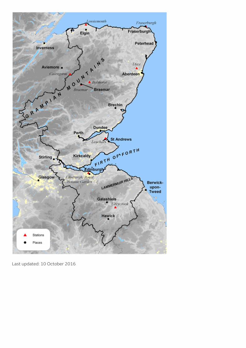
Eastern Scotland: climate This describes the main features of the climate of Eastern Scotland, comprising the Borders, the Lothians, Falkirk, Clackmannanshire, Fife and the former regions of Tayside and Grampian. This region includes the cities of Edinburgh, Dundee and Aberdeen. The principal geographic features comprise the valleys and estuaries of the eastward-flowing Rivers Tweed, Forth, Tay and Dee and extensive upland areas including the Grampian Mountains in the northern part of the region and the Lammermuir Hills south of Edinburgh (rising to 500 metres above sea level). The highest point is Ben Macdui (1309 metres) near the border of Grampian with Highland. Temperature Mean annual temperatures over the region vary from about 9 °C close to the Firth of Forth to less than 6 °C over the higher ground of the Grampians. Elsewhere in the UK, mean annual temperatures reach over 11 °C in Cornwall and the Channel Islands. Within the region, significant variations in temperature arise from the combined effects of proximity to the coast, topography and, to a lesser extent, urban development. Temperature shows both a seasonal and a diurnal variation. Minimum temperatures usually occur around sunrise and maximum temperatures are normally 2 to 3 hours aer midday. January is the coldest month, with mean daily minimum temperatures varying from about 2 °C in areas of East Lothian and Fife bordering the Firth of Forth and on the NE coast of Grampian, to less than -2 °C over the higher ground. Extreme minimum temperatures usually occur in January or February. Examples include the UK record low temperature of -27.2 °C at Braemar (Grampian) on 10 January 1982 (a record shared with Altnaharra, Highland). This occurred during a severe cold spell across Scotland with some night minima below -15 °C and day maxima below -5 °C on several days. Conversely, to the lee of high ground temperatures can occasionally reach up to 15 °C in winter when a south or SW airstream warms up aer crossing upland - an effect known as a fohn wind. July is the warmest month, with mean daily maximum temperatures at low levels inland approaching 20 °C, the highest in Scotland. Elsewhere in Eastern Scotland the mean maxima are somewhat lower, and are less than 17 °C over the higher ground and along the coast of Grampian region. Extreme maximum temperatures can occur in July or August, and are usually associated with heat-waves. Examples include 30.8 °C at Leuchars (Fife) on 2 August 1990, 31.4 °C at Edinburgh airport on 4 August 1975 and the Scottish record temperature of 32.9 °C at Greycrook (Borders) on 9 August 2003. The variation of mean daily maximum and minimum temperatures month by month, together with the highest and lowest temperatures recorded, is shown for Braemar and Edinburgh RBG.

Welcome message from author
This document is posted to help you gain knowledge. Please leave a comment to let me know what you think about it! Share it to your friends and learn new things together.
Transcript
Eastern Scotland: climateThis describes the main features of the climate of EasternScotland, comprising the Borders, the Lothians, Falkirk,Clackmannanshire, Fife and the former regions of Tayside andGrampian.
This region includes the cities of Edinburgh, Dundee and Aberdeen. Theprincipal geographic features comprise the valleys and estuaries of theeastward-flowing Rivers Tweed, Forth, Tay and Dee and extensive uplandareas including the Grampian Mountains in the northern part of the regionand the Lammermuir Hills south of Edinburgh (rising to 500 metres abovesea level). The highest point is Ben Macdui (1309 metres) near the borderof Grampian with Highland.
Temperature
Mean annual temperatures over the region vary from about 9 °C close to the Firth of Forth to less than 6 °Cover the higher ground of the Grampians. Elsewhere in the UK, mean annual temperatures reach over 11 °C inCornwall and the Channel Islands. Within the region, significant variations in temperature arise from thecombined effects of proximity to the coast, topography and, to a lesser extent, urban development.
Temperature shows both a seasonal and a diurnal variation. Minimum temperatures usually occur aroundsunrise and maximum temperatures are normally 2 to 3 hours a�er midday.
January is the coldest month, with mean daily minimum temperatures varying from about 2 °C in areas of EastLothian and Fife bordering the Firth of Forth and on the NE coast of Grampian, to less than -2 °C over thehigher ground. Extreme minimum temperatures usually occur in January or February. Examples include the UKrecord low temperature of -27.2 °C at Braemar (Grampian) on 10 January 1982 (a record shared withAltnaharra, Highland). This occurred during a severe cold spell across Scotland with some night minima below-15 °C and day maxima below -5 °C on several days. Conversely, to the lee of high ground temperatures canoccasionally reach up to 15 °C in winter when a south or SW airstream warms up a�er crossing upland - aneffect known as a fohn wind.
July is the warmest month, with mean daily maximum temperatures at low levels inland approaching 20 °C,the highest in Scotland. Elsewhere in Eastern Scotland the mean maxima are somewhat lower, and are lessthan 17 °C over the higher ground and along the coast of Grampian region. Extreme maximum temperaturescan occur in July or August, and are usually associated with heat-waves. Examples include 30.8 °C at Leuchars(Fife) on 2 August 1990, 31.4 °C at Edinburgh airport on 4 August 1975 and the Scottish record temperatureof 32.9 °C at Greycrook (Borders) on 9 August 2003.
The variation of mean daily maximum and minimum temperatures month by month, together with the highestand lowest temperatures recorded, is shown for Braemar and Edinburgh RBG.

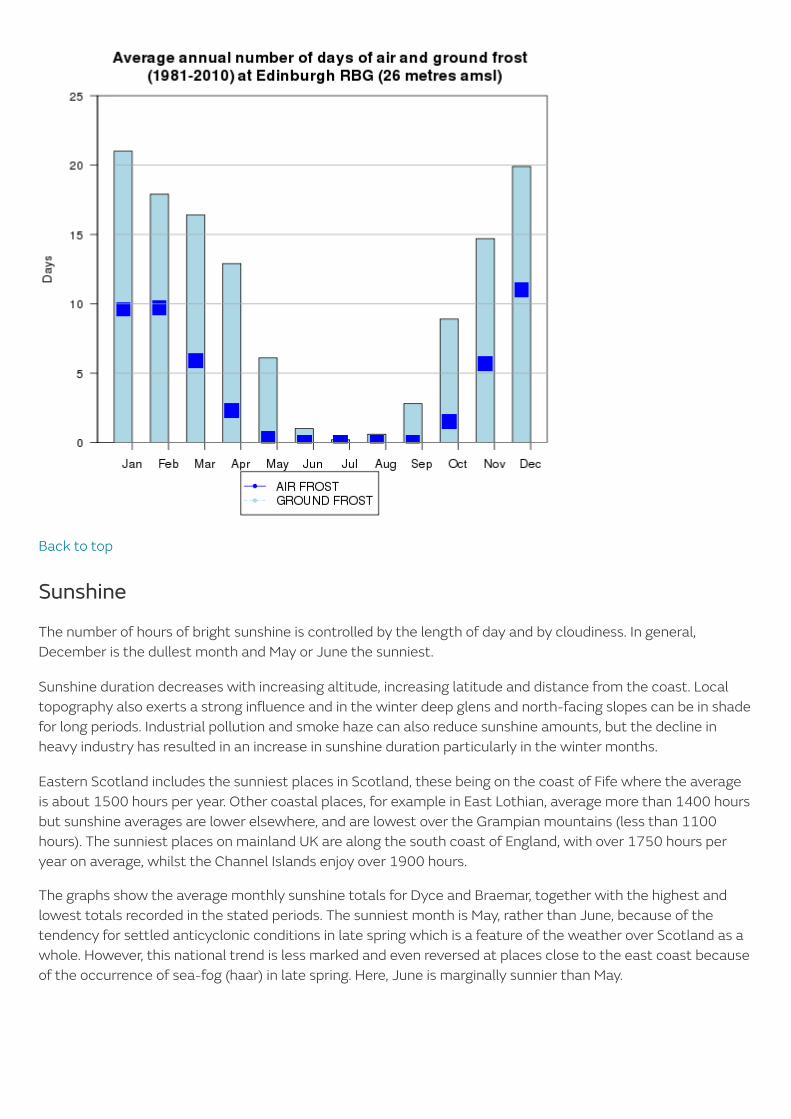
An 'air frost' occurs when the temperature at 1.25 metres above the ground falls below 0 °C, whereasincidence of a 'ground frost' refers to a temperature below 0 °C measured on a grass surface. The average
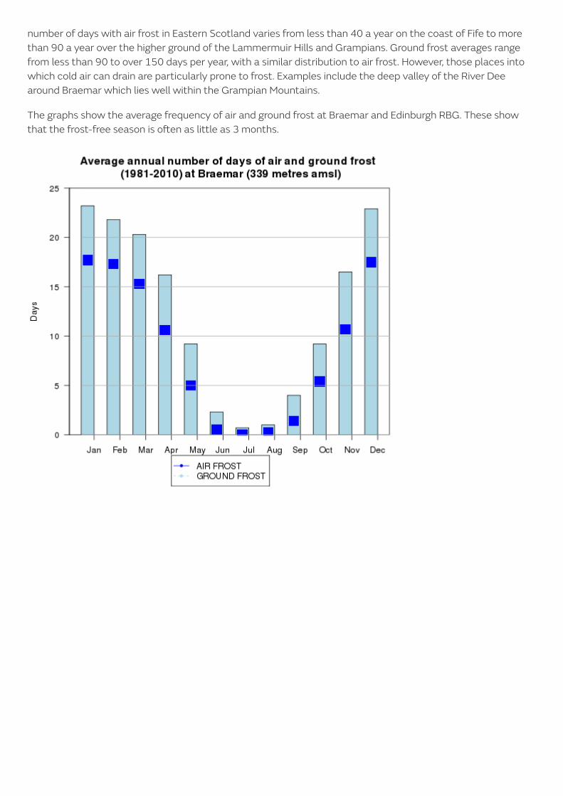
number of days with air frost in Eastern Scotland varies from less than 40 a year on the coast of Fife to morethan 90 a year over the higher ground of the Lammermuir Hills and Grampians. Ground frost averages rangefrom less than 90 to over 150 days per year, with a similar distribution to air frost. However, those places intowhich cold air can drain are particularly prone to frost. Examples include the deep valley of the River Deearound Braemar which lies well within the Grampian Mountains.
The graphs show the average frequency of air and ground frost at Braemar and Edinburgh RBG. These showthat the frost-free season is o�en as little as 3 months.
Back to top
Sunshine
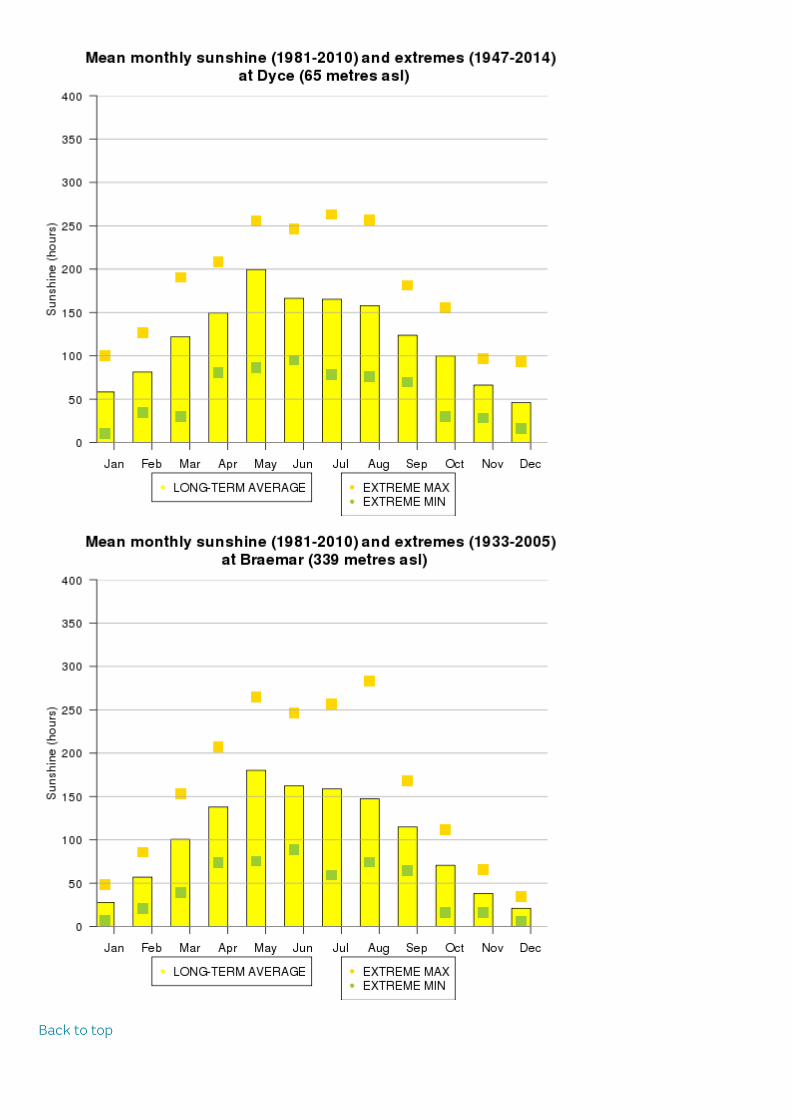
The number of hours of bright sunshine is controlled by the length of day and by cloudiness. In general,December is the dullest month and May or June the sunniest.
Sunshine duration decreases with increasing altitude, increasing latitude and distance from the coast. Localtopography also exerts a strong influence and in the winter deep glens and north-facing slopes can be in shadefor long periods. Industrial pollution and smoke haze can also reduce sunshine amounts, but the decline inheavy industry has resulted in an increase in sunshine duration particularly in the winter months.
Eastern Scotland includes the sunniest places in Scotland, these being on the coast of Fife where the averageis about 1500 hours per year. Other coastal places, for example in East Lothian, average more than 1400 hoursbut sunshine averages are lower elsewhere, and are lowest over the Grampian mountains (less than 1100hours). The sunniest places on mainland UK are along the south coast of England, with over 1750 hours peryear on average, whilst the Channel Islands enjoy over 1900 hours.
The graphs show the average monthly sunshine totals for Dyce and Braemar, together with the highest andlowest totals recorded in the stated periods. The sunniest month is May, rather than June, because of thetendency for settled anticyclonic conditions in late spring which is a feature of the weather over Scotland as awhole. However, this national trend is less marked and even reversed at places close to the east coast becauseof the occurrence of sea-fog (haar) in late spring. Here, June is marginally sunnier than May.
Back to top

RainfallRainfall is caused by the condensation of the water in air that is being li�ed and cooled to its dew point. Rainfalltends to be associated with Atlantic depressions or with convection. The Atlantic Lows are more vigorous inautumn and early winter and bring most of the rain that falls in these seasons. In summer, convection causedby solar surface heating sometimes forms shower clouds.
A further factor that greatly affects the rainfall distribution is altitude. Moist air that is forced to ascend hillsmay be cooled to the dew point to produce cloud and rain. A map of average annual rainfall therefore lookssimilar to a topographic map.
Much of Eastern Scotland is sheltered from the rain-bearing westerly winds. This shelter reaches its greatestpotential along the coasts of East Lothian, Fife and the Moray Firth and these areas receive less than 700 mmof rainfall in an average year. In contrast, the wettest area is the southern Grampians where the average annualrainfall is over 1500 mm. These values can be compared with annual totals around 500 mm in the driest partsof eastern England and over 4000 mm in the western Scottish Highlands.
Rainfall is generally well-distributed throughout the year. The frequency of Atlantic depressions is normallygreatest during the autumn and winter but, unlike other parts of the UK, Scotland tends to remain under theirinfluence for much of the summer too. The wettest months tend to be in autumn and early winter, whereaslate winter and spring is normally the driest part of the year. The course of mean monthly rainfall for 1981-2010 for 4 sites is shown below.
Over much of Eastern Scotland, the number of days with rainfall totals of 1 mm or more ('wet days') tends tofollow a pattern similar to the monthly rainfall totals. In winter (December to February), there are about 30 wetdays on average along the coasts of East Lothian and Fife, rising to over 55 days in the Grampian mountains. In

summer (June to August) the East Lothian and Fife coasts have about 27 wet days and the GrampianMountains over 40 days.
Periods of prolonged rainfall can lead to widespread flooding, especially in winter and early spring when soilsare usually near saturation and snowmelt can be a contributing factor. One example was the severe flooding inthe Tay valley in mid-January 1993, caused by a combination of thawing snow and heavy rain. At Ardtalnaig,on Loch Tay, snow was 36 cm deep on the 12th and followed by 115 mm of rainfall from the 14th to 16th. Bythe 17th, the River Tay at Perth had risen to its highest level since 1814. Another example occurred in lateOctober 2002 when a deep depression brought strong winds and 70-80 mm of rain, resulting in widespreadflooding with disruption to road and rail transport across the Borders, Lothians and Tayside. Falls of about 75mm of rain in 48 hours in November 2002 also resulted in flooding across NE Scotland, including Elgin wherethe River Lossie burst its banks.
Back to top
Snowfall
The occurrence of snow is linked closely with temperature, with falls rarely occurring if the temperature ishigher than 4 °C. For snow to lie for any length of time, the temperature normally has to be lower than this.Over most of the area, snowfall is normally confined to the months from November to April, but upland areaso�en have brief falls in October and May. Snow rarely lies at lower levels outside of the period November toApril.
On average, the number of days with snow falling is about 20 per winter along the coast but over 80 days overthe Grampians. The number of days with snow lying has a similar distribution, with less than 10 along the EastLothian coast but over 60 days over the higher ground of Grampian. These averages can be compared with thecoasts of SW England where less than 3 days per year have lying snow.
The relatively plentiful supply of snow over the highest ground has led to the development of skiing areas suchas Cairngorm, the Lecht (Grampian) and Glenshee (near Braemar).
The monthly averages of days with sleet/snow falling and lying at Dyce and Balmoral are shown below (a dayof lying snow is counted if the ground is more than 50% covered at 0900).
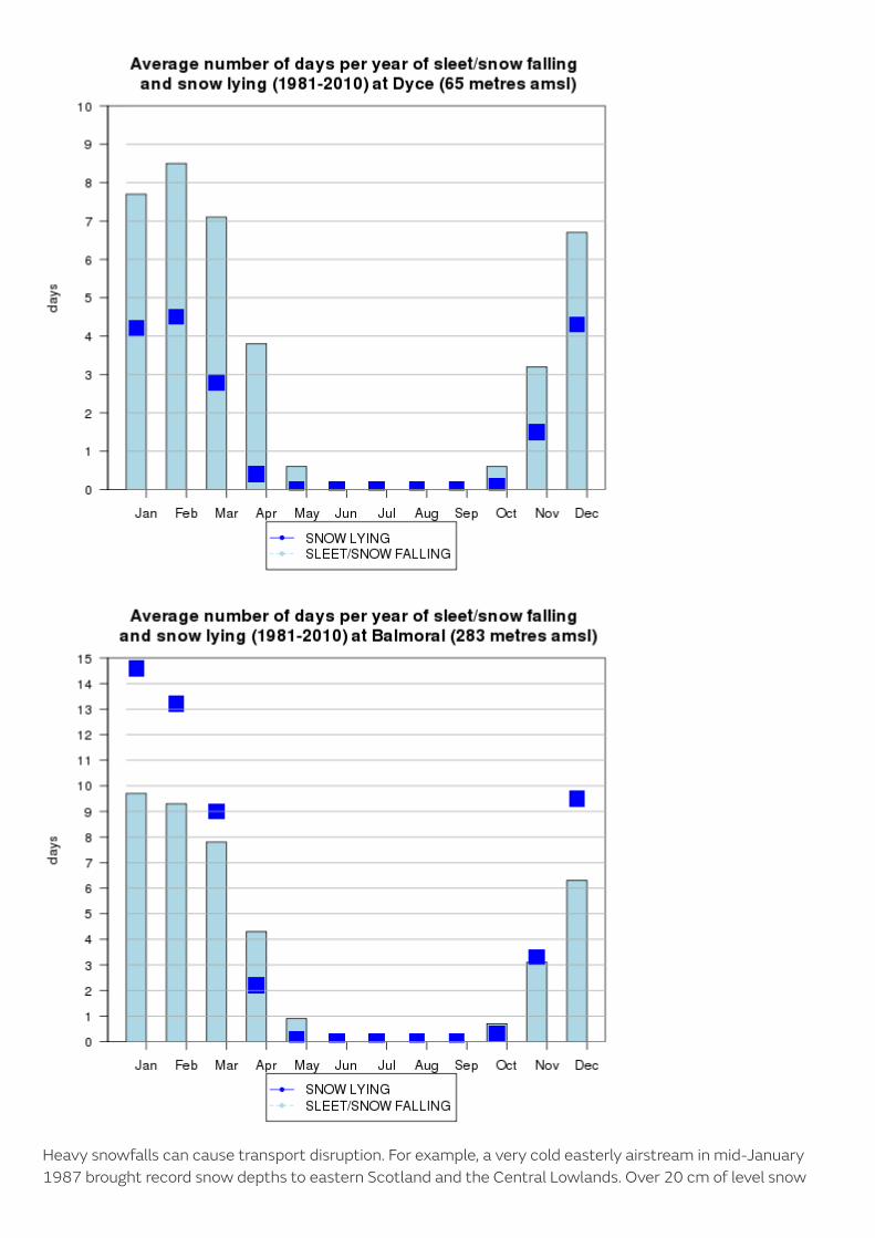
Heavy snowfalls can cause transport disruption. For example, a very cold easterly airstream in mid-January1987 brought record snow depths to eastern Scotland and the Central Lowlands. Over 20 cm of level snow

occurred widely inland from Aberdeen southwards and a few places had over 40 cm. Another north-easterlyairstream between 25 November and 2 December 2010 brought similar aggregate snow depths to the region,and on 6 December the snow depth at Livingston Mill, west of Edinburgh, reached 60 cm.
Back to top
Wind
Eastern Scotland is one of the more windy parts of the UK, being relatively close to the track of Atlanticdepressions. The strongest winds are associated with the passage of deep areas of low pressure close to oracross the UK. The frequency and strength of these depressions is greatest in the winter half of the year,especially from December to February, and this is when mean speeds and gusts (short duration peak values)are high.
The variation in monthly mean speeds (average of a continuous record) and highest gusts ('instantaneous'speed averaged over about 3 seconds) at Leuchars is shown below.
Another measure of wind exposure is the number of days when gale force is reached. If the wind reaches amean speed of 34 knots or more over any ten consecutive minutes, then that day is classed as having a gale.Over most inland areas of the region the average is around 5 days per year but places sheltered to the westexperience fewer than this and well exposed upland areas have over 20 days with gale in an average year. Windspeed is sensitive to local topographic effects and land use. Exposed places on coasts and hills will experiencestronger wind speeds and more days of gale. The highest wind-recording station in the UK is on Cairngorm(1245 metres) which holds the record for the highest gust (150 knots on 20 March 1986).
There have been several noteworthy gales affecting Eastern Scotland, accompanied by property damage anddisruption to travel and power supplies. Examples include 13 February 1989 when the low-level wind speedrecord of a gust of 123 knots was set at Kinnaird's Head lighthouse near Fraserburgh (Grampian). The

corresponding hourly mean speed was an equally impressive 68 knots. On this occasion, over 75,000 people innorthern Scotland lost their electricity supply but fortunately there was no loss of life. More recent examplesinclude 28 January 2002, when a severe westerly gale with gusts approaching 70 knots resulted in the closureof the Forth road bridge, and 12 January 2005 when gusts of 60 knots occurred. On each occasion, power lineswere brought down and there was travel disruption.
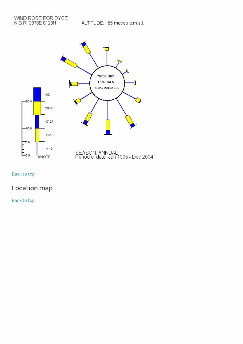
The direction of the wind is defined as the direction from which the wind is blowing. As Atlantic depressionspass the UK the wind typically starts to blow from the south or south west, but later comes from the west ornorth-west as the depression moves away. The range of directions between south and north-west accountsfor the majority of occasions and the strongest winds nearly always blow from this range of directions. Thepenetration of westerly winds into eastern Scotland is controlled to a large extent by topography, with theCentral Lowlands assisting this but the higher ground either side providing shelter.
Spring time tends to have a maximum frequency of winds from the north east. In Eastern Scotland, periods ofvery light or calm winds with no preferred direction vary from about less than 1% of the year on the coast toabout 5% at sheltered places well inland. The annual wind rose for Leuchars is typical of open, level locationsacross the Central Lowlands, with an enhanced south-westerly wind direction through the year associatedwith a large-scale funnelling effect. In marked contrast, places further north, to the lee of the GrampianMountains, experience diminished south-westerlies as air is deflected by the high ground to the west. Theannual wind rose for Aberdeen airport (Dyce) is typical of this area. However, in all areas there tends to be ahigher frequency of north to north-east winds in spring.
Back to top
Location map
Back to top
Last updated: 10 October 2016

Related Documents