Copyright © 2007 John Wiley & Sons, Ltd. Earth Surface Processes and Landforms Earth Surf. Process. Landforms 33, 244–262 (2008) Published online 3 July 2007 in Wiley InterScience (www.interscience.wiley.com) DOI: 10.1002/esp.1541 Wood storage in three mountain streams of the Southern Andes and its hydro-morphological effects Francesco Comiti, Andrea Andreoli, Luca Mao* and Mario Aristide Lenzi Department of Land and Agroforest Environments, University of Padova, Legnaro (PD), Italy Abstract This study analyses large wood (LW) storage and the associated effects on channel morpho- logy and flow hydraulics in three third-order mountain basins (drainage area 9–12 km 2 ) covered in old-growth Nothofagus forests, ranging from the temperate warm Chilean Andean Cordillera to the sub-Antarctic Tierra del Fuego (Argentina). Amount, character- istics and dimensions of large wood (>10 cm diameter, >1 m long) were recorded, as well as their effects on stream morphology, hydraulics and sediment storage. Results show that major differences in LW abundance exist even between adjacent basins, as a result of dif- ferent disturbance histories and basin dissection. Massive LW volumes (i.e. >1000 m 3 ha −1 ) can be reached in basins disturbed by fires followed by mass movements and debris flows. Potential energy dissipation resulting from wood dams is about a quarter of the total eleva- tion drop in two streams, with a gross sediment volume stored behind wood dams of around 1000 m 3 km −1 , which appears to be of the same order as the annual sediment yield. Finally, the presence of wood dams may increase flow resistance by up to one order of magnitude. Copyright © 2007 John Wiley & Sons, Ltd. Keywords: woody debris; channel morphology; flow resistance; mountain basins; Nothofagus forests *Correspondence to: Mr. Luca Mao, Ph.D., Department of Land and Agroforest Environments, University of Padova, Viale Università 16, 35020 Legnaro (PD), Italy. E-mail: [email protected] Introduction Large wood (LW, otherwise called large woody debris, LWD) lying within stream channels has strong consequences for stream hydraulics, morphology, sediment transport and aquatic ecology (Gurnell et al., 2002; Montgomery et al., 2003; Montgomery and Piegay, 2003). In particular, channel morphology in old-growth forested basins is largely controlled by LW, given the abundance of large pieces able to build up stable in-channel structures such as log steps, valley jams and flow deflection jams (Abbe and Montgomery, 2003). Several authors (Keller and Tally, 1979; Bilby, 1979; Keller and Swanson, 1979; Swanson et al., 1976; Faustini and Jones, 2003) observed variable, overall high (10–80%, but up to 100%) potential energy dissipation exerted by log steps in different regions of the US. For Alaskan headwater streams, Gomi et al. (2003) reported up to 35 steps per kilometre of stream formed by either large or fine woody debris, with log steps accounting for an average of 51% of the total number of steps. A similar percentage (45%) was found by Curran and Wohl (2003) in basins of less than 10 km 2 of the Cascade Range (Washington, US). Previously, the percentage of steps formed by LW had been corre- lated by Wohl et al. (1997) to basin/channel size in streams of Montana (US), with values ranging from 50 to 10%. For second- and third-order channels in the Italian Alps, Comiti et al. (2006) found limited numbers of log steps (13– 35 log steps per km), comprising only a small fraction (~10%) of the total step number. LW dam frequencies ranging from 1 km −1 (fourth order) to 100 km −1 (second order) are reported for streams flowing in semi-natural areas in Central Europe (Kaczka, 2003). The influence of LW on flow resistance is receiving more attention by researchers. MacFarlane and Wohl (2003) reported higher flow resistance in step-pool reaches characterized by the presence of LW. Wilcox et al. (2006) used flume investigations to explore patterns of flow resistance partitioning between LW, spill over steps and grains in step-pool channels. The synergistic effect of LW and spill over steps was found to dominate, whereas grain resis- tance is only a small component of the total flow resistance. Wilcox et al. (2006) also found that the interaction Received 15 January 2007; Revised 23 April 2007; Accepted 26 April 2007

Welcome message from author
This document is posted to help you gain knowledge. Please leave a comment to let me know what you think about it! Share it to your friends and learn new things together.
Transcript

244 F. Comiti et al.
Copyright © 2007 John Wiley & Sons, Ltd. Earth Surf. Process. Landforms 33, 244–262 (2008)DOI: 10.1002/esp
Earth Surface Processes and LandformsEarth Surf. Process. Landforms 33, 244–262 (2008)Published online 3 July 2007 in Wiley InterScience(www.interscience.wiley.com) DOI: 10.1002/esp.1541
Wood storage in three mountain streams of theSouthern Andes and its hydro-morphological effectsFrancesco Comiti, Andrea Andreoli, Luca Mao* and Mario Aristide LenziDepartment of Land and Agroforest Environments, University of Padova, Legnaro (PD), Italy
AbstractThis study analyses large wood (LW) storage and the associated effects on channel morpho-logy and flow hydraulics in three third-order mountain basins (drainage area 9–12 km2)covered in old-growth Nothofagus forests, ranging from the temperate warm ChileanAndean Cordillera to the sub-Antarctic Tierra del Fuego (Argentina). Amount, character-istics and dimensions of large wood (>>>>>10 cm diameter, >>>>>1 m long) were recorded, as well astheir effects on stream morphology, hydraulics and sediment storage. Results show thatmajor differences in LW abundance exist even between adjacent basins, as a result of dif-ferent disturbance histories and basin dissection. Massive LW volumes (i.e. >>>>>1000 m3 ha−−−−−1)can be reached in basins disturbed by fires followed by mass movements and debris flows.Potential energy dissipation resulting from wood dams is about a quarter of the total eleva-tion drop in two streams, with a gross sediment volume stored behind wood dams of around1000 m3 km−−−−−1, which appears to be of the same order as the annual sediment yield. Finally,the presence of wood dams may increase flow resistance by up to one order of magnitude.Copyright © 2007 John Wiley & Sons, Ltd.
Keywords: woody debris; channel morphology; flow resistance; mountain basins; Nothofagusforests
*Correspondence to: Mr. LucaMao, Ph.D., Department of Landand Agroforest Environments,University of Padova, VialeUniversità 16, 35020 Legnaro(PD), Italy.E-mail: [email protected]
Introduction
Large wood (LW, otherwise called large woody debris, LWD) lying within stream channels has strong consequencesfor stream hydraulics, morphology, sediment transport and aquatic ecology (Gurnell et al., 2002; Montgomery et al.,2003; Montgomery and Piegay, 2003). In particular, channel morphology in old-growth forested basins is largelycontrolled by LW, given the abundance of large pieces able to build up stable in-channel structures such as log steps,valley jams and flow deflection jams (Abbe and Montgomery, 2003).
Several authors (Keller and Tally, 1979; Bilby, 1979; Keller and Swanson, 1979; Swanson et al., 1976; Faustini andJones, 2003) observed variable, overall high (10–80%, but up to 100%) potential energy dissipation exerted by logsteps in different regions of the US. For Alaskan headwater streams, Gomi et al. (2003) reported up to 35 steps perkilometre of stream formed by either large or fine woody debris, with log steps accounting for an average of 51% ofthe total number of steps. A similar percentage (45%) was found by Curran and Wohl (2003) in basins of less than10 km2 of the Cascade Range (Washington, US). Previously, the percentage of steps formed by LW had been corre-lated by Wohl et al. (1997) to basin/channel size in streams of Montana (US), with values ranging from 50 to 10%.For second- and third-order channels in the Italian Alps, Comiti et al. (2006) found limited numbers of log steps (13–35 log steps per km), comprising only a small fraction (~10%) of the total step number. LW dam frequencies rangingfrom 1 km−1 (fourth order) to 100 km−1 (second order) are reported for streams flowing in semi-natural areas in CentralEurope (Kaczka, 2003).
The influence of LW on flow resistance is receiving more attention by researchers. MacFarlane and Wohl (2003)reported higher flow resistance in step-pool reaches characterized by the presence of LW. Wilcox et al. (2006) usedflume investigations to explore patterns of flow resistance partitioning between LW, spill over steps and grains instep-pool channels. The synergistic effect of LW and spill over steps was found to dominate, whereas grain resis-tance is only a small component of the total flow resistance. Wilcox et al. (2006) also found that the interaction
Received 15 January 2007;Revised 23 April 2007;Accepted 26 April 2007

Wood storage in mountain streams of Southern Andes and its hydro-morphological effects 245
Copyright © 2007 John Wiley & Sons, Ltd. Earth Surf. Process. Landforms 33, 244–262 (2008)DOI: 10.1002/esp
effects between LW and step roughness components can lead to unreliable resistance partitioning between the twocomponents.
As can be extrapolated from the preceding brief summary, most of the geomorphological research on LW inmountain streams has been carried out in the Pacific Northwest region of North America. Among the parts of theworld lacking studies on LW, the Southern Andes represent an ideal location for studying LW in mountain channelsdraining old-growth forested basins.
The main purpose of this study is to provide the first quantitative description of the abundance and morphologicalrole of in-channel wood in mountain streams of the Southern Andes, where forest cover is still dominated by old-growth, native Nothofagus (the so-called southern beech) forests. Even though pristine conditions are now very rareand limited to the most isolated places, human impacts in some areas can still be assumed to have minimally alteredriver form and processes.
In order to cover the huge latitudinal and climatic range of this mountain chain, two geographic end points havebeen selected, the Chilean Araucania and the Argentinian southern Tierra del Fuego. The former, an active volcanicregion, features a temperate–warm humid climate and hosts evergreen and deciduous Nothofagus forests, plus theendemic Araucaria tree. Southern Tierra del Fuego is characterized instead by broad valleys carved by glaciers intosedimentary and metamorphic rocks and features a windy, cold–humid climate with timberline at about 600 m a.s.l.and forests composed of only a few Nothofagus species adapted to a very harsh environment. Three study basins wereexamined: one located in Tierra del Fuego, and two in the Araucania that differ with regard to forest disturbancehistory (fires).
The analysis will address, in order, (i) channel-averaged wood spatial density (pieces and volume per hectare ofchannel bed), (ii) wood and jam dimensions, (iii) macro-scale morphological effects of wood and the associatedsediment storage, (iv) reach-based analysis of factors influencing wood storage and (v) influence of wood structureson sediment size distribution, bed profile and flow resistance.
Field Sites and Methodology
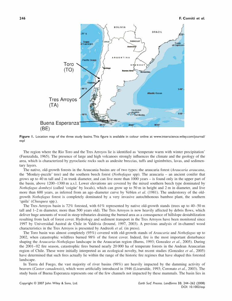
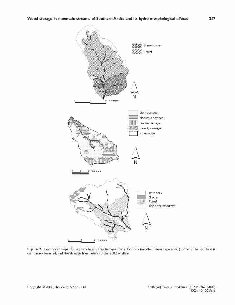
Study basinsThe three basins (Figure 1) that are the subject of the present investigation are the Tres Arroyos (TA, within MalalcahuelloNational Reserve, geographical coordinates 38°27′07 S; 71°33′40 W) and the Rio Toro (TO, within the MallecoNatural Reserve, 38°10′43 S; 71°46′43 W) in the Chilean Araucania region, and the Buena Esperanza (BE) in theArgentinian Tierra del Fuego near the city of Ushuaia (54°47′50 S; 68°22′00 W). Table I provides a summary of themain characteristics of the basins, and maps of the catchments are reported in Figure 2.
Table I. Main characteristics of the study basins
Basin characteristics
Basin Area (km2)Basin elevation (min. – max., m a.s.l.)Mean basin slope (%)Channel order*ClimateHydrological regimeAnnual precipitationGeologyForest cover (%)Dominant forest species
Forest disturbancesTotal channel length (km)Studied channel length (km)Average channel slope (m m−1)Average channel width (m)Channel morphology
* Channel order determined by topographical maps (1:50 000 scale).
Buena Esperanza (BE)
12·90–1275233Temperate cold humidglacionival530/1300Sedimentary/metamorphic34Nothofagus pumilioNothofagus antarcticawind blowdowns (?)7·51·850·0656·3cascade/step-pool
Tres Arroyos (TA)
9·11000–1850433Temperate warm humidpluvial/nival2217Volcanic/pyroclastic74Nothofagus dombeyiAraucaria araucanaWildfire (1920s)4·91·540·087·7step-pool/cascade
Toro (TO)
11·1750–1750203Temperate warm humidpluvial/nival2480Volcanic/pyroclastic95 (98% burned)Nothofagus dombeyiAraucaria araucanaWildfire (2002)72·170·0511·9plane-bed/step-pool
246 F. Comiti et al.
Copyright © 2007 John Wiley & Sons, Ltd. Earth Surf. Process. Landforms 33, 244–262 (2008)DOI: 10.1002/esp
Figure 1. Location map of the three study basins. This figure is available in colour online at www.interscience.wiley.com/journal/espl
The region where the Rio Toro and the Tres Arroyos lie is identified as ‘temperate warm with winter precipitation’(Fuenzalida, 1965). The presence of large and high volcanoes strongly influences the climate and the geology of thearea, which is characterized by pyroclastic rocks such as andesite breccias, tuffs and ignimbrites, lavas, and sedimen-tary layers.
The native, old-growth forests in the Araucania basins are of two types: the araucaria forest (Araucaria araucana,the ‘Monkey-puzzle’ tree) and the southern beech forest (Nothofagus spp). The araucaria – an ancient conifer thatgrows up to 40 m tall and 2 m trunk diameter, and can live more than 1000 years – is found only in the upper part ofthe basin, above 1200 –1300 m a.s.l. Lower elevations are covered by the mixed southern beech type dominated byNothofagus dombeyi (called ‘coigüe’ by locals), which can grow up to 50 m in height and 2 m in diameter, and livemore than 600 years, as inferred from an age–diameter curve by Veblen et al. (1981). The understorey of the old-growth Nothofagus forest is completely dominated by a very invasive autochthonous bamboo plant, the southern‘quila’ (Chusquea spp.).
The Tres Arroyos basin is 72% forested, with 61% represented by native old-growth stands (trees up to 40–50 mtall and 1–2 m diameter, more than 500 years old). The Tres Arroyos is now heavily affected by debris flows, whichdeliver huge amounts of wood in steep tributaries draining the burned area as a consequence of hillslope destabilizationresulting from lack of forest cover. Hydrology and sediment transport in the Tres Arroyos have been monitored since1997 by Universidad Austral de Chile in Valdivia (Iroumé, 1997, 2003). A previous analysis of in-channel woodcharacteristics in the Tres Arroyos is presented by Andreoli et al. (in press).
The Toro basin was almost completely (95%) covered with old-growth stands of Araucaria and Nothofagus up to2002, when catastrophic wildfires burned 98% of the forest cover. Indeed, fire is the most important disturbanceshaping the Araucaria–Nothofagus landscape in the Araucarian region (Burns, 1993; Gonzalez et al., 2005). Duringthe 2001– 02 fire season, catastrophic fires burned nearly 20 000 ha of temperate forests in the Andean Araucarianregion of Chile. These were initially interpreted as an ecological novelty, but recent studies (Gonzalez et al., 2005)have determined that such fires actually lie within the range of the historic fire regimes that have shaped this forestedlandscape.
In Tierra del Fuego, the vast majority of river basins (98%) are heavily impacted by the damming activity ofbeavers (Castor canadensis), which were artificially introduced in 1946 (Lizarralde, 1993; Coronato et al., 2003). Thestudy basin of Buena Esperanza represents one of the few channels not impacted by these mammals. The basin lies in
Wood storage in mountain streams of Southern Andes and its hydro-morphological effects 247
Copyright © 2007 John Wiley & Sons, Ltd. Earth Surf. Process. Landforms 33, 244–262 (2008)DOI: 10.1002/esp
Figure 2. Land cover maps of the study basins: Tres Arroyos (top); Rio Toro (middle); Buena Esperanza (bottom). The Rio Toro iscompletely forested, and the damage level refers to the 2002 wildfire.

248 F. Comiti et al.
Copyright © 2007 John Wiley & Sons, Ltd. Earth Surf. Process. Landforms 33, 244–262 (2008)DOI: 10.1002/esp
front of the Beagle Channel, above the sprawling city of Ushuaia, and hosts a small glacier that imparts a glacionivalregime to the stream. The climate is cold temperate humid with a mean annual temperature of 5·5 °C at sea level.Precipitation is of low intensity and high frequency, evenly distributed throughout the year but with a strong altitudinalgradient. Annual precipitation in the Buena Esperanza (Urciolo et al., 2006) ranges from 530 mm (sea level) to1300 mm (watershed divide).
Only 34% of the drainage area is covered by forest; the rest is above the timberline. Forest cover is characterizedby the relatively simple ‘magellanic mixed forest’, dominated by Nothofagus pumilio (‘lenga’) in association withNothofagus antarctica (‘ñirre’) and Nothofagus betuloides (‘coigüe de Magallanes’). Tree growth in Tierra del Fuegois much lower than in the Araucania region, and consequently tree diameters are generally smaller, such that old-growth stands (>200–250 years) may have diameters at breast height as small as 30 cm (Rebertus et al., 1997; Barreraet al., 2000), in contrast to approximately 40 cm for N. dombeyi in the Valdivian Andes (Veblen et al., 1981). Inaddition, the forest structure of N. pumilio, whose maximum lifespan is between 300 and 400 years, in Tierra delFuego is governed by periodic wind blowdowns associated with low-pressure systems originating in Antarctica(Rebertus et al., 1997). As a consequence, trees having diameters greater than 0·5 m are very uncommon in the BuenaEsperanza basin.
At present, no forest harvesting is allowed in the Buena Esperanza, whereas some occasional logging was con-ducted in the past, especially during the 1940s. Stream flow has been monitored since 2000 by Subsecretaría deRecursos Naturales Provincia de Tierra del Fuego, and for the period 2000–2006 the annual peak discharge rangedapproximately from 2·5 to 4 m3 s−1 (Urciolo et al., 2006).
Survey of channel morphology, wood characteristics and wood mobilityThe study channels (Figure 3) were surveyed in March–April 2005 (Tres Arroyos, TA), January 2006 (Toro, TO) andFebruary–March 2006 (Buena Esperanza, BE). The total channel lengths investigated are reported in Table I. In theBuena Esperanza, an intermediate, 230 m long reach within a gorge was not included because it was inaccessible. Thelongitudinal profiles of the study sections were surveyed using a laser distance meter with inclinometer. Individualreaches were defined based on uniformity of either slope, channel width or abundance of debris. The followingcharacteristics were measured at each single reach: mean channel slope, mean bank-full and fluvial corridor (i.e. bank-full channel plus adjacent active floodplain) width, mean bank-full water depth and number of steps. Drainage area ateach reach was determined from a digital elevation model using GIS software.
Wood pieces greater than 10 cm in diameter and 1 m in length were measured both in the active channel and in theadjacent active floodplain, as in the work of Andreoli et al. (in press). Where the floodplain was absent, as in manyconfined reaches, a maximum flood level was estimated and served as the upper elevation limit for LW to be includedin the records at each location. More than 5500 elements were recorded over all of the study segments.
The length and mid-diameter of each element were measured with a tape and a tree caliper, respectively. Theprecision is estimated to be ~1 cm for diameter and ~5 cm for piece length. All the pieces forming log jams (i.e.accumulations of at least two elements) were measured, and the geometrical dimensions of jams (length, width andheight) were also taken in the Tres Arroyos and in the Buena Esperanza.
Several additional data were recorded for each wood piece during the field survey (Andreoli et al., in press): type(log, rootwad, log with rootwads attached), tree species (Nothofagus/Araucaria/conifers), orientation to flow (parallel,orthogonal, oblique), delivery mechanism into any given reach (bank erosion, landslide, natural mortality, transportedfrom upstream) and position (log step, in channel, bank-full line, channel bridging, channel margins). In-channelpieces were defined as all the wood elements lying at least partially at a lower elevation than bank-full height, butexcluding log steps (which form a different class). For log steps, drop height and pool depth were also measured. TheLW elements found at an elevation corresponding to the bank-full stage were combined into a separate group. Woodelements spanning the channel at an elevation higher than bank-full stage were classified as channel bridging, andchannel margin pieces were defined as those located on the area adjacent to and higher than the bank-full channel,thus subject to inundation during low-frequency floods. In the case of long logs stretching across different portions ofthe channel, their prevalent location was assigned. For pieces lying partly above the maximum inundation level, noestimation of the reduced log volume actually located within the flow was made, so that the total piece length wasrecorded. This procedure might lead to a slight overestimation of the total LW volume.
The volume of each wood element was calculated from its mid-diameter Dlog and length Llog, assuming a solidcylindrical shape, as commonly done in LW studies. Spatial density of LW, in terms of both volume and number ofelements, on the active channel and the fluvial corridor was calculated based on bank-full and corridor widths,respectively. Correlations between channel properties and wood variables were carried out using (log + 1) transformedvalues in the software STATISTICA 7.1 (StatSoft, 2006).

Wood storage in mountain streams of Southern Andes and its hydro-morphological effects 249
Copyright © 2007 John Wiley & Sons, Ltd. Earth Surf. Process. Landforms 33, 244–262 (2008)DOI: 10.1002/esp
Figure 3. Views of the Tres Arroyos (top), Rio Toro (middle) and Buena Esperanza (bottom) main channels. This figure is availablein colour online at www.interscience.wiley.com/journal/espl
250 F. Comiti et al.
Copyright © 2007 John Wiley & Sons, Ltd. Earth Surf. Process. Landforms 33, 244–262 (2008)DOI: 10.1002/esp
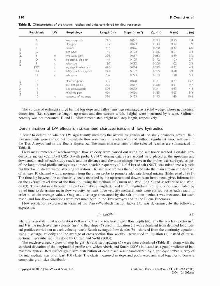
Table II. Characteristics of the channel reaches and units considered for flow resistance
Reach/unit LW Morphology Length (m) Slope (m m−1) D84 (m) H (m) L (m)
A low step-pools 21·5 0·022 0·223 0·25 2·4C riffle-glide 17·2 0·023 0·113 0·22 1·9E cascade 23·4 0·076 0·260 0·42 6·0G step-pool 17·0 0·103 0·336 0·61 3·4B × two valley jams 22·8 0·097 0·083 0·99 3·6D × log step & big pool 4·1 0·105 0·172 1·00 2·7F × valley jam 13·7 0·092 0·208 1·02 2·3
DEF × log step & valley jam 41·3 0·084 0·219 0·72 4·3GH × valley jam & step-pool 22·6 0·132 0·285 0·78 3·9H × valley jam 5·6 0·223 0·153 1·28 5·3
15 riffle/step-pools 36·9 0·028 0·151 0·37 13·71 low step-pools 23·9 0·057 0·378 0·21 9·7
14 step-pool/cascade 50·5 0·072 0·341 0·53 4·88 riffle/step-pool 42·1 0·036 0·385 0·63 5·8
10 × sequence of log steps 32·1 0·153 0·143 1·89 10·6
The volume of sediment stored behind log steps and valley jams was estimated as a solid wedge, whose geometricaldimensions (i.e. streamwise length, upstream and downstream width, height) were measured by a tape. Sedimentporosity was not measured. H and L indicate mean step height and step length, respectively.
Determination of LW effects on streambed characteristics and flow hydraulicsIn order to determine whether LW significantly increases the overall roughness of the study channels, several fieldmeasurements were carried out to evaluate flow resistance in reaches with and without significant wood influence inthe Tres Arroyos and in the Buena Esperanza. The main characteristics of the selected reaches are summarized inTable II.
Field measurements of reach-averaged flow velocity were carried out using the salt tracer method. Portable con-ductivity meters (Campbell CR510 with probe CS547) storing data every second were placed at the upstream anddownstream ends of each study reach, and the distance and elevation change between the probes was surveyed as partof the longitudinal-profile surveys. As a tracer, a variable quantity (0·1– 0·5 kg) of salt (NaCl) was mixed into a plasticbin filled with stream water, avoiding saturation. The salt mixture was then injected into the main stream at a distanceof at least 10 channel widths upstream from the upper probe to promote adequate lateral mixing (Elder et al., 1991).The time lag between the conductivity peaks recorded by the upstream and downstream instruments gives informationon the average travel time of the flow, following the methods of Curran and Wohl (2003) and MacFarlane and Wohl(2003). Travel distance between the probes (thalweg length derived from longitudinal profile survey) was divided bytravel time to determine mean flow velocity. At least three velocity measurements were carried out at each reach, inorder to obtain average values. Only one discharge (measured by the salt dilution method) was measured for eachreach, and low-flow conditions were measured both in the Tres Arroyos and in the Buena Esperanza.
Flow resistance, expressed in terms of the Darcy-Weisbach friction factor ( f), was determined by the followingexpression:
f = 8ghS/V 2 (1)
where g is gravitational acceleration (9·8 m s−1), h is the reach-averaged flow depth (m), S is the reach slope (m m−1)and V is the reach-average velocity (m s−1). Bed slope (S) used in Equation (1) was calculated from detailed longitudi-nal profiles carried out at each velocity reach. Reach-averaged flow depths (h) – derived from the continuity equation,using discharge, velocity and the average of cross-section flow widths – were used in Equation (1) instead of cross-sectional hydraulic radii, as done by Curran and Wohl (2003).
The reach-averaged values of step height (H) and step spacing (L) were then calculated (Table II), along with thestandard deviation of the longitudinal profile (σ), which Aberle and Smart (2003) indicated as a good predictor of bedmacroroughness. Bed surface grain size distribution of each reach was characterized by a grid-by-number survey ofthe intermediate axis of at least 100 clasts. The clasts measured in steps and pools were analysed together to derive acomposite grain size distribution.
Tres
Arr
oyos
Buen
a Es
pera
nza

Wood storage in mountain streams of Southern Andes and its hydro-morphological effects 251
Copyright © 2007 John Wiley & Sons, Ltd. Earth Surf. Process. Landforms 33, 244–262 (2008)DOI: 10.1002/esp
In order to assess the partitioning of flow resistance between the different sources of roughness (see the introduc-tion), grain resistance fg was calculated for each reach using a modified version (Millar and Quick, 1994) of Keulegan’straditional equation, as done by MacFarlane and Wohl (2003). The equation is the following:
fh
kg
s
log= ⋅⋅⎛
⎝⎜⎞⎠⎟
⎡
⎣⎢
⎤
⎦⎥
−
2 0312 2
2
. (2)
Average flow depth is used instead of the hydraulic radius, as in Equation (1), and the D50 of the surface grain sizedistribution as the roughness height ks, following MacFarlane and Wohl (2003).
Results
Spatial density of woodFigure 4 reports the average LW load in terms of numerical and volumetric spatial density in the study basins, for boththe active channel (i.e. within the bank-full width) and the entire fluvial corridor. Data referring to the fluvial corridor
Figure 4. Large wood storage in terms of total piece number (a) and total volume (b) in the active channel (i.e. within the bank-full width) and in the entire fluvial corridor of the three study basins (TA Tres Arroyos; TO Rio Toro, BE Buena Esperanza).
252 F. Comiti et al.
Copyright © 2007 John Wiley & Sons, Ltd. Earth Surf. Process. Landforms 33, 244–262 (2008)DOI: 10.1002/esp
should be viewed as indicative, because measurement of all LW pieces in the floodplain was not always feasiblebecause of the dense vegetation growing in the Araucanian basins.
Average values are obtained by dividing the total piece number/piece volume by the total reference bed area, i.e.bank-full channel area and fluvial corridor area (in hectares), of the surveyed channel segments. Based on LW numberthe Buena Esperanza shows the highest load in the channel (1400 pieces ha−1), whereas if volume is considered the TresArroyos features the largest value, as much as 700 m3 ha−1. The Rio Toro has the lowest LW loads both in terms ofpiece number and volume (215 pieces ha−1 and 117 m3 ha−1, respectively), but this value is very similar to the BuenaEsperanza when LW volume is considered. The large discrepancy in the Buena Esperanza number/volume data dependson LW dimensions, as will be analysed in the next section. Figure 4 also shows that LW spatial density is generally lowerin the fluvial corridor than in the active channel, although this difference is small except for the Buena Esperanza.
Characteristics of wood elementsMarginal pieces of LW (i.e. lying on the floodplain) constitute about half the total number in the Tres Arroyos, butrepresent a minor fraction (about 20%) in the other channels. LW found at bank-full elevation was rather common inthe Buena Esperanza and in the Tres Arroyos (9 and 22%, respectively), but not so in the Rio Toro (<1%). Both logsteps and channel-spanning elements are less than 2% in all of the streams. In the Rio Toro, no log steps were found.In order to facilitate a more significant comparison among the study channels, all the subsequent analyses, where notspecified, will exclude LW pieces found at channel margins.
In the Tres Arroyos and the Rio Toro, a very low fraction of the wood pieces derive from Araucaria trees (6 and1%, respectively), the vast majority being from Nothofagus. In the Fueginan basin, all the LW is from Nothofagus, anddistinction among species (i.e. lenga, ñirre, guindo) was not possible. A rather consistent fraction of total LW formslog jams among the three streams, i.e. 68% in both Toro and Tres Arroyos, and 60% in the Buena Esperanza.
The vast majority of logs appear to have been subject to some transport (i.e. were not immobile pieces fallen intothat location of the channel), ranging from 68% (TO) to 75% (BE), up to 88% (TA). The actual travel distance couldnot be assessed, however, and these pieces may have come from upstream locations of the same reach, whereas manypieces classified as ‘transported’ in the Tres Arroyos may derive from debris flow rather than fluvial transport (Andreoliet al., in press). Only a small percentage of the measured LW has rootwads still attached (2·1, 4 and 6·4% for TO, TAand BE, respectively), and detached rootwads are even fewer (0·3, 0·6 and 1% for TO, BE and TA, respectively).Wood clearly coming from nearby eroding banks is of importance only in the Buena Esperanza (11%), whereasnatural mortality, which includes dead trees sliding down from adjacent hillslopes, is highest in the Toro (27%). Woodpieces found at the toe of landslides inside the channel account for 5% in the Toro, 1% in the Tres Arroyos and only0·1% in the Buena Esperanza.
Log orientation with respect to flow shows a rather similar pattern between the Tres Arroyos and the BuenaEsperanza (i.e. approximately one-third in each class). In contrast, the Rio Toro presents a higher number of orthogonalelements (51%).
Wood dimensionsSome characteristics parameters of wood piece dimensions (i.e. diameter, length and volume) are summarized inTable III. Figure 5(a) and (b) illustrates the frequency distribution of log diameter (truncated at 1 m) and length(truncated at 15 m), respectively.
It is evident that the Fueginan stream (BE) differs substantially from the Araucarian channels in having muchsmaller wood diameters, whereas piece length values and their distribution are similar to the other two basins. In theBuena Esperanza, in fact, as many as 57% of all wood pieces in the active channel are in the 10–20 cm class, and fewlogs are larger than 30 cm. By contrast, in the Tres Arroyos, wood larger than 50 cm (i.e. approximately the averagebank-full water depth) is relatively common. The best-fit distribution for both log diameter and length is log normalfor all the streams, but – based on the Kolmogorov–Smirnov coefficient D – this is not statistically significant(p < 0·01). The average length of pieces classified as log steps matches the 87th and 89th percentiles of the cumulativelength distribution in the Tres Arroyos and Buena Esperanza, respectively, whereas the average log-step diametercorresponds to 59 and 73% of the cumulative diameter distributions. No log steps were found in the Rio Toro.
In terms relative to reach-scale channel size (i.e. bank-full width for piece length and bank-full water depth forpiece diameter, Braudrick and Grant, 2001), all three streams (Table III) are statistically different based on piecelength/channel width ratios (one-way ANOVA and t-tests, p < 0·05). Based on the piece diameter/channel depth ratio,the Tres Arroyos has significantly (t-test, p < 0·05) larger logs than the other two streams, which do not differ fromeach other (t-test, p > 0·05).

Wood storage in mountain streams of Southern Andes and its hydro-morphological effects 253
Copyright © 2007 John Wiley & Sons, Ltd. Earth Surf. Process. Landforms 33, 244–262 (2008)DOI: 10.1002/esp
Table III. Summary of main wood dimensions. For relative dimensions, average values and standard deviation (in brackets) arereported
TA TO BE
Bank-full Fluvial Bank-full Fluvial Bank-full Fluvialchannel corridor channel corridor channel corridor
Maximum diameter (m) 1·2 2·2 1·2 1·2 0·90 0·90Mean diameter (m) 0·50 0·41 0·33 0·33 0·18 0·19D84 (m) 0·55 0·60 0·50 0·5 0·25 0·25D50 (m) 0·30 0·35 0·30 0·29 0·15 0·15D16 (m) 0·20 0·20 0·20 0·15 0·10 0·1Maximum length (m) 25·7 26·0 15 15 17 17Mean length (m) 3·0 3·2 3·62 3·56 0·50 3·17L84 (m) 5·0 4·9 4·0 4·0 4·8 5·5L50 (m) 2·2 2·5 2·2 2·2 2·0 2·1L16 (m) 1·2 1·2 1·5 1·4 1·0 1·1Maximum volume (m3) 24·86 36·85 12·43 12·43 6·68 6·68Mean volume (m3) 0·70 0·77 0·56 0·53 0·13 0·15Log length/bank-full width 0·40 (0·35) – 0·30 (0·22) – 0·46 (0·36) –% logs longer than bank-full width 5·9 – 1·5 – 8·8 –Log diameter/bank-full depth 0·95 (0·46) – 0·41 (0·23) – 0·43 (0·21) –% logs larger than bank-full depth 33·3 – 1·9 – 1·7 –
Log-jam dimensions are reported in Table IV. Tres Arroyos and Buena Esperanza have similar jam frequency valuesand jam geometrical dimensions, and the number of logs forming each jam seems to be relatively constant in all thebasins (non-significant one-way ANOVA, p > 0·10). Average jam wood volume is significantly smaller (one-wayANOVA, p < 0·01) in the Fueginan channel, however, because of the smaller diameters of wood pieces (Table IV). Itis important to bear in mind that only wood elements of over 10 cm were measured in all the channels, therefore adirect comparison of the ratio between jam wood volume and jam geometrical dimensions (the wood/air ratio,Andreoli et al., in press) between the two basins has little physical meaning.
Potential energy dissipation and sediment storage due to LWFor each study channel, the elevation drop associated with log steps and valley jams (the ensemble of these twonatural structures will be hereafter referred to as ‘LW dams’) was calculated summing all LW structure drops, and thisvalue was then divided by the total elevation drop in the surveyed segment. The results are presented in Table V. RioToro is not included because no LW dams were found along the segment investigated.
Even if LW dams occur more frequently in the Buena Esperanza, the largest effect of wood on the longitudinalprofile (i.e. on potential energy dissipation mechanisms) is in the Tres Arroyos, where 27% of the total drop isdissipated locally at LW dams. The Buena Esperanza shows a slightly lower value. This results from the lower dam
Table IV. Summary of main jam dimensions. Average values and ranges (in brackets). For the Rio Torogeometrical dimensions of jams are not available (n/a)
TA TO BE
Number of jams per km 51 19 55Number of pieces 15 (2–93) 12 (3–47) 11 (3–57)Wood volume (m3) 9 (0·2–68) 6·5 (0·2–20) 1·4 (0·06–8·09)Piece diameter (m) 0·4 (0·21–0·65) 0·33 (0·10–1·15) 0·2 (0·1– 0·8)Piece length (m) 3·0 (1·2–6·4) 3·55 (1·0–14) 2·8 (0·6–17·0)Jam length (m) 5·6 (1·2–14·1) n/a 7·3 (3·3–12·5)Jam width (m) 3·3 (1·2–12·0) n/a 2·1 (0·5–7)Jam height (m) 1·0 (0·5–2·5) n/a 1·3 (0·5–2·3)Geometric volume (m3) 24 (2·1–143) n/a 23·8 (2·1–177)

254 F. Comiti et al.
Copyright © 2007 John Wiley & Sons, Ltd. Earth Surf. Process. Landforms 33, 244–262 (2008)DOI: 10.1002/esp
Figure 5. Frequency distribution of LW diameter (a) and length (b) in the three study channels. LW outside the channel is not included.
Table V. Characteristics of log steps and valley jams
TA BE
Frequency of LW dam (number km−1) 20 32Frequency of log steps (number km−1) 17 17Frequency of valley jams (number km−1) 3 15Fraction of LW dams on total number of steps (%) 22 19Maximum dam height (m) 3·5 1·3Mean LW dam height (m) 1·12 0·54Mean LW dam pool depth (m) – 0·33Mean LW dam pool length (m) – 1·65Channel length occupied by LW dam pools (%) – 4Channel length occupied by LW dam impoundments (%) 24 22·3Channel elevation loss due to LW dams (%) 27 23·6Sediment stored behind LW dams (m3 km−1) 1270 872
Wood storage in mountain streams of Southern Andes and its hydro-morphological effects 255
Copyright © 2007 John Wiley & Sons, Ltd. Earth Surf. Process. Landforms 33, 244–262 (2008)DOI: 10.1002/esp
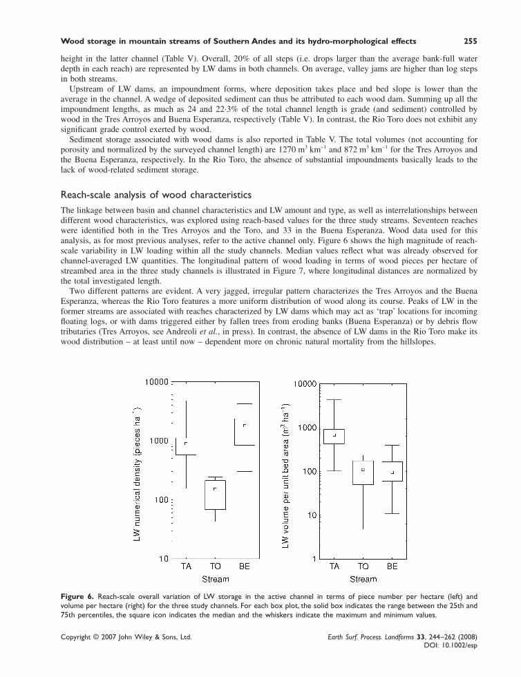
Figure 6. Reach-scale overall variation of LW storage in the active channel in terms of piece number per hectare (left) andvolume per hectare (right) for the three study channels. For each box plot, the solid box indicates the range between the 25th and75th percentiles, the square icon indicates the median and the whiskers indicate the maximum and minimum values.
height in the latter channel (Table V). Overall, 20% of all steps (i.e. drops larger than the average bank-full waterdepth in each reach) are represented by LW dams in both channels. On average, valley jams are higher than log stepsin both streams.
Upstream of LW dams, an impoundment forms, where deposition takes place and bed slope is lower than theaverage in the channel. A wedge of deposited sediment can thus be attributed to each wood dam. Summing up all theimpoundment lengths, as much as 24 and 22·3% of the total channel length is grade (and sediment) controlled bywood in the Tres Arroyos and Buena Esperanza, respectively (Table V). In contrast, the Rio Toro does not exhibit anysignificant grade control exerted by wood.
Sediment storage associated with wood dams is also reported in Table V. The total volumes (not accounting forporosity and normalized by the surveyed channel length) are 1270 m3 km−1 and 872 m3 km−1 for the Tres Arroyos andthe Buena Esperanza, respectively. In the Rio Toro, the absence of substantial impoundments basically leads to thelack of wood-related sediment storage.
Reach-scale analysis of wood characteristicsThe linkage between basin and channel characteristics and LW amount and type, as well as interrelationships betweendifferent wood characteristics, was explored using reach-based values for the three study streams. Seventeen reacheswere identified both in the Tres Arroyos and the Toro, and 33 in the Buena Esperanza. Wood data used for thisanalysis, as for most previous analyses, refer to the active channel only. Figure 6 shows the high magnitude of reach-scale variability in LW loading within all the study channels. Median values reflect what was already observed forchannel-averaged LW quantities. The longitudinal pattern of wood loading in terms of wood pieces per hectare ofstreambed area in the three study channels is illustrated in Figure 7, where longitudinal distances are normalized bythe total investigated length.
Two different patterns are evident. A very jagged, irregular pattern characterizes the Tres Arroyos and the BuenaEsperanza, whereas the Rio Toro features a more uniform distribution of wood along its course. Peaks of LW in theformer streams are associated with reaches characterized by LW dams which may act as ‘trap’ locations for incomingfloating logs, or with dams triggered either by fallen trees from eroding banks (Buena Esperanza) or by debris flowtributaries (Tres Arroyos, see Andreoli et al., in press). In contrast, the absence of LW dams in the Rio Toro make itswood distribution – at least until now – dependent more on chronic natural mortality from the hillslopes.

256 F. Comiti et al.
Copyright © 2007 John Wiley & Sons, Ltd. Earth Surf. Process. Landforms 33, 244–262 (2008)DOI: 10.1002/esp
Figure 7. Longitudinal reach-scale variation in LW storage (pieces per hectare) for the three study channels. The gap present inthe Buena Esperanza results from the unsurveyed reach (see the text).
A Pearson correlation matrix obtained on reach-scale, log-transformed variables describing channel geometry (slope,bank-full channel width and depth, number of boulders and steps larger than bank-full depth) and wood characteristics(spatial density of wood pieces, rootwads and volume, log-step and jam frequency, wood dimensions relative tochannel width and depth) was performed using all reaches from the three channels. Unfortunately, correlation coeffi-cients are generally low, and relationships in terms of LW volume are strongly biased because of the large differencesin wood diameter and wood supply among the three basins. However, an interesting outcome is the high correlation(R2 = 0·64, p < 0·001) between abundance of wood and number of wood pieces longer than bank-full width (numberper ha of streambed area for both variables). In contrast, a much smaller correlation (R2 = 0·20, p < 0·001) is observedwhen considering the number of wood pieces larger than bank-full depth.
Analysing each stream separately, only a few significant correlations can be observed. Wood spatial density issignificantly correlated with reach slope (R2 = 0·310, p = 0·018) and drainage area (R2 = −0·250, p = 0·040) in the TresArroyos, but not in the other streams. Bank-full width and depth do not correlate with wood density in any channel. Alinkage between abundance (i.e. spatial density) of rootwads and wood loading seems instead to exist in all thechannels (R2 = 0·25–0·36, p < 0·05).
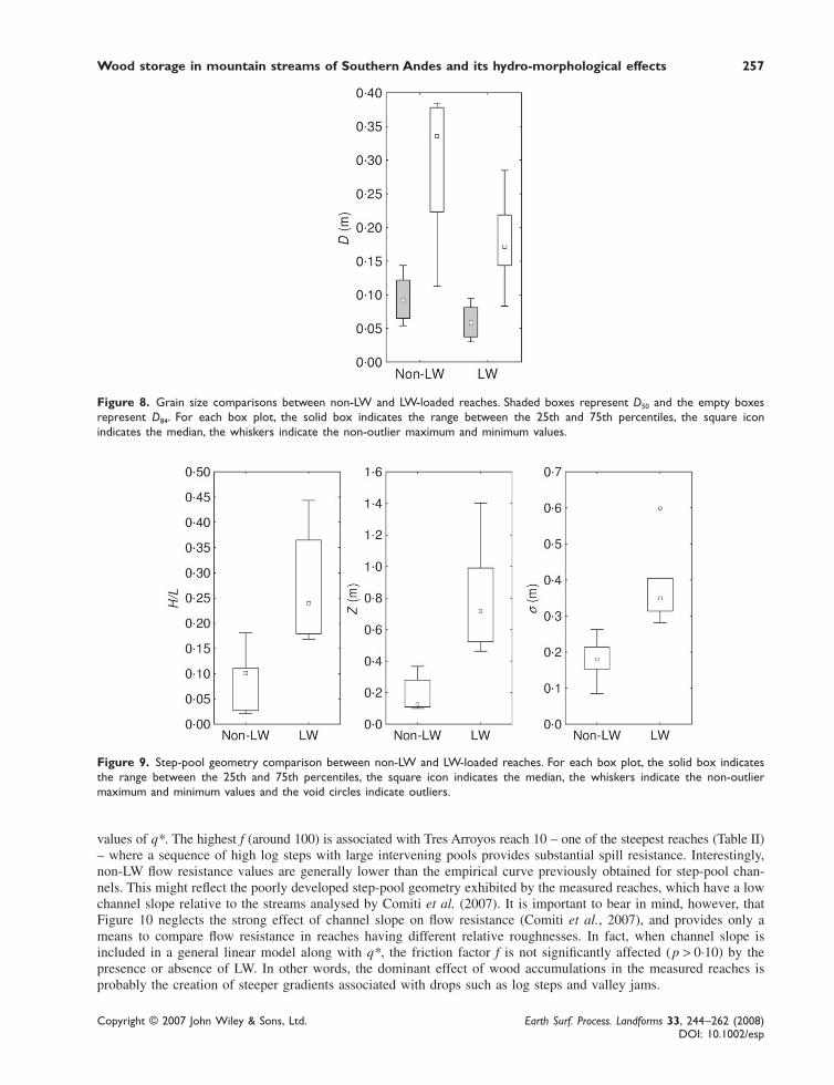
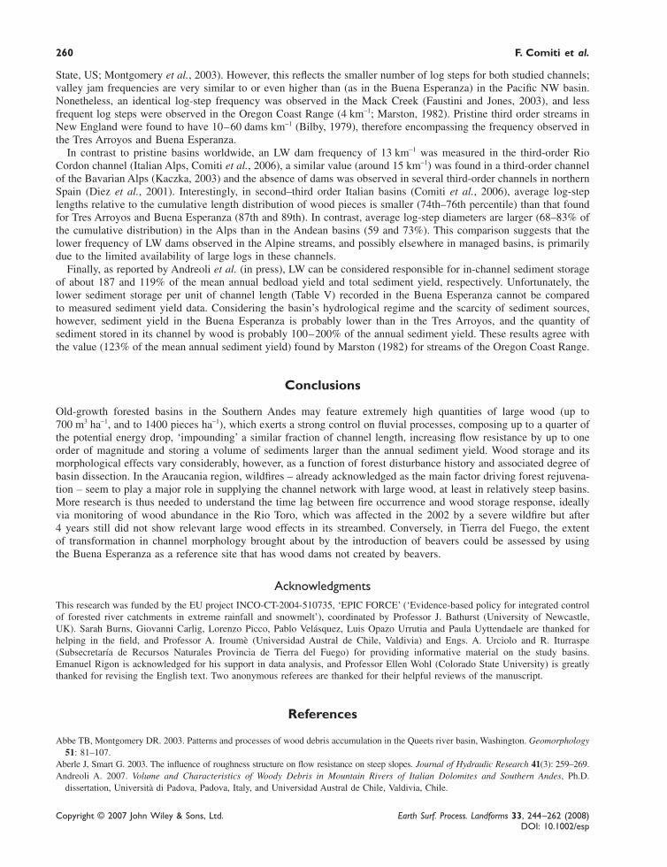
LW influence on grain size distribution, bed roughness and flow resistanceThe key parameters describing the roughness characteristics of the reaches analysed through the salt tracer measure-ments were compared in order to assess dissimilarity between LW and non-LW reaches (see above). Analyses of grainsize distribution in the stream reaches show that the composite D84 of the non-LWD reaches ranges from 0·113 to0·385 m, whereas in LW-influenced reaches the values range from 0·083 to 0·285 m. Figure 8 shows that both D50 andD84 are significantly larger in non-wood reaches than in wood-loaded ones (p < 0·05). The geometry of the longitudi-nal bed profile is also significantly different between the two groups (Figure 9). The reach-averaged drop height Z(calculated as step height minus pool depth) is considerably higher in LW reaches (p < 0·001), as well as the ratiobetween average step height and step spacing (H/L, p = 0·001). Together, the two variables indicate higher steps anddeeper pools in the LW-loaded reaches. Furthermore, the comparison in terms of the standard deviation of thelongitudinal profile (σ) shows significantly larger roughness in LW reaches ( p < 0·001).
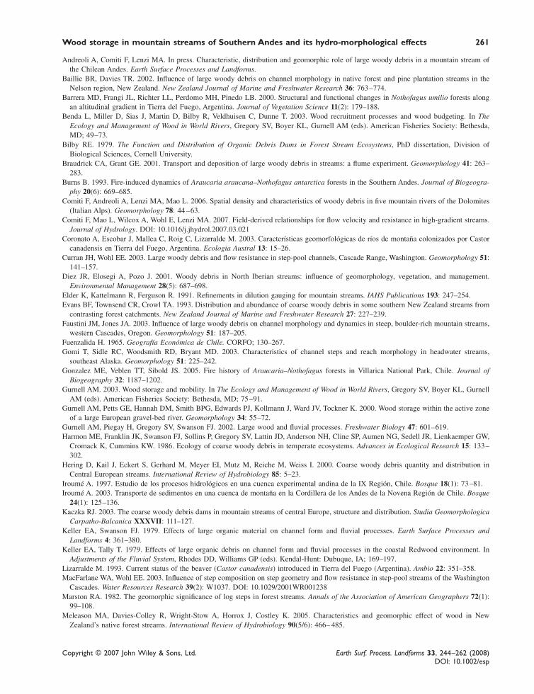
Figure 10 illustrates the variation of the Darcy–Weisbach friction factor f – calculated using Equation (1) – withthe dimensionless unit discharge (i.e. q/(gD84
3)0.5, as in the work of Comiti et al., 2007). The investigated q* rangesfrom 0·036 to 1·126 and calculated friction factor f from 0·3 to 97·5. The field-based curve derived by Comiti et al. forstep-pool streams is also reported. Despite the large scatter, flow resistance shows a decreasing trend and, mostnotably, non-LW reaches feature lower friction factors (up to one order of magnitude) than LW reaches for similar
Wood storage in mountain streams of Southern Andes and its hydro-morphological effects 257
Copyright © 2007 John Wiley & Sons, Ltd. Earth Surf. Process. Landforms 33, 244–262 (2008)DOI: 10.1002/esp
Figure 8. Grain size comparisons between non-LW and LW-loaded reaches. Shaded boxes represent D50 and the empty boxesrepresent D84. For each box plot, the solid box indicates the range between the 25th and 75th percentiles, the square iconindicates the median, the whiskers indicate the non-outlier maximum and minimum values.
Figure 9. Step-pool geometry comparison between non-LW and LW-loaded reaches. For each box plot, the solid box indicatesthe range between the 25th and 75th percentiles, the square icon indicates the median, the whiskers indicate the non-outliermaximum and minimum values and the void circles indicate outliers.
values of q*. The highest f (around 100) is associated with Tres Arroyos reach 10 – one of the steepest reaches (Table II)– where a sequence of high log steps with large intervening pools provides substantial spill resistance. Interestingly,non-LW flow resistance values are generally lower than the empirical curve previously obtained for step-pool chan-nels. This might reflect the poorly developed step-pool geometry exhibited by the measured reaches, which have a lowchannel slope relative to the streams analysed by Comiti et al. (2007). It is important to bear in mind, however, thatFigure 10 neglects the strong effect of channel slope on flow resistance (Comiti et al., 2007), and provides only ameans to compare flow resistance in reaches having different relative roughnesses. In fact, when channel slope isincluded in a general linear model along with q*, the friction factor f is not significantly affected (p > 0·10) by thepresence or absence of LW. In other words, the dominant effect of wood accumulations in the measured reaches isprobably the creation of steeper gradients associated with drops such as log steps and valley jams.

258 F. Comiti et al.
Copyright © 2007 John Wiley & Sons, Ltd. Earth Surf. Process. Landforms 33, 244–262 (2008)DOI: 10.1002/esp
Figure 10. The Darcy–Weisbach friction factor f calculated for the investigated channel reaches (with and without LW) plottedversus the non-dimensional unit discharge q*. The equation for high-gradient streams mostly without wood derived by Comiti et al.(2007, Equation (14)) is also reported, and several reaches are marked (Tres Arroyos TA, Buena Esperanza BE; see Table II).
Analysis of the ratio between grain resistance fg (estimated by Equation (2)) and the measured total friction factorsindicates that grain roughness is able to explain only a small fraction of the total flow resistance (<10%), apart fromreach A in the Buena Esperanza, which is characterized by a low channel slope and by a smooth profile. Overall, LWreaches feature the lowest ratios – on average 2·8% – compared with the mean value of reaches without wood (5·4%,excluding reach A). However, a Mann–Whitney U test did not reveal a strong statistical difference ( p = 0·08) betweenthe two groups.
Discussion
In-channel wood quantity in old-growth forested mountain basins of the Southern Andes can vary considerably bothbetween and within channels. The strong longitudinal variation of LW quantity in the Tres Arroyos and in the BuenaEsperanza as well as its link to ‘external’ factors rather than to channel properties – shown by the low correlationswith stream variables – reflects what Comiti et al. (2006) observed in second–fourth order channels of the ItalianDolomites.
Basically, wood location in such confined, relatively small mountain streams (i.e. relative to wood size) is notprimarily determined by stream hydraulics, such as deposition on bars as found in wider, lower gradient rivers(Gurnell et al., 2000; Wzyga and Zawiejska, 2005), but by complex bank/hillslope processes (e.g. falling of largetrees, debris flows, landslides). These latter processes are the main sources of stable (i.e. relatively long, with rootwadsattached) pieces, which can subsequently trap mobile woody debris floating from upstream. In other words, woodstorage is mostly related to the availability of stable wood pieces locally delivered by banks and hillslopes rather thancoming from upstream reaches.
However, similarities in log length distribution, orientation to flow, number and fraction of pieces within jams andjam dimensions are probably determined by the similar channel size (i.e. bank-full width) of the three third-orderstreams.
LW storage in the Tres Arroyos (around 700 m3 ha−1 in the active channel, or 556 m3 km−1 based on channel length)is extremely abundant. Comparably high values have been reported only for old-growth conifer forests in the PacificNorthwest, where average wood storage of up to 1000 m3 ha−1 is recorded (Gurnell, 2003). For example, in MackCreek, a third-order stream (9 m wide, thus comparable to the Tres Arroyos) that flows through a 500-year-oldconiferous forest, the average wood storage is 812 m3 ha−1 (reported by Gurnell et al., 2002). Such high LW storagecan be partly attributed to the small fraction of wood pieces moved by ‘ordinary’ floods (<1% in the Mack Creek,Gurnell et al., 2002). In the Tres Arroyos, current investigations using metal tags indicate that a similarly low percent-age of wood pieces (2·5–4%; Andreoli, 2007) is mobilized each year by ordinary floods.

Wood storage in mountain streams of Southern Andes and its hydro-morphological effects 259
Copyright © 2007 John Wiley & Sons, Ltd. Earth Surf. Process. Landforms 33, 244–262 (2008)DOI: 10.1002/esp
The relatively low LW volume stored in the Buena Esperanza (120 m3 ha−1, 76 m3 km−1) is determined by its smalllog diameters, which derive from the extremely slow growth of Nothofagus in the Tierra del Fuego, despite theextremely high abundance of wood pieces. The Rio Toro is instead characterized by a low supply of large wood thatmakes its LW storage comparable to the Buena Esperanza (117 m3 ha−1, 144 m3 km−1). Similar values (100–200 m3 ha−1)are, however, typical of unmanaged mature hardwood forests (Harmon et al., 1986; Hering et al., 2000; Gurnell,2003), and, most notably, of second order streams in Nothofagus native forest in New Zealand (94 –101 m3 ha−1, Evanset al., 1993; Baillie and Davies, 2002). Higher (85–470 m3 ha−1) wood storage is reported by Meleason et al. (2005)for small (3–6 m wide) channels in pristine New Zealand basins. Overall, a reference minimum wood storage between100 and 120 m3 ha−1 can be envisioned for mountain streams flowing in pristine Nothofagus forests in both SouthAmerica and New Zealand.
Much smaller LW volumes characterize second–third order channels in long managed montane territories such asthe Italian Alps (30–70 m3 ha−1; Comiti et al., 2006), UK Highland Waters (44–88 m3 ha−1; Gurnell et al., 2002) andnorthern Spain (0·4–4·8 m3 ha−1; Diez et al., 2001). Forest management drastically reduces the supply of large logs,which typically dominate wood volume budget (Meleason et al., 2005), and which also represent potential key piecesable to trap finer wood in channels.
Along with spatial density, wood morphological effects may range from almost negligible (as in the case of RioToro) up to controlling more than a quarter of the total elevation drop and bed surface characteristics along a quarterof the channel length. Interestingly, differences may be substantial even in adjacent basins, and less pronouncedbetween different climates and forest type (i.e. latitudes). Latitude surely acts on tree growth (i.e. wood diameter) andon natural forest disturbance processes (i.e. wildfire versus windblown moving southward), but, notwithstandingdifferent log size and log number, the net effects on channel morphology are apparently very similar. In the sub-Antarctic climate of Tierra del Fuego, wood rarely reaches large dimensions but the abundant supply associated withwind-caused mortality makes streams prone to local grade-control by valley jams and log steps composed of floateddebris trapped by occasional fallen trees. In the warmer climate of the Araucania, fires control forest regeneration andthus probably wood supply to channels. In-channel wood loading does not respond immediately to wildfire, however;a lag time of several decades exists (Benda et al., 2003; Zelt and Wohl, 2004). This may explain why wood volumesare so different between the Rio Toro, where almost all the basin forests burned in 2002, and the Tres Arroyos, whichis now heavily dissected as a consequence of fires that occurred almost a century ago. Of course, basin geology andtopography play a fundamental role in delivering burned dead wood from hillslopes to the main channel. In the TresArroyos, the destruction by fire of the forest cover and of the root network caused severe slope instability, which inturn resulted in debris flows able to transport many huge pieces of wood into the stream, prompting the formation ofmassive valley jams.
In contrast, in the Rio Toro the burned trees are still standing, and no landslides have taken place yet in the basin,possibly as a consequence of the smaller basin slope (Table I). Wood quantity in this ‘wood-limited supply’ basin islow, especially when measured as number of pieces per hectare of bed area. Wood volumes are comparable to theFueginan channel only because Nothofagus trees are much bigger in the Rio Toro than in the cold, wind-batteredBuena Esperanza. Also, relative wood dimensions in the Rio Toro are smaller than in the other two channels (TableIII), possibly favouring wood transport and thus limiting wood storage. However, we may expect Rio Toro to becomemuch enriched in wood within a few decades (10–30 years), once basin hillslopes lose the stabilizing effect of treeroots, and trees themselves decay, fall to the ground and eventually reach the channel network. Whether the degree ofbasin dissection, frequency of debris flows and in turn wood storage will attain a level comparable to the Tres Arroyosis difficult to predict given the effect of other topographic and lithologic factors.
The Tres Arroyos and the Buena Esperanza have very similar values (27 and 24%, respectively) of channelelevation loss due to LW dams, as well as of percentage of LW-related steps (22 and 19%, respectively). These valuesare generally lower than in the Pacific Northwest (see the introduction), but are very similar to the percentage reportedby Faustini and Jones (2003) for the third-order Mack Creek channel (Oregon, US) and for other headwater streams inthe Pacific Northwest (Keller and Swanson, 1979; Keller and Tally, 1979). Much lower relative numbers and dropscaused by LW dams were observed in managed mountain rivers of the Alps (Comiti et al., 2006).
The present study confirms that wood-rich reaches, especially those characterized by wood dams, have finer sediments,higher steps and higher flow resistance than non-wooded segments, as previously found by MacFarlane and Wohl(2003). Higher flow resistance appears to occur mostly as a consequence of the steeper and rougher profile that woodjams induce by creating higher steps. However, MacFarlane and Wohl (2003) found that the relative contribution ofgrain roughness to the total flow resistance – also negligible in most of our reaches – was significantly lower in LWreaches, whereas in the present study the difference is less pronounced.
The longitudinal frequency of LW dams (Table V) in the Buena Esperanza and the Tres Arroyos (32 and 20 damsper km, respectively) appears somewhat lower than in catchments of similar size within the Queets basin (Washington
260 F. Comiti et al.
Copyright © 2007 John Wiley & Sons, Ltd. Earth Surf. Process. Landforms 33, 244–262 (2008)DOI: 10.1002/esp
State, US; Montgomery et al., 2003). However, this reflects the smaller number of log steps for both studied channels;valley jam frequencies are very similar to or even higher than (as in the Buena Esperanza) in the Pacific NW basin.Nonetheless, an identical log-step frequency was observed in the Mack Creek (Faustini and Jones, 2003), and lessfrequent log steps were observed in the Oregon Coast Range (4 km−1; Marston, 1982). Pristine third order streams inNew England were found to have 10–60 dams km−1 (Bilby, 1979), therefore encompassing the frequency observed inthe Tres Arroyos and Buena Esperanza.
In contrast to pristine basins worldwide, an LW dam frequency of 13 km−1 was measured in the third-order RioCordon channel (Italian Alps, Comiti et al., 2006), a similar value (around 15 km−1) was found in a third-order channelof the Bavarian Alps (Kaczka, 2003) and the absence of dams was observed in several third-order channels in northernSpain (Diez et al., 2001). Interestingly, in second–third order Italian basins (Comiti et al., 2006), average log-steplengths relative to the cumulative length distribution of wood pieces is smaller (74th–76th percentile) than that foundfor Tres Arroyos and Buena Esperanza (87th and 89th). In contrast, average log-step diameters are larger (68–83% ofthe cumulative distribution) in the Alps than in the Andean basins (59 and 73%). This comparison suggests that thelower frequency of LW dams observed in the Alpine streams, and possibly elsewhere in managed basins, is primarilydue to the limited availability of large logs in these channels.
Finally, as reported by Andreoli et al. (in press), LW can be considered responsible for in-channel sediment storageof about 187 and 119% of the mean annual bedload yield and total sediment yield, respectively. Unfortunately, thelower sediment storage per unit of channel length (Table V) recorded in the Buena Esperanza cannot be comparedto measured sediment yield data. Considering the basin’s hydrological regime and the scarcity of sediment sources,however, sediment yield in the Buena Esperanza is probably lower than in the Tres Arroyos, and the quantity ofsediment stored in its channel by wood is probably 100–200% of the annual sediment yield. These results agree withthe value (123% of the mean annual sediment yield) found by Marston (1982) for streams of the Oregon Coast Range.
Conclusions
Old-growth forested basins in the Southern Andes may feature extremely high quantities of large wood (up to700 m3 ha−1, and to 1400 pieces ha−1), which exerts a strong control on fluvial processes, composing up to a quarter ofthe potential energy drop, ‘impounding’ a similar fraction of channel length, increasing flow resistance by up to oneorder of magnitude and storing a volume of sediments larger than the annual sediment yield. Wood storage and itsmorphological effects vary considerably, however, as a function of forest disturbance history and associated degree ofbasin dissection. In the Araucania region, wildfires – already acknowledged as the main factor driving forest rejuvena-tion – seem to play a major role in supplying the channel network with large wood, at least in relatively steep basins.More research is thus needed to understand the time lag between fire occurrence and wood storage response, ideallyvia monitoring of wood abundance in the Rio Toro, which was affected in the 2002 by a severe wildfire but after4 years still did not show relevant large wood effects in its streambed. Conversely, in Tierra del Fuego, the extentof transformation in channel morphology brought about by the introduction of beavers could be assessed by usingthe Buena Esperanza as a reference site that has wood dams not created by beavers.
AcknowledgmentsThis research was funded by the EU project INCO-CT-2004-510735, ‘EPIC FORCE’ (‘Evidence-based policy for integrated controlof forested river catchments in extreme rainfall and snowmelt’), coordinated by Professor J. Bathurst (University of Newcastle,UK). Sarah Burns, Giovanni Carlig, Lorenzo Picco, Pablo Velásquez, Luis Opazo Urrutia and Paula Uyttendaele are thanked forhelping in the field, and Professor A. Iroumè (Universidad Austral de Chile, Valdivia) and Engs. A. Urciolo and R. Iturraspe(Subsecretaría de Recursos Naturales Provincia de Tierra del Fuego) for providing informative material on the study basins.Emanuel Rigon is acknowledged for his support in data analysis, and Professor Ellen Wohl (Colorado State University) is greatlythanked for revising the English text. Two anonymous referees are thanked for their helpful reviews of the manuscript.
References
Abbe TB, Montgomery DR. 2003. Patterns and processes of wood debris accumulation in the Queets river basin, Washington. Geomorphology51: 81–107.
Aberle J, Smart G. 2003. The influence of roughness structure on flow resistance on steep slopes. Journal of Hydraulic Research 41(3): 259–269.Andreoli A. 2007. Volume and Characteristics of Woody Debris in Mountain Rivers of Italian Dolomites and Southern Andes, Ph.D.
dissertation, Università di Padova, Padova, Italy, and Universidad Austral de Chile, Valdivia, Chile.
Wood storage in mountain streams of Southern Andes and its hydro-morphological effects 261
Copyright © 2007 John Wiley & Sons, Ltd. Earth Surf. Process. Landforms 33, 244–262 (2008)DOI: 10.1002/esp
Andreoli A, Comiti F, Lenzi MA. In press. Characteristic, distribution and geomorphic role of large woody debris in a mountain stream ofthe Chilean Andes. Earth Surface Processes and Landforms.
Baillie BR, Davies TR. 2002. Influence of large woody debris on channel morphology in native forest and pine plantation streams in theNelson region, New Zealand. New Zealand Journal of Marine and Freshwater Research 36: 763–774.
Barrera MD, Frangi JL, Richter LL, Perdomo MH, Pinedo LB. 2000. Structural and functional changes in Nothofagus umilio forests alongan altitudinal gradient in Tierra del Fuego, Argentina. Journal of Vegetation Science 11(2): 179–188.
Benda L, Miller D, Sias J, Martin D, Bilby R, Veldhuisen C, Dunne T. 2003. Wood recruitment processes and wood budgeting. In TheEcology and Management of Wood in World Rivers, Gregory SV, Boyer KL, Gurnell AM (eds). American Fisheries Society: Bethesda,MD; 49–73.
Bilby RE. 1979. The Function and Distribution of Organic Debris Dams in Forest Stream Ecosystems, PhD dissertation, Division ofBiological Sciences, Cornell University.
Braudrick CA, Grant GE. 2001. Transport and deposition of large woody debris in streams: a flume experiment. Geomorphology 41: 263–283.
Burns B. 1993. Fire-induced dynamics of Araucaria araucana–Nothofagus antarctica forests in the Southern Andes. Journal of Biogeogra-phy 20(6): 669–685.
Comiti F, Andreoli A, Lenzi MA, Mao L. 2006. Spatial density and characteristics of woody debris in five mountain rivers of the Dolomites(Italian Alps). Geomorphology 78: 44 –63.
Comiti F, Mao L, Wilcox A, Wohl E, Lenzi MA. 2007. Field-derived relationships for flow velocity and resistance in high-gradient streams.Journal of Hydrology. DOI: 10.1016/j.jhydrol.2007.03.021
Coronato A, Escobar J, Mallea C, Roig C, Lizarralde M. 2003. Características geomorfológicas de ríos de montaña colonizados por Castorcanadensis en Tierra del Fuego, Argentina. Ecologia Austral 13: 15–26.
Curran JH, Wohl EE. 2003. Large woody debris and flow resistance in step-pool channels, Cascade Range, Washington. Geomorphology 51:141–157.
Diez JR, Elosegi A, Pozo J. 2001. Woody debris in North Iberian streams: influence of geomorphology, vegetation, and management.Environmental Management 28(5): 687–698.
Elder K, Kattelmann R, Ferguson R. 1991. Refinements in dilution gauging for mountain streams. IAHS Publications 193: 247–254.Evans BF, Townsend CR, Crowl TA. 1993. Distribution and abundance of coarse woody debris in some southern New Zealand streams from
contrasting forest catchments. New Zealand Journal of Marine and Freshwater Research 27: 227–239.Faustini JM, Jones JA. 2003. Influence of large woody debris on channel morphology and dynamics in steep, boulder-rich mountain streams,
western Cascades, Oregon. Geomorphology 51: 187–205.Fuenzalida H. 1965. Geografía Económica de Chile. CORFO; 130–267.Gomi T, Sidle RC, Woodsmith RD, Bryant MD. 2003. Characteristics of channel steps and reach morphology in headwater streams,
southeast Alaska. Geomorphology 51: 225–242.Gonzalez ME, Veblen TT, Sibold JS. 2005. Fire history of Araucaria–Nothofagus forests in Villarica National Park, Chile. Journal of
Biogeography 32: 1187–1202.Gurnell AM. 2003. Wood storage and mobility. In The Ecology and Management of Wood in World Rivers, Gregory SV, Boyer KL, Gurnell
AM (eds). American Fisheries Society: Bethesda, MD; 75–91.Gurnell AM, Petts GE, Hannah DM, Smith BPG, Edwards PJ, Kollmann J, Ward JV, Tockner K. 2000. Wood storage within the active zone
of a large European gravel-bed river. Geomorphology 34: 55–72.Gurnell AM, Piegay H, Gregory SV, Swanson FJ. 2002. Large wood and fluvial processes. Freshwater Biology 47: 601–619.Harmon ME, Franklin JK, Swanson FJ, Sollins P, Gregory SV, Lattin JD, Anderson NH, Cline SP, Aumen NG, Sedell JR, Lienkaemper GW,
Cromack K, Cummins KW. 1986. Ecology of coarse woody debris in temperate ecosystems. Advances in Ecological Research 15: 133–302.
Hering D, Kail J, Eckert S, Gerhard M, Meyer EI, Mutz M, Reiche M, Weiss I. 2000. Coarse woody debris quantity and distribution inCentral European streams. International Review of Hydrobiology 85: 5–23.
Iroumé A. 1997. Estudio de los procesos hidrológicos en una cuenca experimental andina de la IX Región, Chile. Bosque 18(1): 73–81.Iroumé A. 2003. Transporte de sedimentos en una cuenca de montaña en la Cordillera de los Andes de la Novena Región de Chile. Bosque
24(1): 125–136.Kaczka RJ. 2003. The coarse woody debris dams in mountain streams of central Europe, structure and distribution. Studia Geomorphologica
Carpatho-Balcanica XXXVII: 111–127.Keller EA, Swanson FJ. 1979. Effects of large organic material on channel form and fluvial processes. Earth Surface Processes and
Landforms 4: 361–380.Keller EA, Tally T. 1979. Effects of large organic debris on channel form and fluvial processes in the coastal Redwood environment. In
Adjustments of the Fluvial System, Rhodes DD, Williams GP (eds). Kendal-Hunt: Dubuque, IA; 169–197.Lizarralde M. 1993. Current status of the beaver (Castor canadensis) introduced in Tierra del Fuego (Argentina). Ambio 22: 351–358.MacFarlane WA, Wohl EE. 2003. Influence of step composition on step geometry and flow resistance in step-pool streams of the Washington
Cascades. Water Resources Research 39(2): W1037. DOI: 10.1029/2001WR001238Marston RA. 1982. The geomorphic significance of log steps in forest streams. Annals of the Association of American Geographers 72(1):
99–108.Meleason MA, Davies-Colley R, Wright-Stow A, Horrox J, Costley K. 2005. Characteristics and geomorphic effect of wood in New
Zealand’s native forest streams. International Review of Hydrobiology 90(5/6): 466– 485.

262 F. Comiti et al.
Copyright © 2007 John Wiley & Sons, Ltd. Earth Surf. Process. Landforms 33, 244–262 (2008)DOI: 10.1002/esp
Millar RG, Quick MC. 1994. Flow resistance of high-gradient gravel channels. In Hydraulic Engineering ’94, Cotroneo GV, Rumer RR(eds). American Society of Civil Engineers; 717–721.
Montgomery DR, Piégay H. 2003. Wood in rivers: interactions with channel morphology and processes. Geomorphology 51: 1–5.Montgomery DR, Collins BD, Buffington KM, Abbe TB. 2003. Geomorphic effects of wood in rivers. In The Ecology and Management of
Wood in World Rivers, Gregory SV, Boyer KL, Gurnell AM (eds). American Fisheries Society: Bethesda, MD; 21–47.Rebertus AJ, Kitzberger T, Veblen TT, Roovers LM. 1997. Blowdown history and landscape patterns in the Andes of Tierra del Fuego,
Argentina. Ecology 78(3): 678–692.StatSoft. 2006. STATISTICA, Version 7.1. Tulsa, OK.Swanson FJ, Lienkaemper GW, Sedell JR. 1976. History, Physical Effects, and Management Implications of Large Organic Debris in
Western Oregon Streams, US Forest Service General Technical Report PNW-56.Urciolo A, Iturraspe R, Collado L. 2006. Report of basin response for Argentina. Presentation at the ‘EPIC FORCE Project’ progress
meeting, Madrid.Veblen TT, Donoso C, Schlegel FM, Escobar B. 1981. Forest dynamics in South-Central Chile. Journal of Biogeography 8(3): 211–247.Wilcox A, Nelson JM, Wohl EE. 2006. Flow resistance dynamics in step-pool channels: 2. Partitioning between grain, spill, and woody
debris resistance. Water Resources Research 42: W05419. DOI: 10.1029/2005WR004278Wohl E, Madsen S, MacDonald L. 1997. Characteristics of log and clast bed-steps in step-pool streams of northwestern Montana, USA.
Geomorphology 20: 1–10.Wyzga B, Zawiejska J. 2005. Wood storage in a wide mountain river: case study of the Czarny Dunajec, Polish Carpathians. Earth Surface
Processes and Landforms 30(12): 1475 –1494.Zelt RB, Wohl EE. 2004. Channel and woody debris characteristics in adjacent burned and unburned watersheds a decade after wildfire,
Park County, Wyoming. Geomorphology 57(3): 217–233.
Related Documents