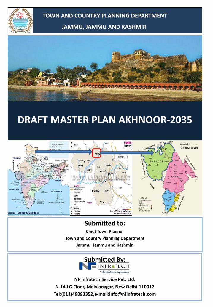
Submitted to: Chief Town Planner Town and Country Planning Department Jammu, Jammu and Kashmir. DRAFT MASTER PLAN AKHNOOR-2035 TOWN AND COUNTRY PLANNING DEPARTMENT JAMMU, JAMMU AND KASHMIR Submitted By: NF Infratech Service Pvt. Ltd. N-14,LG Floor, Malvianagar, New Delhi-110017 Tel:(011)49093352,e-mail:[email protected]

Welcome message from author
This document is posted to help you gain knowledge. Please leave a comment to let me know what you think about it! Share it to your friends and learn new things together.
Transcript
Submitted to:Chief Town Planner
Town and Country Planning Department
Jammu, Jammu and Kashmir.
DRAFT MASTER PLAN AKHNOOR-2035
TOWN AND COUNTRY PLANNING DEPARTMENT
JAMMU, JAMMU AND KASHMIR
Submitted By:
NF Infratech Service Pvt. Ltd.
N-14,LG Floor, Malvianagar, New Delhi-110017
Tel:(011)49093352,e-mail:[email protected]
Draft Master Plan Akhnoor- 2035
NF Infratech Service. Pvt. Ltd. Town Planning Organization, Jammu Page i
Preface
In today’s world where urbanisation is growing at an alarming rate, large amount of resources are
being spent on the development of various urban settlements but the condition of these towns
continue to deteriorate because of piecemeal nature of expenditure and lack of definitive
development schemes. In view of this, Town Planning Organisation, Jammu has undertaken the
preparation of the Master Plans for various towns, which envisages all-encompassing development
of these towns. The Government has also decided to outsource few Master Plans; however, the
Master Plan for Akhnoor, has been outsourced to M/S NF Infratech Service Private Limited, New
Delhi.
The studies involved in the preparation of Master Plan for Akhnoor, 2035 concerns with the areas
crucial to planning and development of the sub-region. It has been a great privilege for M/S NF
Infratech Service Private Limited, New Delhi to undertake the assignment of formulating the Master
Plan of Akhnoor, 2035. In this Draft Master Plan, the development proposals have been framed
after a detailed study and analysis of the crucial issues related to economic development,
infrastructure, transportation, housing, environment and urban sustainability.
At this juncture, the main purpose for M/S NF Infratech Service Private Limited, New Delhi in
putting this document is to solicit critical comments and suggestions to achieve greater
participation, meaningfulness and make the Master Plan for Akhnoor, 2035 acceptable to
stakeholders who have a role to play in its development and implementable for the Local Authority.
The Draft Master Plan Akhnoor, 2035 is being submitted to the government and the Local Authority
for publication under the provision of “J & K Development Act 1970” and the rules framed thereof.
(Joginder Singh)
Chief Town Planner
Town Planning Organisation, Jammu
Draft Master Plan Akhnoor- 2035
NF Infratech Service. Pvt. Ltd. Town Planning Organization, Jammu Page ii
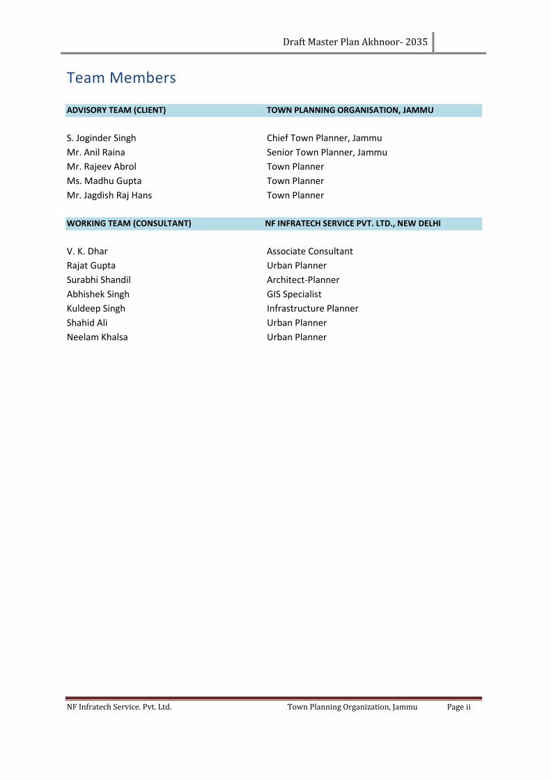
Team Members
ADVISORY TEAM (CLIENT) TOWN PLANNING ORGANISATION, JAMMU
S. Joginder Singh Chief Town Planner, Jammu
Mr. Anil Raina Senior Town Planner, Jammu
Mr. Rajeev Abrol Town Planner
Ms. Madhu Gupta Town Planner
Mr. Jagdish Raj Hans Town Planner
WORKING TEAM (CONSULTANT) NF INFRATECH SERVICE PVT. LTD., NEW DELHI
V. K. Dhar Associate Consultant
Rajat Gupta Urban Planner
Surabhi Shandil Architect-Planner
Abhishek Singh GIS Specialist
Kuldeep Singh Infrastructure Planner
Shahid Ali Urban Planner
Neelam Khalsa Urban Planner
Draft Master Plan Akhnoor- 2035
NF Infratech Service. Pvt. Ltd. Town Planning Organization, Jammu Page iii
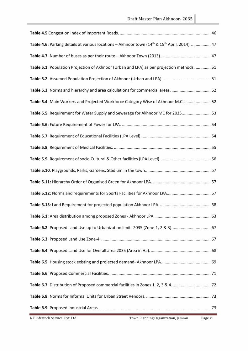
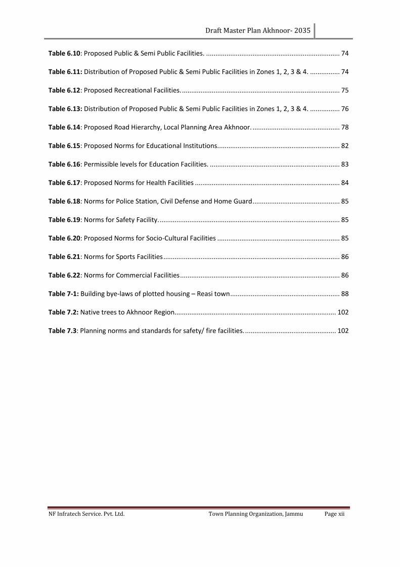
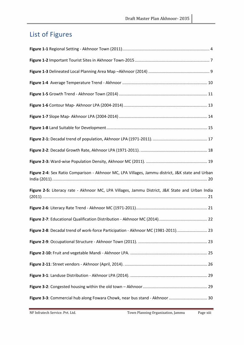
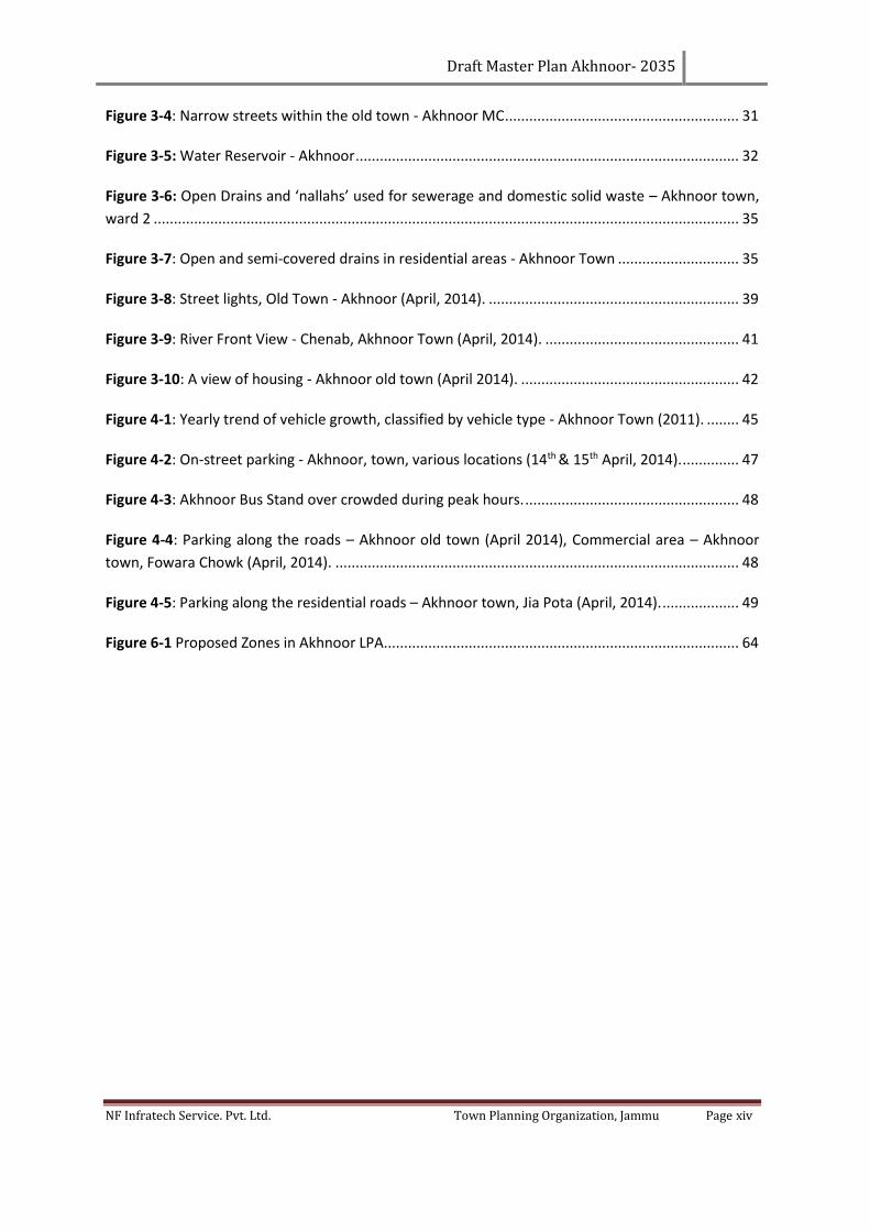
Table of Contents
Preface ............................................................................................................................. i
Team Members ...........................................................................................................................ii
Table of Contents ....................................................................................................................... iii
List of Tables ............................................................................................................................. x
List of Figures .......................................................................................................................... xiii
List of Abbreviations ................................................................................................................. xv
CHAPTER 1. Introduction and Regional Setting ........................................................................ 1
1.1 Background - Theoretical Framework ................................................................................... 1
1.2 Objectives of the Project ....................................................................................................... 2
1.3 Methodology ......................................................................................................................... 2
1.4 Location of Town in a Regional Context ............................................................................... 3
1.5 Transport linkages ................................................................................................................. 4
1.5.1 Road Connectivity ......................................................................................................... 4
1.5.2 Rail Connectivity............................................................................................................ 4
1.6 Regional/natural resources ................................................................................................... 5
1.6.1 Land ............................................................................................................................... 5
1.6.2 Minerals ........................................................................................................................ 5
1.6.3 Water Resources ........................................................................................................... 5
1.6.4 Flora and Fauna ............................................................................................................. 5
1.6.5 Forest resources ............................................................................................................ 6
1.6.6 Tourism and Heritage resources ................................................................................... 6
1.7 Local Planning Area ............................................................................................................... 8
1.8 Physical Characteristics ......................................................................................................... 9
1.8.1 Topography ................................................................................................................... 9
1.8.2 Elevation and Slope ....................................................................................................... 9
1.8.3 Soil ............................................................................................................................... 10
1.8.4 Climate ........................................................................................................................ 10
1.9 Physical Pattern of Growth ................................................................................................. 11
1.10 urban landscape & Built up environment ........................................................................... 12
1.11 Historical Evolution ............................................................................................................. 12
1.12 Identification of Incompatible Land uses ............................................................................ 12
1.12.1 Land suitability analysis .............................................................................................. 13
1.13 Problems and Issues............................................................................................................ 15
Draft Master Plan Akhnoor- 2035
NF Infratech Service. Pvt. Ltd. Town Planning Organization, Jammu Page iv
1.13.1 Existing Environmental Hazards & Disaster ................................................................ 15
1.13.2 Types of disasters ........................................................................................................ 15
CHAPTER 2. Socio-Economic Profile ........................................................................................ 17
2.1 Population Growth of Local Planning Area (LPA), Akhnoor ................................................ 17
2.1.1 Growth rate ................................................................................................................. 18
2.1.2 Population Density ...................................................................................................... 18
2.2 Population Characteristics .................................................................................................. 20
2.2.1 Sex Ratio of Akhnoor LPA and MC (2011) ................................................................... 20
2.2.2 Decadal trend, Akhnoor MC (1971-2011) ................................................................... 20
2.2.3 Literacy& Education .................................................................................................... 21
2.3 Economy and Employment ................................................................................................. 22
2.3.1 Work force participation ............................................................................................. 22
2.3.2 Occupational structure ............................................................................................... 23
2.4 Industries ............................................................................................................................ 24
2.5 Trade and Commerce .......................................................................................................... 24
2.5.1 Retail and wholesale shops ......................................................................................... 25
2.5.2 Mandis......................................................................................................................... 25
2.5.3 Informal Sector ........................................................................................................... 26
2.5.4 Street Vendors ............................................................................................................ 26
2.6 Key Issues under trade & commerce .................................................................................. 27
CHAPTER 3. Physical Growth and Infrastructure and services .................................................. 28
3.1 Existing Land use Distribution ............................................................................................. 28
3.1.1 Residential ................................................................................................................... 29
3.1.2 Commercial ................................................................................................................. 30
3.1.3 Public & Semi-Public ................................................................................................... 30
3.1.4 Recreational ................................................................................................................ 30
3.1.5 Traffic and Transportation .......................................................................................... 30
3.1.6 Agriculture and plantation land use ........................................................................... 31
3.1.7 Defence ....................................................................................................................... 31
3.2 Challenges of land use ........................................................................................................ 31
3.3 Physical Infrastructure ........................................................................................................ 32
3.3.1 Water supply ............................................................................................................... 32
3.3.2 Sewerage and Sanitation ............................................................................................ 34
3.3.3 Drainage ...................................................................................................................... 35
Draft Master Plan Akhnoor- 2035
NF Infratech Service. Pvt. Ltd. Town Planning Organization, Jammu Page v
3.3.4 Key Issues of Sewerage and Sanitation ....................................................................... 36
3.3.5 Solid Waste Management ........................................................................................... 36
3.3.6 Electricity ..................................................................................................................... 38
3.4 Social Infrastructure ............................................................................................................ 39
3.4.1 Education .................................................................................................................... 39
3.4.2 Health and Medical Facilities ...................................................................................... 40
3.5 Sports and Recreational ...................................................................................................... 40
3.5.1 Parks and open spaces ................................................................................................ 40
3.5.2 River front ................................................................................................................... 41
3.6 Other facilities ..................................................................................................................... 41
3.6.1 Post and Telegraph ..................................................................................................... 41
3.6.2 Telephone Exchanges .................................................................................................. 41
3.6.3 Police Facilities ............................................................................................................ 41
3.7 Housing ............................................................................................................................... 42
3.7.1 Housing Stock .............................................................................................................. 42
3.7.2 Housing Condition and Obsolescence Factor ............................................................. 42
3.8 Key Issues of Housing .......................................................................................................... 43
CHAPTER 4. Traffic & Transportation ...................................................................................... 44
4.1 Existing Transportation Network ........................................................................................ 44
4.2 Other District Roads at town and LPA level ........................................................................ 44
4.2.1 Road Accidents ............................................................................................................ 46
4.2.2 Congestion index for important roads ........................................................................ 46
4.3 Parking Facilities .................................................................................................................. 46
4.3.1 Bus Routes and Intercity Bus Services ........................................................................ 47
4.3.2 Terminal Facilities ....................................................................................................... 48
4.3.3 Parking issues .............................................................................................................. 48
4.4 Key issues related to Traffic and Transportation ................................................................ 50
CHAPTER 5. Population Projections and Demand Analysis ...................................................... 51
5.1 Projection and Potential Demand Analysis ......................................................................... 51
5.2 Commercial Projections ...................................................................................................... 52
5.3 Workforce Projections ........................................................................................................ 52
5.4 Infrastructure demand ........................................................................................................ 53
5.5 Physical Infrastructure ........................................................................................................ 53
5.6 Social Infrastructure and Public Services ............................................................................ 54
Draft Master Plan Akhnoor- 2035
NF Infratech Service. Pvt. Ltd. Town Planning Organization, Jammu Page vi
5.6.1 Education .................................................................................................................... 54
5.6.2 Health Care ................................................................................................................. 55
5.6.3 Socio Cultural & Safety Management Facilities .......................................................... 56
5.6.4 Fire Station .................................................................................................................. 56
5.6.5 Recreational Facilities ................................................................................................. 57
5.7 Land Requirement ............................................................................................................... 58
5.8 Conclusion ........................................................................................................................... 58
5.9 SWOT Analysis ..................................................................................................................... 58
5.9.1 Strengths ..................................................................................................................... 59
5.9.2 Weaknesses................................................................................................................. 59
5.9.3 Opportunities .............................................................................................................. 59
5.9.4 Threats ........................................................................................................................ 59
5.10 Vision 2035 .......................................................................................................................... 60
5.11 Objectives............................................................................................................................ 60
5.12 Concept for the preparation of Akhnoor Master Plan ........................................................ 61
5.13 Perspective Development Scenario for the town ............................................................... 61
5.13.1 Development of tourism ............................................................................................. 62
CHAPTER 6. Planning & Development Proposals ..................................................................... 63
6.1 Proposed Zone Development ............................................................................................. 63
6.1.1 Zone I: Area enclosed by core area (Dense Residential Area) .................................... 64
6.1.2 Zone II: Area enclosed by municipal limit of Akhnoor ................................................ 65
6.1.3 Zone III: Area outside MC limit and up to the Urbanizable limit ................................ 65
6.1.4 Zone IV: Agricultural/ defence/ air force/ forest outskirt ........................................... 66
6.2 Proposed Land use Plan ...................................................................................................... 66
6.3 Residential ........................................................................................................................... 68
6.3.1 Housing Shortage ........................................................................................................ 69
6.3.2 mixed use proposals ................................................................................................... 69
6.3.3 Housing Policy ............................................................................................................. 70
6.3.4 Commercial ................................................................................................................. 71
6.3.5 Informal sector ............................................................................................................ 72
6.4 Industrial ............................................................................................................................. 73
6.5 Public and Semi Public ........................................................................................................ 74
6.5.1 Location of Government offices and Buildings ........................................................... 74
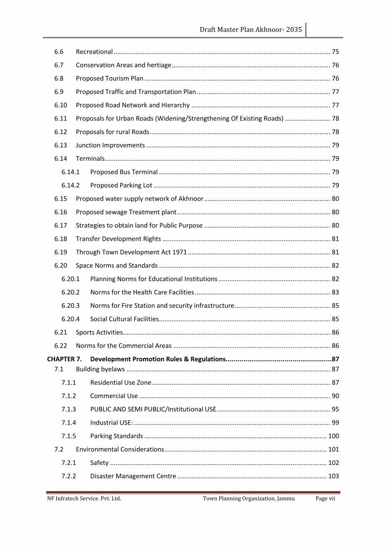
Draft Master Plan Akhnoor- 2035
NF Infratech Service. Pvt. Ltd. Town Planning Organization, Jammu Page vii
6.6 Recreational ........................................................................................................................ 75
6.7 Conservation Areas and hertiage ........................................................................................ 76
6.8 Proposed Tourism Plan ....................................................................................................... 76
6.9 Proposed Traffic and Transportation Plan .......................................................................... 77
6.10 Proposed Road Network and Hierarchy ............................................................................. 77
6.11 Proposals for Urban Roads (Widening/Strengthening Of Existing Roads) ......................... 78
6.12 Proposals for rural Roads .................................................................................................... 78
6.13 Junction Improvements ...................................................................................................... 79
6.14 Terminals ............................................................................................................................. 79
6.14.1 Proposed Bus Terminal ............................................................................................... 79
6.14.2 Proposed Parking Lot .................................................................................................. 79
6.15 Proposed water supply network of Akhnoor ...................................................................... 80
6.16 Proposed sewage Treatment plant ..................................................................................... 80
6.17 Strategies to obtain land for Public Purpose ...................................................................... 80
6.18 Transfer Development Rights ............................................................................................. 81
6.19 Through Town Development Act 1971 ............................................................................... 81
6.20 Space Norms and Standards ............................................................................................... 82
6.20.1 Planning Norms for Educational Institutions .............................................................. 82
6.20.2 Norms for the Health Care Facilities ........................................................................... 83
6.20.3 Norms for Fire Station and security infrastructure ..................................................... 85
6.20.4 Social Cultural Facilities ............................................................................................... 85
6.21 Sports Activities................................................................................................................... 86
6.22 Norms for the Commercial Areas ....................................................................................... 86
CHAPTER 7. Development Promotion Rules & Regulations...................................................... 87
7.1 Building byelaws ................................................................................................................. 87
7.1.1 Residential Use Zone ................................................................................................... 87
7.1.2 Commercial Use .......................................................................................................... 90
7.1.3 PUBLIC AND SEMI PUBLIC/Institutional USE ............................................................... 95
7.1.4 Industrial USE: ............................................................................................................. 99
7.1.5 Parking Standards ..................................................................................................... 100
7.2 Environmental Considerations .......................................................................................... 101
7.2.1 Safety ........................................................................................................................ 102
7.2.2 Disaster Management Centre ................................................................................... 103
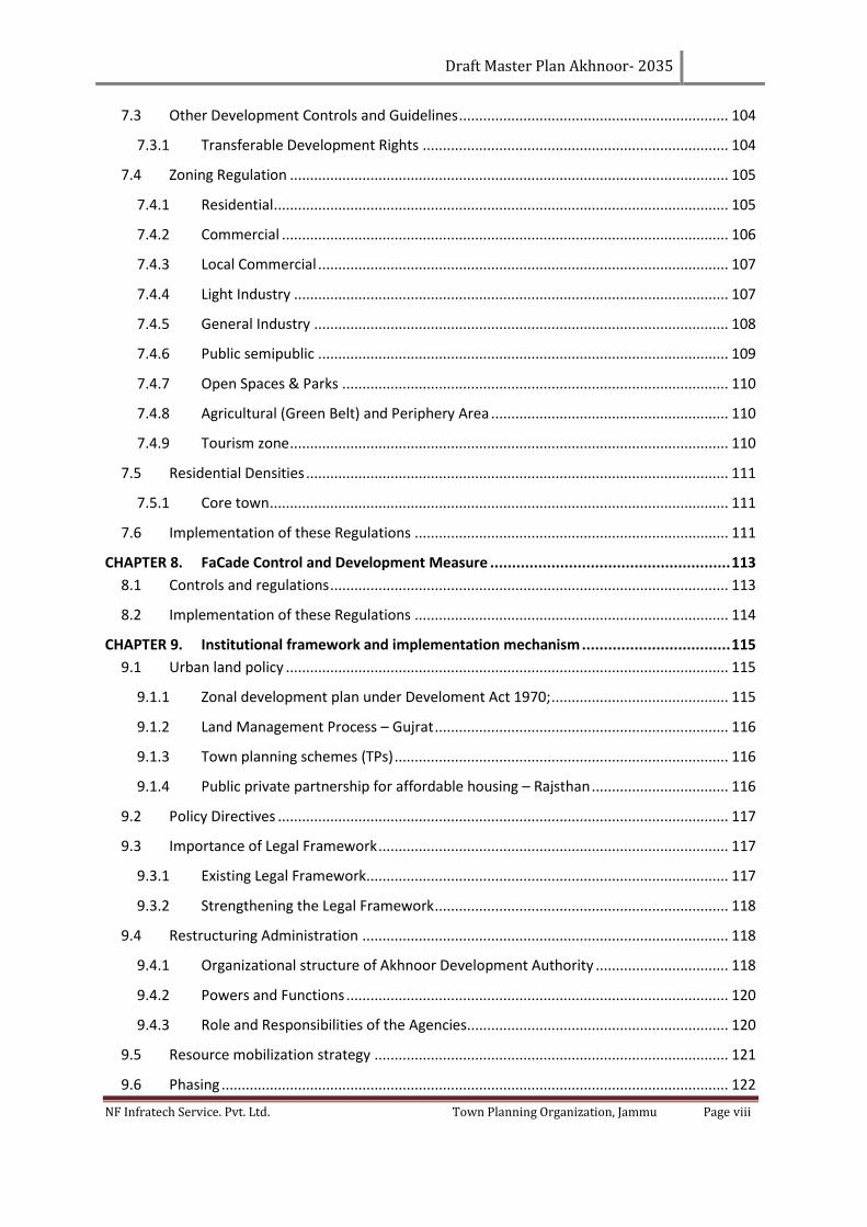
Draft Master Plan Akhnoor- 2035
NF Infratech Service. Pvt. Ltd. Town Planning Organization, Jammu Page viii
7.3 Other Development Controls and Guidelines ................................................................... 104
7.3.1 Transferable Development Rights ............................................................................ 104
7.4 Zoning Regulation ............................................................................................................. 105
7.4.1 Residential ................................................................................................................. 105
7.4.2 Commercial ............................................................................................................... 106
7.4.3 Local Commercial ...................................................................................................... 107
7.4.4 Light Industry ............................................................................................................ 107
7.4.5 General Industry ....................................................................................................... 108
7.4.6 Public semipublic ...................................................................................................... 109
7.4.7 Open Spaces & Parks ................................................................................................ 110
7.4.8 Agricultural (Green Belt) and Periphery Area ........................................................... 110
7.4.9 Tourism zone ............................................................................................................. 110
7.5 Residential Densities ......................................................................................................... 111
7.5.1 Core town .................................................................................................................. 111
7.6 Implementation of these Regulations .............................................................................. 111
CHAPTER 8. FaCade Control and Development Measure ....................................................... 113
8.1 Controls and regulations ................................................................................................... 113
8.2 Implementation of these Regulations .............................................................................. 114
CHAPTER 9. Institutional framework and implementation mechanism .................................. 115
9.1 Urban land policy .............................................................................................................. 115
9.1.1 Zonal development plan under Develoment Act 1970; ............................................ 115
9.1.2 Land Management Process – Gujrat ......................................................................... 116
9.1.3 Town planning schemes (TPs) ................................................................................... 116
9.1.4 Public private partnership for affordable housing – Rajsthan .................................. 116
9.2 Policy Directives ................................................................................................................ 117
9.3 Importance of Legal Framework ....................................................................................... 117
9.3.1 Existing Legal Framework .......................................................................................... 117
9.3.2 Strengthening the Legal Framework ......................................................................... 118
9.4 Restructuring Administration ........................................................................................... 118
9.4.1 Organizational structure of Akhnoor Development Authority ................................. 118
9.4.2 Powers and Functions ............................................................................................... 120
9.4.3 Role and Responsibilities of the Agencies................................................................. 120
9.5 Resource mobilization strategy ........................................................................................ 121
9.6 Phasing .............................................................................................................................. 122
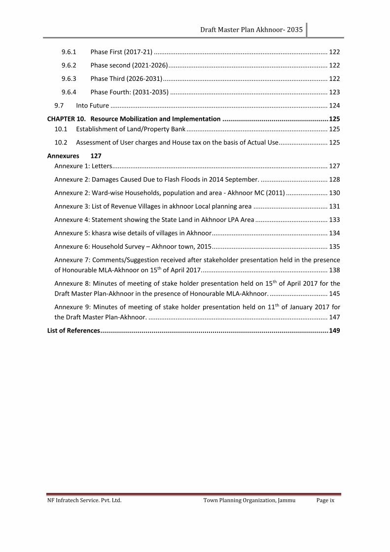
Draft Master Plan Akhnoor- 2035
NF Infratech Service. Pvt. Ltd. Town Planning Organization, Jammu Page ix
9.6.1 Phase First (2017-21) ................................................................................................ 122
9.6.2 Phase second (2021-2026) ........................................................................................ 122
9.6.3 Phase Third (2026-2031) ........................................................................................... 122
9.6.4 Phase Fourth: (2031-2035) ....................................................................................... 123
9.7 Into Future ........................................................................................................................ 124
CHAPTER 10. Resource Mobilization and Implementation ...................................................... 125
10.1 Establishment of Land/Property Bank .............................................................................. 125
10.2 Assessment of User charges and House tax on the basis of Actual Use ........................... 125
Annexures 127
Annexure 1: Letters ....................................................................................................................... 127
Annexure 2: Damages Caused Due to Flash Floods in 2014 September. ..................................... 128
Annexure 2: Ward-wise Households, population and area - Akhnoor MC (2011) ....................... 130
Annexure 3: List of Revenue Villages in akhnoor Local planning area ......................................... 131
Annexure 4: Statement showing the State Land in Akhnoor LPA Area ........................................ 133
Annexure 5: khasra wise details of villages in Akhnoor ................................................................ 134
Annexure 6: Household Survey – Akhnoor town, 2015 ................................................................ 135
Annexure 7: Comments/Suggestion received after stakeholder presentation held in the presence
of Honourable MLA-Akhnoor on 15th of April 2017. ..................................................................... 138
Annexure 8: Minutes of meeting of stake holder presentation held on 15th of April 2017 for the
Draft Master Plan-Akhnoor in the presence of Honourable MLA-Akhnoor. ................................ 145
Annexure 9: Minutes of meeting of stake holder presentation held on 11th of January 2017 for
the Draft Master Plan-Akhnoor. ................................................................................................... 147
List of References .................................................................................................................... 149
Draft Master Plan Akhnoor- 2035
NF Infratech Service. Pvt. Ltd. Town Planning Organization, Jammu Page x
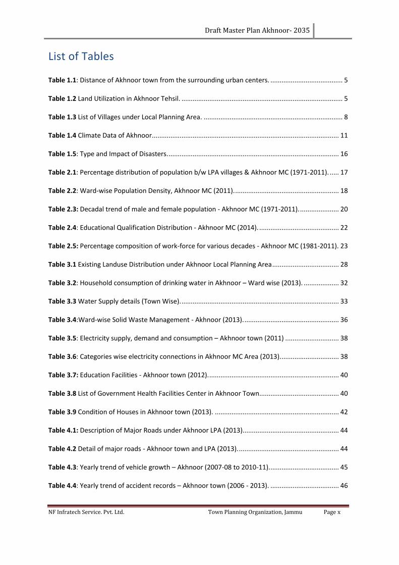
List of Tables
Table 1.1: Distance of Akhnoor town from the surrounding urban centers. ....................................... 5
Table 1.2 Land Utilization in Akhnoor Tehsil. ....................................................................................... 5
Table 1.3 List of Villages under Local Planning Area. ........................................................................... 8
Table 1.4 Climate Data of Akhnoor. .................................................................................................... 11
Table 1.5: Type and Impact of Disasters. ............................................................................................ 16
Table 2.1: Percentage distribution of population b/w LPA villages & Akhnoor MC (1971-2011). ..... 17
Table 2.2: Ward-wise Population Density, Akhnoor MC (2011). ........................................................ 18
Table 2.3: Decadal trend of male and female population - Akhnoor MC (1971-2011). ..................... 20
Table 2.4: Educational Qualification Distribution - Akhnoor MC (2014). ........................................... 22
Table 2.5: Percentage composition of work-force for various decades - Akhnoor MC (1981-2011). 23
Table 3.1 Existing Landuse Distribution under Akhnoor Local Planning Area .................................... 28
Table 3.2: Household consumption of drinking water in Akhnoor – Ward wise (2013). ................... 32
Table 3.3 Water Supply details (Town Wise). ..................................................................................... 33
Table 3.4:Ward-wise Solid Waste Management - Akhnoor (2013). ................................................... 36
Table 3.5: Electricity supply, demand and consumption – Akhnoor town (2011) ............................. 38
Table 3.6: Categories wise electricity connections in Akhnoor MC Area (2013). ............................... 38
Table 3.7: Education Facilities - Akhnoor town (2012). ...................................................................... 40
Table 3.8 List of Government Health Facilities Center in Akhnoor Town........................................... 40
Table 3.9 Condition of Houses in Akhnoor town (2013). ................................................................... 42
Table 4.1: Description of Major Roads under Akhnoor LPA (2013).................................................... 44
Table 4.2 Detail of major roads - Akhnoor town and LPA (2013). ...................................................... 44
Table 4.3: Yearly trend of vehicle growth – Akhnoor (2007-08 to 2010-11). ..................................... 45
Table 4.4: Yearly trend of accident records – Akhnoor town (2006 - 2013). ..................................... 46
Draft Master Plan Akhnoor- 2035
NF Infratech Service. Pvt. Ltd. Town Planning Organization, Jammu Page xi
Table 4.5 Congestion Index of Important Roads. ............................................................................... 46
Table 4.6: Parking details at various locations – Akhnoor town (14th & 15th April, 2014). ................. 47
Table 4.7: Number of buses as per their route – Akhnoor Town (2013)............................................ 47
Table 5.1: Population Projection of Akhnoor (Urban and LPA) as per projection methods. ............. 51
Table 5.2: Assumed Population Projection of Akhnoor (Urban and LPA). ......................................... 51
Table 5.3: Norms and hierarchy and area calculations for commercial areas. .................................. 52
Table 5.4: Main Workers and Projected Workforce Category Wise of Akhnoor M.C. ....................... 52
Table 5.5: Requirement for Water Supply and Sewerage for Akhnoor MC for 2035. ........................ 53
Table 5.6: Future Requirement of Power for LPA. ............................................................................. 54
Table 5.7: Requirement of Educational Facilities (LPA Level). ............................................................ 54
Table 5.8: Requirement of Medical Facilities. .................................................................................... 55
Table 5.9: Requirement of socio Cultural & Other facilities (LPA Level). ........................................... 56
Table 5.10: Playgrounds, Parks, Gardens, Stadium in the town. ........................................................ 57
Table 5.11: Hierarchy Order of Organised Green for Akhnoor LPA. .................................................. 57
Table 5.12: Norms and requirements for Sports Facilities for Akhnoor LPA. ..................................... 57
Table 5.13: Land Requirement for projected population Akhnoor LPA. ............................................ 58
Table 6.1: Area distribution among proposed Zones - Akhnoor LPA. ................................................ 63
Table 6.2: Proposed Land Use up to Urbanization limit- 2035 (Zone-1, 2 & 3). ................................. 67
Table 6.3: Proposed Land Use Zone-4. ............................................................................................... 67
Table 6.4: Proposed Land Use for Overall area 2035 (Area in Ha). .................................................... 68
Table 6.5: Housing stock existing and projected demand- Akhnoor LPA. .......................................... 69
Table 6.6: Proposed Commercial Facilities. ........................................................................................ 71
Table 6.7: Distribution of Proposed commercial facilities in Zones 1, 2, 3 & 4. ................................. 72
Table 6.8: Norms for Informal Units for Urban Street Vendors. ........................................................ 73
Table 6.9: Proposed Industrial Areas. ................................................................................................. 73
Draft Master Plan Akhnoor- 2035
NF Infratech Service. Pvt. Ltd. Town Planning Organization, Jammu Page xii
Table 6.10: Proposed Public & Semi Public Facilities. ........................................................................ 74
Table 6.11: Distribution of Proposed Public & Semi Public Facilities in Zones 1, 2, 3 & 4. ................ 74
Table 6.12: Proposed Recreational Facilities. ..................................................................................... 75
Table 6.13: Distribution of Proposed Public & Semi Public Facilities in Zones 1, 2, 3 & 4. ................ 76
Table 6.14: Proposed Road Hierarchy, Local Planning Area Akhnoor. ............................................... 78
Table 6.15: Proposed Norms for Educational Institutions.................................................................. 82
Table 6.16: Permissible levels for Education Facilities. ...................................................................... 83
Table 6.17: Proposed Norms for Health Facilities .............................................................................. 84
Table 6.18: Norms for Police Station, Civil Defense and Home Guard ............................................... 85
Table 6.19: Norms for Safety Facility. ................................................................................................. 85
Table 6.20: Proposed Norms for Socio-Cultural Facilities .................................................................. 85
Table 6.21: Norms for Sports Facilities ............................................................................................... 86
Table 6.22: Norms for Commercial Facilities ...................................................................................... 86
Table 7-1: Building bye-laws of plotted housing – Reasi town ........................................................... 88
Table 7.2: Native trees to Akhnoor Region....................................................................................... 102
Table 7.3: Planning norms and standards for safety/ fire facilities. ................................................. 102
Draft Master Plan Akhnoor- 2035
NF Infratech Service. Pvt. Ltd. Town Planning Organization, Jammu Page xiii
List of Figures
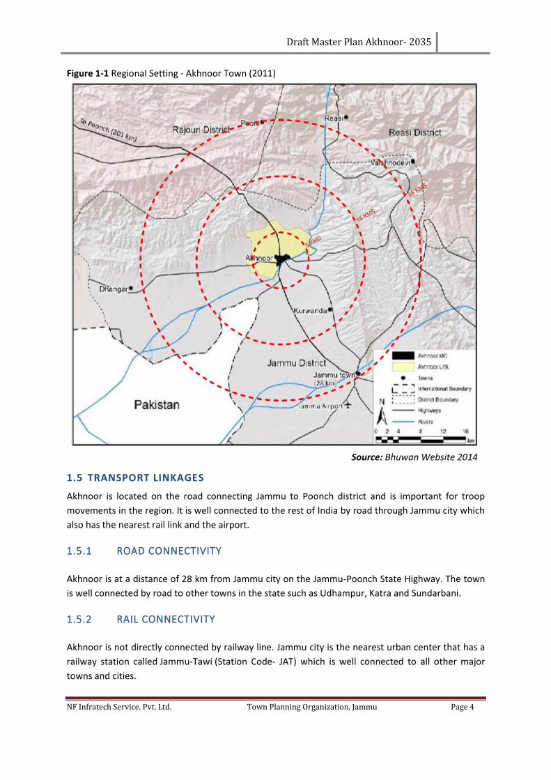
Figure 1-1 Regional Setting - Akhnoor Town (2011) ............................................................................. 4
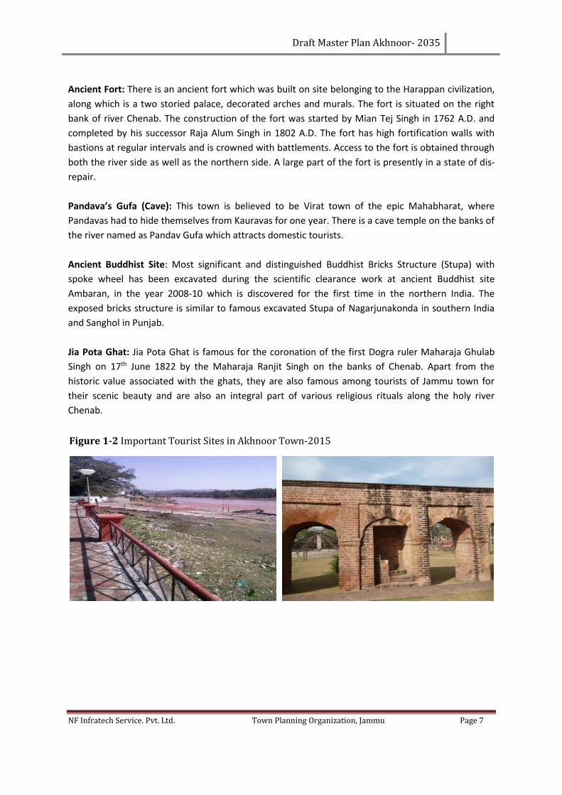
Figure 1-2 Important Tourist Sites in Akhnoor Town-2015 .................................................................. 7
Figure 1-3 Delineated Local Planning Area Map –Akhnoor (2014) ...................................................... 9
Figure 1-4 Average Temperature Trend - Akhnoor ........................................................................... 10
Figure 1-5 Growth Trend - Akhnoor Town (2014) .............................................................................. 11
Figure 1-6 Contour Map- Akhnoor LPA (2004-2014) .......................................................................... 13
Figure 1-7 Slope Map- Akhnoor LPA (2004-2014) .............................................................................. 14
Figure 1-8 Land Suitable for Development ......................................................................................... 15
Figure 2-1: Decadal trend of population, Akhnoor LPA (1971-2011). ................................................ 17
Figure 2-2: Decadal Growth Rate, Akhnoor LPA (1971-2011). ........................................................... 18
Figure 2-3: Ward-wise Population Density, Akhnoor MC (2011). ...................................................... 19
Figure 2-4: Sex Ratio Comparison - Akhnoor MC, LPA Villages, Jammu district, J&K state and Urban
India (2011). ........................................................................................................................................ 20
Figure 2-5: Literacy rate - Akhnoor MC, LPA Villages, Jammu District, J&K State and Urban India
(2011). ................................................................................................................................................. 21
Figure 2-6: Literacy Rate Trend - Akhnoor MC (1971-2011). .............................................................. 21
Figure 2-7: Educational Qualification Distribution - Akhnoor MC (2014). .......................................... 22
Figure 2-8: Decadal trend of work-force Participation - Akhnoor MC (1981-2011). .......................... 23
Figure 2-9: Occupational Structure - Akhnoor Town (2011). ............................................................. 23
Figure 2-10: Fruit and vegetable Mandi - Akhnoor LPA. .................................................................... 25
Figure 2-11: Street vendors - Akhnoor (April, 2014). ......................................................................... 26
Figure 3-1: Landuse Distribution - Akhnoor LPA (2014). .................................................................... 29
Figure 3-2: Congested housing within the old town – Akhnoor ......................................................... 29
Figure 3-3: Commercial hub along Fowara Chowk, near bus stand - Akhnoor .................................. 30
Draft Master Plan Akhnoor- 2035
NF Infratech Service. Pvt. Ltd. Town Planning Organization, Jammu Page xiv
Figure 3-4: Narrow streets within the old town - Akhnoor MC .......................................................... 31
Figure 3-5: Water Reservoir - Akhnoor ............................................................................................... 32
Figure 3-6: Open Drains and ‘nallahs’ used for sewerage and domestic solid waste – Akhnoor town,
ward 2 ................................................................................................................................................. 35
Figure 3-7: Open and semi-covered drains in residential areas - Akhnoor Town .............................. 35
Figure 3-8: Street lights, Old Town - Akhnoor (April, 2014). .............................................................. 39
Figure 3-9: River Front View - Chenab, Akhnoor Town (April, 2014). ................................................ 41
Figure 3-10: A view of housing - Akhnoor old town (April 2014). ...................................................... 42
Figure 4-1: Yearly trend of vehicle growth, classified by vehicle type - Akhnoor Town (2011). ........ 45
Figure 4-2: On-street parking - Akhnoor, town, various locations (14th & 15th April, 2014). .............. 47
Figure 4-3: Akhnoor Bus Stand over crowded during peak hours. ..................................................... 48
Figure 4-4: Parking along the roads – Akhnoor old town (April 2014), Commercial area – Akhnoor
town, Fowara Chowk (April, 2014). .................................................................................................... 48
Figure 4-5: Parking along the residential roads – Akhnoor town, Jia Pota (April, 2014). ................... 49
Figure 6-1 Proposed Zones in Akhnoor LPA ........................................................................................ 64
Draft Master Plan Akhnoor- 2035
NF Infratech Service. Pvt. Ltd. Town Planning Organization, Jammu Page xv
List of Abbreviations
Above Mean Sea Level AMSL
Assistant Regional Transport Officer ARTO
Central Pollution Control Board CPCB
Chief Town Planner CTP
Detailed Project Reports DPR
Development Control Regulations DCR
Development Plans DPs
District Development Commissioner DDC
Environmental Impact Assessment EIA
Equivalent Car Space ECS
Far Area Ratio FAR
General Reserve Engineering Force GREF
Jammu and Kashmir J&K
Kilo Liters per day KLD
Liters per capita per day LPCD
Local Planning Area LPA
Million Liters per day MLD
Ministry of Urban Development MoUD
National Highway NH
National Building Codes NBC
Persons per Hectare pph
Power Development Department PDD
Public Health and Engineering Department PHED
Right of Way ROW
Strength Weakness Opportunity Threat SWOT
Tonnes per day TPD
Town Planning Organization TPO
Town Planning Schemes TPS
Urban & Regional Development Plan Formulation and Implementation URDPFI
University Grant Commission UGC
World Health Organization WHO
Zonal Development Plans ZDPs
Draft Master Plan Akhnoor- 2035
NF Infratech Service. Pvt. Ltd. Town Planning Organization, Jammu Page 1
CHAPTER 1. INTRODUCTION AND REGIONAL SETTING
1.1 BACKGROUND - THEORETICAL FRAMEWORK
Urban areas in the past have not received much attention in terms of proper planning, development
and management, despite the fact that cities and economic development are inextricably linked.
Because of high productivity of urban areas, the economic development activities get located in
cities. Accordingly, it is desirable that human settlements are provided with necessary planning and
development inputs so that their orderly growth and development is ensured. This would also be
necessary for ensuring efficient functioning of human settlements for improving their productivity
and for providing desirable quality of life to its residents in order to cater to their economic, physical
and metaphysical needs. The urban development strategy for any state thus assumes importance for
not only its economic emancipation but also its physical well-being.
Therefore, the real challenge before the planning and development of towns/cities is to have
balanced development in all spheres of urban life in a comprehensive manner: Physical, Social and
Economic. There is need to make urban transition efficient, equitable and cost effective by making
policies and bringing out new projects/schemes. For this, preparation of Master Plan becomes the
guiding principle for wiping out the deficits in urban infrastructure, identifying the problems and
exploring the potentials of the town.
Master Plan is identified as a strategic tool to achieve the above objectives. Considering the role and
importance of rational and orderly growth of urban centers, the Government of Jammu and Kashmir
(J&K) intends to streamline the development process in urban settlements to ensure that these
settlements continue to achieve their objectives of improved efficiency and productivity.
Accordingly, it is desirable to have a stringent check on haphazard development and have an
optimum land use plan for these cities/towns. In the process, the state government of J&K has taken
the decision to prepare Master Plans for all towns and cities for a directed development and to
provide required amenities to its people.
The Town Planning Organization (TPO), Jammu is an apex institution for promoting the balanced
urban growth in the region of Jammu in the state of Jammu and Kashmir. It has undertaken the task
of providing planned residential, commercial and industrial spaces incorporating the latest state of
the art technology and town planning norms. In this process, TPO, Jammu has taken up the
preparation of the Master Plan for Akhnoor to address the infrastructure and service delivery gaps
in Akhnoor and to make the growth and development of Local Planning Area (LPA) rational. The key
objective of the Master Plan is to formulate a long-term vision and strategy to make the LPA vibrant,
livable and creditworthy. Besides rationalizing the land use pattern, the Master Plan will also
facilitate the identification of sectoral investments and reform areas needed to transform the Local
Planning Area Akhnoor.
Draft Master Plan Akhnoor- 2035
NF Infratech Service. Pvt. Ltd. Town Planning Organization, Jammu Page 2
1.2 OBJECTIVES OF THE PROJECT
The prime objective of the Master Plan is to promote, guide and rationalize the future growth and
development of urban centers. It will endorse growth in the desired direction, promote economic
development, improving service delivery and providing amenities to its people. Master Plan ensures
rational policy choices besides providing a flexible framework based on ground realities for a defined
time span. Master Plan is an appropriate and scientific tool for promoting systematic & planned
growth of the town in the form of the following:
1. Identifying existing gaps in physical and social infrastructure & to bridge those gaps.
2. Making town assessment and to suggest strategies for its economic development.
3. Rationalization of Landuse and their interrelationships.
4. Minimizing haphazard and uncontrolled growth of town/cities in order to achieve planned
growth and development in order to provide healthy living environment.
5. Promoting better urban governance and resource generation for planned urban
development.
6. Rationalizing the orderly movement of traffic and transportation within the town. Defining
the area to lay down the network of various services.
7. Spatial distribution of physical/social infrastructure for optimum use.
8. Systematic, balanced & integrated development.
1.3 METHODOLOGY
The various stages of preparation of Master Plan would include:
1. Identification of Local Planning Area
2. Preparation of Existing land use plan
a. Using satellite imageries
b. Using available plans
c. Ground surveys
d. Revenue plans
3. Assessment and analysis of Local Planning Area in terms of:
a. Regional setting
b. Historical evolution
c. Demographic studies
d. Socio-Economic studies
e. Traffic & transportation
f. Physical infrastructure (water supply, sewerage, solid waste management, electricity)
g. Social infrastructure (educational, medical, recreational, miscellaneous facilities)
h. Environmental studies
i. Heritage and tourism
j. Growth pattern
k. Land use studies
l. Available studies and report
4. Gaps and Problem Identification through:
a. Comparison with available norms and standards
Draft Master Plan Akhnoor- 2035
NF Infratech Service. Pvt. Ltd. Town Planning Organization, Jammu Page 3
b. Identification of the critical problems and infrastructure gaps
5. Carrying out SWOT analysis based upon:
a. Studies made and analysis carried on
b. City Assessment
c. Identified problems and gaps
d. Identifying major socio-economic drivers
e. Working out requirements
f. Population projections
g. Norms and standards
h. Broad land use requirements.
6. Defining conceptual framework through:
a. Defining vision for future growth and development
b. Identifying broad objectives
c. Laying down mission statements for critical areas
7. Preparation of concept plan
8. Evolving proposed land use plan and traffic & transportation plan along with
Development Control Regulations (DCR) based upon:
a. Existing land use plan
b. Studies and assessment made
c. Gaps and problems identified
d. Objectives framed
e. Future population growth
f. Future infrastructure requirements
g. Available land for development
h. Phasing and Institutional framework
1.4 LOCATION OF TOWN IN A REGIONAL CONTEXT
This aspect studies the development of the town Akhnoor in its regional context and evaluates the
locational advantages and disadvantages. In the Master Plan, this aspect would help in proposing the
activities that can be explored based upon the regional potential and linkages.
Akhnoor town is located in Jammu district at a distance of about 28 km from Jammu city. It is located
in the foothills of the Himalayas on the banks of the Chenab River and lies on Jammu-Poonch State
Highway. The town is connected to Rajouri at a distance of 118 km in the north-west by Jourian-
Akhnoor road and to Jammu by Akhnoor road (Jammu-Poonch State Highway).
The Akhnoor tehsil area is divided into four revenue blocks: Akhnoor, Chowki Choura, Khour and
Jourian. Akhnoor is located at 32.87°N and 74.73°E. In the North and East directions, it is surrounded
by the Shivaliks and Kali Dhar mountain ranges & Trikuta range respectively.
Draft Master Plan Akhnoor- 2035
NF Infratech Service. Pvt. Ltd. Town Planning Organization, Jammu Page 4
Figure 1-1 Regional Setting - Akhnoor Town (2011)
Source: Bhuwan Website 2014
1.5 TRANSPORT LINKAGES
Akhnoor is located on the road connecting Jammu to Poonch district and is important for troop
movements in the region. It is well connected to the rest of India by road through Jammu city which
also has the nearest rail link and the airport.
1.5.1 ROAD CONNECTIVITY
Akhnoor is at a distance of 28 km from Jammu city on the Jammu-Poonch State Highway. The town
is well connected by road to other towns in the state such as Udhampur, Katra and Sundarbani.
1.5.2 RAIL CONNECTIVITY
Akhnoor is not directly connected by railway line. Jammu city is the nearest urban center that has a
railway station called Jammu-Tawi (Station Code- JAT) which is well connected to all other major
towns and cities.
Draft Master Plan Akhnoor- 2035
NF Infratech Service. Pvt. Ltd. Town Planning Organization, Jammu Page 5
The nearest airport is Satwari Airport in Jammu city, which is about 35 kilometers from the town.
Jammu has direct flights to Srinagar, Delhi, Chandigarh and Leh.
Table 1.1: Distance of Akhnoor town from the surrounding urban centers.
S. No. City Distance (Km)
1 Jammu (District Headquarters) 28
2 Udhampur 90
3 Katra 70
4 Sundarbani 48
Source NUIS Akhnoor, 2012
1.6 REGIONAL/NATURAL RESOURCES
The natural resources that are available in the Akhnoor Tehsil which can be helpful for the
development of the town are described below:
1.6.1 LAND
Akhnoor Tehsil covers an area of 805 Sq. Km. The area under cultivation accounts for only 50.56%.
The forest occupies 14.91% and uncultivated barren land is 34.54% of the area. This barren land is
further used for residential and other developments. (refer Table 1.2).
Table 1.2 Land Utilization in Akhnoor Tehsil.
Category Land Utilization (In sq. km) Percentage (%)
Geographical Area 805 100.00
Area under Forest 120 14.91
Area under Cultivation 407 50.56
Area under Barren Uncultivated Land 278 34.54
Source: Village Directory, Census 2011
1.6.2 MINERALS
As per the studies conducted, Akhnoor District has mineral resources in abundance, like coal fields in
Jungal-Gali, existence of bauxite & lignite ores with coal belts in Kanthan. The availability of lime is
200 to 300 million tonnes in this area.
1.6.3 WATER RESOURCES
The river Chenab flows through the town. In the ancient time, it was known by the name of Asikini
River. The river Chenab (or Chandra Bhaga) is formed after the two streams the Chandra and the
Bhaga merge with each other. The Chandra and the Bhaga originate from the south-west and north-
west faces of Barelacha pass respectively in the Himalayan canton of Lahul and Spiti valley in
Himachal Pradesh.
1.6.4 FLORA AND FAUNA
Akhnoor tehsil has a lot of forest area with the existence of Pine, Deodar, Khai, Sheesham, Bamboo
and Palm grade shrubs. They cover the slopes of valleys, reclining rocks and fairly wide river beds
Draft Master Plan Akhnoor- 2035
NF Infratech Service. Pvt. Ltd. Town Planning Organization, Jammu Page 6
where there is a feasibility of reclaiming the lands and put the same to agriculture and its related
use. The fauna constituents of this tehsil are Neel gai, Wild bear, Parrots, Monkeys and Various
aquatic species.
1.6.5 FOREST RESOURCES
Forest area constitutes very low percentage of total tehsil area. However, it is one of the most
important natural resource of Akhnoor tehsil and its surroundings, which increases its beautification
and tourism potentials at local and regional levels besides wood protection.
1.6.6 TOURISM AND HERITAGE RESOURCES
Akhnoor is a historical town, the antiquity of which goes back to the Indus Valley civilization.
Akhnoor thus, has a lot of tourist attractions albeit being a small town. The glacier fed Chenab River
is perennial and flows along the town. One of the major tourist attractions of Akhnoor is the
Gurudwara which is visited for religious purposes. Akhnoor also has many sites of historical interest,
such as the caves where the Pandavas stayed during their exile.
Another tourist attraction is the temple dedicated to Lord Parasuram, the incarnation of Vishnu,
which is rare to find. The temple also has shrines for Vaishno Devi and Shiva-Parvati-Ganesh. Other
famous tourist places of Akhnoor are the Jia Pota Ghat as well the Buddhist monastery of Ambaran.
All the above mentioned places are linked to other tourist and religious places in Jammu region, and
there is immense potential for a tourism circuit. There is also the potential to invigorate the
economy while preserving and maintaining the ecology if these tourist spots are developed. At the
same time it will helps to provide earning hand to local people.
District Jammu and tehsil Akhnoor have a number of tourism cum pilgrim destinations. The existing
tourism infrastructure for active & passive recreational activities is sufficient in Akhnoor town and its
surroundings. In its immediate vicinity there are various places of tourist and pilgrim interest where
one can enjoy coolest environment during scorching summer periods and attend pilgrim and rituals
activities. People from neighboring states like Punjab and Haryana visit Akhnoor for religious
purpose.
The climate of this district varies from hot at lower places to moderate at higher levels during
summer, which is another attraction for the Nomads to shift from plains. Following are some
important tourism and religious attractions of Akhnoor:
Chenab River: Chenab river is considered holy by Hindus and attracts religious tourism to their ghats
during the holy month of Magh (corresponds with Jan-Feb), and Sankranti of every month.
Devotees, especially women, hailing from different parts of Jammu region congregate at Gurha
Pattan and Jia Pota Ghat. To encourage religious and cultural tourism, the Department of Tourism
has started organizing cultural events on Baisakhi, which now forms an important part of Jammu
festival’s itinerary.
Draft Master Plan Akhnoor- 2035
NF Infratech Service. Pvt. Ltd. Town Planning Organization, Jammu Page 7
Ancient Fort: There is an ancient fort which was built on site belonging to the Harappan civilization,
along which is a two storied palace, decorated arches and murals. The fort is situated on the right
bank of river Chenab. The construction of the fort was started by Mian Tej Singh in 1762 A.D. and
completed by his successor Raja Alum Singh in 1802 A.D. The fort has high fortification walls with
bastions at regular intervals and is crowned with battlements. Access to the fort is obtained through
both the river side as well as the northern side. A large part of the fort is presently in a state of dis-
repair.
Pandava’s Gufa (Cave): This town is believed to be Virat town of the epic Mahabharat, where
Pandavas had to hide themselves from Kauravas for one year. There is a cave temple on the banks of
the river named as Pandav Gufa which attracts domestic tourists.
Ancient Buddhist Site: Most significant and distinguished Buddhist Bricks Structure (Stupa) with
spoke wheel has been excavated during the scientific clearance work at ancient Buddhist site
Ambaran, in the year 2008-10 which is discovered for the first time in the northern India. The
exposed bricks structure is similar to famous excavated Stupa of Nagarjunakonda in southern India
and Sanghol in Punjab.
Jia Pota Ghat: Jia Pota Ghat is famous for the coronation of the first Dogra ruler Maharaja Ghulab
Singh on 17th June 1822 by the Maharaja Ranjit Singh on the banks of Chenab. Apart from the
historic value associated with the ghats, they are also famous among tourists of Jammu town for
their scenic beauty and are also an integral part of various religious rituals along the holy river
Chenab.
Figure 1-2 Important Tourist Sites in Akhnoor Town-2015
Draft Master Plan Akhnoor- 2035
NF Infratech Service. Pvt. Ltd. Town Planning Organization, Jammu Page 8
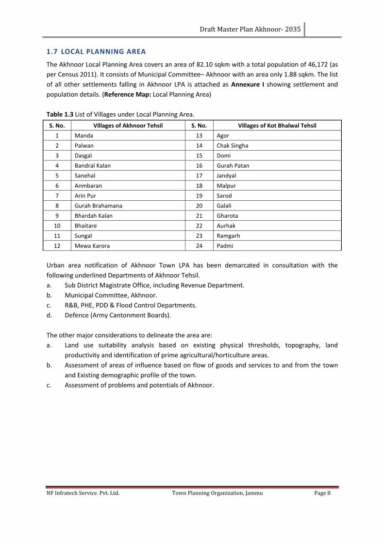
1.7 LOCAL PLANNING AREA
The Akhnoor Local Planning Area covers an area of 82.10 sqkm with a total population of 46,172 (as
per Census 2011). It consists of Municipal Committee– Akhnoor with an area only 1.88 sqkm. The list
of all other settlements falling in Akhnoor LPA is attached as Annexure I showing settlement and
population details. (Reference Map: Local Planning Area)
Table 1.3 List of Villages under Local Planning Area.
S. No. Villages of Akhnoor Tehsil S. No. Villages of Kot Bhalwal Tehsil
1 Manda 13 Agor
2 Palwan 14 Chak Singha
3 Dasgal 15 Domi
4 Bandral Kalan 16 Gurah Patan
5 Sanehal 17 Jandyal
6 Anmbaran 18 Malpur
7 Arin Pur 19 Sarod
8 Gurah Brahamana 20 Galali
9 Bhardah Kalan 21 Gharota
10 Bhaitare 22 Aurhak
11 Sungal 23 Ramgarh
12 Mewa Karora 24 Padmi
Urban area notification of Akhnoor Town LPA has been demarcated in consultation with the
following underlined Departments of Akhnoor Tehsil.
a. Sub District Magistrate Office, including Revenue Department.
b. Municipal Committee, Akhnoor.
c. R&B, PHE, PDD & Flood Control Departments.
d. Defence (Army Cantonment Boards).
The other major considerations to delineate the area are:
a. Land use suitability analysis based on existing physical thresholds, topography, land
productivity and identification of prime agricultural/horticulture areas.
b. Assessment of areas of influence based on flow of goods and services to and from the town
and Existing demographic profile of the town.
c. Assessment of problems and potentials of Akhnoor.
Draft Master Plan Akhnoor- 2035
NF Infratech Service. Pvt. Ltd. Town Planning Organization, Jammu Page 9
Figure 1-3 Delineated Local Planning Area Map –Akhnoor (2014)
Source: Village boundary – Revenue Department, Akhnoor & Worldview 2 Satellite Imagery (2010)
1.8 PHYSICAL CHARACTERISTICS
Physical characteristics of Akhnoor town in context of topography, elevation, slope and climate are
the following:
1.8.1 TOPOGRAPHY
The topography profile of the Akhnoor Local Planning Area consists of plains, gentle slope and Hills.
River Chenab flows from north-east to south-west dividing the Akhnoor Tehsil from Jammu. The
topography of Akhnoor Local Planning Area is comprised of watersheds like River Chenab, Sungal &
Ambaran Nallahs and steep hills in eastern sides which affect the character of the sub region directly
as well as indirectly.
Prime agriculture and orchards in the rest of the area is favorable for development and agriculture
purposes. Defense area also covers a lot of land in Akhnoor Local Planning area including
cantonments.
1.8.2 ELEVATION AND SLOPE
Akhnoor has an average elevation of 330 meters (1082ft). The town slopes from north east to the
south west come with approximate drop of 75 meters. The central region around the River Chenab is
Draft Master Plan Akhnoor- 2035
NF Infratech Service. Pvt. Ltd. Town Planning Organization, Jammu Page 10
relatively flat land. The slope of less than or equal to 30% is considered suitable for development.
Besides, plain and gentle slope is also more suitable for the urban development.
1.8.3 SOIL
The following types of soils are mainly observed in this area:
1. Mountainous soil
2. Loamy Soil
Mountainous Soil is brown in colour and contains medium levels of nitrogen & potash and very little
phosphorous. It is found in some parts of Akhnoor.
Loamy Soil in general varies from loam to sandy loam. This soil is very useful for agricultural
purposes and found in various parts of Akhnoor.
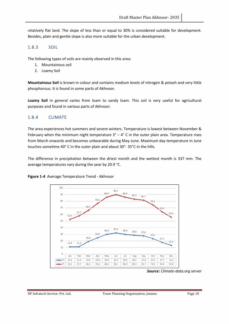
1.8.4 CLIMATE
The area experiences hot summers and severe winters. Temperature is lowest between November &
February when the minimum night temperature 3° – 4° C in the outer plain area. Temperature rises
from March onwards and becomes unbearable during May-June. Maximum day temperature in June
touches sometime 40° C in the outer plain and about 30°- 35°C in the hills.
The difference in precipitation between the driest month and the wettest month is 337 mm. The
average temperatures vary during the year by 20.9 °C.
Figure 1-4 Average Temperature Trend - Akhnoor
Source: Climate-data.org server
Jan Feb Mar Apr May Jun Jul Aug Sep Oct Nov Dec
°C 11.4 11.3 19.0 24.8 30.0 32.3 30.0 28.5 27.6 23.5 17.7 13.3
°F 52.5 57.7 66.2 76.6 86.0 90.1 86.0 83.3 81.7 74.3 63.9 55.9
11.4 11.3
19.0
24.8
30.032.3
30.0 28.5 27.623.5
17.713.3
52.557.7
66.2
76.6
86.090.1
86.083.3 81.7
74.3
63.9
55.9
0
10
20
30
40
50
60
70
80
90
100
Draft Master Plan Akhnoor- 2035
NF Infratech Service. Pvt. Ltd. Town Planning Organization, Jammu Page 11
Table 1.4 Climate Data of Akhnoor.
MONTHS JAN FEB MAR APR MAY JUN JUL AUG SEP OCT NOV DEC
MM 96 82 90 43 30 56 311 350 173 34 13 42
°C 11.4 11.3 19 24.8 30 32.3 30 28.5 27.6 23.5 17.7 13.3
°C (Min) 6.3 8.8 13 18.1 23.1 25.7 25.1 24.1 22.2 16.7 10.6 7.2
°C (Max) 16.6 19.8 25.1 31.5 36.9 39 34.9 33 33 30.4 24.8 19.4
°F 52.5 57.7 66.2 76.6 86 90.1 86 83.3 81.7 74.3 63.9 55.9
°F (Min) 43.3 47.6 55.4 64.6 73.6 78.3 77.2 75.4 72 62.1 51.1 45
°F (Max) 61.9 67.6 77.2 88.7 98.4 102.2 94.8 91.4 91.4 86.7 76.6 66.9
Source: Climate-data.org server
The warmest month of the year is June with an average temperature of 32.3°C. In January, the
average temperature is 11.4°C. It is the lowest average temperature of the whole year.
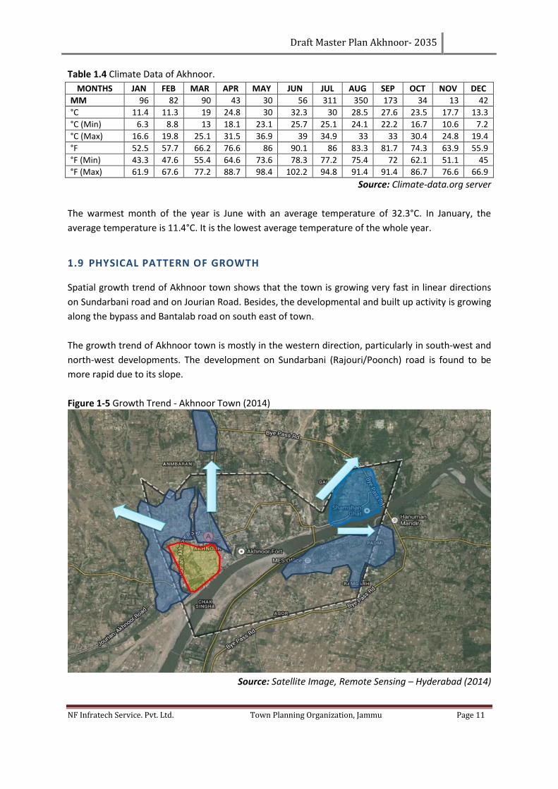
1.9 PHYSICAL PATTERN OF GROWTH
Spatial growth trend of Akhnoor town shows that the town is growing very fast in linear directions
on Sundarbani road and on Jourian Road. Besides, the developmental and built up activity is growing
along the bypass and Bantalab road on south east of town.
The growth trend of Akhnoor town is mostly in the western direction, particularly in south-west and
north-west developments. The development on Sundarbani (Rajouri/Poonch) road is found to be
more rapid due to its slope.
Figure 1-5 Growth Trend - Akhnoor Town (2014)
Source: Satellite Image, Remote Sensing – Hyderabad (2014)
Draft Master Plan Akhnoor- 2035
NF Infratech Service. Pvt. Ltd. Town Planning Organization, Jammu Page 12
With the construction of bypass road, the development along the bypass and old Jammu road has
increased.
While the old part of town is congested with narrow streets and high density development, the new
construction and development including commercial development are seen on Jourian road and
Sundarbani road. Unplanned growth around bus stand has created congestion and other problems.
1.10 URBAN LANDSCAPE & BUILT UP ENVIRONMENT
The town lies along the State Highway which runs along the Chenab River, aligned to north and
south west directions. The character of built structure and pattern which has developed over the
period of time is very organic in nature, i.e., unplanned. Modern day flat roof structures are the
general fabric of the town.
The major connectivity to the town is this State highway of Jammu-Poonch and Bantalab Road. The
core area is very densely populated and congested. The core area is surrounded by Chenab River and
less populated areas. The areas away from the town are having rich agricultural land.
1.11 HISTORICAL EVOLUTION
Akhnoor is one of the most important historical sites in Jammu and Kashmir. Excavations by the
Archaeological Survey of India (ASI) have established the fact that Akhnoor was one of the last
bastions of the Harappan civilization and the northernmost site of the Harappan civilization.
Terracotta figures and other anthropological objects belonging to the later were during the
excavations. There has however been no trace that Harappa’s moved any further beyond Akhnoor.
Further excavations nearby, at Ambaran-Pamberwan sites, are also of much interest to
archeologists, who have proved that the place was a prominent abode of Buddhism during the
Kushan period and Gupta period. Various Buddhist relics including pre-Kushan reign and silver
caskets, Gold and silver leaves, pearls, corals and three copper coins from the Gupta period were
reported to be found.
1.12 IDENTIFICATION OF INCOMPATIBLE LAND USES
Incompatible Land use and land-cover indicate the trend in territorial planning and generate
instability and conflicts leading to the degradation in terms of environmental quality. Urban
landscape structure of Akhnoor urban area has changed lately, especially due to expansion of
residential areas, leading to chaotic urban development. The consequences of this residential
expansion have led to malfunctions, outlining a disadvantaged area due to environmental problems.
Residential areas are frequently located in the proximity of Chenab River. Further, the large
percentage of Local Planning area includes army base area (cantonment) restricting the growth and
development of the town. Thus, it is necessary to address the issues of incompatible landuse and
land-cover expansion in order to make coherent plans for spatial development.
Draft Master Plan Akhnoor- 2035
NF Infratech Service. Pvt. Ltd. Town Planning Organization, Jammu Page 13
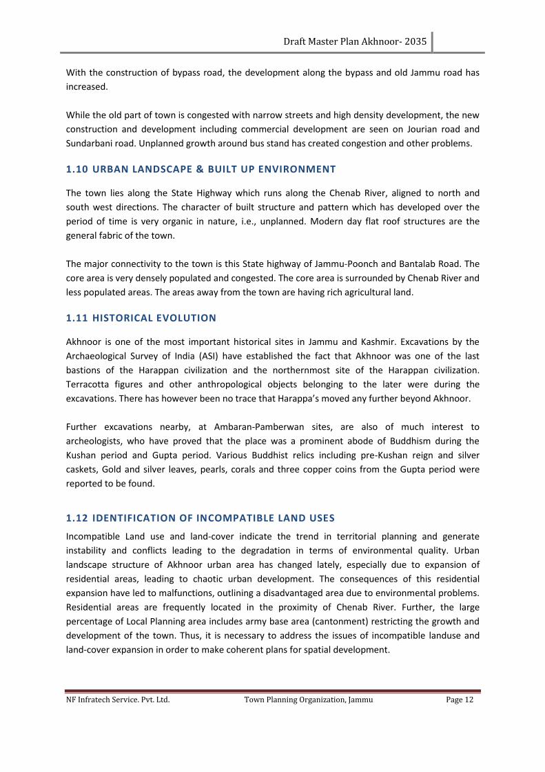
1.12.1 LAND SUITABILITY ANALYSIS
Land suitability analysis is the primary criterion used for the allocation of different uses on terra-
firma using the grade of slope, forest cover, plantation, water bodies, soil type, natural drainage,
agricultural productivity of land, etc. Suitability index has been carried out taking into account the
grade, natural drainage, land cover and plantation of the area. However, for purposes of this master
plan, a natural contour of above 550 m which is considered uphill is not suitable for residential and
commercial development and shall form a prohibitive contour. The suitability analysis of the area
has been based on existing physical features like Water Bodies, Hillocks, Forest Cover and other
parameters like slope & contours. (Refer: Contour Map, Slope Map and Land Suitability Map).
Figure 1-6 Contour Map- Akhnoor LPA (2004-2014)
Source: Satellite image, Remote sensing – Hyderabad
Draft Master Plan Akhnoor- 2035
NF Infratech Service. Pvt. Ltd. Town Planning Organization, Jammu Page 14
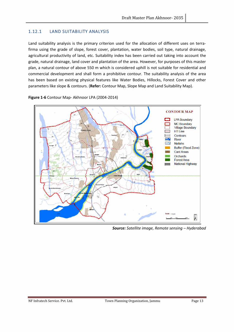
Figure 1-7 Slope Map- Akhnoor LPA (2004-2014)
Source: Satellite Image, Remote Sensing – Hyderabad (2014)
Suitable Zone: According to Digital Elevation Model (DEM), Akhnoor LPA has limited slope like foot
hills and Hillocks. Most of the land is flat surface like plains. This zone covers the open land,
agriculture land and the existing vacant developable land and has the regional and sub-regional
circulation system.
Moderate and Unsuitable Zones: DEM shows the highlands, i.e., hillocks towards the north and
North West and some steep hills in North West part of LPA. About 20-30 % of LPA is under
unsuitable and moderate suitable land. This zone covers the adjoining areas of the hillock, forest,
prime agriculture, Defence (Cantonments) and River Chenab areas.
Draft Master Plan Akhnoor- 2035
NF Infratech Service. Pvt. Ltd. Town Planning Organization, Jammu Page 15
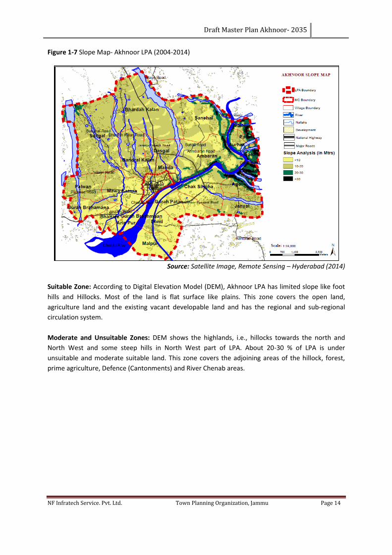
Figure 1-8 Land Suitable for Development
1.13 PROBLEMS AND ISSUES
1.13.1 EXISTING ENVIRONMENTAL HAZARDS & DISASTER
Natural calamities like cloud bursts, flash floods, heavy rains, earthquake, hails storms, drought and
accident, etc. cause a lot of miseries to the people. The district has often been victim of natural
calamities causing severe damage to life and property.
1.13.2 TYPES OF DISASTERS
Both natural and man–made disasters can be sub divided into the following types based on the
source of origin or relative damage caused by it:
• Flood, cyclone, drought, tornadoes, hailstorm, cloud burst, heat wave, cold wave, thunder,
lightning, Landslide and Mudflow, Earthquake, Volcano, Dam failure and Mine fire.
• Forest fires, urban fires, major building collapse, bomb blast, electrical accidents, air and
road accidents.
Draft Master Plan Akhnoor- 2035
NF Infratech Service. Pvt. Ltd. Town Planning Organization, Jammu Page 16
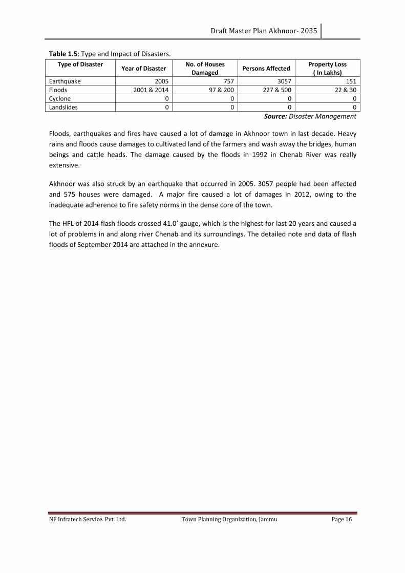
Table 1.5: Type and Impact of Disasters.
Type of Disaster Year of Disaster
No. of Houses Damaged
Persons Affected Property Loss
( In Lakhs)
Earthquake 2005 757 3057 151
Floods 2001 & 2014 97 & 200 227 & 500 22 & 30
Cyclone 0 0 0 0
Landslides 0 0 0 0
Source: Disaster Management
Floods, earthquakes and fires have caused a lot of damage in Akhnoor town in last decade. Heavy
rains and floods cause damages to cultivated land of the farmers and wash away the bridges, human
beings and cattle heads. The damage caused by the floods in 1992 in Chenab River was really
extensive.
Akhnoor was also struck by an earthquake that occurred in 2005. 3057 people had been affected
and 575 houses were damaged. A major fire caused a lot of damages in 2012, owing to the
inadequate adherence to fire safety norms in the dense core of the town.
The HFL of 2014 flash floods crossed 41.0’ gauge, which is the highest for last 20 years and caused a
lot of problems in and along river Chenab and its surroundings. The detailed note and data of flash
floods of September 2014 are attached in the annexure.
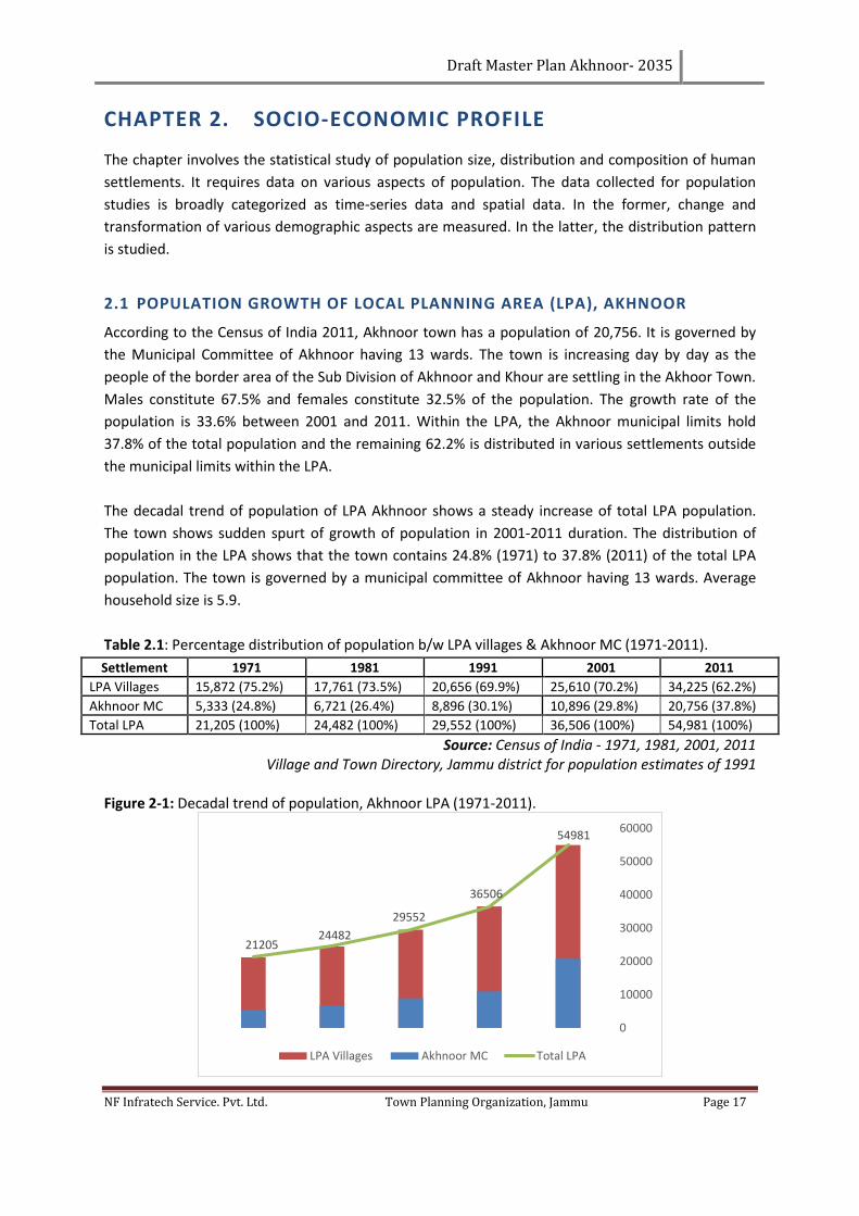
Draft Master Plan Akhnoor- 2035
NF Infratech Service. Pvt. Ltd. Town Planning Organization, Jammu Page 17
CHAPTER 2. SOCIO-ECONOMIC PROFILE
The chapter involves the statistical study of population size, distribution and composition of human
settlements. It requires data on various aspects of population. The data collected for population
studies is broadly categorized as time-series data and spatial data. In the former, change and
transformation of various demographic aspects are measured. In the latter, the distribution pattern
is studied.
2.1 POPULATION GROWTH OF LOCAL PLANNING AREA (LPA), AKHNOOR
According to the Census of India 2011, Akhnoor town has a population of 20,756. It is governed by
the Municipal Committee of Akhnoor having 13 wards. The town is increasing day by day as the
people of the border area of the Sub Division of Akhnoor and Khour are settling in the Akhoor Town.
Males constitute 67.5% and females constitute 32.5% of the population. The growth rate of the
population is 33.6% between 2001 and 2011. Within the LPA, the Akhnoor municipal limits hold
37.8% of the total population and the remaining 62.2% is distributed in various settlements outside
the municipal limits within the LPA.
The decadal trend of population of LPA Akhnoor shows a steady increase of total LPA population.
The town shows sudden spurt of growth of population in 2001-2011 duration. The distribution of
population in the LPA shows that the town contains 24.8% (1971) to 37.8% (2011) of the total LPA
population. The town is governed by a municipal committee of Akhnoor having 13 wards. Average
household size is 5.9.
Table 2.1: Percentage distribution of population b/w LPA villages & Akhnoor MC (1971-2011).
Settlement 1971 1981 1991 2001 2011
LPA Villages 15,872 (75.2%) 17,761 (73.5%) 20,656 (69.9%) 25,610 (70.2%) 34,225 (62.2%)
Akhnoor MC 5,333 (24.8%) 6,721 (26.4%) 8,896 (30.1%) 10,896 (29.8%) 20,756 (37.8%)
Total LPA 21,205 (100%) 24,482 (100%) 29,552 (100%) 36,506 (100%) 54,981 (100%)
Source: Census of India - 1971, 1981, 2001, 2011 Village and Town Directory, Jammu district for population estimates of 1991
Figure 2-1: Decadal trend of population, Akhnoor LPA (1971-2011).
2120524482
29552
36506
54981
0
10000
20000
30000
40000
50000
60000
LPA Villages Akhnoor MC Total LPA
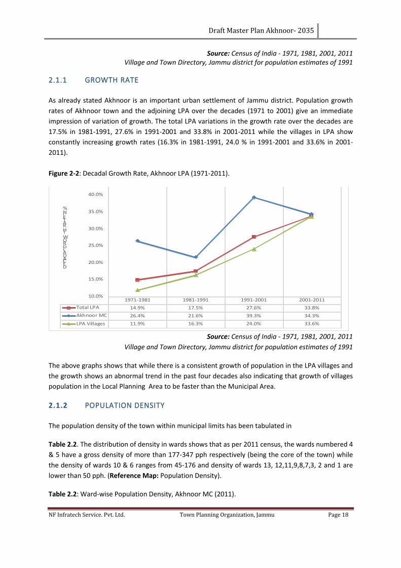
Draft Master Plan Akhnoor- 2035
NF Infratech Service. Pvt. Ltd. Town Planning Organization, Jammu Page 18
Source: Census of India - 1971, 1981, 2001, 2011 Village and Town Directory, Jammu district for population estimates of 1991
2.1.1 GROWTH RATE
As already stated Akhnoor is an important urban settlement of Jammu district. Population growth
rates of Akhnoor town and the adjoining LPA over the decades (1971 to 2001) give an immediate
impression of variation of growth. The total LPA variations in the growth rate over the decades are
17.5% in 1981-1991, 27.6% in 1991-2001 and 33.8% in 2001-2011 while the villages in LPA show
constantly increasing growth rates (16.3% in 1981-1991, 24.0 % in 1991-2001 and 33.6% in 2001-
2011).
Figure 2-2: Decadal Growth Rate, Akhnoor LPA (1971-2011).
Source: Census of India - 1971, 1981, 2001, 2011
Village and Town Directory, Jammu district for population estimates of 1991
The above graphs shows that while there is a consistent growth of population in the LPA villages and
the growth shows an abnormal trend in the past four decades also indicating that growth of villages
population in the Local Planning Area to be faster than the Municipal Area.
2.1.2 POPULATION DENSITY
The population density of the town within municipal limits has been tabulated in
Table 2.2. The distribution of density in wards shows that as per 2011 census, the wards numbered 4
& 5 have a gross density of more than 177-347 pph respectively (being the core of the town) while
the density of wards 10 & 6 ranges from 45-176 and density of wards 13, 12,11,9,8,7,3, 2 and 1 are
lower than 50 pph. (Reference Map: Population Density).
Table 2.2: Ward-wise Population Density, Akhnoor MC (2011).
1971-1981 1981-1991 1991-2001 2001-2011
Total LPA 14.9% 17.5% 27.6% 33.8%
Akhnoor MC 26.4% 21.6% 39.3% 34.3%
LPA Villages 11.9% 16.3% 24.0% 33.6%
10.0%
15.0%
20.0%
25.0%
30.0%
35.0%
40.0%
45.0%
DECADAL GROWTH RATE IN %
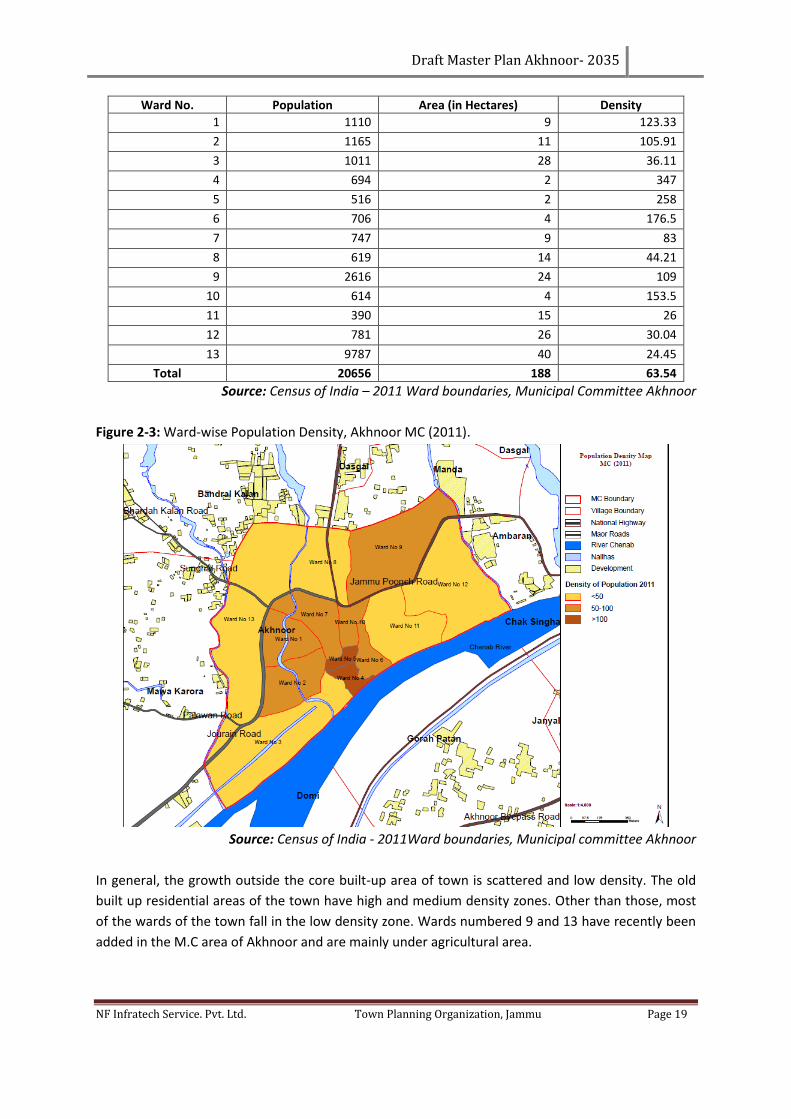
Draft Master Plan Akhnoor- 2035
NF Infratech Service. Pvt. Ltd. Town Planning Organization, Jammu Page 19
Ward No. Population Area (in Hectares) Density
1 1110 9 123.33
2 1165 11 105.91
3 1011 28 36.11
4 694 2 347
5 516 2 258
6 706 4 176.5
7 747 9 83
8 619 14 44.21
9 2616 24 109
10 614 4 153.5
11 390 15 26
12 781 26 30.04
13 9787 40 24.45
Total 20656 188 63.54
Source: Census of India – 2011 Ward boundaries, Municipal Committee Akhnoor
Figure 2-3: Ward-wise Population Density, Akhnoor MC (2011).
Source: Census of India - 2011Ward boundaries, Municipal committee Akhnoor
In general, the growth outside the core built-up area of town is scattered and low density. The old
built up residential areas of the town have high and medium density zones. Other than those, most
of the wards of the town fall in the low density zone. Wards numbered 9 and 13 have recently been
added in the M.C area of Akhnoor and are mainly under agricultural area.
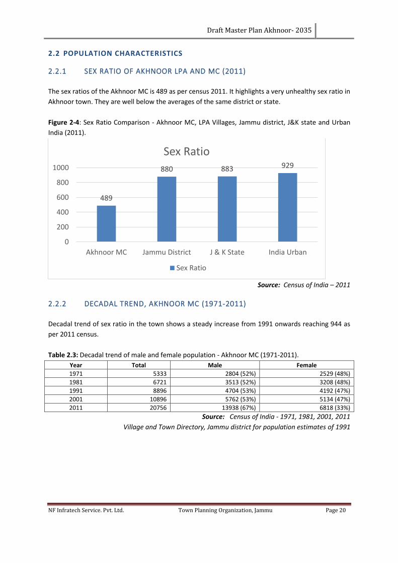
Draft Master Plan Akhnoor- 2035
NF Infratech Service. Pvt. Ltd. Town Planning Organization, Jammu Page 20
2.2 POPULATION CHARACTERISTICS
2.2.1 SEX RATIO OF AKHNOOR LPA AND MC (2011)
The sex ratios of the Akhnoor MC is 489 as per census 2011. It highlights a very unhealthy sex ratio in
Akhnoor town. They are well below the averages of the same district or state.
Figure 2-4: Sex Ratio Comparison - Akhnoor MC, LPA Villages, Jammu district, J&K state and Urban
India (2011).
Source: Census of India – 2011
2.2.2 DECADAL TREND, AKHNOOR MC (1971-2011)
Decadal trend of sex ratio in the town shows a steady increase from 1991 onwards reaching 944 as
per 2011 census.
Table 2.3: Decadal trend of male and female population - Akhnoor MC (1971-2011).
Year Total Male Female
1971 5333 2804 (52%) 2529 (48%)
1981 6721 3513 (52%) 3208 (48%)
1991 8896 4704 (53%) 4192 (47%)
2001 10896 5762 (53%) 5134 (47%)
2011 20756 13938 (67%) 6818 (33%)
Source: Census of India - 1971, 1981, 2001, 2011
Village and Town Directory, Jammu district for population estimates of 1991
489
880 883 929
0
200
400
600
800
1000
Akhnoor MC Jammu District J & K State India Urban
Sex Ratio
Sex Ratio
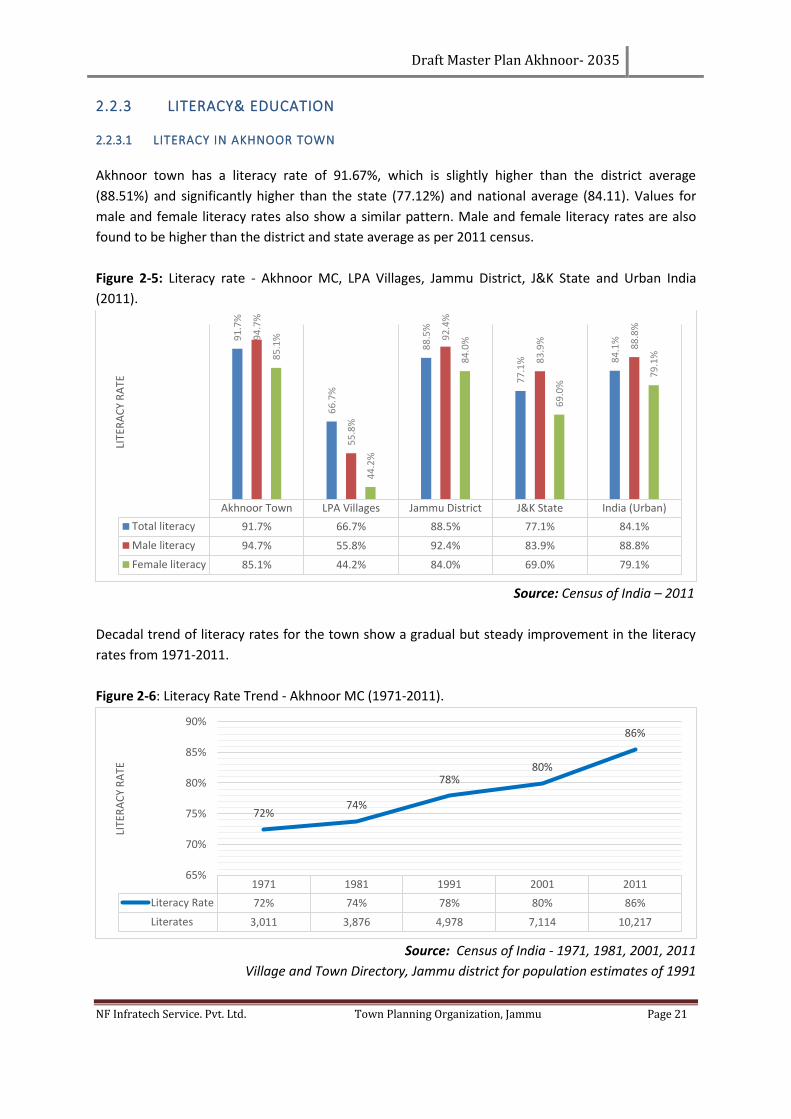
Draft Master Plan Akhnoor- 2035
NF Infratech Service. Pvt. Ltd. Town Planning Organization, Jammu Page 21
2.2.3 LITERACY& EDUCATION
2.2.3.1 LITERACY IN AKHNOOR TOWN
Akhnoor town has a literacy rate of 91.67%, which is slightly higher than the district average
(88.51%) and significantly higher than the state (77.12%) and national average (84.11). Values for
male and female literacy rates also show a similar pattern. Male and female literacy rates are also
found to be higher than the district and state average as per 2011 census.
Figure 2-5: Literacy rate - Akhnoor MC, LPA Villages, Jammu District, J&K State and Urban India
(2011).
Source: Census of India – 2011
Decadal trend of literacy rates for the town show a gradual but steady improvement in the literacy
rates from 1971-2011.
Figure 2-6: Literacy Rate Trend - Akhnoor MC (1971-2011).
Source: Census of India - 1971, 1981, 2001, 2011
Village and Town Directory, Jammu district for population estimates of 1991
Akhnoor Town LPA Villages Jammu District J&K State India (Urban)
Total literacy 91.7% 66.7% 88.5% 77.1% 84.1%
Male literacy 94.7% 55.8% 92.4% 83.9% 88.8%
Female literacy 85.1% 44.2% 84.0% 69.0% 79.1%
91
.7%
66
.7%
88
.5%
77
.1% 8
4.1
%94
.7%
55
.8%
92
.4%
83
.9% 88
.8%
85
.1%
44
.2%
84
.0%
69
.0%
79
.1%
LITE
RA
CY
RA
TE
1971 1981 1991 2001 2011
Literacy Rate 72% 74% 78% 80% 86%
Literates 3,011 3,876 4,978 7,114 10,217
72%74%
78%80%
86%
65%
70%
75%
80%
85%
90%
LITE
RA
CY
RA
TE
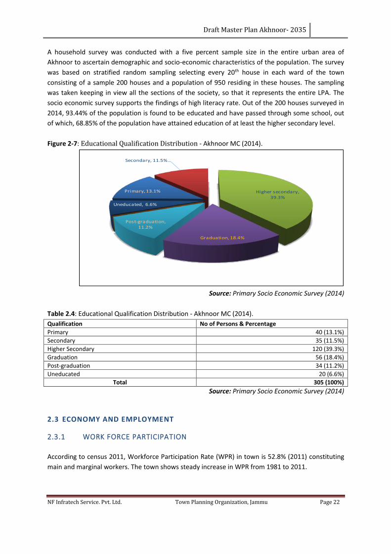
Draft Master Plan Akhnoor- 2035
NF Infratech Service. Pvt. Ltd. Town Planning Organization, Jammu Page 22
A household survey was conducted with a five percent sample size in the entire urban area of
Akhnoor to ascertain demographic and socio-economic characteristics of the population. The survey
was based on stratified random sampling selecting every 20th house in each ward of the town
consisting of a sample 200 houses and a population of 950 residing in these houses. The sampling
was taken keeping in view all the sections of the society, so that it represents the entire LPA. The
socio economic survey supports the findings of high literacy rate. Out of the 200 houses surveyed in
2014, 93.44% of the population is found to be educated and have passed through some school, out
of which, 68.85% of the population have attained education of at least the higher secondary level.
Figure 2-7: Educational Qualification Distribution - Akhnoor MC (2014).
Source: Primary Socio Economic Survey (2014)
Table 2.4: Educational Qualification Distribution - Akhnoor MC (2014).
Qualification No of Persons & Percentage
Primary 40 (13.1%)
Secondary 35 (11.5%)
Higher Secondary 120 (39.3%)
Graduation 56 (18.4%)
Post-graduation 34 (11.2%)
Uneducated 20 (6.6%)
Total 305 (100%)
Source: Primary Socio Economic Survey (2014)
2.3 ECONOMY AND EMPLOYMENT
2.3.1 WORK FORCE PARTICIPATION
According to census 2011, Workforce Participation Rate (WPR) in town is 52.8% (2011) constituting
main and marginal workers. The town shows steady increase in WPR from 1981 to 2011.
Primary, 13.1%
Secondary, 11.5%
Higher secondary, 39.3%
Graduation, 18.4%
Post-graduation, 11.2%
Uneducated, 6.6%
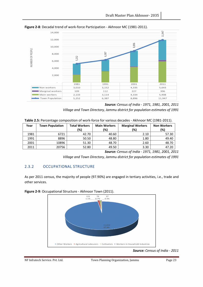
Draft Master Plan Akhnoor- 2035
NF Infratech Service. Pvt. Ltd. Town Planning Organization, Jammu Page 23
Figure 2-8: Decadal trend of work-force Participation - Akhnoor MC (1981-2011).
Source: Census of India - 1971, 1981, 2001, 2011
Village and Town Directory, Jammu district for population estimates of 1991
Table 2.5: Percentage composition of work-force for various decades - Akhnoor MC (1981-2011).
Year Town Population Total Workers (%)
Main Workers (%)
Marginal Workers (%)
Non Workers (%)
1981 6721 42.70 40.60 2.10 57.30
1991 8896 50.50 48.80 1.80 49.40
2001 10896 51.30 48.70 2.60 48.70
2011 20756 52.80 49.50 3.30 47.20
Source: Census of India - 1971, 1981, 2001, 2011
Village and Town Directory, Jammu district for population estimates of 1991
2.3.2 OCCUPATIONAL STRUCTURE
As per 2011 census, the majority of people (97.90%) are engaged in tertiary activities, i.e., trade and
other services.
Figure 2-9: Occupational Structure - Akhnoor Town (2011).
Source: Census of India - 2011
1981 1991 2001 2011
Non workers 3,010 3,152 4,335 5,643
Marginal workers 109 112 227 396
Main workers 2,133 3,114 4,334 5,908
Town Population 5,252 6,387 8,896 11,947
5,25
2 6,38
7
8,89
6
11,9
47
-
2,000
4,000
6,000
8,000
10,000
12,000
14,000NU
MBE
R OF
PEOP
LE
11,022 97.9%
121 1.1%
79 0.7%
37 0.3%
Other Workers Agricultural Labourers Cultivators Workers in Household Industries
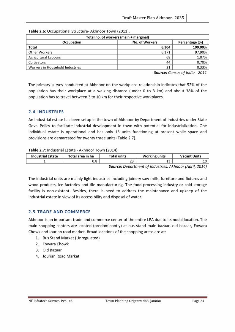
Draft Master Plan Akhnoor- 2035
NF Infratech Service. Pvt. Ltd. Town Planning Organization, Jammu Page 24
Table 2.6: Occupational Structure- Akhnoor Town (2011).
Total no. of workers (main + marginal)
Occupation No. of Workers Percentage (%)
Total 6,304 100.00%
Other Workers 6,171 97.90%
Agricultural Labours 68 1.07%
Cultivators 44 0.70%
Workers in Household Industries 21 0.33%
Source: Census of India - 2011
The primary survey conducted at Akhnoor on the workplace relationship indicates that 52% of the
population has their workplace at a walking distance (under 0 to 3 km) and about 38% of the
population has to travel between 3 to 10 km for their respective workplaces.
2.4 INDUSTRIES
An Industrial estate has been setup in the town of Akhnoor by Department of Industries under State
Govt. Policy to facilitate industrial development in town with potential for industrialization. One
individual estate is operational and has only 13 units functioning at present while space and
provisions are demarcated for twenty three units (Table 2.7).
Table 2.7: Industrial Estate - Akhnoor Town (2014).
Industrial Estate Total area in ha Total units Working units Vacant Units
1 0.8 23 13 10
Source: Department of Industries, Akhnoor (April, 2014)
The industrial units are mainly light industries including joinery saw mills, furniture and fixtures and
wood products, ice factories and tile manufacturing. The food processing industry or cold storage
facility is non-existent. Besides, there is need to address the maintenance and upkeep of the
industrial estate in view of its accessibility and disposal of water.
2.5 TRADE AND COMMERCE
Akhnoor is an important trade and commerce center of the entire LPA due to its nodal location. The
main shopping centers are located (predominantly) at bus stand main bazaar, old bazaar, Fowara
Chowk and Jourian road market. Broad locations of the shopping areas are at:
1. Bus Stand Market (Unregulated)
2. Fowara Chowk
3. Old Bazaar
4. Jourian Road Market
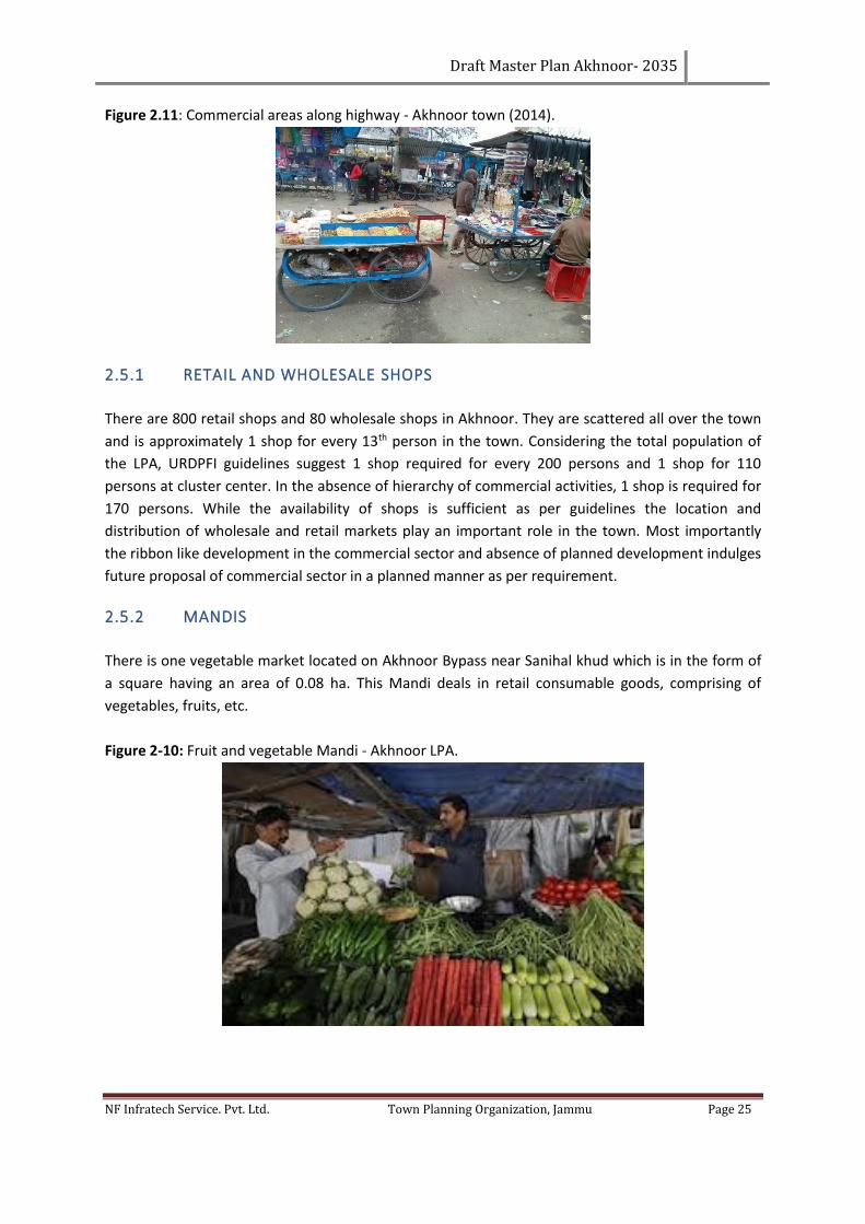
Draft Master Plan Akhnoor- 2035
NF Infratech Service. Pvt. Ltd. Town Planning Organization, Jammu Page 25
Figure 2.11: Commercial areas along highway - Akhnoor town (2014).
2.5.1 RETAIL AND WHOLESALE SHOPS
There are 800 retail shops and 80 wholesale shops in Akhnoor. They are scattered all over the town
and is approximately 1 shop for every 13th person in the town. Considering the total population of
the LPA, URDPFI guidelines suggest 1 shop required for every 200 persons and 1 shop for 110
persons at cluster center. In the absence of hierarchy of commercial activities, 1 shop is required for
170 persons. While the availability of shops is sufficient as per guidelines the location and
distribution of wholesale and retail markets play an important role in the town. Most importantly
the ribbon like development in the commercial sector and absence of planned development indulges
future proposal of commercial sector in a planned manner as per requirement.
2.5.2 MANDIS
There is one vegetable market located on Akhnoor Bypass near Sanihal khud which is in the form of
a square having an area of 0.08 ha. This Mandi deals in retail consumable goods, comprising of
vegetables, fruits, etc.
Figure 2-10: Fruit and vegetable Mandi - Akhnoor LPA.
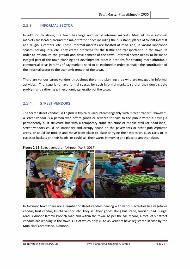
Draft Master Plan Akhnoor- 2035
NF Infratech Service. Pvt. Ltd. Town Planning Organization, Jammu Page 26
2.5.3 INFORMAL SECTOR
In addition to above, the town has large number of informal markets. Most of these informal
markets are located around the major traffic nodes including the bus stand, places of tourist interest
and religious centers, etc. These informal markets are located at road side, in vacant land/open
spaces, parking lots, etc. They create problems for the traffic and transportation in the town. In
order to rationalize the growth and development of the town, informal sector needs to be made
integral part of the town planning and development process. Options for creating more affordable
commercial areas in terms of day markets need to be explored in order to enable the contribution of
the informal sector to the economic growth of the town.
There are various street vendors throughout the entire planning area who are engaged in informal
activities. The issue is to have formal spaces for such informal markets so that they don’t create
problem and rather help in economic generation of the town.
2.5.4 STREET VENDORS
The term “street vendor” in English is typically used interchangeably with “street trader,” “hawker”.
A street vendor is a person who offers goods or services for sale to the public without having a
permanently built structure but with a temporary static structure or mobile stall (or head-load).
Street vendors could be stationary and occupy space on the pavements or other public/private
areas, or could be mobile and move from place to place carrying their wares on push carts or in
cycles or baskets on their heads, or could sell their wares in moving one place to another place.
Figure 2-11: Street vendors - Akhnoor (April, 2014).
In Akhnoor town there are a number of street vendors dealing with various activities like vegetable
vendor, fruit vendor, Kulcha vendor, etc. They sell their goods along bus stand, Jourian road, Sungal
road, Akhnoor-Jammu-Poonch road and within the town. As per the MC record, a total of 57 street
vendors are working in the town. Out of which only 40 to 45 vendors have registered license by the
Municipal Committee, Akhnoor.
Draft Master Plan Akhnoor- 2035
NF Infratech Service. Pvt. Ltd. Town Planning Organization, Jammu Page 27
Table 2.8: Locations and numbers of registered street vendors - Akhnoor town (2014).
S. No. Street Vendor Number Location
1 Kulcha Vendor 10 Bus stand, Jourian road, Sungal road, Akhnoor-Jammu-Poonch road.
2 Vegetable Vendor 16 Within the town, Jourian road, Sungal road, Akhnoor-Jammu-Poonch road
near bus stand.
3 Fruit Vendor 12 Jourian road, Sungal road, Akhnoor-Jammu-Poonch road, near bus stand
4 Gol Gappa Vendor 10 Bus stand, Jourian road, Sungal road, Akhnoor Jammu-Poonch road.
5 Seasonal 9 Bus stand, Jourian road, Sungal road.
Total 57
Source: Municipal Committee Akhnoor (2014)
A separate Street vending plan needs to be prepared by the Concerned Municipal council in order to
have a well-planned system and movement of the street vendors. Moreover it also became useful for
the streamline movement of Traffic. The Preparation of Street vendors plan needs to be carried under
Street vendors act, 2014.
2.6 KEY ISSUES UNDER TRADE & COMMERCE
1. The markets of the old town are highly congested and have high density. Due to the absence
of adequate parking and organized commercial area, the movement in these areas gets
restricted.
2. The narrow streets and road encroachments have further degraded the aesthetic and
potential of the area. This has affected the trade of the markets and thus their existence.
3. No commercial complex for banking, insurance and share market exists in the Town.
4. No organized space is available for the street vendors in the town, creating congestion
problems near the bus stand and other major roads.
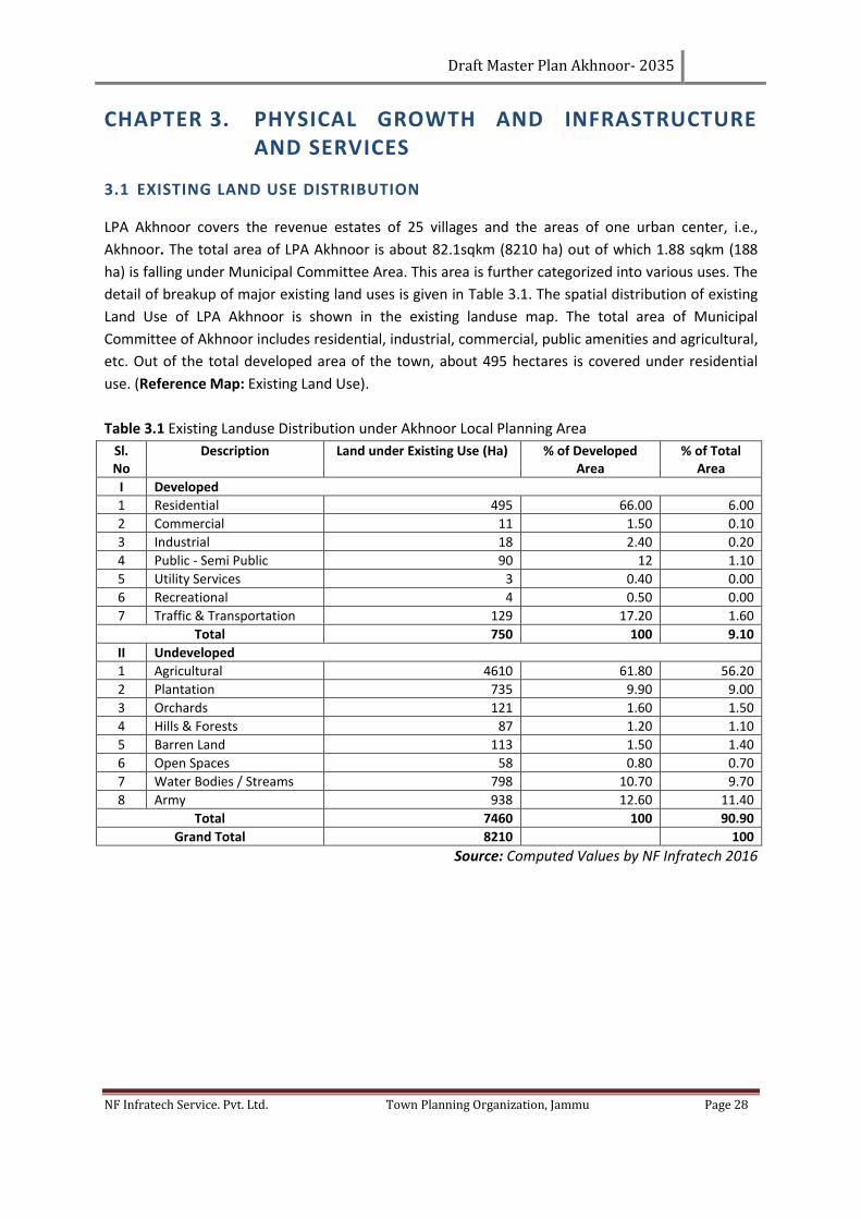
Draft Master Plan Akhnoor- 2035
NF Infratech Service. Pvt. Ltd. Town Planning Organization, Jammu Page 28
CHAPTER 3. PHYSICAL GROWTH AND INFRASTRUCTURE AND SERVICES
3.1 EXISTING LAND USE DISTRIBUTION
LPA Akhnoor covers the revenue estates of 25 villages and the areas of one urban center, i.e.,
Akhnoor. The total area of LPA Akhnoor is about 82.1sqkm (8210 ha) out of which 1.88 sqkm (188
ha) is falling under Municipal Committee Area. This area is further categorized into various uses. The
detail of breakup of major existing land uses is given in Table 3.1. The spatial distribution of existing
Land Use of LPA Akhnoor is shown in the existing landuse map. The total area of Municipal
Committee of Akhnoor includes residential, industrial, commercial, public amenities and agricultural,
etc. Out of the total developed area of the town, about 495 hectares is covered under residential
use. (Reference Map: Existing Land Use).
Table 3.1 Existing Landuse Distribution under Akhnoor Local Planning Area
Sl. No
Description Land under Existing Use (Ha) % of Developed Area
% of Total Area
I Developed
1 Residential 495 66.00 6.00
2 Commercial 11 1.50 0.10
3 Industrial 18 2.40 0.20
4 Public - Semi Public 90 12 1.10
5 Utility Services 3 0.40 0.00
6 Recreational 4 0.50 0.00
7 Traffic & Transportation 129 17.20 1.60
Total 750 100 9.10
II Undeveloped
1 Agricultural 4610 61.80 56.20
2 Plantation 735 9.90 9.00
3 Orchards 121 1.60 1.50
4 Hills & Forests 87 1.20 1.10
5 Barren Land 113 1.50 1.40
6 Open Spaces 58 0.80 0.70
7 Water Bodies / Streams 798 10.70 9.70
8 Army 938 12.60 11.40
Total 7460 100 90.90
Grand Total 8210 100
Source: Computed Values by NF Infratech 2016
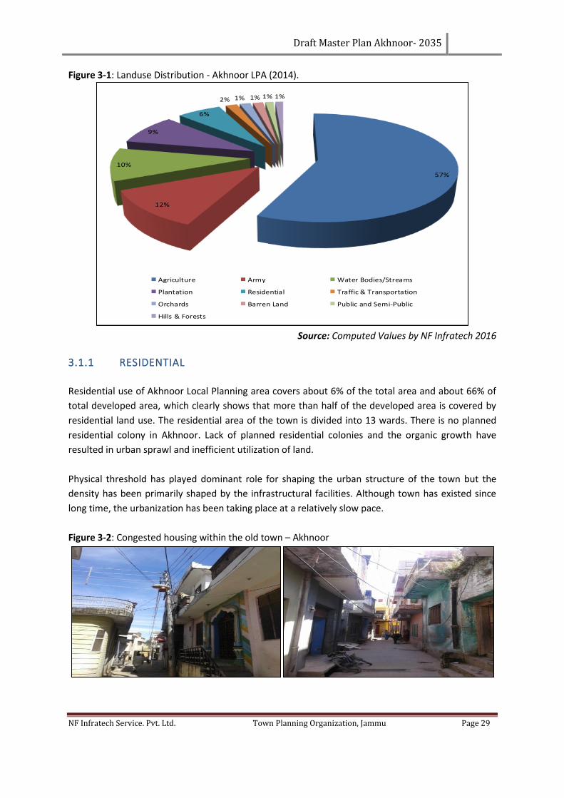
Draft Master Plan Akhnoor- 2035
NF Infratech Service. Pvt. Ltd. Town Planning Organization, Jammu Page 29
Figure 3-1: Landuse Distribution - Akhnoor LPA (2014).
Source: Computed Values by NF Infratech 2016
3.1.1 RESIDENTIAL
Residential use of Akhnoor Local Planning area covers about 6% of the total area and about 66% of
total developed area, which clearly shows that more than half of the developed area is covered by
residential land use. The residential area of the town is divided into 13 wards. There is no planned
residential colony in Akhnoor. Lack of planned residential colonies and the organic growth have
resulted in urban sprawl and inefficient utilization of land.
Physical threshold has played dominant role for shaping the urban structure of the town but the
density has been primarily shaped by the infrastructural facilities. Although town has existed since
long time, the urbanization has been taking place at a relatively slow pace.
Figure 3-2: Congested housing within the old town – Akhnoor
57%
12%
10%
9%
6%
2% 1% 1% 1% 1%
Agriculture Army Water Bodies/Streams
Plantation Residential Traffic & Transportation
Orchards Barren Land Public and Semi-Public
Hills & Forests
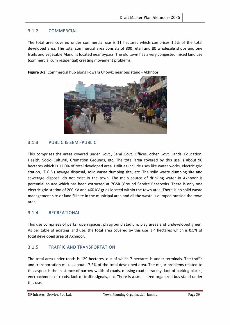
Draft Master Plan Akhnoor- 2035
NF Infratech Service. Pvt. Ltd. Town Planning Organization, Jammu Page 30
3.1.2 COMMERCIAL
The total area covered under commercial use is 11 hectares which comprises 1.5% of the total
developed area. The total commercial area consists of 800 retail and 80 wholesale shops and one
fruits and vegetable Mandi is located near bypass. The old town has a very congested mixed land use
(commercial cum residential) creating movement problems.
Figure 3-3: Commercial hub along Fowara Chowk, near bus stand - Akhnoor
3.1.3 PUBLIC & SEMI-PUBLIC
This comprises the areas covered under Govt., Semi Govt. Offices, other Govt. Lands, Education,
Health, Socio–Cultural, Cremation Grounds, etc. The total area covered by this use is about 90
hectares which is 12.0% of total developed area. Utilities include uses like water works, electric grid
station, (E.G.S.) sewage disposal, solid waste dumping site, etc. The solid waste dumping site and
sewerage disposal do not exist in the town. The main source of drinking water in Akhnoor is
perennial source which has been extracted at 7GSR (Ground Service Reservoir). There is only one
electric grid station of 200 KV and 460 KV grids located within the town area. There is no solid waste
management site or land fill site in the municipal area and all the waste is dumped outside the town
area.
3.1.4 RECREATIONAL
This use comprises of parks, open spaces, playground stadium, play areas and undeveloped green.
As per table of existing land use, the total area covered by this use is 4 hectares which is 0.5% of
total developed area of Akhnoor.
3.1.5 TRAFFIC AND TRANSPORTATION
The total area under roads is 129 hectares, out of which 7 hectares is under terminals. The traffic
and transportation makes about 17.2% of the total developed area. The major problems related to
this aspect is the existence of narrow width of roads, missing road hierarchy, lack of parking places,
encroachment of roads, lack of traffic signals, etc. There is a small sized organized bus stand under
this use.

Draft Master Plan Akhnoor- 2035
NF Infratech Service. Pvt. Ltd. Town Planning Organization, Jammu Page 31
Figure 3-4: Narrow streets within the old town - Akhnoor MC
3.1.6 AGRICULTURE AND PLANTATION LAND USE
Out of total area of Municipal Committee (MC), only 2% area is covered by agriculture land. This lie
in wards numbered 9, 12 and 13 which are newly added in the MC area.
3.1.7 DEFENCE
Army occupies 12.6% of the total LPA area for the purpose of border security that includes a sizeable
area of village Domi, Bhardah Kalan, near the KVS (Army school) and near the bypass.
3.2 CHALLENGES OF LAND USE
The town is witnessing unprecedented land use transformation. The residential use is being
succeeded by commercial and tourism pursuits. Commercial use is colliding with transportation,
tourism and institutional uses. Non-conforming and incompatible uses like workshops, wholesale
markets and on-road parking are badly affecting the predominant and befitting uses as well as
community life. The parks, open spaces, forest areas, drainage lines, roads and steep slopes are
being encroached upon and threatened by consumerism forces.
The town has developed haphazardly and is under utmost strain. Lack of accessibility to many
structures and localities is a matter of serious concern. The localities susceptible to hazards have to
be dealt with. The multi-storey culture against hill development imperatives has to be effectively
addressed. The town is underrated for tourism purposes and calls for stringent regulatory control
mechanism to restore its lost glory and make it sustainable for coming generations as well as
tourists. There is urgent need to address to following:
1. To inculcate culture for planned development.
2. Regulations and penalties in respect of Green Areas
3. Constructions susceptible to hazards on slopes and measures thereof.
4. Non compatible construction activities in the existing Town.
5. Conservative surgery of Central Area and crowded localities.
6. Organized vehicular parking for the smooth flow of traffic.
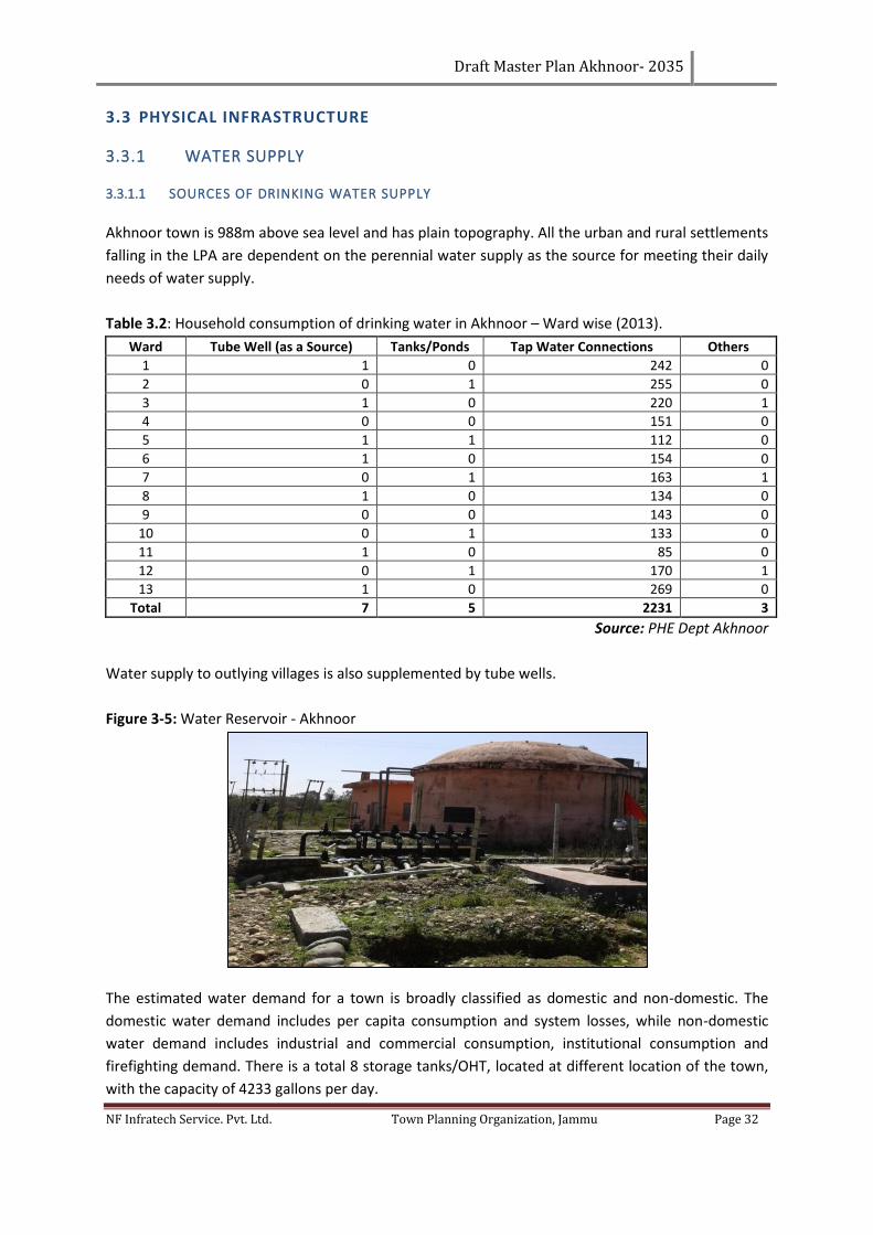
Draft Master Plan Akhnoor- 2035
NF Infratech Service. Pvt. Ltd. Town Planning Organization, Jammu Page 32
3.3 PHYSICAL INFRASTRUCTURE
3.3.1 WATER SUPPLY
3.3.1.1 SOURCES OF DRINKING WATER SUPPLY
Akhnoor town is 988m above sea level and has plain topography. All the urban and rural settlements
falling in the LPA are dependent on the perennial water supply as the source for meeting their daily
needs of water supply.
Table 3.2: Household consumption of drinking water in Akhnoor – Ward wise (2013).
Ward Tube Well (as a Source) Tanks/Ponds Tap Water Connections Others
1 1 0 242 0
2 0 1 255 0
3 1 0 220 1
4 0 0 151 0
5 1 1 112 0
6 1 0 154 0
7 0 1 163 1
8 1 0 134 0
9 0 0 143 0
10 0 1 133 0
11 1 0 85 0
12 0 1 170 1
13 1 0 269 0
Total 7 5 2231 3
Source: PHE Dept Akhnoor
Water supply to outlying villages is also supplemented by tube wells.
Figure 3-5: Water Reservoir - Akhnoor
The estimated water demand for a town is broadly classified as domestic and non-domestic. The
domestic water demand includes per capita consumption and system losses, while non-domestic
water demand includes industrial and commercial consumption, institutional consumption and
firefighting demand. There is a total 8 storage tanks/OHT, located at different location of the town,
with the capacity of 4233 gallons per day.
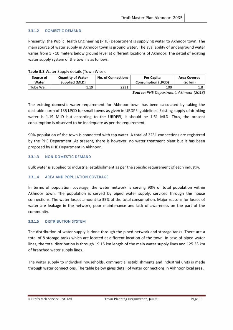
Draft Master Plan Akhnoor- 2035
NF Infratech Service. Pvt. Ltd. Town Planning Organization, Jammu Page 33
3.3.1.2 DOMESTIC DEMAND
Presently, the Public Health Engineering (PHE) Department is supplying water to Akhnoor town. The
main source of water supply in Akhnoor town is ground water. The availability of underground water
varies from 5 - 10 meters below ground level at different locations of Akhnoor. The detail of existing
water supply system of the town is as follows:
Table 3.3 Water Supply details (Town Wise).
Source of Water
Quantity of Water Supplied (MLD)
No. of Connections Per Capita Consumption (LPCD)
Area Covered (sq km)
Tube Well 1.19 2231 100 1.8
Source: PHE Department, Akhnoor (2013)
The existing domestic water requirement for Akhnoor town has been calculated by taking the
desirable norm of 135 LPCD for small towns as given in URDPFI guidelines. Existing supply of drinking
water is 1.19 MLD but according to the URDPFI, it should be 1.61 MLD. Thus, the present
consumption is observed to be inadequate as per the requirement.
90% population of the town is connected with tap water. A total of 2231 connections are registered
by the PHE Department. At present, there is however, no water treatment plant but it has been
proposed by PHE Department in Akhnoor.
3.3.1.3 NON-DOMESTIC DEMAND
Bulk water is supplied to industrial establishment as per the specific requirement of each industry.
3.3.1.4 AREA AND POPULATION COVERAGE
In terms of population coverage, the water network is serving 90% of total population within
Akhnoor town. The population is served by piped water supply, serviced through the house
connections. The water losses amount to 35% of the total consumption. Major reasons for losses of
water are leakage in the network, poor maintenance and lack of awareness on the part of the
community.
3.3.1.5 DISTRIBUTION SYSTEM
The distribution of water supply is done through the piped network and storage tanks. There are a
total of 8 storage tanks which are located at different location of the town. In case of piped water
lines, the total distribution is through 19.15 km length of the main water supply lines and 125.33 km
of branched water supply lines.
The water supply to individual households, commercial establishments and industrial units is made
through water connections. The table below gives detail of water connections in Akhnoor local area.
Draft Master Plan Akhnoor- 2035
NF Infratech Service. Pvt. Ltd. Town Planning Organization, Jammu Page 34
Table 3.5: Categories wise distribution of water connections of Akhnoor Town.
Year Domestic Consumption
Growth Rate %
Commercial Consumption
Growth Rate %
Industrial Consumption
Growth Rate %
Total Growth Rate %
2011 1668 187 90 1945
2012 1987 19.12 204 9.09 110 22.22 2301 18.3
2013 2231 12.28 224 9.8 122 10.91 2577 11.99
Source: PHE Department, Akhnoor (2013)
Due to rapid increase in population, there has been a strong demand to increase the water
connections for domestic use and commercial establishments in Akhnoor.
Further, the water supply in Akhnoor is un-metered. In the absence of metering system, the
efficiency in cost recovery is reduced.
3.3.1.6 KEY ISSUES OF WATER SUPPLY:
1. High wastage due to water leakage.
2. Poor cost recovery due to unmetered water supply.
3. Intermittent water supply leading to higher wastage.
4. Low overhead storage capacity.
5. Poor maintenance of service network.
6. Lack of use of rain water harvesting techniques.
Considering the rapid growth of Akhnoor, appropriate strategies and mechanisms need to be
explored, including recycling of the waste water by the industry. Mechanism of rain water harvesting
should also be encouraged at the household/ institutional/ industrial level in order to provide better
quality and quantity of water. Besides, metering system needs to be introduced in order to increase
its affectivity.
3.3.2 SEWERAGE AND SANITATION
The disposal of sewage generated by industrial, commercial, domestic and institutions is also one of
the basic function of the local bodies. Providing sewage disposal network is mandated due to its
impact on the quality of life and quality of environment. Accordingly, the sewage disposal has also
been considered as one of the critical component of urban infrastructure determining the quality of
life in urban sector. In this context, while preparing the future planning framework for the town, it is
important to examine the issues and status related to sewerage and sanitation in Akhnoor and the
rural settlements located in the LPA.
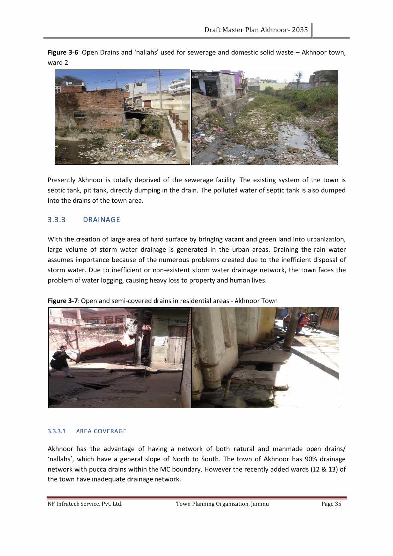
Draft Master Plan Akhnoor- 2035
NF Infratech Service. Pvt. Ltd. Town Planning Organization, Jammu Page 35
Figure 3-6: Open Drains and ‘nallahs’ used for sewerage and domestic solid waste – Akhnoor town,
ward 2
Presently Akhnoor is totally deprived of the sewerage facility. The existing system of the town is
septic tank, pit tank, directly dumping in the drain. The polluted water of septic tank is also dumped
into the drains of the town area.
3.3.3 DRAINAGE
With the creation of large area of hard surface by bringing vacant and green land into urbanization,
large volume of storm water drainage is generated in the urban areas. Draining the rain water
assumes importance because of the numerous problems created due to the inefficient disposal of
storm water. Due to inefficient or non-existent storm water drainage network, the town faces the
problem of water logging, causing heavy loss to property and human lives.
Figure 3-7: Open and semi-covered drains in residential areas - Akhnoor Town
3.3.3.1 AREA COVERAGE
Akhnoor has the advantage of having a network of both natural and manmade open drains/
‘nallahs’, which have a general slope of North to South. The town of Akhnoor has 90% drainage
network with pucca drains within the MC boundary. However the recently added wards (12 & 13) of
the town have inadequate drainage network.
Draft Master Plan Akhnoor- 2035
NF Infratech Service. Pvt. Ltd. Town Planning Organization, Jammu Page 36
3.3.4 KEY ISSUES OF SEWERAGE AND SANITATION
Looking at the existing status of drainage, the major issues emerge;
1. Rural settlements of planning area are devoid of drainage facility.
2. Lack of rainwater storage technique, which can help in conserving the water.
3. Disposal of domestic refuse and untreated sludge in the drains in the storm water drains has
led to high degree of health hazard, emerging as major threat to environment and quality of
life.
4. Absence of Sewage Treatment Plant in Akhnoor town and LPA.
3.3.5 SOLID WASTE MANAGEMENT
Solid Waste Management is the prime responsibility of the Municipal Committee Akhnoor involving
collection, storage, segregation, transportation and disposal. In Akhnoor urban limits, house to
house collection of the solid waste is carried out through a number of sanitary workers deployed by
the Municipal Committee. The payment is made on shared basis by Municipal Committees which are
constituted at Mohalla level and support the system through household contributions. In all, there
are an average 150 sanitary workers deployed.
Table 3.4:Ward-wise Solid Waste Management - Akhnoor (2013).
Ward Average
Generation
(tons/day)
Average
Collection
(tons/day)
No. of houses
covered for house to
house collection
Total area used for
sanitary land fill
(canals)
Manpower Deployed (in no.)
1 0.09 0.12 175 A Total of 5 canals
area is used for
sanitary land fill
which is outside the
municipal limit of
Akhnoor.
3
2 0.21 0.12 184 3
3 0.18 0.11 159 3
4 0.12 0.07 109 2
5 0.09 0.05 81 2
6 0.12 0.08 111 3
7 0.13 0.08 118 3
8 0.11 0.07 97 2
9 0.11 0.07 104 3
10 0.11 0.07 97 3
11 0.07 0.04 62 2
12 0.14 0.09 123 2
13 0.21 0.13 193 4
Total 1.79 1.1 1613 5 35
Source: Municipal Committee, Akhnoor (2013)
It may be mentioned here that the house to house collection of solid waste is done from 81% of
houses of the town. Thus the generation of solid waste from 19% of houses remains uncollected and
need to be taken into account.
Draft Master Plan Akhnoor- 2035
NF Infratech Service. Pvt. Ltd. Town Planning Organization, Jammu Page 37
3.3.5.1 GENERATION
Solid waste comprises of waste generated from different sources. Major sources of generation are
individual households, industries, trade and commerce, hotels and restaurants, healthcare
institutions including dispensaries and hospitals, animals and floating populations in terms of
tourists, hawkers, etc.
The total generation of solid waste in the town of Akhnoor is estimated to be 1.8 tons per day (TPD)
and only 1.1 tons per day (61.1%) is collected and the rest 0.69 tons (38.9%) of waste is not
collected. This amount of solid waste generated is disposed of along Jourian road outside the town
due to the non-availability of permanent land fill site in the town.
3.3.5.2 COLLECTION
Different hierarchy of collection of solid waste is practiced in the town. Since, the household waste
has high contents of organic waste, no system of segregation is used at the generation level. In the
process, the quality of recyclable material gets distorted due to mixing of the dry and wet waste. No
house to house collection of solid waste was done in the LIG areas, such as Jia Pota. In such areas,
the solid waste is dumped mostly in the available vacant plots and nearby low lying areas and water
bodies. The areas where the house to house collection system is not provided, community bins are
strategically provided by the committee or their direct use by the surrounding inhabitants. Many
places, open spaces and roadsides have emerged as the preferred dumping sites.
Besides this, some major collection points have been marked by the Committee which acts as waste
storage points from where they are transported for the final disposal to the Sungal road, Jourian
road and Ranjani wali khad.
3.3.5.3 TRANSPORTATION
For the transportation of the solid waste from the collection center to the disposal site, Akhnoor MC
has deployed number of vehicles including one truck and two tippers of different sizes.
These vehicles are used for primary collection of waste from the community bins and its
transportation to landfill site. The present collection infrastructure and manpower available with
municipal committee is observed to be inadequate as per the requirement.
3.3.5.4 DISPOSAL
Akhnoor Municipal Committee practices open disposal of waste without undertaking any pre-
treatment of the waste. Municipal Committee has not identified permanent landfill site. At present,
the waste generated is dumped along the Jourian road at a distance of 10 km from the town leading
to unhygienic conditions for the local people.
In addition, the informal dumping of the waste has been witnessed in nallahs / khads, open spaces,
vacant plots, along bypass, etc. This informal dumping of garbage along bypass, nallah, etc. has led
to the creation of unhygienic environment in the areas of the town. Moreover, there is no formal
Draft Master Plan Akhnoor- 2035
NF Infratech Service. Pvt. Ltd. Town Planning Organization, Jammu Page 38
system of solid waste management operating in the villages of LPA, which have been included within
planning area.
3.3.5.5 KEY ISSUES OF SOLID WASTE MANAGEMENT
1. Absence of public participation and lack of public awareness.
2. Absence of scientific collection and disposal.
3. Absence of solid waste treatment plant in the town
4. Untrained and unqualified man power deployed in the process of solid waste management.
5. Absence of segregation of waste at the generation level. This is preventing the use of
degradable waste as manure.
6. Inadequate and out dated collection and storage infrastructure in use by Municipal
Committee.
7. Absence of permanent dumping sites as well and the absence of scientific system of landfill
management.
8. Open dumping along roadsides, vacant plots, drains/nallahs, etc.
3.3.6 ELECTRICITY
3.3.6.1 AREA AND POPULATION COVERAGE
100% of Akhnoor is covered by electric supply lines. The total electricity demand for the town is 15
MW against which the supply is 10MW (ref Table 3.5).
Table 3.5: Electricity supply, demand and consumption – Akhnoor town (2011)
Source/Distance (in km) of Power
Plant
Total Electricity
Demand (MW)
Total electricity
Supply(MW)
Total Consumption (Lakhs
unit per Month)
132/33 KV grid station Akhnoor
(3km from town) 15 10 18.504
Source: Electricity Deptt. (2013)
3.3.6.2 DISTRIBUTION NETWORK
The electric supply to the town of Akhnoor is made through two 132 KV power stations located near
Ranjaniwala Khad which are now part of local planning area of Akhnoor Town. Further, the electric
supply to different parts of the town is made through seven 66 KV sub stations. The table below
gives the category wise electricity conecctions in Akhnoor Municipal Committee area.
Table 3.6: Categories wise electricity connections in Akhnoor MC Area (2013).
Type Residential Commercial Industrial Others Total
No. of Electric Connections 2000 1000 40 50 3090
Electric Consumption (Lacs unit per Month) 8.10 3.15 4.554 2.7 18.504
Source: Electricity Department (2013)
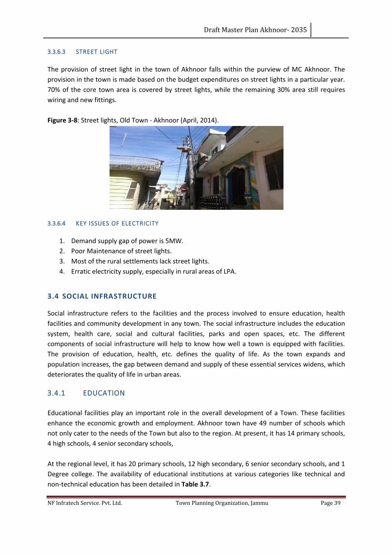
Draft Master Plan Akhnoor- 2035
NF Infratech Service. Pvt. Ltd. Town Planning Organization, Jammu Page 39
3.3.6.3 STREET LIGHT
The provision of street light in the town of Akhnoor falls within the purview of MC Akhnoor. The
provision in the town is made based on the budget expenditures on street lights in a particular year.
70% of the core town area is covered by street lights, while the remaining 30% area still requires
wiring and new fittings.
Figure 3-8: Street lights, Old Town - Akhnoor (April, 2014).
3.3.6.4 KEY ISSUES OF ELECTRICITY
1. Demand supply gap of power is 5MW.
2. Poor Maintenance of street lights.
3. Most of the rural settlements lack street lights.
4. Erratic electricity supply, especially in rural areas of LPA.
3.4 SOCIAL INFRASTRUCTURE
Social infrastructure refers to the facilities and the process involved to ensure education, health
facilities and community development in any town. The social infrastructure includes the education
system, health care, social and cultural facilities, parks and open spaces, etc. The different
components of social infrastructure will help to know how well a town is equipped with facilities.
The provision of education, health, etc. defines the quality of life. As the town expands and
population increases, the gap between demand and supply of these essential services widens, which
deteriorates the quality of life in urban areas.
3.4.1 EDUCATION
Educational facilities play an important role in the overall development of a Town. These facilities
enhance the economic growth and employment. Akhnoor town have 49 number of schools which
not only cater to the needs of the Town but also to the region. At present, it has 14 primary schools,
4 high schools, 4 senior secondary schools,
At the regional level, it has 20 primary schools, 12 high secondary, 6 senior secondary schools, and 1
Degree college. The availability of educational institutions at various categories like technical and
non-technical education has been detailed in Table 3.7.
Draft Master Plan Akhnoor- 2035
NF Infratech Service. Pvt. Ltd. Town Planning Organization, Jammu Page 40
Table 3.7: Education Facilities - Akhnoor town (2012).
Type of Institutions
Type of Institutions
No. of Class Rooms
Enrolment No. of Teachers Student Teacher
Ratio
School Govt. Private Govt. Private Govt. Private Govt. Private Govt. Private
Primary upto 4th 4 10 8 221 124 3981 7 163 18 24
Middle upto 8th 2 2 13 122 161 1887 12 86 13 22
Secondary 10th 0 0 0 0 0 0 0 0 0 0
Senior Secondary 12th
2 2 51 94 1342 2140 94 32 14 67
Total 8 14 72 437 1627 8008 113 281 14 28
Source: Zonal Education Office (2012)
3.4.2 HEALTH AND MEDICAL FACILITIES
The Municipal Committee Akhnoor does not provide the health services. The same is being run by
the J&K Department of health services.
Table 3.8 List of Government Health Facilities Center in Akhnoor Town.
Type of Hospital No. of Units No. of Doctors
General Hospital 1 36
Sub Centers 1 1
Dispensary 0 0
Source: Chief Medical officer Akhnoor, (2013)
Above mentioned table shows that the required number of general hospitals (as per URDPFI) is more
than the sufficient level due to the transitory and service nature of the town Akhnoor. However, at
least one dispensary is required.
3.5 SPORTS AND RECREATIONAL
Recreational facilities are important for physical and social development of an individual.
Recreational facilities exist in the shape of parks, open spaces, stadiums, museums, sport related
activities, clubs, libraries, amusement parks, etc. In order to cater to the essential needs of the
individuals and communities, these facilities need to be provided.
3.5.1 PARKS AND OPEN SPACES
There is only one town level park, namely Rajinder Park which covers an area of 0.5 ha which fulfills
the town’s recreational needs while the rest of the town lacks parks and open spaces. There is no
hierarchy in the parks and open spaces in the town. Akhnoor lacks recreational facilities like libraries,
community hall and other socio-cultural facilities.
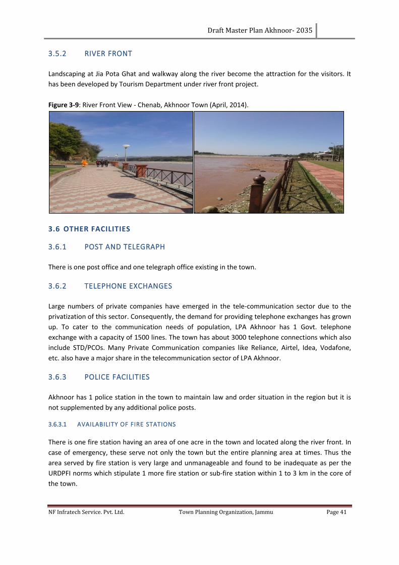
Draft Master Plan Akhnoor- 2035
NF Infratech Service. Pvt. Ltd. Town Planning Organization, Jammu Page 41
3.5.2 RIVER FRONT
Landscaping at Jia Pota Ghat and walkway along the river become the attraction for the visitors. It
has been developed by Tourism Department under river front project.
Figure 3-9: River Front View - Chenab, Akhnoor Town (April, 2014).
3.6 OTHER FACILITIES
3.6.1 POST AND TELEGRAPH
There is one post office and one telegraph office existing in the town.
3.6.2 TELEPHONE EXCHANGES
Large numbers of private companies have emerged in the tele-communication sector due to the
privatization of this sector. Consequently, the demand for providing telephone exchanges has grown
up. To cater to the communication needs of population, LPA Akhnoor has 1 Govt. telephone
exchange with a capacity of 1500 lines. The town has about 3000 telephone connections which also
include STD/PCOs. Many Private Communication companies like Reliance, Airtel, Idea, Vodafone,
etc. also have a major share in the telecommunication sector of LPA Akhnoor.
3.6.3 POLICE FACILITIES
Akhnoor has 1 police station in the town to maintain law and order situation in the region but it is
not supplemented by any additional police posts.
3.6.3.1 AVAILABILITY OF FIRE STATIONS
There is one fire station having an area of one acre in the town and located along the river front. In
case of emergency, these serve not only the town but the entire planning area at times. Thus the
area served by fire station is very large and unmanageable and found to be inadequate as per the
URDPFI norms which stipulate 1 more fire station or sub-fire station within 1 to 3 km in the core of
the town.
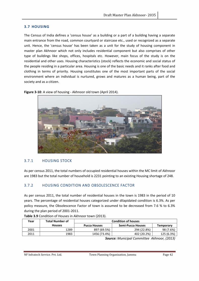
Draft Master Plan Akhnoor- 2035
NF Infratech Service. Pvt. Ltd. Town Planning Organization, Jammu Page 42
3.7 HOUSING
The Census of India defines a 'census house' as a building or a part of a building having a separate
main entrance from the road, common courtyard or staircase etc., used or recognized as a separate
unit. Hence, the 'census house' has been taken as a unit for the study of housing component in
master plan Akhnoor which not only includes residential component but also comprises of other
type of buildings like shops, offices, hospitals etc. However, main focus of the study is on the
residential and other uses. Housing characteristics (stock) reflects the economic and social status of
the people residing in a particular area. Housing is one of the basic needs and it ranks after food and
clothing in terms of priority. Housing constitutes one of the most important parts of the social
environment where an individual is nurtured, grows and matures as a human being, part of the
society and as a citizen.
Figure 3-10: A view of housing - Akhnoor old town (April 2014).
3.7.1 HOUSING STOCK
As per census 2011, the total numbers of occupied residential houses within the MC limit of Akhnoor
are 1983 but the total number of household is 2231 pointing to an existing Housing shortage of 248.
3.7.2 HOUSING CONDITION AND OBSOLESCENCE FACTOR
As per census 2011, the total number of residential houses in the town is 1983 in the period of 10
years. The percentage of residential houses categorized under dilapidated condition is 6.3%. As per
policy measure, the Obsolescence Factor of town is assumed to be decreased from 7.6 % to 6.3%
during the plan period of 2001-2011.
Table 3.9 Condition of Houses in Akhnoor town (2013).
Year Total Number of Houses
Condition of houses
Pucca Houses Semi-Pucca Houses Temporary
2001 1289 897 (69.5%) 294 (22.8%) 98 (7.6%)
2011 1983 1456 (73.4%) 402 (20.2%) 125 (6.3%)
Source: Municipal Committee Akhnoor, (2013)
Draft Master Plan Akhnoor- 2035
NF Infratech Service. Pvt. Ltd. Town Planning Organization, Jammu Page 43
3.8 KEY ISSUES OF HOUSING
1. Poor implementation and monitoring of existing byelaws.
2. The central area of the town is overcrowded. The limits of crowded areas must be defined
wherein no more population be allowed at all and construction be banned further.
3. Lack of planned housing in the town.
4. Migration flow from outside of the town has created the demand for housing.
Draft Master Plan Akhnoor- 2035
NF Infratech Service. Pvt. Ltd. Town Planning Organization, Jammu Page 44
CHAPTER 4. TRAFFIC & TRANSPORTATION
Transport is the backbone of economy and social structure of any region. If urban centers have been
recognized as engines of economic growth, traffic and Transportation has rightly been termed as
wheels of such engines. Road and Rail network plays a vital role in the urban planning and traffic &
transportation has been considered as a function of land use planning. Transport network is
considered as the life line of the town and if any bottleneck or obstruction comes in between, it
poses a severe threat to day to day life of the town people. The good road and rail network is the
symbol of the sound development of any Town and the study of transportation helps in
understanding the existing situation, potentials, weaknesses, etc. and helps to draft out strategies
and projects for the future development.
4.1 EXISTING TRANSPORTATION NETWORK
The Akhnoor town is well served by roads connecting it to various towns of other districts. It is also
served by Akhnoor Bypass which is taken off from Domi Village and meets up at Manda village (7.8
km) with one bridge near Ranjaniwali Khad (0.28 km) and another major road which is known as
Akhnoor-Poonch road connecting Akhnoor to Jammu and Poonch.
The existing road network in Akhnoor town and region shows that it is well served by the regional
roads which provide a high level of connectivity.
Table 4.1: Description of Major Roads under Akhnoor LPA (2013).
S. No.
Hierarchy Name of Road Length of Road (Km)
Right of Way (M)
Building Line (M)
1 State Highway
Jammu Akhnoor Poonch Road
16 30 18-23 as per MORT&H specification
2 Bypass Road
Akhnoor Bypass 7.8 30 18-23 as per MORT&H specification
Source: R&B Department Akhnoor, and GREF Akhnoor (2015)
The State Highway, Jammu Poonch road which passes through Akhnoor town is the major linkage of
Akhnoor and connects it to the rest parts of the state and Country. Akhnoor Bypass is the linkage
which is developed along the eastern sides of the town and plays an important role in this area in
transportation of goods and passengers.
4.2 OTHER DISTRICT ROADS AT TOWN AND LPA LEVEL
The roads are important in the internal flow of traffic as these interconnect the surrounding villages
and other major/prominent areas of work, business and residential to each other.
Table 4.2 Detail of major roads - Akhnoor town and LPA (2013).
Name ROW (M) Building Line (M) Length (Km)
Bantalab Road 7.50 13.50 14
Ambaran Road 5.20 7.50 3.50
Sunail Road 5.20 7.50 3
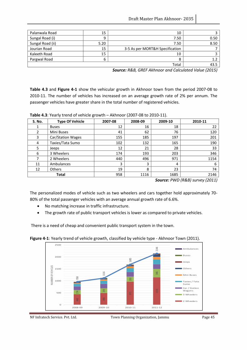
Draft Master Plan Akhnoor- 2035
NF Infratech Service. Pvt. Ltd. Town Planning Organization, Jammu Page 45
Palanwala Road 15 10 3
Sungal Road (i) 9 7.50 0.50
Sungal Road (ii) 5.20 7.50 8.50
Jourian Road 15 3-5 As per MORT&H Specification 7
Kaleeth Road 15 10 3
Pargwal Road 6 8 1.2
Total 43.5
Source: R&B, GREF Akhnoor and Calculated Value (2015)
Table 4.3 and Figure 4-1 show the vehicular growth in Akhnoor town from the period 2007-08 to
2010-11. The number of vehicles has increased on an average growth rate of 2% per annum. The
passenger vehicles have greater share in the total number of registered vehicles.
Table 4.3: Yearly trend of vehicle growth – Akhnoor (2007-08 to 2010-11).
S. No. Type Of Vehicle 2007-08 2008-09 2009-10 2010-11
1 Buses 12 16 18 22
2 Mini Buses 41 62 76 120
3 Car/Station Wages 155 185 197 201
4 Taxies/Tata Sumo 102 132 165 190
5 Jeeps 12 21 28 33
6 3 Wheelers 174 193 203 346
7 2 Wheelers 440 496 971 1154
11 Ambulances 3 3 4 6
12 Others 19 8 23 74
Total 958 1116 1685 2146
Source: PWD (R&B) survey (2011)
The personalized modes of vehicle such as two wheelers and cars together hold approximately 70-
80% of the total passenger vehicles with an average annual growth rate of 6.6%.
• No matching increase in traffic infrastructure.
• The growth rate of public transport vehicles is lower as compared to private vehicles.
There is a need of cheap and convenient public transport system in the town.
Figure 4-1: Yearly trend of vehicle growth, classified by vehicle type - Akhnoor Town (2011).
440 496
971 11
54
174 19
3
203
346
958
1116
1685
2146
0
500
1000
1500
2000
2500
2008-09 2009-10 2010-11 2011-12
NUM
BER
OF V
EHIC
LES
Ambulances
Buses
Jeeps
Others
Mini Buses
Taxies / TataSumo
Car / StationWagons
3 Wheelers
2 Wheelers
Draft Master Plan Akhnoor- 2035
NF Infratech Service. Pvt. Ltd. Town Planning Organization, Jammu Page 46
Source: PWD (R&B) survey (2011)
4.2.1 ROAD ACCIDENTS
The unprecedented growth of vehicles coupled with the large number of accidents may be seen in
Table 4.4.
Table 4.4: Yearly trend of accident records – Akhnoor town (2006 - 2013).
S. No. Year Serious Accidents
Normal Accidents No. of Dead Person No. of Injured Person
1 2006 6 5 1 4
2 2007 5 10 1 1
3 2008 5 5 2 5
4 2009 6 7 1 4
5 2010 5 9 0 7
6 2011 7 10 2 10
7 2012 11 13 1 12
8 2013 10 20 3 17
Source: SSP Akhnoor, (2014)
The trend shows an increase of registered accident cases from 2006 to 2013 (Table 4.4). An average
of 10% of total accidents results in fatalities. The causes of accidents (other than negligence of
driver) are the blind curves, lack of signals/traffic lights/ road markings, encroachment reducing
effective road width, poor road condition or poor road geometry, all of which require improvements.
4.2.2 CONGESTION INDEX FOR IMPORTANT ROADS
Table 4.5 Congestion Index of Important Roads.
Name Of Road RoW (M) Total Volume PCUs CI Remarks
Jammu-Akhnoor 30 1095 54.65 Congestion on road is due to the less carriage way width
Akhnoor- Jourian 15 981 54.6 Congestion on road is due to the less carriage way width
Fowara Chowk 5 867 48.52 Congestion on road is due to the less carriage way width
Source: PWD (R&B) survey (2013)
4.3 PARKING FACILITIES
Insufficient availability of parking spaces is a major problem, being faced by the residents of
Akhnoor. As number of vehicles has increased manifold, there has not been corresponding rise in
number of public parking lots. It has been observed that parking facilities need to be based on:
I. Parking at near bus stand, Jourian road, Jammu, Akhnoor road and Fowara Chowk road.
II. Parking along the inner circular road and near bus stand.
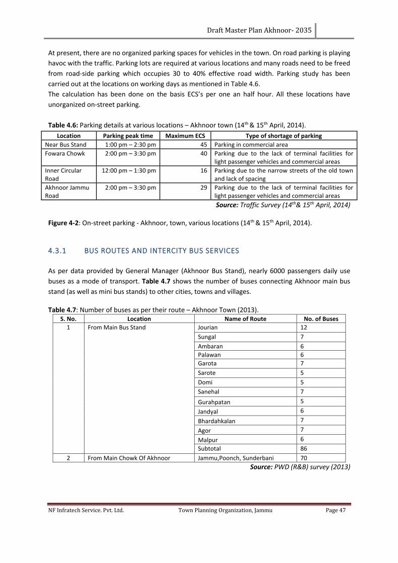
Draft Master Plan Akhnoor- 2035
NF Infratech Service. Pvt. Ltd. Town Planning Organization, Jammu Page 47
At present, there are no organized parking spaces for vehicles in the town. On road parking is playing
havoc with the traffic. Parking lots are required at various locations and many roads need to be freed
from road-side parking which occupies 30 to 40% effective road width. Parking study has been
carried out at the locations on working days as mentioned in Table 4.6.
The calculation has been done on the basis ECS’s per one an half hour. All these locations have
unorganized on-street parking.
Table 4.6: Parking details at various locations – Akhnoor town (14th & 15th April, 2014).
Location Parking peak time Maximum ECS Type of shortage of parking
Near Bus Stand 1:00 pm – 2:30 pm 45 Parking in commercial area
Fowara Chowk 2:00 pm – 3:30 pm 40 Parking due to the lack of terminal facilities for light passenger vehicles and commercial areas
Inner Circular Road
12:00 pm – 1:30 pm 16 Parking due to the narrow streets of the old town and lack of spacing
Akhnoor Jammu Road
2:00 pm – 3:30 pm 29 Parking due to the lack of terminal facilities for light passenger vehicles and commercial areas
Source: Traffic Survey (14th& 15th April, 2014) Figure 4-2: On-street parking - Akhnoor, town, various locations (14th & 15th April, 2014).
4.3.1 BUS ROUTES AND INTERCITY BUS SERVICES
As per data provided by General Manager (Akhnoor Bus Stand), nearly 6000 passengers daily use
buses as a mode of transport. Table 4.7 shows the number of buses connecting Akhnoor main bus
stand (as well as mini bus stands) to other cities, towns and villages.
Table 4.7: Number of buses as per their route – Akhnoor Town (2013). S. No. Location Name of Route No. of Buses
1 From Main Bus Stand Jourian 12
Sungal 7
Ambaran 6
Palawan 6
Garota 7
Sarote 5
Domi 5
Sanehal 7
Gurahpatan 5
Jandyal 6
Bhardahkalan 7
Agor 7
Malpur 6
Subtotal 86
2 From Main Chowk Of Akhnoor Jammu,Poonch, Sunderbani 70
Source: PWD (R&B) survey (2013)
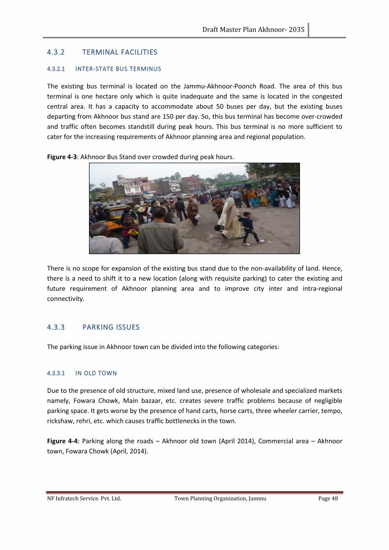
Draft Master Plan Akhnoor- 2035
NF Infratech Service. Pvt. Ltd. Town Planning Organization, Jammu Page 48
4.3.2 TERMINAL FACILITIES
4.3.2.1 INTER-STATE BUS TERMINUS
The existing bus terminal is located on the Jammu-Akhnoor-Poonch Road. The area of this bus
terminal is one hectare only which is quite inadequate and the same is located in the congested
central area. It has a capacity to accommodate about 50 buses per day, but the existing buses
departing from Akhnoor bus stand are 150 per day. So, this bus terminal has become over-crowded
and traffic often becomes standstill during peak hours. This bus terminal is no more sufficient to
cater for the increasing requirements of Akhnoor planning area and regional population.
Figure 4-3: Akhnoor Bus Stand over crowded during peak hours.
There is no scope for expansion of the existing bus stand due to the non-availability of land. Hence,
there is a need to shift it to a new location (along with requisite parking) to cater the existing and
future requirement of Akhnoor planning area and to improve city inter and intra-regional
connectivity.
4.3.3 PARKING ISSUES
The parking issue in Akhnoor town can be divided into the following categories:
4.3.3.1 IN OLD TOWN
Due to the presence of old structure, mixed land use, presence of wholesale and specialized markets
namely, Fowara Chowk, Main bazaar, etc. creates severe traffic problems because of negligible
parking space. It gets worse by the presence of hand carts, horse carts, three wheeler carrier, tempo,
rickshaw, rehri, etc. which causes traffic bottlenecks in the town.
Figure 4-4: Parking along the roads – Akhnoor old town (April 2014), Commercial area – Akhnoor
town, Fowara Chowk (April, 2014).
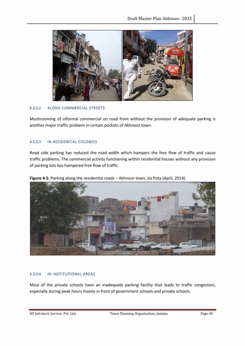
Draft Master Plan Akhnoor- 2035
NF Infratech Service. Pvt. Ltd. Town Planning Organization, Jammu Page 49
4.3.3.2 ALONG COMMERCIAL STREETS
Mushrooming of informal commercial on road front without the provision of adequate parking is
another major traffic problem in certain pockets of Akhnoor town.
4.3.3.3 IN RESIDENTIAL COLONIES
Road side parking has reduced the road width which hampers the free flow of traffic and cause
traffic problems. The commercial activity functioning within residential houses without any provision
of parking lots has hampered free flow of traffic.
Figure 4-5: Parking along the residential roads – Akhnoor town, Jia Pota (April, 2014).
4.3.3.4 IN INSTITUTIONAL AREAS
Most of the private schools have an inadequate parking facility that leads to traffic congestion,
especially during peak hours mainly in front of government schools and private schools.
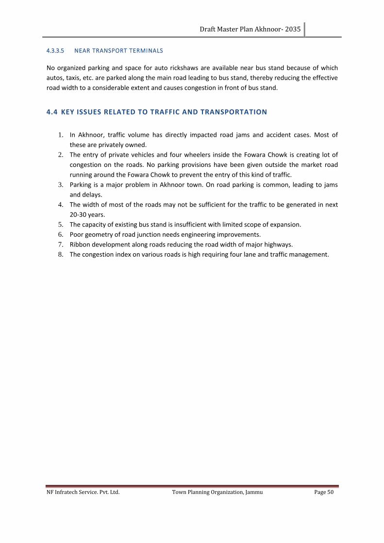
Draft Master Plan Akhnoor- 2035
NF Infratech Service. Pvt. Ltd. Town Planning Organization, Jammu Page 50
4.3.3.5 NEAR TRANSPORT TERMINALS
No organized parking and space for auto rickshaws are available near bus stand because of which
autos, taxis, etc. are parked along the main road leading to bus stand, thereby reducing the effective
road width to a considerable extent and causes congestion in front of bus stand.
4.4 KEY ISSUES RELATED TO TRAFFIC AND TRANSPORTATION
1. In Akhnoor, traffic volume has directly impacted road jams and accident cases. Most of
these are privately owned.
2. The entry of private vehicles and four wheelers inside the Fowara Chowk is creating lot of
congestion on the roads. No parking provisions have been given outside the market road
running around the Fowara Chowk to prevent the entry of this kind of traffic.
3. Parking is a major problem in Akhnoor town. On road parking is common, leading to jams
and delays.
4. The width of most of the roads may not be sufficient for the traffic to be generated in next
20-30 years.
5. The capacity of existing bus stand is insufficient with limited scope of expansion.
6. Poor geometry of road junction needs engineering improvements.
7. Ribbon development along roads reducing the road width of major highways.
8. The congestion index on various roads is high requiring four lane and traffic management.
Draft Master Plan Akhnoor- 2035
NF Infratech Service. Pvt. Ltd. Town Planning Organization, Jammu Page 51
CHAPTER 5. POPULATION PROJECTIONS AND DEMAND ANALYSIS
5.1 PROJECTION AND POTENTIAL DEMAND ANALYSIS
After detailed analysis of landuse and other socio economic data of Akhnoor, which includes local
planning area including municipality area of Akhnoor, the next step is to project for the future
population up to the year 2035. Population projections are a very important factor for the
development of any area and also the basis for working out the future landuse and infrastructure
requirements for the local planning area.
Projections and requirements are calculated on the basis of some assumptions. These calculations
are done keeping in mind the following methodology. To arrive at a conclusive projection figure,
three methods of population projections have been used for the town as well as the whole LPA. The
methods used for projecting population are:
1. Arithmetic Progression Method
2. Geometric Progression Method
3. Incremental Increase Method
Table 5.1: Population Projection of Akhnoor (Urban and LPA) as per projection methods.
Method 2001 2011 2021 2035
Arithmetic Progression Method 36,506 54,981 65259 79647
Geometric Progression Method 36,506 54,981 73954 112000
Incremental Increase Method 36,506 54,981 71417 104773
Source: Computed values
Keeping in view the projections through the above methods, we assume that the population in the
town and its vicinity would grow in a manner shown by the table below:
Table 5.2: Assumed Population Projection of Akhnoor (Urban and LPA).
Area Population Population Population Population Growth Rate %
Population
Year 2001 2011 2021 2031 2035
Urban 10896 20756 28165 38078 27.72 42877
Rural 25610 34225 41871 51186 27.72 55434
Total 36509 54981 70210 89674 27.72 98807
Source: Consultant’s Assumptions
The future planning for preparation of Akhnoor Master Plan, 2035 is taken by assuming that the
population of the urban area shall rise to about 42.877and total LPA (Including Akhnoor urban and
villages) to 98,807 by the year 2035. The growth rate for the coming decades is assumed to be
slightly lesser than the previous decade because of restriction of growth towards border side.
Draft Master Plan Akhnoor- 2035
NF Infratech Service. Pvt. Ltd. Town Planning Organization, Jammu Page 52
5.2 COMMERCIAL PROJECTIONS
The area requirements for commercial activities in medium sized towns is about 0.24 to 0.32
ha/1000 persons on an average. Based upon this, the area requirement for Akhnoor LPA comes out
to be 28.45 ha. The existing commercial area in Akhnoor LPA is 11 ha which is almost sufficient as
per the URDPFI guidelines while an additional area of at least 18.50 ha is required for the year 2035.
Table 5.3: Norms and hierarchy and area calculations for commercial areas.
Category Population Served/Unit
Land Area Requirement (sqm)
Area required for Akhnoor LPA, 2035
Convenience Shopping 5,000 1,500 2.70
Local Shopping including Service Centre
15,000 4,600 2.80
Community Centre with Service Centre
1,00,000 5 5
Weekly Markets 1 to 2 locations for every 1 lakh
4,000 0.80
Total 11.30
Source: URDPFI Guidelines
5.3 WORKFORCE PROJECTIONS
The workforce projections for five industrial workers classification has been made for Akhnoor MC
based on the category wise employment data available from the census 2011.
To estimate category wise employment for the year 2035, it has been assumed that employment in
secondary and tertiary activities will be increased as per the existing trends while cultivation and
agricultural workers will be reduced or there will shift in occupational activity of primary workers.
The category wise employment data for 2011 and employment forecast for Akhnoor M.C up to the
year 2021 and 2035 is given in table 5.4.
Table 5.4: Main Workers and Projected Workforce Category Wise of Akhnoor M.C.
Type of Workers 2011 Existing % of workers Assumed % of workers 2035
Cultivators 121 1.91 1 142
Agriculture Workers 214 3.39 2.5 356
Households Industrial Workers 47 0.75 1.5 213
Secondary And Tertiary 5922 93.9 95 13515
Total 6304 100 100 14226
Source: Computed Values
In the year 1991, no census was conducted in J&K state due to disturbed conditions. As such, it is not
possible to find current trend of workforce precisely. For Akhnoor town, the census record of
previous three decades is available. But for Local planning villages that data is no available. Hence, it
is difficult of find the trend in employment. Being a pilgrimage center substantial increase has been
noticed in the tertiary sector, i.e., labour category and other services. It is revealed that, economic
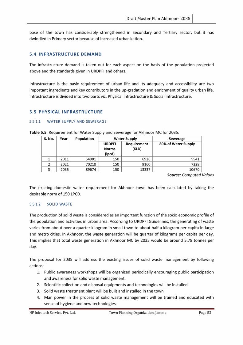
Draft Master Plan Akhnoor- 2035
NF Infratech Service. Pvt. Ltd. Town Planning Organization, Jammu Page 53
base of the town has considerably strengthened in Secondary and Tertiary sector, but it has
dwindled in Primary sector because of increased urbanization.
5.4 INFRASTRUCTURE DEMAND
The infrastructure demand is taken out for each aspect on the basis of the population projected
above and the standards given in URDPFI and others.
Infrastructure is the basic requirement of urban life and its adequacy and accessibility are two
important ingredients and key contributors in the up-gradation and enrichment of quality urban life.
Infrastructure is divided into two parts viz. Physical Infrastructure & Social Infrastructure.
5.5 PHYSICAL INFRASTRUCTURE
5.5.1.1 WATER SUPPLY AND SEWERAGE
Table 5.5: Requirement for Water Supply and Sewerage for Akhnoor MC for 2035.
S. No. Year Population Water Supply Sewerage
URDPFI Norms (lpcd)
Requirement (KLD)
80% of Water Supply
1 2011 54981 150 6926 5541
2 2021 70210 150 9160 7328
3 2035 89674 150 13337 10670
Source: Computed Values
The existing domestic water requirement for Akhnoor town has been calculated by taking the
desirable norm of 150 LPCD.
5.5.1.2 SOLID WASTE
The production of solid waste is considered as an important function of the socio economic profile of
the population and activities in urban area. According to URDPFI Guidelines, the generating of waste
varies from about over a quarter kilogram in small town to about half a kilogram per capita in large
and metro cities. In Akhnoor, the waste generation will be quarter of kilograms per capita per day.
This implies that total waste generation in Akhnoor MC by 2035 would be around 5.78 tonnes per
day.
The proposal for 2035 will address the existing issues of solid waste management by following
actions:
1. Public awareness workshops will be organized periodically encouraging public participation
and awareness for solid waste management.
2. Scientific collection and disposal equipments and technologies will be installed
3. Solid waste treatment plant will be built and installed in the town
4. Man power in the process of solid waste management will be trained and educated with
sense of hygiene and new technologies.
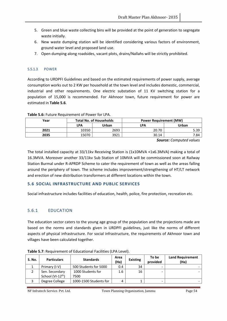
Draft Master Plan Akhnoor- 2035
NF Infratech Service. Pvt. Ltd. Town Planning Organization, Jammu Page 54
5. Green and blue waste collecting bins will be provided at the point of generation to segregate
waste initially.
6. New waste dumping station will be identified considering various factors of environment,
ground water level and proposed land use.
7. Open dumping along roadsides, vacant plots, drains/Nallahs will be strictly prohibited.
5.5.1.3 POWER
According to URDPFI Guidelines and based on the estimated requirements of power supply, average
consumption works out to 2 KW per household at the town level and includes domestic, commercial,
industrial and other requirements. One electric substation of 11 KV switching station for a
population of 15,000 is recommended. For Akhnoor town, future requirement for power are
estimated in Table 5.6.
Table 5.6: Future Requirement of Power for LPA.
Year Total No. of Households Power Requirement (MW)
LPA Urban LPA Urban
2021 10350 2693 20.70 5.39
2035 15070 3921 30.14 7.84
Source: Computed values
The total installed capacity at 33/11kv Receiving Station is (1x10MVA +1x6.3MVA) making a total of
16.3MVA. Moreover another 33/11kv Sub Station of 10MVA will be commissioned soon at Railway
Station Burmal under R-APRDP Scheme to cater the requirement of town as well as the areas falling
around the periphery of town. The scheme includes improvement/strengthening of HT/LT network
and erection of new distribution transformers at different locations within the town.
5.6 SOCIAL INFRASTRUCTURE AND PUBLIC SERVICES
Social infrastructure includes facilities of education, health, police, fire protection, recreation etc.
5.6.1 EDUCATION
The education sector caters to the young age group of the population and the projections made are
based on the norms and standards given in URDPFI guidelines, just like the norms of different
aspects of physical infrastructure. For social infrastructure, the requirements of Akhnoor town and
villages have been calculated together.
Table 5.7: Requirement of Educational Facilities (LPA Level).
S. No. Particulars Standards Area (Ha)
Existing To be
provided Land Requirement
(Ha)
1 Primary (I-V) 500 Students for 5000 0.4 34 - -
2 Sen. Secondary School (VI-12th)
1000 Students for 7500
1.6 16 - -
3 Degree College 1000-1500 Students for 4 1 - -
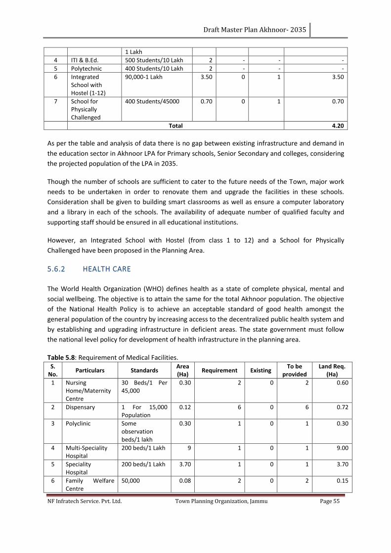
Draft Master Plan Akhnoor- 2035
NF Infratech Service. Pvt. Ltd. Town Planning Organization, Jammu Page 55
1 Lakh
4 ITI & B.Ed. 500 Students/10 Lakh 2 - - -
5 Polytechnic 400 Students/10 Lakh 2 - - -
6 Integrated School with Hostel (1-12)
90,000-1 Lakh 3.50 0 1 3.50
7 School for Physically Challenged
400 Students/45000 0.70 0 1 0.70
Total 4.20
As per the table and analysis of data there is no gap between existing infrastructure and demand in
the education sector in Akhnoor LPA for Primary schools, Senior Secondary and colleges, considering
the projected population of the LPA in 2035.
Though the number of schools are sufficient to cater to the future needs of the Town, major work
needs to be undertaken in order to renovate them and upgrade the facilities in these schools.
Consideration shall be given to building smart classrooms as well as ensure a computer laboratory
and a library in each of the schools. The availability of adequate number of qualified faculty and
supporting staff should be ensured in all educational institutions.
However, an Integrated School with Hostel (from class 1 to 12) and a School for Physically
Challenged have been proposed in the Planning Area.
5.6.2 HEALTH CARE
The World Health Organization (WHO) defines health as a state of complete physical, mental and
social wellbeing. The objective is to attain the same for the total Akhnoor population. The objective
of the National Health Policy is to achieve an acceptable standard of good health amongst the
general population of the country by increasing access to the decentralized public health system and
by establishing and upgrading infrastructure in deficient areas. The state government must follow
the national level policy for development of health infrastructure in the planning area.
Table 5.8: Requirement of Medical Facilities. S.
No. Particulars Standards
Area (Ha)
Requirement Existing To be
provided Land Req.
(Ha)
1 Nursing Home/Maternity Centre
30 Beds/1 Per 45,000
0.30 2 0 2 0.60
2 Dispensary 1 For 15,000 Population
0.12 6 0 6 0.72
3 Polyclinic Some observation beds/1 lakh
0.30 1 0 1 0.30
4 Multi-Speciality Hospital
200 beds/1 Lakh 9 1 0 1 9.00
5 Speciality Hospital
200 beds/1 Lakh 3.70 1 0 1 3.70
6 Family Welfare Centre
50,000 0.08 2 0 2 0.15
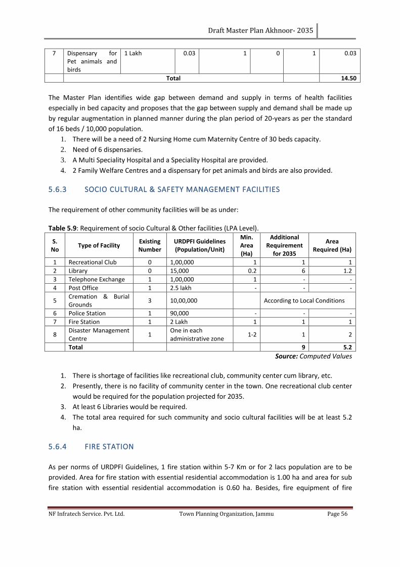
Draft Master Plan Akhnoor- 2035
NF Infratech Service. Pvt. Ltd. Town Planning Organization, Jammu Page 56
7 Dispensary for Pet animals and birds
1 Lakh 0.03 1 0 1 0.03
Total
14.50
The Master Plan identifies wide gap between demand and supply in terms of health facilities
especially in bed capacity and proposes that the gap between supply and demand shall be made up
by regular augmentation in planned manner during the plan period of 20-years as per the standard
of 16 beds / 10,000 population.
1. There will be a need of 2 Nursing Home cum Maternity Centre of 30 beds capacity.
2. Need of 6 dispensaries.
3. A Multi Speciality Hospital and a Speciality Hospital are provided.
4. 2 Family Welfare Centres and a dispensary for pet animals and birds are also provided.
5.6.3 SOCIO CULTURAL & SAFETY MANAGEMENT FACILITIES
The requirement of other community facilities will be as under:
Table 5.9: Requirement of socio Cultural & Other facilities (LPA Level).
S. No
Type of Facility Existing Number
URDPFI Guidelines (Population/Unit)
Min. Area (Ha)
Additional Requirement
for 2035
Area Required (Ha)
1 Recreational Club 0 1,00,000 1 1 1
2 Library 0 15,000 0.2 6 1.2
3 Telephone Exchange 1 1,00,000 1 - -
4 Post Office 1 2.5 lakh - - -
5 Cremation & Burial Grounds
3 10,00,000 According to Local Conditions
6 Police Station 1 90,000 - - -
7 Fire Station 1 2 Lakh 1 1 1
8 Disaster Management Centre
1 One in each administrative zone
1-2 1 2
Total 9 5.2
Source: Computed Values
1. There is shortage of facilities like recreational club, community center cum library, etc.
2. Presently, there is no facility of community center in the town. One recreational club center
would be required for the population projected for 2035.
3. At least 6 Libraries would be required.
4. The total area required for such community and socio cultural facilities will be at least 5.2
ha.
5.6.4 FIRE STATION
As per norms of URDPFI Guidelines, 1 fire station within 5-7 Km or for 2 lacs population are to be
provided. Area for fire station with essential residential accommodation is 1.00 ha and area for sub
fire station with essential residential accommodation is 0.60 ha. Besides, fire equipment of fire
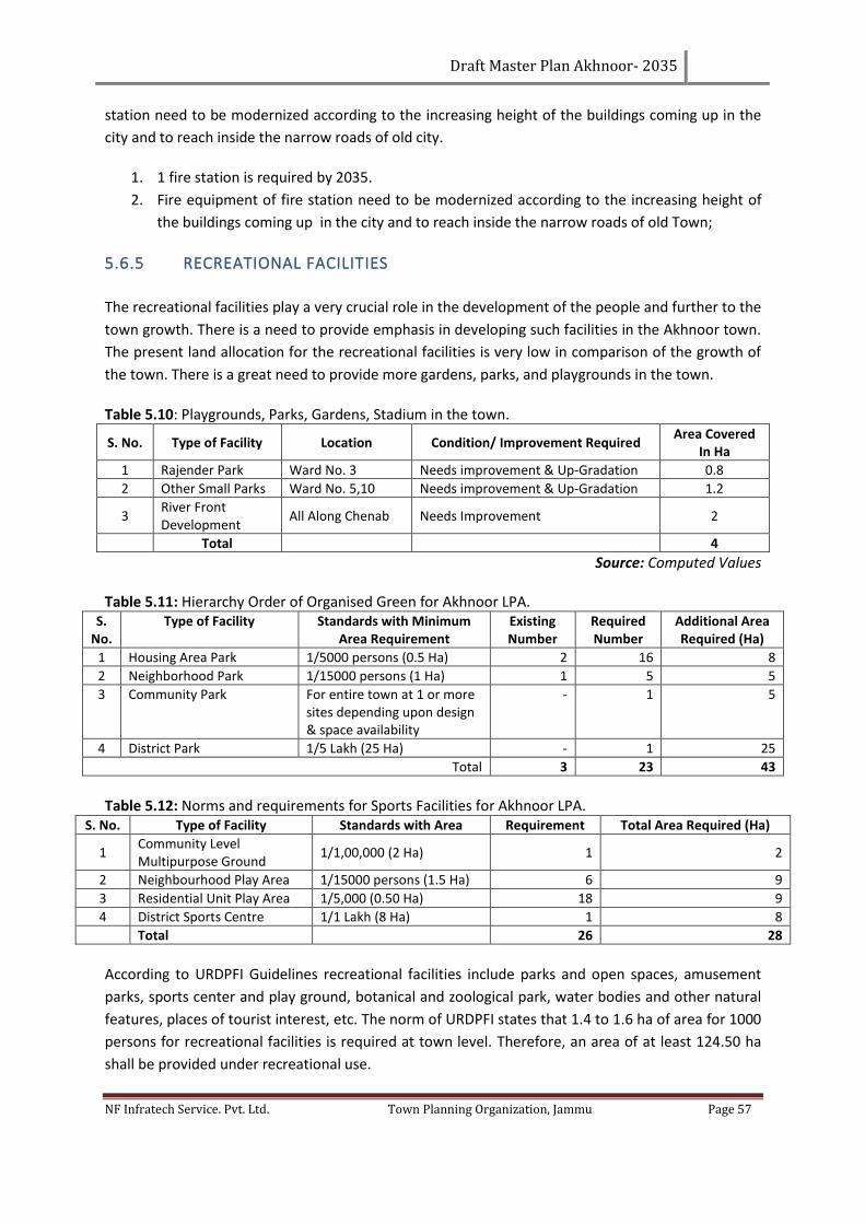
Draft Master Plan Akhnoor- 2035
NF Infratech Service. Pvt. Ltd. Town Planning Organization, Jammu Page 57
station need to be modernized according to the increasing height of the buildings coming up in the
city and to reach inside the narrow roads of old city.
1. 1 fire station is required by 2035.
2. Fire equipment of fire station need to be modernized according to the increasing height of
the buildings coming up in the city and to reach inside the narrow roads of old Town;
5.6.5 RECREATIONAL FACILITIES
The recreational facilities play a very crucial role in the development of the people and further to the
town growth. There is a need to provide emphasis in developing such facilities in the Akhnoor town.
The present land allocation for the recreational facilities is very low in comparison of the growth of
the town. There is a great need to provide more gardens, parks, and playgrounds in the town.
Table 5.10: Playgrounds, Parks, Gardens, Stadium in the town.
S. No. Type of Facility Location Condition/ Improvement Required Area Covered
In Ha
1 Rajender Park Ward No. 3 Needs improvement & Up-Gradation 0.8
2 Other Small Parks Ward No. 5,10 Needs improvement & Up-Gradation 1.2
3 River Front Development
All Along Chenab Needs Improvement 2
Total 4
Source: Computed Values Table 5.11: Hierarchy Order of Organised Green for Akhnoor LPA.
S. No.
Type of Facility Standards with Minimum Area Requirement
Existing Number
Required Number
Additional Area Required (Ha)
1 Housing Area Park 1/5000 persons (0.5 Ha) 2 16 8
2 Neighborhood Park 1/15000 persons (1 Ha) 1 5 5
3 Community Park For entire town at 1 or more sites depending upon design & space availability
- 1 5
4 District Park 1/5 Lakh (25 Ha) - 1 25
Total 3 23 43
Table 5.12: Norms and requirements for Sports Facilities for Akhnoor LPA.
S. No. Type of Facility Standards with Area Requirement Total Area Required (Ha)
1 Community Level Multipurpose Ground
1/1,00,000 (2 Ha) 1 2
2 Neighbourhood Play Area 1/15000 persons (1.5 Ha) 6 9
3 Residential Unit Play Area 1/5,000 (0.50 Ha) 18 9
4 District Sports Centre 1/1 Lakh (8 Ha) 1 8
Total 26 28
According to URDPFI Guidelines recreational facilities include parks and open spaces, amusement
parks, sports center and play ground, botanical and zoological park, water bodies and other natural
features, places of tourist interest, etc. The norm of URDPFI states that 1.4 to 1.6 ha of area for 1000
persons for recreational facilities is required at town level. Therefore, an area of at least 124.50 ha
shall be provided under recreational use.
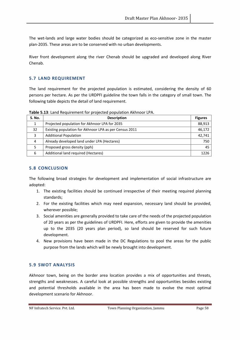
Draft Master Plan Akhnoor- 2035
NF Infratech Service. Pvt. Ltd. Town Planning Organization, Jammu Page 58
The wet-lands and large water bodies should be categorized as eco-sensitive zone in the master
plan-2035. These areas are to be conserved with no urban developments.
River front development along the river Chenab should be upgraded and developed along River
Chenab.
5.7 LAND REQUIREMENT
The land requirement for the projected population is estimated, considering the density of 60
persons per hectare. As per the URDPFI guideline the town falls in the category of small town. The
following table depicts the detail of land requirement.
Table 5.13: Land Requirement for projected population Akhnoor LPA. S. No. Description Figures
1 Projected population for Akhnoor LPA for 2035 88,913
32 Existing population for Akhnoor LPA as per Census 2011 46,172
3 Additional Population 42,741
4 Already developed land under LPA (Hectares) 750
5 Proposed gross density (pph) 45
6 Additional land required (Hectares) 1226
5.8 CONCLUSION
The following broad strategies for development and implementation of social infrastructure are
adopted:
1. The existing facilities should be continued irrespective of their meeting required planning
standards;
2. For the existing facilities which may need expansion, necessary land should be provided,
wherever possible;
3. Social amenities are generally provided to take care of the needs of the projected population
of 20 years as per the guidelines of URDPFI. Here, efforts are given to provide the amenities
up to the 2035 (20 years plan period), so land should be reserved for such future
development.
4. New provisions have been made in the DC Regulations to pool the areas for the public
purpose from the lands which will be newly brought into development.
5.9 SWOT ANALYSIS
Akhnoor town, being on the border area location provides a mix of opportunities and threats,
strengths and weaknesses. A careful look at possible strengths and opportunities besides existing
and potential thresholds available in the area has been made to evolve the most optimal
development scenario for Akhnoor.
Draft Master Plan Akhnoor- 2035
NF Infratech Service. Pvt. Ltd. Town Planning Organization, Jammu Page 59
5.9.1 STRENGTHS
The strength of Akhnoor can be defined in terms of:
1. Premier urban center of the Jammu District having historical, heritage & religious
significance.
2. The town has a potential of administrative status as a Sub-District head quarter for
allocation of funds, make other settlements dependent on it.
3. Important growth town for surrounding villages because of its strategic location.
4. The Akhnoor Town is well served with facilities such as education, so it can be developed as
an educational hub serving the surrounding areas.
5.9.2 WEAKNESSES
The weaknesses of Akhnoor can be defined in terms of:
1. Poor road geometry and inadequate capacity of existing road network and in adequate
parking spaces;
2. Absence of physical and social infrastructure & tourism related infrastructure like hotels,
green & Parks, picnic spots.
3. Nearer to border area become the hurdle in the growth.
4. The conversion of land use from residential to non-residential uses like commercial along
Jourian & Rajouri Roads and in the core of the town leading to problem of traffic congestion
and also increasing load on infrastructure.
5.9.3 OPPORTUNITIES
1. Scope of widening and strengthening of the main roads of Town and Local roads.
2. River Chenab Provides opportunities for yourism development and can enhance the
economic potential of the town.
3. Availability of large chunks of land, which can be put into optimum utilization for various
purposes.
5.9.4 THREATS
1. Through traffic will put huge burden on town roads, as the town is located on the junction of
important roads like Jammu-Poonch and Akhnoor-Jourian roads;
2. Non-rationalization of inter and intra-city traffic and improving/upgrading transportation
network;
3. Delay in creating appropriate infrastructures related to tourism, trade & commerce;
Draft Master Plan Akhnoor- 2035
NF Infratech Service. Pvt. Ltd. Town Planning Organization, Jammu Page 60
4. Delay in bridging the existing gaps in basic infrastructures and services in and around the
town;
5. Present scenario of commercial development along major roads will create more parking
problems;
6. Through traffic creates burden on interior roads;
7. Unplanned growth in & around town area.
5.10 VISION 2035
For the Master Plan, it is necessary to formulate a long term (2035) vision for the Akhnoor Town that
takes into account the present strengths, opportunities, weaknesses (limitations) and threats
(SWOT). For visualizing the growth and development of Akhnoor town, care has been taken to
include the related requirement along with needs and aspirations of the people.
A two pronged strategy can be adopted to translate the vision into the preparation of the master
plan that generates economic development along with meeting the future needs of the population.
The two broad concepts are:
“To streamline and regulate the organic and inorganic growth of the town along with meeting the
future needs of the physical and social infrastructure’’.
“To develop Akhnoor town as “Growth center” for the Sub-region which will generate economic
momentum in the town through a judicious mix of activities such as eco-tourism and Institutional
Activities along with physical and social infrastructure”.
5.11 OBJECTIVES
The long term vision would require spatial land use planning, infrastructure planning, planning of
transportation, effective management and operation of infrastructure services, and regulating and
enforcing plan proposals. The objective of the Master Plan is to create enabling spatial and Land Use
Planning framework to achieve the Vision of LPA Akhnoor. More specific objectives are as under:
The Master Plan endeavors to promote an improved living environment and micro climate of the
town by:
1. Promoting Akhnoor as Institutional and Tourism zone for the next 20 years;
2. Restore, preserve and promote the lost beauty of river Chenab and Nallahs, due to recent
devastating floods in the State and also preserve and promote Akhnoor fort and other
religious places as religious and heritage tourism;
3. Developing and making optimum utilization of existing water bodies;
4. Developing and improving existing gardens, parks and open spaces, besides creating new
open spaces to make Akhnoor Local area as a green;
5. To promote employment and economic development by leveraging on the existing strength
of the town;
6. Decongestion and providing the basic infrastructure in the core area of the town;
7. Develop new residential colonies and shopping centers as per the neighborhood method.
Draft Master Plan Akhnoor- 2035
NF Infratech Service. Pvt. Ltd. Town Planning Organization, Jammu Page 61
5.12 CONCEPT FOR THE PREPARATION OF AKHNOOR MASTER PLAN
It is a preliminary plan which giving the schedule of requirements, general approach, and
alternatives concepts solutions for the consideration of the client and his comments, suggestions
and choice of preferred alternatives for the detailing.
Cities and towns in Jammu and Kashmir, especially in Jammu region in a natural course grow like an
organism in south directions depending upon the availability of land and potential for growth,
sometimes leapfrogging the natural as well as manmade barriers.
On the basis of existing trend of development and studies conducted by the NF Infratech Service Pvt.
Ltd, it is observed that the development activities around Akhnoor are concentrated along main
roads passing through the town besides the area falling in the vicinity of existing developed area of
the town.
Dwelling on the concept the aim is to develop Akhnoor town in such a way, so that it only caters to
itself but also the surrounding towns including Jammu. The concept of eco-tourism keeping in the
potential of the area in terms of its scenic beauty in the eastern side along Chenab River to generate
tourism related economic activities. The eco-tourism will be part of the larger tourist circuit in the
region. Once the potential of eco-tourism and education hub is explored, the development will
follow along with generation of economic activities and in later the job creation. Besides, the other
economic activities keeping in view of potential of the area are to be explored along with support
infrastructure to cater the future needs of the people. (Reference Map: Conceptual Plan).
5.13 PERSPECTIVE DEVELOPMENT SCENARIO FOR THE TOWN
After studying into the existing development pattern of LPA Akhnoor, it is in the form of a triangle,
bounded by Chenab River in one direction, different nallahs in second direction and Jammu-Poonch
Road in the third direction. Due to the slopes and reserved areas like forest in the North and eastern
part of the Local Planning Area, defence along the Jammu-Poonch road and Bantalab road, flat land
is available between the Jourian road and Jammu Poonch road.
Some of the important proposals to be included in the master plan for Akhnoor are:
1. Residential area proposed with the continuity of existing residential area in the three Zone
as keeping in view the:
a. Holding capacity within the municipal boundary.
b. Part of the projected population outside the municipal boundary up to the future
Urbanizable limits.
2. Environmental friendly Industrial area will be proposed on the Jourian road near existing
brick kilns.
3. Institutional Zone are to be proposed in the continuity of existing public and Govt. schools
on Jourian road near proposed SDM Office.
Draft Master Plan Akhnoor- 2035
NF Infratech Service. Pvt. Ltd. Town Planning Organization, Jammu Page 62
4. A bus stand will be proposed (existing proposal) in the western part to provide maximum
advantages to the town and periphery residents.
5. Government offices will be proposed along the new proposed bypass which will be
developed in the form of mini secretariat with proper parking. Medical and health facilities
will be proposed near new sub-district hospital.
6. New bypass roads on western side of the town need to be undertaken connecting the
existing bypass to make it a loop.
7. Outskirts need to be proposed to keep as such as an agriculture land and has been reserved
for the future expansion of the town.
8. Conservation of river Chenab and nallahs of Akhnoor local area by appropriate buffer and
development of river front.
9. To keep the clean environment, green spaces are to be proposed near residential pockets,
industrial areas and along the primary roads.
10. Holistic approach will be applied on all the proposals to achieve the goal.
5.13.1 DEVELOPMENT OF TOURISM
The various activities that can be taken up in the eco-tourism in the Akhnoor for the development of
eco-tourism circuit in the eastern part of the Akhnoor required for the tourists and some of
impressive varieties of tourism products will be as follows:
▪ Providing comfortable and affordable quality accommodation, including low budget
accommodation.
▪ Eco-tourism, wilderness tourism, Adventure tourism.
▪ Pilgrimage, Religious, Culture & Heritage tourism.
▪ Developments on banks of Chenab and Water Tourism include boating and rafting.
Draft Master Plan Akhnoor- 2035
NF Infratech Service. Pvt. Ltd. Town Planning Organization, Jammu Page 63
CHAPTER 6. PLANNING & DEVELOPMENT PROPOSALS
Looking critically at the existing morphology of urban settlements, in depth studies have been
executed. The detailed analysis carried out in terms of physical, socio-economic and demographical
profile of the planning area. It appears logical and rational that spatial planning framework for the
future growth and development of the Akhnoor LPA should be defined in order to ensure the
integrated growth of entire planning area and to launch Akhnoor and other settlements on the path
of fast trajectory of growth and development.
6.1 PROPOSED ZONE DEVELOPMENT
Accordingly, Akhnoor LPA covering an area of 8210 hectares has been visualized in the four different
Zones that are described in detail below:-
1. Zone I: Area enclosed by core area(dense residential area);
2. Zone II: Area enclosed by MC boundary;
3. Zone III: Area outside MC limit and up to the Urbanisable limit;
4. Zone IV: Agricultural/rural area/Defense/forest (Controlled Area).
Table 6.1: Area distribution among proposed Zones - Akhnoor LPA.
S. No. Area (Ha) %age of LPA
Zone 1 62 0.76
Zone 2 126 1.53
Zone 3 1,041 12.68
Zone 4 6,981 85.03
LPA 8,210.0 100.0
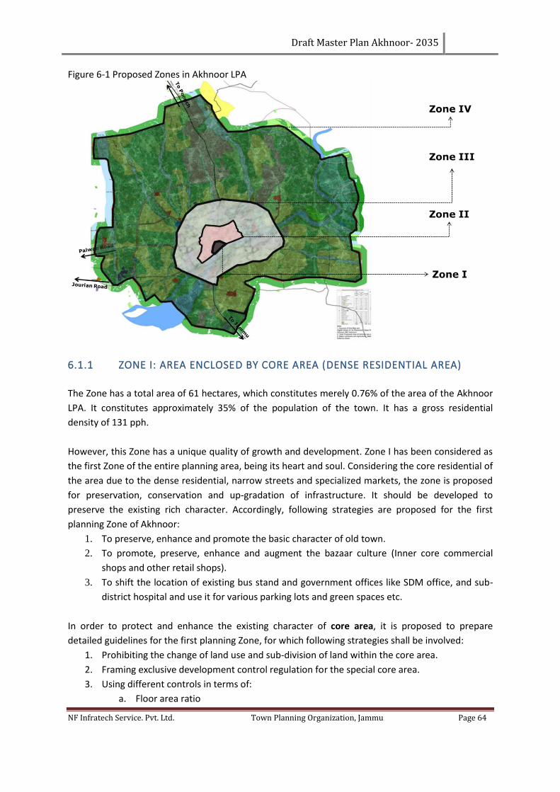
Draft Master Plan Akhnoor- 2035
NF Infratech Service. Pvt. Ltd. Town Planning Organization, Jammu Page 64
Figure 6-1 Proposed Zones in Akhnoor LPA
6.1.1 ZONE I: AREA ENCLOSED BY CORE AREA (DENSE RESIDENTIAL AREA)
The Zone has a total area of 61 hectares, which constitutes merely 0.76% of the area of the Akhnoor
LPA. It constitutes approximately 35% of the population of the town. It has a gross residential
density of 131 pph.
However, this Zone has a unique quality of growth and development. Zone I has been considered as
the first Zone of the entire planning area, being its heart and soul. Considering the core residential of
the area due to the dense residential, narrow streets and specialized markets, the zone is proposed
for preservation, conservation and up-gradation of infrastructure. It should be developed to
preserve the existing rich character. Accordingly, following strategies are proposed for the first
planning Zone of Akhnoor:
1. To preserve, enhance and promote the basic character of old town.
2. To promote, preserve, enhance and augment the bazaar culture (Inner core commercial
shops and other retail shops).
3. To shift the location of existing bus stand and government offices like SDM office, and sub-
district hospital and use it for various parking lots and green spaces etc.
In order to protect and enhance the existing character of core area, it is proposed to prepare
detailed guidelines for the first planning Zone, for which following strategies shall be involved:
1. Prohibiting the change of land use and sub-division of land within the core area.
2. Framing exclusive development control regulation for the special core area.
3. Using different controls in terms of:
a. Floor area ratio
Draft Master Plan Akhnoor- 2035
NF Infratech Service. Pvt. Ltd. Town Planning Organization, Jammu Page 65
b. Height controls
c. Land use control
d. Setbacks/projections
e. Façade control
f. Material control
Based on the above parameters, detailed strategies for the development of the special core area
shall be prepared.
6.1.2 ZONE II: AREA ENCLOSED BY MUNICIPAL LIMIT OF AKHNOOR
The area enclosed by the municipal limit but outside the first planning zone has been defined as the
second zone of master plan. This zone comprises of an area of 126 hectares and constitutes
remaining 67% of the total area of the town and consists of a part of the population of the town. It
would have a gross residential density of 80 pph. It is the Zone which has the major transportation
linkages.
A part of the projected population of the town, i.e., 10,080 will be accommodated in this area. The
majority of the development is unplanned and the commercial areas along major roads have been
developed without parking spaces.
Therefore, in order to preserve the basic character, the following is proposed:
1. To minimize the conversion of land use.
2. To minimize the sub-division of land.
3. To regulate the future growth and development of the area.
4. Providing parks and other recreational services.
5. Developing the area as residential growth along with support services.
6. Improving quality of life by providing quality physical and social infrastructure.
6.1.3 ZONE III: AREA OUTSIDE MC LIMIT AND UP TO THE URBANIZABLE LIMIT
These Zones include the area outside the MC limit and up to the proposed ring road connecting
existing bypass and Jourian, Sungal and Palwan village roads which defines the outer limit of the
Urbanisable limit of the master plan, Akhnoor. The Zone constitutes the area of 1041 hectares. This
area is agriculture in character dotted with rural settlements. It also has sporadic development,
which is both unplanned and haphazard. It also has ribbon development along the major roads
emerging from Akhnoor and providing linkages with the surrounding settlements. It is largely a low
density area which is growing haphazard as mention earlier the propose population will be
accommodate in this Zone.
Draft Master Plan Akhnoor- 2035
NF Infratech Service. Pvt. Ltd. Town Planning Organization, Jammu Page 66
The area also has number of development projects newly developed and proposed like industrial
estate, educational hub, and social cultural areas. Accordingly, development in this area is visualized
by adopting following strategies:
1. Promoting planned development through a well-defined road network;
2. To make Akhnoor self-contained and self-sustaining supported by basic infrastructure;
3. Minimizing ribbon development along the important road network;
4. To rationalize the development with compatibility between various land uses like
educational institutions, small scale Industries and residential;
5. To provide new bus stand in the center of the local planning area to serve the maximum
population and various village settlements.
6.1.4 ZONE IV: AGRICULTURAL/ DEFENCE/ AIR FORCE/ FOREST OUTSKIRT
This Zone comprises of remaining area of Local Planning Area, Akhnoor which includes the area
outside the Urbanisable limits and within the LPA boundary. This Zone has the largest area of 6981
hectares. The area is mainly agricultural in nature containing village abadis and agriculture on all
sides of the region, forest land in the eastern side, Defense land in almost all sides and water bodies,
include Chenab. To retain the green character of this Zone, it is proposed to prevent or minimize
conversion of agricultural land into non-agricultural use such as residential, commercial, etc. Further,
the development pattern in this Zone is proposed tourism circuit. Accordingly, development in this
area is visualized by adopting following strategies:
1. To rationalize the development along the existing bypass and newly proposed ring roads.
2. To keep the out skirts with all reserved land and all reservation like forest, Defence, etc. as
existing.
3. To propose the Sewerage Treatment Plant (STP) in Village Arinpur near Jourian road.
6.2 PROPOSED LAND USE PLAN
On the basis of the study of existing land use plan, analysis and population projections of Akhnoor
LPA followed by several discussions with Town Planning Organization officials of Jammu and with the
local administration of Akhnoor, a proposed land use plan have been prepared. In this plan, different
land use zones such as residential, commercial, industrial, institutional, recreational, public uses,
agricultural, etc. have been earmarked based upon the computation of land use requirements as
stated in the URDPFI guidelines.
The future Urbanisable area required by 2035 is calculated assuming gross developed area density
but it is also important to take into account the immense growth potential of Akhnoor because of it
is importance as commercial and proposed tourism.
The LPA, Akhnoor is spread over an area of 8210 hectares, out of which Akhnoor Municipal
Committee area is 188 hectares. It constitutes 2.29% of the total LPA. The proposed Urbanisable
area of the Akhnoor would comprise of the entire area which falls within the urban limits of Akhnoor
Municipal Committee besides the area falling under the jurisdiction of rural settlements in the south
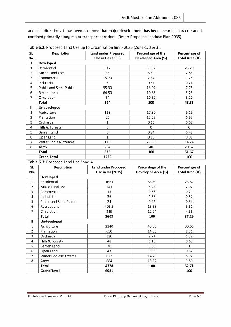
Draft Master Plan Akhnoor- 2035
NF Infratech Service. Pvt. Ltd. Town Planning Organization, Jammu Page 67
and east directions. It has been observed that major development has been linear in character and is
confined primarily along major transport corridors. (Refer: Proposed Landuse Plan 2035).
Table 6.2: Proposed Land Use up to Urbanization limit- 2035 (Zone-1, 2 & 3).
Sl. No.
Description Land under Proposed Use in Ha (2035)
Percentage of the Developed Area (%)
Percentage of Total Area (%)
I Developed
1 Residential 317 53.37 25.79
2 Mixed Land Use 35 5.89 2.85
3 Commercial 15.70 2.64 1.28
4 Industrial 3 0.51 0.24
5 Public and Semi-Public 95.30 16.04 7.75
6 Recreational 64.50 10.86 5.25
7 Circulation 64 10.69 5.17
Total 594 100 48.33
II Undeveloped
1 Agriculture 113 17.80 9.19
2 Plantation 85 13.39 6.92
3 Orchards 1 0.16 0.08
4 Hills & Forests 0 0 0
5 Barren Land 6 0.94 0.49
6 Open Land 1 0.16 0.08
7 Water Bodies/Streams 175 27.56 14.24
8 Army 254 40 20.67
Total 635 100 51.67
Grand Total 1229 100
Table 6.3: Proposed Land Use Zone-4. Sl.
No. Description Land under Proposed
Use in Ha (2035) Percentage of the
Developed Area (%) Percentage of Total Area (%)
I Developed
1 Residential 1663 63.89 23.82
2 Mixed Land Use 141 5.42 2.02
3 Commercial 15 0.58 0.21
4 Industrial 36 1.38 0.52
5 Public and Semi-Public 24 0.92 0.34
6 Recreational 405.5 15.58 5.81
7 Circulation 319 12.24 4.56
Total 2603 100 37.29
II Undeveloped
1 Agriculture 2140 48.88 30.65
2 Plantation 650 14.85 9.31
3 Orchards 120 2.74 1.72
4 Hills & Forests 48 1.10 0.69
5 Barren Land 70 1.60 1
6 Open Land 43 0.98 0.62
7 Water Bodies/Streams 623 14.23 8.92
8 Army 684 15.62 9.80
Total 4378 100 62.71
Grand Total 6981 100
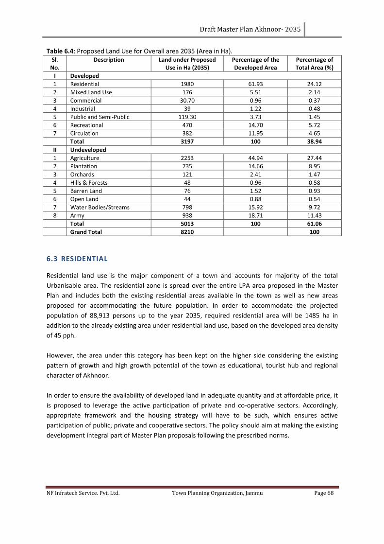
Draft Master Plan Akhnoor- 2035
NF Infratech Service. Pvt. Ltd. Town Planning Organization, Jammu Page 68
Table 6.4: Proposed Land Use for Overall area 2035 (Area in Ha). Sl.
No. Description Land under Proposed
Use in Ha (2035) Percentage of the Developed Area
Percentage of Total Area (%)
I Developed
1 Residential 1980 61.93 24.12
2 Mixed Land Use 176 5.51 2.14
3 Commercial 30.70 0.96 0.37
4 Industrial 39 1.22 0.48
5 Public and Semi-Public 119.30 3.73 1.45
6 Recreational 470 14.70 5.72
7 Circulation 382 11.95 4.65
Total 3197 100 38.94
II Undeveloped
1 Agriculture 2253 44.94 27.44
2 Plantation 735 14.66 8.95
3 Orchards 121 2.41 1.47
4 Hills & Forests 48 0.96 0.58
5 Barren Land 76 1.52 0.93
6 Open Land 44 0.88 0.54
7 Water Bodies/Streams 798 15.92 9.72
8 Army 938 18.71 11.43
Total 5013 100 61.06
Grand Total 8210 100
6.3 RESIDENTIAL
Residential land use is the major component of a town and accounts for majority of the total
Urbanisable area. The residential zone is spread over the entire LPA area proposed in the Master
Plan and includes both the existing residential areas available in the town as well as new areas
proposed for accommodating the future population. In order to accommodate the projected
population of 88,913 persons up to the year 2035, required residential area will be 1485 ha in
addition to the already existing area under residential land use, based on the developed area density
of 45 pph.
However, the area under this category has been kept on the higher side considering the existing
pattern of growth and high growth potential of the town as educational, tourist hub and regional
character of Akhnoor.
In order to ensure the availability of developed land in adequate quantity and at affordable price, it
is proposed to leverage the active participation of private and co-operative sectors. Accordingly,
appropriate framework and the housing strategy will have to be such, which ensures active
participation of public, private and cooperative sectors. The policy should aim at making the existing
development integral part of Master Plan proposals following the prescribed norms.
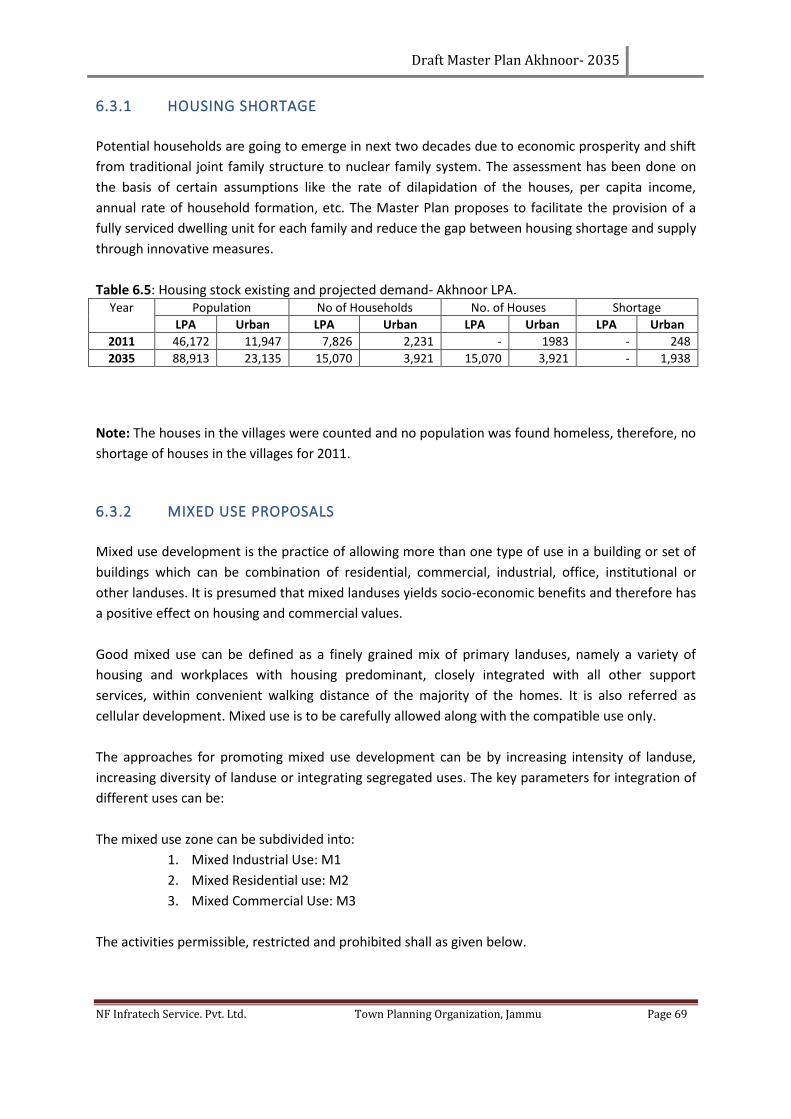
Draft Master Plan Akhnoor- 2035
NF Infratech Service. Pvt. Ltd. Town Planning Organization, Jammu Page 69
6.3.1 HOUSING SHORTAGE
Potential households are going to emerge in next two decades due to economic prosperity and shift
from traditional joint family structure to nuclear family system. The assessment has been done on
the basis of certain assumptions like the rate of dilapidation of the houses, per capita income,
annual rate of household formation, etc. The Master Plan proposes to facilitate the provision of a
fully serviced dwelling unit for each family and reduce the gap between housing shortage and supply
through innovative measures.
Table 6.5: Housing stock existing and projected demand- Akhnoor LPA. Year Population No of Households No. of Houses Shortage
LPA Urban LPA Urban LPA Urban LPA Urban
2011 46,172 11,947 7,826 2,231 - 1983 - 248
2035 88,913 23,135 15,070 3,921 15,070 3,921 - 1,938
Note: The houses in the villages were counted and no population was found homeless, therefore, no
shortage of houses in the villages for 2011.
6.3.2 MIXED USE PROPOSALS
Mixed use development is the practice of allowing more than one type of use in a building or set of
buildings which can be combination of residential, commercial, industrial, office, institutional or
other landuses. It is presumed that mixed landuses yields socio-economic benefits and therefore has
a positive effect on housing and commercial values.
Good mixed use can be defined as a finely grained mix of primary landuses, namely a variety of
housing and workplaces with housing predominant, closely integrated with all other support
services, within convenient walking distance of the majority of the homes. It is also referred as
cellular development. Mixed use is to be carefully allowed along with the compatible use only.
The approaches for promoting mixed use development can be by increasing intensity of landuse,
increasing diversity of landuse or integrating segregated uses. The key parameters for integration of
different uses can be:
The mixed use zone can be subdivided into:
1. Mixed Industrial Use: M1
2. Mixed Residential use: M2
3. Mixed Commercial Use: M3
The activities permissible, restricted and prohibited shall as given below.
Draft Master Plan Akhnoor- 2035
NF Infratech Service. Pvt. Ltd. Town Planning Organization, Jammu Page 70
Permitted Uses/Activities:
In M1 Zone activities falling within non- polluting industry/ service industry (dominant landuse)
categories can coexist with maximum up to 20-30% of commercial, institutional, recreational and
residential land use.
In M2 Zone all activities falling within permitted residential land use (dominant landuse) shall be
minimum 60% and to coexist with commercial, institutional, recreational.
In M3 Zone all activities falling within permitted commercial, institutional land use (dominant
landuse) shall be minimum 60% and to coexist with residential, recreational and non- polluting and
household industry.
Restricted Uses/Activities:
Activities related to commercial, institutional and residential landuse in M1 Zone and non-polluting
industrial landuse in M2 Zone can be increased to between 20-50% depending on the contextual and
locational feasibility of the area.
Prohibited Uses/Activities:
All other activities especially industrial which are polluting in nature and which will have an adverse
impact on the overall activities of this zone
It has been proposed to permit mixed landuse development along the major road network as
detailed below:
1. 100 feet deep mixed landuse zone has been proposed along the Proposed Ring Road-1.
2. 100 feet deep mixed landuse zone has been proposed along the Proposed Ring Road-2.
3. 100 feet deep mixed landuse zone has been proposed along the road connecting Sungal
Village to Palawan Village.
4. 100 feet deep mixed landuse zone has been proposed along Sungal road.
5. 100 feet deep mixed landuse zone has been proposed along the Bypass road within the
urbanisable limit.
6. 100 feet deep mixed landuse zone has been proposed along Ambaran road from Bypass
road to Sunail road.
Note:
• Mixed use may be permitted with the prescribed development norms like ground coverage,
FAR/FSI, density and other urban design guidelines.
6.3.3 HOUSING POLICY
The present housing stock is 7826 units while the projected demand for housing is 15070 units by
the year 2035. The principal policies and strategies for Akhnoor Planning Area have been evolved
based on the National Urban Housing and Habitat Policy, 2005 and the National Slum Policy. The
specific strategies proposed for inclusive housing are:
Draft Master Plan Akhnoor- 2035
NF Infratech Service. Pvt. Ltd. Town Planning Organization, Jammu Page 71
a. Review of space standards considering land cost, availability of developable lands, land
requirements, affordability and space standards for housing developments.
b. New housing for EWS and LIG as well as rehabilitation of slum households will be in composite
and special neighbourhoods whether developed by the public, private, cooperative or joint
sector. These may be in the form of built dwelling units or affordable serviced sites.
c. When housing neighbourhoods and apartment blocks are developed by the private sector o
lands exceeding one hectare, 10-15% of the land shall be reserved and developed for housing for
EWS/LIG with dwelling units not exceeding 45 sqm within the site proposed for development.
d. All shelter programmes will be integrated with provision of infrastructure, security of tenure,
health and education, livelihood opportunities & skill training and micro finance.
e. Public-Private Partnerships will be facilitated to enhance capacity of construction industry to
deliver housing for EWS and LIG through innovative technology routes.
f. Housing will be developed in proximity to the employment centres both existing and proposed.
g. Land assembly using innovative measures such as land readjustment, land pooling, guided
development and neighbourhood developments will be encouraged to minimize undesirable
speculation and increase in land cost to ensure planned development to provide for the needs of
the lower income groups.
h. Problems of shelter for the urban poor and their shelter improvement should be addressed
through improvement of physical surroundings so that it has adequate basic services such as
water supply, drainage, sanitation, street lighting and other physical conditions leading to better
hygienic environment; secondly, through the improvement of the actual structures that the slum
dwellers live in preferably by themselves (extending assistance in terms of financial and physical
resources) and by encouraging in-situ development.
A judicious mix of in-situ development and relocation strategy need to be adopted for slum
improvement. The slums located on the hazardous land need to be identified and relocated.
6.3.4 COMMERCIAL
Existing commercial space is haphazard and the trend of ribbon development in the commercial
sector has to be replaced by organized commercial complexes planned to meet the demand of
different divisions. Organized commercial complexes will discourage the ribbon commercial
development along the roads which creates traffic chaos on major streets in the town. The field
observation revealed that the organized commercial facilities are inadequate resulting in continuous
conversion of residential into commercial use. Also due to the mounting strain of commercial
activities, the road space is continuously being encroached upon by shopkeepers and street vendors.
Accordingly, in terms of the projected requirement of commercial area up to 2035, a total of 30.70
hectares of the total LPA area has been proposed under this use including existing commercial areas.
Table 6.6: Proposed Commercial Facilities.
S. No. Facility Area (Ha) Location Zone
1 Commercial Centre 5 On Sungal Road in Village Bandral Kalan 4th
2 Wholesale 2 On Palwan Road near Village Kot Garhi 4th
Draft Master Plan Akhnoor- 2035
NF Infratech Service. Pvt. Ltd. Town Planning Organization, Jammu Page 72
3 Warehousing 2 On Proposed Ring Road-2 in Village Palawan 4th
4 Hotel Zone 3 In Tourism Zone 4th
5 Local Shopping Centres 3 1 ha each in Dasgal, Mewa Karora & Ambaran villages 3rd
Total Area 15
The above facilities have been proposed on the Proposed Landuse Plan, 2035, but the rest of the
below mentioned proposed facilities would come up when the Zonal Plans are prepared for
Akhnoor.
Table 6.7: Distribution of Proposed commercial facilities in Zones 1, 2, 3 & 4. S. No. Facility Zones
Zone-1 Zone-2 Zone-3 Zone-4
1 Convenience Shopping - 4 (0.15 ha each) 6 (0.15 ha each) 8 (0.15 ha each)
2 Local Shopping Centres - 1 (0.5 ha) - 1 (0.5 ha)
3 Weekly Markets - 1 (0.5 ha) - 1 (0.5 ha)
6.3.5 INFORMAL SECTOR
Street vendors form a very important segment of the unorganized sector in the country and it is
estimated that in several cities street vendors account for about 2% of the population. The planning
of the urban street vending zones shall be so done so as to provide for and promote a supportive
environment for the vast mass of urban street vendors to carry out their vocation while at the same
time ensuring that their vending activities do not lead to overcrowding and unsanitary conditions in
public spaces and streets.
The Street Vendors (Protection of Livelihood and Regulation of Street Vending) Act, 2014 has come
into force since March, 2014. The Act provides for Town Planning Committee (TVC), which shall
conduct a survey of all the existing street vendors every five years. According to the Act, every local
authority shall prepare a plan to promote the vocation of street vendors in consultation with the
planning authority and on the recommendations of the TVC once in every five years. Local authority
can also make byelaws, under the Act, to provide vending zones, regulation of civic services in the
vending zones and other matters.
Demarcation of Vending Zones “the demarcation of ‘Restriction – free Vending Zones’, ‘Restricted
Vending Zones’ and ‘No-Vending Zones will be city/town specific and take into account the natural
propensity of street vendors to locate in certain places at certain times in response to the patterns
of demand of their goods/services. Municipal Authorities need to frame necessary rules for
regulating entry of street vendors on a time sharing basis in the designated vending zones.
Based on the primary survey conducted for the informal sector in Akhnoor town, it has been felt that
organized sites for informal sector are required to be created near the main town nodes, like bus
stand, railway station, parks, etc. and the detailed survey need to be undertaken for earmarking
vending zones as above within the city.
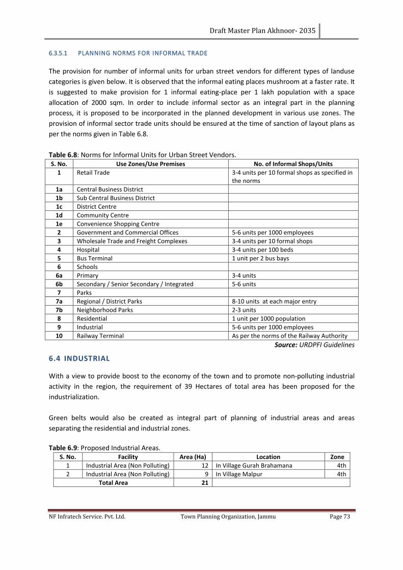
Draft Master Plan Akhnoor- 2035
NF Infratech Service. Pvt. Ltd. Town Planning Organization, Jammu Page 73
6.3.5.1 PLANNING NORMS FOR INFORMAL TRADE
The provision for number of informal units for urban street vendors for different types of landuse
categories is given below. It is observed that the informal eating places mushroom at a faster rate. It
is suggested to make provision for 1 informal eating-place per 1 lakh population with a space
allocation of 2000 sqm. In order to include informal sector as an integral part in the planning
process, it is proposed to be incorporated in the planned development in various use zones. The
provision of informal sector trade units should be ensured at the time of sanction of layout plans as
per the norms given in Table 6.8.
Table 6.8: Norms for Informal Units for Urban Street Vendors. S. No. Use Zones/Use Premises No. of Informal Shops/Units
1 Retail Trade 3-4 units per 10 formal shops as specified in the norms
1a Central Business District
1b Sub Central Business District
1c District Centre
1d Community Centre
1e Convenience Shopping Centre
2 Government and Commercial Offices 5-6 units per 1000 employees
3 Wholesale Trade and Freight Complexes 3-4 units per 10 formal shops
4 Hospital 3-4 units per 100 beds
5 Bus Terminal 1 unit per 2 bus bays
6 Schools
6a Primary 3-4 units
6b Secondary / Senior Secondary / Integrated 5-6 units
7 Parks
7a Regional / District Parks 8-10 units at each major entry
7b Neighborhood Parks 2-3 units
8 Residential 1 unit per 1000 population
9 Industrial 5-6 units per 1000 employees
10 Railway Terminal As per the norms of the Railway Authority
Source: URDPFI Guidelines
6.4 INDUSTRIAL
With a view to provide boost to the economy of the town and to promote non-polluting industrial
activity in the region, the requirement of 39 Hectares of total area has been proposed for the
industrialization.
Green belts would also be created as integral part of planning of industrial areas and areas
separating the residential and industrial zones.
Table 6.9: Proposed Industrial Areas.
S. No. Facility Area (Ha) Location Zone
1 Industrial Area (Non Polluting) 12 In Village Gurah Brahamana 4th
2 Industrial Area (Non Polluting) 9 In Village Malpur 4th
Total Area 21
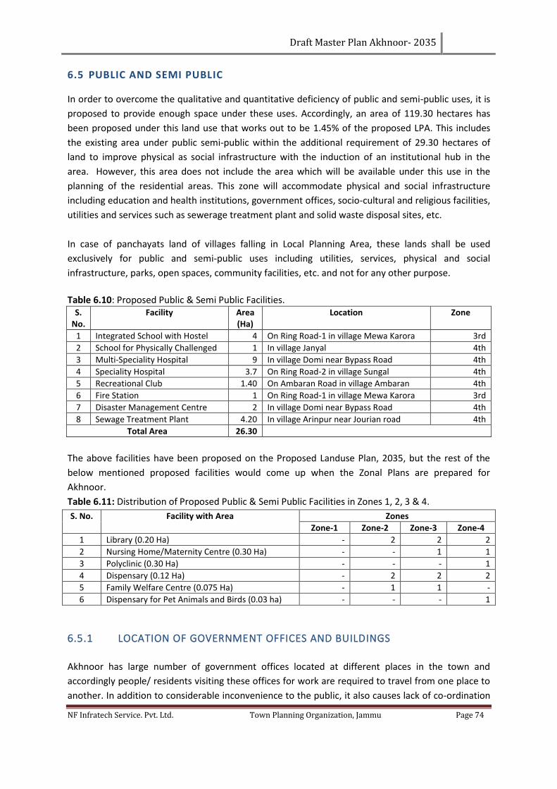
Draft Master Plan Akhnoor- 2035
NF Infratech Service. Pvt. Ltd. Town Planning Organization, Jammu Page 74
6.5 PUBLIC AND SEMI PUBLIC
In order to overcome the qualitative and quantitative deficiency of public and semi-public uses, it is
proposed to provide enough space under these uses. Accordingly, an area of 119.30 hectares has
been proposed under this land use that works out to be 1.45% of the proposed LPA. This includes
the existing area under public semi-public within the additional requirement of 29.30 hectares of
land to improve physical as social infrastructure with the induction of an institutional hub in the
area. However, this area does not include the area which will be available under this use in the
planning of the residential areas. This zone will accommodate physical and social infrastructure
including education and health institutions, government offices, socio-cultural and religious facilities,
utilities and services such as sewerage treatment plant and solid waste disposal sites, etc.
In case of panchayats land of villages falling in Local Planning Area, these lands shall be used
exclusively for public and semi-public uses including utilities, services, physical and social
infrastructure, parks, open spaces, community facilities, etc. and not for any other purpose.
Table 6.10: Proposed Public & Semi Public Facilities.
S. No.
Facility Area (Ha)
Location Zone
1 Integrated School with Hostel 4 On Ring Road-1 in village Mewa Karora 3rd
2 School for Physically Challenged 1 In village Janyal 4th
3 Multi-Speciality Hospital 9 In village Domi near Bypass Road 4th
4 Speciality Hospital 3.7 On Ring Road-2 in village Sungal 4th
5 Recreational Club 1.40 On Ambaran Road in village Ambaran 4th
6 Fire Station 1 On Ring Road-1 in village Mewa Karora 3rd
7 Disaster Management Centre 2 In village Domi near Bypass Road 4th
8 Sewage Treatment Plant 4.20 In village Arinpur near Jourian road 4th
Total Area 26.30
The above facilities have been proposed on the Proposed Landuse Plan, 2035, but the rest of the
below mentioned proposed facilities would come up when the Zonal Plans are prepared for
Akhnoor.
Table 6.11: Distribution of Proposed Public & Semi Public Facilities in Zones 1, 2, 3 & 4.
S. No. Facility with Area Zones
Zone-1 Zone-2 Zone-3 Zone-4
1 Library (0.20 Ha) - 2 2 2
2 Nursing Home/Maternity Centre (0.30 Ha) - - 1 1
3 Polyclinic (0.30 Ha) - - - 1
4 Dispensary (0.12 Ha) - 2 2 2
5 Family Welfare Centre (0.075 Ha) - 1 1 -
6 Dispensary for Pet Animals and Birds (0.03 ha) - - - 1
6.5.1 LOCATION OF GOVERNMENT OFFICES AND BUILDINGS
Akhnoor has large number of government offices located at different places in the town and
accordingly people/ residents visiting these offices for work are required to travel from one place to
another. In addition to considerable inconvenience to the public, it also causes lack of co-ordination
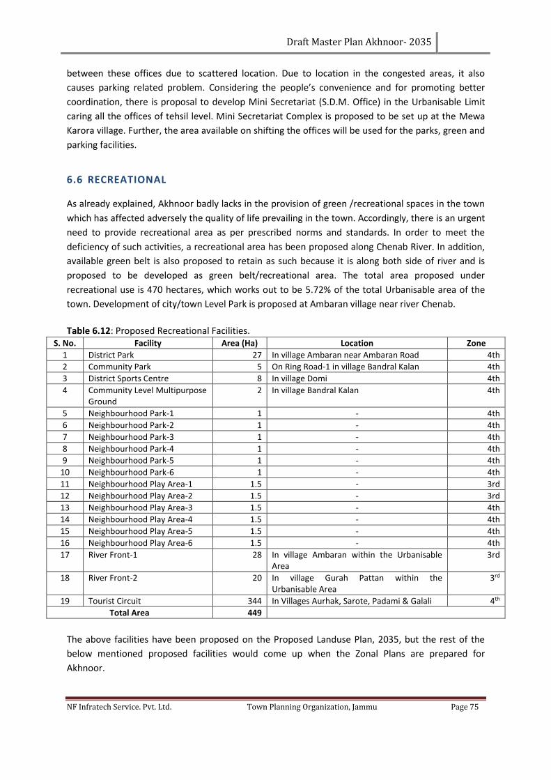
Draft Master Plan Akhnoor- 2035
NF Infratech Service. Pvt. Ltd. Town Planning Organization, Jammu Page 75
between these offices due to scattered location. Due to location in the congested areas, it also
causes parking related problem. Considering the people’s convenience and for promoting better
coordination, there is proposal to develop Mini Secretariat (S.D.M. Office) in the Urbanisable Limit
caring all the offices of tehsil level. Mini Secretariat Complex is proposed to be set up at the Mewa
Karora village. Further, the area available on shifting the offices will be used for the parks, green and
parking facilities.
6.6 RECREATIONAL
As already explained, Akhnoor badly lacks in the provision of green /recreational spaces in the town
which has affected adversely the quality of life prevailing in the town. Accordingly, there is an urgent
need to provide recreational area as per prescribed norms and standards. In order to meet the
deficiency of such activities, a recreational area has been proposed along Chenab River. In addition,
available green belt is also proposed to retain as such because it is along both side of river and is
proposed to be developed as green belt/recreational area. The total area proposed under
recreational use is 470 hectares, which works out to be 5.72% of the total Urbanisable area of the
town. Development of city/town Level Park is proposed at Ambaran village near river Chenab.
Table 6.12: Proposed Recreational Facilities.
S. No. Facility Area (Ha) Location Zone
1 District Park 27 In village Ambaran near Ambaran Road 4th
2 Community Park 5 On Ring Road-1 in village Bandral Kalan 4th
3 District Sports Centre 8 In village Domi 4th
4 Community Level Multipurpose Ground
2 In village Bandral Kalan 4th
5 Neighbourhood Park-1 1 - 4th
6 Neighbourhood Park-2 1 - 4th
7 Neighbourhood Park-3 1 - 4th
8 Neighbourhood Park-4 1 - 4th
9 Neighbourhood Park-5 1 - 4th
10 Neighbourhood Park-6 1 - 4th
11 Neighbourhood Play Area-1 1.5 - 3rd
12 Neighbourhood Play Area-2 1.5 - 3rd
13 Neighbourhood Play Area-3 1.5 - 4th
14 Neighbourhood Play Area-4 1.5 - 4th
15 Neighbourhood Play Area-5 1.5 - 4th
16 Neighbourhood Play Area-6 1.5 - 4th
17 River Front-1 28 In village Ambaran within the Urbanisable Area
3rd
18 River Front-2 20 In village Gurah Pattan within the Urbanisable Area
3rd
19 Tourist Circuit 344 In Villages Aurhak, Sarote, Padami & Galali 4th
Total Area 449
The above facilities have been proposed on the Proposed Landuse Plan, 2035, but the rest of the
below mentioned proposed facilities would come up when the Zonal Plans are prepared for
Akhnoor.
Draft Master Plan Akhnoor- 2035
NF Infratech Service. Pvt. Ltd. Town Planning Organization, Jammu Page 76
Table 6.13: Distribution of Proposed Public & Semi Public Facilities in Zones 1, 2, 3 & 4.
S. No. Facility with Area Zones
Zone-1 Zone-2 Zone-3 Zone-4
1 Housing Area Park (0.50 Ha) - 3 6 7
2 Residential Unit Play Area (0.50 Ha) - 4 6 8
6.7 CONSERVATION AREAS AND HERTIAGE
The town of Akhnoor has heritage zones like the existing Akhnoor fort, Ambaran Buddha site and
core area of town that need to be preserved, conserved and promoted. Major restoration work
needs to be done at Akhnoor fort as it is the first façade to the town. Parks and other recreational
facilities can be given here to encourage tourism in the town, as the close proximity from Jammu
City provides ample opportunities to develop on the strength. Accordingly, a well-defined strategy
will have to be put in place in order to integrate them in the future growth and development of
Akhnoor town. Detailed proposals based on ground realities and the special character of this
complex needs to be prepared with sensitivity in order to make them as an area of tourist attraction.
The proposals of this scheme are proposed to keep as such in the Master Plan 100 meter buffer will
be proposed all along the river Chenab. A 100 meter Buffer from the Akhnoor fort will be imposed in
which neither construction nor demolition will be allowed without the Permission of the Concerned
Authority.
6.8 PROPOSED TOURISM PLAN
The existence of Akhnoor Fort Gurudwara, Lord Parasuram Temple, Jia Potaghat and Pandav Gufa
has the potential of development. These places can be showcased through a system of tourist walks.
Considering the spatial location and importance, following sites is proposed to be developed for
tourist walk within the town for promoting awareness about heritage and tourism development.
For the next 20 years a new tourist circuit is proposed along Chenab River near foot hills of Shivaliks,
and Galali forests to generate the tourism activities in this area. The entire approach to promote
tourism shall revolve around provision of following:
1. Promoting high degree of accessibility;
2. Providing comfortable and affordable quality accommodation, including low budget
accommodation;
3. Creating more opportunities for attracting tourists;
4. Providing state of art tourism related infrastructure and amenities;
5. Development of nature & trekking tourism;
6. Village/rural & home stay tourism;
7. Pilgrimage, religious tourism & culture & heritage tourism;
8. Eco-tourism, wilderness tourism, Adventure tourism;
9. Developments on banks of Chenab and Water Tourism include boating and rafting.
10. Concept of aquaculture to be developed on river Chenab.
11. Provision of aquiculture tourism will be developed.
12. Provision of urban forming & water shed will be proposed.
Draft Master Plan Akhnoor- 2035
NF Infratech Service. Pvt. Ltd. Town Planning Organization, Jammu Page 77
6.9 PROPOSED TRAFFIC AND TRANSPORTATION PLAN
Traffic and transportation is the most critical component of any town because it defines and
determines both existing and future patterns, typology of growth and development of the town.
Since, the Traffic and transportation in any town is the function of Land use, transportation network
would be required to be integrated with the proposed land use in order to provide high degree of
connectivity and travel options between various land uses. It would also be critical to increase the
operational efficiency of different urban centers.
Accordingly, traffic and transportation plan of Akhnoor up to the year 2035 has been proposed
based on the proposed Land use plan for Akhnoor. The proposals related to traffic and
transportation Plan as detailed, aims at
1. Development of 2nd and 3rd ring roads all along the local planning area.
2. Rationalizing the existing road network by:
a. Creating a well-defined hierarchy of roads.
b. Redesigning the critical areas including road junctions.
c. Creating over-bridges.
3. Rationalizing the inter and intra town traffic by:
a. Creating adequate parking spaces.
b. Ensuring distribution and collection of traffic from various parts of the town both in
terms of existing and proposed development.
c. Developing well defined interface between different land uses.
d. Improving efficiencies in traffic movement within the town.
e. Minimizing delays etc. in order to improve the operational efficiency and
productivity of the town.
4. A third Bridge has been proposed in order to have a to and fro traffic from this Bridge and
the Old bridge and it will decrease the traffic Jams and streamline Traffic flow.
The proposed traffic and transportation plan defined in the proposed Land use plan will form the
basis for promoting the rational and planned growth of the Akhnoor. The proposed network will also
help in redefining the proposed Urbanisable area in to different development zones which can be
planned on the basis of self-contained and self-sufficient neighborhood principles with convenience
as a major objective. This would also help in promoting communities and interlinking them to the
basic framework of the town. In addition, it will also help in redesigning the basic infrastructure and
services essential for basic sustenance of the people and the town.
6.10 PROPOSED ROAD NETWORK AND HIERARCHY
The proposed road network comprises of a radial and ring system. The radial/axial road is inter-
connected by one peripheral ring road and a semi-circular ring road (existing bypass). The peripheral
ring road runs at the outer part of Akhnoor with a proposed ROW of 25m. On the northern bank of
river Chenab, maximum of outer ring roads alignment is as per the R&B’s proposed alignment along
the river. (Reference Map: Proposed Traffic and Transport/Proposed Land use Plan).
Following hierarchy of roads has been proposed:
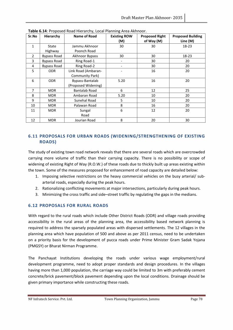
Draft Master Plan Akhnoor- 2035
NF Infratech Service. Pvt. Ltd. Town Planning Organization, Jammu Page 78
Table 6.14: Proposed Road Hierarchy, Local Planning Area Akhnoor. Sr.No Hierarchy Name of Road Existing ROW
(M) Proposed Right
of Way (M) Proposed Building
Line (M)
1 State Highway
Jammu Akhnoor Poonch Road
30 30 18-23
2 Bypass Road Akhnoor Bypass 30 30 18-23
3 Bypass Road Ring Road-1 - 30 20
4 Bypass Road Ring Road-2 - 30 20
5 ODR Link Road (Ambaran- Community Park)
- 16 20
6 ODR Bypass-Bantalab (Proposed Widening)
5.20 16 20
7 MDR Bantalab Road 6 12 25
8 MDR Ambaran Road 5.20 10 20
9 MDR Sunehal Road 5 10 20
10 MDR Palawan Road 8 16 20
11 MDR Sungal Road
6 12 20
12 MDR Jourian Road 8 20 30
6.11 PROPOSALS FOR URBAN ROADS (WIDENING/STRENGTHENING OF EXISTING ROADS)
The study of existing town road network reveals that there are several roads which are overcrowded
carrying more volume of traffic than their carrying capacity. There is no possibility or scope of
widening of existing Right of Way (R.O.W.) of these roads due to thickly built up areas existing within
the town. Some of the measures proposed for enhancement of road capacity are detailed below:
1. Imposing selective restrictions on the heavy commercial vehicles on the busy arterial/ sub-
arterial roads, especially during the peak hours.
2. Rationalizing conflicting movements at major intersections, particularly during peak hours.
3. Minimizing the cross traffic and side–street traffic by regulating the gaps in the medians.
6.12 PROPOSALS FOR RURAL ROADS
With regard to the rural roads which include Other District Roads (ODR) and village roads providing
accessibility in the rural areas of the planning area, the accessibility based network planning is
required to address the sparsely populated areas with dispersed settlements. The 12 villages in the
planning area which have population of 500 and above as per 2011 census, need to be undertaken
on a priority basis for the development of pucca roads under Prime Minister Gram Sadak Yojana
(PMGSY) or Bharat Nirman Programme.
The Panchayat Institutions developing the roads under various wage employment/rural
development programme, need to adopt proper standards and design procedures. In the villages
having more than 1,000 population, the carriage way could be limited to 3m with preferably cement
concrete/brick pavement/block pavement depending upon the local conditions. Drainage should be
given primary importance while constructing these roads.
Draft Master Plan Akhnoor- 2035
NF Infratech Service. Pvt. Ltd. Town Planning Organization, Jammu Page 79
6.13 JUNCTION IMPROVEMENTS
In addition to inadequacy of road network in the Akhnoor town, it has also been observed that the
majority of road junctions have not been properly planned, designed and constructed.
The congestion at few junctions has also led to large number of accidents. In order to rationalize the
flow of traffic and minimized conflicts at the junctions carrying large volume of traffic, it is proposed
to improve the road geometry at number of junctions that have recorded high rate of accidents. The
junctions proposed for immediate improvement include Sungal chowk, Main Chowk and Bypass
Chowk.
6.14 TERMINALS
6.14.1 PROPOSED BUS TERMINAL
A new bus stand has been proposed near Sungal Road. Relocating bus stand from its present
location will rationalize inter and intra-town traffic. It will also help in ensuring that all inter town
traffic carried by buses moves outside the town on the proposed bypass road and does not congest
the town anymore. Shifting of existing bus stand will be supplemented by an efficient system of
public transport town bus service which will ensure the smooth transfer of passengers to their
destination in different parts of town. New bus stand will be constructed on an area of 6 Hectares.
6.14.2 PROPOSED PARKING LOT
Due to rapid growth of the town, most of the core areas still have road network of narrow width,
which is unable to accommodate large vehicular movement.
Accordingly, rapid growth of vehicle ownership has led to creation of major traffic bottlenecks due
to absence of adequate and well-defined parking spaces. In the absence of such spaces most of the
vehicles are parked on the roads leading to traffic congestion and problems in smooth movement of
vehicles. Accordingly, in order to rationalize the movement of traffic in the town and to achieve the
desired level of efficiency, in addition to creating new linkages/widening of existing roads, it will be
critical to provide adequate parking spaces in the town.
For providing adequate parking, different strategies are proposed for area within core town and
other areas. Considering the typical character of the core town, it has already been proposed to
decongest the core area by selective shifting of Trade and Commerce including wholesale market
and population. In order to meet the parking requirements of the town, it is proposed to create
adequate parking spaces outside the core town near the existing bus stand and along the new
proposed ring road.
Traffic nodes like bus stand are required to be provided with adequate spaces, both for motorized
and non-motorized vehicles catering to the needs of the residents of the town. In addition, sites
should also be identified for the auto rickshaw parking and should be leased out.
• A Multi-Level parking is proposed alongside Fawara Chowk in the Right
Draft Master Plan Akhnoor- 2035
NF Infratech Service. Pvt. Ltd. Town Planning Organization, Jammu Page 80
• A multi-level parking is proposed along Jourian Road.
6.15 PROPOSED WATER SUPPLY NETWORK OF AKHNOOR
A study has been already made by the PHE Department of Akhnoor under the scheme of Integrated
Development of small and medium town and conceptual proposals for the water supply network has
also proposed. There is proposed to keep this proposal as it is by PHE department for the
development of water supply network. In addition, it is also proposed that PHE department will
coordinate with the Akhnoor Development authority (proposed Agency at local level which is
responsible for the implementation of master plan under the provision of Section 2. of Town
development Act 1971) time to time for the implementation of water supply network priority wise.
In addition, the option of recycling of the waste water, minimizing the wastage in the water supply
system and creating awareness among community for water conservation needs to be explored to
minimize the pressure on ground water and recharge the ground water. Mechanism of rainwater
harvesting should be encouraged at the household/institutional level in order to reduce dependence
on the ground water.
6.16 PROPOSED SEWAGE TREATMENT PLANT
Since the LPA area contains town and villages scattered around and having horizontal low rise
growth, it is proposed that decentralized septage tank should be provided or encouraged and 3
Sewage Treatment Plants needed to be proposed at suitable locations within the LPA.
In village Gurah Brahamana, along Jourian road, an area of 2 Hectares outside the LPA has been
proposed for the sanitary land fill site for solid waste but it has not been freezed .Land fill site land
use can be changed or it can be acquired in some other area with the permission of the pollution
control Board. It is proposed that the site must be acquired by the Municipal Committee, Akhnoor.
In addition, it is also proposed that detailed Solid Waste Management Project to be prepared for the
proper collection, segregation, transportation and disposals of generated waste of the Akhnoor
town.
6.17 STRATEGIES TO OBTAIN LAND FOR PUBLIC PURPOSE
A town typically requires 20% to 30% of its area for variety of public purposes, where land is owned
by the state government, which is easier to allocate land for public purposes. However, where
private land market is active, it is difficult to ensure land for public purpose and is a major challenge
in preparing a Master Plan. Conventional master planning relied on the powers of compulsory
acquisition of land designated for public purposes. However, limitations of this approach have been
painfully exposed. At the same time, not addressing the question of land for public purposes may
limit the utility of the Master Plan itself. With this background, a wide menu of strategies to obtain
land for public purposes is examined in this section.
Draft Master Plan Akhnoor- 2035
NF Infratech Service. Pvt. Ltd. Town Planning Organization, Jammu Page 81
6.18 TRANSFER DEVELOPMENT RIGHTS
Alternative to monetary compensation could be an award of Transfer of Development Rights (TDR)
either to remainder of the land or to a distant location. This could be in three generic cases viz.
Roads and Road widening: Development rights calculated at the FAR permissible in adjoining area
may be allowed to be used in the remainder of the plot up to a limit. Development rights that cannot
be so consumed can be transferred elsewhere in receiving areas. If FAR is related to width of the
road, resistance to widening may get reduced.
Public purposes on open land or exclusive plots: Lands required for parks and playgrounds or
exclusive uses like secondary school, fire station etc can be obtained by providing TDRs in lieu of
compensation. However, price differentials in originating and receiving zones could be considered as
an incentive in such cases.
Public purposes that require built-up space but not necessarily exclusive plot: Examples of this
could be municipal vegetable market, library etc. In such cases, landowner may be permitted to use
the full potential of development in terms of FAR over the plot provided, offers the built up space
required for the public purpose to the local body.
6.19 THROUGH TOWN DEVELOPMENT ACT 1971
Under section 16 of town development act 1961 of J & K the compulsory acquisition of land is as
follows:-
1. If in the opinion of the government, any land is required for the development, or for any
other purpose under this act, the government may acquire such land under the provisions of
the Land Acquisition Act, Samvat 1990.
2. Where any land has been acquired by the government, the government may, after it has
taken possession of the land, transfer the land to the development authority (proposed) for
the purpose for which the land has been acquired on payment by the authority of the
compensation awarded under that act and the charges incurred by the government in
connection with the acquisition.
And under section 19 of this act - The authority shall have and maintain its own fund to which shall
be credited:
1. All money received by the authority from the central or state government by way of grants,
loans, advances or otherwise.
2. All money borrowed by the authority from source other than the government by way of
loans or debentures.
3. All fees and charges received by the authority under this act.
4. All money received by the authority from the disposal of lands, buildings and other
properties, movable and immovable; and all moneys received by the authority by way of
rents and profits or in any other manner or from any other source.
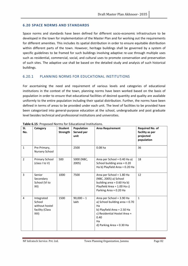
Draft Master Plan Akhnoor- 2035
NF Infratech Service. Pvt. Ltd. Town Planning Organization, Jammu Page 82
6.20 SPACE NORMS AND STANDARDS
Space norms and standards have been defined for different socio-economic infrastructure to be
developed in the town for implementation of the Master Plan and for working out the requirements
for different amenities. This includes its spatial distribution in order to ensure equitable distribution
within different parts of the town. However, heritage buildings shall be governed by a system of
specific guidelines to be framed for such buildings involving adaptive re-use through multiple uses
such as residential, commercial, social, and cultural uses to promote conservation and preservation
of such sites. The adaptive use shall be based on the detailed study and analysis of such historical
buildings.
6.20.1 PLANNING NORMS FOR EDUCATIONAL INSTITUTIONS
For ascertaining the need and requirement of various levels and categories of educational
institutions in the context of the town, planning norms have been worked based on the basis of
population in order to ensure that educational facilities of desired quantity and quality are available
uniformly to the entire population including their spatial distribution. Further, the norms have been
defined in terms of areas to be provided under each unit. The level of facilities to be provided have
been categorized into general-purpose education at the school, undergraduate and post graduate
level besides technical and professional institutions and universities.
Table 6.15: Proposed Norms for Educational Institutions. Sl. No.
Category Student Strength
Population Served per unit
Area Requirement Required No. of facility as per projected population
1 Pre Primary, Nursery School
2500 0.08 ha 36
2 Primary School (class I to V)
500 5000 (NBC, 2005)
Area per School = 0.40 Ha a) School building area = 0.20 Ha b) Playfield Area = 0.20 Ha
18
3 Senior Secondary School (VI to XII)
1000 7500 Area per School = 1.80 Ha (NBC, 2005) a) School building area = 0.60 Ha b) Playfield Area = 1.00 Ha c) Parking Area = 0.20 Ha
12
4 Integrated School without hostel facility (Class IXII)
1500 90,000 – 1 lakh
Area per School = 3.90 Ha a) School building area = 0.70 Ha b) Playfield Area = 2.50 Ha c) Residential Hostel Area = 0.40 Ha d) Parking Area = 0.30 Ha
1
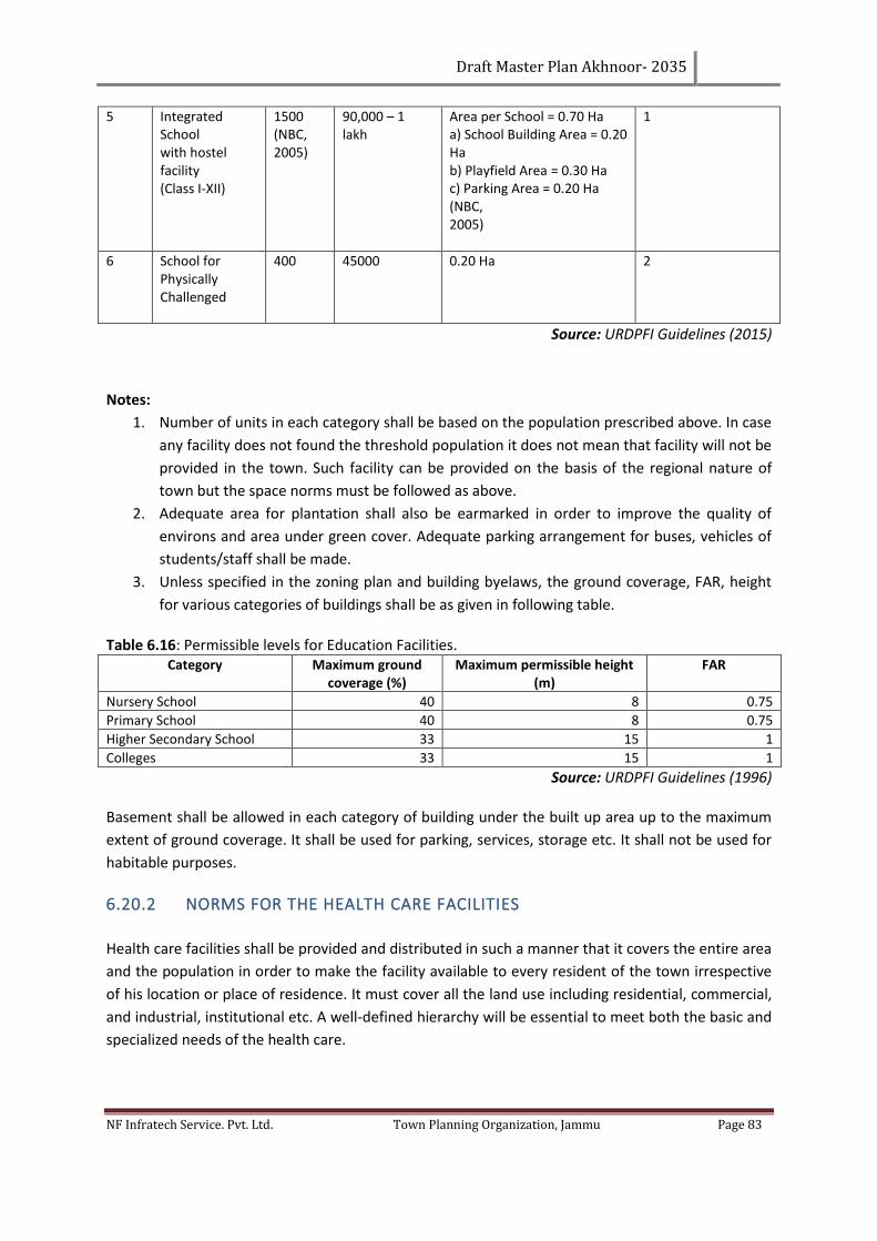
Draft Master Plan Akhnoor- 2035
NF Infratech Service. Pvt. Ltd. Town Planning Organization, Jammu Page 83
5 Integrated School with hostel facility (Class I‐XII)
1500 (NBC, 2005)
90,000 – 1 lakh
Area per School = 0.70 Ha a) School Building Area = 0.20 Ha b) Playfield Area = 0.30 Ha c) Parking Area = 0.20 Ha (NBC, 2005)
1
6 School for Physically Challenged
400 45000 0.20 Ha 2
Source: URDPFI Guidelines (2015)
Notes:
1. Number of units in each category shall be based on the population prescribed above. In case
any facility does not found the threshold population it does not mean that facility will not be
provided in the town. Such facility can be provided on the basis of the regional nature of
town but the space norms must be followed as above.
2. Adequate area for plantation shall also be earmarked in order to improve the quality of
environs and area under green cover. Adequate parking arrangement for buses, vehicles of
students/staff shall be made.
3. Unless specified in the zoning plan and building byelaws, the ground coverage, FAR, height
for various categories of buildings shall be as given in following table.
Table 6.16: Permissible levels for Education Facilities. Category Maximum ground
coverage (%) Maximum permissible height
(m) FAR
Nursery School 40 8 0.75
Primary School 40 8 0.75
Higher Secondary School 33 15 1
Colleges 33 15 1
Source: URDPFI Guidelines (1996) Basement shall be allowed in each category of building under the built up area up to the maximum
extent of ground coverage. It shall be used for parking, services, storage etc. It shall not be used for
habitable purposes.
6.20.2 NORMS FOR THE HEALTH CARE FACILITIES
Health care facilities shall be provided and distributed in such a manner that it covers the entire area
and the population in order to make the facility available to every resident of the town irrespective
of his location or place of residence. It must cover all the land use including residential, commercial,
and industrial, institutional etc. A well-defined hierarchy will be essential to meet both the basic and
specialized needs of the health care.
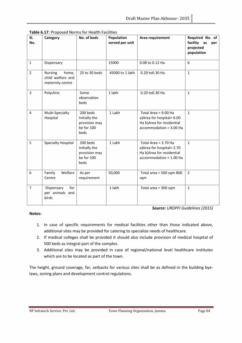
Draft Master Plan Akhnoor- 2035
NF Infratech Service. Pvt. Ltd. Town Planning Organization, Jammu Page 84
Table 6.17: Proposed Norms for Health Facilities Sl. No.
Category No. of beds Population served per unit
Area requirement Required No. of facility as per projected population
1 Dispensary 15000 0.08 to 0.12 Ha 6
2 Nursing home, child welfare and maternity centre
25 to 30 beds 45000 to 1 lakh 0.20 to0.30 Ha 1
3 Polyclinic Some observation beds
1 lakh 0.20 to0.30 Ha 1
4 Multi‐Specialty Hospital
200 beds Initially the provision may be for 100 beds
1 Lakh Total Area = 9.00 Ha a)Area for hospital= 6.00 Ha b)Area for residential accommodation = 3.00 Ha
1
5 Specialty Hospital 200 beds Initially the provision may be for 100 beds
1 Lakh Total Area = 3.70 Ha a)Area for hospital= 2.70 Ha b)Area for residential accommodation = 1.00 Ha
1
6 Family Welfare Centre
As per requirement
50,000 Total area = 500 sqm 800 sqm
2
7 Dispensary for pet animals and birds
1 lakh Total area = 300 sqm 1
Source: URDPFI Guidelines (2015) Notes:
1. In case of specific requirements for medical facilities other than those indicated above,
additional sites may be provided for catering to specialize needs of healthcare.
2. If medical colleges shall be provided it should also include provision of medical hospital of
500 beds as integral part of the complex.
3. Additional sites may be provided in case of regional/national level healthcare institutes
which are to be located as part of the town.
The height, ground coverage, far, setbacks for various sites shall be as defined in the building bye-
laws, zoning plans and development control regulations.

Draft Master Plan Akhnoor- 2035
NF Infratech Service. Pvt. Ltd. Town Planning Organization, Jammu Page 85
6.20.3 NORMS FOR FIRE STATION AND SECURITY INFRASTRUCTURE
1. One Fire Station/Sub-Fire station to be provided within distance of 1-3 km covering a
population of 2,00,000 of 1 hectare each
2. Fire Station needs to be co-ordination with water supply system to provide for fire
hydrants/water tanks.
3. Fire services to be fully equipped to deal with fire accidents in the multi storied Buildings and
buildings in the narrow streets of old town.
Table 6.18: Norms for Police Station, Civil Defense and Home Guard Sl.
No. Category Population Served per unit Land Area Requirement Required No. of
facility as per projected
population
1 Police Post 40,000 – 50,000(Area not served by Police Station)
0.16 Ha (Area inclusive of residential accommodation)
2
2 Police Station
90,000 1.50 Ha (Area inclusive of essential residential accommodation) 0.05 Ha additional to be provided for civil defense and home guards.
1
3 Traffic and Police Control Room
As per requirement
Source: URDPFI Guidelines (2015) Table 6.19: Norms for Safety Facility. Sl. No. Category Distribution or
Population Served per unit
Area Requirement Required No. of facility as per LPA area
1 Fire Station 2 lakh population or 5‐7 km radius
1 Ha with residential accommodation
1
2 Disaster Management Centre
One in each administrative zone
1 Ha along with suitable open area 2 Ha if soft parking, temporary shelter, parade ground etc. included
1
Source: URDPFI Guidelines (2015)
6.20.4 SOCIAL CULTURAL FACILITIES
Table 6.20: Proposed Norms for Socio-Cultural Facilities Sl. No. Category Population Served
per unit Land Area
Requirement Required No. of
facility as per projected population
1 Recreational Club 1 lakh 10,000 sqm 1
2 Religious Facilities At neighbourhood / housing cluster level
5000 400 sqm 18
Source: URDPFI Guidelines (2015)
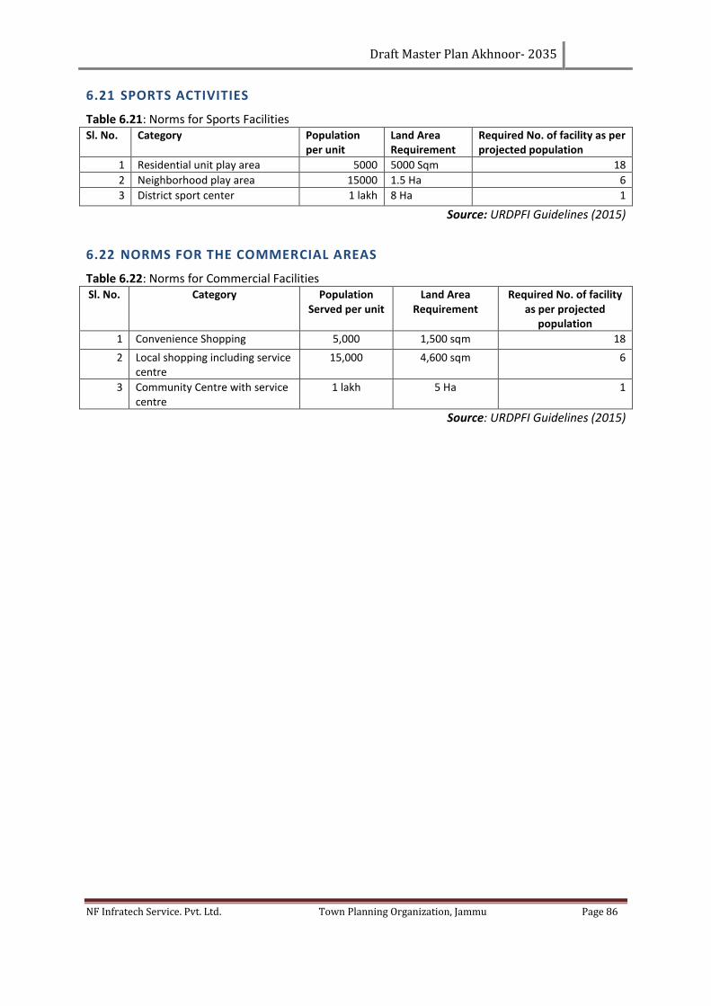
Draft Master Plan Akhnoor- 2035
NF Infratech Service. Pvt. Ltd. Town Planning Organization, Jammu Page 86
6.21 SPORTS ACTIVITIES
Table 6.21: Norms for Sports Facilities Sl. No. Category Population
per unit Land Area Requirement
Required No. of facility as per projected population
1 Residential unit play area 5000 5000 Sqm 18
2 Neighborhood play area 15000 1.5 Ha 6
3 District sport center 1 lakh 8 Ha 1
Source: URDPFI Guidelines (2015)
6.22 NORMS FOR THE COMMERCIAL AREAS
Table 6.22: Norms for Commercial Facilities Sl. No. Category Population
Served per unit Land Area
Requirement Required No. of facility
as per projected population
1 Convenience Shopping 5,000 1,500 sqm 18
2 Local shopping including service centre
15,000 4,600 sqm 6
3 Community Centre with service centre
1 lakh 5 Ha 1
Source: URDPFI Guidelines (2015)
Draft Master Plan Akhnoor- 2035
NF Infratech Service. Pvt. Ltd. Town Planning Organization, Jammu Page 87
CHAPTER 7. DEVELOPMENT PROMOTION RULES & REGULATIONS
The purpose of the Development Control Regulations (D.C.R.) is to assist all the stakeholders
including developers and end-users within the Local Planning Area, Akhnoor, to strive for a
sustainable, quality and environment friendly development.
These Development Control Regulations are applicable to the entire set of existing and proposed
developments that are going to come up within the Local Planning Area. The developers are
required to comply with the provisions of Zoning and Land use Plans defined in the Master Plan.
The chapter lays down the procedural framework for exercising the development Rules.
“Development” in the Town Development 1971 act has been defined as:
"Development" with its grammatical variations means the carrying out of
building, engineering quarrying or extraction or manufacture of building
materials or other operations in, on, over or under land, or "erecting or re-
erecting" of any building or land and include redevelopment.”
7.1 BUILDING BYELAWS
7.1.1 RESIDENTIAL USE ZONE
The residential areas are developed either as: a) Plotted Development or b) Group Housing / Flatted
Development. The density pattern i.e. (high density, medium density or low density) are followed for
working out the pattern of development with respect to the size of the plot to number of dwelling
units on each plot, setbacks, FAR and no. of storey’s/ height of the building. The development norms
for different use/ activities and on different size of plots shall be applied for sanctioning of the plan.
These are based on development control rules applicable to Municipality as per Master Plan/ Zonal
Plan/ Layout Plan.
Residential use in designated core area of old Town:
The designated area of old city shall compromise of the congested part of the city. In essence it shall
comprise of the densely populated wards of the old city. These areas can be developed under
courtyard planning also up to max. Plot area of 250 sqm.
Max. Ground Coverage permissible - 75%
No. of storeys - Ground + 2
Note:
No building shall be allowed on lands with more than 30% slope. Building line for proposed building
shall be governed by Ribbon Development Act and National Highway building line respectively.
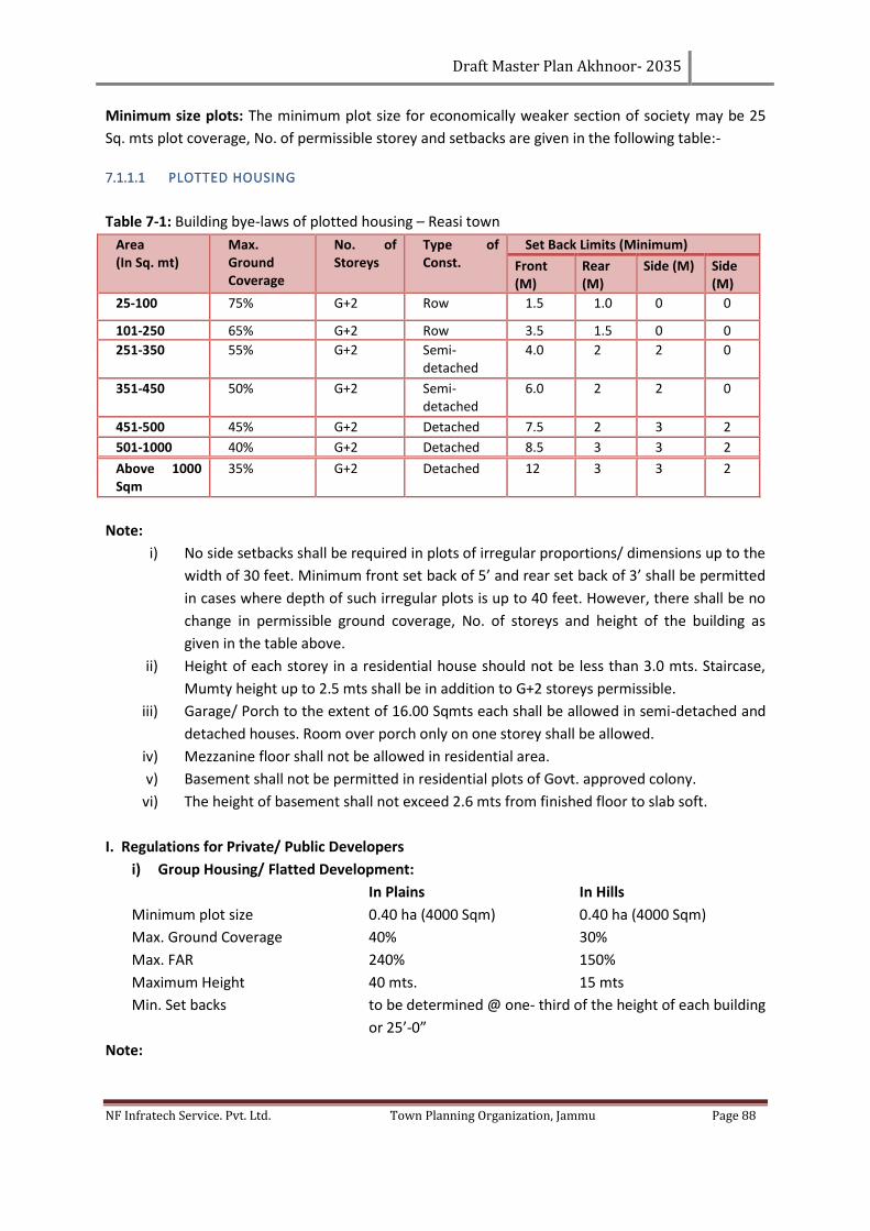
Draft Master Plan Akhnoor- 2035
NF Infratech Service. Pvt. Ltd. Town Planning Organization, Jammu Page 88
Minimum size plots: The minimum plot size for economically weaker section of society may be 25
Sq. mts plot coverage, No. of permissible storey and setbacks are given in the following table:-
7.1.1.1 PLOTTED HOUSING
Table 7-1: Building bye-laws of plotted housing – Reasi town
Area (In Sq. mt)
Max. Ground Coverage
No. of Storeys
Type of Const.
Set Back Limits (Minimum)
Front (M)
Rear (M)
Side (M) Side (M)
25-100 75% G+2 Row 1.5 1.0 0 0
101-250 65% G+2 Row 3.5 1.5 0 0
251-350 55% G+2 Semi-detached
4.0 2 2 0
351-450 50% G+2 Semi-detached
6.0 2 2 0
451-500 45% G+2 Detached 7.5 2 3 2
501-1000 40% G+2 Detached 8.5 3 3 2
Above 1000 Sqm
35% G+2 Detached 12 3 3 2
Note:
i) No side setbacks shall be required in plots of irregular proportions/ dimensions up to the
width of 30 feet. Minimum front set back of 5’ and rear set back of 3’ shall be permitted
in cases where depth of such irregular plots is up to 40 feet. However, there shall be no
change in permissible ground coverage, No. of storeys and height of the building as
given in the table above.
ii) Height of each storey in a residential house should not be less than 3.0 mts. Staircase,
Mumty height up to 2.5 mts shall be in addition to G+2 storeys permissible.
iii) Garage/ Porch to the extent of 16.00 Sqmts each shall be allowed in semi-detached and
detached houses. Room over porch only on one storey shall be allowed.
iv) Mezzanine floor shall not be allowed in residential area.
v) Basement shall not be permitted in residential plots of Govt. approved colony.
vi) The height of basement shall not exceed 2.6 mts from finished floor to slab soft.
I. Regulations for Private/ Public Developers
i) Group Housing/ Flatted Development:
In Plains In Hills
Minimum plot size 0.40 ha (4000 Sqm) 0.40 ha (4000 Sqm)
Max. Ground Coverage 40% 30%
Max. FAR 240% 150%
Maximum Height 40 mts. 15 mts
Min. Set backs to be determined @ one- third of the height of each building
or 25’-0”
Note:
Draft Master Plan Akhnoor- 2035
NF Infratech Service. Pvt. Ltd. Town Planning Organization, Jammu Page 89
a) Basement, if constructed and used for parking, services and for essential storage shall
not be counted in FAR.
b) The quantum of basement varies between 33. 1/3% to 75% of the plot area and shall not
be included in FAR if used for Parking/ Services.
c) In-house back-up facilities to be provided for buildings beyond four storeys.
d) Minimum 1 ECS per dwelling unit shall be provided for MIG and HIG Housing.
e) Stilts, Balconies, lift stairs, lift ducts shall not be counted in FAR.
ii) Housing Colonies:
2. A person or group of persons or a co-operative society or firm intending to plot out an
estate into more than 4 plots (1000 Sqm or more) shall give notice in writing to the
competent authority which will be accompanied by a layout plan of entire land showing
the areas allotted for roads, open spaces, plot and public buildings, the specification of the
roads, drains and other infrastructures.
3. Min. Width of road
i) Housing colony up to 50 Kanals
Entry from the main road shall not be less than 30’ and no internal road shall be less than
20’-0”.
ii) Housing colony beyond 50 Kanals.
Entry from the main road shall not be less than 50’ and no internal road shall be less than
20’-0”.
4. Roads, Drains, water mains and electric lines required for the colony shall be constructed
by the developer at his own cost and no plot shall be eligible for any services and utilities
from the Govt. and/or Municipality unless the colony is developed properly and approved
by the competent authority. No building plan shall be considered by the Municipality or
prescribed authority in any plot of such a colony which has not received the prior approval
of the competent Authority.
5. No housing colony can be allowed in the area not specified as the residential in the
proposed Master Plan (if approved by Govt.) unless considered in any special
circumstances by the competent authority with the approval of govt. In such housing
colonies, the following standards shall apply:-
a) Area under roads: Min. 15% to 20% of the total area of land under the
proposed colony.
b) Land to be allotted for open spaces, schools and public building for a housing
colony of 20 plots and above shall not be less than 15% of the total area of the
colony. However, if the competent authority feels that an open space or a school
site is absolutely necessary within the layout plan of less than 20 plots; necessary
provision shall have to be made by the developer in the layout plan.
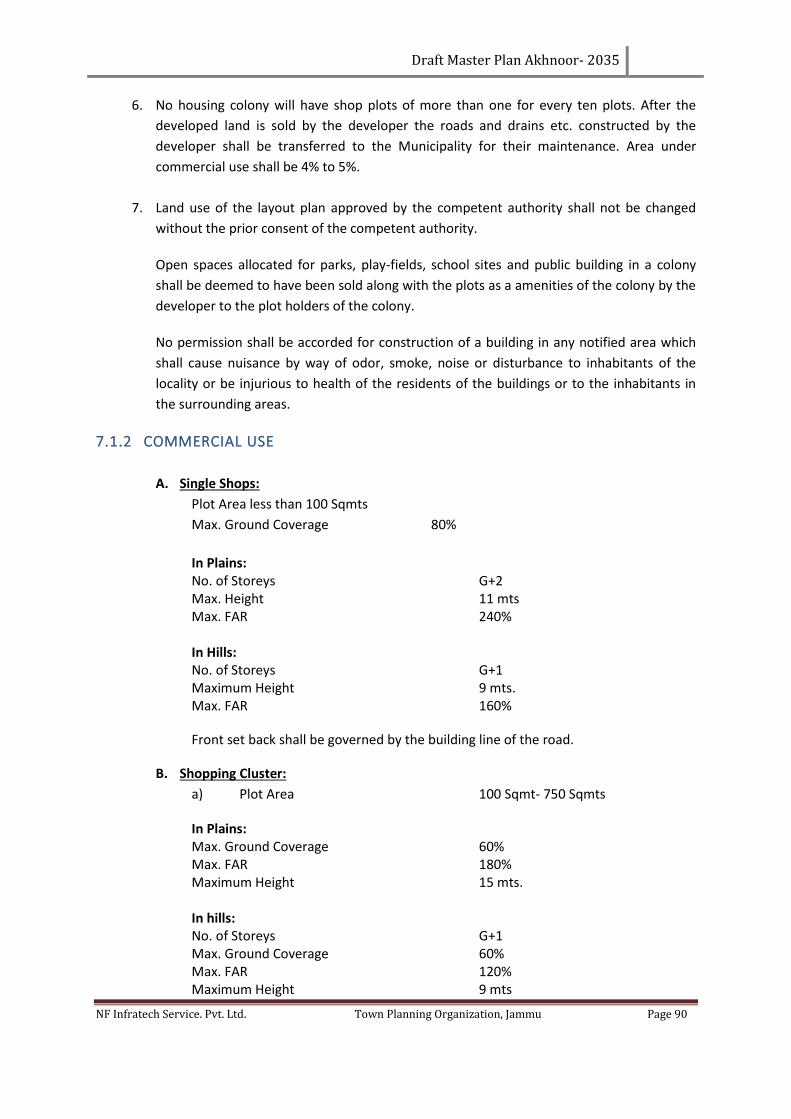
Draft Master Plan Akhnoor- 2035
NF Infratech Service. Pvt. Ltd. Town Planning Organization, Jammu Page 90
6. No housing colony will have shop plots of more than one for every ten plots. After the
developed land is sold by the developer the roads and drains etc. constructed by the
developer shall be transferred to the Municipality for their maintenance. Area under
commercial use shall be 4% to 5%.
7. Land use of the layout plan approved by the competent authority shall not be changed
without the prior consent of the competent authority.
Open spaces allocated for parks, play-fields, school sites and public building in a colony
shall be deemed to have been sold along with the plots as a amenities of the colony by the
developer to the plot holders of the colony.
No permission shall be accorded for construction of a building in any notified area which
shall cause nuisance by way of odor, smoke, noise or disturbance to inhabitants of the
locality or be injurious to health of the residents of the buildings or to the inhabitants in
the surrounding areas.
7.1.2 COMMERCIAL USE
A. Single Shops:
Plot Area less than 100 Sqmts
Max. Ground Coverage 80%
In Plains: No. of Storeys G+2 Max. Height 11 mts Max. FAR 240%
In Hills: No. of Storeys G+1 Maximum Height 9 mts. Max. FAR 160%
Front set back shall be governed by the building line of the road.
B. Shopping Cluster:
a) Plot Area 100 Sqmt- 750 Sqmts
In Plains: Max. Ground Coverage 60% Max. FAR 180% Maximum Height 15 mts. In hills: No. of Storeys G+1 Max. Ground Coverage 60% Max. FAR 120% Maximum Height 9 mts
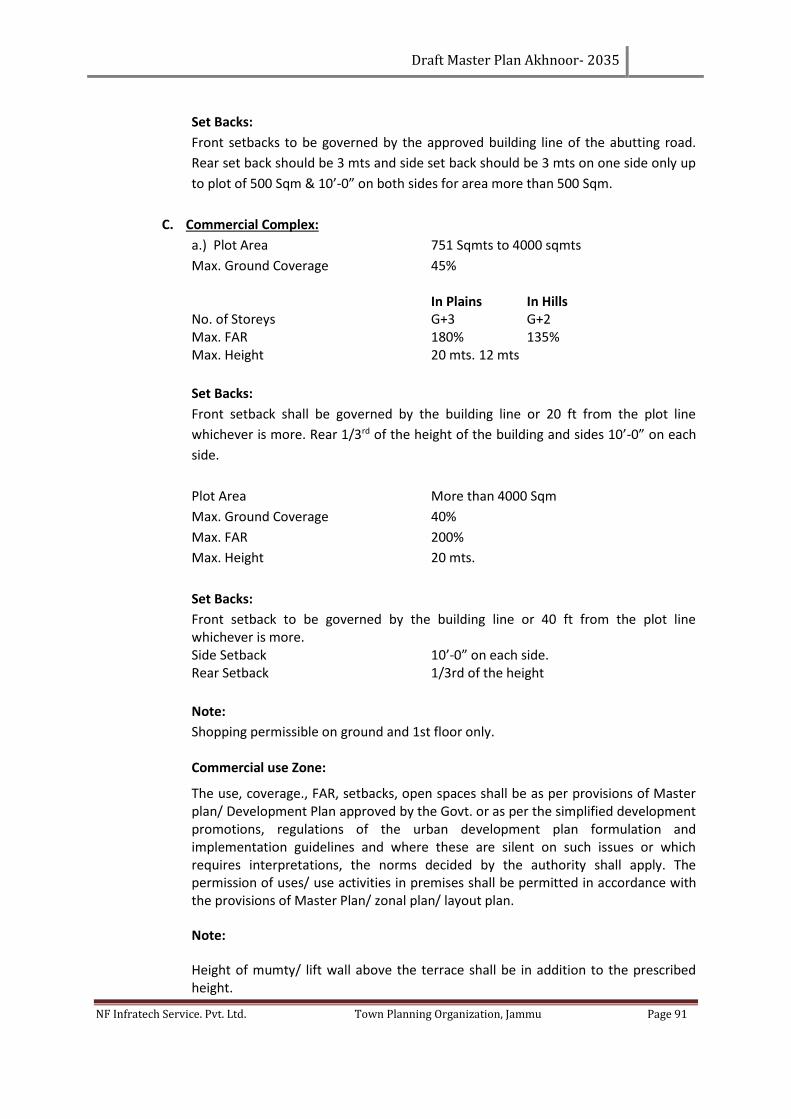
Draft Master Plan Akhnoor- 2035
NF Infratech Service. Pvt. Ltd. Town Planning Organization, Jammu Page 91
Set Backs:
Front setbacks to be governed by the approved building line of the abutting road.
Rear set back should be 3 mts and side set back should be 3 mts on one side only up
to plot of 500 Sqm & 10’-0” on both sides for area more than 500 Sqm.
C. Commercial Complex:
a.) Plot Area 751 Sqmts to 4000 sqmts
Max. Ground Coverage 45% In Plains In Hills No. of Storeys G+3 G+2 Max. FAR 180% 135% Max. Height 20 mts. 12 mts
Set Backs:
Front setback shall be governed by the building line or 20 ft from the plot line
whichever is more. Rear 1/3rd of the height of the building and sides 10’-0” on each
side.
Plot Area More than 4000 Sqm
Max. Ground Coverage 40%
Max. FAR 200%
Max. Height 20 mts.
Set Backs:
Front setback to be governed by the building line or 40 ft from the plot line whichever is more. Side Setback 10’-0” on each side. Rear Setback 1/3rd of the height
Note:
Shopping permissible on ground and 1st floor only.
Commercial use Zone:
The use, coverage., FAR, setbacks, open spaces shall be as per provisions of Master plan/ Development Plan approved by the Govt. or as per the simplified development promotions, regulations of the urban development plan formulation and implementation guidelines and where these are silent on such issues or which requires interpretations, the norms decided by the authority shall apply. The permission of uses/ use activities in premises shall be permitted in accordance with the provisions of Master Plan/ zonal plan/ layout plan.
Note:
Height of mumty/ lift wall above the terrace shall be in addition to the prescribed height.
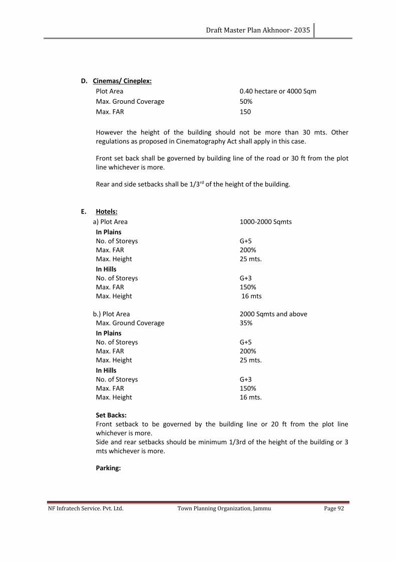
Draft Master Plan Akhnoor- 2035
NF Infratech Service. Pvt. Ltd. Town Planning Organization, Jammu Page 92
D. Cinemas/ Cineplex:
Plot Area 0.40 hectare or 4000 Sqm
Max. Ground Coverage 50%
Max. FAR 150
However the height of the building should not be more than 30 mts. Other regulations as proposed in Cinematography Act shall apply in this case.
Front set back shall be governed by building line of the road or 30 ft from the plot line whichever is more.
Rear and side setbacks shall be 1/3rd of the height of the building.
E. Hotels:
a) Plot Area 1000-2000 Sqmts
In Plains No. of Storeys G+5 Max. FAR 200% Max. Height 25 mts.
In Hills No. of Storeys G+3 Max. FAR 150% Max. Height 16 mts
b.) Plot Area 2000 Sqmts and above Max. Ground Coverage 35%
In Plains No. of Storeys G+5 Max. FAR 200% Max. Height 25 mts.
In Hills No. of Storeys G+3 Max. FAR 150% Max. Height 16 mts. Set Backs: Front setback to be governed by the building line or 20 ft from the plot line whichever is more. Side and rear setbacks should be minimum 1/3rd of the height of the building or 3 mts whichever is more.
Parking:
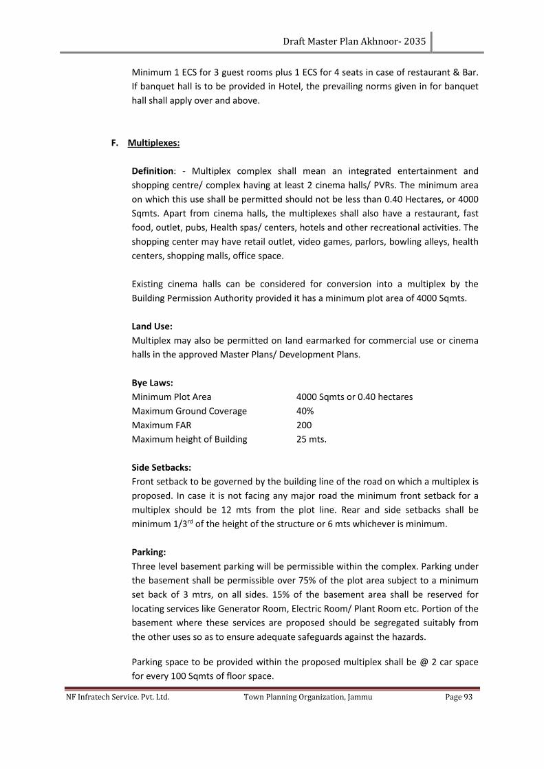
Draft Master Plan Akhnoor- 2035
NF Infratech Service. Pvt. Ltd. Town Planning Organization, Jammu Page 93
Minimum 1 ECS for 3 guest rooms plus 1 ECS for 4 seats in case of restaurant & Bar.
If banquet hall is to be provided in Hotel, the prevailing norms given in for banquet
hall shall apply over and above.
F. Multiplexes:
Definition: - Multiplex complex shall mean an integrated entertainment and
shopping centre/ complex having at least 2 cinema halls/ PVRs. The minimum area
on which this use shall be permitted should not be less than 0.40 Hectares, or 4000
Sqmts. Apart from cinema halls, the multiplexes shall also have a restaurant, fast
food, outlet, pubs, Health spas/ centers, hotels and other recreational activities. The
shopping center may have retail outlet, video games, parlors, bowling alleys, health
centers, shopping malls, office space.
Existing cinema halls can be considered for conversion into a multiplex by the
Building Permission Authority provided it has a minimum plot area of 4000 Sqmts.
Land Use:
Multiplex may also be permitted on land earmarked for commercial use or cinema
halls in the approved Master Plans/ Development Plans.
Bye Laws:
Minimum Plot Area 4000 Sqmts or 0.40 hectares
Maximum Ground Coverage 40%
Maximum FAR 200
Maximum height of Building 25 mts.
Side Setbacks:
Front setback to be governed by the building line of the road on which a multiplex is
proposed. In case it is not facing any major road the minimum front setback for a
multiplex should be 12 mts from the plot line. Rear and side setbacks shall be
minimum 1/3rd of the height of the structure or 6 mts whichever is minimum.
Parking:
Three level basement parking will be permissible within the complex. Parking under
the basement shall be permissible over 75% of the plot area subject to a minimum
set back of 3 mtrs, on all sides. 15% of the basement area shall be reserved for
locating services like Generator Room, Electric Room/ Plant Room etc. Portion of the
basement where these services are proposed should be segregated suitably from
the other uses so as to ensure adequate safeguards against the hazards.
Parking space to be provided within the proposed multiplex shall be @ 2 car space
for every 100 Sqmts of floor space.
Draft Master Plan Akhnoor- 2035
NF Infratech Service. Pvt. Ltd. Town Planning Organization, Jammu Page 94
Area to be considered under parking in basement/ stilts/ open shall be as under:
i) Basement 28 Sqmts per car space
ii) Stilts 23 Sqmts per car space
iii) Open to Sky 18 Sqmts per car space
Note:
Area under parking/ services in the basement floor and stilts shall not be counted
towards the calculation of FAR.
G. Janjghar/ Community Center/ Banquet Hall:
Minimum Plot Area 2.5 acres (20 Kanals)
Max. Ground Coverage 30%
No. of Storeys G + 2
Max. FAR 100%
Max. Height 15 mts
Set Backs:
Front setback to be governed by the building line or 30 ft from the plot line
whichever is more.
Side and rear setbacks shall be minimum 1/3rd of the height of the building.
H. Ware Housing, Storage Vegetables & Fruit Mandis:
Minimum Plot area 2.5 Ha (25000 Sqm)
Maximum Coverage 25%
FAR 100%
Max. Height 15 mts.
I. Petrol Pumps:
The following regulations are recommended for locating petrol pumps cum service
stations:-
i. Minimum distance from the road intersections.
a. 50 mts. on roads having R/W up to 30 mts
b. 100 mts. on roads having R/W more than 30 mts
ii. The minimum distance to the property line of Pump from the center line of the
road should not be less than 15 meters on roads having less than 30 mts R/W. In
case of road having 30 mts. or more R/W building line of the road should be
protected.
iii. Plot Size (Minimum);
a. Only filing station 30 mts. X 17 mts.
b. Filling cum service Station minimum size 36 mts x 30 mts.
c. Frontage of the plot should not be less than 30 mts.
d. Longer side of the plot should be the frontage.
e. New petrol pump shall not be located on any road having R/W less than 15
mts.
Draft Master Plan Akhnoor- 2035
NF Infratech Service. Pvt. Ltd. Town Planning Organization, Jammu Page 95
b) Other Controls:
i. Filling cum Service Station (Size 30 mt. x 36 mts. and above)
a. Ground Coverage 20 %
b. FAR 20%
c. Max. Height 6 mts
d. Canopy Equivalent to permissible ground coverage within setback line.
e. Front Setback 6 mts (min) or B/L whichever is more
ii. Filling Station (Size 30 mt x 17 mts)
a. Ground Coverage 10 %
b. FAR 10%
c. Max. Height 6 mts
d. Canopy Equivalent to permissible ground
coverage within setback line
e. Front Setback 3 mts (min) or b/l whichever is most
c) Compressed Natural Gas (CNG) Mother Station
i. Plot Size (minimum) 36 mt. x 30 mt.
ii. Max. Ground Coverage 20 %
iii. Max. Height 4.5 mt. (Single Storey)
iv. Building Component Control room /office /dispensing room, Store, Pantry and W.C
d) Other Regulations:-
i. Shall be accepted to Explosive /Fire Deptt.
ii. Ground Coverage will exclude canopy area
iii. Mezzanine if provided will be counted in FAR
iv. Whenever the plot is more than 33 mt x 45 mt. development norms shall be restricted to as
applicable to the size i.e. 33 mt x 45 mt both in urban and rural areas.
7.1.3 PUBLIC AND SEMI PUBLIC/INSTITUTIONAL USE
A. Government Offices:
Max. Ground Coverage 35%
Max. Far 175%
Max. Height 20 mts
Set Backs:
Front setback to be governed by the building line or 30 ft from the plot line whichever is
more. Rear and side setbacks shall be minimum 1/3rd of the height of the building.
Note:
i. The integrated office complex shall include Central Govt. Offices, local Govt. offices, public
sector undertaking offices, courts and other Govt. offices, institutions.
Draft Master Plan Akhnoor- 2035
NF Infratech Service. Pvt. Ltd. Town Planning Organization, Jammu Page 96
ii. Basement up to the maximum extent of 75% of the plot area after leaving the setbacks
mentioned above shall be allowed and if used for parking and services, the same should not
be counted towards FAR.
B. Educational:
a) Nursery School:
Minimum Plot Area 750 Sqmt.
Maximum Ground Coverage 25%
Maximum FAR 50
Maximum Height 9 mts
Front set back shall be governed by the building line of the road or 20’ from the plot line
whichever is more. Rear and side setbacks should be 3 mts.
b) Primary School:
Minimum Plot Area 2000 Sqmts.
Maximum Ground Coverage 25%
In Plains In Hills
Maximum FAR 75% 50% Maximum height 15 mts 9mts.
Set Backs:
Front set back shall be governed by the building line of the road or 20’ from the plot line
whichever is more. Rear and side setbacks should be 1/3rd of the height of the building.
Note:
School for handicapped shall have the same norms as the primary school.
c) Middle School:
Minimum Plot Area 4000 Sqmts
Maximum Ground Coverage 25%
In Plains In Hills
Maximum FAR 100% 75% Maximum height 15 mts 12mts.
Front set back shall be governed by the building line of the road or 30’ from the plot line
whichever is more. Rear and side setbacks should be 1/3rd of the height of the building.
d) High/ Higher Secondary School:
Minimum Plot Area 7500 Sqm.
Maximum Ground Coverage 25% including Hostel/ Residential
accommodation for staff
In Plains In Hills
Maximum FAR 100% 75%
Draft Master Plan Akhnoor- 2035
NF Infratech Service. Pvt. Ltd. Town Planning Organization, Jammu Page 97
Maximum height 18mts 12mts.
Front set back shall be governed by the building line of the road or 30’ from the plot line
whichever is more. Rear and side setbacks should be 1/3rd of the height of the building.
e) College:
Minimum Plot Area 30000 Sqm
Maximum Ground Coverage 25% including Hostel/ Admin. Block/ Residential
accommodation for staff.
In Plains In Hills
Maximum FAR 100% 75% Maximum height 18mts 12mts.
Front set back shall be governed by the building line of the road or 30’ from the plot line
whichever is more. Rear and side setbacks should be 1/3rd of the height of the building.
Note:
i) In case of specialized professional institutions like B. Ed Colleges, Law Colleges, Coaching
Centers, Tutorials etc. plot area limitation shall be regulated by the Building Permission
Authority on the merits of the case in accordance with the requirements/ guide lines of
the regulating authority like Medical Council of India, AICTE, UGC etc.
ii) Minimum road width in front should not be less than 12 mts.
iii) Basement up to the max. Extent of 50% of plot area shall be allowed after maintaining
the above setbacks& if used for parking & services should not be counted in FAR.
f) Educational and Research Center, (Large campus i.e. above 8 ha.):
i) Academic including Administration (45% of the total land area):
Max. Ground Cov. 20% In Plains In Hills Max. FAR 80% 60% Max. Height 20 mts 12 mts
ii) Residential (25% of the total land area):
Regulations as provided in group housing/ flatted development shall apply.
iii) Sports and Cultural Activities (15% of the total land area):
Maximum Ground Coverage 10%
Maximum FAR 15%
iv) Parks and Landscape Areas (15%of the total land area):
Note:
Basement below the ground floor and to the maximum extent of ground coverage shall be
allowed and if used for parking and services should not be counted in FAR.
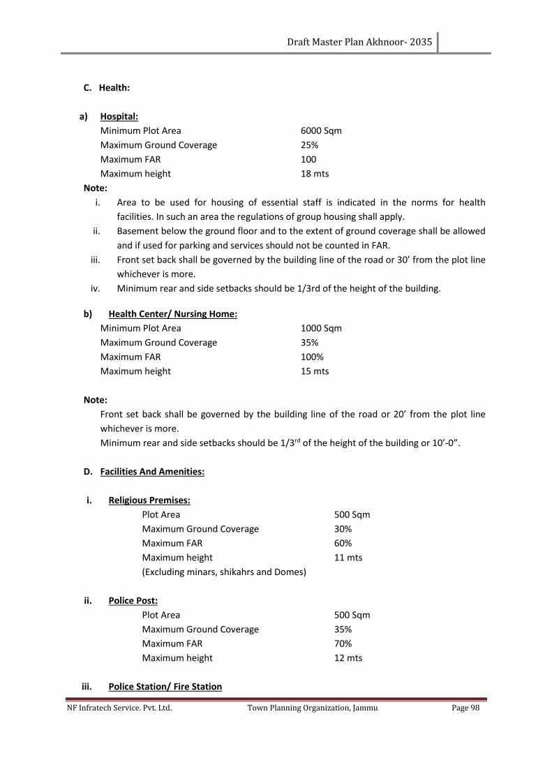
Draft Master Plan Akhnoor- 2035
NF Infratech Service. Pvt. Ltd. Town Planning Organization, Jammu Page 98
C. Health:
a) Hospital:
Minimum Plot Area 6000 Sqm
Maximum Ground Coverage 25%
Maximum FAR 100
Maximum height 18 mts
Note:
i. Area to be used for housing of essential staff is indicated in the norms for health
facilities. In such an area the regulations of group housing shall apply.
ii. Basement below the ground floor and to the extent of ground coverage shall be allowed
and if used for parking and services should not be counted in FAR.
iii. Front set back shall be governed by the building line of the road or 30’ from the plot line
whichever is more.
iv. Minimum rear and side setbacks should be 1/3rd of the height of the building.
b) Health Center/ Nursing Home:
Minimum Plot Area 1000 Sqm
Maximum Ground Coverage 35%
Maximum FAR 100%
Maximum height 15 mts
Note:
Front set back shall be governed by the building line of the road or 20’ from the plot line
whichever is more.
Minimum rear and side setbacks should be 1/3rd of the height of the building or 10’-0”.
D. Facilities And Amenities:
i. Religious Premises:
Plot Area 500 Sqm
Maximum Ground Coverage 30%
Maximum FAR 60%
Maximum height 11 mts
(Excluding minars, shikahrs and Domes)
ii. Police Post:
Plot Area 500 Sqm
Maximum Ground Coverage 35%
Maximum FAR 70%
Maximum height 12 mts
iii. Police Station/ Fire Station
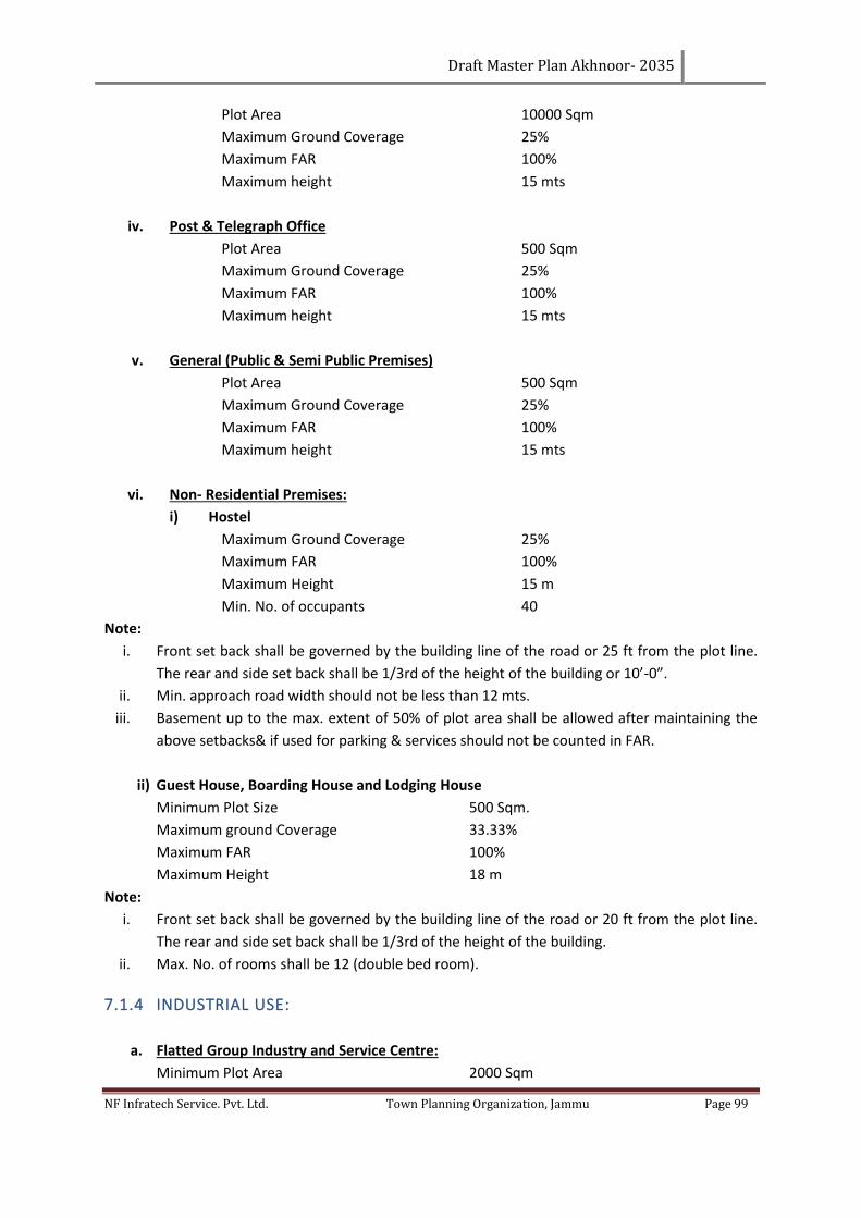
Draft Master Plan Akhnoor- 2035
NF Infratech Service. Pvt. Ltd. Town Planning Organization, Jammu Page 99
Plot Area 10000 Sqm
Maximum Ground Coverage 25%
Maximum FAR 100%
Maximum height 15 mts
iv. Post & Telegraph Office
Plot Area 500 Sqm
Maximum Ground Coverage 25%
Maximum FAR 100%
Maximum height 15 mts
v. General (Public & Semi Public Premises)
Plot Area 500 Sqm
Maximum Ground Coverage 25%
Maximum FAR 100%
Maximum height 15 mts
vi. Non- Residential Premises:
i) Hostel
Maximum Ground Coverage 25%
Maximum FAR 100%
Maximum Height 15 m
Min. No. of occupants 40
Note:
i. Front set back shall be governed by the building line of the road or 25 ft from the plot line.
The rear and side set back shall be 1/3rd of the height of the building or 10’-0”.
ii. Min. approach road width should not be less than 12 mts.
iii. Basement up to the max. extent of 50% of plot area shall be allowed after maintaining the
above setbacks& if used for parking & services should not be counted in FAR.
ii) Guest House, Boarding House and Lodging House
Minimum Plot Size 500 Sqm.
Maximum ground Coverage 33.33%
Maximum FAR 100%
Maximum Height 18 m
Note:
i. Front set back shall be governed by the building line of the road or 20 ft from the plot line.
The rear and side set back shall be 1/3rd of the height of the building.
ii. Max. No. of rooms shall be 12 (double bed room).
7.1.4 INDUSTRIAL USE:
a. Flatted Group Industry and Service Centre:
Minimum Plot Area 2000 Sqm
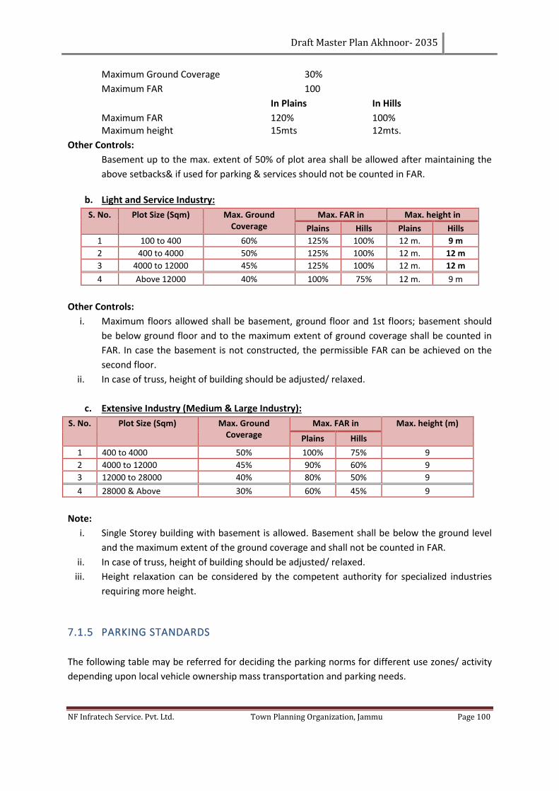
Draft Master Plan Akhnoor- 2035
NF Infratech Service. Pvt. Ltd. Town Planning Organization, Jammu Page 100
Maximum Ground Coverage 30%
Maximum FAR 100
In Plains In Hills
Maximum FAR 120% 100% Maximum height 15mts 12mts.
Other Controls:
Basement up to the max. extent of 50% of plot area shall be allowed after maintaining the
above setbacks& if used for parking & services should not be counted in FAR.
b. Light and Service Industry:
S. No. Plot Size (Sqm) Max. Ground Coverage
Max. FAR in Max. height in
Plains Hills Plains Hills
1 100 to 400 60% 125% 100% 12 m. 9 m
2 400 to 4000 50% 125% 100% 12 m. 12 m
3 4000 to 12000 45% 125% 100% 12 m. 12 m
4 Above 12000 40% 100% 75% 12 m. 9 m
Other Controls:
i. Maximum floors allowed shall be basement, ground floor and 1st floors; basement should
be below ground floor and to the maximum extent of ground coverage shall be counted in
FAR. In case the basement is not constructed, the permissible FAR can be achieved on the
second floor.
ii. In case of truss, height of building should be adjusted/ relaxed.
c. Extensive Industry (Medium & Large Industry):
S. No. Plot Size (Sqm) Max. Ground Coverage
Max. FAR in Max. height (m)
Plains Hills
1 400 to 4000 50% 100% 75% 9
2 4000 to 12000 45% 90% 60% 9
3 12000 to 28000 40% 80% 50% 9
4 28000 & Above 30% 60% 45% 9
Note:
i. Single Storey building with basement is allowed. Basement shall be below the ground level
and the maximum extent of the ground coverage and shall not be counted in FAR.
ii. In case of truss, height of building should be adjusted/ relaxed.
iii. Height relaxation can be considered by the competent authority for specialized industries
requiring more height.
7.1.5 PARKING STANDARDS
The following table may be referred for deciding the parking norms for different use zones/ activity
depending upon local vehicle ownership mass transportation and parking needs.
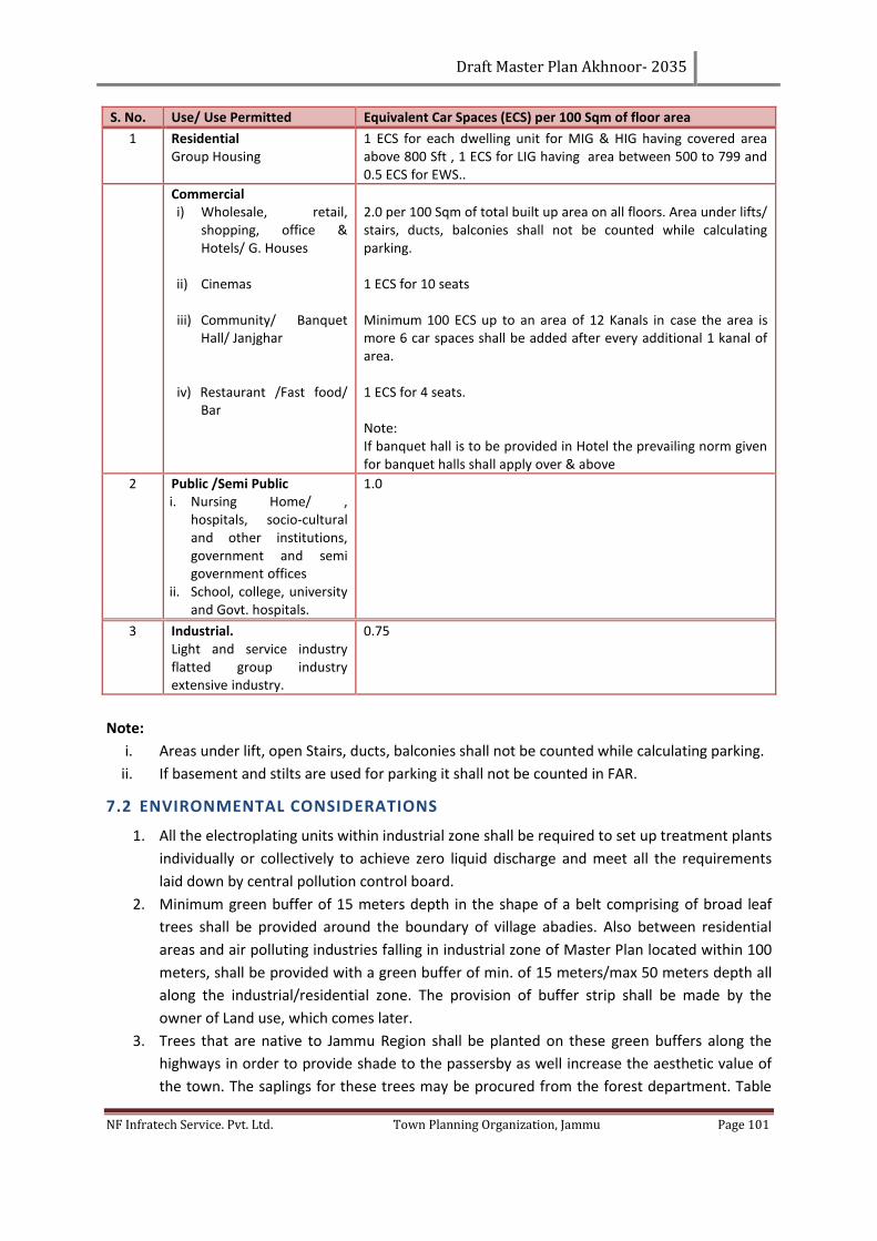
Draft Master Plan Akhnoor- 2035
NF Infratech Service. Pvt. Ltd. Town Planning Organization, Jammu Page 101
S. No. Use/ Use Permitted Equivalent Car Spaces (ECS) per 100 Sqm of floor area
1 Residential Group Housing
1 ECS for each dwelling unit for MIG & HIG having covered area above 800 Sft , 1 ECS for LIG having area between 500 to 799 and 0.5 ECS for EWS..
Commercial i) Wholesale, retail,
shopping, office & Hotels/ G. Houses
ii) Cinemas
iii) Community/ Banquet Hall/ Janjghar
iv) Restaurant /Fast food/ Bar
2.0 per 100 Sqm of total built up area on all floors. Area under lifts/ stairs, ducts, balconies shall not be counted while calculating parking. 1 ECS for 10 seats Minimum 100 ECS up to an area of 12 Kanals in case the area is more 6 car spaces shall be added after every additional 1 kanal of area. 1 ECS for 4 seats. Note: If banquet hall is to be provided in Hotel the prevailing norm given for banquet halls shall apply over & above
2 Public /Semi Public i. Nursing Home/ ,
hospitals, socio-cultural and other institutions, government and semi government offices
ii. School, college, university and Govt. hospitals.
1.0
3 Industrial. Light and service industry flatted group industry extensive industry.
0.75
Note:
i. Areas under lift, open Stairs, ducts, balconies shall not be counted while calculating parking.
ii. If basement and stilts are used for parking it shall not be counted in FAR.
7.2 ENVIRONMENTAL CONSIDERATIONS
1. All the electroplating units within industrial zone shall be required to set up treatment plants
individually or collectively to achieve zero liquid discharge and meet all the requirements
laid down by central pollution control board.
2. Minimum green buffer of 15 meters depth in the shape of a belt comprising of broad leaf
trees shall be provided around the boundary of village abadies. Also between residential
areas and air polluting industries falling in industrial zone of Master Plan located within 100
meters, shall be provided with a green buffer of min. of 15 meters/max 50 meters depth all
along the industrial/residential zone. The provision of buffer strip shall be made by the
owner of Land use, which comes later.
3. Trees that are native to Jammu Region shall be planted on these green buffers along the
highways in order to provide shade to the passersby as well increase the aesthetic value of
the town. The saplings for these trees may be procured from the forest department. Table
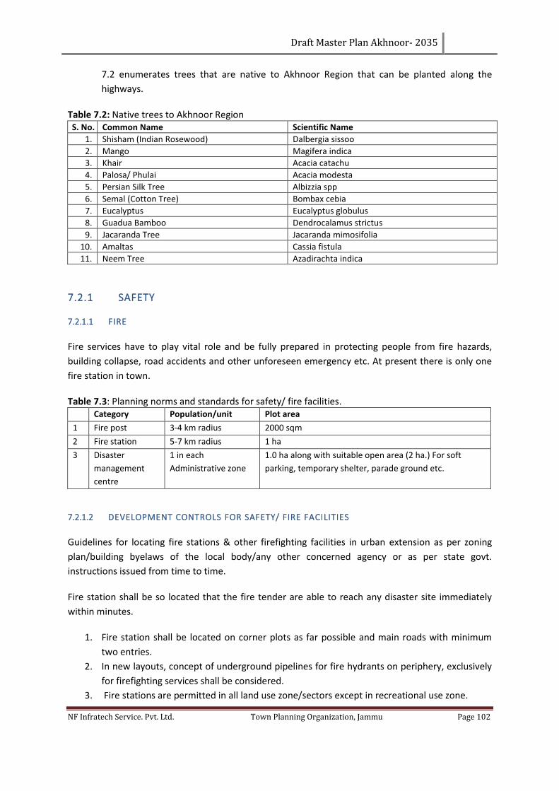
Draft Master Plan Akhnoor- 2035
NF Infratech Service. Pvt. Ltd. Town Planning Organization, Jammu Page 102
7.2 enumerates trees that are native to Akhnoor Region that can be planted along the
highways.
Table 7.2: Native trees to Akhnoor Region S. No. Common Name Scientific Name
1. Shisham (Indian Rosewood) Dalbergia sissoo
2. Mango Magifera indica
3. Khair Acacia catachu
4. Palosa/ Phulai Acacia modesta
5. Persian Silk Tree Albizzia spp
6. Semal (Cotton Tree) Bombax cebia
7. Eucalyptus Eucalyptus globulus
8. Guadua Bamboo Dendrocalamus strictus
9. Jacaranda Tree Jacaranda mimosifolia
10. Amaltas Cassia fistula
11. Neem Tree Azadirachta indica
7.2.1 SAFETY
7.2.1.1 FIRE
Fire services have to play vital role and be fully prepared in protecting people from fire hazards,
building collapse, road accidents and other unforeseen emergency etc. At present there is only one
fire station in town.
Table 7.3: Planning norms and standards for safety/ fire facilities. Category Population/unit Plot area
1 Fire post 3-4 km radius 2000 sqm
2 Fire station 5-7 km radius 1 ha
3 Disaster
management
centre
1 in each
Administrative zone
1.0 ha along with suitable open area (2 ha.) For soft
parking, temporary shelter, parade ground etc.
7.2.1.2 DEVELOPMENT CONTROLS FOR SAFETY/ FIRE FACILITIES
Guidelines for locating fire stations & other firefighting facilities in urban extension as per zoning
plan/building byelaws of the local body/any other concerned agency or as per state govt.
instructions issued from time to time.
Fire station shall be so located that the fire tender are able to reach any disaster site immediately
within minutes.
1. Fire station shall be located on corner plots as far possible and main roads with minimum
two entries.
2. In new layouts, concept of underground pipelines for fire hydrants on periphery, exclusively
for firefighting services shall be considered.
3. Fire stations are permitted in all land use zone/sectors except in recreational use zone.
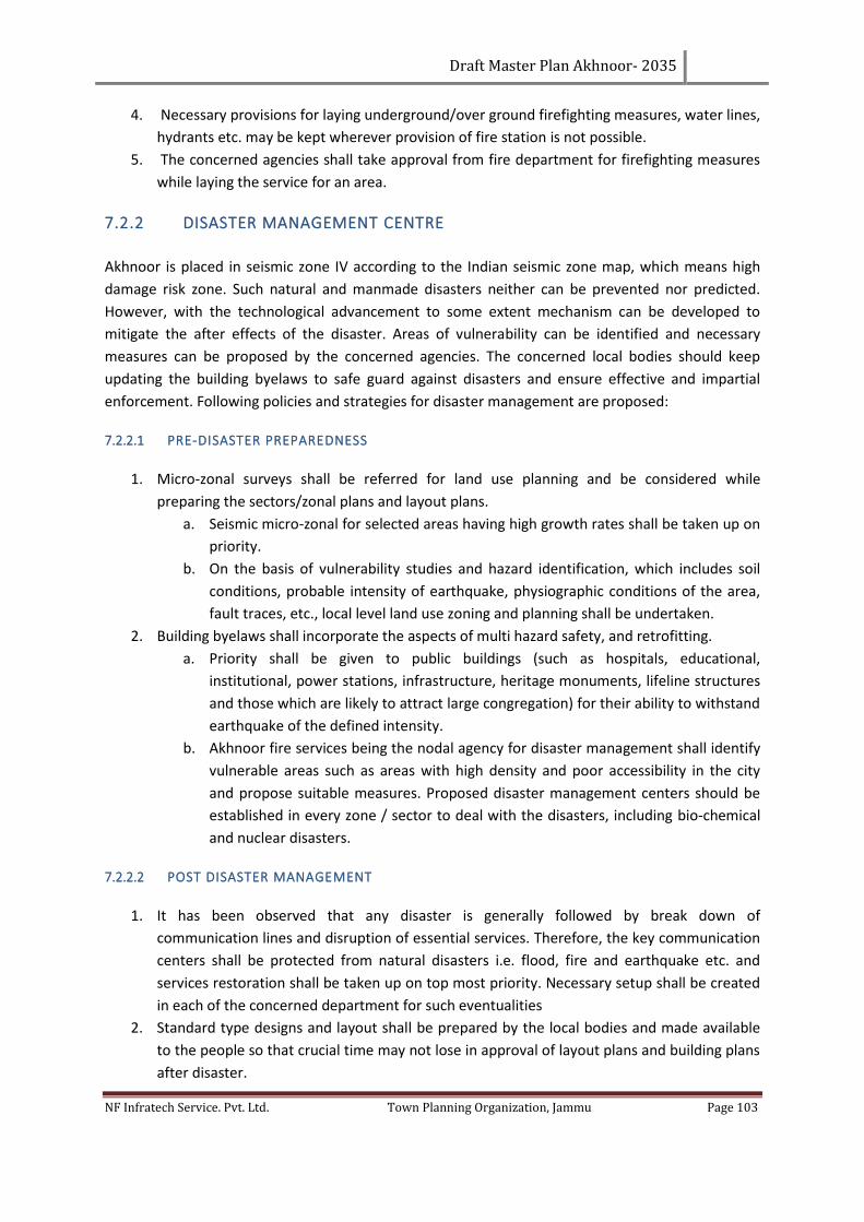
Draft Master Plan Akhnoor- 2035
NF Infratech Service. Pvt. Ltd. Town Planning Organization, Jammu Page 103
4. Necessary provisions for laying underground/over ground firefighting measures, water lines,
hydrants etc. may be kept wherever provision of fire station is not possible.
5. The concerned agencies shall take approval from fire department for firefighting measures
while laying the service for an area.
7.2.2 DISASTER MANAGEMENT CENTRE
Akhnoor is placed in seismic zone IV according to the Indian seismic zone map, which means high
damage risk zone. Such natural and manmade disasters neither can be prevented nor predicted.
However, with the technological advancement to some extent mechanism can be developed to
mitigate the after effects of the disaster. Areas of vulnerability can be identified and necessary
measures can be proposed by the concerned agencies. The concerned local bodies should keep
updating the building byelaws to safe guard against disasters and ensure effective and impartial
enforcement. Following policies and strategies for disaster management are proposed:
7.2.2.1 PRE-DISASTER PREPAREDNESS
1. Micro-zonal surveys shall be referred for land use planning and be considered while
preparing the sectors/zonal plans and layout plans.
a. Seismic micro-zonal for selected areas having high growth rates shall be taken up on
priority.
b. On the basis of vulnerability studies and hazard identification, which includes soil
conditions, probable intensity of earthquake, physiographic conditions of the area,
fault traces, etc., local level land use zoning and planning shall be undertaken.
2. Building byelaws shall incorporate the aspects of multi hazard safety, and retrofitting.
a. Priority shall be given to public buildings (such as hospitals, educational,
institutional, power stations, infrastructure, heritage monuments, lifeline structures
and those which are likely to attract large congregation) for their ability to withstand
earthquake of the defined intensity.
b. Akhnoor fire services being the nodal agency for disaster management shall identify
vulnerable areas such as areas with high density and poor accessibility in the city
and propose suitable measures. Proposed disaster management centers should be
established in every zone / sector to deal with the disasters, including bio-chemical
and nuclear disasters.
7.2.2.2 POST DISASTER MANAGEMENT
1. It has been observed that any disaster is generally followed by break down of
communication lines and disruption of essential services. Therefore, the key communication
centers shall be protected from natural disasters i.e. flood, fire and earthquake etc. and
services restoration shall be taken up on top most priority. Necessary setup shall be created
in each of the concerned department for such eventualities
2. Standard type designs and layout shall be prepared by the local bodies and made available
to the people so that crucial time may not lose in approval of layout plans and building plans
after disaster.
Draft Master Plan Akhnoor- 2035
NF Infratech Service. Pvt. Ltd. Town Planning Organization, Jammu Page 104
3. Disaster management centers have been proposed to serve people in the case of disaster
and provide emergency shelters.
Due to the heavy rain on 03, 04 and 05 Sept. 2014, the water level of Chenab river reached upto
48.5’ which was turn into a big flood problem. The details of the villages, affected by the flood
are given in the Annexure No. 9.4.8.
7.3 OTHER DEVELOPMENT CONTROLS AND GUIDELINES
1. Regulation for village abadis: Special building regulations shall be prepared for the
development and regulation of an area falling within the lal dora or phirni of the villages
falling in the local planning area.
2. All panchayat land of villages falling in local planning area shall be used exclusively for public
and semi-public uses including utilities, services, physical and social infrastructure, parks,
open spaces, community facilities etc. and not for any other purpose.
3. The existing high tension lines shall be shifted along the road but outside the right of way to
ensure unhindered ROW for traffic and other services for all times.
4. The minor drains shall have minimum 10 meters wide (or as may be specified by the state
govt. from time to time) green strips on either side of the drain. Other major water bodies
shall have minimum 30 meters (or as may be specified by the state govt. from time to time)
green strips on each side. Realignment of water bodies shall be permissible wherever
feasible, subject to the certification by the engineering department to ensure free flow of
storm water.
5. Contiguous expansion of village abadis in non-residential zones of Master Plan is not
permissible. However, for the village abadi falling in the residential zone of Master Plan, no
such restrictions shall be applicable.
7.3.1 TRANSFERABLE DEVELOPMENT RIGHTS
To facilitate development, it is necessary to accord top priority to the implementation of public
utilities and infrastructure (such as roads, parks, green belts etc.) which will in turn encourage
planned development/regulated urbanization. However, the respective technical agency or
authority will not be able to proceed with its implementation programmes until the ownership of
private land affected by these public utilities and infrastructure has been transferred to the state or
to the relevant authority(s). Acquisition of private land for this purpose is proposed to be carried out
through one of the following options:
1. Cash compensation to be paid to affected land owners whose land is to be acquired or a
land-pooling scheme may be formulated and implemented.
Out of these options, use of mechanism of TDR (Transfer of Development Rights) is recommended
due to the reasons specified below:
1. It is relatively simple and direct mechanism to implement and execute.
2. The requisite public infrastructure projects can be implemented quickly, thus facilitating
rapid urban development.
Draft Master Plan Akhnoor- 2035
NF Infratech Service. Pvt. Ltd. Town Planning Organization, Jammu Page 105
3. The interests of affected landowners are protected.
The TDR scheme shall be restricted to development projects for public infrastructure and facilities
which shall be announced from time to time. The additional FAR shall not be transferable from one
LPA to another. The competent authority on priority shall finalize detailed policy guidelines on the
operation and implementation of TDR Scheme.
Important note:
In addition to all these building byelaws and development controls, the byelaws described in the
Jammu and Kashmir municipal council act 2000 may also be applied on any building as per the site
requirement.
7.4 ZONING REGULATION
Zoning regulations are basic tools for implementation and enforcement of a development plan
within the frame of the Land use proposals with the intention of achieving orderly growth and
development of the town as envisaged.
Zoning regulations help in controlling density as well as land use in ensuring standards provided for
the future expansion of each zone in an appropriate manner.
The enforcement of zoning regulations is like the enforcement of building bye laws. It will therefore
be simpler to follow and can also be enforced by the concerned department through a qualified
Town and Country Planner holding delegated powers.
The enforcement of zoning regulations will require a detailed development plan of the planning
area. The adoption of the regulations will, therefore, guide to undertake the necessary physical
surveys and also to keep the land record up-to-date so as to enable the effective enforcement of the
zoning regulations.
Zoning regulations shall be applicable to the entire planning area except areas designated otherwise
like Defense areas. There will be a separate set of norms to deal with such areas. The zoning
regulations are broad in nature as follows.
7.4.1 RESIDENTIAL
The Residential Use Zone can be subdivided into
1. Primary Residential Zone: R1,
2. Mixed Residential Zone: R2 and
3. Unplanned/ Informal residential Zone: R3.
The activities Permitted, Restricted and Prohibited in Residential land use zone shall be as given
below:
Draft Master Plan Akhnoor- 2035
NF Infratech Service. Pvt. Ltd. Town Planning Organization, Jammu Page 106
7.4.1.1 PERMITTED USES
Residence – plotted, (detached, semi-detached and row housing) group housing houses, residential
flat, residential-cum-work, hostels, boarding and lodging (accommodation for transit employees of
Govt./ Local Bodies) houses, Baratghar/ marriage hall, community hall, old age home, police post,
guest houses, crèches, day care centre, convenience shopping centers, local (retail shopping),
medical clinic, dispensaries, nursing home and health centers (20 bed), dispensary for pets and
animals, professional offices, educational buildings: (nursery, primary, high school, college), school
for mentally/ physically challenged, research institutes, community centers, religious premises ,
library, gymnasium, park/tot-lots, plant nursery, technical training centre, yoga centers/health
clinics, exhibition and art gallery, clubs, banks/
ATM, police stations, taxi stand/three wheeler stands, bus stops, electrical distribution depot, water
pumping station, post offices, hostels of non-commercial nature, kindergartens, public utilities and
buildings except service and storage yards.
7.4.1.2 RESTRICTED USES/ACTIVITIES
Dharamshala, foreign missions, night shelters, petrol pumps, motor vehicle repairing
workshop/garages, household industry, bakeries and confectionaries, storage of LPG gas cylinders,
burial-grounds, restaurants and hotels, printing press, go-downs/warehousing, bus depots without
workshop, cinema hall, auditoriums, markets for retail goods, weekly markets (if not obstructing
traffic circulation and open during non-working hours), informal markets, multipurpose or junior
technical shops, transient visitors camp, municipal, state and central government offices.
7.4.1.3 USES/ACTIVITIES PROHIBITED
Heavy, large and extensive industries: noxious, obnoxious and hazardous industries, warehousing,
storage go-downs of perishables, hazardous, inflammable goods, workshops for buses etc., slaughter
housing wholesale mandis, hospitals treating contagious diseases, sewage treatment plant/disposal
work, water treatment plant, solid waste dumping yards, outdoor games stadium, indoor games
stadium, shooting range, zoological garden, botanical garden, bird sanctuary, picnic hut,
international conference centre, courts, sports training centre, reformatory, district battalion office,
forensic science laboratory.
7.4.2 COMMERCIAL
7.4.2.1 USES PERMITTED
Dwellings of employees working in the area; offices, retail business, departmental store, hotels,
restaurants and their accessory uses, professional business including educations coaching, theatres,
cinemas, public assembly halls, cultural centers, social and welfare institutions, libraries, electric sub-
station, fire station, post office, police post, clinics, nursing homes, public facility buildings, temples,
mosques, churches and other religious buildings, car and scooter parking, taxi and auto rickshaw
stands, garbage dhalaos.
Draft Master Plan Akhnoor- 2035
NF Infratech Service. Pvt. Ltd. Town Planning Organization, Jammu Page 107
7.4.2.2 PERMISSIBLE ON APPLICATION TO COMPETENT AUTHORITY
Service industries which neither involve manufacturing nor requiring extensive land, petrol filling
stations, commercial entertainment of a transient nature like a circus; Clean industries employing
not more than 40 persons, with or without power; Coal & Fire wood/timber storage yards, transport
terminals for both goods and passengers.
7.4.2.3 PROHIBITED
All uses not specifically mentioned herein including the following:
Quarrying of gravel, sand, clay, and stone except for the purpose of development of the area,
agricultural uses except nurseries, hot houses and green houses. Warehousing and storage of
perishable and inflammable commodities
7.4.3 LOCAL COMMERCIAL
7.4.3.1 USES PERMITTED
All retail and wholesale business and their accessory uses, clinics, nursing homes, professional
business establishments, offices, banks and financial institutions, hotels and restaurants,
commercial entertainment of a transient nature, service industries, petrol filling stations with
garages and service station, public facility buildings, newspaper offices with printing presses,
warehousing for nonperishable and non-flammable commodities, electric sub-station, post &
telegraph offices, fire station, police station, telephone exchange, cinema, theatre, LPG distribution
center, transport terminals for goods and passengers, parking for cars, scooters, taxi and auto
rickshaw, garbage dhalaos.
7.4.3.2 PERMISSIBLE ON APPLICATION TO COMPETENT AUTHORITY
Transit accommodation, temples, mosques, churches, and other religious buildings; all clean
industries not employing more than 20 persons, storage for perishable and inflammable goods;
Sports stadium, swimming pools and other recreational uses, hospitals, technical education and
research institutions
7.4.3.3 PROHIBITED
Dwellings except those of essential watch and ward personnel.
All agricultural uses, quarrying of gravel, sand, clay or stone except for purpose of development of
the area.
7.4.4 LIGHT INDUSTRY
7.4.4.1 USES PERMITTED
All types of light industries, clean industries and service industries, warehousing and storage for
light & service industries, newspaper offices with printing press and accessory uses, petrol filling
Draft Master Plan Akhnoor- 2035
NF Infratech Service. Pvt. Ltd. Town Planning Organization, Jammu Page 108
stations with garages and service stations, parks and playgrounds, nurseries and greenhouses,
medical centers, restaurants, public utility buildings, transport terminals for goods and passengers,
cars, scooters, auto rickshaw and taxi stands. The minimum road within this use zone shall be 18m
R/w.
7.4.4.2 PERMISSIBLE ON APPLICATION TO COMPETENT AUTHORITY
Commercial entertainment of a transient nature like a circus, warehousing & storage of perishable
and inflammable goods, sports stadia, swimming pools and other recreational uses.
Junk yards, hospitals, nursing homes, and technical education and research institutions
7.4.4.3 PROHIBITED
Dwellings except of essential watch and ward personnel; Religious buildings, boarding houses,
rooming houses, irrigated farms and sewage farms; Quarrying of gravel, sand, clay or stone except
for the purpose of development of the area
7.4.4.4 INDUSTRIES PROHIBITED
Manufacturing/refining of ammonia bleaching powder, chlorine, asphalt, brick, terracotta, gypsum,
lime, plaster of paris, coke, creosote, glucose, starch, dye, explosives or fireworks or storage thereof
in excess of 250 kg. fertilizer, gas (fuel or illuminating) in excess of 30 cu.m per day or storage in
excess of 300 cu.m, gelatin or glue or dye from fish or animal refuse or offal, hydrochloric or nitric or
sulphuric or sulphurous acid, lampblack; linoleum or oil cloth or prexylim. Blast furnace, coal or junk
yard, coal, wood or tar or manufacture of any of their distilled products, crop forges, fat, grease,
lard or tallow manufacture, refining flour or grist millo, hot rolling mill, incineration, reduction or
dumping of dead animals, garbage, official or refuse except when accumulated and consumed on
the same premises without the emission of odour, production or refining or storage above ground of
petroleum or other inflammable liquids except heating fuels, slaughtering of animals, tanning or
curing, or storage of raw hides and skins, tyre recapping.
7.4.5 GENERAL INDUSTRY
7.4.5.1 USES PERMITTED
All industries except obnoxious or hazardous industries, warehouses, storage, accessory uses, and all
other uses permitted in the light industrial zone, junk yards, public utility building, car, scooter, auto
rickshaw and taxi stands. The minimum road within this use zone shall be 24 m R/W.
7.4.5.2 PERMISSIBLE ON APPLICATION TO COMPETENT AUTHORITY
Storage of perishable & inflammable goods, sport stadia, swimming pools and other recreational
uses, technical or research institutions, quarry of gravel, sand, clay or stone.
Draft Master Plan Akhnoor- 2035
NF Infratech Service. Pvt. Ltd. Town Planning Organization, Jammu Page 109
7.4.5.3 PROHIBITED
Dwellings, except those of essential watch and ward personnel and workers of this area; Religious
buildings, boarding houses and rooming houses; Irrigated farms and sewage farms; All uses not
specifically mentioned herein.
7.4.6 PUBLIC SEMIPUBLIC
The Public and Semi Public use zone can be sub divided into
1. Govt. / Semi Govt. / Public Offices: PS 1,
2. Govt. land use: PS 2,
3. Police Headquarter/ Station. Police line: PS 3,
4. Educational and Research: PS 4,
5. Medical and Health: PS 5,
6. Socio Cultural and Religious (incl. Cremation and Burial Grounds: PS 6 and
7. Utilities and Services: PS 7.
The activities Permitted, Restricted and Prohibited in Industrial land use zone shall be as given
below:
7.4.6.1 PERMITTED USES/ACTIVITIES
Government offices, central, state, local and semi government, public undertaking offices, Defense
court, universities and specialized educational institute, polytechnic, colleges, schools, nursery and
kindergarten(not to be located near hospital or health care facility), research and development
centers, social and welfare centers, libraries, social and cultural institutes, religious
buildings/centers, conference halls, community halls, barat ghar, Dharamshala, guest house,
museum/art galleries, exhibition centers, auditoriums, open air theatre, recreational club,
playground, banks, police station/police posts, police lines, police headquarters, jails, fire
stations/fire posts, post and telegraph, public utilities and buildings, solid waste dumping
grounds/sites, post offices, local state and central government offices and use for Defense purposes,
bus and railway passenger terminals, public utility and buildings, local municipal facilities, incidental
to government offices and for their use, monuments, radio transmitter and wireless stations,
telecommunication center, telephone exchange, hospitals, health centers, nursing homes,
dispensaries and clinic.
7.4.6.2 RESTRICTED ACTIVITIES/USES
Residential flat and residential plot for group housing for staff employees, hostels, water supply
installations, sewage disposal works, service stations, railway stations/yards, bus/truck terminals,
Draft Master Plan Akhnoor- 2035
NF Infratech Service. Pvt. Ltd. Town Planning Organization, Jammu Page 110
burial grounds, cremation grounds and cemeteries/graveyards, warehouse/storage godowns,
helipads, commercial uses/centers, other uses/ activities.
7.4.6.3 PROHIBITED USES/ACTIVITIES
Heavy, extensive and other obnoxious, hazardous industries, slaughter-houses, junk yards,
wholesale mandis, dairy and poultry farms, farm-houses, workshop for servicing and repairs,
processing and sale of farm product and uses not specifically permitted herein.
7.4.7 OPEN SPACES & PARKS
7.4.7.1 USES PERMITTED
Sports stadium, swimming pools, gardens, parks, playgrounds, Golf courses and other recreational
uses requiring extensive open space with its accessory uses. A district level park is proposed
alongside proposed Hanuman Chowk to Jourian Road.
7.4.7.2 PROHIBITED
Dwellings except of watch and ward personnel.
All other uses not specifically permitted.
7.4.8 AGRICULTURAL (GREEN BELT) AND PERIPHERY AREA
7.4.8.1 PERMITTED USES
Dwellings for the people engaged on the farm, farmhouses, accessory buildings, agriculture,
horticulture, dairy, poultry farms, animal rearing and breeding, stables for riding, etc., storage,
processing and sale of farm produce, petrol and other fuel filling stations, temples, churches,
mosques, other religious buildings and public utility building.
7.4.8.2 PERMISSIBLE ON APPLICATION TO COMPETENT AUTHORITY
Quarry of gravel, sand, clay or stone, limekilns, brick-kilns, workshops for servicing and repair of farm
machinery, service stations and warehousing.
7.4.8.3 PROHIBITED
All other uses not specifically permitted herein.
7.4.9 TOURISM ZONE
7.4.9.1 PERMITTED USES
All types of public utilities and public buildings , regional level entertainment places, Residential use
(plotted/flatted), commercial uses like Shopping malls, Multiplexes, IT/ITES, Institutes, Hotels,
Draft Master Plan Akhnoor- 2035
NF Infratech Service. Pvt. Ltd. Town Planning Organization, Jammu Page 111
Motels, Hospitals, Clinics, Amusement parks, Rides, Water sports, Green houses, Nurseries, Mela
ground
7.4.9.2 PERMISSIBLE ON THE APPLICATION TO COMPETENT AUTHORITY
Commercial like flowers, bakery items, confectionary items, Karyana, general store, dairy product,
stationery, books, gifts, book binding, Photostat, fax, SID, PCO, cybercafé, call phone, booths, meat,
poultry and fish shop, pan shop, barbershop, hair dressing saloon, beauty parlor, laundry, dry
cleaning, ironing, sweet shop, tea stall without sitting arrangement, chemist shop, clinic, dispensary,
pathology lab, optical shop, readymade, garments, cloth shop, ATM.
7.4.9.3 PROHIBITED
All other uses not specifically permitted herein.
Exceptions
1. Any use not listed above under a specific zone will not be permissible in the respective zone
2. Uses determined by the Chief Town Planner, Jammu and Kashmir as compatible with uses
permissible shall be allowed in respective zones.
7.5 RESIDENTIAL DENSITIES
The entire Residential zone for LPA, Akhnoor has been defined in the Proposed Land Use. The
Residential Zone has been divided into two sub zones. Keeping in view the peculiar quality and
pattern of development within core town, the area enclosed within the core town has been
designated as especially residential zone whereas remaining residential area has been put into other
category. The maximum permissible residential density in the sub-zone other than the core city shall
be person per hectare. The gross density for the core town shall not exceed persons per hectare.
7.5.1 CORE TOWN
Keeping in view the special character of the core town and its pattern of development, special
regulations for the development of area falling within core town shall be formulated in order to
ensure decongestion of population and decongestion of activities for creating more open spaces and
improving the quality of life by making available land for physical and social infrastructure. Strategies
would also include prioritization of pedestrian mobility in the congested area of Core town,
minimizing change of land use, minimizing sub-division of land, preserving and enhancing the
ambience of buildings of historical, cultural and religious importance besides rationalizing the traffic
and transportation.
7.6 IMPLEMENTATION OF THESE REGULATIONS
1. All authorities competent to grant permission for layout or sub-division of land or
construction of building or development of land in any other form shall ensure that the
permitted development is in compliance with these Regulations.
Draft Master Plan Akhnoor- 2035
NF Infratech Service. Pvt. Ltd. Town Planning Organization, Jammu Page 112
2. Landowners desirous of developing their land can obtain, by applying to the designated
authority in writing and giving details of their land along with necessary maps, a list of
permissible uses.
3. Similarly, landowners proposing development of certain uses on their land can obtain
certificate of “Compliance with Master Plan” from a designated authority.
Draft Master Plan Akhnoor- 2035
NF Infratech Service. Pvt. Ltd. Town Planning Organization, Jammu Page 113
CHAPTER 8. FACADE CONTROL AND DEVELOPMENT MEASURE
Façade treatment and the architectural detail of buildings contribute significantly to the way a
building ‘reads’ from the street and to the character and continuity of the streetscape. The
composition and detailing of the building façade also has an impact on the apparent bulk and scale
of a building. It is important when considering the design of new development that the predominant
patterns, compositions and articulation of façades reinforce the character and continuity of the
streetscape.
Design consideration is to be given to the underlying building materials that contribute to the
character of a building. Such things include roof shape, pitch and overhangs; entry porches,
verandas, balconies and terraces; materials, finishes, fixtures, patterns, fenestrations, colors and
detailing; the location and proportion of windows and doors.
8.1 CONTROLS AND REGULATIONS
In case of Akhnoor only the Zone one (core town) area depicts a special character and there is a
need to frame a façade controls measures for this area. Following are the suggestive measures for
facade control in this area.
1. The façade of the building/blocks shall be maintained on old lines in case of reconstruction
of existing buildings, however the internal changes shall be permissible;
2. The façade of new building on vacant plots shall be in conformity with the architectural
features and elements of the adjoining buildings for buildings
3. The existing parks and green open spaces shall be preserved as such.
4. The exterior design and height of buildings should have their approval to preserve/improve
the beauty of the area rather than beauty of such building.
5. Signs and Outdoor Display Structures / Including Street Furniture on heritage site shall be
framed by Urban Design Wing (of the concerned department). In addition, regulations or
guidelines to regulate signs, outdoor display structures and street furniture on heritage
sites/ or in area shall also be framed.
6. After the guidelines are framed, buildings within heritage precincts or in the vicinity of
heritage sites shall maintain the skyline in the precinct and follow the architectural style
(without any high-rise or multistoried development) as may be existing in the surrounding
area, so as not to diminish or destroy the value and beauty of or the view from the said
heritage sites. The development within the precinct or in the vicinity of heritage sites shall
be in accordance with the guidelines framed by the Executive Commissioner, Municipal
Council / Vice-Chairman, and other concerned departments on the advice of the Heritage
Conservation Committee or separate regulations / guidelines, if any, prescribed for
respective zones by Municipal Council / concerned department.
7. Widening of the existing roads under the Master Plan of the City or in the Layout Plan shall
be carried out considering the existing heritage buildings (even if they are not included in a
Zone 1 zone) or which may affect natural features areas.

Draft Master Plan Akhnoor- 2035
NF Infratech Service. Pvt. Ltd. Town Planning Organization, Jammu Page 114
8. A wing of concerned department will work as watching dogs for the façade control and
urban development throughout the LPA Akhnoor. Especially in the first planning Zone.
8.2 IMPLEMENTATION OF THESE REGULATIONS
1. All authorities competent to grant permission for layout or sub-division of land or
construction of building or development of land in any other form shall ensure that the
permitted development is in compliance with these Regulations.
2. Landowners desirous of developing their land can obtain, by applying to the designated
authority in writing and giving details of their land along with necessary maps, a list of
permissible uses.
3. Similarly, landowners proposing development of certain uses on their land can obtain
certificate of “Compliance with Master Plan” from a designated authority.
Draft Master Plan Akhnoor- 2035
NF Infratech Service. Pvt. Ltd. Town Planning Organization, Jammu Page 115
CHAPTER 9. INSTITUTIONAL FRAMEWORK AND IMPLEMENTATION MECHANISM
9.1 URBAN LAND POLICY
Master Plan is a set of coherent policies for ensuring living environment in a town or city through a
vision for location criteria and factors of accessibility, functionality, optimization and sustainability of
urban uses. In the Master Plan, an attempt has been made to make Urban Land Policy more realistic
by taking cognizance of economic forces, urban forces, ground realities, fiscal empowerment, and
structure/functions of local agencies and requirement of the community at large. The Master Plan of
Akhnoor for a horizon period of 20-years (2014-2034) proposes development encompassing roughly
about 335 hectares of land within the Planning Area Limits. About 90 % of the land is in private
ownership, which is likely to generate impediments in the implementation and enforcement of the
Master Plan proposals. Due to ownership constraints of land, it has been observed over the period
of time in cities/towns, that most of the Master Plans are not able to achieve the desired goals of
planned development. Master Plan recommends the development of a model for the
implementation of proposals by the local authority using the Public-Private Partnership and Public-
Public Partnership. As per the development act of 1970 of Jammu and Kashmir, there is only option
of zonal development plans for the development of urban areas.
Following are the current features of Development Act of Jammu and Kashmir 1970 are:
▪ Provides overall development framework;
▪ Overall direction of urban expansion;
▪ Land use zoning;
▪ City level infrastructure;
▪ Reservation of land for other public semi-public purposes;
▪ Reservation of land for the housing for poor;
▪ Development control regulations (DCRs).
9.1.1 ZONAL DEVELOPMENT PLAN UNDER DEVELOMENT ACT 1970;
1. Area to be declare for development or redevelopment;
2. Specify standards of population density;
3. Provisions related to all any of the following:
▪ Sub division of land/ site in to plan.
▪ Land reserved for roads/pen spaces/ parks etc.
▪ Amenities to be provided in relation to the site buildings.
Some of the other points which will be cover under ZDPs:
• Development
• Acquisition and disposal of land
• Betterment charges
• Man power
Draft Master Plan Akhnoor- 2035
NF Infratech Service. Pvt. Ltd. Town Planning Organization, Jammu Page 116
• Development charges
There is a need for the review of Development Act, so that the private players can be involve for
development and acquisition of land through negations and land pooling just like the following
models of some states of India.
Land procurement through such means naturally requires huge capital investment, which is beyond
the fiscal capabilities of many of the local authorities. As a result, many plans remain confined to
paper planning only. There is a growing consciousness that urban planning should be self-financing
with minimum burden on local authorities or the government. In this context, the Master Plan
proposes a set of techniques for land assembly or land procurement on the pattern of states like
Maharashtra, Gujarat and Andhra Pradesh, which includes the following:
▪ Town Planning Scheme (TPS) by way of land pooling and redistribution;
▪ Mechanism of Transfer of Development Right;
▪ Large scale ownership of land by the government in the town;
▪ Amendment to land acquisition act;
▪ Disposal of urban land by the government on lease hold basis;
▪ Development of private lands in accordance with the development act;
9.1.2 LAND MANAGEMENT PROCESS – GUJRAT
Urban Planning in Gujarat is two-step process as prescribed in the GTPUDA and its rules. The Ist step
is to prepare a Development Plan (DP) for the entire town/city or development area. The 2nd step is
to prepare Town Planning Schemes (TPs) for the smaller portions of the development area for which
the development plan is prepared.
9.1.3 TOWN PLANNING SCHEMES (TPS)
▪ It is an effective instrument for importance of Master Plan;
▪ Land reconstitution;
▪ Local level infrastructure implementation;
▪ Neighbourhood level road network.
9.1.4 PUBLIC PRIVATE PARTNERSHIP FOR AFFORDABLE HOUSING – RAJSTHAN
Public private partnership is merging as an efficient model for delivery of several areas and various
sectors. The concept of PPP in housing sectors has evolved in order to meet the large demand of
housing.
Public Private Partnership model allows state agencies to overcome reserve deficit, improve cost
recovery and increase supply of houses based on demand.
Draft Master Plan Akhnoor- 2035
NF Infratech Service. Pvt. Ltd. Town Planning Organization, Jammu Page 117
9.2 POLICY DIRECTIVES
o The effective public control over land particularly through large-scale acquisition, especially
for creating land banks for achieving major proposals of the Master Plan e.g. housing, nodal
facilities, terminus centres, socio cultural activities, parallel corridors etc. It is also likely to
help to regulate future development of the town and give financial sustainability to weak
Urban Local agencies of the town ensuring control over land values;
o Provision of Utilities and Services after acquisition of land by local agencies and encouraging
the builders and housing cooperatives, urban local agencies etc registered with the planning
agencies and making them vital component of urban development of Akhnoor;
o Government besides propagating plot reconstitution and plan layout shall also develop
planned colonies after bulk acquisition/land pooling to cater the urban poor who otherwise
due to non-affordability are left out of land market. Plots in Housing colonies developed by
Government/Private Entrepreneurs/individuals shall be reserved for the urban poor (EWS &
LIG) as per norms in vogue to avoid growing of urban slums;
o The implementation agencies should invite applications from the interested parties or
individuals having chunk of land within the Master Plan limits to promote private
interventions in the implementation of Land use proposals;
o In the Planning Area, patches of Government land exist. Government land, pasture land,
within the Master Plan limits shall be taken over by the Local Authority constituted for the
purposes of Planning and Development of Akhnoor under the provisions of the J&K
Development Act1970, while as such land within the Municipal Committee limits shall be
handed over to Municipal Committee for creation of assets, development of
amenities/facilities as per the provisions of the J & K Municipal Act 2000.
9.3 IMPORTANCE OF LEGAL FRAMEWORK
Contemporary city planning, through government machinery seeks to regulate market forces, in a
sequential manner towards city building processes with the intention of furthering citizen’s
wellbeing. The proposed Master Plan apart from seeking to lay-out a physical pattern of land use
and transportation linkages for Akhnoor local planning area as a whole, will serve as a guide for
public and government agencies to conform and integrate their sectoral projects into programmes.
Hence it is important that suitable strategies are evolved for implementation of the plan proposals.
The authorities have to be identified within the framework of existing legal framework wherever
possible and if required frame new set of rules and regulations or amend the existing ones.
9.3.1 EXISTING LEGAL FRAMEWORK
At present the building and land development activities in Akhnoor are regulated by the following
regulations:
1. The Jammu and Kashmir Development Act, 1970.
2. The Jammu and Kashmir State Town Planning Act, 1963.
3. The Jammu and Kashmir Municipal Act, 2000.
4. The Jammu and Kashmir Municipal Laws (Amendment) Act, 2011.
Draft Master Plan Akhnoor- 2035
NF Infratech Service. Pvt. Ltd. Town Planning Organization, Jammu Page 118
Out of the above, the Jammu and Kashmir State Town development act 1963 provide for
preparation of Master Plan and regulate development for matters connected therewith the
procedures in the preparation of Master Plan, there are no clear-cut provisions regarding monitoring
and implementation of the plan. Chapter IV provides for use of land and building as per the Master
Plan provisions and permission is to be granted by the Town Planner.
The Jammu Municipal Act 2000, 1999 deals with the rules and regulations and procedures for issuing
building license within the jurisdiction of the Council.
The town planning act 1963 deals with procedures relating to approval of Master Plan,
modifications to the plan, application for planning permission and fees structure for development or
redevelopment.
9.3.2 STRENGTHENING THE LEGAL FRAMEWORK
Development Regulations proposed in the Master Plan is applicable to the entire Akhnoor Planning
Area. In case of conflict between the proposed development regulation and Municipal Committee
Bye laws or any other law, the provisions contained in the proposed development regulation will be
implemented.
The Akhnoor Planning Area includes Akhnoor municipal town and 23 revenue villages. The J and K
Municipal Committee Building Bye laws, 1999 are applicable only within Akhnoor municipal area.
The provisions of the same may be extended to the entire Planning Area.
The Akhnoor Municipal Committee Building Bye Laws contains certain planning parameters like FAR,
Minimum Plot Size, Set Back and Parking etc. Since the proposed development regulations
comprehensively cover all the planning parameters, some of the provisions of the Akhnoor
Municipal Council Building Bye Laws need to be amended to this effect.
9.4 RESTRUCTURING ADMINISTRATION
At present there is the district development board which is the Planning and execution agency. It
includes the public representatives headed by the DDC with the responsibility of formulation of
district plan and fixing of the priorities. It also includes monitoring the progress and financial
department. The coordination between various departments is lacking at present. Akhnoor being
third largest town in Jammu province, it is proposed that Akhnoor development authority as apex
controlling agency needs to be setup to regulate, guide and control the integrated development as
per proposed master plan.
9.4.1 ORGANIZATIONAL STRUCTURE OF AKHNOOR DEVELOPMENT AUTHORITY
To implement the master plan 2035 proposals following organizational setup has been proposed
with its various functional wings.
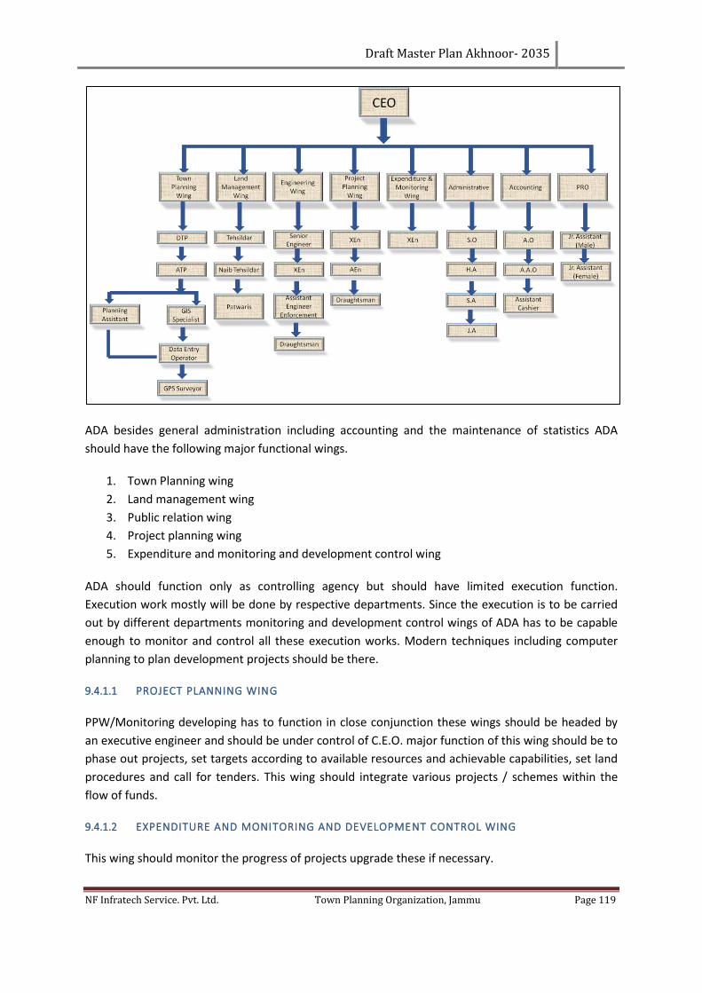
Draft Master Plan Akhnoor- 2035
NF Infratech Service. Pvt. Ltd. Town Planning Organization, Jammu Page 119
ADA besides general administration including accounting and the maintenance of statistics ADA
should have the following major functional wings.
1. Town Planning wing
2. Land management wing
3. Public relation wing
4. Project planning wing
5. Expenditure and monitoring and development control wing
ADA should function only as controlling agency but should have limited execution function.
Execution work mostly will be done by respective departments. Since the execution is to be carried
out by different departments monitoring and development control wings of ADA has to be capable
enough to monitor and control all these execution works. Modern techniques including computer
planning to plan development projects should be there.
9.4.1.1 PROJECT PLANNING WING
PPW/Monitoring developing has to function in close conjunction these wings should be headed by
an executive engineer and should be under control of C.E.O. major function of this wing should be to
phase out projects, set targets according to available resources and achievable capabilities, set land
procedures and call for tenders. This wing should integrate various projects / schemes within the
flow of funds.
9.4.1.2 EXPENDITURE AND MONITORING AND DEVELOPMENT CONTROL WING
This wing should monitor the progress of projects upgrade these if necessary.
Draft Master Plan Akhnoor- 2035
NF Infratech Service. Pvt. Ltd. Town Planning Organization, Jammu Page 120
1. Impose cost control techniques
2. Monitor physical progress for cast cash flow
3. Schedule resources optimality
4. Optimize the project cost
9.4.1.3 LAND MANAGEMENT WING
This wing is the major functional wing should have to prepare the inventory of all lands are acquiring
to give details of Khasra no, ownership, cost etc.
9.4.1.4 TOWN PLANNING WING:
This wing should review the development in view of Master Plan, review the targets premises of
Master Plan at suitable intervals.
Prepare long term development objectives and structures and view on environmental issues.
This being the first Master Plan for Akhnoor there are also proposals on the anvil for preparation of
Master Plans for more towns in J & K it is required that the office of the Town Planner, as provided
for in the town planning act 1963 is further strengthened for effective implementation and
monitoring of the plan proposals. In this context, the following suggestions are made:
9.4.2 POWERS AND FUNCTIONS
The proposed authority will be vested with powers such as, review and revision of Master Plan for
the Planning Area, Implementation of the provisions contained in the approved Master Plan,
Programmes and Projects contemplated in the Master Plan. It will have jurisdiction over the entire
Planning Area including Akhnoor town. The main functions of the Authority will include the
following:
1. Framing policies and strategies towards implementation of Master Plan
2. Realization of identified programmes and projects of the Master Plan, by evolving suitable
implementation mechanism.
3. Approval of building plans and layouts
4. Change of land use and reclassification
5. Dealing with land and building activities in contravention to the provision of the Master Plan
6. Initiate, approve and implement major infrastructure development projects
9.4.3 ROLE AND RESPONSIBILITIES OF THE AGENCIES
A measure of success of the Master Plan would be the extent to which the proposals envisaged in
the plan are implemented in the plan period. The role of various agencies including the government
departments of the Jammu and Kashmir is critical in this regard, and convergence of efforts of all the
concerned stakeholders is required. The departments responsible for the projects enlisted in the
Master Plan need to initiate actions towards preparation of Detailed Project Reports and
Draft Master Plan Akhnoor- 2035
NF Infratech Service. Pvt. Ltd. Town Planning Organization, Jammu Page 121
Environmental Impact Reports wherever necessary and obtain clearance from all relevant
authorities
The Akhnoor development authority could be play its role importantly in implementation of the
various development projects enunciated in the Master Plan relating to Tourism as well as in the
development of the Industrial Estate. The authority could help channelizing the required funds for
the projects through application of innovative public private partnership models.
The role of Information, Publicity and Tourism Department is important in achieving the objectives
of the Master Plan. They need to take appropriate measures to attract more tourists and to create
quality infrastructure for the tourists towards employment generation. While the Master Plan has
included physical projects required in this direction, media publicity and logistics support for the
tourists from the main land could further boost the tourism in the Akhnoor.
As land is an essential component of every project conceived in term of spatial context, the
government departments are to take appropriate steps in acquiring lands for the development
projects.
The Master Plan shall propose Amendments to the Municipal Committee Building Byelaws, 2000 in
consonance with the proposed development regulations, and suggests that the same may be made
applicable for the entire Planning Area till such time, a common bye laws for all panchayats in the
Akhnoor LPA are enacted.
9.5 RESOURCE MOBILIZATION STRATEGY
Implementation of master plan generally requires massive financial investment, mobilization of
which is a complex task. In the pursuit of spatial development, the government should not always be
expected to spend money or participate directly in development activities rather private resources
should also be appropriately mobilized. The role of private sector shall be duly recognized and
utilized in plan implementation. As a general fiscal policy on resource mobilization, it would be
desirable to have a proper mix of public and private sectors. Both plays a symbiotic role in such a
way that the public infrastructure programme is implemented through budgetary sources and
marketed infrastructure. The facilities are provided through private sector while a joint venture
could also be explored where possible. The local authority as such has to come up with innovative
fiscal instruments and ways to mobilize financial resources. One of the ways to enhance fiscal
capabilities of the authority is to shed some of its functions and evolve alternative institutional
arrangements for the performance of such functions. Already some headway has been made in this
regard in other parts of our country. BOT, BOOT, OMT etc are emerging variations of such
partnership arrangements, which need to be explored. Resource Mobilization especially in terms of
fiscal investment during horizon period of master plan for achieving targets is proposed in the light
of alternative investment models. Attempt has been made to explore potential areas of investment
for private investors especially in the operation and maintenance of infrastructure created by Local
Area Authority. As such master plan proposes a restrained role for private sector participation with
respect to fragile environs and environmental sustainability of the area. It is felt that private
Draft Master Plan Akhnoor- 2035
NF Infratech Service. Pvt. Ltd. Town Planning Organization, Jammu Page 122
investment in certain selective areas of development will provide necessary impetus for
infrastructure development in the area.
9.6 PHASING
With limited resources in hand, debarring from horticulture resources, the Master plan asserts that
Local Area Authority should evolve a scientific mechanism for resource mobilization and
implementation of development proposals. It has been proposed that private participation shall be
encouraged to cater the potential infrastructure demand during horizon period of 20 years. It is
urged that the Authority shall provide a conducive environment for public-private-participation and
should develop a mechanism to safeguard the area from destruction through effective checks on
development carried out by private developers. Based on priority of targets, potential demand and
fiscal investment, it is held that the Master Plan will have a horizon period of 20-years to be
implemented in four phases of 5-years.
It proposes that Phase – I shall comprise all those components which may act as catalysts and
contain multiplying effects for development. Therefore, apart from road connectivity, acquisition for
development of housing colony, industrial development, Logistic, dislocation and rehabilitation of
shops and residential structures at major road intersections shall be taken up in Phase-I and Phase-II.
The follow-up phases i.e. Phase-III and IV shall have thrust on further tourism expansion, land
acquisition for further infrastructure development. The Master plan of Akhnoor being a guiding
policy document asserts that possibilities have to be explored to check migration to other major
urban centers by providing the entire infrastructure envisaged in the Master Plan.
9.6.1 PHASE FIRST (2017-21)
1. Development of ring roads;
2. Shifting of government offices, bus stand and hospital;
3. Developments of parking lots along the major roads likes inner roads and Golee market
road;
9.6.2 PHASE SECOND (2021-2026)
1. Development of major residential/ commercial area;
2. Development of sewerage network;
3. Development of outer ring road;
4. Up-gradation and Development of Drainage system;
9.6.3 PHASE THIRD (2026-2031)
1. Development of residential area for population and adequate infrastructure
2. Development of tourism zone and tourism activities in LPA area.
3. Development of river fronts and ghats etc.
Draft Master Plan Akhnoor- 2035
NF Infratech Service. Pvt. Ltd. Town Planning Organization, Jammu Page 123
9.6.4 PHASE FOURTH: (2031-2035)
1. Development of roads, tourism zone and tourism activities in LPA area.
2. Development of residential area for population and adequate infrastructure.
3. Development of gaps by review the all phases.
Akhnoor, due to its location, linkages, phenomenal population growth and urban sprawl is
developing, it is important to effectively implement the proposal of master plan.
This however, will depend considerably on the availability of infrastructure such as housing, power,
transport, water supply, drainage etc. The present level of infrastructure provision is largely
indicated which has to be increased manifold to fulfill the future needs of Akhnoor.
After creation of the development authority as proposed, it needs careful planning, findings means
of abdicate finances for implementation of Master Plan proposals.
As suggested in organizational setup it will take some time and it is only putting this in place, the
development activities can be pursued.
It is assumed, if efforts are made a period till end 2014 the process of notifying the draft master plan
2035 under development act, creation of development authority. Remaining six months,
development authority will be required to create the development climate, mobilizing resources etc.
Consultant estimates that the financial requirement in the first phase to be at around 7 cores for the
land accusation and land development in the phase one. Accordingly various ways of resource
mobilization for the required / investment need to be examined. It has to come as a seed capital or
in the form of loan from the state government.
Consultant also feels that the capital cost of desired level of services like power, roads, water supply,
etc. would be met from state government budgetary allocation which could be channelized through
various concerning departments such as PWD, PHE , PDD , Medical , Educational , Police
Departments.
The consultant feel that the most important source of revenue to will be the sale of land after
accusation and development and the land which will be resolved after shifting the non-conforming
uses like bus stand , fire station , government offices etc.
Since no government land is available hence private land has to be accrued. This accusation could be
possible by obtaining seed capital by either through loan or grant from the state government and
can be allotted the different departments.
It is recommended to immediately develop the parking lots, it should generate revenue by getting
the annual rent of its sale as formal parking.
Draft Master Plan Akhnoor- 2035
NF Infratech Service. Pvt. Ltd. Town Planning Organization, Jammu Page 124
9.7 INTO FUTURE
The proposed land use plan 2035 reflects the development strategies evolved on the basis of many
parameters such as physical, social, economic and environmental. The Master Plan aims to promote
the socio-economic conditions coupled with improvements in quality of life. For successful
implementation of the same the following action programmes are required.
1. Prepare and Implement Detailed Development Plans for the various nodes as suggested in
the Master Plan proposals.
2. Horizontal and Vertical integration of all the sectoral programmes envisaged in the Master
Plan and initiation of action in implementing the same within the timeframe stipulated.
3. Promotion of Public Private Partnership mode of development, especially in the tourism,
industries and housing sectors.
4. Review of the Master plan periodically, to assess the developments taking place and suggest
amendments in accordance with policies of the Government and the priorities of the people.
Following policy measures needs to be considered in the developmental activities:
• Housing is to be as per the overall requirement of the peri-Urban area.
• Provision of proper physical and social infrastructure to the unplanned residential area.
• The village ‘Abadi’ area is be conserved from the future growth by giving green buffer
around the village area.
• Increase the residential density for saving of agricultural rich and marshy areas.
• Area along Chenab River, bypass should be conserved for beautification and future
development.
• 2nd and 3rdRing roads in the LPA should be integrate with the roads of town that will
integrate the whole planning area.
• Reserve the natural resources like water bodies, lakes, river, marshy and agricultural land.
• Existing orchard land will be kept as reserved forest & Promotion of river front development
along river Chenab and water tourism;
Draft Master Plan Akhnoor- 2035
NF Infratech Service. Pvt. Ltd. Town Planning Organization, Jammu Page 125
CHAPTER 10. RESOURCE MOBILIZATION AND IMPLEMENTATION
Adequate amount of land and financial resources will be required to implementation the proposal of
Master Plan. The State and local budgetary support are inadequate for the development of existing
and proposed infrastructure facilities. Since urban development is a continuous phenomenon, city
administration needs to improve its internal resources and management. In the age of the market
economy, there is nothing like availability of free services and facility. The expenditure incurred on
provision of services and facilities will have to be recovered through direct and indirect mean from
the users. Private sector participation needs to be encouraged in order to efficient delivery of
services. Besides budgetary support and mobilization of resources from the market, the following
land base resource mobilization efforts need to be taken up by the urban local body.
10.1 ESTABLISHMENT OF LAND/PROPERTY BANK
1) Preparation of base map for the municipal area and for the development area through
recent satellite images and GIS technology.
2) Identification of additional land on the basis of satellite imagery and revenue records.
3) Acquisition of land for public facilities, services and transport through preparation of urban
land consolidation measures. Town planning scheme can also be adopt here. Thus the
detailed record ownership and management of land will be available with urban local body
and administration which can be used as land bank.
10.2 ASSESSMENT OF USER CHARGES AND HOUSE TAX ON THE BASIS OF ACTUAL USE
There are many properties in urban areas which either is unauthorized or developed in access of
approved development. These have been used mainly for commercial purposes and it is difficult to
remove these properties. There is need to identify such property and penalty in terms of user
charges and house tax.
• Penalties and Punitive charges need to be incorporated. Similarly, additional house tax
needs to be planned for unauthorized development.
• As many heavy and light vehicles have parked on the public land, especially in night.
Therefore, monthly rent needs to collect from these vehicles.
• Permissible FAR needs to be increased upto 1.0 in urban areas. Additional FAR of the marked
sites can be sold out. FAR from 1-2 meter may be saleable by the development authority.
• Additional FAR can be permissible to those land owners who give their land free of cost for
the construction of roads or development of parks. This additional FAR, he can use himself
or sold to any person.
• External development charge and betterment charge needs to be regulated on the basis of
actual displacement expenditure.
• User charges revenue from various public facilities should be increased on the basis of
corresponds to costing.
Draft Master Plan Akhnoor- 2035
NF Infratech Service. Pvt. Ltd. Town Planning Organization, Jammu Page 126
• Land use conversion charge and Impact fee needs to be collected on the basis of actual
constructed property.
• “Free land use Zone” also can be developed by the development authority in which various
non-polluted activities can be permitted after charging of additional impact fee on the basis
of actual demand.
Therefore, these charges will help in efforts to strengthen the financial resource mobilization for
development in the urban area.
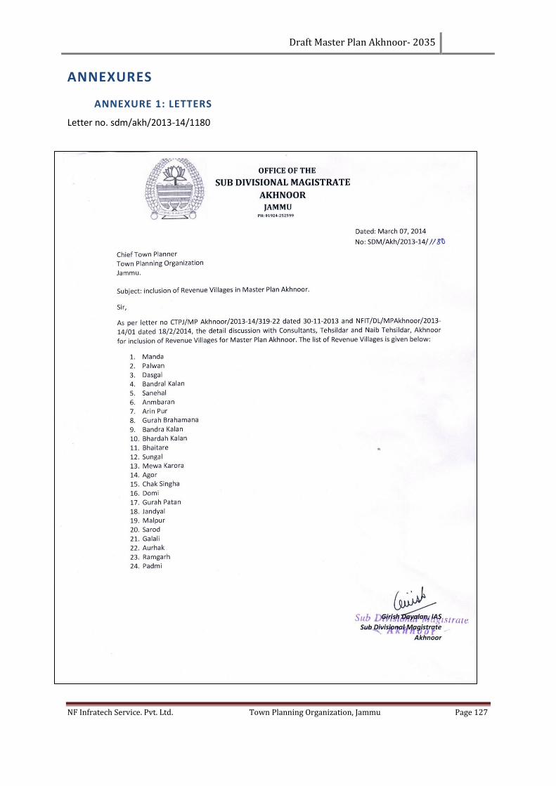
Draft Master Plan Akhnoor- 2035
NF Infratech Service. Pvt. Ltd. Town Planning Organization, Jammu Page 127
ANNEXURES
ANNEXURE 1: LETTERS
Letter no. sdm/akh/2013-14/1180
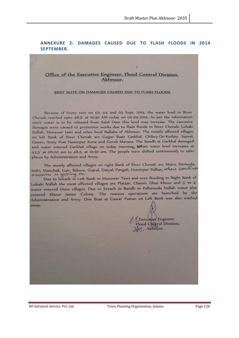
Draft Master Plan Akhnoor- 2035
NF Infratech Service. Pvt. Ltd. Town Planning Organization, Jammu Page 128
ANNEXURE 2: DAMAGES CAUSED DUE TO FLASH FLOODS IN 2014 SEPTEMBER.
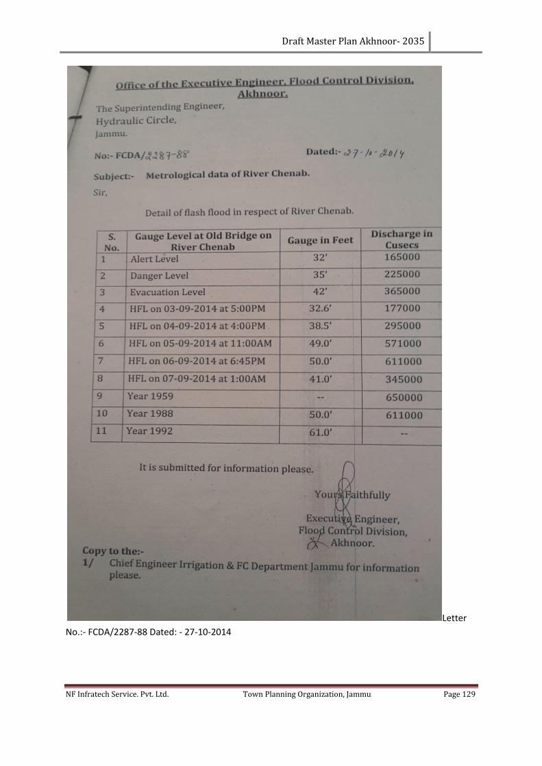
Draft Master Plan Akhnoor- 2035
NF Infratech Service. Pvt. Ltd. Town Planning Organization, Jammu Page 129
Letter
No.:- FCDA/2287-88 Dated: - 27-10-2014
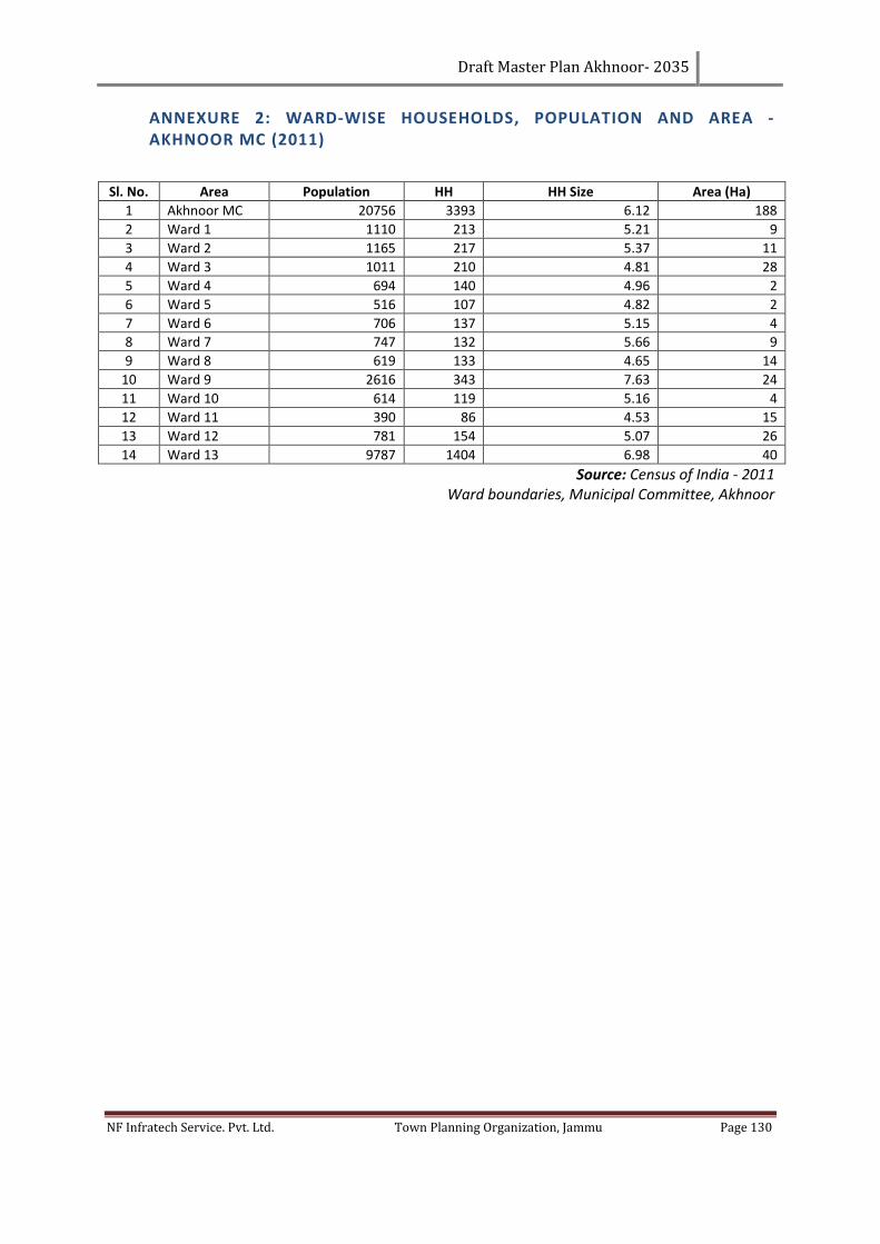
Draft Master Plan Akhnoor- 2035
NF Infratech Service. Pvt. Ltd. Town Planning Organization, Jammu Page 130
ANNEXURE 2: WARD-WISE HOUSEHOLDS, POPULATION AND AREA - AKHNOOR MC (2011)
Sl. No. Area Population HH HH Size Area (Ha)
1 Akhnoor MC 20756 3393 6.12 188
2 Ward 1 1110 213 5.21 9
3 Ward 2 1165 217 5.37 11
4 Ward 3 1011 210 4.81 28
5 Ward 4 694 140 4.96 2
6 Ward 5 516 107 4.82 2
7 Ward 6 706 137 5.15 4
8 Ward 7 747 132 5.66 9
9 Ward 8 619 133 4.65 14
10 Ward 9 2616 343 7.63 24
11 Ward 10 614 119 5.16 4
12 Ward 11 390 86 4.53 15
13 Ward 12 781 154 5.07 26
14 Ward 13 9787 1404 6.98 40
Source: Census of India - 2011 Ward boundaries, Municipal Committee, Akhnoor
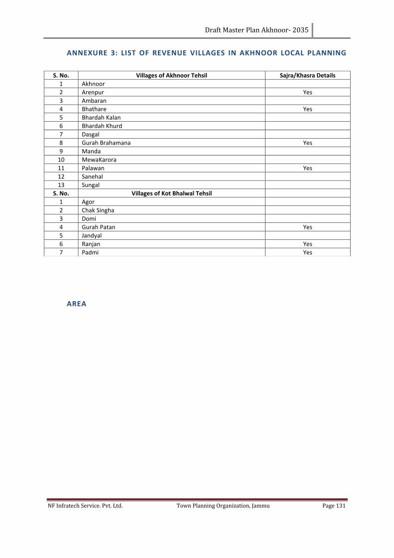
Draft Master Plan Akhnoor- 2035
NF Infratech Service. Pvt. Ltd. Town Planning Organization, Jammu Page 131
ANNEXURE 3: LIST OF REVENUE VILLAGES IN AKHNOOR LOCAL PLANNING
AREA
S. No. Villages of Akhnoor Tehsil Sajra/Khasra Details
1 Akhnoor
2 Arenpur Yes
3 Ambaran
4 Bhathare Yes
5 Bhardah Kalan
6 Bhardah Khurd
7 Dasgal
8 Gurah Brahamana Yes
9 Manda
10 MewaKarora
11 Palawan Yes
12 Sanehal
13 Sungal
S. No. Villages of Kot Bhalwal Tehsil
1 Agor
2 Chak Singha
3 Domi
4 Gurah Patan Yes
5 Jandyal
6 Ranjan Yes
7 Padmi Yes
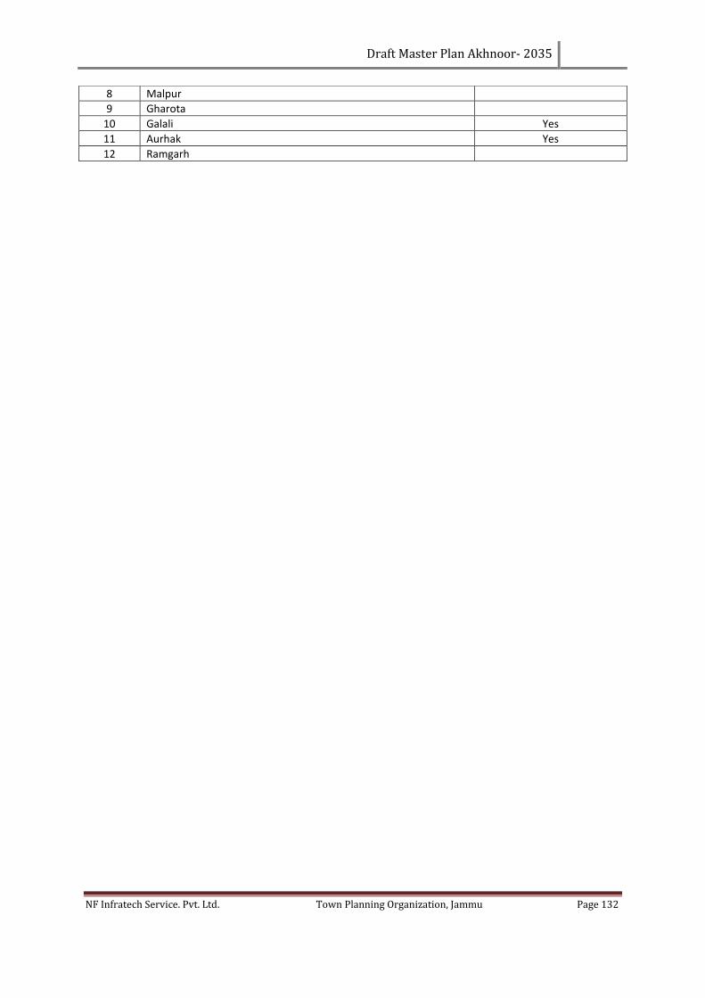
Draft Master Plan Akhnoor- 2035
NF Infratech Service. Pvt. Ltd. Town Planning Organization, Jammu Page 132
8 Malpur
9 Gharota
10 Galali Yes
11 Aurhak Yes
12 Ramgarh
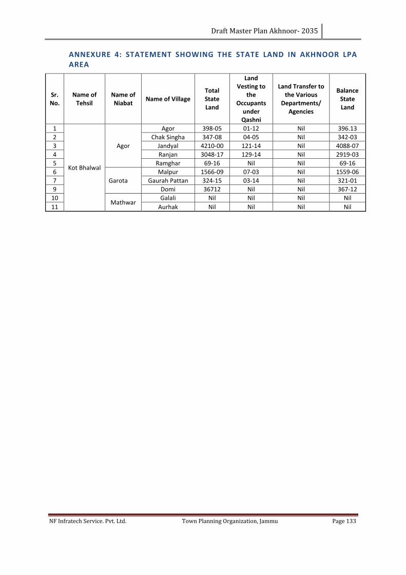
Draft Master Plan Akhnoor- 2035
NF Infratech Service. Pvt. Ltd. Town Planning Organization, Jammu Page 133
ANNEXURE 4: STATEMENT SHOWING THE STATE LAND IN AKHNOOR LPA AREA
Sr. No.
Name of Tehsil
Name of Niabat
Name of Village Total State Land
Land Vesting to
the Occupants
under Qashni
Land Transfer to the Various
Departments/ Agencies
Balance State Land
1
Kot Bhalwal
Agor
Agor 398-05 01-12 Nil 396.13
2 Chak Singha 347-08 04-05 Nil 342-03
3 Jandyal 4210-00 121-14 Nil 4088-07
4 Ranjan 3048-17 129-14 Nil 2919-03
5 Ramghar 69-16 Nil Nil 69-16
6
Garota
Malpur 1566-09 07-03 Nil 1559-06
7 Gaurah Pattan 324-15 03-14 Nil 321-01
9 Domi 36712 Nil Nil 367-12
10 Mathwar
Galali Nil Nil Nil Nil
11 Aurhak Nil Nil Nil Nil
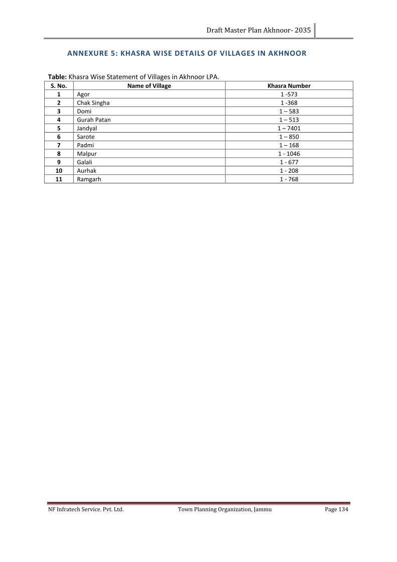
Draft Master Plan Akhnoor- 2035
NF Infratech Service. Pvt. Ltd. Town Planning Organization, Jammu Page 134
ANNEXURE 5: KHASRA WISE DETAILS OF VILLAGES IN AKHNOOR
Table: Khasra Wise Statement of Villages in Akhnoor LPA. S. No. Name of Village Khasra Number
1 Agor 1 -573
2 Chak Singha 1 -368
3 Domi 1 – 583
4 Gurah Patan 1 – 513
5 Jandyal 1 – 7401
6 Sarote 1 – 850
7 Padmi 1 – 168
8 Malpur 1 - 1046
9 Galali 1 - 677
10 Aurhak 1 - 208
11 Ramgarh 1 - 768
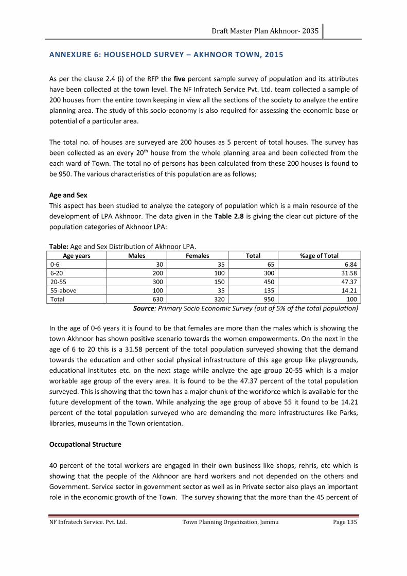
Draft Master Plan Akhnoor- 2035
NF Infratech Service. Pvt. Ltd. Town Planning Organization, Jammu Page 135
ANNEXURE 6: HOUSEHOLD SURVEY – AKHNOOR TOWN, 2015
As per the clause 2.4 (i) of the RFP the five percent sample survey of population and its attributes
have been collected at the town level. The NF Infratech Service Pvt. Ltd. team collected a sample of
200 houses from the entire town keeping in view all the sections of the society to analyze the entire
planning area. The study of this socio-economy is also required for assessing the economic base or
potential of a particular area.
The total no. of houses are surveyed are 200 houses as 5 percent of total houses. The survey has
been collected as an every 20th house from the whole planning area and been collected from the
each ward of Town. The total no of persons has been calculated from these 200 houses is found to
be 950. The various characteristics of this population are as follows;
Age and Sex
This aspect has been studied to analyze the category of population which is a main resource of the
development of LPA Akhnoor. The data given in the Table 2.8 is giving the clear cut picture of the
population categories of Akhnoor LPA:
Table: Age and Sex Distribution of Akhnoor LPA.
Age years Males Females Total %age of Total
0-6 30 35 65 6.84
6-20 200 100 300 31.58
20-55 300 150 450 47.37
55-above 100 35 135 14.21
Total 630 320 950 100
Source: Primary Socio Economic Survey (out of 5% of the total population)
In the age of 0-6 years it is found to be that females are more than the males which is showing the
town Akhnoor has shown positive scenario towards the women empowerments. On the next in the
age of 6 to 20 this is a 31.58 percent of the total population surveyed showing that the demand
towards the education and other social physical infrastructure of this age group like playgrounds,
educational institutes etc. on the next stage while analyze the age group 20-55 which is a major
workable age group of the every area. It is found to be the 47.37 percent of the total population
surveyed. This is showing that the town has a major chunk of the workforce which is available for the
future development of the town. While analyzing the age group of above 55 it found to be 14.21
percent of the total population surveyed who are demanding the more infrastructures like Parks,
libraries, museums in the Town orientation.
Occupational Structure
40 percent of the total workers are engaged in their own business like shops, rehris, etc which is
showing that the people of the Akhnoor are hard workers and not depended on the others and
Government. Service sector in government sector as well as in Private sector also plays an important
role in the economic growth of the Town. The survey showing that the more than the 45 percent of
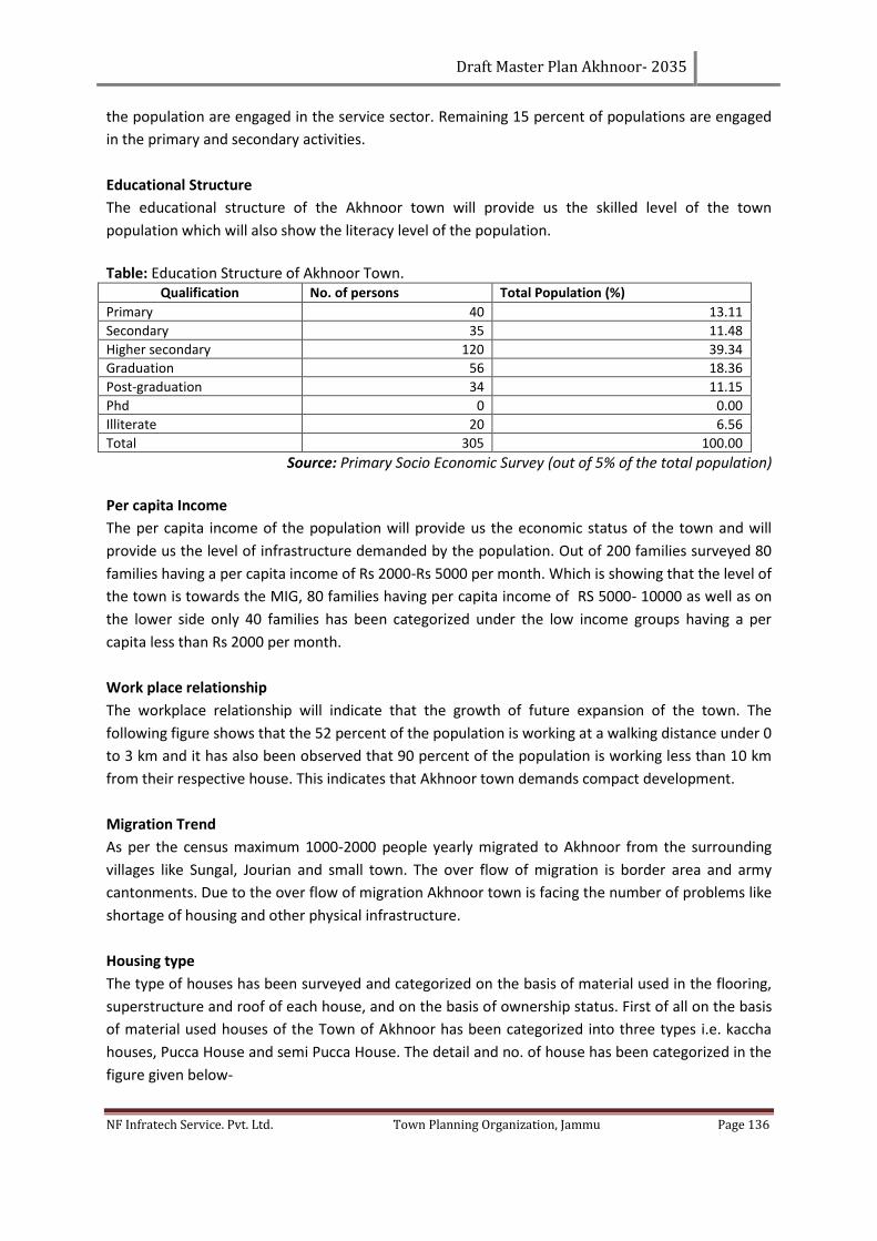
Draft Master Plan Akhnoor- 2035
NF Infratech Service. Pvt. Ltd. Town Planning Organization, Jammu Page 136
the population are engaged in the service sector. Remaining 15 percent of populations are engaged
in the primary and secondary activities.
Educational Structure
The educational structure of the Akhnoor town will provide us the skilled level of the town
population which will also show the literacy level of the population.
Table: Education Structure of Akhnoor Town.
Qualification No. of persons Total Population (%)
Primary 40 13.11
Secondary 35 11.48
Higher secondary 120 39.34
Graduation 56 18.36
Post-graduation 34 11.15
Phd 0 0.00
Illiterate 20 6.56
Total 305 100.00
Source: Primary Socio Economic Survey (out of 5% of the total population)
Per capita Income
The per capita income of the population will provide us the economic status of the town and will
provide us the level of infrastructure demanded by the population. Out of 200 families surveyed 80
families having a per capita income of Rs 2000-Rs 5000 per month. Which is showing that the level of
the town is towards the MIG, 80 families having per capita income of RS 5000- 10000 as well as on
the lower side only 40 families has been categorized under the low income groups having a per
capita less than Rs 2000 per month.
Work place relationship
The workplace relationship will indicate that the growth of future expansion of the town. The
following figure shows that the 52 percent of the population is working at a walking distance under 0
to 3 km and it has also been observed that 90 percent of the population is working less than 10 km
from their respective house. This indicates that Akhnoor town demands compact development.
Migration Trend
As per the census maximum 1000-2000 people yearly migrated to Akhnoor from the surrounding
villages like Sungal, Jourian and small town. The over flow of migration is border area and army
cantonments. Due to the over flow of migration Akhnoor town is facing the number of problems like
shortage of housing and other physical infrastructure.
Housing type
The type of houses has been surveyed and categorized on the basis of material used in the flooring,
superstructure and roof of each house, and on the basis of ownership status. First of all on the basis
of material used houses of the Town of Akhnoor has been categorized into three types i.e. kaccha
houses, Pucca House and semi Pucca House. The detail and no. of house has been categorized in the
figure given below-
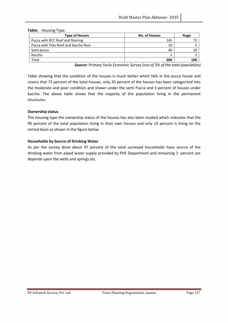
Draft Master Plan Akhnoor- 2035
NF Infratech Service. Pvt. Ltd. Town Planning Organization, Jammu Page 137
Table: Housing Type. Type of Houses No. of Houses %age
Pucca with RCC Roof and flooring 145 72
Pucca with Tiles Roof and Kaccha floor 10 5
Semi pucca 40 20
Kaccha 5 3
Total 200 100
Source: Primary Socio Economic Survey (out of 5% of the total population)
Table showing that the condition of the houses is much better which falls in the pucca house and
covers that 72 percent of the total houses, only 20 percent of the houses has been categorized into
the moderate and poor condition and shown under the semi Pucca and 3 percent of houses under
kaccha. The above table shows that the majority of the population living in the permanent
structures.
Ownership status
The housing type the ownership status of the houses has also been studied which indicates that the
90 percent of the total population living in their own houses and only 10 percent is living on the
rented basis as shown in the figure below
Households by Source of Drinking Water
As per the survey done about 97 percent of the total surveyed households have source of the
drinking water from piped water supply provided by PHE Department and remaining 3 percent are
depends upon the wells and springs etc.
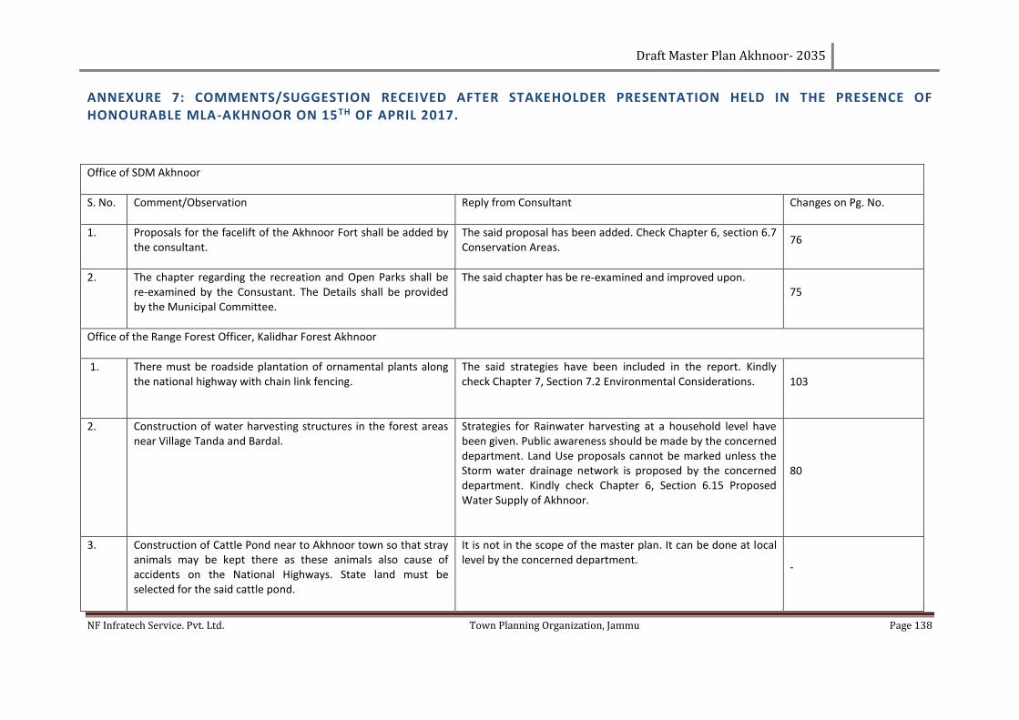
Draft Master Plan Akhnoor- 2035
NF Infratech Service. Pvt. Ltd. Town Planning Organization, Jammu Page 138
ANNEXURE 7: COMMENTS/SUGGESTION RECEIVED AFTER STAKEHOLDER PRESENTATION HELD IN THE PRESENCE OF HONOURABLE MLA-AKHNOOR ON 15TH OF APRIL 2017.
Office of SDM Akhnoor
S. No. Comment/Observation Reply from Consultant Changes on Pg. No.
1. Proposals for the facelift of the Akhnoor Fort shall be added by the consultant.
The said proposal has been added. Check Chapter 6, section 6.7 Conservation Areas.
76
2. The chapter regarding the recreation and Open Parks shall be re-examined by the Consustant. The Details shall be provided by the Municipal Committee.
The said chapter has be re-examined and improved upon. 75
Office of the Range Forest Officer, Kalidhar Forest Akhnoor
1. There must be roadside plantation of ornamental plants along the national highway with chain link fencing.
The said strategies have been included in the report. Kindly check Chapter 7, Section 7.2 Environmental Considerations. 103
2. Construction of water harvesting structures in the forest areas near Village Tanda and Bardal.
Strategies for Rainwater harvesting at a household level have been given. Public awareness should be made by the concerned department. Land Use proposals cannot be marked unless the Storm water drainage network is proposed by the concerned department. Kindly check Chapter 6, Section 6.15 Proposed Water Supply of Akhnoor.
80
3. Construction of Cattle Pond near to Akhnoor town so that stray animals may be kept there as these animals also cause of accidents on the National Highways. State land must be selected for the said cattle pond.
It is not in the scope of the master plan. It can be done at local level by the concerned department.
-
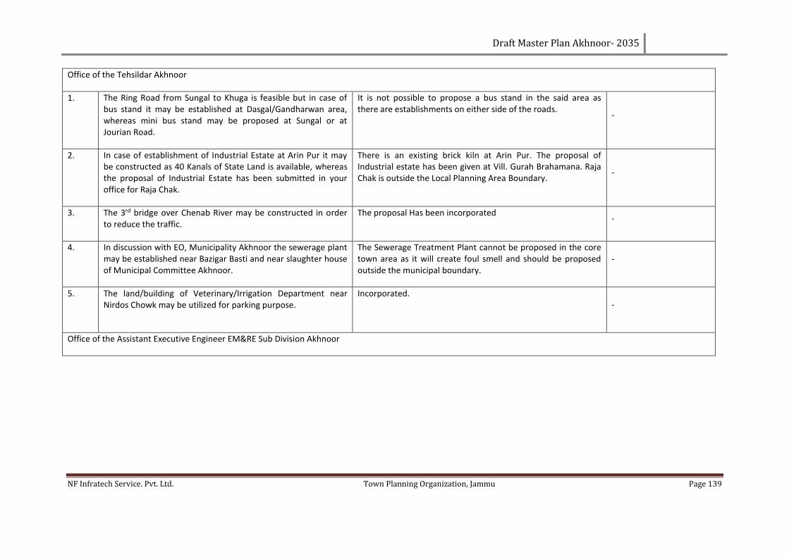
Draft Master Plan Akhnoor- 2035
NF Infratech Service. Pvt. Ltd. Town Planning Organization, Jammu Page 139
Office of the Tehsildar Akhnoor
1. The Ring Road from Sungal to Khuga is feasible but in case of bus stand it may be established at Dasgal/Gandharwan area, whereas mini bus stand may be proposed at Sungal or at Jourian Road.
It is not possible to propose a bus stand in the said area as there are establishments on either side of the roads.
-
2. In case of establishment of Industrial Estate at Arin Pur it may be constructed as 40 Kanals of State Land is available, whereas the proposal of Industrial Estate has been submitted in your office for Raja Chak.
There is an existing brick kiln at Arin Pur. The proposal of Industrial estate has been given at Vill. Gurah Brahamana. Raja Chak is outside the Local Planning Area Boundary.
-
3. The 3rd bridge over Chenab River may be constructed in order to reduce the traffic.
The proposal Has been incorporated -
4. In discussion with EO, Municipality Akhnoor the sewerage plant may be established near Bazigar Basti and near slaughter house of Municipal Committee Akhnoor.
The Sewerage Treatment Plant cannot be proposed in the core town area as it will create foul smell and should be proposed outside the municipal boundary.
-
5. The land/building of Veterinary/Irrigation Department near Nirdos Chowk may be utilized for parking purpose.
Incorporated. -
Office of the Assistant Executive Engineer EM&RE Sub Division Akhnoor
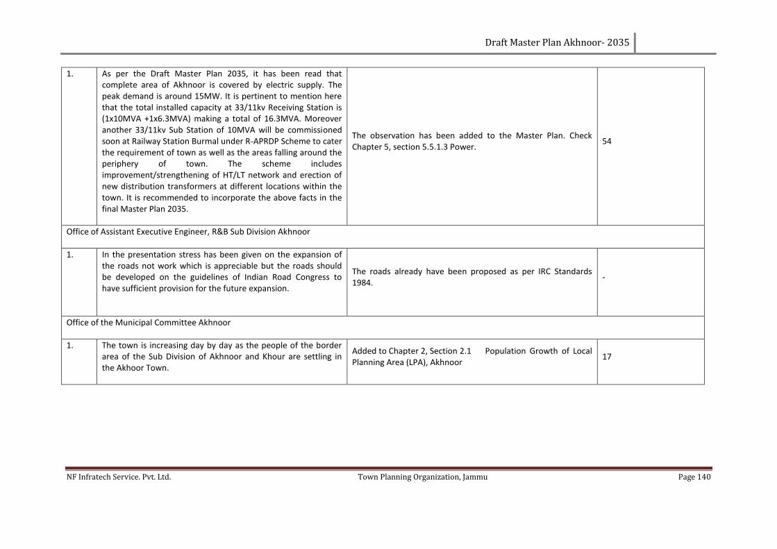
Draft Master Plan Akhnoor- 2035
NF Infratech Service. Pvt. Ltd. Town Planning Organization, Jammu Page 140
1. As per the Draft Master Plan 2035, it has been read that complete area of Akhnoor is covered by electric supply. The peak demand is around 15MW. It is pertinent to mention here that the total installed capacity at 33/11kv Receiving Station is (1x10MVA +1x6.3MVA) making a total of 16.3MVA. Moreover another 33/11kv Sub Station of 10MVA will be commissioned soon at Railway Station Burmal under R-APRDP Scheme to cater the requirement of town as well as the areas falling around the periphery of town. The scheme includes improvement/strengthening of HT/LT network and erection of new distribution transformers at different locations within the town. It is recommended to incorporate the above facts in the final Master Plan 2035.
The observation has been added to the Master Plan. Check Chapter 5, section 5.5.1.3 Power.
54
Office of Assistant Executive Engineer, R&B Sub Division Akhnoor
1. In the presentation stress has been given on the expansion of the roads not work which is appreciable but the roads should be developed on the guidelines of Indian Road Congress to have sufficient provision for the future expansion.
The roads already have been proposed as per IRC Standards 1984.
-
Office of the Municipal Committee Akhnoor
1. The town is increasing day by day as the people of the border area of the Sub Division of Akhnoor and Khour are settling in the Akhoor Town.
Added to Chapter 2, Section 2.1 Population Growth of Local Planning Area (LPA), Akhnoor
17
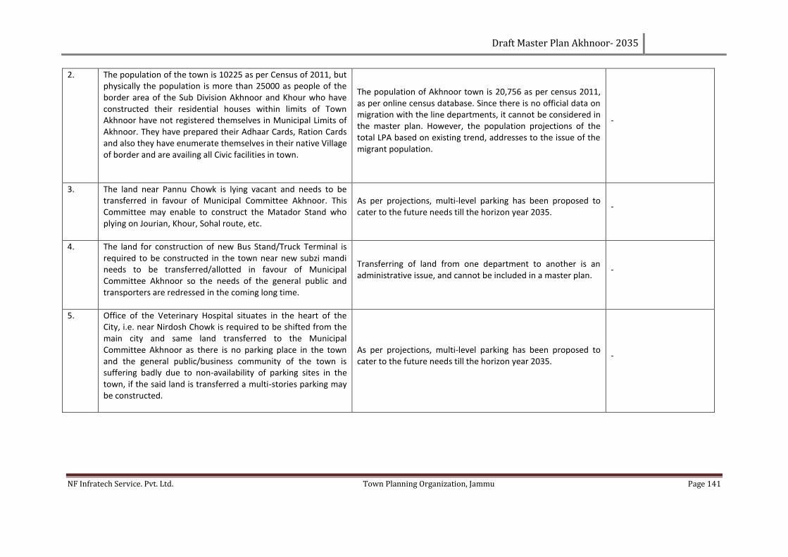
Draft Master Plan Akhnoor- 2035
NF Infratech Service. Pvt. Ltd. Town Planning Organization, Jammu Page 141
2. The population of the town is 10225 as per Census of 2011, but physically the population is more than 25000 as people of the border area of the Sub Division Akhnoor and Khour who have constructed their residential houses within limits of Town Akhnoor have not registered themselves in Municipal Limits of Akhnoor. They have prepared their Adhaar Cards, Ration Cards and also they have enumerate themselves in their native Village of border and are availing all Civic facilities in town.
The population of Akhnoor town is 20,756 as per census 2011, as per online census database. Since there is no official data on migration with the line departments, it cannot be considered in the master plan. However, the population projections of the total LPA based on existing trend, addresses to the issue of the migrant population.
-
3. The land near Pannu Chowk is lying vacant and needs to be transferred in favour of Municipal Committee Akhnoor. This Committee may enable to construct the Matador Stand who plying on Jourian, Khour, Sohal route, etc.
As per projections, multi-level parking has been proposed to cater to the future needs till the horizon year 2035.
-
4. The land for construction of new Bus Stand/Truck Terminal is required to be constructed in the town near new subzi mandi needs to be transferred/allotted in favour of Municipal Committee Akhnoor so the needs of the general public and transporters are redressed in the coming long time.
Transferring of land from one department to another is an administrative issue, and cannot be included in a master plan.
-
5. Office of the Veterinary Hospital situates in the heart of the City, i.e. near Nirdosh Chowk is required to be shifted from the main city and same land transferred to the Municipal Committee Akhnoor as there is no parking place in the town and the general public/business community of the town is suffering badly due to non-availability of parking sites in the town, if the said land is transferred a multi-stories parking may be constructed.
As per projections, multi-level parking has been proposed to cater to the future needs till the horizon year 2035.
-
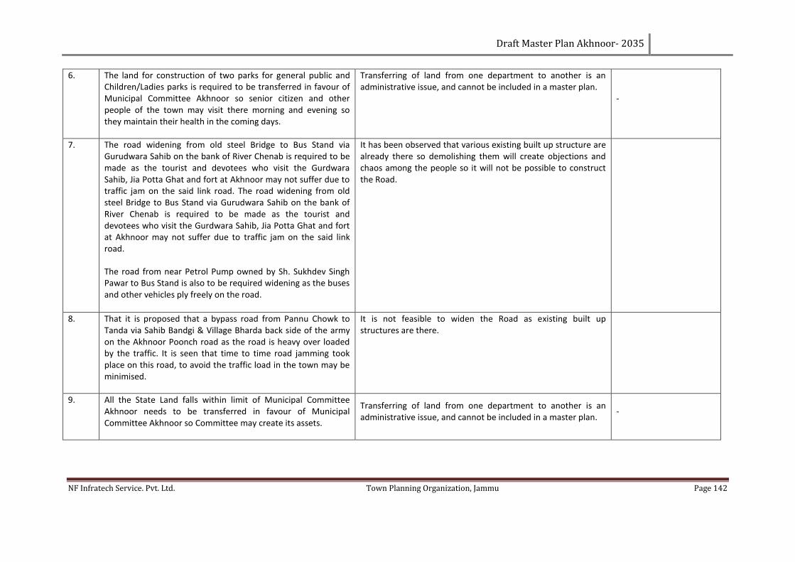
Draft Master Plan Akhnoor- 2035
NF Infratech Service. Pvt. Ltd. Town Planning Organization, Jammu Page 142
6. The land for construction of two parks for general public and Children/Ladies parks is required to be transferred in favour of Municipal Committee Akhnoor so senior citizen and other people of the town may visit there morning and evening so they maintain their health in the coming days.
Transferring of land from one department to another is an administrative issue, and cannot be included in a master plan.
-
7. The road widening from old steel Bridge to Bus Stand via Gurudwara Sahib on the bank of River Chenab is required to be made as the tourist and devotees who visit the Gurdwara Sahib, Jia Potta Ghat and fort at Akhnoor may not suffer due to traffic jam on the said link road. The road widening from old steel Bridge to Bus Stand via Gurudwara Sahib on the bank of River Chenab is required to be made as the tourist and devotees who visit the Gurdwara Sahib, Jia Potta Ghat and fort at Akhnoor may not suffer due to traffic jam on the said link road.
The road from near Petrol Pump owned by Sh. Sukhdev Singh Pawar to Bus Stand is also to be required widening as the buses and other vehicles ply freely on the road.
It has been observed that various existing built up structure are already there so demolishing them will create objections and chaos among the people so it will not be possible to construct the Road.
8. That it is proposed that a bypass road from Pannu Chowk to Tanda via Sahib Bandgi & Village Bharda back side of the army on the Akhnoor Poonch road as the road is heavy over loaded by the traffic. It is seen that time to time road jamming took place on this road, to avoid the traffic load in the town may be minimised.
It is not feasible to widen the Road as existing built up structures are there.
9. All the State Land falls within limit of Municipal Committee Akhnoor needs to be transferred in favour of Municipal Committee Akhnoor so Committee may create its assets.
Transferring of land from one department to another is an administrative issue, and cannot be included in a master plan.
-
Draft Master Plan Akhnoor- 2035
NF Infratech Service. Pvt. Ltd. Town Planning Organization, Jammu Page 143
10. The land in the possession of Army near Sub. Divisional Magistrate Office Akhnoor i.e. Land of Supply and Slaughter House be transferred in favour of Municipal Committee Akhnoor. The Committee shall propose Bus Stand/assets for Municipal Committee.
Transferring of land from one department to another is an administrative issue, and cannot be included in a master plan.
-
Office of the Zonal Education Officer Akhnoor
1. Most of the schools in Akhnoor town need renovation including construction of cemented water tanks and toilet facility with sanitary fittings, games and sports material, complete furniture items for staff and studets, so that the children of these schools can get maximum benefit of these facilities and study in healthy environment.
Up gradation of existing educational infrastructure has been proposed in the master plan. Kindly check Chapter 5, Section 5.6.1 Education.
54
2. All the schools in Akhnoor Town should be provided computers, LEDs and smart class facility, as Computer education in school plays an important role I students career development. Computer with the internet is the most powerful device that students can use to learn new skills and more advanced version of current lessons. Schools are around the globe teaching student’s basics of computer and internet. The uses of computers and internet are growing day by day at high speed.
The said issue, though very important, falls out of scope of the master plan. We recommend you take it up with the administration.
-
Draft Master Plan Akhnoor- 2035
NF Infratech Service. Pvt. Ltd. Town Planning Organization, Jammu Page 144
3. Development of library in schools as libraries are important part of school education. Every school should have a school library. It is source of knowledge to young minds. It develops the habit of reading among the students. Generally the school library subscribes to magazines, periodicals and newspapers. These may be a source encouragement for the students to read the newspapers and periodicals.
The said issue, though very important, falls out of scope of the master plan. We recommend you take it up with the administration.
-
4. Preparation of smart class rooms for pre-pry school children with furniture items, educational toys, musical instruments, writing and art supplies to nurture creativity in child at the early school age.
The said issue, though very important, falls out of scope of the master plan. We recommend you take it up with the administration.
-
5. Major repair required for already constructed resource room for children with special needs including other facilities for CWSN children.
The said issue, though very important, falls out of scope of the master plan. We recommend you take it up with the administration.
-
6. One post of Safai Karamchari for every pry and middle school and two posts for Higher secondary Schools should be created in all the schools so that schools may be kept neat and clean.
The said issue, though very important, falls out of scope of the master plan. We recommend you take it up with the administration.
-
Draft Master Plan Akhnoor- 2035
NF Infratech Service. Pvt. Ltd. Town Planning Organization, Jammu Page 145
ANNEXURE 8: MINUTES OF MEETING OF STAKE HOLDER PRESENTATION HELD ON 15TH OF APRIL 2017 FOR THE DRAFT MASTER PLAN-AKHNOOR IN THE PRESENCE OF HONOURABLE MLA-AKHNOOR.
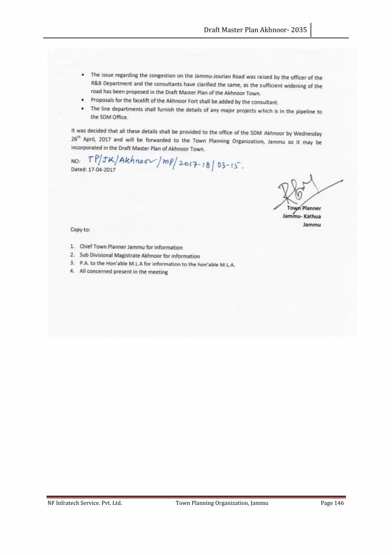
Draft Master Plan Akhnoor- 2035
NF Infratech Service. Pvt. Ltd. Town Planning Organization, Jammu Page 146
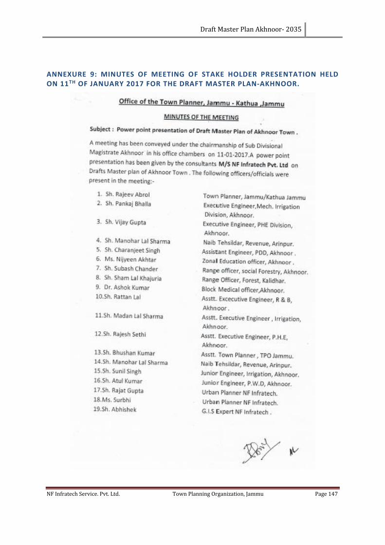
Draft Master Plan Akhnoor- 2035
NF Infratech Service. Pvt. Ltd. Town Planning Organization, Jammu Page 147
ANNEXURE 9: MINUTES OF MEETING OF STAKE HOLDER PRESENTATION HELD ON 11TH OF JANUARY 2017 FOR THE DRAFT MASTER PLAN-AKHNOOR.
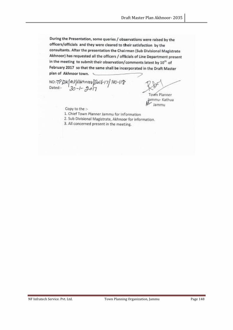
Draft Master Plan Akhnoor- 2035
NF Infratech Service. Pvt. Ltd. Town Planning Organization, Jammu Page 148
Draft Master Plan Akhnoor- 2035
NF Infratech Service. Pvt. Ltd. Town Planning Organization, Jammu Page 149
LIST OF REFERENCES
• URDPFI Guidelines 2014
• Rural development department Akhnoor
• Climate-data. (2014) Climate: Akhnoor. [Online] Available from: http://en.climate-
data.org/location/54107/ [Accessed:20th January 2014]
• ALI, Z.K. Spatial Distribution of Minerals in Jammu and Kashmir. [Online] Available from -
http://www.yourarticlelibrary.com/essay/spatial-distribution-of-minerals-in-jammu-and-
kashmir/41433/. [Accessed: 03.12.2014]
• Assistant Regional Transport Officer, Jammu. (2014) Vehicle ownership trends in Akhnoor.
[Interview]. 12.02.2014.
• Chief Education Officer, Akhnoor. (2014) Education infrastructure in Akhnoor. [Interview].
19.02.2014.
• Chief Medical Officer, Jammu. (2014) Health infrastructure in Akhnoor. [Interview].
11.02.2014.
• Digital Globe. Order # 053397416, Worldview 2, WV02 standard imagery, Pan sharpened @
43 cm resolution. Longmont Colorado, 18.10.2010.
• District Development commissioner, Jammu. (2014) Institutional structure of Jammu district
and plan formulation and implementation. [Interview]. 18.02.2014.
• Government of India, 1971, Census of India 1971, Registrar General & Census Commissioner,
India.
• Government of India, 1981, Census of India 1981, Registrar General & Census Commissioner,
India.
• Government of India, 2001, Census of India 2001, Registrar General & Census Commissioner,
India.
• Government of India, 2011, Census of India 2011, Registrar General & Census Commissioner,
India.
• Government of Jammu & Kashmir, 2012, District statistical handbook 2012, Economics and
statistics division, Jammu.
• Government of Jammu & Kashmir, 2012, Village amenities directory 2012, Economics and
statistics division, Jammu.
• India. DISTRICT DISASTER MANAGEMENT COMMITTEE - DISTRICT Jammu, Government of
Jammu & Kashmir (2009-10) District Disaster Management Plan, Jammu. Jammu.
• India. MINISTRY OF URBAN AFFAIRS & EMPLOYMENT, Government of India (1996) Urban
Development Plan Formulation and Implementation Guidelines. New Delhi.
• Jammu divisional commissioner website. (2014) Divisional commissioner Jammu (Jammu and
Kashmir). [Online] Available from - http://www.divcomjammu.gov.in/. [Accessed
03.12.2014]
• MUNICIPAL COMMITTEE OF Akhnoor. (2011) Ward wise map, Akhnoor. Map not to scale.
• Power Development Department, Akhnoor. (2014) Electricity infrastructure in Akhnoor.
[Interview]. 14.02.2014.
http://www.yourarticlelibrary.com/essay/spatial-distribution-of-minerals-in-jammu-and-kashmir/41433/
Draft Master Plan Akhnoor- 2035
NF Infratech Service. Pvt. Ltd. Town Planning Organization, Jammu Page 150
• Public Health and Engineering Department, Akhnoor. (2014) Water supply infrastructure in
Akhnoor. [Interview]. 14.02.2014.
• Roads and Buildings Department, Akhnoor. (2014) Road characteristics and traffic
infrastructure in Akhnoor. [Interview]. 17.02.2014.
• SRTM digital elevation database v4.1 [computer file]. Sioux Falls, SD: USGS, 2000. SRTM
data<https://lta.cr.usgs.gov/SRTMBasic> (Accessed 18.04.2014).
• Tehsildar, Akhnoor. (2014) Village boundaries and Khasra details. [Interview]. 13.02.2014.
• World Weather online. (2014) Climate: Akhnoor. [Online] Available from -
https://developer.worldweatheronline.com/page/documentation. [Accessed 03.12.2014].
Related Documents