Welcome message from author
This document is posted to help you gain knowledge. Please leave a comment to let me know what you think about it! Share it to your friends and learn new things together.
Transcript
The Journal of Public Space ISSN 2206-9658 2019 | Vol. 4 n. 2 https://www.journalpublicspace.org
ISSN 2206-9658 | City Space Architecture / UN-Habitat
EDITORIAL TEAM Editor in Chief
Luisa Bravo, City Space Architecture, Italy
Scientific Board Davisi Boontharm, Meiji University, Japan Simone Brott, Queensland University of Technology, Australia Julie-Anne Carroll, Queensland University of Technology, Australia Margaret Crawford, University of California Berkeley, United States of America Philip Crowther, Queensland University of Technology, Australia Simone Garagnani, University of Bologna, Italy Pietro Garau, Sapienza University of Rome, Italy Carl Grodach, Monash University, Australia Chye Kiang Heng, National University of Singapore, Singapore Maurice Harteveld, Delft University of Technology, Netherlands Fiona Hillary, RMIT University, Australia Aseem Inam, Cardiff University, United Kingdom Miquel Marti, Universitat Politècnica de Catalunya, Spain Alessandro Melis, University of Portsmouth, United Kingdom Darko Radovic, Keio University, Japan Estanislau Roca, Universitat Politècnica de Catalunya, Spain Joaquin Sabate, Universitat Politècnica de Catalunya, Spain Robert Saliba, American University of Beirut, Lebanon Ellen Marie Sæthre-McGuirk, Nord University, Norway Hendrik Tieben, Chinese University of Hong Kong, Hong Kong
Strategic Advisory Board Cecilia Andersson, UN-Habitat Global Public Space Programme, Kenya Tigran Haas, KTH Royal Institute of Technology, Sweden Maggie McCormick, RMIT University, Australia Michael Mehaffy, KTH Royal Institute of Technology, Sweden Laura Petrella, UN-Habitat Global Public Space Programme, Kenya
Advisory Board for Research into Action Ethan Kent, Project for Public Spaces, United States of America Gregor Mews, Urban Synergies Group, Australia Luis Alfonso Saltos Espinoza, LASE+CityUrb, Ecuador
Assistant Editor Zoë Atkinson Fiennes
T
HE
JO
UR
NA
L O
F P
UB
LIC
SP
AC
E
The Journal of Public Space | 2019, Vol. 4 n. 2 | Editorial Team and Policies
II | ISSN 2206-9658 | City Space Architecture / UN-Habitat
Journal Manager
Luisa Bravo, City Space Architecture, Italy Correspondents and Peer Reviewers Europe and Middle East
Gem Barton, Brighton University, United Kingdom Michael Barke, University of Northumbria at Newcastle, United Kingdom Simon Bell, Estonian University of Life Sciences, Estonia Pedro Ressano Garcia, Universidade Lusófona, Portugal Konstantinos Ioannidis, Aristotle University of Thessaloniki, Greece Marjut Kirjakka, Aalto University, Finland Yoav Lerman, Tel Aviv University, Israel Nicola Marzot, Delft University of Technology, Netherlands Fabiano Micocci, University of Thessaly, Greece Vitor Oliveira, University of Porto, Portugal Lakshmi Priya Rajendran, Anglia Ruskin University, United Kingdom Yodan Rofe, Ben-Gurion University of the Negev, Israel Massimo Santanicchia, Iceland Academy of the Arts, Iceland Goran Vodicka, University of Sheffield, United Kingdom Katharine Willis, Plymouth University, United Kingdom Parisa Ziaesaeidi, Erfan Institute of Higher Education, Iran
America
Camilo Vladimir de Lima Amaral, Universidade Federal de Goias, Brazil Roberto Andrés, Universidade Federal de Minas Gerais, Brazil Dave Colangelo, Portland State University, United States of America Thomas Fowler, California Polytechnic State University, United States of America Maria Goula, Cornell University, United States of America Adrian Gras-Velazquez, Swarthmore College, United States Matthew D. Lamb, Pennsylvania State University, United States of America Marieta Maciel, Universitade Federal de Minas Gerais, Brazil Leonardo Parra, Universidad de Los Andes, Colombia Renato Rego, Universidade Estadual de Maringá - UEM, Brazil
Asia Pak Damrongsak, Thammasat University, Thailand Nga Nguyen, Vietnam National University Ho Chi Minh City, Vietnam Bing Wang, Beijing University of Civil Engineering and Architecture, China Zhen Xu, Nanjing Forestry University, China
The Journal of Public Space | 2019, Vol. 4 n. 2 | Editorial Team and Policies
ISSN 2206-9658 | City Space Architecture / UN-Habitat | III
Africa
Izak van Zyl, Cape Peninsula University of Technology, South Africa
Australia and New Zealand Christopher Brisbin, University of South Australia, Australia Liz Brogden, Queensland University of Technology, Australia Martin Bryant, University of Technology Sydney, Australia Glenda Caldwell, Queensland University of Technology, Australia Philippa Carnemolla, University of Technology Sydney, Australia Debra Cushing, Queensland University of Technology, Australia Emilio Garcia, University of Auckland, New Zealand Morten Gjerde, Victoria University of Wellington, New Zealand Kai Gu, University of Auckland, New Zealand Daniel O'Hare, Bond University, Australia Anoma Kumarasuriyar, Queensland University of Technology, Australia Manfredo Manfredini, University of Auckland, New Zealand Michael Marriott, Queensland University of Technology, Australia Ari Mattes, University of Notre Dame, Australia Linda Matthews, University of Technology Sydney, Australia John Mongard, The Designbank, Australia Milica Muminović, University of Canberra, Australia Kaan Ozgun, University of Queensland, Australia Mark Pennings, Queensland University of Technology, Australia Gavin Perin, University of Technology Sydney, Australia Helena Piha, Queensland University of Technology, Australia Dorina Pojani, University of Queensland, Australia Paul Sanders, Queensland University of Technology, Australia Leigh Shutter, Griffith University, Australia Thomas Sigler, University of Queensland, Australia Claudia Justino Taborda, Queensland University of Technology, Australia Mark Taylor, University of Newcastle, Australia Margaret Ward, Griffith University, Australia Yannis Zavoleas, University of Newcastle, Australia
The Journal of Public Space | 2019, Vol. 4 n. 2 | Editorial Team and Policies
IV | ISSN 2206-9658 | City Space Architecture / UN-Habitat
FOCUS AND SCOPE
The Journal of Public Space is the first, international, interdisciplinary, academic, open access journal entirely dedicated to public space. Established on a well-consolidated global network of scholars and professionals, The Journal of Public Space is committed to expand current scholarship by offering a global perspective and providing the opportunity for unheard countries to speak up and to discuss neglected as well as emerging topics that are usually sidelined in mainstream knowledge. The Journal of Public Space is addressing social sciences and humanities as a major field, and is interested also in attracting scholars from several disciplines. It will perform as a scholarly journal but also as an interdisciplinary platform of discussion and exchange by scholars, professionals, organizations, artists, activists and citizens, whose activities are related to public space. The Journal of Public Space will be enriched by hosting papers on design projects, art performances and social practices, fostering civic engagement and non-expert knowledge.
TOPICS
Authors are welcome to submit original research articles dealing with themes relating to the vision of the journal, which may include, but are not confined to:
SPACE SOCIETY SYSTEMS Architecture Urban Planning Urban Design Urban Morphology Urban Resilience Landscape architecture Interior design Interactive and visual design Art City transformation Infrastructure Environment Ecology Climate change
Gender Human scale People Everyday life Social engagement Health and safety Perception and senses Human rights Social justice Education Heritage History Culture Geography Anthropology Ethnography Community empowerment Migrations Conflicts Inclusion/Exclusion Informality Sub and fringe cultures
Economy Political power Governance Law and regulations Public policies Private sector/interest Developing countries Management and maintenance Digital/Virtual world Technology Media Third sector Decision-making process

The Journal of Public Space | 2019, Vol. 4 n. 2 | Editorial Team and Policies
ISSN 2206-9658 | City Space Architecture / UN-Habitat | V
POLICIES
Peer Review Process A double blind peer review process, based on a distinguished board of editors and editorial advisors, ensures the quality and high standards of research papers. Each paper is assessed by two reviewers and any identifying information in relation to the author is removed during the review process. Reviewers follow an evaluation framework and recommendation guidelines to ensure objectivity and fairness. Submitted articles should not have been previously published. If publication or dissemination through presentation has occurred, then the article should acknowledge this and pay due credit to the original source.
Publication Ethics Statement
The Journal of Public Space aligns itself with the Committee on Publication Ethics (COPE) best practice guidelines for dealing with ethical issues in journal publishing.
http://publicationethics.org/
Open Access Policy
The Journal of Public Space is licensed under a Creative Commons Attribution- NonCommercial 4.0 International License. It provides immediate open access to its content on the principle that making research freely available to the public supports a greater global exchange of knowledge.
https://creativecommons.org/licenses/by-nc/4.0/
CONTACT
Publisher City Space Architecture non-profit cultural association Via Paolo Giovanni Martini 26/d 40134 Bologna, ITALY [email protected] www.cityspacearchitecture.org
in cooperation with KTH Royal Institute of Technology Centre for the Future of Places Stockholm, Sweden https://www.kth.se/en https://www.cfp.abe.kth.se/ RMIT University Melbourne, Australia https://www.rmit.edu.au/
Partner UN Habitat - United Nations Human Settlements Program Nairobi, KENYA www.unhabitat.org

The Journal of Public Space | 2019, Vol. 4 n. 2 | Editorial Team and Policies
VI | ISSN 2206-9658 | City Space Architecture / UN-Habitat
Call for papers | 2019 issues The Journal of Public Space welcomes full papers for 2019 issues, to be published in April, August and December. Deadline for April issue: January 10, 2019 Deadline for August issue: May 10, 2019 Deadline for December issue: September 10, 2019 Submissions will be ongoing throughout the year. Submission can be made: - using the OJS platform by registering online. If you are already a registered author you can log in using your username and password; - by sending an email to the Editor in Chief Luisa Bravo at this email address: [email protected]. Before submitting, please read: - the Focus and Scope of the journal - the Author Guidelines Full papers should be between 5.000 and 8.000 words. https://www.journalpublicspace.org/
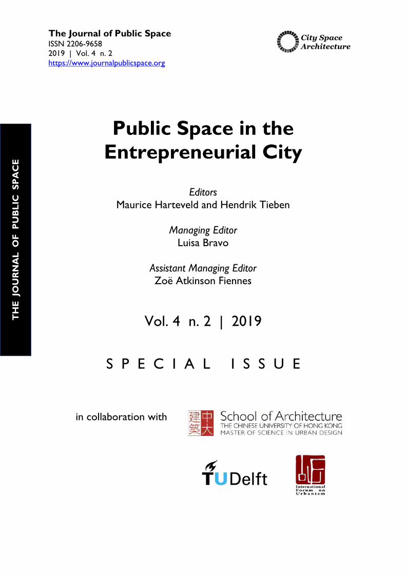
The Journal of Public Space ISSN 2206-9658 2019 | Vol. 4 n. 2 https://www.journalpublicspace.org
Public Space in the Entrepreneurial City
Editors Maurice Harteveld and Hendrik Tieben
Managing Editor
Luisa Bravo
Assistant Managing Editor Zoë Atkinson Fiennes
Vol. 4 n. 2 | 2019
S P E C I A L I S S U E
in collaboration with
T
HE
JO
UR
NA
L O
F P
UB
LIC
SP
AC
E
The Journal of Public Space ISSN 2206-9658 2019 | Vol. 4 n. 2 https://www.journalpublicspace.org
ISSN 2206-9658 | City Space Architecture / UN-Habitat
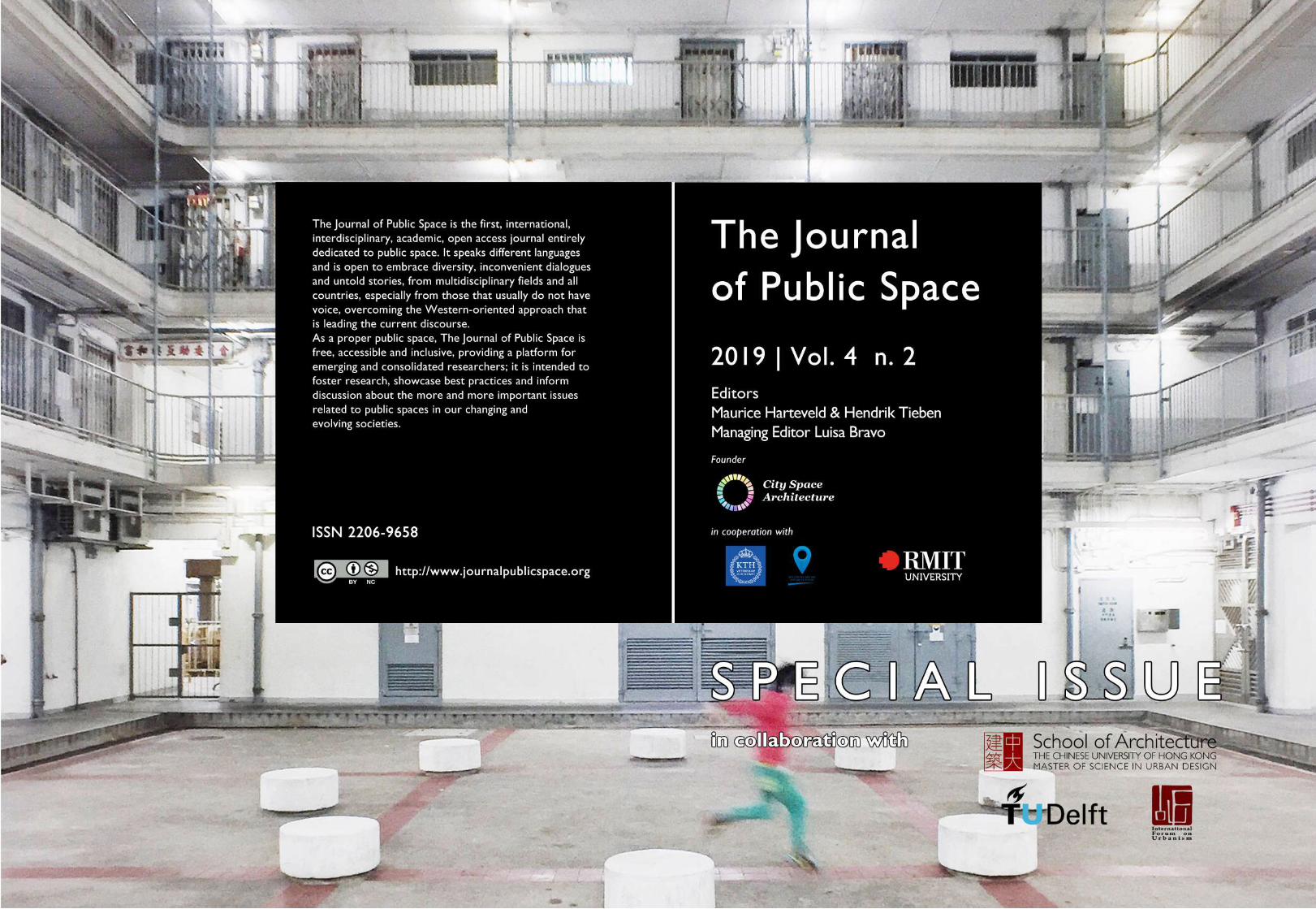
Cover image: Courtyard of a public housing tower in Hong Kong. Picture by Kevin Mak.

The Journal of Public Space ISSN 2206-9658 2019 | Vol. 4 n. 2 https://www.journalpublicspace.org
ISSN 2206-9658 | City Space Architecture / UN-Habitat
TABLE OF CONTENTS EDITORIAL Public Space in the Entrepreneurial City
Maurice Harteveld and Hendrik Tieben
1-8
SPACE The Transformation of Open Urban Space and Increasing Building Density in Hong Kong since the 1970s
Wei Shi, Beisi Jia, H. Koon Wee Public Space, Tourism and Mobility: Projects, Impacts and Tensions in Lisbon’s Urban Regeneration Dynamics
João Rafael Santos
Spaces of Mega Sporting Events versus Public Spaces: Qatar 2022 World Cup and the City of Doha
Simona Azzali
9-28
29-56
57-80
SOCIETY Live-work Tactics in the Suburban House and their Effects on Public Spaces in the Peripheral Neighbourhoods of Rio de Janeiro Ana Slade and Guilherme Lassance The Spatial Production of Public Parks and Counter-Public Non-Parks in Taipei
Min Jay Kang Reviewing Premises on Public Spaces in Democratic, Inclusive, Agential Cities, Illustrated by Amsterdam
Maurice Harteveld
81-100
101-122
123-144
SYSTEMS A Cultural Governance Coalition in Regeneration: A Case Study of Historical Quanzhou City
Cai Shuxiang Community Resilience and Placemaking through Translocal Networking: Learning from Thailand and the Philippines
Astrid Ley Simulation, Control and Desire: Urban Commons and Semi-Public Space Resilience in the Age of Augmented Transductive Territorial Production Manfredo Manfredini
145-164
165-178
179-198
VIEWPOINT Photographing Public Spaces in Hong Kong
Kevin Mak
199-212
T
HE
JO
UR
NA
L O
F P
UB
LIC
SP
AC
E

The Journal of Public Space ISSN 2206-9658 2019 | Vol. 4 n. 2 https://www.journalpublicspace.org
ISSN 2206-9658 | City Space Architecture / UN-Habitat
DISCLAIMER The designations employed and the presentation of the material in this journal do not imply the expression of any opinion whatsoever on the part of the Secretariat of the United Nations concerning the legal status of any country, territory, city or area or of its authorities, or concerning the delimitation of its frontiers or boundaries, or regarding its economic system or degree of development. The analysis, conclusions and recommendations of this publication do not necessarily reflect the views of the United Nations Human Settlements Programme. Reference in this journal of any specific commercial products, brand names, processes, or services, or the use of any trade, firm, or corporation name does not constitute endorsement,
The Journal of Public Space ISSN 2206-9658 2019 | Vol. 4 n. 2 https://www.journalpublicspace.org
ISSN 2206-9658 | 1
City Space Architecture / UN-Habitat
EDITORIAL
Public Space in the Entrepreneurial City
Maurice Harteveld Delft University of Technology, Department of Urbanism, The Netherlands [email protected]
Hendrik Tieben The Chinese University of Hong Kong, School of Architecture, Hong Kong [email protected] This issue of The Journal of Public Space explores the relationship between public space and entrepreneurship. The ideas developed during the Habitat III Conference in Quito, when considering: how to implement the ambitious aims of the New Urban Agenda in context of the current socio-economic realities and to reach a fairer share of the benefits brought by urbanisation? In December 2017, the organisation of the 10th Conference of the International Forum on Urbanism (IFoU) at the Chinese University of Hong Kong offered an opportunity to discuss such questions with international scholars and professionals. The papers in this special issue originated from this conference and later submissions to The Journal of Public Space. The theme ‘Public Space in the Entrepreneurial City’ was chosen based on the following three observations. 1. Entrepreneurial action of public governments The entrepreneurial way of governmental action had been illuminated since the 1980s, following among others John Mollenkopf’s review on Modern urban history through the lens of the entrepreneurial triumph of the American city. Within this context, David Harvey brought the trend to the current and described the trend globally as “[…] local governmental powers [that] try and attract external sources of funding, new direct investments or new employment sources” (Mollenkopf, 1983: 14, 41-46; Harvey, 1989: 7). In the following years, the ‘entrepreneurial city’ continued to be approached and discussed critically in the context of a clear shift of the public sector taking over characteristics once distinctive to the private sector: Cities acting as entrepreneurs - risk-taking, inventiveness, promotion and profit motivation - while shifting planning responsibilities to a small number of private actors (Hall and Hubbard, 1998: 153). This was seen as one of the reasons for the increasing inequality in cities, questioning the right to the city. The ‘entrepreneurial city’ as such led particularly to new spatial conditions and typologies as governments delegated the responsibilities for the production and management of public space to private actors. Entrepreneurial mayors, who advocated the idea to “corporatise” the city and “leverage significant private investments”, got wide international attention (Goldsmith, Giuliani and Daley 1999: 1-15). Despite the emerged critical opposition, their model was multiplied anyhow elsewhere and in different forms. Hong Kong, the place where the 2017
T
HE
JO
UR
NA
L O
F P
UB
LIC
SP
AC
E
Public Space in the Entrepreneurial City
2 | The Journal of Public Space, 4(2), 2019 | ISSN 2206-9658 City Space Architecture / UN-Habitat
conference took place, had been the birthplace for a range of examples for this development with its public spaces in private developments which had been critically approached for two decades. New types emerged with deviating perceptions of public space (Cuthbert & McKinnell, 1997: 308). This extended the debate to the city’s public space in its ubiquitous shopping malls and private residential estates. In chapter ‘space’ of this journal, we can read how the entrepreneurial city approach affects public space in our cities. Particularly by highlighting local residents versus respectively newcomers, tourists and event visitors here, the consequence of governmental action on the public space becomes clear. Analyses of the increasing density of Hong Kong’s Mong Kok area, for example, showcases the effect of a fast changing role of the urban open space. In transforming districts like this one, the attractiveness of the street network, hence the quality of publicness, deteriorated, while on the micro level, public gathering has been directed simultaneously by real estate developers to their private premises. Large groups of people gather indoors. Following the opening of Olympic station in 1996 and Olympic City, series of malls opened between 1998 and 2011, changing Mong Kok drastically. Not only, pedestrian footbridges go straight from these interior public spaces to the street network of neighbouring Mong Kok, but also within the Mong Kok district itself a large number of malls and arcades have opened in the plinths of privately-owned and gated high-rise tower developments. In this setting, existing local public life and entrepreneurial attitude seem more to cause conflicts. Who is benefiting from the spaces generated in the entrepreneurial city? We may question the same in cities such as New York City or Tokyo. Second, the urge to be attractive and competitive, by boosting tourism affects the public nature of open urban space too, as described in the paper on Lisbon. This seems to conflict with the desire to increase liveability. Governmental investments to make the city pedestrian-friendly may add to the vitality of the city, yet also arouses the interest of many travellers hunting for holiday destinations. After hosting international events between 1994 and 2004, boasting global visibility, subsequent entrepreneurial policies have made the city increasingly a tourist destination. Short stay visitors are more and more present in Lisbon’s inner-city neighbourhoods Baixa, Chiado, and the Bairro Alto. Thus here, life in the outdoor public space has changed drastically. As the city becomes more appealing indeed, the question is again for whom? For sure, the same goes for specific areas in most visited cities around the world like Bangkok, Barcelona, or Istanbul. Third, following a similar desire to be competitive, while at the same token promote international cooperation and gathering, the recent case of Doha showcases the effects of popular world tournaments on public space. By highlighting the city’s dedication to host the world’s most watched sporting event, the 2022 FIFA World Cup and more recent the Club World Cup 2019, Doha has become recognised as a global hub and, in this slipstream, the design of new public spaces are made to meet universal standards. Within the public interiors of the soccer stadiums, as unveiled in the first 2010 plans, this may make sense because people from all continents will gather here. Yet, the public quality of the outdoor urban design in the already reconstructed areas of the partner cities Lusail and Al Wakrah may be critical, as public spaces are foremost based on imported western images. Also published artist impressions of the so-called Sports City and Doha Port seem to be disconnected from local use and culture. When considering the rise of the entrepreneurial approach Los Angeles, host of a familiar mega event - the 1984 Olympic Games - holds a pioneering position. Entrepreneurial practice has become part of

Maurtice Harteveld and Hendrik Tieben
The Journal of Public Space, 4(2), 2019 | ISSN 2206-9658 | 3 City Space Architecture / UN-Habitat
urban tourism and new urban development strategies since (Spirou, 2011: 68). Now, in the subsequent age of urbanisation, global travel, and world events, public spaces, created under entrepreneurial policies, are being tested. Again, the question reoccurs; for whom these spaces are designed? 2. Entrepreneurial action of the people, inhabitants of the city The second observation regarding the ‘entrepreneurial city’ goes beyond the entrepreneurial role of public governments and large private corporations, and recognises the entrepreneurial contributions of general citizens, migrants and refugees and its relationship to public space. The concerns here are the initiatives of ‘enterprising citizens’ in places where government provisions lack. The historical roots of this entrepreneurial attitude might go back to “the collective self-help and community actions that characterised the ethos of early settler and farming communities, and that of many of the indigenous peoples before them” (Gass, 1989: 25). In modern times, similar behaviour became apparent in established societies present in established urban areas in transition or fast-growing areas in the urban peripheries. Here on daily basis residents use their human wisdom and initiative to search for ways to improve their own as well as their community’s livelihoods. Governments started to realise the benefits of these initiatives and began to encourage and promote entrepreneurship. For instance, David Cameron, as Prime Minister of the UK, highlighted in 2013 that “[s]ocial enterprises, charities and voluntary bodies have the knowledge, human touch and personal commitment to succeed where governments often fail” (Cameron, 2013, 6th of June). Public policies encouraged citizens to act in a self-reliant or 'entrepreneurial' manner, and people, dependent on the public institutions, had to search for alternative action. This raised the question if they were equipped to do so. In the broader sphere, the education of societies towards collectives of entrepreneurial citizens had been started. For example in an Asian-Pacific review, UNESCO enhanced the vigour of exploration of the entry of "being enterprising", of "becoming doers", pervasively into the entire scope and sequence of general education (UNESCO Principal Regional Office for Asia and The Pacific 1994: i-iii). Following an African review of EDNA, a Dakar-based NGO holding a diplomatic status with the UN ECOSOC, public services at the grassroots should be stimulated. While representing an international network of community-based organisations and community movements, in their review, the ‘entrepreneurial city’ could consequently concern acting on citizens initiatives and on popular action: “The entrepreneurial city is based on a state of mind: on a positive popular imagination” (Gaye, 1996: 53-55). This extended the perspective of the entrepreneurial city to a different current reality of ‘doers’, who counterbalance governmental action or fill the gap between societal needs and governmental action and, as such produce public goods in demand. The ‘entrepreneurial citizens’ could be seen as people of all kinds active in changing societies, which might be dynamic in nature, unclear to some or less accessible for outsiders, or even continuously instable. As the ‘Migrant Crisis’ still continuous to dominate political discussion in Europe and North America, it seems important to explore how particular urban forms and spaces would either encourage or limit micro-economic opportunities. Sudden urban transformations into what Doug Sanders called ‘arrival cities’ had often been a shock for local population throughout recent history. Yet, they brought also new entrepreneurial economies, cultures and attractions. The resulting social mixing
Public Space in the Entrepreneurial City
4 | The Journal of Public Space, 4(2), 2019 | ISSN 2206-9658 City Space Architecture / UN-Habitat
was considered to be beneficial for the entrepreneurial capital of cities (Saunders, 2012: 96, 306). For this discussion, Hong Kong was a compelling example for an ‘arrival city’ during the 2017 conference, which in its past was able to absorb – largely successful – millions of refugees and migrants despite its lack of natural resources and limited territory. It was a suitable example how the entrepreneurial spirit of its migrant population was a key driver in creating a highly efficient city. From trade to industrialisation to today’s service economy, ‘entrepreneurial citizens’, old and new, in Hong Kong always seemed to turn to new tactics of survival (Chu, 1983: 168). Still, the opportunities, which the city offered were related to its early public spaces, characterized by the proximity of mixed land-uses and flexible building typologies, a well-connected street network and high density. Such characteristics concurred with the findings of the UN Habitat’s report: ‘Streets as Public Space and Drivers of Urban Prosperity’ (UN-Habitat, 2013). However, in Hong Kong and other cities, these qualities remained limited to the older urban fabrics, while large mono-functional housing estates and wide vehicular roads dominate the more recent ‘New Development Areas’. A large share of Hong Kong’s new public spaces don’t provide anymore this ecosystem which allowed the ‘enterprising citizen’ to grow. It raises the ground for a second critical observation: Cities like Hong Kong seemed economically to prosper, while they became forbiddingly unaffordable low- and middle-income residents and reduced their economic opportunities, stifling social mobility and innovation. Furthermore, as an increasing number of people rely on short-term and self-employment they depend even more on their social networks and access to different clients, however, the spatial design and planning of the New Development Areas undercuts such opportunities (Tieben, 2016). While these trends are particularly pronounced in Hong Kong, they could be found in many places, which use similar development models and urban typologies, effecting public space in their socio-economic nature. While recent political unrests in Hong Kong can’t be explained solely by these spatial developments, a general sentiment of lack of opportunities and disempowerment can be linked to its planning model, which is closely linked to its socio-political order. It raises questions on the embeddedness of people in the entrepreneurial city. Not all citizens “have financial resources, technical capacities, or ties to other important actors that could contribute to the overall complement of resources” while the public government agencies provide access to public funding and certain public powers to compensate this if needed and generate and disseminate policy information too. So not everybody is embedded. Entrepreneurial citizens, who do interact and participate in the city, may actually be different citizen’ actors that nave different interests. Others, who are not active in place or participating in processes, may still be entrepreneurial by influencing development from the outside and/or in alternative forms (Sullivan, 2000: 30, 60, 140). In chapter ‘society’ of this journal, we continue readings on the entrepreneurial citizen approach effecting public space in our cities in a different manner. In multivariate analyses, the ability to act as entrepreneurial citizens, and alternative ways to act entrepreneurial are studied. First, whereas Rio de Janeiro for decades has been an iconic city known for a local entrepreneurial culture, over the last decade it has promoted itself on the global stage by a series of mega-events, alike Doha today. In times of the 2007 Pan-American Games, the 2014 FIFA World Cup, and the 2016 Olympic Games, but also the United Nations Conference on Sustainable Development in 2012, the city embraced the ‘city project’ and started to improve the city’s infrastructure. Despite this, proper infrastructure continues

Maurtice Harteveld and Hendrik Tieben
The Journal of Public Space, 4(2), 2019 | ISSN 2206-9658 | 5 City Space Architecture / UN-Habitat
to lack in urban peripheral areas and, as public amenities are absent too, entrepreneurial citizens are actively involved in the creation of common spaces. What kind of space create entrepreneurial citizens? In these peripheral neighbourhoods, where the public government is less active, a local tradition of creating communal porches on the private premises as public spaces has surfaced again. These spaces emerge in multifunctional live-work units, in themselves reducing demands for transportation, while adding public spaces for social interaction. The new gathering places foster entrepreneurship, creativity and innovation. Secondly, entrepreneurial actions of the people, inhabitants of the city, can also be illuminated by comprehending who exerts power or has the power to act. It extends the issue of embeddedness. As displayed in the case of Taipei, spaces of ‘counter-publics’ are closer to citizens than so-called public parks which have been established by the municipal government. People are actively involved in the city’s small-grain counter-public spaces. Entrepreneurial citizens created these places for communal interest. Government is by-passed. In contrast, people come to the big events and large-scale leisure activities in a formal park called Da-An. The public governmental agencies created this place in 1994 in order to meet the image of a central park in the global competitive city. Large self-made urban areas housed by squatter communities have been demolished for this park. While both kind of spaces are used well, in their conjunction another conflict in the entrepreneurial city come to the fore: the agency of the public government versus the agency of local citizens, the publics of concern. The entrepreneurial city may display an emerging parallelism. Thirdly, by extending the entrepreneurial city to hyper-divers liberal Amsterdam, a multiplicity in the concept unfolds. The public government of the city underpins concepts of the inclusive city, democratic city, and open city explicitly since the 2000s, as part of their nature. Nevertheless, in this reasoning, from the angle of entrepreneurial citizens, in fact all inhabitants of the city, there does not exist one public space; an absolute public space for, of and by all people. On the contrary. Values conflict among them, as do powers. From that angle, ‘agentiality’, defined as people’s ability to speak out’ and act effectively in public spaces, becomes crucial. This may become relevant to understand public space in a growing number of more or less inclusive, democratic, and open entrepreneurial cities with more than a million foreign-born citizens, representing almost every nation of the world, like Toronto, San Francisco or London. Particularly by highlighting peripheral, or even segregated, communities, counter-publics and hyper divers settings, the consequence of citizens action on the public space becomes clear. This includes power, hence agency in space. Maybe, public spaces always echo diversities in societies. Similarly, the urban initiative is diverse. As these may come with conflicts, the search in the entrepreneurial city is to mediate. 3. Entrepreneurial alliances of civic actors Lastly, there is a third observation regarding the relationship of the ‘entrepreneurial city’ and public spaces formed by new emerging alliances of actors, in response to the above-mentioned conflicts and attempts to mediate. These new alliances of civil society groups comprise old and new NGO’s, academics and activists, and start-ups of social enterprises, launching own initiatives to co-designs alternative community spaces, more affordable and communicative workspaces, and build capacities. Such trends can be seen in many cities and start to create new forms of public spaces, which facilitate social interaction, while creating
Public Space in the Entrepreneurial City
6 | The Journal of Public Space, 4(2), 2019 | ISSN 2206-9658 City Space Architecture / UN-Habitat
more micro-economic opportunities. From the City’s point of view these alliances of civic actors support entrepreneurial governmental actions. Being representatives of entrepreneurial cities, they promote a place-specific enterprise culture and society, with creative, flexible, and enterprising citizens (Hall and Hubbard, 1998: 89). From a citizen point of view, alliances increase innovation in entrepreneurial cities, reduce cost to operate, add to job creation and intensify participation. These alliances commonly follow grassroots footsteps originated in ‘urban community enterprises’ but in fact are a wide variety of agencies appearing in multiple combinations. Of these, particularly, partnerships between government, civil society, and NGOs support groups to allow entrepreneurial citizens to have greater access to public goods and services (Gass, 1989: 25, Gaye, 1996: 53-54). The emerging entrepreneurial alliances of civic actors include organisational and institutional features close to public agents in the city yet are close to an enterprising culture of community driven city makers. These are often quite in balance. Still, paradoxically, their initiatives may improve “the quality of life for all of a community’s residents”, yet also create revived places that “are inherently attractive enough to be sought out by the affluent.”, as architect and urban planner Andres Duany reflected critically in The American Enterprise Magazine. In addition, urban entrepreneurialism creates frequently sameness (Griffiths, 1998: 41-57, Duany, 2001: 36-39). Actions are aligned within the group and with the public government, while input from elsewhere, and promotion and exposure in the larger network might bend over to expected appreciated outcomes. In a critical review, one may include this concern that, as such, entrepreneurial alliances of civic actors may cause the displacement of people and through uniformity even placelessness, caused by. These critiques form a report on ways entrepreneurial communities develop the city for its citizens. During the Hong Kong conference in 2017, the city was presented as an urban environment where diverse entrepreneurial groups were highly active in the domain of public space. Often these groups are joined by professionals or have links to experts at least. Designing Hong Kong (formed in 2003), Central and Western Concern Group (2005), The Professional Commons (2007), Make a Difference (2009), Hong Kong Public Space Initiative (2011), Very Hong Kong (2013) and Design Entrepreneurs Hong Kong (2017), are not-random representatives of the remarkable long listing of enterprising groups which were formed to positively influence public space. In chapter ‘system’ of this journal, we can read how the entrepreneurial alliances approach affects public space in our cities though their organisation. It underlines the power of ‘access’ too; making voices heard, including those who otherwise are in the shadow of shifting a small number of private corporate business actors. The first case study of Quanzhou underpins that entrepreneurial approaches in governmental policy may have a single focus on a global competitive city, serving tourism and consumption, but often may block potentials for stimulating civic action. The acceptance of a certain autonomy of groups in society and of public spaces – instead of seeing them all as one, with one mission, introduces pluralism and encourages public involvement. This stands in contrast to the provision and management of public spaces purely by one public authority, or at least adds to it. Since 2007, new cultural governance coalitions intended for ‘remediation planning’ in the historic sites of the ancient city of Quanzhou, protected as UNESCO World Heritage since 2018. This includes community participation, advocacy planning and other methods of engaging entrepreneurial civic alliances. In 2016, a conservation and development
Maurtice Harteveld and Hendrik Tieben
The Journal of Public Space, 4(2), 2019 | ISSN 2206-9658 | 7 City Space Architecture / UN-Habitat
coordination group has been established to channel the implementation of those programmes. At the micro-level close to the public spaces that traditionally served local residents, entrepreneurial alliances are integrated into public governance. It states again the question: who creates what for whom? In our complex cities, displaying a multiplicity of socio-spatial systems, the answers are never simple. Actors and affected often cannot easily be identified only based on the geographical locality. Cases in smaller Thai and Philippine cities show how grassroots’ engagement have the ability to build international networks in which the civic initiators rely on what has been successful elsewhere, or at least apply lessons learned elsewhere. In the unusual circumstances of the 2004 Indian Ocean Tsunami and the 2009 Typhoon Ketsana, the adaptive capacities of local communities have been tested. These devastating events have pushed community resilience in new forms of organising entrepreneurial citizens and civic agents. NGO, and community-led alliances have been strengthened by translocal networking, which may be a novel but paradoxical phenomenon wherein action in public space becomes locally specific while at the same moment are interlinked with far distant actors. The effects on public space in such cases display transboundary issues and images as well as local interpretations. In some views, entrepreneurial attitudes in place do not affiliate themselves to a territoriality at all. If public spaces are inclusive, democratic and agential, hence are the expression of open, collective and pluralistic associations, common worlds are various but still crucial. In cities like the illuminated case of Auckland in this chapter, or say Berlin, public spaces can be approached as hypermediated, because entrepreneurial alliances are multiscalar and overlapping, while they are establishing many virtual relations and perhaps personal perceptions through the presence of easy-access to digital networks. With ‘the digital turn’, enterprising people may be powerful. Enhancing this to understand public space might be challenging, yet also critical as it might dispose second lives. Despite this, any public space in the entrepreneurial city, formed by civic associations for mutual benefit, by relationship based on similarities or by any other joint partnership, can be best understood through the lens of civic alliances themselves. Influences of entrepreneurial alliances of civic actors are effectively results of specific coalitions and their authority, mediating between public government agents and enterprising citizens locally, as well as their world-wide networking and transductions in place. The set of papers in this special issue illuminate our three observations regarding ‘Public Space in the Entrepreneurial City’. These selections grew out of the conference, and are specific and unique case studies of conditions and approaches in different cities. Given the theoretical background of the theme, they open up perspectives on the ways in which the entrepreneurial city affects public space and how different actors address its challenges with the aim to make it more inclusive and share fairer its benefits and opportunities. References Bekkering, Henco, and Tieben, Hendrik (Eds.) (2019, April). “Urban design for an inclusive
economy: part II,” ICE Journal Urban Design and Planning, Themed Issue, Vol. 172, No.2, 45-46. Bekkering, Henco, and Tieben, Hendrik (Eds.) (2018, December). “Urban design for an inclusive
economy: part I,” ICE Journal Urban Design and Planning, Themed Issue, Vol. 171. No. 6, 229–230.
Cameron, David (2013, 6th of June). Cabinet Office in Prime Minister's speech at the Social Impact Investment Forum in London on 6 June 2013. Published online 6 June 2013:
Public Space in the Entrepreneurial City
8 | The Journal of Public Space, 4(2), 2019 | ISSN 2206-9658 City Space Architecture / UN-Habitat
https://www.gov.uk/government/speeches/prime-ministers-speech-at-the-social-impact-investment-conference, retrieved 11 November 2019.
Chu, David K.W. (1983). Hong Kong: A Business Profile, In: Farmer, Richard N., and John V. Lombardi (1983) Readings in international business. Bloomington: Cedarwood Press.
Cuthbert, Alexander R. & McKinnell, Keith G. (1997), “Ambiguous space, ambiguous rights - corporate power and social control in Hong Kong”, Cities, Vol. 14, No. 5, 295-311.
Duany, Andres (2001). “Three cheers for gentrification”, The American Enterprise, Vol. 12, No. 3, April/May, pp. 36-39.
Gass, J. R. (1989). Towards an "enterprising" culture. A challenge for education and training. (Educational Monograph N°4) Paris: Organisation for Economic Co-Operation and Development (OECD) / Centre for Educational Research and Innovation.
Gaye, Malick (1996). Entrepreneurial cities, public services at the grassroots. (Occasional Papers No. 184-185). Dakar: ENDA Publications.
Griffiths, Ron (1998). Making sameness: Place marketing and the new urban entrepreneurialism. In: Oatley, Nick (ed.), Cities, economic competition and urban policy. London: Paul Chapman Publishing, pp. 41-57.
Goldsmith, Stephen, Rudolph W. Giuliani, and Richard M. Daley (1999). The entrepreneurial city: a how-to handbook for urban innovators. New York: Manhattan Institute for Policy Research (Center for Civic Innovation).
Harvey, David(1989). “From Managerialism to Entrepreneurialism: The Transformation in Urban Governance in Late Capitalism,” Geografiska Annaler. Series B, Human Geography, Vol. 71, No. 1, The Roots of Geographical Change: 1973 to the Present, 3-17, 7.
Hall, Tim & Hubbard, Phil(1998). The entrepreneurial city: geographies of politics, regime and representation, Chicester, England & New York: Wiley.
Mollenkopf, John Hull (1983). The Contested City. New Jersey: Princeton University Press Saunders, Doug (2012). Arrival City: How the Largest Migration in History Is Reshaping Our World,
Vintage. Spirou, Costas (2011). Urban tourism and urban change: Cities in a global economy. (The Metropolis
and Modern Life). New York: Routledge. Sullivan, Daniel Monroe (2000). Embeddedness and the Entrepreneurial City. (doctoral thesis) Madison:
University of Wisconsin. Tieben, Hendrik (2016).“Public Space Trends in Hong Kong. A View From The New Territories”,
The Journal of Public Space, 1(1), pp. 25-34. UN-Habitat (2013). Streets as Public Spaces and Drivers of Urban Prosperity, Nairobi: UN-Habitat. UNESCO Principal Regional Office for Asia and The Pacific (1994). Becoming Enterprising, Technical
Guidelines, compiled by The Asia-Pacific Centre of Educational Innovation for Development (ACEID). Bangkok, UNESCO Principal Regional Office for Asia and The Pacific.
To cite this article: Harteveld, M. and Tieben H. (2019). Public Space in the Entrepreneurial City. The Journal of Public Space, 4(2), 1-8, DOI 10.32891/jps.v4i2.1201
This work is licensed under a Creative Commons Attribution - Non Commercial 4.0 International License https://creativecommons.org/licenses/by-nc/4.0/
The Journal of Public Space ISSN 2206-9658 2019 | Vol. 4 n. 2 https://www.journalpublicspace.org
ISSN 2206-9658 | 9
City Space Architecture / UN-Habitat
The Transformation of Open Urban Space and Increasing Building Density in Hong Kong since the 1970s
Wei Shi, Beisi Jia and H. Koon Wee University of Hong Kong, Department of Architecture, Hong Kong [email protected] | [email protected] | [email protected]
Abstract The narrow concept of open space (OS) present in land-use statutes cannot cover all new kinds of open urban space (OUS), however they must take responsibility for various open spaces in real-life cities, especially in contemporary high-density built environments. Open urban spaces are inserted into buildings or their accessibility is controlled by gated systems. A systematic and comprehensive approach to studying and evaluating the way in which OUS is changing is still lacking — especially from an architectural perspective. We put forward the Level-Type (L-T) framework to analyse the OUS system in central area of the Wan Chai and Yau Tsim Mong Districts, according to an expanded concept of OUS. In this paper, we illustrate the empirical studies from the first level of our research, to demonstrate how to use the new approach to evaluate the impacts of increasing density in the pattern of OUS. This study is fundamentally a qualitative study, however some data analyses act as auxiliary references to interpret changes observed in spatial planes and models. Following a three-step comparison of the changes in spatial forms and relevant data available since 1975, we found that all types of OUS are influenced — to different extents — by increasing trends and the speed at which they occur. Four kinds of relationships between increasing density and the transformation observed in the pattern of OUS are revealed. Moreover, with exception to the fourth kind of relationship — in which the changes observed in OUS are hardly a result of increasing density or the rate at which it occurred — we extract three main characteristics of OUS transformation from the remaining three kinds of relationships, which increase in density respectively. Furthermore, these characteristics of transformation can also explain the current recognition conflicts surrounding OUS from different perspectives and scales. This study method and resultant findings could prove very useful for managing and analysing the OUS system in high-density cities. Keywords: open urban space, Hong Kong, high-density cities, increasing density, level-type framework
T
HE
JO
UR
NA
L O
F P
UB
LIC
SP
AC
E
To cite this article: Shi, W., Jia, B. and Wee, H. K. (2019). The Transformation of Open Urban Space and Increasing Building Density in Hong Kong since the 1970s. The Journal of Public Space, 4(2), 9-28, DOI 10.32891/jps.v4i2.1202 This article has been double blind peer reviewed and accepted for publication in The Journal of Public Space.
This work is licensed under a Creative Commons Attribution - Non Commercial 4.0 International License https://creativecommons.org/licenses/by-nc/4.0/
The Transformation of Open Urban Space and Increasing Building Density
10 | The Journal of Public Space, 4(2), 2019 | ISSN 2206-9658 City Space Architecture / UN-Habitat
1. Introduction During the 1970s, the inner city of Hong Kong Special Administrative Region entered a new phase of gradual reconstruction which introduced higher buildings. Following economic transformation, increasing land-prices became the most critical inducing factor for the renewal. In the process, urban spaces performed in various ways in relation to their original parts, resulting in a range of effects such as confrontation, juxtaposition, interweaving, combination, mutation, evolution, and so on. Following the diversified attributions of openness in urban spaces in Hong Kong, many studies and suggestions were explored to find opportunities for establishing high-quality urban spaces. So far, there is no comprehensive study analysis on OUS, for the most part previous studies focus on public space as being one part of open space. Previous discussions have been developed on the reasonability of urban space patterns according to the positioning of people in these spaces. There are three main positions taken by relevant previous studies; (1) considering the open urban spaces equal to public spaces that various marginal populations should be encouraged to use by providing flexible and informal utilities on a relatively small scale (Xue, 2001); (2) considering urban spaces with unlimited accessibility for the previous mainstream population, whose positions have been gradually taken over by new groups of the population (Wang & Chen, 2018) — a process caused by the economic transformation taking place in Hong Kong. These urban spaces are mainly places of conflict, as previous vital resources are gradually being driven away from original urban spaces because of the process of renewal; (3) considering urban space with open permissions for the new mainstream population in response to the commercial performance that has almost become the main driving force behind the city’s general benefits for daily life. These urban spaces exhibit the chasing of interests at all kinds of scales (Al, 2016). The conflicts in open urban spaces (OUSs) in Hong Kong mostly arise from the displacement of the mainstream population in the inner city and is closely related to the changes in a mainly targeted population that inhabits these spaces. With this in mind, progressive planning and minimum interventions for urban structures is much more appropriate than the alternative aggressive operations. However, because the economic machine is in high-speed operation, a large amount of renewal in small spaces is inevitable (Lai, 2015). As a result, the renewal process still seems radical and rife with conflict. Therefore, during this period, it is essential to understand the consequences of spatial replacements with the aim of exploring the possibility of coordinating private properties with public benefits. Seeking out the potential inherent in OUS should not be arbitrary, which if so could waste a lot of time and public resources. Currently, there is a great need for continued diversification of open urban space, but a framework of study which is flexible enough to mitigate a series of multiple, time-sensitive changes against the backdrop of a holistic open urban space system is still a long way off (Cuff & Sherman, 2011). A comprehensive and complete understanding of the specificities of any particular area is a useful and reliable way to help adjust the OUS system overall (Storper & Scott, 2016; Wu, Wilkes, Silver & Clark, 2019). In this study, we put forward the concept of urban open space (OUS) as the study object. OUS should include all kinds of urban space with varying degrees and modes of openness, such as: open to the air, open to the public, and publicly owned. And the L-T framework is an open framework for studying the urban spaces that are included in this study with the aim of
Wei Shi, Beisi Jia and H. Koon Wee
The Journal of Public Space, 4(2), 2019 | ISSN 2206-9658 | 11
City Space Architecture / UN-Habitat
filling the gap created by an absence of specific suggestions for managing open urban spaces in high-density cities, in the context of a comprehensive and dynamic urban space system. In this study, by comparing the cases in the central area of the Wan Chai District (around the Causeway Bay) and Yau Tsim Mong District (around the Mong Kok), we summarise four kinds of relationships between the pattern of OUS and increasing density. Furthermore, three characteristics of the transformation of OUS are identified, which suggest that we ought to adjust the stereotypes of negative influences arising from very high density in OUS and focus instead on identifying more opportunities during the process of increasing density. The study methods and findings are crucial references for further development of OUS. 2. Methods 2.1 Statistics analysis Although this study is fundamentally a qualitative study, some data analyses act as auxiliary references to interpret changes observed in spatial planes and models. Three groups of parameters are calculated to discover the relationships between patterns of OUS and increasing density. These parameters relate to: density, spatial form, and the proportion of different types of OUS. We used ArcGIS software to filter and correct historical data. And Excel was used to draw visual diagrams to directly compare trends. During the process of statistical analysis we settled upon two strategies to adopt during the study design for developing this analysis with the aim of solving problems from an architectural perspective. The first is a calculation formula for density. In this study, all visible ground floors and construction areas were included in the density calculation, along with podium floors at the ground floor level. Considering that planned roads dedicated to vehicles are usually isolated from pedestrian areas, they are not included in the construction area, and their surface area and forms have remained almost unchanged since 1975 (Shi, Jia & Wee, 2017). Parts of the roads were also eliminated from density calculations. As a result, building density is used as the main parameter in this study rather than the plot ratio of the whole region. The second strategy is data collection. During the process of calculation, we found there to be a lack of records concerning the outlines of towers in the 1975 and 1992 geographical maps. Some towers are mapped, while others are not. At the same time, the tower outlines cannot simply be copied from the 2014 map, because some buildings were replaced with new ones with similar podium floor outlines. The different outlines of towers can influence the density calculation to a large extent. Therefore, it was necessary to check the year in which each of the towers was constructed, one by one, in records available from real estate companies and The Land Registry of HKSAR. The outlines of these towers from historical maps were subsequently added. The parameters of OUS in three periods of history were calculated respectively to uncover the trends of transformation of OUS, as listed in the table (Table 1).

The Transformation of Open Urban Space and Increasing Building Density
12 | The Journal of Public Space, 4(2), 2019 | ISSN 2206-9658 City Space Architecture / UN-Habitat
1 Parameter about intensity of constructions 8 Parameters for each Level analysis
2 Building density 9 Population
3 Density of the whole district 10 Density
4 Construction coverage 11 Average nearest neighbour distance
5 Average floor numbers 12 Coverage
6 Plot ratio of towers above podiums 13 Average floor numbers
7 Spatial volume 14 Length of all OUSs’ connected edge on the ground
Table 1. The parameters for studying the changes of OUS
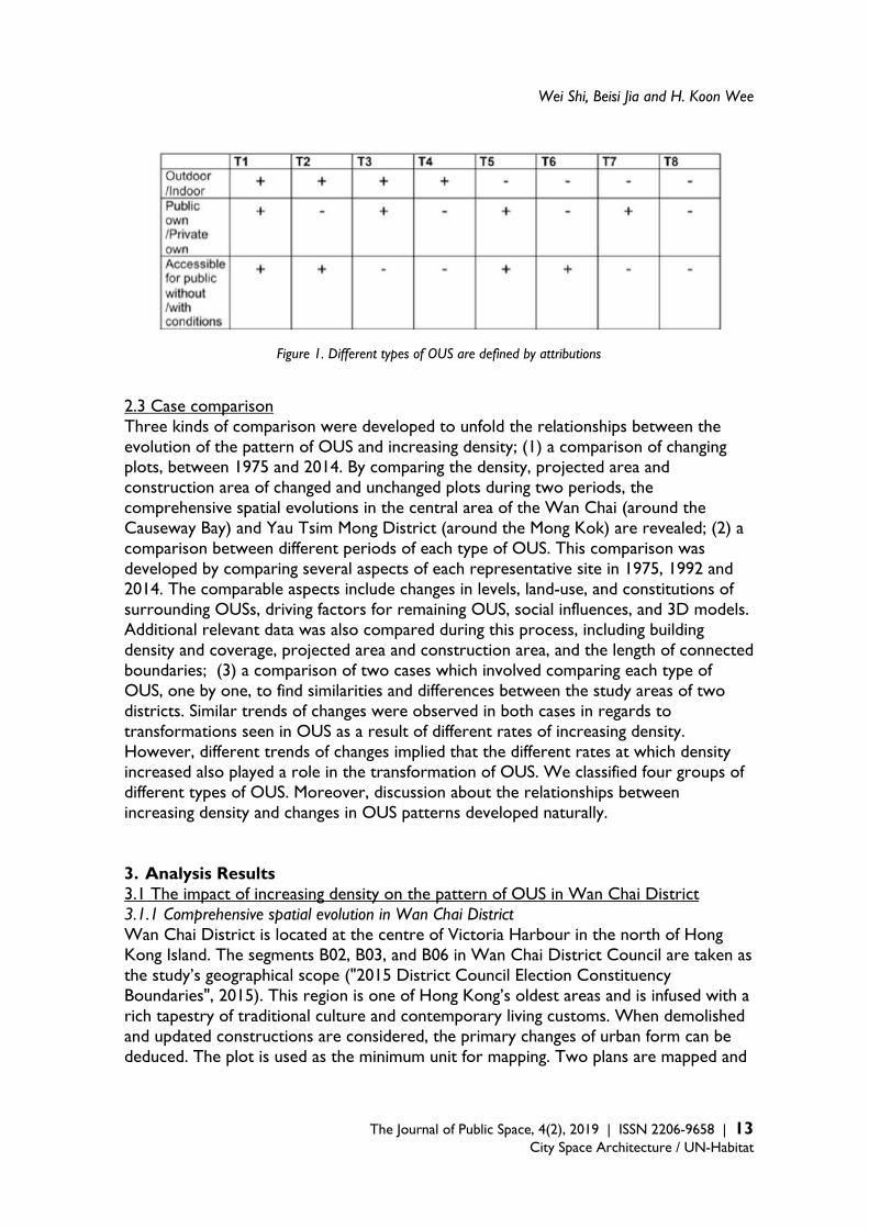
2.2 Mapping analysis This study not only examines the trends of data by making visual 2d and 3d maps of various OUSs in a fine scale, but in addition, the sites which best represent each type of OUS were selected for study on each of the maps respectively. The representative sites were selected one by one according to the L-T framework (Shi, Jia & Wee, 2016; 2017). There are five main criteria for this selection process; (1) to choose the most obvious, large piece of each type of OUS (Figure 1); (2) to choose locations close to important regional business centres planned according to the Statutory Planning process enforced by the Hong Kong Town Planning Board; (3) to select locations relatively near to pedestrian areas or streets planned by the Transport Department of the Hong Kong Government; (4) to select locations in the geographical centres of these districts; and (5) if several representative locations are found by adhering to the above disciplines for one type of OUS, to choose the relatively popular location, according to field investigations. After representative locations were selected, their planes, façades, sections and 3D models were extracted from our updated and accurate digital maps for further comparison. Analyses on both drawings and data were conducted after selecting these representative sites. Although comprehensive study on different scales is still relatively rare, the morphological interpretation methods for reading spatial forms, describing urban spatial evolution and establishing terminologies in the context of urban structure and tissues are relatively mature. In this study, the descriptive customs and terms derived from morphological study methods, including statements about the street, plot, land-use, and building fabric, are adopted for narrating the changes observed in the pattern of OUS since 1975. In this study, the reasons behind the generation and influence of these spatial changes are also examined for each selected site, by comparing maps and historical materials from different periods.
Wei Shi, Beisi Jia and H. Koon Wee
The Journal of Public Space, 4(2), 2019 | ISSN 2206-9658 | 13
City Space Architecture / UN-Habitat
Figure 1. Different types of OUS are defined by attributions 2.3 Case comparison Three kinds of comparison were developed to unfold the relationships between the evolution of the pattern of OUS and increasing density; (1) a comparison of changing plots, between 1975 and 2014. By comparing the density, projected area and construction area of changed and unchanged plots during two periods, the comprehensive spatial evolutions in the central area of the Wan Chai (around the Causeway Bay) and Yau Tsim Mong District (around the Mong Kok) are revealed; (2) a comparison between different periods of each type of OUS. This comparison was developed by comparing several aspects of each representative site in 1975, 1992 and 2014. The comparable aspects include changes in levels, land-use, and constitutions of surrounding OUSs, driving factors for remaining OUS, social influences, and 3D models. Additional relevant data was also compared during this process, including building density and coverage, projected area and construction area, and the length of connected boundaries; (3) a comparison of two cases which involved comparing each type of OUS, one by one, to find similarities and differences between the study areas of two districts. Similar trends of changes were observed in both cases in regards to transformations seen in OUS as a result of different rates of increasing density. However, different trends of changes implied that the different rates at which density increased also played a role in the transformation of OUS. We classified four groups of different types of OUS. Moreover, discussion about the relationships between increasing density and changes in OUS patterns developed naturally. 3. Analysis Results 3.1 The impact of increasing density on the pattern of OUS in Wan Chai District 3.1.1 Comprehensive spatial evolution in Wan Chai District Wan Chai District is located at the centre of Victoria Harbour in the north of Hong Kong Island. The segments B02, B03, and B06 in Wan Chai District Council are taken as the study’s geographical scope ("2015 District Council Election Constituency Boundaries", 2015). This region is one of Hong Kong’s oldest areas and is infused with a rich tapestry of traditional culture and contemporary living customs. When demolished and updated constructions are considered, the primary changes of urban form can be deduced. The plot is used as the minimum unit for mapping. Two plans are mapped and

The Transformation of Open Urban Space and Increasing Building Density
14 | The Journal of Public Space, 4(2), 2019 | ISSN 2206-9658 City Space Architecture / UN-Habitat
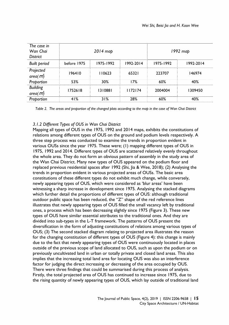
examined (Figure 2) (Table 2). The first, the map of changed plots in 1992 shows similar ratios between the remaining ground area and the construction area of buildings constructed in different periods at 60%: 40%. Thus, in 1992, the remaining area, which was built on or before 1975, had almost the same building density as the renewed area, which was rebuilt during 1972–1992. The second, the map of the changed plot in 2014 reveals that the proportions of remaining ground areas during the three periods were as follows: 53% (constructed before the 1970s), 30% (constructed during 1975–1992), and 17% (constructed during 1992–2014). At the same time, the remaining constructed areas in each of the three periods were 41% (constructed before 1975), 31% (constructed during 1975–1992), and 28% (constructed during 1992–2014). An apparent difference between the two groups of proportions can be noted. Specifically, the renewed construction area after 1992 is more than 1.6 times the ground area (28% to 17%), while the proportions of the two other periods are similar (41% to 53% and 30% to 31%). The difference shows that the buildings constructed during 1992–2014 are considerably higher than the remaining buildings, which were built before 1992. In summary, the findings were unpacked as follows; (1) During 1975–1992, the renewed building heights were similar to those of the remaining ones because the street structure had not changed since 1975. Density increase mainly relied on building construction on previously undeveloped land; (2) during 1992–2014, although the projected area of renewed plots is much smaller than that of the remaining plots, new buildings were considerably higher than previous ones. This kind of development is a welfare consequence of increasing density during 1992-2014 in the study area of the Wan Chai District.
Figure 2. Changed plots in the study area of the Wan Chai District
Wei Shi, Beisi Jia and H. Koon Wee
The Journal of Public Space, 4(2), 2019 | ISSN 2206-9658 | 15
City Space Architecture / UN-Habitat
The case in Wan Chai District
2014 map 1992 map
Built period before 1975 1975-1992 1992-2014 1975-1992 1992-2014
Projected area(㎡)
196410 110623 65321 223707 146974
Proportion 53% 30% 17% 60% 40% Building area(㎡)
1752618 1310881 1172174 2004004 1309450
Proportion 41% 31% 28% 60% 40%
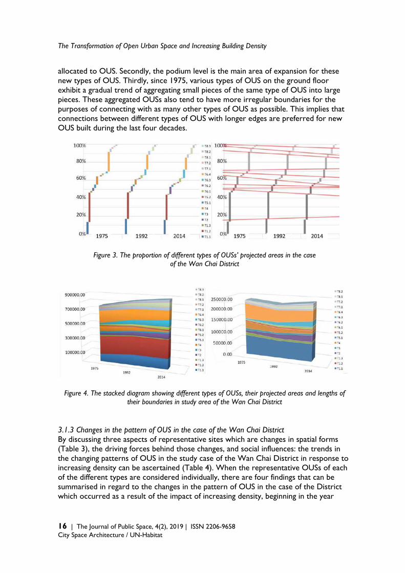
Table 2. The areas and proportion of the changed plots according to the map in the case of Wan Chai District 3.1.2 Different Types of OUS in Wan Chai District Mapping all types of OUS in the 1975, 1992 and 2014 maps, exhibits the constitutions of relations among different types of OUS on the ground and podium levels respectively. A three step process was conducted to examine the trends in proportion evident in various OUSs since the year 1975. These were; (1) mapping different types of OUS in 1975, 1992 and 2014. Different types of OUS are scattered relatively evenly throughout the whole area. They do not form an obvious pattern of assembly in the study area of the Wan Chai District. Many new types of OUS appeared on the podium floor and replaced previous residential spaces after 1992 (Shi, Jia & Wee, 2018); (2) Analysing the trends in proportion evident in various projected areas of OUSs. The basic area constitutions of these different types do not exhibit much change, while conversely, newly appearing types of OUS, which were considered as ‘blur areas’ have been witnessing a sharp increase in development since 1975. Analysing the stacked diagrams which further detail the proportions of different types of OUS: although traditional outdoor public space has been reduced, the “Z” shape of the red reference lines illustrates that newly appearing types of OUS filled the small vacancy left by traditional ones, a process which has been decreasing slightly since 1975 (Figure 3). These new types of OUS have similar essential attributes to the traditional ones. And they are divided into sub-types in the L-T framework. The patterns of OUS present the diversification in the form of adjusting constitutions of relations among various types of OUS; (3) The second stacked diagram relating to projected area illustrates the reason for the changing constitution of different types of OUS (Figure 4): this change is mainly due to the fact that newly appearing types of OUS were continuously located in places outside of the previous scope of land allocated to OUS, such as upon the podium or on previously uncultivated land in urban or totally private and closed land areas. This also implies that the increasing total land area for locating OUS was also an interference factor for judging the direct increasing or decreasing of the area occupied by OUS. There were three findings that could be summarised during this process of analysis. Firstly, the total projected area of OUS has continued to increase since 1975, due to the rising quantity of newly appearing types of OUS, which lay outside of traditional land
The Transformation of Open Urban Space and Increasing Building Density
16 | The Journal of Public Space, 4(2), 2019 | ISSN 2206-9658 City Space Architecture / UN-Habitat
allocated to OUS. Secondly, the podium level is the main area of expansion for these new types of OUS. Thirdly, since 1975, various types of OUS on the ground floor exhibit a gradual trend of aggregating small pieces of the same type of OUS into large pieces. These aggregated OUSs also tend to have more irregular boundaries for the purposes of connecting with as many other types of OUS as possible. This implies that connections between different types of OUS with longer edges are preferred for new OUS built during the last four decades.
Figure 3. The proportion of different types of OUSs’ projected areas in the case of the Wan Chai District
Figure 4. The stacked diagram showing different types of OUSs, their projected areas and lengths of their boundaries in study area of the Wan Chai District
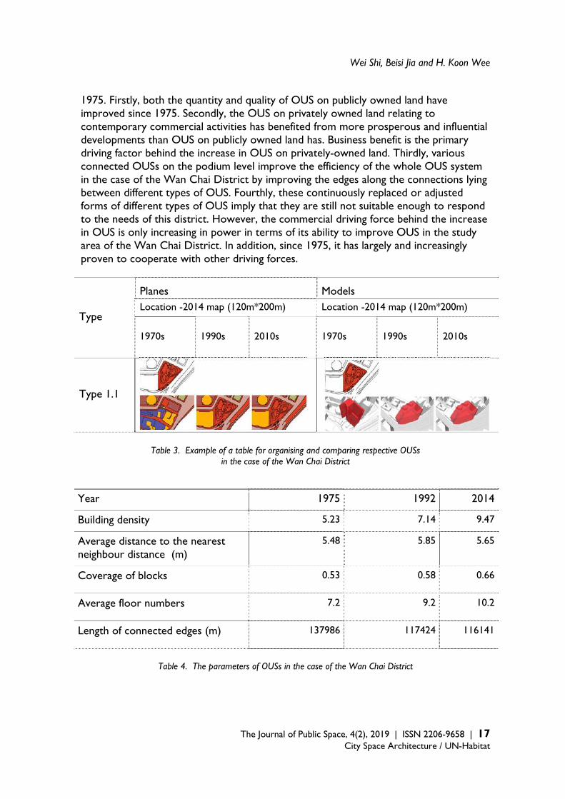
3.1.3 Changes in the pattern of OUS in the case of the Wan Chai District By discussing three aspects of representative sites which are changes in spatial forms (Table 3), the driving forces behind those changes, and social influences: the trends in the changing patterns of OUS in the study case of the Wan Chai District in response to increasing density can be ascertained (Table 4). When the representative OUSs of each of the different types are considered individually, there are four findings that can be summarised in regard to the changes in the pattern of OUS in the case of the District which occurred as a result of the impact of increasing density, beginning in the year
Wei Shi, Beisi Jia and H. Koon Wee
The Journal of Public Space, 4(2), 2019 | ISSN 2206-9658 | 17
City Space Architecture / UN-Habitat
1975. Firstly, both the quantity and quality of OUS on publicly owned land have improved since 1975. Secondly, the OUS on privately owned land relating to contemporary commercial activities has benefited from more prosperous and influential developments than OUS on publicly owned land has. Business benefit is the primary driving factor behind the increase in OUS on privately-owned land. Thirdly, various connected OUSs on the podium level improve the efficiency of the whole OUS system in the case of the Wan Chai District by improving the edges along the connections lying between different types of OUS. Fourthly, these continuously replaced or adjusted forms of different types of OUS imply that they are still not suitable enough to respond to the needs of this district. However, the commercial driving force behind the increase in OUS is only increasing in power in terms of its ability to improve OUS in the study area of the Wan Chai District. In addition, since 1975, it has largely and increasingly proven to cooperate with other driving forces.
Type
Planes
Models Location -2014 map (120m*200m) Location -2014 map (120m*200m)
1970s 1990s 2010s 1970s 1990s 2010s
Type 1.1
Table 3. Example of a table for organising and comparing respective OUSs in the case of the Wan Chai District
Year 1975 1992 2014
Building density 5.23 7.14 9.47
Average distance to the nearest neighbour distance (m)
5.48 5.85 5.65
Coverage of blocks 0.53 0.58 0.66
Average floor numbers 7.2 9.2 10.2
Length of connected edges (m) 137986 117424 116141
Table 4. The parameters of OUSs in the case of the Wan Chai District
The Transformation of Open Urban Space and Increasing Building Density
18 | The Journal of Public Space, 4(2), 2019 | ISSN 2206-9658 City Space Architecture / UN-Habitat
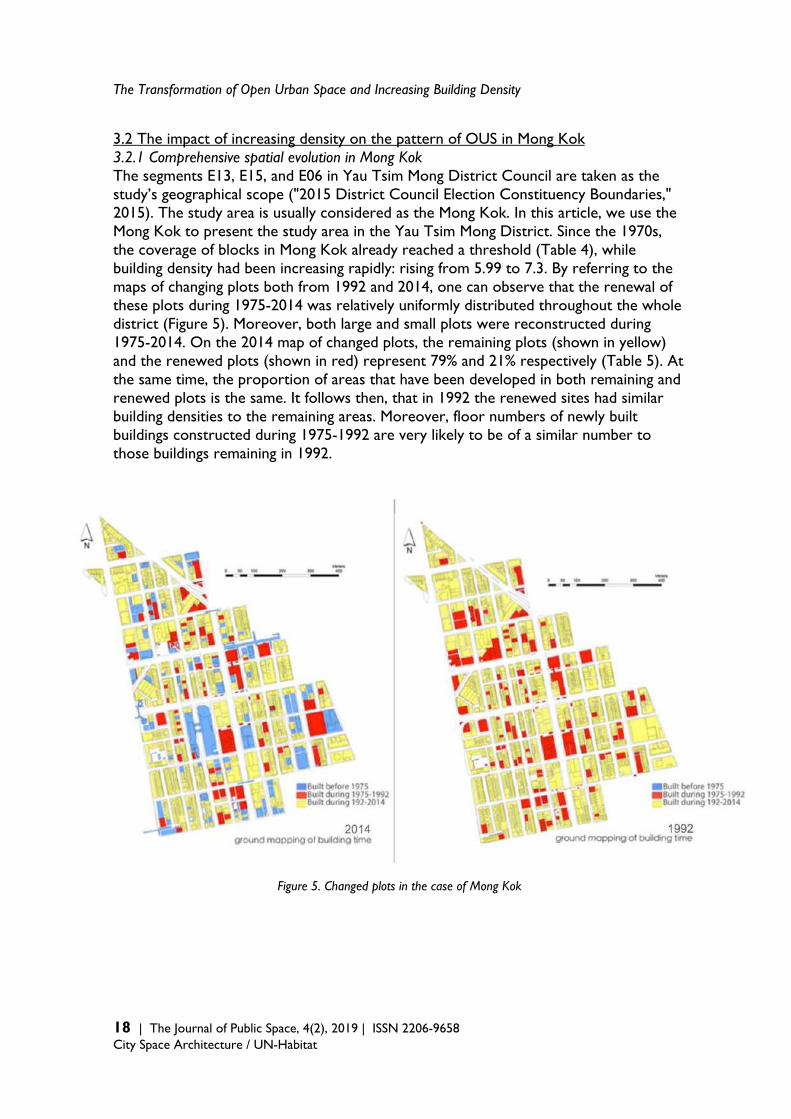
3.2 The impact of increasing density on the pattern of OUS in Mong Kok 3.2.1 Comprehensive spatial evolution in Mong Kok The segments E13, E15, and E06 in Yau Tsim Mong District Council are taken as the study’s geographical scope ("2015 District Council Election Constituency Boundaries," 2015). The study area is usually considered as the Mong Kok. In this article, we use the Mong Kok to present the study area in the Yau Tsim Mong District. Since the 1970s, the coverage of blocks in Mong Kok already reached a threshold (Table 4), while building density had been increasing rapidly: rising from 5.99 to 7.3. By referring to the maps of changing plots both from 1992 and 2014, one can observe that the renewal of these plots during 1975-2014 was relatively uniformly distributed throughout the whole district (Figure 5). Moreover, both large and small plots were reconstructed during 1975-2014. On the 2014 map of changed plots, the remaining plots (shown in yellow) and the renewed plots (shown in red) represent 79% and 21% respectively (Table 5). At the same time, the proportion of areas that have been developed in both remaining and renewed plots is the same. It follows then, that in 1992 the renewed sites had similar building densities to the remaining areas. Moreover, floor numbers of newly built buildings constructed during 1975-1992 are very likely to be of a similar number to those buildings remaining in 1992.
Figure 5. Changed plots in the case of Mong Kok
Wei Shi, Beisi Jia and H. Koon Wee
The Journal of Public Space, 4(2), 2019 | ISSN 2206-9658 | 19
City Space Architecture / UN-Habitat
Mong Kok case 2014 map 1992 map
Built period before 1975 1975-1992 1992-2014 1975-1992 1992-2014
Projected area(㎡)
183342 41549 724792 225538 58707
Proportion 19% 5% 76% 79% 21%
Building area(㎡) 1669512 362439 1172174 1916534 522510
Proportion 52% 11% 37% 79% 21%
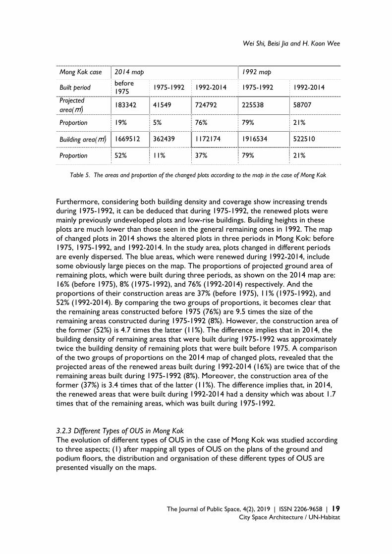
Table 5. The areas and proportion of the changed plots according to the map in the case of Mong Kok
Furthermore, considering both building density and coverage show increasing trends during 1975-1992, it can be deduced that during 1975-1992, the renewed plots were mainly previously undeveloped plots and low-rise buildings. Building heights in these plots are much lower than those seen in the general remaining ones in 1992. The map of changed plots in 2014 shows the altered plots in three periods in Mong Kok: before 1975, 1975-1992, and 1992-2014. In the study area, plots changed in different periods are evenly dispersed. The blue areas, which were renewed during 1992-2014, include some obviously large pieces on the map. The proportions of projected ground area of remaining plots, which were built during three periods, as shown on the 2014 map are: 16% (before 1975), 8% (1975-1992), and 76% (1992-2014) respectively. And the proportions of their construction areas are 37% (before 1975), 11% (1975-1992), and 52% (1992-2014). By comparing the two groups of proportions, it becomes clear that the remaining areas constructed before 1975 (76%) are 9.5 times the size of the remaining areas constructed during 1975-1992 (8%). However, the construction area of the former (52%) is 4.7 times the latter (11%). The difference implies that in 2014, the building density of remaining areas that were built during 1975-1992 was approximately twice the building density of remaining plots that were built before 1975. A comparison of the two groups of proportions on the 2014 map of changed plots, revealed that the projected areas of the renewed areas built during 1992-2014 (16%) are twice that of the remaining areas built during 1975-1992 (8%). Moreover, the construction area of the former (37%) is 3.4 times that of the latter (11%). The difference implies that, in 2014, the renewed areas that were built during 1992-2014 had a density which was about 1.7 times that of the remaining areas, which was built during 1975-1992. 3.2.3 Different Types of OUS in Mong Kok The evolution of different types of OUS in the case of Mong Kok was studied according to three aspects; (1) after mapping all types of OUS on the plans of the ground and podium floors, the distribution and organisation of these different types of OUS are presented visually on the maps.

The Transformation of Open Urban Space and Increasing Building Density
20 | The Journal of Public Space, 4(2), 2019 | ISSN 2206-9658 City Space Architecture / UN-Habitat
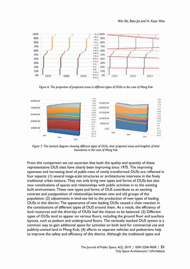
The total projected area of the OUSs on podium floors shows an obvious increasing trend. And the projected area of the types of OUS relating to the connective parts of buildings also increases rapidly. By considering the distribution changes of different OUSs since 1975, an intangible elliptical radar shape can be realised as the path of newly appearing types which replaced previously existing types of OUS in the central area of the study area. Along the spreading ellipse, many indoor OUSs with relatively low-openness replaced the previous residential spaces, in a gradual process since 1975. The OUS with more positive ones of the three pairs of attributions (Figure 1) means it is relatively higher openness. Moreover, new kinds of OUS with mixed commercial usages and relatively high-openness replaced the 20re-existing traditional commercial spaces; (2) Comparing the proportions of different types of OUS in the case of Mong Kok in different time periods (Figure 6). The changes in the proportions of different types of OUS are not immediately obvious upon comprehensively observing their respective percentages. At first, the types of OUS with large proportions show slight decreasing trends, while the types of OUS with lower proportions show obvious increasing trends. However, both of these types of OUS keep their positions in the ranking of proportions. Although the constitution of different types of OUS in the case of Mong Kok does not change much, the acceptance of newly appearing types of OUS have been improving since 1975; (3) by studying the stack diagrams relating to the projected areas of different types of OUS — (Figure 7) the changes in vertical forms from different types of OUS can be figured out by comparing them to respective trends in relation to the lengths of their connecting edges. Although the changes in these parameters during 1975-2014 were relatively gentle and basically stable, some prominent contrasts did appear when we compared four other diagrams detailing the length of all the connection edges of the OUSs, these were: average floor number, coverage, and the average distance to the nearest neighbour respectively (Table 7). One of the prominent contrasts was that the total edge-length on the ground floor shows an apparent trend of decline since 1975, however, the overall length of OUS on the ground and podium floors showed a slightly decrease and then ascendant. The reasons for these different trends is that the length of the OUS on the podium floor is rising with an accelerate ratio. Furthermore, considering that the total ground area of construction land in the study area is a fixed value, when the length of the total boundaries on the ground floor decreases, the spatial form on the ground plan becomes more and more aggregated. It implies that many individual small pieces of OUS were assembled to form larger pieces during 1975-2014. 3.2.3 Changes in the pattern of OUS in Mong Kok Three aspects relating to the pattern of selected representative OUSs are studied in this process of analysis (Table 6). They include the changes of spatial forms, driving forces behind changes, and social influences. Not only the changes in selected patterns of OUSs are analysed, but the relevant data trends from the whole study area are also compared (Table 7).
Wei Shi, Beisi Jia and H. Koon Wee
The Journal of Public Space, 4(2), 2019 | ISSN 2206-9658 | 21
City Space Architecture / UN-Habitat
Figure 6. The proportion of projected areas in different types of OUSs in the case of Mong Kok
Figure 7. The stacked diagram showing different types of OUSs, their projected areas and lengthes of their boundaries in the case of Mong Kok
From this comparison we can ascertain that both the quality and quantity of these representative OUS sites have clearly been improving since 1975. The improving openness and increasing level of public-ness of newly transformed OUSs are reflected in four aspects; (1) several mega-scale structures or architectures intervene in the finely traditional urban texture. They not only bring new types and forms of OUSs but also new constitutions of spaces and relationships with public activities in to the existing built environment. These new types and forms of OUS contribute to an exciting contrast and juxtaposition of relationships between new and old groups of the population; (2) adjustments in land-use led to the production of new types of leading OUSs in this district. The appearance of new leading OUSs caused a chain reaction in the constitutions of different types of OUS around them. As a result, the efficiency of land resources and the diversity of OUSs had the chance to be balanced. (3) Different types of OUSs tend to appear on various floors, including the ground floor and auxiliary layouts, such as podium and underground floors. The vertically stacked OUS system is a common way to gain additional space for activities on both land for commercial use and publicly-owned land in Mong Kok; (4) efforts to separate vehicles and pedestrians help to improve the safety and efficiency of this district. Although the traditional types and

The Transformation of Open Urban Space and Increasing Building Density
22 | The Journal of Public Space, 4(2), 2019 | ISSN 2206-9658 City Space Architecture / UN-Habitat
forms of OUS have changed substantially, the connections between different parts are abrupt. At the same time, various groups of people tend to show apparent preferences to exclusively engage in activities in their familiar spaces.
Type
Planes
Models
Location -2014 map (120m*200m) Location -2014 map (120m*200m)
1970s 1990s 2010s 1970s 1990s 2010s
Type 1.1
Table 6. Example of table for organising and comparing respective OUSs in the case of Mong Kok
Table 7. The parameters of OUSs in the case of Mong Kok
4. Findings As building density in the study area of the Wan Chai District has been increasing at a much faster rate than in the study area of the Yau Tsim Mong District — from a similar starting point around the year 1975 — after three kinds of comparison, it was possible to reveal the the relationships between the evolution of OUSs with different increasing density rates. The similarities and differences between every type of OUS in the central area of the Wan Chai (around the Causeway Bay) and Yau Tsim Mong District (around the Mong Kok), can be categorised in a table and compared one by one. The relationship between the evolution of the pattern of OUS and increasing density can be summarised in four categories; (1) both the increasing trend and increasing ratio of density influence the changes in the pattern of OUS. Type 1.3 and type 6.4 were classified in this category by considering the results below; (2) both the increasing trend and increasing ratio of density influence the changes in the pattern of OUS, but the
Year 1975 1992 2014
Building density 6.09 6.54 7.26
Average distance to the nearest neighbour distance (m)
4.94 5.19 5.49
Coverage of blocks 0.67 0.63 0.66
Average floor numbers 8.0 8.2 8.5
Length of connected edges (m) 125827 132370 138951

Wei Shi, Beisi Jia and H. Koon Wee
The Journal of Public Space, 4(2), 2019 | ISSN 2206-9658 | 23
City Space Architecture / UN-Habitat
different increasing ratio of density is not the most decisive factor for deciphering the changes. The representative cases of type 1.1, type 1.2, type 5.2, type 7.1 and type 8.3 are all included in this category. Some other factors play a more important role in such changes when they change following increased density, such as their re-location, a change in land-use in their surroundings, and so on. (3) The increasing trend of density influences the changes in OUS, but the increasing ratio of density does not influence the changes. For example, the technologies available for construction and the aesthetics of commercial goods during the time in which building occurs can play more important roles in the process of change. Type 4, type 2, type 5.1, type 6.1, type 6.2, type 6.3, type 8.1 and type 8.2 are also considered to form part of this category; (4) neither the increasing trend nor the increasing ratio of density influence the changes to the pattern of OUS. The changes are only provoked by other factors. Type 3 and type 7.2 are distinguishable in this category. After classifying the four categories or groups of different types of OUS, which have different relationships with increasing density, we particularly observed both maps and data in relation to representative cases, group by group. As the fourth group of spaces remains unchanged under the influences of increasing density and increasing ratio, we summarised the other three groups’ main characteristics respectively. Although these characteristics appear more or less in all of the groups, one characteristic in particular shows up in a more obvious way in one group than in the others in our representative cases. (A) The first groups of OUS exhibit the main characteristic of transformation under social influences. These spaces perform the role of intervention and induction for the whole study areas rather than producing the optimised and integrated results observed in previous circumstances, including the environment of density and context of fabric. Regardless of whether or not the connections with surroundings are designed elaborately enough, these spaces have a responsibility to exude the temperament of contributing to previous compact and mixed-use residential areas to gain an irreplaceable and identifiable disposition in a city. (B) The second groups of OUS exhibit the main characteristic of transformation in cooperation with the driving forces that developed them. Although the increasing ratios of building density are different, the sizes and degrees of aggregation among identical types of OUS are very similar. However, spatial morphologies display relatively large differences. Neither the connecting edges with other spaces nor the overall shapes display any obvious similarity. (C) The third groups of OUS show the characteristics of a transformation mainly confined to spatial forms. Although the changes in spatial forms are not influenced by the increasing rate of density, driving forces as a result of commercialisation, privatisation, and introversion show advancements in OUSs. These driving forces push these processes to become independent and principal products of the OUS system rather than being parts of the spatial product in specific buildings. Therefore, it is speculated that changes to these spatial morphologies are decided neither by the increasing densities in relevant areas nor by the previous spatial forms themselves. The global backgrounds in specific periods, including economic and technological conditions, are the dominant factors, clues to which can be found in their forms.
The Transformation of Open Urban Space and Increasing Building Density
24 | The Journal of Public Space, 4(2), 2019 | ISSN 2206-9658 City Space Architecture / UN-Habitat
5. Discussion Through the empirical studies of three periods in the study areas of the Wan Chai and Yau Tsim Mong Districts during 1975-2014, not only four kinds of relationships between increasing building density and patterns of OUS are drawn, but a further three trends of OUS transformation are presented. The new characteristics of contemporary OUS are also important references for future design in high-density cities. These trends of OUS can also explain the current conflicts related to recognition which have surrounded OUS in the last two decades. (A) There is a stereotype that: social influences on contemporary OUSs in the study
areas of the Wan Chai and Yau Tsim Mong Districts seem to drive their development towards homogeneity along with commercial drivers. Although most of the previous studies featuring this kind of stereotype are opposed to the influences arising from OUSs with commercial drivers, some rival ideas have appeared over the last decade. They are looking for alternative ways to develop these public spaces by re-evaluating the potential in and transformed meanings driven by commercial spaces for the public inhabiting these spaces. The gradual diversification of social influences within these spaces is not only related to the spaces in themselves but is also connected to the overall OUS system containing them. Additionally, as is the case for the immigration and emigration of major peoples in some OUSs, the solutions for the problems arising from such replacements of of diverse people can be sought as part of a larger-scale analysis rather than trying to digest and resolve the issue on middle or small scales independently.
(B) There is another stereotype in connection with the amount of reduction in OUSs along with observations that some spatial forms are not friendly enough for people to make contact with each other. Following the statistical analysis, it was concluded that the total area of most OUS with relatively high-openness, which have relatively more opposite attributions of OUS (Figure 1), increased following an increase in density in the relevant area. At the same time, most OUSs tended to be transformed in a way that bestowed them with a relatively high level of public-ness; while, the boundaries of the OUSs tended to become softer and more irregular. The cognitive deviation for the reduction and increase of OUS is caused by the numerous new types of OUS, which took on the major roles of traditional OUSs. Although the projected area of many pre-existing OUSs for relatively high level of public use was not reduced or their types changed, their level of publicness lowered, because many of the newly built OUSs displayed much higher levels of public use and thus played stronger roles than their previous counterparts in terms of offering a high level of service to people.
(C) The third stereotype is that the impetus from the government and commerce are analysed respectively as two opposed forces in research works. However, the driving factors are becoming more diversified with more balanced forces from different aspects. The trends of impetus factors are closely related to the sustainable development of OUS. Otherwise, prioritising an increase in activities in a specific segment of OUS over other considerations leads to bias and inefficiency in terms of maintaining the vitality of OUS on a long-term basis: specifically in relation to the level of services offered the public. One of the main reasons for this
Wei Shi, Beisi Jia and H. Koon Wee
The Journal of Public Space, 4(2), 2019 | ISSN 2206-9658 | 25
City Space Architecture / UN-Habitat
is that visitors are gradually outnumbering local residents in OUS. The vitality of OUS should lie in ensuring a comfortable and efficient streaming of people rather than congestions and jams.
References Abel, C. (2001). ‘Architecture in the pacific century’, Public places in asia pacific cities: current
issues and strategies, MA: Kluwer Academic Publishers, Dordrecht, Boston, p. 4. Al, S. (2016). Mall city: Hong Kong's dreamworlds of consumption, University Press, Hong Kong. Anonymous (2001). ‘The British Museum Queen Elizabeth II great court project fire engineering:
enabling effective design for heritage buildings’, Facilities, vol. 19, no. 10. Aritenang, A.F. (2014). ‘Urbanization in Southeast Asia: issues and impacts’, Bulletin of Indonesian
Economic Studies, vol. 50, no. 1, p.144. Backes, N. (1997). ‘Reading the shopping mall city’, Journal of Popular Culture, vol. 31, no. 3, pp. 1-
17. Barter, P.A. (2000). ‘Transport dilemmas in dense urban areas: examples from eastern asia’,
Compact cities: sustainable urban forms for developing countries, Spon Press, London. Batty, M. (2001). ‘Exploring isovist fields: space and shape in architectural and urban
morphology’, Environment and Planning B: Planning and Design, vol. 28, no. 1, pp. 123-150. Çalișkan, O. & Marshall, S. (2011). ‘Urban morphology and design: introduction’. Built
Environment, vol. 37, no. 4, pp. 380-392. Carlow, J. (2013). ‘[Re]forming public space: a critique of hong kong's park governance through
architectural intervention’, Footprint, vol.12, pp. 67-74. Carmona, M. & Tiesdell, S. (2007), Urban design reader, Mass.: Architectural Press, Oxford.
Burlington. Chan, C.S. (2017). ‘Health-related elements in green space branding in Hong Kong’, Urban
Forestry & Urban Greening, vol. 21, pp. 192-202. Chan, C.H. & Fu, K.W. (2017). ‘The relationship between cyber balkanization and opinion
polarization: time-series analysis on Facebook pages and opinion polls during the Hong Kong occupy movement and the associated debate on political reform’, Journal of Computer Mediated Communication, vol. 22, no. 5, pp. 266-283.
Chen, L, Ng, E., An, X., Ren, C., Lee, M., Wang, U., & He, Z. (2012), ‘Sky view factor analysis of street canyons and its implications for daytime intra-urban air temperature differentials in high-rise, high-density urban areas of Hong Kong: a GIS-based simulation approach’, International Journal of Climatology, vol. 32, no. 1, pp. 121-136.
Conzen, M.P.C. (2001), ‘The study of urban form in the United States’, Urban Morphology, vol. 5, no. 1, pp. 3-14.
Cugurullo, F. (2018), ‘Exposing smart cities and eco-cities: Frankenstein urbanism and the sustainability challenges of the experimental city’, Environment and Planning A: Economy and Space, vol. 50, no. 1, pp. 73-92.
Darin, M. (2004), ‘The study of urban form in Germany’, Urban Morphology, vol. 1, no. 8, pp. 9. Edussuriya, P., Chan, A., & Ye, A. (2011). ‘Urban morphology and air quality in dense residential
environments in Hong Kong. Part I: District-level analysis’, Atmospheric Environment, vol. 45, no. 27, pp. 4789-4803.
District Council Election Constituency Boundaries (2015), Electoral Affairs Commission, Hong Kong.

The Transformation of Open Urban Space and Increasing Building Density
26 | The Journal of Public Space, 4(2), 2019 | ISSN 2206-9658 City Space Architecture / UN-Habitat
Eisenman, P. (2012). ‘The agency interview: the institute for architecture and urban studies
(IAUS)’, Perspecta, vol. 45, pp. 59-66. Enke, S. (1962), ‘Economic development with unlimited and limited supplies of labour’, Oxford
Economic Papers, vol. 14, no. 2, pp. 158-172. Esber, G.S. (1982). ‘Cultural/applied: human aspects of urban form: towards a man
environment approach to urban form and design’, American Anthropologist, vol. 84, no. 2, pp. 464-465.
Franck, K.A. & Schneekloth, L.H. (1994). Ordering space: types in architecture and design, Van Nostrand Reinhold, New York.
Gao, W. (2015). ‘Collective actions for the management of multi-owned residential building: A case of Hong Kong’, Habitat International, vol. 49, pp. 316-324.
Gray, J. (2013). ‘The work of art in the age of mechanical reproduction’, The Virginia Quarterly Review, vol. 89, no. 2, pp. 129-130.
Ghosh, S. (2015). ‘Cities by design: the social life of urban form; explorations in urban design: an urban design research primer; the nature of urban design: a New York perspective on resilience’, Journal of Urban Technology, vol. 22, no. 3, pp. 121–126.
Hart, K. (1973). ‘Informal income opportunities and urban employment in Ghana’. Journal of Modern African Studies, vol. 11, no. 1, pp. 61-89.
Haughton, G. (2001). ‘Achieving sustainable urban form urban study’, vol. 38, pp. 1399-1400. Hillier, B. (2014). ‘The generic city and its origins’, Architectural Design, vol. 84, no. 5, pp. 100-
105. Hofmeister, B. (2004). ‘The study of urban form in Germany’, Urban Morphology, vol. 1, no. 8,
pp. 9. Huang, J., Shen, G.Q. & Zheng, H.W. (2015). ‘Is insufficient land supply the root cause of housing
shortage? Empirical evidence from Hong Kong’, Habitat International, vol. 49, pp. 538-546. Jayantha, W.M. & Lam, S.O. (2015). ‘Capitalization of secondary school education into property
values: a case study in Hong Kong’, Habitat International, vol. 50, pp. 12-22. Jayantha, W.M., Lam, T.I. & Chong, M.L. (2015). ‘The impact of anticipated transport
improvement on property prices: A case study in Hong Kong’, Habitat International, vol. 49, pp. 148-156.
Jenks, M. & Burgess, R. (2000). Compact cities: sustainable urban forms for developing countries, Spon Press, London
Jenks, M., Burton, E. & Williams, K. (1996). The Compact city: a sustainable urban form? (1st ed.), New York: E & FN Spon, London.
Jia, B. (ed.) (2003). Dense living urban structure: selected papers of the International Conference on Open Building, 23-26 October, 2003, Hong Kong: Faculty of Architecture, The University of Hong Kong, Hong Kong.
Habraken, N.J. (2008). ‘Design for flexibility’, Building Research & Information, vol. 36, no. 3, pp. 290-296.

Wei Shi, Beisi Jia and H. Koon Wee
The Journal of Public Space, 4(2), 2019 | ISSN 2206-9658 | 27
City Space Architecture / UN-Habitat
Helbrecht, I. & Dirksmeier, P. (2012). New urbanism: life, work, and space in the new downtown,
Ashgate, Surrey, UK & England. Kai, G. (2001). ‘Urban morphology of China in the post-socialist age: Towards a framework for
analysis’, Urban Design International, vol. 6, no. 3-4, pp. 125. Kendall, S. (1999). ‘Open Building: An Approach to Sustainable Architecture’, Journal of Urban
Technology, vol. 6, no. 3, pp. 1-16. Krasny, E. & Wien, A.Z. (2012). Hands-on urbanism 1850-2012: the right to green, MCCM
Creation. Lai, L.W.C. (2015). ‘Squatting by the privileged? A Hong Kong study on the innovations and
ambiguity of property rights of irregular development’, Habitat International, vol. 50, no. C, pp. 317-325.
Li, W.M., Lee, S.C., & Chan, L.Y. (2001). ‘Indoor air quality at nine shopping malls in Hong Kong’, Science of the Total Environment, vol. 273, no. 1, pp. 27-40.
Maruani, T. & Amit-Cohen, I. (2007). ‘Open space planning models: A review of approaches and methods’, Landscape and Urban Planning, vol. 81, no. 1, pp. 1-13.
Marzot, N. (2002). ‘The study of urban form in Italy’, Urban Morphology, vol. 6, no. 2, pp. 59-73. Mesa, N.A., Corica, L., & Pattini, A. (2011), ‘Evaluation of the potential of natural light to
illuminate buildings in dense urban environment, a study in Mendoza, Argentina’, Renewable Energy, vol. 36, no. 9, pp. 2414-2423.
Miao, P. (ed.) (2001). Public places in Asia Pacific cities: current issues and strategies, MA: Kluwer Academic Publishers, Dordrecht, Boston.
Miles, M., Hall, T., & Borden, I. (ed.) (2004). The City cultures reader (2nd ed.), Routledge, London & New York.
Mindali, O., Raveh, A., & Salomon, I. (2004). ‘Urban density and energy consumption: a new look at old statistics’, Transportation Research Part A, vol. 38, no. 2, pp. 143-162.
Moneo, R. (1978). ‘On Typology’, Oppositions, Institute for Architecture Urban Studies, New York.
Mostafavi, M. & Najle, C. (2000). ‘Urbanism as landscape?’ AA Files, vol. 42, no. 1, pp. 44-47. Moudon, AV 1992, ‘A catholic approach to organizing what urban designers should know’,
Journal of planning literature, vol. 6, no. 4, pp. 331-349. Munton, R. & Collins, K. (1998). ‘Government strategies for sustainable development’,
Geography, vol. 83, pp. 346-357. Nagendra, H. & Gopal, D. (2010). ‘Street trees in Bangalore: Density, diversity, composition and
distribution’, Urban Forestry & Urban Greening, vol. 9, no. 2, pp. 129-137. Norberg-Schulz, C. (1976). ‘The Phenomenon of Place’, Architectural Association Quarterly, vol. 8,
no. 4, pp. 3-10. Shi, W., Jia, B. & Wee, H.K. (2016). ‘Evolution of space pattern in the increasing high-dense city’,
Urban Morphology and the Resilient City, vol. 1, no. 1, pp. 128-143. Shi, W., Jia, B. & Wee, H.K. (2017). ‘Multi-Level: a way to study the pattern of urban open space
in high-density environment’, UIA 2017 Seoul World Architects Congress, vol. 1, no. 1.
The Transformation of Open Urban Space and Increasing Building Density
28 | The Journal of Public Space, 4(2), 2019 | ISSN 2206-9658 City Space Architecture / UN-Habitat
Shi, W., Jia, B. & Wee, H.K. (2018). ‘Relationship between the changing urban open spaces and
increasing density in Mong Kok since the 1970s’, Modern Environmental Science and Engineering, vol. 4, no. 5, pp. 476-486.
Storper, M., & Scott, A.J. (2016). ‘Current debates in urban theory: a critical assessment’, Urban Studies, vol. 53, no. 6, pp. 1114-1136.
Thompson, I. (2000). ‘The city cultures reader. Landscape research’, vol. 25, no. 2, pp. 259. Tucker, D 2002, ‘Public places in Asia pacific cities: current issues and strategies great leap
forward’, The Journal of Asian Study, vol. 61, pp. 1012-1014. Wai, M.K., Yee, C.W., Tim, W.L. & Shan, H.P. (2010). ‘Scoping indoor airborne fungi in an
excellent indoor air quality office building in Hong Kong’, Building Services Engineering Research & Technology, vol. 31, no. 2, pp. 191-199.
Wan, C. & Shen, G.Q. (2015). ‘Salient attributes of urban green spaces in high density cities: the case of Hong Kong’, Habitat International, vol. 49, pp. 92-99.
Wang, H., Zhang, X., & Skitmore, M. (2015). ‘Implications for sustainable land use in high-density cities: evidence from Hong Kong’. Habitat International, vol. 50, pp. 23-34.
Wang, Y., & Chen, J. (2018). ‘Does the rise of pseudo-public spaces lead to the “end of public space” in large Chinese cities? Evidence from Shanghai and Chongqing’, Urban Design International, vol. 23, no. 3, pp. 215-235.
Willams, N. (2001). ‘Achieving sustainable urban form: K Williams, E Burton and M Jenks E & FN Spon, London, 388pp’, Land Use Policy, vol. 18, pp. 202-202.
Woels, M. (2012). ‘Hands-on urbanism, 1850-2012: the right to green archit. Rev’, svol. 231, pp. 97.
Wu, C., Wilkes, R., Silver, D., & Clark, T.N. (2019), ‘Current debates in urban theory from a scale perspective: Introducing a scenes approach’, Urban Studies, vol. 56, no. 8, pp. 1487-1497.
Xue, C.Q.L. & Manuel, K.K. (2001). ‘The quest for better public space: a critical review of urban Hong Kong’, Public places in Asia Pacific cities: current issues and strategies, MA: Kluwer Academic Publishers, Dordrecht, Boston.
Xue, C.Q.L. (2012). ‘Indoor public space: a study of atria in mass transit railway (MTR) complexes of Hong Kong’. Urban Design International, vol. 17, no. 2, pp. 87-105.
Yau, Y. & Chiu, S.M. (2015). ‘Combating building illegality in Hong Kong: a policy delphi study’, Habitat International, vol. 49, pp. 349-356.
The Journal of Public Space ISSN 2206-9658 2019 | Vol. 4 n. 2 https://www.journalpublicspace.org
ISSN 2206-9658 | 29
City Space Architecture / UN-Habitat
Public Space, Tourism and Mobility: Projects, Impacts and Tensions in Lisbon’s Urban Regeneration Dynamics
João Rafael Santos Universidade de Lisboa, Faculdade de Arquitetura, Portugal [email protected] Abstract In the wake of severe economic slowdown during the 2008-2015 crisis, and despite continued constraints on public investment in large scale infrastructure, Lisbon is emerging as one of the most attractive destinations in Europe. Tourism has been driving major spatial, functional and social changes, initially in the city’s historical districts, and nowadays exerts impact across a much larger urban and regional area. Tourism, together with new drivers of the real-estate market, is promoting the renovation of formerly vacant or rundown built stock, taking advantage of a rather fragile socio-economic milieu and changing the face of residential, commercial and public space landscapes. Recently upgraded transportation nodes and extensive improvements on public space have also played a meaningful role in this process. Central government and municipality rationale have underpinned its role in providing accessibility, “attractivity”, and “heritage valorisation”, aiming to attract young residents after decades of resident population decline. In contrast to considerable public investment in public space and infrastructure, very limited funding or policy has been targeted at maintaining an affordable housing and real-estate market: thus leaving much of the public investment return to the private sector. Criticism of gentrification and “touristification”, rising housing prices, and pressure on infrastructure is growing accordingly. The paper provides insight into aspects of this process, with a focus on the relational aspects of mobility upgrade, public space renewal and inner-city urban regeneration. Several urban projects are mapped and broadly characterised in their spatial and functional relationship with tourism. An interpretative framework that combines them with the forms of territorialisation and the main conflicts and tensions is offered as a contribution to the ongoing discussion. Conclusions point to the complex and powerful role that public space and mobility infrastructure play in the impact of territorialising tourism: as supports for better qualified, multi-scalar and shared urban spaces and as drivers of a more balanced, diverse and socially-inclusive urban tourism development. Keywords: touristification, mobility infrastructure, public space, urban regeneration, Lisbon
T
HE
JO
UR
NA
L O
F P
UB
LIC
SP
AC
E
To cite this article: Santos, J. R. (2019). Public Space, Tourism and Mobility: Projects, Impacts and Tensions in Lisbon’s Urban Regeneration Dynamics. The Journal of Public Space, 4(2), 29-56, DOI 10.32891/jps.v4i2.1203 This article has been double blind peer reviewed and accepted for publication in The Journal of Public Space.
This work is licensed under a Creative Commons Attribution - Non Commercial 4.0 International License https://creativecommons.org/licenses/by-nc/4.0/
Public Space, Tourism and Mobility
30 | The Journal of Public Space, 4(2), 2019 | ISSN 2206-9658 City Space Architecture / UN-Habitat
Introduction This paper outlines the emerging relationships between tourism and recently developed projects concerning infrastructure, mobility and public space in Lisbon. In the wake of severe economic slowdown during the 2008 financial crisis, and despite continued constraints on public investment in large scale infrastructure, Lisbon is emerging as one of the most dynamic destinations in Europe. Tourism has been driving major spatial, functional and social changes, initially in the city’s historical districts, and nowadays exerts impact across a much larger urban and regional area. Recently upgraded transportation nodes and extensive improvements on public space have also played a meaningful role in this process. In line with other experiences in touristic cities in Europe, such as Barcelona, Berlin or Prague, the pros and cons of fast-growing tourism are becoming central to critical discussion within the political agenda, in addition to academic and urban planning realms. Its contribution to economic recovery and urban regeneration processes, namely in formerly run-down historical districts, is seen vis-à-vis critics on gentrification and touristification, rising housing prices, and pressure on infrastructure. Tourism can be approached as an economic activity in which multiple actors are engaged but also as a spatial ecosystem in which public space and infrastructure are structural realms. A brief literature review in this field is outlined in the next part, followed by contextual data on Lisbon tourism performance. The subsequent and third paragraph addresses projects developed in historical Lisbon districts since 2000. The fourth paragraph outlines key dimensions of conflict and tension in public space arising from Lisbon’s growing attraction as a tourism destination, while following part offers a discussion on the forms of territorialisation of tourism in Lisbon’s historical districts, and their relationship with transportation infrastructure and new mobility practices. Finally, some conclusions and implications for urban planning are drawn in the final paragraph. Public space and the urban territorialisation of tourism Research regarding the spatial organisation of tourism reveals relevant linkages with urban development issues. The reverse happens in a clear way as well, by acknowledging tourism activities as major drivers of urban attraction, economic progress and spatial regeneration (Roberts et al., 2017). As a complex field, it requires a critical approach in order to identify realms of conflict and opportunity, to better understand and inform future development, adaptation and policy-making. Two lines of discussion can help us better understand the relational aspects of tourism and the spatial and infrastructural apparatus of cities:
- The spatial patterns of urban tourism practice and their evolving configurations, in regard to public space;
- The arguments relating to urban regeneration and tourism; The spatial patterns of urban tourism practice and their evolving configurations The emergence of tourism as ‘mass-phenomenon’ came hand in hand with the establishment of the Fordist model of economic expansion and technological progress
João Rafael Santos
The Journal of Public Space, 4(2), 2019 | ISSN 2206-9658 | 31
City Space Architecture / UN-Habitat
based on the associated ‘mass-production’1. In such a model, leisure and vacation became part of a consumer activity, itself geared to the overall industrial, labour and welfare apparatus engineered in the 20th century (Hoffman et al., 2003). A rather clear spatio-temporal duality between work and leisure shapes both the industrial city and the tourist destination. Under this paradigm, cities and their public realm played a subsidiary role as a sort of detour or small extension of other places such as beach areas, resorts and themed enclaves (Judd, 2003). Even in many cities with a long-established tourism reputation, such as Rome, Paris or Vienna, monuments and museums were once the cornerstone of visitor attractions. In these cases, the distribution of visitors, the spaces they occupied and the time they spent there formed an archipelago to be toured in packages, often resorting to pre-arranged schedules and transportation. That duality between work and leisure, even if rather generic, starts to be eroded as part of a wider post-industrial transition. Not only Fordist socio-economic fundamentals are challenged by increased behavioural individualisation, productive reorganisation and economic globalisation (Ascher, 1995; Castells, 1996), but so are spatial and functional apparatus that supported travel and visitor practices. The extraordinary development of air travel with lowering costs and expanding connections allowed for a much wider horizon (Spasojevic et al., 2018; Vera Rebollo and Ivars Baidal, 2009). The quest for different and unique experiences resulted in the exploitation of new, distant and exotic destinations, but also in the growing competition between cities to stage events and provide various amenities for a highly diverse target market of travellers. Two categories of tourism apparatus may be highlighted:
- the hypertourism apparatus (Costa, 1995), in which attractions are devised in themed, enclaved (mega-malls, amusement parks, resorts, casino complexes, completely touristified heritage sites such as Venice) and media-constructed spaces;
- Territorialised tourism, in which multi-functional stimuli shape the visitor landscape, where ever-changing relational and sometimes collaborative configurations (Costa and Martinotti, 2003) are established between visitors, city users and residents.
Under these circumstances, the diversification of demand is met by the diversification of offer. In terms of urban spaces, the attraction of monumental sites and classical landmarks is now seen as part of a broader experience, in which places with contrasting characteristics may be featured alongside their having attraction potential. Former industrial sites, old port waterfronts or major railroad infrastructures were some of the most visible faces of post-industrial urban scenarios that were discovered as having considerable potential for tourism (Bhati et al., 2014; Jonsen-Verbeke, 1999; Pardo Abad, 2017). On the other hand, socially deprived, traffic-jammed or services-oriented city centres were rediscovered as places of identity and socio-cultural potential (Tegtmeyer, 2015). Tourism rationales have become increasingly entangled with a more sensitive approach to cultural specificities. Multi-motivated tourists (Costa and Martinotti, 2003) explore variegated forms of appropriation and interaction in a given place. Previous dualities are blurred as the
1 Following the definition of Tolliday, Steven and Jonathan Zeitlin (1987) The Automobile Industry and its Workers: Between Fordism and Flexibility, New York: St. Martin's Press, 1–2.
Public Space, Tourism and Mobility
32 | The Journal of Public Space, 4(2), 2019 | ISSN 2206-9658 City Space Architecture / UN-Habitat
spatio-temporalities of work and recreation give way to far more fluid intermingling, sometimes staged as multicultural ethnoscapes (Shaw et al., 2004). Imagine visitors coming to town for a conference or a business meeting, sharing a late afternoon drink on a belvedere with a fine view, in the company of a group of local residents meeting with friends who work in the city but live 20 km away in the metropolis. They are later taken to a music concert-hall designed by a renowned architect, where they meet a couple of Asian architecture enthusiasts having a guided tour around the building’s less-known intricate spaces. Their guide is an international student connected to a small local operator which organises tailor-made visiting tours (Bryon, 2012) resorting to internet and mobile apps (Femenia-Serra et al., 2018; Lu et al., 2015). All tours start from the newly refurbished marketplace (Dimitrovski and Crespi Vallbona, 2018; Guimarães, 2018), where vegetable and fruit sellers lend their charm and proffer ingredients to their small food stalls and the neighbouring residents. This scene reveals different faces of a now usual urban landscape of practices. Post-industrial tourism can thus be metaphorically seen as a sort of bricolage experience (Judd, 2003), either tailor-made for affluent tourists, based on small-scale products available in urban space, or even assembled piece-by-piece by travellers with lower budgets who seek their own path of discovery. Cultural and creative industries intermingle with tourism attractions (Baptista et al., 2018; Jones, 2017), as part of urban competition strategies (Richards, 2014) and alternatives to conventional touristic products (Ebejer, 2019). The arguments relating public space and infrastructure with tourism and urban regeneration When conceived as part of urban regeneration strategies, tourism programming becomes closely associated with the various dimensions of urban planning and development control (Shoval, 2018), namely the rules surrounding accommodation and commercial activities, the definition of priorities regarding the public realm (amenities, safety, and landscape quality) and public urban facilities. Additionally, the role of tourism in public policy is engaged with the complex forms of governance and community involvement (Nofre et al., 2018), as well as more recent issues such as climate change (Pang et al., 2013). As noted by Costa and Martinotti (2003), tourism has acquired a strategic function in local development policies, replacing industry as the economic backbone and employment driver of many cities. In a service-based economy, consumption and recreation are particularly attractive in the redevelopment of former industrial and infrastructural sites. The discourses surrounding environmental awareness, leisure fruition and employment recovery have driven many large-scale interventions to find new uses for such run-down territories. However, when faced with rationales largely determined by market forces, these discourses quickly turn into highly problematic fields of conflict and contradiction (Hayllar et al., 2008; Moufakkir and Burns, 2011; Spirou, 2011; Wilson and Tallon, 2012). Touristification, gentrification and commodification are some of the critical concepts used to triangulate the complex inter-dependency between tourism, urban development and the socio-cultural realm (Cocola-Gant, 2018). Either seen as a panacea to tackle urban distress or as an engine to drive urban

João Rafael Santos
The Journal of Public Space, 4(2), 2019 | ISSN 2206-9658 | 33
City Space Architecture / UN-Habitat
economy, tourism is as prone as any other activity to the limits and thresholds of sustainability. Just as productive activities do, tourism draws on a multi-dimensional set of resources: spatial, environmental, human and cultural. In cities, these resources are hardly managed as a quantifiable and controllable stock. They are interwoven between the material and immaterial (Costa and Martinotti, 2003); they are co-constructed by many players, both locals and outsiders; and they may be reinvented and newly produced just as they may be jeopardised by conjectural and unexpected factors (i.e. the impact of terrorism, socio-political uprisings or natural hazards) (Ingersoll, 2006; Ooi et al., 2018; Yaya, 2009). Taking urban mega-events as research cases to address patterns of urban tourism, van den Berg et al (2002), argued for the existence of a European model that differs from the enclave-oriented American model. Given their social and historical stratification, European cities tend to better intermingle tourism spaces with the ordinary city fabric, making large displacement of residents or cultural friction a less common event. However, even cities such as Barcelona, which boast strong civic engagement and a sensible approach to the public realm (Capel, 2007; Smith, 2005), are seen as victims of an over-exploited resource — its own public realm (Díaz-Parra, 2015; Jover and Díaz-Parra, 2019). In the context of economic slow-down or retraction, the temptation to exploit the city’s capital of attraction through a rather de-regulated model which replaces public commitment and strategic investment in key infrastructure with shorter-term and piece-meal initiatives, is a potentially dangerous risk (Jóhannesson and Huijbens, 2010; Tulumello, 2016). Such risk stems from the commoditisation of everything relatable to tourism. Besides what Spirou calls the commodification of pleasure (Spirou, 2011), one may recall other spatialised forms of commodification: networks, infrastructure and urban amenities, and urban space or culture. The provision of (local) infrastructure and its (global) connection as a support for tourism is probably one such area in which frail balances between commodification and the maintenance of public status are closely associated with the process of decision-making in urban planning. Critics regarding physical, social and economic barriers that impact on individuals’ capacity to inhabit and enjoy a culturally rich, shared and democratic public space (Bravo, 2018) points to the unequal socio-spatial development (Saarinen, 2017) that occurs as a consequence of splintered urban networks and infrastructural configurations (Graham and Marvin, 2001): dedicated/premium/segregated links to airports, cruise terminals or to office and R&D campuses with a number of exclusive facilities and urban scenarios. In multi-functional cities maintaining traditionally high levels of continuity and functional co-existence — exemplified by southern Europe — these splintered configurations seem less likely to appear (Solà-Morales, 2004). Nevertheless, they are still prone to less extreme forms of differentiated infrastructural provision. Dedicated management entities (for example Parque Expo — a dedicated company which managed public space and ran urban facilities in the former Expo 98 site in Lisbon, from 1998 until 2014), control accessibility to the inner-city districts via tolls, surveillance, car pollution restrictions or the privatisation of urban infrastructure: a recurrent practice in many cities with a prominent public sector (Mendes, 2013a). Despite a growing acknowledgement of a much more diversified range of city visitors’ interests, a safe, clean, well-kept and well-connected urban environment remains a key
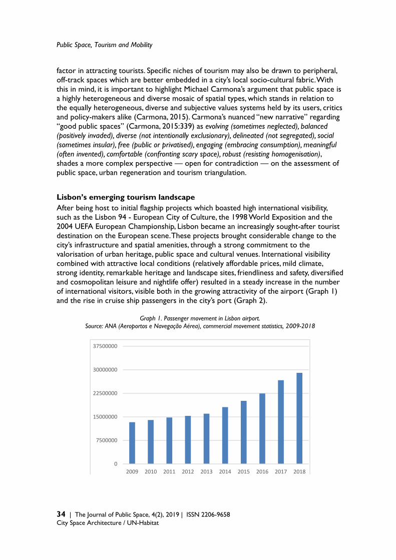
Public Space, Tourism and Mobility
34 | The Journal of Public Space, 4(2), 2019 | ISSN 2206-9658 City Space Architecture / UN-Habitat
factor in attracting tourists. Specific niches of tourism may also be drawn to peripheral, off-track spaces which are better embedded in a city’s local socio-cultural fabric. With this in mind, it is important to highlight Michael Carmona’s argument that public space is a highly heterogeneous and diverse mosaic of spatial types, which stands in relation to the equally heterogeneous, diverse and subjective values systems held by its users, critics and policy-makers alike (Carmona, 2015). Carmona’s nuanced “new narrative” regarding “good public spaces” (Carmona, 2015:339) as evolving (sometimes neglected), balanced (positively invaded), diverse (not intentionally exclusionary), delineated (not segregated), social (sometimes insular), free (public or privatised), engaging (embracing consumption), meaningful (often invented), comfortable (confronting scary space), robust (resisting homogenisation), shades a more complex perspective — open for contradiction — on the assessment of public space, urban regeneration and tourism triangulation. Lisbon’s emerging tourism landscape After being host to initial flagship projects which boasted high international visibility, such as the Lisbon 94 - European City of Culture, the 1998 World Exposition and the 2004 UEFA European Championship, Lisbon became an increasingly sought-after tourist destination on the European scene. These projects brought considerable change to the city’s infrastructure and spatial amenities, through a strong commitment to the valorisation of urban heritage, public space and cultural venues. International visibility combined with attractive local conditions (relatively affordable prices, mild climate, strong identity, remarkable heritage and landscape sites, friendliness and safety, diversified and cosmopolitan leisure and nightlife offer) resulted in a steady increase in the number of international visitors, visible both in the growing attractivity of the airport (Graph 1) and the rise in cruise ship passengers in the city’s port (Graph 2).
Graph 1. Passenger movement in Lisbon airport. Source: ANA (Aeroportos e Navegação Aérea), commercial movement statistics, 2009-2018
0
7500000
15000000
22500000
30000000
37500000
2009 2010 2011 2012 2013 2014 2015 2016 2017 2018
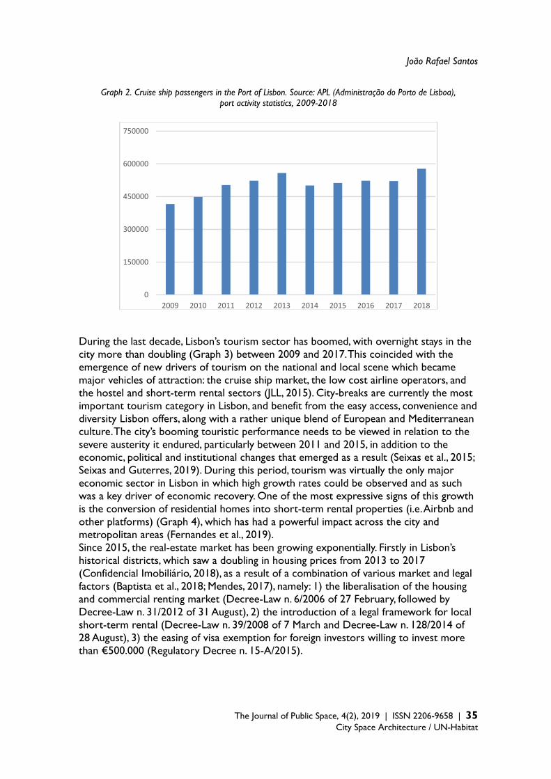
João Rafael Santos
The Journal of Public Space, 4(2), 2019 | ISSN 2206-9658 | 35
City Space Architecture / UN-Habitat
Graph 2. Cruise ship passengers in the Port of Lisbon. Source: APL (Administração do Porto de Lisboa), port activity statistics, 2009-2018
During the last decade, Lisbon’s tourism sector has boomed, with overnight stays in the city more than doubling (Graph 3) between 2009 and 2017. This coincided with the emergence of new drivers of tourism on the national and local scene which became major vehicles of attraction: the cruise ship market, the low cost airline operators, and the hostel and short-term rental sectors (JLL, 2015). City-breaks are currently the most important tourism category in Lisbon, and benefit from the easy access, convenience and diversity Lisbon offers, along with a rather unique blend of European and Mediterranean culture. The city’s booming touristic performance needs to be viewed in relation to the severe austerity it endured, particularly between 2011 and 2015, in addition to the economic, political and institutional changes that emerged as a result (Seixas et al., 2015; Seixas and Guterres, 2019). During this period, tourism was virtually the only major economic sector in Lisbon in which high growth rates could be observed and as such was a key driver of economic recovery. One of the most expressive signs of this growth is the conversion of residential homes into short-term rental properties (i.e. Airbnb and other platforms) (Graph 4), which has had a powerful impact across the city and metropolitan areas (Fernandes et al., 2019). Since 2015, the real-estate market has been growing exponentially. Firstly in Lisbon’s historical districts, which saw a doubling in housing prices from 2013 to 2017 (Confidencial Imobiliário, 2018), as a result of a combination of various market and legal factors (Baptista et al., 2018; Mendes, 2017), namely: 1) the liberalisation of the housing and commercial renting market (Decree-Law n. 6/2006 of 27 February, followed by Decree-Law n. 31/2012 of 31 August), 2) the introduction of a legal framework for local short-term rental (Decree-Law n. 39/2008 of 7 March and Decree-Law n. 128/2014 of 28 August), 3) the easing of visa exemption for foreign investors willing to invest more than €500.000 (Regulatory Decree n. 15-A/2015).
0
150000
300000
450000
600000
750000
2009 2010 2011 2012 2013 2014 2015 2016 2017 2018
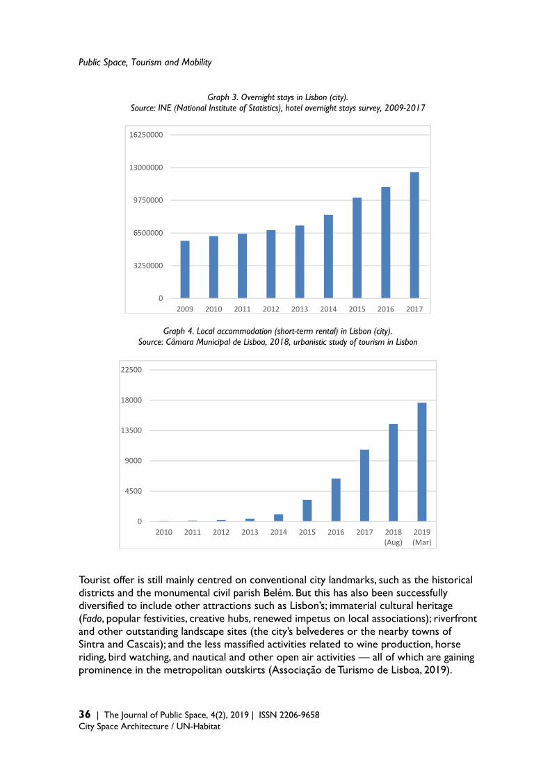
Public Space, Tourism and Mobility
36 | The Journal of Public Space, 4(2), 2019 | ISSN 2206-9658 City Space Architecture / UN-Habitat
Graph 3. Overnight stays in Lisbon (city). Source: INE (National Institute of Statistics), hotel overnight stays survey, 2009-2017
Graph 4. Local accommodation (short-term rental) in Lisbon (city). Source: Câmara Municipal de Lisboa, 2018, urbanistic study of tourism in Lisbon
Tourist offer is still mainly centred on conventional city landmarks, such as the historical districts and the monumental civil parish Belém. But this has also been successfully diversified to include other attractions such as Lisbon’s; immaterial cultural heritage (Fado, popular festivities, creative hubs, renewed impetus on local associations); riverfront and other outstanding landscape sites (the city’s belvederes or the nearby towns of Sintra and Cascais); and the less massified activities related to wine production, horse riding, bird watching, and nautical and other open air activities — all of which are gaining prominence in the metropolitan outskirts (Associação de Turismo de Lisboa, 2019).
0
3250000
6500000
9750000
13000000
16250000
2009 2010 2011 2012 2013 2014 2015 2016 2017
0
4500
9000
13500
18000
22500
2010 2011 2012 2013 2014 2015 2016 2017 2018(Aug)
2019(Mar)
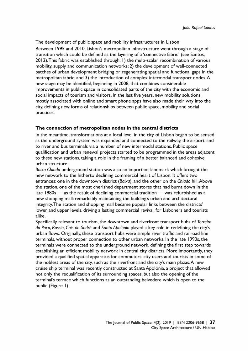
João Rafael Santos
The Journal of Public Space, 4(2), 2019 | ISSN 2206-9658 | 37
City Space Architecture / UN-Habitat
The development of public space and mobility infrastructures in Lisbon Between 1995 and 2010, Lisbon’s metropolitan infrastructure went through a stage of transition which could be defined as the layering of a ‘connective fabric’ (see Santos, 2012). This fabric was established through; 1) the multi-scalar recombination of various mobility, supply and communication networks; 2) the development of well-connected patches of urban development bridging or regenerating spatial and functional gaps in the metropolitan fabric; and 3) the introduction of complex intermodal transport nodes. A new stage may be identified, beginning in 2008, that combines considerable improvements in public space in consolidated parts of the city with the economic and social impacts of tourism and visitors. In the last five years, new mobility solutions, mostly associated with online and smart phone apps have also made their way into the city, defining new forms of relationships between public space, mobility and social practices. The connection of metropolitan nodes in the central districts In the meantime, transformations at a local level in the city of Lisbon began to be sensed as the underground system was expanded and connected to the railway, the airport, and to river and bus terminals via a number of new intermodal stations. Public space qualification and urban renewal projects started to be programmed in the areas adjacent to these new stations, taking a role in the framing of a better balanced and cohesive urban structure. Baixa-Chiado underground station was also an important landmark which brought the new network to the hitherto declining commercial heart of Lisbon. It offers two entrances: one in the downtown district (Baixa), and the other on the Chiado hill. Above the station, one of the most cherished department stores that had burnt down in the late 1980s — as the result of declining commercial tradition — was refurbished as a new shopping mall: remarkably maintaining the building’s urban and architectural integrity. The station and shopping mall became popular links between the districts’ lower and upper levels, driving a lasting commercial revival, for Lisboners and tourists alike. Specifically relevant to tourism, the downtown and riverfront transport hubs of Terreiro do Paço, Rossio, Cais do Sodré and Santa Apolónia played a key role in redefining the city’s urban flows. Originally, these transport hubs were simple river traffic and railroad line terminals, without proper connection to other urban networks. In the late 1990s, the terminals were connected to the underground network, defining the first step towards establishing an efficient mobility network in central city districts. More importantly, they provided a qualified spatial apparatus for commuters, city users and tourists in some of the noblest areas of the city, such as the riverfront and the city’s main plazas. A new cruise ship terminal was recently constructed at Santa Apolónia, a project that allowed not only the requalification of its surrounding spaces, but also the opening of the terminal’s terrace which functions as an outstanding belvedere which is open to the public (Figure 1).

Public Space, Tourism and Mobility
38 | The Journal of Public Space, 4(2), 2019 | ISSN 2206-9658 City Space Architecture / UN-Habitat
Figure 1. Lisbon’s new cruise ship terminal in Santa Apolónia. Source: author The investment in these transport nodes was a meaningful departure from decades of very limited public and political concern with the commercial and urban attractiveness of Lisbon’s central districts. On the other hand, especially since 1998, public space and other urban amenities have also been systematically upgraded and renovated, offering the infrastructure needed to support residential, working and tourist city users. Public space, together with heavy mobility infrastructure, can be said to be a key driver of urban regeneration in central Lisbon. The following section briefly outlines this recently upgraded public space system. The improvement in the public space system associated with urban attractors With most of housing in central Lisbon in private hands, the municipality’s investment in urban regeneration is mainly focused on infrastructure and public space. This focus also stems from national and EU guidelines, in which public funding in recent years has been directed towards environmental qualification and the promotion of soft mobility. Such approaches, in which physical interventions are prioritised can be better described as urban revitalisation initiatives (Balsas, 2007; Mendes, 2013a). During the late 1990s and early 2000s national policies on urban development included a line of investment in the upgrade of spatial, environmental and mobility systems in several cities (Ministério do Ambiente e do Ordenamento do Território, 2000; Secretaria de Estado do Ordenamento do Território e das Cidades, 2008). According to Baptista (2013), this investment — labelled POLIS programme for urban environment — is embedded in a Welfare State rationale:
João Rafael Santos
The Journal of Public Space, 4(2), 2019 | ISSN 2206-9658 | 39
City Space Architecture / UN-Habitat
its focus on public-led intervention, public space for public use, and disciplining of private developers, makes sense in the context of a state apparatus that was still thinking of itself as “modernizing” toward a “European” welfare ideal already in decline elsewhere in the EU and the world at large. With its impetus to extend the benefits of modern city living to a greater number of urban citizens, to fix urban problems, and to use the powers of the state to redistribute social goods and stimulate social cohesion, the Polis Programme constitutes an exemplar of state intervention within a welfare logic that seeks to be a corrective to the logics of capitalist accumulation. Baptista, 2013: 600.
From 2008 onwards, and according to new EU funding guidelines, the national urban policies framework was adapted in order to foster social cohesion, inclusion and local partners’ involvement criteria. In Lisbon, the Municipality established the following policy priorities; the reversion of a four-decade-long demographic loss trend; the attraction of younger inhabitants; and the promotion of inclusion, innovation and creativity through strategic initiatives (Câmara Municipal de Lisboa, 2009a), urban planning (Câmara Municipal de Lisboa, 2012) and local interventions (Câmara Municipal de Lisboa, 2015a, 2009b, 2008; Mendes, 2013b). Along with the major restructuring and expansion of the underground network in the late 1990s came the opportunity to redevelop major plazas and squares. Rossio and Praça da Figueira were the first to be renewed, with underground parking spaces, new pavements, lighting, furniture and trees, and a more generous approach to pedestrian space. Commercial urbanism projects with considerable public funding were implemented in the Baixa historical district, although with limited impact (Porfírio and Guimarães, 2017). Following a first generation of piecemeal interventions (Balsas, 2007), a more consistent and systemic approach to public space improvement can now be detected, especially since 2006 (Câmara Municipal de Lisboa, 2016, 2008; Comissariado para a Baixa-Chiado, 2006; Salgado, 2012). Frente Tejo, SA, a specific purpose public agency, has been established by the Government to lead a large-scale urban revitalisation project in the riverfront area (Conselho de Ministros, 2008). This process has been extended to include other open spaces, defining an increasingly coherent network of qualified public spaces, in which one can trace three main systems:
- the riverfront system: Santos – Cais do Sodré – Ribeira das Naus (Figure 2) – Terreiro do Paço – Campo das Cebolas – Santa Apolónia;
- the garden and belvedere system: Príncipe Real – São Pedro de Alcântara – Portas do Sol (Figure 3) – Graça – Senhora do Monte;
- the street and square system: Santa Catarina – Bica – Chiado – Baixa- Rossio – Martim Moniz – Mouraria – Castelo – Alfama
The upgrading of these systems over the last twenty years (Figures 4 and 5) has had a clear impact on the spatial attractiveness of some of the city’s most outstanding places, but more importantly, it has established a continuous and coherent public realm. Other than the UNESCO listed monuments in Belém civil parish (Jerónimos Monastery and Torre de Belém), Lisbon’s best touristic offer lies in the diversified character of its urban fabric — from its sensual relationship with topography to its dialogue with the Tagus river. What is more, the overall upgrade of these public space systems has had a clear impact on everyday life in central Lisbon and sparked a sharp increase in the commercial and leisure-related offer.
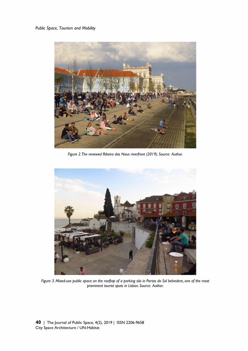
Public Space, Tourism and Mobility
40 | The Journal of Public Space, 4(2), 2019 | ISSN 2206-9658 City Space Architecture / UN-Habitat
Figure 2. The renewed Ribeira das Naus riverfront (2019). Source: Author.
Figure 3. Mixed-use public space on the rooftop of a parking silo in Portas do Sol belvedere, one of the most prominent tourist spots in Lisbon. Source: Author.

João Rafael Santos
The Journal of Public Space, 4(2), 2019 | ISSN 2206-9658 | 41
City Space Architecture / UN-Habitat
Figure 4. Public space and transport infrastructure projects in central Lisbon, since the year 2000. Source: Author.
Figure 5. Types of public space and transport infrastructure projects in central Lisbon, since the year 2000. Source: Author.
Public Space, Tourism and Mobility
42 | The Journal of Public Space, 4(2), 2019 | ISSN 2206-9658 City Space Architecture / UN-Habitat
In fact, most of these public space improvements were accompanied by the development of food and beverage establishments and some fashion retail stores. This commercial profile reveals a clear prevalence of visitor-oriented commerce, either from outside (tourists) or from metropolitan areas. The reinforcement of pedestrianised spaces was accompanied by the building of several multi-level parking areas, some of them located under large squares, in a process that was not exempt from controversy (Balsas, 2007). As with the patterns of commercial change, these parking facilities were mainly targeted at visitors. The appropriation of these renewed spaces didn’t necessarily translate into benefits for local residents or traditional city uses — as discussed in the following chapter. Notwithstanding an undeniable urban spatial qualification, these improvements were also the drivers of a new pattern of use and flow, in which tourism and leisure were clearly favoured in terms of urban amenities or the involvement of local communities. Two cases in which the management of public space and urban facilities were directly shaped by the tourism and leisure industry are the refurbishment of Ribeira Market and an open marketplace — the setting of a thematic food and music offer in Martim Moniz. The former, a prominent 19th century wholesale market was partially franchised in 2014 to TimeOut, the renowned travel and entertainment publisher group. Since then, it has been running part of the market and has made considerable efforts to promote architectural renewal: offering a food court in which trendy food, animation and events can be enjoyed. Its visitors now comprise a mix of city users, with a strong presence of tourists and other visitors to the city. The same happened to the central space in Martim Moniz square, a rather awkward space resulting from urban renewal demolitions in the mid-20th century. Between 2012 and 2018 it was refurbished and transformed into a fusion market by NCS, a local music and entertainment production company. Here, food, beverages and animation were interwoven with ethnic themes that reflected the diverse origins of the people living around that area. Although they proved successful in attracting numerous visitors, both projects have remained largely detached from the surrounding neighbourhood and the people: the vegetable, fish and flower traders in Mercado da Ribeira, who lend their character and charm to the migrant atmosphere in Martim Moniz. In either case, despite maintaining its openness and some of its functional rationale, public space was privatised to some extent. Since 2018, Martim Moniz has been subject to a new discussion regarding its future, after the private franchise failed to meet its contract requirements. The proposal put forward by the Municipality and the franchise for a new layout, featuring modular containers designed to house food and entertainment venues within a fenced precinct to be closed at night, faced strong opposition from various civic movements (Gomes, 2019; Público, 2019a). Under that pressure, the Municipality reversed its initial proposal and is currently looking for less commodified, fenced and privatised alternatives. The link between downtown and the uphill districts Part of a wider strategy to revitalise Lisbon’s historical fabric, the mechanically assisted link between downtown (Baixa) and the uphill castle districts is being developed by the Municipality (Câmara Municipal de Lisboa, 2009b). This new mechanically assisted link stems from a 130 year old Lisbon tradition of installing funiculars and elevators as part
João Rafael Santos
The Journal of Public Space, 4(2), 2019 | ISSN 2206-9658 | 43
City Space Architecture / UN-Habitat
of its transportation system, allowing for mobility across its steep hills and valleys. The project provides an alternative and easily accessible pedestrian path through a sequence of linear spaces connected by free and publicly accessible lifts, a funicular, and mechanised escalators. The lifts are embedded in existing buildings which were renewed and refurbished with the aim of not only establishing vertical connections, but also accommodating new and attractive activities. The overall project is made up of five paths: Baixa, Alfama, Mouraria, Graça and Sé. Baixa path has already been finished and consists of two components; 1) the renewal and adaptation of three existing buildings to accommodate the lifts: a former market which has now been turned into a multi-level structure featuring a retail supermarket, an art gallery and creative industries offices, an open air terrace with outstanding vistas, a restaurant, and a public car-silo (with 196 parking spaces mainly for residents from the neighbourhood). In addition, two old residential buildings provide space for a visitor welcome and interpretation centre, facilities for the local town hall and residential apartments on upper floors; 2) the qualification of the linear sequence of public spaces along the paths, connecting the underground station and commercial streets of Baixa with the lift buildings, the existing squares at mid-level hill and the castle premises. The Mouraria and Alfama paths have already been partially implemented with simpler solutions, such as the introduction of escalators and a small lift in a refurbished building. A more ambitious plan for a funicular will link Mouraria with Graça square and belvedere, one of the main touristic spots in the upper hill area. Although some preliminary plans and projects began at an earlier date, the formal proposal to implement these mechanised assisted paths in Castle hill was approved in 2015 (Câmara Municipal de Lisboa, 2015b). In its justification, social exclusion and territorial isolation were presented as being major weaknesses, along with a more general framework to promote sustainable mobility, pedestrian mobility and a more qualified public space in historical and touristic areas. The conflicts and tensions in tourism-mobilised public space The programmatic rationale of the projects presented in the previous chapter includes concerns such as social inclusiveness, accessible mobility, mixed-use development, heritage, and public-realm based urban-regeneration — namely in urban areas in old city districts diagnosed as being socially and physically frail. These concerns, however, need to be discussed adopting a critical perspective regarding their relationship with the changing social, economic and real-estate landscapes in touristic areas in Lisbon, as implementing improvements often has contradictory effects. In this chapter, an outline of four cases of conflict and tension emerging from public space and infrastructural improvements are discussed:
- the residential and commercial gentrification of historical districts; - the overload of transportation and mobility infrastructures; - coexistence with new mobility services in public space; - the impact of strategic global infrastructures on the city.

Public Space, Tourism and Mobility
44 | The Journal of Public Space, 4(2), 2019 | ISSN 2206-9658 City Space Architecture / UN-Habitat
The impact of residential and commercial gentrification on historical districts Despite city-wide improvements in public transportation, Lisbon’s old neighbourhoods were faced with an elderly, low income and sparse residential population. Tourism has been the main driver behind recent renovations, a process best exemplified by the massive introduction of short-term rental or local accommodation, operating under online platforms such as Airbnb. Larger facilities such as hotels have also been affected. Moreover, the real-estate market has made substantial gains from the attraction of foreign investment, which does not necessarily translate into new residents (Público, 2019b). Emerging arenas of conflict mainly result from the incremental change in housing ownership and use in regard to the existing population. Traditional residents share a strong cultural and place-specific identity, in which public/private frontiers and privacy thresholds are managed through subtle codes of conviviality (Mendes, 2013b, 2012, 2011). These codes are under pressure (Rodrigues, 2010) and are often seen as being disrupted by new visitors and tenants. Rising housing prices are translating into diverse forms of gentrification and resident replacement (Mendes, 2017; Pacione, 2001). Short-term apartment rentals in historical buildings are replacing lower-income tenants, who had previously benefited from decades of rent-freezing. Neighbourhoods known for their quiet and charming atmosphere have been flooded with new gourmet groceries, trendy tea houses and fancy boutiques, along with ubiquitous souvenir shops (Expresso, 2015). This process can be framed in the specific modalities of gentrification associated with tourism, heritage exploitation, and commercial and leisure development (Bures and Cain, 2008; Salgueiro et al., 2017; Young and Markham, 2019). Conflict and protest have also emerged (Público, 2016a; Seixas and Guterres, 2019) and follow many of the known trends in international tourist cities (Bruttomesso, 2018; Jover and Díaz-Parra, 2019; Litvin et al., 2019; Shoval, 2018). Tourism and foreign investment have also sparked a trend in building renovation which has been acknowledged as paving the way for essential architectural maintenance and a much needed boost to the local economy. Recent opinion studies among residents showed a meaningful share of positive views (over 85%) regarding the recent touristic dynamism of Lisbon (Associação de Turismo de Lisboa, 2019). However, its repercussions cannot be gauged simply in terms of residents vs. outsiders. The complexity of the urban condition, especially in a metropolitan core such as Lisbon’s central districts — in the wider context of globalisation — requires a far more open consideration as to who counts as a Lisboner (Lestegás et al., 2018; Seixas et al., 2015). The controversy regarding the unbalanced process of urban renewal and gentrification can be framed under a widely acknowledged literature. Atkinson’s (2004) approach to the pros and cons of urban renaissance, as defined by Rogers (1999) and Roberts and Sykes (2017; 2002), continues to offer useful insight. On the positive side, he highlights the benefits of physical renewal, the social mix and the deconcentration of poverty enclaves; on the negative side, he identifies the impact of the dislocation of residents, the loss of affordable housing stock, the rise in local conflicts, evictions and criminality, the loss of a local population and changes to local services (Atkinson, 2004; Bures and Cain, 2008; Wilson and Tallon, 2012). Kohn (2013) also stresses the need to widen the
João Rafael Santos
The Journal of Public Space, 4(2), 2019 | ISSN 2206-9658 | 45
City Space Architecture / UN-Habitat
territorial scope in which the locally-felt impacts of gentrification are framed: taking socio-political arrangements and organisational apparatus into account. From his perspective, impact assessment cannot be seen as separable from an ideological framework, in which public intervention is extremely bound by a privately led and market-driven societal matrix. In the Portuguese context, research conducted by Balsas (2007) is also helpful, as it identifies contextual specificities for the processes of urban renewal in the cities of Lisbon and Oporto. He identifies: 1) the scale of urban dereliction in many historic district buildings, 2) the absence of legal tools allowing Municipalities to deliver consistent urban regeneration, 3) the perception that investment in public space is more easily delivered and politically sustained than investment in privately-owned built stock, and 4) the least demanding organisational apparatus with the capacity to deliver public-space renewal and improve public facilities. This tradition of giving public space a prominent role in government-led action stems from a strong corpus of urban design and urban planning literature. In line with authors such as Gregotti (1981), recent studies stress the infrastructural capacity of public space to provide a territorial structure and a coherent system of ‘collective spaces’ (Marinoni 2006, Neuman and Smith 2010, Hauck et al. 2011, and Santos 2012). The overload of transportation and mobility infrastructure Emerging from decades of poorly developed mobility networks, Lisbon’s major improvements in transport systems overshadowed other less visible trends of overload. The extension and interconnecting of major railroad, underground, river traffic and airport networks in the city increased its overall capacity significantly, despite the considerable challenge posed by private cars and individual motorisation. Pressure resulting from the number of private cars in circulation is the result of limited transportation offer at the metropolitan scale and highly dispersive land uses. Major employment and commercial attractors are also dependent on car accessibility. On the other hand, various restrictions imposed on car traffic and car overload in the city’s central districts often disrupt local drivers’ needs in terms of individual mobility and parking, thus transferring rather than lowering the overall pressure in the system. Aside from the large-scale infrastructures, such as the airport and its limitations in terms of future expansion, other local infrastructures are facing increasing levels of overload as a result of tourism development. Some major attractions in Lisbon are precisely associated with traditional modes of transportation, as is the case for three funiculars and one lift dating from the late 19th century, and an ex-libris fleet of yellow tram cars. Riding them without a previously purchased ticket is now almost three times more expensive than before. Long queues, delayed stops in popular locations and overloaded vehicles push local users away. Yet, they are crucial in maintaining this ageing network in terms of financial sustainability, after many years of line closing and replacement with bus lines. As previously seen, mobility investments are targeting the connections in central districts, especially in hilly areas, together with the upgrading of public and pedestrian space. However, the interesting side of this investment is being confronted with growing conflict from new forms of transport, especially tailored for tourists (Bloomberg
Public Space, Tourism and Mobility
46 | The Journal of Public Space, 4(2), 2019 | ISSN 2206-9658 City Space Architecture / UN-Habitat
Business, 2015; Público, 2015, 2014): tuk-tuks that run and park in the city’s narrow streetscapes, the tour buses that collect and leave hundreds of cruise ship passengers in central squares to embark on local excursions or enjoy dinner at one of the many fado restaurants, the queuing taxi cars waiting for the opportunity to shuttle tourists, the congested airport facilities, and the ageing train cars crowded with tourists going to and coming from the towns of Cascais and Estoril and their beaches. While legitimised by a consensual discourse on public space improvement, many initiatives led by the municipality — discussed above — resulted in conflicting side effects in other areas of the city. Restrictions placed on the circulation of private cars in central city areas, aimed at decreasing air pollution, serve to exemplify this. Traffic restrictions in outstanding sites such as Baixa and Terreiro do Paço, diverted urban traffic to neighbouring districts which, in turn, failed to accommodate the increased pressure. Additionally, the surge of new amenities attracted visitors, often using their own cars, from other parts of Lisbon including its metropolitan area. This phenomenon can be seen especially at night and during weekends, when public transport becomes a far less convenient alternative. Sharing public space with new mobility solutions In the wake of the various improvement projects being carried out since 1998 in Lisbon, a clearer perspective on public space as a fundamental urban structure has been acknowledged by municipal policies. This perspective informed not only the historic city districts and high-profile waterfront areas, but also other meaningful spaces across the city and its newer districts. The idea of public space as a multifunctional system has been driving the development of a continuous and networked chain of renewed urban spaces of varying natures, such as the transformation of street paving, square and plaza requalification, reorganisation of street parking, and improved accessibility for people with mobility disabilities. This strategy has also intersected with green space and the ecological structure, defining new green corridors through the city and connecting more densely built areas with large parks and open space facilities. Associated with this physical change, considerable investment has been targeted at creating cycle paths to promote more sustainable mobility patterns. Initially seen in Lisbon’s mobility policies as a mode of leisure, the bicycle in now widely acknowledged as an everyday possibility to cope with travel demands in the city. Municipal investment in shared bikes, many of them with electrical engines, has driven new practices and habits, especially in areas with better cycling infrastructure. However, being a step-by-step and expensive process, there are still large areas of the city which are not served by safe and convenient services and infrastructure. Critics exposed the overlapping of such offer with already existing and good public transport networks, namely the underground and major bus routes operating within the central city street structure, leaving large residential areas without adequate services. Habits are nevertheless changing, and growing shares of residents, workers and students are becoming bicycle users. Conflict surrounding private car parking and protests regarding limitations to car traffic (Público, 2016b, 2016c) have, on the other hand, highlighted the controversial nature of these interventions and their political implications. Another field of change associated with conflict and tension is the recent introduction
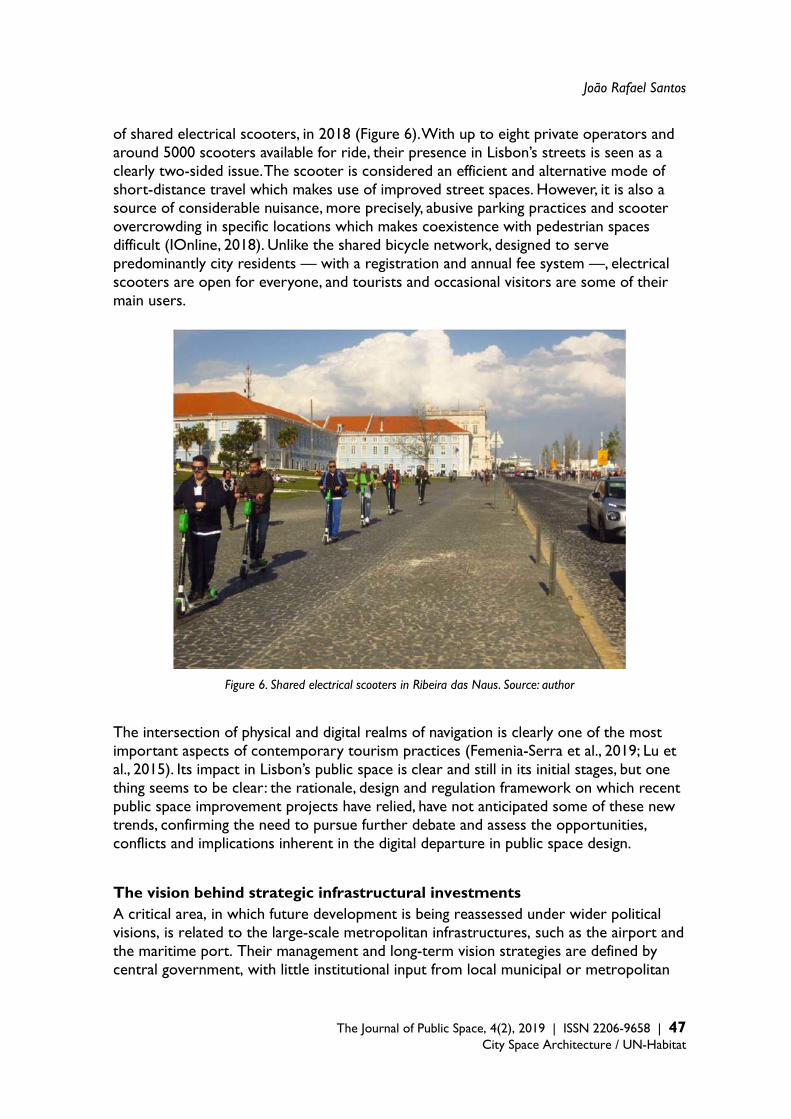
João Rafael Santos
The Journal of Public Space, 4(2), 2019 | ISSN 2206-9658 | 47
City Space Architecture / UN-Habitat
of shared electrical scooters, in 2018 (Figure 6). With up to eight private operators and around 5000 scooters available for ride, their presence in Lisbon’s streets is seen as a clearly two-sided issue. The scooter is considered an efficient and alternative mode of short-distance travel which makes use of improved street spaces. However, it is also a source of considerable nuisance, more precisely, abusive parking practices and scooter overcrowding in specific locations which makes coexistence with pedestrian spaces difficult (IOnline, 2018). Unlike the shared bicycle network, designed to serve predominantly city residents — with a registration and annual fee system —, electrical scooters are open for everyone, and tourists and occasional visitors are some of their main users.
Figure 6. Shared electrical scooters in Ribeira das Naus. Source: author The intersection of physical and digital realms of navigation is clearly one of the most important aspects of contemporary tourism practices (Femenia-Serra et al., 2019; Lu et al., 2015). Its impact in Lisbon’s public space is clear and still in its initial stages, but one thing seems to be clear: the rationale, design and regulation framework on which recent public space improvement projects have relied, have not anticipated some of these new trends, confirming the need to pursue further debate and assess the opportunities, conflicts and implications inherent in the digital departure in public space design. The vision behind strategic infrastructural investments A critical area, in which future development is being reassessed under wider political visions, is related to the large-scale metropolitan infrastructures, such as the airport and the maritime port. Their management and long-term vision strategies are defined by central government, with little institutional input from local municipal or metropolitan
Public Space, Tourism and Mobility
48 | The Journal of Public Space, 4(2), 2019 | ISSN 2206-9658 City Space Architecture / UN-Habitat
actors. However, they have important repercussions for the evolution of the country’s capital city. The role tourism and its stakeholders play in this equation is critical. Two examples reveal this dilemma. Firstly, after a five-decade-long debate regarding the development of a new, large international airport 40 km from Lisbon, current decisions point to a dual airport system due to be fully operational by 2028 (ANA - Aeroportos de Portugal/Vinci Airports, 2018) consisting of: the improvement of existing facilities, taking full advantage of their capacity by expanding the terminal and reorganising runways, along with the building of a new low-cost passenger terminal in an existing air force base in Montijo on the south bank of the Tagus river, 25 km from Lisbon. Arguments in favour of building a whole new facility have highlighted the site’s capacity for expansion and a geo-strategic position (Lisbon as a new hub for Africa and South America) and its role in rebalancing spatial development in the Lisbon metropolis. However, despite major concerns regarding safety and noise, the location of Lisbon’s airport in the middle of city along with its ease of access and effective connections — which enable convenient short-break visits — have been part of a major argument to maintain its operation. Secondly, is the example of Lisbon’s port which is a multi-terminal port consisting of various locations along both banks of the Tagus river. The port is at a cross-roads in terms of securing the future of city terminals. With major cargo terminals located in very central areas of Lisbon, the competition for scarce space-resources is having a direct impact on port and municipal decision-making. Unlike many other waterfront cities, Lisbon has maintained a vision of a working port city, favouring the maintenance of cargo operations in the city. This approach has not been consensual which has resulted in considerable debate and claims regarding the need to return unused port spaces to the city, or even to relocate large container terminals to other locations. Vast areas of landfill have been redesigned as multipurpose public spaces. Significantly, nearly all of them have been shaped mostly for leisure and outdoor entertainment. To a more limited extent, cultural, commercial and scientific facilities have also been developed along the riverfront. This model is closer to the Mediterranean tradition of a strong public space rationale in post-industrial waterfront regeneration, distant from other well-known Anglo-Saxon experiences based on commercially-oriented strategies. Under this rationale, the maintenance of diverse port activities on varying scales is seen as a fundamental component in maintaining the multifunctional economic profile and the identitary condition of a port city. A framework for discussion The impact of tourism on public space and urban infrastructure is a challenge too complex to grasp and anticipate. These urban systems are in a constant state of flux, reacting to changes occurring on multiple scales — from global economic climate, to national regulatory environments and local urban planning guidelines. Moreover, tourism and public space are not only defined by physical and spatial elements (streets, buildings, facilities), but also by the collective interplay of individual, corporate and institutional agents, making them two of the most dynamic and subjective dimensions of urban life. As such, political and urban planning rationales involving public space, infrastructure and urban regeneration are required to cope with a continuous process of adjustment,

João Rafael Santos
The Journal of Public Space, 4(2), 2019 | ISSN 2206-9658 | 49
City Space Architecture / UN-Habitat
reaction and anticipation, managing short-term impacts as well as preparing the city for longer-term scenarios. On reviewing the main arguments from chapter 2, it is clear that (urban) tourism, especially in southern Europe, is considerably connected to processes of territorialisation: meaning they cannot be detached (either as a process or a spatial phenomenon) from the city’s structural and morphological layers. Following this line of thinking, chapter 3 identified specific projects in which very powerful and long-term forms of territorial shaping — those associated with infrastructure — were implemented in Lisbon, as part of an overall urban and metropolitan development rationale that goes well beyond tourism and its management. Finally, chapter 4’s outline of critical and conflictive issues regarding fast and significant changes that occurred in Lisbon as a result of growth in tourism offers an overview of a highly dynamic process that brings with it not only social and economic tensions but also new challenges, in addition to opportunities for mobility. With this in mind, the discussion regarding the interfacing aspects of public space, tourism and mobility requires a framework in which one can identify: 1) the spatial components of public space and mobility infrastructures, 2) the main forms of territorialisation to which they relate, 3) the most significant links they have with touristic practices and rationales, and 4) the conflicts and tensions they are subject to under considerable pressure from growth in tourism. Table 1 provides an overview of this framework, applied to the case of Lisbon. It can be seen as a simple and adjustable basis for a more complex and comprehensive discussion, that would go beyond the scope of this paper. Table 1. Framework for discussion: public space and mobility infrastructure in regard to urban tourism development
Forms of territorialisation
Relationship with tourism Conflictive issues
Public space renewal
Waterfront
Incremental requalification, associated with transport interfaces, main urban spaces and former port/industrial landfills. Linear continuity rationale.
Major attraction: landscape value, leisure, commercial and cultural spaces.
Loss of productive and logistic capacity (port) due to pressure from leisure and commercial claims for waterfront space.
Street and square system
Incremental requalification, associated with main urban spaces, defining preferential pedestrian areas. Public space network rationale.
Comfort and urban landscape quality; heritage value; potential for commercial regeneration.
Residential and commercial gentrification; touristification of public space; disruption of local convivial practices.
Green corridors
Combination between ecological and infrastructural systems; alternative public space network.
Path continuity and accessibility of urban parks; landscape value.
Safety; high maintenance costs; natural hazards.
Bicycle paths
From leisure (main parks and waterfront) to city-wide network; associated with street requalification projects and green corridors.
Support for alternative mobility solutions.
Safety regarding pedestrian and car traffic coexistence.

Public Space, Tourism and Mobility
50 | The Journal of Public Space, 4(2), 2019 | ISSN 2206-9658 City Space Architecture / UN-Habitat
Assisted/mechanised paths
Discrete interventions associated with the requalification of streets and built structures.
Comfort and convenience; accessibility of major urban and heritage attractions.
Overload; residential and commercial gentrification in areas with improved accessibility.
Urban facilities/attractors
Diversification of offer; spatial commodification; in combination with public space requalification.
Commercial attraction (i.e. food markets).
Privatisation of management; commercial gentrification.
Transportation infrastructure
Underground, railroad and river boat interfaces
Multi-modal integration; combination with public space requalification.
Convenience and accessibility in inner-city and metropolitan destinations.
Passenger overload; ageing fleet and lack of maintenance.
Airport
Planned maintenance and optimisation of existing airport; construction of new complementary airport on the south bank of Tagus river.
Convenience (proximity and connection to city centre); growing air travel market.
Overload and difficulties for expansion; limited impact on metropolitan cohesion.
Cruise ship terminals
Concentration of cruise ship movement in new facility; easy connection with underground and public transport.
Convenience (proximity and connection to city centre); stable/growing cruise market.
Concentrated crowding; pollution; traffic congestion; landscape impact.
Marinas and leisure port facilities
Reconversion of old docks; in combination with sport and commercial uses.
Attraction of nautical tourism market.
Congestion; limited space; tension between regular/occasional users.
Cargo port terminals
Accessibility and logistic integration; technology and space requirements and; navigational conditions.
Not relevant. Spatial barrier; traffic nuisance.
Public elevators and funiculars
Integration of historical districts into public space system.
Major attraction: heritage value.
Overload; tension between regular/occasional users.
Parking facilities
Underground space under main squares and plazas; in combination with public space requalification.
Limited; rent-a-car convenience in congested city centre.
Conflict between car restriction policies and improved provision of parking space.
Shared bicycle docks (public system)
Main street axes and public transport interfaces in central districts. In combination with public space requalification.
Limited: targeted at resident/regular users.
Size/impact on public space.

João Rafael Santos
The Journal of Public Space, 4(2), 2019 | ISSN 2206-9658 | 51
City Space Architecture / UN-Habitat
Mobility services
Buses and trams
Street coexistence; limited dedicated spaces for bus/tram lines; historical tram lines particularly adapted to hill street structure.
Major attraction: historical trams; accessibility of main tourist and cultural facilities (i.e. Belém, Castle hill, Bairro Alto).
Overload; tension between regular/occasional users.
Tuk-tuks and other touristic vehicles
Concentration of services in urban attraction areas (historic districts, waterfront).
Convenience, flexibility and experience differentiation.
Traffic congestion; lack of parking space; noise and pollution.
Shared electrical scooters
Specific service areas according to operator.
Convenience and flexibility.
Inappropriate parking in public space; safety.
Shared bicycle system (private)
City-wide service area. Convenience and flexibility.
Inappropriate parking in public space.
Shared bicycle system (public)
Combination with public space requalification.
Limited: targeted at resident/regular users.
Lack of flexibility (parking docks).
Taking Lisbon as a testbed for understanding meaningful relationships between urban tourism, mobility and public space, one can identify various critical points which can be of interest to a more general discussion. Three main aspects can be highlighted: 1) the role of physical improvement in public space in contributing to social and economic change in older parts of the city, 2) the role that the development of metropolitan mobility infrastructure played in the reorganisation of central city public space system, and finally, 3) the impact of emerging public space practices associated with new users, technologies and economic frameworks in everyday city life. Conclusions The paper outlined the major features of change that occurred in Lisbon during the past two decades, regarding the improvement of public space, mobility and infrastructure, in tandem with tourism and urban regeneration dynamics. Starting from a conceptual framework for these issues, it offered a discussion on the critical and problematic aspects such change currently entails, namely those associated with the processes of touristification and gentrification. When considered as common ground, mobility and public space are key contributors to positing the city as a value in and of itself. Instead of competition-driven rationale, in which cities are seen as quasi-enterprise entities2 fighting for a prominent position in the global arena, the argument for a strong relationship between public space improvements and the upgrade of trans-scalar metropolitan connectivity can be seen as a socially aware
2 In the meaning of Madureira and Baeten (2016:362) in “that the attention of local policy-makers turned from emphasizing the management and delivery of public services and local welfare promotion, towards emphasizing the need for local economic promotion and place marketing to attract companies, investments and (creative, wealthy) inhabitants”.
Public Space, Tourism and Mobility
52 | The Journal of Public Space, 4(2), 2019 | ISSN 2206-9658 City Space Architecture / UN-Habitat
approach. As far as urban planning is concerned, public space upgrades and improved mobility connections form part of a robust network of shared spaces and thus remains a valued approach to a democratic and socially equitable city. In an overall assessment, the development of urban infrastructure in central Lisbon over the last 20 years has been able to deliver considerable improvements to that shared system of streets, plazas and transport interfaces — bringing together very diverse strata of urban users and linking multiple spaces and scales. Unlike other approaches in which infrastructural and public space development occur under a rather focused economic rationale, Lisbon’s initiatives have maintained relatively high levels of concern for various strata of city users, going beyond the strict duality of tourists vs. residents. In fact, Carmona’s (2010) claim that conceptualising and assessing public space is a task subject to multiple and diverse value rationales, seems particularly relevant to Lisbon’s case. Despite strong evidence that they contributed to or facilitated processes of gentrification and touristification, recent projects addressed cherished places in the city which were longing for renewal and qualification. Despite an obvious increase of these processes in the inner city, urban public space and mobility infrastructure policies and projects provided a resilient basis for urban regeneration, improving both access to and the quality of the urban landscape. If undesired trends are to be fought, then other realms of urban policy (i.e. housing and real-estate regulation, heritage and conservation, economic and tax policy, private development control, investment incentives), not to mention (capitalist) economic and societal models, must be brought into the discussion. Acknowledgement The author wishes to thank Maurice Harteveld’s and the two peer-reviewers’ valuable contributions to improve this article, as well as Zoë Atkinson-Fiennes’s editorial streamlining. References ANA - Aeroportos de Portugal/Vinci Airports, (2018). O futuro dos aeroportos de Lisboa
[WWW Document]. URL https://www.aeroportosdelisboa.com/ (accessed 30 June 2019). Ascher, F. (1995). Métapolis ou l’avenir des villes. Éditions Odile Jacob, Paris. Associação de Turismo de Lisboa (2019). Relatório de Atividades e Contas 2018. Associação de
Turismo de Lisboa, Lisboa. Atkinson, R. (2004). The evidence on the impact of gentrification: New lessons for the urban
renaissance. European Journal of Housing Policy, 4(1), 107–131. Balsas, C.J.L., (2007). City centre revitalization in Portugal: A study of Lisbon and Porto. Journal of
Urban Design, 12(2), 231–259. Baptista, I., (2013). The travels of critiques of neoliberalism: Urban experiences from the
“borderlands.” Urban Geography, 34(5), 590–611. Baptista, L.V., Nofre, J., Jorge, M. do R. (2018). Mobilidade, Cidade e Turismo: pistas para analisar as
transformações em curso no centro histórico de Lisboa, Sociologia Revista da Faculdade de Letras da Universidade do Porto, Temático, 14–32.
Bhati, A., Pryce, J., Chaiechi, T., (2014). Industrial railway heritage trains: The evolution of a heritage tourism genre and its attributes, Journal of Heritage Tourism, 9(2), 114–133.
Bloomberg Business (2015), Lisbon Tourist Invasion Seen Threatening Ancient City’s Identity

João Rafael Santos
The Journal of Public Space, 4(2), 2019 | ISSN 2206-9658 | 53
City Space Architecture / UN-Habitat
[WWW Document]. Bloom. Bus. Bravo, L. (2018). We the public space. Strategies to deal with inequalities in order to achieve
inclusive and sustainable urban environments, The Journal of Public Space, 3(1), 163–164. Bruttomesso, E. (2018). Making sense of the square: Facing the touristification of public space
through playful protest in Barcelona, Tourist Studies, 18(4), 467–485. Bryon, J. (2012). Tour guides as storytellers - from selling to sharing, Scandinavian Journal of
Hospitality and Tourism, 12(1), 27–43. Bures, R., Cain, C. (2008). Dimensions of Gentrification in a Tourist City. 2008 Meeting of the
Population Association of America. Câmara Municipal de Lisboa (2008). Plano Geral de Intervenções da Frente Ribeirinha de Lisboa
– Documento de Enquadramento. Câmara Municipal de Lisboa, Lisboa. Câmara Municipal de Lisboa (2009a). Carta Estratégica de Lisboa 2010-2024 – Um compromisso
para o futuro da cidade. Câmara Municipal de Lisboa, Lisboa. Câmara Municipal de Lisboa (2009b). Plano de Acessibilidade Suave e Assistida à Colina do
Castelo. Câmara Municipal de Lisboa, Lisboa. Câmara Municipal de Lisboa (2012). Plano Director Municipal de Lisboa. Câmara Municipal de
Lisboa, Lisboa. Câmara Municipal de Lisboa (2015a). Uma Praça em cada Bairro. Câmara Municipal de Lisboa,
Lisboa. Câmara Municipal de Lisboa (2015b). Proposta no 42-2015. Câmara Municipal de Lisboa, Lisboa. Câmara Municipal de Lisboa (2016). Projectos Frente Ribeirinha (do Cais do Sodré ao Campo
das Cebolas) [WWW Document]. URL http://www.cm-lisboa.pt/viver/urbanismo/espaco-publico/projetos-frente-ribeirinha (Accessed 5 September 2017).
Capel, H. (2007). El debate sobre la construcción de la ciudad y el llamado “Modelo Barcelona”, Scripta Nova, 11(233).
Carmona, M. (2010). Contemporary public space, part two: Classification. Journal of Urban Design, 15(2), 157–173.
Carmona, M. (2015). Re-theorising contemporary public space: a new narrative and a new normative. Journal of Urbanism, 8(4), 373–405.
Castells, M. (1996). The Rise of the Network Society - The Information Age: Economy, Society, and Culture. Blackwell, Cambridge, Oxford.
Cocola-Gant, A. (2018). Tourism gentrification. In: Handbook of Gentrification Studies. Edward Elgar Publishing, Cheltenham and Northampton, 281–293.
Comissariado para a Baixa-Chiado (2006). Proposta de Revitalização da Baixa-Chiado. Comissariado para a Baixa-Chiado, Lisboa.
Confidencial Imobiliário (2018). Índice de Preços do mercado residencial - centro histórico de Lisboa 2018. Lisboa.
Conselho de Ministros (2008). Resolução do Conselho de Ministros no 78/2008. Costa, N., Martinotti, G. (2003). Sociological Theories of Tourism and Regulation Theory. In:
Hoffman, L.M., Fainstein, S.S., Judd, D.R. (Eds.), Cities and Visitors – Regulating People, Markets, and City Space. Blackwell Publishing, Malden/Oxford, 53–71.
Díaz-Parra, I. (2015). A back to the city movement by local government action: gentrification in Spain and Latin America, International Journal of Urban Sciences, 19(3), 343–363.
Dimitrovski, D., Crespi Vallbona, M. (2018). Urban food markets in the context of a tourist attraction–La Boqueria market in Barcelona, Spain, Tourism Geographies, 20(3), 397–417.
Ebejer, J. (2019). Urban heritage and cultural tourism development: a case study of Valletta’s role in Malta’s tourism. Journal of Tourism and Cultural Change, 17(3), 306–320.
Expresso (2015). A ver passar turistas. Expresso. Femenia-Serra, F., Neuhofer, B., Ivars-Baidal, J.A. (2018). Towards a conceptualisation of smart
tourists and their role within the smart destination scenario. The Service Industries Journal,
Public Space, Tourism and Mobility
54 | The Journal of Public Space, 4(2), 2019 | ISSN 2206-9658 City Space Architecture / UN-Habitat
39(2), 109–133. Fernandes, J.A.R., Carvalho, L., Chamusca, P., Gago, A., Mendes, T. (2019). Lisboa e a Airbnb. Book
Cover Editoria, Porto. Gomes, P. (2019). The birth of public space privatization: How entrepreneurialism, convivial
urbanism and stakeholder interactions made the Martim Moniz square, in Lisbon, ‘privatization-ready.’ European Urban and Regional Studies, 14–20.
Graham, S., Marvin, S. (2001). Splintering Urbanism. Networked infrastructures, technological mobilities and the urban condition, Technology. Routledge, London and New York.
Gregotti, V. (1981). La forme du territoire. l’Architecture d’Aujourd’hui, 10–15. Guimarães, P.P.C. (2018). The Transformation of Retail Markets in Lisbon: An Analysis through the
Lens of Retail Gentrification. European Planning Studies, 26(7), 1450–1470. Hauck, T., Kleinkort, V., Keller, R. (Eds.) (2011). Infrastructural Urbanism. Addressing the In-
between. DOM Publishers, Berlin. Hayllar, B., Griffin, T., Edwards, D. (Eds.) (2008). City Spaces – Tourist Places. Urban Tourism
Precints. Butterworth-Heinenmann, Oxford/Burlington. Hoffman, L.M., Fainstein, S.S., Judd, D.R. (Eds.) (2003). Cities and Visitors – Regulating people,
markets, and city space. Blackwell Publishing, Malden/Oxford. Ingersoll, R. (2006). Sprawltown. Looking for the City on its Edges. Princeton Architectural Press,
New York. Ionline (2018). Mobilidade. Trotinetes e bicicletas invadem Lisboa. IOnline. JLL (2015). Apartamentos turísticos em Lisboa – Um Mercado em Crescimento. JLL, Lisboa. Jóhannesson, G.T., Huijbens, E.H. (2010). Tourism in times of crisis: Exploring the discourse of
tourism development in Iceland. Current Issues in Tourism, 13(5), 419–434. Jones, A.L. (2017). Regenerating Urban Waterfronts — Creating Better Futures — From
Commercial and Leisure Market Places to Cultural Quarters and Innovation Districts Regenerating Urban Waterfronts — Creating Better to Cultural Quarters and Innovation Districts. Planning Practice and Research, 1–12.
Jonsen-Verbeke, M. (1999). Industrial heritage: A nexus for sustainable tourism development. Tourism Geographies, 1(1), 70–85.
Jover, J., Díaz-Parra, I. (2019). Gentrification, transnational gentrification and touristification in Seville, Spain. Urban Studies.
Judd, D.R. (2003). Visitors and the Spatial Ecology of the City. In: Hoffman, L.M., Fainstein, S.S., Judd, D.R. (Eds.), Cities and Visitors – Regulating People, Markets, and City Space. Blackwell Publishing, Malden/Oxford, 23–38.
Kohn, M. (2013). What is wrong with gentrification?. Urban Research and Practice, 6(3), 297–310. Lestegás, I., Lois-González, R.C., Seixas, J. (2018). The global rent gap of Lisbon’s historic centre.
International Journal of Sustainable Development and Planning, 13(4), 683–694. Litvin, S.W., Smith, W.W., McEwen, W.R. (2019). Not in My Backyard: Personal Politics and
Resident Attitudes toward Tourism. Journal of Travel Research. Lu, J., Mao, Z., Wang, M., Hu, L. (2015). Goodbye maps, hello apps? Exploring the influential
determinants of travel app adoption. Current Issues in Tourism, 18(11), 1059–1079. Madureira, A.M., Baeten, G. (2016). By invitation only: uses and users of the ‘entrepreneurial city’,
International Planning Studies, 21(4), 362-376. Marinoni, G. (2006). Infrastrutture nel progetto urbano. Franco Angeli, Milano. Mendes, L. (2011). Postmodern City, Gentrification and the Social Production of Fragmented
Space. Cidades, Comunidades e Territorios, 23, 82–96. Mendes, L. (2012). Bairro da Mouraria, território de diversidade: entre a tradição e o
cosmopolitismo. Sociologia Revista da Faculdade de Letras da Universidade do Porto, 15–41. Mendes, L. (2013a). A regeneração urbana na política de cidades: inflexão entre o fordismo e o
pós-fordismo. URBE - Revista Brasileira de Gestão Urbana, 5, 33–45.
João Rafael Santos
The Journal of Public Space, 4(2), 2019 | ISSN 2206-9658 | 55
City Space Architecture / UN-Habitat
Mendes, L. (2013b). Public policies on urban rehabilitation and their effects on gentrification in Lisbon. AGIR - Revista Interdisciplinar de Ciências Sociais e Humanas, 1(5), 200–218.
Mendes, L. (2017). Gentrificação turística em Lisboa: neoliberalismo, financeirização e urbanismo austeritário em tempos de pós-crise capitalista 2008-2009. Cadernos Metrópole, 19, 479–512.
Ministério do Ambiente e do Ordenamento do Território (2000). Programa Polis, Programa de Requalificação Urbana e Valorização Ambiental de Cidades. Ministério do Ambiente e do Ordenamento do Território, Lisboa.
Moufakkir, O., Burns, P. M. (2011). Controversies in tourism, Controversies in Tourism. CABI publishers, Wallingford, Oxfordshire.
Neuman, M., Smith, S. (2010). City planning and infrastructure: Once and future partners. Journal of Planning History, 9(1), 21–42.
Nofre, J., Giordano, E., Eldridge, A., Martins, J.C., Sequera, J. (2018). Tourism, nightlife and planning: challenges and opportunities for community liveability in La Barceloneta. Tourism Geographies, 20(3), 377–396.
Ooi, N., Duke, E., O’Leary, J. (2018). Tourism in changing natural environments. Tourism Geographies, 20(2), 193–201.
Pacione, M. (Ed.) (2001). Urban Geography: A Global Perspective. Routledge, London. Pang, S.F.H., McKercher, B., Prideaux, B. (2013). Climate Change and Tourism: An Overview. Asia
Pacific Journal of Tourism Research, 18(1-2), 4–20. Pardo Abad, C.J. (2017). The post-industrial landscapes of Riotinto and Almadén, Spain: scenic
value, heritage and sustainable tourism. Journal of Heritage Tourism, 12(4), 331–346. Porfírio, P., Guimarães, C. (2017). An evaluation of urban regeneration : the effectiveness of a
retail-led project in Lisbon. Urban Research and Practice, 10(3), 350–366. Público (2014). A turistificação de Lisboa ainda pode crescer. Público. Público (2015). Lisboetas sentem-se cada vez mais acossados pelos turistas. Público. Público (2016a). Alfama não quer ser uma Disneyland para turista ver. Público. Público (2016b). As buzinas não eram muitas mas soaram alto contra obras no Eixo Central.
Público. Público (2016c). Soluções de estacionamento no Eixo Central não serenam moradores. Público. Público (2019a). “Queremos um jardim”, gritou-se no Martim Moniz. Público. Público, 2019b. Dos 150 alojamentos comprados numa rua de Alfama só um foi para habitação
própria. Público. Richards, G. (2014). Creativity and tourism in the city. Current Issues in Tourism, 17(2), 119–144. Roberts, P., Sykes, H. (2002). Urban Regeneration: A Handbook, Urban Regeneration: A
Handbook. Sage Publications, London. Roberts, P., Sykes, H., Granger, R. (Eds.) (2017). Urban regeneration, 2nd ed. Sage Publications,
London. Rodrigues, W., 2010. Cidade em transição – Nobilitação Urbana. Estilos de Vida e Reurbanização
em Lisboa. Celta Editora, Oeiras. Rogers, R. (1999). Towards an Urban Renaissance: The Final Report of the Urban Task Force. E &
F.N. Spon, London. Saarinen, J. (2017). Enclavic tourism spaces: territorialization and bordering in tourism destination
development and planning. Tourism Geographies, 19(3), 425–437. Salgado, M. (2012). Reconquista da Frente Ribeirinha de Lisboa [WWW Document]. Portus Plus.
URL http://retedigital.com/wp-content/themes/rete/pdfs/portus_plus/3_2012/Contribuciones/Manuel_Salgado.pdf (accessed 3.1.16).
Salgueiro, T.B., Mendes, L., Guimarães, P. (2017). Tourism and urban changes: Lessons from Lisbon. In: Tourism and Gentrification in Contemporary Metropolises: International Perspectives.
Public Space, Tourism and Mobility
56 | The Journal of Public Space, 4(2), 2019 | ISSN 2206-9658 City Space Architecture / UN-Habitat
255–275. Santos, J.R. (2012). Espaços de mediação infraestrutural: Interpretação e projecto na produção
do urbano no território metropolitano de Lisboa. Universidade Técnica de Lisboa. Secretaria de Estado do Ordenamento do Território e das Cidades (2008.) Política de Cidades
Polis XXI - Bases para as acções preparatórias do Programa Redes Urbanas para a Competitividade e Inovação. Ministério do Ambiente, do Ordenamento do Territorio e do Desenvolvimento Regional, Gabinete do Secretário de Estado do Ordenamento do Território e das Cidades, Lisboa.
Seixas, J., Guterres, A.B. (2019). Political evolution in the Lisbon of the digital era. Fast urban changes, slow institutional restructuring and growing civic pressures. Urban Research and Practice, 12(1), 99–110.
Seixas, J., Tulumello, S., Corvelo, S., Drago, A. (2015). Dinâmicas sociogeográficas e políticas na Área Metropolitana de Lisboa em tempos de crise e de austeridade. Cadernos Metrópole 17(34), 371–399.
Shaw, S., Bagwell, S., Karmowska, J. (2004). Ethnoscapes as spectacle: Reimaging multicultural districts as new destinations for leisure and tourism consumption. Urban Studies, 41(10), 1983–2000.
Shoval, N. (2018). Urban planning and tourism in European cities. Tourism Geographies, 20(3), 371–376.
Smith, A., 2005. Conceptualizing city image change: The “re-imaging” of Barcelona. Tourism Geographies, 7(4), 398–423.
Solà-Morales, M. de la (2004). Contra el modelo de metrópolis universal. In: Ramos, Á.M. (Ed.), Lo Urbano En 20 Autores Contemporáneos. Edicions UPC, Barcelona, 99–104.
Spasojevic, B., Lohmann, G., Scott, N. (2018). Air transport and tourism–a systematic literature review (2000–2014). Current Issues in Tourism, 21(9), 975–997.
Spirou, C. (2011). Urban Tourism and Urban Change. Cities in a Global Economy. Routledge, New York.
Tegtmeyer, L.L. (2015). Tourism aesthetics in ruinscapes: Bargaining cultural and monetary values of Detroit’s negative image. Tourist Studies,16(4), 462–477.
Tulumello, S. (2015). Reconsidering neoliberal urban planning in times of crisis: Urban regeneration policy in a “dense” space in Lisbon. Urban Geography, 37(1), 117–140.
van den Berg, L., van der Borg, J., Russo, A.P. (2002). The Infrastructure of Urban Tourism: A European Model? A Comparative Analysis of Mega-projects in Four Eurocities. In: Judd, D.R. (Ed.), The Infrastructure of Play: Building the Tourist City. M E Sharpe, Armonk/London, 296–319.
Vera Rebollo, J.F., Ivars Baidal, J.A. (2009). Spread of Low-Cost Carriers: Tourism and Regional Policy Effects in Spain. Regional Studies, 43(4), 559–570.
Wilson, J., Tallon, A. (2012). Geographies of gentrification and tourism. In: Wilson, J. (Ed.), New Perspectives in Tourism Geographies. Routledge, New York, 103–112.
Yaya, M.E. (2009). Terrorism and tourism: The case of Turkey. Defence and Peace Economics, 20(6), 477–497.
Young, M., Markham, F. (2019). Tourism, capital, and the commodification of place. Progress in Human Geography.
The Journal of Public Space ISSN 2206-9658 2019 | Vol. 4 n. 2 https://www.journalpublicspace.org
ISSN 2206-9658 | 57
City Space Architecture / UN-Habitat
Spaces of Mega Sporting Events versus Public Spaces: Qatar 2022 World Cup and the City of Doha
Simona Azzali James Cook University, College of Science and Engineering, Singapore [email protected]
Abstract In the last decades, many emerging countries have been staging mega sporting events more and more frequently. Among those nations, Qatar stands out for being the first Arab country to host a FIFA World Cup. With the rationale of diversifying its economy and promoting itself as a tourist destination, Doha, its capital city, has recently staged many international events and is literally under construction, undergoing important changes in terms of transportation, infrastructure, and sports facilities. While hosting cities and organising committees often promote the supposed benefits of a mega event, experience shows an opposite trend: outcomes from staging major events are mostly harmful, and their effects are planned to last only for a short time. When it comes to sporting events sites, stadiums, and their precincts, they usually become under-used and very costly to maintain in a very short time, and their precincts are completely abandoned. What will be the destiny of the 2022 World Cup stadiums and infrastructure? How can this event be leveraged as a momentum of experimentation and sustainable growth of its capital city, Doha? Is it possible to transform the Cup’s stadiums and precincts into liveable, enjoyable and well-integrated public spaces and neighbourhoods? This work focuses on the city of Doha, which hosted the 2006 Asian Games and will host the 2022 FIFA World Cup and aims to identify strategies to plan and maximise the post-event use of event sites and venues, more specifically stadiums, to generate more liveable and sustainable public spaces. The article investigates Doha’s public spaces, and analyses the government’s legacy plans for the 2022 World Cup, with a specific focus on stadiums and their precincts. The research aims to be a warning to future hosting cities and presents a series of suggestions on how to best leverage the stage of mega sporting events to promote healthy and liveable public spaces. Keywords: open public spaces, mega sporting events, sustainable legacies, Qatar 2022, stadiums, Doha, liveability
T
HE
JO
UR
NA
L O
F P
UB
LIC
SP
AC
E
To cite this article: Azzali, S. (2019). Spaces of Mega Sporting Events versus Public Spaces: Qatar 2022 World Cup and the City of Doha. The Journal of Public Space, 4(2), 57-80, DOI 10.32891/jps.v4i2.1204 This article has been double blind peer reviewed and accepted for publication in The Journal of Public Space.
This work is licensed under a Creative Commons Attribution - Non Commercial 4.0 International License https://creativecommons.org/licenses/by-nc/4.0/

Spaces of Mega Sporting Events versus Public Spaces
58 | The Journal of Public Space, 4(2), 2019 | ISSN 2206-9658 City Space Architecture / UN-Habitat
Introduction According to organising committees and hosting cities, mega-events can be very attractive urban policy tools for several reasons: they can confirm or create regional or global status of a city; they can be an opportunity for the construction of new buildings and projects; they can attract visitors and tourists; and they can legitimate a rapid program of infrastructure development. The 1960s were a dividing line in the management of the mega sport events from when they started to be seen as tools for the regeneration and urban transformation of hosting cities. First Rome (1960), and then Tokyo (1964) leveraged the Olympics for the realisation of massive schemes of urban redevelopment, including transportation, road networks, and other major infrastructure (Essex & Chalkey, 1999; Smith, 2012). The 1992 host of the Summer Olympics, Barcelona, became another milestone in the history of sports mega-events. As many researchers underlined (e.g., Pitts and Liao, 2009; Smith, 2012), the Games was the occasion for Barcelona to revitalise declining parts of the city and regenerate entire brownfield areas. However, the real effectiveness of such a program to rebuild a city requires a strong plan and legacy strategy. If Barcelona succeeded, other experiences show that outcomes from staging major events are mostly harmful, and their legacies are planned to last only a short time. These negative outcomes are even exacerbated if it is considered how sports facilities and event sites are utilised once the event is over: sports venues are usually under-used and very costly to maintain, while their neighbourhoods are underutilized and become abandoned pieces of cities (Azzali, 2019a; Azzali, 2017a; Azzali, 2017b). The Persian Gulf countries are not an exception in the desire of staging mega-events, being an area characterised by a massive sportification (Amara, 2005), with a significant rise in the number of international sport events held (e.g., Doha Moto GP and Bahrain International Formula One Grand Prix). In the case of Doha, the phenomenon of sportification is translated into the desire of transforming the city into a sporting hub. Sport also plays a key role in the 2030 Qatar National Vision, in which sports tourism is indicated as an example of economy diversification from the oil-based model (QSDP, 2009). Finally, during the last ten years, Doha has made bids for and staged many mega-events. The process of transforming itself into an international sporting hub started with the Asian Games in 2006 and will culminate with the host of the 2022 World Cup. Since the stage of the Asian Games, the city has faced critical urban transformations (Azzali, 2016). Four new metro lines, new roads infrastructure, and, most importantly, eight stadiums are currently under construction. The Cup has been envisaged by the Qatari Government to trigger important urban mega-projects and to shift toward a more sustainable model of city. But what will be left after the 2022 World Cup? How are the eight stadiums and their precincts going to be utilised in the long run? What will be their future? How can site venues and surrounding areas be transformed into meaningful public open spaces (POS)? Is their legacy beneficial in a long-term perspective? Since Doha shows a lack of public open spaces within its boundaries, is it possible to leverage the 2022 World Cup and other major sports events to promote the implementation of sustainable and liveable POS in the city? What are the legacies planned for the 2022 World Cup in terms of POS? How can the post-event usage of the stadiums utilised for the tournament and their neighbourhoods be maximised?

Simona Azzali
The Journal of Public Space, 4(2), 2019 | ISSN 2206-9658 | 59 City Space Architecture / UN-Habitat
By investigating Doha’s public spaces, planning practice, and 2022 World Cup’s legacy plans, the research aims at deriving some of the recurrent mistakes and malpractices of hosting cities, and helping those cities and organising committees to best leverage the stage of mega sporting events. This roadmap is mainly tailored to Doha and other hosting cities in the Gulf Region, with the aim of adding to the discourse on how to promote healthy and liveable public spaces as legacies of mega sporting events. Methodology In the effort of the Qatari government to transform Doha into a more sustainable and liveable place, some major issues related to planning capability, transportation, and the lack of public spaces accompanied the rapid growth of the city (Azzali and Tomba, 2018). In the first part of the article, the research briefly introduces main public spaces in Doha and their locations. Subsequently, the role of sporting events in Qatar government’s strategy is investigated with particular reference to their role in Doha’s planning and development. The research covers the city’s strategy of sportification by reviewing the planned legacies of the 2022 Qatar World Cup. After a review of the bid process, the article continues with an overview of the precincts of the eight stadiums involved in the tournament and concludes with an analysis of current malpractices. Data were collected through site visits and interviews with experts, , and from content analysis of official reports, websites, and newspaper articles. The site visits allowed gaining awareness on the stadiums’ precincts and a better understanding of the context in which the venues are located in terms of services, transport system, and future development. At the same time, five interviews were performed with experts in the field. The interviews covered three main areas: a personal definition of legacy; best and worst practices of Doha’s World Cup planning, pitfalls and main achievements; and personal opinion on how different hosting cities (i.e. developing vs. developed cities) and different sport events (i.e. Olympics vs. World Cups) can achieve/promote beneficial long-lasting and sustainable legacies. The city of Doha: Public spaces, planning practice, and the role of sports in its strategic vision Doha, capital city of Qatar, is a small and narrow country facing the Persian Gulf, between Saudi Arabia and Iran. Doha was a sleepy and tiny urban settlement with an economy based on fishing and pearling until the 1970s, when the discovery of first, oil, and then gas, triggered an unprecedented rapid urbanisation process. Since the 1970s, Doha has transformed itself from a small vernacular village into an emerging international urban centre with a population of two million residents (QSA, 2015). With more than a hundred different nationalities inhabiting its territory, it is a multi-ethnic centre, home to a large community of expatriates. Foreigners account for about 85% of its population, with the number of Qataris nationals being about 300,000 (QSA, 2015). After a first urbanisation process linked to the increasing oil production, Doha is now facing a second fast urban growth led by a new development strategy, which has been implemented to diversify its economy. Tourism has been identified as a fundamental
Spaces of Mega Sporting Events versus Public Spaces
60 | The Journal of Public Space, 4(2), 2019 | ISSN 2206-9658 City Space Architecture / UN-Habitat
pillar to diversify the local economy as well as brand the city to attract new international investments. Indeed, the government is focusing on transforming Doha into a cultural, as well as a sports centre, by hosting many international events like the upcoming 2022 World Cup (QSDP, 2009; Qatar Tourism Authority, 2014). In the government’s effort to transform Doha into a more sustainable and liveable place, some major issues related to planning capability, scarce public transportation, and the lack of public spaces accompanies the rapid growth of the city. For example, the expansion into large areas of the desert has created urban sprawl instead of a city with delimited boundaries and specific characteristics. This feature is functionally connected to the intensified use of private cars. As Adham (2008) explains, priorities in city planning were given to facilitate the daily use of the car by individual commuters on a large scale. The city is experiencing an extremely rapid horizontal growth. In this context of massive urbanisation, sprawl, and dependence on private vehicles, environmental issues, social inequalities and physical fragmentation are three main consequences to the rapid motorisation of Doha. The results are a lack of walkability and pedestrian paths, and, also, of public and communal spaces for residents. Doha’s public spaces: Few and scattered around the edges of the city Liveable, available and accessible open spaces contribute to the overall quality of the urban environment. However, decision makers seem to forget their importance when examining and debating choices related to land use and the enhancement of the public realm, especially in the absence of urban design strategies and guidelines (Salama & Azzali, 2015). The relevance of open public spaces is related to their characteristic of satisfying many human needs and providing moments of interaction among citizens (Carmona, 2010). In public spaces, people can meet and interact, experience social and spontaneous forms of learning and confrontation, especially among citizens who share diverse culture and habits (Elsheshtawy, 2011). Many scholars focused on the social impact of public spaces. Gehl (1987), for example, describes open spaces as places where people can perform both optional and necessary activities, like going to school or work, or simply reading, walking, sitting or relaxing. All these activities are made possible by the quality and the features offered by these places (Salama & Azzali, 2015). Creating high quality open spaces is essential for the wellbeing of people, and sports-themed areas can play an important role in it. For example, they can be used for physical activities, offering beneficial opportunities to improve fitness and health, especially when the average low active lifestyle in cities, and the rising number of people with heart disease and obesity are considered. To be successful, local governments should avoid creating underutilised, artificial areas, by building urban sport facilities designed to welcome many types of users, and which are flexible and easily accessible to ordinary people. Brown et al. (2000) suggest integrating them with residential and retail activities and facilities, while Smith (2010) proposes mixed-use districts with sport at their centre, and strongly advises implementing areas that are not simply a stadium with a few other iconic facilities around it, but districts with multi-functional activities in the form of shops, business and residential units. All this can lead to the implementation of areas fully integrated with the city, leading to social development.
Simona Azzali
The Journal of Public Space, 4(2), 2019 | ISSN 2206-9658 | 61 City Space Architecture / UN-Habitat
In Doha, the only few open public spaces (POS) available are scattered around the peripheries (Figure 1), far from one another, and their quantity is not enough to cover the need of the population. Major POS within Doha include the Corniche and the Museum of Islamic Art (MIA) Park, Al Bidda Park, the Pearl, Katara, the Aspire Zone and Park, Al Sadd, Souq Waqif, Msherieb. New additions include the recently opened Sheraton park near Corniche, and, outside Doha, Al Khor Park and Al Wakrah Souq. Oxgen Park in Education City is under construction (Figures 1 and 2). Figure 2 shows a matrix summarising the profile of main POS. The matrix represents a condensed descriptive profile of each space, which includes a profile of urban typology, accessibility to peoples and cars, type of users of the spaces, and types of activities performed in the space. While the type and uses of spaces vary extensively, establishing a profile of existing public spaces helped to map the need of different socioeconomic groups of residents.
Figure 1. The major POS in Doha (source: adapted by the author from Google Maps). Hence, the realisation of new open public spaces, and among them the implementation of sports areas, is essential for the well development of Doha’s urban form and the quality of life of its citizens. This growing demand within Qatar for more facilities for the sports and events industry is even more significant considering the high rate of obesity and diabetes among the youth in the Arabian Peninsula (Amara, 2005). It is underlined by the Qatar National Vision 2030, which stresses the importance of good health habits and actions to encourage local residents to lead a more active lifestyle (QSDP, 2009).

Spaces of Mega Sporting Events versus Public Spaces
62 | The Journal of Public Space, 4(2), 2019 | ISSN 2206-9658 City Space Architecture / UN-Habitat
Doha has to address this lack, but the new spaces need to be physically integrated with the city and avoid any form of isolation, segregation and over regulation. Finally, open spaces should lead to societal development, for example, being the occasion of encounter and exchange, but also encourage sports for all and enhance the overall wellbeing of its inhabitants (Amara, 2005). Major sports events, such as the upcoming 2022 World Cup, if well leveraged, could contribute to partially solve the lack of public spaces and contribute to improve the overall wellbeing of Doha’s residents.
Figure 2. Summary of the characteristics of Doha’s main open spaces (source: adapted from Salama and Azzali, 2015).
The evaluation of the bid book and the role of the Supreme Committee for delivery & legacy On 2 December 2010, Russia and Qatar were awarded the 2018 and 2022 World Cups respectively (FIFA, 2010). Qatar is the first Arab country to be awarded a FIFA World Cup. Former president Sepp Blatter endorsed the idea of having a World Cup in the MENA region, and, in April 2010, said, “The Arabic world deserves a World Cup. They have 22 countries and have not had any opportunity to organise the tournament”. He

Simona Azzali
The Journal of Public Space, 4(2), 2019 | ISSN 2206-9658 | 63 City Space Architecture / UN-Habitat
also added "When I was first in Qatar there were 400,000 people here and now there are 1.6 million. In terms of infrastructure, when you are able to organise the Asian Games [in 2006] with more than 30 events for men and women, then that is not in question" (Qatar Gulf News, 2010). An analysis of the bid book allows the understanding of the country’s legacy strategy. First of all, the bid’s concept tries to be in line with the 2030 Qatar National Vision, the national comprehensive blueprint. For example, the bid book focused strongly on the development of new transport and infrastructure. Indeed, at the time of writing, four metro lines are under construction and planned to be partially ready for 2019. Additional infrastructure included and promised in the bid book were the new airport, Hamad International Airport, opened in mid-2014, a new port, opened in early 2017, and an overall improvement of roads condition. The bid book also promised that social and human development initiatives would be carried out, aiming to enhance the human condition through local and global football-based initiatives. The bid book committed to develop initiatives related to the development of football facilities and opportunities for women. Regarding costs and expenditures, a stadium construction and renovation budget of approximately USD 3 billion has been projected (FIFA, 2010). In April 2011, the Qatar 2022 Supreme Committee (SC) was founded to manage and deliver the event. The Committee changed its name to Supreme Committee for Delivery & Legacy in January 2014, to stress the commitment of the country to legacy and sustainability, and to separate the roles of delivery and legacy from the tournament operations and hosting experience. The Supreme Committee for Delivery & Legacy is tasked with delivering proposed tournament venues and projects for the 2022 competition, while ensuring that its preparations align with Qatar’s other development imperatives, as described in the Qatar National Vision 2030 and the National Development Strategy 2011–2016. On the contrary, the Local Organizing Committee (LOC) is the event organiser, and will take over responsibility for event planning, promotion and marketing, as well as operations and all related tournament duties (SC, 2016a). The stadiums and precincts planned for the 2022 World Cup Differently from what affirmed in the bid book, where 12 stadiums were proposed, Qatar is currently building eight stadiums (Figure 3 and Table 1), which is the minimum number required by FIFA to host a tournament of 32 teams. Five stadiums (Qatar Foundation, Al Khor, Al Ryyan, Al Wakrah, and Khalifa International Stadium) are currently under construction and all are scheduled to be completed by 2020. Another three stadiums (Ras Abu Abboud, Lusail, and Al Thumama) are still in the preliminary stages at the time of writing. According to the Supreme Committee of Delivery and Legacy – SC (2016b), all the stadiums and their precincts will be environmentally friendly, targeting LEED and GSAS1 4 Star certifications. In addition, the majority of them will be served by the new public transport system that is under construction. According to the bid book, after the end of the World Cup, the upper tiers of at least six stadiums will be dismantled and donated to developing nations, in order to provide them with the means to build new venues. Also, according to SC, the stadiums will be
1 Global Sustainability Assessment System (GSAS) is the first performance-based system in the MENA region, developed for rating the green buildings and infrastructures.
Spaces of Mega Sporting Events versus Public Spaces
64 | The Journal of Public Space, 4(2), 2019 | ISSN 2206-9658 City Space Architecture / UN-Habitat
provided with cooling technologies that will be utilised all year-round, regardless of outside temperature and weather conditions.
Figure 3. The location of the eight planned stadiums in Doha (source: adapted by the author from Google Maps).
The following section will briefly present the eight stadiums and their precincts’. Data were collected through site visits and interviews with experts, performed between September and December 2016, and from websites and newspaper articles. The site visits allowed gaining awareness of the stadiums’ precincts and a better understanding of the context in which the venues are located in terms of services, transport system, and future development. Lusail stadium Lusail is a new development that is under construction in the North of Doha, near Al Qutaifiya bay, and it is designed to accommodate between 200,000 and 250,000 inhabitants in a 35 km2 area. This neighbourhood will host residential areas, two marinas, seaside resorts located on offshore islands, shopping centres, and other luxury activities. The red metro line and four lines of light rails will reach the neighbourhood. Lusail is planned around mixed-use developments (Figures 4) with the aim of creating integration, diversity, and sustainability (Lusail City, 2016). Not far from Lusail, there is the international circuit of Losail that hosts one round of MotoGP every year, a multi-
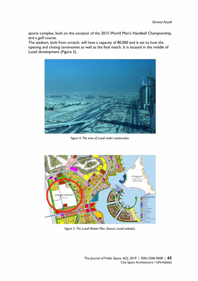
Simona Azzali
The Journal of Public Space, 4(2), 2019 | ISSN 2206-9658 | 65 City Space Architecture / UN-Habitat
sports complex, built on the occasion of the 2015 World Men's Handball Championship, and a golf course. The stadium, built from scratch, will have a capacity of 80,000 and is set to host the opening and closing ceremonies as well as the final match. It is located in the middle of Lusail development (Figure 5).
Figure 4. The area of Lusail under construction.
Figure 5. The Lusail Master Plan (Source: Lusail website).
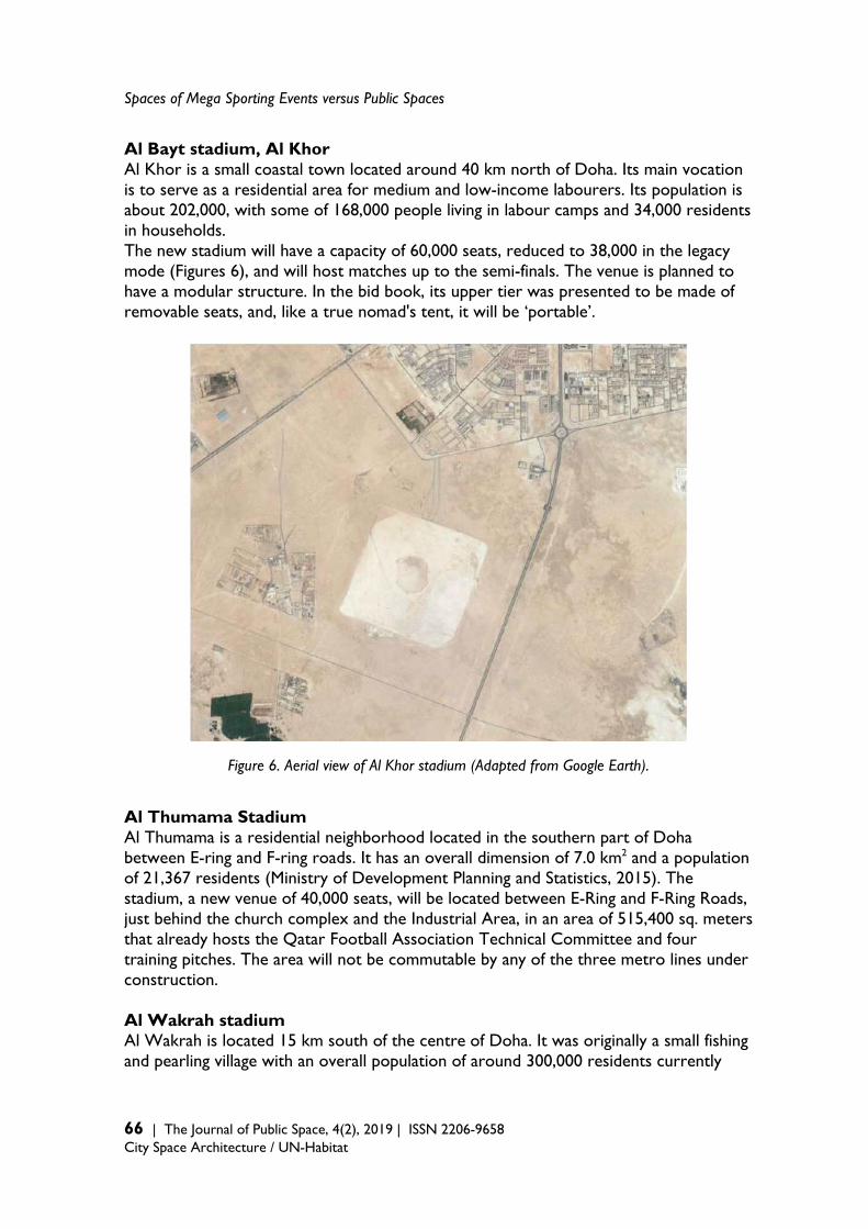
Spaces of Mega Sporting Events versus Public Spaces
66 | The Journal of Public Space, 4(2), 2019 | ISSN 2206-9658 City Space Architecture / UN-Habitat
Al Bayt stadium, Al Khor Al Khor is a small coastal town located around 40 km north of Doha. Its main vocation is to serve as a residential area for medium and low-income labourers. Its population is about 202,000, with some of 168,000 people living in labour camps and 34,000 residents in households. The new stadium will have a capacity of 60,000 seats, reduced to 38,000 in the legacy mode (Figures 6), and will host matches up to the semi-finals. The venue is planned to have a modular structure. In the bid book, its upper tier was presented to be made of removable seats, and, like a true nomad's tent, it will be ‘portable’.
Figure 6. Aerial view of Al Khor stadium (Adapted from Google Earth). Al Thumama Stadium Al Thumama is a residential neighborhood located in the southern part of Doha between E-ring and F-ring roads. It has an overall dimension of 7.0 km2 and a population of 21,367 residents (Ministry of Development Planning and Statistics, 2015). The stadium, a new venue of 40,000 seats, will be located between E-Ring and F-Ring Roads, just behind the church complex and the Industrial Area, in an area of 515,400 sq. meters that already hosts the Qatar Football Association Technical Committee and four training pitches. The area will not be commutable by any of the three metro lines under construction. Al Wakrah stadium Al Wakrah is located 15 km south of the centre of Doha. It was originally a small fishing and pearling village with an overall population of around 300,000 residents currently

Simona Azzali
The Journal of Public Space, 4(2), 2019 | ISSN 2206-9658 | 67 City Space Architecture / UN-Habitat
(Ministry of Development Planning and Statistics, 2015), although about 220,000 people out of this number live in labour camps, and only 80,000 live in households in the city Al Wakrah. The red metro line will serve the town, with a stop in the north of the city. Al Wakrah’s main vocation is to serve as a residential area for medium and low-income labourers. The stadium is a new venue, around 7 km away from the metro stop on the red line (Figure 7). It stands near the main hospital and schools, and a mall. The capacity for the World Cup will be 40,000 seats, reduced to 20,000 in the legacy mode. According to the Supreme Committee of Delivery and Legacy (2016b), the upper tier will be disassembled and distributed to developing nations that lack sporting infrastructure. In the legacy mode, the venue will become the new home of Al Wakrah Sports Club.
Figure 7. Aerial view of Al Wakrah, with metro stop and stadium’s precincts. Ras Abu Abboud stadium Ras Abu Abboud is located in the southeast of Doha’s city centre, near to the old airport and the new Hamad International Airport. It has a waterfront location that is visible from West Bay, the new business district of Doha. The site covers an area of about 1 km2 and has a population of 1,731 residents (Ministry of Development Planning and Statistics, 2015). According to recent plans, this area will be redeveloped into a new urban neighbourhood, and the Gold metro line under construction will serve it. However, the site has a strong touristic vocation, as it stands close to the Museum of Islamic Art, the National Museum under construction, and some hotels. In addition, Ras Abu Abboud is also close to the panoramic street Al Corniche, a seven-kilometre costal road, Souq Waqif, and the old port, that will be reconverted into a touristic harbor.
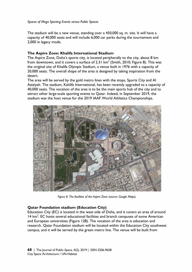
Spaces of Mega Sporting Events versus Public Spaces
68 | The Journal of Public Space, 4(2), 2019 | ISSN 2206-9658 City Space Architecture / UN-Habitat
The stadium will be a new venue, standing over a 450,000 sq. m. site. It will have a capacity of 40,000 seats and will include 6,000 car parks during the tournament and 2,000 in legacy mode. The Aspire Zone: Khalifa International Stadium The Aspire Zone, Doha’s sports city, is located peripherally to the city, about 8 km from downtown, and it covers a surface of 2.31 km2 (Smith, 2010; Figure 8). This was the original site of Khalifa Olympic Stadium, a venue built in 1976 with a capacity of 20,000 seats. The overall shape of the area is designed by taking inspiration from the desert. The area will be served by the gold metro lines with the stops, Sports City and Al Aziziyah. The stadium, Kahlifa International, has been recently upgraded to a capacity of 40,000 seats. The vocation of the area is to be the main sports hub of the city and to attract other large-scale sporting events to Qatar. Indeed, in September 2019, the stadium was the host venue for the 2019 IAAF World Athletics Championships.
Figure 8. The facilities of the Aspire Zone (source: Google Maps). Qatar Foundation stadium (Education City) Education City (EC) is located in the west side of Doha, and it covers an area of around 14 km2. EC hosts several educational facilities and branch campuses of some American and European universities (Figure 128). The vocation of the area is education and research. Qatar Foundation stadium will be located within the Education City southwest campus, and it will be served by the green metro line. The venue will be built from
Simona Azzali
The Journal of Public Space, 4(2), 2019 | ISSN 2206-9658 | 69 City Space Architecture / UN-Habitat
scratch and is expected to be ready by the end of 2019. Full capacity will be 40,000 seats, reduced to 25,000 in the legacy mode (Figure 129). Al Ryyann stadium Situated near Dukhan Highway and the Mall of Qatar, Al Rayyan stadium will be rebuilt on the former site of the Ahmed Bin Ali stadium which was recently deconstructed (Figure 130 and 131). The old venue was supposed to be refurbished for the World Cup, but it was demolished because it did not meet FIFA’s technical requirements. The stadium will be finished by the end of 2019 and served by the green metro line. The capacity for the FIFA World Cup will be 40,000 seats, reduced to 21,000 after the event. In the legacy mode, the stadium’s precinct should include other sports facilities such as an athletics track, tennis courts, cycling and running tracks, cricket pitch, hockey pitch, football training area, aquatics centre, as well as a skating park (SC, 2016c). Malpractices and key-issues in the 2022 World Cup The development of sustainable legacies from the stage of mega sports events is a difficult task. Indeed, the achievement of a positive sustainable legacy requires cooperation and resource sharing from a variety of event stakeholders (Leopekey, 2013). As a result of a series of site visits around Doha’s stadiums precincts, interviews with experts in the field, and the investigation of the process of sportification of Doha, several implications arose. Following the framework developed in Azzali (2019b), six main attributes, in the form of opposite terms, were utilised to assess Doha’ stadiums and precincts. This set of attribute includes temporary vs. permanent; already existing vs. new infrastructure; integration vs. divergence; public vs. private; local needs vs. event needs; high vs. low responsiveness to unplanned or unintended events.The framework aims at providing guidance to host cities in the planning of a mega sport event, specifically, for the post-event use of sports clusters. The list particularly intends to be a moment of reflection on the identity and role of sports venues and event sites. Cities, especially in emerging countries, are increasingly interested in bidding and hosting mega-events, and it has become strategic to implement strategies to maximise the benefits from their stage, and planning and implementing positive, sustainable and long-lasting legacies. The following is a list of some critical issues that emerged. Temporary vs. Permanent A first element to consider when planning a major sport event site is the right balance between ephemeral and permanent components. In particular, temporary infrastructure is a solution that is not taken into account enough in event planning. Jürgen Müller, the head of planning and infrastructure at the 2022 World Cup and at FIFA, during the three-day World Stadium Congress, held in Doha in May 2016, stated that sports venues should take into account local needs, and that some requirements could be met and declared through temporary solutions. Indeed, he said, “Don’t build stadiums that (will) not (be) filled by your leagues or your teams. FIFA would like to avoid, by all means, white elephants” (Doha News, 2016a). However, Qatar has a small population
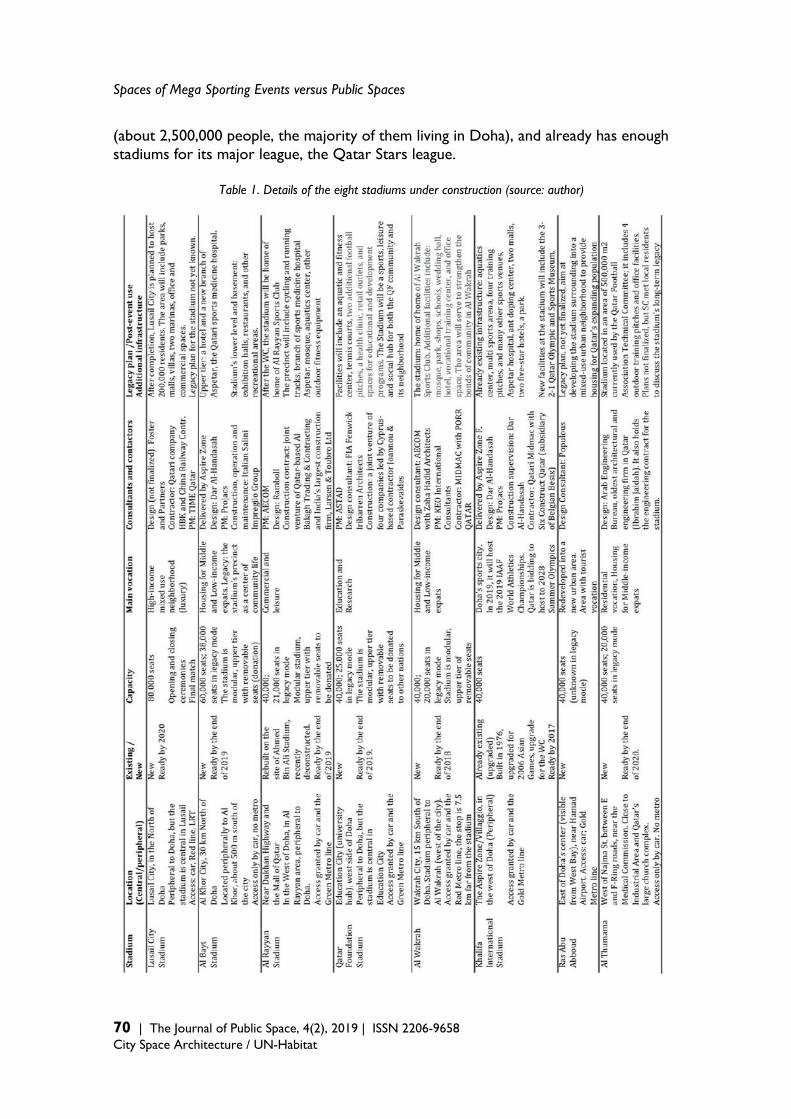
Spaces of Mega Sporting Events versus Public Spaces
70 | The Journal of Public Space, 4(2), 2019 | ISSN 2206-9658 City Space Architecture / UN-Habitat
(about 2,500,000 people, the majority of them living in Doha), and already has enough stadiums for its major league, the Qatar Stars league.
Table 1. Details of the eight stadiums under construction (source: author)
Simona Azzali
The Journal of Public Space, 4(2), 2019 | ISSN 2206-9658 | 71 City Space Architecture / UN-Habitat
All the eight stadiums that are under construction for the 2022 World Cup are meant to be permanent; although for five of them (with the exclusion of Lusail, Ras Abu Abboud, and Khalifa International stadium), plans, in the legacy mode, include the removal of the upper tier seats. All the stadiums are designed as modular structures and should be downscaled to half the capacity after the tournament. In the bid book, it was also promised that those tiers and modular sections would be used to construct stadiums in developing countries. It is also said that venues’ precincts will be dedicated to sports and leisure, with hotels, shops, restaurants, and other activities that will be placed both inside and outside the stadiums. According to SC (2016b), the precincts will host schools, parks, and other mixed-used facilities according to local needs. Stadiums should also house Qatar residents in the event of a national emergency to serve as temporary accommodation, during earthquakes or other natural disasters (Doha News, 2016b). These initiatives are meant to improve the number and the quality of open spaces and public services in Doha. However, the plans are vague and not yet finalised for the majority of the cases. There is no clue about how much the downscale of the stadiums will cost, and how long it will take to complete the process. There are also no precise indications on the use of the dismantled upper tiers and which countries should receive them. Especially for venues as the Lusail Stadium, which will have a capacity of 80,000 seats, detailed plans on the legacy mode are vital, as the country does not need such a huge infrastructure, and the risk of becoming a white elephant is very high. In addition to sports infrastructure, Qatar also needs to upgrade its touristic and hotel infrastructure. With a current number of 20,000 serviced apartments and hotel rooms available, Qatar needs to meet the FIFA requirement of 60,000 rooms before 2022. To overcome the absence of hotel rooms, the country is implementing wise initiatives such as allowing residents to temporarily rent out their rooms through services such as Airbnb, utilising cruise ships, and building temporary tent camps in the desert to accommodate tourists during the tournament (Doha News, 2016c). Temporary solutions here seem wise to prevail permanent ones. Already existing vs. new infrastructure Very often, mega sports events generate white elephants and underutilised venues. Hosting cities should consider accurately balancing new and existing infrastructure in their plans for the event, both regarding sports venues and city infrastructure (i.e. transport and mobility). In the case of Qatar, with the exception of Khalifa International, which is under refurbishment to be upgraded to 40,000 seats, all the other planned venues are new and built from scratch. Three stadiums with a capacity of 40,000 seats each (Al Wakra, Al Thumana, and Ras Abu Abboud) will be located in the area of the new airport, within a radius of 15 km, and, with the exclusion of Al Khor, which is placed 30 km north of Doha, the average distance between two contiguous stadiums will be around 16 km (Table 2). For a country that already has enough venues for its major league and does not have a strong football tradition, these numbers are impressive. In addition to the stadiums, Qatar is also building a massive supportive infrastructure for the tournament. First of all, improvements in the transport system are underway. Indeed, in May 2014, Hamad International, the new airport, opened, while the first phase of the new port opened in mid-2017.
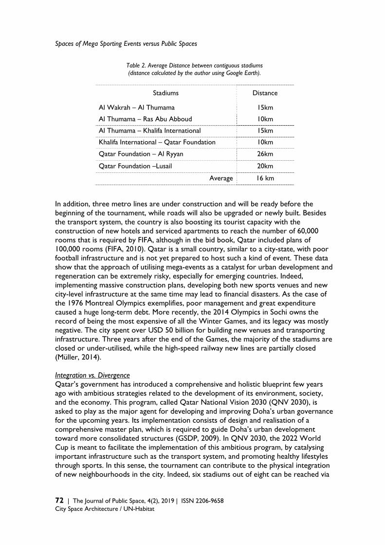
Spaces of Mega Sporting Events versus Public Spaces
72 | The Journal of Public Space, 4(2), 2019 | ISSN 2206-9658 City Space Architecture / UN-Habitat
Table 2. Average Distance between contiguous stadiums (distance calculated by the author using Google Earth).
Stadiums Distance
Al Wakrah – Al Thumama 15km
Al Thumama – Ras Abu Abboud 10km
Al Thumama – Khalifa International 15km
Khalifa International – Qatar Foundation 10km
Qatar Foundation – Al Ryyan 26km
Qatar Foundation –Lusail 20km
Average 16 km In addition, three metro lines are under construction and will be ready before the beginning of the tournament, while roads will also be upgraded or newly built. Besides the transport system, the country is also boosting its tourist capacity with the construction of new hotels and serviced apartments to reach the number of 60,000 rooms that is required by FIFA, although in the bid book, Qatar included plans of 100,000 rooms (FIFA, 2010). Qatar is a small country, similar to a city-state, with poor football infrastructure and is not yet prepared to host such a kind of event. These data show that the approach of utilising mega-events as a catalyst for urban development and regeneration can be extremely risky, especially for emerging countries. Indeed, implementing massive construction plans, developing both new sports venues and new city-level infrastructure at the same time may lead to financial disasters. As the case of the 1976 Montreal Olympics exemplifies, poor management and great expenditure caused a huge long-term debt. More recently, the 2014 Olympics in Sochi owns the record of being the most expensive of all the Winter Games, and its legacy was mostly negative. The city spent over USD 50 billion for building new venues and transporting infrastructure. Three years after the end of the Games, the majority of the stadiums are closed or under-utilised, while the high-speed railway new lines are partially closed (Müller, 2014). Integration vs. Divergence Qatar’s government has introduced a comprehensive and holistic blueprint few years ago with ambitious strategies related to the development of its environment, society, and the economy. This program, called Qatar National Vision 2030 (QNV 2030), is asked to play as the major agent for developing and improving Doha’s urban governance for the upcoming years. Its implementation consists of design and realisation of a comprehensive master plan, which is required to guide Doha’s urban development toward more consolidated structures (GSDP, 2009). In QNV 2030, the 2022 World Cup is meant to facilitate the implementation of this ambitious program, by catalysing important infrastructure such as the transport system, and promoting healthy lifestyles through sports. In this sense, the tournament can contribute to the physical integration of new neighbourhoods in the city. Indeed, six stadiums out of eight can be reached via
Simona Azzali
The Journal of Public Space, 4(2), 2019 | ISSN 2206-9658 | 73 City Space Architecture / UN-Habitat
the new metro system, and many roads will be upgraded or opened (Figure 133 for the metro system). So, after the tournament, commute to and from Doha will be easier. However, from a physical point of view, a risk associated with event sites is that they often allow the creation of ‘islands of regeneration’ or ‘bubbles’ (Carrière and Demaziere, 2002): event venues are physically separated and detached from the rest of the city, and they become an obstacle to the integration they are expected to implement. One of the reasons for that is that these areas are designed without any consideration of their interaction with the city and on how they will affect the surroundings. The design effort is devoted exclusively to a specific area, without examining the impact on the whole city. Also, new stadiums need to be carefully planned. Stadiums are indeed the dominant facility in all mega sports events, but they are also the most problematic venues in the post-event usage. Usually they are enormous facilities that ‘struggle’ to find their place in the city and they alternate short periods of extreme congestion on match days with long periods when they are totally empty or under-utilised. In many other occasions, the stadium is almost abandoned after the end of the event, and this risk is very high in Doha. From a social point of view, Qatar is an emerging but wealthy country, and its citizens are among the richest in the world. In this sense, with regards to local residents, Qatar will not face the same issues as its predecessors (i.e. Brazil, Russia, South Africa). The highest social cost is related to the work force utilised for the preparation of World Cup infrastructure (i.e. South East Asian labourers involved in the building of the stadiums and transport infrastructure). Indeed, just after the award, a number of concerns regarding human right issues arose, in particular, regarding working conditions and the hiring system. Also, in March 2017, the International Labor Organization (ILO) decided to continue monitoring Qatar for human rights violations till November 2017. After this time, ILO will revisit to open a Commission of Inquiry, its highest investigative mechanism (Doha News, 2017). Finally, regarding the environment, the bid promised Qatar to be the first carbon neutral tournament, and that new technologies and materials would be used to build sustainable stadiums. In this sense, the bid also promised the stadiums to be GSAS2 certified. However, in spite of GSAS certification, sustainability will be achieved only if the venues are fully used after the tournament. Regarding Al Rayyan, the stadium is supposed to utilise about 90 per cent of the materials derived from the deconstruction of the old stadium (SC, 2015). The old venue was supposed to be refurbished for the World Cup, but it was demolished because it did not meet FIFA’s technical requirements. Public vs. Private Who will be the beneficiaries from the stage of the 2022 World Cup? And who will pay for it? In any mega event, the right balance between private and public interests should be planned and implemented, by involving local communities in the decisions and panning processes with public participations tools. Qatar is a rich country, and with an average of 133,000 USD, it is the country with the highest GDP per capita in the world.
2 Global Sustainability Assessment System (GSAS) is the first performance-based system in the MENA region, developed for rating the green buildings and infrastructures.
Spaces of Mega Sporting Events versus Public Spaces
74 | The Journal of Public Space, 4(2), 2019 | ISSN 2206-9658 City Space Architecture / UN-Habitat
However, Qatar is also a small country and its overall GDP is estimated to about 167 billion USD, less than the 195 billion of Greece, the 370 billion of the Emirates, or the 292 billion of Singapore (The World Bank, 2015a). Indeed, in the 2015 world GDP ranking by the World Bank (2015b), Qatar is placed in the 54th place, after countries like Bangladesh, Vietnam, or Peru. Although official data are not available, according to some estimates (Doha News, 2011; The Telegraph, 2011), the overall cost of the 2022 tournament will be about 220 billion USD, around 60 times of what South Africa spent in 2010 (estimated in 3.5 billion USD). With a population of around 225,000 Qatari citizens, it means that country will spend more or less 100,000 USD per capita, compared to 73 USD per capita for the 2010 Brazil World Cup, 350 USD per capita for the 2014 Sochi Winter Games, and 54 USD per capita for South Africa (data for Sochi, South Africa and Brazil from Time, 2013). If this amount of money is confirmed, it means also that Qatar will spend more than one year GDP in the tournament. Also, for example, the focus of 2017’s budget was to ensure that major projects related to the 2022 tournament proceed as scheduled, with about 50% of the annual country’s budget dedicated to this effort. Since mega sport events expenditure usually does not pay off, especially in the long-term, Qatar should review its strategy and look for positive case studies that associated the construction of a new stadium with more profitable real estate investments. Qatar should look at examples of implemented strategies to minimise the debt incurred for the preparation of the stadiums and the tournament. Local Needs vs. Event Needs Müller (2015) reminds us of the risk of event take over when dealing with infrastructure related to mega events. He states, “Mega-event priorities often displace long-term urban development priorities. Instead of the event becoming an instrument for urban development, urban development becomes the instrument for the event” (p. 10). The costs presented in the previous paragraph seem to move towards this direction, but other factors also support this statement. Indeed, there is a very recent football tradition in Qatar. The main league, Qatar Stars League, had its first official season only in 1972, and it features 14 teams, with the most recent team founded in 2009. The teams utilise 10 different stadiums for the matches that are considered more than enough for the needs of the league, each with a capacity between 12,000 and 25,000 seats. Qatar had initially promised 12 new stadiums for the World Cup, but, at the time of writing, this number has been wisely reduced to eight. However, even if the number eight is confirmed and the post-tournament plans are approved, according to which the majority of the stadiums would be reduced to half capacity (see Table 3), the number of seats available still would be surprisingly high for a total country’s population of 2,500,000 people. Indeed, Qatari nationals are estimated in about 300,000 units, while the number of seats in the legacy mode would be 284,000, with an availability of about one seat for each Qatari citizen (Table 3).
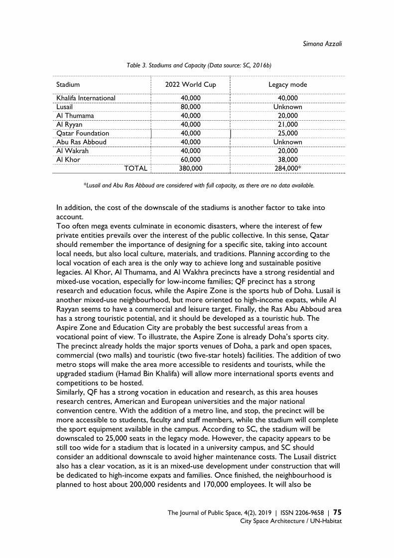
Simona Azzali
The Journal of Public Space, 4(2), 2019 | ISSN 2206-9658 | 75 City Space Architecture / UN-Habitat
Table 3. Stadiums and Capacity (Data source: SC, 2016b)
Stadium 2022 World Cup Legacy mode
Khalifa International 40,000 40,000 Lusail 80,000 Unknown Al Thumama 40,000 20,000 Al Ryyan 40,000 21,000 Qatar Foundation 40,000 25,000 Abu Ras Abboud 40,000 Unknown Al Wakrah 40,000 20,000 Al Khor 60,000 38,000
TOTAL 380,000 284,000*
*Lusail and Abu Ras Abboud are considered with full capacity, as there are no data available. In addition, the cost of the downscale of the stadiums is another factor to take into account. Too often mega events culminate in economic disasters, where the interest of few private entities prevails over the interest of the public collective. In this sense, Qatar should remember the importance of designing for a specific site, taking into account local needs, but also local culture, materials, and traditions. Planning according to the local vocation of each area is the only way to achieve long and sustainable positive legacies. Al Khor, Al Thumama, and Al Wakhra precincts have a strong residential and mixed-use vocation, especially for low-income families; QF precinct has a strong research and education focus, while the Aspire Zone is the sports hub of Doha. Lusail is another mixed-use neighbourhood, but more oriented to high-income expats, while Al Rayyan seems to have a commercial and leisure target. Finally, the Ras Abu Abboud area has a strong touristic potential, and it should be developed as a touristic hub. The Aspire Zone and Education City are probably the best successful areas from a vocational point of view. To illustrate, the Aspire Zone is already Doha’s sports city. The precinct already holds the major sports venues of Doha, a park and open spaces, commercial (two malls) and touristic (two five-star hotels) facilities. The addition of two metro stops will make the area more accessible to residents and tourists, while the upgraded stadium (Hamad Bin Khalifa) will allow more international sports events and competitions to be hosted. Similarly, QF has a strong vocation in education and research, as this area houses research centres, American and European universities and the major national convention centre. With the addition of a metro line, and stop, the precinct will be more accessible to students, faculty and staff members, while the stadium will complete the sport equipment available in the campus. According to SC, the stadium will be downscaled to 25,000 seats in the legacy mode. However, the capacity appears to be still too wide for a stadium that is located in a university campus, and SC should consider an additional downscale to avoid higher maintenance costs. The Lusail district also has a clear vocation, as it is an mixed-use development under construction that will be dedicated to high-income expats and families. Once finished, the neighbourhood is planned to host about 200,000 residents and 170,000 employees. It will also be
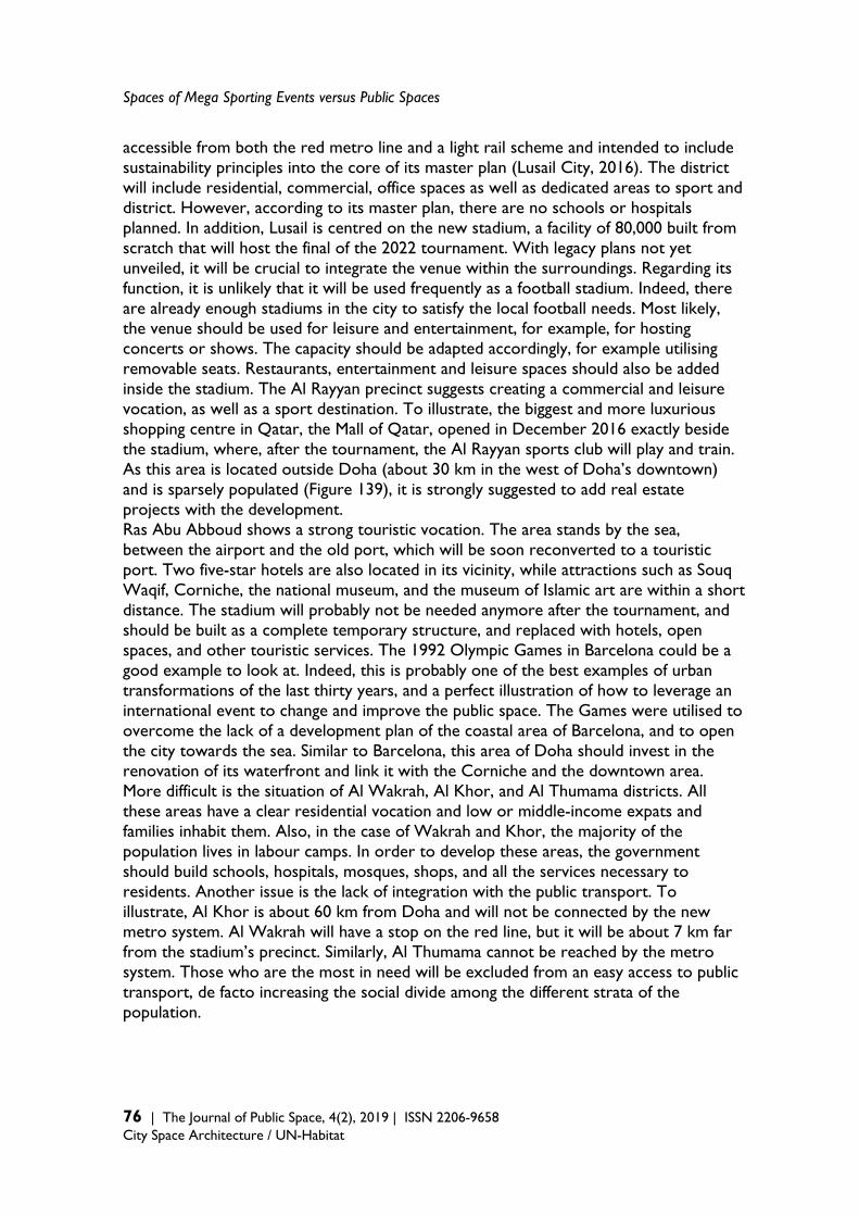
Spaces of Mega Sporting Events versus Public Spaces
76 | The Journal of Public Space, 4(2), 2019 | ISSN 2206-9658 City Space Architecture / UN-Habitat
accessible from both the red metro line and a light rail scheme and intended to include sustainability principles into the core of its master plan (Lusail City, 2016). The district will include residential, commercial, office spaces as well as dedicated areas to sport and district. However, according to its master plan, there are no schools or hospitals planned. In addition, Lusail is centred on the new stadium, a facility of 80,000 built from scratch that will host the final of the 2022 tournament. With legacy plans not yet unveiled, it will be crucial to integrate the venue within the surroundings. Regarding its function, it is unlikely that it will be used frequently as a football stadium. Indeed, there are already enough stadiums in the city to satisfy the local football needs. Most likely, the venue should be used for leisure and entertainment, for example, for hosting concerts or shows. The capacity should be adapted accordingly, for example utilising removable seats. Restaurants, entertainment and leisure spaces should also be added inside the stadium. The Al Rayyan precinct suggests creating a commercial and leisure vocation, as well as a sport destination. To illustrate, the biggest and more luxurious shopping centre in Qatar, the Mall of Qatar, opened in December 2016 exactly beside the stadium, where, after the tournament, the Al Rayyan sports club will play and train. As this area is located outside Doha (about 30 km in the west of Doha’s downtown) and is sparsely populated (Figure 139), it is strongly suggested to add real estate projects with the development. Ras Abu Abboud shows a strong touristic vocation. The area stands by the sea, between the airport and the old port, which will be soon reconverted to a touristic port. Two five-star hotels are also located in its vicinity, while attractions such as Souq Waqif, Corniche, the national museum, and the museum of Islamic art are within a short distance. The stadium will probably not be needed anymore after the tournament, and should be built as a complete temporary structure, and replaced with hotels, open spaces, and other touristic services. The 1992 Olympic Games in Barcelona could be a good example to look at. Indeed, this is probably one of the best examples of urban transformations of the last thirty years, and a perfect illustration of how to leverage an international event to change and improve the public space. The Games were utilised to overcome the lack of a development plan of the coastal area of Barcelona, and to open the city towards the sea. Similar to Barcelona, this area of Doha should invest in the renovation of its waterfront and link it with the Corniche and the downtown area. More difficult is the situation of Al Wakrah, Al Khor, and Al Thumama districts. All these areas have a clear residential vocation and low or middle-income expats and families inhabit them. Also, in the case of Wakrah and Khor, the majority of the population lives in labour camps. In order to develop these areas, the government should build schools, hospitals, mosques, shops, and all the services necessary to residents. Another issue is the lack of integration with the public transport. To illustrate, Al Khor is about 60 km from Doha and will not be connected by the new metro system. Al Wakrah will have a stop on the red line, but it will be about 7 km far from the stadium’s precinct. Similarly, Al Thumama cannot be reached by the metro system. Those who are the most in need will be excluded from an easy access to public transport, de facto increasing the social divide among the different strata of the population.
Simona Azzali
The Journal of Public Space, 4(2), 2019 | ISSN 2206-9658 | 77 City Space Architecture / UN-Habitat
Unplanned or unintended events A final factor to consider is the response to unplanned or unintended circumstances. This kind of mega events is usually planned at least seven years in advance. During this time span, many changes in the political, social, or economic situation of hosting countries can occur. For example, Qatar was awarded the 2022 World Cup at the end of 2010, when it was at the highest point of its economic success. However, in 2015, because of the rapid collapse of oil prices, Qatar’s economic situation changed dramatically, and the country closed the 2015 financial year with a deficit for the first time in 15 years (Gulf Times, 2016). To illustrate, for Qatar, the fiscal break-even price of oil, which is the price that balances an oil-exporting country’s budget, is about 70 USD per-barrel (The National, 2015), while, in 2016, the average price per-barrel was only 48 USD and this led Qatar to accumulate a deficit of 13 billion USD. In addition, forecasts predict that the country will face deficit until 2019 at the least. To face the economic crisis, the Government has undertaken measures that include cutting down on or postponing important mega projects, downsizing plans in many governmental companies, and the introduction of a new taxation system (Doha News, 2016e, 2016f, 2016i). In addition, the Government unveiled that plans for the National Development Strategy 2017–2022 include, besides completing all 2022 World Cup-related projects and infrastructure, “cutting the fat in government”, by shifting some responsibility from the state onto the private sector, and “transitioning from a nation of simple social welfare policies to a state of action by empowering citizens” (Doha News, 2016h). These facts underline how the approach of utilising mega-events for urban development and regeneration can be extremely risky. In the case of Doha, the World Cup was intended to accelerate the transformation of the city, promote sustainable initiatives as a new public transport system and catalyse the implementation of the 2030 Qatar National Vision, the country’s blueprint. However, the economic crisis that hit the Gulf Region in mid-2015 has led the government to redefine the country’s priorities. Many initiatives and projects have been cancelled; but the entire infrastructure related to the World Cup, like the construction of eight new stadiums, has not been touched because it is part of the obligations imposed by FIFA. While the Cup was supposed to trigger beneficial urban change, it has now transformed into a boomerang effect, fostering the proliferation of white elephants and unnecessary urban infrastructure. Conclusion The analysis of the stadiums’ precincts revealed a series of issues related to their post-event use, in particular regarding their function, capacity, costs, and integration within the urban fabric. Indeed, this kind of events always generates huge debts and bulky, complex sports structures that are expensive to build and maintain. One way to partially mitigate those issues is to leverage the vocation of each stadium’s neighbourhood, by transforming the stadiums and their precincts according to local needs. Each city (or country) has to develop a strategy that fits their characteristics and peculiarities. However, some recurrent mistakes and bad habits emerged as recurrent: the low proportion of temporary structures, the exorbitant costs, the inability to respond to unforeseen circumstances, and the lack of attention to local needs. With

Spaces of Mega Sporting Events versus Public Spaces
78 | The Journal of Public Space, 4(2), 2019 | ISSN 2206-9658 City Space Architecture / UN-Habitat
regards to the 2022 World Cup, the previous sections highlighted some major issues, as the weak legacy plans for the stadiums’ precincts, the need to improve local planning capacity, exorbitant costs to build the event infrastructure and the eight new stadiums. Mega-events planning is a controversial form of urban policymaking because despite its wide impact on cities, this impact is often more negative than positive. The research showed how difficult it is to benefit from the stage of mega events and unveiled important issues to consider before bidding. Indeed, those events are very expensive in terms of costs, effort, resources, and people, and cities need to maximise the benefits and limit the damages from their hosting. The study showed that there is potential to realise sports-oriented areas and open spaces from event sites that are fully integrated within hosting cities; however, the locations chosen for the event need to be carefully selected according to the morphology and needs of the hosting city. The right mix of temporary, new, and already existing venues; the balance between sport and city infrastructure; the strict control of expenditure and the respect of the local vocation are some of the most important challenges cities need to face and solve. In this, FIFA, IOC and other major event organisations have to clarify their role and advocate all the initiatives that are necessary to promote and support beneficial outcomes and positive legacies. The research aimed at contributing to the discourse on mega sports events and their impact on the built environment, and it is hoped that this work will help future hosting cities to avoid recurrent mistakes and malpractices and build their positive legacies. Acknowledgement This article was made possible by grant # GSRA1-1-1119-13007 from the Qatar National Research Fund (a member of Qatar Foundation). The findings achieved herein are solely the responsibility of the author. References Adham, K. (2008). Rediscovering the Island: Doha's Urbanity from Pearls to Spectacle. In
Elsheshtawy, Y. (ed.) The Evolving Arab City: Tradition, Modernity and Urban Development. New York: Routledge.
Amara, M. (2005). 2006 Qatar Asian Games: A ‘Modernization’ Project. Sport in Society: Cultures, Commerce, Media, Politics, Vol.8(3), pp.493-514.
Azzali S (2019a) Mega sporting events as tools of urban redevelopment: lessons learned from Rio de Janeiro. Proceedings of the Institution of Civil Engineers (ICE): Urban Design and Planning, 172 (3). pp. 81-89
Azzali, Simona (2019b) Challenges and key factors in planning legacies of mega sporting events: lessons learned from London, Sochi, and Rio de Janeiro. Archnet-IJAR: International Journal of Architectural Research. (In Press)
Azzali, S. (2017a). The legacies of Sochi 2014 Winter Olympics: an evaluation of the Adler Olympic Park. Urban Research & Practice, Vol.10(3), pp 329–349.
Azzali, S. (2017b). Mega-events and urban planning: Doha as a case study. Urban Design International. Vol.22(1), pp 3–12.
Azzali, S. (2016). The Aspire Zone in Doha: A post-occupancy evaluation of the long-term legacies of the 2006 Asian Games. Journal of Urban Regeneration & Renewal, Vol.9(4), pp. 393-405.
Simona Azzali
The Journal of Public Space, 4(2), 2019 | ISSN 2206-9658 | 79 City Space Architecture / UN-Habitat
Azzali, Simona, and Tomba, Mattia (2018) Urban development and planning practice in Doha. Middle East Journal, 180.
Brown, A., O’Connor, J., & Cohen, S. (2000). Local music policies within a global music industry: Cultural quarters in Manchester and Sheffield, Geoforum, Vol.31 (4), pp.437–451.
Carmona, M. (2010). Contemporary public space, part two: classification, Journal of Urban Design, Vol.15(2), pp.157–173.
Carrière, J. & Demaziere, C. (2002). Urban Planning and Flagship Development Projects: Lessons from Expo 98, Lisbon. Planning Practice and Research. 17,1, 69-79.
Doha News (2011). Qatar’s World Cup will cost $220bn – What does that mean? Retrieved from http://dohanews.co/qatars-world-cup-will-cost-220bn-what-doesthat/
Doha News (2016a). FIFA exec warns against building ‘white elephant’ World Cup stadiums. Retrieved from http://dohanews.co/fifa-exec-warns-against-building-whiteelephant-world-cup-stadiums/
Doha News (2016b). Stadiums to house Qatar residents in the event of a national emergency. Retrieved from http://dohanews.co/stadiums-to-house-qatar-residents-inthe-event-of-a-national-emergency/
Doha News (2016c). Experts: Qatar businesses should start preparing for VAT now. Retrieved from http://dohanews.co/experts-qatar-businesses-should-startpreparing-for-vat-now/
Doha News (2016d). Stadiums to house Qatar residents in the event of a national emergency. Retrieved at http://dohanews.co/stadiums-to-house-qatar-residents-in-the-event-of-a-national-emergency/
Doha News (2016e). Experts: Qatar businesses should start preparing for VAT now. Retrieved from http://dohanews.co/experts-qatar-businesses-should-start-preparing-for-vat-now/
Doha News (2016f). Timeline for Gulf Rail project pushed back three years to 2021. Retrieved from http://dohanews.co/timeline-gulf-rail-project-pushed-back-three-years-2021/
Doha News (2016g). Work on multibillion-riyal Doha sewer project suddenly halted. Retrieved from http://dohanews.co/work-on-multibillion-riyal-doha-sewer-project-suddenly-halted/
Doha News (2016h). Emir: Time to move Qatar’s people off of social welfare and into action. Retrieved from http://dohanews.co/emir-time-to-move-qatars-people-off-of-social-welfare-and-into-action/
Doha News. (2016i). Qatar World Cup organizers issue tender for football fan desert camp. Retrieved from http://dohanews.co/qatar-world-cup-organizers-issue-tender-for-football-fan-desert-camp/
Doha News (2017). Qatar gets until November to improve its human rights record. Retrieved from https://dohanews.co/qatar-gets-november-improve-human-rights-record/
Elsheshtawy, Y. (2011). Informal encounters: mapping Abu Dhabi’s urban public spaces, Built Environment, Vol.37(1), pp.92–113.
Essex, S. & Chalkley, B. (1999). Olympic Games: catalyst of urban change. Leisure Studies, Vol.17(3), pp.187–206.
Fédération Internationale de Football Association – FIFA (2010). FIFA World Cup, Qatar BiD evaluation Report. Retrieved from www.fifa.com/mm/document/tournament/competition/01/33/74/56/b9qate.pdf
Gehl, J. (1987). Life between buildings: using public space. New York: Van Nostrand Reinhold Company.
Gulf Times (2016). Qatar’s 2016 budget foresees ‘first deficit’ in 15 years. Retrieved from http://www.gulf-times.com/story/487042/Qatar-s-2016-budget-foresees-first-deficit-in-15-y
Leopkey, B. (2013). The Governance of Olympic Games Legacy, PhD Dissertation, School of Human Kinetics Faculty of Health Sciences University of Ottawa, Canada.
Lusail City (2016) Lusail City. Retrieved from http://www.lusail.com/who-we-are/ceo-message/
Spaces of Mega Sporting Events versus Public Spaces
80 | The Journal of Public Space, 4(2), 2019 | ISSN 2206-9658 City Space Architecture / UN-Habitat
Ministry of Development Planning and Statistics (2015). First Section Population and Social Statistics. Retrieved from http://www.mdps.gov.qa/en/statistics/Statistical%20Releases/Population/Population/2015/1_Population_2015.pdf
Müller, M. (2014). After Sochi 2014: costs and impacts of Russia’s Olympic Games. Eurasian Geography and Economics, Vol.55(6), pp.628-655.
Müller, M. (2015). The Mega-Event Syndrome: Why So Much Goes Wrong in Mega-Event Planning and What to Do About It. Journal of the American Planning Association. Vol.(81)1, pp.6-17.
Pitts, A., & Liao, H. (2009). Sustainable Olympic Design and Urban Development, New York: Routledge.
Qatar Statistics Authority – QSA (2015). Population structure. Retrieved from http://www.qsa.gov.qa/eng/
Qatar General Secretariat of Development Planning – QSDP (2009). Qatar National Vision 2030. Advancing Sustainable Development, Qatar’s Second Human Development Report, Doha: Gulf Publishing and Printing Company.
Qatar Gulf News (2010). The 2022 World Cup. Retrieved from http://www.qatargulfnews.com/341-2/
Qatar Tourism Authority – QTA (2014). Activities, Retrieved from http://www.qatartourism.gov.qa/en-us/thingstodo/activities/sport.aspx
Salama, A.M., & Azzali, S. (2015). Examining attributes of urban open spaces in Doha. Proceedings of the ICE - Urban Design and Planning, Vol.168(2), pp.75-87.
Smith, A. (2010). The Development of “Sports-City” Zones and Their Potential Value as Tourism Resources for Urban Areas, European Planning Studies, Vol.18(3), pp.385- 410.
Smith, A. (2012). Events and Urban regeneration, New York: Routledge. The Supreme Committee for Delivery and Legacy – SC, 2016a. Stadiums. Retrieved from
http://www.sc.qa/en/stadiums The Supreme Committee for Delivery and Legacy – SC. (2015). Al Rayyan Stadium
deconstruction successfully completed. Retrieved from http://www.sc.qa/en/news/alrayyan_stadium_deconstruction
The Supreme Committee for Delivery and Legacy - SC. (2016a). Stadiums. Retrieved from http://www.sc.qa/en/stadiums
The Supreme Committee for Delivery and Legacy – SC. (2016b). Al Bayt Stadium in Al Khor. Retrieved from http://www.sc.qa/en/news/construction-advancing-on-albayt-stadium-bowl-at-proposed-semi-final venue-for-2022
The Supreme Supreme Committee for Delivery & Legacy – SC. (2016 c). About us. Retrieved at http://www.sc.qa/en/about/vision-mission-values
The Telegraph (2011). Qatar World Cup in 2022 could cost £138 billion according to financial analyst. Retrieved from http://www.telegraph.co.uk/sport/football/worldcup/8749931/Qatar-World-Cup-in-2022-could-cost-138-billion-according-tofinancial-analyst.html
The National (2015). How GCC states’ break-even oil prices stack up. Retrieved from http://www.thenational.ae/business/energy/how-gcc-states-break-even-oil-prices-stack-up
The World Bank (2015a). GDP (current US$). Retrieved from http://data.worldbank.org/indicator/NY.GDP.MKTP.CD?name_desc=false
The World Bank (2015b). Gross domestic product 2015. Retrieved from http://databank.worldbank.org/data/download/GDP.pdf
Time (2013). Why Qatar is Spending $200 Billion On Soccer. Retrieved from http://keepingscore.blogs.time.com/2013/07/11/why-qatar-is-spending-200-billion-on-soccer/

The Journal of Public Space ISSN 2206-9658 2019 | Vol. 4 n. 2 https://www.journalpublicspace.org
ISSN 2206-9658 | 81
City Space Architecture / UN-Habitat
Live-work Tactics in the Suburban House and their Effects on Public Spaces in the Peripheral Neighbourhoods of Rio de Janeiro
Ana Slade and Guilherme Lassance Federal University of Rio de Janeiro, Postgraduate Program in Urbanism (Prourb), Brazil [email protected] | [email protected] Abstract Housing production in Brazil continues, for the most part, to be tied to the mono-functional paradigm. Social housing developments, gated communities and new neighbourhoods are conceived according to modern, functional zoning logic. However, in reality, the Brazilian way of life subverts this logic where its expression produces urban spaces that don’t correspond to what is originally planned or imposed by regulation. This paper presents the outcomes of an investigation conducted on suburban houses in Rio de Janeiro, which have been informally transformed to accommodate multiple activities ranging from living areas to workspaces. Vast areas of lots generally occupied by single-family houses characterise the low-income suburbs of Rio. In these areas, the pressing need families face to increase their income, a need associated with the general lack of infrastructure — including local commerce and facilities — fosters the development of informal economies, which in turn transforms the built environment and effecting the public space. A fragment of one of these peripheral neighbourhoods is analysed in this paper through the mapping of commercial and professional activities that take place in single-family houses. The urban environment of streets in which these kinds of activities are taking place is compared with neighbouring streets in which no such activities are apparent. The investigation consists of a consideration of the social and spatial effects of informal practices occurring within the formal city. The suburban houses are analysed as privileged spaces in which the local way of life can be observed and acknowledged as being intrinsic to a specific social and economic reality. Both spatial and building solutions are thereby recognised as valuable lessons which urge practitioners to consider alternatives to the way in which housing projects and city planning have been previously defined. Keywords: peripheral neighbourhoods, live-work architecture, public space
T
HE
JO
UR
NA
L O
F P
UB
LIC
SP
AC
E
To cite this article: Slade, A. and Lassance, G. (2019). Live-work Tactics in the Suburban House and their Effects on Public Spaces in the Peripheral Neighbourhoods of Rio de Janeiro. The Journal of Public Space, 4(2), 81-100, DOI 10.32891/jps.v4i2.1205 This article has been double blind peer reviewed and accepted for publication in The Journal of Public Space.
This work is licensed under a Creative Commons Attribution - Non Commercial 4.0 International License https://creativecommons.org/licenses/by-nc/4.0/
Live-work Tactics in the Suburban House and their Effects on Public Spaces
82 | The Journal of Public Space, 4(2), 2019 | ISSN 2206-9658 City Space Architecture / UN-Habitat
Introduction Major paradigm shifts in the organisation and planning of cities are deeply related to the conformation of the workspace and its relation to dwelling. In the pre-industrial period, domestic spaces were utilised as mixed-use living and working areas. In the same family environment commercial activities were run alongside those pertaining to daily life. The new mode of production introduced by industrial capitalism lead to the spatial separation of dwelling places and workplaces and as a result, urban planning principles began to mirror the spatial segregation of functions that defined the industrial age. Along with live-work typology, small-grain, diverse and mixed uses were abolished the strictly residential areas of proletarian suburbs were born. After decades of planning based on functional zoning, criticisms of the modern city began to emerge. Among others, author Jane Jacobs claimed, in the 1960s, that diversity and density should be considered as necessary qualities to achieve vitality and safety in the city. In the late 19th and early 20th centuries, despite a markedly slow process of industrialisation, Rio de Janeiro went through deep foundational transformations specifically in relation to its economy and systems of production. Similarly to other large cities in the world, economic shifts generated intense population growth, accompanied by an increase in the number of precarious dwellings. The desire to transform the image of the city, to embody the expression of a modern capital, drove the displacement of the lower and middle-class populations away from the city to its surrounding areas. However, unlike the Howard’s ‘Garden City’ in England or ‘habitat ideology’ in France (Lefebvre, 1991), no development project emerged to serve the displaced population. Instead, these proletarian suburbs grew predominantly without planning and were characterised by real estate driven processes which entailed subdividing former farmland into small urban plots coupled with the spatial segregation of activities, thus generating extensive strictly-residential areas. While in the United States, interest in hybrid uses re-emerged from critical re-evaluations of urban planning policies based on functional zoning; Rio de Janeiro, continues to be governed by regulations implemented in the 1970s — which have not yet been substantially revised —and continue to be considerably influenced by the modern principles of use segregation (Lassance et al., 2012: 37). However, although there is much discussion around and policies against intensifying mixed use in North America, consolidated residential areas are vast and heavily shielded for mixed use. Diversely, in Brazil, home-based informal entrepreneurial activities have proliferated in suburban residential neighbourhoods despite legislation, and have profited from a lack of inspection from Governmental bodies. Such activities — and their impact on urban space in residential suburban neighbourhoods of Rio de Janeiro — are the phenomena being analysed in this article. The spontaneous transformation of the suburban house and the relationships between spatial and building solutions and local street life are recognised as valuable non-hegemonic innovative practices produced by different individuals and socio-spatial contents. By doing so, the research reveals a suburban reality that transcends the condition of scarcity and economic dependence, which often form the narrative used by locals to describe Rio de Janeiro‘s suburbs (Fernandes, 2011). The suburban residents’ everyday practices — their ‘making do’ in terms of living and
Ana Slade and Guilherme Lassance
The Journal of Public Space, 4(2), 2019 | ISSN 2206-9658 | 83
City Space Architecture / UN-Habitat
carrying out economic activities — are treated and analysed as a resource with the potential to facilitate alternative housing policies and city planning strategies. In understanding these informal entrepreneurial activities within the formal city, the present research opens up a territory of investigation on the ordinary production of the city and its architecture, something that designers and planners often fail to consider (Walker, 2010). The suburban houses are analysed as valuable spaces in which the local lifestyle can be observed and acknowledged as being intrinsic to a specific social and economic reality: in which dwelling is often associated with professional activities and income generation. The ‘suburb’ of Rio de Janeiro - from aristocracy to proletariat In Rio de Janeiro, the concept of suburb has changed over time, absorbing a singular local connotation (Soares, 1960; Fernandes, 2011). Its current definition is in direct contrast to what prevailed until the late 19th century, a time when “suburb” referred to the outskirts of the city, which served primarily as a rural retreat for wealthy families and the backdrop to farming activities (Fernandes, 2011: 53-55). Even after the construction of the first railway line in 1858, for decades suburbs would remain the territories of the upper classes. At that time, the plans for the outskirts of Rio were similar to those found in the modern rail suburbs of Europe and North America, created for the middle and upper classes (Fernandes, 2011: 57). However, from the beginning of the 20th century onwards, the attributes related to the concept of suburb in Rio drastically changed (Fernandes, 2011: 44). Faced with the ideological needs of a capitalist society and as a result of the development of major urban reforms, the suburbs became the subject of stigmatisation where they began to be associated with the neighbourhoods served by the train lines that were used by the low-income classes. From this point on, discriminatory policies were adopted to deal with the periphery. They were linked to the process of “opening the suburbs to the proletariat” (Abreu, 1987: 15) and the trinomial “train / suburb / proletarian” — a typical depiction of the suburbs in Rio de Janeiro (Fernandes, 2011: 143). This context favoured the development of the enduring social and spatial segregation of the proletarian suburbs. During the first three decades of the 20th century, the residents of these neighbourhoods had to seek independent ways of living and working, with little to no State intervention in the social and urbanistic domain, let alone dedicated public space. During the first three decades of the 20th century, the residents of these neighbourhoods started to seek independent ways of living and working From farms and rural properties to land parceling for urban developments
The suburb came to be occupied by the proletariat because of the imperative of the accelerated growth of the city, of the migration flows, of the real estate dealers who promoted the percolation
of the farmland in order to transform it into new urban developments that were cheap because of the lack of infrastructure Fernandes, 2011: 151
The process of urbanisation of the many peripheral neighbourhoods known today as
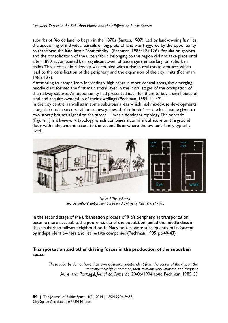
Live-work Tactics in the Suburban House and their Effects on Public Spaces
84 | The Journal of Public Space, 4(2), 2019 | ISSN 2206-9658 City Space Architecture / UN-Habitat
suburbs of Rio de Janeiro began in the 1870s (Santos, 1987). Led by land-owning families, the auctioning of individual parcels or big plots of land was triggered by the opportunity to transform the land into a “commodity” (Pechman, 1985: 125,126). Population growth and the consolidation of the urban fabric belonging to the region did not take place until after 1890, accompanied by a significant swell of passengers embarking on suburban trains. This increase in ridership was coupled with a rise in real estate ventures which lead to the densification of the periphery and the expansion of the city limits (Pechman, 1985: 127). Attempting to escape from increasingly high rents in more central areas, the emerging middle class formed the first main social layer in the initial stages of the occupation of the railway suburbs. An opportunity had presented itself for them to buy a small piece of land and acquire ownership of their dwellings (Pechman, 1985: 14, 42). In the city centre, as well as in some suburban areas which had mixed-use developments along their main streets, rail or tramway lines, the “sobrado” — the local name given to two storey houses aligned to the street — was a dominant typology. The sobrado (Figure 1) is a live-work typology, which combines a commercial store on the ground floor with independent access to the second floor, where the owner's family typically lived.
Figure 1. The sobrado. Source: authors’ elaboration based on drawings by Reis Filho (1978).
In the second stage of the urbanisation process of Rio’s periphery, as transportation became more accessible, the poorer strata of the population joined the middle class in these suburban railway neighbourhoods. Many houses were subsequently built-for-rent by independent owners and real estate companies (Pechman, 1985, pp.40-43). Transportation and other driving forces in the production of the suburban space
These suburbs do not have their own existence, independent from the center of the city, on the contrary, their life is common, their relations very intimate and frequent
Aureliano Portugal, Jornal do Comércio, 20/06/1904 apud Pechman, 1985: 53
Ana Slade and Guilherme Lassance
The Journal of Public Space, 4(2), 2019 | ISSN 2206-9658 | 85
City Space Architecture / UN-Habitat
The suburban territories were consolidated along the four main railway lines. In addition, a somewhat dense network of tramway lines “sewed” links between the first areas to be urbanised, which were concentrated around the train stations, and more scattered developments (Pechman, 1985: 52). We can therefore conclude that the residential neighbourhoods that are the object of this study were a repository of houses, the result of the parceling of land understood as a mere commodity, which served to “store” the massive population that constituted the working class, who sold their labor in the most central and now privileged areas of the city (Bonduki and Rolnik, 1979). Nowadays, the suburban region is composed of a patchwork of formal and informal settlements (favelas). Within the formally developed settlements, one can find many strictly residential neighbourhoods. Within the formally developed settlements, one can find many strictly residential neighbourhoods featured by the lack of amenities, shops and services. The replacement in the middle of 20th century of tramway lines with bus routes worsened even more the connectivity of these areas with district centres commercial hubs. The highly profitable business of mono-functional housing development is deeply entrenched in Rio’s periphery and continues to be the dominant model of urbanisation. Case study: residential fragment in the district of Irajá Home-based informal economy refers to a wide range of activities from artisan production to small shops and represents a common practice occurring in the peripheral neighbourhoods of large Brazilian cities. Often, the proliferation of such activities happens in areas dominated by single-family houses that are distant and disconnected from any major commercial hub. The case study presented here offers an illustration of a typical situation found in residential areas in the suburbs of Rio de Janeiro. The first suburbs developed with daily commuters in mind were situated in the North Zone of the city. For this reason, focusing this research on this area in particular was deemed to be of the utmost relevance. Furthermore, the determining factor in the selection of Irajá for the case study —from among the many areas initially mapped — was the issue of security. Following initial efforts to establish contact with local agents and ensuing conversations, this area was identified as being the safest one in which to conduct our field research. Consequently, the selection of Irajá from among other potential representative urban fragments was not the result of a selection process conceived on the basis of establishing the most ideal or most representative area in the Northern periphery of the city (Figure 2). The neighbourhood of Irajá is located in the North Zone of Rio de Janeiro, the most populated area of the city. The North Zone consists of 87 districts which are home to 42 per cent of the city's population and presents a population density of 10,185 per km2, which is the highest rate in the city of Rio de Janeiro (SEBRAE/RJ, 2015). In the year 2000, the North Zone region presented the lowest average income per household in Rio de Janeiro and this rate in the neighbourhood of Irajá was even lower, getting close to one third of North Zone average income per household (IBGE, 2010).
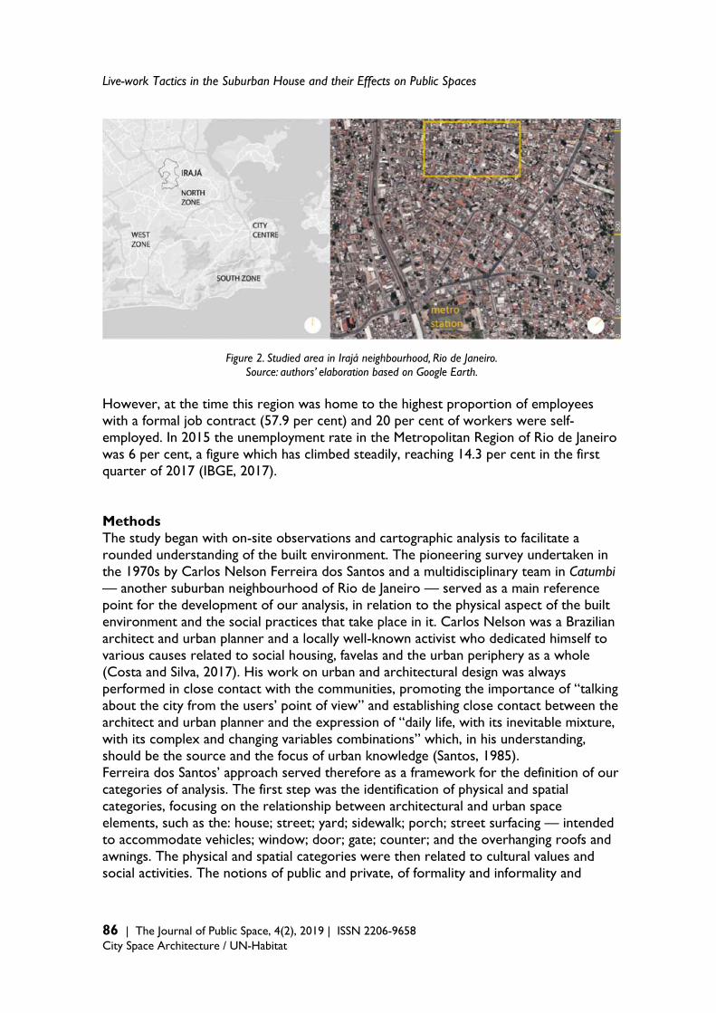
Live-work Tactics in the Suburban House and their Effects on Public Spaces
86 | The Journal of Public Space, 4(2), 2019 | ISSN 2206-9658 City Space Architecture / UN-Habitat
Figure 2. Studied area in Irajá neighbourhood, Rio de Janeiro. Source: authors’ elaboration based on Google Earth.
However, at the time this region was home to the highest proportion of employees with a formal job contract (57.9 per cent) and 20 per cent of workers were self-employed. In 2015 the unemployment rate in the Metropolitan Region of Rio de Janeiro was 6 per cent, a figure which has climbed steadily, reaching 14.3 per cent in the first quarter of 2017 (IBGE, 2017). Methods The study began with on-site observations and cartographic analysis to facilitate a rounded understanding of the built environment. The pioneering survey undertaken in the 1970s by Carlos Nelson Ferreira dos Santos and a multidisciplinary team in Catumbi — another suburban neighbourhood of Rio de Janeiro — served as a main reference point for the development of our analysis, in relation to the physical aspect of the built environment and the social practices that take place in it. Carlos Nelson was a Brazilian architect and urban planner and a locally well-known activist who dedicated himself to various causes related to social housing, favelas and the urban periphery as a whole (Costa and Silva, 2017). His work on urban and architectural design was always performed in close contact with the communities, promoting the importance of “talking about the city from the users’ point of view” and establishing close contact between the architect and urban planner and the expression of “daily life, with its inevitable mixture, with its complex and changing variables combinations” which, in his understanding, should be the source and the focus of urban knowledge (Santos, 1985). Ferreira dos Santos’ approach served therefore as a framework for the definition of our categories of analysis. The first step was the identification of physical and spatial categories, focusing on the relationship between architectural and urban space elements, such as the: house; street; yard; sidewalk; porch; street surfacing — intended to accommodate vehicles; window; door; gate; counter; and the overhanging roofs and awnings. The physical and spatial categories were then related to cultural values and social activities. The notions of public and private, of formality and informality and
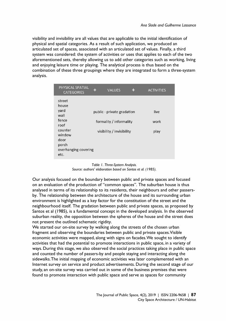
Ana Slade and Guilherme Lassance
The Journal of Public Space, 4(2), 2019 | ISSN 2206-9658 | 87
City Space Architecture / UN-Habitat
visibility and invisibility are all values that are applicable to the initial identification of physical and spatial categories. As a result of such application, we produced an articulated set of spaces, associated with an articulated set of values. Finally, a third system was considered: the system of activities or uses that applies to each of the two aforementioned sets, thereby allowing us to add other categories such as working, living and enjoying leisure time or playing. The analytical process is thus based on the combination of these three groupings where they are integrated to form a three-system analysis.
Table 1. Three-System Analysis. Source: authors’ elaboration based on Santos et al. (1985).
Our analysis focused on the boundary between public and private spaces and focused on an evaluation of the production of “common spaces”. The suburban house is thus analysed in terms of its relationship to its residents, their neighbours and other passers-by. The relationship between the architecture of the house and its surrounding urban environment is highlighted as a key factor for the constitution of the street and the neighbourhood itself. The gradation between public and private spaces, as proposed by Santos et al (1985), is a fundamental concept in the developed analysis. In the observed suburban reality, the opposition between the spheres of the house and the street does not present the outlined schematic rigidity. We started our on-site survey by walking along the streets of the chosen urban fragment and observing the boundaries between public and private spaces. Visible economic activities were mapped, along with signs on facades. We sought to identify activities that had the potential to promote interactions in public space, in a variety of ways. During this stage, we also observed the social practices taking place in public space and counted the number of passers-by and people staying and interacting along the sidewalks. The initial mapping of economic activities was later complemented with an Internet survey on service and product advertisements. During the second stage of our study, an on-site survey was carried out in some of the business premises that were found to promote interaction with public space and serve as spaces for community
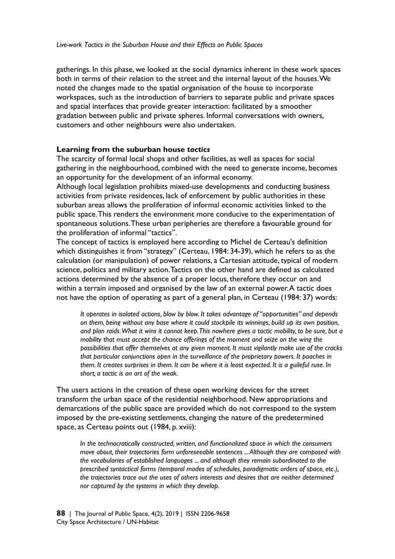
Live-work Tactics in the Suburban House and their Effects on Public Spaces
88 | The Journal of Public Space, 4(2), 2019 | ISSN 2206-9658 City Space Architecture / UN-Habitat
gatherings. In this phase, we looked at the social dynamics inherent in these work spaces both in terms of their relation to the street and the internal layout of the houses. We noted the changes made to the spatial organisation of the house to incorporate workspaces, such as the introduction of barriers to separate public and private spaces and spatial interfaces that provide greater interaction: facilitated by a smoother gradation between public and private spheres. Informal conversations with owners, customers and other neighbours were also undertaken. Learning from the suburban house tactics The scarcity of formal local shops and other facilities, as well as spaces for social gathering in the neighbourhood, combined with the need to generate income, becomes an opportunity for the development of an informal economy. Although local legislation prohibits mixed-use developments and conducting business activities from private residences, lack of enforcement by public authorities in these suburban areas allows the proliferation of informal economic activities linked to the public space. This renders the environment more conducive to the experimentation of spontaneous solutions. These urban peripheries are therefore a favourable ground for the proliferation of informal “tactics”. The concept of tactics is employed here according to Michel de Certeau's definition which distinguishes it from “strategy” (Certeau, 1984: 34-39), which he refers to as the calculation (or manipulation) of power relations, a Cartesian attitude, typical of modern science, politics and military action. Tactics on the other hand are defined as calculated actions determined by the absence of a proper locus, therefore they occur on and within a terrain imposed and organised by the law of an external power. A tactic does not have the option of operating as part of a general plan, in Certeau (1984: 37) words:
It operates in isolated actions, blow by blow. It takes advantage of “opportunities” and depends on them, being without any base where it could stockpile its winnings, build up its own position, and plan raids. What it wins it cannot keep. This nowhere gives a tactic mobility, to be sure, but a mobility that must accept the chance offerings of the moment and seize on the wing the possibilities that offer themselves at any given moment. It must vigilantly make use of the cracks that particular conjunctions open in the surveillance of the proprietary powers. It poaches in them. It creates surprises in them. It can be where it is least expected. It is a guileful ruse. In short, a tactic is an art of the weak.
The users actions in the creation of these open working devices for the street transform the urban space of the residential neighborhood. New appropriations and demarcations of the public space are provided which do not correspond to the system imposed by the pre-existing settlements, changing the nature of the predetermined space, as Certeau points out (1984, p. xviii):
In the technocratically constructed, written, and functionalized space in which the consumers move about, their trajectories form unforeseeable sentences ... Although they are composed with the vocabularies of established languages ... and although they remain subordinated to the prescribed syntactical forms (temporal modes of schedules, paradigmatic orders of space, etc.), the trajectories trace out the uses of others interests and desires that are neither determined nor captured by the systems in which they develop.
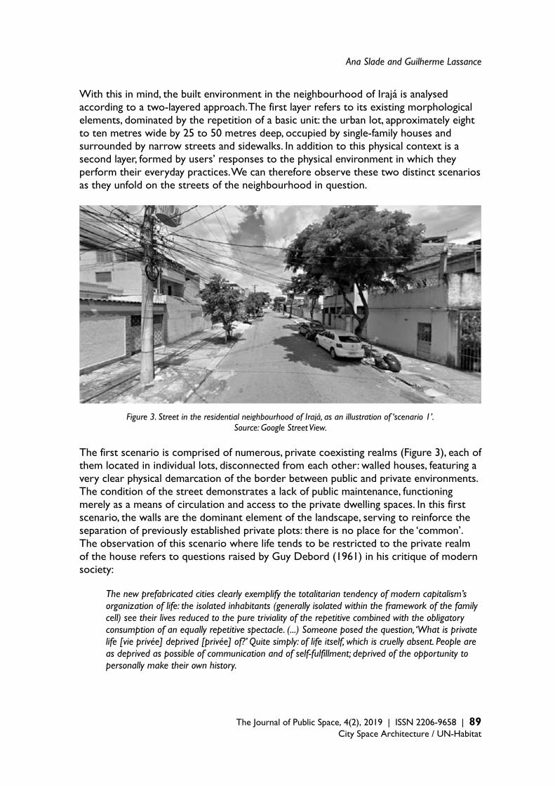
Ana Slade and Guilherme Lassance
The Journal of Public Space, 4(2), 2019 | ISSN 2206-9658 | 89
City Space Architecture / UN-Habitat
With this in mind, the built environment in the neighbourhood of Irajá is analysed according to a two-layered approach. The first layer refers to its existing morphological elements, dominated by the repetition of a basic unit: the urban lot, approximately eight to ten metres wide by 25 to 50 metres deep, occupied by single-family houses and surrounded by narrow streets and sidewalks. In addition to this physical context is a second layer, formed by users’ responses to the physical environment in which they perform their everyday practices. We can therefore observe these two distinct scenarios as they unfold on the streets of the neighbourhood in question.
Figure 3. Street in the residential neighbourhood of Irajá, as an illustration of ‘scenario 1’. Source: Google Street View.
The first scenario is comprised of numerous, private coexisting realms (Figure 3), each of them located in individual lots, disconnected from each other: walled houses, featuring a very clear physical demarcation of the border between public and private environments. The condition of the street demonstrates a lack of public maintenance, functioning merely as a means of circulation and access to the private dwelling spaces. In this first scenario, the walls are the dominant element of the landscape, serving to reinforce the separation of previously established private plots: there is no place for the ‘common’. The observation of this scenario where life tends to be restricted to the private realm of the house refers to questions raised by Guy Debord (1961) in his critique of modern society:
The new prefabricated cities clearly exemplify the totalitarian tendency of modern capitalism’s organization of life: the isolated inhabitants (generally isolated within the framework of the family cell) see their lives reduced to the pure triviality of the repetitive combined with the obligatory consumption of an equally repetitive spectacle. (...) Someone posed the question, ‘What is private life [vie privée] deprived [privée] of?’ Quite simply: of life itself, which is cruelly absent. People are as deprived as possible of communication and of self-fulfillment; deprived of the opportunity to personally make their own history.
Live-work Tactics in the Suburban House and their Effects on Public Spaces
90 | The Journal of Public Space, 4(2), 2019 | ISSN 2206-9658 City Space Architecture / UN-Habitat
In the second scenario, a fundamental component transforms the urban environment, making it essentially different from the previous one. We refer here to the presence of entrepreneurial activities: a window is opened, a sign is placed, or an awning is deployed over the sidewalk or small porch attached to the house to sell a product or service in the residential neighbourhood (Figure 4). They are subtle operations that proliferate within the structures of the residential street and silently subvert the mono-functional nature of the neighbourhood, responding to various economic, cultural and social demands. Such devices, or tactics, in the sphere of both daily life and work modify the “status quo” in these neighbourhoods by promoting the interaction between private and public spaces.
Figure 4. Home-based informal activities in the residential neighbourhood of Irajá, as illustration of ‘scenario 2’. Source: authors’ selection from Google Street View.
Ana Slade and Guilherme Lassance
The Journal of Public Space, 4(2), 2019 | ISSN 2206-9658 | 91
City Space Architecture / UN-Habitat
Figure 5. Mapping of home-based informal activities in a fragment of the residential neighbourhood of Irajá, Rio de Janeiro. Source: authors’ elaboration based on a Google search.
Live-work Tactics in the Suburban House and their Effects on Public Spaces
92 | The Journal of Public Space, 4(2), 2019 | ISSN 2206-9658 City Space Architecture / UN-Habitat
These practices are related to the “house” in terms of physical property: they transform the building to accommodate workspace. However, they also result in transformations within the family ways of living and the surrounding community as they are interwoven with local lifestyles and reimagine social interactions beyond the walled family structure as spilling out on to the street and wider neighbourhood. Through inviting neighbours to ring the bell and interact with the domestic family life, they promote even more transformative interactions. Overhanging coverings, or small add-on sheds, proliferate across local streets forming spaces of greater integration between public and private domains. This breaking down of both the formal and informal barriers segregating domestic and public spaces blurs these borders and creates a transitional space that has the quality of the “in-between” (Hertzberger, 1996), encouraging users to stay on the sidewalk and to use it as a common space (Figures 5, 6 and 7).
Figure 6. Scheme of a home-based ‘Manicure and Tattoo’ salon in Irajá, Rio de Janeiro. Source: authors (collaboration: Daniel Moraes)
The overhanging coverings are deployed in front of the houses, on the frontal setback or even outside the private plot, on the public sidewalk. They are also built on top of the houses, transforming the existing flat roof slab into a living space. They are often used as a shelter for productive or commercial activities, but they are, above all, spaces of sociability. Solving practical and functional issues, overhangs extend the space occupied by the house, enabling small-scale entrepreneurial activities to take place: promoting
Ana Slade and Guilherme Lassance
The Journal of Public Space, 4(2), 2019 | ISSN 2206-9658 | 93
City Space Architecture / UN-Habitat
social and cultural practices which encourage community interaction previously repressed in these strictly residential streets. No longer is the border between street and private realm reinforced by physical and visual barriers (Figures 6, 7 and 8). In areas where streets are populated by such entrepreneurial activities, urban life is activated, offering more favourable conditions for certain daily social practices. During our on-site visits and our observations of street life, we noticed numerous signs that pointed to the various social practices taking place, such as: greetings, informal conversation and coexistence between neighbours. These diverse practices all served to provide a greater appropriation of sidewalks. As an example, some of the residents reported that the street where the “patty factory” is located — which offers a communal porch facing the street where neighbours usually sit and chat — is safer than another street on the other side of the same block which is for strictly residential use and suffers from a higher robbery rate. In the close vicinity of the overhanging porch, an even older habit typical of the suburbs of Rio de Janeiro can be observed: the tradition of placing chairs on the sidewalk in front of residential houses. This tradition is at risk of being lost in the streets with predominantly residential and walled houses. Fashioned from tubular iron structures, plastic tubes and lightweight roofing tiles, plastic canvas or plastic tarpaulins, the overhanging coverings shelter displays of products for sale and professionals repairing appliances or manufacturing artefacts such as metal frames; all while they take part in the life of the street and greet their neighbours. Meanwhile, residents sitting in chairs, chat on communal porches, alongside spaces dedicated to productive activity. (Figures 4, 6, 7 and 8). Another important commercial activity that thrives — and according to residents also creates spaces for leisure and a vibrant social life in these neighbourhoods — is the “birosca” (Figure 8): an informal bar where beer and pastries are sold and a barbecue is prepared on weekends, inviting clients to sit at tables along the sidewalk. On this particular street corner, the plot has been subdivided and many houses have been built within its confines (Figure 9). There are three small shops and each features a distinctive public-private gradation. At the corner, there is a window from which the seller has a wide view of the street and which customers also use to stop by to chat. In another house, the overhanging roof built over the sidewalk defines a workspace protected from both sun and rain, fully open and integrated into the public space that is the street. The roof already housed a bicycle repair shop and is now also used as a car wash that animates public life in that urban space. The third commercial space is a beauty salon. Although organised indoors and not visible from the street, its entrance door is connected to the sidewalk by a small public hall. This corner is a lively place in the neighbourhood. These practices are all evidence of the knowledge the users possess. These anonymous “arts of practice” that invent ingenious creations offer hope that from within the interstices of the imposed codes, life can be injected in to lacklustre spaces that are the direct result of an imposed technocratic system: bestowing on them new and local meanings. Through small subversions with unpretentious purpose and undetermined political goals, they improve the otherwise alienating nature of everyday life with “wonders”.

Live-work Tactics in the Suburban House and their Effects on Public Spaces
94 | The Journal of Public Space, 4(2), 2019 | ISSN 2206-9658 City Space Architecture / UN-Habitat
Figure 7. Scheme of a home-based patties factory in Irajá, Rio de Janeiro. Source: author (collaboration: Daniel Moraes)
Figure 8. Scheme of a home-based birosca in Irajá, Rio de Janeiro. Source: authors (collaboration: Daniel Moraes)
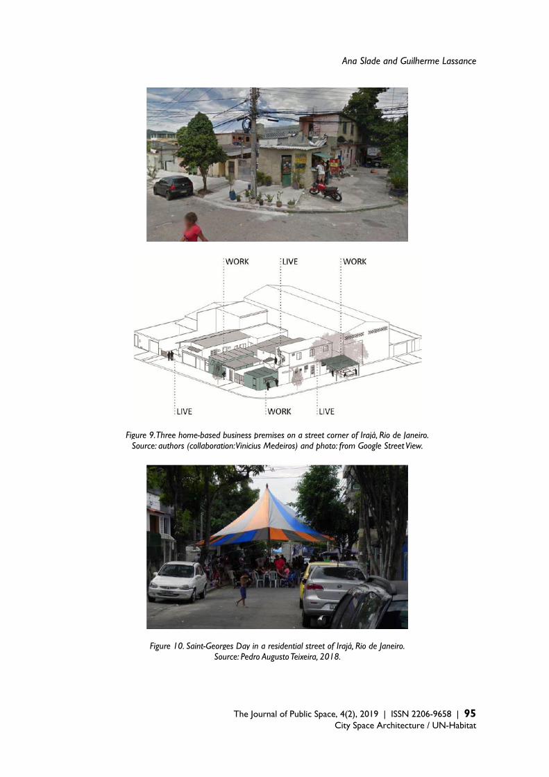
Ana Slade and Guilherme Lassance
The Journal of Public Space, 4(2), 2019 | ISSN 2206-9658 | 95
City Space Architecture / UN-Habitat
Figure 9. Three home-based business premises on a street corner of Irajá, Rio de Janeiro. Source: authors (collaboration: Vinicius Medeiros) and photo: from Google Street View.
Figure 10. Saint-Georges Day in a residential street of Irajá, Rio de Janeiro. Source: Pedro Augusto Teixeira, 2018.
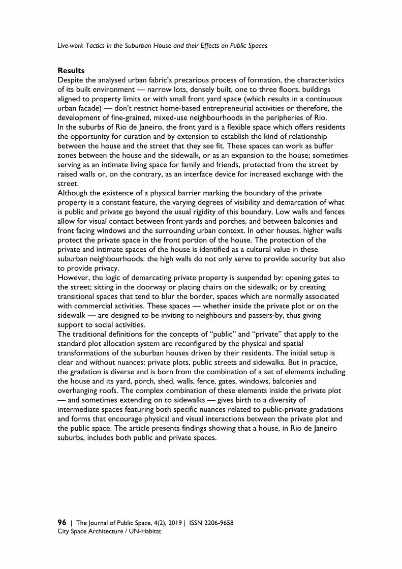
Live-work Tactics in the Suburban House and their Effects on Public Spaces
96 | The Journal of Public Space, 4(2), 2019 | ISSN 2206-9658 City Space Architecture / UN-Habitat
Results Despite the analysed urban fabric’s precarious process of formation, the characteristics of its built environment — narrow lots, densely built, one to three floors, buildings aligned to property limits or with small front yard space (which results in a continuous urban facade) — don’t restrict home-based entrepreneurial activities or therefore, the development of fine-grained, mixed-use neighbourhoods in the peripheries of Rio. In the suburbs of Rio de Janeiro, the front yard is a flexible space which offers residents the opportunity for curation and by extension to establish the kind of relationship between the house and the street that they see fit. These spaces can work as buffer zones between the house and the sidewalk, or as an expansion to the house; sometimes serving as an intimate living space for family and friends, protected from the street by raised walls or, on the contrary, as an interface device for increased exchange with the street. Although the existence of a physical barrier marking the boundary of the private property is a constant feature, the varying degrees of visibility and demarcation of what is public and private go beyond the usual rigidity of this boundary. Low walls and fences allow for visual contact between front yards and porches, and between balconies and front facing windows and the surrounding urban context. In other houses, higher walls protect the private space in the front portion of the house. The protection of the private and intimate spaces of the house is identified as a cultural value in these suburban neighbourhoods: the high walls do not only serve to provide security but also to provide privacy. However, the logic of demarcating private property is suspended by: opening gates to the street; sitting in the doorway or placing chairs on the sidewalk; or by creating transitional spaces that tend to blur the border, spaces which are normally associated with commercial activities. These spaces — whether inside the private plot or on the sidewalk — are designed to be inviting to neighbours and passers-by, thus giving support to social activities. The traditional definitions for the concepts of “public” and “private” that apply to the standard plot allocation system are reconfigured by the physical and spatial transformations of the suburban houses driven by their residents. The initial setup is clear and without nuances: private plots, public streets and sidewalks. But in practice, the gradation is diverse and is born from the combination of a set of elements including the house and its yard, porch, shed, walls, fence, gates, windows, balconies and overhanging roofs. The complex combination of these elements inside the private plot — and sometimes extending on to sidewalks — gives birth to a diversity of intermediate spaces featuring both specific nuances related to public-private gradations and forms that encourage physical and visual interactions between the private plot and the public space. The article presents findings showing that a house, in Rio de Janeiro suburbs, includes both public and private spaces.

Ana Slade and Guilherme Lassance
The Journal of Public Space, 4(2), 2019 | ISSN 2206-9658 | 97
City Space Architecture / UN-Habitat
Figure 11. Rio suburban houses public-private section-diagram. Source: authors, 2019.
Conclusion Despite a functional zoning legislation that does not allow for commercial and residential uses to coexist in the same plot, the socio-economic context combined with inoperative monitoring by the city administration has stimulated informal home-based productive activities. The result is the transformation of some areas into hybrid environments, which helps to mitigate the fragmentary and homogenising character of functional zoning codes and this affects urban space. Home-based, informal productive activities in the suburbs of Rio de Janeiro boost local economy and transform the daily routines of local residents and their built environment. In response to users’ needs, which were not considered on planning, these activities create devices that are more conducive to enhancing their users’ social lives, whilst in public space. Triggered by the need to generate income, they also help to improve the common by: creating small shops and facilities within walking distance; shifting interactions between houses and street life, creating spaces in which to encounter fellow residents and engage in collective interaction; and intensifying the use of the sidewalks, activating urban life and transforming the street into a more inhabited, cared for and safe space. Their actions generate public space. Spontaneous cultural and social practices demonstrate that residents are looking for alternative conditions to those typical of bucolic spaces created by functional zoning in these residential suburban areas. Communities are being transformed through occupant adaptations which lead to busier streets which, in turn, promote social interaction and entrepreneurial activities that encourage cooperation/collaboration among inhabitants. The transformations, or 'arts of practicing', playing out in the suburban neighbourhoods of Rio de Janeiro are valuable clues as to identifying possible improved city planning and housing policies from a wider angle too. They demonstrate alternatives to hegemonic mono-functional housing developments — to single-family townhomes closed within gated communities — an urban and housing model that continues to be used repeatedly in Brazil, all the while further contributing to the formation of increasingly segregated cities. The home-based work lifestyle that develops spontaneously in the suburbs of Rio

Live-work Tactics in the Suburban House and their Effects on Public Spaces
98 | The Journal of Public Space, 4(2), 2019 | ISSN 2206-9658 City Space Architecture / UN-Habitat
de Janeiro is in line with idealised strategies being advanced in developed countries across the world, by American author Thomas Dolan and British author Frances Holliss for example. The proposal of a multifunctional live-work unit is approached as a city-wide strategy due to its potential for impact on both the optimisation of resources and reduction in the demand for transportation, in addition to the qualification of urban space in suburban neighbourhoods. The concept of “Zero Commute Housing” indicated in the title of Dolan’s book (2012) refers to architectural typologies that are able to reduce the need for individual or collective transportation, whether for work or for other daily activities. The potential for use, related to productive activities, is also valued by Dolan — in terms of neighbourhood vitality — over the alternative of strictly residential neighbourhoods. Holliss (2015), in turn, calls for a review of how buildings and cities are thought of, particularly in the face of informational capitalism and the unprecedented number of women in the labor market. She argues for the pressing issue of how transformations in the lives of individuals should be strongly linked to the transformations in the ways in which buildings and whole neighbourhoods are conceived. She also champions the social, economic and environmental benefits that the encouragement of the “work-home” model could provide (Holliss, 2015, pp.168-197). However, Holliss also points out that in England, as is the case in many countries, both building and urban regulations are still based on a mono-functional paradigm: this continues to be a major drawback.
Regulations rooted in the industrial past discourage this working practice and as a consequence severely restrict the possibility of developing buildings and city districts appropriate to contemporary home-based employment practices, in part, generated by informational capitalism. Changes to planning frameworks, property taxation systems and tenancy agreements in social housing are urgently needed. They would help bring this practice and these buildings out from the shadows Holliss, 2015: 165
The ‘live-work’ tactics analysed as proliferating in the suburbs of Rio are finally recognised as valuable lessons as the demonstration that these small-scale changes, born out of ingenuity and intrinsic to local ways of entrepreneurial life, have the potential to alter the urban environment and the notion of public space. As we have demonstrated, changes to the home alter the dynamic of urban life, which can radically transform the neighbourhood, its public spaces network and as such the surrounding community. The lessons learned from these seemingly-ordinary actions, arising from the common man, are illustrative of possible alternative route to reimagining the city. Acknowledgement This research is supported by a series of study grants given to the first author by the Brazilian Council for the Improvement of Higher Education (CAPES) and the Canadian Emerging Leaders in the Americas Program (ELAP), for the development of her PhD dissertation.
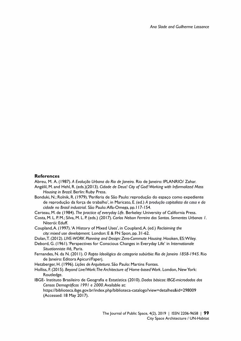
Ana Slade and Guilherme Lassance
The Journal of Public Space, 4(2), 2019 | ISSN 2206-9658 | 99
City Space Architecture / UN-Habitat
References Abreu, M. A. (1987). A Evolução Urbana do Rio de Janeiro. Rio de Janeiro: IPLANRIO/ Zahar. Angélil, M. and Hehl, R. (eds.)(2013). Cidade de Deus! City of God! Working with Informalized Mass
Housing in Brazil. Berlin: Ruby Press. Bonduki, N.; Rolnik, R. (1979). ‘Periferia de São Paulo: reprodução do espaço como expediente
de reprodução da força de trabalho’, in Maricato, E. (ed.) A produção capitalista da casa e da cidade no Brasil industrial. São Paulo: Alfa-Omega, pp.117-154.
Certeau, M. de (1984). The practice of everyday Life. Berkeley: University of California Press. Costa, M. L. P. M.; Silva, M. L. P. (eds.) (2017). Carlos Nelson Ferreira dos Santos. Sementes Urbanas 1.
Niterói: Eduff. Coupland, A. (1997). ‘A History of Mixed Uses’, in Coupland, A. (ed.) Reclaiming the
city: mixed use development. London: E & FN Spon, pp. 31-62. Dolan, T. (2012). LIVE-WORK Planning and Design: Zero-Commute Housing. Hooken, ES: Wiley. Debord, G. (1961). ‘Perspectives for Conscious Changes in Everyday Life’ in Internationale
Situationniste #6, Paris. Fernandes, N. da N. (2011). O Rapto Ideológico da categoria subúrbio: Rio de Janeiro 1858-1945. Rio
de Janeiro: Editora Apicuri/Faperj. Hetzberger, H. (1996). Lições de Arquitetura. São Paulo: Martins Fontes. Holliss, F. (2015). Beyond Live/Work: The Architecture of Home-based Work. London, New York:
Routledge. IBGE- Instituto Brasileiro de Geografia e Estatística (2010). Dados básicos: IBGE-microdados dos
Censos Demográficos 1991 e 2000. Available at: https://biblioteca.ibge.gov.br/index.php/biblioteca-catalogo?view=detalhes&id=298009 (Accessed: 18 May 2017).
Live-work Tactics in the Suburban House and their Effects on Public Spaces
100 | The Journal of Public Space, 4(2), 2019 | ISSN 2206-9658 City Space Architecture / UN-Habitat
IBGE- Instituto Brasileiro de Geografia e Estatística (2017). Diretoria de Pesquisas, Coordenação
de Trabalho e Rendimento. Pesquisa Nacional por Amostra de Domicílios Contínua, March 2017. Available at: http://www.ibge.gov.br/home/estatistica/indicadores/trabalhoerendimento/pnad_continua/
(Accessed: 18 May 2017). Jacobs, J. (2000) [1961]. Morte e vida nas grandes cidades. São Paulo: Martins Fontes. Lassance, G., Varella, P., Capillé, C. (2012). Rio Metropolitano: Guia para uma arquitetura. Rio de
Janeiro: Rio Book’s. Lefebvre, H. (1991) [1968]. O Direito à Cidade, São Paulo: Editora Morais. Pechman, R. (1985). Gênese do mercado urbano de terras, a produção de moradias e a formação dos
subúrbios no Rio de Janeiro. Dissertation. Universidade Federal do Rio de Janeiro. Reis Filho, N. G. (1978). Quadro da Arquitetura no Brasil. São Paulo: Perspectiva. Santos, C. N. F. dos; Vogel, A.; Mello, M. A. S.; Mollica, O. et al (1985). Quando a rua vira casa: a
apropriação de espaços de uso coletivo em um centro de bairro. 3. ed. São. Paulo: Projeto FINEP; IBAM.
Santos, J. J. M. (1996). De freguesias rurais a subúrbio: Inhaúma e Irajá no município do Rio de Janeiro. Thesis. Universidade de São Paulo.
SEBRAE- Serviço Brasileiro de Apoio às Micro e Pequenas Empresas (2015). Painel Regional: Rio de Janeiro e bairros / Observatório Sebrae/ RJ. Rio de Janeiro: SEBRAE/RJ. Available at: http://www.sebrae.com.br/Sebrae/Portal%20Sebrae/UFs/RJ/Anexos/SebraePainel_CidadeRiodeJaneiro.pdf (Accessed: 20 March 2019).
Walker, E. (ed.) (2010). lo ordinario. Barcelona: Editorial Gustavo Gilli.
The Journal of Public Space ISSN 2206-9658 2019 | Vol. 4 n. 2 https://www.journalpublicspace.org
ISSN 2206-9658 | 101
City Space Architecture / UN-Habitat
The Spatial Production of Public Parks and Counter-public Non-parks in Tapei * Min Jay Kang National Taiwan University, Taiwan [email protected] Abstract This research differentiates counter-public non-parks from public parks to look into the spatial politics and social processes behind the productions of urban parks and open greens in the city of Taipei. The colonial modernity ushered in the concept of public parks in Taipei, though under the authoritarian ruling the meaning of publicness was problematic and the discourse surrounding the public sphere underdeveloped. The process of democratisation in the post-1980s eras activated the grassroots engagement in politics and further nurtured the bottom-up mechanism of counter-publics in a conservation movement and in claiming their rights to the city. The paradigm of counter-public non-park defied the general definition and used patterns of public parks, and advocated a more socially inclusive and culturally diverse program for the alternative public green. Non-park implies either the unregulated land use patterns that are endured within the zoned parks or the publicly shared open greens that are not officially designated as public parks. It also motivated the transformation of settlement-into-park to settlement-park and responded to the call for dynamic urban conservation. This research looks into the coexistence of parks and non-parks in Taipei’s Da-an District, and concludes that the variegated park paradigms are conducive to the development of a more democratic and progressive city that sustains a broader comprehension of public history. Keywords: public park, counter-public non-park, settlement-into-park, settlement-park, subaltern counter-publics, landscape urbanism, Da-An Park, Taipei * The designations employed do not imply the expression of any opinion whatsoever on the part of the Secretariat of the United Nations concerning the legal status of any country, territory or area, or of its authorities.
T
HE
JO
UR
NA
L O
F P
UB
LIC
SP
AC
E
To cite this article: Kang, M. J. (2019). The Spatial Production of Public Parks and Counter-public Non-parks in Tapei. The Journal of Public Space, 4(2), 101-122, DOI 10.32891/jps.v4i2.1157 This article has been double blind peer reviewed and accepted for publication in The Journal of Public Space.
This work is licensed under a Creative Commons Attribution - Non Commercial 4.0 International License https://creativecommons.org/licenses/by-nc/4.0/
The Spatial Production of Public Parks and Counter-public Non-parks in Taipei
102 | The Journal of Public Space, 4(2), 2019 | ISSN 2206-9658 City Space Architecture / UN-Habitat
1. Introduction: the emergence of counter-public non-parks within the public park system in Taipei
The concept of park in modern urban planning is derived from the logic of land-use zoning to provide public facilities for urban recreation and nature reserve. Yet the production of a park, regardless of its affiliation with nature, is a political contention embedded in the urbanisation of a “socio-ecological process” (Heynen et al, 2006). The first park in Taipei appeared in 1897 during the Japanese colonial period as a demonstration of modernist planning as well as a proposition of the ruling power for the urban green system. In 1932, the green infrastructure network for the capital city of Taipei had been mapped out to illustrate an environmental vision as well as a symbol of “colonial modernity” (Barlow, 1997; Wu, 2010), and though only partially implemented, it had become the guiding scheme for the post World War II follow-up plan of the Nationalist government. Park is also a manifestation of publicness and openness, and its land is oftentimes publicly-owned. But in a time of non-democratic governance, the meaning of publicness might be questioned or disputed. According to the executive procedure of Taiwanese urban planning, the tool of eminent domain or expropriation would be employed to acquire land for the park, unless it is publicly owned. The original landscape would then be razed to ground zero to accommodate new plan and design. However rational it may sound, this process of park implementation instigated many serious conflicts and controversies, especially when the political conundrum and housing deficiency of the post-War development were brought to the fore. During the first-phase of the Nationalist governance, the KuoMinTang (KMT) government did not relinquish the plan of reclaiming Mainland China, and showed little motivation towards ‘localising’ the practices of urban and housing policies. Under the circumstances of inadequate housing provision, a high volume of political immigrants who followed Chiang Kai-Shek’s retreat to Taiwan began to occupy underdeveloped public land to self-build transitional housing collectively and agglomerate them into many types of temporary settlements. Among all the occupied urban land, a significant percentage was still zoned for park use succeeding the Japanese colonial plan, including the larger tracts of Park #7, #12, #14, #15, etc. in Taipei alone. In fact, the KMT government also ’illegally’ built legal military-dependents’ housing compound inside the parkland, for instance Park #7 (later-day Da-An Park), to accommodate the families of the higher-ranking political immigrants. Yet there were more ‘illegal’ military-dependents’ settlements of the lower-rank veterans’ families growing organically around the legal housing compound, followed by self-built dwelling units of the rural-urban immigrants who sought for cheap housing resources in the city since the 1970s. What was planned to be public parkland gradually evolved into ‘private’ yet collective homeland for the underprivileged citizens after several decades. But when the deadline of expropriating private land for implementing zoned public facilities drew near, the government had to take a drastic measure to evict all inhabitants and demolish all existing buildings. The ultimate fate of ‘settlement-into-park1’ appeared to have
1‘Settlement-into-park’ exemplifies a particular type of urban park that replaces its predecessor of living settlements through the tools of urban zoning and eminent domain, for instance, Kolkata’s Maidan Park and New York City’s Central Park.
Min Jay Kang
The Journal of Public Space, 4(2), 2019 | ISSN 2206-9658 | 103 City Space Architecture / UN-Habitat
responded to the public quest for urban green and zoning enactment, it also mercilessly disintegrated strong identifications of places and tightknit neighbourhood networks. Many of the government-built or squatter villages on the parklands had existed since the post-World War II era until their final terminations, yet the inhabitants’ living experiences and collective memories established for more than half of a century were hardly recognised to be of historical value in the face of park implementation. The settlement inhabitants were coerced to confront different conditions of diaspora (a part of the military dependents even suffered double diasporas). Some were fortunate enough to be resettled into new public housing, but some became victims of compulsory displacement. The spatial production of parks in Taipei ironically triggered a new agenda of claiming right to the city and housing justice by settlement inhabitants and progressive advocates, and expanded into social movements of settlement conservation and rewriting “public history” (Hayden, 1996) for the disempowered social groups. The conservation movement was not a return to nostalgia; instead, it activated a revival of spatial meanings and a mobilization of placemaking. The subaltern society and the marginalised social groups, resisting forced displacement, kindled spatial imagination of the ‘counter-publics’ through the mechanism of bottom-up self-organization and participatory planning, and asserted a more socially and culturally inclusive park paradigm to differentiate itself from the general public park simply obeying the zoning definition and ordinances. Consequently, the counter-public non-park is referred to as an open green or semi-park space beyond park administration or zoning ordinances, including a type of settlement-park2 that may exceed the regulated 15% building coverage ratio, and different types of quasi-park that either allows residential and other ‘privatising’ activities inside the park, or takes advantage of the transitional period of development to create green open space, or challenges the general but constrained conception of publicness within park use, or exhibits publicly-shared green zone yet inappropriately zoned. The non-park, however, can be located in official parkland, only that its counter-public trait or its process of spatial production brings a twist to the common perception of a public park. The non-park3 generated via settlement conservation is not an anti-park, but to transform the urban planning rationale of settlement-into-park into a type of settlement-park that integrates settlement morphology and open green. From the preservation of settlement fabrics to the dynamic conservation of sustaining living patterns and community networks of the underprivileged settlement counter-publics, settlement parks in Taipei have developed distinctive detailed plans under a mixed effect of zoning ordinance and the cultural heritage preservation act. Fraser (1992) proposes the critical concept of subaltern counter-publics to challenge the little questioned “bourgeoisie public sphere” and the mass publics that exclude the underprivileged others, such as women, labourers, and the subordinated class, from the discourses and mediations of the public sphere. Fraser regards that the idealised public sphere according to Jurgen Habermas is single and unitary, contradictory to the
2 ‘Settlement-park’ represents a park form incorporating the original settlement fabrics into park design, such as Virginia’s Jamestown Festival Park or Sydney’s Foundation Park (the Rocks). 3 Non-park, an affix derived out of park, is deliberately coined to exemplify the cases of either the unregulated land use patterns that are endured within the zoned parks or the publicly shared open greens that are not officially designated as public parks.
The Spatial Production of Public Parks and Counter-public Non-parks in Taipei
104 | The Journal of Public Space, 4(2), 2019 | ISSN 2206-9658 City Space Architecture / UN-Habitat
publicness “composed of the conflictual and antagonist publics” (Kampourakis, 2016). Fraser reworks the discourse of publicness to underline subaltern counter-publics against the dominant publics, and urges the formation and emergence of a contesting identity of the subaltern society, deliberately overlooked and suppressed by the traditional public sphere, to participate in the production of public meanings. Warner (2002: 63) also remarks, “mass publics and counter-publics” are “both damaged forms of publicness, just as gender and sexuality are, in this culture, damaged forms of privacy.” In line with the counter-publics discourse, the use of counter-public in this research intends to reveal the often-excluded or -displaced statuses or spaces by the designated public realm of urban planning, and counter argue the substantial role of non-parks in the open city. This research is concerned about the contrasting politics of the productions of parks and non-parks, and how such politics is embedded in the modernising and concomitantly democratising and liberalising processes. How do these processes confront and foster publicness while at the same time begets the effect of exclusion and expulsion, if maximum publicness infers upmost social inclusion? How do the counter-publics reconstruct public history and spatial narratives through their participation in the development of non-parks? 2. The quest for urban park and the landscape urbanism turn in urban planning and design
Christopher Alexander was right: a city is not a tree. It is a landscape.
-Tom Turner, 1996
Inheriting the park tradition established by the most influential landscape theorist and practitioner Frederic Law Olmsted, many cities reserve large parks to sustain the regional characteristics and the integrity of ecology. Czerniak (2007) cites Olmsted and the pioneering landscape architects as the devotees of large parks and traces back how the reserved large open spaces have upheld the ecological sink of the green infrastructure and affected urban public life. But she also reminds us that in the democratic city the processes of shaping large parks are far from those of the authoritarian time, and the entanglement of environmental justice, land justice, social justice, and procedural justice may even question the legitimacy of acquiring large parcel of land for park use only. In recent years, the concept and design principles of landscape urbanism have brought together the different disciplines of landscape architecture, architecture, urban planning and design, ecological planning, and urban studies to reinvestigate and intervene in the urban processes through large-scale green implementations. Its dynamic interlocking of the spatial and temporal dimensions stimulates the design profession to be more sensitive to the ever-changing nature of the city (Connolly, 1995; Mostafavi et al, 2003). The Design with Nature (1969) methodology of Ian McHarg cast a lasting impact on landscape urbanism and further integrated the research on nature into the process of
Min Jay Kang
The Journal of Public Space, 4(2), 2019 | ISSN 2206-9658 | 105 City Space Architecture / UN-Habitat
design. His disciples, most noteworthy James Corner4 and Charles Waldheim5, carry his legacy to the theoretic frameworks of landscape architecture and reinforce the mode of incorporating the ecological system of nature and its reserve to the green infrastructure of urban design. Yet in the scope of landscape urbanism, the process of nature is much accentuated over the political process of urban governance. Comparatively, the paradigm of new urbanism6 is another post-modern urban design approach that is critical to the frequent de-contextualisation of modernist architecture and zoning-based urban planning, while emphasising incongruent urban values from those of landscape urbanism that both have, to certain degree, become mutual critiques of each other. Advocates of new urbanism criticise landscape urbanism for its lack of understanding of density and bona-fide urbanism and for its ignorance of what urban streets mean to the pedestrians and living communities while proposing and designing expensive ‘green’ projects that in reality proliferate urban sprawl. But landscape urbanists disdain the nostalgic genes of neo-classicism in the skeleton of new urbanism and how it has evolved into a new authority of urban design without the sensitivity of ecological diversity and sustainability (Steuteville, 2011). From the urban experiences of the Global North, landscape urbanism indeed cares more about the strategic layout of large parks than the street front living or the articulation of green system with the residential communities and street life. In the built-up areas of compact cities, the challenges of expropriating the urban land for the implementation of green infrastructure are enormous. The highly publicised case of the High Line is a rare realisation of landscape urbanism within the fine-grained urban texture without manoeuvring large public spending to acquire the land. On one hand, the project helps regenerate a linear corridor of the run-down industry in west Manhattan and attract millions of New Yorkers and global tourists to visit the creative reuse design of the nullified rail system each year; yet on the other, the abutting neighbourhoods of the High Line are caught in the new struggles of “green gentrification” (Gould and Lewis, 2016) and vertical expansion of developments (Speckhardt, 2014). The aspect of political economy associated with any urban landscape is an issue that landscape urbanism cannot ignore, but it is oftentimes unheeded or simplified in the process of design where it is presumed that ‘open-ended’ landscape evolution may be quickly terminated by the logic of capital. This happens to be a problem for new urbanism as well, as Harvey (1997) rightly points out, in that it forges communitarian rhetoric of nostalgia to activate an urban agenda of de-stratifying social classes and homogenising differences and to thereby creates a ‘new’ urban condition embracing neighbourly life and formal aesthetics of a village.
4 Corner (2006), modifying the tradition of Design with Nature, identifies a few principles that are critical to the realization of landscape urbanism, including the horizontal alignment of landscaping in restructuring the city, adaptive working methods and techniques that respond to the constraints and potentials of local environment, enriching imagination to foster new possibilities and relationships, and a respect for natural processes to facilitate a fluid design over time that creates open-ended, flexible, and negotiable urban dialogues. 5 Waldheim (2002) exemplifies the open design of landscape urbanism and regards the spatial program of the park as a changeable process that deploys layered events and activities in a non-hierarchical layout. 6 New Urbanism focuses on designing urban villages with vital street life and a sense of neighbourhood through pedestrian-oriented development (POD) and transit-oriented development (TOD) (Kelbaugh, 2002).
The Spatial Production of Public Parks and Counter-public Non-parks in Taipei
106 | The Journal of Public Space, 4(2), 2019 | ISSN 2206-9658 City Space Architecture / UN-Habitat
In 1991, the city of Seattle attempted an approach of landscape urbanism and proposed a large park known as Seattle Commons in the functional light industrial area south of Lake Union to be connected with downtown, and one of the founders of Microsoft Paul Allen endorsed the proposal with substantial finance. The Cascade community and 130 light industry companies that were about to be replaced decided to resist the top-down planning of the 25-hectare Seattle Commons and counter campaign against the joint speculation of the corporate power and the state. They argued that voters for the park initiative should consider the cultural and industrial sustainability of the Cascade neighbourhood and the city should wisely allocate the tax revenue in the improvement of neighbourhood parks and schools instead of building a new de-contextualised large park where few citizens would commute to use or real estate would profit from. Their bottom-up voices made a persuasive contention, and in the referendum dated 19th of September 1995, the voters vetoed the park proposal with a margin of 53% to 47% (Higgins, 1995). It was an indicator of how landscape urbanism, with strong environmental vision and ecological concern, might still be disconnected with the everyday urbanism of street vitality and the immediacy of social agenda. Till today, Seattle Commons remains a castle in the air while the real estate value of the proposed area continues to boom. The publicness of public parks is not unquestionable and it needs to be addressed in public discourses beyond the green rhetoric. In a democratic process of park development, different options of green urbanism and green infrastructure can thereby be planned and evaluated. Is a large park bordered by lines of park-view development more favourable than a series of smaller neighbourhood parks embedded in living neighbourhoods? Can counter-public non-parks be deployed in a zoned and regulated public park system? Based on which perspective, ecological, social, or cultural? And whose benefit of public green is guarded, the green real-estate developers, the bourgeoisie publics, or the subaltern counter-publics? Drawing on David Harvey’s concept of spatial fix (2001), Loughran (2018) regards the development of urban park as a “cultural fix” and that “parks and other green spaces structure property values, but they also provide essential sites of political exchange, social control, recreation, and cultural production.” Cranz (1982) exemplifies that park has always been associated with the social reform movements of different eras and represents how the social elites manipulate their powers to intervene and dictate the public agenda via reform programs on the footing of social welfare and public wellbeing. From this perspective, park can be seen as a planner’s tool to spatially mediate social problems, Tsai (1991), tracking Cranz’s socio-political analysis of urban park and the formation of local urban park landscape, interprets park as a projection and aspiration for the rational urban form and an ideological outreach of the ruling regime. The production of Taiwanese urban parks is therefore embedded in the “policy mobility” (McCann and Ward, 2015) of local politics and national policy7 along the process of its own democratisation.
7 McCann and Ward (2015) argue that urban policy mobility should be conceptualised through “relational dyads, rather than oppositional dualisms.”

Min Jay Kang
The Journal of Public Space, 4(2), 2019 | ISSN 2206-9658 | 107 City Space Architecture / UN-Habitat
3. Research methods This research employs different modes of field investigation, including participatory observations, unstructured interviews, and field notes, as well as secondary source and critical analysis, overlay of historical maps, and GIS mapping to conduct a comprehensive survey of parks and non-parks in Taipei’s Da-An District. Some of the interviews related to the collective memory of the settlements in the park were conducted in the annual Da-an Park Ecological Fair, where some of the past inhabitants or neighbours strolled into our exhibition booth to read the old maps and photos and watch film clips. Many photos were purchased from the archives of the Central News Agency, and the historical maps were searched from the document of the Centre for GIS, RCHSS (Research Centre for Humanities and Social Sciences) of Academia Sinica. The method of auto ethnography, using self-reflecting writing to connect personal experiences with broader cultural context and explore the social meaning of specific events, is also employed in the non-park analysis. A few case studies outside the main researched area but related to the core arguments are also comparatively analysed. 4. The urban politics behind the productions of Taipei’s parks and non-parks The colonial green plan for Taipei was laid out long before the theory of landscape urbanism emerged to become the guiding principles of implementing urban infrastructure, but their visions and approaches are in accordance. The effect of the colonial plan, however, did not come to fruit till the 1980s when the deadlines for implementing designated public facilities were about to expire. It was also a time when the Martial Law was lifted and the grassroots began to flex their muscles, and the change of the political climate prompted the critical actions against the top-down imposition. The following sections illustrate the different routes of facilitating public parks and their counterpart non-parks in Taipei. 4.1 Urban parks and open space system under Taipei’s urban planning scheme The quest for urban parks in the immigrant city of Taipei was in question and deferred when the demand for housing in the post-War era surpassed any other urban concern of collective consumption. The population of Taipei surged up from 270,000 in 1946 right after World War II to 560,000 in 1951, the post-War political immigrants nearly collapsed the Japanese colonial planning capacity of maximum 600,000 people in less than 5 years. In the statistics of 1963, there were 292,894 people living in illegal self-built housing, about 28.13% of the overall population. Many of them chose to squat on the undeveloped land zoned for public park use, hardly aware of the consequence of stigmatisation and eviction after a few decades (Kang, 2015). On the other hand, the unchallengeable transition of land ownership from the colonial state to the KMT regime released the largest share of urban land to the Ministry of National Defence, which activated the building of many military-dependents housing clusters after their coerced acceptance of the islands of Taiwan as the long-term refuge for the political immigrants. But that being recognised, many of the clusters were established on the parkland and two of them were located in one of the largest planned urban parks of Taipei, Da-An Park.
The Spatial Production of Public Parks and Counter-public Non-parks in Taipei
108 | The Journal of Public Space, 4(2), 2019 | ISSN 2206-9658 City Space Architecture / UN-Habitat
The composite uses of the demarcated land for Da-An Park before its eventual implementation were dynamic and chaotic, including, other than the formal and informal housing clusters for military dependents, temples, churches, International House of Taipei, squatter houses for rural-urban immigrants, cemetery, military police barracks, military radio station, markets, eateries, auto repair shops, recycling centre, and so on that accommodated a huge urban settlement of more than 12,000 people (Huang, 1997). The political decisions of turning the occupied land into a park were in certain way an official response to the original colonial urban plan, but not without serious debates. The major challenge came from the proposal of a gymnasium dome, which replicated other precedent or later transformations of parkland into public facilities and incurred criticism from environmentalist groups in the late 1980s when Martial Law was lifted and the democratising process was at its peak. In 1991, the then-mayor of Taipei Huang Da-zhou declared that the land would be reserved only for Da-An “Forest” Park and determined to relocate or demolish all of the existing features on the parkland except for, controversially, an iconic Buddhist statue of Gaun-Yin (Goddess of Mercy). The tall freestanding Guan-Yin statue used to be a part of an illegal temple in the park zone and worshipped by many Buddhist pilgrims and passers-by. The neighbouring Hsin-Sheng South Road was nicknamed ‘Way to Heaven’ and famous for accommodating a variety of religious institutes along the way, including four different Christian churches, one Catholic church, and one Islamic mosque. When a group of protesters gathered in front of the statue to passionately defend its deemed irreplaceable position, the in-situ preservation of Guan-yin immediately turned into an identity politics of religion. The legitimacy of preserving a singular religious symbol in a public park was questioned in a democratising society that asserted coexistence of diverse cultures and religions. After many rounds of negotiations, the government came to an unusual solution to claim the statue as an object of public art thanks to, luckily, the creator of the statue being a renowned sculptor Yang Ying-Feng. In order to differentiate a religious icon from a ‘public’ art, the government also erected a signboard that declared Guan-Yin as an artwork dedicated to the public through private donation and all worshipping and religious activities would be thence prohibited. The declaration is still in effect today, but impromptu praying and worshipping pilgrimage are easily spotted on site while the official reminder is always overlooked. The perpetuated standing of the Guan-Yin statue in Da-An Park becomes a testament of publicness being a process of contending urban meanings and identities. The common homeland for the military-dependents and the squatters of multiple generations was not recognised as a ‘public’ asset; rather, it was disparaged as an infringement on publicness. Many political immigrant families and underprivileged citizens were forced to confront the second-time diaspora and make their ways for the “green bulldozer” (Huang, 2012). The illegal status of the squatters was a consequence of the inadequacy of post-War housing policy and provision, their self-help and self-built tactics of survival actually helped alleviate the crisis of the governance of KMT. Yet decades of identification with a place and a vibrant neighbourhood was labelled as a detriment to public green and fell victim to the advent of a large park. A popular movie of 1983 Papa Can You Hear Me Sing? (Da-Cuo-Che, 搭錯車) intentionally blended the pre-park village into the set of low-end living in the face of impending demolition and became a sour note of the park development in Taipei. The issue of public inclusion is
Min Jay Kang
The Journal of Public Space, 4(2), 2019 | ISSN 2206-9658 | 109 City Space Architecture / UN-Habitat
most acute when contrasting the evicted community with the prime real estate surrounding Da-An Park today. The controversy of green bulldozer and green real estate continued when the sites of #14 and #15 Park encountered similar situation of ousting the squatter villages of political immigrants for the open green in the mid-1990s. The two designated parks were adjacent and located in another prime location of urban development, only separated by a south-north boulevard. Unsurprisingly, the adjoining neighbourhoods and commercial strips that perceived fronting park as a major boost for real estate value embraced the reclamation of public land for planned parks. But the squatter community that had little resources requested in-situ rebuilding or building new housing for resettlement before demolishing the old settlements. The academics, students, and activists joined the disempowered inhabitants to initiate an influential movement that counteracted the manoeuvre of the ‘governmental bulldozers’ and the rationale of parks over homeland. What appeared to be neutral and unquestioned publicness of parks became highly politicised and its understated role as a medium for land speculation was seriously criticised and re-evaluated. The anti-governmental bulldozer movement was considered to be the major resistance forefront of civil disobedience since Snails without Shells Housing Movement of 1989. Even though six unknown fires burned down the entire squatter villages on Park #14 and #15 on the evening of eviction and paved the way for park implementation, the legacy of anti-governmental bulldozer motivated the other counter-public actions and bottom-up conservation projects in different parts of the capital city that challenged the taken-for-granted idea of public spheres. In 1998, different communities under the threat of the governmental bulldozer self-organised to hold the Exposition of Disempowered Communities at Taipei’s Treasure Hill, another squatter settlement zoned to be razed for a park. Through lobbying and petitioning for the mayor candidates at that time to sign a ‘voucher’ of conservation and rebuilding, the political manoeuvring later facilitated the new and more progressive paradigm of counter-public non-parks. Eventually, Da-An Park was completed and open to the public in 1994 with a bleak image of dirt, unhealthy trees, and incomplete facilities. Mayor Huang Da-Zhou was criticised for the hurried implementation and lost his seat, but it was a rare fulfilment of a colonial legacy back in 1932. Fig. 1 illustrated the comparison of the Planning of Park and Green Parkway of 1932 with the present-day green resources layout plan, and the 1932 plan (in slash lines) prescribed a green infrastructure on Taipei’s undeveloped eastside but later modified into patches of green in diversified neighbourhoods. Even though the KMT government basically followed the colonial order for the post-War urban planning of Taipei, many open spaces of larger parks were replaced by building coverage ranging from San Yat-sen Memorial (Park #6), Taipei Arena (Park #5), Hakka Cultural Compound (Park #11), to Floral Expo Buildings (Par #3 and #4) over the years, and the north-south green boulevard connecting the large parks was also changed into an elevated auto speedway. The colonial green plan exhibited an intention and ambition comparable to the theorised landscape urbanism, but Da-An was the few cases of retaining the open green of large parks with minor adjustment along the road edges. The horizontality of landscape urbanism conceived by colonial modernity still receded to the verticality of urban development after all.
The Spatial Production of Public Parks and Counter-public Non-parks in Taipei
110 | The Journal of Public Space, 4(2), 2019 | ISSN 2206-9658 City Space Architecture / UN-Habitat
Fig. 1. Comparison of the Planning of Park and Green Parkway of 1932 and the present-day green layout plan The 1932 colonial green plan deployed the larger parks around the river bend or the foothill of mountains to take the best advantage of natural resources, while the parks inserted among the urban blocks anchored the green system of the not-yet developed eastside areas at a few strategic locations. Though the 1932 plan was never fully realised due to the interruption of war, the colonial government activated the critical implementation of the 1936 Taiwan Urban Planning Act to establish the mechanism and tools of zoning and urban administration. Accordingly, 3% of the consolidated land for district residential development would be reserved for small neighbourhood parks, and between 1937 and 1942, altogether 54 neighbourhood parks in five planned residential blocks for the Japanese were confirmed and by 1942, 11 of them were completed for ‘public’ use (Liu, 2005). This could be regarded as the inception of Taipei’s small or neighbourhood parks, but it was also questionable how public it could be considering the segregation of the Japanese neighbourhoods from the city at large. In the urban planning map of 1951 (Fig. 2), a few small parks (in red circles) could be identified in the neighbourhoods north of the still undeveloped Da-An Park. The same year, the $1.48 billion US Aid began to reshape many urban infrastructure and modernist housing developments through transnational finance and technical assistance. Between 1951 and 1965, many public buildings and neighbourhoods were directly or indirectly constructed via the loan and planning advices of the Western institute. Since 1965, the founded colonial system was also modified by the suggestions of U.N. Advisory Group and UHDC (Urban and Housing Development Committee), which
Min Jay Kang
The Journal of Public Space, 4(2), 2019 | ISSN 2206-9658 | 111 City Space Architecture / UN-Habitat
enhanced the concept of planned neighbourhood units that lay emphasis on accessible green public parks.
Fig. 2. The urban planning map of 1951 indicating neighbourhood parks north of the proposed Da-An Park (the slashed green area)
Min-Sheng Community marked the first master-planned neighbourhoods in Taipei following the US planning paradigm with local adjustment of intensifying the residential density to accommodate 45,000 people on 110-hectare farmland. Through land consolidation and a well-constituted master plan, 25 medium- and small-size parks were organised around grid blocks of walk-up flats. Tree-lined streets amplified the green layout, and the 1st floor setback for front-yard gardens, green sidewalks and firebreak alleys, green circle and refuge islands further spread the greenness to a district without large parks (Fig. 3). Similar to the neighbourhood unit proposal of Clarence Perry in 1910 that at least 10% of the development should be zoned for open spaces and the schools be located adjacent to parks (Relph, 1987), Min-Sheng Community made the best use of the green open spaces to achieve an image of a sustainable neighbourhood. With the localised mixed-use zoning code, the major commercial activities were allocated around the collector street of Min-sheng East St. and the subdued retails and cafes around the minor street to keep the street life alive. At present day, Min-Sheng Community has evolved into a creative cluster and a hot spot for gentrification thanks to its perceived image of the most liveable urban village in Taipei. The extension of the MRT line into the south of the community’s border exemplified the TOD and POD approaches of new urbanism and, unsurprisingly, further boosted up its property value (Kang and Yang, 2013). In this regard, the real estate often flourishes around the coveted urban green, either through landscape urbanism or new urbanism, differing merely by a matter of degree.

The Spatial Production of Public Parks and Counter-public Non-parks in Taipei
112 | The Journal of Public Space, 4(2), 2019 | ISSN 2206-9658 City Space Architecture / UN-Habitat
Fig. 3. A typical green layout of Min-Sheng Community Other than the Min-Sheng Community model, many planned or designated urban parks and neighbourhood parks are not fully implemented due to the difficulty of land acquisition. The overall number of designated parks and green should be amounted to 1,067 with total coverage of 2,000 hectares, yet so far only about 800 of the parkland have been developed, with total coverage of 1,400 hectares, among which 40% are less than 2,000 square meters (Zhang and Wang, 2013). Prior to 1970s, the municipal fiscal budget was stringent to directly expropriate or purchase the land for neighbourhood parks, but with the introduced mechanisms of zone expropriation and land consolidation, the city of Taipei gradually procured the land to expand the park layout. Fig. 4 illustrates the general composition of the municipal Taipei today, the dotted greens embedded in the entire city precincts are the most accessible and frequently used green that speak less to the natural habitats than the daily environments of the urban communities. However, from the larger picture of urban ecology, they still provide nodal islands for the necessary niches and habitats of a variety of species. Taipei’s neighbourhood parks are typically designed with similar features, including the most practical facilities of playground for children, exercise equipment, pavilion, plaza, and low-maintenance green elements. More interestingly, not until 2016 was the management of neighbourhood parks transferred from the Department of Civil Affairs to the professional Parks and Street Light Office of Public Works Department, implicating that the spatial role of neighbourhood parks were held more in line with the daily practices of civil life than a landscape resource. It is cherished as a shared inner court of the community, situated at accessible nodes along the everyday-life routines, and is particularly important for families with children and seniors. Before the emergence of larger urban parks, these inconspicuously designed neighbourhood parks were indispensable landscapes tightly meshed into the community life of Taipei, but rarely paid attention to by the tenet of landscape urbanism.

Min Jay Kang
The Journal of Public Space, 4(2), 2019 | ISSN 2206-9658 | 113 City Space Architecture / UN-Habitat
Fig. 4. The general layout of Taipei’s green and blue system
In the compact city of Taipei, the green system of urban landscapes can also cover a range of open spaces not specifically zoned as parks, and school campuses are the most noteworthy among them. Fig. 5 indicates the school campuses of different levels around

The Spatial Production of Public Parks and Counter-public Non-parks in Taipei
114 | The Journal of Public Space, 4(2), 2019 | ISSN 2206-9658 City Space Architecture / UN-Habitat
Da-An Park as possible green resources in a city of low park ratio, and the largest one being the NTU (National Taiwan University) campus south of Da-An. Since 1990, the open campus policy has opened up 153 elementary schools and 62 high schools for the community uses of exercises and recreation during the after-school hours (Zhang and Wang, 2013), and along with the mostly open campuses of universities and colleges the availability of the green campuses has been understatedly catering to the need of neighbouring citizens. From the ecological perspective, the campus environment also serves the purposes of nurturing habitat islands and ecological ‘sink’ for the ecological ‘source’ of the surrounding mountains. The expansive ground of NTU campus sheltering diversified habitats of flora and fauna and sustaining the experimental farmland since the colonial period is in many ways a more mature and bio-friendly environment than Da-An Park. The connection between the two large green areas at the southern part of the city, where the river and mountains merge, with the proposed upgrading of Hsin-sheng South Road into an artery of blue and green is therefore a visionary project that also restores the collective memory of an irrigation channel which used to run through the middle of the street. The hint of landscape urbanism is almost patent.
Fig. 5. The campus network of schools of different levels around Da-An Park 4.2 The transitional-green, negotiated-green, and contended-green tactics of the counter-
public non-parks The most deviant development of Taipei’s green system occurred in 2009 when the city hosted the International Flora Expo and simultaneously cultivated 18 hectares of
Min Jay Kang
The Journal of Public Space, 4(2), 2019 | ISSN 2206-9658 | 115 City Space Architecture / UN-Habitat
transitional green fields in the name of Taipei Beautiful. This controversial project encouraged both the public and private sectors to demolish the defunct buildings awaiting the upcoming urban renewal development then turned the vacant lots into open green experiments for 18 months in exchange for a bonus floor area ratio (FAR) up to maximum 10%. It was criticised by activists against large-scale urban renewal for the cheap sale of the public interest of FAR to developers only with a short-term profit of ‘fake parks’ since, however the transitional green might be appreciated by the communities; the green would be eventually melted into solid gold of real estate. But due to the special designation of the transitional green, Taipei Parks and Street Lights Office did not administrate or manage them in their durations, which released certain degree of freedom normally forbidden or unforeseen in the uses of parks. Instead, many NGO adopted the transitional green to work on progressive experiments of urban green, ranging from community p-patch, rain garden, reading garden, community oven, and even gay film festival, concert for the survival of urban minorities, bonfire for the sharing of indigenous hunter school, exchange bazaar of second-hand books, and many other events that challenged exclusions of counter-publics in public parks. These fragmented transitional green amounted to 72 in total and sporadically dispersed in 12 administrative districts of Taipei. Fig. 6 shows only a portion of these experimental green that redefined the urban public life indocile to the governance of institutionalised parks.
Fig. 6. The layout of the transitional green of Taipei Beautiful and the other temporary uses of urban farming
The Spatial Production of Public Parks and Counter-public Non-parks in Taipei
116 | The Journal of Public Space, 4(2), 2019 | ISSN 2206-9658 City Space Architecture / UN-Habitat
Fig. 6 also displays urban farming in allotment, unused vacant lots, and rooftop, which are popular at grassroots level and now approved by the municipal government as legitimate green. Urban and weekend farmers establish their relationships with land through hands-on cultivation and periodic harvest and share of produces. While the districts of Guandu, Beito, and Shihlin retain large tracts of rice paddies, the relatively approachable dry farming of vegetables, herbs, and flowers is closer to the daily practices of urban farmers and deemed as a mode of leisure urbanism and a buffer between Taipei’s agricultural past and the bustle and hustle of city life. Allotment farms appear on private as well as public land, and this localised interpretation of urban green through collective farming is closer to the spirit of urban commons rather than a public park. It raises the awareness of negotiated publicness amongst designated publicness and the participatory caretaking of urban land through do-it-yourself mechanism. The statistics of 2013 estimated that the park and green area enjoyed by a citizen in Taipei is only 5.1 m2, much lower than that of 16 m2 per person in Seoul, 26.4 m2 in New York, 31.7 m2 in London, or even 8m2 during the Japanese colonial time and the bottom limit of 9m2 per person standardised by WHO. With such a predicament and existing constraints of urban governance, Taipei cannot depend on the methodology of landscape urbanism alone to explore the social imagination of the green. To combine the above-mentioned green resources around Da-An Park and NTU campus together, Fig. 7 may exemplify a composite effect of the dynamics between landscape urbanism and civic life in the Da-An district of Taipei. It is also a negotiation of boundary between landscape urbanism and new urbanism, adjusted to the context of an Asian compact city and mixed-use messy urbanism. The small neighbourhood parks and transitional green are implanted among the street blocks, which are sometimes cut or indented by intricate alleyways; while the larger urban parks and campuses anchor the intersections of a few tree-lined boulevards. If the general urban landscape lacks the grand scheme of large parks, vibrant street life, episodic yet accessible neighbourhood parks, and the sprawling green of the surrounding hills counterpoise such deficiency. And if a surveyor of urban green zooms in particular corners inside the street blocks, informal green and blue, such as overflowing green from apartment balconies or the front-yards of Japanese bungalows, salvaged trees from previous urban plans, autonomous arrangement of green in planters, a section of uncovered irrigation channel cherished by the community, or a singular landmark spider tree in seasonal bloom, may pop up to greet the onlooker or even signify the neighbourhood identity. Taipei is far from the ideal paradigm of Garden City, but from certain perspective, it self evolves into a more flexible and grassroots-induced ‘planter city.’ The green patches and dots are discontinuous and the verticality of urban developments exacerbates the horizontal alignment of the green resources. Thanks to the rare opportunity of being crowned 2016 World Design Capital, the city government of Taipei overruled the priority of automobile transportation and widened the sidewalks for another line of tree and bike trail on Hsin-Sheng South Road. The downsize of car lanes decrease the flow and amount of automobiles to benefit both the pedestrians who enjoy street life and the bio-species that require the bridged green canopy between the larger habitats of Da-An Park and NTU campus. The accompanied sidewalk design
Min Jay Kang
The Journal of Public Space, 4(2), 2019 | ISSN 2206-9658 | 117 City Space Architecture / UN-Habitat
intended to reflect the neighbouring community of Willow Den8 (Wen-Luo-Ting, 溫羅), particularly known for its diverse array of independent bookstores, live houses, cafes, and NGOs, and incorporated metal paving plates of quotes and poems collected from the contributions of different independent bookstores. But it immediately elicited another tension between publics and counter-publics, considering the exclusion of the selected words from a provocative gay bookstore.
Fig. 7. The composite layout of green resources around Da-An Park and NTU campus
Hsin-Sheng South Road is a highly visible and ‘public’ boulevard adjacent to NTU campus, and as aforementioned, a Way to Heaven connecting many religious institutes. The invisibility of the gay bookstore plate can be read two-sided as a compromise to hide the representation of counter-publics in front of the general publics and/or as a strategic move to curtail direct confrontations and conflicts between the religious groups and the gay community so as to protect the tacit coexistence of both spheres. The decision was somewhat based on the controversies that already surfaced at two other sites of non-park in the same territory.
8 Willow Den was intentionally named to project an alternative image of the Gong-Guan area near NTU campus. It’s thus identified largely for its cultural foundation and milieu while Gong-Guan is easily associated with transportation hub, night market, and NTU. Willow Den community is a composition of residential neighbourhoods and many idiosyncratic and long-standing shops that have been renting spaces from landowners and subject to their lease terms and rent price setting.
The Spatial Production of Public Parks and Counter-public Non-parks in Taipei
118 | The Journal of Public Space, 4(2), 2019 | ISSN 2206-9658 City Space Architecture / UN-Habitat
The first one happened in 2010 at a Taipei Beautiful temporary green where the landowner agreed to release the undeveloped private land for 18 months of ‘public’ use to acquire FAR bonus and invite the Willow Den Independent Consortium to manage the open lot. Though the members of the Consortium were fully aware of the fake-park criticism, they believed it was a rare platform for the counter-publics to voice up in a semi-public sphere and accepted the task of its collective management as a reading garden. In the following months, different independent bookstores took turns to arrange events according to their associated identities, including LGBTQ, feminism, leftism, Taiwanese indigenous tribes, religions, philosophical and sociological studies, and so on. They also contributed a symbolic text that represented each individual identity for a series of paving plates to exhibit a particular urban slice made of diverse social groups. When the landowner found out that the plate text of the gay bookstore quoted an extremely provocative poem by a famous poet, entitled The Subjectivity of My Anus, she called for an immediate removal of what seemed to be a blasphemy in language. The Consortium denied her request because she, compensated by extra floor areas, did not have any privilege on the land that had become ‘public.’ Guarded by the counter-publics’ demand, the gay bookstore plate was firmly installed with other twelve bookstore texts on the garden ground; and due to the postponement of development, the garden still stands today, so do all the bookstore plates. The second controversy continued the previous one when there was an opportunity for the public Taipower Company, located in the Willow Den neighbourhood, to install a public artwork in its territory, and the public art committee chose the site of a famous spider tree inside a fenced utility ground. The Taipower public art project demanded the artist group not only to remove the fence surrounding the spider tree for public appreciation, but also to collaborate with the Independence Consortium as a mode of participation. Knowing that the bookstore plates in the reading garden might be removed once the development matured into reality, the Consortium requested the artist group to make a vertical panel ‘wall’ to accommodate all the original texts next to the spider tree as a part of a permanent public art. The verticality of the art wall made the provocative poem too visible to be overlooked by the curious passers-by; and the nearby residential community, some of whose members were ardent and conservative Christians, soon reacted to the explicit text that confronted their moral value. The local Christians started to protest blatantly in front of the Taipower building and called for a direct dismantlement of the art panel. Different flyer and post-it messages appeared on or covered the gay poem, but counter messages from the gender-equality groups would quickly replace the hostile words of resentment. The daily battle of words turned into a tangible tension between the territorial community and the exogenous partisans of identity politics, but there wasn’t much of a direct dialogue between two oppositional groups to sustain a public forum. The artist group eventually had to deal with the situation when publics and counter-publics couldn’t meet each other halfway. The solution was to change the original single-surface panel that include words from 18 Willow Den independent bookstores into multi-surfaces which reflected the rent-sidestepping reality of a few second-story or underground bookstores, and in the meanwhile hid the controversial quotes and the words from the closed-down bookstores inside ‘pupil’ holes that impeded direct viewing whereas seduced close-up gazing into (Fig. 8). The new tree-protecting art fence and the small opening under the
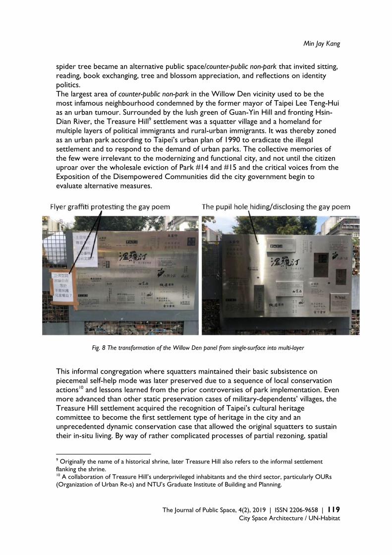
Min Jay Kang
The Journal of Public Space, 4(2), 2019 | ISSN 2206-9658 | 119 City Space Architecture / UN-Habitat
spider tree became an alternative public space/counter-public non-park that invited sitting, reading, book exchanging, tree and blossom appreciation, and reflections on identity politics. The largest area of counter-public non-park in the Willow Den vicinity used to be the most infamous neighbourhood condemned by the former mayor of Taipei Lee Teng-Hui as an urban tumour. Surrounded by the lush green of Guan-Yin Hill and fronting Hsin-Dian River, the Treasure Hill9 settlement was a squatter village and a homeland for multiple layers of political immigrants and rural-urban immigrants. It was thereby zoned as an urban park according to Taipei’s urban plan of 1990 to eradicate the illegal settlement and to respond to the demand of urban parks. The collective memories of the few were irrelevant to the modernizing and functional city, and not until the citizen uproar over the wholesale eviction of Park #14 and #15 and the critical voices from the Exposition of the Disempowered Communities did the city government begin to evaluate alternative measures.
Fig. 8 The transformation of the Willow Den panel from single-surface into multi-layer This informal congregation where squatters maintained their basic subsistence on piecemeal self-help mode was later preserved due to a sequence of local conservation actions10 and lessons learned from the prior controversies of park implementation. Even more advanced than other static preservation cases of military-dependents’ villages, the Treasure Hill settlement acquired the recognition of Taipei’s cultural heritage committee to become the first settlement type of heritage in the city and an unprecedented dynamic conservation case that allowed the original squatters to sustain their in-situ living. By way of rather complicated processes of partial rezoning, spatial
9 Originally the name of a historical shrine, later Treasure Hill also refers to the informal settlement flanking the shrine. 10 A collaboration of Treasure Hill’s underprivileged inhabitants and the third sector, particularly OURs (Organization of Urban Re-s) and NTU’s Graduate Institute of Building and Planning.
The Spatial Production of Public Parks and Counter-public Non-parks in Taipei
120 | The Journal of Public Space, 4(2), 2019 | ISSN 2206-9658 City Space Architecture / UN-Habitat
reprogramming and renovation, some of the settlement inhabitants opted to move back into their self-built units and pay under-market-value rent after legalised restoration by the government. It was at a crucial timing that the first Department of Cultural Affairs (DCA) was established within the administrative framework of Taipei, Treasure Hill was then re-envisioned as a co-living compound of artists, craftsmen, travellers, and original inhabitants, under the management of Taipei’s International Artists Village and DCA. The creative cluster of arts and crafts is now an integral part of Treasure Hill and open to the public on daily basis, and such a program, though bringing in inevitable tourist gazes, offsets the criticism of the counter-publics’ privatisation of public land. The large tract of green landscape enveloping Treasure Hill remains its former zoning of a public park, altogether the settlement-park stimulates a special type of counter-public non-park that is unparalleled in Taiwanese planning and pubic history. The dynamic conservation blends the settlement daily life into the spatial fabric of a planned park and an organic settlement of gradual evolution, and it showcases how the settlement-into-park rationality may be counterbalanced by the alternative settlement-park in a more progressive mode of urban governance. The experiences of Treasure Hill cast an impact on the follow-up re-evaluation and reprogramming of informal settlement at the urban edge, such as the conservation case of the Toad Hill settlement. Registered as a cultural landscape heritage, Toad Hill is undertaking a rezoning process towards an ecovillage paradigm, an ongoing evolution beyond a settlement-park. The coexistence of public parks and counter-public non-parks in the Da-an district blurs the boundaries between designated publicness and negotiated publicness, between zoning strategies and urban tactics, and between the social strata that separate publics and counter-publics. The political struggles behind the production of regulated urban parks and informal public greens in Taipei unexpectedly facilitate the development of a more democratic and inclusive city that upholds variegated green infrastructures and a broader comprehension of public history. 5. Conclusion Urban parks are not neutral green spaces under the rules of zoning or the theory of landscape urbanism, and their productions are the consequences of land politics and eminent domain that accentuate the prominence of nature, leisure, and publicness. This research looks into the landscape dialectics between public parks and counter-public non-parks and the spatial politics regarding their implementations in the city of Taipei. The counter-publics’ claim for their rights to the city and the movement of urban conservation, following the democratising process, challenged the modernist zoning rationales of transforming settlement-into-park in the name of publicness, and fostered a more inclusive and dynamic paradigm of settlement-park that integrate the socio-spatial fabrics of the settlement with its environing nature. The true publicness may not only lie in the public sphere that is achieved by pre-empting the extant cultural landscapes and excluding the subaltern counter-publics, but also acknowledge the collective voices and experiences of the underprivileged to approximate a holistic public.
Min Jay Kang
The Journal of Public Space, 4(2), 2019 | ISSN 2206-9658 | 121 City Space Architecture / UN-Habitat
References Barlow, T. (1997). Introduction: on “colonial modernity”‘, in T. Barlow (ed.), Formations of
Colonial Modernityin East Asia, Durham, NC: Duke University Press: 1–20. Connolly, P. (1995). Kerb: Journal of Landscape Architecture, no 1, Melbourne: RMIT University
Press. Corner, J. (2006). Terra Fluxus, in C. Waldheim ed. The Landscape Urbanism Reader, N.Y.:
Princeton Architectural Press, 21-34. Cranz G. (1982). The Politics of Park Design: A History of Urban Parks in America. Cambridge, MA:
MIT Press. Czerniak, J. (2007). Introduction: Speculating on Size, in J. Czerniak and G. Hargreaves. eds.
Large Parks. N. Y.: Princeton Architectural Press, 19-34. Fraser, N. (1990). Rethinking the Public Sphere: A Contribution to the Critique of Actually
Existing Democracy, Social Text (Duke University Press), 25/26: 56–80. Gould K.A. and Lewis T.L. (2016). Green Gentrification: Urban Sustainability and the Struggle for
Environmental Justice. New York: Routledge. Harvey, D. (1997). The New Urbanism and the Communitarian Trap, Harvard Design Magazine,
Winter/Spring, Number 1. Harvey, D. (2001). Globalization and the "Spatial Fix", Geographische Revue, 2, 23-30. Hayden, D. (1996). Urban Landscapes as Public History, in The Power of Place: Urban Landscapes
as Public History, Cambridge, MA: MIT Press. Higgins M. (1995). Commons Levy Defeated, Seattle Post-Intelligencer, 20 September, p. 1. Huang, S.C. (2012). Green Bulldozer: The Squatters, Parks, Nature estate, and institutionalized
landscape of 90’s Taipei. Taipei: Pots Publication. Kang, M.J. (2015). The Unfinished Business of Taipei’s Post-World War II Urban and Housing
Development, in H.F. Lin and M.H. Gao ed., The planned city affairs - The urban development history of post World War II Taipei, Taipei: Garden City Publisher, 26-33.
Kang, M.J. and Yang S.S. (2013). Creative Cluster or Community Economy? The Transformation and Restructuring of Min-Sheng Community, in Proceedings of the 7th Conference of IFoU (International Forum on Urbanism): Creativity and Urban Evolution, 162-175.
The Spatial Production of Public Parks and Counter-public Non-parks in Taipei
122 | The Journal of Public Space, 4(2), 2019 | ISSN 2206-9658 City Space Architecture / UN-Habitat
Kampourakis, I. (2016). Nancy Fraser: Subaltern Counterpublics. Critical Legal Thinking (blog),
November 6, retrieved 2019/5/21, http://criticallegalthinking.com/2016/11/06/nancy-fraser-subaltern-counterpublics/.
Kelbaugh, D. (2002). Repairing the American Metropolis: Common Place Revisited, Seattle: University of Washington Press.
Liu, D.Q. (2005). The Study of the Formation and Development of Taiwan’s Parks and Green Fields – the Case of Taipei, in Urban Governance Forum of Hualien County and Hawaii County, Hualien.
McCann, E., and Ward, K. (2015). Thinking through Dualism in Urban Policy Mobilities, International Journal of Urban and Regional Research, 39(4), 828-830.
McHarg, I.L. (1969). Design with Nature, Garden City, NY: Natural History Press. Mostafavi, M., C. Najle, and Architectural Association (2003). Landscape Urbanism: A Manual for
the Machinic Landscape. London: Architectural Association. Relph, E. (1987). The Modern Urban Landscape, Baltimore: The Johns Hopkins University Press. Speckhardt, L. (2013). High Times, Landscape Architecture Magazine, retrieved 2019/5/21,
https://landscapearchitecturemagazine.org/2013/01/25/high-times/ Steuteville, R. (2011). Street Fight: Landscape Urbanism versus New Urbanism, retrieved
2019/5/21, https://www.cnu.org/publicsquare/2011/06/09/street-fight-landscape-urbanism-versus-new-urbanism
Tsai H.N. (1991). The Establishment Processes of Taiwan’s Urban Parks, 1895-1987, Dissertation, Graduate Institute of Building and Planning, National Taiwan University.
Turner, T. (1996). City as Landscape, London: E&FN Spon. Waldheim, C. (2002). Landscape Urbanism: A Genealogy, in Praxis 4: Landscapes, 10-17. Warner, M. (2002). Publics and Counterpublics. New York: Zone Books. Wu, P.S. (2010). Walking in Colonial Taiwan: A Study on Urban Modernization of Taipei, 1895-
1945, Journal of Asian Architecture and Building Engineering, 9:2, 307-314. Zhang, S. and Wang J.H. (2013). Taipei Unveiled, Taipei: Garden City.
The Journal of Public Space ISSN 2206-9658 2019 | Vol. 4 n. 2 https://www.journalpublicspace.org
ISSN 2206-9658 | 123
City Space Architecture / UN-Habitat
Reviewing Premises on Public Spaces in Democratic, Inclusive, Agential Cities, Illustrated by Amsterdam
Maurice Harteveld Delft University of Technology, Department of Urbanism, Netherlands [email protected] Abstract This article highlights the dynamics of values in our reasoning on public space. By means of an epistemological study, illustrated by examples in the Dutch city of Amsterdam, it tests the contemporary premises underlying our ways to safeguard the inclusive, democratic, agential city, and, as such, it aims to update our view on public space. The article raises three subsequent questions: [i] Is the city our common house as perceived from the Renaissance onward, containing all, and consequently are public spaces used by the people as a whole? [ii] Is the city formalising our municipal autonomy as emphasised since the Enlightenment, in an anti-egoistic manner, and in this line, are public spaces owned by local governments representing the people? And, [iii] is the city open to our general view as advocated in Modern reasoning, restricting entrepreneurial influences, and synchronically, are its public spaces seen and/or known by everyone? Inclusiveness, democracy, and ‘agentiality’ are strongholds in our scientific thinking on public space and each issue echoes through in an aim to keep cities connected and accessible, fair and vital, and open and social. Yet, conflicts appear between generally-accepted definitions and what we see in the city. Primarily based upon confronting philosophy with the Amsterdam case for this matter, the answering of questions generates remarks on this aim. Contemporary Western illuminations on pro-active citizens, participatory societies, and effects of, among others, global travel, migration, social media and micro-blogging forecast a more differentiated image of public space and surmise to enforce diversification in our value framework in urban theory and praxis. Keywords: public space, value conflicts, inclusiveness, democracy, agentiality
T
HE
JO
UR
NA
L O
F P
UB
LIC
SP
AC
E
To cite this article: Harteveld, M. (2019). Reviewing Premises on Public Spaces in Democratic, Inclusive, Agential Cities, Illustrated by Amsterdam. The Journal of Public Space, 4(2), 123-144, DOI 10.32891/jps.v4i2.1206 This article has been double blind peer reviewed and accepted for publication in The Journal of Public Space.
This work is licensed under a Creative Commons Attribution - Non Commercial 4.0 International License https://creativecommons.org/licenses/by-nc/4.0/

Reviewing Premises on Public Spaces in Democratic, Inclusive, Agential Cities
124 | The Journal of Public Space, 4(2), 2019 | ISSN 2206-9658 City Space Architecture / UN-Habitat
An Epistemological Study Public space is a fundamental notion in the organisation of many cities. All over the world, we share the idea that public space is publicly-used, publicly-owned and publicly-known space. When our colleagues, urban theorists and professionals concerned with public space, aim to make sure that everyone is included, that everyone has a say, and that everyone is familiar with the space, colleagues are building upon the same premises: Public space pertains to the people as a whole, it is protected by a body representing them — the government — and it is open to the general view of all. This article argues the dogmatic use of these premises, by raising three subsequent questions which have been derived from previous research (Harteveld, 2014): [i] Is the city our common house as perceived from the Renaissance onward, containing all, and consequently are public spaces used by the people as a whole? [ii] Is the city formalising our municipal autonomy as emphasised since the Enlightenment, in an anti-egoistic manner, and in this line, are public spaces owned by local governments representing the people? And, [iii] is the city open to our general view as advocated in Modern reasoning, restricting entrepreneurial influences, and synchronically, is its public spaces seen and/or known by everyone? Given remarkable mismatches between an understanding that public space should be absolutely all and observations in our cities, in essence, the study behind the article has broadly questioned if such public space really exists at all, and/or to what extent. From one point of view, this reportage aims to update our current knowledge by unfolding generally-accepted propositions in our international discourse on public space in reverse chronological order. From another, the work compares these to an illustrative and near-random collage of observations in the Dutch city of present-day Amsterdam, and searches for alternative understandings by mirroring the international narratives to Dutch lines of reasoning. Both the confrontation to a real city and to local but coeval shifts in scientific thinking seem to constitute an essential approach in reviewing the premises underlying our ways to safeguard the inclusive, democratic, agential city: a public space which is absolutely public. The answering of the three questions is, and can only be, specific to a particular case, which presents an alternative way of thinking. Amsterdam is used as such a city. It showcases a diversity of public spaces, among others echoing times of pro-active citizens, participatory societies, and effects of global travel, migration, social media and micro-blogging. In this article it is shown that such diversity argues against a common premise on public space. This may not mean that there is not one dominant image of the city, turning towards absolute public space. Amsterdam is for example known for its canal city, isn’t it? This image immediately pops up in the minds of a lot of people when the city is discussed. Of course, numerous local and global people have moved along its quays and crossed its bridges and will continue to do so. These spaces are very populated almost every day. These spaces are publicly-used. Even from a distance, people share the same image of the city. Searching the internet for Amsterdam one finds predominantly canals. The urban spaces with the artificial waterways are magnets for people visiting the city, sharing snapshots and liking them online. These spaces are publicly-known. These spaces also belong to the local government. It may be a ‘pars-pro-toto’ for a city in the Netherlands. Facing water threats in the country below sea level, the Dutch have to do it together and the City administration assures shared interest and safeguards the common good. These spaces are publicly-owned. As such, the Amsterdam

Maurice Harteveld
The Journal of Public Space, 4(2), 2019 | ISSN 2206-9658 | 125
City Space Architecture / UN-Habitat
canals may be prototypical ‘public spaces’, because these urban spaces are used by a lot of people, known by many, and owned by the public government. It showcases Dutch design along the lines of value systems in which public spaces are essential for the inclusive, democratic, agential city. In the Netherlands, the value system is covered by public law. Technically public space is described as “all foot-, bicycle -, and towpaths, walks, mill and church roads and other restricted traffic lanes”, as well as “bridges”. Ownership, as far as the contrary is not proven, is presumed to be with the province, municipality or water-board, by which the road is maintained. On the one hand, this means that all roads or paths have to be open to public traffic. On the other, law elaborates that all parts in the living environment which are accessible to the public should be considered as such too. And when using ‘open to all’, it means to be used by all, hence without exception. According to the Netherlands Constitution everybody should be treated equally.1 (Wegenwet Art, 1, 4 and 13, Wegenverkeerswet Art, 1.1b, Besluit Omgevingsrecht Appendix, 2 Art. 1.1, Grondwet, Art. 1, 6, 7 and 9) All people have to be able to use it. Still, by illuminating Amsterdam, rhetoric questions rise. Is the public space really of all, for all? Is it able to be? Who are the people using it as a whole? Currently, the City and citizens are turning against the 17 million people visiting the city: “Tourism is ‘destroying’ Amsterdam”, “We don’t want to have more people”. Pro-active community associations have become unsympathetic to short-term visitors, their carry-ons, waste, noise, being there. United in a platform called Wij-Amsterdam,2 they complain about the many taxi ranks, and stops for coaches or hop-on-hop-off in the canal district. It’s a confrontational image of the city: Amsterdam may be a global place that hates tourists the most. In this line, the city’s new memorandum on public space is subtitled: “The Living Room of All Amsterdam Citizens”. Amsterdam shall stay for ‘everyone’ its acting Mayor announced (Amsterdam Marketing, 2016; Van Loon, 2016, 7 July; Coffey, 2017, 15 May; Gemeente Amsterdam, 2017, 8 Juni; Couzy and Koops, 2017, 9 September; and www.wij-amsterdam.eu/category/toerisme, as consulted 26 September 2017). So, more rhetoric questions help to introduce the validity of the illustrative case: Is the public space of all citizens, for all citizens? And again, is it able to be? The public seems the citizens only. The public government observes a “renaissance of public life in the inner city, and with that of public space”. Yet, while the City draws consequences and invests in places of stay and transport, they mainly focus on the gentrifier. That is to say, the design of public space is approached as a “co-creation by or with residents and entrepreneurs”, the city’s marketeers branding the public space are guiding people through cultural offering to “hidden pearls” and “unknown neighbourhoods”, and the usability of communal grounds like allotment gardens and sports parks is increased
(Amsterdam Marketing, 2016, 4 January; and Gemeente Amsterdam, 2017, 8 June). To say
1 Defining ‘public space’ is originated in this case in respectively defining ‘openbare wegen’ in The Road Act (Wegenwet) as directly derived from the one issued on 1 October 1932 and the Road Traffic Act (Wegenverkeerswet) of 21 April 1994; and in ‘openbaar toegankelijk gebied’, naming squares, parks, green plots, public waters and other areas alike, in the Environmental Licensing Decree (Besluit Omgevingsrecht) of 25 March 2010. The freedom of speech and public assembly is articulated in the Constitution of the Kingdom of the Netherlands, firstly issued on 24 August 1815. Government is allowed to limit freedom of speech outside buildings and closed places when for example traffic circulation is at stake of to prevent public disorder. 2 Translated as ‘We Amsterdam’, as statement against the popular ‘I AMsterdam’ slogan in branding the city.

Reviewing Premises on Public Spaces in Democratic, Inclusive, Agential Cities
126 | The Journal of Public Space, 4(2), 2019 | ISSN 2206-9658 City Space Architecture / UN-Habitat
it popularly; public space is particularly made accessible for the pro-actives following the latest trends and fashions, the cycling young urban professionals lounging outdoors while drinking a latte macchiato. So, within this frame, only that group seems to constitute the public. There seems to be an ignorance towards people and groups with other lifestyles. “Tourism and Global Hipsterism have transformed the City where I once lived. But not entirely — The Canals endure”, as a New York Times reporter observes. He explains that in the past Amsterdam shaped itself around the power and needs of individuals, especially when the canals were designed, and argues that perhaps this is still true. (Shortoaug 2016, 4 September) The author raises concerns related to what has been called ‘the right to the city’. (United Nations, 2017: 5) Although public space is for all individuals, the focus turns to only one specific group in the Amsterdam example. In conjunction to the short intro to the illustrative case, this critical remark forms a stepping stone to the larger search for ways to understand premises behind safeguarding the inclusive, democratic, agential city. Publicly-Used Public Space If one thinks of public space, one hopefully first thinks of the people. A gathering of people makes space public in the first place. Following reasoning in Modern urban sociology, particularly established in times of emancipation and secularisation, people’s presence and their interactive behaviour defines the public quality of a public space. It sets the most recent era in the diachronic review in this study: the Age of Modernism. Two notions which are fundamental to grasping this understanding are: on one hand ‘public realm’ and on the other ‘public sphere’. Both can be found in the dominant German-American schools of thought. The first term came from Hannah Arendt, defining ‘public realm’ as the sphere of action and speech. It stands in contrast to the ‘private realm’ of the household, as the sphere of necessity, existence, survival and the reproduction of life. Interaction between people and public interdependence as part of ‘being’ form the basis. This is further illuminated by her teacher Martin Heidegger, who advocated for a ‘public world’ as an accessible one. Similarly, public realm is one of seeing and hearing others; ‘common to us all’3 (Arendt, 1958: 2, 46-47, 52-67, Heidegger, 1927: 67, 1958: 55, and 1962: 66). By using ‘realm’, one could perceive people as part of something big, and the public as the all-embracing. – The second term came from Jürgen Habermas. He likewise started with people’s behaviour, but obviously antipathetic to Heidegger and disagreeing with Arendt, he put the emphasis on the place or position people have in the whole, each claiming to have interest. He used ‘sphere’. Metaphorically, it could be the orbit of individual people, set in groups and forming the larger whole, containing all. In reviewing Arendt’s work, he shifted lenses on intersubjective shared life: “the ‘realm of appearance’ which the agents enter and in which they meet and are seen and heard”, spatially “determined by the fact of human plurality”. Given this, public sphere “stood or fell with the principle of universal access...”(Habermas, 1962, 1971: 233-234, 1983: x, xix, 174-175, and 1991: xv, 70, 85). So in short, ‘public realm’ was seen as an area controlled as a whole, and ‘public sphere’ referred to the circuit or range of action, knowledge, or influence of people. In both, public space was more than just a physical volume defined by absolute
3 Heidegger used notions as ‘dasein’ and the ‘being of being’.
Maurice Harteveld
The Journal of Public Space, 4(2), 2019 | ISSN 2206-9658 | 127
City Space Architecture / UN-Habitat
public qualities, presuming a use by all people (Harteveld, 2014: 67-69). Public space safeguards ‘the city for all’ versus ‘the city of all’. The urban sociological definitions of public space as publicly-used are quite understandable if one considers the Renaissance Humanistic founding of the notion of ‘public’. It’s the founding era in the diachronic review of this understanding. It carries a long — but steady — evolution of subsequent definitions accumulating in the abstract meaning of ‘the people in general’4 (Harteveld, 2014: 77). Based on reinterpreting ancient philosophy, the architect-philosopher Leon Battista Alberti introduced this notion in the field of architectural and urban theory in 1452. Practicing the notion ‘publice’, or ‘publick’ in English, he underlined that all citizens should be concerned with everything of a public nature being part of a city. Although, he acknowledged that society may have a wide variety of people, setting arguments for differentiation in design, he stated strongly that public spaces should concern all. This statement had been built upon his essay ‘De lure’, discussing safeguarding the public interest by means of a ‘republic’, while reflecting on the Florentine Republic where he lived5 (Alberti, 1437 and 1437/38, and Alberti, 1452, as transcribed by Jacobi 1521: xlbc-xbc, and as translated by Leoni 1755: 64-68). Alberti formed a base point for the Modern thoughts on public space, and, by placing Modern and Renaissance values close together, one can confirm a certain continuum in our value system: public spaces have to relate to all, be open to all, thus be ‘inclusive’. It presumes open space ‘for all’ people to gather, hence ‘of all’ too. Influenced by the work of Alberti, two views on public space were interpreted. Transcendentally, ‘realm’ was represented in paintings of The Ideal City attributed to several artists. They showed universal open spaces in a centric linear perspective of individual buildings recalling the Florentine Romanesque style of Alberti. And, ‘sphere’ was denoted in the drawing of the Vitruvian Man by Leonardo da Vinci. Portraying a symmetrical human body, yielding a circular outline and inscribed in a superimposed square figure, an Albertian analogy for the human influence on the universe. (n.a. [Laurana?] c.1470, n.a. [Di Giorgio Martini?], 1477, n.a. [Carnevale?] c.1480/1484, and Da Vinci, 1487) The whole housed different people and spaces, each having individual influence. Vice versa, individuals made the whole. Alberti tied it together by approaching the city as a house: “For if a city, according to the opinion of philosophers, be no more than a great house”6 (Alberti, 1452, as transcribed by Jacobi 1521: xiv). Humanistically approached, defining public space was less dogmatic than what we got out of the Modernist reasoning. Sharing different ‘spheres’, people
4 In the dawn of the English Renaissance, the word ‘pupplik’ appeared as an adjective in the English language. It had the meaning of ‘open to general observation, sight or knowledge’ (1394). Soon it had transformed into the meaning of ‘concerning the people as a whole’, as in ‘publiqué’ and in the spelling ‘publike’ (1427 and 1447). It was borrowed from the old French ‘public’ and ‘publique’, which on its turn came from the Latin ‘pūblica’, an alteration of the Old Latin ‘poplicus’, meaning ‘pertaining to the people’. In the sixteenth century, the English word appeared as a noun; to converse in ‘publike’, meaning to converse in a common place (1500), and subsequently evolving in meaning ‘the people in general’ (1665). 5 His interpretation of the publican concept echoed loudly in his writings on designing cities: "It will not be amiss to recollect the opinions of the wise founders of ancient republicks and laws concerning the division of the people of different orders", as Alberti started one of his books. In other words, Alberti made a plea to learn from ancient philosophers when it concerns the treatment of different groups in society. 6 The Ideal Cities seemed like a window onto another, better world. Especially so-called Baltimore panel emphasised this idea by some human figures walk in the centre of a square demarcated by statues representing Justice, Liberality, Moderation, and Fortitude.

Reviewing Premises on Public Spaces in Democratic, Inclusive, Agential Cities
128 | The Journal of Public Space, 4(2), 2019 | ISSN 2206-9658 City Space Architecture / UN-Habitat
could assemble in multiple rooms in the city. They might be part of a diverse ‘realm’. The Renaissance value base tests contemporary premises underlying our ways to safeguard the inclusive city closely related to Modern reasoning. Again, rhetorically: Does public space for use of the people as a whole exist? No. Can we envision a public space which is used by all? Most literally, this means one room where the world population is. Of course 7.7 billion people won’t fit anywhere. So, no again. Nevertheless, Amsterdam, used as an example, does assemble several geographies of centrality, and wider networks, ranging from global and continental to the metropolitan and local. One may argue that global public space is approached here. When looking to its citizens, the local population includes most nationalities in the world.7 (Trouw, 2007, 22; August, Hylkema, Bosveld, De Graaff, Beentjes, and Slot, 2016 November: 56-57) Amsterdam may have more qualities of a global city (Sassen, 1991: 175-177). Still, bluntly said, when it concerns a space there is little chance to see one of the three Amsterdam Bahamian really meeting one of the two Amsterdam Bhutanese.8 The definitions of Arendt and Habermas may have taken a wrong turn. Maybe it has to be less strict, and following the Florentines; the city may be a house with different rooms used by different people. Notwithstanding critiques and limitations on these Modern definitions, ideas on public space were persistent and found their way across the border. International channels were open. In the Age of Modernism, their thoughts spread easily to the Netherlands too9 (Atanassievitch, 1930: 149-166, Algemeen Handelsblad, 1930, 18 March, Leendertz, 1933). The Dutch urban sociologist Paul Kraemer was for instance convinced by the work of Arendt: “when people are restrained in the possibility of acting in the public domain, they are deeply deprived in their being”. Positioned at MIT Boston, he warned Dutch academics apocalyptically for the creation of ‘half-people’, soon to be ‘un-beings’. He felt obliged to act in order to open-up public space (Kraemer, 1968, October: 496). Despite such examples, within Dutch thinking alternative value sets emerged simultaneously. It unfolds cross-cultural confrontation in the recent era reviewed in this study. Closer to practice, urban and architectural designer Aldo van Eyck broke international hegemonies stating synchronically that ‘openness’ and ‘enclosure’ only mattered if they assisted people in alternating inclination towards inside and outside. By observing behaviour in cities, Amsterdam in particular, he concluded that cities extended as much inward as dwellings extended outward: “Space has no room, time not a moment for man” (Van Eyk 1956, Mei-Juni: 133, and 1962, December: 600-602). Public space was defined as rooms where people are. His close Delft colleague Herman Hertzberger argued in the same line, explicitly against the black-and-white definitions of public and private argued by Arendt.
7 Amsterdam counted 169 nationalities, and 834.713 inhabitants within the municipality boundaries in November 2016. 8 Actually they met on Monday 21 November 2016. As part of the 180 Amsterdam-based project, the mayor of Amsterdam invited representatives of each of the hundred-eighty nationalities in the city to have dinner at the Royal Tropical Institute. 9 German-Dutch relations were tight, when the work of Heidegger was introduced at first. It was boosted by two lectures in 1930 for de Vereeniging voor Wijsbegeerte in Amsterdam His lectures on “Die Gegenwartige Lage der Philosophie” and on “Hegel und das Problem der Metaphysik” were held on 21 and 22 March 1930 in the School voor Maatschappelijk Werk. The latter lecture was also given in The Hague on 24 March. It was embedded in reasoning at the University of Amsterdam. Later, the American influence became omnipresent due to recovery programmes for Europe, intercontinental broadcasting and air travel. This included philosophical and urban sociological works.
Maurice Harteveld
The Journal of Public Space, 4(2), 2019 | ISSN 2206-9658 | 129
City Space Architecture / UN-Habitat
In his view, collectiveness was always formed by individuals in relation to each other. Also illustrated by Amsterdam examples, the public could gather within interiors and people could domesticate streets. He stated that the dichotomies public-private, collective-individual were false (Hertzberger and Steenkist (ed). 1984, March: 5, 58-87). Different gatherings, different collectives, different public spaces… “Make every city into a big house and every house into a small city”, as Van Eyck rephrased Alberti (Van Eyck, as quoted in Ellenbroek 1989, 17 November). Dutch social-geographers, cultural philosophers, and designers joined in illuminating issues from this viewpoint. “The traditional opposition between valuable public space and secure private space can no longer be assumed as an axiom”, an architectural magazine rephrased. Practitioners and academics agreed on the “extension and dispersion of the ‘place’ for publicity”. One would speak of a ‘diverged’ public space, not just simply consisting of streets and squares (e.g. Tilman 1992, Summer, Gall 1993: 9, and Oosterman 1993: 77, 105-106). It gives us an alternative way of thinking, and although it may seem like an acculturated answer drifting away from Modernism, it is on its turn in line with local values and part of a longer history. There was also cross-cultural exchange in the era that enhances this relation between public and people. Renaissance Humanistic philosophy from Florence had reached the Dutch before.10 Its arrival had boosted Renaissance in the larger Low Countries, and as soon as the Republic of the Seven United Netherlands emerged in the north, it shifted to among others booming Amsterdam. Cross-cultural confrontation is discovered in the founding era too. Here, alternative Humanist ideology was expanding thinking through the vehicle of pure-language, confirming independence. This effected thinking on the city too. The Dutch designer-thinker Simon Stevin would mirror Alberti in a better way. He also related the design of a house to the design of a city, and he also learned from ancient philosophers. However, in an attempt to understand a common mother tongue, he avoided Greek and Latin. The Roman notion ‘res publica’ was translated in Dutch11 as ‘ghemeensake’. Consequently ‘public issue’ became more a ‘common issue’. By substituting public for ‘gemeen’ (common), Stevin took explicit position against the doctrine and meaning of ancient philosophers. He plead for a republic safeguarding the equality of Dutch cities and places, wherein no one gained power over another, and at no places people’s privileges were limited by others. This differed from Alberti’s reasoning on the republic, wherein public interest is protected by central power. In Stevin’s view, individual liberty and freedom would increase by embracing ‘civicness’ and increasing commonalities. He envisioned a differentiation of common spaces in cities (Stevin, 1590: 32-33; and 1649: 17-37, 62), and this was applied in designing the Amsterdam canal city extension in 1613. (Taverne, 1990) Dutch values differed: cities had to be open to all in order to have the freedom to act. It may be a contextual continuous search of the human free will, pioneered by Dutch philosopher-theologian Desiderius Erasmus; ‘diatribe de libero arbitrio’ (Roterodamus, 1526). Today, it is difficult to find absolute publicly-used public space as internationally dominant in our thinking. On the contrary, the concept of humanistic space is still echoing. It does particularly in the illustrative example of Amsterdam, but it has many forms here: we can
10 Also in the Fifteenth Century, international channels were open. International trade and booming textile industry made cities in the Netherlands economic and cultural centres of gravity. The nobles and rich traders were able to commission artists, leading to frequent exchanges with Northern Italy. 11 Stevin introduced a lot of new words and notions in Dutch, what he called ‘plat Duytsch’.

Reviewing Premises on Public Spaces in Democratic, Inclusive, Agential Cities
130 | The Journal of Public Space, 4(2), 2019 | ISSN 2206-9658 City Space Architecture / UN-Habitat
learn from the groofy places for/of the hipsters at the edge of its inner city (e.g. NDSM-Warf, De Ceuvel, Kop Dijksgracht and De Tuin van Bret). These public spaces have become showcase of something we may call co-designed public spaces for/of a particular public. We can learn from the ancient and emerging collegiate campuses used by the academics and students (of the University of Amsterdam, Vrije Universiteit Amsterdam, Amsterdam University of Applied Sciences, and AMS Institute); typically representing a kind of domesticated public space, again made and used by a specific public. In another way, schoolyards, soccer fields and playgrounds, supported by non-governmental organisations, provide examples of public spaces designed for kids (respectively the Jantje Beton, Cruyf, and Krajicek foundations). The ‘good’ol’ market places can be added too. These commercial public spaces can be reinterpreted as pop-up urbanism and gathering the bargain hunters and cheap jacks, ‘ecosophers’ and urban farmers. Another specific public. Residential community gardens as crowdsourced public space, reception places for refugees and asylum seekers as temporal public spaces bringing together all kinds of humans, elderly places, and so forth. In a free flowing dialogue, the listing can become endless, and with many doublings and many blurring boundaries. From a simple and short saturated set of these exemplary observations in Amsterdam, we have to accept that people gather in many spaces, yet no space gathers all. In this way, space is theirs when they are there, and publicly-used public space is not so different to what is considered as privately-used. Although the reasoning does not yet reach out to other territories, cultures and cities, the estimate is that public space always has its own public wherever when active. Hence, theoretically the common house may be still there, with different rooms with very different public qualities as it once was put forward. This means that the desired public gathering space continues to exists as an abstract value, not excluding any individual or group of society, yet being confronted with current reality in which publics always involve in some space in the city somehow. This impacts the inclusive city, different publics have different spaces in a common house. Publicly-Owned Public Space If one thinks of public space, one may secondly reason that, no matter what, the space should be in the hands of the public government safeguarding the public interest. Taking care that everyone is involved somehow. Questioning if a space is really public often resolves in a normative discussion on private ownership versus public ownership. Most of all debaters will argue for the latter, implying that a public institution representing the people is of greater value. Especially when referring to the recent era echoing Modern values, particularly established in the years of fast urbanisation, when local public governments started to control initiatives on the private property to maintain public accessibility. The French civil engineer Georges-Eugene Haussmann, supervisor of the modernisation programme for Paris, signed for the demolishment of large parts of the city to make room for the increasing need of people movement. It was seen as turning point. The new boulevards, avenues and squares, designed with Adolphe Alphand, were publicly-owned public spaces. Private streets devoted to public use were expropriated. ‘La via pública’ and ‘öffentlichen Verkerseinrichtungen’ became the new norm. Internationally the value of public ownership for spaces of public interest was adopted by a larger European-American community of prominent designers (Cerda, 1867; Alphand 1886,
Maurice Harteveld
The Journal of Public Space, 4(2), 2019 | ISSN 2206-9658 | 131
City Space Architecture / UN-Habitat
Baumeister 1890, Stübben 1890, and e.g. The Royal Institute of British Architects 1908). Public spaces owned by local governments representing the people became one of the most important means to ease accessibility. Despite this Modern regulation, decades later, both Arendt and Habermas concluded that the public realm or sphere was something in which not everybody could participate as promised by the government, but: "Every citizen, by virtue of his citizenship, receives besides his private life a sort of second life, he belongs to two orders of existence, there is an sharp distinction in his life between what is his own and what is common”, as Hannah Arendt elaborated her reasoning on the public good. Although public ownership was a less explicit concern to them, being part of public “stood or fell with the principle of universal access ...” (Habermas, 1962: 16 and 66, Arendt 1958: 52-67, 243-247, and Arendt 1974, 15 February). Following this German-American thought, Richard Sennett did shine the urban sociological light on the ownership issue. In his vision, newly emerged privately-owned public spaces had absorbed public life. Consequently, streets had become sole places for mobility and transportation, losing “any independent experimental meaning of its own". Urban spaces were not places devoted to public life anymore, as he perceived this not only as a violent disruption made by planners, but he blamed people too, who were moving away from the street. ‘Public man’ had fallen. He accredited individuals to have active influence on the public quality of urban space. These ego interests must be suspended, following Sennett’s previous study of the effect of city life on personal identity. Adding to Habermas and pointing to the legacy of Haussmann, ‘public sphere’ was seen as a common domain of influences. This implied democracy and, in Sennett’s view, active participation should be facilitated. In a further aim to pinpoint at contemporary problems of social isolation and spatial fragmentation, he appealed designers, to create clear boundaries between the publicly-owned and privately-owned space, helping to bring dead urban spaces back to life (Sennett, 1970: 198, 262; Sennett, 1976: 12-16, 31, 134-135; and 2008: 225-235). Public space as defined by planners, shaped by designers and formed by people is qualified as of greater value when it is a priori publicly-owned. It ought to facilitate ‘the city by all’, while safeguarding a ‘democratic’ city. The urban sociological definitions of public space as publicly-owned are clearly understandable if one considers the Enlightened Humanistic use of the notion of ‘public’. It introduces the founding era for this definition. Sennett’s emphases on active participation in the public space even indirectly related back to the Renaissance strive for liberty and freedom by the rebirth of the ‘res-publica’. Following age-old models alike the Florentine Republic, a pioneering example was the establishment of the Dutch Republic in 1581 as a first way to regain “old freedoms”. The new free republic attracted new people from all over the world. Cities became liberal cosmopolitan places. The predecessor of the Netherlands pioneered in the reconceptualised theoretical model, as well as in practice. In the case of the city of Amsterdam, the consequent growth of the number of people generated not only a growth in the size of the city, but also in the municipal government, including the council of citizens. To house the increasing new government, several neighbouring city blocks were prepared to house the growing representation of the people. A majestic new city hall with Roman and Greek architectural references – recalling ancient republican buildings – was designed to replace the old. Its geometric footprint created a Classic virtually orthogonal public space in the middle of the city, and facing its dam in the river (Asseliers, 1581, July; and
Reviewing Premises on Public Spaces in Democratic, Inclusive, Agential Cities
132 | The Journal of Public Space, 4(2), 2019 | ISSN 2206-9658 City Space Architecture / UN-Habitat
Commelin 1693: 210, 254-260). More than in the canal city extension, freedom was tested by urban redesign. At the time, the idea was that people’s privileges ought not to be limited, still the government took action and razed houses. Within this societal context and given such cases, the Dutch philosopher Baruch Spinoza tested the free will, as defined by Desiderius Erasmus. If authority is able to do something that ordinary human beings could not, and everyone would be eagerly following their action, then legitimacy had been found in a republic. Otherwise people would always have to obey. Spinoza relies on active participation too, as for him “obedience has no place in a social order where sovereignty is in the hands of everyone and laws are enacted by common consent”. It tested governments. The ‘ius democratia’ should be part of the republic. With that, and following the focus of his teacher Franciscus van den Enden, he laid an important base for a ‘democratic’ city12 (Spinoza, 1670: 60, 175-186; n.a. [Van Den Enden] 1662: 3-4; and 1665: 48-49). Enlightenment Humanistic philosophy was born. The English Republic, American Republic and French Republic followed the Netherlands, respectively in 1649, 1776, and 1789. The notion of public was related to the abstract meaning of ‘community, nation or state'13 (Harteveld, 2014: 77, 88-94). These subsequent convulsions marked the Age of Enlightenment supported by theorists. The Genevan philosopher Jean-Jacques Rousseau reasoned in Amsterdam on the established republican values: As long as by nature ordinary people could not be the sovereign government as well, a republican representation was the answer. Because: "The people would be far less often mistaken in its choice than the prince” (Rousseau, 1754, 12 June, and 1762: 130-132). Only in freedom, people could develop themselves, as his younger German colleague Immanuel Kant would add. More than Rousseau, he aspired to the freedom for all people by means of voices of the population, self-governance and reason regarding public order and harmony in the commonwealth (Kant 1784, 30 September). Democracy for all. The English-American philosopher Thomas Paine reasoned likewise. As he opposed the presence of lords and monarchs in his country, he opposed stadtholders in the Dutch Republic as well. The new-found system of representation should be more radical and democratic. A republic ought to be instituted on what it is to be employed, "res-publica, the public affairs, or the public good; or, literally translated, the public thing". One could relate this to the republican spaces of Federal City, or the young capital city of Washington. Though its grand avenues and principal streets “leading through the public appropriations” exposed a paradoxical dilemma. Is the public interest served by appropriating land of local people, undermining their interest? As one of the Founding Fathers of the United States, Paine was clear: “Society in every state is a blessing, but government even in its best state is but a necessary evil” (n.a. [Paine] 1776, 14 February; Paine 1792: 18-20; and Ellicott 1793). Confronting subsequent developments in the founding era with the Dutch forerunner case, a series of evidences come to the table in which people’s influence on the government increased. Public governments democratically representing the people in other countries, like municipalities representing their citizens, may own public space, yet this does not avoid conflicts. As a matter of fact, in a cross-cultural confrontation in the Modern era, one can again
12 His teacher Franciscus van den Enden introduced him to the notions on ‘equality’ and ‘liberty, similar freedom for all alike and freedom from arbitrary government. 13 The abstract meaning of 'the community, nation or state' was founded in 1611.

Maurice Harteveld
The Journal of Public Space, 4(2), 2019 | ISSN 2206-9658 | 133
City Space Architecture / UN-Habitat
find the influence of general-accepted Modern reasoning in the Netherlands too. On the other hand, international accepted values defined by Sennett were literally recognised in quotes of Dutch academics. Planner and political scientist Maarten Hajer parroted Sennett by stating that "the public space of cities must be designed in such a way that all peoples are encouraged to use it” and urban designer and planner Riek Bakker echoed him by stating that public space should be an “objective and neutral space” designed for all people. In this ideal, ‘privately-owned public space’ would work contra-productive (Hajer, 1989: 7, 45; and Bakker, 1993: 95, 102-103).Yet on the alternative path of the Dutch reasoning, social geographer and planner Ton Kreukels proposed a different value definition. He stated in his central thesis that "the public domain is not per se, nor per definition only or even predominantly, the resort of the government". All kinds of facilities and institutions relate to the public interest, but this does not mean that governments have dominant voices in them (Kreukels and Simonis, 1988: 11). This thought somehow got an audience and was followed by a persistent multidisciplinary discussion underlining pluralistic spheres. Debaters of all kinds accepted privately-owned public space by framing it as a third kind of space. They introduced new notions like 'semi-public space' and 'collective space' to position this space between private and public space, still presupposing a dialogic dichotomy (Sola Morales, 1992, 12 May, as translated by Bet 1992, Summer; Moscoviter, Van Beek and Geuze, 1992: 30; and Heeling, 1997, April). At a certain moment even Dutch Ministers adapted these definitions of 'new public space' and with that the assessment of public space was less negative compared to Sennett: "Right now the public space balances between vitality and decay", as they stated in a national memorandum (Remkens, Van Boxtel, Faber, Korthals, Van der Ploeg and Pronk 2002, May). Today, it is difficult to find absolute publicly-owned public space. Especially Amsterdam displays a wide variety of public ownerships. Hence, they show more mismatches with the dominant international Modern definitions. The concept of humanistic space is omnipresent in Amsterdam in many forms too, thus another list of supporting examples can be given: we can learn for example that underneath a majority of buildings in the city lies public land. Hundreds-thousand citizens have bought the right to occupy these privately-built municipally-owned public spaces via a leasehold-system. This public property is not public assessable at all. Space is occupied by inner-city mansions or townhouses (e.g. in recent IJburg, Eastern Dock and South-Axis). We can also learn from strategies to make private property assessable by means of a legal right to pass along through grounds or property belonging to another, under certain circumstances. Apart from back alleys, also gloomy tunnels under the rail-infrastructure and its sterile overpasses represent right-of-way public spaces.14 One could also learn from the privately-owned transit-oriented public spaces as smooth commuter places. Although, public-use is differently formalised, many of these public spaces have been developed
14 So-called ‘erfpacht’ (leasehold-system) and ‘recht van overpad’ (right of way) are based on the Civil Code of the Netherlands of 22 November 1991, supported by the Disclosure of Impediments under Public Law Act of 17 June 2004. See: Burgerlijk Wetboek Boek 5, resp. Titel 7. Erfpacht, art. 85-100, and Titel 6. Erfdienstbaarheden, art. 70-84, with Wet Kenbaarheid Publiekrechtelijke Beperkingen Onroerende Zaken.
Reviewing Premises on Public Spaces in Democratic, Inclusive, Agential Cities
134 | The Journal of Public Space, 4(2), 2019 | ISSN 2206-9658 City Space Architecture / UN-Habitat
under public-private partnerships15 (for instance the renewed Amsterdam Central Station or Rokin station project). Same goes for the just-off mainstream privately-developed public spaces in the heart of the city (Kalvertoren, Magna Plaza, and Beurspassage etc.); shiny public interiors exemplifying mass-class places. Continuing the demonstrative listing in the illustrative case of Amsterdam, one can find public space cooperatively-owned by social housing corporations or common grounds owned by associations of self-made denizens. In every case, one may state that free will or even democracy is limited, but these spaces serve publics. On the contrary, the government limits these too at other sites. For example, it demolishes buildings for roads or for another city hall, for the sake of all, and it establishes pedestrian-only spaces outdoors or restricts public spaces to public transport or residents only. Road-blocks, bollards, and mandatory signs are everywhere. Lastly, based on use and behaviour, informal ownership is clearly visible around the city.16 Appropriation of public space can be avoided nowhere. Occasionally the government anticipates on these feelings of belonging by formalising participatory planning processes. It’s a kind of co-determination right on publicly-owned public space which feels like ‘your’ room (Amsterdams Volkshuisvestingsoverleg, 2010, 2 April; and Gemeente Amsterdam, Stadsdeel West 2012, 17 July). Neutral public space hardly exists in our cities. Public space is not necessary made autonomous and publicly-owned by the government. Even if so, people feel affiliated and appropriate space. The abstract democratic value related to space has got many forms, because publics own spaces in a variety of ways and in each public interest is safeguarded in another representative way. In achieving the democratic city, public representation and municipal autonomy have many forms. Publicly-Known Public Space Thinking of public space, lastly, one will have certain understanding of what this means, being familiar to and/or aware of certain cities and places. In that sense, a public space is like a ‘public figure’. Its image may be famous from ‘public media’, but impressions will not be the same for all people. In reviewing the recent era again, Modern thinkers accept this human plurality exists. Moreover, it discloses the phenomenon of ‘the agent’; different actors participating in the public. Agency relates to behaviour, hence interest and influence (Arendt, 1958: 175-176; and Habermas, 2001: 27). Elaborating on ‘public realm’ and ‘public sphere’, asymmetries have to be accepted. Sennett qualifies for instance some people as ‘dominant agents’, others as part of ‘collective agents’. Yet, in all Modern premises, the aim is to engage people to be part of an entirety: ‘vita activa’. This includes regulating the power of entrepreneurial as well as collective agents. Being in spaces of commercial developers, of specific groups or even families are seen as withdrawals from society. Modern thinkers see safeguarding the agency of people in the city of value. Built on the
15 The concept of ‘publiek-private samenwerking’ (public-private partnership) has been adopted by Dutch governments in 1986, establishing agreements for certain and indefinite periods between public and private parties, in order to establish, maintain, manage and operate infrastructure from a shared risk acceptance and with respect to estimated costs and expected revenues. See: Knoester et al 1987, May. 16 The notion ‘informeel eigendom’ (informal ownership) relates to outdoor space belonging to a group of people, redefining public space as a chain of common spaces or ‘gemeenschappelijke ruimtes’. See: Van Dorst 2005: 292.
Maurice Harteveld
The Journal of Public Space, 4(2), 2019 | ISSN 2206-9658 | 135
City Space Architecture / UN-Habitat
premise that this means acting in the outdoor space, it presumes an ‘open city’, open for all, open to interact, open for those outside its boundaries. Sennett expresses that: “When the city operates as an open system – incorporating principles of porosity of territory, narrative indeterminacy and incomplete form – it becomes democratic not in a legal sense, but as physical experience.” Thus, in his view, designing an open city means shaping the narratives of urban development, creating physical incomplete forms, and moulding the experience of passages from place to place, including walls defining and delineating
(Sennett, 1977: 179; Sennett, 2008: 73; and Sennett, 2006, 10-11 November). The contemporary suggestions from Sennett on the address of the planner-designers are practical, but seemingly bound and restricted to the publicly-owned public space. Again, we see Modern ideas landing in the Netherlands. The open city of Sennett is among others adopted by the Dutch architect and urban planner Kees Christiaanse.17 On one hand, he highlights likewise actions in public space and whatever happens in buildings. The open city needs to challenge the increased attention on marketability, proliferating commerce, and the unprogrammed congregation and encounter. Designing coexistence is consequently also his answer. Yet, on the other hand, with the support of others, he explores the open city concept much broader than Sennett. He acculturates it to a Dutch context in which ‘open’ not only means ‘accessible’ but also ‘open-minded’. Although, the concentration of people leads to the valuable “exchange and accumulation of knowledge”, Christiaanse sees human diversity also as a threat: “An open society is both friend and enemy of the open city”. He relates to the observation of Sassen that in the global city trans-local geographies connect spaces with multiple others elsewhere, so that virtual cohesiveness may be stronger than the physical bond sometimes. So, whereas Sennett is quoted to emphasises the physical, his wife Sassen emphasises the non-physical. Both show that ‘openness’ causes conflicts, and cities are triaged through conflicting commercial and civic activities (Rieniets, Sigler, and Christiaanse, 2009: 25-36, 147-156, 202). In an open city people move from one place to another, adding experiences, and while they meet others, their knowledge accumulates. The rise of global travel and migration has further increased scopes. Whatever people think of a public space, relates to what they already know. Besides experiencing cities, their knowledge generally derives from sources to which they have access to. Mass-communication and open internet eased the collection of observations and ideas in the recent days of Modernism. The galaxy of knowledge on cities and spaces exploded, to be shared by all, and at any position. It is permeating everyday lives of societies. With this, ways of ‘being there’ have exponentially multiplied. People have second-lives and alternative places to be while being in a place. The present popular prerogatives are putting the emphasis on who’s connected, …where, to where and to whom. Evidently, ‘the being of public’ is tested. While people have different interests and influences, informing and involving themselves, suddenly intellectuals and professionals can discover many publics – many opinions. Theories on public space are turning to the agential city. Who are the actors in public? Do we know the public? The above urban sociological definitions of public space as publicly-known emerged
17 Christiaanse was curator of the 4th International Architecture Biennale Rotterdam (IABR), 25 September 2009 – 10 January 2010, in Rotterdam – Amsterdam. The theme was ‘the open city’: “a city that is diverse, lively and socially sustainable, where people can productively relate to each other culturally, socially, as well as economically”.

Reviewing Premises on Public Spaces in Democratic, Inclusive, Agential Cities
136 | The Journal of Public Space, 4(2), 2019 | ISSN 2206-9658 City Space Architecture / UN-Habitat
recently and particularly from a Modern Humanistic use of the notion of ‘public’. Although as such the reasoning on publicly-known space seems rather young, Dutch roots are slightly older. At the dawn of the Modernism, the Dutch philosopher Gerard Heymans argued against ‘the truth’ or ‘the known’. He stated that scientists might have developed enlightened ideas, but ‘people’s opinion’ could be different. He questions the universally known. Governments could have the best intentions to safeguard freedom and liberty, still people-people and people-government conflicts remained. Reasoning on the thoughts of Spinoza, in the view of Heymans, differences in being, in terms of spheres of influence and knowledge, would be part of human nature. He explained difference as an “established social phenomenon, which could be explained psychologically in any particular case”. Thus, as long as people are human, having different personalities, subjectivity will always play an important role (Heymans, 1883: 89-90, 96, and 106). Each person has an innate view on the public world. This comes out in their visions, converged trough experiences and learning. So, concerning public spaces, personal views determine the public quality of space too. All people have images created upon their own interpretations based on all they know, as do representatives, theorists, and planner-designers (Harteveld, 2014: 535, and 549). Public spaces are known differently by different people because of diversity in their nature and knowledge. Based on these subjective viewpoints, discussing the ‘public’ sphere becomes ambiguous and the perception of a ‘realm’ is questionable. There’s no realm – that is to say not shared by all –, and many spheres. Heymans emphasises that ‘the known’ is not universal. Traces of this Dutch ratiocination are found among German thinkers too18 (e.g. Gadamer, 1960). Especially in the work of the contemporary philosopher Peter Sloterdijk. In reference to the private and public, he sees ‘the known’ old-homely sphere being destroyed and the ‘all-knowing’ universal being exploded. Diachronic comparison can only be juvenile. Still, like Heymans, Sloterdijk identifies Spinoza as a way out. Yet, generally, he avoids the use of ‘public’. Public space may relate to ancient European cities, defining “itself as the continuation of domesticity by other means”, presuming that “the house’s sources of warmth, the heart, also permeates the public world to its limits, however remote these may be”. For him people have created their own gathering space. His reasoning on ‘spheres’ examines places “that humans create in order to have somewhere they can appear as those who they are”. Again, by using the term sphere, one rediscovers an emphasis on positions people have, and - while ignoring Sennett, fighting Habermas and by-passing Arendt - he bases thoughts on Heidegger’s ‘being’ too. While now highlighting subjectivity, he identifies multiple spheres. Sloterdijk makes “use of foam metaphor to examine the republic of spaces” (Sloterdijk, 1998: 28; 1999: 235-237, 465, 467-468; and 2004: 23-25). Self-evidently, generally the term foam refers to cell-pockets in versatile multiscale media, thus metaphorically created through dispersion in society, capturing people in a physical matter, as if they are gas in a liquid or solid. He puts emphases on physical representations of these plural spheres throughout his thinking. Exemplary are what he calls macro-interiors and urban assembly buildings. Groups and even larger wholes share an orbit, hence a ‘private sky’, like individuals (Sloterdijk, 2004:
18 Also schools of thoughts mix and disperse. In Germany, particularly the emphases on subjectivity by Hans-Georg Gadamer supported the paradigm shift as described by Heymans. Gadamer, who was educated by Heidegger together with among others Arendt, questioned ‘Wahrheit und Methode’.
Maurice Harteveld
The Journal of Public Space, 4(2), 2019 | ISSN 2206-9658 | 137
City Space Architecture / UN-Habitat
604-670 and 733). Today, it is also difficult to find absolute publicly-known public space. The Amsterdam canals may come close, as their images pop-up on the internet, searching for hashtag public space in Amsterdam. Nonetheless, on the base of such fairly superficial correlations – googling for pics only - hollow spheres with iridescent surfaces may be formed. Canals keep dominating the top results for web-searches on the city, based on past online searches and popularity rankings.19 These images may attract travel junkies, adrenaline seekers, exhibitionists and random bloggers to visit these public spaces too, sharing more of the same and thus making them more publicly-known. In this way, very known spaces relate to very publicly-used and publicly-owned spaces in a mutually reinforcing way. Still, the most recent concept of humanistic public space is based on who knows the space. Then, in second review, even the canals in Amsterdam have many faces: we find the same canals filled with boats, with people respectively dressed in orange at the annual King’s Day, or enjoying evening concerts on stages on the water during Amsterdam Sail.20 These particular mass experiences show how spheres can differ whereas physical space stays the same. The orange visitors of open-air fun share a different image than the nautical lovers. Thus, the public spaces are differently known. In this line, more examples can be given: we can learn this too from impressions we get from the ArenA, the main stadium of Amsterdam, and its nearby concert hall. Given the number of views during performances on their stages , these mass-event public spaces may be the most well-known spaces in Amsterdam among YouTube users. They bring performer and public together.21 Still, celebrities, crowds and fans change continuously, their views and perceptions too. Public spaces, like this one, are fluid. We can learn from the waterfront public spaces developed in Amsterdam in the recent decade by starchitects. An assemblage of different iconic landmark buildings seem to add to the plurality of publicly-known space. They seem to attract the eyes of specific people, yet also specific familiarities, knowledge and understanding. Again, even such a building is known in many ways by different persons and publics. Stories behind the images may matter. Separated conscious minds may correlate knowledge on certain spaces. In this way, we can learn from sphero-chromatic public spaces in a snapshot, selfie-blocked public spaces, or 140 character public spaces as posted on Instagram, Tumblr or Twitter. These spaces are known too, amongst specific publics. People publish more personalised experiences in space via these platforms, and relate them to others by semantic self-tags embedded in media sources. They make the spaces public. When people seem to agree on sets of meanings and their posts are agglomerating geographically, then dynamic
19 Canals are shown while searching for Amsterdam, because the Google search method premises that popular web-sources are more desirable than others. This is based on a sable 2,240,000 monthly web-searches via Google, world’s largest web-search engine. See: https://adwords.google.com; https://trends.google.com/trends/ explore?q=amsterdam. Searching for e.g. Amsterdam Waterfront shows a certain plurality of spheres. 20 During King’s Day on April 27th,, 700,000 people are present in the city. During the free quinquennial maritime festival Sail 2015 two- to three million others have been in-situ. The Canal Festival's concerts are performed on stages by or even on the water. Research on Social Urban Data by AMS Institute show a correlation between places where people share data via social media and ways crowds are formed and flow through the city. Pictures were uploaded predominantly at the riverfront, as well as at Prinsengracht. Research included crowd monitoring for Sail2015. 21 Based on largest number of views for a YouTube search for ‘amsterdam’.

Reviewing Premises on Public Spaces in Democratic, Inclusive, Agential Cities
138 | The Journal of Public Space, 4(2), 2019 | ISSN 2206-9658 City Space Architecture / UN-Habitat
public spheres unfold: public space is created.22 On the contrary, we can learn from public spaces in the villages in the city (like Oudekerk, Betondorp, and the philosopher’s eponymous place Sloterdijk23) where parochial communities may breathe the slow pace, and public space seems to be known by a very limited public. Again, things and people do not exist in autonomous spheres. Even the most introverted communal parishioner has a wider orbit than just one set on public spaces to act in. Locals have always unexpected encounters with non-friends, passers-by and outsiders. They distribute knowledge. Locals also read magazines, watch the news or, who knows, follow vlogs. Knowledge flocks in multiple ways, thus even less known space has its public. People are rarely prisoners in a cell. They are never caught in Facebook-groups only, for instance. There are always strangers. On the base of all kinds of information ‘being there’ exists without being there. All the more, publicly-known space is not always placed geographically. One may remember a bridge with love padlocks in Amsterdam, but forgets the so-called Staalmeesterbrug where they have been. Similarly, publicly-known space is also not always coeval. One may know Amsterdam scatter places, but it is hard to find them today. As such subjectivity becomes manifest. A public space can never be open to a general view, universally-known and understood. This list of last examples showcases a variety in agential information forming the public space. The list saturates to an understanding of public space, which is open to whoever forms a public, and adding to intersubjective views people share. Via ‘a culture of open-mindedness’24 (Gemeente Amsterdam, Dienst Ruimtelijke Ordening, 1997; and Bosma and Davids, 2000), the open city concept links to the affiliations and relations of people, entrepreneurial or not, collective or not, familiar or not. Mediation and interaction between the people forming publicly-known space is a premise in the agential cities. These impacts aiming for the agential city, different publics have different views in an open city. Conclusion and afterword In the end, reasoning on public space makes us user-oriented, owner-oriented and knowledge-oriented by origin. [i] The city is still our common house, but public spaces are not used by the people as a whole. People share rooms, though. [ii] The city is still formalising our municipal autonomy in an anti-egoistic manner, but public spaces are not owned by local governments representing the people. Other representatives and bodies play a role too, while municipally-owned space is appropriated by specific publics. And [iii] the city is still open to our general view too, but public spaces cannot be seen and/or known by everyone. Maybe we can accept that the city is always our main learning lab. We observe and learn here. We review and learn here. We analyse and learn here. Cities provide real status quo’s on which designers can act while theories only reflect temporal understanding or
22 An example is the SocialGlass project of the AMS Institute. 23 Sloterdijk, by change namesake of Peter Sloterdijk, is a village established in 1465 in the west of Amsterdam. Betondorp is established between 1923 and 1925 as garden village in the east of Amsterdam. Both are part of Amsterdam now. Oudekerk aan de Amstel is older than Amsterdam, established in the 11th Century, and currently divided over two municipalities, southeast of Amsterdam. 24 In Amsterdam, ‘open-minded’ is seen as a cultural achievement, and related to urban design and planning. .
Maurice Harteveld
The Journal of Public Space, 4(2), 2019 | ISSN 2206-9658 | 139
City Space Architecture / UN-Habitat
aims. Instead of considering ‘public space’ as an absolute given notion, maybe we can accept reality, like some colleagues already do. Some of them co-create narratives on inclusive public spaces by inviting and counting on the present users, and their ways of doing. They work with the related people. Some add to democratic public spaces by including the present stakeholders, who are safeguarding the public interest with different roles. They work with all representatives of present publics. Some even contribute to the agential public spaces by incorporating different levels of present understanding. They work with public intersubjectivity. In those cases, the city becomes a living lab.25 Every professional and academic in the future can question: (i) who uses the space? How are people interrelated? Can we cooperate in improving public space by better facilitating its interrelated use of all kinds, of all kinds of people? (ii) Who owns the space? How is the public interest safeguarded? Can we improve public space by better work with its interrelated ownerships, allowing all kinds of appropriation? (iii) Who knows the space? How do they perceive the space? Can we improve public space by better facilitating its interrelated knowledge, meanings, and ultimately values? The answer to these questions gives an alternative and specific understanding of public space. This approach follows a recent line of Dutch Humanist thinking. It accepts that not every person uses, owns and knows our academic reflections or professional insights, while every person does use, own and know public spaces. It brings people into a multiplicity approach to understand public qualities, updating our value framework based on inclusiveness, democracy, and the city. Not everyone is included or acts actively with influence in a public space. Designing public spaces reflects equilibrium, which consequently is provisional due to publics that continue to evolve.
References Alberti, Leon Battista (1437). De lure, ad Franciscum Coppinum Pratensem. Albertiana, Con il
Patrocinio dell' / Sous le Patronage de I' / Under the Patronage of the, Istituto Italiano per gli Studi Filosofici, Vol. III, 2000, Paris: Societe lnternationale Leon Battista Alberti, Firenze: Leo S. Olschki Editore, p.165.
Alberti, Leon Battista (1437/38). Vita. In: Alberti, Leon Battista, as translated by Christine Tauber, 2004. Vita. Lateinisch Deutsch. Frankfurt am Main: Stroemfeld I Basel: Roter Stern
Alberti, Leon Batista (1452). De Re Aedificatoria. Alberti, Leonis Baptistae, transcribed by Jacobi (1521). Leonis Baptistae Alb erti Fiorentini viri
Clarissimi De Re Aedificatoria: Opus Elegatissimu et Maxime Utile, Parihisiis (Paris): Jacobi. Alberti, Leon Batista, as translated by Edward Owen Giacomo Leoni (1755). The Architecture of
Leon Batista Alberti in ten Books, London: A. Tiranti. Algemeen Handelsblad (1930, 18 March). Lezingen – Professor Heidegger, Algemeen Handelsblad,
Nieuwe Amsterdamse Courant, 103de Jaargang, No. 33432, Dinsdag 18 Maart 1930, p.10. Amsterdam Marketing (2016, 4 January). Strategisch Plan 2016-2020. Amsterdam: Amsterdam
Marketing.
25 Projects like Future of Public Space, Democracy by Design and Amsterdam Smart Citizens Lab - From Needs To Knowledge, as developed by AMS Institute within the Amsterdam LivingLab bring those practices together.

Reviewing Premises on Public Spaces in Democratic, Inclusive, Agential Cities
140 | The Journal of Public Space, 4(2), 2019 | ISSN 2206-9658 City Space Architecture / UN-Habitat
Amsterdam Marketing (2016). Bezoekersonderzoek Metropool Amsterdam 2016. Amsterdam
Metropolitan Area Visitors Survey 2016, as published online http://amsterdam-marketing.instantmagazine.com/kerncijfers-2016/boma-2016#! consulted 26 September 2017.
Amsterdams Volkshuisvestingsoverleg (2010, 2 April). Leidraad Participatie, Amsterdamse Leidraad voor Participatie bij Wijkvernieuwingen Complexgewijze Aanpak. Amsterdam: Amsterdams Volkshuisvestingsoverleg.
Alphand, Adolphe (1886). Ville de Paris. Recueil des Lettres Patentes, Ordonnances Royales, Décrets et Arrêtés Préfectoraux concernant les Voies Publiques, dresse sous la Direction de M. Alphand, par MM. A. Deville, Hochereau, Paris: Impr. Nouvelle.
Arendt, Hannah (1958). The Human Condition, Chicago: The University of Chicago Press I London: Cambridge University Press I Toronto: The University of Toronto Press.
Arendt, Hannah (1974, 15 February). no title [notes in response to a paper on Private Rights and the Public Good given by Charles Frankel, a Professor of Philosophy and Public Affairs at Columbia University, 15 February 1974]. Manuscript Division, Library of Congress, Washington, D.C., Hannah Arendt Papers (ID No.: MSS11056), Subject File, 1949-1975, 1938-1968, BOX 55, Conference on Private Rights and the Public Good, 1973-1974, undated (1 folder).
Asseliers, J. van (1581, July). Placcaert vande Staten Generael vande Gheunieerde Nederlanden: Byden Welken, Midts den Redenen int Lange int Selfde bebrrepen, men verclaert den Coninck van Spaegnien vervallen van de Ouerheyt ende Heerschappije van dese voors. Nederlanden, ende verbiet sijnen naem ende zeghel inde selve Landen meer te ghbruycken, &c. Scrutamint. Leyden: Charles Sibius, ghesworen Drucker des Staten s'Landes van Hollandi.
Atanassievitch, Xenia (1930). Hedendaagsche Wijsbegeerte: Standpunten en Stroomingen. Tijdschrift voor Wijsbegeerte, Vier-en-Twintigste Jaargang, 1930, pp. 149-166.
Bakker, Riek, 1993. De Openbare Ruimte, In: Gall, Stefan, Roy Bijhouwer, Jan Dirk Hoekstra and Jan Geuskens (ed) (1993). Stedebouw in Beweging, Rotterdam: Uitgeverij 010.
Baumeister, Reinhard (1890). Handbuch der Baukunde, Eine Systematische und Vollständige Zusammenstellung der Resultate der Bauwissenschaften mit den Zugehörigen Hülfswissenschaften, Veranstaltet von der Herausgebern der Deutschen Bauzeitung und des Baukalenders, Abteilung III, Baukunde des lngenieures, 3. Heft, Städtisches Strassenwesen und Städtreinigung, Berlin: Kommissions-Verlag von Ernst Toeche.
Bosma, Koos and Karel Davids (2000). Historisch Tijdschrift Holland, 32e Jaargang, Nr. 3/4 (2000) Werken aan een Open Amsterdam. Haarlem: Historische Vereniging Holland, 2000.
Cerdá, Ildefonso (1867). Teoriá General de la Urbanización, Y Apltgaigion de sus Printcipios y Doctrinas á la Reforma y Ensanche de Barcelona, Tomo I, Madrid: lmprenta Española.
Coffey, Helen (2017, 15 May). Eight Places that hate Tourists the Most, The Independent, as published on www.independent.co.uk.
Couzy, Michiel en Ruben Koops (2017, 9 September). Wethouder Kajsa Ollongren: 'Amsterdam moet van Iedereen blijven'. Het Parool, 9 September 2017.

Maurice Harteveld
The Journal of Public Space, 4(2), 2019 | ISSN 2206-9658 | 141
City Space Architecture / UN-Habitat
Commelin, Isaak (1693). Van alle de Stads Oude en Nieuwe Gebouwen, In: Commelin, Casparus
(1693) Beschryvinge van Amsterdam, Desselfs Eerste Oorspronk uyt den Huyse der Heeren van Amstel en Amstellant, Van haar Leven en dappere Krijgsdaden; Amsterdams Kleyne Beginselen, Oudheyt, Bemuring, en Verfcheyde Vergrootingen: De Gelegentheyt en Hoedanigheyt der Stad, de Voornaamste Gebouwen, en Wijze van Regeeringe. Beneffens een Historisch Verhaal, Vervattende 't Geene in, en om de Zelve, van den Beginne af, tot in de Jare 1691. toe, is Voorgevallen. […] Amsterdam: Wolfgang, Waasberge, Boom, Van Someren en Gortmals, pp. 251-419.
Da Vinci, Leonardo di ser Piero (1487). Le Proporzioni del Corpo Umano Secondo Vitruvio [pen and ink with wash over metalpoint on paper, Gallerie dell'Accademia, Venice].
Ellenbroek, Willem (1989, 17 November). Maak van een Huis een Kleine Stad!, riep de Dichter uit, In: De Volkskrant, Vrijdag 17 November 1989, 68e Jaargang, No. 19847, p. 9.
Ellicott, Andrew (1793). [Territory of Columbia]. [Map retrieved from the Library of Congress, G3850 1793 .E4].
Gadamer, Hans-Georg (1960). Wahrheit und Methode, Grundzüge einer Philosophischen Hermeneutik. Tübingen: J.C.B.Mohr, (Paul Siebeck).
Gemeente Amsterdam (2017, 8 June). Visie Openbare Ruimte 2025. De Huiskamer van àlle Amsterdammers. Richtlijnen voor Ontwikkeling en Beheer van de Amsterdamse Openbare Ruimte. Amsterdam: Gemeente Amsterdam.
Gemeente Amsterdam, Dienst Ruimtelijke Ordening (1997), Juli. Amsterdam open stad : structuurplan 1996. (three volumes: Deel 1, Het Plan; Deel 2, De toelichting; Deel 3, Overzicht van de Bedenkingen) Amsterdam: Dienst Ruimtelijke Ordening (Afdeling CST).
Gemeente Amsterdam, Stadsdeel West (2012, 17 July). Ruimte voor Burgers in West, Kaders en Uitgangspunten voor Participatie bij Plan- en Beleidsvorming en Uitvoering. Amsterdam: Gemeente Amsterdam, Stadsdeel West.
Habermas, Jürgen (1962). Strukturwandel der Offentlichkeit. Untersuchungen zu einer Kategorie der Bürgelichen Gesellschaft. Neuwied am Rhein | Berlin: Hermann Luchterhand Verlag GmbH.
Habermas, Jürgen (1971). Philosophisch-politische Profile. Frankfurt: Suhrkamp Verlag. Habermas, Jürgen (translated by Frederick G. Lawrence), 1983. Philosophical-Political Profiles.
Cambridge | London: The MIT Press. Habermas, Jürgen (1991). The Structural Transformation of the Public Sphere. An Inquiry into a
Category of Bourgeois Society. Cambridge: MIT Press. Habermas, Jürgen (2001). Begründete Enthaltsamkeit, Gibt es Postmetaphysische Antworten auf die
Fragen nach dem ‘Richtungen Leben’? In: Die Zukunft der Menschlichen Natur, Auf dem Weg zu einer Liberalen Eugenik? Frankfurt am Main: Suhrkamp Verlag.
Hajer, Maarten A. (1989). De Stad als Publiek Domein, Den Haag: Wiardi Beckman Stichting. Harteveld, Maurice (2014). Interior Public Space, On the Mazes in the Network of an Urbanist. A
Scientific Journey of a Designer, following the Evolution of Greco-Roman Thoughts, through some Remarkable Indo-European Cities, including those in The Americas, crossing the Turkic and

Reviewing Premises on Public Spaces in Democratic, Inclusive, Agential Cities
142 | The Journal of Public Space, 4(2), 2019 | ISSN 2206-9658 City Space Architecture / UN-Habitat
Arabic Spheres in their Proximity, and Abridging to the Japanese Capital as Introductory Exemplar, to reconstruct Today's reasoning on Public Interiors by means of Defining Types, interrelating People and Actions, describing Socio-Spatial Transformations, and Comprehending Cultural Meaning. In Nine Books. Delft : Delft University of Technology.
Heeling, Jan (1997, April). Een Zoektocht naar de Grondslagen van de Stedebouwkunde, Delft: n.p. Heidegger, Martin (1927). Sein und Zeit, Tübingen: Max Niemeyer Verlag. Heidegger, Martin (1956). Zur Seinsfrage, Frankfurt am Main: Vittorio Klostermann. Heidegger, Martin (translated by Jean T Wilde and William Kluback) (1958). The Question of
Being, Albany: NCUP, Inc. Heidegger, Martin (translated by John Macquarrie and Edward Robinson) (1962). Being and Time,
Oxford: Blackwell Publishers Ltd. Hertzberger, Herman and Erik Steenkist (ed) (1984, March). Theorie en Practijk van het
Ontwerpen, Samenvatting Colleges Architectuurbeschouwing 1973-1982, Deel A: Het Openbare Rijk, Delft: Vakgroep 13 Architectuurbeschouwing.
Heymans (1883). Volks- en Staatssouvereiniteit. In: De Gids. Zeven en Veertigste Jaargang, (Vierde Serie, Eerste Jaargang), Eerste Deel, Amsterdam: P.N. van Kampen & Zoon, pp. 84-118.
Hylkema, Cor (ed), Willem Bosveld, Laura de Graaff, Rob Beentjes, and Jeroen Slot (2016 November). Amsterdam in Cijfers 2016, Onderzoek, Informatie en Statistiek, Amsterdam: Gemeente Amsterdam, Onderzoek, Informatie en Statistiek.
Kant, I. (1784, 30 September). Beantwortung der Frage: Was ist Aufklärung? (S. Decemb. 1783. S. 516.), In: Berlinische Monatsschrift, IV, B.6, Zwolftes Stiik, December 1784, pp. 481-494.
Knoester, T., et al (1987, May). Publiek-Private Samenwerkingsvormen in de Grond-, Water- En Wegenbouwsector 1. Eindadvies. [Client: Ministerie VROM, Directie Bouwbeleid]. Utrecht: Adviseurs voor Organisatie & Informatica (Arthur Young International).
Kraemer, P.E. (1968), Oktober. Chicago Journaal. Wending, Maandblad voor Evangelie en Cultuur, Jaargang 23, nr. 8 . Oktober 1968, pp. 491-502.
Kreukels, A.M.J. and J.B.D. Simonis (1988) Publiek Domein: De Veranderende Balans tussen Staal en Samenleving. In: A.M.J. Kreukels en J.B.D. Simonis (red.) Publiek Domein: De Veranderende Balans tussen Staal en Samenleving, (B en M Jaarboek 1987/1988), Meppel/Amsterdam: Boom, pp. 9-29.
Leendertz, W. (1933). Dogma en Existentie, Openbare Les Kweekschool der Algemeene Doopsgezinde Sociëteit Amsterdam. Amsterdam: H.J. Paris.
Moscoviter, Herman, Paul van Beek and Adriaan Geuze (1992). Het Genot van de Leegte, In: Van Stokkom, H.C., A.H. van Steijn, R.W. Spee, F.M. Spruijt, W.C.A. van der Walle, R.Ch.J. Widderhoven and H.A. Meeuwig (eds), 1992. Stedelijke Openbare Ruimte, 1992, Kerstnummer Grafisch Nederland, Amstelveen: Koninklijk Verbond van Grafische Ondernemingen, pp. 30-47.
Paine, T. (1792). Rights of Man, Being an Answer to Mr. Burke's Attack on the French Revolution, Part I, London: J. Parsons.
Remkens, J.W., R.H.L.M. van Boxtel, G.H. Faber, A.H. Korthals, F. van der Ploeg and JP. Pronk (2002, May). Preambule, In: Werkgroep Openbare Ruimte in Revisie (2002, May) Pleidooi

Maurice Harteveld
The Journal of Public Space, 4(2), 2019 | ISSN 2206-9658 | 143
City Space Architecture / UN-Habitat
voor de Openbare Ruimte, De Opgave Verkend, Den Haag: Ministerie van Volkshuisvesting, Ruimtelijke Ordening en Milieubeheer / Ministerie van Onderwijs Cultuur en Wetenschappen / Ministerie van Landbouw, Natuurbeheer en Visserij (Grote Projecten, Ontwerpen aan Nederland), pp. 9-39.
Rieniets, Tim, Jennifer Sigler, and Kees Christiaanse (2009). Open City: Designing Coexistence. Amsterdam: SUN Publishers.
Roterodamus, D. Erasmum (1526). Hyperaspistes Diatribæ adversvs Seruum Arbitrium Martini Lutheri. Basileæ: Io. Frob.
Rousseau, Jeanjacques (1754, 12 June). A La Republique de Geneve, In: Rousseau, Jean Jaques, 1755. Discours sur l'Origine et Jes Fondemens de l'Inegalite parmi Jes Homrnes, Par Jean Jaques Rousseau, Citoten de Geneve, Amsterdam: Marc Michel Rev. pp. iii-lxxii.
Rousseau, J.J. (1762). Du Contra! Social ou Principes du Droit Politique, Par J.J. Rousseau, Citoyen de Geneve, Frederis Aquas Dicamus Leges, Æneid XI, Edition sans Cartons, à laquelle on a ajoúté une Lettre de I' Auteur au seul Ami qui lui reste dans le Monde, Amsterdam: Marc-Michel Rev.
Sassen, Saskia (1991). The Global City: New York, London, Tokyo. Princeton: Princeton University Press.
Shortoaug, Russell (2016, 4 September). Amsterdam, Revisited. Tourism and Global Hipsterism have transformed the City where I once lived. But not entirely — The Canals endure. The New York Times, Sunday September 4, 2016, p. TR1.
Sennett, Richard (1970). The Uses of Disorder: Personal Identity & City Life. New York: Alfred A. Knopf, Inc.
Sennett, Richard (1976). The Fall of Public Man. New York: Alfred A. Knopf, Inc. Sennett, Richard (2006, 10-11 November). Housing and Urban Neighbourhoods, The Open City
[Newspaper Essay], presented at Berlin: Towards an Urban Age (sixth conference of Urban Age, a Worldwide Series of Conferences investigating the Future of Cities organised by the Cities Programme at the London School of Economics and Political Science and the Alfred Herrhausen Society, the International Forum of Deutsche Bank).
Sennett, Richard (2008). The Craftsman. New Haven I London: Yale University Press. Sloterdijk, Peter (1998). Sphären, Microsphärologie, Band I, Blasen, Frankfurt am Main:
Suhrkamp Verlag. Sloterdijk, Peter (1999). Sphären, Macrosphärologie, Band II, Globen, Frankfurt am Main:
Suhrkamp Verlag. Sloterdijk, Peter (2004). Sphären, Plurale Sphärologie, Band III, Schäume, Frankfurt am Main:
Suhrkamp Verlag. Sola Morales, Manuel de, translated by Eis Bet (1992), Summer. Openbare en Collectieve
Ruimte, De Verstedelijking van het Prive-Domein als Nieuwe Uitdaging, In: OASE 33, Over de Transformatie van de Metropool, Tijdschrift voor Architectuur, Zomer 1992, Rotterdam: NAi Uitgevers, pp. 3-8.
Spinoza, Benedictus de (1670). Tractatus Theologico-Politicus, Continens Dissertationes aliquot quibus Ostenditur Libertatem Philosophandi non tantum Salva Pietate, et Reipublicae Pace Posse

Reviewing Premises on Public Spaces in Democratic, Inclusive, Agential Cities
144 | The Journal of Public Space, 4(2), 2019 | ISSN 2206-9658 City Space Architecture / UN-Habitat
Concedi : Sed eandem Nisi cum Pace Reipublicae, Ipsaque Pietate tolli non posse. […] Hamburgi:
Henricum Künraht. Stevin, Simon (1590). Vita Politica, Het Burgerlick Leven, Leyden: Franchoys van Ravelenghien. Stübben, J., 1890. Entwerfen, Anlage und Einrichtung der Gebaude. Des Handbuches der Architecture
Vierter Theil. 9. Halb-Band: Der Stiidtebau. In: Durm, J., H. Ende, E. Schmitt. and H. Wagner (1890). Handbuch der Architektur. Unter Mitwerkung von Fachgenossen. Darmstadt: Verlag von Arnold Bergsträsser.
Taverne, E.R.M. (1990). Mercator Sapiens. De Amsterdamse stadsuitleg (1613) in het Licht van Humanistische Opvattingen over Stad en Koopman. De zeventiende eeuw. Jaargang 6 (1990).
The Royal Institute of British Architects (1908). International Congress of Architects, Seventh Session, Held in London 16-21 July 1906, Under the Auspices of the Royal Institute of British Architects, Transactions, London: The Royal Institute of British Architects.
Trouw (2007, 22 August). Amsterdam Stad met Meeste Nationaliteiten (177) ter Wereld, Trouw, 22 Augustus 2007.
Van Dorst, Machiel Johannes (2005). Een Duurzaam Leefbare Woonomgeving, Fysieke Voorwaarden voor Privacyregulering. Delft: Uitgeverij Eburon.
Van Eyck, Aldo (1956, May-June). Over Binnen- en Buitenruimte. Forum, Maandblad voor Architectuur en Gebonden Kunst, Elfde Jaargang, No 4, Mei-Juni 1956, CIAM Nummer, p.133.
Van Eyck, Aldo (1962). December. [no title]. Architectural Design, Volume XXXII, No. 12, December, Team 10 Primer, pp. 600-602.
Van Loon, Marissa (2016, 7 July). Aantal Bezoekers Amsterdam in 5 jaar gegroeid tot 17 Miljoen. NRC, 7 July 2016.
United Nations General Assembly (2016). New Urban Agenda, (A/RES/71/256), New York: United Nations.
n.a. [Carnevale, Fra? (or Francesco di Giorgio Martini)] c.1480/1484. The Ideal City [oil and tempera on panel, The Walters Art Museum, Baltimore].
n.a. [Di Giorgio Martini, Francesco?], 1477. La Veduta di Città Ideale [oil and tempera on panel (reframed), Gemäldegalerie, Berlin].
n.a. [Laurana, Luciano? (or Francesco di Giorgio Martini, or Melozzo da Forlì)], c.1470. La Città Ideale [oil and tempera on panel, Galleria Nazionale delle Marche, Palazzo Ducale di Urbino, Urbino].
n.a. [Paine, Thomas] (1776, 14 February). Common Sense, Addressed to the Inhabitants of America. Philadelphia: R. Bell.
n.a. [Van Den Enden, Franciscus] (1662). Kort-verhael van Nieuw-Nederlants Gelegenheit, Deughden, Natuerlycke Voorrechten en Byzondere Bequamheidt ter Bevolkingh […]. Amsterdam: n.p.
n.a. [Van Den Enden, Franciscus] (1665). Vrye Politijke Stellingen en Consideratien van Staat […].Amsterdam: Pieter Arentsz. Raep.

The Journal of Public Space ISSN 2206-9658 2019 | Vol. 4 n. 2 https://www.journalpublicspace.org
ISSN 2206-9658 | 145
City Space Architecture / UN-Habitat
A Cultural Governance Coalition in Regeneration. A Case Study of Historical Quanzhou City
Shuxiang Cai Quanzhou Normal University, College of Fine Art and Design, China [email protected] Abstract Compared with the gradual and long exploration processes typical of European and American countries, China experienced a period marked by extremely high-speed modernisation and urbanisation, following the Land Reform. This is exemplified by a great number of urban reconstruction projects which have changed the traditional fabric of most cities. Yet, following the trend of cultural consumption since the late 1990s, numerous integrated restoration projects for historic districts were implemented to promote tourism as a promising industry to sustain economic growth. As a consequence of growth-oriented urban entrepreneurship, public spaces in these historic urban areas have also been perceptibly privatised. To a large extent, the capital and the authority of the local government directs the future prospect of the historic urban landscape in Chinese cities. On the other hand, development-oriented urban construction stimulates a rise in awareness of the need for protection strategies to conserve historic urban fabric. On a global scale, the public sector has begun to introspect on urban governance under the spirit of entrepreneurship. The urban renewal has now been extended to urban regeneration and the previous public-private partnership has been substituted with a multi-sectoral cooperative model. In recent years, the Chinese central government has proposed the core concept of “Seeing people, Seeing things, Seeing life”, which is re-orientated towards historic-city regeneration as a way of promoting “Micro-renewal and Micro-disturbance”. Among such activities, the use of exhibitions as a strategy for simultaneous spatial transformation and activation has gradually formed a common path, encouraging many cities to regenerate historic urban areas. This article is based on this reorientation, taking Quanzhou as an example, making a critical observation on the new form of public space it has produced, and digs into the operational mechanism behind it as well as the possibility for publicness. Keywords: historic city, regeneration, multi-sectoral cooperation, publicness
T
HE
JO
UR
NA
L O
F P
UB
LIC
SP
AC
E
To cite this article: Cai, S. (2019), A Cultural Governance Coalition in Regeneration. A Case Study of Historical Quanzhou City. The Journal of Public Space, 4(2), 145-164, DOI 10.32891/jps.v4i2.1207 This article has been double blind peer reviewed and accepted for publication in The Journal of Public Space.
This work is licensed under a Creative Commons Attribution - Non Commercial 4.0 International License https://creativecommons.org/licenses/by-nc/4.0/

A Cultural Governance Coalition in Regeneration
146 | The Journal of Public Space, 4(2), 2019 | ISSN 2206-9658 City Space Architecture / UN-Habitat
I. Introduction The rapid development of China over the past 30 years has attracted the attention of the whole world. At the same time, the urban landscape has undergone earth-shaking changes. Development-oriented urbanisation has become the major appeal under the impact of modernisation, which has contributed to a “demolition economics” with unique Chinese characteristics (Yang, 2006). A large number of old cities have been demolished and rebuilt, transformed into high-end central business districts (CBD), modern residential areas, fashionable commercial streets, and even urban complexes. The huge volume of the project erased the original urban fabric as well as social relations. On the other hand, parts of the remaining historic city areas were incarnated into tourist destinations as historic and cultural blocks, while some were lucky enough to have their original appearance preserved. However, the project failed to tackle problems such as vulnerable infrastructure facilities and ageing blocks. Post World War II, European and American countries gradually explored the conservation and regeneration modes of intervening in historic urban areas, and each stage had its own distinct characteristics (Tallon, 2013). However, China’s rapid development compressed this process. Various types of regeneration patterns are occurring in parallel. The imitation of cases, learning from experience and the transplantation of policies — to some extent — assimilated the process of the regeneration of historic cities in China to the Western formula. By means of borrowing, the pace of space production can thus keep up with the pace of development, providing an ideal image and lifestyle of ‘modern cities’ for local politicians, investors and the public — as they are imagined in a quick and effective manner. In addition, the so-called local characteristics were integrated so as to meet the emerging needs expressed by cultural consumption and to establish uniqueness under the trend of globalisation and resulting homogeneity. In addition to borrowing these characteristics, the public-private partnership, which occupied the mainstream paradigm in urban regeneration in the West during the 1980s and 1990s has also been adopted. Similar public problems that originally accompanied this entrepreneurship can now also be witnessed in China. The difference, as Harvey (2005:25) said, is that China’s reform and opening up, which happened almost simultaneously along with policies stimulating an increasing free-market in the United Kingdom of Great Britain and Northern Ireland and the United States of America is a different kind which hybridises what he calls ‘neo-liberalism’ with authoritative centralised control. Therefore, whether in terms of implementation or effectiveness, its strength and breadth has outdistanced the previous experience of the West, and as such is connected with China’s political and economic system in an inseparable way. As a result of over-restoration or over-exploitation, irreparable and destructive changes - masked as protective measures - have been made to many historic urban areas in China, causing a lot of criticism and introspection. Now, the central government has put forward the core concept of “Seeing people, Seeing things, Seeing life”, making “Micro-renewal and Micro-disturbance” a new guideline for future conservation efforts. Globally speaking, entrepreneurial urban governance has shifted, placing its emphasis on a multi-sectoral cooperation model formed by uniting the third sector, not just the public and private sectors. How should China’s old cities cope with the challenges

Shuxiang Cai
The Journal of Public Space, 4(2), 2019 | ISSN 2206-9658 | 147
City Space Architecture / UN-Habitat
brought forward by the shift in awareness of the times as well as the re-orientation of policy? 2. Review of the Context 2.1 Western Experience of Old City Regeneration Since the end of World War II, inner cities in the West have been undergoing several stages of modification, namely: reconstruction, revitalisation, renewal, redevelopment and regeneration (Roberts & Sykes, 1999: 17). The context behind these processes is a series of inner-city crises and economic problems brought about by urban expansion and de-industrialisation. The promulgation of the 1977 White Paper ‘Policy for the Inner Cities’ meant that the government of United Kingdom of Great Britain and Northern Ireland recognised that it could not rely on its own strength alone to solve huge urban problems (Tallon, 2013:39), so it opened the door of urban governance based on an entrepreneurial attitude. The government’s attitude towards inner cities changed from managers-lead planning to an urban governance based on public-private partnerships, thus shifting policies. Local governments attract investors to return to cities by means of subsidies grants, tax exemptions and deregulation of planning control, encouraging the private sector to redevelop the decaying historic cities (Healey et al., 1992). Therefore, in terms of urban development, the roles these two entities play have changed, as more and more private capital impacts on the operation of urban space production. The partnership between the public and private sector not only alleviates the government’s financial burden, but also reshapes the decaying image of the historic city and promotes the redevelopment of the local economy. The urban renewal model including public-private partnerships has been based on market involvement, hence entrepreneurship. It have been widely disseminated and replicated around the world, as the approach to revitalise inner cities. However, after the real-estate-oriented urban renewal took up a dominant position, local governments and communities continued to be marginalised (Turok, 1992). Ultimately, despite the original intention of solving urban decay, this mode of urban renewal not only fails to improve conditions in the poorest areas (Herbert, 2000), but also causes further deterioration of social and spatial inequality. Smith (2002) pointed out that under neo-liberalism, local governments became agents of the market, not regulators. The gentrification, which meant unplanned, fragmented and spontaneous behaviour from the middle class in the 1960s, has been widely used as an important urban strategy in cities of all sizes around the world since the 1980s. In the name of public-private partnership, the privatisation of the inner-city land was systematically strengthened. That is to say, that in the traditional society, “public space” which means “common property”, has been continuously delineated as private property as a result of this process. Moreover, this false “publicness” was subsequently exposed and thus criticised by many scholars. Habermas refers to those pacified and privately-owned public spaces as the “colonization” of the public sphere (Zou, 2015: 179), an action which is now percolating into the mainstream in society. Ubiquitous surveillance reveals the exclusiveness of these public spaces which contributes to the detrimental effects of the privatisation or commercialisation of “public space” elements, as exemplified by the
A Cultural Governance Coalition in Regeneration
148 | The Journal of Public Space, 4(2), 2019 | ISSN 2206-9658 City Space Architecture / UN-Habitat
chaos ensuing in the form of vagabond demonstrations and poverty: all in the name of security and purification (Zukin, 1996). In these spaces, the street ballet in daily life as emphasised by Jane Jacobs (1992) is no longer the main repertoire on the city stage. On the contrary, the state and enterprises have obtained right to express culture to the public. Under capital and power, “public space is merely a side-line seat to watch the spectacular corporate wonders that have been carefully monitored” (Bolton, 1989). Apart from the variation in property rights, another focus is on the reproduction of meaning in public space. Habermas (1989) focused on the important concept of the public sphere. He regards public space inhabited by the middle class, such as the salon, cafe and club — which were born from a market economy — as social places where public affairs can be reasonably debated and the critical power of liberalism and individualism can be brought into play. Its spatial significance guides the vision of democratic politics and explores the possibility of public participation. Unfortunately, although modern urban planning preserves a large number of public spaces, most of them are cold and hollow. Public spaces have faded and become nothing but empty shells (Sennett, 2017). It can be said that under the spirit of entrepreneurship, public space is not only commercialised and privatised, but also flattened and simplified on a cultural level. At its core, entrepreneurial orientation in politics blocks the potential for stimulating social action. Generally speaking, the overall effect of urban renewal that took place in the 1980s was considered to be negative (Atkinson & Moon, 1994). In the face of controversy, government policy began to be gradually restructured in the 1990s. Urban regeneration, which shifts from a single goal of economic growth to a more multi-dimensional perspective, is a “comprehensive and integrated vision and action which leads to the resolution of urban problems and which seeks to bring about a lasting improvement in the economic, physical, social and environmental condition of an area that has been subject to change” (Roberts, 2000: 17). Therefore, the corresponding urban policy should not only pay attention to the decline of the physical environment in the inner city, but also emphasise the activation of regional industrial vitality and soft functions, while focusing on the social and economic diversity factors that can benefit existing communities (CLG, 2008; IPF, 2009) and the fundamental principles of sustainable development. The publicness has also become more open and inclusive, emphasising diversity and differences. Fraser (1990) criticised Habermas’ ideal of the public sphere as it represents the dominant value held by a white, male and middle class, and revised it on the basis of advocating a more pluralistic public sphere. Similarly, Carter et al. (1993) also pointed out Habermas’ over-idealisation and homogenisation of the bourgeois public sphere, and proposed the a heterogeneous public space in the city as a place for debate, open to different-groups with different orientations. Various local communities and residents who were previously excluded began to attract a significant amount of attention, and multi-sectoral cooperation began to emerge (Tallon, 2013: 68). Community participation, advocacy planning and other methods are now integrated into urban governance. There are also many active civil society groups that try to regain dominance over urban public space from the bottom up, through various urban actions (Kung, 2016).
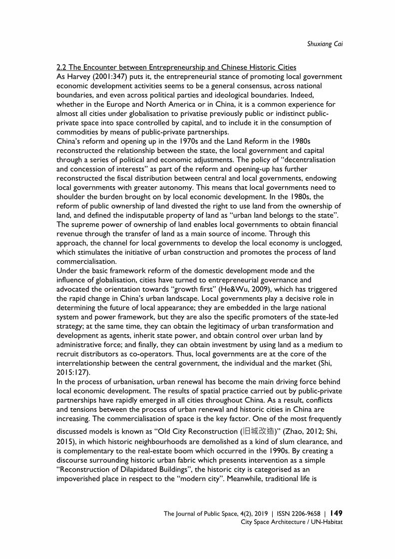
Shuxiang Cai
The Journal of Public Space, 4(2), 2019 | ISSN 2206-9658 | 149
City Space Architecture / UN-Habitat
2.2 The Encounter between Entrepreneurship and Chinese Historic Cities As Harvey (2001:347) puts it, the entrepreneurial stance of promoting local government economic development activities seems to be a general consensus, across national boundaries, and even across political parties and ideological boundaries. Indeed, whether in the Europe and North America or in China, it is a common experience for almost all cities under globalisation to privatise previously public or indistinct public-private space into space controlled by capital, and to include it in the consumption of commodities by means of public-private partnerships. China’s reform and opening up in the 1970s and the Land Reform in the 1980s reconstructed the relationship between the state, the local government and capital through a series of political and economic adjustments. The policy of “decentralisation and concession of interests” as part of the reform and opening-up has further reconstructed the fiscal distribution between central and local governments, endowing local governments with greater autonomy. This means that local governments need to shoulder the burden brought on by local economic development. In the 1980s, the reform of public ownership of land divested the right to use land from the ownership of land, and defined the indisputable property of land as “urban land belongs to the state”. The supreme power of ownership of land enables local governments to obtain financial revenue through the transfer of land as a main source of income. Through this approach, the channel for local governments to develop the local economy is unclogged, which stimulates the initiative of urban construction and promotes the process of land commercialisation. Under the basic framework reform of the domestic development mode and the influence of globalisation, cities have turned to entrepreneurial governance and advocated the orientation towards “growth first” (He&Wu, 2009), which has triggered the rapid change in China’s urban landscape. Local governments play a decisive role in determining the future of local appearance; they are embedded in the large national system and power framework, but they are also the specific promoters of the state-led strategy; at the same time, they can obtain the legitimacy of urban transformation and development as agents, inherit state power, and obtain control over urban land by administrative force; and finally, they can obtain investment by using land as a medium to recruit distributors as co-operators. Thus, local governments are at the core of the interrelationship between the central government, the individual and the market (Shi, 2015:127). In the process of urbanisation, urban renewal has become the main driving force behind local economic development. The results of spatial practice carried out by public-private partnerships have rapidly emerged in all cities throughout China. As a result, conflicts and tensions between the process of urban renewal and historic cities in China are increasing. The commercialisation of space is the key factor. One of the most frequently
discussed models is known as “Old City Reconstruction (旧城改造)” (Zhao, 2012; Shi, 2015), in which historic neighbourhoods are demolished as a kind of slum clearance, and is complementary to the real-estate boom which occurred in the 1990s. By creating a discourse surrounding historic urban fabric which presents intervention as a simple “Reconstruction of Dilapidated Buildings”, the historic city is categorised as an impoverished place in respect to the “modern city”. Meanwhile, traditional life is

A Cultural Governance Coalition in Regeneration
150 | The Journal of Public Space, 4(2), 2019 | ISSN 2206-9658 City Space Architecture / UN-Habitat
posited as the antithesis of modernity, and is therefore taken at face value as a justified excuse to empty land and relocate residents. However, in order to maximise the value of land, local governments cooperate with developers to demolish large numbers of old buildings and replace them with commercial housing or other modern functional sites. Despite the fact that regulatory control provisions for the protection of historic cities are in place, these provisions are still ignored or circumvented by many political operations. For example, regulations which ought to control volume ratio and enforce the height limit are being broken constantly and the landscape comprising historic urban areas has been nibbled at and guzzled. Driven by the booming economy, destruction of the historical fabric has occurred at an unprecedented pace around 1999 (Whitehand and Gu, 2007: 650). In the process of city reconstruction for Beijing, alleys disappeared at a rate about 600 per year at that time (Huang, 2004: 124). When compared with the situation in 1949, the total area of traditional houses within the old city has reduced by more than half in scale (Dong, 2006: 195-196). The boundary of traditional public space in the city is produced during the long-term negotiation process that is neighbourhood life, which being both vague and dynamic, endows itself with urban vitality through various elastic uses of space (see Fig. 1). Tradition has been replaced by a new model, transformed into a well-defined access-controlled community, commercial plots and office space, which divides the original public space. The discourse surrounding safety and modes of property management etc., under the pretext of modern life, rationalised its existence and thus gained public recognition. In addition to real estate development, another major model is the restoration of historic blocks (Chen, Zhang, 2010; Su, 2015). China began to evaluate historic and cultural cities in 1982, but for a long time the protection of historic blocks was not taken seriously by local governments. On the one hand, every year, the government at all levels allocates extremely limited funds to protection — which is utterly inadequate for protecting historic districts; on the other hand, the protection of historic districts seems to restrict the development of urbanisation and is even regarded as a stumbling block to the growth of the local economy (Zhao, 2002). However, with the rise of cultural consumption, historic blocks have brought considerable benefits to local tourism economies and have become an important part of securing local economic income. Marketing urban heritage has proven to be an effective policy in helping cities succeed in the face of regional competition and economic restructuring (Britton, 1991). Local governments began to be obsessed with cultural construction projects for various historic blocks. Nowadays, portions of urban fabric that have been nominated as “Historic and Cultural Blocks” at a national, provincial and local level, are beyond count. Many of them serve tourism consumption in a semi-commercial or even completely commercial mode. For example, the “Shanghai Xintiandi” project, which won many international architecture and culture awards, is under the banner of the protection of historic blocks, but on closer inspection it appears in the form of historic real estate. Essentially, developers do not focus on the cultural value of the building itself, but create a delicate historical atmosphere for the purposes of consumption. Therefore, a large number of architectural details and symbols are extracted from their original locations and reassembled, a reminiscent practice of selling high-quality reproductions of the past in a
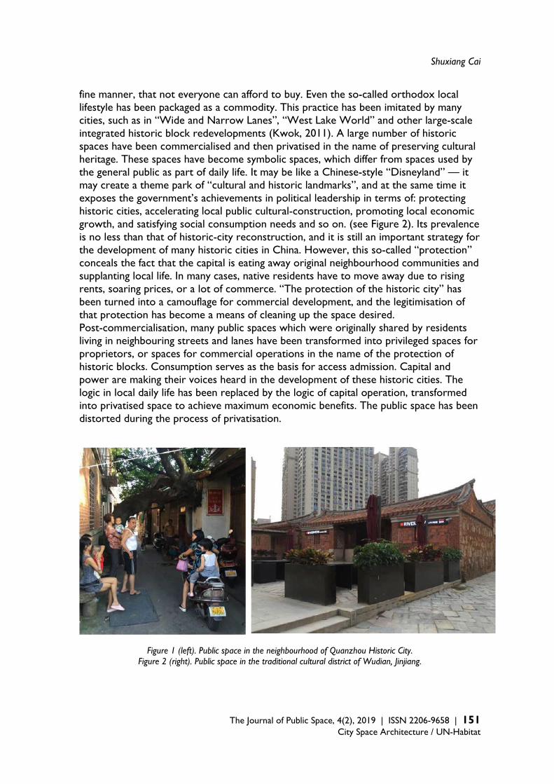
Shuxiang Cai
The Journal of Public Space, 4(2), 2019 | ISSN 2206-9658 | 151
City Space Architecture / UN-Habitat
fine manner, that not everyone can afford to buy. Even the so-called orthodox local lifestyle has been packaged as a commodity. This practice has been imitated by many cities, such as in “Wide and Narrow Lanes”, “West Lake World” and other large-scale integrated historic block redevelopments (Kwok, 2011). A large number of historic spaces have been commercialised and then privatised in the name of preserving cultural heritage. These spaces have become symbolic spaces, which differ from spaces used by the general public as part of daily life. It may be like a Chinese-style “Disneyland” — it may create a theme park of “cultural and historic landmarks”, and at the same time it exposes the government’s achievements in political leadership in terms of: protecting historic cities, accelerating local public cultural-construction, promoting local economic growth, and satisfying social consumption needs and so on. (see Figure 2). Its prevalence is no less than that of historic-city reconstruction, and it is still an important strategy for the development of many historic cities in China. However, this so-called “protection” conceals the fact that the capital is eating away original neighbourhood communities and supplanting local life. In many cases, native residents have to move away due to rising rents, soaring prices, or a lot of commerce. “The protection of the historic city” has been turned into a camouflage for commercial development, and the legitimisation of that protection has become a means of cleaning up the space desired. Post-commercialisation, many public spaces which were originally shared by residents living in neighbouring streets and lanes have been transformed into privileged spaces for proprietors, or spaces for commercial operations in the name of the protection of historic blocks. Consumption serves as the basis for access admission. Capital and power are making their voices heard in the development of these historic cities. The logic in local daily life has been replaced by the logic of capital operation, transformed into privatised space to achieve maximum economic benefits. The public space has been distorted during the process of privatisation.
Figure 1 (left). Public space in the neighbourhood of Quanzhou Historic City.
Figure 2 (right). Public space in the traditional cultural district of Wudian, Jinjiang.
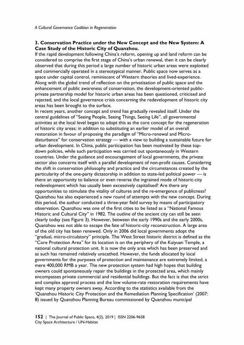
A Cultural Governance Coalition in Regeneration
152 | The Journal of Public Space, 4(2), 2019 | ISSN 2206-9658 City Space Architecture / UN-Habitat
3. Conservation Practice under the New Concept and the New System: A Case Study of the Historic City of Quanzhou. If the rapid development following China’s reform, opening up and land reform can be considered to comprise the first stage of China’s urban renewal, then it can be clearly observed that during this period a large number of historic urban areas were exploited and commercially operated in a stereotypical manner. Public space now serves as a space under capital control, reminiscent of Western theories and lived-experience. Along with the global trend of reflection on the privatisation of public space and the enhancement of public awareness of conservation, the development-oriented public-private partnership model for historic urban areas has been questioned, criticised and rejected, and the local governance crisis concerning the redevelopment of historic city areas has been brought to the surface. In recent years, another concept and trend has gradually revealed itself. Under the central guidelines of “Seeing People, Seeing Things, Seeing Life”, all governmental activities at the local level began to adopt this as the core concept for the regeneration of historic city areas; in addition to substituting an earlier model of an overall restoration in favour of proposing the paradigm of “Micro-renewal and Micro-disturbance” for conservation strategy — with a view to building a sustainable future for urban development. In China, public participation has been motivated by these top-down policies, while such participation was carried out spontaneously in Western countries. Under the guidance and encouragement of local governments, the private sector also concerns itself with a parallel development of non-profit causes. Considering the shift in conservation philosophy and practice and the circumstances created by the particularity of the one-party dictatorship in addition to state-led political power — is there an opportunity to balance or even reverse the ingrained mode of historic-city redevelopment which has usually been excessively capitalised? Are there any opportunities to stimulate the vitality of cultures and the re-emergence of publicness? Quanzhou has also experienced a new round of attempts with the new concept. During this period, the author conducted a three-year field survey by means of participatory observation. Quanzhou was one of the first cities to be listed as a “National Famous Historic and Cultural City” in 1982. The outline of the ancient city can still be seen clearly today (see Figure 3). However, between the early 1990s and the early 2000s, Quanzhou was not able to escape the fate of historic-city reconstruction. A large area of the old city has been renewed. Only in 2006 did local governments adopt the “gradual, micro-circulatory” principle. The West Street historic district is defined as the “Core Protection Area” for its location is on the periphery of the Kaiyuan Temple, a national cultural protection unit. It is now the only area which has been preserved and as such has remained relatively unscathed. However, the funds allocated by local governments for the purposes of protection and maintenance are extremely limited, a mere 400,000 RMB a year. The new protection system had high hopes that building owners could spontaneously repair the buildings in the protected area, which mainly encompasses private commercial and residential buildings. But the fact is that the strict and complex approval process and the low volume-rate restoration requirements have kept many property owners away. According to the statistics available from the ‘Quanzhou Historic City Protection and the Remediation Planning Specification’ (2007: 8) issued by Quanzhou Planning Bureau commissioned by Quanzhou municipal

Shuxiang Cai
The Journal of Public Space, 4(2), 2019 | ISSN 2206-9658 | 153
City Space Architecture / UN-Habitat
government, in the year 2000 the number of first-class preserved buildings was documented at 126, this figure dropped to 81 by the year of 2006 — 45 buildings disappeared over a period of only six years. Common problems in old cities such as: ageing buildings which might collapse at any time, offshore migration of native residents, and rent decline and industrial stagnation are posing a growing threat. Although over the past ten years the public sector has been trying to generate various schemes to promote conservation, local governments must contend with a chorus of conflicting voices which renders making strategic decisions difficult. How to regenerate historic urban areas is a long-standing problem that has long plagued local governments.
Figure 3. Left: A Mapping Survey of Quanzhou in 1922. Right: An Aerial Map of Quanzhou in 2016.
Since 2016, Quanzhou has held a series of exhibitions entitled “Soundless Lubrication (
润物无声)” as one of the cultural strategies for space activation. Unlike regular exhibitions which are commonly held in large art centres, the understated nature of the Soundless Lubrication exhibition reflects its name. It carries the hope of lubricating everything in a silent manner, which in practice means that it doesn’t intervene in the city with a one-time direct action but instead appears in small, informal ways where it is sprinkled around in numerous micro-spaces in streets and alleys in the historic city: integrating itself into these areas, and thus gradually activating historic city areas. The use of an exhibition as a regeneration strategy may not be new, but from the perspective of its underlying mechanism, the exhibition for historic Quanzhou has the following special attributes which are worth exploring.

A Cultural Governance Coalition in Regeneration
154 | The Journal of Public Space, 4(2), 2019 | ISSN 2206-9658 City Space Architecture / UN-Habitat
3.1 Coalition restructuring In the past, it was local planning bureaus, planning institutes and other professional departments which represented the public sector, and acted as the major governing units for the protection of historic cities. These units were mainly focused on material-oriented protection strategies. Although the units are often regarded as professionally competent units, authorised to protect historic fabric, in reality they have very limited access to human and financial resources, power or scope for impact at administrative decision-making levels. Wading through the multiple layers necessary to gain approval so as to obtain protection funds is always a long process, even if they set up a specific channel designed for submitting their projects for approval separately. This leads to difficulties in the implementation of protection strategies in historic cities and in turn, conflicts in development-oriented local governance. Based on the experience gained in past decades, the conservation surrounding historic cities around the world has been constantly updated, and has made people aware of the fact that protection should not be too dependent on pre-modern traditions or be restricted to a certain single historical level. According to the Recommendation on the Historic Urban Landscape promulgated by UNESCO in 2011, moving forward, the purpose of historic urban landscapes should not only be rooted in their protection, but should also be about maintaining and improving the overall living environment for human beings. That is to say, conservation should also be integrated into urban development strategy, thereby establishing a broader and multi-level urban development context which considers the city’s habitability and the sustainability of all of its aspects, including the role of different stakeholders (Kang, 2012). Therefore, the conservation and activation of historic cities must face the problem of cross-domain cooperation directly. Compared to the past, local governments are increasingly more sensitive to the social impact and are more cautious in seeking strategies to achieve a balance between protection and development. Triggered by many factors, the coalition related to the regeneration of the historic city of Quanzhou has been restructured. In early 2016, Quanzhou established the “Quanzhou Historic City Conservation and Development Coordination Group”, a provisional public organisation headed by the mayor: a move which aimed to bestow sufficient decision-making power on the new initiative. Formed by a range of offices and different working groups, the organisation includes a planning group, a cultural group, a policy group, an advocacy group and other various groups with different responsibilities pertaining to daily operations. By borrowing outstanding talents from various government departments and institutions, the government devotes time and significant efforts to bringing people from different fields together and encouraging collaboration — including relevant units which had been working for the protection of historic cities over a long period of time. At the same time, “Quanzhou Historic City Development Co., Ltd. is responsible for the protection and development of the daily work”1 — which lays out the role of private sector in public-private partnerships. In fact, Quanzhou Historic City Development Co., Ltd. is a 1 The website of Quanzhou Municipal People's Government (2016), "Notice of the Office of Quanzhou Municipal People's Government on the Establishment of the Coordination Group for the Protection and Development of Quanzhou Historic Cities" is : http://www.fjqz.gov.cn/zfb/xgk/zfxgkzl/zfxgkml/srmzfxgkml/jgsz/201602/t20160229_250507.htm. (2017/08/21)
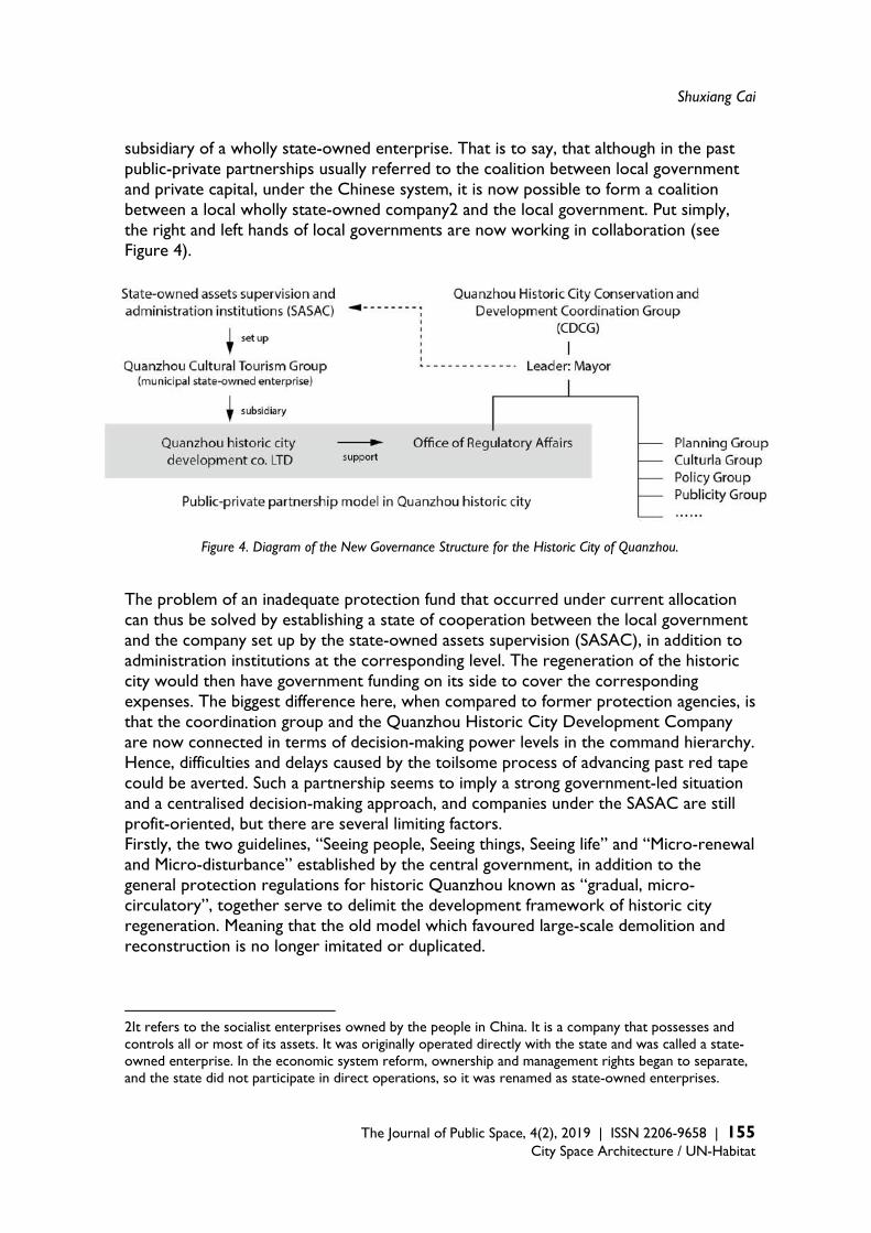
Shuxiang Cai
The Journal of Public Space, 4(2), 2019 | ISSN 2206-9658 | 155
City Space Architecture / UN-Habitat
subsidiary of a wholly state-owned enterprise. That is to say, that although in the past public-private partnerships usually referred to the coalition between local government and private capital, under the Chinese system, it is now possible to form a coalition between a local wholly state-owned company2 and the local government. Put simply, the right and left hands of local governments are now working in collaboration (see Figure 4).
Figure 4. Diagram of the New Governance Structure for the Historic City of Quanzhou.
The problem of an inadequate protection fund that occurred under current allocation can thus be solved by establishing a state of cooperation between the local government and the company set up by the state-owned assets supervision (SASAC), in addition to administration institutions at the corresponding level. The regeneration of the historic city would then have government funding on its side to cover the corresponding expenses. The biggest difference here, when compared to former protection agencies, is that the coordination group and the Quanzhou Historic City Development Company are now connected in terms of decision-making power levels in the command hierarchy. Hence, difficulties and delays caused by the toilsome process of advancing past red tape could be averted. Such a partnership seems to imply a strong government-led situation and a centralised decision-making approach, and companies under the SASAC are still profit-oriented, but there are several limiting factors. Firstly, the two guidelines, “Seeing people, Seeing things, Seeing life” and “Micro-renewal and Micro-disturbance” established by the central government, in addition to the general protection regulations for historic Quanzhou known as “gradual, micro-circulatory”, together serve to delimit the development framework of historic city regeneration. Meaning that the old model which favoured large-scale demolition and reconstruction is no longer imitated or duplicated.
2It refers to the socialist enterprises owned by the people in China. It is a company that possesses and controls all or most of its assets. It was originally operated directly with the state and was called a state-owned enterprise. In the economic system reform, ownership and management rights began to separate, and the state did not participate in direct operations, so it was renamed as state-owned enterprises.
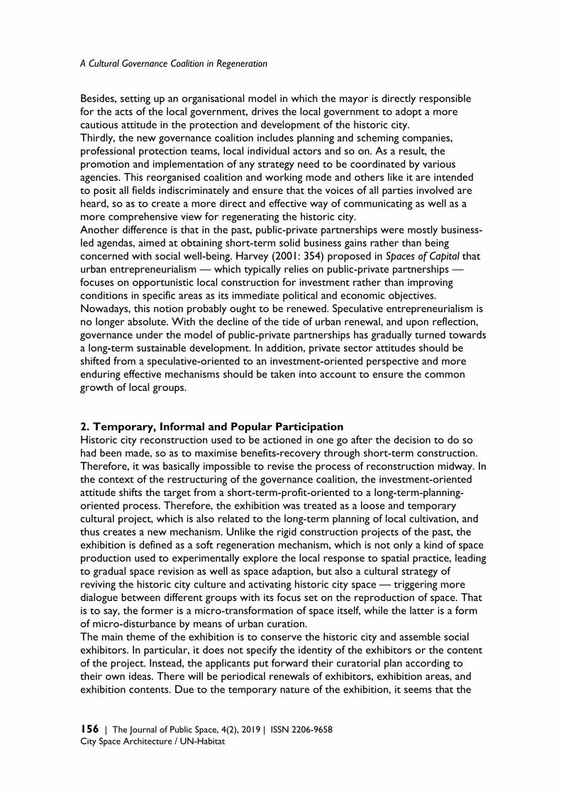
A Cultural Governance Coalition in Regeneration
156 | The Journal of Public Space, 4(2), 2019 | ISSN 2206-9658 City Space Architecture / UN-Habitat
Besides, setting up an organisational model in which the mayor is directly responsible for the acts of the local government, drives the local government to adopt a more cautious attitude in the protection and development of the historic city. Thirdly, the new governance coalition includes planning and scheming companies, professional protection teams, local individual actors and so on. As a result, the promotion and implementation of any strategy need to be coordinated by various agencies. This reorganised coalition and working mode and others like it are intended to posit all fields indiscriminately and ensure that the voices of all parties involved are heard, so as to create a more direct and effective way of communicating as well as a more comprehensive view for regenerating the historic city. Another difference is that in the past, public-private partnerships were mostly business-led agendas, aimed at obtaining short-term solid business gains rather than being concerned with social well-being. Harvey (2001: 354) proposed in Spaces of Capital that urban entrepreneurialism — which typically relies on public-private partnerships — focuses on opportunistic local construction for investment rather than improving conditions in specific areas as its immediate political and economic objectives. Nowadays, this notion probably ought to be renewed. Speculative entrepreneurialism is no longer absolute. With the decline of the tide of urban renewal, and upon reflection, governance under the model of public-private partnerships has gradually turned towards a long-term sustainable development. In addition, private sector attitudes should be shifted from a speculative-oriented to an investment-oriented perspective and more enduring effective mechanisms should be taken into account to ensure the common growth of local groups. 2. Temporary, Informal and Popular Participation Historic city reconstruction used to be actioned in one go after the decision to do so had been made, so as to maximise benefits-recovery through short-term construction. Therefore, it was basically impossible to revise the process of reconstruction midway. In the context of the restructuring of the governance coalition, the investment-oriented attitude shifts the target from a short-term-profit-oriented to a long-term-planning-oriented process. Therefore, the exhibition was treated as a loose and temporary cultural project, which is also related to the long-term planning of local cultivation, and thus creates a new mechanism. Unlike the rigid construction projects of the past, the exhibition is defined as a soft regeneration mechanism, which is not only a kind of space production used to experimentally explore the local response to spatial practice, leading to gradual space revision as well as space adaption, but also a cultural strategy of reviving the historic city culture and activating historic city space — triggering more dialogue between different groups with its focus set on the reproduction of space. That is to say, the former is a micro-transformation of space itself, while the latter is a form of micro-disturbance by means of urban curation. The main theme of the exhibition is to conserve the historic city and assemble social exhibitors. In particular, it does not specify the identity of the exhibitors or the content of the project. Instead, the applicants put forward their curatorial plan according to their own ideas. There will be periodical renewals of exhibitors, exhibition areas, and exhibition contents. Due to the temporary nature of the exhibition, it seems that the
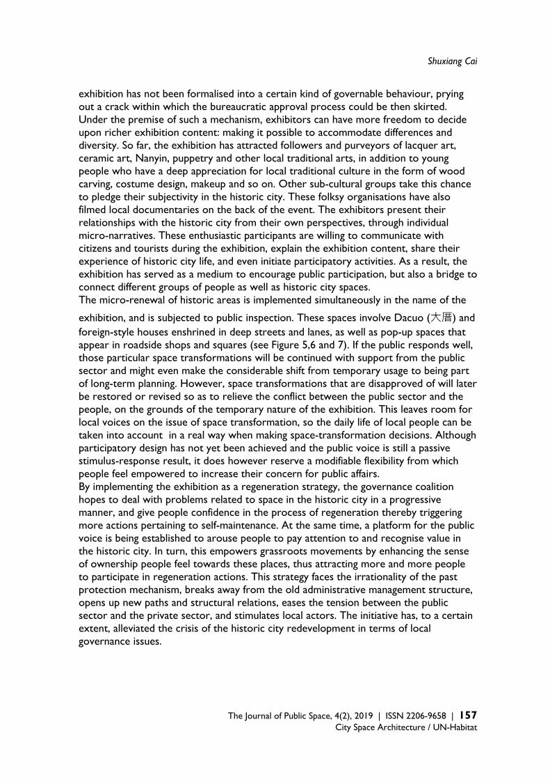
Shuxiang Cai
The Journal of Public Space, 4(2), 2019 | ISSN 2206-9658 | 157
City Space Architecture / UN-Habitat
exhibition has not been formalised into a certain kind of governable behaviour, prying out a crack within which the bureaucratic approval process could be then skirted. Under the premise of such a mechanism, exhibitors can have more freedom to decide upon richer exhibition content: making it possible to accommodate differences and diversity. So far, the exhibition has attracted followers and purveyors of lacquer art, ceramic art, Nanyin, puppetry and other local traditional arts, in addition to young people who have a deep appreciation for local traditional culture in the form of wood carving, costume design, makeup and so on. Other sub-cultural groups take this chance to pledge their subjectivity in the historic city. These folksy organisations have also filmed local documentaries on the back of the event. The exhibitors present their relationships with the historic city from their own perspectives, through individual micro-narratives. These enthusiastic participants are willing to communicate with citizens and tourists during the exhibition, explain the exhibition content, share their experience of historic city life, and even initiate participatory activities. As a result, the exhibition has served as a medium to encourage public participation, but also a bridge to connect different groups of people as well as historic city spaces. The micro-renewal of historic areas is implemented simultaneously in the name of the
exhibition, and is subjected to public inspection. These spaces involve Dacuo (大厝) and foreign-style houses enshrined in deep streets and lanes, as well as pop-up spaces that appear in roadside shops and squares (see Figure 5,6 and 7). If the public responds well, those particular space transformations will be continued with support from the public sector and might even make the considerable shift from temporary usage to being part of long-term planning. However, space transformations that are disapproved of will later be restored or revised so as to relieve the conflict between the public sector and the people, on the grounds of the temporary nature of the exhibition. This leaves room for local voices on the issue of space transformation, so the daily life of local people can be taken into account in a real way when making space-transformation decisions. Although participatory design has not yet been achieved and the public voice is still a passive stimulus-response result, it does however reserve a modifiable flexibility from which people feel empowered to increase their concern for public affairs. By implementing the exhibition as a regeneration strategy, the governance coalition hopes to deal with problems related to space in the historic city in a progressive manner, and give people confidence in the process of regeneration thereby triggering more actions pertaining to self-maintenance. At the same time, a platform for the public voice is being established to arouse people to pay attention to and recognise value in the historic city. In turn, this empowers grassroots movements by enhancing the sense of ownership people feel towards these places, thus attracting more and more people to participate in regeneration actions. This strategy faces the irrationality of the past protection mechanism, breaks away from the old administrative management structure, opens up new paths and structural relations, eases the tension between the public sector and the private sector, and stimulates local actors. The initiative has, to a certain extent, alleviated the crisis of the historic city redevelopment in terms of local governance issues.
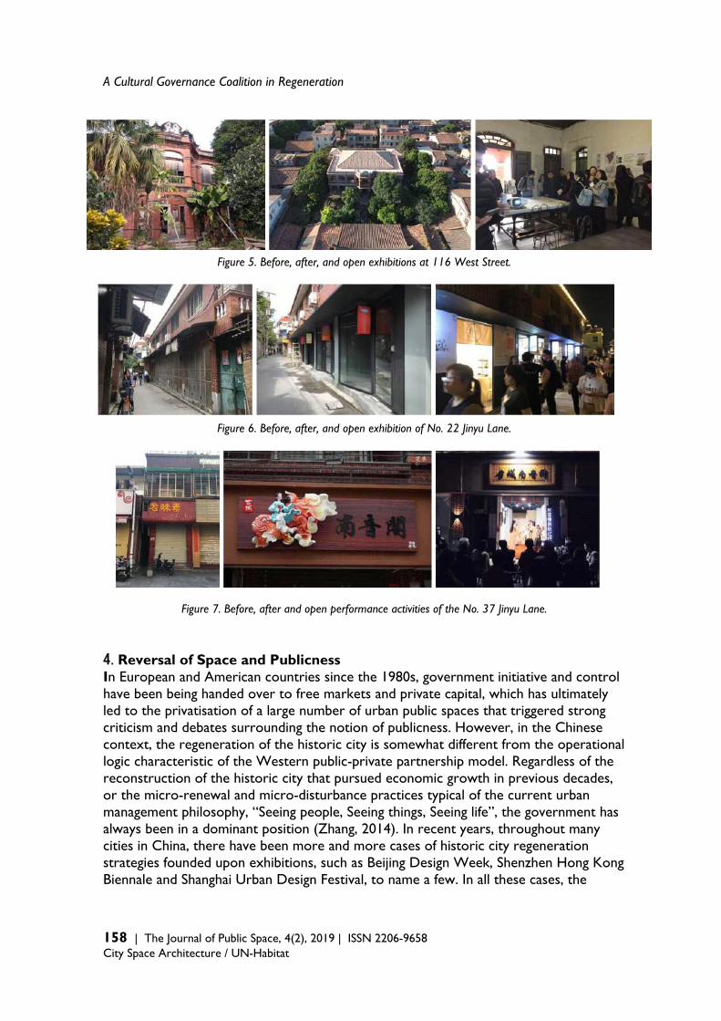
A Cultural Governance Coalition in Regeneration
158 | The Journal of Public Space, 4(2), 2019 | ISSN 2206-9658 City Space Architecture / UN-Habitat
Figure 5. Before, after, and open exhibitions at 116 West Street.
Figure 6. Before, after, and open exhibition of No. 22 Jinyu Lane.
Figure 7. Before, after and open performance activities of the No. 37 Jinyu Lane. 4.Reversal of Space and Publicness In European and American countries since the 1980s, government initiative and control have been being handed over to free markets and private capital, which has ultimately led to the privatisation of a large number of urban public spaces that triggered strong criticism and debates surrounding the notion of publicness. However, in the Chinese context, the regeneration of the historic city is somewhat different from the operational logic characteristic of the Western public-private partnership model. Regardless of the reconstruction of the historic city that pursued economic growth in previous decades, or the micro-renewal and micro-disturbance practices typical of the current urban management philosophy, “Seeing people, Seeing things, Seeing life”, the government has always been in a dominant position (Zhang, 2014). In recent years, throughout many cities in China, there have been more and more cases of historic city regeneration strategies founded upon exhibitions, such as Beijing Design Week, Shenzhen Hong Kong Biennale and Shanghai Urban Design Festival, to name a few. In all these cases, the

Shuxiang Cai
The Journal of Public Space, 4(2), 2019 | ISSN 2206-9658 | 159
City Space Architecture / UN-Habitat
government, enterprises, and the third sector jointly work together to operate historic city areas. Most of the large-scale events carried out which are wider in scope are based on cooperation between local governments and local state-owned enterprises, working in a collaborative left-hand-with-right-hand attitude. Local state-owned groups, as capital parties that cooperate with government policies and funds, not only need to make profits as their ultimate goal, but also need to constantly seek a balance between public interest and their own interests. The last part of the article will focus on this issue and re-explore the inherent contradictions in public space formed by the exhibition as event, in addition to the possibility of the formation of publicness under this cooperative mode of practice. In the traditional urban space, the distinction between public and private life is not clear. It is often regarded as a vague boundary which is mutually infiltrated. In southern Fujian, the two traditional architectural types, the arcade and the front courtyard of Dacuo, are concrete manifestations of private space which has been put to public use. Therefore, public and private can be defined as relative concepts. In addition to the ownership of property rights, whether a space is public or private can also be classified according to who has the power to access the space, and the public or private nature of activities taking place in the space. That is to say, the definition of public space is the interlacing of property rights, access and activities, which varies depending on the situation (Wang, Shen & Lin, 2009: 9). This is similar to the concept of “public” in Japan — what constitutes a public space is determined by the events which take place there. That is, a public activity determines the scope of space at a specific time, without a tangible, permanent boundary (Hidaka & Tanaka, 2001). In this sense, the public events created by the exhibition flip various micro-spaces in the historic city into a source that could be could be used with visible effect in the near future under this framework, shifting them from private to public, which reinvigorates and diversifies the public spaces in historical Quanzhou. But in fact, the reason for the emergence of these public spaces is that under the new cooperative structure, the government is to repair some old buildings in the historic city that have remained unused for a long period of time or which have even collapsed, in order to exchange the right to use them, thereby assisting Quanzhou Cultural Tourism Group, the state-owned company, in the storage of fixed assets. Although it is a progressive and yet piecemeal repair process, there is a set of overall planning guidelines which serve as a reference point. These represent a revision of the previous method of integral reconstruction or restoration which guided past interventions. After the restoration, the government and state-owned company then introduced cooperation from the third sector. On the one hand, they mobilised local resources as much as possible to jointly activate these spaces. On the other hand, they bestowed a higher profile on the historic city and promoted an increase in small capital injections. Although top-down centralised politics is often criticised, it is this supreme authority that has the power to mobilise enough resources financial, material, human or otherwise, and to formulate the necessary corresponding policies and regulations such as rent control, support for businesses, etc. This is rare in the Western context. Thus, the top-down model has the capacity to transform the logic of interest-oriented space production into the core concept of “Seeing people, Seeing things, Seeing life”, guided by public opinion. Its concentration, universality and operational intensity — and the effects that can be
A Cultural Governance Coalition in Regeneration
160 | The Journal of Public Space, 4(2), 2019 | ISSN 2206-9658 City Space Architecture / UN-Habitat
produced in a short period of time — differ greatly from the modes of spontaneous or small-scale capital intervention. However, exploring the driving forces behind these public spaces still seems to relate back to the monopoly rent under the logic of capital (Harvey, 2001). Harvey proposed two forms of monopoly rent, one is to monopolise goods or services produced by land, resources or a location with unique characteristics, and the other is to hoard land or resources instead of putting them into current use, coveting its value in the future. Rehabilitation and exhibition activities have improved the historic city’s image. It also advances the appreciation of monopoly rents on the part of local governments and capital enterprises. Sponsoring exhibitions and incubating cultural formats with local characteristics also creates uniqueness or scarcity, enhancing the city’s competitiveness. As a result, local governments, capital companies, and third sectors have their respective roles in this cooperative coalition. Historic city regeneration, cultural development, and the monopoly of space and cultural resources are connected in series. From this point of view, groups who have a deep appreciation for the historic city and who participate in exhibition activities are being subsumed under the governance coalition as unique cultural resources. Even if those groups possess a certain amount of freedom, they cannot exert enough impact, and may even be replaced by other groups in the coalition at any time. It is also undeniable that as a result of this process, people or subjects that do not conform with the official understanding and definition of “Seeing people, Seeing things, Seeing life” will be excluded. For example, some shops which have long been operating in local areas and which serve local life but do not have any unique characteristics or do not conform to the historic city’s new image, may be included in the category of discouraged facilities in the corresponding form-support policy and thus be forced to either move or close down. In addition, some public spaces that traditionally served local residents are considered to be of less value if they do not have significant utilities. These utilities are attractive to the government and enterprises because they are expected to appreciate and can be monopolised. For example, the pocket park micro-renewal project for Haogou Gully, implemented in the historic city of Quanzhou, was described by the relevant government officials in the following words: “A new street garden will be built on this open space to improve the street environment.” However, compared with the design announced in June 2018, the final layout of the pocket park — completed in July 2019 — simplified the design of the rest pavilion and corridor into a few stone benches. It remains to be seen whether this pocket park will really be loved and effectively used by residents. (Figures 7, 8 and 9). As MacLeod (2002) pointed out, any so-called publicness introduced for revival and regeneration is highly selective and systematically discriminating. Even so, is it possible for publicness to emerge from the interaction between various groups with exhibitions serving as the medium? Influenced by traditional Confucianism, the meaning attributed to the concept of “publicness” in China is not the same as the definition — founded upon democracy and debate — which is prevalent in the West. It is more like a social contract based on consultation and consensus (Rowe, 2005:167), and therefore lacks grassroots power. Due to this kind of collective-contract spirit, the traditional neighbourhood model is often taken up as the ideal type of public space. But when the Recommendation on the Historic Urban Landscape expands the definition of

Shuxiang Cai
The Journal of Public Space, 4(2), 2019 | ISSN 2206-9658 | 161
City Space Architecture / UN-Habitat
historic urban landscape into a more complex structure featuring several layers of urban development, the discussion of public space in the historic city should not be confined to the imagination of traditional neighbourhoods from the past. The traditional publicness in China also needs to face the issue of contemporary urbanity and its new significance under the effects of rapid change.
Figure 8-9-10 (from left to right). Pocket Park Design Plan; Reconstruction at the end of 2018 (Source: Quanzhou Network); Current Status
Returning to the public space put forward by Richard Sennett, his focus is not on democratic participation nor is it on the basis of communicating reason as Habermas would have it, but instead on the open flow of public space and the high tolerance of mixed differences. Event-oriented activities such as “Silent Lubrication”, carried out in a wide range of sites in the historic city are not simply general abstract discussions of historic city issues but neither are they deeply immersed within or restricted to particular places. Instead, they intentionally open up dialogues between the outside and the local. Because of the exhibition’s irregular, temporary and informal nature, the degree of freedom allowed usually deviates from the existing standards and rules. Such a festival-like carnival provides an opportunity for all parties to make their voices heard. Scholars, artists, students and citizens pour into these activities. Different groups and residents gather together. The collision of various ideas and actions may result in numerous unpredictable consequences and achievements, which play out in daily life. Moreover, these achievements may also generate opportunities to trigger more chain reactions, under the scrutiny of all sectors of society. To a certain extent, this responds to the definition put forward by Carr et al. (1992: 45) of a successful public space, namely a “social binder” and: “the potential to bring together various groups so that they can learn from each other and become a multi-class, multi-cultural, heterogeneous society with the richest characteristics”. It can be said that the exhibition events taking cities as exhibition venues have re-blurred the distinctive public-private boundaries enforced under urban entrepreneurship: some are even in clear opposition to the public space produced by the capital logic. Although located in the historic city, this kind of space differs from the traditional public space which belongs to the past. Such a publicness lies not only in debates, but also in personal entry and reflection, introducing differences and flows, creating connections and actions, and emphasising the activation and cohesion of initiative, thus infusing the
A Cultural Governance Coalition in Regeneration
162 | The Journal of Public Space, 4(2), 2019 | ISSN 2206-9658 City Space Architecture / UN-Habitat
place with a public lens of contemporary urban characteristics to stimulate more folk practice. To sum up, the Chinese government is making great efforts to revise the previous model for urban renewal — which is mainly carried out by means of large-scale demolition and reconstruction — and is seeking new ideas and paradigms. Although historic city regeneration is usually highly selective, only benefiting certain special spaces and social groups (Tallon, 2013: 277), compared to the past, real-estate-oriented urban regeneration does still exist throughout the country but it is no longer dominant and continues to weaken gradually. Secondly, the focus of regeneration is returning to balancing public interests and alleviating social problems, and trying to redistribute resources and make effective use of them, which echoes the original intention of urban regeneration in the West. Finally, the participation of the third sector plays a direct role in this process. The third sector can be regarded as an actor, as an active and crucial force operating between local governments and enterprises. The third sector is a vehicle for engaging the public and can use its strength to promote public interests in the regeneration process. Under the trend of a central-government-led concept of “Seeing people, Seeing things, Seeing life” and the gradual revival of the third sector, whether there is an opportunity to balance or even reverse the capital logic of regeneration experience in the historic city is a topic worthy of both long-term observation and discussion. Reference Atkinson, R., & Moon, G. (1994). Urban Policy in Britain: The City, the State and the Market.
Macmillan International Higher Education. Bolton, R. (1989). Figments of the Public: Architecture and Debt. Threshold, 4: 44-49. Britton, S. (1991). Tourism, Capital, and Place: Towards a Critical Geography of
Tourism. Environment and planning D: society and space, 9(4): 451-478. Carr, S. (1992). Public Space. Cambridge University Press. Carter, E. & Donald, J. (1993). Space and Place: Theories of Identity and Location. Lawrence &
Wishart Ltd. Chen, L. & Zhang, W. (2010). The Change and Reconstruction of Local Culture in Response to Urban
Renewal and Globalization: A Case Study of Shichahai Historic District. Progress in geography, 29(6): 649-656.
Dong, G. (2006). A Fifty-year Evolutionary Record of Ancient Capital of Beijing. Nanjing: Southeast University Press.
CLG (2008). Transforming Places; Changing Lives: A Framework for Regeneration. Communities and Local Government, London.
IPF (2009). Urban Regeneration: Opportunities for Property Investment. Investment Property Forum (IPF), London.
Fraser, N. (1990). Rethinking the Public Sphere: A Contribution to the Critique of Actually Existing Democracy. Social text, (25/26): 56-80.
Kung, S. (2006). Social Network Booting, Urban Micro-regeneration Acting. Time Architecture, 2016 (4): 29-33.
Kwok, Y. C. J. (2011). The Production of Space in East Asian Cities: Urban Cultures of Tokyo, Shanghai and Hong Kong. Taipei: Garden City.
Shuxiang Cai
The Journal of Public Space, 4(2), 2019 | ISSN 2206-9658 | 163
City Space Architecture / UN-Habitat
Habermas, J. (1989). The Structural Transformation of the Public Sphere, trans. Thomas
Burger. Cambridge: MIT Press. Harvey, D. (2001). Spaces of Capital: Towards a Critical Geography. Routledge. Harvey, D. (2005). Spaces of Neoliberalization: Towards a Theory of Uneven Geographical
Development (Vol. 8). Franz Steiner Verlag. He, S., & Wu, F. (2009). China's Emerging Neoliberal Urbanism: Perspectives From Urban
Dedevelopment. Antipode, 41(2): 282-304. Healey, P., Davoudi, S., Tavsanoglu, S., O’Toole, M. and Usher, D. (eds.) (1992). Rebuilding the
City: Property-Led Urban Regeneration, London: E & FN Spon. Herbert, D. (2000). Towns and Cities. In V. Gardiner and H. Matthews (eds.), The Changing
Geography of the United Kingdom (pp. 190–212), London: Routledge, 3rd e. Hidaka, T., & Tanaka, M. (2001). Japanese Public Space as Defined by Event. In Public Places in Asia
Pacific Cities (pp.107-118). Springer Netherlands. Huang Y. (2004). Houhai Family: Living in the Lost Landscape. In Zhang Z. (eds.), China in 2004 -
Rising China and the World (pp.121-126). China Citic Press. Jacobs, J. (1992). The Death and Life of Great American Cities. New York: Vintage. Kang M. (2012). Urban Conservation in the Booty Capitalist City. Router: a journal of cultural
studies, (15): 230-241. MacLeod, G. (2002). From Urban Entrepreneurialism to a ‘Revanchist City’? On the Spatial Injustices
of Glasgow’s Renaissance. Antipode, 34(3): 602-624. Sennett, R. (2017). The Fall of Public Man. WW Norton & Company. Quanzhou Planning Bureau (2007), Quanzhou Historic City Protection and the Remediation Planning
Specification. Quanzhou: Quanzhou Planning Bureau. Roberts, P. & Sykes, H. (1999). Urban Regeneration: A Handbook. London: SAGE Rowe, P. (2005). East Asia Modern: Shaping the Contemporary City. London: Reaktion.
A Cultural Governance Coalition in Regeneration
164 | The Journal of Public Space, 4(2), 2019 | ISSN 2206-9658 City Space Architecture / UN-Habitat
Shi, Y. (2015). Becoming Citizens: State and Individual in Inner City Renewal and Urban Social
Movements. Beijing: Social sciences academic press. Smith, N. (2002). New Globalism, New Urbanism: Gentrification as Global Urban
Strategy. Antipode, 34(3): 427-450. Su, X., (2015). Urban Entrepreneurialism and the Commodification of Heritage in China. Urban
Studies, 52(15): 2874-2889. Tallon, A. (2013). Urban Regeneration in the UK. London: Routledge. Turok, I. (1992). Property-led Urban Regeneration: Panacea or Placebo? Environment and Planning
A, 24: 361–379. Wang C., Shen M. & Lin C. (2009). Politics of Boundary-making in Ethnic Public Spaces: Southeast
Asian Landscapes of Consumption in Outer Taipei Metropolitan Area. Taiwan Journal of Southeast Asian Studies, 6(1): 4-48.
Whitehand, J. W. R. and Gu K. (2007). Urban Conservation in China: Historical Development, Current Practice and Morphological Approach. The Town Planning Review, 78(5): 643-670.
Yang, D. (2006). City Monsoon: Cultural Spirit of Beijing and Shanghai. Beijing: New Star Press. Zhang, J. (2014). Study on Land Redevelopment and Management of Inner City in Beijing under
Perspective of Historic Urban Quarters Protection. Beijing: Capital Normal University Press. Zhao, Z. (2002). The Characteristics of Chinese Historic Cultural Cities and Their Preservation. City
planning review 26(7): 35-38. Zhao, H. (2012). The restructuring and preservation of Hutong and courtyards horses in the inner city
of Beijing. Doctoral Dissertation. Taipei: National Taiwan University. Zou, C. (2015). David Harvey’s Geographical Critique of Capitalism. Homeward Publishing. Zukin, S. (1996). The Cultures of Cities. Wiley-Blackwell.
The Journal of Public Space ISSN 2206-9658 2019 | Vol. 4 n. 2 https://www.journalpublicspace.org
ISSN 2206-9658 | 165
City Space Architecture / UN-Habitat
Community Resilience and Placemaking through Translocal Networking: Learning from Thailand and the Philippines Astrid Ley University of Stuttgart, International Urbanism, Germany [email protected] Abstract Research on community resilience has historically focused strongly on the local features of communities which in support of and display resilient behaviour in times of stress and in the face of a range of shocks. However, the argument presented in this paper is that both prior organisation — often within the realm of public space belonging to a community — and connectivity beyond the locality which reaches the international level, need to be taken into consideration as significant aspects of community resilience. Last but not least, organisation across spatial levels provides a new understanding of the role of public space. For instance, organised communities in Asia facilitate remedial responses to multiple risks that their local environment poses such as poor living conditions, neglected public spaces and the threat posed by natural or climate-change related disasters. These communities are self-organised and rooted locally which aids in creating alliances and supporting recovery actions led by the local authorities: all of which serve to lessen the gravity of these challenges. Public space often provides the opportunity for prior organisation. These collective actions are simultaneously place-based and embedded in transnational networks such as ‘Shack/Slum Dwellers International’ (SDI) or the ‘Asian Coalition for Housing Rights’ (ACHR). This account does not aspire to justify a shift of responsibilities from the state to collective actors. Instead, it seeks to contribute to an emerging analytical framework on translocal social resilience. Keywords: community resilience, translocal urbanism, placemaking, Asian Coalition for Housing Rights
T
HE
JO
UR
NA
L O
F P
UB
LIC
SP
AC
E
To cite this article: Ley, A. (2019), Community Resilience and Placemaking through Translocal Networking: Learning from Thailand and the Philippines. The Journal of Public Space, 4(2), 165-178, DOI 10.32891/jps.v4i2.1208 This article has been double blind peer reviewed and accepted for publication in The Journal of Public Space.
This work is licensed under a Creative Commons Attribution - Non Commercial 4.0 International License https://creativecommons.org/licenses/by-nc/4.0/
Community Resilience and Placemaking through Translocal Networking
166 | The Journal of Public Space, 4(2), 2019 | ISSN 2206-9658 City Space Architecture / UN-Habitat
Introduction Research on community resilience has historically focused strongly on the local features of communities which are in support of and display resilient behaviour (e.g. Cutter et al, 2008; Chaskin, 2007). “Community adaptation” and “adaptive capacities” are some key words and concepts in this regard that take local self-organisation and assets into account. At the core of these concepts is the fact that social forms of resilience are cornerstones for realising resilient communities and averting concepts that were predominantly reliant on more technical systems or physical infrastructure. Similarly, the discourse surrounding public space has expanded into the non-physical notion of public space, whereby spatial enablement of social contact is seen to improve the quality of urban life. The aim of this article is not to repeat the critique which relies on a narrow focus upon physical aspects or to foster the increased recognition of the significance of social and community resilience. Instead, the paper builds on this argument and identifies shortcomings in the discourse pertaining to community resilience and public space. Moreover, the aim of this paper is to extend the notion of place-based community resilience by highlighting that in today’s world locality is characterised by “connectivity”. This also has implications for the understanding of public space and placemaking beyond local territories: thereby positing the emerging concept of translocal social resilience in migration studies as an important point of reference (Sakdapolrak et al, 2016). The underlying assumption is that communities which are organised on various levels are considerably more resilient than those that aren’t as they are better equipped to cope with and adapt to the fallout resulting from a range of adverse situations and times of stress. Examples include but are not limited to natural disasters and hazards related to climate change. Moreover, networks of collective actors also present communities and individuals with the means to transform their livelihoods. Translocal social networks and capacities can be found in migrant communities, but also in communities that have mobilised into networks beyond their locality, particularly around livelihood issues. Earlier studies on transnational urbanism (Smith 1998, Appadurai 1996, Krätke et al 2012) which include aspects of horizontal learning, peer-to-peer support and mobilisation to collectively address injustice issues can collectively serve to inform the emerging concept of translocal social resilience. The paper will illustrate this with a case study on translocal and transnational community networks in Asia. Social Resilience through Community Networks Resilience has gained prominence as a concept that addresses the various complex challenges of urbanisation (Meerow et al, 2016; Wamsler, 2014). Building resilience is a key aspect of global agendas such as the United Nations 2030 Agenda for Sustainable Development, and its Sustainable Development Goals (SDGs) and respective indicators that seek to measure “vulnerabilities” and “exposure” as well as the resilience capacity at a national level (Bahadur et al, 2015). Furthermore, the Habitat III process and the resulting New Urban Agenda (NUA) seek to operationalise the resilience agenda at city level. A series of issue papers on urban resilience, subsequently published by the UN, underlined that cities need to be understood as complex and dynamically adaptive
Astrid Ley
The Journal of Public Space, 4(2), 2019 | ISSN 2206-9658 | 167
City Space Architecture / UN-Habitat
systems and that therefore the interconnected nature of risks and effects in urban areas needs to be acknowledged (UN-Habitat, 2015). However, the concept of resilience and the associated underlying definitions are rather vague and sometimes even partially contradictory. Some reduce it to post-disaster recovery (e.g. Campanella, 2016) while others view it as a comprehensive way to prepare for, mitigate and adapt to potential hazards (e.g. Bahadur et al, 2015). Furthermore, resilience is mostly associated with natural hazards and climate change. Even in the context of the Habitat III process urban resilience was limited to these aspects (see United Nations Task Team, 2015: 8). Other scholars suggest a broader understanding of underlying systems that need transformation in order to address inequality, vulnerabilities and the need to overcome barriers to develop adaptive capacities (Meerow et al, 2016: 46). Unsurprisingly, the deriving actions depend on the underlying concept and as such are diverse. Nevertheless, disasters that have been occurring since the beginning of the 21st century have led to an increase in awareness surrounding the significance of social resilience on an individual, household and community level (Sherrieb et al, 2010; Moser and Stein, 2011; Walker and Salt, 2012; Satterthwaite, 2011). Social resilience is a people-centred concept which encompasses coping, adapting and the transformative capacities required to face the effects of a variety of shocks and times of stress (Keck and Sakdapolrak, 2013; McIan et al, 2014; Saja et al, 2018). Community resilience can be considered part of this conceptual framework particularly in relation to the notion of capacities and resources of collective actors. As aforementioned, research surrounding community resilience has historically been markedly focused on the local features of communities which support and display resilient behaviour (e.g. Cutter et al, 2008; Berkes and Ross, 2012; Chaskin, 2007). Place-based actors in local communities are recognised as installing a proactive mode of climate governance. This view has gained particular momentum against the backdrop of a growing recognition of the implementation deficit at a national, as well as a municipal state level — accompanied by the reality that climate change is directly impacting local communities (vulnerability). State actors are seen to be lacking in the ability to frame the risks or enforce the necessary related actions (Kropp and Türk, 2017). Community resilience requires taking various factors into consideration that lie beyond mere physical attributes, such as social, economic or institutional conditions (Kwok et al, 2016). Some scholars argue that the concept of community resilience can be further informed by studying the adaptive capacities of informal settlement communities. The argument is that in this context there is a dynamic and continuous adaptation to changing conditions (Mendoza-Arroyo and Chelleri, 2017; Chaskin, 2007; Wilson, 2014). The concept of community resilience raises critical aspects in the context of informality where new tensions, forms of exclusion and resistance emerge and the framing of community is often blurred and contested (Mulligan et al, 2016). Community resilience needs to be critically reviewed against sometimes conflicting rationalities within communities and between communities and other scales of governance. The adaptation strategy adopted by an individual or one part of the community could thereby lead to increased overall vulnerability: also known as “maladaptation” (Burton, 1997). Mendoza-Arroyo and Chelleri (2017) therefore suggest applying the concept as defined

Community Resilience and Placemaking through Translocal Networking
168 | The Journal of Public Space, 4(2), 2019 | ISSN 2206-9658 City Space Architecture / UN-Habitat
by McIean et al (2014) who differentiate social resilience according to six attributes: (1) knowledge and skills, (2) community networks, (3) people’s attachment to places, (4) community infrastructures, (5) diverse and innovative economies and (6) engaged governance. As one component of social resilience, community networks in particular looks in to relationship-building between individuals and communities. Similarly, but more comprehensively, Saja et al (2018) offer a social resilience framework based on previous frameworks. The inclusive framework outlines five dimensions (social structure, social capital, social mechanisms, social equity, and social belief) as well as corresponding characteristics and indicators. Public Space as Catalyst for Community Resilience The importance of place-based social networks in the context of climate change can be well illustrated by the 1995 Chicago heat wave during which the poor, African-American urban communities suffered the highest mortality rates. Surprisingly, a study conducted by Klinenberg (2002) showed that one of these poor communities in particular experienced comparably very low mortality rates, and thus proved to be an exception. The explanatory factor is that the public spaces present in the community, such as sidewalks and parks, played a significant role in enabling social contact between residents and thereby crucial support for vulnerable members of the community, the result of which was a reduction in the likelihood of heat-related deaths. Similarly, the significance of access to places that enable social contact could also be observed during Hurricane Sandy in New York City in 2012 and during Hurricane Katrina in New Orleans in 2005. Therefore, in her article “Resilience Is About Relationships, Not Just Infrastructure” Sarah Goodyear (2013) stressed: “As cities prepare for climate change in earnest, they’re going to need to harden infrastructure, change building patterns, and overhaul government emergency procedures. But they’re also going to have to put a greater value on the human connections that can be found in walkable neighbourhoods where people know each other and support local businesses.” Although public spaces seemingly play an important role in community resilience, the Charter of Public Space highlights the physical rather than the social dimension of public space with regards to mitigation and adaptation strategies to combat climate change. It specifically outlines a) its role in regulating environmental change (e.g. microclimates in public spaces), for increased environmental protection (e.g. of river banks) and the lowering of environmental risks, and b) the need to use public spaces for rebuilding initiatives in the wake of disaster events (UN-Habitat 2016: 129). Consequently, place-based approaches to community resilience are often related to the local techno-physical conditions of public space. The function of public space as a place which encourages social-contact receives more recognition when it comes to addressing urban development challenges in general. Klaus Selle (PT, 2017) and Carmona et al (2003) define spaces for social interaction that enable incidental social contact as “public useable space”. This definition can also entail privately-owned spaces that are open for public use and accessible in principle (however not always in practice). In the context of informal settlements, the idea that public space provides a “living room” that allows for social interaction, and encourages identification and feelings of belonging — along with the associated social and economic benefits for
Astrid Ley
The Journal of Public Space, 4(2), 2019 | ISSN 2206-9658 | 169
City Space Architecture / UN-Habitat
vulnerable communities in dense living environments — has been particularly emphasised (UN-Habitat, 2016: vii). This understanding resonates with the conceptualisation of community resilience. Consequently, “placemaking” can be understood as a community resilience effort, as both processes indicate collaborative action in the public realm with the aim of strengthening social ties beyond physical infrastructure and the confines of urban design. Related public space-led approaches to “slum upgrading” take their starting point in public space, often in streets, when it comes to organising communities. While participation around issues such as housing is rather complex and conflict-laden, “citizens mobilize over a public space they want to create or maintain” (UN-Habitat, 2016: 21). Thus, in dense environments, public space is seen as a catalyst for upgrading, in addition to civic engagement. Translocal Connectivity Promotes Community Resilience According to both McIean et al (2014) and Saja et al (2018), community networks are one of the key attributes of social resilience. Studies indicate that a) well-organised communities are better prepared for both the occurrence of disaster events and their aftermath (UN, 2014; Rahman and Kausel, 2013) and b) community relationship-building is positively influenced by the existence of public space that allows for social contact. The importance of existing local networks is by now recognised in the scientific literature (Twigg and Mosel, 2018; Satterthwaite, 2011). What has been less included in studies on community and social resilience, and public space and placemaking, is the critical role of that connectivity plays beyond localities. For instance, the inclusive social resilience framework drawn up by Saja et al (2018) details a set of characteristics that focus on social cohesion, social support and social networks under the sub-dimension ‘social capital’. Under ‘social networks’, three indicators which measure the resilience of social networks to disasters are provided, they are: civic engagement, civic organisations and volunteerism (Saja et al 2018: 868). None of these indicators pay particular attention to initiatives beyond locality. Similarly, definitions of public space often encompass both physical and non-physical characteristics. Both characteristics are rather following a particular understanding of public space in terms of locality and “community of place” (Gerson et al, 1977). Among the non-physical characteristics, particular mention is made only of cyberspace: “Cyberspace, through the internet and social networks, offers new opportunities for virtual encounter and interaction that can lead to the multiplication of ‘real’ interactions in ‘real’ space” (UN-Habitat, 2016: 28). This notion can however be contested, as scholars caution that the expansion of social media and digitalisation might also contribute to further social polarisation and exclusion, and instead highlight the need for offline activities for social relations (Harari, 2018). Also missing, is the acknowledgement that public space needs to be understood as a physical phenomenon which is influenced by initiatives, skills and knowledge from across and beyond local territories which are not limited to cyberspace. This will be instrumental in the future when it comes to framing public spaces as loci for encounters, interaction and communication. The notion that social networks operate beyond the place-based community needs to be taken into consideration for conceptualising community resilience and placemaking. In the aftermath of Hurricane Katrina in New Orleans, it was the Vietnamese-American
Community Resilience and Placemaking through Translocal Networking
170 | The Journal of Public Space, 4(2), 2019 | ISSN 2206-9658 City Space Architecture / UN-Habitat
community that recovered more quickly, in spite of the fact that it was one of the poorest in the city. Instead of drawing on government resources, this community relied on a globally organised diaspora to financially support the recovery and rebuilding processes (Leong et al, 2007). However, communities that had to recover without this kind of network-based financial support – such as the African-American communities – were badly affected. The message here is not to downplay the importance of state intervention, but instead to contribute to an understanding of the key role that relationship-building plays in community resilience, beyond the physical boundaries of localities. This realisation corresponds to findings in the field of transnational urbanism which highlight that cities are sites of transnational practices both, “from above” (through transnational corporations, global production chains and elites) and “from below” (Smith, 1998). “Transnationalism from below” (Miraftab, 2009) is often studied in terms of how migrants establish transnational links and thereby create “translocalities”. The original methodological approach to the area of study was mostly limited to ethnography and to the individual citizen (migrants, creative class) in the city, as the object of study. Migration studies have pushed the envelope on connectedness by framing the links between migrants and their place of origin (e.g. Levitt and Glick Schiller 2004). This debate recently also referred to migration in the face of climate change (migration as adaptation). One critique in the scholarly debate on migration as adaptation is that these studies “tend to take networks for granted, rather than focusing on the way networks evolve over time” (Sakdapolrak et al 2016: 86). Sakdapolrak et al (2016) posit translocal social resilience as an analytical framework that includes: a) social practices, b) the social constructedness of migration-environment links, and c) connectedness of actors and places. The latter aspect highlights that networks are the basis and outcome of practices that relate to communication and the exchange of resources and ideas. The concept thereby emphasises the role of social actors as embedded in translocal networks, however, without particularly shedding light on the role of collective actors and public spaces as a catalyst for the appearance of translocal connectedness in the first place. A different kind of attention has recently been paid to organised, place-based collective civil society actors, their cross-boundary networks and their respective methods for improved mobility of resources. Here, the civil society discourse – in particular the scholarly debate around urban social movements – goes beyond the individual and takes the importance of the globalising context into account in relation to organised actors. What is indicated here is a trajectory from a micro-level activity to macro-level activism (Gaventa and Tandon, 2010; Sassen, 2004). Practices that take place in civil society and within networks are often locally rooted, but at the same time they also form part of translocal and transnational exchange processes. Transnational networks of urban poor have hardly been focused upon in respect of improving living conditions. The activities promoted by Shack/Slum Dwellers International (SDI) and the Asian Coalition for Housing Rights (ACHR) are illustrative examples as both organisations represent transnational alliances between local federations and support Non-Governmental Organizations (NGOs). Their underlying local-global practices include collective processes of mappings and enumerations in informal settlements involving peers from other countries, group savings that not only
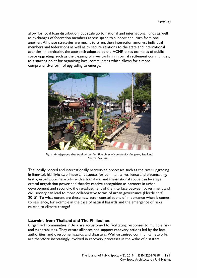
Astrid Ley
The Journal of Public Space, 4(2), 2019 | ISSN 2206-9658 | 171
City Space Architecture / UN-Habitat
allow for local loan distribution, but scale up to national and international funds as well as exchanges of federation members across space to support and learn from one another. All these strategies are meant to strengthen interaction amongst individual members and federations as well as to secure relations to the state and international agencies. In particular, the approach adopted by the ACHR takes examples of public space upgrading, such as the cleaning of river banks in informal settlement communities, as a starting point for organising local communities which allows for a more comprehensive form of upgrading to emerge.
Fig. 1. An upgraded river bank in the Ban Bua channel community, Bangkok, Thailand. Source: Ley, 2013.
The locally rooted and internationally networked processes such as the river upgrading in Bangkok highlight two important aspects for community resilience and placemaking: firstly, urban poor networks with a translocal and transnational scope can leverage critical negotiation power and thereby receive recognition as partners in urban development and secondly, the re-adjustment of the interface between government and civil society can lead to more collaborative forms of urban governance (Herrle et al, 2015). To what extent are these new actor constellations of importance when it comes to resilience, for example in the case of natural hazards and the emergence of risks related to climate change? Learning from Thailand and The Philippines Organised communities in Asia are accustomed to facilitating responses to multiple risks and vulnerabilities. They create alliances and support recovery actions led by the local authorities, and overcome hazards and disasters. Well-organised community networks are therefore increasingly involved in recovery processes in the wake of disasters.
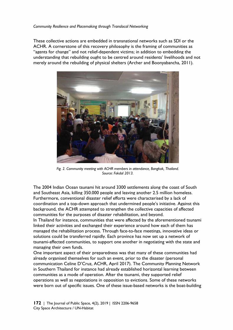
Community Resilience and Placemaking through Translocal Networking
172 | The Journal of Public Space, 4(2), 2019 | ISSN 2206-9658 City Space Architecture / UN-Habitat
These collective actions are embedded in transnational networks such as SDI or the ACHR. A cornerstone of this recovery philosophy is the framing of communities as “agents for change” and not relief-dependent victims; in addition to embedding the understanding that rebuilding ought to be centred around residents’ livelihoods and not merely around the rebuilding of physical shelters (Archer and Boonyabancha, 2011).
Fig. 2. Community meeting with ACHR members in attendance, Bangkok, Thailand. Source: Fokdal 2013.
The 2004 Indian Ocean tsunami hit around 3300 settlements along the coast of South and Southeast Asia, killing 350.000 people and leaving another 2.5 million homeless. Furthermore, conventional disaster relief efforts were characterised by a lack of coordination and a top-down approach that undermined people’s initiative. Against this background, the ACHR attempted to strengthen the collective capacities of affected communities for the purposes of disaster rehabilitation, and beyond. In Thailand for instance, communities that were affected by the aforementioned tsunami linked their activities and exchanged their experience around how each of them has managed the rehabilitation process. Through face-to-face meetings, innovative ideas or solutions could be transferred rapidly. Each province has now set up a network of tsunami-affected communities, to support one another in negotiating with the state and managing their own funds. One important aspect of their preparedness was that many of these communities had already organised themselves for such an event, prior to the disaster (personal communication Celine D’Cruz, ACHR, April 2017). The Community Planning Network in Southern Thailand for instance had already established horizontal learning between communities as a mode of operation. After the tsunami, they supported relief operations as well as negotiations in opposition to evictions. Some of these networks were born out of specific issues. One of these issue-based networks is the boat-building
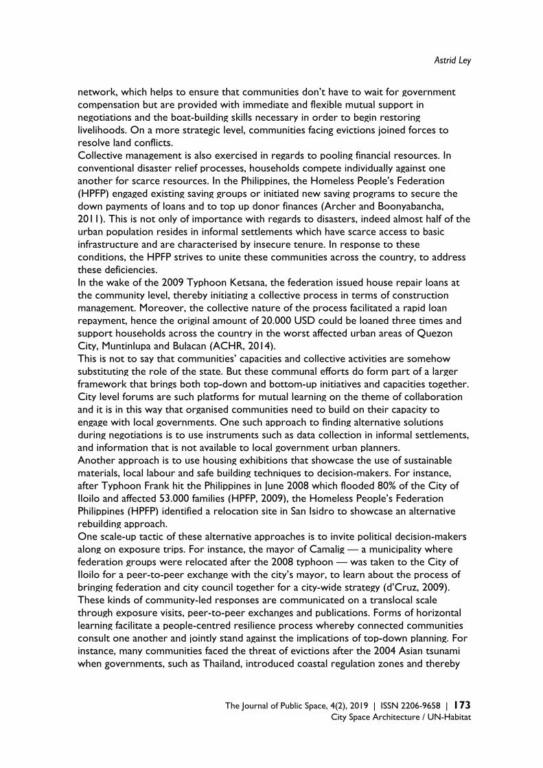
Astrid Ley
The Journal of Public Space, 4(2), 2019 | ISSN 2206-9658 | 173
City Space Architecture / UN-Habitat
network, which helps to ensure that communities don’t have to wait for government compensation but are provided with immediate and flexible mutual support in negotiations and the boat-building skills necessary in order to begin restoring livelihoods. On a more strategic level, communities facing evictions joined forces to resolve land conflicts. Collective management is also exercised in regards to pooling financial resources. In conventional disaster relief processes, households compete individually against one another for scarce resources. In the Philippines, the Homeless People’s Federation (HPFP) engaged existing saving groups or initiated new saving programs to secure the down payments of loans and to top up donor finances (Archer and Boonyabancha, 2011). This is not only of importance with regards to disasters, indeed almost half of the urban population resides in informal settlements which have scarce access to basic infrastructure and are characterised by insecure tenure. In response to these conditions, the HPFP strives to unite these communities across the country, to address these deficiencies. In the wake of the 2009 Typhoon Ketsana, the federation issued house repair loans at the community level, thereby initiating a collective process in terms of construction management. Moreover, the collective nature of the process facilitated a rapid loan repayment, hence the original amount of 20.000 USD could be loaned three times and support households across the country in the worst affected urban areas of Quezon City, Muntinlupa and Bulacan (ACHR, 2014). This is not to say that communities’ capacities and collective activities are somehow substituting the role of the state. But these communal efforts do form part of a larger framework that brings both top-down and bottom-up initiatives and capacities together. City level forums are such platforms for mutual learning on the theme of collaboration and it is in this way that organised communities need to build on their capacity to engage with local governments. One such approach to finding alternative solutions during negotiations is to use instruments such as data collection in informal settlements, and information that is not available to local government urban planners. Another approach is to use housing exhibitions that showcase the use of sustainable materials, local labour and safe building techniques to decision-makers. For instance, after Typhoon Frank hit the Philippines in June 2008 which flooded 80% of the City of Iloilo and affected 53.000 families (HPFP, 2009), the Homeless People’s Federation Philippines (HPFP) identified a relocation site in San Isidro to showcase an alternative rebuilding approach. One scale-up tactic of these alternative approaches is to invite political decision-makers along on exposure trips. For instance, the mayor of Camalig — a municipality where federation groups were relocated after the 2008 typhoon — was taken to the City of Iloilo for a peer-to-peer exchange with the city’s mayor, to learn about the process of bringing federation and city council together for a city-wide strategy (d’Cruz, 2009). These kinds of community-led responses are communicated on a translocal scale through exposure visits, peer-to-peer exchanges and publications. Forms of horizontal learning facilitate a people-centred resilience process whereby connected communities consult one another and jointly stand against the implications of top-down planning. For instance, many communities faced the threat of evictions after the 2004 Asian tsunami when governments, such as Thailand, introduced coastal regulation zones and thereby
Community Resilience and Placemaking through Translocal Networking
174 | The Journal of Public Space, 4(2), 2019 | ISSN 2206-9658 City Space Architecture / UN-Habitat
hindered the affected communities’ efforts to return. Networking opened the door for displaced communities that resided on coastal land to negotiate government land rights issues (ACHR, 2006).
Fig. 3. Housing exhibition at the San Isidro relocation site, Iloilo City, the Philippines.
Source: Fokdal 2013. Translocal connectivities are, however, not free of critique. The capacity of the urban poor to organise transnationally is disputed. Rather, transnational activities are considered to be of further burden on these already vulnerable groups (Pithouse, 2012). The implementation of such relationship-building beyond the locality only makes sense for communities if it is of relevance to the local context. In the context of the ACHR it is seen as a complementary strategy for otherwise place-based communities whose trust and opportunity for knowledge production and engagement with the state is based on proximity.
Astrid Ley
The Journal of Public Space, 4(2), 2019 | ISSN 2206-9658 | 175
City Space Architecture / UN-Habitat
Smaller geographies and constituencies support the principle that relationships matter, makes it possible to engage qualitatively with the nature of power, keeps the knowledge produced relevant to engage with the local politics and allows communities to go at their pace. I am learning that going global is not necessarily all good and actually jeopardizes the principles besides being more expensive. Global makes sense as long as it is deeply relevant to the local. (personal communication with Celine d’Cruz, May 2018)
Conclusion Prior organisation within individual communities and establishing connectivity beyond singular localities – sometimes on a national or even international level — need to be taken into consideration as significant aspects of community resilience and placemaking. Prior organisation is of significance because this is an important precondition for ensuring capacities for resilience before, during and after a crisis. Public space can be seen here as a catalyst for social interaction and joint activities. It facilitates community mobilisation and organisation before entering more complex community upgrading. Also of significance is the issue of connectivity between collective actors. The focus here is on translocal and transnational networks of urban poor, particularly around improving their livelihoods and in addition, settlements in Asia that mobilise members (often around the issue of public space upgrading), generate knowledge and facilitate the mobility of knowledge through a re-scaling of their established practices. This local-global activism is a new phenomenon which offers some initial indications as to its potential to influence community resilience in particular, and public space more generally. The translocal community networks in Thailand and the Philippines have shifted their focus from individual households to collective management strategies as a long-term solution. This also illustrates how communities are networking beyond the scope of rebuilding physical shelters and instead seeking a posits their livelihoods as the main focal point. Moreover, this translocal peer-to-peer support system seems to address some critical issues such as giving a stronger voice to disaster affected communities to express their needs to other actors. Nevertheless, two challenges must be considered. Firstly, as with any community process and related discourses around social capital there needs to be a critical assessment as to whether or not these activities ultimately lead to the exclusion of groups who are outside the networks (Twigg and Mosel 2018: 12). This also applied to translocal community resilience and placemaking. Secondly, community-led processes with a focus on translocal network-building need to build on capacities and investments in terms of time to mobilise and establish relationships. However, this often overburdens already vulnerable communities and stands in stark contrast to the rapid response agenda favoured by many donors in post-disaster situations (Archer and Boonyabancha, 2011). In addition to community resilience and placemaking, translocal activities need to be considered as a complementary strategy capable of creating synergies, to the responsibilities and efforts of other actors for achieving a state of overall resilience in
Community Resilience and Placemaking through Translocal Networking
176 | The Journal of Public Space, 4(2), 2019 | ISSN 2206-9658 City Space Architecture / UN-Habitat
cities, and be further acknowledged in global policy related to public space. Until now, translocal activities have been overlooked in favour of pro-active community involvement and the ability to be resilient in public spaces. Acknowledgment The article draws on findings of research conducted with a focus on transnational connections of urban poor (Herrle et al 2015) and an expert group workshop on "Collective action and resilience in emerging city regions" organised at the University of Stuttgart in April 2017. A shorter and earlier version was published as a conference proceeding – see: Ley, A.: Translocal networking as a cornerstone for community resilience: Activities by the Asian Coalition of Housing Rights (ACHR), International Forum on Urbanism Conference “Reframing Urban Resilience Implementation”, Barcelona, December 2018, https://sciforum.net/manuscripts/5996/manuscript.pdf (accessed 09. August 2019). I would like to thank Celine d’Cruz from the Asian Coalition for Housing Rights and Josefine Fokdal from the University of Stuttgart for their constructive comments concerning early versions of the manuscript. References Appadurai, A. (1996). Modernity at large: cultural dimensions of globalization, Minneapolis:
Minnesota Press. Archer, D. and Boonyabancha, S. (2011). ‘Seeing a disaster as an opportunity- harnessing the
energy of disaster survivors for change’, Environment and Urbanization, 23(2), 351-364. Asian Coalition for Housing Rights (ACHR) (2014). ‘Homeless People’s Federation Philippines in
15 cities and 6 disaster-hit areas’, in Cities in Asia, Fifth Yearly Report of the Asian Coalition for Community Action Program, 215, 41.
Asian Coalition for Housing Rights (ACHR) (2006). ‘The Power of People’s Networks: Vulnerable communities find that linking together in different ways allows them to do all kinds of things they could never do in isolation’, Tsunami Update, 5, available: http://www.achr.net/upload/downloads/file_22122013021601.pdf [accessed 29 Sept 2019].
Bahadur, A., Lovell, E., Wilkinson, E., Tanner, T. (2015). ‘Resilience in the SDGs: Developing an indicator for Target 1.5 that is fit for purpose’, ODI briefing papers, August 2015, available: https://www.odi.org/sites/odi.org.uk/files/odi-assets/publications-opinion-files/9780.pdf [accessed 29 Sept 2019].
Berkes, F., Ross, H., (2012). ‘Community Resilience: Toward an Integrated Approach’, Society & Natural Resources, 26(1), 5-20.
Burton, I. (1997). ‘Vulnerability and adaptive response in the context of climate and climate change’, Climatic Change, 36(1-2), 185-196.
Campanella, T.J. (2006). ‘Urban resilience and the recovery of New Orleans’, Journal of the American Planning Association, 72(2), 141–146.
Carmona, M., Heat, T., Oc, T. and Tiesdell, S. (2003). Public Places, Urban Spaces: The Dimensions of Urban Design, London: Architectural Press.
Chaskin, R. J. (2007). ‘Resilience, Community, and Resilient Communities: Conditioning Contexts and Collective Action’, Child Care in Practice, 14(1), 65-74.
Cutter, S. L., Barnes, L., Berry, M., Burton, C., Evans, E., Tate, E. and Webb, J. (2008). ‘A place-based model for understanding community resilience to natural disasters’, Global Environmental Change, 18, 598-606.
Astrid Ley
The Journal of Public Space, 4(2), 2019 | ISSN 2206-9658 | 177
City Space Architecture / UN-Habitat
d’Cruz, C. (2009). ‘Leadership in urban areas’, Tiempo, 72, p. 3-8. Download: http://www.citiesalliance.org/ca/sites/citiesalliance.org/files/CA_Images/Tiempo_CelinedCruz_July09.pdf [accessed 01. July 2018].
Gaventa, J. and Tandon, R. (eds.) (2010). Globalizing Citizens: New Dynamics of Inclusion and Exclusion, London: Zed Books.
Gerson, K., Stueve, A. and Fischer, C.S. (1977). ‘Attachment to Place’, In Fischer, C.S. et al (eds.), Networks and Places: Social Relations in the Urban Setting, New York: The Free Press.
Goodyear, S. (2013) ‘Resilience Is About Relationships, Not Just Infrastructure’, https://www.citylab.com/environment/2013/01/resilience-about-relationships-not-just-infrastructure/4305/ (accessed 22 August 2019).
Harari, Y. N. (2018). 21 Lessons for the 21st Century, London: Jonathan Cape. Herrle, P., Ley, A. and Fokdal, J. (eds.) (2015). From Local Action to Global Networks: Housing the
Urban Poor, London: Ashgate. Homeless People’s Federation Philippines (HPFP) Thinking City-Wide in Iloilo City, Philippines,
Blog http://homelessiloilo.blogspot.com [accessed 06 August 2018]. Keck, M. and Sakdapolrak, P. (2013). ‘What is social resilience? Lessons learned and ways
forward’, Erdkunde, 67 (1), 5-19. Klinenberg, E. (2002). Heat wave: a social autopsy of disaster in Chicago, Chicago: Chicago Press. Krätke, S., Wildner, K. and Lanz, S. (eds.) (2012). Transnationalism and Urbanism, Routledge
Research in Transnationalism, 25, Routledge: London and New York. Kropp C., Türk J. (2017). ‘Bringing Climate Change Down to Earth: Climate Change
Governance from the Bottom Up’, In Esguerra, A., Helmerich, N. and Risse T. (eds.) Sustainability Politics and Limited Statehood. Governance and Limited Statehood, Cham: Palgrave Macmillan, 179-210.
Kwok, A.H., Doyle, E.E.H., Becker, J., Johnston, D. and Paton, D. (2016). ‘What is “social resilience”? Perspectives of disaster researchers, emergency management practitioners, and policy makers in New Zealand’, International Journal of Disaster Risk Reduction, 19, 197–211.
Leong, K. J., Airriess, C.A., Li, W., Chia-Chen Chen, A. and Keith, V.M. (2007). ‘Resilient History and the Rebuilding of a Community: The Vietnamese American Community in New Orleans East’, in The Journal of American History, 94 (3), 770-779.
Maclean, K., Cuthill, M., and Ross, H. (2014). ‘Six attributes of social resilience’, Journal of Environmental Planning and Management, 57(1), 144-156.
Meerow, S., Newell, J.P. and Stults, M. (2016). ‘Defining Urban Resilience: A review’, in Landscape and Urban Planning, 147, 38–49.
Mendoza-Arroyo, C. and Chelleri, L. (2017). ‘The Potential of Community Resilience in Unveiling Social-Economic Dynamics for Informal Settlement Up-Grading’, in: Tieben, H., Geng, Y. and Rossini, F. (eds.) The Entrepreneurial City, 10th conference of the International Forum on Urbanism (IFoU), Rotterdam: International Forum on Urbanism (IFoU), 169-180.
Miraftab F. (2009). ‘Insurgent Planning: Situating Radical Planning in the Global South’, Planning Theory, 8 (1), 32-50.
Moser, C. and Stein, A. (2011). ‘Implementing urban participatory climate change adaptation appraisals: a methodological guideline’, Environment and Urbanization, 23(2), 463–485.
Mulligan, M., Steele, W., Rickards, L., and Funfgeld, H. (2016). ‘Keywords in planning: what do we mean by ‘community resilience’?’ International Planning Studies, 21(4), 348–361.
Pithouse, R. (2012). ‘Move from and not on the Occult Zone (Where the People Dwell): An Argument for the Political Priority of Solidarity with Popular (and Largely Situated) Mobilization by the Poor over Transnational Organization by Civil Society’, in: Krätke, S.,
Community Resilience and Placemaking through Translocal Networking
178 | The Journal of Public Space, 4(2), 2019 | ISSN 2206-9658 City Space Architecture / UN-Habitat
Wildner, K. and Lanz, S. (eds.) Transnationalism and Urbanism, Routledge Research in Transnationalism, 25, Routledge: London and New York,197-223.
PT - Lehrstuhl für Planungstheorie und Stadtentwicklung RWTH Aachen University (2017). ‘Öffentliche Räume in stadtgesellschaftlich vielfältigen Quartieren: Nutzung, Wahrnehmung und Bedeutung‘, PT Materialien No. 37.
Rahman, Md. S. and Kausel, T. (2013). ‘Coastal Community Resilience to Tsunami: A Study on Planning Capacity and Social Capacity, Dichato, Chile’, IOSR Journal Of Humanities And Social Science,12 (6), 55-63.
Saja, A. A.M., Teo, M., Goonetilleke, A. and Ziyath, A.M. (2018). ‘An inclusive and adaptive framework for measuring social resilience to disasters’, International Journal of Disaster Risk Reduction, 28, 862–873.
Sassen, S. (2004). ‘Local Actors in Global Politics’, Current Sociology, 52(4): 649-670. Satterthwaite, D. (2011). ‘Editorial: Why is community action needed for disaster risk reduction
and climate change adaptation?’, Environment and Urbanization, 23(2): 339-349. Sherrieb, K., Norris, F. H. and Galea, S. (2010). ‘Measuring Capacities for Community
Resilience’, Social Indicators Research, 99(2), 227–247. Smith, M.P. (1998). Transnational Urbanism. Locating Globalization, Blackwell: Malden. Twigg, J. and Mosel, I. (2018). ‘Informality in urban crisis response’, ODI working paper, 532,
March 2018, available: https://www.odi.org/sites/odi.org.uk/files/resource-documents/12065.pdf [accessed 29 Sept 2019].
UN-Habitat (2016). ‘Global Public Space Toolkit: From Global Principles to Local Policies and Practice’, Nairobi, Revision February 2016, available: https://unhabitat.org/wp-content/uploads/2015/10/Global%20Public%20Space%20Toolkit.pdf [accessed 29 Sept 2019].
United Nations (UN) (2014). ‘Pro-poor urban climate resilience in Asia and the pacific, Nairobi, available: http://www.unescap.org/sites/default/files/Quick%20Guide%20for%20Policy%20Makers.pdf [accessed 06 April 2018].
United Nations Task Team (2015). ‘Habitat III Issue Papers. HABITAT III ISSUE PAPERS. 15 Urban Resilience, New York, 31 May 2015, available: http://habitat3.org/wp-content/uploads/Habitat-III-Issue-Paper-15_Urban-Resilience-2.0.pdf [accessed 06 April 2018].
Walker, B. and Salt, D. (2012). Resilience Practice: Building Capacity to Absorb Disturbance and Maintain Function, Island Press: Washington D.C.
Wamsler, C. (2014). Cities, Disaster Risk and Adaptation, Routledge: London. Wilson, G. A. (2014). ‘Community resilience: path dependency, lock-in effects and transitional
ruptures’, Journal of Environmental Planning and Management, 57(1), 1-26.
The Journal of Public Space ISSN 2206-9658 2019 | Vol. 4 n. 2 https://www.journalpublicspace.org
ISSN 2206-9658 | 179
City Space Architecture / UN-Habitat
Simulation, Control and Desire: Urban Commons and Semi-Public Space Resilience in the Age of Augmented Transductive Territorial Production
Manfredo Manfredini University of Auckland, School of Architecture and Planning, New Zealand [email protected] Abstract Considering place-based participation a crucial factor for the development of sustainable and resilient cities in the post-digital turn age, this paper addresses the socio-spatial implications of the recent transformation of relationality networks. To understand the drivers of spatial claims emerged in conditions of digitally augmented spectacle and simulation, it focuses on changes occurring in key nodes of central urban public and semi-public spaces of rapidly developing cities. Firstly, it proposes a theoretical framework for the analysis of problems related to socio-spatial fragmentation, polarisation and segregation of urban commons subject to external control. Secondly, it discusses opportunities and criticalities emerging from a representational paradox depending on the ambivalence in the play of desire found in digitally augmented semi-public spaces. The discussion is structured to shed light on specific socio-spatial relational practices that counteract the dissipation of the “common worlds” caused by sustained processes of urban gentrification and homogenisation. The theoretical framework is developed from a comparative critical urbanism approach inspired by the right to the city and the right to difference, and elaborates on the discourse on sustainable development that informs the New Urban Agenda. The analysis focuses on how digitally augmented geographies reintroduce practices of participation and commoning that reassemble fragmented relational infrastructures and recombine translocal social, cultural and material elements. Empirical studies on the production of advanced simulative and transductive spatialities in places of enhanced consumption found in Auckland, New Zealand, ground the discussion. These provide evidence of the extent to which the agency of the augmented territorialisation forces reconstitutes inclusive and participatory systems of relationality. The concluding notes, speculating on the emancipatory potential found in these social laboratories, are a call for a radical redefinition of the approach to the problem of the urban commons. Such a change would improve the capacity of urbanism disciplines to adequately engage with the digital turn and efficaciously contribute to a maximally different spatial production that enhances and strengthens democracy and pluralism in the public sphere. Keywords: semi-public space, transductive spatialities, urban commons
T
HE
JO
UR
NA
L O
F P
UB
LIC
SP
AC
E
To cite this article: Manfredini, M. (2019), Simulation, Control and Desire: Urban Commons and Semi-Public Space Resilience in the Age of Augmented Transductive Territorial Production. The Journal of Public Space, 4(2), 179-198, DOI 10.32891/jps.v4i2.1209 This article has been double blind peer reviewed and accepted for publication in The Journal of Public Space.
This work is licensed under a Creative Commons Attribution - Non Commercial 4.0 International License https://creativecommons.org/licenses/by-nc/4.0/
Simulation, Control and Desire
180 | The Journal of Public Space, 4(2), 2019 | ISSN 2206-9658 City Space Architecture / UN-Habitat
1. Appraising the complexity of contemporary urban commons As part of the “world in common,” inclusionary urban commons are key civic institutions –crucially also including public space – for the affirmation of the collective dimension of the city and its development as a just, safe, healthy, accessible, affordable and resilient place (Borch & Kornberger, 2015; Flusty, 1997; Garnett, 2012). As such, these commons are a universally accessible part of the common non-commodifiable asset, whose conception, construction, management and usage are expression of open, collective and pluralistic associations. The domain of their free and participatory networks comprehends four main areas: a) production, consumption, and safeguarding of public services and goods; b) relationality communication, interaction, and encounter; c) culture and creativity; and, most important, d) politics and citizenship. Problems affecting the world in common have been central in the modern discourse on urbanisation (Hardt & Negri, 2009; Harvey, 2011, 2012; Hodkinson, 2012; Lee & Webster, 2006; Lefebvre, 1996; Parr, 2015; Purcell, 2002; Stanek, 2011; Susser & Tonnelat, 2013) and have recently been addressed by the New Urban Agenda (2016), the highest level document including global principles, policies and standards for urban development. Among the streams on relations between space and political spheres, and critical changes in urban society, a leading area has concentrated on the public realm and the critique of the decay of the public condition with the crisis of public interactions and expressions (McQuire, 2008; Sennett, 1977, 2008). Causes linked to the expansion of private power and control systems have been discussed with fundamental references to the work of Hannah Arendt (1958), who focused on the occlusion of the political sphere towards plurality of human difference; Jurgen Habermas, who examined societal contradictions of the modern “feudalisation” of the public sphere in relation to the negation of citizenship rights (Calhoun, 1992); and Nancy Fraser (1993), whose discourse on the multiplicity of publics and the publicness of some private elements addressed emerging issues of inequality and relationality, segmentation and subordination. Critical stances on these issues have consolidated and become robust particularly around issues of spatial control (Dehaene & De Cauter, 2008a; Foucault 1995; Harvey, 2003), socio-economic polarisation processes concerning privatisation (Dawson, 2010; Lee & Webster, 2006; Low, 2006; Minton, 2012; Soja, 2010); spatial justice (Low & Smith 2006; Mitchell, 2003); socio-spatial segmentation (Dawson, 2010; Harvey, 2003; Hodkinson, 2012); consumption and alienation (Debord, 1983; Firat & Venkatesh, 1995; Miles & Miles, 2004); and selective deprivation of public space (Davis, 1990; Harvey, 2003; Mitchell, 1995, 2003; Sorkin, 1992). In the production of public realm, the penetration of the private sector affects all levels of conception, delivery, and governance, and progressively expands globally. Recent decades have seen its very acute diffusion in contexts of rapid urbanisation both in Asia and Australasia, starting from the decolonising territories, such as Hong Kong, Singapore, Australia and New Zealand, to massively propagate in the growing economies of largest East and Southeast Asian countries, such as China and Indonesia. For the appraisal of the growing complexity of this phenomenon, a comparative urbanism approach is adopted here to address the way regional differences produce specific countering forces and organisations that strengthen the resiliency of local communities and their capacity to protect the commons. This approach can critically analyse the complexity of these antagonist forces in their contexts and systematically

Manfredo Manfredini
The Journal of Public Space, 4(2), 2019 | ISSN 2206-9658 | 181
City Space Architecture / UN-Habitat
understand similarities and differences among different processes to contribute to the development of the discourse on such a rapidly evolving matter. By establishing an intimate relation between theoretical work and empirical practice, it is not only possible to align the nature of the research practice to that of the studied phenomenon, but, importantly, to entirely appreciate the contribution to theory of particular phenomena emerging in urban laboratories, such as the Chinese Special Administrative Zones, that present non-generalisable power relations. This approach uses a mixed methodology that both disentangles and maintains the associated, complex and concurrent aspects of each process spatial production: the conceived, lived and represented dimensions. This investigation is framed by and bridges major research traditions in critical urbanism: firstly the work on space of Henry Lefebvre (1991 [1974], 1996, 2003 [1970], 2004 [1992]; Goonewardena, Kipfer, Milgrom & Schmid, 2008; Purcell 2002, 2014; Soja 1998, 2000); secondly Richard Sennett’s (1977, 2008, 2018) idea of the open city; and lastly territorial research related to actor-network and assemblage theories (Anderson & McFarlane 2011; Deleuze & Guattari 1987, 2000; Farías & Bender, 2010; Latour 1999, 2005; Law, 2009; McFarlane 2011; Murdoch 1998). A specific development of ANT, territoriological studies, provides important support to address the “unpredictable multiplication, interpenetration and ongoing production” (Brighenti, 2014: 2) of territories that characterise the commons of our age (Brighenti, 2014: 3 and passim; Kärrholm, 2012; Merriman, 2012). Territorial behaviour studies help to understand the spatial production of enduring networks where plasticity has become a fundamental characteristic. They provide instruments to unravel individual practices as well as complex associational processes within specific translocalised, distributed and diffused systems where nodes (people and things), bodies (stabilised sub-associations of nodes) and sorts (stabilised patterns composed of variable nodes) establish a large variety of open, mobile, migrating and non-linear configurational dynamics over space and time. The concentration on strategies of occupation, tactics of appropriation, and effects of association of socio-spatial constitutive processes progressively expands from individual acts and actors into multidimensional assemblages of practices and apparatuses with heterochronic relations. The analysis of practices and apparatuses elicits the irreducible specificity of each actor – or to use Bruno Latour’s (1999: 303; 2005: 71) terminology, actant – in its physical (devices, materials and objects), social (routines, bonds, alliances and conflicts) and semantic (languages, signs and representations) aspects. The actants are also explored in their permanent involvement in loops of establishing and re-establishing “chains of activation and reactivity” (Brighenti, 2014: 20) through processes that are either routine or ad hoc, confined and translocal, and tangible and intangible. The chains are addressed to evaluate their effectiveness and efficaciousness in shaping, organising and transforming the public socio-spatial systems of the city. Each peculiar form, dynamic and effect generated by situated aggregations of associative systems is seen as an expression of chains of relations reflecting the fundamental tension between territorial grounding and relational responsiveness (Massey, 2007). Particularly relevant in the background of this discussion on spatialisations of relational systems is the contention of the ontogenetic capacity of urban space and the correlative citizens’ right to the city (Harvey, 2008; Lefebvre, 1996; Park, 1967) that concern historically specific material, and conceptual and quotidian practices of appropriation,
Simulation, Control and Desire
182 | The Journal of Public Space, 4(2), 2019 | ISSN 2206-9658 City Space Architecture / UN-Habitat
association and control (Lefebvre, 1991 [1947]). This tenet has been recently adopted by the New Urban Agenda (2016), advocating for a pluralist and inclusive public sphere that constitutes an effective antidote to the progressive fragmentation of the social, cultural and environmental body of the city. Plurality, freedom, and autonomy of thought and action are seen as indispensable to an exercise of this right that enables the establishment of emancipatory and equitable spatialities of integral relationality (Villa, 1992). Imbued in it, is the Arendtian idea of a democratic agonistic pluralism that sustains equitable participation in social dialogue and exchange of our increasing cosmopolitan conditions, acknowledging conflict as essential elements of the political in a complex civil society (Mouffe, 1999, 2008). Recognising difference as irreducible and non-substitutable value of pluralism, this framework provides theoretical instruments to detect and evaluate the growth and appearance of concrete instances of spatialised practices that set free diversifying forces to overcome divisions, repetitions and confinement and enable us to maintain centrality in “make and remake ourselves and our cities” (Harvey, 2008: 23). Differentiation, a process whose maximal expression ensures the exercise of collective power over the processes of urbanisation and socialisation, is therefore identified as a fundamental “right.” The right to difference (Lefebvre, 1987: 396) protects the citizen against the attempt of hegemonic economic groups to expand their dominating power with processes of abstraction that normalise and homogenise diversity. Yet, maximal differentiation is not an external force, but develops within and in antagonism to abstractive domains. It internally opposes the deceptive stratagems of abstract space that, by implementing “technology, applied sciences, and knowledge bound to power” to cast sameness (“induced diversity”) as multiplicity, “fetishize space” and make “the milieu of the commodity… become a commodity”, to progressively “set itself up as the space of power” (Lefebvre, 1991 [1974]: 50-51). This capacity of differentiation to emerge from its most adverse conditions is confirmed by a paradox identified by Foucault (2001) in an interview where he stated that “at that very moment it became apparent that if one governed too much, one did not govern at all – that one provoked results contrary to those one desired” (352). The author’s previous studies on differential coutermovements emerged within local manifestations of abstractive globalising state or corporate apparatuses have shown how relevant forces for the reconstitution of urban integrity can grow from spatialised practices (“I do not think that there is anything that is functionally – by its very nature – absolutely liberating. Liberty is a practice” [Foucault, 2005: 354]) virtual-spatial assemblages transversally diffused through societal strata. The metamorphic, loose constitution, plural potentiality and self-organisation of micropolitics and creative becoming of these tangible forces generated “insurgent citizenship” forms that incrementally instituted themselves as major stabilised associations. Their production had various origins, ranging from the political activism of such actors as members of the networked transnational movement that emerged (Figure 1) in the Istanbul’s Gezi park protest (Manfredini, Zamani, & Leardini, 2017), to the accomplices behaviour of those who constituted the participatory post-consumerist communities of the major New Zealand malled metropolitan centre (Manfredini, 2019). Importantly, these forces have a dual dynamic. On one hand they grew through resonance machinic processes (Connolly, 2005) that feed on the antagonist mechanisms of deception sympathetically mirroring
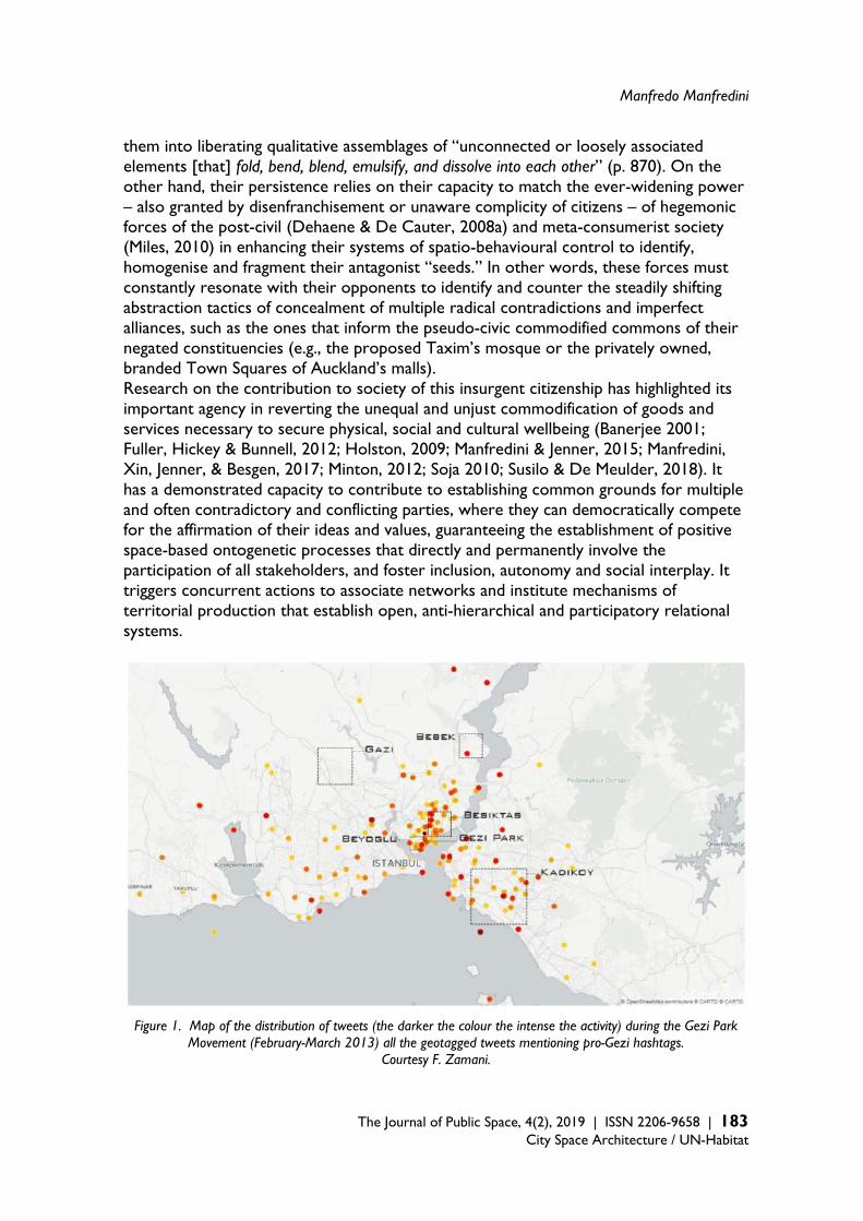
Manfredo Manfredini
The Journal of Public Space, 4(2), 2019 | ISSN 2206-9658 | 183
City Space Architecture / UN-Habitat
them into liberating qualitative assemblages of “unconnected or loosely associated elements [that] fold, bend, blend, emulsify, and dissolve into each other” (p. 870). On the other hand, their persistence relies on their capacity to match the ever-widening power – also granted by disenfranchisement or unaware complicity of citizens – of hegemonic forces of the post-civil (Dehaene & De Cauter, 2008a) and meta-consumerist society (Miles, 2010) in enhancing their systems of spatio-behavioural control to identify, homogenise and fragment their antagonist “seeds.” In other words, these forces must constantly resonate with their opponents to identify and counter the steadily shifting abstraction tactics of concealment of multiple radical contradictions and imperfect alliances, such as the ones that inform the pseudo-civic commodified commons of their negated constituencies (e.g., the proposed Taxim’s mosque or the privately owned, branded Town Squares of Auckland’s malls). Research on the contribution to society of this insurgent citizenship has highlighted its important agency in reverting the unequal and unjust commodification of goods and services necessary to secure physical, social and cultural wellbeing (Banerjee 2001; Fuller, Hickey & Bunnell, 2012; Holston, 2009; Manfredini & Jenner, 2015; Manfredini, Xin, Jenner, & Besgen, 2017; Minton, 2012; Soja 2010; Susilo & De Meulder, 2018). It has a demonstrated capacity to contribute to establishing common grounds for multiple and often contradictory and conflicting parties, where they can democratically compete for the affirmation of their ideas and values, guaranteeing the establishment of positive space-based ontogenetic processes that directly and permanently involve the participation of all stakeholders, and foster inclusion, autonomy and social interplay. It triggers concurrent actions to associate networks and institute mechanisms of territorial production that establish open, anti-hierarchical and participatory relational systems.
Figure 1. Map of the distribution of tweets (the darker the colour the intense the activity) during the Gezi Park Movement (February-March 2013) all the geotagged tweets mentioning pro-Gezi hashtags.
Courtesy F. Zamani.
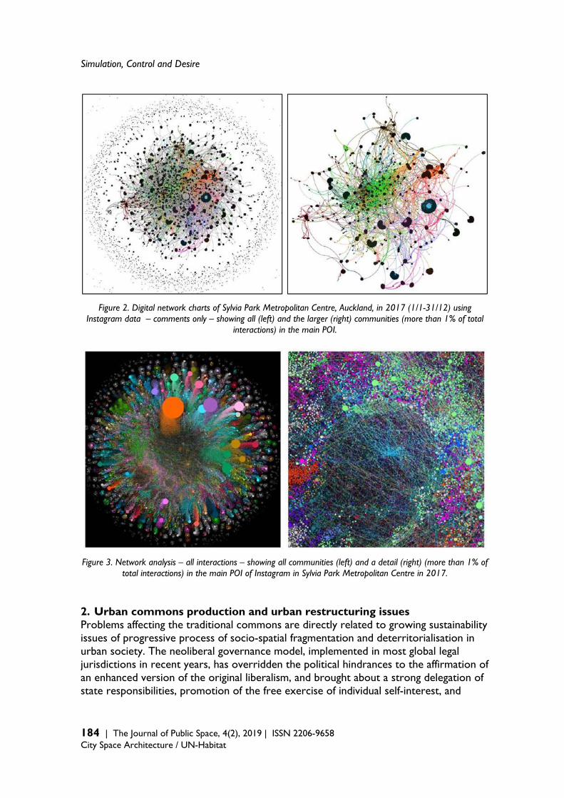
Simulation, Control and Desire
184 | The Journal of Public Space, 4(2), 2019 | ISSN 2206-9658 City Space Architecture / UN-Habitat
Figure 2. Digital network charts of Sylvia Park Metropolitan Centre, Auckland, in 2017 (1/1-31/12) using Instagram data – comments only – showing all (left) and the larger (right) communities (more than 1% of total
interactions) in the main POI.
Figure 3. Network analysis – all interactions – showing all communities (left) and a detail (right) (more than 1% of total interactions) in the main POI of Instagram in Sylvia Park Metropolitan Centre in 2017.
2. Urban commons production and urban restructuring issues Problems affecting the traditional commons are directly related to growing sustainability issues of progressive process of socio-spatial fragmentation and deterritorialisation in urban society. The neoliberal governance model, implemented in most global legal jurisdictions in recent years, has overridden the political hindrances to the affirmation of an enhanced version of the original liberalism, and brought about a strong delegation of state responsibilities, promotion of the free exercise of individual self-interest, and
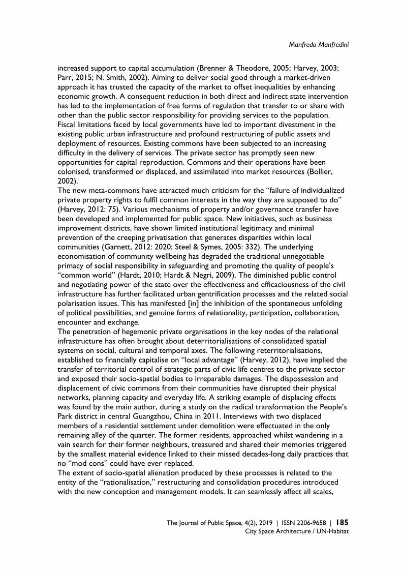
Manfredo Manfredini
The Journal of Public Space, 4(2), 2019 | ISSN 2206-9658 | 185
City Space Architecture / UN-Habitat
increased support to capital accumulation (Brenner & Theodore, 2005; Harvey, 2003; Parr, 2015; N. Smith, 2002). Aiming to deliver social good through a market-driven approach it has trusted the capacity of the market to offset inequalities by enhancing economic growth. A consequent reduction in both direct and indirect state intervention has led to the implementation of free forms of regulation that transfer to or share with other than the public sector responsibility for providing services to the population. Fiscal limitations faced by local governments have led to important divestment in the existing public urban infrastructure and profound restructuring of public assets and deployment of resources. Existing commons have been subjected to an increasing difficulty in the delivery of services. The private sector has promptly seen new opportunities for capital reproduction. Commons and their operations have been colonised, transformed or displaced, and assimilated into market resources (Bollier, 2002). The new meta-commons have attracted much criticism for the “failure of individualized private property rights to fulfil common interests in the way they are supposed to do” (Harvey, 2012: 75). Various mechanisms of property and/or governance transfer have been developed and implemented for public space. New initiatives, such as business improvement districts, have shown limited institutional legitimacy and minimal prevention of the creeping privatisation that generates disparities within local communities (Garnett, 2012: 2020; Steel & Symes, 2005: 332). The underlying economisation of community wellbeing has degraded the traditional unnegotiable primacy of social responsibility in safeguarding and promoting the quality of people’s “common world” (Hardt, 2010; Hardt & Negri, 2009). The diminished public control and negotiating power of the state over the effectiveness and efficaciousness of the civil infrastructure has further facilitated urban gentrification processes and the related social polarisation issues. This has manifested [in] the inhibition of the spontaneous unfolding of political possibilities, and genuine forms of relationality, participation, collaboration, encounter and exchange. The penetration of hegemonic private organisations in the key nodes of the relational infrastructure has often brought about deterritorialisations of consolidated spatial systems on social, cultural and temporal axes. The following reterritorialisations, established to financially capitalise on “local advantage” (Harvey, 2012), have implied the transfer of territorial control of strategic parts of civic life centres to the private sector and exposed their socio-spatial bodies to irreparable damages. The dispossession and displacement of civic commons from their communities have disrupted their physical networks, planning capacity and everyday life. A striking example of displacing effects was found by the main author, during a study on the radical transformation the People’s Park district in central Guangzhou, China in 2011. Interviews with two displaced members of a residential settlement under demolition were effectuated in the only remaining alley of the quarter. The former residents, approached whilst wandering in a vain search for their former neighbours, treasured and shared their memories triggered by the smallest material evidence linked to their missed decades-long daily practices that no “mod cons” could have ever replaced. The extent of socio-spatial alienation produced by these processes is related to the entity of the “rationalisation,” restructuring and consolidation procedures introduced with the new conception and management models. It can seamlessly affect all scales,

Simulation, Control and Desire
186 | The Journal of Public Space, 4(2), 2019 | ISSN 2206-9658 City Space Architecture / UN-Habitat
from macroscopic to microscopic, ranging from the formation of large exclusionary urban enclosures to the introduction of an individual building’s regulations that exclude access by “undesirables,” such as anti-social youth and the homeless (Doherty et al., 2008). These reterritorialisations often include strategies that economise local cultural advantage and cast the relationships between local communities and places into vulgarised representations. Several creative city-led urban redevelopments, renewals and re-imaging programmes have included the staging and simulation of authentic elements and disrupted the relational chains that can guarantee a sustainable development and preserve a sense of belonging and identity of places (Mommaas, 2004; Shepherd, 2002; Zukin, 1991). The survival of isolated fragments of both tangible and intangible historical networks and institutions that support the physical, social and cognitive-spatial dimensions of locales is often conducive to their complete dismissal. This not only affects the local communities that have shaped themselves and their spatialities over time, but also the wider society that shares “not only with those who live with us, but also with those who were here before and those who will come after us” (Arendt, 1958: 55; Benhabib, 2000) what it has in common through the network of consolidated relational assemblages This replacement of common worlds with users’ alienated semi-public enclosures also brings about problems of suspension of democratic accountability. Research shows the critical effects on communicative acting of exclusionary, censorship, surveillance practices enacted in privately governed urban places (Atkinson, 2003; Loukaitou-Sideris, 1993; Minton, 2012). The deprivation of possibility to participate in open processes of publicly relevant urban spaces creates “strangely ‘placeless’ places, cut off from their original wellsprings of local life and vitality” (Minton, 2012: 4), undermining trust, citizenship and democracy. In places like shopping malls, the deprivation that affects basic rights is deliberately exercised and explicitly stated in regulations or codes of conduct. The ban on any activity purposely disturbing the public peace, or interfering with the flow of visitors, and other behavioural limitations often include the negation of freedom regarding to assemble and congregate in groups of three or more; wear apparel that disguises, obscures or conceals the face; and engage in expressive activities not sponsored by the governing organisations. Some privately owned public spaces, such as the “excess plot ratio” networks of corridors, halls, plazas and flyovers of Hong Kong, usually have publicly approved regulations allowing their governing bodies to “cleanse” social space, with actions such as excluding “any person causing nuisance” or restricting usage to mere right of passage (Cuthbert & McKinnel, 2001). Economised urban infrastructures, surrogating and supplanting the public ones, constitute systems of institutions that interfere with the physical and social spatialities of the commons of the traditional city, upsetting their distribution, displacing their spatial practices, and perturbing the perception of their networks. These disruptions originate from competitive and dominant instead of complementary and collaborative objectives that tend to opportunistically intercept and exploit systemic opportunities rather than contribute to expand them. As sets of engrafted prosthetic organs – constituted by commons where indeterminacy is substituted with over-determination, such as festivalisation of marketplaces and choreographization of mall atriums – they redefine centralities, deterritorialise consolidated geographies and reterritorialize within
Manfredo Manfredini
The Journal of Public Space, 4(2), 2019 | ISSN 2206-9658 | 187
City Space Architecture / UN-Habitat
controlled enclosures. These enclosures have been described as all-inclusive and semi-autonomous mini-cities with enclavic character that exacerbate the on-going segmentation and polarisation of the wider city (Shane, 2011: 329ss). Their antagonism to the traditional open systems is manifested not only in their introversion, but also in the seamless transitional space that interconnects them. This space is made of armatures, such as urban freeways and subways, that have high capacity, social neutrality, and weld the scattered enclosures into seamless city-wide rhizomatic assemblages Specific to the enclavic assemblages is the strong transductional capacity (i.e., the ability to use information to iteratively transform perception and usage of space) that makes them a peculiar kind of Foucauldian heterotopia. The extension and complexity of their systems transform interiors into exteriors, peripheries in to centres, making their introverted, displaced and disjoined places sites of normalised and habitual experience. Their all-inclusiveness reproduces, as an allegoric mirroring, the “real” centres of the city that they supplant: by normalising both discontinuity and simulative reproduction, they contest, suspend, neutralise or invert the set of relations that they simultaneously designate (Foucault, 1995, 2008 [1982]). Importantly, these assemblages produce sequences of conflicting juxtapositions that both formally and semantically frame the displaced reproductions with the most obvious representational and functional reference: the ideal city. As described by Gernot Bohme (2012: 258), imposing meta-narratives of “cityness” evokes meanings, experiences and patterns of what is “other” to them. Overarching structures of coordinated typo-morphological reproductions of stereotypical representations mirror “past or distant public places” (Goss 1993: 19). Pseudo-commons, such as arcaded streets, fountain squares, local market halls, establish the backbone of their urban structure with imitative layouts, massing, material connotations and naming. Places are often named to proclaim their virtual publicness as “civic plazas,” “town squares” (Manfredini, 2017); occasionally, ostenting bold explicit themes, such as the Venetia, Parisian and Londoner flagship Sands mega-resort cluster in Macau. The corollary function of these “fixed scenes” is to set the tone for chains of sub-otherness of shopping and entertainment to be nestled “ad infinitum.” 3. From ambivalence to contradiction: The illusionary compensation of
“othernesses” and the abstractive differentialism of simulacra Among the numerous theoretical interpretations that analyse the efficaciousness of the hyper-spatialities of these heterotopic places in establishing themselves as prime social catalysts in our cities, significant ones focus on their capacity to constitute apparatuses that lure their users by producing illusionary environments. Particularly useful, to critically address the evolution of this discussion on the age of pervaded augmented representation, are the specific contributions to the discourse on illusion and simulation in complex relational systems of Michel Foucault and the duo Deleuze and Guattari. Elaborating the concept of heterotopia, Foucault delineates a systematic description of its constitutive principles, including one that concerns its function to relate the real and the imaginary (De Cauter & Dehaene, 2008b: 25, 27). This function is to regulate the relations between the heterotopic place and “the rest,” by embodying the non-real
Simulation, Control and Desire
188 | The Journal of Public Space, 4(2), 2019 | ISSN 2206-9658 City Space Architecture / UN-Habitat
spaces of utopia and making it the vehicle to access the wonder – the most precious treasures concealed in the “gardens” of the world (Foucault, 2008 [1967]: 22). As means to achieve this, Foucault identifies a range between two extreme poles: illusion and compensation. Compensation is delivered by places that deploy an abstracted reality “as perfect, as meticulous, as well arranged as ours is disorderly, ill construed and sketchy” (Foucault, 2008 [1967]: 21; Shane, 2005: 37, 42). Illusion is afforded with very special mechanisms that, whilst providing conditions to satisfy desires, deploy the crucial awareness agency of enabling the subject to understand the illusive nature of the “real” and the supressing nature of the superstructures in “the interior of which human life is enclosed and partitioned” (Foucault, 1995: 21). The urban enclavic transductional assemblages adopt this functional principle in a very peculiar way. They conflate the two extreme delivery means of the functional principle by packaging illusion and compensation in a simultaneous, yet disjoined, conveyance. On the one hand, digitally enhanced transductive simulation is used to deploy compensatory conditions that make real or virtually accessible idealised paradigms of civic order and social harmony; on the other hand, illusion is employed to offer semi-fictional conditions that embody desired realities “supposed to lift us out of the mire of our everyday lives and [lead us] into the sacred spaces of ritualized pleasures” (Zukin, 1995: 1). Their awareness agency unveils the ineffectuality of these mirrored pseudo-cities exposing the mechanisms of control and deception that leave the forces triggered by desire hindered and unable to unfold their “greatest reserve of imagination” (Foucault, 1995: 22). The consolatory and relieving compensation is crushed by the limitations of unilateral governance’s policies (e.g., rigid codes of conduct, opening hours and location of augmented reality points of interest [POI]) and procedures (e.g., panoptical and integrated physical and digital surveillance methods). The illusory experience unveils the superstructuralism of the systems manifesting the untimeliness and non-appropriateness of the reified practices and rites (e.g., the minimal relationship-building capacity of McDonaldised coffee shop and parochial spaces created with augmented reality games). A paradox presented by these augmented and simulative heterotopias is their growth in popularity in spite of their manifested deviousness. Their governing bodies attract people by exploiting the power of desire to attract people with the production of utopian embodiments that, equivalent to the Foucauldian greatest reserve of imagination: the ships of the colonial times (Foucault, 1995: 22) that made accessible the most precious treasures of the age. Yet, they develop a contradiction between the instrumental dominating ends and the free play of desire. This results in fallacious simulations whose mirroring methods enact a form of productive repetition that intensifies autonomous associative processes of spatial reappropriation. Relevant evidence of this paradox is found in the social construct autonomously generated by individuals and communities with the digitally enabled creation of materials, links and spatialities. An example is the disproportionately high amount and quality of place-based interactions and spatial representations produced in these places on image-based, locative digital social media (Manfredini, 2019; Manfredini & Rieger, 2017; Tian et al., 2017). The theory developed by Deleuze (1994), in his seminal discussion on repetition, entails a crucial aspect of simulation that illuminates this representational paradox. Deleuze identifies repetition as a subversive force of differentiation that counteracts the
Manfredo Manfredini
The Journal of Public Space, 4(2), 2019 | ISSN 2206-9658 | 189
City Space Architecture / UN-Habitat
enforced suppressions of imaginary capacity. It institutes instances of individuation, rather than creating homologating, inauthentic and impure copies. It actualises ideas and reconstitutes or re-creates a type of spatial instance that does not replace reality, but rather produces reality by appropriating it through a “despotic overcoding” (Deleuze, 1994: 38, 67; Deleuze & Guattari, 2000: 210; D. Smith, 2006). The overcoding results from an independent and creative interpretation of what is repeated through a fabulatory process that uses “‘redundancy’ or ‘excess’ to reassociate and open to infinite new interpretations elements that have been disjoined for dominating and controlling purposes” (Deleuze & Guattari, 1987: 114). The recognition of simulation as a productive force constituted by the differential nature of repetition that opposes homogenising forces reflects what Lefebvre identifies as “presence.” Presence is a creative and inventive condition. Its manifestation emerges when repetition produces difference through the encounter of the event in the dramatic becoming of the haecceity and opposes what effaces the “immediate” and interrupts interaction – the “present” as cunning repetition conformed to a standard (Lefebvre, 2004 [1992]: 7, 39, 47). This opposition is the same for “differential” to “abstract” spaces (1991 [1974]: 352–400), where, by simulating presence, hegemonic powers erase differences and surrogate relations with derivatives that disdain life to implement oppressive and repressive strategies of control, homologation, hierarchic order and segregation. 4. Abstractive forces: Simulation and desire control This and the following section discuss the paradoxes emerging in the conflictual relations between abstract and differential spaces, exploring what fuels the simulatory spatial production of the enclavic transductional assemblages. The interpretation of the forces behind the advanced transductive simulations, which transform the commercial abstract spaces of the heterotopic assemblages in the age of experience economy, is guided by the theories of Deleuze (and Guattari) on the internal dynamics of the conflicting yet consubstantial oppositions that make individuals invest in social systems that constantly repress them (D. Smith, 2007: 74). This enables us to read commerce-driven complexes as apparatuses created to elaborate and fulfil customers’ desires to consumerism ends. It unveils how expressed, latent and induced drives and impulses are captured with simulated realities that deflect and commodify them through surrogate instances. “Empty bodies without organs” (Deleuze & Guattari, 2000: 9–17) are produced by overpowering organisations to homogenise and disestablish spontaneous organisational life, creating a realm of scripted relationality with manufactured ecologies that take the place of indigenous ones. They tease and betray drivers of desires by obliterating the fundamental oppositions on which they rely. The disestablishment of dyads such as real/represented, authentic/counterfeit, and homogeneous/fractured make it possible to re-morph, de-associate, uncouple and “crudely” cobble back together (Lefebvre, 1991 [1974]: 309, 352–356, 636) desires and needs of individuals to match them to lacking elements of social formations cunningly designed and imposed on them (D. Smith, 2007: 73–75). In these complexes, to prevent the potentially disruptive effects of autonomous differential forces, simulation is implemented with abstractive routines of controlled and automated repetition (Lefebvre, 2004 [1192]: 40, 1991 [1974]: 38–39, 352–356, 636;

Simulation, Control and Desire
190 | The Journal of Public Space, 4(2), 2019 | ISSN 2206-9658 City Space Architecture / UN-Habitat
Deleuze & Guattari, 1987: 211–212). The critique on these routinary, simulative processes has been extensive and has produced comprehensive descriptions of the surreptitious ways in which desire is exploited by established economic powers to influence and control users’ behaviours and choices. Appraisals of the specific methods that cope with transformational experience economy imperatives and their “participatory” approach to choice, creativity, and self-realisation, include the discourse evolved from the Debordian critique of the strategies and effects of the “super-added information” in The Society of the Spectacle (1983). Important elaborations address the novel forms in which publics are subjected to the “strangling seduction” of the deceptive and consolatory commodity fetishism of the seamless global “junkspace” (Koolhaas, 2002: 176). The efficacious use of the power of desire is described as a complement to the enhancement of socio-spatial fragmentation, compartmentalisation, and segregation. In contemporary cities, the diffuse scarcity of civicness (i.e., lack in centrality and differentiation, communal and communing spatialities [urban commons and amenities], and identity and referentiality), particularly acute in has favoured the deployment of these apparatuses of simulative actualisations in full-scale heterotopic collective social spaces, such as integrated shopping malls with entertainment, cultural, employment and residential components. The creation of these surrogative “live, work and play” conflations includes the deployment of the state-of-the-art digital technologies that transform the core “abstractive” apparatuses of the modern malls into ultra-virtualising into multiscalar hypermediated relational assemblages. Technological advances enable to create multilevel apparatuses of resonances where abstraction and differentiation are do not differ because of the rigidness or suppleness segmentarity, but for the openness or closure of their systems. Reproducibility, molarity, bounding, rigidness, discreteness and continuous induced mutation, their key features, as listed by Deleuze and Guattari (1987: 210–13), are dissimulated and proposed as their “differential” opposites: individuation, molecularity, openness, suppleness, and continuous produced mutation. Individuation and molecularity are dissimulated with the introduction into the consumption systems of front-line participatory production practices. Personalised engagement using artificial intelligence, predictive analysis, and the Internet of Things, activates various forms of independent labour and creativity of the consumer (e.g., digital shopping assistant services that allow the customer to order multiple meals from different restaurants within the same mall, select dishes and their ingredients, and set the preparation time according to desired collection routine). The dissimulation also includes advanced individual profiling of expressed and monitored preferences, and personalised emotional labour. These services, whilst substantially improving the customer’s experience, choice and effectiveness, produce radical homogenisation that affords major competitive advantages to large international corporations over small local agencies (e.g., requiring major investments in setup and maintenance of services subject to steady innovation involving big data analytics, enterprise cloud and cyber security). Openness is provided by participatory digital spatial transduction that enables individuals to access multiple spatial and social sub-realms and engages them in inexhaustible numbers and combinations (e.g., providing multidimensional links to the multitude of
Manfredo Manfredini
The Journal of Public Space, 4(2), 2019 | ISSN 2206-9658 | 191
City Space Architecture / UN-Habitat
actants that visit the centres). Openness is also combined with suppleness in the use of transduction to grant personal “tunability” of places and atmospheres by making the experiential multiple layers modifiable and adjustable to individual needs (Coyne, 2010). There, the plasticity of their environments is finely orchestrated to manipulate behaviours and coordinate the kaleidoscopic conflation of goods and services for hyper-consumption (e.g., cunningly placing POIs in a mall courtyard to encamp parochial realms of AR games, such as Pokémon Go’s “stops” and “gyms”). The combination of participatory consumption, transduction and tunability in conditions of improved experientiality and relentless eventfulness affords an internal incremental production, becoming and continuous mutation. This expands networkability by providing infrastructure and services to assist multimodal access to and multidimensional communication with a widening multitude of people and things both compresent and remote, spatially and chronologically (e.g., the intense social campaigns of mall operators to improve experience and support the expansion of digital communities on social media, such as Facebook, Twitter, Instagram, and Pinterest). The increments in social networks, particularly acute in digital media, are strongly supported, monitored and controlled by the hegemonic organisations, since, more and more, participatory processes occupy a central role in marketing strategies. Overall, artfully compounded deceiving and simulation tactics unfold systems of overabundant social, material and cognitive loops with apparent self-sufficient character. They capture desire with relationality-forming mechanisms that entrap it in closed loops centred on commodities and embed it in a hybrid experience of the lifeworld that involves socialisation (Bäckström, 2011; Massicotte et al, 2011) play and wellbeing (e.g., the augmented reality games capacity to redefine technological and cultural practices [Hjorth & Richardson, 2017] and stimulate physical activity [LeBlanc & Chaput, 2017]). This is achieved by providing pre-constituted locked assemblages of disparate elements, such as scripted events that spark controlled social play between unacquainted people, or making available predetermined and programmed assembling devices, such as activating networking POIs of locative digital social media. To afford imperviousness to these mechanisms, their domains are endowed with close, self-referential systems that guarantee control and prevent the development of autonomous forces that enable genuine engagement in open, productive and creative acts. Within these loops, simulation, paraphrasing Daniel Smith’s (2006) comments on the concept of simulacrum, renders indiscernible and internalises the difference between heterotopia and the city itself – “the rest,” the left over – “thereby scrambling the selection and perverting the judgment” (102). 5. Conclusion: Resilient commons, differential forces and the liberating
power of desire The creative and productive power of desire triggers differential forces that express the resilience embedded in the autonomous socio-spatial assemblages. Constituting open systems with molecular associations and incremental production in continuous evolution that thrive in enhanced places of participatory consumption, transduction and tunability, it introduces disruptive challenges in the closed systems of the illusionary

Simulation, Control and Desire
192 | The Journal of Public Space, 4(2), 2019 | ISSN 2206-9658 City Space Architecture / UN-Habitat
heterotopias and develops autonomous forms of socio-spatial relationality and territorialisation. In their discussion on territories and networks, Deleuze and Guattari (1987) state that the power of desire operates in a dual relational process of a primarily social kind, where connections and productive associations are simultaneously assembling and being assembled (212, 399). Similar to the Lefebvrian “production of space,” the ambivalence of desire consists of its capacity to produce associations whilst producing its desiring subject. Its autonomy and independence towards differential production contrasts the closed circles of redundancy of the abstractive spatialities of the instituted powers. As Lefebvre (1991 [1974]) puts it, referencing Nietzsche's “Grand Desire” – desire strives “to overcome divisions – divisions between work and product, between repetitive and differential, or between needs and desires” and liberate conflicts and differences that are therewith materialised (392–393). Desire penetrates in abstractive, spatially transductive and tunable commercial assemblages through the gap opened by their false alliance with participatory consumption. It introduces its core differential agency in the progressively autonomous dynamics of the new modes of production of the collaborative economy that the abstractive simulation process intends to mirror, yet cannot dominate. In a resilient development, it generates what Lefebvre (1991 [1974]) calls a “transitional state” where growing internal conflicts cannot last indefinitely (374). From the perspective of the integral sustainability of Deleuze and Guattari, the contradiction between, on the one hand, the segmentation and compartmentalisation of the ever-expanding simulative mechanisms controlled by the instituted powers and, on the other hand, the steadily growing autonomous production of emancipatory associative and experimentally creative desiring machines, becomes increasing untenable. Examples of the crisis of these conflicts in everyday life can be found in the digital sphere; whilst the abstractive forces steadily enhance the performance of their digital media infrastructure to implement their core hyper-consumerist strategies, reinforce their socio-spatial hegemony and cope with the democratisation imperative of the sharing economy, the very same infrastructure supports the growth of the autonomous aggregations and associations that are a key characteristic of the latter. Two relevant paradoxical cases concerning non-compliant digital media usage are: a) the concurrent vetoing of taking photographs and videos in shopping malls – as warned at each of their entry points – and the contrasting support given to interaction on image-based social media services; and b) the development of “online to offline” retail systems – that merge traditional and online marketing of the same company – and openly accept the brazen purchase practices of customers who, straight after trying and selecting the goods, proceed to buy them from cheaper online competitors. The difficulty in controlling the freeing agency of simulation supports the development of relational processes that permanently increase the number of “deviant” associations and connections. They range from being wholly antagonist to accomplices in deflecting their own desires, yet both open paths towards important reappropriation of creative and cultural experiences (Harvey, 2012: 11-14; Miles, 2012; Miles & Miles, 2004; Rifkin, 2000; Susilo & De Meulder, 2018; Styhre & Hagberg, 2013; Witkin, 2003: 3-5; Zukin, 1995). These processes, bolstered by the subversive agency of the productive desire, strengthen the capacity and power of autonomous actants to establish autonomous

Manfredo Manfredini
The Journal of Public Space, 4(2), 2019 | ISSN 2206-9658 | 193
City Space Architecture / UN-Habitat
association that deterritorialise and reterritorialise the ever-expanding realms of augmented transductional contextualisation. Haecceity-driven becomings have already shown phenomena of mall “cannibalisation” (Susilo & De Meulder, 2018: 149) that transvaluate the context, “letting its parts fly free to connect in diverse ways” (Petrescu, 2005: 45). Guaranteeing the exercise of theright to difference, these assembled/assembling heterotopias efficaciously reactivate the lived temporality of “the rest” – what has been abstracted, excluded and marginalised. By widening the fractures of the closed systems, the play of the commodity spectacle and the fabricated meta-narratives of control are unmasked, unveiling the way desire is subjugated by control mechanisms that manipulate the flow of interaction and the formation of associations. The repression of relational needs loses its effectiveness, destabilises the gained complicity of the user in the production of the consumerist spectacle of goods, and unlocks the productive production of the loops of redundancy or “excess.” The metamorphic networks and the multiple “lines of flight” granted by the democratisation of the simulative digital atmosphere of transduction set free unrestrained simulative chains of spatial production. These, in turn, pioneer forms of antagonistic re-appropriations and re-association of individuals and spatialities, responding to the demands of productive desire to transform the simulated common world into an actual one. The reintroduction of individual autonomy and independence supports novel collective forms of a political project for the reinstitution of the right to the city and right to difference, which includes the resistance against rigid segmentation, dispossession, segregation and abstraction of the “civic.” New civic institutional systems, counter-hegemonic organisation and commoning forces operate a restructuring of the deterritorialised commons, building “alliances and linkages across space in such a way as to mitigate or challenge the hegemonic dynamics of capitalist accumulation that dominate the historical geography of social life” (Harvey, 1989: 16) for the affirmation of a “space of the dream” (Lefebvre, 1991 [1974]: 35) with supple commons where desire has full play to sustain a robust and integral wellbeing. Acknowledgement This research is funded through the New Zealand’s Ministry of Business, Innovation and Employment of programme Building Better Homes, Towns and Cities, National Science Challenge contestable fund - Give Us Space project. References Anderson, B., & McFarlane, C. (Eds.). (2011). Assemblage and geography. Area, 43, 124–64. Arendt, H. (1958). The human condition. Chicago: University of Chicago. Atkinson, R. (2003). Domestication by cappuccino or a revenge on urban space? Control and
empowerment in the management of public spaces. Urban Studies, 40(9), 1829–1843. Bäckström, K. (2011), “Shopping as leisure: an exploration of manifoldness and dynamics in
consumers shopping experiences”, Journal of Retailing & Consumer Services, 18(3), 200-209.
Simulation, Control and Desire
194 | The Journal of Public Space, 4(2), 2019 | ISSN 2206-9658 City Space Architecture / UN-Habitat
Banerjee, T. (2001). The future of public space: Beyond invented streets and reinvented places.
Journal of the American Planning Association, 67(1), 9–24. Benhabib, S. (2000). The reluctant modernism of Hannah Arendt. Thousand Oaks: Sage. Bohme, G. (2012). Flanieren in der Postmoderne. Die Shopping Mall als ästhetischer Raum. Der
Architekt, 2, 28–32. Bollier, D. (2002), Silent Theft: The Private Plunder of Our Common Wealth, New York: Routledge. Borch, C., & Kornberger, M. (Eds.). (2015). Urban commons: Rethinking the city. Abingdon, Oxon:
Routledge. Brenner, N., & Theodore, N. (2005). Neoliberalism and the urban condition. City, 9(1), 101–107. Brighenti, A. M. (2014). Mobilizing territories, territorializing mobilities. Sociologica, 1. Calhoun, C. (1992). Introduction: Habermas and the public sphere, in C. Calhoun (Ed.),
Habermas and the public sphere. Studies in contemporary German social thought. Cambridge, MA: MIT Press, 1–50.
Connolly, W. (2005). The evangelical-capitalist resonance machine. Political Theory, 33(6), 869-886.
Coyne, R. (2010). The tuning of place: Sociable spaces and pervasive digital media. Cambridge, MA: MIT Press.
Cuthbert, A., & McKinnel, K. (2001). Public domain, private interest: Social space in Hong Kong, in P. Miao (Ed.), Public places in Asia Pacific cities. Dordrecht, Netherlands: Kluwer Academic Publishers, 191–211.
Davis, M. (1990). City of quartz: Excavating the future in Los Angeles. New York: Verso. Dawson, A. (2010). Introduction: New enclosures. New Formations, 69, 8–22. Debord, G. (1983). Society of the spectacle. Detroit: Black & Red. Dehaene M., & De Cauter, L. (2008a). Heterotopia: A postcivil society, in M. Dehaene & L. De
Cauter (Eds.), Heterotopia and the city: Public space in a postcivil society. Abingdon, Oxon: Routledge, 3–9.
Dehaene M., & De Cauter, L. (2008b). Notes, in M. Dehaene & L. De Cauter (Eds.), in Heterotopia and the city: Public space in a postcivil society. Abingdon, Oxon: Routledge, 22–29.
Deleuze, G. (1994). Difference and repetition, New York: Columbia University Press. Deleuze, G., & Guattari, F. (1987). A thousand plateaus. Minneapolis: University of Minnesota
Press. Deleuze G., & Guattari, F. (2000) Anti-Oedipus: Capitalism and schizophrenia, London: Athlone. Doherty, J., Busch-Geertsema, V., Karpuskiene, V., Korhonen, J., O'Sullivan, E., Sahlin, I., Tosi,
A., Petrillo, A., & Julia W. (2008). Homelessness and exclusion: Regulating public space in European cities. Surveillance and Inequality, 5(3), 290–314.
Farías, I., & Bender, T. (Eds) (2010). Urban assemblages: How actor-network theory changes urban studies, London: Routledge.
Firat, A. F., & Venkatesh, A. (1995). Liberatory postmodernism and the reenchantment of consumption. Journal of Consumer Research, 22(3), 239–267.
Flusty, S. (1997). Building paranoia, in N. Ellin (Ed.), Architecture of fear. New York: Princeton Architectural Press, 47–60.
Foucault, M. (1995). Discipline and punish: The birth of the prison, New York: Vintage Books. Foucault, M. (2008 [1967]). Of other spaces, in M. Dehaene and L. De Cauter (Eds.), in
Heterotopia and the city: Public space in a postcivil society. Abingdon, Oxon: Routledge, 13–29.
Manfredo Manfredini
The Journal of Public Space, 4(2), 2019 | ISSN 2206-9658 | 195
City Space Architecture / UN-Habitat
Foucault, M. (2008 [1982]). Space, Knowledge, And Power. Interview conducted by Paul
Rabinow, in J (Ed.), Power, Essential Works of Foucault (1954-1984), Vol. 3. New York: New Press, 349-364.
Fuller, A., Hickey, M., & Bunnell, T. (2012). Asian urbanisms and mallness in Recording the Future (RtF) (183). Singapore: Asia Research Institute.
Garnett, N. S. (2012). Managing the urban commons. University of Pennsylvania Law Review, 160, 1995–2027.
Goonewardena, K., Kipfer, S., Milgrom, R., & Schmid, C. (Eds.). (2008). Space, difference, everyday life: Henri Lefebvre and radical politics. London: Routledge.
Goss, J. (1993). The "magic of the mall": An analysis of form, function, and meaning in the contemporary retail built environment. Annals of the Association of American Geographers, 83(1), 18–47.
Hardt, M. (2010) The common in communism. Rethinking Marxism, 22(3), 346–356. Hardt, M., & Negri, A. (2009). Commonwealth. Cambridge, MA: Belknap Press of Harvard
University. Harvey, D. (1989). From managerialism to entrepreneurialism: The transformation in urban
governance in late capitalism. Geografiska Annaler. Series B, Human Geography, 71(1), 3–17. Harvey, D. (2003). The new imperialism. New York: University Press. Harvey, D. (2008). The right to the city. New Left Review, 53, 23–40. Harvey, D. (2011). The future of the commons. Radical History Review, 109. Harvey, D. (2012). Rebel cities: From the right to the city to the urban revolution. New York: Verso
Books. Hjorth, L., & Richardson, I. (2017). Pokémon GO: Mobile media play, place-making, and the
digital wayfarer, Mobile Media & Communication, 5(1), 3-14. Hodkinson, S. (2012). The new urban enclosures. City, 16(5), 500–518. Holston, J. (2009). Insurgent citizenship: Disjunctions of democracy and modernity in Brazil.
Princeton: Princeton University Press. Kärrholm, M. (2012). Retailising space: Architecture, retail and the territorialisation of public space.
Surrey, England: Ashgate. Koolhaas, R. (2002). Junkspace. Obsolescence, 100, 175–190. Latour, B. (1999). On recalling ANT, in Law J. & Hassard J. (Eds.), Actor-network theory and after.
Oxford: Blackwell, 15–25. Latour, B. (2005). Reassembling the social: An introduction to actor-network-theory. Oxford: Oxford
University Press. Law, J. (2009). Actor network theory and material semiotics, in B. S. Turner (Ed.), The new
Blackwell companion to social theory. Malden, MA: Blackwell, 141–158. LeBlanc, A., & Chaput, J.P. (2017). Pokémon Go: A game changer for the physical inactivity
crisis? Preventive Medicine, 101, 235-237. Lee, S., & Webster, C. (2006). Enclosure of the urban commons. GeoJournal, 66, 27–42. Lefebvre, H. (1991 [1947]). The critique of everyday life, Volume 1 (J. Moore trans.). London:
Verso. Lefebvre, H. (1991 [1974]). The production of space. Oxford: Blackwell. Lefebvre, H. (1996). Writings on cities. Cambridge, MA: Blackwell. Lefebvre, H. (2003 [1970]). The urban revolution (R. Bononno, trans.). Minneapolis: University of
Minnesota Press.
Simulation, Control and Desire
196 | The Journal of Public Space, 4(2), 2019 | ISSN 2206-9658 City Space Architecture / UN-Habitat
Lefebvre, H. (2004 [1992]). Rhythmanalysis, space, time and everyday life. London: Continuum. Loukaitou-Sideris, A. (1993). Privatisation of public open space: The Los Angeles experience.
The Town Planning Review, 64(2), 139–167. Low, S. (2006). How private interests take over public space: Zoning, taxes, and incorporation
of gated communities, in S. Low & N. Smith (Eds), Politics of public space. New York: Routledge, 81-104.
Low, S., & Smith, N. (Eds.). (2006). Politics of public space. New York: Routledge. Manfredini, M. (2017). The augmented meta-public space: Interpreting emerging transductive
territories in enhanced centres of consumption. The Journal of Public Space, 2(3), 111–128. Manfredini, M. (2019). Give us space: Improving community well-being by enhancing
performance and communication of semi-public space in the evolving public realm. Retrieved from https://www.drh.nz/give-us-space/
Manfredini, M., & Jenner, R. (2015). The virtual public thing: De-re-territorialisations of public space through shopping in Auckland’s urban space. Interstices: Journal of Architecture and Related Arts, 16, 70–81.
Manfredini, M., & Rieger, U. (2017). Dynamics of territorial production in situated and community projects, in D. Brown, M. Manfredini, P. McPherson, A. Pretty, U. Rieger, & M. Southcombe (Eds.), Crossing boundaries: Reflections on applied collaborative architectural research. Siracusa, Italy: Lettera Ventidue, 159–166.
Manfredini, M., & Ta, A. N. (2016). Co-creative urbanism: The production of plural evolutionary spatialities through conflicts and complicities between public and private in the streets of Hanoi, Vietnam. Joelho, Journal of Architectural Culture, 7, 132–155.
Manfredini, M., & Ta, A. N. (2017). The production of pluralistic spatialities: The persistence of counter-space territories in the streets of Hanoi, Vietnam, in R. Galdini, A. Marata & M. Spada (Eds.), Creative cities: Public space and everyday places. Rome: CNAPPC, 373–381.
Manfredini, M., Xin, T, Jenner, R., & Besgen, A. (2017). Transductive urbanism: A method for the analysis of the relational infrastructure of malled metropolitan centres in Auckland, New Zealand. Athens Journal of Architecture, 3(4), 411–440.
Manfredini, M., Zamani G., F., & Leardini, P. (2017). Instances of emerging agonistic spatialities in the contemporary city: The production of differential geographies in the public space of Istanbul. Asian Journal of Humanities and Social Studies, 5(5), 281–291.
Massey, D. (2007). World city. Cambridge, England: Polity. Massicotte, M. C., Michon, R., Chebat, J. C., Joseph Sirgy, M., & Borges, A. (2011). Effects of mall
atmosphere on mall evaluation: Teenage versus adult shoppers. Journal of Retailing and Consumer Services, 18(1), 74–80.
McFarlane, C. (2011). Learning the city: Knowledge and translocal assemblage. Oxford: Wiley-Blackwell.
McQuire, S. (2008). The media city: Media, architecture and urban space. Los Angeles: Sage. Merriman, P. (2012). Human geography without time-space. Transactions of the Institute of British
Geographers, 37(1), 13–27. Miles, S. (2010). Spaces for consumption: Pleasure and placelessness in the post-industrial city. Los
Angeles: Sage. Miles, S. (2012). The neoliberal city and the pro-active complicity of the citizen consumer.
Journal of Consumer Culture, 12(2), 216–230. Miles, S., & Miles, M. (2004). Consuming cities. New York: Palgrave Macmillan.
Manfredo Manfredini
The Journal of Public Space, 4(2), 2019 | ISSN 2206-9658 | 197
City Space Architecture / UN-Habitat
Minton, A. (2012). Ground control: Fear and happiness in the twenty-first century city. London:
Penguin. Mitchell, D. (1995). The end of public space? People’s Park, definitions of the public, and
democracy. Annals of the Association of American Geographers, 85, 108–133. Mitchell, D. (2003). The right to the city: Social justice and the fight for public space. New York:
Guilford. Mommaas, H. (2004) Cultural clusters and the post-industrial city: Towards the remapping of
urban cultural policy. Urban Studies, 41(3), 507–532. Mouffe, C. (1999). Deliberative democracy or agonistic pluralism? Social Research, 66(3), 745–
758. Mouffe, C. (2008). Public spaces and democratic politics. In J. Boomgaard (Ed), Highrise–common
ground. Art and the Amsterdam Zuidas area, Amsterdam: Valiz, 135–156. Murdoch, J. (1998). The spaces of actor-network theory. Geoforum, 29(4), 357–374. Park, R. (1967). On social control and collective behavior. Chicago: University of Chicago Press. Parr, A. (2015) Urban debt, neoliberalism and the politics of the commons. Theory, Culture &
Society, 32(3), 69–91. Petrescu, D. (2005). Losing control, keeping desire, in P. Blundell Jones, D. Petrescu, & J. Till
(Eds.), Architecture and participation, Abingdon, Oxon: Taylor & Francis, 43-61. Purcell, M. (2002). Excavating Lefebvre: The right to the city and its urban politics of the
inhabitant. GeoJournal, 58(2–3), 99–108. Purcell, M. (2014). Possible worlds: Henri Lefebvre and the Right to the City. Journal of Urban
Affairs, 36(1), 141–154. Rifkin, J. (2000). The age of access: The new culture of hypercapitalism, where all of life is a paid-for
experience. New York: Tarcher/Putnam. Sennett, R. (1977). The fall of public man. New York: Knopf. Sennett, R. (2008). Reflections on the public realm, in G. Bridge & S. Watson (Eds.), A companion
to the city. Chichester: Wiley-Blackwell, 390-397. Sennett, R. (2018). Building and Dwelling: Ethics for the City. New York: Farrar, Straus and Giroux. Shepherd, R. (2002). Commodification, culture and tourism. Tourist Studies, 2(2), 183–201. Shane, D. G. (2005). Recombinant urbanism: Conceptual modeling in architecture, urban design, and
city theory. London: Wiley-Academy. Shane, D. G. (2011). Urban design since 1945: A global perspective. London: Wiley-Academy. Smith, D. (2006). The concept of the simulacrum: Deleuze and the overturning of Platonism.
Continental Philosophy Review, 38(1-2), 89–123. Smith, D. (2007). Deleuze and the question of desire: Toward an immanent theory of ethics,
Parrhesia, 2, 66–78. Smith, N. (2002). New globalism, New Urbanism: Gentrification as global urban strategy.
Antipode, 34(3), 427–450. Soja, E. (1989). Postmodern Geographies: The reassertion of space in critical social theory. London:
Verso Press. Soja, E. (2000). Postmetropolis: Critical studies of cities and regions. Oxford: Blackwell. Soja, E. (2010). Seeking spatial justice. Minneapolis: University of Minnesota Press. Sorkin, M. (Ed.). (1992). Variations on a theme park: The new American city and the end of public
space, New York: Hill and Wang. Stanek, L. (2011). Henri Lefebvre on space. Minneapolis: University of Minnesota Press.
Simulation, Control and Desire
198 | The Journal of Public Space, 4(2), 2019 | ISSN 2206-9658 City Space Architecture / UN-Habitat
Steel, M., & Symes, M. (2005). The privatisation of public space? The American experience of
business improvement districts and their relationship to local governance. Local Government Studies, 31(3), 321–334.
Styhre, A., & Hagberg, J. (2013). The production of social space: Shopping malls as relational and transductive spaces. Journal of Engineering, Design and Technology, 11(3), 354–374.
Susilo, C., & De Meulder, B. (2018). The Boulevard Commercial Project of Manado, Indonesia: Trickled-down globalization versus a catalyzed super local, in J. Gosseye & T. Avermaete (Eds.), Acculturating the shopping centre. London: Routledge, 147–163.
Susser, I., & Tonnelat, S. (2013). Transformative cities: The three urban commons. Focaal, 66, 105–121.
United Nations General Assembly (2016). New Urban Agenda, (A/RES/71/256), New York: United Nations.
Villa, D. (1992). Postmodernism and the public sphere. American Political Science Review, 86(3), 712–721.
Witkin, R. W. (2003). Adorno on popular culture. London: Routledge. Xin, T., Manfredini, M., Zamani, F., Xu, L., Li, Y., & Wang T. (2018). Public life in megamalls.
Chinese & Overseas Architecture, 4, 18–23. Zukin, S. (1991). Landscapes of power: From Detroit to Disney World, Berkeley: University of
California Press. Zukin, S. (1995). The cultures of cities. Oxford: Blackwell.
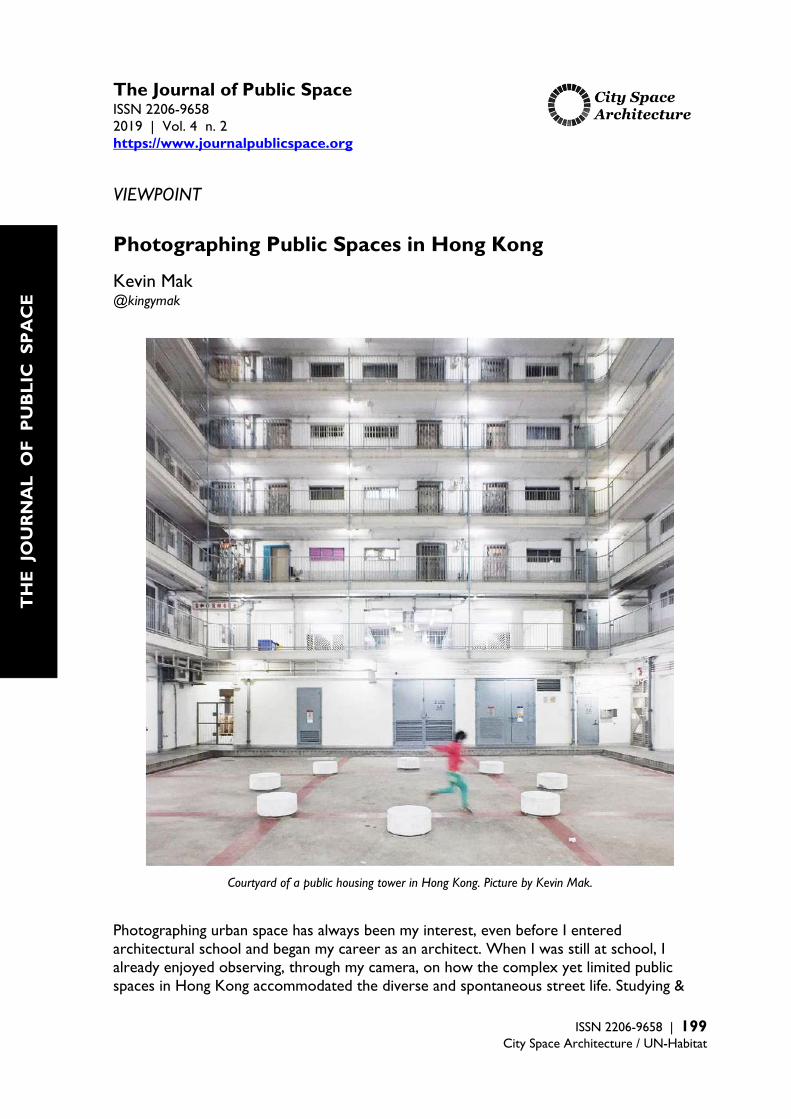
The Journal of Public Space ISSN 2206-9658 2019 | Vol. 4 n. 2 https://www.journalpublicspace.org
ISSN 2206-9658 | 199
City Space Architecture / UN-Habitat
VIEWPOINT
Photographing Public Spaces in Hong Kong
Kevin Mak @kingymak
Courtyard of a public housing tower in Hong Kong. Picture by Kevin Mak. Photographing urban space has always been my interest, even before I entered architectural school and began my career as an architect. When I was still at school, I already enjoyed observing, through my camera, on how the complex yet limited public spaces in Hong Kong accommodated the diverse and spontaneous street life. Studying &
T
HE
JO
UR
NA
L O
F P
UB
LIC
SP
AC
E

Photographing Public Spaces in Hong Kong
200 | The Journal of Public Space, 4(2), 2019 | ISSN 2206-9658 City Space Architecture / UN-Habitat
practising in architecture further shaped my interest in exploring Hong Kong’s urban topics beyond the visuals. My approach in urban photography promotes spatial aesthetics that embrace diverse cultures in public space, and controversially suggests how we introspect our way & attitude living in contemporary cities. An interview with Zolima Citymag in 20181 summarized very much on how I see the importance of public space in Hong Kong: ‘it’s not the buildings that make a city special, it’s the space in between them.’1 Buildings could look the same over time, but the activities in the space in between never repeat.
Solitary on a slope. Picture by Kevin Mak.
1 Availbale at: https://zolimacitymag.com/hong-kong-on-instagram-kingymaks-urban-space/
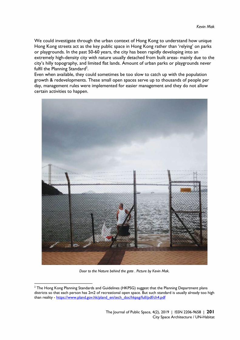
Kevin Mak
The Journal of Public Space, 4(2), 2019 | ISSN 2206-9658 | 201 City Space Architecture / UN-Habitat
We could investigate through the urban context of Hong Kong to understand how unique Hong Kong streets act as the key public space in Hong Kong rather than ‘relying’ on parks or playgrounds. In the past 50-60 years, the city has been rapidly developing into an extremely high-density city with nature usually detached from built areas- mainly due to the city’s hilly topography, and limited flat lands. Amount of urban parks or playgrounds never fulfil the Planning Standard2. Even when available, they could sometimes be too slow to catch up with the population growth & redevelopments. These small open spaces serve up to thousands of people per day, management rules were implemented for easier management and they do not allow certain activities to happen.
Door to the Nature behind the gate . Picture by Kevin Mak.
2 The Hong Kong Planning Standards and Guidelines (HKPSG) suggest that the Planning Department plans districts so that each person has 2m2 of recreational open space. But such standard is usually already too high than reality - https://www.pland.gov.hk/pland_en/tech_doc/hkpsg/full/pdf/ch4.pdf
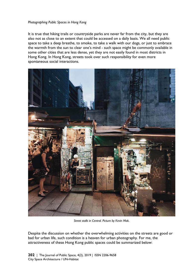
Photographing Public Spaces in Hong Kong
202 | The Journal of Public Space, 4(2), 2019 | ISSN 2206-9658 City Space Architecture / UN-Habitat
It is true that hiking trails or countryside parks are never far from the city, but they are also not as close to an extent that could be accessed on a daily basis. We all need public space to take a deep breathe, to smoke, to take a walk with our dogs, or just to embrace the warmth from the sun to clear one’s mind - such space might be commonly available in some other cities that are less dense, yet they are not easily found in most districts in Hong Kong. In Hong Kong, streets took over such responsibility for even more spontaneous social interactions.
Street stalls in Central. Picture by Kevin Mak. Despite the discussion on whether the overwhelming activities on the streets are good or bad for urban life, such condition is a heaven for urban photography. For me, the attractiveness of these Hong Kong public spaces could be summarized below:
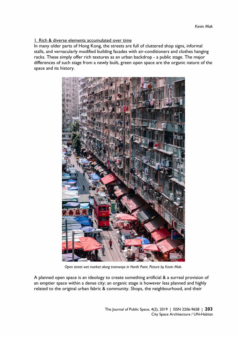
Kevin Mak
The Journal of Public Space, 4(2), 2019 | ISSN 2206-9658 | 203 City Space Architecture / UN-Habitat
1. Rich & diverse elements accumulated over time In many older parts of Hong Kong, the streets are full of cluttered shop signs, informal stalls, and vernacularly modified building facades with air-conditioners and clothes hanging racks. These simply offer rich textures as an urban backdrop - a public stage. The major differences of such stage from a newly built, green open space are the organic nature of the space and its history.
Open street wet market along tramways in North Point. Picture by Kevin Mak. A planned open space is an ideology to create something artificial & a surreal provision of an emptier space within a dense city; an organic stage is however less planned and highly related to the original urban fabric & community. Shops, the neighbourhood, and their
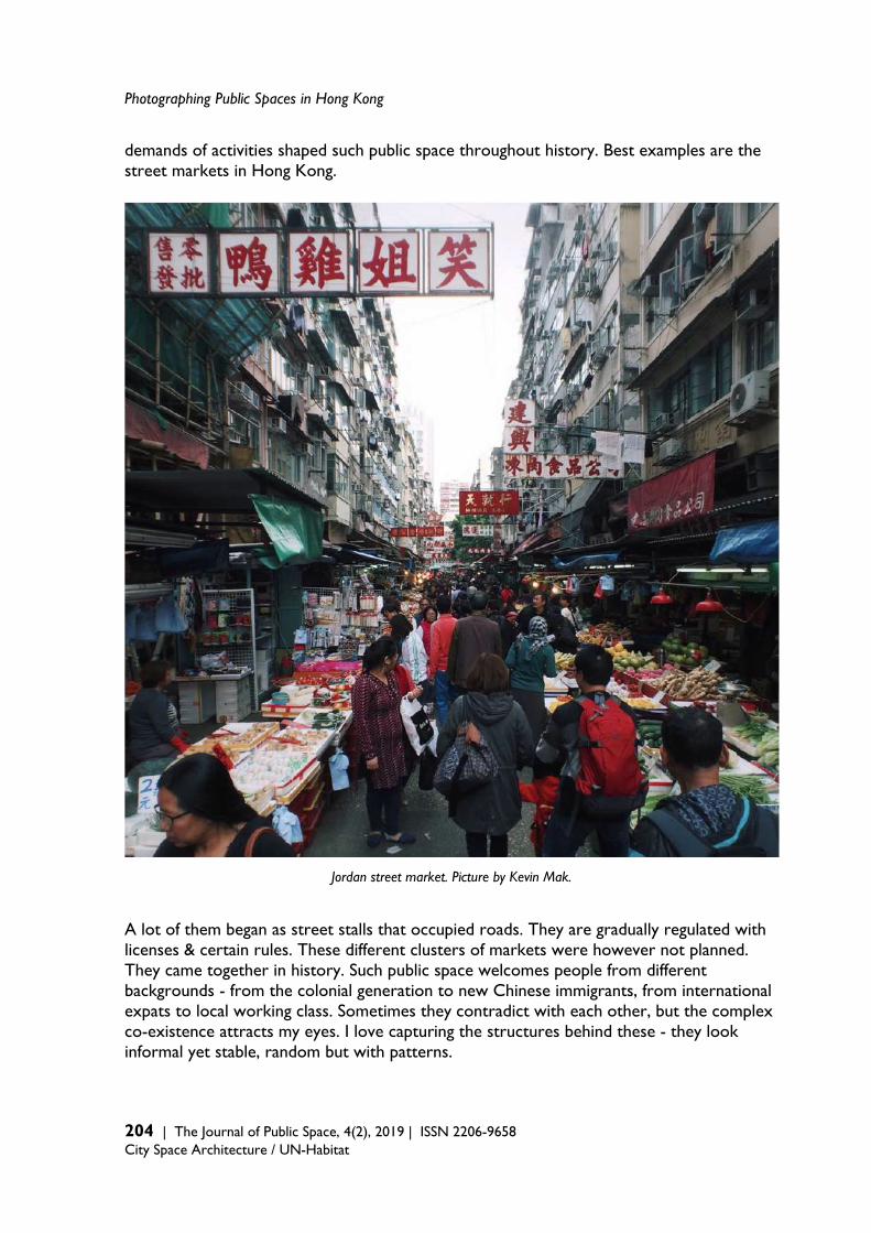
Photographing Public Spaces in Hong Kong
204 | The Journal of Public Space, 4(2), 2019 | ISSN 2206-9658 City Space Architecture / UN-Habitat
demands of activities shaped such public space throughout history. Best examples are the street markets in Hong Kong.
Jordan street market. Picture by Kevin Mak. A lot of them began as street stalls that occupied roads. They are gradually regulated with licenses & certain rules. These different clusters of markets were however not planned. They came together in history. Such public space welcomes people from different backgrounds - from the colonial generation to new Chinese immigrants, from international expats to local working class. Sometimes they contradict with each other, but the complex co-existence attracts my eyes. I love capturing the structures behind these - they look informal yet stable, random but with patterns.
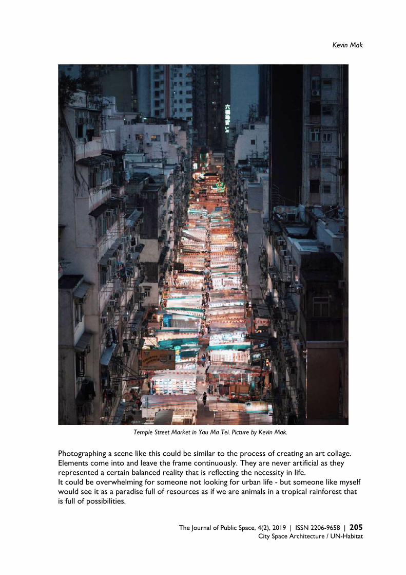
Kevin Mak
The Journal of Public Space, 4(2), 2019 | ISSN 2206-9658 | 205 City Space Architecture / UN-Habitat
Temple Street Market in Yau Ma Tei. Picture by Kevin Mak.
Photographing a scene like this could be similar to the process of creating an art collage. Elements come into and leave the frame continuously. They are never artificial as they represented a certain balanced reality that is reflecting the necessity in life. It could be overwhelming for someone not looking for urban life - but someone like myself would see it as a paradise full of resources as if we are animals in a tropical rainforest that is full of possibilities.
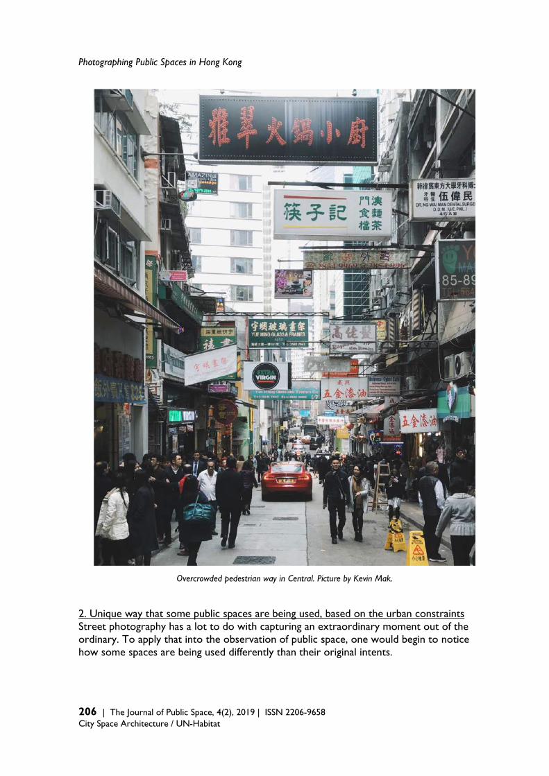
Photographing Public Spaces in Hong Kong
206 | The Journal of Public Space, 4(2), 2019 | ISSN 2206-9658 City Space Architecture / UN-Habitat
Overcrowded pedestrian way in Central. Picture by Kevin Mak. 2. Unique way that some public spaces are being used, based on the urban constraints Street photography has a lot to do with capturing an extraordinary moment out of the ordinary. To apply that into the observation of public space, one would begin to notice how some spaces are being used differently than their original intents.
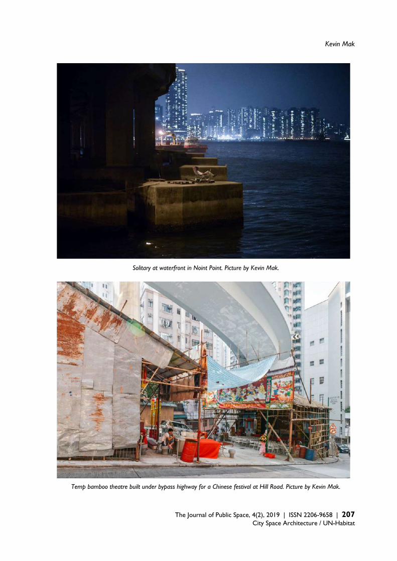
Kevin Mak
The Journal of Public Space, 4(2), 2019 | ISSN 2206-9658 | 207 City Space Architecture / UN-Habitat
Solitary at waterfront in Noint Point. Picture by Kevin Mak.
Temp bamboo theatre built under bypass highway for a Chinese festival at Hill Road. Picture by Kevin Mak.

Photographing Public Spaces in Hong Kong
208 | The Journal of Public Space, 4(2), 2019 | ISSN 2206-9658 City Space Architecture / UN-Habitat
Hong Kong is famous for the elevated walkway system that avoided vehicle traffic, until the domestic workers taking it to the next level. Most of these 390,000 workers (~5% of the population!), mainly from Philippine & Indonesia, take their day-off on Sunday and would often gather to ‘picnic’ on the footbridges for the whole day as it’s well ventilated under the subtropical humid weather. They could sometimes block more than half of the width of these footbridges, but it’s widely accepted as these are the only leftover public space in Hong Kong. This shows a lot on the shortage of public spaces in Hong Kong, and how creative people would use them. As an example, when it comes to city-wide festivals such as the Chinese Ghost Festival, temporary bamboo theatres would be built in many historical districts. Among them, the one at Hill Road under a flyover & on a steep slope is an extreme and mission impossible. The slope does however form a perfect theatre setting that offer very good sightline for the audience. Photographing scenes like this explains a lot of a city’s culture, and are great case studies for architects and planners. 3. Spontaneously cinematic & emotional scenes Apart from capturing the extraordinary within urban design and planned spatial functionality, public spaces have their charm because of the human activities, which they accommodate. They form journeys beyond regular life pattern, between work and private life. They are background for stories that trigger emotions and one’s relationship to his/her life in a city. The vibrant and dense public space of Hong Kong could be a downside for many people, because of the noise, crowd, poor natural light and ventilation, hygiene conditions, etc. There are however also countless advantages, e.g. close proximity, convenient, economically efficient. They allow more interactions than being in a park and they are also great platforms to do people-watching. Noises could be a meditation. I like to focus on a solitary character: a man stopping in the middle of a busy street, a man enjoy some personal time on a tram with busy market in the background, a worker making a conversation with a cat on his way to work. Each of these characters tells a story that can only happen within a particular public space at a particular moment. Altogether we could grab a glance from what are really important to people’s life from these emotional scenes, and be inspired to appreciate the existing but unnoticeable beauty through new perspectives. The photography of public space began as observations, but has extended to represent some phenomena that could be hard to explain through statistics or other means of research. For policy makers, architects and planners, we might even find these moments difficult to be recreated. They keep questioning myself on whether we should restructure how we design on top of an existing community, on how much we should research, and on how much new intervention are reasonable - in order to keep a public space’s authenticity that is closely related to a city’s history, culture, and communities. Photography is widely available nowadays, and it could be the moment that we make use of the power of such visual storytelling perspective in design.
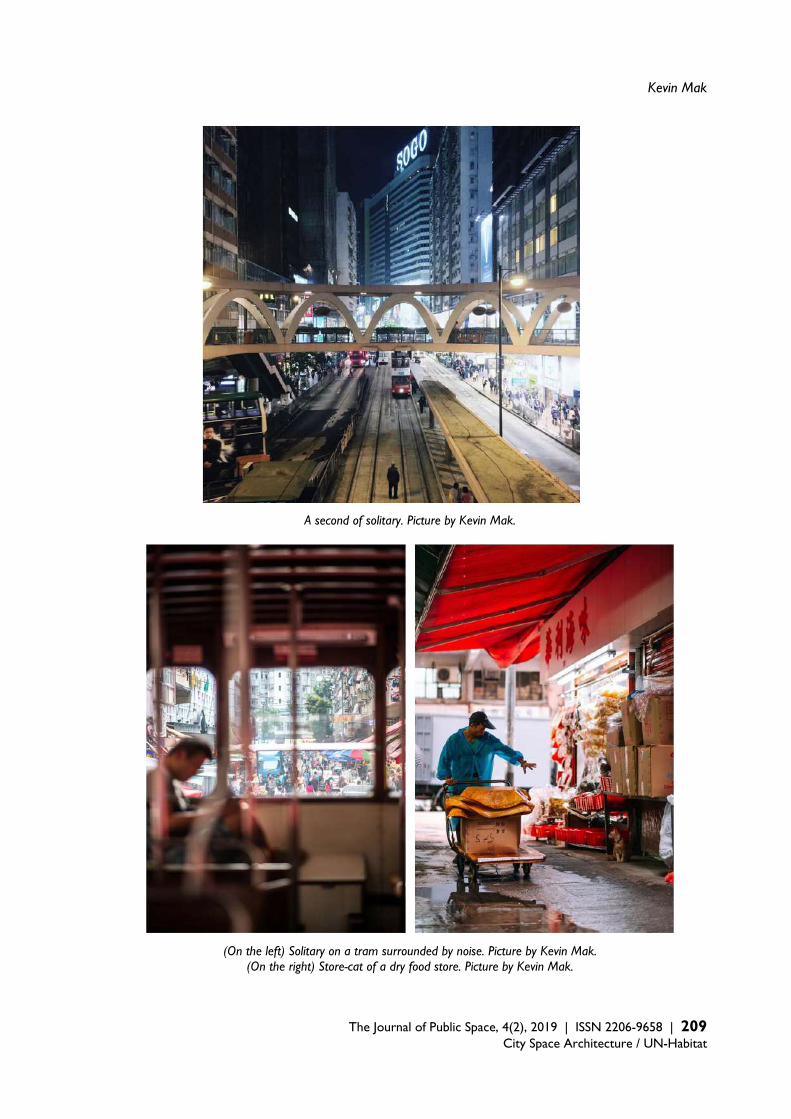
Kevin Mak
The Journal of Public Space, 4(2), 2019 | ISSN 2206-9658 | 209 City Space Architecture / UN-Habitat
A second of solitary. Picture by Kevin Mak.
(On the left) Solitary on a tram surrounded by noise. Picture by Kevin Mak. (On the right) Store-cat of a dry food store. Picture by Kevin Mak.
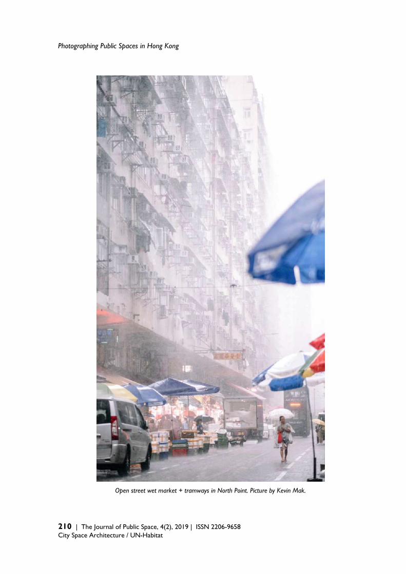
Photographing Public Spaces in Hong Kong
210 | The Journal of Public Space, 4(2), 2019 | ISSN 2206-9658 City Space Architecture / UN-Habitat
Open street wet market + tramways in North Point. Picture by Kevin Mak.

Kevin Mak
The Journal of Public Space, 4(2), 2019 | ISSN 2206-9658 | 211 City Space Architecture / UN-Habitat
Reading in a planned park with an unplanned plant. Picture by Kevin Mak.
To cite this article: Mak, K. (2019). Photographing Public Spaces in Hong Kong. The Journal of Public Space, 4(2), 199-212, DOI 10.32891/jps.v4i2.1210
This work is licensed under a Creative Commons Attribution - Non Commercial 4.0 International License https://creativecommons.org/licenses/by-nc/4.0/
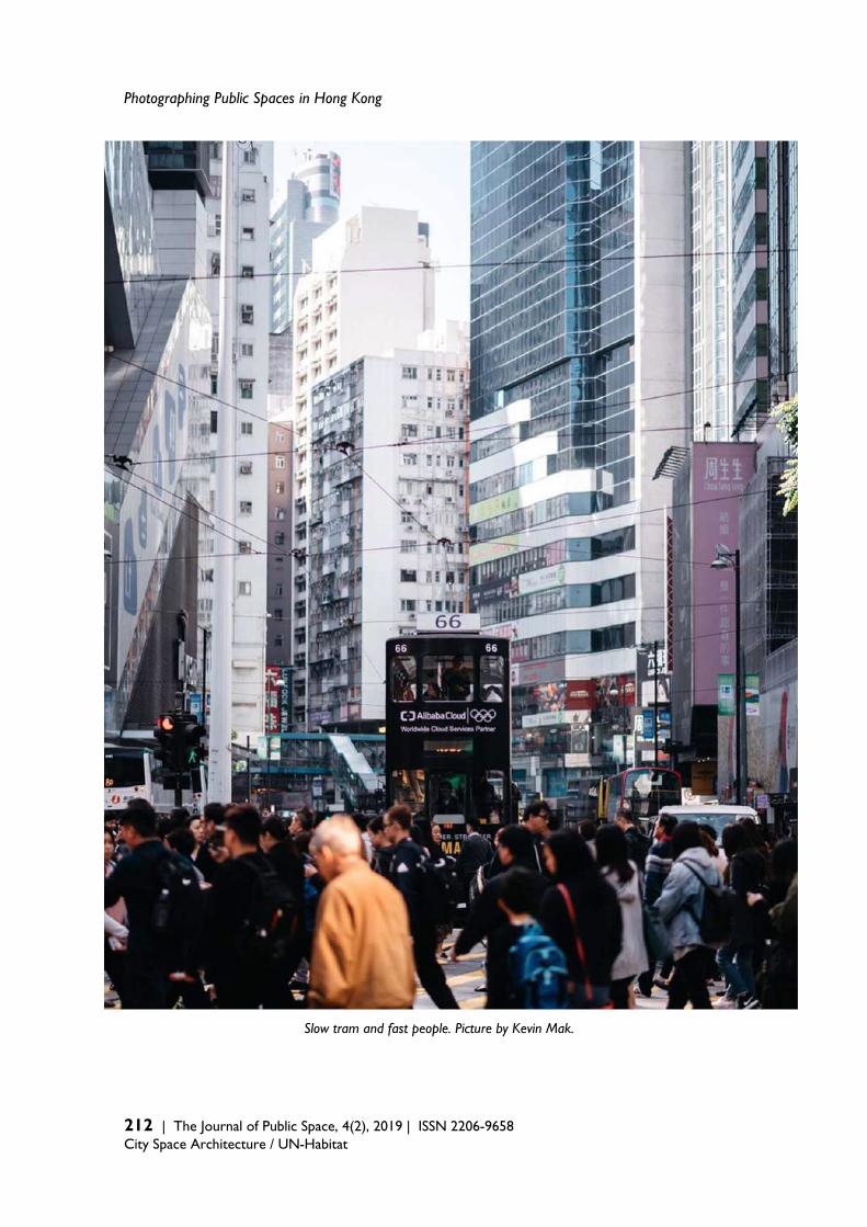
Photographing Public Spaces in Hong Kong
212 | The Journal of Public Space, 4(2), 2019 | ISSN 2206-9658 City Space Architecture / UN-Habitat
Slow tram and fast people. Picture by Kevin Mak.
Thank you for reading!
The Journal of Public Space ISSN 2206-9658
Editor in Chief Luisa Bravo City Space Architecture
Italy
https://www.journalpublicspace.org
Founder Partner
in cooperation with
Related Documents