Donegal County Council Comhairle Chontae Dhtin na nGall Section 15 : Landscape and Visual Meenaboll Environmental Impact Statement m 15.0 15.1 15.2 0 15.3 15.4 LANDSCAPE AND VlSliAL INTRODUCTION The landscape and visual impact assessment of the proposed Meenaboll Landfill Site Co. Donegal, is concerned with a description of the existing landscape character of the area, the im,pact of the proposed development on the landscape and visual character, and on views of it. Mitigation measures are also described. BAsrs FOR THE LANDSCAPEIMPACT ASSESSMENT The assessment of the landscape impact of the proposed development is based on the guidelines laid out by the Landscape Institute, and the Institute of Environmental Assessment in the Guidelines for Landscape and Visual impact Assessment (2002) and The Environmental Protection Agency Guidelines on the information to be contained in Environmental impact Statements (2002). Landscape in the Existing Environment The Guidelines note that landscape is a combination of two separate but closely related aspects. “The first is visual impacts, that is the extent to which new developments can be seen. The second is impacts on the character of the landscape, that is, responses that are felt towards the combined effects of the new developmenr. The Guidelines recdmmend the following to be included in any assessment. (i) Context Areas from which the existing site can be seen are generally noted with particular attention to views from roads, residences and designated tourism routes and viewpoints. Areas from beyond the site boundary from Which the site can be seen should be noted. Principal landscape features and areas of distinctive character should be mapped. (ii) Character A description of the landscape character differentiates between subjective, assessments and objective description. A description of the character of the site as perceived both within the site and wider landscape is important, as is a description of the intensity and character of land use. I (iii) Significance This entails the level of intrusion upon designated views, designated landscape and designated landscape amenity areas. 5234.50/Report.slEIS status: Issue Date: Final September 2004 15-1 For inspection purposes only. Consent of copyright owner required for any other use. EPA Export 25-07-2013:17:27:18

Welcome message from author
This document is posted to help you gain knowledge. Please leave a comment to let me know what you think about it! Share it to your friends and learn new things together.
Transcript

Donegal County Council Comhairle Chontae Dhtin na nGall
Section 15 : Landscape and Visual Meenaboll Environmental Impact Statement
m 15.0
15.1
15.2
0
15.3
15.4
LANDSCAPE AND VlSliAL
INTRODUCTION
The landscape and visual impact assessment of the proposed Meenaboll Landfill Site Co.
Donegal, is concerned with a description of the existing landscape character of the area, the
im,pact of the proposed development on the landscape and visual character, and on views of
it. Mitigation measures are also described.
BAsrs FOR THE LANDSCAPE IMPACT ASSESSMENT
The assessment of the landscape impact of the proposed development is based on the
guidelines laid out by the Landscape Institute, and the Institute of Environmental Assessment
in the Guidelines for Landscape and Visual impact Assessment (2002) and The
Environmental Protection Agency Guidelines on the information to be contained in
Environmental impact Statements (2002).
Landscape in the Existing Environment
The Guidelines note that landscape is a combination of two separate but closely related
aspects. “The first is visual impacts, that is the extent to which new developments can be
seen. The second is impacts on the character of the landscape, that is, responses that are felt
towards the combined effects of the new developmenr.
The Guidelines recdmmend the following to be included in any assessment.
(i) Context
Areas from which the existing site can be seen are generally noted with particular
attention to views from roads, residences and designated tourism routes and viewpoints.
Areas from beyond the site boundary from Which the site can be seen should be noted.
Principal landscape features and areas of distinctive character should be mapped.
(ii) Character
A description of the landscape character differentiates between subjective, assessments
and objective description. A description of the character of the site as perceived both
within the site and wider landscape is important, as is a description of the intensity and
character of land use. I (iii) Significance
This entails the level of intrusion upon designated views, designated landscape and
designated landscape amenity areas.
5234.50/Report.slEIS
status: Issue Date:
Final September 2004
15-1
For
insp
ectio
n pur
pose
s only
.
Conse
nt of
copy
right
owne
r req
uired
for a
ny ot
her u
se.
EPA Export 25-07-2013:17:27:18
,‘“,r^‘~ - - - . . , . . . ” ..%+“-. , . , . - ~~ y 1 a, ‘a;!
i,’ I ; ( . , 5, ,.Jj
:i:-’
Donegal County Council Section 15 : Landscape and Vkuai Comhairle Chontae Dhljn na nGall Meenaboll Environmental Impact Statement
(iv) Sensitivity
The, extent to which the existing landscape or views are capable of being changed before a
altering the perceived character.
Definition of Visual Impacts
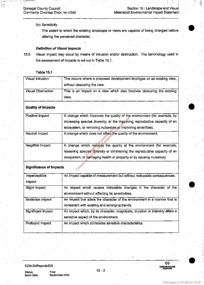
15.5 Visual impact may occur by means of intrusion and/or obstruction. The terminology used in
the assessment of impacts is set out in Table 15.1. ,
Table 15.1
Visual Intrusion ‘. This occurs where a proposed development impinges on an.existing view,
Visual Obstruction
without obscuring the view;
This is an impact on a view which also involves obscuring the existing
view.
Quality of Impacts
Positive Impact
Neutral Imp&t
A change which improves the quality of the $nviro?ment (for example, by
increasing species diversity; or the improving reproductive capacity .of ati
ecosystem, or removing nuisances or improving amenities).
A change which does not affect the quality of the environment.
Negzrtlve Impact A change which reduces the quality of the environment (for example,
lessening species diversity or diminishing the reproductive capacity of an
ecosystem; or damaging health or property or by causing nuisance).
Significance of Impacts
Imperceptible
Impact
Slight Impact
Moderate Impact
Significant Impact
Profound Impact
An impact capable of measurement but without noticeable consequences.
An impact ,which causes noticeable changes in the character of the
environment without affecting its sensitivities.
An impact that alters the character of the environment in a manner that is
consistent with existing and emerging trends.
An impact which, by its character, magnitude, duration or intensity alters a
sensitive aspect of the environment.
An impact which obliterates sensitive characteristics.
a
a
5234.50/ReporWEIS
status: Final Issue Date: September 2004
For
insp
ectio
n pur
pose
s only
.
Conse
nt of
copy
right
owne
r req
uired
for a
ny ot
her u
se.
EPA Export 25-07-2013:17:27:18

0
e
Donegal County Council Section 15 : Landscape and Visual ’ Comhairle Chontae Dhlin na nGall Meenaboll Environmental Impact Statement
Table 15.1 Continued
Duration of Impacts
Temporary Impact
Short-term Impact
Impact lasting for one year or less.
Impact lasting one to seven years.
Medium-term Impact Impact lasting seven to fifteen years.
Long-term Impact
Permanent Impact
Impact lasting fifteen to sixty years.
Impact lasting over sixty years.
Types of Impacts
Cumulative Impact 1 The addition of many small impacts to create one larger, more significant
impact.
‘Do Nothing Impact’ The environment as it would be in the future should no development of any
kind be carried out.
Indeterminable Impact When the full consequences of a change in the environment cannot be
described.
Irreversible Impact When the character, distinctiveness, diversity or reproductive capacity of
an environment is permanently lost.
Residual Impact The degree of environmental change that would occur after the proposed
mitigation measures have taken effect.
Synergistic Impact Where the resultant impact is of greater significance that the sum of its
constituents.
Worst Case’ Impact The impacts arising from a development in the case where mitigation
measures substantially fail.
e Method of Landscape and Visual Assessment
15.6 The process for assessing the landscape and visual environment includes; . Field and photographic survey . Desktop survey of ordinance survey maps and photographs . On site visual appraisal . . Analysis of the survey results
Desktop Survey
15.7 The area of visual influence was evaluated using the 1:50,000 and 1:20,000 and l:lO,OOO
Ordnance Survey maps along with 1 :l ,000 Survey maps of the Landfill site.
15.8 Three constraints govern the size of the Visual Envelope O/E) or zone of visual influence
within the study area. They are; the physical limits to visibility; the nature of the developments
and the landscape context of the developments and their surroundings,
5234.50lReporWEIS.
status: Final
00
Y!ziE%FE 15-3
Issue Date: September 2004
For
insp
ectio
n pur
pose
s only
.
Conse
nt of
copy
right
owne
r req
uired
for a
ny ot
her u
se.
EPA Export 25-07-2013:17:27:18

Donegal County Council Comhairle Chontae Dhirn na nGall
Section 15 : Landscape and Visual Meenaboll Environmental Impact Statement
15.9 Physical limits are determined by the intervening elements of the landscape arising from
topographical settings, vegetation and land uses. These inhibit or screen views of thesite, l
e.g. ridges, hills, buildings, walls and vegetation etc. The mass, colour and form of the landfill
facility and its relationship to the landscape i.e. hills, valleys, vegetation etc also influence the
VE. The VE has been measured with consideration given to local inhabitants,
visiting travellers and relates to the road network and adjacent landuses. (Fig 15.1).
local and
Field and Photographic Survey _
15.10 The study area was surveyed in changeable conditions, from overcast and dull through to
clear, providing an understanding of visibility across a range of weather conditions.
15.1 I The purpose of the field and photographic survey was:
= To confirm and record specific viewpoint locations; (Fig 15.2).
n To record specific objective and subjective information for each chosen viewpoint;
. To .photographically record each viewpoint; (Fig 15.3, 15.4, 15.5 & 15.6).
n To provide base data for analysis of both existing and proposed landscape and’ visual
analysis.
15.1’2 The assessment seeks to define. the extent of the areas from which the landfill facility may be
seen and within that area, qualify the sensitivity of a particular view point, which would be
affected by characteristics such as: .
n Distance of view from the site.
. Frequency of use of the view point.
9 Landscape characteristics.
. Duration of the view.
. Viewer response (inhabitants/travellers).
15.13 Three types of impact were considered
n Predicted Impact . ‘Do Nothing’ Impact
. Worse Case’ Impact
~2345O~Reports~EIS
status: Final Issue Date: September 2004
v .s .?
MORTON 15-4
For
insp
ectio
n pur
pose
s only
.
Conse
nt of
copy
right
owne
r req
uired
for a
ny ot
her u
se.
EPA Export 25-07-2013:17:27:19

Donegal County Council Section 15 : Landscape and Visual Comhairle Chontae Dhirn na nGall Meenaboll Environmental Impact Statement
@
15.14
15.15
c ,
15.16
15.17
15.18
THE RECEIVING LANDSCAPE
Surrounding Area/Background
The site of the proposed landfill facility is located in the Glendowan Mountains, (Grid ref 8996
093) to the north west of Meenaboll Hill, (Height 317m) Co Donegal and close to the head
waters of the Owenbeg and Sruhanpolldoo Rivers. The site is 11.6km south of Glenveagh
Castle, 14km from the Glenveagh National Park Visitor Centre, and 0.5km east of the SAC
site Clogheragoare Bog. Today the Glenveagh National Park occupies some 16,548 hectares.
The nearest settlement is Kingarrow 4km to the south west.
The greater landscape is open with long distance views to the surrounding hills and
mountains. (Figure 15.3 - Photo 1, 2, & 4). Blanket bog covers much of the area. In places it
has been drained and planted with conifer forest. The area is remote with no main roads or
houses visible from the proposed site. A stoned local road which passes the site connects the
R250 Letterkenny to Fintown Road and the R254 Churchill to Doochany Road. This would be
the main access route to the site and it is currently used by forestry traffic, local farmers and
occasional tourists.
The landscape character reflects the underlying geological structure of the area and the
prevailing climatic conditions.
Towns and Settlements
The site lies 18km southwest of Letterkenny and 9.7km northeast of Fintown. Small
settlements are scattered throughout the surrounding area and include Glendowan (5.6km)
and Doocharry (13km).
Natural Features
The area is located in the Caledonian Province of the Northwest and consists of pre
Cambrian, Ordovician and Silurian rocks which have been subjected to several phases of
metamorphism by pressure, igneous intrusion and weathering. Folding during the Caledonian
period has resulted in the southwest and northeast trend of the river valleys. Differential
weathering between quartzites, granites and schist, have produced a marked contrast in the
landform. The quartzite ranges have conical peaks such as Mount Errigan and Slieve Snaght,
while the granites have smoothly rounded hills, such as the Glendowan and Derryveagh
Mountains. Glacial scouring has moulded the mountains and valleys to a considerable degree
and the landscape clearly shows its influence.
5234.501RepotWElS
status: Final Issue Date: September 2004
For
insp
ectio
n pur
pose
s only
.
Conse
nt of
copy
right
owne
r req
uired
for a
ny ot
her u
se.
EPA Export 25-07-2013:17:27:19

Donegal County Council Comhairle Chontae Dhrjn na nGall
Section 15 : Landscape and Visual Meenaboll Environmental Impact Statement
. . .i
15.19
15.20
15.21
15.22
15.23
15.24
The proposed landfill site is to be located on the northwest slopes of Meenaboll Hill, which is
part of the granite Glsndowan Mountain range which, includes Moylenana (589m),
Crockskallabagh (494m), Croaghacullin (435m) and Crockastoller (415m). These hills
dominate the area. The Derryleagh Mountains lie in the distance away to the north and west.
Drainage follows the Caledonian folding which is southwest/northeast. The Owenbeg River
flows northeast and the Sruhanpollando flows southwest. The latter is also fid by water from
Lough Muck 3.7km to the southwest.
Roads in the area are restricted by the underlying landform and follow the river valleys. 1.5km
to the south, the R250 is the nearest road to the site. It links Letterkenny to Fintown. To the
north and west is the R254 Glendowand to Doochary road and to the southwest the R252
Fintown to Doochary road. Proposed access to the site would be from the R250 on to a
stoned local road that links it to the R254, close to the village of Glendowan. The roads are not
visually significant in the context of the general landscape.
Landuse
Extensive areas of poor quality blanket bog cover much of the area and severely limit
agricultural activity, which is more evident in the-lower sheltered valleys in the form of dairying
and beef production. Open grazing is the main agricultural activity on the bogland. Extensive
areas of conifer forests cover much of the lower slopes and valley sides in the area. These
break up the visual character of the area with their dark form and regular outline at variance
with the surrounding landscape. There is also evidence of domestic’peat cutting in the local
area.
The local area contains some archaeological evidence, with standing stones and megalithic
tombs testament to a long period of settlement from mesolithic times to the present. No
evidence of archaeological material has been found on the site to date. Sustained rural
depopulation is evident from the number of abandoned farmsteads in the wider landscape.
The proposed site is situated in a remote area and lies away from the main tourist routes,
however lying to the north and west of the site, the Glenveagh National Park is,a major tourist
attraction. The main tourist activity is centred at Glenveagh Castle and the Glenveagh’
National Park Visitor Centre. Hill walking is becoming more important in the local area and a
new walking route, Sli na Finne (24km) has been established. It follows the River Finn and its
tributaries for most of its length. It is part of the National Waymarked Ways Network in
Donegal. The proposed site would not be visible from this walk.
5234.50/ReportsiEI.S
status: Final issue Date: September 2004
For
insp
ectio
n pur
pose
s only
.
Conse
nt of
copy
right
owne
r req
uired
for a
ny ot
her u
se.
EPA Export 25-07-2013:17:27:19

Donegal County Council Section 15 : Landscape and Visual Comhairle Chontae Dhlin na nGall Meenaboll Environmental Impact Statement
Vegetation
15.25 Atlantic blanket bog is the predominant form of vegetation. It is a key constituent of the
landscape and contributes to the ecology of the area.
15.26 Where forestry has taken place, modified peatland now exists and includes areas of grassy
heath with wet flushes. Currently blocks of coniferous forest cover large areas of the valley
and create intermittent enclosures within the landscape. Ongoing. felling operations are
changing the shape and extent of forest cover and its visibility within the landscape. (See
Flora and Fauna section for a more detailed description of existing vegetation).
EXISTING ENVIRONMENT
Site Description
15.27 The environs of the site are characterised by commercial forestry and blanket bog, with a
more open landscape of hills and mountains extending beyond.
15.28 There are no farm buildings or dwellings within the VE. The scene is generally peaceful in
nature with panoramic views over the surrounding landscape. The wilderness quality of the
landscape is an important resource for the area.
15.29 The vegetation on the site has been significantly modified by drainage and forestry operations.
Currently the site is seen as an expanse of modified blanket bog, which is untidy in
appearance; the coniferous forest having recently been clear felled. It is littered with tree roots
and dead wood but there is also evidence of recent planting.
15.30 The proposed site is defined by an existing stoned local road to the south and west. The
entrance to the site would be through a new section of road. There is no defining boundary to
the north. To the east the site it is crossed by a stone forestry track that runs parallel, with the
contours. This track would be relocated further up the hillside.
15.31 The proposed development would occupy an area of approximately 14.5 hectares. The site is
roughly square in shape; would have a capacity of 500,000 tons and would take approximately
20 years to fill.
15.32 The site is northwest facing and has a cross fall of approximately 30 metres. To the east the
ground rises to Meenaboll Hill (317m) were some remnants of forestry remain on the skyline.
Binswilly lies further to the northeast (337m).
15.33 The site lies close to the source of the Owenbeg River, which flows north east and the
Sruhanpollandoo River which flows south west.
5234.5O/Reports/EIS
status: Final Issue Date: September 2004
For
insp
ectio
n pur
pose
s only
.
Conse
nt of
copy
right
owne
r req
uired
for a
ny ot
her u
se.
EPA Export 25-07-2013:17:27:19

. : :
: :
Donegal County Council Comhairle Chontae Dhlin na nGall
Section 15 : Landscape and Visual Meenaboll Environmental Impact Statement
15.34
15.35
15.36
‘15.37
15.38
15.39
15.40
15.41
15.42
The proposed landfill site would be excavated to a depth of between 2-8m metres, with some
of the fill, material being used in stockpiles for future covering. 2m and 3m high earth bunds 0
would be created on the boundaries of the proposed site, to act as visual barriers.
Drainage
The site is crossed by a number of small drainage channels which were constructed prior to
the planting of the coniferous forest. These would be ‘diverted during the proposed
construction work.
Vegetation
On the proposed landfill site, the coniferous planting has been removed and is largely covered
with poor quality grasses and recently replanted conifers.
As the surrounding area has also been replanted, areas not affected by proposed construction
work would be allowed to grow on and along with future planting would help to provide 0
localised screening.
Site Visibility
Visibility of the proposed landfill site is primarily determined by topography and the local
screening vegetation of the coniferous forest.
North
Generally, views of the site from the north are restricted by the intervening landform and the
remainder of the existing coniferous forest. (Figure 15.3 - Photos 2 & 3).
From the northeast and within 1 km of the site, there are views over the site where clear felling
has occurred (Figure 15.3 - Photo 4).
From the northwest the existing coniferous forest screens short distance views. Beyond 1 km,
a section of the remaining forest creates a screen on the edge of the forestry land. A spur of
ground leading down from Binswilly screens the site from the remainder of the north east.
There are no views of the proposed site from the existing stoned local road as it ascends
through the valley of the Owenbeg River from Glendowan. This is due to inventing landform
and the existing conifer forest. (Figure 15.3 - Photo 3). There are no views from any of the
properties along this road.
15.43 It is not ‘until the proposed entrance is reached that the actual site is revealed, as the forest
cover has been removed at this point.
@ 0 I
5234,50/Reports/EIS Y!kE%E-
status: Final 15-8 Issue Date: September 2004
For
insp
ectio
n pur
pose
s only
.
Conse
nt of
copy
right
owne
r req
uired
for a
ny ot
her u
se.
EPA Export 25-07-2013:17:27:19

Donegal County Council Section 15 : Landscape and Visual Comhairle Chontae Dhljn na nGall Meenaboll Environmental Impact Statement
0 15.44
15.45
15.46
15.47
e
I 5.48
15.49
15.50
To the northwest, the forested Brallamore helps to screen the site from lower elevations.
Beyond 3km, there are longer distance views of the site from the hills and mountains to the
north and northwest. From these areas the proposed site is seen as a small part of a much
larger landscape and currently has little impact on the overall scene.
There are no views from the R254 road to the north and northwest, which is an important
route to the Glenveagh National Park. (Figure 15.5 - Photo 14 & 15).
East
Views of the site from the east are restricted by the intervening rising landform, part of which is
covered in forest. There are no views of the site from the R250. (Figure 15.4 - Photo 6 & 7).
From the east, an important visual barrier is provided by the rising ground of Meenaboll Hill
and Binswilly. There are glimpses of the proposed site from the western slopes of these hills,
through the remnants of the existing coniferous forest. (Figure 15.4 - Photo 6).
Site traffic would be visible on the R250 and on part of the existing stone local road close to its
junction with the R250.
South
There are no views of the site from the R250 as the road ascends from Fintown. (Photo 9).
Neither are there views from Fintown nor from Kingarrow’ to the southwest. Approaching the
site along the existing stoned local road, views towards the proposed site are screened by
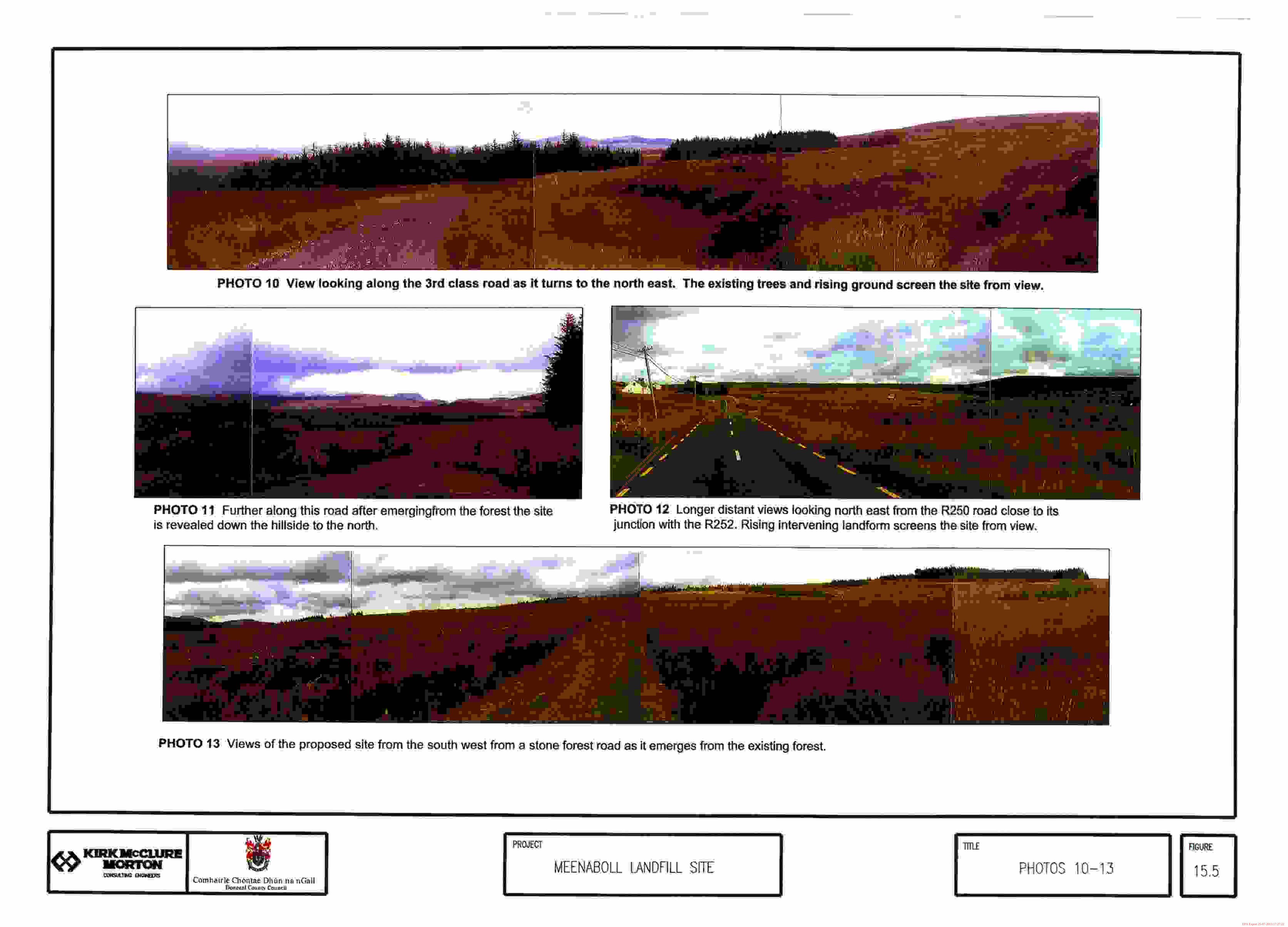
landform and existing forest. (Figure 15.5 - Photo 10). It is not until the stoned road starts to
round Meenaboll Hill (1 km) after passing through a section of forest, that the site is revealed at
a lower level with the wider landscape beyond. (Figure 15.5 - Photo 11). Views towards the
site form the Sruhanpolldoo River Valley to the southwest are restricted by intervening forest
and it is only on the edge of the forest that the site becomes visible. (Figure 15.5 - Photo 13).
West
The proposed site is more visible from the southwest and northwest, particularly over longer
distances where the higher ground provides largely uninterrupted views towards the site.
(Figure 15.6 - Photo 14 & 15). However, the site is perceived as a relatively small area in a
much larger landscape setting within a forested area. Mountains screen the site from the
main roads in the west. Photo 16 (Figure 15.6) is a view from the R254 Doocharry to
Glendowan Road looking in the direction of the proposed site, however the site cannot be
seen due to the intervening landform.
5234.50/Reports/EIS
status: Final Issue Date: September 2004
For
insp
ectio
n pur
pose
s only
.
Conse
nt of
copy
right
owne
r req
uired
for a
ny ot
her u
se.
EPA Export 25-07-2013:17:27:19

Donegal County Council Comhairle Chontae Dhlin na nGall
Section 15 : Landscape and Visual Meenaboll Environmental Impact Statement
15.51
15.52
15.53
15.54
15.55
15.56
15.57
15.58
The site is only likely to be seen from the west by farmers and walkers occasionally using the
hills. Photo 14 shows a view looking southwest from the site down the valley, with the wider e
landscape in view. Beyond 2km the rising ground would afford views in the direction of the
proposed site. Shorter distance views between 0.5-2km are currently screened by intervening
forests. There are no views of the site from Lough Muck to the southwest.
Photo 15 is a view over the proposed site showing the .Glendowan Mountains and the
Derryleagh Mountains beyond. It shows the areas from which the site can be seen. The
extensive open nature of the landscape provides spectacular long distance views. Within this
landscape the. proposed site is at present inconspicuous.
Photo 17 is a view from close to the .entrance to the proposed landfill site. It looks southwest
down the valiey, with the surrounding forest clearly in view. L
Significance’ e
The area of the site and the surrounding coniferous planting is not recognised as being
sensitive or significant and has not been officially designated.
However the site does lie close to part of the Glenveagh National Park which is recognised as
being both sensitive and significant. The Glenveagh National Park has recently been
expanded and includes the acquisition of land opposite the proposed site. Figure 15.1 shows
the expanse of the park in relation to the proposed site. It is important to ensure that the
setting of the park is not compromised by the proposed development.
The main visitor attractions of the park are located further to the northwest around Lough
Beagh where Glenveagh Castle (11.6km) and the Glenveagh National Park Visitor Centre
(14km) are located. The proposed site would have no impact on this area.
0
There would be shorter distance views from those parts of the Glenveagh National P&k
closest to the proposed site. Beyond 5km little detail of the site would be visible from the
higher more.distant parts’ of the park; where it would be seen simply as an area of contrasting
ground within a forested area and part of a larger landscape setting.
Currently, the area consists of a wild landscape with large scale open spaces. Forestry has
brought a degree of enclosure at lower elevations. Landform and the .existing conifer forest
currently help to limit views of the proposed site. Apart from the forestry activities, interest is
generally passive, low key and peaceful in nature.
5234.50IReportsIEIS
status: Final Issue Date: September 2004
For
insp
ectio
n pur
pose
s only
.
Conse
nt of
copy
right
owne
r req
uired
for a
ny ot
her u
se.
EPA Export 25-07-2013:17:27:19

Donegal County Council Section 15 : Landscape and Visual Comhairle Chontae Dhlin na nGall Meenaboll Environmental Impact Statement
e 15.59 The introduction of coniferous forest into the valley has had a significant effect on the area in
15.60
15.61
15.62
15.63
15.64
terms of its local ecology and visual quality. The forest covers a wide area and its associated
drainage works have destroyed the former bog cover. The open nature of the landscape has
been broken up with mass planting of mainly spruce, which obliterates the micro topography
and provides little visual relief. When felling does take place, the resulting scene is visually
unattractive. At present the valley contains areas of mature forest, clear felled areas and
recent plantings.
If the proposed landfill site were approved, there would be a temporary loss of vegetation
cover and the removal of an area of young planting. The loss of these elements, which are
common in the area, would not be significant. New planting would in time offset this loss of
habitat. Proposed earth bunds and planting works would be used to limit the visual intrusion
of the proposed site. These works would be followed by the progressive restoration of the site
to reduce the amount of disturbed land and limit the visibility of the site. A new landform
would emerge to replace the existing one and would be in sympathy with the local topography.
Sensitivity
This is the degree to which the existing landscape can accommodate the proposed
development without detrimental effects on its character. Sensitive receptors would include
travellers on the local road, farmers and hill walkers and the landscape of Glenveagh National
Park.
The peace and tranquillity of the area and its sense of remoteness would be affected by the
development of the site. Ongoing forestry operations have modified these characteristics and
the visual and wilderness qualities of the area have been compromised. It is, nevertheless, a
landscape valued by local people and is important in the context of the setting of the
Glenveagh National Park. The loss of habitats associated with the proposed development is
not considered to be significant as they are abundant in the local area.
The proposed landfill site would create further intrusion. This would include the development
of the site and the creation of a new landform, changes to the visual scene, an increase in
noise levels, an increase in dust levels, particularly during periods of dry weather conditions,
and the introduction of artificial lighting. Steps would be taken to limit any adverse effects of
the above factors.
Although the character of the area is essentially open, forestry has brought a degree of
enclosure. It is this enclosure that would help to limit the visibility of the proposed development
within the landscape. The fact that there are no residents or few travellers in the area also
makes it amenable to this type of development.
5234SOlReportslEIS
status: Final Issue Date: September 2004
For
insp
ectio
n pur
pose
s only
.
Conse
nt of
copy
right
owne
r req
uired
for a
ny ot
her u
se.
EPA Export 25-07-2013:17:27:20
Donegal County Council Comhairle Chontae Dhun na nGall
Section 15 : Landscape and Visual Meenaboll Environmental Impact Statement
15.65
15.66
15.67
15.68
The pattern and scale of the existing landscape is large and open in nature. As the proposed
development would take place within an existing forest setting, the pattern and scale of the 0
landscape would not be further disrupted.
As surrounding hills and mountains overlook the site, the proposed site would be visible in the
landscape over a large area. However it would be seen only as a small part of a much larger
landscape setting and contained within a forestry setting, which is undergoing change. Part of
the Glenveagh National Park which lies across the valley from the proposed development,
would have largely open views over the proposed site, particularly from higher ground. This,
in conjunction with the ongoing forestry operations would have an impact on the local setting.
However the cumuiative impact of both operations need not adversely affect the sensitivity of
the area provided appropriate mitigation measures are put in place. The number of people
likely to see the proposed site is also likely to be limited.
PROJECT DESCRIPTION 0 .
The proposed development would involve the following: ,
.
,
.
.
.
.
.
.
.
.
n
Excavation of the site and the storage of over burden materials for future use.
The lining of the containing area, provision of drainage and gas collection facilities.
The construction of a new internal road to provide access for construction traffic to the .
site.
Litter containment facilities.
Progressive filling and capping of 5 phases of operation.
Landscape treatments to.assimilate the development back into the landscape setting, i.e.
grassing and planting works (native species).
The creation of earth bunds on the boundaries of the development to help screen the,site
from view. These would be planted up to create a visual barrier.
Regrading the final contours to create a landform, which would harmonise with the 0
surrounding area.
Gas flare stack
Lighting
Buildings and associated facilities i.e. a lagoon, wheel washing Provision of passing points for lorries on the existing stoned local-road
LANDSCAPE IM~A~TA~~ES~MENT
The landscape impact assessment of the area is based on criteria set out in detail in section
15.2, Basis of Landscape lhpact Assessment. Impacts may be indirect, secondary or
cumulative and visual impacts may occur by means of intrusion and/or obstruction. The
assessment includes an appraisal of the ‘Do Nothing’ approach.
5234.50/Reports/ElS
status: Final issue Date: September 2004
For
insp
ectio
n pur
pose
s only
.
Conse
nt of
copy
right
owne
r req
uired
for a
ny ot
her u
se.
EPA Export 25-07-2013:17:27:20

Donegal County Council Section 15 : Landscape and Visual Comhairle Chontae Dhlin na nGall Meenaboll Environmental Impact Statement
Scope of Existing and Proposed Impact
15.69 Currently, the proposed site is part of a commercial forest in an open bogland landscape. The
proposed landfill site would have an impact on the visually quality of the area, giving rise to
changes in the landscape character of the VE. Visual impacts would occur as a result of
intrusion on views of the area. Visual impact would be considered in relation to farmers and
hill walkers; the Glenveagh National Park and users of the local road.
Proposed impacts
15.70 Site Development - Construction of the site and facilities would be completed in
approximately 6 months, followed by site infllling, which would be a 5 phased programme
lasting 20 years. Site construction traffic would use existing roads bounding the site and the
stoned local road would require upgrading and passing points. The construction and infilling
works would cause general noise and physical disturbance around the site and create a visual
0 impact in the area. The sense of quiet and wildness in the landscape would diminish.
15.71 Changes in Land Use - The land would change from forestry use to a landfill site. On
completion it would return to native woodland (screen planting) and native grassland. In visual
terms, the proposed physical development of the site would represent a significant change to
existing conditions. Along with the forestry operations, it would bring changes to an otherwise
stable environment.
15.72 ‘Do Nothing’ Landscape Impacts - Presently the site is used for commercial forestry
operations. If the proposed landfill site does not take place, the site would continue as
commercial forest.
IMPACT ON VISUAL CHARACTER
0 15.73 Visual impacts would be likely to occur as a result of the following:-
.
.
.
.
.
.
.
.
.
.
Excavation and construction works to prepare the site for landfilling
Stockpiles of soil/fill materials.
Vehicles entering and leaving the site and using surrounding local roads.
Filling operations, with vehicles moving and spreading fill materials.
Fencing used to limit the movement of wind blown materials.
Dust, particularly during periods of dry weather.
Exposed areas of bare ground.
The colours of fill areas in contrast to surrounding areas.
Earth bunds with their steep gradients, until grassing and planting helps to soften their
outline.
Pollution of roads by run off from lorries
Alteration of ground levels 0 . 00
5234.50IReportslEIS Y2z%iiRE status: Final 15-13 Issue Date: September 2004
For
insp
ectio
n pur
pose
s only
.
Conse
nt of
copy
right
owne
r req
uired
for a
ny ot
her u
se.
EPA Export 25-07-2013:17:27:20

Donegal County Council Comhairle Chontae Dhljn na nGall
Section 15 : Landscape and Visual Meenaboll Environmental Impact Statement
9 Changes in landuse from commercial forestry to landfill site and then to native grassland
with native woodland planting
. Lighting of site
. Gas flare stack
15.74 When viewed from a number of locations around the site, the completed development would
produce visual intrusion as expanded below:-
15.75’ When considering visibility and visual impact the following general points need to be
considered.
Table 15.2
Factors Influencing VisibilityNisual Impact
Distance The greater the distance, the less detail is observable and the more-
difficult it is to distinguish a site from its background, thus diminishing
. potential impact.
Elevation This is in comparison to a viewpoint which is lower than the site
feature so that the site is more likely to be viewed against the sky
which increases its impact. When the viewpoint is higher than the
site, it is viewed against a backdrop which diminishes its impact.
Sire The greater the proportion of the view occupied by the features and
activities, the greater the impact. Colour and form can increase or
diminish impact, by drawing the eye or by providing camouflage.
Context The degree to which the development is in character with the context
along with features in the view such as landform or vegetation which
frame, mask, filter views of the site.
Weather Conditions Clarity of the air and the angle and direction of the sum at different
times of year affect visibility. Upland areas are more prone to misty,
cloudy and rainy conditions thus reducing visibility.
Activity Movement of vehicles and light reflection changing with movement,
draw the eye increasing impact.
Change The degree of change in the view and the rapidity of the process of
change affect the degree of impact.
i
52~4.50/Repo1tdEIS
status: Issue Date:
Final September 2004
IS-14
For
insp
ectio
n pur
pose
s only
.
Conse
nt of
copy
right
owne
r req
uired
for a
ny ot
her u
se.
EPA Export 25-07-2013:17:27:20

Donegal County Council Section 15 : Landscape and Visual Comhairle Chontae Dhrin na nGall Meenaboll Environmental Impact Statement
SITE DEVELOPMENT
15.76 The proposed site would be excavated and developed to create the site layout as shown in
Figure 15.8. It would create a facility with a capacity for 500,000 tonnes of waste and with an
estimated life of 20 years. Buildings/site facilities would be located in the northwest corner of
the site. This is the lowest part of the site and it woujd benefit from the screening potential of
the existing topography and forest. Buildings/structures would be designed to fit onto the site
and local landscape setting in relation to scale, form and colour. For example, bright colours
and shiny surfaces would be avoided. The greatest visual intrusion would occur during the
construction phase (6 months) when the whole of the site would be worked on and the
maximum amount of disturbed land would be visible. When filling is taking place in the upper
cells of the site and during capping and restoration works, machinery and fencing may be
visible through the vegetation screen.
15.77 A gas flume 5m high would be required. It would be located away from the local stoned road
but would rise partly above the proposed 3m high earth bund and new planting and would be
seen over longer distances until the maturing planting would reduce its impact. There would
be no visible smoke or flames associated with the flume.
15.78 Perimeter fencing surrounding the proposed site would be of an unobtrusive form i.e. 2.4m
high bent arm post with galvanized chain link fence topped with barbed wire. Most of the
fence would be behind existing new forest planting which would help to lessen its impact. A
further perimeter litter fence would be used at sections of the site to prevent windblown
materials escaping into the local landscape and would be typically 5m high. In addition to this
it is proposed to use an enclosed litter net at the working face to minimise windblown litter.
This litter net will typically be 40m x 40m x 12m high and is discussed in detail in Section 7.
There would be visual intrusion from the temporary fencing used to curtain wind blow material
in ongoing fill areas, until the proposed planting would help soften its impact. With distance its
impact would be reduced.
15.79 Perimeter lighting would be required and would be designed to reduce light pollution as much
as possible. The site lighting would help to focus attention towards the site and represent a
marked change over existing conditions. Proposed perimeter woodland planting would in time
reduce the impact of this element. This planting would combine with existing areas of recently
planted conifer forest that would be retained for screening purposes.
5234.50/Reports/EIS
status: Final Issue Date: September 2004
For
insp
ectio
n pur
pose
s only
.
Conse
nt of
copy
right
owne
r req
uired
for a
ny ot
her u
se.
EPA Export 25-07-2013:17:27:20

Donegal County Council Comhairle Chontae Dhun na nGall
Section 15 : Landscape and Visual Meenaboll Environmental Impact Statement
15.80
15.81
15.82
15.83
15.84
15.85
15.86
Earth bunds 3m high (beside the local road and behind the gas flume) and 2m high around the
remainder of the site would be created along with a single access road into the site. The a
bunds would be graded to create a natural profile and planted with native trees and shrubs to
help screen future workings and site activities: Future landfill operations would therefore take
place behind earth bunds and a maturing vegetation screen. In order to limit the impact of site
traffic using the haul routes on the side of the landfill site,.a further earth mound I .5m high
would be created to help reduce the impact of vehicles. This would be removed on
completion of the site. The 3m high earth bunds on the northwest corner of the site would
also screen the two leachate tanks (5m high), which would be sunk 2 m into the ground.
The new planting would include a high proportion of wind firm native species to help to.create
a more natural woodland cover, which would.bring positive benefits to the area and add to its
‘ecological diversity. .
As the planting matures over the 20 year life of the landfill site, the screening would become e
more effective. Screening would also be reinforced by replanted forestry areas which are of
evergreen species.
Stockpiles of overburden materials would be located on the north east boundary of the site
and in the upper cells of the site away from the local road, so that reworking these areas
would not be visible from the road. (See figure 15.8).
Progressive restoration of the proposed site in 5 phases would play an important role in
limiting the amount of disturbed land that would be visible (See figure 15.8). Restored ground
would be planted with native grass species to create a more natural ground cover in character
with the surrounding ecology. This would be particularly important if the site is viewed from
higher elevations. This grassland would be maintained to prevent trees establishing on the
site the roots of which could damage the integrity of the capping layer. 0
Filling of the lower cells would allow the perimeter planting to develop before works would
commence on the higher, potentially more visible parts of the site. The higher parts of the site would be seen over a greater area, while lower parts of the site would benefit from the
screening effects of the existing coniferous forest, earth bunds and new planting. When the
proposed planting becomes established on the site boundary, visual obstruction would limit
short distance views into the site.
During periods of dry weather, steps would be taken to reduce the impact of dust pollution that
can discolour vegetation in surrounding areas, or create clouds ‘of dust which may be visible
over longer distances.
5234.50/Reports/EIS
status: Final Issue Date: September 2004
For
insp
ectio
n pur
pose
s only
.
Conse
nt of
copy
right
owne
r req
uired
for a
ny ot
her u
se.
EPA Export 25-07-2013:17:27:20
Donegal County Council Section 15 : Landscape and Visual Comhairle Chontae Dhtin na nGall Meenaboil Environmental Impact Statement
0 15.87
15.88
15.89
15.90
8
15.91
15.92
15.93
15.94 It is important to note that the number of people likely to see the site from the north would be
The surface of existing local road would be upgraded and passing points for lorries provided.
A constructed wetland is to be created adjacent to the site entrance Detailed design and
extent of this is yet to be determined. This feature would be an environmental gain, as it
would provide positive benefits to the area with a new habitat for wildlife.
North
Views of the proposed landfill site from the north would be limited by the nature of the existing
topography and forestry planting, which would help to screen the site. Existing conifer forestry
planting and proposed perimeter woodland planting would add to the screening effect.
Within 1 km of the site there would be short distance views from the land to the north and
northeast. The greatest visual intrusion would occur during the construction phase, when
visual impact is likely to be significant but of short-term duration. After construction most of
the site would be partly screened by bunds and planting. As filling reaches upper cells, there
may be views of vehicles working at the highest levels on the site. There would be views of
the proposed netting and vehicles using the internal haul routes. Visual impact would be slight
and of short term duration.
Short distance views from the northwest would be screened by existing forestry. It would be
beneficial if this section of forest could be retained for the life of the proposed landfill site
The spur of higher ground running down from Binswilly (2km) screens the site from the
northeast. Further to the north beyond 2km (Photo 1 & 15), there would be longer distance
views towards the site, from part of the Glenveagh National Park around Croaghnanamph
(6.5km) and Leahanmore at a distance of 8km. With increasing distance little detail would be
visible and the site would be seen simply as an area of disturbed land. Visual impact is likely
to be imperceptible but of long term duration. Photo 2 is a view from the north looking back
towards the site at a distance of 3.8km. At this distance no details would be visible.
There are no roads from the north from which the site would be visible. An existing forest
track that runs through the proposed site would be relocated further up the hillside.
5234.50IReportslEIS
status: Final Issue Date: September 2004
For
insp
ectio
n pur
pose
s only
.
Conse
nt of
copy
right
owne
r req
uired
for a
ny ot
her u
se.
EPA Export 25-07-2013:17:27:20

Donegal County Council Comhairle Chontae Dhtin na nGall
Section 15 : Landscape and Visual Meenaboll Environmental Impact Statement
East
15.95 Views of the proposed site from the east would be limited to the views within the valleys of the 0.
rivers Owenbeg and Sruhanpolldoo; as Binswilly, Meenaboll Hill, and Meenatinny effectively
screen the site from the north east, east, and south east. There would be no views of the site
from the R250, however, there would be views of traffic going to and from the site and turning
off onto the track leading to the site. Predicted visual impact from vehicle traffic would be
slight, imperceptible but of long term duration.
15.96 Views overlooking the site from Meenaboll Hill and Binswilly would be filtered by the remnants
of the former coniferous forest. (Photo 8). From these vantage points only occasional hill
walkers, farmers or forestry workers would see views.
15.97 During the construction period visual impact from the east, within 1 km of the site, is likely to be
: significant and short term during the construction period, after which it will become moderate. 0 When planting works become established, the visual impact would be reduced to slight. As
filling reaches higher levels, there may be views of vehicles working the highest levels of the
site. Visual impact would be slight and of short term duration.
South
15.98 . There would be no long distance views of the proposed site from beyond 1 km as the landform
of Meenatinny and forestry areas would screen the site from view. (Photo 10).
15.99 Within 1 km there would be short distance views of the site from the stoned local road as it
descends to the north and skirts the proposed site. The first view of the site would occur as
the road passes through a section of forest and comes into a clearing where the site would be
visible in the distance (Photo 11). Proposed earth bunds 3m high, new planting and new
forestry planting on either side of the existing stone road, would add to the screening effect.
Visual impact during construction would be significant and short term becoming long term and
moderate. As planting matures and progressive restoration continues, it will become slight.
As the local road has little vehicular traffic using it, the number of road users likely to see the
proposed site would be limited.
15.100 There would be glimpses of the top of the gas flume stack from the road until the planting
develops and screens it from view.
15.101 There would be views of vehicles using the internal haul route located on the southern side of
the landfill site. Additional earth mounds 1.5m would be used to reduce the impact of this
traffic. As the planting matures visual impact would decrease. i
I
523+50/Reports/EIS
status: Final issue Date: September 2004
For
insp
ectio
n pur
pose
s only
.
Conse
nt of
copy
right
owne
r req
uired
for a
ny ot
her u
se.
EPA Export 25-07-2013:17:27:20

Donegal County Council Section 15 : Landscape and Visual Comhairle Chontae Dhljn na nGall Meenaboll Environmental Impact Statement
a 15.102 To the southwest the land falls along the valley of the Sruhanpolldoo River. Most of the valley
sides are currently planted in coniferous forest that would help to screen the site from view.
Part of the Sruhanpolldoo valley is used for the Sli Ma Finne walking trail but there would be
no views of the site from the trail.
15.103 Photo 13 shows a view from the current limit of the forest, looking in the direction of the site.
Visual impact from this area is likely to be significant and short term during the period of
construction after which it would be long term and moderate. As planting matures and
progressive restoration continues it will become slight. Photo 14 is a view from the site
looking southwest, showing the extent of the current forest cover and indicating some of the
more distant areas from which the site would be visible. However with increasing distance,
little detail would be visible and the site would be seen as an area of disturbed land. Visual
impact is likely to be imperceptible and of long‘ term duration.
West
15.104 There would be no short distance (within1 km) views of the proposed site form the north and
northwest or from the local road as existing forestry and landform screen the site. There
would however be views from the southwest including the local road as the existing forest has
been cleared close to the proposed entrance to the site. Proposed 3m high planted earth
bunds would play an important role in limiting visually intrusion from this road. Visual intrusion
would be significant during the period of construction after which visual obstruction from the
earth bunds would screen much of the site from view. There would be views of the proposed
netting used to limit windblown material. In time the proposed planting would limit its impact.
15.105 At lower elevations, between I-2.5km the forested Brallamore would screen the site from the
north and northwest.
15.106 The elevated position of the land to the west of the proposed site would allow open long
distance views towards the site. In the overall scene the site would occupy only a small
section of the view and its location in a forestry setting provides a degree of screening. It
would be visible as an area of disturbed ground in contrasting colour to the surrounding area.
The movement and activity within and around the site would focus attention towards the area,
as would the proposed site lighting.
5234.501ReportslEIS
status: Final Issue Date: September 2004
# KIRM~M~”
15- 19
For
insp
ectio
n pur
pose
s only
.
Conse
nt of
copy
right
owne
r req
uired
for a
ny ot
her u
se.
EPA Export 25-07-2013:17:27:21
Donegal County Council Comhairle Chontae Dhirn na nGall
Section 15 : Landscape and Visual Meenaboll Environmental Impact Statement
15.107
15.108
15.109
The proposed site would be located down the hillside to keep it off the skyline and so the site
would be seen against the backdrop of Meenaboll Hill. Progressive restoration would play a 8
critical role in limiting the amount of disturbed land that would be visible. As filling reaches the
final stages of completion, visual intrusion would potentially be more noticeable with
movement of vehicles, protective fencing, regrading etc would all impact on part of the view.
However it would be seen against .the .backcloth of the hillside and a maturing vegetation
screen.
Certain raised viewpoints in the surrounding landscape including parts of the Glenveagh
National Park would have open views towards the site. However with increasing distance the
clarity of the view would decrease and the area would register more as an area of contrasting
ground. It is accepted that neither the earth bunds surrounding works the proposed site or the
proposed planting would have much impact in reducing visual impact in the short term. During
Y * the life of the site progressive restoration would play an increasing important role in limiting
long-term impacts. e.
Visual impact during construction is likely to be significant short term after which it would
become moderate’over the long term and as progressive restoration continues it would
become slight.
15.1 IO It is also important to note that the number of people likely to see the site form the west would
be very small.
Predicted Impact on Landscape Character
15.111 The impact of the proposed landfill site on the landscape character of the area is dependent
upon the vulnerability and sensitivity of the affected landscape, its importance within the local,
regional and national context and its ability to accommodate change.
15.112 In terms of its scenic qualities the landscape in this part of Donegal is of high significance
within a regional and national context. Within the area of the Owenbeg River and the
Sruhanpollando valleys, commercial forestry activities have reduced the significance. of the
landscape in terms of its value and character. The inclusion of the proposed development
would also impact on these qualities.
. .
~234.5O/ReportdEIS
status: Final isye Date: September 2004
For
insp
ectio
n pur
pose
s only
.
Conse
nt of
copy
right
owne
r req
uired
for a
ny ot
her u
se.
EPA Export 25-07-2013:17:27:21

Donegal County Council Section 15 : Landscape and Visual Comhairle Chontae Dhtin na nGall Meenaboll Environmental Impact Statement
15.113 The proposed site represents only a relatively small area within a much larger landscape
setting, which could be characterised as remote and wild even though it has been modified by
forestry activities. The development of the landfill would change the peaceful and tranquil
nature of the area and hence would be considered a negative impact on the character of the
area of the landfill. In the wider landscape context, the landscape character would not be
adversely affected. Its location within a forested setting, along with its associated screening
potential, would give the landscape a tolerance to this type of development, provided
appropriate mitigation measures are put in place. This tolerance is also due to the relatively
low levels of leisure and tourism in the area and the small number of travellers through the
area. These are more significant to the north and west.
15.114 Only that part of the Glenveagh National Park close to the proposed site, which has been
added recently to the Park Boundary, ticuld be affected by development. This area has been
acquired to conserve areas of special natural value. Based on usage of the land. by
occasional hill walkers or farmers there would be the potential for a negative impact on its
setting, however in terms of significant this would be slight but of long term duration.
15.115 High standards in the design and management of the proposed landfill operation would be
necessary to ensure that the local area is not compromised in the future. This would include
strict.ongoing monitoring.
15.116 On completion the site would be returned to a new landform, which would integrate with the
surrounding landforms and be covered in natural grasses within a perimeter screen of native
trees.
Predicted Impact on Visual Character
15.117 Long and short distance visual impacts are likely. The desktop study suggests the following
would be the main receptors of visual impacts in the area.
1. Users of the local road
2. Local farmers, forestry workers and occasional hill walkers
3. The Glenveagh National Park
15.118 The only road from which the site would be visible is from the local road which passes the site.
This would be limited to within 1 km of the site. (Photo 11) Road users travelling from the
south would see the site lower down the hillside, but in the context of the whole landscape, the
visual intrusion of the development would be slight giving rise to low visual impacts.
5234.501ReportslEIS
status:. Final Issue Date: September 2004
@ Tfiiis:RE
15-21
For
insp
ectio
n pur
pose
s only
.
Conse
nt of
copy
right
owne
r req
uired
for a
ny ot
her u
se.
EPA Export 25-07-2013:17:27:21

Donegal County Council Comhairle Chontae Dhun na nGal1
Section 15 : Landscape and Visual Meenaboll Environmental Impact Statement
15.119 Approaching the southeast corner of the site, the level of visual intrusion would increase, as
more of the site would be revealed. Views would include the earth bunds, areas of disturbed l ground, fill areas, plant and machinery, fencing and netting. Visual impact would be significant
until the proposed planting would mature when the impact would become moderate.
15.120 Passing the site, the 3m high planted bunds would act as a visual obstruction and screen
much of the site and it would not be until filling has reached higher levels that that visual
intrusion would- occur. This would give rise to significant visual intrusion of short-term
duration. It is important to remember that, when considering the visual and landscape impacts
of the proposed development, much of the filling would take place behind planted earth’bunds.
Maturing intervening conifer forest would also add to the screening effect.
15.121 During the period of construction visual intrusion would be significant after which it would
become moderate and eventually as the planting matures, slight. 0
15.122 Views of the site from the surrounding landscape would be limited to’ farmers using the hills,
forestry workers and occasional hill walkers. The degrees of visual intrusion experienced by
these people would depend on the sensitivity of the receptor and a range of factors, including
distance from the site, direction of view, local weather conditions etc. For example in the case
of hill walkers, their expectation of views may be considered to be higher and so they may.be
more sensitive to changes in the visual quality of the area. Effective screening measures and
’ progressive site restoration would be the most effective means of limiting visual intrusion.
15.123 There would be visual impacts on that part of the Glenveagh National Park situated OSkm to
the west opposite the proposed site. There would be open views towards the site and it would
be perceived as an area of disturbed ground with on-going filling and activity. The site would
be seen against the backdrop of Meenaboll Hill. Sights would include areas of disturbed
ground, fill areas, spoil heaps, litter netting, buildings and site traffic. Should fill materials e
contain a high proportion of black plastic bags; the reflection of sunlight from their surface
could increase the critical viewing distance. Clouds of dust and dust-covered vegetation can
attract attention to the site but measures can be put in place to limit this effect. Although
attention would be drawn towards the site, the fact that it would occupy only a relatively small
area and would be contained within a commercial forest would help to lesson its visual impact.
The proposed perimeter woodland would also help to soften its edge. With increasing
distance from the site, impacts will become less discernible.
15.124 Visual impacts would be significant during the period of construction but of short duration.
Impacts would then be moderate during the filling operation and become slight as progressive
restoration continues. There may an increase in visual intrusion during the final capping of the
last phases of infiliing.
5234.50lReporWElS
status: Final Issue Date: September 2004
00 0
?!$sf%ii- 15-22 ’
For
insp
ectio
n pur
pose
s only
.
Conse
nt of
copy
right
owne
r req
uired
for a
ny ot
her u
se.
EPA Export 25-07-2013:17:27:21
Donegal County Council Comhairle Chontae Dhun na nGall
MITIGATION
Section 15 : Landscape and Visual Meenaboll Environmental Impact Statement
Mitigation Measures
15.125 The following section describes the mitigation measures and landscape objectives considered
as part of the development.
. No shiny surfaces to reflect light
n Lighting to be designed to reduce the impact of light pollution
n Progressive restoration
m Neutral colours to be used on buildings/plant
= Grouping buidings/plant to a defined area
n Planting on earth bunds
n Various netting techniques used to limit the amount of windblown materials
. Methods to disperse flocks of birds
m Dampening of surfaces during periods of dry weather to limit dust pollution
15.126 It has to be accepted that it would be extremely difficult to screen such a development from
every location, particularly from higher ground, but where feasible, its impact should be reduced.
15.127 The site would be restored to native grassland and would benefit by additional native tree
planting works that would increase the ecological diversity of the area.
Avoidance
15.128 Location - The proposed site has been carefully chosen to be located in a remote area away
from main roads and areas of population and within a commercial forest, which screens the
site from many viewpoints.
15.129 Layout - The site would be located to reduce the extent of its visibility
l Careful consideration of the site layout to reduce landscape and visual impacts
a Earth bunds and planting works to help to screen the site which would be contoured to
provide a gradual transition to the landfill site and would create a more natural profile in
harmony with the surrounding landscape
n Locating the site down the hillside to keep the development below the skyline.
l Phased filling of the landfill area to limit visual disruption by ensuring that the whole of the
site is not in use during the proposed life of the landfill
. Progressive restoration of the filled areas with native grasses to help limit the amount of
disturbed land that would be created.
5234.50lReportsIEIS
status: Final Issue Date: September 2004
15-23
For
insp
ectio
n pur
pose
s only
.
Conse
nt of
copy
right
owne
r req
uired
for a
ny ot
her u
se.
EPA Export 25-07-2013:17:27:21

Donegal County Council Comhairle Chontae Dhljn na nGall
Section 15 : Landscape and Visual Meenaboll Environmental Impact Statement
15.130 Remediation
n .lntegrate the development, physically and visually, into the receiving landscape, by a
creating a new landform which would be in sympathy with the local topography.
n The creation of an area of native grassland and native woodland to add to the diversity of
the landscape.
fi The establishment of wetland lagoon.
15.131
15.132
15.133
15.134
15135
Form and Specification of Site Planting
Establishment of planting using a range of indigenous trees and woodland lower canopy
shrubs.
15.;36 Establishmerit of planting .in groups and linear forms to provide adequate screening.
Reduction
* Where possible, screen the site from the adjacent local road. This would be important
and take the form of a 3m high earth bund planted with native trees
. Planting to take place in year one to allow increasing growth to screen the proposed
development. The restoration proposals are shown on Figure 15.8
Site Planting
= Provision of native tree shrub and grass areas to help to create an integrated landscape
scheme.
. Provision of selected native woodland planting including understorey planting.
t Provision of additional tree planting at key areas to ensure that visual intrusion is
minimised.
m Regrassing of disturbed areas with native species.
Maintenance and Management
= Maintenance and management of all planting stock in perpetuity.
Establishment of Planting
Where feasible certain planting works would begin at the start of the next planting season after
the completion of the construction works. In this respect some of the planting works would
develop early so allowing basic site screening to become established. 0
’ ’
5234.50/ReportsiEIS
status: Final Issue Date: September 2004
For
insp
ectio
n pur
pose
s only
.
Conse
nt of
copy
right
owne
r req
uired
for a
ny ot
her u
se.
EPA Export 25-07-2013:17:27:21

Donegal County Council Section 15 : Landscape and Visual Comhairle Chontae Dhljn na nGall Meenaboll Environmental impact Statement
15.137 Planting species to be both evergreen and deciduous and include the following:
Ash (Fraxinus excelsior)
Hawthorn (Crataegus monogyna)
Alder (Alnus glutinosa)
Holly (Ilex aquifolium)
Elder (Sambucus nigra)
Hazel (Corylus avellana)
Willow (Salix caprea and cinerea)
Birch (Betula pubsescens)
Sorbus (Sorbus acuparia)
Pine (Pinus sylvestris)
* 15.138 Trees would range in size from feathered whips to selected standards of 1 O-12cm girth
Whips, transplants and forestry stock would range in size from 20-30cm to 60-90cm in overall
height from ground level.
15.139 Woodland planting would be at least 2 per m*.
15.140 In order to create a more natural grass cover, typical of that already found in the area,
grassing would be of a native species (Native Irish Species).
0 CG
5234.50/Reports/EIS KlRKM~CJ.J.E
status: Final 15-25 Issue Date: September 2004
For
insp
ectio
n pur
pose
s only
.
Conse
nt of
copy
right
owne
r req
uired
for a
ny ot
her u
se.
EPA Export 25-07-2013:17:27:21

Donegal County Council Section 15 : Landscape and Visual Comhairle Chontae Dhljn na nGall Meenaboll Environmental Impact Statement
FIGURES
5234.50lReportslEIS
status: Issue Date:
Final September 2004
For
insp
ectio
n pur
pose
s only
.
Conse
nt of
copy
right
owne
r req
uired
for a
ny ot
her u
se.
EPA Export 25-07-2013:17:27:21

For
insp
ectio
n pur
pose
s only
.
Conse
nt of
copy
right
owne
r req
uired
for a
ny ot
her u
se.
EPA Export 25-07-2013:17:27:22

For
insp
ectio
n pur
pose
s only
.
Conse
nt of
copy
right
owne
r req
uired
for a
ny ot
her u
se.
EPA Export 25-07-2013:17:27:22

For
insp
ectio
n pur
pose
s only
.
Conse
nt of
copy
right
owne
r req
uired
for a
ny ot
her u
se.
EPA Export 25-07-2013:17:27:22

For
insp
ectio
n pur
pose
s only
.
Conse
nt of
copy
right
owne
r req
uired
for a
ny ot
her u
se.
EPA Export 25-07-2013:17:27:22
For
insp
ectio
n pur
pose
s only
.
Conse
nt of
copy
right
owne
r req
uired
for a
ny ot
her u
se.
EPA Export 25-07-2013:17:27:22

For
insp
ectio
n pur
pose
s only
.
Conse
nt of
copy
right
owne
r req
uired
for a
ny ot
her u
se.
EPA Export 25-07-2013:17:27:22

For
insp
ectio
n pur
pose
s only
.
Conse
nt of
copy
right
owne
r req
uired
for a
ny ot
her u
se.
EPA Export 25-07-2013:17:27:22

For
insp
ectio
n pur
pose
s only
.
Conse
nt of
copy
right
owne
r req
uired
for a
ny ot
her u
se.
EPA Export 25-07-2013:17:27:22
Related Documents