103 5.1 INTRODUCTION The core of landscape architecture as a design discipline is the construction and articulation of three-dimensional outdoor space. It considers the representation, realisation and apprehen- sion of the three-dimensional composition as constituent components of spatial design. This architectural way of space-making is a living and constantly changing power, influenced by the philosophical, religious and scientific attitudes in the societal context (Bacon, 1967). Representation is essential in the understanding and construction of space 1 , not only for visual thinking and visual communication in the design process, but also as it addresses the dialogue between the conceptual and perceptual order of space. It expresses the fundamental difference between the physical, metric reality (Euclidian space) and its visual appearance (perceived space). A representation can portray an already existing spatial reality, but can also be a projec- tion of an imaginary three-dimensional concept. As Bacon (1967) suggested: “these two phases interact with each other, the concept influencing the structure and the structure influencing the concept in a never-ending interplay… The designer conceives a three-dimensional form which is later [constructed]. From observation of [the actual constructed space] the designer gains new understanding…” In other words: the designer acquires a new understanding by examining the physiognomy or visible form of the composition, which is linked with movement of the observer through the space, and then can implement it in another context. Thus we can STEFFEN NIJHUIS VISUAL RESEARCH IN LANDSCAPE ARCHITECTURE “VISIBLE THINGS OFTEN APPEAR VERY DIFFERENT FROM WHAT THEY REALLY ARE.” Johann Heinrich Lambert (1752)

Welcome message from author
This document is posted to help you gain knowledge. Please leave a comment to let me know what you think about it! Share it to your friends and learn new things together.
Transcript
103
5 . 1 I N T R O D U CT I O N
The core of landscape architecture as a design discipline is the construction and articulation
of three-dimensional outdoor space. It considers the representation, realisation and apprehen-
sion of the three-dimensional composition as constituent components of spatial design. This
architectural way of space-making is a living and constantly changing power, infl uenced by the
philosophical, religious and scientifi c attitudes in the societal context (Bacon, 1967).
Representation is essential in the understanding and construction of space 1, not only for visual
thinking and visual communication in the design process, but also as it addresses the dialogue
between the conceptual and perceptual order of space. It expresses the fundamental difference
between the physical, metric reality (Euclidian space) and its visual appearance (perceived
space). A representation can portray an already existing spatial reality, but can also be a projec-
tion of an imaginary three-dimensional concept. As Bacon (1967) suggested: “these two phases
interact with each other, the concept infl uencing the structure and the structure infl uencing
the concept in a never-ending interplay… The designer conceives a three-dimensional form
which is later [constructed]. From observation of [the actual constructed space] the designer
gains new understanding…” In other words: the designer acquires a new understanding by
examining the physiognomy or visible form of the composition, which is linked with movement
of the observer through the space, and then can implement it in another context. Thus we can
S T E F F E N N I J H U I S
VISUAL RESEARCH IN LANDSCAPE ARCHITECTURE“VISIBLE THINGS OFTEN APPEAR VERY DIFFERENT FROM WHAT THEY REALLY ARE.”Johann Heinrich Lambert (1752)
104 Visual research in landscape architecture
consider the visible form and its representation as the interface between the conceptual and
perceptual space, and as a container of object-related and typological design knowledge.
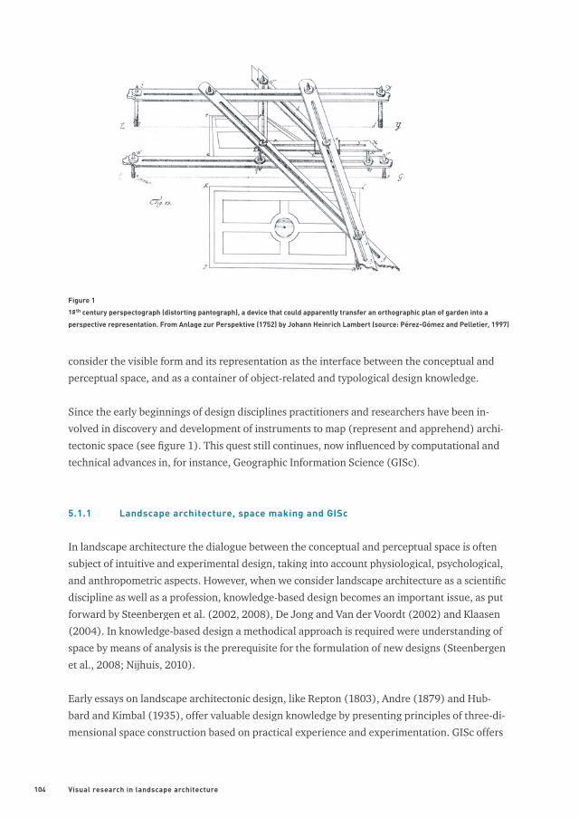
Since the early beginnings of design disciplines practitioners and researchers have been in-
volved in discovery and development of instruments to map (represent and apprehend) archi-
tectonic space (see fi gure 1). This quest still continues, now infl uenced by computational and
technical advances in, for instance, Geographic Information Science (GISc).
5.1.1 Landscape architecture, space making and GISc
In landscape architecture the dialogue between the conceptual and perceptual space is often
subject of intuitive and experimental design, taking into account physiological, psychological,
and anthropometric aspects. However, when we consider landscape architecture as a scientifi c
discipline as well as a profession, knowledge-based design becomes an important issue, as put
forward by Steenbergen et al. (2002, 2008), De Jong and Van der Voordt (2002) and Klaasen
(2004). In knowledge-based design a methodical approach is required were understanding of
space by means of analysis is the prerequisite for the formulation of new designs (Steenbergen
et al., 2008; Nijhuis, 2010).
Early essays on landscape architectonic design, like Repton (1803), Andre (1879) and Hub-
bard and Kimbal (1935), offer valuable design knowledge by presenting principles of three-di-
mensional space construction based on practical experience and experimentation. GISc offers
Figure 1
18th century perspectograph (distorting pantograph), a device that could apparently transfer an orthographic plan of garden into a
perspective representation. From Anlage zur Perspektive (1752) by Johann Heinrich Lambert (source: Pérez-Gómez and Pelletier, 1997)
105
designers new possibilities for mapping landscape architectonic compositions to deepen and
broaden the body of knowledge about the understanding of the relation between the concep-
tual and perceptual space. Although this relationship is complex in nature (e.g. it’s involvement
of subjective aspects of perception) it is worthwhile to consider the concepts and tools of GISc
for analysing the ‘horizontal perspective’ (as an observer exploring the visual space), which
have a great potential for this kind of design research.
5.1.2 Aims and structure
This chapter aims to explore some basic concepts of the horizontal perspective linked to land-
scape architectonic design research by means of Geographic Information Systems (GIS). It is
about the analysis of the visible form and its architectonic composition as would be experi-
enced by an observer moving through a virtual space, by making use of GIS-based isovists and
viewsheds. On one hand it introduces the basic concepts of visual perception and the role of
movement. On the other, it explores how some of these concepts can be revealed by using GIS,
presenting particularities of the perceived landscape architectonic space.
The chapter is structured as follows: Firstly, landscape architecture is positioned as a design
discipline focussed on the study of three-dimensional compositions, following that a frame-
work for design research is introduced in section 5.2. Secondly, the concept of visible form
is elaborated involving the basic concepts of visual perception and movement in section 5.3.
Thirdly, the potential of GIS in visibility analysis for grasping the visual form and it’s archi-
tectonic composition is exemplifi ed by two examples: Piazza San Marco (Venice, Italy), as a
designed space of buildings, and Stourhead landscape garden (Wiltshire, UK), as a designed
space of vegetation and relief in section 5.4. Isovist and viewshed functions in particular are
explored. The chapter ends with concluding remarks and discussion.
5 . 2 L A N D S C A P E A R C H I T E CT U R E : D E S I G N I N G O U T D O O R S PA C E
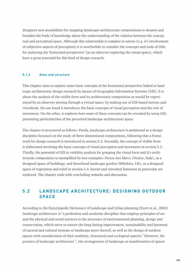
According to the Encyclopedic Dictionary of Landscape and Urban planning (Evert et al., 2010)
landscape architecture is “a profession and academic discipline that employs principles of art
and the physical and social sciences to the processes of environmental planning, design and
conservation, which serve to ensure the long-lasting improvement, sustainability and harmony
of natural and cultural systems or landscape parts thereof, as well as the design of outdoor
spaces with consideration of their aesthetic, functional and ecological aspects.” However, the
practice of landscape architecture 2, the arrangement of landscape as manifestation of spaces
106 Visual research in landscape architecture
and objects, is as old as human existence (Pregill and Volkman, 1999; Rogers, 2001; Newton,
1971). Within the broad fi eld of landscape architecture there are three areas of activity accord-
ing to the scales of time and space in which they operate: landscape planning, landscape design
and landscape management. See Stiles (1994a, 1994b) and Thompson (1999) for an elaboration
on this topic. This chapter focuses upon landscape design, in particular the design of sites.
5.2.1 Research, design and three-dimensional space
Landscape architecture consists of a basic attitude that involves four principles of study and
practice. These are: anamnesis (palimpsest), process, three-dimensional space and scale-contin-
uum (relational context) (Nijhuis, 2006; Prominski, 2004; Marot, 1995). This chapter is about
three-dimensional space as a crucial aspect in landscape design and comprises of the represen-
tation, realisation and apprehension of outdoor space. In the Dutch landscape architecture tra-
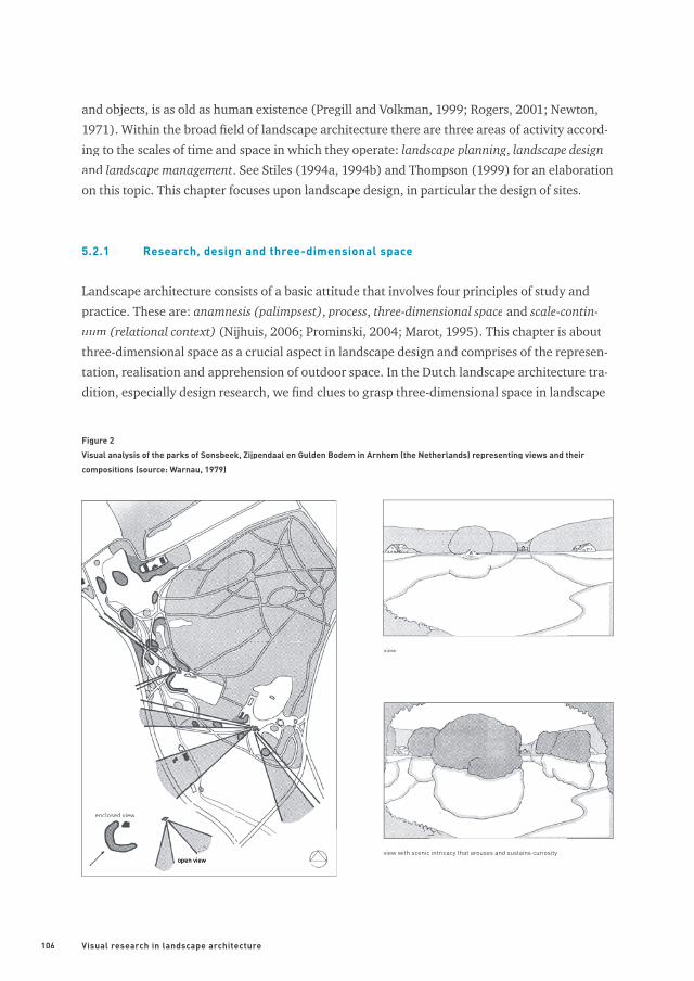
dition, especially design research, we fi nd clues to grasp three-dimensional space in landscape
Figure 2
Visual analysis of the parks of Sonsbeek, Zijpendaal en Gulden Bodem in Arnhem (the Netherlands) representing views and their
compositions (source: Warnau, 1979)
enclosed view
open viewopen view
view
view with scenic intricacy that arouses and sustains curiosity
107
design, exemplifi ed by the seminal works such as: Architecture and Landscape (Steenbergen
and Reh, 2003), Designing Parks (Baljon, 1992), Rapport over de parken Sonsbeek, Zijpendaal
en Gulden Bodem in Arnhem (Report about the parks Sonsbeek, Zijpendaal and Gulden Bodem
in Arnhem) (Warnau, 1979) and Waarnemen en ontwerpen in tuin en landschap (Perception and
design of garden and landscape) (Bijhouwer, 1954) (see fi gure 2). In these studies landscape
design is considered as a three-dimensional composition of natural, cultural, urban and archi-
tectonic elements related to aesthetic, ecologic, social and economic parameters.
Landscape design in relation to spatial compositions involves two important research domains:
design research (analysis of existing designs or precedents) and research by design (formulation
of new designs) (De Jong and Van der Voordt, 2002). These respective research domains and
their variables are positioned in table 1. The two components cannot be seen apart from each
other: design research is an indispensable step in research by design. From this point of view
we can consider this approach as a form of heuristics (way to fi nd), a scientifi c approach that
leads to new discoveries and inventions by taking a methodical approach (Steenbergen et al.,
2002).
Especially in the work of Steenbergen cum suis (2009, 2008, 2003) we fi nd a well-established
framework for (typo)morphological research related to landscape as an architectonic com-
position (see fi gure 3). Here the composition is understood as the vehicle that establishes the
relationship between content and form. Content is everything that comprises the landscape
architectonic object, its material, topography, technical structure, and cultural substance. The
form involves the way in which the parts are assembled in a composition and is considered as
the interface between intention and perception (Steenbergen et al., 2008).
OBJECT
determined variable
CONTEXTdetermined plan analysis design experiment
variable comparative research experimental design
design research research by design
Table 1
Design research and research by design: a variable relationship between object and context (source: Steenbergen et al., 2008)
108 Visual research in landscape architecture
5.2.2 Design research and visible form
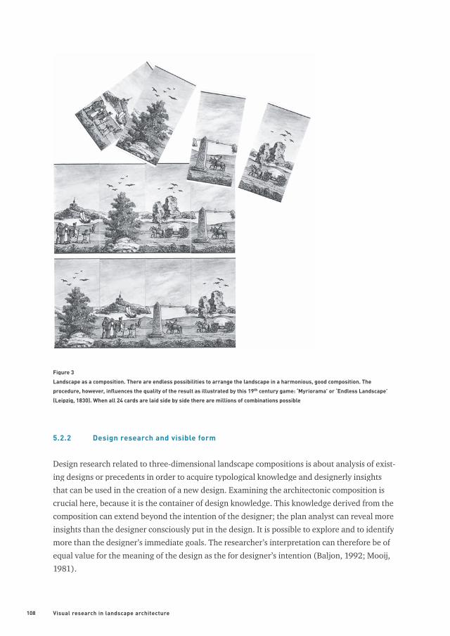
Design research related to three-dimensional landscape compositions is about analysis of exist-
ing designs or precedents in order to acquire typological knowledge and designerly insights
that can be used in the creation of a new design. Examining the architectonic composition is
crucial here, because it is the container of design knowledge. This knowledge derived from the
composition can extend beyond the intention of the designer; the plan analyst can reveal more
insights than the designer consciously put in the design. It is possible to explore and to identify
more than the designer’s immediate goals. The researcher’s interpretation can therefore be of
equal value for the meaning of the design as the for designer’s intention (Baljon, 1992; Mooij,
1981).
Figure 3
Landscape as a composition. There are endless possibilities to arrange the landscape in a harmonious, good composition. The
procedure, however, infl uences the quality of the result as illustrated by this 19th century game: ‘Myriorama’ or ‘Endless Landscape’
(Leipzig, 1830). When all 24 cards are laid side by side there are millions of combinations possible
109
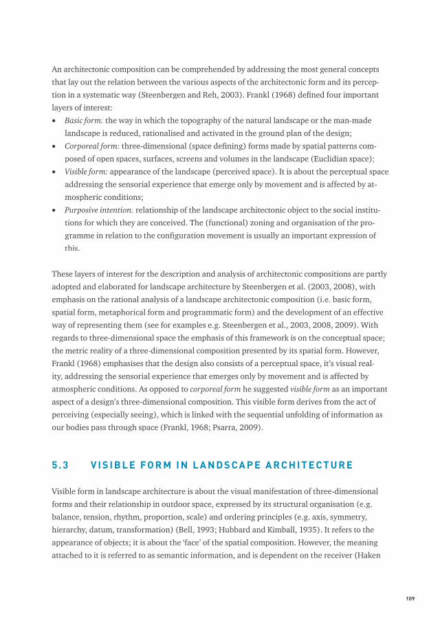
An architectonic composition can be comprehended by addressing the most general concepts
that lay out the relation between the various aspects of the architectonic form and its percep-
tion in a systematic way (Steenbergen and Reh, 2003). Frankl (1968) defi ned four important
layers of interest:
• Basic form: the way in which the topography of the natural landscape or the man-made
landscape is reduced, rationalised and activated in the ground plan of the design;
• Corporeal form: three-dimensional (space defi ning) forms made by spatial patterns com-
posed of open spaces, surfaces, screens and volumes in the landscape (Euclidian space);
• Visible form: appearance of the landscape (perceived space). It is about the perceptual space
addressing the sensorial experience that emerge only by movement and is affected by at-
mospheric conditions;
• Purposive intention: relationship of the landscape architectonic object to the social institu-
tions for which they are conceived. The (functional) zoning and organisation of the pro-
gramme in relation to the confi guration movement is usually an important expression of
this.
These layers of interest for the description and analysis of architectonic compositions are partly
adopted and elaborated for landscape architecture by Steenbergen et al. (2003, 2008), with
emphasis on the rational analysis of a landscape architectonic composition (i.e. basic form,
spatial form, metaphorical form and programmatic form) and the development of an effective
way of representing them (see for examples e.g. Steenbergen et al., 2003, 2008, 2009). With
regards to three-dimensional space the emphasis of this framework is on the conceptual space;
the metric reality of a three-dimensional composition presented by its spatial form. However,
Frankl (1968) emphasises that the design also consists of a perceptual space, it’s visual real-
ity, addressing the sensorial experience that emerges only by movement and is affected by
atmospheric conditions. As opposed to corporeal form he suggested visible form as an important
aspect of a design’s three-dimensional composition. This visible form derives from the act of
perceiving (especially seeing), which is linked with the sequential unfolding of information as
our bodies pass through space (Frankl, 1968; Psarra, 2009).
5 . 3 V I S I B L E FO R M I N L A N D S C A P E A R C H I T E CT U R E
Visible form in landscape architecture is about the visual manifestation of three-dimensional
forms and their relationship in outdoor space, expressed by its structural organisation (e.g.
balance, tension, rhythm, proportion, scale) and ordering principles (e.g. axis, symmetry,
hierarchy, datum, transformation) (Bell, 1993; Hubbard and Kimball, 1935). It refers to the
appearance of objects; it is about the ‘face’ of the spatial composition. However, the meaning
attached to it is referred to as semantic information, and is dependent on the receiver (Haken
110 Visual research in landscape architecture
and Portugali, 2003; Blake and Sekuler, 2006). Thus there is a subjective part containing
symbolic, cultural and personal elements which fi nally determine the experience of landscape
architectonic space (see e.g. Kaplan and Kaplan, 1989).
How can we understand visible form in order to extract design knowledge? According to
Salingaros (2005) “we defi ne our living space by connecting to solid boundaries, visually and
acoustically as well as through physical contact. Strictly speaking, outdoor space doesn’t need
[e.g.] buildings at all; only surrounding surfaces, nodes for sitting and standing, and paths”. In
short, we defi ne our environment as a collection of surfaces, screens and objects in space. So
landscape architectonic composition consists of a given spatial relationship between these con-
sidering the diurnal and seasonal variations in natural light. The visible attributes of the space-
establishing elements are position, size, direction, number, shape, colour and texture which
every visible form posses under any condition of illumination (Thiel, 1961; Gibson, 1986; Bell,
1993; Simonds, 1997).
The observer’s relationship to these visual descriptors is of a higher geometrical order and they
locate their position by using a rough polar or vector orientation in terms of distance and direc-
tion (Gibson, 1986). This optical structure is called an ambient optic array and was introduced ambient optic array and was introduced ambient optic array
by Gibson (1961). He explained the optic array as a set of nested solid angles corresponding to
surface elements in the environment. The architectonic space exchanges information via these
fi elds with our senses; it is a visual information fi eld (Gibson, 1986; Salingaros, 2005).
5.3.1 Perceiving visible form
Although physical space is three-dimensional, these dimensions are not equal to human per-
ception of space. The cognitive organism acts on visual information that is imaged on the
retina. In other words: the perceptual space is fl attened in terms of information content (Blake
and Sekuler, 2006; Snowden et al., 2006; Ware, 2008). Thus visual space has dimensions that
are very different from the geographic or measured space and each dimension has different
affordances. This perceptual space consists of an up-down and left-right (sideways) dimension
(the retinal image or picture plane) and a distance dimension (depth) (Blake and Sekuler, 2006;
Ware, 2008). These different characteristics are of greatest importance for landscape design
because they not only determine if and how the visual form is perceived, but also can be con-
sciously applied to achieve a certain spatial quality and establish space relationships.
The information from the up-down and sideways dimension is basically a matter of visual pat-
tern processing and colour discrimination and is the basis for recognition of objects and their
relationships. Pattern recognition is primarily about contours (shape), regions, spatial grouping
111
(based on: nearness, continuity, similarity, enclosure, shape and common direction) and visual
distinctness. Visual distinctness describes the degree of feature-level contrast between the ob-
ject and its surroundings (e.g. fi gure-background) (Blake and Sekuler, 2006; Ware, 2008; Bell,
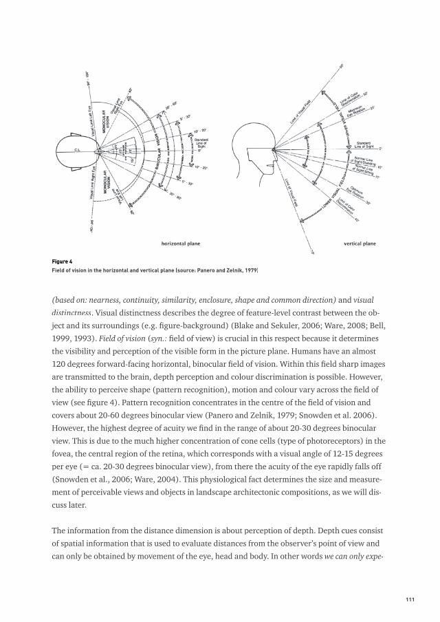
1999, 1993). Field of vision (syn.: fi eld of view) is crucial in this respect because it determines
the visibility and perception of the visible form in the picture plane. Humans have an almost
120 degrees forward-facing horizontal, binocular fi eld of vision. Within this fi eld sharp images
are transmitted to the brain, depth perception and colour discrimination is possible. However,
the ability to perceive shape (pattern recognition), motion and colour vary across the fi eld of
view (see fi gure 4). Pattern recognition concentrates in the centre of the fi eld of vision and
covers about 20-60 degrees binocular view (Panero and Zelnik, 1979; Snowden et al. 2006).
However, the highest degree of acuity we fi nd in the range of about 20-30 degrees binocular
view. This is due to the much higher concentration of cone cells (type of photoreceptors) in the
fovea, the central region of the retina, which corresponds with a visual angle of 12-15 degrees
per eye (= ca. 20-30 degrees binocular view), from there the acuity of the eye rapidly falls off
(Snowden et al., 2006; Ware, 2004). This physiological fact determines the size and measure-
ment of perceivable views and objects in landscape architectonic compositions, as we will dis-
cuss later.
The information from the distance dimension is about perception of depth. Depth cues consist
of spatial information that is used to evaluate distances from the observer’s point of view and
can only be obtained by movement of the eye, head and body. In other words we can only expe-
Figure 4
Field of vision in the horizontal and vertical plane (source: Panero and Zelnik, 1979)
112 Visual research in landscape architecture
rience space by movement (Blake and Sekuler, 2006; Ware, 2008; Bell, 1999). Depth cues can
be divided in physiologic, kinetic and pictorial cues. Pictorial depth cues can be reproduced
in a painting or a photograph, or consciously applied in landscape architectonic design. The
most powerful depth cue is occlusion (objects that visually block other objects appear closer).
Other depth cues are related to the geometry of perspective: linear perspective, size gradients
and texture gradients. Furthermore, cast shadows, height on picture plane, shading, depth of fo-
cus, size relative to known objects, and atmospheric contrast reduction are important depth cues
(Blake and Sekuler, 2006; Snowden et al., 2006; Ware, 2008). Each of the depth cues support
different kinds of visual queries and can be applied (individually) in a landscape architectonic
composition to create optical illusions or pictorial effects. Non-pictorial depth cues are related
to the physiology of the visual system: stereoscopic depth (stereopsis), accommodation and
convergence, and kinetics: structure from motion (motion parallax) (Blake and Sekuler, 2006;
Snowden et al., 2006; Ware, 2008).
5.3.2 Movement and landscape architectonic composition
We can only experience landscape architectonic space by movement. As opposed to a painting,
we move through a landscape or a building and its visible form alters or changes constantly, as
does its internal relationships. The interpretation of every single image as three-dimensional
that we receive from different viewpoints are (usually) not ends in themselves but part of a
series of three-dimensional images which draw together the architectonic image (mental im-
age) of the composition (Frankl, 1968) 3. This kinetic experience of the observer who arrives
at a ‘single’ image as the product of many partial images is summarised by Hoogstad (1990)
as: Space = Time (+ memory) x Movement. In other words, visible form is about the construc-
tion of time-space relationships among the space establishing elements and their attributes
(Hoogstad, 1990). Successive acts of perception and recognition infl uences one’s sense of time.
Observers in motion perceive change successively and adjust their knowledge. For instance,
individuals tell the length of their walks by the rhythmic spacing of recurring elements. The
more spatial variation, the shorter the walk appears; but recalling from memory, the walk ap-
pears longer (Bosselman, 1998).
Landscape architectonic compositions stimulate, or at least permit, certain kinds of movement
with different modalities, and manage speed and direction. So movement takes place partly in
response to or in accordance with the designer’s intentions (Conan, 2003; Hunt, 2004). Yet to-
gether with spaces, paths are considered to be paramount structural components of (designed)
landscapes because they play a crucial role in mediating or facilitating the experience and use
of these compositions (Dee, 2001; Bell, 1993). In this respect paths and routes play a crucial
role as structural organisers of the architectonic image (Appleyard, 1970; Lynch, 1960).
113
Related to movement through space we can distinguish three modes of vision:
• Stationary vision: standing still or sitting; frontal perception of a fi xed scene;
• Slow-motion vision: walking, cycling and horse riding; slow sequential frontal and/or lateral
perception of scenes;
• Fast-motion vision: car driving, motorcycling and train; fast sequential frontal and/or lateral
perception of scenes.
The characteristics of these modes of vision have wide ranging implications for the visible form.
For instance, the speed of movement determines the visual angle and the focus towards the
landscape (e.g. with increasing speed the visual angle narrows down). This chapter focuses
on stationary vision and slow-motion vision because it closely relates to the primordial act of
walking as an aesthetic and social practice (Careri, 2002; König, 1996; Solnit, 2001) 4. The
relevance of this for landscape architecture is put forward by Conan (2003), Hunt (2004) and
De Jong (2007). The latter summarises it as follows: “the walk [(as an action, but also a route)]
represents an important unifying and structural principle in the design of garden and land-
scape architecture and the discovery of landscape from past to present. It must be considered
the hinge that steered more than anything else the changing options for use, experience, and
design and contributed fundamentally to both personal and cultural developments” (De Jong,
2007).
5.3.3 Visually controlled movement
With regard to visible form it is important to link visually controlled movement to space percep-
tion. Perception of space is essentially about perception of action potential within the local en-
vironment. This concept is referred to as affordances (Gibson, 1986). Gibson (1986) conceived
affordances as physical properties of the environment, which are about linking perception and
action. So, paths afford walking, a bench affords sitting, et cetera. Affordances in visual space
are readily perceived possibilities for action, especially movement. With regard to the visual
form we can speak of visually controlled movement. An open environment affords movement in
any direction, and an environment with surfaces, screens and objects only at openings (Gibson,
1986). Research in wayfi nding 5 indicates that route choice behaviour is for 60% depended on
spatial aspects such as space perception, spatio-visual attractiveness, arousal and orientation
(Korthals Altes and Steffen, 1988). So the visible form is crucial because it affords movement
by its openings, offers a sense of direction by its spatial orientation and offers arousal/attrac-
tion by its visual composition.
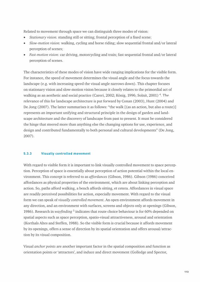
Visual anchor points are another important factor in the spatial composition and function as
orientation points or ‘attractors’, and induce and direct movement (Golledge and Spector,
114 Visual research in landscape architecture
1978; Golledge, 1999; Hillier et al., 1993). Anchor points are key primitive elements or strate-
gic foci (signifi cant features or landmarks) in space and attract our attention more than other
areas of the landscapes’ face. Yarbus (1967) pointed out that they provide more information
than others and carry useful or necessary information for recognition and understanding of
spatial relationships and function as ‘spatial magnets’ or destinations (see fi gure 5). In this
respect we can distinguish three different means for movement: travel to familiar destinations,
exploratory travel and travel to novel destinations (Allen, 1999). In these types of movement
following a marked trail and landmark-based piloting are important modes of wayfi nding, which
have their applications in landscape design, as we shall see later. Landmark-based piloting re-
fers to the act in which the observer relies on sequentially organised knowledge: a landmark is
associated with direction and distance information that leads to another (Allen, 1999). It can
be considered as a landscape architecture tool for initiating movement.
5.3.4 The shape of a walk: organising visual logic
As we have seen the visible form of a landscape architectonic composition derives from the
act of visual perception, which is linked with the sequential unfolding of visual information by
movement through space. Paths do not only provide passage but also direct movement through
the three-dimensional composition. In addition, paths offer a means to organise the visual
Figure 5
Record of eye movement during free examination of a photographed face. The eye fi xates mainly on the eyes and mouth as anchor
points in the ‘landscape of the face’ because they provide important information on the internal state of mind of the person on the
picture and are the basis for action (source: Yarbus, 1967)
115
logic of a site by directing the visitor’s gaze at (distant) views or focal points (e.g. buildings,
objects) and their sequence (serial vision) as a spatial narrative (O’Malley et al., 2010; Psarra,
2009; Potteiger, 1998). Focal points serve often as ‘destinations’ and induce movement (i.e.
landmark-based piloting).
Hunt (2003, 2004) proposed a taxonomy of ‘walkscapes’ in designed landscapes, which exem-
plify the intended relation between movement and visible form:
• Procession: ritual movement that follows both a preordained path and purpose and is de-
termined by implicit or explicit guidelines constituting the performance of that ritual laid
down in formal records such as social or religious conventions or written text (examples:
Sacro Monti, Varallo (Italy), and Versailles, Paris (France));
• Stroll: movement with an ultimate purpose within the site and a sense of destination. Stroll-
ing also implies a defi ned route between whatever incidents punctuate and give rhythm to
the movement (examples: Stowe landscape gardens, Buckinghamshire (England), and Cali-
fornia Scenario, Costa Mesa, California (USA));
• Ramble: movement without an external prompt, they are promoted largely by the will or
curiosity of an individual. Rambles are for the pleasure of movement itself (examples: Cen-
tral Park, New York (USA), and Vondelpark, Amsterdam (the Netherlands)).
As such the landscape architectonic composition is visible by stationary vision and slow-motion
vision, and is choreographed by the confi guration of paths. In this way we can consider a
landscape architectonic design as a three-dimensional composition of scenes, views and tab-
leaux with references, symbols and stories (Vroom, 2006; Olwig, 2002). This presumes that
‘pictorialisation’ 6 or scenography (stage setting) and its sequence are signifi cant aspects of the
visual organisation and perception of landscape architectonic compositions (Grandell, 1993).
Furthermore, the individual surfaces, screens and objects within the composition can have a
certain spatiality or visual effect such as spatial radiance which bestow a certain visual direction
and amplitude (Arnheim, 1977; Von Meiss, 2004).
5.3.5 The scene as a image
The formal relationship of three-dimensional objects in space is visible as a scene (tafereel) on
the retina (Hoogstad, 1990). A scene refers to an extensive piece of the (urban) landscape that
can be seen from a single (or multiple) point of view as in a painting or as a stage of a theatre 7
with a foreground, middle ground and background (O’Malley et al., 2010; Repton, 1803). More
particularly, it is about views, feature views or focal views (vistas), which are (composed) land-
scape unities within the horizontal, binocular fi eld of vision of about 20-30 degrees (Hubbard
and Kimball, 1935). This corresponds with the centre of our fi eld of vision, as discussed before,
116 Visual research in landscape architecture
and it appears that this anthropometric fact is a decisive factor in spatial design. Research of
Pechère (2002) pointed out that 22 degrees is a common used angle to determine appropriate
views in landscape design, and Schubert (1965) discovered the sequence of 20, 30, 33 and 42
degrees in urban design with the emphasis on 20 and 30 degrees for important ensembles 8.
View-making involves demarcating, organising and framing of scenes with architectonic ob-
jects (e.g. by using buildings, porches and porticos), planting and barriers such as walls, fences
and hedges. These barriers are used to direct the gaze by openings in them or screen less ‘pic-
turesque’ elements.
Through the centuries the principles of view-making in relation to movement is a constant fac-
tor, while the context of landscape architectonic composition itself varied (Grandell, 1993).
Steenbergen and Reh (2003) distinguished three important contexts: rational, formal and
pictorial. For example: whereas the French formal garden was based on a single axial view
from the house, the English picturesque garden was a series of multiple oblique views that
were meant to be experienced while one walked through it. Through the ages “the [landscape
architectonic] composition was becoming more cinematic than pictorial; it was designed to be
experienced in motion as a series of compositions dissolving into each other rather then as a
picture…” (Solnit, 2001). The sequential experience of ‘moving pictures’ also became the basis
for fi lm and cinema as beautifully illustrated by the rolled-up panoramic landscapes on translu-
cent paper by Carmontelle, an eighteenth-century French painter and landscape designer (De
Brancion, 2008).
Independent of the different contexts, views were carefully planned combining formal, transi-
tional and progressive elements. Views were also often subject to optical illusions making use
of depth perception (especially pictorial depth cues) and size constancy. By manipulating the
spatial dimensions and layout landscape architects created the illusion of distance (impression
of greater depth) as, for instance, brilliantly elaborated at Vaux-le-Vicomte, Melun (France)
(Steenbergen and Reh, 2003; Hazlehurst, 1980). Views were not only valued as aesthetically
pleasing, but were also equated with ownership and control of one’s domain (O’Malley et al.,
2010).
5 . 4 M A P P I N G V I S I B L E FO R M W I T H G E O G R A P H I C I N FO R M AT I O N SY S T E M S ( G I S )
As discussed before the visible form is the interface between the intention and the perception
of the landscape architectonic design. Therefore it is important to acquire object-related and
typological design knowledge on the perceptual order of landscape architectonic compositions.
This addresses the question of how a design interfaces the conceptual order (physical space)

117
with the perceptual order (visual space). GISc in relation to the perceptual order considers
architectonic compositions as visibility fi elds and explores those parameters that are observ-
able by a viewer located within space (the horizontal perspective), and those confi guration
properties that can be discovered by visual experience evoked by optical axes, visibility fi elds
and sequences of visual information (Psarra, 2009; Tzortzi, 2004). It incorporates the related
concepts of visual perception with regards to the organisation of visual logic, space-making,
composing views and the control of movement.
Tandy suggested already in 1967 the application of isovists or viewsheds (“limit-of-vision
plottings” and “visual watersheds” as he called them) in order to “convey the spatial composi-
tion from an observers point of view” and “to enable visual analysis of the landscape” (Tandy,
1967). Later, Benedikt connected Gibson’s concept of the ambient optic array to isovists and
isovist fi elds for means of architectonic research (Benedikt, 1979, 1981). For landscape plan-
ning, the concept of viewsheds is elaborated by Higuchi and Lynch for means of visual impact
analysis (Higuchi, 1975; Lynch, 1976).
Due to advances in computer science the concepts of visibility-analysis are nowadays a wide-
spread phenomena with a broad palette of applications (for examples see other contributions
in this book). More particularly, advances in GISc offer researchers in (urban) landscape design
interesting clues to engage in the fi eld of visual research. GIS-based concepts of isovists (sight
fi eld polygons) (see e.g. Rana, 2002; Batty, 2001) and viewsheds (see e.g. Llobera, 2003; Fisher
1995) can especially help to comprehend the relation between the conceptual and perceptual
space and offer different modes of representation. The typical difference between the two
concepts is that the raster-based viewsheds represent parts of space that are visible, taking into
account vertical viewing angle and elevation, while vector-based isovists consider visible space
in the horizontal plane. The result is a closed polygon that can be characterised with different
numerical parameters (Batty, 2001; Turner et al., 2001).
Although both concepts have great potential for landscape architectonic research we only see
them sparsely applied in the fi eld of landscape design. However, for means of visual impact
analysis and landscape character assessment we see several applications of the GIS-based
viewshed in landscape planning (see e.g. chapters 10, 11, 12, 13), and only recently the use of
GIS-based isovists (Weitkamp, 2010; see chapter 9).
5.4.1 Research approach towards examples
The aim of this section is to describe, map and analyse the visible form made by spatial pat-
terns composed of open spaces, surfaces, screens and volumes as it could be experienced by
118 Visual research in landscape architecture
an observer moving through a virtual space, making use of GIS-based isovists and viewsheds.
It addresses the physiognomy of space with visibility as a key element. The potential of ‘being
able to see’ is mapped out and addresses plausible and/or probable visible space (Fisher, 1995,
1996; Weitkamp, 2010).
This section explores the use of viewsheds and isovists in landscape design research in order
to reveal some important visual concepts by using two examples which are well-documented
architectonic objects and offer widely acknowledged designed spatial qualities which have the
potential to be tested and verifi ed by means of GIS. It offers an actual (non- or a-historical) and
formal reading of the sites. The analysis of visual form reveals the perceived spatial potential
as a basis for performance and reception. The Piazza San Marco (Venice, Italy), famous for its
space relationships and articulation of space, is used as an example for the analysis of a de-
signed space of buildings. Stourhead landscape garden (Wiltshire, UK), famous for its pictorial
circuit with composed views in a sequence, is used as an example for the analysis of a designed
space mainly of vegetation and relief. The fi rst example focuses on the application of isovists
analysing the entrance of the square and the spatio-visual impact of the bell-tower using se-
quences of viewpoints and a fi eld of viewpoints. The latter is about application of viewsheds
for means of analysing composed views and their sequence by using multiple single viewpoints
and their sequential/specifi c organisation.
The examples are based on highly accurate digital and digitised data obtained from fi eld sur-
veys provided respectively by the University of Venice (Piazza San Marco) and The National
Trust (Stourhead) complemented or corrected by other sources (archival material, historical
maps, map reconstructions, etc.) and fi eld observations. For testing the results of the meas-
urements we used text interpretation (expert-judgement), digital three-dimensional models,
(aerial) photographs and measurements in the fi eld.
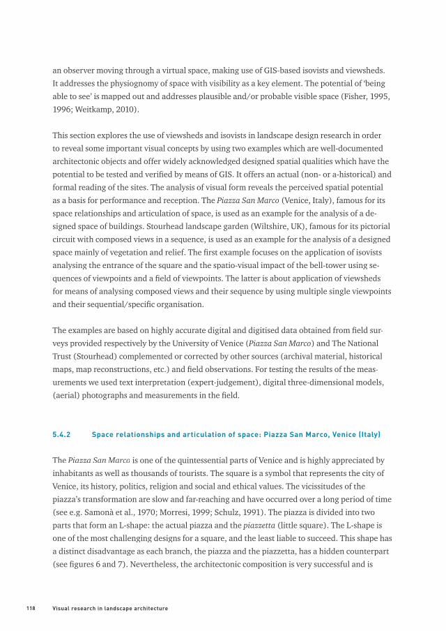
5.4.2 Space relationships and articulation of space: Piazza San Marco, Venice (Italy)
The Piazza San Marco is one of the quintessential parts of Venice and is highly appreciated by
inhabitants as well as thousands of tourists. The square is a symbol that represents the city of
Venice, its history, politics, religion and social and ethical values. The vicissitudes of the
piazza’s transformation are slow and far-reaching and have occurred over a long period of time
(see e.g. Samonà et al., 1970; Morresi, 1999; Schulz, 1991). The piazza is divided into two
parts that form an L-shape: the actual piazza and the piazzetta (little square). The L-shape is
one of the most challenging designs for a square, and the least liable to succeed. This shape has
a distinct disadvantage as each branch, the piazza and the piazzetta, has a hidden counterpart
(see fi gures 6 and 7). Nevertheless, the architectonic composition is very successful and is
119
Figure 6
Piazza San Marco
Figure 7
Plan of the Piazza San Marco. Dionisio Moretti, 1828
(source: Supernova Edizioni)
120 Visual research in landscape architecture
acknowledged for its spatial qualities such as the articulation of space and space relationships
(see e.g. Janson and Bürklin, 2002; Newton, 1971; Samonà, 1970). In this example we focus on
space relationships and the articulation of space.
Origins of the square
A group of marsh islands or mudfl ats (called: Barena) in the Venetian Lagoon, formed some
6000 years ago, was a precondition for settlement starting in the 5th century. Venice begun to
emerge as an early archipelago in the 9th century (Ammerman, 2003; Crouzet-Pavan, 2002;
Bellavitis and Romanelli, 1985). However, the occupation of the islands at San Marco dates
from the 7th and 8th century (Ammerman et al., 1995). The actual Piazza San Marco had its
beginning in 811, when the ducal seat was moved from Malamocco (Lido) to Venice. With the
construction of the ducal palace and then the Basilica of San Marco, the doge’s private chapel,
the area at the head of the Grand Canal became the hub of political and ceremonial life in the
city, and the Venetian Republic (Schulz, 1991; Fenlon, 2009, 2007).
San Marco
Figure 8
The location of the Piazza on a map of the 8th and 9th century
Venetian settlements (source: Trincanato and Franzoi, 1971)
mudfl atsmudfl atsmudfl ats
consolidated landconsolidated land
121
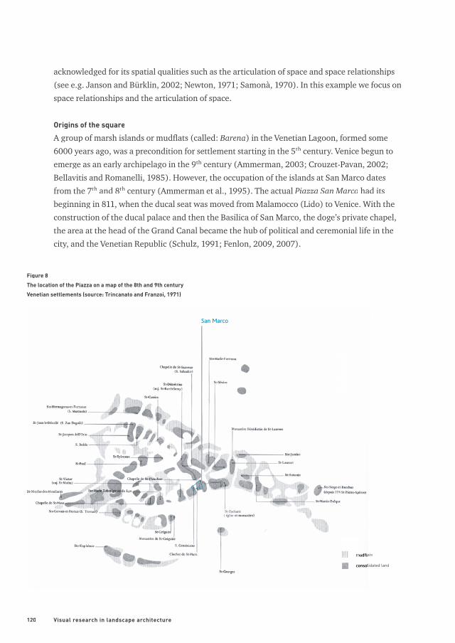
The site consisted originally of two islands, which by land reclamation and architectonic en-
deavours transformed radically from the 1160s (or 1170s) onwards (Schulz, 1991) (see fi gure
8). The shape of the square we know now dates from the mid 15th century as a result of an am-
bitious renovatio urbis led by the state architect Pietro Bon († 1529), later succeeded by Jacopo
Sansovino (1486-1570). It remained the centre of the city-state until the fall of the Venetian
Republic to Napoleon in 1797. He called the Piazza San Marco “the fi nest drawing-room in Eu-
rope” because of its architectonic qualities (Fenlon, 2009; Goy, 1997).
Architectonic system of the square
In terms of geometry the piazza is the predominant part of the ensemble, with the Basilica di
San Marco as the terminal focus of attention. The piazza is a trapezoidal form of 175 metres
long and 81 metres wide at the campanile (bell tower), and 56 metres wide in front of the
Palazzo Reale. The view towards the façade of the basilica is framed by the space defi ning fa-
cades of the Procuratie Vecchie and Procuratie Nuove, and the foot of the campanile. The whole
Figure 9
Three-dimensional model of the square (by S. Nijhuis and J. Wiers)
Procuratie Vecchie
Torre dell’orologioBasilica di San Marco
Palazzo Ducale
Procuratie Nuove
Campanile
Zecca
LibreriaSansoviniana
122 Visual research in landscape architecture
façade of the basilica is seen at glance because the determined view covers a visual angle of 20
- 33 degrees (Schubert, 1965), which corresponds with centre of the binocular fi eld of vision.
This view is also subject to optical illusions making use of pictorial depth cues, like the diverg-
ing lines of the surrounding facades ‘slowing down’ the optical perspective and shrinking the
optical size of the basilica. In the reverse direction the length of the square is exaggerated by
the converging lines, ‘speeding up’ the optical perspective.
The southern branch of the L-shape, the piazzetta, is 96 metres long and its width varies from
a minimum of 40 metres (south-end) to a maximum of 48 metres. The piazzetta is formed by
the Palazzo Ducale di Venezia and the Libreria Sansoviniana, which converge slightly at the
south-end. Here two freestanding columns frame the sunlit view across the water to San Gior-
gio Maggiore (by Andrea Palladio; 1508-1580), the island church seemingly ‘fl oating on the
lagoon’. Also here the organisation and demarcation of the view is based on the fi eld of vision
of 20-30 degrees (Schubert, 1965). By pushing the Libreria (and Zecca (mint)) southward to
the lagoon, the building mass gives direction and orientation to space and movement from the
Molo (water-side) ‘pointing’ towards the piazzetta and piazza. In the piazzetta, the entrance of
the campanile visually points towards the main-entrance of the palazzo.
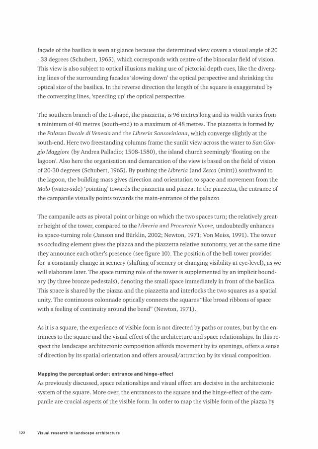
The campanile acts as pivotal point or hinge on which the two spaces turn; the relatively great-
er height of the tower, compared to the Libreria and Procuratie Nuove, undoubtedly enhances
its space-turning role (Janson and Bürklin, 2002; Newton, 1971; Von Meiss, 1991). The tower
as occluding element gives the piazza and the piazzetta relative autonomy, yet at the same time
they announce each other’s presence (see fi gure 10). The position of the bell-tower provides
for a constantly change in scenery (shifting of scenery or changing visibility at eye-level), as we
will elaborate later. The space turning role of the tower is supplemented by an implicit bound-
ary (by three bronze pedestals), denoting the small space immediately in front of the basilica.
This space is shared by the piazza and the piazzetta and interlocks the two squares as a spatial
unity. The continuous colonnade optically connects the squares “like broad ribbons of space
with a feeling of continuity around the bend” (Newton, 1971).
As it is a square, the experience of visible form is not directed by paths or routes, but by the en-
trances to the square and the visual effect of the architecture and space relationships. In this re-
spect the landscape architectonic composition affords movement by its openings, offers a sense
of direction by its spatial orientation and offers arousal/attraction by its visual composition.
Mapping the perceptual order: entrance and hinge-effect
As previously discussed, space relationships and visual effect are decisive in the architectonic
system of the square. More over, the entrances to the square and the hinge-effect of the cam-
panile are crucial aspects of the visible form. In order to map the visible form of the piazza by
123
Figure 10
Serial vision from the west-end of the piazza to the south-end of the piazzetta showing the crucial role of the campanile in the changing
visibility (degree of shifting scenery) of the spatial transition from the piazza to the piazzetta
1
2
3
4
5
6
7

124 Visual research in landscape architecture
Figure 11
Sequence of views entering the square at the Torre dell’orologio
viewpoint 1
viewpoint 2
viewpoint 3
1 2
3
125
means of GIS-based isovists we have built an accurate vector based GIS-model, based on fi eld
surveys by the University of Venice (1:100; 1:500) and research by Samonà et al. (1970) and
Morresi (1999).
In order to represent and apprehend the visible form of an entrance we analysed the approach
to the square from the Torre dell’orologio (Clock Tower). This clock tower is one of the most
important links between the piazza and the rest of the city. We used GIS-based isovists (at eye-
level) in a sequence of viewpoints to map the perceptual order of the entrance. The sequence
of isovists shows the framed views into the piazza, across the façade of the Basilica, straight
out through the piazzetta, until San Giorgio Maggiore. On the opposite side, it provides visual
reference, taking the eye past the piazza and on in the direction of Rialto. However, towards
the square the optical axis points towards the piazzetta, to gradually open out over the whole
piazza. This slow sequence of frontal views can also be represented as a Minkowski-model (Ben-
edikt, 1979) showing the relation between visible form and time (movement). The model is a
sequential stacking of individual isovists and shows the gradual change of visible space by mov-
ing forward entering the square (see fi gures 11 and 12).
Figure 12
Minkowski-model from Piazza San Marco approached via the Torre dell’orologio. The top layer of the model represents the fi rst isovist
at point A; the bottom layer represents the isovist at point B
starting point AB
space
time
126 Visual research in landscape architecture
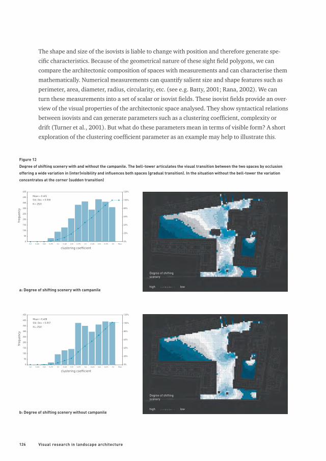
The shape and size of the isovists is liable to change with position and therefore generate spe-
cifi c characteristics. Because of the geometrical nature of these sight fi eld polygons, we can
compare the architectonic composition of spaces with measurements and can characterise them
mathematically. Numerical measurements can quantify salient size and shape features such as
perimeter, area, diameter, radius, circularity, etc. (see e.g. Batty, 2001; Rana, 2002). We can
turn these measurements into a set of scalar or isovist fi elds. These isovist fi elds provide an over-
view of the visual properties of the architectonic space analysed. They show syntactical relations
between isovists and can generate parameters such as a clustering coeffi cient, complexity or
drift (Turner et al., 2001). But what do these parameters mean in terms of visible form? A short
exploration of the clustering coeffi cient parameter as an example may help to illustrate this.
0
50
100
150
200
250
300
350
400
450
0.2 0.225 0.25 0.275 0.3 0.325 0.35 0.375 0.4 0.425 0.45 0.475 0.5 Meer
clustering coefficient
freq
uenc
y
0%
20%
40%
60%
80%
100%
120%
Mean = 0.405Std. Dev. = 0.058
N = 2501
0
50
100
150
200
250
300
350
400
450
0.2 0.225 0.25 0.275 0.3 0.325 0.35 0.375 0.4 0.425 0.45 0.475 0.5 Meer
clustering coefficient
freq
uenc
y
0%
20%
40%
60%
80%
100%
120%
Mean = 0.408Std. Dev. = 0.057
N = 2501
Figure 13
Degree of shifting scenery with and without the campanile. The bell-tower articulates the visual transition between the two spaces by occlusion
offering a wide variation in (inter)visibility and infl uences both spaces (gradual transition). In the situation without the bell-tower the variation
concentrates at the corner (sudden transition)
Degree of shifting scenery
Degree of shifting scenery
high
high
low
lowa: Degree of shifting scenery with campanile
b: Degree of shifting scenery without campanile
127
As we have seen, the campanile plays a crucial role in the composition of the Piazza San Marco
as a hinge in the architectonic system that connects the two branches of the square. The cam-
panile articulates the connection between piazza and piazzetta as an intermediate member,
blocking a direct transition between the two areas of the piazza. As regards the movement of
passers-by, this translates into a pause and a change in direction or division of space. This initi-
ates an interesting shift of scenery (changing visibility), which offers spatio-visual attractive-
ness, arousal and clues for orientation. The shift of scenery can be mapped by using the cluster-
ing coeffi cient parameter in an isovist fi eld at eye level. The clustering coeffi cient gives a meas-
urement of the proportion of intervisible space within the visibility neighbourhood of a point.
It indicates how much of an observer’s visual fi eld will be retained or lost as the individual
moves away from that point (Turner et al., 2001). In order to show the impact of the campanile,
a comparison of the piazza with and without the bell-tower can be seen. The results show that
the campanile has a great impact on the variation in visibility, and infl uences large parts of both
squares (see fi gures 13a, b).
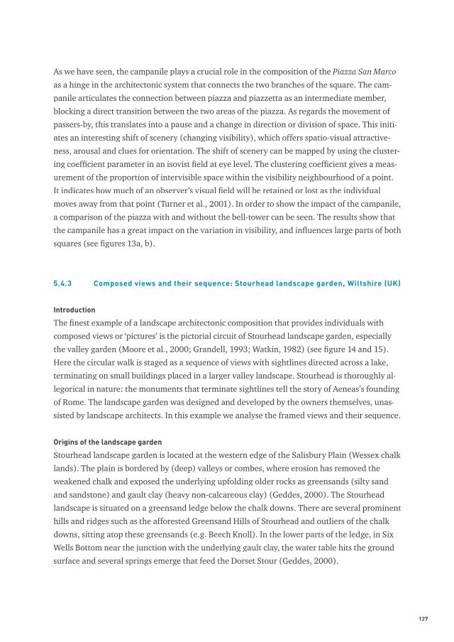
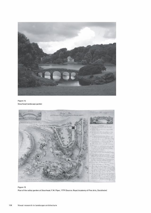
5.4.3 Composed views and their sequence: Stourhead landscape garden, Wiltshire (UK)
Introduction
The fi nest example of a landscape architectonic composition that provides individuals with
composed views or ‘pictures’ is the pictorial circuit of Stourhead landscape garden, especially
the valley garden (Moore et al., 2000; Grandell, 1993; Watkin, 1982) (see fi gure 14 and 15).
Here the circular walk is staged as a sequence of views with sightlines directed across a lake,
terminating on small buildings placed in a larger valley landscape. Stourhead is thoroughly al-
legorical in nature: the monuments that terminate sightlines tell the story of Aeneas’s founding
of Rome. The landscape garden was designed and developed by the owners themselves, unas-
sisted by landscape architects. In this example we analyse the framed views and their sequence.
Origins of the landscape garden
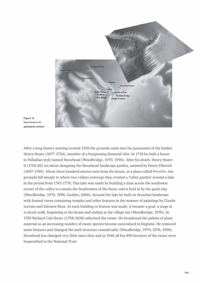
Stourhead landscape garden is located at the western edge of the Salisbury Plain (Wessex chalk
lands). The plain is bordered by (deep) valleys or combes, where erosion has removed the
weakened chalk and exposed the underlying upfolding older rocks as greensands (silty sand
and sandstone) and gault clay (heavy non-calcareous clay) (Geddes, 2000). The Stourhead
landscape is situated on a greensand ledge below the chalk downs. There are several prominent
hills and ridges such as the afforested Greensand Hills of Stourhead and outliers of the chalk
downs, sitting atop these greensands (e.g. Beech Knoll). In the lower parts of the ledge, in Six
Wells Bottom near the junction with the underlying gault clay, the water table hits the ground
surface and several springs emerge that feed the Dorset Stour (Geddes, 2000).
128 Visual research in landscape architecture
Figure 14
Stourhead landscape garden
Figure 15
Plan of the valley garden at Stourhead. F.M. Piper, 1779 (Source: Royal Academy of Fine Arts, Stockholm)
129
After a long history starting around 1350 the grounds came into the possession of the banker
Henry Hoare (1677-1724), member of a burgeoning fi nancial elite. In 1718 he built a house
in Palladian style named Stourhead (Woodbridge, 1970, 1996). After his death, Henry Hoare
II (1705-85) set about designing the Stourhead landscape garden, assisted by Henry Flitcroft
(1697-1769). About three hundred metres west from the house, at a place called Paradise, the
grounds fall steeply to where two valleys converge they created a ‘valley garden’ around a lake
in the period from 1743-1770. This lake was made by building a dam across the southwest
corner of the valley to contain the headwaters of the Stour, and is held in by the gault clay
(Woodbridge, 1970, 1996; Geddes, 2000). Around the lake he built an Arcadian landscape
with framed views containing temples and other features in the manner of paintings by Claude
Lorrain and Salvator Rosa. As each building or feature was made, it became a goal; a stage in
a circuit walk, beginning at the house and ending at the village inn (Woodbridge, 1976). In
1785 Richard Colt Hoare (1758-1838) inherited the estate. He broadened the palette of plant
material as an increasing number of exotic species became naturalised in England. He removed
some features and changed the path structure considerably (Woodbridge, 1970, 1976, 1996).
Stourhead has changed very little since then and in 1946 all but 890 hectares of the estate were
bequeathed to the National Trust.
Figure 16
Stourhead in its
geological context
Alfred’s Tower
St Peter’s Pump
The Convent
Obelisk
Stourhead House
GrottoGothic Cottage
PantheonIron Bridge
Temple of Flora
Palladian Bridge
Temple of Apollo
130 Visual research in landscape architecture
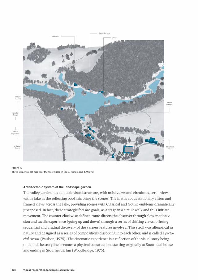
Architectonic system of the landscape garden
The valley garden has a double visual structure, with axial views and circuitous, serial views
with a lake as the refl ecting pool mirroring the scenes. The fi rst is about stationary vision and
framed views across the lake, providing scenes with Classical and Gothic emblems dramatically
juxtaposed. In fact, these strategic foci are goals, as a stage in a circuit walk and thus initiate
movement. The counter-clockwise defi ned route directs the observer through slow-motion vi-
sion and tactile experience (going up and down) through a series of shifting views, offering
sequential and gradual discovery of the various features involved. This stroll was allegorical in
nature and designed as a series of compositions dissolving into each other, and is called a picto-
rial circuit (Paulson, 1975). The cinematic experience is a refl ection of the visual story being
told; and the storyline becomes a physical construction, starting originally at Stourhead house
and ending in Stourhead’s Inn (Woodbridge, 1976).
Templeof Flora
St. Peter’sChurch
BristolHigh Cross
Templeof Apollo
PalladianBridge
Pantheon
Gothic Cottage
Grotto
StourheadHouse
Figure 17
Three-dimensional model of the valley garden (by S. Nijhuis and J. Wiers)
131
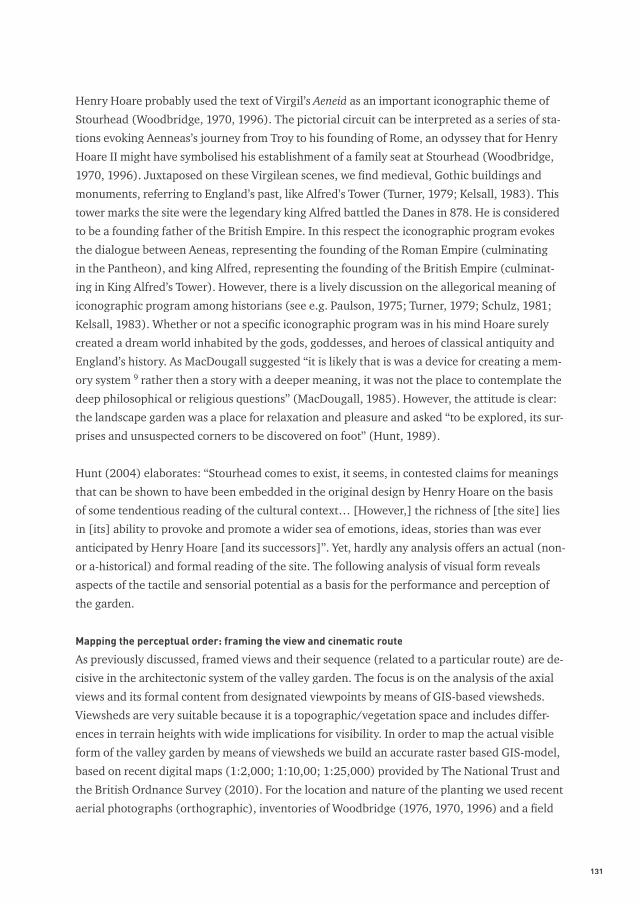
Henry Hoare probably used the text of Virgil’s Aeneid as an important iconographic theme of
Stourhead (Woodbridge, 1970, 1996). The pictorial circuit can be interpreted as a series of sta-
tions evoking Aenneas’s journey from Troy to his founding of Rome, an odyssey that for Henry
Hoare II might have symbolised his establishment of a family seat at Stourhead (Woodbridge,
1970, 1996). Juxtaposed on these Virgilean scenes, we fi nd medieval, Gothic buildings and
monuments, referring to England’s past, like Alfred’s Tower (Turner, 1979; Kelsall, 1983). This
tower marks the site were the legendary king Alfred battled the Danes in 878. He is considered
to be a founding father of the British Empire. In this respect the iconographic program evokes
the dialogue between Aeneas, representing the founding of the Roman Empire (culminating
in the Pantheon), and king Alfred, representing the founding of the British Empire (culminat-
ing in King Alfred’s Tower). However, there is a lively discussion on the allegorical meaning of
iconographic program among historians (see e.g. Paulson, 1975; Turner, 1979; Schulz, 1981;
Kelsall, 1983). Whether or not a specifi c iconographic program was in his mind Hoare surely
created a dream world inhabited by the gods, goddesses, and heroes of classical antiquity and
England’s history. As MacDougall suggested “it is likely that is was a device for creating a mem-
ory system 9 rather then a story with a deeper meaning, it was not the place to contemplate the
deep philosophical or religious questions” (MacDougall, 1985). However, the attitude is clear:
the landscape garden was a place for relaxation and pleasure and asked “to be explored, its sur-
prises and unsuspected corners to be discovered on foot” (Hunt, 1989).
Hunt (2004) elaborates: “Stourhead comes to exist, it seems, in contested claims for meanings
that can be shown to have been embedded in the original design by Henry Hoare on the basis
of some tendentious reading of the cultural context… [However,] the richness of [the site] lies
in [its] ability to provoke and promote a wider sea of emotions, ideas, stories than was ever
anticipated by Henry Hoare [and its successors]”. Yet, hardly any analysis offers an actual (non-
or a-historical) and formal reading of the site. The following analysis of visual form reveals
aspects of the tactile and sensorial potential as a basis for the performance and perception of
the garden.
Mapping the perceptual order: framing the view and cinematic route
As previously discussed, framed views and their sequence (related to a particular route) are de-
cisive in the architectonic system of the valley garden. The focus is on the analysis of the axial
views and its formal content from designated viewpoints by means of GIS-based viewsheds.
Viewsheds are very suitable because it is a topographic/vegetation space and includes differ-
ences in terrain heights with wide implications for visibility. In order to map the actual visible
form of the valley garden by means of viewsheds we build an accurate raster based GIS-model,
based on recent digital maps (1:2,000; 1:10,00; 1:25,000) provided by The National Trust and
the British Ordnance Survey (2010). For the location and nature of the planting we used recent
aerial photographs (orthographic), inventories of Woodbridge (1976, 1970, 1996) and a fi eld
132 Visual research in landscape architecture
visit (2009). Finally, the reconstruction of the route and path-structure is based on research by
Woodbridge (1976) and Reh (1995).
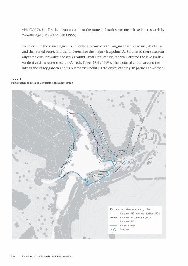
To determine the visual logic it is important to consider the original path structure, its changes
and the related route, in order to determine the major viewpoints. At Stourhead there are actu-
ally three circular walks: the walk around Great Oar Pasture, the walk around the lake (valley
garden) and the outer circuit to Alfred’s Tower (Reh, 1995). The pictorial circuit around the
lake in the valley garden and its related viewpoints is the object of study. In particular we focus
Situation 1785 (after Woodbridge, 1976)
Situation 1820 (after Reh,1995)
Situation 2010
Analysed route
Viewpoints
1
2
3
4
5
6
7
1
Path and route structure valley garden:
Figure 18
Path structure and related viewpoints in the valley-garden
133
on the major views related to the ‘unchanged’ path structure that facilitate the counter-clock-
wise stroll starting at the Temple of Flora and ending at Bristol High Cross (see fi gure 18).
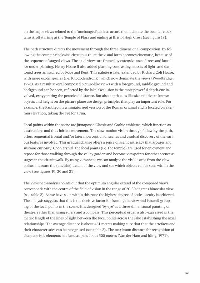
The path structure directs the movement through the three-dimensional composition. By fol-
lowing the counter-clockwise circuitous route the visual form becomes cinematic, because of
the sequence of staged views. The axial views are framed by extensive use of trees and laurel
for under-planting. Henry Hoare II also added planting contrasting masses of light- and dark-
toned trees as inspired by Pope and Kent. This palette is later extended by Richard Colt Hoare,
with more exotic species (i.e. Rhododendrons), which now dominate the views (Woodbridge,
1976). As a result several composed picture-like views with a foreground, middle ground and
background can be seen, refl ected by the lake. Occlusion is the most powerful depth-cue in-
volved, exaggerating the perceived distance. But also depth cues like size relative to known
objects and height on the picture plane are design principles that play an important role. For
example, the Pantheon is a miniaturised version of the Roman original and is located on a ter-
rain elevation, taking the eye for a run.
Focal points within the scene are juxtaposed Classic and Gothic emblems, which function as
destinations and thus initiate movement. The slow-motion vision through following the path,
offers sequential frontal and/or lateral perception of scenes and gradual discovery of the vari-
ous features involved. This gradual change offers a sense of scenic intricacy that arouses and
sustains curiosity. Upon arrival, the focal points (i.e. the temple) are used for enjoyment and
repose for those walking through the valley garden and become viewpoints for other scenes as
stages in the circuit walk. By using viewsheds we can analyse the visible area from the view-
points, measure the (angular) extent of the view and see which objects can be seen within the
view (see fi gures 19, 20 and 21).
The viewshed-analysis points out that the optimum angular extend of the composed views
corresponds with the centre of the fi eld of vision in the range of 20-30 degrees binocular view
(see table 2). As we have seen within this zone the highest degree of optical acuity is achieved.
The analysis suggests that this is the decisive factor for framing the view and (visual) group-
ing of the focal points in the scene. It is designed ‘by eye’ as a three-dimensional painting or
theatre, rather than using rulers and a compass. This perceptual order is also expressed in the
metric length of the lines of sight between the focal points across the lake establishing the axial
relationships. The average distance is about 431 metres making sure that that the artefacts and
their characteristics can be recognised (see table 2). The maximum distance for recognition of
characteristic elements in a landscape is about 500 metres (Van der Ham and Iding, 1971).
134 Visual research in landscape architecture
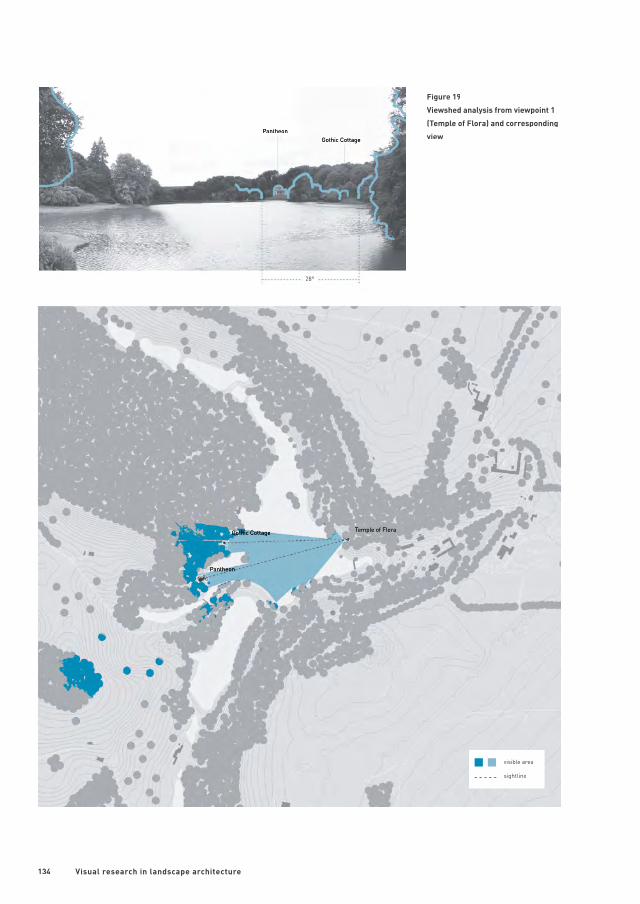
Figure 19
Viewshed analysis from viewpoint 1
(Temple of Flora) and corresponding
view Pantheon
Gothic CottageTemple of Flora
Pantheon
Gothic Cottage
28°
visible area
sightline
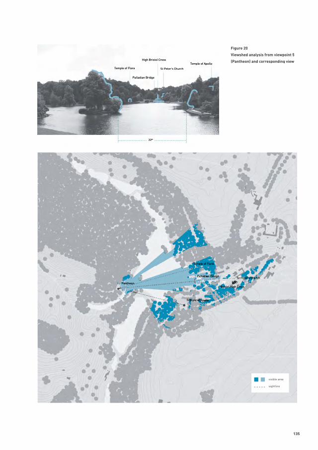
135
Figure 20
Viewshed analysis from viewpoint 5
(Pantheon) and corresponding view
Pantheon
Temple of Flora
Palladian Bridge St Peter’s Church
Bristol High Cross
Temple of Apollo
Temple of Flora
High Bristol Cross
St Peter’s Church
Palladian Bridge
Temple of Apollo
22°
visible area
sightline
136 Visual research in landscape architecture
Figure 21
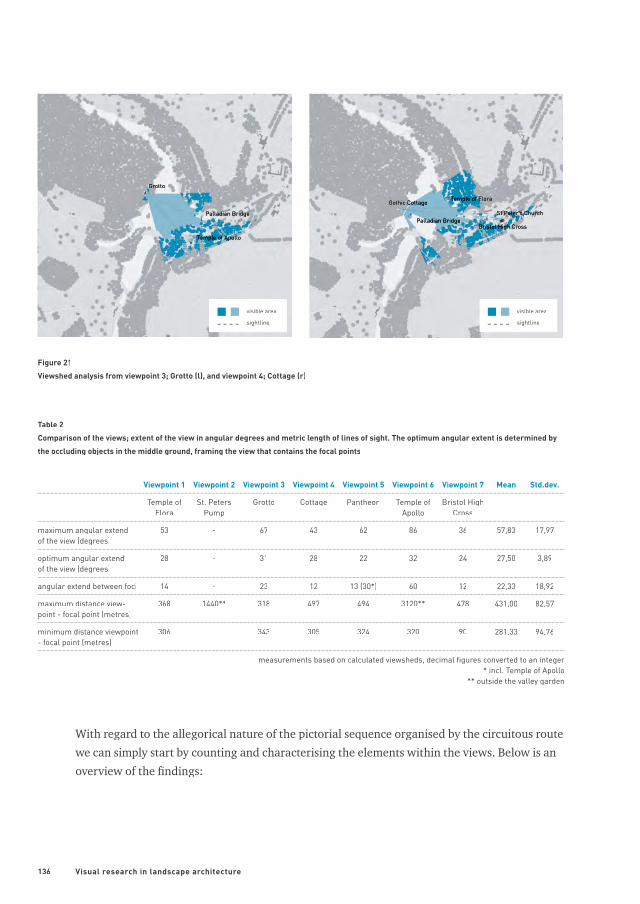
Viewshed analysis from viewpoint 3; Grotto (l), and viewpoint 4; Cottage (r)
Viewpoint 1 Viewpoint 2 Viewpoint 3 Viewpoint 4 Viewpoint 5 Viewpoint 6 Viewpoint 7 Mean Std.dev.
Temple of Flora
St. Peters Pump
Grotto Cottage Pantheon Temple of Apollo
Bristol HighCross
maximum angular extend of the view (degrees)
53 - 67 43 62 86 36 57,83 17,97
optimum angular extend of the view (degrees)
28 - 31 28 22 32 24 27,50 3,89
angular extend between foci 14 - 23 12 13 (30*) 60 12 22,33 18,92
maximum distance view-point - focal point (metres)
368 1440** 318 497 494 3120** 478 431,00 82,57
minimum distance viewpoint - focal point (metres)
306 - 343 305 324 320 90 281,33 94,76
measurements based on calculated viewsheds, decimal fi gures converted to an integer* incl. Temple of Apollo
** outside the valley garden
Table 2
Comparison of the views; extent of the view in angular degrees and metric length of lines of sight. The optimum angular extent is determined by
the occluding objects in the middle ground, framing the view that contains the focal points
With regard to the allegorical nature of the pictorial sequence organised by the circuitous route
we can simply start by counting and characterising the elements within the views. Below is an
overview of the fi ndings:
Gothic Cottage
Grotto
Palladian Bridge
Temple of Apollo
Temple of Flora
Palladian BridgeSt Peter’s Church
Bristol High Cross
visible area
sightline
visible area
sightline
137
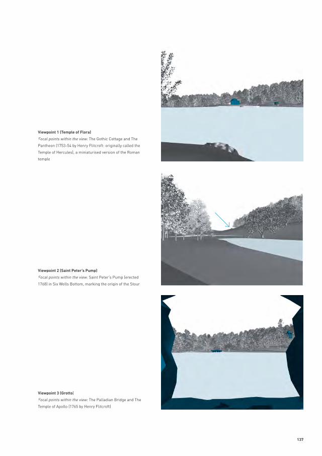
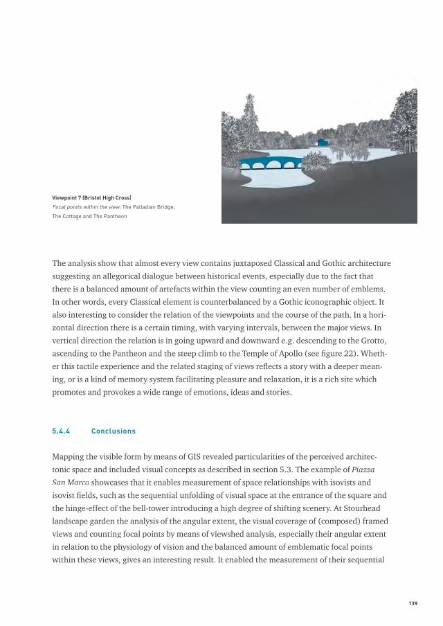
Viewpoint 1 (Temple of Flora)
Focal points within the view: The Gothic Cottage and The
Pantheon (1753-54 by Henry Flitcroft: originally called the
Temple of Hercules), a miniaturised version of the Roman
temple
Viewpoint 2 (Saint Peter’s Pump)
Focal points within the view: Saint Peter’s Pump (erected Focal points within the view: Saint Peter’s Pump (erected Focal points within the view:
1768) in Six Wells Bottom, marking the origin of the Stour
Viewpoint 3 (Grotto)
Focal points within the view: The Palladian Bridge and The
Temple of Apollo (1765 by Henry Flitcroft)
138 Visual research in landscape architecture
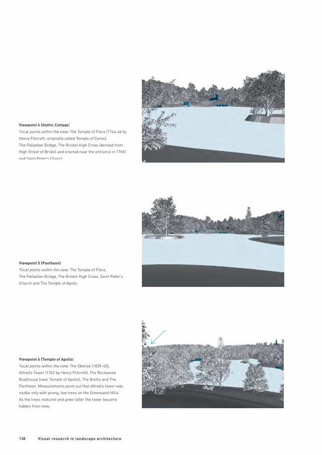
Viewpoint 4 (Gothic Cottage)
Focal points within the view: The Temple of Flora (1744-46 by Focal points within the view: The Temple of Flora (1744-46 by Focal points within the view:
Henry Flitcroft; originally called Temple of Ceres),
The Palladian Bridge, The Bristol High Cross (derived from
High Street of Bristol and erected near the entrance in 1765)
and Saint Peter’s Church
Viewpoint 5 (Pantheon)
Focal points within the view: The Temple of Flora, Focal points within the view: The Temple of Flora, Focal points within the view:
The Palladian Bridge, The Bristol High Cross, Saint Peter’s
Church and The Temple of Apollo
Viewpoint 6 (Temple of Apollo)
Focal points within the view: The Obelisk (1839-40), Focal points within the view: The Obelisk (1839-40), Focal points within the view:
Alfred’s Tower (1762 by Henry Flitcroft), The Rockwood
Boathouse (near Temple of Apollo), The Grotto and The
Pantheon. Measurements point out that Alfred’s tower was
visible only with young, low trees on the Greensand Hills.
As the trees matured and grew taller the tower became
hidden from view.
139
The analysis show that almost every view contains juxtaposed Classical and Gothic architecture
suggesting an allegorical dialogue between historical events, especially due to the fact that
there is a balanced amount of artefacts within the view counting an even number of emblems.
In other words, every Classical element is counterbalanced by a Gothic iconographic object. It
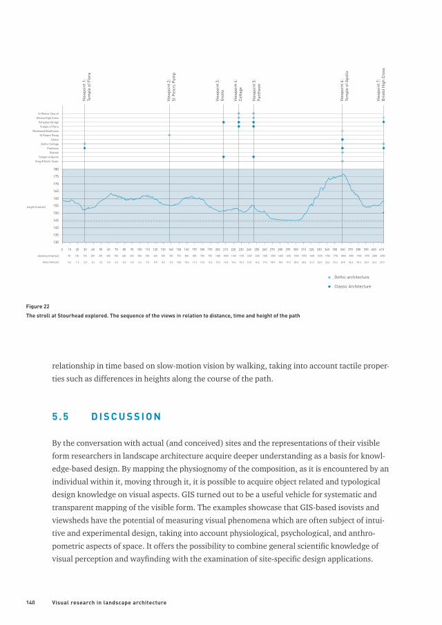
also interesting to consider the relation of the viewpoints and the course of the path. In a hori-
zontal direction there is a certain timing, with varying intervals, between the major views. In
vertical direction the relation is in going upward and downward e.g. descending to the Grotto,
ascending to the Pantheon and the steep climb to the Temple of Apollo (see fi gure 22). Wheth-
er this tactile experience and the related staging of views refl ects a story with a deeper mean-
ing, or is a kind of memory system facilitating pleasure and relaxation, it is a rich site which
promotes and provokes a wide range of emotions, ideas and stories.
5.4.4 Conclusions
Mapping the visible form by means of GIS revealed particularities of the perceived architec-
tonic space and included visual concepts as described in section 5.3. The example of Piazza
San Marco showcases that it enables measurement of space relationships with isovists and
isovist fi elds, such as the sequential unfolding of visual space at the entrance of the square and
the hinge-effect of the bell-tower introducing a high degree of shifting scenery. At Stourhead
landscape garden the analysis of the angular extent, the visual coverage of (composed) framed
views and counting focal points by means of viewshed analysis, especially their angular extent
in relation to the physiology of vision and the balanced amount of emblematic focal points
within these views, gives an interesting result. It enabled the measurement of their sequential
Viewpoint 7 (Bristol High Cross)
Focal points within the view: The Palladian Bridge,
The Cottage and The Pantheon
140 Visual research in landscape architecture
relationship in time based on slow-motion vision by walking, taking into account tactile proper-
ties such as differences in heights along the course of the path.
5 . 5 D I S C U S S I O N
By the conversation with actual (and conceived) sites and the representations of their visible
form researchers in landscape architecture acquire deeper understanding as a basis for knowl-
edge-based design. By mapping the physiognomy of the composition, as it is encountered by an
individual within it, moving through it, it is possible to acquire object related and typological
design knowledge on visual aspects. GIS turned out to be a useful vehicle for systematic and
transparent mapping of the visible form. The examples showcase that GIS-based isovists and
viewsheds have the potential of measuring visual phenomena which are often subject of intui-
tive and experimental design, taking into account physiological, psychological, and anthro-
pometric aspects of space. It offers the possibility to combine general scientifi c knowledge of
visual perception and wayfi nding with the examination of site-specifi c design applications.
130
135
140
145
150
155
160
165
170
175
100
50 100 150 200 250distance (metres)
height (metres)
time (minuts) 0.6 1.3 2.0 2.6 3.3
300
4.0
350
4.6
400
5.3
450
6.0
500
6.6
20 30 40 50 7060 80 90 100
180
Gothic architecture
Classic Architecture
110 120 130 140 150 160 180170 190 200 210 220 240230 250 260 270 280 290 300 310 320 330 340 350 360 370 380 390 400 410
550 600 650 700
7.3 8.0 8.6 9.3
750
10.0
800
10.6
850
11.3
900
12.0
950
12.6
1000 1050 1100 1150
13.3 14.0 14.6 15.3
1200
16.0
1250
16.6
1300
17.3
1350
18.0
1400
18.6
1450 1500 1550 1600
19.3 20.0 20.6 21.3
1650
22.0
1700
22.6
1750
23.3
1800
24.0
1850
24.6
1900
25.3
1950
26.0
2000
26.6
2050
27.3
View
poin
t 7:
Bri
stol
Hig
h Cr
oss
View
poin
t 1:
Tem
ple
of F
lora
Temple of FloraRockwood Boathouse
View
poin
t 2:
St P
eter
s Pu
mp
St Peters PumpGrotto
St Peters Church
View
poin
t 3:
Gro
tto
View
poin
t 4:
Cott
age
View
poin
t 5:
Pant
heon
View
poin
t 6:
Tem
ple
of A
pollo
Bristol High CrossPalladian Bridge
Gothic CottagePantheon
ObeliskTempel of Apollo
King Alfred’s Tower
Figure 22
The stroll at Stourhead explored. The sequence of the views in relation to distance, time and height of the path
141
In comparison to important landscape design research studies on visible form in the Dutch
academic context, such as the seminal works of Steenbergen and Reh (2003), Baljon (1992),
Warnau (1979) and Bijhouwer (1954), it seems that GIS deepens and broadens the body of
knowledge in landscape architecture in two ways by:
(1) Following the discipline and developing specifi c aspects of it: by using GIS we can map the
‘same types of design-knowledge’ but in a more precise, systematic/transparent, and quan-
tifi ed manner. It makes for precise delineation and alternative ways of representation of
the visible landscape. By using GIS it is possible to reproduce and transfer methodology; it
is a transparent and systematic approach for advanced spatial analysis. It also comprises of
measurement (quantities), testing and verifi cation of expert knowledge, or known visual
phenomena in landscape architecture.
(2) Expanding the fi eld by setting in motion fundamental new developments: by using GIS we
can map ‘new types of design-knowledge’ by advanced spatial analysis and the possibility
of linking up/integrating other information layers, fi elds of science and data sources. GIS
offers the possibility of integrating and exploring other fi elds of science (e.g. visual percep-
tion, wayfi nding studies) and dealing with complexity (more variables). Also the avail-
ability of other types of data such as Web 2.0, terrestrial LiDAR, LBS, and Crowd Sourcing
is important in this respect. This offers the possibility to enrich formal reading by revealing
tactile and sensorial potentialities of a design, which was hardly possible before, and also
expands the analysis with data derived from psychological and phenomenological ap-
proaches addressing matters of reception of a design.
Although there is lot left to be explored in examples, this research exemplifi ed that it can offer
clues for deeper understanding of particular spatial phenomena that constitute visible form.
This is important for acquisition of design knowledge, but is also crucial in management and
restoration of sites like Stourhead 10.
A C K N O W L E D G E M E N T S
I like to thank professor Marc Antrop, Ron van Lammeren and Mari Sundli Tveit for their valu-
able comments and enthusiastic support. I also like to thank professor Clemens Steenbergen for
his remarks on an early version of the manuscript and professor Erik de Jong for the inspiring
conversations we had on the topic. Furthermore I like to thank The National Trust for their gen-
erous support providing digital maps and other information of Stourhead landscape garden.
The digitised plan of the Piazza San Marco is used by courtesy of the University IUAV of Venice.
I am grateful to my father Jan Nijhuis for his enthusiasm and encouragement in my research.
He unfortunately passed away while I was writing this chapter.
142 Visual research in landscape architecture
N OT E S
[1] For an elaboration on scientifi c perspective and the infl uence it exerted on architecture see Pérez-Gómez and Pelletier (1997).
[2] The term landscape architecture (architecte-paysagiste) was coined by Jean-Marie Morel in 1803 and marked the eclipse of the
‘new’ discipline (Disponzio, 2002). Landscape architecture as an English term appeared for the fi rst time in a book title: On
the Landscape Architecture of the Great Painters of Italy (Scott, 1828), and was subsequently used by Frederic Law Olmstead
and Calvert Vaux at the design competition for the Central Park in New York in 1858. The profession became offi cial, when in
1863 the title Landscape Architect was fi rst used by the state-appointed Board of Central Park Commissioners in New York City
(Steiner, 2001; Evert, 2010; Turner, 1990).
[3] This corresponds with space-conceptions as described by Montello (1993), Mark (1993) and Tversky et al. (1999).
[4] You can even consider it a science: strollology or strollology or strollology promenadology as proposed by Burckhardt (2008). It engages in the study of promenadology as proposed by Burckhardt (2008). It engages in the study of promenadology
sequences with which the observer is confronted by within the spatial environment.
[5] Wayfi nding refers to the cognitive and behavioural abilities of humans to fi nd a way from an origin to a destination, see
Golledge (1999).
[6] This is not exclusively restricted to The Picturesque as a movement. In this tradition Picturesque is an aesthetic category de-
rived from the idea of designing (urban) landscapes to look like pictures and was advocated by landscape architects like Wil-
liam Kent and urban designers like Camillo Sitte and Gordon Cullen.
[7] The invention/description of the linear perspective by Filippo Brunelleschi as written down by Leon Battista Alberti played a
crucial role in the architectonic compositions such as Pienza (see e.g. Pieper, 2000, 2009). The notion of pictorial staging or
scenography was introduced by Hans Vredeman de Vries in his book Sevenographia, sive perspectiveae (1560), showing décor-
like architectonic settings, using the rules of linear perspective to fi t objects logically into surrounding space (Vroom, 2006;
Mehrtens, 1990).
[8] See also Van der Ven (1980) and Doxiades (1972).
[9] Memory could be developed by establishing a mental image of a place inhabited by or ‘decorated’ with views. See MacDougall
(1985) on this matter.
[10] The author intends to elaborate the research on Stourhead and show applications for management and conservation.
R E F E R E N C E S
Allen, G.L. (1999) Spatial Abilities, Cognitive Maps and Way-
fi nding. In: Golledge, R.G. (ed.) Wayfi nding Behaviour.
Cognitive mapping and other spatial processes. Baltimore
and London, The Johns Hopkins University Press, pp
46-80
Ammerman, A.J. (2003) Venice before the Grand Canal.
Memoirs of the American Academy in Rome 48; 141-158
Ammerman, A.J. et al. (1995) More on the origins of Venice.
Antiquity 69; 501-510Antiquity 69; 501-510Antiquity
Andre, E. (1879) L’art des Jardins. Traite general de la composi-
tion des parcs et jardins. Paris, G. Masson.
Antrop, M. (2007) Perspectieven op het landschap. Achter-
gronden om landschappen te lezen en te begrijpen. Gent,
Academia Press.
Appleyard, D. (1970) Styles and Methods of Structuring a
City. Environment & Behavior 2(1); 100-116Environment & Behavior 2(1); 100-116Environment & Behavior
Arnheim, R. (1977) The dynamics of architectonic form. Berke-
ley, University of California Press.
Bacon, E.N. (1967) Design of Cities. New York, Penguin Books.
Baljon, L. (1992) Designing Parks. Amsterdam, A&NP.
Batty, M. (2001) Exploring Isovist Fields. Space and Shape in
Architectonic and Urban Morphology. Environment and
planning B: Planning and Design 28; 123-150
Bell, S. (1993) Elements of Visual Design in the Landscape.
London, E&FN Spon.
Bell, S. (1999) Landscape. Pattern, Perception and Process.
London, E&FN Spon.
Bellavitis, G., and Romanelli, G. (1985) Le città nella storia
d’ Italia. Venezia. Roma-Bari, Editori Laterza.
Benedikt, M.L. (1979) To take Hold of Space: Isovists and
Isovist Fields. Environment and Planning B 6; 47-65
Benedikt, M.L. and Burnham, C.A. (1981) Perceiving Archi-
tectural Space: From Optic Arrays to Isovists. In: Warren,
W.H., Shaw, R.E. and Hillsdale, N. J. (eds.) Persistence
and Change. Connecticut, Lawrence Erlbaum, pp 103-
114
Bijhouwer, J.T.P. (1954) Waarnemen en ontwerpen in tuin en
landschap. Amsterdam, Uitgeverij Argus.
Blake, R., and Sekuler, R. (2006) Perception. New York,
McGraw-Hill.
Bosselman, P. (1998) Representation of Places. Reality and
Realism in City Design. Berkeley, Los Angeles & London,
University of California Press.
Burckhardt, L. (2008) Warum ist Landschaft schon? Die Spa-
ziergangwissenschaft. Berlin, Martin Schmitz Verlag
Careri, F. (2002) Walkscapes. Walking as an Aesthetic Practice.
Barcelona, Editorial Gustavo Gili.
143
Crouzet-Pavan, E. (2002) Venice Triumphant. The Horizon of a
Myth. Baltimore & London, Johns Hopkins University Press.
Conan, M. ed. (2003) Landscape Design and the Experience
of Motion. Washington, Dumbarton Oaks Trustees for
Harvard University (Dumbarton Oaks Colloquium on
the History of Landscape Architecture Vol. XXIV)
De Brancion, L.C. (2008) Carmontelle’s Landscape Transpar-
encies: Cinema of the Enlightment. Los Angeles, Getty
Publications.
De Jong, E.A. (2007) Taking Fresh Air: Walking in Holland,
1600-1750. In: Conan, M. (ed.) Performance and Ap-
propriation. Profane Rituals in Gardens and Landscapes.
Washington D.C., Dumbarton Oaks Research Library
and Collection, (Dumbarton Oaks Colloquium on the
History of Landscape Architecture Vol. XXVII), pp 18-40
De Jong, T., and Van der Voordt, T. (2002) Criteria for scien-
tifi c study and design. In: de Jong, T. and van der Voordt,
T. (eds.) Ways to Study and Research. Delft University
Press, pp 19-30
Dee, C. (2001) Form and fabric in landscape architecture.
London, Routledge.
Disponzio, J. (2002) Jean-Marie Morel and the Invention of
Landscape Architecture. In: Hunt, J.D., Conan, M., and
Goldstein, C. (eds.) Tradition and Innovation in French
Garden Art. Chapters of a New History. Philadelphia,
University of Pennsylvania Press, pp 135-159
Doxiadis, C.A. (1972) Architectural Space in Ancient Greece.
Cambrigde, Massachusetts, The MIT Press.
Evert, K.J., Ballard, E.B., Oquinena, I., Schmerber, J.M. and
Stipe, R.E., eds. (2010) Encyclopedic Dictionary of Land-
scape and Urban Planning. Multilingual Reference Book
in English, Spanish, French, and German (2 vols.). Berlin,
Heidelberg, New York, Springer Verlag.
Fenlon, I. (2007) The Ceremonial City. History, Memory and
Myth in Renaissance Venice. New Haven & London, Yale
University Press.
Fenlon, I. (2009) The Piazza San Marco. Cambridge, Massa-
chusetts, Harvard University Press.
Fischer, P.F. (1995) An Exploration of Probable Viewsheds in
Landscape Planning. Environment and Planning B: Plan-
ning and design 22; 527-546
Fisher, P. F. (1996) Extending the Applicability of Viewsheds
in Landscape Planning. Programmetric Engineering and
Remote Sensing 62(11): 1297-1302
Frankl, P. (1968) Principles of architectural history. The four
phases of architectural style (1420-1900). The MIT press,
Cambridge, Massachusetts and London.
Gibson, J.J. (1986) The Ecological Approach to Visual Percep-
tion. London, Lawrence Erlbaum Associates (Original
edition 1979).
Geddes, I. (2000) Hidden Depths. Wiltshire’s Geology & Land-
scapes. Bradford on Avon, Ex Libris Press.
Golledge, R.G. and Spector, A.N. (1978) Comprehending the
Urban Environment: Theory and Practice. Geographical
Analysis 10(4); 403-426
Golledge, R.G. (1999) Human Cognitive Maps and Wayfi nd-
ing. In: Golledge, R.G. (ed.) Wayfi nding Behaviour.
Cognitive mapping and other spatial processes. Baltimore
& London, The Johns Hopkins University Press, pp 1-45
Goy, R. (1997) Venice. The City and its Architecture. New York,
Phaidon Press.
Grandell, G. (1993) Nature Pictorialized. Baltimore & London,
The Johns Hopkins University Press.
Haken, H. and Portugali, J. (2003) The face of the city is its
information. Journal of Environmental Psychology 23; Journal of Environmental Psychology 23; Journal of Environmental Psychology
385–408
Hazlehurst, F.H. (1980) Gardens of Illusion. The Genius of
André Le Nostre. Nashville, Vanderbilt University Press.
Higuchi, T. (1975) The Visual and Spatial Structure of Land-
scapes. Cambridge, The MIT Press.
Hillier, B., Penn, A., Hanson, J., Grajewski, T. and Xu, J.
(1993) Natural Movement: or, Confi guration and Attrac-
tion in Urban Pedestrian Movement. Environment and
Planning B: Planning and Design 20; 29-66
Hubbard, H.V., and Kimball, T. (1935) An Introduction to the
Study of Landscape Design. New York, The Macmillan
Company (revised edition).
Hunt, J.D. (1989) The Figure in the Landscape: Poetry, Paint-
ing, and Gardening during the Eighteenth Century. Balti-
more & London, The Johns Hopkins University Press.
Hunt, J.D. (2003) “Lordship of the Feet”: Toward a Poetics of
Movement in the Garden. In: Conan, M. (ed.) Landscape
Design and the Experience of Motion. Washington, Dum-
barton Oaks Trustees for Harvard University, pp 187-213
Hunt, J.D. (2004) The Afterlife of Gardens. London, Reaktion
Books.
Hoogstad, J. (1990) Ruimte-tijd-beweging. Prolegomena voor
de architectuur. Den Haag, SDU Uitgevers.
Janson, A., and Bürklin, T. (2002) Scenes. Interaction with
Architectural Space: the Campi of Venice. Basel, etc.,
Birkhäuser.
Kaplan, R., and Kaplan, S. (1989) The Experience of Nature.
A Psychological Perspective. Cambridge, Cambridge Uni-
versity Press.
Kelsall, M. (1983) The Iconography of Stourhead. Journal of
the Warburg and Courtauld Institutes 46; 133-147
Klaasen, I.T. (2004) Knowledge-based design. Developing urban
and regional design into a science. Amsterdam, DUP
König, G.M. (1996) Eine Kulturgeschichte des Spazierganges.
Spuren einer bürgerlichen Praktik, 1780-1850. Wien,
Bóhlau Verlag.
Korthals Altes, H.J. and Steffen, C. (1988) Beleving en
routekeuze in de binnenstad van Delft. Delft, Delft Uni-
versity Press.
Llobera, M. (2003) Extending GIS-based visual analysis: the
concept of visualscapes. International Journal for Geo-
graphical Information Science 17(1); 25-48
Lynch, K. (1960) The Image of the City. Cambridge, MIT Press.
Lynch, K. (1976) Managing the Sense of a Region. Cambridge,
MIT Press.
144 Visual research in landscape architecture
Mark, D.M. (1993) Human Spatial Cognition. In: Medyckyj-
Scott, D., and Hearnshaw, H.M. (eds.), Human Factors in
Geographical Information Systems. London and Florida,
Belhaven Press, pp 51-60
MacDougall, E.B. (1985) Imitation and Invention: Language
and decoration in Roman Renaissance Gardens. Journal
of Garden History 5(2); 119-134of Garden History 5(2); 119-134of Garden History
Mehrtens, U.M. (1990) Johan Vredeman de Vries and the
Hortorum Formae. In: Mosser, M, and Teyssot, G. (eds.)
The History of Garden Design. The Western Tradition from
the Renaissance to the Present Day. London, Thames &
Hudson, pp 103-105
Montello, D.R. (1993) Scale and Multiple Psychologies of
Space. In: Frank, A.U. and Campari, I. (Eds.) Spatial
Information theory: A theoretical basis for GIS. Berlin,
Springer-Verlag (Lecture Notes in Computer Science
716), pp 312-321
Marot, D. (1995) Landscape as Alternative. In: van der Mar-
liere, K. (ed.) Het Landschap/The Landscape. Antwerpen,
De Singel, pp 9-36
Mooij, J. (1981) Idee en verbeelding. Filosofi sche aspecten van
de literatuurbeschouwing. Assen.
Moore, C.W., Mitchell, W.J., and Turnbull jr., W. (2000) The Po-
etics of Gardens. Cambridge, Massachusetts, The MIT Press.
Morresi, M. (1999) Piazza San Marco. Istituzioni, Poteri e
Architettura a Venezia nel primo Cinquencento. Milano,
Electa.
Motloch, J.L. (2001) Introduction to Landscape Design. Second
edition. New York, etc., John Wiley & Sons.
Newton, N.T. (1971) Design on the Land. The Development
of Landscape Architecture. Cambridge, Massachusetts,
Harvard University Press.
Nijhuis, S. (2006) Westvaart als landschapsarchitectonische
ontwerpopgave. Vier ontwerpen nader beschouwd. In:
Westvaart in de polder. Leiden, RAP Architectuurcen-
trum, pp 35-37
Nijhuis, S. (2010) Landscape Architecture: Theory, methods
and techniques. Delft University of Technology (internal
report)
Olwig, K. (2002) Landscape, nature and the body- politic. From
Britain’s Renaissance to America’s new world. Wisconsin,
The University of Wisconsin Press.
O’Malley, T., Kryder-Reid, E., and Helmreich, A.L. (2010) Key-
words in American Landscape Design. Washington / New
Haven and London, Centre for Advanced Study in the
Visual Arts, National Gallery of Art / Yale University Press.
Panero, J. and Zelnik, M. (1979) Human Dimension & Interior
Space. New York, Whitney Library of Design.
Paulson, R. (1979) Emblem and Expression. Meaning in English
Art of the Eighteenth Century. Cambridge, Mass.
Pérez-Gómez, A., and Pelletier, L. (1997) Architectural Rep-
resentation and the Perspective Hinge. Cambridge, Mas-
sachusetts & London, The MIT Press.
Pechère, R. (2002) Grammaire des Jardins. Secrets de métier.
Bruxelles, Éditions Racine.
Pregill, P., and Volkman, N. (1999) Landscapes in History.
Design and Planning in the Eastern and Western Traditions
(Second Edition). New York, etc., John Wiley & Sons Inc.
Prominski, M. (2004) Landschaft Entwerfen. Sl, Reimer Verlag
Psarra, S. (2009) Architecture and narrative. The formation
of space and cultural space. Abingdon and New York,
Routledge.
Rana, S. (2002) Isovist Analyst Extension. Version 1.1. Com-
puter software program produced by the author at the
Centre for Advanced Spatial Analysis, University College
London.
Reh, W. (1995) Arcadia en metropolis. Het landschapsexperi-
ment van de verlichting. Delft University of Technology.
Repton (1803) The Theory and Practice of Landscape Gar-
dening. Reprinted in: Repton, H. (1907), The Art of
Landscape Gardening. Including his Sketches and Hints
on Landscape Gardening and Theory and Practice of
Landscape Gardening. Edited by J. Nolen. Cambridge,
Massachusetts, The Riverside Press (Houghton Miffl in
Company).
Rogers, E.B. (2001) Landscape Design. A Cultural and Architec-
tural History. New York, Harry N. Abrams.
Potteiger, M. (1998) Landscape Narratives. Design Practices for
Telling Stories. New York, etc., Wiley & Sons Inc.
Salingaros, N.A. (2005) Principles of Urban Structure. Amster-
dam, Techne Press.
Samonà, G. (1970) Caratteri morfologici del sistema architet-
tonico di Piazza San Marco. In: Samonà, G. et al. Piazza
San Marco. L’architettura la storia le funzioni. Padova,
Marsilio Editori, pp. 9-42.
Samonà, G. et al. (1970) Piazza San Marco. L’architettura la
storia le funzioni. Padova, Marsilio Editori.
Schubert, O. (1965) Optik in Architektur und Städtebau.
Verlag Gebr. Mann, Berlin.
Schulz, M.F. (1981) The Circuit Walk of the Eighteenth-
Century Landscape Garden and the Pilgrim’s Circuitous
Progress. Eighteenth-Century Studies 15(1); 1-25
Schulz, J. (1991) Urbanism in Medieval Venice. In: Molho, A.
Raafl aub, K. and Emlen, J. (eds.) City-States in Classical
Antiquity and Medieval Italy. Athens, Rome, Florence and
Venice. Stuttgart, Franz Steiner Verlag, pp 419-445
Simonds, J.O. (1997) Landscape Architecture. New York etc.,
McGraw-Hill
Snowden, R., Thompson, P. and Troscianko, T. (2006) Basic
Vision. An introduction to visual perception. Oxford,
Oxford University Press.
Solnit, R. (2001) Wanderlust. A History of Walking. Verso,
London & New York.
Steenbergen, C.M., Meeks, S., and Nijhuis, S. (2008) Compos-
ing Landscapes. Analysis, Typology and Experiments for
Design. Birkhäuser, Basel, Boston, Berlin.
Steenbergen, C.M., Mihl, H., and Reh, W. (2002) Introduction;
Design Research, Research by Design. In: Steenbergen,
C.M., Mihl, H., Reh, W. et al. (eds.) Architectural design
and composition. Bussum, Thoth publishers, pp 12-25
145
Steenbergen, C.M., and Reh, W. (2003) Architecture and
landscape. The Design Experiment of the Great Euro-
pean Gardens and Landscapes. Revised and expanded
edition. Basel, Boston, Berlin, Birkhäuser.
Steenbergen, C.M., Reh, W., Nijhuis, S., and Pouderoijen,
M.T. (2009) The Polder Atlas of the Netherlands. Pantheon
of the Low Lands. Bussum, THOTH publishers.
Steiner, F.R. (2001) Landscape Architecture. In: Smelser, N.J.
and P.B. Baltes (eds.) International Encyclopaedia of the
Social and Behavioural Sciences, pp 8270-8275
Stiles, R. (1994a) In Search of a Defi nition. Landscape Design
234; 44-48
Stiles, R. (1994b) Landscape theory: a missing link between
landscape planning and landscape design? Landscape
and urban planning 30; 139-149
Tandy, C.R. (1967) The Isovist Method of Landscape Survey,
In: Murray, C.R. (ed.) Methods of Landscape Analysis.
London, Landscape Research Group, pp 9-10
Thiel, P. (1961) A sequence-experience notation. Town Plan-
ning Review 32 (1); 33-52
Trincanato, E., and Franzoi, U. (1971) Venise au fi l du temps.
Atlas historique d’urbanisme et d’architecture. Paris, Edi-
tions Joel Cuenot.
Turner, J. (1979) The Structure of Henry Hoare’s Stourhead.
Art Bulletin 61(1); 68-77
Turner, T. (1990) Was “Landscape Architecture” a Good Idea?
Landscape Design 191; 28-29
Turner, A., Doxa, M., O’Sullivan, D. and Penn, A. (2001) From
isovists to visibility graphs: a methodology for the analy-
sis of architectural space. Environment and Planning B:
Planning and design 28; 103-121
Thompson, I.H. (1999) Ecology, Community and Delight.
Sources of Values in Landscape Architecture. New York,
Routledge.
Thompson, I.H. (2002) Ecology, community and delight: a
trivalent approach to landscape education. Landscape
and urban planning 60; 81–93
Tversky, B., Morrison, J.B., Franklin, N., and Bryant, D.J.
(1999) Three spaces of Spatial Cognition. Professional
Geographer 51(4); 516-524Geographer 51(4); 516-524Geographer
Tzortzi, K. (2004) Building and exhibition layout. Sainsbury
Wing compared with Castelvecchio. Architectural Re-
search Quaterly 8(2); 128-140search Quaterly 8(2); 128-140search Quaterly
Van der Ham, R.J.M., and Iding, J.A. (1971) De landschaps-
typologie naar visuele kenmerken. Methodiek en gebruik.
Wageningen, Department of Landscape Architecture,
Wageningen University.
Van der Ven, C. (1980) Van beeld tot maat I/II. Intermediair
16(17,18), 13-21/43-52
Von Meiss, P. (1991) Elements of Architecture. London, E &
FN Spon.
Vroom, M. (2006) Lexicon of garden and landscape architec-
ture. Basel, Boston, Berlin, Birkhäuser
Ware, C. (2004) Information Visualization. Perception for
design. Burlington, Morgan Kaufmann Publishers.
Ware, C. (2008) Visual Thinking for Design. Burlington, Mor-
gan Kaufmann Publishers.
Warnau, H. (1979) Rapport over de parken Sonsbeek,
Zijpendaal en Gulden Bodem in Arnhem. Beschrijving,
waardering, mogelijke veranderingen. Wageningen, Vak-
groep Landschapsarchitectuur, Landbouwhogeschool
Wageningen
Watkin, D. (1982) The English Vision. The Picturesque in
Architecture, Landscape & Garden Design. London, John
Murray Publishers.
Weitkamp, G. (2010) Capturing the View. A GIS Based Proce-
dure to Assess Perceived Landscape Openness. Wagenin-
gen, Wageningen University.
Woodbridge, K. (1970) Landscape and Antiquity. Aspects of
English Culture at Stourhead 1718-1838. Oxford.
Woodbridge, K. (1976) The Planting of Ornamental Schrubs
at Stourhead. A History, 1746-1946. Garden History
4(1); 88-109
Woodbridge, K. (1996) The Stourhead Landscape. The Na-
tional Trust (Reprint edition 2002)
Yarbus, A.L. (1967) Eye Movement and Vision. New York,
Plenum Press.
Related Documents