CENSUS OF= INDIA 2001 SERIES-20 WEST BENGAL. DISTRICT CENSIUS HANDBOOK Part -/\ & B DISTRICT: BANKURA VILLAGE & TOW'N DIRECTORY VILLAGE AND TOWNWISE PRIMARY CENSlJS ABSTRACT Directorate of Census Operations, West Bengal

Welcome message from author
This document is posted to help you gain knowledge. Please leave a comment to let me know what you think about it! Share it to your friends and learn new things together.
Transcript
CENSUS OF= INDIA 2001
SERIES-20 WEST BENGAL.
DISTRICT CENSIUS HANDBOOK
Part -/\ & B
DISTRICT: BANKURA
VILLAGE & TOW'N DIRECTORY
~
VILLAGE AND TOWNWISE PRIMARY CENSlJS ABSTRACT
Directorate of Census Operations, West Bengal

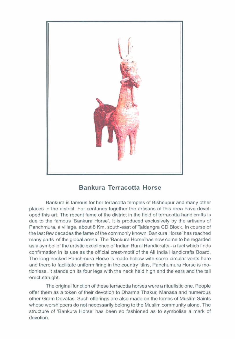
Bankura Terracotta Horse
Bankura is famous for her terracotta temples of Bishnupur and many other places in the district. For centuries together the artisans of this area have developed this art. The recent fame of the district in the field of terracotta handicrafts is due to the famous 'Bankura Horse'. It is produced exclusively by the artisans of Panchmura, a village, about 8 Km. south-east of Taldangra CD Block. In course of the last few decades the fame of the commonly known 'Bankura Horse' has reached many parts of the global arena. The 'Bankura Horse'has now come to be regarded as a symbol of the artistic excellence of Indian Rural Handicrafts - a fact which finds confirmation in its use as the official crest-motif of the All India Handicrafts Board. The long-necked Panchmura Horse is made hollow with some circular vents here and there to facilitate uniform firing in the country kilns, Panchumura Horse is motionless. It stands on its four legs with the neck held high and the ears and the tail erect straight.
The original function of these terracotta horses were a ritualistic one. People offer them as a token of their devotion to Dharma Thakur, Manasa and numerous other Gram Devatas. Such offerings are also made on the tombs of Muslim Saints whose worshippers do not necessarily belong to the Muslim community alone. The structure of 'Bankura Horse' has been so fashioned as to symbolise a mark of devotion.

Foreword
Preface
Acknowledgements
Map of the District
District Highlights - 2001 Census
Important Statistics of the District
Contents
Important statistics & Ranking of Blocks and Towns in the District
Statements 1 to 9
Pages
(xi)
(xiii)
(xv)
(xix)
(xx)
(xxii)
Statement - 1 : Name of the administrative units of District / CD Blocks/Towns, their Rural- (xxv) Urban status and distance from District Headquarters, 2001
Statement - 2: Name of the Headquarters of District / CD Blocks, their Rural -Urban status and distance from District Headquarters, 2001
Statement - 3: Population of the District at each Census from 1901 to 2001
Statement - 4: Area, Number of Villages/Towns and population in District, CD Blocks and Towns, 2001
Statement - 5: CD Block-wise number of villages and rural population, 2001
Statement - 6: Population of Urban Agglomerations including constituent Units/Towns, 2001
Statement - 7: Villages with population of 5,000 and above at CD Block Level as per 2001 Census and Amenities available
Statement - 8: Statutory Towns with Population less than 5,000 as per 2001 Census and Amenities available
Statement - 9: Houseless and Institutional population of CD Blocks, Towns, Rural and Urban, 2001
Analytical Note
(xxvi)
(xxvi)
(xxvii)
(xxix)
(xxx)
(xxx)
(xxxi)
(xxxii)
(i) History and Scope of District Census Handbook 3
(ii) Briefhistory of the District 4
(iii) Administrative Setup: (i) Region of the state where district is located (ii) Total 5 number of CD B locks or the next admin istrative units after district and changes therein includingjurisdictional changes during 1991-2001 (iii) Total number of towns/ Villages etc., (iv) If the district is newly created, the area from which it has been carved out, (v) Urban local bodies
(iv) Physical features : (i) Location and Size (ii) Physiography (iii) Drainage 6 (iv) Climate (v) Economic Resources (vi) Gram Panchayat
(v) Census Concepts: Building, Permanent Houses, Semi-Permanent Houses, 10 Temporary Houses, Dwelling Room, Census House, Village, Town/Urban Areas, City, Urban Agglomeration, Household, Institutional Household,
(v)
(vi)
(vii)
(viii)
(ix)
(x)
(xi)
(xii)
(xiii)
Houseless Household, Scheduled Castes & Scheduled Tribes, Languages and Mother tongue, Literate, Literacy Rate, Educational Level, Work, Main Vv'orker, Marginal Worker, Non Worker, Cultivator, Agricultural Labourer, Household Industry Worker, Other Worker, Work Participation Rate, Population Density, Age, Sex Ratio
Non Census Concepts: Improved Drinking Water, System of Sewerage, Type of Latrine and Method of Disposal of night soil, Fertility, Crude Birth Rate(CBR), Crude Death Rate(CDR), Natural Growth Rate, Age Specific Fertility Rate (ASFR), Age Specific Marital Fertility Rate (ASMFR), General Fertility Rate (GFR), General Marital Fertility Rate (GMFR), Total Fertility Rate (TFR), Total Marital Fertility Rate (TMFR), Age-Specific Mortality Rate (ASMR), ql, q2, q5, Infant Mortality Rate (IMR), Neo-natal Mortality Rate (NMR), Early Neo-natal Mortality Rate, Late Neo-natal Mortality Rate, Post Neo-natal Mortality Rate (PNMR), Peri-natal Mortality Rate (PMR), Still Birth Rate (SBR), Maternal Mortality Rate (MMR), Eligible Couple" Child Woman Ratio (0-4), Child Woman Ratio (5-9), Migration, Civic status of Urban Units, Size Class ofUA/Town, Slum Area and Mega city)
2001 Census findings - Population, its distribution
(a) Distribution of population in rural-urban areas
(b)Size, Class and Status of Towns, Population, Growth rate, Densilty, Sex ratio, Work participation rate, Literacy rate, Religion and Availability of University education in the district
Brief analysis ofInset Tables based on PCA, 1 to 36 Village Directory, Town Directory, 37-47 Houses and Household amenities data of House I isting Operations, 48-52
Major social and cultural events, natural and administrative developments and significant activities during the decade
Brief description of places of religious, historical or archaeological importance in villages and places of Tourist interest in the towns of the district
Major characteristics ofthe district, contribution of the district in the form of any historical figure associated with the district
Scope of Village Directory and Town Directory
Calendar of events for the conduct of House listing & Enumeration under Census ofIndia, 2001 in the State
PART -A : VILLAGE AND TOWN DIRECTORY
Section - I : Village Directory
(a) Note explaining the abbreviations used in Village Directory
(b) List of Villages merged in towns and outgrowths at 2001 Census
(c) CD Block wise presentation of Village Directory Data
Pages
15
19
25
78
80
81
81
85
89
92
(i) Saltora Block Map showing Block boundaries 93
(ii) Alphabetical list of Villages of Saltora along with location Code 1991 and 94 2001
(iii) Presentation of Village Directory Data of Salt ora 98
(vi)
Pages
(d) (i) Mejhia Block Map showing Block boundaries 127
(ii) Alphabetical list of Villages ofMejhia along with location Code 1991 and 128
2001
(iii) Presentation of Village Directory Data ofMejhia 130
(e) (i) Gangajalghati Block Map showing Block boundaries 145
(ii) Alphabetical list of Villages ofGangajalghati along with location Code 1991 146 and 2001
(iii) Presentation of Village Directory Data ofGangajalghati 150
(f) (i) Chhatna Block Map showing Block boundaries 181
(ii) Alphabetical list of Villages ofChhatna along with location Code 1991 and 183 2001
(iii) Presentation of Village Directory Data ofChhatna 190
(g) 0) Indpur Block Map showing Block boundaries 249
(ii) Alphabetical list of Villages ofIndpur along with location Code 1991 and 251 2001
(iii) Presentation of Village Directory Data ofIndpur 256
(h) (i) Bankura-I Block Map showing Block boundaries 295
(ii) Alphabetical list of Villages ofBankura-I along with location Code 1991 296 and 2001
(iii) Presentation of Village Directory Data of Bankura-I 300
(i) (i) Bankura-Il Block Map showing Block boundaries 331
(ii) Alphabetical list of Vi llages ofBankura-II along with location Code 1991 332 and 2001
(iii) Presentation of Village Directory Data of Bankura-II 336
G) (i) Barjora Block Map showing Block boundaries 365
(ii) Alphabetical list of Villages ofBarjora along with location Code 1991 and 367 2001
(iii) Presentation of Village Directory Data ofBarjora 372
(k) (i) Sonamukhi Block Map showing Block boundaries 409
(ii) Alphabetical list of Villages of Sonamukhi along with location Code 1991 411 and 2001
(iii) Presentation ofViUage Directory Data of Son am uk hi 416
(I) (i) Patrasayer Block Map showing Block boundaries 451
(ii) Alphabetical list of Villages ofPatrasayer along with location Code 1991 452 and 2001
(iii) Presentation of Village Directory Data ofPatrasayer 456
(m) (i) Indus Block Map showing Block boundaries 489
(ii) Alphabetical list of Villages ofIndus along with location Code 1991 and 491 2001
(iii) Presentation of Village Directory Data ofIndus 494 (vii)
Pages
(n) (i) Kotulpur Block Map showing Block boundaries 521
(ii) Alphabetical list ofVilJages ofKotulpur along with location Code 1991 and 522 2001
(iii) Presentation of Village Directory Data ofKotulpur 526
(0) (i) JaypurBlock Map showing Block boundaries 563
(ii) Alphabetical list of Villages of J aypur along with location Code 1991 and 565 2001
(iii) Presentation of Village Directory Data of Jaypur 568
(p) (i) Vishnupur Block Map showing Block boundaries 599
(ii) Alphabetical list of Villages of Vishnu pur along with location Code 1991 600 and 2001
(iii) Presentation of Village Directory Data of Vishnu pur
(q) (i) Onda Block Map showing Block boundaries
604
637
(ii) Alphabetical list of Villages ofOnda along with location Code 1991 and 639 2001
(iii) Presentation ofViUage Directory Data ofOnda 646
(r) (i) Taldangra Block Map showing Block boundaries 701
(ii) Alphabetical list of Villages ofTaldangra along with location Code 1991 703 and 2001
(iii) Presentation of Village Directory Data ofTaldangra 706
(viii)
Foreword
The District Census Handbook (DCHB) published by Census Organisation since 1951 census, is one of the important publications in the context of planning and development at grass-root level. The publication,
which is brought out for each district, contains several demographic and socia-economic characteristics villagewise and town-wise of the district alongwith the status of availability of civic amenities, infrastructural facilities, etc.
2. The scope of the DCHB was initially confined to a few Census Tables and primary Census Abstract (PCA) of each village and town within the district. Thereafter, at successive censuses, its scope and coverage has been enlarged. The DCHB published at the 1961 census provided a descriptive account of the district, administrative statistics, census tables and a village and town directory including PCA. The 1971 censusDCHB series was in three parts: Part-A related to village and town directory, Part-B to village and town PCA and Part-C comprised analytical report, administrative statistics, district census tables and certain analytical tables based on PCA and amenity data in respect of villages. The 198] census DCHB was in two parts: Part-A contained village and town directory and Part-B the PCA of village and town including the SCs and STs PCA up to tahsil/town levels. New features alongwith restructuring of the formats of village and town directory were added into it. In Village Directory, all amenities except electricity were brought together and if any amenity was not available in the referent village, the distance in broad ranges from the nearest place having such an amenity, was given. Information on new items such as adult literacy centres, primary health sub-centres and community health workers in the village were provided so as to meet the requirements of some of the Revised Minimum Needs Programme. Information on approach to the village was provided for the first time in the Village Directory so as to give the details on number of inaccessible villages in each district. In the Town Directory, a statement (IV-A) on slums was introduced to provide the details on civic and other amenities in the notified slums of Class I and Class II towns.
3. The 1991 census DCHB, by and large, followed the pattern of presentation of 1981 census, except the format of PCA was restructured. Nine-fold industrial classification of main workers was given against the four-fold industrial classification presented in the 1981 census. In addition, sex-wise population in 0-6 age group was included in the PCA for the first time with a view to enable the data users to compile more realistic literacy rate as all children below 7 years of age had been treated as illiterate at the time of 1991 census. One of the important innovations in the 1991 census was the Community Development Block (CD Block) level presentation of village directory and PCA data instead of the traditional tahsil/taluklPS level pre$entation. It was expected that the presentation of village directory and PCA data at CD block level will help the planners in formulation of micro level development plans, CD block being the lowest administrative unit.
4. The present series of 2001 census DCHBs have been made more informative and exhaustive in terms of coverage and content. The Village Directory has been enlarged in scope by including a number of other facilities like banking, recreational and cultural facilities, newspapers and magazines and 'most important commodity' manufactured in village. Income and expenditure of gram panchayat, wherever possible, has been provided. Apart from these, more details on distance(s) at which basic amenities are available Of not available in the village), are given. This includes educational facilities (namely primary and middle schools and college), medical facilities (viz. Allopathic Hospital, Maternity & Child Welfare Centre and Primary Health Centre), drinking water, post & telegraph (post office and phone), communication, bank, credit societies and recreational facilities. In Town Directory, the statement on Slums has been modified and its coverage enlarged by including details on all slums instead of 'notified slums'. The information is given in case of all statutory towns irrespective of their class, against only Class I and Class II towns in the 1981 and 1991 censuses. The basic amenities
(xi)
available in the villages and towns are analysed in depth with the help of a number of cross-classified inset tables and statements. Two other significant additions in the publication are inclusion of 'motif highlighting significant characteristic of the district and analytical notes as annexures. The analytical notes on (i) fertility and mortality and (ii) various measures of fertility and mean age at marriage are prepared based on 1991 census. Whereas, in the notes relating to (i) percentage distribution of migrants by place of birth/place of last residence, (ii) main religions, (iii) marital status of population, (iv) age, sex and education, and (v) distribution of spectrum of mother tongue, nature and extent of changes occurred in the district in its basic socio-demographic features during the decade 1991-2001 are analysed. The eight digits permanent location code (PLCN) to all the villages and towns have been assigned keeping in view the future needs.
5. The village and town level amenity data have been collected, compiled and computerized in prescribed· record structure under the supervision of Shri Vikram Sen, lAS, Director of Census Op~)rations, West Bengal. Thereafter, efforts have been made to ensure comparability of the information with that of 1991 census data and the information brought out by the respective state governments in their annual reports and statistical handbooks for various years after 1991. The task of planning, designing and coordination of this publication was carried out by Shri R.G. Mitra, Deputy Registrar General (C&T) and Dr. I.C. Agrawal, Senior Research Officer of Social Studies division. Dr. R.P. Singh, Deputy Registrar General (Map) provided the technical guidance in the preparation of maps. Whereas, Shri Anil Kumar Arora, Deputy Director of Data Processing Division who worked under the overall supervision of Shri Himakar, Add!. Director (EDP) helped in preparation of record structure for computerization of village and town directory data and the programme for the generation of Village Directory and Town Directory statements including analytical inset tables. The draft DCHB manuscripts received from the Census Directorates have been scrutinized in the Social Studies Division under the guidance of Shri S.L. Jain, Deputy Director and Shri R.K. Mehta, Assistant Director. I am thankful to all of them and others who have contributed to make this publication possible.
New Delhi Dated: 17.10.2006
(xii)
D.K. Sikri Registrar General &
Census Commissioner, India
Preface
The task of publishing the District Census Handbook (DCHB) is a joint venture between the central and state government and the recent publication for 2001 Census bappens to be the sixth in the series of its
publication since the year 1951. Since then, in view of the contemporary requirement of data, the coverage ofDCHB has widened and received regular refinement. Hence, it has become the most widely used publication compiled and prepared by the Census organization. The presentation of data is done in two parts, viz., the Part-XII-A and Part-XII-B seperately for the bigger districts and single combined volume for the each smaller district.
Part-XII-A contains Village & Town Directory data with some important tables depicting availability of basic civic amenities at the C.D. BlockIVillage and Town level. In the other hand, Part-XIJ-B presents district Primary Census Abstract (General), Primary Census Abstract for Scheduled Caste, Primary Census Abstract for Scheduled Tribe and CD BlockJVillagewise Primary Census Abstract and Urban Primary Census Abstract. In addition to the above an effort is made to furnish various essential information about the district such as - historical background, administrative set-up, drainage, physiography, climate, place of historical, archaeological and tourists importance etc. The 200 I Census DCHB presents a variegated picture of the human life as reflected by the census data. The scope of analysis of census and non-census data has considerably increased through various summary tables and inset tables. Besides brief analysis of basic census data in the form of PC A and analysis of amenities and infrastructural facilities available in villages and towns in the form of Village Directory and Town Directory, the data on houses and household amenities have also been briefly analyzed and included in this volume. Not only this, we have made efforts to present comparative data on various aspects such as distribution of population, growth rate, density of population, sex ratio, work participation rates, literacy, language, religion, scheduled caste and schedule tribe population (since 1951 or 1961) mostly by residence for the benefit of data users. Likewise, in the am1exures, brief analysis on some socio-demographic, economic, migration and cultural aspects of the population pertaining to 199 I Census has also been made.
There has been regular and continuous flow of suitable suggestions and advice from Shri J .K. Banthia, Registrar General, India, throughout completion of the work for which I express my deepest and sincere gratitude to him. Other officers in the office of the Registrar General, India, New Delhi, contributed their share in the befitting manner for which as well I record my thankfulness to Shri R.G. Mitra, Deputy Registrar General (C&T), Shri R.P. Singh, Deputy Registrar General (Map), Shri I.e. Agarwal, Senior Research Officer (S.S.) and Shri S.L. Jain, Deputy Director (S.S.), for without their timely help and guidelines this publication would not have appeared before us in time and in this form.
I shall be failing in my duties if I do not acknowledge the contributions made by the District Census Officersl District Magistrates and innumberable Village, Block and Municipal level officials of all the districts of West Bengal for arranging collection of village and town directory data by the local officials from the villages/towns under their jurisdiction.
In my own office my thanks are due to each one of the staff members for their zeal and enthusiasm shown in completing this project successfully at various stages of work very much within the stipulated time. As it is not feasible to express my thanks individually a separate page of acknowledgement is included in this publication.
25.07.2004 Kolkata
(xiii)
Vikram Sen Director of Census Operations,
West Bengal

Acknowledgements
A. The Directorate of Census Operations respectfully acknowledges the devoted, sincere hard work rendered by about one lakh fifty thousand Census Enumerators, Supervisors and Officials at the District, Block and Municipal levels without whose heroic efforts, the Census 2001 could never be undertaken. Three among these Enumerators also laid down their lives while in discharge of Census work.
B. The Census Directorate, West Bengal also gratefully acknowledges the sincere and dedicated work of the fol1owing officers/officials of this Directorate associated with the preparation of this Hand Book.
Drafting of analytical notes/ overall editing and checlking at various stages :
Shri R.K. Ram Joint Director Shri P.K. Majumdar
Dr. Palash Chandra Coomar Deputy Director Shri Debesh Roy
Late G.C.Halder Deputy Director Shri S.K. Lodh
Deputy Director
Deputy Director
Deputy Director
Smt. Laxmi Saha
Dr. Tilak Bagchi Smt. Keka Ghosh
Assistant Director
Assistant Director Assistant Director
Shri M.K. Darjee Assistant Director Shi Hemant Kumar Singh Assistant Director
Drafting of gazetteer part :
Shri Saibal Datta Junior Supervisor
Data Entry of Village & Town Directory :
Shri Prasun Ganguly D.E.O. Grade B
Shri Amitava Mitra Shri Prasant Kumar
Generation of Inset Tables :
Smt. Anjali Das
Checking of Tables
Shri Hemant Kumar Singh
Smt. Anjali Das
Smt. Sucheta Dutta
D.E.O. Grade B D.E.O. Grade B
sr, Grade I
Assistant Director
sr, Grade I
Sl, Grade II Smt. Banani Ghosh Sl, Grade II
Smt. Bandana Sen Chowdhury sr, Grade III Sl, Grade III
Sl, Grade III
Smt. Renukana Chatterjee
Smt. Kalpana Chowdhury Smt. Mira Banerjee Smt. Shelly Paul
SI, Grade III Assistant Compiler
SRS write up :
Shri P.K. Majumdar
Checking of SRS data :
Shri Subhas Dasgupta
Shri Subhasish Chatterjee
Deputy Director
Assistant Director
SI, Grade I
(xv)
Shri Saibal Datta Junior Supervisor
Shri Ajoy Saha
Shri Goutam Kr. Roy
Shri Prasun Ganguly
Smt. Keka Ghosh
Smt. Kshnaprova Raj
Smt. Anita Mukherjee Late N andita Dutta
Shri Nikhil Bagchi
Smt. Sujata Deb
Shri Manash Mitra Smt. Nira Chakraborty
Shri H.K. Singh
D.E.O. Grade B
D.E.O. Grade B
D.E.O. Grade B
Assistant Director
SI, Grade I
SI, Grade II
SI, Grade III
SI, Grade III
SI, Grade III
SI, Grade III
SI, Grade III
Assistant Director
Preparation of Maps :
Shri O.M. Singh Senior Geographer Dr Utpal Mandai Senior Geographer
Dr. Sumit Mukherjee Geographer Shri B.N. Mallick Sr. Drawing Asstt.
Shri H.R. Banerjee Sr. Draughtsl11an Shri Pradeep Das Sr. Draughtsman Shri R.C. Das Sr. Draughtsl11an Shri S.K. Chatterjee Sr. Draughtsman
Smt. Suman Topno Sr. Draughtsl11an Shri Asok Mondal Draughtsman
Shri Kartick Murmu Draughtsman Shri Narendranath Das Draughtsman
Shri Prasanta Roy Draughtsman Shri Sanjib Das Draughtsman
Shri Tapan Bhattacharjee Draughtsman Shri Tilak Dutta Draughtsman
Preparation of Camera Ready Copy (CRC):
Shri Prasun Ganguly D.E.O. Grade B
Preparation of e-book :
Shri Bibhas Kanti Hira D.E.O. Grade B Shri Prasant Kumar D.E.O. Grade B
Shri Prasun Ganguly D.E.O. Grade B Shri Prasanta Roy Draughtsman
Shri Tapan Bhattacharj ee Draughtsman
In-house' Printing :
Shri Mohan Lal Das Gestener Operator Shri Sudarsan Ganguly Peon
Other supporting Officers/Officials :
Shri Ramkrishna Maity Deputy Director Shri Amit Gupta Deputy Director
Shri K.K. Das Assistant Director Smt. Kiran Talukdar Assistant Director
Smt. Parul Barman Assistant Director Smt. Anjali Chatterjee sr, Grade II
Shri Mihir Kr. Das SI, Grade II Smt. Namita Chatterjee sr, Grade II
Smt. Anjali Banerjee sr, Grade 1II Smt. Anju Banerjee sr, Grade III
Smt. Archana Roy chowdhury SI, Grade III Shri Ashok Kr. Sarkar sr, Grade III
Smt. Gita Saha sr, Grade III Shri Lal Mohan Roy SI, Grade III
Smt. Mukul Mukherjee SI, Grade III Smt. Priti Majumdar sr, Grade III
Smt. Provati Munshi sr, Grade III Smt. Rupali Banerjee Senior Compiler
Smt. Shila Banerjee Senior Compiler Smt. Mili Bhowmick Proof Reader
Sri Saibal Roy Proof Reader Sk. SajjatAli Proof Reader
Shri Umasankar Bhattacharjee Proof Reader Shri Sushil Kr. Dutta Proof Reader
Shri Baidyanath Kabashi Compiler Shri Deb Kumar Dey Compiler
Shri Manik Majumdar Compiler Shri Anjan Sengupta Assistant Compiler
Shri Dilip Kr. Chatterjee Typist, Grade I Smt. Biva Karmakar Typist
Shri Ani) Kr. Chakraborty Peon Shri Ashok Pradhan Peon
Shri Deb Kumar Dey Peon Shri Gour Das Peon
Shri Madhusudan Das Peon Shri Nakuleswar Sarkar Peon
(xvi)
Jl
"Y ,._.
\
(
\
C,D,BLOCK RANIBUNDH
.... ..........
/
l' l?
'2 ,8 E!
"g
~ 1 '"
D I
c
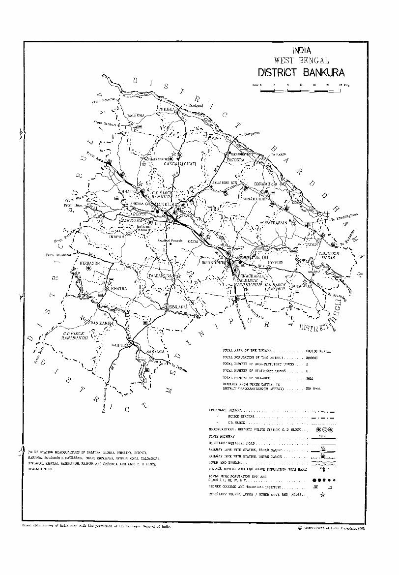
POLICE STATION HEADQUARTERS OF SALTORA, MEJHIA, CHHATNA, tNDPUR,
BARJORA, SONAMUKHI. PATRASAIR, INDUS, KOTALPUR, JOYPUR, ONDA, TALDANGRA,
SIMLAPAL, KHATRA, RANIBANDH, RAIPUR AND SARENGA ARE ALSO C, 0, BLOCK
HEADQUARTERS,
s
Based upon Survey of India map with the permission of the Surveyor General of [ndia.
INDIA WEST BENGAL
DISTRICT BANKURA
I
Kms 5
c
R
TOTAL AREA OF THE mSTRICT
TOTAL POPULATION OF THE DISTRICT,
TOTAL NUMBER OF NON-STATUTORY TOWNS,
TOTAL NUMBER OF STATUTORY TOWNS
TOTAL NUMBER OF VILLAGES.
DISTANCE FROM STATE CAPITAL TO DISTRICT HEADQUARTERS (IN APPROX)
BOUNDARY, DISTRICT,
POLICE STATION.
C,D, BLOCK,
10,
HEADQUARTERS , DlSTRICf, POLICE STATION, C, D, BLOCK,
STATE HIGHWAY
IMPORTANT METALLED ROAD ,
RAILWAY LINE WITH STATION, BROAD GAUGE . .
RAILWAY LINE WITH STATlON. METRE GAUGE
RIVER AND STREAM,
15 20
6882,00 Sq,Kms,
3192695
3830
225 Kms.
@@@ SH 4
RB,
~
VILLAGE HAVING 7000 AND ABOVE POPULATION WITH NAME
TOWNS WITH POPULATION SIZE AND
Maliara • CLASS I, II, III, IV, & V. ...... D.E:~REE COLLEGE AND TECHNICAL INsTITUTE . .
IMPORTANT TOURIST LODGE / OTHER GOVT, REST HOUSE, it
25 Kms
, r .,
© Government of India Copyright, 2006.

District Highlights - 2001 Census
1. Bankura district occupies 12th position in tenns of population in the State.
2. Bankura is one of the least urbanised districts of the State having less than 8.0 per cent of the total population in urban areas, whereas more than 27.0 per cent of the State's population lives in urban areas.
3. Bankura is in advantageous position in growth rate with 17th rank which is the second lowest in the State.
4. Bankura has the second lowest density (464 persons per Sq. Km.) in the State.
S. The sex ratio of the district (952) is well above the State's sex ratio (934).
6. Literacy rate of the district is 63.44 per cent thereby making its rank 12th in the State.
7. There are 253 uninhabited villages in the district.
8. There are 2 villages having population of 10,000 and above.
9. Aguri Band Punisol (Andal CD Block) is the most populated (15,715) and Biharinath Parbat (Sahora CD Block), Chhota Nabagram (Gangajalghati CD Block) and Patna Jaykrishnapur (Bankura-II CD Block) are the three least populated villages (1 person each).
10. The economy of the district is based on agriculture. Nearly 62.0 per cent of the Main Workers of the district is engaged in agricultural sector.
11. Proportion of female participation rate in Agricultural Labour (46.0 per cent) and Household Industry (9.5 per cent) is far greater than that of the males. (23.8 per cent and 3.9 per cent) respectively.
12. Onda CD Block has the highest number of villages (291) and Mejhia the lowest (75).
13. Chak Patra Sair village ofPatrasayer CD Block has the largest area (2,378 hectares) and Kunjaban of Bankura-II CD Block is the smallest (7 hectares).
(xix)
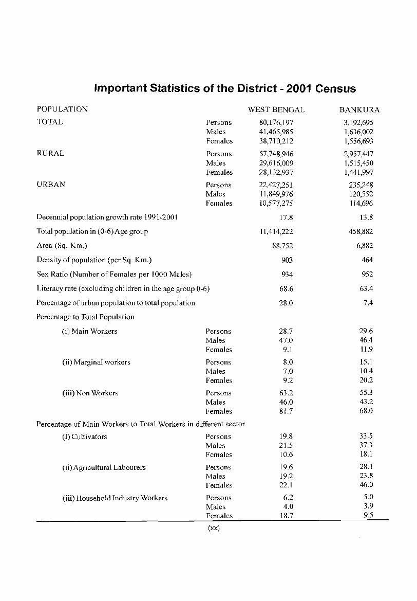
Important Statistics of the District - 2001 Census
POPULATION WEST BENGAL BANKURA
TOTAL Persons 80,176,197 3,192,695 Males 41,465,985 1,636,002 Females 38,710,212 1,556,693
RURAL Persons 57,748,946 2,957,447 Males 29,616,009 1,515,450 Females 28,132,937 1,441,997
URBAN Persons 22,427,251 235,248 Males 11,849,976 120,552 Females 10,577,275 114,696
Decennial population growth rate 1991-2001 17.8 13.8
Total population in (0-6) Age group 11,414,222 458,882
Area (Sq. Km.) 88,752 6,882
Density of population (per Sq. Km.) 903 464
Sex Ratio (Number of Females per 1000 Males) 934 952
Literacy rate (excluding children in the age group 0-6) 68.6 63.4
Percentage of urban population to total population 28.0 7.4
Percentage to Total Population
(i) Main Workers Persons 28.7 29.6 Males 47.0 46.4 Females 9.1 11.9
(ii) Marginal workers Persons 8.0 15.1 Males 7.0 10.4 Females 9.2 20.2
(iii) Non Workers Persons 63.2 55.3 Males 46.0 43.2 Females 81.7 68.0
Percentage of Main Workers to Total Workers in different sector
(I) Cultivators Persons 19.8 33.5 Males 21.5 37.3 Females 10.6 18.1
(ii) Agricultural Labourers Persons 19.6 28.1 Males 19.2 23.8 Females 22.1 46.0
(iii) Household Industry Workers Persons 6.2 5.0 Males 4.0 3.9 Females 18.7 9.5
(xx)
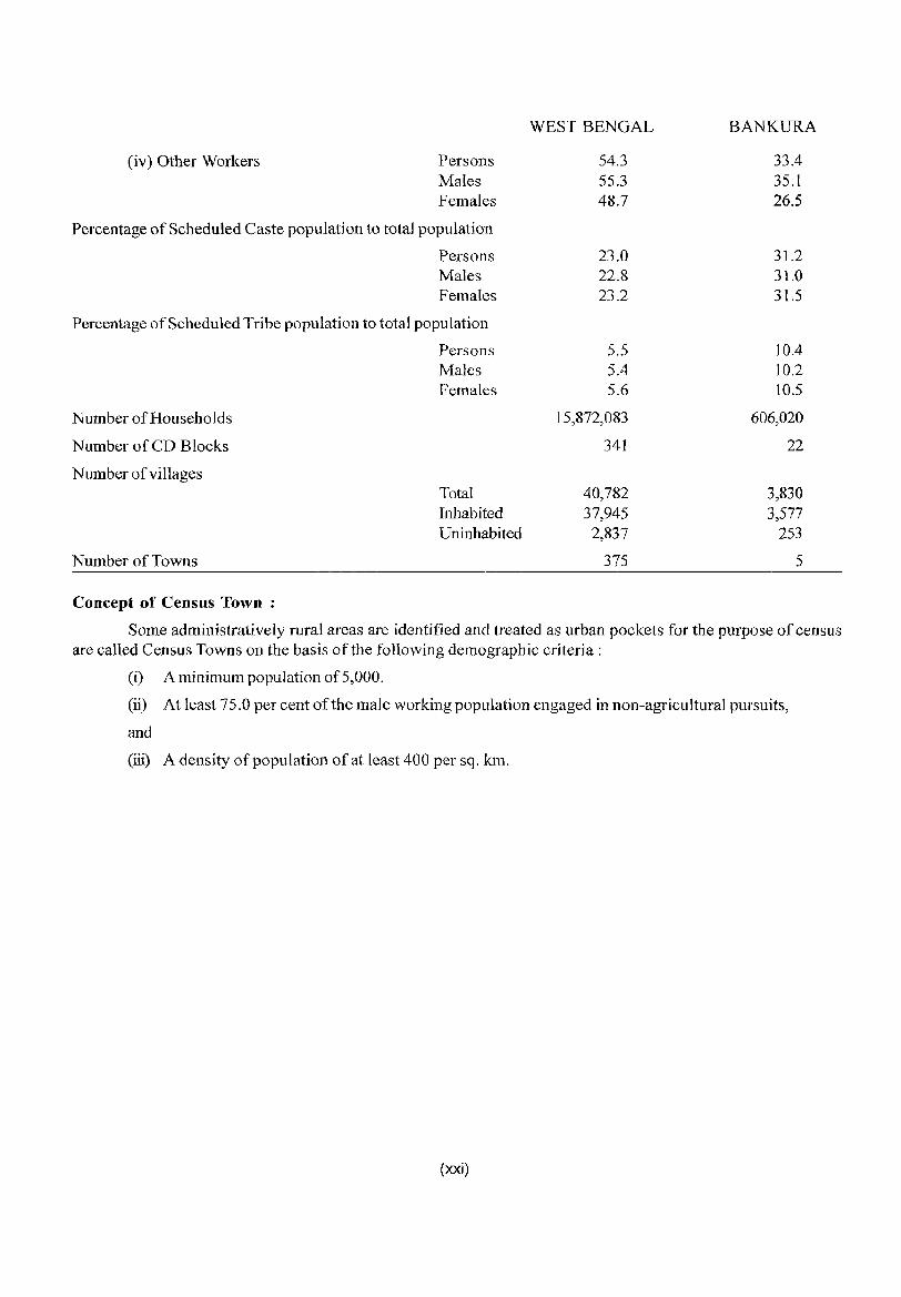
(iv) Other Workers Persons Males Females
Percentage of Scheduled Caste population to total population
Persons Males Females
Percentage of Scheduled Tribe population to total population
Persons Males Females
Number of Households
Number of CD Blocks
Number of villages
Number of Towns
Concept of Census Town :
Total Inhabited Uninhabited
WEST BENGAL
54.3 55.3 48.7
23.0 22.8 23.2
5.5 5.4 5.6
15,872,083
341
40,782 37,945
2,837
375
BANKURA
33.4 35.1 26.5
31.2 31.0 31.5
10.4 10.2 10.5
606,020
22
3,830 3,577
253
5
Some administratively rural areas are identified and treated as urban pockets for the purpose of census are called Census Towns on the basis of the following demographic criteria:
(i) A minimum population of5,000.
(ii) At least 75.0 per cent of the male working population engaged in non-agricultural pursuits,
and
(iii) A density of popUlation of at least 400 per sq. km.
(xxi)

Serial Number
1 2 3 4 5 6
7 8 9
10 11
12 13 14 15
16
17 18
Serial Number
1 2
3
4
5
6 7 8
9
10 11
12 13 14 IS
16
17 18
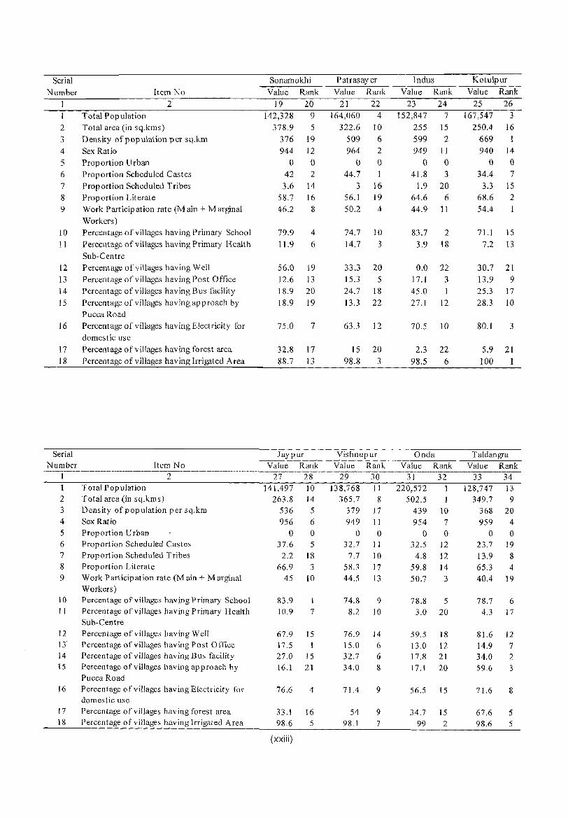
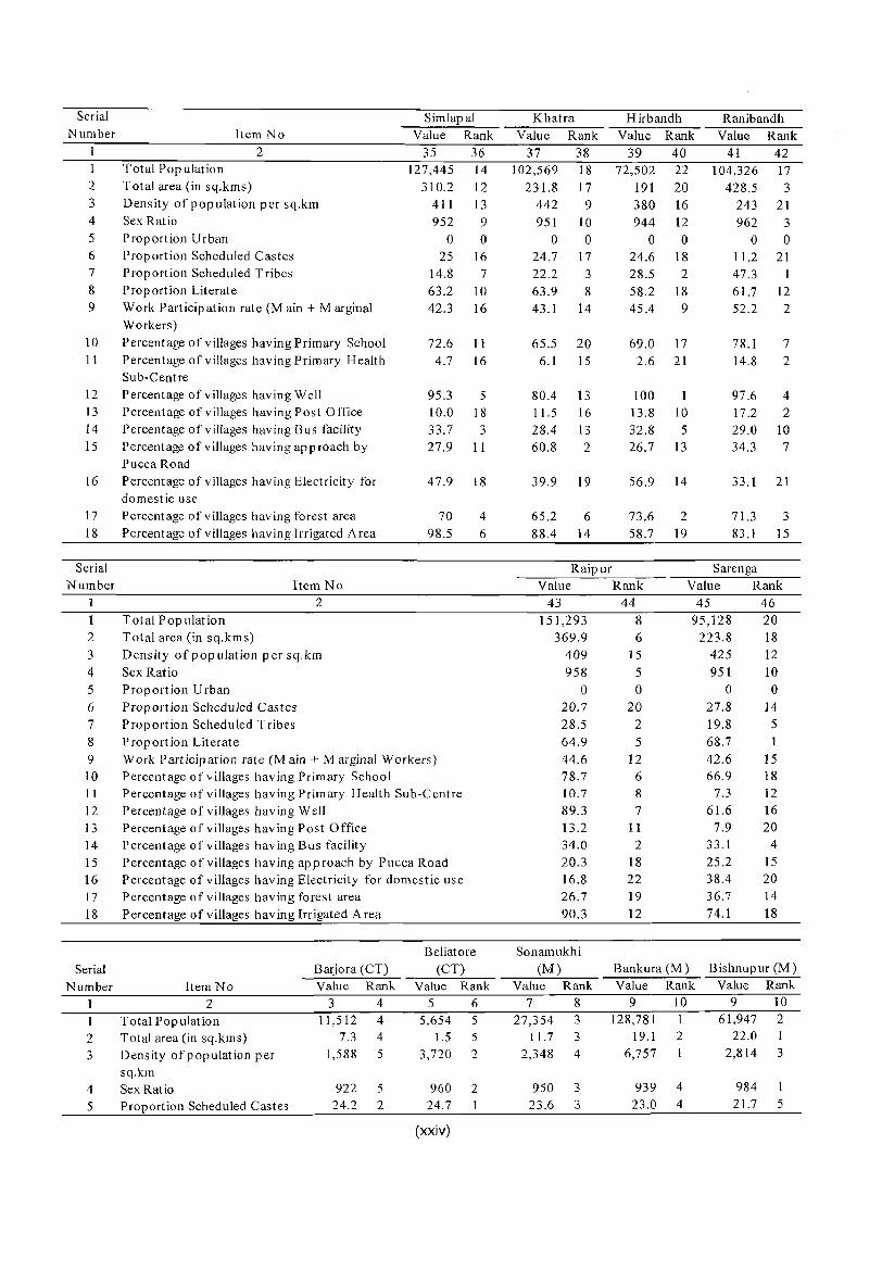
Important Statistics and Ranking of Blocks and Towns in the District of Bankura
Item No
Total Population Total area (in sq.kms)
2
Density of population per sq.km Sex Ratio Proportion Urban Proportion Scheduled Castes Proportion Scheduled Tribes Proportion Literate Work Participation rate (M ain + Marginal Workers) Percentage of villages hav ing Primary School Percentage of villages having Primary Health Sub-Centre Percentage of villages having Well Percentage of villages having Post Office Percentage of villages having Bus facility Percentage of villages having approach by Pucca Road Percentage of villages having Electricity for domestic use Percentage 0 f villages having forest area Percentage of villages having Irrigated Area
Item No
Total Pop ulation Total area (in sq.kms)
2
Density of population per sq.km Sex Ratio Proportion Urban Proportion Scheduled Castes Proportion Scheduled Tribes Proportion Literate Work Participation rate (M ain + Marginal Workers) Percentage of villages having Primary School Percentage of villages having Primary Health Sub-Centre Percentage of villages having Well Percentage of villages having Post Office Percentage of villages having Bus facility Percentage of villages having approach by Pucca Road Percentage of villages having Electricity for domestic use Percentage of villages having forest area Percentage of villages having Irrigated A rea
Saltora Value Rank
3 4 121,552 16
312.6 11 389 15 953 8
o 0 33.6 8
19 6
55.1 20 47.8 6
71.9 14 3.4 19
85.6 9 11.6 15 30.8 7 23.3 16
52.7 17
54.1 8 98.1 7
Indpur Value Rank
11 12 137,825 12
302.6 13 455 8 941 13
o 0 38.2 4
9.8 9 61.9 11 42.6 15
75.6 8 0.5 22
98.5 3 16.2 4 29.9 8 30.5 9
59.4 13
59.9 7 78.8 16
(xxii)
Mejhia Value Rank
5 6 76,123 21
162.9 22 467 7 926 16
o 0 32.9 10
2.2 18 59.3 15 39.1 21
81.9 3 12.5 5
61.1 17 15.3 5 19.4 19 68.1
91.7
30.7 18 98.7 4
Bankura - I Value Rank
13 14 95,840 19
171.1 21 560 3 953 8
o 0 36.5 6
6.7 11 63.2 10 41.4 17
66.2 19 7.4 11
99.3 2 14.0 8 28.7 11 26.5 14
75.7 5
42.7 13 97.3 8
G angajalghat i Value Rank
7 8 162,007 5
366.5 7 442 9 949 11
o 0 33.6 8
4.1 13 60.6 13 40.7 18
72.3 13 7.1 14
87.1 8 12.3 14 25.8 16 40.6 6
67.7 11
46.1 II 95.8 10
Bankura - II Value Rank
15 16 123,415 15
220.8 19 559 4 949 11
o 0 28.9 13
2.8 17 64 7 49 5
69.4 16 14.6 4
84.0 10 11.1 17 28.5 12 50.7 5
81.9 2
45.5 12 96.1 9
Chhatna Value Rank
9 10 169,215 2
447.5 2
378 18 975 1
o 0 27.4 15 21.8 4 58.7 16 47.1 7
72.5 12 9.4 9
93.5 6
9.1 19 29.3 9 22.8 17
54.3 16
81.2 77.4 17
Barjora Value Rank
17 18 161,841 6
384.5 4 421 12 938 15
o 0 33.3 9
2 19 63.4 9 40.2 20
72.5 12 17.0 1
83.5 11 11.5 16 27.5 14 54.9 4
75.3 6
46.2 10 95.5 11
Serial Number Item No
2 Total Population
2 Total area (in sq.kms)
3 Density of population per sq.km 4 Sex Ratio 5 Proportion Urban 6 Proportion Scheduled Castes
7 Proportion Scheduled Tribes 8 Proportion Literate 9 Work Participation rate (M ain + Marginal
Workers) 10 Percentage of villages having Primary School
11 Percentage of villages having Primary Health Sub-Centre
12 Percentage of villages having Well 13 Percentage of villages having Post Office
14 Percentage of villages having Bus facility 15 Percentage of villages having approach by
Pucca Road 16 Percentage of villages having Electricity for
domestic use 17 Percentage of villages having forest area 18 Percentage of villages having Irrigated Area
Serial Number
1
2 3 4
5 6
7 8 9
10 II
12 13 14 15
16
17 18
Item No
Total Population Total area (in sq.kms)
2
Density of population per sq.km Sex Ratio Proportion Urban Proportion Scheduled Castes Proportion Scheduled Tribes Proportion Literate Work Participation rate (M ain + Marginal Workers) Percentage of villages having Primary School Percentage of villages having Primary Health Sub-Centre Percentage of villages having Well Percentage of villages having Post Office Percentage of viII ages having Bus facility Percentage of villages having approach by Pucca Road Percentage of villages having Electricity for domestic use Percentage of villages having forest area Percentage of villages having Irrigated Area
Sonamukhi
Value Rank
19 20 142,328 9
378.9 5
376 19 944 12
o 0 42 2
3.6 14 58.7 16 46.2 8
79.9 4
11.9 6
56.0 19 12.6 13 J 8.9 20 18.9 19
75.0 7
32.8 17
88.7 13
Jaypur Value Rank
27 28 141,497 10
263.8 14 536 5 956 6
o 0 37.6 5
2.2 18 66.9 3
45 10
83.9 1 10.9 7
67.9 15 17.5 I
27.0 15 16.1 21
76.6 4
33.1 16 98.6 5
(xxiii)
Patrasayer Value Rank
21 22 164,060 4
322.6 10
509 6 964 2
o 0 44.7
3 16 56.1 19 50.2 4
74.7 10
14.7 3
33.3 20 15.3 5 24.7 18
13.3 22
63.3 12
15 20 98.8 3
Vishnupur Value Rank
29 30 138,768 II
365.7 8 379 17 949 II
o 0 32.7 II
7.7 10 58.3 17 44.5 13
74.8 9 8.2 10
76.9 14 15.0 6 32.7 6 34.0 8
71.4 9
54 9 98.1 7
Indus Value Rank
23 24 152,847 7
255 15
599 2 949 11
o 0 41.8 3
1.9 20 64.6 6 44.9 11
83.7 2
3.9 18
0.0 22 17.1 3
45.0 1
27.1 12
70.5 10
2.3 22
98.5 6
Onda Value Rank
31 32 220,572
502.5 I
439 10 954 7
o 0 32.5 12
4.8 12 59.8 14 50.7 3
78.8 5
3.0 20
59.5 18 13.0 12 17.8 21 17.1 20
56.5 15
34.7 15 99 2
Kotulpur Value Rank
25 26 167,547 3
250.4 16
669 I 940 14
o 0 34.4 7
3.3 15 68.6 2
54.4
71.1 15
7.2 13
30.7 21
13.9 9 25.3 17
28.3 10
80.1 3
5.9 21 100 1
Taldangra Value Rank
33 34 128,747 13
349.7 9 368 20 959 4
o 0 23.7 19 13.9 8 65.3 4 40.4 19
78.7 6 4.3 17
81.6 12
14.9 7 34.0 2 59.6 3
71.6 8
67.6 5 98.6 5
Serial Number
I 2 3 4
5 6 7
8 9
10 11
12 13 14 IS
16
17 18
Serial Number
1 2
3
4 5
6
7 8 9 10 II
12 13 14 15 16 17
18
Serial Number
2
3
4 5
Item No
Total Population Total area (in sq.kms)
2
Density of population per sq.km Sex Ratio Proportion Urban Proportion Scheduled Castes Proportion Scheduled Tribes Pro p art ion Literat e Work Participation rate (M ain + Marginal Workers) Percentage of villages having Primary School Percentage of villages having Primary Health Sub-Centre Percentage of villages having Well Percentage of villages having Post Office Percentage of villages having Bus facility Percentage of v iUages having app roach by Pucca Road Percentage of villages having Electricity for domestic use Percentage of villages having forest area Percentage of villages having Irrigated Area
Item No
Total Population Total area (in sq.kms)
2
Density of pop ulation per sq.km Sex Ratio Proportion Urban Proportion Scheduled Castes Proportion Scheduled Tribes Proportion Literate
Simlapal Value Rank
35 36 127,445 14
310.2 12 411 13 952 9
o 0 25 16
14.8 7 63.2 10 42.3 16
72.6 11 4.7 16
95.3 5 10.0 18 33.7 3 27.9 II
47.9 18
70 98.5
4
6
Work Participation rate (M ain + Marginal Workers) Percentage of villages having Primary School Percentage of villages having Primary Health Sub-Centre Percentage of villages having Well Percentage of villages having Post Office Percentage of villages having Bus facility Percentage of villages having ap proach by Pucca Road Percentage of villages having Electricity for domestic use Percentage of villages having forest area Percentage of villages having Irrigated Area
Barjora (CT) Beliatore
(CT)
Item No 2
Total Population Total area (in sq.kms) Density of population per sq.km Sex Ratio Proportion Scheduled Castes
Value 3
11,512 7.3
1,588
Rank 4 4 4
5
922 5 24.2 2
Value 5
5,654 1.5
3,720
Rank 6 5 5
2
960 2 24.7
(xxiv)
Khatra Value Rank
37 38 102,569 18
231.8 17 442 9 951 10
o 0 24.7 17 22.2 3 63.9 8 43.1 14
65.5 20 6.1 15
80.4 13 11.5 16
28.4 13 60.8 2
39.9 19
65.2 6
88.4 14
Raipur
Hirbandh Value Rank
39 40 72,502 22
191 20 380 16 944 12
o 0 24.6 18 28.5 2 58.2 18 45.4 9
69.0 17 2.6 21
100 13.8 10 32.8 5 26.7 13
56.9 14
73.6 2 58.7 19
Ranibandh Value Rank
41 42 104,326 17
428.5 3 243 21 962 3
o 0 11.2 21 47.3 1 61.7 12 52.2 2
78.1 7
14.8 2
97.6 4
17.2 2
29.0 10 34.3 7
33.1 21
71.3 3
83.1 15
Sarenga Value Rank Value Rank
43 44 151,293 8
369.9 6 409 15 958 5
o 0 20.7 20 28.5 2 64.9
44.6 78.7 10.7 89.3 13.2 34.0 20.3 16.8 26.7 90.3
5
12 6 8
7 11
2
18 22
19 12
45 46 95,128 20
223.8 18 425 12 951 10
o 0 27.8 14 19.8 5 68.7 42.6 66.9
7.3 61.6
7.9 33.1 25.2 38.4 36.7 74.1
1
15 18 12 16 20
4
15 20 14 18
Sonamukhi (M) Bankura (M) Bishnupur (M)
Value 7
27,354 11.7
2,348
Rank 8 3 3
4
950 3 23.6 3
Value 9
128,781 19.1
6,757
Rank 10
2
1
939 4 23.0 4
Value 9
61,947 22.0
2,814
Rank 10 2 1
3
984 1 21.7 5
Serial Bmjora (CT) Beliatore (CT) Sonamukhi (M) Bankura (M) Bishnupur (M)
Number Item No Value Rank Value Rank Value Rank Value Rank Value Rank
2 3 4 5 6 7 8 9 10 9 10
6 Proportion Scheduled Tribes 0.1 5 0.4 4 1.3 0.8 2 0.5 3
7 Proportion Literate 80.3 3 82.0 1 78.8 4 81.9 2 77.1 5
8 Work Participation rate (Main 31.2 5 33.4 3 37.4 1 32.8 4 34.6 2 + Mar inal Workers)
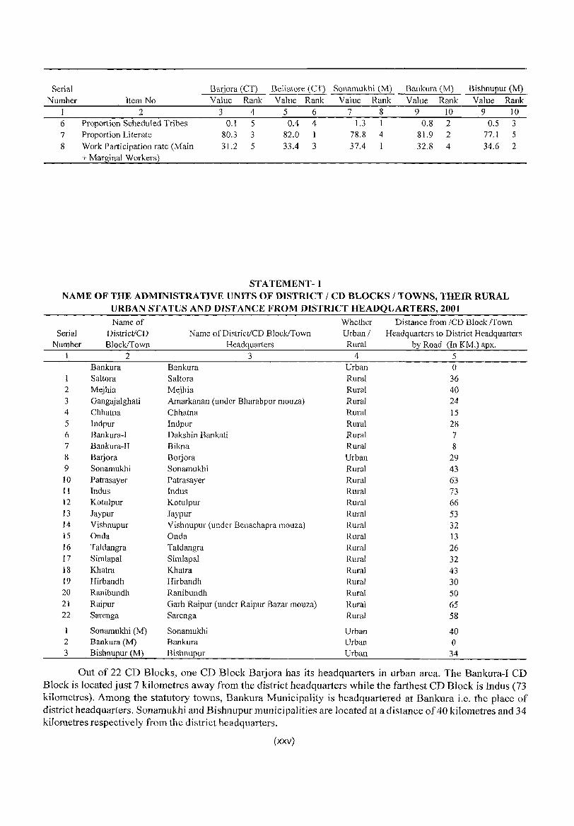
STATEMENT-I NAME OF THE ADMINISTRATIVE UNITS OF DISTRICT / CD BLOCKS / TOWNS, THEIR RURAL
URBAN STATUS AND DISTANCE FROM DISTRICT HEADQUARTERS, 2001 Name of Whether Distance from ICD Block ITown
Serial District/CD Name of District/CD Block/Town Urban I Headquarters to District Headquarters Number Block/Town Headq uarters Rural by Road (In KM.) apx.
1 2 3 4 5 Bankura Bankura Urban 0 Saltora Saltora Rural 36
2 Mejhia Mejhia Rural 40 3 Gangaj alghati Amarkanan (under Bharabpur mouza) Rural 24 4 Chhatna Chhatna Rural 15 5 Indpur Indpur Rural 28 6 Bankura-I Dakshin Bankati Rural 7 7 Bankura-II Bikna Rural 8 8 B arj ora Borjora Urban 29 9 Sonamukhi Sonamukhi Rural 43 10 Patrasayer Patrasayer Rural 63 II Indus Indus Rural 73 12 Kotulpur Kotulpur Rural 66 13 Jaypur Jaypur Rural 53 14 Vishnupur Vishnupur (under Benachapra mouza) Rural 32 15 Onda Onda Rural 13 16 Taldangra Taldangra Rural 26 17 Simlapal Simlapal Rural 32 18 Khatra Khatra Rural 43 19 Hirbandh Hirbandh Rural 30 20 Ranibundh Ranibundh Rural 50 21 Raipur Garh Raipur (under Raipur Bazar mouza) Rural 65 22 Sarenga Sarenga Rural 58
Sonamukhi (M) Sonamukhi Urban 40 2 Bankura (M) Bankura Urban 0 3 Bishnupur (M) Bishnupur Urban 34
Out of 22 CD Blocks, one CD Block Barjora has its headquarters in urban area. The Bankura-I CD Block is located just 7 kilometres away from the district headquarters while the farthest CD Block is Indus (73 kilometres). Among the statutory towns, Bankura Municipality is headquartered at Bankura i.e. the place of district headquarters. Sonamukhi and Bishnupur municipalities are located at a distance of 40 kilometres and 34 kilometres respectively from the district headquarters.
(xxv)
STATEMENT - 2
NAME OF THE HEAD QUARTERS OFDISTRICT/CDBWCKS,THEIRRURAlrURBAN STATUS AND DISTANCE FROM DISTRICT HEADQUARTERS, 2001
Distance from CD Block Headquarters to district
Serial Name of District / CD Block Whether Headquarters by Road Number Name of District / CD Block Headquarters Urban I Rural (in km) approx.
1 2 3 4 5
Same as Statement-l
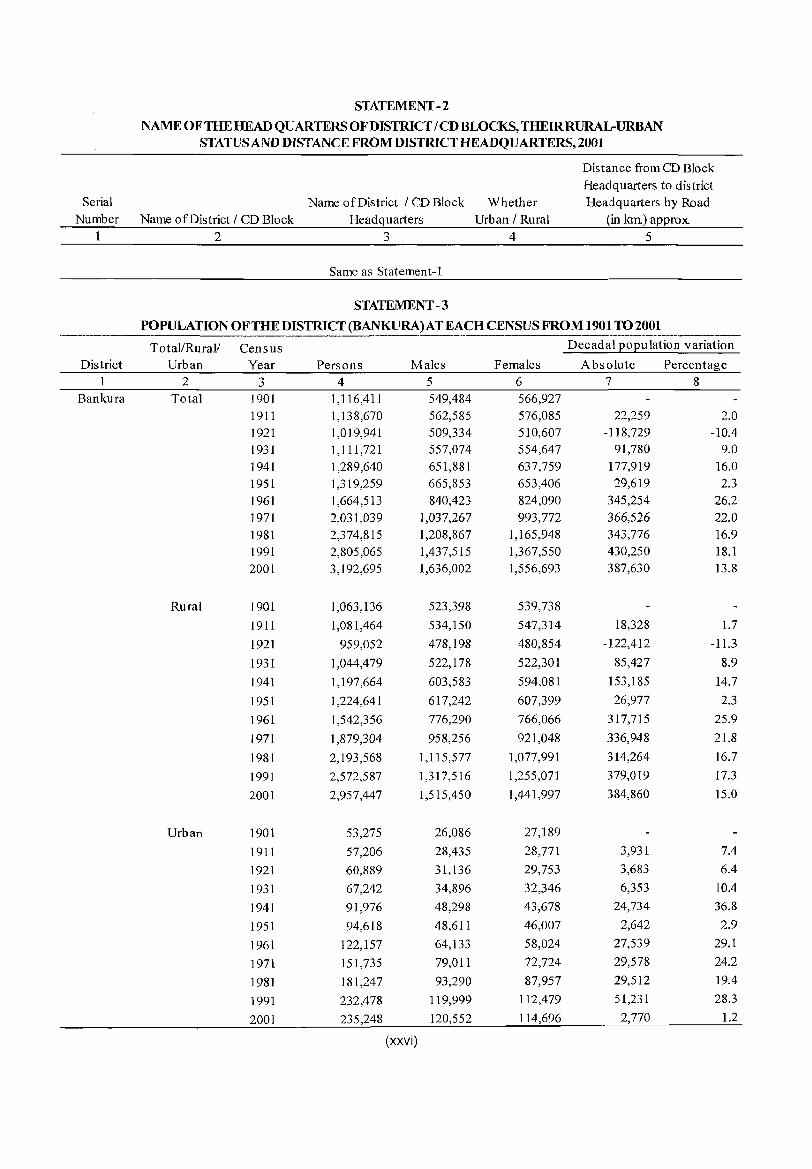
STATEMENT -3
POPULATION OF THE DISTRICT (BANKURA) AT EACH CENSUS FROM 1901 TO 2001 ---_._-Total/Rural! Census Decadal population variation
District Urban Year Persons Males Females Absolute Percentage 2 3 4 5 6 '7 8
Bankura Total 1901 1,116,411 549,484 566,927 1911 1,138,670 562,585 576,085 22,259 2.0 1921 1,019,941 509,334 510,607 -118,729 -10.4 1931 1,111,72] 557,074 554,647 91,780 9.0 1941 1,289,640 651,881 637,759 177,919 16.0 1951 1,319,259 665,853 653,406 29,619 2.3 ]961 1,664,513 840,423 824,090 345,254 26.2 1971 2,031,039 1,037,267 993,772 366,526 22.0 1981 2,374,815 1,208,867 1,165,948 343,776 16.9 1991 2,805,065 1,437,515 1,367,550 430,250 18.1 2001 3,192,695 1,636,002 1,556,693 387,630 13.8
Rural 1901 1,063,136 523,398 539,738
1911 1,081,464 534,150 547,314 18,328 1.7
1921 959,052 478,198 480,854 -122,412 -11.3
1931 1,044,479 522,178 522,301 85,427 8.9
1941 1,197,664 603,583 594,081 153,185 14.7
1951 1,224,641 617,242 607,399 26,977 2.3
1961 1,542,356 776,290 766,066 317,715 25.9
1971 1,879,304 958,256 921,048 336,948 21.8
1981 2,] 93,568 1,115,577 1,077,991 314,264 16.7
1991 2,572,587 1,317,516 1,255,071 379,019 17.3
2001 2,957,447 1,515,450 1,441,997 384,860 15.0
Urban 1901 53,275 26,086 27,189
1911 57,206 28,435 28,771 3,931 7.4
1921 60,889 31,136 29,753 3,683 6.4
1931 67,242 34,896 32,346 6,353 10.4
1941 91,976 48,298 43,678 24,734 36.8
1951 94,618 48,611 46,007 2,642 2.9
1961 122,157 64,133 58,024 27,539 29.1
1971 151,735 79,011 72,724 29,578 24.2
1981 181,247 93,290 87,957 29,512 19.4
1991 232,478 119,999 ] 12,479 51,231 28.3
2001 235,248 120,552 114,696 2,770 1.2
(xxvi)
During the last hundred years the highest decennial growth rate was (26.2 per cent) in 1961 for the district and the lowest being in 1921 wherein the population declined by -10.4 per cent. The decline may be attributed to heavy mortality caused by influenza epidemics of 1918-19. In rural areas the highest growth (25.9 per cent) is recorded in 1961 and the lowest in 1921 (-11.3 per cent). In urban areas, the highest growth is observed in 1941 (36.8 per cent) while the lowest in 2001 (1.2 per cent). The growth behaviour of the population has been quite erratic in the district. The urban growth rate has drastically decl ined from 28.3 per cent in 1991 to 1.2 per cent in 2001.
S T A TEMENT-4
AREA, NUMBER OF VILLAGES/TOWNS AND POPULATION IN DISTRICT, CD BLOCKS AND TOWNS,
2001
SI. No.
District / CD Block I UA /
Town 2
Bankura
I Saltora
2 Mejhia
3 Gangajalghati
4 Chhatna
5 Indpur
6 Bankum - I
7 Bankura - II
Popu Total/ Area lation Rural! in sq. per Urban kms sq.km
3 4 5 Total 6882.0 464 Rural 6820.5 434 Urban 61.5 3,826
Total 312.6 Rural 312.6 Urban
Total 162.9 Rural 162.9 Urban
Total 366.5 Rural 366.5 Urban
Total 447.5 Rural 447.5 Urban
Total 302.6 Rural 302.6 Urban
Total I7I.I Rural 171. I Urban
Total 220.8 Rural 220.8 Urban
389 389
467 467
442 442
378 378
455 455
560 560
559 559
8 Barjora Total 393.2 455 Rural Urban
Barjora (CT) Urban Beliatore (CT) Urban
384.5 421 8.8 1,957 7.3 1,588 1.5 3,720
9 Sonamukhi Total 378.9 376 376 Rural 378.9
Urban
Num- Number Number of ber of of Number
villages statu-In- Un- tory
habited inhabited towns 6 7 8
3,577 253 3 3,577 253 0
o 0 3
146 146
o
72
72
o
155 155
o
276 276
o
197 197
o
136 136
o
144 144
o
182 182
o o o
159 159
o
J 1
J 1
o
3
3
o
10 10 o
12 12 o
25 25 o
14
14 o
10 10
° 17 17 o o o
27 27 o
(xxvii)
o o o
o o o
o o o
o o o
o o o
o o o
o o o
o o o o o
o o o
census towns I
OG 9
2/0 0/0 2/0
o o o
o o
° o o o
o o o
o o o
o o o
o o o
2
o 2
I
o o o
of house holds Persons
10 11
Population
Males Females 12 13
606,020 3,192,695 1,636,002 1,556,693 559,295 2,957,447 1,515,450 1,441,997
46,725 235,248 120,552 114,696
2 I ,444 21,444
o
13,651 13,651
o
29,714 29,714
o
31,889 31,889
o
24,586 24,586
o
17,621 17,621
o
23,457 23,457
o
34,537 30,931
3,606 2,403 1,203
27,109 27, I 09
o
121,552 121,552
o
76,123 76,123
o
162,007 162,007
o
169,215 169,215
o
137,825 137,825
o
95,840 95,840
o
123,415 123,415
o
179,007 161,841
17,166 11,512 5,654
142,328 142,328
o
62,239 62,239
o
39,525 39,525
o
83,117 83,117
o
85,669 85,669
o
70,990 70,990
o
49,083 49,083
o
63,330 63,330
o
92,368 83,494
8,874 5,989 2,885
73,221 73,221
o
59,313 59,313
o
36,598 36,598
o
78,890 78,890
o
83,546 83,546
o
66,835 66,835
o
46,757 46,757
o
60,085 60,085
o
86,639 78,347
8,292 5,523 2,769
69,107 69,107
o
SI. No.
District / CD Block / UA /
Town 2
10 Patrasayer
11 Indus
12 Kotulpur
13 Jaypur
14 Vishnupur
15 Onda
16 Taldangra
17 Simlapal
18 Khatra
19 Hirbandh
20 Ranibundh
21 Raipur
22 Sarenga
Area Total/ in Rural! sq.km Urban s
3 4 Total 322.6 Rural 322.6 Urban
Total 255.0 Rural 255.0 Urban
Total 250.4 Rural 250.4 Urban
Total 263.8 Rural 263.8 Urban
Total 365.7 Rural 365.7 Urban
Total 502.5 Rural 502.5 Urban
Total 349.7 Rural 349.7 Urban
Total 310.2 Rural 310.2 Urban
Total 231.8 Rural 231.8 Urban
Total 191.0 Rural 191.0 Urban
Total 428.5 Rural 428.5 Urban
Total 369.9 Rural 369.9 Urban
Total 223.8 Rural 223.8 Urban
Num- Number Popu Number of berof of lation villages statu- census per In- U n- tory towns!
sq.km habited inhabited towns 00 5 6 7 8 9 509 509
599 599
669 669
536 536
379 379
439 439
368 368
411 411
442 442
380 380
243 243
409 409
425 425
150 150
o
129 129
o
166 166
o
137 137
o
147 147
o
269 269
o
141 141
o
190 190
o
148 148
o
116 116
o
169 169
o
197 197
o
151 151
o
10 10 o
2 2 o
4
4 o
2 2
o
14 14 o
22 22 o
4
4
o
13 13 o
7 7
o
5
5 o
17 17 o
9 9 o
15 15 o
(xxvii()
o o o
o o o
o o o
o o o
o o o
o o o
o o o
o o o
o o o
o o o
o o o
o o o
o o o
o o o
o o o
o o o
o o o
o o o
o o o
o o o
o o o
o o o
o o o
o o o
o o o
o o o
Number of
house holds
10 32,289 32,289
o
30,097 30,097
o
32,238 32,238
o
27,439 27,439
o
26,153 26,153
o
40,682 40,682
o
24,256 24,256
o
23,826 23,826
o
19,324 19,324
o
13,611 13,611
o
21,132 21,132
o
29,661 29,661
o
18,185 18,185
o
Persons 11
164,060 164,060
o
152,847 152,847
o
167,547 167,547
o
141,497 141,497
o
138,768 138,768
o
220,572 220,572
o
128,747 128,747
o
127,445 127,445
o
102,569 102,569
o
72,502 72,502
o
104,326 104,326
o
151,293 151,293
o
95,128 95,128
o
Population
Males 12
83,517 83,517
o
78,404 78,404
o
86,385 86,385
o
72,348 72,348
o
71,200 71,200
o
112,875 112,875
o
65,713 65,713
o
65,297 65,297
o
52,563 52,563
o
37,301 37,301
o
53,168 53,168
o
77,252 77,252
o
48,759 48,759
o
Females 13
80,543 80,543
o
74,443 74,443
o
81,162 81,162
o
69,149 69,149
o
67,568 67,568
o
107,697 107,697
o
63,034 63,034 '
o
62,148 62,148
o
50,006 50,006
o
35,201 35,201
o
51,158 51,158
o
74,041 74,041
o
46,369 46,369
o
Num- Number Area Popu Number of ber of of Number
District / CD Total! in lation villages statu- census of Population
SI. Block / UA / Rural! sq.km per In- Un- tory towns / house
No. Town Urban s sq.km habited inhabited towns OG holds Persons Males Females
1 2 3 4 5 6 7 8 9 10 11 12 13
URBAN (units) Urban 61.5 3,826 0 0 3 2 46,725 235,248 120,552 114,696
23 Bankura (M) Urban 19.1 6,757 0 0 1 0 25,173 128,781 66,429 62,352
24 Barjora (CT) Urban 7.3 1,588 0 0 0 2,403 11,512 5,989 5,523
25 Beliatore (CT) Urban 1.5 3,720 0 0 0 1 1,203 5,654 2,885 2,769
26 Bishnupur (M) Urban 22.0 2,814 0 0 0 12,598 61,947 31,223 30,724
27 Sonamukhi (M ) Urban 11.7 2,348 0 0 0 5,348 27,354 14,026 13,328
Note: While calculating density, area figures have been taken upto two decimal points
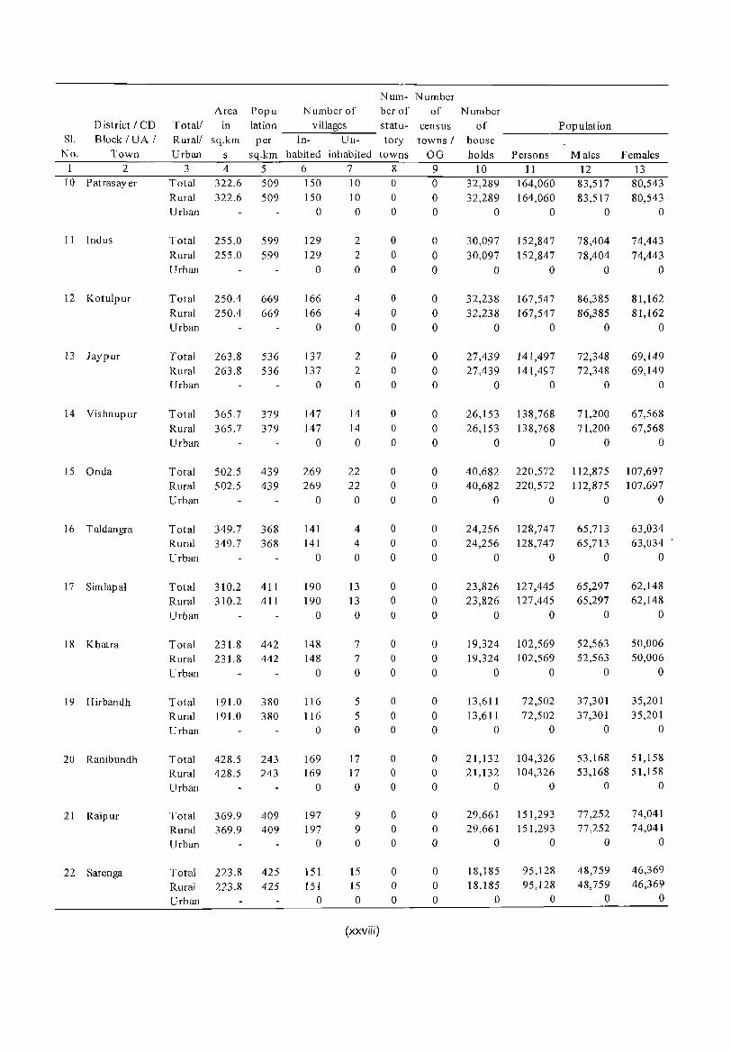
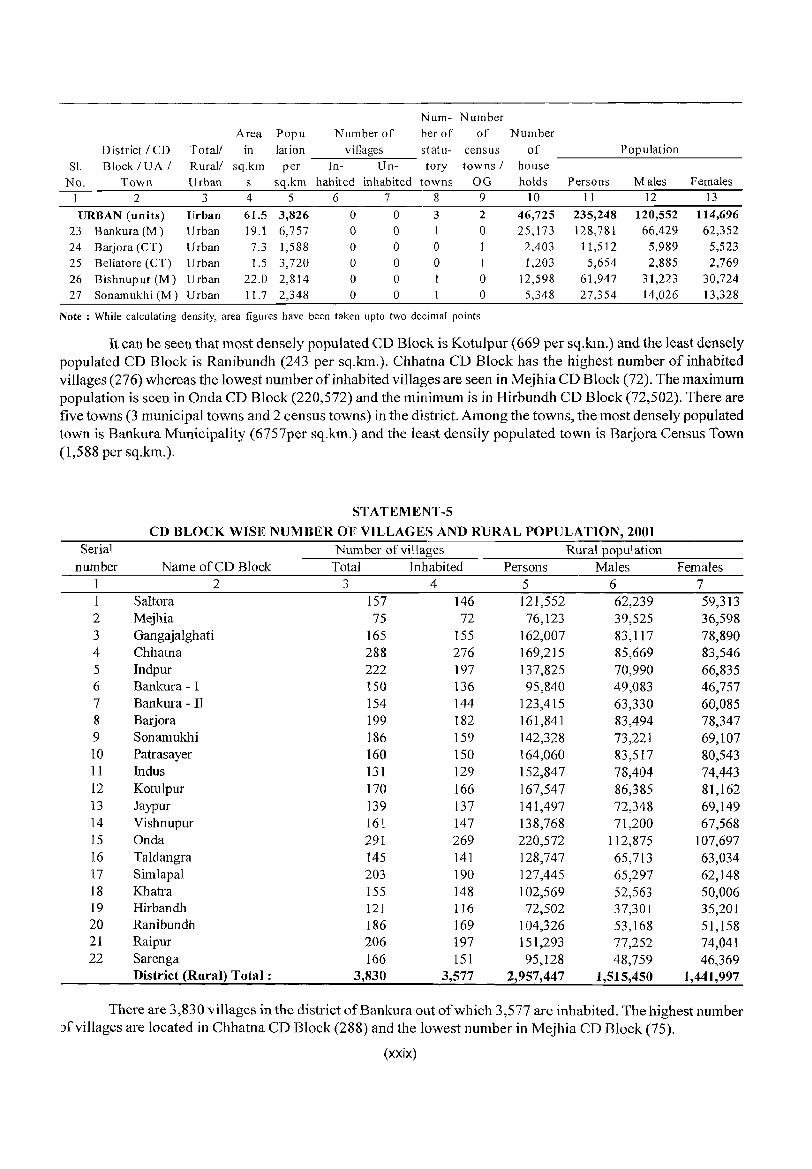
It can be seen that most densely populated CD Block is Kotulpur (669 per sq.km.) and the least densely populated CD Block is Ranibundh (243 per sq.km.). Chhatna CD Block has the highest number of inhabited villages (276) whereas the lowest number of inhabited villages are seen in Mejhia CD Block (72). The maximum population is seen in Onda CD Block (220,572) and the minimum is in Hirbundh CD Block (72,502). There are five towns (3 municipal towns and 2 census towns) in the district. Among the towns, the most densely populated town is Bankura Municipality (6757per sq.km.) and the least densily populated town is Barjora Census Town (1,588 per sq.km.).
STATEMENT-5
CD BLOCK WISE NUMBER OF VILLAGES AND RURAL POPULATION, 2001 Serial Number of villages Rural population
number Name of CD Block Total Inhabited Persons Males Females 1 2 3 4 5 6 7 1 Saltora 157 146 121,552 62,239 59,3l3 2 Mejhia 75 72 76,123 39,525 36,598 3 Gangajalghati 165 155 162,007 83,117 78,890 4 Chhatna 288 276 169,215 85,669 83,546 5 Indpur 222 197 137,825 70,990 66,835 6 Bankura - I 150 136 95,840 49,083 46,757 7 Bankura - II 154 144 123,415 63,330 60,085 8 Barjora 199 182 161,841 83,494 78,347 9 Sonamukhi 186 159 142,328 73,221 69,107 10 Patrasayer 160 150 164,060 83,517 80,543 11 Indus l31 129 152,847 78,404 74,443 12 Kotulpur 170 166 167,547 86,385 81,162 13 Jaypur 139 137 141,497 72,348 69,149 14 Vishnupur 161 147 138,768 71,200 67,568 15 Onda 291 269 220,572 112,875 107,697 16 Taldangra 145 141 128,747 65,713 63,034 17 Simlapal 203 190 127,445 65,297 62,148 18 Khatra 155 148 102,569 52,563 50,006 19 Hirbandh 121 116 72,502 37,301 35,201 20 Ranibundh 186 169 104,326 53,168 5l,158 21 Raipur 206 197 151,293 77,252 74,041 22 Sarenga 166 151 95,128 48,759 46,369
District (Rural) Total: 3,830 3,577 2,957,447 1,515,450 1,441,997
There are 3,830 villages in the district ofBankura out of which 3,577 are inhabited. The highest number Jfvillages are located in Chhatna CD Block (288) and the lowest number in Mejhia CD Block (75).
(xxix)
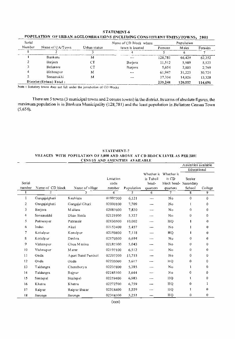
S T A TEMENT-6 POPULATION OF URBAN AGGLOMERATIONS (INCLUDING CONSTITUENT UNITS)/TOWNS, 2001
Serial Name of CD Block where Population Number Name ofUA/Town Urban status town is located Persons Males Females
I 2 3 4 5 6 7 1 Bankura M 128,781 66,429 62,352 2 Barjora CT Barjora 11,512 5,989 5,523 3 Beliatore CT Barjora 5,654 2,885 2,769 4 Bishnupur M 61,947 31,223 30,724 5 Sonamukhi M 27,354 14,026 13,328
District (Urban) Tota!_L_. _________ .. _ .. ___ ._. __ . _ ..... _ . 235,248 120,552 114,696 Note: Statutory towns does not fall under the jurisdiction of CD Blocks
There are 5 towns (3 municipal towns and 2 census towns) in the district. In terms of absolute figures, the maximum popUlation is in Bankura Municipality (128,781) and the least population in Beliatore Census Town (5,654).
STATEMENT-7 VILLAGES WITH POPULATION OF 5,000 AND ABOVE AT CD BLOCK LEVEL AS PER 2001
CENS LIS AND AMENITIES AVAILABLE Amenities available
Educational Whether it Whether it
Location is Tahsil is CD Senior Serial code head- block head- Secondary
number N arne of CD block Narne of village number Population quarters quarters School College 1 2 3 4 5 6 7 8 9
I Gangajalghati Keshiara 01997300 6,121 No 0 0
2 Gangajalghati Gangajal Ghati 02000100 7,709 No I 0
3 Barjora M aliara 02087600 7,830 No 0 0
4 Sonamukhi Dhan Simla 02121900 5,327 No 0 0
5 P at ras ay er Patrasair 02130500 10,002 HQ 0
6 Indus Akui 02153400 5,457 No 0
7 Kotulpur Kotulpur 02159800 7,118 HQ 0
8 Kotulpur Deshra 02170500 6,694 No 0 0
9 Vishnupur Chua M as ina 02187300 5,043 No 0 0
10 Vishnupur Marar 02197100 6,512 No 0 0
11 Onda Aguri Band Punisol 02207200 15,715 No 0 0
12 Onda Onda 02220000 5,617 HQ 0 0
13 Taldangra Chenchurya 02237800 5,285 No 0
14 Taldangra Rajpur 02245100 5,644 No 0 0
15 Simlapal Simlapal 02259400 6,083 HQ 1 0
16 Khatra Khatra 02272700 6,759 HQ 0
17 Raipur Raipur Bazar 02318400 5,559 HQ 0
18 Sarenga Sarenga 02344300 5,251 HQ 0 0
(XXX)
Amenities available
Drinking Commu-
Medical Water nication Banking Primary Primary Co-
Serial Name of CD Health Health Sub- Tap Railway Commercial operative
number block Name of village Centre centre water station Bank Bank
2 3 10 11 12 13 14 15
G angaj alghat i Keshiara 0 0 No No 0 0
2 Gangajalghati Gangajal Ghati 0 No No 0
3 Barjora Maliara 0 2 No No 0
4 Sonamukhi Dhan Simla 0 0 No No 0
5 Patrasayer Patrasair 2 Yes Yes 0
6 Indus Akui 0 No No 0
7 Kotulpur Kotulpur 0 Yes No 2 2
8 Kotulpur Deshra 1 0 No No 0 I
9 Vishnupur Chua M as ina 0 0 No No 0 0
10 Vishnupur Marar 0 No No 0 0
11 Onda Aguri Band Punisol 0 0 No No 0 0
12 Onda Onda 0 Yes Yes 2
13 TaJdangra Chenchurya 0 1 No No I
14 Taldangra Rajpur 0 0 No No 0 0
15 Simlapal Simlapal 0 Yes No 1
16 Khatra Khatra 0 No No 0
17 Raipur Raipur Bazar 0 Yes No 2 2
18 Sarenga Sarenga 0 Yes No
Note: There is no Tahsil in West Bengal
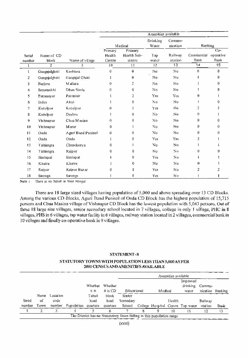
There are 18 large sized villages having population of 5,000 and above spreading over 13 CD Blocks. Among the various CD Blocks, Aguri Band Punisol ofOnda CD Block has the highest population of 15,715 persons and Chua Masina village of Vishnu pur CD Block has the lowest population with 5,043 persons. Out of these 18 large size villages, senior secondary school located in 7 villages, college in only 1 village, PHC in 8 villages, PHS in 6 villages, tap water faciity in 6 villages, railway station located in 2 viII ages, commercial bank in 10 villages and finalIy co-operative bank in 9 villages.
Name
Serial of number Town
1 2
STATEMENT -8
STATUTORY TOWNS WITH POPULATION LESS THAN 5,000 AS PER 2001 CENSUS AND AMENIllIES AVAILABLE
Amenities available
Improved Whether Whether drinking
it is it is CD Educational Medical water Location Tahsil block Senior
code head head Secondary Health number Population quarters quarters School College Hospital Centre Tap water
3 4 5 6 7 8 9 10 11 The District has no Statututory Town falling in this population range
(xxxi)
Commu-nication Banking
Railway station Bank
12 13
STATEMENT -9
HOUSELESS AND INSTITUTIONAL POPULA nON OF CD BLOCKS, TOWNS, RURAL AND URBAN, 2001
Serial Number
2
3
4
5
6
7
8
9
10
11
12
District / CD Block /
UA/Town
2
Bankura
Saltora
Mejhia
Gangajalghati
Chhatna
lndpur
Bankura - I
Bankura - II
Barjora
Barjora (CT) Beliatore (CT)
Sonamukhi
Patrasayer
Indus
Total/ Rural! Urban
3
Total
Rural
Urban
Total Rural Urban
Total Rural
Urban
Total Rural
Urban
Total Rural
Urban
Total Rural Urban
Total Rural Urban
Total Rural
Urban
Total
Rural Urban Urban
Urban
Total Rural Urban
Total Rural Urban
Total Rural Urban
Houseless pop ulation
Number of households
4
165 136 29
9 9
o
1
o
11 11 o
5 5
o
7
7 o
4
4 o
12 12
o
6
5 1
o
o
6 6
o
2 2 o
Persons Males Females 567
535 459
76
32 32
o
2
2 o
36 36 o
13 13 o
20 20 o
11 11 o
60 60 o
10
9 1
o
7
7 o
10 10 o
7 7
o
(xxxii)
305 253
52
15 15
o
1
o
14 14 o
9 9 o
11
11 o
7 7 o
37 37 o
6
5 1
o
5
5
o
4
4 o
5
5
o
230 206
24
17 17 o
I
1 o
22 22 o
4 4
o
9
9 o
4
4
o
23 23 o
4
4 o o o
2 2 o
6 6 o
2 2
o
Institutional pop ulation
Number of
households
8
660 565 95
11 II
o
8
8 o
33 33 o
37 37 o
57 57 o
40 40 o
20 20 o
24 20
4 4
o
21 21 o
16 -16 o
10 10 o
Persons
15,490 13,880
1,,610
159 159
o
58 58 o
774
774 o
674 674
o
1,932
1,932 o
1,545 1,545
o
300 300
o
316 284
32 32 o
207 207
o
275 275
o
139 139
o
Males 10
12,485 11,232
1,253
148 148
o
34 34 o
660 660
o
546 546
o
1,378 1,378
o
1,223 1,223
o
222 222
o
258 236
22 22 o
173 173
o
239 239
o
114 114
o
Females
11
3,005 2,648
357
11 II
o
24 24 o
114 114
o
128 128
o
554 554
o
322 322
o
78 78 o
58 48 10 10 o
34 34 o
36 36 o
25 25 o
Serial
Number
13
14
15
16
17
18
19
20
21
22
23
24
25
26
District I CD Block I UA (Town
2
Kotulpur
Jaypur
Vishnupur
Onda
Ta1dangra
Simlapal
Khatra
Hirbandh
Ranibundh
Raipur
Sarenga
Bankura(M)
Bishnupur eM)
Sonamukhi (M)
TotaV
RuraV
Urban
3
Total
Rural
Urban
Total Rural
Urban
Total Rural
Urban
Total
Rural
Urban
Total
Rural
Urban
Total
Rural
Urban
Total
Rural
Urban
Total
Rural
Urban
Total
Rural
Urban
Total
Rural Urban
Total
Rural
Urban
Urban
Urban
Urban
Houseless population
Number of
households
4
6
6
o
7 7
o
10 10
o
3 3 o
6 6 o
22 22 o
3
3
o
3
3 o
3 3
o
8
8 o
2
2 o
18
8
2
Persons Males Females
567
7
7 o
27 27 o
28 28 o
5 5 o
19 19
o
90 90 o
7
7
o
8
8
o
7
7 o
34
34
o
20 20 o
41
28
6
(xxxiii)
5
5 o
19 19 o
13 13 o
3
3 o
11
11
o
41 41 o
3 3
o
2
2 o
2 2
o
21 21 o
20
20 o
23
23
5
2
2 o
8 8
o
15
15
o
2
2 o
8
8 o
49 49 o
4 4
o
6
6
o
5 5
o
13
13 o
o o o
18
5
Institutional population
Number of
households
8
25
25 o
17
17 o
26 26 o
18 18 o
24 24 o
26 26 o
18 18 o
30
30
o
29 29 o
42 42 o
37
37 o
58
15
18
Persons
9
526 526
o
474 474
o
338 338
o
143 143
o
338
338 o
365 365
o
300
300 o
793
793 o
1,246 1,246
o
1,797
1,797 o
1,213 1,213
o
1,147
166
265
Males 10
480 480
o
443 443
o
305 305
o
87 87 o
290 290
o
279 279
o
259 259
o
731 731
o
1,045 1,045
o
1,363
1,363
o
977 977
o
871
101
259
Females
11
46
46 o
31 31 o
33 33
o
56 56 o
48 48 o
86 86 o
41 41
o
62 62 o
201
201 o
434
434 o
236 236
o
276
65
6
The above table shows that the house less population in the district is 535 (305 males and 230 females). Out ofthe total houseless population, 459 (253 males and 206 females) live in rural areas and 76 (52 males and 24 females) live in urban areas. Among the CD Blocks, the highest number of house less population is recorded in Simlapal CD Block (90) followed by Bankura-II CD Block (60) and the lowest in Mejhia CD Block (2) followed by Onda CD Block (5). Among the statutory towns, Bankura Municipality contains the maximum houseless population (41) and the lowest is found in Sonamukhi Municipality (6). The institutional population in district is 15,490 (12,485 males and 3,005 females). The rural-urban break-up shows that out of the total institutional population, 13,880 (11,232 males and 2,648 females) live in rural areas and 1,610 (1,253 males and 357 females) live in urban areas. Among the CD Blocks, the highest number of institutional population is: returned by Indpur CD Block (1 ,932) followed by Raipur CD Block (1,797), Bankura-I CD Block (1,545), Ranibundh CD Block (1,246)' and Sarenga CD Block (1,213) as against the lowest seen in Mejhia CD Block (58) followed by Indus CD Block (139). Among the statutory towns, the largest number of institutional population is observed in Bankura Municipality (1,147) and the smallest number in Bishnupur Municipality (166).
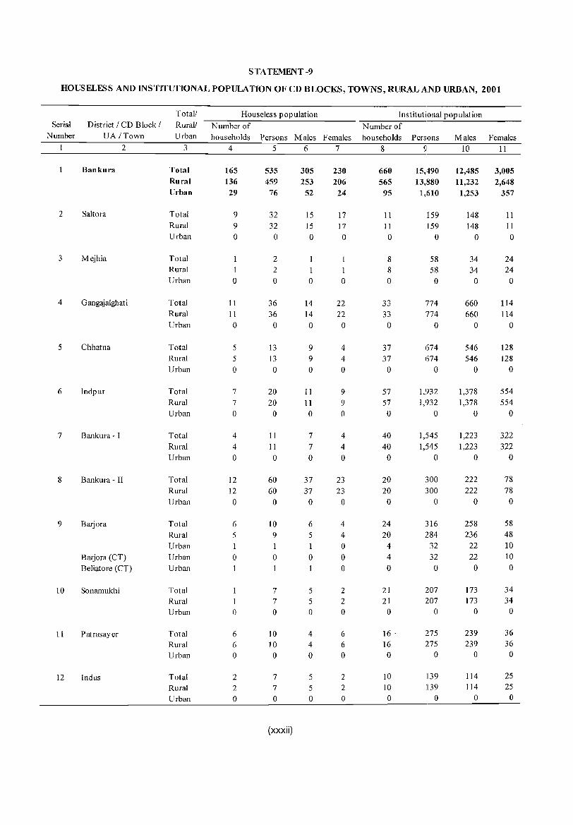
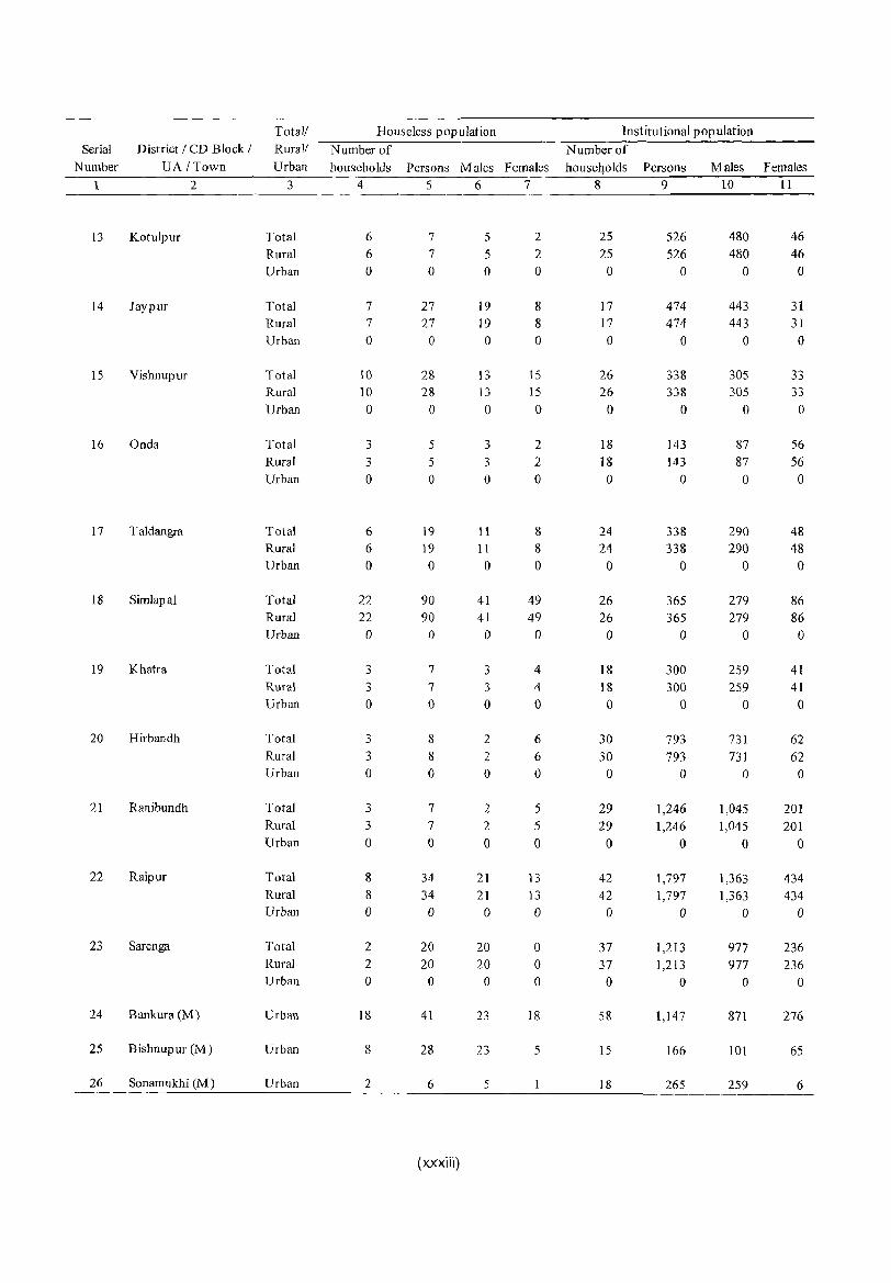
(xxxiv)
ANALYTICAL NOTE

ANALYTICAL NOTE
Analytical Note
(i) History and scope of the District Census Handbook
The District Census Handbook a joint venture of the State Government! Union Territory Administrations and the Census Organisation, is one of the most important publications, particularly in the context of planning and development at grass root level. It is perhaps the only source that gives village and town level information concerning several demographic and socia-economic characteristics and also on availability of important civic amenities. This publication was for the first time brought out in the 1951 Census. In fact it is the replacement of 'Village Statements' used to be prepared in the Censuses of Pre Independence period and since then it is published after each decennial Census with some innovations/improvements.
Scope & coverage of District Census Hand Books of 1951-1991 Censuses
Initially the scope of the DCHB was confined to certain important census tables on population, economic and socio-cultural aspects and also the Primary Census Abstract (PCA) of each village and town of the district. The DCHB published after the 1961 Census contained a descriptive account of the district, administrative statistics, Census tables and Village and Town Directories including PCA. In 1971 Census the DCHBs were brought out in two parts viz. Part A comprising Village and Town Directories and Part B comprising Village and Town PCA in respect of all the States and Union Territories. The Third part of the DCHBs comprising of administrative statistics and district Census tables. During 1981 Census new features alongwith restructuring of the format of Village and Town Directory were introduced in the DCHB. These were published in two parts for each district. While Part A comprised of Village and Town Directories, the PCA of Village and Towns (ward-wise) including Scheduled Castes and Scheduled Tribes PCA upto tahsil/town level were provided in Part-B. To illustrate, all the amenities except electricity, were brought together in the Village Directory and if an amenity was not available in referent village, the distance in broad ranges from the nearest place having such amenity
3
was given. Information on some new items such as adult literacy centres, primary health sub-centres and community health workers in the village were provided so as to meet some of the requirements of the Revised Minimum Needs Programme. Similarly, information on approach to the Village was also provided for the first time in the Village Directory so as to give an idea about the number of inaccessible villages in each district. In case of Town Directories also, keeping in view the requirements of the Minimum Needs Programme, a Statement (IV-A) on slums was provided so as to enable the planners to chalk out the programmes for providing civic amenities in the slums. In this statement details on civic and other amenities were presented for the notified slums of Class I and Class II towns. Apart from this, one column on the Scheduled Castes and Scheduled Tribes population and another on adult literacy classes/centres were added in statements IV and V respectively.
The manner of presentation of the DCHBs for the 1991 Census was more or less similar to that of 1981. However, the format of PCA was restructured slightly in the 1991 Census for the benefit of data users. Nine fold industrial classification of main workers was given as against four-fold, industrial classification presented in the 1981 Census. In addition to this, the sex-wise population in the 0-6 age group was also included in PCA for the first time with a view to enabling data users to compute more realistic literacy rate as all children below seven years of age have been treated as illiterate in 1991 Census. It was expected that these changes would help the planners in chalking out more effective developmental programmes.
One of the most important innovations in the 1991 Census was the Community Development Block (CD B lock) level presentation of data in the Village Directory and PCA instead of the traditional Police Station level presentation. It was expected that the presentation of Village Directory and PCA data at CD Block level would help the planners in formulation of micro level development plans, as the CD Blocks are the lowest administrative unit for developmental planning. In order to facilitate the task of administrators, Planners and Researchers to use Village Directory/PCA data, either
from the magnetic tapes/floppies or from the published records, both the computer and manual codes for each Village were provided for the 1991 Census alongwith the corresponding codes of 1981.
Scope & coverage of District Census Handbooks of India, 2001
The District Census Hand Books for Census of India, 2001 are more informative and exhaustive in terms of coverage and context. The coverage in Village Directory has been further broadened and includes facilities like banking, recreational, income and expenditure of Gram Panchayats and most important commodity/commodities manufactured in the village. Apart from these, more details on distance (s) of basic health and educational facilities (viz. Allopathic Hospital, Maternity and Child Welfare Centre, Primary Health Centre and Primary School), if not available in the village are proposed to be given for the first time.
The type and extent of basic amenities available in the villages and towns are proposed to be analyzed in depth with the help of a large number of cross classified inset table & statements. Brief analytical notes laccounts on important aspects concerning respective districts viz. (i) firstly, mortality and migration, (ii) various measures of fertiLity and mean age at marriage, (iii) percentage distribution of migrants by place ofbirth/place of residence, (iv) main religions, (v) marital status of population, (vi) age, sex and education & (vii) distribution of different mother tongue, all based on 1991 Census, will be given at the end of the text as separate annexures. It is also decided to provide two lists separately indicating names of colleges and hospitals available in the villages and towns in the district.
For the District Census Handbooks under Census of India, 2001 more emphasis has been given towards quality of village and town level amenity data. With a view to find out erratic or aberrant trends or in inexplicable fluctuations in amenity data, similar information brought out by the State and Central Government have been collected & these information have been used to verifY the Village Directory & Town Directory data. The inconsistencies noticed in Village Directory & Town Directory data have been removed in consultation with the respective district administration as far as possible.
(ii) Brief history of the district :
Bankura belongs to the Barddhaman Division of the State and forms a part of' Radh' region of Bengal. Most of the poets of Mediaeval Age have repeatedly
4
DISTRICT CENSUS HANDBOOK: BANKURA
mentioned the deity Dhanna Thakur by its popular name 'Bankura Ray'. It is evident that 'Bankura Ray' was held in high esteem in this area and with the passing of time the name became indentified with the area. Initially it was a small village which later converted into district headquarters and maintains that status still now. The original administrative unit, which subsequently developed into the district of Bankura was known in official records as 'Bishenpore', Le., Vishnupur even in 1834 A.D. with headquarters at, Bankura. The district had assumed the current name only between 1834 and 1855 A.D_ So far the area is concerned, it largely differed from Bankura of present day.
In the Hindu period, between 4th century to 6th century A.D. sizable portion of the southern districts of Bengal of which Bankura was a part was under Gupta empire. By 6th century A.D. the Gupta power was on the wane. Some time before 606 AD. Sasanka became the King of Gaur with his capital at Karnasuvarna and all the tracts surrounding the present day Bankura district appear to have been included in Sasanka's empire. With the death of Sasanka his empire broke up. With the accession of Gopal in 8th century the Pal empire became the dominAnt power in Eastern India. But going by the epigraphic evidence this empire did not extend south of the Damodar river before Devpal's regime and that too for a brief spell.!Proof of Utkal invasion and subjugation of the area from time to time is also evident. Independent or semiindependent local rulers in this part of the land had always existed even when some parts were subjugated by any emperor or king. In the 10th, 11th and 12th centuries they were mostly indl~pendent. The longest example of such local rulers is the rule of the Vishnupur Raj or the Mallas of Mallabhum. Their rule was founded probably around seventh century A.D. and endured till the eighteenth century when it was ruined by the ravages of the Marathas invation and by the famine ofl770.
Protected by the rapid cun-ents of the adjoining rivers like Damodar, by extensive tracts of scrub-wood and sal jungle and by strong forts like that of Vishnu pur the MalIa kings ruled rather peacefully and undisturbed even during the Muslim period. Only when the Mughal ' power extended and consolidated itself on all sides, the suzerainty of the Mughal rulers was acknowledged by the MaUa Kings of Vishnu pur by way of paying the annual tributes. In 1590 Mana King Bir Hambir rescued Jagat Singh - the son of Akbar's General Raja Man Singh - during a battle at Raipur in present Bankura

ANALYTICAL NOTE
between the Mughal and the Afghan. Raja Man Singh also came to his help when the Afghans attacked Bir Hambir for his loyalty to the emperor of Delhi. Later Bir Hambir reigned for a long time almost as a sovereign. There are however instances of several stray clashes between Utkal kings and Muslim invaders over possession of some other parts of the present day district.
Bankura of this period comprised of two parts -the Chakla Vishnupur and the Jungle Mahals. The territories under Chakla of Vishnupur came under British control after East India Company obtained Diwani of Bengal, Bihar and Orissa in 1765 as a result of a treaty with Shah Alam-II. The other part that was later referred to by the British as Jungle Mahals contained some independent chiefdoms lying between Birbhum, Bankura, Medinipur and the hilly country of Chhatonagpur that the company took possession of in 1767. During 1773 the whole of Bengal was divided into five grand divisions and Vishnupur figured as a district as part of the second grand division. Sometime prior to 1785 Vishnupur and Birbhum had been included within the district of Murshidabad, but as per notification published in the Calcutta Gazette in March 1787 Vishnupur and Birbhum were united into a compact district and Bankura continued to exist within that form until 1793 when it was transferred to Barddhaman. In 1798-99 the Chuar Rebellion took place in the south-west part of the present day district, that was, in the Jungle Mahals. For the administrative convenience and control now a separate district called Jungle Mahals was formed comprising of23 parganas and mahals of which 15 were from Birbhum, 3 from Barddhaman and 5 from Medinipur. These three from Barddhaman (one of which was Vishnupur) and five from Medinipur are the parganas/mahals that constitute today's Bankura. Bankura continued to form a part of the Jungle Mahals till 1833. On account of another Chuar Rebellion in 1832 which is famous in history as Ganga Narayani Hangama the district of Jungle Mabals was abolished and another administrative change took place. Simultaneously the regular system of administration was withdrawn from the area and it became under jurisdiction of South-West Frontier Agency. It meant practically the whole of western part ofthe present day district had gone to Manbhum. And the remainder of the district formed another district known as West Burdwan with its headquarters at Bankura. At the time of the Rebellion of 1858, Bankura comprised only the eastern half of the present district. Without going into detail of subsequent changes it would
5
be sufficient to mention that Bankura district attained its present form in the year 1879 with the subdivision of Vishnupur being added to the existing parts under the erstwhile Jungle Mahals. With the creation of separate District Judgeship exclusively for Bankura it became a full-fledged administrative unit from 1881. Since then there has been no change either in the physical boundary of the district or in the administration of justice.
(iii) Administrative set up :
(i) Region of the state where district is located :
Bankura is situated on the western periphery of the state of West Bengal and included in the Barddhaman Division. It formed the Western boundary of the state bordering Bihar (now Jharkhand) till 1956 when Purulia was included in West Bengal and formed the western most boundary of the state.
(ill) Total number of CD Blocks or the next Administrative units after district and changes therein including jurisdictional changes during 1991-2001 :
The district has three sub-divisions, viz. (1) Bankura (Sadar) (2) Bishnupur and (3) Khatra. There are 20 Police Stations in the district, namely, (1) Sahora (2) Mejhia (3) Gangajalghati (4) Chhatna (5) Indpur (6) Bankura (7) Barjora (8) Sonamukhi (9) Patrasayer (10) Indus (11) Kotalpur (12) Joypur (13) Bishnupur (14) Onda (15) Taldangra (16) Simlapal (17) Khatra (18) Ranibandh (19) Raipur and (20) Sarenga. There has been no jurisdictional change in the district during 1991-2001.
There are in all 22 Community Development Blocks in the district, viz. (1) Saltora (2) Mejhia (3) Gangajalghati (4) Chhatna (5) Indpur (6) Bankura-I (7) Bankura-II (8) Barjora (9) Sonamukhi (10) Patrasayer(ll) Indus (12) Kotulpur (13) Joypur (14) Vishnupur (15) Onda (16) Taldangra (17) SimlapaJ (18) Khatra (19) Hirbandh (20) Ranibundh (21) Raipur and (22) Sarenga.
(iii) Total number of TownsNilIages etc. :
Total number of urban units in Bankura is 5, out of which there are 3 municipalities i.e. statutory towns viz. (1) Bankura (2) B ishnupur and (3) Sonamukhi and 2 census towns viz. (1) Barjora and (2) Beliatore. During 1991 Census there were 7 urban units, out of which four were non-municipal. But in 2001 Census the total number of urban units has been reduced to 5 because Khatra (NM) and Patrasayer (NM) have become rural areas under 2001 census.
The district has 22 Panchayat Samities with 190 Gram Panchayats consisting of 3,830 villages.
(iv) If the district is newly created, the area from which it has been carved out :
It is not a newly created district.
(v) Urban Local Bodies:
The history of urban local bodies dates back in India to Indus Valley Civilisation. In modern India it originated during British rule when in 1687 the first Municipal Corporation was set up at Madras under a charter granted by James II. There are different types of municipal bodies, namely, Municipal Corporations, Municipalities, Notified Area Comittees, Cantonment Boards etc. Except the Cantonment Boards all other types are created under state municipal laws. Cantonment Boards owe their origin to the Central Act called Cantonment Acts, 1924. A municipality is a body politic and corporate, constituted by the incorporation of the inhabitants of a city or town. Municipal Corporations constitute the highest or topmost form of urban local governments and are created for big cities by the enactment of state legislatures or of Parliament in case of union territories. AN otified Area Committee is created for an area which does not fulfil all the conditions laid down as necessary for the constitution of a municipality or it may also be created for newly developing towns or areas.The councils of all these corporate bodies except notified area comprise elected, opted and associate members. The notified area is governed by the state governments through a body nominated by it. The primary object of every urban local body is to provide civic amenities to the people and the overall development of the town.
As already stated, there are 3 municipalities in Bankura, viz. Bankura, Bishnupur and Sonamukhi. All the three municipalities came into existence in the 19th
century. Bankura Municipality was established on April 1, 1869, Bishnupur on September 1, 1873 and Sonamukhi in sometime between 1886-87.
Civil Administration :
The Civil Administration of the district consists of the District Magistrate as the Principal Executive with 3 Subdivisional Officers being the subdivisional heads and one Block Development Officer for each CD Block. Under the police administration, Superintendent of Police is the head of the district and under him there are 3 Subdivisional Police Officers with Inspector in charge/Officer in charge in each police station. At the district Head Quarter District Judge is the head of the
6
DISTRICT CENSUS HANDBOOK: BANKURA
Judiciary. The subdivisional Judicial Magistrate sits in the Courts at the subdivisionallevel.
(iv) Physical features :
(i) Location and size
The district is situated between 22°38" and 23°38" North latitudes and between 86°36" and 87°46" East longtitudes. It is bounded by Medinipur and HugH district in the East, Puruliya in the West, Barddhaman in the North and again Medinipur in the South. Bankura i~r: almost triangular in shape with a total area of 6,882 sq. kms. and it ranks 4th among all the districts according to size. Its north to south extension is of 112 kms and that of east to west is of 120 kms.
(ii) Physiography :
The intermediate tract that lies between the riceproducing alluvial plains of Bengal to the east and the Chhotanagpur plateau on the west is called Bankura. Here the plains gradually end in undulations that become more pronounced towards the west where the land is interspersed with hillocks and broken up into low ridges and valleys. Though not distinguishable much as they merge into one another, three regions of the district broadly divided are - 1) The hilly areas to the west, 2) The connecting undulating tract in the middle and 3) The level alluvial plains to the east. The entire Bishnupur and some parts of Sa dar subdivision of Bankura can be described as one such level country( not materially different from the flat plains in the adjoining districts of Barddhaman and Hugli. But laterite, interspersed with associated rocks of sands and gravels, forms the most characteristic geological feature of the district. There are true laterites and laterite gravels with all the appearance of a mass. The reddish-brown nodules of the laterite being mixed up with the coarse sandy clay gives a slight red tint to the soil. Locally these nodular laterites are known as Kankar. The undulating tract of the middle with this characteristic reaching the western fringe of the district, the ChhotanagpurtableLand, achieves highest eminences in the Biharinath and Susunia hills - two peaks of considerable height. Biharinath is in the extreme north west corner of the district in Saltora and rises to 447.8 metres above sea level. Susunia is situated in the northern border of Chhatna and rises abruptly from the neighbouring undulating plains to a height of 439.5 metres.
Topographically the district has been divided into 6 sub-micro regions viz.
1. Main Bankura Upland - characterized by
ANALYTICAL NOTE
undulating terrains with many hills and ridges along the north-western boundary of the district and having a gradual descent from the Chhatonagpur plateau.
2. Bankura Upland - continuation from the main Bankura Upland lies over a small tract in the southeast corner.
3. Bankura - Vishnupur Radh Plain - the elevation rises gradually in undulating surface but abruptly in hilly tract towards west extending between western hilly tract and eastern alluvial plains. The hillocks range in the region from 90 to 180 metres respectively.
4. Patrasair Plain - a fertile plain area that has a gradual slope towards south-west and lies in the northeast portion of the district.
5. Selai Plain - also a plain area with some undulations in the west extending in the south-central part of the district.
6. Middle Kasai Basin - mainly a plain area shaped by the river Kasai flowing from north-west to southeast and covers the north-western part of the district.
Elevation of the district from mean sea level is 448 metres.
Flora & Fauna:
Some of the important plants which grow in the eastern portion of the district that forms part of the alluvial plains of West Bengal are ash-sheora, bel, sajina, bhat etc. The Pipal , Banyan, Red Cotton tree, Mango, Jiyal, Khejur and Tal are the notable trees. The uplands are covered with Kul, Palas, Babla and Kuchila. The low hills are clothed with Dom-sal, Kendu etc. and the forest mainly with Sal and Mahua.
Denudation of forest has left the fauna ofBankura rather small. Leopard, Panther or Wolf are rare animals nowadays. Jackals and Foxes are however still exist. There are Sloth Bear in small numbers in forests. Wild Cats (Ban Bira!) are not uncommon. Common Otter (Bhodor) may be seen in ponds, tanks and rivers. The palm and small Indian Civets (Bham, Khatas, Gandhagoku!), the small Indian Mongoose and the Indian Grey Mongoose (Neu!), the nocturnal Hyaena, Wild Pig (BunoSuar), the common Hare (Khargosh), Lal-bandar, the Langur (Hanuman), Squirrel and Porcupine etc. are familiar animals of the district. Water-holes have been dug at suitable places in the Ranibandh area to attract wild life. Of the many species of snakes, Python (Maya!), Cobra (Keute, Gokhro), common and banded Kraits, Russel's viper (Chandrabora), Rat-snake (Dhamna), Checkered
7
keelback (Heley) and Enhydris (Dhonra) are prominent. The numerous species of birds are found in the district. There are two aviaries - one at Joypur and the other at Sonamukhi - especially for the multiplication of the game birds and their release into the forests.
(iii) Drainage
The drainage of the district is mainly controlled by the Damodar, the Dwarakeswar and the Kangsabati river alongwith their network oftributaries. They have in general south easterly flow. The courses of the principal rivers are approximately parallel to each other.
Damodar river rises in hilly country of Palamou District of Chhatonagpur and before it touches the Bankura district, it receives the water of many smaller hill streams including those of the Barakar, its principal tributary. Its length of flow is about 89.6 km.
The Dwarakeswar flows almost through the middle ofthe district and divides it into two halves. It rises in the adjoining Puruliya district, flows in a south easterly course for a distance about 107.2 kms after it enters Bankura district and leaves for Hugli near Indas. The Gandheswari which rises in the region north-west of Susunia hill in Chhatna drains a large part ofChhatna and Bankura town before it joins Dwarakeswar. Its total length is about 32 kms. The Berai is a small tributary of the Dwarakeswar traversing about 30 kms. The Silabati, popularly known as Silai, is the largest tributary of the Dwarakeswar. The total distance traversed by this river within the district is 56 kms. The Joypanda is the principal tributary ofSilabati and it runs for a distance of 43.2 kms within the district. The Amodar is the only other important tributary of Dwarakeswar which flows for about 27.2 kms.
The Kangsabati or the Kasai is the third largest river in the district, which rises in the hilly terrain of Ihalda CD Block in the adjoining district ofPuruliya and enters Bankura district in Khatra CD Block. Thereafter it flows south easterly for a distance of about 56 kms. across the southern part of the district and! enters Medinipur district at the south east corner. It is liable to occasional floods during the rainy season. A large dam has been constructed across the Kangsabati and its tributary - the Kumari river, a little above the confluence in Ambikanagar in Ranibandh block. The Kumari, the Bhairabbanki and the Tarafeni are the tributaries of the Kangsabati river. The first flows in an easterly course for only about 8 kms. within the district. The next two rivers have total run of 32 km. and 8 kms. respectively within Bankura.
Main water features such as tank, lake reservoir etc.
There is no natural lake in the district except a large swamp near Mejia called the Mejia Beel formed by the overflow of the Damodar river. There are also a few natural pools of small breadth and depth along the banks of the Silabati and the Joypanda locally called asura pan}. Bankura has some reservoirs and good number of tanks both locally called Bandh. In the undulating west of the district, the surface drainages are confined by natural embankments at suitable places. In the east, the ordinary forms of tank with four embanked sides are to be found. Excepting a few, most of these tanks are of considerable antiquity, constructed by Bir Singh, the Malia Raja of Vishnu pur. Names of some of these famous tanks are Jamunabandh, Krishnabandh, Lalbandh, Kalindibandh, Shyambandh etc.
O'Malley, in the old District Gazetteers ofBankura had mentioned about some small but picturesque waterfalls along the course of Silabati river near the village Harmasra in the western extremity ofTaldangra PS. Such springs occur in the uplands of the district of Bankura. Most prominent two of them are on the southern slopes of the Susunia hill.
(iv) Climate
The climate of Bankura is tropical, dry and subhumid. Bankura district is well known as a drought prone district of the State. The monthly temperature varies between 5°C in the winter to 40°C in summer. Average of the maximum and minimum temperature of the district for the preceeding 10 years is as below.
Year Maximum Minimum (in Celsius) ( in Celsius)
1991 33 19 1992 33 18 1993 36 18 1994 36 18 1995 36 18 1996 36 17 1997 35 17 1998 37 18 1999 36 18 2000 35 17
Note: Yearwise data taken from District Statistical Hand Book,
1996 & 2001
The hottest month in Bankura is May and the coldest is December. Characteristic of the wind is generally light to moderate. The force slightly increases
8
DISTRICT CENSUS HANDBOOK: BANKURA
during the summer and monsoon seasons. In summer season it blows mostly from directions between south and east, in monsoon season in southwest and in cold season from directions between west and north and in March-April mostly from directions between south and northwest. The district receives a mean annual rainfall varying from a little more than 1,430 mm to the southeast to less than 1,200 mm to the north-west which comes within 53 to 77 rainy days and about 70.0 per cent of which comes during the four monsoon months-" of June to September. July and August are the rainiest months in Bankura. Nor westers (locally known as kalbaisakhi) occasionally occur during March-April.
(v) Economic resources
a) Forest Area: The district has 150,465.3 hectares of land under forest. Out of the total forest area 13 1,203.19 hectares of land is under protected forest and 3889.07 hectares ofland is under reserved forest. From the forest produce the Govt. collected revenue ofRs. 107,650/- in 2000-01. (Source: District Statistical Hand Book, 2001, Govt. of West Bengal)
b) Mineral product: In Chhendapathar in Ranibandh CD Block and in the CD Block area of Khatra ulgam arefound. In Saltora, Mejia and Barjora CD Block areas coal is found. In the Susunia Hill area quartzite and china clay are available.
c) Soil & Cropping Pattern: The soil of the Bankura: Upland is laterite red and hard beds are covered with scrub jungle and sal wood. Thj~ soil of the BankuraVishnupur Radh Plain is red sandy, red loamy and alluvial. The Patrasayer Plain has shallow black, brown and alluvial soils consisting of sand and clay silts carried by the rivers. The Selai Plain has red sandy, shallow black, brown and recent alluvial soils. In the lower and southern part of the Middle Kasai Basin the brown and alluvial soils are found while red sandy, red loamy and black brown laetrite soils are found in the western part of the region.
In the low-lying river basin areas of of Bankura, aman paddy and maize are generally grown. Aman paddy, sugarcane, tobacco, beteK leaves and vegetables are grown in the Bankura-Bichampur Radh Plain. Aman paddy, sugarcane, oilsee:ds, tabacco and other vegetables are abundantly grown in the Patrasayerplain region, the soil of which are more suited for these crops. Soil ofSelai Plain are more suited for cultivation mainly for aman paddy. Other crops such as sugarcane and patatoes are also grown in the region. (Source : Regional Divisions of India - A Cartographic Analysis, Series 1, Vol. XXV, West Bengal)
ANALYTICAL NOTE
d) Land and land-use pattern: Bankura is the land of red soils. According to D.L.R. W.B. the total area of land is 688,100 hectares. Out of the total area, 344,060 thousand hectares ofland is under net-cropped area, 148,350 hectares of land is under forest and 62,140 hectares of land is under current fallow. (Source: District Statistical Hand Book, Bankura 2001, Govt. of West Bengal)
e) Tenancy: The State Government is the owner of all estate land since the enactment of West Bengal EstateAcquisitionAct, 1948. But in case of agricultural land the tenancy is contractual with the owner. After the land reform measures taken up by the State Government there is no intermediary system of tenancy in the district. In terms of operational land holding, more than 67 per cent falls under the marginal (below 1.0 acre) size of holding in the district. As per the records of Directorate of Agriculture, Government of West Bengal, till 2000, 22,590.56 hectares of vested agricultural land have been distributed among 1 lakh 48 thousand and 16 beneficiaries, of which 74.35 per cent belongs to Scheduled Caste and Scheduled Tribe community when considered together. (Source: District Statistical Hand Book, Bankura 2001, Govt. of West Bengal)
1) Agriculture: Agricultural land of Bankura is of three types- Sali, Suna and Tara or Danga. 'Sali' is suitable for growing of aman rice, 'Suna' for various crops like 'aus' kharif, sugarcane, cotton, tobacco, mustard etc. Suna is used for production of fine kind of rice. Bishnupur sub-division is endowed most with these two types of soils i.e. Sali and Suna. The agricultural lands between Suna and Danga are locally called 'Bait' and 'Kanali'. Success of paddy cultivation on 'Bait' lands (occurs at a level lower than patit danga) depends on good and evenly distributed rain fall. 'Kanali' lands (just above the sali lands on the rise of the slopes) are capab Ie of producing good winter paddy. The main agricultural crop is paddy and it is produced in the 90.0 per cent of the total cultivated area of the district. Wheat, barly, jute and potato are the other important agricultural products of the district. In the irrigated area there is the cultivation of sugar cane. The area under paddy in 2001 is 395.6 thousand hectares of land. (Source : District Statistical Hand Book, Bankura 2001, Govt. of West Bengal)
g) Irrigation: In the district irrigation from private canal is nil. The existing irrigation facilities are mainly from government canal, tanks, wells and other sources. Out of total cultivable land of33276 hectares ofland is under irrigation. In the district various sources of
9
irrigation are available. There are 26,062 shallow tubewells, 921 deep tubewells (including main tubewells) and 230 river lift Irrigation for watering the field under crop. (Source: District Statistical Hand Book, Bankura 2001, Govt. of West Bengal)
h) Animal Husbandry: As per last Cattle Census Report and last Livestock Census Report, 1994 more than 13 lakhs cattle, more than 1 lakh buff ales and more than 7 Iakhs goats are there in the district. (Source: District Stati stical Hand Book, Bankura 2001, Govt. of West Bengal)
i) Fishery: In West Bengal, Bankura is one of the outstanding district in respect of the production of fish which amounts to nearly 22,000 mt. In the small tanks and ponds sweet water fishes are available in plenty. Out of total water area of 22,425 hectares, 14,000 hectares are meant for fish rearing. Bankura has set an example among the other districts in the production of spawn. Almost 156 eco-hatcheries are available for hatching eggs which produce 60 per cent of fishes. In respect offisheries sector ofBankura, the district was prepared mainly for the production of table fishes in the big water areas as well as other water resources of the district through different fisheries scheme.
D Electricity & Power : In the year 2000-2001, 201,092 units (thousand KWH) of electricity were consumed. In the district there are 5 towns and 3,830 villages out of which 2,214 villages have been electrified. Out of 2,214 vilages, 2,056 villages are having electricity for domestic purpose, 648 villages for agricultural purpose, 692 villages for other purposes and 429 villages are using electricity for all purposes.
k) Industry: The major large scale industrial unit in the district is Mejia Thermal Power Project. The cottage and small scale industry constitute the major segment of the district's economy. In case of cottage industry, Bankura plays a dominant role in West Bengal. The silk products of Vishnupur are famous. Tassar, Matka, Garad and Cotton Chadars (scarf) are produced in this district. The total products like the Conch shell products ofBishnupur and Bankura sadar subdivisions are famous in this state. The Brass and Bell Metal products, Wood Carved products, Soft Stone products, Clay products and Terracotta products are produced in the district. The Terracotta toys of Panchmura are exported to different parts of the country and also exported to different countries outside India.
I) Trade and Commerce : In Bankura district, Jhal1tipahari, Chhatna, Bankura, Onda, Gangajalghati,
Beliatore, Ramsagar, Barjora, Asaria, Pakhanna, Maliara, Kotulpur and Patrasayer are the main centres for transaction in paddy and rice. In Sonamukhi, Raipur and Sarenga jute is purchased and sold. Sonamukhi, Indas and Kotulpur are also the important trading centres of the district where potato and sugarcane are purchased and sold.
m) Transport: Total length of road of the district is 6,918 kms and maintained by PWD, West Bengal, Highway Divisions and local authorities. Railway road length is 70 kms. Bus routes are 151, Ferry services 37 and number of registered motor vehicles are 23,524 in the district carrying goods and passengers.
(vi) Gram Panchayat
The three tier panchayat system has been functional in West Bengal since 1978. In the district at the top there is Zilla Parishad (ZP); the Panchayat Samities CPS) are cotermins with at CD Block. There are Gram Panchyat at the lowest level consisting of elected members from the respective villages. Since 1978 the panchayat system has been performing a vital role for the development activists from village to district level and fund are placed for implementing the development plans from GP level to district level.
In spite of some shortcomings, the panchayat system has changed the village economy, social and political system. In West Bengal small and marginal farmer have got cultivable land, the wages of agricultural labourers have increased. Due to land reforms and other village development program the productions of agriculture have also increased significantly. As a result the intake of food has also increased.
(v) Census Concepts
Building:
A 'building' is generally a single structure on the ground. Sometimes it is made up of more than one component unit which are used or likely to be used as dwellings (residences) or establishments such as shops, business houses, offices, factories, workshops, worksheds, schools, places of entertainment, places of worship, godowns, stores, etc. It is also possible that buildings which have component units may be used for a combination of purposes such as shopcum-residence, workshop-cum-residence, office-cumresidence, etc.
Usually a structure will have four walls and a roof. But in some areas the very nature of construction of houses is such that there may not be any wall. Such is the case of conical structures where
10
DISTRICT CENSUS HANDBOOK: BANKURA
entrance is also provided but they may not have any walls. Therefore, such of the conical structures are also treated as separate buildings.
Permanent Houses :
Houses, the walls and roof which are made of permanent materials. The material of walls can be anyone from the following, namely, galvanized iron sheets or other metal sheets, asbestos sheets, brunt bricks, stones or concrete. Roof may be made of anyone of the following materials, namely, tiles, slate, galvanized iron sheets, metal sheets, asbestos sheets, bricks, stones or concrete.
Semi-Permanent Houses :
Houses in which either the wall or the roof is made of permanent material and the other is made of temporary material.
Temporary Houses:
Houses in which both walls and roof are made of materials which have to be replaced frequently. Walls may be made from anyone of the following temporary materials, namely, grass, thatch, bamboo, plastic, polythene, mud, unbumt bricks or wood. Roof may be made from anyone of the following temporary materials, namely, grass, thatch bamboo, wood, mud, plastic or polythene.
Dwelling Room :
A room is treated as a dwelling room if it has walls with a doorway and a roof and should be wide and long enough for a person to sleep in, i.e. it should have a length of not less than 2 meters and a breath of at least 1.5 meters and a height of 2 meters. A dwelling room would include living room, bedroom, dining room, drawing room, study room, servant's room and other habitable rooms. Kitchen, bathroom, latrine, store room, passageway and verandah which are not normally usable for livIng are not considered as dwelling room. A room, used for multipurpose such as sleeping, sitting, dining, storing, cooking etc. is regarded as dwelling room. In a situation where a census house is used as a shop or office etc., and the household also stays in it then the room is not considered as a dwelling room. But if a garage or servant's quarter is used by a servant and if she/he also lives in it as a separate household then this has " been considered as a dwelling room available to the servant's household. Tent or eonical shaped hut if used for living by any household is also considered as dwelling room.
A dwelling room, which is shared by more than one household, has not been counted for any of them.
ANALYTICAL NOTE
If two households have a dwelling room each but in addition also share a common dwelling room, then the common room has not been counted for either of the households.
Census House
A 'Census House' is a building or part ofa building used or recognized as a separate unit because of having a separate main entrance from the road or common courtyard or, staircase, etc. It may be occupied or vacant. It may be used for a residential or non-residential purpose or both.
In certain peculiar situations, the manner in which buildings and census houses were identified for numbering in the field by the enumerators is described hereunder;
Sometimes a series of different buildings are found along a street which are joined with one another by common walls on either side looking like a continuous structure. These different units are practically independent of one another and are likely to have been built at different times and owned by different persons. In such cases, though the whole structure with all the adjoining units apparently appears to be one building, each portion was treated as a separate building and its constituent units as separate census houses.
On the other hand, one may come across cases, particularly in large cities of multi-storied ownership flats. In these cases while the structure looks like one building, different persons own the flats. In case of such multi-storied structures, having a number of flats owned by different persons, the entire structure was treated as one building and each flat as a separate census house.
If within a large enclosed area there are separate buildings owned by different persons then each such building is treated a separate building. There can be a situation where within an enclosed compound there are separate buildings owned by an undertaking or company or even government that are actually in occupation of different persons. For example, Indian Oil corporation colony where the buildings are owned by the Corporation but these are in occupation of their employees. Each such building should treated as a separate building. But ifin any of these buildings there are flats in occupation of different households, each such flat should be reckoned as a separate census house.
Sometimes it becomes difficult to apply the
11
definition of census house strictly in certain cases. For example, in an urban area, if a flat has five rooms, each room having direct entrance from the common staircase or courtyard. By definition, this has to be treated as five census houses. If all these five rooms are occupied by a single household it should not be realistic to treat them as five census houses. In such a case, 'singleness' of use of these rooms along with the main house should be considered and the entire flat should be treated as one census house. On the other hand, if two independent households occupy these five rooms, the first household living in three rooms and the second household occupying two rooms, then considering the use, the first three rooms together should be treated as one census house and the remaining rooms as another census house. But if each room was occupied by an independent household, then each such room was treated as a separate census house.
In case of hostels, hotels etc., even if the door of each room in which an inmate lives opens to a common verandah, staircase, courtyard or a common room, as it happens almost invariably, the entire hostel/ hotel building should be treated as one census house. But if such hostels/hotels have out-houses or other structures used for different purposes of the same purpose, then each structure attached to the main hostel/hotel should be treated as a separate census house.
In some parts of the country, in rural areas, the pattern of habitation is such that a group of huts, located in a compound, whether enclosed or unenclosed, is occupied by one household. While the main residence may be located in one hut, other huts may be used for sleeping, as a kitchen, bathroom, baithak etc. Though each of the huts is a separate structure, they form single housing unit and therefore, have to be treated collectively as one building and one census house. If some of the huts are used by one household and the others by a second household as residence, then the two groups of huts should be treated separate census houses. However, if there are also other huts in the compound used for other purposes and not as part ofthe household's residence such as, cattle shed, work-shed etc., these should be treated as separate census houses.
On the other hand, in urban areas, where more than one structure within an enclosed or open compound (premises) belonging to the same person, e.g., the main house, the servant's quarter, the garage, etc., only one building number is given for this group and each of the constituent a separate census house number.
Only cases where a structure with roof and pillars has come up is treated as a building.
Rural-Urban Area :
The data in tables on Houses, Household Amenities and Assets are presented separately for rural. and urban areas. The unit of classification in this regard is 'town' for urban areas and 'village'; for rural areas. In the Census of India 2001, the definition of urban area adopted is as follows :
(a) All places with a municipality, municipal corporation, cantonment board or notified town area committee, etc.
(b) A place which satisfy or are expected to satisfy the following criteria simultaneously:
i) A minimum population of 5,000;
ii) At least 75 per cent of the male working population engaged in non-agricultural pursuits; and
iii) A density of population of at least 400 per square kilometre (1,000 per square mile).
For identification of places which would qualify to be classified as 'urban', all villages, which, as per the 1991 Census had a population of 4,000 and above, a population density of 400 persons per sq. km. and having at least 75 per cent of male working population engaged in non-agricultural activities were considered. To work out the proportion of male working population referred to above against b) (ii), the data relating to main workers were taken into account.
Apart from these, the outgrowths (OGs) of cities and towns have also been treated as urban areas under Urban Agglomerations. Examples of outgrowths are railway colonies, university campuses, port areas, military camps, etc., may have come up near a statutory town or city but these are within the revenue limits of a village or villages contiguous to the town or city. Each such individual area by itself may not satisfy the demographic criteria laid down at (b) above to qualify it to be treated as an independent urban unit but may deserve to be clubbed with the towns as a continuous urban spread. Thus, the town level data, wherever presented, also includes the data for outgrowths of such towns.
Household:
A 'household' is usually a group of persons who normally live together and take their meals from a common kitchen unless the exigencies of work prevent any of them from doing so. Persons in a household may be related or unrelated or a mix of
12
DISTRICT CENSUS HANDBOOK: BANKURA
both. However, if a group of unrelated persons live in a census house but do not take their meals from the common kitchen, then they are not constituent of a common household. Each slLlch person was to be treated as a separate household. The important link in finding out whether it was a household or not was a common kitchen. There may be one member households, two member households or multi-member households.
Institutional household :
A group of unrelated persons who live in an institution and take their me:als from a common kitchen is called an Institutional Household. Examples of Institutional Households are boarding houses, messes, hostels, hotels, rescue homes, jails, ashrams, orphanages, etc. To make the definition more clearly perceptible to the enumerators at the Census 2001, it was specifically mentioned that this category or households would cover only those households where a group of unrelated persons live in an institution and share a common kitchen.
Houseless household :
Households who do not live in buildings or census houses but live in the open on roadside, pavements, in hume pipes, under fly-overs and staircases, or in the open in places of worship, mandaps, railway platforms, etc., are treated as Houseless Households.
Scheduled Castes and Scheduled Tribes:
Article 341 of the Constitution provides that the President may, with respect to any State or Union territory, specify the castes, races or tribes or parts of or groups within castes, races or tribes which shall for the purposes of the Constitution be deemed to be Scheduled Castes in relation to that State or Union territory. Article 342 similarly provides for specification of tribes or tribal communities or parts of or groups within tribes or tribal communities, which are to be deemed for the purposes of the Constitution to be Scheduled Tribes in relation to the various States and Union territories. In pursuance of these provisions, the list of Scheduled Castes and / or Scheduled Tribes are notified for each State and Union territory and are valid only within the jurisdiction of that State or Union territory and not outsid~:.
It is important to mention here that under the Constitution (Scheduled Castes) Order, 1950, no person who professed a religion different from Hinduism was deemed to be a member of a Scheduled Castes in addition to every member of the
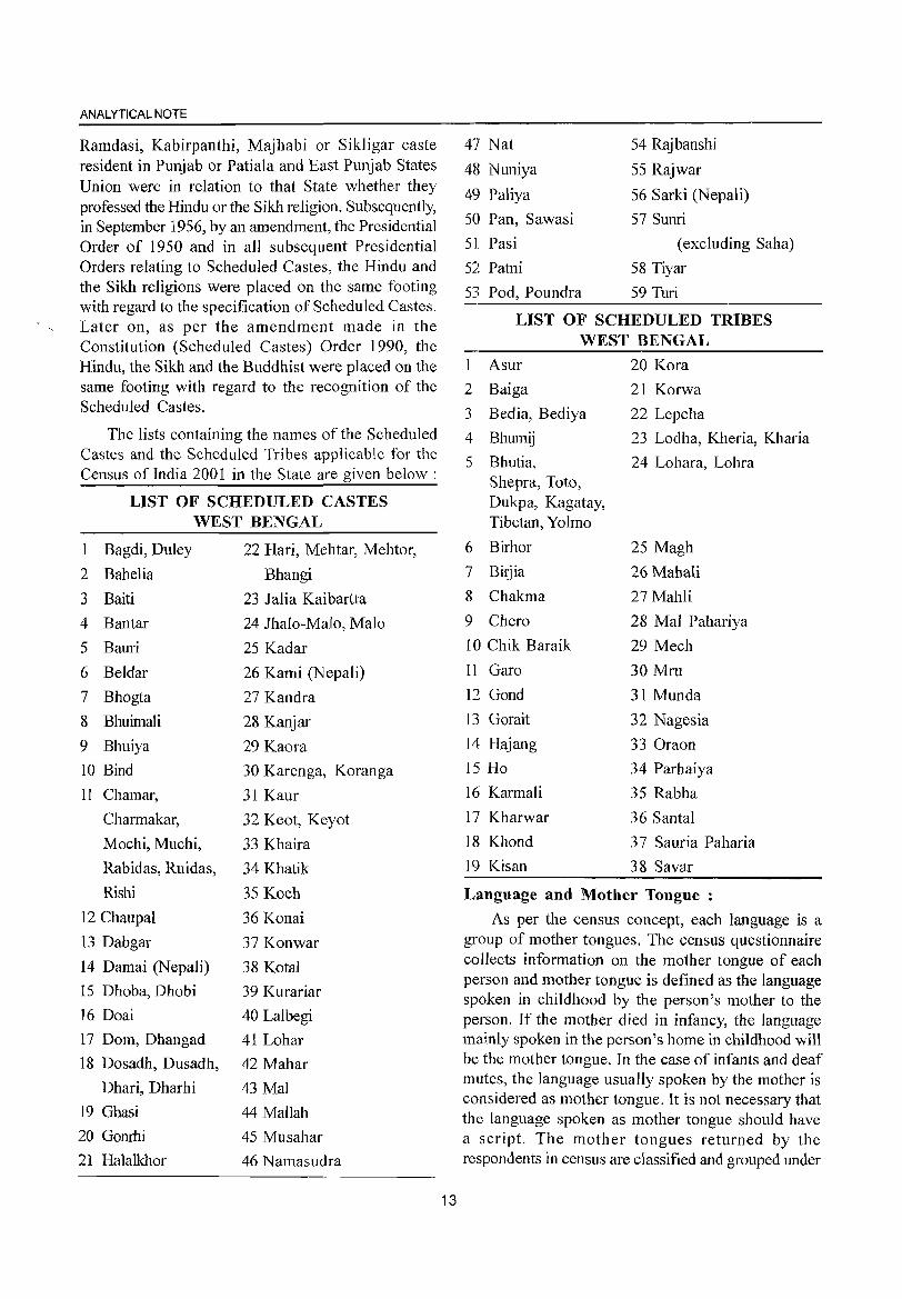
ANALYTICAL NOTE
Ramdasi, Kabirpanthi, Majhabi or Sikligar caste resident in Punjab or Patiala and East Punjab States Union were in relation to that State whether they professed the Hindu or the Sikh religion. Subsequently, in September 1956, by an amendment, the Presidential Order of 1950 and in all subsequent Presidential Orders relating to Scheduled Castes, the Hindu and the Sikh religions were placed on the same footing with regard to the specification of Scheduled Castes. Later on, as per the amendment made in the Constitution (Scheduled Castes) Order 1990, the Hindu, the Sikh and the Buddhist were placed on the same footing with regard to the recognition of the Scheduled Castes.
The lists containing the names of the Scheduled Castes and the Scheduled Tribes applicable for the Census of India 2001 in the State are given below:
LIST OF SCHEDULED CASTES WEST BENGAL
1 Bagdi, Duley 22 Hari, Mehtar, Mehtor,
2 Bahelia Bhangi
3 Baiti 23 Jalia Kaibartta
4 Bantar 24 Jhalo-Malo, Malo
5 Bauri 25 Kadar
6 Beldar 26 Kami (Nepali)
7 Bhogta 27 Kandra
8 Bhuimali 28 Kanjar
9 Bhuiya 29 Kaora
10 Bind 30 Karenga, Koranga
11 Chamar, 31 Kaur
Charmakar, 32 Keot, Keyot
Mochi, Muchi, 33 Khaira
Rabidas, Ruidas, 34 Khatik
Rishi 35 Koch
12 Chaupal 36 Konai
13 Dabgar 37 Konwar
14 Damai (Nepali) 38 Kotal
15 Dhoba, Dhobi 39 Kurariar
16 Doai 40 Lalbegi
17 Dom, Dhangad 41 Lohar
18 Dosadh, Dusadh, 42 Mahar
Dhari, Dharhi 43 Mal
19 Ghasi 44 Mallah
20 Gonrhi 45 Musahar
21 Halalkhor 46 Namasudra
13
47 Nat
48 Nuniya
49 Paliya
50 Pan, Sawasi
51 Pasi
52 Patni
53 Pod, Poundra
54 Rajbanshi
55 Rajwar
56 Sarki (Nepali)
57 Sunri
(excluding Saha)
58 Tiyar
59 Turi
LIST OF SCHEDULED TRIBES WEST BENGAL
Asur
2 Baiga
3 Bedia, Bediya
4 Bhumij
5 Bhutia, Shepra, Toto, Dukpa, Kagatay, Tibetan, Yolmo
6 Birhor
7 Bitjia
8 Chakma
9 Chero
10 Chik Baraik
11 Garo
12 Gond
13 Gorait
14 Hajang
15 Ho
16 Karmali
17 Kharwar
18 Khond
19 Kisan
20 Kora
21 Korwa
22 Lepcha
23 Lodha, Kheria, Kharia
24 Lohara, Lohra
25 Magh
26 Mahali
27 Mahli
28 Mal Pahariya
29 Mech
30 Mru
31 Munda
32 Nagesia
33 Oraon
34 Parhaiya
35 Rabha
36 Santal
37 Sauria Paharia
38 Sayar
Language and Mother Tongue :
As per the census concept, each language is a group of mother tongues. The census questionnaire collects information on the mother tongue of each person and mother tongue is defined as the language spoken in childhood by the person's mother to the person. If the mother died in infancy, the language mainly spoken in the person's home in childhood will be the mother tongue. In the case of infants and deaf mutes, the language usually spoken by the mother is considered as mother tongue. It is not necessary that the language spoken as mother tongue should have a script. The mother tongues returned by the respondents in census are classified and grouped under
appropriate languages according to their linguistic characteristics.
Literate:
A person age 7 years and above who can both read and write with understanding in any language is taken as literate. A person who can only read but cannot write is not literate. It is not necessary that to be considered as literate, a person should have received any formal education or passed any minimum educational standard. Literacy could also have been achieved through adult literacy classes or through any non-formal educational system. People who are blind and can read in Braille are treated as literates.
Literacy rate :
Literacy rate of the population is defined as the percentage of literates in the age group seven years and above. For different age groups the percentage of literates in that age group gives the literacy rate.
Educational Level :
The highest level of education a person has completed.
Work:
Work IS defined as participation in any economically productive activity with or without compensation, wages or profit. Such participation may be physical and/or mental in nature. Work involves not only actual work but also includes effective supervision and direction of work. It even includes part time help or unpaid work on farm, family enterprise or in any other economic activity. All persons engaged in 'work' as defined above are workers. Persons who are engaged in cultivation or milk production even solely for domestic consumption are also treated as workers.
Reference period for determining a person as worker and non-worker is one year preceeding the date of enumeration.
Main Worker :
A person who has worked for major part of the reference period (i.e. six months or more during the last one year precceding the date of enumeration) in any economically productive activity is termed as 'Main worker'.
Marginal Worker :
A person who worked for less than six months of the reference period (i.e. in the last one year preceeding the date of enumeration) in any economic activity is termed as 'Marginal worker'.
14
DISTRICT CENSUS HANDBOOK: BANKURA
Non Worker:
A person who has not worked at all in any economically productive activity during the reference period (i.e. last one year preceeding the date of enumeration) is termed as 'Non worker'.
Cultivator :
For purposes of the Census. a person is classified as cultivator if he or she is engaged in cultivation on land owned or held from govt~rnment or held from / private persons or institutions for payment in money, kind or share. Cultivation includes effective supervision or direction in cultivation.
A person who has given out her/his land to another person or persons or institution(s) for cultivation for money, kind or share of crop and who does not even supervise or direct cultivation in exchange ofland, is not treated as cultivator. Similarly, a person working on another person's land for wages in cash or kind or a combination of both (agricultural labourer) is not treated as cultivator.
Cultivation involves ploughing, sowing, harvesting and production of cereals and millet crops such as wheat, paddy,jowar, bajra, ragil, etc., and other crops such as sugarcane, tobacco, ground-nuts, tapioca, etc., and pulses, raw jute and kindred fiber crop, cotton, cinchona and other medicinal plants, fruit growing, vegetable growing or keeping orchards or groves, etc. Cultivation does not include the following plantation crops - tea, coffee, rubber, coconut and betel-nuts (areca).
Agricultural Labourer :
A person who works on another person's land for wages in money or kind or share is regarded as an agricultural labourer. She/he has no risk in the cultivation, but merely works on another person's land for wages. An agricultural labourer has no right of lease or contract on land on which she/he works.
Household Industry Worker :
Household industry is defined as an industry conducted by the head of the household herself/himself and or by the members of the household at home or within the village in rural areas and only within the precincts of the house where the household lives in urban areas. The larger proportion of workers in household industry should consist of members of the household including the head. The industry should not be run on the scale of a registered factory which would qualify or has to be registered under the Indian Factories Act and should be engaged in manufacturing,
ANALYTICAL NOTE
processing, servicing and repairs of goods.
It does not include professions such as a pleader, Doctor, Musician, Dancer, Waterman, Astrologer, Dhobi, Barber, etc. or merely trade or business, even if such professions, trade or services are run at home by members of the household.
Other Worker :
A person who has been engaged in some economic activity during the reference period but not as a cultivator or agricultural labourer or in Household Industry is termed as a 'Other Worker (OW)'. The type of workers that come under this category of 'OW' include all government servants, municipal employees, teachers, factory workers, plantation workers, those engaged in trade, commerce, business, transport, banking, mining, construction, political or social work, priests, entertainment artists, etc. In effect, all those workers other than cultivators or agricultural labourers or household industry workers, are 'Other Workers'.
Work Participation Rate :
Percentage of workers (main + marginal) to total population.
PopUlation Density :
Population density is the number of persons inhabited per square kilo-metre of the area.
Age:
Age is measured ill terms of the completed number of years.
Sex-ratio:
Number of females per 1000 males III a population.
(vi) Non Census Concepts
Improved drinking water :
If the household had access to drinking water supplied from a tap, hand pump, tube well or well (protected or covered) situated within or outside the premises, it is considered as having access to improved drinking water .. It may be mentioned that such uniform definition may not be valid across all states.
System of sewerage :
Generally, a sewerage system would mean a network of mains and branches of underground conduits for the conveyance of sewerage to the point of disposal. Sewers that carry only household and
15
industrial wastage are called separate sewers; those that carry storm water from roofs, streets and other surfaces are known as storm water drains, while those carrying both sewage and storm water are called combined sewers. However, in some towns, which are not provided with such underground sewerage system, it is served by open surface drain, box drain, silk pattern drain, etc., in these towns.
Type of latrine and Method of disposal of night soil :
There are three prevalent systems of disposal of human wastes, viz. (i) underground sewerage, (ii) sanitary water flush latrines with individual disposal systems, like septic tank, leaching cess pool and collecting well, and (iii) dry type of latrines with manual scavenging.
The system of underground sewerage provides for the street sewerage with which are connected the sanitary latrines constructed in the houses having water closets and fitted with flushing cistern (or hand flushing). Through this sewer the faecal matter is transported without the need for scavenging. This system generally exists in cities and big towns.
Where the street sewer does not exist these sanitary water flush latrines are connected to a local septic tank with a sub-soil dispersion system or a leaching pit. Here the liquid wastes from the water closet is disposed of locally in leaching pit, a septic tank with a soil dispersion system is constructed. This dispersion requires an optimum travel through the pores of the soil, which renders the harmful liquid bacterially innocuous by the slow process of filtration through the soil traversed.
Where the soil is impermeable, collecting wells are constructed and the sanitary water flush latrines are connected with them. These wells are cleaned at periodic intervals by a suitable device. The dry type of latrines are of service type latrines from where human excreta is removed by scavengers from house to house, in most cases carrying it on their heads or shoulders or in baskets with handle or wheel barrows. These are then collected in bullock carts or trucks or tractors and trolleys for being carried to the dumping grounds.
Fertility :
In demography, the word fertility is used in relation to the actual production of children or occurrence of births specially live births. Fertility is a measure of rate at which popUlation adds to itself by births and
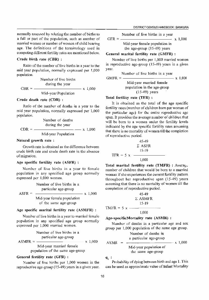
normally assessed by relating the number of births to a full or part of the population, such as number of married women or number of women of child bearing age. The definitions of the terminology used in computing different fertility rates are mentioned below.
Crude birth rate (CBR) :
Ratio of the number of live births in a year to the mid year population, normally expressed per t ,000 population.
Number of live births during the year
CBR = ---------- x 1,000 Mid-year Population
Crude death rate (CDR) :
Ratio of the number of deaths in a year to the mid year population, normally expressed per 1,000 population.
Number of deaths during the year
CDR = ---------- x 1,000 Mid-year Population
Natural growth rate :
Growth rate is obtained as the difference between crude birth rate and crude death rate in the absence of migration.
Age specific fertility rate (ASFR) :
Number of live births in a year to female population in any specified age group normally expressed per 1,000 women.
ASFR =
Number of live births in a particular age-group
----------- x 1,000 Mid-year female population
of the same age-group
Age specific marital fertility rate (ASMFR)
Number of live births in a year to married female population in any specified age group normally expressed per 1,000 married women.
Number of live births in a particular age-group
ASMFR = ---------- x 1,000 Mid-year married female
population of the same age-group
General fertility rate (GFR) :
Number of live births per 1,000 women in the reproductive age-group (15-49) years in a given year.
16
DISTRICT CENSUS HANDBOOK: BANKURA
Number of live births in a year GFR == x 1,000
Mid-year female popUlation in the age-group (15-49) years
General marital fertility rate (GMFR)
Number of live births per 1,000 married women in reproductive age-group (15-49) years in a given year.
Number of live births in a year GMFR == x 1,00(
Mid-year married female population in the age-group
(15-49) years .
Total fertility rate (TFR) :
It is obtained as the total of the age specific fertility rates (number of children born per woman of the particular age) for the el1ltire reproductive age span. It provides the average number of children that will be born to a woman under the fertility levels indicated by the age specific fertility rates assuming that there is no mortality of women till the completion of reproductive period.
45-49 L ASFR
15-19 TFR = 5 x
1,000
Total marital fertility rate (TMFR) : Avera!:,,number of children that would be born to a married woman if she experiences the current fertility pattern throughout her reproductive span (15-49) years assuming that there is no mortality of women till the completion of reproductive period.
45-49 L ASMFR
15-19 TMFR = 5 x ------
1,000
Age-specificMortality rate (ASMR) :
Number of deaths in a particular age and sex group per 1,000 population of the same age group.
ASMR
q, :
Number of deaths in a particular age-group
----------- x 1,000 Mid-year population of
the same age-group
Probability of dying between birth and age 1. This can be used as approximate value ofInfant Mortality
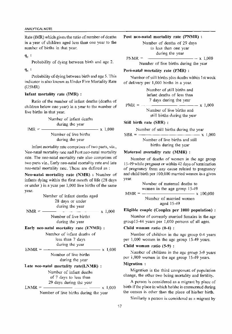
ANALYTICAL NOTE
Rate (IMR) which gives the ratio of number of deaths in a year of children aged less than one year to the number of births in that year.
q2 Probability of dying between birth and age 2.
qs :
Probability of dying between birth and age 5. This indicator is also known as Under Five Mortality Rate (USMR)
Infant mortality rate (IMR) :
Ratio of the number of infant deaths (deaths of children below one year) in a year to the number of live births in that year.
Number of infant deaths during the year
IMR = ---------- x 1,000 Number of live births
during the year
Infant mortality rate comprises of two parts, viz., Neo-natal mortality rate and Post neo-natal mortality rate. The neo-natal mortality rate also comprises of two parts viz., Early neo-natal mortality rate and late neo-natal mortality rate. These are defined as :
Neo-natal mortality rate (NMR) : Number of infants dying within the first month of life (28 days or under) in a year per 1,000 live births of the same year.
Number of infant deaths aged 28 days or under during the year
NMR = ---------- x 1,000 Number of live births
during the year
Early neo-natal mortality rate (ENMR)
Number of infant deaths of less than 7 days during the year
ENMR:;:: ---------- x 1,000 Number of live births
during the year
Late neo-natal mortality rate(LNMR)
Number of infant deaths of 7 days to less than
29 days during the year LNMR = x 1,000
Number of live births during the year
17
Post neo-natal mortality rate (PNMR) :
Number of deaths of 29 days to less than one year
during the year PNMR = x 1,000
Number of live births during the year
Peri-natal mortality rate (PMR) :
Number of still births plus deaths within 1 st week of delivery per 1,000 births in a year.
Number of still births and infant deaths of less than
7 days during the year PMR = ---------- x 1,000
Number of live births and still births during the year
Still birth rate (SBR) :
Number of still bitihs during the year SBR = x 1,000
Number of live births and still births during the year
Maternal mortality rate (MMR) :
Number of deaths of women in the age group 15-49 while pregnant or within 42 days oftennination of pregnancy from any cause related to pregnancy and child birth per 100,000 married women in a given year.
Number of maternal deaths to women in the age group 15-49
MMR = x 100,000 Number of married women
aged 15-49
Eligible couple (Couples per 1000 population)
Number of currently married females in the age group 15-44 years per 1,000 persons of all ages.
Child woman ratio (0-4) :
Number of children in the age group 0-4 years per 1,000 women in the age group 15-49 years.
Child woman ratio (5-9) :
Number of children in the age group 5-9 years per 1,000 women in the age group 15-49 years.
Migration:
Migration is the third component of popUlation change, the other two being mortality and fertility.
A person is considered as a migrant by place of birth if the place in which he/she is enumerated during the census is other than the place of his/her birth.
Similarly a person is considered as a migrant by
place of last residence if the place in which he/she is enumerated during the census is other than his/her place of immediate last residence outside the village or town and not simply in another house or locality in the same village or town.
Certain aspects concerning temporary movement/ migration of people has been explained below as these are important components concerning migration :
(i) Migration of persons in search of job is high in the country. In many cases such migrants are only seasonal in nature. People migrate to other places for work in a particular season and come back again to their usual place of residence after three or four months. All such workers are treated as migrants. Similarly, if a person moved to any other place for attending short term vocational or educational course that lasted for only few months of a year, she/he too were considered as a migrant.
(ii) Where a person had merely gone out to another place or had been shifting from one place to another purely on tour, pilgrimage, visit to hospital for treatment or for temporary business purposes, such persons are not deemed to have had another residence different from the place where she/he or her/his family normally resides. She/he is not considered as migrant.
(iii) A woman temporarily moves into a hospital or to her parents or other relative's house for delivery and if the hospital or the parents/relatives houses is in a place different from usual place of residence, the place where the hospital or parents/ relative's house is the place of last residence of the child but not of the mother.
A new response category 'Moved after birth' was added in Census of India 2001 in the question on 'reasons for migration' to bring out additional migration patterns. Natural calamities or distress migration as a reason for migration for last residence migrants included in 1991 Census, is covered under category of 'Others'. The reason for migration has been deteImined as applicable at the time of migration and not in reference to any point of time after that. For example, if a person had moved from the place of her/his last residence for the purpose of education and subsequently at some point of time got employment there only, the reason for migration would be 'education' and not 'work/employment'.
Internal and International migration :
The migrational movements are of three types
18
DISTRICT CENSUS HANDBOOK: BANKURA
(i) Migration within the state itse:lfwith its components (a) Migration within the district of enumeration (intra district migration) (b) Migration from one district of state to another district of state (inter district migration), (ii) Migration from one state to another State of the country (inter-state migration), (iii) Migration from one country to another country. The first two streams together constitute internal migration, while the last type of movement is called international migration. The present name of the country, state or district and not the name by which( they were known at the time of her/his birth or last residence were recorded.
Rural - Urban components of migration:
Rural or Urban status in respect of migrants have been determined as applicable at the time of migration and not with reference to any point of time after that.
The flow of migrants consists of four streams viz. rural to rural, rural to urban, urban to rural and urban to urban.
Civic status of urban units :
Civic Status of a town/city is determined on the basis of Civic Administrative authority of the town e.g., Municipal Corporation I Corporation, Municipal Committeel Municipal council, Municipality etc.
Size class of UA / town: r
Size-class ofUA/Town is based on the populationl size ofthe UA/City/Town UAs.lTowns with 1,00,000 and above population are classified as Class I UAs. I towns. These Class I UAs. I towns are now further sub classified in to seven sub classes namely Ml to M7 depending on the population size of VA/Cityl Town. These are M7(5,000,000 and above); M6(2,000,000 to 4,999,999); M5 (1,000,000-1,999,999) M4 (500,000-999,999); M3(300,000-499,999), M2 (200,000-299,999) & Ml (100,000-199,999). towns with, 50,000 to 99,999 population are classified as Class II towns, 20,000 to 49,999 population are Class III towns, population with 10,1000-19,999 are Class IV towns, population with 5000 and 9999 are Class V towns and towns with less than 5000 population are Class VI towns.
Slum area:
The Slum Areas (Improvement and Clearance) Act, 1956 which was enacted by the Central Govt. defined slums as a) Areas where buildings are in any respect unfit for human habitation; or b) are by reasons of dilapidation, overcrowding, fault arrangement and design of such buildings, narrowness or faulty
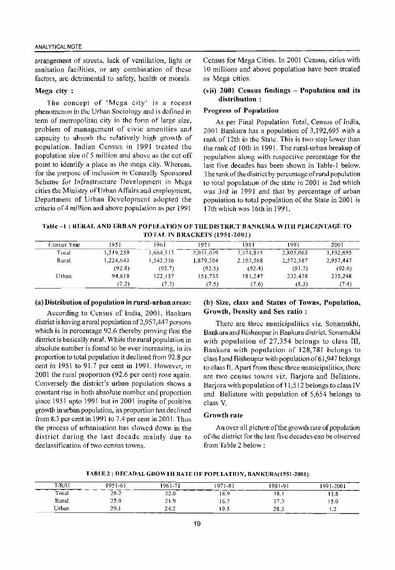
ANALYTICAL NOTE
arrangement of streets, lack of ventilation, light or sanitation facilities, or any combination of these factors, are detrimental to safety, health or morals.
Mega city:
The concept of 'Mega city' is a recent phenomenon in the Urban Sociology and is defined in term of metropolitan city in the form of large size, problem of management of civic amenities and capacity to absorb the relatively high growth of population. Indian Census in 1991 treated the population size of 5 million and above as the cut off point to identify a place as the mega city. Whereas, for the purpose of inclusion in Centrally Sponsored Scheme for Infrastructure Development in Mega cities the Ministry of Urban Affairs and employment, Department of Urban Development adopted the criteria of 4 million and above popUlation as per 1991
Census for Mega Cities. In 2001 Census, cities with 10 millions and above population have been treated as Mega cities.
(vii) 2001 Census findings - Population and its distribution :
Progress of Populatiolll
As per Final Population Total, Census of India, 2001 Bankura has a population of 3,192,695 with a rank of 12th in the State. This is two step lower than the rank of 10th in 1991. The rural-urban breakup of population along with respective percentage for the last five decades has been shown in Table-l below. The rank of the district by percentage of rural population to total popUlation of the state in 2001 is 2nd which was 3rd in 1991 and that by percentage of urban population to total population of the State in 2001 is 17th which was 16th in 1991.
Table -1 : RURAL AND URBAN POPULATION OF THE DIS TRICT BANKURA WITH PERCENTAGE TO TOTAL IN BRACKETS (1951-2001)
Census Year 1951 1961 Total 1,3 I 9,259 1,664,513 Rural 1,224,641 1,542,356
(92.8) (92.7) Urban 94,618 122,157
(7.2) (7.3)
(a) Distribution ofpopulation in rural-urban areas:
According to Census of India, 2001, Bankura district is having a rural population of2,957,447 persons which is in percentage 92.6 thereby proving that the district is basically rural. While the rural population in absolute number is found to be ever increasing, in its proportion to total population it declined from 92.8 per cent in 1951 to 91.7 per cent in 1991. However, in 2001 the rural proportion (92.6 per cent) rose again. Conversely the district's urban population shows a constant rise in both absolute number and proportion since 1951 upto 1991 but in 2001 inspite of positive growth in urban population, its proportion has declined from 8.3 per cent in 1991 to 7.4 per cent in 2001. Thus the process of urbanisation has slowed down in the district during the last decade mainly due to declassification of two census towns.
1971 1981 1991 2001 2,031,039 2,374,815 2,805,065 3,192,695 1,879,304 2, I 93,568 2,572,587 2,957,447
(92.5) (92.4) (91.7) (92.6) 151,735 181,247 232,478 235,248
(7.5) (7.6) (8.3) (7.4)
(b) Size, class and Status of Towns, Population, Growth, Density and Sex ratio:
There are three municipalities viz. Sonamukhi, Bankura and Bishnupur in Bankura district. Sonamukhi with population of 27,354 belongs to class III, Bankura with population of 128,781 belongs to class I and Bishnupur with population of 61,947 belongs to class ll. Apart from these three municipalities, there are two census towns viz. Barjora and Beliatore. Barjora with population of 11,512 belongs to class IV and Beliatore with population of 5,654 belongs to class V.
Growth rate
An over all picture of the growth rate of population oHhe district for the last five decades can be observed from Table 2 below:
TABLE 2: DECADAL GROWTH RATE OF POPULATION, BANKURA(1951-2001)
TIRJU 1951-61 1961-71 1971-81 1981-91 1991-2001 Total 26.2 22.0 16.9 18.1 13.8 Rural 25.9 21.9 16.7 17.3 15.0 Urban 29.1 24.2 19.5 28.3 1.2
19
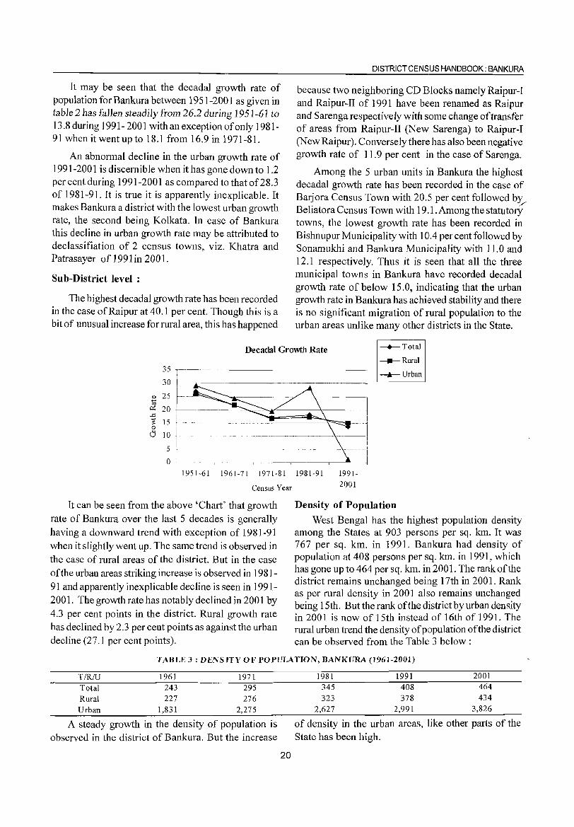
It may be seen that the decadal growth rate of population for Bankura between 1951-2001 as given in table 2 has fallen steadily from 26.2 during 1951-61 to 13.8 during 1991- 2001 with an exception of only 1981-91 when it went up to 18.1 from 16.9 in 1971-81.
An abnormal decline in the urban growth rate of 1991-2001 is discernible when it has gone down to 1.2 per cent during 1991-2001 as compared to that of28.3 of 1981-9l. It is true it is apparently inexplicable. It makes Bankura a district with the lowest urban growth rate, the second being Kolkata. In case of Bankura this decline in urban growth rate may be attributed to declassifiation of 2 census towns, viz. Khatra and Patrasayer of 1991 in 2001.
8ub-District level :
The highest decadal growth rate has been recorded in the case of Raipur at 40.1 per cent. Though this is a bit of unusual increase for rural area, this has happened
DISTRICT CENSUS HANDBOOK: BANKURA
because two neighboring CD Blocks namely Raipur-I and Raipur-II of 1991 have be:en renamed as Raipur and Sarenga respectively with some change of transfer of areas from Raipur-II (New 8arenga) to Raipur-I (New Raipur). Conversely ther~~ has also been negative growth rate of 11.9 per cent in the case of Sarenga.
Among the 5 urban units in Bankura the highest decadal growth rate has been recorded in the case of Barjora Census Town with 20.5 per cent followed b~ Beliatora Census Town with 19,1. Among the statutory towns, the lowest growth rate has been recorded in Bishnupur Municipality with 101.4 per cent followed by Sonamukhi and Bankura Municipality with 11.0 and 12.1 respectively. Thus it is seen that all the three municipal towns in Bankura have recorded decadal growth rate of below 15.0, indicating that the urban growth rate in Bankura has achieved stability and there is no significant migration of rural population to the urban areas unlike many other districts in the State.
Decadal Growth Rate -+--Total
_Rural
-k-Urban 35 ,-~--~~~~~~~-~----------------------,
30
Q) 25
~ 20 t--~~--------.---~"""" ~ 15 ~~==::!~ $ 10
i 5 - ~-----l
o r -.---'.--~------r-------.------~
1951·61 1961-71 1971-81 1981-91 1991-
2001 Census Year
It can be seen from the above 'Chart' that growth rate of Bankura over the last 5 decades is generally having a downward trend with exception of 1981-91 when it slightly went up. The same trend is observed in the case of rural areas of the district. But in the case ofthe urban areas striking increase is observed in 1981-91 and apparently inexplicable decline is seen in 1991-2001. The growth rate has notab ly declined in 2001 by 4.3 per cent points in the district. Rural growth rate has declined by 2.3 per cent points as against the urban decline (27. I per cent points).
Density of Population
West Bengal has the highest population density among the States at 903 persons per sq. km. It was 767 per sq. km. in 1991. Bankura had density of population at 408 persons per sq. km. in 1991, which has gone up to 464 per sq. km. in 2001. The rank ofthe district remains unchanged being 17th in 2001. Rank as per rural density in 2001 also remains unchanged being 15th. But the rank of the district by urban density in 2001 is now of 15th instead of 16th of 1991. The rural urban trend the density of population of the district can be observed from the TablE~ 3 below:
TABLE 3: DENSITY OF POPULATION, BANKURA (1961-2001)
TfRfU
Total Rural Urban
1961 243 227
1,831
1971 295 276
2,275
A steady growth in the density of population is observed in the district of Bankura. But the increase
20
1981 345 323
1991 408 378
2001 464 434
2,627 2,991 3,826
of density in the urban areas, like other parts of the State has been high.
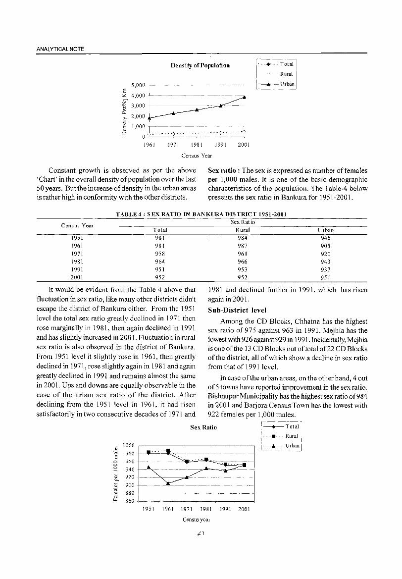
ANALYTICAL NOTE
Density of Population F -- Total
Rural
l=. Urban
1961 1971 1981 1991 2001
Census Year
Constant growth is observed as per the above 'Chart' in the overall density of population over the last 50 years_ But the increase of density in the urban areas is rather high in conformity with the other districts.
Sex ratio: The sex is expressed as number of females per 1,000 males. It is one of the basic demographic characteristics of the population. The Table-4 below presents the sex ratio in Bankura for 1951-2001.
TABLE 4 : SEX RATIO IN BANKURA DISTRICT 1951-2001
Census Year Total
1951 981 1961 981 1971 958 1981 964 1991 951 2001 952
It would be evident from the Table 4 above that fluctuation in sex ratio, like many other districts didn't escape the district of Bankura either. From the 1951 level the total sex ratio greatly declined in 1971 then rose marginally in 1981, then again declined in 1991 and has slightly increased in 200 1. Fluctuation in rural sex ratio is also observed in the district of Bankura. From 1951 level it slightly rose in 1961, then greatly declined in 1971, rose slightly again in 1981 and again greatly declined in 1991 and remains almost the same in 2001. Ups and downs are equally observable in the case of the urban sex ratio of the district. After declining from the 1951 level in 1961, it had risen satisfactorily in two consecutive decades of 1971 and
Sex Ratio
Rural Urban 984 946 987 905 961 920 966 943 953 937 952 951
1981 and declined further in 1991, which has risen again in 2001.
Sub-District level
Among the CD Blocks, Chhatna has the highest sex ratio of 975 against 963 in 1991. Mejhia has the lowest with 926 against 929 in 1991. Incidentally, Mejhia is one of the 13 CD Blocks out of total of22 CD Blocks of the district, all of which show a decline in sex ratio from that of 1991 level.
In case of the urban areas, on the other hand, 4 out of 5 towns have reported improvement in the sex ratio. Bishnupur Municipality has the highest sex ratio of984 in 2001 and Barjora Census Town has the lowest with 922 females per 1,000 males.
Sex Ratio ,------, [- • Total I'
/- - .• - - - Rural
on 1000 <IJ
OJ 980 a i_~rbanl
0 960 0
:=2 940 ... 920 <IJ 0-on 900 <IJ
03 880 a ~----------------------
OJ ~ 860
1951 1961 1971 1981 1991 2001
Census year
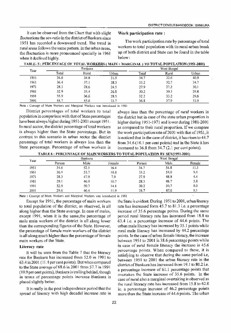
DISTRICT CENSUS HANDBOOK: BANKURA
It can be observed from the Chart that with slight Work participation rate: fluctuations the sex-ratio in the district ofBankura since 1951 has recorded a downward trend. The trend in The work participation rate by percentage of total rural areas follows the same pattern. In the urban areas, workers to total population with its rural-urban break the fluctuation is more pronounced specially in 1961 up of both district and State can be found in the table when it declined highly. below:
TABLE- 5: PERCENTAGE OF TOTAL WORKERS ( MAIN + MARGINAL) TO TOTAL POPULATION (1951-2001)
Year Bankura West Bengal
Total Rural Urban Total Rural Urban 1951 34.6 34.8 31.9 34.7 32.6 40.9 1961 36.4 37.1 28.3 33.2 32.7 34.7 1971 28.3 28.6 24.5 27.9 27.2 30.1 1981 32.9 33.4 26.8 30.2 30.3 29.8 1991 35.9 36.6 28.5 32.2 33.2 29.6 2001 44.7 45.6 33.7 36.8 37.9 33.9
Note: Concept of Main Workers and Marginal Workers was introduced in 1981
District percentages of total workers to total always less than the percentage of rural workers in population in comparison with that of State percentages the district but in case of the state urban proportion is have been always higher during 1951-2001 except 1951. higher during 1951-1971 and lower during 1981-2001 In rural sector, the district percentage of total workers as compared to their rural proportion. If we compare is always higher than the State percentage. But in the work participation rate of2001 with that of195.1, it contrast to this scenario in urban sector the district is noticed that in the case of district, it has risen to 44.7 percentage of total workers is always less than the from 34.6 (10.1 per cent points) and in the State it has State percentage. Percentage of urban workers is increased to 36.8 from 34.7 (2.ll per cent points).
TABLE 6: PERCENTAGE OF MAIN WORKERS TO TOTAL POPULATION BY SEX(1951-2001)
Year Bankura West Bengal
Person Male Female Person Male Female 1951 34.6 52.5 16.4 34.7 54.8 11.3
1961 36.4 53.7 18.8 33.2 54.0 9.4 1971 28.3 47.9 7.9 27.9 48.8 4.4
1981 29.1 46.9 10.7 28.3 48.7 5.8
1991 32.9 50.7 14.1 30.2 50.7 8.0
2001 29.6 46.4 11.9 28.7 47.0 9.1
Note: Concept of Main Workers and Marginal Workers was introduced in 1981
Except for 1951, the percentage of main workers to total population of the district, as observed, is all along higher than the State average. In case of males, except 1991, when it is the same,the percentage of male main workers of the district is all along lower than the corresponding figures of the State. However, the percentage of female main workers of the district is all along much higher than the percentage of female main workers of the State.
Literacy rate
It will be seen from the Table 7 that the literacy rate for Bankura has increased from 52.0 in 1991 to 63.4 in 200 1 (11.4 per cent points). But when compared to the State average of68.6 in 2001 from 57.7 in 1991 (10.9 percent points), Bankura is trailing behind, though in terms of percentage points increase Bankura is placed slightly better.
It is really in the post independence period that the spread of literacy with high decadal increase rate in
22
the State is evident. During 1951 to 2001, urban literacy rate has increased form 45.7 to 81.3 i.e. a percentage increase of 35.6 percentage points. During the same period rural literacy rate has increased from 18.8 to 63.4 i.e. a percentage increase of 44.6 points. The urban male literacy has increased by 35.1 points while rural male literacy has increased by 44.2 percentage points. In the case of urban femalle literacy, the increase between 1951 to 2001 is 38.6 percentage points while in case of rural female literacy the increase is 45.6 percentage points. When compared to these, it is satisfying to observe that during the same period i.e, between 1951 to 2001 the urban literacy rate in the district ofBankurahas increased from 19.1 to 80.2 i.e. a percentage increase of 61.1 percentage points that overtakes the State increase of 35.6 points. In the case of rural also a marginal overtaking is observed as the rural literacy rate has increased from 15.8 to 62.0 ie. a percentage increase of 46.2 percentage points more than the State increase of 44.6 points. The urban
ANALYTICAL NOTE
male literacy in the district has increased' by per cent points has overtaken the increase of38.6 per 68.7 percentage points and the rural male literacy cent points of the State in urban female literacy. In has increased by 51.4 percentage points for surpassing rural female literacy, it is trailing behind the State with both urban and rural percentage points. The its 41.0 percentage increase points which is less than urban female literacy has increased by 53.1 the State's percentage increase of 45.6 per cent points. percentage points and the rural female literacy has In the rural areas of Bankura the literacy rate has increased by 41.0 percentage points. Thus it is seen increased by 12.0 points from 50.0 in 1991 to 62.0 that in the case of female literacy, the district with 53.1 in 2001.
TABLE-7 : LITERACY RATE, BYSEXAND RESIDENCE, BANKURA AND WEST BENGAL WITH CHANGE
IN DECENNIAL PERCENTAGE POINT IN PARENTHESIS (1951-2001) Bankura West Bengal
Year TIRIU p M F P M F
2 6 7 8 3 4 5
1951 T 16.1 24.0 7.5 25.0 34.7 13.2 R 15.8 24.4 6.6 18.8 28.9 7.6 U 19.1 19.4 18.8 45.7 51.0 37.1
1961 T 27.2 42.4 11.5 34.5 46.6 20.3
(11.1 ) (18.4) (4.0) (9.5) (11. 9) (7.1) R 25.4 40.6 9.8 25.8 38.9 1l.7
(9.6) (16.2) (3.2) (7.1) (10.0) (4.2) U 49.3 63.9 33.0 59.6 66.0 50.0
(30.2) ( 44.5) (14.2) (13.8) (15.0) (12.9) 1971 T 31.0 44.1 17.2 38.9 49.6 26.6
(3.9) (1.7) (5.7) (4.4) (3.0) (6.3) R 29.3 42.5 15.3 30.6 42.3 18.1
(3.9) (1.9) (5.5) (4.8) (3.4) (6.3) U 51.8 62.9 39.6 62.3 68.2 54.1
(2.5) (-1.0) (6.6) (2.7) (2.2) (4.1 ) 1981 T 43.1 58.1 27.4 46.3 57.0 34.4
(12.0) (13.9) (10.2) (7.5) (7.5) (7.9) R 41.3 56.6 25.3 37.9 49.7 25.3
(12.0) (14.1) (10.0) (7.3) (7.4) (7.3) U 63.7 75.2 51.5 68.7 75.2 60.7
(11.9) (12.3) (11. 9) (6.5) (7.0) (6.6) 1991 T 52.0 66.& 36.6 57.7 67.8 46.6
(9.0) (8.7) (9.2) (11.4 ) (10.&) (12.1) R 50.0 65.2 34.1 50.5 62.1 3&.1
(8.7) (8.6) (3.7) (12.6) ( 12.3) (12.8) U 73.7 83.4 63.4 75.3 81.2 68.3
(10.0) (8.2) ( 11.9) (6.5) (6.0) (7.5) 2001 T 63.4 76.8 49.4 68.6 77.0 59.6
(11.4) (10.0) (12.9) (10.9) (9.2) (13.1) R 62.0 75.8 47.6 63.4 73.1 53.2
(12.0) (10.6) (13.5) (12.9) (l1.1) (15.0) U 80.2 88.1 71.9 81.3 86.1 75.7
(6.5) (4.8) (8.6) (6.0) (4.9) (7.5) Note: Upto 1971 literacy rate was calculated excluding 0-4 age population. From 1981 onwards literacy rate is calculated excluding the 0-6
age group population
Among the CD Blocks, in rural areas, Ranibundh Blocks, Sarenga, Raipur and Hirbandh but except these CD Block achieved the highest per cent points increase 4 CD Blocks, rest 18 CD Blocks out of total 22 CD with 17.8 in its literacy and Gangajalghati CD Block is Blocks of the district do not match in performance as in the lowest range with per cent points increase of8.8 they range between 8.8 to 13.4 far below the overall only. In average decadal percentage point increase in increase of 18.0. Performance of7 CD Blocks is even literacy rate, Ranibundh is followed by 3 more CD lower than the blocks with higher average rate of
23
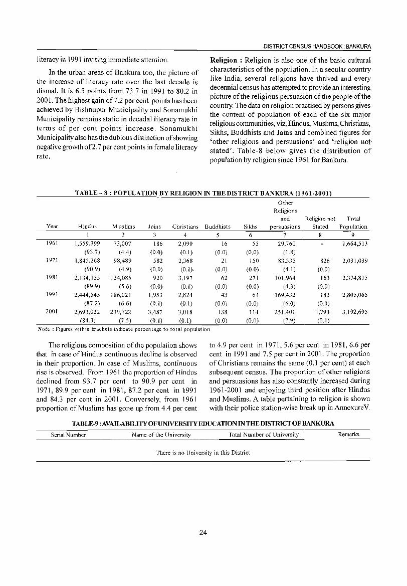
literacy in 1991 inviting immediate attention.
In the urban areas of Bankura too, the picture of the increase of literacy rate over the last decade is dismal. It is 6.5 points from 73.7 in 1991 to 80.2 in 2001. The highest gain 00.2 per cent points has been achieved by Bishnupur Municipality and Sonamukhi Municipality remains static in decadalliteracy rate in terms of per cent points increase. Sonamukhi Municipality also has the dubious distinction of showing negative growth of2. 7 per cent points in female literacy rate.
DISTRICT CENSUS HANDBOOK: BANKURA
Religion: Religion is also one of the basic cultural characteristics of the population. In a secular country like India, several religions have thrived and every decennial census has attempted to provide an interesting picture of the religious persuasiion of the people of the country. The data on religion practised by persons gives the content of population of c~ach of the six major religious communities, viz, Hindus, Muslims, Christians, Sikhs, Buddhists and Jains and combined figures for 'other religions and persuasions' and 'religion notstated'. Table-8 below gives the distribution of population by religion since 1961 for Bankura.
TABLE- 8: POPULATION BY RELIGION IN THE DISTRICT BANKURA (1961-2001)
Other Religions
and Religion not Total Year Hindus Muslims J ains Christians Buddhists Sikhs persuasions Stated Population
2 3 4 5 6 7 8 9 1961 1,559,399 73,007 186 2,090 16 55 29,760 1,664,513
(93.7) (4.4) (0.0) (0.1) (0.0) (0.0) (1.8) 1971 1,845,268 98,489 582 2,368 21 150 83,335 826 2,031,039
(90.9) (4.9) (0.0) (0.1) (0.0) (0.0) (4.1) (0.0) 1981 2,134,153 134,085 920 3,197 62 271 101,964 163 2,374,815
(89.9) (5.6) (0.0) (0.1) (0.0) (0.0) (4.3) (0.0) 1991 2,444,545 186,021 1,953 2,824 43 64 169,432 183 2,805,065
(87.2) (6.6) (0.1) (0.1) (0.0) (0.0) (6.0) (0.0) 2001 2,693,022 239,722 3,487 3,018 138 114 251,401 1,793 3,192,695
(84.3) (7.5) (0.1) (0.1) (0.0) (0.0) (7.9) (0.1 )
Note: Figures within brackets indicate percentage to total population
The religious composition of the population shows that in case of Hindus continuous decline is observed in their proportion. In case of Muslims, continuous rise is observed. From 1961 the proportion of Hindus declined from 93.7 per cent to 90.9 per cent in 1971, 89.9 per cent in 1981, 87.2 per cent in 1991 and 84.3 per cent in 2001. Conversely, from 1961 proportion of Muslims has gone up from 4.4 per cent
to 4.9 per cent in 1971,5.6 per cent in 1981, 6.6 per cent in 1991 and 7.5 per cent in 2001. The proportion of Christians remains the same (0.1 per cent) at each subsequent census. The proportion of other religions and persuasions has also constantly increased during 1961-2001 and enjoying third position after Hir..dus and Muslims. A table pertaining to religion is shown with their police station-wise break up in Annexurev.
TABLE-9:AVAILABILITYOFUNNERSITYEDUCATIONINTHEDISTRlCTOFBANKURA
Serial Number Name of the University Total Number of University Remarks
There is no University in this District
24
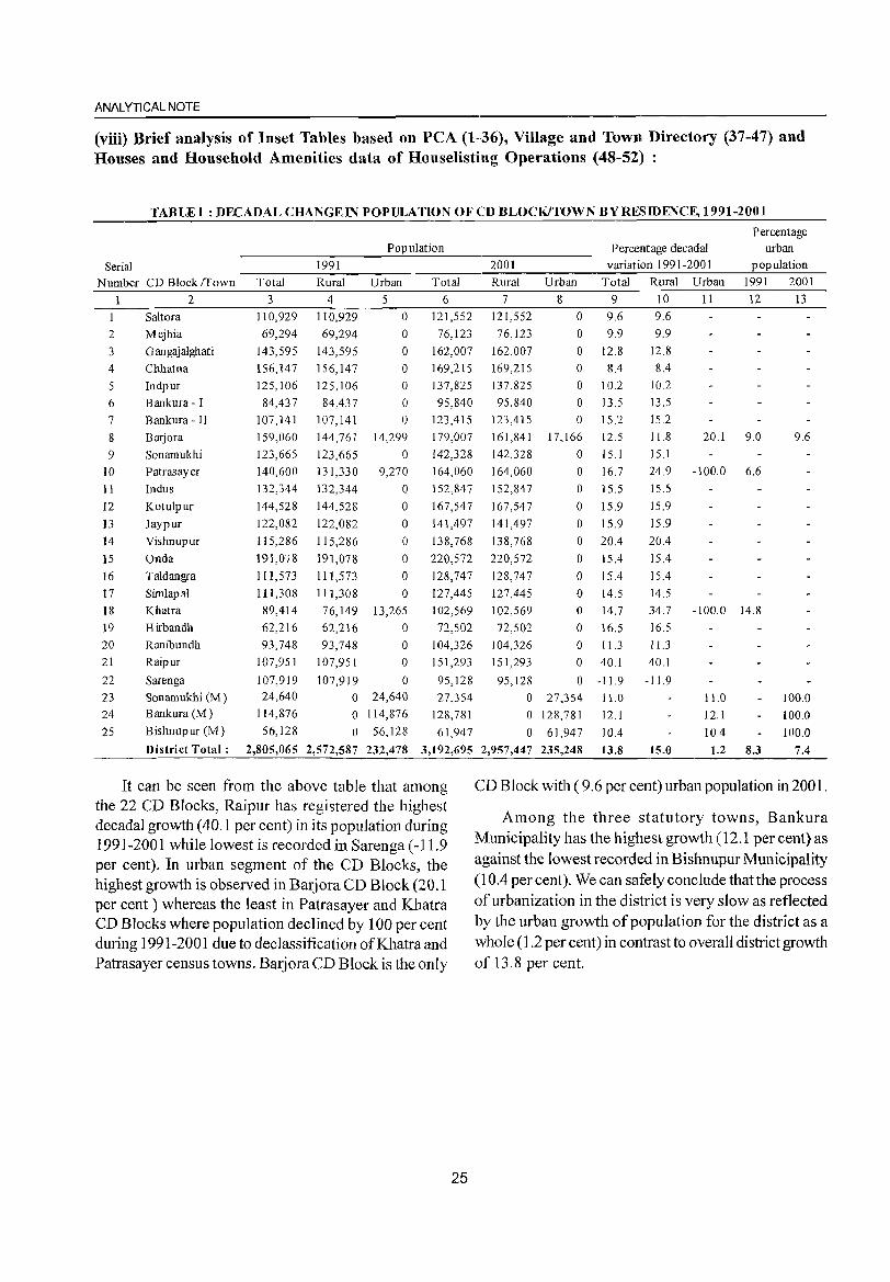
ANALYTICAL NOTE
(viii) Brief analysis of Inset Tables based on peA (1-36), Village and Town Directory (37-47) and Houses and Household Amenities data of Houselisting Operations (48-52) :
TABLEI : DECADAL CHANGE IN POPULATION OF CD BLOCK/TOWN BY RESIDENCE, 1991-2001
Percentage Population Percentage decadal urban
Serial 1991 2001 variation 1991-2001 population
Number CD Block frown Total Rural Urban Total Rural Urban Total Rural Urban 1991 2001
2 3 4 5 6 7 8 9 10 11 12 13
Saltora 110,929 110,929 0 121,552 121,552 0 9.6 9.6
2 Mejhia 69,294 69,294 0 76,123 76,123 0 9.9 9.9
3 G angajalghati 143,595 143,595 0 162,007 162,007 0 12.8 12.8
4 Chhatna 156,147 156,147 0 169,215 169,215 0 8.4 8.4
5 Indpur 125,106 125,106 0 137,825 137,825 0 10.2 10.2
6 Bankura - I 84,437 84,437 0 95,840 95,840 0 13.5 13.5
7 Bankura - II 107,141 107,141 0 123,415 123,415 0 15.2 15.2
8 Barjora 159,060 144,761 14,299 179,007 161,841 17,166 12.5 11.8 20.1 9.0 9.6
9 Sonamukhi 123,665 123,665 0 142,328 142,328 0 15.1 15.1
10 Patrasayer 140,600 131,330 9,270 164,060 164,060 0 16.7 24.9 -100.0 6.6
11 Indus 132,344 132,344 0 152,847 152,847 0 15.5 15.5
12 Kotulpur 144,528 144,528 0 167,547 167,547 0 15.9 15.9
13 Jaypur 122,082 122,082 0 141,497 141,497 0 15.9 15.9
14 Vishnupur 115,286 115,286 0 138,768 138,768 0 20.4 20.4
15 Onda 191,078 191,078 0 220,572 220,572 0 15.4 15.4
16 Taldangra 111,573 111,573 0 128,747 128,747 0 15.4 15.4
17 Simlapal 111,308 111,308 0 127,445 127,445 0 14.5 14.5
18 Khatra 89,414 76,149 13,265 102,569 102,569 0 14.7 34.7 -100.0 14.8
19 Hirbandh 62,216 62,216 0 72,502 72,502 0 16.5 16.5
20 Ranibundh 93,748 93,748 0 104,326 104,326 0 11.3 11.3
21 Raipur 107,951 107,951 0 151,293 151,293 0 40.1 40.1
22 Sarenga 107,919 107,919 0 95,128 95,128 0 -11.9 -11.9
23 Sonamukhi (M) 24,640 0 24,640 27,354 0 27,354 !l.0 11.0 100.0 24 Bankura (M) 114,876 0 114,876 128,781 0 128,781 12.1 12.1 100.0
25 Bishnupur (M) 56,128 0 56,128 61,947 0 61,947 10.4 10.4 100.0 District Total: 2,805,065 2,572,587 232,478 3,192,695 2,957,447 235,248 13.8 15.0 1.2 8.3 7.4
It can be seen from the above table that among CD Block with (9.6 per cent) urban population in 2001. the 22 CD Blocks, Raipur has registered the highest
Among the three statutory towns, Bankura decadal growth (40.1 per cent) in its population during 1991-2001 while lowest is recorded in Sarenga (- 11.9 Municipality has the highest growth (12.1 per cent) as
per cent). In urban segment of the CD Blocks, the against the lowest recorded in Bishnupur Municipality
highest growth is observed in Barjora CD Block (20.1 (10.4 per cent). We can safely conclude thatthe process
per cent) whereas the least in Patrasayer and Khatra of urbanization in the district is very slow as reflected
CD Blocks where popUlation declined by 100 per cent by the urban growth of population for the district as a
during 1991-2001 due to declassification ofKhatra and whole (1.2 per cent) in contrast to overall district growth Patrasayer census towns. Barjora CD Block is the only of 13.8 per cent.
25
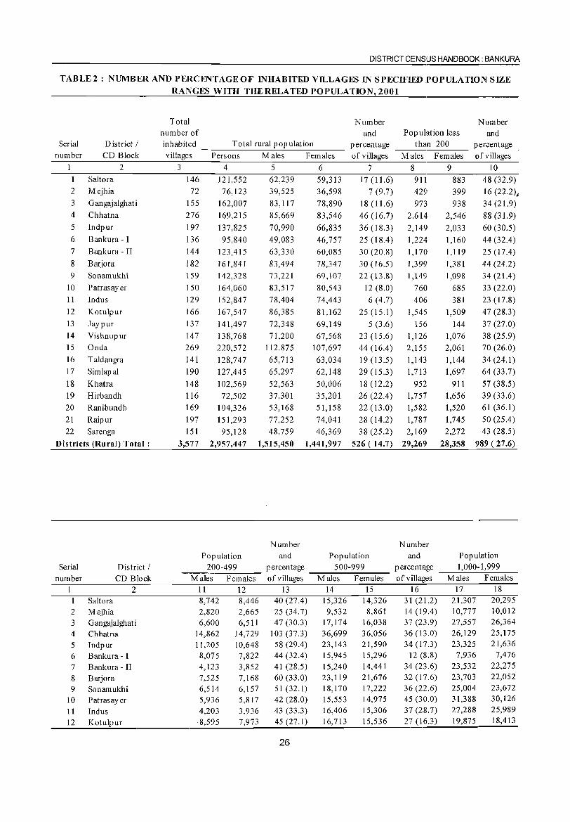
DISTRICT CENSUS HANDBOOK: BANKURA
TABLE2: NUMBER AND PERCENTAGE OF INHABITED VILLAGES IN SPECIFIED POPULATION SIZE
RANGES WITH THE RELATED POPULATION, 2001
Total Number Number number of and Population less and
Serial District I inhabited Total rural population percentage than 200 percentage number CD Block villages Persons Males Females of villages Males Females of villages
2 3 4 5 6 7 8 9 10 Saltora 146 121,552 62,239 59,313 17 (11.6) 911 883 48 (32.9)
2 Mejhia 72 76,123 39,525 36,598 7 (9.7) 429 399 16 (22.2)~ 3 G angajalghat i 155 162,007 83,117 78,890 18(11.6) 973 938 34 (21.9) 4 Chhatna 276 169,215 85,669 83,546 46 (16.7) 2,614 2,546 88 (31.9)
5 Indpur 197 137,825 70,990 66,835 36 (18.3) 2,149 2,033 60 (30.5) 6 Bankura - I 136 95,840 49,083 46,757 25(18.4) 1,224 1,160 44 (32.4) 7 Bankura - II 144 123,415 63,330 60,085 30 (20.8) 1,170 1,119 25 (17.4)
8 Barjora 182 161,841 83,494 78,347 30 (16.5) 1,399 1,381 44 (24.2)
9 Sonamukhi 159 142,328 73,221 69,107 22 (13.8) 1,149 1,098 34 (21.4) 10 Patrasayer 150 164,060 83,517 80,543 12 (8.0) 760 685 33 (22.0) 11 Indus 129 152,847 78,404 74,443 6 (4.7) 406 381 23 (17.8) 12 Kotulpur 166 167,547 86,385 81,162 25 (15.1) 1,545 1,509 47 (28.3)
13 Jaypur 137 141,497 72,348 69,149 5 (3.6) 156 144 37 (27.0)
14 Vishnupur 147 138,768 71,200 67,568 23 (15.6) 1,126 1,076 38 (25.9) 15 Onda 269 220,572 112,875 107,697 44 (16.4) 2,155 2,061 70 (26.0)
16 Taldangra 141 128,747 65,713 63,034 19 (13.5) 1,143 1,144 34(24.1)
17 Simlapal 190 127,445 65,297 62,148 29 (15.3) 1,713 1,697 64 (33.7)
18 Khatra 148 102,569 52,563 50,006 18(12.2) 952 911 57 (38.5)
19 Hirbandh 116 72,502 37,301 35,201 26 (22.4) 1,757 1,656 39 (33.6)
20 Ranibundh 169 104,326 53,168 51,158 22 (13.0) 1,582 1,520 61 (36.1)
21 Raipur 197 151,293 77,252 74,041 28 (14.2) 1,787 1,745 50 (25.4)
22 Sarenga 151 95,128 48,759 46,369 38 (25.2) 2,169 2,272 43 (28.5)
Districts (Rural) Total: 3,577 2,957,447 1,515,450 1,441,997 526 ( 14.7) 29,269 28,358 989 (27.6)
Number Number Population and Population and Population
Serial District I 200-499 percentage 500-999 percentage 1,000·1,999 number CD Block Males Females of villages Males Females of villages Males Females
I 2 11 12 13 14 15 16 17 18 1 Saltora 8,742 8,446 40(27.4) 15,326 14,326 31 (21.2) 21,307 20,295
2 Mejhia 2,820 2,665 25 (34.7) 9,532 8,861 14 (19.4) 10,777 10,012
3 G angajalghat i 6,600 6,511 47 (30.3) 17,174 16,038 37 (23.9) 27,557 26,364
4 Chhatna 14,862 14,729 103 (37.3) 36,699 36,056 36 (13.0) 26,129 25,175
5 Indpur 11,205 10,648 58 (29.4) 23,143 21,590 34 (17.3) 23,325 21,636
6 Bankura - I 8,075 7,822 44 (32.4) 15,945 15,296 12 (8.8) 7,936 7,476
7 Bankura - II 4,123 3,852 41 (28.5) 15,240 14,441 34 (23.6) 23,532 22,275
8 Barjora 7,525 7,168 60 (33.0) 23,119 21,676 32 (17.6) 23,703 22,052
9 Sonamukhi 6,514 6,157 51 (32.1) 18,170 17,222 36 (22.6) 25,004 23,672
10 Patrasayer 5,936 5,817 42 (28.0) 15,553 14,975 45 (30.0) 31,388 30,126
11 Indus 4,203 3,936 43 (33.3) 16,406 15,306 37 (28.7) 27,288 25,989
12 Kotulpur ·8,595 7,973 45 (27.1) 16,713 15,536 27 (16.3) 19,875 18,413
26
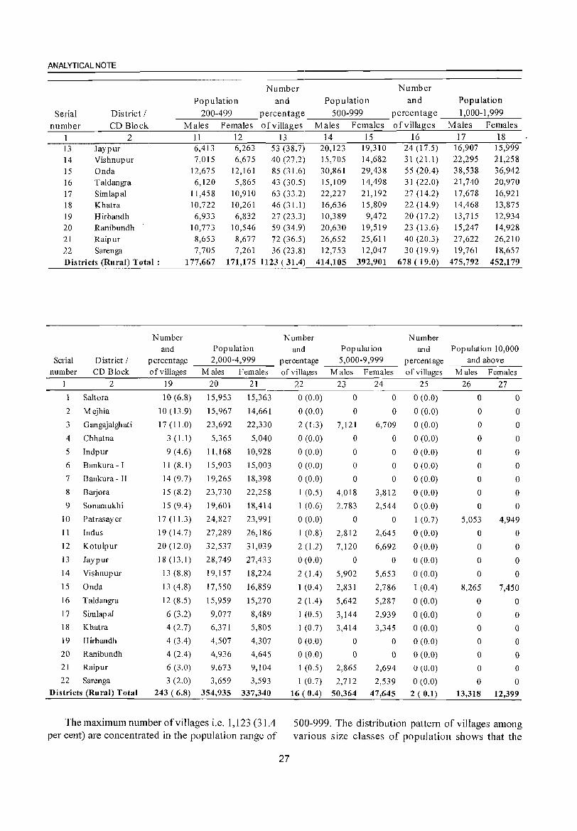
ANALYTICAL NOTE
Number Number
Population and Population and Population
Serial District I 200-499 percentage 500-999 P e rcen t ag e _-----'1 ,'--00_0_---'1 ,.:..._99....:.9 __ number CD Block Males Females of villages Males Females of villages Males Females
1 2 l3 Jay pur 14 Vishnupur 15 Onda 16 Taldangra 17 Simlapal 18 Khatra 19 Hirbandh 20 Ranibundh 21 Raipur 22 Sarenga
11 12 13 6,413 6,263 53 (38.7) 7,015 6,675 40 (27.2)
12,675 12,161 85 (31.6) 6,120 5,865 43 (30.5)
11,458 10,910 63 (33.2) 10,722 10,261 46 (31.1)
6,933 6,832 27 (23.3) 10,773 10,546 59 (34.9) 8,653 8,677 72 (36.5) 7,705 7,261 36 (23.8)
14 15 16 20,123 15,705 30,861 15,109 22,227 16,636 10,389 20,630
19,310 14,682 29,438 14,498 21,192 15,809 9,472
19,519 26,652 25,611 12,753 12,047
24(17.5) 31 (21.1) 55 (20.4) 31 (22.0) 27 (14.2) 22 (14.9) 20 (17.2) 23 (13.6) 40 (20.3) 30 (19.9)
Districts (Rural) Total: 177,667 171,175 1123 (31.4) 414,105 392,901 678 ( 19.0)
Serial District I number CD Block
2
Sahara
2 Mejhia
3 Gangajalghati
4 Chhatna
5 Indpur
6 Bankura - I
7 Bankura - II
8 Barjora
9 Sonamukhi
10 Patrasayer
11 Indus
12 Kotulpur
13 Jaypur
14 Vishnupur
15 Onda
16 T aldangra
17 Simlapal
18 Khatra
19 Hirbandh
20 Ranibundh
21 Raipur
22 Sarenga
Districts (Rural) Total
Number Number and Population and
percentage __ 2,;_0_00_-_4;_,9_9_9 __ percentage of villages Males Females of villages
19 20 21 22
10 (6.8) 15,953 15,363 0 (0.0)
10 (13.9) 15,967 14,661 0 (0.0)
17(11.0) 23,692 22,330 2(1:3)
3 (1.1) 5,365 5,040 0 (0.0)
9(4.6) 11,168 10,928 0(0.0)
11 (8.1) 15,903 15,003 0 (0.0)
14 (9.7) 19,265 18,398 0 (0.0)
15 (8.2) 23,730 22,258 1 (0.5)
15 (9.4) 19,601 18,414 1 (0.6)
17(11.3) 24,827 23,991 0(0.0)
19 (14.7) 27,289 26,186 1 (0.8)
20 (12.0) 32,537 31,039 2 (1.2)
18 (13.1) 28,749 27,433 0 (0.0)
13(8.8) 19,157 18,224 2(1.4)
13 (4.8) 17,550 16,859 1 (0.4)
12 (S.5) 15,959 15,270 2 (1.4)
6 (3.2) 9,077 8,489 I (0.5)
4 (2.7) 6,371 5,805 I (0.7)
4 (3.4) 4,507 4,307 0 (0.0)
4 (2.4) 4,936 4,645 0 (0.0)
6 (3.0) 9,673 9,104 1 (0.5)
3 (2.0) 3,659 3,593 1 (0.7)
Number Population and
__ 5....:..,0_0_0_-9....:,_99_9 __ percentage M ales Females of villages
23 24 25
o 0 0 (0.0)
o 0 0 (0.0)
7,121
o o o o
4,018
2,783
o 2,812
7,120
o 5,902
2,S31
5,642
3,144
3,414
o o
2,865
2,712
6,709
o o o o
3,812
2,544
o 2,645
6,692
o 5,653
2,786
5,287
2,939
3,345
o o
2,694
2,539
0(0.0)
0(0.0)
o (0.0)
o (0.0)
o (0.0)
0(0.0)
0(0,0)
1 (0.7)
o (0.0)
o (0.0)
0(0.0)
o (0.0)
1 (0.4)
0(0.0)
o (0.0)
o (0.0)
o (0.0)
o (0.0)
o (0.0)
o (0.0) 243 (6.8) 354,935 337,340 16 (0.4) 50,364 47,645 2 (0.1)
17 16,907 22,295 38,538 21,740 17,678 14,468 13,715 15,247 27,622 19,761
475,792
18 15,999 21,258 36,942 20,970 16,921 13,875 12,934 14,928 26,210 18,657
452,179
Population 10,000 and above
M ales Females
26 27
o 0
o 0
o o o o o o o
5,053
o o o o
8,265
o o o o o o o
o o o o o o o
4,949
o o o o
7,450
o o o o o o o
13,318 12,399
The maximum number of villages i.e. 1,123 (3 I .4 per cent) are concentrated in the population range of
500-999. The distribution pattern of villages among various size classes of population shows that the
27
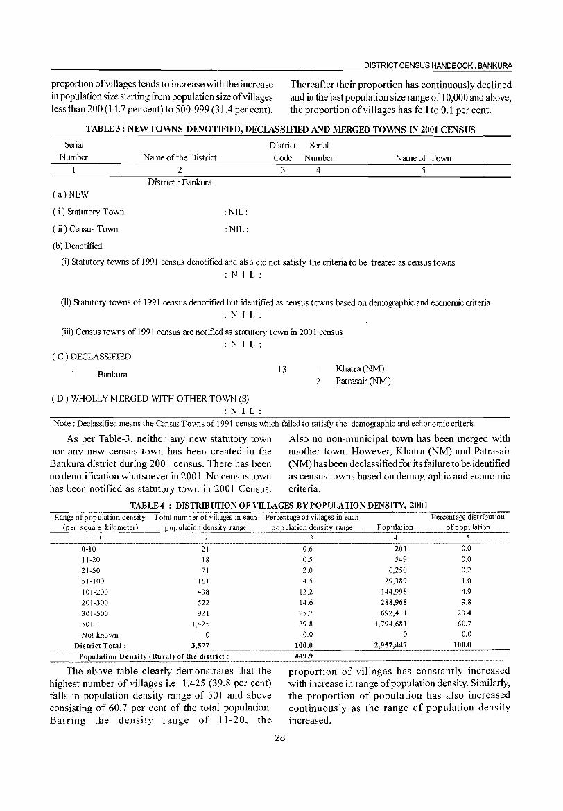
proportion of villages tends to increase with the increase in population size starting from population size of villages less than 200 (14.7 per cent) to 500-999 (31.4 per cent).
DISTRICT CENSIJS HANDBOOK: BANKURA
Thereafter their proportion has continuously declined and in the last population size range of 1 0,000 and above, the proportion of villages has fell to 0.1 per cent.
TABlE3: NEWTOWNS DENOTIFIED, DECIASSIFIED AND MERGED TOWNS IN 2001 CENSUS
District Serial Serial
Number Name of the District Code Number Name of Town
(a)NEW
( i) Statutory Town
( ii) Census Town
(b) Denotified
2
District: Bankura 3 4 5
:NIL:
:NIL:
(i) Statutory towns of 1991 census denotified and also did not satisfY the criteria to be treated as census towns
: NIL:
(ii) Statutory towns of 1991 census denotified but identified as census towns based on demographic and economic criteria
: NIL:
(iii) Census towns of 1991 census are notified as statutory town in 2001 census
: NIL: ( C ) DECLASSIFIED
Bankura
( D) WHOLLY MERGED WITH OTHER TOWN (S)
: NIL:
13 1
2
Khatra(NM)
Patrasair (NM)
Note: Declassified means the Census Towns of 1991 census which failed to satisfy the demographic and echo nomic criteria.
As per Table-3, neither any new statutory town nor any new census town has been created in the Bankura district during 2001 census. There has been no denotification whatsoever in 2001. No census town
Also no non-municipal town has been merged with another town. However, Khatra (NM) and Patrasair (NM) has been declassified for its failure to be identified as census towns based on demographic and economic
has been notified as statutory town in 2001 Census. criteria.
TABLE4 : DISTRmUTION OF VILLAGES BY POPULATION DENSITY, 2001 ---..,::-----:------.-.. -~.--'-------... -.~
Range of population density Total number of villages in each Percentage ofvillages in each
(per square __ k_ilo_m_e_te_r,-) __ -"p_o,!_pu.latio.~.~~E;.sity range population density range Population
1 2 3 4 ----------_._ .. __ ..... _-------_ .. _._ ............ _-_._--,--,---------' 21 0,6 201 0-10
11-20
21-50
51-100
101-200
201-300
301-500
501 + Not known
18
71
161
438
522
921
1,425
o
0,5
2.0
4.5
12.2
14.6
25.7
39.8
0.0
District Total: 3,577 100.0 ---~.--~--"--,,"-"
549
6,250
29,389
144,998
288,968
692,411
1,794,681
0
2,957,447
___ .~~pulation Density (Rural) ?L.!_he dis~}_~~ ________ 44_9_.9 ___________ _
Percentage distribution of population
5
0.0
0.0
0.2
1.0
4.9
9.8
23.4
60.7
0.0
100.0
The above table clearly demonstrates that the highest number of villages i.e. 1,425 (39.8 per cent) falls in popUlation density range of 501 and above consisting of 60.7 per cent of the total population. Barring the density range of 11-20, the
proportion of villages has constantly increased with increase in range of population density. Similarly, the proportion of population has also increased continuously as the range of population density increased.
28
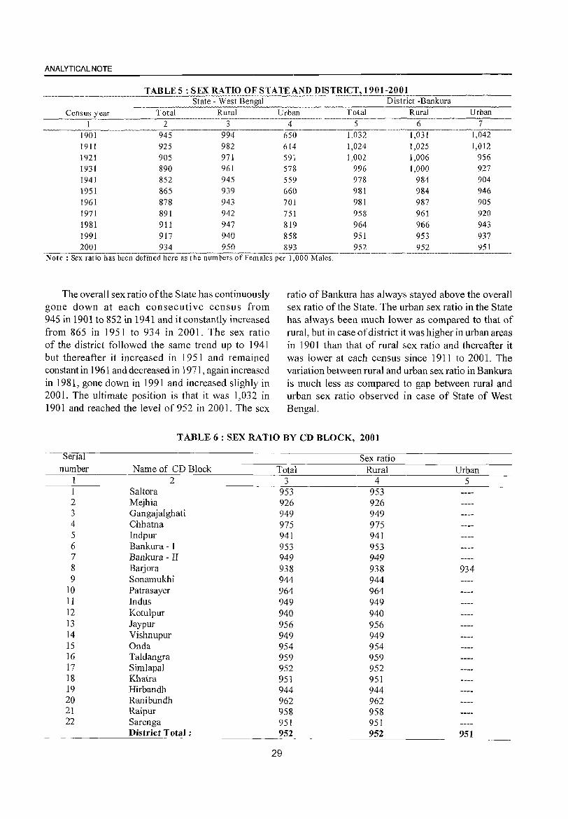
ANALYTICAL NOTE
TABLES: SEX RATIO OF STATE AND DISTRICT, 1901-2001 State - West Bengal District -Bankura
Census year Total Rural Urban Total Rural Urban --------I~---------- 2 -------3-----------;r-------- ------5---------6 ---------7---
1901 945 994 650 1,032 1,031 1,042 1911 925 1921 905 1931 890 1941 852 1951 865 1961 878 1971 891 1981 911 1991 917 2001 934
982 971 961 945 939 943 942 947 940 950
614 591 578 559 660 701 751 819 858 893
1,024 1,002
996 978 981 981 958 964 951 952
1,025 1,006 1,000
984 984 987 961 966 953 952
1,012 956 927 904 946 905 920 943 937 951
Note: Sex ratio has been defined here as the nuffi-bers ofFema]es per 1,000 Males.--------- --------
The overall sex ratio ofthe State has continuously gone down at each consecutive census from 945 in 1901 to 852 in 1941 and it constantly increased from 865 in 1951 to 934 in 2001. The sex ratio of the district followed the same trend up to 1941 but thereafter it increased in 1951 and remained constant in 1961 and decreased in 1971, again increased in 1981, gone down in 1991 and increased slighly in 2001. The ultimate position is that it was 1,032 in 1901 and reached the level of 952 in 2001. The sex
ratio of Bankura has always stayed above the overall sex ratio of the State. The urban sex ratio in the State has always been much lower as compared to that of rural, but in case of district it was higher in urban areas in 1901 than that of rural sex ratio and thereafter it was lower at each census since 1911 to 2001. The variation between rural and urban sex ratio in Bankura is much less as compared to gap between rural and urban sex ratio observed in case of State of West Bengal.
TABLE 6: SEX RATIO BY CD BLOCK, 2001
ena Sex ratio number Name of CD Block Total Rural Urban
1 2 3 4 5 1 Saltora 953 953 2 Mejhia 926 926 3 Gangajalghati 949 949 4 Chhatna 975 975 5 lndpur 941 941 6 Bankura - I 953 953 7 Bankura - II 949 949 8 Barjora 938 938 934 9 Sonamukhi 944 944
10 Patrasayer 964 964 11 Indus 949 949 12 Kotulpur 940 940 13 Jaypur 956 956 14 Vishnupur 949 949 15 Onda 954 954 16 Taldangra 959 959 17 Simlapal 952 952 18 Khatra 951 951 19 Hirbandh 944 944 20 Ranibundh 962 962 21 Raipur 958 958 22 Sarenga 951 951
District Total; 952 952 951
29
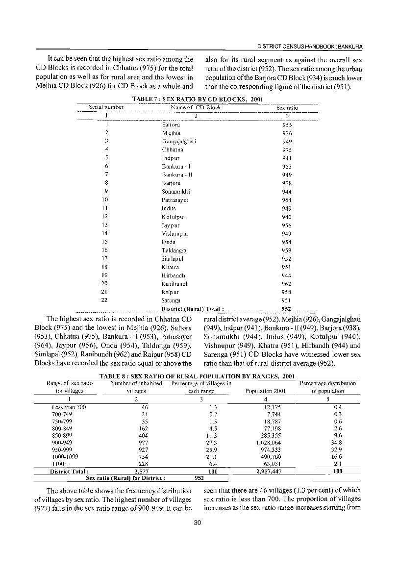
It can be seen that the highest sex ratio among the CD Blocks is recorded in Chhatna (975) for the total population as well as for rural area and the lowest in Mejhia CD Block (926) for CD Block as a whole and
DISTRICT CENSUS HANDBOOK; BANKURA
also for its rural segment as against the overall sex ratio of the district (952). The sex ratio among the urban population of the Barjora CD Block (934) is much lower than the corresponding figure of the district (951).
TABLE 7: SEX RATIO BY CD BLOCKS, 2001 Serial number Name of CD Block Sex ratio
----------.-------.. --.. -... --.. --.--.. - ---=2----------3
I Salt ora 2 Mejhia 3 Gangajalghati
953 926
949
975 941
953 949
938 944
964
949
940
956 949
954
959
952
951 944
962 958
951
952
4 Chhatna 5 lndpur 6 Bankura - I 7 Bankura - II 8 Barjora 9 Sonamukhi
10 Patrasayer 11 Indus 12 Kotulpur 13 Jaypur 14 Vishnupur 15 Onda 16 Taldangra 17 Simlapal 18 Khatra 19 Hirbandh 20 Ranibundh 21 Raipur 22 Sarenga
District (Rural) Total:
The highest sex ratio is recorded in Chhatna CD Block (975) and the lowest in Mejhia (926). Saltora (953), Chhatna (975), Bankura - I (953), Patrasayer (964), Jaypur (956), Onda (954), Taldanga (959), Simlapal (952), Ranibundh (962) and Raipur (958) CD Blocks have recorded the sex ratio equal or above the
rural district average (952). Mejhia (926), Gangajalghati (949), Indpur (941), Bankura - II (949), B arj ora (938), Sonamukhi (944), Indus (949), Kotulpur (940), Vishnupur (949), Khatra (951), Hirbandh (944) and Sarenga (951) CD Blocks have witnessed lower sex ratio than that of rural district average (952).
TABLE 8: SEX RATIO OF RURAL POPULATION BY RANGES, 2001 Range of sex ratio Number of inhabited Percentage of villages in Percentage distribution
for villages villages each range Population 2001 of population
I 2 Less than 700 46 700-749 24 750-799 55 800-849 162 850-899 404 900-949 977 950-999 927 1000-1099 754 1100+ 228
District Total: 3,577 Sex ratio (Rural) for District:
The above table shows the frequency distribution of villages by sex ratio. The highest number of villages (977) falls in the sex ratio range of900-949. It can be
3
952
30
4 5 1.3 12,175 0.4 0.7 7,744 0.3 1.5 18,787 0.6 4.5 77,198 2.6
11.3 285,355 9.6 27.3 1,028,064 34.8 25.9 974,333 32.9 21.1 490,760 16.6 6.4 63,031 2.1 100 2,957,447 100
seen that there are 46 villages (1.3 per cent) of which sex ratio is less than 700. The proportion of villages increases as the sex ratio range increases starting from
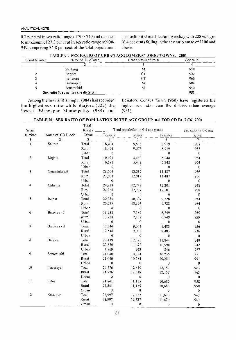
ANALYTICAL NOTE
0.7 per cent in sex ratio range of 700-749 and reaches to maximum of27.3 per cent in sex ratio range of900-949 comprising 34.8 per cent of the total population.
Thereafter it started declining ending with 228 villages (6.4 per cent) falling in the sex ratio range of 1100 and above.
TABLE 9: SEX RATIO OF URBAN AGGLOMERATIONS / TOWNS, 2001 Serial Number
1
2 3 4 5
Name of UA/Town
Bankura Barjora Beliatore Bishnupur Sonamukhi
2
Sex ratio (Urban) for the district:
Among the towns, Bishnupur (984) has recorded the highest sex ratio while Barjora (922) the lowest. Bishnupur Municipality (984) and
Urban status of town 3
M CT CT M M
Sex ratio 4
939 922 960 984 950 951
Beliatore Census Town (960) have registered the higher sex ratio than the district urban average (951 ).
TABLE 10: SEX RATIO OF POPULATION IN THE AGE GROUP 0-6 FOR CD BLOCK, 2001 Total/
Serial Rural/ Total population in 0-6 age group Sex ratio for 0-6 age number Name of CD Block Urban Persons Males Females group
1 2 3 4 5 6 7 1 Saltora Total 18,494 9,575 8,919 931
Rural 18,494 9,575 8,919 931 Urban 0 0 0 0
2 Mejhia Total 10,691 5,443 5,248 964 Rural 10,691 5,443 5,248 964 Urban 0 0 0 0
3 Gangajalghati Total 23,504 12,017 11,487 956 Rural 23,504 12,017 11,487 956 Urban 0 0 0 0
4 Chhatna Total 24,938 12,737 12,201 958 Rural 24,938 12,737 12,201 958 Urban 0 0 0 0
5 Indpur Total 20,035 10,307 9,728 944 Rural 20,035 10,307 9,728 944 Urban 0 0 0 0
6 Bankura - I Total 13,938 7,189 6,749 939 Rural 13,938 7,189 6,749 939 Urban 0 0 0 0
7 Bankura - II Total 17,544 9,061 8,483 936 Rural 17,544 9,061 8,483 936 Urban 0 0 0 0
8 Barjora Total 24,439 12,595 11,844 940 Rural 22,670 11,672 10,998 942 Urban 1,769 923 846 917
9 Sonamukhi Total 21,040 10,784 10,256 951 Rural 21,040 10,784 10,256 951 Urban 0 0 0 0
10 Patrasayer Total 24,776 12,619 12,157 963 Rural 24,776 12,619 12,157 963 Urban 0 0 0 0
11 Indus Total 21,841 11,155 10,686 958 Rural 21,841 1 1,155 10,686 958 Urban 0 0 0 0
12 Kotulpur Total 23,997 12,327 11,670 947 Rural 23,997 12,327 11,670 947 Urban 0 0 0 0
31
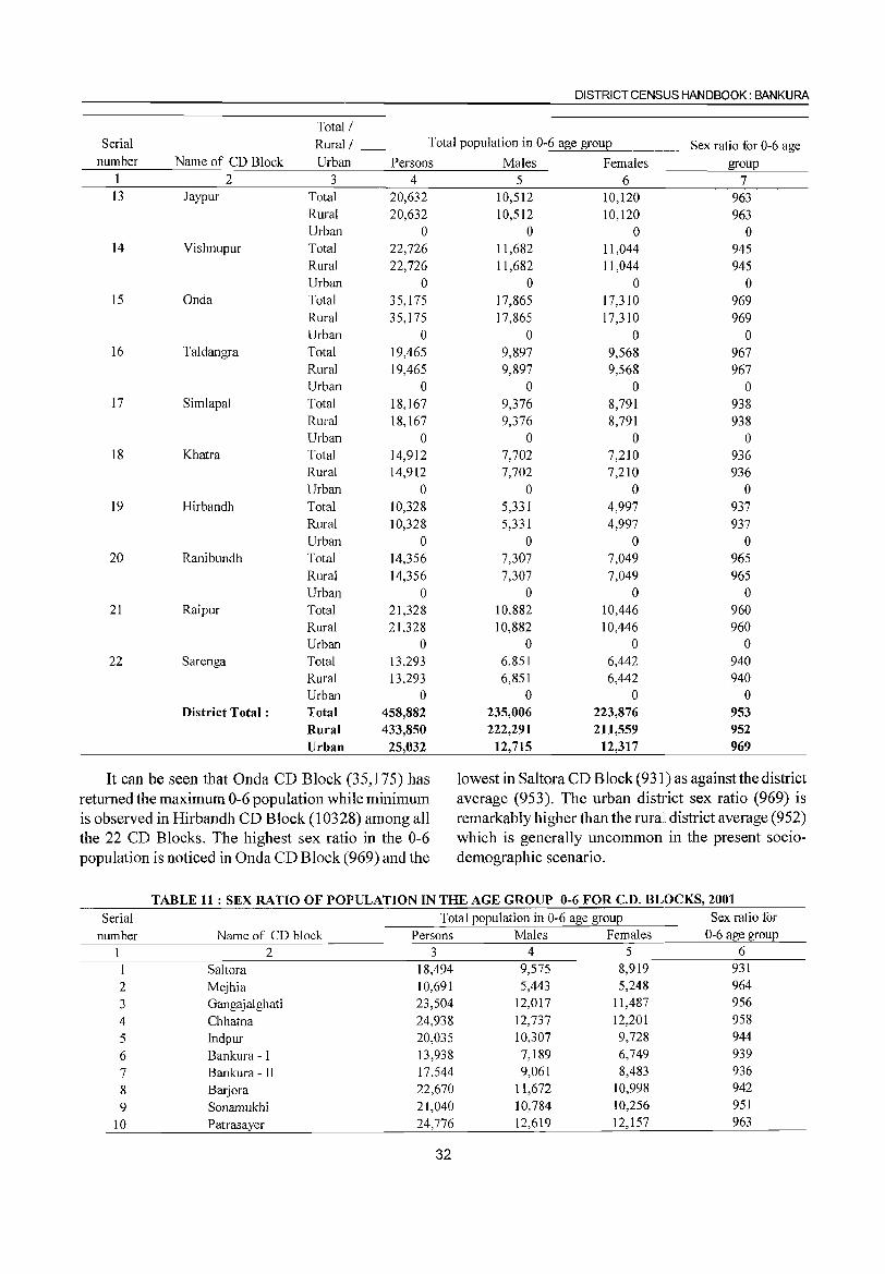
DISTRICT CENSUS HANDBOOK: BANKURA
Total/ Serial Rural/ Total population in 0-6 age group Sex ratio for 0-6 age
number Name of CD Block Urban Persons Males Females group I 2 3 4 5 6 7 13 Jaypur Total 20,632 10,512 10,120 963
Rural 20,632 10,512 10,120 963 Urban 0 0 0 0
14 Vishnupur Total 22,726 11,682 11,044 945 Rural 22,726 11,682 11,044 945 Urban 0 0 0 0
15 Onda Total 35,175 17,865 17,310 969 Rural 35,175 17,865 17,310 969 Urban 0 0 0 0
16 Taldangra Total 19,465 9,897 9,568 967 Rural 19,465 9,897 9,568 967 Urban 0 0 0 0
17 Simlapal Total 18,167 9,376 8,791 938 Rural 18,167 9,376 8,791 938 Urban 0 0 0 0
18 Khatra Total 14,912 7,702 7,210 936 Rural 14,912 7,702 7,210 936 Urban 0 0 0 0
19 Hirbandh Total 10,328 5,331 4,997 937 Rural 10,328 5,331 4,997 937 Urban 0 0 0 0
20 Ranibundh Total 14,356 7,307 7,049 965 Rural 14,356 7,307 7,049 965 Urban 0 0 0 0
21 Raipur Total 21,328 10,882 10,446 960 Rural 21,328 10,882 10,446 960 Urban 0 0 0 0
22 Sarenga Total 13,293 6,851 6,442 940 Rural 13,293 6,851 6,442 940 Urban 0 0 0 0
District Total: Total 458,882 235,006 223,876 953 Rural 433,850 222,291 211,559 952 Urban 25,032 12,715 12,317 969
It can be seen that Onda CD Block (35,175) has lowest in Saltora CD Block (931) as againstthe district returned the maximum 0-6 population while minimum average (953). The urban district sex ratio (969) is is observed in Hirbandh CD Block (10328) among all remarkably higher than the rurall district average (952) the 22 CD Blocks. The highest sex ratio in the 0-6 which is generally uncommon in the present socio-population is noticed in Onda CD Block (969) and the demographic scenario.
TABLE 11 : SEX RATIO OF POPULATION IN THE AGE GROUP 0-6 FOR C.D. BLOCKS, 2001
Serial Total population in 0-6 age group Sex ratio for number Name of CD block Persons Males Females 0-6 age group
I 2 3 4 5 6
1 Saltora 18,494 9,575 8,919 931
2 Mejhia 10,691 5,443 5,248 964
3 Gangajalghati 23,504 12,017 11,487 956
4 Chhatna 24,938 12,737 12,201 958
5 Indpur 20,035 10,307 9,728 944
6 Bankura - I 13,938 7,189 6,749 939
7 Bankura - II 17,544 9,061 8,483 936
8 Barjora 22,670 11,672 10,998 942
9 Sonamukhi 21,040 10,784 10,256 951
10 Patrasayer 24,776 12,619 12,157 963
32
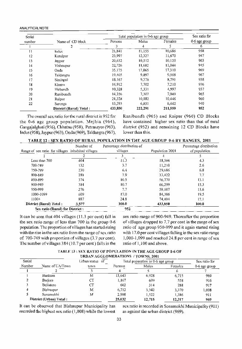
ANALYTICAL NOTE
Serial Total population in 0-6 age group Sex ratio for
number Name of CD block Persons Males Females 0-6 age group
1 2 3 4 5 6
11 Indus 21,841 11,155 10,686 958
12 Kotulpur 23,997 12,327 11,670 947
13 Jaypur 20,632 10,512 10,120 963
14 Vishnupur 22,726 11,682 11,044 945
15 Onda 35,175 17,865 17,310 969
16 Taldangra 19,465 9,897 9,568 967
17 Simlapal 18,167 9,376 8,791 938
18 Khatra 14,912 7,702 7,210 936
19 Hirbandh 10,328 5,331 4,997 937
20 Ranibundh 14,356 7,307 7,049 965 21 Raipur 21,328 10,882 10,446 960 22 Sarenga 13,293 6,851 6,442 940
District (Rural) Total: 433,850 222,291 211,559 952
The overall sex ratio for the rural district is 952 for the 0-6 age group population. Mejhia (964), Gangajalghati (956), Chhatna (95S), Patrasayer (963), Indus (958), Jaypur (963), Onda (969), Taldangra (967),
Ranibundh (965) and Raipur (960) CD Blocks have contained higher sex ratio than that of rural district (952) and remaining 12 CD Blocks have lower than this.
TABLE 12: SEX RATIO OF RURAL POPULATION IN THE AGE GROUP 0-6 BY RANGES, 2001 Number of Percentage distribution of Percentage distribution
Range of sex ratio for villages inhabited villages
1 2 Less than 700 404 700-749 132 750-799 230 800-849 281 850-899 374 900-949 384 950-999 276 1000-1099 609 1100+ 887
District (Rural) Total: 3,577 Sex ratio (Rural) for District:
It can be seen that 404 villages (11.3 per cent) fall in the sex ratio range of less than 700 in the group 0-6 population. The proportion of villages has started rising with the rise in the sex ratio from the range of sex ratio of 700-749 with proportion of villages (3.7 per cent). The number of villages 384 (l 0.7 per cent) falls in the
villages Population 2001 of population
3 4 5 11.3 18,566 4.3 3.7 11,210 2.6 6.4 29,686 6.8 7.9 33,422 7.7
10.5 56,770 13.1 10.7 66,299 15.3 7.7 59,107 13.6
17.0 84,386 19.5 24.8 74,404 17.1
100.0 433,850 100.0
952
sex ratio range of 900-949. Thereafter the proportion of villages dropped to 7.7 per cent in the range of sex ratio of age group 950-999 and it again started rising with 17.0 per cent villages falling in the sex ratio range 1,000-1,099 and reached 24.S per cent in range of sex ratio of 1,100 and above.
TABLE 13: SEX RATIO OF POPULATION IN THE AGE GROUP 0-6 OF URBAN AGGLOMERATIONS / TOWNS, 2001
Serial Urban status of Total population in 0-6 age group Sex ratio for Number Name ofUAlTown town Females 0-6 age group Persons Males
1 2 3 6 7 4 5 13,643 6,928
1,167 609 602 314
6,712 3,342 2,908 1,522
It can be observed that Bishnupur Municipality has sex ratio is recorded in Sonamukhi Municipality (911) recorded the highest sex ratio (1 ,OOS) while the lowest as against the urban district (969).
33
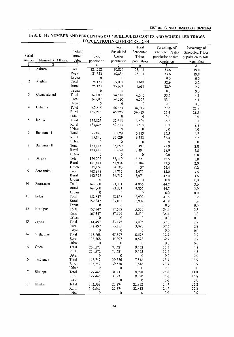
DISTRICT CENSUS HANDBOOK: BANKURA
TABLE 14: NUMBER AND PERCENTAGE OF SCHEDULED CASTES AND SCHEDULED TRIBES POPULATION IN CD BLOCKSl 2001
Total Total Percentage of Percentage of Total/ Scheduled Scheduled Scheduled Castes Scheduled Tribes
Serial Rural/ Total Castes Tribes population to total population to total number Name of CD Block Urban 12012ulation 12012ulation 12012ulation 12012ulation EO]2ulation
1 2 3 4 5 6 7 8 1 Saltora Total 121,552 40,856 23, III 33.6 19.0
Rural 121,552 40,856 23,111 33.6 19.0 Urban 0 0 0 0.0 0.0
2 Mejhia Total 76,123 25,032 1,684 32.9 2.2 Rural 76,123 25,032 1,684 32.9 2.2 Urban 0 0 0 0.0 0.0
3 Gangajalghati Total 162,007 54,510 6,576 33.6 4.1 Rural 162,007 54,510 6,576 33.6 4.1 Urban 0 0 0 0.0 0.0
4 Chhatna Total 169,215 46,325 36,919 27.4 21.8 Rural 169,215 46,325 36,919 27.4 21.8 Urban 0 0 0 0.0 0.0
5 Indpur Total 137,825 52,613 13,505 38.2 9.8 Rural 137,825 52,613 13,505 38.2 9.8 Urban 0 0 0 0.0 0.0
6 Bankura - I Total 95,840 35,029 6,383 36.5 6.7 Rural 95,840 35,029 6,383 36.5 6.7 Urban 0 0 0 0.0 0.0
7 Bankura - II Total 123,415 35,659 3,491 28.9 2.8 Rural 123,415 35,659 3,491 28.9 2.8 Urban 0 0 0 0.0 0.0
8 Barjora Total 179,007 58,119 3,221 32.5 1.8 Rural 161,841 53,934 3,184 33.3 2.0 Urban 17,166 4,185 37 24.4 0.2
9 Sonamukhi Total 142,328 59,717 5,071 42.0 3.6 Rural 142,328 59,717 5,071 42.0 3.6 Urban 0 0 0 0.0 0.0
10 Patrasayer Total 164,060 73,331 4,856 44.7 3.0 Rural 164,060 73,331 4,856 44.7 3.0 Urban 0 0 0 0.0 0.0
II Indus Total 152,847 63,838 2,902 41.8 1.9 Rural 152,847 63,838 2,902 41.8 1.9 Urban 0 0 0 0.0 0.0
12 Kotulpur Total 167,547 57,599 5,550 34.4 3.3 Rural 167,547 57,599 5,550 34.4 3.3 Urban 0 0 0 0.0 0.0
13 Jaypur Total 141,497 53,175 3,095 37.6 2.2 Rural 141,497 53,175 3,095 37.6 2.2 Urban 0 0 0 0.0 0.0
14 Vishnupur Total 138,768 45,397 10,678 32.7 7.7 Rural 138,768 45,397 10,678 32.7 7.7 Urban 0 0 0 0.0 0.0
15 Onda Total 220,572 71,621 10,553 32.5 4.8 Rural 220,572 71,621 10,553 32.5 4.8 Urban 0 0 0 0.0 0.0
16 Taldangra Total 128,747 30,556 17,848 23.7 13.9 Rural 128,747 30,556 17,848 23.7 13.9 Urban 0 0 0 0.0 0.0
17 Simlapal Total 127,445 31,831 18,890 25.0 14.8 Rural 127,445 31,831 18,890 25.0 14.8 Urban 0 0 0 0.0 0.0
18 Khatra Total 102,569 25,374 22,812 24.7 22.2 Rural 102,569 25,374 22,812 24.7 22.2 Urban 0 0 0 0.0 0.0
34
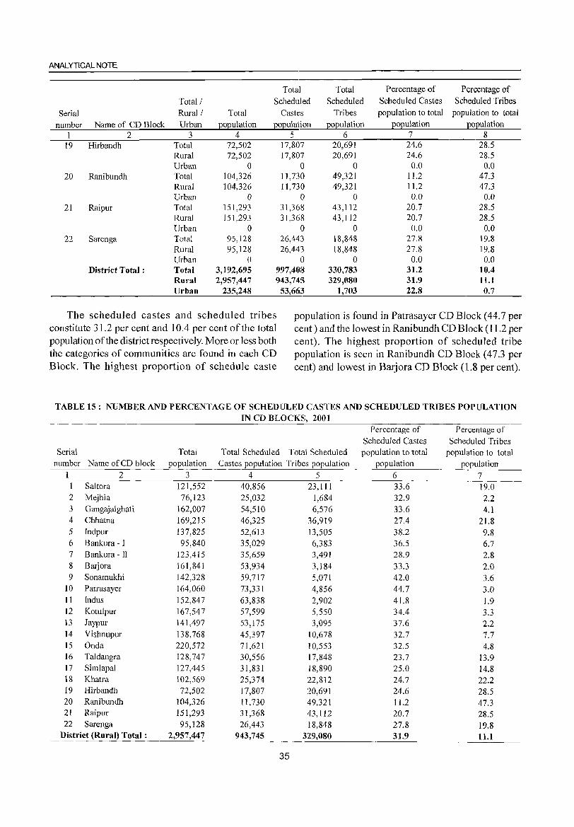
ANALYTICAL NOTE
Total Total Percentage of Percentage of
Total/ Scheduled Scheduled Scheduled Castes Scheduled Tribes
Serial Rural! Total Castes Tribes population to total population to total
number Name of CD Block Urban EOEulation EOEulation EOEulation EOEulation EOEulation 1 2 3 4 5 6 7 8
19 Hirbandh Total 72,502 17,807 20,691 24.6 28.5 Rural 72,502 17,807 20,691 24.6 28.5 Urban 0 0 0 0.0 0.0
20 Ranibundh Total 104,326 11,730 49,321 11.2 47.3 Rural 104,326 11,730 49,321 11.2 47.3 Urban 0 0 0 0.0 0.0
21 Raipur Total 151,293 31,368 43,112 20.7 28.5 Rural 151,293 31,368 43,112 20.7 28.5 Urban 0 0 0 0.0 0.0
22 Sarenga Total 95,128 26,443 18,848 27.8 19.8 Rural 95,128 26,443 18,848 27.8 19.8 Urban 0 0 0 0.0 0.0
District Total: Total 3,192,695 997,408 330,783 31.2 10.4 Rural 2,957,447 943,745 329,080 31.9 11.1 Urban 235,248 53,663 1,703 22.8 0.7
The scheduled castes and scheduled tribes population is found in Patrasayer CD Block (44.7 per constitute 31.2 per cent and lOA per cent of the total cent) and the lowest in Ranibundh CD Block (11.2 per population of the district respectively. More or less both cent). The highest proportion of scheduled tribe the categories of communities are found in each CD popUlation is seen in Ranibundh CD Block (47.3 per Block. The highest proportion of schedule caste cent) and lowest in Barjora CD Block (1.8 per cent).
TABLE 15: NUMBER AND PERCENTAGE OF SCHEDULED CASTES AND SCHEDULED TRIBES POPULATION IN CD BLOCKS, 2001
Percentage of Percentage of Scheduled Castes Scheduled Tribes
Serial Total Total Scheduled Total Scheduled population to total population to total number Name of CD block population Castes popUlation Tribes population popUlation population
1 2 3 4 5 6 7 1 Saltora 121,552 40,856 23,111 33.6 19.0 2 Mejhia 76,123 25,032 1,684 32.9 2.2 3 Gangajalghati 162,007 54,510 6,576 33.6 4.1 4 Chhatna 169,215 46,325 36,919 27.4 21.8 5 Indpur l37,825 52,6l3 13,505 38.2 9.8 6 Bankura - I 95,840 35,029 6,383 36.5 6.7 7 Bankura - II 123,415 35,659 3,491 28.9 2.8 8 Barjora 161,841 53,934 3,184 33.3 2.0 9 Sonamukhi 142,328 59,717 5,071 42.0 3.6
10 Patrasayer 164,060 73,331 4,856 44.7 3.0 11 Indus 152,847 63,838 2,902 41.8 1.9 12 Kotulpur 167,547 57,599 5,550 34.4 3.3 l3 Jaypur 141,497 53,175 3,095 37.6 2.2 14 Vishnupur 138,768 45,397 10,678 32.7 7.7 15 Onda 220,572 71,621 10,553 32.5 4.8 16 Taldangra 128,747 30,556 17,848 23.7 13.9 17 Simlapal 127,445 31,831 18,890 25.0 14.8 18 Khatra 102,569 25,374 22,812 24.7 22.2 19 Hirbandh 72,502 17,807 20,691 24.6 28.5 20 Ranibundh 104,326 11,730 49,321 11.2 47.3 21 Raipur 151,293 31,368 43,112 20.7 28.5 22 Sarenga 95,128 26,443 18,848 27.8 19.8
District (Rural) Total: 2,957,447 943,745 329,080 31.9 11.1
35
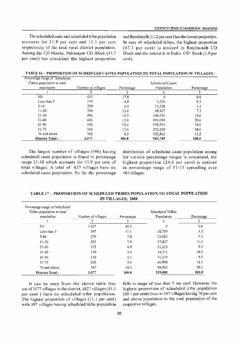
The scheduled caste and scheduled tribe population accounts for 31.9 per cent and 11.1 per cent respectively of the total rural district population. Among the CD Blocks, Patrasayer CD Block (44.7 per cent) has contained the highest proportion
DISTRICT CENSIJS HANDBOOK: BANKURA
and Ranibundh (11.2 per cent) has the lowest proportion. In case of scheduled tribes, the highest proportion (47.3 per cent) is noticed in Ranibundh CD Block and the lowest is in Indus CD Block (1.9 per cent).
TABLE 16: PROPORTION OF SCHEDULED CASTES POPULATION TO TOTAL POPULATION IN VILLAGES, Percentage range ot Scheduled
Castes population to total Scheduled Castes population Number of villages
I 2 Nil 637 Less than 5 173 5-10 229 11-20 450 21-30 496 31-40 466 41-50 356 51-75 465 76 and above 305
District Total: 3,577
The largest number of villages (496) having scheduled caste population is found in percentage range 21-30 which accounts for 13.9 per cent of total villages. A total of 637 villages have no scheduled caste population. So far the percentage
Percentage Population Percentage 3 4 5
17.8 0 0.0 4.8 3,220 0.3 6.4 13,228 1.4
12.6 69,327 7.3 13.9 146,931 15.6 13.0 194,094 20.6 10.0 178,913 19.0 13.0 232,220 24.6 8.5 105,812 11.2
100.0 943,745 100.0
distribution of scheduled caste population among the various percentage rangl~s is concerned, the highest proportion (24.6 per cent) is noticed in percentage range of 51,-75 spreading over 465 villages.
TABLE 17: PROPORTION OF SCHEDULED TRIBES POPULATION TO TOTA][_' POPULATION IN VILLAGES, 2001
Percentage range of Scheduled Tribes population to total
population Number of villages 1 2
Nil 1,627
Less than 5 397
5-10 279
11-20 281
21-30 175
31-40 139
41-50 110
51-75 202
76 and above 367
District Total: 3,577
It can be seen from the above table that out of3577 villages in the district, 1627 villages (45.5 per cent) have no scheduled tribe population. The highest proportion of villages (11.1 per cent) with 397 villages having scheduled tribe popUlation
Scheduled Tribes Percentage Population Percentage
36
3 4 5
45.5 0 0.0
ILl 10,719 3.3
7.8 23,882 7.3
7.9 37,427 11.4
4.9 31,215 9.5
3.9 34,711 10.5
3.1 31,234 9.5
5.6 60,990 18.5
10.3 98,902 30.1
100.0 329,080 100.0
falls in range of less than 5 per cent. However, the highest proportion of scheduled tribe population (30.1 per cent) lives in 367 villages having 76 per cent and above population to the total popUlation of the respective villages.
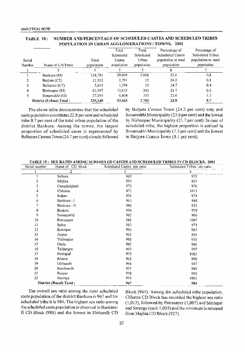
ANALYTICAL NOTE
TABLE 18: NUMBER AND PERCENTAGE OF SCHEDULED CASTES AND SCHEDULED TRIBES POPULATION IN URBAN AGGLOMERATIONS / TOWNS, 2001
Total Total Percentage of Percentage of
Scheduled Scheduled Scheduled Castes Scheduled Tribes
Serial Total Castes Tribes population to total population to total
Number Name of UA/Town population population population population population
2 3 4 5 6 7
1 Bankura(M) 128,781 29,609 1,008 23.0 0.8
2 Barjora (CT) 11,512 2,791 12 24.2 0.1
3 Beliatore (CT) 5,654 1,394 25 24.7 0.4
4 Bishnupur (M) 61,947 13,415 303 21.7 0.5
5 Sonamukhi (M) 27,354 6,454 355 23.6 1.3
District (Urban) Total: 235,248 53,663 1,703 22.8 0.7
The above table demonstrates that the scheduled caste population constitutes 22.8 per cent and scheduled tribe 0.7 per cent of the total urban population of the district Bankura. Among the towns, the largest proportion of scheduled caste is represented by Beliatore Census Town (24.7 per cent) closely followed
by Barjora Census Town (24.2 per cent) very and Sonamukhi Municipality (23.6 per cent) and the lowest by Bishnupur Municipality (21.7 per cent). In case of scheduled tribe, the highest proportion is noticed in Sonamukhi Municipality (1.3 per cent) and the lowest in Barjora Census Town (0.1 per cent).
TABLE 19: SEX RATIO AMONG SCHEDULED CASTES AND SCHEDULED TRIBES IN CD BLOCKS, 2001 Serial number Name of CD block Scheduled Castes sex ratio Scheduled Tribes sex ratio
234 Saltora
2 Mejhia
3 Gangaj alghati 4 Chhatna 5 Indpur
6 Bankura - I 7 Bankura - II 8 Barjora 9 Sonamukhi
10 Patrasayer 11 Indus 12 Kotulpur 13 Jaypur 14 Vishnupur 15 Onda 16 Taldangra 17 Simlapal 18 Khatra 19 Hirbandh 20 Ranibundh 21 Raipur 22 Sarenga
District (Rural) Total:
The overall sex ratio among the rural scheduled caste population of the district Bankura is 967 and for scheduled tribe it is 984. The highest sex ratio among the scheduled caste population is observed in BankuraII CD Block (986) and the lowest in Hirbandh CD
37
965 975 953 927 973 976 971 951 963 986 956 965 981
963 956
965 981 983 963 975 962 941 951 958 954
967
1013 974 944 955
979 960
1007 974 963 954 953 981 997
1003 990 947 980 995
1003 984
Block (941). Among the scheduled tribe population, Chhatna CD Block has recorded the highest sex ratio (1,013), followed by Patrasayer (1,007) and Simlapal and Sarenga(each 1,003) and the minimum is returned from Mejhia CD Block (927).
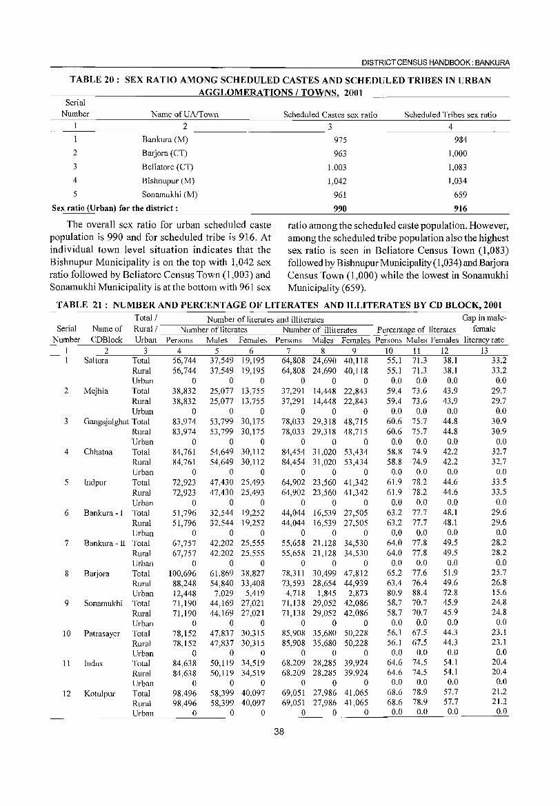
DISTRICT CENSUS HANDBOOK: BANKURA
TABLE 20: SEX RATIO AMONG SCHEDULED CASTES AND SCHEDULED TRIBES IN URBAN AGGLOMERATIONS / TOWNS 2001
Serial Number Name ofUAlTown Scheduled Castes sex ratio Scheduled Tribes sex ratio
2
3
4
5
2
Bankura (M)
Barjora (CT)
Beliatore (CT)
Bishnupur (M)
Sonamukhi (M)
3
975
963
1,003
1,042
961
4
984
1,000
1,083
1,034
Sex ratio (Urban) for the district: 990
659
916
The overall sex ratio for urban scheduled caste population is 990 and for scheduled tribe is 916. At individual town level situation indicates that the Bishnupur Municipality is on the top with 1,042 sex ratio followed by Beliatore Census Town (1,003) and Sonamukhi Municipality is at the bottom with 961 sex
ratio among the scheduled caste population. However, among the scheduled tribe population also the highest sex ratio is seen in Beliatore Census Town (1,083) followed by Bishnupur Municipality (1,034) and BaJj ora Census Town (1,000) while the lowest in Sonamukhi Municipality (659).
TABLE 21 : NUMBER AND PERCENTAGE OF LITERATES AND ILLITERATES BY CD BLOCK, 2001
Serial Number
2
3
4
5
6
7
8
9
10
11
12
Total/Number of literates and illiterates Name of Rural / -------=-N-=-u-m--=-b-er-o-,f=li:-te-ra-t-es----=-N-=-u-m-:-b-er-o--::f-'i""'lh:-'te-r-at-es-- Percentage of literates
CDBlock Urban Persons Males Females Persons Males Females Persons Males Females 2 3 4 5 6 7 8 9 10 11 12
Saltora Total 56,744 37,549 19,195 64,808 24,690 40,118 55.1 71.3 38.1 Rural Urban
Mejhia Total Rural Urban
Gangajalghat Total Rural Urban
Chhatna Total Rural Urban
Indpur Total Rural Urban
Bankura - I Total Rural Urban
Bankura - II Total Rural Urban
Barjora Total Rural Urban
Sonamukhi Total Rural Urban
Patrasayer Total Rural Urban
Indus Total Rural Urban
Kotulpur Total Rural Urban
56,744 37,549 19,195 64,808 24,690 40,118 55.1 71.3 38.1 o ° 0 0 ° 0 0.0 0.0 0.0
38,832 25,077 13,755 37,291 14,448 22,843 59.4 73.6 43.9 38,832 25,077 13,755 37,291 14,448 22,843 59.4 73.6 43.9
o 0 0 0 0 0 0.0 0.0 0.0 83,974 53,799 30,175 78,033 29,318 48,715 60.6 75.7 44.8 83,974 53,799 30,175 78,033 29,318 48,715 60.6 75.7 44.8
o 0 0 0 0 0 0.0 0.0 0.0 84,761 54,649 30,112 84,454 31,020 53,434 58.8 74.9 42.2 84,761 54,649 30,112 84,454 31,020 53,434 58.8 74.9 42.2
o 0 0 0 0 0 0.0 0.0 0.0 72,923 47,430 25,493 64,902 23,560 41,342 61.9 78.2 44.6 72,923 47,430 25,493 64,902 23,560 41,342 61.9 78.2 44.6
o 0 0 0 0 0 0.0 0.0 0.0 51,796 32,544 19,252 44,044 16,539 27,505 63.2 77.7 48.1 51,796 32,544 19,252 44,044 16,539 27,505 63.2 77.7 48.1
o 0 0 0 0 0 0.0 0.0 0.0 67,757 42,202 25,555 55,658 21,128 34,530 64.0 77.8 49.5 67,757 42,202 25,555 55,658 21,128 34,530 64.0 77.8 49.5
o 0 0 0 0 0 0.0 0.0 0.0 100,696 61,869 38,827 78,311 30,499 47,812 65.2 77.6 51.9 88,248 54,840 33,408 73,593 28,654 44,939 63.4 76.4 49.6 12,448 7,029 5,419 4,718 1,845 2,873 80.9 88,4 72.8 71,190 44,169 27,021 71,138 29,052 42,086 58.7 70.7 45.9 71,190 44,169 27,021 71,138 29,052 42,086 58.7 70.7 45.9
o 0 0 0 0 0 0.0 0.0 0.0 78,152 78,152
o 84,638 84,638
o 98,496 98,496
o
47,837 47,837
o 50,119 50,119
o 58,399 58,399
o
30,315 30,315
o 34,519 34,519
o 40,097 40,097
o
85,908 35,680 50,228 56.1 67.5 44.3 85,908 35,680 50,228 56.1 67.5 44.3
o 0 0 0.0 0.0 0.0 68,209 28,285 39,924 64.6 74.5 54.1 68,209 28,285 39,924 64.6 74.5 54.1
o 0 0 0.0 0.0 0.0 69,051 27,986 41,065 68.6 78.9 57.7 69,051 27,986 41,065 68.6 78.9 57.7
o 0 0 0.0 0.0 0.0
38
Gap in malefemale
literacy rate 13
33.2 33.2 0.0
29.7 29.7
0.0 30.9 30.9
0.0 32.7 32.7
0.0 33.5 33.5 0.0
29.6 29.6
0.0 28.2 28.2
0.0 25.7 26.8 15.6 24.8 24.8
0.0 23.1 23.1
0.0 20.4 20,4
0.0 21.2 21.2
0.0
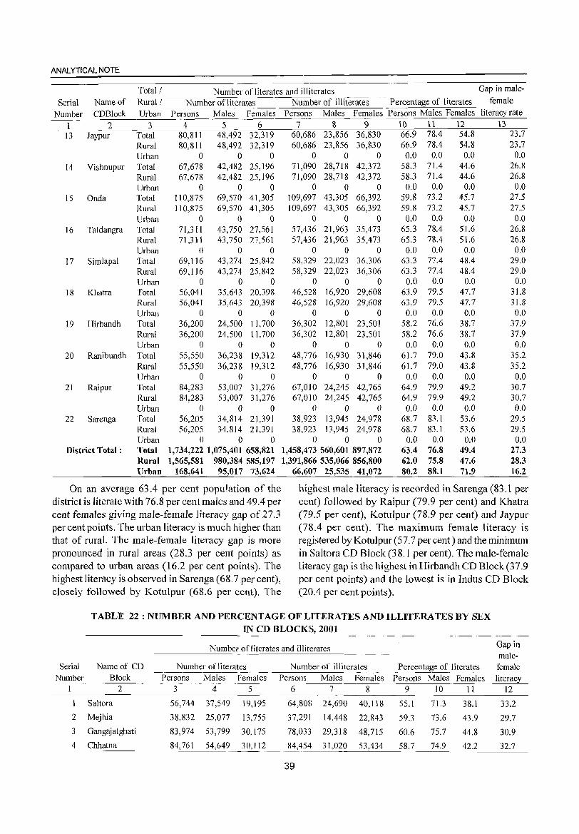
ANALYTICAL NOTE
Serial Name of Number CDBlock
1 2 13 Jaypur
14 Vishnupur
15 Onda
16 Ta1dangra
17 Simlapal
18 Khatra
19 Hirbandh
20 Ranibundh
21 Raipur
22 Sarenga
District Total:
Total! Number of literates and illiterates Rural I -----,-N-=-u-m-:-b-er_:_o:..::f~li~te~r-::at-:-es=::..:::--:-::-:::~N'-;-ucm-c:-b-er-o---;:f;--;i:;-Oll-;-ite-r-at-e-s - Percentage of literates
Urban Persons Males Females Persons Males Females Persons Males Females 3 4 5 6 7 8 9 1() 11 12
Total 80,811 48,492 32,319 60,686 23,856 36,830 66.9 78.4 54.8 Rural 80,811 48,492 32,319 60,686 23,856 36,830 66.9 78.4 54.8 Urban 0 0 0 0 0 0 0.0 0.0 0.0 Total 67,678 42,482 25,196 71,090 28,718 42,372 58.3 71.4 44.6 Rural 67,678 42,482 25,196 71,090 28,718 42,372 58.3 71.4 44.6 Urban 0 0 0 0 0 0 0.0 0.0 0.0 Total 110,875 69,570 41,305 109,697 43,305 66,392 59.8 73.2 45.7 Rural 110,875 69,570 41,305 109,697 43,305 66,392 59.8 73.2 45.7 Urban 0 0 0 0 0 0 0.0 0.0 0.0 Total 71,311 43,750 27,561 57,436 21,963 35,473 65.3 78.4 51.6 Rural 71,311 43,750 27,561 57,436 21,963 35,473 65.3 78.4 51.6 Urban 0 0 0 0 0 0 0.0 0.0 0.0 Total 69,116 43,274 25,842 58,329 22,023 36,306 63.3 77.4 48.4 Rural 69,116 43,274 25,842 58,329 22,023 36,306 63.3 77.4 48.4 Urban 0 0 0 0 0 0 0.0 0.0 0.0 Total 56,041 35,643 20,398 46,528 16,920 29,608 63.9 79.5 47.7 Rural 56,041 35,643 20,398 46,528 16,920 29,608 63.9 79.5 47.7 Urban 0 0 0 0 0 0 0.0 0.0 0.0 Total 36,200 24,500 11,700 36,302 12,801 23,501 58.2 76.6 38.7 Rural 36,200 24,500 11,700 36,302 12,801 23,501 58.2 76.6 38.7 Urban 0 0 0 0 0 0 0.0 0.0 0.0 Total 55,550 36,238 19,312 48,776 16,930 31,846 61.7 79.0 43.8 Rural 55,550 36,238 19,312 48,776 16,930 31,846 61.7 79.0 43.8 Urban 0 0 0 0 0 0 0.0 0.0 0.0 Total 84,283 53,007 31,276 67,010 24,245 42,765 64.9 79.9 49.2 Rural 84,283 53,007 31,276 67,010 24,245 42,765 64.9 79.9 49.2 Urban 0 0 0 0 0 0 0.0 0.0 0.0 Total 56,205 34,814 21,391 38,923 13,945 24,978 68.7 83. I 53.6 Rural 56,205 34,814 21,391 38,923 13,945 24,978 68.7 83.1 53.6 Urban 0 0 0 0 0 0 0.0 0.0 0.0 Total 1,734,222 1,075,401 658,821 1,458,473 560,601 897,872 63.4 76.8 49.4 Rural 1,565,581 980,384 585,197 1,391,866 535,066 856,800 62.0 75.8 47.6 Urban 168,641 95,017 73,624 66,607 25,535 41,072 80.2 88.1 71.9
Gap in male
female literacy rate
\3 23.7 23.7
0.0 26.8 26.8
0.0 27.5 27.5
0.0 26.8 26.8
0.0 29.0 29.0
0.0 31.8 31.8
0.0 37.9 37.9 0.0
35.2 35.2
0.0 30.7 30.7 0.0
29.5 29.5
0.0 27.3 28.3 16.2
On an average 63.4 per cent population of the district is literate with 76.8 per cent males and 49.4 per cent females giving male-female literacy gap of 27.3 per cent points. The urban literacy is much higher than that of rural. The male-female literacy gap is more pronounced in rural areas (28.3 per cent points) as compared to urban areas (16.2 per cent points). The highest literacy is observed in Sarenga (68.7 per cent), closely followed by Kotulpur (68.6 per cent). The
highest male literacy is recorded in Sarenga (83.1 per cent) followed by Raipur (79.9 per cent) and Khatra (79.5 per cent), Kotulpur (78.9 per cent) and Jaypur (78.4 per cent). The maximum female literacy is registered by Kotulpur (57.7 per cent) and the minimum in Saltora CD Block (38.1 per cent). The male-female literacy gap is the highest in Hirbandh CD Block(37.9 per cent points) and the lowest is in Indus CD Block (20.4 per cent points).
TABLE 22 : NUMBER AND PERCENTAGE OF LITERATES AND ILLITERATES BY SEX IN CD BLOCKS, 2001
Serial Name of CD Number Block
I 2
1 Saltora
2 Mejhia
3 Gangajalghati
4 Chhatna
Number of literates and illiterates Gap in male-
Number of literates Number of illiterates Percentage of literates female Persons Males Females Persons Males Females Persons Males Females literacy
3 4 5 6 7 8 9 10 II 12
56,744 37,549 19,195
38,832 25,077 13,755
83,974 53,799 30, 175
84,761 54,649 30,112
64,808 24,690
37,291 14,448
78,033 29,3 I 8
40,118
22,843
48,715
55.1
59.3
60.6
71.3
73.6
75.7
38.1
43.9
44.8
84,454 31,020 53,434 58.7 74.9 42.2
39
33.2
29.7
30.9
32.7
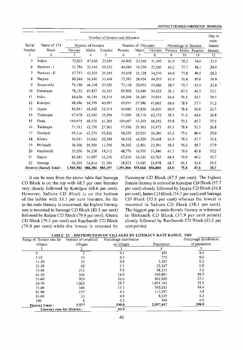
DISTRICT CENSUS HANDBOOK: BANKURA
Number ofliterates and illiterates Gap in male-
Serial Name of CD Number of literates Number of illiterates Percentage of literates female Number Block Persons Males Females Persons Males Females Persons Males Females literacy
1 2 3 4 5 6 7 8 9 10 11 12
5 Indpur 72,923 47,430 25,493 64,902 23,560 41,342 61.9 78.2 44.6 33.5
6 Bankura -I 51,796 32,544 19,252 44,044 16,539 27,505 63.2 77.7 48.1 29.6
7 Bankura - II 67,757 42,202 25,555 55,658 21,128 34,530 64.0 77.8 49.5 28.2
8 Barjora 88,248 54,840 33,408 73,593 28,654 44,939 63.4 76.4 49.6 26.8
9 Sonamukhi 71,190 44,169 27,021 71,138 29,052 42,086 58.7 70.7 45.9 24.8
10 Patrasayer 78,152 47,837 30,3 I 5 85,908 35,680 50,228 56.1 67.5 44.3 23. I
11 Indus 84,638 50,119 34,519 68,209 28,285 39,924 64.6 74.5 54.1 20.4
12 Kotulpur 98,496 58,399 40,097 69,051 27,986 41,065 68.6 78.9 57.7 21.2
13 Jaypur 80,811 48,492 32,319 60,686 23,856 36,830 66.9 78.4 54.8 23.7
14 Vishnupur 67,678 42,482 25,196 71,090 28,718 42,372 58.3 71.4 44.6 26.8
15 Onda 110,875 69,570 41,305 109,697 43,305 66,392 59.8 73.2 45.7 27.5
16 Taldangra 71,3 I I 43,750 27,561 57,436 21,963 35,473 65.3 78.4 51.5 26.8
17 Simlapal 69,116 43,274 25,842 58,329 22,023 36,306 63.2 77.4 48.4 29.0
18 Khatra 56,041 35,643 20,398 46,528 16,920 29,608 63.9 79.5 47.7 31.8
19 Hirbandh 36,200 24,500 11,700 36,302 12,801 23,501 58.2 76.6 38.7 37.9
20 Ranibundh 55,550 36,238 19,312 48,776 16,930 31,846 61.7 79.0 43.8 35.2
21 Raipur 84,283 53,007 31,276 67,010 24,245 42,765 64.9 79.9 49.2 30.7
22 Sarenga 56,205 34,814 21,391 38,923 13,945 24,978 68.7 83.1 53.6 29.5 District (Rural) Total: 1,565,581 980,384 585,197 1,391,866 535,066 856,800 62.0 75.8 47.6 28.3
It can be seen from the above table that Sarenga Patrasayer CD Block (67.5 per cent). The highest CD Block is on the top with 68.7 per cent literates female literacy is noticed in Kotulpur CD Block (57.7 very closely followed by Kotulpur (68.6 per cent). per cent) closely followed by Jaypur CD Block (54.8 However, Salt ora CD Block is on the bottom per cent), Indus CD Block (54.3 per cent) and Sarenga of the ladder with 55.1 per cent literates. So far CD Block (53.6 per cent) whereas the lowest is as the male literacy is concerned, the highest literacy recorded in Saltora CD Block (38.1 per cent). rate is recorded in Sarenga CD Block (83.1 per cent) The biggest gap in male-female literacy is witnessed followed by Raipur CD Block (79.9 per cent), Khatra in Hirbandh CD Block (37.9 per cent points) CD Block (79.5 per cent) and Ranibundh CD Block closely followed by Ranibundh CD Block (35.2 per (79.0 per cent) while the lowest is returned by cent points).
TABLE 23 : DISTRIBUTION OF VILLAGES BY LITERACY RATE RANGE, 2001 Range of literacy rate for Number of inhabited Percentage distribution Percentage distribution
villages villages of villages Population of 2opulation 1 2 3 4 5
0 5 0.1 105 0.0 1-10 10 0.3 735 0.0 11-20 33 0.9 5,203 0.2 21-30 82 2.3 22,247 0.8 31-40 211 5.9 98,253 3.3 41-50 501 14.0 309,801 10.5 51-60 929 26.0 802,816 27.1 61-70 1,062 29.7 1,051,162 35.5 71-80 546 15.3 545,013 18.4 81-90 157 4.4 113,597 3.8 91-99 33 0.9 8,325 0.3
100 8 0.2 190 0.0
District Total: 3,577 100.0 2,957,447 100.0
Literacy rate for District: 63.4
40
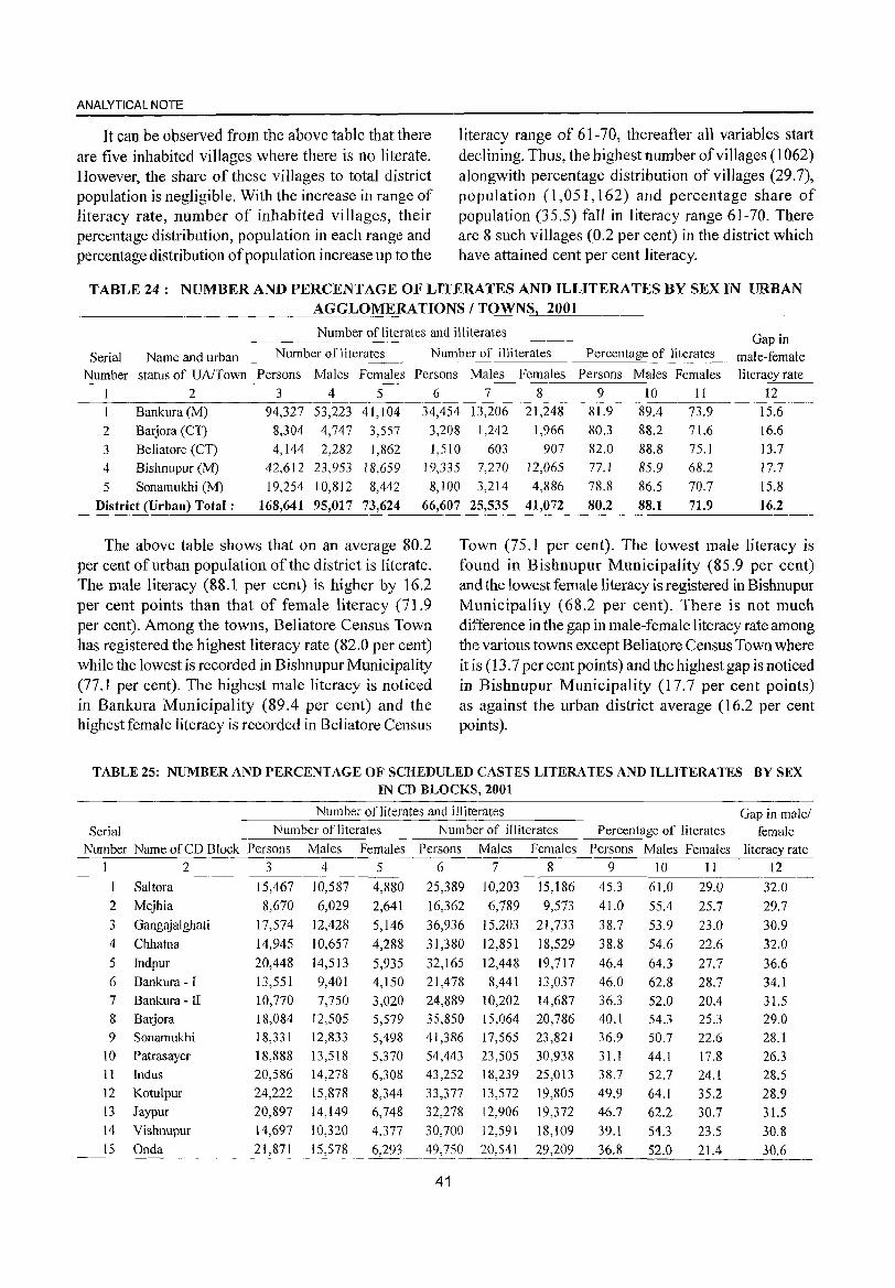
ANALYTICAL NOTE
It can be observed from the above table that there are five inhabited villages where there is no literate. However, the share of these villages to total district population is negligible. With the increase in range of literacy rate, number of inhabited villages, their percentage distribution, population in each range and percentage distribution of population increase up to the
literacy range of 61-70, thereafter all variables start declining. Thus, the highest number of villages (1062) alongwith percentage distribution of villages (29.7), population (1,051,162) and percentage share of population (35.5) fall in literacy range 61-70. There are 8 such villages (0.2 per cent) in the district which have attained cent per cent literacy.
TABLE 24: NUMBER AND PERCENTAGE OF LITERATES AND ILLITERATES BY SEX IN URBAN AGGLOMERATIONS / TOWNS 2001
Number of literates and illiterates Gap in
Serial Name and urban Number of literates Number of illiterates Percentage of literates male-female
Number status of UA/Town Persons Males Females Persons Males Females Persons Males Females literacy rate
2 3 4 5 6 7 8 9 10 I I 12
Bankura (M) 94,327 53,223 4 I, 104 34,454 13,206 21,248 81.9 89.4 73.9 15.6
2 Barjora (CT) 8,304 4,747 3,557 3,208 1,242 1,966 80.3 88.2 71.6 16.6
3 Beliatore (CI) 4,144 2,282 1,862 1,5 I 0 603 907 82.0 88.8 75.1 13.7
4 Bishnupur (M) 42,612 23,953 18,659 19,335 7,270 12,065 77. I 85.9 68.2 17.7
5 Sonamukhi (M) 19,254 10,812 8,442 8,100 3,214 4,886 78.8 86.5 70.7 15.8
District (Urban) Total: 168,641 95,017 73,624 66,607 25,535 41,072 80.2 88.1 71.9 16.2
The above table shows that on an average 80.2 per cent of urban population of the district is literate. The male literacy (88.1 per cent) is higher by 16.2 per cent points than that of female literacy (71.9 per cent). Among the towns, Beliatore Census Town has registered the highest literacy rate (82.0 per cent) while the lowest is recorded in Bishnupur Municipality (77.1 per cent). The highest male literacy is noticed in Bankura Municipality (89.4 per cent) and the highest female literacy is recorded in Beliatore Census
Town (75.1 per cent). The lowest male literacy is found in Bishnupur Municipality (85.9 per cent) and the lowest female literacy is registered in Bishnupur Municipality (68.2 per cent). There is not much difference in the gap in male-female literacy rate among the various towns except Beliatore Census Town where it is (13.7 per cent points) and the highest gap is noticed in Bishnupur Municipality (17.7 per cent points) as against the urban district average (16.2 per cent points).
TABLE 25: NUMBER AND PERCENT AGE OF SCHEDULED CASTES LITERATES AND ILLITERATES BY SEX IN CD BLOCKS, 2001
Num ber of literates and illiterates Gap in male/ Serial Number ofliterates Number of illiterates Percentage of literates female
Number Name of CD Block Persons Males Females Persons Males Females Persons Males Females literacy rate 1 2 3 4 5 6 7 8 9 10 II 12
I Saltora 15,467 10,587 4,880 25,389 10,203 15,186 45.3 61.0 29.0 32.0
2 Mejhia 8,670 6,029 2,641 16,362 6,789 9,573 41.0 55.4 25.7 29.7
3 Gangajalghati 17,574 12,428 5,146 36,936 15,203 21,733 38.7 53.9 23.0 30.9
4 Chhatna 14,945 10,657 4,288 31,380 12,851 18,529 38.8 54.6 22.6 32.0
5 Indpur 20,448 14,513 5,935 32,165 12,448 19,717 46.4 64.3 27.7 36.6 6 Bankura - I 13,551 9,401 4,150 21,478 8,441 13,037 46.0 62.8 28.7 34.1
7 Bankura - II 10,770 7,750 3,020 24,889 10,202 14,687 36.3 52.0 20.4 31.5 8 Barjora 18,084 12,505 5,579 35,850 15,064 20,786 40.1 54.3 25.3 29.0
9 Sonamukhi 18,331 12,833 5,498 41,386 17,565 23,821 36.9 50.7 22.6 28.1
10 Patrasayer 18,888 13,518 5,370 54,443 23,505 30,938 31.1 44.1 17.8 26.3 11 Indus 20,586 14,278 6,308 43,252 18,239 25,013 38.7 52.7 24.1 28.5 12 Kotulpur 24,222 15,878 8,344 33,377 13,572 19,805 49.9 64.1 35.2 28.9 13 Jaypur 20,897 14,149 6,748 32,278 12,906 19,372 46.7 62.2 30.7 31.5 14 Vishnupur 14,697 10,320 4,377 30,700 12,591 18,109 39.1 54.3 23.5 30.8 15 Onda 21,871 15,578 6,293 49,750 20,541 29,209 36.8 52.0 21.4 30.6
41
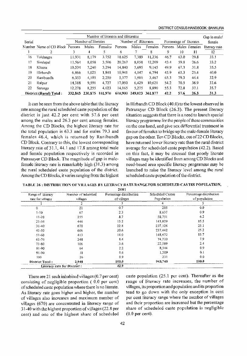
DISTRICT CENSUS HANDBOOK: BANKURA
Number ofliterates and illiterates Gap inmalel Serial Number of literates Number of illiterates Percentage of literates female
Number Name of CD Block Persons Males Females Persons Males Females Persons Males Females literacy rate 1 2 3 4 5 6 7 8 9 10 11 12
16 Taldangra 11,931 8,179 3,752 18,625 7,389 11,236 46.7 63.0 29.8 33.1
17 Simlapal 11,564 8,058 3,506 20,267 8,058 12,209 43.4 59.8 26.6 33.2
18 Khatra 10,534 7,240 3,294 14,840 5,695 9,145 49.9 67.3 31.8 35.5
19 Hirbandh 6,866 5,025 1,841 10,941 4,147 6,794 45.9 65.3 25.4 40.0
20 Ranibundh 6,353 4,103 2,250 5,377 1,910 3,467 63.3 79.3 46.4 32.9
21 Raipur 14,318 9,591 4,727 17,050 6,429 10,621 54.2 70.5 36.9 33.6
22 Sarenga 12,278 8,255 4,023 14,165 5,275 8,890 55.3 72.8 37.1 35.7
District (Rural} Total: 332,845 230,875 101,970 610,900 249,023 361!877 42.2 57.6 26.3 31.3
It can be seen from the above table that the literacy rate among the rural scheduled caste population of the district is just 42.2 per cent with 57.6 per cent among the males and 26.3 per cent among females. Among the CD Blocks, the highest literacy rate for the total population is 63.3 and for males 79.3 and females 46.4, which is returned by Ranibundh CD Block. Contrary to this, the lowest corresponding literacy rate of31.1, 44.1 and 17.8 among total male and female population respectively is recorded in Patrasayer CD Block. The magnitude of gap in malefemale literacy rate is remarkably high (31.3) among the rural scheduled caste population of the district. Among the CD Blocks, it varies ranging from the highest
in Hirbandh CD Block (40.0) to the lowest observed in Patrasayer CD Block (26.3). The present literacy situation suggests that there is a need to launch special literacy programme for the people of these communities on the one hand, and give sex differential treatment in favour offemales to bridge up the male-female literacy gap on the other. Ten CD Blocks, out of22 CD Blocks, have returned lower literacy rate than the rural district average for scheduled caste population (42.2). Based on this fact, it may be stressed that poorly literate villages may be identified from among CD Blocks and need-based area specific literaGY programme may be launched to raise the literacy llevel among the rural scheduled caste population of the district.
TABLE 26: DISTRIBUTION OF VILLAGES BY LlTERACYRATERANGEFOR SCHEDULED CASTES POPULATION,
2001 Range of literacy Number of inhabited Percentage distribution Scheduled Castes Percentage distribution
rate for villages villages of villages Population of popUlation 1 2 3
0 21 0.7 1-10 67 2.3 11-20 255 8.7 21-30 446 15.2 31-40 670 22.8 41-50 606 20.6 51-60 413 14.0 61-70 248 8.4 71-80 106 3.6 81-90 64 2.2 91-99 18 0.6 100 26 0.9
District Total: 2,940 100.0
Literacy rate for Distl'i<;_t_:. ___ "" 42.9
There are 21 such inhabited villages (0.7 per cent) consisting of negligible proportion ( 0.0 per cent) of scheduled caste population where there is no literate. As literacy rate goes higher and higher, the number of villages also increases and maximum number of villages (670) are concentrated in literacy range of 31-40 with the highest proportion of villages (22.8 per cent) and one of the highest share of scheduled
42
4 5 205 0.0
8,637 0.9 58,751 6.2
145,829 15.5 237,126 25.1 237,442 25.2 148,472 15.7
74,710 7.9 22,589 2.4
8,544 0.9 1,209 0.1
231 0.0 943,745 100.0
caste population (25.1 per cent). Thereafter as the range of literacy rate increases, the number of villages, its proportion and population and its proportion tend to go down with the only exception in cent per cent literacy range where the number of villages and their proportion are increased but the percentage share of scheduled caste population is negligible (0.0 per cent).
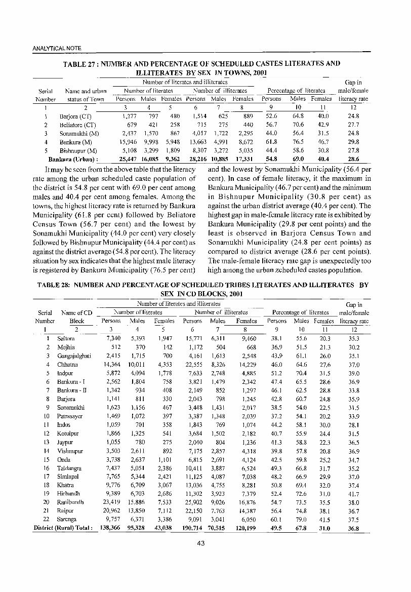
ANALYTICAL NOTE
TABLE 27: NUMBER AND PERCENTAGE OF SCHEDULED CASTES LITERATES AND ILLITERATES BY SEX IN TOWNS, 2001
Number ofiiterates and illiterates Gap in
Serial Name and urban Number ofiiterates Number of illiterates Percentage of literates male/female
Number status of Town Persons Males Females Persons Males Females Persons Males Females literacy rate
2 3 4 5 6 7 8 9 10 11 12
1 Barjora (CT) 1,277 797 480 1,514 625 889 52.6 64.8 40.0 24.8
2 Beliatore (CT) 679 421 258 715 275 440 56.7 70.6 42.9 27.7
3 Sonamukhi (M) 2,437 1,570 867 4,017 1,722 2,295 44.0 56.4 31.5 24.8
4 Bankura (M) 15,946 9,998 5,948 13,663 It,99 1 8,672 61.8 76.5 46.7 29.8
5 Bishnupur (M) 5,108 3,299 1,809 8,307 3,272 5,035 44.4 58.6 30.8 27.8
Bankura (Urban) : 25,447 16,085 9,362 28,216 10,885 17,331 54.8 69.0 40.4 28.6
It may be seen from the above table that the literacy and the lowest by Sonamukhi Municipality (56.4 per rate among the urban scheduled caste population of cent). In case of female literacy, it the maximum in the district is 54.8 per cent with 69.0 per cent among BankuraMunicipality (46.7 percent) and the minimum males and 40.4 per cent among females. Among the in Bishnupur Municipality (30.8 per cent) as towns, the highest literacy rate is returned by Bankura against the urban district average (40.4 per cent). The Municipality (61.8 per cent) followed by Beliatore highest gap in male-female literacy rate is exhibited by Census Town (56.7 per cent) and the lowest by Bankura Municipality (29.8 per cent points) and the Sonamukhi Municipality (44.0 per cent) very closely least is observed in Barjora Census Town and followed by Bishnupur Municipality (44.4 per cent) as Sonamukhi Municipality (24.8 per cent points) as against the district average (54.8 per cent). The literacy compared to district average (28.6 per cent points). situation by sex indicates that the highest male literacy The male-female literacy rate gap is unexpectedly too is registered by Bankura Municipality (76.5 per cent) high among the urban zcheduled castes population.
TABLE 28: NUMBER AND PERCENTAGE OF SCHEDULED TRIBES LITERATES AND ILLITERATES BY SEX IN CD BLOCKS, 2001
Number ofliterates and illiterates Gap in Serial Name of CD Number ofliterates Number of illiterates Percentage of literates male/female
Number Block Persons Males Females Persons Males Females Persons Males Females literacy rate 1 2 3 4 5 6 7 8 9 10 11 12
1 Saltora 7,340 5,393 1,947 15,771 6,311 9,460 38.1 55.6 20.3 35.3
2 Mejhia 512 370 142 1,172 504 668 36.9 51.5 21.3 30.2
3 Gangajalghati 2,415 1,715 700 4,161 1,613 2,548 43.9 61.1 26.0 35.1
4 Chhatna 14,364 10,011 4,353 22,555 8,326 14,229 46.0 64.6 27.6 37.0 5 Indpur 5,872 4,094 1,778 7,633 2,748 4,885 51.2 70.4 31.5 39.0 6 Bankura - I 2,562 1,804 758 3,821 1,479 2,342 47.4 65.5 28.6 36.9 7 Bankura -II 1)42 934 408 2,149 852 1,297 46.1 62.5 28.8 33.8
8 Barjora 1,141 811 330 2,043 798 1,245 42.8 60.7 24.8 35.9 9 Sonamukhi 1,623 1,156 467 3,448 1,431 2,017 38.5 54.0 22.5 31.5
10 Patrasayer 1,469 1,072 397 3,387 1,348 2,039 37.2 54.1 20.2 33.9 11 Indus 1,059 701 358 1,843 769 1,074 44.2 58.1 30.0 28.1 12 Kotulpur 1,866 1,325 541 3,684 1,502 2,182 40.7 55.9 24.4 31.5
13 Jaypur 1,055 780 275 2,040 804 1,236 41.3 58.8 22.3 36.5 14 Vishnupur 3,503 2,611 892 7,175 2,857 4,318 39.8 57.8 20.8 36.9 15 Onda 3,738 2,637 1,101 6,815 2,691 4,124 42.5 59.8 25.2 34.7 16 Taldangra 7,437 5,051 2,386 10,411 3,887 6,524 49.3 66.8 31.7 35.2 17 Simlapal 7,765 5,344 2,421 11,125 4,087 7,038 48.2 66.9 29.9 37.0 18 Khatra 9,776 6,709 3,067 13,036 4,755 8,281 50.8 69.4 32.0 37.4 19 Hirbandh 9,389 6,703 2,686 11,302 3,923 7,379 52.4 72.6 31.0 41.7 20 Ranibundh 23,419 15,886 7,533 25,902 9,026 16,876 54.7 73.5 35.5 38.0 21 Raipur 20,962 13,850 7,112 22,150 7,763 14,387 56.4 74.8 38.1 36.7 22 Sarenga 9,757 6,371 3,386 9,091 3,041 6,050 60.1 79.0 41.5 37.5
District (Rural) Total: 138,366 95,328 43,038 190,714 70,515 120,199 49.5 67.8 31.0 36.8
43
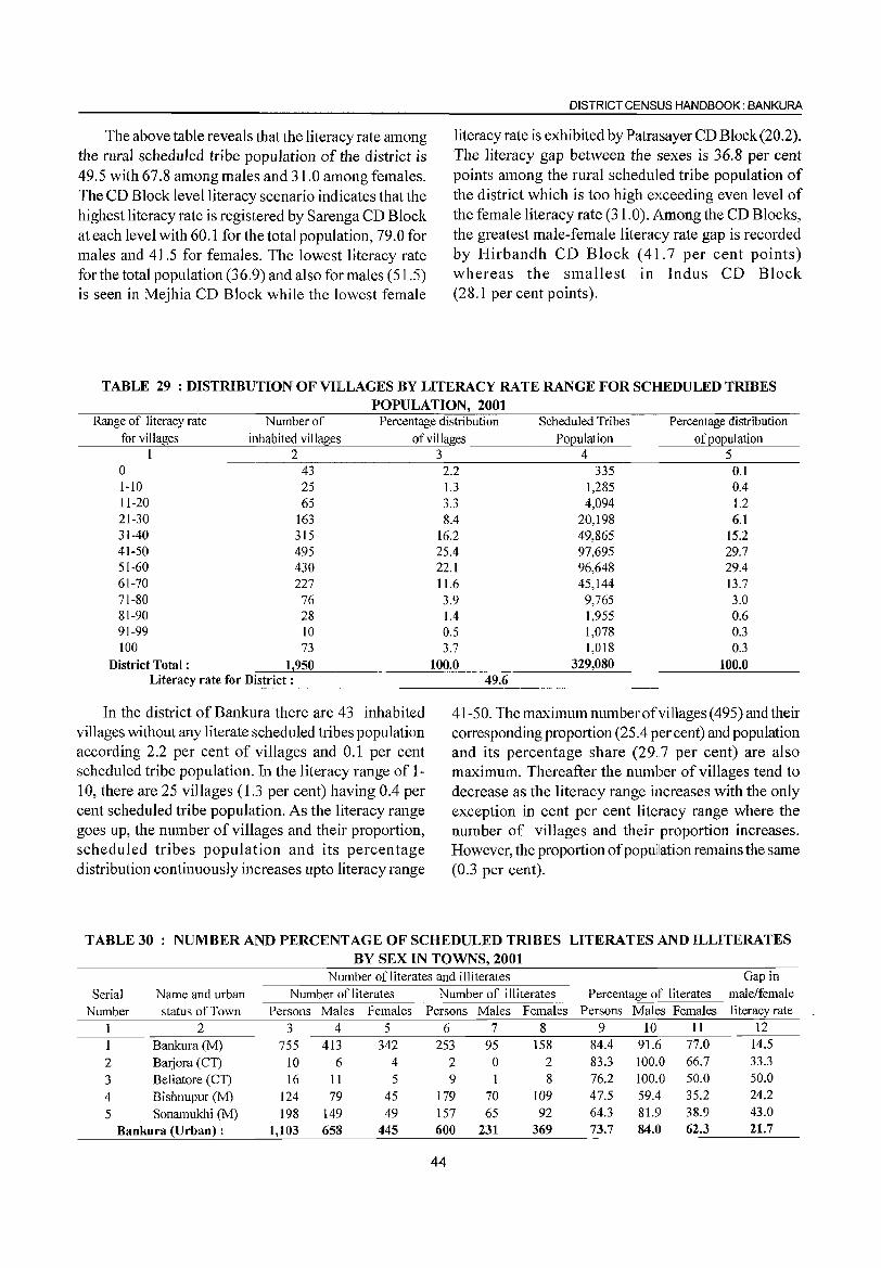
The above table reveals that the literacy rate among the rural scheduled tribe population of the district is 49.5 with 67.8 among males and 31.0 among females. The CD Block level literacy scenario indicates that the highest literacy rate is registered by Sarenga CD Block at each level with 60.1 for the total population, 79.0 for males and 41.5 for females. The lowest literacy rate for the total population (36.9) and also for males (51.5) is seen in Mejhia CD Block while the lowest female
DISTRICT CENSUS HANDBOOK: BANKURA
literacy rate is exhibited by Patrasayer CD Block (20.2). The literacy gap between the sexes is 36.8 per cent points among the rural scheduled tribe population of the district which is too high exceeding even level of the female literacy rate (31.0). Among the CD Blocks, the greatest male-female literacy rate gap is recorded by Hirbandh CD Block (41.7 per cent points) whereas the smallest in Indus CD Block (28.1 per cent points).
TABLE 29 : DISTRIBUTION OF VILLAGES BY LITERACY RATE RANGE FOR SCHEDULED TRIBES POPULATION,2001
Range of literacy rate Number of Percentage distribution Scheduled Tribes Percentage distribution for villages inhabited villages of villages Population of population
1 2 0 43 1-10 25 11-20 65 21-30 163 31-40 315 41-50 495 51-60 430 61-70 227 71-80 76 81-90 28 91-99 10 100 73
District Total: 1,950 Literacy rate for District :
In the district of Bankura there are 43 inhabited villages without any literate scheduled tribes population according 2.2 per cent of villages and 0.1 per cent scheduled tribe population. In the literacy range of 1-10, there are 25 villages (1.3 per cent) having 0.4 per cent scheduled tribe population. As the literacy range goes up, the number of villages and their proportion, scheduled tribes population and its percentage distribution continuously increases upto literacy range
3 4 5 2.2 335 0.1 1.3 1,285 0.4 3.3 4,094 1.2 8.4 20,198 6.1
16.2 49,865 15.2 25.4 97,695 29.7 22.1 96,648 29.4 11.6 45,144 13.7 3.9 9,765 3.0 1.4 1,955 0.6 0.5 1,078 0.3 3.7 1,018 0.3
100.0 329,080 100.0 49.6
41-50. The maximum number ofviHages (495) and their corresponding proportion (25.4 per cent) and population and its percentage share (29 .. 7 per cent) are also maximum. Thereafter the number of villages tend to decrease as the literacy range increases with the only exception in cent per cent literacy range where the number of villages and their proportion increases. However, the proportion of popullation remains the same (0.3 per cent).
TABLE 30 NUMBER AND PERCENTAGE OF SCHEDULED TRIBES LITERATES AND ILLITERATES BY SEX IN TOWNS, 2001
Number of literates and illiterates Gap in
Serial Name and urban Number of literates Number of illiterates Percentage of literates male/female
Number status of Town Persons Males Females Persons Males Females Persons Males Females literacy rate
2 3 4 5 6 7 8 9 10 11 12
1 Bankura (M) 755 413 342 253 95 158 84.4 91.6 77.0 14.5
2 Barjora (CT) 10 6 4 2 0 2 83.3 100.0 66.7 33.3
3 Beliatore (CT) 16 11 5 9 1 8 76.2 100.0 50.0 50.0
4 Bishnupur (M) 124 79 45 179 70 109 47.5 59.4 35.2 24.2
5 Sonamukhi (M) 198 149 49 157 65 92 64.3 81.9 38.9 43.0
Bankura (Urban) : 1,103 658 445 600 231 369 73.7 84.0 62.3 21.7
44
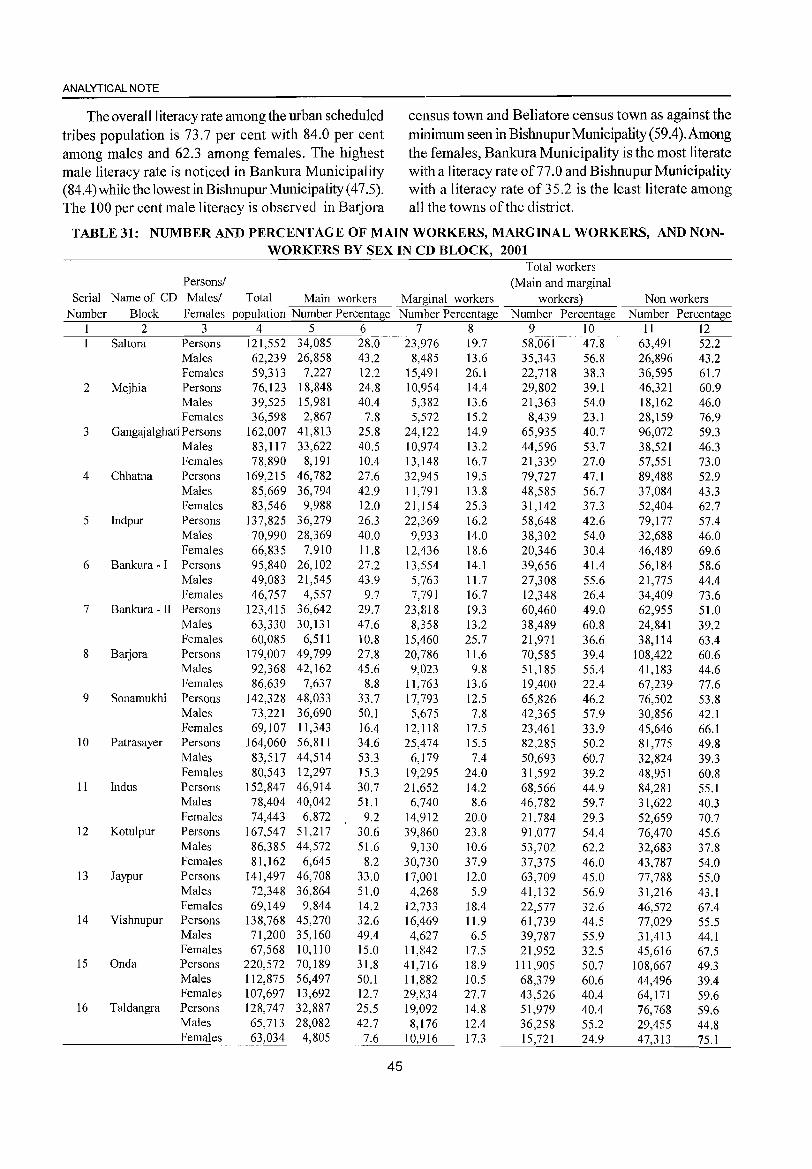
ANALYTICAL NOTE
The overall literacy rate among the urban scheduled census town and Beliatore census town as against the
tribes population is 73.7 per cent with 84.0 per cent minimum seen in Bishnupur Municipality (59.4). Among among males and 62.3 among females. The highest the females, Bankura Municipality is the most literate male literacy rate is noticed in Bankura Municipality with a literacy rate of 77 .0 and Bishnupur Municipality (84.4) while the lowest in Bishnupur Municipality (47.5). with a I iteracy rate of 35.2 is the least literate among The 100 per cent male literacy is observed in Barjora all the towns of the district.
TABLE 31: NUMBER AND PERCENTAGE OF MAIN WORKERS, MARGINAL WORKERS, AND NON-WORKERS BY SEX IN CD BLOCK, 2001
Total workers Persons/ (Main and marginal
Serial Name of CD Males/ Total Main workers Marginal workers workers) Non workers Number Block Females population Number Percentage Number Percentage Number Percentage Number Percentage
1 2 3 4 5 6 7 8 9 10 11 12 Sahora Persons 121,552 34,085 28.0 23,976 19.7 58,061 47.8 63,491 52.2
Males 62,239 26,858 43.2 8,485 13.6 35,343 56.8 26,896 43.2 Females 59,313 7,227 12.2 15,491 26.1 22,718 38.3 36,595 61.7
2 Mejhia Persons 76,123 18,848 24.8 10,954 14.4 29,802 39.1 46,321 60.9 Males 39,525 15,981 40.4 5,382 13.6 21,363 54.0 18,162 46.0 Females 36,598 2,867 7.8 5,572 15.2 8,439 23.1 28,159 76.9
3 Gangajalghati Persons 162,007 41,813 25.8 24,122 14.9 65,935 40.7 96,072 59.3 Males 83,117 33,622 40.5 10,974 13.2 44,596 53.7 38,521 46.3 Females 78,890 8,191 10.4 13,148 16.7 21,339 27.0 57,551 73.0
4 Chhatna Persons 169,215 46,782 27.6 32,945 19.5 79,727 47.1 89,488 52.9 Males 85,669 36,794 42.9 11,791 13.8 48,585 56.7 37,084 43.3 Females 83,546 9,988 12.0 21,154 25.3 31,142 37.3 52,404 62.7
5 Indpur Persons 137,825 36,279 26.3 22,369 16.2 58,648 42.6 79,177 57.4 Males 70,990 28,369 40.0 9,933 14.0 38,302 54.0 32,688 46.0 Females 66,835 7,910 11.8 12,436 18.6 20,346 30.4 46,489 69.6
6 Bankura - I Persons 95,840 26,102 27.2 13,554 14.1 39,656 41.4 56,184 58.6 Males 49,083 21,545 43.9 5,763 11.7 27,308 55.6 21,775 44.4 Females 46,757 4,557 9.7 7,791 16.7 12,348 26.4 34,409 73.6
7 Bankura - II Persons 123,415 36,642 29.7 23,818 19.3 60,460 49.0 62,955 51.0 Males 63,330 30,131 47.6 8,358 13.2 38,489 60.8 24,841 39.2 Females 60,085 6,511 10.8 15,460 25.7 21,971 36.6 38,114 63.4
8 Barjora Persons 179,007 49,799 27.8 20,786 11.6 70,585 39.4 108,422 60.6 Males 92,368 42,162 45.6 9,023 9.8 51,I 85 55.4 41,183 44.6 Females 86,639 7,637 8.8 11,763 13.6 19,400 22.4 67,239 77.6
9 Sonamukhi Persons 142,328 48,033 33.7 17,793 12.5 65,826 46.2 76,502 53.8 Males 73,221 36,690 50.1 5,675 7.8 42,365 57.9 30,856 42.1 Females 69,107 11,343 16.4 12,118 17.5 23,461 33.9 45,646 66.1
10 Patrasayer Persons 164,060 56,811 34.6 25,474 15.5 82,285 50.2 81,775 49.8 Males 83,517 44,514 53.3 6,179 7.4 50,693 60.7 32,824 39.3 Females 80,543 12,297 15.3 19,295 24.0 31,592 39.2 48,951 60.8
11 Indus Persons 152,847 46,914 30.7 21,652 14.2 68,566 44.9 84,281 55.1 Males 78,404 40,042 5I.1 6,740 8.6 46,782 59.7 31,622 40.3 Females 74,443 6,872 9.2 14,912 20.0 21,784 29.3 52,659 70.7
12 Kotulpur Persons 167,547 51,217 30.6 39,860 23.8 91,077 54.4 76,470 45.6 Males 86,385 44,572 51.6 9,130 10.6 53,702 62.2 32,683 37.8 Females 81,162 6,645 8.2 30,730 37.9 37,375 46.0 43,787 54.0
13 Jaypur Persons 141,497 46,708 33.0 17,001 12.0 63,709 45.0 77,788 55.0 Males 72,348 36,864 51.0 4,268 5.9 41,132 56.9 31,216 43.1 Females 69,149 9,844 14.2 12,733 18.4 22,577 32.6 46,572 67.4
14 Vishnupur Persons 138,768 45,270 32.6 16,4-69 11.9 61,739 44.5 77,029 55.5 Males 71,200 35,160 49.4 4,627 6.5 39,787 55.9 31,413 44.1 Females 67,568 10,110 15.0 11,842 17.5 21,952 32.5 45,616 67.5
15 Onda Persons 220,572 70,189 31.8 41,716 18.9 111,905 50.7 108,667 49.3 Males 112,875 56,497 50.1 11,882 10.5 68,379 60.6 44,496 39.4 Females 107,697 13,692 12.7 29,834 27.7 43,526 40.4 64,171 59.6
16 Taldangra Persons 128,747 32,887 25.5 19,092 14.8 51,979 40.4 76,768 59.6 Males 65,713 28,082 42.7 8,176 12.4 36,258 55.2 29,455 44.8 Females 63,034 4,805 7.6 10,916 17.3 15,721 24.9 47,313 75.1
45
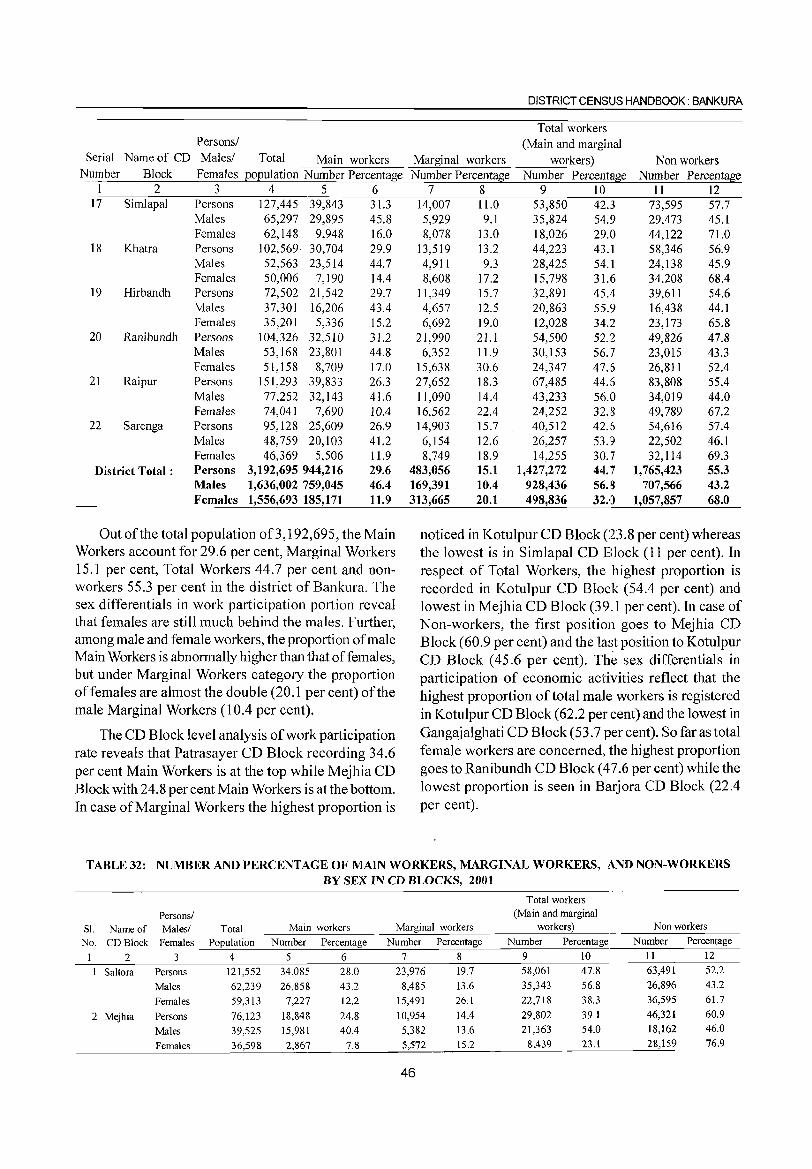
DISTRICT CENSUS HANDBOOK: BANKURA
Total workers Persons! (Main and marginal
Serial Name of CD Males! Total Main workers Marginal workers workers) Non workers Number Block Females population Number Percentage Number Percentage Number Percentage Number Percentage
1 2 3 4 5 6 17 Simlapal Persons 127,445 39,843 31.3
Males 65,297 29,895 45.8 Females 62,148 9,948 16.0
18 Khatra Persons 102,569 30,704 29.9 Males 52,563 23,514 44.7 Females 50,006 7,190 14.4
19 Hirbandh Persons 72,502 21,542 29.7 Males 37,301 16,206 43.4 Females 35,201 5,336 15.2
20 Ranibundh Persons 104,326 32,510 31.2 Males 53,168 23,801 44.8 Females 51,158 8,709 17.0
21 Raipur Persons 151,293 39,833 26.3 Males 77,252 32,143 41.6 Females 74,041 7,690 10.4
22 Sarenga Persons 95,128 25,609 26.9 Males 48,759 20,103 41.2 Females 46,369 5,506 11.9
District Total: Persons 3,192,695 944,216 29.6 Males 1,636,002 759,045 46.4 Females 1,556,693 185,171 11.9
Out of the total population of3, 192,695, the Main Workers account for 29.6 per cent, Marginal Workers 15.1 per cent, Total Workers 44.7 per cent and nonworkers 55.3 per cent in the district of Bankura. The sex differentials in work participation portion reveal that females are still much behind the males. Further, among male and female workers, the proportion of male Main Workers is abnormally higher than that of females, but under Marginal Workers category the proportion of females are almost the double (20.1 per cent) of the male Marginal Workers (l0.4 per cent).
The CD Block level analysis of work participation rate reveals that Patrasayer CD Block recording 34.6 per cent Main Workers is at the top while Mejhia CD Block with 24.8 per cent Main Workers is at the bottom. In case of Marginal Workers the highest proportion is
7 8 9 10 11 12 14,007 11.0 53,850 42.3 73,595 57.7 5,929 9.1 35,824 54.9 29,473 45.1 8,078 13.0 18,026 29.0 44,122 71.0
13,519 13.2 44,223 43.1 58,346 56.9 4,911 9.3 28,425 54.1 24,138 45.9 8,608 17.2 15,798 31.6 34,208 68.4
11,349 15.7 32,891 45.4 39,611 54.6 4,657 12.5 20,863 55.9 16,438 44.1 6,692 19.0 12,028 34.2 23,173 65.8
21,990 21.1 54,500 52.2 49,826 47.8 6,352 11.9 30,153 56.7 23,015 43.3
15,638 30.6 24,347 47.6 26,811 52.4 27,652 18.3 67,485 44.6 83,808 55.4 11,090 14.4 43,233 56.0 34,019 44.0 16,562 22.4 24,252 32.8 49,789 67.2 14,903 15.7 40,512 42.6 54,616 57.4 6,154 12.6 26,257 53.9 22,502 46.1 8,749 18.9 14,255 30.7 32,114 69.3
483,056 15.1 1,427,272 44.7 1,765,423 55.3 169,391 10.4 928,436 56.8 707,566 43.2 313,665 20.1 498,836 32.0 1,057,857 68.0
noticed in Kotulpur CD Block (23.8 per cent) whereas the lowest is in Simlapal CD Block (11 per cent). In respect of Total Workers, the highest proportion is recorded in Kotulpur CD Block (54.4 per cent) and lowest in Mejhia CD Block (39.1 per cent). In case of Non-workers, the first position goes to Mejhia CD Block (60.9 per cent) and the last position to Kotulpur CD Block (45.6 per cent). The sex differentials in participation of economic activities reflect that the highest proportion of total mal~, workers is registered in Kotulpur CD Block (62.2 per cent) and the lowest in Gangajalghati CD Block (53.7 per cent). So far as total female workers are concerned, the highest proportion goes to Ranibundh CD Block (47.6 per cent) while the lowest proportion is seen in Barjora CD Block (22.4 per cent).
TABLE 32: NUMBER AND PERCENTAGE OF MAIN WORKERS, MARGINAL WORKERS, AND NON-WORKERS BY SEX IN CD BLOCKS, 2001
Total workers
Persons/ (Main and marginal
SI. Name of Males/ Total Main workers Marginal workers workers) Nonworkers
No. CD Block Females Population Number Percentage Number Percentage Number Percentage Number Percentage
2 3 4 5 6 7 8 9 10 11 12
1 Saltora Persons 121,552 34,085 28.0 23,976 19.7 58,061 47.8 63,491 52.2
Males 62,239 26,858 43.2 8,485 13.6 35,343 56.8 26,896 43.2
Females 59,313 7,227 12.2 15,491 26.1 22,718 38.3 36,595 61.7
2 Mejhia Persons 76,123 18,848 24.8 10,954 14.4 29,802 39.1 46,321 60.9
Males 39,525 15,981 40.4 5,382 13.6 21,363 54.0 18,162 46.0
Females 36,598 2,867 7.8 5,572 15.2 8,439 23.1 28,159 76.9
46
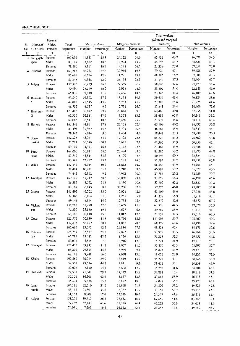
ANALYTICAL NOTE
Persons/ Sl. Name of Males/
No. CD Block Females
123
3 Gangajal- Persons ghati Males
Females
4 Chhatna Persons
5 Indpur
Males
Females
Persons
Males
Females
6 Bankura - Persons
I Males
Females
7 Bankura - Persons
II Males
Females
8 Barjora Persons
9 Sonamukhi
10 Patrasayer
11 Indus
12 Kotulpur
I3 Jaypur
14 Vishnupur
15 Onda
16 Taldangra
17 Simlapal
18 Khatra
19 Hirbandh
20 Ranibundh
21 Raipur
Males
Females
Persons
Males
Females
Persons
Males
Females
Persons
Males
Females
Persons
Males
Females
Persons
Males
Females
Persons
Males
Females
Persons
Males
Females
Persons
Males
Females
Persons
Males
Females
Persons
Males
Females
Persons
Males
Females
Persons
Males Females
Persons
Males
Females
Total Population
4
162,007
83,117
78,890
169,215
85,669
83,546
137,825
70,990
66,835
95,840
49,083
46,757
123,415
63,330
60,085
161,841
83,494
78,347
142,328
73,221
69,107
164,060
83,517
80,543
152,847
78,404
74,443
167,547
86,385
81,162
141,497
72,348
69,149
138,768
71,200
67,568
220,572
112,875
107,697
128,747
65,713
63,034
127,445
65,297
62,148
102,569
52,563
50,006 72,502
37,301
35,201
104,326
53,168
51,158
151,293
77,252
74,041
Main workers
Number
5 41,813
33,622
8,191
46,782
36,794
9,988
36,279
28,369
7,910
26,102
21,545
4,557
36,642
30,131
6,511
44,971
37,957
7,014
48,033
36,690
11,343
56,811
44,514
12,297
46,914
40,042
6,872
51,217
44,572
6,645
46,708
36,864
9,844
45,270
35,160
10,110
70,189
56,497
13,692
32,887
28,082
4,805
39,843
29,895
9,948
30,704
23,514
7,190 21,542
16,206
5,336
32,510
23,801
8,709
39,833
32,143
7,690
Percentage
6 25.8
40.5
10.4
27.6
42.9
12.0
26.3
40.0
11.8
27.2
43.9
9.7
29.7
47.6
10.8
27.8
45.5
9.0
33.7
50.1
16.4
34.6
53.3
15.3
30.7
5l.l
9.2
30.6
51.6
8.2
33.0
51.0
14.2
32.6
49.4
15.0
31.8
50.1
12.7
25.5
42.7
7.6
31.3
45.8
16.0
29.9
44.7
14.4
29.7
43.4
15.2
31.2
44.8
17.0
26.3
41.6
10.4
Marginal workers
Number Percentage
7 8
24,122 14.9
10,974 13.2
13,]48 16.7
32,945 19.5
11,791 13.8
21,154
22,369
9,933
12,436
13,554
5,763
7,791
23,818
8,358
15,460
20,138
8,704
11,434
17,793
5,675
12,118
25,474
6,179
19,295
21,652
6,740
14,912
39,860
9,130
30,730
17,001
4,268
12,733
16,469
4,627
11,842
41,716
11,882
29,834
19,092
8,176
10,916
14,007
5,929
8,078
13,519
4,911
8,608 11,349
4,657
6,692
21,990
6,352
15,638
27,652
11,090
16,562
47
25.3
16.2
14.0
18.6
14.1
II.7 16.7
19.3
13.2
25.7
12.4
10.4
14.6
12.5
7.8
17.5
15.5
7.4
24.0
14.2
8.6
20.0
23.8
10.6
37.9
12.0
5.9
18.4
11.9
6.5
17.5
18.9
10.5
27.7
14.8
12.4
17.3
11.0
9.1
13.0
13.2
9.3
17.2
15.7
12.5
19.0
2l.l
11.9
30.6
18.3
14.4
22.4
Total workers (Main and marginal
workers)
Number Percentage
9 10
65,935 40.7
44,596 53.7
21,339 27.0
79,727 47.1
48,585 56.7
31,142
58,648
38,302
20,346
39,656
27,308
12,348
60,460
38,489
21,971
65,109
46,661
18,448
65,826
42,365
23,461
82,285
50,693
31,592
68,566
46,782
21,784
91,077
53,702
37,375
63,709
41,132
22,577
61,739
39,787
21,952
111,905
68,379
43,526
51,979
36,258
15,721
53,850
35,824
18,026
44,223
28,425
15,798
32,891
20,863
12,028
54,500
30,153
24,347
67,485
43,233
24,252
37.3
42.6
54.0
30.4
41.4
55.6
26.4
49.0
60.8
36.6
40.2
55.9
23.5
46.2
57.9
33.9
50.2
60.7
39.2
44.9
59.7
29.3
54.4
62.2
46.0
45.0
56.9
32.6
44.5
55.9
32.5
50.7
60.6
40.4
40.4
55.2
24.9
42.3
54.9
29.0
43.1
54.1
31.6 45.4
55.9
34.2
52.2
56.7
47.6
44.6
56.0
32.8
Nonworkers
Number Percentage
II 12
96,072 59.3
38,521 46.3
57,551 73.0
89,488 52.9
37,084 43.3
52,404
79,177
32,688
46,489
56,184
21,775
34,409
62,955
24,841
38,114
96,732
36,833
59,899
76,502
30,856
45,646
81,775
32,824
48,951
84,281
31,622
52,659
76,470
32,683
43,787
77,788
31,216
46,572
77,029
31,413
45,616
108,667
44,496
64,171
76,768
29,455
47,313
73,595
29,473
44,122
58,346
24,138
34,208
39,611
16,438
23,173
49,826
23,015
26,811
83,808
34,019
49,789
62.7
57.4
46.0
69.6
58.6
44.4 73.6
51.0
39.2
63.4
59.8
44.1
76.5
53.8
42.1
66.1
49.8
39.3
60.8
55.1
40.3
70.7
45.6
37.8
54.0
55.0
43.1
67.4
55.5 44.1
67.5
49.3
39.4
59.6
59.6
44.8
75.1
57.7
45.1
71.0
56.9
45.9
68.4 54.6
44.1
65.8
47.8
43.3
52.4
55.4
44.0
67.2
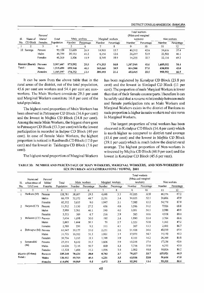
DISTRICT CENSLJS HANDBOOK: BANKURA
Total workers Persons/ (Main and marginal
SI. Name of Males! Total Main workers Marginal workers workers) Non workers No. CD Block Females Population Number Percentage Number Percentage Number Percentage Number Percentage
2 3 4 5 6 7 8 9 10 11 12 22 Sarenga Persons 95,128 25,609 26.9 14,903 15.7 40,512 42.6 54,616 57.4
Males 48,759 20,103 41.2 6,154 12.6 26,257 53.9 22,502 46.1 Females 46,369 5,506 11.9 8,749 18.9 14,255 30.7 32,114 69.3
District (Rural) Pel'sons 2,957,447 873,592 29.5 474,353 16.0 1,347,945 45.6 1,609,502 54.4 Total: Males 1,515,450 699,340 46.1 165,160 10.9 864,500 57.0 650,950 43.0
Females 1,44],997 174,252 12.1 309,193 21.4 483,445 33.5 958,552 66.5
It can be seen from the above table that in the rural areas of the district, out of the total population, 45.6 per cent are workers and 54.4 per cent are nonworkers. The Main Workers constitute 29.5 per cent and Marginal Workers constitute 16.0 per cent of the total population.
The highest rural proportion of Main Workers has been observed in Patrasayer CD Block (34.6 per cent) and the lowest in Mejhia CD Block (24.8 per cent). Among the male Main Workers, the biggest share goes to PatrasayerCD Block (53.3 per cent) while the lowest participation is recorded in Indpur CD Block (40 per cent). In case of female Main Workers, the highest proportion is noticed in Ranibundh CD Block (17.0 per cent) and the lowest in Taldangra CD Block (7.6 per cent).
The highest rural proportion of Marginal Workers
has been registered by Kotulpur CD Block (23.8 per cent) and the lowest in Simlapal CD Block (11 per cent). The proportion of male Marginal Workers is lower than that of their female counterparts. Therefore it can be safely said that a reverse relationship between male and female participation rate as Main Workers and Marginal Workers exists in the district of Bankura as male proportion is higher in main workers and vice versa in Marginal Workers.
The largest proportion of total workers has been observed in Kotulpur CD Block (54.4 per cent) which is much higher as compared to district rural average (45.6 per cent) and the lowest in Mejhia CD Block (39.1 per cent) which is much below the district rural average. The highest proportion of Non-workers is witnessed by Mejhia CD Block (60.9 per cent) and the lowest in Kotulpur CD Block (45.6 per cent).
TABLE 33: NUMBER AND PERCENTAGE OF MAIN WORKERS, MARGINAL WORKERS, AND NON-WORKERS BY SEX IN URBAN AGGLOMERATIONS I TOWNS, 2001
Total workers
Name and Personsl (Main and marginal
SI. urban status of Malesl Total Main workers Marginal workers workers) Non workers
No. UAffown Females Population Number Percentage Number Percentage Number Percentage Number Percentage
1 2 3 4 5 6 7 8 9 10 11 12
1 Bankura(M) Persons 128,781 38,007 29.5 4,198 3.3 42,205 32.8 86,576 67.2
Males 66,429 32,372 48.7 2,251 3.4 34,623 52.1 31,806 47.9
Females 62,352 5,635 9.0 1,947 3.1 7,582 12.2 54,770 87.8
2 Barjora (CT) Persons 11,512 3,130 27.2 456 4.0 3,586 31.2 7,926 68.8
Males 5,989 2,761 46.1 240 4.0 3,001 50.1 2,988 49.9
Females 5,523 369 6.7 216 3.9 585 10.6 4,938 89.4
3 Beliatore (CT) Persons 5,654 1,698 30.0 192 3.4 1,890 33.4 3,764 66.6
Males 2,885 1,444 50.1 79 2.7 1,523 52.8 1,362 47.2
Females 2,769 254 9.2 113 4.1 367 13.3 2,402 86.7
4 Bishnupur (M) Persons 61,947 19,177 31.0 2,251 3.6 21,428 34.6 40,519 65.4
Males 31,223 16,012 51.3 1,061 3.4 17,073 54.7 14,150 45.3
Females 30,724 3,165 10.3 1,190 3.9 4,355 14.2 26,369 85.8
5 Sonamukhi Persons 27,354 8,612 31.5 1,606 5.9 10,218 37.4 17,136 62.6 (M) Males 14,026 7,116 50.7 600 4.3 7,716 55.0 6,310 45.0
Females 13,328 1,496 11.2 1,006 7.5 2,502 18.8 10,826 81.2
District (Urban) Persons 235,248 70,624 30.0 8,103 3.7 79,321 33.7 155,921 66.3
Total: Males 120,552 59,705 49.5 4,231 3.5 63,936 53.0 56,616 47.0
Females 114,696 10,919 9.5 4,472 3.9 15,391 13.4 99,305 86.6
48
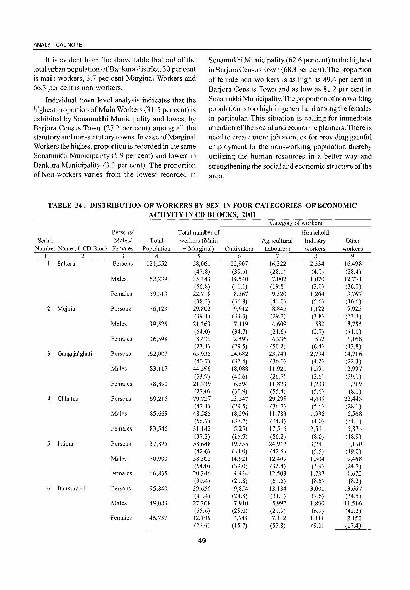
ANALYTICAL NOTE
It is evident from the above table that out of the total urban population of Bankura district, 30 per cent is main workers, 3.7 per cent Marginal Workers and 66.3 per cent is non-workers.
Individual town level analysis indicates that the highest proportion of Main Workers (31.5 per cent) is exhibited by Sonamukhi Municipality and lowest by Barjora Census Town (27.2 per cent) among all the statutory and non-statutory towns. In case of Marginal Workers the highest proportion is recorded in the same Sonamukhi Municipality (5.9 per cent) and lowest in Bankura Municipality (3.3 per cent). The proportion of Non-workers varies from the lowest recorded in
Sonamukhi Municipality (62.6 per cent) to the highest in J3arjora Census Town (68.8 per cent). The proportion of female non-workers is as high as 89.4 per cent in Barjora Census Town and as low as 81.2 per cent in Sonamukhi Municipality. The proportion of non working population is too high in general and among the females in particular. This situation is calling for immediate attention of the social and economic planners. There is need to create more job avenues for providing gainful employment to the non-working population thereby utilizing the human resources in a better way and strengthening the social and economic structure of the area.
TABLE 34: DISTRIBUTION OF WORKERS BY SEX IN FOUR CATEGORIES OF ECONOMIC ACTIVITY IN CD BLOCKS, 2001
Category of workers
Persons/ Total number of Household Serial Males/ Total workers (Main Agricultural Industry Other
Number Name of CD Block Females Population + Marginal) Cultivators Labourers workers workers 1 2 3 4 5 6 7 8 9
1 Saltora Persons 121,552 58,061 22,907 16,322 2,334 16,498 (47.8) (39.5) (28.1) (4.0) (28.4)
Males 62,239 35,343 14,540 7,002 1,070 12,731 (56.8) (41.1) (19.8) (3.0) (36.0)
Females 59,313 22,718 8,367 9,320 1,264 3,767 (38.3) (36.8) (41.0) (5.6) ( 16.6)
2 Mejhia Persons 76,123 29,802 9,912 8,845 1,122 9,923 (39.1) (33.3) (29.7) (3.8) (33.3)
Males 39,525 21,363 7,419 4,609 580 8,755 (54.0) (34.7) (21.6) (2.7) (41.0)
Females 36,598 8,439 2,493 4,236 542 1,168 (23.1) (29.5) (50.2) (6.4) (13.8)
3 Gangajalghati Persons 162,007 65,935 24,682 23,743 2,794 14,716 (40.7) (37.4) (36.0) (4.2) (22.3)
Males 83,117 44,596 18,088 11,920 1,591 12,997 (53.7) (40.6) (26.7) (3.6) (29.1)
Females 78,890 21,339 6,594 11,823 1,203 1,719 (27.0) (30.9) (55.4) (5.6) (8.1)
4 Chhatna Persons 169,215 79,727 23,547 29,298 4,439 22,443 (47.1) (29.5) (36.7) (5.6) (28.1 )
Males 85,669 48,585 18,296 11,783 1,938 16,568 (56.7) (37.7) (24.3) (4.0) (34.1 )
Females 83,546 31,142 5,251 17,515 2,501 5,875 (37.3) (16.9) (56.2) (8.0) (18.9)
5 Jndpur Persons 137,825 58,648 19,355 24,912 3,241 11,140 (42.6) (33.0) (42.5) (5.5) (19.0)
Males 70,990 38,302 14,921 12,409 1,504 9,468 (54.0) (39.0) (32.4) (3.9) (24.7)
Females 66,835 20,346 4,434 12,503 1,737 1,672 (30.4) (21.8) (61.5) (8.5) (8.2)
6 Bankura - I Persons 95,840 39,656 9,854 13,134 3,001 13,667 ( 41.4) (24.8) (33.1) (7.6) (34.S)
Males 49,083 27,308 7,910 5,992 1,890 11,516 (55.6) (29.0) (21.9) (6.9) (42.2)
Females 46,757 12,348 1,944 7,142 I, III 2,151 (26.4) (15.7) (57.8) (9.0) (17.4)
49
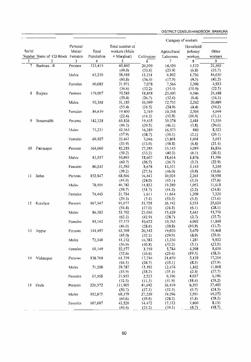
DISTRICT CENSUS HANDBOOK: BANKURA
Category of workers
Personsl Total number of Household Serial Malesl Total workers (Main Agricultural Industry Other
Number Name of CD Block Females Population + Marginal) Cultivators Labourers workers workers 1 2 3 4 5 6 7 8 9
7 Bankura - II Persons 123,415 60,460 20,309 14,456 4,132 21,563 (49.0) (33.6) (23.9) (6.8) (35.7)
Males 63,330 38,489 13,231 6,892 1,736 16,630 (60.8) (34.4) (17.9) (4.5) (43.2)
Females 60,085 21,971 7,078 7,564 2,396 4,933 (36.6) (32.2) (34.4) (10.9) (22.5)
8 Barjora Persons 179,007 70,585 18,848 23,003 4,546 24,188 (39.4) (26.7) (32.6) (6.4) (34.3)
Males 92,368 51,185 16,099 12,755 2,242 20,089 (55.4) (31.5) (24.9) (4.4) (39.2)
Females 86,639 19,400 2,749 10,248 2,304 4,099 (22.4) (14.2) (52.8) ( 11.9) (21.1)
9 Sonamukhi Persons 142,328 65,826 19,435 30,374 2,481 l3,536 ( 46.2) (29.5) (46.1) (3.8) (20.6)
Males 73,221 42,365 16,389 16,573 880 8,523 (57.9) (38.7) (39.1) (2.1) (20.1)
Females 69,107 23,461 3,046 13,801 1,601 5,013 (33.9) (13.0) (58.8) (6.8) (21.4)
10 Patrasayer Persons 164,060 82,285 27,285 33,145 5,019 16,836 (50.2) (33.2) (40.3) (6.1) (20.5)
Males 83,517 50,693 18,607 18,614 1,876 11,596 (60.7) (36.7) (36.7) (3.7) (22.9)
Females 80,543 31,592 8,678 14,531 3,143 5,240 (39.2) (27.5) (46.0) (9.9) (16.6)
II Indus Persons 152,847 68,566 16,443 30,924 2,261 18,938 (44.9) (24.0) (45.1 ) (3.3) (27.6)
Males 78,404 46,782 14,832 19,280 1,052 11,618 (59.7) (31. 7) ( 41.2) (2.2) (24.8)
Females 74,443 21,784 1,611 11,644 1,209 7,320 (29.3) (7.4) (53.5) (5.5) (33.6)
12 Kotulpur Persons 167,547 91,077 33,728 26,192 5,533 25,624 (54.4) (37.0) (28.8) (6.1) (28.1 )
Males 86,385 53,702 23,056 15,429 1,441 13,776 (62.2) (42.9) (28.7) (2.7) (25.7)
Females 81,162 37,375 10,672 10,763 4,092 11,848 (46.0) (28.6) (28.8) (10.9) (31.7)
13 Jaypur Persons 141,497 63,709 20,542 19,020 5,679 18,468 (45.0) (32.2) (29.9) (8.9) (29.0)
Males 72,348 41,132 16,783 13,236 1,281 9,832 (56.9) (40.8) (32.2) (3.1) (23.9)
Females 69,149 22,577 3,759 5,784 4,398 8,636 (32.6) (16.6) (25.6) (19.5) (38.3)
14 Vishnupur Persons 138,768 61,739 17,716 21,670 5,139 17,214 (44.5) (28.7) (35.1) (8.3) (27.9)
Males 71,200 39,787 15,193 12,474 1,102 11,018 (55.9) (38.2) (31.4) (2.8) (27.7)
Females 67,568 21,952 2,523 9,196 4,037 6,196 (32.5) (11.5) ( 41.9) (18.4) (28.2)
15 Onda Persons 220,572 111,905 41,692 36,419 6,391 27,403 (50.7) (37.3) (32.5) (5.7) (24.5)
Males 112,875 68,379 27,220 19,296 2,591 19,272 (60.6) (39.8) (28.2) (3.8) (28.2)
Females 107,697 43.526 14,472 17,123 3,800 8,131 (40.4) (33.2) (39.3) (8.7) (18.7)
50
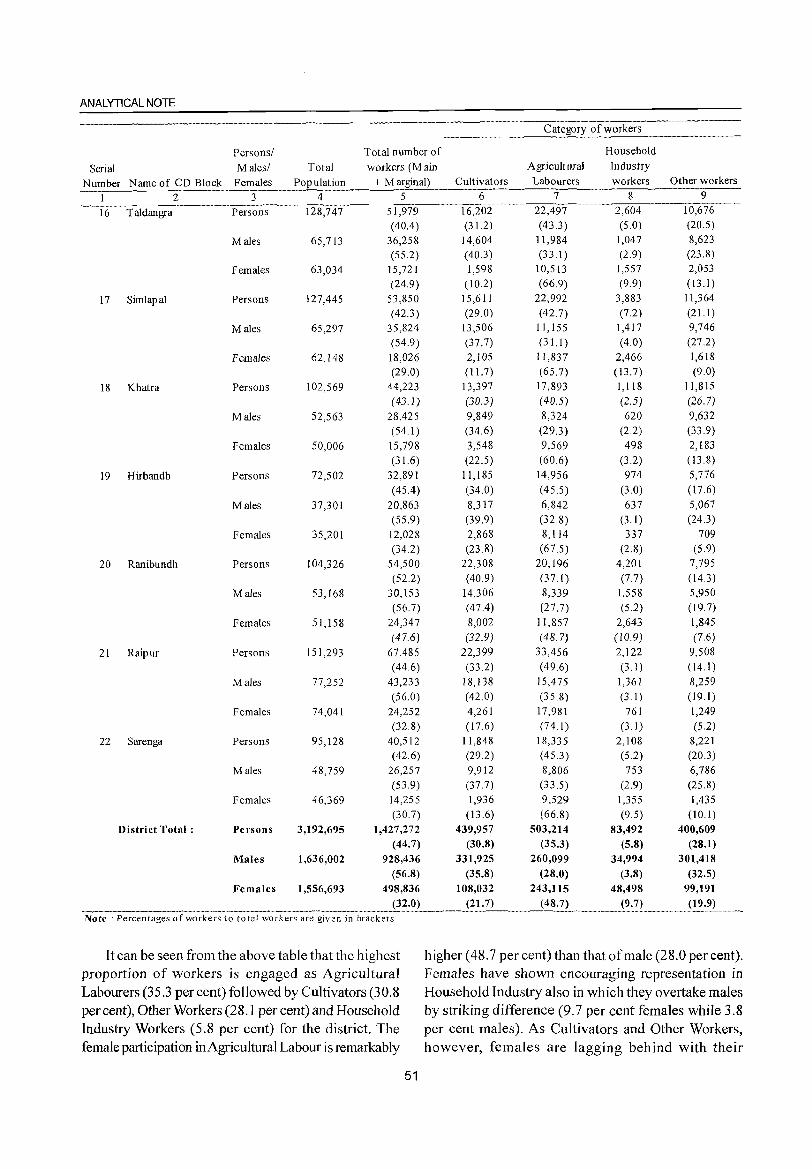
ANALYTICAL NOTE
Persons/ Total number of Household
Serial Males! Total workers (M ain Agricultural Industry
Number Name of CD Block Females Population + Marginal) Cultivators Labourers workers Other workers
1 2 3 4 5 6 7 8 9
16 Taldangra Persons 128,747 51,979 16,202 22,497 2,604 10,676
(40.4) (31.2) (43.3) (5.0) (20.5)
Males 65,713 36,258 14,604 11,984 1,047 8,623
(55.2) (40.3) (33.1 ) (2.9) (23.8)
Females 63,034 15,721 1,598 10,513 1,557 2,053
(24.9) (10.2) (66.9) (9.9) (13.1)
17 Simlapal Persons 127,445 53,850 15,611 22,992 3,883 11,364
(42.3) (29.0) (42.7) (7.2) (21.1)
Males 65,297 35,824 13,506 11,155 1,417 9,746
(54.9) (37.7) (3 1.1) (4.0) (27.2)
Females 62,148 18,026 2,105 11,837 2,466 1,618
(29.0) (11. 7) (65.7) ( 13.7) (9.0)
18 Khatra Persons 102,569 44,223 13,397 17,893 1,118 11,815 (43.1) (30.3) (40.5) (2.5) (26.7)
Males 52,563 28,425 9,849 8,324 620 9,632 (54.1) (34.6) (29.3) (22) (33.9)
Females 50,006 15,798 3,548 9,569 498 2,183
(31.6) (22.5) (60.6) (3.2) (13.8)
19 Hirbandh Persons 72,502 32,891 11,185 14,956 974 5,776
(45.4) (34.0) (45.5) (3.0) (17.6)
Males 37,301 20,863 8,317 6,842 637 5,067
(55.9) (39.9) (32.8) (3.1 ) (24.3)
Females 35,201 12,028 2,868 8,114 337 709 (34.2) (23.8) (67.5) (2.8) (5.9)
20 Ranibundh Persons 104,326 54,500 22,308 20,196 4,201 7,795 (52.2) (40.9) (37 1) (7.7) (14.3)
Males 53,168 30,153 14,306 8,339 1,558 5,950 (56.7) (47.4) (27.7) (5.2) (19.7)
Females 51,158 24,347 8,002 11,857 2,643 1,845
(47.6) (32.9) (48.7) (10.9) (7.6)
21 Raipur Persons 151,293 67,485 22,399 33,456 2,122 9,508 (44.6) (33.2) (496) (3 I) (14.1)
Males 77,252 43,233 18,138 15,475 1,361 8,259 (56.0) (42.0) (35.8) (3.1 ) (19.1)
Females 74,041 24,252 4,261 17,981 761 1,249 (32.8) (17.6) (74 I) (3.1 ) (5.2)
22 Sarenga Persons 95,128 40,512 11,848 18,335 2,108 8,221 (42.6) (29.2) (45.3) (5.2) (20.3)
Males 48,759 26,257 9,912 8,806 753 6,786 (53.9) (37.7) (33.5) (2.9) (25.8)
Females 46,369 14,255 1,936 9,529 1,355 1,435 (30.7) (13.6) (668) (9.5) (IO.1)
District Total: Persons 3,192,695 1,427,272 439,957 503,214 83,492 400,609 (44.7) (30.8) (35.3) (5.8) (28.1)
Males 1,636,002 928,436 331,925 260,099 34,994 301,418 (56.8) (35.8) (28.0) (3.8) (32.5)
Females 1,556,693 498,836 108,032 243,115 48,498 99,191
._" .. ________ ._2.~?2"_ .. _____ __j_~_:2L ___ J~~:_7_L_ .. _"_". __ " (9:7) (19.9) Note : Percentages of workers to total workers are given in brackets
It can be seen from the above table that the highest higher (48.7 per cent) than that of male (28.0 per cent). proportion of workers is engaged as Agricultural FemaJes have shown encouraging representation in Labourers (35.3 per cent) followed by Cultivators (30.8 Household Industry also in which they overtake males per cent), Other Workers (28.1 per cent) and Household by striking difference (9.7 per cent females while 3.8 Industry Workers (5.8 per cent) for the district. The per cent males). As Cultivators and Other Workers, female participation inAgricultural Labour is remarkably however, females are lagging behind with their
51
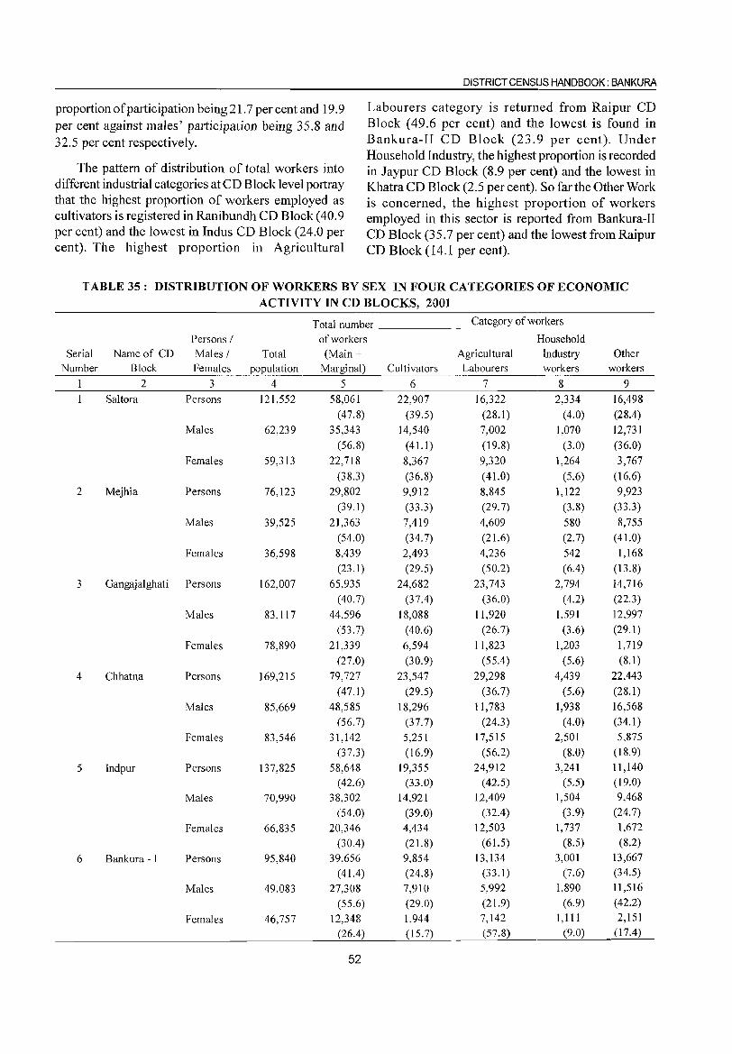
DISTRICT CENSUS HANDBOOK: BANKURA
proportion of participation being 21.7 per cent and 19.9 Labourers category is returned from Raipur CD per cent against males' participation being 35.8 and Block (49.6 per cent) and the lowest is found in
32.5 per cent respectively. Bankura-II CD Block (23.9 per cent). Under Household Industry, the highest proportion is recorded
The pattern of distribution of total workers into in Jaypur CD Block (8.9 per cent) and the lowest in different industrial categories at CD Block level portray Khatra CD Block (2.5 per cent). So far the Other Work that the highest proportion of workers employed as is concerned, the highest proportion of workers cultivators is registered in Ranibundh CD Block (40.9 employed in this sector is reported from Bankura-II per cent) and the lowest in Indus CD Block (24.0 per CD Block (35.7 per cent) and the lowest from Raipur cent). The highest proportion III Agricultural CD Block (14.1 per cent).
TABLE 35: DISTRIBUTION OF WORKERS BY SEX IN FOUR CATEGORIES OF ECONOMIC ACTIVITY IN CD BLOCKS, 2001
Total number Category of workers
Persons I of workers Household Serial Name of CD Males I Total (Main + Agri cuI tural Industry Other
Number Block Females population Marginal) Cultivators Labourers workers workers
2 3 4 5 6 7 8 9 Saltora Persons 121,552 58,061 22,907 16,322 2,334 16,498
(47.8) (39.5) (28.1 ) (4.0) (28.4) Males 62,239 35,343 14,540 7,002 1,070 12,731
(56.8) (41.1) (19.8) (3.0) (36.0)
Females 59,313 22,718 8,367 9,320 1,264 3,767
(38.3) (36.8) (41.0) (5.6) (16.6)
2 Mejhia Persons 76,123 29,802 9,912 8,845 1,122 9,923
(39.1) (33.3) (29.7) (3.8) (33.3)
Males 39,525 21,363 7,419 4,609 580 8,755
(54.0) (34.7) (21.6) (2.7) (4l.0)
Females 36,598 8,439 2,493 4,236 542 1,168
(23.1) (29.5) (50.2) (6.4) (13.8)
3 Gangajalghati Persons 162,007 65,935 24,682 23,743 2,794 14,716
(40.7) (37.4) (36.0) (4.2) (22.3)
Males 83,117 44,596 18,088 11,920 1,591 12,997
(53.7) (40.6) (26.7) (3.6) (29.1 )
Females 78,890 21,339 6,594 11,823 1,203 1,719
(27.0) (30.9) (55.4) (5.6) (8.1)
4 Chhatna Persons 169,215 79,727 23,547 29,298 4,439 22,443
(47.1) (29.5) (36.7) (5.6) (28.1)
Males 85,669 48,585 18,296 11,783 1,938 16,568
(56.7) (37.7) (24.3) (4.0) (34.1 )
Females 83,546 31,142 5,251 17,515 2,501 5,875
(37.3) (16.9) (56.2) (8.0) (18.9)
5 Indpur Persons 137,825 58,648 19,355 24,912 3,241 11,140
(42.6) (33.0) (42.5) (5.5) (19.0)
Males 70,990 38,302 14,921 12,409 1,504 9,468
(54.0) (39.0) (32.4) (3.9) (24.7)
Females 66,835 20,346 4,434 12,503 1,737 1,672
(30.4) (21. 8) (61.5) (8.5) (8.2)
6 Bankura - [ Persons 95,840 39,656 9,854 13,134 3,001 13,667
(4l.4) (24.8) (33.1) (7.6) (34.5)
Males 49,083 27,308 7,910 5,992 1,890 11 ,516
(55.6) (29.0) (2l.9) (6.9) (42.2)
Females 46,757 12,348 1,944 7,142 1,111 2,151
(26.4) (15.7) (57.8) (9.0) (17.4)
52
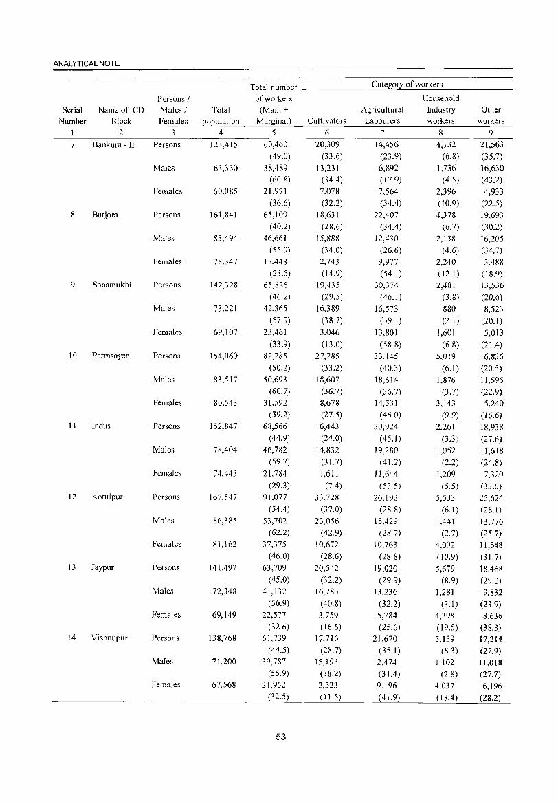
ANALYTICAL NOTE
Total number Category of workers
Persons I of workers Household
Serial Name of CD Males I Total (Main + Agricultural Industry Other Number Block Females population Marginal) Cultivators Labourers workers workers
1 2 3 4 5 6 7 8 9
7 Bankura -II Persons 123,415 60,460 20,309 14,456 4,132 21,563 (49.0) (33.6) (23.9) (6.8) (35.7)
Males 63,330 38,489 13,231 6,892 1,736 16,630 (60.8) (34.4) (17.9) (4.5) (43.2)
Females 60,085 21,971 7,078 7,564 2,396 4,933 (36.6) (32.2) (34.4) (10.9) (22.5)
8 Barjora Persons 161,841 65,109 18,631 22,407 4,378 19,693 (40.2) (28.6) (34.4) (6.7) (30.2)
Males 83,494 46,661 15,888 12,430 2,138 16,205 (55.9) (34.0) (26.6) (4.6) (34.7)
Females 78,347 18,448 2,743 9,977 2,240 3,488 (23.5) (14.9) (54.1) (12.1 ) (18.9)
9 Sonamukhi Persons 142,328 65,826 19,435 30,374 2,481 13,536 (46.2) (29.5) (46.1) (3.8) (20.6)
Males 73,221 42,365 16,389 16,573 880 8,523 (57.9) (38.7) (39.1) (2.1) (20.1)
Females 69,107 23,461 3,046 13,801 1,601 5,013 (33.9) (13.0) (58.8) (6.8) (21.4)
IO Patrasayer Persons 164,060 82,285 27,285 33,145 5,019 16,836 (50.2) (33.2) (40.3) (6.1) (20.5)
Males 83,517 50,693 18,607 18,614 1,876 11,596 (60.7) (36.7) (36.7) (3.7) (22.9)
Females 80,543 31,592 8,678 14,531 3,143 5,240 (39.2) (27.5) (46.0) (9.9) (16.6)
11 Indus Persons 152,847 68,566 16,443 30,924 2,261 18,938 (44.9) (24.0) ( 45.1) (3.3) (27.6)
Males 78,404 46,782 14,832 19,280 1,052 11,618 (59.7) (31.7) ( 41.2) (2.2) (24.8)
Females 74,443 21,784 1,611 11,644 1,209 7,320 (29.3) (7.4) (53.5) (5.5) (33.6)
12 Kotulpur Persons 167,547 91,077 33,728 26,192 5,533 25,624 (54.4) (37.0) (28.8) (6.1) (28.1)
Males 86,385 53,702 23,056 15,429 1,441 13,776 (62.2) (42.9) (28.7) (2.7) (25.7)
Females 81,162 37,375 10,672 10,763 4,092 11,848 (46.0) (28.6) (28.8) (10.9) (31. 7)
13 Jaypur Persons 141,497 63,709 20,542 19,020 5,679 18,468 (45.0) (32.2) (29.9) (8.9) (29.0)
Males 72,348 41,132 16,783 13,236 1,281 9,832 (56.9) (40.8) (32.2) (3.1) (23.9)
Females 69,149 22,577 3,759 5,784 4,398 8,636 (32.6) ( 16.6) (25.6) (19.5) (38.3)
14 Vishnupur Persons 138,768 61,739 17,716 21,670 5,139 17,214 (44.5) (28.7) (35.1) (8.3) (27.9)
Males 71,200 39,787 15,193 12,474 1,102 11,018 (55.9) (38.2) (31.4) (2.8) (27. 7)
Females 67,568 21,952 2,523 9,196 4,037 6,196 (32.5) ( 11.5) ( 41.9) (18.4) (28.2)
53
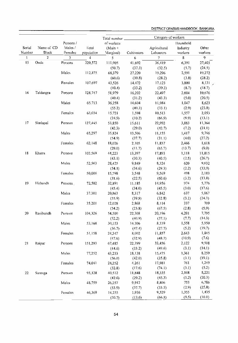
DISTRICT CENSUS HANDBOOK: BANKURA
Total number Category of workers
Persons / of workers Household Serial Name of CD Males / Total (Main + Agricultural Industry Other
Number Block Females population Marginal) Cultivators Labourers workers workers
1 2 3 4 5 6 7 8 9 IS Onda Persons 220,572 111,905 41,692 36,419 6,391 27,403
(50.7) (37.3) (32.5) (5.7) (24.5)
Males 112,875 68,379 27,220 19,296 2,591 19,272
(60.6) (39.8) (28.2) (3.8) (28.2)
Females 107,697 43,526 14,472 17,123 3,800 8,131 /
(40.4) (33.2) (39.3) (8.7) (18.7)
16 Taldangra Persons 128,747 51,979 16,202 22,497 2,604 10,676
(40.4) (31.2) ( 43.3) (5.0) (20.5)
Males 65,713 36,258 14,604 11,984 1,047 8,623
(55.2) (40.3) (33.1 ) (2.9) (23.8)
Females 63,034 15,721 1,598 10,513 1,557 2,053
(24.9) (10.2) (66.9) (9.9) (13.1)
17 Simlapal Persons 127,445 53,850 15,611 22,992 3,883 11,364
( 42.3) (29.0) (42.7) (7.2) (21.1 )
Males 65,297 35,824 13,506 11,155 1,417 9,746
(54.9) (37.7) (3l.l) (4.0) (27.2)
Females 62,148 18,026 2,105 11,837 2,466 1,618
(29.0) (11. 7) (65.7) (13.7) (9.0)
18 Khatra Persons 102,569 44,223 13,397 17,893 1,118 11,815
(43.1 ) (30.3) ( 40.5) (2.5) (26.7)
Males 52,563 28,425 9,849 8,324 620 9,632
(54.1) (34.6) (29.3) (2.2) (33.9)
Females 50,006 15,798 3,548 9,569 498 2,183
(31.6) (22.5) (60.6) (3.2) (13.8)
19 Hirbandh Persons 72,502 32,891 11,185 14,956 974 5,776
(45.4) (34.0) ( 45.5) (3.0) (17.6)
Males 37,301 20,863 8,317 6,842 637 5,067
(55.9) (39.9) (32.8) (3.1 ) (24.3)
Females 35,201 12,028 2,868 8,114 337 709
(34.2) (23.8) (67.5) (2.8) (5.9)
20 Ranibundh Persons 104,326 54,500 22,308 20,196 4,201 7,795
(52.2) (40.9) (37.1) (7.7) (14.3)
Males 53,168 30,153 14,306 8,339 1,558 5,950
(56.7) (47.4) (27.7) (5.2) (19.7)
Females 51,158 24,347 8,002 11,857 2,643 1,845
(47.6) (32.9) (48.7) (10.9) (7.6)
21 Raipur Persons 151,293 67,485 22,399 33,456 2,122 9,508
( 44.6) (33.2) (49.6) (3.1) (14.1 )
Males 77,252 43,233 18,138 15,475 1,361 8,259
(56.0) (42.0) (35.8) (3.1) (19.1)
Females 74,041 24,252 4,261 17,981 761 1,249
(32.8) (17.6) (74.1) (3.1) (5.2)
22 Sarenga Persons 95,128 40,512 11,848 18,335 2,108 8,221
(42.6) (29.2) (45.3) (5.2) (20.3)
Males 48,759 26,257 9,912 8,806 753 6,786
(53.9) (37.7) (33.5) (2.9) (25.8)
Females 46,369 14,255 1,936 9,529 1,355 1,435
(30.7) (13.6) (66.8) (9.5) (10.1 )
54
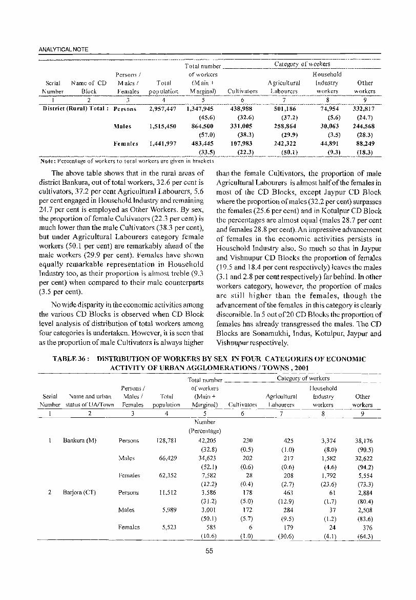
ANALYTICAL NOTE
Total number _______ C_a_;_t.....;eg::.:_o.....;fY'--o_f_w_o_rk_e_fs _____ _
Persons / of workers Household
Serial Name of CD Males / Total eM ain + Agricultural Industry Other
N urn ber Block F emales ._.__!?_?J...::l~!io:: __ ~ arginB:L~.::!!!~~ __ Labo~~~_" __ ,, __ ~_~.:.kers . __ w_or_k_er_s_ 2 3 4 5 6 7 8 9
District (Rural) Total: Persons 2,957,447 1,347,945
(45.6)
Males 1,515,450 864,500
(57.0)
Females 1,441,997 483,445
(33.5)
Note: Percentage of workers to total workers are given in brackets
The above table shows that in the rural areas of district Bankura, out of total workers, 32.6 per cent is cultivators, 37.2 per cent Agricultural Labourers, 5.6 per cent engaged in Household Industry and remaining 24.7 per cent is employed as Other Workers. By sex, the proportion offemale Cultivators (22.3 per cent) is much lower than the male Cultivators (38.3 per cent), but under Agricultural Labourers category female workers (50.1 per cent) are remarkably ahead of the male workers (29.9 per cent). Females have shown equally remarkable representation in Household Industry too, as their proportion is almost treble (9.3 per cent) when compared to their male counterparts (3.5 per cent).
No wide disparity in the economic activities among the various CD Blocks is observed when CD Block level analysis of distribution of total workers among four categories is undertaken. However, it is seen that as the proportion of male Cultivators is always higher
438,988
(32.6)
331,005
(38.3)
107,983
(22.3)
501,186
(37.2)
258,864
(29.9)
242,322
(50.1)
74,954
(5.6)
30,063
(3.5)
44,891
(9.3)
332,817
(24.7)
244,568
(28.3)
88,249
(18.3)
than the female Cultivators, the proportion of male Agricultural Labourers is almost half of the females in most of the CD Blocks, except Jaypur CD Block where the proportion of males (32.2 per cent) surpasses the females (25.6 per cent) and in Kotulpur CD Block the percentages are almost equal (males 28.7 per cent and females 28.8 per cent). An impressive advancement of females in the economic activities persists in Household Industry also. So much so that in Jaypur and Vishnupur CD Blocks the proportion of females (19.5 and 18.4 per cent respectively) leaves the males (3.1 and 2.8 per cent respectively) far behind. In other workers category, however, the proportion of males are still higher than the females, though the advancement of the females in this category is clearly discernible. In 5 out of20 CD Blocks the proportion of females has already transgressed the males. The CD Blocks are Sonamukhi, Indus, Kotulpur, Jaypur and Vishnupur respectively.
TABLE 36: DISTRIBUTION OF WORKERS BY SEX IN FOUR CATEGORIES OF ECONOMIC ACTIVITY OF URBAN AGGLOMERATIONS / TOWNS, 2001
Persons / Serial Name and urban Males / Total
Number status ofUAlTown Females population
234
Bankura (M) Persons 128,781
Males 66,429
Females 62,352
2 Barjora (CT) Persons 11,512
Males 5,989
Females 5,523
Total number
of workers
(Main + Marginal)
5 Number
(Percentage)
42,205
(32.8)
34,623
(52.1) 7,582
(122) 3,586 (31.2)
3,001 (50.1 )
585 (10.6)
55
Cultivators
6
230
(0.5)
202
(0.6) 28
(0.4) 178
(5.0)
172
(5.7)
6 (1.0)
Category of workers
Household
Agricultural Industry Other Labourers workers workers
7 8 9
425 3,374 38,176
(1.0) (8.0) (90.5) 217 1,582 32,622
(0.6) (4.6) (94.2) 208 1,792 5,554
(2.7) (23.6) (73.3)
463 61 2,884 (12.9) (1.7) (80.4)
284 37 2,508 (9.5) (1.2) (83.6)
179 24 376 (30.6) (4.1) (64.3)
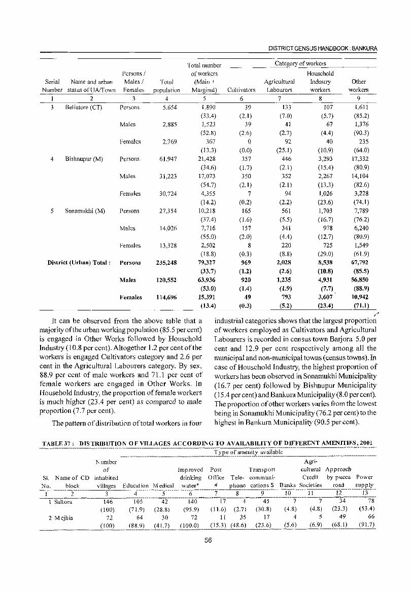
Serial Name and urban Number status ofUA/Town
2
3 Beliatore (CT)
4 Bishnupur (M)
5 Sonamukhi (M)
Persons / Males! Females
3
Persons
Males
Females
Persons
Males
Females
Persons
Males
Females
Total population
4
5,654
2,885
2,769
61,947
31,223
30,724
27,354
14,026
13,328
DISTRICT CENSUS HANDBOOK: BANKURA
Total number _______ C_a_te-""go_r,,_y_of_w __ o_r_ke_rs _____ _
of workers Household (Main +
Marginal) Cultivators
5 6 1,890
(33.4)
1,523
(52.8)
367
(13.3)
21,428
(34.6)
17,073
(54.7)
4,355
(14.2)
10,218
(37.4)
7,716
(55.0)
2,502
(18.8)
39
(2.1)
39
(2.6)
° (0.0)
357
(1.7)
350
(2.1)
Agricultural Labourers
7
133
(7.0)
41
(2.7)
92 (25.1)
446
(2.1)
352
(2.1)
94
(2.2)
561
(5.5)
341
(4.4)
220
(8.8)
Industry workers
8
107
(5.7)
67
(4.4)
40 (10.9)
3,293
(15.4)
2,267
(13.3)
1,026
(23.6)
1,703
(16.7)
978
(12.7)
Other workers
9 1,611
(85.2)
1,376
(90.3)
235
(64.0)
17,332
(80.9)
14,104
(82.6)
3,228
(74.1)
7,789
(76.2)
6,240
(80.9)
1,549
(61.9)
District (Urban) Total: Persons 235,248 79,327
(33.7)
63,936
(53.0)
15,391
(13.4)
7
(0.2)
165
(1.6)
157
(2.0)
8
(0.3)
969
(1.2)
920
(1.4)
2,028
(2.6)
1,235
(1.9)
793
(5.2)
725
(29.0)
8,538
(10.8)
4,931
67,792
(85.5)
56,850
(88.9)
10,942
(71.1)
Males 120,552
Females 114,696
It can be observed from the above table that a majority of the urban working population (85.5 per cent) is engaged in Other Works followed by Household Industry (10.8 per cent). Altogether 1.2 per cent of the workers is engaged Cultivators category and 2.6 per cent in the Agricultural Labourers category. By sex, 88.9 per cent of male workers and 71.1 per cent of female workers are engaged in Other Works. In Household Industry, the proportion offemale workers is much higher (23.4 per cent) as compared to male proportion (7.7 per cent).
The pattern of distribution of total workers in four
49
(0.3)
(7.7)
3,607
(23.4) , ,
industrial categories shows that the largest proportion of workers employed as Cultivators and Agricultural Labourers is recorded in census town Barjora 5.0 per cent and 12.9 per cent respectively among all the municipal and non-municipal towns (census towns). In case of Household Industry, the highest proportion of workers has been observed in Sonamukhi Municipality (16.7 per cent) followed by Bishnupur Municipality (15.4 per cent) and Bankura Municipality (8.0 per cent). The proportion of other workers varies from the lowest being in Sonamukhi Municipality (76.2 per cent) to the highest in Bankura Municipality (90.5 per cent).
TABLE 37 : DISTRIBUTION OF VILLAGES ACCORDING TO AVAILABILITY OF DIFFERENT AMENITJES,2001
Number Agri-
of Improved Post Transport cultural Approach
Sl. Name of CD inhabited drinking Office Tele- communi- Credit by pucca Power
No. block villages Education Medical water* # phone cations $ Banks Societies road supply
I 2 3 4 5 6 7 8 9 10 II 12 13
1 Saltora 146 105 42 140 17 4 45 7 7 34 78
(100) (71.9) (28.8) (95.9) (11.6) (2.7) (30.8) (4.8) (4.8) (23.3) (53.4)
2 Mejhia 72 64 30 72 II 35 17 4 5 49 66
(100) (88.9) (41.7) (100.0) (15.3) (48.6) (23.6) (5.6) (6.9) (68. I) (91.7) .-~---~-~-.~.----... --
56
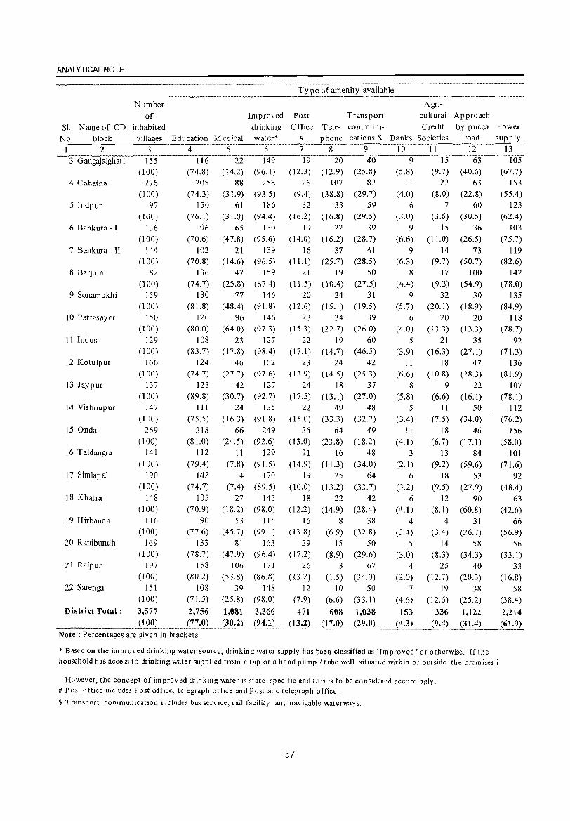
ANALYTICAL NOTE
Number Agri-of Improved Post Transport cultural Approach
Sl. Name of CD inhabited drinking Office Tele- communi- Credit by pucca Power
No. block villages Education Medical water* # phone cations $ Banks Societies road supply
1 2 3 4 5 6 7 8 9 10 II 12 13
3 Gangajalghati 155 116 22 149 19 20 40 9 15 63 105
(100) (74.8) (14.2) (96.1 ) (12.3) (12.9) (25.8) (5.8) (9.7) (40.6) (67.7) 4 Chhatna 276 205 88 258 26 107 82 11 22 63 153
(100) (74.3) (31.9) (93.5) (9.4) (38.8) (29.7) (4.0) (8.0) (22.8) (55.4)
5 Indpur 197 150 61 186 32 33 59 6 7 60 123 (100) (76.1) (31.0) (94.4) (16.2) (16.8) (29.5) (3.0) (3.6) (30.5) (62.4)
6 Bankura - I 136 96 65 130 19 22 39 9 15 36 103 (100) (70.6) (47.8) (95.6) (14.0) (16.2) (28.7) (6.6) (11.0) (26.5) (75.7)
7 Bankura - II 144 102 21 139 16 37 41 9 14 73 119 (100) (70.8) ( 14.6) (96.5) (11.1 ) (25.7) (28.5) (6.3) (9.7) (50.7) (82.6)
8 Barjora 182 136 47 159 21 19 50 8 17 100 142 (l00) (74.7) (25.8) (87.4) (11.5) (10.4) (27.5) (4.4) (9.3) (54.9) (78.0)
9 Sonamukhi 159 130 77 146 20 24 31 9 32 30 135 (100) (81.8) (48.4) (91.8) (12.6) (15.1) (19.5) (5.7) (20.1 ) ( 18.9) (84.9)
10 Patrasayer 150 120 96 146 23 34 39 6 20 20 118 (100) (80.0) (64.0) (97.3) (15.3) (22.7) (26.0) (4.0) (13.3) (13.3) (78.7)
11 Indus 129 108 23 127 22 19 60 5 21 35 92 (100) (83.7) (17.8) (98.4) (17.1 ) (14.7) ( 46.5) (3.9) (16.3) (27.1) (71.3)
12 Kotulpur 166 124 46 162 23 24 42 II 18 47 136 (100) (74.7) (27.7) (97.6) (13.9) (14.5) (25.3) (6.6) (10.8) (28.3) (81. 9)
13 Jaypur 137 123 42 127 24 18 37 8 9 22 107 (100) (89.8) (30.7) (92.7) (17.5) (13.1) (27.0) (5.8) (6.6) (16.1 ) (78.1)
14 Vishnupur 147 111 24 135 22 49 48 5 11 50 112 (100) (75.5) (16.3) (91.8) (15.0) (33.3) (32.7) (3.4) (7.5) (34.0) (76.2)
15 Onda 269 218 66 249 35 64 49 11 18 46 156 (100) (81.0) (24.5) (92.6) (13.0) (23.8) (18.2) (4.1 ) (6.7) (17.1) (58.0)
16 Taldangra 141 112 II 129 21 16 48 3 13 84 101 (100) (79.4) (7.8) (91.5) (14.9) (11.3) (34.0) (2.1) (9.2) (59.6) (71.6)
17 Simlapal 190 142 14 170 19 25 64 6 18 53 92 (100) (74.7) (7.4) (89.5) (10.0) (13.2) (33.7) (3.2) (9.5) (27.9) (48.4)
18 Khatra 148 105 27 145 18 22 42 6 12 90 63 (100) (70.9) (18.2) (98.0) (12.2) (14.9) (28.4) (4.1 ) (8.1) (60.8) (42.6)
19 Hirbandh 1 16 90 53 115 16 8 38 4 4 31 66 (100) (77.6) (45.7) (99. I) (13.8) (6.9) (32.8) (3.4) (3.4) (26.7) (56.9)
20 Ranibundh 169 133 81 163 29 IS 50 5 14 58 56 (100) (78.7) (47.9) (96.4) (17.2) (8.9) (29.6) (3.0) (8.3) (34.3) (33.1)
21 Raipur 197 158 106 171 26 3 67 4 25 40 33 (100) (80.2) (53.8) (86.8) (13.2) (1.5) (34.0) (2.0) (12.7) (20.3) (16.8)
22 Sarenga 15 I 108 39 148 12 10 50 7 19 38 58 (100) (71.5) (25.8) (98.0) (7.9) (6.6) (33. I) (4.6) (12.6) (25.2) (38.4)
District Total: 3,577 2,756 1,081 3,366 471 608 1,038 153 336 1,122 2,214 (100) (77.0) (30.2) (94.1) (13.2) (17.0) (29.0) (4.3) (9.4) (31.4) (61.9)
Note: Percentages are given in brackets
* Based on the improved drinking water source, drinking water supply has been classified as . Improved' or otherwise. If the household has access to drinking water supplied from a tap or a hand pump / tube well situated within or outside the premises i
However, the concept of improved drinking water is state specific and this is to be considered accordingly. # Post office includes Post office, telegraph office and Post and telegraph office.
$ Transport communication includes bus service, rail facility and navigable waterways.
57
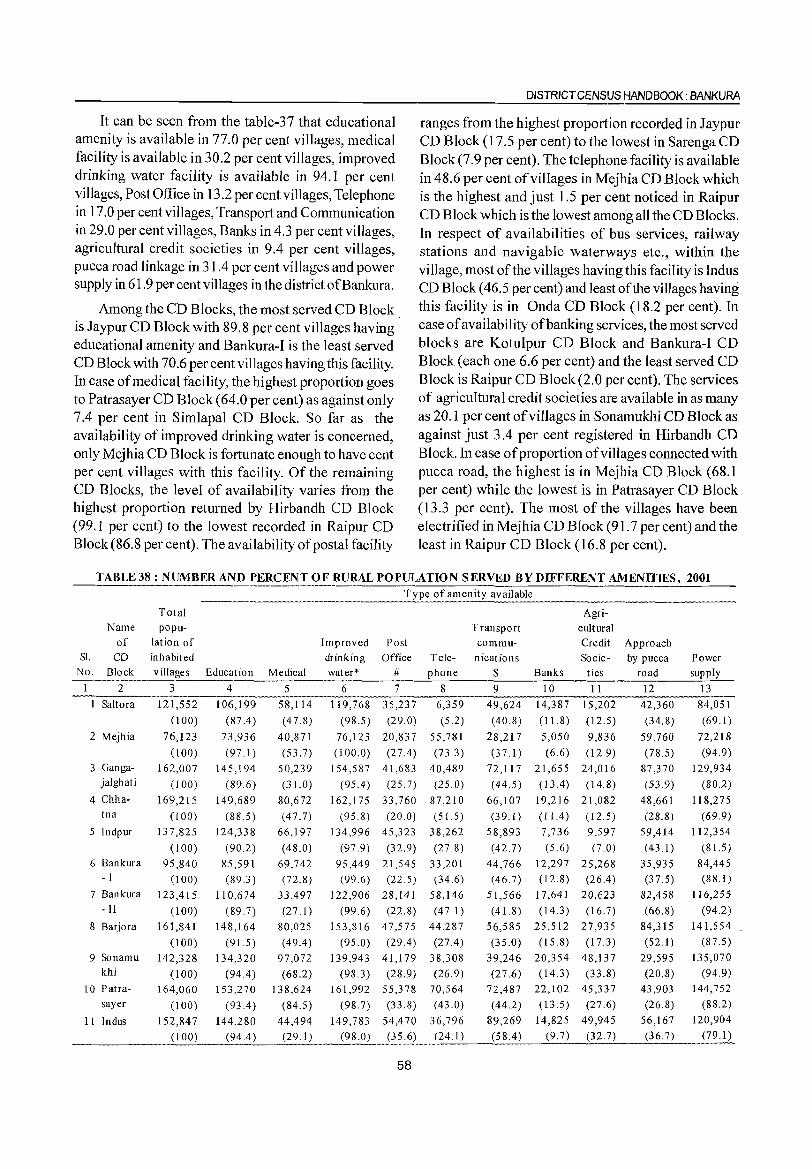
It can be seen from the table-37 that educational amenity is available in 77.0 per cent villages, medical facility is available in 30.2 per cent villages, improved drinking water facility is available in 94.1 per cent villages, Post Office in 13.2 per cent villages, Telephone in 17.0 per cent villages, Transport and Communication in 29.0 per cent villages, Banks in 4.3 per cent villages, agricultural credit societies in 9.4 per cent villages, pucca road linkage in 31.4 per cent villages and power supply in 61.9 per cent villages in the district ofBankura.
Among the CD Blocks, the most served CD Block is Jaypur CD Block with 89.8 per cent villages having educational amenity and Bankura-I is the least served CD Block with 70.6 per cent villages having this facility. In case of medical facility, the highest proportion goes to Patrasayer CD Block (64.0 per cent) as against only 7.4 per cent in Simlapal CD Block. So far as the availability of improved drinking water is concerned, only Mejhia CD Block is fortunate enough to have cent per cent villages with this facility. Of the remaining CD Blocks, the level of availability varies from the highest proportion returned by Hirbandh CD Block (99.1 per cent) to the lowest recorded in Raipur CD Block (86.8 per cent). The availability of postal facility
DISTRICT CENSUS HANDBOOK: BANKURA
ranges from the highest proportion recorded in Jaypur CD Block (17.5 per cent) to the lowest in Sarenga CD Block (7.9 per cent). The telephone facility is available in 48.6 per cent of villages in Mejhia CD Block which is the highest and just 1.5 per cent noticed in Raipur CD Block which is the lowest among all the CD Blocks. In respect of availabilities of bus services, railway stations and navigable waterways etc., within the vi Hage, most of the villages having this facility is Indus CD Block (46.5 per cent) and least of the villages having this facility is in Onda CD Block (18.2 per cent). In case of availability of banking services, the most served blocks are Kotulpur CD Block and Bankura-I CD Block (each one 6.6 per cent) and the least served CD Block is Raipur CD Block (2.0 per cent). The services of agricultural credit societies are available in as many as 20.1 per cent of villages in Sonamukhi CD Block as against just 3.4 per cent registered in Hirbandh CD Block. In case of proportion of villages connected with puce a road, the highest is in Mejhia CD Block (68.1 per cent) while the lowest is in Patrasayer CD Block (13.3 per cent). The most of the villages have been electrified in Mejhia CD Block (91.7 per cent) and the least in Raipur CD Block (16.8 per cent).
TABLE 38 : NUMBER AND PERCENT OF RURAL POPULATION SERVED BY DIFFERENT AMENITIES, 2001 '~"'---'-----'-~""--'
available
Total Agri-Name popu- Transport cultural
of lation of Improved Post commu- Credit Approach S1. CD inhabited drinking Office Tele- nications Socie- by pucca Power
No. Block v iJIages Education Medical water* # phone $ Banks ties road supply
1 2 3 4 5 6 7 8 9 10 11 12 13
1 Saltora 121,552 106,199 58,114 119,768 35,237 6,359 49,624 14,387 15,202 42,360 84,051
(100) (87.4) (47.8) (98.5) (29.0) (5.2) (40.8) (11.8) (12.5) (34.8) (69.1)
2 Mejhia 76,123 73,936 40,871 76,123 20,837 55,781 28,217 5,050 9,836 59,760 72,218
(100) (97. I) (53.7) (100.0) (27.4 ) (73.3) (37.1) (6.6) (12.9) (78.5) (94.9) 3 Ganga- 162,007 145,194 50,239 154,587 41,683 40,489 72,117 21,655 24,016 87,370 129,934
jalghati (100) (89.6) (3 LO) (95.4 ) (25.7) (25.0) ( 44.5) (13.4) (14.8) (53.9) (80.2)
4 Chha- 169,215 149,689 80,672 162,175 33,760 87,210 66,107 19,216 21,082 48,661 118,275 tna (100) (88.5) (47.7) (95.8) (20.0) (51.5) (39.1) (11.4) (12.5) (28.8) (69.9)
5 Indpur 137,825 124,338 66,197 134,996 45,323 38,262 58,893 7,736 9,597 59,414 112,354
(100) (90.2) (48.0) (97.9) (32.9) (27.8) (42.7) (5.6) (7.0) (43.1) (81.5)
6 Bankura 95,840 85,591 69,742 95,449 21,545 33,201 44,766 12,297 25,268 35,935 84,445 -I (100) (89.3) (72.8) (99.6) (22.5) (34.6) (46.7) (12.8) (26.4 ) (37.5) (88.1)
7 Bankura 123,415 110,674 33,497 122,906 28,141 58,146 51,566 17,641 20,623 82,458 116,255 -II (100) (89.7) (27.1) (99.6) (22.8) (47.1) (41.8) (14.3) (16.7) (66.8) (94.2)
8 Barjora 161,841 148,164 80,025 153,816 47,575 44,287 56,585 25,512 27,935 84,315 141,554
(100) (91.5) (49.4) (95.0) (29.4 ) (27.4 ) (35.0) (15.8) (17.3) (52.1) (87.5)
9 Sonamu 142,328 134,320 97,072 139,943 41,179 38,308 39,246 20,354 48,137 29,595 135,070 khi (100) (94.4 ) (68.2) (98.3) (28.9) (26.9) (27.6) (14.3) (33.8) (20.8) (94.9)
10 Patra- 164,060 153,270 138,624 161,992 55,378 70,564 72,487 22,102 45,337 43,903 144,752 sayer (100) (93.4 ) (84.5) (98.7) (33.8) (43.0) (44.2) (13.5) (27.6) (26.8) (88.2)
II Indus 152,847 144,280 44,494 149,783 54,470 36,796 89,269 14,825 49,945 56,167 120,904
(100) (94.4 ) (29.1 ) (98.0) (35.6) (24.1) (58.4) (9.7) (32.7) (36.7) (79.1)
58
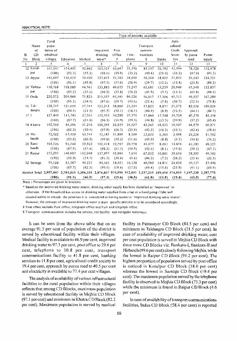
ANALYTICAL NOTE
available
Total Agri-
Name popu- Transport cultural
of lation of Improved Post commu- Credit Approach
Sl. CD inhabited drinking Office Tele- nications Socie- by pucca Power No. Block Education Medical water* # $ Banks ties road
I 2 3 4 5 6 7 8 9 10 II 12 13 .•• __ ..... ~........._ .. ,~,,~ •••••• ._.,._~.~_~ ••• ,~ __ u __ .... _~_ ..... ~n'~._ ......... "'.~ ______ •• ~ __ ~ ...... __ .... _. ___ ••• _______ ~ .......... __ ... __ ~._. __ ~~ __ ~ .. __
12 Kotul- 167,547 154,405 92,662 165,124 63,647 55,596 83,107 36,195 43,944 78,728 152,978 pur (100) (92.2) (55.3) (98.6) (38.0) (33.2) (49.6) (21.6) (26.2) (47.0) (91.3)
13 Jaypur 141,497 136,019 70,420 137,643 53,182 38,050 56,244 18,655 21,843 36,543 124,731
(100) (96.1) (49.8) (97.3 ) (37.6) (26.9) (39.7) (13.2) (15.4) (25.8) (88.2) 14 Vishnu- 138,768 128,089 44,561 133,883 49,625 75,242 63,681 13,239 20,940 63,540 122,837
pur (100) (92.3 ) (32.1) (96.5) (35.8) (54.2) (45.9) (9.5) (15.1 ) (45.8) (88.5)
15 Onda 220,572 209,960 75,825 215,357 65,541 96,226 56,017 17,306 45,713 49,527 167,299 (l00) (95.2) (34.4 ) (97.6) (29.7) (43.6 ) (25.4 ) (7.8) (20.7) (22.5) (75.8)
16 Tal- 128,747 121,655 27,744 123,212 38,809 23,324 57,822 8,877 21,272 82,556 109,026 dangra (100) (94.5) (21.5) (95.7) (30.1) (18.1) ( 44.9) (6.9) (16.5) (64.1) (84.7)
17 1 127,445 111,743 27,531 122,553 34,280 37,374 57,064 17,248 31,734 47,370 83,356 (100) (87.7) (21.6) (96.2) (26.9) (29.3) ( 44.8) (13.5) (24.9) (37.2) (65.4)
18 Khatra 102,569 84,296 31,21 ° 100,398 26,855 24,527 43,265 16,635 10,407 64,979 60,271
(100) (82.2) (30.4 ) (97.9) (26.2) (23.9) ( 42.2) (162) (10.1) (63.4) (58.8) 19 Hir- 72,502 67,459 43,744 72,183 21,899 8,389 32,653 6,365 3,098 25,224 51,702
bandh (100) (93.0) (60.3) (99.6) (30.2) ( 11.6) (45.0) (8.8) (4.3) (34.8) (71.3) 20 Rani- 104,326 91,740 59,922 102,418 32,597 20,758 44,477 8,467 14,650 41,185 49,155
bundh (l00) (87.9) (57.4) (98.2 ) (31.2) (19.9) (42.6) (8.1 ) (14.0) (39.5) (47.1) 21 Raipur 151,293 140,607 112,948 137,997 45,984 7,024 67,032 10,881 39,650 38,503 49,162
(100) (92.9) (74.7) (91.2) (30.4 ) (4.6) (44.3 ) (7.2) (26.2) (25.4 ) (32.5)
22 Sarenga 95,128 83,387 40,221 94,561 18,451 16,138 46,980 14,811 24,630 39,137 57,446 (l00) (87.7) (42.3) (99.4 ) (19A) (17.0) (49.4 ) ( 15.6) (25.9) (41.1) (60.4)
)istrict Total 2,957,447 2,705,015 1,386,335 2,876,867 875,998 912,051 1,237,219 349,454 574,859 1,197,230 2,287,775
(100) (91.5) (46.9) (97.3) (29.6) (30.8) (41.8) (11.8) (19.4) (40.5) (77.4) Note: Percentages are given in brackets.
* Based on the improved drinking water source, drinking water supply has been classified as 'Improved' or
otherwise. If the household has access to drinking water supplied from a tap or a hand pump I tube well
situated within or outside the premises it is considered as having access to . Improved drinking water source'.
However, the concept of improved drinking water is state specific and this is to be considered accordingly.
# Post office includes Post office, telegraph office and Post and telegraph office.
$ Transport communication includes bus service, rail facility and navigable waterways.
It can be seen from the above table that on an average 91.5 per cent of population of the district is served by educational facility within their villages. Medical facility is available to 46.9 per cent, improved drinking water to 97.3 per cent, post office to 29.6 per cent, telephone to 30.8 per cent, transport communications facility to 41.8 per cent, banking services to 11.8 per cent, agricultural credit society to 19.4 per cent, approach by pucca road to 40.5 per cent and electricity is available to 77.4 per cent villages.
The analysis of availability of various infrastructural facilities to the rural population within their villages reflects that among CD Blocks, maximum population is served by educational facility in Mejhia CD Block (97.1 per cent) and minimum in Khatra CD Block (82.2 per cent). Maximum population is served by medical
59
facility in Patrasayer CD Block (84.5 per cent) and minimum in Taldangra CD Block (21.5 per cent). In case of availability of improved drinking water, cent per cent population is served in Mejhia CD Block with three more CD Blocks viz. Bankura-I, Bankura-II and Hirbandh (99.6 per cent) closely following Mejhia, while the lowest in Raipur CD Block (91.2 per cent). The highest proportion of population served by post office is noticed in Kotulpur CD Block (38.0 per cent) whereas the lowest in Sarenga CD Block (19.4 per cent). The maximum popUlation served by the telephone facility is observed in Mejhia CD Block (73.3 per cent) while the minimum is found in Raipur CD Block (4.6 per cent).
In case of availability of transport communications facilities, Indus CD Block (58.4 per cent) is reported
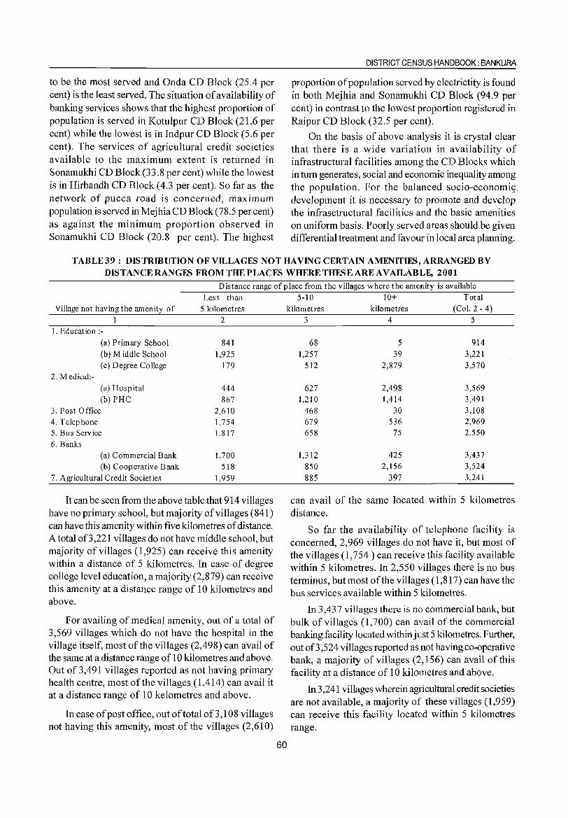
DISTRICT CENSUS HANDBOOK: BANKURA ----------------------------------------------------~~----
to be the most served and Onda CD Block (25.4 per cent) is the least served. The situation of availability of banking services shows that the highest proportion of population is served in Kotulpur CD Block (21.6 per cent) while the lowest is in Indpur CD Block (5.6 per cent). The services of agricultural credit societies available to the maximum extent is returned in Sonamukhi CD Block (33.8 per cent) while the lowest is in Hirbandh CD Block (4.3 per cent). So far as the network of pucca road is concerned, maximum population is served in Mejhia CD Block (78.5 per cent) as against the minimum proportion observed in Sonamukhi CD Block (20.8 per cent). The highest
proportion of population served by electrictity is found in both Mejhia and Sonamukhi CD Block (94.9 per cent) in contrast to the lowest proportion registered in Raipur CD Block (32.5 per cent).
On the basis of above analysis it is crystal clear that there is a wide variation in availability of infrastructural facilities among the CD Blocks which in tum generates, social and economic inequality among the population. For the balanced socio-economig_ development it is necessary to promote and develop the infrasctructural facilities and the basic amenities on uniform basis. Poorly served areas should be given differential treatment and favour in local area planning.
TABLE39: DISTRffiUTION OF VILLAGES NOT HAVING CERTAIN AMENITIES, ARRANGED BY DISTANCE RANGES FROMTHEPLACFS WHERE THFSE ARE AVAILABlLE, 2001
-----:-:-:-....,--------Distance range of place from the villages where the amenity is available
Less than Village not having the amenity of 5 kilometres
1 2 I. Education :-
(a) Primary School 841 (b) Middle School 1,925 (c) Degree College 179
2. M edical:-(a) Hosp ital 444 (b) PHC 867
3. Post Office 2,610 4. Telephone 1,754 5. Bus Service 1,817 6. Banks
(a) Commercial Bank 1,700 (b) Cooperative Bank 518
7. Agricultural Credit Societ ies 1,959
It can be seen from the above table that 914 villages have no primary school, but majority of villages (841) can have this amenity within five kilometres of distance. A total 00,221 villages do not have middle school, but majority of villages (1,925) can receive this amenity within a distance of 5 kilometres. In case of degree college level education, a majority (2,879) can receive this amenity at a distance range of 10 kilometres and above.
For availing of medical amenity, out of a total of 3,569 villages which do not have the hospital in the village itself, most of the villages (2,498) can avail of the same at a distance range of 10 kilometres and above. Out of 3,491 villages reported as not having primary health centre, most of the villages (1,414) can avail it at a distance range of 10 kelometres and above.
In case of post office, out of total of3, 1 08 villages not having this amenity, most of the villages (2,610)
5-10 10+ Total kilometres kilometres (Col. 2 - 4)
3 4 5
68 5 914 1,257 39 3,221
512 2,879 3,570
627 2,498 3,569 1,210 1,414 3,491
468 30 3,108 679 536 2,969 658 75 2,550
1,312 425 3,437 850 2,156 3,524
885 397 3,241
can avail of the same located within 5 kilometres distance.
60
So far the availability of telephone facility is concerned, 2,969 villages do not have it, but most of the villages (1,754 ) can receive this facility available within 5 kilometres. In 2,550 villages there is no bus terminus, but most of the villages (1,817) can have the bus services available within 5 kilometres.
In 3,437 villages there is no commercial bank, but bulk of villages (1,700) can avail of the commercial banking facility located withinjust 5 kilometres. Further, out 00,524 villages reported as not having co-operative bank, a majority of villages (2,156) can avail of this facility at a distance of 10 kilometres and above.
In 3,241 villages wherein agricultural credit societies are not available, a majority of these villages (1,959) can receive this facility locat~~d within 5 kilometres range.
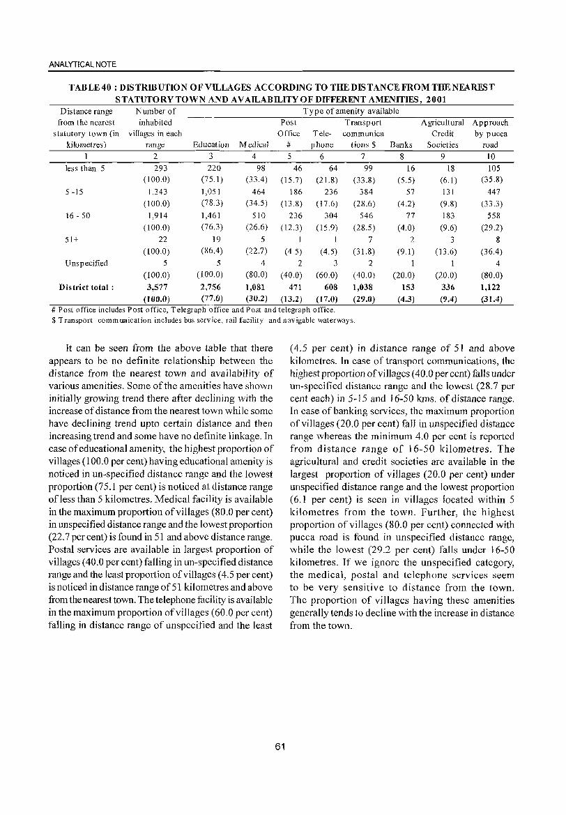
ANALYTICAL NOTE
TAB LE 40 : DIS TRffiUTIO N 0 F VILLAGFS ACCO RDIN G TO THE DIS TAN CE FRO M THE NEARFS T STATUTORY TOWN AND AVAILABILITY OF DIFFERENT AMENITIFS, 2001
Distance range Number of Ty pe of amenity available from the nearest inhabited Post Transport Agricultural Approach
statutory town (in villages in each Office Tele- communica Credit by pucca kilometres) range Education Medical # phone tions $ Banks Societies road
1 2 3 4 5 6 7 8 9 10
less than 5 293 220 98 46 64 99 16 18 105 (l00.0) (75.1 ) (33.4 ) (15.7) (21.8) (33.8) (5.5) (6.1) (35.8)
5 -15 1,343 1,051 464 186 236 384 57 131 447
(l00.0) (7S.3) (34.5) (13.8) (17.6) (2S.6) (4.2) (9.8) (33.3)
16 - 50 1,914 1,461 510 236 304 546 77 183 558
(l00.0) (76.3) (26.6) (12.3) (15.9) (28.5) (4.0) (9.6) (29.2)
51+ 22 19 5 1 1 7 2 3 8
(l00.0) (86.4) (22.7) (4.5) (4.5) (31.8) (9.1 ) (13.6) (36.4)
U nsp ecified 5 5 4 2 3 2 1 1 4
(100.0) (100.0) (80.0) (40.0) (60.0) (40.0) (20.0) (20.0) (SO.O)
Dis triet total: 3,577 2,756 1,081 471 608 1,038 153 336 1,122
(100.0) (77.0) (30.2) (13.2) (17.0) (29.0) (4.3) (9.4) (31.4) # Post office includes Post office, Telegraph office and Post and telegraph office. $ Transport communication includes bus service, rail facility and navigable waterways.
It can be seen from the above table that there appears to be no definite relationship between the distance from the nearest town and availability of various amenities. Some of the amenities have shown initially growing trend there after declining with the increase of distance from the nearest town while some have declining trend upto certain distance and then increasing trend and some have no definite linkage. In case of educational amenity, the highest proportion of villages (100.0 per cent) having educational amenity is noticed in un-specified distance range and the lowest proportion (75.1 per cent) is noticed at distance range ofless than 5 kilometres. Medical facility is available in the maximum proportion of villages (80.0 per cent) in unspecified distance range and the lowest proportion (22.7 per cent) is found in 51 and above distance range. Postal services are available in largest proportion of villages (40.0 per cent) falling in un-specified distance range and the least proportion of villages (4.5 per cent) is noticed in distance range of 51 kilometres and above from the nearest town. The telephone facility is available in the maximum proportion of villages (60.0 per cent) falling in distance range of unspecified and the least
61
(4.5 per cent) in distance range of 51 and above kilometres. In case of transport communications, the highest proportion of villages (40.0 per cent) falls under un-specified distance range and the lowest (28.7 per cent each) in 5-15 and 16-50 kms. of distance range. In case of banking services, the maximum proportion of villages (20.0 per cent) fall in unspecified distance range whereas the minimum 4.0 per cent is reported from distance range of 16-50 kilometres. The agricultural and credit societies are available in the largest proportion of villages (20.0 per cent) under unspecified distance range and the lowest proportion (6.1 per cent) is seen in villages located within 5 kilometres from the town. Further, the highest proportion of villages (80.0 per cent) connected with pucca road is found in unspecified distance range, while the lowest (29.2 per cent) falls under 16-50 kilometres. If we ignore the unspecified category, the medical, postal and telephone services seem to be very sensitive to distance from the town. The proportion of villages having these amenities generally tends to decline with the increase in distance from the town.
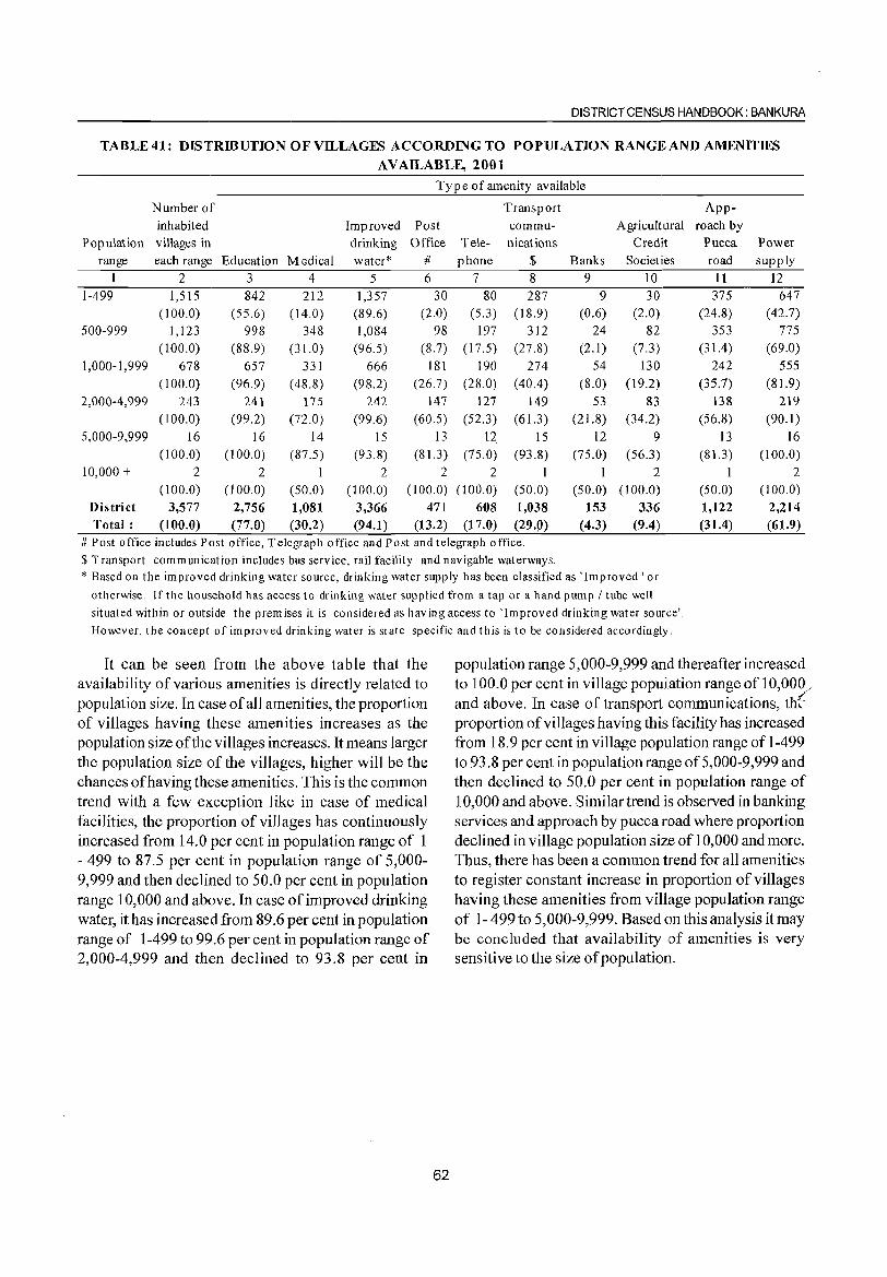
DISTRICT CENSUS HANDBOOK: BANKURA
TABLE41: DISTRffiUTION OF VILLAGES ACCORDING TO POPULATION RANGE AND AMENITIES
AVAILABLE, 2001
Type of amenity available
Number of Transport App-
inhabited Improved Post commu- Agricultural roach by Population villages in drinking Office Tele- nications Credit Pucca Power
range each range Education Medical water* # phone $ Banks Societiies road supply
1 2 3 4 5 6 7 8 9 10 11 12 1-499 1,515 842 212 1,357 30 80 287 9 30 375 647
(100.0) (55.6) ( 14.0) (89.6) (2.0) (5.3) (18.9) (0.6) (2.0) (24.8) (42.7) 500-999 1,123 998 348 1,084 98 197 312 24 82 353 775
(l00.0) (88.9) (31.0) (96.5) (8.7) ( 17.5) (27.8) (2.1) (7.3) (31.4) (69.0) 1,000- I ,999 678 657 331 666 181 190 274 54 130 242 555
(100.0) (96.9) ( 48.8) (98.2) (26.7) (28.0) (40.4) (8.0) (19.2) (35.7) (81.9) 2,000-4,999 243 241 175 242 147 127 149 53 83 138 219
(100.0) (99.2) (72.0) (99.6) (60.5) (52.3) (61.3) (21.8) (34.2) (56.8) (90.1) 5,000-9,999 16 16 14 15 13 12 15 12 9 13 16
(100.0) (100.0) (87.5) (93.8) (81.3 ) (75.0) (93.8) (75.0) (56.3) (81.3) (100.0) 10,000 + 2 2 I 2 2 2 I I 2 I 2
(100.0) (l00.0) (50.0) (IOO.O) (100.0) (100.0) (50.0) (50.0) (100.0) (50.0) (100.0) District 3,577 2,756 1,081 3,366 471 608 1,038 153 336 1,122 2,214 Total: (l00.0) (77.0) (30.2) (94.1) (13.2) (17.0) (29.0) (4.3) (9.4) (31.4) (61.9)
# Post office includes Post office, Telegraph office and Post and telegraph office.
$ Transport communication includes bus service, rail facility and navigable waterways. * Based on the improved drinking water source, drinking water supply has been classified as 'Improved I or
otherwise. If the household has access to drinking water supp lied from a tap or a hand pump I tube well
situated within or outside the premises it is considered as having access to 'Improved drinking water source'.
However, the concept of improved drinking water is state specific and this is to be considered accordingly.
It can be seen from the above table that the availability of various amenities is directly related to population size. In case of all amenities, the proportion of villages having these amenities increases as the population size of the villages increases. It means larger the population size of the villages, higher will be the chances of having these amenities. This is the common trend with a few exception like in case of medical facilities, the proportion of villages has continuously increased from 14.0 per cent in population range of I - 499 to 87.5 per cent in population range of 5,000-9,999 and then declined to 50.0 per cent in population range 10,000 and above. In case of improved drinking water, it has increased from 89.6 per cent in population range of 1-499 to 99.6 per cent in population range of 2,000-4,999 and then declined to 93.8 per cent in
62
population range 5,000-9,999 and thereafter increased to 100.0 per cent in village popuJ!ation range of 10,000/ and above. In case of transport communications, th::' proportion of vi Uages having this facility has increased from 18.9 per cent in village population range of 1-499 to 93.8 per cent in population range of 5,000-9,999 and then declined to 50.0 per cent in population range of 10,000 and above. Similar trend is observed in banking services and approach by pucca road where proportion declined in village population size of 10,000 and more. Thus, there has been a common trend for all amenities to register constant increase in proportion of villages having these amenities from village population range of 1- 499 to 5,000-9,999. Based on this analysis it may be concluded that availability of amenities is very sensitive to the size of population.
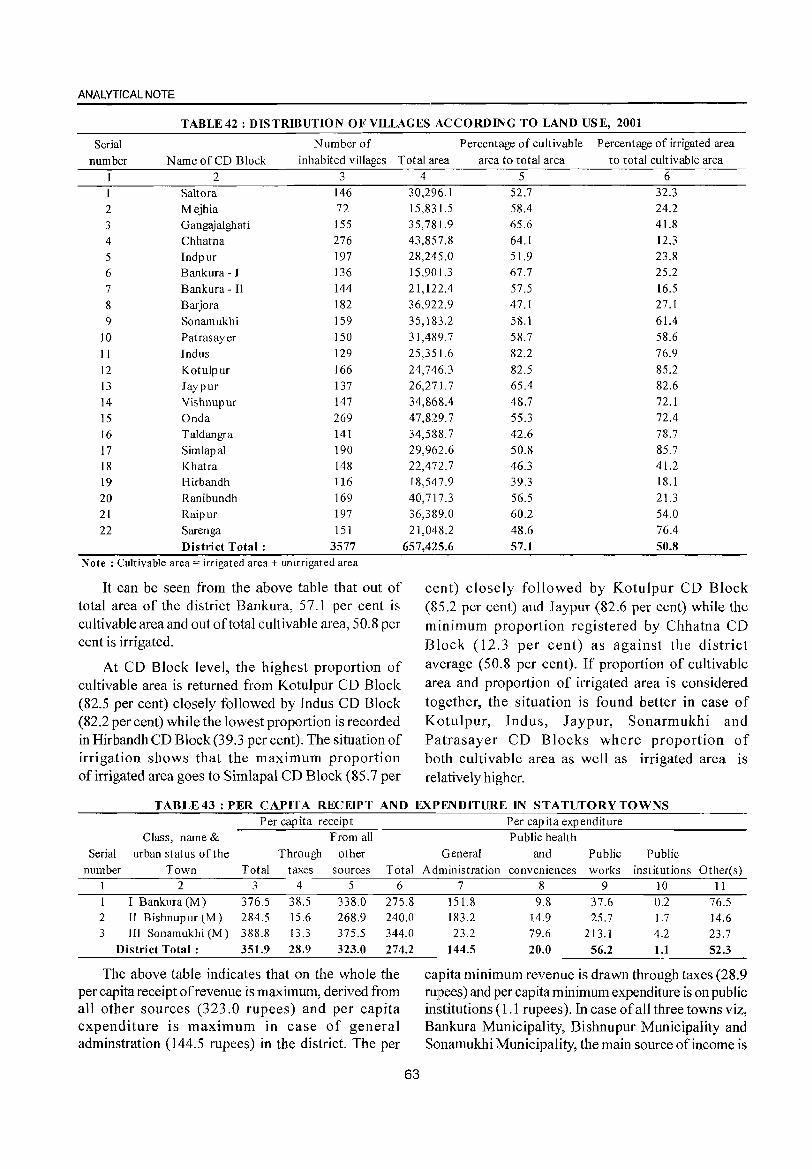
ANALYTICAL NOTE
TABLE 42 : DISTRIBUTION OF VILLAGES ACCORDING TO LAND USE, 2001
Serial Number of Percentage of cultivable Percentage of irrigated area
number N arne of CD Block inhabited villages Total area area to total area to total cultivable area
2 3 Saltora 146
2 Mejhia 72 3 Gangajalghati 155
4 Chhatna 276
5 Indpur 197
6 Bankura - I 136
7 Bankura - II 144
8 Barjora 182
9 Sonamukhi 159
10 Patrasayer 150
11 Indus 129
12 Kotulpur 166
l3 Jaypur 137
14 Vishnupur 147 15 Onda 269 16 Taldangra 141
17 Simlapal 190 18 Khatra 148 19 Hirbandh 116 20 Ranibundh 169 21 Raipur 197 22 Sarenga 151
District Total: 3577 Note: Cultivable area = irrigated area + unirrigated area
It can be seen from the above table that out of total area of the district Bankura, 57.1 per cent is cultivable area and out of total cultivable area, 50.8 per cent is irrigated.
At CD Block level, the highest proportion of cultivable area is returned from Kotulpur CD Block (82.5 per cent) closely followed by Indus CD Block (82.2 per cent) while the lowest proportion is recorded in Hirbandh CD Block (39.3 per cent). The situation of irrigation shows that the maximum proportion of irrigated area goes to Simlapal CD Block (85.7 per
4 5 6 30,296.1 52.7 32.3 15,831.5 58.4 24.2 35,781.9 65.6 41.8 43,857.8 64.1 12.3 28,245.0 51.9 23.8 15,901.3 67.7 25.2 21,122.4 57.5 16.5 36,922.9 47.1 27.1 35,183.2 58.1 61.4 31,489.7 58.7 58.6 25,351.6 82.2 76.9 24,746.3 82.5 85.2 26,271.7 65.4 82.6 34,868.4 48.7 72.1 47,829.7 55.3 72.4 34,588.7 42.6 78.7 29,962.6 50.8 85.7 22,472.7 46.3 41.2 18,547.9 39.3 18.1 40,717.3 56.5 21.3 36,389.0 60.2 54.0 21,048.2 48.6 76.4
657,425.6 57.1 50.8
cent) closely followed by Kotulpur CD Block (85.2 per cent) and Jaypur (82.6 per cent) while the minimum proportion registered by Chhatna CD Block (12.3 per cent) as against the district average (50.8 per cent). If proportion of cultivable area and proportion of ilTigated area is considered together, the situation is found better in case of Kotulpur, Indus, Jaypur, Sonarmukhi and Patrasayer CD Blocks where proportion of both cultivable area as well as irrigated area is relatively higher.
TABLE43 : PER CAPITA RECEIPT AND EXPENDITURE IN STATUTORY TOWNS Per capita receipt
Class, name & From all Serial urban status of the Through other
number Town Total taxes sources Total 2 3 4 5 6
I Bankura (M) 376.5 38.5 338.0 275.8 2 II Bishnup ur (M) 284.5 15.6 268.9 240.0 3 III Sonamukhi (M) 388.8 13.3 375.5 344.0
District Total: 35l.9 28.9 323.0 274.2
The above table indicates that on the whole the per capita receipt of revenue is maximum, derived from all other sources (323.0 rupees) and per capita expenditure is maximum in case of general adminstration (144.5 rupees) in the district. The per
63
Per capita expenditure Public health
General and Public Public Administration conveniences works institutions Other(s)
7 8 9 10 11 151.8 9.8 37.6 0.2 76.5 183.2 14.9 25.7 1.7 14.6 23.2 79.6 213.1 4.2 23.7
144.5 20.0 56.2 1.1 52.3
capita minimum revenue is drawn through taxes (28.9 rupees) and per capita minimum expenditure is on pub lie institutions (1.1 rupees). In case of all three towns viz, Bankura Municipality, Bishnupur Municipality and Sonamukhi Municipality, the main source of income is
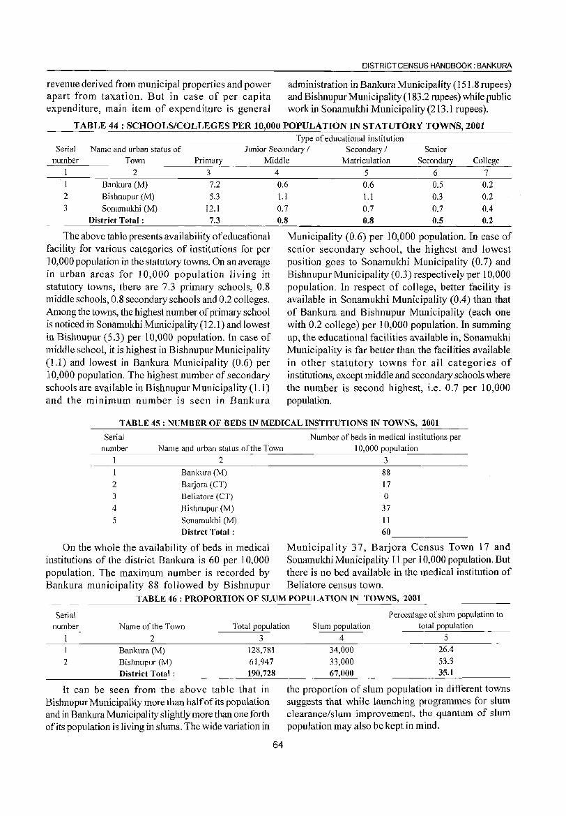
DISTRICT CENSUS HANDBOOK: BANKURA
revenue derived from municipal properties and power administration in Bankura Municipality (151.8 rupees) apart from taxation. But in case of per capita and BishnupurMunicipality (183.2 mpees) while public expenditure, main item of expenditure is general work in Sonamukhi Municipality (213.1 rupees).
TABLE 44 : SCHOOLS/COLLEGES PER 10,000 POPULATION IN STATUTORY TOWNS, 2001 Type of educational institution
Serial Name and urban status of Junior Secondary / Secondary / Senior
number Town Primary Middle Matriculation Secondary College
I 2 3 4 5 6 7
I Bankura eM) 7.2
2 Bishnupur eM) 5.3
3 Sonamukhi eM) 12.1
District Total: 7.3
The above table presents availability of educational facility for various categories of institutions for per 10,000 population in the statutory towns. On an average in urban areas for 10,000 population living in statutory towns, there are 7.3 primary schools, 0.8 middle schools, 0.8 secondary schools and 0.2 colleges. Among the towns, the highest number of primary school is noticed in Sonamukhi Municipality (12.1) and lowest in Bishnupur (5.3) per 10,000 population. In case of middle school, it is highest in Bishnupur Municipality (1.1) and lowest in Bankura Municipality (0.6) per 10,000 population. The highest number of secondary schools are available in Bishnupur Municipality (1.1) and the minimum number is seen in Bankura
0.6 0.6 0.5 0.2
1.1 1.1 0.3 0.2
0.7 0.7 0.7 0.4
0.8 0.8 0.5 0.2
Municipality (0.6) per 10,000 population. In case of senior secondary school, the highest and lowest position goes to Sonamukhi Municipality (0.7) and Bishnupur Municipality (OJ) respectively per 10,000 population. In respect of college, better facility is available in Sonamukhi Municipality (0.4) than that of Bankura and Bishnupur Municipality (each one with 0.2 college) per 10,000 population. In summing up, the educational facilities available in, Sonamukhi Municipality is far better than the facilities available in other statutory towns for all categories of institutions, except middle and secondary schools where the number is second highest, i.e. 0.7 per 10,000 population.
TABLE 45 : NUMBER OF BEDS IN MEDICAL INSTITUTIONS IN TOWNS, 2001
Serial
number
1
2
3
4 5
Name and urban status of the Town
2 Bankura (M)
Barjora (CT)
Beliatore (CT)
Bishnupur (M)
Sonamukhi (M)
Distrct Total:
Number of beds in medical institutions per
10,000 population
3
88
17
o 37 11
60
On the whole the availability of beds in medical Municipality 37, Barjora Census Town 17 and institutions of the district Bankura is 60 per 10,000 Sonamukhi Municipality 11 per 10,000 population. But popUlation. The maximum number is recorded by there is no bed available in the medical institution of Bankura municipality 88 followed by Bishnupur Beliatore census town.
TABLE 46: PROPORTION OF SLUM POPULATION IN TOWNS, 2001
Percentage of slum population to Serial
number Name of the Town Total population Slum population total population
2 3
Bankura (M) 128,781
2 Bishnupur (M) 61,947
District Total: 190,728
It can be seen from the above table that in Bishnupur Municipality more than half of its population and in Bankura Municipality slightly more than one forth of its popUlation is living in slums. The wide variation in
64
4 5
34,000 26.4
33,000 53.3
67,000 35.1
the proportion of slum population in different towns suggests that while launching programmes for slum clearance/slum improvement, the quantum of slum population may also be kept in mind.
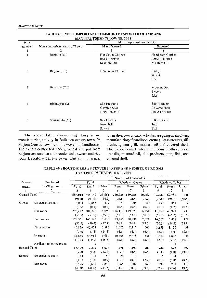
ANALYTICAL NOTE
TABLE 47 : MOST IMPORTANT COMMODITY EXPORTED OUT OF AND
MANUFACTURED IN 'fOWNS 2001 Most important commodity Serial
number Name and urban status of Town Manufactured Exported 2
Bankura(M)
2 Barjora (CT)
3 Beliatore (CT)
4 Bishnupur (M)
5 Sonamukhi (M)
3 4 Handloom Clothes Brass Utensils Mustard Oil
Handloom Clothes
Silk Products Covered Shell Brass Utensils
Silk Clothes Iron Grill Bricks
Handloom Clothes Brass Materials Mustard Oil
Paddy Wheat Pot
Wooden Doll Sweets Rice
Silk Products Covered Shell Brass Utensils
Silk Clothes Jute Fish
The above table shows that there is no manufacturing activity in Beliatore census town. In Barjora Census Town, cloth is woven on handlooms. The export comprised paddy, wheat and pot from Barjora census town and wooden doll, sweets and rice from Beliatore census town. But in municipal
towns diverse economic activities are going on involving manufacturing of hand loom clothes, brass utensils, silk products, iron grill, mustard oil and covered shell. The export constitutes handloom clothes, brass utensils, mustard oil, silk products, jute, fish, and covered shell.
TABLE 48 : HOUSEHOLDS BY TENURE STATUS AND NUMBER OF ROOMS
OCCUPIED IN THE DISTRICT, 2001
N urn ber of househo Ids
Tenure Number of Total Scheduled Castes Scheduled Tribes status dwelling rooms Total Rural Urban Total Rural Urban Total Rural Urban
2 3 4 5 6 7 8 9 10 11 Owned Total 585,010 545,149 39,861 200,238 189,786 10,452 63,233 62,787 446
(96.8) (97.8) (84.9) (98.1) (98.5) (91.2) (97.6) (98.1) (58.8) Owned No exclusive room 3,063 2,886 177 1,073 1,004 69 453 451 2
(0.5) (0.5) (0.4) (0.5) (0.5) (0.7) (0.7) (0.7) (0.4) One room 295,412 281,322 14,090 126,117 119,827 6,290 41,152 40,921 231
(50.5) (51.6) (35.3) (63.0) (63.1 ) (60.2) (65.1) (65.2) (51.8) Two rooms 178,561 165,543 13,018 53,760 50,890 2,870 16,607 16,478 129
(30.5) (30.4) (32.7) (26.8) (26.8) (27.5) (26.3) (26.2) (28.9) Three rooms 46,329 40,433 5,896 8,982 8,317 665 3,158 3,120 38
(7.9) (7.4) (14.8) (4.5) (4.4) (6.4) (5.0) (5.0) (8.5) 3+ rooms 61,645 54,965 6,680 10,306 9,748 558 1,863 1,817 46
(10.5) (10.1 ) (16.8) (S.I) (5.1) (5.3) (2.9) (2.9) (10.3) Median number of rooms I 2 I 1 I I I I
Rented Total 13,499 7,471 6,028 1,976 1,193 783 744 522 222 (2.2) (1.3) (12.8) (1.0) (0.6) (6.8) (1.1) (0.8) (29.3)
Rented No exclusive room 144 92 52 26 9 ]7 5 4 I (1.1) ( 1.2) (0.9) (1.3) (0.8) (2.2) (0.7) (0.8) (0.5)
One room 6,476 3,631 2,845 1,065 602 463 390 280 110 (48.0) (48.6) (47.2) (53.9) (50.5) (59.1) (52.4) (53.6) (49.5)
65
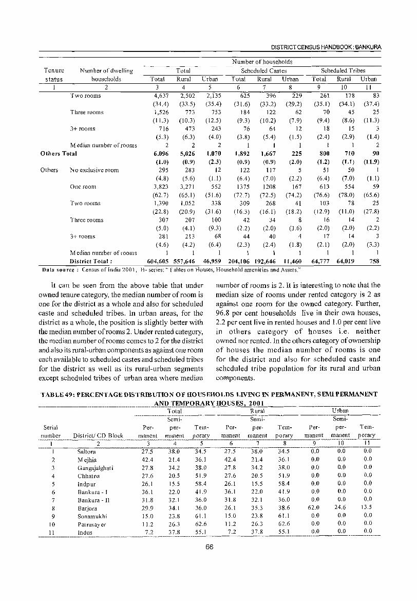
DISTRICT CENSUS HANDBOOK: BANKURA
Number of households
Tenure Number of dwelling Total Scheduled Castes Scheduled Tribes
status households Total Rural Urban Total Rural Urban Total Rural Urban I 2 3 4 5 6 7 8 9 10 II
Two rooms 4,637 2,502 2,135 625 396 229 261 178 83
(34.4) (33.5) (35.4) (31.6) (33.2) (29.2) (35.1) (34.1) (37.4) Three rooms 1,526 773 753 184 122 62 70 45 25
(11.3) (10.3) ( 12.5) (9.3) (l0.2) (7.9) (9.4) (8.6) (11.3)
3+ rooms 716 473 243 76 64 12 18 IS 3 (5.3) (6.3) (4.0) (3.8) (5.4) (1.5) (2.4) (2.9) (1.4)
Median number of rooms 2 2 2 I I 1 2
Others Total 6,096 5,026 1,070 1,892 1,667 225 800 710 90 (1.0) (0.9) (2.3) (0.9) (0.9) (2.0) (U) (1.1) (11.9)
Others No exclusive room 295 283 12 122 117 5 51 50 1
(4.8) (5.6) (1.1 ) (6.4) (7.0) (2.2) (6.4) (7.0) (1.1)
One room 3,823 3,271 552 1375 1208 167 613 554 59
(62.7) (65.1) (51.6) (72.7) (72.5) (74.2) (76.6) (78.0) (65.6) Two rooms 1,390 1,052 338 309 268 41 103 78 25
(22.8) (20.9) (3 I .6) (16.3) (16.1 ) (18.2) (12.9) (11.0) (27.8)
Three rooms 307 207 100 42 34 8 16 14 2 (5.0) (4.1 ) (9.3) (2.2) (2.0) (3.6) (2.0) (2.0) (2.2)
3+ rooms 281 213 68 44 40 4 17 14 3
(4.6) (4.2) (6.4) (2.3) (2.4) (l.8) (2.1) (2.0) (3.3) Median number ofrooms 1 1 1 1 1 District Total: 604,605 557,646 46,959 204,106 192,646 11,460 (;4,777 64,019 758
Data sou ree : Census of India 2001, H- series: "1 abies on Houses, Household amenities and Assets."
It can be seen from the above table that under number of rooms is 2. It is interesting to note that the owned tenure category, the median number of room is median size of rooms under re:nted category is 2 as one for the district as a whole and also for scheduled against one room for the owned category. Further, caste and scheduled tribes. In urban areas, for the 96.8 per cent households live in their own houses, district as a whole, the position is slightly better with 2.2 per cent live in rented houses and 1.0 per cent live the median number of rooms 2. Under rented category, in others category of houses i.e. neither the median number of rooms comes to 2 for the district owned nor rented. In the others category of ownership and also its rural-urban components as against one room of houses the median number of rooms is one each available to scheduled castes and scheduled tribes for the district and also for scheduled caste and for the district as well as its rural-urban segments scheduled tribe population for its rural and urban except scheduled tribes of urban area where median components.
TABLE 49: PERCENTAGEDISTRmUTION OF HOUSEHOLDS LIVlNG IN PERMANENT~, SEMIPERMANENT
_. __ AND_I~MPORARY HOUSES! 2001 Total Rural Urban
.-----~.---~.---~-.. ~-.-.~-------Semi- Semi- Semi-
Serial Per- per- Tem- Per- per- Tem- Per- per- Tem-
number District! CD Block manent manent porary manent manent porary manent manent porary
1 2 3 4 5 6 7 8 9 10 11
1 Saltora 27.5 38.0 34.5 27.5 38.0 34.5 0.0 0.0 0.0
2 Mejhia 42.4 21.4 36.1 42.4 21.4 36.1 0.0 0.0 0.0
3 Gangajalghati 27.8 34.2 38.0 27.8 34.2 38.0 0.0 0.0 0.0
4 Chhatna 27.6 20.5 51.9 27.6 20.5 51.9 0.0 0.0 0.0
5 Indpur 26.1 15.5 58.4 26.1 15.5 58.4 0.0 0.0 0.0
6 Bankura - I 36. I 22.0 41.9 36.1 22.0 41.9 0.0 0.0 0.0
7 Bankura - II 31.8 32. I 36.0 31.8 32. I 36.0 0.0 0.0 0.0
8 Barjora 29.9 34.1 36.0 26.1 35.3 38.6 62.0 24.6 13.5
9 Sonamukhi 15.0 23.8 61.1 15.0 23.8 61.1 0.0 0.0 0.0
10 Patrasayer 11.2 26.3 62.6 11.2 26.3 62.6 0.0 0.0 0.0
I I Indus 7.2 37.8 55.1 7.2 37.8 55.1 0.0 0.0 0.0 .---~~-•.. ----.--~-
66
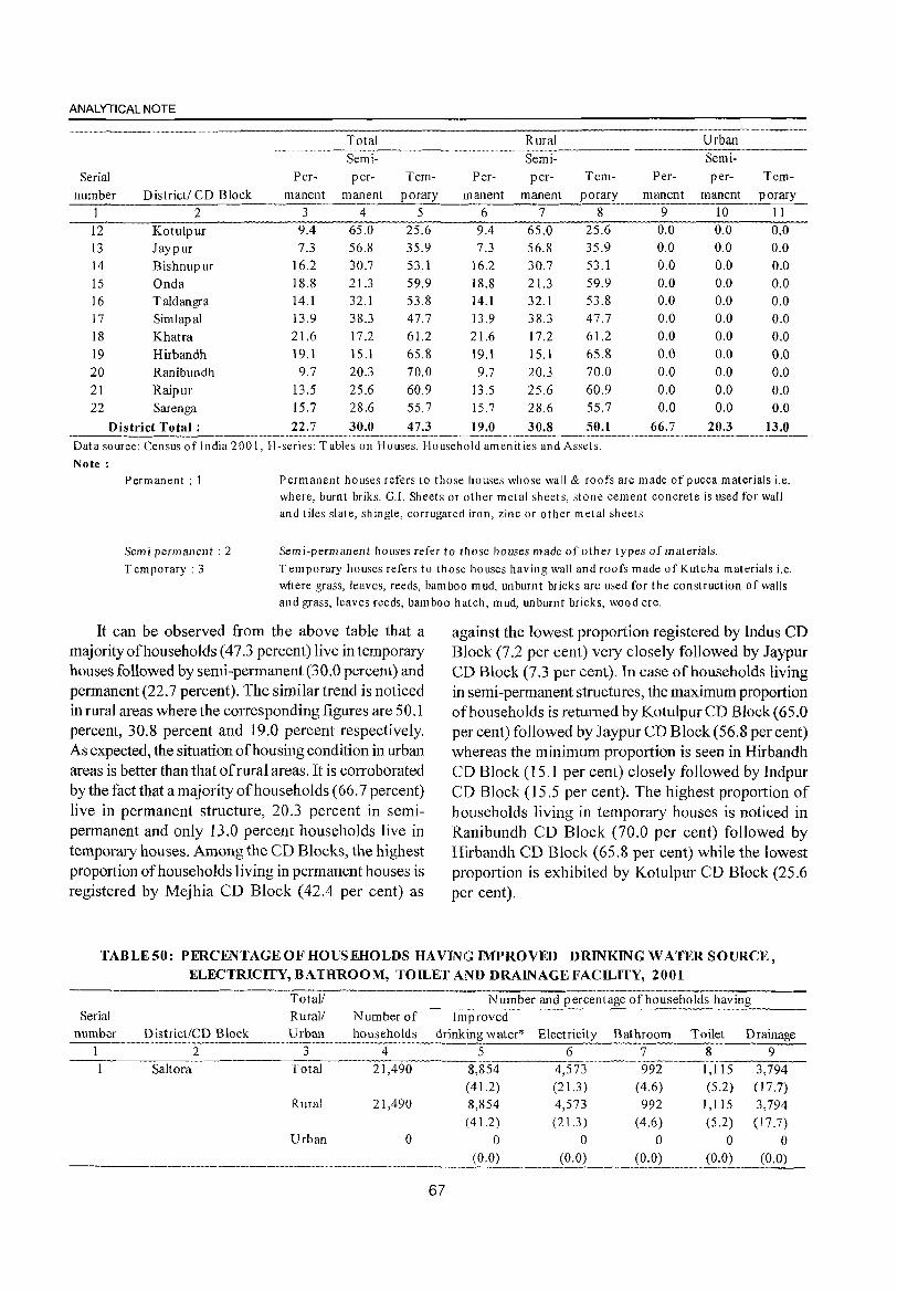
ANALYTICAL NOTE
Total Rural Urban
Semi- Semi-
Serial Per- per- Tem- Per- per- Tem- Per- per- Tem-
number District! CD Block manent manent porary manent manent porary manent manent porary
2 3 4 5 6 7 8 9 10 II
12 Kotulpur 9.4 65.0 25.6 9.4 65.0 25.6 0.0 0.0 0.0 13 Jaypur 7.3 56.8 35.9 7.3 56.8 35.9 0.0 0.0 0.0 14 Bishnupur 16.2 30.7 53.1 16.2 30.7 53.1 0.0 0.0 0.0 15 Onda 18.8 21.3 59.9 18.8 21.3 59.9 0.0 0.0 0.0 16 Taldangra 14.1 32.1 53.8 14.1 32.1 53.8 0.0 0.0 0.0 17 Simlapal 13.9 38.3 47.7 13.9 38.3 47.7 0.0 0.0 0.0 18 Khatra 2l.6 17.2 6l.2 21.6 17.2 61.2 0.0 0.0 0.0 19 Hirbandh 19.1 15.1 65.8 19.1 15.1 65.8 0.0 0.0 0.0 20 Ranibundh 9.7 20.3 70.0 9.7 20.3 70.0 0.0 0.0 0.0 21 Raipur 13.5 25.6 60.9 13.5 25.6 60.9 0.0 0.0 0.0 22 Sarenga 15.7 28.6 55.7 15.7 28.6 55.7 0.0 0.0 0.0
District Total: 22.7 30.0 47.3 19.0 30.S 50.1 66.7 20.3 13.0 .- "-'~---'~---"'-'-----'-"-""----~--'--"'-'-----'"---.---------.--.. -~.-.. --.--~--.--.-.. -.--.. -Data source: Census oflndia 200 I, H-series: Tables on Houses, Household amenit ies and Assets. Note:
Permanent: 1 Permanent houses refers to those houses whose wall & roofs are made of pucca materials i.e. where, burnt briks. G.!. Sheets or other metal sheets, stone cement concrete is used for wall and tiles slate, shingle, corrugated iron, zinc or other metal sheets
Semi permanent: 2 Temporary: 3
Scm i-permanent houses refer to those houses made of other types of materials. Temporary houses refers to those houses having wall and roofs made of Kutcha materials i.e. where grass, leaves, reeds, bamboo mud, unburnt bricks are used for the construction of walls and grass, leaves reeds, bamboo hatch, mud, unburnt bricks, wood etc.
It can be observed from the above table that a majority of households (473 percent) live in temporary houses followed by semi-permanent (30.0 percent) and permanent (22.7 percent). The similar trend is noticed in rural areas where the corresponding figures are 50.1 percent, 30.8 percent and 19.0 percent respectively. As expected, the situation of housing condition in urban areas is better than that of rural areas. It is corroborated by the fact that a majority of households (66. 7 percent) live in permanent structure, 20.3 percent in semipermanent and only 13.0 percent households live in temporary houses. Among the CD Blocks, the highest proportion of households living in permanent houses is registered by Mejhia CD Block (42.4 per cent) as
against the lowest proportion registered by Indus CD Block (7.2 per cent) very closely followed by Jaypur CD Block (7.3 per cent). In case of households living in semi-permanent structures, the maximum proportion of households is retumed by Kotulpur CD Block (65.0 per cent) followed by Jaypur CD Block (56.8 per cent) whereas the minimum proportion is seen in Hirbandh CD Block (15.] per cent) closely followed by Indpur CD Block (15.5 per cent). The highest proportion of households living in temporary houses is noticed in Ranibundh CD Block (70.0 per cent) followed by Hirbandh CD Block (65.8 per cent) while the lowest proportion is exhibited by Kotulpur CD Block (25.6 per cent).
TABLE50: PERCENTAGE OF HOUSEHOLDS HAVING IMPROVED DRINKING WATER SOURCE, ELECTRICITY, BATHROOM, TOILET AND DRAINAGE FACILITY, 2001
----------------_. __ . __ ._---_. -------_-_._-------------Total! N umber and percentage of households having
Serial Rural! Number of Improved number District/CD Block Urban households drinking water* Electricity Bathroom Toilet Drainage
2 3 4 5 6 7 8 9
SaItora Total 21,490 8,854 4,573 992 1,115 3,794 ( 41.2) (21.3) (4.6) (5.2) (17.7)
Rural 21,490 8,854 4,573 992 1,115 3,794 (41.2) (21.3 ) (4.6) (5.2) (17.7)
Urban 0 0 0 0 0 0
. ______ ... __ .. _ ..... __ . ________ . __ ~~ __ . __ ._~2. _____ .. ~.~~ ... ____ i2:0) (0.0)
67
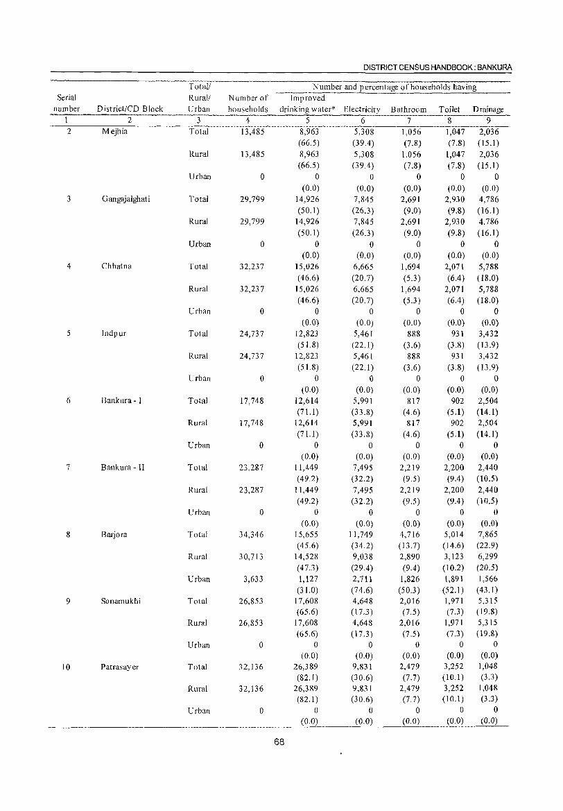
DISTRICT CENSUS HANDBOOK: BANKURA
Total! Number and percentage of households having Serial Rural! Number of -Improved --.. -----.
number D istrict/CD Block Urban households drinking water* Electricity Bathroom Toilet Drainage 1 2 3 4 5 6 7 8 9 2 Mejhia Total 13,485 8,963 5,308 1,056 1,047 2,036
(66.5) (39.4) (7.8) (7.8) (15.1) Rural 13,485 8,963 5,308 1,056 1,047 2,036
(66.5) (39.4 ) (7.8) (7.8) (15.1) Urban 0 0 0 0 0 0
(0.0) (0.0) (0.0) (0.0) (0.0) 3 G angajalghati Total 29,799 14,926 7,845 2,691 2,930 4,786
(50.1) (26.3) (9.0) (9.8) (16.1) Rural 29,799 14,926 7,845 2,691 2,930 4,786
(50.1) (26.3) (9.0) (9.8) (16.1) Urban 0 0 0 0 0 0
(0.0) (0.0) (0.0) (0.0) (0.0) 4 Chhatna Total 32,237 15,026 6,665 1,694 2,071 5,788
(46.6) (20.7) (5.3) (6.4) ( 18.0) Rural 32,237 15,026 6,665 1,694 2,071 5,788
(46.6) (20.7) (5.3) (6.4) (18.0) Urban 0 0 0 0 0 0
(0.0) (0.0) (0.0) (0.0) (0.0) 5 Indpur Total 24,737 12,823 5,461 888 931 3,432
(51.8) (22.1) (3.6) (3.8) (13.9) Rural 24,737 12,823 5,461 888 931 3,432
(51.8) (22.1) (3.6) (3.8) (l3.9) Urban 0 0 0 0 0 0
(0.0) (0.0) (0.0) (0.0) (0.0) 6 Bankura - I Total 17,748 12,614 5,991 817 902 2,504
(71.1 ) (33.8) (4.6) (5.1) (14.1) Rural 17,748 12,614 5,991 817 902 2,504
(71.1 ) (33.8) (4.6) (5.1) (14.1) Urban 0 0 0 0 0 0
(0.0) (0.0) (0.0) (0.0) (0.0) 7 Bankura - II Total 23,287 11,449 7,495 2,219 2,200 2,440
(49.2) (32.2) (9.5) (9.4) (10.5)
Rural 23,287 11,449 7,495 2,219 2,200 2,440 (49.2) (32.2) (9.5) (9.4) (10.5)
Urban 0 0 0 0 0 0 (0.0) (0.0) (0.0) (0.0) (0.0)
8 Barjora Total 34,346 15,655 11,749 4,716 5,014 7,865 (45.6) (34.2) (13.7) ( 14.6) (22.9)
Rural 30,713 14,528 9,038 2,890 3,123 6,299 (47.3 ) (29.4) (9.4) (10.2) (20.5)
Urban 3,633 1,127 2,711 1,826 1,891 1,566 (31.0) (74.6) (50.3) (52.1) (43.1)
9 Sonamukhi Total 26,853 17,608 4,648 2,016 1,971 5,315 (65.6) (17.3) (7.5) (7,3) (19.8)
Rural 26,853 17,608 4,648 2,016 1,971 5,315 (65.6) (17.3 ) (7.5) (7.3) (19.8)
Urban 0 0 0 0 0 0
(0.0) (0.0) (0.0) (0.0) (0.0)
10 Patrasayer Total 32,136 26,389 9,831 2,479 3,252 1,048 (82.1 ) (30.6) (7.7) (10.1) (3.3)
Rural 32,136 26,389 9,83 I 2,479 3,252 1,048 (82.1) (30.6) (7.7) (10.1) (3.3)
Urban 0 0 0 0 0 0 (0.0) (0.0) (0.0) (0.0) (0.0)
68
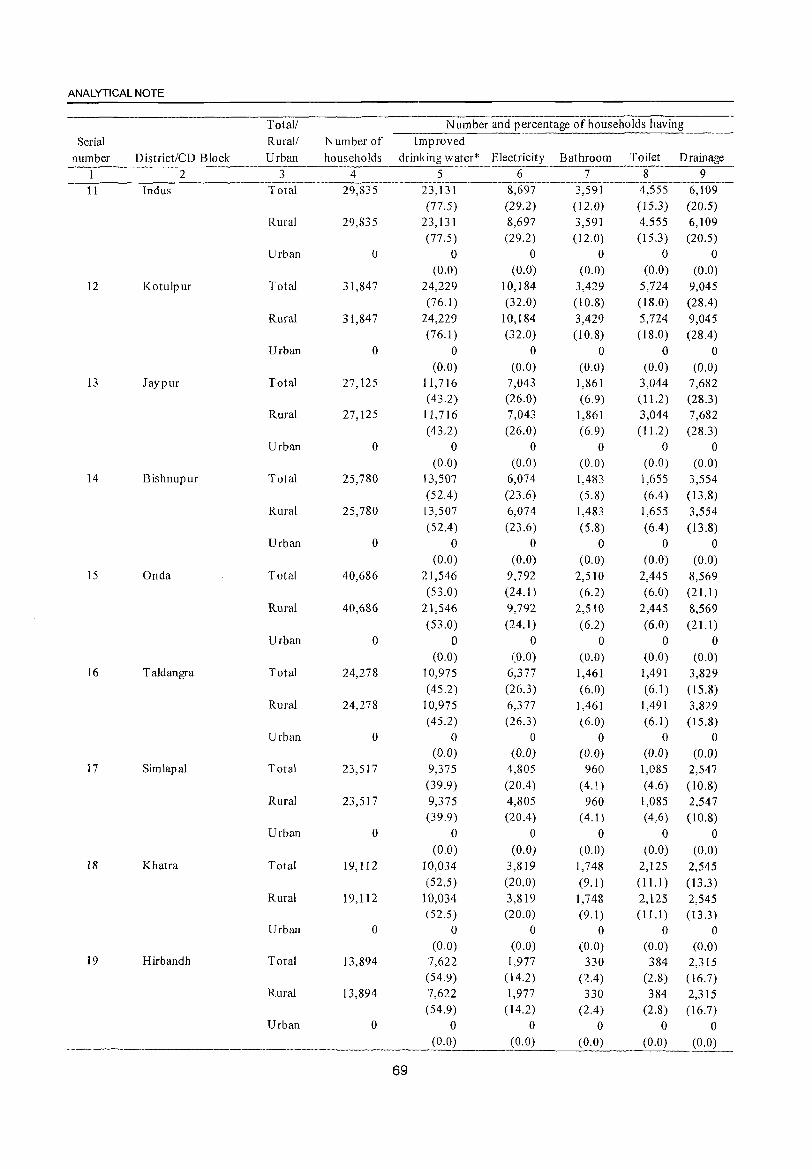
ANALYTICAL NOTE
Total! Number and percentage of households having
Serial Rural! Number of Improved
number District/CD Block Urban households drinking water* Electricity Bathroom Toilet Drainage 2 3 4 5 6 7 8 9
. ~-~'~-~~'------'-""""'---'-"""'-'---'~~-~----'-'-'----"--11 Indus Total 29,835 23,131 8,697 3,591 4,555 6,109
(77.5) (29.2) (12.0) (15.3) (20.5)
Rural 29,835 23,131 8,697 3,591 4,555 6,109 (77.5) (29.2) (12.0) (15.3 ) (20.5)
Urban 0 0 0 0 0 0 (0.0) (0.0) (0.0) (0.0) (0.0)
12 Kotulpur Total 31,847 24,229 10,184 3,429 5,724 9,045 (76.1 ) (32.0) (10.8) (18.0) (28.4)
Rural 31,847 24,229 10,184 3,429 5,724 9,045 (76.1 ) (32.0) (10.8) (18.0) (28.4)
Urban 0 0 0 0 0 0 (0.0) (0.0) (0.0) (0.0) (0.0)
13 Jaypur Total 27,125 11,716 7,043 1,861 3,044 7,682 ( 43.2) (26.0) (6.9) (11.2) (28.3)
Rural 27,125 11,716 7,043 1,861 3,044 7,682 (43.2) (26.0) (6.9) (11.2) (28.3)
Urban 0 0 0 0 0 0 (0.0) (0.0) (0.0) (0.0) (0.0)
14 Bishnupur Total 25,7&0 13,507 6,074 1,483 1,655 3,554 (52.4 ) (23.6) (5.8) (6.4) (13.8)
Rural 25,780 13,507 6,074 1,483 1,655 3,554 (52.4) (23.6) (5.8) (6.4) (13.8)
Urban 0 0 0 0 0 0 (0.0) (0.0) (0.0) (0.0) (0.0)
15 Onda Total 40,686 21,546 9,792 2,510 2,445 8,569 (53.0) (24.1) (6.2) (6.0) (21.1 )
Rural 40,686 21,546 9,792 2,510 2,445 8,569 (53.0) (24.1 ) (6.2) (6.0) (21.1 )
Urban 0 0 0 0 0 0 (0.0) (0.0) (0.0) (0.0) (0.0)
16 Taldangra Total 24,278 10,975 6,377 1,461 1,49] 3,829 (45.2) (26.3) (6.0) (6.1) (15.8)
Rural 24,278 10,975 6,377 1,461 1,491 3,829 (45.2) (26.3) (6.0) (6.1) (15.8)
Urban 0 0 0 0 0 0 (0.0) (0.0) (0.0) (0.0) (0.0)
17 Simlapal Total 23,517 9,375 4,805 960 1,085 2,547 (39.9) (20.4) (4.1 ) (4.6) (l0.8)
Rural 23,517 9,375 4,805 960 1,085 2,547 (39.9) (20A) (4.1) (4.6) (10.8)
Urban 0 0 0 0 0 0 (0.0) (0.0) (0.0) (0.0) (0.0)
18 Khatra Total 19,112 10,034 3,819 1,748 2,125 2,545 (52.5) (20.0) (9.1 ) (11.1) (13.3)
Rural 19,112 10,034 3,819 1,748 2,125 2,545 (52.5) (20.0) (9.1) (11.1) (13.3 )
Urban 0 0 0 0 0 0 (0.0) (0.0) (0.0) (0.0) (0.0)
19 Hirbandh Total 13,894 7,622 1,977 330 384 2,315 (54.9) (14.2) (2.4) (2.8) (16.7)
Rural 13,894 7,622 1,977 330 384 2,315 (54.9) (14.2) (2.4) (2.8) (16.7)
Urban 0 0 0 0 0 0 (0.0) (0.0) (0.0) (0.0) (0.0)
69
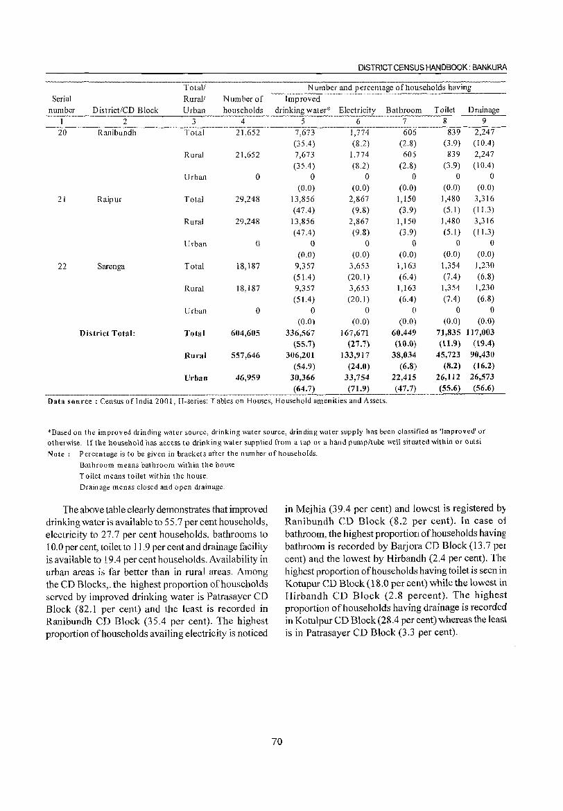
Serial Total! Rural! Number of
DISTRICT CENSUS HANDBOOK: BANKURA
Number and percentage of households having
Improved number District/CD Block Urban households drinking water* Electricity Bathroom Toilet Drainage
1 2 3 4 5 6 7 8 9 -W---RanibunCih--··-----·-Totiif"··-·-·-···· -2-j)53-2------7,67-3 -----1 }7"4--- 606 839
(3.9) 839
(3.9)
2,247 (10.4)
2,247
(10.4) Rural 21,652
Urban o
21 Raipur Total 29,248
Rural 29,248
Urban o
22 Sarenga Total 18,187
Rural 18,187
Urban o
District Total: Total 604,605
Rural 557,646
Urban 46,959
(35.4) (8.2) (2.8)
7,673
(35.4)
o (0.0)
13,856
(47.4)
13,856 (47.4)
o (0.0)
9,357 (51.4) 9,357
(51.4)
o (0.0)
336,567 (55.7)
306,201 (54.9)
30,366 (64.7)
1,774
(8.2)
o (0.0)
2,867
(9.8) 2,867
(9.8) o
(0.0) 3,653 (20.1 ) 3,653
(20.1 ) o
(0.0)
167,671 (27.7)
133,917
(24.0) 33,754
(71.9)
606
(2.8) I)
(0.0) 1,150
(3.9) 1,150
(3.9) o
(0.0)
1,163
(6.4)
1,163
(6.4)
o (0.0)
60,44~1
(10.0) 38,034-
(6.8)1
22,415 (47.7)
o (0.0)
1,480
(5.1) 1,480
(5.1)
o (0.0)
1,354-
(7.4)
1,354
(7.4)
o (0.0)
71,835 (11.9)
45,723 (8.2)
26,112 (55.6)
o (0.0)
3,316
(11.3) 3,316
(11.3)
o (0.0)
1,230
(6.8) 1,230
(6.8) o
(0.0)
117,003 (19.4)
90,430 (16.2)
26,573 (56.6)
Data sou rce : Census of India 2001, H-series: T abies on Houses, Household amenities and Assets.
*Based on the improved drinding water source, drinking water source, drinding water supply has been classified as 'Improved' or otherwise. If the household has access to drinking water supplied from a tap or a hand pump/tube well situated within or outsi
Note: Percentage is to be given in brackets after the number of households.
Bathroom means bathroom within the house
Toilet means toilet within the house.
Drainage menas closed and open drainage.
The above table clearly demonstrates that improved drinking water is available to 55.7 per cent households, electricity to 27.7 per cent households, bathrooms to 10.0 per cent, toilet to 11.9 per cent and drainage facility is available to 19.4 per cent households. Availability in urban areas is far better than in rural areas. Among the CD Blocks,. the highest proportion of households served by improved drinking water is Patrasayer CD Block (82.1 per cent) and the least is recorded in Ranibundh CD Block (35.4 per cent). The highest proportion of households availing electricity is noticed
70
in Mejhia (39.4 per cent) and lowest is registered by Ranibundh CD Block (8.2 per cent). In case oi bathroom, the highest proportion of households having bathroom is recorded by Barjora CD Block (13.7 pel cent) and the lowest by Hirbandh (2.4 per cent). The highest proportion of households having toilet is seen in Kotupur CD Block (18.0 per cent) while the lowest in Hirbandh CD Block (2.8 percent). The highest proportion of households having drainage is recorded in Kotulpur CD Block (28.4 per eent) whereas the least is in Patrasayer CD Block (3.3 per cent).
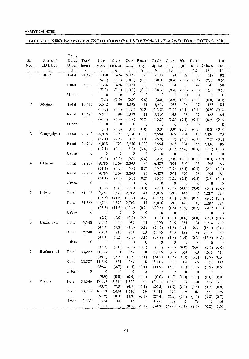
ANALYTICAL NOTE
TABLES1: NUMBER AND PERCENT OF HOUSEHOLDS BYTVPEOFFUELUSEDFORCOOKING, 2001
Sl.
No.
2
3
4
5
6
7
8
District / CD Block
2
Saltora
Mejhia
Gangajalghat i
Chhatna
Indpur
Bankura - I
Bankura - II
Barjora
Total!
Rural! Total Fire Crop Cow Electri- Coal/ Cook- Bio- Kero-
Urban house wood residue dung city Lignite ing gas sene 3 4 5 6 7 8 9 10 11 12
·Total··2T;i·90·-ilj58--·-6762:T7i--··23""-~-iT--84-73---42
Rural 21,490
Urban o
Total 13,485
Rural 13,485
Urban o
Total 29,799
Rural 29,799
Urban o
Total 32,237
Rural 32,237
Urban o
Total 24,737
Rural 24,737
Urban a
Total 17,748
Rural 17,748
Urban o
Total 23,287
Rural 23,287
Urban o
Total 34,346
Rural 30,713
Urban 3,633
(52.9) (3.1) (l 0.1) (0.1) (30.3) (0.4) (0.3) (0.2) 11,358
(52.9)
o (0.0)
5,512
(40.9) 5,512
(40.9)
o (0.0)
14,028
(47. I) 14,028
(47.1 )
o (0.0)
19,796
(61.4)
19,796 (61.4)
o (0.0)
10,752
(43.5)
10,752
(43.5)
o (0.0)
7,234
(40.8)
7,234
(40.8)
o (0.0)
[ [,699
(50.2)
11,699
(50.2)
o (0.0)
17,097
(49.S) 16,563 (53.9)
534 (14.7)
676 (3.1)
o (0.0)
190 (1.4)
190 (1.4)
o (0.0) 723
(2.4)
723 (2.4)
o (0.0)
1,566
( 4.9)
1,566
(4.9)
o (0.0)
2,879 ( 11.6)
2,879
(11.6)
o (0.0)
920 (5.2)
920
(5.2)
o (0.0)
621
(2.7) 621
(2.7)
o (0.0)
2,514
(7.3)
2,454 (8.0)
60 (1. 7)
2,171 (10.1)
o (0.0)
1,538 (11.4)
1,538 (11.4 )
o (0.0)
2,550
(S.6)
2,550 (8.6)
o (0.0)
2,203
(6.8)
2,203
(6.8)
a (0.0)
2,702
(10.9)
2,702
(l0.9)
o (0.0) 991
(5.6)
991
(5.6)
o (0.0)
367
(1.6)
367 (1.6)
o (0.0)
1,522 (4.4)
1,510 (4.9)
12
(0.3)
71
23
(0. I) o
(0.0)
21 (0.2)
21 (0.2)
o (0.0)
1,000
(3.4)
1,000 (3.4)
o (0.0)
64
(0.2)
64 (0.2)
o (0.0)
41 (0.2)
41 (0.2)
o (0.0)
25 (0.1 )
25 (O.l)
o (0.0)
18 (0.1 )
18 (0.1 )
o (0.0)
41
(0. I)
39 (0.1 )
2
(0.1 )
6,517
(30.3)
o (0.0)
5,819
(43.2)
5,819 ( 43.2)
o (0.0)
7,994
(26.S)
7,994
(26.8)
o (0.0)
6,487
(20.1)
6,487 (20.1)
o (0.0)
5,076
(20.5)
5,076
(20.5)
o (0.0)
5,100
(28.7)
5,100
(28.7)
o (0.0)
8,116
(34.9)
8,116
(34.9)
o (0.0)
10,404
(30.3)
8,411 (27.4)
1,993 (54.9)
84
(0.4)
o (0.0)
165 (1.2)
165 ( 1.2)
o (0.0)
367 (1.2)
367 (1.2)
o (0.0) 394
( 1.2)
394 (1.2)
o (0.0)
391 (1.6)
391 (1.6)
o (0.0)
316
0.8) 316
Cl.8) a
(0.0)
810
(3.5)
810
(3.5)
o (0.0)
73
(0.3)
o (0.0)
16
(0.1)
16
(0.1 )
o (0.0)
831
(2.8)
831 (2.8)
o (0.0) 692
(2.1 )
692 (2.1 )
o (0.0) 442
(1.8)
442 (1.8)
o (0.0)
255 (1.4)
255
( 1.4)
o (0.0)
104 (0.4)
104
(0.4)
o (0.0)
1,683 113
(4.9) (0.3)
775 110 (2.5) (0.4)
908 3 (25.0) (0.1)
42
(0.2)
o (0.0)
17 (0.1)
17 (0.1)
o (0.0)
85
(0.3) 85
(0.3)
a (0.0)
96
(0.3)
96 (0.3)
o (0.0)
43 (0.2)
43
(0.2)
o (0.0)
34 (0.2)
34
(0.2)
o (0.0)
65 (0.3)
65
(0.3)
o (0.0)
138
(0.4)
62 (0.2)
76 (2.1)
No Others cook
13 14
448 98 (2.1) (0.5)
448 98
(2.1) (0.5)
o 0 (0.0) (0.0)
123 84 (0.9) (0.6)
123 84 (0.9) (0.6)
a 0 (0.0) (0.0)
2,136 85
(7.2) (0.3)
2,136 85
(7.2) (0.3)
a 0 (0.0) (0.0) 756 183
(2.3) (0.6)
756 183 (2.3) (0.6)
o 0
(0.0) (0.0)
2,287 124 (9.2) (0.5)
2,287 124 (9.2) (0.5)
o 0
(0.0) (0.0)
2,734 139 (15.4) (0.8)
2,734 139 (15.4) (0.8)
o 0 (0.0) (0.0)
1,363 124
(5.9) (0.5) 1,363 124
(5.9) (0.5)
o 0 (0.0) (0.0)
569 265 (1.7) (0.8)
560 229 (1.8) (0.7)
9 36 (0.2) (1.0)
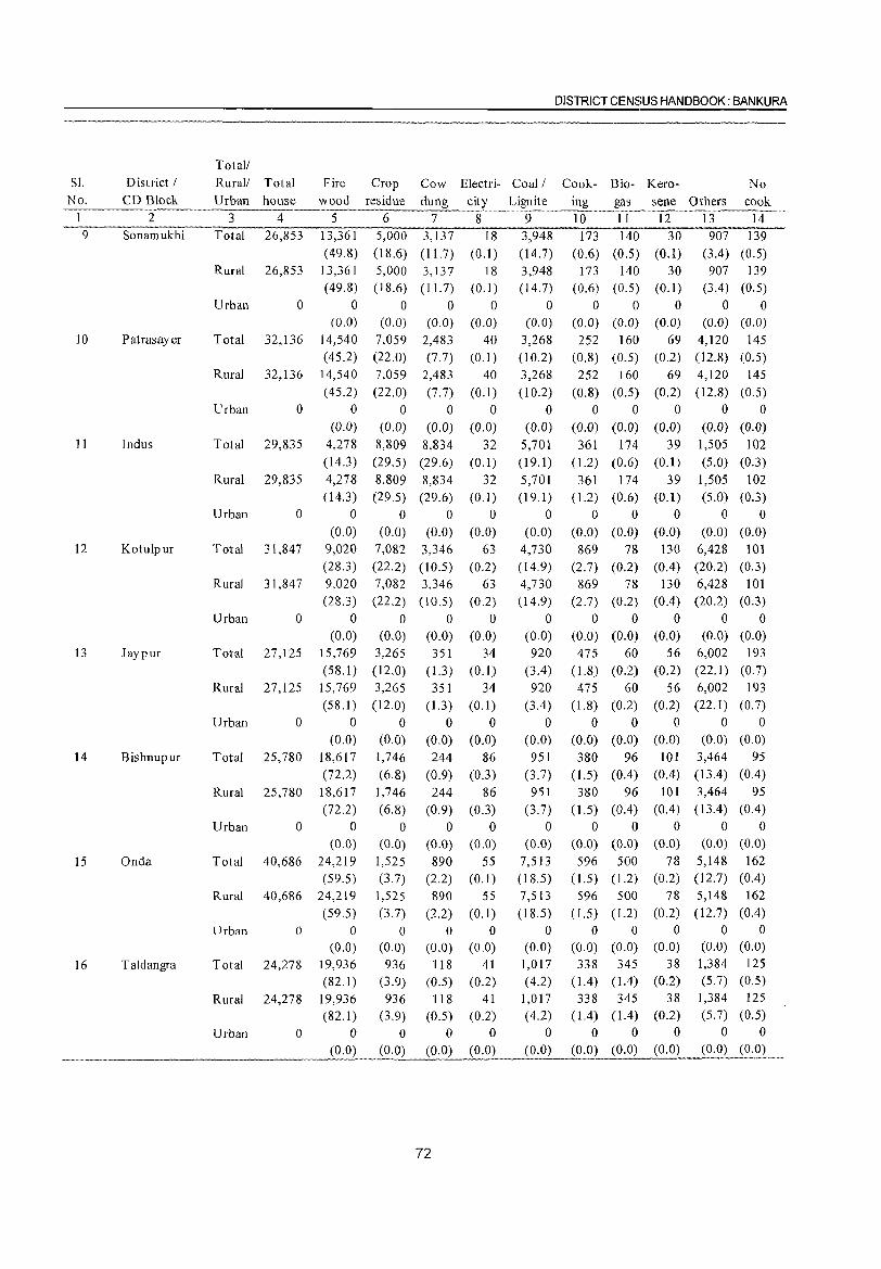
DISTRICT CENSUS HANDBOOK: BANKURA
Total/ Sl. District / Rural/ Total Fire Crop Cow Electri- Coal/ Cook- Bio- Kero- No
No. CD Block Urban house wood residue dung city Lignite iug gas sene Others cook 1 2 3 4 5 6 7 8 9 10 II 12 13 14 9 Sonamukhi Total 26,853 13,361 5,000 3,137 18 3,948 173 140 30 907 139
(49.8) (18.6) ( 11.7) (0.1) (14.7) (0.6) (0.5) (0.1) (3.4) (0.5) Rural 26,853 13,361 5,000 3,137 18 3,948 173 140 30 907 139
(49.8) (18.6) (II. 7) (0.1 ) (14.7) (0.6) (0.5) (0.1) (3.4) (0.5) Urban 0 0 0 0 0 0 0 0 0 0 0
(0.0) (0.0) (0.0) (0.0) (0.0) (0.0) (0.0) (0.0) (0.0) (0.0) 10 Patrasayer Total 32,136 14,540 7,059 2,483 40 3,268 252 160 69 4,120 145
(45.2) (22.0) (7.7) (0.1) (10.2) (0.8) (0.5) (0.2) (12.8) (0.5) Rural 32,136 14,540 7,059 2,483 40 3,268 252 160 69 4,120 145
(45.2) (22.0) (7.7) (0.1) (10.2) (0.8) (0.5) (0.2) (12.8) (0.5) Urban 0 0 0 0 0 0 0 0 0 0 0
(0.0) (0.0) (0.0) (0.0) (0.0) (0.0) (0.0) (0.0) (0.0) (0.0) 11 Indus Total 29,835 4,278 8,809 8,834 32 5,701 361 174 39 1,505 102
(14.3 ) (29.5) (29.6) (0.1) (19.1) (1.2) (0.6) (0.1) (5.0) (0.3) Rural 29,835 4,278 8,809 8,834 32 5,701 361 174 39 1,505 102
(14.3) (29.5) (29.6) (0.1) (19.1) (1.2) (0.6) (0.1) (5.0) (0.3) Urban 0 0 0 0 0 0 0 0 0 0 0
(0.0) (0.0) (0.0) (0.0) (0.0) (0.0) (0.0) (0.0) (0.0) (0.0) 12 Kotulpur Total 31,847 9,020 7,082 3,346 63 4,730 869 78 130 6,428 101
(28.3) (22.2) (l0.5) (0.2) (14.9) (2.7) (0.2) (0.4) (20.2) (0.3) Rural 31,847 9,020 7,082 3,346 63 4,730 869 78 130 6,428 101
(28.3 ) (22.2) (10.5) (0.2) (14.9) (2.7) (0.2) (OA) (20.2) (0.3) Urban 0 0 0 0 0 0 0 0 0 0 0
(0.0) (0.0) (0.0) (0.0) (0.0) (0.0) (0.0) (0.0) (0.0) (0.0) 13 Jaypur Total 27,125 15,769 3,265 351 34 920 475 60 56 6,002 193
(58.1) (12.0) (1.3) (0.1) (3.4) (1.8) (0.2) (0.2) (22.1) (0.7) Rural 27,125 15,769 3,265 351 34 920 475 60 56 6,002 193
(58.1 ) (12.0) (1.3) (0.1) (3.4) ( 1.8) (0.2) (0.2) (22.1 ) (0.7) Urban 0 0 0 0 0 0 0 0 0 0 0
(0.0) (0.0) (0.0) (0.0) (0.0) (0.0) (0.0) (0.0) (0.0) (0.0)
14 Bishnupur Total 25,780 18,617 1,746 244 86 951 380 96 101 3,464 95 (72.2) (6.8) (0.9) (0.3) (3.7) ( 1.5) (004) (OA) (13.4) (0.4)
Rural 25,780 18,617 1,746 244 86 951 380 96 101 3,464 95 (72.2) (6.8) (0.9) (0.3) (3.7) 0.5) (004) (0.4) (13.4) (0.4)
Urban 0 0 0 0 0 0 0 0 0 0 0 (0.0) (0.0) (0.0) (0.0) (0.0) (0.0) (0.0) (0.0) (0.0) (0.0)
15 Onda Total 40,686 24,219 1,525 890 55 7,513 596 500 78 5,148 162 (59.5) (3.7) (2.2) (0.1) (18.5) ( 1.5) (1.2) (0.2) (12.7) (0.4)
Rural 40,686 24,219 1,525 890 55 7,513 596 500 78 5,148 162
(59.5) (3.7) (2.2) (0.1) (18.5) ( 1.5) ( 1.2) (0.2) (12.7) (0.4)
Urban 0 0 0 0 0 0 0 0 0 0 0 (0.0) (0.0) (0.0) (0.0) (0.0) (0.0) (0.0) (0.0) (0.0) (0.0)
16 Taldangra Total 24,278 19,936 936 118 41 1,017 338 345 38 1,384 125
(82.1 ) (3.9) (0.5) (0.2) (4.2) 0.4) (1.4) (0.2) (5.7) (0.5)
Rural 24,278 19,936 936 118 41 1,017 338 345 38 1,384 125
(82.1) (3.9) (0.5) (0.2) (4.2) (1.4) (1.4) (0.2) (5.7) (0.5)
Urban 0 0 0 0 0 0 0 0 0 0 0
(0.0) (0.0) (0.0) (0.0) (0.0) (0.0) (0.0) (0.0) (0.0) (0.0)
72
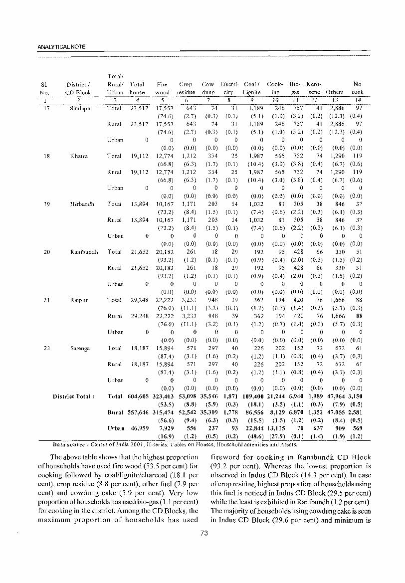
ANALYTICAL NOTE
Total/
SI. District / Rural! Total Fire Crop Cow Electri- Coal! Cook- Bio- Kero- No
No. CD Block Urban house wood residue dung city Lignite ing gas sene Others cook
I 2 3 4 5 6 7 8 9 10 II 12 13 14
17 Simlapal Total 23,517 17,553 643 74 31 1,189 246 757 41 2,886 97
(74.6) (2.7) (0.3) (0.1) (5.1 ) ( 1.0) (3.2) (0.2) (12.3) (0.4)
Rural 23,517 17,553 643 74 31 1,189 246 757 41 2,886 97
(74.6) (2.7) (0.3) (0.1) (5.1 ) (1.0) (3.2) (0.2) (12.3) (0.4)
Urban 0 0 0 0 0 0 0 0 0 0 0
(0.0) (0.0) (0.0) (0.0) (0.0) (0.0) (0.0) (0.0) (0.0) (0.0)
18 Khatra Total 19,112 12,774 1,212 334 25 1,987 565 732 74 1,290 119
(66.8) (6.3) (1.7) (0.1 ) (10.4) (3.0) (3.8) (0.4) (6.7) (0.6)
Rural 19,112 12,774 1,212 334 25 1,987 565 732 74 1,290 119
(66.8) (6.3) (1.7) (0.1 ) (l0.4) (3.0) (3.8) (0.4) (6.7) (0.6) Urban 0 0 0 0 0 0 0 0 0 0 0
(0.0) (0.0) (0.0) (0.0) (0.0) (0.0) (0.0) (0.0) (0.0) (0.0)
19 Hirbandh Total 13,894 10,167 1,171 203 14 1,032 81 305 38 846 37 (73.2) (8.4) (1.5) (0.1 ) (7.4 ) (0.6) (2.2) (0.3) (6.1) (0.3)
Rural 13,894 10,167 1,171 203 14 1,032 81 305 38 846 37 (73.2) (8.4) (1.5) (0.1) (7.4) (0.6) (2.2) (0.3) ( 6.1) (0.3)
Urban 0 0 0 0 0 0 0 0 0 0 0 (0.0) (0.0) (0.0) (0.0) (0.0) (0.0) (0.0) (0.0) (0.0) (0.0)
20 Ranibundh Total 21,652 20,182 261 18 29 192 95 428 66 330 51
(93.2) (1.2) (0.1) (0.1 ) (0.9) (0.4) (2.0) (0.3) (1.5) (0.2)
Rural 21,652 20,182 261 18 29 192 95 428 66 330 51
(93.2) (1.2) (0.1 ) (0.1 ) (0.9) (0.4) (2.0) (0.3) ( 1.5) (0.2)
Urban 0 0 0 0 0 0 0 0 0 0 0 (0.0) (0.0) (0.0) (0.0) (0.0) (0.0) (0.0) (0.0) (0.0) (0.0)
21 Raipur Total 29,248 22,222 3,233 948 39 362 194 420 76 1,666 88
(76.0) (11.1 ) (3.2) (0.1) (1.2) (0.7) (104) (0.3) (5.7) (0.3)
Rural 29,248 22,222 3,233 948 39 362 194 420 76 1,666 88 (76.0) (11.1) (3.2) (0.1) (1.2) (0.7) (1.4) (0.3) (5.7) (0.3)
Urban 0 0 0 0 0 0 0 0 0 0 0 (0.0) (0.0) (0.0) (0.0) (0.0) (0.0) (0.0) (0.0) (0.0) (0.0)
22 Sarenga Total 18,187 15,894 571 297 40 226 202 152 72 672 61
(87.4) (3.1) (1.6) (0.2) (1.2) (1.1 ) (0.8) (0.4) (3.7) (0.3) Rural 18,187 15,894 571 297 40 226 202 152 72 672 61
(87.4 ) (3.1 ) (1.6) (0.2) (1.2) (1.1) (0.8) (0.4) (3.7) (0.3) Urban 0 0 0 0 0 0 0 0 0 0 0
(0.0) (0.0) (0.0) (0.0) (0.0) (0.0) (0.0) (0.0) (0.0) (0.0)
District Total: Total 604,605 323,403 53,098 35,546 1,871 109,400 21,244 6,940 1,989 47,964 3,150
(53.5) (8.8) (5.9) (0.3) (18.1 ) (3.5) (Ll) (0.3) (7.9) (0.5)
Rural 557,646 315,474 52,542 35,309 1,778 86,556 8,129 6,870 1,352 47,055 2,581
(56.6) (9.4) (6.3) (0.3) (15.5) (1.5) (1.2) (0.2) (8.4) (0.5)
Urban 46,959 7,929 556 237 93 22,844 13,115 70 637 909 569 (16.9) (1.2) (0.5) (0.2) (48.6) (27.9) (0.1 ) (1.4) (1.9) (1.2)
Data sou rce : Census ofIndia 2001, H-series: T abIes on Houses, Household amenit ies and Assets.
The above table shows that the highest proportion fireword for cooking in Ranibundh CD Block of households have used fire wood (53.5 per cent) for (93.2 per cent). Whereas the lowest proportion is cooking followed by coal/lignite/charcoal (18.1 per observed in Indus CD Block (14.3 per cent). In case cent), crop residue (8.8 per cent), other fuel (7.9 per of crop residue, highest proportion of households using cent) and cowdung cake (5.9 per cent). Very low this fuel is noticed in Indus CD Block (29.5 per cent) proportion of households has used bio-gas (1.1 per cent) while the least is exhibited in Ranibundh (1.2 per cent). for cooking in the district. Among the CD Blocks, the The majority ofhouseholds using cowdung cake is seen maximum proportion of households has used in Indus CD Block (29.6 per cent) and minimum is
73
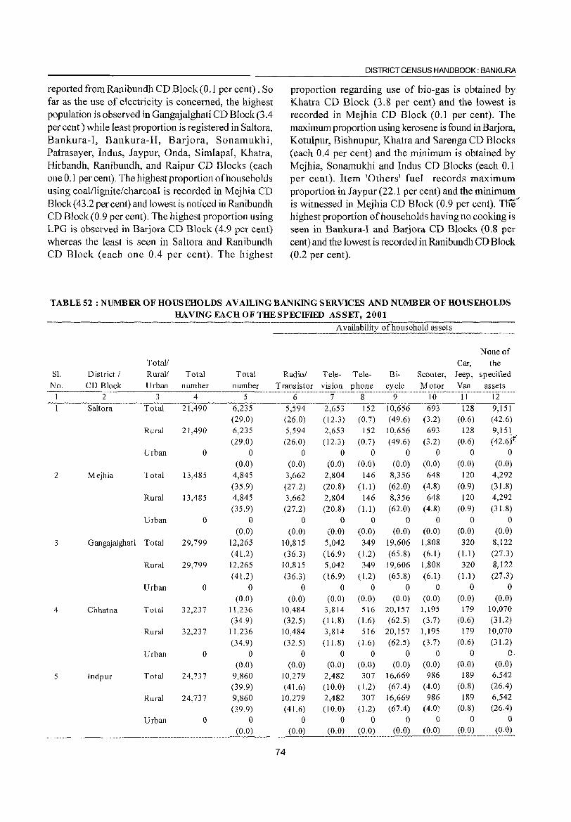
reported from Ranibundh CD Block (0.1 per cent) . So far as the use of electricity is concerned, the highest population is observed in Gangajalghati CD Block (3.4 per cent) while least proportion is registered in Saltora, Bankura-I, Bankura-II, Barjora, Sonamukhi, Patrasayer, Indus, Jaypur, Onda, Simlapal, Khatra, Hirbandh, Ranibundh, and Raipur CD Blocks (each one 0.1 per cent). The highest proportion of households using coal/lignite/charcoal is recorded in Mejhia CD Block (43.2 percent) and lowest is noticed in Ranibundh CD Block (0.9 per cent). The highest proportion using LPG is observed in Barjora CD Block (4.9 per cent) whereas the least is seen in Sahora and Ranibundh CD Block (each one 0.4 per cent). The highest
DISTRICT CENSUS HANDBOOK: BANKURA
proportion regarding use of bio-gas is obtained by Khatra CD Block (3.8 per cent) and the lowest is recorded in Mejhia CD Block (0.1 per cent). The maximum proportion using kerosene is found in Barjora, Kotulpur, Bishnupur, Khatra and Sarenga CD Blocks (each 0.4 per cent) and the minimum is obtained by Mejhia, Sonamukhi and Indus CD Blocks (each 0.1 per cent). Item IOthers l fuel records maximum proportion in Jaypur (22.1 per (~ent) and the minimum is witnessed in Mejhia CD Block (0.9 per cent). Tli'e' highest proportion of households having no cooking is seen in Bankura-I and Barjora CD Blocks (0.8 per cent) and the lowest is recorded in Ranibundh CD Block (0.2 per cent).
TABLE 52 : NUMBER OF HOUSEHOLDS AVAILING BANKING SERVICES AND NUMBER OF HOUSEHOLDS HAVING EACH OF THE SPECIFIED ASSET, 2001
Availability of household assets
None of TotaV Car, the
Sl. District I RuraV Total Total Radiol Tele- Tele- Bi- Seooter, Jeep, specified No. CO Block Urban number number Transistor vision phone cycle Motor Van assets
I 2 3 4 5 6 7 8 9 10 11 12
Saltora Total 21,490 6,235 5,594 2,653 152 10,656 693 128 9,151 (29.0) (26.0) (12.3) (0.7) ( 49.6) (3.2) (0.6) (42.6)
Rural 21,490 6,235 5,594 2,653 152 10,656 693 128 9,151 -:,;;..
(29.0) (26.0) (12.3) (0.7) (49.6) (3.2) (0.6) ( 42.6)t
Urban 0 0 0 0 0 0 0 0 0 (0.0) (0.0) (0.0) (0.0) (0.0) (0.0) (0.0) (0.0)
2 Mejhia Total 13,485 4,845 3,662 2,804 146 8,356 648 120 4,292
(35.9) (27.2) (20.8) (1.1) (62.0) (4.8) (0.9) (31.8)
Rural 13,485 4,845 3,662 2,804 146 8,356 648 120 4,292
(35.9) (27.2) (20.8) ( 1.1) (62.0) (4.8) (0.9) (31.8)
Urban 0 0 0 0 0 0 0 0 0 (0.0) (0.0) (0.0) (0.0) (0.0) (0.0) (0.0) (0.0)
3 Gangajalghati Total 29,799 12,265 10,815 5,042 349 19,606 1.,808 320 8,122
(41.2) (36.3) (16.9) (1.2) (65.8) (6.1) (1.1) (27.3)
Rural 29,799 12,265 10,815 5,042 349 19,606 1,,808 320 8,122
( 41.2) (36.3) (16.9) (1.2) (65.8) (6.1) (1.1) (27.3)
Urban 0 0 0 0 0 0 0 a 0
(0.0) (0.0) (0.0) (0.0) (0.0) (0.0) (0.0) (0.0)
4 Chhatna Total 32,237 11,236 10,484 3,814 516 20,157 1,195 179 10,070
(34.9) (32.5) (11.8) (1.6) (62.5) (3.7) (0.6) (31.2)
Rural 32,237 11,236 10,484 3,814 516 20,157 1,195 179 10,070
(34.9) (32.5) (11.8) ( 1.6) (62.5) (3.7) (0.6) (31.2)
Urban 0 0 0 0 0 0 0 a o· (0.0) (0.0) (0.0) (0.0) (0.0) (0.0) (0.0) (0.0)
5 Indpur Total 24,737 9,860 10,279 2,482 307 16,669 986 189 6,542
(39.9) ( 41.6) (10.0) (1.2) (67.4) (4.0) (0.8) (26.4)
Rural 24,737 9,860 10,279 2,482 307 16,669 986 189 6,542
(39.9) (41.6) (10.0) (1.2) (67.4) (4.0) (0.8) (26.4)
Urban 0 0 0 0 0 0 0 0 0
(0.0) (0.0) (0.0) (0.0) (0.0) (0.0) (0.0) (0.0)
74
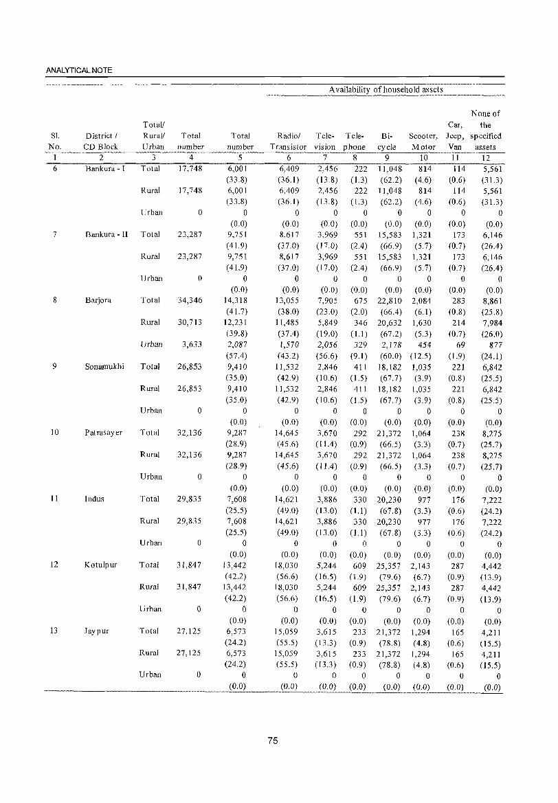
ANALYTICAL NOTE
A vailability of household assets
None of Total! Car, the
S1. District I Rural! Total Total Radiol Tele- Tele- Bi- Scooter, Jeep, specified No. CD Block Urban number number Transistor vision phone cycle Motor Van assets
1 2 3 4 5 6 7 8 9 10 11 12 6 Bankura - I Total 17,748 6,001 6,409 2,456 222 11,048 814 114 5,561
(33.8) (36.1 ) (13.8) (1.3) (62.2) (4.6) (0.6) (31.3) Rural 17,748 6,001 6,409 2,456 222 11,048 814 114 5,561
(33.8) (36.1 ) (13.8) (1.3) (62.2) (4.6) (0.6) (31.3 ) Urban 0 0 0 0 0 0 0 0 0
(0.0) (0.0) (0.0) (0.0) (0.0) (0.0) (0.0) (0.0) 7 Bankura - II Total 23,287 9,751 8,617 3,969 551 15,583 1,321 173 6,146
( 41.9) (37.0) (17.0) (2.4) (66.9) (5.7) (0.7) (26.4) Rural 23,287 9,751 8,617 3,969 551 15,583 1,321 173 6,146
( 41.9) (37.0) (17.0) (2.4) (66.9) (5.7) (0.7) (26.4) Urban 0 0 0 0 0 0 0 0 0
(0.0) (0.0) (0.0) (0.0) (0.0) (0.0) (0.0) (0.0) 8 Barjora Total 34,346 14,318 13,055 7,905 675 22,810 2,084 283 8,861
( 41.7) (38.0) (23.0) (2.0) (66.4) (6.1) (0.8) (25.8) Rural 30,713 12,231 11,485 5,849 346 20,632 1,630 214 7,984
(39.8) (37.4) (19.0) 0.1) (67.2) (5.3) (0.7) (26.0) Urban 3,633 2,087 1,570 2,056 329 2,178 454 69 877
(57.4) (43.2) (56.6) (9.1) (60.0) (12.5) (1.9) (24.1) 9 Sonamukhi Total 26,853 9,410 11,532 2,846 411 18,182 1,035 221 6,842
(35.0) ( 42.9) (10.6) 0.5) (67.7) (3.9) (0.8) (25.5) Rural 26,853 9,410 11,532 2,846 411 18,182 1,035 221 6,842
(35.0) (42.9) (10.6) 0.5) (67.7) (3.9) (0.8) (25.5) Urban 0 0 0 0 0 0 0 0 0
(0.0) (0.0) (0.0) (0.0) (0.0) (0.0) (0.0) (0.0) 10 Patrasayer Total 32,136 9,287 14,645 3,670 292 21,372 1,064 238 8,275
(28.9) (45.6) (11.4) (0.9) (66.5) (3.3) (0.7) (25.7) Rural 32,136 9,287 14,645 3,670 292 21,372 1,064 238 8,275
(28.9) (45.6) (11.4 ) (0.9) (66.5) (3.3) (0.7) (25.7) Urban 0 0 0 0 0 0 0 0 0
(0.0) (0.0) (0.0) (0.0) (0.0) (0.0) (0.0) (0.0) 11 Indus Total 29,835 7,608 14,621 3,886 330 20,230 977 176 7,222
(25.5) (49.0) (13.0) 0.1 ) (67.8) (3.3) (0.6) (24.2) Rural 29,835 7,608 14,621 3,886 330 20,230 977 176 7,222
(25.5) (49.0) (13.0) 0.1 ) (67.8) (3.3) (0.6) (24.2) Urban 0 0 0 0 0 0 0 0 0
(0.0) (0.0) (0.0) (0.0) (0.0) (0.0) (0.0) (0.0) 12 Kotulpur Total 31,847 13,442 18,030 5,244 609 25,357 2,143 287 4,442
(42.2) (56.6) (16.5) (l.9) (79.6) (6.7) (0.9) (13.9) Rural 31,847 13,442 18,030 5,244 609 25,357 2,143 287 4,442
(42.2) (56.6) (16.5) (1.9) (79.6) (6.7) (0.9) (13.9) Urban 0 0 0 0 0 0 0 0 0
(0.0) (0.0) (0.0) (0.0) (0.0) (0.0) (0.0) (0.0) 13 Jay pur Total 27,125 6,573 15,059 3,615 233 21,372 1,294 165 4,211
(24.2) (55.5) (13.3) (0.9) (78.8) (4.8) (0.6) (I5.5) Rural 27,125 6,573 15,059 3,615 233 21,372 1,294 165 4,211
(24.2) (55.5) (13.3 ) (0.9) (78.8) (4.8) (0.6) (I5.5) Urban 0 0 0 0 0 0 0 0 0
(0.0) (0.0) (0.0) (0.0) (0.0) (0.0) (0.0) (0.0)
75
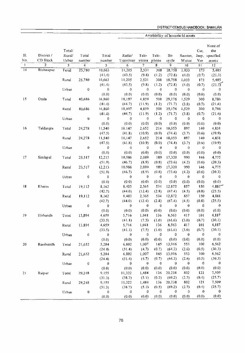
DISTRICT CENSUS HANDBOOK: BANKURA
A vailability of household assets
None of Total! Car, the
SI. District I Rural! Total Total Radiol Tele- Tele- Bi- Scooter, Jeep, specified No. CD Block Urban number number Transistor vision phone cycle Motor Van assets
I 2 3 4 5 6 7 8 9 10 11 12 . ___ . 14 Bishnupur Total 25,780 10,663 11,205 2,531 308 18,758 1,033 173 5,485
( 41.4) (43.5) (9.8) ( 1.2) (72.8) (4.0) (0.7) (21.3) Rural 25,780 10,663 11,205 2,531 308 18,758 1,033 173 5,485
(41.4) (43.5) (9.8) ( 1.2) (72.8) (4.0) (0.7) (21.3) Urban 0 0 0 0 0 0 0 0 0
(0.0) (0.0) (0.0) (0.0) (0.0) (0.0) (0.0) (0.0) 15 Onda Total 40,686 16,860 18,197 4,859 508 29,176 1,529 300 8,786
(41.4 ) ( 44.7) (11. 9) (1.2) (71.7) (3.8) (0.7) (21.6)
Rural 40,686 16,860 18,197 4,859 508 29,176 1,529 300 8,786
( 41.4) (44.7) (11.9) ( 1.2) (71.7) (3.8) (0.7) (21.6)
Urban ° 0 ° 0 0 0 0 0 0
(0.0) (0.0) (0.0) (0.0) (0.0) (0.0) (0.0) (0.0) 16 Taldangra Total 24,278 11,540 10,147 2,652 214 18,053 897 140 4,831
(47.5) (41.8) (10.9) (0.9) (74.4) (3.7) (0.6) (19.9)
Rural 24,278 11,540 10,147 2,652 214 18,053 897 140 4,831 (47.5) ( 41.8) (10.9) (0.9) (74.4) (3.7) (0.6) (19.9)
Urban 0 0 0 0 0 0 0 0 0
(0.0) (0.0) (0.0) (0.0) (0.0) (0.0) (0.0) (0.0) 17 Simlapal Total 23,517 12,213 10,986 2,089 189 17,320 990 146 4,775
(51.9) ( 46.7) (8.9) (0.8) (73.6) (4.2) (0.6) (20.3)
Rural 23,517 12,213 10,986 2,089 189 17,320 990 146 4,775
(51.9) (46.7) (8.9) (0.8) (73.6) (4.2) (0.6) (20.3)
Urban 0 0 0 0 0 0 0 0 0
(0.0) (0.0) (0.0) (0.0) (0.0) (0.0) (0.0) (0.0) 18 Khatra Total 19,112 8,162 8,403 2,365 534 12,872 857 150 4,881'''''
( 42.7) (44.0) (12.4 ) (2.8) (67.4) (4.5) (0.8) (25.5)
Rural 19,112 8,162 8,403 2,365 534 12,872 857 150 4,881
(42.7) (44.0) (12.4) (2.8) (67.4) (4.5) (0.8) (25.5)
Urban 0 0 0 0 0 0 0 0 0
(0.0) (0.0) (0.0) (0.0) (0.0) (0.0) (0.0) (0.0)
19 Hirbandh Total 13,894 4,659 5,716 1,041 136 8,563 417 101 4,187
(33.5) (41.1) (7.5) (1.0) (61.6) (3.0) (0.7) (30.1)
Rural 13,894 4,659 5,716 1,041 136 8,563 417 101 4,187
(33.5) (41.1) (7.5) (1.0) (61.6) (3.0) (0.7) (30.1)
Urban 0 0 0 0 0 0 0 0 0
(0.0) (0.0) (0.0) (0.0) (0.0) (0.0) (0.0) (0.0)
20 Ranibundh Total 21,652 5,284 6,802 1,007 145 13,916 553 100 6,562
(24.4) (31.4) (4.7) (0.7) (64.3) (2.6) (0.5) (30.3)
Rural 21,652 5,284 6,802 1,007 145 13,916 553 100 6,562
(24.4) (31.4 ) (4.7) (0.7) (64.3) (2.6) (0.5) (30.3)
Urban 0 0 0 0 0 0 0 0 0
(0.0) (0.0) (0.0) (0.0) (0.0) (0.0) (0.0) (0.0)
21 Raipur Total 29,248 9,155 11,322 1,484 136 20,238 802 121 7,509
(31.3) (38.7) (5.1) (0.5) (69.2) (2.7) (0.4) (25.7)
Rural 29,248 9,155 11,322 1,484 136 20,238 802 121 7,509
(31.3) (38.7) (5.1) (0.5) (69.2) (2.7) (0.4) (25.7)
Urban 0 0 0 0 0 0 0 0 0
(0.0) (0.0) (0.0) (0.0) (0.0) (0.0) (0.0) (0.0)
76
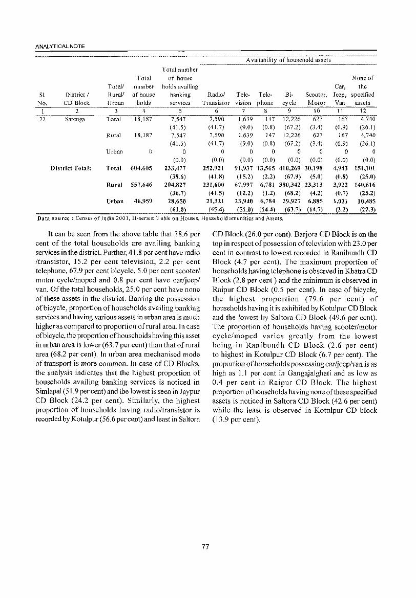
ANALYTICAL NOTE
A vailability of household assets
Total number Total of house None of
Total! number holds availing Car, the
Sl. District / Rural! of house banking Radio/ Tele- Tele- Bi- Scooter, Jeep, specified
No. CD Block Urban holds services Transistor vision phone cycle Motor Van assets
1 2 3 4 5 6 7 8 9 10 11 12
22 Sarenga Total 18,187 7,547 7,590 1,639 147 12,226 627 167 4,740 ( 41.5) (41. 7) (9.0) (0.8) (67.2) (3.4) (0.9) (26.1)
Rural 18,187 7,547 7,590 1,639 147 12,226 627 167 4,740 ( 41.5) (41. 7) (9.0) (0.8) (67.2) (3.4) (0.9) (26.1 )
Urban 0 0 0 0 0 0 0 0 0 (0.0) (0.0) (0.0) (0.0) (0.0) (0.0) (0.0) (0.0)
District Total: Total 604,605 233,477 252,921 91,937 13,565 410,269 30,198 4,943 151,101 (38.6) ( 41.8) (15.2) (2.2) (67.9) (5.0) (0.8) (25.0)
Rural 557,646 204,827 231,600 67,997 6,781 380,342 23,313 3,922 140,616 (36.7) ( 41.5) (12.2) (1.2) (68.2) (4.2) (0.7) (25.2)
Urban 46,959 28,650 21,311 23,940 6,784 29,927 6,885 1,021 10,485 (61.0) (45.4) (51.0) (14.4) (63.7) (14.7) (2.2) (22.3)
Data sou rce : Census of India 200 I, H·series: T able on Houses, Household amenities and Assets.
It can be seen from the above table that 38.6 per cent of the total households are availing banking services in the district. Further, 41.8 per cent have radio /transistor, 15.2 per cent television, 2.2 per cent telephone, 67.9 per cent bicycle, 5.0 per cent scooter/ motor cycle/moped and 0.8 per cent have car/jeep/ van. Of the total households, 25.0 per cent have none of these assets in the district. Barring the possession of bicycle, proportion of households availing banking services and having various assets in urban area is much higher as compared to proportion of rural area. In case of bicycle, the proportion of households having this asset in urban area is lower (63.7 per cent) than that of rural area (68.2 per cent). In urban area mechanised mode of transport is more common. In case of CD Blocks, the analysis indicates that the highest proportion of households availing banking services is noticed in S imlapal (51.9 per cent) and the lowest is seen in J aypur CD Block (24.2 per cent). Similarly, the highest proportion of households having radio/transistor is recorded by Kotulpur (56.6 percent) and least in Saltora
77
CD Block (26.0 per cent). Barjora CD Block is on the top in respect of possession oftelevision with 23.0 per cent in contrast to lowest recorded in Ranibundh CD Block (4.7 per cent). The maximum proportion of households having telephone is observed in Khatra CD Block (2.8 per cent) and the minimum is observed in Raipur CD Block (0.5 per cent). In case of bicycle, the highest proportion (79.6 per cent) of households having it is exhibited by Kotulpur CD Block and the lowest by Saltora CD Block (49.6 per cent). The proportion of households having scooter/motor cycle/moped varies greatly from the lowest being in Ranibundh CD Block (2.6 per cent) to highest in Kotulpur CD Block (6.7 per cent). The proportion of households possessing car/jeep/van is as high as 1.1 per cent in Gangajalghati and as low as 0.4 per cent in Raipur CD Block. The highest proportion of households having none of these specified assets is noticed in Saltora CD Block (42.6 per cent) while the least is observed in Kotulpur CD block (13.9 per cent).
(ix) Major social and cultural events, natural and administrative developments and significant activities during the decade
Innumerable fairs, festivals and socio-cultural events are held throughout the year in this district having wide admixture of religion, community and culture. The followers of the main faiths and some tribal groups observe their own religious festivals whereas they intermingle in melas (fairs) and ceremonies. Briefnotes on the major festivals and melas (fairs) of the district are given below:
Festivals
State level common :
In all the districts of the state certain religious festivals are observed in such a huge magnitude that the impact is cross-cultural involving the overall market economy. Those are:
1. Durga Puja is the most popular annual festival of the Hindus held both at community level and at clan or household level. The four day festival relate to worshiping of the mother goddess 'Durga' and symbolising the victory of good over evil is held in the month of Ashwin (Bengali calender) or September-October. In folk culture this festival also represents the home coming of Mother Durga (Parbati) - wife of Lord Shiva along with her two sons and two daughters to visit her paternal home from their snowy abode of the Himalayas. This festival therefore also represents a family reunion of members staying at distant places.
2. In north India 'Deepavali' or the festival oflights is celebrated to commemorate the home coming of Lord Rama to Ayodha after fourteen years of punishment as per the epic Ramayana. But in Bengal Kalipuja or Diwali is related to worshiping goddess 'Kali' or 'Shakti' (the power) as another expression of mother cult. This one day event is held on the moon less night following Durga Puja in the month of Kartik (mid-Oct to mid-Nov). Decoration with lights is a part of the observation adding a flavour of the famous national festivity called the 'Festival oflight or Deepawali'.
3. Dol Jatra or Holi is the festival of colours. In fact the colours of the spring time nature is celebrated with much grandeur for expressing the feeling of love and friendship as symbolized by the holy conjugation of Lord Krishna and Radha.
4. Rathajatra or the car festival of Jagannath, Balaram and Subhadra is held duringAshadh (midJune to mid-July).
78
DISTRICT CENSUS HANDBOOK: BANKURA
5. Id-ul-Fitr is the most popular religious festival of the Muhammedan population in the state. This is observed with a mass prayer (Namaz) andjoyful get together after the month-long fasting during 'Ramzan'.
6. The next important festival of the Muhammedans, Idu'z Zuha or the Festival of Sacrifice, is also celebrated with mass prayers and exchange of gifts and sweet meat etc. with a spirit of brotherhood ..
7. Muharram is another popular festival of the Mohammedans held on the thirtieth day after Idu'z Zuha to mourn the death of Has san and Hussain -two grandsons of the Prophet Muhammed in the battle of Karbala. Tajiyas are built and taken in a procession symbolizing the memorial tombs of those two martyrs.
8. The Christmas day on 25th December and Good Friday in April are the two most important religious festivals of the Christian community. 'Christmas day', in particular, is observed with prayers in the church to commemorate the birth of Jesus Christ and the festivity continues till 1st January - the new calender year. The day of Christ's crucifixion is the day to pray again on Good Friday.
9. The Sikhs celebrate their most important religious festival on the occasion of Guru Nanak's birth day, the founder of the Sikhism.
10. The full moon day of May is observed as Buddha Pumima by the followers of Buddhism in different pockets of the State. This is the biggest festival for Buddhists to mark the o(;casion of the birth of Lord Buddha.
11. The followers of Jain ism observe Mahabir Jayanti which is the birthday of Lord Mahabir in the month of April.
District specific :
Gajan of Shiva
Gajan festival is by far the most popular and important of the celebrations throughout the district of Bankura held in honour of shiva. These festivals are held during the closing week of Chaitra (mid-April ) and coincide with the Chadak. Gajans are always accompanied by local fairs large or small. Most famous gajan festival is held in Ekteswar. Thousands gather on the occasion of the annual Gajan festival near the Shiva temple. People of the aboriginal descent collect on this occasions in large numbers and amuse themselves with group dances and music. Others, mostly Hindus, participate in the hook-swinging
ANALYTICAL NOTE
(Chadak) ceremony. Hook-swinging is held in imitation of swinging of the sun at the beginning of spring or at the solstices-a piece of magic to help the sun move. Previously there were gruesome rites like Ban-phora and Agun-sannyas but the rites are now banned by law.
Gajan of Dharma raj
The next most important festival is the Gajan held in honour of Dharmaraj. There is no image of Dharmaraj in any form. A piece of crude stone represent the deity. The name of Dharma Thakur differs from place to place such as, Bankura Ray of Beldiha, Phate Singh of PhulIar, Dalu Ray of Shyambazar etc. Basical1y the presiding deity in the sun which is worshipped by the primitive tribal agricultural societies as being regulation of the rain. Today the deity is worshipped for other reasons too. Generally the deities are installed at the foot of any tree, but the annual festivals are held only near the temples of Dharmaraj. Beliatore is most famous for Dharma worship.
Gajan of Dharmaraj has all the necessary ingredients that the Gajan of Shiva and Chadak have. The annual festivals are held during Ashadh (mid-June to mid-July) or Sraban (mid-July to mid-August). Gajans of Dharmaraj are also accompanied by local fairs.
Makar snanjatra
Makar Snanjatra is held on the last day of Paush (mid-January), i.e. Paush-sankranti. Ritual bathings are observed in the nearby rivers. The festival occasions a number of fairs.
Ras
Ras festival stems from the love stories of Radha and Krishna. It occasions many fairs most famous being the Bishnupur festival. Altogether 108 garlanded images are displayed here and the aesthetic sight of massworship by waving the earthen lights before the images is worth seeing. It proves that the district was once under considerable influence ofGaudiya Vaishnavism.
Rathajatra
Most famous fairs occasioned by Rathajatra are held in Bankura and Bishnupur.
Pancharatri
Festival of Pancharatri is another proof of high influence of Gaudiya Vaishnavism. The fairs
79
occasioned by it continue for 5 days. An image of Annapurna is worshiped for those 5 days. Chanting of
the name of Hari continues. People sing holy songs
and praise the deity aloud.
Adivasi festivals
Tribes constitute a sizable portion ofthe population of the Bankura district. They have got their own distinct social festivals. Ind-parab is the most important festival of the Bhumijs and Bandhna/Soharai parab is the most important festival of the Santals. Bhadu and Tusu is connected to fertility cult and is in essence a festival of women. Ind-parab is held in Khatra on the 17th of Bhadra (1 st week of September) each year. Bandhna is held during Kartick (mid October-mid November). The word 'Bhadu' originates from Bhadra because it is held in that month (mid August-mid September) and Tusu is held in Agrahayan and Pous (mid November to mid January). All these festivals are attended by fairs that draw large crowds.
Fairs
Innumerable fairs occasioned by the festivals take place in Bankura. A brief account of of some of the fairs with maximum congregation and some with largest duration as per the District Census Handbook, Bankura 1961 is given below.
Amongst the fairs, mostly populated fair used to take place in Sushunia village under Simlapal CD Block (a gathering of 60,000 people) on the occasion of Manasa Puja in the month of Sravan (mid July-mid August) which continued for 4 consecutive days. Next comes Ekteswar village under Bankura-II CD Block with an approximate total attendance of 50,000 people where Gajan festival used to take place towards the end of Chaitra (mid April) and this fair continued for consecutive 2 days. In Matgoda village under Raipur CD Block approximately 35,000 people used to attend the fair occasioned by the annual festival of Dharma raj in the month of Magh (mid January-mid February) and it continued for consecutive 8 days. The fair that continued for longest number of days used to take place in Siharvillage under KotulpurCD Block (16 days) on the occassion of Siv Gajan and Charak in the month of Chaitra (mid March-mid April) in which the total attendance was estimated at 9,000 followed by Kuchiakol under Jaypur CD Block (15 days) on the occasion of Rathajatra in the month of Asharh (mid June-mid July) in which the total attendance was estimated at 15,000/16,000 and Salna under Patrasayer CD Block (14115 days) on the occasion of Gajan
festival in the month of Jaistha (mid May-mid June) in which the total attendance was estimated at 10,0001
12,000.
Significant activities during the decade
Even in the eighties the district was described as a district without any large-scale industry. But the large Mejia Thermal Power Plant has been set up. The Project area is approximately 2,565 acres of land and production capacity is 210 megawatts. There is also District Urban Development Agency formed in the last decade with various programmes like IDSMT, ILCS, EIVS, SYSJ and UBSP to keep pace with the trend of urbanization.
(x) Brief description of places of religious, historical or archaeological importance in villages and places of tourist interest in the towns of the district
There are numerous places of religious, historical or archaeological importance in villages in the district and places of tourist interest in the towns. Local attraction for the tourists is marvellous and the various sights under the district can be divided into 4 Zones;
Northern Zone Durgapur Barrage, Gangdoa Dam and Koropahar
Southern Zone Mukutmonipur, Jhilimili, Sutan, ECO Park at Taldangra, Talberia, Terracotta Project at Panchmura etc.
Western Zone Susunia Hill and Biharinath Hill
Eastern Zone Temples of Vi shnu pur, layrambati.
Salient features of tourist spots
Places of religious importance :
Bishnupur : Bishnupur is famous for the temples with terracotta art and large water areas. There are several temples in the Bishnupur town for which travellers travel throughout the year. Most of the temples are made in the decade ofMallaraja namely Jorebangalow, Rasmanch, Madan-mahan, Chhinnamasta etc.
Joyrambati : Joyrambati, the birth place of Sarada Devi, the wife of Sri Ramkrishna, the famous nineteenth century saint and is a holy visiting place for many. Mayer Pukur in front of the residential house of Ma Sarada is also a visible sight.
Places of historical or archaeological importance: The most interesting remains found in the district Bankura are at Bishnupur, where there are a number
80
DISTRICT CENSUS HANDBOOK: BANKURA
of temples representing the most complete set of specimens of the peculiar Bengali style of temple architecture. There are other temples of archaeological interest at Bahulara (traces ofJainism), Ekteswar and Sonatapol and remains of old forts are found at Karasurgarh, Asurgarh and Shyamsundargarh. (Source : Bengal District Gazetteers-Bankura by L.S.S. O'Malley).
Places of tourist interest :
Susunia : Susunia Hill is quite popular as trekking sp,,- . for people from both inside and outside of Bankura district. It is also an important tourist spot for the people who visit the place to see' dhara' and' silalipi'.
Biharinath : Biharinath Hill is a famous place oftourist attraction. At the foot of the hiIJ near the temple there is a small tank measuring 0.50 hectares that can be accommodated with angling fadlities for recreation of the touring people.
Mukutmonipur : MukutmonipurMJhilimili circuit has become most attractive tourist circuit. With the second biggest earthen dam of India, MukutMmonipur is 55 kms away from Bankura district Head Quarters and 10 km away from Khatra subMdivisional Head Quarter and situated in the confluence of River Kangsabati and Kumari. The vast bluish tract of water surrounded by green forests and hillocks is a very beautiful sight. All facilities like Hotel, Restaurant, Dak Bungalow, Fares! Bungalow are available here for the tourists.
Jhilimili : Jhilimili-Sutan-Talbl~ria forest is the abode of forest wealth of Bankura. It has a best stretch of different indigenous natural and planted forest. Visitors from all corners of the state of West Bengal and others have been visiting this area with great interest.
Talberia Dam : A natural dam without any river has been made by harvesting rainwater from the surrounding hills and forest. It is a beautiful and pleasant sight as well as picnic spot. Talberia Dam is located on the way to Jhilimili - the natural forest beauty.
Eco Park : There is a beautiful tourist spot 9 kms away from Taldangra beside Bibarda Road made by forest department. Beautification of the park is mainly for picnic purpose. A small dam with boating facility, rest house is available here.
Terracotta Project: Panchmura is quite popular for terracotta project. It is also an important tourist spot. Various burnt earthen goods are made by local craftsmen for different use of the people.
Accommodation
ANALYTICAL NOTE
There is a government tourist lodge in Bishnupur run by West Bengal Tourism Development Corporation Ltd. and a Government tourist lodge in Mukutmonipur run by the Tourism Department itself. The Department of Sports and Youth Welfare of the Government of West Bengal runs three youth hostels in the district, one in Bankura called 'Ramkinkar Yuva Awas' and the other two are in Mukutmonipur and Susunia respectively. There is also a forest Bungalow in Mukutmanipur run by the West Bengal Forest Development Corporation Ltd. called' Sonajhuri Prakriti Bhraman Kendra'. Apart from all these, there are 3 Dak Bungalows in Saltara, Bishnupur and Bankura respectively and there are, in all, 8 Inspection Bungalows in Gangajalghati, Sonamukhi, Kotalpur, Onda, Chhatna, Taldangra, Ranibandh and Khatra respectively where tourists can get accommodation subject to approval of the concerned authorities.
(xi)Major characteristics of the district, contribution of the district in the form of any historical figure associated with the district
In the district there is peaceful co-existence of people with different religious faiths such as Buddhist, Jain, Shaiba, Shakta, Baisnab, Muslim, Christian. Religious liberalism is the major characteristics of the district.
Following persons are the historical figures associated with the district:
1. Badu Chandidas - A medieval poet of 'Sri Krishnakirtan' fame
2. Ma Saradamoni - Wife of Lord Ramakrishna
3. Ramananda Chatterjee - Noted Journalist and Founder editor of 19th century Bengali magazine 'Prabasi'
4. Kshirod Prasad Vidyabinod - Noted Famous Dramatist
5. Gopeswar Bandopadhyay - Noted Vocalist of Bisbnupur gharana
6. Acharya Jogesh Chandra Roy Vidyanidhi Eminent Scholar
7. Iamini Roy - Renowned Artist
8. Ramkinkar Baiz - Renowned Sculptor
9. Satyen Bandopadhyay - Renowned Artist
(xii) Scope of Village Directory and Town Directory
Village Directory :
The "Village Directory" is one of the traditional compilations of the census. The format of the directory
81
is almost the same as was prescribed in the 1991 census. It bears the list of villages, their location code numbers, areas, population, amenities such as educational, medical, communications, drinking water facilities etc. available to them and also the land use pattern for each village. For this purpose, villages have been arranged CD Block wise in order of their location code numbers. The inclusion of alphabetical list of villages with 200 I census population and the map of every CD Block depicting location of villages by population size, urban-spread and important infrastructural facilities available therein will further help the reader in identifying any village in the CD Block.
'Village' is a statutorily recognized unit having a definite boundary and separate land records. In case a complete village is treated as an outgrowth of urban agglomeration, data on amenities and land use for that village have not been given in the Village Directory but shown along with the urban component. For those villages, which have partly merged in an outgrowth of U .A. data pertaining to remaining part of the village is shown in the Village Directory and for the part merged or treated as an outgrowth, the details have been given under the concerned urban agglomeration. Land use data for villages treated as Census Towns (Urban) in 2001 census can be seen in Appendix-III of the Village Directory.
If a village has fully merged into another village, the location code number and name of the merged village are given both in the Village Primary Census Abstract and the Village Directory at the appropriate place. Data in respect of these two villages put together appear against the village with which the other village ha.s merged.
The uninhabited village (villages with no population) has been indicated as such after furnishing details in columns I to 3 i.e. the location code number, name and area of the village. In addition to the above details, foHowing eight appendices to Village Directory have also been included.
Appendix - I
Appendix-IA
Appendix-IE
Appendix-Ie
Abstract of educational, medical and other amenities in Villages -CD Block level
Villages by number of Primary Schools
Villages by Primary, Middle and Secondary Schools
Villages with different sources of drinking water facilities available
Appendix-II
Appendix -IIA
Appendix-III
Appendix-IV
Villages with 5,000 and above population which do not have one or more amenities available
List of Census Towns which do not have one or more amenities
Land utilisation data in respect of Census Towns/Non Municipal Towns
CD Block wise list of inhabited villages where no amenity other than drinking water facility is available
Appendix-V Summary showing number of Villages having or not having Scheduled Caste Population
Appendix-VI Summary showing number of Villages having or not having Scheduled Tribe Population
Appendix-VIIA-- List of Villages according to the proportion of the Schedule Castes to the total population by ranges
Appendix-VIIB-- List of Villages according to the proportion of the Schedule Tribes to the total population by ranges
Appendix-VIII -- Number of Villages under each Gram Panchayat (CD B lock wise)
The above eight appendices are expected to help the planners for planning inputs in areas / villages where basic infrastructure is lacking and also for evolving suitable plans for the welfare of Scheduled Castes and Scheduled Tribes, in particular.
The Village Directory format has 23 columns and the details given under each column and the abbreviations used to explain availability of amenities are as under.
Column 1 - Serial No. of the villages.
Column 2 - The name and location code number of each village, as this is necessary for proper identification of the village. This also includes the forest and uninhabited villages.
Column 3 - The total area of the village (in hectares) as indicated by the State Revenue Department.
Column 4 - The total population in each village (2001 Census).
Column 5 - The total number of households in the village (200 1 Census).
82
DISTRICT CENSUS HANDBOOK: BANKURA
Data on amenities such as educational, medical, drinking water, post, telegraph and telephone, commercial and cooperative Banks, credit societies, Recreational & cultural facilities, communications etc. are shown under columns 6 to 13 of the Village Directory. In case if an amenity is not available within the referent village, a dash (-) is shown in the column and next to it in brackets the distance in broad ranges viz., up to 5 kms., 5-10 kms. and 10+ kms. to the nearest place where the facility is avalilable has been given. This will help not only for local area planning but in regulating the provision of goodls and services as well, so as to minimize the regional imbalance in the process of development.
Column 6 shows the number of all kinds of educational institutions run by different agencies, government or private of the level of viz., primary school, middle school, secondary school, senior secondary, college, industrial school, training school adult literacy school/centre and other educational institutions (Sanskrit pathshala, senior basic school, makhtab etc).
If in a village, secondary sl:::hool has middle and primary classes also, the same has been counted as three schools i.e., secondary, middle and primary school. In case there are more than one institution of any type in a village their number is indicated within brackets against the prescribed abbreviation.
Column 7 provides data on medical facilities available in the village.
Column 8 gives information regarding availability of drinking water within the village. In case more than one source is available to the village the same has been indicated.
Column 9 provides information about the existance of facilities such as post, telegraph and telephone connections available in the village.
Column 10 refers to the availability of banking service in the villages and this is shown by giving the number of commercial and co-operative banks separately.
Column 11 contains information on availability of credit societies in the village. The information is represented separately by recording the number of Agricultural, non-Agricultural and other credit societies.
Column 12 give information on availability of Recreational & Cultural facilities such as Cinema / Video Hall, Sports Club, Stadium / Auditorium, in the village.
ANALYTICAL NOTE
Column 13 gives information as to whether the village is served by any mode of public transport like bus, rail and water-ways.
Column 14 refers to the state of roads etc. leading to the village, this is useful in detennining as to whether the village is approachable both in fair and foul weather, and whether it is inaccessible only for some time in the year.
Column 15 gives the information about the nearest town and its distance in kilometers in bracket from the referent village. In case the nearest town is located in another state, the name of the state has also been furnished.
Column 16 relates to the availability of power supply in the village.
In case the power supply is released only for specific purpose, say agriculture or other it has been stated accordingly. In case the electricity is not available to the village, a dash (-) has been mentioned in the column.
Column 17 is regarding receipt of News Paper / Magazine in the village.
Column 18 has infonnation regarding the name of the most important commodity, manufactured in the village.
Columns 19 to 23 give the details about land utilization. The land use pattern given in the Village Directory conforms to the pattern of classification of land use as recommended by the Ministry of Agriculture, Government ofIndia.
Column 19 includes all lands classed as forests under any legal enactment dealing with forests or administered as forests, whether State-owned or private, and whether wooded or maintained as potential forest land. The area of crops raised in the forest and grazing lands or areas open for grazing within the forests has been included under the forest area.
Column 20 indicates extent of irrigated lands under various types of irrigation.
Column 21 cover all agricultural lands including the net area sown with crops and orchards or net cropped area and also current and other fallow lands, the latter would imply all lands which were taken up for cultivation, but are temporarily out of cultivation for a period of not less than one year and not more than five years. The columns does not include gross year sown or gross cropped area. Net area sown thus
83
represents the area sown with crops and orchards. Area sown more than once in the same year has been counted only once.
Column 22 gives information on cultivable wastelands and includes all lands available for cultivation whether not taken up for cultivation once but not cultivated during the preceding five years or more in succession. Such lands may be either fallow or covered with shrubs and jungles, which are not put to any use. These may be assessed or unassessed and may be in isolated blocks within cultivated holding. Lands under thatching grasses, bamboo, bushes and other groves for fuel etc., which are not included under orchards or forests are included in this category. All grazing lands, whether they are permanent pastures and meadows or not, village common and grazing lands within forest area are also included in this column.
Column 23 includes the land not available for cultivation such as barren, unculturable land and put to non-agricultural use. All lands occupied by buildings, roads, railways, rivers, canals, etc. form part of the land under non-agricultural uses. Barren and unculturable lands include mountains, rocks, deserts etc., which cannot be brought under cultivation, except at a very high cost.
Column 24 and 25 are once again the name of the viillages and serial numbers respectively for the readers convinience.
Town Directory :
The town directory is presented for each town covering different aspects of urban life through a set of seven statements from I to VII. The data contained in these statements are about the identification particulars of town, the area, number of households (including house less households), population and growth rate in 2001 and past censuses, density, sex ratio, physical aspects and location of towns, communications, municipal finances, civic and other amenities, medical, educational, recreational, cultural facilities, trade, commerce, industry, banking, and civic and other amenities in slums. It covers all the towns in the district statutorily notified as well as non-municipal towns (Census Towns). All the towns in the district are arranged in ascending order of location code number.
The data collected in these statements have largely been furnished by the municipal bodies. In case of non municipal towns (Census Towns) the Block level office supplied the information.
Statement I shows status and growth history of the towns in the district. Column 2 in this statement indicates class, name and civic administration status of town (as in 2000). Class of the town indicated under this column has been introduced to factilities the analysis of town directory data at the state and the national level. Census towns have no urban civic status.
Size and Class of Towns : Class
I II III IV V VI
Size 100,000 and above 50,000 to 99,999 20,000 to 49,999 10,000 to 19,999 5,000 to 9,999 below 5,000
Column 3 is for representing eight digit pennanent code number for each town in the district.
Coulmn 4 indicates the name of police station in which the town is located.
Column 5 is for recording the name of CD Block if the town is located in it.
Column 6 gives area (in sq. kms.) of the town.
Column 7 gives information about number of households including house less households.
Columns 8 to 18 gives population and growth rate of the town since the Censuses of 1901, which would help in drawing the trends in their growth rate.
Column 19 present density in 2001 Census and 20 to 22 represent the sex ratio.
Statement II shows physical aspects and location of towns. In physical aspects only the rainfall, maximum and minimum temperature data as obtained from the Director General of Meteorological Survey of India have been shown. Towns for which information could not be obtained from Meteorological Survey ofIndia, the same has been collected locally or calculated in relation to the nearest town, to the extent possible. Columns 6 to 12 have been filled up on the basis of information received from the respective district authority. Distances respectively from the state, district and tahsil/CD Block headquarters as well as the nearest city (urban area with a population of 100,000+) would help in determining the location of a town. Communication facilities are shown mentioning railway station, bus route and navigable river/canal.
Statement III deals with municipal finance for the statutory and also non-statutory town bodies managing civic administration of the town provided they have
84
DISTRICT CENSUS HANDBOOK: BANKURA
separate budgets and accounts of their own.
Statement IV Scheduled Castes/Scheduled Tribes population figure given in columns 4 and 5 would help in measuring amenities in respect of population size of the weaker sections in the towns. The information on road length within the town shown under column 6 has been obtained from Municipality (except for the highways).
Columns 7 to 12 reflects the information on system of sewerage number oflatrines and method of disposal of night soil.
Columns 13 and 14 indicate sources and system of storage with capacity of protected water supply to the inhabitants of the towns.
Column 15 gives information regarding availability of fire fighting services. In case, it is not available in the referent towns, the name of the nearest place where it is available has been mentioned and the distance from the town has also been indiicated within brackets. Columns 16 to 20 pertain to the number of connection of electricity supply available for domestic, industrial, commercial, road lighting (points) and for any other purposes.
Statement V gives information regarding amenities like medical, educational, recreational and cultural facilities available in the town. 2001 population figures for each town have balso been indicated and this will facilitate in analyzing data on faGilities available to the people.
Data related to medical facilities have been obtained from the concerned district authority and shown under columns 4 and 5. An types of medical institutions whether allopathic" ayurvedic, unani or homoeopathic have been covered.
If the medical institution is Ayurvedic, Unani or Homoeopathic the same is indicated in bracket by recording the number of institutions.
In case, more than one institution of any type is available, the exact number is shown within the brackets.
The information on educational facilities are depicted in column 6 to 14.
Column 1 ° pertains to the number of recognized shorthand, typewriting and vocational training institutes ( grouped as others ) which include Applied Art / Painting college, Pharmacy college, B.Ed. college, Teacher's training institute, Music / Dancing, Nursing school, etc.
ANALYTICAL NOTE
Column 15 shows the information in respect of Adult Literacy classes I Centres etc. Similarly in view of the spurt in the employment of women in towns, information on number of working women's hostels and seats available therein has been given under column 16. This data would help in formulating plru1s for opening new hostels in order to meet the prob lems of the single working women.
Columns 17 to 20 show recreational and cultural facilities available in the town. These include stadia, cinema, auditoria I drama I community halls, public libraries indicated as 'PL' and reading rooms indicated as'RR'.
Statement VI presents information in respect of Trade, Commerce, Industry and Banking services in the town. Columns 3, 4 and 5 contain information about the three most important comodities exported out from the town, column number 6, 7 and 8 in the other hand bears information about the three most important commodities manufactured in the town. Colu~n number 9, 10 and 11 show the number of agricultural and non-agricultural credit societies in the town.
Statement VII provides data in respect of civic and other amenities in the slums.
(xiii) Calendar of events for the conduct of House listing and Enumeration under Census of India, 2001 in the State
Calendar for Census 2001 upto Houselisting Operation:
December, 1999
(i) Issue of all appointments of Charge Officers, Zonal Sub-Charge Officers and Charge Assistants etc., by the Principal Census Officer.
(ii) State level meeting with all Principal Census Officers to brief them on the different steps to be taken for conduct of Census-200 1 to be convened by the Chief Secretary to the Government of West Bengal.
(iii) Meeting to be convened by all the Principal Census Officers at their respective H. Qtrs. to train all the Charge Officers and Sub-Charge Officers and Charge Assistants. The meetings to be attended by Director IJoint Director of Census Operations, West Bengal.
(iv)Principal Census Officers to write to all School Authorities, Govt. Offices, Semi Govt. Offices, local bodies etc., for sending list of officials for appointment as Enumerators and Supervisors.
85
(v) Collection and compilation of data for Village and Town Directory.
January, 2000
(i) Survey work for preparation of notional maps and layout sketches for formation of House listing B locks on the basis of 1991 Enumeration Blocks.
(ii) Formation of House listing Blocks on the basis of Survey and Guideline No.1.
(iii) Collection of list of School Teachers, Govt. Officials etc. from all respective authorities for appointment as Enumerators and Supervisors.
(iv)Preparation of Village Registers at all the Block Charge levels on the basis of data collected on Village Directory.
(v) Regular visit and liaison by the officials of Directorate of Census Operations to the different charges to impart spot training and oversee the Block formation.
February, 2000
(i) 2nd meeting of the Principal Census Officers at the State level to brief them about the House listing Schedules and Instruction Manual.
(ii) Subsequent meeting at the respective H. Qtrs. of all the Principal Census Officers to train all the Charge Officers, zonal Sub-Charge officers etc. on the House listing Schedule, Instruction Manual and House list Abstract - to be attended by Director! Joint Director of Census Operations.
(iii) Subsequent training at all charges levels on the House listing Schedule, Instruction Manual and House list Abstract to all Zonal Charge Officers, Zonal Assistants by the Charge Officer. Regular contact by officials from the Directorate of Census Operations, West Bengal.
(iv)Completion of appointment of Enumerators and Supervisors and allotment of Houselisting blocks to them.
(v) Despatch of House listing Schedules and Instruction Manual, Abstract and other forms from the Directorate of Census Operations to all Districts and receipt/storage of the same at the District level and despatch to all Charge levels, Receipt, storage & giving of locational code numbers to the schedules at each charge levels.
March, 2000
(i) 1 st training of Enumerators and Supervisors at the charge level.
(ii) Distribution of House listing Schedules, Instructions and Abstract to the Enumerators.
(iii) Completion of assignment of permanent house numbers to the houses by the Panchayats and Municipalities.
(iv)Preparations of the Charge Registers at each charge level.
April,2000 (i) 2nd training of Enumerators and Supervisors at
each charge level. (ii) Issue of T.A.lD.A. amount to the Enumerators/
Supervisors. (iii)Issue of House-numbering materials to the
Enumerators/ Supervisors or advance in lieu thereof.
(iv)Issue of badges/Identity Slips to the Enumerators/ Supervisors.
(v) Training of Enumerators at each circle level/Zone level by the Supervisors/Zonal Sub-Charge Officers.
17.04.2000 to 16.05.2000 (i) Houselisting Operations (a) First 4 (four) days devoted to survey and
preparation of layout sketches as per sketches already prepared at the charge level
(b) Next 20 (twenty) days devoted to house to house canvass of the Houselist Schedule.
(c) Last 2 (two) days devoted to preparation of Houselist Abstract and duplicate Houselist by Enumerators and handing over the same to the Supervisors.
17.05.2000 to 31.05.2000 Collection ofthe completed Houselist Schedule and Houselist Abstract from Supervisors/Zonal Charge Officers at the Charge level, preparation of Charge Abstract and onward transmission to this Directorate.
Calendar for Enumeration Stage of Census of India - 2001 1. Conference, Training of Principal Census Officers,
Additional Principal Census Officer and District Census Officers. .................... To be completed by 31 st July, 2000
2. Training of Charge Officers .......................... To be completed by 15.08.2000
3. Formation of Enumeration Blocks and despatch of Annexure 'N' by the Charge Officer to the Director of Census Operations, West Bengal. .......................... To be completed by 31.09.2000
4. Writing of Abridged Houselist based on recarved Enumeration Block and preparation of fresh Charge, Registers after appointment of Enumerators and Supervisors for Each
86
DISTRICT CENSUS HANDBOOK: BANKURA
Enumeration Block. .......................... To be completed by 31.07.2000
5. Despatch of materials to the districts by the Directorate of Census Operations and distribution of the same by the District Census Officers to the Charge Officers ., ........ '" ........... '" .... To be completed 31.10.2000
6. I st training of Enumerators and Supervisors ......... To be completed by 15th December, 2000
7. 2nd training of Enumerators and Supervisors _.c-
.. ......... To be completed by31st December, 2000 8. Field Training of Enumerators and Supervisors and
handing over of materials required for Census taking. .............. To be completed by 15th January, 2001
9. Population Enumeration to begin on .............................................. 9th February, 2001
10. Population Enumeration to end on . ............................................ 28th February, 2001
11. Enumeration of House less Population To be completed by night of 28th February, 2001
12. Revisional Round to be conducted for updating the information as on 00 hours of 1 st March ........ To be completed by 1st - 5th March, 2001
13. Receipt of records by district census officers from all charge officers .......................... To be completed by 07.03.2001
14. Compilation and checking of Population Totals by __ District Census Officers ................... 10.03.2001
15. State wise compilation of PPT by Director of Ceusus Operations and intimation to R.G.I. .......................... To be completed by 12.03.2001
16. Receipts of records by District Census Officers from all Charge Officers. ............... To be completed by 15th March, 2001
17. Intimation of Preliminary Population Figures in respect of the following: .......................... To be completed by 10.03.2001
(i) Total Population
Total Male Population Total Female Population
(ii) Total Literate Population
Total Male Literate Population Total Female Literate Population
(iii) Total Main workers
Total Marginal Workers Total Non Workers
By the district Magistrates to the Director of Census Operations, West Bengal and Registrar General, India by Telephone and FAX.
Part·· A Village and Tovvn Directory

VILLAGE AND TOWN DIRECTORY
Section -I : Village Directory (a) Note explaining the abbreviation used in
Village Directory :
The "Village Directory" is one of the traditional compilations of the Census. It gives the list of villages, their location numbers, their area, population, number of households, amenities such as educational, medical, drinking water, post and telegraph, commercial and co-operative banks, agricultural non-agricultural and other credit societies, recreational and cultural facilities, communication, approach to village, nearest town with a distance, power supply availability of newspaper and magazines, most important commodity manufactured and land use of each village.
Village is a statutory recognized unit having a definite boundary and separate land records. In case, a comp lete village is treated as an outgrowth of urban agglomeration, data on amenities for that village, have not been given in the Village Directory but shown along with the urban component. The villages which are consider as a Census Town, the amenities data are shown in the Town Directory. For those villages which have partly merged in an outgrowth of U.A., the amenities data are shown in the Village Directory for that particular village.
The 'un-inhabited' villages (villages with no population) have been indicated as such after furnishing details in columns 1 to 3 i.e., Serial number, Name of village & location code number and area of the village against column no. 4 to 18. The land use data for such villages are shown in col. 19 to 23.
The Village Directory format has 23 columns and the details given under each column are for the village are as follows :-
Columns 1 : Serial Number
Self explanatory. All the villages within the CD Block are presented serially in the ascending order of their location code number.
Columns 2 : Name and Location Code Number of village
The name and location code number of the village are shown against these columns. This also includes the forest and uninhabited villages.
Column 3 : Area of the village
The area of the villages in hectares are given. Wherever the area figures was not furnished by the concerned department the column is left blank.
89
Column 4: Total population
The total population of the village as per 200 I Census is given against this column.
Column 5: Number of households
The number of households as per 2001 Census is given in this column.
Amenities:
In column 6 to 23, availability in respect of different amenities such as education, medical, drinking water, post, telegraph, banks, credit societies, communication, power, approach road etc. in each village has been depicted with appropriate codes against the column concerned. Wherever the amenities are not available in the village, a dash (-) is shown in the column and next to it in brackets the distance in broad ranges viz. <5 kms., 5-10 kms. and 10+ kms of the nearest place where the facility is available is given. Column wise details are given below:
Column 6: Educational
Classes upto class V included in Primary School. This will include nursery school, kindergarten school. Pre-basic school, pre-primary school, junior basic school upto class V.
Classes from VI to VIII are included in the middle school.
Classes from IX and X included in High secondary school. Classes XI and XII are included in senior secondary school.
In case of composite schools like middle school with primary school or secondary school with middle school, these are also included in the number of primary and middle schools, respectively.
Accordingly any of the following types of institutions if exists within the village is shown as per codes given below:
(i) Primary School P (ii) Middle School M (iii) Secondary School S
(iv) Senior Secondary School PUC (v) College C (vi) Industrial School I (vii) Training School Tr (viii) Adult literacy class/centre AC (ix) Others (specifY) e.g. Sanskrit 0
Pathshala, Senior basic school, Navodaya Vidyalaya, Makhtab etc.
More than one institution of a type in the village is indicated by the number within brackets against the abbreviation, e.g. P(3), M(4), etc.
Column 7 : Medical
Availability of medical facility within the village is indicated by following codes:
(i) Allopathic Hospital H Ayurvedic Hospital HA Unani Hospital HU Homeopathic Hospital Hom
(ii)
(iii)
(iv)
(v)
(vi)
(vii)
(viii)
(ix)
(x)
(xi)
(xii)
Allopathic Dispensary Ayurvedic Dispensary Unani Dispensary Homeopathic Dispensary
Maternity & Child Welfare
Maternity Home
Child Welfare Centre
Health Centre
Primary Health Centre
Primary Health Sub-Centre
Family Welfare Centre
T.B. Clinic
Nursing Home
Registered Private Medical Practitioner
D DA DU DHom
MCW
MH
CWC
HC
PHC
PHS
FWC
TB
NH
RMP
(xiii) Subsidised Medical Practitioner SMP
(xiv) Community Health Worker
(xv) Others
CHW
o More than one institution of a type in the village is
indicated by the number within brackets against the abbreviations, e.g. H(3), D( 4), etc.
Column 8: Drinking Water
The type of the drinking water supply sources available within the village are indicated by codes as follows:
(i) Tap Water T
(ii) Well Water W
(iii) Tank Water TK
(iv) Tubewell Water TW
(v) Handpump HP
(vi) River Water R
(vii) Canal C
(viii) Lake L
(ix) Spring S
90
DISTRICT CENSUS HANDBOOK: BANKURA
(x) Others
(xi) Summer Sorce
o SS-
Column 9: Post, Telegraph and Telephone
It is indicated by codes as shown below whether within the village exists the following amenities:
m fu~Offi~ PO
(ii) Telegraph Office TO
(iii) Post & Telegraph Office PTO
(iv) Telephone Connection PH
Column 10: Commercial and Co-operative Banks
If the village is served by any banking service, commercial bank, co-operative bank etc. the same is indicated in codes mentioned below along with the number of banks in brackets. If not available the distance of nearest place where the facility exist is given:
(i) Commercial Bank
(ii) Co-operative Bank
Column 11: Credit Societies
CM
CP
lfthe village enjoys the services of Credit Societies i.e. Agricultural Credit Societies, Non Agricultural Credit Society or Other Credit Societies, the same is indicated in codes mentioned below along with the number of such societies in brackets. In case the facility is not available within the village the distance of the nearest place where such faciiity exist is given:
(i) Agricultural Credit Society ACS
(ii) Non-Agricultural Credit Society NCS
(iii) Other Credit Society OCS
Column 12 : Recreational and cultural facilities
If facilities such as CinemaNideo hall, Sports Club, Stadium! Auditorium is available in the village. The same is recorded in these columns. If not available the particulars of the nearest place with the facility is recorded. The information is indicated in codes mentioned below along with the number of such facilities in brackets:
(i) Cinema / Video Hall
(ii) Sports Club
(iii) Stadium / Auditorium
Column 13 : Communications
CV
SP
ST
If the village is served by any mode of public / private transport like Bus, Railway station or Navigable water ways they are to be mentioned as follows:
VILLAGE AND TOWN DIRECTORY
(i) Bus
(ii) Railway Station
(iii) Navigable Waterway
Column 14: Approach to village
BS
RS
NW
Approach to village refers to the state of road leading to village. The approach to the village is indicated in following codes:
(i) Paved Road PR
(ii) Mud road MR
(iii) Footpath FP
(iv) Navigable River NR
(v) Navigable Canal NC
(vi) Navigable waterways NW other than River, Canal
Column 15 : Nearest Town and distance
The distance is given in kilometers in brackets against the name of the town nearest to the village.
Column 16 : Power supply
Availability of Power Supply in the village, whatever may be the form of its use is given by using following codes:
(i) Electricity for domestic use ED
(ii) Electricity for agricultural use EAG
(iii) Electricity for other purposes EO
(iv) Electricity for all purposes EA
Column 17 : News Paper / Magazine
Ifvillage receives any News Paper/Magazines the same is noted in this column using following codes:
(i) News Paper N
(ii) Magazine M
Column 18: Most important commodities manufactured
The name of three most important commodities manufactured in the village is recorded against this column.
Column 19 to 23 : Land use i.e. area under different types of land use
Land use data maintained by the State/ UT Govts. are furnished against these columns. The data concerning area under Forest, Irrigated land (by source), Un-irrigated land, Culturable waste and Area not available for cultivation in the village are shown against these columns. The area figures are given in hectare(s) up to one decimal. Dash '-' is recorded
91
wherever the information is not made available by the concerned department. The codes used for different types of irrigation facilities available in the village are indicated below:
(i) Government Canal GC
(ii) Private Canal PC
(iii) Well (without electricity) W
(iv) Well (with electricity) WE
(v) Tubewell (without electricity) TW
(vi) Tubewell(with electricity) TWE
(vii) Tank TK
(viii) River R
(ix) Lake L
(x) Waterfall WF
(xi) Others 0
(xii) Total T
The village directory also carries the following appendices.
Appendix-I It gives the abstract of educational, medical and other amenities available in villages CD Block wise of the district.
Appendix-I-A Indicates number of villages CD Block wise having one or more primary schools.
Appendix-I-B Indicates number of villages CD Block wise having primary, middle and secondary schools.
Appendix-I-C Shows number of villages CD Block wise with different sources of drinking water facilities.
Appendix-II Indicates the list of villages with 5,000 and above population which do not have one or more important amenities.
Appendix-II-A Indicates list of Census Towns which do not have one or more amenities.
Appendix-III It gives the land utilization data in respect of Census Towns / nonmunicipal Towns.
Appendix-IV CD Block wise list of inhabited villages where no amenity other than drinking water facility is available.
Appendix-V
Appendix-VI
Summary showing number of villages having or not
having Scheduled Castes population.
Summary showing number of villages having or not having Scheduled Tribes population.
DISTRICT CENSUS HANDBOOK: BANKURA
Appendix-VII A & VII B
Appendix-VIII
The appendix shows the list of villages according to proporti on of the Scheduled castes and Scheduled Tribes to the total population by ranges.
Indicates C D Block wise number of village:s under each Gram Panchayat.
(b) List of villages merged in Towns and out growths at 2001 Census:
Serial Number
Villages in 1991 merged into new! existing towns in 2001 with JL No.
2
- Nil -
92
Remarks
3
TOTAL AREA OF THE C. D. BLOCK. . . 312.62 Sq. Kms.
TOTAL POPULATION OF THE C. D. BLOCK. 121552
TOTAL NUMBER OF TOWNS. . Nil
TOTAL NUMBER OF VILLAGES. 157
DISTANCE FROM DISTRICT HEADQUARTERS TO C. D. BLOCK HEADQUARTERS(IN APPROX) 36 Krns.
INDIA WEST BENGAL
C. D. BLOCK SAL TORA POLICE STATION SAL TORA
DISTRICT BANKURA
DISiRICT BAR D D 1I Km 1.~-=:IoL __ .c'==-""=:::Jt Km,
4
~ ~
......... p '-.:{ lV~olJ]
I.Jriq /::)
Ci:;
/::)
Q,
-. '-.
...c ';} ~ 0
c' ,...... (")
"("\
P.L.C.N. - PERMANENT LOCATION CODE NUMBER.
'Ii,
\
-. Frolh Cbhatna
C}fHAT N A
Police Station headquarters is also C. D. Block headquarters.
BOUNDARY, DISTRICT
POLICE STATION.
VILLAGE WITH P.L.C.N .
HEADQUARTERS: POLlCE STATION & C. D. BLOCK.
VILLAGES WITH POPULATION SIZE BELOW 200, 200-499, 500-999, 1000-4999 .
UNINHABITED VILLAGE WITH P.L.C.N.
01966100
@
I 01970600 X I
. -. At-4./)!
. .oJ.
Ganjalghati
C. D. BLOCK boundary of SAL TOR A is co-terminus with Police Station boundary.
IMPORTANT METALLED ROAD.
UNMETALLED AND OTHER ROADS
RIVER AND STREAM.
POST OFFICE / POST & TELEGRAPH OFFICE
HIGH SCHOOL / HIGHER SECONDARY SCHOOL
PRIMARY HEALTH CENTRE.
COMMERCIAL BANK / CO-OPERATIVE BANK.
po / PTO
S
B
Based upon Survey of India map with the permission of the Surveyor General of India. © Government of India Copyright, 2006.
DISTRICT CENSUS HANDBOOK: BANKURA
Alphabetical list of Villages (CD Block wise)
Serial number N arne of village
1 2
Name of the CD Block: Saltora Code of the CD Block: 0001
1 Adhuri 2 Alunia 3 Amjhor 4 Anandapur 5 Baghadabar 6 Bagjata 7 Bagulia 8 Baku1ia 9 Ba1ararnpur
10 Bamantora 11 Bamnisha1a 12 Bansh Ketia 13 Barasa1 14 Bardubi 15 Barkona 16 Behari 17 Belebad 18 Be1ekuri 19 Beitikri 20 Beriathol 21 Bhadaspur 22 Bhadaspur Khas 23 Bhaluka 24 Bhangucha 25 Bharatpur 26 Bhodadi 27 Bhuban Bandi 28 Bhur Kunda Thol 29 B iharinathparbat 30 Binoddihi 31 Binodpur 32 Bishjor 33 Boja Pathar 34 Chak Mushiia 35 Chak Paruri 36 Chakbaga 37 Chandbad 38 Chandipur 39 Chandra 40 Chaubata
2001 Census location code number
3
01980300 01978200 01976400 01969500 01976100 01969600 01966500 01970400 01966200 01969300 01975800 01977600 01971900 01967400 01981100 01972400 01979600 01978400 01972900 01975000 01966900 01967000 01966700 0197]700 01968100 01981000 01971300 01973200 01972500 01977400 01966800 01975300 01980900 01974700 01974800 01968200 01969900 01972600 01981700 01979900
94
1991 Census location code number
4
140010010001000143 140010010001000122 140010010001000104 140010010001000035 140010010001000101 140010010001000036 140010010001000005 140010010001000044 140010010001000002 140010010001000033 140010010001000098 140010010001000116 140010010001000059 140010010001000014 1401010010001000151 1401010010001000064 1401010010001000136 140010010001000124 140010010001000069 140010010001000090 140010010001000009 140010010001000010 140010010001000007 ]400100]000]000057 140010010001000021 140010010001000150 140010010001000053 140010010001000072 140010010001000065 140010010001000114 140010010001000008 140010010001000093 140010010001000149 140010010001000087 140010010001000088 140010010001000022 140010010001000039 140010010001000066 140010010001000157 140010010001000139
VILLAGE AND TOWN DIRECTORY
Alphabetical list of Villages (CD Block wise)
2001 Census location 1991 Census location Serial number Name of village code number code number
2 3 4
41 Chaukhuri 01970000 140010010001000040 42 Chhata Pathar 01977900 140010010001000119 43 Chhatinbaid 01967700 140010010001000017 44 Chuaberia 01972800 140010010001000068 45 Dahuka 01970900 140010010001000049 46 Damodarpur 01978900 140010010001000129 47 Demramo1 01978600 140010010001000126 48 Dhapali 01981300 140010010001000153 49 Dhat1a 01977500 140010010001000115 50 Dhekia 01974100 140010010001000081 51 Dighit 01968400 140010010001000024 52 Dightor 01975700 140010010001000097 53 Dubrajpur 01973000 140010010001000070 54 Du1altara 01974200 140010010001000082 55 Fatepur 01976300 140010010001000103 56 Gogra 01980000 140010010001000140 57 GonsaiDihi 01973700 140010010001000077 58 GopalNagar 01970600 140010010001000046 59 Goradihi 01975400 140010010001000094 60 Got 01979800 140010010001000138 61 Harakbad 01971600 140010010001000056 62 Haroka 01980500 140010010001000145 63 Hirerban 01972200 140010010001000062 64 Ilam Bazar 01971800 140010010001000058 65 Iswarda 01969100 140010010001000031 66 lturi 01967900 140010010001000019 67 Iadabpur 01980400 140010010001000144 68 Iahur Bana 01976200 140010010001000102 69 Ihanka 01976700 140010010001000107 70 Jhupulia 01970300 140010010001000043 71 Ka1akundi 01966300 140010010001000003 72 Kalla 01969800 140010010001000038 73 Kamalhir 01971000 140010010001000050 74 Kanuri 01979700 140010010001000137 75 Karkata 01981500 140010010001000155 76 Kashihir 01967200 140010010001000012 77 Kastara 01971100 140010010001000051 78 Katabaid 01978700 140010010001000127 79 Kechka 01972100 140010010001000061 80 Kendana 01971400 140010010001000054 81 Keshar Kundi 01968800 140010010001000028 82 Khagra 01978000 140010010001000120
95
DISTRICT CENSUS HANDBOOK: BANKURA
Alphabetical list of Villages (CD Block wise)
2001 Census location 199] Census location Serial number Name of village code number code number
1 2 3 4
83 Kharbana 01975900 140010010001000099 84 Khatmara 0]981400 140010010001000154 85 Krishnapur 0]969000 140010010001000030 86 Krishnapur 01975600 140010010001000096 87 Kujkuria 01969400 140010010001000034 88 Kukhrakuri 01969700 140010010001000037 89 Kultuka 0]980700 140010010001000147 90 Laks hankata 01967500 140010010001000015 91 Lakshmanpur 01981200 140010010001000152 92 Lalitakuri 01973800 140010010001000078 93 Latu1ia 01980100 140010010001000141 94 Lechhera 01980200 140010010001000142 95 Ledapalash 01976900 1400100]0001000109 96 Ledi Pahari 0]973600 140010010001000076 97 Madhabpur 01980600 140010010001000146 98 Mahisaradi 01967800 140010010001000018 99 Majit 01970200 140010010001000042
100 Majura Kundi 01979300 140010010001000133 101 Maldihi 01967600 140010010001000016 102 Manipur 01979100 140010010001000131 103 Mauchuria 01977100 140010010001000111 104 Mohanapara 01973300 140010010001000073 105 Mou1ahir 01979500 140010010001000135 106 Murgadoba 01980800 140010010001000148 107 Murlu 01976500 140010010001000105 108 Mutukbani 01972700 140010010001000067 109 Nabagram 0]966400 140010010001000004 110 Narayanpur 01969200 140010010001000032 111 Netkamla 01981600 14001001000]000156 112 Niamatpur 01975200 140010010001000092 113 Nimra 01978500 14001001000]000125 114 Pabayan 01974000 140010010001000080 115 Pabra 01974600 140010010001000086 116 Pagarbari 01972300 140010010001000063 117 Paharbera 01968300 1400100]0001000023 118 Paharpur 01967300 140010010001000013 119 Patdoha 01975100 140010010001000091 120 Pathardihi 01975500 140010010001000095 121 Pirrabaid Dholar Bandh 01978100 140010010001000121 122 Raghunath Chak 0]977700 ]40010010001000117 123 Raj Bandh 01979400 140010010001000134 124 Rajpura 01968900 140010010001000029
96
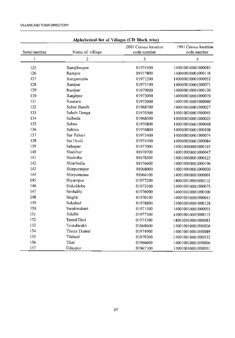
VILLAGE AND TOWN DIRECTORY
Alphabetical list of Villages (CD Block wise)
2001 Census location 1991 Census location Serial number Name of village code number code number
1 2 3 4
125 Ramjibanpur 01974500 140010010001000085 126 Rampur 01977800 140010010001000118 127 Rangamatia 01971200 140010010001000052 128 Ranipur 01973100 140010010001000071 129 Ranipur 01979000 140010010001000130 130 Ranjitpur 01973900 140010010001000079 131 Rautara 01972000 140010010001000060 132 SaburBandh 01968700 140010010001000027 133 Saheb Danga 01970500 140010010001000045 134 Salbeda 01968500 140010010001000025 135 Salma 01970800 140010010001000048 136 Saltora 01976800 140010010001000108 137 Sar Pahari 01973400 140010010001000074 138 Sat Deuli 01974400 140010010001000084 139 Sebapur 01977000 140010010001000110 140 Shalchur 01970700 140010010001000047 141 Shalroha 01978300 140010010001000123 142 Shiarbedia 01976600 140010010001000106 143 Shirpuranpur 01968000 140010010001000020 144 Shirpumama 01966100 140010010001000001 145 Shyampur 01977200 140010010001000112 146 Siakuldoba 01973500 140010010001000075 147 Simladihi 01976000 140010010001000100 148 Singhir 01970100 140010010001000041 149 Sukabad 01978800 140010010001000128 150 Swatiwakuri 01971500 140010010001000055 151 Telidihi 01977300 140010010001000113 152 Tentul Tikri 01974300 140010010001000083 153 Tentularakh 01968600 140010010001000026 154 Thana Dumar 01974900 140010010001000089 155 Tilabaid 01979200 140010010001000132 156 Tiluri 01966600 140010010001000006 157 Udaypur 01967100 140010010001000011
97
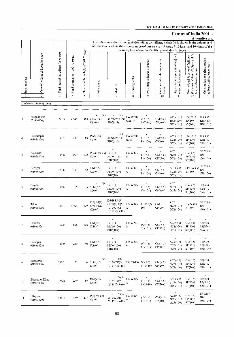
2
CD Block: Saltora (0001)
2
3
4
5
6
7
9
10
II
Shirpurnama (01966100)
Balarampur (01966200)
Kalakundi (01966300)
Nabagram (01966400)
BaguJia (01966500)
Tiluri (01966600)
Bhaluka (01966700)
Binodpur (01966800)
Bhadaspur (01966900)
Bhadaspur Khas (01967000)
Udaypur (01967100)
3
771.4
111.4
114.8
221.6
30.6
334.1
90.0
89.0
110.3
136.8
545.4
~
~ c " U
o o C'.-
4
3,454
357
1,099
339
65
4,794
665
279
21
467
1,469
DISTRICT CENSUS HANDBOOK: BANKURA
Census of India 2001 -Amenities and
Amenities available (if not available within the village, a dash (-) is shown in the column and next to itin brackets the distance in broad ranges viz.< 5 kms., 5-10 kms. and 10+ kms oftbe
nearest place where the facility is available is given
5 6 7 8 9
P« - H« 563 5) M« 5) 5) MCW(5-10) TW W TK PO« 5)
C(IO+) PHC« 5) R SS-W PH(IO+)
66 PM«5) C(IO+)
H« TWWTK 5) MCW« 5) SS-W PO« 5) PHC« 5) PH(IO+)
192 P AC M« 5) H(10+) C(lO+) MCW« 5)
PHC(IO+)
42 P M« S) C(IO+)
H(IO+) MCW(IO+) PHC(IO+)
- P« H(I~+) 5 5) M« 5) MCW(IO+)
C(IO+) PHC(IO+)
DNHRMP
~W W SS- PO« 5)
PH(IO+)
TWWSS-PO« 5) PH(IO+)
W
:WSS- PO«5)
PH(lO+)
10
CM«5) CP(lO+)
CM« 5) CP(IO+)
CM« 5) CP(IO+)
CM«5) CP(IO+)
CM«5) CP(IO+)
P(3) M(2) 922 S(2) PUC
C(lO+)
CHW(2) H(5- TW W SS- PO PH(5- CM
116 PM« 5) C(IO+)
46 PM« 5) C(lO+)
P« 6 5)M«5)
C(lO+)
87 P M« 5) C(10+)
277 P(2) M« 5) C(lO+)
10) MCW(5- W 10) CP(10+) 10) PHC(S-IO)
H(IO+) MCW(IO+) PHC(IO+)
H(IO+) MCW(\O+) PHC(10+)
H(5-
TWWSS-W PO« 5)
PH(lO+)
TWWSS-W PO« 5)
PH(IO+)
10) MCW(5- TW SS-TW PO« 5) 10)PHC(5-10) PH(5-10)
- H(5-10) MCW(5- TW W SS- PO« 5)
10) PHC(5-10) W PH(5-1O)
- H(5-10) MCW(5- TW W SS- PO« 5)
10) PHC(5-10) W PH(IO+)
98
CM« 5) CP(IO+)
CM«5) CP(IO+)
CM« 5) CP(10+)
CM«5) CP(IO+)
CM«5) CP(IO+)
II
ACS(lO+) NCS(10+) OCS(lO+)
ACS(IO+) NCS(IO+) OCS(IO+)
ACS NCS(IO+) OCS(IO+)
ACS« 5) NCS(IO+) OCS(IO+)
ACS NCS(lO+) OCS(IO+)
ACS NCS(10+) OCS(10+)
ACS« 5) NCS(IO+) OCS(IO+)
ACS« 5) NCS(10+) OCS(10+)
ACS« 5) NCS(10+) OCS(IO+)
ACS« 5) NCS(10+) OCS(lO+)
ACS«5) NCS(IO+) OCS(10+)
12
CV(IO+) SP(10+) ST(IO+)
CV(lO+) SP(IO+) ST(IO+)
CV«5) SP(IO+) ST(IO+)
13
BS« 5) RS(5-10) NW(IO+)
BS« 5) RS(5-10) NW(10+)
BS RS(5-10) NW(lO+)
SP CV« 5) BS RS(5-10)
ST(IO+) NWCIO+)
CV«5) SP(IO+) ST(IO+)
BS« 5) RS(5-1O) NW(IO+)
CV SP(2) BS RS(S-10)
ST(IO+) NW(10+)
CV«5) SP(IO+) ST(IO+)
CV«5) SP(10+) ST(IO+)
CV« 5) SP(IO+) ST(10+)
CV« 5) SP(lO+) ST(IO+)
CV«5) SP(10+) ST(lO+)
BS« 5) RS(IO+) NW(IO+)
BS« 5) RS(10+) NW(IO+)
BS« 5) RS(5-10) NW(IO+)
BS«5) RS(5-10) NW(10+)
BSRS(5-10) NW(JO+)
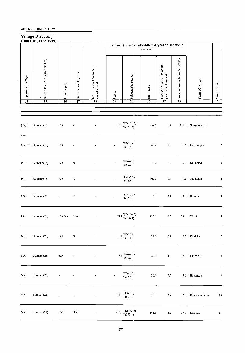
VILLAGE DIRECTORY
Village Directory Land Use (As on 1999)
14 15
MRFP Bumpur(13)
MRFP Bumpur(13)
PR Bumpur(IS)
PR Bumpur (18)
MR Bumpur (20)
PR Burnpur (20)
MR Bumpur(24)
MR Bumpur (23)
MR Bumpur (22)
MR Bumpur (22)
MR Bumpur(21)
16 17 18
ED
ED
ED N
ED N
N
ED EO NM
ED N
ED
EO NM
Land use (i.e. area under different types ofland use in hectare)
19 20
162 TK(16S.9) · T(16S.9)
TK(29.4) T(29.4)
TK(62.0) T(62.0)
TK(88.6) T(88.6)
TK(16.3) T(16.3)
239 TK(136.0) · T(136.0)
IS 0 TK(36.1) · T(361)
8 S TK(42.0) · T(42.0)
TK(66.0) T(66.0)
413 TK(60.0) · T(60.0)
180 I TK(17S.5) · T(l7S.S)
99
21
259.6
47.4
40.0
107.3
6.1
137.1
27.6
20.1
30.1
18.9
141.1
22 23 2
18.4 311.2 Shirpurnama
2.9 31.6 Balarampur
2.9 9.9 Kalakundi
6.1 19.6 Nabagram
2.8 S.4 Bagulia
4.S 32.6 Tiluri
2.7 8.6 Bhaluka
1.0 17.3 Binodpur
4.7 9.6 Bhadaspur
3.7 12.9 Bhadaspur Khas
8.8 39.9 Udaypur
2
3
4
5
6
7
8
9
10
II
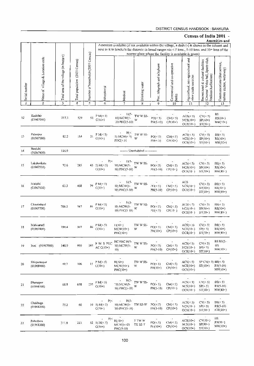
DISTRICT CENSUS HANDBOOK: BANKURA
Census of India 2001 -Amenities and
Amenities available (if not available within the village, a dash (-) is shown in the column and
next to it in brackets the distance in broad ranges viz.< 5 kms., 5-10 kms. and 10+ kms of the ~
nearest place where the facility_ is available is given en
~ ;:l
OJ en ::: "0 lJ E~ "0 ~ OJ
0 "0 en U iii <> OJ ~ .~ u a;r C -= C; OJ OJ ""§ C t: ;> ~ CI'l U 0 5 <1.) 0 0 .~ ·u t: ·E ~ .~ U c:\- -= 2 ~ & <> a> ~ c.. "3 OJ i2 0 ~ <:> '" <tl c.. U co'" ~ ~ ...:I <:> "0 ] 0 'fn ~~ !3 ==" E c:\- o 6
;:l <1.)
0'13 ;; -= "0 ~ ''':: :g ~ .2 o:l til (]) t: u ';:;:::
j <1.) t: en '" "0 t: ., u 0 ....
.£ 0 ;:l .... t: 0· ..... • 0<3 ~ .g ::: "
til .~ 0 (]) -= t: 0 .~ .§ 4-< -= ~
c.. '" 5; co>3 .D .;; 0 "3 4-< 0; ~ co "8 :.ci E '" Q. 0 t: .~ c: <: 'a ~ ::l 4-< ~ 0 .... 0 bI) (]) E ~: .S (U 6 t: 0 Q. (]) .~ ca t: ] <1) ;:l ;>,
~ '" .D .>l J< E en ;:l (..) til E ::l E ~ 0; 0; E u .g ~ ~ g:.a § "0 ~
;:l "0 t: en E -" §~ (]) ;:l "0 (]) is o 18 ~~ ~ u E Z f--; Z ;;E 0
'" >Q 0-; U..o o::~'" U f::: I 2 3 4 5 6 7 8 9 10 11 12 13
Kashihir PM« 5) - H(5-
ACS« 5) CV« 5) BS
12 217.3 529 91 10) MCW(5- TW W SS- PO«5) CM«5) RS(IO+) (01967200) C(lO+) 10) PHC(5-10) W PH(5-10) CP(10+ )
NCS(lO+) SP(lO+) NW(10+)
OCS(lO+) ST(lO+)
Paharpur PM«5) H« TWWSS- ACS« 5) CV« 5) BS« 5) 13 82.2 184 31 5) MCW« 5) PO«5) CM« 5) (01967300) CCIO+) PHC« 5)
W PH«5) CP(IO+)
NCS(lO+) SP(10+) RS(IO+) OCS(lO+) ST(lO+) NW(IO+)
14 Bardubi
116.9 -------- Uninhabited ------------(01967400)
Lakshankata P« - H(5-
ACS« 5) CV«5) BS«5) IS 72.6 285 45 5) M« 5) 10) MCW(5- TW W SS- PO«5) CM«5) (01967500) C(lO+) 10)PHC(5-10) W PH(5-10) CP(lO+)
NCS(10+) SP(]O+) RS(IO+) OCS(IO+) ST(10+) NW(IO+)
Maldihi P M«5) - H(5- ACS
CV« 5) BS« 5) 16
(01967600) 63.3 468 79
C(lO+) 10) MCW(5- TW W SS- PO«5) CM« 5) NCS(lO+)
SP(lO+) RS(IO+) 10) PHC(5-10) W PH(5-10) CP(lO+) OCS(10+)
ST(10+) NW(lO+)
Chhatinbaid P M« 5) - H(5-
ACS« 5) CV« 5) BS« 5) 17 206.5 547 84 10) MCW(5- :W W SS- CM«5)
(0]967700) C(IO+) PO«5)
NCS(IO+) SP(10+) RS(IO+) 10) PHCC5-1O) PH«5) CP(lO+)
OCS(lO+) ST(lO+) NW(lO+)
18 Mahisaradi
199.4 507 86 P M« 5) H(10+) TWWSS-
PO«5) CM«5) ACS« 5) CV« 5) BS« 5)
(01967800) C(IO+) MCW(IO+) W NCS(IO+) SP« 5) RS(lO+) PHC(lO+)
PH(IO+) CP(lO+) OCS(lO+) ST(IO+) NW(IO+)
PM S PUC HCPHC H(5-
TWWSS- ACS« 5) CV« 5) BSRS(5-
19 lturi (01967900) 148.9 909 185 AC CCI 0+)
10) MCW(5-W
PO«5) CM« 5) NCS(lO+) SP«5)
10)
10) PH(5-10) CP(1O+) OCS(IO+) ST(]O+)
NW(IO+)
Shirpuranpur 49.7 106 15
P M« 5) H(lO+) TWWSS-PO«5) CM«5)
ACS«5) SPCV« 5) BS« 5) 20
(01968000) C(10+) MCW(10+) W NCS(10+) ST(lO+) RS(5-10)
PHC(lO+) PH(]O+) CP(IO+)
OCS(IO+) NW(IO+)
Bharatpur P M« 5) H(S-
TWWSS- ACS« 5) CV«5) BS«5) 21
(01968100) 68.8 658 135
C(10+) ]0) MCW(5- W PO«5) CM« 5)
NCS(10+) SP« 5) RS(5-10) 10) PHC(5-10) PH(5-IO) CP(10+)
OCS(IO+) ST(10+) NW(IO+)
Chakbaga P« H(5-
ACS« 5) CV« 5) BS« 5) 22 75:2 60 10 5) M« 5) 10) MCW(5- TWSS-W PO«5) CM« 5)
NCS(10+) SP«5) RS(5-10) (01968200) C(lO+) 10) PHC(5-10) PH(5-10) CP(10+)
OCS(10+) ST(10+) NW(lO+)
- P« -ACS(lO+) CV(JO+)
BS Paharbera
32 H(lO+) TTWW
PO« 5) CM« 5) RS(10+) 23 211.8 223 5) M« 5) MCW(5-1O) TK SS-T NCS(JO+) SP(IO+) (01968300) PH(IO+) CP(lO+) NW(IO+) C(lO+) PHC(5-10) OCS(lO+) ST(lO+)
100
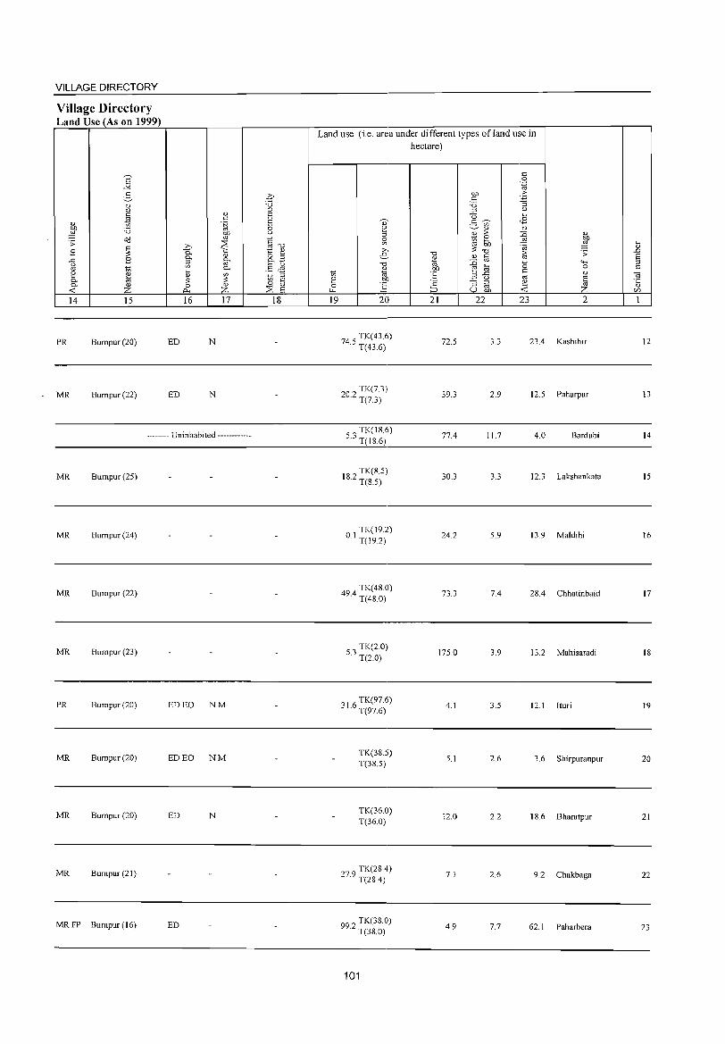
VILLAGE DIRECTORY
Village Directory Land Use (As on 1999)
s "'" 5
<l) C) c t1 <l)
OJ) :.a 21 O(l .s: ~ B
..<:: B C)
'" 1;; 2 <l)
0- @ 0- <l)
« z 14 15
PR Bumpur(20)
MR Bumpur(22}
<l) c .~
OJ)
'" >, ::E 0.. '" 0..
<l)
0 0.. U) '" 0.. .... <l)
~ ~ 0 ~ Cl..
16 17
ED N
ED N
-------- Uninhabited ------------
MR Bumpur(25)
MR Bumpur(24)
MR Bumpur(22)
MR Bumpur (23)
PR Bumpur(20) ED EO NM
MR Bumpur(20) ED EO NM
MR Bumpur(20) ED N
MR Bumpur(21)
MRFP Bumpur(16) ED
.q "0 0 E E 0 C)
§"O t:: <l)
8.3 .5 J1 1;; 0
§ 0
::E E 18
Land use (i.e. area under different types of land use in hectare)
19 20
TK(436} 74.5 T(43.6)
202 TK(7.3) · T(7.3)
o TK(18.6) 5 . .) T(IS.6)
82 TK(S.5) I . T(S.5)
01 TK(19.2) · T(19.2)
494 TK( 48.0) · T(4S.0)
53 TK(2.0) · T(2.0}
01 6 TK(97.6) .) . T(97.6)
TK(38.S) T(3S.5)
TK(36.0) T(36.0)
279 TK(2S.4) · T(2S.4)
99 2 TK(38.0) · T(38.0)
101
"0
" OJ OJ)
·E ·2 ~
21
72.5
39.3
77.4
30.3
24.2
73.3
175.0
4.1
5.1
12.0
71
4.9
OJ) c
:.a 0 u § ~ U)
<l)
j >-e OJ)
"0 <l) § :0 e @
.a ..c <.)
"3 @ u OJ)
22
3.3
2.9
11.7
3.3
5.9
7.4
3.9
3.5
2.6
2.2
2.6
7.7
c 0
".g -5 "3
C)
.... <8
<l)
{j <l)
~ ~ 1;; .;:
"0 ""' 0 c " '" ~ ~
23 2
23.4 Kashihir
12.5 Paharpur
4.0 Bardubi
12.3 Lakshankata
13.9 Maldihi
2S.4 Chhatinbaid
13.2 Mahisaradi
12.1 [turi
3.6 Shirpuranpur
IS.6 Bharatpur
9.2 Chakbaga
62.1 Paharbera
t .D E 0 c
~ " (/)
1
12
13
14
15
16
17
IS
19
20
21
22
23
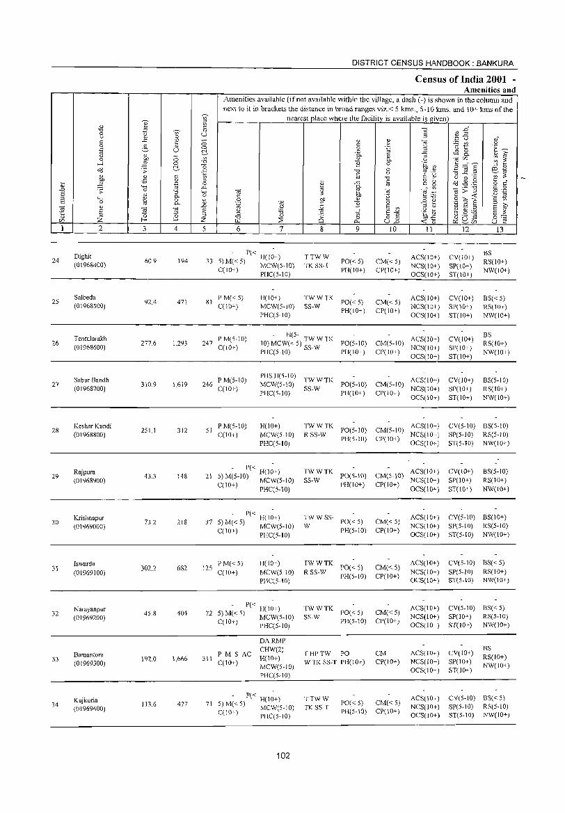
24
25
26
27
28
29
30
31
32
33
34
2
Dighit (0\968400)
Salbeda (01968500)
Tentularakh (01968600)
Sabur Bandh (01968700)
Keshar Kundi (01968800)
Rajpura (01968900)
Krishnapur (01969000)
Iswarda
(01969100)
Narayanpur (01969200)
Bamantora (01969300)
Kujkuria (01969400)
3 4
60.9 194
92.4 471
277.6 1,293
310.9 1,619
251.1 312
43.3 148
73.2 218
302.2 682
45.8 404
192.0 1,666
113.6 477
DISTRICT CENSUS Hi!\NDBOOK : BANKURA
Census of India 2001 -Amenities and
Amenities available (if not available within the village, a dash (-) is shown in the column and next to it in brackets the distance in broad ranges viz.< 5 kms., 5-1 () kms. and 10+ kms of the
nearest place where the facility is available is given
5 6 7
- P« H(I~+) 33 5) M« 5) MCW(S-IO)
C(10+) PHC(5-10)
81 P M«5) C(10+)
H(IO+) MCW(S-IO) PHC(5-10)
8
TTWW TK SS-T
(i) r: o
..c: Q. (i)
2 "'" c oj
..c: Q. e OJ) (i)
B "ti o
0...
9
PO« 5) PH(IO+)
TWWTK SS-W PO«5)
PH(IO+}
10
CM« 5) CP(IO+)
CM«5) CP(IO+}
11
ACS(10+) NCS(IO+) OCS(10+)
ACS(lO+) NCS(IO+) OCS(IO+)
247 P M(5-IO) C(10+)
- H(5-10) MCW« 5) TW W TK PO(5-10) PHC(5-10) SS-W PH(JO+)
CM(5-IO} ACS(IO+) CP(IO+) NCS(IO+)
OCS(10+)
246 P M(5-1O) C(10+)
PHS H(s-IO) TW W TK ACS(lO+) MCW(5-10) SS-W PO(5-IO) CM(5-IO) NCS(IO+) PHC(5-1O) PH(lO+) CP(lO+)
OCS(IO+)
51 PM(5-10) C(lO+)
H(IO+) MCW(S-IO) PHC(5-10)
- P« H(I;+) 21 5) M(5-10) MCW(5-10)
C(10+) PHC(5-10)
- P« H( I~+} 37 5} M« 5} MCW(s-IO}
C(IO+) PHC(5-1O)
125 P M« 5) C(IO+)
H(IO+) MCW(5-10) PHC(s-IO)
- P« H(l~+) 72 5) M« 5) MCW(5-1O)
C(lO+) PHC(5-10)
311 PM S AC C(lO+)
DARMP CHW(2) H(IO+) MCW(s-IO) PHC(5-10)
- P« H(I~+) 71 5) M« 5) MCW(5-IO)
C(IO+) PHC(5-10)
102
TWWTK R SS-W PO(5-10)
PH(5-10)
ACS(IO+) CM(S-IO) NCS(10+) Cpe 10+) OCS(J 0+ }
TWWTK PO(5-10) CM(5-IO) ACS(IO+) SS-W PH(lO+) CP(IO+) NCS(lO+)
OCS(lO+)
:W W SS- PO« 5}
PH(5-1O)
TWWTK PO« 5)
R SS-W PH(5-1O)
TWWTK SS-W PO« 5)
PH(5-10)
THPTW PO W TK SS-T PH(10+)
TTWW TK SS-T
PO«5) PH(5-10)
CM«5} CP(IO+)
CM« 5) CP(IO+)
CM«5) CP(IO+)
CM CP(lO+)
CM« 5) CP(lO+)
ACS(IO+) NCS(IO+) OCS(IO+)
ACS(IO+) NCS(IO+) OCS(IO+)
ACS(IO+) NCS(10+) OCS(IO+)
ACS(10+) NCS(lO+) OCS(10+)
ACS(IO+) NCS(10+) OCS(lO+)
12
CV(10+) SP(lO+) ST(IO+)
CV(JO+) SP(10+) ST(JO+)
CV(10+) SP(lO+) ST(10+)
CV(lO+) SP(IO+) ST(IO+)
13
BS RS(10+) NW(IO+)
BS« 5) RS(10+) NW(IO+)
BS RS(10+} NW(IO+)
BS(s-IO) RS(lO+) NW(IO+)
CV(s-to) BS(s-lO) SP(5-1O) RS(5-10) ST(5-IO) NW(IO+)
CV(lO+) SP(to+) ST(10+)
BS(5-to) RS(IO+) NW(10+)
CV(5-1O) BS(10+) SP(S-10} RS(5-10) ST(5-10) NW(lO+)
CV(5-10) BS« 5) SP(5-IO) RS(IO+) ST(5-10) NW(10+)
CV(5-10) BS« 5) SP(IO+) RS(5-1O) ST(IO+) NW(lO+)
CV(lO+) SP(IO+) ST(IO+)
BS RS(IO+) NW(10+)
CV(5-IO) BS« 5) SP(5-10) RS(5-10) ST(5-1O) NW(IO+)
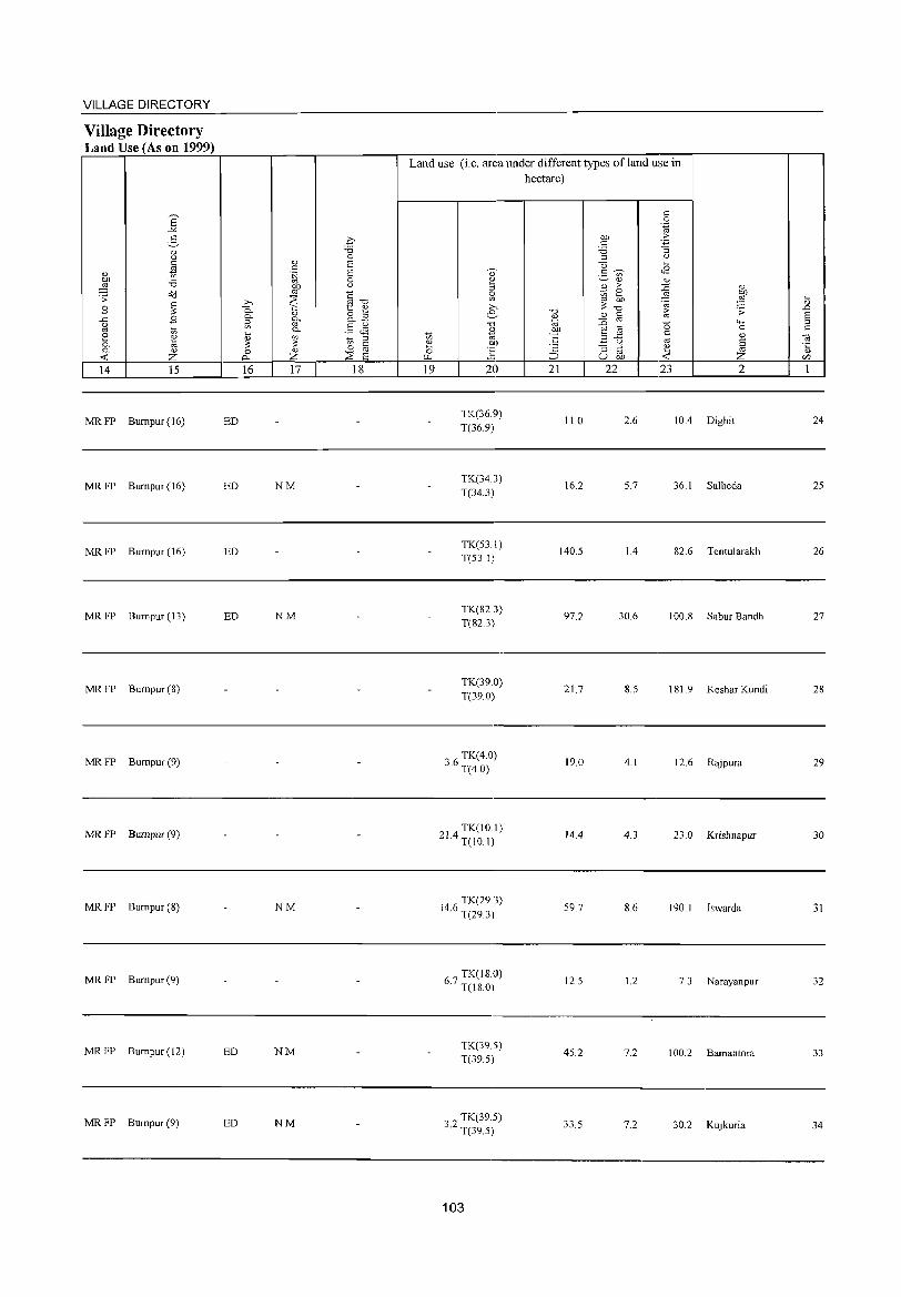
VILLAGE DIRECTORY
Village Directory Land Use (As on 1999)
14 15
MR FP Bumpur (16)
MRFP Bumpur(16)
MR FP Bumpur (16)
MRFP Bumpur(13)
MR FP Bumpur (8)
MR FP Bumpur (9)
MR FP Bumpur (9)
MR FP Bumpur (8)
MR FP Bumpur (9)
MR FP Bumpur (12)
MR FP Bumpur (9)
16 17 18
ED
ED NM
ED
ED NM
NM
ED NM
ED NM
Land use (i.e. area under different types ofland use in hectare)
19 20
TK(36.9) T(36.9)
TK(34.3) T(34.3)
TK(53.1) T(53.1)
TK(82.3) T(82.3)
TK(39.0) T(39.0)
36 TK(4.0) · T(4.0)
214 TK(lO.I) · T(IO.I)
4 6 TK(29.3)
1 . T(29.3)
67 TK(lS.O) · T(18.0)
TK(39.5) T(39.5)
32 TK(39.5) · T(39.5)
103
21 22
11.0
16.2
140.5
97.2
21.7
19.0
14.4
59.7
12.5
45.2
33.5
23 2
2.6 10.4 Dighit
5.7 36.1 Salbeda
1.4 82.6 Tentularakh
30.6 100.8 Sabur Bandh
8.5 181. 9 Keshar Kundi
4.1 12.6 Rajpura
4.3 23.0 Krishnapur
8.6 190.1 Iswarda
1.2 7.3 Narayanpur
7.2 100.2 Bamantora
7.2 30.2 Kujkuria
24
25
26
27
28
29
30
31
32
33
34
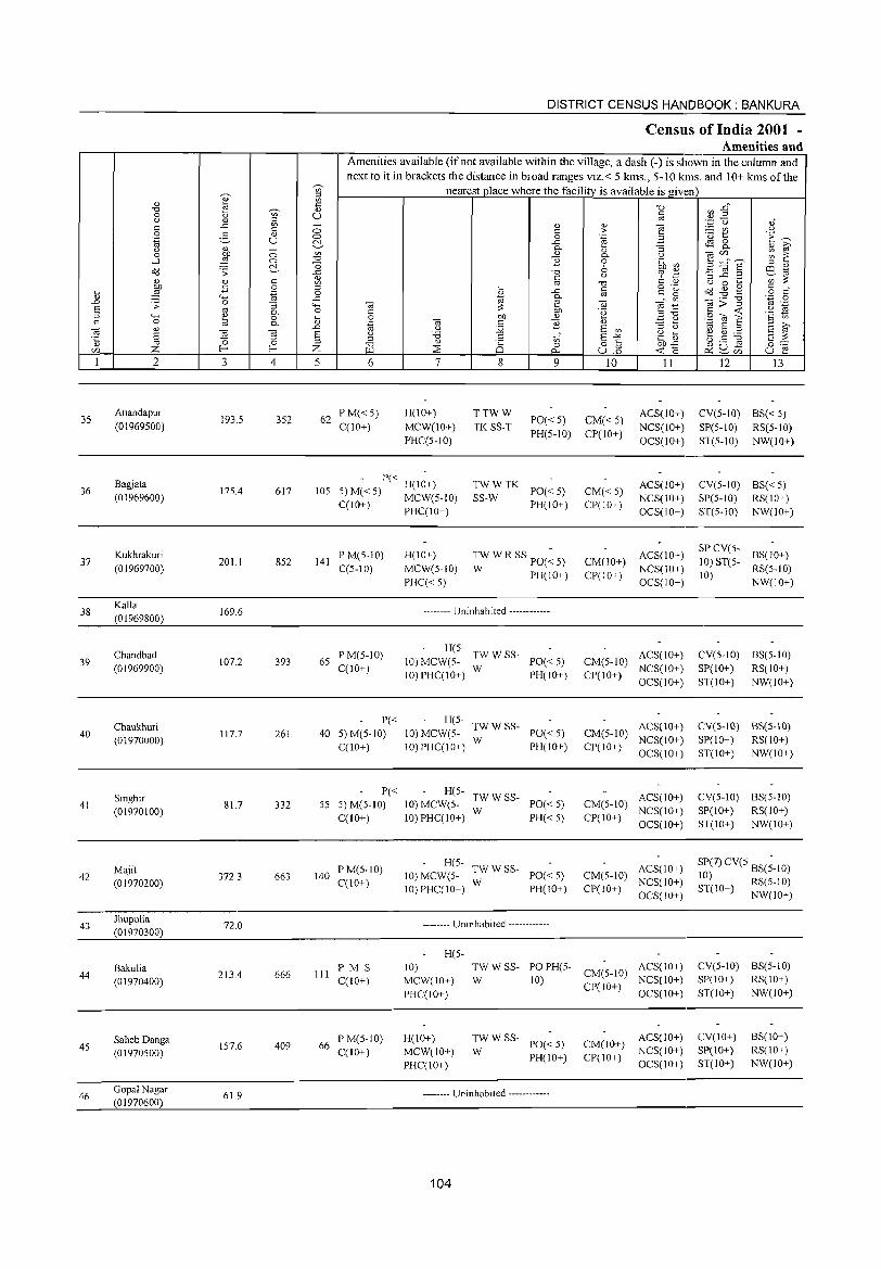
35
36
37
38
39
40
41
42
43
44
45
46
2
Anandapur (01969500)
Bagjata (01969600)
Kukhrakuri (01969700)
Kalla (01969800)
Chandbad (01969900)
Chaukhuri (01970000)
Singhir (01970100)
Majit (01970200)
Jhupulia (01970300)
Bakulia (01970400)
SahebDanga (01970500)
Gopal Nagar (01970600)
3
193,5
175.4
201.1
169.6
107.2
117,7
81.7
372.3
72.0
213.4
157.6
61.9
o o ~ c: o
".g :; Co C-
~ 4
352
617
852
393
261
332
663
666
409
DISTRICT CENSUS HANDBOOK: BANKURA
Census of India 2001 -Amenities and
Amenities available (ifnot available within the village, a dash (-) is shown in the column and next to it in brackets the distance in broad ranges viz.< 5 kms., 5-lO kms. and 10+ kms of the
nearest place where the facility is available is given
o o ~ '" -0
] '" '" '" o
..c 'o ~
'" ..0
§ Z 5 6
62 PM«5) CCIO+)
7
H(IO+)
MCW(lO+)
PHCC5-1O)
8
TTWW
TKSS-T
'" o 0...
9
PO« 5) PH(5-IO)
10
CM«5) CP(IO+)
11
ACS(lO+)
NCS(IO+)
OCS(IO+)
105 - P« H(1~+)
5) M« 5) MCW(5-10) TWWTK SS-W PO« 5)
PH(IO+) CM«5) CP(10+)
ACS(IO+) NCS(IO+)
OCS(IO+) C(10+) PHC(IO+)
141 PM(5-10) CC5-10)
65 PM(5-1O) C(lO+)
P« 40 5) M(5-10)
C(lO+)
P« 55 5) M(5-10)
C(10+)
140 P M(5-IO) C(IO+)
III PM S C(1O+)
66 P M(5-10) C(lO+)
H(IO+)
MCW(5-1O)
PHC« 5)
TWWR SSpO(~ 5)
W PH(IO+)
-------- Uninhabited ------------
H(5- TWW SS-10) MCW(5- W PO« 5) 10) PHC(IO+) PH(IO+)
H(5- TWWSS-10) MCW(5- W PO« 5) IO)PHC(IO+) PH(IO+)
H(5- TWWSS-10) MCW(5- W PO« 5) 10) PHC(10+) PH« 5)
H(5- TWW SS-10) MCW(5- W PO« 5) 10)PHC(10+) PH(IO+)
-------- Uninhabited ------------
H(5-
CM(10+)
CP(IO+)
ACS(IO+)
NCS(IO+)
OCS(IO+)
CM(5-10) ACS(IO+) CP(10+) NCS(IO+)
OCS(IO+)
CM(5-10) ACS(10+) NCS(IO+)
Cpr 10+) OCS( 10+ )
CM(5-10) ACS(lO+) CP(IO+) NCS(10+)
OCS(10+)
CM(5-10) ACS(IO+) CP(IO+) NCS(IO+)
OCS(IO+)
10) MCW(IO+)
PHC(IO+)
TW W SS- PO PH(5- CM(5-10) ACS(IO+)
W 10) CP(10+) NCS(IO+) OCS(IO+)
H(10+)
MCW(IO+)
PHC(IO+)
:: W SS- PO« 5)
PH(IO+)
-------- Uninhabited ------------
104
CM(IO+) CP(IO+)
ACS(IO+) NCS(IO+)
OCS(IO+)
12 13
CV(5-IO) BS« 5)
SP(5-1O) RS(5-10)
ST(5-1O) NW(IO+)
CV(5-IO) BS« 5) SP(5-IO) RS(IO+)
ST(5-1O) NW(IO+)
SP CV(5- BS(10+)
10) ST(5- RS(5-10)
10) NW(IO+)
CV(5-1O) BS(5-10)
SP(IO+) RS(IO+)
ST(IO+) NW(IO+)
CV(5-IO) BS(5-10)
SP( 10+) RS(l 0+)
ST(lO+) NW(IO+)
CV(5-1O) BS(5-10)
SP(1 0+) RS(1 0+)
ST(IO+) NW(10+)
SP(7) CV(5 BS(;-IO) 10) ST(IO+) RS(5-10)
NW(IO+)
CV(5-1O) BS(5-10) SP(IO+) RS(IO+)
ST(IO+) NW(IO+)
CV(IO+)
SP(IO+)
ST(IO+)
BS(IO+) RS(IO+)
NW(IO+)
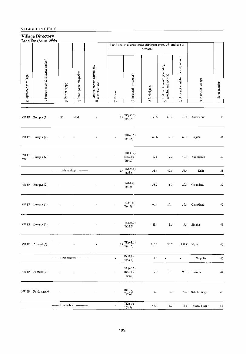
VILLAGE DIRECTORY
Village Directory Land Use (As on 1999)
E "" 2-
OJ (.)
~ <1)
" Q) .~
E ::a on a'd co .;;
~ .b ~ B 0-0- Q)
-5 .8 ::J g. '" in '" 0-0
~ ....
<n h <1)
0- :so ~ 0- Q) 0 Q)
...: z ~ Z 14 15 16 17
MR FP Bumpur (2) ED NM
MRFP Bumpur(2) ED
MRFP Bumpur(2)
NW
-------- Uninhabited ------------
MRFP Bumpur(2)
MRFP Bumpur(2)
MRFP Bumpur(3)
MRFP Asansol (2)
-------- Uninhabited ------------
MRFP AsansoJ (3)
MRFP Ranigang (3)
-------- Uninhabited ------------
€ -0 0 E E 0 u
§-o t:: Q)
8..2 §Jl in ::J 0 ~
:2: E 18
Land use (i.e. area under different types ofland use in hectare)
<n e 0 ~
19
Q)
2 ::J S; >-e-
-0
* on ] 20
32 TK(50.5) . T(50.5)
TK(40.5) T(40.5)
TK(30.2) R(69.0) T(99.2)
1 4 TK(23.6) 5. T(23.6)
TK(8.5) T(85)
TK(4.8) T(4.8)
TK(23.0) T(23.0)
49 TK(48.5) . T(48.5)
R(57.8) T(57.8)
TK(40.7) R(561) T(96.7)
R(40 7) T(40.7)
TK(6.5) T(6.5)
105
-0
* OJ)
'6 ·c ;:J
21
50.6
62.6
52.5
38.8
58.3
64.8
41.1
115.3
14.3
7.7
7.7
43.1
0: 0 .~
OJ) .::: " -3 ::a ::J <.)
Q ~
g ~ <B '" 0) <1)
2 > ::0 Q)
gj 2 .."! OJ)
~ OJ) .", ~
-0 ~ ;;:
Q) " :0 co 0 '-H
E ia "
0
B .c Q) (.) co § :; ::J
~ co u on Z 22 23 2
60.4 28.8 Anandapur
12.3 60.1 Bagjata
2.3 47.1 Kukhrakuri
40.5 51.4 Kalla
11.3 29.1 Chandbad
19. J 29.1 Chaukhuri
3.5 14.1 Singhir
20.7 182.9 Majit
Jhupulia
10. J 98.9 BakuJia
10.3 98.9 Saheb Danga
6.7 5.6 Gopal Nagar
~ .D E ::J
" ~ Q)
r/)
1
35
36
37
38
39
40
41
42
43
44
45
46
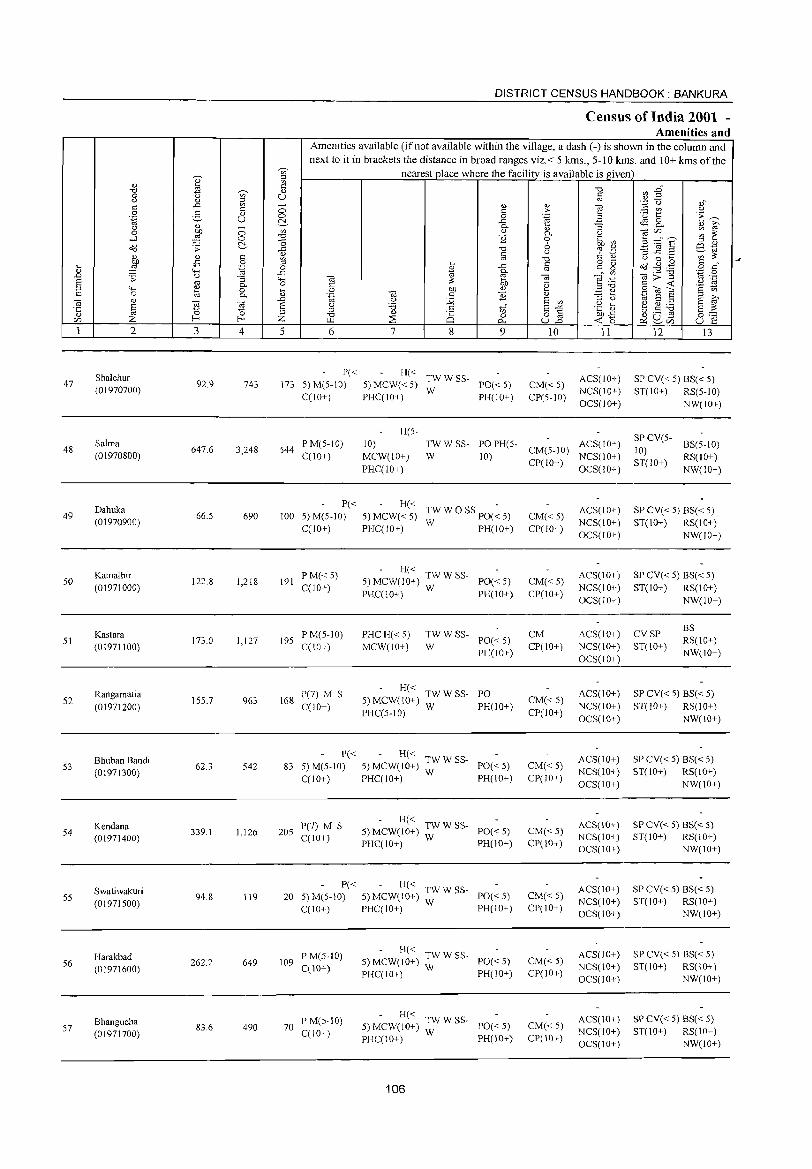
47
48
49
50
51
52
53
54
55
56
57
2
Shalchur (01970700)
Salma (01970800)
Dahuka (01970900)
Kamalhir (01971000)
Kastara (01971100)
Rangamatia (01971200)
Bhuban Bandi (01971300)
Kendana (01971400)
Swatiwakuri (01971500)
Harakbad (01971600)
Bhangucha (01971700)
3
92.9
647.6
66.5
122.8
173.0
155.7
62.3
339.1
94.8
262.2
83.6
T u o o ~
4
743
3,248
690
1,218
1,127
963
542
1,126
119
649
490
DISTRICT CENSUS HII,NDBOOK : BANKURA
Census of India 2001 -Amenities and
Amenities available (ifnot available within the village, a dash (-) is shown in the column and next to it in brackets the distance in broad ranges viz.< 5 kms., 5-10 kms. and 10+ kms of the
nearest place where the facility is available is given
5 6
P« 173 5) M(5-10)
C(10+)
7 8 9
H« TW W SS-5) MCW« 5) W PO« 5) PHCCIO+) PH(IO+)
H(5-
10
CM«5) CP(5-iO)
11
ACS(IO+) NCS(IO+) OCS(10+)
544 P M(5-10) CCl0+)
10) MCW(10+)
PHC(lO+)
TWWSS- POPH(5- CM(5-10) ACS(10+)
W 10) CP(IO+) NCS(IO+) OCS(lO+)
P« H« -100 5) M(5-10) 5) MCW« 5) TW W 0 SS PO« 5)
C(lO+) PHCClO+) W PH(lO+)
191 PM«5) C(lO+)
195 PM(5-10) CCI0+)
168 P(7) M S C(lO+)
- H« 5) MCW(IO+) TW W SS- PO« 5)
PHC(10+) W PH(10+)
PHCH«5) MCW(10+)
:W W SS- PO« 5)
PH(IO+)
- H« 5)MCW(10+) TWWSS- PO PHCC5-10) W PH(IO+)
P« - H« 83 5) M(5-1 0) 5) MCW(1 0+) ;:' W SS- POe < 5)
CCl0+) PHCCIO+) PH(IO+)
205 P(7) M S C(lO+)
- H« 5) MCW(IO+) TW W SS- PO« 5)
PHCC10+) W PH(10+)
P« - H« TW W SS-20 5) M(5-10) 5) MCW(10+) W PO« 5)
CCIO+) PHCC10+) PH{ID+)
109 P M(5-1O) CC 10+)
70 PM(5-10) C(lO+)
H« TWWSS-5)MCW(10+) W PO«5) PHCC10+) PH(IO+)
H« TWWSS-5) MCW(lO+) W PO« 5) PHCC10+) PH(10+)
106
CM« 5) CP(IO+)
CM«5) CP(10+)
CM Cpr 10+)
CM«5) CP(IO+)
CM« 5) CP(lO+)
CM«5) CP(10+)
CM« 5) CP(IO+)
CM«5) CP(IO+)
CM«5) CP(lO+)
ACS(lO+) NCS(IO+)
OCS(IO+)
ACS(IO+)
NCS(lO+) OCS(lO+)
ACS(IO+) NCS(IO+) OCS(IO+)
ACS(1O+)
NCS(lO+)
OCS(10+)
ACS(IO+) NCS(IO+)
OCS(IO+)
ACS(IO+) NCS(lO+) OCS(10+)
ACS(lO+) NCS(IO+) OCS(10+)
ACS(lO+) NCS(IO+) OCS(JO+)
ACS(lO+) NCS(10+) OCS(JO+)
12 13
SP CV« 5) BS« 5) ST(10+) RS(5-10)
NW(10+)
SP CV(5- BS(5-10) 10) ST(IO+) RS(IO+)
NW(IO+)
SP CV« 5) BS« 5) ST(IO+) RS(lO+)
NW(JO+)
SP CV« 5) BS« 5) ST(IO+) RS(lO+)
NW(IO+)
CVSP ST(IO+)
BS RS(IO+)
NW(IO+)
SP CV« 5) BS« 5) ST(IO+) RS(lO+)
NW(10+)
SP CV« 5) BS« 5) ST(10+) RS(10+)
NW(1O+)
SP CV« 5) BS« 5) ST(lO+) RS(IO+)
NW(10+)
SP CV« 5) BS« 5) ST(JO+) RS(10+)
NW(10+)
SP CV« 5) BS« 5) ST(IO+) RS(IO+)
NW(IO+)
SP CV« 5) BS« 5) ST(lO+) RS(IO+)
NW(lO+)
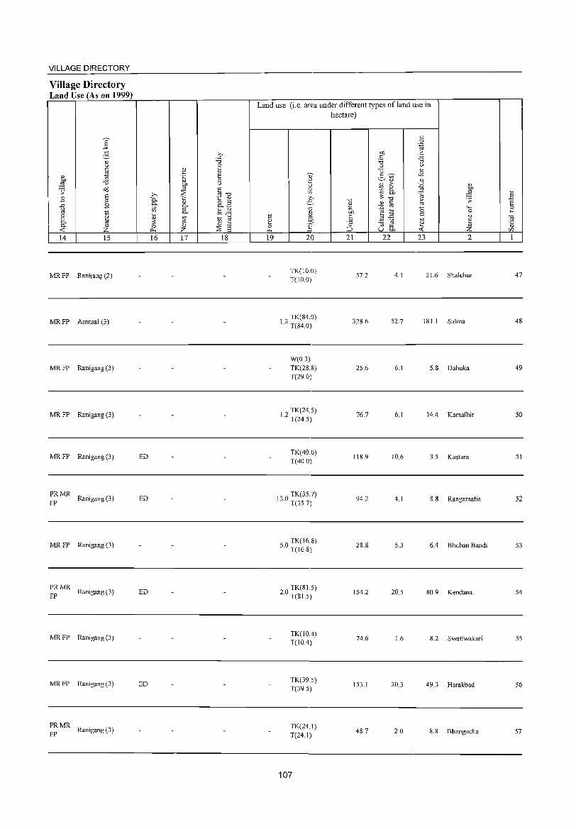
VILLAGE DIRECTORY
Village Directory Land Use (As on 1999)
E "'" 3 n> t>
n> ~ OJ) :0 ;:§ ;;: a'd
.8 ~ ..c: .8 t>
'" t; 2 ~ 0. 0. n>
-< Z 14 15
MR FP Ranijang (2)
MRFP Asansal (3)
MRFP Ranigang (3)
MRFP Ranigang (3)
MRFP Ranigang (3)
PRMR Ranigang (3)
FP
MR FP Ranigang (3)
~ MR Ranigang (3)
MR FP Ranigang (3)
MR FP Ranigang (3)
PRMR Ranigang (3)
FP
16 17 18
ED
ED
ED
ED
Land use (i.e. area under different types of land use in hectare)
19 20
TK(IO.O) T(1O.0)
TK(84.0) 1.2 T(84.0)
W(O.3) TK(28.S) T(29.0)
2 TK(24.5) 1. T(24.5)
TK(40.0) T(40 0)
"0 TK(35.7) b. T(35.7)
o TK(16.8) 5. T(16.8)
20 TK(81.5) . T(S1.5)
TK(IOA) T(IOA)
TK(39.5) T(39.5)
TK(24.1) T(24.1)
107
21 22
57.2
328.6
25.6
76.7
118.9
94.2
28.8
154.2
74.6
153.1
48.7
23 2
4.1 21.6 Shalchur
52.7 181 I Salma
6.1 5.8 Dahuka
6.1 14.4 Kamalhir
10.6 3.5 Kastara
4.1 8.8 Rangamatia
5.3 6.4 Bhuban Bandi
20.5 80.9 Kendana
1.6 8.2 Swatiwakuri
20.3 49.3 Harakbad
2.0 8.8 Bhangucha
47
48
49
50
51
52
53
54
55
56
57

5&
59
60
61
62
63
64
65
66
67
68
2
Ham Bazar (01971800)
Barasa! (01971900)
Rautara (01972000)
Kechka (01972100)
Hirerban (01972200)
Pagarbari (01972300)
Behari (01972400)
Biharinathparbat (01972500)
Chandipur (01972600)
Mutukbani (01972700)
Chuaberia (01972800)
~ <::
'" U
3 4
134.6 551
136.4 358
289.4 1,362
76.6 582
45.9 228
194.2 519
272.7 479
281.4
53.6 340
212.7 1,570
258.9 1,162
DISTRICT CENSUS HANDBOOK: BANKURA
Census of India 2001 -Amenities and
Amenities available (ifnot available within the village, a dash (-) is shown in the column and next to it in brackets the distance in broad ranges viz. < 5 kms., 5-10 kms. and 10+ kms of the
nearest place where the facility is available is given
5 6 7 8 9
92 PM(5-IO) C(10+)
- H« 5)MCW(10+) TWWSS- PO«5)
PHC(5-1O) W PH(IO+)
P« - H« 68 5)M(5-10) 5)MCW(10+) TWWSS- PO«S)
C(IO+) PHC(IO+) W PH(IO+)
221 P M« 5) C(IO+)
97 P M(5-10) C(lO+)
H(IO+)
MCW(5-10)
PHCCIO+)
H(IO+)
MCW(5-10) PHC(lO+)
- P« -37 5)M«5) H(10+)
CCI 0+) MCW(5-10) PHCCIO+)
TWWTK SS-W PO« 5)
PH(IO+)
TWWTK SS-W PO« 5)
PH(lO+)
TTWW TK SS-T
PO«5) PH(lO+)
P« DDHH{IO+) TTWW 102 5)M(5-10) MCW(5-10) TKSS-T PO«5)
PH(IO+) C(10+) PHCC5-10)
92 PM«5) C(lO+)
H(IO+)
MCW(5-1O}
PHCC5-IO)
- P« H(I~+) 5) M(5-10) MCW(5-10)
C(IO+) PHCC5-1O)
TTWW
TK SS-T
-«
PO«5) PH(10+)
5) S8-T« PO« 5) 5) PH(lO+)
P« 55 5) M« 5)
C(lO+)
H(S- TWW SS-10) MCW(5- W PO«5) 10) PHC« 5) PH« 5)
10
CM«5) CP(IO+)
CM«5) CP(lO+)
CM«5) CP(IO+)
CM«5) CP(10+)
CM«5) CP(IO+)
CM CP(10+)
CM« 5) CP(IO+)
CM«5) CP(10+)
CM«5) CP(IO+)
11
ACS(IO+ ) NCS(IO+) OCS(IO+)
ACS(IO+) NCS(IO+)
OCS(IO+)
ACS(10+) NCS(IO+) OCS(IO+)
ACS(10+)
NCS(10+) OCS(10+)
ACS(IO+)
NCS(10+) OCS(lO+)
ACS(lO+) NCS(IO+) OCS(10+)
ACS(IO+)
NCS(IO+)
OCS(lO+)
ACS(IO+) NCS(10+) OCS(lO+)
ACS(IO+) NCS(lO+) OCS(IO+)
309 P(2) M(5-1O) H(IO+) CCI 0+) MeW(S-lO)
PHC(IO+)
T TW W SS· PO PH(5- CM« 5)
T 10) CP(IO+)
ACS(IO+) NCS(IO+) OCS(IO+)
219 PM(5-10) C(lO+)
H(IO+) MCW(IO+) PHCCIO+)
108
:W W SS- PO« 5)
PH«5)
CM(5-10) ACS(IO+) NCS(IO+)
CP(10+) OCS(10+)
12 13
SP CV« 5) BS« 5) ST(IO+) RS(IO+)
NW(lO+)
SP CV« 5) BS« 5) ST(10+) RS(10+)
NW(10+)
CV(lO+) SP(IO+)
ST(10+)
CV(IO+) SP(10+) ST(10+)
CV(IO+) SP(10+) ST(IO+)
CV(10+) SP(IO+) ST(10+)
CV(10+)
SP(lO+) ST(10+)
CV(IO+) SP(IO+) ST(IO+)
CV(lO+) SP(lO+) ST(IO+)
CV(lO+) SP(JO+) ST(IO+)
CV(JO+) SP(JO+) ST(IO+)
BS« 5) RS(IO+) NW(10+)
BS« 5) RS(IO+) NW(IO+)
BS« 5) RS{IO+) NW(lO+)
BS RS(IO+) NW(IO+)
8S« 5) RS(lO+) NW(10+)
BS« 5) RS(lO+) NW(10+)
BS« 5) RS(IO+) NW(IO+)
BS(5-1O) RS(JO+) NW(10+)
BS(5-10) RS(JO+) NW(lo+)
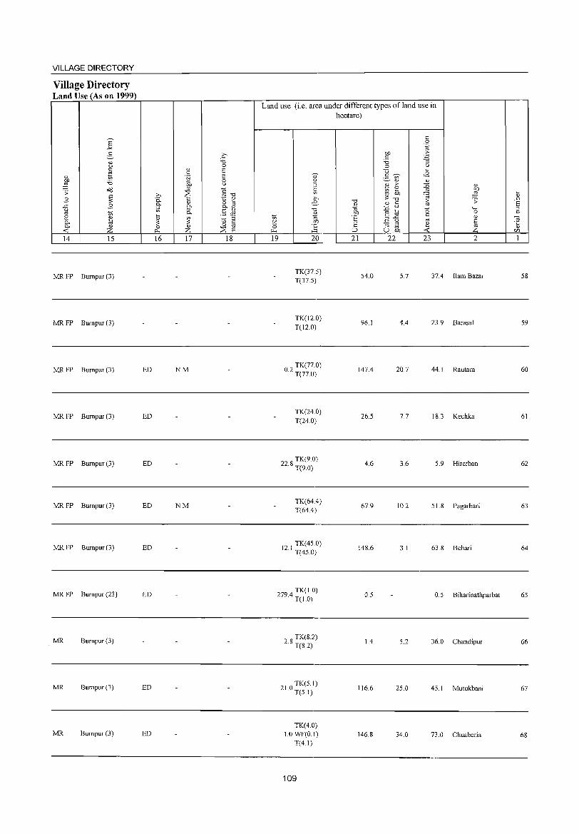
VILLAGE DIRECTORY
Village Directory Land Use (As on 1999)
E -'" 5-
<J) 0 t::
'" " t> on 'i5 ~ ;; <>'<l
.8 ~ ..c .8 ()
'" '" [ ~ 0- <J)
< Z 14 15
MR FP Bumpur (3)
MR FP Bumpur (3)
MR FP Bumpur (3)
MR FP Bumpur (3)
MRFP Bumpur(3)
MRFP Bumpur(3)
MRFP Bumpur(3)
MR FP Bumpur (23)
MR Bumpur(3)
MR Bumpur(3)
MR Bumpur(3)
C 'i3 0
" 8 c .~ 8
0 OJ) ()
'" C >, ::'2 '" "0 0.. 'i::: 1:: OJ
0- " 8.2 0-::l '" § J1 '" 0-~ ~ t> ::l ~ 0 8 0 OJ
::'2 0- Z 8 16 17 18
ED NM
ED
ED
ED NM
ED
ED
ED
ED
Land use (i.e. area under different types ofland use in hectare)
Q) 2 ::l c v; >, e -0
~ '" ~ .!'P ~ ~
19 20
TK(375) T(37.5)
TK(l2.0) T(12.0)
TK(77.0) 0.2 T(77.0)
TK(24.0) T(24.0)
228 TK(9.0) · T(9.0)
TK(64.4) T(64.4)
TK(450) 12.1 T(45.0)
294 TK(1.0) 7. T(1.0)
28 TK(S.2) · T(8.2)
210 TK(5.1) · T(5.1)
TK(4.0) 1.0WF(0.1)
T(4.1)
109
"0 OJ 1ii OJ)
E ;::
:::> 21
54.0
96.1
147.4
26.5
4.6
67.9
148.6
0.5
1.4
116.6
146.8
t:: 0
'-g OJ) . .5 c 'i3 ""3 ::l ()
U ~
2- ';;) <2 <J) OJ
1l > ::g " '" ~ OJ)
'" ~ ~ ~ "0 ~ ;;
<1.) c ::i3 '" 0 .... ~
:;, 0 ..c c <1) 0 '" ~ .. "3 8 ~
u OJ) < 22 23 2
5.7 37.4 Bam Bazar
4.4 23.9 Barasal
20.7 44. I Rautara
7.7 18.3 Kechka
3.6 5.9 Hirerban
10.2 51.8 Pagarbari
3.1 63.8 Behari
0.5 Biharinathparbat
5.2 36.0 Chandipur
25.0 45.1 Mutukbani
34.0 73.0 Chuaberia
~ ..0 8 ::l c
0; '0::
<1)
CIl
1
58
59
60
61
62
63
64
65
66
67
68
DISTRICT CENSUS HANDBOOK: BANKURA
Census of India 2001 -Amenities and
Amenities available (ifnot available within the village, a dash (-) is shown in the column and next to it in brackets the distance in broad ranges viz.< 5 krns., 5-10 kms. and 10+ kms of the
';)' nearest place where the facility is available is given
I 5l " <= "Cl Vl ..g" "Cl ~ " 0 Ul U <= (.) " ::l '" ,,~
n.) ..<: Ul - " " ~ '.c: u
c c 0 '" > :..::: v:, u 0 .5 " 0 0 .~ 3 'u t: 'E ~ -~ u ~ -<= tS 8. <!) i? (.) '" - 0.
" '3 0 00 0 '" '" 0. u
~ ~"~ ~ ~ .._) ,g 0 "Cl 1i 0 -~.~ ~ -0 6 :l " o<l .;; ..<: '0 - '" 0:1 -u "3..c ...... ~ '" " '" .;:. tl Ul ;: " " C 'fl '" '0 l) 0 .._ bI) -B 0 :l .._
'" o .- Od ~ . .g <= c-.._ ,g '-g 0 " -<= '" <= 15 0
" 4-< ..<: ., 0. Ul -a:;;:"2 -~ 0 .D .;;: 0 '3 4-< -a e -a '"§:a .~
§ '" C- o c ;: 00 .~ '" <C
u "-' ~ 0 t; 0 bI) " E ~ SOla c t>
c 0 0. .~ -a c 1i " ~ ~ ~ " ..0 '-' J2 E Ul
:l U ., E ;:l
8 -a -a 8 (.) '5 .5 t>- E-'" .g ~ ~ ~ :.a E 3: '" 0 0 :l ::l
" 8] ~ u E " "Cl a 0 !!'o 0:-::: en Z f-; f-; Z i:LI :2S 0... A:::~en U e 1 2 3 4 5 6 7 8 9 10 11 12 13
69 Beltikri
160.7 874 160 P M(5-1O) H(10+) TWWSS-
PO(IO+) CM(5-10) ACS(IO+) CV(IO+) BS(5-10)
(01972900) C(10+) MCW(S-IO) W NCS(10+) SP(IO+) RS(lO+) PHC(5-10)
PH« S) CP(10+) OCS(IO+) ST(lO+) NW(IO+)
Dubrajpur P M(5-10) H(5-
ACS(IO+) CV(5-1O) BS RS(5-
70 187.7 1,020 157 10) MCW(5- TW W SS- PO« 5) CM(5-10) 10) (01973000) C(10+)
10) PHC(S-IO) W NCS(10+) SP(IO+)
PH« 5) CP(IO+) OCS(IO+) ST(IO+)
NW(lO+)
Ranipur P« H(S-ACS(IO+) CV(S-IO)
BS 71 87.5 44 8 5)M«5) 10) MCW(5- TW SS-TW PO« 5) CM(5-10) RS(JO+)
(01973100) C(IO+) 10) PHC(5-1O) PH« 5) CP(IO+)
NCS(IO+) SP(IO+) NW(IO+)
OCS(IO+) ST(IO+)
Bhur Kunda Thol P M« 5) - H(S-
ACS(lO+) CV(S-IO) BS« 5) 72 292.6 371 57 10) MCWeS- TW W SS- PO« 5) CM(5-10)
(01973200) C(lO+) 10) PHC(5-10) W
NCS(IO+) SP(IO+) RS(IO+) PH«S) CP(IO+)
OCS(IO+) ST(lO+) NW(IO+)
73 Mohanapara (01973300)
100.1 -------- Uninhabited ------------
74 Sar Pahari
49.6 -------- Uninhabited ------------(01973400)
Siakuldoba PM(5-10) H« TWWSS- ACS(lO+) CV«5) BS« 5)
75 (01973500)
165.7 328 54 C(10+)
5) MCW« 5) W
PO«5) CM«5) NCS(IO+) SP(IO+) RS(IO+)
PHC«5) PH« 5) CP(IO+) OCS(IO+) ST(IO+) NW(lO+)
76 Ledi Pahari
90.3 -------- Uninhabited ------------(01973600)
Gonsai Dihi PM«5) - H(5-
POPH(S- ACS(IO+) CV(5-10) BS« 5) 77 276.3 780 131 10) MCW(5- TW W SS- CM(5-10)
(01973700) C(10+) 10)PHC(5-IO) W
10) CP(10+)
NCS(IO+) SP(10+) RS(IO+) OCS(lO+) ST(lO+) NW(lO+)
P« H(5-TWWSS- ACS(IO+) CV(5-10)
BS Lalitakuri
78 82.4 287 41 5)M«5) 10) MCW(S-W
PO« 5) CM(5-10) NCS(IO+) SP(IO+)
RS(lO+) (01973800)
C(IO+) 10) PHC« 5) PH«5) CP(IO+) NW(IO+) OCS(JO+) ST(JO+)
H(5-ACS(lO+) CV(5-10)
BS RS(5-
79 Ranjitpur
153.6 435 76 P M C(5-10) 10) MCW(5- TW W SS- PO« 5) CM(5-10) 10) (01973900) 10) PHC(5-10) W PH« 5) CP(IO+)
NCS(IO+) SP(IO+) NW{lO+)
OCS(IO+) ST(IO+)
Pabayan P(2) M« 5) CHWH(5-10)
TWWSS- ACS(IO+) CV(5-1O) BS« 5) 80 286.9 956 187
C(10+) MCW(S-IO)
W PO« 5) CM(5-10)
NCS(lO+) SP(lO+) RS(IO+) (01974000) PHC(5-10) PH« 5) CP(lO+) OCS(IO+) ST(lO+) NW(lO+)
Dhekia P(2) M« 5) CHWH(5-1O)
TWWSS- ACS(lO+) CV(5-1O) BS«5) 81 272.5 1,358 245
C(lO+) MCW(5-10)
W PO« 5) CM(5-10)
NCS(lO+) SP(lO+) RS(IO+) (01974100) PHC(5-10) PH«5) CP(IO+) OCS(lO+) ST(lO+) NW(lD+)
110
VILLAGE DIRECTORY
Village Directory Land Use (As on 1999)
6 -" 2, " <J
§ " " " to .~
~ '6 bl)
o'<l '" .s: ::s ~
>; B 0. ~
0.. " ..c B 0.. ;:> U
"' '" '" '" ..., 0.. 2 " " "' 0.. ~ :s ::: 0.. " 0 " -< Z 0... Z 14 IS 16 17
MR Bumpur (3)
PR Bumpur (3) ED
PRMR Bumpur (3) ED
MR Bumpur (3)
-------- Uninhabited ------------
-------- Uninhabited ------------
MR Bumpur (3) N
-------- Uninhabited ------------
MR Raniganj (3) ED
PRMR Raniganj (3) ED
PRMR Raniganj (3) ED
MR Raniganj (3) ED
MR Raniganj (3) ED
~ 0 8 8 0 u
§ -0 1:: ~ o ;:> 0.. ~
§ J1 ~ ;:>
'" " o oj ::s 8 18
Land use (i.e. area under different types ofland use in
0;'
~ ;:;: >; e--0
~ '" e 00 0 ~ ~
19 20
TK(4.1) WF(O.I)
T(4.1)
24 TK(4.2) · T(4.2)
02 TK(3.0) · T(3.0)
W(O.O) 112.5 TK(3.0)
T(3.1)
530 TK(6.0) · T(6.0)
1123 TK(45.0) · T(45.0)
TK(2.0)
Te2.0)
90 TK(l2.0) · T(12.0)
TK(2.0) T(2.0)
TK(22.0) T(22.0)
TK(40.0) T(40.0)
280 TK(17.0) · T(17.0)
111
hectare)
"0
" ., bll 'E ;:
:::::>
21
115.7
91.1
50.3
105.6
28.1
49.6
1.6
53.3
80.0
52.4
56.6
121.0
120.5
" 0 .~
bl) > " ~ '6 ;:> <J
C3 ..., <B 2 ~ to
" " B > ~ " ~ e bl)
::§ :s co '(iJ "0
~ ;; " " '" ::0 "-<
~ 0 0 e " .3 ..c
'" " u 8 "3 ;:>
~ '" ~ u bll
22 23 2
10.0 30.8 Beltikri
7.0 83.1 Dubrajpur
9.0 25.0 Ranipur
6.0 65.4 Bhur Kunda Thol
13.0 Mohanapara
Sar Pahari
6.8 Siakuldoba
1.0 34.0 Ledi Pahari
13.0 162.3 Gonsai Dihi
6.0 22.0 Lalitakuri
15.0 60.0 Ranjitpur
40.0 85.9 Pabayan
20.0 87.0 Dhekia
..., " .D 8 ;:>
" -a ·c " lfJ
1
69
70
71
72
73
74
75
76
77
78
79
80
81
--;n-~ '" '" i is
""Cl --;n- <!) 0 U "' '" ~ t: ..t: -t: 0 0 S <!)
.~ u 0 c:!-<!) {.)
~ ;; {j 0 ....:; 0 c:!- o
o'd .;; ..t:
~ <!) t: ~
-£i 0 '" .... .~ 0 <i)
"""' ..t: .D .;; 0 "3 """' 2 '" 0- 0 ::l """' i!:! 0 .... t: 0
'" 0- '" "'
<l> .n § "Ei ~ E '5 0 ;:;l
ifJ Z l- l- Z I 2 3 4 5
82 Dulaltara (01974200)
37.6 90 12
83 Tentul Tikri
245.5 978 148 (01974300)
Sat Deuli 84 1 18.6 709 103
(01974400)
85 Ramjibanpur
205.8 353 53 (01974500)
86 Pabra
829.8 3,859 725 (01974600)
87 ChakMushlia
46.0 (01974700)
Chak Paruri 88
(01974800) 158.8 322 57
Thana Dumar 89
(01974900) 92.5 158 28
Beriathol 90
(01975000) 59.8 293 51
Patdoha 91
(01975100) 4919 1,790 317
Niamatpur 92 (01975200)
146.9 458 74
DISTRICT CENSUS HANDBOOK: BANKURA
Census of India 2001 -Amenities and
Amenities available (if not available within the village, a dash (-) is shown in the column and next to it in brackets the distance in broad ranges viz.< 5 kms., 5-10 killS. and 10+ kms of the
nearest place where the facility is available is given
"0 ~ E~ t:
'" :-8 Q <I, <!) <!) ""§ t: > 7i '" u
1:: ·E ~ 0 .~ 3 ..t: $ 0 0- "3 0, <i) ~ <!) «lifJ ~ E: 0- U
1l 0 .~ ~ S ;:j"S 6 ::l <!)
"0 Q '? 'p -3 _g .2 ~~ t: c: <!) '" if; '" "0 (.) 0 .... o ._
o<l ~ .g c i3 .c c: c 15 '" '"
0
'" g- '" «l;:;:"g .~ .~
"' "' e:ij if; on (.) '" t: '2 § -< ·2 0 1>0 <l) .:§ ~ _"i\l"E in .~ (ij c 1l <!)
'" 2 ::l ::l
G' u J2 E '" ;:;l (.) E u '6 S 1i E""" .~ ~ ~.5 ] 2 :;: ::l
"0 <i)
0 0 82 bJl-£i 0::::: >-LI ::;;: 0..- -< 0 ~u~ u ~ ~ifJ
6 7 8 9 10 Il 12 13
- P« H(10+) TWWTK PO« 5)
ACS(lO+) CV(IO+) BS« 5) 5) M« 5) q< MCW« 5) CM«5)
SS-W NCS(lO+) SP(IO+) RS(10+) 5) PHC« S) PH(IO+) CP(IO+)
OCS(10+) ST(10+) NW(lO+)
PM« 5) CHW(2) H(5- TW W SS-PO«5)
ACS(lO+) CV(5-10) BS« 5) 10) MCW(5- CM(5-10)
CCIO+) 10) PHCC5-10) W PH«5) CP(IO+)
NCS(IO+) SP(IO+) RS(5-1O) OCS(lO+) ST(lO+) NW(5-IO)
P M« 5) - H«
ACS(IO+) SP CV« 5) BS« 5) 5) MCW(5-10) TWWOSS pO«5) CM«5) CCIO+)
PHCCIO+) W PH(10+) CP(10+) NCS(lO+) ST(IO+) RS(lO+) OCS(10+) NW(IO+)
P M« 5) MCWH«5) TWWTK PO«5) CM« 5)
ACS(IO+) CV(IO+) BS« 5) CCIO+) PHCCJO+) SS-W
PH(10+) CP(10+) NCS(lO+) SP(l()+ ) RS(JO+) OCS(10+) ST(1O+) NW(IO+)
P(2) M(2) PHC H« 5) TWWTK PO ACS(10+)
CV BS« 5)
S(2) AC(2) CM«5) SP(IO+) C(10+)
MCW(5-10) SS-W PH(10+) CP(10+)
NCS(10+) ST(lO+)
RS(10+) OCS(10+) NW(IO+)
-------- Uninhabited ------------
PM« 5) MCWH«5) TWWTK PO« 5) CM«5)
ACS(IO+) CV(IO+) BS« 5) C(10+) PHC(5-10) CSS-W NCS(10+) SP(10+) RS(lO+)
PH(IO+) CP(10+) OCS(10+) ST(lO+) NW(lO+)
P« H« WTK SS- ACS(10+) CV(IO+) BS« 5) 5)M« 5) 5) MCW« 5)
W PO(5-1O) CM«5)
NCS(10+) SP(10+) RS(IO+) C(lO+) PHC« 5) PH(lO+) CP(lO+)
OCS(IO+) ST(10+) NW(10+)
PM(5-10) MCWH«5) TWWTK PO«5) CM«5)
ACS(lO+) CV(IO+) BS« 5)
C(10+) PHC(10+) SS-W NCS(IO+) SP(lO+ ) RS(10+) PH(10+) CP(10+)
OCS(IO+) ST(10+) NW(10+)
PM(5-1D) DH(2) H(lO+)
TW W SS- ACS(10+) CV(IO+) BS« 5)
C(10+) MCW(5-1O)
W PO«5) CM(5-10)
NCS(10+) SP(10+) RS(lO+) PHCCIO+) PH«5) CP(lO+)
OCS(IO+) ST(lO+) NW(10+)
P M«5) - H(5- ACS(IO+) CV(5-10) BS« 5)
10) MCW(5- ~W W SS- PO«5) CM(5-1O) C(10+) NCS(10+) SP(IO+) RS(IO+)
10) PHC(5-10} PH« S) CP(IO+) OCS(10+) ST(10+) NW(10+)
112
VILLAGE DIRECTORY
Village Directory Land Use (As on 1999)
E .-'<
g Q) u C
tl <l) OJ) ;:a ~ O<l .s:
~ B B ..c
g e U>
~ 0-0- <l.)
<r: z 14 15
MR Raniganj (3)
PR MR Raniganj (3)
MR FP Ranigang (3)
MR Raniganj (3)
PRMR Raniganj (3)
c ;:a 0
0) a c '~ a
0 OJ) U OJ
§-o ~ » !5.. '" t:: 0)
0) 8.3 0-::l 0-
OJ §& '" 0-..... 0) '" ::l :::: :::: '" c 0 0) 0 oj
0. Z ~ a 16 17 18
ED
ED EO N
-------- Uninhabited ------------
MR Raniganj (3)
MR Raniganj (3)
MR Raniganj (3) N
MR FP Raniganj (3) N Belmala
MR Raniganj (3)
Land use (i.e. area under different types ofland use in
1;; i": 0 ~
19
., 2 ::l 0
'" » e -0
<l.)
til OJ)
] 20
TK(2.0) T(2.0)
TK(30.0) T(30.0)
TK(25.0) T(2S.0)
TK(9IA) T(91.4)
40 7 TK(20.7) . T(20.7)
7' TK(2.0) .-' T(2.0)
TK(S.3) T(S.3)
32 TK(8.1) , T(S.I)
TK(70) T(7.0)
TK(57.2) T(S7.2)
10 TK(lO.O) . T(IO.O)
113
hectare)
-0 <l.)
til CJ)
E '2 ;:J
21
19.6
90.0
60.0
40.S
447.7
17.7
76.6
S1.S
41.8
394.1
97.0
c 0 .~
bl) > c ~ ;:a '" u
<> ..... <8 2- ~ U>
<l) <l) <l) > :g 0)
1;; e ~ OJ bl) ~ ::::-0 <V r:: 1';; .s: :g OJ ...... 0 ..... 0 ..... OJ C 0) ",..c
OJ ~ <.)
~ "3 ::l
~ co u bl)
22 23 2
16.0 Dulaltara
IS.O 110.5 Tentul Tikri
10.1 23,S Sat Deuli
33.2 40.7 Ramjibanpur
43.9 276.8 Pabra
4.5 14.4 Chak Mushlia
20.S 56.4 Chak Paruri
20.9 8.8 Thana Dumar
11.0 Beriathol
8.1 32.S Patdoha
11.0 27.9 Niamatpur
..... <l.)
.£)
§ c
~ <l.)
c;I)
1
82
83
84
85
86
87
88
89
90
91
92
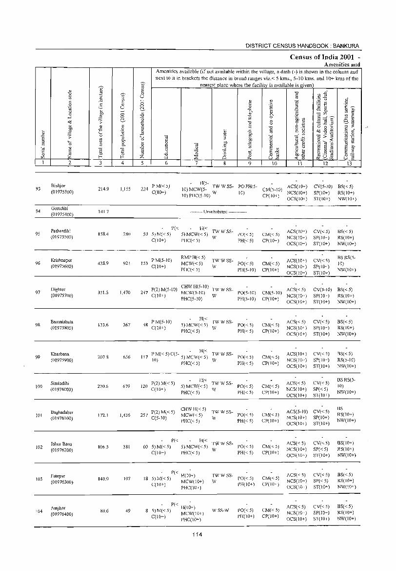
-;;;-
~ ;::I
" '" '" '0 ~ " 0 t) '" U u " ;::I .r:: '" ~
'" ~ 0 0 2- 0 '.g U ~ u gt -0 0 '" ....l ;1 0 '0 '0
o(l ;; ~ ..<:
" <1l 4l '" en
~ 0 ;::I ...
"-' ~ 0
" ..<: ..0 ;; 0 4-< S '" ;::I 0. 0
;::I 4-;
~ 0 ... '" 0 0. " -a <1l ] ~
..0
S E ·c <1l Z 0 ;::I
t--- t--- Z r/J
1 2 3 4 5
Bishjor 93 214.9 1,155 224
(01975300)
94 Goradihi (01975400)
141.7
Pathardihi 95 158.4 280 50
(01975500)
Krishnapur 96 428.9 921 153
(01975600)
Dightor 97 351.3 1,470 247
(01975700)
Bamnishala 98
(01975800) 133.6 267 48
Kharbana 99 207.8 656 117
(01975900)
Simladihi 100
(01976000) 220.6 679 120
Baghadabar 101 172.1 1,436 257
(01976100)
Jahur Bana 102
(01976200) 106.5 381 60
Fatepur 103
(01976300) 140.0 107 18
Amjhor 104 80.6 49 8
(01976400)
DISTRICT CENSUS HANDBOOK: BANKURA
Census of India 2001 -Amenities and
Amenities available (if not available within the village, a dash (-) is shown in the column and next to it in brackets the distance in broad ranges viz.< 5 kms., 5-10 kms. and 10+ kms of the
nearest place where the facility is available is given
'0 en ..0"
'" .~ ..2 '" of " " "§ E u
'" > t u 0 .~ '0 E~ ..<: B ~ 0 0.
" ::; 0. " G' " 0. U ] ~~6 :;; ~ B 0 .~ ~~ ;:l " '0 6 'B ~ .2 Sea '"
(.) '? ''';:::~ '" :;: til '0 '" " C) 0 ... o .~, '" " ... ..c: '" e" ~ d<l-15g ~ '" o <=
0. OJ;>"§ '_;: 0 -a ~ OJ "'§ .~ '" .-:;: .~ 19 '" "e '" -<C 0 OJ) "
;::I '<:, .8 Co E '" en .~ -a '" B " .±:: f:~ ;:l
U j;i E en ;::I ", "til S ;::I
E f u '6 .g ~) t.5 ~ ;::I
== "Ii E-"
'0 " o § bJ)..c: g"" ::2: Ci 0 ~ 2U5 >.Ll A. U...o -<Co U 1:! 6 7 8 9 10 11 12 13
PM«5) - H(5-
POPH(5- ACS(lO+) CV(S-IO) BS« 5) 10) MCW(5- TW W SS- CM(5-JO) C(lO+)
10) PHCCS-IO) W 10)
CP(IO+) NCS(IO+) SP(10+) RS(IO+) OCS(IO+) ST(IO+) NW(IO+)
-------- Uninhabited ------------
P« H« TWWSS- ACS(JO+) CV« 5) BS«5) 5)M«5) 5) MCW«5) PO« 5) CM« 5)
C(10+) PHC« 5) W
PH« 5) CP(lO+) NCS(IO+) SP(IO+) RS(IO+) OCS(IO+) ST(IO+) NW(10+)
P M(S-IO) RMPH« 5)
TWWSS- ACS(IO+} CV« 5) BS RS(5-
MCW«5) PO« 5) CM«5) 10) C(IO+) W NCS(10+) SP(10+)
PHC« 5) PH(5-10) CP(IO+) OCS(lO+) ST(10+)
NW(lO+)
P(2) M(5-1O) CHWH(5-JO)
TWWSS- ACS«5) CV(5-1O) BS«5) MCW(S-IO) PO(5-10) CM(5-10)
C(IO+) W NCS(IO+) SP(IO+) RS(IO+) PHC(5-10) PH(5-10) CP(IO+)
OCS(IO+) ST(JO+) NW(IO+)
P M(5-1O) H«
TWWSS- ACS«5) CV« 5) BS«5) C(10+)
5) MCW«5) W
PO« 5) CM« 5) NCS(lO+) SP(IO+) RS(IO+)
PHC« 5) PH« 5) CP(IO+) OCS(lO+) ST(IO+) NW(IO+)
- H« TWW SS- ACS(IO+) CV« 5) BS«5) P M« 5) C(5- 5) MCW« 5) PO« 5) CM« 5)
10) PHC« 5) W PH« 5) CP(IO+)
NCS(lO+) SP(IO+) RS(5-10) OCS(IO+) ST(IO+) NW(10+)
P(2) M« 5) H«
TWWSS- ACS« 5) CV« 5) BS RS(5-
C(IO+) 5) MCW«5)
W PO« 5) CM« 5)
NCS(10+) SP« 5) 10)
PHC« 5) PH« 5) CP(IO+) OCS(lO+) ST(lO+)
NW(IO+)
CHWH«5) ACS(5-10) CV« 5) BS
P(2)M«5) TWWSS-MCW«5) PO« 5) CM« 5) RS(IO+)
C(5-10) PHC« 5)
W PH« 5) CP(IO+)
NCS(IO+) SP(IO+) NW(IO+)
OCS(IO+) ST(IO+)
P« H« TWWSS- ACS« 5) CV« 5) 8S(IO+)
5) M«5) 5) MCW«5) W
PO«5) CM«5) NCS(10+) SP« 5) RS(IO+)
C(IO+) PHC« 5) PH«5) CP(IO+) OCS(10+) ST(10+) NW(10+)
- P« H(I~+) TWWSS-PO« 5) CM« 5)
ACS« 5) CV« 5) BS«5) 5) M«5) MCW(IO+) W NCS(IO+) SP« 5) RS(IO+)
PH(IO+) CP(IO+) C(IO+) PHC(IO+) OCS(IO+) ST(IO+) NW(IO+)
- P« H(I~+) WSS-W PO« 5) CM« 5)
ACS«5) CV« 5) BS« 5) 5) M« 5) MCW(IO+) NCS(lO+) SP(IO+) RS(IO+)
PH(10+) CP(lO+) C(lO+) PHC(IO+) OCS(IO+) ST(lO+) NW(lO+)
114
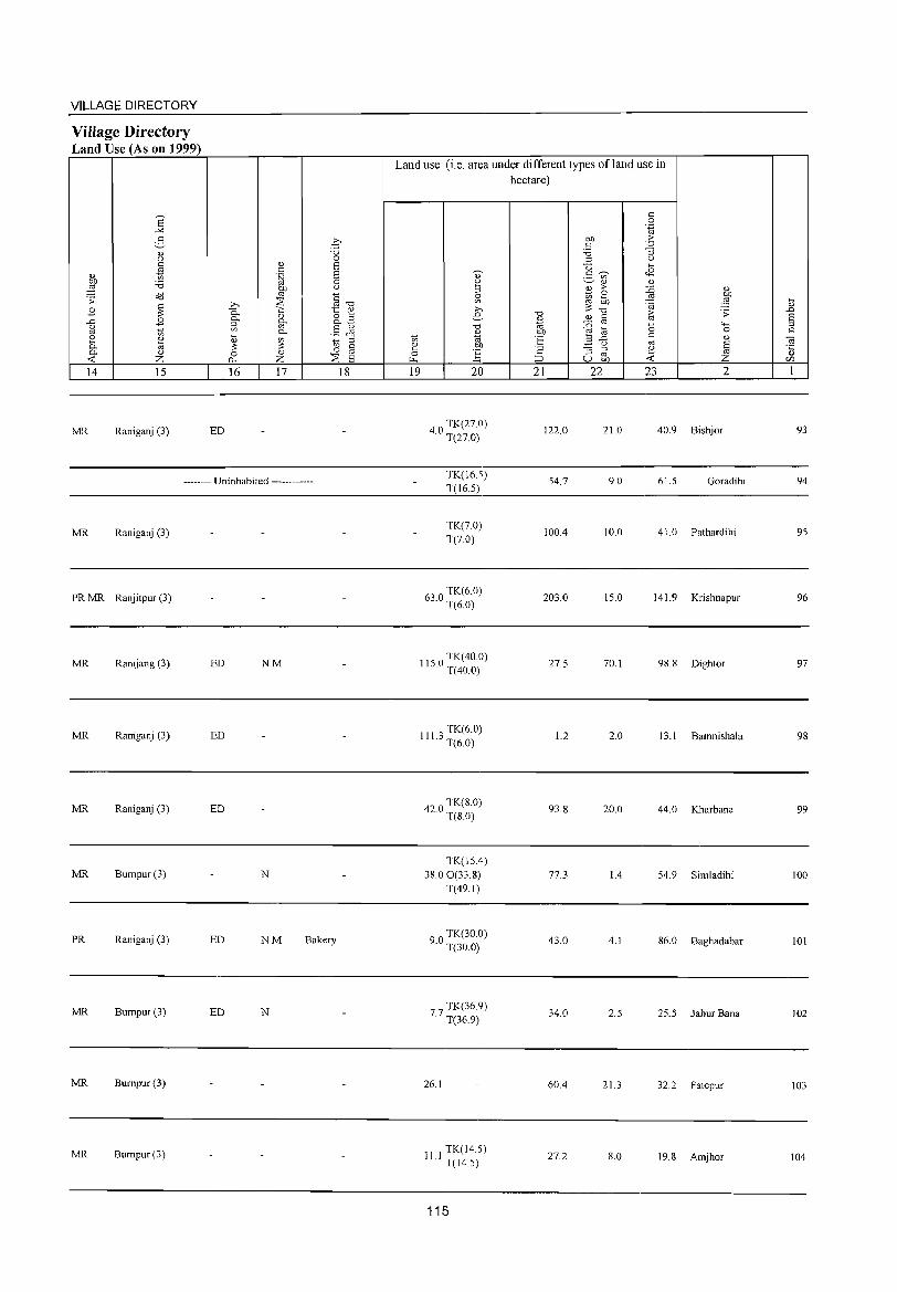
VILLAGE DIRECTORY
Village Directory Land Use (As on 1999)
14 15
MR Raniganj (3)
16 17
ED
-------- Uninhabited ------------
MR Raniganj (3)
PR MR Ranjitpur (3)
MR Ranijang (3) ED NM
MR Raniganj (3) ED
MR Raniganj (3) ED
MR Bumpur(3) N
PR Raniganj (3) ED NM Bakery
MR Bumpur(3) ED N
MR Bumpur(3)
MR Bumpur (3)
18
Land use (i.e. area under different types of land use in hectare)
19 20
40 TK(27.0) · T(27.0)
TK(16.5) T(165)
TK(7.0) T(7.0)
630 TK(6.0) · T(6.0)
1150 TK(40.0) · T(40.0)
III 3 TK(6.0) · T(6.0)
420 TK(8.0) · T(80)
TK(15.4) 38.00(338)
T(49.1)
90 TK(30.0) · T(30.0)
77 TK(36.9) · T(36.9)
26.1
11 I TK(14.5) T(14.5)
115
21 22
122.0
54.7
100.4
203.0
27.5
1.2
93.8
77.3
43.0
34.0
60.4
27.2
23 2
21.0 40.9 Bishjor
9.0 61.5 Goradihi
10.0 41. 0 Pathardihi
15.0 141.9 Krishnapur
70.1 98.8 Dightor
2.0 13.1 Bamnishala
20.0 44.0 Kharbana
1.4 54.9 Simladihi
4.1 86.0 Baghadabar
2.5 25.5 Jahur Bana
21.3 32.2 Fatepur
8.0 19.8 Amjhor
93
94
95
96
97
98
99
100
101
102
103
104
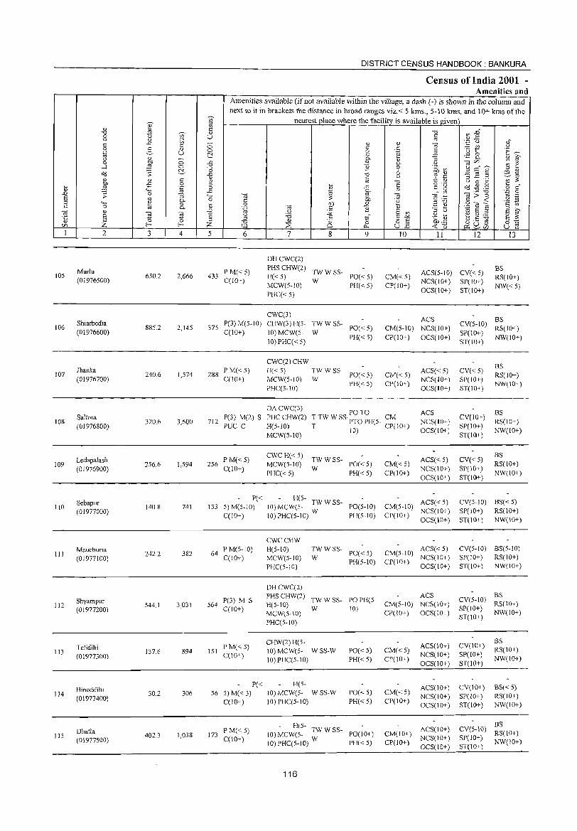
105
106
107
108
109
110
III
112
113
114
115
2
Murlu (01976500)
Shiarbedia (01976600)
Ihanka (01976700)
Saltora (01976800)
Ledapalash (01976900)
Sebapur (01977000)
Mauchuria (01977100)
Shyampur (01977200)
Telidihi (01977300)
Binoddihi (01977400)
Dhatla (01977500)
3
650.2
885.2
240.6
320.6
256.6
140.8
242.2
544.1
137.6
30.2
402.3
'" '" ;g (l)
(_)
4
2,666
2,145
1,574
3,600
1,594
741
382
3,031
894
306
1,038
DISTRICT CENSUS HANDBOOK: BANKURA
Census of India 2001 -Amenities and
Amenities available (if not available within the village, a dash (-) is shown in the column and next to it in brackets the distance in broad ranges viz.< 5 krns., 5-10 kms. and 10+ kms of the
nearest place where the facility is available is given
o o ~ on
"0
I '" o
.c 4-< o ~ <l)
.D E '" ;z: 5 6
433 P M« 5) C(lO+)
375 P(3) M(5-10) C(IO+)
288 P M« 5) C(10+)
712 P(3) M(2) S PUC C
256 P M« 5) C(lO+)
P« 133 5) M(5-1 0)
C(JO+)
64 P M(S-IO) C(IO+)
564 P(3) M S C(IO+)
151 PM«5) C(lO+}
P« 56 5) M(<: 5)
C(IO+)
173 PM«5) C(10+)
7
DHCWC(2)
PHSCHW(2)
H«5) MCW(5-10)
PHC« 5)
CWC(3) CHW(3) H(5-
10) MCW(5-
10) PHC« 5)
CWC(2)CHW
8 9
TWWSS-W PO« 5)
PH« 5)
TWWSS-W PO«5)
PH« 5)
H« 5) TW W SS-PO« 5) PH«5)
MCW(5-10) W PHC(5-IO)
10 11 12 13
CM«5) CP(lO+)
ACS(5-10) CV« 5) BS RS(IO+)
NW«5) NCS(IO+) SP(IO+) OCS(lO+) ST(10+)
ACS CM(5-IO) NCS(IO+)
CP(10+) OCS(10+)
CM« 5) CP(JO+)
ACS« 5) NCS(IO+) OCS(IO+)
BS CV(5-1O) RS(IO+)
SP(10+) NW(IO+) ST(IO+)
CV« 5) SP(IO+) ST(IO+)
BS RS(IO+) NW(IO+)
DACWC(3)
PHCCHW(2) H(5-10)
MCW(S-10)
PO TO T TW W SS· PTO PH(5- CM T 10) CP(IO+)
ACS
NCS(IO+) OCS(IO+)
CV(10+) SP(IO+)
ST(10+)
BS RS(IO+)
NW(JO+)
CWC H« 5) TW W SS-MCW(5-10) W PO« 5) PHC« 5) PH« S)
H(S- TWWSS 10) MCW(5- - PO(5-10) 1O)PHC(5-10) W PH(5-10)
CWCCHW H(5-10) MCW(5-10) PHC(S-10)
:W W SS- PO« 5)
PH(S-10)
CM« 5) CP(IO+)
ACS« 5) NCS(lO+)
OCS(IO+)
ACS« 5) CM(5-1O) NCS(IO+)
CP(IO+) OCS(IO+)
ACS« 5) CM(5-1O) NCS(IO+) CP(10+) OCS(IO+)
ACS DHCWC(2) PHSCHW(2) H(5-10) MCW(5-10) PHC(5-1O)
TW W SS- PO PH(5-W 10) CM(5-10) NCS(lO+)
Cpr I 0+) OCS( 10+)
CHW(2)H(5-10) MCW(5- W SS-W 10)PHC(5-10)
HC5-10) MCW(5- W SS-W 10) PHC(5-1O)
PO«5) PH« 5)
PO« 5)
PH« 5)
- H(5- TW W SS-10) MCW(5- PO(JO+) 10) PHC(5-1O) W PH« 5)
116
CM«5) CP(10+)
CM« 5) CP{JO+)
ACS(10+) NCS(lO+) OCS(lO+)
ACS(lO+) NCS(lO+) OCS(lO+)
ACS(lO+) CM(IO+) NCS(IO+)
CP(lO+) OCS(10+)
CV« 5) SP(lO+) ST(10+)
BS RS(IO+)
NW(JO+)
CV(5-JO) BS« 5) SP(IO+) RS(lO+) ST(10+) NW(lO+)
CV(5-1O) BS(5-1O) SP(JO+) RS(IO+) ST(IO+) NW(IO+)
CV(5-1O) :;(10+) SP(10+) NW(lO+) ST(10+)
CV(lO+) SP(lO+)
ST(IO+)
CV(lO+) SP(lO+) ST(10+)
BS RS(lO+) NW(IO+)
BS« 5) RS(IO+) NW(IO+)
BS CV(5-10) RS(10+)
SP(IO+) NW(10+) ST(IO+)
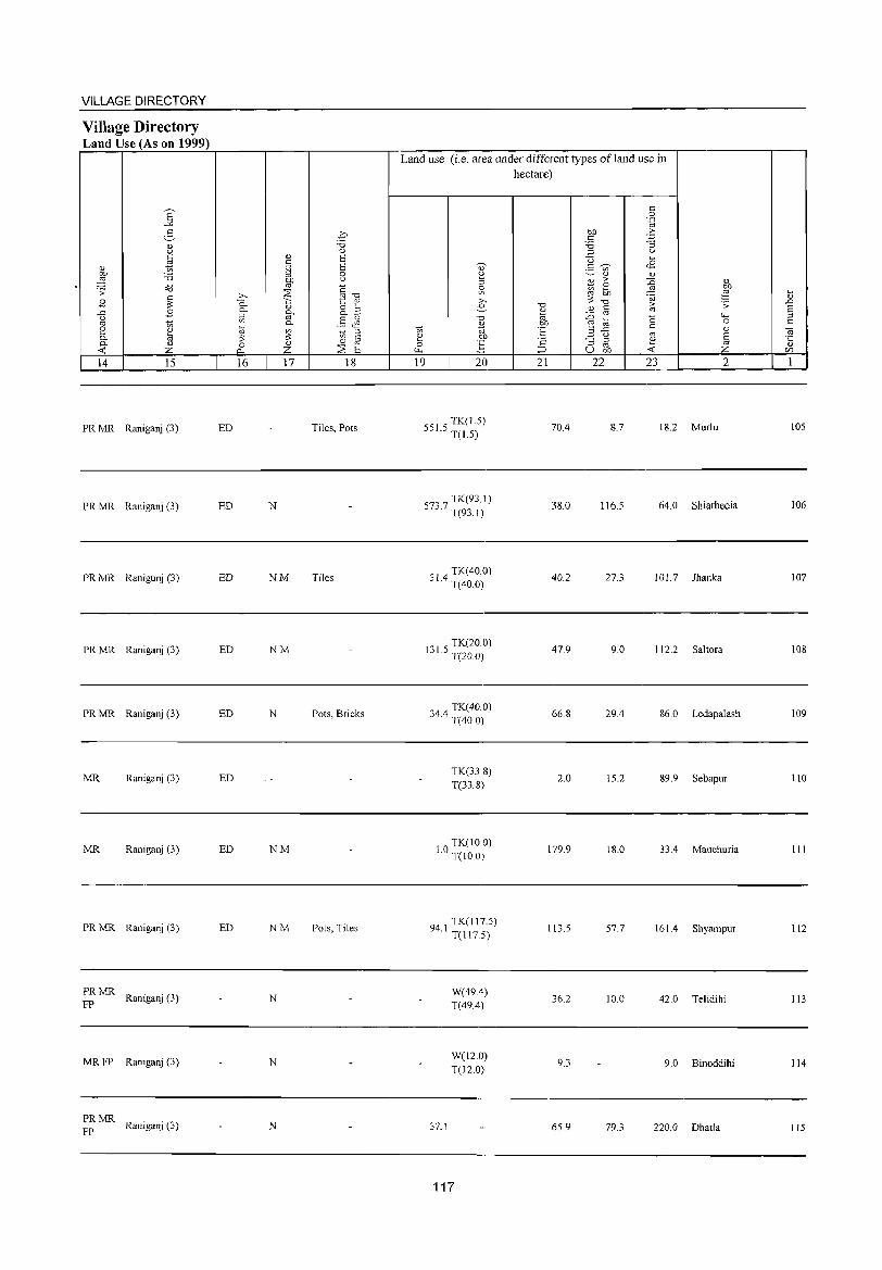
VILLAGE DIRECTORY
Village Directory Land Use (As on 1999)
14 15
PR MR Raniganj (3)
PR MR Raniganj (3)
PR MR Ranigunj (3)
PRMR Raniganj (3)
PRMR Raniganj (3)
MR Raniganj (3)
MR Raniganj (3)
PR MR Raniganj (3)
PRMR Raniganj (3)
FP
MRFP Raniganj (3)
PRMR Raniganj (3)
FP
16 17 18
ED Tiles, Pots
ED N
ED NM Tiles
ED NM
ED N Pots, Bricks
ED
ED NM
ED NM Pots, Tiles
N
N
N
Land use (i.e. area under different types of land use in hectare)
19 20
51 5 TK(1.5)
5 . T(15)
73 7 TK(93.1)
5 . T(93.1)
01 4 TK( 40.0) " . T(40.0)
131 5 TK(20 0) · T(20.0)
344 TK(40.0) · T(40.0)
TK(338) T(33.8)
10 TK(100) · T(IO.O)
94 1 TK(l17.5) · T(llT5)
W(49A) T(49A)
W(l2.0) T(12.0)
37.1
117
21
70A
3S.0
40.2
47.9
66.8
2.0
179.9
113.5
36.2
9.3
65.9
22 23 2
8.7 18.2 Murlu
116.5 64.0 Shiarbedia
27.3 101.7 Jhanka
9.0 112.2 Saltora
29A 86.0 Ledapalash
15.2 89.9 Sebapur
18.0 33.4 Mauchuria
57.7 161 .4 Shyampur
10.0 42.0 Telidihi
9.0 Binoddihi
79.3 220.0 Dhatla
~
" .D
§ C
lOS
106
107
lOS
109
110
111
112
113
114
115
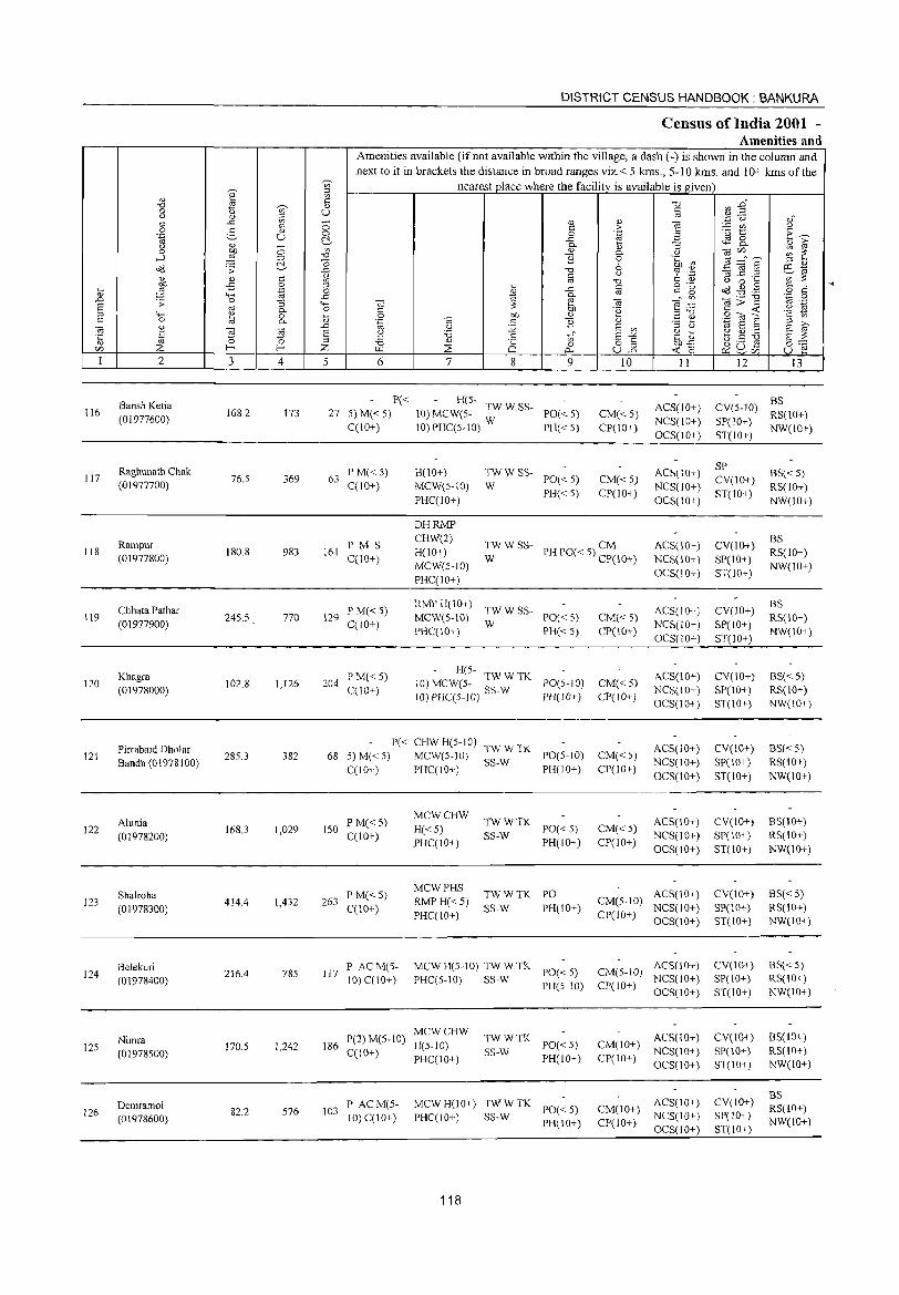
116
117
118
119
120
121
122
123
124
125
126
2
Bansh Ketia
(01977600)
Raghunath Chak (01977700)
Rarnpur (01977800)
Chhata Pathar (01977900)
Khagra (01978000)
Pirrabaid Dholar Bandh (01978100)
Alunia (01978200)
Shalroha
(01978300)
Belekuri (01978400)
Nirnra
(01978500)
Dernramol (01978600)
3 4
168.2 173
76.5 369
180.8 983
24S.5 770
102.8 1,126
285.3 382
168.3 1,029
414.4 1,432
216.4 785
170.5 1,242
82.2 576
DISTRICT CENSUS HANDBOOK: BANKURA
CelllSUS of India 2001 -Amenities and
Amenities available (ifnot available within the village, a dash (-) is shown in the column and next to it in brackets the distance in broad ranges viz.< 5 kms., 5-10 kms. and 10+ kms of the
nearest place where the facility is available is given
5 6 7 8 9
P« - H(5-27 5) M« 5) 10) MCW(5- TW W SS- PO« 5)
C(1O+) IO)PHC(5-10) W PH«5)
63 P M« 5) C(10+)
H(IO+) MCW(S-IO)
PHC(10+)
TWW SS-PO« 5)
PH« 5) W
10
CM«5) CP(IO+)
CM« 5) CP(lO+)
II
ACS(IO+) NCS(IO+) OCS(IO+)
ACS(IO+) NCS(IO+) OCS(10+)
16J PM S C(10+)
DHRMP CHW(2) H(IO+)
MCW(5-10) PHC(10+)
TWWSS- CM W PH PO« 5) CP(10+)
ACS(IO+) NCS(IO+) OCS(JO+)
129 P M« 5) C(10+)
RMP H(10+) TW W SS-MCW(S-IO) W PO« 5)
PHC(10+) PH« 5) CM«5) CP(10+)
ACS(JO+) NCS(10+) OCS(10+)
204 PM«5) C(10+)
H(5-10) MCW(5- TW::TK PO(5-10) CM«5) 1O)PHC(5-10) SS- PH(10+) CP(JO+)
ACS(IO+) NCS(IO+) OCS(10+)
P« CHWH(5-10) TWWTK 68 5) M« 5) MCW(5-10) SS-W PO(5-IO)
C(10+) PHC(IO+) PH(10+)
150 PM«5) C(IO+)
263 P M« 5) C(lO+)
117 P ACM(5-10)C(10+)
MCWCHW
H«5) PHC(IO+)
MCWPHS
RMP H«5) PHC(IO+)
~~::TK PO«5) PH(IO+)
TWWTK PO
SS-W PH(10+)
MCWH(5-10)TWWTK PO«5)
PHC(5-10) SS-W PH(5-10)
MCWCHW 186 P(2) M(5-10) H(5-10)
C(10+) PHC(IO+) ~~:: TK PO« 5)
103 P ACM(5-10) C(IO+)
PH(IO+)
MCW H(lO+) ~~:: TK PO« 5) PHC(10+) PH(IO+)
118
CM« 5) CP(10+)
CM«5) CP(IO+)
ACS(10+) NCS(10+)
OCS(lO+)
ACS(IO+) NCS(10+) OCS(IO+)
CM(5-IO) ACS(lO+) CP(lO+) NCS(IO+)
OCS(10+)
ACS(lO+) CM(5-10) NCS(IO+) CP(IO+) OCS(IO+)
ACS(lO+) CM(IO+) NCS(IO+) CP(I 0+) OCS( 10+)
CM(IO+) ACS(lO+) NCS(10+)
cpc I 0+) OCS(1 0+)
12 13
BS CV(5-l0) RS(10+) SP(JO+) ST(IO+) NW(IO+)
SP CV(IO+) ST(lO+)
CV(IO+)
SP(10+) ST(10+)
CV(JO+) SP(IO+) ST(JO+)
CV(IO+) SP(IO+) ST(IO+)
CV(JO+) SP(IO+)
ST(10+)
CV(IO+) SP(10+) ST(10+)
CV(IO+)
SP(10+) ST(10+)
CV(IO+) SP(IO+) ST(IO+)
CV(IO+} SP(10+) ST(IO+)
CV(IO+) SP(IO+) ST(IO+)
BS«5) RS(IO+) NW(10+)
BS RS(10+) NW(10+)
BS RS(10+) NW(10+)
BS« 5) RS(IO+) NW(IO+)
BS« 5) RS(10+)
NW(lO+)
BS(IO+) RS(IO+)
NW(IO+)
BS« 5) RS(10+) NW(IO+)
BS« 5) RS(IO+) NW(IO+)
BS(10+) RS(IO+) NW(lO+)
BS RS(IO+) NW(lO+)
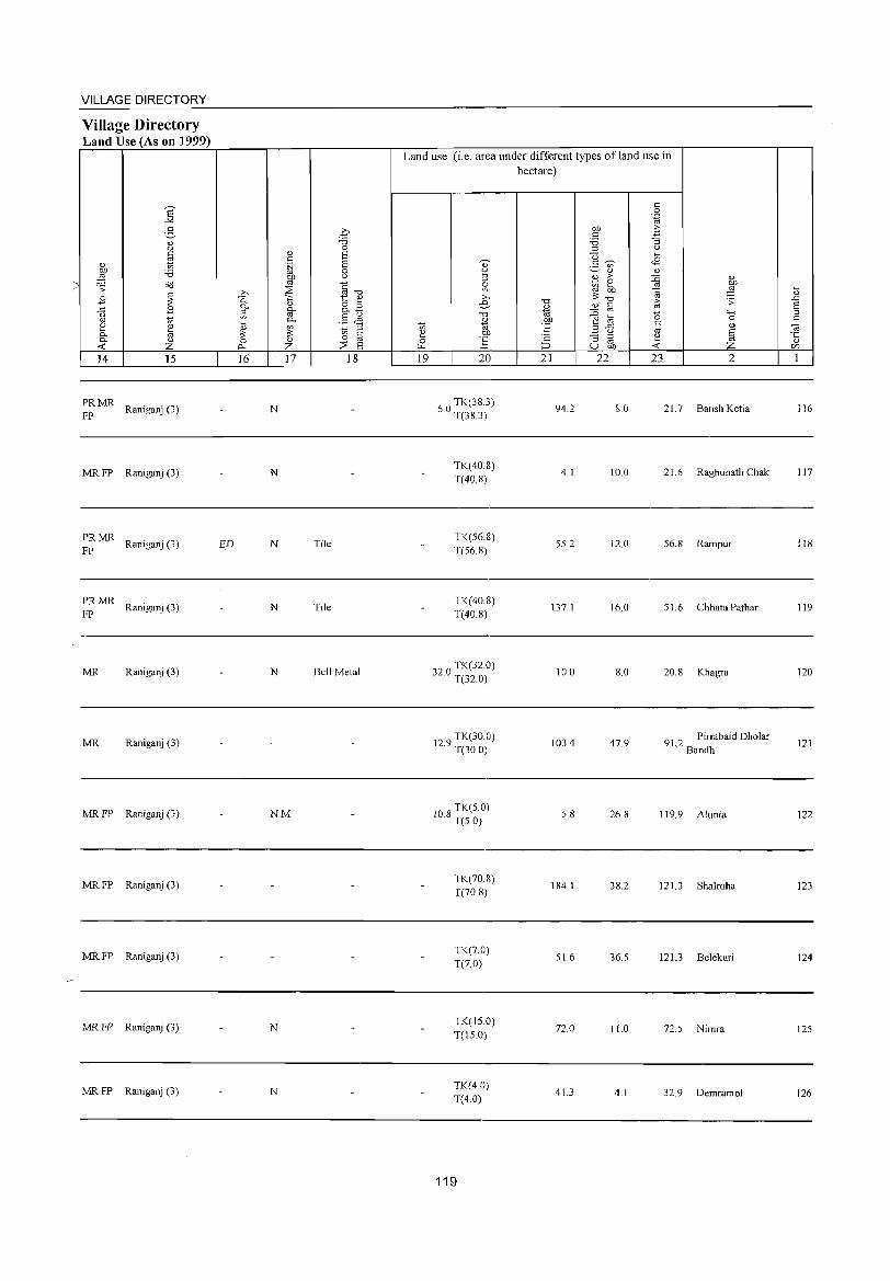
~
VILLAGE DIRECTORY
Village Directory Land Use (As on 1999)
8' -" 2-<l) (J
~ 0.> bJ) 'i3 ,g
o"d .;;
~ .B ..c: 0
'" ~ i? ~ 0- m 0- 0.>
~ Z 14 15
PRMR Raniganj (3)
FP
MR FP Raniganj (3)
PRMR Raniganj (3)
FP
PRMR Raniganj (3)
FP
MR Raniganj (3)
MR Raniganj (3)
MR FP Raniganj (3)
MR FP Raniganj (3)
MR FP Raniganj (3)
MR FP Raniganj (3)
MR FP Raniganj (3)
ED
€ ""d 0
0.> 6 s:: .~ 6
0 OJ) (J
'" § ;>.. ~ ""d
0. 1:: 0.>
0- 0.> 8.2 ;:l 0-
'" '" § ~ 0-~ ~ ~ ;:l
'" til 0 <l) 0
~ z ::'E 6 16 17 18
N
N
N Tile
N Tile
N Bell Metal
NM
N
N
Land use (i.e. area under different types ofland use in hectare)
19 20
TK(38.3) 6.0 T(38.3)
TK(40.8) T(40.8)
TK(S6.8) T(S6.8)
TK(40.8) T(40.8)
32 0 TK(32.0) · T(32.0)
129 TK(30.0) · T(30.0)
10 8 TK(S.O) · T(S.O)
TK(70.8) T(70.8)
TK(7.0) T(7.0)
TK(IS.O) T(IS.O)
TK(4.0) T(4.0)
119
"0
'" 1ii ~ t: <= :::>
21
94.2
4.1
S5.2
137.1
10.0
103.4
S.8
184.1
S1.6
72.0
41.3
c 0 .~
OJ) 2: c: '3 'i3 ;:l 0
"0 >-<
g <n- 08 <l) <l)
.B > ~
<l)
~ ~ ~ '"
.0; ""d [;; ;;:
'" c {j '" "0 4-<
t;; 0
2 ..c: '" '" 0 '" § ""5 ;:l ~ '" u bJ) ~ Z
22 23 2
8.0 21.7 Bansh Ketia
10.0 21.6 Raghunath Chak
12.0 56.8 Rampur
16.0 S1.6 Chhata Pathar
8.0 20.8 Khagra
47.9 91 Pirrabaid Dholar
.2 Bandh
26.8 119.9 Alunia
38.2 121.3 Sha1roha
36.S 121.3 Be1ekuri
11.0 72.S Nimra
4.1 32.9 Demramol
~ <l)
..D E ;:l
'" "Ol "5 CIl
I
116
117
118
119
120
121
122
123
124
12S
126
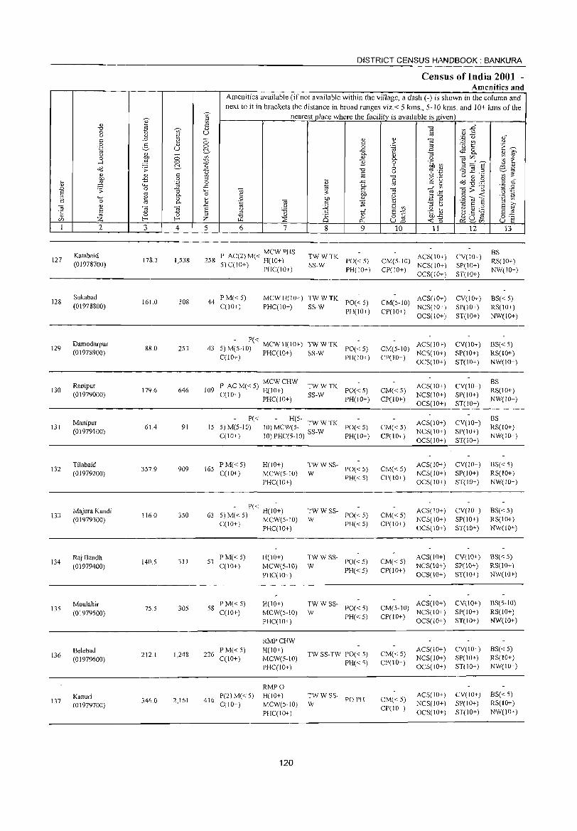
DISTRICT CENSUS H/I,NDBOOK : BANKURA
Census of India 2001 -Amenities and
Amenities available (if not available within the village, a dash (-) is shown in the column and
next to it in brackets the distance in broad ranges viz. < 5 krns., 5-10 kms. and 10+ krns of the -;;, nearest place where the facility is available is given
]' " '" :g
'0 tn "'§" "d -;;, <l.)
0 '0 u § () 1] i,l .~ '0 "," c ::; <l.) Q)
~ c
'" :>- :.::: til '-' 0 E- " 0 _g .~ '0 t E~ '.g u ~ ~ 8-~ 0- '3 Q) ?;'
() ;; '" Q) cac/J ~ e 0 0- 0
-' ~ 0 "Cl '2 0 .~ ~~ ~:::::rS :g " " ~ ;;: ~ '0 6 ';:s 'p 3 jg .~ E9.-~ " c ~ 0: U :g ;s: 0,) oj '0
s:::= 11,) U 0 ~
~ -= 0 o ._, o(J ~ .g ~ .~ 0 :;; ..<:: § '" <.> .~ or
" "'" ..c t<:i 0- " ~1 ._ "0 1ii 0 .D .;;: 0 "3 ..... ca ~ ca e~ ]>~ .~ § oj 0- 0 C :;: 00 .~ u
"'" ~ 0 ~ 0 on " .2 0,) .~ 'iii S 'a Ul c 0 oj 0- Q) 'fa ca c '2 '" "5 b S ?;' ca " 'IS .D u :Q E Ul 1ii E "
E ~ § () 'i3 .g ~ e~;,a l~ " " tf E-'" E :;: os 0 "d Q)
8 0 o C 00"<:: ~8£ 0=-= c/J Z f- f- Z '" ::;E c.. ull <Co u E 1 2 3 4 5 6 7 8 9 10 11 12 13
Katabaid P AC(2)M« MCWPHS TWWTK ACS(IO+) CV(IO+) BS
127 178.3 1,538 258 5) C(10+) H(IO+) PO« 5) CM(5-10) RS(lO+) (01978700) PHC(IO+)
SS-W PH(IO+) CP(IO+)
NCS(lO+) SP(10+) NW(JO+)
OCS(IO+) ST(JO+}
128 Sukabad
161.0 308 44 PM« 5) MCWH(JO+) TWWTK ACS(JO+) CV(IO+) BS« 5)
PO« 5) CM(5-10) (01978800) C(lO+) PHC(IO+) SS-W PH(IO+) CP(JO+)
NCS(IO+) SP(10+) RS(lO+) OCS(IO+) ST(IO+) NW(IO+)
Damodarpur - P« TWWTK ACS(IO+) CV(IO+) BS« 5) 129 88.0 253 43 5)M(5-10) MCWH(IO+) PO« 5) CM(5-10)
(01978900) C(lO+) PHC(IO+) SS-W PH(IO+) CP(IO+)
NCS(IO+) SP(IO+) RS(IO+) OCS(IO+) ST(IO+) NW(IO+)
Ranipur P AC M« 5) MCW CHW TWWTK ACS(JO+) CV(IO+) BS
130 (01979000)
179.6 646 109 C(lO+) H(IO+) SS-W PO« 5) CM«5)
NCS(IO+) SP(IO+) RS(IO+)
PHC(10+) PH(!o+) CP(IO+) OCS(IO+) ST(10+)
NW(IO+)
Manipur PC< H(5-
ACS(lO+) CV(IO+) BS
131 (01979100)
61.4 91 15 5) M(5-1 0) 10) MCW(5- TW W TK PO« 5) CM« 5) NCS(10+) SP(IO+)
RS(IO+) C(lO+) 10) PHC(5-1O) SS-W PH(IO+) CP(IO+)
OCS(IO+) ST(IO+) NW(IO+)
132 TiJabaid
357.9 909 165 P MC< 5) H(IO+) TWWSS-
POC< 5) CM« 5) ACS(10+) CV(IO+) BS« 5)
(01979200) C(lO+) MCW(S-IO) W PHC< 5) CP(IO+)
NCS(IO+) SP(lO+) RS(IO+) PHC(lO+) OCS(IO+) ST(10+) NW(lO+)
Majura Kundi PC<
H(IO+) TWWSS- ACS(IO+) CV(IO+) BS« 5) 133
(01979300) 116.0 350 63 5)M«5)
MCW(5-10) W PO« 5) CM« 5)
NCS( 10+) SP(lO+) RS(10+) C(lO+)
PHC(IO+) PH« 5) CP(JO+)
OCS(IO+) ST(IO+) NW(10+)
134 Raj Bandh
140.5 311 53 PM« 5) H(IO+) TWWSS-
PO« 5) CM«5) ACS(IO+) CV(10+) BS« 5)
(01979400) C(10+) MCW(5-IO) W NCS(10+) SP(10+) RS(IO+)
PHC(10+) PH« 5) CP(IO+)
OCS(JO+) ST(lO+) NW(10+)
Moulahir 75.5 305 58
P M« 5) H(IO+) TWWSS-PO« 5) CM(5-IO)
ACS(10+) CV(IO+) BS(5-10) 135
(01979500) C(IO+) MCW(5-10) W NCS(10+) SP(lO+) RS(IO+)
PHC(10+) PH« 5) CP(lO+)
OCS(IO+) ST(IO+) NW(10+)
RMPCHW
Belebad 212.1 1,248 226
P M«5) H(lO+) TW SS-TW PO« 5) CM«5)
ACS(IO+) CV(lO+) BS« 5) 136 C(IO+) MCW(5-10) NCS(IO+) SP(lO+) RS(IO+) (01979600)
PH«5) CP(10+) PHC(IO+) OCS(IO+) ST(lO+) NW(lO+)
RMPO
Kanuri P(2) M« 5) H(IO+) TWWSS-PO PH CM«5)
ACS(IO+) CV(IO+) BS« 5) 137 346.0 2,161 416
W NCS(JO+) SP(IO+) RS(IO+) (01979700) C(IO+) MCW(S-IO) CP(lO+)
PHC(10+) OCS(IO+) ST(IO+) NW(IO+)
120
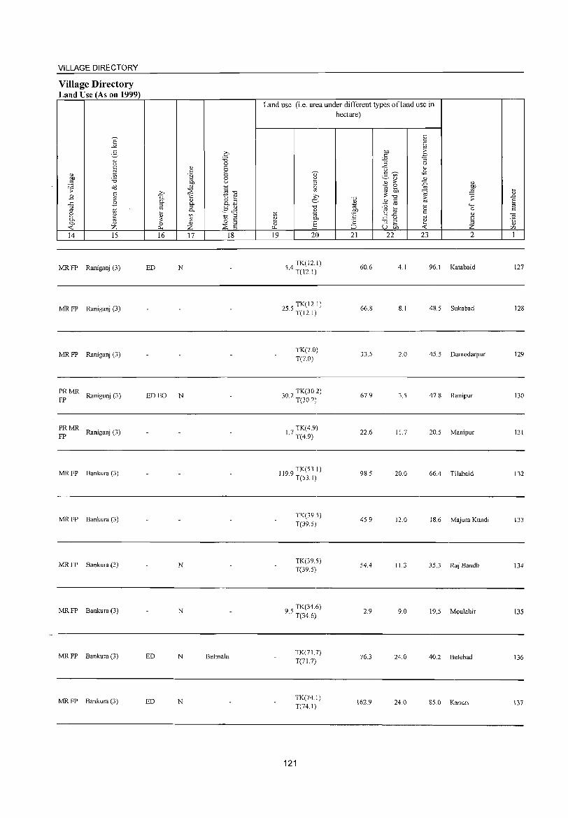
VILLAGE DIRECTORY
Village Directory Land Use (As on 1999)
E -'"
2-" u C
%l " OIl '0 ::§ 08 .s;:
~ .8 ..c .8 ;e ~ 2 " 0. a 0. " < Z 14 15
MRFP Raniganj (3)
MR FP Raniganj (3)
MRFP Raniganj (3)
PRMR Ranigunj (3)
FP
PRMR Raniganj (3)
FP
MRFP Bankura (3)
MR FP Bankura (3)
MR FP Bankura (3)
MR FP Bankura (3)
MR FP Bankura (3)
MR FP Bankura (3)
0 'B 0
" E c .~ E
0 gp u
§""d >, ::;s 0. -;:; 1:: e 0- " at! os §"' '" 0- .§ <l1 ~
" ~ ~ os ~ 0 § 0 z il-< ::;s E 16 17 18
ED N
ED EO N
N
N
ED N Belmala
ED N
Land use (i.e. area under different types ofland use in hectare)
19 20
4 TK(12.1)
5. T(12. I)
TK(12.1) 25.5 T( 12. I)
TK(70) T(7.0)
302 TK(30.2) · T(30.2)
7 TK(4.9) 1. T(4.9)
1199 TK(53.1) · T(53.1)
TK(39.5) T(39.5)
TK(39.5) T(39.5)
95 TK(34.6) · T(34.6)
TK(71.7) T(71.7)
TK(74.1) T(74.1)
121
"0
" 1<l
'E ·S ::::J 21
60.6
66.8
33.5
67.9
22.6
98.5
45.9
54.4
2.9
76.3
162.9
c 0 '.g
t>.O -s c '0 "3 '" u
"0 .... g '"
<.8 " " 2 > ::0 "
~ ~ .-"! ~ ·OJ ""0 iii .s;:
" c :0 '" "0 """" e ~ 0 c
" "'..<: '" ~ u S "3 ::l e '" ~ U OIl <
22 23 2
4.1 96.1 Katabaid
8.1 48.5 Sukabad
2.0 45.5 Damodarpur
3.5 47.8 Ranipur
11.7 20.5 Manipur
20.0 66.4 Tilabaid
12.0 18.6 Majura Kundi
11.3 35.3 Raj Bandh
9.0 19.5 Moulahir
24.0 40.2 Belebad
24.0 85.0 Kanuri
~
" .0 S :! c -a "5 C/)
1
127
128
129
130
131
132
133
134
135
136
137
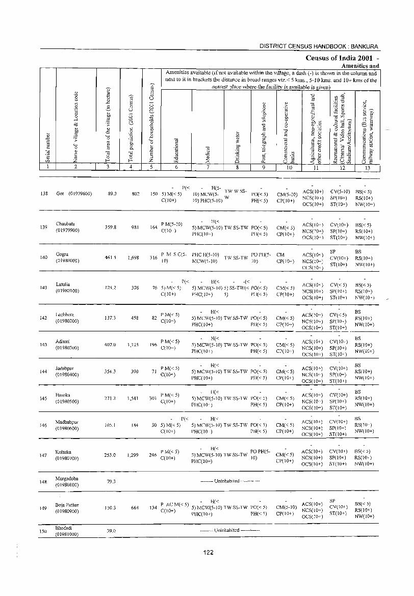
DISTRICT CENSUS HANDBOOK: BANKURA
Census of India 2001 -Amenities and
Amenities available (if not available within the village, a dash (-) is shown in the column and
next to it in brackets the distance in broad ranges viz.< 5 krns., 5-10 krns. and 10+ krns of the
'" nearest place where the facility is available isgi_ven
~ ::>
" '" c; "d ",.0 "d
'"' " 0 u § ,,2 <J Q) i'l ",p (.) ,," ..<:: C; 0) 0) -a '" :::
'" :> :..::: (/) <J 0 5 " 0 0 .~ 3 u t:: I~ .~ u ~ .c ~ 8-<J Q) - 0. 0) "3 " i? 0 b.O 0 '" Q) 0. (.) <iJtZl ~ 2: ,....1 2l 0 "d "Ii 0 .~ U) 3=S s:'.- "0 6 ::> " o<l .:;: ..<:: -0 6 'i~ ~ jg .2
co ~ " c: <J ~~ Q) <!) '" '" OJ "0 (.) 0 ~
:W -E 0 ;:1 ~ o ._,
o<l ~ . .g c; t; '-g 0 " ..c c; C g o c;" ..... ..<::
~ 0.. '" " '" <iJ;;:"§ 'z 0 ..0 .:;: 0 "3 ..... -a ~ -a <iJ ~ OJ .-E '" 0.. 0 ::: '2 :;::0 ::: <r:: '2 ~ ::> '-H " 0 ~ 0 b.O <!) S't;Ja 8 - <!) " 0 0.. <l.) '.g -a " "Ii <l.) ;; 8 '" ;>,
~ " ~ ..0 u :.g E '" 1;j E '" E '" § <iJ E (.) '6 " S-'" ,g ~ e~~ S :::
~ '" '" <!)
8 '" o " ga-s <U "0 0 on..<:: 0:::: tZl Z E- Z r.Q :::E 0.. u.2 <r::o ~~tZl u e 1 2 3 4 5 6 7 & 9 10 11 12 13
P« - H(5-ACS(IO+) CV(5-1O) BS« 5) 138 Got (01979800) 89.3 802 150 5) M« 5) 10) MCW(5- TWWSS- PO«5) CM(5-1O)
C(10+) 10)PHC(5-lO) W PH«5) CP(1O+) NCS(10+) SP(IO+) RS(IO+) OCS(10+) ST(1O+) NW(IO+)
Chaubata P M(5-1O) H« ACS(1O+) CV(lO+) BS« 5) 139 359.8 981 164 5) MCW(5-10) TW SS-TW PO« 5) CM{< 5) (01979900) C(10+)
PHC(lO+) PH«5) CP(IO+) NCS(IO+) SP(IO+) RS(lO+) OCS(IO+) ST(JO+) NW(IO+)
Gogra P M S C(5- PHC H(5-1O) PO PH(5- CM ACS(IO+) SP BS
140 461.5 1,698 316 TW SS-TW CV(1O+) RS(IO+) (01980000) 10) MCW(5-lO) 10) Cpr 10+) NCS(!O+) ST(IO+) NW(IO+)
OCS(IO+)
Latulia P« H« -« ACS(IO+) CV« 5) BS« 5) 141 124.2 376 76 5) M« 5) 5) MCW(5-IO) 5) SS-TW« PO« 5) CM« 5)
(01980100) C(lO+) PHC(lO+) 5) PH« 5) CP(IO+)
NCS(IO+) SP(IO+) RS(IO+)
OCS(IO+) ST(IO+) NW(IO+)
Lechhera P M«5) H«
ACS(IO+) CV« 5) BS
142 (01980200)
137.3 458 82 C(IO+)
5) MCW(5-10) TW SS-TW PO« 5) CM«5) NCS(10+) SP(10+)
RS(IO+) PHC(IO+) PH« 5) CP(IO+)
OCS(10+) ST(IO+) NW(lO+)
Adhuri P M«5) H«
ACS(lO+) CV(lO+) BS
143 (01980300)
407.0 1,125 196 C(lO+)
5) MCW(5-10) TW SS-TW PO« 5) CM«5) NCS(IO+) SP(10+)
RS(10+)
PHC(10+) PH« 5) CP(IO+) OCS(IO+) ST(lO+)
NW(IO+)
Jadabpur P M« 5) H«
ACS(IO+) CV(IO+) BS
144 354.3 390 71 5) MCW(5-1O) TW SS-TW PO« 5) CM« 5) RS(IO+) (01980400) C(lO+)
PHC(IO+) PH« 5) CP(IO+) NCS(IO+) SP(10+)
NW(IO+) OCS(IO+) ST(10+)
H« ACS(IO+) CV(IO+)
BS
145 Haroka
271.2 1,541 301 P M«5)
5) MCW(5-10) TW SS-TW PO« 5) CM« 5) RS(IO+) (01980500) C(lO+)
PHC(IO+) PH« 5) CP(IO+) NCS(IO+) SP(lO+)
NW(IO+) OCS(lO+) ST(lO+)
P« H« CV(IO+) BS
Madhabpur 105.1 184 30 5) M« 5) 5) MCW(5-1O) TW SS-TW PO« 5) CM«5)
ACS(lO+) RS(IO+) 146
(01980600) NCS(IO+) SP(lO+) C(lO+) PHC(lO+) PH« 5) CP(IO+)
OCS(IO+) ST(10+) NW(IO+)
Kultuka P M« 5) - H« PO PH(5-CM« 5)
ACS(IO+) CV(IO+) BS« 5) 147 253.0 1,299 246
C(IO+) 5) MCW(5-10) TW SS-TW 10)
NCS(1O+) SP(1O+) RS(IO+) (01980700) PHC(10+) CP(10+)
OCS(IO+) ST(10+) NW(10+)
148 Murgadaba
(01980800) 79.3 -------- Uninhabited ------------
- H« - ACS(IO+) SP
BS« 5) Boja Pathar P ACM«5) 5) MCW(5-IO) TW SS-TW PO«5) CM(5-10) CV(IO+) 149 150.3 664 134 NCS(IO+) RS(IO+) (01980900) C(10+) PHC(10+) PH« 5) CP(IO+) ST(IO+) OCS(IO+) NW(IO+)
150 Bhadadi
39.0 -------- Uninhabited ------------(01981000)
122
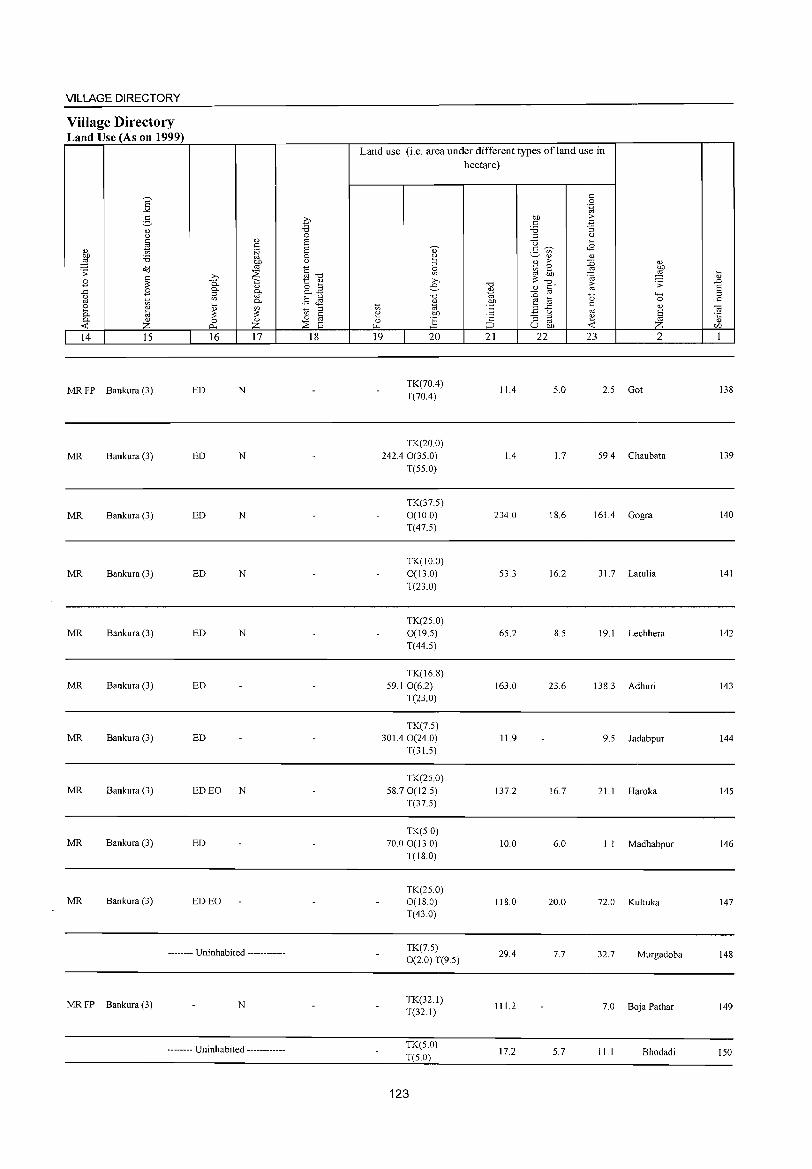
VILLAGE DIRECTORY
Village Directory Land Use (As on 1999)
"' ~ " z
14 15
MR FP Bankura (3)
MR Bankura (3)
MR Bankura (3)
MR Bankura (3)
MR Bankura (3)
MR Bankura (3)
MR Bankura (3)
MR Bankura (3)
MR Bankura (3)
MR Bankura (3)
16 17
ED N
ED N
ED N
ED N
ED N
ED
ED
ED EO N
ED
ED EO
-------- Uninhabited ------------
MR FP Bankura (3) N
-------- Uninhabited ------------
18
Land use (i.e. area under different types ofland use in hectare)
19 20
TK(70.4) T(70.4)
TK(20.0) 242.4 0(35.0)
T(55.0)
TK(37.5) 0(10.0) T(47.5)
TK(IO.O) 0(130) T(23.0)
TK(25.0) 0(19.5) T(44.5)
TK(16.8) 59.1 0(6.2)
T(23.0)
TK(7.5) 301.40(24.0)
T(31.5)
TK(25.0) 58.70(12.5)
T(37.5)
TK(5.0) 70.00(13.0)
T(18.0)
TK(25.0) 0(18.0) T(43.0)
TK(7.5) 0(2.0) 1'(9.5)
TK(32.1) T(32.1)
TK(50) 1'(5.0)
123
21 22
11.4
1.4
234.0
53.3
65.2
163.0
11.9
137.2
10.0
118.0
29.4
111.2
17.2
23 2
5.0 2.5 Got
1.7 59.4 Chaubata
18.6 161.4 Gogra
16.2 31.7 Latulia
8.5 19.1 Lechhera
23.6 138.3 Adhuri
9.5 Jadabpur
16.7 21.1 Haroka
6.0 I . I Madhabpur
20.0 72.0 Kultuka
7.7 32.7 Murgadoba
7.0 Boja Pathar
5.7 11.1 Bhodadi
138
139
140
141
142
143
144
145
146
147
148
149
150
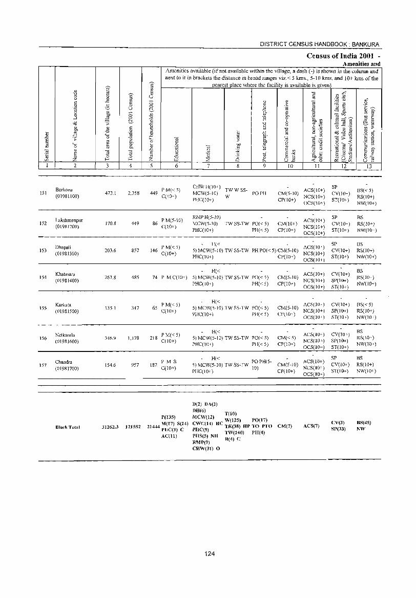
151
152
153
154
155
156
157
2
Barkona (01981100)
Lakshmanpur (01981200)
Dhapali (01981300)
Khatmara (01981400)
Karkata (01981500)
Netkamla (01981600)
Chandra (01981700)
Block Total
3 4
473.1 2,358
170.8 449
203.6 857
263.8 485
135.1 347
346.9 1,178
154.6 957
31262.3 121552
DISTRICT CENSUS HANDBOOK: BANKURA
Census ofIndia 2001 -Amenities and
Amenities available (if not available within the village, a dash (-) is shown in the column and next to it in brackets the distance in broad ranges viz. < 5 krns., 5-10 krns. and 10+ kms of the
nearest place where the facility is available is given
5 6
449 P M« 5) C(IO+)
86 P M(5-10) C(10+)
146 P M« 5) C(1O+)
7 8 9
CHW H( 10+) TW W SS-MCW(5-10) W PO PH PHC(lO+)
RMPH(5-1O) MCW(5-10) PHC(10+)
TW SS-TW PO« 5)
PH« 5)
10 11
CM(5-IO) ACS(IO+) CP(IO+) NCS(10+)
OCS(lO+)
CM(IO+) CP(lO+)
ACS(\O+) NCS(10+) OCS(10+)
H« 5) MCW(5-10) TWSS-TW PHPO«5) CM(5-IO) ACS(IO+) PHC(lO+) CP(lO+) NC8(10+)
OC8(10+)
H« 74 P MC(IO+) 5) MCW(5-10) TWSS-TW PO«5) CM(S-IO) ACS(10+)
CP(lO+) NCS(IO+) OC8(1O+)
65 P M« 5) C(lO+)
218 P M« 5) C(IO+)
182 PM S C(lO+)
P(13S)
21444 M(t7) S(14) PUC(J) e AC(ll)
PHC(lO+) PH« 5)
H« 5) MCW(S-IO) TW SS-TW PO« 5)
PHC(IO+) PH« 5)
H« 5) MeW(5-10) TW SS-TW PO« 5) PHC(IO+) PH« 5)
ACS(10+) CM(S-IO) NCS(lO+) CP(IO+) OCS(10+)
CM« 5) CP(10+)
ACS(lO+) NCS(lO+) OC$(lO+)
- H« S) MCW(5-10) TW SS-TW P
100)PH(5- CM(5-10) ACS(lO+)
NCS(lO+) PHC(lO+) CP(IO+) OCS(IO+)
D(2) DA(2)
DR(6) T(IO)
MCW(12) W(12S) PO(17) eWC(14) He TK(38) HP TO PTO PRC(5) TW(140) PH(4) PHS(S) NH R(4) C RMP(9)
CM(7) ACS(7)
CHW(3J) 0
124
12
SP CV(10+) ST(10+ )
SP CV(lO+) ST(IO+)
SP CV(lO+) ST(IO+)
CV(10+) SP(lO+) ST(IO+)
CV(lO+) SP(IO+) ST(IO+)
CV(lO+) SP(lO+) ST(IO+)
SP CV(lO+) ST(IO+)
eV(3) S],(33)
13
BS« 5) RS(IO+) NW(lO+)
BS RS(lO+) NW(10+)
BS RS(IO+) NW(lO+)
BS RS(lO+) NW(lO+)
BS«5) RS(IO+) NW(IO+)
BS RS(lO+) NW(IO+)
BS RS(!O+) NW(lO+)
BS(45) NW
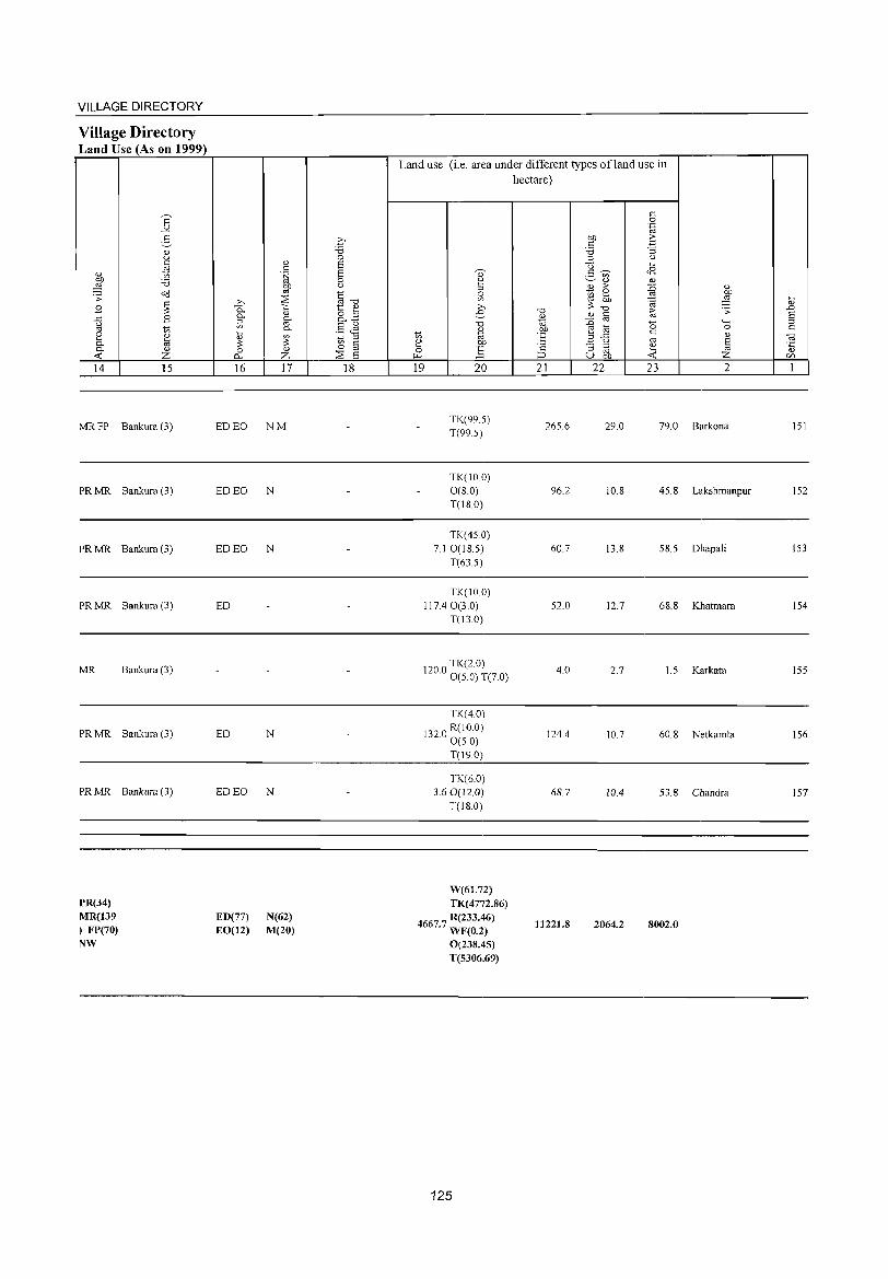
VILLAGE DIRECTORY
Village Directory Land Use (As on 1999)
., bl)
,g .;;: B .c u '" ~ 0.. -< 14
MRFP
PRMR
PRMR
PRMR
MR
PRMR
PRMR
PR(34) MR(139 ) FP(70) NW
E -'" 2-" u
~ 'B "d
~ B
'" " til " Z 15
Bankura (3)
Bankura(3)
Bankura (3)
Bankura (3)
Bankura (3)
Bankura (3)
Bankura (3)
>,
0.. 0..
~
~ 0
0..
16
ED EO
ED EO
ED EO
ED
ED
ED EO
ED(77) EO(12)
" " .~ OJ)
'" ~ -;:;
" 0..
'" 0.. U)
;:: " Z 17
NM
N
N
N
N
N(62) M(20)
0 'B 0 S S 0 u
~~ 1:: " 8.2 §~ "t; ::> 0 " '" ~ a 18
Land use (i.e. area under different types of land use in
d) 2 ::> ~ >,
e.. -0
" on "' 2 bl)
0 ~ "-' 19 20
TK(99.5) T(99 5)
TK(IO.0) 0(8.0) T(I8.0)
TK(45.0) 7.1 0(18.5)
T(63.5)
TK(IO 0) 117.4 0(3.0)
T(l3.0)
TK(2.0) 120.0 0 (5.0) T(7.0)
TK(40)
1320 R(IO.O) . 0(50)
T(19.0)
TK(6.0) 3.60(12.0)
T(18.0)
W(61.72) TK(4772.86)
4667.7 R(233.46) WF(0.2) 0(238.45) T(5306.69)
125
hectare)
-0
~ OJ)
'E '2 ::J 21
265.6
96.2
60.7
52.0
4.0
124.4
68.7
11221.8
c 0
'.g bl) 2: " -3 'B ::> 0
-0 ... c ~ <8 ._ '" ~ " '" 2 > :0 ~ ::: ~ ;:: bl) '@
-0
" C ~ '" :0 '0 e] c
.2 u '" :; '" 2 oj u bl) -< 22 23
29.0 79.0
10.8 45.8
13.8 58.5
12.7 68.8
2.7 1.5
10.7 60.8
10.4 53.8
2064.2 8002.0
" OJ)
,g ~ .;;: .0 S ...... ::>
0 c " ca § '5 Z r/l
2 1
Barkona 151
Lakshmanpur 152
Dhapali 153
Khatmara 154
Karkata 155
Netkamla 156
Chandra 157

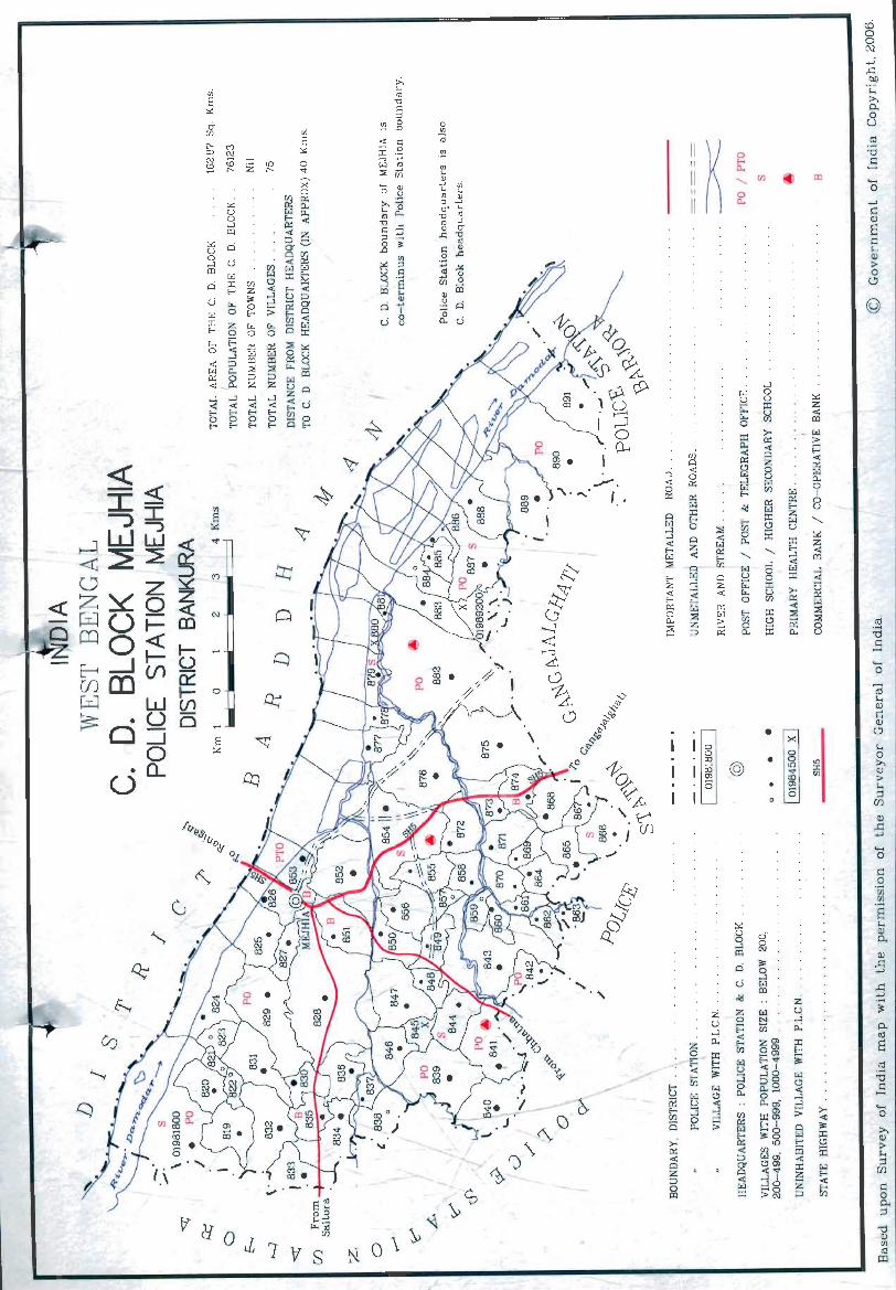
<Ii E ~
ci-UJ
r0- C') CD N c.j CO Z If:) :9 ['- ['-
:.:: u 0 ....l CD
~ ci u 0
U ....l CD
[%J
ci :r: E-<
~
:r: N p
Q
o Cr::
~
G ~
IJ: F-...,
&)
........
c:;
~
V(! OJ7 if S ~
"
~ \ \> 0
a '" -.;
~~ \><0
o ~ .
..-- . ' . ",. I.
._ ~ ~ 0
......:} <r:: ~
.di
~ L.. (')
' .,
00-
<\. ()
'\
c:i ...: 0 p::
0 [%J ....l ....l ...: E-< W ;:;; E-< Z <C E-< p:: 0 0... ?§
" t; Ii: E-< en a >= p:: ...: 0 z ;:> 0 CD
!! ~ II " II
UJ Q ...: 0 p::
p:: [%J :r: E-< 0
0 Z ...: 0 [%J ....l ....l ...: E-< [%J ;:;; Z ;:>
0 E-< p..
........ 0 0...
[%J u
E o
[%J u r:;: roo. o
!il o 0...
i I @ I ~ ·0
I
~ u 0 ....l OJ
ci u old
:i t..i ....l
Z p.;
0 :r: e:: E-< ...: ~ E-< UJ
W [11 C,) u j ::s ....l 0 ;; p..
UJ
....l
8 :r: u UJ
>Il:: <C o z 8 w UJ
• •
0 0 N
"" 3 [11 OJ
8) OJ
. _ W
> E=: ...: p:: [%J 0... o I
o u ........ ~ z ...: ro
'" ;r:
'"
((j 0 0 C\l ...; ..c: I:lD .c; >, c. 0 u
.~ '0
.5 ~
0
....,
" Q)
6 " h <Il > 0
'"' ©
-o
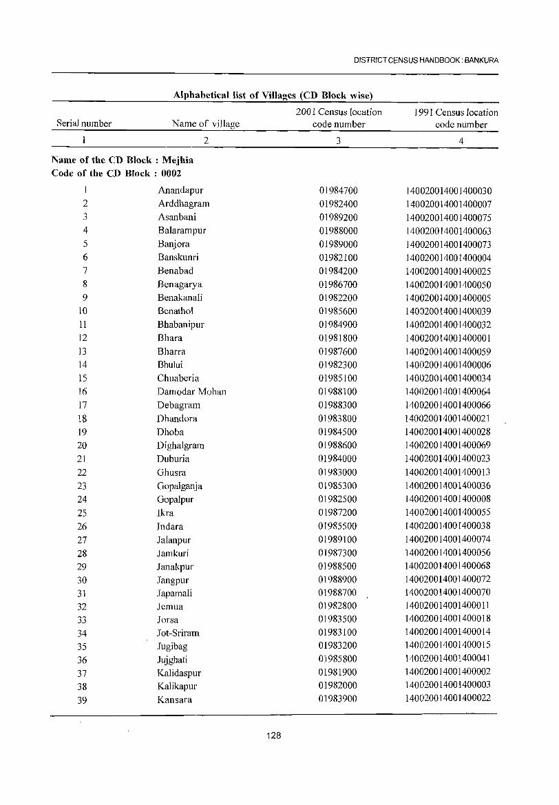
DISTRICT CENSUS HANDBOOK: BANKURA
Alphabetical list of Villages (CD Block wise)
2001 Census location 1991 Census location Serial number Name of village code number code number
1 2 3 4
Name of the CD Block: Mejhia Code of the CD Block : 0002
Anandapur 01984700 140020014001400030 2 Arddhagram 01982400 140020014001400007 3 Asanbani 01989200 140020014001400075 4 Balarampur 01988000 140020014001400063 5 Banjora 01989000 140020014001400073 6 Banskunri 01982100 140020014001400004 7 Benabad 01984200 140020014001400025 8 Benagarya 01986700 140020014001400050 9 B enakan ali 01982200 140020014001400005
10 Benathol 01985600 140020014001400039 11 Bhabanipur 01984900 140020014001400032 12 Bhara 01981800 140020014001400001 13 Bharra 01987600 140020014001400059 14 Bhului 01982300 140020014001400006 15 Chuaberia 01985100 140020014001400034 16 Damodar Mohan 01988100 140020014001400064 17 Debagram 01988300 140020014001400066 18 Dhandora 01983800 140020014001400021 19 Dhoba 01984500 140020014001400028 20 Digha1gram 01988600 140020014001400069 21 Duburia 01984000 140020014001400023 22 Ghusra 01983000 140020014001400013 23 Gopalganja 01985300 140020014001400036 24 Gopalpur 01982500 140020014001400008 25 Ikra 01987200 140020014001400055 26 Indara 01985500 140020014001400038 27 Jalanpur 01989100 140020014001400074 28 Jamkuri 01987300 140020014001400056 29 Janakpur 01988500 140020014001400068 30 Jangpur 01988900 140020014001400072 31 Japamali 01988700 140020014001400070 32 Jemua 01982800 140020014001400011 33 Jorsa 01983500 140020014001400018
34 Jot-Sriram 01983100 140020014001400014
35 Jugibag 01983200 140020014001400015
36 Jujghati 01985800 140020014001400041
37 Kalidaspur 01981900 140020014001400002
38 Kalikapur 01982000 140020014001400003
39 Kansara 01983900 140020014001400022
128
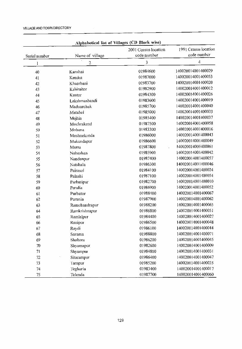
VILLAGE AND TOWN DIRECTORY
Alphabetical list of Villages (CD Block wise)
2001 Census location 1991 Census location
Serial number Name of village code number code number
2 3 4
40 Kanshai 01984600 140020014001400029
41 Kendut 01987000 140020014001400053
42 Khaerbani 01983700 140020014001400020
43 Kshiraitor 01982900 140020014001400012
44 Kustor 01984300 140020014001400026
45 Lakshmanbandi 01983600 140020014001400019
46 Maduarchak 01985700 140020014001400040
47 Matabel 01985000 140020014001400033
48 Mejhia 01985400 140020014001400037
49 Mochrakend 01987500 140020014001400058
50 Mohana 01983300 140020014001400016
51 Moshnekonda 01986000 140020014001400043
52 Mukundapur 01986600 140020014001400049
53 Murra 01987800 140020014001400061
54 Nabashan 01985900 140020014001400042
55 Nandanpur 01987400 140020014001400057
56 Natshala 01986300 140020014001400046
57 Pairasol 01984100 140020014001400024
58 Palashi 01987100 140020014001400054
59 Parbatipur 01982700 140020014001400010
60 Pamlia 01986900 140020014001400052
61 Purbator 01988400 140020014001400067 62 Pumnia 01987900 140020014001400062
63 Ramchandrapur 01988200 140020014001400065
64 Ramkrishnapur 01986800 140020014001400051 65 Ramlalpur 01984400 140020014001400027 66 Ranipur 01986500 140020014001400048 67 Raydi 01986100 140020014001400044 68 Sarama 01988800 140020014001400071 69 Shaltora 01986200 140020014001400045 70 Shyamapur 01982600 140020014001400009 71 Shyampur 01984800 140020014001400031 72 Sitarampur 01986400 140020014001400047 73 Tarapur 01985200 140020014001400035 74 Tegharia 01983400 140020014001400017 75 Telenda 01987700 140020014001400060
129
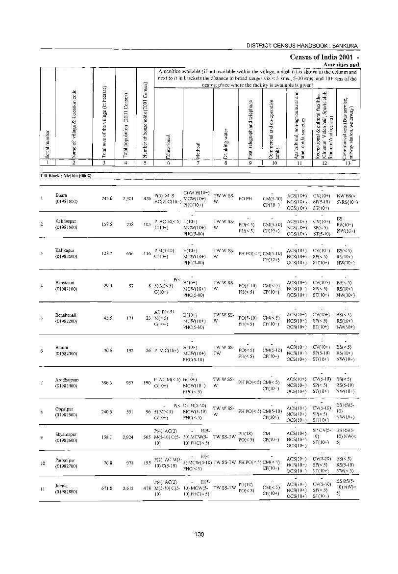
DISTRICT CENSUS HANDBOOK: BANKURA
Census of India 2001 -Amenities and
Amenities available (if not available within the village, a dash (-) is shown in the column and next to it in brackets the distance in broad ranges viz.< 5 kms., 5-10 kms. and 10+ kms of the
"' nearest place where the facility is available is _given ~ 5i
'" '" "" K; ~~ "" 0) 0 u '" U § 0 .,
~ .~ u .," § ..c - ., .,
"§ '" 0 '" > .,..::: In U
2- ., 0 .~ 'u t: E~ .~ U 0 2 c:'.. ..c tS &
0 ., - 0- 0) "3 0) ~
0 Ol) 0 ~ " 0- U CO'" ~ ~ -l ,g C> ~ 0 .~ ~ t3:::f S c:'.. "0 6 ;:l .,
a'J .;; ..c "" '? '';:1 fi .2 .2 Ee-«i ~ '"
0 en :;:
~ .,
'" '" "" '" " u 0 ._ ._ ..c 0 ;:l ._
.c § o '0 o'(j .g.g '" " .;; .~ 0 '" c " o '" ., ..c «i 0-'" til>"3 .~ .2 .0 .;; 0 "3 """ til :;: to til e :!:~ E oj
0- 0 '" .~ '" -< .~ :s ;:l
""" ~ 0 ._ 0 QO ., E~ SOlS '" '" '" 0 0- 0) .~ (i3 '" ~ .,
;:l >, (i3 Q) .0 () J2 E '" ;:l u «i E ;:> E oj
E ~ ~ E 0 'S .5 tf E"'" .g ~) b.S ~ E :;: '5 ~ ;:> ;:l
0) o § o.o..c: f-< f-< Z "" :;2 Q 0 d;!u- 0'-'
'" '"' -< ~. U ~ 0.. U.o C> ~ '" 1 2 3 4 5 6 7 8 9 10 11 12 13
CD Block: Mejhia (0002)
Bhara P(3) M S CHW H(lO+)
TWWSS- ACS(IO+) CV(IO+) NWBS« 745.6 2,301 426 AC(2)C(10+) MCW(IO+) PO PH CM(5-10) (01981800) W NCS(10+) SP(5-10) 5) RS(IO+) PHC(IO+) CP(IO+)
OCS(IO+) ST(IO+)
Kalidaspur P ACM«5) H(IO+) TWWSS- ACS(IO+) CV(IO+) BS
2 157.5 738 103 PO« 5) CM(5-10) RS(lO+) (01981900) C(IO+) MCW(IO+) W NCS(IO+) SP«5)
PHC(5-10) PH«5) CP(IO+)
OCS(IO+) ST(5-10) NW(IO+)
Kalikapur 128.7 656 116
PM(5-10) H(IO+) TWWSS-PH PO« 5) CM(5-10)
ACS(IO+) CV(IO+) BS«5) (01982000) C(IO+) MCW(IO+) W NCS(IO+) SP« 5) RS(IO+)
PHC(5-10) CP(10+)
OCS(IO+) ST(IO+) NW(IO+)
4 Banskunri
29.3 57 - P« H(I~+) TWWSS-
PO(5-IO) CM«5) ACS(lO+) CV(10+) BS« 5)
(01982100) 5) M« 5) MCW(IO+) W NCS(lO+) SP« 5) RS(lO+) C(lO+) PHC(5-10) PH«5) CP(IO+)
OCS(lO+) ST(IO+) NW(JO+)
Benakanali AC P« 5)
H(lO+) TWWSS- ACS(lO+) CV(lO+) 8S« 5) (01982200)
45.6 171 23 M«5) MCW(IO+) W
PO(5-10) CM« 5) NCS(lO+) SP« 5) RS(lO+)
C(IO+) PHC(5-10)
PH«5) CP(IO+) OCS(IO+) ST(IO+) NW(IO+)
Bhului 70.6 26 P MC(IO+)
H(IO+) TWWSS-PO«5) CM(5-IO)
ACS(IO+) CV(10+) 8S«5) 6
(01982300) 193
MCW(IO+) TW NCS(IO+) SP(5-10) RS(lO+)
PHC(5-10) PH«5) CP(10+)
OCS(10+) ST(IO+) NW(IO+)
Arddhagram 386.3 190
P AC M« 5) H(IO+) TWWSS-PH PO« 5) CM« 5)
ACS(IO+) CV(5-10) BS«5) 7
(01982400) 957
C(IO+) MCW(IO+) W NCS(IO+) SP« 5) RS(5-10)
PHC«5) CP(IO+)
OCS(10+) ST(IO+) NW(IO+)
Gopalpur P« DH H(5-10)
TWWSS- ACS(10+) CV(5-10) BS RS(5-
(01982500) 240.5 551 96 5) M« 5) MCW(5-10)
W PH PO« 5) CM(5-1O)
NCS(IO+) SP«5) 10)
C(IO+) PHC« 5) CP(IO+) OCS(IO+) ST(IO+)
NW(lO+)
P(4) AC(2) H(5-PH(18) CM ACS(IO+)
SPCV(5- BSRS(5-Shyamapur
9 158.1 2,924 565 M(5-1O) C(5- 10) MCW(5- TW SS-TW PO« 5) CP(10+) NCS(10+) 10) 10) NW«
(01982600) 10) 10) PHC« 5) ST(IO+) 5)
OCS(IO+)
- H« - ACS(IO+) CV(5-IO) 8S« 5) Parbatipur 76.8 195 P(2) AC M(S- 5) MCW(5-10) TW SS-TW PH PO« 5) CM« 5) 10
(01982700) 978
10) C(5-10) PHC« 5) CP(IO+) NCS(10+) SP« 5) RS(5-1O) OCS(IO+) ST(IO+) NW«5)
P(4) AC(2) H(5-PH(IO) ACS(IO+) CV(5-10)
BS RS(5-Jemua M(5-10) C(5- 10) MCW(5- CM«5) JO)NW« II 671.8 2,612 478 TW SS-TW PO« 5) NCS(IO+) SP« 5) (01982800) 10) 10) PHC« 5) CP(IO+) 5)
OCS(lO+) ST(IO+)
130
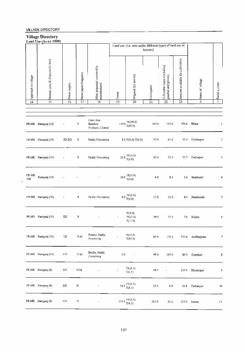
VILLAGE DIRECTORY
Village Directory Land Use (As on 1999)
E
14 15
PRMR Raniganj (10)
PR MR Raniganj (10)
PR MR Raniganj (10)
PRMR Raniganj (10)
NW
PRMR Raniganj (10)
PRMR Raniganj (10)
PRMR Raniganj (10)
PRMR Raniganj (10)
PRMR Raniganj (8)
PRMR Raniganj (8)
PRMR Raniganj (8)
16 17 18
Cane And N Bamboo
Products, Chattai
ED EO N Paddy Processi ng
N Paddy Processing
N Paddy Processing
ED N
ED NM Pottery, Paddy Processing
ED NM Bricks, Paddy Processing
ED NM
ED N
ED N
Land use (i.e. area under different types of land use in hectare)
19 20
1160 TK(49.0) · T(49.0)
1.0 W(6.0) T(6.0)
2 0 TK(4.0)
5. T(4.0)
100 TK(4.0) · T(4.0)
40 TK(6.0) · T(6.0)
W(9.0) TK(2.0) T(IIO)
R(410) T(410)
6.0
TK(4.1) T(4.1)
146 TK(4.1) · T(4.1)
1129 TK(4.5) · T(4.5)
131
21
244.0
57.0
45.0
4.0
15.0
39.0
85.0
49.0
48.5
25.5
201.9
22 23 2
142.0 194.6 Bhara
61.0 32.5 KaJidaspur
32.0 22.7 Kalikapur
8.3 3.0 Banskunri
12.0 8.6 Benakanali
13.0 7.6 Bhului
139.3 1210 Arddhagram
105.0 80.5 GopaJpur
105.5 Shyamapur
6.9 25.8 Parbatipur
35.2 317.2 Jemua
2
3
4
6
7
9
10
II
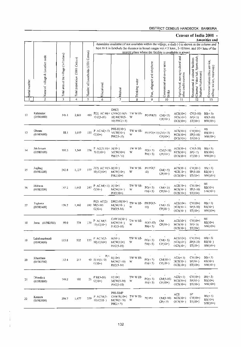
12
13
14
15
16
17
18
19
20
21
22
'+< o
2
Kshiraitor (01982900)
Ghusra (01983000)
Jot-Sriram
(01983100)
Jugibag (01983200)
Mohana
(01983300)
Tegharia
(01983400)
Jorsa (01983500)
Lakshmanbandi
(01983600)
Khaerbani
(01983700)
Dhandora (01983800)
Kansara (01983900)
3 4
345.1 2,801
88.1 1,019
192.3 1,544
242.8 1,127
145.2 1,643
176.7 1,482
99.0 774
115.8 932
112.4 213
148.2 105
298.7 1,477
DISTRICT CENSUS HANDBOOK: BANKURA
Census of India 2001 -Amenities and
Amenities available (if not available within the village, a dash (-) is shown in the column and next to it in brackets the distance in broad ranges viz.< 5 kms., 5-10 kms. and 10+ kms of the
nearest place where the facility is available is given
5 6 7 8 9 10 11 12 13
DH(2)
495 P(2) AC M« CHW(2) H(S-5) C(5-IO) 10) MCW(5-
10) PHC« 5)
~WWSS- POPH(3) CM«5)
CP(IO+)
ACS(IO+) CV(5-IO) BS« 5)
NCS(10+) SP« 5) RS(5-1O)
OCS(IO+) ST(IO+) NW(IO+)
P AC M« 5) PHS H(10+) 155 C(10+) MCW(10+)
PHC(5-10)
256 P AC(3) M« H(10+) 5)C(IO+) MCW(IO+)
PHC(5-10)
177 P(2) AC M(5-H(10+) 10)C(10+) MCW(10+)
PHC(IO+)
247 P AC M« 5) H(IO+) C(10+) MCW(IO+)
PHC(IO+)
TWWSS-
W PH PO« 5) CM« 5)
ACS(10+)
NCS(10+)
OCS(10+)
:WWSS- PO«5)
PH«5)
TW W SS- PH PO(5-
CP(10+)
CM(5-IO) ACS(IO+)
CP(IO+) NCS(IO+) OCS(IO+)
W CM« 5)
10) CP(IO+)
ACS(10+)
NCS(IO+)
OCS(10+)
:W W SS- PO« 5)
PH«5) CM« 5) CP(lO+)
ACS(IO+)
NCS(IO+)
OCS(10+)
P(2) AC(2) DH(2) H(10+) TW W SS- PH PO(5-282 M(5-10) MCW(10+) W 10) CM«5)
ACS(IO+)
NCS(10+)
OCS(10+) C(10+) PHC(5-10) CP(10+)
120 P AC M(5-10) C(10+)
CHW H(lO+) TW W SS- CM MCW(IO+) W PO(5-10)
ACS(IO+)
NCS(10+)
OCS(IO+) PHC(5-10) PH« 5) CP(10+)
153 PAC M(5-10) C(IO+)
H(IO+)
MCW(IO+)
PHC(5-1O)
- P« H(I~+) 40 5)M(5-10) MCW(5-10)
C(10+) PHC(5-1O)
TWWSS-W PO«5)
PH«S)
;;: W SS- PO« 5)
PH«5)
CM«5)
CP(IO+)
ACS(10+)
NCS(10+)
OCS(IO+)
ACS« 5) CM(IO+) NCS(IO+)
CP(IO+) OCS(lO+)
CV(IO+)
SP(5-1O)
ST(lO+)
BS RS(lO+) NW(10+)
CV(5-IO) BS«5)
SP« 5) RS(10+)
ST(IO+) NW(IO+)
CV(IO+)
SP(5-1O)
ST(IO+)
CV(10+)
SP(5-1O)
ST(10+)
CV(IO+)
SP(5-lO)
ST(IO+)
CV(10+)
SP« 5) ST(lO+)
CV(10+)
SP(5-10)
ST(10+)
CV(IO+) SP(10+)
ST(10+)
8S«5) RS(10+)
NW(10+)
BS RS(IO+) NW(lO+)
BS«5) RS(10+)
NW(10+)
BS
RS(IO+) NW(10+)
BS« 5)
RS(10+)
NW(IO+)
BS«5) RS(10+) NW(IO+)
21 PM(5-IO) C(10+)
H(10+)
MCW(5-10)
PHC(5-10)
TWWSS-PO«5)
ACS« 5) CV(10+) CM(5-10) NCS(10+) SP(IO+)
BS«5) RS(10+) NW(lO+)
259 P ACM(5-10) C(10+)
W PH«5)
PHSRMP
CHW H(lO+) TW W SS- PO PH MCW(5-1O) W
PHC«5)
132
CP(10+) OCS(10+) ST(10+)
ACS CM(5-1O) NCS(10+)
CP« 5) OCS(10+)
SP CV(IO+)
ST(IO+)
BS« 5) RS(lO+) NW(\O+)
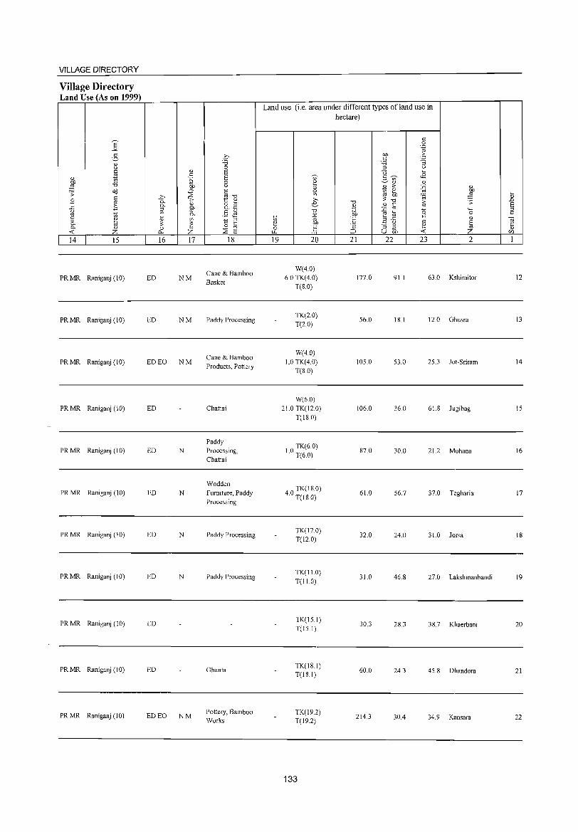
VILLAGE DIRECTORY
Village Directory Land Use (As on 1999)
8' "" 2-
<l.) <) C
~ <l.)
on ::a ,g Od .:; ~ B
~ B <)
'" t; 2 ~ 0. 0. <l.)
« z 14 15
PRMR Raniganj (10)
PRMR Raniganj (10)
PRMR Raniganj (10)
PRMR Raniganj (10)
PRMR Raniganj (10)
PRMR Raniganj (10)
PRMR Raniganj (10)
PRMR Raniganj (10)
PR MR Raniganj( I 0)
PR MR Raniganj (10)
PR MR Raniganj(lO)
<l.)
c .~
on '" :::E >,
P.. '" 0. Q)
::l iif '" 0. ~ <l.) '" :: :: 0 Q)
0.. Z 16 17
ED NM
ED NM
ED EO NM
ED
ED N
ED N
ED N
ED N
ED
ED
ED EO NM
.0 ::a 0 S S 0 <)
~""d t:: Q)
8.2 §J1
::l "' c 0
:::E '" S 18
Cane & Bamboo Basket
Paddy Processing
Cane & Bamboo Products, Pottery
Chattai
Paddy Processing, Chattai
Wodden Furniture, Paddy Processing
Paddy Processing
Paddy Processing
Ghanta
Pottery, Bamboo Works
Land use (i.e. area under different types ofland use in
'" e 0 ~
19
'0)' 2 g '" >, e-"0 ~ co co ] 20
W(4.0) 6.0 TK(4.0)
T(S.O)
TK(2.0) T(2.0)
W(40) 1.0 TK(4.0)
T(S.O)
W(6.0) 21.0 TK(12.0)
T(l80)
10 TK(6.0) . T(6.0)
40 TK(IS.O) . T(l8.0)
TK(12.0) T(12.0)
TK(II.O) T(l1.0)
TK(15.1) T(15.1)
TK(IS.I) T(IS.I)
TK(l9.2) T(l9.2)
133
hectare)
'0 <l.)
iiJ on 'E c
;:J
21
177.0
56.0
105.0
106.0
S7.0
61.0
32.0
31.0
30.3
60.0
214.3
c 0 .~
on .:: c "3 ::a ::l u tl '" .S c;) <8 ~<l.) Q)
til > {i <l.) 0 on
'" '" ~ ,g ::: &; .:;
<l.) c ::0 '" (5 '-'" '" 0 '" '" c <l.) ::l..c
'" ~ <) s :; ::> e '" '" u on « z
22 23 2
91.1 63.0 Kshiraitor
IS.I 12.0 Ghusra
53.0 25.3 Jot-Sriram
36.0 61.S Jugibag
30.0 21.2 Mohana
56.7 37.0 Tegharia
24.0 31.0 Jorsa
46.S 27.0 Lakshmanbandi
2S.3 3S.7 Khaerbani
24.3 45.S Dhandora
30.4 34.9 Kansara
~ ..0 S ::> c
"i(j
'5 [/j
1
12
13
14
15
16
17
IS
19
20
21
22
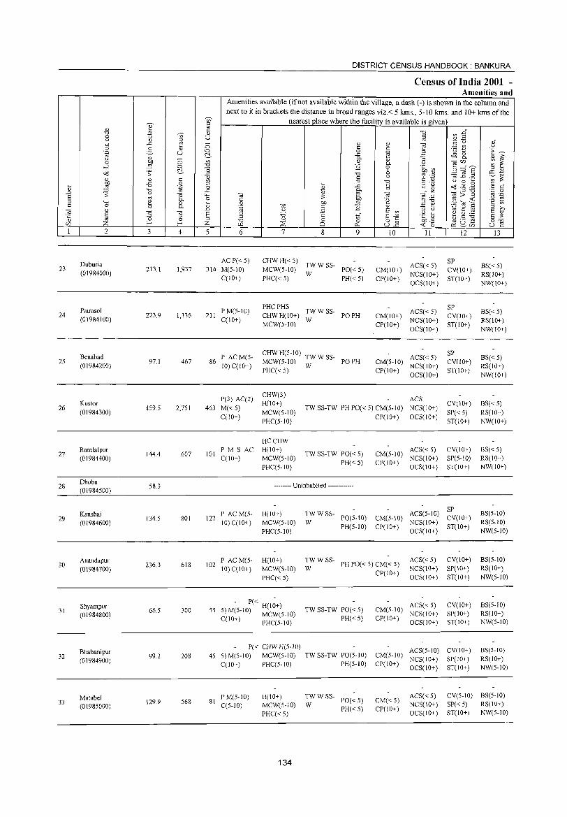
DISTRICT CENSUS HANDBOOK: BANKURA
Census of India 2001 -Amenities and
Amenities available (if not available within the village, a dash (-) is shown in the column and
next to it in brackets the distance in broad ranges viz.< 5 kms., 5-10 kms. and 10+ kms of the ~ nearest place where the facility is available is given
" ~ '" ~ '" "0
V) ..g" ""Cl ~ <1) 0 <n U s:: u '" ~ '" .~ Q s:: ..c: - <1) '" ~
","
5 0 s:: ,. ;.:::: til u 0 2- 0 0 .~ "i:l ~ "E~ .~ u c:>.- ..c: "3 ~ 8- " i;? u '" 0-
:W (3 ~
<1) '" ~ en,, __ ~ ~ 0 0- u ...:l 0 ~ 0 .~ ~ c:>.- o 6 ll'@§ ;::! " ~ .;;: ..c: "0 ro ._. il1 to '" s:: <1) '"
u 6 ~ :::s ..c ._ ';;;':;: " '" '" "0 u 0 .... .... ~ -£ 0 ;::! .... ..c: c 0'6: ~ ~ .g s:: "
.~ 0 <l.) s:: 0 o c '" 4-< ..c: to 0- '" '" <il;;""§l
'';:: 0 ..0 ;;: 0 "3 4-< <il e <il ~ .~ '" .-S '" c. 0 c :;: Cl) .~ s:: <t: u to ;::! 4-< " 0 ~ 0 Of) ." ;::!"Ci 2"6 "2 en c 0 tii «i s:: ~ "
~ 0> E i;? c. .~ "3 ti
~ '" ..D u j2 E '" to S ;::!
S ] <il E u :.a s ..r E -'" ·t ~ e ~ ~ 8 :;: "0 ;::! 0> '" 0 ;::!
"0 '" '" 8] Cl)..c: a3 a JS 0:-= C/) Z l- I- Z w.l ~ 25 0
<t: 15 u e 0... ~ ~C/)
I 2 3 4 5 6 7 8 9 10 II 12 13
Duburia ACP« 5) CHWH«S)
TWWSS- ACS« 5) SP
BS« 5) 23 213.1 1,937 314 M(5-10) MCW(S-10) PO«S) CM(10+) CV(10+) (01984000) W NCS(lO+) RS(lO+) C(10+) PHCC< S) PH«5) CP(10+)
OCS(10+) ST(10+)
NW(IO+)
Pairaso1 PM(S-10) PHCPHS
TWWSS- ACS« 5) SP
24 223.9 1,136 211 CHWH(10+) PO PH CM(IO+) CV(IO+) BS« S)
(01984100) C(lO+) W NCS(10+) RS(10+) MCW(5-10) CP(IO+)
OCS(IO+) ST(lO+)
NW(10+)
Benabad P AC M(5-CHWH(5-10)
TWWSS- ACS« S) SP
BS« 5) 2S
(01984200) 97.1 467 86
10) CCIO+) MCW(5-10)
W PO PH CM(S-10)
NCS(IO+) CV(IO+)
RS(lO+) PHCC<S) CP(lO+)
OCS(IO+) ST(lO+ )
NW(10+)
P(3) AC(2) CHW(3)
ACS
26 Kustor
459.5 2,751 463 M«5) H(lO+)
TW SS-TW PH PO« 5) CM(5-10) NCS(IO-+-) CV(10-+-) BS« S)
(01984300) MCW(S-IO) SP«5) RS(IO+) CCl0+)
PHCCS-10) CP(lO+) OCS(10+)
ST(IO+) NW(IO+)
HCCHW
27 Ramlalpur
144.4 607 101 PM S AC H(IO+)
TW SS-TW PO« 5) CM(S-10) ACS« S) CV(IO+) BS« S)
(01984400) CCIO+) MCW(S-IO) NCS(IO+) SP(S-IO) RS(IO+)
PHCC5-tO) PH« 5) CP(IO+)
OCS(IO+) ST(IO+) NW(IO+)
28 Dhoba
(01984500) 58.3 -------- Uninhabited ------------
Kanshai P ACM(S- H(lO+) TWWSS- ACS(S-IO) SP
BS(S-IO) 29
(01984600) 134.S 801 127
10) C(lO+) MCW(S-IO) W PO(S-IO) CM(S-10)
NCS(10+) CV(lO+)
RS(S-IO)
PHCCS-10) PH(S-lO) CP(IO+)
OCS(IO+) ST(lO+)
NW(S-IO)
Anandapur PAC M(S- H(IO+) TWWSS-PH PO« 5) CM« S)
ACS« S) CV(lO+) BS(S-IO) 30
(01984700) 236.3 618 102
10) C(IO+) MCW(S-IO) W NCS(IO+) SP(IO+) RS(IO+)
PHCC< S) CP(IO+)
OCS(IO+) ST(IO+) NW(S-IO)
Shyampur 66.S 300 SS
- P« H(I~+) TW SS-TW PO« 5) CM(S-IO)
ACS« S) CV(IO+) BS(S-10) 31
(01984800) S)M(S-IO) MCW(S-IO) NCS(IO+) SP(lO+) RS(lO+) C(lO+) PHCCS- 10) PH«S) CP(IO+)
OCS(lO+) ST(IO+) NW(S-IO)
Bhabanipur P« CHW H(S-JO) ACS(S-IO) CV(IO+) B5(S-10)
32 (01984900)
99.2 208 4S S)M(S-IO) MCW(5-10) TW SS-TW PO(5-10) CM(S-IO) NCS(IO+) SP(IO+) RS(IO+)
C(10+) PHCCS-IO) PH(S-IO) CP(IO+) OCS(lO+) ST(lO+) NW(S-IO)
Malabel PM(5-10) H(IO+) TWWSS-PO«5) CM« S)
ACS«S) CV(S-IO) BS(S-IO) 33 129.9 S68 81
CCS-IO) MCW(5-10) W NCS(10+) SP« S) RS(lO+) (0 1985000) PH«5) CP(JO+) PHCC<5) OCS(IO+) ST(lO+) NW(S-IO)
134
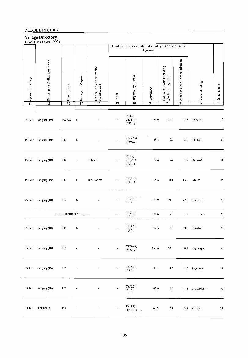
VILLAGE DIRECTORY
Village Directory Land Use (As on 1999)
'" ~ '" z
14 15
PR MR Raniganj (10)
PR MR Raniganj (10)
PRMR Raniganj (10)
PR MR Raniganj (10)
PRMR Raniganj (10)
16 17 18
ED EO N
ED N
ED Belmala
ED N Hide Works
ED N
-------- Uninhabited ------------
PRMR Raniganj (10) ED N
PR MR Raniganj (10) ED
PR MR Raniganj (10) ED
PR MR Raniganj (10) ED
PR MR Raniganj (8) ED
Land use (i.e. area under different types ofland use in hectare)
19 20
W(4.0) TK(l8.1) T(22.1)
TK(200.0) T(200.0)
W(1.2) TK(20.2) T(21.5)
TK(12.1) T(12.1)
TK(0.8) T(0.8)
TK(3.0) T(3.0)
TK(4.6) T(4.6)
TK(10.3) T(l0.3)
TK(9.5) T(9.5)
TK(6.5) T(65)
TK(7 I) 0(2.0) T(9.1)
135
21 22
93.6
18.4
73.2
308.8
78.9
34.6
77.5
153.6
24.1
49.0
66.6
23 2
20.2 77.1 Duburia
0.5 5.0 Pairasol
1.2 1.2 Benabad
53.6 85.0 Kustor
21.9 42.8 Ramlalpur
9.3 11.4 Dhoba
13.4 39.0 Kanshai
32.0 40.4 Anandapur
15.0 18.0 Shyampur
15.0 28.8 Bhabanipur
17.4 36.9 Matabel
23
24
25
26
27
28
29
30
31
32
33
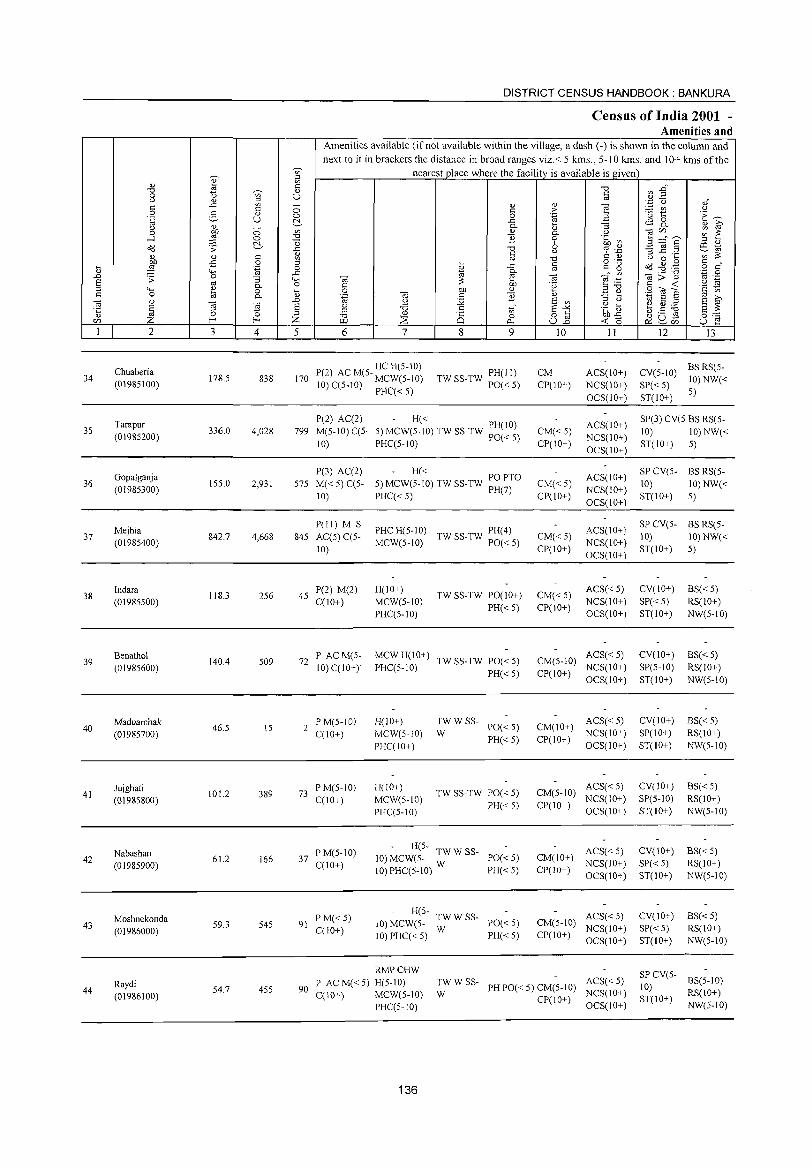
DISTRICT CENSUS HJlINDBOOK : BANKURA
Census of India 2001 -Amenities and
Amenities available (if not available within the village, a dash (-) is shown in the column and
next to it in brackets the distance in broad ranges viz.< 5 kms., 5-10 kms. and 10+ kms of the
~ 'V> nearest place where the facilitv is available is given
" " S; 8 c: "'Cl a3 :an "'Cl " 0 1> V> U c:
u " S; '" '.;:j C,)
" c: ..c: - " " ] c: 0 c: >- ~ t u 0 2- " 0 0 "-g 'E ~ .~ U ~ ..c a ~ 8. u " - "- [l :; " ~ 0 OJ} 0 U) " "- u taifJ ;;; 1-:
....l ,g 0 "'Cl '2 0 .~ ~ ~ ::::"e ~ "0 6 '" " ~ .;;: ..c: "'Cl '? "_P .:g 11 .2 co ~ u ~ '" " c:
V> :>: " .E c: U) '" "0 c: " () 0 :5 OJ} 0 '" o ._
c:: " ,g '-< ..c: ~ c:" ~ ~ ..g .~ [l .~ 0 " o c: ..0 '0 ..c: '" "- ._ "0 '.c 0 .:;: :; '-H ta :>: e ta E:_a 8>~ '" ._ S '" "- 0 c: OJ} 'g '2 ~ '" "'" ~ 0 13 0 OJ} " E ~ sOle c: 0 "- '~ ta c:: '2 'oj s '" >, ta " ..0 u s;; S '" :l u
S '" iii ta ] S u ;.a .~ ~ ~ :g ~ '1:: '0 :l .5 V> E.-'< S :>: " 0 '" "'Cl " a 0 o c: on..c: c:J ._ ro
0:-:::' ifJ Z E- E- Z ::E ujg -< '0 P:!u ..... r.LI r:>.. ~ifJ U e I 2 3 4 5 6 7 8 9 10 11 12 13
Chuaberia P(2) AC M(5- HC H(5-10) TW SS-TW PH(II) CM ACS(IO+) CV(5-10)
BSRS(5-34 178.5 838 170 10) C(S-IO) MCW(5-1O) 10) NW« (01985100) PO« 5) CP(lO+) NCS(10+) SP« 5)
PHC« 5) OCS(IO+) ST(IO+)
5)
Tarapur P(2) AC(2) - H«
ACS(IO+) SP(3) CV(5 BS RS(5-
35 336.0 4,028 799 M(5-10) C(5- 5) MCW(5-10) TW SS-TW PH(IO) CM«5) 10) 10) NW« (01985200) 10) PHCC5-10) PO«5) CP(IO+)
NCS(IO+) ST(IO+) 5)
OCS(IO+)
Gopalganja P(3) AC(2) - H«
ACS(IO+) SP CV(5- BS RS(5-
36 155.0 2,931 575 M« 5) C(5- 5) MCW(5-1O) TW SS-TW PO PTO CM« 5) 10) 10) NW« (01985300)
10) PHC« 5) PH(7) CP(!O+) NCS(10+)
ST(IO+) 5) OCS(IO+)
Mejhia P(11) M S
PHCH(5-10) TW SS-TW PH(4) ACS(IO+) SPCV(5- BS RS(5-
37 842.7 4,668 845 AC(5) CC5- CM«5) 10) 10) NW« (01985400) MCW(5-10) PO«5) NCS(IO+}
10) CP(10+) OCS(10+)
ST(IO+) 5)
38 Indara
118.3 256 45 P(2) M(2) H(10+)
TW SS-TW PO(1 0+) CM«5) ACS«5) CV(IO+) BS«5)
(01985500) C(10+) MCW(5-10) PH«5) CP(10+)
NCS(IO+) SP«5) RS(lO+)
PHCC5-10) OCS(10+) ST(10+) NW(5-10)
39 Benathol
140.4 509 72 P ACM(5- MCWH(lO+)
TW SS-TW PO« 5) CM(5-10) ACS« 5) CV(IO+) 8S« 5)
(01985600) 10) C(10+) PHC(5-10) PH«5) CP(IO+)
NCS(IO+) SP(S-IO) RS(10+)
OCS(IO+) ST(10+) NW(5-10)
Maduarchak 46.5
P M(5-10) H(IO+) TWWSS-PO«5) CM(IO+)
ACS«5) CV(10+) BS« 5) 40
(01985700) IS 2
C(10+) MCW(5-10) W NCS(IO+) SP(IO+) RS(IO+)
PHCC10+) PH«5) CP(10+)
OCS(IO+) ST(10+) NW(5-10)
41 Jujghati
101.2 389 73 PM(5-10) H(10+)
TW SS-TW PO« 5) CM(5-10) ACS« 5) CV(lO+) 8S«5)
(01985800) C(lO+) MCW(5-10) PH«5) CP(IO+)
NCS(IO+) SP(5-10) RS(IO+)
PHC(5-10) OCS(lO+) ST(IO+) NW(5-10)
Nabashan PM(5-10) H(5- TWWSS-PO«5) CM(lO+)
ACS«5) CV(IO+) 8S« 5) 42
(01985900) 61.2 166 37
C(10+) 10) MCW(5-
NCS(IO+) SP«5) RS(IO+) 10) PHC(5-10) W PH« 5) CP(10+)
OCS(lO+) ST(IO+) NW(5-10)
Moshnekonda P M«5) H(5-
TWWSS- ACS« 5) CV(IO+) 8S« 5) 43
(01986000) 59.3 545 91
C(10+) 10) MCW(5-
W PO«5) CM(5-10)
NCS(IO+) SP«5) RS(IO+) 10) PHCC< 5) PH«5) CP(10+)
OCS(10+) ST(IO+) NW(5-10)
RMPCHW SP CV(5-Raydi P AC M« 5) H(5-10) TWWSS- ACS« 5) 8S(5-10)
44 (01986100)
54.7 455 90 C(10+) MCW(5-10) W
PH PO« 5) CM(5-10) NCS(IO+)
10) RS(lO+)
PI-IC(S-IO) CP(IO+)
OCS(!O+) ST(IO+)
NW(5-10)
136
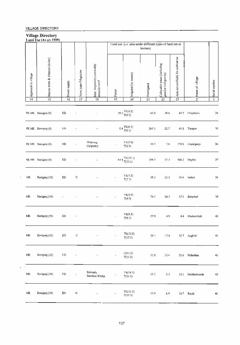
VILLAGE DIRECTORY
Village Directory Land Use (As on 1999)
E "'" 2-'" 0 c ~ '" on ~ 2l o'd .;;: ~ B
..<:: B (.)
'" '" ~ '" t;J 0.. '" ...: z 14 15
PRMR Raniganj (8)
PR MR Raniganj (8)
PR MR Raniganj (8)
PR MR Raniganj (8)
MR Raniganj (10)
MR Raniganj (10)
MR Raniganj (10)
MR Raniganj (10)
MR Raniganj (12)
MR Raniganj (10)
MR Raniganj (10)
ED
ED
ED
ED
ED
ED
ED
ED
ED
ED
'" c .~
on '" .Q ::s
0.. <:: '" 0.. 0.. ::l
'" '" 0.. i;
~ ~ 0
r:>.. Z 16 17
N
N
N
q "'" 0 E 8 0 0
§""d 1:: '" 8.2 §J:1 'gl § ::s E
18
Weaving, Carpentry
Belmala, Bamboo Works
Land use (i.e. area under different types ofland use in hectare)
t; ~ 0 ~
19
" 2 ::l
~ >. e
"'" '" '" on ] 20
291 TK(4.2) · T(42)
04 TK(6.1) · T(6.1)
TK(20) T(2.0)
644 TK(13.1) · T(13.I)
TK(7.3) T(7.3)
TK(4.9) T(4.9)
TK(9.3) T(9.3)
TK(12.0) T(12.0)
0(11.2) T(112)
TK(14.1) T(14.1)
TK(15.3) T(15.3)
137
21
63.8
265.1
10.5
348.7
482
74.1
27.9
36.1
11.0
15.1
13.9
22 23 2
38.0 43.3 Chuaberia
22.7 41. 8 Tarapur
3.6 138.8 Gopalganja
12.1 404.3 Mejhia
22.3 40.6 Indara
24.3 37.2 Benathol
4.9 4.4 Maduarchak
17.4 35.7 Jujghati
13.4 25.6 Nabashan
6.1 24.1 Moshnekonda
6.9 18.7 Raydi
34
35
36
37
38
39
40
41
42
43
44
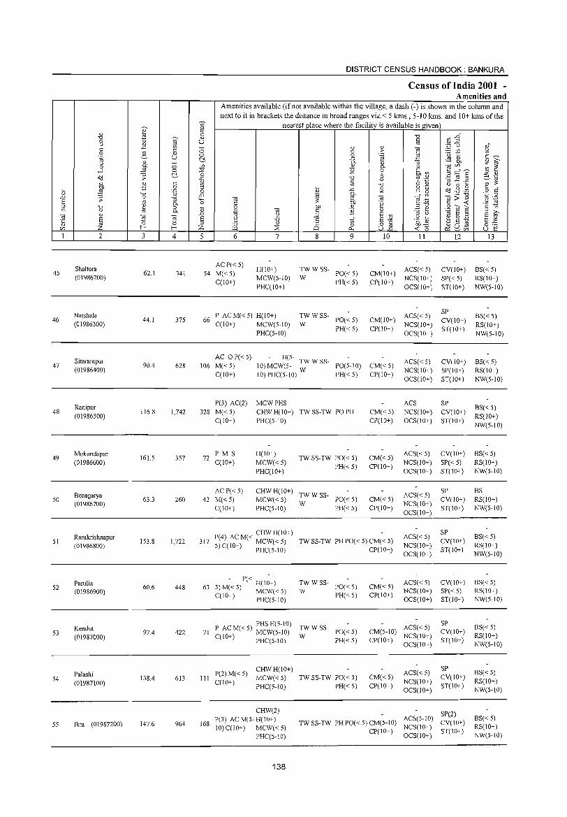
DISTRICT CENSUS HANDBOOK: BANKURA
Census I()f India 2001 -Amenities and
Amenities available (if not available within the village, a dash (-) is shown in the column and next to it in brackets the distance in broad ranges viz.< 5 kms., 5-10 kms. and 10+ kms ofthe
~
nearest place where the facility is available is given ~ ~ " " ~ C "0 en ~" "0 0;;- " 0 U c = OJ
,,_ <.) " ',p 0 ". ..c '" :; " " ] c c C >- ~ (/) " 0 2- " 0 0 .~ .<3 ~ E~ 'ia U ~ ..c ~ 8. <.) "
_ 0- " "3 " 6'
0 ~ 0 '" " 0- <.) 0lC/l ~ ~ -' 0 "0 E 0 .~ .~ :; ::::"8 ~ "0 6 = " o'(j .;; ..c "0 -3 ~.= co .., ill c " C d) ,;;;",
" " c " "0 " B 5 bJ) -5 0 = 0·- c " ~ ..c c c" ~ ~ ~ .~ 0 " " o'(j "0 ."\:! o c
" """' ..c j 0-Ol;;"§
'z 0 .D .;; 0 "3 '+- Ol ~ Ol ~ :~ '" .-S '" 0- 0 C bJ) 'g c -< .~ ]3 " '+- ~ 0 ~ 0 bJ) "
,,"0 .S"OJ S c '" c 0 0- " .~ Ol c E .:= e E 6' Ol " ..0 " J< S '" = <.) .., Ei " S Ol to Ei " '0 .5 S""'" .g b e ~ ~ i§,g '5 " " = '" '" " "0 " Q 0 o § bJ)..c ~ g_a C/l z [-< [-< Z ~ :::E 0.. U..o
-< " U ~ 1 2 3 4 5 6 7 8 9 10 11 12 13
Shaltora AC P« 5)
H(lO+) TWWSS- ACS« 5) CV(IO+) BS«5) 45 62.1 341 54 M«5) PO«5) CM(IO+) (01986200)
CCIO+) MCW(5-10) W
PH«5) .CP(IO+) NCS(lO+) SP«5) RS(lO+)
PHCClO+) OCS(IO+) ST(lO+) NW(5-IO)
Natshala P AC M« 5) H(IO+) TWWSS- ACS«5) SP
BS« 5) 46 44.1 375 66 PO«5) CM(IO+) CV(10+)
(01986300) CCIO+) MCW(5-IO) W NCS(lO+) RS(IO+) PHCC5-IO)
PH«5) CP(IO+) OCS(10+)
ST(10+) NW(5-IO)
Sitarampur AC o P«5) H(5- TW W SS- ACS« 5) CV(lO+) BS« 5)
47 90.4 628 106 M«5) 10) MCW(5- W PO(5-10) CM« 5) (01986400)
C(10+) 10) PHCC5-IO) PH«5) CP(lO+) NCS(IO+) SP(IO+) RS(IO+) OCS(10+) ST(IO+) NW(5-10)
Ranipur P(3) AC(2) MCWPHS ACS SP
BS« 5) 48
(01986500) 116.8 1,742 328 M«5) CHWH(lO+) TW SS-TW PO PH CM«5) NCS(10+) CV(10+)
RS(IO+) CClO+) PHCC5-10) CP(10+) OCS(10+) ST(10+)
NW(5-10)
49 Mukundapur
161.5 357 72 PM S H(10+)
TW SS-TW PO« 5) CM«5) ACS« 5) CV(10+) BS« 5)
(01986600) CCIO+) MCW«5) PH« 5) CP(lO+)
NCS(10+) SP« 5) RS(10+)
PHCClO+) OCS(10+) ST(lO+) NW(5-10)
Benagarya AC P« 5) CHWH(10+)
TWWSS- ACS«5) SP BS
50 63.3 260 42 M«5) MCW«5) PO«5) CM«5) CV(lO+) RS(lO+) (01986700)
CCIO+) PHCC5-JO) W
PH«5) CP(10+) NCS(IO+)
ST(IO+) NW(5-10) OCS(lO+)
P(4) AC M« CHW H(IO+) ACS« 5) SP
BS«5) 51
Ramkrishnapur 153.8 1,722 317 TW SS-TW PH PO« 5) CM« 5) CV(IO+)
(01986800) 5)CCIO+) MCW«5) CP(IO+)
NCS(IO+) ST(IO+)
RS(10+) PHCC5-1O)
OCS(IO+) NW(5-10)
Parulia - P« -
TWWSS- ACS« 5) CV(IO+) BS« 5) 52
(01986900) 60.6 448 63 5) M« 5) H(10+)
W PO«5) CM«5)
NCS(IO+) SP« 5) RS(10+) MCW«5) PH« 5) CP(10+) CCIO+) PHC(5-10) OCS(IO+) ST(IO+) NW(5-10)
P AC M« 5) PHS H(5-10) TWWSS- ACS«5) SP
BS«5) Kendut 97.4 PO«5) CM(5-1O) CV(IO+) 53
(01987000) 422 71 C(10+) MCW(5-10) W NCS(IO+) RS(IO+)
PRCC5-10) PH«5) CP(lO+) OCS(lO+)
ST(IO+) NW(5-IO)
CHWR(lO+) ACS« 5)
SP BS« 5) Palashi
138.4 613 III P(2)M« 5)
MCW«5) TW SS-TW PO« 5) CM«5) CV(IO+) 54 C(lO+) NCS(10+) RS(IO+) (01987100) PHC(5-1O) PH«5) CP(IO+) ST(IO+)
OCS(IO+) NW(5-IO)
CHW(2) SP(2)
P(3) AC M(5- H(IO+) ACS(5-10) BS« 5) 55 lkra (01987200) 147.6 964 168
10) C(IO+) MCW«5) TW SS-TW PH PO« 5) CM(5-IO)
NCS(lO+) CV(10+)
RS(IO+)
PRC(S-IO) CP(IO+)
OCS(IO+) ST(IO+)
NW(5-10)
138
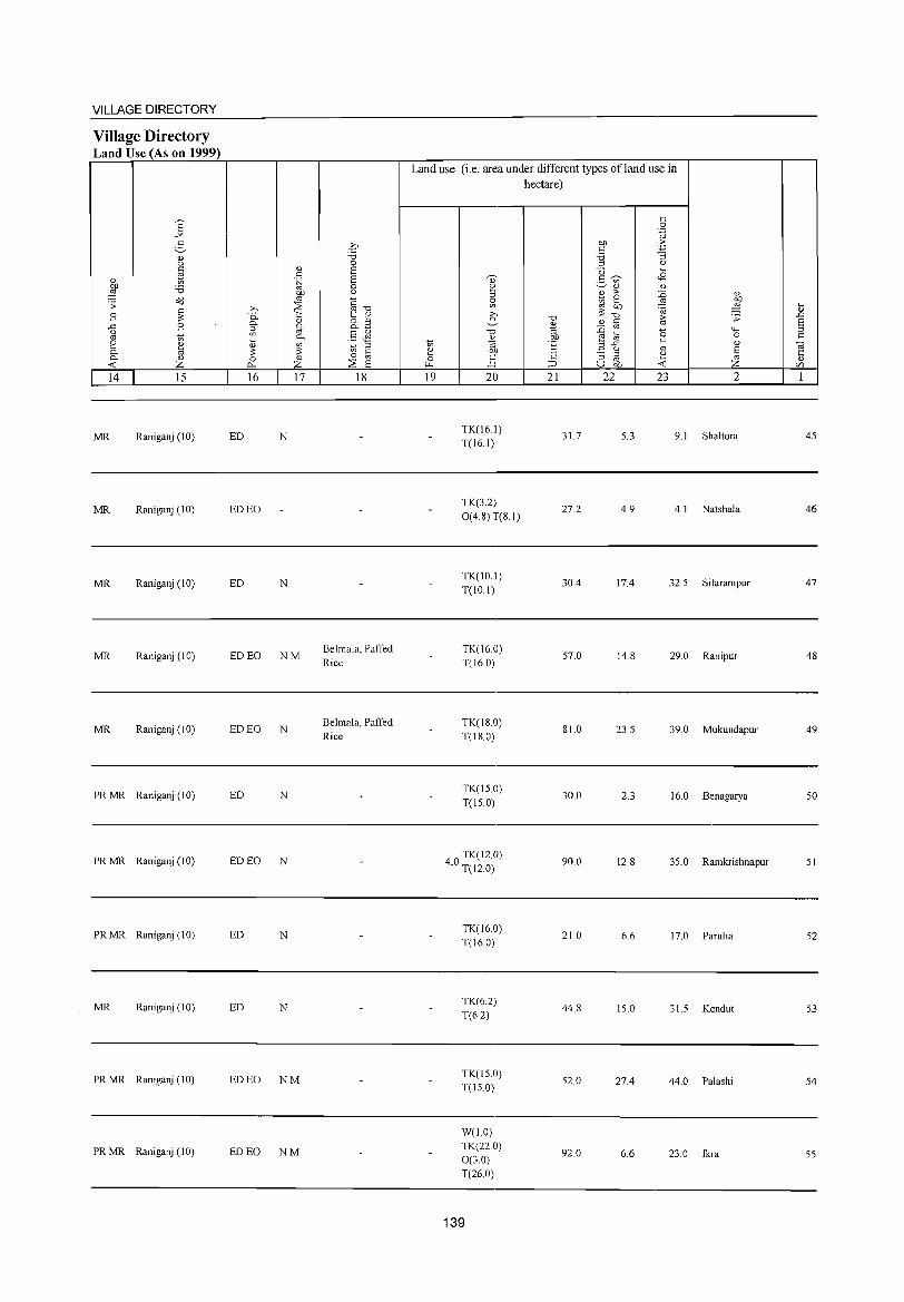
VILLAGE DIRECTORY
Village Directory Land Use (As on 1999)
E "" 2-<l) (.)
§ <l) t; OIl 'U ::§
o"(j .;; c
B 3: -" B (.)
"" t; e ~ 0-0- " -< Z 14 15
MR Raniganj (10)
MR Raniganj (10)
MR Raniganj (10)
MR Raniganj (JO)
MR Raniganj (10)
PRMR Raniganj (10)
PRMR Raniganj (10)
PR MR Raniganj(IO)
MR Raniganj (10)
PRMR Raniganj (10)
PRMR Raniganj (10)
<l) c .~
OIl
"" ;>, :::E 0. "i::: 0- " ::l g. '" 0-~ <l)
~ 3: 0 " I'l. Z 16 17
ED N
ED EO
ED N
ED EO NM
ED EO N
ED N
ED EO N
ED N
ED N
ED EO NM
ED EO NM
q "0 0 E E 0 (.)
c """0 1: ~ o ::l O-~
§~ t; ::l c 0 '" :::E E
18
BelmaJa, Paffed Rice
Belmala, Paffed Rice
Land use (i.e. area under different types ofland use in hectare)
19 20
TK(16.1) T(16.1)
TK(3.2) 0(4.8) T(8.1)
TK(IO.J) T(lO.l)
TK(J6.0) T(J60)
TK(18.0) T(18.0)
TK(15.0) T(15.0)
40 TK(l2.0) . T(J2.0)
TK(16.0) T(J6.0)
TK(6.2) T(6.2)
TK(15.0) T(15.0)
W(1.0) TK(22.0) 0(3.0) T(26.0)
139
"0
%l OIl
E C
;::>
21
31.7
27.2
30.4
57.0
81.0
30.0
90.0
21.0
44.8
52.0
92.0
OIl c 'U ::l
U ~ :5 '" <l)
~ >-
~ 3: "0
" c :0 "" e ~ ,3 ..c
(.)
"3 ::l
"" u OIl
22
5.3
4.9
J7.4
14.8
23.5
2.3
12.8
6.6
J5.0
27.4
6.6
c 0 .~
-5 ""5
(.)
~ <l)
:0 <l)
.!'! 9 .t;j
i;; .;;
0 """' 0 c <l)
'" § ~ -< Z 23 2
9.1 Shaltora
4.1 Natshala
32.5 Sitarampur
29.0 Ranipur
39.0 Mukundapur
16.0 Benagarya
35.0 Ramkrishnapur
J 7.0 Parulia
31.5 Kendut
44.0 Palashi
23.0 Ikra
~ ..0 E ::l c
~ <l)
c/)
1
45
46
47
48
49
50
51
52
53
54
55
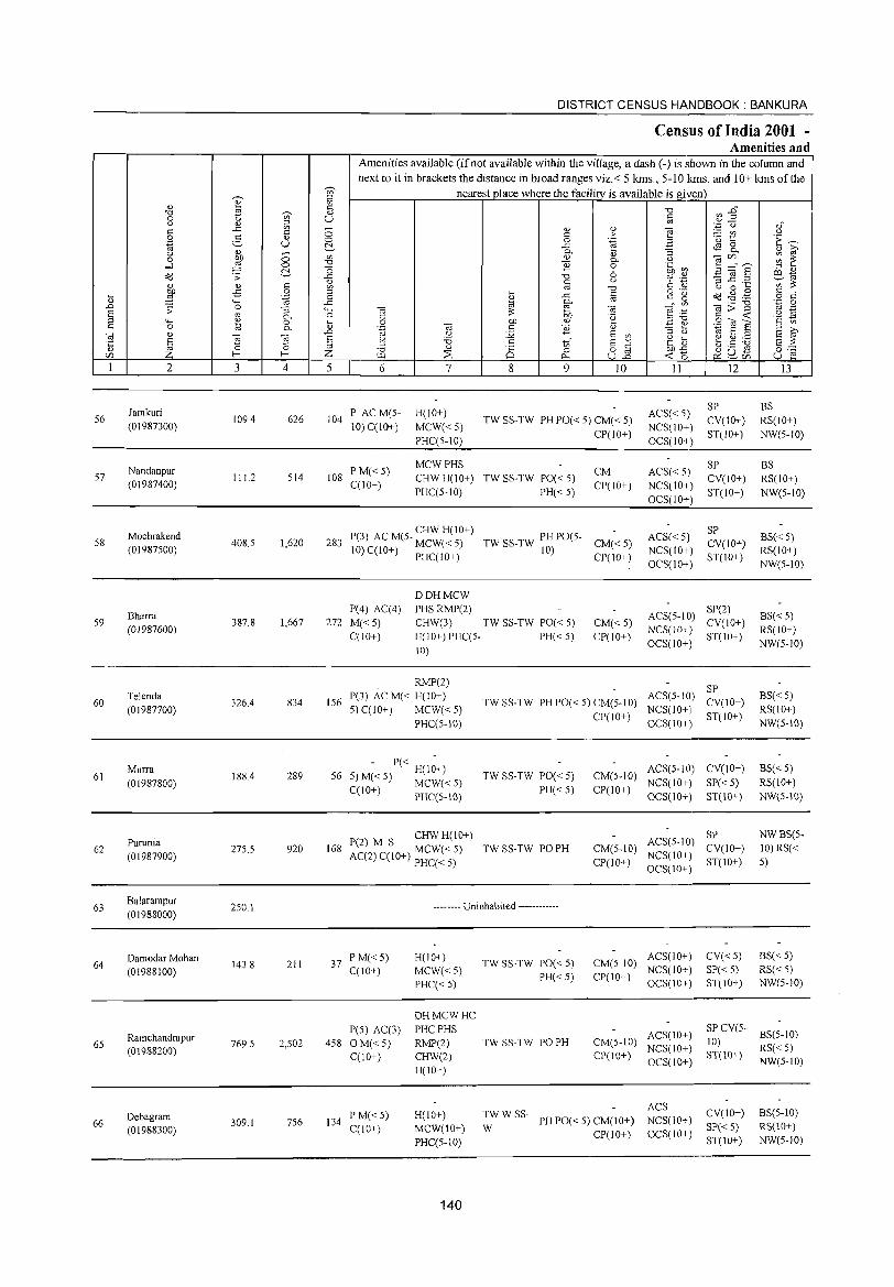
DISTRICT CENSUS HANDBOOK: BANKURA
Census of India 2001 -Amenities and
Amenities available (ifnot available within the village, a dash (-) is shown in the column and
next to it in brackets the distance in broad ranges viz.< 5 kms., 5-10 kms. and 10+ kms of the ~
nearest place where the facility is available is given '" ~ ::> e '" <1.) c ",.D "0 OJ ';;)' <1.) "0
0 t u c <1.)2
<:) <1.) ::> OJ ',p <.) <1.)" .c '" 0 (1) <1.)
] c c _ '" <:)
0 2- <1.) c > 'u t: 'E ~ .~ U 0 0 .~ ~ .c tf! ~ (1) ?i' (1) 0.. "3 <:) bJ) ;; '" (1)
<1.) OJCIl ~ ~ 0
~ "0 B
0.. <:)
-l 0 0 0 'b1 ~ ::; ="8 ::> <1.)
d:3 .;; ~ .c "0 6 ~ .~ '3 ~.2 ~'oJ '" c <:) '" ;:;: (1) <1.) c '" '" "0 C <1.) <:) 0 ~ bJ) -B 0 ::> ... c o .- Cd .g . .@ c " ...
~ .~ 0 ~
.c OJ c 15 o c
<1.) ... .c 0.. Vl Oil;;-g '';:::: 0 .n ;; 0
" ""' Oil e Oil Oil ~ OJ .-S '" 0.. 0 C
;:;: 01) 'e ~~ c ~ '2 ~ ::> "" ~ 0 ~ 0 bJ) '" S "Ols c 0 0.. .~ Oil c B <1.) .=: ~ ::> ;>,
Oil <1.) .n <:) j;2 S '" ::> u 'oj S ::> S OJ S ] Oil E <:) '5 c t{ S -"" <:) ... ~ ~ ~ S ;:;: '5 15 ::> 'C: d) OJ ~
::> "0 <1.)
8 0 82 bJ).c ~u!S 0"" CIl Z t- Z [.L1 :2: p., ~o ~ CIl u 1:: I 2 3 4 5 6 7 8 9 10 II 12 13
Jamkuri P ACM(5- H(JO+) ACS« 5) SP BS
56 109.4 626 104 TW SS-TW PH PO« 5) CM« 5) CY(10+) RS(IO+) (01987300) 10) C(IO+) MCW«5)
CP(IO+) NCS(IO+)
ST(IO+) NW(5-1O) PHC(5-10) OCS(lO+)
Nandanpur PM«5) MCWPHS
CM ACS« 5) SP BS
57 111.2 514 108 CHWH(IO+) TW SS-TW PO« 5) CY(IO+) RS(IO+) (01987400) C(IO+) PHC(5-10) PH« 5)
CP(JO+) NCS(IO+) ST(lO+) NW(5-10)
OCS(IO+)
Mochrakend P(3) AC M(5- CHW H(IO+) TW SS-TW PH PO(5- ACS« 5)
SP BS« 5) 58 408.5 1,620 283 MCW«5) CM«5) CY(IO+)
(01987500) 10) C(lO+) PHC(IO+) 10) CP(IO+)
NCS(lO+) ST(IO+)
RS(IO+) OCS(IO+) NW(5-10)
OOHMCW
Bharra P(4) AC(4) PHSRMP(2)
ACS(5-10) SP(2)
BS« 5) 59
(01987600) 387.8 1,667 272 M«5) CHW(3) TW SS-TW PO« 5) CM«5)
NCS(IO+) CY(IO+)
RS(IO+) C(IO+) H(IO+) PHC(5. PH«5) CP(IO+)
OCS(IO+) ST(IO+)
NW(5-JO) 10)
RMP(2) SP
60 Telenda
326.4 834 156 P(3) AC M« H(IO+)
TW SS-TW PH PO« 5) CM(5·10) ACS(5-10)
CY(lO+) BS« 5)
(01987700) 5) C(IO+) MCW«5) CP(IO+)
NCS(IO+) ST(IO+)
RS(IO+)
PHC(5·10) OCS(IO+) NW(S-IO)
Murra - P« -
ACS(5-IO) CY(IO+) BS«5) 61 188.4 289 56 5)M«5) H(IO+) TW SS-TW PO« 5) CM(5-10)
(01987800) MCW«5) PH«5) CP(IO+)
NCS(IO+) SP«5) RS(IO+) C(JO+) PHC(5-10) OCS(IO+) ST(IO+) NW(5-10)
CHW H(10+) ACS(5-10)
SP NWBS(S-
62 Purunia
275.5 920 168 P(2) M S
TW SS-TW PO PH CM(5-10) CY(lO+) 10) RS« (01987900) AC(2) C(IO+) MCW« 5)
CP(IO+) NCS(IO+)
ST(lO+) 5) PHC« 5) OCS(10+)
63 Balarampur
250.1 ------- Uninhabited ------------(01988000)
Damodar Mohan 211 37
P M« 5) H(IO+) TW SS-TW PO« 5) CM(5-10)
ACS(IO+) CY«5) BS«5) 64 143.8
C(lO+) MCW«5) NCS(lO+) SP«5) RS« 5) (01988100) PH« 5) CP(IO+) PHC« 5) OCS(10+) ST(IO+) NW(5-10)
OHMCWHC P(5) AC(3) PHCPHS ACS(IO+)
SP CY(5-BS(5-10)
65 Ramchandrapur
769.5 2,502 458 OM«5) RMP(2) TW SS-TW PO PH CM(5-10) 10) (01988200) C(10+) CHW(2) CP(IO+)
NCS(IO+) ST(lO+)
RS« 5)
H(IO+) OCS(10+) NW(5-10)
TWWSS-ACS
CY(IO+) BS(5-10) Oebagram P M« 5) H(IO+) PH PO« 5) CM(lO+) NCS(IO+) 66 309.1 756 134
C(IO+) MCW(lO+) W SP« 5) RS(10+) (01988300) CP(IO+) OCS(lO+) PHC(5-10) ST(10+) NW(5-10)
140
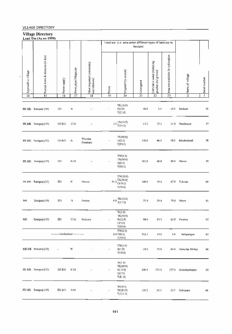
VILLAGE DIRECTORY
Village Directory Land Use (As on 1999)
14 15
PR MR Raniganj(10)
PR MR Raniganj (10)
PR MR Raniganj (10)
PR MR Raniganj (10)
PR MR Raniganj (10)
MR Raniganj (10)
MR Raniganj (10)
16 17
ED N
ED EO NM
ED EO N
ED NM
ED N
ED N
ED NM
18
Wooden Furniture
Pottery
Pottery
Belmala
-------- Uninhabited ------------
MR NR Raniganj (10) N
PR MR Raniganj (10) ED EO NM
PR MR Raniganj (10) ED EO NM
Land use (i.e. area under different types ofland use in hectare)
19 20
TK(180) 0(3.0) T(210)
30 TK(14.0) · T(14.0)
TK(90.0) 0(5.0) T(95.0)
TW(4.0) TK(50.0) 0(6.0) T(60.0)
TW(IO.0)
440 TK(50.0) · 0(10.0)
T(70.0)
60 TK(12.0) · T(12.0)
W(3.0) TK(IO.0) R(32.0) 0(5.0) T(50.0)
TW(2.0) 5.00(8.0)
T(10.0)
TW(30) R(7.0) T(IO.0)
W(IO) TK(69.0) R(IO.0) 0(1.0) T(SI.O)
W(282) TK(S39) T(1122)
141
21
48.0
410
149.0
183.0
106.0
71.0
98.0
212.1
35.0
240.0
120.2
22 23 2
5.4 35.0 Iamkuri
32.2 210 Nandanpur
86.5 78.0 Mochrakend
46.8 98.0 Bharra
39.4 67.0 Telenda
29.4 70.0 Murra
84.5 43.0 Purunia
14.0 9.0 Balarampur
29.8 69.0 Damodar Mohan
271.5 177.0 Ramchandrapur
34.2 42.7 Debagram
.... OJ
..0 E ::l t:
56
57
58
59
60
61
62
63
64
65
66
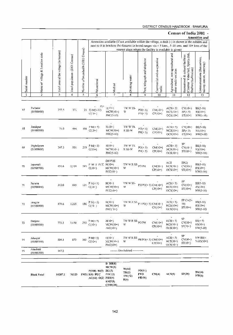
DISTRICT CENSUS HANDBOOK: BANKURA
Census of India 2001 -Amenities and
Amenities available (if not available within the village, a dash (-) is shown in the column and next to it in brackets the distance in broad ranges viz.< 5 krns., 5-10 kms. and 10+ krns of the
'V;' nearest place where the facility is available is given
" fil ., ~ " "U ~~ .", 'V;'
., § 0 U Q ., fil '.0 u .,-
" -" " _ ., .,
] _ '" '-' 0 " > 0 2- ., 0 0 .~ '(3 t:: 'E ~ .~ U C!- -" $ 8.. ., ~ ., _
c. "3 '-' 00 Ul " " a;(/) ~ ~ 0 0 c. '-' -l ,g 0 "U 11 0 .~ a3 B ~~~ C!- o 6 ~~ dd .;; -" "U ~ '';:::
~ " '-' " "
:3..c ._ Ul ;;: " " " '" "U Q 0 ....
:W -£i 0 = o ._ dd ~ .g § j -" " " g ,,-
~ .~ 0 '" "-' -" 0- _- Ul a;;>"§ '.g 0 J'J .;; 0 "3 "-' Cil b'h a; .~ § '" ~ '-' '" c. 0 " .~
..... _ " <r: "-' ~ 0 .8 00 " ="U .8 til 6 '2
~ ~ " " 0 c. a; " 11 " _ .... = >,
a; ., J'J 'oj '-' :.g E Ul = '-' 'oj 8 = 8 ~ E g a; 8 g '6 " E-'" .g t b.S ~ .~ 0 t; §c:= '" ~ = "U " 8 0 o § 00-" Z f-; z :2S <r: 0 ~u- U e en W 0.- U..o ~en
1 2 3 4 5 6 7 8 9 10 11 12 13
Purbator P«
H(IO+) TWWSS- ACS« 5) CV(IO+) BS(5-10) 67 257.5 121 21 5) M(5-10) PO« 5) CM(10+)
(01988400) MCW(IO+) W NCS(10+) SP« 5) RS(10+) C(10+)
PHC(5-10) PH« 5) CP(lO+)
OCS(IO+) ST(IO+) NW(5-10)
68 Janakpur
71.0 494 104 P M« 5) H(IO+) TWWTK
PO« 5) CM(10+) ACS« 5) Cv(IO+) BS(5-10)
(01988500) C(IO+) MCW(IO+) RSS-W PH«5) CP(10+)
NCS(10+) SP« 5) RS(IO+) PHC(5-1O) OCS(IO+) ST(10+) NW(5-1O)
Dighalgram P M« 5) H(IO+) TWWTK ACS« 5) SP
BS(5-1O) 69 247.3 931 219 PO«5) CM(IO+) Cv(lO+)
(01988600) C(10+) MCW(IO+) RSS-W PH«5) CP(lO+)
NCS(IO+) ST(10+)
RS(lO+) PHC(5-1O) OCS(10+) NW(5-1O)
DHPHS ACS SP(2)
Japamali PM S PUC H(IO+) TWWRSSpOp
BS(5-1O) 70
(01988700) 451.6 3,110 593
C(IO+) MCW(IO+) W H CM(IO+) NCS(10+) Cv(IO+) RS(IO+)
PHC(IO+) CP(IO+) OC8(10+) ST(10+)
NW(5-IO)
Sarama PM«5) H(IO+) TWWS8- ACS« 5) SP
BS(5-10) 71 313.0 665 121 PH PO« 5) CM(IO+) Cv(IO+)
(01988800) C(10+) MCW(IO+) W CP(lO+)
NCS(IO+) ST(IO+)
RS(10+) PHC(10+) OC8(10+) NW(5-10)
Jangpur PM«5) H(IO+) TW W R SS PH PO« 5) CM(-IO+) ACS« 5) SP CV(5-
BS(5-10) 72 474.6 1,223 186 10)
(01988900) C(IO+) MCW(IO+) W CP(IO+)
NCS(IO+) ST(10+)
RS(IO+)
PHC(IO+) OCS(IO+) NW(5-10)
TW WR8SpOPH
ACS« 5) SP
BS« 5) 73
Banjora 773.5 1,450 255
PM«5) H(10+) CM(lO+) CV(10+)
(01989000) C(10+) MCW(IO+) W CP(IO+)
NCS(IO+) ST(IO+)
RS(10+)
PHC(10+) OCS(IO+) NW(5-10)
TW W R SS· PH PO« 5) CM(-lO+) ACS«5) SP
NWBS« 74
Jalanpur 504.5 870 163
P M« 5) H(lO+) CV(10+)
(01989100) C(IO+) MCW(10+) W CP(10+)
NCS(10+) ST(IO+)
5) RS(10+)
PHC(IO+) OCS(10+)
75 Asanbani
147.2 -------- Uninhabited ------------(01989200)
D DH(8) MeW(S)
W(44) P(108) M(9) HC(3)
TK(2) PO(ll)
BS(14) Block Total 16287.1 76123 136S1 S(6) PUC PHC(3)
TW(n) PTO CM(4) ACS(S) SP(3S)
NW(4) AC(62) 0(2) PHS(9)
R(6) PH(91)
RMP(8) CHW28
142
VILLAGE DIRECTORY
Village Directory Land Use (As on 1999)
14 15
PR MR Raniganj(lO)
MR Raniganj (10)
MR Raniganj (10)
MR Raniganj (10)
MR Raniganj (10)
MR Raniganj (10)
MR NR Raniganj (10)
MR NR Durgapur (IS)
16 17 18
ED NM
ED NM
ED NM
ED EO NM Wearing Cloth
ED N
ED N Belmala
ED NM
ED NM
-------- Uninhabited ------------
PR(49) MR(72) NR(3) NW(4)
ED(66) EO(15)
N(54) M(21)
Land use (i.e. area under different types ofland use in hectare)
19 20
W(45.5) TK(SO.9) T(I26.4)
W(6.1) TK(2S.3)
T(34.4)
W(S.O) TK(35.0) T(43.0)
W(41.0) TK(92.0) T(I33.0)
W(2J.O) TK(S7.0) R(41.0) T(1490)
W(200) TK(9JO) R(25 0) T(1360)
W(29.0)
50 TK(106.0) . R(25.0)
T(160.0)
W(7.0)
50 TK(S4.0) . R(21.0)
T(112.0)
TK(23.0) T(23.0)
W(244.96) TW(19)
488-4 TK(1753.27) R(202) 0(59.04) T(2278.27)
143
21
90.5
10.1
171.0
251.0
119.0
2SI.0
531.0
271.5
7251.4
22 23 2
4.1 36.5 Purbator
4.1 22.4 Janakpur
6.3 27.0 Dighalgram
5.6 62.0 Japamali
4.0 41.0 Sarama
5.6 52.0 Jangpur
3.5 74.0 Banjora
7.0 109.0 Jalanpur
6.2 IIS.0 Asanbani
2220.7 4048.3
67
68
69
70
71
72
73
74
75

INDIA WEST BENGAL
C. D. BLOCK GANGAJALGHA TI POLICE STATION GANGAJALGHA TI
DISTRICT BANKURA Km 1 0 2 3 4 Kms ... -=~! .. .£===-! .. -=~I
C. D. BLOCK boundary of GANGAJALGHATI i. co- terminus with Police Station boundary.
BOUNDARY, POLICE STATION ....
VILLAGE WITH P.L.C.N .
\
HEADQUARTERS : POLICE STATION, C. D. BLOCK
VILLAGES WITH POPULATION SIZE : BELOW 200, 200- 499, 500- 999, 1000- 4999, 5000 & ABOVE.
, \
I 01989300
@ @
TOTAL AREA OF THE C. D. BLOCK . . . .
TOTAL POPULATION OF THE C. D. BLOCK . 366.47 Sq. Kms.
162007 TOTAL NUMBER OF TOWNS. Nil
TOTAL NUMBER OF VILLAGES . 165 DISTANCE FROM DISTRICT HEADQUARTERS TO C. D. BLOCK HEADQUARTERS(IN APPROX) 24 Kms.
I O N AI i YJ e J
._. \ .
)
I
/ - . '- . .ij ./ . 0191Al300 ' '''' ' ~ . ~ ..<I · -. ' '' . :(
o
o
UNMETALLED AND OTHER ROADS
RIVER AND STREAM. , . . . ... . ,-'
~ POST OFFICE . . . . .
, I
\
o
PO
UNINHABITED VILLAGE WITH P.L.C.N . .. . . . . . 101990700 Xl _ HIGH SCHOOL / HIGHER SECONDARY SCHOOL s
STATE ArGHWAY . . . .
IMPORTANT METALLED ROAD.
SH5 PRIMARY HEALTH CENTRE .... .. .. . . . .
COMMERCIAL BANK / CO- OPERATIVE BANK . B
Based upon Survey of India map with the permission of the Surveyor General of India. © Government of India Copyright,2006.
DISTRICT CENSUS HANDBOOK: BANKURA
Alphabetical list of Villages (CD Block wise)
2001 Census location 1991 Census location Serial number N arne of village code number code number
2 3 4
Name of the CD Block: Gangajalghati Code of the CD Block : 0003
Abhirampur 02005100 140040008000800159 2 Adwitpur 01990700 140040008000800015 3 AmalaDihi 01998700 140040008000800095 4 Amjor 01999000 140040008000800098 5 Anandapur 01991100 140040008000800019 6 Arbat 02003300 140040008000800141 7 Arbetal 02005700 140040008000800165 8 Arjunpur 02003500 140040008000800143 9 Asan Chua 02003400 140040008000800142
10 Atarya 02003900 140040008000800147 11 Balijora 02002400 140040008000800132 12 Balikhun 01995700 140040008000800065 13 Bamundiha 01996900 140040008000800077 14 Ban Ashuria 01993800 140040008000800046 15 Banka Jura 01996500 140040008000800073 16 Bankdaha 01991900 140040008000800027 17 Bara Kumira 01993900 140040008000800047 18 Bara Lachhipur 01989900 140040008000800007 19 Bara Rampur 01996100 140040008000800069 20 Barajuri 02002900 140040008000800137 21 Barasal 01989400 140040008000800002 22 Barasal Srirampur 01989800 140040008000800006 23 Basudebpur 01990500 140040008000800013 24 Bayer Mara 02005500 140040008000800163 25 Belarmari 02000200 140040008000800110 26 Beldanga 01994000 140040008000800048 27 Benagari 01992400 140040008000800032 28 Bhairabpur 01999900 140040008000800107 29 Bhakta Band 01997800 140040008000800086 30 Bhaluka Pahari 02005400 140040008000800162 31 Bhalukathol 01993500 140040008000800043 32 Bharadihi 01996000 140040008000800068 33 Bhatla Para 02004900 140040008000800157 34 Bhiringi 02002700 140040008000800135 35 Bihar Jurya 02003600 140040008000800144 36 Birra 02002200 140040008000800130 37 Bishinda 01995000 140040008000800058 38 Brahmanara 02001800 140040008000800126 39 Brajarajpur 01991200 140040008000800020 40 Brindabanpur 02003800 140040008000800146
146
VILLAGE AND TOWN DIRECTORY
Alphabetical list of Villages (CD Block wise)
2001 Census location 1991 Census location Serial number Name of village code number code number
1 2 3 4
41 Chaitanyapur 01991300 140040008000800021 42 Chak Ranga Metya 01995200 140040008000800060 43 Chandipur 01991500 140040008000800023 44 Charadihi 02001900 140040008000800127 45 Chausal 01990600 140040008000800014 46 ChholaBaid 01997000 140040008000800078 47 Chhota Kumira 02000300 140040008000800111 48 Chhota Lachhipur 01996700 140040008000800075 49 Chhota Lalpur 01994500 140040008000800053 50 Chhota Nabagram 01994600 140040008000800054 51 Chururi 01994700 140040008000800055 52 Damra 01992800 140040008000800036 53 Dandulya 02003000 140040008000800138 54 Dethol 01991400 140040008000800022 55 Deuli 01993400 140040008000800042 56 Dhabani 01990300 140040008000800011 57 Dhabani Gobindapur 02004200 140040008000800150 58 Duberdanga 01989700 140040008000800005 59 Dumuria 01993200 140040008000800040 60 Durlabhpur 01992500 140040008000800033 61 Ekchala 01998300 140040008000800091 62 Gangajal Ghati 02000100 140040008000800109 63 Garjuria 01997600 140040008000800084 64 Ghanashyampur 01990900 140040008000800017 65 Gobardhanpur 02004000 140040008000800148 66 Gobinda Dham 01999200 140040008000800100 67 Gobindapurbaid 01993600 140040008000800044 68 Gopalpur 02002500 140040008000800133 69 Gopinathpur 01993100 140040008000800039 70 Gopinathpur 02004500 140040008000800039 71 Gura Chhanda 01998600 140040008000800094 72 Hadalbani 01992100 140040008000800029 73 Hanri Bhanga 01997100 140040008000800079 74 Hare Krishnapur 02003700 140040008000800145 75 Ita Dangra 01997400 140040008000800082 76 Jam Bedya 01997900 140040008000800087 77 Jambedya 02002600 140040008000800134 78 Jamshala 01996600 140040008000800074 79 Jemua 02002300 140040008000800131 80 Jenadihi 01994900 140040008000800057 81 Ka1i Pathar 01989300 140040008000800001 82 Kalipur 01994400 140040008000800052 83 Kallapur 02001300 140040008000800121
147
DISTRICT CENSUS HANDBOOK: BANKURA
Alphabetical list of Villages (CD Block wise)
200 I Census location 1991 Census location Serial number Name of village code number code number
1 2 3 4
84 Kamalpur 01989500 140040008000800003 85 Kantabani 02004400 140040008000800152 86 Kapishtha 02000700 140040008000800115 87 Kelai 01995400 140040008000800062 88 Kenduabari 02003200 140040008000800140 89 Kenduadihi 02000400 140040008000800112 90 Kenthalya 01995500 140040008000800063 91 Keshiara 01997300 140040008000800081 92 Khajuri 01996400 140040008000800072 93 Khayer Bani 01998800 140040008000800096 94 Khopaganj 02002100 140040008000800129 95 Konra 01999700 140040008000800105 96 Kot Madan Mohanpur 02000600 140040008000800114 97 Kudra 01992700 140040008000800035 98 Kusthalia 01994100 140040008000800049 99 Lachhmanpur 01995900 140040008000800067
100 Lakhyara 01998200 140040008000800090 101 Lalpur Bara 01990100 140040008000800009 102 Latiabani 01992200 140040008000800030 103 Macha Parulia 01999100 140040008000800099 104 Machh Banda 01992300 140040008000800031 105 Madanpur 01993000 140040008000800038 106 Madhabpur 02001200 140040008000800120 107 Ma1danga 02004600 140040008000800154 108 Malkonra 02002800 140040008000800136 109 Mallikdihi 01997500 140040008000800083 110 Mandi 02000000 140040008000800108 111 Maraya 01999800 140040008000800106 112 Mautara 01999300 140040008000800101 113 Menjua 02005000 140040008000800158 114 MukundaPur 01998500 140040008000800093 115 Mukundapurbaid 01993700 140040008000800045 116 Nabagram 02000500 140040008000800113 117 Nadihi 01996800 140040008000800076 118 Nandanpur 01993300 140040008000800041 119 Narayanpur 01994200 140040008000800050 120 Nidhirampur 01992600 140040008000800034 121 Nischintapur 02000900 140040008000800117 122 Nityanandapur 01991600 140040008000800024 123 Nutangram 01996300 140040008000800071 124 Pachamba 01992900 140040008000800037 125 Palajuria 01990200 140040008000800010 126 Panktor 01990400 140040008000800012
148
VILLAGE AND TOWN DIRECTORY
Alphabetical list of Villages (CD Block wise)
2001 Census location 1991 Census location Serial number N arne of village code number code number
1 2 3 4
127 Pankua 01998900 140040008000800097 128 Paramanik Kunri 01995100 140040008000800059 129 Pheguasol 01992000 140040008000800028 130 Phuljam 01991000 140040008000800018 131 Pirrabani 02004100 140040008000800149 132 Radha Krishnapur 02004300 140040008000800151 133 Radhashyampur 02001600 140040008000800124 134 Raidihi 01994800 140040008000800056 135 Rajamela 01995600 140040008000800064 136 Rajarampur 01990000 140040008000800008 137 Ramkanali 02003100 140040008000800139 138 Ramnagar 02001400 140040008000800122 139 Rampur 02002000 140040008000800128 140 Ranbahal 01999500 140040008000800103 141 I Ranga Metya 01995300 140040008000800061 142 Ranganathpur 0]998400 140040008000800092 143 Raniara 02005600 140040008000800164 144 Ratanpur 01989600 140040008000800004 145 Sagarya 01996200 140040008000800070 146 Salbedya 02001100 140040008000800119 147 Sahora 02001000 140040008000800118 148 Sankarara 02001700 140040008000800125 149 Sarangapur 01991800 140040008000800026 150 Selera 01999600 140040008000800104 151 Shimlagar 02004800 140040008000800156 152 Shirsha 01998000 140040008000800088 153 Shua Basa 01997200 140040008000800080 154 Sibipara 01991700 140040008000800025 155 Sidara 01995800 140040008000800066 156 Srichandrapur 01990800 140040008000800016 157 Srirampur 02005200 140040008000800160 158 Suarara 02001500 140040008000800123 159 Subar Nator 02000800 140040008000800116 160 Sudarshanpur 01994300 140040008000800051 161 Taljhitka 01998100 140040008000800089 162 Tentulia Danga 02004700 140040008000800155 163 Thumkonra 01999400 140040008000800102 164 Tilasuli 02005300 140040008000800161 165 UkhraDihi 01997700 140040008000800085
149
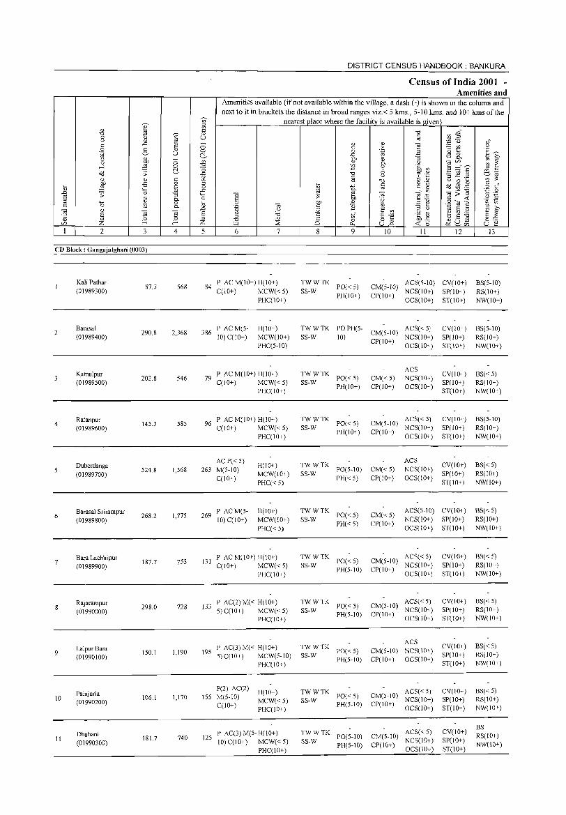
DISTRICT CENSUS H)\NDBOOK : BANKURA
Census of India 2001 -Amenities and
Amenities available (if not available within the village, a dash (-) is shown in the column and next to it in brackets the distance in broad ranges viz.< 5 kms., 5-10 kms. and 10+ kms of the
~
~ '" nearest place where the facility is available is given " ~
" ~ C "0 en ..g" "0 ~ " 0 '" U § u " " .~ "0 ,," s:: ..<:: '" - " " ] c 0 s:: :>
_ Ul U 0 2- " 0 0 .~ 'u t '~ ~ .~ U ~ ..<:: ~ 8. u " - '"
0-"
:; " ~ 0 :W 0 " 0. u ",'" ~ ~ ....l 0 "0 E 0 .~ Cl'l B ~"S ~ "0 6 " '" Cd ';;: ..<:: "0 ~ ·t1 ~~
s:: '" § u :;..<:: .8 ~ '" 0) 0) <Il "0
C <l.) t) 0 ~ OIl -5 0 " iil c o 'u Cd ~ ,g '- ::§ '.g 0 ..<:: 0 c"
" '"' ~ '" " 0 ..<:: ~ - "" ",>"g .~ 0 ..0 .;;: 0 "3 '"' '" '" .~ a '" ;;: '" ~, u
0- 0 C .~ '- '-1 s:: <t:
" '"' ~ ,,"0 '2 0 E; 0 OIl " ~ " SOlE c 0 0- .~ '" c E " - ~ " ;>,
'" " ..0 u :.:;; S '" " '-' ~ a " s ~ § g ~ s u 'i3 s:: 1;;" s~ ·c ~ b oS ~ .t:: 0 " " '" t5 §:::: " "0 0 o '" ~~ '" Z f-< f-< Z U.l :::E 0., U..o ~ 8in U ~
1 2 3 4 5 6 7 8 9 10 II 12 13
CD Block: Gangajalghati (0003)
Kali Pathar 87.3 568 84
P AC M(lO+) H(IO+) TWWTK ACS(5-IO) CV(IO+) BS(S-IO) (01989300) C(lO+) MCW«S) SS-W
PO« S) CM(5-10) NCS(IO+) SP(IO+) RS(lO+)
PHC(10+) PH(10+) CP(IO+)
OCS(IO+) ST(10+) NW(IO+)
2 Barasal
290.8 2,368 386 P ACM(S- H(IO+) TWWTK PO PH(S- ACS« S) CV(IO+) BS(S-IO)
CM(S-IO) (01989400) 10) C(lO+) MCW(IO+) SS-W 10)
CP(IO+) NCS(IO+) SP(1O+) RS(IO+)
PHC(5-IO) OCS(IO+) ST(IO+) NW(IO+)
Kamalpur P AC M(10+) H(IO+) TWWTK ACS
CV(10+) BS«S) 3 202.8 546 79 PO«5) CM«5) NCS(IO+)
(01989S00) C(10+) MCW«S) SS-W PH(IO+) CP(IO+) OCS(IO+)
SP(IO+) RS(IO+) PHC(IO+) ST(IO+) NW(10+)
4 Ratanpur
14S.3 585 96 P AC M(IO+) H(IO+) TWWTK
PO«S) CM(S-IO) ACS« 5) CV(1O+) BS(5-10)
(01989600) C(IO+) MCW« S) SS-W PH(IO+) CP(IO+)
NCS(IO+) SP(10+) RS(IO+) PHC(IO+) OCS(IO+) ST(1O+) NW(IO+)
Duberdanga AC P«S)
H(IO+) TWWTK ACS
CV(IO+) BS« S) S
(01989700) S24.8 1,568 263 M(5-10)
MCW(IO+) SS-W PO(5-10) CM«S) NCS(1O+)
SP(IO+) RS(IO+) C(10+)
PHC« 5) PH«S) CP(1O+) OCS(10+)
ST(1O+) NW(IO+)
Barasal Srirampur 269
P ACM(5- H(IO+) TWWTK PO«S) CM«S)
ACS(5-10) CV(10+) BS«S) 6
(01989800) 268.2 1,77S
10) C(10+) MCW(10+) SS-W NCS(IO+) SP(IO+) RS(IO+)
PHC« 5) PH«S) CP(10+)
OCS(IO+) ST(IO+) NW(10+)
Bara Lachhipur 131
P AC M(10+) H(lO+) TWWTK PO«S) CM(S-IO)
ACS« 5) CV(IO+) BS« 5) 7
(01989900) 187.7 753
C(10+) MCW«S) SS-W NCS(10+) SP(1O+) RS(IO+)
PHC(IO+) PH(S-IO) CP(IO+)
OCS(IO+) ST(IO+) NW(10+)
Rajarampur P AC(2)M« H(lO+) TWWTK PO«S) CM(S-IO)
ACS«S) CV(IO+) BS« 5) 8
(01990000) 298.0 728 133
S) C(IO+) MCW«S) SS-W NCS(IO+) SP(IO+) RS(IO+)
PHC(IO+) PH(S-IO) CP(IO+)
OCS(IO+) ST(IO+) NW(10+)
TWWTK ACS
CV(IO+) BS« S) LalpurBara P AC(3)M« H(IO+) PO«S) CM(5-10) NCS(IO+) 9 IS0.1 1,190 19S
5)C(10+) MCW(S-IO) SS-W SP(10+) RS(IO+) (01990100) PH(S-IO) CP(IO+) OCS(IO+) PHC(IO+) ST(IO+) NW(IO+)
Palajuria P(2) AC(2)
H(IO+) TWWTK ACS« S) CV(10+) BS«5) 10 106,1 1,170 155 M(5-10)
MCW«S) SS-W PO«S) CM(5-10)
NCS(10+) SP(10+) RS(IO+) (01990200) C(lO+) PH(5-1O) CP(IO+) PHC(IO+) OCS(IO+) ST(10+) NW(IO+)
ACS« 5) CV(IO+) BS
Dhabani P AC(3) M(5- H(IO+) TWWTK PO(S-IO) CM(S-lO) RS(10+) 11 181.7 740 12S
10) C(lO+) MCW«5) SS-W NCS(IO+) SP(lO+) (01990300) PH(S-IO) CP(IO+) NW(IO+) PHC(IO+) OCS(10+) ST(IO+)
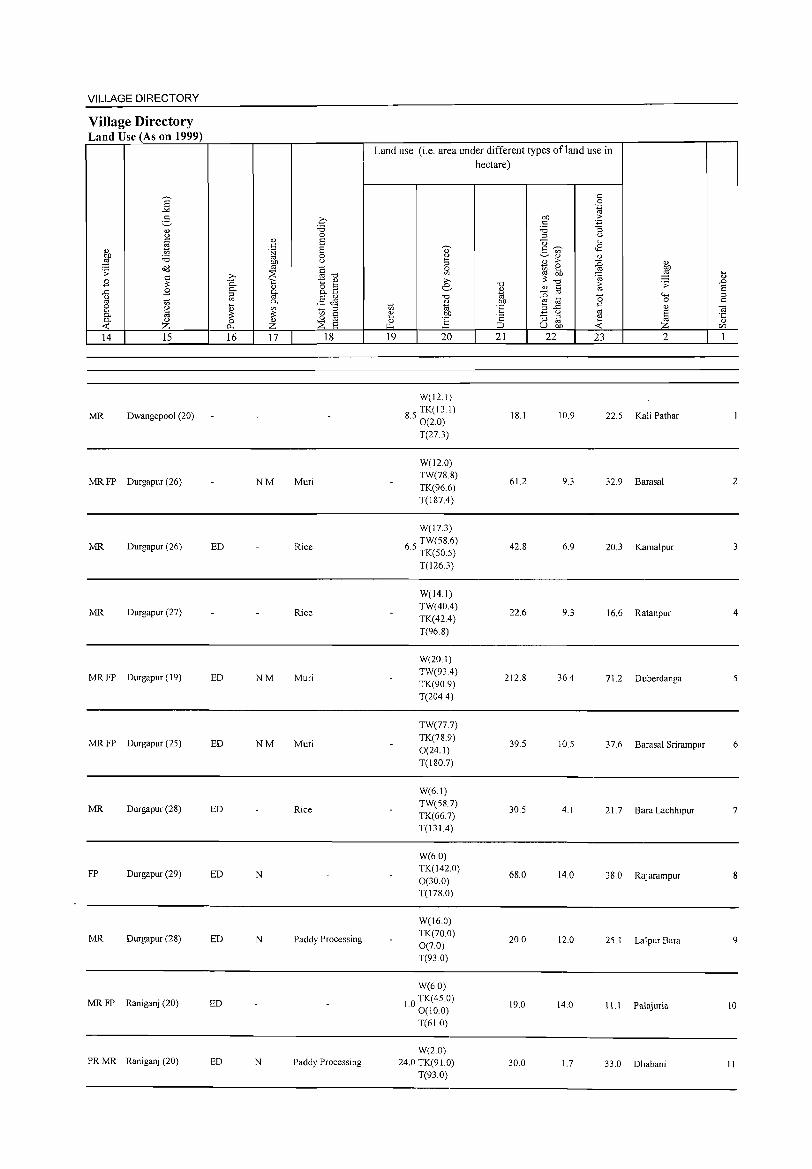
VILLAGE DIRECTORY
Village Directory Land Use (As on 1999)
14 15
MR Dwangepool (20)
MRFP Durgapur (26)
MR Durgapur (26)
MR Durgapur (27)
MRFP Durgapur (19)
MRFP Durgapur (25)
MR Durgapur (28)
FP Durgapur (29)
MR Durgapur (28)
MRFP Raniganj (20)
PRMR Raniganj (20)
16 17 18
NM Muri
ED Rice
Rice
ED NM Muri
ED NM Muri
ED Rice
ED N
ED N Paddy Processing
ED
ED N Paddy Processing
Land use (i.e. area under different types of land use in hectare)
19 20 21 22 23
W(12.1)
85 TK(131) . 0(20) 18.1 10.9 22.5
T(27.3)
W(120) TW(78.8)
61.2 9.3 32.9 TK(96.6) T(187A)
W(17.3)
65 TW(58.6) . TK(50.5)
42.8 6.9 20.3
T(126.3)
W(14.1) TW(40A)
22.6 9.3 16.6 TK(42A)
T(96.8)
W(20.1) TW(93A)
212.8 36A 712 TK(90.9) T(204A)
TW(77.7) TK(78.9)
39.5 10.5 37.6 0(24.1) T(180.7)
W(6.1) TW(58.7)
30.5 4.1 21.7 TK(66.7) T(131A)
W(6.0) TK(142.0)
68.0 14.0 38.0 0(30.0) T(178.0)
W(16.0) TK(70.0)
20.0 12.0 25.1 0(70) T(93.0)
W(6.0)
1.0 TK(45.0) 0(100)
19.0 14.0 11.1
T(61.0)
W(2.0) 24.0 TK(91.0) 30.0 1.7 33.0
T(93.0)
2
Kali Pathar
Barasal 2
Kamalpur
Ratanpur 4
Duberdanga
Barasal Sri ram pur 6
Bara Lachhipur 7
Rajarampur 8
Lalpur Bara 9
Palajuria 10
Dhabani II
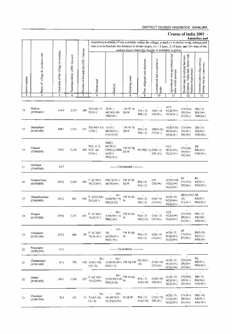
12
13
14
15
16
17
18
19
20
21
22
23
<l)
"'" o u <= o .~
u
.3 ~
~ ;; ..., o <l)
§ Z 2
Panktor
(01990400)
Basudebpur (01990500)
Chausal (01990600)
Adwitpur
(01990700)
Srichandrapur (01990800)
Ghanashyampur
(01990900)
Phuljam (01991000)
Anandapur (01991100)
Brajarajpur (01991200)
Chaitanyapur (01991300)
Dethol (01991400)
Chandipur (0199IS00)
3
344.0
298.1
270.0
65.7
256.2
101.2
259.0
257.2
S7.1
43.1
166.1
70.5
V> ::l
ie <l)
U
o Cl
U-
4
2,217
1,433
2,156
1,126
961
1,352
446
770
1,190
134
DISTRICT CENSUS HANDBOOK: BANKURA
Census of India 2001 -Amenities and
Amenities available (if not available within the village, a dash (-) is shown in the column and
next to it in brackets the distance in broad ranges viz.< 5 kms., 5-10 kms. and 10+ kms of the
nearest place where the facility is available isgiven
5 6 7
389 P(2)M«5) H(10+) C(lO+) MCW(5-IO)
PHCC10+)
271 P(2) M(5-10) H(IO+) C(lO+) MCW(IO+)
PHCC5-10)
DH(2)
I on <= :;; <= 8 8 9
TWWTK SS-W PO« 5)
PH«5)
TWWTK SS-W PO« 5)
PH« 5)
'" > .~ 0-o 6 u
§ -a .~
'" E v>
5§ U..o
10
CM« 5) CP(IO+)
11
ACS NCS(10+)
OCS(IO+)
12
CV(JO+) SP(IO+) ST(JO+)
CM(5-10) ACS(5-10) CV(IO+) cpc 10+) NCS( 10+ ) SP(J 0+ )
OCS(IO+) ST(10+)
P(2) M S
368 PUC AC C(10+)
MCW(2) W CWC(2) CHW TW TK H(10+) SS-W
PO PH« 5) CM« 5) CP(10+)
ACS NCS(IO+) OCS(10+)
CV(10+) SP(JO+)
ST(10+)
190 P AC M(5-10) CC10+)
PHCC10+)
-------- Uninhabited ------------
PHCH(10+) MCW(10+)
~~:TK PO«5) PH«5)
CM CP(IO+)
ACS(5-10) ~~(10+) NCS(IO+) ST(IO+) OCS(IO+)
13
BS«5) RS(lO+) NW(IO+)
BS«5) RS(lO+)
NW(10+)
BS RS(IO+) NW(IO+)
BS RS(JO+) NW(IO+)
- H« 156 P AC(2) M( < 5) MCW( < 5) TW W SS- POe < 5) ACS« 5)
NCS(IO+) OCS(10+)
SP(2) CV(5 BS
5)C(10+) PHCC5-10) W PH«5) CM«5) CP(10+)
263 P ACM(S-10) CC10+)
9S P AC M(S-10) C(lO+)
P« 138 5)M(5-10)
CCS-10)
237 P ACM(S-10) CCIO+)
P« 31 5)M(5-10)
q< 5)
H« TW W SS-5) MCW« 5) W PO« 5) PHCC10+) PH(5-1O)
H(S-
10) MCW(10+) PHC(IO+)
TWWSS-
W PO«5) PH«5)
-------- Uninhabited ------------
CM«S) CP(10+)
CM«5) CP(IO+)
ACS NCS(10+)
OCS(IO+)
ACS«5) NCS(IO+) OCS(10+)
- H« POPH(5 ACS«5) 5)MCW(10+) TW SS-TW 10) - CM(5-10) NCS(IO+)
PHCC<5) CP(IO+) OCS(1O+)
- H« 5) MCW(5-10) TW W SS- PO« 5)
PHCC5-10) W PH(5-10)
H(5-
10) MCW(5- W SS-W 10) PHq10+)
PO«5) PH(5-10)
ACS«5) CM(5-10) NCS(10+) CP(IO+) OCS(10+)
ACS« 5) CM(5-10) NCS(10+)
CP(10+) OCS(IO+)
10) RS(10+)
ST(IO+) NW(10+)
CV(lO+) SP(10+)
ST(10+)
SP
CV(IO+) ST(JO+)
CV(1O+) SP(lO+)
ST(10+)
CV(IO+) SP(lO+) ST(10+)
CV(10+) SP(10+) ST(lO+)
BS«5) RS(IO+) NW(10+)
BS(S-10)
RS(lO+) NW(lO+)
BS RS(IO+) NW(10+)
BS« 5) RS(10+) NW(10+)
8S(5-1O) RS(IO+)
NW(lO+)
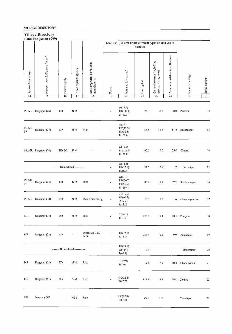
VILLAGE DIRECTORY
Village Directory Land Use (As on 1999)
E "" 5 " " ~ " bIJ :.a ~ di:l .;; c
B ;;: .c B (.)
'" '" ~ " til a. " « z 14 15
PR MR Durgapur (26)
~~ MR Durgapur (27)
PR MR Ourgapur (24)
c :.a 0
" c E '§i E
0 OJ) u '" §-o >. :::s
0.. C:; t " a. " aE1 i;l a. '" §J1 a.
[i '" ~ ::> ;;: ;;: til 0 " 0 p.. z :::s E 16 17 18
ED NM
ED NM Muri
ED EO NM
-------- Uninhabited ------------
~MR Durgapur(21) ED NM Rice
PR MR Durgapur (IS) ED NM Paddy Processing
MR Durgapur (34) ED NM Rice
MR Durgapur (25) ED Processed Cow Milk
-------- Uninhabited ------------
MR Durgapur (35) ED NM Rice
MR Durgapur (41 ) ED NM Rice
MR Durgapur (40) NM Rice
Land use (i.e. area under different types ofland use in hectare)
'" ~ ~
19
" ~ :J
~ >. e
-0
" ~ bIJ
] 20
W(12.0) TK(1310) T(143.0)
W(5.S) TW(45.5) TK(5S.3) T(109.6)
W(IO.0) TK(116.0) T(126.0)
W(12.6) TK(12.1) T(24.7)
W(6.1) TW(56.7) TK(56.7) T(119A)
GC(IO.O) TK(60.8) 0(17.2) T(88.0)
GC(4.1) T(4.1)
TK(12.1) T(12.1)
TK(23.5) WF(23.5) T(46.9)
GC(7.9) T(7.9)
GC(22.2) T(22.2)
GC(17.8) T(17.8)
-0
~ CJl
"E '2 ;::J
21
72.0
65.8
1000
37.0
80.9
10.0
226.9
234.S
10.2
17.5
117.S
49.5
c 0
".g bIJ "_b C :.a :; :J " U ~
2- ~ <8 '" Q) Q)
~ > :0 Q)
~ ~ '" ~ ;;: 'a -0
~ .;;
Q) til :0 '0 "'" e til 0 .c c
" 3 u '" ~ :; ::> ~ '" U bIJ Z
22 23 2
310 98.0 Panktor
38.5 84.2 Basudebpur
19.0 25.0 Chausal
2.8 12 Adwitpur
18.2 37.7 Srichandrapur
1.6 1.6 Ghanashyampur
S.I 20.0 Phuljam
0.5 9.9 Anandapur
Brajarajpur
7.5 10.3 Chaitanyapur
5.3 20.S Dethol
3.2 Chandipur
[i .D s ::> c
~ " CZl
1
12
13
14
15
16
17
18
19
20
21
22
23
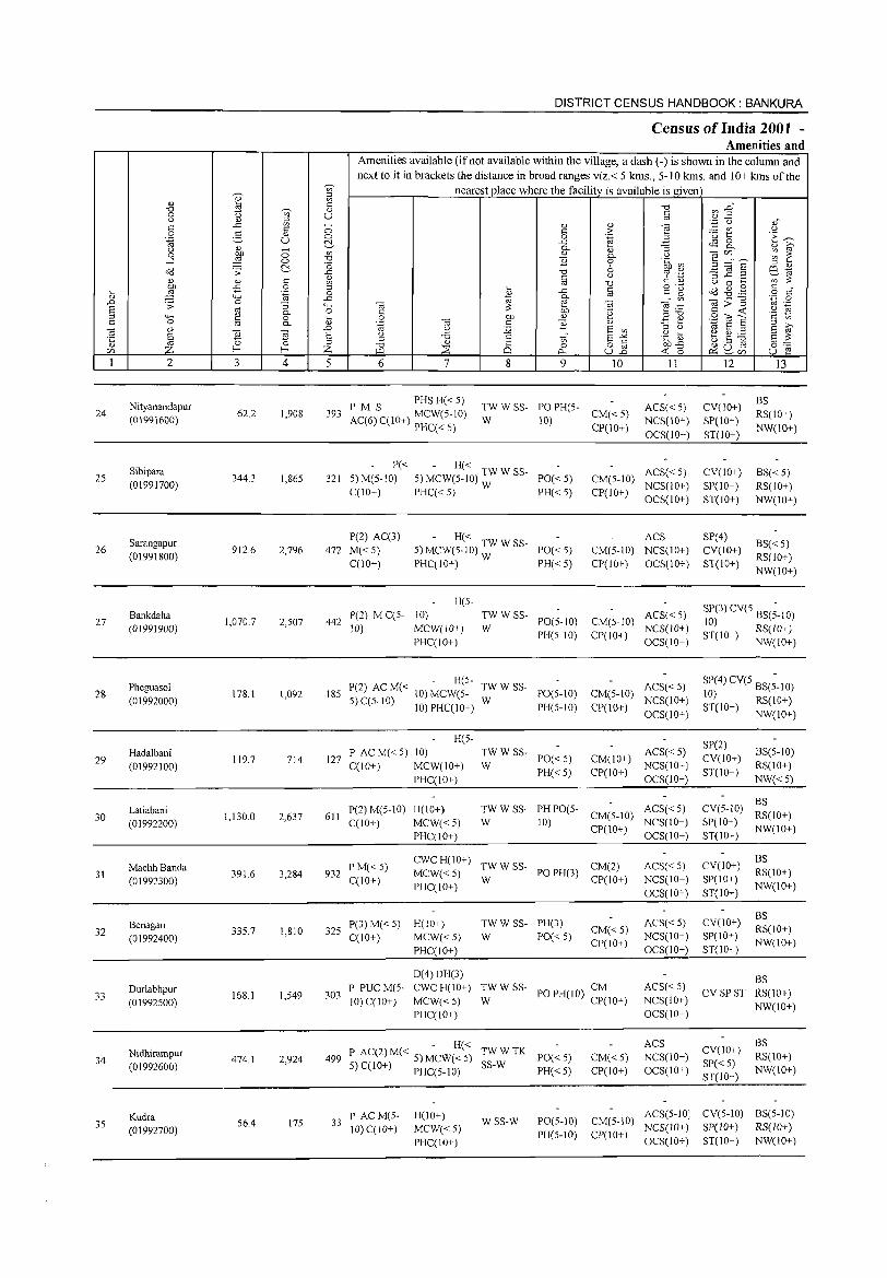
DISTRICT CENSUS HANDBOOK: BANKURA
Census of India 2001 -Amenities and
Amenities available (if not available within the village, a dash (-) is shown in the column and next to it in brackets the distance in broad ranges viz. < 5 kms., 5-10 kIns. and 10+ kIns of the
'Ui' nearest place where the facility is available is given O? ::l
'" U)
~ 0: "0 ~ :2
h
"0 'Ui' <!) 0 u § (J <1> i;l 0: ..c ~ <!) <!) "§
.~ C) <!)"
0 e- o: 0 0: ;> ~ U) (J <!) 0 0 .~ ::l ·0 1:: .~ ~
.~ U ~ ..c ;g ~ 8.. (J '" ~ 0- <!) iO' 0 ~ 0 U) <!) <!)
(J 12 (/),, __ ~ ~ 0--l 0 "0 B 0 .~ ~
~ 0 '" E =a § ::l <!)
<i<l .;; ..c "0 % .~ eta ~ <!) 0: <1> C (J ;:::l ..c: ._
U) ~ U) oj "0 U 0 ... -5 0 ::l ... 0: o .- ~ .g . .g 0: "
~ :§ ""' .~ 0 ~
..c '"
c g o c ..c 0-
" U) .- "0 '';:::::: 0 ..0 .s: 0 :; ""' '" ~ e '" e:g g>~ '" .-E '" 0.. 0 C OJ) '2 '2 ~ ::l 4-< e 0 ~ 0 OJ) <l) .E ~ 9~S 0: 0 '" 0- '-§ '" c B <l) E iO' '"
d)
"E1 ..0 (J :;;; E U)
::l (J ~ E ::l
§ "E1 E u '6 c E "'" .~ ~ ~ ~ ~ E ~ '5 ::l U) 0 0 ::l "0 <l)
8 0 8] bh..c ~ U E 0:-::: (/) Z l- I- Z ~ :::8 "" <t: (5 ~ ~(/) u e I 2 3 4 5 6 7 8 9 10 11 12 13
Nityanandapur PM S PHS H« 5)
TWWSS- PO PH(5- ACS« 5) CV(lO+) BS
24 62.2 1,908 393 AC(6) CC 10+) MCW(5-10) CM« 5) RS(lO+) (01991600) W 10) NCS(10+) SP(10+)
PHCC< S) CP(10+) OCS(lO+) ST(IO+)
NW(10+)
Sibipara P« - H« ACS« 5) CV(10+)
25 344.3 1,865 321 5) M(5-10) 5) MCW(5-10) TW W SS- PO«5) CM(5-1O) BS« 5)
(01991700) C(10+) PHCC< 5) W PH«5) CP(lO+)
NCS(10+) SP(10+) RS(10+) OCS(10+) ST(10+) NW(10+)
Sarangapur P(2) AC(3) - H« ACS SP(4)
BS«5) 26 912.6 2,796 472 M«5) 5) MCW(5-10) TW W SS- PO«5) CM(5-1O) NCS(10+) CV(10+)
(01991800) CC 1O+) PHCC10+) W PH«5) CP(10+) OCS(10+) ST(10+)
RS(10+) NW(lO+)
H(5-SP(3)CV(5 BS(;-IO)
27 Bankdaha
1,070.7 442 P(2) M CC5- 10) TW W SS- ACS« 5)
(01991900) 2,507
10) MCW(IO+) W PO(5-10) CM(5-10)
NCS(IO+) 10)
PH(5-10) CP(IO+) ST(IO+) RS(IO+) PHCCIO+) OCS(IO+) NW(IO+)
Pheguaso! - H(5-
TWWSS- ACS« 5) SP(4)CV(5 BS(;-10) 28
(01992000) 178.1 1,092 185 P(2) AC M« lO) MCW(5-
W PO(5-10) CM(5-10)
NCS(IO+) 10)
5) C(5-10) 10) PHC(!O+) PH(5-10) CP(10+) ST(10+) RS(IO+) OCS(IO+) NW(lO+)
H(5-SP(2)
29 Hadalbani
119.7 714 127 P AC M« 5) 10) TW W SS-
PO«5) CM(lO+) ACS«5)
CV(lO+) BS(5-10)
(01992100) C(10+) MCW(IO+) W PH«5) CP(!O+)
NCS(lO+) ST(10+)
RS(10+)
PHC(10+) OCS(lO+) NW« 5)
Latiabani P(2) M(5-1O) H(lO+) TWWSS- PH PO(5- ACS« 5) CV(5-1O) BS
30 1,130.0 2,637 611 CM(5-10) RS(10+) (01992200) C(10+) MCW«5) W 10)
CP(lO+) NCS(lO+) SP(lO+)
NW(lO+) PHC(10+) OCS(lO+) ST(lO+)
CWCH(lO+) TWWSS- CM(2) ACS« 5) CV(10+)
BS
31 MachhBanda
391.6 3,284 932 PM«5)
MCW«5) PO PH(3) RS(10+) (01992300) CCIO+) W CP(IO+) NCS(IO+) SP(IO+)
PHC(IO+) OCS(IO+) ST(10+)
NW(lO+)
TW W SS- PH(3) ACS« 5) CV(10+) BS
Benagari 325
P(3) M« 5) H(IO+) CM«5) RS(10+) 32
(01992400) 335.7 1,810
C(lO+) MCW« 5) W PO« 5) NCS(IO+) SP(lO+)
PHCC1O+) CP(IO+)
OCS(IO+) ST(lO+) NW(IO+)
0(4) OH(3) BS Ourlabhpur P PUCM(5- CWC H(10+) TWWSS- CM ACS« 5)
CV SP ST RS(10+) 33 (01992500)
168.1 1,549 303 10) C(lO+) MCW« 5) W PO PH(lO) CP(10+) NCS(10+)
PHC(lO+) OCS(IO+) NW(lO+)
- H« ACS CV(lO+)
BS Nidhirampur P AC(2) M« 5) MCW« 5) TWWTK
PO« 5) CM«5) NCS(10+) RS(10+) 34 (01992600)
474.1 2,924 499 SS-W SP« 5) 5) C(10+) PHC(5-10) PH«5) CP(lO+) OCS(IO+) ST(lO+)
NW(lO+)
Kudra 56.4 175 33
PAC M(5- H(lO+) WSS-W PO(5-10) CM(5-10)
ACS(5-1O) CV(5-1O) BS(5-10) 35 MCW«5) NCS(lO+) SP(10+) RS(lO+) (01992700) 10) C(lO+)
PH(5-10) CP(!O+) PHC(IO+) OCS(lO+) ST(lO+) NW(lO+)
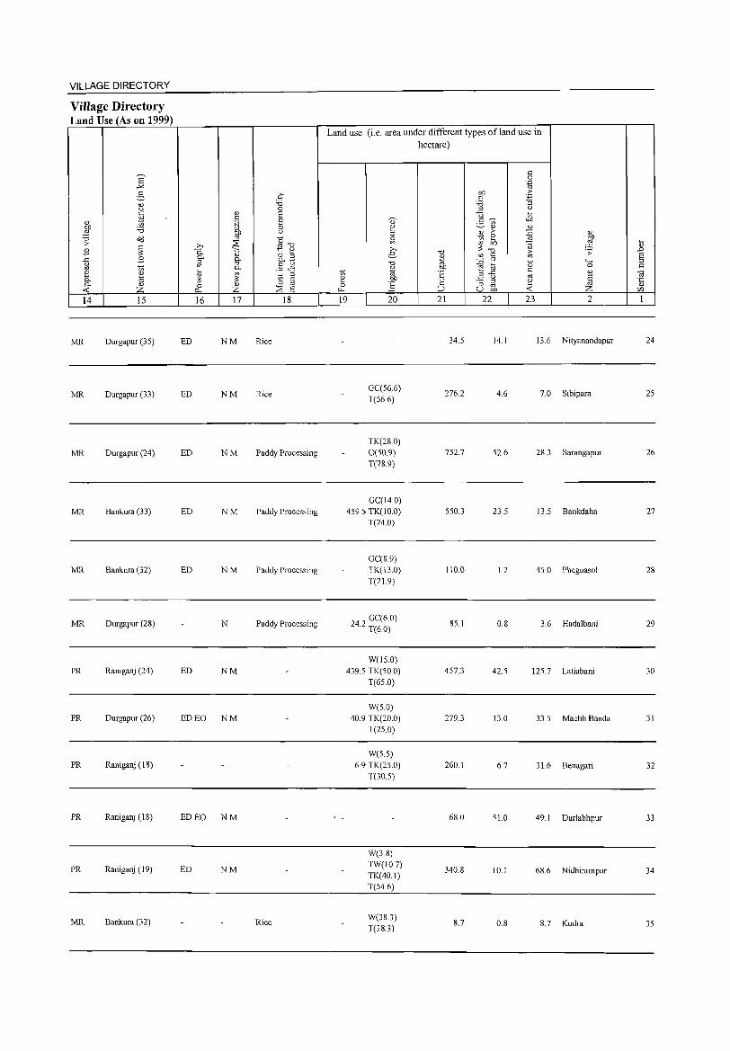
VILLAGE DIRECTORY
Village Directory Land Use (As on 1999)
'" ~ '" z
14 15
MR Durgapur (35)
MR Durgapur (33)
MR Durgapur (24)
MR Bankura (33)
MR Bankura (32)
MR Durgapur (28)
PR Raniganj (24)
PR Durgapur (26)
PR Raniganj (\ 8)
PR Raniganj (18)
PR Raniganj (19)
MR Bankura (32)
16 17 18
ED NM Rice
ED NM Rice
ED NM Paddy Processing
ED NM Paddy Processing
ED NM Paddy Processing
N Paddy Processi ng
ED NM
ED EO NM
ED EO NM
ED NM
Rice
Land use (i.e. area under different types ofland use in hectare)
19 20 21 22 23 2
34.5 14.1 13.6 Nityanandapur
GCC56.6) 276.2 4.6 7.0 Sibipara
T(56.6)
TK(2S.0) 0(50.9) 752.7 52.6 2S.3 Sarangapur T(78.9)
GCCI4.0) 459.5 TK(IO.0) 550.3 23.5 13.5 Bankdaha
T(24 0)
GCCS 9) TK(130) 110.0 1.2 45.0 Pheguasol T(21.9)
242 GCC6.0) . T(6.0)
85.1 0.8 3.6 Hadalbani
W(15.0) 4395 TK(50.0) 457.3 42.5 125.7 Latiabani
T(65.0)
W(5.0) 40.9 TK(20.0) 279.3 13.0 33.5 Machh Banda
T(25.0)
W(5.5) 6.9 TK(25.0) 260.1 6.7 31.6 Benagari
T(30.5)
68.0 51.0 49.1 Durlabhpur
W(3.8) TW(10.7)
340.8 10.1 68.6 Nidhirampur TK(40.1) T(S4.6)
W(38.3) 8.7 0.8 8.7 Kudra
T(38.3)
24
25
26
27
28
29
30
31
32
33
34
35
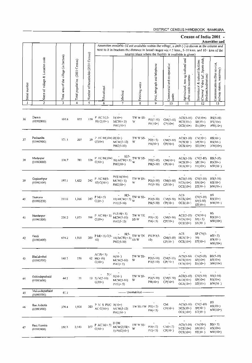
DISTRICT CENSUS HANDBOOK: BANKURA
Census of India 2001 -Amenities and
Amenities available (if not available within the village, a dash (-) is shown in the column and next to it in brackets the distance in broad ranges viz.< 5 kms., 5-10 kms. and 10+ kms of the
'U) nearest place where the facility is available is gi ven
" ;:l
'" 0) l'l c ~ :2" '"d ~ 0) -0
0 " '" u c
" 0) ;:l oj
c .c '" - <l> 0)
] '';:; C)- O)"
c 0 :.::: VI " 0 2- 0) c > .~ i5 E~ '.g u 0 0 .~
~ .c "
0)
0 '" 0. 0) :; "" 0.
0) ~ 0 OJ) 0)
0. " <ijlf} ~ ~ -l ~ 0 '"d E 0 .~ ~ ~ ~"E ~ -0 ;:l 0)
Ccl .;;: -'" '"d 6 oj .- -3 _g .2 ~E
0) 0) '" 0) '" " i: t> gJ ~ '" '" '"d " 0 .... OJ) -B 0 ;:l .... c g 'g Od .g .-@ il ~ 4-< .~ 0 0) -'" oj 0 c"
..D 0 -'" '" 0. '" .- '"d .~ 0 ;;: :; 4-< "@ e "@ E .1:: 1l>~ .~ § oj 0. 0 C :: OJ) .~ " 4-< ~ 0 .... 0 OJ) 0) ;:l'"d
.9 til E a to c 0 0. <l) .~ "@ c E <l) .=: ~ td S ::1
;:l ;>,
] <l)
~ ~ ..0 " :.;;; E '" ;:l " E oj
E E " '5 " .... ~ ~ ~ ;:l .S '" E-'" ~£ E ::
~ ;:l <l) o c ~ U .s z '"d is 0 0:-:::
CIl I--< I--< W ~ P; ull « 0 ~ ~CIl u e 1 2 3 4 5 6 7 8 9 10 11 12 13
36 Damra
104.6 872 139 P ACM(5- H(IO+) TW W SS- ACS(5-lIl) CV(IO+) BS(5-10)
(01992800) 10) C(10+) MCW«5) W PO(5-IO) CM(5-IO)
NCS(IO+) SP(10+) RS(IO+) PHC(IO+)
PH(IO+) CP(IO+) OCS(IO+) ST(IO+) NW(IO+)
37 Pachamba
171.1 207 29 P AC M(IO+) H(IO+) TWWSS- ACS(5-1O) CV(IO+) BS(IO+)
PO«5) CM(5-1O) (01992900) C(lO+) MCW(5-10) W PH(10+) CP(IO+)
NCS(IO+) SP(IO+) RS(IO+) PHC(5-1O) OCS(IO+) ST(IO+) NW(lO+)
38 Madanpur
136.7 781 126 P ACM(IO+) 10)~cw7~5-) TWWSS- PO(5-1O) CM(IO+) ACS(5-1O) CV(5-10) BS(5-10)
(01993000) C(lO+) PHC(IO+) 5 W PH(5-10) CP(IO+) NCS(IO+) SP(lO+) RS(IO+) OCS(IO+) ST(IO+) NW(IO+)
Gopinathpur P ACM(S-PHSH(IO+)
TWWSS- ACS(5-10) CV(5-to) BS(5-1O) 39 197.1 1,422 242 MCW«5) PO(5-10) CM(5-10)
(01993100) 10) C(lO+) PHC(IO+)
W PH(5-1O) CP(IO+)
NCS(10+) SP(lO+) RS(lO+) OCS(IO+) ST(10+) NW(lO+)
Durnuria PM«S) - H(S- ACS
CV(S-10) BS
40 211.0 1,366 247 10) MCW( < S) ~W W SS- PO(S-IO) CM(S-IO) NCS(IO+) RS(lO+) (01993200) C(10+)
PHC(5-10) PH(S-IO) CP(IO+) OCS(IO+) SP(5-10)
NW(IO+) ST(IO+)
P AC M« 5) PHS H« 5) ACS(5-10) CV(lO+) BS
Nandanpur 236.2 1,023 198
TWWTK PO«S) CM(5-1O) RS(lO+) 41
(01993300) C(lO+) MCW(S-10) SS-W NCS(IO+) SP« S) PHC(5-IO) PH«5) CP(IO+)
OCS(lO+) ST(lO+) NW(IO+)
- H(5-PH PO(5-
ACS SP CV(5-BS« S)
42 Deuli
674.2 1,929 303 P M« 5) C(5- 10) MCW« S) TW W TK CM(5-10) NCS(IO+) 10) (01993400) 10) PHC(5-10) SS-W 10)
CP(lO+) OCS(lO+) ST(JO+) RS(lO+)
NW(IO+)
Bhalukathol ACP«S)
H(IO+) TWWSS- ACS(S-IO) CV(S-10) BS(S-IO) 165.3 370 62 M(S-IO) PO(5-IO) CM(5-10) 43
(01993S00) MCW(S-IO) W NCS(IO+) SP(IO+) RS(lO+) C(lO+)
PHC«S) PH(5-10) CP(IO+)
OCS(IO+) ST(IO+) NW(lO+)
Gobindapurbaid 13
- P« H(I;+) TWWSS-PO(S-IO) CM(S-IO)
ACS(S-IO) CV(5-10) BS(S-IO) 44 44.S 71 S) M(5-10) MCW(5-1O) W NCS(lO+) SP(IO+) RS(lO+) (01993600) PH(IO+) CP(10+) C(IO+) PHC« 5) OCS(IO+) ST(IO+) NW(IO+)
45 Mukundapurbaid
61.1 -------- Uninhabited ------------(01993700)
ACS(S-IO) CV(S-IO) BS
Ban Ashuria PM S PUC H(10+) TW SS-TW PO« 5)
CM RS(IO+) 46 376.4 1,938 383 ACC(IO+) MCW(5-IO) CP(lO+) NCS(IO+) SP(IO+) (01993800) PH«5) NW(IO+)
PHC(IO+) OCS(lO+) ST(IO+)
DDH TWWSS- ACS(S-IO) CV(lO+) BS«5) Bara Kumira 3S7 P AC M« 5) MCW(2) H« PO« S) CM« 5) 47 160.2 2,143 W NCS(lO+) SP(lO+) RS(IO+) (01993900) C(IO+) 5) PHC(IO+) PH«5) CP(IO+)
OCS(IO+) ST(IO+) NW(IO+)
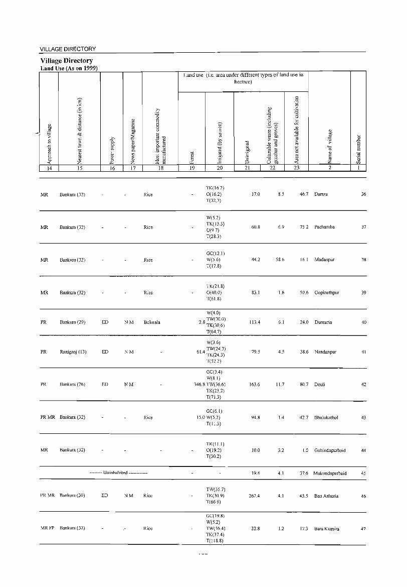
VILLAGE DIRECTORY
Village Directory Land Use (As on 1999)
14 15
MR Bankura (32)
MR Bankura (32)
MR Bankura (32)
MR Bankura (32)
PR Bankura (29)
PR Raniganj (13)
PR Bankura (26)
PR MR Bankura (32)
MR Bankura (32)
16 17 18
Rice
Rice
Rice
Rice
ED NM Belmala
ED NM
ED NM
Rice
•.•..... Uninhabited ........... .
PR MR Bankura (30) ED NM Rice
MR FP Bankura (32) Rice
Land use (i.e. area under different types ofland use in hectare)
19 20
TK(16.2) 0(16.2) T(32.3)
W(S.2) TK(13.3) 0(97) T(28.3)
GCCI2.1) W(S.6) T(17.8)
TK(21.8) 0(40.0) T(61.8)
W(4.0)
28 TW(30.0) . TK(30.6)
T(64.7)
W(3.6)
614 TW(24.3) . TK(24.3)
T(S2.2)
GCC3.4) W(81)
346.8 TW(36.6) TK(232) T(71.3)
GCC6.1) 15.0 W(52)
T(IL3)
TK(I1.I) 0(19.2) T(30.2)
TW(35.7) TK(309) T(66.6)
GCCI9.8) W(5.2) TW(56.4) TK(37.4) T(118.8)
21
17.0
60.8
44.2
83.1
113.4
79.S
163.6
94.8
10.0
19.4
262.4
22.8
22 23 2
8.S 46.7 Damra
6.9 7S.2 Pachamba
58.6 16.1 Madanpur
1.6 SO.6 Gopinathpur
6.1 24.0 Dumuria
4.5 38.6 Nandanpur
11.7 80.7 Deuli
1.4 42.7 Bhalukathol
3.2 1.0 Gobindapurbaid
4.1 37.6 Mukundapurbaid
4.1 43.5 Ban Ashuria
1.2 17.3 Bara Kumira
36
37
38
39
40
41
42
43
44
45
46
47
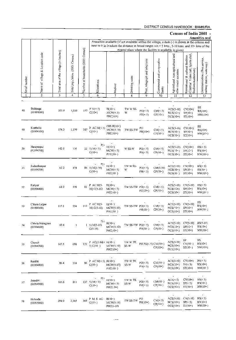
48
49
50
51
52
53
54
55
56
57
58
2
Beldanga (01994000)
Kusthalia (01994100)
Narayanpur (01994200)
SudarshanpUT (01994300)
Kalipur (01994400)
Chhota Lalpur (01994500)
Chhota Nabagram (01994600)
Chururi (01994700)
Raidihi (01994800)
Jenadihi (01994900)
Bishinda (01995000)
3 4
201.9 1,010
574.3 1,579
142.6 126
63.2 438
68.9 470
115.1 554
60.4
145.5 698
86.4 514
181.6 811
394.0 2,145
DISTRICT CENSUS HANDBOOK: BANKURA
Census of India 2001 -Amenities and
Amenities available (if not available within the village, a dash (-) is shown in the column and next to it in brackets the distance in broad ranges viz.< 5 kms., 5-10 kms. and 10+ kms of the
nearest place where the facility is available is given
5 6 7
157 PM« 5) C(lO+)
H(10+)
MCW«5) PHC(IO+)
P ACM«5) PHSH(lO+) 287 C(1O+) MCW(5-10)
PHC(IO+)
- P« -22 5) M« 5) H(IO+)
C(IO+) MCW« 5) PHC(IO+)
- P« -84 5)M(5-10) H(IO+)
C(lO+) MCW«5) PHC(IO+)
81 P ACM(5-10) C(5-10)
113 PACM(5-10)C(5-10)
H(IO+)
MCW«5) PHC(lO+)
H(lO+) MCW(5-10) PHC(IO+)
- P« -H(IO+)
5) M(5-10) MCW(S-IO) C(5-10) PHC(IO+)
122 P AC(2) M« H(IO+) 5)C(10+) MCW(5-IO)
PHC(lO+)
86 P AC M« 5) H(IO+) C(IO+) MCW(S-IO)
PHC(IO+)
- P« H(1;+) 132 5) M« 5) MCW« 5)
C(10+) PHC(IO+)
369 P M S AC H(IO+) C(lO+) MCW(5-10)
PHC(5-1O)
8 9
TWWSS-W PO«5)
PH«5)
TWSS-TW PO PH(IO+)
WSS-W
TWWSS-W
PO«5) PH«5)
PO«5) PH«5)
TW SS-TW PO« 5) PH(lO+)
TW SS-TW PO« 5) PH(IO+)
TW SS-TW PO« 5) PH(IO+)
10
CM«5) CP(10+)
CM«5) CP(lO+)
CM«5) CP(IO+)
11 12
ACS(5-1O) CV(IO+) NCS(lO+) SP(IO+) OCS(IO+) ST(IO+)
ACS(5-10) CV(IO+) NCS(IO+) SP(IO+) OCS(10+) ST(10+)
ACS(5-IO) CV(IO+) NCS(IO+) SP(IO+) OCS(IO+) ST(IO+)
13
BS RS(IO+) NW(IO+)
BS RS(IO+) NW(lO+)
BS«5) RS(lO+) NW(IO+)
CM(5-10) ACS(5-IO) CV(IO+) NCS(IO+) SP(IO+)
CP(IO+) OCS(IO+) ST(IO+)
BS«5) RS(10+) NW(IO+)
CM«5) CP(lO+)
CM«5) CP(10+)
CM«5) CP(IO+)
ACS(5-10) CV(S-IO) BS«5) NCS(lO+) SP(IO+) RS(10+) OCS(10+) ST(10+) NW(10+)
BS ACS(5-10) CV(5-10) RS(IO+) NCS(10+) SP(lO+) NW(IO+) OCS(IO+) ST(IO+)
ACS(5-10) CV(5-1O) BS(5-1O) NCS(lO+) SP(lO+) RS(IO+) OCS(IO+) ST(lO+) NW(IO+)
SP TS:; TK PH PO« 5) CM(IO+) ACS(5-IO) CV(lO+)
CP(IO+) NCS(IO+) ST(IO+) OCS(IO+)
BS RS(IO+) NW(IO+)
TWWTK SS-W PO« 5)
PH«5)
TWWTK SS-W PO« 5)
PH«5)
PO TW SS-TW PH( 10+ )
CM(IO+) ACS(5-10) CV(IO+) NCS(10+) SP« 5)
CP(IO+) OCS(IO+) ST(IO+)
CM(IO+) ACS« 5) CP(IO+) NCS(IO+)
OCS(IO+)
CV(IO+) SP«5) ST(IO+)
BS«5) RS(IO+) NW(IO+)
BS« 5) RS(IO+) NW(IO+)
CM«5) CP(IO+)
ACS(5-10) CV(5-1O) SS( < 5) NCS(IO+) SP« 5) RS(IO+) OCS(IO+) ST(IO+) NW(IO+)
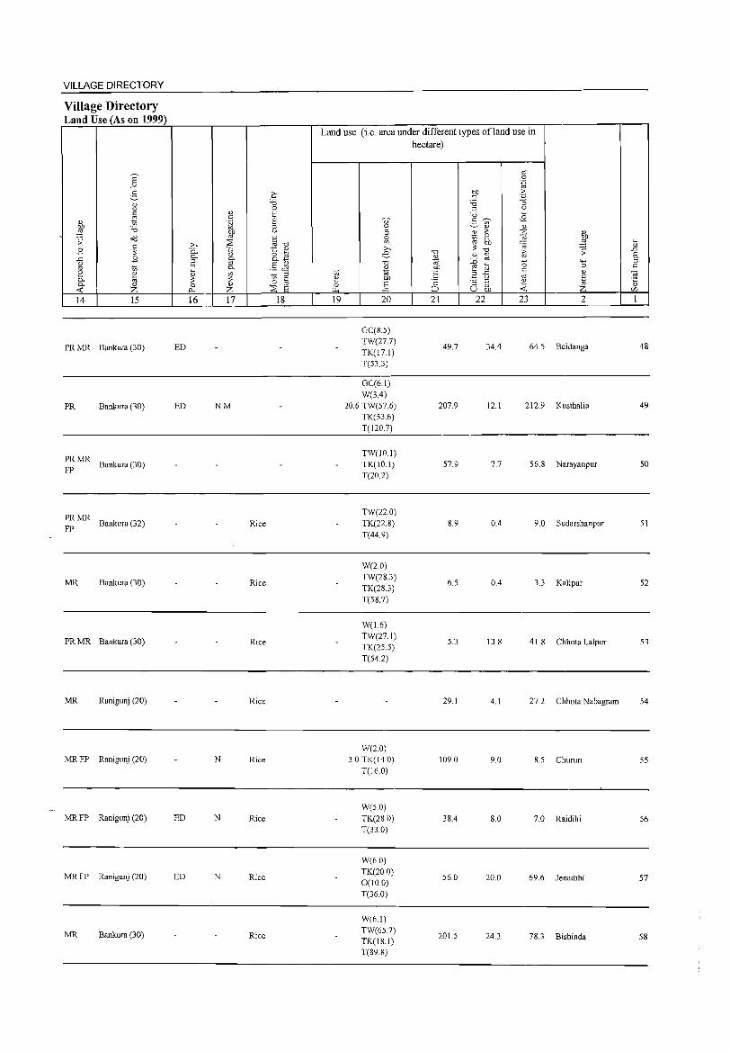
VILLAGE DIRECTORY
Village Directory Land Use (As on 1999)
14 15
PR MR Bankura (30)
PR Bankura (30)
~~ MR Bankura (30)
~~ MR Bankura (32)
MR Bankura (30)
PR MR Bankura (30)
MR Ranigunj (20)
MRFP Ranigunj (20)
MRFP Ranigunj (20)
MRFP Ranigunj (20)
MR Bankura (30)
16 17 18
ED
ED NM
Rice
Rice
Rice
Rice
N Rice
ED N Rice
ED N Rice
Rice
Land use (i.e. area under different types ofland use in hectare)
19 20
GC(S.5) TW(27.7) TK(17.1) T(53.3)
GC(6.1) W(3.4)
20.6 TW(57.6) TK(53.6) T(120.7)
TW(10.1) TK(10.1) T(202)
TW(22.0) TK(22.8) T(44.9)
W(2.0) TW(2S.3) TK(28.3) T(58.7)
W(1.6) TW(27.1) TK(25.5)
T(54.2)
W(20) 3.0 TK(14.0)
T(160)
W(5.0) TK(28.0) T(33.0)
W(6.0) TK(20.0) 0(10.0) T(36.0)
W(6.1) TW(65.7) TK(lS.I) T(89.8)
21 22
49.7
207.9
57.9
8.9
6.5
5.3
29.1
109.0
38.4
56.0
201.5
23 2
34.4 64.5 Beldanga
12.1 212.9 Kusthalia
7.7 56.8 Narayanpur
0.4 9.0 Sudarshanpur
0.4 3.3 Kalipur
13.8 41.8 Chhota Lalpur
4.1 27.2 Chhota Nabagram
9.0 8.5 Chururi
8.0 7.0 Raidihi
20.0 69.6 Jenadihi
24.3 78.3 Bishinda
48
49
50
51
52
53
54
55
56
57
58
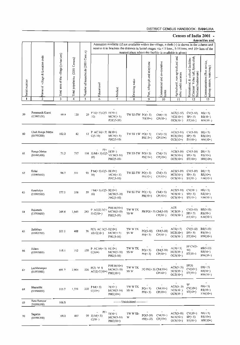
59
60
61
62
63
64
65
66
67
68
69
70
2
Paramanik Kunri
(01995100)
Chak Ranga Metya (01995200)
Ranga Metya
(01995300)
Kelai (01995400)
Kenthalya
(01995500)
Rajamela (01995600)
Balikhun
(01995700)
Sidara (01995800)
Lachhmanpur (01995900)
Bharadihi (01996000)
Bara Rampur (01996100)
Sagarya (01996200)
3
69.9
102.0
71.3
98.7
177.1
348.8
333.1
118.1
691.7
115.7
106.8
68.0
~
'" :::l
'" t: Cl)
U
4
120
82
717
511
338
1,645
488
712
2,964
1,729
467
DISTRICT CENSUS HANDBOOK: BANKURA
Census of India 2001 -Amenities and
Amenities available (if not available within the village, a dash (-) is shown in the column and next to it in brackets the distance in broad ranges viz.< 5 kms., 5-10 kms. and 10+ kms of the
nearest place where the facility is available is given
5 6 7
29 PM«5}C(5- H(lO+) 10) MCW«5)
PHCC5-IO)
12 P AC M« 5) H(IO+) CC5-1O) MCW« 5)
PHC(5-10)
- P« H(I~+) 116 5)M«5)C(5' MCW(5_10)
10) PHC(5-1O)
93 P M« 5) C(5- H(10+) 10) MCW«5)
PHC(5-10)
59 P M« 5) C(5- H(IO+) 10) MCW(5-10)
PHC(5-10)
PHS H(IO+) 283 P AC(2) M« MCW(5-10)
5) C(IO+) PHCC5-1O)
76 P(2) AC M(5- H(1 0+) 10) C(IO+) MCW« 5)
PHCC5-10)
130 P AC M« 5) H(IO+) C(10+) MCW(5-10)
PHC(5-10)
PHS H(IO+) 526 P(2) M S MCW(5-10)
AC(2) C(10+) PHCCIO+)
330 P M« 5) CCIO+)
H(IO+) MCW(5-10) PHC(tO+)
8
'" o (:l..;
9
TW SS-TW PO« 5) PH(IO+)
TW SS-TW PO« 5) PH(IO+)
TW SS-TW PO« 5) PH(IO+)
TW SS-TW PO« 5) PH(IO+)
TW SS-TW PO« 5) PH(IO+)
10
CM«5) CP(IO+)
CM«5) CP(IO+)
CM«5) CP(IO+)
CM«5) CP(IO+)
CM«5) CP(IO+)
II 12 13
ACS(5-10) CV(5-IO) BS«5) NCS(IO+) SP« 5) RS(IO+) OCS(IO+) ST(IO+) NW(IO+)
ACS(5-10) CV(5-1O) BS«5) NCS(IO+) SP« 5) RS(IO+) OCS(IO+) ST(IO+) NW(IO+)
ACS(5-1O) CV(5-1O) BS« 5) NCS(10+) SP«5) RS(IO+) OCS(IO+) ST(IO+) NW(IO+)
ACS(5-IO) CV(5-1O) BS« 5) NCS(IO+) SP«5) RS(IO+) OCS(IO+) ST(IO+) NW(IO+)
ACS(5-IO) CV(IO+) NCS(IO+) SP« 5) OCS(IO+) ST(IO+)
ACS
BS«5) RS(IO+) NW(IO+)
TWWTK SS-W PH PO« 5) CM(5-1O) NCS(10+)
CP(IO+) OCS(10+)
CV(5-10) BS(5-10) SP« 5) RS(IO+)
TWWTK PO(5-tO)
PH«5) SS-W
TWWTK SS-W PO« 5)
PH«5)
ACS«5) CM(5-tO) NCS(IO+) CP(IO+) OCS(10+)
ACS« 5) CM(5-10) NCS(IO+) CP(IO+) OCS(IO+)
ST(IO+) NW(10+)
CV(5-10) BS(5-10)
SP« 5) RS(10+) ST(IO+) NW(IO+)
SP CV(5- 8S(5-1O) 10) ST(IO+) RS(10+)
NW(IO+)
~~::TK PO PH«5) CM(IO+) CP(IO+)
SP(3) ACS(5-IO) Cy(tO+) NCS(tO+) ST(IO+) OCS(IO+)
BS«5) RS(IO+) NW(tO+)
TWWTK SS-W PO« 5)
PH«5)
CM(IO+) CP(IO+)
SP ACS(5-IO) CV(IO+) NCS(IO+) ST(IO+) OCS(IO+)
BS« 5) RS(IO+) NW(tO+)
-------- Uninhabited ------------
- P« H(I~+) 99 5)M«5) MCW(5-10)
C(10+) PHC(10+)
TWWSS-W PO(5-tO)
PH(5-10)
ACS(5-IO) CV(IO+) CM(IO+) NCS(10+) SP« 5) CP(IO+) OCS(IO+) ST(IO+)
BS« 5) RS(IO+) NW(IO+)
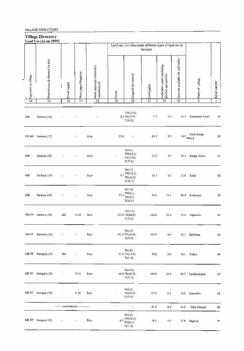
VILLAGE DIRECTORY
Village Directory Land Use (As on 1999)
14 15
MR Bankura (29)
PR MR Bankura (27)
MR Bankura (30)
MR Bankura (29)
MR Bankura (29)
MR FP Bankura (30)
MR FP Raniganj (16)
MRFP Raniganj (15)
MR FP Raniganj (IS)
MRFP Raniganj (18)
16 17
Rice
Rice
Rice
Rice
ED NM Rice
Rice
ED Rice
NM Rice
NM Rice
-------- Uninhabited ------------
MR FP Raniganj (20) Rice
18
Land use (i.e. area under different types ofland use in hectare)
19 20
TW(27.9) 0.3 TK(27 9)
T(55.S)
35.6
W(4.1) TW(1S.2) TK(15.6) T(37.S)
W(2.3) TW(IS.2)
9.7 TK(16.2)
T(36.7)
W(2.0)
474 TW(8.1) . TK(8.1)
T(18.2)
W(130) 103.0 TK(60 0)
T(73.0)
W(3.0) 171.0 TK(40.0)
T(43 0)
W(5.0) 11.0 TK(16.0)
T(21.0)
W(IO.O) 64.0 TK(45.0)
T(55.0)
W(60) TK(26.0) T(32.0)
W(2.8)
65 TW(IO.I) . TK(8.1)
T(21.0)
21
1.3
43.3
13.0
14.2
52.6
126.0
103.0
70.0
498.0
65.4
84.8
18.7
22 23
2.0
S.9
4.1
4.5
12.1
22.0
6.0
6.0
20.0
2.4
8.0
4.0
2
10.5 Paramanik Kunri
14.2 Chak Ranga Metya
16.5 Ranga Metya
33.6 Kelai
46.8 Kenthalya
24.8 Rajamela
10.1 Balikhun
10.1 Sidara
54.7 Lachhmanpur
16.0 Bharadihi
14.0 BaraRampur
17.8 Sagarya
59
60
61
62
63
64
65
66
67
68
69
70
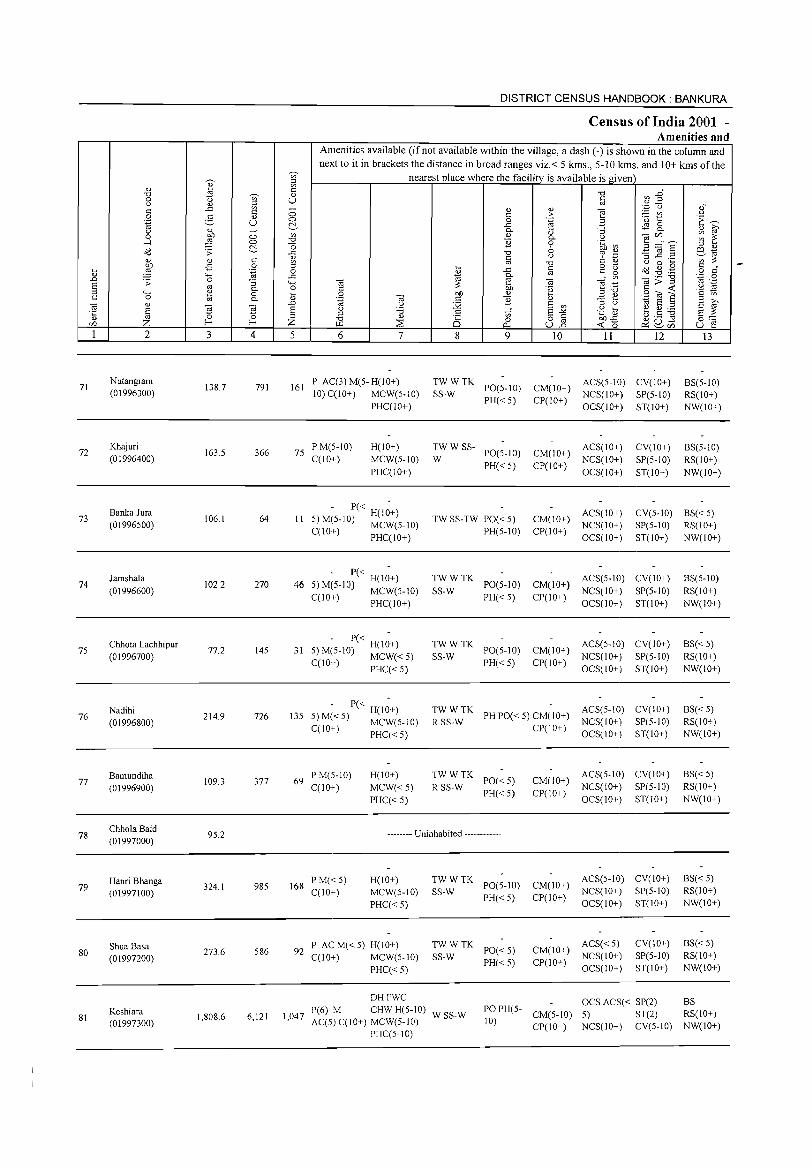
71
72
73
74
7S
76
77
78
79
80
81
2
Nutangram (01996300)
Khajuri
(01996400)
Banka Jura (01996500)
Jamshala
(01996600)
Chhota Lachhipur
(01996700)
Nadihi
(01996800)
Bamundiha
(01996900)
ChholaBaid (01997000)
Hanri Bhanga
(01997100)
ShuaBasa (01997200)
Keshiara (01997300)
3
138.7
163.5
106.1
102.2
77.2
214.9
109.3
9S.2
324.1
273.6
1,808.6
~ t::
'" U
o o ~ t:: o
'-g :; 0.. o 0..
4
791
366
64
270
14S
726
377
98S
S86
6,121
DISTRICT CENSUS HANDBOOK: BANKURA
Census of India 2001 -Amenities and
j
Amenities available (if not available within the village, a dash (-) is shown in the column and next to it in brackets the distance in broad ranges viz. < 5 kms., 5-10 IGUs. and 10+ kms of the
nearest place where the facility is available is given t::
'" U
o o ~ if>
-0 "0 ..t::
'" ["l o
..t:: 4-< o .... '" .D
§ Z 5 6 7
161 P AC(3)M(5-H(10+) 10) C(10+) MCW(5-10)
PHC(IO+)
75 PM(5-10) C(IO+)
H(IO+)
MCW(5-10)
PHC(IO+)
- P« H(1;+) II 5)M(5-10) MCW(5-10)
C(10+) PHC(IO+)
- P« H(I;+) 46 5) M(5-10) MCW(S-IO)
C(10+) PHC(IO+)
- P« H(1;+) 31 S)M(S-IO) MCW«S)
C(10+) PHC« S)
13S - P« H(I;+)
S)M«S) MCW(S-IO) C(IO+) PHC« S)
69 PM(5-10) C(10+)
H(IO+)
MCW«S)
PHC« 5)
8
of o
0..
9
~~: TK PO(5-1O)
PH« 5)
:W W SS- PO(5-10)
PH« 5)
TW SS-TW PO« 5) PH(5-10)
TWWTK SS-W PO(5-10)
PH« 5)
~~: TK PO(S-IO)
PH« 5)
10 11 12
CM(IO+) ACS(5-1O) CV(IO+) CP(IO+) NCS(IO+) SP(5-10)
OCS(IO+) ST(10+)
CM(IO+) ACS(IO+)
CP(IO+) NCS(IO+) OCS(IO+)
CV(IO+)
SP(5-10)
ST(IO+)
13
BS(5-1O) RS(IO+)
NW(IO+)
BS(5-10) RS(IO+)
NW(IO+)
CM(IO+) ACS(IO+) CV(5-1O) BS« 5) NCS(IO+)
Cpr 10+) OCS( 10+) SP(5-10) RS(IO+)
ST(IO+) NW(IO+)
CM(lO+) ACS(S-IO) CV(IO+)
CP(10+) NCS(10+) SP(S-IO) OCS(IO+) ST(10+)
ACS(S-IO) CV(IO+) CM(IO+) NCS(IO+) SP(5-10) CP(IO+) OCS(IO+) ST(IO+)
BS(5-1O)
RS(IO+) NW(IO+)
BS« 5) RS(IO+) NW(IO+)
TW W TK ACS(S-IO) CV(IO+) R SS-W PH PO« 5) CM(IO+) NCS(IO+) SP(5-10)
BS« S) RS(10+)
NW(IO+)
TWWTK R SS-W PO« S)
PH«S)
CP(IO+) OCS(IO+) ST(IO+)
ACS(S-IO) CV(IO+) CM(IO+) NCS(IO+) SP(5-10)
CP(IO+) OCS(IO+) ST(IO+)
BS« S) RS(IO+)
NW(IO+)
-------- Uninhabited ------------
168 P M« 5) C(10+)
H(IO+)
MCW(S-IO)
PHC« S)
92 P ACM«5) H(IO+) C(10+) MCW(S-IO)
1,047
PHC« 5)
DHFWC P(6) M CHW H(S-IO) AC(5)C(10+) MCW(S-IO)
PHC(5-IO)
~~: TK PO(5-1O) PH« S)
TWWTK SS-W PO«5)
PH«S)
ACS(S-IO) CV(IO+) CM(IO+) NCS(IO+) SP(5-1O)
CP(IO+) OCS(IO+) ST(IO+)
ACS« S) CM(10+) NCS(IO+) CP(IO+) OCS(IO+)
CV(IO+) SP(S-IO)
ST(IO+)
BS«S) RS(10+)
NW(IO+)
BS«S) RS(IO+)
NW(IO+)
WSS-W
OCS ACS« SP(2) BS PO PH(5- CM(S-IO) S) ST(2) RS(IO+)
10) CP(IO+) NCS(IO+) CV(5-10) NW(IO+)
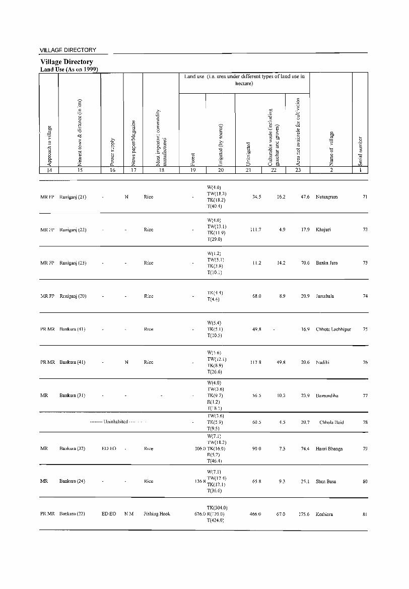
VILLAGE DIRECTORY
Village Directory Land Use (As on 1999)
14 15
MR FP Raniganj(21)
MR FP Raniganj (22)
MR FP Raniganj (23)
MR FP Raniganj (20)
PRMR Bankura(41)
PRMR Bankura(41)
MR Bankura (31)
16 17 18
N Rice
Rice
Rice
Rice
Rice
N Rice
-------- Uninhabited ------------
MR Bankura (32) ED EO Rice
MR Bankura (24) Rice
PR MR Bankura (22) ED EO NM Fishing Hook
Land use (i.e. area under different types ofland use in hectare)
19 20
W(4.0) TW(IS.2) TK(IS.2) T(40A)
W(4.0) TW(13.1) TK(ll9) T(29.0)
W(l2) TW(S.I)
TK(3.S) T(lO.I)
TK(4A)
T(4.4)
W(SA)
TK(S.I)
T(IO.S)
W(S.6)
TW(12.1) TK(S.9) T(26.6)
W(4.0) TW(36) TK(9.7) R(1.2) T(IS.S)
TW(36) TK(S.9)
T(9.S)
W(7.l) TW(IS.2)
106.0 TK(16.0) R(S.2)
T(46A)
W(7.1)
136 S TW(17A) . TK(l2.1)
T(36.6)
TK(304.0) 676.0 R(120.0)
T(4240)
21 22
34.5
111.7
11.2
68.0
49.S
117.S
S6.5
60.5
90.0
6S.8
466.0
23 2
16.2 47.6 Nutangram
4.9 17.9 Khajuri
14.2 70.6 Banka Jura
8.9 20.9 Jamshala
16.9 Chhota Lachhipur
49.S 20.6 Nadihi
10.3 23.9 Bamundiha
4.5 20.7 Chhola Baid
7.3 74A Hanri Bhanga
9.3 2S.1 Shua Basa
67.0 17S.6 Keshiara
71
72
73
74
7S
76
77
78
79
so
SI
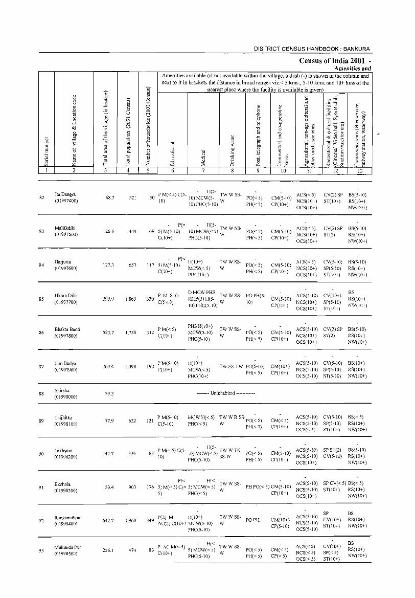
DISTRICT CENSUS HANDBOOK: BANKURA
Census of India 2001 -Amenities and
Amenities available (if not available within the village, a dash (-) is shown in the column and next to it in brackets the distance in broad ranges viz.< 5 krns., 5-10 kms. and 10+ kms of the
~ tii' nearest place where the facility is available is given '" " i3 " ~ "0 ~ :2~ "0 ~ " 0 '" U t::
" " :::l '" '_,;::j (.) <) t:: ..t:: '" - " " "§ t:: 0 t:: >- :.::: til " 0 3 " 0 0 .~ 2 '0 t E~ '.g u t!- ..t:: ~ 8, " ~ " " - Q.
" :; 0 :W 0 en " 0.. () OilifJ ~ ~ "0 ] ...l 0
"0 9 .~ ~ :3 ="5 '" " o<J .;;: t!- ..t:: "0 0 '" ._ '3 ] .~ e~ 1;l c t.) 6 0:> '" :;; " " t:: '" "0 U 0 ~
:W -5 0 '" ~
o ._ o'd ~ . .g C
..t:: C C:" ~ o c"
~ .~ 0
* '" 4-< ..t:: Q.
0;>1 ''';:: 0
.D .;;: 0 :; '- 0; :;; ~ 0; o;~ '" ._ S '" Q. 0 C 'g ;:;:..0 c -< '2 ~ :::l 4-< ~ 0 ~ 0 bIJ " .=: ~ S'Oil'E t:: 0 Q. " '.g 0; c '2 E ~ Oil "
.D t.) j;i E en '" U "til S ;:l
S ~ '5 s u '6 S E"'" .g] ~ ~ ~ E ;;: ·c '" cn
" '" ?: ;:l "0 " 25 0 o c: ~o ~ u Ei 0'-:
ifJ Z 1- Z f.Ll ~ p.. ull ~ ~ifJ U e 1 2 3 4 5 6 7 8 9 10 I1 12 J3
Ita Dangra - H(5-
ACS« 5) CV(2)SP BS(5-1O) 82 68.7 321 50 P M« 5) CC5- 10) MCW(5- TW W SS- PO«5) CM(5-10) (01997400) 10) 10) PHCC5-1O) W PH« 5) CP(lO+)
NCS(lO+) ST(10+) RS(IO+) OCS(IO+) NW(IO+)
Mallikdihi P« - H(5-ACS« 5) CV(2) SP BS(5-10)
83 126.6 444 69 5)M(5-10) 10) MCW« 5) TW W SS- PO« 5) CM(5-1O) (01997500)
CCIO+) PHCC5-10) W PH« 5) CP(lO+) NCS(IO+) ST(2) RS(10+) OCS(IO+) NW(IO+)
GaIjuria - P« -
TWWSS- ACS« 5) CV(5-10) BS(5-1O) 84 127.3 657 117 5) M(5-10) H(lO+) PO«5) CM(5-10)
(01997600) C(lO+) MCW« 5) W NCS(IO+) SP(5-10) RS(lO+) PHCCIO+)
PH«5) CP(lO+) OCS(IO+) ST(lO+) NW(IO+)
UkhraDihi PM S 0 DMCWPHS
TWWSS- PO PH(5- ACS(5-10) CV(IO+) BS
85 (01997700)
299.9 1,863 330 CC5-10)
RMP(2) H(5- W 10)
CM(5-10) NCS(IO+) SP(5-10)
RS(lO+) 10) PHC(5-10) CP(IO+)
OCS(IO+) ST(IO+) NW(IO+)
Bhakta Band PM«5) PHS H(lO+)
TWWSS- ACS(5-10) CV(2) SP BS(5-10) 86 523.7 1,750 312 MCW(5-10) PO«5) CM(5-10)
(01997800) C(lO+) PHCC5-10)
W PH« 5) CP(10+)
NCS(lO+) ST(2) RS(10+) OCS(IO+) NW(IO+)
87 Jam Bedya
269.4 1,098 192 PM(5-10) H(IO+)
TW SS-TW PO(5-1O) CM(IO+) ACS(5-10) CV(5-10) BS(IO+)
(01997900) C(lO+) MCW«5) PH« 5) CP(IO+)
NCS(5-10) SP(5-10) RS(IO+)
PHC(IO+) OCS(5-10) ST(5-10) NW(IO+)
88 Shirsha (01998000)
59.2 -------- Uninhabited ------------
89 Taljhitka
77.9 622 121 PM(S-IO) MCWH«5) TW W R SSpO(~ 5) CM«5)
ACS(5-10) CV(5-10) BS«5) (01998100) C(5-10) PHC« 5) W PH«5) CP(10+)
NCS(5-10) SP(5-10) RS(IO+) OCS«5) ST(IO+) NW(IO+)
Lakhyara - H(5-
ACS(5-lD) SP ST(2) BS(5-10) 90 142.7 326 63 P M« 5) C(5- 10) MCW« 5) TW W TK PO«S) CM(5-10)
(01998200) 10) PHC(5-10) SS-W PH«5) CP(IO+) NCS(5-10) CV(5-10) RS(IO+) OCS(IO+) NW(IO+)
Ekchala P« H«
TWWSS- ACS(5-1O) SP CV« 5) BS« 5) 91 53.4 903 176 5) M« 5) C« 5) MCW« 5)
W PH PO« 5) CM(5-10)
NCS(5-JO) ST(IO+) RS(IO+) (01998300) 5) PHC«5) CP(IO+)
OCS(IO+) NW(IO+)
ACS(5-10) SP BS
Ranganathpur P(2) M H(IO+) TWWSS-PO PH CM(IO+) CV(IO+) RS(IO+) 92 642.7 1,960 349
AC(2) C(lO+) MCW(5-10) W NCS(5-1O) (01998400) CP(5-1O) ST(10+) NW(IO+) PHC(5-10) OCS(5-1O)
- H« ACS«5) CV(IO+)
BS Mukunda Pur P AC M« 5) 5) MCW« 5) TWWSS-
PO«5) CM«5) RS(IO+) 93 256.1 474 83 W NCS« 5) SP«5) (01998500) C(lO+) PHC(5-10) PH«5) CP«5) NW(IO+)
OCS« 5) ST(IO+)
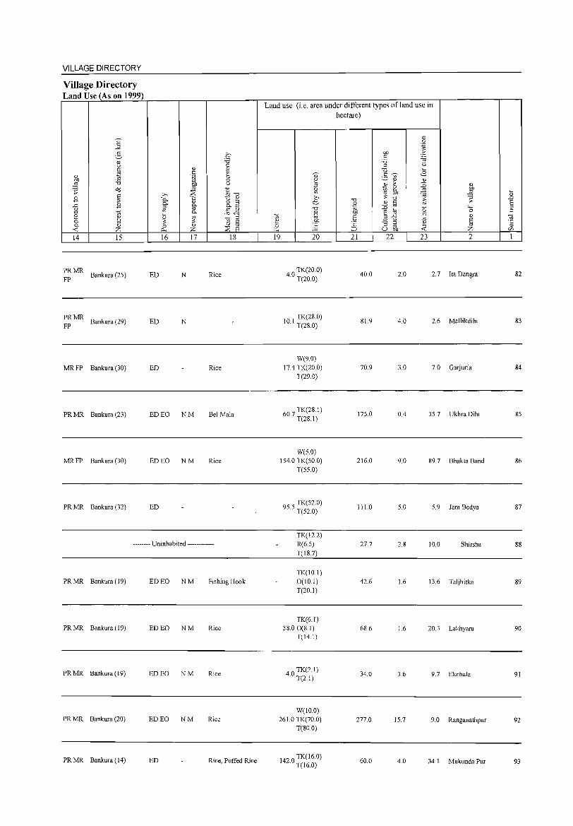
VILLAGE DIRECTORY
Village Directory Land Use (As on 1999)
]' 5 (l) OJ c: ~ " OIl '6 ;:§
.;; o'd
~ B ..c: B g t; 2 ~ 0.. 0.. " -< z 14 15
PRMR Bankura (25)
FP
PRMR Bankura (29)
FP
MRFP Bankura (30)
PRMR Bankura (23)
MRFP Bankura (30)
PRMR Bankura (32)
0 '5 0
(l) e: c: .~ e:
0
ilP u
2: §'O >. 0.. -;:; t:: ~ 0..
(l)
o '" a §- o..~
0.. §~ 5 ~ '" ::: '" 8 0 (l) 0 p., z 2: E 16 17 18
ED N Rice
ED N
ED Rice
ED EO NM Bel Mala
ED EO NM Rice
ED
-------- Uninhabited ------------
PRMR Bankura (19) ED EO NM Fishing Hook
PRMR Bankura (19) ED EO NM Rice
PRMR Bankura (19) ED EO NM Rice
PRMR Bankura (20) ED EO NM Rice
PRMR Bankura (14) ED Rice, Puffed Rice
Land use (i.e. area under different types ofland use in hectare)
c: 0 .-g
OIl > c: 'p
'5 "3
'" u U .... 3 'V)' <8
" (l)
j > :0 ~ '" '0 ~
'0 (l) c: t;; (l)
'" "' :D '0 "E ~ ~ ..c: c:
u '" c "3 '" ~ '" ::::> u OIl -<
~ (l)
~
'" ~ >. e '0 (l)
t; "' ~ OIl 0 ~ "" 19 20 21 22 23
" :W ;;
"'" 0
" e: ~ 2
40 TK(20.0) · T(20.0)
40.0 2.0 2.7 Ita Dangra
10 I TK(28.0) · T(28.0)
81.9 4.0 2.6 Mallikdihi
W(9.0) 17.4 TK(20.0) 70.9 3.0 7.0 Garjuria
T(29.0)
607 TK(28I) · T(28.1)
175.0 0.4 35.7 UkhraDihi
W(S.O) 154.0 TK(SO.O) 216.0 9.0 89.7 Bhakta Band
T(55.0)
955 TK(52.0) · T(52.0)
111.0 5.0 5.9 Jam Bedya
TK(12.2) R(6.5) 27.7 2.8 10.0 Shirsha T(18.7)
TK(IO.I) 0(10.1) 42.6 1.6 13.6 Taljhitka T(20.1)
TK(6.1) 38.00(8.1) 68.6 1.6 20.3 Lakhyara
T(J4.J)
40 TK(2. J) · T(2.1)
34.0 3.6 9.7 EkchaJa
W(IO.O) 261.0 TK(70.0) 277.0 15.7 9.0 Ranganathpur
T(80.0)
1420 TK(16.0) · T(16.0)
60.0 4.0 34.1 MukundaPur
5 .D e: '" c:
~ (l)
U'l
1
82
83
84
85
86
87
88
89
90
91
92
93
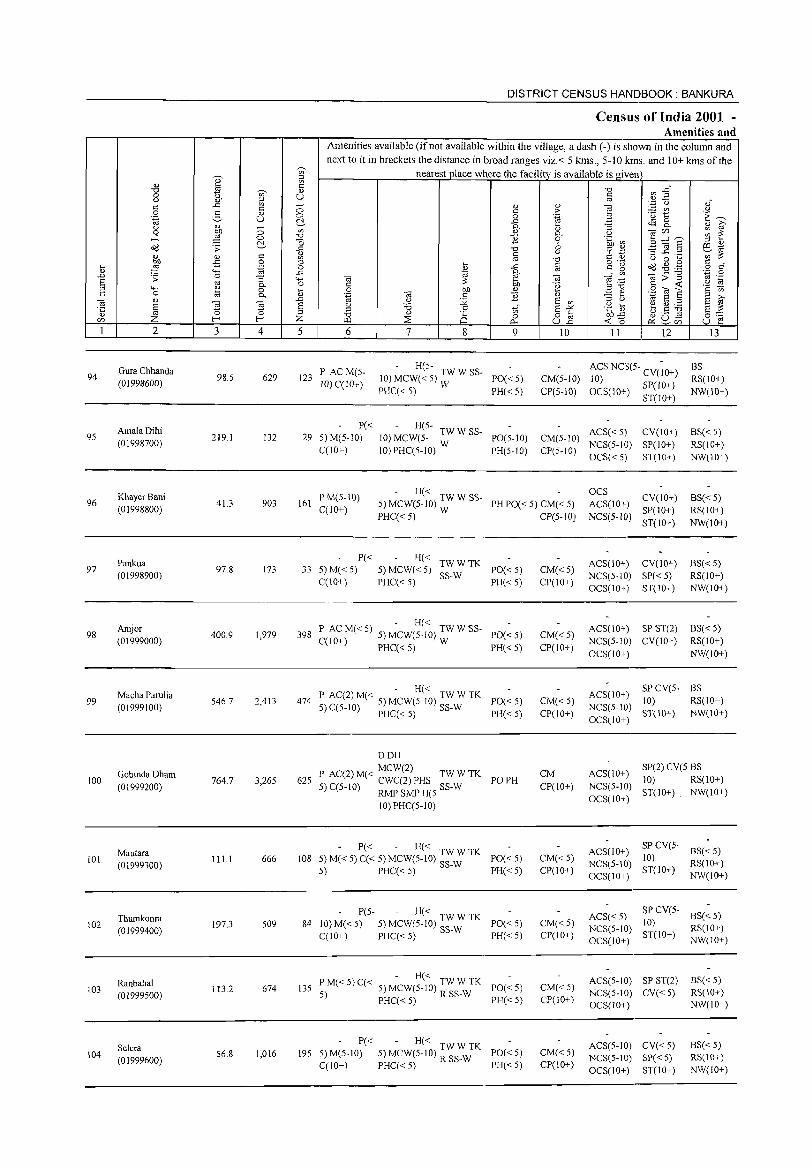
DISTRICT CENSUS HANDBOOK: BANKURA
Census of India 2001 -Amenities and
Amenities available (ifnot available within the village, a dash (-) is shown in the column and
next to it in brackets the distance in broad ranges viz.< 5 kms., 5-10 kms. and 10+ kms of the -;;, nearest place where the facility is available is given Q)' :::l Ul
<!.) ta c:: "0 ~ -§~ "0 -;;, <!.)
0 g. u § u ~ :; u .~n c:: ..r:: 0 " " e c:: > _ Ul
0 ~ <!.) c:: 'u 1:: '.g U 0 0 .~ B i:~ C!. ..r:: t.S8. u <!.) - Ii} :u "3 " i2 0 ~ 0 '" 0. Cl ~~~ ~ ~ ....l 0 "0 11 0 .~ ~~ -0 :::l " Cd .s;: C!. ..r:: "0 6 cr '';:: 3]§ 0::1 1<j <!.l c:: " §
(.) ';;:;: <!.) Ul
" c:: '" () 0 ....
:§ iJ 0 :::l :u ..c § 0"2\ Cd ~ .12 0:: " :u .~ 0 c:: 0 .~ .§ """ ..r:: ~ ~ - v, -a;;"§ ..0 .s;: 0 "3 '- -a -a § '"
~ .-:: u 1<j '-H e 0. 0 <= 'g Bil
<:: «: '§ til 0 :u 0 bJ) " .S ~ a <= 0 '" 0. '"§ -a c:: ]} - ... -a <!.l -a ~ -" u :;;; E! '"
:::l U 1<j S :::l E! i2 8 § Cl 'B .8 t;;' E-'" .~ 1] e ~ ~ E! ::: .;:: a :::l
<!.) '" "0 " a 0 o c:: () ._ ro 0::
<Zl Z f- f- Z ~ ::E 0... ull ~o ~u- u ~ ~<Zl
1 2 3 4 5 6 7 8 9 10 11 12 13
Gura Chhanda PAC M(S-- H(S- ACS NCS(S- CV(;O+) BS
94 98.S 629 123 10) MCW« 5) TW W SS- PO«5) CM(5-1O) RS(IO+) (01998600) 10)C(10+) 10)
PHC« 5) W PH« 5) CP(S-IO) OCS(IO+) SP(10+) NW(IO+) ST(IO+)
AmalaDihi P« H(S-ACS« 5) CV(IO+) BS« 5) 95 219.1 132 29 5)M(5-10) 10) MCW(5- TW W SS- PO(5-10) CM(5-10)
(01998700) C(lO+) 10) PHC(5-1O) W PH(5-10) CP(5-10)
NCS(5-IO) SP(IO+) RS(IO+)
OCS« 5) ST(IO+) NW(IO+)
KhayerBani P M(5-10) - H« OCS
CV(10+) BS« 5) 96 41.3 903 161 5) MCW(5-10) TW W SS- PH PO« 5) CM« 5) ACS(lO+)
(01998800) C(lO+) PHC«5) W CP(5-1O) NCS(5-1O)
SP(10+) RS(IO+)
ST(10+) NW(lO+)
Pankua P« H« TWWTK ACS(10+) CV(IO+) BS« 5) 97
(01998900) 97.8 173 33 5) M«5) 5) MCW«5)
SS-W PO«5) CM«5)
NCS(5-10) SP« 5) RS(IO+) C(IO+) PHC« 5) PH« 5) CP(IO+)
OCS(IO+) ST(IO+) NW(IO+)
Amjor - H«
ACS(IO+) SP ST(2) BS« 5) 98 400.9 1,979 398 P ACM«5) 5) MCW(5-10) TWWSS- PO«5) CM«5)
(01999000) C(lO+) PHC« 5) W NCS(5-10) CV(lO+) RS(lO+) PH« 5) CP(lO+)
OCS(IO+) NW(IO+)
Macha Parulia P AC(2) M« - H« TW W TK ACS(IO+) SP CV(5- BS
99 (01999100)
546.7 2,413 474 5)C(5-10) 5) MCW(5-10) SS-W PO«5) CM«5) NCS(5-10)
10) RS(IO+)
PHC« 5) PH« 5) CP(lO+) OCS(IO+)
ST(IO+) NW(IO+)
DOH
Gobinda Dham MCW(2)
CM ACS(IO+) SP(2) CV(5 BS
100 764.7 3,265 625 P AC(2) M« CWC(2) PHS TW W TK PO PH 10) RS(10+) (01999200) 5) C(5-1O) RMP SMP H(5 SS-W CP(IO+) NCS(5-1O)
ST(IO+) . NW(IO+)
10) PHC(5-1 0) OCS(IO+)
Mautara - P« - H« TWWTK ACS(lO+) SP CV(5-
BS« 5) 101
(01999300) 111.1 666 108 5) M«5) C« 5) MCW(5-10) SS-W PO«5) CM«5)
NCS(5-10) 10)
RS(IO+) 5) PHC« 5) PH«5) CP(IO+)
OCS(10+) ST(10+)
NW(IO+)
Thumkonra P(5- - H« TWWTK ACS« 5)
SP CV(5-BS« S)
102 (01999400)
197.3 509 84 10)M«5) 5) MCW(5-1O) SS-W PO« 5) CM«5) NCS(5-10)
10) RS(IO+)
C(IO+) PHC« 5) PH«5) CP(IO+) OCS(IO+)
ST(IO+) NW(IO+)
Ranbahal PM« 5)C« - H« TWWTK PO«5) CM«5)
ACS(5-10) SP ST(2) BS«5) 103 113.2 674 135
5) 5) MCW(5-10) R SS-W NCS(5-10) CV«5) RS(IO+) (01999500) PHC« 5) PH«5) CP(IO+)
OCS(IO+) NW(IO+)
Selera P« - H« TWWTK ACS(5-10) CV{<5) BS« 5)
104 56.8 1,016 195 5)M(5-10) 5) MCW(5-10) R SS-W PO«5) CM« 5) NCS(5-IO) SP« 5) RS(IO+) (01999600)
C(IO+) PHC« 5) PH«5) CP(IO+) OCS(IO+) ST(lO+) NW(IO+)
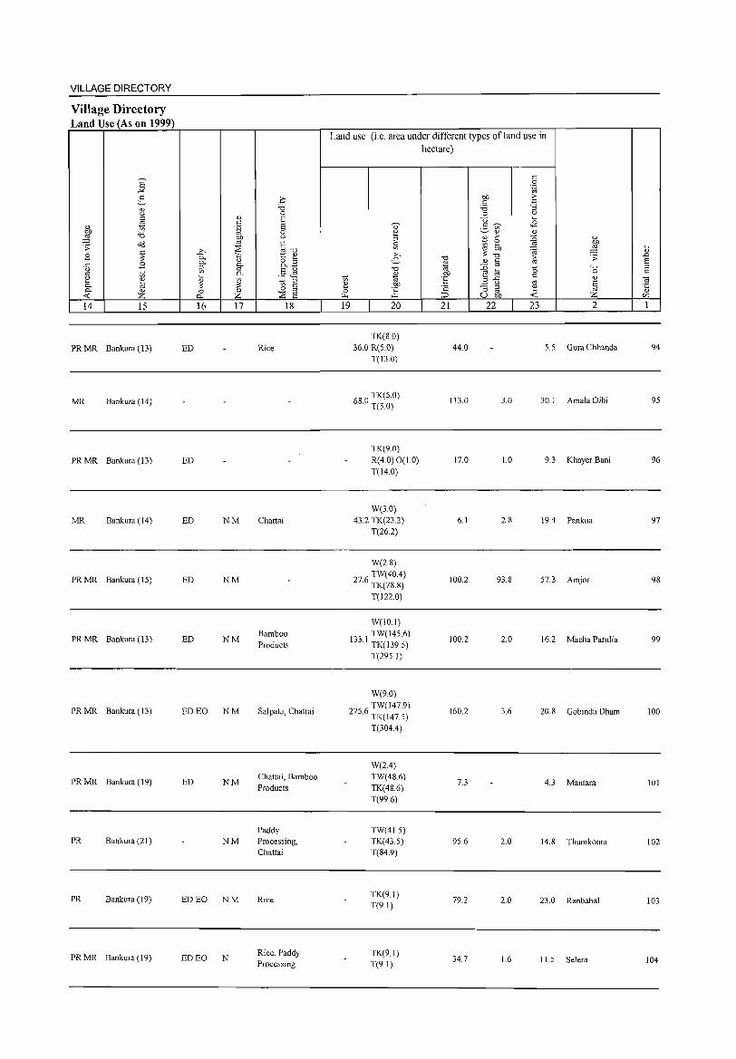
VILLAGE DIRECTORY
Village Directory Land Use (As on 1999)
14 15
PR MR Bankura (13)
MR Bankura (14)
PR MR Bankura (13)
MR Bankura ( 14)
PR MR Bankura (15)
PR MR Bankura (13)
PR MR Bankura (13)
PR MR Bankura (19)
PR Bankura (21 )
PR Bankura (19)
PR MR Bankura (19)
16 17
ED
ED
ED NM
ED NM
ED NM
ED EO NM
ED NM
NM
ED EO NM
ED EO N
18
Rice
Chattai
Bamboo Products
Salpata, Chattai
Chattai, Bamboo Products
Paddy Processing, Chattai
Rice
Rice, Paddy Processing
Land use (i.e. area under different types ofland use in hectare)
19 20
TK(S.O) 36.0 R(5.0)
T(13.0)
680 TK(5.0) · T(5.0)
TK(9.0) R(4.0) 0(10) T(14.0)
W(3.0) 43.2 TK(23.2)
T(26.2)
W(2.8) TW(40.4)
27.6 TK(78.S)
T(1220)
W(JO.I)
133 I TW(145.6) · TK(139.5)
T(295 I)
W(9.0)
2756 TW(147.9) · TK(1475)
T(304.4)
W(2.4) TW(4S.6) TK(48.6) T(99.6)
TW(415) TK(43.5) T(84.9)
TK(9.1) T(9.1)
TK(91) T(9.1)
21
44.0
113.0
17.0
6.1
100.2
100.2
160.2
7.3
95.6
79.2
34.7
22 23 2
5.5 Gura Chhanda
3.0 3~. J AmaJa Dihi
1.0 9.3 Khayer Bani
2.S 19.4 Pankua
93.8 57.3 Amjor
2.0 16.2 Macha Parulia
3.6 20.8 Gobinda Dham
4.3 Mautara
2.0 14.8 Thumkonra
2.0 23.0 Ranbahal
16 11.5 Selera
94
95
96
97
98
99
100
101
102
103
104
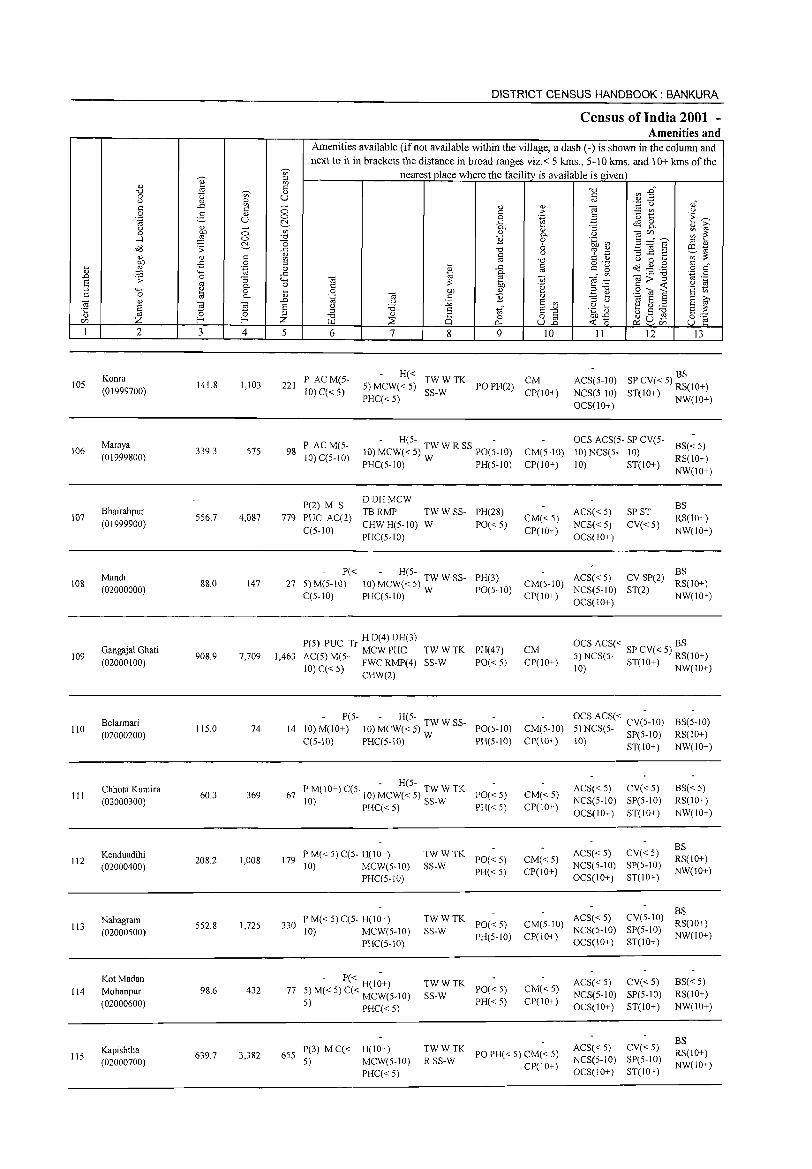
105
106
107
108
109
110
III
112
113
114
115
2
Konra (01999700)
Maraya (01999800)
Bhairabpur (01999900)
Mandi (02000000)
Gangajal Ghati (02000100)
Belarrnari (02000200)
Chhota Kumira (02000300)
Kenduadihi (02000400)
Nabagram (02000S00)
KotMadan Mohanpur (02000600)
Kapishtha (02000700)
3
141.8
339.3
556.7
88.0
908.9
115.0
60.3
208.2
SS2.8
98.6
639.7
o o ~
4
1,103
57S
4,087
147
7,709
74
369
1,008
1,72S
432
3,382
DISTRICT CENSUS HANDBOOK: BANKURA
Census of India 2001 -Amenities and
Amenities available (if not available within the village, a dash (-) is shown in the column and next to it in brackets the distance in broad ranges viz.< 5 kms., 5-10 kms. and 10+ kms of the
nearest place where the facility is available is given
o o ~
'" "0
] '" '" '" o
..c 'o ~
'" .D E '" Z 5 6
221 P ACM(5-10) C«5)
98 P ACM(5-10) C(5-10)
7 8 9 10
H« TWWTK CM 5) MCW« 5) SS-W PO PH(2) CP(IO+) PHC«5)
H(5- -10)MCW«S) TWWRSSpO(S_IO) CM(5-10)
PHC(S-lO) W PH(S-IO) CP(IO+)
779
DDHMCW P(2) M S TB RMP
PUC AC(2) CHW H(5-10) TW W SS- PH(28)
W PO«5) CM«5) CP(IO+) C(5-10) PHCC5-10)
11 12 13
BS ACS(5-1O) SP CV« S) RS(lO+)
NCS(5-1O) ST(IO+) NW(IO+) OCS(IO+)
OCS ACS(5- SP CV(5- BS« 5)
10) NCS(5- 10) RS(lO+)
10) ST(lO+) NW(lO+)
ACS« S)
NCS« 5) OCS(10+)
SP ST
CV«5)
BS
RS(10+)
NW(IO+)
27 5) M(5-10~« 10) ~CW7~5~) TW W SS- PH(3) CM(5-10) ACS« S) CV SP(2) :;(10+)
CCS-IO) PHC(5-10) W PO(S-IO) CP(IO+) NCS(S-IO) ST(2) NW(IO+) OCS(lO+)
1,463
P(5) PUC Tr HD(4)DH(3)
AC(S) M(S- MCW PHC 10) C« 5) FWC RMP(4)
CHW(2)
TWWTK PH(47)
SS-W PO« S)
CM CP(IO+)
P(5- - H(5-14 10) M(lO+) 10) MCW« 5) :W W SS- PO(S-IO) CM(5-10)
CCS-IO) PHC(5-10) PH(5-IO) CP(IO+)
- H(S-67 PM(IO+) C(5. 10) MCW« 5) TW W TK PO« S)
10) PHC« 5) SS-W PH« 5) CM«S) CP(lO+)
179 PM«5)CC5- H(10+) 10) MCW(S-IO)
PHC(S-lO)
330 PM«5)C(S- H(IO+) 10) MCW(5-1O)
PHCCS-l0)
- P« H(I~+) 77 5) M« 5) C« MCW(5-10)
5) PHCC< 5)
6S5 P(3) MC« H(IO+) 5) MCW(S-IO)
PHC« S)
TWWTK SS-W PO« S)
PH«S)
CM« S) CP(lO+)
TW W TK PO« S) CM(S-IO)
SS-W PH(S-10) CP(IO+)
TWWTK SS-W PO« 5)
PH«5)
CM«5) CP(IO+)
~~S~:K PO PH« S) CM« 5) CP(IO+)
OCS ACS« BS 5) NCS(S- SP CV« 5) RS(lO+) 10) ST(IO+) NW(IO+)
OCS ACS« CV(;-IO) 5) NCS(5- SP(S-IO)
10) ST(IO+)
ACS( < 5) CV( < S)
NCS(S-IO) SP(5-1O)
OCS(IO+) ST(IO+)
ACS« 5) CV« 5) NCS(S-IO) SP(S-IO) OCS(10+) ST(lO+)
BS(S-IO)
RS(IO+)
NW(IO+)
BS« 5) RS(IO+)
NW(IO+)
BS RS(IO+)
NW(10+)
BS ACS« S) CV(S-IO) RS(lO+) NCS(5-1O) SP(5-1O) NW(IO+) OCS(IO+) ST(10+)
ACS« 5) CV« 5) NCS(5-10) SP(5-1O)
OCS(10+) ST(JO+)
ACS« S) CV« S) NCS(S-IO) SP(5-10)
OCS(IO+) ST(IO+)
BS«5) RS(IO+)
NW(lO+)
BS RS(lO+)
NW(lO+)
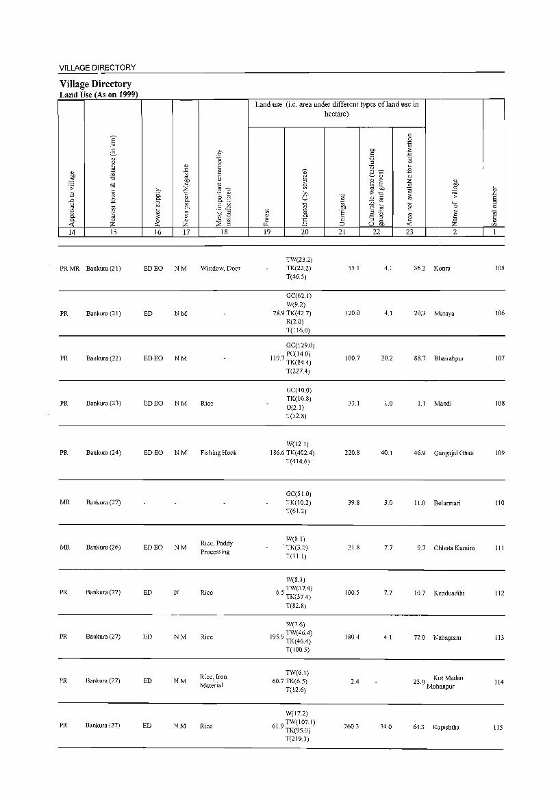
VILLAGE DIRECTORY
Village Directory Land Use (As on 1999)
14 15
PR MR Bankura (21)
PR Bankura (21)
PR Bankura (22)
PR Bankura (23)
PR Bankura (24)
MR Bankura (27)
MR Bankura (26)
PR Bankura (27)
PR Bankura (27)
PR Bankura (27)
PR Bankura (27)
16 17
ED EO NM
ED NM
ED EO NM
ED EO NM
EDEO NM
ED EO NM
ED N
ED NM
ED NM
ED NM
18
Window, Door
Rice
Fishing Hook
Rice, Paddy Processing
Rice
Rice
Rice, Iron Material
Rice
Land use (i.e. area under different types ofland use in hectare)
19 20
TW(23.2) TK(23.2) T(46.5)
GC(62.1) W(9.2)
78.9 TK(42.7) R(2.0) T(l16.0)
GC(129.0)
1197 PC(14.0) · TK(84,4)
T(227,4)
GC(40 0) TK(10.8) 0(2.1) T(52.8)
W(l2.1) 186.6 TK(402,4)
T(414.6)
GC(51.0) TK(lO.2) T(61.2)
W(8.1) TK(3.0) T(l1.l)
W(8.1)
6 TW(37.4) .5 TK(37,4)
T(82.8)
W(7.6)
1959 TW(46.4) · TK(46,4)
T(100.5)
TW(6.1) 60.7 TK(6.5)
T(12.6)
W(17.2)
619 TW(l07.1) · TK(95.0)
T(219.3)
21
55.1
120.0
100.7
33.1
220.8
39.8
31.8
100.5
180,4
2,4
260.3
22 23
4.1
4.1
20.2
1.0
40.1
3.0
7.7
7.7
4.1
34.0
2
36.2 Konra
20.3 Maraya
88.7 Bhairabpur
1.1 Mandi
46.9 Gangajal Ghati
11.0 Belarrnari
9.7 Chhota Kumira
10.7 Kenduadihi
72.0 Nabagram
23.0 Kot Madan Mohanpur
64.3 Kapishtha
105
106
107
108
109
110
III
112
113
114
115
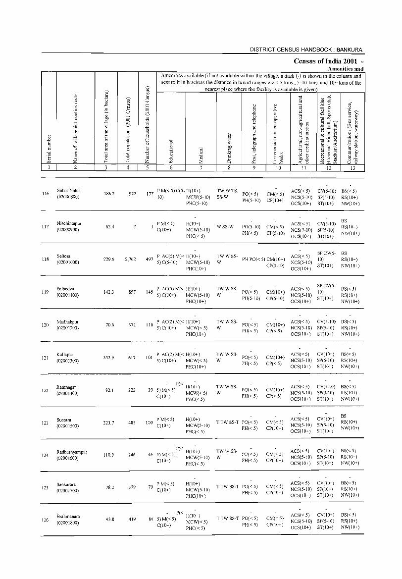
~ 5l
" ~ <:: .", ~ <I) 0 '" u (.) " ::>
..c '" -0: 0: 0 0 2- " 0 '.g u t'.. 0 <l) -0 bIl 0 '" ....l ::§ 0 .",
t'.. "0 o<J ;;: ..c
<1.)
" " 0: '" bIl £ 0 ::> ~ ::§ '.g 0 ..... ..c .D .;;: 0 "3 ..... s '" 0. 0 ::> ..... ~ 0 '" 0: 0 0- '" ~ " ..0
S ca ca S 0 0 ::>
" Z f- f- Z r/J
I 2 3 4 5
116 Subar Nator (02000800)
186.2 922 177
Nischintapur 117 62.4 7
(02000900)
Saltora 118
(02001000) 229.6 2,702 497
Salbedya 119
(02001100) 142.3 857 145
Madhabpur 572 110 120
(02001200) 70.6
Kallapur 101 121
(02001300) 532.9 617
Ramnagar 223 39 122
(02001400) 92.1
123 Suarara (02001500)
223.7 485 100
Radhashyampur 124 110.9 246 46
(02001600)
Sankarara 125
(02001700) 78.2 379 79
Brahmanara 126
(02001800) 43.8 419 84
DISTRICT CENSUS HANDBOOK: BANKURA
Census of India 2001 -Amenities and
Amenities available (if not available within the village, a dash (-) is shown in the column and next to it in brackets the distance in broad ranges viz.< 5 kms., 5-10 kms. and 10+ kms of the
nearest place where the facility is available is given .", ~ :3~ §
'.p C) ,," " " ] <:: > ~ t
(.)
0 .~ ·E ..c ..m 0 f 0. :; 0. ill <1.) 0. 0 ~ ~~s '" 11 0 .~ ~ ::> 6 ~ ~ .", "r '.0 3] .2 0: (.) ::: '" .", 0: " (.) 0 '" '" ~ ..c 0: 0 ·0 Od ~ .,g 0:
0:" <1.)
'" 0: 0 0
'" 0.
'" .- .", .~ 0 ca ::: e ca ]~ 8>~ .~ 0: bIl 'e '6 0
0 bIl <1.) .2 e Sa e ·s .~ ca c 11 " "3 ::>
~ '" j2 S '" (.) ~ E ;:$ S (.) '6
"' E -'" ·c aJ e ~ ~ s ::: ::> <1.) '" c
~ Q£ .", ~ cs 0 0 '"
bIl..c 0 ~ "" <0... U ..0 « 0 u 6 7 8 9 10 II 12 13
P M« 5) C(5- H(IO+) TWWTK ACS« 5) CV(5-10) BS«5) PO«5) CM«5)
10) MCW(5-10) SS-W NCS(5-IO) SP(5-1O) RS(IO+) PHC(5-10)
PH(5-10) CP(IO+) OCS(IO+) ST(IO+) NW(IO+)
P M«5) H(10+) ACS« 5) CV(5-10) 8S
WSS-W PO(5-10) CM«5) RS(10+) C(10+) MCW(5-10) NCS(5-10) SP(5-10)
PHC« 5) PH« 5) CP(5-IO)
OCS(lO+) ST(IO+) NW(10+)
P AC(5) M« H(10+) TWWSS- ACS« 5) SPCv(5- BS
5) C(5-10) MCW(5-10) W PH PO« 5) CM(IO+)
NCS(5-10) 10) RS(IO+)
PHC(IO+) CP(5-1O)
OCS(IO+) ST(IO+) NW(IO+)
P AC(5) M« H(lO+) TWWSS- ACS« 5) SP CV(5-
BS« 5) 5) C(IO+) MCW(5-10) W
PO«5) CM(IO+) NCS(5-10)
10) RS(IO+)
PHC(IO+) PH(5-10) CP(5-10)
OCS(1O+) ST(IO+)
NW(IO+)
P AC(2) M« H(IO+) TWWSS-PO«5) CM(IO+)
ACS« 5) CV(5-10) 8S« 5) 5)C(10+) MCW«5) W NCS(5-1O) SP(5-10) RS(IO+)
PHC(1O+) PH«5) CP« 5)
OCS(IO+) ST(IO+) NW(IO+)
P AC(2) M« H(IO+) TWWSS-PO«5) CM(1O+)
ACS« 5) Cv(IO+) BS« 5) 5) C(lO+) MCW«5) W NCS(5-1O) SP(5-1O) RS(IO+)
PHC(lO+) PH«5) CP« 5)
OCS(IO+) ST(lO+) NW(IO+)
- P« H(I~+) TWWSS-PO«5) CM(IO+)
ACS« 5) CV(5-10) 8S«5) 5) M« 5) MCW« 5) W NCS(5-10) SP(5-10) RS(IO+) C(IO+) PHC« 5) PH«5) CP«5)
OCS(IO+) ST(IO+) NW(10+)
ACS« 5) Cv(IO+) 8S
PM«5) H(IO+) TTW SS-T PO«5) CM«5) RS(IO+)
C(10+) MCW(5-1O) NCS(5-10) SP(5-10)
PHC« 5) PH«5) CP(IO+)
OCS(IO+) ST(IO+) NW(IO+)
- P« H(I~+) TWWSS-PO«5) CM«5)
ACS« 5) Cv(IO+) 8S«5) 5)M«5) MCW(5-1O) W NCS(5-10) SP(5-10) RS(IO+)
PH«5) CP(IO+) C(IO+) PHC« 5) OCS(IO+) ST(IO+) NW(IO+)
P M«5) H(IO+) TTW SS-T PO«5) CM«5)
ACS« 5) CV(10+) BS« 5)
C(IO+) MCW(5-1O) NCS(S-IO) SP(IO+) RS(IO+) PH«5) CP(IO+)
PHC(IO+) OCS(10+) ST(IO+) NW(IO+)
- P« H(I~+) TTWSS-T PO«5) CM«5)
ACS« 5) CV(10+) 8S« 5) 5) M«5) MCW«5) NeS(5-IO) SP(S-IO) RS(IO+)
PH«5) CP(IO+) C(IO+) PHC« 5) OCS(10+) ST(10+) NW(10+)
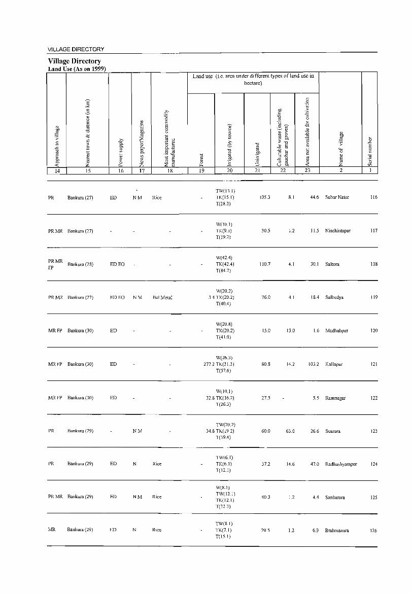
VILLAGE DIRECTORY
Village Directory Land Use (As on 1999)
Land us~ (i.e. area under different types of land use in
hectare)
E .:: 0
.!< '-g 2, .£
OJ) .::: .:: -3 " "0 '0 '-' 0 ::I '-' .:: " 8 u ... oj .:: <8
" t; .~ 8 " .5 ~ OJ) '0 0 ~ ~ " " ::§ OJ) '-' ::I " > :g " o"d '" ~ 0 OJ) .;;: ::22 §-o ~ ~ ...
~ ::§ ... ~
>-. ;;:~ " B 0.. -.:: ~ ~ >-. "0 8 .;;: ..0
" e.- " .:: 8 ..c: B c.. [if o ::I " - '" ~ c..~
'" "0 ""' ::I <.) §J§ "0 ~ a 0 .:: '" '" ... c.. %l 'E .:: [ " " '" ~ ::I '" 3-5 '" " ] 8 ;;: ;;: i!J § ~ OJ) ;: - ::I ~ ~ c.. " 0 " 0 ] ::I '" " -< z "-' z ::8 e "" :::> u OJ) -< '" 14 15 16 17 18 19 20 21 22 23 2 1
TW(13.1)
PR Bankura (27) ED NM Rice TK(15.1) 105.3 8.1 44.6 Subar Nator 116 T(2S.2)
W(IO.I)
PRMR Bankura (27) TK(9.1) 30.5 1.2 11.5 Nischintapur 117
T(19.2)
PRMR W(42.4)
Bankura (28) ED EO TK(42.4) 110.7 4.1 30.1 Saltora 118 FP
T(S4.7)
W(20.2)
PRMR Bankura (27) ED EO NM Bel Metal 3.4 TK(202) 76.0 4. I IS.4 Salbedya 119 T(40.4)
W(20.S)
MRFP Bankura (30) ED TK(20.2) 15.0 13.0 1.6 Madhabpur 120 T(41.0)
W(26.3)
MRFP Bankura (30) ED 277.2 TK(31.3) SO.8 14.2 103.2 Kallapur 121
T(57.6)
W(IO.I) MRFP Bankura (30) ED 32.S TK(l6.2) 27.5 5.5 Ramnagar 122
T(26.3)
TW(20.2) PR Bankura (29) NM 34.S TK(19.2) 60.0 63.0 26.6 Suarara 123
T(39.4)
TW(6.1) PR Bankura (29) ED N Rice TK(6.1) 37.2 14.6 47.0 Radhashyampur 124
T(l2. I)
W(S.I)
PRMR Bankura (29) ED NM Rice TW(121) TK(12.1)
40.3 1.2 4.4 Sankarara 125
T(32.3)
TW(S.l) MR Bankura (29) ED N Rice TK(7.1) 20.5 1.2 6.9 Brahmanara 126
T(lS.l)
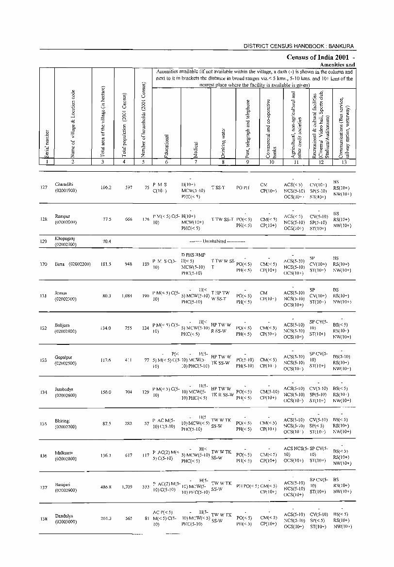
127
128
129
130
131
132
133
134
135
136
137
138
2
Charadihi
(02001900)
Rampur
(02002000)
Khopaganj
(02002100)
Birra (02002200)
Jemua
(02002300)
Balijora
(02002400)
Gopalpur
(02002500)
Jambedya
(02002600)
Bhiringi (02002700)
Malkonra
(02002800)
Barajuri (02002900)
Dandulya (02003000)
3
106.2
77.5
70.4
181.5
80.3
134.0
113.6
156.0
87.5
136.3
486.8
201.3
'" '" Ii U
C> C> ~
4
597
666
948
1,084
755
411
704
282
617
1,709
565
DISTRICT CENSUS HANDBOOK: BANKURA
Census of India 2001 -Amenities and
Amenities available (if not available within the village, a dash (-) is shown in the column and next to it in brackets the distance in broad ranges viz.< 5 kms., 5-10 kms. and 10+ kms of the
nearest place where the facility is available is given
5 6
75 PM S C(10+)
7
H(IO+)
MCW(5-IO) PHC« 5)
8 9
TSS-T PO PH
126 P M« 5) C(5- H(10+) 10) MCW(IO+)
PHC« 5)
T TW SS-T PO« 5)
PH« 5)
189 PM S C(5-10)
-------- Uninhabited ------------
DPHSRMP
H«S) MCW(5-1O) PHC(5-1O)
T TW W SS· PO(~ 5)
T PH« 5)
- H« 190 P M« 5) C(5- 5) MCW(5-10) T HP TW
10) PHC(5-10) W SS-T PO« 5)
PH« 5)
- H« 124 P M« 5) C(5- 5) MCW(S-IO) HP TW W PO« 5)
10) PHC« 5) R SS-W PH« 5)
77 5) M~< 5) ~~. 10) ~cw7~:- : ~~:: PO(5-10) 10) IO)PHC(5-10) PH(5-10)
- H(5- HPTWW -129 P M« 5) C(5- 10) MCW(5- TK R SS-W PO« 5)
10) 10) PHC« 5) PH« 5)
57 P ACM(5-10) C(5-10)
- H(5-10) MCW« 5) TW W TK PO« 5) PHC(5-10) SS-W PH« 5)
- H« 117 P AC(2)M« 5) MCW(5-10) TWWTK PO«5)
5)C(5-1O) PHC«5) SS-W PH«5)
<l,)
> .~
<l,)
0.. o 6 ()
.",
§ <ii .~
E '" §"§ U.o
10
CM
CP(10+)
CM«5) CP(IO+)
CM«5) CP(IO+)
CM CP(10+)
CM« 5) CP(IO+)
CM«5) CP(IO+)
11 12
ACS« 5) CV(10+)
NCS(5-10) SP(5-10) OCS(IO+) ST(IO+)
13
BS RS(10+) NW(IO+)
ACS« 5) NCS(5-10) OCS(10+)
CV(S-IO) ~~(IO+) SP(S-10) NW(IO+) ST(10+)
SP ACS(S-lO) CV(10+) NCS(5-1O) ST(10+) OCS(IO+)
ACS(S-IO) ~~(10+) NCS(5-10) ST(10+) OCS(10+)
BS RS(10+) NW(IO+)
BS RS(10+)
NW(IO+)
ACS(5-10) NCS(5-10) OCS(10+)
SP CV(S- BS« 5) 10) ST(10+) RS(IO+)
ACS(5-10) NCS(5-10) OCS(IO+)
NW(10+)
SP CV(5- BS(S-IO) 10) ST(IO+) RS(10+)
NW(IO+)
ACS(5-10) CV(5-10) BS« 5) CM(5-10) NCS(5-10) SP(5-10) RS(IO+) CP(10+) OCS(10+) ST(10+) NW(10+)
CM«S) CP(lO+)
CM«5) CP(IO+)
ACS(5-10) CV(5-10) BS«5) NCS(5-10) SP« 5) RS(IO+) OCS(lO+) ST(IO+) NW(IO+)
ACS NCS(5- SP CV(5- BS« 5) 10) 10) OCS(IO+) ST(.I0+) RS(lO+)
NW(10+)
- H(5-333 P AC(2) M(5- 10) MCW(5- TW W TK PH PO« 5) CM« 5)
10) C(5-10) 10) PHC(5-10) SS-W CP(lO+)
SPCV(5- BS ACS(5-10) 10) RS(IO+)
NCS(5-1O) ST(IO+) NW(IO+)
AC P« 5) - H(5-81 M« 5) C(5- 10) MCW« 5) TW W TK PO« 5)
10) PHC(5-10) SS-W PH« 5) CM« 5) CP(IO+)
OCS(IO+)
ACS(5-10) CV(5-10) BS« 5) NCS(5-1O) SP« 5) RS(lO+) OCS(lO+) ST(IO+) NW(10+)
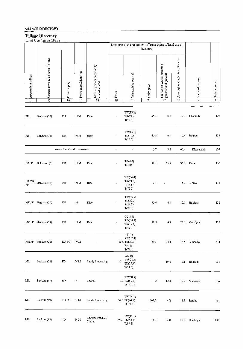
VILLAGE DIRECTORY
Village Directory Land Use (As on 1999)
14 15
PR Bankura (32)
PR Bankura (33)
ED
ED
16 17 18
NM Rice
NM Rice
-------- Uninhabited ------------
PR FP Behiatose (5)
~: MR Bankura (34)
MR FP Bankura (30)
MR FP Bankura (27)
MR FP Bankura (22)
MR Bankura (21)
MR Bankura (19)
MR Bankura (19)
MR Bankura (18)
ED NM
ED NM
ED N
ED NM
ED EO NM
ED NM
ED N
ED EO NM
ED NM
Rice
Rice
Rice
Rice
Paddy Processing
Chattai
Paddy Processing
Bamboo Product, Chattai
Land use (i.e. area under different types ofland use in hectare)
19 20
TW(19.2) TK(21.2) T(40.4)
TW(J3.J) TK(13.J) T(26.2)
TK(4.0) T(4.0)
TW(36A) TK(21.0) R(J4.6) T(n.O)
TW(46.S) TK(22.2) R(24.3) T(93.0)
GC(3.6) TW(243) TK(19.4) T(47.3)
W(3.2) TW(37.4)
20.6 TK(29.3) R(4.1) T(74.0)
W(2.0)
10 1 TW(24.3) . TK(2SA)
T(51.6)
TW(SO.S) 7.3 TK(SO.S)
T(101.1)
TW(64.1) 39.2 TK(64 J)
T(128.1)
TW(42. I) 94.7 TK(42.1)
T(84.2)
21 22
45.4
40.5
6.7
81.1
4.1
30A
32.8
20.S
0.2
307.1
4.9
23 2
0.5 19.9 Charadihi
0.4 10.4 Rampur
3.2 60A Khopaganj
6S.2 31.2 Birra
4.2 Jemua
OA 10.1 Balijora
4.4 29.1 Gopalpur
24.1 16.8 Jambedya
19.6 6.1 Bhiringi
12.0 IS.7 Malkonra
4.2 8.3 Barajuri
2.0 15.6 Dandulya
127
128
129
130
131
132
133
134
135
136
137
138
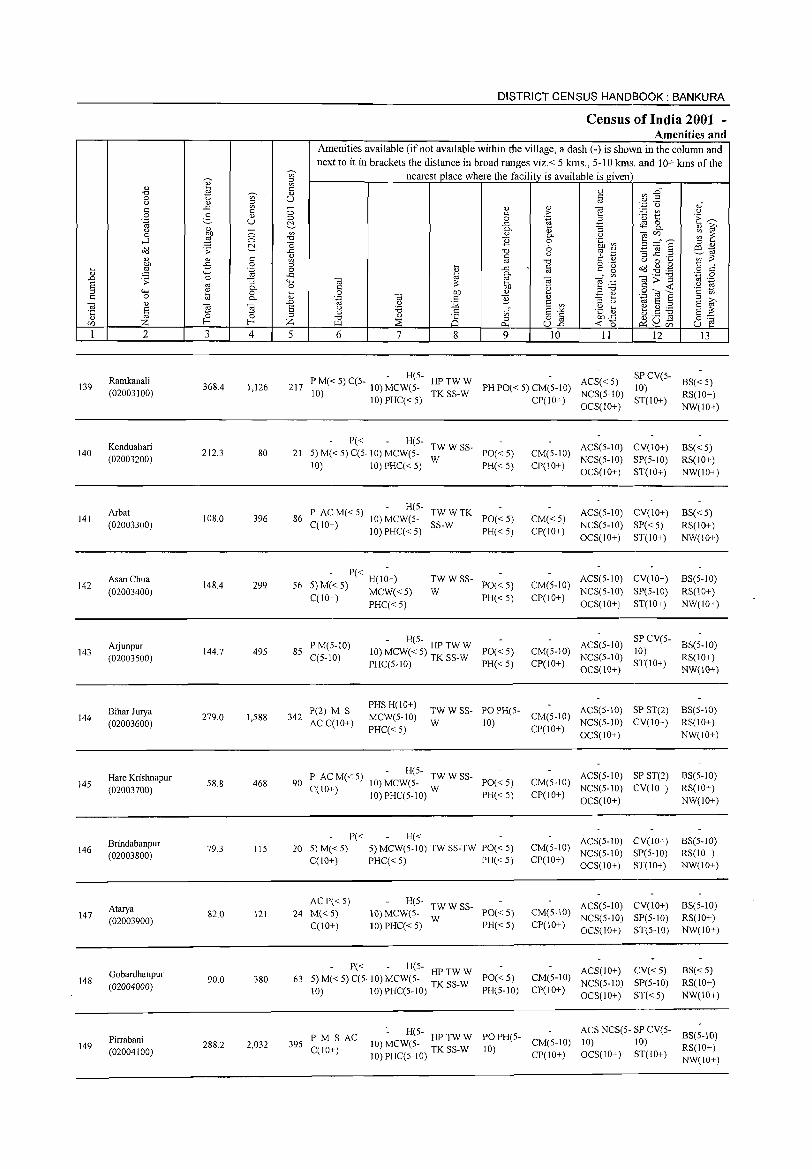
DISTRICT CENSUS HANDBOOK: BANKURA
Census of India 2001 -Amenities and
Amenities available (if not available within the village, a dash (-) is shown in the column and next to it in brackets the distance in broad ranges viz.< 5 kms., 5-10 kms. and 10+ kms of the
~
nearest_Qlace where the facility is available is given ~ " ~ c: "0 ",.6 "0 Ui' " 0 u c:
" " u " ~ OJ ".;::J U oJ ..<: - <1.l " ""§ c: c: 0 c: > ~t " 0 2- " ·E ~ .~ u 0 0 .~ 2 ~ .<: ~ 8.. " " - D. "3 " g 0 :W 0 '" " D. ." ~ :~a ~ ~
'""" 0 "0 ];j 0 0 bb~ ;:l " a<l .;; c:- ..<: "0 6 % ':g '3.2.2 e~
" c: u '" ;?: <1.l <1.l C
~ '" "0 u 0 ~ Dll -5 0 o .- c: " .... ..c til c: g o>J .g ,g .... ,g .~ 0
~ o c:
" ""' ..<: D. '" ._ "0 '.;j 0 .n .;; 0 ""3 ""' Cd ~ Cd "'§ .~ ~>~ OJ .-
§ OJ :;: U '" "
D. 0 c: '2 ;:l"O '2 t) '0 til 0 .... 0 01) <1.l ~ " S~8 c: 0- " .~ Cd c: ];j " - ~ 2 g Cd " .n u 12 E '" ;:l " '" E ;:l § £l ~ E " 'i3 .5 E"'" .~ ~ ~ \U ' ..... E :;: ·c ;:l
'" g8] " 0 ;:l "0 Q)
0 0 8] 01)"<: 8~ Ul Z f-< f-< Z '" ~ 0.. <t: 0 p::: ~ Ul
I 2 3 4 5 6 7 8 9 10 11 12 13
Ramkanali P M« 5) C(5- - H(5- HPTWW ACS«5) SP CV(5-
BS« 5) 139 368.4 1,126 217 10) 10) MCW(5- PH PO« 5) CM(5-10) 10) (02003100) TKSS-W NCS(5-1O) RS(lO+)
10) PHC« 5) CP(lO+) OCS(lO+)
ST(IO+) NW(lO+)
Kenduabari P« H(5-
TWWSS- ACS(5-IO) CV(IO+) BS« 5) 140 212.3 80 21 5) M« 5) C(5· 10) MCW(5- PO«5) CM(5-10)
(02003200) 10) 10) PHC« 5)
W PH«5) CP(10+)
NCS(5-IO) SP(5-10) RS(IO+) OCS(IO+) ST(lO+) NW(IO+)
Arbat P ACM«5) H(5-
TWWTK ACS(5-1O) CV(lO+) BS« 5) 141
(02003300) 108.0 396 86
C(lO+) 10) MCW(5-
SS-W PO«5) CM«5)
NCS(5-10) SP«5) RS(IO+) 10) PHC« 5) PH«5) CP(IO+)
OCS(IO+) ST(IO+) NW(lO+)
Asan Chua - P« -
TWWSS- ACS(5-10) CV(lO+) BS(5-10) 142 148.4 299 56 5) M«5) H(IO+) PO«5) CM(5-1O)
(02003400) C(lO+) MCW« 5) W PH«5) CP(IO+)
NCS(5-1O) SP(5-10) RS(IO+)
PHC«5) OCS(lO+) ST(lO+) NW(IO+)
Arjunpur PM(5-lO) - H(5- HPTWW ACS(5-1O) SPCV(5-
BS(5-1O) 143 144.7 495 85 10) MCW« 5) TK SS-W PO«5) CM(5-10) lO)
(02003500) C(5-10) PHC(5-1O) PH«5) CP(IO+)
NCS(5-10) ST(lO+)
RS(10+) OCS(IO+) NW(IO+)
Bihar Jurya P(2) M S PHSH(IO+)
TWWSS- PO PH(S- ACS(5-10) SP ST(2) BS(5-10) 144 279.0 1,588 342 MCW(5-10) CM(5-10)
(02003600) ACC(IO+) PHC«5)
W 10) CP(lO+)
NCS(5-10) CV(lO+) RS(IO+) OCS(IO+) NW(1O+)
Hare Krishnapur P ACM«5) - H(5- TW W SS-PO«5) CM(5-10)
ACS(5-10) SP ST(2) BS(5-1O) 145
(02003700) 58.8 468 90
C(IO+) 10) MCW(5- W NCS(5-10) CV(lO+) RS(IO+) 10)PHC(5-10) PH«5) CP(IO+)
OCS(lO+) NW(lO+)
Brindabanpur P« H« ACS(5-1O) CV(10+) BS(5-1O)
79.3 115 20 5) M«5) 5) MCW(5-10) TW SS-TW PO« 5) CM(5-10) 146 (02003800) NCS(5-10) SP(5-10) RS(lO+)
C(IO+) PHC« 5) PH«5) CP(lO+) OCS(lO+) ST(ID+) NW(ID+)
Atarya ACP« 5) H(5-
TWWSS- ACS(5-10) CV(IO+) BS(5-1O) 147 82.0 121 24 M«5) 10) MCW(5-
W PO« 5) CM(5-10)
NCS(5-10) SP(5-1O) RS(IO+) (02003900) C(lO+) 10) PHC« 5) PH«5) CP(lO+) OCS(IO+) ST(5-1O) NW(IO+)
Gobardhanpur - P« - H(5- HPTWW
PO« 5) CM(5-1O) ACS(IO+) CV«5) BS«5)
148 90.0 380 63 5) M« 5) C(5. 10) MCW(5- TK SS-W NCS(5-10) SP(5-1O) RS(IO+) (02004000) 10) 10) PHC(5-10) PH(5-1O) CP(1O+) OCS(lO+) ST« 5) NW(IO+)
PM S AC .- H(5- HPTWW POPH(5-ACS NCS(5- SP CV(5-
BS(5-10) Pirrabani CM(5-10) 10) 10) 149 288.2 2,032 395 10) MCW(5- TKSS-W 10) RS(IO+) (02004100) C(IO+) 10) PHC(5-10) CP(IO+) OCS(IO+) ST(IO+)
NW(IO+)
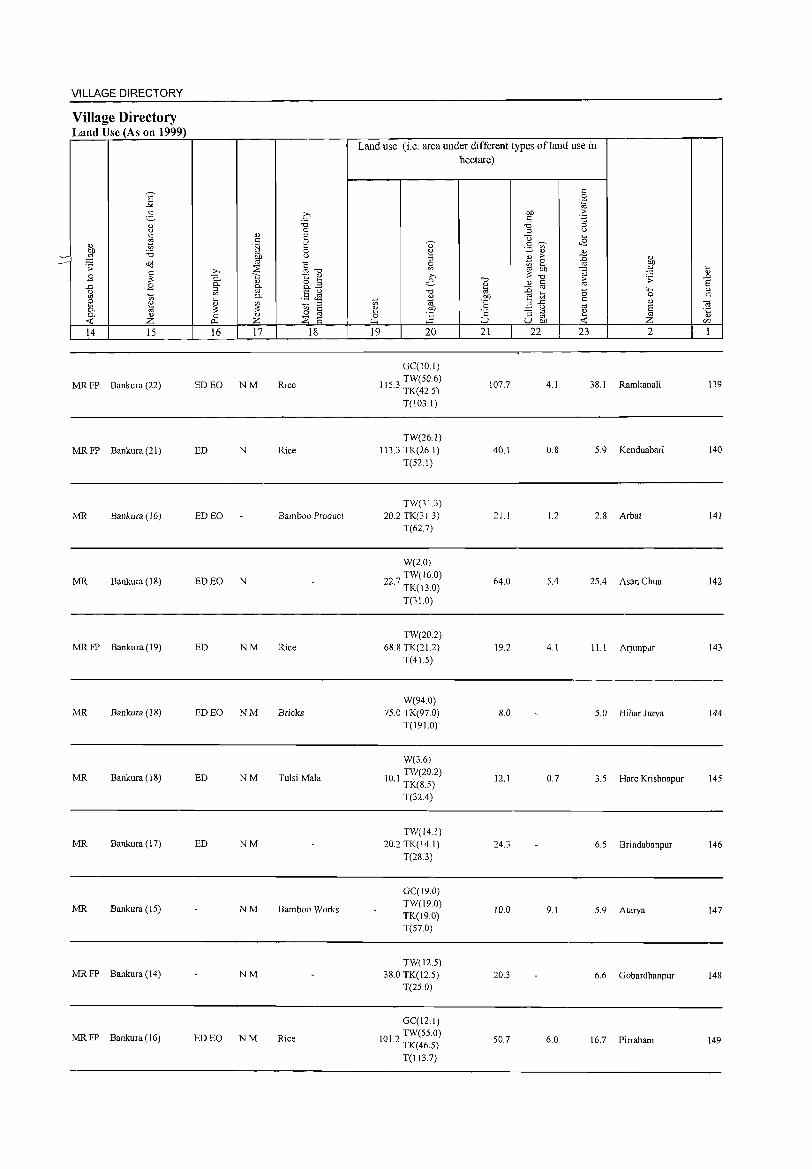
VILLAGE DIRECTORY
Village Directory Land Use (As on 1999)
14 15
MR FP Bankura (22)
MR FP Bankura (21)
MR Bankura (16)
MR Bankura (18)
MR FP Bankura (19)
MR Bankura (18)
MR Bankura (IS)
MR Bankura (17)
MR Bankura (IS)
MRFP Bankura(14)
MR FP Bankura (16)
16 17 18
ED EO NM Rice
ED N Rice
ED EO Bamboo Product
ED EO N
ED NM Rice
ED EO NM Bricks
ED NM Tulsi Mala
ED NM
NM Bamboo Works
NM
ED EO NM Rice
Land use (i.e. area under different types of land use in hectare)
19 20
GC(IO I) TW(SO.6)
115.3 TK(42.5)
T(l03.1)
TW(26.1) 113.3 TK(26.1)
T(52.1)
TW(31.3) 20.2 TK(31.3)
T(627)
W(2.0)
22 7 TW(l6.0) · TK(13.0)
T(31.0)
TW(20.2) 68.S TK(21.2)
T(4J5)
W(94 0) 75.0 TK(97.0)
T(191.0)
W(3.6)
10 I TW(20.2) · TK(S.5)
T(32.4)
TW(14.1) 20.2 TK(14.1)
T(2S 3)
GC(19.0) TW(19.0) TK(19.0) T(S7.0)
TW(12.5) 38.0 TK(J2.S)
T(2S.0)
GC(12.1)
101 2 TW(55.0) · TK(46.S)
T(113.7)
21
107.7
40.1
21 1
64.0
19.2
8.0
12.1
24.3
10.0
20.3
50.7
22 23 2
4.1 38.1 Ramkanali
0.8 5.9 Kenduabari
1.2 2.8 Arbat
5.4 25.4 Asan Chua
4.1 11.1 Arjunpur
5.0 Bihar Jurya
0.7 3.5 Hare Krishnapur
6.5 Brindabanpur
9.1 5.9 Atarya
6.6 Gobardhanpur
6.0 16.7 Pirrabani
139
140
141
142
143
144
145
146
147
148
149
2
Dhabani
150 Gobindapur
lSI
IS2
IS3
154
IS5
IS6
157
158
IS9
160
161
(02004200)
Radha Krishnapur
(02004300)
Kantabani
(02004400)
Gopinathpur
(02004S00)
Maldanga
(02004600)
Tentulia Danga
(02004700)
Shimlagar
(02004800)
Bhatia Para (02004900)
Menjua (02005000)
Abhirampur (0200SI00)
Srirampur
(02005200)
Tilasuli (0200S300)
3
180.4
63.9
102.2
76.1
101.6
288.8
S2.6
94.1
61.S
43.4
67.4
190.1
o o ~ s: o .,g "3 0.. o 0-
'" c3 4
857
634
487
1,194
430
1,049
398
144
272
5
147
DISTRICT CENSUS HANDBOOK: BANKURA
Census of India 2001 -Amenities and
Amenities available (if not available within the village, a dash (-) is shown in the column aud next to it in brackets the distance in broad rauges viz.< 5 kms., 5-10 kms. aud 10+ kms of the
nearest place where the facility is available is given
6 7 8
'" o 0..
9
-------- Uninhabited ------------
- P« -5)M«S) H(IO+) C(10+) MCW(S-IO)
PHC(S-IO)
WSS-W PO« S) PH(S-IO)
10 II 12 13
CM(S-IO) ACS(10+) NCS(IO+)
CP(IO+) OCS(lO+)
CY(S.IO) BS(S-IO)
SP« 5) RS(IO+)
ST(IO+) NW(IO+)
116 P AC M« 5) H(lO+) C(lO+) MCW(S-IO)
:W W SS- PO(S-IO)
PH(S-IO)
ACS(IO+) CM(S-IO) NCS(IO+) CP(10+)
CY(IO+)
SP(S-IO)
ST(IO+)
BS(S-IO)
RS(lO+)
NW(lO+) PHC« S)
77 P M(S-IO) C(S-IO)
H(IO+)
MCW(S-IO)
PHC(S-IO)
:W W SS- PO« 5)
PH(5-IO)
-------- Uninhabited ------------
21 I P AC M« 5) H(lO+) TWWSS-
PO«5) C(5-1O) MCW(5-10) W
PHC(IO+) PH«S)
81 - P(S- H(l~+) TWWSS-
PO« S) IO)M(S-IO) MCW(S-IO) W PH«S) C(IO+) PHC(IO+)
P AC 0 M(5- MCW H(5-10) TW W SS- PO PH(5-192
10) C(lO+) PHC(IO+) W 10)
PAC M(S-H(5-
TWWSS-72 10) MCW(5- PO(5-10)
10) C(JO+) 10) PHC« 5)
W PH(5-1O)
P(S- H(S- TWW SS-27 10) M(S-IO) 10) MCW(S- PO(S-IO)
C(lo+) 10) PHC(IO+) W PH(5-1O)
-------- Uninhabited ------------
- P« H(I~+) TWWSS-PO« 5) 42 S) M« 5) C« MCW« 5) W PH(S-IO)
5) PHC(10+)
OCS(IO+)
ACS(IO+) CM(5-1O) NCS(IO+)
CP(IO+) OCS(10+)
CM(5-1O) ACS(IO+)
NCS(IO+) CP(IO+)
OCS(IO+)
CM(5-10) ACS(IO+)
CP(IO+) NCS(IO+) OCS(lO+)
ACS CM(5-10) NCS(IO+)
CP(lO+) OCS(IO+)
ACS(IO+) CM(5-10)
CP(IO+) NCS(IO+)
OCS(IO+)
ACS(IO+) CM(5-10)
NCS(IO+) cP(lo+)
OCS(IO+)
CM(5-10) ACS(lO+)
NCS(lO+) CP(IO+)
OCS(10+)
CY(IO+)
SP(S-IO)
ST(IO+)
CY(2)SP
ST
CY(IO+)
SP(S-IO)
ST(5-10)
SP ST CY(IO+)
SP ST
CY(IO+)
SP ST CY(IO+)
CY(2) SP
ST
BS(5-10)
RS(IO+)
NW(IO+)
BS(5-10)
RS(lO+)
NW(IO+)
BS(S-IO)
RS(IO+)
NW(IO+)
BS(S-IO) RS(IO+) NW(IO+)
BS(5-10)
RS(IO+) NW(IO+)
BS« S) RS(IO+)
NW(IO+)
BS(5-10)
RS(IO+)
NW(IO+)
VILLAGE DIRECTORY
Village Directory Land Use (As on 1999)
B
14 15 16 17
-------- Uninhabited ------------
MR Bankura (20) Rice
MR Bankura (26) ED NM Rice
MR Bankura (27) ED N Rice
-------- Uninhabited ------------
MR Bankura (26) ED NM
MR Bankura (24) N Rice
MR Bankura (22) ED NM Rice
MR Bankura (21) ED N Rice
MR Bankura (19)
-------- Uninhabited ------------
MR Bankura (IS) ED N Rice
18
Land use (i.e. area under different types ofland use in hectare)
19 20 21 22 23 2
GCC7.7) TW(50,4)
611 TK(30.6)
T(S8.6)
10.1 1.6 18.9 Dhabani Gobindapur 150
TW(lS.2) 14.6 TK(IS.2)
T(36,4)
GCC7.3) W(32S) TK(IS.2)
R(8.!) T(66,4)
TW(22.3)
TK(IU) R(10.9) T(445)
TW(182) TK(12.7) R(6.5) T(37,4)
GC(121)
PCC7.1) W(22.0)
125.5 TK(29.3)
R(20.2) T(90.8)
TW(IO.I) TK(lO.I)
T(20.2)
GCCIO.l) TW(28.3)
TK(l4.2) R(18.2) T(70.8)
GCCI2.1)
20 TW(18.2) . TKCI2.1)
T(425)
GCC4.1)
73 TW(12 I) . TK(8.1)
T(24.3)
WE(12.1) 17.4 TK(13.0)
T(25.1)
TW(28.3) 58.3 TK(28.3)
T(56.7)
9.6 2.0
14.2 3.2
8.1 2.8
23.7 4.1
37.5 4.9
6.9 4.5
7.7
S.5 0.8
6.5
16.2 0.0
52.6 2.0
1.2 Radha Krishnapur 151
18,4 Kantabani 152
20.6 Gopioathpur 153
36.5 Maldanga 154
30.2 Tentulia Danga 155
21.1 Shimlagar 156
15.6 Bhatia Para 157
7.7 Menjua 158
5,4 Abhirampur 159
8.7 Srirampur 160
20.5 Tilasu1i 161
162
163
164
165
2
Bhaluka Pahari (02005400)
Bayer Mara (02005500)
Raniara (02005600)
Arbelal
(02005700)
Block Total
3 4
78.2 800
111.3 438
382.0 599
124.9 741
36646.8 162007
DISTRICT CENSUS HANDBOOK: BANKURA
Census of India 2001 -Amenities and
Amenities available (if not available within the village, a dash (-) is shown in the column and next to it in brackets the distance in broad ranges viz. < 5 kms., 5-10 kms. and 10+ kms of the
nearest place where the facility is available is given
5 6 7 8 9
P AC M( 5) H(5- TW W SS-150 < 10) MCW(5- PO« 5)
C(lO+) 10)PHC«5) W PH(5-10)
- P« 78 5)M(5-1O) MCWH(IO+) ~WWSS- PO«5)
C(lO+) PHC« 5) PH(5-1O)
115 P ACM(5-10) C(10+)
P« 155 5) M«5)
C(lO+)
P(l38) M(lS) S(11)
29714 PUC(S) Tr AC(118)
0(2)
H(IO+) MCW(5-10)
PHC(IO+)
;WSS- PO«5)
PH«5)
H(5- TWWSS-10) MCW(5- W PO(5-10) 10) PHC« 5) PH(5-10)
H D(13)
DH(12) T(7) MCW(12) W(l3S)
CWC(6) TK(60) PHC(2) HP(8) PHS(ll) TW(148) FWC(2) TB R(9) RMP(9) SMP CHW(S)
PO(19) PH(109)
10 II
CM(5-10) ACS(IO+) NCS(lO+)
CP(lO+) OCS(10+)
CM(5-10) ACS(lO+) CP(IO+) NCS(10+)
OCS(10+)
CM(5-1O) ACS(IO+)
CP(10+) NCS(IO+) OCS(IO+)
ACS(10+) CM(5-IO) NCS(10+)
CP(lO+) OCS(10+)
CM(IO) ACS(1S) OCS(S)
12 13
CV(2)SP BS(5-10) ST RS(lO+)
NW(lO+)
CV(2) SP BS(5-10) ST RS(10+)
NW(IO+)
CV(2) SP BS(5-1O)
ST RS(10+) NW(IO+)
CV(lO+)
SP« 5) ST(IO+)
CV(18) ST(28) SII'(67)
BS(5-1O) RS(JO+) NW(lO+)
BS(40)
VILLAGE DIRECTORY
Village Directory Land Use (As on 1999)
14
MR
MR
MR
MR
PR(63)
MR(129 ) FP(41)
15
Bankura (18)
Bankura (21)
Bankura (24)
Bankura (21)
16 17
ED
ED NM
ED(105) N(lOO)
EO(28) M(77)
18
Rice
Rice
Rice
Rice
Land use (i.e. area under different types ofland use in
hectare)
19 20
GC(S.7)
TW(28.3) TK(20.2) T(S4.2)
TW(IO.I) TK(IO 1)
T(20.2)
TW(8S.0) TK(38.4) R(46S) T(170.0)
TW(23.2) TK(23.2) T(46.S)
GC(589.51)
PC(21.09)
W(786.84)
WE(12.14)
6299 5 TW(2794.94) . TK(5291.51)
R(297.21)
WF(23.47) 0(257.39)
T(10074.1)
21
17.0
84.6
163.0
51.1
13952.3
22 23 2
7.0 Bhaluka Pahari
6.S Bayer Mara
11.1 38.0 Raniara
4.1 23.4 Arbelal
1647.1 4673.8
162
163
164
165

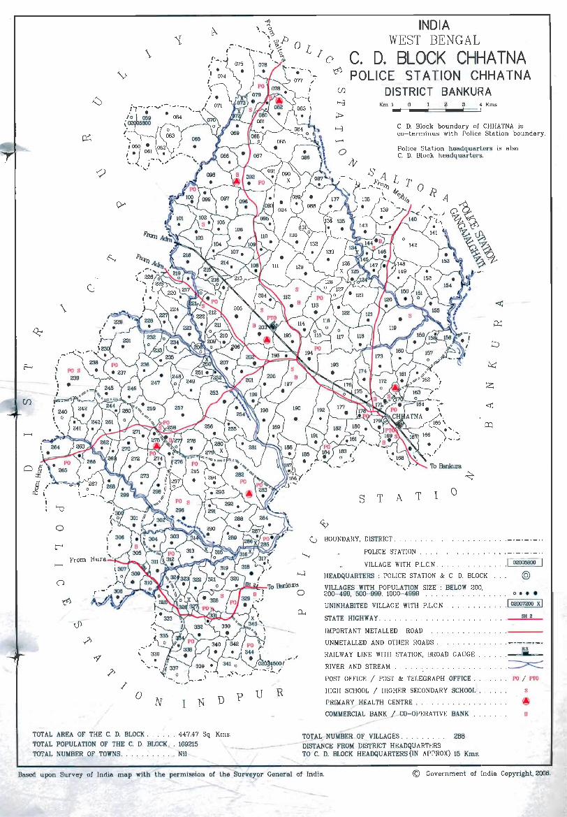
\ ( . . ~ .
I .. \.> I
\
o
From
"
/ u R o
N D p N I
°L 10
INDIA WEST BENGAL
~ C. D. BLOCK CHHA TNA POLICE STATION CHHA TNA
..-o
Jtt
DISTRICT BANKURA Km 1 0 2 3 4Kms
S T
C. D. Block boundary of CHHATNA is co- terminus with Police Station boundary .
Police Station headquarters is also C. D. Block headquarters.
...... . ....
To B:mkura ..¢
A T 1 a
G BOUNDARY, DISTRICT .
POLICE STATION
VILLAGE WITH P.L.C.N.
HEADQUARTERS: POLlCE STATION & C. D. BLOCK
VILLAGES WITH POPULATION SIZE : BELOW 200. 200- 499, 500- 999, 1000- 4999 ..
UNINHABITED VILLAGE WITH P.L.C.N .
STATE HIGHWAY .
IMPORTANT METALLED ROAD.
UN METALLED AND OTHER ROADS.
RAILWAY LINE WITH STATION, BROAD GAUGE
RIVER AND STREAM
POST OFFICE I POST & TELEGRAPH OFFICE .
HIGH SCHOOL I HIGHER SECONDARY SCHOOL.
PRIMARY HEALTH CENTRE
COMMERCIAL BANK I CO- OPERATIVE BANK
.1 02005800
@
o • ••
I 02007200 X I SH 2
R.S 'iii
PO / PTO
s
B
TOTAL AREA OF THE C. D. BLOCK. . . .. 447.47 Sq. Kms. TOT L NUMBEi OF VILLAGES . . . . . . . . 288 TOTAL POPULATION OF THE C. D. BLOCK ,_. 169215 ~ - - DISTANCE FROM DISTRICT HEADQUARTERS TOTAL NUMBER OF TOWNS. . Nil TO C. D. BLOCK HEADQUARTERS (IN APPROX) 15 Kms.
Based upon Survey of India map with the permission of the Surv:elor General of India. © Government of India Copyright, 2006.

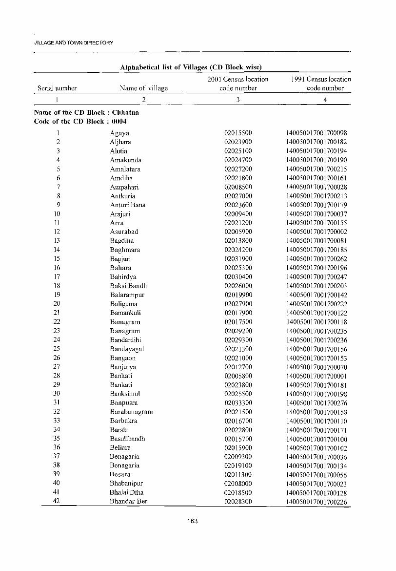
viLLAGE AND TOWN DIRECTORY
Alphabetical list of Villages (CD Block wise)
Serial number Name of village
2
Name of the CD Block: Chhatna Code of the CD Block : 0004
Agaya 2 Aljhara 3 Alutia 4 Amakunda 5 Amalatara 6 Amdiha 7 Ampahari 8 Antkuria 9 Anturi Bana
10 Arajuri 11 Arra 12 Asurabad 13 Bagdiha 14 Baghmara 15 Bagjuri 16 Bahara 17 Bahirdya 18 Baksi Bandh 19 Balarampur 20 Baliguma 21 Bamankuli 22 Banagram 23 Banagram 24 Bandardihi 25 Bandayagal 26 Bangaon 27 Banjurya 28 Bankati 29 Bankati 30 Banksimul 31 Banpusra 32 Barabanagram 33 Barbakra 34 Barshi 35 Basulibandh 36 Be1iara 37 Benagaria 38 Benagaria 39 Besara 40 Bhabanipur 41 BhalaiDiha 42 Bhandar Ber
2001 Census location code number
3
02015500 02023900 02025100 02024700 02027200 02021800 02008500 02027000 02023600 02009400 02021200 02005900 02013800 02024200 02031900 02025300 02030400 02026000 02019900 02027900 02017900 02017500 02029200 02029300 02021300 02021000 02012700 02005800 02023800 02025500 02033300 02021500 02016700 02022800 02015700 02015900 02009300 02019100 02011300 02008000 02018500 02028300
183
1991 Census location code number
4
140050017001700098 140050017001700182 140050017001700194 140050017001700190 140050017001700215 140050017001700161 140050017001700028 140050017001700213 140050017001700179 140050017001700037 140050017001700155 140050017001700002 140050017001700081 140050017001700185 140050017001700262 140050017001700196 140050017001700247 140050017001700203 140050017001700142 140050017001700222 140050017001700122 140050017001700118 140050017001700235 140050017001700236 140050017001700156 140050017001700153 140050017001700070 140050017001700001 140050017001700181 140050017001700198 140050017001700276 140050017001700158 140050017001700110 140050017001700171 140050017001700100 140050017001700102 140050017001700036 140050017001700134 140050017001700056 140050017001700023 140050017001700128 140050017001700226
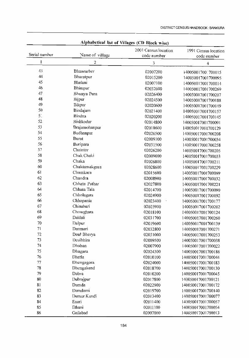
DISTRICT CENSUS HANDBOOK: BANKURA
Alphabetical list of Villages (CD Block wise)
2001 Census location 1991 Census location Serial number Name of village code number code number
2 3 4
43 Bhanrarber 02007200 140050017001700015 44 Bharatpur 02015200 140050017001700095 45 Bhelani 02007100 140050017001700014 46 Bhimpur 02032600 140050017001700269 47 Bhunya Pura 02026400 140050017001700207 48 Bijpur 02024500 140050017001700188 49 Bikpur 02020600 140050017001700149 50 Bindajam 02021400 140050017001700157 51 Bindna 02020200 140050017001700145 52 Bishkodar 02014800 140050017001700091 53 Brajamohanpur 02018600 140050017001700129 54 Budhanpur 02026500 140050017001700208 55 Burat 02009100 140050017001700034 56 Buripara 02031500 140050017001700258 57 Chaintor 02026200 140050017001700205 58 ChakChaki 02009000 140050017001700033 59 Chaka 02026800 140050017001700211 60 Chaktamakgara 02028600 140050017001700229 61 Chamkara 02015600 140050017001700099 62 Chandra 02008900 140050017001700032 63 Chhata Pathar 02027800 140050017001700221 64 Chhata Tala 02014700 140050017001700090 65 Chholagara 02024900 140050017001700192 66 Chhopania 02023400 140050017001700177 67 Chinabari 02025900 140050017001700202 68 Chowghara 02018100 140050017001700124 69 Daldali 02031700 140050017001700260 70 Dalpur 02019600 140050017001700139 71 Danmari 02032800 140050017001700271 72 Deul Bherya 02031000 140050017001700253 73 DeuIbhira 02009500 140050017001700038 74 Dhaban 02007900 140050017001700022 75 Dhagara 02024300 140050017001700186 76 Dhatla 02010100 140050017001700044 77 Dhengagora 02024000 140050017001700183 78 Dhengakend 02018700 140050017001700130 79 Dubra 02010200 140050017001700045 80 Dubrajpur 02017800 140050017001700121 81 Dumda 02022900 140050017001700172 82 Dumdumi 02019700 140050017001700140 83 DumurKundi 02013400 140050017001700077 84 Enari 02011400 140050017001700057 85 Ethani 02011100 140050017001700054 86 Gailabad 02007000 140050017001700013
184
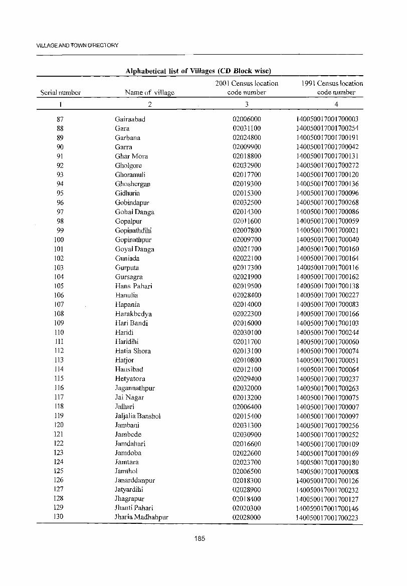
VILLAGE AND TOWN DIRECTORY
Alphabetical list of Villages (CD Block wise)
2001 Census location 1991 Census location Serial number N arne of village code number code number
2 3 4
87 Gairaabad 02006000 140050017001700003 88 Gara 02031100 ]40050017001700254 89 Garbana 02024800 ]40050017001700191 90 Garra 02009900 140050017001700042 91 Ghar Mora 02018800 140050017001700131 92 Gholgore 02032900 140050017001700272 93 Ghoramuli 02017700 140050017001700120 94 Ghoshergan 02019300 140050017001700136 95 Gidhuria 02015300 140050017001700096 96 Gobindapur 02032500 140050017001700268 97 GohalDanga 02014300 140050017001700086 98 Gopalpur 02011600 140050017001700059 99 Gopinatbdihi 02007800 140050017001700021
100 Gopinathpur 02009700 140050017001700040 101 Goyal Danga 02021700 140050017001700160 102 Guniada 02022100 140050017001700164 103 Gurputa 02017300 140050017001700116 104 Gursagra 02021900 140050017001700162 105 Hans Pahari 02019500 140050017001700138 106 Hanulia 02028400 140050017001700227 107 Hapania 02014000 140050017001700083 108 Harakbedya 02022300 140050017001700166 109 HariBandi 02016000 140050017001700103 110 Haridi 02030100 140050017001700244 111 Haridihi 02011700 140050017001700060 112 Hatia Shora 02013100 140050017001700074 113 Hatjor 02010800 140050017001700051 114 Hausibad 02012100 140050017001700064 115 Hetyatora 02029400 140050017001700237 116 J agannathpur 02032000 140050017001700263 117 Jai Nagar 02013200 140050017001700075 118 Jalhari 02006400 140050017001700007 119 JaljaliaBanshol 02015400 140050017001700097 120 Jambani 02031300 140050017001700256 121 Jambede 02030900 140050017001700252 122 Jamdahari 02016600 140050017001700109 123 Jamdoba 02022600 140050017001700169 124 Jamtara 02023700 140050017001700180 125 Jamthol 02006500 140050017001700008 126 Janarddanpur 02018300 140050017001700126 127 Jatyardihi 02028900 140050017001700232 128 Jhagrapur 02018400 140050017001700127 129 Jhanti Pahari 02020300 140050017001700146 130 Jharia Madhabpur 02028000 140050017001700223
185
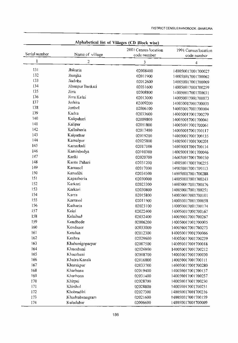
DISTRICT CENSUS HANDBOOK: BANKURA
Alphabetical list of Villages (CD Block wise)
2001 Census location 1991 Census location Serial number Name of village code number code number
1 2 3 4
131 Jhikuria 02008400 ]40050017001700027 132 Jhunjka 02011900 140050017001700062 133 Iiadoba 02012600 140050017001700069 134 Jibanpur Bankati 02031600 140050017001700259 135 Jirra 02008800 140050017001700031 136 JirraKelai 02013000 140050017001700073 137 Jorhira 02009200 140050017001700035 138 Iorthol 02006100 140050017001700004 139 Kadra 02033600 140050017001700279 140 Kalipahari 02009800 140050017001700041 ]41 Kalipur 02011800 140050017001700061 142 Kallaiberia 02017400 140050017001700117 143 Kalpathar 02019200 140050017001700135 144 Kamalpur 02025800 140050017001700201 145 Kamarkuli 02017100 140050017001700114 146 Kaminbedya 02010300 1410050017001700046 147 Kanki 02020700 1410050017001700150 148 Kanta Pahari 02031200 140050017001700255 149 Kantasol 02017000 140050017001700113 150 Kanudihi 02034500 140050017001700288 151 Kapasberia 02030000 140050017001700243 152 Karkari 02023300 140050017001700176 153 Karkari 02030800 140050017001700251 154 Karra 02015800 140050017001700101 155 Karrasol 02011500 140050017001700058 156 Katharia 02023100 140050017001700174 157 Kelai 02022400 140050017001700167 158 Kelaibad 02032400 140050017001700267 159 Kendbede 02006200 140050017001700005 160 Kendsaer 02033000 140050017001700273 161 Kendua 02012300 140050017001700066 162 Keshra 02029600 140050017001700239 163 Khabanigoparpur 02007500 ]4005001700]700018 164 Khaeabani 02026900 14010500]7001700212 165 Khaerbani 02008700 1401050017001700030 166 Khaira Kanali 02016800 140050017001700111 167 Kharakpur 02033700 140050017001700280 168 Kharbana 02019400 140050017001700137 169 Kharbona 02031400 140050017001700257 170 Khirpai 02028700 140050017001700230 171 Khirshol 02028800 140050017001700231 172 Khobradihi 02027300 140050017001700216 173 Khudrabanagram 02021600 140050017001700159 174 Ku1adabar 02006600 140050017001700009
186
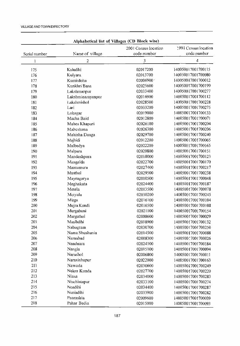
VILLAGE AND TOWN DIRECTORY
Alphabetical list of Villages (CD Block wise)
2001 Census location 1991 Census location Serial number N arne of village code number code number
2 3 4
175 Kuludihi 02017200 140050017001700115 176 Kulyara 02013700 140050017001700080 177 Kumirdoha 02006900· 140050017001700012 178 Kunkhri Basa 02025600 140050017001700199 179 Lakshmanpur 02033400 140050017001700277 180 Lakshminarayanpur 02016900 140050017001700112 181 Lakshmishol 02028500 140050017001700228 182 Lari 02033200 140050017001700275 183 Lohagar 02019000 140050017001700133 184 Macha Baid 02012800 140050017001700071 185 Mahes Khapuri 02026100 140050017001700204 186 Maheshana 02026300 140050017001700206 187 Mahisha Danga 02029700 140050017001700240 188 Majhidi 02012200 140050017001700065 189 Malbedya 02022200 1400500]7001700165 190 Malpara 02020800 140050017001700151 191 Mandashpara 02018000 140050017001700123 192 Mangalda 02022700 140050017001700170 193 Mantumura 02027400 140050017001700217 194 Masthol 02029500 140050017001700238 195 Mayragarya 02010500 140050017001700048 196 Meghakata 02024400 140050017001700187 197 Metela 02013500 140050017001700078 198 Metyala 02030200 140050017001700245 199 Mirga 02016100 140050017001700104 200 MujraKundi 02016500 140050017001700108 201 Murgabani 02021]00 140050017001700154 202 Murgathol 02008600 140050017001700029 203 Musibdihi 02018900 140050017001700132 204 Nabagram 02030700 140050017001700250 205 Nama Shushunia 02014500 140050017001700088 206 Namabad 02008300 140050017001700026 207 Nanduara 02024100 140050017001700184 208 Nangla 02015100 140050017001700094 209 Narashol 02006800 140050017001700011 210 N arasinhapur 02022000 140050017001700163 211 Nawada 02030600 140050017001700249 212 Nekra Kunda 02027700 140050017001700220 213 Niasa 02034000 140050017001700283 214 Nisehintapur 02033100 140050017001700274 215 Noadihi 02034400 140050017001700287 216 Nuniadihi 02033900 140050017001700282 217 Paarashia 02009600 140050017001700039 218 Pahar Bedia 02015000 140050017001700093
187
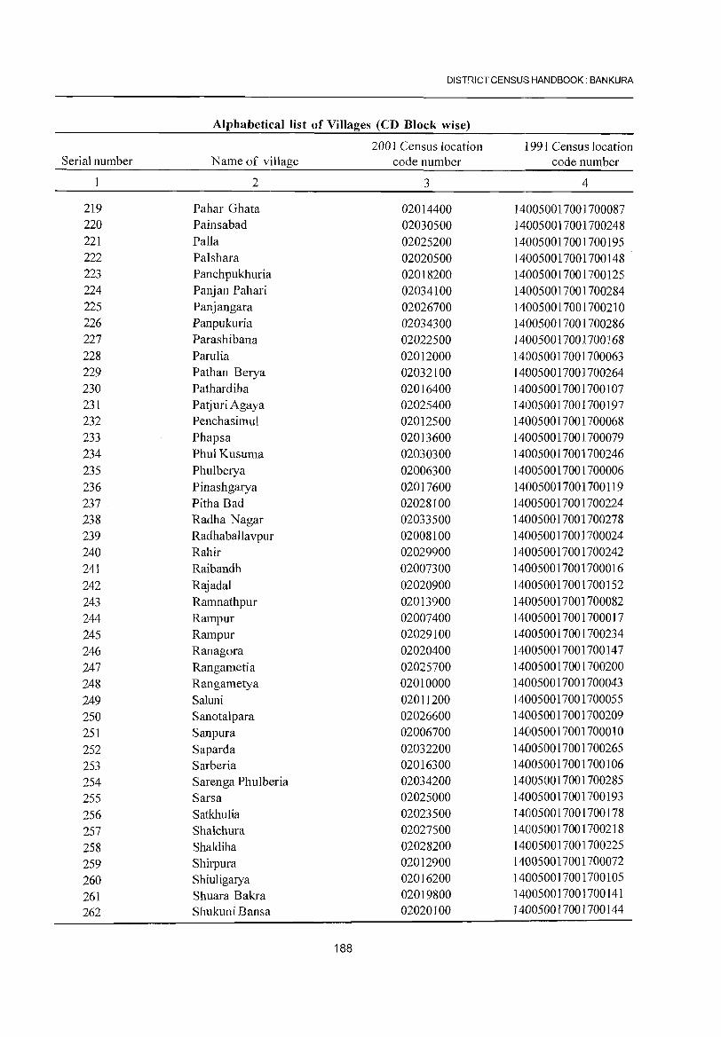
DIST~ICT CENSUS HANDBOOK: BANKURA
Alphabetical list of Villages (CD Block wise)
2001 Census location 1991 Census location Serial number Name of village code number code number
2 3 4
219 Pahar Ghata 02014400 140050017001700087 220 Painsabad 02030500 140050017001700248 221 Palla 02025200 140050017001700195 222 Palshara 02020500 140050017001700148 223 Panchpukhuria 02018200 140050017001700125 224 Panjan Pahari 02034100 140050017001700284 225 Panjangara 02026700 140050017001700210 226 Panpukuria 02034300 140050017001700286 227 Parashibana 02022500 140050017001700168 228 Parulia 02012000 1410050017001700063 229 Pathan Berya 02032100 1410050017001700264 230 Pathardiha 02016400 140050017001700107 231 Pat juri Agaya 02025400 140050017001700197 232 Penchasimul 02012500 140050017001700068 233 Phapsa 02013600 140050017001700079 234 PhulKusuma 02030300 140050017001700246 235 Phulberya 02006300 140050017001700006 236 Pinashgarya 02017600 140050017001700119 237 . Pitha Bad 02028100 140050017001700224 238 Radha Nagar 02033500 140050017001700278 239 Radhaballavpur 02008100 14005001700]700024 240 Rahir 02029900 140050017001700242 241 Raibandh 02007300 140050017001700016 242 Rajadal 02020900 140050017001700152 243 Ramnathpur 02013900 140050017001700082 244 Rampur 02007400 140050017001700017 245 Rampur 02029100 140050017001700234 246 Ranagora 02020400 140050017001700147 247 Rangametia 02025700 140050017001700200 248 Rangametya 02010000 140050017001700043 249 Saluni 02011200 140050017001700055 250 Sanotalpara 02026600 140050017001700209 251 Sanpura 02006700 140050017001700010 252 Saparda 02032200 140050017001700265 253 Sarberia 02016300 1401050017001700106 254 Sarenga Phulberia 02034200 1401050017001700285 255 Sarsa 02025000 1401050017001700193 256 Satkhulia 02023500 1401050017001700178 257 Shalchura 02027500 1400510017001700218 258 Shaldiha 02028200 140050017001700225 259 Shirpura 02012900 14010500117001700072
260 Shiuligarya 02016200 1401050017001700105
261 Shuara Bakra 02019800 140050017001700141 262 Shukuni Bansa 02020100 140050017001700144
188
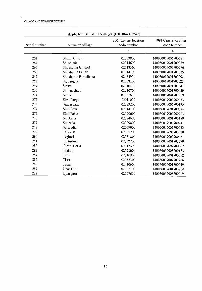
VILLAGE AND TOWN DIRECTORY
Alphabetical list of Villages (CD Block wise)
2001 Census location 1991 Census location Serial number Name of village code number code number
1 2 3 4
263 Shunri Chitra 02033800 140050017001700281 264 Shushunia 02014600 140050017001700089 265 Shushunia Iamthol 02013300 140050017001700076 266 Shushunia Pahar 02014200 140050017001700085 267 Shushunia Parasibana 02014900 140050017001700092 268 Sidhaberia 02008200 140050017001700025 269 Sihika 02010400 140050017001700047 270 Sihikapahari 02010700 140050017001700050 271 Simla 02027600 140050017001700219 272 Simulbetya 02011000 140050017001700053 273 Singergara 02023200 140050017001700175 274 Siuli Bana 02014100 140050017001700084 275 Siuli Pahari 02020000 140050017001700143 276 Siulibana 02024600 140050017001700189 277 Subarda 02029800 140050017001700241 278 Suribedia 02029000 140050017001700233 279 Taljharia 02007700 140050017001700020 280 Teghori 02031800 140050017001700261 281 Tentuibad 02032700 140050017001700270 282 Tentul Beria 02012400 140050017001700067 283 Tilajuri 02023000 140050017001700173 284 Tilna 02010900 140050017001700052 285 Tisra 02032300 140050017001700266 286 Tulsa 02010600 140050017001700049 287 UparDihi 02027100 140050017001700214 288 Upargara 02007600 140050017001700019
189
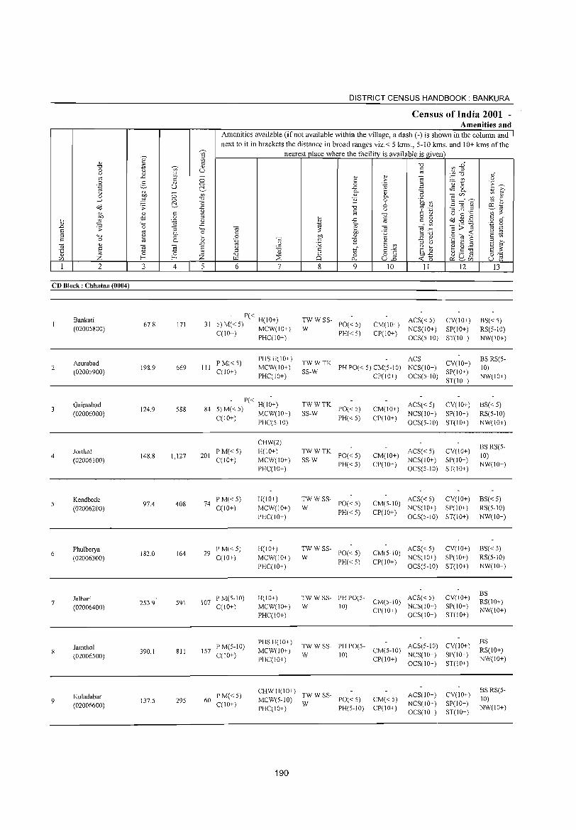
~
" .D E = c
2
CD Block: Chhatna (0004)
2
4
6
7
9
Bankati (02005800)
Asurabad (02005900)
Gairaabad (02006000)
Jorthol (02006100)
Kendbede (02006200)
Phulberya (02006300)
Jalhari (02006400)
Jamthol (02006500)
Kuladabar (02006600)
3
67.8
198.9
124.9
148.8
97.4
182.0
253.9
390.1
137.5
o o c:!, c o .-g
""3 0-o 0-
E cS 4
171
669
588
1,127
408
164
591
811
295
DISTRICT CENSUS HANDBOOK: BANKURA
Census of India 2001 -Amenities and
'" ~
Amenities available (ifnot available within the village, a dash (-) is shown in the column and next to it in brackets the distance in broad ranges viz.< 5 krns., 5-10 kms. and 10+ krns of the
nearest place where the facility is available is given c " U
5 6 7
P« H(IO+) 31 5)M«5) MCW(IO+)
CCI O+) PHCCIO+)
III P M«5) CCIO+)
PHS H(IO+) MCW(IO+) PHCCIO+)
- P« H(l~+) 84 5) M« 5) MCW(10+)
CCIO+) PHCC5-10)
201 PM« 5) C(10+)
74 PM«5) CCl0+)
29 P M« 5) CCIO+)
107 P M(S-IO) CCIO+)
157 P M(5-IO) C(10+)
CHW(2) H(IO+)
MCW(IO+) PHCCIO+)
H(10+)
MCW(IO+)
PHCCIO+)
H(IO+)
MCW(IO+) PHCCIO+)
H(IO+) MCW(IO+) PHCCIO+)
PHS H(IO+) MCW(IO+) PHC(IO+)
8
" c o
..c:: "'-" ]
"0 §
..c::
e-M
" ]
tf o
p.,
9
:W W SS- PO« 5)
PH« 5)
10
CM(lO+) CP(IO+)
11 12
ACS« 5) CV(IO+) NCS(IO+) SP(10+) OCS(5-1O) ST(10+)
~;:: TK PH PO« 5) CM(5-10) CP(10+)
ACS CV(IO+) NCS(IO+) OCS(5-10) SP(10+)
ST(IO+)
TWWTK SS-W PO« 5)
PH«5)
TWWTK SS-W PO« 5)
PH«5)
:W W SS- PO« 5)
PH«5)
TWWSS-W PO«5)
PH« 5)
CM(IO+)
CP(IO+)
ACS« 5) CV(IO+)
NCS(lO+) SP(10+) OCS(5-10) ST(IO+)
ACS« 5) CV(IO+) CM(IO+) NCS(IO+) SP(10+) CP(lO+) OCS(5-1O) ST(IO+)
AC8« 5) CV(10+) CM(5-10) NCS(10+) SP(10+)
CP(IO+) OCS(5-10) ST(IO+)
ACS« 5) CV(10+) CM(5-10) NCS(IO+) SP(IO+)
CP(IO+) OCS(5-10) ST(10+)
TW W SS- PH PO(S- ACS« S) W 10) CM(S-IO) NCS(IO+)
CV(IO+) SP(10+) ST(IO+) CP(10+) OCS(IO+)
TW W SS- PH PO(5- ACS(5-1O) CV(IO+) W 10) CM(5-10) NCS(IO+) SP(10+)
CP(IO+) OCS(10+) ST(IO+)
60 PM«5) CCI O+)
CHW H(10+) TW W SS-MCW(5-10) W PO« 5) CM«5)
CP(10+)
ACS(IO+) NCS(10+) OCS(10+)
CV(IO+) SP(10+) ST(IO+)
PHC(IO+) PH(5-10)
190
13
BS«5) RS(5-10) NW(10+)
BS RS(5-10) NW(10+)
8S« 5) RS(5-10) NW(10+)
BSRS(5-10) NW(IO+)
B8« 5) RS(5-10) NW(IO+)
BS« 5) RS(5-10) NW(IO+)
BS RS(10+) NW(10+)
BS RS(IO+) NW(10+)
BSRS(5-10) NW(10+)
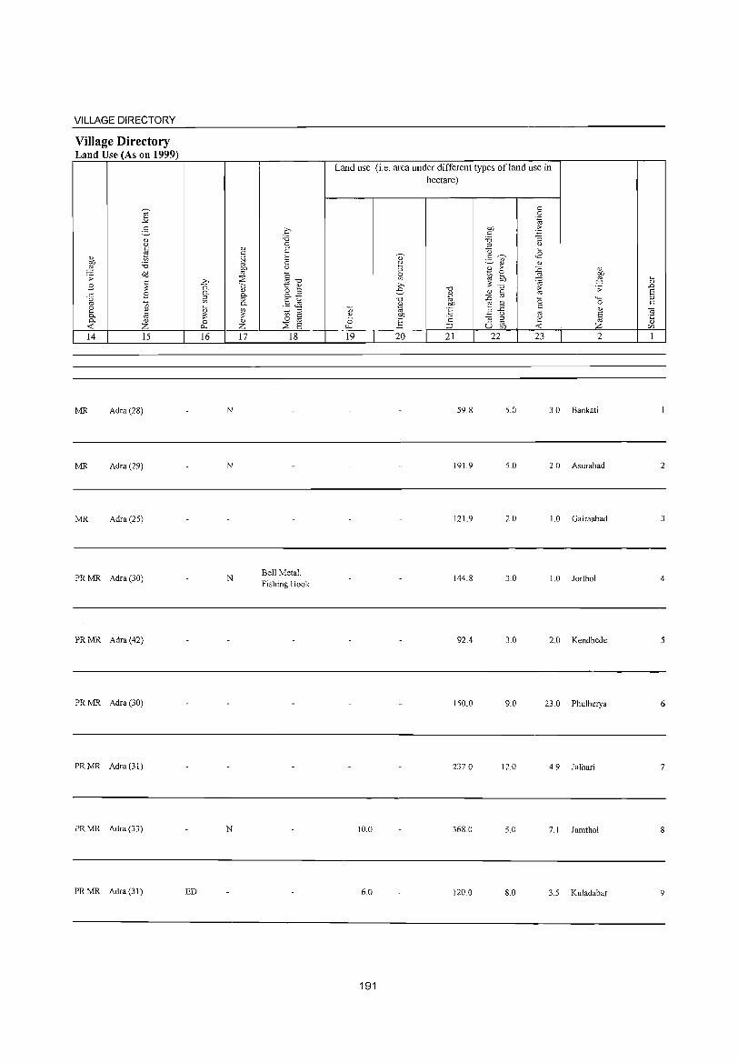
VILLAGE DIRECTORY
Village Directory Land Use (As on 1999)
14 15
MR Adra (28)
MR Adra (29)
MR Adra (25)
PR MR Adra (30)
PR MR Adra (42)
PR MR Adra (30)
PRMR Adra(31)
PR MR Adra (33)
PRMR Adra(3J)
16
N
N
N
N
ED
17 18
Bell Metal, Fishing Hook
Land use (i.e. area under different types ofland use in hectare)
19 20 21 22 23 2
59.8 5.0 3.0 Bankati
191.9 5.0 2.0 Asurabad
121.9 2.0 1.0 Gairaabad
144.8 3.0 1.0 Iortho1
92.4 3.0 2.0 Kendbede
150.0 9.0 23.0 Phu1berya
237.0 12.0 4.9 Ia1hari
10.0 368.0 5.0 7.1 Iamtho1
6.0 120.0 8.0 3.5 Kuladabar
191
2
3
4
5
6
7
9
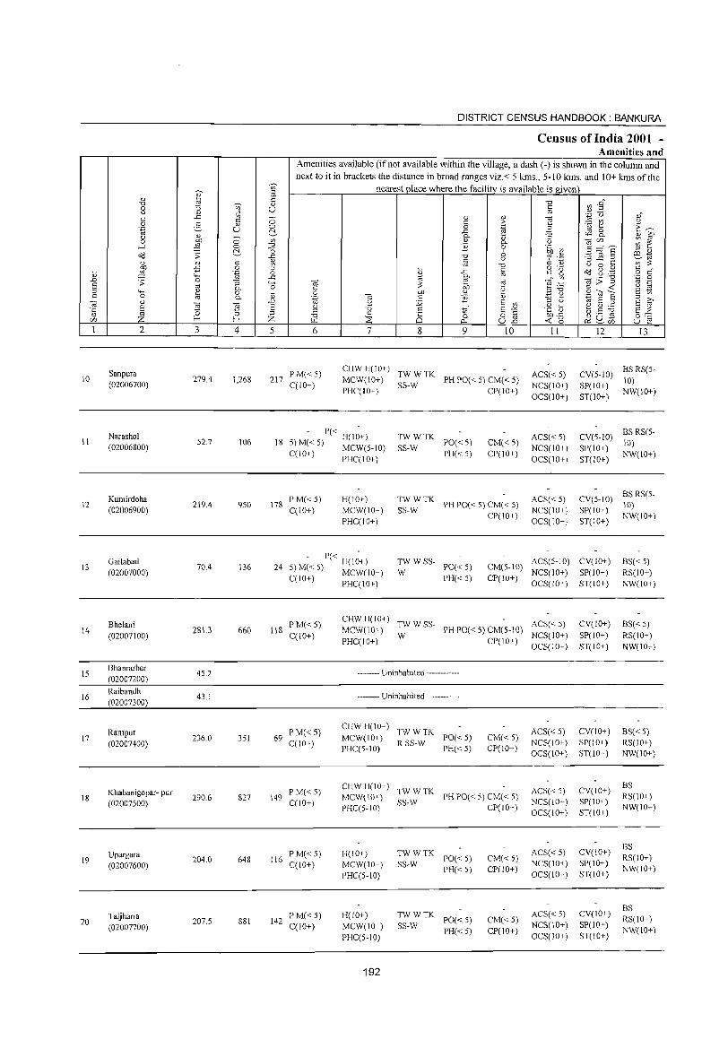
10
11
12
13
14
15
16
17
18
19
20
2
Sanpura
(02006700)
Narashol
(02006800)
Kumirdoha
(02006900)
Gailabad
(02007000)
Bhelani
(02007100)
Bhanrarber
(02007200)
Raibandh
(02007300)
Rampur (02007400)
Khabanigopar· pur
(02007500)
Upargara (02007600)
Taljharia
(02007700)
3 4
279.4 1,268
52.7 106
219.4 950
70.4 136
2813 660
45.2
43.1
236.0 351
290.6 827
204.0 648
207.5 881
DISTRICT CENSUS HANDBOOK: BANKURA
Census of India 2001 -Amenities and
T Amenities available (ifnot available within the village, a dash C-) is shown in the column and next to it in brackets the distance in broad ranges viz.< 5 kms., 5-10 kms. and 10+ kms of the
nearest place where the facility is available is given
u
5 6 7 8
" c o .c 0-
" B
9
" > .~ <V 0-o b u
"0
8 ""iii .~
" E v>
15 -a ull
10
217 PM«5) C(10+)
CHWH(10+) TWWTK MCW(10+) SS-W PH PO« 5) CM« 5) PHC(IO+) CP(IO+)
• P« . 18 5) M« 5) H(IO+)
C(IO+) MCW(5-10) PHC(10+)
178 P M« 5) C(lO+)
H(IO+) MCW(IO+) PHC(IO+)
TWWTK SS-W PO«5)
PH«5) CM« 5) CP(IO+)
~:: TK PH PO« 5) CM« 5) CP(IO+)
II
ACS« 5) NCS(IO+) OCS(IO+)
ACS« 5) NCS(10+) OCS(IO+)
ACS« 5) NCS(IO+)
OCS(IO+)
12 13
CV(5-1O) BS RS(5-
SP(10+) 10) ST(IO+) NW(10+)
CV(5.10) BS RS(5. 10)
SP(IO+) NW(IO+) ST(IO+)
CV(5-IO) BS RS(5-
SP(IO+) 10) ST(10+) NW(IO+)
P« H(10+) 24 5) M« 5) MCW(IO+)
C(10+) PHC(lO+)
:W W SS· PO« 5)
PH«5)
CM(S.10) ACS(S·IO) CV(IO+)
CP(10+) NCS(IO+) SP(lO+) OCS(lO+) ST(IO+)
BS«5) RS(10+) NW(10+)
118 PM«S) C(1O+)
69 PM« S) C(10+)
149 P M« 5) C(10+)
116 PM«S) C(10+)
142 P M« S) C(10+)
CHW H(IO+) TW W SS. ACS« 5) MCW(lO+) W PH PO« 5) CM(5-10)
NCS(IO+) PHC(10+) CP(IO+) OCS(IO+)
.. __ .... Uninhabited _ ....... -_ ..
.... _-_. Uninhabited --....... __ .
CHWH(10+) TWWTK MCW(IO+) R SS.W PO« 5) PHC(5-1O) PH« 5)
CM« 5) CP(IO+)
CHW H(10+) TW W TK MCW(10+) SS.W PH PO« S) CM« S) PHC(5-10) CP(10+)
H(10+) MCW(IO+) PHC(S·IO)
H(IO+) MCW(IO+) PHC(S·IO)
192
TWWTK SS.W PO« 5)
PH«5)
TW W TK PO« 5)
SS·W PH« 5)
CM« 5) CP(10+)
CM«5) CP(10+)
ACS« 5) NCS(lO+) OCS(IO+)
ACS« 5) NCS(10+) OCS(lO+)
ACS« 5) NCS(IO+) OCS(10+)
ACS« 5) NCS(10+) OCS(JO+)
CV(IO+)
SP(IO+)
ST(IO+)
CV(lO+) SP(IO+) ST(10+)
CV(10+) SP(10+) ST(10+)
CV(IO+) SP(lO+) ST(IO+ )
CV(IO+) SP(10+) ST(IO+)
BS« 5)
RS(IO+) NW(10+)
BS« 5) RS(IO+) NW(lO+)
BS RS(10+) NW(10+)
BS RS(10+) NW(lO+)
BS RS(IO+) NW(IO+)
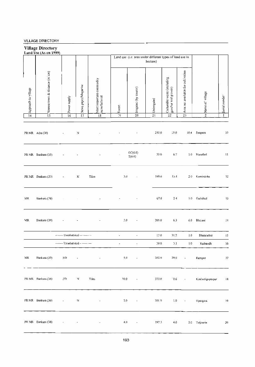
VILLAGE DIRECTORY
Village Directory Land Use (As on 1999)
E -'" 5 <l) to C
~ '" Ol) :.a ~ ~. o'd
B ~ {l B co 1;; 2 '" a 0-0- <l)
~ Z 14 15
PR MR Adra (30)
PR MR Bankura (33)
PR MR Bankura (33)
MR Bankura (38)
MR Bankura (39)
'" c .~
gp :::E >,
-a 0::; 0- '" 0-a co
0-... '" ~ ~ 0 '" 0.. Z 16 17
N
N Tiles
-------- Uninhabited ------------
-------- Uninhabited ------------
MR Bankura (39) ED
PR MR Bankura (36) ED N Tiles
PR MR Bankura (36) N
PR MR Bankura (38)
q "0 0 6 6 0 u
§ "0 ~ '" 8.B .5 JS
::s en § 0
:::E 6 18
Land use (i.e. area under different types ofland use in
en 1: 0 ~
19
3.0
3.0
5.0
10.0
2.0
4.0
" ~ 0
'" » e "0
~ OJ)
'.§ 20
GC(6.0)
T(6.0)
193
hectare)
"0 <l)
"' 'E ·2 :J
21
250.0
39.0
199.0
67.0
266.0
130
39.0
202.0
270.0
201.0
197.5
c 0
'.g Ol) -5 c 'Ci "3 ::l U
<3 ... ~ <8 2- en
'" '" til > :0 '" ~ co Ol) co ,g ~ 3 "0 > .s;: " c co co :0 "0 """' ~ a 0 c .3 .c co '" (.) E "3 ::s 1: CO ~ U bJl <.r:
22 23 2
19.0 10.4 Sanpura
6.7 1. 0 Narashol
15.4 2.0 Kumirdoha
2.4 1.0 Gai1abad
6.3 6.0 Bhe1ani
31.2 1.0 Bhanrarber
3.1 1.0 Raibandh
29.0 Rampur
10.6 Khabanigoparpur
1.0 Upargara
4.0 2.0 Taljharia
... " .D 6 ::s c ca .~
U".l
1
10
11
12
13
14
15
16
17
18
19
20
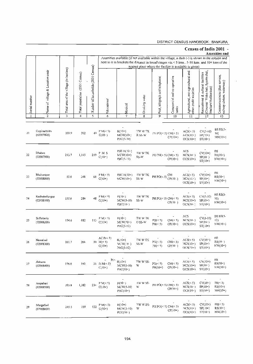
21
22
23
24
25
26
27
28
29
2
Gopinathdihi (02007800)
Dhaban (02007900)
Bhabanipur (02008000)
Radhaballavpur (02008100)
Sidhaberia (02008200)
Namabad (02008300)
Jhikuria (02008400)
Ampahari (02008500)
Murgathol (02008600)
3 4
109.9 302
213.7 1,14S
53.6 348
155.6 286
154.6 682
101.7 266
176.0 193
303.8 1,382
245.5 739
DISTRICT CENSUS HANDBOOK: BANKURA
Census of India 2001 -Amenities and
Amenities available (ifnot available within the village, a dash (-) is shown in the column and next to it in brackets the distance in broad ranges viz.< 5 kms., 5-10 kms. and 10+ kms of the
nearest place where the facility is available is given
5 6
49 PM«S) C(IO+)
219 PM S C(IO+)
66 P M« 5) C(IO+)
48 P M« 5) C(lO+)
113 PM«5) C(IO+)
AC P« 5)
50 M«5) C(IO+)
7
H(IO+) MCW(lO+) PHC(S-IO)
PHSH(IO+)
MCW(10+) PHC(S-10)
PHCH(IO+) MCW(IO+)
H(IO+)
MCW(5-10) PHC(lO+)
H(IO+) MCW(IO+) PHC(5-10)
H(lO+)
MCW(IO+) PHC(S-lO)
- P« H(l~+) 35 5) M« 5) MCW(5-10)
C(lO+) PHC(IO+)
234 P M« 5) C(lO+)
122 P M« 5) C(10+)
H(IO+) MCW(S-IO)
PHC(lO+)
H(IO+) MCW(5-10) PHC(IO+)
194
8 9 10
~~S~WTK PH PO« S) CM« 5) CP(IO+)
TWWTK SS-W POPH«S)CM«5)
CP(IO+)
TWWTK CM SS-W PHPO«5) CP(IO+)
~~:TK PHPO«5)CM«5) CP(IO+)
TWWTK o SS-W PO« 5)
PH«5)
TWWTK SS-W PO« 5)
PH«5)
TWWSS-W PO«5)
PH(!O+)
CM«5) CP(IO+)
CM«5) CP(lO+)
CM«S) CP(!O+)
:W W SS- PH PO« 5) CM« 5)
CP(IO+)
TW W SS-W PH PO« 5) CM« 5)
CP(IO+)
11
ACS« S) NCS(IO+) OCS(IO+)
ACS NCS(10+) OCS(IO+)
ACS« 5) NCS(IO+)
OCS(IO+)
ACS« 5) NCS(IO+)
OCS(IO+)
ACS NCS(IO+) OCS(IO+)
ACS« 5) NCS(IO+) OCS(IO+)
ACS« 5) NCS(lO+) OCS(lO+)
ACS« 5) NCS(lO+) OCS(IO+)
ACS« 5) NCS(lO+) OCS(IO+)
12 13
CY(S-IO) BSRS(5-10)
SP(IO+) NW(IO+) ST(IO+)
CY(IO+) SP(lO+) ST(IO+)
CY(IO+) SP(IO+)
ST(IO+)
BS RS(IO+) NW(IO+)
BS RS(IO+) NW(IO+)
CY(5-10) BS RS(5-10)
SP(IO+) NW(IO+) ST(IO+)
CY(5-10) BS RS(S-10)
SP(IO+) NW(IO+) ST(IO+)
CY(IO+) SP(IO+) ST(lO+)
CY(lO+) SP(10+) ST(IO+)
CY(10+) SP(IO+) ST(10+)
CY(lO+) SP(lO+) ST(IO+)
BS RS(IO+) NW(lO+)
BS RS(lO+) NW(lO+)
BS«5) RS(lO+) NW(10+)
BS«5) RS(10+) NW(IO+)
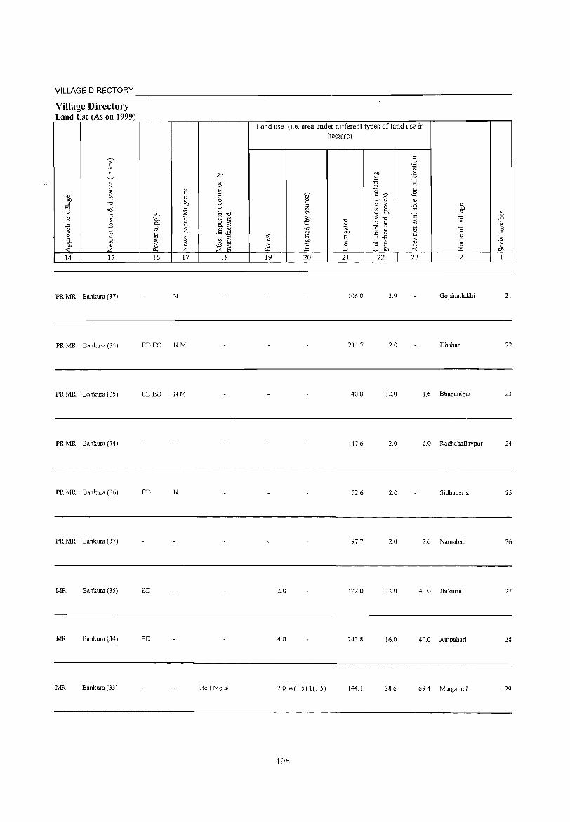
VILLAGE DIRECTORY
Village Directory Land Use (As on 1999)
14 15
PR MR Bankura (37)
PR MR Bankura (35)
PR MR Bankura (35)
PR MR Bankura (34)
PR MR Bankura (36)
PR MR Bankura (37)
MR Bankura (35)
MR Bankura (34)
MR Bankura (33)
16 17 18
N
ED EO NM
ED EO NM
ED N
ED
ED
Bell Metal
Land use (i.e. area under different types ofland use in hectare)
19 20 21 22 23 2
106.0 3.9 Gopinathdihi
211.7 2.0 Dhaban
40.0 12.0 1.6 Bhabanipur
147.6 2.0 6.0 Radhaballavpur
152.6 2.0 Sidhaberia
97.7 2.0 2.0 Namabad
2.0 122.0 12.0 40.0 lhikuria
4.0 243.8 16.0 40.0 Ampahari
2.0 W(1.5) T(1.5) 144.1 28.6 69.4 Murgathol
195
21
22
23
24
25
26
27
28
29
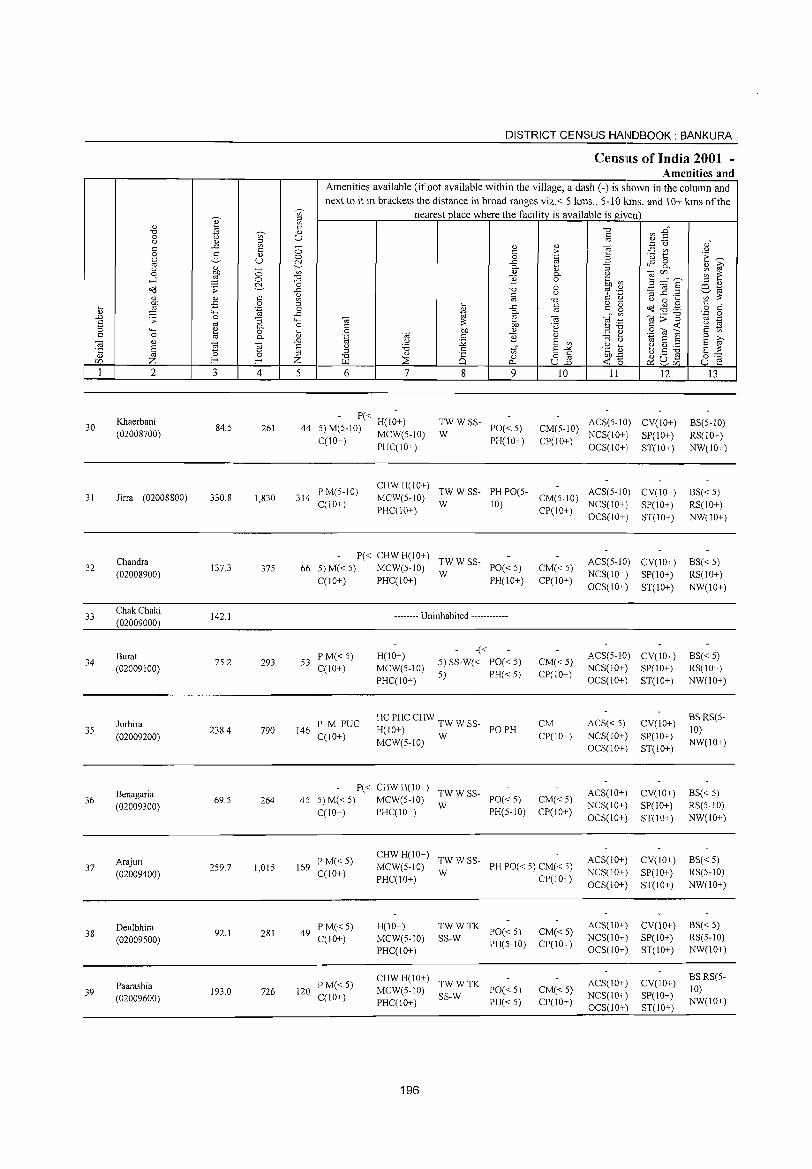
30
31
32
33
34
35
36
37
38
39
2
Khaerbani (02008700)
Jirra (02008800)
Chandra (02008900)
Chak Chaki (02009000)
Burat (02009100)
lorhira (02009200)
Benagaria (02009300)
Arajuri (02009400)
Deulbhira (02009500)
Paarashia (02009600)
3
84.5
330.8
137.3
142.1
75.2
2384
69.5
259.7
92.1
193.0
'" ~ " '" u
o o ~
4
261
1,830
375
293
790
264
1,015
281
726
DISTRICT CENSUS HANDBOOK: BANKURA
CenslLls of India 2001 -Amenities and
Amenities available (if not available within the village, a dash (-) is shown in the column and next to it in brackets the distance in broad ranges viz.< 5 kms., 5-10 kms. and J 0+ kms of the
nearest place where the facility is available is given
5 6 7
- P« H(I;+) 44 5) M(5-10) MCW(5-tO)
CCl0+) PHCC10+)
8 9
:W W SS- PO« 5)
PH(10+)
10 11 12
CM(5-10) ACS(5-10) CV(IO+) CP(lO+) NCS(lO+) SP(lO+)
OCS(lO+) ST(lO+)
314 PM(5-10) CCl0+)
CHW H(10+) TW W SS- PH PO(5 ACS(5-10) MCW(5-10) W 10) - CM(5-10) NCS(10)
CV(10+) SP(10+) ST(10+)
PHC(10+) CP(\O+) +, OCS(10+)
P« CHW H(lO+) TW W SS-66 5) M« 5) MCW(5-10) W PO« 5)
C(IO+) PHC(10+) PH(10+)
53 PM«5) C(10+)
146 PM PUC CClO+)
-------- Uninhabited ------------
H(10+) MCW(5-1O) PI-IC(10+)
-« 5) SS-W« PO« 5) 5) PI-I« 5)
HC PHC CHW TW W SS-H(10+) PO PH MCW(5-10) W
P« CHW H(10+) TW W SS-45 5) M« 5) MCW(5-10) W PO« 5)
C(10+) PHCCI0+) PI-I(5-10)
CM«5) CP(IO+)
CM«5) CP(lO+)
CM CP(10+)
CM«5) CP(10+)
169 PM« 5) C(10+)
CI-IW 1-1(10+) TW W SS-MCW(5-10) W PI-I PO« 5) CM« 5) PHC(10+) CP(lO+)
49 PM«5) CCI O+)
120 P M« 5) C(lO+)
H(10+) MCW(5-10) PHCC10+)
~~:TK PO«5) PI-I(5-1O)
CHW H(10+) TW W TK MCW(5-10) SS-W PO« 5) PI-ICC10+) PI-I« 5)
196
CM«5) CP(10+)
CM«5) CP(10+)
ACS(5-10) CV(10+) NCS(10+) SP(10+) OCS(10+) ST(10+)
ACS(5-10) CV(lO+) NCS(10+) SP(lO+) OCS(lO+) ST(10+)
ACS« 5) NCS(lO+) OCS(10+)
ACS(10+) NCS(lO+) OCS(IO+)
ACS(10+) NCS(lO+) OCS(10+)
ACS(10+) NCS(lO+) OCS(10+)
ACS(10+) NCS(10+) OCS(10+)
CV(10+)
SP(10+) ST(10+)
CV(10+) SP(10+) ST(lO+)
CV(lO+) SP(10+) ST(10+)
CV(lO+) SP(10+) ST(lO+)
CV(10+) SP(lO+) ST(10+)
13
BS(5-10) RS(IO+) NW(IO+)
BS« 5) RS(lO+) NW(10+)
BS« 5) RS(10+) NW(IO+)
BS« 5) RS(10+) NW(IO+)
BS RS(5-10) NW(10+)
BS« 5) RS(5-1O) NW(10+)
BS« 5) RS(5-10) NW(IO+)
BS« 5) RS(5-1O) NW(10+)
BSRS(5-10) NW(lO+)
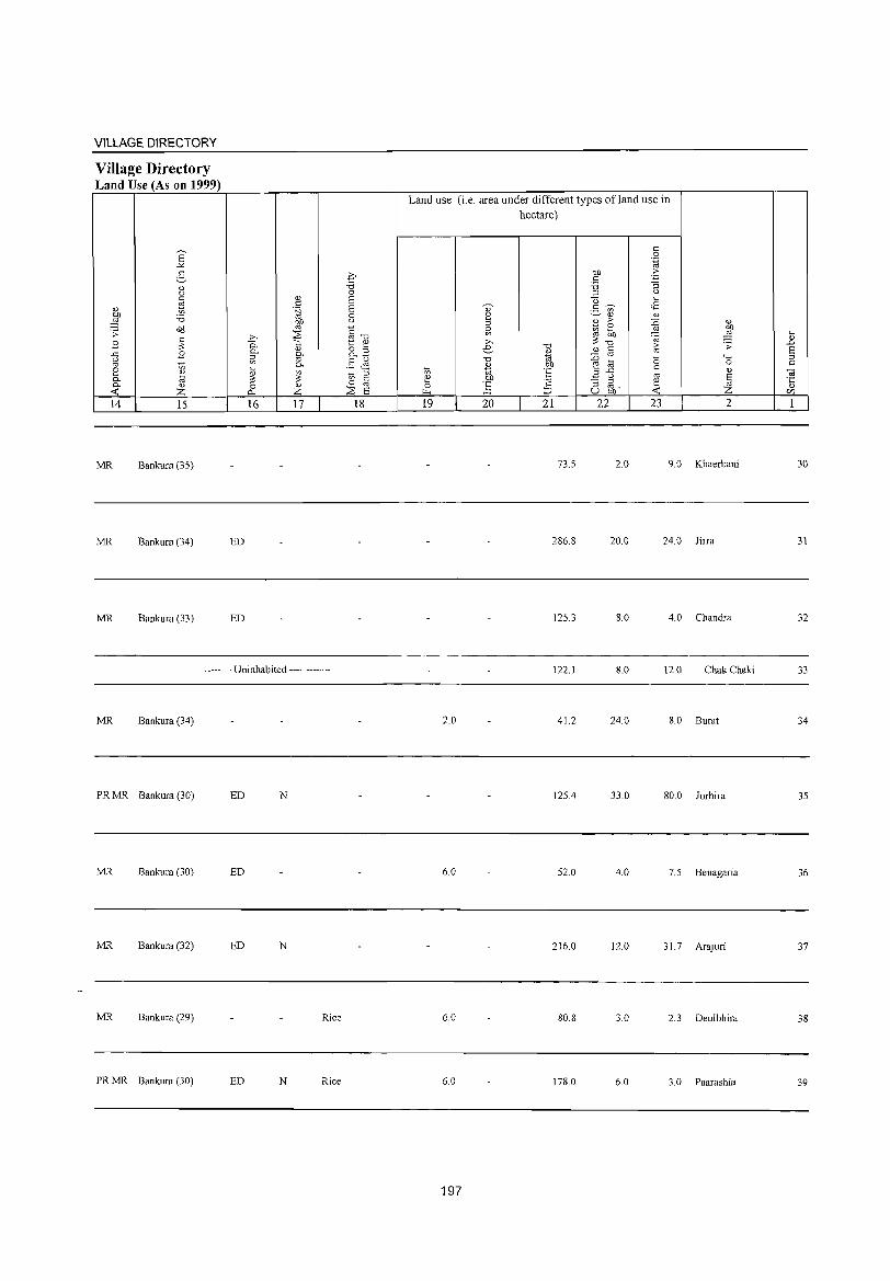
VILLAGE DIRECTORY
Village Directory Land Use (As on 1999)
14 15
MR Bankura (35)
MR Bankura (34)
MR Bankura (33)
16 17
ED
ED
-------- Uninhabited ------------
MR Bankura (34)
PR MR Bankura (30) ED N
MR Bankura (30) ED
MR Bankura (32) ED N
MR Bankura (29) Rice
PR MR Bankura (30) ED N Rice
18
Land use (i.e. area under different types ofland use in hectare)
19 20 21 22 23 2
73.5 2.0 9.0 Khaerbani
286.8 20.0 24.0 Jirra
125.3 8.0 4.0 Chandra
122.1 8.0 12.0 ChakChaki
2.0 41.2 24.0 8.0 Bural
125.4 33.0 SO.O Jorhira
6.0 52.0 4.0 7.5 Benagaria
216.0 12.0 31.7 Arajuri
6.0 SO.S 3.0 2.3 Deulbhira
6.0 178.0 6.0 3.0 Paarashia
197
30
31
32
33
34
35
36
37
38
39

DISTRICT CENSUS HANDBOOK: BANKURA
Census of India 2001 -Amenities and
Amenities available (if not availablewithin the village, a dash (-) is shown in the column and
next to it in brackets the distance in broad ranges viz.< 5 kms., 5-10 lans. and 10+ kms of the ~
nearest place where the facility is available is given co 0) i;;
" lil c -0 a3 :2~ -0 ~ " 0 t) co U c (.) " i;; '" ''';:: u ,," C ..c - " " e c 0 c >
,_ co (.)
0 5 " 0 0 .~ 3 '" t:: E~ .~ U ~ ..c: ~ 8.. " ~ (.) " - 0-" ;;
0 bJ) 0 co " 0- (.)
~ ~~ S ~ ~ -l ~ 0 "0 1i 0 .~ ~ ~ 0 6 ::> "
~ .:; ..c -0 6 'i1 -3 _§ .= e,rtj
" c 1;l " (.)
co ;;: " '" -0 (.) 0 ~
:W -5 0 ::> ~ " o ._
~ ~ .,g c " ~ .~ 0 " ..c:
c:" ~ o c " '- ..c 0; 0- '" Cil;;"§
'';:; 0 ..c :; 0 ;; '- Cil e Cil ~ .- '" '-S '" 0- 0 " ;;: bJ) .~ " ~ '2 ~ ::> "-< " 0 ~ 0 bJ) " ::>-0
2~S C 0 [;;; 0- " .~ Cil c 1i " .=: ~ E ~ Oil " ..c (.) i2 S co ::> (.) til S ::> E Cil ~ S (.) 'i3 .5 E-'< (.) ~ ~ ~ :.a E ;;: '5 '" (5 ::> ::>
" co o iii 'i:; (!)
~O~ -0 2S 0 bJ)..c 0:-::: C/l Z l- I- Z U-1 ~ p., U..c ~ (5 ~ ~C/l U e 1 2 3 4 5 6 7 8 9 10 11 12 13
40 Gopinathpur
235.7 748 137 - P« H(I~+) TWWTK
PH PO« 5) CM« 5) ACS(IO+) CV(IO+) BS« 5)
(02009700) 5) M« 5) MCW(5-1O) SS-W NCS(IO+) SP(1O+) RS(5-1O) C(lO+) PHC(IO+) CP(10+)
OCS(IO+) ST(10+) NW(IO+)
41 Kalipahari
247.1 585 97 PM«5) H(10+) TWWTK
PH PO« 5) CM« 5) ACS(IO+) CV(IO+) BS« 5)
(02009800) C(10+) MCW(5-10) SS-W NCS(lO+) SP(10+) RS(5-10) PHC(IO+)
CP(1O+) OCS(10+) ST(10+) NW(IO+)
Garra P M«5) CHW H(IO+)
TWWTK ACS(IO+) CV(IO+) BS«5) 42
(02009900) 104.7 564 98
C(IO+) MCW(5-IO)
SS-W PO« 5) CM«5)
NCS(IO+) SP(IO+) RS« 5) PHC(IO+) PH«5) CP(IO+)
OCS(IO+) ST(IO+) NW(IO+)
Rangametya P M«5) H(IO+) TWWTK PO ACS
CV(lO+) BS« 5) 43 131.2 663 124 CM«5) NCS(IO+)
(02010000) C(IO+) MCW(5-10) RSS-W PH(IO+) CP(IO+) OCS(1O+)
SP(IO+) RS«5) PHC(IO+) ST(IO+) NW(IO+)
Dhatla 215.7 481 90
P M«5) H(IO+) TWWTK PH PO« 5) CM« 5)
ACS(10+) CV(IO+) BS«5) 44
(02010100) C(lO+) MCW(5-IO) SS-W NCS(10+) SP(IO+) RS(5-10)
PHC(IO+) CP(IO+)
OCS(IO+) ST(IO+) NW(lO+)
Dubra PM S PHSH« 5)
TWWTK ACS(IO+) CV(10+) BS«5) 45
(02010200) 115.8 407 67
C(10+) MCW«5)
SS-W PO«5) CM«5)
NCS(IO+) SP(1O+) RS(5-1O) PHC(IO+) PH(5-1O) CP(IO+)
OCS(IO+) ST(10+) NW(IO+)
( PHSCHW Kaminbedya
182.8 817 127 P < H(IO+) TWWSS-
PH PO« 5) CM(5-10) ACS(IO+) CV(IO+) BS(5-10)
46 (02010300) 5)M«5) MCW(5-10) W NCS(IO+) SP(IO+) RS(5-10)
C(IO+) PHC(IO+) CP(IO+) OCS(5-10) ST(1O+) NW(IO+)
Sihika P M«5) H(IO+) TWWSS-PH PO« 5) CM(5-10)
ACS(10+) CV(5-10) BS(5-10) 47
(02010400) 112.0 431 81
C(10+) MCW(5-10) W NCS(IO+) SP(IO+) RS(5-10)
PHC(IO+) CP(IO+)
OCS(5-10) ST(IO+) NW(IO+)
Mayragarya P« CHW H(10+)
TWWTK ACS(IO+) CV(10+) BS«5) 48 103.2 264 40 5) M«5) MCW(5-10) PH PO« 5) CM« 5)
(02010500) C(10+) PHC(IO+)
SS-W CP(IO+)
NCS(IO+) SP(IO+) RS«5) OCS(5-10) ST(IO+) NW(IO+)
PM«5) H(IO+) TWWTK ACS(IO+) CV(IO+) BSRS(5-
Tulsa PH PO« 5) CM(5-10) 10) 49 229.3 558 96 C(10+) MCW(S-IO) ss-w NCS(10+) SP(IO+) (02010600) CP(IO+) NW(IO+)
PHC(IO+) OCS(5-IO) ST(lO+)
198
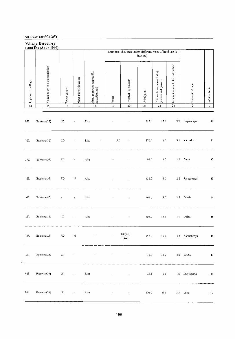
VILLAGE DIRECTORY
Village Directory Land Use (As on 1999)
14 15
MR Bankura (32)
MR Bankura (31)
MR Bankura (33)
MR Bankura (35)
MR Bankura (40)
MR Bankum (32)
MR Bankura (25)
MR Bankura (25)
MR Bankura (30)
MR Bankura (30)
ED
ED
ED
ED
ED
ED
ED
ED
ED
16 17
Rice
Rice
Rice
N Rice
Rice
Rice
N
Rice
Rice
C 'is o S S o <J
§"O t " 8.3 .5 ~
::l
ts @ ~ S
18
Land use (i.e. area under different types of land use in hectare)
19
12.0
20
GC(2.0) T(20)
199
21 22
215.0
226.0
95.0
121.0
205.0
102.0
158.0
78.0
93.6
220.0
23 2
17.0 3.7 Gopinathpur
6.0 3.1 Kalipahari
8.0 1.7 Garra
8.0 2.2 Rangametya
8.0 2.7 Dhatla
12.4 1.4 Dubra
18.0 4.8 Kaminbedya
30.0 4.0 Sihika
8.0 1.6 Mayragarya
6.0 3.3 Tulsa
40
41
42
43
44
45
46
47
48
49
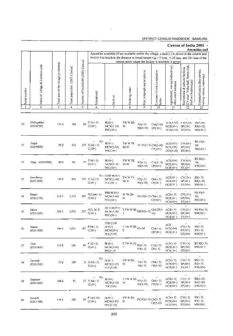
50
51
52
S3
54
55
56
57
58
59
60
""' o
" § Z 2
Sihikapahari (02010700)
Ha~or (02010800)
Tilna (02010900)
Simulberya (020'1100'0)
Ethani (02011100)
Saluni (02011200)
Besara (02011300')
Enari (020'1140'0')
Karrasol (020'11500)
Gopalpur (02011600)
Haridihi (02011700)
3
134.4
99.2
80.0
129.9
319.7
369.5
196.6
115.8
77.6
108.S
IS9.5
o o ~
" o .~
"3 Q. o Q.
OJ
~ 4
368
613
391
864
1,153
1,953
1,021
536
108
91
190
5
66
107
71
135
203
362
187
94
16
22
39
DISTRICT CENSUS HANDBOOK: BANKURA
Census of India 2001 -Amenities and
Amenities available (ifnot available within the village, a dash (-) is shown in the column and next to it in brackets the distance in broad ranges viz. < 5 Ians., 5- I 0 kms. and 10+ Ians of the
nearest place where the facility is available is given
6 7
P M«5) H(10+) C(10+) MCW(S-10)
PHCCI0+)
- P« -5) M« 5) H(10+) C(lO+) MCW(5-10)
PHCCIO+)
PM«S) H(10+) C(10+) MCW(S-IO)
PHCCI0+)
P« CHW H(IO+) 5) M«5) MCW(S-10) CCI0+) PHCCIO+)
P(2)M« 5) PHS H(IO+)
MCW(S-10) CCI0+)
PHCCIO+)
P(2) M S HCOH(IO+) MCW(S-10)
C(10+) PHCCIO+)
PHSCHW PM«5) H(10+) CCIO+) MCW(10+)
PHCC5-10)
PM«5) H(lO+) C(10+) MCW(5-10)
PHCC<5)
- P« H(I;+) 5) M« 5) MCW(5-10) C(10+) PHCC5-IO)
- P« -H(IO+)
S)M«S) MCW(5-10) C(lO+) PHCCI0+)
PM(5-10) H(IO+) C(10+) MCW(5-10)
PHCCS-I0)
200
8
TWWSS-
W
co o
i>.
9
PO«5) PH(S-lO)
" > .~
" Q. o 6 u
"0
iii OJ ·2 " E co
§-E u.2
10
CM(5-1O) CP(10+)
TWWTK PH PO« 5) CM(5-1O)
SS-W CP(lO+)
TWWTK PO«5) CM(5-10)
SS-W PH(5-1O) CP(10+)
TWWTK PO«5) CM«S)
SS-W PH(5-10) CP(IO+)
WTKSS-PH PO« 5) CM« 5)
W CP(lO+)
T TW W SS· PH PO« 5) CM CP(5-T 10)
TTWW SS'POPH CM«5) T
CP(IO+)
T TW W SS· PO(~ 5) CM« 5) T PH« 5) CP«5)
TWWSS-PO« 5) CM«5)
W PH« 5) CP(5-10)
TTW W SSpO(~ 5) CM«S) W PH(S-lO) CP(10+)
TWWSS-PH PO« 5) CM« 5)
W CP(5-10)
II 12 13
ACS(5-1O) CY(5-10) BS(5-10) NCS(10+) SP(10+) RS(S-10) OCS(S-lO) ST(10+) NW(10+)
ACS(1O+) CY(10+) BS RS(5-10)
NCS(10+) SP(IO+) NW(lO+)
OCS(5-lD) ST(lO+)
ACS(lO+) CY(10+) BS RS(5-10)
NCS(10+) SP(10+) NW(IO+)
OCS(10+) ST(10+)
ACS(10+) CV(10+) BS« S) NCS(lO+) SP(10+) RS(5-1O)
OCS(10+) ST(10+) NW(10+)
ACS« 5) CV(10+) BS RS(5-
10) NCS(10+) SP(10+) OCS(10+) ST(10+)
NW(lO+)
ACS« 5) CY(10+) BSRS« 5) NCS(10+) SP(10+) NW(IO+)
OCS(IO+) ST(IO+)
ACS NCS(IO+)
CV« 5) BS« 5)
OCS(10+) SP(lO+) RS« 5) ST(10+) NW(10+)
ACS« 5) CV«5) BS RS« 5)
NCS(10+) SP(IO+) NW(IO+)
OCS(10+) ST(lO+)
ACS« 5) CY«5) BS«5)
NCS(10+) SP(10+) RS« 5) OCS(10+) ST(10+) NW(10+)
ACS« 5) CV«5) BS(5-10)
NCS(IO+) SP(10+) RS(5-10)
OCS(10+) ST(10+) NW(lO+)
ACS« 5) CY« 5) BS« 5)
NCS(lO+) SP(IO+) RS«5)
OCS(IO+) ST(IO+) NW(10+)
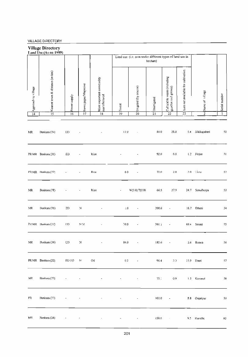
VILLAGE DIRECTORY
Village Directory Land Use (As on 1999)
14 15
MR Bankura (24)
PR MR Bankura (26)
PR MR Bankura (27)
MR Bankura (28)
MR Bankura (26)
PR MR Bankura (22)
MR Bankura (26)
PR MR Bankura (22)
MR Bankura (22)
PR Bankura (22)
MR Bankura (24)
16 17 18
ED
ED Rice
Rice
Rice
ED N
ED NM
ED N
ED EO N Oil
Land use (i.e. area under different types of land use in
hectare)
19 20 21 22 23 2
12.0 89.0 28.0 5.4 Sihikapahari
92.0 6.0 1.2 Hatjor
6.0 70.0 2.0 2.0 Tilna
W(0.8) T(0.8) 66.5 37.9 24.7 Simulberya
10 300.0 18.7 Ethani
39.0 261.1 69.4 Saluni
14.0 180.0 2.6 Besara
0.2 96.4 15.9 Enari
75.1 0.9 1.5 Karrasol
100.0 8.8 Gopalpur
150.0 9.5 Haridihi
201
50
51
52
53
54
55
56
57
58
59
60
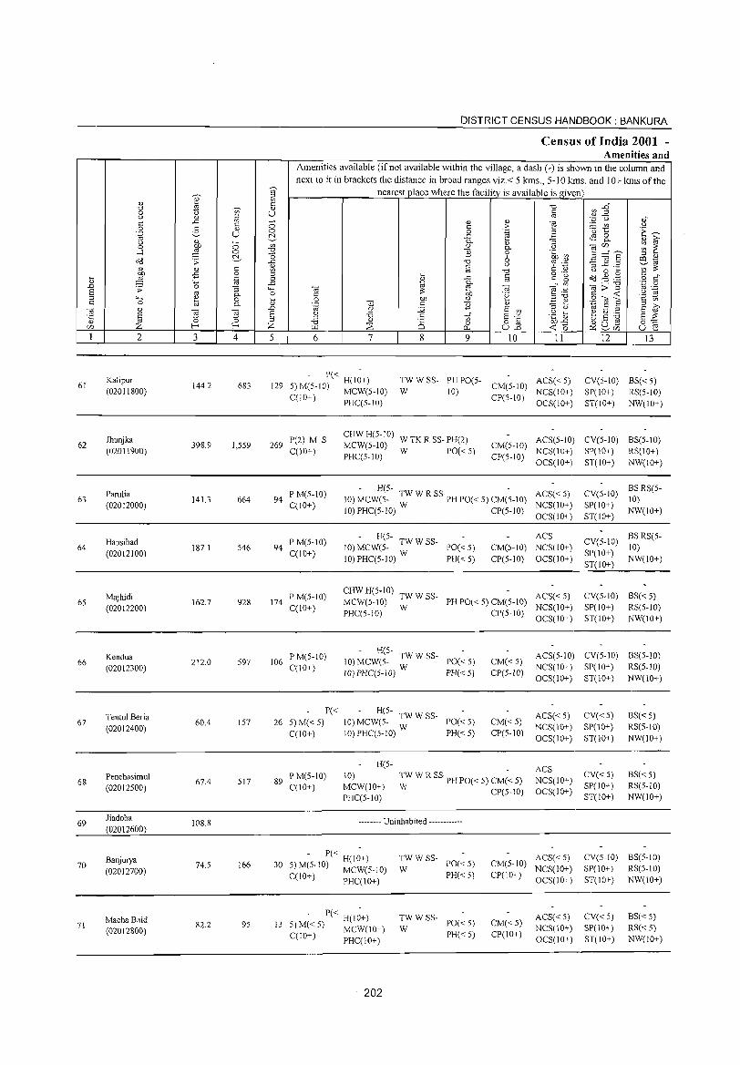
DISTRICT CENSUS HANDBOOK: BANKURA
Census of India 2001 -Amenities and
Amenities available (ifnot available within the village, a dash (-) is shown in the column and next to it in brackets the distance in broad ranges viz.< 5 kms., 5-10 kms. and 10+ kms of the
~
'" nearest place where the facilitv is available is Il.iven ]' '" ., '" '" -0 ~ E~ -0 .,
0 t) '" U " (.) II '" ro
" '" - ., " ] '.;j u ,f
'" 0 > :.::: U'l u 0 " " '" ·0 1:: .~ ~ .~ v u 0 0 .~
~ ..c ~ 8. (.)
~ 0- '3 " iii'
0 0 '" " " (.)
~ ~~s ~ 1: "C) 0-....:l 0 E 0 .~ ~
~ ] 6 '" ., o<l .;;: -0 '3 ~ .2 P'1 ~ ., (.) ~ .~ ~ro .,
" '" '" '" ~ '" ro -0 (.) 0 ....
~ £ 0 '" o ._ '" " .... .~ il I ..c '" =" ~ o<l .g .g o '" .,
""' 0- ro '.p 0 .D .;;: 0 '3 ""' ce E! '" e .~ ce>"§ '" ._ S ro 0- 0 " bJ) °e '" -< '2 ~ '" 4-< ~ 0 .... 0 bJ) <l.) ,,-0 .S (U S " 0 0- " .~ '" c 2 " ~ ~ g ~ ce " "E! ~
.D C) :.g E '" '" (.) 10 S '" S 8 (.) '6 .~ ~ b .5 ~ '5 '" 5 E-" 8 ~ ro ~ " "C) '" CS '" o '" bJ)..c 0:-;:::::
C/) Z f-< Z "" :::s 0 u13 -< 0 ~ SU5 u E! 0.-
1 2 3 4 5 6 7 8 9 10 11 12 13
61 Kalipur
144.2 683 129 - P« H(I~+) TW W SS- PH PO(5- ACS« S) CV(5-10) BS« S)
(02011800) S) M(S-IO) MCW(S-IO) W 10) CM(S-IO)
NCS(10+) SP(IO+) RS(S-10) C(lO+) PHC(S-IO) CP(S-lO)
OCS(IO+) ST(IO+) NW(lO+)
Ihunjka P(2) M S CHWH(5-1O)
W TK R SS- PH(2) ACS(S-10) CV(S-IO) BS(S-1O) 62 398.9 I,SS9 269 MCW(5-10) CM(S-IO)
(02011900) C(10+) W PO«S) NCS(10+) SP(IO+) RS(10+) PHC(S-IO) CP(S-IO)
OCS(lO+) ST(lO+) NW(lO+)
Parulia P M(S-10) H(S- TWWRSS - ACS« S) CV(S-IO) BSRS(S-
63 141.3 664 94 10) MCW(S- W PH PO« S) CM(S-10) 10) (02012000) C(10+) NCS(10+) SP(1O+)
10) PHC(S-IO) CP(S-10) OCS(10+) ST(10+)
NW(lO+)
Hausibad PM(S-1O) - H(S- ACS
CV(S-IO) BSRS(S-
64 187.1 546 94 10) MCW(S- TW W SS- PO« S) CM(S-IO) NCS(1O+) 10) (02012100) C(10+)
10)PHC(5-10) W PH«5) CP(5-10) OCS(10+) SP(lO+)
NW(lO+) ST(1O+)
65 Majhidi P M(5-1O) CHW H(5-10) TW W SS- ACS« 5) CV(5-10) BS« 5)
(02012200) 162.7 928 174
C(10+) MCW(S-IO) W PH PO« 5) CM(S-10)
NCS(10+) SP(10+) RS(5-10) PHC(5-10) CP(5-10)
OCS(1O+) ST(10+) NW(1O+)
Kendua P M(S-10) - H(5- TW W SS-PO«5) CM«5)
ACS(5-1O) CV(5-10) BS(5-1O) 66 212.0 S97 106 10) MCW(5-
(02012300) C(IO+) 10)PHC(5-1O) W PH« 5) CP(5-W) NCS(1O+) SP(IO+) RS(5-10) OCS(10+) ST(10+) NW(lO+)
Tenlul Beria P« - H(5- TW W SS- ACS«5) CV« 5) BS« 5)
67 60.4 157 26 5) M«5) 10) MCW(5- PO«5) CM«5) (02012400) 10) PHC(5-10) W
NCS(10+) SP(IO+) RS(5-10) C(10+) PH«5) CP(5-10)
OCS(10+) ST(10+) NW(10+)
H(5-ACS
68 Penchasimul
67.4 517 89 P M(S-10) 10) ~W W R SS PH PO« 5) CM(-< 5) NCS(1O+)
CV« 5) BS«5)
(02012500) C(10+) MCW(10+) CP(5-10) OCS(IO+)
SP(IO+) RS(5-10)
PHC(5-1O) ST(10+) NW(lO+)
69 Iiadoba
108.8 -------- Uninhabited ------------(02012600)
Banjurya - P« H(I~+) TWWSS-PO«5) CM(5-10)
ACS«5) CV(5-10) BS(5-1O) 70
(02012700) 74.5 166 30 5) M(5-10) MCW(5-10) W NCS(lO+) SP(10+) RS(5-1O)
C(10+) PHC(10+) PH« 5) CP(10+) OCS(lO+) ST(IO+) NW(IO+)
Macha Baid - P« H(I~+) TWWSS-PO« 5) CM«5)
ACS« 5) CV« 5) BS« 5) 71
(02012800) 82.2 95 13 5) M« 5) MCW(10+) W NCS(10+) SP(10+) RS« 5)
C(IO+) PHC(10+) PH«5) CP(IO+) OCS(10+) ST(10+) NW(lO+)
202
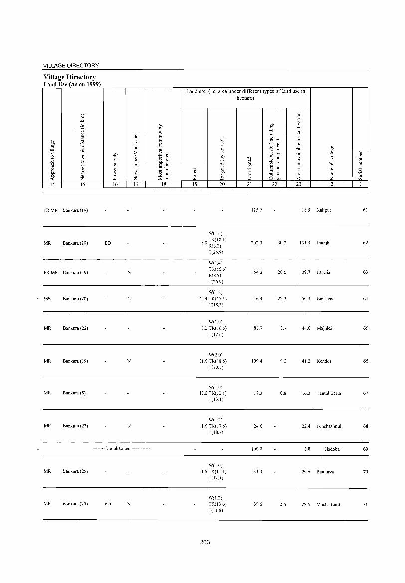
VILLAGE DIRECTORY
Village Directory Land Use (As on 1999)
14 15
PRMR Bankura (J 9)
MR Bankura (20)
PRMR Bankura (19)
MR Bankura (20)
MR Bankura (22)
MR Bankura (19)
MR Bankura (8)
MR Bankura (23)
16 17
ED
N
N
N
N
-_-__ --_ Uninhabited __ -_-_-___ -_
MR Bankura (25)
MR Bankura (25) ED N
18
Land use (i.e. area under different types of land use in hectare)
19 20 21 22 23
125.7 IS.5
W(16)
S TK(18 I) .0 R(6.2) 202.9 30.3 13l.9
T(25.9)
W(l.4) TK(16.6)
54.3 20.5 39.7 R(S.9) T(26.9)
W(L2) 49.4 TK(17.l) 46.9 22.3 50.3
T(18.3)
W(I.O) 3.2 TK(16 6) 8S.7 8.7 44.6
T(17.6)
W(2.0) 3l.6 TK(18 5) 109.4 9.3 41.2
T(20.5)
W(l.O) 13.0 TK(12.1) 17.3 O.S 16.3
T(131)
W(1.2) l.6 TK(17 5) 24.6 22.4
T(18.7)
100.0 8.8
W(1.0) 1.6 TK(ll.I) 31.3 29.6
T(12.1)
W(I.2) TK(10.6) 39.6 2.4 2S.4 T(ll.S)
203
2
Kalipur 61
Jhunjka 62
Parulia 63
Hausibad 64
Majhidi 65
Kendua 66
Tentul Beria 67
Penchasimul 68
Jiadoba 69
Banjurya 70
Macha Baid 71
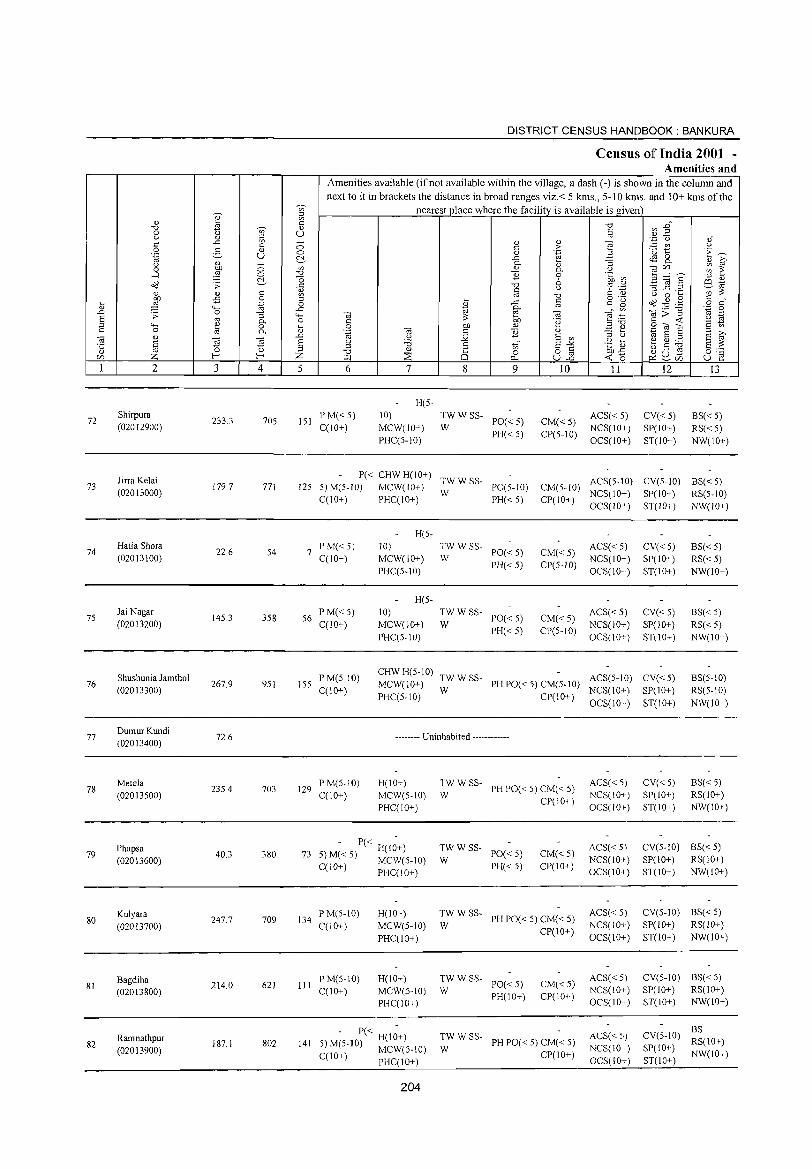
72
73
74
75
76
77
78
79
80
81
82
2
Shirpura
(02012900)
Jirra Kelai (02013000)
Hatia Shora (020J3100)
Jai Nagar (02013200)
Shushunia Jamthol (02013300)
DumurKundi (02013400)
Metela (02013500)
Phapsa (02013600)
Kulyara (02013700)
Bagdiha (02013800)
Ramnathpur
(02013900)
3
233.3
J79.7
22.6
145.3
267.9
72.6
235.4
40.3
247.7
214.0
187.1
u> ::l u> C
" U
o o ~
4
705
771
54
358
951
703
380
709
621
802
DISTRICT CENSUS HANDBOOK: BANKURA
Census oj[ India 2001 -Amenities and
Amenities available (if not available within the village, a dash (-) is shown in the column and next to it in brackets the distance in broad ranges viz.< 5 kms., 5-10 kms. and 10+ kms of the
nearest place where the facility is available is given
5 6
151 PM«5) C(IO+)
7
H(5-
10)
MCW(JO+)
PHce5-10)
8 9
TWWSS-W PO«5)
PH«5)
10
CM« 5) CP(5-10)
II
ACS« 5) NCS(lO+)
OCS(IO+)
12
CV«5) SP(IO+)
ST(10+)
13
BS«5)
RS« 5) NW(lO+)
P« CHW H(lO+) TW W SS-J25 5) M(5-JO) MCW(JO+) W PO(5-JO) CM(5-JO) ACS(5-10) CV(5-10) BS«5)
CP(IO+) NCS(IO+) SP(IO+) RS(5-JO) C(JO+) PHceIO+) PH« 5) OCS(IO+) ST(IO+) NW(JO+)
7 PM«5) C(IO+)
56 P M« 5) C(1O+)
H(5-
10)
MCW(IO+)
PHce5-10)
H(5-
10)
MCW(lO+)
PHC(S-IO)
:W W SS- PO« 5)
PH« 5)
TWWSS-W PO« 5)
PH« 5)
CM«5) CP(5-10)
CM«5) CP(5-IO)
ACS« 5) NCS(lO+)
OCS(IO+)
ACS« 5)
NCS(1O+)
OCS(IO+}
155 P M(5-10) ceJO+)
CHW H(5-10) TW W SS- ACS(5-10) MCW(1O+) W PH PO« 5) CM(5-10) NCS(lO+)
PHceS-10) CP(lO+) OCS(lO+)
-------- Uninhabited ------------
129 P M(5-IO) C(IO+)
H(IO+)
MCW(5-10) PHC(IO+)
- P« H(I~+) 73 5) M« 5) MCW(5-10)
C(lO+) PHceIO+)
134 P M(S-IO) C(10+)
I I I P M(S-IO) ceIO+)
H(IO+)
MCW(5-10)
PHC(10+)
H(IO+)
MCW(5-1O)
PHceIO+)
- P« H(I~+) 141 5)M(5-10) MCW(5-10)
ceIO+) PHC(IO+)
204
:W W SS- PH PO« 5) CM« 5)
CP(IO+)
TWWSS-W PO« 5)
PH« 5) CM«5) CP(JO+)
:W W SS- PH PO« 5) CM« 5)
CP(IO+)
:W W SS- PO« 5)
PH(IO+) CM«5) CP(IO+)
TWWSS-W PH PO« 5) CM« 5)
CP(lO+)
ACS« 5) NCS(IO+) OCS(IO+)
ACS«5) NCS(IO+) OCS(IO+)
ACS«5) NCS(1O+)
OCS(10+)
ACS« 5) NCS(IO+) OCS(IO+)
ACS« 5) NCS(IO+)
OCS(IO+)
CV« 5) SP(lO+)
ST(IO+)
CV«5) SP(JO+)
ST(lO+)
CV« 5) SP(lO+)
ST(lO+)
CV(<:5)
SP(IO+)
ST(lO+)
BS« 5) RS« 5) NW(IO+)
BS« 5)
RS« 5)
NW(IO+)
BS(5-10)
RS(5-10)
NW(10+)
BS« 5)
RS(IO+) NW(JO+)
CV(S-IO) BS«5)
SP(lO+) RS(IO+) ST(IO+) NW(IO+)
CV(S-IO) BS« 5)
SP( 10+) RS( 10+)
ST(lO+) NW(lO+)
CV(5-10) BS« 5) SP(10+) RS(IO+)
ST(IO+) NW(IO+)
CV(S-IO) ~~(IO+) SP(IO+) NW(IO+) ST(IO+)
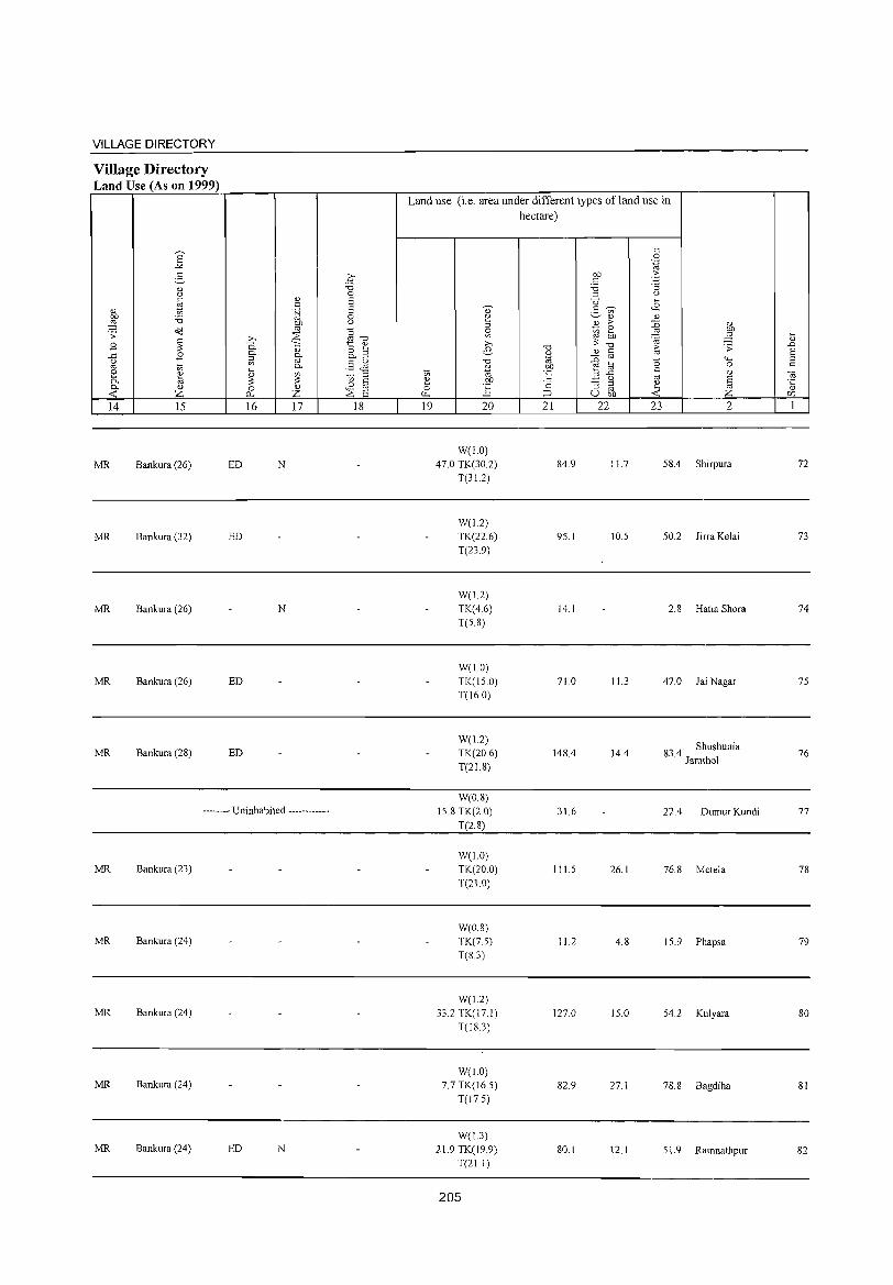
VILLAGE DIRECTORY
Village Directory Land Use (As on 1999)
14 15
MR Bankura (26)
MR Bankura (32)
MR Bankura (26)
MR Bankura (26)
MR Bankura (28)
16 17
ED N
ED
N
ED
ED
-------- Uninhabited ------------
MR Bankura (23)
MR Bankura (24)
MR Bankura (24)
MR Bankura (24)
MR Bankura (24) ED N
18
Land use (i.e. area under different types of land use in hectare)
19 20
W(1.0)
47.0 TK(30.2)
T(3L2)
W(1.2)
TK(22.6)
T(23.9)
W(1.2)
TK(4.6)
T(S.8)
W(I.O)
TK(1S 0)
T(16.0)
W(l.2) TK(20.6)
T(21.8)
W(0.8)
15.8 TK(2.0)
T(2.8)
W(1.0)
TK(20.0)
T(21.0)
W(O.S)
TK(75)
T(83)
W(1.2)
33.2 TK(17.1)
T(IS.3)
W(!,O)
7.7 TK(16.5)
T(17.5)
W(I.3) 21.9 TK(19.9)
T(2!.1)
205
21 22
84.9
95.1
14.1
710
148.4
31.6
111.5
11.2
127.0
82.9
SO.I
23 2
11.7 58.4 Shirpura
10.5 50.2 Jirra Kelai
2.8 Hatia Shora
11.3 47.0 Jai Nagar
14.4 83.4 Shushunia Jamthol
22.4 Dumur Kundi
26.1 76.8 Metela
4.S 15.9 Phapsa
15.0 54.2 Kulyara
27.1 78.8 Bagdiha
12.1 5!.9 Ramnathpur
72
73
74
75
76
77
78
79
80
SI
82
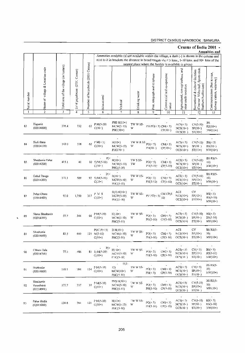
83
84
85
86
87
88
89
90
91
92
93
" ~ Z 2
Hapania (02014000)
Siuli Bana (02014100)
Shushunia Pahar (02014200)
Gohal Danga (02014300)
Pahar Ghata (02014400)
Nama Shushunia (02014500)
Shushunia (02014600)
Chhata Tala (02014700)
Bishkodar (02014800)
Shushunia Parasibana (02014900)
Pahar Bedia (02015000)
3
236.4
143.0
415.1
172.1
92.0
59.7
83.5
77.3
118.5
172.7
128.8
Vl ::l ;g " U
o o ~
" o '"§ :; 0. o 0.
'" ;§ 4
332
338
41
509
1,7S0
344
640
486
784
217
764
DISTRICT CENSUS HANDBOOK: BANKURA
Census of India 2001 -Amenities and
~
Amenities available (if not available within the village, a dash (-) is shown in the column and next to it in brackets the distance in broad ranges viz.< 5 kms., 5-10 kms. and 10+ kms of the
nearest place where the facility is available is given
" " u o o ~ Vl
"0 o ~ ;::l
,_g 4-< o .... Q)
.D E ;::l
Z 5 6
65 PM(5-lO) C(IO+)
62 PM«5) C(10+)
7
PHSH(lO+) MCW(5-10) PHC(IO+)
H(10+) MCW(5-10) PHC(lO+)
- P« H(I~+) 10 5) M(5-10) MCW(5-10)
C(JO+) PHC(5-IO)
- P« H(I~+) 92 S)M(5-10) MCW(5-10)
C(IO+)
3\7 PM S C(10+)
66 PM(5-10) C(10+)
PUCP« 5) 121 M(5-10)
C(10+)
PHC(S-IO)
D(3) H(IO+) MCW(5-10) PHC(5-1O)
H(IO+) MCWeS-IO) PHC(5-10)
DH(10+) MCW(5-JO) PHC(5-IO)
- P« H(I~+) 87 5) ~(S-10) MCW(S-IO)
C( +) PHC(5-1O)
154 P M(5-10) C(IO+)
35 P M(5-10) C(lO+)
121 P M(5-10) C(JO+)
H(5-10) MCW(10+) PHC(5-10)
PHS H(IO+) MCW(S-IO) PHC(5-10)
H(IO+) MCW(5-10) PHC(5-10)
206
8
TWWSS-W
TW S SSTW
TW W SS-W
en o
0...
9
Q)
.!": e Q) 0. o 6 u
"0
iii
'" .~
Q)
E '" 5~ uE
10
PH PO« 5) CM« 5) CP(IO+)
CM«5) CP(IO+)
PO« 5) CM« S) PH(5-IO) CP(5-1O)
PO« 5) PH(5-10)
CM«5) CP(5-10)
II
ACS«5) NCS(IO+) OCS(lO+)
ACS«5) NCS(10+) OCS(IO+)
ACS« 5) NCS(lO+) OCS(IO+)
ACS« 5) NCS(IO+) OCS(IO+)
TW W SS- ACS PHPO«5)CMCP(5- NCS(10+}
W
TWWSS-W
PO« 5) PH(5-1O)
10) OCS(10+}
CM« 5) ACS« 5) CP(5-10) NCS(10+)
OCS(JO+)
TWWSS-W
PO« 5) CM« 5)
ACS NCS(JO+) OCS(IO+) PH(5-IO) CP(5-JO)
:W W SS- PO« 5)
PH(5-IO)
:W W SS- PO« 5)
PH« S)
TWW SS-PO« 5) PH(5-1O)
W
;;: W SS- PO« 5)
PH(S-IO)
CM« S) CP(S-IO)
CM«5) CP(5-10)
CM« S) CP(5-1O)
CM«5) CP(S-10)
ACS« 5) NCS(IO+) OCS(IO+)
ACS« 5) NCS(IO+) OCS(IO+)
ACS« 5) NCS(IO+) OCS(IO+)
ACS« 5) NCS(10+) OCS(10+)
12 13
BS CV(S-IO) RS(lO+) SP(IO+) ST(IO+) NW(lO+)
CV(5-lO) BS« 5) SP( 10+) RS(l 0+) ST(IO+) NW(10+)
CV(S-IO) BS RS(5-
SP(IO+) 10) ST(IO+) NW(IO+)
CV(5-10) BS RS(S-
SP(lO+) 10) ST(IO+) NW(IO+)
CV SP(lO+) ST(lO+)
BS«5) RS(5-10) NW(10+)
CV(5-JO) BS« 5) SP(IO+) RS(5-10) ST(10+) NW(lO+)
CV SP(lO+) ST(IO+)
CV«5) SP(lO+) ST(10+)
CV«5) SP(IO+) ST(IO+)
BSRS(5-10) NW(IO+)
BS« 5) RS(5-JO) NW(10+)
BS RS(5-10) NW(IO+)
CV(5-10) BS RS(5-10)
SP(10+) NW(IO+) ST(lO+)
CV(5-1O) BS« 5) SP(10+) RS(S-IO) ST(lO+) NW(10+)
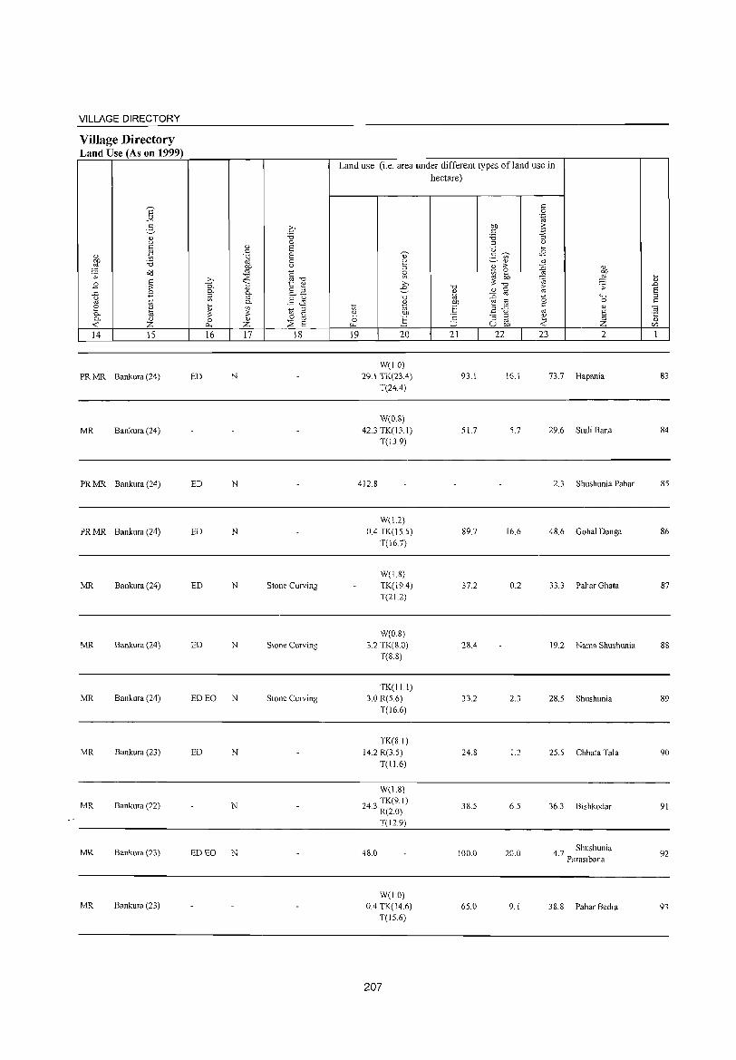
VILLAGE DIRECTORY
Village Directory Land Use (As on 1999)
14 15
PR MR Bankura (24)
MR Bankura (24)
PR MR Bankura (24)
PR MR Bankura (24)
MR Bankura (24)
MR Bankura (24)
MR Bankura (24)
MR Bankura (23)
MR Bankura (22)
MR Bankura (23)
MR Bankura (23)
16 17 18
ED N
ED N
ED N
ED N Stone Curving
ED N Stone Curving
ED EO N Stone Curving
ED N
N
ED EO N
Land use (i.e. area under different types of land use in hectare)
19 20
W(IO) 29.1 TK(23A)
T(24.4)
W(0.8) 42.3 TK(13.1)
T(13.9)
412.S
W(1.2) 0.4 TK(IS.5)
T(167)
W(IS) TK(19A) T(21.2)
W(O.S) 3.2 TK(S.O)
T(S.8)
TK(II,I) 3.0 R(S.6)
T(l6.6)
TK(SI) 14.2 R(3,S)
T(11.6)
W(I.8)
243 TK(9 I) , R(2,O)
T(12.9)
48.0
W(1.0) 0.4 TK(14 6)
T(IS.6)
207
21 22
93.1
51.7
89.7
37.2
28.4
33.2
24,8
38.S
100.0
6S.0
23
16.1
5.7
16.6
0.2
2.3
1.2
6.S
20.0
9.1
2
73.7 Hapania
29.6 Siuli Bana
2.3 Shushunia Pahar
48.6 Gohal Danga
33.3 Pahar Ghata
19.2 Nama Shushunia
28.S Shushunia
25.5 Chhata Tala
36.3 Bishkodar
4 7 Shushunia , Parasibana
38.8 Pahar Bedia
83
84
8S
86
87
88
89
90
91
92
93

DISTRICT CENSUS HANDBOOK: BANKURA
Census of India 2001 -Amenities and
Amenities available (if not available within the village, a dash (-) is shown in the column and next to it in brackets the distance in broad ranges viz. < 5 krus., 5-10 kms. and 10+ krus of the
~
nearest place where the facility is available is given a " ~ <=: "0 ~ :2" "0 ';;;' " 0 t) U <=:
" " ~ Ol
c ..<: ;; " " e '';:; 0 ,," c <=: > - "' u 0 2- " 0 '03 ~ E~ .~ u 0 .~ .a ~ ..c ~8. " " - 0- "3 <l.) i2 0 00 0 "' <l.) 0- u Ojr/l ~ ~ ....:I ::§ 0 "0 B 0 .~ ~ :l ="8 ~ "0 6 ::J "
o'Cl ;:: ..<: "0 ro ._ ~ _@ .2 6tti " " <=: ;ll <=: u ~ t) "' ~
:W -;S 0 ::J Ol "0 o ._ u 0 ~
c " ~ ..<: c c g o'Cl.g~ ~ .~ 0 " o c " '+-< ..<: ., 0- Ol
"' OJ;>:"g '.,c 0 ..D .;;: 0 "3 '+-< OJ ~ OJ ] .-:: " ._ § " 0- 0 C ~ bIJ '2 c -< .~ E
'+-< e 0 i:l 0 00 <U ::J"O ::lOla c "'
" 0 Ol 0. .~ to c B " .=:: ~ S i2 to " to to ..D u :.'2 E "' ::J " <0 E ::J
E E u :.a .g ~ ~ g:.a '5 '0 '0 ::J " E -'" E ?: " ::l "0 " Ci '" 8.2 00"<: ~u~ 0:-:::
r/l Z l- I- Z \.I.l ;:;2 0 -< '0 u ~ iO-. r:r, ~r/l I 2 3 4 5 6 7 8 9 10 II 12 13
Nangla - P« -
TWWSS- ACS« 5) CV(5-10) BS« 5) 94 98.1 18 5)M(5-10) H(IO+) PO«5) CM«5)
(02015100) C(10+) MCW(S-IO) W PH(S-IO) CP(5-1O)
NCS(IO+) SP(lO+) RS(S-lO)
PHC(5-10) OCS(IO+) ST(lO+) NW(lO+)
9S Bharatpur
150.6 360 73 PM(5-1O) H(10+) TWWSS-
PO«S) CM«S) ACS(IO+) CV(5-10) BS« 5)
(02015200) C(10+) MCW(S-IO) W PH(5-10) CP(S-IO)
NCS(10+) SP(lO+) RS(5-1O)
PHC(5-10) OCS(IO+) ST(10+) NW(lO+)
Gidhuria P M(5-1O) PHSH(IO+)
TWWSS- ACS(10+) CV(5-10) BS(S-IO) 96 176.6 712 125 MCW(S-IO) PO«S) CM(5-10)
(02015300) C(10+) PHC(5-10)
W PH(5-10) CP(5-10)
NCS(IO+) SP(IO+) RS(5-10) OCS(lO+) ST(IO+) NW(IO+)
97 Jaljalia Banshol
220.5 649 129 P(2) M(S-IO) H(IO+)
WSS-W PO«S) CM(5-10) ACS(10+) CV(5-1O) BS(5-10)
(02015400) C(10+) MCW(5-10) NCS(IO+) SP(IO+) RS(5-10)
PHC(5-10) PH(5-10) CP(5-10)
OCS(IO+) ST(lO+) NW(IO+)
98 Agaya
169.5 695 124 P M(5-10) H(IO+) TW W SS-
PO«S) CM« 5) ACS(IO+) CV(S-IO) BS« 5)
(02015500) C(lO+) MCW(5-1O) W PH(5-10) CP(S-IO)
NCS(IO+) SP(IO+) RS(5-10)
PHC(5-1O) OCS(IO+) ST(IO+) NW(IO+)
Chamkara PM(5-10) CHWH(IO+)
TW SS-TW PH PO(S- ACS(S-IO) CV(S-lO) BS(S-IO) 99 194.8 871 173 MCW(S-IO) CM(5-10)
(020IS600) C(10+) PHC(5-10)
10) CP(S-IO)
NCS(10+) SP(5-10) RS(S-IO)
OCS(IO+) ST(10+) NW(10+)
Basulibandh P« DHCHW
ACS(5-1O) CV(5-1O) BS(S-IO) 100 201.5 187 32 S) M(5-10) H(IO+) TW SS-TW PO(S-IO) CM(S-IO)
(020IS700) C(10+) MCW(lO+) PH(5-10) CP(5-1O) NCS(IO+) SP(IO+) RS(S-IO)
PHC«5) OCS(IO+) ST(IO+) NW(IO+)
Karra P« CHW H(lO+)
PH PO(5- ACS(5-1O) CV(S-IO) BS(S-IO) 101
(02015800) 38.8 404 83 5)M(S-10) MCW(IO+) TKSS-TK
10) CM(5-10)
NCS(lO+) SP(IO+) RS(5-10) C(lO+) PHC« 5) CP(S-IO)
OCS(10+) ST(IO+) NW(10+)
Beliara 186.4 623 127
PM(5-10) H(IO+) TW SS-TW PO(S-IO) CM(S-IO)
ACS(5-10) CV(5-10) BS(5-10) 102 C(IO+) MCW(IO+) NCS(IO+) SP(IO+) RS(S-IO) (02015900) PH(5-10) CP(5-10)
PHC(5-10) OCS(IO+) ST(IO+) NW(IO+)
Hari Bandi 284 50
PM«S) H(IO+) TTW SS-T PO«5) CM« 5)
ACS« S) CV«5) BS« 5) 103
(02016000) IS3.1
C(IO+) MCW(5-10) NCS(lO+) SP(lO+) RS«5)
PHC« 5) PH«S) CP«5)
OCS(IO+) ST(IO+) NW(lO+)
208
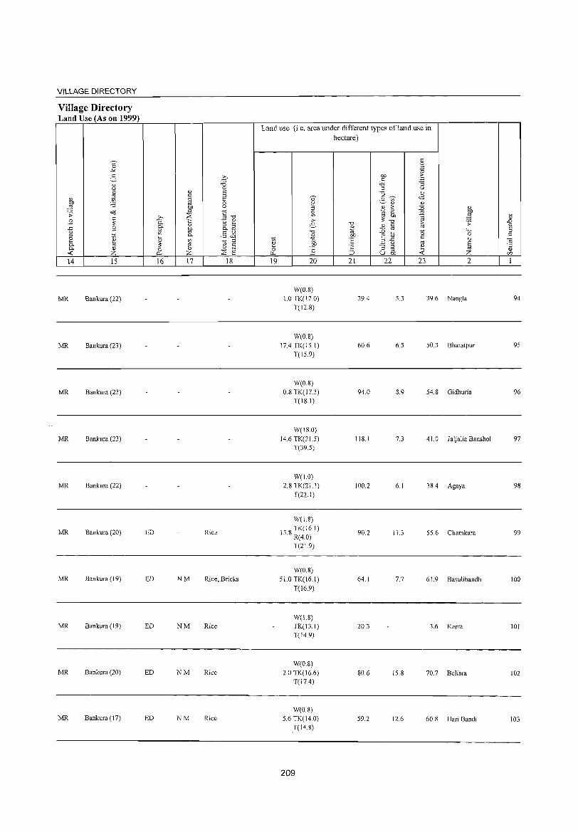
VILLAGE DIRECTORY
Village Directory Land Use (As on 1999)
14 15
MR Bankura (22)
MR Bankura (23)
MR Bankura (23)
MR Bankura (23)
MR Bankura (22)
MR Bankura (20)
MR Bankura (19)
MR Bankura (19)
MR Bankura (20)
MR Bankura (I 7)
ED
ED
ED
ED
ED
16 17 18
Rice
NM Rice, Bricks
NM Rice
NM Rice
NM Rice
Land use (i.e. area under different types ofland use in hectare)
19 20
W(O.S) 1.0 TK(120)
T(12.S)
W(O.S) 17.4 TK(lS.I)
T(IS.9)
W(O.S) 0.8 TK(17.3)
T(18.1)
W(18.0)
14.6 TK(ZU)
T(39.S)
W(10)
2.8 TK(21.1)
T(22.1)
W(1.S)
IS 8 TK(16.1) . R(4.0)
T(21.9)
W(0.8)
510 TK(16.1)
T(l6.9)
W(1.8) TK(13.1)
T(14.9)
WeO.S) 2.0 TK(16.6)
T(17.4)
W(08)
5.6 TK(14.0)
T(14.S)
209
21
39.4
60.6
94.0
J IS. J
100.2
90.2
64.1
20.3
SO.6
59.2
22 23 2
5.3 39.6 Nangla
6.5 50.3 Bharatpur
8.9 54.8 Gidhuria
7.3 41.0 .Taljalia Banshol
6.1 38.4 Agaya
11.3 55.6 Chamkara
7.7 61. 9 Basulibandh
3.6 Karra
15.8 70.7 Beliara
12.6 60.S Hari Bandi
94
95
96
97
98
99
100
10l
102
103

DISTRICT CENSUS HANDBOOK: BANKURA
Census of India 2001 -Amenities and
Amenities available (if not available within the village, a dash (-) is shown in the column and next to it in brackets the distance in broad ranges viz.< 5 kms., 5-10 kms. and 10+ kms of the
~ '§' nearest place where the facility is available is given <i) ~ E
~ -g" "'" .s Vi' <i) "'" 0 u () 8 u <i) ::l '';::: Q oJ ..c '" - <i) " ] '" '" 0 c >- :.=: U':J Q 0 g " 0 0 .~ ·0 1:: E~ .~ u ~ ..c tEl 8.. ., iii' u <i) - 0. ., "3 0 bJl 0 '" " 0- 0 ""§":,,._ ;;; ~
...l ~ 0 ""d }l 0 .~ rn ~ "0 (, E'iii § ::l "
o'<l .;; ..c ""d co .~ >0 '" " 8 (.) c !)
:l .J::: ._ ';;;';;:: " " c gJ ""d U 0 .... bJl -£ 0 .... §
o .- Od ~ ,g '" " til ~ '-g 0 " ..c e" ~ o C
"-< ..c '" 0.
"i<i>"§ '_;:j 0
..D .;; 0 "3 "-< "i<i ;;:: ~ "i<i e:B til .-
§ co 0. 0 c '2 c -< .~ g "-< " 0 .... 0 bJl " _g e S"Oil a c '" '" 0 ~ 0. " '.g "i<i '" }l " '" E ::l E iii' "i<i "
..D (.) :.g E '" ::l Q
til ] ] E 0 :0 "," E "'" (.) ....
~.5 ] E ;;:: .J: ::l .s .~£ " ~ 0 ;::! "d " 25 0 o c 0:-:::
<Zl Z E- Z [..Q ~ p... uJ5 -< 0 ~~u:; u e 1 2 3 4 5 6 7 8 9 10 11 12 13
104 Mirga
104.5 579 110 PM«5) H(lO+)
TW SS-TW PO« 5) CM«5) ACS« 5) CV«5) BS« 5)
(02016100) C(lO+) MCW(IO+) PH« 5} CP«5)
NCS(IO+) SP(IO+) RS«5) PHC« 5) OCS(IO+) ST(10+) NW(IO+)
Shiuligarya P« CHW H(lO+)
ACS« 5) CV«5) BS«5) 105 196.0 200 43 5) M«5) MCW(5-10) TTWSS-T PO« 5) CM« 5)
(02016200) C(lO+) PHC« 5) PH«5) CP«5)
NCS(lO+) SP(lO+) RS« 5) OCS(IO+) ST(lO+) NW(IO+)
Sarberia P« CHW H(lO+)
ACS« 5) CV«5) BS« 5) 106 94.2 149 25 5) M« 5) MCW(5-10) TTWSS-T PO« 5) CM« 5)
(02016300) C(10+) PHC« 5) PH«5) CP« 5)
NCS(lO+) SP(lO+) RS« 5) OCS(IO+) ST(IO+) NW(IO+)
Pathardiha P M«5) CHWH«5)
ACS« 5) CV«5) BS« 5) 107
(02016400) 271.2 1,431 206
C(IO+) MCW(5-10) TW SS-TW PO« 5) CM« 5)
NCS(IO+) SP(IO+) RS«5) PHC« 5) PH«5) CP«5)
OCS(IO+) ST(IO+) NW(lO+)
MujraKundi PM«5) CHWH(IO+)
ACS« 5) CV«5) BS«5) 108 96.9 254 48 MCW(5-IO) TW SS-TW PO« 5) CM« 5)
(02016500) C(IO+) PHC(5-IO) PH«S) CP«5)
NCS(IO+} SP(IO+) RS«5) OCS(IO+) ST(IO+) NW(lO+)
109 Jamdahari
214.4 715 128 P M«5) H(IO+)
TWSS-TW PO« 5) CM«5) ACS«5) CV«5) BS« 5)
(02016600) C(IO+) MCW(5-10) PH« 5) CP«5)
NCS(IO+) SP(IO+) RS« 5)
PHC« 5) OCS(IO+) ST(IO+) NW(lO+)
Barbakra PM«5) CHWH(lO+)
TW SS-T PH(10) ACS«5) CV« 5) BS«5) 110 170.2 1,733 359 MCW(IO+) CM«5)
(02016700) C(lO+) T PO«5) NCS(IO+) SP(IO+) RS«5) PHC«5) CP«5)
OCS(IO+) ST(IO+) NW(lO+)
Khaira Kanali 100.8 375 70
PM«5) H(IO+) TW SS-TW PO« 5) CM« 5)
ACS«5} CV« 5) BS RS« 5) III
(02016800) C(lO+) MCW(5-10) NCS(IO+) SP(IO+) NW(IO+)
PHC« 5) PH« 5) CP« 5)
OCS(IO+) ST(10+)
NHRMP PTO PO« CV Lakshmi- ACS(5-1O) BS RS« 5)
596 P(2) M S CHWH(IO+)
T TW SS-T 5) PH(5- CMCP SP(10+) 112 narayanpur 101.7 3,220 C(IO+) MCW(5-10) NCS(IO+) NW(IO+)
(02016900) PHC« 5)
10) OCS(IO+)
ST(10+)
HCPHCCHW ACS CV«5) BS RS«5) Kantasol
481 P MC(IO+) H(IO+) TW SS-TW PO PH(7) CM«5) NCS(IO+) 113 203.5 2,530 SP(10+) NW(10+) (02017000) MCW«5) CP«5) OCS(IO+)
ST(JO+)
210
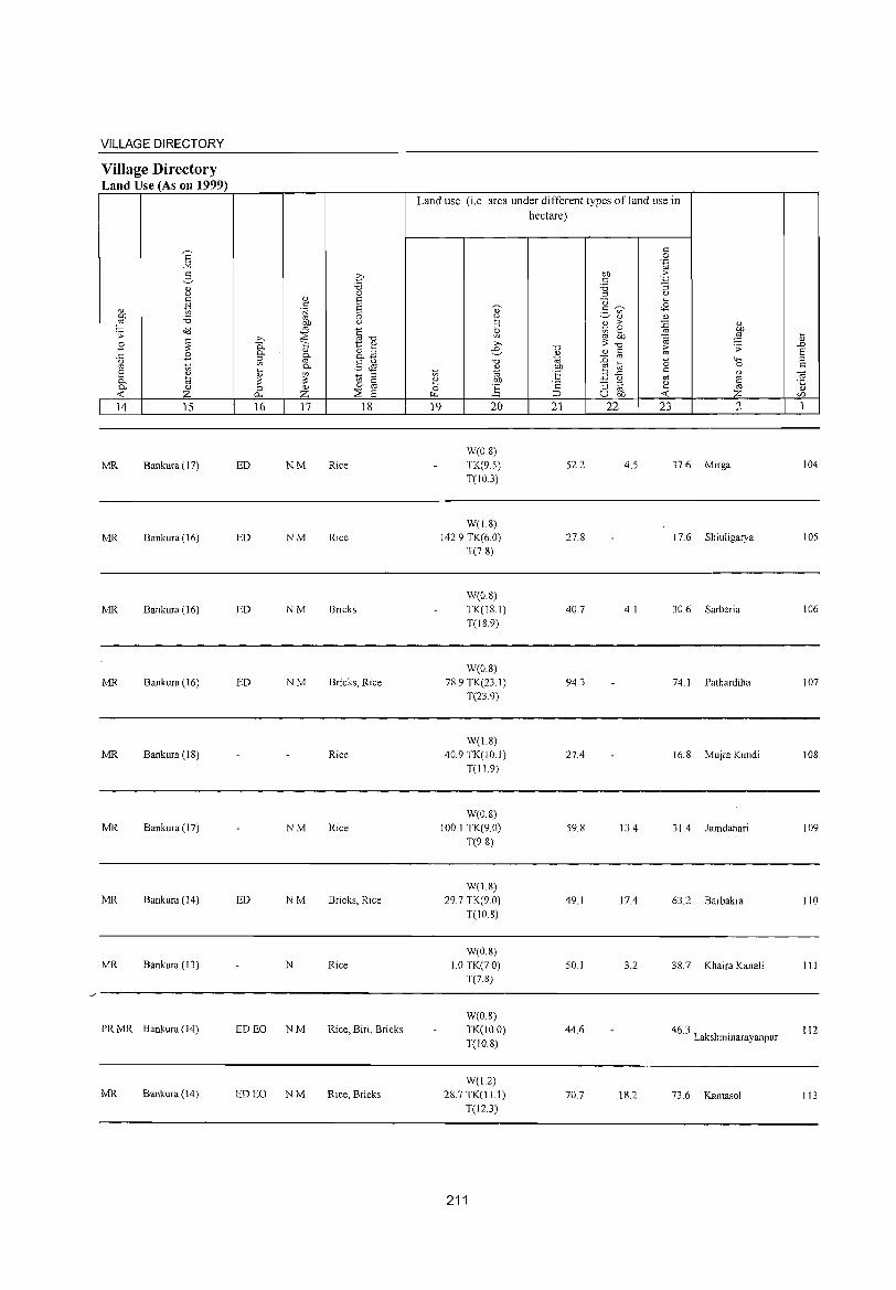
VILLAGE DIRECTORY
Village Directory Land Use (As on 1999)
'" ~ " z
14 lS
MR Bankura (17)
MR Bankura (16)
MR Bankura (16)
MR Bankura (16)
MR Bankura (18)
MR Bankura (17)
MR Bankura (14)
MR Bankura (13)
PR MR Bankura (14)
MR Bankura (14)
16 17 18
ED NM Rice
ED NM Rice
ED NM Bricks
ED NM Bricks, Rice
Rice
NM Rice
ED NM Bricks, Rice
N Rice
ED EO NM Rice, Biri, Bricks
ED EO NM Rice, Bricks
Land use (i.e. area under different types of land use in hectare)
19 20
W(08) TK(9.S) T(10.3)
W(18) 142.9 TK(6.0)
T(78)
W(OS) TK(18.1) T(189)
W(O.S) 78.9 TK(23.1)
T(23.9)
W(1.8) 40.9 TK(lO.l)
T(119)
W(0.8) 100.1 TK(9.0)
T(98)
W(18) 29.7 TK(9 0)
T(108)
W(0.8) 1.0 TK(70)
T(7.8)
WeO.8) TK(IO.O) T(10.8)
WeU) 287 TKel1.l)
TeI2.3)
211
21 22
52.2
27.8
40.7
94.3
27.4
59.8
49.1
50.1
44.6
70.7
23 2
4.5 37.6 Mirga
17.6 Shiuligarya
4.1 30.6 Sarberia
74.1 Pathardiha
16.8 Mujra Kundi
13.4 31.4 Jamdahari
17.4 63.2 Barbakra
3.2 38.7 Khaira Kanali
46.3 . Lakshmmarayanpur
18.2 73.6 Kantasol
104
105
106
107
108
109
110
III
112
113

DISTRICT CENSUS HANDBOOK: BANKURA
Census of India 2001 -Amenities and
Amenities available (if not available within the village, a dash (-) is shown in the column and
next to it in brackets the distance in broad ranges viz.< 5 kms., 5-10 kms. and 10+ Ions of the ~
nearest place where the facility is available is given '" j ;::l
'" '" t:: -0 ~ 2~ -0 <0' " 0 u U t: U " 5l co t:: .s= ~ OJ " e E ~ " c 0 c > u 0 5 " 0 '(3 1:: E~ .~ U 0 .~ £1 c:!- .s= ~ 8- " i;;' u ~ ~ 0-
" ;::l 0 0 '" " 0- .~
car/) ~ f: ....l 2:! 0 -0 "2 0 3 ="'E c:!- o 6 Co ~ ;::l '" ~ ;; .s= -0 u 'F '';::: -3 ~.2 e.ta " " c " c c OJ '" ;:: ~ '" -0 U 0 ._ on .;:; 0 ._ c
o ._ o:d ..g .,g c
d" ._ ::§ .~ 0 " .s= c:" ~ 0
" 4-< .s= 'OJ 0- ro ca>1 .~ 0
..0 .;; 0 "3 "-' ca co ca ""§ :!::: .~ E ro ;:: bb u
'" "-' " 0- 0 t:: '2 ",-0 t:: -< '2 0 ._ 0 on " 90!S c 0 8 0. " '"§ ca c "2 " ~ ~ S i;;'
~ " ..0 u :Q E '" 'OJ E ;::l
E ] ] a u '3 .g ~ r3.S] '" .5 t; E-" E ;:: OJ co 0 0 ;::l -0 " Ci 0 o § Of) . .s= 0:-: r/) Z f-' f-' Z U-l ~ 0., U..o -< 0 ~ ~r/) U f:! 1 2 3 4 5 6 7 8 9 10 11 12 13
PHSRMP
Kamarkuli P(2) M S CHWO(3)
T TW W SS· PH(19) CMCP« ACS«5) CY
BSRS«5) 114 158.2 1,522 320 H(lO+) SP(lO+) (02017100) PUCC(IO+) T PO« 5) 5) NCS(IO+) NW(IO+) MCW(S-IO) ST(IO+) PHC« 5)
OCS(lO+)
115 Kuludihi
146.6 - P« H(I;+) TWWSS- ACS«5) CY« 5) BS« 5)
92 17 5) M(5-10) MCW(5-10) PO«5) CM«5) (02017200) W NCS(lO+) SP(IO+) RS«5)
C(lO+) PHC« 5) PH«5) CP«5) OCS(lO+) ST(IO+) NW(IO+)
116 Gurputa
218.1 787 157 P M(5-10) H(IO+) TWWSS-
PO«5) CM«5) ACS« 5) CY« 5) BS RS« 5)
(02017300) C(IO+) MCW(S-IO) W NCS(IO+) SP(IO+) NW(IO+) PHC« 5)
PH« 5) CP«5) OCS(IO+) ST(lO+)
Kallaiberia PI M(5-10) CHWH(lO+)
TWWSS- PH(3) ACS« 5) CY« 5) BS RS(S-
117 129.2 592 127 MCW(S-lO) CM«5) 10) (02017400) C(IO+) W PO«5) NCS(IO+) SP(10+)
PHC« 5) CP«5) OCS(IO+) ST(IO+)
NW(lO+)
Banagram P M(5-1O) CHWH(lO+)
T TW W SS· PH(3) ACS«5) CY« 5) BSRS 118
(02017500) 110.6 208 38
C(lO+) MCW(S-IO)
T PO« 5) CM«5)
NCS(10+) SP(IO+) NW(10+) PHC«5) CP«5)
OCS(lO+) ST(10+)
119 Pinashgarya
96.3 167 34 - P« H(I;+)
T W SS-T PH(3)
CM«5) ACS« 5) CY« 5) BS RS« 5)
(02017600) 5) M(5-IO) MCW(5-10) PO«5) NCS(10+) SP(lO+) NW(lO+) C(lO+) PHC« 5) CP«5)
OCS(IO+) ST(10+)
Ghoramuli P(2) OM(5-CHWH(lO+)
TTWWSS· - ACS« 5) CY« 5) BS« 5) 120
(02017700) 191.4 1,413 261
10) C(IO+) MCW(S-10) T PH PO« 5) CM« 5) NCS(IO+) SP(IO+) RS(10+) PHC« 5) CP«5)
OCS(IO+) ST(10+) NW(10+)
PHS CHW
121 Dubrajpur
56.2 967 197 P ACM(5- H(10+) TTW W SS 0 Cl CM«5)
ACS« 5) CY« 5) BS RS« 5)
(02017800) 10)C(10+) MCW(5-10) T P PH.)
CP« 5) NCS(IO+) SP(lO+) NW(lO+)
PHC« 5) OCS(IO+) ST(lO+)
122 Bamankuli
63.1 1,675 330 P OM(5-10) H(IO+) T TW W SS· PH(9)
CM«5) ACS«5) CY«5) 8S« 5)
(02017900) C(10+) MCW(5-10) T PO«5) CP«5)
NCS(lO+) SP(lO+) RS« 5)
PHC« 5) OCS(10+) ST(IO+) NW(IO+)
123 Mandashpara
175.0 496 83 o P« 5) M(5- H(IO+) T TW W SS· PO(~ 5) CM«5)
ACS« 5) CY« 5) BS« 5)
(02018000) 10) C(lO+) MCW(5-1O) T PH« 5) CP« 5) NCS(10+) SP(10+) RS« 5)
PHC« 5) OCS(lO+) ST(10+) NW(lO+)
Chowghara P M(5-10) H(lO+) TWWSS-PO«5) CM«5)
ACS« 5) CY« 5) BS RS«5) 124 68.8 321 58
C(lO+) MCW(5-10) W NCS(IO+) SP(lO+) NW(lO+) (02018100) PH« 5) CP« 5) PHC« 5) OCS(10+) ST(IO+)
212
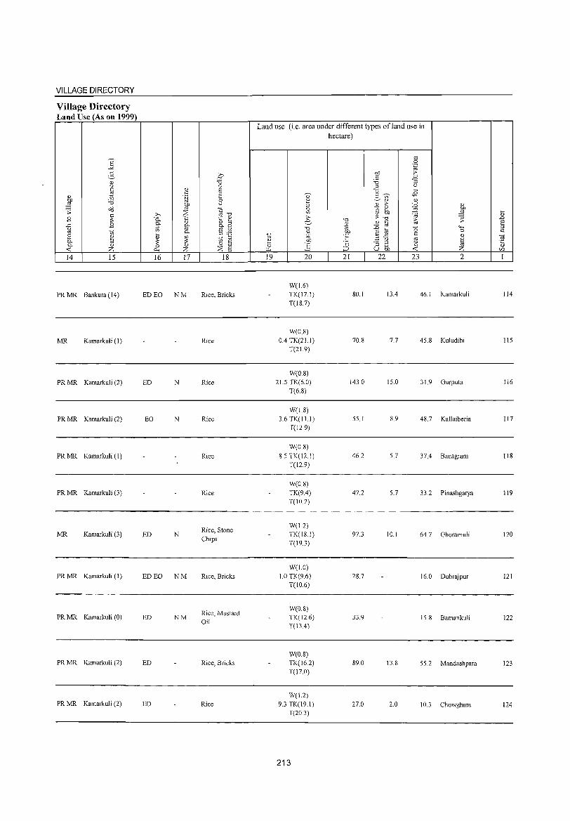
VILLAGE DIRECTORY
Village Directory Land Use (As on 1999)
14 15
PR MR Bankura (14)
MR Kamarkuli (1)
PR MR Kamarkuli (2)
PR MR Kamarkuli (2)
PR MR Kamarkuli (l)
PR MR Kamarkuli (3)
MR Kamarkuli (3)
PR MR Kamarkuli (I)
PR MR Kamarkuli (0)
PR MR Kamarkuli (2)
PR MR Kamarkuli (2)
16 17
ED EO NM
ED N
EO N
ED N
ED EO NM
ED NM
ED
ED
18
Rice, Bricks
Rice
Rice
Rice
Rice
Rice
Rice, Stone Chips
Rice, Bricks
Rice, Mustard Oil
Rice, Bricks
Rice
Land use (i.e. area under different types ofland use in hectare)
19 20
W(L6) TK(l7.1) T(lS.7)
W(0.8) 0.4 TK(2Ll)
T(21.9)
W(08) 21.5 TK(6.0)
T(6.S)
W(18)
3.6 TK(I II) T(12.9)
W(O.S) 8.5TK(12.1)
T(l29)
W(O.S) TK(9.4) T(10.2)
W(l.2) TK(18.1) T(19.3)
W(1.0) 1.0 TK(96)
T(10.6)
W(O.8)
TK(126) T(l34)
W(O.8)
TK(162) T(I7.0)
W(L2) 9.3 TK(19.1)
T(20.3)
213
21
SO. 1
70.8
143.0
55.1
46.2
47.2
97.3
28.7
33.9
89.0
270
22 23 2
13.4 46.1 Kamarkuli
7.7 45.8 Kuludihi
15.0 31.9 Gurputa
8.9 48.7 Kallaiberia
5.7 37.4 Banagram
5.7 33.2 Pinashgarya
10.1 64.7 Ghoramuli
16.0 Dubrajpur
15.8 Bamankuli
13.8 55.2 Mandashpara
2.0 10.3 Chowghara
114
115
116
117
liS
119
120
121
122
123
124
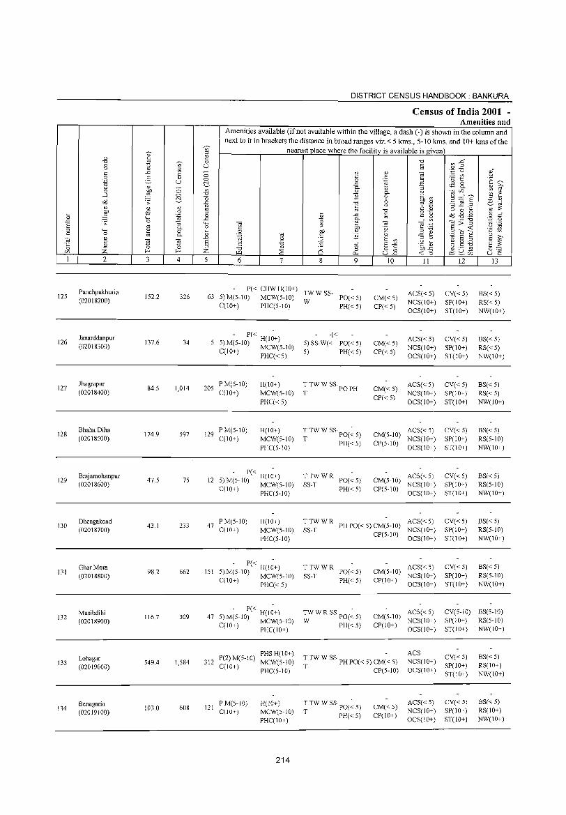
._ <l)
..0
§ "
125
126
127
128
129
130
131
132
133
134
<l) "0 o u
" o '.g u o
..-l a<J
~ ;;
"-< o <l)
§ Z 2
Panchpukhuria
(02018200)
Janarddanpur
(02018300)
Jhagrapur
(02018400)
Bhalai Diha
(02018500)
Brajamohanpur (02018600)
Dhengakend
(02018700)
Ghar Mora
(02018800)
Musibdihi
(02018900)
Lohagar
(02019000)
Benagaria (02019100)
3
152.2
137.6
84.5
174.9
47.5
43.1
98.2
116.7
549.4
103.0
o o ~
" o .~
:J 0-o 0-
~ 4
326
34
1,014
597
75
233
662
309
1,584
608
DISTRICT CENSUS HAINDBOOK : BANKURA
Census of India 2001 -Amenities and
Amenities available (if not available within the village, a dash (-) is shown in the column and next to it in brackets the distance in broad ranges viz.< 5 kIDs., 5-10 kms. and 10+ kIDs of the
nearest place where the facility is available is given
5 6 7 8 9
<l)
> .~
a.> 0-o 6 u
"0
~ c;; .~
<l)
E en E-'" 8]
10 11
P« CHW H(lO+) TW W SS-63 5) M(5-1O) MCW(5-1O) W PO« 5)
ACS« 5) NCS(IO+) OCS(IO+)
C(10+) PHC(5-10) PH« 5) CM«5) CP«5)
- P« -5 5) M(5-IO) H(lO+)
C(lO+) MCW(5-10) PHC«5)
205 P M(5-10) C(1O+)
129 PM(5-10) C(IO+)
H(IO+) MCW(5-10)
PHC« 5)
H(lO+) MCW(5-10) PHC(5-10)
12 P« H(IO+) 5) M(5-1O) MCW(5-10) C(lO+)
47 PM(5-10) C(IO+)
PHC(5-10)
H(lO+) MCW(5-10) PHC(5-10)
5 - P« H(I~+) 151 ) M(5-10) MCW(5-10)
C(lO+) PHC« 5)
- P« H(I~+) 47 5) M(5-10) MCW(5-10)
C(10+) PHC(10+)
P(2) M(5-1O) PHS H(lO+) 312 C(lO+) MCW(5-10)
121 P M(5-10) C(IO+)
PHC(5-10)
H(10+) MCW(5-10) PHC(IO+)
214
-« 5) SS-W« PO« 5) 5) PH« 5)
TTWW SS·PO T PH
T TW W SS· PO(~ 5)
T PH« 5)
TTWWR SS-T PO« 5)
PH«5)
CM«5) CP«5)
CM«5) CP«5)
ACS«5) NCS(IO+) OCS(IO+)
ACS« 5) NCS(lO+) OCS(IO+)
CM(5-1O) ACS« 5) CP(5-10) NCS(IO+)
OCS(IO+)
CM(5-10) ACS« 5) NCS(IO+)
CP(5-10) OCS(IO+)
TTWWR ACS«5) SS-T PH PO« 5) CM(5-1O) NCS(IO+)
TTWWR SS-T PO«5)
PH«5)
TWWRSSpO(~5) W PH« 5)
CP(5-10) OCS(IO+)
CM(5-1O) ACS« 5) NCS(IO+)
CP(IO+) OCS(IO+)
CM(5-1O) ACS«5) NCS(IO+)
CP(10+) OCS(10+)
T TW W SS· PH PO« 5) CM(-< 5)
T CP(5-10)
ACS NCS(lO+) OCS(IO+)
T TW W SS· PO(~ 5)
T PH« 5) CM«5) CP(IO+)
ACS«5) NCS(IO+) OCS(lO+)
12
CV«5) SP(IO+) ST(lO+)
CV«5) SP(IO+) ST(IO+)
CV«5) SP(IO+) ST(IO+)
CV«5) SP(IO+) ST(IO+)
CV«5) SP(IO+) ST(IO+)
CV«5) SP(IO+) ST(IO+)
CV«5) SP(lO+) ST(IO+)
13
BS« 5) RS« 5) NW(IO+)
BS«5) RS«5) NW(IO+)
BS« 5) RS«5) NW(IO+)
BS«5) RS(5-10) NW(IO+)
BS« 5) RS(5-10) NW(IO+)
BS« 5) RS(5-10) NW(IO+)
BS«5) RS(5-10) NW(IO+)
CV(5-10) BS(5-10) SP(IO+) RS(5-10) ST(IO+) NW(IO+)
CV«5) SP(lO+) ST(IO+)
CV« 5)
SP(IO+) ST(lO+)
BS«5) RS(IO+) NW(IO+)
8S« 5) RS(IO+) NW(IO+)
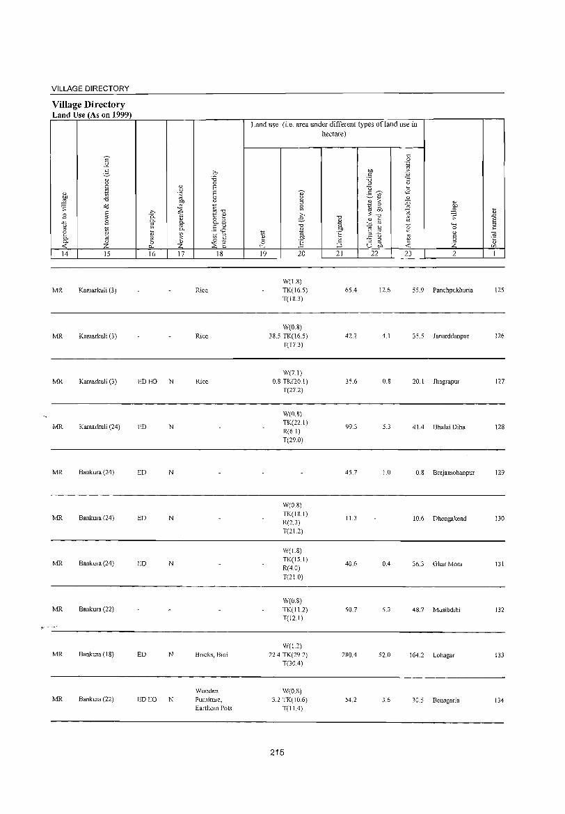
VILLAGE DIRECTORY
Village Directory Land Use (As on 1999)
14 15
MR Kamarkuli (3)
MR Kamarkuli (3)
MR Kamarkuli (3)
MR Kamarkuli (24)
MR Bankura (24)
MR Bankura (24)
MR Bankura (24)
MR Bankura (22)
MR Bankura (1S)
MR Bankura (22)
16
ED EO N
ED N
ED N
ED N
ED N
ED N
ED EO N
17 18
Rice
Rice
Rice
Bricks, Bidi
Wooden Furniture,
Earthern Pots
Land use (i.e. area under different types ofland use in hectare)
19 20
W(1.8)
TK(16.5)
T(18.3)
W(D.8) 38.5 TK(16.5)
T(J 7.3)
W(7.])
0.8 TK(20 1)
T(27.2)
W(0.8)
TK(22.1)
R(6.1)
T(29.0)
W(O.S)
TK(IS.I)
R(2.3)
T(21.2)
W(I.S)
TK(15.1)
R(40)
T(21.0)
W(O.S)
TK(I1.2) T(12.1)
W(1.2)
22.4 TKe29.2) T(30A)
W(08)
3.2 TK(10.6) T(11.4)
215
21 22
65.4
42.2
35.6
99.3
45.7
11.3
40.6
50.7
2S0.4
54.2
23 2
12.6 55.9 Panchpukhuria
4.1 35.5 Janarddanpur
0.8 20.1 Jhagrapur
5.3 41.4 Bhalai Diha
1.0 0.8 Brajamohanpur
10.6 Dhengakend
0.4 36.3 Ghar Mora
5.3 48.7 Musibdihi
52.0 164.2 Lohagar
3.6 30.5 Benagaria
125
126
127
128
129
130
131
132
133
134
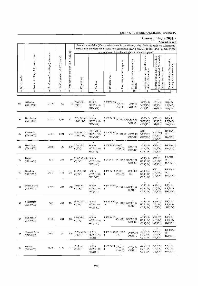
DISTRICT CENSUS HANDBOOK: BANKURA
Census of India 2001 -Amenities and
Amenities available (if not available within the village, a dash (-) is shown in the column and next to it in brackets the distance in broad ranges viz. < 5 laDS., 5-10 kms. and 10+ kms of the
"" ~ nearest place where the facility is available is given '" " l§ '" -0 ~~ -0 Vi' " 0 (j U '" '" '" ,,-(j " ',C (.) ,," ..c '" - " " e '" '" 0 '" > - '" <J
0 2 " 0 0 .~ 3 '(3 ~ 'E ~ '.g U ~ ..c qg 8. (j " 0 0- :; " i;;' 0 ~ '" " 0- (j
~~s ;;; ~ ,..l 0 -0 }j 0 .~ ~ ~ "0 6 '" " Od .;; ..c -0 Q ~ '.;;1 '3 ~ .2 e&J
" " '" ~ c '" " '" ;::: '" -0 (j 0 ~
~ .,s 0 '" ~ til o ._
~ ~ . .g '" "," ~ '-g 0 " ..c '" g 0
" """' ..c to 0- en Ol;;""§ .~ 0 .D ;; 0 :; ...... Ol e Ol ""§:i5 .~ S '" 0- 0 '"
;::: OJ) '2 '" ...::
(j
'" ...... ~ 0 ~ 0 OJ) " E e S~] '2
'" 0 0- ',g Ol '" }j " to S S i;;' Ol " Ol ~ .D (j J2 S '" '" (j
§ S (j 'B .5 S"" .~ ] ~ Q) .- S ;::: '1: '6 ;:l ;:l
" '" 8] (.) ,8 -g " Z f-< f-< Z -0
~ Q 0 ~'6 ~u~ 0:-::: r/) I.Ll 0.. ~r/) U e I 2 3 4 5 6 7 8 9 10 II 12 l3
135 Kalpathar
211.6 420 72 PM(5-10) H(IO+) T TW W SS· PO(~ 5) CM«5)
ACS« 5) CV«5) BS« 5) (02019200) C(10+) MCW(5-10)
T PH« 5) CP(5-1O) NCS(IO+) SP(IO+) RS(5-10)
PHC(5-10) OCS(IO+) ST(IO+) NW(IO+)
136 Ghoshergan
371.1 1,766 351 P(2) AC M(5- H(IO+) ~ TW W SS· PH PO« 5) CM(~ 5) ACS« 5) CV«5) BS« 5)
(02019300) 10) C(IO+) MCW(5-10) NCS(IO+) SP(IO+) RS(5-lO) PHC(5-10)
CP(5-10) OCS(10+) ST(IO+) NW(IO+)
Kharbana P(3) AC M(5- PHS H(IO+) T TW W SS· PO PH(8)
ACS CV(IO+)
BS RS(5-137 234.4 1,221 245 CM(5-10) NCS(IO+) 10)
(02019400) 10) C(IO+) MCW(5-10) T SP(10+) PHC(5-1O) CP(5-1O) OCS(lO+)
ST(IO+) NW(10+)
138 Hans Pahari
200.6 696 119 PM(5-10) H(10+) T TW W SS· PH(3)
CM«5) ACS«5) CV«5) BS RS« 5)
(02019500) C(lO+) MCW(5-IO) T PO«5) CP(5-1O)
NCS(lO+) SP(lO+) NW(IO+) PHC« 5) OCS(IO+) ST(IO+)
Dalpur P AC M« 5) H(IO+) ACS«5) CV«5) BSRS(5-
139 95.0 341 69 TWSS-T PH PO« 5) CM« 5) 10) (02019600) C(IO+) MCW(5-W)
CP(5-10) NCS(lO+) SP(IO+)
NW(IO+) PHC(5-10) OCS(IO+) ST(IO+)
Dumdumi PM S AC H(IO+) T TW W SS· PH(8) CMCP(5- ACS« 5) CV BS RS(5-
140 245.7 1,146 245 SP(IO+) 10) (02019700) C(IO+) MCW(5-10) T PO«5) 10) NCS(IO+)
ST(IO+) NW(IO+) PHC(5-10) OCS(IO+)
141 Shuara Bakra
219.5 803 148 PM(5-IO) H(IO+) T TW W SS· PH POe < 5) CM(~ 5) ACS«5) CV«5) BS«5)
(02019800) C(10+) MCW(5-10) T CP(IO+) NCS(IO+) SP(IO+) RS(5-10)
PHC(IO+) OCS(IO+) ST(IO+) NW(IO+)
142 Balarampur
90.1 639 154 P AC M« 5) H(IO+) TW W R SS· PH POe < 5) CM(-< 5) ACS« 5) CV«5) BS«5)
(02019900) C(10+) MCW(5-10) W CP(IO+) NCS(lO+) SP(IO+) RS(5-10)
PHC(5-10) OCS(IO+) ST(IO+) NW(10+)
Siuli Pahari 215.8 884 172
P M(5-10) H(10+) T TW W SS'PH PO« 5) CM(~ 5) ACS«5) CV«S) BS« 5) 143
(02020000) C(10+) MCW(S-IO) T CP(5-10) NCS(IO+) SP(IO+) RS(5-10)
PHC(5-10) OCS(IO+) ST(10+) NW(IO+)
P AC M« 5) H(IO+) T TW W SS· PH PO(5- ACS« S) CV«S) BS RS(S-
Shukuni Bansa 206.0 886 176 CM(5-10) 10) 144
(02020100) C(IO+) MCW(S-IO) T 10) NCS(IO+) SP(IO+)
PHC(IO+) CP(IO+)
OCS(IO+) ST(IO+) NW(IO+)
Bindna 217
PM AC H(lO+) T TW W SS· PO(~ 5) CM«5) ACS«5) CV«5) BS«5)
145 185.8 1,182 C(10+) MCW(5-10) NCS(IO+) SP(IO+) RS«5) (02020200) T PH« 5) CP(IO+)
PHC(IO+) OCS(10+) ST(IO+) NW(IO+)
216
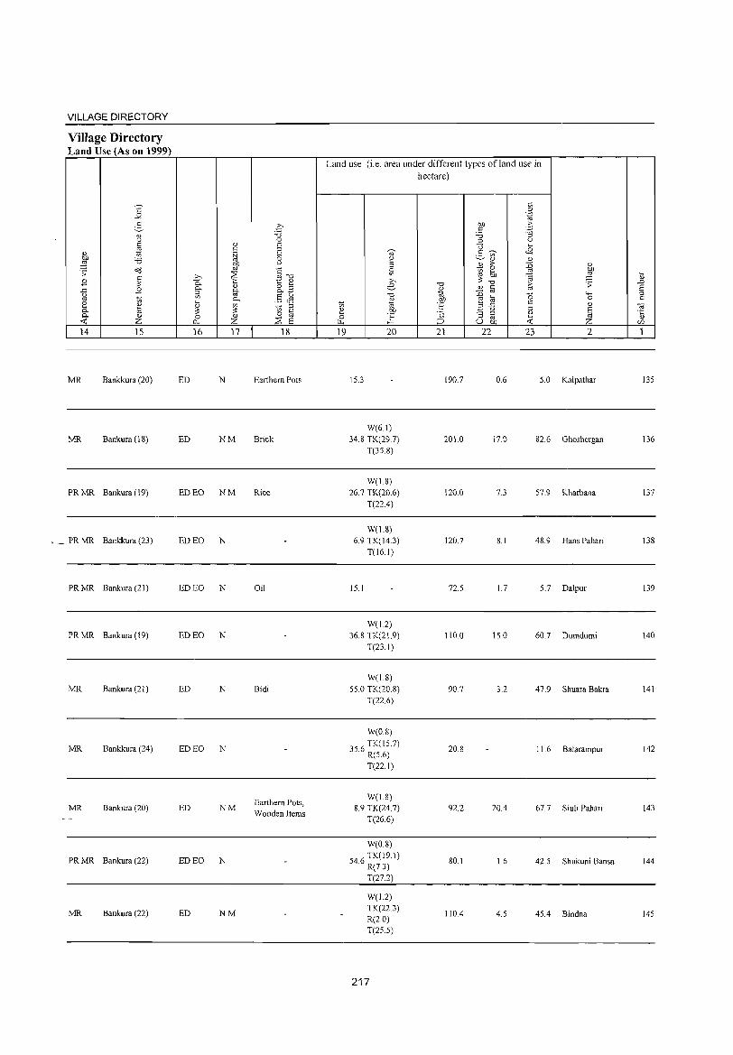
VILLAGE DIRECTORY
Village Directory Land Use (As on 1999)
14 15
MR Bankkura (20)
MR Bankura (18)
PRMR Bankura (19)
,.~ PRMR Bankkura (23)
PRMR Bankura (21)
PRMR Bankura (19)
MR Bankura (21)
MR Bankkura (24)
MR Bankura (20)
PRMR Bankura (22)
MR Bankura (22)
16 17 18
ED N Earthern Pots
ED NM Brick
ED EO NM Rice
ED EO N
ED EO N Oil
ED EO N
ED N Bidi
ED EO N
Earthern Pots, ED NM
Wooden Items
ED EO N
ED NM
Land use (i.e. area under different types ofland use in hectare)
19 20 21 22 23 2
15.3 190.7 0.6 5.0 Kalpathar
W(61) 34.8 TK(29.7) 201.0 17.0 82.6 Ghoshergan
T(3S.8)
W(1.8) 26.7 TK(20.6) 120.0 7.3 57.9 Kharbana
T(22.4)
W(1.8) 6.9 TK(14.3) 120.7 8.1 48.9 Hans Pahari
T(l6.1)
15.1 72.5 1.7 5.7 Dalpur
W(1.2) 36.8 TK(21.9) 110.0 15.0 60.7 Dumdumi
T(23.1)
W(1.8) 55.0 TK(20.8) 90.7 3.2 47.9 Shuara Bakra
T(22.6)
W(0.8)
3 6 TK(1S 7) 5. R(S.6) 20.8 11.6 Balarampur
T(22.I)
W(1.8) 8.9 TK(24.7) 92.2 20.4 67.7 Siuli Pahari
T(26.6)
W(0.8)
546 TK(19.1) . R(7.3)
80.1 1.6 42.5 Shukuni Bansa
T(27.2)
W(1.2) TK(223)
110.4 4.5 45.4 Bindna R(2.0) T(25.S)
217
135
136
137
138
139
140
141
142
143
144
145
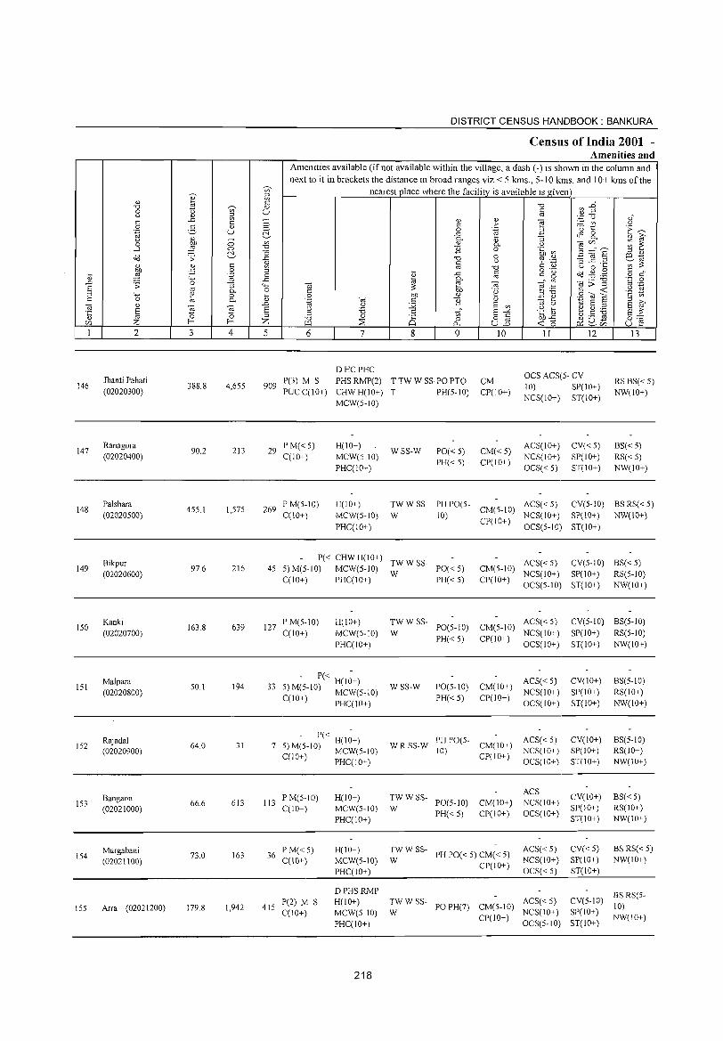
DISTRICT CENSUS HANDBOOK: BANKURA
Census of India 2001 -Amenities and
Amenities available (if not available within the village, a dash (-) is shown in the column and
next to it in brackets the distance in broad ranges viz.< 5 kms., 5-10 kms. and 10+ kms of the u;- nearest place where the facility is available is given ~
" E '" -0 ~~ -0 ~ <l) 0 u '" U " u " ~ to
'';:: C,) ,," ..c - '" " e " " 0 " > - '" u 0 2- " 0 0 .~ '0 t:: E~ .~ u ~ ..c: 3 ~ a " ~ u " - '"
Cl.
'" :; <il Cll ~ ~ 0 :W 0 '" Cl. u ..J 0 -0 1i 0 '§b ~ 5=S ~ "0 (, :l '" dd .;; ..c: -0 3 ~.2 ro-
u ~ .~ ~ to 1A " '" ~ " " " to -0 " '" u 0 ...
bf) ii 0 :l
I " o .-
0(3 ~ . .g " " ~ ~ .~ 0 ..c " g o " 4-< ..c: Cl. to '_P 0 .D .;; 0 :; 4-< -a ~ -a - '" <il:;:-g to .-S to Cl. 0 " .~ ~:g " -< '2 ~ :l 4-< ~ 0 t 8 bf) '" E e .8 (a E c 0 to Cl. Cii c 1i " S ~ ~ " ..0 '" '-' j2 E '" :l '-' '" E :l
E Cii -a E u '8 :::: r;;" E "" .g [) e ~ ~ s ~ 0 0 ;:!
" to :l -0 '" Ci 0 o " bf)..c: U ._ cd
0"" CIl Z f-- f-- Z "-l ~ p_. u..2 -<0 Plu- u ~ ~ CIl
1 2 3 4 5 6 7 8 9 10 11 12 13
DHCPHC OCS ACS(5- CV
Jhanti Pahari P(3) M S PHS RMP(2) TTW W SS·POPTO CM RS BS« 5) 146 388.8 4,655 909 10) SP(IO+)
(02020300) PUC C(IO+) CHWH(IO+) T PH(5-10) CP(IO+) NCS(IO+) ST(IO+)
NW(IO+) MCW(5-10)
147 Ranagora
90.2 213 29 PM«5) H(IO+)
WSS-W PO« 5) CM«5) ACS(IO+) CV«5) BS« 5)
(02020400) C(JO+) MCW(5-10) NCS(IO+) SP(10+) RS«5) PHC(lO+)
PH«5) CP(IO+) OCS« 5) ST(IO+) NW(1O+)
148 Palshara
455.1 1,575 269 PM(5-10) H(IO+) TWWSS- PH PO(5-
CM(5-10) ACS« 5) CV(5-10) BS RS« 5)
(02020500) C(10+) MCW(S-IO) W 10) CP(IO+)
NCS(IO+) SP(IO+) NW(IO+)
PHC(JO+) OCS(5-10) ST(IO+)
Bikpur P« CHW H(IO+)
TWWSS- ACS«5) CV(5-1O) BS« 5) 149 97.6 216 45 5)M(5-10) MCW(S-IO) PO«5) CM(S-IO)
(02020600) W NCS(IO+) SP(IO+) RS(5-10) C(10+) PHC(lO+) PH«5) CP(IO+)
OCS(5-10) ST(10+) NW(10+)
ISO Kanki
163.8 639 127 PM(5-IO) H(IO+) TWWSS-
PO(5-10) CM(5-10) ACS« 5) CV(5-10) BS(5-1O)
(02020700) C(10+) MCW(S-lO) W PH«5) CP(10+)
NCS(1O+) SP(IO+) RS(5-10)
PHC(IO+) OCS(1O+) ST(10+) NW(10+)
151 Malpara
50.1 194 33 - P« H(I;+)
WSS-W PO(5-10) CM(IO+) ACS« 5) CV(IO+) BS(5-10)
(02020800) 5) M(5-10) MCW(S-IO) PH«5) CP(1O+)
NCS(IO+) SP(lO+) RS(IO+) C(10+) PHC(IO+) OCS(10+) ST(IO+) NW(IO+)
Rajadal - P« -
PH PO(5- ACS« 5) CV(lO+) BS(5-10) 152 64.0 31 7
H(IO+) W R SS-W CM(IO+)
(02020900) 5) M(5-10) MCW(S-IO) 10) NCS(1O+) SP(IO+) RS(IO+) C(JO+) PHC(IO+) CP(IO+)
OCS(IO+) ST(IO+) NW(10+)
TWWSS-ACS
CV(1O+) BS«5) Bangaon 613 113
PM(5-1O) H(IO+) PO(5-10) CM(IO+) NCS(10+) 153
(02021000) 66.6
C(10+) MCW(5-1O) W SP(10+) RS(IO+)
PHC(IO+) PH«5) CP(IO+) OCS(IO+)
ST(10+) NW(IO+)
Murgabani 73.0 163 36
P M« 5) H(IO+) TWWSS-PH PO« 5) CM« 5)
ACS« 5) CV«5) BS RS« 5) 154
(02021100) C(10+) MCW(S-IO) W NCS(lO+) SP(lO+) NW(IO+)
PHC(IO+) CP(1O+)
OCS« 5) ST(IO+)
DPHSRMP BSRS(5-
1,942 415 P(2) M S H(10+) TWWSS-
PO PH(7) CM(5-10) ACS« 5) CV(5-10)
10) 155 Arra (02021200) 179.8 C(10+) MCW(5-1O) W NCS(IO+) SP(IO+)
PHC(IO+) CP(1O+)
OCS(5-10) ST(lO+) NW(lO+)
218
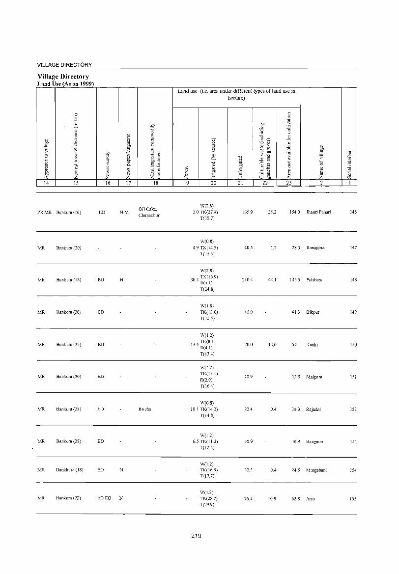
VILLAGE DIRECTORY
Village Directory Land Use (As on 1999)
14 15
PR MR Bankura (16)
MR Bankura (20)
MR Bankura (18)
MR Bankura (20)
MR Bankura (25)
MR Bankura (30)
MR Bankura (28)
MR Bankura (28)
MR Bankkura (IS)
MR Bankura (22)
16 17
EO NM
ED N
ED
ED
ED
ED
ED
ED N
ED EO N
18
Oil Cake, Chanachur
Bricks
Land use (Le. area under different types ofland use in hectare)
19 20
W(2.8) 2.0 TK(27.9)
T(30.7)
W(0.8) 4.9 TK(14.5)
T(l5.3)
W(2.8)
'04 TK(169) ~ . R(5.1)
T(24.8)
W(1.8) TK(13.6) T(15.4)
W(J2)
l' 4 TK(8.1) ~. R(4.1)
T(l3.4)
W(1.2) TK(13.1) R(2.0) T(16A)
W(0.8) 10.1 TK(l4.0)
T(14.S)
W(I.2) 6.5 TK(I1.2)
T(12.4)
W(U) TK(16.5) T(17.7)
W(1.2) TK(28.7) T(29.9)
219
21 22
165.9
40.5
210.4
40.9
70.0
20.9
20A
30.9
30.5
76.2
23 2
35.2 154.9 Jhanti Pahari
1.2 28.3 Ranagora
44.1 145.5 Palshara
41.3 Bikpur
13.0 54.1 Kanki
12.9 Malpara
0.4 IS.3 RajadaJ
16.9 Bangaon
0.4 24.5 Murgabani
10.9 62.S Arra
146
147
14S
149
150
151
152
153
154
155
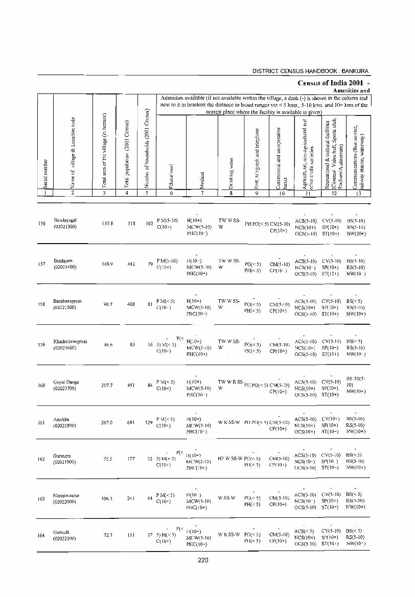
156
IS7
IS8
IS9
160
161
162
163
164
2
Bandayagal (02021300)
Bindajam (02021400)
Barabanagram (02021S00)
Khudrabanagram (02021600)
Goyal Danga (02021700)
Amdiha (02021800)
Gursagra (02021900)
Narasinhapur (02022000)
Guniada (02022100)
3
137.8
148.9
90.7
46.6
207.7
267.0
7S.S
106.3
72.7
'" ::l '" " <L> U
o o c:'..
4
518
442
408
83
4S1
681
177
241
III
DISTRICT CENSUS HANDBOOK: BANKURA
Census of India 2001 -Amenities and
Amenities available (if not available within the village, a dash (-) is shown in the column and next to it in brackets the distance in broad ranges viz. < 5 kms., 5-10 kms. and 10+ kms of the
nearest place where the facility is available is given
5 6 7
102 P M(5-10) C(IO+)
H(IO+)
MCW(S-IO) PHC(IO+)
79 PM(S-10) C(10+)
H(10+) MCW(S-10) PHC(10+)
81 PM«S) H(10+) C(lO+) MCW(S-10)
PHC(10+)
16 - P« H(I~+)
S) M« 5) MCW(5-1O) C(10+) PHC(IO+)
PM«S) H(JO+) 84
C(JO+) MCW(S-10) PHC(IO+)
129 P M«5) H(IO+) C(10+) MCW(S-JO)
PHC(10+)
P« H(10+) 32 5) M«S)
MCW(5-10) C(10+)
PHC(10+)
44 PM«5) H(10+) C(10+) MCW(S-10)
PHC(IO+)
17 - P« H(I~+)
5) M« 5) MCW(S-IO) C(lO+) PHC(IO+)
220
8
"0 C
'" ..c 0. E b1) <L>
E
'" o 0..
9
<L> > .-§ '" 0. o 6 u
"0 §
"@ .~
<L>
E '" ~~ ull
10 11 12 13
TW W SS- PH PO« 5) CM(5-10) ACS(S-IO) CV(S-IO) BS(S-IO) W NCS(IO+) SP(IO+) RS(S-IO)
CP(lO+) OCS(S-IO) ST(lO+) NW(IO+)
TWWSS-PO«S) PH« S)
W CM(5-10) ACS(S-10) CV(S-IO) BS(S-IO)
NCS(10+) SP(10+) RS(S-10) CP(10+) OCS(S-10) ST(10+) NW(IO+)
TWWSS-PO« S) CM(S-10)
ACS(S-10) CV(S-JO) BS« S) W NCS(10+) SP(10+) RS(S-IO)
PH«S) CP(10+) OCS(S-10) ST(10+) NW(JO+)
TWWSS-PO« S) CM(S-10)
ACS(5-10) CV(S-10) 6S« S) W NCS(10+) SP(JO+) RS(S-10)
PH« S) CP(IO+) OCS(S-IO) ST(10+) NW(10+)
:W W R SS PH POe < S) CM(-S- 10) ACS(S-10) CV(S-IO) BS RS(5-10)
CP(10+) NCS(IO+) SP(10+)
NW(IO+) OCS(5-10) ST(IO+)
WRSS-W PH PO« S) CM(S-10) ACS(5-10) CV(lO+) BS(5-10)
NCS(lO+) SP(IO+) RS(S-IO) CP(10+)
OCS(10+) ST(10+) NW(10+)
ACS(S-10) CV(5-10) 6S« S) HP W SS-W PO« 5) CM(5-10)
NCS(10+) SP(10+) RS(S-JO) PH« S) CP(10+)
OCS(S-10) ST(10+) NW(10+)
WSS-W PO« 5) CM(S-10) ACS(5-10) CV(S-IO) BS«S) NCS(10+) SP(lO+) RS(S-IO)
PH« S) CP(lO+) OCS(5-10) ST(lO+) NW(IO+)
WRSS-W PO« S) CM(S-10) ACS« 5) CV(S-IO) 6S« S) NCS(IO+) SP(10+) RS(S-IO)
PH« 5) CP(IO+) OCS(5-10) ST(IO+) NW(lO+)
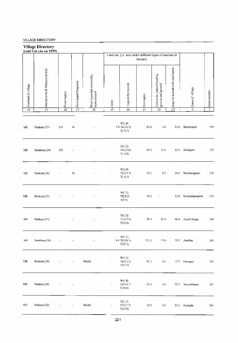
VILLAGE DIRECTORY
Village Directory Land Use (As on 1999)
S ..:<
2-'" <)
c tl '" bJ) 'i3 ;g o<J .;;: c
B ~ ..<:: B u
'" 10 e '" 0. til 0. '" ...: z 14 15
MR Bankura (23)
MR Bankkura (24)
MR Bankura (24)
MR Bankura (23)
MR Bankura (23)
MR Bankkura (26)
MR Bankura (24)
MR Bankura (24)
MR Bankura (22)
ED
ED
q '0 0
'" E c .~ 8
0 bJ) u
'" ;: » ~ "''0
0.. ';:; 1:: " 0.. '" 8.3 ::! 0.. U) '" §$ 0.
~ U) 10 ;;:l
~ 0 C 0 " ~ '" 0. Z 8 16 17 18
N
N
Bricks
Bricks
Land use (i.e. area under different types ofland use in hectare)
19 20
W(18) 93 TK(16.5)
T(18.3)
W(1.2) TK(13.6)
T(14.8)
W(10) TK(153) T(16.3)
W(J.2) TK(8.2) T(9.4)
W(1.8) TK(236) T(25.4)
W(1.2) 0.4 TK(26.1)
T(27.3)
W(1.2) TK(11.1) T(12.3)
W(1.8) TK(147) T(16.6)
W(1.2) TK(13.7) T(15.0)
221
'0
'" "' bJ)
'E 2
;::J
21
66.0
65.4
35.3
24.2
90.5
151.1
41.2
51.4
32.0
bJ) c:
'i3 ;;:l
'0 2- 0>
'" B ;>
~ ~ '0
'" § :0 '" t;; 2 ..c
u '3 ;;:l
'" u bJ)
22
2.6
15.4
8.7
24.9
13.0
4.5
2.0
1.6
c 0 .~
.~
" u .... <8 '" :0 '" ~
bJ)
;g '", ~ ;;: '0 4-<
0 c '" '" 8 ~ :Z' ...:
23 2
416 Bandayagal
53.4 Bindajam
30.4 Barabanagram
13.0 Kh udrabanagram
66.8 Goyal Danga
75.2 Amdiha
17.7 Gursagra
363 Narasinhapur
24.2 Guniada
.... '" .D 8 ;;:l c
oa .~
en
I
156
157
158
159
160
161
162
163
164

165
166
167
168
169
170
171
172
173
174
2
Malbedya
(02022200)
Harakbedya
(02022300)
Kelai
(02022400)
Parashibana (02022500)
lamdoba (02022600)
Mangalda (02022700)
Barshi (02022800)
Dumda (02022900)
Tilajuri (02023000)
Katharia (02023100)
3 4
96.7 337
156.6 508
181.9 505
46.7 161
169.1 417
98.3 353
124.6 381
208.3 447
88.0 212
301.9 855
5
DISTRICT CENSUS HANDBOOK: BANKURA
Census of India 2001 -Amenities and
Amenities available (ifnot available within the village, a dash (-) is shown in the column and next to it in brackets the distance in broad ranges viz. < 5 kms., 5 -1 0 krns. and 10+ kms of the
nearest place where the facility is available is given
(il c o .~
u ;:l
G3 6
60 PM«5) CCIO+)
85 P M« 5) CCIO+)
7
H(lO+) MCW(5-10) PHCC 10+)
H(10+) MCW(5-10)
PHCCIO+)
- P« H(I;+) 84 5) M(5-10) MCW(5-10)
CCl0+) PHCCIO+)
34 P M« 5) C(10+)
H(1O+) MCW(5-10) PHCCIO+)
8
WSS-W
9
PO«5) PH«5)
TW W R SS PO(~ 5)
W PH«5)
WSS-W PO(5-10)
PH«5)
~W W SS- PO« 5)
PH«5)
10 11 12 13
ACS« 5) CV(5-10) BS« 5) CM(5-10) NCS(IO+) SP(IO+) RS(5-1O) CP(lO+) OCS(5-1O) ST(IO+) NW(IO+)
CM(IO+) ACS(5-10) CV(10+) CP(10+) NCS(IO+) SP(10+)
OCS(10+) ST(IO+)
CM(10+) ACS(5-1O) CV(10+) CP(10+) NCS(10+) SP(lO+)
OCS(10+) ST(JO+)
CM(10+) ACS(5-10) CV(10+) NCS(IO+) SP(lO+)
CP(IO+) OCS(10+) ST(10+)
BS«5) RS(10+) NW(IO+)
BS(5-1O) RS(10+) NW(IO+)
BS«5) RS(10+) NW(10+)
74 PM(5-10) C(10+)
H(IO+) MCW(5-10) PHCCIO+)
TW W SS- PH PO(5- ACS(5-10) CV(IO+) W 10) CM(10+) NCS(IO+) SP(IO+)
BS« 5) RS(5-10) NW(IO+)
- P« H(1;+) 59 5) M(5-10) MCW(5-10) W R SS-W PO(5-10)
PH«5) CCIO+) PHCCI0+)
74 PM(5-10) CCIO+)
77 PM«5) C(10+)
43 PM«5) CCIO+)
H(10+) MCW(5-10) PHCCIO+)
TWWR SSpO(;_1O)
W PH«5)
H(5- -10) MCW(5- TW W R SS PO« 5)
10)PHCC5-10) W PH(5-10)
- H« 5) MCW(5-1O) ~W W SS- PO« 5)
PHCC5-10) PH(5-10)
CP(IO+) OCS(IO+) ST(IO+)
ACS(5-10) CV(IO+) CM(10+) NCS(10+) SP(10+) CP(IO+) OCS(1O+) ST(10+)
CM(10+) ACS(5-1O) CV(IO+) NCS(IO+) SP(10+)
CP(10+) OCS(IO+) ST(IO+)
BS(5-10) RS(IO+) NW(IO+)
BS(5-1O) RS(IO+) NW(IO+)
ACS(5-1O) CV(5-10) BS(5-1O) CM(5-10) NCS(IO+) SP(IO+) RS(10+) CP(IO+) OCS(lO+) ST(IO+) NW(IO+)
ACS(5-10) CV« 5) CM(5-10) NCS(lO+) SP(lO+) CP(IO+) OCS(IO+) ST(IO+)
BS(5-1O) RS(10+) NW(IO+)
165 P M(5-raJ CCIO+)
RMP H( I 0+) TW W SS- PH(2} MCW(5-10) W PO(5-1O) PHCCI O+)
CM(5-10) ACS(5-10) CV(5-W) 8S(5-10) NCS(10+) SP(IO+) RS(IO+)
CP(IO+) OCS(1O+) ST(IO+) NW(IO+)
222
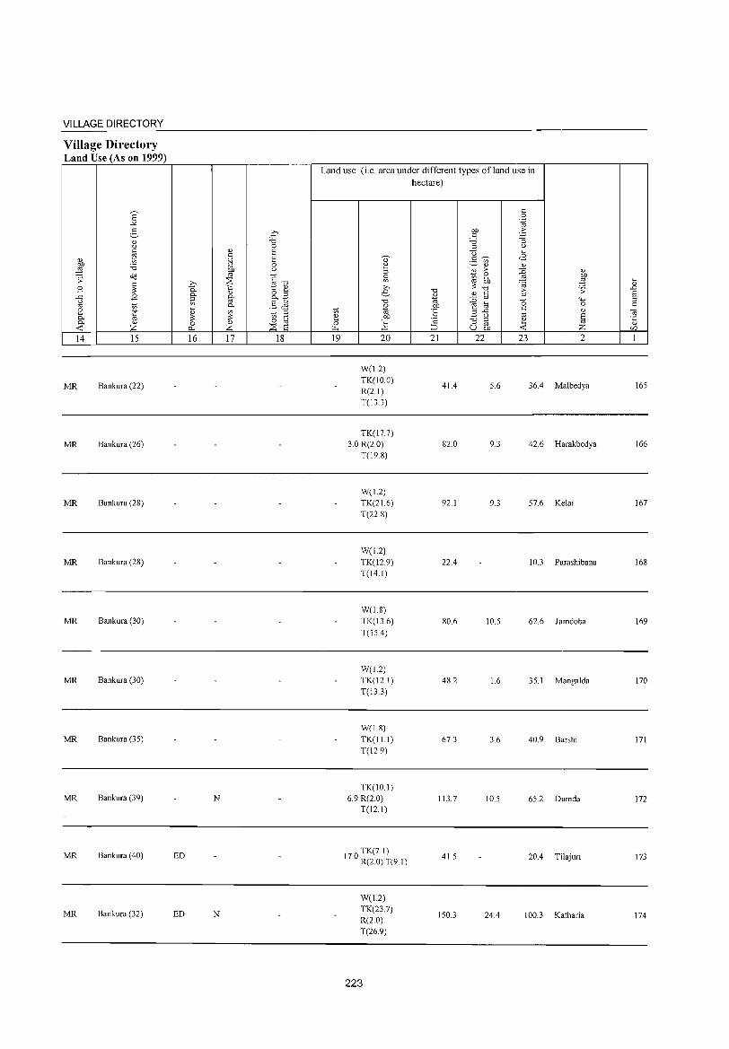
VILLAGE DIRECTORY
Village Directory Land Use (As on 1999)
14 15
MR Bankura (22)
MR Bankura (26)
MR Bankura (28)
MR Bankura (28)
MR Bankura (30)
MR Bankura (30)
MR Bankura (35)
MR Bankura (39)
MR Bankura (40)
MR Bankura (32)
16 17 18
N
ED
ED N
Land use (i.e. area under different types ofland use in
hectare)
19 20
W(1.2) TK(IO.O) R(2.1) T(13.3)
TK(17.7) 3.0 R(2.0)
T(198)
W(12) TK(21.6) T(22.8)
W(1.2) TK(l2.9) T(14.1)
W(1.8) TK(13.6) T(15A)
W(J2) TK(12.1) T(133)
W(1.8) TK(ll1) T(129)
TK(lO.1) 6.9 R(2.0)
T(12.1)
TK(7.1) 17.0 R(2.0) T(9.1)
W(12) TK(23.7) R(2.0) T(26.9)
223
21
41.4
82.0
92.1
22A
80.6
48.2
67.3
113.7
41.5
150.3
22 23 2
5.6 36A Malbedya
9.3 42.6 Harakbedya
9.3 57.6 Ke1ai
10.3 Parashibana
10.5 62.6 Jamdoba
1.6 35.1 Mangalda
3.6 40.9 Barshi
10.5 65.2 Dumda
20A Ti1ajuri
24A 100.3 Katharia
165
166
167
168
169
170
171
172
173
174
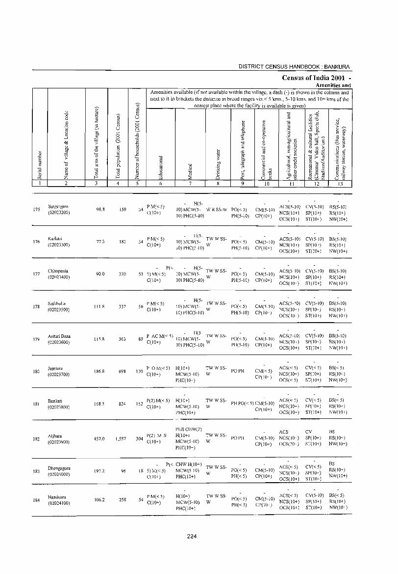
175
176
177
178
179
180
181
182
183
184
2
Singergara (02023200)
Karkari (02023300)
Chhopania (02023400)
Satkhulia (02023500)
Anturi Bana (02023600)
Jamtara (02023700)
Bankati (02023800)
Aljhara (02023900)
Dhengagora (02024000)
Nanduara (02024100)
3
98.8
77.3
90.0
111.8
115.8
186.8
168.5
4S2.0
195.2
106.2
I u o o C!-
4
159
182
320
332
363
698
824
1,557
96
2S8
5
DISTRICT CENSUS HANDBOOK: BANKURA
CensllIs of India 2001 -Amenities and
Amenities available (if not available within the village, a dash (-) is shown in the column and next to it in brackets the distance in broad ranges viz.< 5 kms., 5-10 kms. and 10+ kms of the
nearest place where the facility is available is given
6
34 PM«5) C(10+)
34 PM«5) C(IO+)
7 8 9
H(S-10) MCW(5- W R SS-W PO« 5) 10) PHC(5-10) PH(5-10)
- H(5-10) MCW(5- TW W SS- PO« 5)
10) PHC(5-1O) W PH(5-10)
P« - H(S-S3 5) M« 5) 10) MCW(5- TW W SS- PO« S)
C(IO+) 10) PHC(5-10) W PH(S-IO)
56 PM« S) C(10+)
- H(5-10) MCW(S- TW W SS- PO« S)
10) PHC(S-lO) W PH(5-10)
- H(5-89 P AC M« S) 10) MCW(S- TW W SS- PO« S)
C(IO+) 10) PHC(S-lO) W PH(S-IO)
10 11 12 13
CM(5-10) ACS(S-lO) CV(S-lO) BS(S-IO) CP(10+) NCS(IO+) SP(IO+) RS(IO+)
OCS(10+) ST(IO+) NW(IO+)
CM(5-10) ACS(S-IO) CV(5-IO) BS(S-IO) CP(IO+) NCS(lO+) SP(IO+) RS(IO+)
OCS(lO+) ST(IO+) NW(IO+)
CM(S-IO) ACS(5-10) CV(5-iO) BS(S-10) CP(IO+) NCS(10+) SP(10+) RS(IO+)
OCS(IO+) ST(lO+) NW(10+)
CM(S-IO) ACS(S-IO) CV(S-IO) BS(S-IO) CP(IO+) NCS(IO+) SP(IO+) RS(10+)
OCS(lO+) ST(lO+) NW(IO+)
CM(S-lO) ACS(S-IO) CV(S-IO) BS(S-IO) NCS(10+) SP(10+) RS(IO+)
CP(IO+) OCS(10+) ST(IO+) NW(IO+)
130 P OM«S) H(IO+) C(10+) MCW(S-IO)
TWW SS- POPH W
CM«S) CP(IO+)
ACS«S) NCS(10+)
OCS« S)
CV«S) SP(10+)
ST(IO+)
BS« 5) RS(10+) NW(10+) PHqIO+)
152 P(2) M« 5) C(1O+)
H(IO+) MCW(5-10) PHC(IO+)
TW W SS- ACS« 5) W PH PO« 5) CM(5-10) NCS(IO+)
304 P(2) M S C(10+)
PHSCHW(2) H(10+) MCW(5-IO)
PHC(IO+)
TWW SS- POPH W
P« CHWH(IO+) TWWSS-18 S)M«5) MCW(5-10) W PO«S)
C(10+) PHC(10+) PH« 5)
54 P M« 5) C(10+)
H(IO+) MeW(5-10) PHC(IO+)
224
~W W SS- PO« 5)
PH«S)
Cpr 10+) OCS(IO+)
ACS CM(5-1O) NCS(10+) CP(IO+) OCS(10+)
ACS« 5) CM(5-1O) NCS(10+) CP(IO+) OCS(10+)
ACS« S) CM(5-IO) NCS(IO+) CP(1 0+) OCS( 10+ )
CV«5) SP(IO+) ST(IO+)
CV SP(IO+) ST(IO+)
CV«S) SP(IO+) ST(10+)
BS«5) RS(IO+) NW(10+)
BS RS(IO+) NW(IO+)
BS RS(10+) NW(10+)
CV(5-IO) BS« 5) SP(lO+) RS(IO+) ST(IO+) NW(IO+)
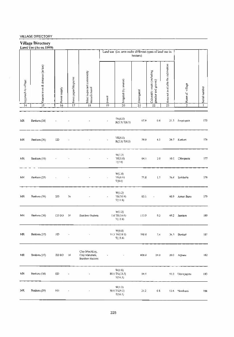
VILLAGE DIRECTORY
Village Directory Land Use (As on 1999)
E -'"
2-0) u c
0) ~ OJ) :a ,g .;; ~
c B 3: g B
t;;
~ ~ ~
0)
Z 14 15
MR Bankura (3S)
MR Bankura (36)
MR Bankura (35)
MR Bankura (35)
MR Bankura (36)
MR Bankura (36)
MR Bankura (37)
MR Bankura (37)
MR Bankura (38)
MR Bankura (39)
.0 :a 0
0) S c .~ S
0
%l u
,.., :2 §-o 0. C 1:: 0)
0) o ~ 0.. 0.. p.~ ::l '" '" 0.. §~ ~ ~ t1 g 3: o oj 0 Z :::2 2 0...
16 17 18
ED
ED N
EDEO N Bamboo Baskets
ED
Clay Moulding, ED EO N Clay Materials,
Bamboo Baskets
ED
ED
Land use (i.e. area under different types ofland use in hectare)
c 0
',g bJ) . .6 c :a "3 ::l U
U ~
OJ c ~ <8 ;::, on
2 0) 0)
::l 2 :> :0 Sl ~ 2 -"l bJ) ,.., 3: "0
·ca e "0
0) c iO 0)
"0 iii :0 oj (5
t;; 0) bJ)
~ a c iii 'E ..c e f u co .", ::; ::l
~ 0 oj ~ ::;, u bJ)
19 20 21 22 23
0) bJ)
,g ;;
'-H 0 0)
§ z 2
TK(6.0) R(2.5) T(S 5)
67.9 O.S 21.5 S ingergara
TK(6.0) 3S.0 4.1 26.7 Karkari
R(2.5) T(S.5)
W(L2) TK(6.6) 64.1 2.0 16.0 Chhopania T(79)
W(l.S) TK(66) 75.8 1.2 26.4 Satkhulia T(S.4)
W(12) TK(10.6) 63.1 40.9 Anturi Bana T(Il.8)
W(l.2) l.6 TK(t4.6) 110.9 9.3 49.2 Jamtara
T(lS.S)
W(O.S) 11.3 TK(tS.6) 100.S 2.4 34.5 Bankati
T(19.4)
408.0 24.0 20.0 Aljhara
W(0.8) 80.5 TK(13.5) 59.4 41.0 Dhengagora
T(l4.3)
W(1.0) 50.6TK(9.1) 31.2 0.8 13.6 Nanduara
T(JO.!)
225
~ 0)
.>:> S ::l C
Oi '5 r:/)
1
175
176
177
17S
179
180
lSI
182
183
184
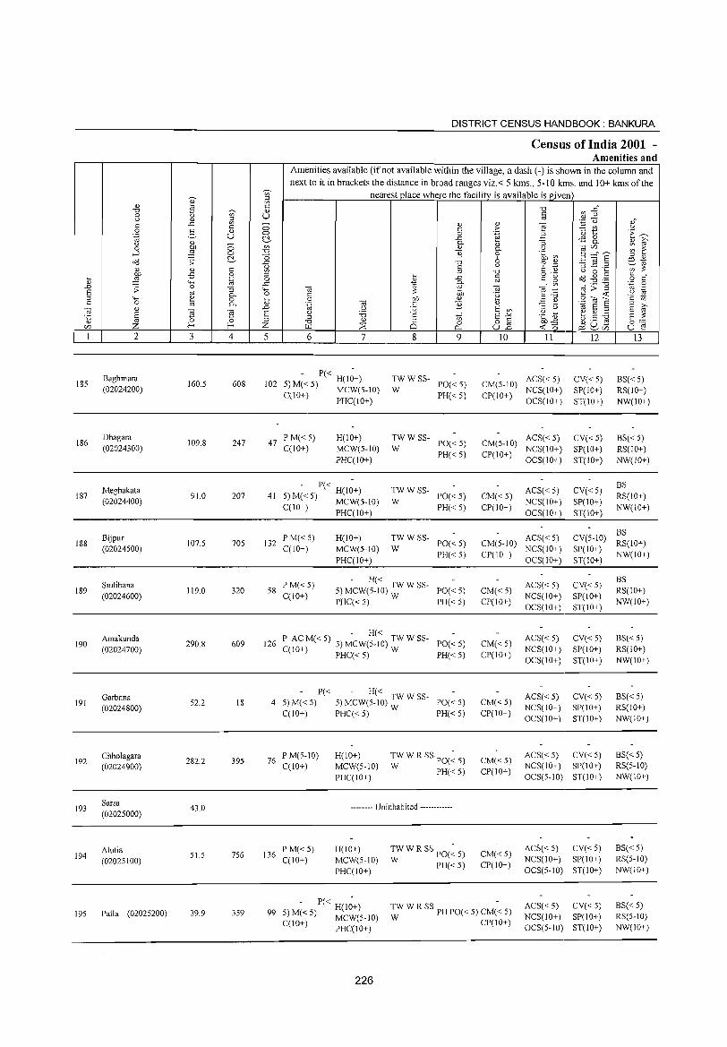
185
186
187
188
189
190
191
192
193
194
195
2
Baghmara
(02024200)
Dhagara
(02024300)
Meghakata
(02024400)
Bijpur (02024500)
Siulibana
(02024600)
Amakunda
(02024700)
Garbana (02024800)
Chhoiagara
(02024900)
Sarsa
(02025000)
Alutia (02025100)
Palla (02025200)
3
160.5
109.8
91.0
107.5
119.0
290.8
52.2
282.2
43.0
51.5
39.9
o o ~
4
608
247
207
705
320
609
18
395
756
359
DISTRICT CENSUS HANDBOOK: BANKURA
Census of India 2001 -Amenities and
Amenities available (if not available within the village, a dash (-) is shown in the column and next to it in brackets the distance in broad ranges viz.< 5 krns., 5-10 krns. and 10+ kms of the
nearest place where the facility is available is given
o o ~
'" "0 -0 ..c 1;l ::l o
..c "o .... ., ..D
§ Z
5 6 7
102 - P« H(I~+)
5) M« 5) MCW(5-1O) C(lO+)
47 PM«5} C(1O+)
PHC(IO+)
H(10+)
MCW(5-10)
PHC(IO+)
- P« -41 5) M« 5) H(IO+)
C(IO+) MCW(S-IO) PHC(IO+)
132 PM«5) C(IO+)
H(IO+)
MCW(5-10)
PHC(IO+)
8
<;; o
0..
9
TWWSS-W PO«5)
PH«5)
TWWSS-PO«5)
PH«5) W
TWWSS-PO«5)
PH«5) W
TWWSS-PO«5)
PH« 5) W
58 PM«5) C(IO+)
- H« 5) MCW(5-10) TW W SS- PO« 5)
PHC« 5) W PH« 5)
- H« 126 P ACM«5) 5) MCW(5-10) TWWSS- PO«5)
C(lO+) PHC« 5) W PH« 5)
P« - H« 4 5)M«5) 5)MCW(5_10):WSS- PO«5)
C(IO+) PHC« 5) PH« 5)
76 P M(5-10) C(lO+)
136 P M« 5) C(1O+)
H(IO+)
MCW(5-10)
PHC(IO+)
TWWRSSpO(~5) W PH«5)
-------- Uninhabited ------------
H(IO+)
MCW(5-10)
PHC(IO+)
TW W R SS PO(~ 5)
W PH«5)
10 II
ACS« 5) CM(5-10) NCS(IO+)
CP(IO+) OCS(IO+)
ACS« 5) CM(5-10) NCS(lO+)
CP(IO+) OCS(IO+)
CM«5)
CP(IO+)
ACS« 5)
NCS(IO+)
OCS(lO+)
12
CV«5)
SP(lO+)
ST(lO+)
CV«5)
SP(IO+)
ST(IO+)
CV«5)
SP(IO+)
ST(lO+)
13
BS«5)
RS(lO+)
NW(IO+)
BS« 5)
RS(IO+)
NW(IO+)
BS
RS(IO+)
NW(IO+)
ACS« 5) CM(5-10) NCS(IO+)
BS CV(5-10) RS(IO+)
SP(IO+) NW(IO+) CP(IO+) OCS(IO+) ST(lO+)
CM«5)
CP(IO+)
CM«5)
CP(IO+)
CM«5) CP(IO+)
CM« 5)
CP(IO+)
CM« 5)
CP(IO+)
ACS« 5) NCS(IO+)
OCS(IO+)
ACS« 5)
NCS(lO+)
OCS(lO+)
ACS« 5) NCS(IO+)
OCS(IO+)
CV«5)
SP(lO+)
ST(lO+)
CV«5) SP(IO+)
ST(IO+)
CV«5) SP(IO+)
ST(IO+)
ACS« 5) CV« 5) NCS(IO+) SP(IO+)
OCS(5-10) ST(IO+)
ACS« 5) CV« 5) NCS(IO+) SP(IO+)
OCS(5-10) ST(IO+)
BS
RS(IO+)
NW(IO+)
BS« 5)
RS(lO+)
NW(IO+)
BS« 5) RS(IO+)
NW(lO+)
BS«5) RS(5-10)
NW(IO+)
BS«5) RS(5-10)
NW(10+)
- P« H(I~+) 99 5)M«5) MCW(5-10)
C(IO+) PHC(10+)
TW W R SS· PH PO« 5) CM(~ 5)
W CP(lO+)
ACS« 5) CV« 5) NCS(10+) SP(IO+)
OCS(5-10) ST(IO+)
BS« 5) RS(5-10)
NW(IO+)
226
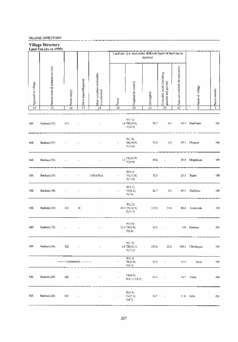
VILLAGE DIRECTORY
Village Directory Land Use (As on 1999)
14 15
MR Bankura (37)
MR Bankura (37)
MR Bankura (35)
MR Bankura (35)
MR Bankura (34)
MR Bankura (33)
MR Bankura (32)
MR Bankura (36)
16 17 18
ED
Puffed Rice
ED N
ED
-------- Uninhabited ------------
MR Bankura (29) ED
MR Bankura (28) ED
Land use (i.e. area under different types ofland use in hectare)
19 20
W(l.2) 1.6 TK(19.6)
T(20.9)
W(LO) TK(14.6)
T(15.6)
I? TK(IO.9) .- T(IO.9)
W(LO) TK(120) T(13.0)
W(12) TK(6.2) T(7.4)
W(1.2)
44.5 TK( 1 0.5)
T(l1.7)
W(1.0) 31.2 TK(5.0)
T(6.0)
W(1.2)
3.0 TK(12.1)
T(13.3)
W(1.2) TK(5.0)
T(6.2)
TK(OA)
R(4. I) T(4.5)
W(1.6)
TK(7.1) T(8.7)
227
21
74.7
52.0
49.0
72.0
62.7
115.0
10.2
135.6
25.3
32.3
19.7
22 23 2
4.1 59.3 Baghmara
2.0 40.2 Dhagara
29.9 Meghakata
22.5 Bijpur
8.5 40.5 Siulibana
31.6 88.0 Amakunda
4.8 Garbana
22.0 108.3 Chholagara
11.5 Sarsa
14.7 Alutia
11.6 Palla
185
186
187
188
189
190
191
192
193
194
195
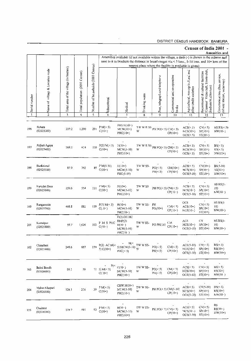
DISTRICT CENSUS HANDBOOK: BANKURA
Census of India 2001 -Amenities and
Amenities available (if not available within the village, a dash (-) is shown in the column and
next to it in brackets the distance in broad ranges viz.< 5 kms., 5-10 kms. and 10+ kms of the 'Vi' nearest place where the facility is available is given
I '" " l3 -0 Vl --§" -0 ~ " 0 Ul U § u " '" . .3 u ,,-..c:: Ul ;; " " ""§ co t: :.::: VI u 0 :§, "
t: ;>
'" t '1: ~ .~ u 0 0 .~ 2 ~ ..c:: $ 8.. " li;' u j _
Q.
" "3 0 0 Ul " Q. u tOr:/) ~ ~ ....l 0 -0 '}i 0 .~ ~ 3 _- ~
~ -0 6 ;::l " ~ .s: ..c:: -0 ~ .~ :s 11 § co" " t: u ~~ .&
<l) t: ~ co -0 u 0 ... .,s 0 ... t: o .- o'd ~ .g co or ~ .~ 0 <l) ,..c; co t: g 0
~ "'" ,..c;
" Q. en .- -0 .~ 0 .!:> 0 "3 "'" to e to E! ."!::! ];:.~ .~ E co Q. 0 c: ~ ao '2 " ;:I "'" ~ 0 ... 0 ao "
;:1-0 .9," a '2
t: 0 Q. <l) 'g to t: '}i <l) ~ '" E li;' _ ....
to 0) .!:> .2 :.;;; 6 Ul '" U " 2 ;:I
~ ~ 6 u 'c ~ ~ 8 :.a ·c ~ .g -0 t: tl E-" E ;:: "
;:I " C§ 0 8_2 ao.c ~ U .5 0::::: r:/) Z f-< f-< Z f.l.l ~ 0.. ~ 0 ~ ~r:/) u e 1 2 3 4 5 6 7 8 9 10 11 12 13
Bahara P M«5) PHS H(lO+)
:W W R SS PH PO« 5) CM(~ 5) ACS« 5) CV« 5) BS RS« 5) 196 339.2 1,290 291 MCW(10+) (02025300) C(10+) NCS(lO+) SP(IO+) NW(IO+)
PHC(IO+) CP(10+) OCS«5) ST(10+)
197 Patjuri Agaya
268.2 614 120 P(2)M« 5) H(lO+) TW W R SS· PH POe < 5) CM(-< 5) ACS« 5) CV« 5) BS« 5)
(02025400) C(10+) MCW(5-10) W CP(IO+)
NCS(10+) SP(IO+) RS«5) PHC(10+) OCS« 5) ST(IO+) NW(lO+)
198 Banksimul
82.0 362 85 PM(5-10) H(10+) TWWSS-
PO«5) CM(IO+) ACS« 5) CV(10+) BS(5-10)
(02025500) C(10+) MCW(5-1O) W PH«5) CP(10+)
NCS(IO+) SP(IO+) RS(IO+)
PHC(5-10) OCS(5-10) ST(lO+) NW(10+)
Kunkhri Basa PM«5) H(10+) TWWSS- ACS« 5) CV«5) BS RS(5-
199 (02025600)
159.6 554 III C(lO+) MCW(5-10) W
PH PO« 5) CM« 5) NCS(IO+) SP(10+)
10)
PHC(IO+) CP(IO+)
OCS(5-10) ST(10+) NW(IO+)
Rangametia P(2) M« 5) H(IO+) TWWSS- PH OCS
CV«5) BS RS(5-
200 408.8 882 159 CM«5) ACS(10+) 10) (02025700) C(10+) MCW(5-10) W PO(IO+)
CP(10+) NCS(10+) SP(IO+)
NW(10+) PHC(10+) ST(10+)
D(2)DHHC
PM S PUC RMP(2)
TWWSS- CM ACS CV BS RS(5-
Kamalpur 201
(02025800) 59.7 1,626 333
C(IO+) H(IO+)
W PO PH(16) CP(10+) NCS(IO+) SP(lO+) 10)
MCW(5-10) OCS(5-10) ST(10+) NW(10+)
PHC(10+)
Chinabari - H«
ACS(5-10) CV«5) BS«5) 202 249.6 887 179 P(2) AC M« 5) MCW(5-10) TW W SS- PO« 5) CM«5)
(02025900) 5) C(lO+) PHC« 5) W PH« 5) CP(10+) NCS(10+) SP(IO+) RS(IO+)
OCS(5-10) ST(10+) NW(lO+)
Baksi Bandh 12
- P« H(1;+) TWWSS-PO« 5) CM«5)
ACS« 5) CV« 5) BS«5) 203 99.1 59 5) M« 5) MCWe5-10) W NCS(10+) SP(10+) RS(10+) (02026000) PH« 5) CP(10+) C(10+) PHC(10+) OCS(5-10) ST(IO+) NW(IO+)
Mahes Khapuri PM« 5) CHWH(10+)
TWWSS- ACS«5) CV(5-10) BS« 5) 204 128.1 216 39
C(10+) MCW(5-1O)
W PH PO« 5) CM(5-10)
NCS(10+) SP(10+) RS(10+) (02026100) PHC(10+) CP(IO+) OCS(5-10) ST(IO+) NW(IO+)
ACS« 5) CV«5) BS
Chaintor PM«5) H(10+) TWWSS-PH 1'0« 5) CM« 5) RS(10+) 205 119.7 491 93
C(10+) MCW(5-10) W NCS(10+) SP(10+) (02026200) CP(10+) NW(10+) PHC(10+) OCS(5-10) ST(lO+)
228
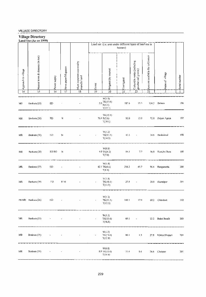
VILLAGE DIRECTORY
Village Directory Land Use (As on 1999)
Land use (i.e. area under different types ofland use in
hectare)
]' c: 0 .~
g .£ OIl > c: .;::
8 "'" '5 :; 0 '" u
~ " 8 {3 <8 c: <U .~ 8 ., c:~ .- '" ~ :a 0 ~
~ <U <U U <l) > ::0 <U ro - 0 .;; '*3 1: 0
gj '"' 2:! bI)
~ z-, ~ ro"", '" :::~ .;a ;g IV
B 0- 1:: e e "'" ;:; .;; .!)
..c B 0- " o '" " <U c: § ::l go 0.._ (;i - '" "-" <.) §Jil "'" ~ ta 0
'" '" '" 0.. " OIl 0 s::
~ e ~ ~ ::l 1;; (;i E ",..c c <U OJ ~ § e OIl ~ U '" § '" ·2 - ;:J
~ ·5 0.. " 0 " 0 E '" '" .;:: Z Q., z ::8 6 »- ;:l U OIl Z V)
14 15 16 17 18 19 20 21 22 23 2 1
W(LO)
MR Bankura (25) ED 20 TK(12.0) . R(4.1)
182.6 23.3 114.2 Bahara 196
T(17.1)
TK(IS.5)
MR Bankura (26) ED N 70A R(2.6) 92.0 15.0 72.8 Pauuri Agaya 197
T(18.1)
W(L2)
MR Bankura (30) ED N TK(13.1) 43.2 24.6 Banksimul 198 T(14.3)
W(0.8) MR Bankura (28) ED EO N 4.0 TK(6.2) 84.1 7.7 56.8 Kunkhri Basa 199
T(7.0)
W(ISl MR Bankura (27) ED 42.1 TK(6.6) 216.2 45.7 96.4 Rangametia 200
T(8.4)
W(1.8) MR Bankura (29) EO NM TK(IO I) 27.8 20.0 Kamalpur 201
T(119)
W(1.2) PRMR Bankura (34) ED TK(I1.1) 160.1 17.0 60.2 Chinabari 202
T(12.3)
W(L2) MR Bankura (33) TK(1S.6) 60.1 22.2 Baksi Bandh 203
T(16.8)
W(L2) MR Bankura (35) TK(14.6) 80.1 4.5 27.8 Mahes Khapuri 204
T(l58)
W(D.8) MR Bankura (35) 8.9 TK(13.6) 71.4 0.4 24.6 Chaintor 205
T(14.4)
229

DISTRICT CENSUS HANDBOOK: BANKURA
Census of India 2001 -Amenities and
Amenities available (if not available within the village, a dash (-) is shown in the column and
next to it in brackets the distance in broad ranges viz.< 5 kms., 5-10 kms. and 10+ kms of the
'" nearest place where the facility is available is given Q) ~ " 2 " "0 ",..D "0 ~ " 0 u '" U " ,,~ u " '" oj
" " ..t:: '" - '" " ~
.~ CJ
" 0 " >- :.= CI'l u 0 2- " 0 0 .~ 'w ~ E~ "'§ u ~ ..t:: ;3 ~ 8- " 12 u " - 0..
" "3 0 OIl 0 '" " 0.. .>l -a'" ~ E .....l ,g 0 "0 E 0 5 :::f E ~ 0
'" bb ~ '" " ~ ;;: ..t:: "0 % ".g '3 ~ .2 e~
" " ~ " u
'" :: " oj "0 u 0 .... OIl -B 0 '"
o ._ " 0
~ ,g '-g 0 ~ ..t:: " " g Od ~ .~ o " '- ..t:: 1ij 0- oj
'" -a>"§ .~ 0 .n ;;: 0 "3 "" -a ~ -a e:g " ._ S " 0- 0 "
:: "2 " « "a ~ '" "" ~ 0 ~ 0 OIl " B e 90l a " 0 0.. .~ -a " E " E 12 -a " 'IS ~ .n u ~ S '" '" u ~ e ~
~ § u ;a .S E"'" .~ t e :g :.a 8 ::: ·c '" '" " 0 "0 " ti 0 o " 0Il..t:: ~ U .s 0:"::
'" Z l- I- Z r.u :::E 0... u.2 « 0 o::~'" u ~ I 2 3 4 5 6 7 8 9 10 II 12 13
DRMP ACS
Maheshana PM(5-10) H(IO+) TWWSS- CV(lO+) BS
206 92.4 528 106 PHPO« 5) CM(IO+) NCS(IO+) RS(lO+) (02026300) C(lO+) MCW(IO+) W CP(IO+) OCS(5-10)
SP(IO+) NW(IO+)
PHC(IO+) ST(IO+)
207 Bhunya Pura
170.5 932 180 P ACM(5- H(IO+) TWWSS-
PH PO« 5) CM(IO+) ACS(S-IO) CV(IO+) BS« 5)
(02026400) 10) C(IO+) MCW(IO+) W CP(IO+)
NCS(lO+) SP(lO+) RS(IO+) PHC(IO+) OCS(5-1O) ST(lO+) NW(IO+)
Budhanpur P OM(5-10) PHS H(IO+)
TWWSS- PO PH(5- ACS«S) CV(lO+) BS
208 231.9 246 54 MCW(5-10) CM(IO+) RS(IO+) (02026500) C(lO+)
PHC(IO+) W 10)
CP(lO+) NCS(IO+) SP(IO+)
NW(lO+) OCS(lO+) ST(lO+)
209 Sanotalpara
176.7 420 92 PM(S-IO) H(IO+) TWWSS-
PH PO« 5) CM(lO+) ACS(5-10) CV(5-1O) BS«5)
(02026600) C(lO+) MCW(5-10) W NCS(lO+) SP(lO+) RS(IO+) PHC(IO+)
CP(IO+) OCS(lO+) ST(lO+) NW(IO+)
Panjangara ACP« S) CHW H(IO+)
TWWSS- ACS(5-10) CV(5-10) BS« 5) 210 132.4 SI 10 M(5-1O) MCW(IO+) PO«5) CM(S-IO)
(02026700) C(IO+) PHCCIO+)
W PH«5) CP(IO+)
NCS(lO+) SP(IO+) RS(IO+) OCS(IO+) ST(IO+) NW(IO+)
211 Chaka
137.0 898 180 P ACM(5- H(IO+) TWWSS-
PH PO« 5) CM(5-10) ACS«5) CV(5-10) BS«5)
(02026800) 10) CCIO+) MCW(5-10) W NCS(lO+) SP(IO+) RS(IO+)
PHCCIO+) CP(IO+)
OCS(lO+) ST(IO+) NW(IO+)
Khaeabani P M«5) CHWH(IO+)
TW W SS- ACS« 5) CV«5) BS«S) 212 38.7 202 55 MCW(S-IO) PH PO« 5) CM« 5)
(02026900) CCIO+) PHCCIO+)
W CP(IO+)
NCS(lO+) SP(IO+) RS(IO+) OCS(lO+) ST(IO+) NW(IO+)
Antkuria 140.5 720 134
PM(5-10) H(IO+) TW W SS-PH PO« 5) CM« 5)
ACS« 5) CV«S) BS« 5) 213
(02027000) CCIO+) MCW(5-10) W NCS(IO+) SP(IO+) RS(IO+)
PHCC 10+) CP(IO+)
OCS(lO+) ST(lO+) NW(lO+)
ACS CV«5) BS«5) UparDihi
IS3.0 517 102 o P« 5) M« H(lO+) TWWSS-
PO«5) CM«5) NCS(IO+) 214 (02027100) 5) C(IO+) MCW(5-10) W SP(IO+) RS(IO+)
PHCCIO+) PH«5) CP(IO+) OCS« 5)
ST(IO+) NW(lO+)
Amalatara PM«5) CHWH(IO+)
TWW SS- ACS« 5) CV«5) BS« 5) 215 148.6 529 100
CCIO+) MCW(5-IO)
W PO« S) CM«5)
NCS(IO+) SP(IO+) RS(lO+) (02027200) PHCCI0+) PH«5) CP(10+)
OCS«S) ST(IO+) NW(IO+)
230
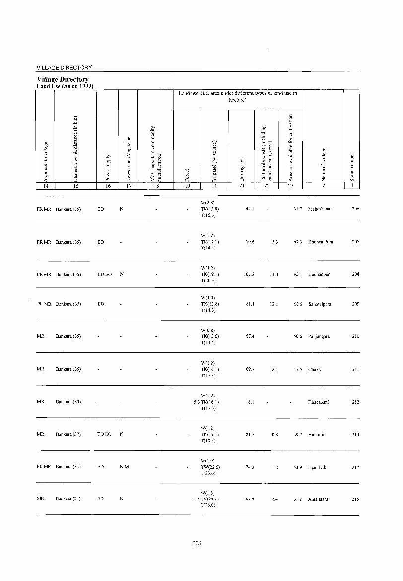
VILLAGE DIRECTORY
Village Directory Land Use (As on 1999)
14 15
PR MR Bankura (35)
PR MR Bankura (35)
PR MR Bankura (35)
PR MR Bankura (35)
MR Bankura (35)
MR Bankura (35)
MR Bankura (35)
MR Bankura (37)
PR MR Bankura (34)
MR Bankura (34)
16 17 18
ED N
ED
ED EO N
ED
ED EO N
ED NM
ED N
Land use (i.e. area under different types ofland use in hectare)
19 20
W(2.S) TK(13.S)
T(16.6)
W(1.2)
TK(171)
T(lS.4)
W(1.2)
TK(l9.1)
T(20.3)
W(1.0)
TK(13.S)
T(14.S)
W(O.S)
TK(l3.6)
T(14.4)
W(1.2)
TK(16.1)
T(l7.3)
W(I.2)
5.3 TK(161)
T(17.3)
W(I.2)
TK(17.1)
T(IS.3)
W(1.0)
TW(22.6)
T(23.6)
W(1.S) 41.3 TK(24.2)
T(26.0)
231
21 22
44.1
79.6
107.2
S1.1
67.4
69.7
16.1
81.7
74.3
47.6
23 2
31. 7 Maheshana
5.3 67.3 Bhunya Pura
11.3 93.1 Budhanpur
12.1 6S.6 Sanotalpara
50.6 Panjangara
2.4 47.5 Chaka
Khaeabani
o.S 39.7 Antkuria
1.2 53.9 Upar Dihi
2.4 31 .2 Amalatara
206
207
20S
209
210
211
212
213
214
215
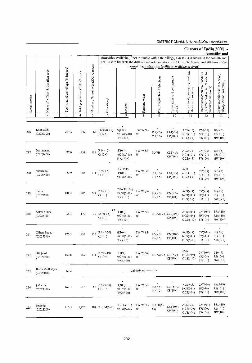
216
217
218
219
220
221
222
223
224
225
2
Khobradihi (02027300)
Mantumura (02027400)
Shalchura (02027500)
Simla (02027600)
Nekra Kunda (02027700)
Chhata Pathar (02027800)
Baliguma (02027900)
Jharia Madhabpur (02028000)
PithaBad (02028100)
Shaldiha (02028200)
3 4
214.3 347
77.0 557
82.9 805
188.4 985
36.3 170
170.3 635
159.8 559
69.2
162.3 316
710.5 1,926
DISTRICT CENSUS HAINDBOOK : BANKURA
Census of India 2001 -Amenities and
Amenities available (ifnot available within the village, a dash (-) is shown in the column and next to it in brackets the distance in broad ranges viz. < 5 kms., 5-10 kms. and 10+ kms of the
nearest place where the facility is available is given
5 6 7
63 P(2) M« 5) H(IO+) C(10+) MCW(5-1O)
103 PM« 5) C(10+)
171 PM«5) C(lO+)
PHC(IO+)
H(JO+) MCW(5-IO) PHC(IO+)
PHC PHS H(IO+) MCW(5-10)
8 9
TWWSS-W PO«5)
PH« 5)
~WWSS- POPH
~W W SS- PO« 5)
PH«5)
10
CM«5) CP(JO+)
CM«5) CP(IO+)
CM«5) CP(IO+)
II
ACS«5) NCS(IO+) OCS«5)
ACS« 5) NCS(IO+) OCS«5)
ACS NCS(IO+) OCS« 5)
12
CV« 5) SP(IO+) ST(IO+)
CV«5) SP(10+) ST(IO+)
CV« 5) SP(IO+) ST(IO+)
204 PM« 5) C(lO+)
CHW H(10+) TW W SS-MCW(5-10) W PO« 5) CM«5)
CP(IO+)
ACS«5) NCS(IO+) OCS« 5)
CV« 5) SP(JO+) ST(10+)
PHC(lO+) PH« 5)
- P« H(I;+) 38 5) M« 5) MCW(5-10)
C(10+) PHC(IO+)
139 P M(5-10) C(JO+)
114 PM(5-IO) C(lO+)
H(JO+) MCW(5-IO) PHC« 5)
H(IO+) MCW(5-10) PHC(5-10)
TW W SS- PH PO« 5) CM(JO+) ACS(IO+) CV(IO+) W NCS(JO+) SP(10+)
~W W SS- PO« 5)
PH«5)
CP(JO+) OCS(5-10) ST(IO+)
CM(IO+) ACS« 5) CV(lO+) NCS(IO+) SP(IO+)
CP(IO+) OCS(5-IO) ST(lO+)
~W W SS- PH PO« 5) CM« 5) CP(10+)
ACS NCS(IO+) CV(IO+)
SP(IO+) OCS(5-10) ST(IO+)
-------- Uninhabited ------------
62 PM(5-1O) C(lO+)
H(lO+) MCW(5-10) PHC(5-10)
387 PCM(5-10) PHCH(JO+) MCW(S-10)
232
TWWSS-W PO«5)
PH« 5)
ACS« 5) CM(5-1O) NCS(10+) CP(IO+) OCS(IO+)
TW W SS- PO PH(5- ACS« 5) W 10) CM(IO+) NCS(lO+)
CP(1 0+) OCS( 10+)
CV(lO+) SP(IO+) ST(IO+)
CV(IO+) SP(lO+) ST(IO+)
13
BS«5) RS(IO+) NW(IO+)
BS« 5) RS(IO+) NW(IO+)
BS« 5) RS(IO+) NW(lO+)
BS« 5) RS(10+) NW(10+)
BS(5-1O) RS(5-IO) NW(IO+)
BS« 5) RS(IO+) NW(IO+)
BS« 5) RS(IO+) NW(IO+)
BS(5-1O) RS(10+) NW(IO+)
BS(5-1O) RS(10+) NW(lO+)
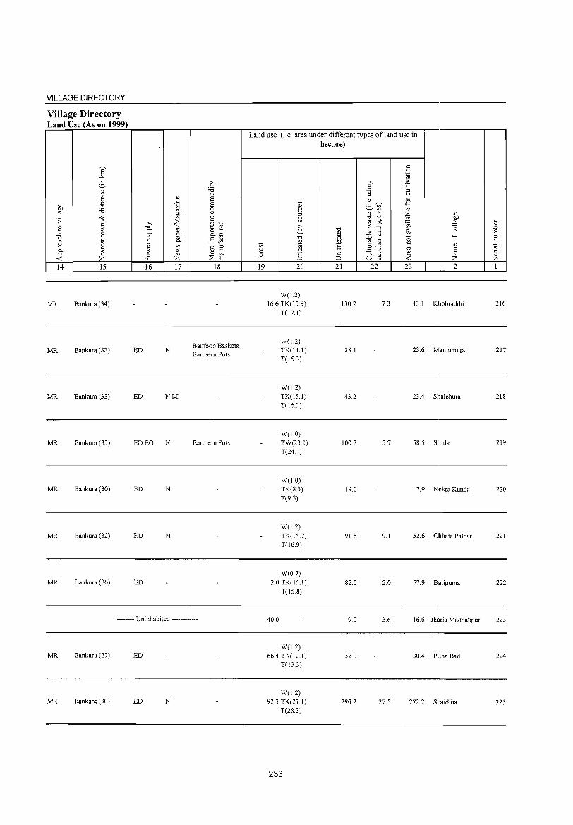
VILLAGE DIRECTORY
Village Directory Land Use (As on 1999)
14 15
MR Bankura (34)
MR Bankura (33)
MR Bankura (33)
MR Bankura (33)
MR Bankura (30)
MR Bankura (32)
MR Bankura (36)
16 17
ED N
ED NM
ED EO N
ED N
ED N
ED
18
Bamboo Baskets, Earthern Pots
Earthern Pots
-------- Uninhabited ------------
MR Bankura (27) ED
MR Bankura (30) ED N
Land use (i.e. area under different types ofland use in hectare)
19 20
W(L2) 16.6 TK(15.9)
T(17.1)
W(L2) TK(14.1) T(15.3)
W(L2) TK(1S.1) T(16.3)
W(10) TW(23.1) T(24.1)
W(LO) TK(8.3) T(9.3)
W(L2) TK(15.7) T(16.9)
W(0.7) 2.0TK(15.1)
T(15.8)
40.0
W(L2) 66.4 TK(12.1)
T(13.3)
W(L2) 92.3 TK(27. I)
T(28.3)
233
21
130.2
38.1
43.2
100.2
19.0
91.8
82.0
9.0
52.3
290.2
22 23 2
7.3 43.1 Khobradihi
23.6 Mantumura
23.4 Shalchura
5.7 58.5 Simla
7.9 Nekra Kunda
9.1 52.6 Chhata Pathar
2.0 57.9 Baliguma
3.6 16.6 Jharia Madhabpur
30.4 Pitha Bad
27.5 272.2 ShaJdiha
~
" ..0 E ::>
" Oi .t::
" C/J
216
217
218
219
220
221
222
223
224
225
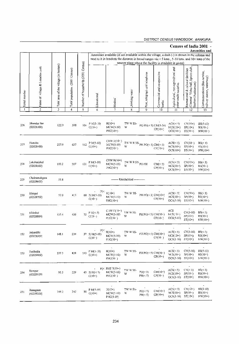
226
227
228
229
230
231
232
233
234
235
2
Bhandar Ber (02028300)
Hanulia (02028400)
Lakshmishol (02028500)
Chaktamakgara (02028600)
Khirpai (02028700)
Khirshol (02028800)
Jatyardihi (02028900)
Suribedia (02029000)
Rampur (02029100)
Banagram (02029200)
3 4
122.9 598
227.9 637
100.2 S67
SS.8
S2.0 413
IS7.4 420
148.1 239
237.3 838
95.3 229
144.3 342
5
DISTRICT CENSUS HANDBOOK: BANKURA
Census of India 2001 -Amenities and
Amenities available (if not available within the village, a dash (-) is shown in the column and next to it in brackets the distance in broad ranges viz.< 5 kms., 5-10 kms. and 10+ kms of the
nearest place where the facility is available is given
6 7 8 9 10 II 12 13
104 P M(5-10) C(lO+)
H(IO+) MCW(5-10) PHC(IO+)
TW W SS- ACS« 5) W PO PH« 5) CM(5-10) NCS(IO+)
CP(IO+) OCS(IO+)
CV(IO+) SP(lO+) ST(IO+)
BS(S-IO) RS(IO+) NW(10+)
112 P M(S-IO) C(lO+)
121 P M(S-IO) C(lO+)
CHWH(IO+) -MCW(S-IO) ;; W R SS'PH PO« S) CM« 5)
PHC(IO+) CP(10+)
CHWH(IO+) MCW(S-IO) TW W R SS PO PH
PHC(IO+) W
-------- Uninhabited ------------
CM« 5) CP(lO+)
ACS« S) NCS(IO+) OCS(lO+)
ACS« 5) NCS(lO+) OCS(IO+)
CV(lO+) SP(lO+) ST(lO+)
CV(lO+) SP(lO+) ST(IO+)
- P« H(IO+) 68 S) M(S-IO) MCW(S-IO)
TW W SS- ACS« S) CV(JO+) W PH PO« S) CM(IO+) NCS(JO+) SP(JO+)
C(IO+) PHC(lO+) CP(IO+) OCS(S-IO) ST(IO+)
72 PM«S) C(JO+)
CHW H(IO+) TW W SS-MCW(S-IO) W PH PO« S) CM(IO+) PHC(IO+) CP(IO+)
ACS NCS(IO+) CV(S-IO)
OCS(S-IO) SP(JO+) ST(lO+)
BS«S) RS(IO+) NW(lO+)
BS«S) RS(IO+) NW(IO+)
BS«S) RS(lO+) NW(lO+)
BS«S) RS(IO+) NW(IO+)
- P« H(I~+) 37 5) M(5-1O) MCW(S-IO)
TWWSS- ACS«S) CV(S-IO) BS«5) W PH PO« 5) CM(IO+) NCS(lO+) SP(lO+) RS(JO+)
C(lO+) PHC(IO+)
163 P M(S- 10) C(IO+)
H(IO+) MCW(S-IO) PHC(IO+)
P« PHS H(IO+) 4S 5)M«5) MCW(5-10)
C(lO+) PHC(IO+)
86 P M(5-10) C(IO+)
H(10+) MCW(S-IO) PHC(S-10)
234
CP(IO+) OCS(S-lO) ST(IO+) NW(IO+)
TW W SS- ACS« 5) CV(5-10) BS(5-10) W PH PO« S) CM(lO+) NCS(IO+) SP(lO+) RS(lO+)
:W W SS- PO« 5)
PH« 5)
:W W SS- PO« 5)
PH« S)
CP(lO+) OCS(S-lO) ST(lO+) NW(lO+)
ACS« S) CV« 5) CM(10+) NCS(IO+) SP(IO+) CP(10+) OCS(S-JO) ST(IO+)
CM(10+) CP(IO+)
ACS« 5) CV(10+) NCS(10+) SP(10+) OCS(5-1O) ST(IO+)
BS«5) RS(lO+) NW(IO+)
BS(5-10) RS(IO+) NW(IO+)

VILLAGE DIRECTORY
Village Directory Land Use (As on 1999)
14 15
MR Bankura (26)
MR Bankura (27)
MR Bankura (29)
16 17 18
ED NM
ED N
ED NM
-------- Uninhabited ------------
MR Bankura (29) ED
MR Bankura (30) ED N
MR Bankura (3D)
MR Bankura (37) ED
MR Bankura (36) Talai Chatai
MR Bankura (32) N
Land use (i.e. area under different types ofland use in hectare)
19 20
W(O.8) 21.9 TK(10.0)
T(1O.8)
W(0.8) TK(!6.6) T(!74)
W(O.8) TK(11.6) R(4.1)
T(164)
TK(6.5)
R(2.0) T(8.5)
W(1.0) TK(8.!) T(9.1)
W(1.8) TK(21.1)
T(22.9)
W(D.8) 71.2 TK(4.0)
R(2.D) T(6.8)
TK(8.1) 3.3 R(5.!)
T(I3.!)
W(1.D) 9.7 TK(l2.1)
T(l3.!)
W(1.2) 9.7TK(18.1)
T(194)
235
21
41.7
123.0
45.1
27.!
24.1
72.2
38.5
98.2
37.1
65.2
22 23 2
3.2 45.3 Bhandar Ber
3.2 84.2 Hanulia
38.7 Lakshmishol
20.2 Chaktamakgara
18.8 Khirpai
3.2 59.1 Khirshol
31. 6 J atyardihi
26.3 964 S uribedia
354 Rampur
1.2 48.8 Banagram
226
227
228
229
230
231
232
233
234
235
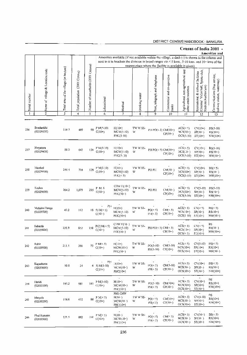
236
237
238
239
240
241
242
243
244
245
246
2
Bandardihi (02029300)
Hetyatora (02029400)
Masthol (02029500)
Keshra (02029600)
Mahisha Danga (02029700)
Subarda (02029800)
Rahir (02029900)
Kapasberia (02030000)
Haridi (02030100)
Metyala (02030200)
Phul Kusuma (02030300)
3 4
118.7 489
88.0 642
249.4 716
364.2 1,079
43.2 112
235.9 852
211.5 366
50.8 24
185.2 981
118.6 432
125.5 882
DISTRICT CENSUS HANDBOOK: BANKURA
Census of India 2001 -Amenities and
Amenities available (if not available within the village, a dash (-) is shown in the column and next to it in brackets the distance in broad ranges viz.< 5 kms., 5-10 kms. and 10+ kms ofthe
nearest place where the facility is available is given
5 6
99 PM(5-1O) C(10+)
136 P M(5-10) C(10+)
128 P M(5-10) C(1O+)
7
H(IO+) MCW(5-10) PHC(5-10)
H(IO+) MCW(5-10) PHC(5-10)
H(10+) MCW(5-10) PHC« 5)
8 9 10 II 12
TW W SS- PH PO« 5) CM(10+) ACS« 5) CV(10+) W CP(IO+) NCS(JO+) SP(10+)
OCS(5-10) ST(IO+)
TW W SS- PH PO« 5) CM(IO+) ACS« 5) CV(IO+) W CP(lO+) NCS(IO+) SP(IO+)
:WWSS- POPH
OCS(5-1O) ST(10+)
ACS« 5) CV(lO+) CM(IO+) NCS(lO+) SP(lO+) CP(IO+)
OCS(5-10) ST(JO+)
13
BS(5-10) RS(10+) NW(IO+)
BS(5-10) RS(IO+) NW(IO+)
BS«5) RS(IO+) NW(lO+)
235 PM S C(lO+)
CHW H(lO+) TW W SS-MCW(5-10) W PO PH
CM(IO+) ACS« 5) CV(5-1O) BS(5-10)
PHC(IO+)
- P« H(I~+) 18 5) M« 5) MCW(5-10)
C(IO+) PHC(IO+)
TWWSS-PO«5) PH«5)
W
CP(IO+) NCS(IO+) SP(lO+) RS(IO+) OCS(5-1O) ST(IO+) NW(IO+)
CM«5) CP(lO+)
ACS« 5) CV« 5) NCS(IO+) SP(lO+) OCS(5-1O) ST(10+)
BS«5) RS(10+) NW(10+)
P(2) M( 5) CHW H(IO+) TW W SS-158 < MCW(5-IO) PH PO« 5) CM« 5)
ACS« 5) NCS(IO+) OCS« 5)
CV«5) SP(IO+) ST(IO+)
BS RS(IO+) NW(IO+) C(lO+) PHC(IO+) W CP(IO+)
73 PM«5) C(IO+)
H(IO+) MCW(IO+) PHC(IO+)
- P« H(1~+) 4 5)M(5-10) MCW(IO+)
C(IO+) PHC(IO+)
181 P M(5-1O) C(10+)
88 PM«5) C(10+)
161 P M«5) C(10+)
H(10+) MCW(lO+) PHC(IO+)
PHSCHW H(10+) MCW(lO+) PHC(lO+)
H(JO+) MCW(IO+) PHC(IO+)
236
TW W SS- ACS« 5) W PO(5-10) CM(5-1O) NCS(IO+)
PH(5-IO) CP(IO+) OCS(10+)
TWWSS-W
PO« 5) PH« 5)
ACS«5) CM(5-IO) NCS(lO+)
CP(IO+) OCS(IO+)
TW W SS- ACS« 5) W PO(5-IO) CM(10+) NCS(lO+)
PH« 5) CP(10+) OCS(10+)
:W W SS- PO« 5)
PH« 5)
:WWSS- PO«5)
PH« 5)
ACS« 5) CM(10+) NCS(10+) CP(l 0+) OCS( 1 0+)
CM« 5) CP(lO+)
ACS«5) NCS(lO+) OCS(IO+)
CV(S-IO) BS« 5) SP(IO+) RS(IO+) ST(IO+) NW(IO+)
CV(lO+)
SP(lO+) ST(lO+)
CV(IO+) SP(IO+) ST(IO+)
BS«5) RS(lO+) NW(IO+)
BS RS(IO+) NW(10+)
CV(5-1O) ~;(10+) SP(10+) NW(10+) ST(lO+)
CV(IO+) SP(IO+) ST(lO+)
BS«5) RS(lO+) NW(10+)
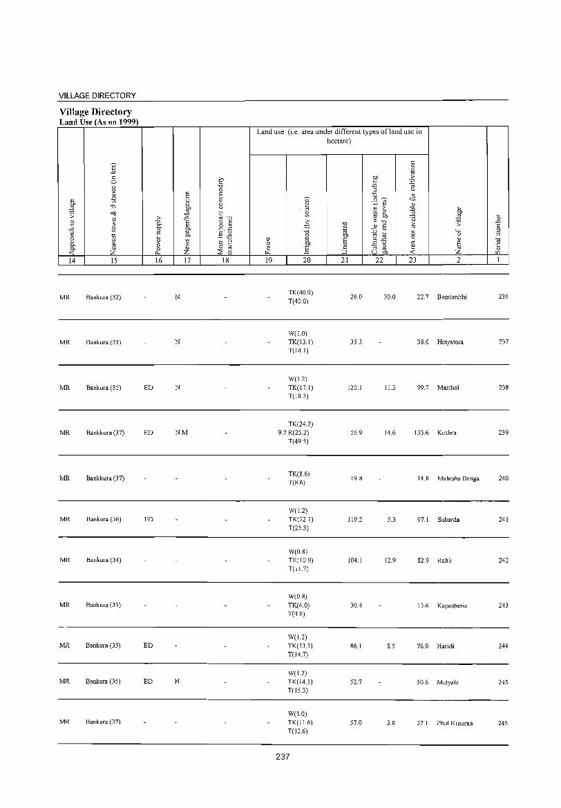
VILLAGE DIRECTORY
Village Directory Land Use (As on 1999)
14 15
MR Bankura (32)
MR Bankura (35)
MR Bankura (35)
MR Bankkura (37)
MR Bankkura (37)
MR Bankura (36)
MR Bankura (34)
MR Bankura (35)
MR Bankura (35)
MR Bankura (35)
MR Bankura (37)
16 17 18
N
N
ED N
ED NM
ED
ED
ED N
Land use (i.e. area under different types of land use in hectare)
19 20
TK(40.0) T(40.0)
W(1.0) TK(13.1) T(141)
W(L2) TK(17.1) T(18.3)
TK(24.2) 9.7 R(25.2)
T(49.5)
TK(8.6) T(8.6)
W(1.2) TK(22.1) T(23.3)
W(0.8) TK(10.9) T(I1.7)
W(O.S) TK(4.0) T(4.8)
W(1.2) TK(13.5) T(14.7)
W(I.2) TK(14.1) T(15.3)
W(1.0)
TK(11.6) T(126)
237
21 22
26.0
35.3
120.1
156.9
19.8
110.2
104.1
30.4
86.1
52.7
57.0
23 2
30.0 22.7 Bandardihi
38.6 Hetyatora
11.3 99.7 Mastho1
14.6 133.6 Keshra
14.8 Mahisha Oanga
5.3 97.1 Subarda
12.9 82.9 Rahir
15.6 Kapasberia
8.5 76.0 Haridi
50.6 Metya1a
3.8 52.1 Phu1 Kustlma
236
237
238
239
240
241
242
243
244
245
246
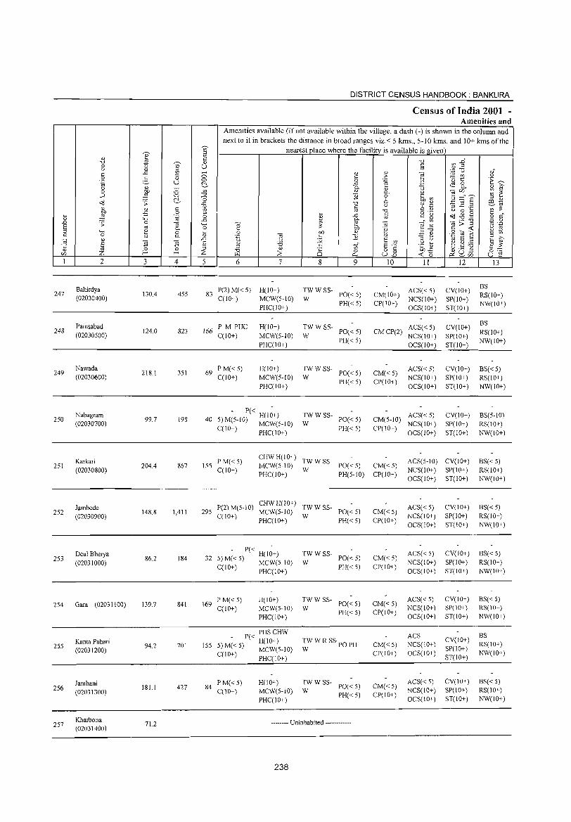
DISTRICT CENSUS HANDBOOK: BANKURA
CensllIs of India 2001 -Amenities and
Amenities available (ifnot available within the village, a dash (-) is shown in the column and next to it in brackets the distance in broad ranges viz. < 5 kms., 5-10 kms. and 10+ kms ofthe
~
nearest place where the facility is available is given on ::l
'" ~ '" '" -0 ~ :8~ -0 ~ '" 0 '" u iii '" '" ::l '';:: C) "," .D on
0 " " ] § '" " > - on '" :§._ '" 0 0 .~ ·u t:: E~ '-g u ~ -" tS 8. Q '" - 0- " :; '" i? 0 OJ) 0 on " 0- '" "§ c/)" ,-.,. ~ ~ ....:l ~ 0 -0 ] 0 .~ ~ ~ -0 6 E ~ § ::l '" Q(J .;;: .D -0 c;:t '';::::; co 1a
" '" § '" :l,....e: ....... ';;;:: '" " U) "0 " '" '" 0 ~
~ ii 0 ::l ~ c o ._ Q(J.gg c "
~ .~ 0 '" -" ro CO' ~ o c " .... .D 1a §- til>"'§
';::: 0 .D :; 0 :; .... til (iJ e .- ro ._ E ro 0- 0 "
;:: on 'g '" ~ .~ :s :; .... ~ 0 iil 0 OJ) " :;-0
.S OJ E '" on C 0 0- .~ til " ] .!:! ~ :; >,
.~ " .0 '" ~ E on :; '" 1a E ::l E ~ § til :s E '" :;:; uf .g ct:; ~.8 ] 0 :; :; " '" E-'" §:;;;;
'" 0 -0 25 0 o " OJ).D r/) Z f- f- Z ~ ::E 0- u15 ~ 0 & ~iIl u r: I 2 3 4 5 6 7 8 9 10 11 12 13
Bahirdya P(2)M«5) H(lO+) TWWSS- ACS«5) CV(IO+) BS
247 130.4 455 83 PO« 5) CM(IO+) RS(IO+) (02030400) C(lO+) MCW(5-10) W NCS(10+) SP(IO+) PHC(lO+)
PH«5) CP(IO+) OCS(IO+) ST(IO+)
NW(IO+)
Painsabad PM PUC H(10+) TWWSS- ACS« 5) CV(10+) BS
248 124.0 823 166 PO« 5) CMCP(2) RS(IO+) (02030500) C(lO+) MCW(5-10) W NCS(IO+) SP(10+) PHcelO+)
PH«5) OCS(IO+) ST(lO+)
NW(IO+)
249 Nawada
218.1 351 69 PM«5) H(IO+) TWWSS- ACS« 5) CV(10+) BS«5)
(02030600) ceIO+) MCW(5-10) W PO«5) CM«5)
NCS(lO+) SP(IO+) RS(10+) PHceIO+)
PH«5) CP(IO+) OCS(IO+) ST(10+) NW(10+)
Nabagram - P« -
TWWSS- ACS« 5) CV(lO+) BS(5-1O) 250 99.7 198 40
H(IO+) PO« 5) CM(5-1O)
(02030700) 5) M(5-1O) MCW(5-1O) W NCS(10+) SP(10+) RS(IO+) cel0+) PHC(10+) PH«5) CP(IO+)
OCS(IO+) ST(lO+) NW(IO+)
Karkari PM«5) CHWH(IO+)
TWWSS- ACS(5-1O) CV(IO+) BS« 5) 251 204.4 867 ISS MCW(S-IO) PO«5) CM«5)
(02030800) cel0+) PHceIO+)
W PH(5-1O) CP(IO+)
NCS(10+) SP(IO+) RS(10+) OCS(IO+) ST(IO+) NW(lO+)
Jambede P(2) M(5-10) CHWH(10+)
TWWSS- ACS« 5) CV(10+) BS«5) 252 148.8 1,411 295 MCW(5-10) PO« 5) CM«5)
(02030900) C(10+) PHceIO+)
W PH«5) CP(10+)
NCS(IO+) SP(IO+) RS(10+) OCS(1O+) ST(lO+) NW(IO+)
253 Deul Bherya
86.2 184 32 - P« H(I;+) TWWSS-
PO«5) CM«5) ACS« 5) CV(lO+) BS« 5)
(02031000) 5) M« 5) MCW(5-10) W PH«5) CP(IO+)
NCS(lO+) SP(10+) RS(lO+) cel0+) PHcel0+) OCS(IO+) ST(10+) NW(lO+)
(02031100) 841 169 P M«5) H(IO+) TWWSS-
PO« 5) CM«5) ACS« 5) CV(lO+) BS« 5)
254 Gara 139.7 C(10+) MCW(5-10) W NCS(IO+) SP(IO+) RS(IO+)
PHceIO+) PH«5) CP(10+)
OCS(IO+) ST(IO+) NW(IO+)
P« PHSCHW ACS CV(IO+)
BS Kanta Pahari
94.2 701 155 H(IO+) TW W R SSpO PH CM«5) NCS(10+) RS(lO+) 255 5)M«5) MCW(5-10) SP(lO+) (02031200) W
CP(IO+) OCS(IO+) NW(IO+) ceIO+) PHcel0+) ST(IO+)
Jambani P M«5) H(1O+) TWWSS-PO«5) CM«5)
ACS« 5) CV(IO+) BS«5) 2S6 181.1 427 84
cel0+) MCW(S-IO) W NCS(IO+) SP(IO+) RS(10+) (02031300) PH«5) CP(IO+) PHC(10+) OCS(IO+) ST(lO+) NW(lO+)
257 Kharbona
71.2 -------- Uninhabited ------------(02031400)
238
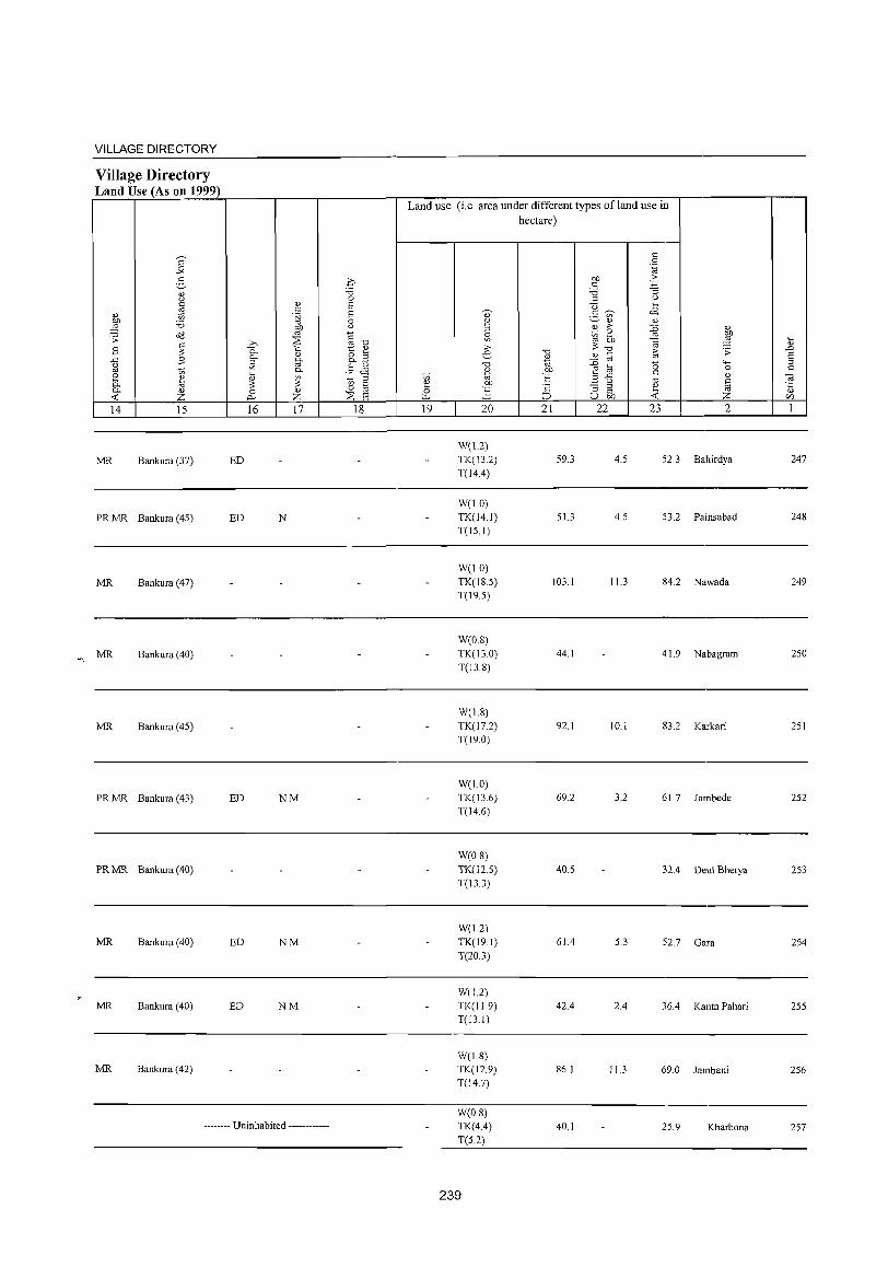
VILLAGE DIRECTORY
Village Directory Land Use (As on 1999)
14 15
MR Bankura (37)
PR MR Bankura (45)
MR Bankura (47)
MR Bankura (40)
MR Bankura (45)
PR MR Bankura (43)
PR MR Bankura (40)
MR Bankura (40)
MR Bankura (40)
MR Bankura (42)
16 17
ED
ED N
ED NM
ED NM
ED NM
-------- Uninhabited ------------
18
Land use (i.e. area under different types ofland use in hectare)
19 20
W(1.2) TK(13.2)
T{l4.4)
W(1.0) TK{l4.1) T{l5.1)
W(l.O)
TK{l8.5) T(19.5)
W(0.8) TK(13.0) T(13 8)
W(18) TK(17.2) T(190)
W(1.0) TK(13.6) T{l46)
W(0.8) TK(12.5)
T(13.3)
W(1.2)
TK{l9.1) T(20.3)
W(I2) TK(11.9) T(13.1)
W(1.8)
TK(12.9) T(14.7)
W(0.8)
TK(4.4)
T(5.2)
239
21 22
59.3
51.3
103.1
44.1
92.1
69.2
40.5
61.4
42.4
86.1
40.1
23 2
4.5 52.3 Bahirdya
4.5 53.2 Painsabad
11.3 84.2 Nawada
41.9 Nabagram
10.1 83.2 Karkari
3.2 61.7 Iambede
32.4 Deul Bherya
5.3 52.7 Gara
2.4 36.4 Kanta Pahari
11.3 69.0 Iambani
25.9 Kharbona
247
248
249
250
251
252
253
254
255
256
257
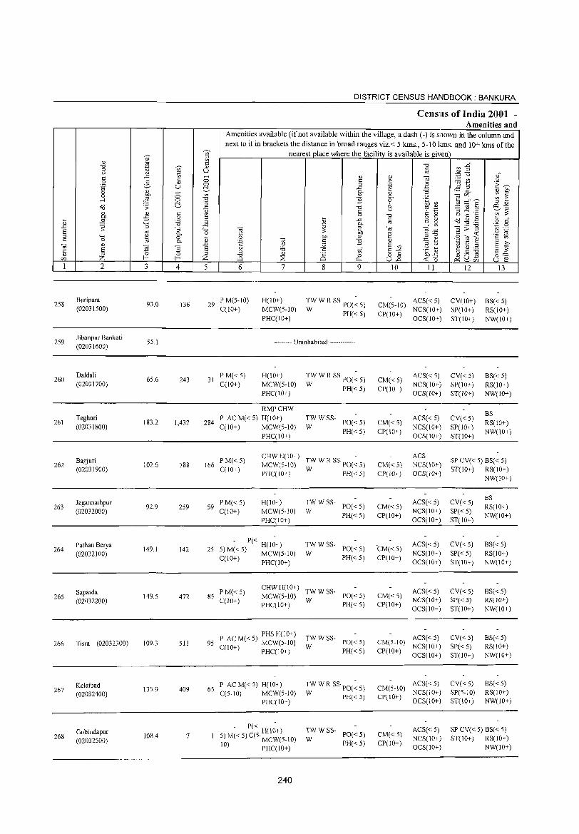
258
259
260
261
262
263
264
265
266
267
268
2
Buripara
(02031500)
Jibanpur Bankati (02031600)
Daldali
(02031700)
Teghori
(02031800)
Bagjuri
(02031900)
Jagannathpur
(02032000)
Pathan Berya
(02032100)
Saparda (02032200)
Tisra (02032300)
Kelaibad
(02032400)
Gobindapur
(02032500)
3
93.0
55.1
65.6
183.2
102.6
92.9
149.1
149.5
109.3
13S.9
108.4
T ()
o o ~
4
136
243
1,432
788
259
142
472
511
409
7
5
DISTRICT CENSUS HANDBOOK: BANKURA
Census of India 2001 -Amenities and
Amenities available (if not available within the village, a dash (-) is shown in the column and next to it in brackets the distance in broad ranges viz. < 5 kms., 5-10 !ems. and 10+ kms of the
nearest place where the facility is available is given
6
29 P M(5-IO) C(IO+)
31 PM«5) C(10+)
7
H(lO+)
MCW(5-10)
PHC(IO+)
8 9
TW W R SS PO(~ 5)
W PH«5)
-------- Uninhabited ------------
H(10+)
MCW(5-10)
PHC(IO+)
TWWRSSpO(~5) W PH«5)
10 11
ACS« 5) CM(5-IO) NCS(IO+)
CP(1 0+ ) OCS( I 0+)
CM«5) CP(IO+)
ACS« 5)
NCS(10+) OCS(10+)
12
CV(IO+)
SP(IO+)
ST(lO+)
CV«5) SP(IO+)
ST(lO+)
13
BS« 5) RS(IO+)
NW(IO+)
BS« 5) RS(IO+)
NW(10+)
284
RMPCHW
P AC M« 5) H(10+)
C(IO+) MCW(5-10)
TWWSS-W PO«5) CM«5)
CP(10+)
ACS« 5)
NCS(IO+)
OCS(IO+)
CV«5)
SP(IO+)
ST(IO+)
BS
RS(10+)
NW(lO+) PHC(IO+)
PH« 5)
166 PM«5) C(IO+)
CHWH(IO+) -MCW(S-IO) TW W R SS PO« 5)
PHC(IO+) W PH« 5)
59 PM«5) C(IO+)
H(IO+)
MCW(5-10)
PHC(IO+)
- P« H(I~+) 25 5) M« 5) MCW(5-10)
C(IO+) PHC(IO+)
TWWSS-W PO«5)
PH«5)
TWWSS-W PO«5)
PH«5)
85 P M« 5) C(10+)
CHW H(l 0+) TW W SS-MCW(5-10) W PO« 5) PHC(IO+) PH«5)
PHS H(IO+) 95 P AC M« 5) MCW(5-1O)
C(IO+) PHC(IO+)
P AC M« 5) H(IO+) 65 C(5-10) MCW(5-10)
PHC(IO+)
- P« H(l~+) 5) M« 5) C(5· MCW(5-10)
10) PHC(IO+)
240
TWWSS-W PO«5)
PH«5)
TWWRSSpO(~S) W PH«5)
TW W SS- PO« 5)
W PH«5)
CM«S) CP(IO+)
CM«5) CP(10+)
CM«5)
CP(IO+)
CM«5) CP(IO+)
ACS
NCS(IO+)
OCS(IO+)
ACS« 5) NCS(IO+)
OCS(10+)
ACS« 5) NCS(IO+)
OCS(IO+)
ACS« 5) NCS(IO+)
OCS(10+)
ACS«5) CM(5-1O) NCS(IO+)
CP(IO+) OCS(IO+)
ACS« 5) CM(5-IO) NCS(IO+)
ep( 10+) oes( 10+)
CM«5) CP(IO+)
ACS«5) NCS(IO+)
OCS(IO+)
SP CV« 5) BS« 5) ST(IO+) RS(IO+)
NW(!o+)
CV«5)
SP« 5)
ST(IO+)
CV«5)
8P« 5) ST(IO+)
CV«5)
SP« 5) ST(IO+)
CV«5) SP« 5) ST(lO+)
eV«5) SP(5-1O)
ST(IO+)
BS RS(IO+)
NW(lO+)
B8« 5) RS(IO+)
NW(IO+)
BS« 5) RS(lO+ )
NW(lO+)
BS«5) RS(10+)
NW(lO+)
BS« 5) RS(IO+) NW(IO+)
SP CV« 5) BS« 5) ST(IO+) RS(IO+)
NW(lO+)
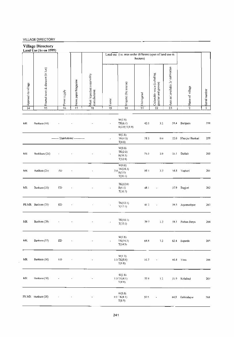
VILLAGE DIRECTORY
Village Directory Land Use (As on 1999)
14 15
MR Bankura (44)
16 17
-------- Uninhabited ------------
MR Bankkura (25)
MR Bankura (25) ED
MR Bankura (25) ED
PR MR Bankura (25) ED
MR Bankura (28)
MR Bankura (27) ED
MR Bankura (30) ED
MR Bankura (30)
PR MR Bankura (28)
18
Land use (i.e. area under different types of land use in hectare)
19 20
W(0.8) TK(6.1) R(2.0) T(S.9)
W(OS) TK(4.0) T(4.8)
W(0.8)
TK(2.0) R(IO.I) T(12.9)
W(0.8)
30 TK(28.3) . R(10)
T(30.1)
TK(126) R(4.l) T(16.7)
TK(12.1) T(12.1)
TK(10.1) T(IO.I)
W(O.S) TK(14.1) T(14.9)
W(1.2) 1.0 TK(S.6)
T(9.8)
W(O.S) 1.0TK(S.I)
T(S 9)
W(O.S) 4.0 TK(8.1)
T(S.9)
241
21
42.6
28.3
25.5
88.1
48.1
41.3
79.7
6S.S
51.7
72.9
50.6
22 23 2
3.2 38.4 Buripara
0.0 22.0 Jibanpur Bankati
2.0 25.1 Daldali
3.2 58.8 Teghori
37.9 Bagjuri
39.5 Jagannathpur
1.2 5S.1 Pathan Berya
3.2 62.4 Saparda
46.S Tisra
1.2 51. 9 Kelaibad
44.9 Gobindapur
258
259
260
261
262
263
264
265
266
267
26S
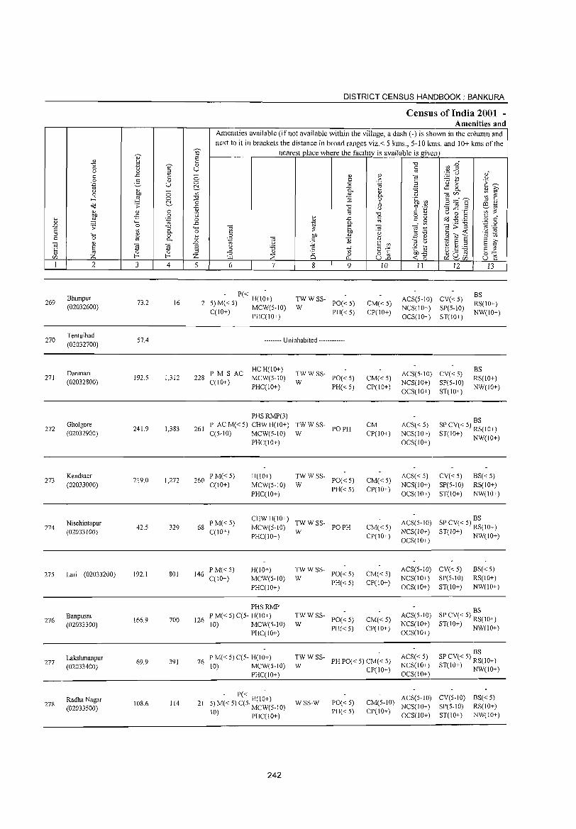
269
270
271
272
273
274
275
276
277
278
2
Bhimpur (02032600)
Tentuibad (02032700)
Danmari
(02032800)
Gholgore (02032900)
Kendsaer (02033000)
Nisehintapur
(02033100)
Lari (02033200)
Banpusra (02033300)
Lakshmanpur (02033400)
RadhaNagar (02033500)
3
73.2
57.4
192.5
241.9
219.0
42.5
192.1
166.9
69.9
108.6
~ c::
" U
o o ~ c:: o '~
"3 0. o 0.
co ~ 4
16
1,312
1,383
1,272
329
801
700
391
114
DISTRICT CENSUS HANDBOOK: BANKURA
Census of India 2001 -Amenities and
Amenities available (if not available within the village, a dash (-) is shown in the column and next to it in brackets the distance in broad ranges viz.< 5 kms., 5-10 kms. and 10+ kms of the
nearest place where the facility is available is given
5 6 7 8 9
- P« -2 5) M« S) H(IO+)
C(IO+) MCW(5-10) PHC(IO+)
~WWSS- PO«5)
PH«5)
-------- Uninhabited ------------
P M S AC HC H(10+) 228 C(10+) MCW(5-10)
PHC(IO+)
261
PHSRMP(3) P AC M« 5) CHW H(IO+) C(5-IO) MCW(5-IO)
PHC(IO+)
260 P M« 5) C(IO+)
H(10+)
MCW(5-10)
PHC(IO+)
TWWSS-W PO«5)
PH«5)
TWWSS- POPH W
TWWSS-PO«5)
PH«5) W
68 PM«5) C(10+)
CHW H(IO+) TW W SS-MCW(5-10) W PO PH PHC(lO+)
146 P M« 5) C(10+)
H(JO+) MCW(S-IO)
PHC(IO+)
126
PHSRMP P M« S) C(5- H(IO+) 10) MCW(S-IO)
PHC(10+)
~WWSS- PO«5)
PH«5)
~W W SS- PO« 5)
PH«5)
10
CM«5) CP(IO+)
CM« 5) CP(IO+)
CM CP(IO+)
CM«5) CP(IO+)
CM«5) CP(JO+)
CM«5) CP(IO+)
CM«5) CP(10+)
11 12
ACS(5-10) CV«5) NCS(IO+) SP(5-1O) OCS(IO+) ST(10+)
ACS(5-10) CV«5) NCS(IO+) SP(5-10) OCS(IO+) ST(IO+)
13
BS RS(IO+) NW(IO+)
BS RS(IO+) NW(IO+)
ACS« 5) NCS(IO+) OCS(IO+)
BS SP CV« 5) RS(10+) ST(10+) NW(IO+)
ACS« 5) NCS(IO+)
OCS(10+)
CV«5) SP(5-1O)
ST(10+)
BS«5) RS(IO+) NW(10+)
BS ACS(5-10) SP CV« 5) RS(IO+) NCS(IO+) ST(JO+) NW(IO+) OCS(IO+)
ACS(S-IO) CV« 5) NCS(10+) SP(S-IO)
OCS(10+) ST(lO+)
BS« 5) RS(10+)
NW(lO+)
BS ACS(5-10) SP CV« 5) RS(IO+) NCS(IO+) ST(JO+) NW(10+) OCS(IO+)
BS 76 P M« 5) C(5- H(IO+)
10) MCW(5-10) PHC(IO+)
~WWSS- PHPO«5) CM«5)
CP(IO+)
ACS« 5) NCS(10+) OCS(IO+)
SP CV« 5) RS(IO+) ST(IO+) NW(10+)
- P« H(I~+) 21 5) M« 5) C(5· MCW(S-IO)
10) PHC(10+)
242
WSS-W PO«5) PH« 5)
ACS(5-10) CV(5-10) BS« 5) CM(5-10) NCS(IO+) SP(5-10) RS(IO+) CP(IO+) OCS(IO+) ST(IO+) NW(IO+)
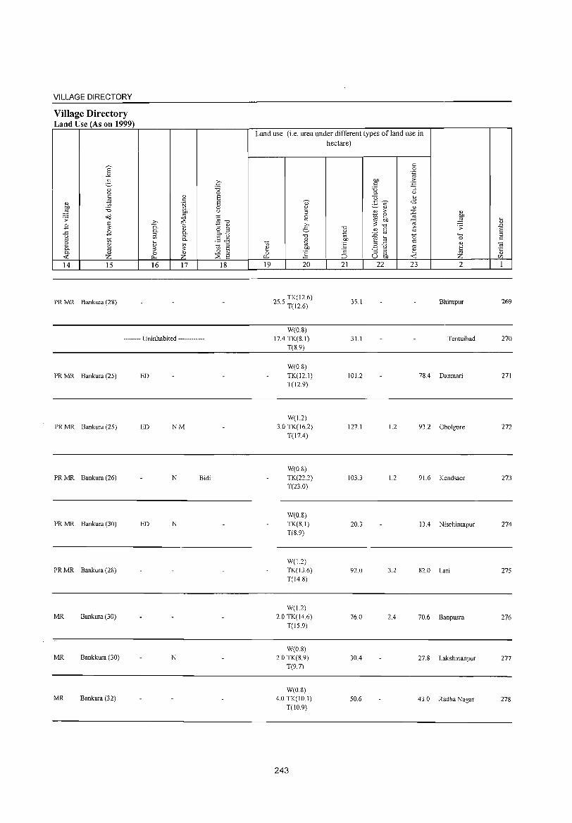
VILLAGE DIRECTORY
Village Directory Land Use (As on 1999)
14 15
PR MR Bankura (28)
16 17
-------- Uninhabited ------------
PR MR Bankura (25) ED
PR MR Bankura (25) ED NM
PR MR Bankura (26) N Bidi
PR MR Bankura (30) ED N
PR MR Bankura (28)
MR Bankura (30)
MR Bankkura (30) N
MR Bankura (32)
18
Land use (i.e. area under different types ofland use in hectare)
19 20
25 5 TK(J 2.6) . T(12.6)
W(O.S)
17.4 TK(S.I)
T(S.9)
W(O.S)
TK(12.1)
T(12.9)
W(1.2)
3.0 TK(16.2)
T(17.4)
W(O.S)
TK(22.2)
T(23.0)
W(08)
TK(S.I)
T(8.9)
W(1.2)
TK(136)
T(148)
W(1.2)
2.0 TK(14.6)
T(15.9)
W(0.8)
2.0 TK(S.9)
T(9.7)
W(0.8)
4.0 TK(10.1)
T(10.9)
243
21
35.1
31.1
101.2
127.1
103.3
20.3
92.0
76.0
30.4
50.6
22 23 2
Bhimpur
Tentuibad
7S.4 Danmari
1.2 93.2 Gholgore
1.2 91. 6 Kendsaer
13.4 Nisehintapur
3.2 82.0 Lari
2.4 70.6 Banpusra
27.S Lakshmanpur
43.0 Radha Nagar
269
270
271
272
273
274
275
276
277
278
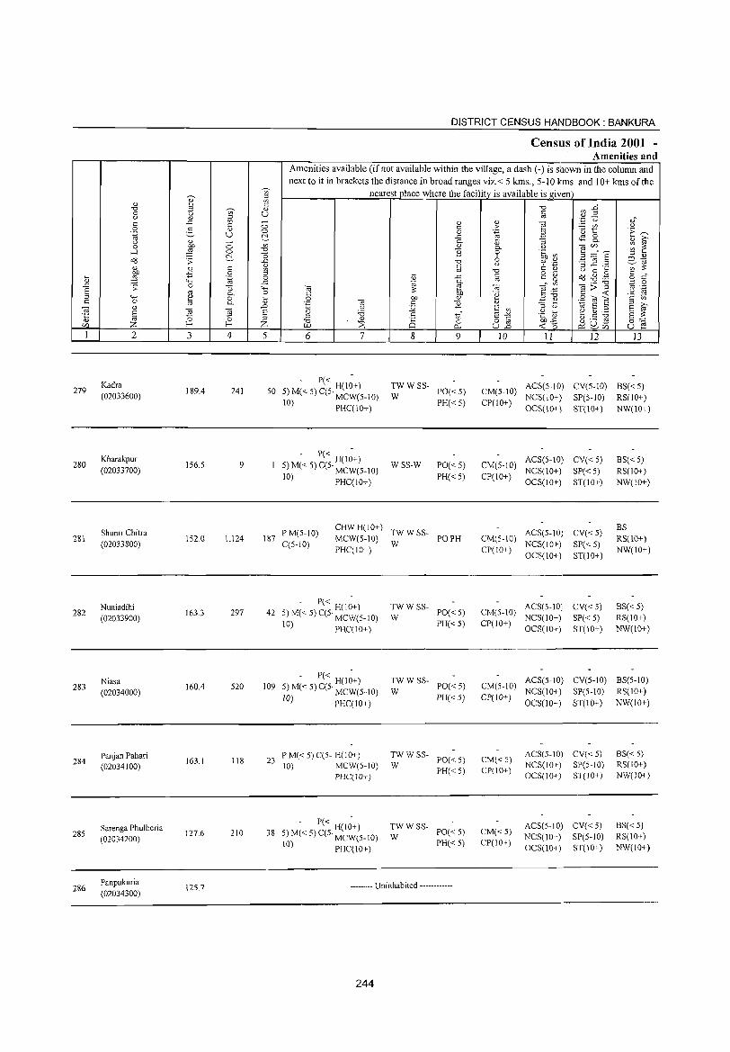
279
280
281
282
283
284
285
286
2
Kadra (02033600)
Kharakpur
(02033700)
Shunri Chitra
(02033800)
Nuniadihi (02033900)
Niasa (02034000)
Panjan Pahari (O2034100)
Sarenga Phulberia (02034200)
Panpukuria (02034300)
3
189.4
156.5
152.0
163.3
160.4
163.1
127.6
12S.7
'" '" ~ '" o .~
2. o 0.
~ 4
241
9
1,124
297
520
118
210
5
DISTRICT CENSUS HANDBOOK: BANKURA
CenSlllS of India 2001 -Amellities and
Amenities available Cifnot available within the village, a dash C-) is shown in the column and next to it in brackets the distance in broad ranges viz.< 5 kms., 5-10 kms. and 10+ kms of the
nearest place where the facility is available is given
6 7 8
<n o
0...
9
<1)
> .~ 0. o 6 u
"0 @
OJ .~ <1)
E <n
§"§ U.D
10 11 12 13
- P« H(l;+) 50 5)M«5)C(5' MCW(5_1O)
10) PHC(IO+)
TWWSS-PO«5) PH«5)
W CM(5-10) ACS(5-10) CV(S-IO) 8S« 5) CP(1O+) NCS(1O+) SP(5-10) RS(IO+)
187
42
109
23
38
- P« H(I;+) 5) M« 5) C(5· MCW(5-1O)
10) PHC(IO+)
PM(5-10) CHW H(IO+)
MCW(S-IO) C(S-IO}
PHC(IO+)
- P« H(l;+) 5) M« 5) C(5· MCW(5-1O)
10) PHC(IO+)
- P« H(I;+) 5) M« 5) C(5· MCW(5-10)
10) PHC(IO+)
P M« 5} C(5- H(IO+} IO} MCW(5-IO}
PHC(IO+)
- P« H(IO+) 5) M« 5) C(5· MCW(5-IO)
10) PHC(IO+)
WSS-W
TW W SS-
W
TWWSS-W
TWWSS-
W
TWWSS-W
TWWSS-W
PO«5) PH«5)
PO PH
PO«S) PH« 5)
PO«5)
PH« 5)
PO«5) PH« 5)
PO«5) PH« 5)
-------- Uninhabited ------------
244
OCS(10+) ST(IO+) NW(IO+)
CM(5-10) ACS(5-IO) CV« 5) NCS(10+) SP« 5)
CP(IO+) OCS(lO+) ST(IO+)
ACS(5-10) CV«5) CM(S-IO)
CP(lO+) NCS(IO+) SP« 5) OCS(lO+) ST(IO+)
CM(5-10) ACS(5-10) CV«5)
CP(IO+) NCS(lO+) SP« 5) OCS(10+) ST(lO+)
CM(5-10) ACS(5-10) CV(5-10)
NCS(IO+) SP(5-1O) CP(IO+)
OCS(IO+) ST(IO+)
CM«5) ACS(5-10) CV«5) NCS(IO+) SP(5-IO}
CP(IO+) OCS(10+) ST(lO+)
CM«5) ACS(5-IO) CV«5) NCS(10+) SP(5-1O)
CP(IO+) OCS(lO+) ST(lO+)
8S« 5) RS(1O+) NW(IO+)
8S RS(lO+) NW(IO+)
8S« 5) RS(lO+) NW(lO+)
8S(5-10) RS(IO+)
NW(lO+)
BS« 5) RS(IO+) NW(JO+)
8S« 5) RS(lO+) NW(lO+)
VILLAGE DIRECTORY
Village Directory Land Use (As on 1999)
8' .-"
2-0)
'-' c 0) .is
'" bJl 'i3 :§ s;: Od
B ~ ..c B 0 oj en e ~ 0. 0. 0)
<>:: z 14 15
MR Bankura (32)
MR Bankura (32)
MR Bankkura (30)
MR Bankura (30)
MR Bankkura (30)
MR Bankura (30)
MR Bankura (28)
0)
c .~ bl)
'" >. ::;;: "C. >::: 0.
0)
iil g-0. ....
0) en :;: :;: 0 0)
P- Z 16 17
-------- Uninhabited ------------
.q "d 0 Ei Ei 0 0
§-o 1:: ~ o ;;J o.~
§Jl to ;;J
c 0 '" ::;;: Ei 18
Land use (i.e. area under different types ofland use in
hectare)
to ~ 0 ~
19
., 0
~ s: >. e "d
<1)
~ bl)
g 20
W(O.S) 83.4 TK(l4.1)
T(l5.0)
546 TK(l2.7) . T(127)
W(1.2) TK(16.2) T(17.4)
W(I.8) 32.4 TK(S.6)
T(IO.4)
W(0.8) TK(12.9) T(13.7)
W(0.8) 1.0TK(8.1)
T(8.9)
W(O.S) 1.0 TK(12.6)
T(I3.4)
W(0.8) 8.5 TK(8.6)
T(9.4)
245
-0
~ bl)
'E '2 ;::>
21
87.0
86.0
70.4
78.0
68.8
83.8
62.3
63.5
c 0 .~
bl) 2: c -3 'i3 ;;J 0
0 .... .S ~ Jl en
0) <1)
* > :0 0) 0
.."! bl)
'" on :§ :;: '", -0 f;; .s;:
0) c :0 '" 0 '>-< ~ a 0
..c c 0)
.3 0 '" ~ "3 ;;J ~ '" u bl) <>::
22 23 2
4.0 Kadra
3.1 Kharakpur
0.8 63.3 Shunri Chitra
2.4 40.1 Nuniadihi
3.2 74.6 Niasa
3.2 66.2 Panjan Pahari
50.9 Sarenga Phulberia
44.3 Panpukuria
.... 0)
.0 Ei ;;J c
Oi ·c 0)
r:/J
1
279
280
281
282
283
284
285
286
287
288
2
Noadihi
(02034400)
Kanudihi
(02034500)
Block Total
3 4
158.9 1,485
41.5 51
44746.9 169215
DISTRICT CENSUS HANDBOOK: BANKURA
Census ()If India 2001 -Amenities and
Amenities available (ifnot available within the village, a dash (-) is shown in the column and next to it in brackets the distance in broad ranges viz.< 5 kms., 5-10 kms. and 10+ kms of the
nearest place where the facility is available is given
5 6 7
294 P M« 5) C(10+)
RMPCHW H(10+)
MCW(S-10)
PHC(10+)
- P« H(I~+) 8 5) M« 5) MCW(S-10)
C(JO+) PHC(5-10)
D(9) DH(2)
P(223) HC(6) S(14) PHC(6)
31889 M(18) PHS(26) NH PUC(6) C I RMP(15) AC(20) 0(6) CHW(64)
0(4)
246
8
" c o
.<: 0.
" 1i
'" o c.. 9
TWWSS- POPH W
~W W SS- PO« 5)
PH«5)
T(34) W(2SS) PO(2S) TK(32) HP PTO(2) TW(2SS) PH(19S) R(33) S
10
CM«5) CP(10+)
CM«S)
CP(IO+)
CM(ll) CP(3)
11 12 13
ACS(5-10) SP CV«5) BS«5) NCS(IO+) ST(IO+) RS(IO+) OCS(IO+) NW(lO+)
ACS(5-10) CV« 5) NCS(10+) SP« 5) OCS(10+) ST(10+)
ACS(22) OCS(2)
CV(S) SP(7)
BS« 5) RS(10+) NW(10+)
BS(Sl) RS(2)
VILLAGE DIRECTORY
Village Directory Land Use (As on 1999)
14
MR
MR
PR(63) MR(275 )
15
Bankkura (32)
Bankura (32)
16 17
ED(150) N(120) EO(27) M(33)
18
Land use (i.e. area under different types ofland use in hectare)
19 20
W(18)
TK(121) T(13.9)
W(D.8) TK(8.1) T(8.9)
GC(8) W(263.07000 0000001)
2988.8 TW(45.73) TK(3046.1) R(149.93) T(3512.83)
247
21
71.9
311
25186.3
22 23 2
3.2 69.8 Noadihi
15 Kanudihi
2058.7 11 000.3
287
288

~ ::J~
o...~ 00
......:1 zz <r: l'J Z
« z ~o - ~ ()I-~ cq o« - E--< _JI-
UJ. U1 ~ m ;s: W
U 0 _J
0 0...
()
« a::: :::> ~ z « co I-0 0::: I-(/l
0
o
a i<
.... _.i
Q
U
til ;:l I'l
'8 .... '" ... 1 0 C.)
, ~
P:: ;:> c..>, 0 .... z '" ~'" I'l .... ;:l 00 >,.0
~ I'l "d 0 QZ ;:l '" 0'" .0 til
..>: ~ C.) ,~ 0-_0 ~c..
Q:S uiJ
: ~~ © 1 0 .~ 1
:z; <.< ..J
z 0,.;
0 :r: t:: E-< ..: f;;-E-<
b til
"" ~ "" Cl P:: ~ ..: !ii o-'l
..J ..J
S 0 :> c.. ~ P:: ..: Cl z ::> 0 ~
• ~o . ~ ~ • g o 0
;..: ..:
'"' :r: 8 :r: w b ..: !ii
i i ~ " II " II ii
"" U
~ r;:: "" ..: 0 0 0 ..: P:: :r: 0 p" Il: P:: ..: W P:: :r: 0 Cl
W E-< W ..J 0 :::s ..J ..J ..: w 0 b ..: z w E-< ..: P:: "-w E-< :::s Cl C/l
"" E-< "" Cl u ..J r;:: z ..... z « ..: « "" b !;;i 0
P:: P:: !ii 0 :::s w a. > Z 0 2i :::> 5:: c..
..J 0 0 :r: u til
>-P:: ..: Cl z 0 u w til "" P:: P::
E-< w z :r: w l!l U :c :r: "- ~
..: ..J !'>oJ 0 ::r: 0 :r: >-u P:: til «
:r: 2i l!l P:: :c p"
~ z ..: ~
"" > t:: ..: P:: w c.. 0 I
0 u
"-~ Z ..: ~
..J ..: U Il: w :::s :::s 0 u
..... o
,§ gj
8 ... " a.

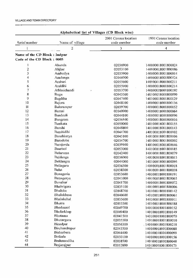
VILLAGE AND TOWN DIRECTORY
Alphabetical list of Villages (CD Block wise)
Serial number Name of village
1 2
Name of the CD Block: Indpur Code of the CD Block : 0005
1 Ahanda 2 Alijhar 3 Ambedya 4 Amdanga 5 Arabari 6 Araldihi 7 Atbhaichandi 8 Baga 9 Bagdiha
10 Bajora 11 Balarampur 12 Bamni 13 Bandeuli 14 Bangram 15 Bankata 16 Banshi 17 Ban shidihi 18 Banshketya 19 Baradoba 20 Barajorda 21 Baurisol 22 Belaruma 23 Beldanga 24 Beldangra 25 Beliagara 26 Belut 27 Benageria 28 Benagerya 29 Benahar 30 Bhabrigara 31 Bhaluka 32 Bhalukbasa 33 Bhalukchal 34 Bhatra 35 Bheduasol 36 Bholarkhap 37 Bhutama 38 Bhutargara 39 Binodpur 40 Birchandrapur 41 Bisharbera 42 Botkula 43 Brahmandiha 44 Brajarajpur
2001 Census location code number
3
02036900 02053100 02035900 02046900 02055600 02055900 02053700 02043500 02047400 02048100 02039700 02040900 02044100 02036100 02050000 02048800 02044700 02045100 02034700 02039100 02053000 02042400 02036000 02044000 02036300 02038300 02053600 02041000 02041700 02035100 02048700 02040600 02035600 02053300 02049700 02049400 02041500 02035500 02056300 02043300 02044400 02050100 02038500 02052000
251
1991 Census location code number
4
140100018001800024 140100018001800186 140100018001800014 140100018001800124 140100018001800211 140100018001800214 140100018001800192 140100018001800090 140100018001800129 140100018001800136 140100018001800052 140100018001800064 140100018001800096 140100018001800016 140100018001800155 140100018001800143 140100018001800102 140100018001800106 140100018001800002 140100018001800046 140100018001800185 140100018001800079 140100018001800015 140100018001800095 140100018001800018 140100018001800038 140100018001800191 140100018001800065 140100018001800072 140100018001800006 140100018001800142 140100018001800061 140100018001800011 140100018001800188 140100018001800152 140100018001800149 140100018001800070 140100018001800010
, 140100018001800218 140100018001800088 140100018001800099 140100018001800156 140100018001800040 140100018001800175
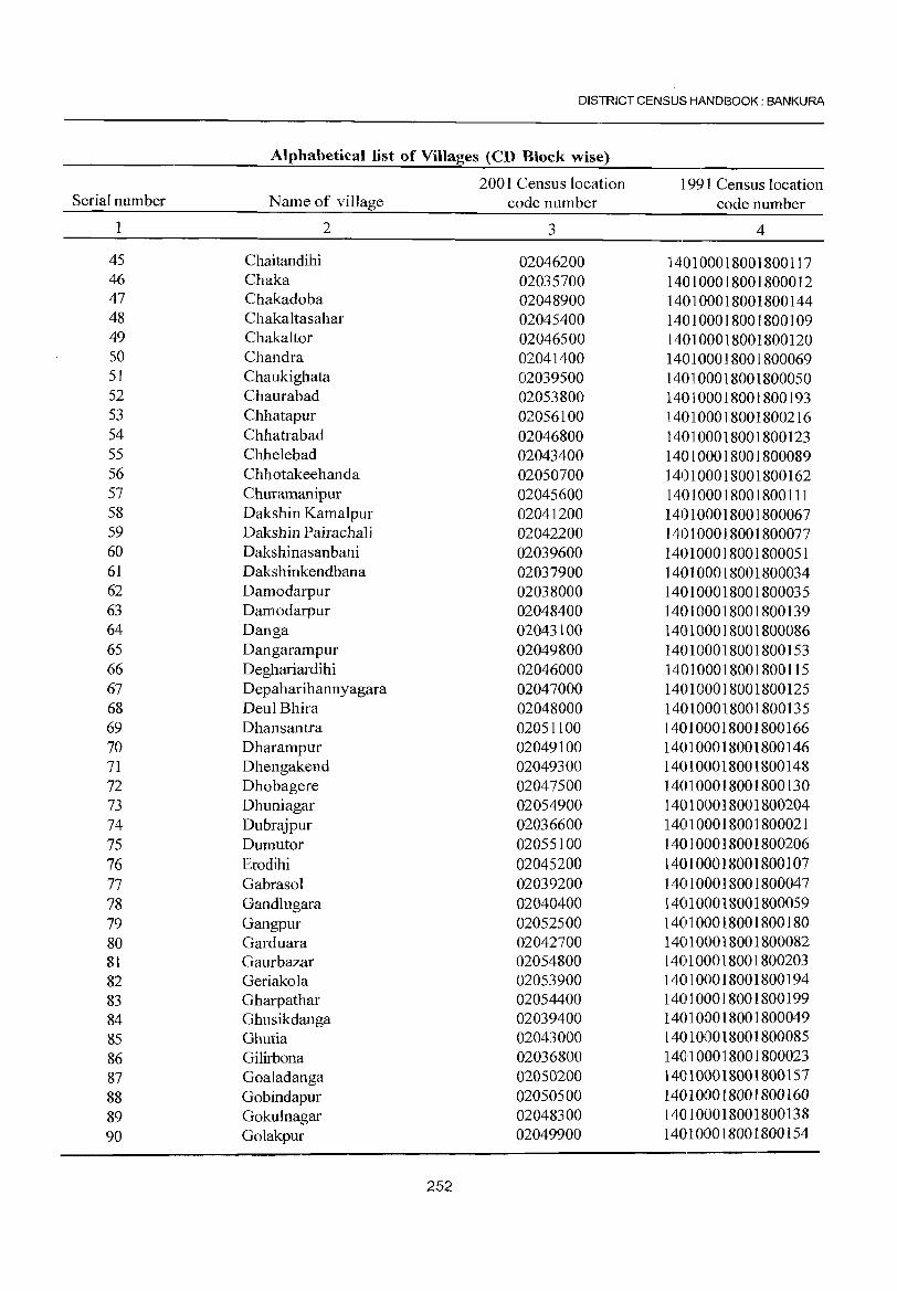
DISTRICT CENSUS HANDBOOK: BANKURA
Alphabetical list of Villages (CD Block wise)
2001 Census location 1991 Census location Serial number Name of village code number code number
1 2 3 4
45 Chaitandihi 02046200 140100018001800117 46 Chaka 02035700 140100018001800012 47 Chakadoba 02048900 140100018001800144 48 Chakaltasahar 02045400 140100018001800109 49 Chakaltor 02046500 140100018001800120 50 Chandra 02041400 140100018001800069 51 Chaukighata 02039500 140100018001800050 52 Chaurabad 02053800 140100018001800193 53 Chhatapur 02056100 140100018001800216 54 Chhatrabad 02046800 140100018001800123 55 Chhelebad 02043400 140100018001800089 56 Chhotakeehanda 02050700 140100018001800162 57 Churamanipur 02045600 140100018001800111 58 Dakshin Kamalpur 02041200 140100018001800067 59 Dakshin Pajrachal i 02042200 140100018001800077 60 Dakshinasanbani 02039600 140100018001800051 61 Dakshinkendbana 02037900 140100018001800034 62 Damodarpur 02038000 140100018001800035 63 Damodarpur 02048400 140100018001800139 64 Danga 02043100 140100018001800086 65 Dangarampur 02049800 140100018001800153 66 Deghariardihi 02046000 140100018001800115 67 Depaharihannyagara 02047000 140100018001800125 68 Deul Bhira 02048000 140100018001800135 69 Dhansantra 02051100 140100018001800166 70 Dharampur 02049100 140100018001800146 71 Dhengakend 02049300 140100018001800148 72 Dhobagere 02047500 140100018001800130 73 Dhuniagar 02054900 140100018001800204 74 Dubrajpur 02036600 140100018001800021 75 Dumutor 02055100 140100018001800206 76 Erodihi 02045200 140100018001800107 77 Gabrasol 02039200 140100018001800047 78 Gandlugara 02040400 140100018001800059 79 Gangpur 02052500 140100018001800180 80 Garduara 02042700 140100018001800082 81 Gaurbazar 02054800 1401100018001800203 82 Geriakola 02053900 140100018001800194 83 Gharpathar 02054400 1401100018001800199 84 Ghusikdanga 02039400 1401100018001800049 85 Ghutia 02043000 1401100018001800085 86 Gilirbona 02036800 140100018001800023 87 Goaladanga 02050200 140100018001800157 88 Gobindapur 02050500 140100018001800160 89 Gokulnagar 02048300 140100018001800138 90 Golakpur 02049900 140100018001800154
252
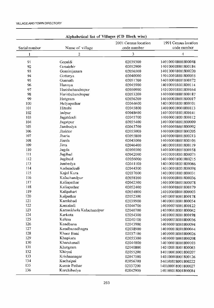
VILLAGE AND TOWN DIRECTORY
Alphabetical list of Villages (CD Block wise)
2001 Census location 1991 Census location Serial number Name of village code number code number
1 2 3 4
91 Gopaldi 02039300 140100018001800048 92 Gosainhir 02052900 140100018001800184 93 Gosainijanara 02056500 140100018001800220 94 Gottarya 02040000 140100018001800055 95 Gunnath 02051700 140100018001800172 96 Hanny a 02045900 140100018001800114 97 Harishchandrapur 02050900 140100018001800164 98 Harishchandrapur 02053200 140100018001800187 99 Hatgram 02036200 140100018001800017
100 Hetyapathar 02044600 140100018001800101 101 Hitashi 02045800 140100018001800113 102 Indpur 02048600 140100018001800141 103 Jagatdeuli 02045700 140100018001800112 104 Jagatpur 02035400 140100018001800009 105 Jambedya 02043700 140100018001800092 106 Jhaktor 02055000 140100018001800205 107 Jharia 02055800 140100018001800213 108 Jiarda 02045000 140100018001800105 109 Jirra 02046400 140100018001800119 110 Jugda 02050300 140100018001800158 111 Jugibad 02042000 140100018001800075 112 Jugibaid 02056000 ]40100018001800215 113 Junbedya 02041100 140100018001800066 114 Kadamdeuli 02044300 140100018001800098 115 KajaJ Kura 02037600 140100018001800031 116 Kalachandpur 02038100 140100018001800036 117 Kaliapathar 02042300 140100018001800078 118 Kaliapathar 02052400 140100018001800179 119 Kalipahari 02034800 140100018001800003 120 Kalpathar 02052300 140100018001800178 121 Kamlabad 02039900 140100018001800054 122 Kantakuli 02046700 140100018001800122 123 Karamkhola Kalachandpur 02040700 140100018001800062 124 Karkota 02054300 140100018001800198 125 Kelera 02040100 140100018001800056 126 Kendbana 02043900 140100018001800094 127 Kendbanadhagra 02038900 140100018001800044 128 Khaer Bani 02037]00 140100018001800026 129 Khapkata 02055300 ]40100018001800208 130 Kharakanali 02044800 140100018001800103 131 Khatgram 02040800 140100018001800063 132 Khirpai 02055200 140100018001800207 133 Krishnanagar 02047100 140100018001800126 134 Kuchaipa1 02056700 140100018001800222 135 Kumir Pathar 02037200 140100018001800027 136 Kurchibedya 02042900 140100018001800084
253
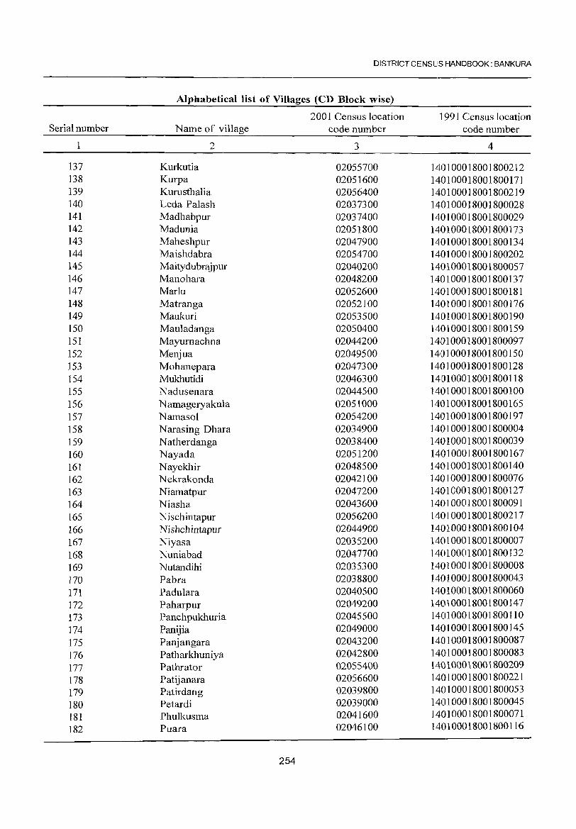
DISTRICT CENSUS HANDBOOK: BANKURA
Alphabetical list of Villages (CD Block wise)
2001 Census location 1991 Census location Serial number Name of village code number code number
2 3 4
137 Kurkutia 02055700 140100018001800212 138 Kurpa 02051600 140100018001800171 139 Kurusthalia 02056400 140100018001800219 140 Leda Palash 02037300 140100018001800028 141 Madhabpur 021037400 1401000180018010029 142 Madunia 02051800 140100018001800173 143 Maheshpur 021047900 14101010018001800134 144 Maishdabra 02054700 1410110100180018010202 145 Maitydubrajpur 1021040200 140100018001810101057 146 Manohara 02048200 1401010018001800137 147 Marlu 02052600 1401010018001800181 148 Matranga 02052100 1410100018001800176 149 Maukuri 02053500 140100018001800190 150 Mauladanga 1021050400 14010001801018100159 151 Mayumachna 102104421010 14101010101810018010097 152 Menjua 021049500 1410101001800180101510 153 Mohanepara 021047300 140100018001800128 154 Mukhutidi 02046300 141010100180101800118 155 Nadusenara 021044500 1410100018001800100 156 N amageryakula 02105110010 1410100018001800165 157 Namasol 102105421010 1401101010181001800197 158 Narasing Dhara 021034900 140101001810018010004 159 Natherdanga 021038400 1410100018001800039 160 Nayada 020512010 1410110100180018010167 161 Nayekhir 102048500 140100018001800140 162 Nekrakonda 02042100 140100101810018001076 163 Niamatpur 02047200 140100018001800127 164 Niasha 02043600 140100018001800091 165 Nischintapur 02056200 140100018001800217 166 Nishchintapur 10204491010 140110100180018010104 167 Niyasa 1020352100 1410100101810018010007 168 Nuniabad 10210477010 14101000180018010132 169 Nutandihi 021035300 14101010018001800008 170 Pabra 0210388100 1410110100180018010043 171 Padulara 1021040500 1401000180018010060 172 Paharpur 021049200 1401100018001800147 173 Panchpukhuria 021045500 1401000180018001110 174 Panijia 02049101010 14011000180018010145 175 Panjangara 021043200 140100018001800087
176 Patharkhuniya 02042800 140100018001800083 177 Pathrator 02055400 140100018001800209 178 Patijanara 02056600 140100018001800221
179 Patirdang 02039800 140100018001800053
180 Petardi 02039000 140100018001800045
181 Phulkusma 02041600 140100018001800071
182 Puara 020461010 140100018001800116
254
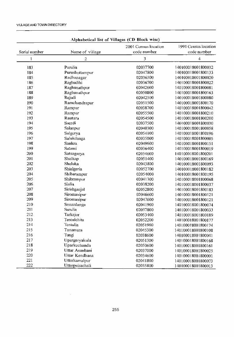
VILLAGE AND TOWN DIRECTORY
Alphabetical list of Villages (CD Block wise)
2001 Census location 1991 Census location Serial number N arne of village code number code number
1 2 3 4
183 Purulia 02037700 140100018001800032 184 Purushottampur 02047800 140100018001800133 185 Radhanagar 02036500 140100018001800020 186 Ragbudihi 02036700 140100018001800022 187 Raghunathpur 02042600 140100018001800081 188 Raghunathpur 02050800 140100018001800163 189 Rajudi 02042500 140100018001800080 190 Ramchandrapur 02051500 140100018001800170 191 Rampur 02038700 140100018001800042 192 Rampur 02055500 140100018001800210 193 Rautara 02054500 140100018001800200 194 Saerdi 02037500 140100018001800030 195 Salanpur 02040300 140100018001800058 196 Salgerya 02054100 140100018001800196 197 Sa1ukdanga 02035000 140100018001800005 198 Sankra 02049600 140100018001800151 199 Satami 02036400 140100018001800019 200 Satsagarya 02054600 140100018001800201 201 Sha1kap 02051400 140100018001800169 202 Sha1uka 02043800 140100018001800093 203 Shialgeria 02052700 140100018001800182 204 Shibarampur 02054000 140100018001800195 205 Shibrampur 02041300 140100018001800068 206 Sia1ia 02038200 140100018001800037 207 Sirishganja1 02052800 140100018001800183 208 Siromanipur 02046600 140100018001800121 209 Siromanipur 02047600 140100018001800121 210 Sonardanga 02041900 140100018001800074 211 Surulia 02037800 140100018001800033 212 Tarkajor 02053400 140100018001800189 213 Tentulchita 02052200 140100018001800177 214 Tentulia 02051900 140100018001800174 215 Tunamara 02045300 140100018001800108 216 Tungi 02038600 140100018001800041 217 Upargeryaku1a 02051300 140100018001800168 218 Uparkechanda 02050600 140100018001800161 219 Uttar Asanbani 02037000 140100018001800025 220 Uttar Kendbana 02034600 140100018001800001 221 Uttarkama1pur 02041800 140100018001800073 222 Uttarpairacha1i 02035800 140100018001800013
255
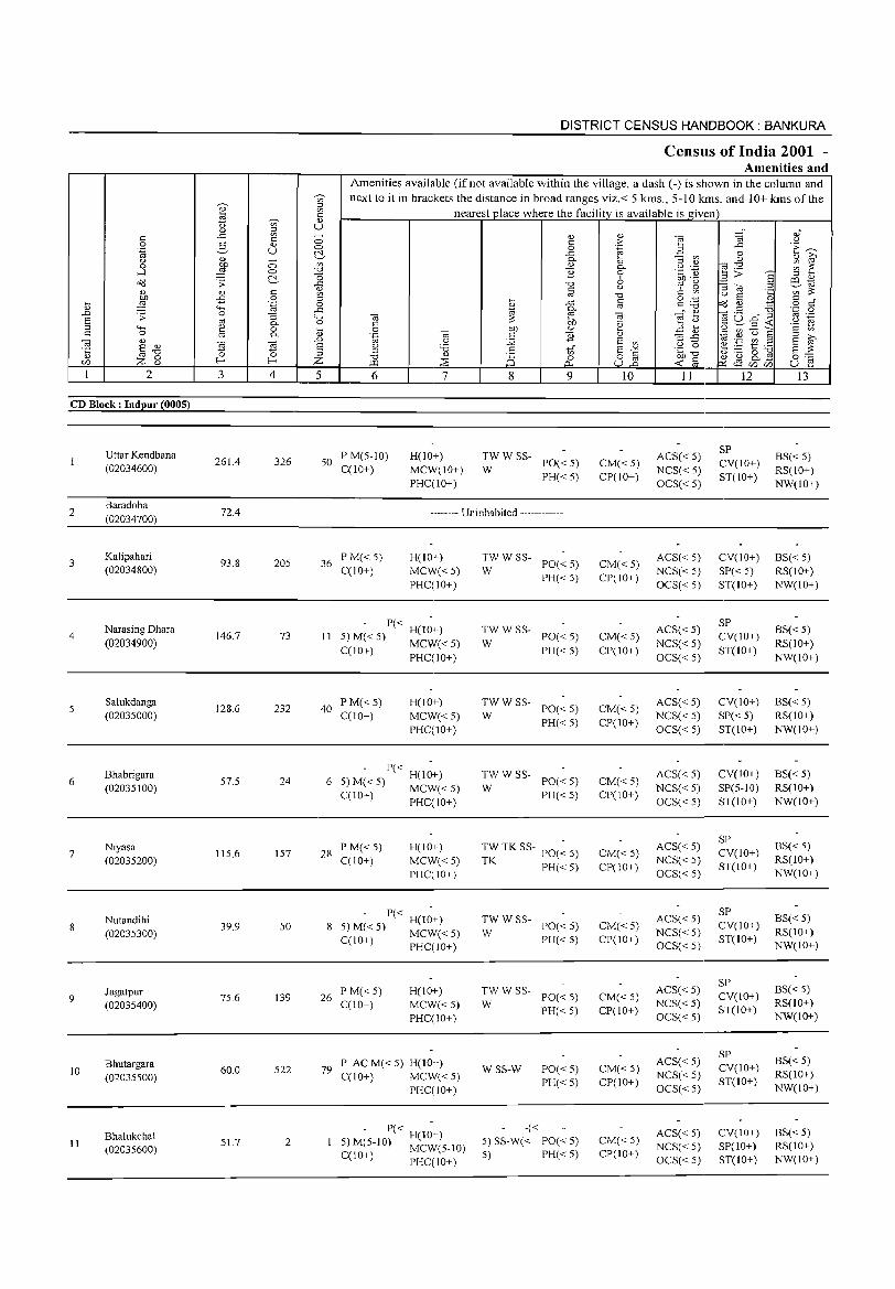
2
CD Block: Indpur (0005)
2
3
4
5
6
7
8
9
10
11
Uttar Kendbana (02034600)
Baradoba (02034700)
Kalipahari (02034800)
Narasing Dhara (02034900)
Salukdanga (02035000)
Bhabrigara (02035100)
Niyasa (02035200)
Nutandihi (02035300)
Jagatpur (02035400)
Bhutargara (02035500)
Bhalukchal (02035600)
3
261.4
72.4
93.8
146.7
128.6
57.5
115.6
39.9
75.6
60.0
51.7
o o ~ c o .~
"3 0-o 0-
S ~ 4
326
205
73
232
24
157
50
139
522
2
DISTRICT CENSUS HANDBOOK: BANKURA
Census of India 2001 -Amenities and
Amenities available (if not available within the village, a dash (-) is shown in the column and next to it in brackets the distance in broad ranges viz.< 5 kms., 5-10 kms. and 10+ kms of the
nearest place where the facility is available is giv<en
5 6
50 PM(5-10) C(10+)
7
H(lO+) MCW(IO+) PHC(IO+)
8 9
;;: W SS- PO« 5)
PH« 5)
-------- Uninhabited ------------
36 P M« 5) C(10+)
H(IO+) MCW« 5) PHC(IO+)
P« H(lO+) II 5) M« 5) MCW« 5)
C(lO+) PHC(IO+)
40 PM«5} C(10+}
H(10+) MCW«5) PHC(IO+)
- P« -6 5) M« 5) H(10+)
C(10+) MCW« 5) PHC(lO+)
28 P M« 5) C(lO+)
H(IO+) MCW«5) PHC(IO+)
P« H(IO+) 8 5) M« 5) MCW« 5)
C(lO+) PHC(IO+)
26 PM«5) C(IO+)
H(IO+) MCW« 5) PHC(IO+)
79 P ACM«5) H(lO+) C(lO+) MCW« 5)
PHC(IO+)
- P« H(I;+) 5) M(5-10) MCW(5-10) C(IO+) PHC(IO+)
;;: W SS- PO« 5)
PH« 5)
TWWSS-W PO« 5)
PH« 5)
TWWSS-W PO« 5)
PH« 5)
TWWSS-PO« 5) PH«5)
W
TW TKSS-TK PO« 5)
PH« 5)
:W W SS- PO« 5)
PH« 5)
:W W SS- PO« 5)
PH« 5)
WSS-W
-«
PO«5) PH« 5)
5) SS-W« PO« 5) 5) PH« 5)
10
CM« 5) CP(IO+)
CM«5) CP(IO+)
CM« 5) CP(IO+)
CM« 5) CP(1O+)
CM« 5) CP(1O+)
CM« 5) CP(IO+)
CM«5) CP(IO+)
CM«5) CP(10+)
CM«5) CP(IO+)
CM« 5) CP(IO+)
II
ACS« 5) NCS« 5) OCS« 5)
ACS« 5) NCS« 5) OCS« 5)
ACS« 5) NCS« 5) OCS« 5)
ACS« 5) NCS« 5) OCS« 5)
ACS« 5) NCS« 5) OCS« 5)
ACS« 5) NCS« 5) OCS« 5)
ACS« 5) NCS« 5) OCS« 5)
ACS« 5) NCS« 5) OCS« 5)
ACS« 5) NCS«5) OCS« 5)
ACS« 5) NCS« 5) OCS« 5)
12
SP CV(IO+) ST(IO+)
CV(IO+) SP« 5) ST(lO+)
SP CV(lO+) ST(IO+)
CV(IO+) SP« 5) ST(IO+)
CV(10+) SP(5-10) ST(IO+)
SP CV(IO+) ST(lO+)
SP CV(IO+) ST(lO+)
SP CV(IO+) ST(lO+)
SP CV(IO+) ST(lO+)
CV(IO+) SP(IO+) ST(IO+)
13
BS«5) RS(lO+) NW(IO+)
BS« 5) RS(lO+) NW(lO+)
BS« 5) RS(IO+) NW(lO+}
BS« 5) RS(IO+) NW(IO+)
BS« 5) RS(IO+) NW(lO+)
BS« 5) RS(lO+) NW(IO+)
BS« 5) RS(lO+) NW(IO+)
BS« 5) RS(IO+) NW(IO+)
BS« 5) RS(lO+) NW(IO+)
BS« 5) RS(lO+) NW(IO+)
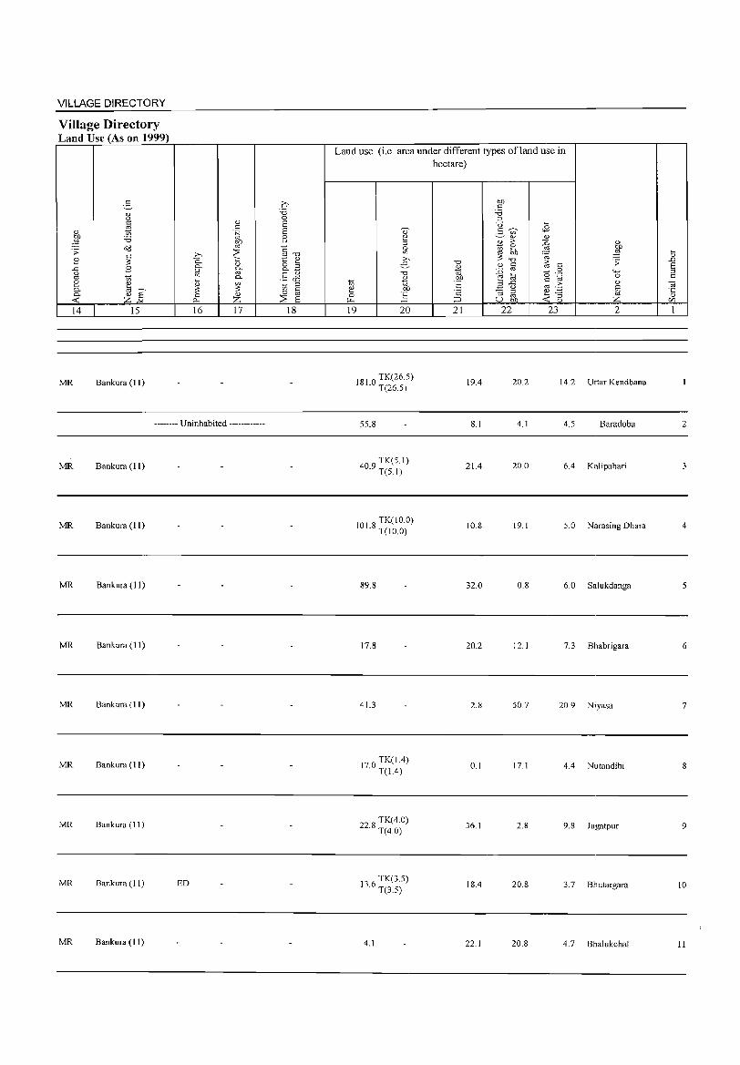
VILLAGE DIRECTORY
Village Directory Land Use (As on 1999)
:3 <L> u c '" " 1;)
OJ) :.a ,g ~ .:; ~ .8
..c .8 u '" on 2 ~ c.. ]' c.. <L>
<C Z 14 15
MR Bankura (11)
<I)
c .~ OJ)
'" >, ::::: 0. <::: c.. <L>
::> [if '" '-'
c.. <l.) on ~ ~ 0 <L>
p., Z 16 17
-------- Uninhabited ------------
MR Bankura (11)
MR Bankura (11)
MR Bankura (11)
MR Bankura (11)
MR Bankura (11)
MR Bankura (II)
MR Bankura (11)
MR Bankura (1 1) ED
MR Bankura (11)
2:' :.a 0 E E 0 u
"E '" "0 to; " o '-' o...§ .§ ciS 1;) ::> c 0 co
::::: E 18
Land use (i.e. area under different types ofland use in hectare)
., 2 ~ >, e
"0 <l.)
1;) '" ~ .~ 0 ~ ~
19 20
181 0 TK(26.5) · T(26.5)
55.8
409 TK(5.1) · T(S.I)
101 8 TK( 10.0) · T(10.0)
89.8
17.8
41.3
170 TK(I.4) · T(L4)
228 TK(4.0) · T(4.0)
13 6 TK(3.5) · T(3.5)
4.1
"0 <L>
'" OJ)
E <2
:::J 21
19.4
8.1
21.4
10.8
32.0
20.2
2.8
0.1
36.1
18.4
22.1
OJ) t:: :.a ::>
-0 '-'
2- ~ <B on <I) <I)
B > ~ i(J ~
~ ;;; "0 1; <L> C C
::0 '" (5 0
E! til .~ t:: .a ..c
'" ·5 0 ::; ::> ~ '" ::; U OJ) <C 0
<L> OJ)
,g ;;:
"-' 0 <L>
§ z
22 23 2
20.2 14.2 Uttar Kendbana
4.1 4.5 Baradoba
20.0 6.4 Kalipahari
19.1 5.0 Narasing Dhara
0.8 6.0 Salukdanga
12.1 7.3 Bhabrigara
50.7 20.9 Niyasa
17.1 4.4 Nutandihi
2.8 9.8 Jagatpur
20.8 3.7 Bhutargara
20.8 4.7 Bhalukchal
'-' <L>
.D E ::> c
0; ·5 IZl
1
2
3
4
5
6
7
8
9
10
II
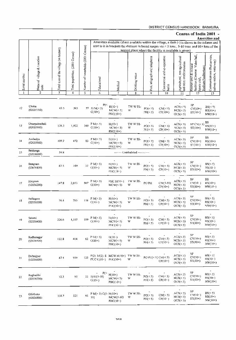
12
13
14
15
16
17
18
19
20
21
22
23
2
Chaka (02035700)
Uttarpairachali (02035800)
Ambedya (02035900)
Beldanga (02036000)
Bangram (02036100)
Hatgram (02036200)
Beliagara (02036300)
Salami (02036400)
Radhanagar (02036500)
Dubrajpur (02036600)
Raghudihi (02036700)
Gilirbona (02036800)
3
43.5
126.3
109.7
59.8
63.5
147.8
74.4
226.6
122.8
47.4
72.3
138.7
o o C!-c o .~
:; 0-o 0-
Ol
~ 4
393
1,922
472
169
2,853
703
1,107
414
939
95
321
DISTRICT CENSUS HANDBOOK: BANKURA
Census of India 2001 -Amenities and
Amenities available (ifnot available within the village, a dash (-) is shown in the colunm and next to it in brackets the distance in broad ranges viz. < 5 kms., 5-10 kms. and 10+ kms of the
nearest place where the facility is available is given
5 6 7
- P« -77 5) M« 5) H(10+)
C(lO+) MCW«5) PHC(IO+)
340 P M« 5) C(IO+)
H(JO+) MCW« 5) PHC(IO+)
83 PM«5) C(10+)
H(IO+) MCW«5) PHC(IO+)
8
TWWSS-W
TWWSS-W
TW WSS-W
0) c o
..c: 0-0)
]] '0 C
'" ..c:
~ Of> 0)
]]
tf o
0..
9
PO« 5)
PH« 5)
PO« 5)
PH« 5)
PO« 5) PH« 5)
-------- Uninhabited ------------
32 PM«5) C(10+)
567 P M« 5) C(lO+)
116 PM«5) C(IO+)
189 P M« 5) C(IO+)
62 P M«5) C(IO+)
H(IO+) MCW« 5) PHqIO+)
PHCH(IO+)
MCW« 5)
H(IO+) MCW«5) PHC(IO+)
H(IO+)
MCW«5) PHqlO+)
H(IO+) MCW«5) PHqIO+)
TW WSS-PO« 5)
PH« 5) W
~WWSS- POPH
TW WSS-PO« 5) PH« 5)
W
TW WSS-PO«5) PH« 5)
W
:;: W SS- PO« 5)
PH« 5)
10
CM«5) CP(lO+)
CM«5) CP(IO+)
CM«5) CP(IO+)
CM«5) CP(IO+)
11
ACS« 5) NCS« 5)
OCS« 5)
ACS« 5)
NCS« 5) OCS« 5)
ACS« 5) NCS« 5) OCS« 5)
ACS« 5) NCS« 5)
OCS« 5)
CM(5-1O) ACS« 5) CP(IO+) NCS« 5)
OCS« 5)
CM«5) CP(IO+)
CM«5) CP(IO+)
CM«5) CP(IO+)
ACS« 5) NCS« 5) OCS« 5)
ACS« 5) NCS« 5) OCS«5)
ACS« 5) NCS«5) OCS« 5)
125 P(2) M(2) S MCW H(10+) :;: W SS- PO PH« 5) CM« 5) PUC C(10+) PHC(IO+) CP(10+)
ACS« 5) NCS« 5) OCS«5)
- P« H(l~+) 22 5) M(5-10) MCW« 5)
C(lO+) PHC(lO+)
61 P M« 5) C(5- H(lO+) 10) MCW(5-1O)
PHC(IO+)
~W W SS- PO« 5)
PH«5)
:;: W SS- PO« 5)
PH« 5)
CM« 5) CP(IO+)
CM« 5) CP(IO+)
ACS«5) NCS« 5) OCS« 5)
ACS« 5) NCS« 5) OCS« 5)
12
SP CV(lO+) ST(IO+)
13
BS« 5) RS(IO+)
NW(lO+)
BS SP CV« 5) RS(IO+) ST(lO+) NW(lO+)
SP CV(IO+) ST(IO+)
SP CV(IO+) ST(10+)
SP CV(IO+) ST(lO+)
SP CV(IO+) ST(IO+)
SP CV(IO+) ST(lO+}
SP CV(IO+) ST(IO+)
SP CV(IO+) ST(lO+)
SP CV(IO+) ST(IO+)
SP CV(lO+) ST(IO+)
BS RS(IO+) NW(IO+)
BS« 5) RS(IO+) NW(IO+)
BS RS(IO+) NW(lO+)
BS« 5) RS(IO+) NW(IO+)
BS« 5) RS(lO+) NW(IO+)
BS« 5) RS(IO+) NW(IO+)
BS« 5) RS(IO+) NW(IO+)
BS« 5) RS(IO+) NW(IO+)
BS« 5) RS(lO+) NW(IO+)
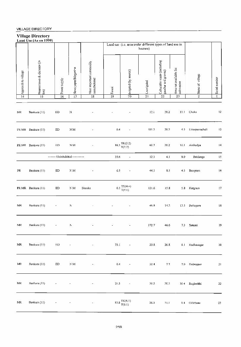
VILLAGE DIRECTORY
Village Directory Land Use (As on 1999)
14 15
MR Bankura (11)
PRMR Bankura (11)
PRMR Bankura (11 )
16 17
ED N
ED NM
ED NM
-------- Uninhabited ------------
PR Bankura (11 ) ED NM
PR MR Bankura (11) ED NM Shanka
MR Bankura (11) N
MR Bankura (11 ) N
MR Bankura (11 ) ED
MR Bankura (I 1 ) ED NM
MR Bankura (11)
MR Bankura (11)
18
Land use (i.e. area under different types ofland use in hectare)
19 20
0.4
165 TK(2.2) . T(2.2)
35.6
6.5
03 TK(4.4) . T(4.4)
73.1
0.4
21.5
8' 8 TK(6.1) .>. T(6.1)
21 22
12.1
101.2
60.7
12.1
44.1
121.6
46.8
172.7
20.8
32.4
20.2
36.3
., ~ .s;: 4-< 0 ., ~ z
23 2
20.2 11.1 Chaka
20.2 4.5 Uttarpairachali
20.2 10.1 Ambedya
4.1 8.0 Beldanga
8.5 4.5 Bangram
15.8 5.8 Hatgram
14.2 13.5 Beliagara
46.6 7.3 Satami
20.8 8. 1 Radhanagar
7.7 7.0 Dubrajpur
20.2 10.4 Raghudihi
11.1 1.4 Gilirbona
Ii; ..c E ;:l
'" "' '5 U)
1
12
13
14
15
16
17
18
19
20
21
22
23
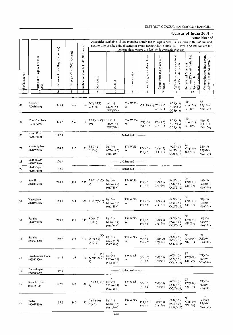
24
25
26
27
28
29
30
31
32
33
34
35
36
37
2
Ahanda (02036900)
Uttar Asanbani (02037000)
Khaer Bani (02037100)
Kumir Pathar (02037200)
Leda Palash (02037300)
Madhabpur (02037400)
Saerdi (02037500)
Kajal Kura (02037600)
Purulia (02037700)
Suruba (02037800)
Dakshin- kendbana (02037900)
Damodarpur (02038000)
Kalachandpur (02038100)
Sialia (02038200)
3 4
112.1 749
137.6 552
201.1
194.5 210
170.9
43.5
218.3 1,120
129.8 664
213.6 781
152.7 719
144.8 76
59.8
137.9 170
87.0 849
DISTRICT CENSUS HANDBOOK: BANKURA
Census of India 2001 -Amenities and
Amenities available (if not available within the village, a dash (-) is shown in the column and next to it in brackets the distance in broad ranges viz.< 5 kms., 5-10 kms. and 10+ kms of the
nearest place where the facility is available is given
5 6 7 8
'" o 0...
9 10
124 P(2) M(2) C(5-10)
H(IO+) MCW«5) PHC(IO+)
W
TWW SS-PO PH« 5) CM« 5)
86 PM«5)C(5-H(10+) 10) MCW«5)
PHC(IO+)
:W W SS- PO« 5)
PH«5)
-------- Uninhabited ------------
35 PM«5) C(10+)
H(IO+)
MCW«5) PHC(lO+)
TWW SS-PO«5) PH« 5)
W
-------- Uninhabited ------------
-------- Uninhabited ------------
177 PM«5)C« H(lO+) 5) MCW«5)
PHC(JO+)
H(IO+) 109 P M C(5-10) MCW« 5)
PHC(10+)
139 PM«5) C(10+)
H(IO+) MCW« S) PHC(lO+)
P« H(lO+) 5) M«S) MCW«5) C(lO+) PHC(10+)
114
- P« H(IO+) 15 5) M« 5) C« MCW« 5)
S) PHC(IO+)
~ W SS- PO« 5)
PH«5)
TWW SS-PO«5) PH«5)
W
TWW SS-W PO« 5)
PH«S)
:W W SS- PO« 5)
PH«5)
TWW SS-W PO« 5)
PH«S)
-------- Uninhabited ------------
25 P M« 5) C« H( 10+) 5) MCW«5)
PHC(IO+)
132 PM(5-10) C« 5)
H(IO+) MCW«5) PHC(lO+)
:W W SS- PO« 5)
PH«5)
;;: W SS- PO« 5)
PH«5)
CP(IO+)
CM«5) CP(IO+)
CM«5) CP(IO+)
CM«5) CP(lO+)
CM«5) CP(IO+)
CM« 5)
CP(lO+)
CM«5) CP(IO+)
CM«5) CP(lO+)
CM«5) CP(lO+)
CM«5) CP(IO+)
II
ACS« 5) NCS« 5) OCS« 5)
ACS« 5) NCS« 5) OCS« 5)
12
SP CV(IO+) ST(lO+)
SP CV(lO+) ST(IO+)
ACS« 5) SP NCS« 5) CV(IO+) OCS(5-10) ST(IO+)
SP ACS« 5) CV(10+) NCS« 5) OCS(5-10) ST(IO+)
SP ACS« 5) CV(10+) NCS« 5) OCS(5-10) ST(10+)
SP ACS« 5) CV(lO+) NCS« 5) OCS(5-1O) ST(lO+)
SP ACS« 5) CV(10+) NCS« 5) OCS(5-10) ST(10+)
SP ACS« 5) CV(IO+) NCS« 5) OCS(5-10) ST(JO+)
SP ACS« 5) CV(lO+) NCS« 5) OCS(5-10) ST(IO+)
SP ACS« 5) CV(lO+) NCS« 5) OCS(5-10) ST(IO+)
13
BS RS(IO+) NW(IO+)
BS« 5) RS(10+) NW(IO+)
BS« 5) RS(IO+) NW(10+)
BS« 5) RS(IO+) NW(IO+)
BS« 5) RS(IO+) NW(IO+)
BS« 5) RS(10+) NW(IO+)
BS RS(10+) NW(IO+)
BS« 5) RS(IO+) NW(IO+)
BS« 5) RS(IO+) NW(lO+)
BS« 5) RS(IO+) NW(IO+)
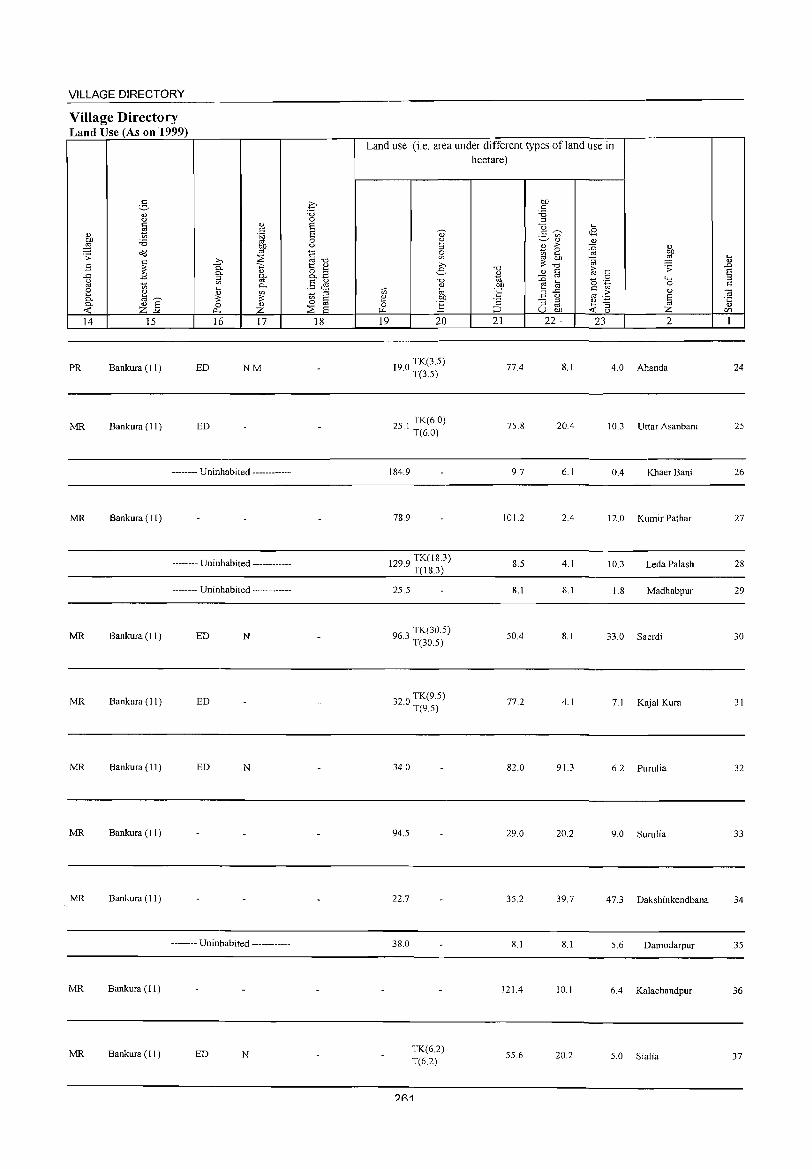
VILLAGE DIRECTORY
Village Directory Land Use (As on 1999)
§ <1.) <) c " ~ c
" §l on 'B ::§ bJ)
o(l '" .;;: c >. ::;;:
.8 ;;: 0. '" 0.. " ..c .8 '" 0..
g V) '" 10
~ 0..
2 ~ '" 0.. "'~ ;;: 0.. <1.) E 0 " « z-" p.. z 14 15 16 17
PR Bankura (11 ) ED NM
MR Bankura (11 ) ED
-------- Uninhabited ------------
MR Bankura (11 )
-------- Uninhabited ------------
-------- Uninhabited ------------
MR Bankura (11) ED N
MR Bankura (11 ) ED
MR Bankura ( 11 ) ED N
MR Bankura (11 )
MR Bankura (11 )
-------- Uninhabited ------------
MR Bankura (I 1)
MR Bankura (11) ED N
c 'B 0 S S 0 <)
§'"d t: ~ o '" 0.. ~
§ & ~ ;:j
iB @ ::;;: E
18
Land use (i.e. area under different types ofland use in hectare)
19 20
190 TK(3.5) · T(3.5)
251 TK(6.0) · T(6.0)
184.9
78.9
1299 TK(18.3) · T(I8.3)
25.5
96.3 TK(30.5) T(30.5)
32.0 TK(9.5) T(9.5)
34.0
94.5
22.7
38.0
TK(6.2) T(6.2)
?R1
"0
" 0; OJ)
'E ';:: ;:::J
21
77.4
75.8
9.7
101.2
8.5
8.1
50.4
77.2
82.0
29.0
35.2
8.1
121.4
55.6
bJ) c
'B '" '0
:.S ~ '" <1.)
" :> 10 ~ '" ;;: "0
" c :0 '" e @ ,:1 ..c
<J
"3 '" '" u on 22·
8.1
20.4
6.1
2.4
4.1
8.1
8.1
4.1
91.3
20.2
39.7
8.1
10.1
20.2
.... <8 v :0 <1.)
OJ bJ)
~ ::§ ~
.;;: c 0 '<-< 0 .~ 0 c
.2: " '" § ~ '3 « '" z 23 2
4.0 Ahanda
10.3 Uttar Asanbani
0.4 Khaer Bani
12.0 Kumir Pathar
10.3 Leda Palash
1.8 Madhabpur
33.0 Saerdi
7.1 Kajal Kura
6.2 Purulia
9.0 Surulia
47.3 Dakshinkendbana
5.6 Damodarpur
6.4 Kalachandpur
5.0 Sialia
~ .!:J E ::I c
~ <1.)
CIl
1
24
25
26
27
28
29
30
31
32
33
34
35
36
37
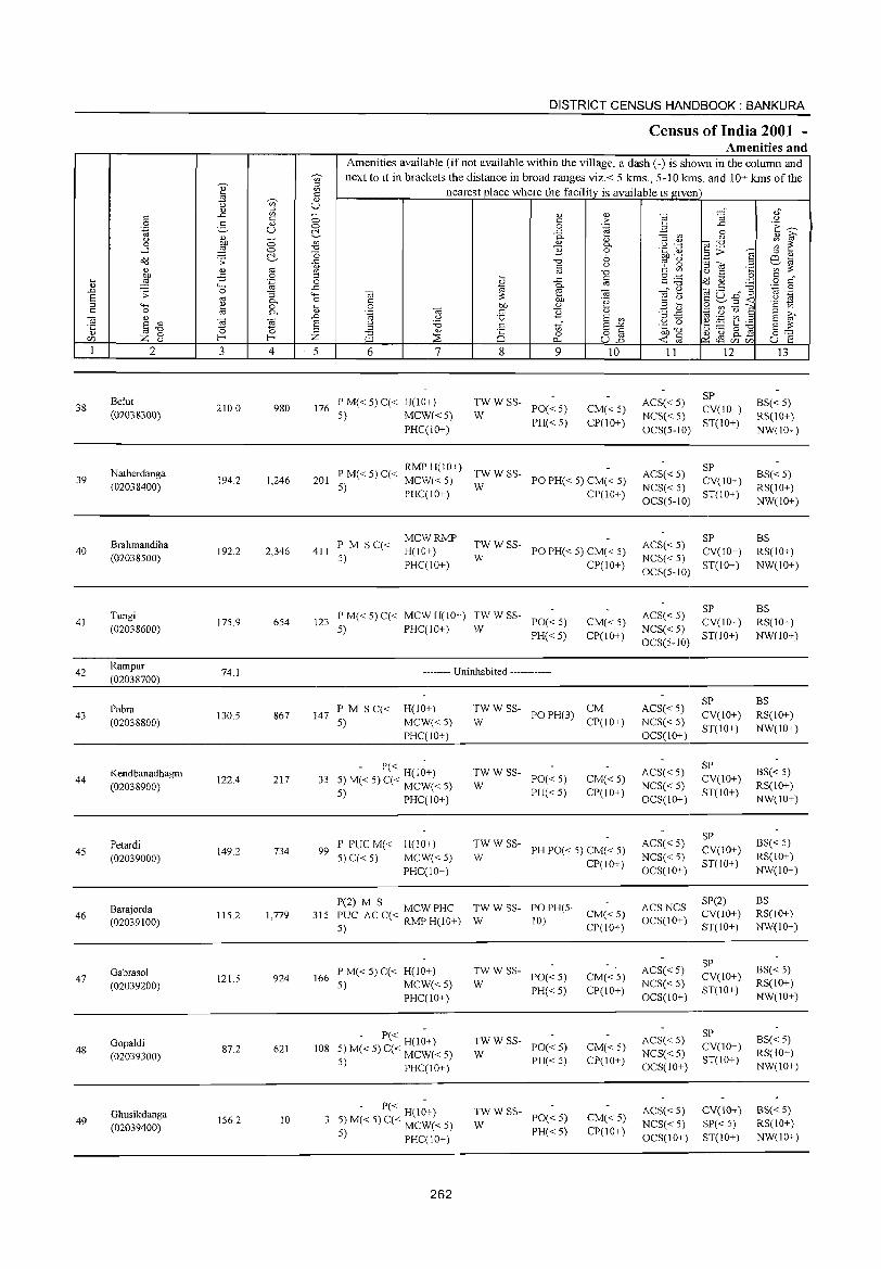
38
39
40
41
42
43
44
45
46
47
48
49
2
Belut (02038300)
Natherdanga (02038400)
Brahmandiha (02038500)
Tungi (02038600)
Rampur (02038700)
Pabra (02038800)
Kendbanadhagra (02038900)
Petardi (02039000)
Barajorda (02039100)
Gabrasol (02039200)
Gopaldi (02039300)
Ghusikdanga (02039400)
3 4
210.0 980
194.2 1,246
192.2 2,346
175.9 654
74.1
130.5 867
122.4 217
149.2 734
115.2 1,779
121.5 924
87.2 621
156.2 10
DISTRICT CENSUS HANDBOOK: BANKURA
CensUis of India 2001 -Amenities and
Amenities available (if not available within the village, a dash (-) is shown in the column and next to it in brackets the distance in broad ranges viz. < 5 kms., 5-10 lams. and 10+ kms of the
nearest place where the facility is available is given
5 6 7
176 P M« 5) q< H(IO+) 5) MCW«5)
PHqIO+)
8
en o
0...
9
~W W SS- PO« 5)
PH« 5)
10
CM« 5) CP(lO+)
P M( 5) C( RMP H(10+) TW W SS-201 < < MCW«5) W POPH«5) CM«5)
5) PHq 10+) CP(IO+)
411 PM sq< 5)
MCWRMP H(IO+) PHqIO+)
:W W SS- PO PH« 5) CM« 5)
CP(IO+}
123 P M« 5) q< MCW H(IO+} TWW W SS- POe 5) 5) PHC(IO+) <
PH«5) CM« 5) CP(IO+)
-------- Uninhabited ------------
147 PM S C« 5)
H(lO+) MCW«5) PHqIO+)
- P« H(I~+) 33 5) M« 5) C« MCW« 5)
5) PHC(IO+)
99 P PUC M« H(10+) 5) C« 5) MCW« 5)
PHC(IO+)
TWWSS- CM W
POPH(3)
;;: W SS- PO« 5)
PH«5)
CP(IO+)
CM« 5) CP(10+)
W
TWWSS-PH PO« 5) CM« 5)
CP(IO+)
P(2) M S MCW PHC TW W SS- PO PH(5-315 PUC AC C« RMP H(10+) W 10) CM« 5)
5) CP(10+)
166 P M« 5) C« H(IO+) 5) MCW«5)
PHC(10+)
108 - P« H(I~+)
5) M« 5) C« MCW« 5)
5) PHC(10+)
- P« H(I~+) 5) M« 5) C« MCW« 5}
5) PHC( 10+)
262
TWWSS-W PO«5)
PH«5)
;;: W SS- PO« 5)
PH«5)
TWWSS-W PO« 5)
PH« 5)
CM« 5) CP(lO+)
CM«5) CP(IO+)
CM« 5) CP(IO+)
11
ACS« 5) NCS« 5) OCS(5-10)
12
SP CV(IO+) ST(IO+)
ACS«5) SP NCS« 5) CV(IO+) OCS(5-10) ST(10+)
SP ACS« 5} CV(IO+) NCS« 5) OCS(5-10) ST(lO+}
SP ACS« 5) CV(IO+) NCS« 5) ST(IO+) OCS(5-10}
ACS« 5) NCS« 5) OCS(10+)
ACS« 5) NCS« 5) OCS(IO+)
ACS« 5) NCS« 5) OCS(10+)
ACS NCS OCS(10+)
ACS« 5) NCS« 5) OCS(10+)
ACS« 5) NCS«5) OCS(IO+)
ACS« 5) NCS« 5) OCS(IO+)
SP CV(10+) ST(IO+)
SP CV(IO+) ST(10+)
SP CV(10+) ST(IO+)
SP(2) CV(lO+) ST(lO+)
SP CV(10+) ST(lO+)
SP CV(10+) ST(10+)
CV(10+) SP«5) ST(10+)
13
BS« 5) RS(IO+) NW(IO+)
BS« 5) RS(IO+) NW(IO+)
BS RS(IO+} NW(IO+)
BS RS(10+) NW(IO+)
BS RS(lO+) NW(IO+)
BS« 5) RS(IO+) NW(JO+)
BS« 5) RS(10+) NW(IO+)
BS RS(IO+) NW(10+)
BS« 5) RS(IO+) NW(10+)
BS« 5) RS(lO+) NW(10+)
BS« 5) RS(IO+) NW(10+)
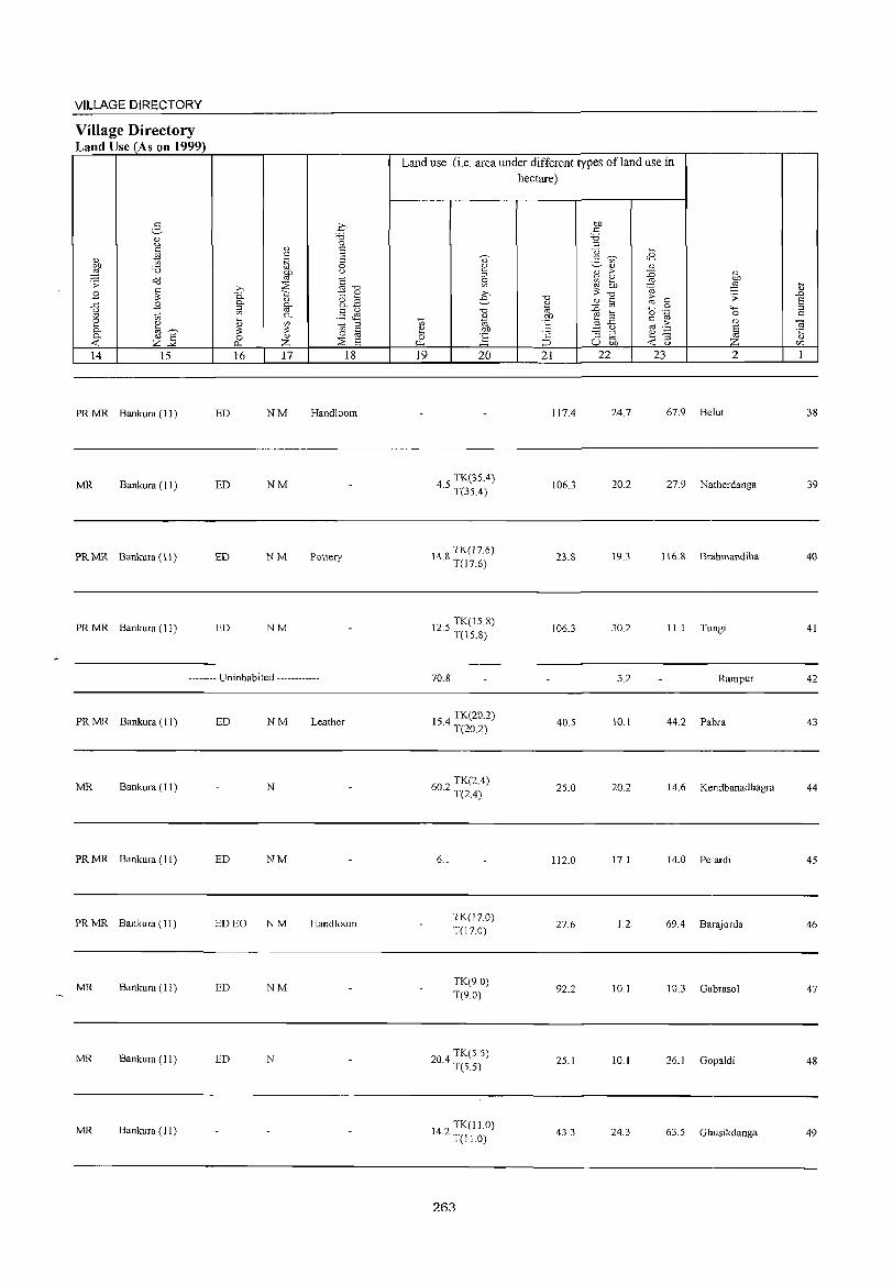
VILLAGE DIRECTORY
Village Directory Land Use (As on 1999)
2-Q) u C
'" l t) :0 Cd .;;:
~ B {3 B '" t) 2 '" 0. til~
~ " 8 Z..:.< 14 15
PR MR Bankura (11 )
MR Bankura (11 )
PR MR Bankura (11)
PRMR Bankura (11)
ED
ED
ED
ED
.q "0 0
" E c E .~ 0
i?P u
1:i ~ >, '" "0 "0. '" 1:: Q)
" 8.2 0. [if ::I C u '" 0. ,::::: ~ ~
" ~ ::I 3 '" c
" 0 oj
0 ~ 0.. Z 8 16 17 18
NM Hand100m
NM
NM Pottery
NM
-------- Uninhabited ------------
PRMR Bankura (11) ED NM Leather
MR Bankura (11) N
PR MR Bankura (II) ED NM
PR MR Bankura (11 ) ED EO N M Handloom
MR Bankura ( 11 ) ED NM
MR Bankura (II ) ED N
MR Bankura (11)
Land use (i.e. area under different types of land use in
~
'" e 0
p..
19
0) 2 ::l
s: >, e
"0
~ r 20
4 S TK(3S.4) · T(3S.4)
148 TK(17.6) · T(17.6)
12.S TK(IS 8) T(\S.8)
70.8
IS 4 TK(20.2) · T(20.2)
60.2 TK(2.4) T(2.4)
6.1
TK(J7 0) T(17.0)
TK(90) T(9.0)
204 TK(S.5) · T(S.S)
14.2 TK(11.0) T(Il.O)
hectare)
"0
" ~ .~ t: ;: ~
21
117.4
106.3
23.8
106.3
40.S
2S.0
112.0
27.6
92.2
25.1
43.3
OJ) c
:0 ::I <3 ~
5 ~ c8 '" Q) Q)
1:l > :0 Q)
~ 2 '" OJ)
OJ) ~ ::§ 3 "0 ;;: Q) C i; c
'" 0 :0 0 'g '-oj til 0
_8{5 c (1)
'" .:: :; ::I e "§ ~ oj u OJ) -< u
22 23 2
24.7 67.9 Belut
20.2 27.9 Natherdanga
19.3 116.8 Brahmandiha
30.2 III Tungi
3.2 Rampur
10.1 44.2 Pabra
20.2 14.6 Kendbanadhagra
17.1 14.0 Petardi
].2. 69.4 Barajorda
10.1 10.3 Gabrasol
10.1 26.1 Gopaldi
24.3 63.5 Ghusikdanga
il ..0 E :J c
O! .~
<Zl
1
38
39
40
41
42
43
44
45
46
47
48
49
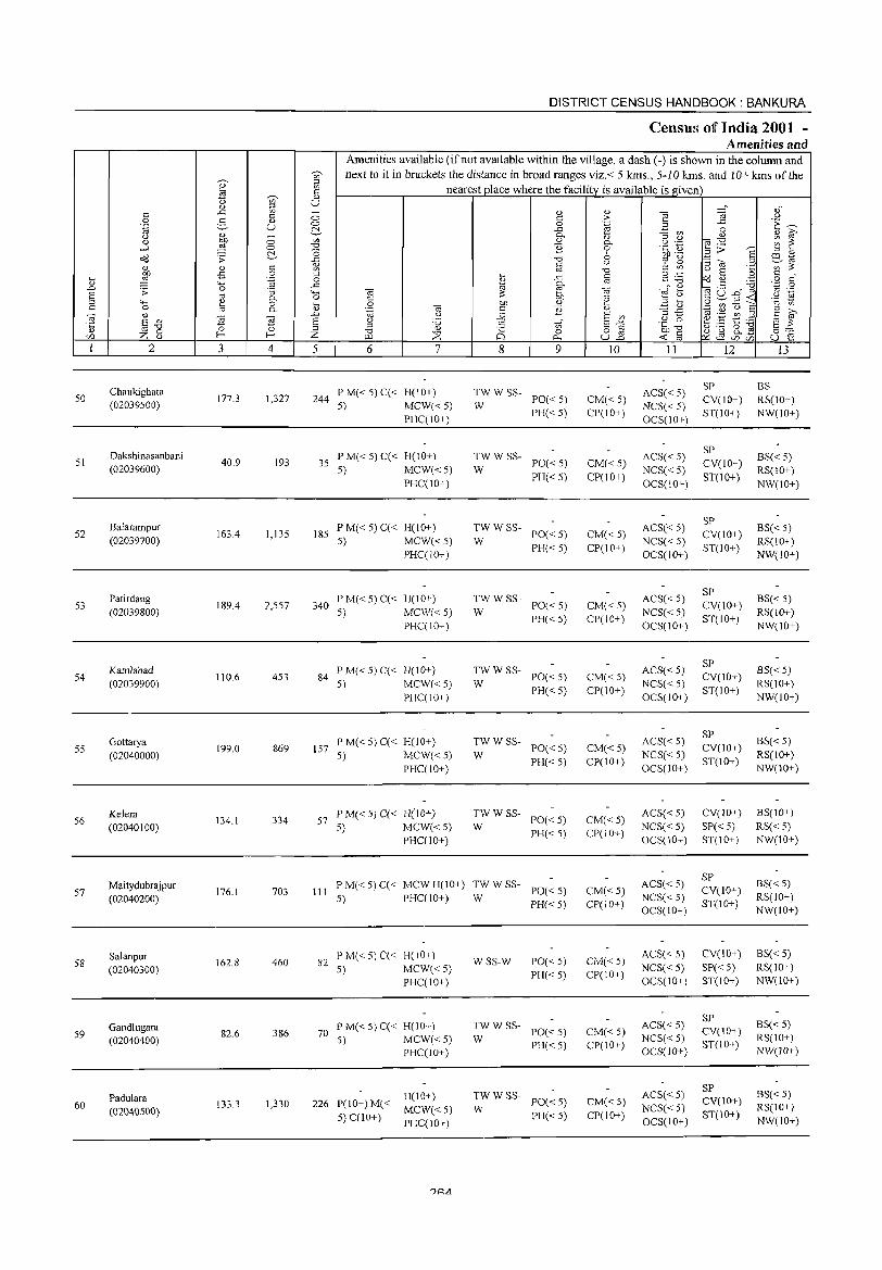
50
51
52
53
54
55
56
57
58
59
60
2
Chaukighata (02039500)
Dakshinasanbani (02039600)
Balarampur (02039700)
Patirdang (02039800}
Kamlabad (02039900)
Gottarya (02040000)
Kelera (02040100)
Maitydubrajpur (02040200)
Salanpur (02040300)
Gandlugara (02040400)
Padulara (02040500)
3
177.3
40.9
163.4
189.4
110.6
199.0
134.1
176.1
162.8
82.6
133.3
'" o .-g :; 0. o 0.
~ r-4
1,327
193
1,135
2,557
453
869
334
703
460
386
1,330
DISTRICT CENSUS HANDBOOK: BANKURA
Census of India 2001 -Amenities and
Amenities available (if not available within the village, a dash ( -) is shown in the column and next to it in brackets the distance in broad ranges viz.< 5 krns., 5-10 kms. and 10+ krns of the
nearest place where the facility is available is given
5 6 7
244 PM«5)C« H(IO+) 5) MCW«5)
PHC(IO+)
35 PM«5)C« H(I0+) 5) MCW«5)
PHC(IO+)
185 PM«5)C« H(IO+) 5) MCW«5)
PHC(lO+)
340 PM«5)C« H(IO+) 5) MCW«5)
PHC(IO+)
84 P M« 5) C« H(lO+) 5) MCW«5)
PHC(IO+)
157 P M« 5) C« H(10+) 5) MCW«5)
PHC(10+)
57 P M« 5) C« H(lO+) 5) MCW«5)
PHC(lO+)
8 9
:WWSS- PO«5)
PH« 5)
:W W SS- POC< 5)
PH«5)
;;: W SS- PO« 5)
PH«5)
;; W SS- PO« 5)
PH«5)
:W W SS- PO« 5)
PH«5)
TWWSS-W PO« 5)
PH«5)
:W W SS- PO« 5)
PH«5)
III P M« 5) C« MCW H(IO+) :W W SS- PO« 5) 5) PHC(IO+) PH« 5)
82 PM«5)C« H(IO+) 5) MCW«5)
PHC(IO+)
70 P M« 5) C« H(IO+) 5) MCW«5)
PHC(lO+)
226 P(IO+)M« 5) C(IO+)
H(IO+)
MCW«5) PHC(lO+)
WSS-W PO« 5) PH« 5)
TWW SS-W PO« 5)
PH«5)
TW W SS- PO« 5)
W PH«5)
10
CM«5) CP(IO+)
CM«5) CP(lO+)
CM«5) CP(IO+)
CM«5) CP(IO+)
CM«5) CP(IO+)
CM« 5) CP(lO+)
CM«5) CP(IO+)
CM«5) CP(lO+)
CM« 5) CP(lO+)
CM« 5) CP(IO+)
CM« 5)
CP(IO+)
11
ACS« 5) NCS« 5) OCS(IO+)
ACS« 5) NCS« 5) OCS(10+)
ACS« 5) NCS« 5) OCS(IO+)
ACS« 5) NCS« 5) OCS(IO+}
ACS« 5) NCS« 5) OCS(lO+)
ACS« 5) NCS« 5) OCS(lO+)
ACS« 5) NCS« 5) OCS(IO+)
ACS« 5) NCS« 5) OCS(IO+)
ACS« 5) NCS« 5) OCS(IO+)
ACS« 5) NCS« 5) OCS(lO+)
ACS« 5) NCS« 5) OCS(IO+)
12
SP CV(IO+) ST(IO+)
SP CV(10+) ST(JO+)
SP CV(IO+) ST(IO+)
SP CV(10+) ST(IO+)
SP CV(lO+) ST(IO+)
SP CV(lO+) ST(10+)
CV(IO+)
SP« 5) ST(IO+)
SP CV(IO+) ST(IO+)
CV(IO+) SP« 5) ST(lO+)
SP CV(IO+) ST(IO+)
SP CV(IO+) ST(lO+)
13
8S RS(lO+) NW(IO+)
8S« 5) RS(IO+) NW(10+)
8S« 5) RS(IO+) NW(lO+)
8S« 5) RS(IO+) NW(IO+)
8S« 5) RS(IO+) NW(10+)
8S« 5) RS(lO+) NW(IO+)
8S(IO+) RS« 5) NW(10+)
8S« 5) RS(IO+) NW(IO+)
8S« 5) RS(IO+) NW(lO+)
8S« 5) RS(IO+) NW(JO+)
8S« 5) RS(lO+) NW(IO+)

VILLAGE DIRECTORY
Village Directory Land Use (As on 1999)
E-d) <J
ta 0.> t;:; on :0 2l dd .;;:
~ .8 "" .8 u
OJ t;:; [ '" ta~ 0. '" E ...: z"" 14 15
PRMR Bankura (11 )
MR Bankura (II)
PR MR Bankura (II)
PR MR Bankura (II)
MR Bankura (11)
MR Bankura (11)
MR Bankura (II )
MR Bankura (11)
MR Bankura (11 )
MR Bankura (II )
MR Bankura (11 )
0.>
" '1;1 OJ)
'" » :::s 0. -;:;
(1) 0. fir '" '" 0. ~
'" ~ 3 0 0.>
0... Z 16 17
ED EO NM
ED NM
N
ED N
ED
ED NM
ED NM
ED NM
.£' "" 0 E E 0 u
§ "" ~ d)
8.2 §& t;:; '" § 0 :::s E
18
Land use (i.e. area under different types of land use in hectare)
19 20
TK(24.8) T(24.8)
TK(19.2) T(19.2)
TK(19.2) T(19.2)
TK(5.7) T(5.7)
TK(30.4) T(30.4)
TK(10.3) T(IO.3)
20 TK(16.4) · T(16.4)
239 TK(20.0) · T(200)
20 TK(1O.2) · T(10.2)
TK(20.2) T(20.2)
II 3 TK(34.7) · T(34.7)
?R&;
21 22
84.1
10.4
114.3
154.0
56.5
131.6
60.1
14.9
115.3
15.4
40.3
23 2
11.7 56.7 Chaukighata
2.6 S.S Dakshinasanbani
IS.2 11.6 Balarampur
20.3 9.4 Patirdang
20.3 3.4 Kamlabad
19.9 37.1 Gottarya
20.3 35.3 Kelera
17.0 100.3 Maitydubrajpur
16.2 19.2 Salanpur
4.1 43.0 Gandlugara
16.2 30.S Padulara
50
51
52
53
54
55
56
57
58
59
60
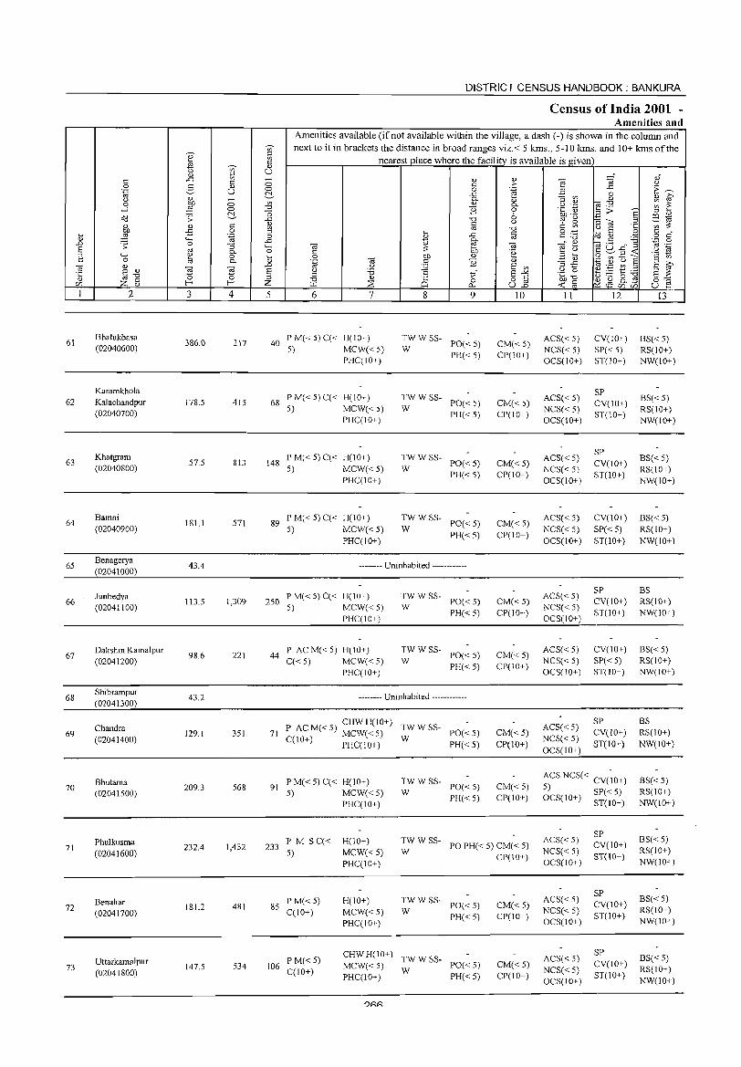
6\
62
63
64
65
66
67
68
69
70
71
72
73
2
Bhalukbasa (02040600)
Karamkhola Kalachandpur (02040700)
Khatgram (02040800)
Bamni (02040900)
Benagerya (02041000)
Iunbedya (02041100)
Dakshin Kamalpur (02041200)
Shibrampur (02041300)
Chandra (02041400)
8hutama (02041500)
Phulkusma (02041600)
Benahar (02041700)
Uttarkamalpur (02041800)
3 4
386.0 217
178.5 415
57.5 813
\81.1 571
43.4
113.5 1,309
98.6 221
43.2
129.1 351
209.3 568
232.4 1,432
181.2 481
147.5 534
DISTRICT CENSUS HANDBOOK: BANKURA
Census of India 2001 -Amenities and
Amenities available (if not available within the village, a dash (-) is shown in the column and next to it in brackets the distance in broad ranges viz.< 5 lans., 5-10 lans. and 10+ lans of the
nearest place where the facility is available is given
5 6 7
40 P M« 5) C« H(IO+) 5) MCW« 5)
PHC(IO+)
68 PM«5)C« H(!O+) 5) MCW« 5)
PHC(IO+)
148 PM«5)C«H(lO+) 5) MCW« 5)
PHC(IO+)
89 PM«5)C«H(10+) 5) MCW« 5)
PHC(IO+)
8 9
TWW SS-PO«5) PH« 5)
W
TWW SS-PO«5) PH« 5)
W
~W W SS- PO« 5)
PH«5)
TWW SS-PO«5) PH«5)
W
-------- Uninhabited ------------
250 PM«5)C« H(10+) 5) MCW« 5)
PHC(IO+)
44 P AC M« 5) H(10+) C« 5) MCW« 5)
PHC(IO+)
:W W SS- PO« 5)
PH«5)
~W W SS- PO« 5)
PH«5)
-------- Uninhabited ------------
P AC M« 5) CHW H(10+) TW W SS-71 C( 0 ) MCW« 5) W PO« 5)
1 + PHC(IO+) PH« 5)
91 PM«5)C« H(IO+) 5) MCW« 5)
PHC(IO+)
~W W SS- PO« 5)
PH«5)
10
CM« 5) CP(IO+)
CM« 5) CP(IO+)
CM« 5) CP(lO+)
CM« 5) CP(IO+)
CM« 5) CP(10+)
CM« 5) CP(IO+)
CM«5) CP(JO+)
CM« 5) CP(IO+)
233 PM S C« 5)
H(10+)
MCW« 5) PHC(10+)
:; W SS- PO PH« 5) CM« 5)
CP(IO+)
85 P M« 5) C(10+)
106 P M« 5) C(IO+)
H(IO+)
MCW« 5) PHC(IO+)
:; W SS- PO« 5)
PH«5)
CHW H(IO+) TW W SS-MCW« 5) W PO« 5) PHC(IO+) PH« 5)
?RR
CM« 5) CP(IO+)
CM« 5) CP(IO+)
II
ACS« 5) NCS« 5) OCS(IO+)
ACS« 5) NCS« 5) OCS(\O+)
ACS« 5) NCS« 5) OCS(IO+)
ACS« 5) NCS« 5) OCS(IO+)
ACS« 5) NCS« 5) OCS(IO+)
ACS« 5) NCS« 5) OCS(IO+)
ACS« 5) NCS« 5) OCS(IO+)
12
CV(IO+) SP«5) ST(10+)
SP CV(IO+) ST(IO+)
SP CV(IO+) ST(10+)
CV(IO+)
SP«5) ST(10+)
SP CV(IO+) ST(10+)
CV(IO+)
SP«5) ST(lO+)
SP CV(IO+)
ST(lO+)
ACS NCS« CV(~O+) 5) SP« 5) OCS(IO+) ST(IO+)
ACS« 5) NCS« 5) OCS(lO+)
ACS« 5) NCS« 5) OCS(IO+)
ACS« 5) NCS«5) OCS(10+)
SP CV(IO+) ST(IO+)
SP CV(IO+) ST(IO+)
SP CV(IO+) ST(lO+)
13
BS«5) RS(\O+) NW(IO+)
BS«5) RS(lO+) NW(lO+)
BS«5) RS(10+) NW(10+)
BS« 5) RS(IO+) NW(IO+)
BS RS(IO+) NW(IO+)
BS«5) RS(IO+) NW(IO+)
BS RS(IO+) NW(IO+)
8S«5) RS(IO+) NW(IO+)
8S«5) RS(IO+) NW(10+)
BS«5) RS(IO+) NW(IO+)
BS«5) RS(lO+) NW(IO+)
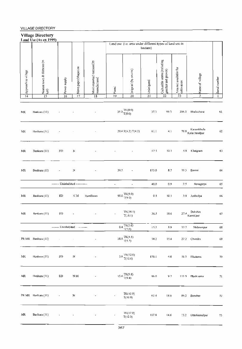
VILLAGE DIRECTORY
Village Directory Land Use (As on 1999)
14 15
MR Bankura (11)
MR Bankura (11 )
MR Bankura (11 )
MR Bankura (11)
16 17
ED N
N
-------- Uninhabited ------------
18
MR Bankura (11) ED NM Handloom
MR Bankura (11) ED
-------- Uninhabited ------------
PRMR Bankura (11)
MR Bankura (11 ) ED N
MR Bankura (11) ED NM
PR MR Bankura (11) N
MR Bankura (11)
Land use (i.e. area under different types of land use in hectare)
19 20
350 TK(8.0) · T(S.O)
30.4 R(4.2) T(4.2)
30.2
900 TK(9.0) · T(9.0)
TK(161) T(16.1)
04 TK(50) · T(5.0)
288 TK(4.5) · T(4.5)
39 TK(12.0) · T(12.0)
154 TK(9.8) · T(9.8)
TK(109) T(10.9)
TK(12.0) T(120)
?R7
-a 0)
1<> 00
"E ·2 ::;J
21
37.3
61 I
42.5
123.0
40.0
0.5
36.5
15.2
58.2
170.1
86.0
62.4
107.8
00 c 'is '" -0 ~ g '" 0)
2 >-~ e
00 ~ -a '" <=
j OJ @
..c <.)
:; ;::l
"" U bll
22
99.3
4.1
10.1
8.7
0.9
10.1
18.6
8.9
15.4
4.0
9.7
18.6
14.6
..8 OJ
~ Q) bl)
:a ,g 8 .;;:
<=
" 0 ""' .~ 0 s:::
.2: Q) OJ § OJ -3 ~ <.) Z 23 2
206.3 Bhalukbasa
78.8 Karamkhola Kalachandpur
4.9 Khatgram
19.3 Bamni
2.5 Benagerya
3.9 Junbedya
27.4 Dakshin Kamalpur
13.7 Shibrampur
22.2 Chandra
193 Bhutama
111.5 Phulkusma
89.3 Benahar
13.2 Uttarkamalpur
~ Q)
..0 E ;::l c:
~ " C/J
1
61
62
63
64
65
66
67
68
69
70
71
72
73
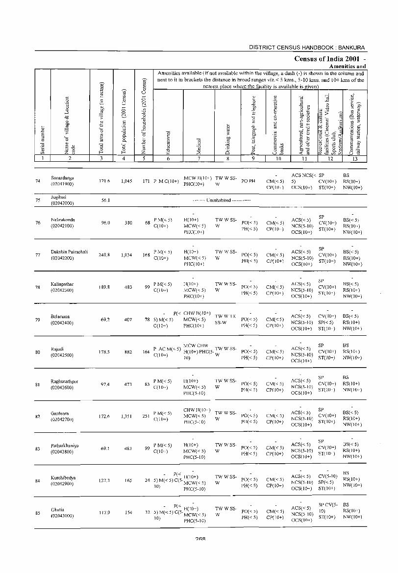
74
75
76
77
78
79
80
81
82
83
84
85
2
Sonardanga (02041900)
Jugibad (02042000)
Nekrakonda (02042100)
Dakshin Pairachali (02042200)
Kaliapathar (02042300)
Belaruma (02042400)
Rajudi (02042500)
Raghunathpur (02042600)
Garduara (02042700)
Patharkhuniya (02042800)
Kurchibedya (02042900)
Ghutia (02043000)
3
171.6
56.1
96.0
240.8
189.8
69.2
178.5
97.4
172.6
69.1
127.3
117.9
'" o '.g "3 0.. o 0..
~ 4
1,045
380
1,034
483
407
882
473
1,351
483
165
154
DISTRICT CENSUS HANDBOOK: BANKURA
Census of India 2001 -Amenities and
Amenities available (if not available within the village, a dash (-) is shown in the column and next to it in brackets the distance in broad ranges viz.< 5 krns., 5-10 klns. and 10+ krns of the
nearest place where the facility is available is given
5 6 7 8
'" c o
..c a. '" B
"D @
..c g-Ob '" B
9
171 P MC(IO) MCWH(IO+) TWWSS- POPH + PHC(IO+) W
-------- Uninhabited ------------
68 P M« 5) C(10+)
168 PM«5) C(10+)
99 PM«5) C(10+)
H(IO+)
MCW« 5) PHC(lO+)
H(10+)
MCW« 5) PHC(10+)
H(lO+) MCW« 5) PHC(10+)
~WWSS- PO«5)
PH« 5)
~W W SS- PO« 5)
PH« 5)
:: W SS- PO« 5)
PH« 5)
P« CHW H(lO+) TW W TK 78 5) M« 5) MCW« 5) SS-W PO« 5)
C(IO+) PHC(IO+) PH« 5)
MCWCHW 164 P AC M« 5) H(10+) PHC(5- TW W SS- PO« 5)
C(lO+) 10) W PH« 5)
83 PM«5) C(IO+)
H(IO+) MCW« 5) PHC(5-10)
TW W SS- PO« 5)
W PH« 5)
251 P M« 5) C(10+)
CHW H( 1 0+) TW W SS-MCW« 5) W PO« 5) PHC(5-10) PH«5)
99 PM« 5) C(10+)
H(IO+) MCW« 5) PHC(5-10)
- P« H(IO+) 24 5) M« 5) C(5· MCW« 5)
10) PHC(5-10)
- P« H(10+) 32 5) M« 5) C(5· MCW« 5)
10) PHC(5-10)
?RA
~W W SS- PO« 5)
PH« 5)
TW W SS- PO« 5)
W PH« 5)
:W W SS- PO« 5)
PH« 5)
10
CM«5) CP(IO+)
CM«5) CP(IO+)
CM«5) CP(IO+)
CM«5) CP(IO+)
CM«5) CP(IO+)
CM« 5) Cpr 10+)
CM«5) CP(IO+)
CM« 5) CP(IO+)
CM« 5) CP(IO+)
CM« 5) CP(10+)
CM« 5) CP(JO+)
11 12
ACSNCS« SP 5) CV(lO+) OCS(lO+) ST(IO+)
ACS« 5) SP NCS(5-10) CV(IO+) OCS(1 0+) ST( 10+ )
ACS« 5) SP NCS(5-10) CV(10+) OCS( 1 0+ ) ST( 10+ )
ACS« 5) SP NCS(5-1O) CV(10+) OCS(lO+) ST(IO+)
ACS« 5) CV(IO+) NCS(5-10) SP« 5) OCS(lO+) ST(10+)
SP ACS«5) NCS(5-10) CV(ID+) OCS(IO+) ST(IO+)
ACS« 5) SP NCS(5-1O) CV(IO+) OCS(l 0+) ST( 1 0+ )
ACS«5) SP NCS(5-10) CV(IO+) OCS(IO+) ST(lO+)
SP ACS« 5) NCS(5-10) eV(lO+) OCS(10+) ST(IO+)
13
BS RS(IO+) NW(IO+)
BS«5) RS(IO+) NW(IO+)
BS«5) RS(10+) NW(10+)
BS« 5) RS(IO+) NW(lO+)
BS«5) RS(10+) NW(IO+)
BS RS(IO+) NW(\o+)
BS RS(IO+) NW(IO+)
BS« 5) RS(10+) NW(10+)
BS«5) RS(IO+) NW(ID+)
ACS« 5) NCS(5-10) OCS(10+)
BS eV(5-10) RS(IO+) SP«5) ST(10+) NW(IO+)
SPCV(5- BS ACS« 5) 10) RS(IO+) NCS(5-10) ST(IO+) NW(IO+) OCS(IO+)
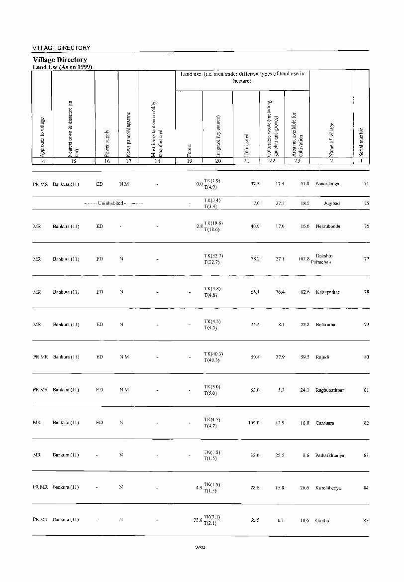
VILLAGE DIRECTORY
Village Directory Land Use (As on 1999)
14 15
PR MR Bankura (II)
16 17
ED NM
-------- Uninhabited ------------
MR Bankura ( II ) ED
MR Bankura ( 11 ) ED N
MR Bankura (11) ED N
MR Bankura (11 ) ED N
PR MR Bankura (II) ED NM
PR MR Bankura (11 ) ED NM
MR Bankura (11) ED N
MR Bankura (11) N
PR MR Bankura (11 ) N
PR MR Bankura (11) N
18
Land use (i.e. area under different types ofland use in hectare)
19 20
00 TK(4 9) · T(4.9)
TK(3A) T(3.4)
28 TK(18.6) · T(18.6)
TK(327) T(327)
TK(4.8) T(4.8)
TK(4.5) T(4.S)
TK(40.3) T(40.3)
TK(5.0) T(S.O)
TK(47) T(4.7)
TK(J.5) T(J.5)
49 TK(1.5) · T(J.5)
336 TK(2.1) · T(2.1)
?RQ
21 22
97.S
7.0
40.9
78.2
66.1
34.4
50.8
63.0
109.0
38.6
78.6
65.5
17.4
27.3
17.0
27.1
36.4
8.1
27.9
5.3
42.9
25.5
15.8
6.1
23 2
S1.8 Sonardanga
18.5 Jugibad
16.6 Nekrakonda
102 8 Dakshin . Pairachali
82.6 Kaliapathar
22.2 Belaruma
59.5 Rajudi
24.1 Raghunathpur
16.0 Garduara
3.6 Patharkhuniya
26.6 Kurchibedya
10.6 Ghutia
74
75
76
77
78
79
80
81
82
83
84
85
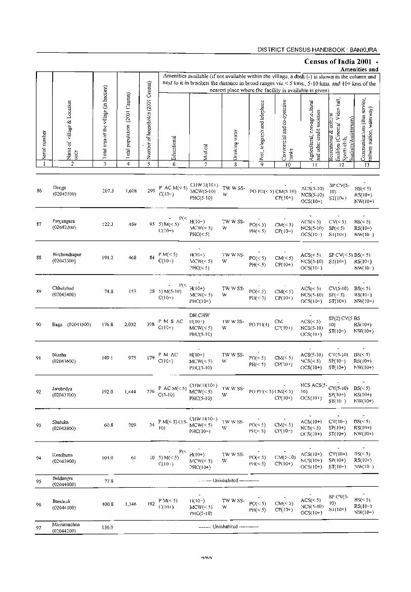
86
87
88
89
90
91
92
93
94
95
96
97
2
Oanga (02043100)
Panjangara (02043200)
Birchandrapur (02043300)
Chhelebad (02043400)
Baga (02043S00)
Niasha (02043600)
Jambedya (02043700)
Shaluka (02043800)
Kendbana (02043900)
Beldangra (02044000)
Bandeuli (02044100)
Mayumachna (02044200)
3
207.3
122.3
191.2
74.8
176.8
149.1
192.0
60.8
104.0
77.8
400.8
136.9
s:: o .~
"3 0. o 0.
-a ~ 4
1,608
469
468
153
2,OS2
975
1,444
209
61
1,146
DISTRICT CENSUS HANDBOOK: BANKURA
Census of India 2001 -Amenities and
Amenities available Cifnot available within the village, a dash C-) is shown in the column and next to it in brackets the distance in broad ranges viz.< 5 kms., 5-10 kms. and 10+ kms of the
nearest place where the facility is available is given)
5 6 7 8 9 10 11 12 13
P ACM«S) CHWH(lO+) TWWSS- ACS(S-IO) 299 C(lO+) MCW(S-IO) W PO PH« 5) CM(5-10)
SP CV(5- BS« S) 10)
PHC(5-1O) CP(IO+) NCS(S-IO) OCS(IO+)
ST( 10+ ) RS( 10+ ) NW(IO+)
P« 95 5)M«5) H(IO+)
C(10+) MCW« 5) PHC«5)
84 P M« 5) C(10+)
H(IO+)
MCW«5) PHC«5)
- P« -28 5)M(5-10) H(IO+)
C(IO+) MCW« 5) PHC(IO+)
~W W SS- PO« 5)
PH« 5)
;;: W SS- PO« 5)
PH« 5)
~W W SS- PO« 5)
PH« 5)
CM« 5) CP(IO+)
CM«5) CP(lO+)
CM«5) CP(IO+)
398 P M S AC C(IO+)
OHCHW H(lO+)
MCW« 5) PHC(5-10)
TWWSS- CM W POPH(4) CP(10+)
179 PM AC C(10+)
H(IO+)
MCW« 5) PHC(5-10)
~WWSS- PO«S)
PH« 5)
CM« 5) CP(10+)
P ACM«S) CHWH(IO+) TWWSS-276 C(5-10) MCW« 5) W PO PH« 5) CM« 5)
PHC(5-10) CP(IO+)
P M« 5) C(5- CHW H(IO+) TW W SS-34 10) MCW« 5) W PO« 5)
PHC(IO+) PH« 5) CM«5) CP(IO+)
ACS« 5) CV« 5) NCS(S-IO) SP« S) OCS(IO+) ST(10+)
BS«5) RS(lO+) NW(IO+)
ACS« 5) SP CV« 5) BS« 5) NeS(5-10) ST(IO+) RS(IO+) OCS(IO+) NW(IO+)
ACS« 5) CV(5-10) BS« 5) NCS(5-10) SP« 5) RS(IO+) OCS(10+) ST(10+) NW(IO+)
ACS« 5) SP(2) CV(5 BS 10) RS(10+)
NCS(5-10) ST(IO+) NW(IO+) OCS(IO+)
ACS(5-10) CV(S-IO) BS« S) NCS« 5) SP(IO+) RS(IO+) OCS(10+) ST(IO+) NW(IO+)
NCS ACS(5- CV(;-IO) 10) OCS(IO+) SP(lO+)
ACS(10+) NCS«S) OCS(IO+)
ST(lO+)
CV(IO+) SP(IO+) ST(lO+)
BS«S) RS(IO+) NW(IO+)
BS«5) RS(10+) NW(JO+)
10 P« H(IO+) 5) M« 5) MCW« 5) C(lO+)
PHC(IO+)
TW WSS-W PO« 5)
PH« 5)
CM(5-10) ACS(IO+) CP(10+) NCS(IO+)
OCS(10+)
CV(IO+) SP(10+) ST(IO+)
BS«S) RS(IO+) NW(IO+)
192 P M« 5) C(IO+)
-------- Uninhabited ------------
H(lO+)
MCW«5) PHC(5-10)
~WWSS- PO«5)
PH« 5)
-------- Uninhabited ------------
CM« 5) CP(lO+)
ACS« 5) NCS(5-10) OCS(10+)
SP CV(5- BS« 5) 10) ST(IO+) RS(IO+)
NW(JO+)
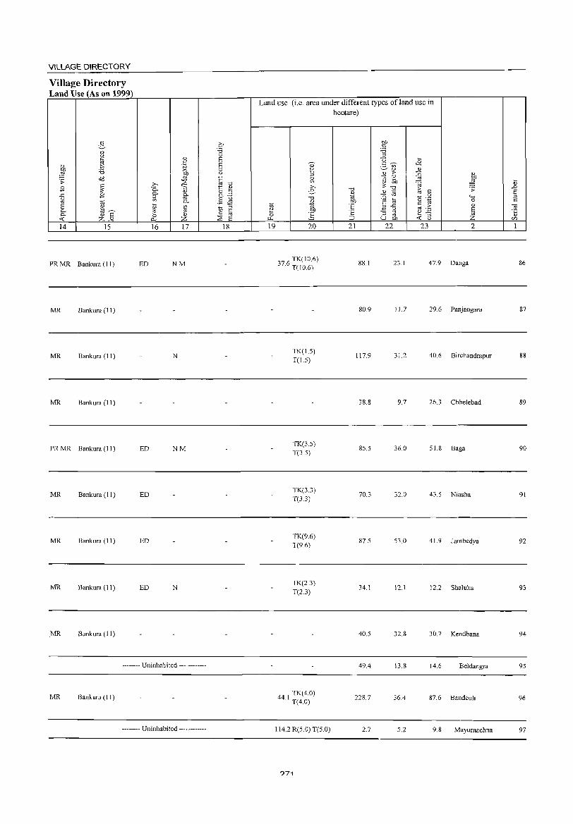
VILLAGE DIRECTORY
Village Directory Land Use (As on 1999)
14 15
PR MR Bankura (II)
MR Bankura (11)
MR Bankura (11)
MR Bankura (I I)
PRMR Bankura(ll)
Bankura (II)
MR Bankura (II)
MR Bankura (11)
MR Bankura (II)
16 17
ED NM
N
ED NM
ED
ED
ED N
-------- Uninhabited ------------
MR Bankura (1 I)
-------- Uninhabited ----.-------
18
Land use (i.e. area under different types of land use in hectare)
e 0
1'4
19
., 2 '" ~ >-. e
"0
~ b1J
g 20
3 6 TK(lO 6) 7. T(IO 6)
TK(LS) T(LS)
TK(3.5) T(3.5)
TK(3.3) T(3.3)
TK(9.6) T(9.6)
TK(2.3) T(2.3)
TK(4.0) 44.1 T(4.0)
114.2 R(S.O) T(S.O)
?71
"0 ... '" b1J ·E .s=: ;=J
21
881
80.9
117.9
38.8
85.5
70.3
87.5
34.1
40.S
49.4
228.7
2.7
b1J C :.a '" u § ~ U)
Cl)
~ > 2
;;, b1J "0
Cl) c: ::0 '" e a .3 .<:
<..> ::; ::I
'" U b1J
22
23.1
11.7
31.2
9.7
36.0
32.0
S3.0
12.1
32.8
13.8
36.4
S.2
... <B ... ::0 Cl)
~ b1J
'@ ~ 1;; .s;: c: 0
0
"" c: "-g 0
co .2: Cl)
8 ~ '3 ~ <..>
23 2
47.9 Danga
29.6 Panjangara
40.6 Birchandrapur
26.3 Chhelebad
51.8 Baga
43.5 Niasha
41.9 Jambedya
12.2 Shaluka
30.7 Kendbana
14.6 Beldangra
87.6 Bandeuli
9.8 Mayurnachna
:u .D 8 '" c:
OJ ·c Cl)
VJ
1
86
87
88
89
90
91
92
93
94
95
96
97
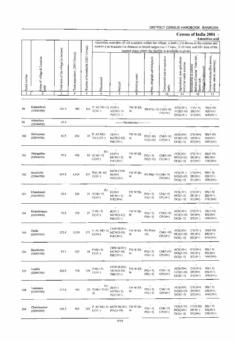
98
99
100
101
102
103
104
105
106
107
108
109
2
Kadamdeuli (02044300)
Bisharbera (02044400)
Nadusenara (02044500)
Hetyapathar (02044600)
Banshidihi (02044700)
Kharakanal i (02044800)
Nishchintapur (02044900)
liarda (02045000)
Banshketya (02045100)
Erodihi (02045200)
Tunamara (02045300)
Chakaltasahar (02045400)
3 4
202.5 880
47.4
81.9 206
97.4 448
193.8 1,414
36.4 180
50.8 170
222.4 1,039
93.3 354
126.9 728
115.6 164
136.5 460
DISTRICT CENSUS HANDBOOK: BANKURA
Census of India 2001 -Amenities and
Amenities available (if not available within the village, a dash (-) is shown in the column and next to it in brackets the distance in broad ranges viz.< 5 kms., 5-10 killS. and 10+ kms of the
nearest place where the facility is available is given
5 6 7 8
'" c o
..c P..
'" E -0 §
..c
~ 01) <U
E
9 10 11 12
162 P AC M« 5) H(IO+) TWWSS- ACS(lO+) CV«5) W PH PO« 5) CM(5- to) NCS(5-IO) SP(IO+) C(lO+) MCW« 5)
PHC(IO+)
-------- Uninhabited ------------
35 PAC M(5-10) C(!O+)
H(!O+) MCW(S-IO) PHC(IO+)
- P« -83 5) M« 5) H(lO+)
C(10+) MCW«5) PHC(lO+)
:W W SS- PO(5-10)
PH(S-IO)
;;: W SS- PO« 5)
PH(5-10)
CP(lO+) OCS(lO+) ST(IO+)
CM(5-10) ACS(IO+) CV(IO+) CP(IO+) NCS(5-10) SP(lO+)
OCS« 5) ST(lO+)
CM(5-10) ACS(lO+) CV(IO+) CP(10+) NCS(5-1O) SP(IO+)
OCS« 5) ST(lO+)
MCWCHW 242 P(2) M AC H(IO+)
C(IO+) PHC(lO+) :W W SS- PO PH« 5) CM« 5)
CP(IO+)
ACS(IO+) CV(IO+) NCS(5-1O) SP(IO+) OCS« 5) ST(IO+)
- P« -31 5) M« 5) H(!o+)
C(1O+) MCW« 5) PHC(IO+)
27 P M« 5) C(1O+)
H(IO+) MCW(S-IO) PHC(IO+)
:W W SS- PO« 5)
PH«5)
:W W SS- PO« 5)
PH«5)
CM«5) CP(IO+)
ACS(IO+) NCS« 5) OCS« 5)
CV(10+) SP(IO+) ST(IO+)
ACS(IO+) CV(IO+) CM(5-10) NCS(5-10) SP(10+) CP(IO+) OCS« 5) ST(IO+)
P AC M« 5) CHW H(IO+) TW W SS- PO PH(5- ACS(IO+) 171 C(lO+) MCW(S-IO) W 10) CM(5-10) NCS(5-1O)
CV(IO+) SP(lO+) ST(10+) PHC(lO+) CP(IO+) OCS« 5)
56 PM« 5) C(JO+)
126 P M« 5) C(IO+)
CHW H(IO+) TW W SS-MCW(5-10) W PO« 5) PHC(IO+) PH« 5)
CHWH(10+) TWWSS-MCW(5-10) W PO« 5) PHC(lO+) PH« 5)
- P« H(IO+) 23 5) M« 5) C« MCW« 5)
:W W SS- PO« 5)
PH«5) 5) PHC(10+)
ACS(IO+) CV(lO+) CM(5-10) NCS(5-10) SP(IO+) CP(IO+) OCS« 5) ST(JO+)
CM«5) CP(IO+)
CM«5) CP(lO+)
ACS(IO+) CV(JO+) NCS(5-1O) SP(10+) OCS« 5) ST(JO+)
ACS(lO+) CV(IO+) NCS(5-10) SP(10+) OCS« 5) ST(IO+)
13
BS(5-10) RS(lO+) NW(IO+)
BS(5-1O) RS(IO+) NW(IO+)
BS(5-10) RS(IO+) NW(lO+)
BS« 5) RS(lO+) NW(lO+)
BS« 5) RS(IO+) NW(lO+)
BS(5-10) RS(IO+) NW(IO+)
BS(5-1O) RS(lO+) NW(lO+)
BS« 5) RS(IO+) NW(IO+)
BS« 5) RS(IO+) NW(IO+)
BS« 5) RS(lO+) NW(IO+)
lOS P AC M« 5) MCW H(IO+) :W W SS- PO« 5) CM«5) CP(JO+)
ACS(5-10) CV(S-IO) ES« 5)
C(IO+) PHC(5-10) PH« 5) NCS(10+) SP(IO+) RS(IO+) OCS« 5) ST(10+) NW(lO+)
?7?
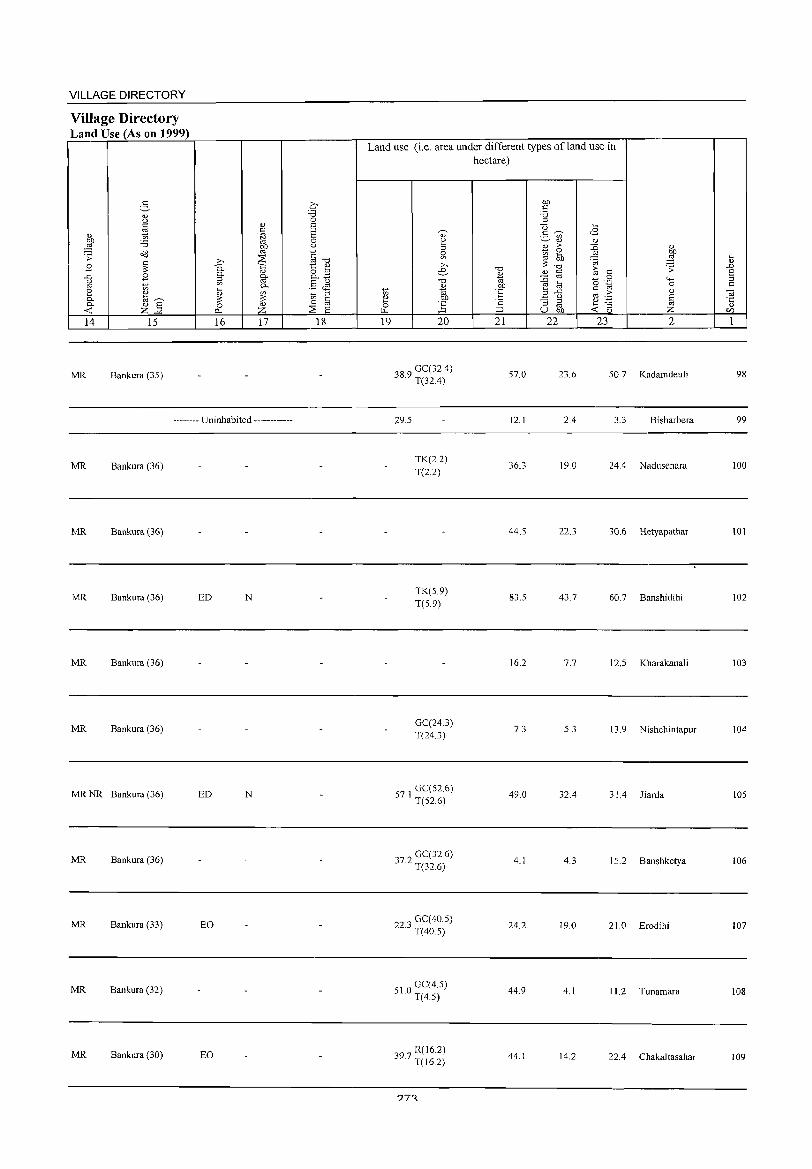
VILLAGE DIRECTORY
Village Directory Land Use (As on 1999)
5 <1) u C
'" " 1;; 01}
'i3 ::§ <>d .;: ~ E
..<:: E g e '" <l)
0. @~ 0. <l) E
-<C Z-" 14 15
MR Bankura (35)
'" .~ OJ)
'" ..0 ~ 0. i:i 0. g. ::;l
'" "'-
~ '" ~ 0..
16 17
-------- Uninhabited ------------
MR Bankura (36)
MR Bankura (36)
MR Bankura (36) ED N
MR Bankura (36)
MR Bankura (36)
MR NR Bankura (36) ED N
MR Bankura (36)
MR Bankura (33) EO
MR Bankura (32)
MR Bankura (30) EO
0 'i3 0 6 6 0 u
~"'CI 1:: <l)
8.3 .§ JS 1;; ::;l
0 C
:2 oj
E 18
Land use (i.e. area under different types ofland use in hectare)
19 20
38 9 GC(32.4) · T(32.4)
29.5
TK(2.2) T(2.2)
TK(5.9) T(S.9)
GC(24.3) T(24.3)
57 1 GC(52.6) · T(S2.6)
372 GC(32.6) · T(32.6)
22 3 GC( 40.5) · T(40.5)
510 GC(4.5) · T(4.5)
"97 R(16.2) ~ . T(16.2)
?7~
"0
%l °E ';: ::J 21
57.0
12.1
36.3
44.5
83.5
\6.2
7.3
49.0
4.1
24.2
44.9
44.1
OJ} c 'i3 ;:l
U ~ 2- '" <l)
B ;>
~ ~ "0 <1) §
::0 E @
..c ;:l u '§ ::;l oj
U OJ}
22
23.6
2.4
19.0
22.3
43.7
7.7
5.3
32.4
4.3
19.0
4.1
14.2
08 <l)
~ " 9 '@
~ .;:
c 0
0 '<-< .~ 0 c
" '" of; § ~ "3
u Z 23 2
50.7 Kadamdeuli
3.3 Bisharbera
24.4 Nadusenara
30.6 Hetyapathar
60.7 Banshidihi
12.5 Kharakanali
13.9 Nishchintapur
31.4 Jiarda
\5.2 Banshketya
21.0 Erodihi
11.2 Tunamara
22.4 Chakaltasahar
.... " .D S ;:l c
'" -5 U)
1
98
99
100
10\
102
103
104
105
106
107
108
109
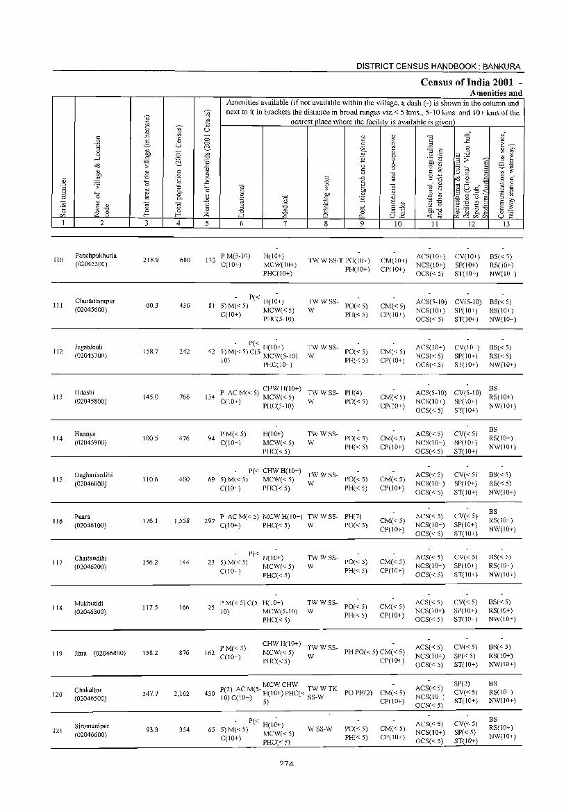
110
III
112
113
114
115
116
117
118
119
120
121
" S " ",-0
Z 8 2
Panchpukhuria (02045500)
Churamanipur (02045600)
Jagatdeuli (02045700)
Hitashi (02045800)
Hannya (02045900)
Oeghariardihi (02046000)
Puara (02046100)
Chaitandihi (02046200)
Mukhutidi (02046300)
Jirra (02046400)
Chakaltor (02046500)
Siromanipur (02046600)
3
218.9
60.3
158.7
14S.0
100.5
110.6
176.1
156.2
117.5
158.2
247.7
93.3
'" i;l c " U
o o ~ c o
'-g ""3 0-o 0-
~ 4
680
436
242
766
476
400
1,558
144
166
876
2,162
354
DISTRICT CENSUS HANDBOOK: BANKURA
Census of India 2001 -Amenities and
Amenities available (if not available within the village, a dash (-) is shown in the column and next to it in brackets the distance in broad ranges viz.< 5 krns., 5-10 krns. and 10+ kms of the
nearest place where the facility is available is given
5 6 7 8 9 10 11 12 13
133 PM(5-10) C(lO+)
H(IO+) MCW(10+) PHC(!O+)
TW W SS-T PO(lO+) PH(lO+)
CM(IO+) ACS(IO+) CP(10+) NCS(IO+)
OCS« 5)
CV(IO+) SP(lO+) ST(lO+)
BS« 5) RS(lO+) NW(IO+)
- P« -81 S)M«S) H(IO+)
MCW«S) C(1O+) PHC(5-10)
- P« H(I~+) 42 5) M«5) C(5' MCW(5_IO)
10) PHC(IO+)
;;' W SS- PO« 5)
PH« 5)
:W W SS- PO« 5)
PH« 5)
P AC M« 5) CHW H(IO+) TW W SS- PH(4) 134 C(IO+) MCW« S) W PO« 5)
PHC(5-1O)
94 PM«5) C(lO+)
H(IO+)
MCW«5) PHC«5)
:W W SS- PO« 5)
PH« 5)
P« CHWH(IO+) TWWSS-69 5) M« 5) MCW« 5) W PO« 5)
C(lO+) PHC«5) PH«5)
297 P AC M( < 5) MCW H( I 0+) WTW W SS- PH(7) C(IO+) PHC« 5) PO« 5)
- P« H(I~+) 23 5) M« 5) MCW« 5)
C(lO+) PHC« 5)
25 P M( < 5) C(5- H(!o+) 10) MCW(5-IO)
PHC« 5)
TW WSS-W PO« 5)
PH« 5)
:W W SS- PO« 5)
PH« 5)
CM«5) CP(lO+)
CM« 5) CP(IO+)
CM« 5) CP(lO+)
CM«5) CP(IO+)
CM« 5) CP(IO+)
CM«5) CP(lO+)
CM« 5) CP(lO+)
CM« 5) CP(IO+)
162 PM« 5) C(10+)
CHWH(IO+) TWWSS-MCW«5) W PHPO«5)CM«5) PHC«5) CP(10+)
P(2) AC M(5- MCW CHW TW W TK 430 10) C(IO+) H(IO+) PHC« ss-w PO PH(2) CM« 5)
5) CP(IO+)
- P« H(I~+) 65 5) M« 5) MCW« 5)
C(lO+) PHC«5)
?7.<1
WSS-W PO« 5) PH« 5)
CM« 5) CP(IO+)
ACS(S-IO) CV(S-IO) BS« 5) NCS(10+) SP(lO+) RS(IO+) OCS« 5) ST(!O+) NW(lO+)
ACS(IO+) NCS« 5) OCS« 5)
ACS(5-10) NCS(IO+)
OCS« 5)
ACS« 5) NCS(IO+) OCS« 5)
ACS«5) NCS(IO+)
OCS« 5)
ACS« 5) NCS(IO+)
OCS« 5)
ACS«5) NCS(IO+)
OCS« 5)
ACS« 5) NCS(lO+) OCS« 5)
ACS« 5) NCS(IO+)
OCS« 5)
ACS«5) NCS(IO+} OCS«5)
ACS« 5) NCS(IO+) OCS« 5)
CV(IO+) SP(IO+) ST(IO+)
BS« 5) RS«5) NW(IO+)
BS CV(5-IO) RS(IO+)
SP(IO+) NW(IO+) ST(lO+)
CV«5) SP(IO+) ST(lO+)
CV«5) SP(IO+) ST(IO+)
CV«5) SP(IO+) ST(IO+)
CV«5) SP(lO+) ST(IO+)
CV«5) SP(lO+) ST(IO+)
CV«5) SP« 5) ST(IO+)
SP(2) CV«5) ST(lO+)
CV«5) SP« 5) ST(JO+)
BS RS(IO+) NW(IO+)
BS« 5) RS« 5) NW(lO+)
BS RS(IO+) NW(IO+)
BS« 5) RS(IO+) NW(IO+)
BS« 5) RS(IO+) NW(lO+)
BS« 5) RS(IO+) NW(IO+)
BS RS(lO+) NW(IO+)
BS RS(!O+) NW(lO+)
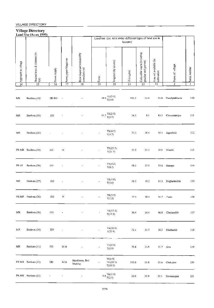
VILLAGE DIRECTORY
Village Directory Land Use (As on 1999)
3 <1.> u
~ ., OJ) 'B ~ .:; Cd
~ 2 ..c 2 g ~ 8 <1.> 0. tar--~ <1.> "' Z-'" 14 15
MR Bankura (19)
MR Bankura (30)
MR Bankura (34)
PRMR Bankura (30)
PRFP Bankura (26)
MR Bankura (27)
PRMR Bankura (26)
MR Bankura (26)
MR Bankura (24)
MR Bankura (1 J)
PRMR Bankura (11)
PRMR Bankura (II)
c 'B 0
<1.> a " .~ S 0
~ u
~ §~ >, 0. "i::; to: 0)
<1.> o 15 0- §-0. _
;:l §& '" 0-~ <1.> ~ ~ § ~ 0 0 <1.>
~ Z ~ a 16 17 18
ED EO
EO
ED N
ED
EO
EO N
ED
EO
ED NM
Handloom, Biri ED NM
Making
Land use (i.e. area under different types ofland use in hectare)
19 20
380 TK(3.4) · T(3.4)
11 7 TK(2.5) · T(2.5)
TK(4.7) T(4.7)
TK(25.7) T(25.7)
TK(4.2) T(4.2)
TK(4.6) T(4.6)
TK(5.5) T(5.5)
TK(17.5) T(l7.5)
TK(32.9) T(32.9)
TK(2.0) T(2.0)
W(0.5) TK(18.5) T(19.0)
08 TK(2.4) · T(2A)
?7t:;
-0 <1.> ~ OJ)
'E 'c ~
21
102.2
24.5
72.2
55.2
58.5
56.5
77.5
56.4
22.1
70.8
155.0
32.0
b1)
" 'B ;:l
<3 2- ~ '" <1.>
E ;>
~ ~ ~ -0 <1.> " :0 oj
e @
B .<:: u
-= ;:l
u oj b1)
22
32.4
8.1
36.4
24.3
12.1
18.2
38.5
36.4
24.3
33.6
21.0
25.9
~ <1.> :g <1.>
on ~ ~ 1;; .;;:
" "
0
""" .~ 0
" '.6 <1)
oj fj ~ -= Z u
23 2
42.8 Panchpukhuria
13.5 Churamanipur
45.4 Jagatdeuli
39.8 Hitashi
25.6 Hannya
31.3 Deghariardihi
54.7 Puara
46.0 Chaitandihi
38.2 Mukhutidi
51.7 Jirra
52.6 Chakaltor
32.2 Siromanipur
~ ..0 s ;:l c «l '5 c/)
1
110
III
112
113
114
115
116
117
118
119
120
121
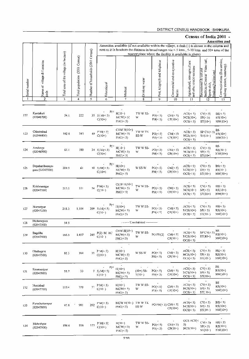
122
123
124
125
126
127
128
129
130
131
132
133
134
2
Kantakuli (02046700)
Chhatrabad (02046800)
Arndanga (02046900)
Depaharihannyagara (02047000)
Krishnanagar (02047100)
NiamatpuT (02047200)
Mohanepara (02047300)
Bagdiha (02047400)
Dhobagere (02047500)
Siromanipur (02047600)
Nuniabad (02047700)
Purushottampur (02047800)
Maheshpur (02047900)
3
54.1
102.8
61.1
209.5
215.1
218.3
54.5
166.5
86.3
55,7
119.4
92.8
198.6
o o ~
§ -~
-= 0-o 0-
] 4
222
283
180
61
331
1,104
1,457
164
33
320
981
936
DISTRICT CENSUS HANDBOOK: BANKURA
Census of India 2001 -Amenities and
Amenities available (ifnot available within the village, a dash (-) is shown in the column and next to it in brackets the distance in broad ranges viz.< 5 kms., 5-10 kms. and ]0+ kms of the
nearest place where the facility is available is given
5 6 7
P« H(10+) 35 5) M« 5) MCW« 5)
C(1O+) PHC«5)
8
'" o 0..
9
~W W SS- PO« 5)
PH« S)
49 PM«5) C(10+)
CHW H(10+) TW W TK MCW« S) SS-W PO« 5) PHC« 5) PH« 5)
- P« H(J~+) 34 5) M« 5) MCW« 5)
C(1 0+ ) PHC( < 5)
P« H(1O+) 10 5) M« 5) MCW« 5)
C(10+) PHC« 5)
:W W SS- PO« 5)
PH«5)
WSS-W PO«5) PH«5)
54 PM«5) C(10+)
CHW H(10+) TW W SS-MCW« 5) W PO« 5) PHC« 5) PH« 5)
209 P« H(10+)
5) M« 5) MCW« 5) ;;: W SS- PO« 5)
PH«5) C(10+) PHC« 5)
-------- Uninhabited ------------
10
CM«5) CP(10+)
CM«5) CP(10+)
CM«5) CP(10+)
CM«5) CP(lO+)
CM«5) CP(10+)
CM«5) CP(10+)
( C CHW H(10+) TWW SS-245 P 2) M A MCW« 5) PO PH(2) CM« 5)
C(10+) PHC«5) W CP(IO+)
35 PM« 5) C(10+)
H(IO+) MCW«5) PHC«5)
- P« H(1~+) 7 5) M« 5) MCW« 5)
C(10+) PHC« 5}
71 PM« 5) C(10+)
H(10+) MCW«5) PHC« 5)
WSS-W
(10+) SST(10+}
PO«5) PH«5)
PO«5) PH«5}
:W W SS- PO« 5)
PH«5)
CM«5) CP(IO+)
CM« 5) CP(10+)
CM«5) CP(10+)
202 P M« 5) C(10+)
MCWH(IO+) TWWTK POPH«5)CM«5) PHC« 5) SS-W CP(10+)
175 PM«5) C(10+)
H(lO+) MCW«5) PHC« 5)
?7P.
;;: W SS- PO« 5)
PH« 5) CM«5) CP(lO+)
II
ACS« 5) NCS(lO+) OCS« 5)
ACS« 5) NCS(10+) OCS« 5)
ACS« 5) NCS(10+) OCS« 5)
ACS« 5) NCS(1O+) OCS« 5)
ACS« 5) NCS(lO+) OCS« 5)
ACS« 5) NCS(lO+) OCS« 5)
ACS« 5) NCS(IO+) OCS« 5)
ACS« 5) NCS(1O+) OCS« 5)
ACS« 5) NCS(10+) OCS« 5)
ACS« 5) NCS(lO+) OCS« 5)
ACS« 5) NCS(10+) OCS« 5)
12
CV«5) SP« 5) ST(10+)
13
BS« 5) RS(lO+) NW(IO+)
BS SP CV« 5) RS(10+) ST(10+) NW(IO+)
CV«5) SP« 5) ST(10+)
CV«5) SP« 5) ST(10+)
CV«5) SP« 5) ST(IO+)
CV«5) SP« 5) ST(10+)
BS RS(1O+) NW(IO+)
BS« 5) RS(1O+) NW(IO+)
BS« 5) RS(10+) NW(IO+)
BS« 5) RS(10+) NW(10+)
BS SP CV« 5} RS(10+) ST(IO+) NW(IO+)
CV«5) SP« 5) ST(lO+)
CV«5) SP« 5) ST(10+}
CV«5) SP« 5) ST(10+)
CV« 5) SP« 5) ST(10+)
BS« 5) RS(1O+) NW(10+)
BS RS(1O+) NW(IO+)
BS RS(1O+) NW(10+)
BS« 5) RS(1O+) NW(10+)
OCS ACS« CV(~ 5)
5) SP« 5) BS« 5) RS(1O+) NW(lO+) NCS(10+) ST(10+)
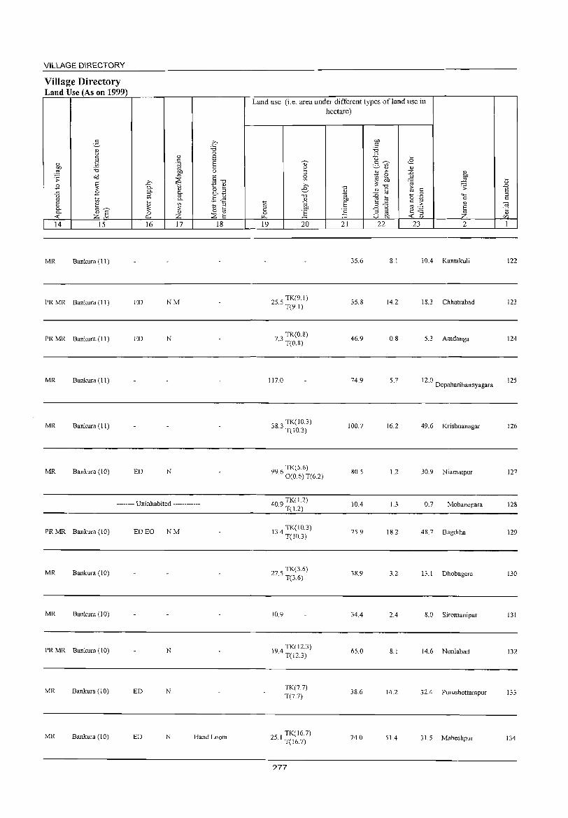
VILLAGE DIRECTORY
Village Directory Land Use (As on 1999)
14 15
MR Bankura (11)
PR MR Bankura (11 )
PR MR Bankura (11)
MR Bankura (11)
MR Bankura (11)
MR Bankura (10)
16 17 18
ED NM
ED N
ED N
-------- Uninhabited ------------
PRMR Bankura (10) ED EO NM
MR Bankura (10)
MR Bankura (1 0)
PRMR Bankura (10) N
MR Bankura (10) ED N
MR Bankura (10) ED N Hand Loom
Land use (i.e. area under different types ofland use in hectare)
19 20
255 TK(9.1) · T(9.1)
73 TK(0.8) · T(O.S)
117.0
383 TK( 10.3) · Te10.3)
TK(56) 99.6 0 (0.6) T(6.2)
409 TK(1.2) · T(1.2)
13 4 TK(10.3) · T(IO.3)
275 TK(3.6) · T(3.6)
10.9
194 TK(12.3) · T(12.3)
TK(7.7) T(7.7)
251 TK(16.7) · T(16.7)
?77
21 22
35.6
35.8
46.9
74.9
100.7
SO.5
10.4
75.9
38.9
34.4
65.0
38.6
74.0
23 2
8.1 10.4 Kantakul i
14.2 IS.3 Chhatrabad
0.8 5.3 Amdanga
5.7 12.0 . Depahanhannyagara
16.2 49.6 Krishnanagar
1.2 30.9 NiamatpuT
1.3 0.7 Mohanepara
18.2 48.7 Bagdiha
3.2 13.1 Dhobagere
2.4 8.0 Siromanipur
8.1 14.6 Nuniabad
14.2 32.4 PUTUshottampur
51.4 3 1.5 Maheshpur
122
123
124
125
126
127
128
129
130
131
132
133
134
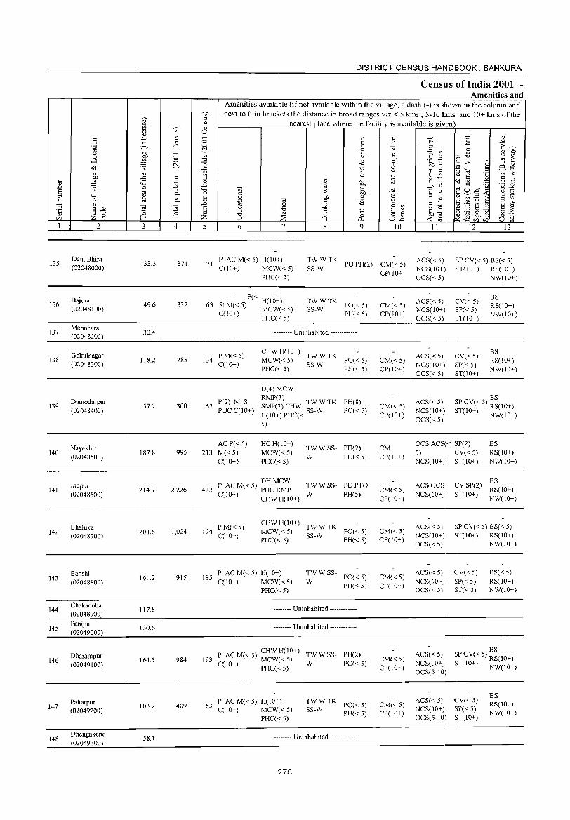
135
136
137
138
139
140
141
142
143
144
145
146
147
148
2
Deul Bhira (02048000)
Bajora (02048100)
Manohara (02048200)
Gokulnagar (02048300)
Damodarpur (02048400)
Nayekhir (02048500)
Indpur (02048600)
Bhaluka (02048700)
Banshi (02048800)
Chakadoba (02048900)
Panijia (02049000)
Dharampur (02049100)
Paharpur (02049200)
Dhengakend (02049300)
3
33.3
49.6
30.4
118.2
57.2
187.8
214.7
201.6
161.2
117.8
130.6
164.5
103.2
58.1
~ " " u
<:) <:)
e § .~
""5 0. o 0.
~ 4
371
332
785
300
995
2,226
1,024
915
984
409
DISTRICT CENSUS HANDBOOK: BANKURA
CensUlS of India 2001 -Amenities and
Amenities available (if not available within the village, a dash (-) is shown in the column and next to it in brackets the distance in broad ranges viz. < 5 kms., 5-10 kms. and 10+ kms of the
nearest place where the facility is available is given
5 6 7 8 9
" ,. .~
" 0. o o u
§ OJ .~
" S V>
§~ u.2
10
71 P AC M« 5) H(IO+) C(IO+) MCW« 5)
PHC« 5) SS-W TWWTK
PO PH(2) CM« 5)
P« He10+) 63 5) M« 5) MCW« 5}
TWWTK SS-W PO« 5)
PH« 5) C(IO+) PHC« 5)
134 P M«5) C(lO+)
63 P(2) M S PUCC(lO+)
ACP« 5) 213 M« 5)
C(lO+)
-------- Uninhabited ------------
CHW H(10+) TW W TK MCW« 5) SS-W PO« 5) PHC« 5) PH« 5)
D(4)MCW RMP(3) SMP(2) CHW TW W TK
H(IO+)PHC« SS-W
PH(8)
PO« 5)
5)
HC H(lO+)
MCW«5) PHC« 5)
TW W SS- PH(2) W PO« 5)
P AC M« 5) DH MCW TW W SS- PO PTO 422 C(lO+) PHC RMP W PH(5)
CHW H(10+)
194 PM«5) C(lO+)
CHW H( 1 0+) TW W TK MCW«5) SS-W PO«5) PHCC< 5) PH« 5)
185 PACM«5)H(lO+) CCI0+) MCW« 5)
PHCC< 5)
TWWSS-PO« 5) PH« 5)
W
-------- Uninhabited ------------
-------- Uninhabited ------------
CHW H(IO+) 193 P ACM«5) MCW«5) T
WWWSS-PH(2)
CCIO+) PHCC< 5) PO« 5)
83 P AC M« 5) H(10+) CC10+) MCW« 5)
PHCC< 5)
TWWTK SS-W PO« 5)
PH« 5)
-------- Uninhabited ------------
?7R
CP(lO+)
CM«5) CP(10+)
CM« 5) CP(lO+)
CM« 5) CP(IO+)
CM CP(10+)
CM«5) CP(10+)
CM« 5) CP(lO+)
CM«5) CP(10+)
CM«5) CP(10+)
CM«5) CP(IO+)
11
ACS« 5) NCS(IO+) OCS« 5)
ACS« 5) NCS(IO+) OCS« 5)
ACS«5) NCS(IO+) OCS« 5)
ACS« 5)
NCS(lO+) OCS« 5)
12 13
SP CV« 5) BS« 5) ST(10+) RS(lO+)
NW(IO+)
CV«5) SP« 5) ST(IO+)
CV«5) SP« 5) ST(IO+)
BS RS(IO+) NW(10+)
BS RS(10+) NW(IO+)
BS SP CV« 5) RS(10+) ST(10+) NW(IO+)
OCS ACS« SP(2) BS RS(10+) NW(IO+)
5) CV« 5) NCS(lO+) ST(IO+)
ACSOCS NCS(10+)
BS CV SP(2) RS(10+) ST(IO+) NW(10+)
ACS« 5) NCS(10+) OCS« 5)
SP CV« 5) BS( < 5) ST(IO+) RS(10+)
NW(lO+)
ACS« 5) NCS(10+) OCS« 5)
CV«5) SP« 5) ST« 5)
BS« 5) RS(lO+) NW(IO+)
BS ACS«5) SPCV«5) RS(IO+) NCS(10+) ST(lO+) NW(IO+) OCS(5-10)
ACS« 5) CV« 5) NCS( 10+) SP( < 5) OCS(5-10) ST(IO+)
BS RS(IO+) NW(iO+)
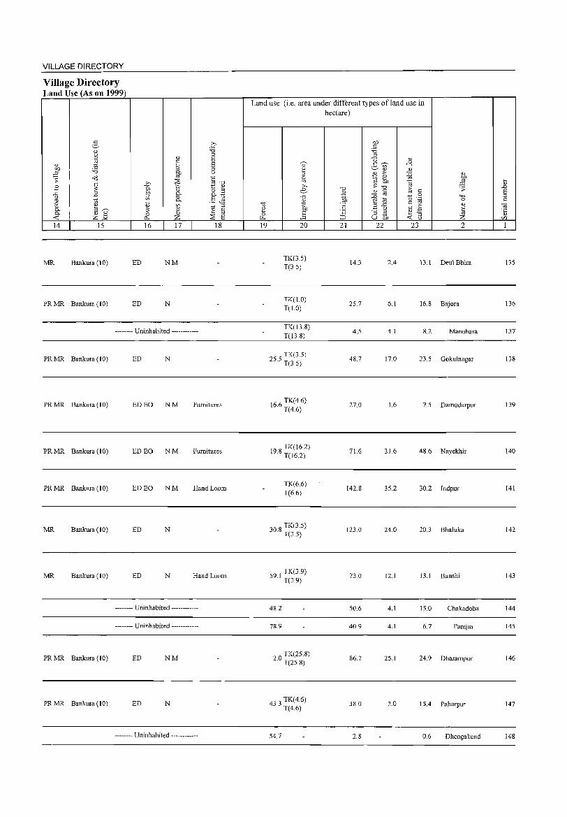
VILLAGE DIRECTORY
Village Directory Land Use (As on 1999)
2- 0 0.) '6 u 0 <= 0.) E cd <=
" t; § E l '6 0
fill u <>::l § .;;
;>, ~ "0
.8 ~ 0.. ';::; to: 0.)
0.) o S ..<= .8 "" "" i;; "" -u '" §& oj ti "" t. '""' ~~ <.> 3! ::I ::: U) c "" 0.) E 0 <.> 0 oj
<t: Z'" p.. z :2S E 14 15 16 17 18
MR Bankura (10) ED NM
PRMR Bankura (10) ED N
-------- Uninhabited ------------
PRMR Bankura (J 0) ED N
PR MR Bankura (10) ED EO NM Furnitures
PRMR Bankura (10) ED EO NM Furnitures
PRMR Bankura (10) EDEO NM Hand Loom
MR Bankura (10) ED N
MR Bankura (10) ED N Hand Loom
-------- Uninhabited ------------
-------- Uninhabited ------------
PRMR Bankura (10) ED NM
PR MR Bankura (10) ED N
-------- Uninhabited ------------
Land use (i.e. area under different types ofland use in
t;
~ ~
19
~
~ 0 U)
:>-. e '" ~ on ] 20
TK(35) T(3.5)
TK(1.0) T(1.0)
TK(13.8) T(138)
255 TK(3.5) · T(35)
166 TK(4.6) · T(4.6)
198 TK(J6.2) · T(l6.2)
TK(6.6) T(66)
308 TK(3.5) · T(3.5)
91 TK(39) 5 . T(3.9)
48.2
78.9
20 TK(25.8) · T(25.8)
4~ 3 TK(4.6) ~. T(4.6)
54.7
hectare)
OJ) <= '6 ::l
<3 g ~ '" 0)
til ,. tb cd ::: "0 "0 0) C
~ cd jS OJ) '" a
°E B""5 C '3 ::I
~ u gb 21 22
14.3 2.4
25.7 6.1
4.5 4.1
48.7 17.0
27.0 1.6
71.6 31.6
142.8 35.2
123.0 24.0
73.0 12.1
50.6 4.1
40.9 4.1
86.7 25.1
38.0 2.0
2.8
,8 <.> jS " ..'O! OJ}
'OJ ::§ ~ C ;;
0 4-< 0 ."§ 0 <= <L> cd ·s ~ § '3 <t: u Z 23 2
13.1 Deul Bhira
16.8 Bajora
8.2 Manohara
23.5 Gokulnagar
7.5 Damodarpur
48.6 Nayekhir
30.2 Indpur
20.3 Bha1uka
13.1 Banshi
15.0 Chakadoba
6.7 Panijia
24.9 Dharampur
15.4 Paharpur
0.6 Dhengakend
il ..0 E ::l <=
" ·c 0.)
C/l
1
135
136
137
138
139
140
141
142
143
144
145
146
147
148
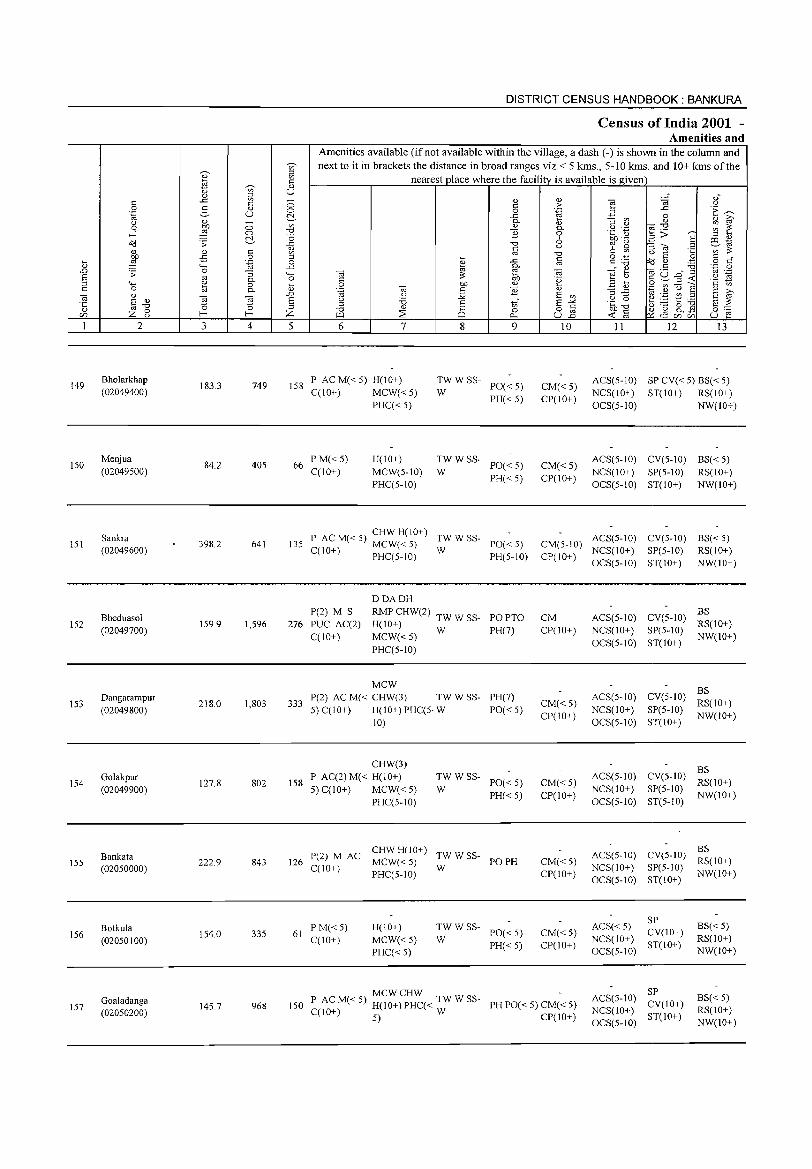
'-
'" .D S ;:l c: ] '" [fJ
1
149
150
lSI
152
153
154
155
156
157
c: 0 .~ (.) 0
...l OC!
" bll ,g .;: '+-< 0
'" '" § "0
Z 0 (.)
2
Bholarkhap (02049400)
Menjua (02049500)
Sankra (02049600)
Bheduasol (02049700)
Dangarampur (02049800)
Golakpur (02049900)
Bankata (02050000)
Botkula (020S0100)
Goaladanga (020S0200)
0)
l'i '" c..>
'" " ..<: '" c: g " u '" ~
:W 0 0 ~ ;:
'" <: -5 0
.~ 4-< 0 "3 '" 0.
~ 0 0.
t;; t;; '0 '0 r r 3 4
183.3 749
84.2 405
398.2 641
159.9 1,596
218.0 1,803
127.8 802
222.9 843
154.0 335
14S.7 968
~ = '" U
0 0 ~ '" "0 -0 ..<: '" en ;:l 0
..<: 4-< 0 '-
'" .D S ;:l
z 5
DISTRICT CENSUS HANDBOOK: BANKURA
Census of India 2001 -Amenities and
Amenities available (ifnot available within the village, a dash (-) is shown in the column and next to it in brackets the distance in broad ranges viz.< 5 kms., 5-10 kms. and 10+ kms of the
nearest place where the facility is available is given
6 7 8
tf o 0...
9 10 11 12 13
158 P AC M« 5) H(IO+) C(lO+) MCW« 5)
PHC« 5)
~W W SS- PO« 5)
PH« 5) CM«5) CP(IO+)
ACS(S-IO) SP CV« S) BS« 5) NCS(IO+) ST(lO+) RS(IO+) OCS(5-1O) NW(IO+)
66 P M«5) H(IO+) TWWSS-
PO« 5) CM« S) ACS(S-IO) CV(5-10) B8« S)
C(lO+) MCW(S-IO) W NCS(IO+) SP(S-IO) RS(IO+) PHC(5-10)
PH« 5) CP(IO+) OCS(S-IO) ST(IO+) NW(IO+)
135 P AC M« 5) CHW H(IO+) TWWSS-
PO« 5) CM(5-10) ACS(5-1O) CV(5-1O) 88« 5)
MCW«5) W NCS(IO+) SP(5-1O) RS(IO+) C(IO+) PHC(5-10) PH(5-10) CP(IO+)
OCS(5-10) ST(IO+) NW(IO+)
DDADH P(2) M S RMP CHW(2) TW W SS- POPTO CM ACS(5-10) CV(5-1O)
BS 276 PUC AC(2) H(IO+) R8(1O+)
C(JO+) MCW«5) W PH(7) CP(IO+) NCS(IO+) SP(5-1O)
NW(IO+)
PHC(5-1O) OCS(5-10) ST(IO+)
MCW BS
333 P(2) ACM« CHW(3) TWWSS- PH(7)
CM« 5) ACS(5-10) CV(5-10)
RS(IO+) 5)C(10+) H(lO+) PHC(5- W PO« 5) NCS(IO+) SP(5-1O)
10) CP(lO+)
OCS(5-10) ST(lO+) NW(IO+)
CHW(3) BS
158 P AC(2)M« H(IO+) TWWSS-
PO« 5) CM«5) ACS(5-10) CV(5-1O)
RS(IO+) 5) C(10+) MCW«5) W NCS(IO+) SP(5-10}
PHC(5-1O) PH« 5) CP(lO+)
OCS(5-10) ST(5-10} NW(IO+)
CHW H(IO+) ACS(S-IO) CV(5-10)
BS
126 P(2) M AC
MCW«S) TWWSS-
PO PH CM«5) RS(IO+) C(lO+) W NCS(IO+) SP(5-10}
PHC(5-10) CP(IO+) OCS(5-10) ST(IO+)
NW(IO+)
ACS« 5} SP
BS« 5) PM«5) H(IO+) TWWSS-PO« 5) CM« 5) CV(IO+) 61
C(IO+) MCW«S) W NCS(lO+) RS(lO+) PH« 5) CP(IO+) ST(IO+)
PHC« 5) OCS(S-IO) NW(IO+)
P AC M« 5) MCW CHW TW W SS- AC8(5-10) SP
B8« 5) 150 PH PO« 5) CM« 5) CV(IO+) C(lO+) H(IO+) PHC« W NCS(lO+) RS(IO+)
CP(lO+) ST(10+) 5) OCS(S-IO) NW(IO+)
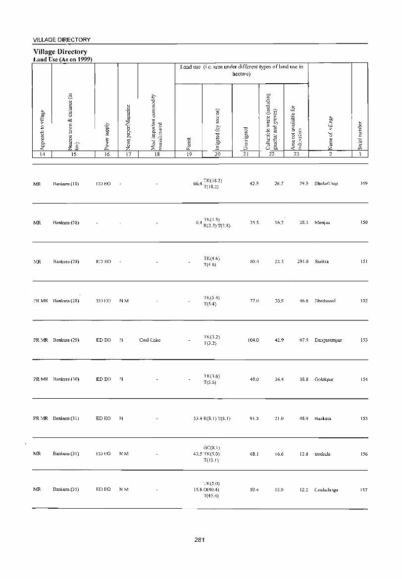
VILLAGE DIRECTORY
Village Directory Land Use (As on 1999)
14 15
MR Bankura (I 0)
MR Bankura (28)
MR Bankura (2S)
PR MR Bankura (28)
PR MR Bankura (29)
PR MR Bankura (30)
PR MR Bankura (31)
MR Bankura (3 I)
MR Bankura (35)
16 17 18
ED EO
ED EO
ED EO NM
ED EO N Coal Cake
ED EO N
ED EO N
ED EO NM
ED EO NM
Land use (i.e. area under different types ofland use in hectare)
19 20
664 TK(182) . T(IS.2)
TK(1.5) 0.4 R(2.3) T(3.8)
TK(4.6) T(4.6)
TK(5A) T(5A)
TK(3.2) T(3.2)
TK(3.6) T(3.6)
53.4 R(8.1) T(8.1)
GC(S.I) 43.5 TK(5.0)
T(13.1)
TK(5.0) 15.80(40.4)
T(45.4)
281
21
42.5
35.5
SOA
77.0
104.0
49.0
91.5
68.1
59.4
22 23 2
26.7 29.5 Bholarkhap
16.2 2S.3 Menjua
22.3 291.0 Sankra
30.9 46.6 Bheduasol
42.9 67.9 Dangarampur
36.4 3S.S Golakpur
21.0 4S.9 Bankata
16.6 12.8 Botkula
13.0 12.2 Goa1adanga
149
ISO
lSI
152
153
154
155
156
157
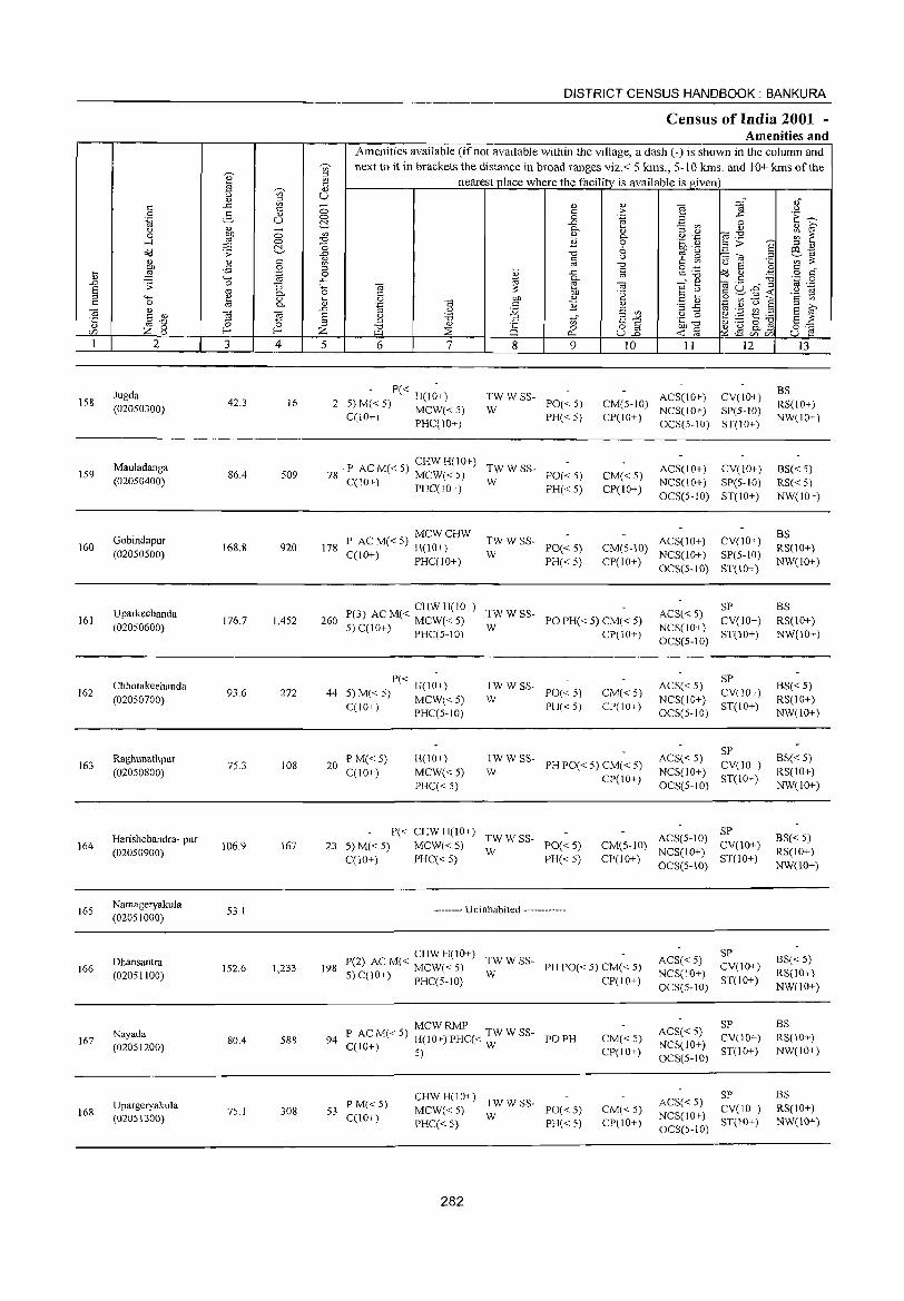
158
159
160
161
162
163
164
165
166
167
168
2
Jugda (02050300)
Mauladanga (02050400)
Gobindapur (02050500)
Uparkechanda (02050600)
Chhotakeehanda (02050700)
Raghunathpur (02050800)
Harishchandra- pur (02050900)
Namageryakula (02051000)
Dhansantra (02051100)
Nayada (02051200)
Upargeryakula (02051300)
3
42.3
86.4
168.8
176.7
93.6
75.3
106.9
53.1
152.6
80A
75.1
o o ~
'" o .~
"3 0-o 0-
ta
~ 4
16
509
920
1,452
272
108
167
1,233
588
308
DISTRICT CENSUS HANDBOOK: BANKURA
Census of India 2001 -Amenities and
Amenities available (if not available within the village, a dash (-) is shown in the column and next to it in brackets the distance in broad ranges viz.< 5 kms., 5-10 Ions. and 10+ kms of the
nearest place where the facility is available is given)
5 6 7 8 9 10 11 12
- P« H(I~+) 2 5) M« 5) MCW« 5)
C(IO+) PHC(10+)
: W SS- PO« 5)
PH« 5)
ACS(10+) CV(!O+) CM(5-10) NCS(IO+) SP(5-1O) CP(IO+) OCS(S-10) ST(10+)
78 P ACM«5) ~~;;:,,~(~~+) TWWSS- PO«5)
C(10+) PHC(10+) W PH« 5) CM« 5) CP(IO+)
ACS(10+) CV(10+) NCS(10+) SP(5-IO) OCS(5-10) ST(IO+)
MCWCHW 178 P AC M« 5) H(10+)
C(lO+) PHC(IO+)
TWWSS-W
ACS(IO+) CV(IO+) CM(5-10) NCS(lO+) SP(S-IO)
CP(lO+) OCS(5-10) ST(IO+)
PO« 5) PH«5)
CHWH(IO+) 260 P(3) AC M« MCW« 5) ~W W SS- PO PH« 5) CM« 5)
5) C(lO+) PHC(5-10) CP(lO+)
P« H(IO+) 44 5) M« 5) MCW« 5)
C(IO+) PHC(5-1O)
:W W SS- PO« 5)
P1-I« 5)
CM«5) CP(lO+)
20 PM«5) CCIO+)
H(10+)
MCW« 5) PHC« 5)
:W W SS- PH PO« 5) CM« 5)
CP(IO+)
P« CHWH(IO+) TWWSS-23 5) M« 5) MCW« 5) W PO« 5)
CCIO+) PHC« 5) PH« 5)
-------- Uninhabited ------------
CM(5-10) CP(10+)
CHW H(lO+) 198 P(2) AC M( < MCW( < 5) :W W SS- PH POe < 5) CM( < 5)
5) C(10+) PHCC 5-1O) CP(10+)
MCWRMP 94 P ACM«5) H(10+)PHC« TWWSS- POPB
C(10+) 5) W
53 PM«5) C(lO+)
CHWH(10+) TWWSS-MCW« 5) W PO« 5) PHC« 5) PH« 5)
282
CM« 5) CP(10+)
CM« 5) CP(lO+)
SP ACS« 5) NCS(lO+) CV(lO+) OCS(5-10) ST(10+)
ACS« 5) SP NCS(10+) CV(IO+) OCS(5-10) ST(IO+)
SP ACS« 5) NCS(IO+) CV(IO+) OCS(5-10) ST(IO+)
SP ACS(5-10} CV(10+) NCS(IO+) OCS(5-10) ST(lO+)
ACS« 5) SP NCS(10+) CV(IO+)
OCS(5-10) ST(10+)
SP ACS« 5) CV(10+) NCS(lO+) ST(10+) OCS(5-10)
SP ACS« 5) NCS(JO+) CV(lO+) OCS(5-10) ST(lO+)
13
BS RS(10+) NW(IO+)
BS« 5) RS« 5) NW(IO+)
BS RS(IO+) NW(10+)
BS RS(IO+) NW(IO+)
BS« 5) RS(IO+) NW(IO+)
BS« 5) RS(IO+) NW(IO+)
BS« 5) RS(IO+) NW(10+)
BS« 5) RS(10+) NW(lO+)
BS RS(lO+) NW(10+)
BS RS(IO+) NW(IO+)
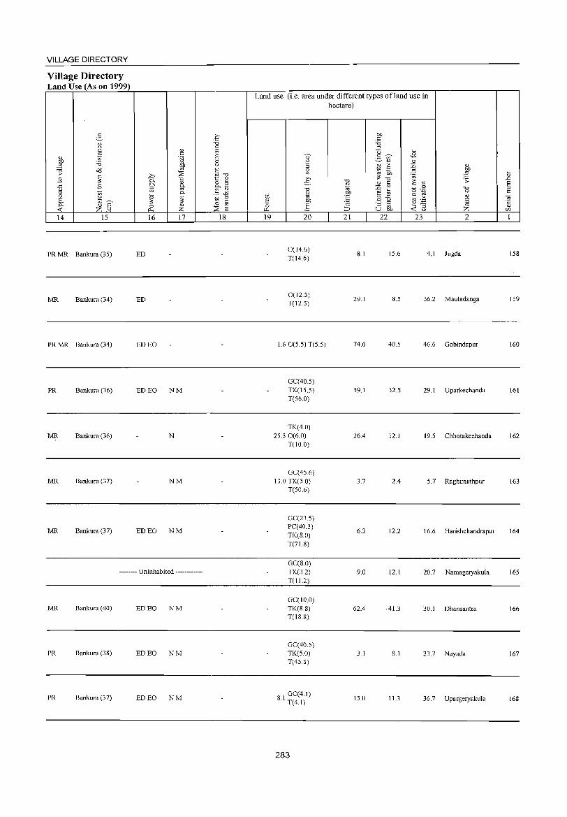
VILLAGE DIRECTORY
Village Directory Land Use (As on 1999)
g OJ
'" " OJ d) 1;;
:W '0 o(l .;;:
~ B ..t:: B u oj 1;;
~ OJ a~
<>< OJ S ~ z-'" 14 15
» 0.
<>< ~
~ 0 p"
16
PR MR Bankura (3S) ED
MR Bankura (34) ED
PR MR Rankura (34) ED EO
PR Bankura (36) ED EO
MR Bankura (36)
MR Bankura (37)
MR Bankura (37) ED EO
<L>
" .~
~
~ <L>
§' <><
~ Z 17
NM
N
NM
NM
-------- Uninhabited ------------
MR Bankura (40) ED EO NM
PR Bankura (38) ED EO NM
PR Bankura (37) ED EO NM
.£' "0 0 S a 0 u
~-o 1:: <L> o '" o..-§
.§ <l'l tl § 0
::is a 18
Land use (i.e. area under different types ofland use in hectare)
1;; ~ 0 ~
19
aJ 2 ::> ~ » e. "0
'" "' OJ)
:§ 20
0(14.6) T(14.6)
O(l2.S) T(12.S)
1.6 O(S.S) T(S S)
GC(40.S) TK(15.S) T(56.0)
TK(4.0) 2S.50(6.0)
T(lO.O)
GC(4S.6) 13.0 TK(5.0)
T(SO.6)
GC(23.5) PC(40.3) TK(S.O) T(7l.8)
GC(S.O) TK(3.2) T(Il.2)
Ge(IO.O) TK(8.8) T(18.8)
GC(40.S) TK(S.O) T(4S.S)
8 I GC(4.1) . T(4.1)
283
"0
%J OJ)
l:: '2 ~
21
S.1
29.1
74.6
59.1
26.4
3.7
6.3
9.0
62.4
3.1
IS.O
OJ)
" '0 :::l
U ~ ~ 2- '" OJ OJ
%; > :0 '" ~ OJ OJ)
'" ~ ::§ ~ "0
~ .s:
OJ til " =§ 0 4-< a o .~ 0
z -5 " > OJ OJ ._ § :l ::> OJ ~
OJ ~] u OJ) Z 22 23 2
IS.6 4.1 Jugda
8.5 36.2 Mauladanga
40.5 46.6 Gohindapur
32.5 29.1 Uparkechanda
12.1 19.5 Chhotakeehanda
2.4 5.7 Raghunathpur
12.2 16.6 Harishchandrapur
12.1 20.7 Namageryakula
·41.3 30.1 Dhansantra
8.1 23.7 Nayada
11.3 36.7 Upargeryakula
~ .D s :::l
" "3 '5 r:/)
1
ISS
IS9
160
161
162
163
164
165
166
167
168
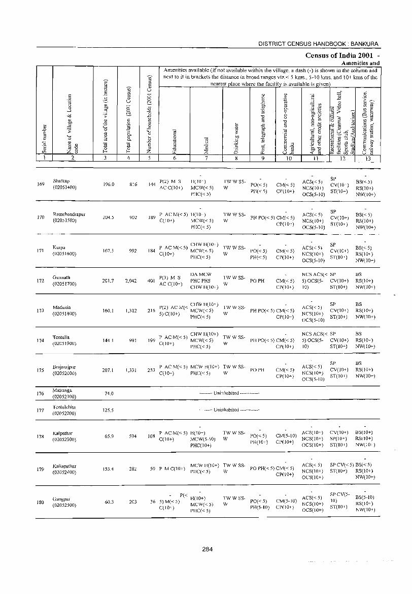
169
170
171
172
173
174
175
176
177
178
179
180
2
Shalkap (02051400)
Ramchandrapur (02051500)
Kurpa (02051600)
Gunnath (02051700)
Madunia (02051800)
Tentulia (02051900)
Brajarajpur (02052000)
Matranga (02052100)
Tentulchita (02052200)
Kalpathar (02052300)
Kaliapathar (02052400)
Gangpur (02052500)
3 4
196.0 816
204.5 902
167.3 992
201.7 2,042
160.1 1,312
144.1 991
207.1 1,331
74.0
125.5
65.9 594
153.4 282
60.3 203
DISTRICT CENSUS HANDBOOK: BANKURA
Census of India 2001 -Amenities and
Amenities available (if not available within the village, a dash (-) is shown in the column and next to it in brackets the distance in broad ranges viz. < 5 kms., 5-10 kms. and 10+ kms of the
nearest place where the facility is available is given
5 6
144 P(2) M S AC C(lO+)
7
H(lO+)
MCW«5) PHC« 5)
8 9
~WWSS- PO«5)
PH« 5)
10
CM«5) CP(lO+)
189 P ACM«5) H(lD+) C(IO+) MCW« 5)
PHC« 5)
TWW SS-W PH PO« 5) CM« 5)
P AC M« 5) CHW H(IO+) TW W SS-184 C(lO+) MCW« 5) W PO« 5)
401 P(3) M S AC C(lO+)
PHC« 5) PH« 5)
DAMCW PHC PHS :W W SS- PO PH
CHWH(lO+)
CP(IO+)
CM«5) CP(10+)
CM« 5) CP(IO+)
CHWHCI0+) 216 P(2) AC M« MCW« 5) TW W SS- PH PO« 5) CM« 5)
5) C(!O+) PHC« 5) W CP(10+)
P AC M« 5) CHW H(IO+) TW W SS-199 C(lO+) MCW« 5) W PH PO« 5) CM« 5)
PHC« 5) CP(IO+)
253 P AC M« 5) MCW H(IO+) TwW W SS- PO PH C(IO+) PHC«5)
-------- Uninhabited ------------
-------- Uninhabited ------------
CM«5) CP(IO+)
11 12
ACS« 5) SP NCS(IO+) CV(IO+) OCS(5-10) ST(10+)
SP ACS« 5) CV(IO+) NCS(lO+) OCS(5-10) ST(IO+)
SP ACS« S) NCS(IO+) CV(IO+) OCS(5-10) ST(IO+)
NCS ACS« SP 5) OCS(5- CV(lO+) 10) ST(IO+)
ACS« 5) SP NCS(IO+) CV(IO+) OCS(5-10) ST(IO+)
NCS ACS« SP 5) OCS(5- CV(lO+) 10) ST(IO+)
SP ACS« 5) NCS(IO+) CV(IO+) OCS(5-10) ST(lO+)
13
BS«5) RS(10+) NW(IO+)
BS« 5) RS(lO+) NW(IO+)
BS«5) RS(lO+) NW(IO+)
BS RS(10+) NW(lO+)
BS RS(IO+) NW(10+)
BS RS(10+) NW(lO+)
BS RS(IO+) NW(10+)
108 P AC M« 5) H(lO+) C(10+) MCWe5-10)
TWWSS-W PO«5) CM(5-1O) ACS(IO+)
NCS(lO+) CV(IO+) SP(IO+) ST(IO+)
BS(10+) RS(IO+) NW(IO+) PHC(IO+)
PH(IO+) CP(IO+) OCS(lO+)
50 P MC(IO+) ~C~<~iIO+) :WWSS- POPH«5)CM«5) CP(IO+)
ACS« 5) NCS(lO+) OCS(lO+)
P« H(IO+) 36 5)M«5) MCW«5)
C(IO+) PHC«5)
284
:W W SS- PO« 5)
PH(5-10)
ACS« 5) CM(5-10) NCS(lO+) CP(IO+) OCS(IO+)
SP CV« 5) BS« 5) ST(IO+) RS(10+)
NW(IO+)
SP CV(5- BS(5-10) 10) RS(lO+) ST(IO+) NW(lO+)
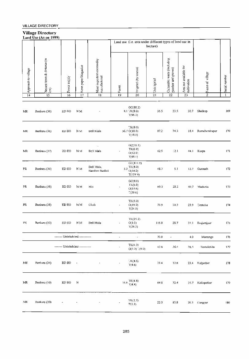
VILLAGE DIRECTORY
Village Directory Land Use (As on 1999)
2-<l.) <..>
'" tl <l.)
00 :.a ~ d8 .s: ~ B
..c: B g ~ e <l.)
~ til~ ~ <l.) a
--< z-" 14 15
MR Bankura (36)
MR Bankura (36)
MR Bankura (37)
PR Bankura (36)
PR Bankura (38)
PR Bankura (38)
PR Bankura (10)
.2;-:.a 0
<V S c: s '§i 0 00 ()
'" § ;>., ::;s "0 '0. ';:; 1:: Q)
<l.) 8..B ~ ~
'" en '" .§ & ~ [; '" 1;> '" '" ~ § 0
0
~ z ::;s a 16 17 18
ED EO NM
ED EO NM Bell Mala
ED EO NM Bell Mala
ED EO NM Bell Mala, Bamboo Busket
ED EO NM Biri
ED EO NM Cloth
ED EO NM Bell Mala
-------- Uninhabited ------------
-------- Uninhabited ------------
MR Bankura (34) ED EO
MR Bankura (I 0) ED EO N
MR Bankura (10)
Land use (i.e. area under different types ofland use in
'\'l () .... 19
., 2 '" ~ ;>., e
"0
'" "" 00
] 20
GC(S8.2) 8.1 TK(8.0)
T(96.2)
TK(S.O) 56.70(10.0)
T(18.0)
GC(30.1) TK(6.0) 0(12.0) T(48.1)
GC(!119)
53 TK(8.0) . 0(10.0)
T(129.9)
GC(8.0) TK(6.0) 0(15.6) T(29.6)
TK(5.0) 0(19.0) T(24.0)
TK(25.2) 0(1.0) T(26.2)
TK(4.0) 0(50) T(90)
TK(4.6) T(4.6)
166 TK(4.S) . T(4.S)
TK(2.3) T(2.3)
285
hectare)
"0 <l.)
"" 00 ·E '2 ;::J
21
35.5
87.2
62.9
4S.7
69.5
75.9
115.0
70.0
43.6
25.4
64.0
22.0
OD
'" :.a '" <:3 .... 3 ~ <2
'" '" <l.)
E > :0 <l.)
~ ~ ."! ~ '"
'OJ "0
~ .s:
<l.) c: c:
'" 15 .~ :0 "'" til 0 r:: .a ..c: c: > <l) u ~ .,C
~ "5 8 ~~ U bD
22 23 2
23.5 32.7 Shalkap
24.3 18.4 Ramchandrapur
12.1 44.1 Kurpa
5.1 12.7 Gunnath
20.2 40.7 Madunia
20.2 23.9 Tentulia
28.7 37.1 Brajarajpur
4.0 Matranga
36.4 36.5 Tentulchita
12.6 23.4 Kalpathar
32.4 35.7 Kaliapathar
15.8 20.3 Gangpur
[; .0 a '" c:
OJ ·c <l.)
('/J
1
169
170
171
172
173
174
175
176
177
178
179
180
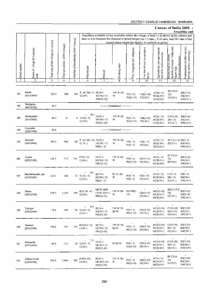
181
182
183
184
185
186
187
188
189
190
191
192
2
Marlu (02052600)
Shialgeria (02052700)
Sirishganjal (02052800)
Gosainhir (02052900)
Baurisol (02053000)
Alijhar (02053100)
Harishchandra- pur (02053200)
Bhatra (02053300)
Tarkajor (02053400)
Maukuri (02053500)
Benageria (02053600)
Atbhaichandi (02053700)
3 4
129.7 929
50.7
40.0 21
80.6
380.2 965
144.5 517
12S.0 106
279.9 1,129
38.4 169
196.6 733
80.0 115
205.9 1,084
DISTRICT CENSUS HANDBOOK: BANKURA
Census of India 2001 -Amenities and
Amenities available (ifnot available within the village, a dash (-) is shown in the column and next to it in brackets the distance in broad ranges viz.< 5 kms., 5-10 kms. and 10+ kms of the
nearest place where the facility is available is given
5 6 7
190 P ACM«5) H(IO+) C(IO+) MCW« 5)
PHC(S-IO)
8 9
TWWSS-W PO« 5)
PH(S-IO)
-------- Uninhabited ------------
- P« H(i~+) 6 5) M« 5) MCW« 5)
C(10+) PHC(5-10)
:;: W SS- PO« 5)
PH(5-IO)
-------- Uninhabited ------------
180 P ACM«5) H(10+) C(lO+) MCW« 5)
PHC« 5)
101 P M« 5) C(10+)
1I(101)
MCW« 5) PHC(S-IO)
- P« H(I~+) IS 5) M« S) MCW« 5)
C(lO+) PHC« 5)
:;: W SS- PO« 5)
PH« 5)
:W W SS- PO« 5)
PH(5-IO)
~ TK SS- PO« S)
PH« S)
10 II
ACS« 5) CM(5-10) NCS(IO+) CP(IO+) OCS(IO+)
ACS« 5) CM(5-10) NCS(10+) CP(lO+)
OCS(lO+)
CM«5) CP(lO+)
ACS« 5) NCS(IO+) OCS(1O+)
ACS« 5) CM(5-1O) NCS(IO+) CP(lO+) OCS(IO+)
CM«5) CP(IO+)
ACS« 5) NCS(1O+) OCS(lO+)
12 13
SP CV(5-10) BS(5-10)
ST(IO+) RS{IO+) NW(1O+)
CV(5-1O) BS(5-10) SP« S) RS(lO+) ST(lO+) NW(10+)
SP CV« 5) BS« 5) ST(lO+) RS(10+)
NW(10+)
SP CV(5- BS(S-IO)
10) RS(10+) ST(lO+) NW(1O+)
CV«5) SP« 5) ST(10+)
B5« S) RS(10+) NW(IO+)
198 P(2) M C MCW SMP TW W SS- PO PHIS ACS(S 10)
A CHWH(1O+) - CM(5-10) -SP(2) CV(S BS(;-IO)
10) RS(S-IO) C(1O+) PHC(S-lO) W 10) CP(lO+) NCS(10+) OCS(lO+) ST(iO+) NW(IO+)
- P« H(l~+) 26 5) M« S) MCW« S)
CCIO+) PHC(5-IO)
143 P(2)M«5) C(IO+)
H(IO+) MCW« 5) PHC(5-10)
P« H(lO+) 24 5) M« 5) MCW« 5)
C(lO+) PHC(5-JO)
205 PM(5-IO) C(10+)
H(IO+) MCW(5-tO) PHC(5-10)
286
TWWTK SS-W PO« S)
PH(5-IO)
TW W TK PO« 5) SS-W PH(5-IO)
WSS-W PO« 5) PH(5-10)
;;: W SS- PO« 5)
PH(S-IO)
CM(5-10) ACS(S-10) CV(5-1O) BS(S-10) NCS(10+) SP(5-IO) RS(10+)
CP(IO+) OCS(10+) ST(IO+) NW(IO+)
CM(5-10) ACS(5-IO) CV(5-1O) BS(5-10) NCS(IO+) SP« 5) RS(10+)
CP(IO+) OCS(10+) ST(lO+) NW(lO+)
ACS(5-1O) CV(5-1O) BS(5-1O) CM(5-IO) NCS(IO+) SP« 5) RS(IO+) CP(10+) OCS(lO+) ST(IO+) NW(lO+)
ACS« S) CM(5-10) NCS(IO+) CP(IO+) OCS(JO+)
SP CV(5- BS(5-10) 10) RS(IO+) ST(IO+) NW(IO+)
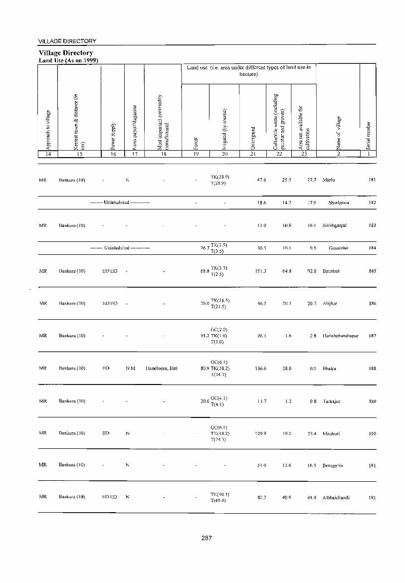
VILLAGE DIRECTORY
Village Directory Land Use (As on 1999)
14 15
MR Bankura (10)
16 17
N
-------- Uninhabited ------------
MR Bankura (10)
-------- Uninhabited ------------
MR Bankura (10) EDEO
MR Bankura (10) ED EO
MR Bankura (10)
18
MR Bankura (10) ED NM Handloom, Biri
MR Bankura(IO)
MR Bankura (10) ED N
MR Bankura (10) N
MR Bankura (10) ED EO N
Land use (i.e. area under different types ofland use in hectare)
19 20
TK(28.9) T(28.9)
267 TK(3.S) · T(3.S)
688 TK(2.S) · T(2.S)
'60 TK(21.S) J . T(2J.S)
GC(20) 91.S TK(1.0)
T(3.0)
GC(6.1) 80.9 TK(28.2)
T(34.3)
206 GC(4.1) · T(4.1)
GC(6.1) TK(IS.2) T(24.3)
TK(40.4) T(40.4)
287
-0 '" ~ OJ)
"S ·2 ;::J
21
47.6
18.6
13.0
30.S
151.3
46.S
26.1
136.6
11.7
129.9
S1.0
80.2
OJ)
" '8 ::l
"0
2- ~ <Il
'" '" >-t; ~ '" ;:; "0
'" " :0 '" ~ E '" .2 ..c <.)
;; ::l
'" u 01)
22
25.5
14.2
10.9
10.1
64.8
20.2
1.6
28.0
1.2
19.0
12.6
40.9
~
<S '" ~ '" ~ .",
i;; ;; " (5 0 "" "-§ c 0
'" >- " . .;:::: E ~ ;; ~ <t: u
23 2
27.7 Marlu
17.9 Shialgeria
16.1 Sirishganjal
9.8 Gosainhir
92.8 Baurisol
20.2 Alijhar
2.8 Harishchandrapur
0.0 Bhatra
0.8 Tarkajor
23.4 Maukuri
16.5 Benageria
44.4 Atbhaichandi
1;; .D S ::l
" '" ·c " U)
I
181
182
183
184
185
186
187
188
189
190
191
192
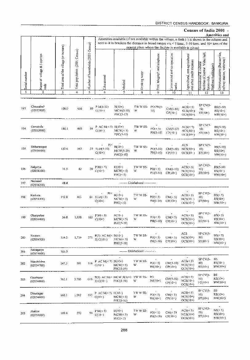
193
194
195
196
197
198
199
200
201
202
203
204
205
2
Chaurabad (02053800)
Geriakola (02053900)
Shibarampur (02054000)
SaJgerya (02054100)
Namasol (02054200)
Karkota (02054300)
Gharpathar (02054400)
Rautara (02054500)
Satsagarya (02054600)
Maishdabra (020S4700)
Gaurbazar (020S4800)
Dhuniagar (020S4900)
Jhaktor (02055000)
3 4
186.0 456
186.1 469
120.6 J67
71.5 82
48.4
153.8 403
56.8 1,038
114.2 1,739
10S.2
145.3 581
762.J 3,785
160.1 1,062
109.4 5S2
DISTRICT CENSUS HANDBOOK: BANKURA
Census of India 2001 -Amenities and
Amenities available (ifnot available within the village, a dash (-) is shown in the column and next to it in brackets the distance in broad ranges viz.< 5 kms., 5-10 kms. and 10+ kms of the
nearest place where the facility_ is available is given
5 6 7 8 9 10 11
89 P M(5-10) C(JO+)
H(IO+) MeW(S-IO) PHC(S-tO)
TW W SS- PO PH(5- ACS« 5) W 10) CM(5-10) NCS(10+)
94 P AC M« 5) H(10+) C(lO+) MCW« 5)
PHC(5-1O)
- P« H(I~+) 27 5) M(5-JO) MCW(5-1O)
C(10+) PHC(5-10)
20 PM« 5) C(10+)
H(lO+)
MCW«5) PHC« 5)
~W W SS- PO« 5)
PH(5-10)
-: W SS- POls-to)
PH(5-10)
~W W SS- PO« 5)
PH(S-JO)
-------- Uninhabited ------------
P« H(lO+) 61 5)M«5) MCW«5)
C(10+) PHC« 5)
163 PM«5) C(JO+)
H(10+)
MCW«5) PHC(S-lO)
271 P(2) AC M« H(lO+) 5) C(lO+) MCW« 5)
PHC(5-10)
-: W SS- PO« 5)
PH(5-10)
TW W SS- PO« 5)
W PH(5-JO)
~W W SS- PO« 5)
PH(5-1O)
-------- Uninhabited ------------
116 P AC M« 5) H(lO+) C(10+) MCW«5)
PHC(5-1O)
;;: W SS- PO« 5)
PH(lO+)
P(3) ACM« MCWH(10+) TWWSS- PO 6J6 S) C(10+) PHC(S-10) W PH(JO+)
P AC M« 5) H(IO+) 193 C(10+) MCW« 5)
PHC(5-10)
94 P M«5) C(10+)
H(10+) MCW«5) PHC«5)
288
~W W SS- PO« 5)
PH(10+)
TW W SS- PO« 5)
W PH(5-10)
CP(JO+) OCS(IO+)
ACS« 5) CM(5-10) NCS(IO+) CP(IO+) OCS(IO+)
ACS CM(5-10) NCS(IO+) CP(10+) OCS(lO+)
ACS«5) CM(5-10) NCS(IO+) CP(JO+) OCS(IOI)
CM« 5) CP(10+)
CM« 5) CP(IO+)
CM«5) CP(to+)
ACS« 5) NCS(10+) OCS(10+)
ACS« 5) NCS(IO+) OCS(IO+)
ACS NCS(IO+) OeS(lo+)
ACS« 5) CM(5-JO) NCS(10+) CP(lO+) OCS(10+)
ACS« 5) CM(5-10) NCS(IO+) CP(!O+) OCS(10+)
CM« 5) CP(lO+)
CM« 5) CP(10+)
ACS«5) NCS(IO+) OCS(10+)
ACS« 5) NCS(lO+) OCS(10+)
12 13
SP CV(S- BS(5-10) JO) ST(JO+) RS(JO+)
NW(\O+)
SPCV(5- BS(5-JO)
JO) RS(IO+) ST(IO+) NW(1O+)
SP CV(5- BS(5-10) 10) ST(1 0+) RS(1 0+ )
NW(lO+)
SP eV(5- BS(5-JO} 10) ST(IO+) RS(IO+)
NW(IO+)
SP CV(S- 8S« 5)
10) RS(lO+) ST(JO+) NW(IO+)
SP CV(5- BS« 5) 10) ST(IO+) RS(lO+)
NW(lO+)
SP eV(5- BS« S) 10) ST(IO+) RS(IO+)
NW(lO+)
SPCV(5- BS 10) RS(lO+) ST(lO+) NW(IO+)
SPCV(5- BS 10) RS(IO+) ST(IO+) NW(lO+)
SP CV(S- BS 10) RS(lO+) ST(10+) NW(IO+)
SP CV(S-10)
ST(10+)
BS« 5) RS(IO+) NW(lO+)
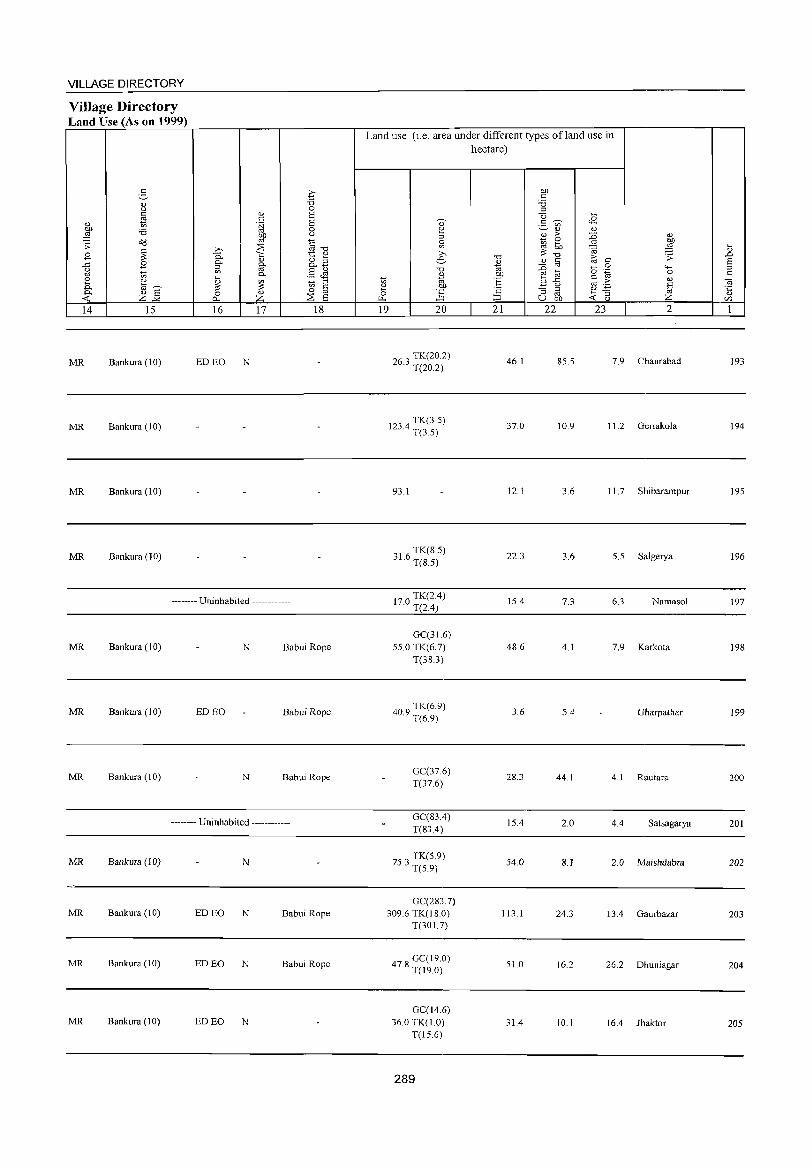
VILLAGE DIRECTORY
ViJlage Directory Land Use (As on 1999)
e-<1.) u
~ <l> Of} :.a ::2 o:d .;;:
'" .8 ~ ..<:: .8 (.)
'" '" 2 ~ 0- "'~ 0. <1.) S « z-'" 14 15
MR Bankura (10)
MR Bankura (10)
MR Bankura (l 0)
MR Bankura (10)
o :.a 0
v S '" S .t;j
0 OJ) u
'" ~""O ;>-, ~ 0. 1:: <l>
0- '" 8.3 ::l [if '" .5 Jl 0-,_ .,
~ to ::l ~ § 0 '"
0 p... z :2: S 16 17 18
ED EO N
-------- Uninhabited ------------
MR Bankura (10) N Babui Rope
MR Bankura (10) ED EO Babui Rope
MR Bankura (10) N Babui Rope
-------- Uninhabited ------------
MR Bankura (10) N
MR Bankura (10) ED EO N Babui Rope
MR Bankura (10) ED EO N Babui Rope
MR Bankura (10) ED EO N
Land use (i.e. area under different types of land use in hectare)
19 20
263 TK(20.2) · T(20.2)
123 4 TK(3.5) · T(3.5)
93.1
316 TK(8.5) · T(S.5)
170 TK(2.4) · T(2.4)
GC(316) 55.0 TK(6.7)
T(38.3)
409 TK(6.9) · T(6.9)
GC(37.6) T(37.6)
GC(83.4) T(83.4)
753 TK(5.9) · T(5.9)
GC(283.7) 309.6 TK(IS.O)
T(301.7)
47 S GC(19.0) · T(19.0)
GC(14.6) 36.0 TK(1.0)
T(lS.6)
289
21
46.1
37.0
12.1
22.3
15.4
48.6
3.6
28.3
15.4
54.0
113.1
SI.O
31.4
22 23 2
85.5 7.9 Chaurabad
10.9 11.2 Geriakola
3.6 11. 7 Shibarampur
3.6 5.5 Salgerya
7.3 6.3 Namasol
4.1 7.9 Karkota
5.4 Gharpathar
44.1 4.1 Rautara
2.0 4.4 Satsagarya
S.l 2.0 Maishdabra
24.3 13.4 Gaurbazar
16.2 26.2 Dhuniagar
10.1 16.4 Jhaktor
193
194
195
196
197
198
199
200
201
202
203
204
205
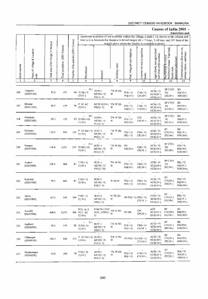
206
207
208
209
210
211
212
213
214
215
216
217
2
Dumutor (02055100)
Khirpai (02055200)
Khapkata (02055300)
Pathrator (02055400)
Rampur (02055500)
Arabari (02055600)
Kurkutia (02055700)
Jharia (02055800)
Araldihi (02055900)
Jugibaid (02056000)
Chhatapur (02056100)
Nischintapur (02056200)
3 4
87.2 421
83.1 419
69.3 153
129.2 880
116.4 1,251
156.1 468
79.3 463
167.4 549
408.4 2,073
58.3 579
192.3 834
93.0 396
DISTRICT CENSUS HAINDBOOK : BANKURA
Census of India 2001 -Amenities and
Amenities available (if not available within the village, a dash (-) is shown in the column and next to it in brackets the distance in broad ranges viz. < 5 kms., 5-10 kills. and 10+ kms of the
nearest place where the facility is available is given
5 6 7 8 9
- P« H(l;+) 68 5) M« 5) MCW« 5)
C(10+) PHC« 5)
TWWSS-PO« 5) PH(lO+)
W
76 PM AC C(lO+)
MCW H(l 0+) TW W SS-PHC« 5) W PO« 5)
PH(1O+)
P« H(IO+) 30 5)M(5-10) MCW« 5)
C(10+) PHC«5)
152 P AC M« 5) H(IO+) C(10+) MCW« 5)
PHC« 5)
215 - P« H(I;+)
5)M(5-10) MCW«5)
C(lO+) PHC« 5)
83 P M« 5) C(lO+)
83 PM«5) C(lO+)
H(10+)
MCW« 5) PHC(5-10)
H(IO+) MCW« 5) PHC« 5)
TWWSS-PO« 5) PH(10+)
W
:W W SS- PO« 5)
PH« 5)
TWWSS- PO W PH(lO+)
TWWSS-W
WSS-W
PO« 5) PH(IO+)
PO« 5) PH« 5)
10
CM« 5) CP(1O+)
CM« 5) CP(10+)
CM CP(lO+)
CM« 5)
CP(IO+)
CM« 5) CP(IO+)
CM« 5) CP(lO+)
CM«5) CP(IO+)
100 P M« 5) C(IO+)
H(\O+) MCW«5) PHC« 5)
W TK SSW
PH PO« 5) CM« 5) CP(IO+)
P(2) M S 366 PUC AC
C(IO+)
DMCWCHW T H(IO+)PHC« WWss- POPH 5) W
P« H(lO+) 92 5) M« 5) MCW« 5)
C(lO+) PHC« 5)
:W W ss- PO« 5)
PH« 5)
CM CP(10+)
CM« 5) CP(lO+)
152 P AC M« 5) H(lO+) C(l 0+) MCW( < 5)
PHC« 5)
:w W SS- PH PO« 5) CM« 5)
CP(IO+)
78 PM«5) C(10+)
H(IO+) MCW«5) PHC« 5)
290
;: W SS- PO« 5)
PH« 5) CM« 5) CP(IO+)
11
ACS« 5) NCS(10+) OCS(10+)
ACS«5) NCS(lO+) OCS(IO+)
ACS« 5) NCS(IO+) OCS(IO+)
ACS« 5) NCS(IO+) OCS(IO+)
ACS«5) NCS(lO+) OCS(10+)
ACS« 5) NCS(10+) OCS(10+)
ACS« 5) NCS(IO+) OCS(IO+)
ACS« 5) NCS(IO+) OCS(IO+)
ACS NCS(lO+) OCS(IO+)
ACS«5) NCS(IO+) OCS(lO+)
ACS«5) NCS(lO+) OCS(IO+)
ACS«5) NCS(JO+) OCS(IO+)
12 13
SP CV(5- BS 10) RS(10+) ST(lO+) NW(lO+)
SP CV(5- BS 10) RS(IO+) ST(IO+) NW(lO+)
SP CV(S- BS !O) RS(IO+) ST(lO+) NW(lO+)
SP CV(lO+) ST(10+)
BS RS(lO+) NW(10+)
SPCV(5- BS«5)
10) RS(\O+) ST(IO+) NW(lO+)
SP CV(5- BS« 5) 10) ST(IO I) RS(IO+)
SP CV(lO+) ST(IO+)
SP CV(IO+) ST(IO+)
SP CV(IO+) ST(lO+)
SP CV(lO+) ST(IO+)
SP CV(lO+) ST(IO+)
SP CV(IO+) ST(IO+)
NW(10+)
BS«5) RS(IO+) NW(IO+)
8S«5) RS(IO+) NW(lO+)
BS RS(IO+) NW(IO+)
BS RS(IO+) NW(lO+)
BS RS(IO+) NW(10+)
BS« 5) RS(lO+) NW(IO+)
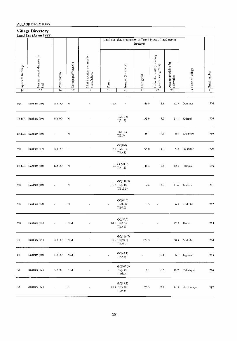
VILLAGE DIRECTORY
Village Directory Land Use (As on 1999)
14 15
MR Bankura (10)
PR MR Bankura (10)
PR MR Bankura (10)
MR Bankura (37)
PR MR Bankura (10)
MR Bankura (10)
MR Bankura (32)
MR Bankura (34)
PR Bankura (34)
PR Bankura (40)
PR Bankura (42)
PR Bankura (42)
16 17 18
ED EO N
ED EO N
N
ED EO
ED EO N
N
N
NM
ED EO NM
ED EO NM
ED EO NM
N
Land use (i.e. area under different types ofland use in hectare)
19
15.4
20
TK(31.8) T(31.8)
TK(3.5) T(3.5)
GC(S.O) 8.1 TK(7.1)
T(15.1)
9,GC(41.3} . .0 T(41.3)
GC(11O.5} 16.6 TK(3.0)
T(113.5)
GC(60.7) TK(8.3) T(69.0)
GC(56.7) 81.8 TK(6.5)
T(63 I)
GC(116.7) 40.9 TK(40.0)
T(156.7)
GC(42.1) T(42.1)
GC(167.5) TK(2.0) T(169.5)
GC(17.8) 20.2 TK(2.0)
T(l9.8)
291
21 22
46.9
33.0
45.1
95.0
41.3
12.4
3.5
122.3
6.1
26.3
23 2
12.1 12.7 Dumutor
7.3 11.1 Khirpai
12.1 8.6 Khapkata
5.3 5.8 Pathrator
12.6 12.0 Rampur
2.0 11. 6 Arabari
6.8 Kurkutia
22.5 Jharia
88.5 Araldihi
10.1 6. I Jugibaid
6.5 10.2 Chhatapur
12.1 14.5 Nischintapur
206
207
20S
209
210
211
212
213
214
215
216
217
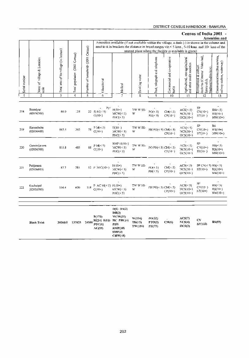
218
219
220
221
222
2
Binodpur (02056300)
Kurusthalia (02056400)
Gosainijanara (02056500)
Patijanara (02056600)
Kuchaipa! (02056700)
Block Total
3 4
60.0 125
147.4 363
155.8 485
87.7 281
104.4 600
30260.0 137825
DISTRICT CENSUS HAINDBOOK : BANKURA
Census of India 2001 -Amenities and
Amenities available (if not available within the village, a dash (-) is shown in the column and next to it in brackets the distance in broad ranges viz.< 5 kms., 5-10 krns. and 10+ kms of the
nearest place where the facility is available is given
5 6 7
P« H(IO+) 22 5) M« 5) MCW« 5)
C(10+) PHC«5)
78 PM«5) C(lO+)
H(JO+) MCW« 5) PHC« 5)
8
TWWSS-W
'" o 0...
9
PO« 5) PH«5)
10
CM«5) CP(lO+)
TWWSS-W PH PO« 5) CM« 5)
CP(10+)
88 PM«5) C(IO+)
RMP H(I 0+ ) TW W SS-MCW« 5) W PO PH« 5) CM« 5) PHC« 5) CP(10+)
H(10+) 52 P MC(10+) MCW«5)
PHC« 5)
118 P ACM«5) H(lO+) C(lO+) MCW« 5)
PHC« 5)
P(l72)
24586 M(24) S(11) PUC(6) AC(59)
D(6) DA(2) DH(3) MCW(25) HC PHC(4)
PHS RMP(lO) SMP(3) CHW(48)
292
TWWSS-W
PO« 5)
PH« 5)
CM«5) CP(lO+)
TWWSS-W PH PO« 5) CM« 5)
CP(lO+)
W(194) TK(15) TW(186)
PO(32) PTO(2) PH(7S)
CM(6)
11
ACS« 5) NCS(lO+) OCS(lO+)
ACS« 5) NCS(lO+) OCS(lO+)
ACS« 5) NCS(lO+) OCS(lO+)
ACS« 5) NCS(lO+) OCS(lO+)
ACS« 5) NCS(lO+) OCS(10+)
ACS(7) NCS(4)
OCS(3)
12
SP CV(lO+) ST(10+)
SP CV(10+) ST(lO+)
SP CV(IO+) ST(JO+)
13
BS« 5) RS(10+) NW(lO+)
BS RS(IO+) NW(lO+)
BS« 5) RS(lO+) NW(lO+)
SP CV« 5) BS« 5) ST(10+) RS(10+)
NW(JO+)
SP CV(lO+) ST(lO+)
CV SP(133)
BS« 5) RS(IO+) NW(10+)
8S(59)
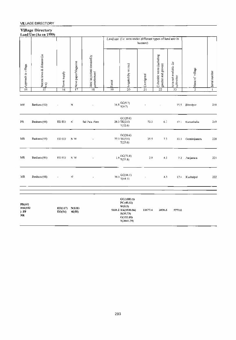
VILLAGE DIRECTORY
Village Directory Land Use (As on 1999)
14
MR
PR
MR
MR
MR
PR(60) MR(182 ) FP NR
15
Bankura (42)
Bankura (44)
Bankura (44)
Bankura (46)
Bankura (4S)
16 17
N
ED EO N
ED EO NM
ED EO NM
N
ED(1l7) N(121) EO(S4) M(S8)
18
Sal Pata Plate
Land use (i.e. area under different types ofland use in hectare)
19 20
348 GC(9.7) · T(9.7}
GC(206) 28.3 TK(2.0)
T(22.6)
GC(20.6) 77.3 TK(S.O)
T(2S.6)
16 GC(72.8) · T(n.S)
385 GC(44 I) · T(44.1)
GC(1882.S) PC(40.32) W(O.S)
5331.2 TK(1530.56) R(35.73) 0(152.18) T(3641.79)
293
21
73.3
3S.5
2.0
11677.4
22 23 2
IS.S Binodpur
6.1 17. I Kurusthalia
7.3 10.1 Gosainijanara
4.1 7.2 Patijanara
4.S 17.4 Kuchaipal
3836.6 5773.0
21S
219
220
221
222

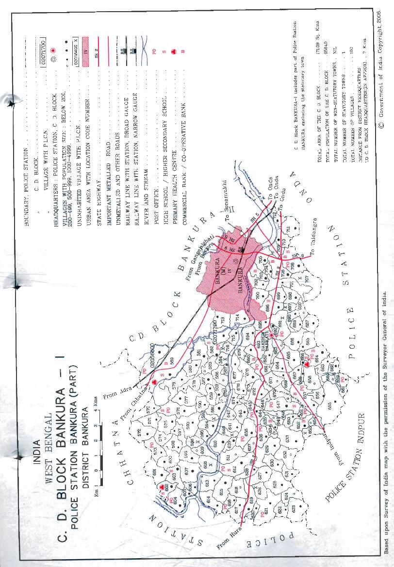
z o ~ < E-< [/)
~ u ~ o p..
::.-.-0:: < o z ::;, o tIl
• o
'" X CIl
c. U·
J I
(. ~
1 '1 0 c\ a J
-o
-o
I=l o 'fii
CIJ
'S .... <Il Po
..... o >. <Il > .... ;j [/)
I=l o Po ;j
'0 <Il CIJ <Il
CD
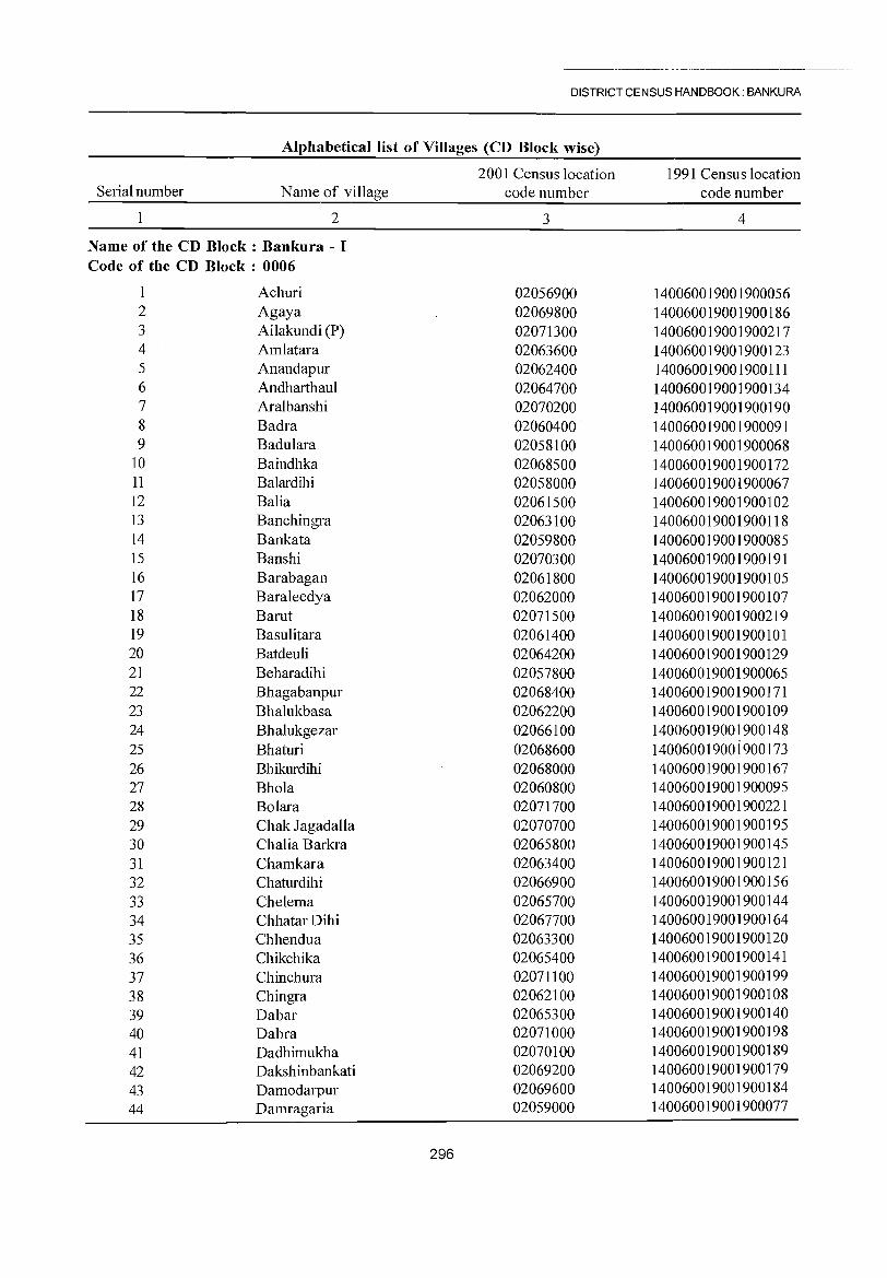
-- -~---~- -- ---------~~-~-----
DISTRICT CENSUS HANDBOOK: BANKURA
Alphabetical list of Villages (CD Block wise)
Serial number Name of village
2
Name of the CD Block: Bankura - I Code of the CD Block : 0006
Achuri 2 Agaya 3 Ailakundi (P) 4 Amlatara 5 Anandapur 6 Andharthaul 7 Aralbanshi 8 Badra 9 Badulara
10 Baindhka 11 Balardihi 12 Balia 13 Banchingra 14 Bankata 15 Banshi 16 Barabagan 17 Baraleedya 18 Barut 19 Basulitara 20 Batdeuli 21 Beharadihi 22 Bhagabanpur 23 Bhalukbasa 24 Bhalukgezar 25 Bhaturi 26 Bhikurdihi 27 Bhola 28 Bolara 29 Chak Jagadalla 30 Chalia Barkra 31 Chamkara 32 Chaturdihi 33 Chelema 34 Chhatar Dihi 35 Chhendua 36 Chikchika 37 Chinchura 38 Chingra 39 Dabar 40 Dabra 41 Dadhimukha 42 Dakshinbankati 43 Damodarpur 44 Damragaria
2001 Census location code number
3
02056900 02069800 02071300 02063600 02062400 02064700 02070200 02060400 02058100 02068500 02058000 02061500 02063100 02059800 02070300 02061800 02062000 02071500 02061400 02064200 02057800 02068400 02062200 02066100 02068600 02068000 02060800 02071700 02070700 02065800 02063400 02066900 02065700 02067700 02063300 02065400 02071100 02062100 02065300 02071000 02070100 02069200 02069600 02059000
296
1991 Census location code number
4
140060019001900056 140060019001900186 140060019001900217 140060019001900123 1400160019001900111 140060019001900134 140060019001900190 140060019001900091 140060019001900068 140060019001900172 140060019001900067 140060019001900102 140060019001900118 140060019001900085 140060019001900191 140060019001900105 140060019001900107 140060019001900219 140060019001900101 140060019001900129 140060019001900065 140060019001900171 140060019001900109 140060019001900148 14006001900i900173 140060019001900167 140060019001900095 140060019001900221 140060019001900195 140060019001900145 140060019001900121 140060019001900156 140060019001900144 140060019001900164 140060019001900120 140060019001900141 140060019001900199 140060019001900108 140060019001900140 140060019001900198 140060019001900189 140060019001900179 140060019001900184 140060019001900077
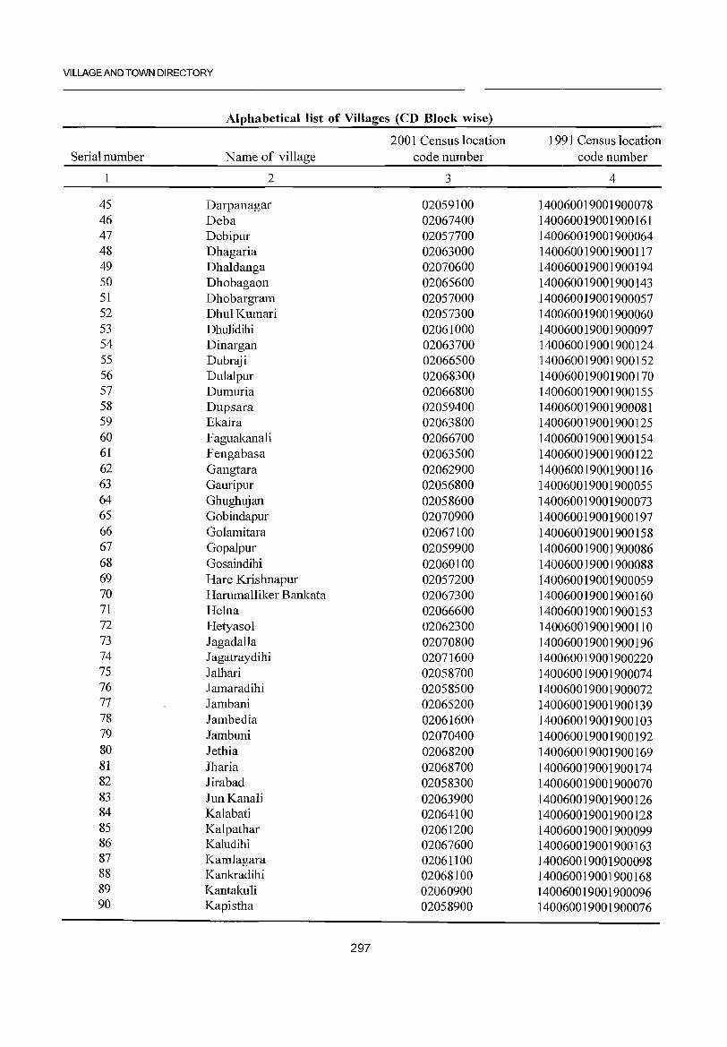
VILLAGE AND TOWN DIRECTORY
Alphabetical list of Villages (CD Block wise)
2001 Census location 1991 Census location Serial number Name of village code number code number
2 3 4
45 Darpanagar 02059100 140060019001900078 46 Deba 02067400 140060019001900161 47 Debipur 02057700 140060019001900064 48 Dhagaria 02063000 140060019001900117 49 Dhaldanga 02070600 140060019001900194 50 Dhobagaon 02065600 140060019001900143 51 Dhobargram 02057000 140060019001900057 52 DhulKumari 02057300 140060019001900060 53 Dhulidihi 02061000 140060019001900097 54 Dinargan 02063700 140060019001900124 55 Dubraji 02066500 140060019001900152 56 Dulalpur 02068300 140060019001900170 57 Dumuria 02066800 140060019001900155 58 Dupsara 02059400 140060019001900081 59 Ekaira 02063800 140060019001900125 60 Faguakanali 02066700 140060019001900154 61 Fengabasa 02063500 140060019001900122 62 Gangtara 02062900 140060019001900116 63 Gauripur 02056800 140060019001900055 64 Ghughujan 02058600 140060019001900073 65 Gobindapur 02070900 140060019001900197 66 Golamitara 02067100 140060019001900158 67 Gopalpur 02059900 140060019001900086 68 Gosaindihi 02060100 140060019001900088 69 Hare Krishnapur 02057200 140060019001900059 70 Hammalliker Bankata 02067300 140060019001900160 71 Helna 02066600 140060019001900153 72 Hetyasol 02062300 140060019001900110 73 Iagadalla 02070800 140060019001900196 74 J agatraydihi 02071600 140060019001900220 75 Ialhari 02058700 140060019001900074 76 Iamaradihi 02058500 140060019001900072 77 Iambani 02065200 140060019001900139 78 Iambedia 02061600 140060019001900103 79 Iambuni 02070400 140060019001900192 80 Iethia 02068200 140060019001900169 81 Jharia 02068700 140060019001900174 82 Jirabad 02058300 140060019001900070 83 IunKanali 02063900 140060019001900126 84 Kalabati 02064100 140060019001900128 85 Kalpathar 02061200 140060019001900099 86 Kaludihi 02067600 140060019001900163 87 Kamlagara 02061100 140060019001900098 88 Kankradihi 02068100 140060019001900168 89 Kantakuli 02060900 140060019001900096 90 Kapistha 02058900 140060019001900076
297
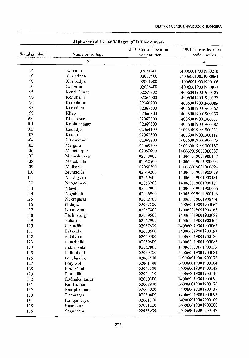
DISTRICT CENSUS HANDBOOK: BANKURA
Alphabetical list of Villages (CD Block wise)
2001 Census location 1991 Census location Serial number Name of village code number code number
2 3 4
91 Kargahir 02071400 140060019001900218 92 Kasiadoba 02057400 140060019001900061 93 Kasibedya 02061900 140060019001900106 94 Katgaria 02058400 1400600]9001900071 95 Kend Khune 02069700 140060019001900185 96 Kendbana 02064000 140060019001900127 97 Kenjakura 02060200 140060019001900089 98 Keranipur 02067500 140060019001900162 99 Khap 02066300 140060019001900150
100 Khenkriara 02062600 140060019001900113 101 Krishnanagar 02069500 140060019001900182 102 Kumidya 02064400 140060019001900131 103 Kustara 02062500 140060019001900112 104 Makarkendi 02068800 140060019001900175 105 Manjura 02069900 ]40060019001900187 106 Manoharpur 02060000 140060019001900087 107 Manushmura 02070000 140060019001900188 108 Matiakhola 02060500 140060019001900092 109 Molbana 02060700 140060019001900094 110 Muraddihi 02059200 140060019001900079 III Nandigram 02069400 140060019001900181 112 Nangalbera 02063200 140060019001900119 113 Nawdi 02057900 140060019001900066 114 Nayabadi 02065900 140060019001900146 115 Nekragaria 02062700 140060019001900114 116 Nidaya 02057500 140060019001900062 117 Nutangaon 02067800 140060019001900165 118 Pachirdang 02059500 140060019001900082 119 Paharia 02067900 140060019001900166 120 Papurdihi 02057600 140060019001900063 121 Patakala 02070500 1401060019001900193 122 Patalkhuri 02069300 1401060019001900180 123 Pathakdihi 02059600 140060019001900083 124 Patharkata 02062800 140060019001900115 125 Pathrabaid 02059700 140060019001900084 126 Penchaldihi 02064500 1401060019001900132 127 Poryasol 02061700 1401060019001900104 128 PuraMouli 02065500 1401060019001900142 129 Purundihi 02064300 1410060019001900130 130 Radhakantapur 02060300 140060019001900090 131 Raj Kumar 02068900 1410060019001900176 132 Ramjibanpur 02065000 1410060019001900137 133 Ramnagar 02060600 1410060019001900093 134 Rangametya 02061300 1410060019001900100 135 Rasunkur 02071200 1410060019001900200 136 Sagunsara 02066000 1410060019001900147
298
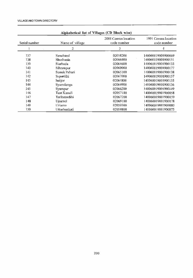
VILLAGE AND TOWN DI RECTORY
Alphabetical list of Villages (CD Block wise)
2001 Census location 1991 Census location Serial number Name of village code number code number
1 2 3 4
137 Sanaband 02058200 140060019001900069 138 Shushunia 02066400 140060019001900151 139 Siarbada 02064600 140060019001900133 140 Sibrampur 02069000 140060019001900177 141 Sunuk Pahari 02065100 140060019001900138 142 Supurdihi 02067000 140060019001900157 143 Sutijor 02064800 140060019001900135 144 Syamdanga 02064900 140060019001900136 145 Syampur 02066200 140060019001900149 146 TantKanali 02057100 140060019001900058 147 Taribaterdihi 02067200 140060019001900159 148 Uparsol 02069100 140060019001900178 149 Uriama 02059300 140060019001900080 150 Uttarbankati 02058800 140060019001900075
299
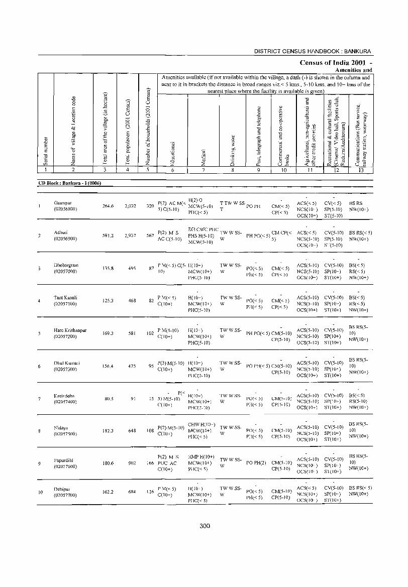
DISTRICT CENSUS H/INDBOOK : BANKURA
Census of India 2001 -Amenities and
Amenities available (ifnot available within the village, a dash (-) is shown in the column and next to it in brackets the distance in broad ranges viz.< 5 kms., 5-10 kms. and 10+ kms of the
j nearest place where the facility is available is gi..;.ve::.;n+ ___ -.-__ ---I ~ ~ 5 '"d ., 8 t5 '-;;) U ~ cn~ C _g ~ Cl) d) .- • .3"0 'tJ o :=_ ~ g § .2: ~ ~ t ,_ .~ - U N ..c e B ",0 c:~ g jo ~oo ~ fr ~ B ~o. ~~
..J = ~ -0 E 6 .~ Ul ~ ~ E ~ t ~ ";: ::",0.) "0 c.) ~ .1:! '3 ~ .2 8 ~ <l) '" OC V~ @-o!=:;Q;I{)O.....CI',);;:-~ -5 ..... t: g .~; ~ ~.g § d' 13 _ tc; .~ _g B -g_ cd " ~ ._ '"0 .~ 0
§ ';;: ro:3 ~ '--o~ ~ E! ~ e :!::, ~ > .3 u .~ -' 4-< Q) 0.. H ~ '§ ;::f...... 0 --. ....... '2 ~ c 0 ~ 8. ~ ~ gf Ji3. (l) .=:~:._ (Q E ~ VJ
ca!\) .0 '-g .~ ~ ~ E Vl ~ (.) td E ~ E ~ E ce ca S Q '"0 .~ t-:." l= ..::.:: 'c~' e ~ :.a E 3: '5 zro 2;~:l ~ d) .-- ... ~ 0 C 0.0 ..c c.)._ ro 0 ::
~~71~~-~2~--t-~~~-i-..;.~~-+~z75-t---~6~-4--~~~-+--~~~~~~~~~-u~10=~~+-~-<~1~lo--~~=<l)~~~2~~~-~~u~1-;~~
CD Block: Bankura - I (0006)
Gauripur (02056800)
264.6 2,032 P(2) ( H(2) 0 ( C
320 AC M < MCW(5-10) T TW W SS· PO PH CM« 5) ACS < 5) V« 5) BSRS NW(IO+) 5) C(5-1O) PHC« 5) T CP« 5) NCS(lO+) SP(5-10)
__________________________________________________________________________ O~C~S~(l~O+) __ S_T~(5_-_10~) ______ __
2
3
4
6
7
8
9
10
Achuri (02056900)
Dhobargram (02057000)
Tant Kanali (02057100)
Hare Krishnapur (02057200)
Dhul Kumari (02057300)
Kasiadoba (02057400)
Nidaya (02057500)
Papurdihi (02057600)
Debipur (02057700)
591.2 2,937
135.8 495
125.3 468
169.3 581
156.4 475
80.5 91
112.3 648
180.6 902
162.2 684
567 P(2) M S AC C(5-tO)
DH CWC PHC TW W SS- CM CP« ACS« 5) PHSH(5-10) W PHPO«S)
CV(5-1O) BS RS« 5)
MCW(5-10) 5) NCS(5-1O) OCS(IO+)
SP(5-10) NW(tO+) ST(5-10)
87 P M« 5) C(5- H(IO+) 10) MCW(IO+)
PHC(5-10)
82 P M« 5) C(lO+)
102 P M(5-lO) C(lO+)
H(IO+) MCW(lO+) PHC(5-IO)
H(IO+) MCW(IO+) PHC(5-10)
95 P(3) M(5-IO) H(lO+) C(IO+) MCW(IO+)
PHC(5-10)
P« H(IO+) 15 5)M(5-IO) MCW(lO+)
C(IO+) PHC(5-10)
:;'WSS- PO«5)
PH« 5)
:WWSS- PO«5)
PH« 5)
CM« 5) CP« 5)
CM«5) CP«5)
ACS(5-IO) CV(5-1O) BS« 5) NCS(5-10) SP(lO+) RS« 5) OCS(lO+) ST(lO+) NW(JO+)
ACS(5-IO) CV(S-IO) BS« 5)
NCS(5-to) SP(IO+) RS« 5) OCS(lO+) ST(IO+) NW(lO+)
TW W SS- PH PO« 5) CM(5-1O) ACS(5-10) W CP(5-10) NCS(5-10)
OCS(5-1O)
CV(S-IO) BS RS(5-10)
SP(10+) NW(to+) ST(tO+)
TWWSS- POPH«5)CM(5-1O) ACS(5-10) W CP(5-IO) NCS(5-10)
OCS(lO+)
CV(5-10) BS RS(5-10)
SP(IO+) NW(lO+) ST(lO+)
TWWSS-W PO« 5)
ACS(5-10) CV(5- 10) BSC < 5) CM{5-10) NCS(5-10) SP(lO+) RS(5-10)
PH« 5) CP(5-10) OCS(lO+) ST(lO+) NW(IO+)
P(2) M(5-10) CHW H(IO+) TW W SS-108 C(lO+) MCW(lO+) W PO« 5)
ACS(5-10) CM(5-1O) NCS(5-1O)
CV(5-IO) BS RS(5-10)
P(2) M S 166 PUC AC
C(lO+)
116 PM«5) C(lO+)
PHC« 5) PH« 5) CP(5-IO) OCS(lO+)
RMP H(IO+) TW W SS- ACS(5-1O) MCW(IO+) W PO PH(2) CM(5-10) NCS(lO+)
PHC« 5) CP(5-10) OCS(IO+)
H(IO+) MCW(IO+) PHC« 5)
300
:W W SS- PO« 5)
PH« 5)
ACS« 5) CM(5-10) NCS(10+) CP(5-10) OCS(10+)
SP(IO+) NW(IO+) ST(IO+)
CV(5-10) BS RS(5-to)
SP(lO+) NW(tO+) ST(IO+)
CV(5-1O) BS RS« 5) SP(lO+) NW(lO+) ST(lO+)
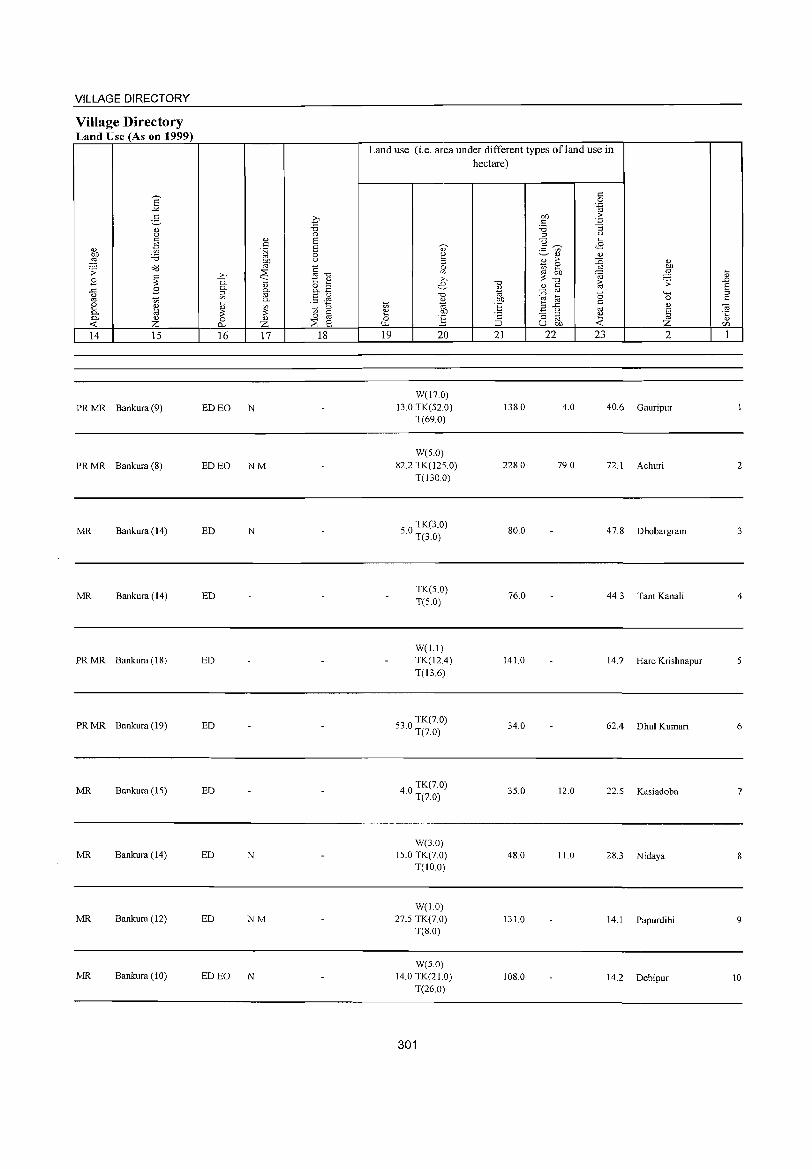
VILLAGE DIRECTORY
Village Directory Land Use (As on 1999)
E .!<:
g <l) u
" <1) 1il ~ :.a
o"d .;; ~ ,9
.<:: ,9 u oj
'" ~ ~ 0- <l)
-< Z 14 15
PRMR Bankura(9)
PRMR Bankura (8)
MR Bankura (14)
MR Bankura (14)
PRMR Bankura (18)
PRMR Bankura (19)
MR Bankura (IS)
MR Bankura (14)
MR Bankura (12)
MR Bankura (10)
q "0 0 ., S .s s [;j 0
bf) U
'" ~"d ~ >-> "0. "";:::; t 2 0-
<l) o ::I
~ 0- o.~
'" §11 0-:;:; ~ 1;; ::::!
;; 0 fa 0 <l)
0... Z ~ E 16 17 18
ED EO N
ED EO NM
ED N
ED
ED
ED
ED
ED N
ED NM
ED EO N
Land use (i.e. area under different types ofland use in hectare)
c: 0
'"§ bf) ;>
" . .;::
:.a ::; ::I U
u l'l " .f: ~ 2 ~<l) <l)
::I <l) ;> ::i5 <l)
0 Iii ~ '" ~ '" :a .... ~ '" '" "0 -a
~ .;; .0 e <l) <l) fa E .., :0 "0 """' ::I -a
oj t;; 0 " <l)
"S c: 1;; .., E'fi oj <1) Ol
2 OJ)
" :; '" ~ § ·c
0 .§ '" <l)
'"" ;::J u on Z <fl
19 20 21 22 23 2 1
W(17 0) 13.0 TK(52.0) 138.0 4.0 40.6 Gauripur
T(69.0)
W(S.O) 82.2 TK(125.0) 228.0 79.0 72.1 Achuri 2
T(130 0)
SO TK(3.0) · T(3.0)
80.0 47.8 Dhobargram 3
TK(S.O) 76.0 44.3 Tan! Kanali 4
T(S.O)
W(l.1) TK(12.4) 141.0 14.7 Hare Krishnapur S T(13.6)
S3 0 TK(7.0) · T(7.0)
34.0 62.4 Dhul Kumari 6
40 TK(7.0) · T(7.0)
3S.0 12.0 22.5 Kasiadoba 7
W(3.0) 15.0 TK(7 0) 48.0 11.0 28.3 Nidaya 8
T(lO 0)
W(1.0) 27.S TK(7.0) 131.0 14.1 Papurdihi 9
T(S.O)
W(5.0) 14.0 TK(21.0) 108.0 14.2 Debipur 10
T(26.0)
301
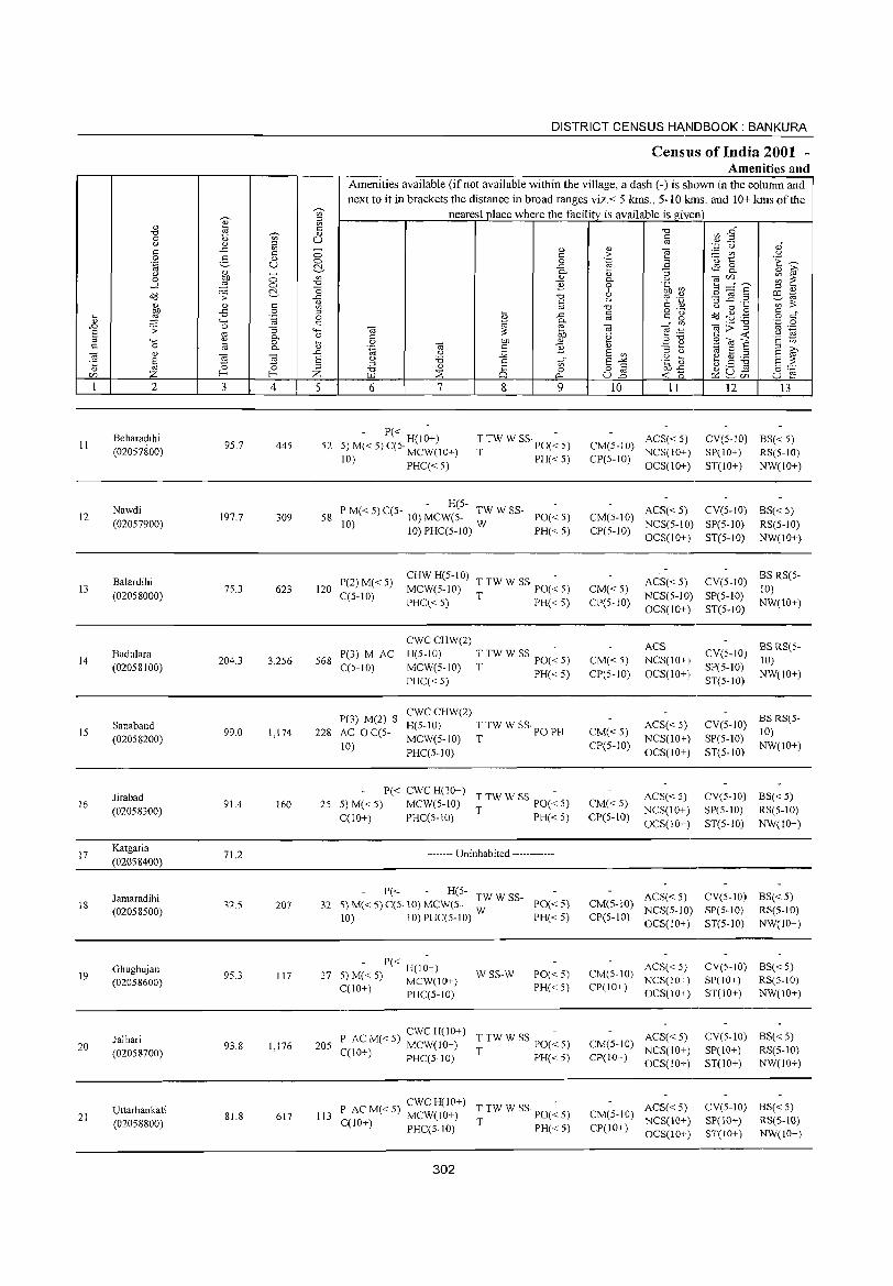
II
12
13
14
IS
16
17
18
19
20
21
.... " .D E ;:I c til ·c " <ZJ
2
Beharadihi (02057800)
Nawdi (02057900)
Balardihi (02058000)
Badulara (02058100)
Sanaband (02058200)
Jirabad (02058300)
Katgaria (02058400)
Jamaradihi (02058500)
Ghughujan (02058600)
Jalhari (02058700)
Uttarbankati (02058800)
3 4
95.7 445
197.7 309
75.3 623
204.3 3,256
99.0 1,174
91.4 160
71.2
32.5 207
95.3 117
93.8 1,176
81.8 617
DISTRICT CENSUS HANDBOOK: BANKURA
CensUls of India 2001 -Amenities and
Amenities available (if not available within the village, a dash (-) is shown in the column and next to it in brackets the distance in broad ranges viz.< 5 kms., 5-10 kms. and 10+ kms of the
nearest place where the facility is available is given =,----,----1
5 6 7
- P« H(I;+) 52 5) M( < 5) C(5· MCW( I 0+)
10) PHC« 5)
8
" c o ..c 0..
" ] "0 C
'" .c
e-OJ)
" ]
Vl o
Q..
9
T TW W SS· PO(~ 5)
T PH« 5)
- H(5-58 P M« 5) C(5- 10) MCW(5- TW W SS- PO« 5)
10) 10) PHC(5-10) W PH« 5)
120 P(2) M« 5) C(5-10)
CHW H(5-10) -MCW(5-1O) TTWWSS' PO«5)
PHC« 5) T PH« 5)
568 P(3) M AC C(5-10)
P(3) M(2) S
228 AC 0 C(5-10)
CWCCHW(2)
H(5-1O) TTWWSS'PO(~5) MCW(5-10) T PH«5) PHC« 5)
CWCCHW(2)
H(5-1O) T TW W SS· PO PH MCW(5-10) T PHC(5-10)
P« CWC H(lO+) -25 5)M«5) MCW(5-10) TTWWSS' PO«5)
C(IO+) PHC(5-10) T PH« 5)
-------- Uninhabited ------------
- P« - H(5- TW W SS-32 S)M«5)C(5.10)MCW(S- W PO«S)
10) 10) PHC(5-10) PH« 5)
P« H(IO+) 27 5) M« 5) MCW(IO+)
C(IO+) PHC(5-10)
WSS-W PO«5) PH«5)
CWCH(lO+) -205 P AC M« 5) MCW(IO+) T TW W SS· PO« 5)
C(1O+) PHC(5-10) T PH« 5)
CWCH(IO+) -113 P AC M« 5) MCW(10+) T TW W SS· PO« 5)
C(lO+) PHC(5-IO) T PH« 5)
302
" > .~
'" 0.. o 6 u "0 C
'" til .~
'" E '" ~-'2 uB
10 11
CM(5-10) ACS« 5) CP(5-10) NCS(IO+)
OCS(IO+)
12 13
CV(5-1O) BS«5) SP(IO+) RS(5-10) ST(10+) NW(IO+)
ACS« 5) CV(5-10) BS« 5) CM(5-10) NCS(5-IO) Spe5-10} RS(5-1O) CP(S-IO)
OCS(IO+) ST(5-10) NW(lO+}
CM« 5) CP(S-IO)
CM«5) CP(5-10)
CM« 5) CP(5-10)
CM«5) CP(S-IO)
ACS« 5) NCS(5-1O) OCS(IO+)
ACS NCS(IO+) OCS(lO+)
ACS« 5) NCS(IO+) OCS(IO+)
ACS«5) NCS(IO+) OCS(IO+)
CV(5-1O) BS RS(5-10)
SP(5-10) NW(IO+) ST(5-10)
CV(5-10) BS RS(S-10)
SP(5-10) NW(10+) ST(5-10)
CV(5-10) BS RS(5-10)
SP(5-10) NW(IO+) ST(5-10)
CV(5-1O) BS« 5) SP(5-1O) RS(5-1O) ST(5-10) NW(10+)
ACS« 5) CV(5-10) BS« 5) CM(5-10) NCS(5-10) SP(5-10) RS(5-1O) CP(5-1O) OCS(IO+) ST(5-10} NW(lO+)
ACS« 5) CM(5-10) NCS(IO+) CP(IO+) OCS(lO+)
ACS« 5) CM(5-IO) NCS(IO+) CP(10+) OCS(IO+)
ACS« 5) CM(5-10) NCS(IO+) CP(lO+) OCS(IO+)
CV(5-10) BS« 5) SP(lO+) RS(5-1O) ST(10+) NW(10+)
CV(5-10) BS« 5) SP(IO+) RS(5-JO) ST(IO+) NW(lO+)
CV(5-1O) BSC < 5) SP(lO+) RS(S-10) ST(IO+) NW(lO+)
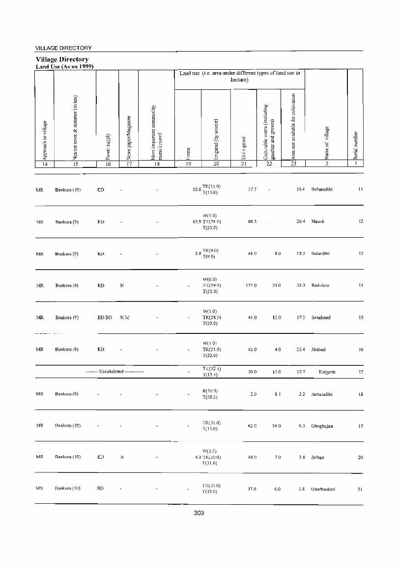
VILLAGE DIRECTORY
Village Directory Land Use (As on 1999)
S "'" g '" ()
~ d) b1) '0 ;:§
o<J .s: .8 ~
.8 .<:: u '" 2
<Il
'" 0, ~ 0, '" -< Z 14 15
MR Bankura (10)
MR Bankura (9)
MR Bankura (9)
MR Bankura (8)
MR Bankura (9)
MR Bankura (8)
'" '" .~ b1)
'" >-. ~ P.. 0, 0.>
:> g. <Il 0, .... d) <Il
;: ~ 0 0... Z 16 17
ED
ED
ED
ED N
ED EO NM
ED
-------- Uninhabited ------------
MR Bankura (9)
MR Bankura (10)
MR Bankura (10) ED N
MR Bankura (10) ED
q "0 0 S S 0 ()
~""d t '" 8.B .§ JS '0 ::I
'" 0 '" ~ S 18
Land use (i.e. area under different types ofland use in hectare)
'" 0 ".g
on .~
'" -3 '0 :> ()
"i3 .... d) "'~ <E ._ <Il
~ ~ '" '" til :>
~ 0.> 0 ~ ~ <Il '" =a iil >-.
"0 ;: "0
~ .s: .D e- " 0.> § S d :0 0 "" :> "0
'" t<; 0 '" '" .!"!J 1;1 d B .<:: '" '" til t: '" e bll <.> ~ "5 'c "3 = ~ 0 ~ '" '"" ;:J u b1) Z </J
19 20 21 22 23 2 1
06 TK(ll.O) 5 . T(I1.0) 177 16A Beharadihi 11
W(l.O) 63.9 TK(24.0) 88.3 20A Nawdi 12
T(2S.0)
20 TK(9.0) . T(9.0) 44.0 8.0 12.3 Balardihi 13
W(6.0) TK(19.0) 1220 24.0 33.3 Badulara 14 T(2S.0)
W(l.O) TK(28.0) 41.0 12.0 17.0 Sanaband 15 T(29.0)
W(1.0) TK(21.0) 42.0 4.0 23.4 Jirabad 16 T(22.0)
TK(12.S) 30.0 15.0 13.7 Katgaria 17
T(l2.S)
R(20.3) 2.0 8.1 2.2 Jamaradihi 18
T(20.3)
TK(I1.0) 62.0 16.0 6.3 Ghughujan 19
T(I1.0)
W(1.0) 4.0 TK(30.0) 48.0 7.0 3.8 Jalhari 20
T(3JO)
TK(33.0) 37.0 6.0 5.8 Uttarbankati 21 T(33.0)
303
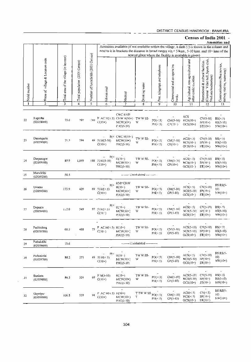
________________________________________________________ ~D~IS~T~R~I~C~T~C~E~N~S~U~S~H:ANDBOOK:BANKURA
Census of India 2001 -Amenities and
22
23
24
2S
26
27
28
29
30
31
32
Kapistha (02058900)
Damragaria (02059000)
Darpanagar (02059100)
Muraddihi (020S9200)
Uriama (020S9300)
Dupsara (02059400)
Pachirdang (020S9S00)
Pathakdihi (02059600)
Pathrabaid (020S9700)
Bankata (020S9800)
Gopalpur (02059900)
73.6 797
71.5 294
89.9 1,099
58.S
173.9 420
112.0 549
60.3 488
73.6
88.2 271
86.3 324
108.8 S59
Amenities available (if not available within the village, a dash (-) is shown in the column and next to it in brackets the distance in broad ranges viz.< 5 kms., 5-10 kms. and 10+ kms of the
nearest place where the facility is available isfLv._e""n,_ ___ .,..-__ --I
CWCRMP
140 P ACM(<5) CHWH(IO+) TWWSS-C(IO+) MCW(IO+) W PO« 5)
PHC(5-10) PH« 5)
P« CWC H(IO+) TW W SS-48 5) M(5-10) MCW(IO+) W PO« 5)
C(IO+) PHC(5-IO) PH« 5)
- P« H(I~+) 5) M(5-IO) MCW(lO+)
C(IO+) PHC(5-10)
188 :: W SS- PO« 5)
PH«5)
-------- Uninhabited ------------
RMPCHW P« H(lO+)
69 S) M« 5) MCW(lO+)
C(IO+) PHC(S-IO)
- P« H(I~+) 97 5) M« S) MCW(10+)
C(10+) PHC(5-10)
7S P AC M« 5) H(lO+) C(10+) MCW(lO+)
PHC(5-1O)
:WWSS- PO«S)
PH« S)
:WWSS- PO«5)
PH« 5)
:W W SS- PO« 5)
PH« 5)
-------- Uninhabited ------------
- P« H(I~+) 49 5) M« S) MCW(lO+)
C(10+) PHC(S-IO)
69 P M(5-10) C(IO+)
H(10+) MCW(JO+) PHC(S-lO)
94 PACM«S)H(10+) C(lO+) MCW(IO+)
PHC(5-IO)
304
~W W SS- PO« S)
PH« S)
~W W SS- PO« S)
PH« 5)
T TW W SS· PO(~ 5)
T PH« S)
ACS CM(5-10) NCS(IO+) CP(IO+) OCS(IO+)
ACS« 5) CM(5-IO) NCS(IO+) CP(IO+) OCS(IO+)
CM(S-IO) ACS« 5) CP(lO+) NCS(IO+)
OCS(IO+)
ACS« 5) CM(S-IO) NCS(5-10) CP(S-IO) OCS(IO+)
CV(5-10) BS«5) SP(IO+) RS(S-IO) ST(l 0+ ) NW(l 0+ )
CV(5-10) BS« 5) SP(lO+) RS(5-10) ST(lO+) NW(IO+)
eV(5-10) BS«5) SP(IO+) RS(5-10) ST(lO+) NW(IO+)
CV(S-IO) BS RS(5-10)
SP(10+) NW(10+) ST(10+)
ACS« 5) CV(5-10) BS« S) CM(S-10) NCS(5-IO) SP(lO+) RS(5-10) CP(5-10) OCS(IO+) ST(IO+) NW(lO+)
ACS(5-10) CV(5-10) BS« 5) CM(5-10) NCS(S-IO) SP(IO+) RS(S-lO) CP(S-IO) OCS(10+) ST(10+) NW(10+)
ACS« 5) CM(S-lO) NCS(S-IO) CP(S-IO) OCS(lO+)
BS RS(SCV(5-1O) 10)
SP(10+) NW(lO+) ST(IO+)
ACS(S-10) CV(5-10) BS«5) CM(S-lO) NCS(S-IO) SP(IO+) RS(S-IO) CP(5-10) OCS(lO+) ST(10+) NW(10+)
CM(5-10) ACS« 5) NCS« S)
CP(S-IO) OCS(IO+)
CV«S) SP(lO+) ST(10+)
BS RS(S-10) NW(10+)
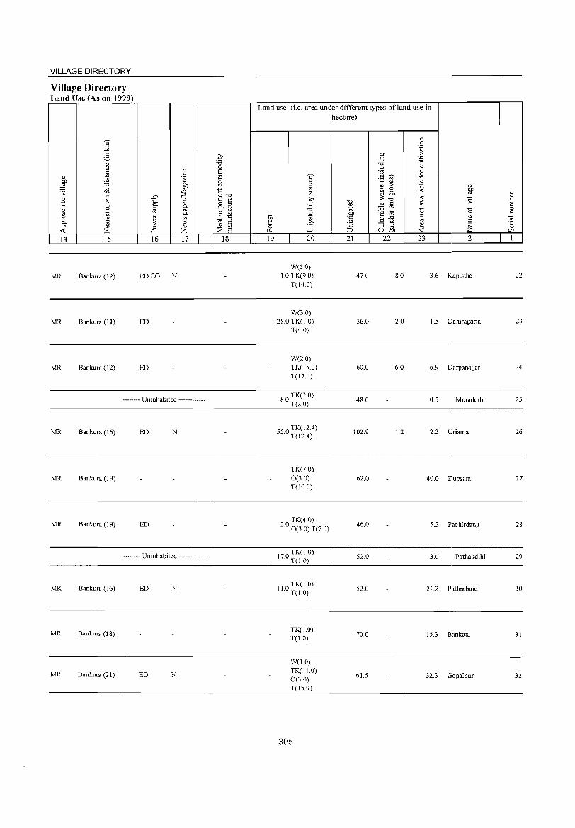
VILLAGE DIRECTORY
Village Directory Land Use (As on 1999)
6' "" 3
<1) c.>
'" ~ 0)
~ 'i3 o'd '': ~ B
..c:: B c.>
'" ti 8 ~ 0.. 0.. <1)
<C Z 14 15
MR Bankura (12)
MR Bankura (II)
MR Bankura (12)
<1)
'" .~ 01)
'" ~ >,
0.. -;:, <1)
0.. 0.. iil '" 0.. ~ <l.)
~ ~ 0 <1)
i>-. Z 16 17
ED EO N
ED
ED
-------- Uninhabited ------------
MR Bankura (16) ED N
MR Bankura (19)
MR Bankura (19) ED
-------- Uninhabited ------------
MR Bankura (16) ED N
MR Bankura (18)
MR Bankura (21) ED N
.£ "Cl 0 S S 0 c.>
~ u 1:: <1)
&2 .§ .M ti ::>
§ 0
~ 8 18
Land use (i.e. area under different types ofland use in hectare)
'" 0 .~
01) .::: '" -'§ 'i3 ::> c.>
0 ~
~ <B ., 2- '" 2 <1) <1)
::> E > :0 <1)
0 ~ e ~ § '" OJ) ~
~ '", <1) >,
"Cl "0 ~ '': .D e- <1) § S <1)
:0 "0 d 0 "-< ::> t;; 0 '" <1) OJ) e ti d "E ..c:: '" <!l
"' .8 '" e .~ c.>
~ .t:; '2 "3 ::> e 0 E '" <1)
(.L.. :::> u OJ) <C c/J
19 20 21 22 23 2 1
W(S.O) 10 TK(9.0) 47.0 8.0 3.6 Kapistha 22
T(14.0)
W(3.0) 28.0 TK(IO) 36.0 2.0 1.5 Damragaria 23
T(4.0)
W(2.0) TK(IS.O) 60.0 6.0 6.9 Darpanagar 24 T(I7.0)
80 TK(2.0) · T(2.0) 48.0 0.5 Muraddihi 25
550 TK(12.4) · T(12.4) 102.9 1.2 2.3 Uriama 26
TK(7.0) 0(3.0) 62.0 40.0 Dupsara 27 T(IO.O)
TK(40) 2.0 0 (3.0) T(7.0) 46.0 5.3 Pachirdang 28
170 TK(1.0) · T(IO) 52.0 3.6 Pathakdihi 29
110 TK(1.0) · T(1.0)
52.0 24.2 Pathrabaid 30
TK(IO) 70.0 15.3 Bankata 31 T(IO)
W(1.0) TK(IIO)
61.5 32.3 Gopalpur 32 0(30) T(150)
305
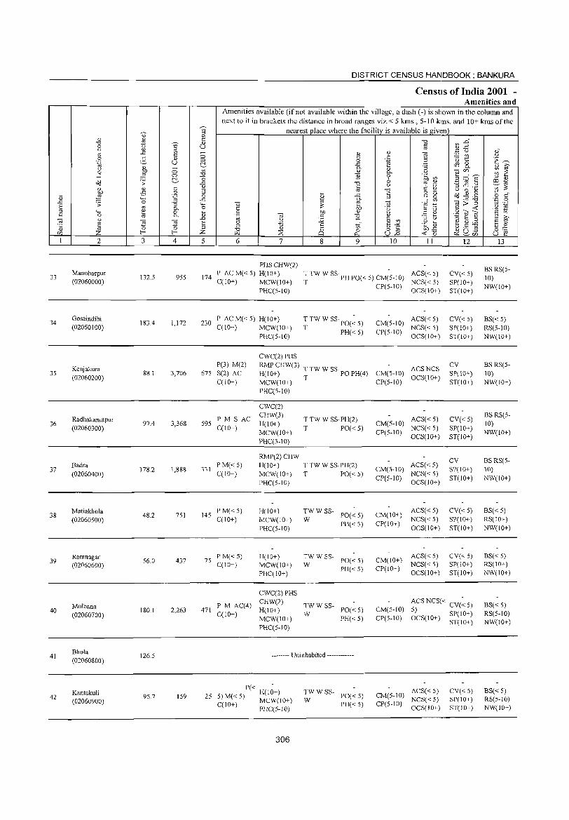
33
34
35
36
37
38
39
40
41
42
2
Manoharpur (02060000)
Gosaindihi (02060100)
Kenjakura (02060200)
Radhakantapur (02060300)
Badra (02060400)
Matiakhola (02060500)
Ramnagar (02060600)
Molbana (02060700)
Bhola (02060800)
Kantakuli (02060900)
3 4
132.5 955
1834 1,172
88.1 3,706
97.4 3,368
178.2 1,888
48.2 751
56.0 437
180.1 2,263
126.5
95.7 159
DISTRICT CENSUS HANDBOOK: BANKURA
CensUlS of India 2001 -Amenities and
Amenities available (ifnot available within the village, a dash (-) is shown in the column and next to it in brackels the dislance in broad ranges viz.< 5 krns., 5-10 k.ms. and 10+ k.ms of the
nearest_Qlace where the facility is available is given
5 6 7
174
PHSCHW(2) P ACM«5) H(10+) C(1O+) MCW(IO+)
PHC(5-10)
230 P ACM«5) H(IO+) C(10+) MCW(IO+)
P(3) M(2) 675 S(2) AC
C(lO+)
595 PM S AC C(lO+)
331 PM«5) C(IO+)
145 P M« 5) C(1O+)
75 PM«5) C(10+)
471 P M AC(4) C(lO+)
PHC(5-10)
CWC(2) PHS RMPCHW(3) H(lO+) MCW(IO+) PHC(5-10)
CWC(2) CHW(3) H(lO+) MCW(IO+) PHC(5-10)
RMP(2)CHW H(IO+) MCW(IO+) PHC(S-IO)
H(lO+) MCW(lO+) PHC(5-IO)
H(10+) MCW(IO+) PHC(IO+)
CWC(2) PHS CHW(2) H(10+) MCW(IO+) PHC(5-10)
8 9 10 11
T TW W SS· PH PO« 5) CM(5-10) ACS« 5) T CP(5-IO) NCS« 5)
OCS(IO+)
T TW W SS· PO(~ 5)
T PH« 5)
CM(5-10) ACS«5) NCS« 5)
CP(5-10) OCS(IO+)
T TW W SS· PO PH(4) ACS NCS T CM(5-10) OCS(IO+)
CP(5-1O)
T TW W SS· PH(2) T PO« 5)
T TW W SS· PH(2) T PO« 5)
~W W SS- PO« 5)
PH« S)
TW W ss-w PO« 5) PH«5)
CM(5-10) ACS« 5) NCS« 5)
CP(5-10) OCS(lO+)
CM(5-10) ACS« 5) NCS«5)
CP(5-10) OCS(IO+)
CM(IO+) CP(10+)
CM(IO+) CP(IO+)
ACS« 5) NCS« 5) OCS(lO+)
ACS« 5) NCS«5) OCS(IO+)
12
CV« 5) SP(lO+) ST(IO+)
CV«5) SP(IO+) ST(IO+)
CV SP(IO+) ST(IO+)
CV« 5) SP(IO+) ST(10+)
CV SP(10+) ST(IO+)
CV«5) SP(lO+) ST(lO+)
CV« 5) SP(IO+) ST(IO+)
~W W SS- PO« 5)
PH«5)
CM(5-10) CP(5-10)
ACS NCS« CV« 5) 5) OCS(IO+) SP(IO+)
ST(lO+)
-------- Uninhabited ------------
P« 25 5) M( 5) H(IO+)
< MCW(lO+) C(lO+) PHC(5-1O)
306
:WWSS- PO«5)
PH«5)
ACS« 5) CM(5-10) NCS«5) CP(5-10) OCS(JO+)
CV« S) SP(IO+) ST(IO+)
13
BS RS(5-10) NW(lO+)
BS« 5) RS(5-IO) NW(lO+)
BS RS(5-10) NW(lO+)
BS RS(5-10) NW(lO+)
BSRS(5-10) NW(IO+)
BS« 5) RS(IO+) NW(IO+)
BS«5) RS(IO+) NW(IO+)
BS« 5) RS(5-1O) NW(10+)
BS« 5) RS(5-10) NW(IO+)
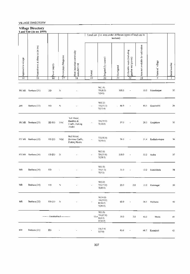
VILLAGE DIRECTORY
Village Directory Land Use (As on 1999)
14 15
PR MR Bankura (21)
MR Bankura (22)
PR MR Bankura (23)
PR MR Bankura (23)
PR MR Bankura (24)
MR Bankura (24)
MR Bankura (24)
MR Bankura (22)
16 17
ED N
ED N
ED EO NM
ED EO NM
ED EO N
ED
ED N
ED EO N
18
Bell Metal, Bamboo & Crafts, Fishing Hooks
Bell Metal, Bamboo Crafts, Fishing Hooks
-------- Uninhabited ------------
MR Bankura (21) ED
Land use (i.e. area under different types ofland use in hectare)
19 20
W(1.0) TK(S.O) T(9.0)
W(O.2) TK(11.2) T(11.4)
TK(IO.O) T(IO.O)
TK(IO.0) T(IO.O)
W(7.0) TK(21.0) T(2S.0)
W(1.0) TK(4.0) T(S.O)
W(5.0) TK(15.0) T(20.0)
W(14.0) TK(54.0) R(16.0) T(S4.0)
W(1.0)
13 0 TK(27 0) . R(4.0)
T(32.0)
TK(7.0) T(7.0)
307
21
IOS.0
86.9
57.9
76.0
11S.0
31.0
23.0
60.0
35.0
40.0
22 23 2
15.5 Manoharpur
85.1 Gosaindihi
20.3 Kenjakura
II .4 Radhakantapur
32.2 Badra
12.2 Matiakhola
2.0 II. 0 Ramnagar
36.1 Molbana
3.0 43.5 Bhola
48.7 Kantakuli
33
34
35
36
37
38
39
40
41
42
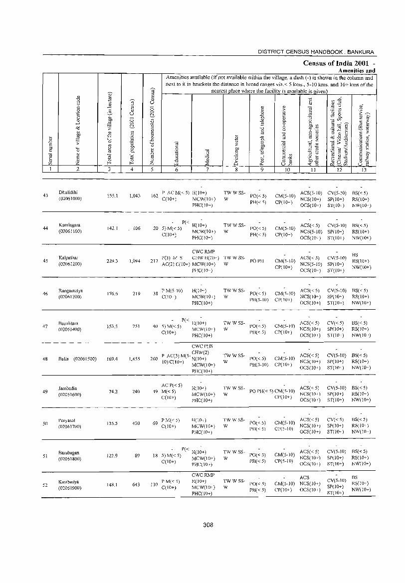
43
44
45
46
47
48
49
50
51
52
2
Dhulidihi (02061000)
Kamlagara (02061100)
Kalpalhar
(02061200)
Rangametya (02061300)
Basulitara (02061400)
Balia (02061500)
Jambedia (02061600)
Poryasol (02061700)
Barabagan (02061800)
Kasibedya (02061900)
3 4
155.1 1,043
142.1 106
229.3 1,094
176.6 219
153.5 251
169.4 1,455
74.2 240
135.S 430
122.9 89
148.1 643
DISTRICT CENSUS HP,NDBOOK : BANKURA
Census of India 2001 -Amenities and
Amenities available (if not available within the village, a dash (-) is shown in the column and next to it in brackets the distance in broad ranges viz.< 5 kms., 5-10 kms. and 10+ kms of the
nearest place where the facility. is available is given
5 6 7
162 P AC M« 5) H(IO+) C(lO+) MCW(10+)
PHC(IO+)
20 P« H(10+} 5) M« 5) MCW(10+} C(lO+) PHC(IO+)
CWCRMP
8
TWWSS-W
TWWSS-W
V> o c.. 9
PO« 5) PH« 5}
PO« 5) PH« 5}
217 P(3) M S CHW H(IO+) TW W SS- PO PH AC(2) C(10+) MCW(IO+) W
PHC(IO+)
38 P M(5-10) C(IO+)
H(IO+)
MCW(IO+) PHC(IO+)
- P« H(I;+) 40 5)M«5) MCW(IO+)
C(IO+) PHC(lO+)
260
CWCPHS CHW(2)
P AC(3)M(5- H(IO+)
10)C(10+) MCW(IO+)
PHC(IO+)
:W W SS- PO« 5)
PH(5-10)
:WWSS- PO«5)
PH« 5)
:W W SS- PO« 5)
PH(5-10)
10 11 12 13
CM(5-10) ACS(5-1O) CV(5-10} BS«5} CP(IO+) NCS(IO+) SP(IO+) RS(IO+)
OCS(IO+) ST(IO+) NW(IO+)
ACS«5) CV(S-10) BS«5) CM(5-1O) NCS(5-10) SP(lO+) RS(lO+} CP(IO+}
OCS(lO+) ST(10+) NW(lO+)
ACS«5) CM(5-10) NCS(5-1O)
CP(IO+) OCS(10+)
ACS« 5) CM(5-10) NCS(lO+)
CP(IO+) OCS(IO+)
ACS« 5) CM(5-10) NCS(IO+)
CP(IO+) OCS(IO+)
ACS« 5) CM(5-10) NCS(lO+) CP(IO+) OCS(IO+)
BS CV(5-JO) RS(10+) SP(IO+) NW(lO+) ST(IO+)
CV(S-IO) BS« 5) SP(IO+) RS(lO+) ST(IO+) NW(lO+)
CV«5) SP(IO+) ST(IO+)
8S« 5) RS(lO+) NW(IO+)
CV(S-IO) BS« 5) SP(IO+) RS(lO+) ST(lO+) NW(IO+)
ACP« 5) 49 M« 5)
C(lO+)
H(lO+) MCW(IO+) PHC(10+)
TW W SS- ACS« 5) W POPH«5}CM(5-10) NCS(10+)
CV(S-IO) 8S«5)
69 P M« 5) C(10+)
H(lO+) MCW(IO+) PHC(10+)
- P« H(I;+) 18 5)M«5) MCW(10+)
C(IO+) PHC(lO+)
110 PM«5) C(lO+)
CWCRMP H(IO+) MCW(IO+) PHC(lO+)
308
:WWSS- PO«5)
PH« 5)
TWWSS-W PO« 5)
PH« 5)
TWWSS-W PO« 5)
PH« 5)
CP(IO+) OCS(10+)
ACS« S) CM(5-10) NCS(IO+) CP(S-IO) OCS(IO+)
ACS« 5) CM(5-10) NCS(IO+) CP(S-IO) OCS(lO+)
ACS CM(5-IO) NCS(IO+) CP(JO+) OCS(IO+)
SP(IO+) RS(IO+) ST(10+) NW(10+)
CV«5) SP(IO+) ST(IO+)
BS« 5) RS(IO+) NW(IO+)
CY(5-1O) BS« 5) SP(lO+) RS(lO+) ST(IO+) NW(IO+)
BS CV(5-1O) RS(IO+) SP(lO+) NW(10+) ST(IO+)
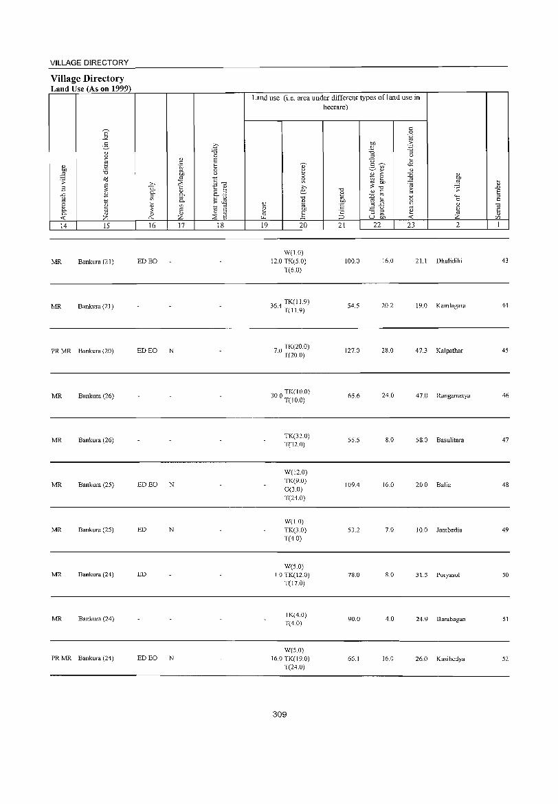
VILLAGE DIRECTORY
Village Directory Land Use (As on 1999)
E -'" g " Q c:
" tl 01) 'i3 ::§
~ .;;: ~ E
.c .8 g t) 8 ~ 0- '" 0- " --< Z 14 15
MR Bankura (21)
MR Bankura (21)
PR MR Bankura (20)
MR Bankura (26)
MR Bankura (26)
MR Bankura (25)
MR Bankura (25)
MR Bankura (24)
MR Bankura (24)
PRMR Bankura (24)
q "0 0
.S S S [;j 0
01) C)
'" g--c; .Q ~ 0. t:: " 0. " o !:l ::l ~ 0. +' en 0- S g i3 ._ '""
~ ~ § ~ 0 " p. Z ~ S 16 17 18
ED EO
ED EO N
ED EO N
ED N
ED
ED EO N
Land use (i.e. area under different types ofland use in hectare)
19 20
W(1.0) 12.0 TK(5.0)
T(6.0)
364 TK(I1.9) . T(I1.9)
70 TK(20.0) . T(20.0)
000 TK(10.0) o . T(J 0.0)
TK(32.0) T(32 0)
W(12.0) TK(9.0) 0(3.0) T(24.0)
W(1.0) TK(3.0) T(4.0)
W(5.0) 1.0 TK(12.0)
T(17.0)
TK(4.0) T(4.0)
W(5.0) 16.0 TK(19.0)
T(24.0)
309
'0
" "' 01) os 'c ::J 21
100.0
54.5
127.0
65.6
55.5
109.4
53.2
78.0
90.0
66.1
c 0 .~
01) .2: c: -'§ 'i3 ::l (.)
U .... 3 'U> <8
" " E ;> :0 " ~ ~ OJ 01)
'@ ::§ ~ '0 [:; .;;: " @ :0 0 4-<
e @ 0
.z {i c:
" OJ E :J ::l ~ '" '" U 01) --< Z 22 23 2
16.0 21.1 Dhulidihi
20.2 19.0 Kamlagara
28.0 47.3 Kalpathar
24.0 47.0 Rangametya
8.0 58.0 Basulitara
16.0 20.0 Balia
7.0 10.0 Jambedia
8.0 31.5 Poryasol
4.0 24.9 Barabagan
16.0 26.0 Kasibedya
i3 ..c E ::l c:
-;;; ·c " CI)
1
43
44
45
46
47
48
49
50
51
52
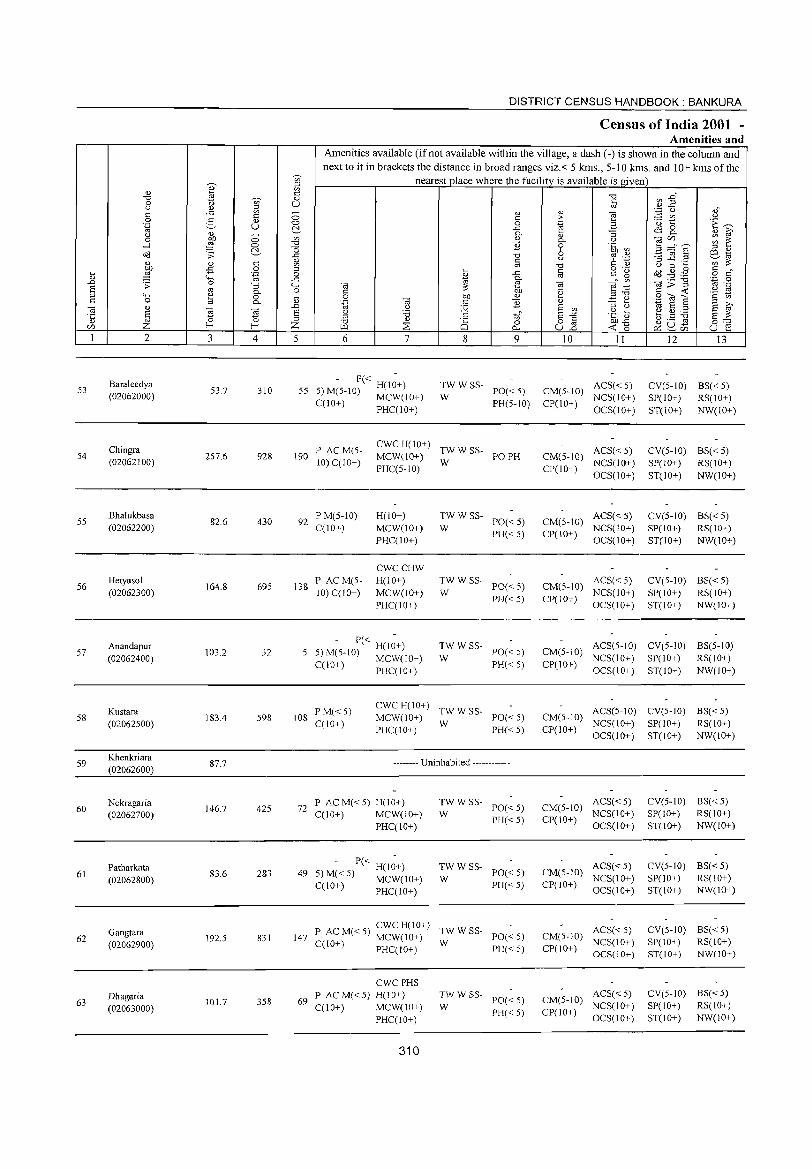
'" " ~ ~
0:: .",
~ C1)
0 t> u " '" 0:: .<::: i3 ~
0 0 S " 0 .~ u ~ " C1) ~
0 b!) 0 en .--l :§ 0 -0
~ a o(l ;; ..<:
C1)
" '" 0:: en
9 -s 0 ::l ... '-g 0 " '-H ..<: .n .;;: 0 "3 '-H s '" 0- 0 ::> "-' " 0 tl 0:: 0 a 0-
1S " ,n
§ OJ OJ S :u ~ 0 ::> e/) Z f--< Z I 2 3 4 5
53 Baraleedya
53.7 310 55 (02062000)
Chingra 54 257.6 928 190
(02062100)
S5 BhaIukbasa
82.6 430 92 (02062200)
56 Hetyasol
164.8 695 138 (02062300)
S7 Anandapur
103.2 32 5 (02062400)
Kustara 58
(02062500) 183.4 598 108
59 Khenkriara
&7.7 (02062600)
Nekragaria 60
(02062700) 146.7 425 72
Patharkata 61
(02062800) 83.6 283 49
Gangtara 62
(02062900) 192.5 831 147
Dhagaria 63
(02063000) 101.7 358 69
DISTRICT CENSUS HANDBOOK: BANKURA
Census of India 2001 -Amenities and
Amenities available (if not available within the village, a dash (-) is shown in the column and next to it in brackets the distance in broad ranges viz.< 5 krns., 5-10 kms. and 10+ krns of the
nearest place where the facility is available is given -0 '" ,n" § .~ .2 <Ii
'" " e ~ " " > '" '" 0 .~ .8 ~ 1:: E~ ..<: 0 0. C1) :; 0. '" ~ " 0. " tile/) ~ ~ B 9 .~ en ~ :="6 '" " -0 0 ~ .~ 3 ~.2 co t<i 0:: u
i~ '" -0 0:: " " 0 ... o ._
I ..<: 0:: " g ~ ~ .-§ 0 of 0. '" 0 '" til;;"g t<i OJ b1, OJ ~ .~ -~
" .~ 0:: <t '" 0 b!) " ::> .", .S (ij"8 '§ '" '.g OJ 0:: E " .::: ~
u J2 S '" ::> " 1\1 S ::s S ~ u '0 0:: S -" -~] ~.S ~ s ~ ::> " '" " "0 8 0 0""
"" ::E 0 u '" <to p:: 2- Ci) u ~ 0... .0
6 7 8 9 10 II 12 13
- P« H(I~+) TWWSS-PO« 5) CM(5-1O) ACS«5) CV(5-IO) BS« 5)
5) M(5-1O) MCW(IO+) W NCS(IO+) SP(IO+) RS(lO+) C(10+) PHC(lO+) PH(5-IO) CP(IO+)
OCS(lO+) ST(IO+) NW(lO+)
P ACM(5-CWCH(lO+)
TWWSS- ACS« 5) CV(5-10) BS«5) MCW(lO+) PO PH CM(5-10)
10) C(lO+) PHC(5-IO)
W CP(1O+)
NCS(lO+) SP(lO+) RS(IO+) OCS(lO+) ST(lO+) NW(lO+)
P M(5-IO) H(lO+) TWWSS-PO« 5) CM(5-1O)
ACS«5) CV(S-IO) BS«5) C(10+) MCW(lO+) W NCS(lO+) SP(IO+) RS(IO+)
PHC(IO+) PH« 5) CP(IO+)
OCS(lO+) ST(10+) NW(10+)
CWCCHW P ACM(S- H(IO+) TWWSS-
PO« 5) CM(5-10) ACS« 5) CV(5-1O) BS«5)
10) C(1O+) MCW(lO+) W PH« 5) CP(lO+)
NCS(lO+) SP(lO+) RS(ID+) PHC(lO+) OCS(lO+) ST(lO+) NW(lO+)
- P« H(l~+) TWWSS-PO« 5) CM(5-10)
ACS(5-10) CV(5-10) BS(5-10) 5)M(5-IO) MCW(1O+) W
PH« 5) CP(lO+) NCS(lO+) SP(10+) RS(lO+)
C(IO+) PHCC 10+) OCS(IO+) ST(IO+) NW(1O+)
P M« 5) cwe H(IO+)
TWWSS- ACS(5-1O) CV(5-10) BS« 5) C(lO+)
MCW(10+) W
PO« 5) CM(5-10) NCS(IO+) SP(lO+) RS(lO+)
PHC(IO+) PH« 5) CP(IO+) OCS(IO+) ST(IO+) NW(lO+)
-------- Uninhabited ------------
P ACM«5) H(lO+) TWWSS-PO« 5) CM(5-1O)
ACS« 5) CV(S-IO) BS«5) C(IO+) MCW(IO+) W NCS(lO+) SP(IO+) RS(IO+)
PHCCIO+) PH« 5) CP(lO+)
OCS(lO+) ST(lO+) NW(lO+)
- P« H(l~+) TWWSS-PO« 5) CM(5-10)
ACS« 5) CV(S-IO) BS«5) 5) M«5) MCW(lO+) W NCS(IO+) SP(lO+) RS(lO+) C(10 I) PHC(lO+) PH« 5) CP(10+)
OCS(lO+) ST(JO+) NW(IO+)
P ACM«5) CWC H(lO+)
TWWSS- ACS«5) CV(5-10) BS« 5)
C(10+) MCW(lO+)
W PO« 5) CM(5-10)
NCS(lO+) SP(lO+) RS(lO+) PHCCI O+) PH« 5) CP(lO+)
OCS(lO+) ST(lO+) NW(IO+)
CWCPHS P ACM«5) H(lO+) TWWSS-
PO« 5) CM(5-10) ACS«5) CV(5-10) BS« 5)
C(IO+) MCW(lO+) W NCS(IO+) SP(lO+) RS(lO+) PH« 5) CP(lO+)
PHC(IO+) OCS(lO+) ST(lO+) NW(lO+)
310
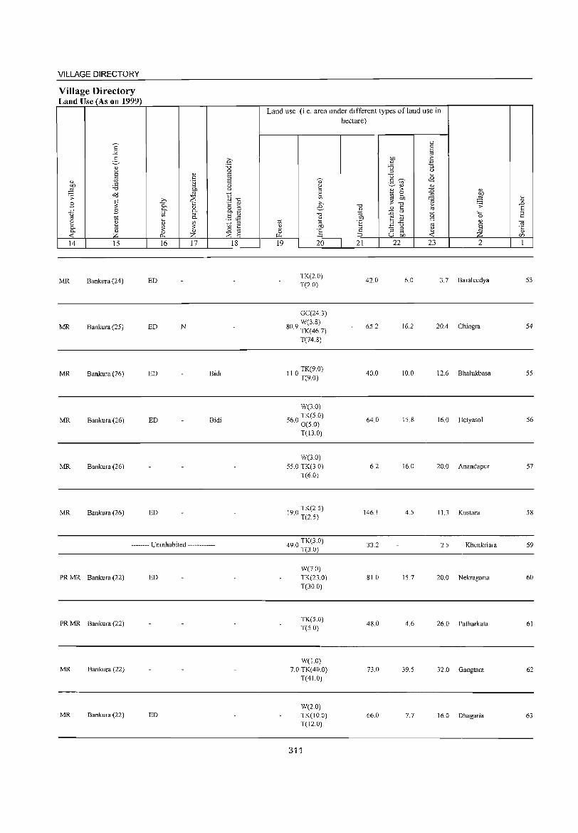
VILLAGE DIRECTORY
Village Directory Land Use (As on 1999)
14 15
MR Bankura (24)
MR Bankura (25)
MR Bankura (26)
MR Bankura (26)
MR Bankura (26)
MR Bankura (26)
16 17
ED
ED N
ED Bidi
ED Bidi
ED
-------- Uninhabited ------------
PR MR Bankura (22) ED
PR MR Bankura (22)
MR Bankura (22)
MR Bankura (22) ED
18
Land use (i.e. area under different types ofland use in hectare)
19 20
TK(2.0) T(2.0)
GC(24.3) W(3.8)
80.9 TK(46.7)
T(74.8)
110 TK(9.0) · T(9.0)
W(3.0)
60 TK(5.0) 5 . 0(5.0)
T(13.0)
W(3.0) 55.0 TK(3.0)
T(6.0)
190 TK(2.5) · T(2.5)
490 TK(3.0) · 1(3.0)
W(7.0) TK(23.0) T(30.0)
TK(S.O) T(5.0)
W(1.0) 7.0 TK(40.0)
T(41.0)
W(2.0) TK(10.0) T(12.0)
311
21
42.0
65.2
40.0
64.0
6.2
146.1
33.2
81.0
48.0
73.0
66.0
22 23 2
6.0 3.7 Baraleedya
16.2 20.4 Chingra
10.0 12.6 Bhalukbasa
15.8 16.0 Hetyasol
16.0 20.0 Anandapur
4.5 11.3 Kustara
2.5 Khenkriara
15.7 20.0 Nekragaria
4.6 26.0 Patharkata
39.5 32.0 Gangtara
7.7 16.0 Dhagaria
53
54
55
56
57
58
59
60
61
62
63
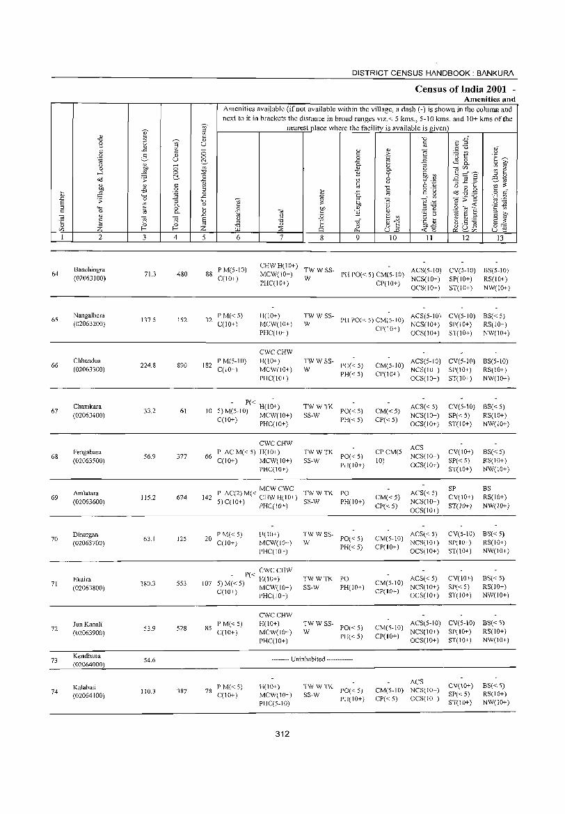
en ~ <l) 5l
" id t: "0 " 0 t)
~ U u 0) ..c: 0 t: t:
0 g <l) 0 .~ u c:,
~ u - '" 0 0 -l 0 "CI
"0 ~ ~ c:, ..c:
t: '" '" <l) ~ :W -5 0 ... '.g 0
'" '+< ..c: .0 .;;: 0 -= '+-< E co 0.. 0 ;:l "" '" 0 ~ '" 0 id 0.. 'iii '" .0
~ g g E ·c ., 0 0 '" '" !--< !--< Z
1 2 3 4 5
Banchingra 64 71.3 480 88
(02063100)
65 Nangalbera
137.5 152 32 (02063200)
66 Chhendua
224.8 890 182 (02063300)
67 Chamkara
33.2 61 10 (02063400)
68 Fengabasa
56.9 377 66 (02063500)
Amlatara 69 115.2 674 142
(02063600)
70 Dinargan
63.1 125 20 (02063700)
Ekaira 71
(02063800) 180.3 553 107
Jun Kanali 8S 72
(02063900) 53.9 528
73 Kendbana
S4.6 (02064000)
Kalabati 74
(02064100) 110.3 387 78
DISTRICT CENSUS HANDBOOK: BANKURA
CenslUs of India 2001 -Amenities and
Amenities available (if not available within the village, a dash (-) is shown in the column and next to it in brackets the distance in broad ranges viz. < 5 kms., 5-10 kms. and 10+ kms of the
nearest place where the facility is available is given "CI ~ :2" t:
'" :g u oJ <l) Q) "i§ t: ;> t: u 0 .~ B
'(3 'E ~ ..c: <lS 0 0.. -= 0.. '" ~ (\) '" 'iii'" ~ i: 0.. U
B 0 'to ~ 3 ::::"s ;:l '" "CI 6 c;:I "a -§ ~ .2 EStd iii
u en ;:;
"CI C '" u 0 ... ... c o ._
Od ~ .g c _
..c: c~ ~ o 0:: '" ~ co '.;:J 0
~ 'iii>'g 'iii 'iii ""§::g OJ .-C 'e c ...: .:2 ]g 0 b1) '" .:e ~ gas c '" .~ 'iii c B '" ., E ::l
::l ~ Q :.g E '"
::l u E u 'B t: tf E"" .~ ~ b.S ~ ~4 '" "CI " 8 82 OJ)..c: fl.l ::E 0
...: '0 ~u~ u E! 0... ~'" 6 7 8 9 10 11 12 13
P M(S-IO) CHWH(IO+)
TWWSS- ACS(S-IO) CV(S-IO) BS(S-IO) MCW(lO+) PH PO« S) CM(S-lO)
C(lO+ ) W NCS(IO+) SP(lO+) RS(IO+) PHCCIO+) CP(IO+)
OCS(IO+) ST(lO+) NW(IO+)
P M«S) H(IO+) TWWSS-PH PO«5) CM(5-10)
ACS(S-IO) CV(5-10) BS« S) C(I 0+) MCW(IO+) W NCS(IO+) SP(lO+) RS(lO+)
PHCCIO+) CP(IO+)
OCS(IO+) ST(IO+) NW(lO+)
CWCCHW P M(5-10) H(10+) TWW SS-
PO«5) CM(5-10) ACS(S-IO) CV(S-IO) BS(S-IO)
CCl0+) MCW(IO+) W NCS(lO+) SP(IO+) RS(IO+) PHCCIO+)
PH«5) CP(IO+) OCS(IO+) ST(10+) NW(IO+)
- P« H(I~+) TWWTK PO«5) CM« 5)
ACS« 5) CV(S-IO) BS« 5) 5) M(5-1O) MCW(lO+) SS-W NCS(lO+) SP«S) RS(IO+) CCIO+) PHCCIO+) PH«5) CP« 5)
OCS(lO+) ST(IO+) NW(lO+)
CWCCHW ACS
P AC M« 5) H(IO+) TWWTK PO«5)
CPCM(5-NCS(IO+)
CV(IO+) BS« 5)
CCIO+) MCW(IO+) SS-W PH(IO+)
10) OCS(IO+)
SP«5) RS(IO+) PHC(10+) ST(10+) NW(10+)
MCWCWC TWWTK ACS« S)
SP BS P AC(2) M« CHW H(IO+) PO
CM« 5) CV(10+) RS(IO+) S) C(l 0+) PHCClO+) SS-W PH(10+)
CP« 5) NCS(IO+)
ST(10+) NW(IO+) OCS(lO+)
P M« 5) H(IO+) TW W SS-PO«5) CM(S-10)
ACS« 5) CV(5-10) 8S« 5) C(lO+) MCW(IO+) W
PH«5) CP(IO+) NCS(IO+) SP(IO+) RS(IO+)
PHCCIO+) OCS(10+) ST(10+) NW(10+)
_ P« CWCCHW TWWTK PO ACS« 5) CV(lO+) 8S« 5) H(IO+)
CM(5-10) 5) M«5) MCW(IO+) SS-W PH(IO+) NCS(IO+) SP«S) RS(IO+) C(10+) PHC(lO+) CP(JO+)
OCS(IO+) ST(IO+) NW(IO+)
CWCCHW
P M« 5) H(lO+) TWW SS-PO«5) CM(S-10)
ACS(5-10) CV(5-10) BS« 5)
C(lO+) MCW(IO+) W NCS(lO+) SP(IO+) RS(IO+)
PHC(IO+) PH«5) CP(IO+)
OCS(IO+) ST(10+) NW(10+)
-------- Uninhabited ------------
TWWTK ACS
CV(10+) 8S« 5) PM«5) H(IO+) PO«5) CM(S-lO) NCS(IO+)
C(lO+) MCW(10+) SS-W SP« 5) RS(10+) PH(IO+) CP«5) OCS(IO+)
PHCC5-10) ST(10+) NW(IO+)
312
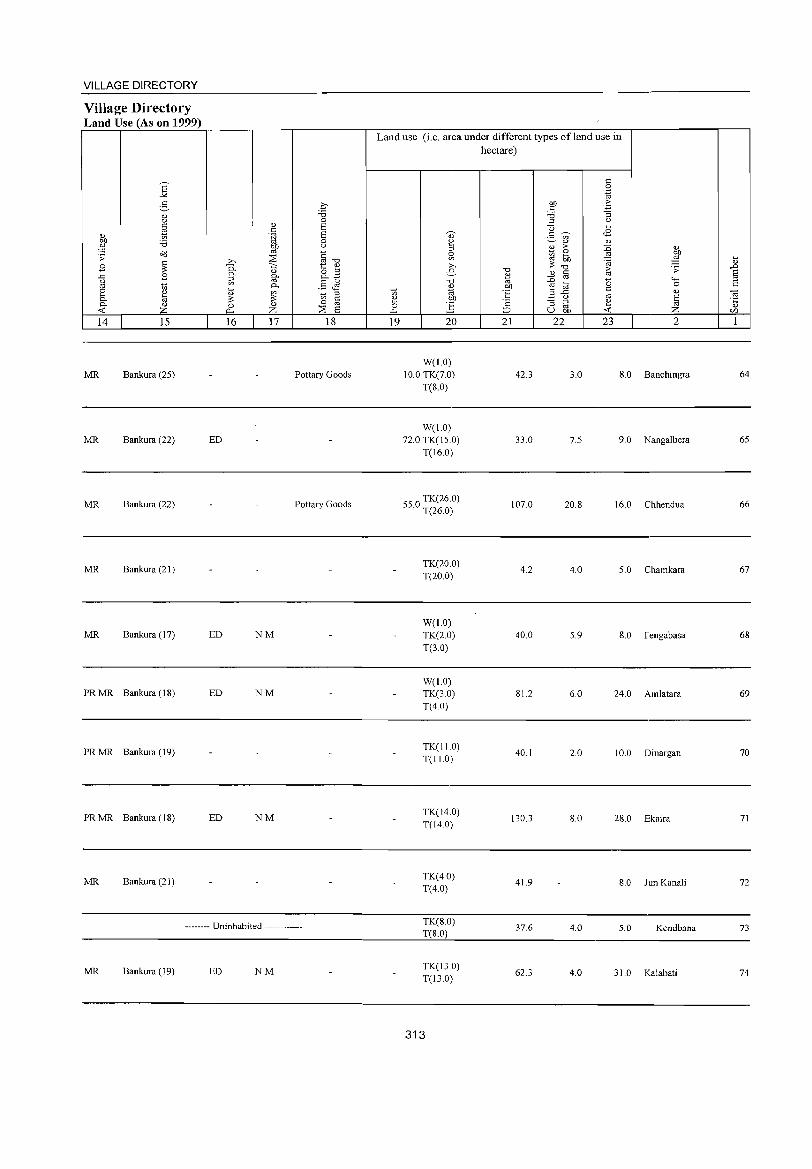
VILLAGE DIRECTORY
Village Directory Land Use (As on 1999)
E -'" 5 0) Q
" tl 0) OJ) '6 ;:§ .;;: ~
E ~ -" B u co ~ e ~ c. c. '" < Z 14 15
MR Bankura (25)
MR Bankura (22)
MR Bankura (22)
MR Bankura (21)
MR Bankura (17)
PRMR Bankura (IS)
PRMR Bankura (19)
PR MR Bankura (18)
MR Bankura (21)
ED
ED
ED
ED
.€ "0 0
0) E " .~ E
0 gp u
~ ~""d ;>, 0. "i::; t v
'" o " 0. g. ~
o.~
.§ Jl P-'-<
'" ~ ~ ;::J
~ 0 § 0 '" ~ ~ Z S 16 17 18
Pottary Goods
Pottary Goods
NM
NM
NM
-------- Uninhabited ------------
MR Bankura (19) ED NM
Land use (i.e. area under different types ofland use in
~ ~ 0 ~
19
d)
~ ~ ;>,
e "0 O)
"' .SJ) ~ 20
W(l.O) 10.0 TK(7.0)
T(8.0)
W(l.O) 72.0 TK(l5.0)
T(16.0)
55 0 TK(26.0) . T(26.0)
TK(20.0) T(20.0)
W(l.O) TK(2.0) T(3.0)
W(1.0) TK(3.0) T(4.0)
TK(I1.0) T(I1.0)
TK(14.0) T(14.0)
TK(4.0) T(4.0)
TK(8.0) T(S.O)
TK(13.0) T(13.0)
313
hectare)
"E
"' OJ)
°E ·2 :::> 21
42.3
33.0
107.0
4.2
40.0
81.2
40.1
130.3
41.9
37.6
62.3
" 0 .~
OJ) ;>
" .'" '6 :i ;::J 0
u '-<
<8 3 ~ if> 0) 0)
0) ;> :0 0)
1(1 e ~ ~ OJ) .~ ~ "0
" i;; .;;: 2 .D '" 15 '+-< r!] 0
" '" .2 (.) '" :i ;::J
~ §
'" u OJ) Z 22 23 2
3.0 8.0 Banchingra
7.5 9.0 Nangalbera
20.8 16.0 Chhendua
4.0 5.0 Chamkara
5.9 8.0 Fengabasa
6.0 24.0 Amlatara
2.0 10.0 Dinargan
8.0 28.0 Ekaira
8.0 Jun Kanali
4.0 5.0 Kendbana
4.0 31.0 Kalabati
\) .D S ;::J
" ,. '5 (/)
1
64
65
66
67
68
69
70
71
72
73
74
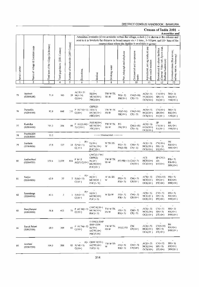
75
76
77
78
79
80
81
82
83
84
85
2
Batdeul; (02064200)
Purundihi (02064300)
Kumidya (02064400)
Penchaldihi (02064500)
Siarbada
(02064600)
Andharthaul (02064700)
Sutijor (02064800)
Syamdanga (02064900)
Ramjibanpur (02065000)
Sunuk Pahari (02065100)
Iambani (02065200)
3 4
71.4 165
91.8 648
IOU 504
75.2
57.8 137
159.4 2,029
63.9 37
42.5 2
58.8 413
69.9 309
104.3 506
5
DISTRICT CENSUS HANDBOOK: BANKURA
CenslUS of India 2001 -Amenities and
Amenities available (if not available within the village, a dash (-) is shown in the column and next to it in brackets the distance in broad ranges viz.< 5 kms., 5-10 kms. and 10+ kms of the
nearest place where the facility is available is given
6
AC P« 5) 29 M(5-10)
C(10+)
7
H(IO+)
MCW(10+)
PHC(IO+)
8
to" o
r:>,
9
TWWTK SS-W PO« 5)
PH(JO+)
10 11
ACS« 5) CM(5-10) NCS(IO+)
CP« 5) OCS(JO+)
12
CV(lO+)
SP« 5) ST(IO+)
13
BS« 5) RS(IO+)
NW(IO+)
135
CHW(2)
P AC M« 5) H(lO+) C(lO+) MCW(IO+)
TWWTK SS-W PO(5-10) CM(5-10) ACS« 5)
NCS(lO+) CV(lO+)
SP(JO+)
ST(lO+)
BS« 5) RS(IO+)
NW(IO+) PHC(lO+)
PHS H(IO+) 98 P AC(2) M« MCW(lO+)
5)C(10+) PHC(IO+)
PH(IO+)
TWWTK PO SS-W PH(lO+)
-------- Uninhabited ------------
- P« H(J;+) 24 5)M«5) MCW(lO+)
C(lO+) PHC(IO+)
CWC(2)FWC
CHW(2)
WTKSS
W PO« 5) PH(5-10)
CP« 5) OCS(10+)
ACS« 5) CM(5-1O) NCS(lO+)
CP« 5) OCS(IO+)
CM« 5)
CP«5)
ACS« 5) NCS(lO+)
OCS(IO+)
404 PM S H(10+) AC(2) C(IO+) MCW(lO+)
TWWTK SS-W PO PH« 5) CM« 5)
CP(IO+)
ACS NCS(IO+)
OCS(10+)
PHC(lO+)
- P« H(I;+) 7 5) M« 5) MCW(IO+)
C(lO+) PHC(5-10)
- P« H(I;+) 5) M«5) MCW(lO+)
C(IO+) PHC« 5)
: TK SS- PO« 5)
PH« 5)
WSS-W PO« 5)
PH« 5)
ewc H(IO+) 79 P AC M« 5) MCW(IO+) ~:_:: TK PO« 5)
C(10+) PHC« 5) PH« 5)
CM«5) CP(lO+)
CM(<.5)
CP(lO+)
CM«5)
CP« 5)
DDH(2)RMP
SMPCHW 63 P AC M« 5) H(IO+) TWWTK CM
SS-W PO(2) PH CP(IO+) C(JO+) MCW(lO+)
PHC(5-1O)
P« CHWH(IO+) TWWSS-83 5)M«5) MCW(lO+) W PO«5)
C(104-) PHC« 5) PH« 5)
314
CM«5) CP(lO+)
ACS« 5)
NCS(10+)
OCS(lO+)
ACS« 5) NCS(lO+)
OCS(lO+)
ACS« 5) NCS(lO+) OCS(10+)
ACS« 5) NCS(lO+)
OCS(lO+)
ACS« 5) NCS(lO+)
OeS(lo+)
SP CV(lO+) ST(lO+)
eV(lo+)
SP« 5) ST(lO+)
BS RS(lO+) NW(lO+)
BS RS(lO+)
NW(JO+)
SP CV(5- BS« 5) 10) ST(lO+) RS(IO+)
NW(JO+)
CV(5-1O) BS« 5) SP(IO+) RS(IO+)
ST(IO+) NW(IO+)
eV«5) SP« 5) ST(IO+)
CV«5) SP« 5) ST(lO+)
BS« 5) RS(IO+)
NW(IO+)
BS« 5) RS(IO+) NW(10+)
BS CV(5-10) RS(IO+)
SP« 5) NW(IO+) ST(IO+)
CV«5) SP« 5) ST(lO+)
BS« 5) RS(IO+) NW(lO+)
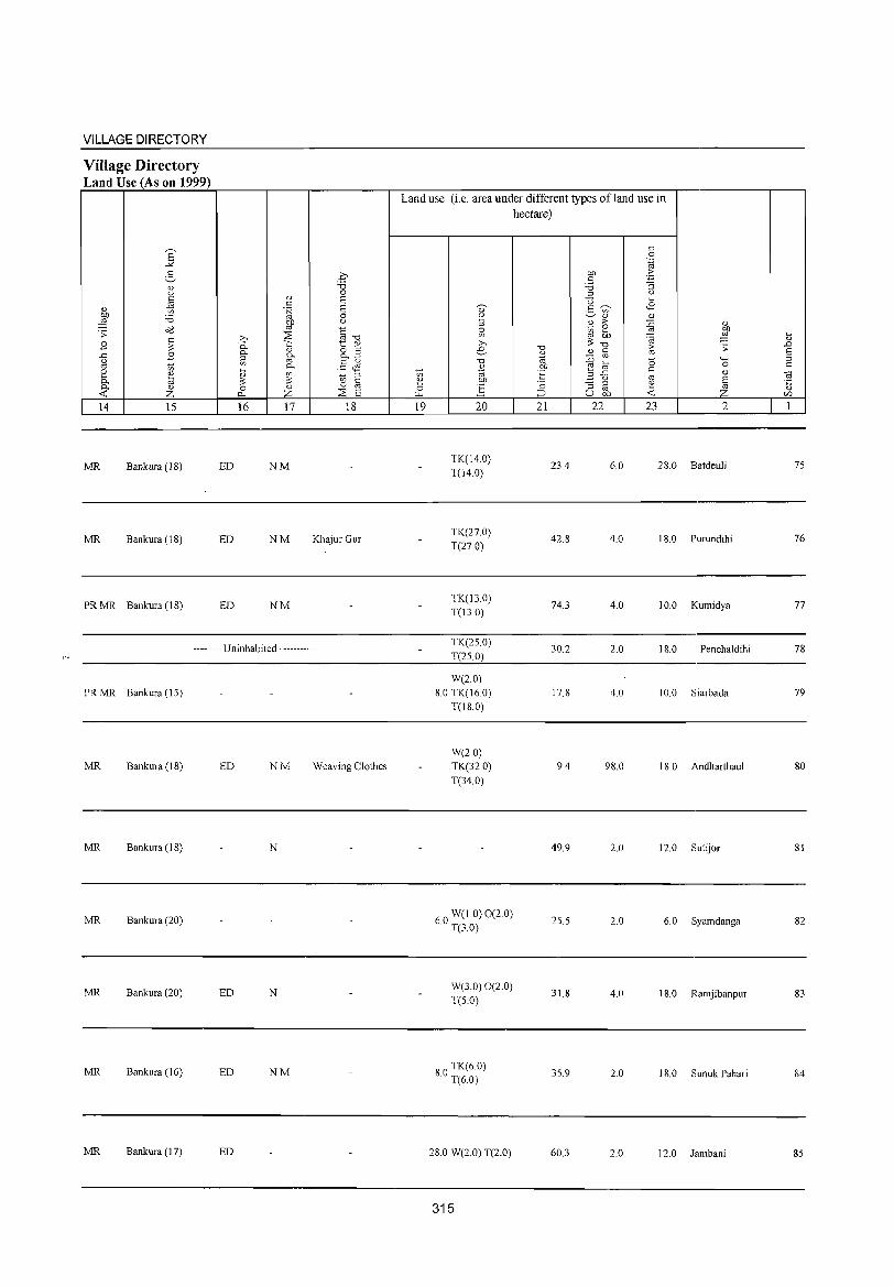
VILLAGE DIRECTORY
Village Directory Land Use (As on 1999)
E """ 2-
0.> U t::
'" 0.> to
:W ;.a o'd .;;:
~ B .t:: B u '" '" K ~ 0- 0.>
-< Z 14 15
MR Bankura (18)
MR Bankura (18)
PRMR Bankura (18)
ED
ED
ED
0 ;.a 0
0.> 6 . 6 ~
6 0
OIl u
'" §"O >- :::2 0.. -;:: t " 0- " g_B ~ ~
§~ .... 0-
~ ~ to ::l C
0 0.> 0 '" p., z :::2 6 16 17 18
NM
NM Khajur Gur
NM
-------- Uninhabited ------------
PRMR Bankura (15)
MR Bankura (IS) ED NM Weaving Clothes
MR Bankura (IS) N
MR Bankura (20)
MR Bankura (20) ED N
MR Bankura (16) ED NM
MR Bankura (17) ED
Land use (i.e. area under different types ofland use in hectare)
19 20
TK(14.0) T(14.0)
TK(27.0) T(27 0)
TK(13.0) T(13.0)
TK(25.0) T(2S.0)
W(2.0) 8.0 TK(16.0)
T(18.0)
W(20) TK(32.0) T(34.0)
60 W(l.O) 0(2.0) . T(3.0)
W(3.0) 0(2.0) T(S.O)
80 TK(6 0) . T(6.0)
28.0 W(2.0) T(2.0)
315
"0
%l OIl 'E '2 ;::::>
21
23.4
42.8
74.3
30.2
17.8
9.4
49.9
25.5
31.8
35.9
60.3
OIl c ;.a ::l
<3 5 '" <l)
.8 ,.
~ 2 ;:: OIl
"0 0.> C :0 '" .... e '" 3 .t::
u :; ::l
'" U OIl
22
6.0
4.0
4.0
2.0
4.0
98.0
2.0
2.0
4.0
2.0
2.0
c 0 .~
.2: "§ u ....
<B " {j 0.>
OIl
'§ ;g ~ ;;: (5 4-<
t:: 0
'" " 6 1: Z -< 23 2
28.0 Batdeuli
18.0 Purundihi
10.0 Kumidya
18.0 Penchaldihi
10.0 Siarbada
18.0 Andharthaul
12.0 Sutijor
6.0 Syamdanga
18.0 Ramjibanpur
18.0 Sunuk Pahari
12.0 Jambani
iil ..D 6 ::l c
~ 0.>
CI)
1
75
76
77
78
79
SO
81
82
83
S4
85
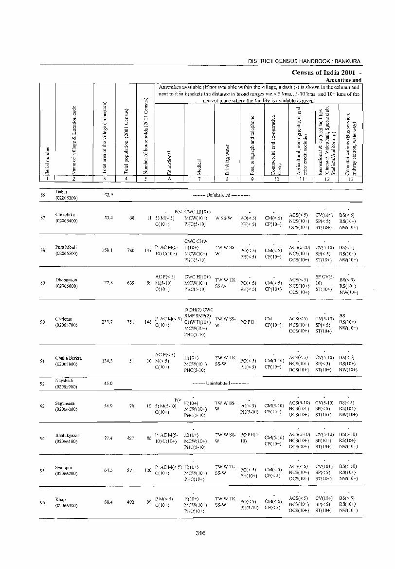
DISTRICT CENSUS HANDBOOK: BANKURA
Census of India 2001 -Amenities and
Amenities available (if not available within the village, a dash (.) is shown in the column and next to it in brackets the distance in broad ranges viz.< 5 kms., 5·10 kms. and 10+ kms of the
~
nearest place where the facility is available is given ~ '" ::l
" ~ Q) I-
~1 "0 u " "0
0 ~ U 0:
" " '" '"
..c: '" ;; " " ca '';::: 0 <Ii .: c > ;..:::: V') " 0 2- " 0 0 .~ 2 ·u 1:: t,..., .~ U ~ ..c: ~ 8-
(.;) " - 0. " ""3 " ~ 0 bJl 0 '" " 0. .~ car./) ~ ~ ....l :2 0 -0 "]] 0 3 :::=S "0 M~ ;:j " o<l .s: ~ ..c: -0 6 % .~ ~ _g .2 ill1d OJ OJ .: OJ .: " ';;;:;:
'" co -0 (.;) 0 .... OIl ,s 0 ;:j
o ._ C
I- :2 '-g 0 ,_
..c: c c~ ~ o<l.gg o .:" " "" ..c: ~ 0. co
ca;;"g '.0 0 .D .s: 0 ""3 4-< ca ~ ca ~ :::: co ._
S co :;: .~ -s ;:j "" e 0. 0 C .~ ;:j -0 '" <C 0 I- 0 bJl OJ 2«j"S c '" .: 0 co 0. " .~ ca c ] OJ ~ ~ E ~ ca Q) ca ]
.D " J2 E '" ::> (.;) 1d E ;::l
'5 § E " '6 c E-'" .g ti ~ g ~ E :;: 15 ::l 0 ;::l -0 " 8 '" o iii bf)..c: as u ~ 0'"
CZl Z l- I- Z :;:s 0 <C 15 >.Q 0- U.D ~ ~CIl U ~
1 2 3 4 5 6 7 8 9 10 11 12 13
86 Dabar
92.9 (02065300)
-------- Uninhabited ------------
Chikchika P« CWC H(lO+)
ACS« 5) CV(lO+) BS«5) 87 53.4 68 II 5) M«5) MCW(10+) WSS-W PO«5) CM«5) (02065400)
C(lO+) PHC(5.10) PH« 5) CP(10+) NCS(IO+) SP« 5) RS(10+) OCS(IO+) ST(IO+) NW(IO+)
CWCCHW
88 PuraMouli
350.1 780 147 P ACM(5- H(10+) TWWSS- ACS(5-1O) CV(5-1O) BS«5)
PO«5) CM« 5) (02065500) 10) C(IO+) MCW(IO+) W
PH«5) CP(IO+) NCS(10+) SP« 5) RS(10+)
PHC(5-10) OCS(10+) ST(IO+) NW(10+)
Dhobagaon AC P« 5) CWCH(10+)
TWWTK ACS«5) SP CV(5-
8S«5) 89 77.8 639 99 M(5-10) MCW(10+) PO«5) CM« 5) 10)
(02065600) C(lO+) PHC(5-10)
SS-W PH«5) CP(IO+)
NCS(10+) ST(10+)
RS(lO+) OCS(10+) NW(10+)
DDH(2)CWC
Chelema P AC M« 5) RMP SMP(2) TWWSS- CM ACS« 5) CV(S-IO) BS
90 233.7 751 148 C(10+) CHWH(IO+) POPH RS(IO+) (02065700) W CP(IO+) NCS(10+) SP« 5)
MCW(IO+) OCS(10+) ST(IO+)
NW(10+)
PHC(5-10)
Chalia Barkra ACP« 5)
H(lO+) TWWTK ACS« 5) CV(5-1O) BS« 5) 91
(02065800) 134.3 51 10 M«5)
MCW(10+) SS-W PO«5) CM(5-1O)
NCS(IO+) SP« 5) RS(10+) C(lO+)
PHC(5-10) PH«5) CP(10+)
OCS(10+) ST(lO+) NW(lO+)
92 Nayabadi (02065900)
45.0 •• -.-••• Uninhabited ••••••••• --.
93 Sagunsara
54.9 78 10 - P« H(I;+) TWWSS-
PO«5) CM(5-10) ACS(5-1O) CV(5-10) BS«5)
(02066000) 5) M(5-10) MCW(lO+) W NCS(lO+) SP« 5) RS(10+) C(10+) PHC(5-10) PH(5-10) CP(10+)
OCS(10+) ST(10+) NW(10+)
Bhalukgezar 77.4 427 86
P ACM(S· H(10+) TWWSS- PO PH(5. CM(5-JO)
ACS(5-10) CV(5-10) BS(5-10) 94
(02066100) 10) C(1O+) MCW(10+) W 10) NCS(IO+) SP(IO+) RS(10+)
PHC(5-10) CP(10+)
OCS(10+) ST(IO+) NW(IO+)
Syampur 64.5 571 120
P ACM«5) H(IO+) TWWTK PO« 5) CM«5)
ACS« 5) CV(10+) BS(5-1O) 95
(02066200) C(IO+) MCW(10+) SS-W NCS(10+) SP« 5) RS(10+)
PHC(IO+) PH(lO+) CP« 5)
OCS(10+) ST(10+) NW(lO+)
Khap 88.4 493 99
P M«5) H(10+) TWWTK PO«5) CM«5)
ACS« 5) CV(10+) BS«5) 96
(02066300) C(10+) MCW(lO+) SS·W NCS(lO+) SP« 5) RS(lO+)
PHC(10+) PH(5-10) CP« 5)
OCS(10+) ST(10+) NW(lO+)
316
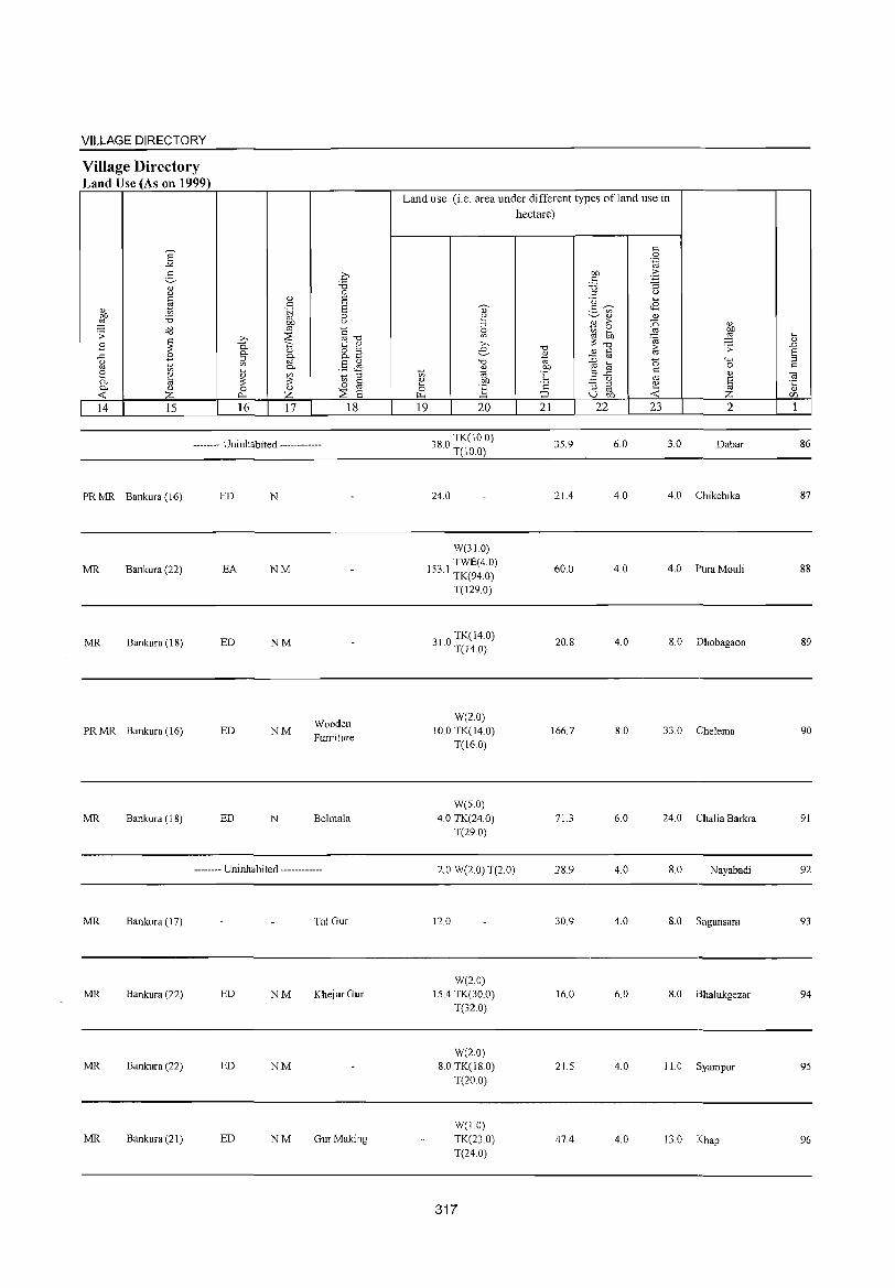
VILLAGE DIRECTORY
Village Directory Land Use (As on 1999)
E ""'" g " '"' ::: ~ '-'
~ 'i3 o'(l .':
~ B ..c: B g 1;; ::: " 0- @ 0. " -< Z 14 15
>,
--a 0-
~ ~ :;: 0
0..
16
. .£2 "d 0
" 6 ::: 6 .j;j 0
OJ) ()
'" " ~ oj "d t; " " o S
~ o..~
0- .8 ~ Vl 1;; ;:l :;: § "
0
Z '::8 6 17 18
-------- Uninhabited ------------
PR MR Bankura (16)
MR Bankura (22)
MR Bankura (18)
PR MR Bankura (16)
MR Bankura (18)
MR Bankura (I 7)
MR Bankura (22)
MR Bankura (22)
MR Bankura (21 )
ED
EA
ED
ED
ED
N
NM
NM
NM
N
Wooden Furniture
Behnala
-------- Uninhabited ------------
Tal Gur
ED NM Khejur Gur
ED NM
ED NM GurMaking
Land use (i.e. area under different types ofland use in hectare)
19 20
080 TK(10 0) o . T(IO.0)
24.0
W(31.0) TWE(4.0)
153.1 TK(94.0)
T(129.0)
31 0 TK(14.0) . T(l4.0)
W(2.0) 10.0 TK(14.0)
T(16.0)
W(5.0) 4.0 TK(24.0)
T(29.0)
2.0 W(2.0) T(2.0)
12.0
W(2.0) 15.4 TK(30.0)
T(32.0)
W(2.0) 8.0 TK(18.0)
T(20.0)
W(I.O) TK(23.0) T(24.0)
317
"d '-' (;j OJ)
°E ·6 ::::> 21
35.9
21.4
60.0
20.8
166.7
71.3
28.9
30.9
16.0
21.5
47.4
::: 0 .~
00 E '" 'i3 ""3 ::J (.)
" I-<
2 ~ <B Vl IV Q)
2 > ~ " Vl ~ bO
~ .", ;:§ "d [;; .':
" t: ::0 oj
"0 "-' e @ ::: 0
.a ..t: OJ
IV () § "3 ;:l " oj I-<
u bll -< Z 22 23 2
6.0 3.0 Dabar
4.0 4.0 Chikchika
4.0 4.0 PUra Mouli
4.0 8.0 Dhobagaon
8.0 33.0 Chelema
6.0 24.0 Chalia Barkra
4.0 8.0 Nayabadi
4.0 8.0 Sagunsara
6.0 8.0 Bhalukgezar
4.0 11.0 Syampur
4.0 13.0 Khap
~ .D 8 ;:l ::: ] '-'
<f}
1
86
87
88
89
90
91
92
93
94
95
96
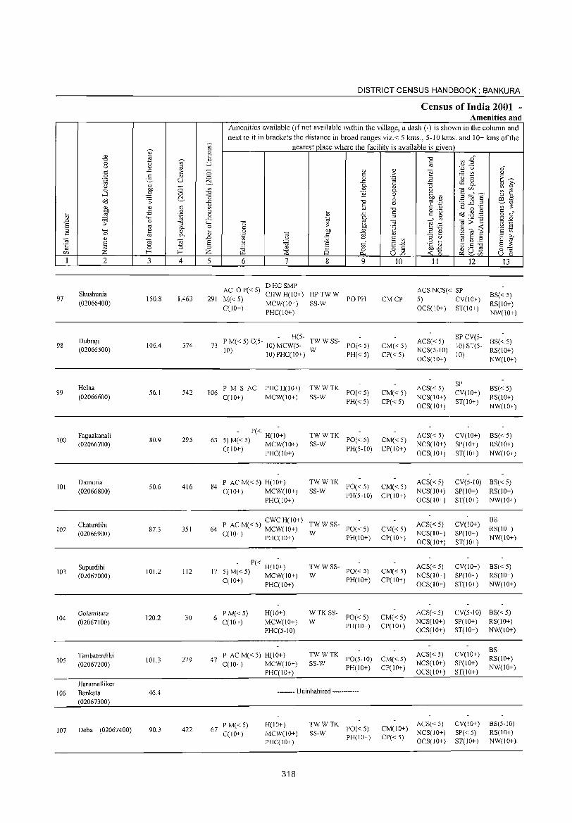
....._ ~ <1) ~ '" C
-0 ~ <1)
0 u U u '" ~ ..c -c c 0 0 2- OJ 0 .~ u c::-
'" -(.)
'" 0 (lJ) 0 ....:I ,g 0 -0
c::- o "d ;;: ..c
1;l <1) <1) c
:W .;:; 0 :J .... .~ 0 <U "-' ..c A ;;: 0 "3 4-; s OJ P- o :J 4-; ~ 0 .. c 0 0. 0.)
OJ OJ A
'5 § ~ -a s ~ :J
C/J Z f-< Z 1 2 3 4 5
Shushunia 97 150.8 1,463 291
(02066400)
Dubraji 98 106.4 374 73
(02066500)
Helna 99 56.1 542 106
(02066600)
Faguakanali 295 100
(02066700) 80.9 63
Dumuria 416 84 101
(02066800) 50.6
Chaturdihi 87.3 351 64 102
(02066900)
Supurdihi 103
(02067000) 101.2 112 17
Golamitara 104
(02067100) 120.2 30 6
Taribaterdihi 105
(02067200) 101.3 279 47
Harumalliker
106 Bankata 46.4 (02067300)
107 Deba (02067400) 90.3 422 67
DISTRICT CENSUS HANDBOOK: BANKURA
Census of India 2001 -Amenities and
Amenities available (if not available within the village, a dash (-) is shown in the column and next to it in brackets the distance in broad ranges viz.< 5 killS., 5-10 kms. and 10+ kms of the
nearest place where the facility is available is given
-0 ~ E" c '" § ~ ,s
'" <1)
] c > u 0 .~ ·0 1:: E~ ..c <l'l 0 0. "3 0. <1) iO' <U III OJ(/] ~ ~ 0. (.)
B 0 .~ ~ S ;:::" E 6 :J <1)
-0 ~ '.j:j ~ .2 .2 ill 10 c u ';;::: '" -0 C <l.) u 0 .... o ._
Od ~ . .g § c" ~ ..c c " g '" 0. '" OJ>"§l
'.c 0 OJ OJ OJ "§:; '" ._ ::: .. 'a ~ " (lJ) .~ c --< 0 00 III E e 20i a .~ OJ " E <1) ;::l
U j;i E '" ;::l u "' S ;::l E f u '5 5 tf E-" .~ ~ e ~ ii ;::l §:-;;: -0 <l.)
0 0 o c oo..c g u .s ;.Q ::os 0.. u.2 --<0 t:x::~(/] u e 6 7 8 9 10 11 12 13
AC o P«5) DHCSMP
ACSNCS« SP CHWH(IO+) HPTWW 8S« 5)
M«5) PO PH CMCP 5) CV(JO+) MCW(JO+) SS-W RS(IO+)
C(10+) PHC(IO+)
OCS(10+) ST(IO+) NW(IO+)
- H(5-TWWSS- ACS« 5)
SP CV(5-8S« 5) P M« 5) C(5- 10) MCW(5- PO« 5) CM« 5) 10) ST(5-
10) 10) PHCCI O+) W NCS(5-1O) RS(IO+)
PH« 5) CP« 5) OCS(10+)
10) NW(IO+)
PM S AC PHCH(IO+) TWWTK ACS« 5) SP
8S«5) PO« 5) CM« 5) CV(10+)
C(10+) MCW(IO+) SS-W NCS(IO+) RS(\O+) PH« 5) CP« 5)
OCS(IO+) ST(IO+)
NW(IO+)
- P« H(1~+) TWWTK PO« 5) CM« 5)
ACS« 5) CV(JO+) 8S« 5) 5) M« 5) MCW(10+) SS-W NCS(IO+) SP(10+) RS(10+) C(10+) PHCCIO+) PH(5-10) CP(10+)
OCS(IO+) ST(IO+) NW(IO+)
P AC M« 5) H(IO+) TWWTK PO« 5) CM« 5)
ACS« 5) CV(5-10) 8S« 5)
CCIO+) MCW(JO+) SS-W NCS(IO+) SP(IO+) RS(IO+)
PHCCIO+) PH(5-10) CP(IO+)
OCS(IO+) ST(IO+) NW(JO+)
5 CWC H(IO+) TWWSS- ACS« 5) CV(10+)
8S P AC M« ) MCW(IO+) PO« 5) CM« 5) RS(IO+)
W NCS(IO+) SP(IO+) C(IO+) PHC(IO+) PH(IO+) CP(IO+) OCS(lO+) ST(IO+)
NW(IO+)
- P« H(I~+) TWWSS-PO« 5) CM« 5)
ACS« 5) CV(IO+) 8S« 5) 5) M« 5) MCW(IO+) W NCS(IO+) SP(IO+) RS(IO+) C(10+) PHC(IO+) PH(IO+) CP(IO+)
OCS(IO+) ST(IO+) NW(IO+)
PM«5) H(JO+) WTKSS-PO« 5) CM« 5)
ACS« 5) CV(5-10) 8S« 5)
C(10+) MCW(10+) W NCS(IO+) SP(IO+) RS(IO+)
PHC(5-IO) PH(IO+) CP(IO+)
OCS(IO+) ST(IO+) NW(IO+)
ACS« 5) CV(IO+) BS
P AC M« 5) H(IO+) TWWTK PO(5-10) CM«5) RS(IO+)
C(10+) MCW(IO+) SS-W NCS(10+) SP(IO+)
PHC(IO+) PH(IO+) CP(IO+)
OCS(IO+) ST(lO+) NW(IO+)
-------- Uninhabited "-""-----•..
PM«5) H(IO+) TWWTK PO« 5) CM(10+)
ACS« 5) CV(10+) 8S(5·10)
C(IO+) MCW(IO+) SS-w NCS(IO+) SP« 5) RS(IO+)
PHC(10+) PH(IO+) CP« 5)
OCS(lO+) ST(IO+) NW(IO+)
318
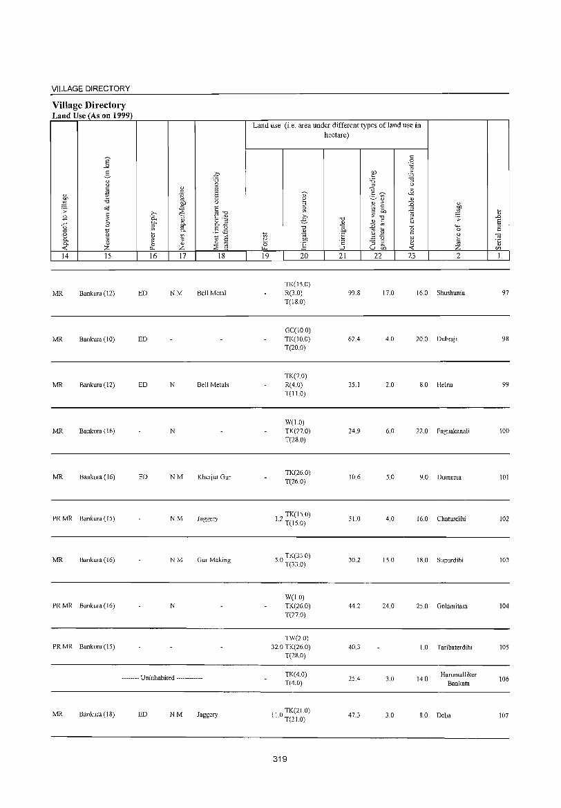
VILLAGE DIRECTORY
Village Directory Land Use (As on 1999)
14 15
MR Bankura (12)
MR Bankura (10)
MR Bankura (12)
MR Bankura (16)
MR Bankura (16)
PR MR Bankura (15)
MR Bankura (16)
PR MR Bankura (16)
PR MR Bankura (IS)
ED
ED
ED
ED
16 17 18
NM Bell Metal
N Bell Metals
N
NM Kherjur Gur
NM Jaggery
NM GurMaking
N
-------- Uninhabited ------------
MR Bankura (18) ED NM Jaggery
Land use (i.e. area under different types ofland use in hectare)
19 20
TK(150)
R(3.0)
T(IS.O)
GCCIO 0) TK(JO.O)
T(20.0)
TK(7.0)
R(4.0)
T(l LO)
W(l.O)
TK(27.0)
T(2S.0)
TK(26.0)
T(26 0)
12 TK(15 0) . T(15.0)
O TK(33 0)
5. T(33 0)
W(LO)
TK(260)
T(27.0)
TW(20)
32.0 TK(26.0) T(28.0)
TK(4.0)
T(4.0)
110 TK(21.0) . T(2LO)
319
21 22
99.S
62.4
35.1
24.9
10.6
SI.O
30.2
44.2
40.3
2S.4
47.3
23
17.0
4.0
2.0
6.0
5.0
4.0
15.0
24.0
3.0
3.0
2
16.0 Shushunia
20.0 Dubraj i
8.0 Helna
22.0 Faguakanali
9.0 Dumuria
16.0 Chaturdihi
18.0 Supurdihi
2S.0 Golamitara
L 0 Taribaterdihi
14.0 Harumalliker
Bankata
8.0 Deba
97
98
99
100
101
102
103
104
105
106
107
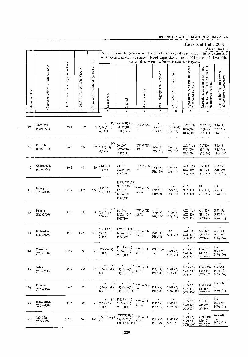
DISTRICT CENSUS HANDBOOK: BANKURA
Cens.us of India 2001 -Amenities and
Amenities available (if not available within the village, a dash (-) is shown in the column and
next to it in brackets the distance in broad ranges viz. < 5 kms., 5-10 kms. and 10+ kms of the ~
nearest place where the facility is available is given '" iii Q.) ~ C
"0 ~ En "0 ~ Q.)
0 b '" u c " " '" OJ
c ..c Vl - Q.) '" e ';I Q "," c ~t u
9 2- Q.) 0 C > ·E ~ U 0 0 '"@ ,3 d ~ ..c ~ 8. " '" ;; 0-
'" "3 'U i;;' 0 l Vl OJ ",if) ;;; ~ "0 0- <)
....l 0 B 0 .~.~ ~ ="6 ~ (3 6 '" " 0::3 .s;: ..c "0 -3 ~.~ FE-rtj c " c u = ~ '" :;;; " " '" '" "0 u 0 ~
OJ) -E 0 '" ~
o ._ o::3..gg c "
~ ~ .~ 0 ..c c c g o c " "-' ..c * ~
oj
'" ",:;:-g 'z 0 .£> .s;: 0 "3 "-' <;j -;;; e:g '" .-E '" :;;; U -0- 0 C .~ C -< '§ ~ '" "" ~ 0 ~ 0 OIl " £ ~ 9 "?Ie c 0 0- " .~ -;;; c "2 '" '" E ::> <;j " -;;; '"
..0 u :.Q E '" ::> <) E i;;'
.;:: E E u 'd .S t;;" 6-2 .~ ti ~ ~ ~ §~ 0 0 '" ::>
OJ OJ Z "0 " is 0 o '"
b/j..c {) ._ ct1
<Zl Z f- f- '-'"I ::'is p... U..o -< 0 ~u- U f:! ~<Zl
1 2 3 4 5 6 7 8 9 10 11 12 13
Keranipur P« CHW H(lO+) TWWSS- ACS« 5) CV(5-10) BS«5) 108 S9.1 29 4 5)M(S-10) MCW(lO+) PO«5) CM(S-IO) (02067500) W NCS(lO+) SP(IO+) RS(IO+) C(IO+) PHC(IO+) PH«5) CP(IO+)
OCS(10+) ST(IO+) NW(10+)
Kaludihi - P« -
TWWTK ACS« 5) CV(IO+) BS«S) 109 86.0 374 67 5) M« 5) H(lO+) PO«5) CM« 5) (02067600) C(lO+) MCW(lO+) SS-W PH(lO+) CP(IO+)
NCS(10+) SP« 5) RS(IO+) PHC(IO+) OCS(IO+) ST(IO+) NW(10+)
110 Chhatar Dihi
119.6 441 80 PM«5) H(IO+) TW W R SS PO(~ 5) ACS« 5) CY(lO+) BS« 5)
CM«5) (02067700) C(lO+) MCW(IO+) W PH(W+) CP(W+ ) NCS(lO+) SP« 5) RS(10+)
PHC(IO+) OCS(IO+) ST(IO+) NW(IO+)
DDHCWC(2)
Nutangaon P(3) M SMPCHW
TWWTK ACS SP BS
III (02067800)
154.3 2,885 522 AC(2) C(lO+) H(IO+) SS-W PO«S) CM« S) NCS(IO+) CY(IO+) RS(lO+)
MCW(IO+) PH(5-10) CP(IO+) OCS(lO+) ST(IO+) NW(10+)
PRC(lO+)
112 Paharia
61.3 183 38 5 - P« H(I~+) TWWTK
PO«5) CM«S) ACS«5) CY(lO+) 8S«5)
(02067900) )M«5) MCW(10+) SS-W NCS(lO+) SP« 5) RS(10+) C(lO+) PHC(lO+) PH(5-10) CP(10+)
OCS(IO+) ST(lO+) NW(IO+)
Bhikurdihi ACP« 5) cwe H(lO+)
TWWTK CM ACS«5) CY(IO+) BS«5) 113
(02068000) 45.4 1,077 154 M«5) MCW(IO+)
SS-W PO«5)
CP(lO+) NCS(10+) SP« 5) RS(10+) CCIO+) PHCCIO+) PH(5-1O)
OCS(IO+) ST(lO+) NW(JO+)
P(2)M«5) PHS H(10+)
ACS«S) CY(IO+) BS
114 Kankradihi
110.5 193 33 MCW(10+) TWWTK PO PH(5-
CM«5) RS(10+) (02068100) C(10+)
PHC(!O+) SS-W 10)
CP(lO+) NCS(lO+) SP« 5)
NW(IO+) OCS(10+) ST(IO+)
Jethia P« H(5-
TWWTK ACS« 5) CV(S-IO) BS« 5) 115 8S.S 258 48 5) M« 5) C(5·10) MCW(S- PO« 5) CM«S)
(02068200) SS-W NCS« 5) SP(5-10) RS(5-1O) 10) 10) PHCClO+) PH« 5) CP«5)
OCS(IO+) ST(5-IO) NW(lO+)
Dulalpur P« R(S-
TWWSS- ACS« 5) eY(S-IO) BSRS(5-
116 64.2 21 3 S) M« 5) C(5· 10) MCW(S- PO« 5) CM« 5) 10) (02068300)
10) 10) PHC(IO+) W
PH« 5) CP(S-IO) NCS(IO+) SP(IO+)
NW(IO+) OCS(lO+) ST(S-IO)
P« PHS H(IO+) CY(lO+) BS
Bhagabanpur 300 57 5) M« 5) MCW(IO+) TWWTK
PO« 5) CM«5) ACS« 5) RS(lO+) 117 85.7
SS-W NCS(lO+) SP(10+) (02068400) C(10+) PHC(IO+) PH(5-IO) CP(5-1O) NW(IO+) OCS(10+) ST(IO+)
P M« 5) C(S- CHW(2) H(5- TW W TK ACS« 5) CY(S-IO) BSRS(5-
Baindhka 125.3 769 162 PO« 5) CM«5) 10) 118 o 10) MeW(S- W NCS« 5) SP« 5) (02068500) I ) 10) PHC(5-10) SS- PH« 5) CP«5) NW(IO+)
OCS(10+) ST(5-IO)
320
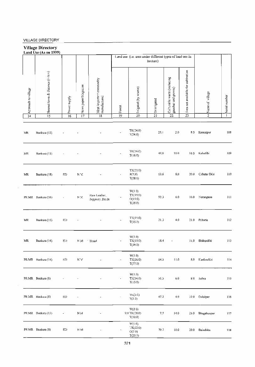
VILLAGE DIRECTORY
Village Directory Land Use (As on 1999)
6' -'<
2-" u
" '" " t; ,g :.a .s: ~
" B ~ ..c B u '" t; §. ~ 0. " <C z 14 15
MR Bankura (12)
MR Bankura (15)
MR Bankura (18)
PRMR Bankura (16)
MR Bankura (15)
MR Bankura (14)
PRMR Bankura (14)
PRMR Bankura (8)
PRMR Bankura (8)
PRMR Bankura (13)
PRMR Bankura (8)
16 17 18
ED NM
NM Raw Leather, Jaggeary, Brade
ED
ED NM . Bread
ED NM
ED
NM
ED NM
Land use (i.e. area under different types ofland use in hectare)
19 20 21 22 23 2
TK(24.0) T(24.0)
25.1 2.0 8.0 Keranipur
TK(l6.0) 44.0 10.0 16.0 Kaludihi
T(16.0)
TK(210) R(7.0) 63.6 8.0 20.0 Chhatar Dihi T(28.0)
W(lO) TK(19.0)
93.3 6.0 16.0 Nutangaon 0(19.0) T(39.0)
TK(1S.0) 21.3 4.0 210 Paharia
T(IS.0)
W(1.0) TK(IS.0) 18.4 11.0 Bhikurdihi T(16.0)
W(1.0) TK(26.0) 64.5 11.0 8.0 Kankradihi T(27.0)
W(I.O) TK(14.0) 56.5 6.0 8.0 Jethia T(IS.O)
TK(30) 47.2 4.0 10.0 Dulalpur
T(3.0)
W(2.0) 9.0 TK(28.0) 7.7 14.0 25.0 Bhagabanpur
T(30.0)
Wel.O) TK(22.0)
70.3 10.0 20.0 Baindhka 0(2.0) T(2S.0)
321
108
109
110
111
112
113
114
115
116
117
118
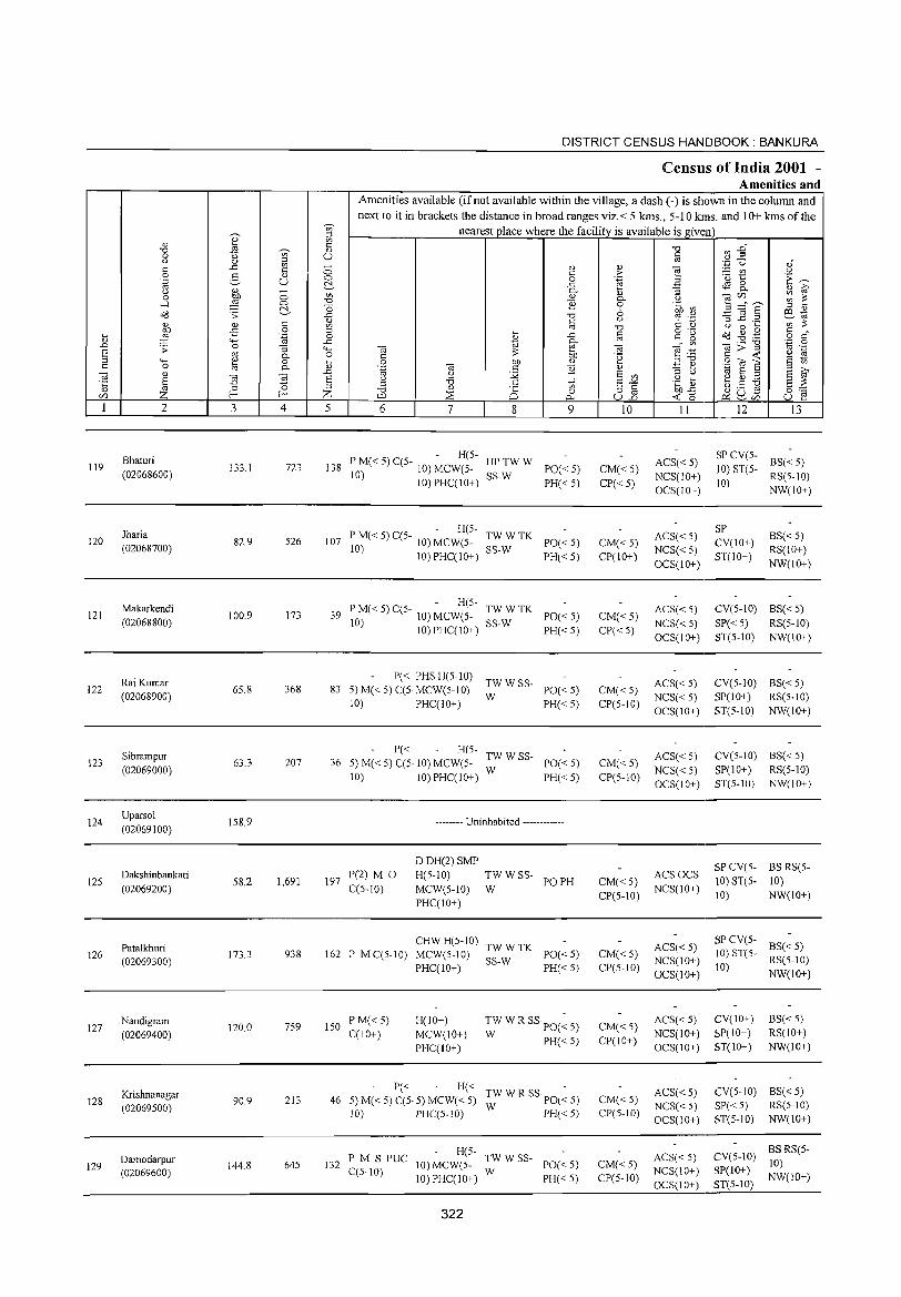
119
120
121
122
123
124
125
126
127
128
129
2
Bhaturi
(02068600)
Jharia
(02068700)
Makarkendi
(02068800)
Raj Kumar
(02068900)
Sibrampur
(02069000)
Uparsol
(02069100)
Dakshinbankati
(02069200)
Patalkhuri
(02069300)
Nandigram
(02069400)
Krishnanagar (02069500)
Damodarpur (02069600)
3
133.1
82.9
100.9
65.8
63.3
158.9
58.2
173.3
120.0
90.9
144.8
en
~ '" " u
4
723
526
173
368
207
1,691
938
759
213
645
DISTRICT CENSUS HANDBOOK: BANKURA
Census of India 2001 -Amenities and
Amenities available (ifnot available within the village, a dash (-) is shown in the column and next to it in brackets the distance in broad ranges viz.< 5 kms., 5-10 kms. and 10+ kms of the
nearest place where the facility is available is givt:n
5 6 7 8 9
P M« 5) C(5 - H(5- HP TW W 138 -10)MCW(5- PO«5)
10) 10)PHC(10+) SS-W PH« 5)
- H(5-107 PM«5)C(5- 10) MCW(5- TWWTK PO«5)
10) SS-W 10)PHC(10+) PH«5)
P M« 5) C(5- - H(5- TW W TK 39 10) 10) MCW(S- SS-W PO« 5)
IO)PHC(IO+) PH«5)
P« PHSH(S-IO) 83 5)M«5)C(S.MCW(5-10) ;;:WSS- PO«5)
10) PHC(IO+) PH« 5)
P« H(5- TWWSS-36 5) M« 5) C(5· 10) MCW(5- W PO« 5)
10) IO)PHC(IO+) PH«5)
197 P(2) M 0 C(5-10)
-------- Uninhabited ------------
DDH(2)SMP
H(5-1O) TW W SS-
MCW(5-10) W PO PH
PHC(IO+)
CHWH(5-10) TWWTK 162 PMC(5-10) MCW(5-10) SS-W PO«5)
PHC(lO+) PH« 5)
150 PM«5) C(lO+)
H(10+)
MCW(IO+) PHC(10+)
TW WR SSpO(~ 5)
W PH« 5)
P« H« 46 5) M« 5) C(5. 5) MCW« 5) TW W R SS PO« 5)
10) PHC(5-1O) W PH« 5)
P M S PUC H(5- TW W SS-132 10) MCW(5- W PO« 5)
C(S-IO) 10) PHC(IO+) PH« 5)
322
10
CM« 5) CP«5)
CM« 5) CP(IO+)
CM« 5) CP«5)
CM«5) CP(5-10)
CM« 5) CP(5-10)
11
ACS«5) NCS(IO+) OCS(IO+)
ACS« 5) NCS« 5)
OCS(IO+}
ACS« 5)
NCS«5) OCS(10+)
ACS« 5) NCS« 5) OCS(IO+)
ACS« 5)
NCS« 5) OCS(IO+)
ACSOCS CM« 5) CP(S-IO) NCS(IO+)
CM«5) CP(S-IO)
CM« 5) CP(IO+)
CM«5) CP(S-IO)
CM«5) CP(5-10)
ACS« 5) NCS(lO+)
OCS(lO+)
ACS« 5) NCS(10+) OCS(10+)
ACS«5) NCS« 5) OCS(IO+)
ACS« 5) NCS(lO+)
OCS(IO+)
12 13
SP CV(5- BS( 5) < 10) ST(S- RS(5-1O)
10) NW(lO+)
SP CV(10+)
ST(lO+)
BS«5) RS(lO+)
NW(lO+)
eVe5-10) BS« 5)
SP« 5) RS(5-10) ST(5-10) NW(IO+)
eV(5-10) BS« 5) SP(IO+) RS(5-10)
ST(5-1O) NW(lO+)
eV(5-10) BS« 5)
SP(10+) RS(5-10) ST(5-10) NW(lO+)
SP CV(5- BS RS(5-
10) ST(5- 10) 10) NW(IO+)
SP CV(S- BS« S) 10) ST(5- RS(5-10)
10) NW(IO+)
CV(IO+)
SP(10+) ST(10+)
BS«S) RS(lO+) NW(IO+)
CV(5-10) BS« 5) SP« 5) RS(5-10) ST(5-IO) NW(10+)
CV(5-1O) BS RS(5-
SP(IO+) 10) ST(S-IO) NW(lO+)
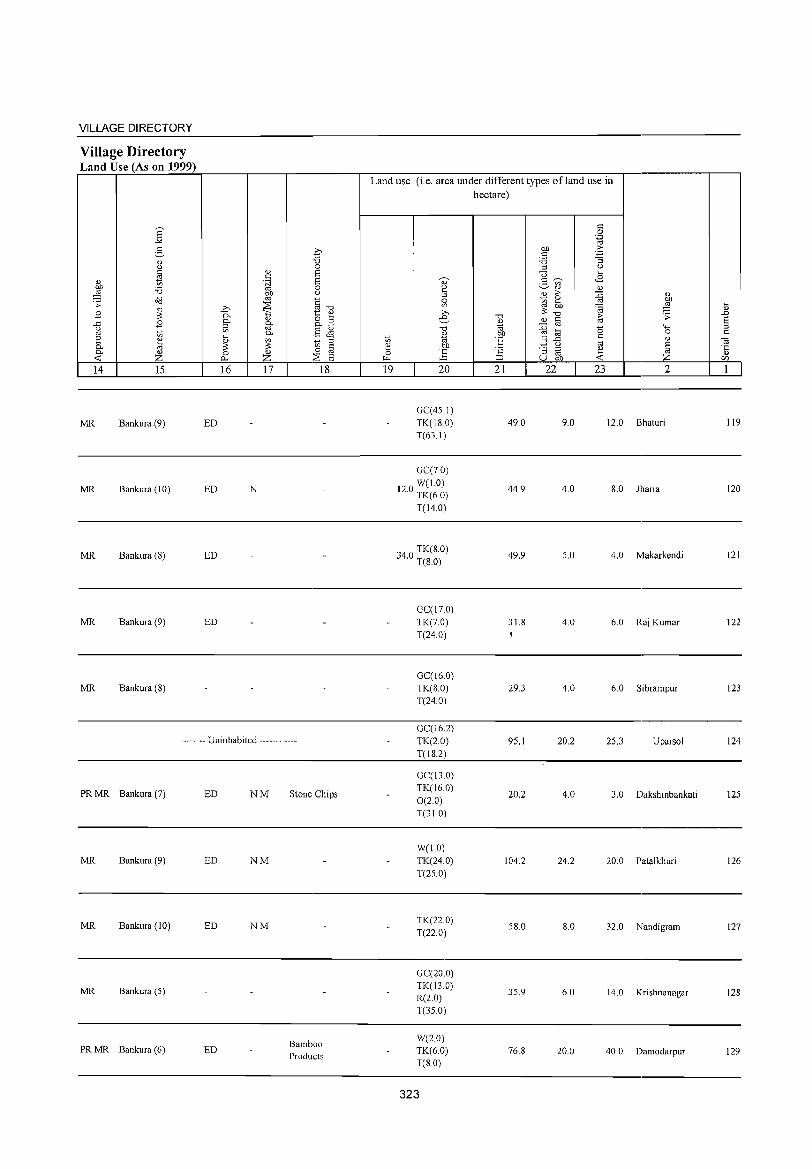
VILLAGE DIRECTORY
Village Directory Land Use (As on 1999)
14 15
MR Bankura (9)
MR Bankura (10)
MR Bankura (8)
MR Bankura (9)
MR Bankura (8)
16 17 18
ED
ED N
ED
ED
-------- Uninhabited ------------
PR MR Bankura (7)
MR Bankura (9)
MR Bankura (10)
MR Bankura (5)
PR MR Bankura (6)
ED NM
ED NM
ED NM
ED
Stone Chips
Bamboo Products
Land use (i.e. area under different types of land use in hectare)
19 20
GC(45.1) TK(18.0) T(63.1)
GC(70) W(1.0)
12.0 TK(6.0)
T(14.0)
340 TK(S.O) . T(8.0)
GC(I7.0) TK(7.0) T(24.0)
GC(16.0) TK(8.0) T(24.0)
GC(16.2) TK(2.0) T(18.2)
GC(13.0) TK(16.0) 0(20) T(31.0)
W(lO) TK(24.0) T(25.0)
TK(22.0) T(22.0)
GC(20.0) TK(130) R(2.0) T(35.0)
W(20) TK(6.0) T(8.0)
323
21 22
49.0
44.9
49.9
31.8
29.3
95.1
20.2
104.2
58.0
35.9
76.8
23 2
9.0 12.0 Bhaturi
4.0 8.0 Jharia
5.0 4.0 Makarkendi
4.0 6.0 Raj Kumar
4.0 6.0 Sibrampur
20.2 25.3 Uparsol
4.0 3.0 Dakshinbankati
24.2 20.0 Patalkhuri
8.0 32.0 Nandigram
6.0 14.0 Kri shnanagar
20.0 40.0 Damodarpur
119
120
121
122
123
124
125
126
127
128
129
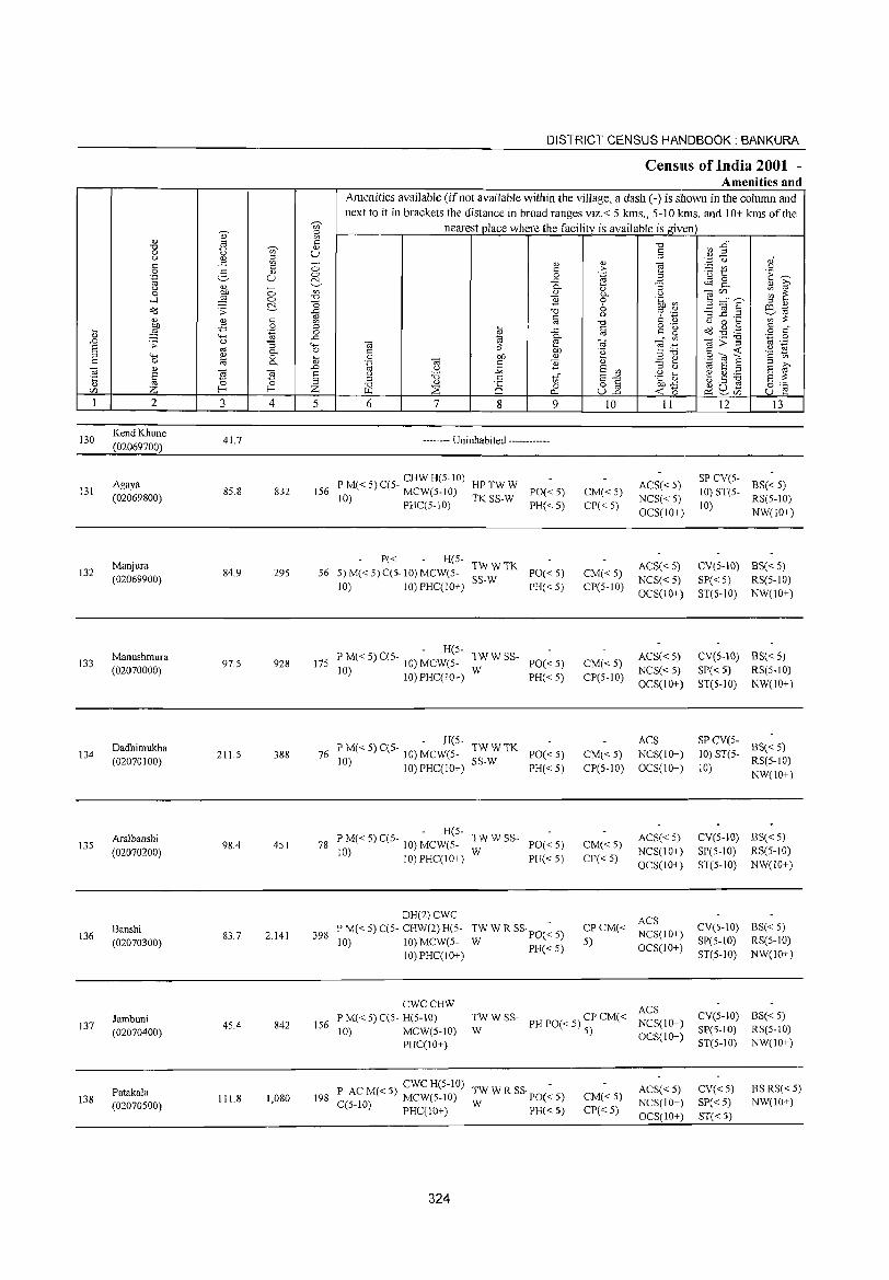
130
13l
132
133
134
135
136
137
138
2
KendKhune (02069700)
Agaya (02069800)
Manjura (02069900)
Manushmura (02070000)
Dadhimukha (02070100)
Aralbanshi
(02070200)
Banshi (02070300)
Jambuni (02070400)
Patakala (02070500)
3
41.7
8S.8
84.9
97.S
211.S
98.4
83.7
45.4
111.8
o o e '" o .~
"'3 0.. o 0..
4
832
29S
928
388
4S1
2,141
842
1,080
DISTRICT CENSUS HANDBOOK: BANKURA
Census of India 2001 -Amenities and
Amenities available (ifnot available within the village, a dash (-) is shown in the column and next to it in brackets the distance in broad ranges viz.< 5 kms., 5-10 kms. and 10+ kms of the
nearest_place where the facility is available is given
5 6 7 8 9
-------- Uninhabited ------------
PM«S)C(5- CHWH(S-IO) HPTWW 156 10) MCW(S-IO) TK SS-W PO« 5)
PHC(5-10) PH« 5)
P« H(S-
56 5) M« S) C(S. 10) MCW(S- ~~:: TK PO« S) 10) 10) PHC(IO+) PH« 5)
- H(S-17S PM«5)C(5- 10)MCW(S_ TWWSS- PO«5)
10) 10) PHC(IO+) W PH« 5)
- H(5-76 PM«5)C(5- 10)MCW(S- ~~::TK PO«S)
10) 10) PHC(10+) PH« 5)
- H(S-TWWSS-
78 P M« S) C(S- 10) MCW(S-W
PO« S) 10) 10) PHC(IO+) PH« S)
DH(2)CWC
398 P M« 5) C(5- CHW(2) H(5- TWWRSSpO(~S) 10) 10) MCW(5-
W PH« S) 10) PHC(IO+)
CWCCHW
10
CM« 5)
CP« 5)
CM« 5) CP(S-IO)
CM« 5) CP(5-10)
CM« S)
CP(5-1O)
CM« S) CP«S)
CPCM« 5)
156 P M« 5) C(5- H(5-10) TWWSS-
PH PO« 5)~; CM« 10) MCW(S-IO) W
PHC(IO+)
CWC H(5-10) TWWRSSpO(~5) P AC M« S) MCW(S-IO) CM«S) 198
C(S-10) PHC(10+) W PH« 5) CP« 5)
324
11
ACS« 5) NCS« S)
OCS(IO+)
ACS« 5) NCS« S) OCS(IO+)
ACS« 5)
NCS«5) OCS(IO+)
ACS NCS(10+)
OCS(10+)
ACS«5) NCS(IO+)
OCS(IO+)
ACS NCS(IO+) OCS(10+)
ACS NCS(IO+) OCS(10+)
ACS« S) NCS(IO+) OCS(10+)
12 13
SP CV(S- BS« 5)
10) ST(S- RS(S-IO)
10) NW(10+)
eV(S-IO) BS« 5) SP« 5) RS(S-IO) ST(5-10) NW(IO+)
eVeS-IO) BS« 5) SP« 5) RS(5-1O) ST(5-10) NW(10+)
SP CV(5- BS« 5)
10) ST(5- RS(S-IO)
10) NW(IO+)
CVe5-10) BS« 5) SP(5-10) RS(5-10)
ST(5-1O) NW(IO+)
CV(5-10) BS« 5) SP(5-1O) RS(5-1O)
ST(S-IO) NW(lO+)
CV(S-IO) BS« S) SP(S-IO) RS(S-IO) ST(S-10) NW(IO+)
CV«5) BSRS«S) SP« 5) NW(IO+)
ST« 5)
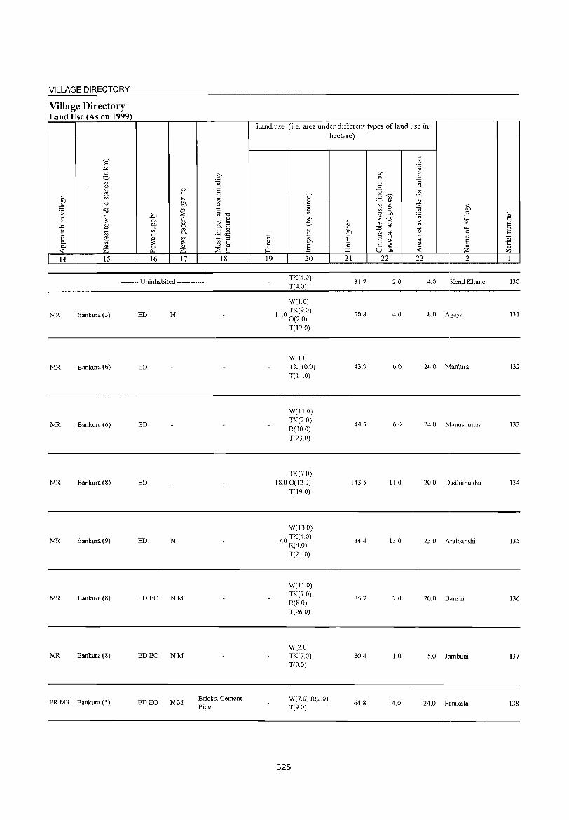
VILLAGE DIRECTORY
Village Directory Land Use (As on 1999)
E -'" 2, " u
'" ~ " tlfl :a ,g <\d .;;: ~ B
..c B u
"' '" 8 ~ "'" "'" u « z 14 15
;>,
0. "'" ~ '-< u
'" 0 P-.
16
.q "Cl 0
u Ei '" Ei .~
0 bJ) u co
§-o ~ t:: ~ u 8..B "'" co .5 <is "'" '" t; § '" u 0
Z ::8 8 17 18
-------- Uninhabited ------------
MR Bankura (5) ED N
MR Bankura (6) ED
MR Bankura (6) ED
MR Bankura (8) ED
MR Bankura (9) ED N
MR Bankura (8) ED EO NM
MR Bankura (8) ED EO NM
PRMR Bankura (5) ED EO NM Bricks, Cement Pipe
Land use (i.e. area under different types of land use in hectare)
19 20
TK(4.0) T(4.0)
W(1.0)
110 TK(90) . 0(2.0)
T(12.0)
W(1.0) TK(lO.O) T(II.O)
W(II 0) TK(2.0) R(IO.0)
T(23.0)
TK(70) 18.00(120)
T(19.0)
W(13.0)
70 TK(4.0) . R(4.0)
T(21.0)
W(11.0) TK(7.0) R(8.0) T(26.0)
W(2.0) TK(7.0) T(9.0)
W(7.0) R(2.0) T(9.0)
325
"Cl
" ~ bJ)
"E ';: ::J 21
31.7
50.8
43.9
44.5
143.5
34.4
35.7
30.4
64.8
c 0 .~
bJ) .~ c 'i3 "'3 ;:l u
<3 '-<
2- ~ <8 '" 0) " E :>-
~ " Ul ~ bI)
'" ,g
'" 'c;;
"Cl ~
.;;: " c :n co a ""' ~ a 0
..c s:: " u "' ~ "'3 ;:l ~ co
U bJ) « 22 23 2
2.0 4.0 Kend Khune
4.0 8.0 Agaya
6.0 24.0 Manjura
6.0 24.0 Manushmura
11.0 20.0 Dadhimukha
13.0 23.0 Aralbanshi
2.0 20.0 Banshi
1.0 5.0 Iambuni
14.0 24.0 Patakala
'-< u .D Ei ;:l s::
-c;; ·c u en 1
130
131
132
133
134
135
136
137
138
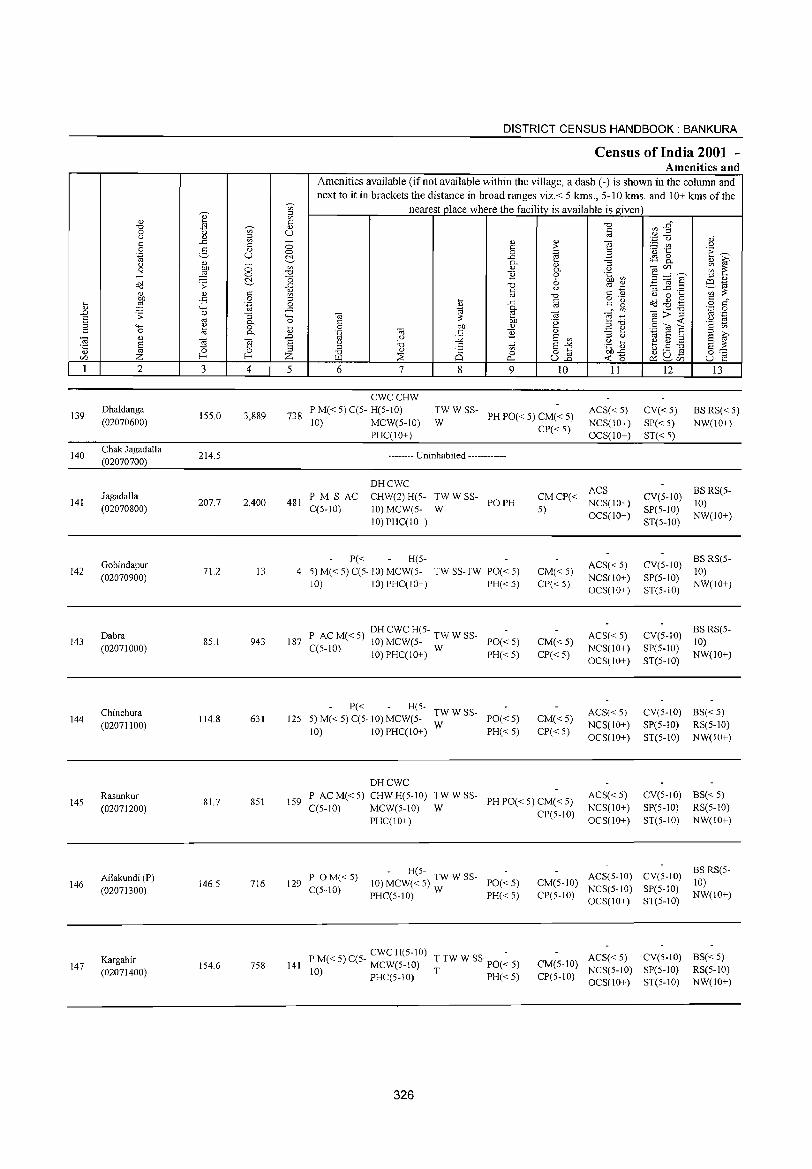
139
140
141
142
143
144
145
146
147
2
Dhaldanga
(02070600)
Chak Jagadalla (02070700)
Jagadalla (02070800)
Gobindapur (02070900)
Dabra (02071000)
Chinchura (02071100)
Rasunkur (02071200)
Ailakundi (P) (02071300)
Kargahir (02071400)
3 4
155.0 3,889
214.S
207.7 2,400
71.2 13
8S.1 943
114.8 631
81.7 8S1
146.5 716
154.6 758
DISTRICT CENSUS HANDBOOK: BANKURA
Census of India 2001 -Amenities and
Amenities available (if not available within the village, a dash (-) is shown in the column and next to it in brackets the distance in broad ranges viz.< 5 kms., 5-10 kms. and 10+ kms of the
nearest place where the facility is available is given
5 6 7 8
if> o
0...
9 10 11 12 13
738
CWCCHW P M« S) C(S- H(S-IO) 10) MCW(S-IO)
PHC(IO+)
TW WSS-W
PH PO« 5) CM« 5) ACS« S) NCS(IO+) OCS(IO+)
CV«S) SP« S) ST« S)
BS RS« S) NW(IO+)
481 PM S AC C(S-IO)
-------- Uninhabited ------------
DHCWC CHW(2) H(5-10) MCW(S-
10)PHC(lO+)
:WWSS- POPH
P« H(S-4 S) M« 5) C(5· 10) MCW(5- TW SS-TW PO« 5)
10) IO)PHC(IO+) PH«5)
P ACM«S) DHCWCH(S- TWWSS-187 10) MCW(S- PO«5)
C(5-10) 10) PHC(lO+) W PH« 5)
P« H(S- TW W SS-125 S)M«5)C(S·10)MCW(5- W PO«5)
10) 10) PHC(IO+) PH« 5)
DHCWC
CP«S)
ACS CMCP« S) NCS(IO+)
CM«5) CP«5)
CM«5)
CP«S)
CM«5) CP«S)
OCS(IO+)
ACS« S) NCS(IO+) OCS(IO+)
ACS« S) NCS(10+) OCS(IO+)
ACS«5) NCS(lO+) OCS(IO+)
CV(S-10) BS RS(5-10)
SP(S-10) NW(10+) ST(5-1O)
CV(S-IO) BS RS(5-10)
SP(S-IO) NW(IO+) ST(S-IO)
CV(S-IO) BS RS(S-10)
SP(S-IO) NW(10+) ST(S-IO)
CV(S-IO) BS« 5) SP(S-IO) RS(5-10) ST(S-IO) NW(IO+)
P ACM«S) CHWH(S-IO) TWWSS-IS9 PH PO« S) CM« 5)
C(S-IO) MCWe5-10) W CP(5-10) PHC(IO+)
ACS« S) NCS(IO+) OCS(IO+)
CV(5-1O) BS« S) SP(5-10) RS(S-10) ST(S-IO) NW(IO+)
- H(5-129 POM«5) 10) MCW«5) TWWSS- PO«5)
C(5-10) PHC(5-10) W PH« S)
ACS(5-10) CV(5-IO) BS RS(5-CM(5-10) 10) CP(5-10) NCS(5-10) SP(S-IO) NW(IO+)
OCS( 10+) ST(S-IO)
CWCH(5-10) -141 P M« 5) C(5- MCW(5-10) T TW W SS· PO« 5)
10) PHC(5-10) T PH« 5)
ACS« 5) CV(5-10) BS« 5) CM(5-10) NCS(5-IO) SP(5-10) RS(5-10) CP(5-IO) OCS(IO+) ST(5-10) NW(IO+)
326

VILLAGE DIRECTORY
Village Directory Land Use (As on 1999)
2' ..>G
2, Q.) ()
" " Q.) to OIl :0 ~ a<J .;;:
~ ,9 ,9 ..c
g '" §. ~
0. '" -< z 14 15
PRMR Bankura (6)
~ 0
<U S " .~ S 0
gf ()
ti ~ :>. ""d
0. t <U
0. Q.) &B ::l ~
'" 0. §Jl ~ <IJ ~ ::l
~ on g 0 Q.) 0
p... z ::s a 16 17 18
EDEO NM
-------- Uninhabited ------------
Handloom MR Bankura (7) ED EO NM
Article
PRMR Bankura (7) ED N
PRMR Bankura (9) ED EO NM
PRMR Bankura (10) ED EO N
MR Bankura (10) ED N
MR Bankura (5) N
PR MR Bankura (7) ED
Land use (i.e. area under different types of land use in
to ::: 0 ~
19
'0)
~ 0 '" ;>, e "d
Q.)
1a ;:!l
J:i 20
W(7 0) T(7.0)
37.0
We20.0) 11.0 TK(26.0)
T(46.0)
W(II.O) TK(ll.O) T(22.0)
GC(24.0) W(5.0)
TK(5.0) T(34.0)
GC(40.0)
W(2.0) TK(I LO) T(53.0)
GC(12.0) TK(3.0)
T(15.0)
TK(4.0) T(4.0)
W(1.0) 3.0 TK(S.O)
T(9.0)
327
hectare)
"0 Q.)
~ OIl
E 'c ;::J
21
710
163.5
124.7
30.2
33.1
17.8
30.7
102.5
118.6
" 0 '.g
on ·E " :0 '3 ::l ()
U '-<8 5 ~ '" Q.) Q.)
%1 >- :@ <1)
2 ~ " OIl ~
. til "d
10 .;;:
Q.) " :0 " '0 4-<
~ 8 0 ..c " .,
2 " OJ § '3 iii ~ u OIl Z 22 23 2
12.0 65.0 Dhaldanga
'8.0 6.0 Chak J agadalla
2.0 24.0 Jagadalla
2.0 17.0 Gobindapur
6.0 12.0 Dabra
16.0 28.0 Chinchura
4.0 32.0 Rasunkur
8.0 32.0 Ailakundi (P)
4.0 20.0 Kargahir
'-<U
.D a ::l
" ~ Q.)
CZl
1
139
140
141
142
143
144
145
146
147
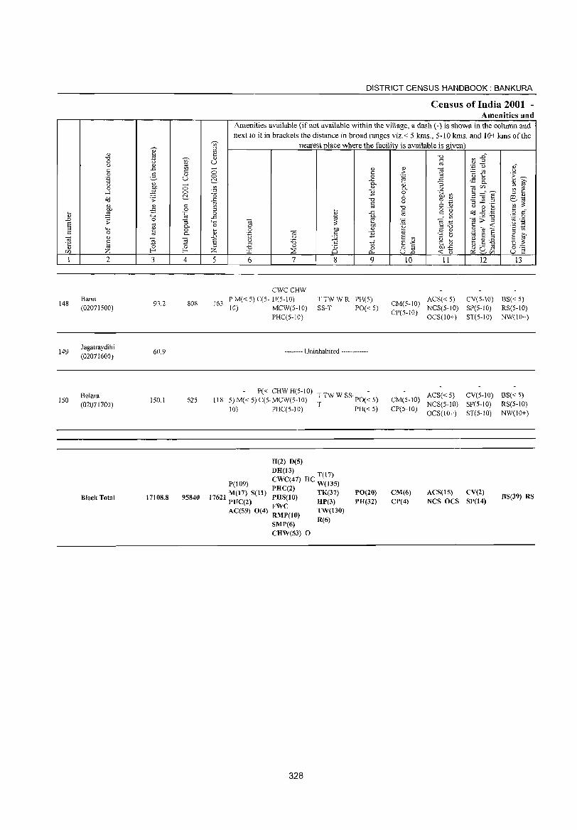
,-.._ <1)
" ~ "0 0 '" (.) = .<: '" c c 0 :S- a> .~ C) (.) ~ ~
0 <=> ..-l ~ 0
~ o::J .;;: <1) <1) c: OJ) -:S 0 ... ~ .~
" """' ..0 ;;: 0 "3 S '" 0-
'" ...... 0) 0 <= 0 ~ 0-
-a " E ~ Z! '5 '" 0 U) Z f-< f-<
I 2 3 4
148 Barut
93.2 808 (0207IS00)
149 Jagatraydihi
60.9 (02071600)
Bolara 150 150.1 625
(02071700)
Block Total 17108.8 95840
DISTRICT CENSUS HANDBOOK: BANKURA
Census of India 2001 -Amenities and
Amenities available (if not available within the village, a dash (-) is shown in the column and next to it in brackets the distance in broad ranges viz. < 5 kms., 5-10 kms. and 10+ kms of the
]' nearest place where the facility is available is given <= "0 '" _c, 0)
C) <= 0).2
'" :.a (.) " ;; 0) 0) ""§ <= >- - '" .>l
<=> 0 .~ B ·0 t:: i":~ ~ .<: ~ 8.- a> ~
'" g- O} "3 -at/) ;;; 1:: 0- (.)
-0 1i 0 .~ [J 5 ="'S -0 6 = <1)
.<: "0 '"? .~ '3 _g .~ e<;:i Q) 8
(.)
'" ;:!: 3 "0 C " (.) 0 ... ... c: o .~
o::J .g .g <= -0 {j ..c
'" c: g o <=
..c g- on .~ -0 '.p 0 4-< -a OJ e ."t:: ~>~ '" .-;:!: ....
'2 ~ 0 c: OJ) .~
til 0 OJ) <l) ","0 9<0 6 .~ OJ c E <l) ~ e '" ..0 Q ;.Q E '" '" (.) <;:i S '" S f § (.) :;:; c of E-'" .g ~ ~.S ~ = §:::: "0 <l.l
25 0 o § OJ)'<:
~ ~c15 Z r..u ~ 0.. C)..o --< -0 C) E! 5 6 7 8 9 10 11 12 13
CWCCHW
163 P M« 5) C(5- H(5-IO) TTWWR PH(S)
CM(5-10) ACS« S) CV(S-IO) BS« S)
10) MCW(S-IO) SS-T PO« S) CP(5-10)
NCS(S-IO) SP(S-IO) RS(S-IO) PHC(5-10) OCS(IO+) ST(5-10) NW(lO+)
-------- Uninhabited ------------
P« CHW H(S-IO) T TW W SS· PO(~ 5) ACS« S) CV(S-IO) BS« S)
118 S) M« S) C(S·MCW(5-IO) CM(S-IO) T PH« 5)
NCS(S-IO) SP(S-IO) RS(S-IO) 10) PHC(5-10) CP(5-10)
OCS(IO+) ST(5-IO) NW(lO+)
H(2) D(S)
DH(13) T(l?)
P(109) CWC(47) HC W(13S)
M(l?) S(l1) PHC(2) TK(37) 17621 PUC(2) PHS(10) HP(3)
AC(S9) 0(4) ~:~(10) TW(130)
PO(20) PH(32)
CM(6) CP(4)
ACS(15) CV(2) NCS DCS SP(14)
BS(39) RS
SMP(6) R(6)
CHW(S3) D
328
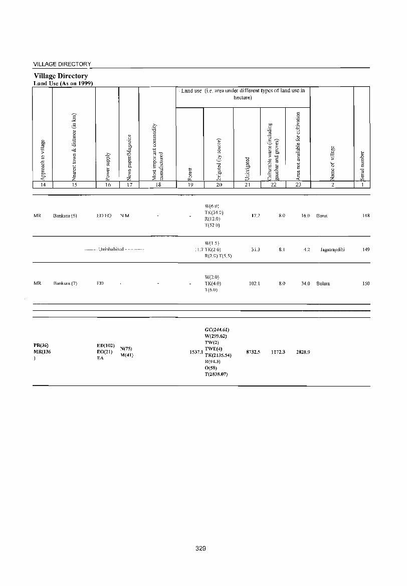
VILLAGE DIRECTORY
Village Directory Land Use (As on 1999)
E -'<
e-'" c.>
'" £1 '-' be '8 ,g
o<J ;;: '" .8 ;;:
..c: .8 c.>
'" 1;; [ OJ
8 0. OJ
-< Z 14 15
MR Bankura (6)
'-'
'" .~
gp >-> ~ P.. <I.) 0. 0. ::l en '" 0-~
'-' ~ ;;: 0 <I.)
0. Z 16 17
ED EO NM
-------- Uninhabited ------------
MR
PR(36)
MR(136 )
Bankura (7) ED
ED(102) N(7S) EO(21) M(41) EA
o '8 0 s s 0 u
~-o t '" 8.E §Jl _ ::l
13 til ::;s S 18
Land use (i.e. area under different types ofland use in hectare)
19 20
W(6.0) TK(34.0) R(12.0) T(52.0)
W(1.5)
-0 '-' ., 'E ·2 ;:J
21
17.2
'" 0 .~
be ·5 '" '8 "3 ::l c.>
-0 -9 3 en OJ OJ
B >- {l ~ ~ ;;: =@
-0 ~ '-' '" :0 '" 0 E! 8
.a ..c: '" c.> '" "3 ::l ~ '" U be -<
22 23
8.0 16.0 Barut
'-'
~ .;;: "-' 0 '-' § Z 2
11.7 TK(2.0) R(2.0) T(5 5)
31.3 8.1 4.2 J agatraydihi
W(2.0) TK(4.0) T(6.0)
GC(244.61) W(299.62) TW(2) TWE(4)
1537.1 TK(2135.54)
R(94.3) 0(58) T(2838.07)
329
102.1 8.0 34.0 Bolara
8732.5 1172.3 2828.9
~
'-' .D S ::l 0:
.~ '-'
if)
1
148
149
150

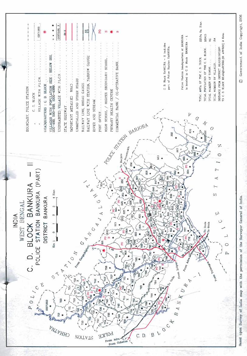
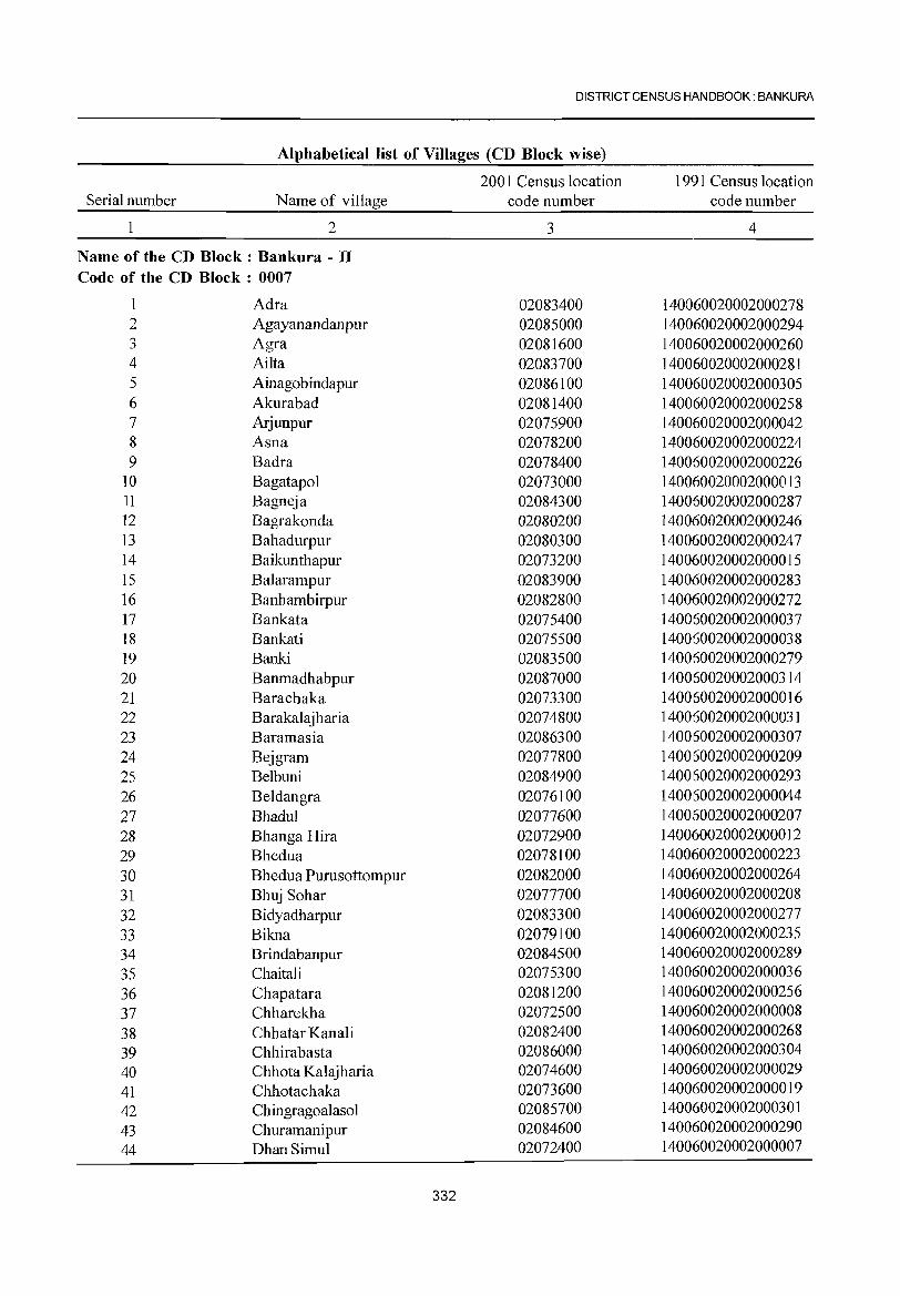
DISTRICT CENSUS HANDBOOK: BANKURA
Alphabetical list of Villages (CD Block wise)
2001 Census location 1991 Census location Serial number Name of village code number code number
2 3 4
Name of the CD Block: Bankura - II Code of the CD Block : 0007
1 Adra 02083400 140060020002000278 2 Agayanandanpur 02085000 140060020002000294 3 Agra 02081600 140060020002000260 4 Ailta 02083700 140060020002000281 5 Ainagobindapur 02086100 140060020002000305 6 Akurabad 02081400 140060020002000258 7 Arjunpur 02075900 140060020002000042 8 Asna 02078200 140060020002000224 9 Badra 02078400 140060020002000226
10 Bagatapol 02073000 140060020002000013 11 Bagneja 02084300 140060020002000287 12 Bagrakonda 02080200 140060020002000246 13 Bahadurpur 02080300 140060020002000247 14 Baikunthapur 02073200 140060020002000015 15 Balarampur 02083900 140060020002000283 16 Banhambirpur 02082800 140060020002000272 17 Bankata 02075400 140060020002000037 18 Bankati 02075500 140060020002000038 19 Banki 02083500 140060020002000279 20 Banmadhabpur 02087000 140060020002000314 21 Barachaka 02073300 140060020002000016 22 Barakalajharia 02074800 140060020002000031 23 Baramasia 02086300 140060020002000307 24 Bejgram 02077800 140060020002000209 25 Belbuni 02084900 140060020002000293 26 Beldangra 02076100 140060020002000044 27 Bhadul 02077600 140060020002000207 28 Bhanga Hira 02072900 140060020002000012 29 Bhedua 02078100 140060020002000223 30 Bhedua Purusottompur 02082000 140060020002000264 31 Bhuj Sohar 02077700 140060020002000208 32 Bidyadharpur 02083300 140060020002000277 33 Bikna 02079100 140060020002000235 34 Brindabanpur 02084500 140060020002000289 35 Chaitali 02075300 140060020002000036 36 Chapatara 02081200 140060020002000256 37 Chharekha 02072500 140060020002000008 38 Chhatar Kanali 02082400 140060020002000268 39 Chhirabasta 02086000 140060020002000304 40 Chhota Kalajharia 02074600 140060020002000029 41 Chhotachaka 02073600 140060020002000019 42 Chingragoalasol 02085700 140060020002000301 43 Churamanipur 02084600 140060020002000290 44 DhanSimul 02072400 140060020002000007
332
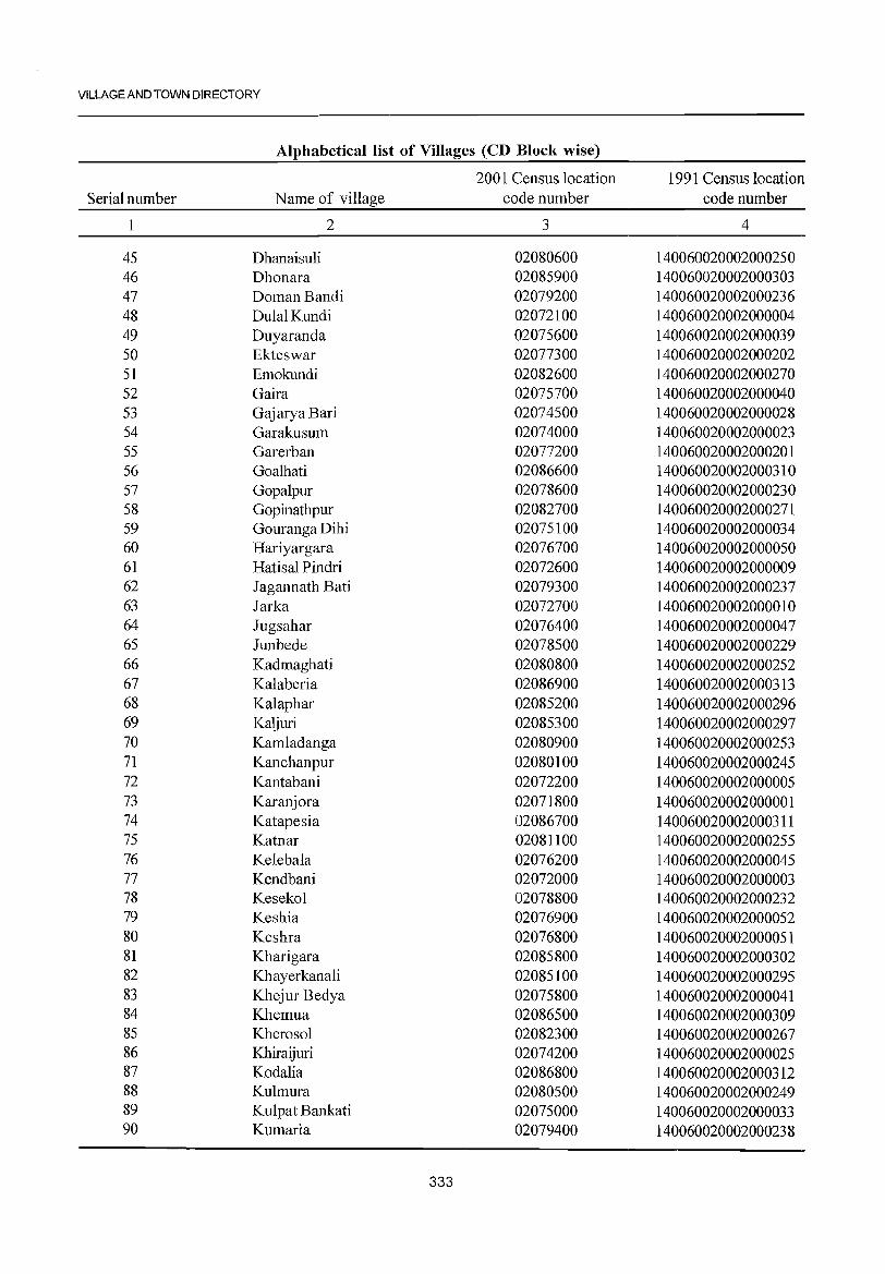
VILLAGE AND TOWN DIRECTORY
Alphabetical list of Villages (CD Block wise)
2001 Census location 1991 Census location Serial number Name of village code number code number
1 2 3 4
45 Dhanaisuli 02080600 140060020002000250 46 Dhonara 02085900 140060020002000303 47 Doman Bandi 02079200 140060020002000236 48 DulalKundi 02072100 140060020002000004 49 Duyaranda 02075600 140060020002000039 50 Ekteswar 02077300 140060020002000202 51 Emokundi 02082600 140060020002000270 52 Gaira 02075700 140060020002000040 53 GajaryaBari 02074500 140060020002000028 54 G araku sum 02074000 140060020002000023 55 Garerban 02077200 140060020002000201 56 Goalhati 02086600 140060020002000310 57 Gopalpur 02078600 140060020002000230 58 Gopinathpur 02082700 140060020002000271 59 Gouranga Dihi 02075100 140060020002000034 60 Hariyargara 02076700 140060020002000050 61 Hatisal Pindri 02072600 140060020002000009 62 Iagannath Bati 02079300 140060020002000237 63 Iarka 02072700 140060020002000010 64 Iugsahar 02076400 140060020002000047 65 Iunbede 02078500 140060020002000229 66 Kadmaghati 02080800 140060020002000252 67 Kalaberia 02086900 140060020002000313 68 Kalaphar 02085200 140060020002000296 69 Kaljuri 02085300 140060020002000297 70 Kamladanga 02080900 140060020002000253 71 Kanchanpur 02080100 140060020002000245 72 Kantabani 02072200 140060020002000005 73 Karanjora 02071800 140060020002000001 74 Katapesia 02086700 140060020002000311 75 Katnar 02081100 140060020002000255 76 Kelebala 02076200 140060020002000045 77 Kendbani 02072000 140060020002000003 78 Kesekol 02078800 140060020002000232 79 Keshia 02076900 140060020002000052 80 Keshra 02076800 140060020002000051 81 Kharigara 02085800 140060020002000302 82 Khayerkanali 02085100 140060020002000295 83 Khejur Bedya 02075800 140060020002000041 84 Khemua 02086500 140060020002000309 85 Kherosol 02082300 140060020002000267 86 Khiraijuri 02074200 140060020002000025 87 Kodalia 02086800 140060020002000312 88 Kulmura 02080500 140060020002000249 89 Kulpat Bankati 02075000 140060020002000033 90 Kumaria 02079400 140060020002000238
333
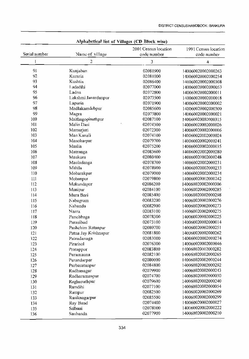
DISTRICT CENSUS HANDBOOK: BANKURA
Alphabetical list of Villages (CD Block wise)
2001 Census location 1991 Census location Serial number Name of village code number code number
1 2 3 4
91 Kunjaban 02081900 140060020002000263 92 Kuraria 02081000 140060020002000254 93 Kushtia 02086400 140060020002000308 94 Ladadihi 02077000 140060020002000053 95 Ladna 02072800 140060020002000011 96 Lakshmi Janardanpur 02073500 140060020002000018 97 Lapuria 02071900 140060020002000002 98 Madlakamdebpur 02085600 140060020002000300 99 Magra 02073800 140060020002000021
100 Maithagopinathpur 02087100 1401060020002000315 101 Malin Dasi 02074300 1401060020002000026 102 Mamurjuri 02072300 1401060020002000006 103 Man Kanali 02074100 1401060020002000024 104 Manoharpur 02079700 1401060020002000241 105 Maslia 02075200 1401060020002000035 106 Matranga 02083600 1401060020002000280 107 Maukura 02080400 1401060020002000248 108 Mauladanga 02078700 140060020002000231 109 Mithila 02078900 140060020002000233 110 Mobarakpur 02079000 140060020002000234 111 Mohanpur 02079800 140060020002000242 112 Mukundapur 02086200 140060020002000306 113 Munipur 02084100 140060020002000285 114 MuraBari 02085400 140060020002000298 115 Nabagram 02083200 140060020002000276 116 Nabanda 02082900 140060020002000273 117 Narra 02083100 140060020002000275 118 Panchbaga 02078300 140060020002000225 119 Parasibad 02073100 140060020002000014 120 Pashchim Ratanpur 02080700 140060020002000251 121 Patna Jay Krishnapur 02081800 140060020002000262 122 Patradanaga 02083000 140060020002000274 123 Pirarisol 02076300 140060020002000046 124 Pratappur 02083800 140060020002000282 125 Puramauna 02082100 140060020002000265 126 Purandarpur 02080000 140060020002000244 127 Purbaratan pur 02084800 140060020002000292 128 Radhanagar 02079900 140060020002000243 129 Radharamanpur 02074700 140060020002000030 130 Raghunathpur 02079600 140060020002000240 131 Ramdihi 02077100 140060020002000054 132 Rampur 02082500 140060020002000269 133 Rasiknagarpur 02085500 140060020002000299 134 Ray Band 02074400 140060020002000027 135 Salbani 02078000 140060020002000222 136 San banda 02077900 140060020002000210
334
VILLAGE AND TOWN DIRECTORY
Alphabetical list of Villages (CD Block wise)
2001 Census location 1991 Census location Serial number Name of village code number code number
1 2 3 4
l37 Sankarhati 02077400 140060020002000203 138 Sankarpur 02082200 140060020002000266 l39 Sendra 02081300 140060020002000257 140 Shitladihi 02073400 140060020002000017 141 Shitladihi 02076500 140060020002000048 142 Sibrampur 02084400 140060020002000288 143 Sirsara 02084000 140060020002000284 144 Sonadaha 02074900 140060020002000032 145 Sonamui 02073900 140060020002000022 146 Sonarekh 02073700 140060020002000020 147 Syamdaspur 02077500 140060020002000206 148 Taldanga 02081500 140060020002000259 149 Tantkanali 02076600 140060020002000049 150 Teleghra 02084200 140060020002000286 151 Tilabedya 02079500 140060020002000239 152 UparDihi 02076000 140060020002000043 153 Uparbanda 02084700 140060020002000291 154 Upamarra 02081700 140060020002000261
335
DISTRICT CENSUS HANDBOOK: BANKURA
Census of India 2001 -Amenities and
Amenities available (if not available within the village, a dash (-) is shown in the column and next to it in brackets the distance in broad ranges viz.< 5 kms., 5-10 kms. and 10+ kms of the
';ii' nearest place where the facility is available is_given 'V ;:;
'" d) S c: "0 ~ :3~ "0 ';ii' " 0 () U c: u " ::I '" ''';:: 0 a) c: .<: '" - OJ " "§ c: 0 c: > ~t u 0 2- d) 'E ~ '-g u 0 0 .~ .a C!.. ..c: ~ 8..
11 ~ Q. "3 " i:;' u '" OJ " Cil<Zl ~ 2: 0 0 Q. u
...l ~ 0 "0 "ii 0 .~ ~ 5 ="6' C!.. :g 6 ;:; " a<3 .;;: "0 '3 ~ .2 e~
" c: u '? '';:::: '" ::: d) " c:
~ '" "0 c: d) u 0 ._
~ -£ 0 o .- ~ .g . .§ c: " ~ ..c: c: c: g il .~ 0 to o c: ..... ..c: 0- '" Cil:>"2
'P 0 .D .;;: 0 "3 e Cil to .-S ..... Cil ::: e .t:: '2 ~ to 0.. 0 c: 0/) 'e c: ~ ;::l '+< " 0 ._ 0 bO "
;:;"0 .S 'OJ 8 c: 0 a " Cil c: "ii " ~ " ::I 0. '.g - ._ i:;' Cil d) .D U :;l S '"
;:l u ~ E ;::::I S S -a -a § u '3 .:; c: "'" .g 1U ~ g:.a s ::: ·c to (5 (5 ;:;
" '" - c: ~G.s " z "0 0 0 o to O/)..c: 0:;::: <Zl Z f-< f-< rL1 ~ "'"- U.D ~(5 ~ ~<Zl U e 1 2 3 4 5 6 7 8 9 10 11 12 13
CD Block: Bankura - II (0007)
Karanjora P(2) M«5) - H(5-
ACS(IO+) CV(2) SP BS
434.1 1,797 316 10) MCW(5- TW W SS- PO« 5) CM(5-IO) RS(IO+) (02071800) C(lO+) 10) PHC(5-1O) W PH(IO+) CP(5-1O)
NCS(IO+) ST(lO+) NW(IO+)
OCS(10+)
2 Lapuria
236.8 1,081 194 PM« 5) H(JO+) TWWSS-
PO(5-10) CM(5-10) ACS(IO+) CV(IO+) BS(5-10)
(02071900) C(lO+) MCW(5-1O) W NCS(lO+) SP(5-10) RS(5-10) PHC(5-10)
PH(10+) CP(5-10) OCS(IO+) ST(IO+) NW(IO+)
3 Kendbani
297.3 782 124 P M«5) H(lO+) TW WSS-
PO(5-1O) ACS(10+) CV(lO+) BS« 5)
(02072000) C(10+) MCW(5-IO) W CM« 5)
NCS(lO+) Spe5-10) RS(IO+)
PHC«5) PH« 5) CP« 5)
OCS(10+) ST(10+) NW(IO+)
4 DulalKundi
103.0 36 - P(5- H(I;+) TWWSS-
PO« 5) CM« 5) ACS(IO+) CV(lO+) BS« 5)
(02072100) 10)M«5) MCW(5-IO) W NCS(IO+) SP(5-IO) RS(IO+) C(IO+) PHC« 5) PH«5) CP« 5)
OCS(JO+) ST(IO+) NW(IO+)
Kantabani 96.2 289 57
P M« 5) H(IO+) TWWSS-PO«5) CM«5)
ACS(IO+) CV(10+) BS« 5) (02072200) C(IO+) MCW(S-IO) W
PH« 5) CP«S) NCS(IO+) SP(5-10) RS(IO+)
PHC«5) OCS(lO+) ST(IO+) NW(IO+)
6 Mamurjuri
126.7 161 29 - P(5- H(I;+)
TWSS-W PO« 5) CM«5) ACS(IO+) CV(IO+) BS« 5)
(02072300) IO)M« 5) MCW(5-10) NCS(10+) SP(S-lO) RS(IO+) C(JO+) PHC«5) PH« 5) CP«5)
OCS(lO+) ST(JO+) NW(lO+)
DhanSimul 174.5 173 28
P M« 5) H(IO+) TWWSS-PO«5) CM« 5)
ACS(lO+) CV(IO+) BS« 5) 7
(02072400) C(10+) MCW(5-10) W NCS(IO+) SP(5-10) RS(IO+)
PHC«5) PH« 5) CP« 5)
OCS(IO+) ST(lO+) NW(lO+)
8 Chharekha
143.2 -------- Uninhabited ------------(02072500)
9 Hatisal Pindri
62.1 -------- Uninhabited ------------(02072600)
10 larka (02072700) 79.7 -------- Uninhabited ------------
Ladna P M«5) PHS H(IO+)
TWW SS- ACS(IO+) CV(IO+) BS« 5) II 1 13.9 1,13 I 211
C(IO+) MCW(5-10)
W PO«5) CM«5)
NCS(IO+) SP(5-10) RS(IO+) (02072800) PHC«5) PH«5) CP«5) OCS(lO+) ST(IO+) NW(IO+)
BhangaHira P« H(IO+) ACS(IO+) CV(IO+) BS« 5)
12 59.5 362 63 5) Me< 5) MCW(5-10)
RSS-R POC< 5) CM«5) NCS(IO+) SP(5-10) RS(IO+) (02072900) C(JO+) PH« 5) CP« 5)
PHC« 5) OCS(IO+) ST(IO+) NW(10+)
336
VILLAGE DIRECTORY
Village Directory Land Use (As on 1999)
en
~ " z
14 15 16 17 18
PRMR Bankura (29) ED EO Dhuti, Chaddar, Lungi
MR Bankura (29)
MR Bankura (24)
MR Bankura (24)
MR Bankura (24)
MR Bankura (21) ED
MR Bankura (24)
-------- Uninhabited ------------
-------- Uninhabited ------------
-------- Uninhabited ------------
MR Bankura (22) ED
MR Bankura (22) ED
Land use (i.e. area under different types ofland use in hectare)
19 20
1000 TK(4.0) · T(4.0)
TK(30) T(3.0)
1040 TK(7.0) · T(7.0}
368 TK(7.4) · T(7.4)
18.0
77.0
TK(7.5) T(75)
380 TK(S.O) · T(S.O)
20 TK(6.0) · T(6.0)
TWE(O.O) 8.4 TK(O.I)
T(O.I)
TK(7.5) T(7S)
R(O.O) T(O.O)
337
21
204.9
141.4
170.3
44.4
57.0
50.0
74.9
36.2
40.1
25.3
67.1
51.0
22 23 2
105.2 20.0 Karanjora
72.4 20.0 Lapuria
16.0 Kendbani
10.2 4.2 Dulal Kundi
17.2 4.0 Kantabani
19.2 50.0 Mamurjuri
22.3 0.3 Dhan Simul
14.0 50.0 Chharekha
9.0 4.9 Hatisal Pindri
30.0 15.9 Jarka
35.0 4.4 Ladna
7.0 1.5 Bhanga Hira
2
3
4
5
6
7
8
9
10
II
12
'" ~ :l
" ~ '" '" "0 ';;) " 0 {) u 0 " ~ "
..::: " C;
0 g " 0 .~ u ~ <1.l -0
'" 0 OJ) 0 -l ~ 0 "0
~ -0 o<! .;; ..c
dl
" <1.l " :g OJ) ..c 0 .... :§ ,:;:: .~ 0 dl ..::: .D .;; 0 :5 ..... S '" 0- 0 ::l ..... 0.> 0 t c 0 ta 0.,
0;; " ..0
E iii ~ S '5 OJ 0 ::l Z IZJ Z I-< I-<
1 2 3 4 5
13 Bagatapol
160.3 640 114 (02073000)
14 Parasibad
116.2 151 25 (02073100)
15 Baikunthapur
84.9 539 106 (02073200)
16 Barachaka
137.2 270 47 (02073300)
17 Shitladihi
80.9 150 23 (02073400)
Lakshmi 18 Janardanpur 162.9 726 129
(02073500)
19 Chhotachaka
115.3 265 48 (02073600)
Sonarekh 120 20
(02073700) 90.5 670
Magra 21 95.4 2,299 40&
(02073800)
Sonamui 22
(02073900) 146.6 3,050 621
Garakusum 23
(02074000) 97.4 290 66
DISTRICT CENSUS HANDBOOK: BANKURA
Census of India 2001 -Amenities and
Amenities available (if not available within the village, a dash (-) is shown in the column and next to it in brackets the distance in broad ranges viz.< 5 kms., 5-10 kms. and 10+ kms of the
nearest place where the facility is available is given -0 '" .D" § .~ E
'" ~ 0 rJ
" OJ '" {)
" > 0 .~ 2 'u t 'E ~ ..c c$ 0 0- :5 0- <1.l G' "
<1.l OJIZJ ~ ~ 0- 0 ] 0 .~ !:ids 6 '" ::l " "0 % .~ ~ ~ .~ ~td "
0 '" ::: OJ "0 00 .... .... §
o .- Cd ..g . .g <:: "
~ .g_ " g o " '" .- "0 'p 0
OJ e 0;; e:g g>~ OJ .-
'" ::: be .~ .~ ~
0 OJ) " E e .S: 'it! E <:: '" .~ <il c ] dl
1il S ::l ::l
G' 0 :.g S '" ::l 0 S {) '0 t;" E-'" .~ ~ ~ .5 ~ g,s ::l
" E 8.2 6b..c "0 ::;E Q 0 p,ju-'-U 0.. <>:: 0 ~IZJ U e 6 7 8 9 10 11 12 13
P M(5-1O) H(IO+) TWWSS-PO« 5) CM(5-10)
ACS(lO+) CV(lO+) BS(5-10) C(lO+) MCW(5-10) W
PH« 5) CP(5-1O) NCS(IO+) SP(5-10) RS(5-10)
PHC« 5) OCS(10+) ST(lO+) NW(IO+)
- P« H(l~+) TWWSS-PO(5-10) CM(5-10)
ACS(IO+) CV(lO+) BS(5-IO) 5)M(5-10) MCW(5-10) W NCS(IO+) SP(5-1O) RS(5-10) C(IO+) PHC« 5) PH«5) CP(5-10)
OCS(IO+) ST(IO+) NW(IO+)
P M(5-1O) H(lO+) TWWSS-PO(5-10) CM(5-10)
ACS(IO+) CV(IO+) BS(5-10) C(lO+) MCW(5-10) W
PH« 5) CP(5-10) NCS(IO+) SP(5-1O) RS(5-10)
PHC«5) OCS(IO+) ST(IO+) NW(IO+)
P M(5-10) H(IO+) TWWSS-PO(5-10) CM(5-10)
ACS(IO+) CV(lO+) BS(5-1O) C(lO+) MCW(5-10) W
PH« 5) CP(5-10) NCS(IO+) SP(5-IO) RS(5-IO)
PHC«5) OCS(lO+) ST(lO+) NW(IO+)
- P« H(lO+) TWWSS-PO« 5) CM(5-10)
ACS(lO+) CV(IO+) BS« 5) 5)M(5-10) MCW(5-10) W NCS(10+) SP(5-10) RS« 5) C(lO+) PHC« 5) PH« 5) CP(5-10)
OCS(lO+) ST(IO+) NW(lO+)
- P« H(I~+) TWWSS- ACS(IO+) CV(IO+) BS(5-1O) 5) M(S-I 0) MCW(5-10) W
PO(S-IO) CM(S-IO) NCS(lO+) SP(S-lO) RS(S-lO)
C(IO+) PHC(S-IO) PH« 5) CP(5-10) OCS(IO+) ST(IO+) NW(lO+)
- P« H(IO+) ACS(IO+) CV(IO+) BS
TW SS-TW PO« 5) CM«5) RS(10+) 5) M(5-1 0) MCW(5-10) PH« 5) CP«5)
NCS(IO+) SP(5-10) NW(IO+) C(IO+) PHC« 5) OCS(10+) ST(IO+)
P M(5-1O) H(lO+) TWRSS-PO« 5) CM(5-10)
ACS(10+) CV(IO+) BS« 5) C(lO+) MCW(5-10) TW NCS(lO+) SP(5-1O) RS(5-1O)
PHC(5-1O) PH« 5) CP(5-10)
OCS(IO+) ST(lO+) NW(IO+)
P(2) M S PHSH(IO+)
TWWRSSpO(~5) ACS(IO+) CV SP(5-
BS« 5)
C(lO+) MCW(5-10) CM« 5)
NCS(IO+) 10)
RS(IO+) PHC«5) W PH«5) CP«5) ST(10+)
OCS(IO+) NW(IO+)
PMS H(10+) TWWSS- PO PH(5- CM CP(5- ACS(lO+) CVSP BS« 5)
C(10+) MCW(5-l0) W 10) 10) NCS(lO+) ST(10+) RS(lO+)
PHC«5) OCS(10+) NW(10+)
ACS(lO+) CV(10+) BS
PM S H(IO+) TWSS-TW PO« 5) CM(5-10) RS(IO+)
MCW(5-10) NCS(IO+) SP(5-1O) C(lO+) PH« 5) CP(5-10) NW(IO+)
PHC« 5) OCS(lO+) ST(lO+)
338
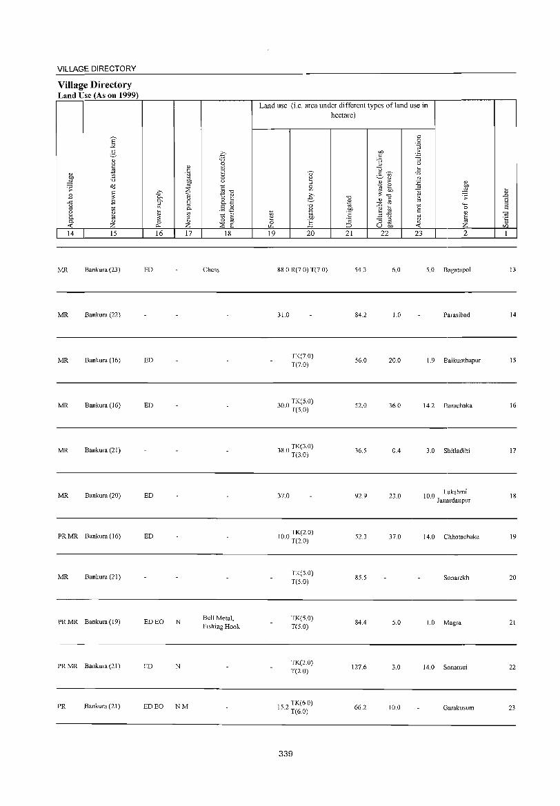
VILLAGE DIRECTORY
Village Directory Land Use (As on 1999)
14 15
MR Bankura (23)
MR Bankura (22)
MR Bankura (16)
MR Bankura (16)
MR Bankura (21 )
MR Bankura (20)
PRMR Bankura (16)
MR Bankura (21 )
PR MR Bankura (19)
PR MR Bankura (21 )
PR Bankura (21 )
16 17
ED
ED
ED
ED
ED
EDEO N
ED N
ED EO NM
18
Chess
Bell Metal, Fishing Hook
Land use (i.e. area under different types of land use in hectare)
19 20
88.0 R(7.0) T(7.0)
31.0
TK(7.0) T(70)
300 TK(5.0) · T(5.0)
380 TK(3.0) · T(3.0)
37.0
100 TK(2.0) · T(20)
TK(5.0) T(5.0)
TK(5.0) T(5.0)
TK(2.0) T(2.0)
152 TK(6.0) · T(6.0)
339
21 22
54.3
84.2
56.0
52.0
36.5
92.9
52.3
85.5
84.4
127.6
66.2
23 2
6.0 5.0 Bagatapol
1.0 Parasibad
20.0 1.9 8aikunthapur
36.0 14.2 Barachaka
0.4 3.0 Shitladihi
23.0 10.0 Lakshmi J anardanpur
37.0 14.0 Chhotachaka
Sonarekh
5.0 1.0 Magra
3.0 14.0 Sonamui
10.0 Garakusum
13
14
15
16
17
18
19
20
21
22
23
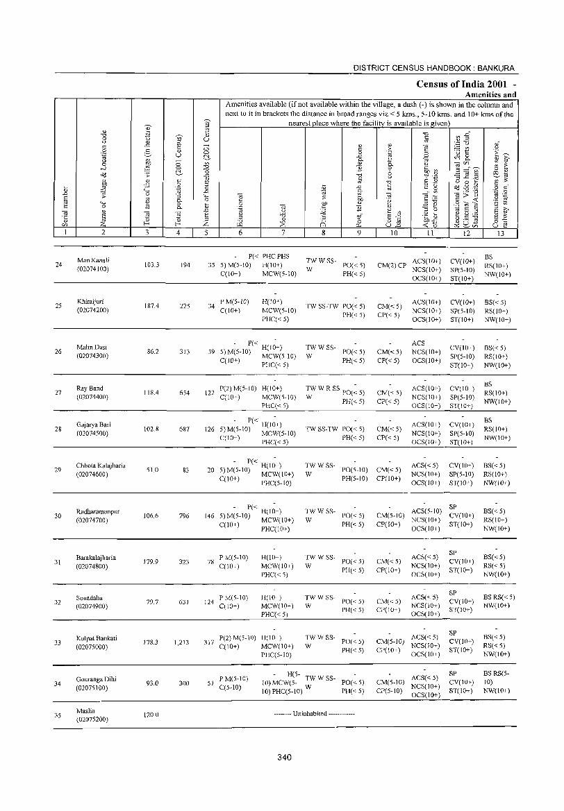
24
25
26
27
28
29
30
31
32
33
34
3S
2
Man Kanali
(02074100)
Khiraijuri (02074200)
Malin Dasi
(02074300)
Ray Band
(02074400)
GajaryaBari
(02074500)
Chhota Kalajharia
(02074600)
Radharamanpur
(02074700)
Barakalajharia
(02074800)
Sonadaha (02074900)
Kulpat Bankati
(0207S000)
Gouranga Dihi
(02075100)
Maslia (0207S200)
3
103.3
1874
86.2
118.4
102.8
51.0
106.6
179.9
79.7
178.3
93.0
120.0
c o .~
:; 0. o 0.
~ 4
194
225
313
654
687
83
796
323
631
1,213
300
DISTRICT CENSUS HANDBOOK: BANKURA
Census of India 2001 -Amenities and
Amenities available (if not available within the village, a dash (-) is sho'>vn in the column and next to it in brackets the distance in broad ranges viz.< 5 kms., 5-10 kms. and 10+ kms of the
nearest place where the facility is available is given
5 6 7
P« PHCPHS
35 5) M(S-IO) H(IO+)
C(10+) MCW(5-10)
34 P M(5-1O) C(IO+)
H(lO+)
MCW(5-10)
PHC« S)
- P« H(I;+) 59 5)M(5-10) MCW(5-10)
C(IO+) PHC« 5)
122 P(2) M(5-10) H(IO+) C(IO+) MCW(S-IO)
PHC« 5)
- P« H(I;+) S)M(5-10) MCW(5-10)
C(IO+) PHC« 5)
126
8
TWWSS-
W
'" o 0..
9
PO« S) PH« S)
TW SS-TW PO« S)
PH« S)
TWWSS-PO«5)
PH« 5) W
TWW R SSpO(~ 5)
W PH« 5)
TW SS-TW PO« S)
PH« S)
<1)
> .~
<1J 0. o 6 t>
-cJ §
'" .~
0)
E '" E -" o c uJ5
10 11
ACS(lO+) CM(2) CP NCS(IO+)
CM« S) CP«5)
CM«5)
CP«5)
CM« 5)
CP« 5)
CM« S) CP« S)
OCS(IO+)
ACS(IO+)
NCS(IO+)
OCS(JO+)
ACS
NCS(IO+)
OCS(IO+)
ACS(IO+)
NCS(IO+) OCS(IO+)
ACS(lO+)
NCS(10+)
OCS(10+)
12
CV(IO+)
SP(5-10) ST{IO+)
CV{IO+)
SP(S-IO)
ST(JO+)
CV(IO+)
SP(5-1O)
ST(IO+)
CV(IO+)
SP(5-10) ST(10+)
CV(lO+)
SP(S-IO)
ST(10+)
- P« H(I;+) 20 S)M(S-IO) MCW(lO+)
C(IO+) PHC(S-IO)
TWWSS-W PO(S-IO) CM« 5)
PH(S-IO) CP(lO+)
ACS« S) NCS{IO+)
OCS(10+)
CV(IO+)
SP(5-10)
ST(lO+)
146 - P« H(I;+)
5) M(S-IO) MCW(10+)
C(10+) PHC(IO+)
78 P M(S-IO) C(JO+)
124 PM(S-IO) C(IO+)
H(lO+)
MCW(IO+)
PHC« S)
H(IO+) MCW(IO+)
PHC« S)
317 P(2) M(S-IO) H(IO+) C(IO+) MCW(IO+)
PHC(S-IO)
;;WSS- PO«S)
PH« S)
TWWSS-W PO« 5)
PH« 5)
:W W SS- PO« 5)
PH«S)
:W W SS- PO« 5)
PH« 5)
SI P M(S-IO) C(S-IO)
H(S-10) MCW(5- TW W SS- PO« 5)
10) PHC(5-10) W PH« S)
-------- Uninhabited ------------
340
CM(S-IO)
CP(IO+)
SP ACS(S-IO) CV(lO+)
NCS(IO+) ST(IO+) OCS(IO+)
CM« 5)
CP(lO+)
CM«5) CP(10+)
ACS« 5) NCS(IO+)
OCS(IO+)
ACS« 5) NCS(IO+)
OCS(IO+)
ACS« 5) CM(5-10) NCS(10+)
CP(10+) OCS(IO+)
ACS« 5) CM(5-10) NCS(IO+)
CP(5-10) OCS(lO+)
SP CV(IO+)
ST(IO+)
SP CV(IO+) ST(IO+)
SP CV(IO+)
ST(IO+)
SP CV(JO+)
ST(IO+)
13
BS RS{lO+)
NW(lO+)
BS« 5) RS(lO+)
NW(JO+)
BS« 5) RS(lO+)
NW(IO+)
BS RS(lO+)
NW(IO+)
BS
RS(lO+)
NW(IO+)
BS« 5) RS(IO+)
NW(JO+)
BS« 5) RS(IO+)
NW(IO+)
BS« 5) RS« 5) NW(IO+)
BS RS« S) NW(IO+)
BS« 5) RS« 5) NW(IO+)
BS RS(S-
10)
NW(lO+)
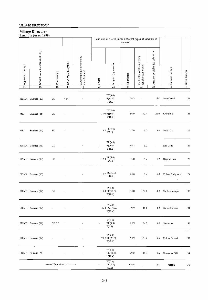
VILLAGE DIRECTORY
Village Directory Land Use (As on 1999)
14 15
PR MR Bankura (20)
MR Bankura (2S)
MR Bankura (24)
PR MR Bankura (19)
PR MR Bankura (19)
PR MR Bankura (10)
PR MR Bankura (17)
PR MR Bankura (12)
PR MR Bankura (12)
PRMR Bankura(12)
PR MR Bankura (7)
16 17
ED NM
ED
ED
ED
ED
ED
ED EO
-------- Uninhabited ------------
18
Land use (i.e. area under different types ofland use in hectare)
19 20
TK(3.0) R(IS.O) T(I8.0)
TK(8.0) S1.0 R(lO.O)
T(l8.0)
08 TK(4.0) · T(4.0)
TK(S.O) R(lO.O) T(lS.O)
124 TK(5 0) · T(S 0)
122 TK(IO.O) · T(lO.O)
W(2.0) 14.4 TK(16.0)
T(18.0)
W(0.8) 36.4 TW(19.6)
T(20.4)
W(O.4) TK(8.S) T(92)
W(0.8) 24.8 TK(20.0)
T(20.8)
W(O.4) TK(12.0) T(12.4)
W(OA) TK(3.2) T(3.6)
341
21 22
79.3
86.0
67.0
98.2
7S.0
28.0
34.8
72.9
28.9
S8.9
29.0
100.4
23 2
6.0 Man Kanali
12.4 20.0 Khiraijuri
6.0 8.4 Malin Dasi
5.2 Ray Band
9.2 1.2 Gajarya Bari
0.4 0.4 Chhota Kalajharia
34.6 4.8 Radharamanpur
46.8 3.4 Barakalajharia
34.0 7.6 Sonadaha
64.2 9.6 Kulpat Bankati
32.0 19.6 Gouranga Dihi
16.0 Maslia
24
25
26
27
28
29
30
31
32
33
34
35
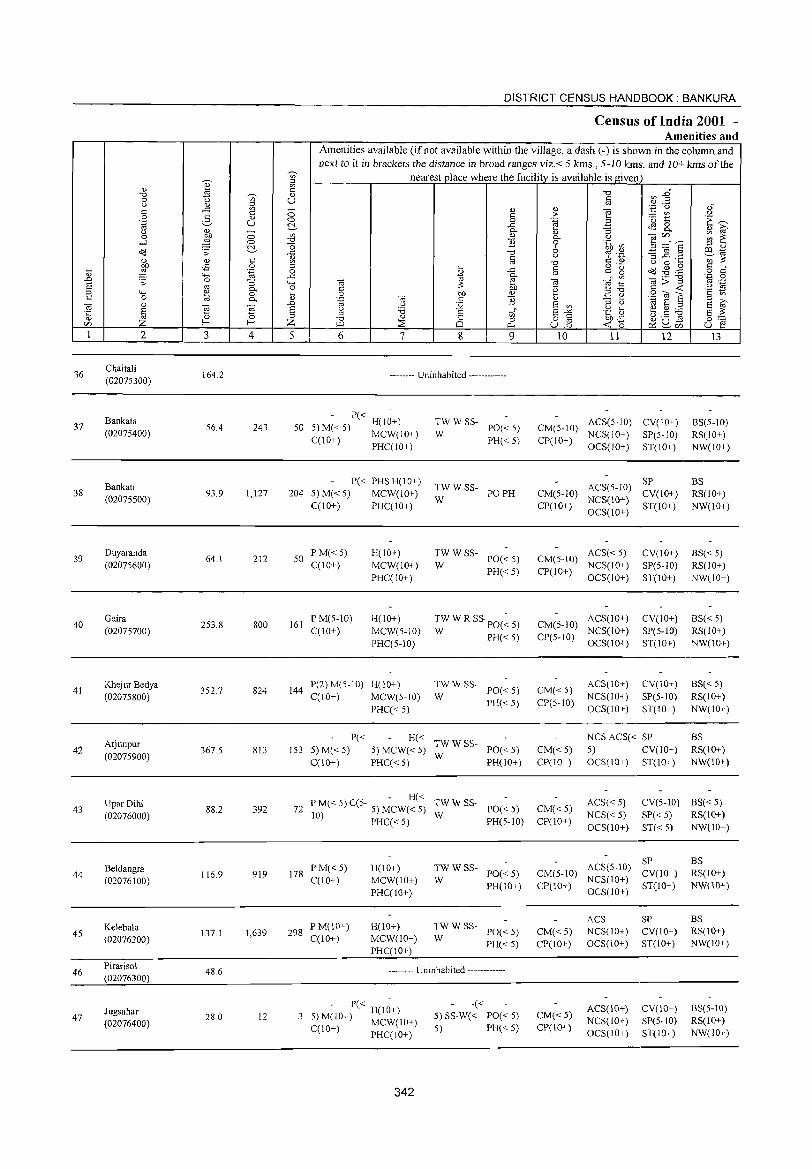
DISTRICT CENSUS HANDBOOK: BANKURA
Census of India 2001 -Amenities and
Amenities available (ifnot available within the village, a dash (-) is shown in the column and
next to it in brackets the distance in broad ranges viz. < 5 kms., 5-10 lUllS. and 10+ kms of the ~
nearest place where the facility is available is given ~ U>
'" ~ " ~
<: "0 a3 :2~ "0 ~ " 0 '" U <:
" '" ~ '" '';:: (.) ". <: ..c: - '" " ] c 0 § > :.:::: ttl '" 0 2- 0) 0 .~ '0 1:: 'E '""' '.g u ~ ..c: tE9 8-" '" 0 0- '" :; '" iti' 0 OJ) U> '" 0- '" ca'" ~ ~ -l ~ 0 "0 E 0 .~ ~ S =:" S ~ 0
" ;:s '"
o'(J .;;: ..c: "0 '" ._ ~ ~.3 C!lt;j
'" c u C d) ';;;'~ '" '" c U> '" "0 U 0 "-OJ) -5 0 ;:s , § o -_
dd ~ . .@ c d :;:; ~ .~ 0 ..c:
c:" ~ 0 4-< ..c: 0- ca;:;:11 .~ 0 ..0 .;;: 0 :; "" OJ '" OJ ""§:g .~ a '" 0- 0 <: bb '0 s:: -< '" ;:s ...... '" 0 "- 0 OJ) Q)
~ .:§ 2 .S OJ '8 '§ tn <: 0 @ 0- '" .~ OJ <: E OJ "
..0 U :.Q 8 '" ;:s " t;j a ;:s a ~ ~ 'E a " '5 u .... b.5 ~ '5 ~ ;:s t: tn" 8 "" 'C Il) 8 ~
0 ;:s "0 <l)
8 0 o s:: OJ)-B 0:-:::
'" f- f- Z >Ll ~ "'" u15 -< 0 ~2U5 u ~ I 2 3 4 5 6 7 8 9 10 11 12 13
36 Chaitali
164.2 -------- Uninhabited ------------(02075300)
Bankata P« H(IO+) TW W SS- ACS(5-10) CV(IO+) BS(5-1O) 37 56.4 243 50 5)M«5) PO« 5) CM(5-10)
(02075400) C(lO+)
MCW(IO+) W PH« 5) CP(IO+)
NCS(IO+) SP(5-10) RS(IO+) PHC(IO+) OCS(IO+) ST(IO+) NW(lO+)
Bankati P« PHSH(10+)
TW W SS- ACS(5-10) SP BS
38 93.9 1,127 204 5) M« 5) MCW(lO+) PO PH CM(5-10) CV(lO+) RS(lO+) (02075500) W NCS(IO+)
C(10+) PHC(lO+) CP(IO+) OCS(IO+)
ST(lO+) NW(lO+)
39 Duyaranda
64.1 212 50 PM« 5) H(lO+) TWWSS-
PO«5) CM(5-JO) ACS« 5) CV(lO+) BS« 5)
(02075600) C(lO+) MCW(lO+) W PH«5) CP(IO+)
NCS(IO+) SP(5-1O) RS(IO+) PHC(IO+) OCS(lO+) ST(JO+) NW(IO+)
40 Gaira
253.8 800 161 P M(5-10) H(JO+) TW W R SS PO(~ 5) CM(S-IO)
ACS(lO+) CV(lO+) BS« 5) (02075700) C(lO+) MCW(5-10) W PH«5) CP(5-1O)
NCS(IO+) SP(5-1O) RS(IO+) PHC(5-10) OCS(IO+) ST(10+) NW(10+)
41 Khej ur Bedya
352.7 824 144 P(2)M(S-10) H(IO+) TWWSS-
PO«5) CM« 5) ACS(IO+) CV(IO+) BS« 5)
(02075800) C(10+) MCW(5-10) W PH«5) CP(S-IO)
NCS(JO+) SP(5-IO) RS(JO+)
PHC« 5) OCS(lO+) ST(IO+) NW(IO+)
Arjunpur P« H«
TWW SS-NCS ACS« SP BS
42 367.5 813 153 5) M«5) 5) MCW«5) PO«5) CM«5) 5) CV(lO+) RS(IO+) (02075900)
C(10+) PHC« 5) W
PH(IO+) CP(10+) OCS(IO+) ST(IO+) NW(10+)
UparDihi - H« TWWSS- ACS« 5) CV(5-JO) BS« 5)
43 (02076000)
88.2 392 72 P M« 5) C(5- 5) MCW« 5) W
PO« 5) CM«5) NCS« 5) SP« 5) RS(IO+) 10) PHC« 5) PH(5-JO) CP(lO+) OCS(10+) ST« 5) NW(10+)
ACS(5-IO) SP BS
Beldangra 116.9 919 178
PM«5) H(10+) TWWSS-PO« 5) CM(5-10) CV(IO+) RS(IO+) 44
(02076100) C(10+) MCW(lO+) W NCS(IO+)
PHC(IO+) PH(JO+) CP(IO+)
OCS(lO+) ST(10+) NW(10+)
ACS SP BS Kelebala
1,639 298 PM(IO+) H(10+) TWWSS-
PO« 5) CM« 5) NCS(IO+) CV(JO+) RS(IO+) 45 (02076200)
137.1 C(10+) MCW(10+) W
PHC(IO+) PH« 5) CP(JO+) OCS(IO+) ST(JO+) NW(JO+)
46 Pirarisol
48.6 -------- Uninhabited ------------(02076300)
- P« - -« ACS(IO+) CV(IO+) BS(5-10) Jugsahar 3 5) M(IO+) H(10+) 5) SS-W« PO«5) CM« 5) 47 28.0 12 NCS(JO+) SP(5-IO) RS(10+) (02076400) MCW(IO+) 5) PH« 5) CP(IO+) C(10+) PHC(iO+) OCS(10+) ST(lO+) NW(iO+)
342
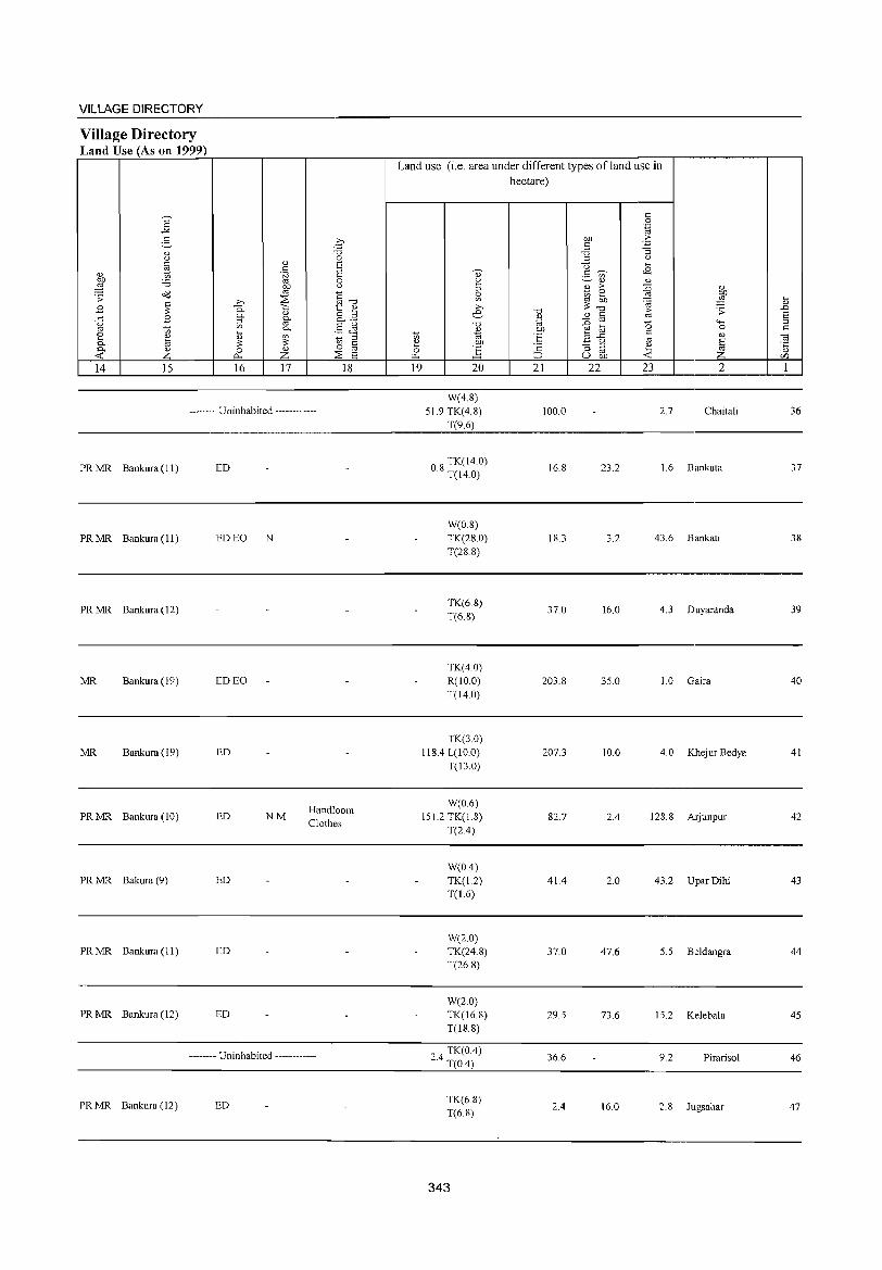
VILLAGE DIRECTORY
Village Directory Land Use (As on 1999)
14 15 16 17 18
-------- Uninhabited ------------
PR MR Bankura (II)
PR MR Bankura (II)
PR MR Bankura (12)
MR Bankura (19)
MR Bankura (19)
PR MR Bankura (10)
PR MR Bakura (9)
PR MR Bankura (11)
PR MR Bankura (12)
PR MR Bankura (12)
ED
ED EO N
ED EO
ED
ED NM
ED
ED
ED
Handloom Clothes
-------- Uninhabited ------------
ED
Land use (i.e. area under different types of land use in hectare)
19 20
W(4.8) 51.9 TK(4.8)
T(9.6)
08 TK(14.0) . T(14.0)
WeO.8) TK(28.0) T(28.8)
TK(6.8) T(6.8)
TK(4.0) R(10.0) T(14.0)
TK(30) 118A L(IO.0)
T(13.0)
W(0.6) 151.2 TK(1.8)
T(2.4)
W(OA) TK(1.2) T(1.6)
W(2.0) TK(24.8) T(26.8)
W(2.0) TK(16.8) T(I8.8)
24 TK(O.4) . T(OA)
TK(6.8) T(6.8)
343
21 22
100.0
16.8
18.3
37.0
203.8
207.3
82.7
41.4
37.0
29.5
36.6
2.4
23 2
2.7 Chaitali
23.2 1.6 Bankata
3.2 43.6 Bankati
16.0 4.3 Duyaranda
35.0 1.0 Gaira
10.0 4.0 Khej ur Bedya
2A 128.8 Arjunpur
2.0 43.2 Upar Dihi
47.6 5.5 Beldangra
73.6 15.2 Kelebala
9.2 Pirarisol
16.0 2.8 Jugsahar
36
37
38
39
40
41
42
43
44
45
46
47
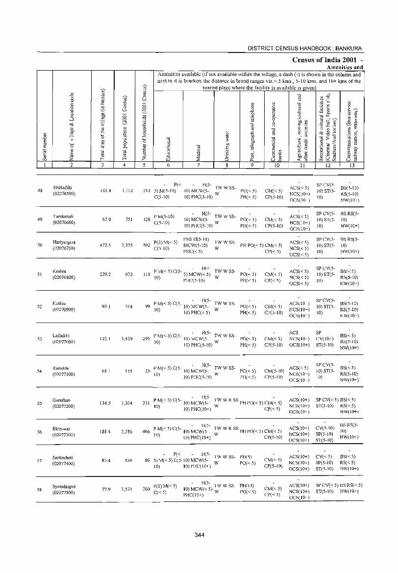
DISTRICT CENSUS HANDBOOK: BANKURA
Census of India 2001 -Amenities and
Amenities available (if not available within the village, a dash (-) is shown in the column and next to it in brackets the distance in broad ranges viz.< 5 kms., 5-10 kms. and 10+ kms of the
";n' nearest_pJace where the facility is available is given Q) .:;;
0> E t: "0 ~ :2" "0 <> 0 '" U t:
'" (I) g "' .;::: u '" t: ..t: t: - 0> Cl)
] :..::: V'l '" 0 t: > 0 3 <l,) 0 0 .~ '0 t '1: ~ '.g u ~ ..t: ~ 8. '" iii' '" (I) - 0- Cl) "3
0 OIl 0 '" '" 0- (..) -.;Ul ~ ~ .....l ,g 0 "0 '2 0 .~ ~ 5 ;:::"6' ~ "0 6 ;:l Cl)
a'(J ;; ..t: "0 % .~ -3 ~.2 a:l d t: ~ §
(..) ~;s: <l,) '" "0 (..) 0 .... on -5 0 ;:l o ._
~ -$J .g t: .... ,g '.g 0 ~ ..t: t: C g 0 c"
'" "'" ..t: 0- ro '" -.;::;"3 '-@ .8 .D ;; 0 "3 4-< -.; ;s: ~ -.;
~~ d 8 co 0- 0 C 'g C -< u ;:l "'" '" 0 .... 0 on Cl) E e 8ca S ·S to s:: 0 til 0- '" "-§ -.; c '2 ;:l >,
-.; <I) .D u 12 8 '" ;:l <J d 8 ;::l S '"
~ -.; 'Ei 8 <J ;:0 E-'" .g Ii> ~ ~ :.a 8 ;s: '5 '0 ;::l ;::l <I) .S to (.) .- ro 0 "0 Ci 0 8] on£ 0'-;::
Ul Z f- f- Z i:.ll ;;E O;!u- u 1: 0.. -< 0 ~ Ul
1 2 3 4 5 6 7 8 9 10 11 12 13
Shitladihi P« - H(5-ACS« 5)
SPCV(5-BS(5-10)
48 165.8 1,152 213 5)M(5-1O) 10) MCW(5- TW W SS- PO«5) CM«5) 10) ST(5-(02076500)
C(5-10) 10) PHC(5-10) W PH«5) CP(5-10) NCS(IO+)
10) RS(5-10)
OCS(IO+) NW(\o+)
Tantkanali PM(5-10) - H(5-
ACS« 5) SPCV(5- BS RS(5-
49 62.0 751 128 10) MCW(5- TW W SS- PO«5) CM«5) 10) ST(5- 10) (02076600) C(5-10)
10) PHC(5-10) W PH«5) CP(5-10) NCS(lO+)
10) NW(IO+) OCS(IO+)
Hariyargara P(3) M« 5) PHS H(5-10)
TWWSS- ACS«5) SP CV(5- BS RS(5-
50 (02076700)
472.5 2,575 502 C(5-10)
MCW(5-10) W
PH PO« 5) CM« 5) NCS« 5)
10) ST(5- 10)
PHC« 5) CP«5) OCS« 5)
10) NW(lO+)
Keshra - H«
TWWSS- ACS« 5) SP CV(5-
BS«5) 51
(02076800) 220.2 622 III P M« 5) C(5- 5) MCW« 5)
W PO«5) CM«5)
NCS«5) 10) ST(5-
RS(5-10) 10) PHC(5-1O) PH« 5) CP«5) OCS« 5)
10) NW(JO+)
Keshia - H(5-
TWWSS- ACS(10+) SPCV(5-
BS(5-10) 52 93.1 514 99 P M« 5) C(5- 10) MCW(5- PO« 5) CM«5) 10) ST(5-
(02076900) 10) 10) PHC« 5) W PH« 5) CP(5-10)
NCS(10+) 10)
RS(5-10) OCS(10+) NW(lO+)
Ladadihi - H(5- ACS SP
BS« 5) 53 122.1 1,429 295 P M« 5) C(5- 10) MCW(5- TW W SS- PO« 5) CM«5) NCS(10+) CV(IO+)
(02077000) 10) 10) PHC(5-10) W PH« 5) CP(5-10) OCS(IO+) ST(5-10) RS(5-IO) NW(10+)
Ramdihi - H(5-
ACS«5) SPCV(5-
BS« 5) 54
(02077100) 68.1 155 35 P M« 5) C(5- 10) MCW(5- TW W SS- PO«5) CM(5-10)
NCS(lO+) 10) ST(5-
RS(5-10) 10) 10) PHC(5-10) W PH«5) CP(5-10)
OCS(lO+) 10)
NW(IO+)
Garerban - H(5-
TW W R SS PH PO« 5) CM(~ 5) ACS(10+) SP CV« 5) BS« 5) 55
(02077200) 134,5 1,204 231 P M« 5) C(5- 10) MCW(5-
NCS(IO+) ST(5-10) RS« 5) 10) 10) PHC(IO+) W CP«5)
OCS(JO+) NW(IO+)
Ekteswar - H(S-
TW W R SS PH PO« 5) CM(-< 5) ACS(10+) CV(5-1O) BS RS(5-
56 188.4 2,386 466 P M« 5) C(5- 10) MCW(5- 10) (02077300) 10) 10) PHC(10+) W CP(5-10)
NCS(lO+) SP(5-JO) NW(JO+)
OCS(IO+) ST(5-1O)
Sankarhati P« H(5-
TWWSS- PH(5) ACS(IO+) CV« 5) BS« 5) 86 5) M« 5) C(5, 10) MCW(5- CM« 5) 57
(02077400) 83.4 430
W PO« 5) NCS(IO+) SP(5-10) RS« 5) 10) 10) PHC(IO+) CP(5-10)
OCS(lO+) ST(5-1O) NW(IO+)
P(2)M« 5) - H(5-
PH(14) ACS(IO+) SP CV« 5) BS RS« 5) Syamdaspur 72.9 3,531 760 10) MCW« 5):W W SS- CM«5) 58 C« 5) PO« 5) NCS(10+) ST(S-IO) NW(IO+) (02077500)
PHC(IO+) CP«5) OCS(IO+)
344
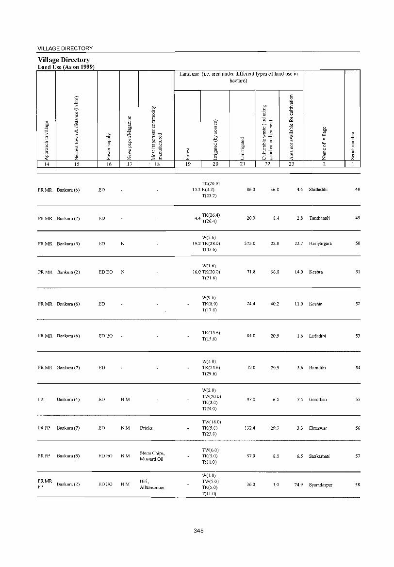
VILLAGE DIRECTORY
Village Directory Land Use (As on 1999)
14 15
PR MR Bankura (6)
PR MR Bankura (7)
PR MR Bankura (S)
PR MR Bankura (2)
PR MR Bankura (6)
PR MR Bankura (6)
PR MR Bankura (7)
PR Bankura (4)
PR FP Bankura (7)
PR FP Bankura (6)
PRMR Bankura (2)
FP
16 17
ED
ED
ED N
ED EO N
ED
ED EO
ED
ED NM
ED NM
ED EO NM
ED EO NM
18
Bricks
Stone Chips, Mustard Oil
Biri, AIJumunium
Land use (i.e. area under different types ofland use in hectare)
19 20
TK(20.0) IS.2 R(3.2)
T(23.2)
TK(26.4) 4.4 T(26.4)
W(S.6) 19.2 TK(28.0)
T(336)
W(1.6) 16.0 TK(20.0)
T(21.6)
W(9.6) TK(8.0) T(17.6)
TK(15.6) T(15.6)
W(4.0) TK(2S.6) T(29.6)
W(2.0) TW(20.0) TK(2.0) T(24.0)
TW(18.0) TK(5.0) T(23.0)
TW(6.0) TK(50) T(ll.0)
W(1.0) TW(5.0) TK(5.0) T(I1.0)
345
21 22
86.0
20.0
37S.0
71.8
24.4
84.0
12.0
97.0
132.4
57.9
36.0
23 2
36.8 4.6 Shitladihi
8.4 2.8 Tantkanali
22.0 22.7 Hariyargara
96.8 14.0 Keshra
40.2 11.0 Keshia
20.9 1.6 Ladadihi
20.9 5.6 Ramdihi
6.0 7. S Garerban
29.7 3.3 Ekteswar
8.0 6.5 Sankarhati
1.0 24.9 Syamdaspur
48
49
50
51
52
53
54
55
56
57
58
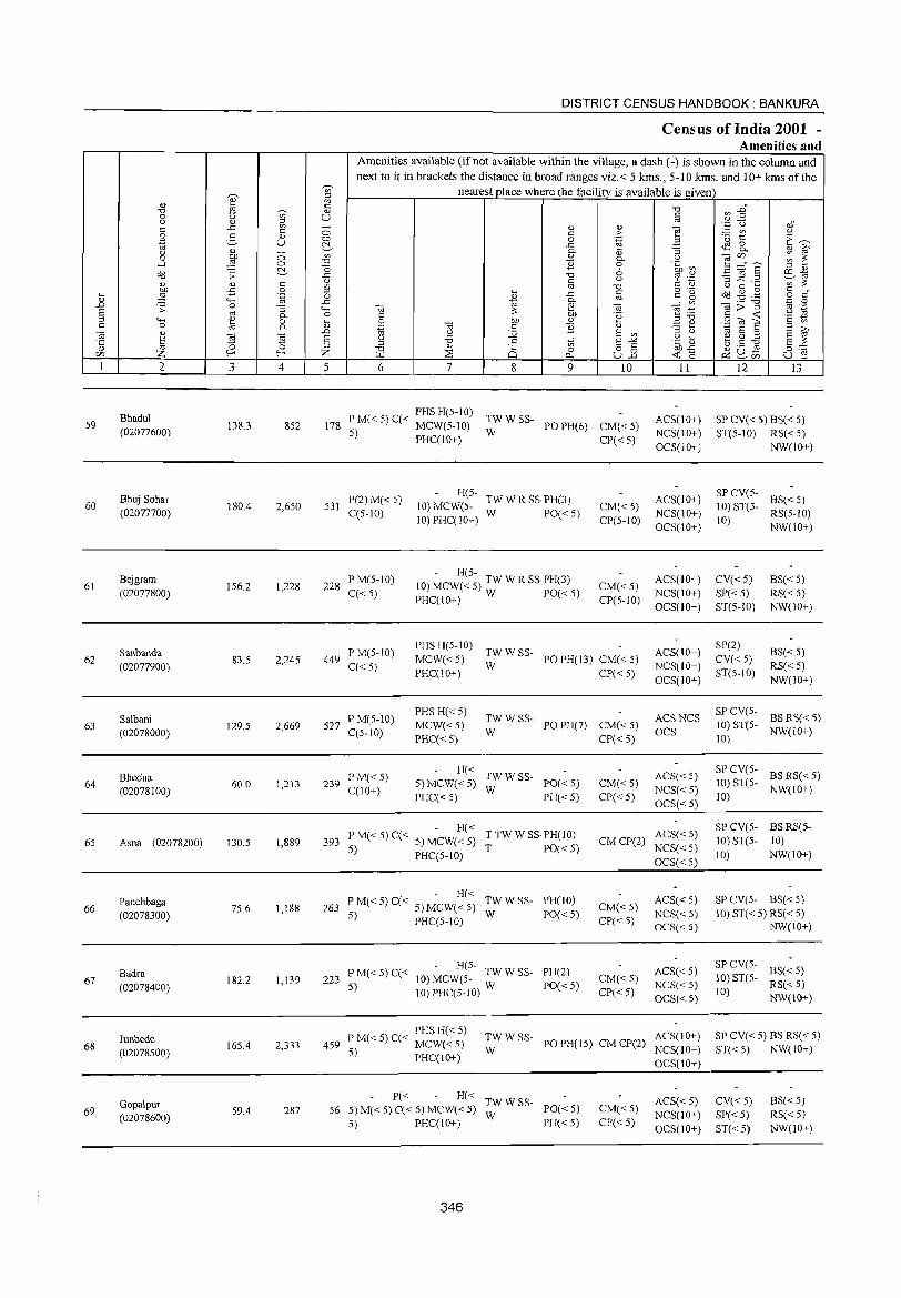
DISTRICT CENSUS HANDBOOK: BANKURA
Cens.us of India 2001 -Amenities and
Amenities available (if not available within the village, a dash (-) is shown in the column and
next to it in brackets the distance in broad ranges viz.< 5 krns., 5-10 krns. and 10+ krns of the ~
nearest place where the facility is available is given '" 0) ~ ~ ~ .is
<:; ~ ~ :2~ 'V;" <!)
0 u u fa u '" ;;; '"
..c - 0) 0)
] '';:: (.) oS
'" 0 '" > :.::: tI) " .g 2- <L> 0 0 .~ ·0 t:: E~
"' u ~ .c ~ 8.. u d.) - C- ""5 <!) iii'
0 tlI) 0 '" '" C- " ";;jC/l ~ ~ ...:I ~ 0 -0 ~ 0 .~ ~ 5 ::::"8 ~ "0 6 ::l " Od ;; ..c "0 u c;:' '';::: -3 ~ .2 FE,1a
'" d.) '" ~ '" '" 0) '" ::: '" ""0 <.J 0 .... till -5 0 :::l .... o ._
~ ~ ,g '" " ~ ::§ .~ 0 ~
..c: c '" g o '" 'H 0- ro ..0 ..c '" ";;j;:;""§
'.0 0 .s: 0 ""5 <..., ";;j ~ ";;j ";;j ~ OJ ._
§ '" C- o '" ::: tlI) .~ 5 :a <=: ~ .2 ~
"-< <l) 0 ~ 0 bJJ 0) .g {i! E <=: '" <=: 0 ta OJ ~ '" 0- '.g C ~ <!) - .... E i;' ";;j " ~ "E!
~ (j :.g E '" :::l <.J "t;; a :::l
'5 a a (j '5 .S E'"'" .~ ~ ~ ~ :a s ::: :::l '" '" ,:: :::l -0 '" Q 0 8j bJJ ..c: ~ Q_ £ o~ (/] Z f-< Z ~ ::8 p_, ~ 0 u f! I 2 3 4 5 6 7 8 9 10 11 12 13
59 Bhadul
138.3 PM«5) C« PHSH(5-1O) TWWSS- ACS(10+) SP CV« 5) BS« 5) 852 178 5) MCW(5-10) POPH(6) CM«5) (02077600) W NCS(IO+} ST(5-1O) RS«5) PHC(IO+) CP«5)
OCS(IO+} NW(IO+)
Bhuj Sohar P(2) M« 5) H(5-
TW W R SS·PH(3) ACS(IO+) SPCV(5-
BS« 5) 60 180.4 2,650 531 10) MCW(5- CM« 5) 10) ST(5-
(02077700) C(5-10) W PO«5) NCS(lO+) RS(5-1O) 10) PHC(IO+) CP(5-10)
OCS(\O+) 10)
NW(lO+)
Bejgram P M(5-10) - H(5-
ACS(IO+) CV« 5) BS«5) 61 156.2 1,228 228 10) MCW« 5) TW W R SS·PH(3) CM«5)
(02077800) C« 5) PHC(lO+) W PO«5) CP(5-10) NCS(IO+) SP« 5) RS« 5) OCS(10+) ST(5-10) NW(lO+)
Sanbanda P M(5-IO) PHS H(5-10)
TWWSS- ACS(IO+) SP(2)
BS« 5) 62
(02077900) 83.5 2,245 449
C«5) MCW« 5)
W PO PH(13) CM« 5)
NCS(IO+) CV«5)
RS«5) PHC(10+) CP« 5)
OCS(IO+) ST(5-10)
NW(IO+)
Salbani P M(5-10) PHS H« 5)
TWW SS- ACSNCS SP CV(5-
BS RS« 5) 63 129.5 2.669 527 MCW«5) POPH(7) CM«5) 10) ST(5-
(02078000) C(5-10) PHC«5)
W CP« 5)
OCS 10)
NW(10+)
Bhedua P M« 5) H« TWWSS- ACS«5)
SP CV(5-BSRS«5)
64 60.0 1,213 239 5) MCW«5) PO« 5) CM« 5) 10) ST(5-(02078100) C(IO+)
PHC« 5) W
PH« 5) CP«5) NCS«5)
10) NW(IO+)
OCS« 5)
- H« T TW W SS·PH(IO) ACS« 5) SP CV(5- BSRS(5-
65 Asna (02078200) 130.5 1,889 393 P M« 5) C« 5) MCW« 5) T PO« 5)
CMCP(2) NCS«5)
10) ST(5- 10) 5) PHC(5-10)
OCS« 5) 10) NW(IO+)
Panchbaga - H«
TWWSS- PH(IO) ACS« 5) SP CV(5- BS« 5) 66
(02078300) 75.6 1,188 263 PM«5)C« 5)MCW«5)
W PO« 5) CM« 5)
NCS«5) 10) ST« 5) RS« 5) 5) PHC(5-1O) CP«5)
OCS« 5) NW(IO+)
Badra P M« 5) C« - H(5-
PH(2) ACS«5) SPCV(5-
BS« 5) 67 182.2 1,139 223 10) MCW(5- TW W SS- CM« 5) 10) ST(5-
(02078400) 5) JO)PHC(5-10) W PO« 5)
CP« 5) NCS«5)
10) RS« 5)
OCS« 5) NW(IO+)
Junbede . PHSH« 5)
TWWSS- ACS(IO+) SP CV« 5) BS RS« 5) 459 PM«5)C« MCW«5) PO PH(15) CM CP(2) 68
(02078500) 165.4 2,333
5) PHC(lO+) W NCS(IO+) ST« 5) NW{IO+) OCS(IO+)
Gopalpur P« H«
TWWSS- ACS« 5) CV« 5) BS« 5) 69 (02078600)
59.4 287 56 5)M«5)C« 5) MCW«5) W
PO« 5) CM« 5) NCS(10+) SP« 5) RS«5)
5) PHC(lO+) PH« 5) CP« 5) OCS(10+) ST« 5) NW(10+)
346
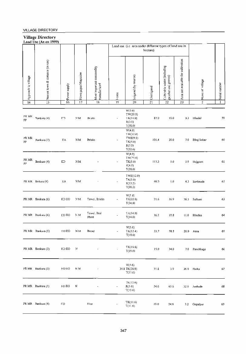
VILLAGE DIRECTORY
Village Directory Land Use (As on 1999)
E -'" g " (j C
'" " 1;)
:W :;:; o<l .;; ~ .8
..c: .8 (j
'" 1;)
~ ~ 0- " --< Z 14 15
PRMR Bankura (4)
FP
PRMR Bankura (7)
FP
PRMR Bankura (4)
FP
PRMR Bnkura (4)
PRMR Bankura (6)
PRMR Bankura (6)
PRMR Bankura (5)
PRMR Bankura (3)
PRMR Bankura (5)
PRMR Bankura (3)
PRMR Bankura (4)
.€ "0 0
Q.) S " S .~ 0
gp u
~""d ~ ..Q 1:: '" 0. Q.) &3 0.
[if ;::l V> .§ & .... 0.
" '" 1;) ;::l
::: 3 ~ 0 0 Q.)
p... Z ~ S 16 17 18
ED NM Bricks
EA NM Bricks
ED NM
EA NM
ED EO NM Towel, Bricks
ED EO NM Towel, Bed Sheet
ED EO NM Bread
ED EO N
ED EO NM
ED EO N
ED Rice
Land use (i.e. area under different types ofland use in hectare)
" 0 .~
O!l .~ " 'B :; ;::l u u ,_
0) .5 ~ <8 ~
~ Q.) " ~ ;>
~ " Sl :3 OJ)
'" O!l ::§ .... 3"0 'OJ " ;>, .;; ..0 e "0
'" " ~ S '" '" <;j ::0 0 4-< ::s "0 e ta 0 " %l °E c " V> ;::l..c
'" <a 2 CJ) - (j § .~ ';:: :; ::s 2 0 ~ '" u.. ;:J U OJ) < Z '" 19 20 21 22 23 2 1
W(1.0) TW(20.0) TK(14.0) 87.0 10.0 3.3 Bhadul 59 R(3.0) T(38.0)
W(4.0) TW(33.0) TWE(9.0)
lOlA 20.0 7.0 Bhuj Sohar 60 TK(4.0) R(2.0) T(52.0)
W(4.0) TW(15.0) TK(5.0) 117.3 5.0 5.9 Bejgram 61 R(4.0) T(28.0)
TWE(l2.0) TK(5.0)
48.0 1.0 4.3 Sanbanda 62 R(13.2) T(30.2)
W(2.8) TK(32.0) 21.6 36.9 36.3 Salbani 63 T(34.8)
TK(14.0) 16.2 18.8 11.0 Bhedua 64
T(l4.0)
W(5.6) TK(12A) 33.7 58.8 20.0 Asna 65 T(18.0)
TK(l9.6) 15.0 34.0 7.0 Panchbaga 66
T(19.6)
W(5.6) 36.8 TK(28.0) 71.8 3.9 36.0 Badra 67
T(33.6)
TK(120) R(3.6) 54.0 63.8 32.0 Iunbede 68 T(15.6)
TK(l1.6) 20.0 24.6 3.2 Gopalpur 69 T(11.6)
347
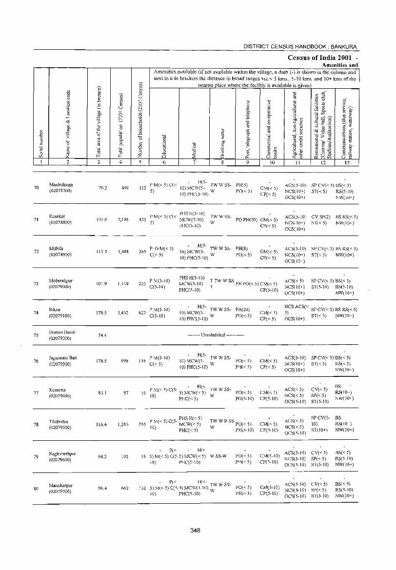
70
71
72
73
74
75
76
77
78
79
80
2
Mauladanga (02078700)
Kesekol (02078800)
Mithila (02078900)
Mobarakpur (02079000)
Bikna (02079100)
Doman Bandi (02079200)
Jagannath Bati (02079300)
Kumaria (02079400)
Tilabedya (02079500)
Raghunathpur (02079600)
Manoharpur (02079700)
3 4
70.2 499
101.0 2,186
111.5 1,488
101.9 1,149
178.5 3,432
54.4
178.5 998
81.1 97
316.4 1,263
64.2 102
96.4 662
DISTRICT CENSUS HANDBOOK: BANKURA
Census of India 2001 -Amenities and
Amenities available (ifnot available within the village, a dash (-) is shown in the column and next to it in brackets the distance in broad ranges viz.< 5 kms., 5-10 YJlls. and 10+ kms oftbe
nearest place where the facility is available is given
5 6 7 8 9
- H(5-112 P M« 5) C« 10) MCWeS- TW W SS- PH(5)
5) 10) PHC(5-10) W PO« 5)
10
CM«S) CP« 5)
11 12 13
ACS(5-1O) SP CV« 5) BS« 5) NCS(IO+) ST«5) RS(5-10) OCS(IO+) NW(10+)
P M« 5) C« PHS H(S-lO) TW W SS-431 5) MCW(5-10) W PO PH(20) CM« 5)
PHqS-l0) CP« 5)
ACS(5-10) CV SP(2) BS RS« 5) NCS(lO+) ST«5) NW(10+)
265 P OM« 5) q< 5)
- H(5-10) MCW(5- TW W SS- PH(8)
10)PHC(5-10) W PO«5) CM« 5)
CP« 5)
OCS(lO+)
ACS(5-10) SP CV« 5) BS RS« 5) NCS(IO+) ST«5) NW(lO+) OCS(lO+)
223 P M(5-IO) C(5-10)
PHS H(5-10) -MCW(5-l0) T TW W SS· PH POe < 5) CM( < 5) ACS« 5)
NCS(IO+) OCS(lO+)
SP CV« 5) BS« 5)
PHq5-1O) T CP(5-10) ST(5-10) RS(S-lO)
NW(10+)
623 P M(5-10) q5-10)
- R(5-10) MCW(5- TW W SS- PH(20)
10) PHC(5-10) W PO« 5)
-------- Uninhabited ------------
156 PM(5-10) q< 5)
- R(5-10) MCW(5- TW W SS- PO« 5)
10) PHC(5-10) W PH« 5)
- H« 16 P M« 5) C(5- 5) MCW« 5) TW W SS- PO« 5)
10) PHq< 5) W PH(5-10)
PHSH« 5) 255 P M« 5) C(5- MCW« 5)
10) PHC«5)
P« H«
TWWRSSpO(~5) W PR(5-10)
16 5)M«5)C(5·5)MCW«5) WSS-W PO«5) PH« S) 10) PHq5-10)
- P« - H« TWWSS-132 5) M« 5) C(5· 5) MeW(5-tO) W PO« S)
10) PHC(5-1O) PH« 5)
348
CM«5) CP« 5)
CM« 5) CP« 5)
CM«5) CP(5-1O)
CM«5) CP(5-10)
NCS ACS« SP CV« 5) BS RS« 5)
6CS(1O+) ST« 5) NW(IO+)
ACS(5-10) SP CV« 5) BS« 5) NCS(10+) ST«5) RS«5) OCS(IO+) NW(10+)
ACS« 5) CV« 5)
NCS« 5) SP« 5) OCS( 5-10) ST( 5-10)
BS RS(IO+) NW(lO+)
SPCV(5- BS ACS« 5) 10) RS(lO+) NCS«5) OCS(5-10) ST(lO+) NW(10+)
CM(5-lO) ACS(5-10) CV« 5) NCS(5-10) SP« 5)
CP(S-IO) OCS(5-10) ST(5-10)
BS« 5) RS(5-IO) NW(10+)
ACS(5-10) CV« 5) CM(5-10) NCS(5-IO) SP«5) CP(5-10) OCS(5-JO) ST(5-10)
BS« 5) RS(5-IO) NW(IO+)

VILLAGE DIRECTORY
Village Directory Land Use (As on 1999)
s -'" :§_
0)
'-' c ~ OJ
~ '6 ;; <>'<l
~ B .<:: B ;;l
'" 8 ~ 0.. '" 0.. 0)
..: z 14 15
MR Bankura (4)
PR MR Bankura (1)
PRMR Bankura (1)
MR Bankura (2)
PRMR Bankura (3)
q -0 0
0) 8 c .~ 8
0
~ '-'
::os §-o b 0.. '" t ~ 0.. 0)
o " " go o..~
'" 0.. §Jl ~
'" OJ ~ " ~ ~ ~ 8 0 0)
p.. z ::os 8 16 17 18
ED N
ED EO N Mustard Oil
ED EO N Mustard Oil
ED N
ED EO N Various Statue
-------- Uninhabited ------------
MR Bankura (3) ED N
PRMR Bankura (S)
PRMR Bankura (9) ED
MR Bankura(7)
PR MR Bankura (7) ED
Land use (i.e. area under different types of land use in hectare)
19 20
TK(4.I) 0(2.0) T(6.I)
TK(2.4) 0(2.0) T(4.5)
TK(2.4) 0(12) T(3.6)
TK(2.4) 0(7.7) T(lO.I)
TK(3.2) 0(12)T(45)
TK(3.2) 0(1.2) T(4.5)
TK(2.S) 0(08) T(3.6)
TK(2.0) T(2.0)
W(O.S) 1.6 TK(2.8)
T(3.6)
TK(2.4) T(2.4)
124 TK(1.2) . T(l.2)
349
-a 0)
1;; OJ)
"E '2 ::::J 21
44.5
47.6
44.7
55.0
57.5
44.9
153.5
41.6
177.6
32.6
34.0
OJ) c '6 " <3 2- '" 0)
B >-~ ~ ~ -0 0) c
:D '" ~ til
.<:: '-'
"3 ::l
'" U OJ)
22
4.5
1.6
2.S
2.4
2.4
4.0
1.2
2.0
1.6
2.0
2.0
c 0 .~
.2: '3 '-' ~
08 OJ
:D OJ
-"! ~ '(;j
fd .;;
0 ""' 0 c OJ
'" § ~ ..: z 23 2
I 5.2 Mauladanga
47.4 Kesekol
60.3 Mithila
34.4 Mobarakpur
114.1 Bikna
1.0 Doman Bandi
20.2 J agannath Bati
35.5 Kumaria
132.0 Tilabedya
27.2 Raghunathpur
46.S Manoharpur
~ 0)
or>
§ c 0; ·c Q)
r/J
1
70
71
72
73
74
75
76
77
78
79
so
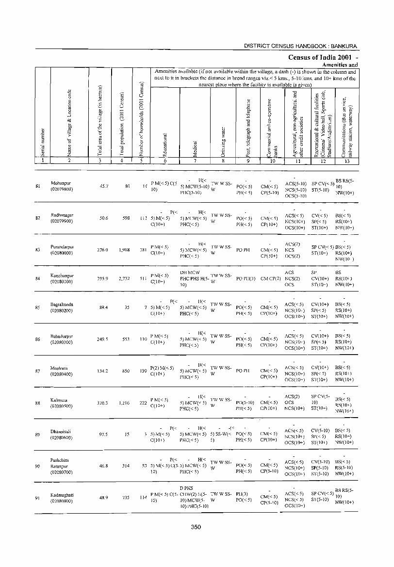
81
82
83
84
85
86
87
88
89
90
91
.... '" .0 E ::l = ., ·c '" en
2
Mohanpur (02079800)
Radhanagar (02079900)
Purandarpur (02080000)
Kanchanpur (02080100)
Bagrakonda (02080200)
Bahadurpur (02080300)
Maukura (02080400)
Kulmura (02080500)
Dhanaisuli (02080600)
Pashchim Ratanpur (02080700)
Kadmaghati (02080800)
3 4
45.7 80
50.6 598
276.0 1,988
395.9 2,732
89.4 35
249.5 553
134.2 850
320.3 1,216
97.5 15
46.8 314
48.9 735
DISTRICT CENSUS HANDBOOK: BANKURA
Census of India 2001 -Amenities and
Amenities available (if not available within the village, a dash (-) is shown in the column and next to it in brackets the distance in broad ranges viz.< 5 krns., 5-10 lans. and 10+ kms of the
nearest place where the facility is available is given
5 6 7 8
'" o 0..
9
- H« 14 P M« 5) C(5- 5) MCW(5-1O) TW W SS- PO« 5)
10) PHC(5-10) W PH« 5)
P« III 5)M«5)
C(lO+)
381 P M« 5) C(IO+)
H« TWWSS-5) MCW« 5) W PO« 5) PHC« 5) PH« 5)
H« TWWSS-5) MCW« 5) W PO PH PHC« 5)
'" > ""@
" P.-o 6 u
"0 @
"' .~
" E '" §"§ U.o
10
CM«5) CP(5-10)
CM« 5) CP(IO+)
CM«5) CP(IO+)
11 12 13
ACS(5-1O) SP CV« 5) BS RS(5-10)
NCS(5-1O) ST(5-10) NW(IO+) OCS(5-1O)
ACS« 5) NCS(IO+) OCS(IO+)
ACS(2) NCS OCS(2)
CV«5) SP« 5) ST(lO+)
BS« 5) RS(10+) NW(10+)
SP CV« 5) BS« 5) ST(IO+) RS(10+)
NW(10+)
511 PM«5) CCIO+)
DHMCW W ACS PHC PHS H(5- TW SS- PO PH(3) CM CP(2) NCS(2)
SP CV(lO+) ST(IO+)
BS RS(lO+) NW(IO+) 10) W OCS
P« 7 5)M« 5)
C(lO+)
110 PM«5) CCI 0+)
139 P(2) M« 5) C(lO+)
222 P M« 5) C(10+)
P« 3 :5)M«5)
C(IO+)
H« TWWSS-5) MCW« 5) W PO« 5) PHC« 5) PH« 5)
H« TWW SS-5) MCW« 5) W PO« 5) PHC« 5) PH« 5)
H« TW WSS-5) MCW« 5) W PO PH PHC« 5)
H« TWWSS-5) MCW« 5) W PO(5-10) PHC« 5) PH« 5)
H« -« 5) MCW« 5) 5) SS-W« PO« 5)
PHC« 5) 5) PH« 5)
P« H« TW W 8S-53 5) M( < 5) CIS· 5) MCW( < 5) W POe < 5)
114
10) PHC« 5) PH« 5)
DPHS P M« 5) C(5- CHW(2) H(5- TW W SS- PH(3) 10) 10) MCW(5- W PO« 5)
10)PHC(5-10)
350
CM« 5) CP(lO+)
CM«5) CP(IO+)
CM«5) CP(10+)
CM«5) CP(10+)
CM«5) CP(IO+)
CM« 5) CP(5-IO)
CM«5) CP(5-10)
ACS«5) NCS(IO+) OCS(IO+)
ACS«5) NCS(IO+) OCS(lO+)
ACS« 5) NCS(IO+) OCS(10+)
ACS(2) OCS NCS(JO+)
ACS« 5) NCS(lO+) OCS(IO+)
ACS«5) NCS(10+) OCS(10+)
ACS« 5) NCS« 5) OCS(10+)
CV(IO+) SP« 5) ST(IO+)
CV(IO+) SP« 5) ST(IO+)
CV(10+)
SP« 5) ST(10+)
BS« 5) RS(lO+) NW(IO+)
BS« 5) RS(IO+) NW(lO+)
BS« 5) RS(IO+) NW(IO+)
SP CV(5- B5« 5)
10) RS(10+) ST(IO+) NW(lO+)
CV(S-IO) B5« 5)
SP« 5) R8(1O+) ST(lO+) NW(lO+)
CV(5-IO) B8« 5) SP(5-1O) R8(5-10) ST(5-1O) NW(IO+)
SP CV« 5) ~~) RS(5-
ST(5-IO) NW(10+)
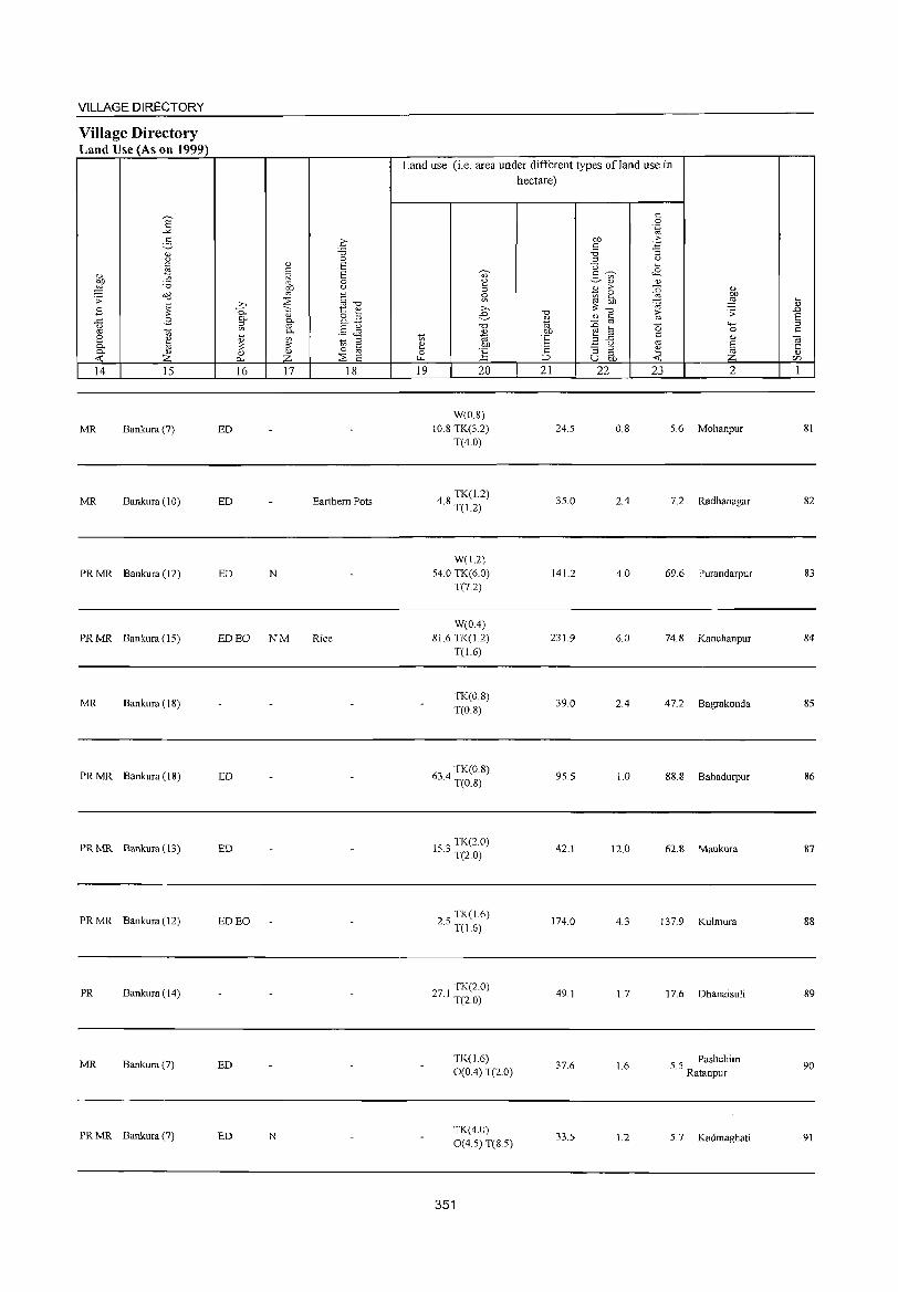
VILLAGE DIRECTORY
Village Directory Land Use (As on 1999)
E -"' 2-
<l.) u <: Z!
<l.)
'" ~ '0 .;;: o(l
~ B ..c B <.)
~
'" S '" ~ 0- ~ 0-
..0:: Z 14 15
MR Bankura (7)
MR Bankura (10)
PR MR Bankura (12)
PR MR Bankura (15)
MR Bankura (18)
PR MR Bankura (18)
PR MR Bankura (13)
PR MR Bankura (12)
PR Bankura (14)
MR Bankura (7)
PR MR Bankura (7)
.£ "0 0
<l.) E '" .t;j E
0
~ <.)
;:E c z-. '" "0 -;::; 1:: <l.) 0- <l.) 8.2 §- g. '" § & 0-t ~ 10 ::J ;;: § 0 <l.) 0
0- Z ;:E E 16 17 18
ED
ED Earthem Pots
ED N
ED EO NM Rice
ED
ED
ED EO
ED
ED N
Land use (i.e. area under different types of land use in hectare)
10 ~ 0 ~
19
., 2 ::J
~ >,
e "0
<1.)
1<> bJl
:§ 20
W(O.S) 10.8 TK(3.2)
T(4.0)
4 S TK(1.2) · T(1.2)
W(I.2) 54.0 TK(6.0)
T(7.2)
W(O.4) S1.6 TK(1.2)
T(1.6)
TK(0.8) T(0.8)
634 TK(0.8) · T(0.8)
153 TK(2.0) · T(2.0)
25 TK(1.6) · T(1.6)
271 TK(2.0) · T(2.0)
TK(1.6) 0(0.4) T(2.0)
TK(4.0) 0(4.5) T(8.5)
351
"0 <1.)
1<> OJ)
°6 .;:: :::> 21
24.5
35.0
141.2
231.9
39.0
95.5
42.1
174.0
49.1
37.6
335
OJ)
'" '0 ::J
U 2- ~ '" <l.)
B >-
~ ~ ;;: "0
" '" :0 '" ~ til B ..c
<.)
:; ::J
'" u OJ)
22
0.8
2.4
4.0
6.0
2.4
1.0
12.0
4.3
1.7
1.6
1.2
'" 0 '.g o£j :; " ~
oE <l.)
{i <l.)
bJl
~ ~ >- .;;: '" (5 4-<
0 c <l.)
'" J ~ 23 2
5.6 Mohanpur
7.2 Radhanagar
69.6 Purandarpur
74.8 Kanchanpur
47.2 Bagrakonda
88.8 Bahadurpur
62.8 Maukura
137.9 Kuhnura
17.6 Dhanaisuli
5.5 Pashchim Ratanpur
5.7 Kadmaghati
~ <1.)
.!:> S ::J c til '5 en 1
SI
82
83
84
85
86
87
S8
89
90
91
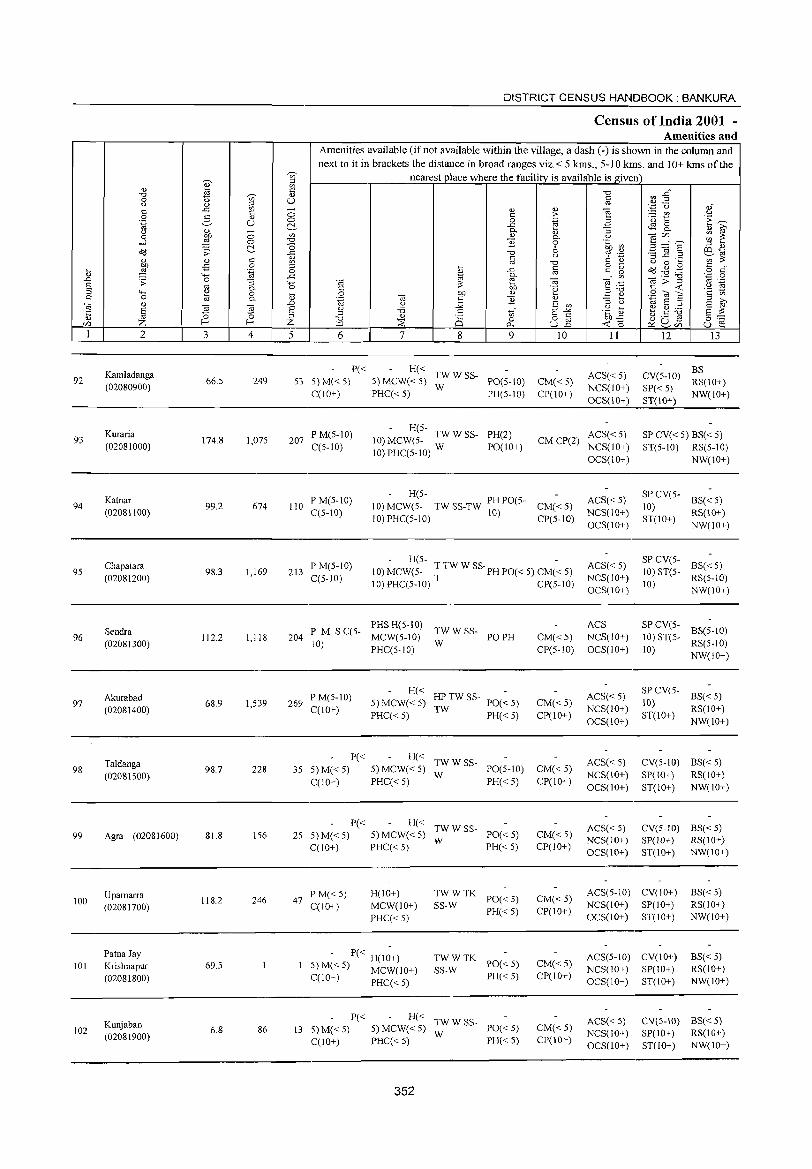
92
93
94
95
96
97
98
99
100
101
102
2
Kamladanga (02080900)
Kuraria (02081000)
Katnar (02081100)
Chapatara (02081200)
Sendra (02081300)
Akurabad (02081400)
Taldanga (02081500)
Agra (02081600)
Upamarra (02081700)
PatnaJay Krishnapur (02081800)
Kunjaban (02081900)
3 4
66.5 249
174.8 1,075
99.2 674
98.3 1,169
112.2 1,118
68.9 1,539
98.7 228
81.8 156
118.2 246
69.5
6.8 86
DISTRICT CENSUS HANDBOOK: BANKURA
Census of India 2001 -Amenities and
Amenities available (if not available within the village, a dash (-) is shown in the column and next to it in brackets the distance in broad ranges viz.< 5 kms., 5-10 kms. and 10+ kms of the
nearest place where the facility is available is given
5 6 7 8
'" o p.,
9
P« H« S3 S)M«5) S)MCW«S) ;:WSS- PO(5-IO)
C(10+) PHC« 5) PH(5-IO)
10
CM«S) CP(\O+)
II
ACS« 5) NCS(10+)
OCS(IO+)
12 J3
CV(5-10) ~~(IO+) SP« 5) NW(lO+) ST(IO+)
207 P M(5-10) C(5-10)
H(5-10) MCW(S- TW W SS- PH(2)
10)PHC(S-1O) W PO(10+)
ACS« 5) CM CP(2) NCS(10+)
SP CV« 5) BS« 5) ST(5-10) RS(5-1O)
110 PM(5-10) C(S-10)
H(5-10) MCW(5- TW SS-TW PH PO(S- CM« 5)
10)PHC(5-10) 10) CP(S-IO)
213 P M(S-IO) C(S-lO)
H(S- -10) MCW(S- TTW W SS'PHPO«S) CM«5)
10) PHC(5-10) T CP(5-10)
P M S C(5- PHS H(S-IO) TW W SS-204 10) MCW(5-10) W PO PH
PHC(S-IO)
269 P M(5-10) C(lO+)
H« HPTWSS-5) MCW« 5) TW PO« 5) PHC« 5) PH« 5)
P« H« TWWSS-35 5)M«5) 5)MCW«5) W PO(5-10)
C(lO+) PHC« 5) PH«5)
P« H« TWWSS-25 5)M«5) 5)MCW«5) W PO«5)
C(lO+) PHC« 5) PH« 5)
47 PM«5) C(IO+)
H(IO+) MCW(\o+)
PHC« S)
- P« H(IO+) 5) M( < 5) MCW(l 0+) C(10+) PHC« 5)
TWWTK SS-W PO« 5)
PH« 5)
TWWTK SS-W PO« 5)
PH«5)
P« 13 5) M« 5)
C(lO+)
H« TWWSS-5)MCW«5) W PO«5) PHC« 5) PH« 5)
352
CM«5) CP(S-lO)
CM«5) CP(10+)
CM«5) CP(10+)
CM«5) CP(10+)
CM«5) CP(IO+)
CM«5) CP(IO+)
CM«5) CP(IO+)
OCS(10+)
ACS« 5) NCS(10+) OCS(IO+)
ACS« S) NCS(IO+) OCS(IO+)
ACS NCS(IO+) OCS(IO+)
ACS« 5) NCS(IO+)
OCS(lO+)
ACS« 5) NCS(IO+) OCS(10+)
ACS« S) NCS(lO+) OCS(lO+)
NW(IO+)
SP CV(S- BS« 5) 10) ST(IO+) RS(10+)
NW(IO+)
SP CV(5- BS« 5)
10) ST(S- RS(5-10)
10) NW(10+)
SP CV(5-10) ST(5- BS(5-10) 10) RS(5-1O)
NW(IO+)
SP CV(5- BS« 5) 10) ST(IO+) RS(IO+)
NW(lO+)
CV(5"JO) BS« 5) SP(IO+) RS(IO+) ST(10+) NW(IO+)
CV(5-IO) BS« 5) SP( 10+) RS(I 0+) ST(IO+) NW(IO+)
ACS(5-10) CV(IO+) BS« 5) RS(10+) NW(IO+)
NCS(IO+) SP(IO+) OCS(IO+) ST(\o+)
ACS(5-IO) CV(IO+) NCS(lO+) SP(\o+) OCS(IO+) ST(IO+)
BS«5) RS(10+) NW(IO+)
ACS« 5) NCS(lO+) OCS(IO+)
CV(5-10) BS« 5) SP(lO+) RS(IO+) ST(lO+) NW(10+)
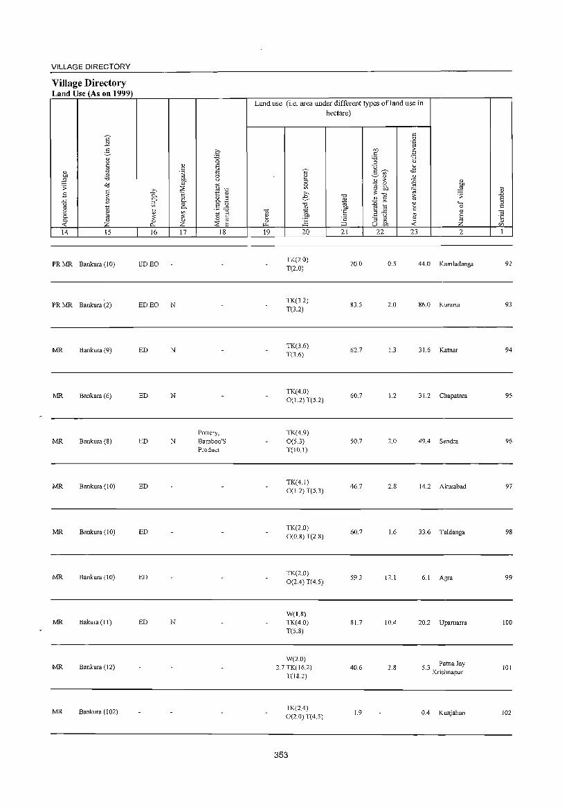
VILLAGE DIRECTORY
Village Directory Land Use (As on 1999)
14 15
PR MR Bankura (10)
PR MR Bankura (2)
MR Bankura (9)
MR Bankara (6)
MR Bankura (8)
MR Bankura (10)
MR Bankura (10)
MR Bankura (10)
MR Bakura (J 1)
MR Bankura ( 12)
MR Bankura (102)
16 17 18
ED EO
ED EO N
ED N
ED N
Pottery. ED N Bamboo'S
Product
ED
ED
ED
ED N
Land use (i.e. area under different types ofland use in hectare)
19 20
TK(2.0)
T(2.0)
TK(32) T(3.2)
TK(3.6)
T(3.6)
TK(4.0)
0(1.2) T(S.2)
TK(49) 0(5.3) T(IO.I)
TK(41)
0(1.2) T(5.3)
TK(2.0)
0(0.8) T(2.8)
TK(2.0) 0(2.4) T(4.5)
W(1.8) TK(4.0) T(5.8)
W(2.0) 2.7 TK(16.2)
T(I&.2)
TK(2.4) 0(2.0) T(4.5)
353
21 22
20.0
83.5
62.7
60.7
50.7
46.7
60.7
59.2
81.7
40.6
1.9
23 2
0.5 44.0 Kamladanga
2.0 86.0 Kuraria
1.3 31.6 Katnar
1.2 31.2 Chapatara
2.0 49.4 Sendra
2.& 14.2 Akurabad
1.6 33.6 Taldanga
12.1 6.1 Agra
10.4 20.2 Uparnarra
2.& 53 Patna Jay
. Krishnapur
0.4 Kunjaban
92
93
94
95
96
97
98
99
100
101
102
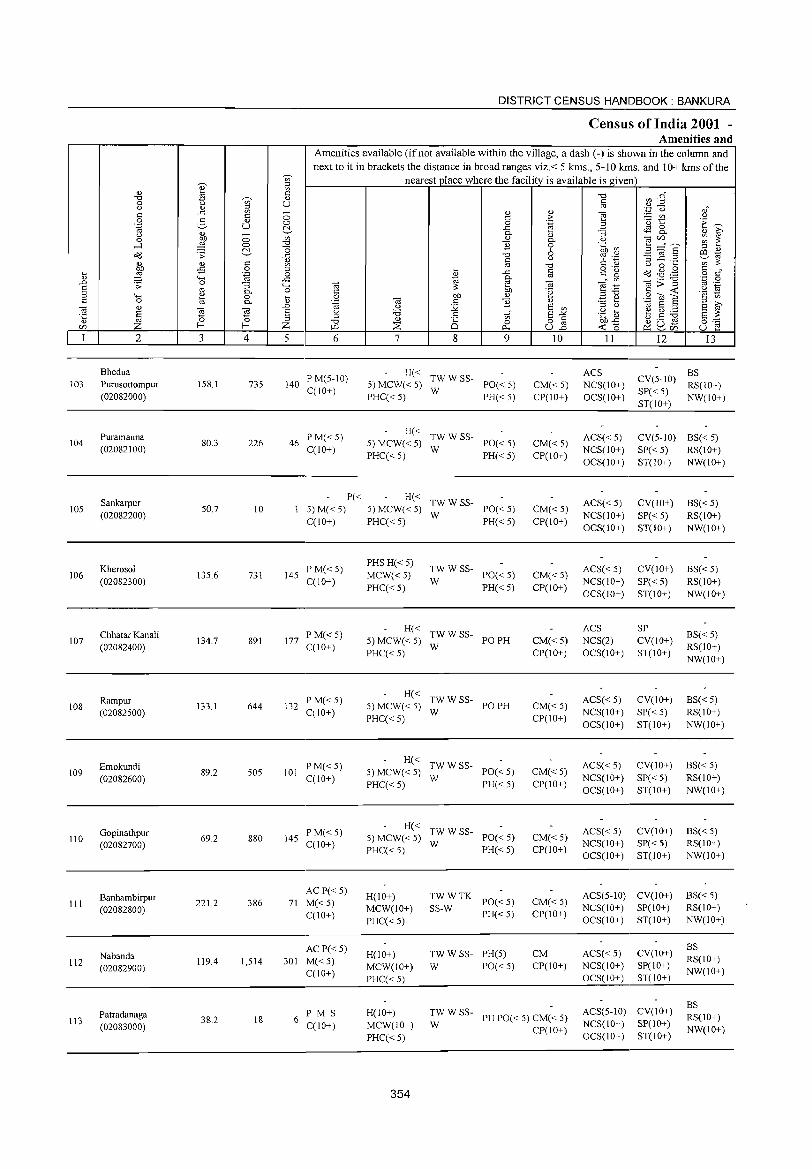
103
104
105
106
107
108
109
110
III
112
113
2
Bhedua Purusottompur (02082000)
Puramauna (02082100)
Sankarpur (02082200)
Kherosol (02082300)
Chhatar Kanali (02082400)
Rampur (02082500)
Emokundi (02082600)
Gopinathpur (02082700)
Banhambirpur (02082800)
Nabanda (02082900)
Patradanaga (02083000)
3
158.1
80.3
50.7
135.6
134.7
133.1
89.2
69.2
221.2
119.4
38.2
o o c:>-c o .-g "3 0-o 0-
l'l ~ 4
735
226
10
731
891
644
505
880
386
1,514
18
DISTRICT CENSUS HANDBOOK: BANKURA
Census of India 2001 -Amenities and
Amenities available (if not available within the village, a dash (-) is shown in the column and next to it in brackets the distance in broad ranges viz.< 5 krns., 5-10 krns. and 10+ krns of the
nearest place where the facility is available is given
o o c:>-oo
-0
1 o
..c "-< o ....
0,) .D
§ Z 5 6
140 P M(5-10) C(10+)
46 PM«5) C(10+)
P« 5) M« 5) C(10+)
145 PM«5) C(IO+)
177 PM«5) C(10+)
132 P M« 5) C(IO+)
101 P M«5) C(lO+)
145 P M«5) C(IO+)
ACP« 5) 71 M« 5)
C(10+)
AC P« 5) 301 M« 5)
C(IO+)
6 PM S C(1O+)
7 8 9
H« TW W SS-5) MCW« 5) W PO« 5) PHC«5) PH«5)
H« TW W SS-5) MCW« 5) W PO« 5) PHC«5) PH«5)
H« TW W SS-5) MCW« 5) W PO« 5) PHC( < 5) PH( < 5)
PHS H«5)
MCW«5) PHC«5)
~W W SS- PO« 5)
PH« 5)
H« TW W SS-5) MCW« 5) W PO PH PHC«5)
H« TWWSS-5) MCW« 5) W PO PH PHC« 5)
H« TW W SS-5) MCW« 5) W PO« 5) PHC«5) PH«5)
H« TWWSS-5) MCW« 5) W PO« 5) PHC« 5) PH« 5)
H(lO+) MCW(IO+)
PHC« 5)
H(10+) MCW(IO+)
PHC« 5)
TWWTK SS-W PO«5)
PH« 5)
TW W SS- PH(5) W PO«5)
10
CM« 5) CP(IO+)
CM« 5) CP(lO+)
CM« 5) CP(IO+)
CM«5) CP(IO+)
CM«5) CP(IO+)
CM« 5) CP(IO+)
CM« 5) CP(IO+)
CM« 5) CP(IO+)
CM« 5) CP(IO+)
CM CP(IO+)
H(IO+) MCW(IO+)
PHC«5)
;; W SS- PH PO« 5) CM« 5)
CP(IO+)
354
11 12 13
ACS NCS(IO+) OCS(IO+)
CV(5-IO) ~~(IO+) SP«5) ST(IO+) NW(IO+)
ACS« 5) NCS(lO+) OCS(IO+)
CV(5-10) BS« 5) SP« 5) RS(IO+) ST(10+) NW(IO+)
ACS«5) NCS(lO+)
OCS(lO+)
ACS« 5) NCS(IO+) OCS(10+)
ACS NCS(2) OCS(IO+)
ACS« 5) NCS(IO+)
OCS(IO+)
ACS« 5) NCS(IO+)
OCS(IO+)
ACS«5) NCS(IO+) OCS(IO+)
CV(lO+)
SP« 5) ST(JO+)
CV(lO+)
SP« 5) ST(10+)
SP CV(IO+) ST(IO+)
CV(IO+)
SP«5) ST(IO+)
CV(IO+)
SP« 5) ST(IO+)
CV(lO+) SP«5) ST(IO+)
ACS(5-10) CV(10+) NCS(lO+) SP(IO+) OCS(IO+) ST(lO+)
ACS«5) NCS(IO+) OCS(lO+)
CV(lO+) SP(IO+) ST(IO+)
ACS(5-10) CV(lO+) NCS(lO+) SP(10+) OCS(l 0+) ST( 10+)
BS« 5) RS(IO+)
NW(IO+)
BS«5) RS(IO+) NW(IO+)
BS« 5) RS(lO+) NW(lO+)
BS« 5) RS(IO+) NW(IO+)
BS« 5) RS(IO+) NW(IO+)
BS« 5) RS(IO+) NW(lO+)
BS« 5) RS(IO+) NW(IO+)
BS RS(10+) NW(10+)
BS RS(IO+) NW(10+)
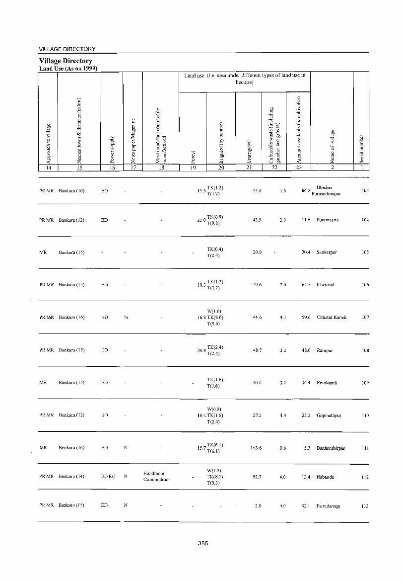
VILLAGE DIRECTORY
Village Directory Land Use (As on 1999)
E -'" 2-
Q.) u
'" ro
" t; OJ) '5 ~ .:;: tid
E ~ ..c: E o '" t; 2 ~ 0. 0. C1.)
<t; z 14 15
PRMR Bankura (10)
PRMR Bankura (12)
MR Bankura (15)
PRMR Bankura (15)
PRMR Bankura (16)
PRMR Bankura (15)
MR Bankura (15)
PRMR Bankura (12)
MR Bankura (16)
PRMR Bankura (14)
PRMR Bankura (15)
0 '5 0
Q.) S '" .~ S 0
~ " ~ §"O .b 1:: " 0. Q.) g_a 0. g-~ .§ ~
~ 0.
~ t; ;::l
0 8 0 Q.) :;s >l-; z s 16 17 18
ED
ED
ED
ED N
ED
ED
ED
ED N
Handloom ED EO N
Commodities
ED N
Land use (i.e. area under different types of land use in hectare)
t; ~ 0 ~
19
~
" ~ g ;>, e
"0 u
"" .!"!' 1:: 20
TK(J.2) 15.5 T(l.2)
TK(0.8) 22.0 T(O 8)
TK(0.4) T(OA)
183 TK(1.2) . T(J.2)
W(J.6) 16.8 TK(8.0)
T(9.6)
30 TK(2A) .8 T(2A)
TK(J.6) T(l.6)
W(0.8) lOA TK(J.6)
T(2A)
TK(6.1) 15.7 T(6.1)
W(1.2) TK(S.I) T(9.3)
355
"0 Q.)
"" 'E ·2 ;::J
21
55.6
43.9
29.9
49.6
44.6
48.7
50.0
27.2
193.6
92.7
2.0
'" 0 '-g
Of) .f; c '5 ::; ;::l u
U ~
2- -;;;- 08 " Q.)
~ ;> {j " 2 l ;;: Of) ~ "0
~ .:;:
" c
~ ro
"0 """' til 0 ..c: '" " 3 u ro
~ ::; ;::l ~ ro u Of) <t;
22 23 2
1.6 84.2 Bhedua Purusottompur
2.0 11.6 Puramauna
20A Sankarpur
2.0 64.5 Kherosol
4.1 59.6 Chhatar Kanali
3.2 48.0 Rampur
3.2 34A Emokundi
4.0 25.2 Gopinathpur
0.6 5.3 Banhambirpur
4.0 13A Nabanda
4.0 32.1 Patradanaga
t .0 S ;::l c: "iii ·c " en 1
103
104
105
106
107
108
109
110
111
112
113
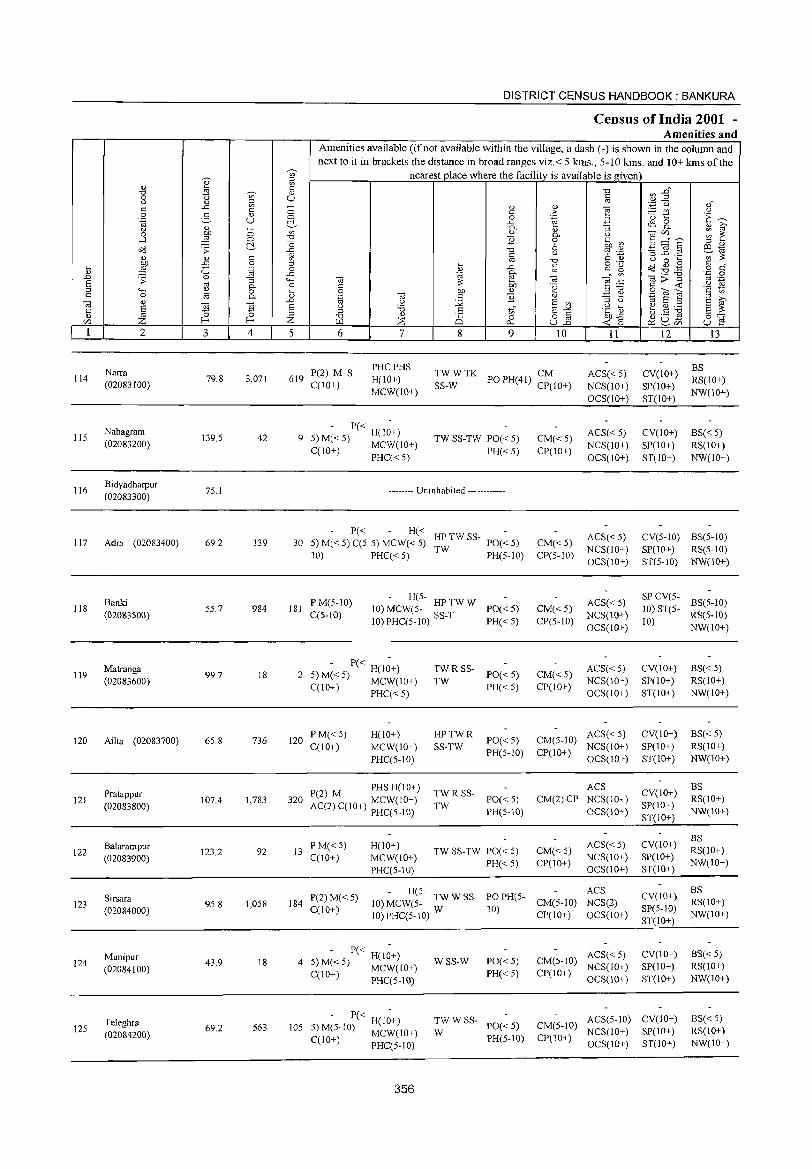
114
115
116
117
118
119
120
121
122
123
124
125
2
Narra (02083100)
Nabagram (02083200)
Bidyadharpur (02083300)
Adra (02083400)
Banki (02083500)
Matranga (02083600)
Ailta (02083700)
Pratappur (02083800)
Balarampur (02083900)
Sirsara (02084000)
Munipur (02084100)
Teleghra (02084200)
3
79.8
139.5
75.1
69.2
55.7
99.7
65.8
107.4
123.2
95.8
43.9
69.2
o o ~ c o .~
"3 0.. o 0..
'" ~ 4
3,071
42
139
984
18
736
1,783
92
1,058
18
563
DISTRICT CENSUS HANDBOOK: BANKURA
Censills of India 2001 -Amenities and
Amenities available (if not available within the village, a dash (-) is shown in the column and next to it in brackets the distance in broad ranges viz.< 5 krns., 5-10 kms. and 10+ kms of the
nearest place where the facility is available is given
5 6 7 8 9 10 II
619 P(2) M S C(lO+)
PHCPHS H(lO+) MCW(10+)
TWWTK CM SS-W PO PH(41) CP(lO+)
ACS« 5) NCS(10+) OCS(lO+)
- P« -9 5) M«5) H(lO+)
C(1O+) MCW(lO+) PHC« 5)
TW SS-TW PO« 5) PH« 5)
-------- Uninhabited ------------
P« H« -30 5) M« 5) C(5. 5) MCW« 5) HP TW SS- PO« 5)
10) PHC«5) TW PH(5-10)
181 PM(5-IO) C(S-IO)
- H(5-10) MCW(5- HPTWW PO«5) 10) PHC(5-1O) SS-T PH« 5)
- P« H(I;+) 2 5) M« 5) MCW(IO+)
C(10+) PHC« 5)
120 PM«5) C(10+)
H(IO+) MCW(lO+) PHC(5-10)
P(2) M PHS H( 1 0+ ) 320 MCW(lO+)
AC(2) C(10+) PHC(S-lO)
13 PM«5) C(10+)
H(IO+) MCW(lO+) PHC(5-IO)
~~ R SS- PO« 5)
PH«5)
HPTWR SS-TW
PO«5) PH(5-10)
~~ R SS- PO« 5)
PH(S-lO)
TWSS-TW PO«S) PH« 5)
CM«5) CP(lO+)
CM«5) CP(5-10)
CM«5) CP(5-10)
CM«5) CP(lO+)
ACS« 5) NCS(lO+) OCS(lO+)
ACS« 5) NCS(lO+) OCS(IO+)
ACS« 5) NCS(10+) OCS(IO+)
ACS«5) NCS(10+) OCS(IO+)
ACS« 5) CM(5-10) NCS(10+) CP(lO+) OCS(IO+)
ACS CM(2) CP NCS(lO+)
OCS(lO+)
CM«5) CP(IO+)
ACS« 5) NCS(10+) OCS(10+)
184 P(2) M« 5) C(10+)
H(5- ACS 10) MCW(5- TW W SS- PO PH(S- CM(5-10) NCS(2)
10)PHC(5-10) W 10) CP(IO+) OCS(IO+)
- P« H(I~+) 4 :5) M« 5) MCW(IO+)
(;(10+) PHC(5-10)
WSS-W PO« 5) PH«5)
ACS« 5) CM(5-10) NCS(IO+) CP(IO+) OCS(lO+)
12
CV(10+) SP(IO+) ST(lO+)
CV(10+) SP(10+) ST(10+)
l3
BS RS(10+) NW(10+)
BS« 5) RS(10+) NW(IO+)
CV(5-10) BS(5-1O) SP(IO+) RS(5-1O) ST(5-10) NW(10+)
SP CV(5-10) ST(5- BS(5-1O) 10) RS(5-10)
NW(10+)
CV(IO+) SP(10+) ST(JO+)
CV(IO+) SP(10+) ST(lO+)
CV(IO+) SP(JO+) ST(IO+)
CV(IO+) SP(10+) ST(IO+)
CV(lO+) Spe5-10) ST(IO+)
CV(lO+) SP(IO+) ST(lO+)
BS« 5) RS(lO+) NW(10+)
BS«5) RS(lO+) NW(10+)
BS RS(lO+) NW(10+)
BS RS(IO+) NW(IO+)
BS RS(10+) NW(10+)
BS« 5) RS(10+) NW(10+)
,_ - P« H(I;+) 105 ,»M(5-10) MCW(IO+)
TW W SS- ACS(5-1O) CV(10+) W PO« 5) CM(5-10) NCS(IO+) SP(JO+)
BS«5) RS(IO+) NW(lO+) C(10+) PHC(5-10) PH(5-10) CP(10+) OCS(IO+) ST(JO+)
356
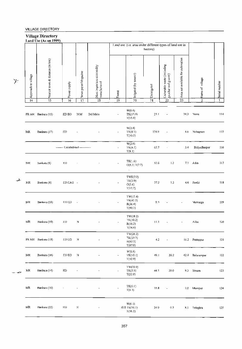
k
- -<7
VILLAGE DIRECTORY
Village Directory Land Use (As on 1999)
2' ..><
E-<1)
"
* " on :.a ,g o<l '':
B ~ -" B (.)
OJ to ~ " 8 0- 0)
~ Z 14 15
PRMR Bankura (15)
MR Bankura (17)
q "0 0
(!) 8 .:: '§j § b1J '" co 10 ~ ;;.., "'"0 c. '" to: " '-' 8.-8 0- §" ~ §~ 0-
~
'" " to :l 3: 3: .:: 0 0 '-' OJ
I'l.. Z ~ 8 16 17 18
ED EO NM Bel Mala
ED
-------- Uninhabited ------------
MR Sankara (8) ED
MR Bankura (8) EDEAG
MR Bankura (18) ED EO
MR Bankura (19) ED N
PRMR Bankura (18) EDEO N
MR Bankura (16) ED EO N
MR Bankura (14) ED
MR Bankura (20)
MR Bankura (22) ED N
Land use (i.e. area under different types ofland use in hectare)
.:: 0 .~
on >-.:: ~ :.a :l " u ~
~ 08 OJ g e ~ " :l B >- ::D ~ 0 e OJ i(l ,g ~ '" b1J ~ (!) ;;.., 3: "0 ..c e "0
" .:: >- '> 8 B OJ OJ
"0 co ::D 0 "" ::s '-' Of) e ~ 0 .::
to OJ ·E :l -" .:: '-' ~ OJ e Of) - (.) til '2 :; :l e 0 ~ OJ OJ
~ ::> u Of) ~ Z en 19 20 21 22 23 2 1
W(OA) TK(15.0) 25.1 39.3 Narra 114
T(l5.4)
W(2.4) TK(S.I) 124.9 4.0 Nabagram lIS
T(l0.5)
W(20) TK(6.1) 63.7 3.4 Bidyadharpur 116
T(S.I)
TK(J.6) 52.6 1.2 7.7 Adra 117
0(6.1) T(7.7)
TWE(7.0) TK(2.0)
0(3.6) 37.2 1.2 4.6 Banki 118
T(12.7)
TW(l3.4)
TK(40.5) 9.5 Matranga 119
R(36.4)
T(90.3)
TW(18.2) TK(20.2)
11.1 Ailta 120 R(l62)
T(54.6)
TW(24.3) TK(20.2)
4.2 16.2 Pratappur 121 R(425)
T(S70)
W(OS) TK(IO.I) 49.1 20.2 42.9 Balarampur 122 T(10.9)
TW(20.0) TK(2.0) 44.5 20.0 9.3 Sirsara 123 T(22.0)
TK(6.1) 35.8 2.0 Munipur 124
T(6.1)
W(6.1) 10.8 TK(IO.I) 34.0 0.2 8.1 Teleghra 125
T(16.2)
357
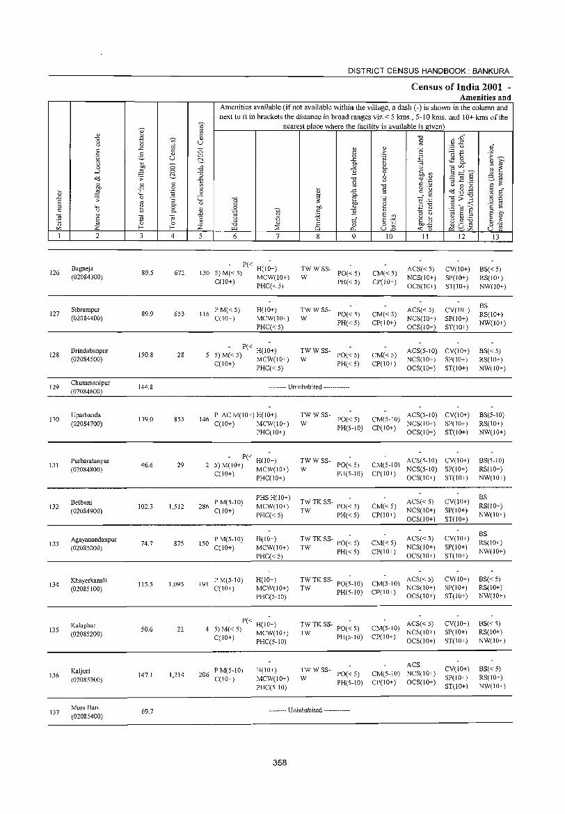
126
127
128
129
130
131
132
133
134
135
136
137
2
Bagneja (02084300)
Sibrampur (02084400)
Brindabanpur (02084500)
Churamanipur (02084600)
Uparbanda (02084700)
Purbaratanpur (02084800)
Belbuni (02084900)
Agayanandanpur (02085000)
Khayerkanali (02085100)
Kalaphar (02085200)
Kaljuri (02085300)
Mura Bari (02085400)
3
89.5
89.9
150.8
144.8
139.0
46.6
102.3
74.7
115.5
50.6
147.1
69.7
o o C-c o .~
~ o c.
4
672
653
28
855
29
1,512
875
1,095
22
1,214
DISTRICT CENSUS HANDBOOK: BANKURA
CensUlS of India 2001 -Amenities and
'[
Amenities available (if not available within the village, a dash (-) is shown in the column and next to it in brackets the distance in broad ranges viz.< 5 krns., 5-10 kms. and 10+ kms of the
nearest place where the facility is available is given c
'" U -o o C-'" "Cl
] 1;l
.8 4-< o iil
..0
§ Z 5
130
6 7
P« H(IO+) 5)M«5) MCW(10+) C(lO+) PHC« 5)
116 P M« 5) C(1O+)
H(IO+) MCW(10+)
PHC« 5)
- P« H(1~+) 5)M«5) MCW(IO+) C(lO+) PHC« 5)
8
<!} c o ..c 0. <!}
1i "0
~ ..c §" OJ) <!}
1i
9
~W W SS- PO« 5)
PH« 5)
~W W SS- PO« 5)
PH« 5)
;;: W SS- PO« 5)
PH« 5)
-------- Uninhabited ------------
146 P AC M(IO+) H(IO+) C(10+) MCW(IO+)
PHC(IO+)
P« H(IO+) 2 5) M(IO+) MCW(lO+)
C(IO+) PHC(IO+)
286 P M(S-IO) C(10+)
150 PM(5-10) C(lO+)
191 PM(5-10) C(lO+)
PHS H(IO+) MCW(lO+)
PHC« 5)
H(lO+) MCW(IO+)
PHC«5)
H(IO+) MCW(IO+) PHC(5-10)
- P« H(I~+) 4 5)M«5) MCW(IO+)
C(IO+) PHC(5-10)
206 PM(5-10) C(JO+)
H(IO+) MCW(10+)
PHC(5-10)
~W W SS- PO« 5)
PH(5-1O)
~W W SS- PO« 5)
PH(5-10)
TW TK SS- PO(~ 5)
TW PH« 5)
TW TK SS- PO(~ 5)
TW PH« 5)
~~ TK SS- PO(5-10)
PH(5-10)
~~ TK SS- PO« 5)
PH(5-1O)
~W W SS- PO« 5)
PH(5-IO)
-------- Uninhabited -----------
358
'" > .~
'" 0. o 6 (.)
"0
~ Oi .~
E '" 15-2 u.2
10
CM«5) CP(IO+)
CM«5) CP(IO+)
11
ACS« 5) NCS(lO+) OCS(lO+)
ACS« 5) NCS(lO+) OCS(IO+)
12
CV(IO+) SP(IO+) ST(IO+)
CV(10+) SP(IO+) ST(IO+)
CM« 5) CP(lO+)
ACS(5-IO) CV(10+) NCS(IO+) SP(lO+)
OCS(IO+) ST(10+)
CM(5-IO) ACS(5-IO) CV(IO+) CP(lO+) NCS(10+) SP(IO+)
OCS(IO+) ST(10+)
CM(5-IO) ACS(5-10) CV(IO+) NCS(5-10) SP(IO+)
CP(IO+) OCS(IO+) ST(IO+)
CM« 5) CP(IO+)
CM«5) CP(IO+)
ACS« 5) NCS(IO+) OCS(IO+)
ACS« 5) NCS(lO+) OCS(10+)
ACS« 5) CM(5-IO) NCS(IO+) CP(IO+) OCS(IO+)
ACS« 5) CM(5-1O) NCS(IO+)
CP(IO+) OCS(IO+)
ACS CM(5-IO) NCS(IO+) CP(IO+) OCS(lO+)
CV(IO+)
SP(lO+) ST(IO+)
CV(IO+)
SP(lO+) ST(IO+)
CV(IO+) SP(JO+) ST(IO+)
CV(lO+) SP(IO+) ST(IO+)
CV(lO+) SP(IO+) ST(IO+)
13
BS« 5) RS(IO+) NW(10+)
BS RS(10+) NW(IO+)
BS« 5) RS(10+) NW(10+)
BS(5-IO) RS(IO+) NW(IO+)
BS(5-10) RS(IO+) NW(10+)
BS RS(IO+)
NW(IO+)
BS RS(IO+)
NW(IO+)
BS« 5) RS(IO+) NW(IO+)
BS« 5) RS(lO+) NW(IO+)
BS« 5) RS(IO+) NW(IO+)
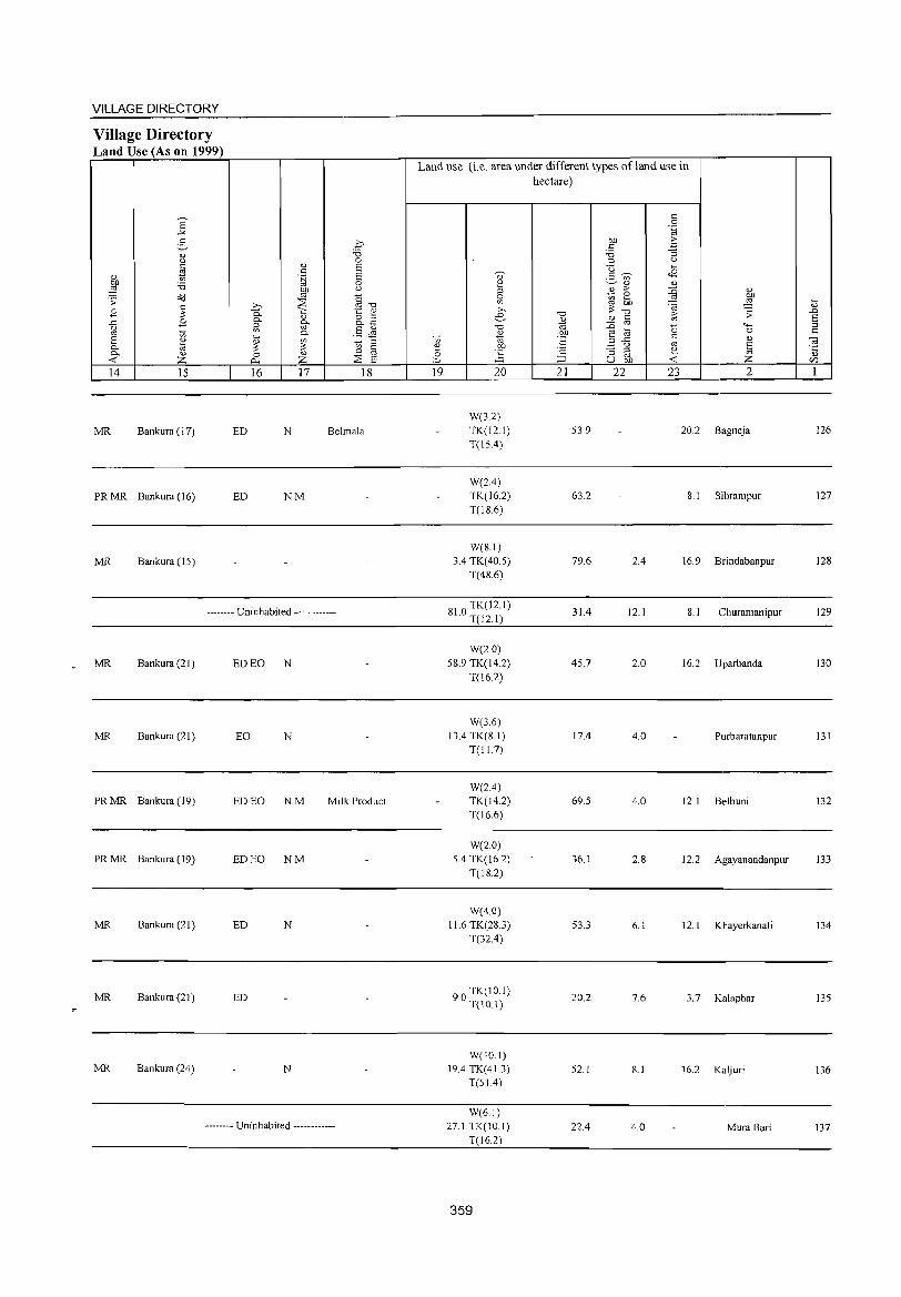
VILLAGE DIRECTORY
Village Directory Land Use (As on 1999)
14 15
MR Bankura (1 7)
PR MR Bankura (16)
MR Bankura (15)
16 17 18
ED N Be1ma1a
ED NM
-------- Uninhabited ------------
MR Bankura (21 ) ED EO N
MR Bankura (21) EO N
PR MR Bankura (19) ED EO NM Milk Product
PR MR Bankura (19) ED EO NM
MR Bankura (21 ) ED N
MR Bankura (21) ED
MR Bankura (24) N
-------- Uninhabited ------------
Land use (i.e. area under different types ofland use in hectare)
19 20
W(3.2) TK(12.1) T(15A)
W(2A) TK(16.2) T(lS.6)
W(8.1) 3.4 TK( 40.5)
T(4S.6)
SI 0 TK(12.1) . T(12.1)
W(2.0) 58.9 TK(14.2)
T(16.2)
W(36) 13.4 TK(S. 1)
T(11.7)
W(2.4) TK(14.2) T(16.6)
W(2.0) 5.4 TK(16.2}
T(lS.2)
W(4.0) 11.6 TK(28.3)
T(32.4}
90 TK(10.1) . T(lO.I)
W(10.1) 19.4 TK(41.3)
T(51.4)
W(61) 27.1 TK(lO.l)
T(l6.2)
359
21 22
53.9
63.2
79.6
31.4
45.7
17.4
69.5
36.1
53.3
20.2
52.1
22.4
23 2
20.2 Bagneja
8.1 Sibrampur
2.4 16.9 Brindabanpur
12.1 8.1 Churamanipur
2.0 16.2 Uparbanda
4.0 Purbaratanpur
4.0 12.1 Be1buni
2.8 12.2 Agayanandanpur
6.1 12.1 Khayerkana1i
7.6 3.7 Ka1aphar
8.1 16.2 Kaljuri
4.0 Mura Bari
126
127
128
129
130
131
132
133
134
135
136
137

138
139
140
141
142
143
144
145
146
147
148
2
Rasik.nagarpur
(02085500)
Madlakam- debpur
(02085600)
Chingragoalasol
(02085700)
Kharigara
(02085800)
Dhonara
(02085900)
Chhirabasta
(02086000)
Ainagobindapur
(02086100)
Mukundapur
(02086200)
Baramasia
(02086300)
Kushtia (02086400)
Khemua
(02086500)
3
326.0
327.5
84.5
308.0
77.7
43.1
100.3
387.7
1,1243
223.3
125.6
~ c '" U
o o ~
§ .-g "3 0.. o 0..
4
3
1,693
95
678
230
451
551
1,262
574
1,327
480
DISTRICT CENSUS HANDBOOK: BANKURA
CenSlllS of India 2001 -Amenities and
Amenities available (if not available within the village, a dash (-) is slhown in the column and next to it in brackets the distance in broad ranges viz.< 5 kms., 5-10 kms. and 10+ kms of the
nearest place where the facility is available is given
5 6
PMS C(lO+)
326 P M(5-10) C(lO+}
15 P M(5-10) C(lO+)
7
H(IO+) MCW(lO+} PHC(IO+)
H(10+) MCW(lO+) PHC(10+)
H(lO+) MCW(10+) PHC(lO+)
123 - P« H(l~+)
5) M(5-10) MCW(10+)
C(lO+) PHC(10+)
46 P M(5-10) C(10+)
H(IO+) MCW(10+) PHC(lO+)
8 9
TWWSS-PO« 5) PH(5-1O}
W
TWWSS-W PO« 5)
PH(10+)
:WWSS- PO«5)
PH(IO+)
TWWSS-W PO(5-IO)
PH(IO+)
TW S SSTW
PO(10+) PH(10+)
88 PM(5-10) C(lO+)
H(5-10) MCW(5- TWWSS- PO«5)
10)PHC(5-1O) W PH(5-10)
10 11 12
CM(5-10) ACS(5-10) CV(10+) CP(IO+} NCS(IO+) SP(IO+}
OCS(IO+) ST(10+)
CM(10+) CP(10+)
CM(10+) CP(lO+)
ACS(5-1O) CV(l 0+) NCS(10+) SP(lO+) OCS(10+) ST(IO+)
ACS(5-10) CV(lO+) NCS(10+) SP(lO+) OCS(lO+) ST(lO+)
CM(IO+} ACS(5-10) CV(10+) NCS(lO+) SP(10+)
CP(10+} OCS(lO+) ST(10+)
CM(lO+) CP(10+}
ACS(10+) NCS(10+) OCS(IO+)
CV(10+) SP(lO+) ST(lO+)
ACS(5-lO) CV(10+) CM(5-10) NCS(5-lO) SP(5-10) CP(10+) OCS(5-1O) ST(10+)
13
BS RS(10+) NW(lO+)
BS«5) RS(10+) NW(IO+)
BS«5) RS(lO+) NW(lO+)
BS«5} RS(10+) NW(lO+)
BS(5-10) RS(10+) NW(lO+)
BS« 5) RS(lO+) NW(10+)
115 PM«5) C(lO+)
H« TWWSS-5) MCW« 5) W PH PO« 5) CM« 5) PHC« 5) CP(10+)
ACS« 5) CV(10+) NCS« 5) SP« 5) OCS(5-10) ST(lO+)
BS« 5) RS(10+) NW(10+)
- H(5-211 P(2)M(5-10) 10) MCW(5- TWWSS- PO«5)
C(lO+) 10) PHC(5-1O) W PH« 5)
ACS« 5) CV(IO+) CM(5-10) NCS(5-10) SP(5-10) CP(IO+) OCS(lO+) ST(10+)
BS« 5) RS(10+) NW(IO+)
100
- H(5-P(2) M(5-10) 10) MCW(5- TwW W SS- PH PO« 5) CM(5-10) ACS(5-lO) C( lO+) NCS(5-10)
10) PHC(5-1O) CP(IO+)
CV(lO+) SP(S-10) ST(IO+)
BS(5-10) RS(10+) NW(lO+)
244 P M(5-10) C(lO+)
88 PM(5-10) C(1O+)
OCS(5-10)
PHS H«5) MCW(5-1O) PHC(5-10)
TW W SS- ACS(5-10) W PO PH« 5) CM(5-10) NCS(5-10)
BS CV(5-1O) RS(10+)
- H« TWWSS-5) MCW(5-1O) W PO« 5) PHC(5-1O) PH«5)
360
CP(IO+) OCS(lO+) SP(5-10) NW(IO+) ST(lO+)
ACS(5-1O) CV(5-1O) BS« 5) CM(5-10) NCS(5-1O) SP(5-10) RS(IO+) CP(IO+) OCS(IO+) ST(IO+) NW(lO+)
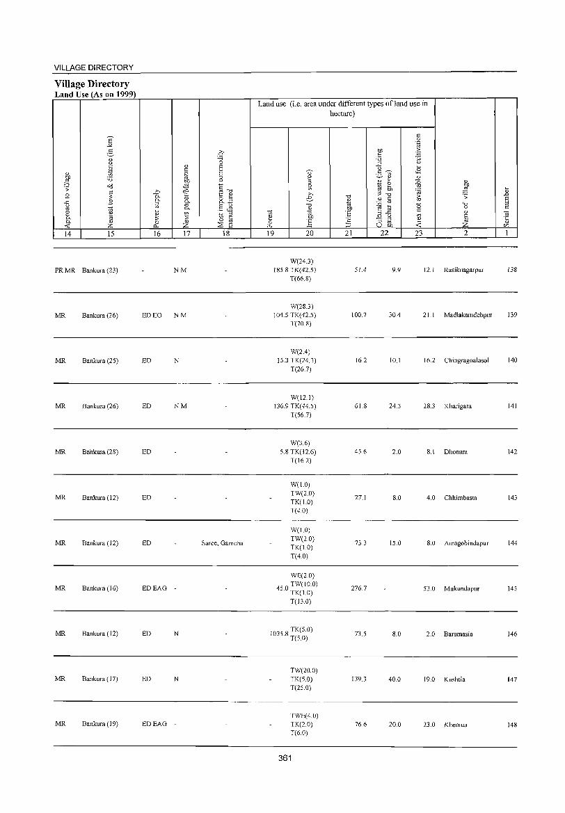
VILLAGE DIRECTORY
Village Directory Land Use (As on 1999)
14 15
PR MR Bankura (23)
MR Bankura (26)
MR Bankura (25)
MR Bankura (26)
MR Bankura (28)
MR Bankura (12)
MR Bankura (12)
MR Bankura (16)
MR Bankura (12)
MR Bankura (17)
MR Bankura (19)
16 17 is
NM
ED EO NM
ED N
ED NM
ED
ED
ED Saree, Gamcha
EDEAG
ED N
ED N
EDEAG
Land use (i.e. area under different types ofland use in hectare)
19 20
W(24.3) 185.8 TK(42.5)
T(66.8)
W(283) 104.5 TK(42.5)
T(70 8)
W(2.4) 15.3 TK(24.3)
T(26.7)
W(121) 136.9 TK(44.5)
T(56.7)
W(3.6) 5.8 TK(I2.6)
T(l6.2)
W(l.O) TW(2.0) TK(1.0) T(4.0)
W(l.O) TW(2.0) TK(1.0) T(4.0)
WE(2.0)
450 TW(IO.O) . TK(1.0)
T(l3.0)
1035 8 TK(5.0) . T(5.0)
TW(20.0) TK(5.0)
T(25.0)
TWE(4.0) TK(20) T(6.0)
361
21
51.4
100.7
16.2
61.8
45.6
27.1
73.3
276.7
73.5
139.3
76.6
22 23 2
9.9 12.1 Rasiknagarpur
30.4 21.1 Madlakamdebpur
10.1 16.2 Chingragoalasol
24.3 28.3 Kharigara
2.0 8.1 Dhonara
8.0 4.0 Chhirabasta
15.0 8.0 Ainagobindapur
53.0 Mukundapur
8.0 2.0 Baramasia
40.0 19.0 Kushtia
20.0 23.0 Khemua
138
139
140
141
142
143
144
145
146
147
148
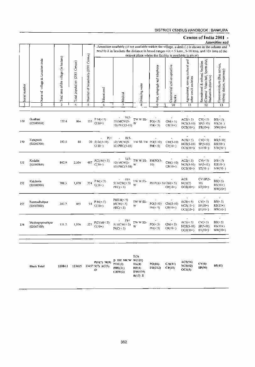
149
ISO
151
152
153
154
2
Goalhati (02086600)
Katapesia (02086700)
Kodalia (02086800)
Kataberia (02086900)
Banmadhabpur (02087000)
Maithagopinathpur (02087100)
RlockTotal
3 4
122.4 864
192.5 88
842.9 2,504
388.3 1,838
243.7 465
151.7 1,076
22084.1 123415
DISTRICT CENSUS HANDBOOK: BANKURA
Census of India 2001 -Amenities and
Amenities available (if not available within the village, a dash (-) is shown in the column and next to it in brackets the distance in broad ranges viz.< 5 kms., 5-10 kms. and 10+ kms of the
nearest _place where the facility is available is givl~n
5 6
155 P M« 5) C(10+)
P« 20 5) M(5-10)
C(lO+)
487 P(2) M« 5) C(1O+)
324 P M« 5) C(10+)
94 PM«5) C(10+)
227 P(2) M« 5) C(10+)
P(1l7) M(8) 23457 5(7) AC(5)
o
7 8 9
- H(5-10) MCW(5- TW W SS- PO« 5)
10) PHC(5-10) W PH« 5)
H(5-10) MCW(5- TW SS-TW PO(5-10) 10)PHC(5-10) PH«5)
10
CM«5) CP(10+)
11 12
ACS« 5) CV« 5) NCS(5-1O) SP(5-10) OCS(10+) ST(IO+)
ACS« 5) CV« 5) CM(5-10) NCS(5-10) SP(5-1O) CP(I 0+) OCS(10+) ST(lO+)
- H(5-10) MCW(5- TW W SS- PH PO(5- CM(5-10) ACS« 5)
to)PHC(5-1O) W 10) CP(IO+) NCS(5-1O)
CV«5) SP(5-10) ST(IO+) OCS(tO+)
13
BS« 5) RS(IO+) NW(10+)
BS(5-1O) RS(10+) NW(10+)
BS« 5) RS(IO+) NW(IO+)
H« TW WSS-5) MCW« 5) W PH PO« 5) CM« 5)
ACS NCS(2) OCS(lO+)
CV SP(5- BS« 5} 10) ST(IO+) RS(10+) PHC( < 5) CP(l 0+ )
PHSH« 5) MCW«5) PHC«5)
TWW SS-W PO(5-tO)
PH« 5)
H« TWW SS-5) MCW« 5) W PO« 5) PHC« 5) PH« 5)
T(3) D DH MeW W(121) PHC(3) TK(8)
PHS(21) HP( 4)
CHW(2) TW(139) R(13) S
362
PO(16) PH(212)
ACS« 5) CM(5-10) NCS(10+) CP(1 0+ ) OCS(l 0+)
CV«5) SP(10+) ST(10+)
CM« 5) CP(10+)
ACS« 5) CV« 5) NCS(5-10) SP(S-IO) OCS(lO+) ST(IO+}
CM(ll) CP(10)
AC8(16) NCS(12) OCS(S)
CV(6) 8P(50)
NW(lO+)
BS« 5) RS(10+) NW(IO+)
BS«5) RS(IO+) NW(IO+)
B8(41)
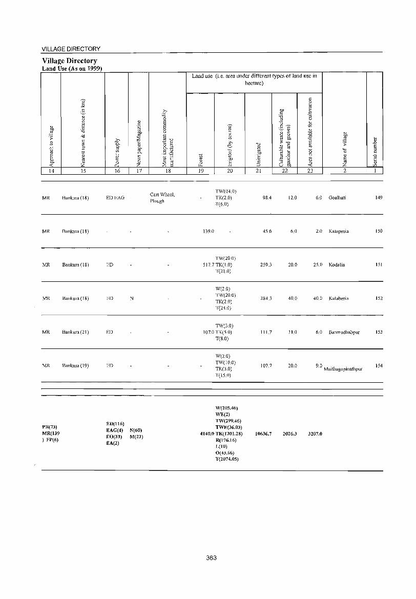
VILLAGE DIRECTORY
Village Directory Land Use (As on 1999)
'" ~ ';> E ..c 0 oj
e 0-0-
<t: 14
MR
MR
MR
MR
MR
MR
PR(73) MR(139 ) FP(6)
E "'" 2-" 0
~ :.a o:d
~ B U)
'" til " Z 15
Bankura (18)
Bankura (IS)
Bankura (18)
Bankura (IS)
Bankura (21 )
Bankura (19)
» 0.. 0.
~
~ 0
p.,
16
EDEAG
ED
ED
ED
ED
ED(116) EAG(4) EO(33) EA(2)
" c .~ Of) oj
~ '" 0-oj 0-
~ '" z 17
-
N
N(60) M(23)
p :.a 0 E E 0 <..>
<= "''0 t:: '" &8 §~ to '" c 0 oj
:2: E 18
Cart Wheel, Plough
Land use (i. e. area under different types of land use in hectare)
OJ ~ 0 U)
>-. e '0
'" to '" '" Of) (3 :§ ~
19 20
TWE(40) TK(2.0) T(6.0)
139.0
TW(20.0) 517.7 TK(1.0)
T(21.0)
W(2.0) TW(20.0) TK(2.0) T(24.0)
TW(3.0) 107.0 TK(S.O)
T(S.O)
W(2.0) TW(1O.0) TK(3.0) T(lS.O)
W(205.46) WE(2) TW(299.46) TWE(36.03)
4140.0 TK(1301.28) R(176.16) L(10) 0(43.66) T(2074.05)
363
'0 <1>
'" ·E '2 :::> 21
98.4
45.6
259.3
284.3
111.7
107.7
10636.7
c 0 .~
tlD .E; C :.a "3 :::l <.>
<3 ~
2- U) <E '" '" '" > :0 <1>
to tb oj 9 oj
~ ;;: '0 > ';> '" C '" :0 oj
'0 "'" ~ til 0 ...c c
'" B 0 oj § :; :::l ~ oj u Of) <t: Z 22 23 2
12.0 6.0 Goalhati
6.0 2.0 Katapesia
20.0 25.0 Kodalia
40.0 40.0 Kalaberia
11.0 6.0 Banmadhabpur
20.0 9.0. . Malthagopmathpur
2026.3 3207.0
~
'" ..c E: :::l c
~ <1>
c/)
1
149
150
151
152
153
154

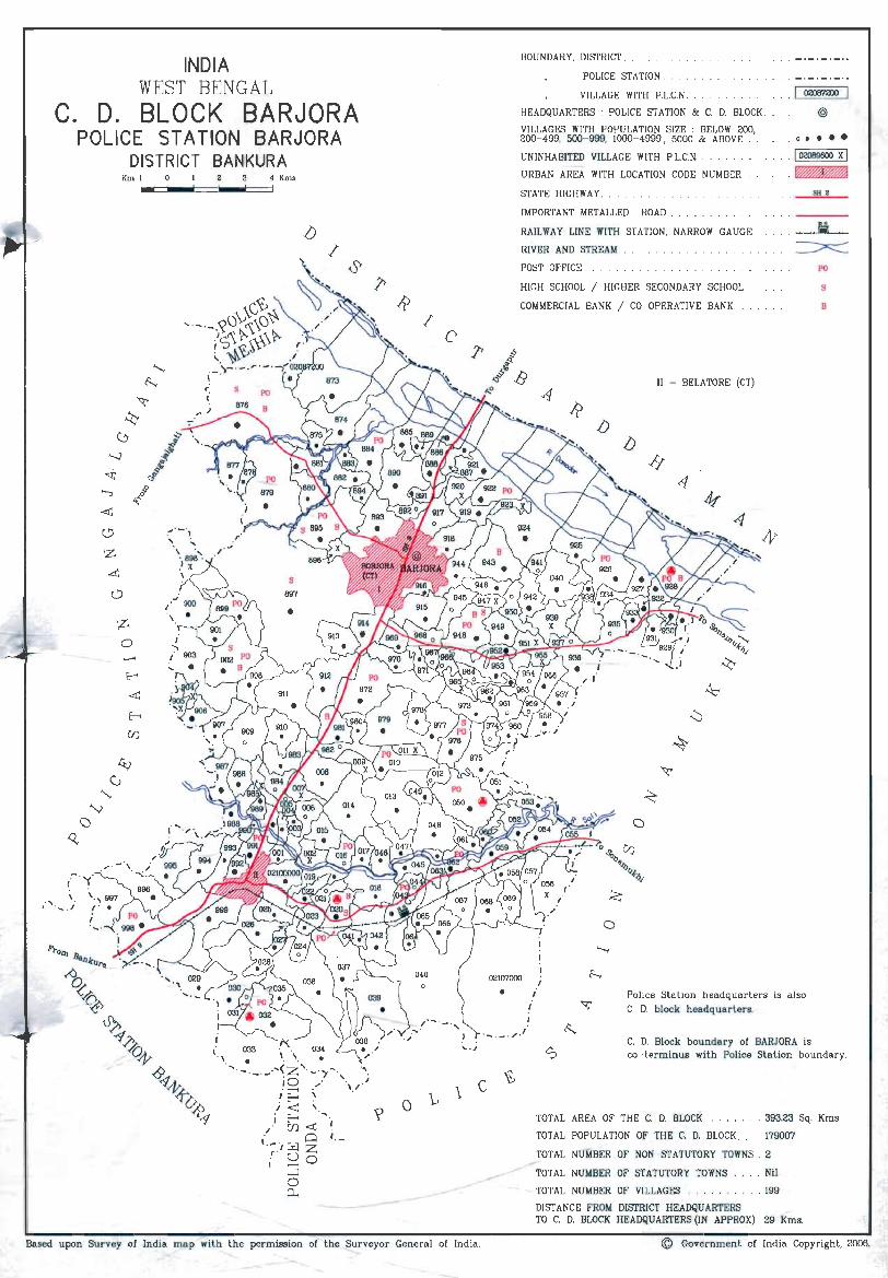
INDIA WEST BENGAL
C. D. BLOCK BARJORA POLICE 5T A TION BARJORA
DISTRICT BANKURA Km 1 o 4 Kms
\G~~ '- . ~ ,_.,?OV,\_\O'>'
/J
t~~t'3\\\~ i~)-' _ , r ' _. _'-mn,_,Yl
<. S (
/
/
BOUNDARY, DISTRICT.
POLICE STATION.
VILLAGE WITH P.L.C.N.
HEADQUARTERS: POLICE STATION & C. D. BLOCK .
VILLAGES WITH POPULATION SIZE : BELOW 200, 200-499, 500- 999, 1000- 4999, 5000 & ABOVE ..
UNINHABITED VILLAGE WITH P.L.C.N .
URBAN AREA WITH LOCATION CODE NUMBER
STATE HIGHWAY .
IMPORTANT METALLED ROAD ... . . .
RAILWAY LINE WITH STATION, NARROW GAUGE.
RIVER AND STREAM
POST OFFICE. . .
HIGH SCHOOL ! HIGHER SECONDARY SCHOOL . .
COMMERCIAL BANK ! CO- OPERATIVE BANK.
II - BELATORE (CT)
/J /J
o
· I 02087200
@
· 0 •• ••
· I 02089600 X I .~
SH 2
PO
S
B
0211Y1000
• f
f
I
Police Sta tion headquarters is also C. D. block headquarters.
._. _."." ~ C, D. Block boundary of BARJORA is co-terminus with Police Station boundary.
1 c o
Based upon Survey of India map with the permission of the Surveyor General of India.
TOTAL AREA OF THE C. D. BLOCK . . . . . . . 393.23 Sq. Kms.
TOTAL POPULATION OF THE C. D. BLOCK. 179007
TOTAL NUMBER OF NON- STATUTORY TOWNS. 2
TOTAL NUMBER OF STATUTORY TOWNS , . .. Nil
TOTAL NUMBER OF VILLAGES . . . , . 199
DISTANCE FROM DISTRICT HEADQUARTERS TO C. D. BLOCK HEADQUARTERS (IN APPROX) 29 Kms.
© Government of India Copyright, 2006.

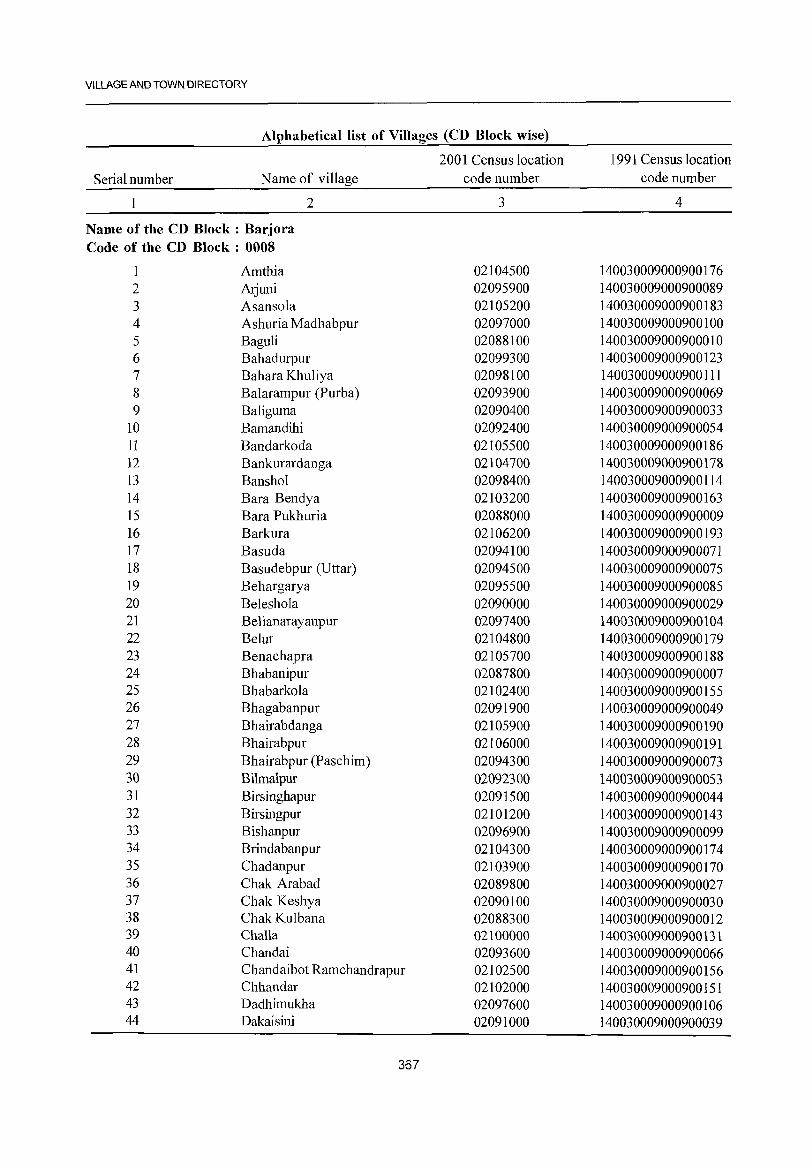
VILLAGE AND TOWN DIRECTORY
Alphabetical list of Villages (CD Block wise)
2001 Census location 1991 Census location Serial number Name of village code number code number
2 3 4
Name of the CD Block: Barjora Code of the CD Block : 0008
1 Amtbia 02104500 140030009000900176 2 Atjuni 02095900 140030009000900089 3 Asansola 02105200 140030009000900183 4 Ashuria Madbabpur 02097000 140030009000900100 5 Baguli 02088100 140030009000900010 6 Bahadurpur 02099300 140030009000900123 7 Bahara Khuliya 02098100 140030009000900111 8 Balarampur (Purba) 02093900 140030009000900069 9 Baliguma 02090400 140030009000900033
10 Bamandihi 02092400 140030009000900054 11 Bandarkoda 02105500 140030009000900186 ]2 Bankurardanga 02104700 140030009000900178 13 Banshol 02098400 140030009000900114 14 Bara Bendya 02103200 140030009000900163 15 Bara Pukhuria 02088000 140030009000900009 16 Barkura 02106200 140030009000900193 17 Basuda 02094100 140030009000900071 18 Basudebpur (Uttar) 02094500 140030009000900075 19 Behargarya 02095500 140030009000900085 20 Beleshola 02090000 140030009000900029 21 Belianarayanpur 02097400 140030009000900104 22 Belut 02104800 140030009000900179 23 Benachapra 02105700 140030009000900188 24 Bhabanipur 02087800 140030009000900007 25 Bhabarkola 02102400 140030009000900155 26 Bhagabanpur 02091900 140030009000900049 27 Bhairabdanga 02105900 140030009000900190 28 Bhairabpur 02106000 140030009000900191 29 Bhairabpur (Paschim) 02094300 140030009000900073 30 Bilmalpur 02092300 140030009000900053 31 Birsinghapur 02091500 140030009000900044 32 Birsingpur 02101200 140030009000900143 33 Bishanpur 02096900 140030009000900099 34 Brindabanpur 02104300 140030009000900174 35 Chadanpur 02103900 140030009000900170 36 Chak Arabad 02089800 140030009000900027 37 Chak Keshya 02090100 140030009000900030 38 Chak Kulbana 02088300 140030009000900012 39 Challa 02100000 140030009000900131 40 Chandai 02093600 140030009000900066 41 Chandaibot Ramchandrapur 02102500 140030009000900156 42 Chhandar 02102000 140030009000900151 43 Dadhimukha 02097600 140030009000900106 44 Dakaisini 02091000 140030009000900039
367
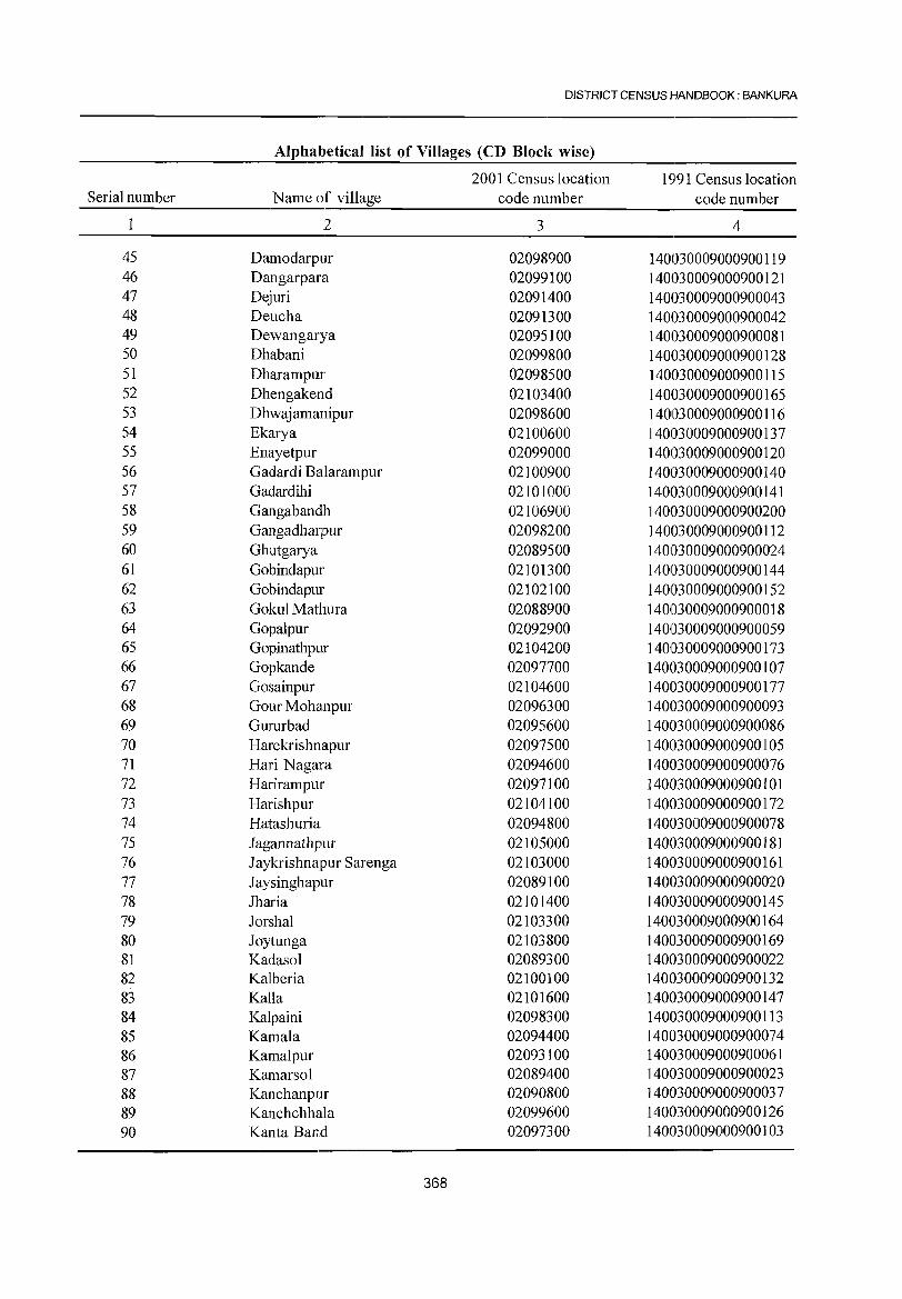
DISTRICT CENSUS HANDBOOK: BANKURA
Alphabetical list of Villages (CD Block wise)
2001 Census location 1991 Census location Serial number Name of village code number code number
2 3 4
45 Damodarpur 02098900 140030009000900119 46 Dangarpara 02099100 140030009000900121 47 Dejuri 02091400 140030009000900043 48 Deucha 02091300 140030009000900042 49 Dewangarya 02095100 140030009000900081 50 Dhabani 02099800 140030009000900128 51 Dharampur 02098500 140030009000900115 52 Dhengakend 02103400 140030009000900165 53 Dhwajamanipur 02098600 140030009000900116 54 Ekarya 02100600 140030009000900137 55 Enayetpur 02099000 140030009000900120 56 Gadardi Balarampur 02100900 140030009000900140 57 Gadardihi 02101000 140030009000900141 58 Gangabandh 02106900 140030009000900200 59 Gangadharpur 02098200 1401030009000900112 60 Ghutgarya 02089500 140030009000900024 61 Gobindapur 02101300 140030009000900144 62 Gohindapur 02102100 140030009000900152 63 Gokul Mathura 02088900 140030009000900018 64 Gopalpur 02092900 140030009000900059 65 Gopinathpur 02104200 140030009000900173 66 Gopkande 02097700 1401030009000900107 67 Gosainpur 02104600 140030009000900177 68 Gour Mohanpur 02096300 140030009000900093 69 Gururbad 02095600 140030009000900086 70 Harekrishnapur 02097500 140030009000900105 71 Hari Nagara 02094600 140030009000900076 72 Harirampur 02097100 140030009000900101 73 Harishpur 02104100 140030009000900172 74 Hatashuria 02094800 140030009000900078 75 Jagannathpur 02105000 140030009000900181 76 J aykrishnapur Sarenga 02103000 140030009000900161 77 Jaysinghapur 02089100 140030009000900020 78 Jharia 02101400 140030009000900145 79 Jorshal 02103300 140030009000900164 80 Joytunga 02103800 140030009000900169 81 Kadasol 02089300 140030009000900022 82 Kalberia 02100100 140030009000900132 83 Kalla 02101600 140030009000900147 84 Kalpaini 02098300 140030009000900113 85 Kamala 02094400 140030009000900074 86 Kamalpur 02093100 140030009000900061 87 Kamarsol 02089400 140030009000900023 88 Kanchanpur 02090800 140030009000900037 89 Kanchchhala 02099600 140030009000900126 90 Kanta Band 02097300 140030009000900103
368
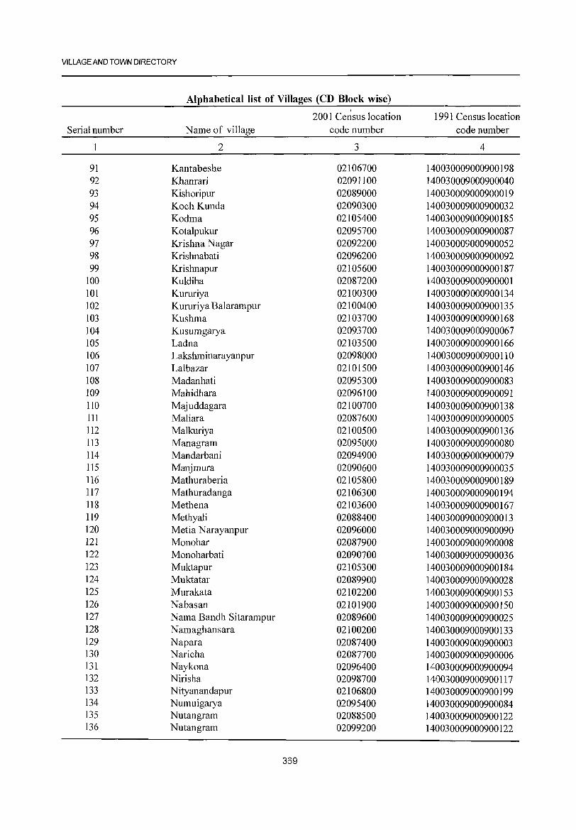
VILLAGE AND TOWN DIRECTORY
Alphabetical list of Villages (CD Block wise)
200 1 Ce~sus location 1991 Census location Serial number Name of village code number code number
2 3 4
91 Kantabeshe 02106700 140030009000900198 92 Khanrari 02091100 140030009000900040 93 Kishoripur 02089000 140030009000900019 94 Koch Kunda 02090300 140030009000900032 95 Kodma 02105400 140030009000900185 96 Kotalpukur 02095700 140030009000900087 97 Krishna Nagar 02092200 140030009000900052 98 Krishnabati 02096200 140030009000900092 99 Krishnapur 02105600 140030009000900187
100 Kuldiha 02087200 140030009000900001 101 Kururiya 02100300 140030009000900134 102 Kururiya Balarampur 02100400 140030009000900135 103 Kushma 02103700 140030009000900168 104 Kusumgarya 02093700 140030009000900067 105 Ladna 02103500 140030009000900166 106 Lakshrninarayanpur 02098000 140030009000900110 107 Lalbazar 02101500 140030009000900146 108 Madanhati 02095300 140030009000900083 109 Mahidhara 02096100 140030009000900091 110 Majuddagara 02100700 140030009000900138 III Maliara 02087600 140030009000900005 112 Malkuriya 02100500 140030009000900136 113 Managrarn 02095000 140030009000900080 114 Mandarbani 02094900 140030009000900079 115 Manjrnura 02090600 140030009000900035 116 Mathuraberia 02105800 140030009000900189 117 Mathuradanga 02106300 140030009000900194 118 Methena 02103600 140030009000900167 119 Methyali 02088400 140030009000900013 120 Metia N arayanpur 02096000 140030009000900090 121 Monohar 02087900 140030009000900008 122 Monoharbati 02090700 140030009000900036 123 Muktapur 02105300 140030009000900184 124 Muktatar 02089900 140030009000900028 125 Murakata 02102200 140030009000900153 126 Nabasan 02101900 140030009000900150 127 Nama Bandh Sitararnpur 02089600 140030009000900025 128 N amaghansara 02100200 140030009000900133 129 Napara 02087400 140030009000900003 130 Naricha 02087700 140030009000900006 131 Naykona 02096400 140030009000900094 132 Nirisha 02098700 140030009000900117 133 Nityanandapur 02106800 140030009000900199 134 Numuigarya 02095400 140030009000900084 135 Nutangram 02088500 140030009000900122 136 Nutangram 02099200 140030009000900122
369
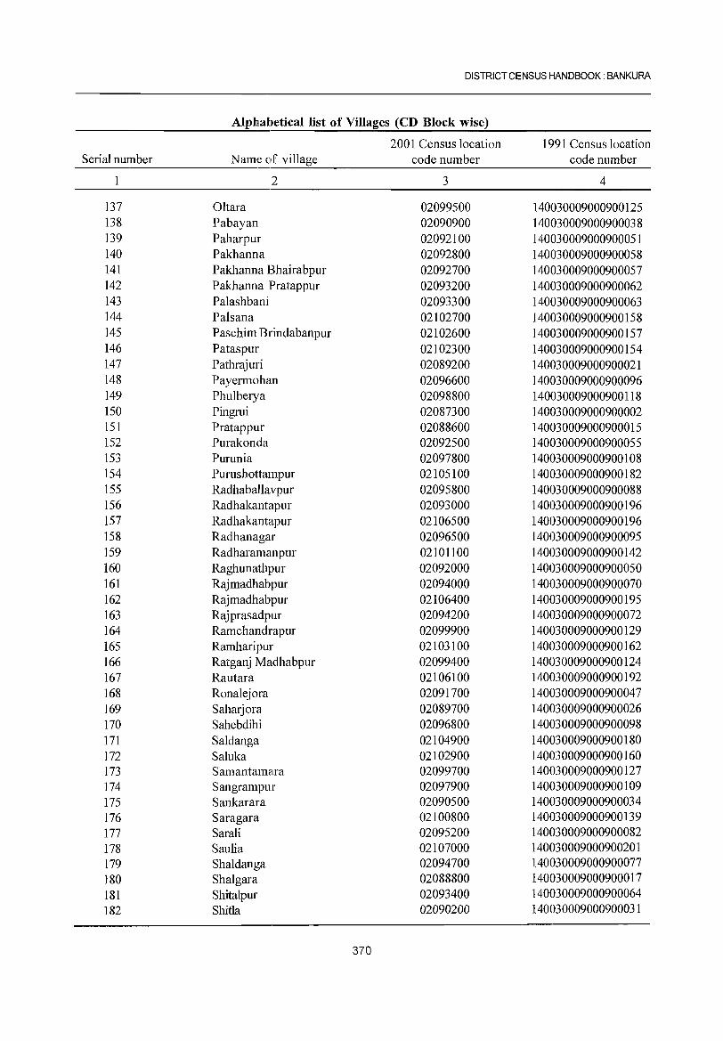
DISTRICT CENSUS HANDBOOK: BANKURA
Alphabetical list of Villages (CD Block wise)
2001 Census location 1991 Census location Serial number Name of village code number code number
2 3 4
137 Oltara 02099500 140030009000900125 138 Pabayan 02090900 140030009000900038 139 Paharpur 02092100 140030009000900051 140 Pakhanna 02092800 140030009000900058 141 Pakhanna Bhairabpur 02092700 140030009000900057 142 Pakhanna Pratappur 02093200 140030009000900062 143 Palashbani 02093300 140030009000900063 144 Palsana 02102700 140030009000900158 145 Paschim Brindabanpur 02102600 140030009000900157 146 Pataspur 02102300 140030009000900154 147 Pathrajuri 02089200 140030009000900021 148 Payermohan 02096600 1401030009000900096 149 Phulberya 02098800 140030009000900118 150 Pingrui 02087300 1401030009000900002 151 Pratappur 02088600 1401030009000900015 152 Purakonda 02092500 1401030009000900055 153 Pumnia 02097800 1401030009000900108 154 Pumshottampur 02105100 1401030009000900182 155 Radhaballavpur 02095800 1401030009000900088 156 Radhakantapur 02093000 140030009000900196 157 Radhakantapur 02106500 140030009000900196 158 Radhanagar 02096500 140030009000900095 159 Radharamanpur 02101100 140030009000900142 160 Raghunathpur 02092000 140030009000900050 161 Rajmadhabpur 02094000 140030009000900070 162 Rajmadhabpur 02106400 140030009000900195 163 Rajprasadpur 02094200 140030009000900072 164 Ramchandrapur 02099900 140030009000900129 165 Ramharipur 02103100 140030009000900162 166 Ratganj Madhabpur 02099400 140030009000900124 167 Rautara 02106100 140030009000900192 168 Ronalejora 02091700 140030009000900047 169 Saharjora 02089700 140030009000900026 170 Sahebdihi 02096800 140030009000900098 171 Saldanga 02104900 140030009000900180 172 Saluka 02102900 140030009000900160 173 Sam an tamara 02099700 140030009000900127 174 Sangrampur 02097900 140030009000900109 175 Sankarara 02090500 140030009000900034 176 Saragara 02100800 140030009000900139 177 Sarali 02095200 140030009000900082 178 Saulia 02107000 140030009000900201 179 Shaldanga 02094700 140030009000900077 180 Shalgara 02088800 140030009000900017 181 Shitalpur 02093400 140030009000900064 182 Shitla 02090200 140030009000900031
370
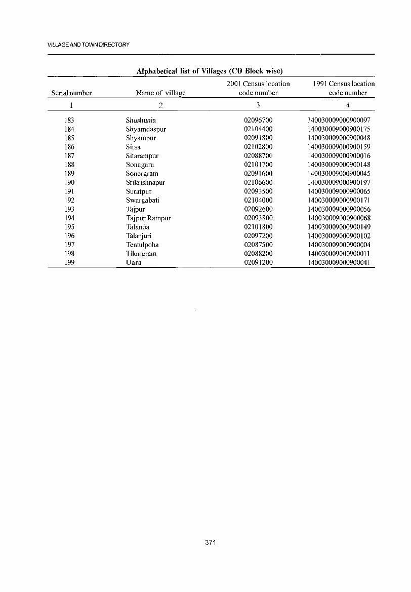
VILLAGE AND TOWN DIRECTORY
Alphabetical list of Villages (CD Block wise)
2001 Census location 1991 Census location Serial number Name of village code number code number
2 3 4
183 Shushunia 02096700 140030009000900097 184 Shyamdaspur 02104400 140030009000900175 185 Shyampur 02091800 140030009000900048 186 Sirsa 02102800 140030009000900159 187 Sitarampur 02088700 140030009000900016 188 Sonagara 02101700 140030009000900148 189 Sonergram 02091600 140030009000900045 190 Srikrishnapur 02106600 140030009000900197 191 Suratpur 02093500 140030009000900065 192 Swargabati 02104000 140030009000900171 193 Tajpur 02092600 140030009000900056 194 Tajpur Rampur 02093800 140030009000900068 195 Talanda 02101800 140030009000900149 196 Talanjuri 02097200 140030009000900102 197 Tentulpoha 02087500 140030009000900004 198 Tikargram 02088200 140030009000900011 199 Uara 02091200 140030009000900041
371
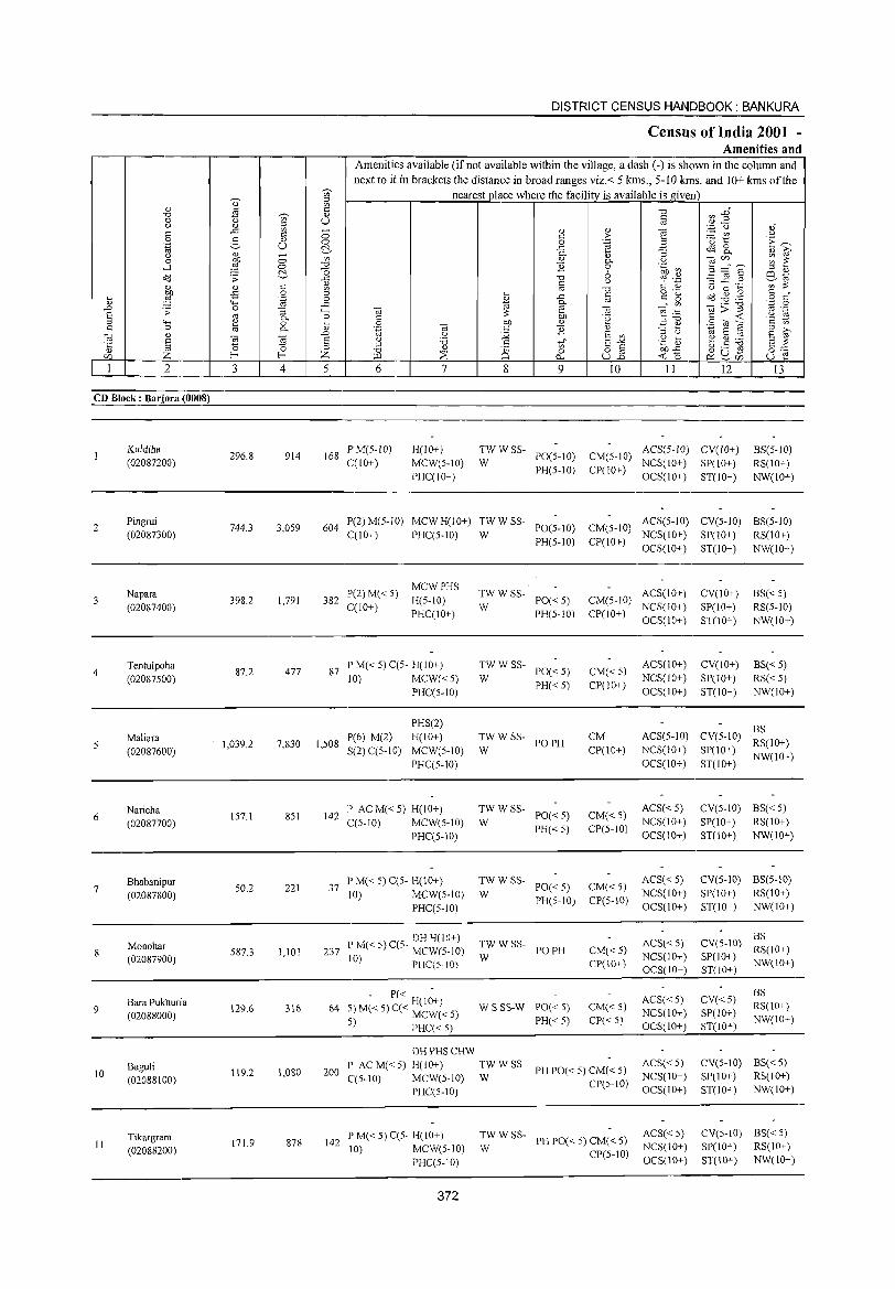
., § Z 2
CD Block: Barjora (0008)
2
3
4
6
7
8
9
10
11
Kuldiha (02087200)
Pingrui (02087300)
Napara (02087400)
Tentulpoha (02087S00)
Maliara (02087600)
Naricha (02087700)
Bhabanipur (02087800)
Monohar (02087900)
Bara Pukhuria (02088000)
Baguli (02088100)
Tikargram (02088200)
1 U
3 4
296.8 914
744.3 3,059
398.2 1,791
87.2 477
1,039.2 7,830
IS7.1 851
50.2 221
587.3 1,101
129.6 316
119.2 1,080
171.9 878
DISTRICT CENSUS HANDBOOK: BANKURA
Census of India 2001 -Amenities and
1 Amenities available (if not available within the village, a dash (-) is shown in the column and next to it in brackets the distance in broad ranges viz.< 5 kms., 5-10 kms. and LO+ kms of the
nearest place where the facilitv is available is given
U
5 6
168 P M(S-IO) C(1O+)
7
H(10+ )
MCW(S-lO)
PHCCIO+)
8 9
<l)
> .~ <l) 0-o o u
-0 §
" T~ '" E '" 15"§ U..o
10 11 12
TWWSS- PO(5-10) CM(S-IO) ACS(S-IO) CV(lO+)
W PH(S-IO) CP(IO+) NCS(IO+) SP(10+) OCS(lO+) ST(10+)
13
BS(S-IO)
RS(IO+)
NW(10+)
604 P(2) M(S-IO) MCW H(IO+) TW W SS- ACS(S-IO) CV(S-IO) BS(S-IO) C(10+) PHCCS-IO) W PO(5-10) CM(S-IO) NCS(lO+) SP(10+) RS(lO+)
PH(5-10) CP(IO+) OCS(10+) ST(IO+) NW(lO+)
MCWPHS 382 P(2) M« 5) H(5-10)
C(10+) PHCCIO+)
87 PM«5)CC5- H(10+) 10) MCW«5)
PHCC5-10)
P(6) M(2) 1,508 S(2) CC 5-10)
PHS(2)
H(IO+)
MCW(S-IO)
PHCC5-1O)
142 P ACM«5) H(IO+) C(S-IO) MCW(S-IO)
PHCCS-10)
37 l' M« 5) CCS- H(10+) 10) MCW(5-10)
PHCCS-IO)
DH H(10+) 237 P M« 5) CC5- MCW(S-IO)
10) PHC(S-IO)
- P« H(I;+) 64 5)M«5)C« MCW«5)
5) PHC« 5)
DH PHS CHW
:W W SS- PO« 5)
PH(5-10)
TWWSS-PO«5)
PH«5) W
TWWSS-W PO PH
TWWSS-PO«S)
PH«S) W
ACS(10+) CM(5-10) NCS(lO+)
CP(IO+) OCS(10+)
CM«5) CP(10+)
CM CP(10+)
CM« S) CP(5-IO)
ACS(IO+)
NCS(IO+) OCS(10+)
ACS(5-1O)
NCS(10+)
OCS(IO+)
ACS«S) NCS(IO+)
OCS(10+)
TWW W SS- PO« 5) CM« 5) ACS« 5)
PH(5 10) CP(5-10) NCS(10+) - OCS(IO+)
TWW SS- POPH W
W S SS-W PO« 5)
PH«5)
CM«5) C]>(IO+)
CM« 5)
CP«5)
ACS« 5) NCS(10+) OCS(IO+)
ACS« 5) NCS(lO+) OCS(IO+)
200 P AC M« 5) H(lO+) TW W SS- ACS« 5)
PH PO« 5) CM« 5) NCS(10+) C(5-IO) MCW(5-10) W PHC(5-10) CP(5-10) OCS(10+)
142 P M« 5) C(5- H(lO+) 10) MCW(5-10)
PHCC5-l0)
372
:W W SS- PH PO« 5) CM« 5)
CP(5-10)
ACS« 5) NCS(IO+)
OCS(IO+)
CV(lO+)
SP(IO+) ST(10+)
CV(10+)
SP(1O+)
ST(10+)
BS«5) RS(5-10)
NW(10+)
BS« 5) RS«5) NW(IO+)
BS CV(S-lO) RS(lO+)
SP(10+) NW(lO+) ST(IO+)
CV(5-10) BS« S) SP(lO+) RS(10+) ST(10+) NW(10+)
CV(5-10) BS(5-10)
S1'(1 0+) RS( 1 0+) ST(10+) NW(10+)
CV(5-10) ~~(10+) SP(IO+) NW(10+) ST(IO+)
CV«5) SP(IO+) ST(IO+)
BS RS(lO+) NW(10+)
CV(5-10) BS«5) S1'(l 0+ ) RS( 1 0+) ST(10+) NW(IO+)
CV(5-10) BS« 5) SP(10+) RS(10+)
ST(10+) NW(10+)
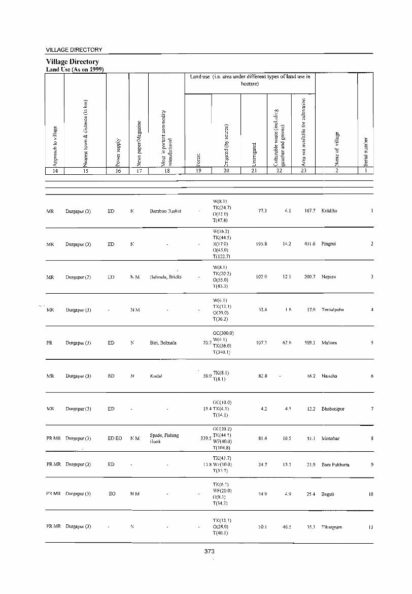
VILLAGE DIRECTORY
Village Directory Land Use (As on 1999)
14 15
MR Durgapur (3)
MR Durgapur (3)
MR Durgapur (2)
MR Durgapur (3)
PR Durgapur (3)
MR Durgapur (3)
MR Durgapur (3)
PRMR Durgapur (3)
PRMR Durgapur (3)
PRMR Durgapur (3)
PRMR Durgapur (3)
16 17 18
ED N Bamboo Busket
ED N
ED NM Belmala, Bricks
NM
ED N Biri, Belmala
ED N Kodal
ED
ED EO NM Spade, Fishing Hook
ED
EO NM
N
Landuse (i.e. area under different types ofland use in hectare)
19 20 21 22 23
W(8.1) TK(24.7)
77.3 4.1 167.7 0(15.0) T(47.8)
W(16.2) TK(44.5) R(17.0) 19S.8 14.2 411.6 0(4S.0)
T(1227)
W(B.I) TK(20.2)
102.0 12.1 200.7 O(SS.O)
T(83.3)
W(4.1) TK(12.1)
32.4 1.6 17.0 0(20.0) T(36.2)
GC(300.0) W(4.1)
20.2 TK(36.0) 107.3 62.6 S09.1
T(340.1)
500 TK(8.1) . T(8.1) 82.B 16.2
GC(IO.O) IS.4 TK(4.1) 4.2 4.5 12.2
T(14.1)
GC(20.2)
339 TK(44.S) .S WF(40 0) 81.4 10.S S1.1
T(104.8)
TK(43.7) 13.8 WF(IO.O) 24.7 15.5 21.9
T(53.7)
TK(6.1)
WF(20.0) 54.9 4.9 25.4
0(8.1) T(34.2)
TK(12.1) 0(28.0) 50.1 46.5 3S.1 T(40.1)
373
2
Kuldiha
Pingrui 2
Napara
Tentulpoha 4
Maliara
Naricha 6
Bhabanipur 7
Monohar
Bara Pukhuria 9
Baguli 10
Tikargram II
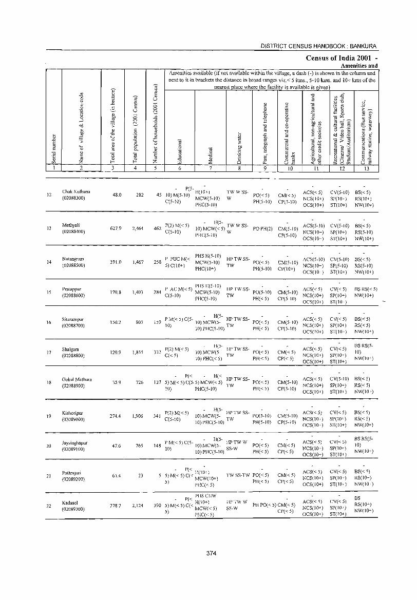
DISTRICT CENSUS HANDBOOK: BANKURA
Census of India 2001 -Amenities and
Amenities available (if not available within the village, a dash (-) is shown in the column and next to it in brackets the distance in broad ranges viz.< 5 kms., 5-10 kIns. and 10+ kms of the
'U;' nearest place where the facility is available is given ~ i;l " " liJ c "0 (/} .g" "0 'U;' '" 0 " u iii
" Q) i;l .~ "0 " c ..s:: c ;:; Q) " iii ;.:: r/) " c ;> .S g " 0 0 .~ B ·0 t: E~
'" u C- ..c c.S 8- " i;;' " 0. "3 " ;:; '" " " iii'" ;:; t: 0 bO 0. " .....l ::§ 0 "0 E 0 .~ en _g~" § "0 ::> Q)
o(l .;;: C- ] "0 6 1 ·3 o:l '" c " .::s..c .:::: ';;::» Q) " c '" "0 § .~ " 0 '"' ~ oS 0 ::>
" ..c c c: g o(l .g .g § d
" '-@ 0 "-' ..s:: '" 0. '" U) iii:;:"g
'.p 0 ..c ~ 0 "3 iii e iii '" .-S '" ""' ::» ~:g .~ 13 0. 0 C bO .~ c <C ::> "-' ~ 0 K; 0 bO " SOla c '" C 0 0. .~ iii c 1i .=:: ~ ., S ::> ::> ;>,
iii " ..c " ::;; s '" ::> " S ~ E 5 5 s " 'i3 .:: tf E-" .g t5 b.S ~ ·c ::> §'" " '" 0 0 ::> "0 " Q 0 8] bO..s:: tZJ Z f-< f-< Z >LI ::B 0... <C 0 ~u- u e ~tZJ
1 2 3 4 5 6 7 8 9 10 11 12 13
Chak Kulbana - P(S- -
TW WSS- ACS« S) CV(S-IO) 8S«5) 12 48.0 282 45 IO)M(5-IO) H(IO+) PO«5) CM«5) (02088300) C(5-10) MCW(5-IO) W PH(5-10) CP(5-10)
NCS(IO+) SP(IO+) RS(IO+) PHC(S-IO) OCS(1O+) ST(lO+) NW(IO+)
Methyali P(2) M« 5) - H(5-
ACS(5-10) CV(5-10) BS«5) 13 627.9 2,464 462 10) MCW« 5) TW W SS- POPH(2) CM(5-10) (02088400) C(S-IO)
PHC(5-10) W CP(5-10) NCS(IO+) SP(IO+) RS(5-10) OCS(IO+) ST(IO+} NW(IO+}
Nutangram P PUCM« PHS H(5-IO)
HPTW SS- ACS(5-IO) CV(5-10) BS« 5) 14 391.0 1,467 258 MCW(5-10) PO«5) CM(5-10) (02088S00) 5) C(lO+)
PHC(IO+) TW
PH(5-10) CP(IO+) NCS(IO+) SP(5-10) RS(5-10) OCS(IO+) ST(1O+) NW(lO+)
Pratappur P C M« 5) PHS H(5-1O) HP TW SS- PO(;-IO) ACS«5) CV« 5) BS RS« 5)
IS 170.8 1,403 284 A MCW(5-10) CM(5-10) (02088600) C(5-10) PHC(S-IO) TW PH«5) NCS(IO+) SP(lO+) NW(IO+)
CP(5-10) OCS(IO+) ST(tO+)
Sitarampur - H(5-
ACS« 5) CV«5) BS« 5) 16 150.2 807 159 PM«5)C(5- to)MCW(S- HPTWSS- PO«S) CM(5-10)
(02088700) to) 10)PHC(5-10) TW PH« 5) CP(5-10) NCS(IO+) SP(lO+) RS«5) OCS(IO+) ST(IO+) NW(IO+)
Shalgara P(2) M« 5) H(5-
HPTW SS- ACS«5) CV«5) BS RS(5-
17 120.9 1,855 332 10) MCW(S- PO«5) CM« 5) 10) (02088800) q< 5)
10) PHC« 5) TW
PH«5) CP« 5) NCS(IO+) SP(IO+)
NW(IO+) OCS(IO+) ST(IO+)
Gokul Mathura P« H«
HP TW SS- POe ~ 5) ACS« 5) CV(5-1O) BS«5) 18 35.9 726 137 5) M« 5) C(5· 5) MCW« 5) CM(5-10)
(02088900) \0) PHC(5-10) TW PH«5) CP(S-IO)
NCS(IO+) SP(IO+) RS« 5) OCS(IO+) ST(lO+) NW(IO+)
Kishoripur P(2)M« 5) H(5- -
ACS« 5) CV«5) BS« 5) 19 274.4 1,906 341 10) MCW(5- HPTWSS- PO(5-tO) CM(5-1O)
(02089000) C(5-IO) IO)PHC(5-1O) TW PH(5-10) CP(5-10) NCS(lO+) SP(IO+) RS« S) OCS(IO+) ST(IO+) NW(10+)
Jaysinghapur - H(5-
ACS« 5) CV«5) BSRS(5-
20 47.6 765 148 PM«5)C(5- 10)MCW(5- HPTWW PO«5) CM«5) 10) (02089100) 10) 10) PHC(5-1O) SS-W PH«5) CP« 5)
NCS(IO+) SP(lO+) NW(lO+)
OCS(10+) ST(IO~ )
Pathrajuri - P« .-
ACS« 5) CV«5) 8S« S) 23
H(IO+) TW SS-TW PO« 5) CM«5) 21 61.4 5) M« 5) C« MCW(IO+) NCS(IO+) SP(IO+) RS(IO+) (02089200) PH« 5) CP« 5) 5) PHC« 5) OCS(IO+) ST(IO+) NW(IO+)
P« PHS CHW CV« 5)
BS Kadasol , H(IO+) HPTWW
PH PO« 5) CM« 5) ACS« 5) RS(IO+) 22 278.2 2,124 390 5) M« 5) C« MCW« 5) SS-W NCS(1O+) SP(10+) (02089300) CP« 5) NW(IO+)
5) PHC« 5) OCS(lO+) ST(1O+)
374
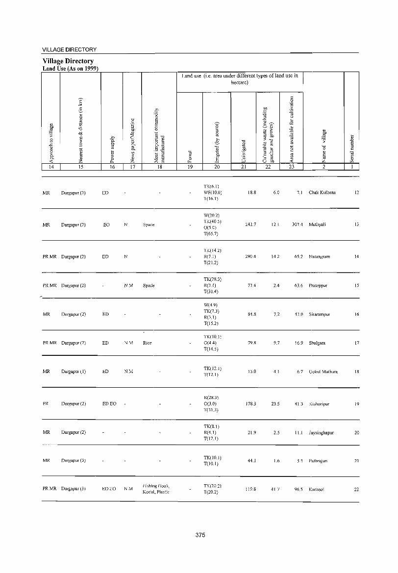
VILLAGE DIRECTORY
Village Directory Land Use (As on 1999)
14 15
MR Durgapur (3)
MR Durgapur (2)
PR MR Durgapur (2)
PR MR Durgapur (2)
MR Durgapur (2)
PR MR Durgapur (2)
MR Durgapur (1)
PR Durgapur (2)
MR Durgapur (2)
MR Durgapur (3)
PR MR Durgapur (3)
16 17
ED
EO N
ED N
NM
ED
ED NM
ED NM
ED EO
ED EO NM
18
Spade
Spade
Rice
Fishing Hook, Kodal, Plastic
Land use (i.e. area under different types ofland use in hectare)
19 20
TK(6.1) WF(IO.O) T(16.1)
W(20.2) TK(40.S) O(S.O) T(6S.7)
TK(14.2) R(7.1) T(21.2)
TK(28.3) R(3.1) T(31.4)
W(4.9) TK(7.3) R(3.1) T(IS.2)
TK(10 1) 0(4.4)
T(14.S)
TK(121) T(12.1)
R(28.3)
0(3.0) T(31.3)
TK(8.1) R(41) T(12.1)
TK(IO.l) T(IO.I)
TK(20.2) T(20.2)
375
21 22
18.8
242.7
290.4
73.4
84.8
79.8
13.0
178.3
21.9
44.1
119.8
23 2
6.0 7.1 Chak Kulbana
12.1 307.4 Methyali
14.2 6S.2 Nutangram
2.4 63.6 Pratappur
7.2 43.0 Sitarampur
9.7 16.9 Shalgara
4.1 6.7 Gokul Mathura
23.5 41.3 Kishoripur
2.S 11.1 Jaysinghapur
1.6 5.S Pathrajuri
41.7 96.S Kadasol
12
13
14
15
16
17
18
19
20
21
22
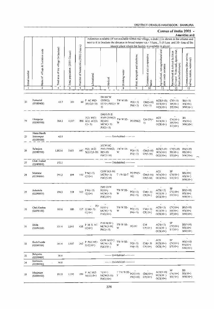
23
24
25
26
27
28
29
30
31
32
33
34
35
2
Kamarsol
(02089400)
Ghutgarya (02089500)
Nama Bandh
Sitarampur
(02089600)
Sahaljora
(02089700)
Chak Arabad
(02089800)
Muktatar
(02089900)
Beleshola (02090000)
Chak Keshya
(02090100)
Shitla (02090200)
Koch Kunda (02090300)
Baliguma (02090400)
Sankarara (02090500)
Manjmura (02090600)
3 4
45,7 331
364,2 4,517
43,9
1,863,6 3,651
152,1
29l.2 698
194.3 558
103.6 686
321.4 2,041
3614 1,937
56,6
44.8
101.0 1,230
DISTRICT CENSUS HANDBOOK: BANKURA
Census of India 2001 -Amenities and
~
Amenities available (if not available within the village, a dash (-) is shown in the column and next to it in brackets the distance in broad ranges viz,< 5 kms" 5-10 kms, and 10+ kms of the
nearest place where the facility is available is given c " U
5 6
60 PAC M(5-10) C(5-1O)
P(2) M(2)
890 S(2) AC(3)
q< 5)
7 8
DHMCW CHW(2) TW W SS-
H(IO+)PHC« W 5)
DH(4) PHS
9
PO« 5) PH« 5)
" > .~
" 0-o 6 u
"0 § 0; .~
" S '" §"§ U..c
10 11 12
CM(5-10) ACS(5-10) CV« 5) CP« 5) NCS(IO+) SP(IO+)
OCS(IO+) ST(IO+)
RMP CHW(2) TW W SSH(JO+) MCW«5) W
PO PH(2) CM CP« ANCCSS(IO) 5) +
CV(IO+)
SP(10+)
ST(IO+) OCS(IO+)
PHq< 5)
-------- Uninhabited ------------
13
BS« 5) RS(IO+) NW(lO+)
BS
RS(lO+) NW(JO+)
647 P(2) M(2) S(2) q5-1O)
MCWHC
PHS CHW(2) H(5-IO)
PHqS-IO)
TWWSS-W
PO« 5) CM(5-1O) ACS(5-10) CV(5-1O) BS(5-10)
CP(5-1O) NCS(lO+) SP(IO+) RS(IO+) PH«5) OCS(IO+) ST(10+) NW(IO+)
-------- Uninhabited ------------
152 P M« 5) qIO+)
CHWH(5-10) ACS MCW« 5) T TW SS-T PO PH(5- CM(5-10) NCS(lO+)
SP
CV(lO+) ST(IO+) PHq5-10) lO) CP(5-10) OCS(IO+)
102 IPM« 5) C(lO+)
PHSCHW
H(IO+)
MCW«5) PHqIO+)
137 , - P« H(l~+) ~,) M« 5) MCW« 5)
C(IO+) PHqIO+)
F' M S AC PHS H(IO+)
438 C(10+) MCW(5-1O) PHC«5)
:W W SS- PO« 5)
PH« 5)
:W W SS- PO« 5)
PH«5)
TWWSS- POPH W
C M( CHWH(IO+) TWWSS-342 P PU < MCW« 5) PO« 5)
5) C(IO+) PHC(lO+) W PH« 5)
220 PAC M(5-10) C(IO+)
-------- Uninhabited ------------
-------- Uninhabited ------------
H(IO+)
MCW(5-10) PHC(IO+)
376
T TW W SS· PO(;-IO)
T PH(S-IO)
CM« 5) CP(IO+)
CM«5) CP(IO+)
CM CP(lO+)
CM« 5) CP(IO+)
CM(IO+)
CP(IO+)
ACS« 5) NCS(JO+)
OCS(IO+)
ACS«5) NCS(IO+)
OCS(IO+)
ACS«5) NCS(IO+)
OCS(IO+)
ACS NCS(IO+) OCS(lO+)
SP CV(IO+)
ST(lO+)
CV(IO+)
SP(IO+)
ST(IO+)
SP CV(JO+)
ST(lO+)
SP CV(IO+) ST(JO+)
SP ACS(5-10) CV(IO+)
NCS(IO+) ST(IO+) OCS(IO+)
BS(IO+)
RS(lO+)
NW(IO+)
BS(5-1O)
RS(IO+)
NW(IO+)
BS(5-IO)
RS(IO+)
NW(IO+)
BS(5-10) RS(IO+)
NW(IO+)
BS(5-10) RS(IO+) NW(JO+)
BS RS(IO+)
NW(IO+)
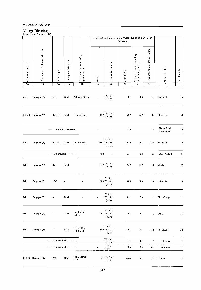
VILLAGE DIRECTORY
Village Directory Land Use (As on 1999)
E "" 2- q
OJ '0 0 a c <lJ 8 ~
c OJ .~ 8 bJ) 'i3 a ~ bJ) 0
o<l '" §'O .;; ~
>, ::E B 0. ';:; 1:: <lJ
OJ 8.2 .c B 0.. g-o ;;;l
§~ '" 1;; en 0..
~ OJ iil en 1;; ;;;l
til :;: :;: § 0.. OJ a <lJ a -< Z 0- Z ::E 8 14 15 16 17 18
MR Durgapur (3) ED NM Behnala, Plastic
PRMR Durgapur (3) ED EO NM Fishing Hook
-------- Uninhabited ------------
MR Durgapur (3) ED EO NM Monolithics
-------- Uninhabited ------------
MR Durgapur (3) ED NM
MR Durgapur (3) EO
MR Durgapur (3) NM
Handloom MR Durgapur (3) NM
Article
Fishing Hook, MR Durgapur (3) NM
Bell Metal
-------- Uninhabited ------------
-------- Uninhabited ------------
PRMR Durgapur (3) ED NM Fishing Hook, Talai
Land:use (i.e. area under different types ofland use in hectare)
c a .~
bJ) .f; c 'i3 '3 ;;;l (,)
u ~
2- en <8 OJ OJ
~ :> :0 ~ '" '" ~ :;:
'0 '0 ~ OJ c OJ
'" ." :0 '0 bJ)
~ til 'E .c c
(,) '" '" '3 ;;;l
~ '" ;:J U bJ)
19 20 21 22 23
OJ
~ ;;
'H a OJ
~ 2
TK(12.4) T(12A)
14.2 10.6 8.5 Kamarsol
437 TK(32.4) · T(32A)
163.9 65.7 58.5 Ghutgarya
40.0 3.9 Nama Bandh Sitarampur
W(20.2) 1018.2 TK(80.0) 600.0 22.1 123.0 Saharjora
T(100.2)
43.3 63.1 13A 32.3 Chak Arabad
882 TK(24.3) · T(24.3)
97.2 45.7 35.8 Muktatar
W(2.0) 64.0 TK(8.0) 84.0 24.3 12.0 Beleshola
T(IO.0)
W(8.1) TK(16.2) 60.7 6.5 12.1 Chak Keshya T(24.3)
W(24.3) 23.1 TK(36.4) 157.8 44.5 35.2 Shitla
T(60.7)
W(6.0) 38.9 TK(34.4) 117.4 50.3 114.5 Koch Kunda
T(40A)
TK(IO.I) 38.5 4.1 3.9 Baliguma
T(lO.I)
TK(4.0) 28.0 6.5 6.3 Sankarara
T(4.0)
93 TK(19.2) · T(l9.2) 48.6 4.3 19.7 Manjmura
377
~ OJ
.D 8 ::l c
OJ ·c " r/J
1
23
24
25
26
27
28
29
30
31
32
33
34
35
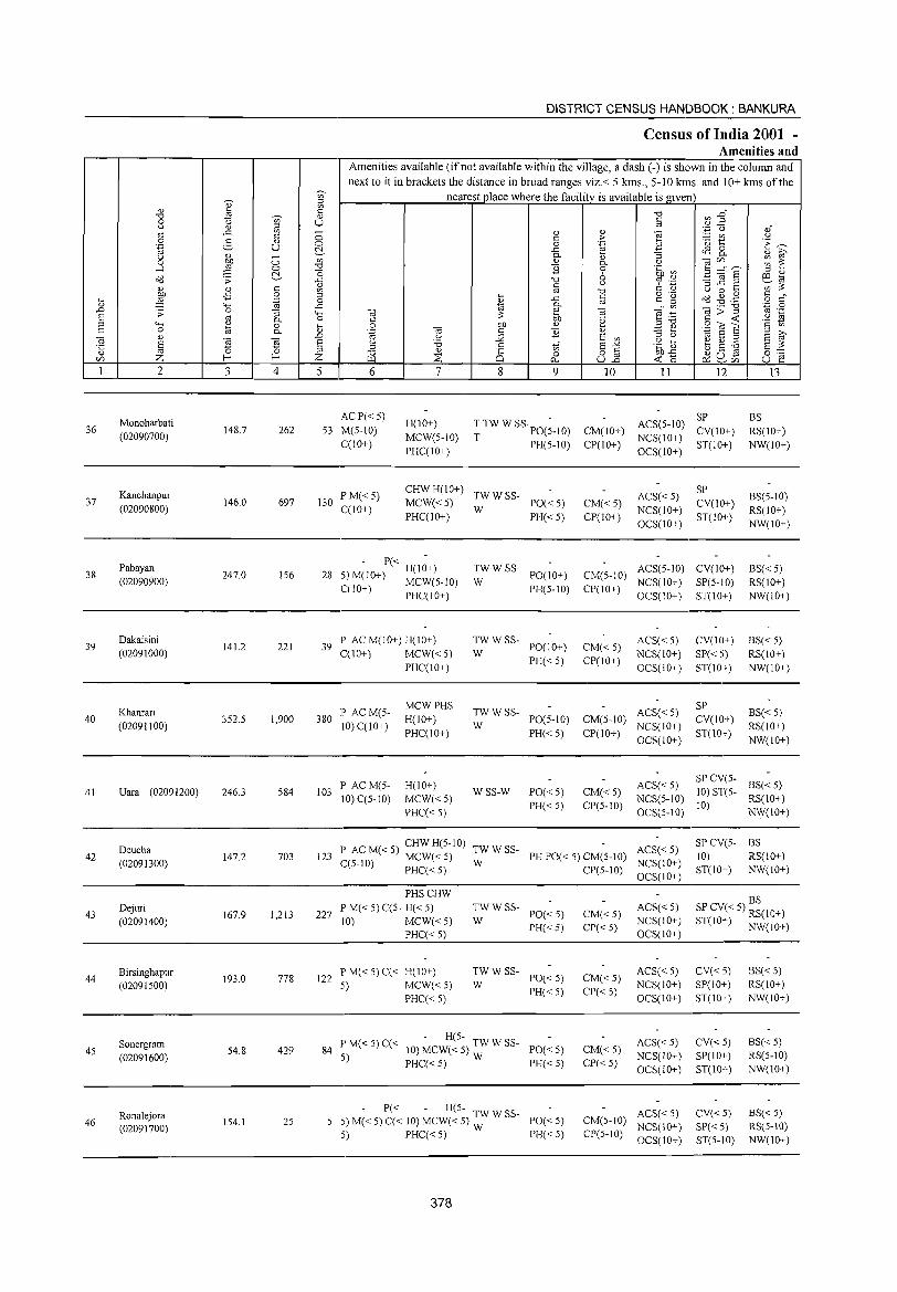
36
37
38
39
40
41
42
43
44
45
46
2
Monoharbati
(02090700)
Kanchanpur
(02090800)
Pabayan
(02090900)
Dakaisini
(02091000)
Khanrari
(02091100)
Uara (02091200)
Deucha
(02091300)
Dejuri
(02091400)
Birsinghapur
(02091500)
Sonergram
(02091600)
Ronalejora (02091700)
3
148.7
146.0
247.0
141.2
352.5
246.3
147.2
167.9
193.0
54.8
154.1
o o C!-o: o .~
"3 0.. o 0..
t3 ;S 4
262
697
156
221
1,900
584
703
1,213
778
429
25
DISTRICT CENSUS HANDBOOK: BANKURA
Census of India 2001 -Amenities and
Amenities available (if not available within the village, a dash (-) is shown in the colwnn and next to it in brackets the distance in broad ranges viz.< 5 kms., 5-10 krns. and 10+ kms of the
nearest place where the facility is available is given
5 6
ACP«5)
53 M(5-10)
C(lO+)
7
H(IO+)
MCW(5-1O)
PHC(IO+)
8
" c: o
..c: 0..
" B "0 0:
'" ..c: a. e bJJ
" B t)" o
0...
9
TTW W SS'PO(;_IO)
T PH(5-10)
130 PM«5) C(lO+)
CHW H(IO+) TW W SS-MCW« 5) W PO« 5) PHC(IO+) PH« 5)
- P« H(I~+) 28 5) M(lO+) MCW(5-10)
C(lO+) PHC(IO+)
39 P AC M(lO+) H(IO+) C(IO+) MCW« S)
PHC(lO+)
380 IP AC M(5-10) C(lO+)
103 P ACM(5-10) C(5-10)
MCWPHS
H(IO+)
PHC(IO+)
H(lO+)
MCW«5)
PHC« S)
TWWSS-1'0(10+) PH(5-10)
W
TWWSS-PO(IO+)
PH«5) W
TWWSS-W PO(5-1O)
PH«5)
WSS-W PO«5)
PH«5)
10
CM(IO+)
CP(IO+)
CM« 5) CP(IO+)
II 12
SP ACS(5-10) CV(lO+)
NCS(IO+) ST(IO+) OCS(IO+)
ACS« 5)
NCS(lO+)
OCS(lO+)
SP
CV(IO+)
ST(IO+)
CM(5-IO) ACS(5-1O) CV(IO+) NCS(IO+) SP(5-10)
CP(IO+) OCS(IO+) ST(IO+)
CM«5)
CP(IO+)
ACS«5)
NCS(IO+)
OCS(IO+)
ACS« 5) CM(5-10) NCS(IO+)
CP(IO+) OCS(10+)
CV(lO+)
SP« 5)
ST(IO+)
SP
CV(IO+)
ST(IO+)
13
BS
RS(lO+)
NW(IO+)
BS(5-10)
RS(IO+)
NW(lO+)
BS« 5) RS(IO+)
NW(iO+)
BS« 5)
RS(IO+)
NW(IO+)
BS« 5)
RS(IO+)
NW(lO+)
CM«5) CP(5-10)
ACS« 5) NCS(5-10)
OCS(5-10)
SP CV(5- BS« 5)
10) S1"(5- RS(IO+) 10)
NW(IO+)
l' ACM«5) CHWH(5-10) TWWSS- ACS«5) 123 C(510) MCW«5) W PHPO«5)CM(5-1O) NCS(IO+)
SI' CV(5- BS
10) RS(IO+) J - PHC« 5) CP(5-1O)
OCS(IO+)
PHSCHW
227 I' M« 5) C(5- H« 5) 10) MCW« 5)
I'HC« 5)
122 P M« 5) C« H(IO+) 5) MCW«5)
PHC« 5)
:;: W SS- 1'0« 5)
PH«5)
:W W SS- PO« 5)
PH«5)
P M« 5) C« - H(5- TW W SS-84 5) 10)MCW«5)w PO«5)
PHC« 5) PH« 5)
- P« - H(5- TW W SS-5) M« 5) C« 10) MCW« 5) W PO« 5)
5) PHC« 5) PH« 5)
378
CM«5) CP«5)
CM«5)
CP« 5)
CM«5)
CI'«5)
ACS«5) NCS(IO+)
OCS(IO+)
ACS«5) NCS(IO+)
OCS(IO+)
ACS«5)
NCS(IO+)
OCS(lO+)
ACS« 5) CM(5-1O) NCS(IO+) CP(5-10) OCS(IO+)
ST(IO+) NW(IO+)
BS SP CV« 5) RS(IO+) S1"(IO+) NW(IO+)
CV«5) SP(IO+)
ST(IO+)
CV« 5)
SP(lO+)
ST(IO+)
CV«5)
SP«5) ST(5-IO)
BS« 5) RS(IO+)
NW(IO+)
BS«5) RS(5-iO)
NW(IO+)
BS«5) RS(5-10) NW(IO+)
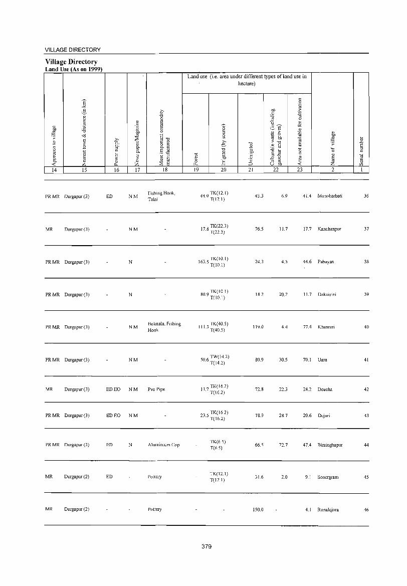
VILLAGE DIRECTORY
Village Directory Land Use (As on 1999)
6 -'" 5
<!)
" " J:l <!)
"' 00 '6 ::2 .;;: o::l
~ .9 ..c: .9 <.>
'" "' 2 ~ 0. c. <!)
<: z 14 15
PRMR Durgapur (3)
MR Durgapur (3)
PR MR Durgapur (3)
PR MR Durgapur (3)
PR MR Durgapur (3)
PRMR Durgapur (3)
MR Durgapur (3)
PRMR Durgapur (3)
PRMR Durgapur (3)
MR Durgapur (2)
MR Durgapur (2)
» 0. 0.
~ ~ <!)
;s: 0 c. 16
ED
ED EO
ED EO
ED
ED
<!)
" .~
~
~ <!)
0.
'" 0.
~ <!)
Z 17
NM
NM
N
N
NM
NM
NM
NM
N
p '6 0 S S 0
" §"<:i 1:: ~ o ;;;l 0._
§JS ;;;l
"' c 0 '" ~ S 18
Fishing Hook, Talai
Belmala, Fishing Hook
Pvc Pipe
Aluminium Cop
Pottery
Pottery
Land use (i.e. area under different types ofland use in hectare)
" 2 ;;;l
~ » e
"<:i <!)
t; <il e 00 0 ~. ~ 19 20
449 TK(12.1) · T(12.!)
17 8 TK(22.3) · T(22.3)
1635 TK(JO.I) · T(IO.I)
809 TK(IO I) · T(IO.I)
III 3 TK(40.5) · T(40.5)
506 TW(14.2) · T(14.2)
11 7 TK(16.2) · T(16.2)
235 TK(16.2) · T(16.2)
TK(6.5) T(65)
TK(12.1) T(12.1)
379
"<:i
~ 00
E C :J
21
43.3
76.5
24.3
18.2
119.0
80.9
72.8
78.9
66.5
31.6
150.0
" 0 .~
00 °b c '6 "3 ;:J (.)
u ~
2- "' <8
<!) <!)
E ;> ::0 <!)
~ ~ '" 00
~ ::2 ;s: "<:i 10 .;;: <!) " ::0 '" a '->-< e a 0
3 ..c: " <!)
" '" § "3 ;:J e '" U 00 <: z 22 23 2
6.9 41.4 Monoharbati
11.7 17.7 Kanchanpur
4.5 44.6 Pabayan
20.2 II. 7 Dakaisini
4.4 77.4 Khanrari
30.5 70.1 Uara
22.3 24.2 Deucha
28.7 20.6 Dejuri
72.7 47.4 Birsinghapur
2.0 9.1 Sonergram
4.1 Ronalejora
~ <!)
..0 S ;;;l
" ~ <!)
C/l
I
36
37
38
39
40
41
42
43
44
45
46
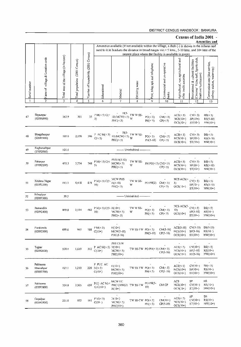
47
48
49
50
51
52
53
54
55
56
57
58
2
Shyampur
(02091800)
Bhagabanpur (02091900)
Raghunathpur (02092000)
Paharpur (02092100)
Krishna Nagar (02092200)
Bilmalpur (02092300)
Bamandihi (02092400)
I'urakonda (02092500)
Tajpur (02092600)
Pakhanna Bhairabpur (02092700)
Pakhanna (02092800)
GopaJpur (02092900)
3
163.9
105.0
101.6
425.3
443.1
59.5
809.8
499.6
539.4
427.1
324.8
231.0
C> C> l::!-
4
201
2,070
3,734
4,478
2,534
965
1,619
1,210
3,365
832
DISTRICT CENSUS HANDBOOK: BANKURA
Census of India 2001 -Amenities and
Amenities available (ifnot available within the village, a dash (-) is shown in the column and next to it in brackets the distance in broad ranges viz.< 5 kms., 5-10 kms. and 10+ kms of the
nearest place where the facility is available isgiven
C> C> l::!-'" '0
i o
..c '¢ ._ <1)
..0
§ Z 5 6 7 8
'" o p_.
9
- H(5-33 P M« 5) C« 10) MCW« 5) TW W SS-
5) PHC« 5) W ~~i:~;
- H(5-396 l' AC M« 5) 10) MCW« 5) TW W SS- PO« 5)
C« 5) PHC« 5) W PH(5-10)
-------- Uninhabited ------------
<1)
> .~
<1) 0.. o 6 " ]
OJ ·2
<1)
E '" ~§ U..o
10
CM« 5) CP« 5)
CM«5) CP« 5)
I' M« 5) C« PHS H(5-10) TW W SS-748 ';) MCW« 5) W PH PO« 5) CM« 5)
- I'HC« 5) CI'« 5)
MCWI'HS 879 l' M« 5) C(5- H(5-10)
10) PHC« S) :W W SS- PO PH(2) CM« 5)
CP« 5)
-------- Uninhabited ------------
482 P M« 5) C(5- H(IO+) 10) MCW«5)
PHC« 5)
:W W SS- 1'0« 5)
I'H«5) CM«5) CP«5)
II
ACS« 5) NCS(10+) OCS(IO+)
ACS«5) NCS(10+) OCS(IO+)
ACS« 5) NCS(10+) OCS(10+)
12
CV«5) SP(10+) ST(10+)
CV«5) SP(10+) ST(IO+)
CV«5) SP(1O+) ST(10+)
NCS ACS« CV(~ 5)
5) SI'(IO+) OCS(IO+) ST(IO+)
NCS ACS(5· CV(~ 5)
10) SP(5-10) OCS(IO+) ST(IO+)
13
BS« 5) RS(5-1O) NW(IO+)
BS«5) RS(5-10) NW(IO+)
BS« 5) RS(5-1O) NW(IO+)
BS« S) RS(5-10) NW(IO+)
BS«5) RS(IO+) NW(IO+)
188 PM«5) C(IO+)
H(IO+)
MCW(5-10) PHC(5-10)
TW SS-TW 1'0« 5) PH(5-10)
CM(5-10) ACS(5-10) CV(5-10) BS(5-10) CP(5-1O) NCS(lO+) SI'(5-10) RS(10+)
OCS(IO+) ST(10+) NW(IO+)
PHSCHW
312 P ACM«5) H(IO+) C(10+) MCW« 5)
PHC(IO+)
P PUC AC H(IO+) 220 M« 5) MCW« 5)
C(IO+) PHC(IO+)
TW SS-TW PO PH« 5) CM« 5) CP(5-10)
TW SS-TW PO« 5) PH«5)
CM«5) CP(5-10)
ACS« 5) NCS(IO+) OCS(10+)
ACS« 5) NCS(10+) OCS(IO+)
MCWHC 659 P(2) AC M« PHC CHW(2) TW SS-TW PO I'H(5- CM CP
S) C(IO+) H(IO+) 10)
ACS NCS(IO+) OCS(IO+)
161 F'M«5) C(IO+)
H(10+)
MCW«5) F'HC(IO+)
380
TW SS-TW PO« 5) PH«5)
CM(IO+) ACS« 5) CP(5-10) NCS(10+)
OCS(IO+)
CV(lO+) SP(5-10) ST(5-10)
CV(IO+) SI'(IO+) ST(IO+)
SP CV(IO+) ST(IO+)
SP CV(IO+) ST(IO+)
BS«5) RS(10+) NW(IO+)
BS«5) RS(IO+) NW(IO+)
BS RS(IO+) NW(IO+)
BS RS(IO+) NW(IO+)
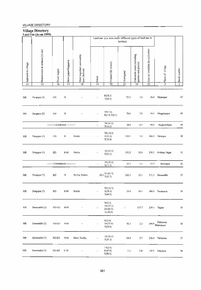
VILLAGE DIRECTORY
Village Directory Land Use (As on 1999)
E "'" g OJ 0 c tl OJ
E 'd ~ .;; ~ B
.c B 0
'" ~ '" OJ t;;
0- OJ
<C Z 14 15
MR Durgapur (2)
MR Durgapur (2)
ED
ED
.€
.", 0
OJ S c .~ S
0
~ 0
§~ ;>, ::s P- o::. 1:: OJ
OJ 8.3 0- 0-5l '" §& 0-
~ ~ 1;) ;l
§ 0 0 OJ ::s 0- Z S 16 17 18
N
N
-------- Uninhabited ------------
MR Durgapur (2) ED N Bricks
MR Durgapur (2) ED NM Bricks
-------- Uninhabited ------------
MR Durgapur (3) ED N Bricks, Pottery
MR Durgapur (3) ED NM Bricks
MR Sonemukhi (3) ED EO NM
MR Sonamukhi (3) ED EO NM
MR Sonamukhi (3) ED EO NM Black Smithy
MR Sonamukhi (3) ED EO NM
Land use (i.e. area under different types ofland use in
1;)
~ ~
19
" ~ ~ ;>, e
.", OJ
'" OJ)
~ 20
R(28.3) T(283)
TK(3.2) R(4.9)T(81)
TK(16.2) T(16.2)
TK(18.2) R(14.2) T(32.4)
TK(22.3) T(22.3)
TK(12.2) T(12.2)
202 TK(43.7) . T(437)
TK(16.2) R(28.3) T(44.5)
W(5.3) TK(27.1) 0(160.3) T(I92.6)
W(2.0) TK(22.6) T(24.6)
TK(20.2) T(20.2)
TK(2.0) R(87.0) T(89.0)
381
hectare)
.",
B '" OJ)
Of: .",
::::> 21
97.5
70.4
38.9
129.1
152.2
25.5
202.3
35.6
56.3
68.4
5.3
c 0 .~
OJ) ;> c ~ 'd ;l 0
0 .£ c~ ._ '" ~OJ OJ OJ ;> :g OJ
1;) e OJ)
'" OJ) ~ ,g ;;:.", OJ C t;; ;;
'" ::0 0 ""' ~.2 0 C OJ
'" _ 0
§ :; ;l
~ '" u OJ) z 22 23 2
1.6 36.4 Shyampur
2.0 24.4 Bhagabanpur
6.1 40.5 Raghunathpur
1.6 262.2 Paharpur
52.6 216.1 Krishna Nagar
4.1 17.7 Bilmalpur
12.1 531.3 Bamandihi
59.1 360.4 Purakonda
107.7 239.1 Tajpur
2.3 344.0 Pakhanna BhaIrabpur
9.7 226.4 Pakhanna
0.8 135.9 Gopalpur
.... OJ
..0 S ;l c 0; "5 C/l
1
47
48
49
50
51
52
53
54
55
56
57
58
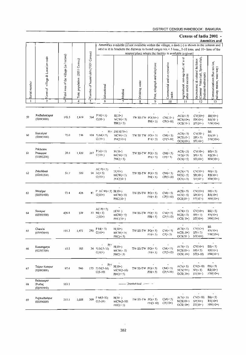
DISTRICT CENSUS HANDBOOK: BANKURA
Censlls of India 2001 -Amenities and
Amenities available (if not available within the village, a dash (-) is shown in the column and next to it in brackets the distance in broad ranges viz.< 5 kms., 5-10 kms. and 10+ kms of the
V> nearest place where the facility is available is given
I ~ '" 0: "'0 a3 ~~ "'0 ";i;' " 0 U 0: (.) " ::J '" " ..0: '" ;; " " e
'';::: () 0: 0: c > :.::: V'J (.) 0 g " 0 0 .~ 'u 1:: .~ ~ .~ u ~ -g_ 3 ~ 8. '" - :; " 8' (.)
~ V> <l) " ~ ~~s ~ ~ 0 0 0- (.)
-l 0 "'0 E 0 '§b ~ ~ -0 6 " " o'<l .;; ..0: "'0 '" ._ .!§] .2 ~'cil 0: " t: U C n> '" ::: " " ~ '" "'0 (.) 0 ...
:W .,s 0 ... @ o ._
~ ~ .g 0: 0:' tl '.g 0
~ ..0: t: g 0
"-< ..0: 0-'" .,>"§ .-§ 0 .D .;; 0 :; ...... ., e ., .~
§ '" 0- 0 t: ::: OIl .~ e .,!::: c -< (.)
"-< ~ 0 tl 0 OIl " ,,"'0
.$2 (;j 6 ·s 1;; 0: 0 0- .~
., 0: ] " .!:! e ::J >, ., " co ~
.D (.) :.;;; S V> " (.) 'cil S ::J S '" E § u '8 .S S'" .~ :u ~.S ~ E ::: '5 0 " V>
'" "'0 " 8] 0Il'<: 0;'::: Z f-< Z ::is is 0 ~ SU5 r:/l ~ P, -< 0 u e
1 2 3 4 5 6 7 8 9 10 11 12 13
59 RadbakantapuT
143.5 1,619 304 PM«5) H(10+)
TW SS-TW PO(JO+) CM(JO+) ACS« 5) CV(10+) BS(10+) (02093000) C(IO+) MCW«5) NCS(lO+) SP(IO+) RS(lO+)
PHC«5) PH« 5) CP(5-10)
OCS(IO+) ST(IO+) NW(IO+)
Kamalpur P« DH H(IO+) ACS« S) CV(10+)
8S 60 75.0 546 108 5)M«5) MCW«5) TW SS-TW PO« 5) CM«5) RS(IO+)
(02093100) C(lO+) PHC(IO+) PH« S) CP(5-10)
NCS(IO+) SP« 5) NW(IO+)
OCS(IO+) ST(IO+)
Pakhanna PM«S)
61 Pratappur 39.4 1,439 267 H(IO+)
TW SS-TW PO« 5) CM«5) ACS«_5) CV(IO+) 8S« 5)
(02093200) C(IO+) MCW«5)
PH«5) CP« 5) NCS« 5) SP« 5) RS(IO+)
PHC«5) OCS«5) ST(IO+) NW(IO+)
Palashbani ACP« 5)
H(IO+) ACS« 5) CV(IO+) BS« 5) 62 51.7 509 94 M«5) TW SS-TW PO« 5) CM«5)
(02093300) C(lO+)
MCW«5) PH«5) CP(5-1O)
NCS« 5) SP(IO+) RS(IO+) PHC(IO+) OCS« 5) ST(IO+) NW(IO+)
63 Shitalpur
73.4 426 81 P AC M« S) H(lO+)
TW SS-TW PO« 5) CM«5) ACS«5) CV(IO+) BS«5)
(02093400) C(JO+) MCW«5) PH«5) CP(5-10)
NCS«5) SP(IO+) RS(lO+) PHC(IO+) OCS(lO+) ST(JO+) NW(lO+)
Suratpur AC P« 5)
H(lO+) ACS« 5) CV(IO+) 8S«5) 64
(02093500) 426.8 159 32 M«5)
MCW«5) TW SS-TW PO« S) CM«S)
NCS« 5) SP«5) RS(IO+) C(10+)
PHC(JO+) PH«5) CP(5-IO)
OCS(10+) ST(IO+) NW(JO+)
ACS« 5) CV(IO+) 8S
65 Chandai
191.3 1,451 290 PM«5) H(IO+)
TW SS-TW PO« S) CM«5) RS(IO+) (02093600) C(J 0+) MCW«5)
PH«5) CP« 5) NCS(10+) SP« 5)
NW(IO+) PHC« 5) OCS(10+) ST(JO+)
Kusumgarya - P« -
ACS« 5) CV(IO+) BS« 5) 66 5S.S 185 34 5) M(S-IO) H(JO+) TW SS-TW PO« 5) CM«S)
(02093700) C(lO+) MCW« 5) PH«5) CP(5-IO) NCS(IO+) SP« 5) RS(JO+)
PHC« 5) OCS(lO+) ST(S-IO) NW(lO+)
T1\ipur Rampur - P« -
ACS«5) CV(5-10) 8S«5) 67 97.4 946 175 5) M(5-10) H(IO+) TW SS-TW PO« S) CM«5)
(02093800) C(5-10) MCW(5-IO) PH«5) CP(5-1O) NCS(IO+) SP«5) RS(IO+)
PHC« 5) OCS(IO+) ST(IO+) NW(IO+)
Balarampur 68 (Purba) 163.1 -------- Uninhabited ------------
(02093900)
Raj madhabpur 1,688 309 P'M(5-10) H(IO+)
TW SS-TW PO« 5) CM« 5) ACS« 5) CV(5-10) 8S«5)
69 (02094000)
232.S C(S-IO) MCW(5-1O) NCS(lO+) SP(IO+) RS(IO+)
PHC« 5) PH(5-10) CP(IO+)
OCS(IO+) ST(IO+) NW(IO+)
382
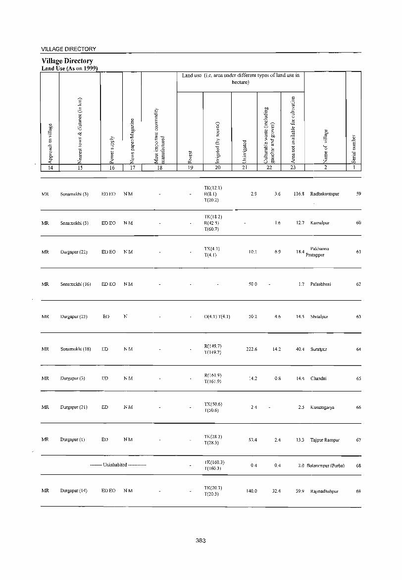
VILLAGE DIRECTORY
Village Directory Land Use (As on 1999)
~ " z
14 15
MR Sonamukhi (3)
MR Sonamukhi (3)
MR Durgapur (22)
MR Sonamukhi (16)
MR Durgapur (23)
MR Sonamukhi (IS)
MR Durgapur (3)
MR Durgapur (21)
MR Durgapur (1)
16 17
ED EO NM
ED EO NM
ED EO NM
ED EO NM
EO N
ED NM
ED NM
ED NM
ED NM
-------- Uninhabited ------------
MR Durgapur (14) ED EO NM
18
Land use (i.e. area under different types ofland use in hectare)
19 20
TK(12.1)
R(S.I) T(20.2)
TK(IS.2)
R(42.5) T(60.7)
TK(4.1)
T(4.1)
O(4.1)T(4.1)
R(149.7)
T(l49.7)
R(161.9) T(16J.9)
TK(50.6)
T(50.6)
TK(2S.3) T(2S.3)
TK(160.3)
T(l60.3)
TK(20.3) T(20.3)
383
21 22
2.9
10.1
50.0
50.2
222.6
14.2
2.4
53.4
0.4
140.0
23 2
3.6 116.S Radhakantapur
1.6 12.7 Kamalpur
6.9 IS.4 Pakhanna Pratappur
1. 7 Pal ash bani
4.6 14.5 Shitalpur
14.2 40.4 Suratpur
O.S 14.4 Chandai
2.5 Kusumgarya
2.4 13.3 Tajpur Rampur
0.4 2.0 Balarampur (Purba)
32.4 39.9 Rajmadhabpur
59
60
61
62
63
64
65
66
67
6S
69
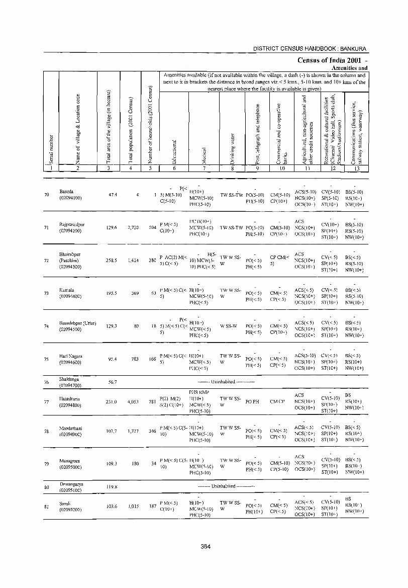
70
71
72
73
74
75
76
77
2
Basuda (02094100)
Rajprasadpur (02094200)
Bhairabpur (Paschim) (02094300)
Kamala (02094400)
Basudebpur (Uttar) (02094500)
Hari Nagara (02094600)
Shaldanga (02094700)
Hatashuria (02094800)
3
47.4
129.6
258.5
195.5
129.3
95.4
56.7
231.0
o o ~
'" o .~
:; "o 0-
~ 4
4
2,720
1,424
369
80
783
4,053
DISTRICT CENSUS HANDBOOK: BANKURA
Census of India 2001 -Amenities and
Amenities available (if not available within the village, a dash (-) is shown in the column and next to it in brackets the distance in broad ranges viz.< 5 kms., 5-10 kms. and 10+ kms of the
nearest place where the facility is available is given
o o ~
'" '0 (3
il ::l o
..<:
""" o ... " .D
§ ;z; 5 6 7
- P« -5) M(5-1O) H(lO+) C(5-10) MCW(5-IO)
PHC(5-1O)
504 PM«5) C(lO+)
HC H(lO+)
MCW(S-IO)
PHC(10+)
8 9
TW SS-TW PO(5-1O)
PH(5-1O)
TW SS-TW PO(5-IO)
PH(5-IO)
- H(5-280 P AC(2) M« 10) MCW(5- TW W SS- PO« 5)
5) C« 5) 10) PHC« 5) W PH« 5)
63 P M« 5) C« H(10+) 5) MCW(S-10)
PHC«5)
- P« -
18 5) M« 5) C« ~~~l< 5)
5) PHC« 5)
166 P M« 5) C« H(IO+) 5) MCW«5)
PHC« 5)
TWWSS-W PO«5)
PH«5)
WSS-W PO«5)
PH«5)
::' W SS- PO« 5)
PH«5)
-------- Uninhabited ------------
10 11 12 13
CM(5-10) ACS(5-10) CV(5-10) BS(5-10) CP(lO+) NCS(IO+) SP(S-IO) RS(10+)
OCS(10+) ST(IO+) NW(lO+)
ACS
CM(5-10) NCS(lO+)
CP(IO+) OCS(IO+)
ACS CP CM« NCS(10+)
5) OCS(IO+)
CM«5)
CP«5)
CM«5) CP(IO+)
ACS« 5) NCS(10+)
OCS(IO+)
ACS« 5) NCS(lO+)
OCS(IO+)
CV(IO+)
SP(lO+)
ST(lO+)
CV«.5) SP(IO+)
ST(I()+)
CV«5) SP(10+)
ST(lO+)
CV«5) SP(10+)
ST(lO+)
CM«5)
CP«5)
ACS(5-10) CV« 5)
NCS(IO+) SP(lO+)
OCS(IO+) ST(IO+)
BS(5-10)
RS(5-10) NW(lO+)
BS« 5) RS(5-1O)
NW(IO+)
BS« 5) RS(5-10)
NW(IO+)
BS«5) RS(lO+)
NW(IO+)
BS« 5) RS(IO+)
NW(IO+)
PHS RMP ACS BS H(IO+) TW W SS- PO PH CM CP NCS(IO+) CV(5-10) RS(IO+) 781 P(2) M(2)
S(2) C(IO+) MCW« 5) W OCS(1O+) SP(lO+) NW(10+) ______________________ P....:H~C.:.;(5_-1..:..0);___ _______________ ST(IO~_,;.) ___ _
78
79
80
81
Mandarbani (02094900)
Managram (02095000)
Dewangarya (02095100)
Sarali (02095200)
102.7 1,727
109.3 180
119.8
103.6 1,015
346 I'M«5)C(5- H(IO+) 10) MCW(S-IO)
PHC(5-10)
34 P M« 5) C(5- H(10+) 10) MCW(S-IO)
PHC(5-1O)
:W W SS- PO« 5)
PH«5)
::'WSS- PO«5)
PH«5)
-------- Uninhabited ------------
187 PM«5) C(1O+)
H(lO+) MCW(S-IO)
I'HC(5-10)
384
:W W SS- PO« 5)
PH(lO+)
CM« 5)
CP«5)
ACS«5) NCS(IO+)
OCS(IO+)
ACS
CM(5-10) NCS(IO+)
CP(5-10) OCS(IO+)
CM« 5) CP«5)
ACS«5) NCS(IO+) OCS(IO+)
CV(5-IO) BS« 5) SI'(\O+) RS(IO+) ST(lO+) NW(1O+)
CV(5-10) BS«5) SI'(IO+) RS(IO+)
ST(lO+) NW(IO+)
CV(5-10) ~~(10+) SP(IO+) NW(lO+) ST(lO+)
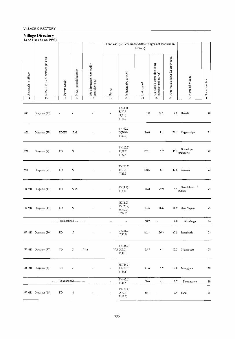
VILLAGE DIRECTORY
Village Directory Land Use (As on 1999)
14 15
MR Durgapur (15)
MR Durgapur (IS)
MR Durgapur (9)
MR Durgapur (9)
PR MR Durgapur (14)
PR MR Durgapur (14)
16 17
ED EO NM
ED N
ED N
ED NM
ED N
-------- Uninhabited ------------
PR MR Durgapur (16) ED N
PR MR Durgapur (17) ED N Rice
PR MR Durgapur (3) ED
-------- Uninhabited ------------
PR MR Durgapur (16) ED N
18
Land use (i.e. area under different types ofJand use in hectare)
19 20
TK(2.4) R(12.8) 0(2.0) T(I7.2)
TK(60.7) 0(20.0) T(SO.7)
TK(20.2) R(20.2) T(40.5)
TK(26.3) R(2.0) T(283)
TK(SI) T(S.I)
GC(2.0) TK(20.2) WF(2.0) T(24.2)
TK(35.0) T(35.0)
TK(24.3) 30.4 0(6.0)
T(30.3)
GC(26.3) TK(lS.3) T(44.6)
TK(42.5) T(425)
TK(IO.1) 0(2.0) T(l2.1)
385
21 22
1.8
16.0
167.1
118.6
16.S
33.6
50.7
112.1
25.S
41.6
60.6
89.1
23
24.3
8.5
5.7
6.1
97.9
18.6
26.7
4.1
3.2
4.1
2
4.1 Basuda
24.3 Rajprasadpur
45 2 Bhairabpur . (Paschim)
42.6 Kamala
6 5 Basudebpur . (Uttar)
IS.9 Hari Nagara
6.0 Sha1danga
57.3 Hatashuria
12.2 Ivlandarbani
19.8 Managram
12.7 Dewangarya
2.4 Sarali
70
71
72
73
74
75
76
77
7S
79
80
SI
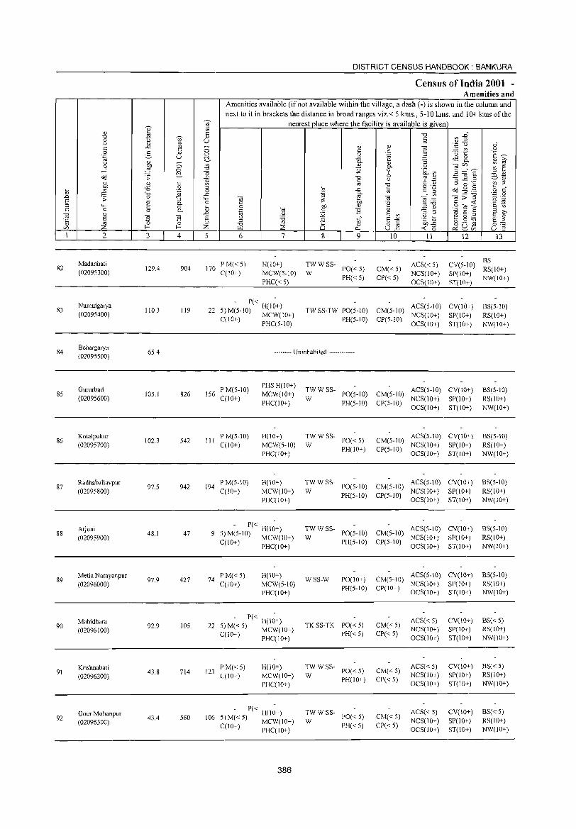
DISTRICT CENSUS HANDBOOK: BANKURA
Census of India 2001 -Amenities and
Amenities available (if not available within the village, a dash (-) is shown in the column and next to it in brackets the distance in broad ranges viz.< 5 kms., 5-10 kms. and 10+ kms of the
~
nearest place where the facility is available is given '" ~ :l
" <l) '" l'l c -0 ~ :2~ -0 'Vi' " 0 u U c
u " ~ oj
'.0 Q oS C ..c C 8 " " ~
;.:::: CIl u C > .~ 2- " 0 0 .~ '" 1:: E~ U ~ ..c ~ 8- " ~ <l) 0- :J " 0 '" <l)
<l) tOC/] ~ ~ 0 l 0- u
..J 0 -0 E 0 .~ ~ 3 ~"e '0 ::> " ~ 6 o=,~ Od '> ..c -0 oj .- 3 ~.2 ~ oj
" c u = d) '" :;; §J " c '" oj -0 u 0 '"' £ 0 ::> li3 c 0'-~ ..g . .§ c "
'"' ~ '"§ 0 ..c oj c g o c " '- ..c 1il 0- - '" to;;"g '.;::J 0
..0 '> 0 :J '- to :;; ~ to oj ~ oj .-
E oj 0- 0 c '2 5~ c ..,:; .~ ~ ::> '- <l)
0 '"' 0 on " S co S c '" c 0 t<i 0- <l) '.g to c ] <l) .=:: e ::> :>,
to " ..0 " ;.Q E '" ::l " 1il E ::> E ~
~ ~ "§ E u '0 c c "" .g ti t5.s ~ '5 :l '" 8:-;:: ~
::> -0 " 8 - c on..c Z Z ::E 0 o oj ~ 2, (/) C/] ~ 0.. U..o "':;0 U E!
1 2 3 4 5 6 7 8 9 10 11 12 13
Madanhati PM«S) H(lO+) TWWSS- ACS« 5) CV(5-10) BS
82 129.4 904 170 PO«S) CM«S) RS(10+) (0209S300) C(10+) MCW(S-IO) W NCS(lO+) SP(IO+) PHC« 5)
PH«S) CP«S) OCS(IO+) ST(IO+)
NW(IO+)
Numuigarya - P« -
ACS(S-IO) CV(lO+) BS(S-IO) 83 110.3 119 22
H(IO+) TW SS-TW PO(5-10) CM(S-IO) S)M(S-IO) MCW(10+) (02095400)
C(lO+) PHC(5-10) PH(S-IO) CP(5-lO) NCS(lO+) SP(lO+) RS(IO+) OCS(lO+) ST(lO+) NW(lO+)
84 Behargarya
6S.4 -------- Uninhabited ------------(02095500)
Gururbad PM(5-10) PHS H(lO+)
TWWSS- ACS(5-10) CV(IO+) BS(5-10) 8S
(02095600) 10S.1 826 IS6
C(10+) MCW(IO+)
W PO(S-IO) CM(S-10)
NCS(lO+) SP(lO+) RS(IO+) PHC(lO+) PH(S-IO) CP(S-IO)
OCS(lO+) ST(IO+) NW(IO+)
86 Kotalpukur
102.3 S42 III PM(S-IO) H(IO+) TWWSS-
PO«S) CM(S-IO) ACS(5-10) CV(IO+) BS(5-10)
(02095700) C(IO+) MCW(S-IO) W PH(!o+) CP(5-10)
NCS(IO+) SP(IO+) RS(IO+) PHC(IO+) OCS(IO+) ST(IO+) NW(IO+)
87 Radhaballavpur
97.S 942 194 II'M(5-10) H(IO+) TWWSS-
PO(S-IO) CM(S-IO) ACS(5-10) CV(IO+) BS(5-10)
(0209S800) C(lO+) MCW(IO+) W PH(S-IO) CP(5-1O)
NCS(IO+) SP(IO+) RS(lO+)
PHC(IO+) OCS(IO+) ST(IO+) NW(IO+)
88 Arjuni
48.1 47 9 ,. - P« H(I~+) TWWSS-
PO(S-IO) CM(S-10) ACS(S-10) CV(IO+) BS(5-1O)
(02095900) J) M(5-10) MCW(IO+) W PH(S-IO) CP(S-IO)
NCS(IO+) SP(IO+) RS(lO+) C(10+) PHC(IO+) OCS(IO+) ST(IO+) NW(IO+)
89 Metia Narayanpur
97.9 427 74 PM«S) H(IO+)
WSS-W PO(IO+) CM(S-IO) ACS(5-10) CV(IO+) BS(S-IO)
(02096000) C(10+) MCW(5-10) PH(5-10) CP(IO+)
NCS(IO+) SP(10+) RS(!O+)
PHC(lO+) OCS(IO+) ST(IO+) NW(10+)
90 Mahidhara
92.9 105 22 - P« H(I~+)
TK SS-TK PO«5) CM«S) ACS« 5) CV(IO+) BS« 5)
(02096100) 5) M« 5) MCW(10+) PH«S) CP«S)
NCS(lO+) SP(IO+) RS(lO+) C(1O+) PHC(IO+) OCS(IO+) ST(IO+) NW(IO+)
Krishnabati PM«S) H(lO+) TWWSS-PO«S) CM«S)
ACS« 5) CV(IO+) BS« 5) 91
(02096200) 43.8 714 123
C(lO+) MCW(10+) W NCS(10+) SP(IO+) RS(IO+)
PHC(IO+) PH(IO+) CP« 5)
OCS(IO+) ST(IO+) NW(lO+)
Gour Mohanpur - P« H(I~+) TWWSS-PO«5) CM«5)
ACS«S) CV(IO+) BS« 5) 92
(02096300) 43.4 S60 106 S) M« S) MCW(IO+) W NCS(IO+) SP(IO+) RS(IO+)
C(lO+) PHC(IO+) PH«S) CP« S) OCS(10+) ST(IO+) NW(IO+)
386
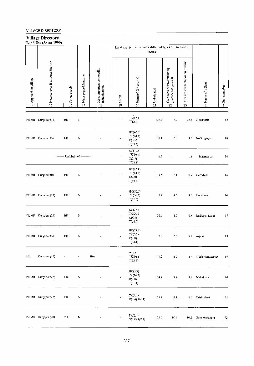
VILLAGE DIRECTORY
Village Directory Land Use (As on 1999)
14 15
PR MR Durgapur (16)
PR MR Durgapur (3)
16 17
ED N
ED N
-------- Uninhabited ------------
PR MR Durgapur (0) ED N
PR MR Durgapur (22) ED N
PR MR Durgapur (23) ED N
PR MR Durgapur (3) ED N
MR Durgapur ( I 7) Biri
PR MR Durgapur (22) ED N
PR MR Durgapur (22) ED N
PR MR Durgapur (20) ED N
18
Land use (i.e. area under different types ofland use in hectare)
19 20
TK(121) T(12.1)
GC(40.5) TK(202) 0(3.5) T(64.2)
GC(3004) TK(30.4) 0(2.5) T(63.2)
GC(43.4) TK(18.2) 0(3.0) T(64.6)
GC(50.6) TK(34.4) T(85.0)
GC(385) TK(20 2)
0(6.3) T(64.9)
GC(27.1)
TK(5.3) 0(2.0) T(34.4)
W(2.5) TK(IO.I) T(12.6)
GC(5.3)
TK(14.2) 0(2.0) T(21.4)
TK(4.1) 0(2.4) T(604)
TK(6.1) 0(2.0) T(S.I)
387
21 22
100.4
30.1
0.7
37.5
3.2
30.6
2.9
77.2
54.7
23.2
15.0
23 2
3.2 13.6 Madanhati
2.0 14.0 Numuigarya
104 Behargarya
2.1 0.9 Gururbad
4.5 9.6 Kotalpukur
1.2 0.8 Radhaballavpur
2.0 8.9 Arjuni
4.9 3.2 Metia Narayanpur
9.7 7.1 Mahidhara
8.1 6.1 Krishnabati
10.1 10.2 Gour Mohanpur
82
83
84
85
86
87
88
89
90
91
92
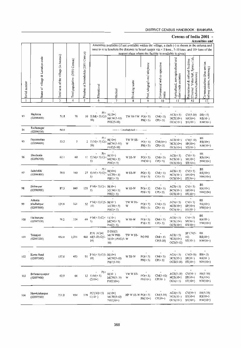
DISTRICT CENSUS HANDBOOK: BANKURA
Census of India 2001 -Amenities and
Amenities available (if not available within the village, a dash (-) is shown in the column and next to it in brackets the distance in broad ranges viz.< 5 krns., 5-10 kms. and 10+ krns of the
-;;;- nearest place where the facility is available isgiven ;;l
" ~ on c: -0 CI)~ -0 -;;;- " 0 ()
~ u 1ii Q) --(J " ''':::' {) Q)"
c: ..c t: - " Q)
~ ~ til (J 0 c: ,.
0 :3 " 0 0 .~ '0 1:: 'E ~ .~ u f::!.. ..c ~ 8. " 8"-(J " - on 0-
" "3 03C/l ~ ~ 0 tlJ) 0 " 0- (J
....l ,g 0 -0 ] 0 .~ ~ 3 ::..:'E f::!.. '0 6 ;;l " c<J .;; ..c -0 '? '.z:j ~.!~ .~ f3_~
Q) § (,)
on :;:: " " c: on -0 c: " (J 0 ... tlJ) .,s 0 ;;l ... c:
o ._ Od ~J .8 c:
"f .... ,g '"§ 0 " ..c to c: g -0 ._ 0 Q) "'" ..c
~ 0- '" 03;;"§ .~ .S .0 .;; 0 "3 "'" 03 ~ 03 ""§:g "' 6 to 0- 0 c: '2 c: -< (,)
;;l "'" " 0 ... 0 tlJ) Q)
.2 " .S co ~ '2 1;; c: 0 t;J 0- " '~ 03 '" ] " ::s t)
"' 6 ;;l ,..,
03 " .0 (,) :.g 6 '" 6 ~ ] ~ 6 (J .g ~ ~ ~ ~ ·c § ;;l 'i3 .6 1;;" 6'" 13::= " 0 ;;l -0 Q)
Q 0 o c: tlJ)..c: g (.) .s C/) z I-< I-< Z ~ :;s 0... ull -< 0 ~ ~C/) u e 1 2 3 4 5 6 7 8 9 10 II 12 13
Naykona - P« -
ACS« 5) CV(5 .. 1O) BS« 5) 93 51.8 76 10 5) M« 5) C(5. H(IO+) TW SS-TW PO« 5) CM«5) (02096400) 10) MCW(5-1O) PH«5) CP«5)
NCS(ID+) SP(ID+) RS(IO+) PHC(5-1O) OCS(IO+) ST(10+) NW(IO+)
94 Radhanagar
64.0 -------- Uninhabited ------------(02096500)
Payermohan - P« -
TWW SS- ACS(IO+) CV(5-10) BS
95 53.2 5 2 H(IO+)
PO« 5) CM(IO+) RS(IO+) (02096600) 5) M« 5) C(5' MCW(5_10) W NCS(IO+) SP(10+) 10) PHC(5-1O) PH«5) CP«5)
OCS(10+) ST(IO+) NW(10+)
Shushunia - P« -
ACS«5) CV«5) BS
96 62.1 68 II :5) M« 5) C« H(IO+) WSS-W PO«5) CM«5) RS(IO+) (02096700) 'i) MCW«5) PH(10+) CP« 5)
NCS(10+) SP(IO+) NW(10+)
. PHC« 5) OCS(IO+) ST(IO+)
Sahebdihi - P« -
ACS« 5) CV« 5) BS
97 79.0 140 27 :5) M« 5) C« H(lO+) WSS-W PO«5) CM«5) RS(lO+) (02096800) ._) MCW«5)
PH« 5) CP«5) NCS(IO+) SP(IO+)
NW(lO+) ,) PHC«5) OCS(IO+) ST(IO+)
Bishanpur P M« 5) C« H(lO+) ACS«5) CV«5) BS
98 87.3 840 135 WSS-W PO«5) CM«5) RS(IO+) (02096900) 5) MCW«5)
PH«5) CP«5) NCS(10+) SP(10+)
NW(10+) PHC«5) OCS(lO+) ST(IO+)
Ashuria P M« 5) C(5- H(lO+) TWWSS- ACS« 5) CV« 5)
BS 99 Madhabpur 124.6 321 52 PO«5) CM«5) RS(IO+)
(02097000) 110) MCW«5) W
PH«5) CP« 5) NCS(IO+) SP(IO+)
NW(IO+) PHC« 5) OCS(IO+) ST(IO+)
Harirampur PM« 5)C« H(IO+) ACS« 5) CV«5) BS
100 79.2 329 69 WSS-W PO«5) CM«5) RS(10+) (02097100) 5) MCW«5)
PH«5) CP« 5) NCS(IO+) SP(IO+)
NW(IO+) PHC«5) OCS(IO+) ST(IO+)
1'(4) AC(4) DDH(2)
SPCV(5- BS
101 Talanjuri
452.0 2,371 460 M(5-10) C(5-MCWPHS TWWSS-
PO PH CM«5) ACS« 5)
10) RS(IO+) (02097200)
10) H(IO+) PHC(5· W
CP(5-10) NCS(IO+)
ST(IO+) NW(IO+) 10) OCS(5-10)
102 KantaBand
157.6 493 91 P M« 5) C(5- H(10+)
WSS-W PO«5) CM«5) ACS«5) CV(5-10) BS« 5)
(02097300) 10) MCW(5-10) PH«5) CI'« 5)
NCS(IO+) SP(lO+) RS(IO+)
PHC(5-10) OCS(5-10) ST(10+) NW(IO+)
Belianarayanpur - P« -
TWWSS- ACS(5-10) CV(IO+) BS(5-10) 62.9 66 12
H(IO+) PO«5) CM(5-IO) 103
(02097400) 5) M« 5) MCW(5-IO) W NCS(IO+) SP(IO+) RS(IO+) ecIO+) PHC(10+) PH(IO+) CP(IO+)
OCS« 5) ST(lO+) NW(IO+)
Harekrishnapur 231.0 954 178
P(3) M« 5) H(10+) HP W SS-W PO« 5) CM(5-10)
ACS«5) CV(IO+) BS(5-1O) 104
(02097500) C(10+) MCW(5-10) NCS(10+) SP(IO+) RS(IO+)
PHC(IO+) PH(IO+) CP(10+)
OCS(IO+) ST(IO+) NW(IO+)
388
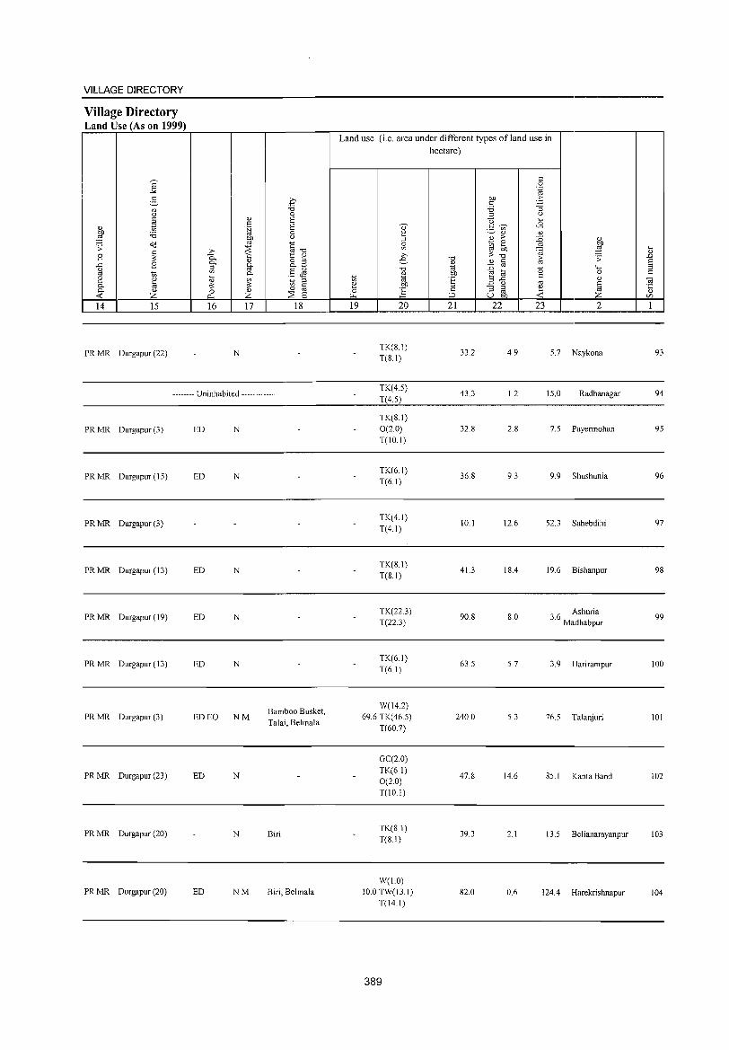
VILLAGE DIRECTORY
Village Directory Land Use (As on 1999)
14 15
PR MR Durgapur (22)
16 17 18
N
-------- Uninhabited ------------
PR MR Durgapur (3)
PR MR Durgapur (15)
PR MR Durgapur (3)
PR MR Durgapur (13)
PR MR Durgapur (19)
PR MR Durgapur (13)
PR MR Durgapur (3)
PR MR Durgapur (23)
PR MR Durgapur (20)
PR MR Durgapur (20)
ED N
ED N
ED N
ED N
ED N
ED EO NM
ED N
N
ED NM
Bamboo Busket, Talai, Belmala
Biri
Biri, Belmala
Land use (i.e. area under different types ofland use in hectare)
19 20
TK(S.l) T(S.l)
TK(4.5)
T(4.5)
TK(S.l) 0(2.0) T(IO.l)
TK(6.1) T(6.1)
TK(4.1)
T(4.1)
TK(S.l) T(S.I)
TK(22.3) T(22.3)
TK(6.1) T(6.1)
W(14.2) 69.6 TK(46.5)
T(60.7)
GC(2.0)
TK(6.1) 0(2.0)
T(lO.I)
TK(SI) T(S.l)
W(1.0) 10.0 TW(13.1)
T(14 I)
389
21 22
33.2
43.3
32.S
36.S
10.1
41.3
90.S
63.5
240.0
47.S
39.3
S2.0
23 2
4.9 5.7 Naykona
1.2 15.0 Radhanagar
2.S 7.5 Payennohan
9.3 9.9 Shushunia
12.6 52.3 Sahebdihi
IS.4 19.6 Bishanpur
S.O 36 Ashuria . Madhabpur
5.7 3.9 Harirampur
5.3 76.5 Talanjuri
14.6 85.1 Kanta Band
2.1 13.5 Belianarayanpur
0.6 124.4 Harekrishnapur
... " .D
§ C
93
94
95
96
97
9S
99
100
101
102
103
104
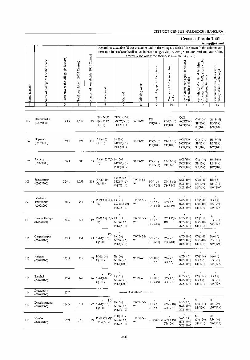
105
106
107
108
109
110
2
Dadhimukha (02097600)
Gopkande (02097700)
Purunia (02097800)
Sangrampur (02097900)
Lakshminarayanpur (02098000)
Bahara Khuliya (02098100)
3 4
143.7 1,437
169.6 628
106.4 509
324.1 1,057
68.3 241
134.4 728
DISTRICT CENSUS HANDBOOK: BANKURA
Census of India 2001 -Amenities and
Amenities available (if not available within the village, a dash (-) is shown in the column and next to it in brackets the distance in broad ranges viz.< 5 kms., 5-10 kms. and 10+ kms of the
nearest place where the facility is available is given
5 6
P(2) M(2) 302 S(2) PUC
C(lO+)
115 P M« 5) C(10+)
7
PHS H(10+) MCW(5-10) PHC(IO+)
H(IO+)
MCW«5) PHC(IO+)
77 P M« 5) C(5- H(10+) 10) MCW«5)
PHC(10+)
8
WSS-W
WSS-W
WSS-W
'" o 0...
9
PO PH(IO+)
10 11
OCS CM(5-1O) ACS(IO+) CP(IO+) NCS(IO+)
PO(5-10) CM(5-10) ACS(lD+) PH(IO+) CP(lO+) NCS(lO+)
OCS(IO+)
PO« 5) CM(5-10) ACS(IO+) PH(5-10) CP(10+) NCS(IO+)
OCS(IO+)
206 P M(5-10) C(5-10)
CHWH(5-10) TWWSS- ACS(10) MCW« 5) PO« 5) CM(5-1O) + PHC(5-10) W PH(5-1O) CP(5-10) NCS(IO+)
OCS(IO+)
42 IP M« 5) C(5- H(IO+) 10) MCW(5-10)
PHC(5-1O)
~W W SS- PO« 5) CM« 5)
PH(5-lO) CP(5-10)
ACS(lO+) NCS(lO+) OCS(IO+)
12
CV(lO+) SP(10+) ST(lO+)
CV(IO+) SP(IO+) ST(10+)
CV(IO+) SP(IO+) ST(IO+)
13
BS(5-1O) RS(IO+) NW(IO+)
BS(5-10) RS(IO+) NW(IO+)
BS(5-10) RS(10+) NW(IO+)
CV(5-10) BS« 5) SP( 10+) RS(I 0+) ST(IO+) NW(IO+)
CV(5-10) BS« 5) SP(5-10) RS(lO+) ST(IO+) NW(lO+)
112 IP M« 5) C(5- H(IO+) ;:' W SS- PO« 5) CM CP(5- ACS(IO+) CV(5-10) :~(IO+) 10) MCW« 5) PH(5-10) 10) NCS(IO+) SP(5-10) NW(IO+)
__________________________________________ P_H_c~(5_-1_0~) ________________________ 0_C_S~(l_O+~)_.ST(lO+.~) ________ _
III
112
113
114
115
116
Gangadbarpur (02098200)
Kalpaini (02098300)
Banshol (02098400)
Dharampur (02098500)
Dhwajamanipur (02098600)
Nirisha (02098700)
133.3 134
162.9 235
87.6 146
67.7
104.3 517
167.9 1,050
.- - P« H(I~+) 28 ;~ M(5-10) MCW« 5)
~(5-10) PHC(5-10)
39 P M(IO+) C(10+)
H(ID+) MCW«5) PHC(IO+)
- P« H(I~+) 26 5) M(lO+) MCW« 5)
C(l 0+) PHC( 10+)
TW W SS- PO« 5) CM« 5) ACS(IO+)
W PH(5-10) CP(5-lO) NCS(lO+) OCS(10+)
WSS-W
WSS-W
PO(10+) PH« 5)
CM«5) CP«5)
PO(IO+) CM« 5) PH(5-10) CP(IO+)
ACS«5) NCS(lO+) OCS(IO+)
ACS«5) NCS(IO+) OCS(IO+)
-------- Uninhabited ------------
,_ - P« H(I~+) 97 ;~ M(5-10) MCW« 5)
~(5-1O) PHC(5-10)
) D H(lO+) 189 J AC(2) M(5- MCW« 5)
10) C(5-1O) PHC(5-1O)
390
~W W SS- PO« 5)
PH«5)
ACS« 5) CM(5-10) NCS(IO+) CP(l 0+ ) OCS(l 0+)
TW W SS- ACS« 5) W PH PO« 5) CM(5-10) NCS(IO+)
CP(10+) OCS(lO+)
CV(5-IO) BS« 5) SP(5-10) RS(10+) ST(IO+) NW(IO+)
CV(IO+) SP« 5) ST(lO+)
CV(IO+) SP«5) ST(lO+)
SP CV(lO+) ST(IO+)
SP CV(lO+) ST(IO+)
BS«5) RS(IO+) NW(lO+)
BS«5) RS(lO+) NW(10+)
BS RS(lO+) NW(10+)
BS RS(10+) NW(10+)
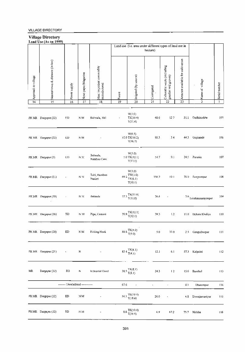
VILLAGE DIRECTORY
Village Directory Land Use (As on 1999)
14 15
PR MR Durgapur (22)
PR MR Durgapur (22)
PR MR Durgapur (3)
PR MR Durgapur (21)
PR MR Durgapur (19)
PR MR Durgapur (16)
PR MR Durgapur (20)
PR MR Durgapur (21)
MR Durgapur (22)
ED
ED
ED
ED
ED
EO
16 17
NM
NM
NM
NM
NM
NM
NM
N
N
18
Belmala, Biri
Belmala, Bamboo Cane
Tabi, Bamboo Busket
Belmala
Pipe, Cement
Fishing Hook
Industrial Good
-------- Uninhabited ------------
PRMR Durgapur (22) ED NM
PRMR Durgapur (22) ED NM
Landuse (i.e. area under different types of land use in hectare)
19 20
W(1.0) TK(30.4) T(3l.4)
W(0.5) 10.0 TK(l6.2)
T(16.7)
W(1.0) 5.0 TK(l2.1)
T(l3.1)
W(l.O)
692 TW(3.0) · TK(61)
T(IO.I)
173 TK(l1.0) · T(ll.O)
708 TK(12.1) · T(12.1)
888 TK(4.0) · T(4.0)
834 TK(4.1) · T(4.1)
085 TK(S.J) ~ . T(S.I)
67.6
54 I TK(19.4) · T(l9.4)
OS TK(19.4) · T(19.4)
391
21 22
48.6
95.3
54.7
156.7
36.4
39.3
5.0
12.1
24.3
26.0
4.9
23 2
12.7 51.1 Dadhim ukha
3.4 44.3 Gopkande
9.1 24.5 Purunia
10.1 78.0 Sangrampur
3.6 Lakshminarayanpur
1.2 11.0 Bahara Khuliya
33.0 2.5 Gangadharpur
6.1 57.3 Kalpaini
1.2 15.6 Banshol
0.1 Dharampur
4.S Dhwajamanipur
67.2 75.7 Nirisha
105
106
107
108
109
110
III
112
113
114
115
116
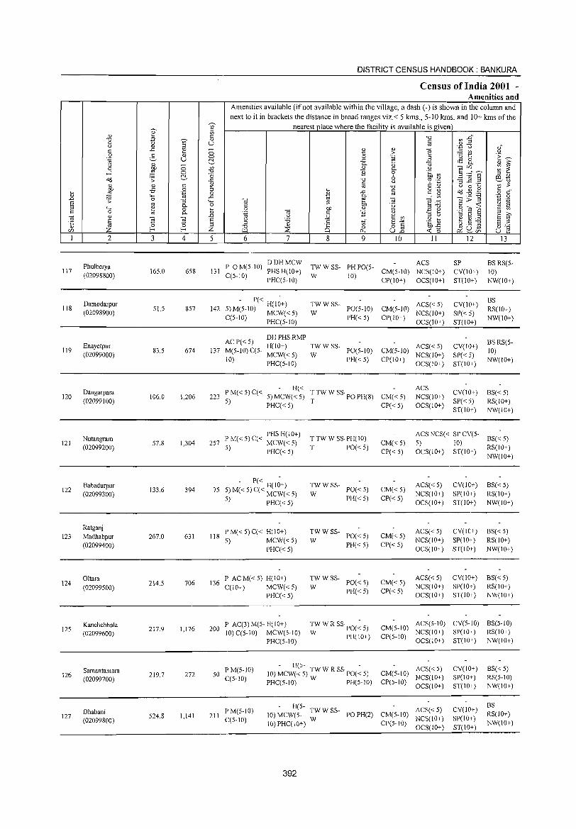
DISTRICT CENSUS HANDBOOK: BANKURA
Census of India 2001 -Amenities and
Amenities available (if not available within the village, a dash (-) is shown in the column and next to it in brackets the distance in broad ranges viz.< 5 kms., 5-10 krns. and 10+ kms of the
~
nearest place where the facility is available isgiven ~
U)
::l
" " '" ~
c: "=' U'l.g" "=' ';)' " § 0 U .~ '0 " " ::l OJ" ..c: '" " " 1 c: c: 0 - '" " 0 2- " c: >
'" 1:: 'E ~ 0 0 .~ .~ U ~ ..c: tS 8. " P- " ~ " 0 on " " ~ ~~" s ~ ~ 0 ~ P- " ....l 0 'T:l "2 0 'i .~ ~ -0 " ::l "
c<l ;; -0 ~ oj e:."E ..c:
" ;; .C: .2 ~ c: ~ ~ on ;;:
" " c: '" -0 " 0 ... on -5 0 ::l ... c: o ._
a(j ~~ .g c: " ~ ~ 'ia 0
* ..c: co ~~ ~ o c:
4-< ..c: P- cti ~; -g '';:: 0 .D .;; 0 ;; 4-< '" ;;: e '" ~ .:::
co ._ S co P- o " on '2 ;:;"=' §:(O :'S '2 ~ ::l 4-< ~ 0 ... 0 on " c: 0 P- " '-g '" " "2 " ~ ~ ._ S E ~ ~ " .D " ;.Q S '" ::l " " S ::l
~ ] ] S " 'B " Vi S-'" .~ ] ~ ~ ~ S ;;: ;:;
" 0 ~ ;:;
'T:l " 8 0 o c: ~o ~ C) g 0:-;::
Ul t- Z P-l ::E p., u2 ~ ,~Ul u e 1 2 3 4 5 6 7 8 9 10 II 12 13
Phulberya P 0 M(5-lO) DDHMCW
TWWSS- PH PO(5-ACS SP BS RS(5-
117 165.0 658 131 PHS H(lO+) CM(5-l0) NCS(10+) CV(10+) 10) (02098800) C(5-10) W 10) PHC(5-10) CP(10+) OCS(10+) ST(IO+) NW(lO+)
Damodarpur - P« H(l~+) TWWSS- ACS« 5) CV(IO+) BS
118 51.5 857 142 5) M(5-lO) MCW( < 5) PO(5-lO) CM(5-IO) RS(10+) (02098900) W NCS(lO+) SP« 5)
C(5-lO) PHC(5-lO) PH«5) CP(IO+) OCS(lO+) ST(lO+)
NW(10+)
ACP«5) DHPHSRMP
BS RS(5-Enayetpur H(lO+) TWWSS- ACS« 5) CV(10+)
119 83.5 674 137 M(5-1O) C(5- MCW« 5) PO(5-10) CM(5-10) 10) (02099000) W NCS(lO+) SP«5)
10) PHC(5-10) PH«5) CP(IO+) OCS(IO+) ST(lO+)
NW(lO+)
Dangarpara - H«
T TW W SS· PO PH(S) ACS
CV(10+) 8S« 5) 120 106.0 1,206 223 PM«5)C« 5)MCW«5) CM« 5) NCS(10+)
(02099100) 5) PHC« 5) T CP« 5) OCS(lO+)
SP« 5) RS(lO+) ST(IO+) NW(10+)
Nutangram PHS H(IO+)
T TW W SS· PH(IO) ACS NCS« SP CV(5-
8S«5) 121 57.8 1,304 257 l~ M« 5) C« MCW« 5) CM«5) 5) 10)
(02099200) :l) PHC«5) T PO« 5) CP« 5) OCS(IO+) ST(IO+)
RS(IO+) NW(IO+)
Bahadurpur 394 75
,_ - PC: H(I~+) TWWSS-PO«5) CM«5)
ACS«5) CV(IO+) BS« 5) 122
(02099300) 133.6 ::) M« 5) C( MCW« 5) W NCS(IO+) SP(lO+) RS(IO+)
.,) PHC«5) PH«5) CP«5) OCS(10+) ST(10+) NW(lO+)
Ratganj PM«5)C« H(lO+) TWWSS- ACS« 5) CV(IO+) BS« 5)
123 Madhabpur 267.0 631 liS 5) MCW«5) W
PO«5) CM«5) NCS(IO+) SP(IO+) RS(IO+)
(02099400) PHC«5)
PH«5) CP«5) OCS(IO+) ST(lO+) NW(lO+)
Oltara 706 136
P AC M« 5) H(10+) TWWSS-PO« 5) CM« 5)
ACS«5) CV(IO+) BS«5) 124
(02099500) 214.5
C(10+) MCW«5) W NCS(10+) SP(lO,,) RS(IO+)
PHC« 5) PH« 5) CP« 5)
OCS(IO+) ST(IO+) NW(lO+)
Kanchchhala 217.9 1,176 200
P AC(3)M(5-H(10+) TW W R SS PO(~ 5) CM(5-lO) ACS(5-10) CV(5-IO) BS(5-10)
125 (02099600) 10) C(5-10) MCW(5-10) W PH(\O+)
NCS(IO+) SP(IO+) RS(\O+)
PHC(S-IO) CP(S-\O)
OCS(IO+) ST(lO+) NW(IO+)
F'M(5-10) - H(5- -
ACS« 5) CV(lO+) BS«5) Samantamara 272 50 10) MCW« 5) TW W R SS· PO« 5) CM(5-1O) 126 219.7 C(5-lO) NCS(lO+) SP(IO+) RS(5-1O) (02099700) PHC(5-lO) W PH(5-10) CP(5-lO)
OCS(IO+) ST(IO+) NW(10+)
H(5- ACS« 5) CV(10+) BS
Dhabani F'M(5-10) 10) MCW(5- TW W SS- PO PH(2) CM(5-10) RS(IO+) 127 524.8 1,141 211 C(5-10) NCS(IO+) SP(IO+) (02099800) 10) PHC(lO+) W CP(5-10) NW(lO+)
OCS(lO+) ST(lO+)
392
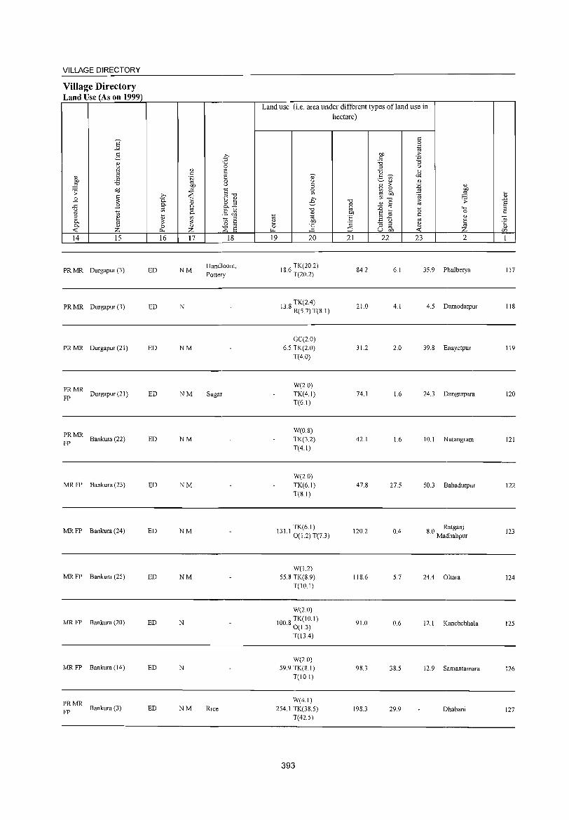
VILLAGE DIRECTORY
Village Directory Land Use (As on 1999)
Land use (i.e. area under different types ofland use in hectare)
S <= 0
-" .~
2- .€ bJl .J; " OJ "0 '6 :l
'" 0 ::l '"
* ., E u ... <= E 0- <=~ <8 ., .~ .- '"
~ '6 0 ~ ~., .,
~ '" ., ;>
~ .,
o<J §~ 0 ~ 0
~ .;;: ~ '" ~~ il
~ 1:> '«1 B 0.
1:: ., >-, "0 G .;;: .D ., 8.3 e " c E .c B 0. §- OJ - '" ::l ., ""' ::l il '" .S ~ "0 ~ ta -0 0 c 1;; ... 0. ., bJl <= e ~ .,
~ ~ ::l 1;; ., E B-5 '" .,
til 0- '" ::; '" c ~ bJl '2 "S rJ ~ ~ .~ 0- .,
0 ., o '" 0 ] -< Z r:>-. Z ::s E ~ ::J U on -< C/J
14 15 16 17 18 19 20 21 22 23 2 1
PRMR Durgapur (3) ED NM Handloom, IS 6 TK(20.2) S4.2 6.1 35.9 Phulberya 117 Pottery . T(20.2)
PRMR Durgapur (3) ED N TK(24)
13.S R(5.7) T(S.I) 21.0 4.1 4.5 Damodarpur lIS
GC(20) PRMR Durgapur (21) ED NM 6.5 TK(2.0) 31.2 2.0 39.S Enayetpur 119
T(4.0)
PRMR W(2.0)
FP Durgapur (21) ED NM Sugar TK(4.1) 74.1 1.6 24.3 Dangarpara 120
T(61)
PRMR W(O.S)
FP Bankura (22) ED NM TK(3.2) 42.1 1.6 10.1 Nutangram 121
T(4.1)
W(2.0) MRFP Bankura (23) ED NM TK(61) 47.S 27.5 50.3 Bahadurpur 122
T(S.I)
MRFP Bankura (24) ED NM TK(6.1)
120.2 04 SO Ratganj 123 13 Ll 0(1.2) T(7.3) . Madhabpur
W(1.2) MRFP Bankura (25) ED NM 55.8 TK(S 9) IIS.6 5.7 244 Oltara 124
T(IO.I)
W(2.0)
MRFP Bankura (20) ED N 100 S TK(IO.I) . 0(1.3) 91.0 0.6 12.1 Kanchchhala 125
T(134)
W(2.0) MRFP Bankura (14) ED N 59.9 TK(S.I) 9S.3 3S.5 12.9 Samantamara 126
T(IO I)
PRMR W(4.1)
FP Bankura (3) ED NM Rice 254.1 TK(3S.5) 19S.3 29.9 Dhabani 127
T(42.5)
393
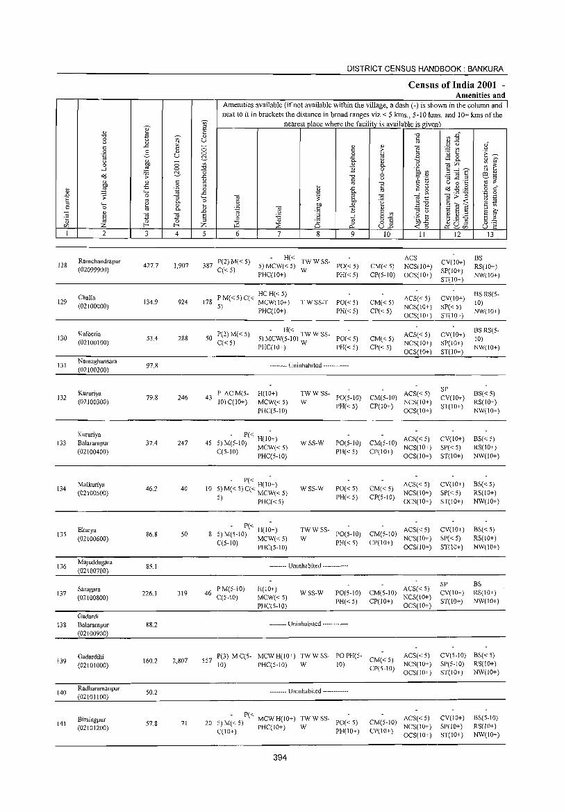
128
129
130
131
132
133
134
13S
136
137
2
Ramchandrapur (02099900)
Challa (02100000)
Kalberia (02100100)
Namaghansara (02100200)
Kururiya (02100300)
Kururiya Balarampur (02100400)
Malkuriya (02100500)
Ekarya (02100600)
Majuddagara (02100700)
Saragara (02100800)
Gadardi 13 8 Balarampur
(02100900)
139
140
141
Gadardihi (02101000)
Radharamanpur (02101100)
Birsingpur (02101200)
3
427.7
134.9
53.4
97.8
79.8
37.4
46.2
86.8
8S.1
226.1
88.2
160.2
SO.2
S7.8
~ c " U
c o
'.g
" 0. o 0.
~ 4
1,907
924
288
246
247
40
50
319
2,807
71
DISTRICT CENSUS HANDBOOK: BANKURA
Census of India 2001 -Amenities and
1 Amenities available (if not available within the village, a dash (-) is shown in the column and next to it in brackets the distance in broad ranges viz.< 5 kms., 5-10 kms. and 10+ kms of the
nearest place where the facility is available is given
" u
5 6 7 8 9
387 P(2) M« 5) C« 5)
H« TW W SS-5)MCW«S) W PO«S) PHC(IO+) PH«S)
P M« S) C« HC H« S) 178 5) MCW(IO+)
PHC(IO+) T W SS-T PO« 5)
PH«S)
50 P(2) M« 5) - H« TW W SS
5)MCW(5-10) - PO«S) C« 5) W
PHC(IO+) PH« 5)
-------- Uninhabited ------------
43 P AC M(5-10) C(IO+)
H(lO+) MCW«S) PHC(S-IO)
- P« -45 5) M(5-1O) H(IO+)
MCW«5) C(5-10) PHC(5-10)
- P« -10 5) M« 5) C« H(IO+)
5) MCW« 5) PHC« 5)
- P« -8 S) M(5-10) H(lO+)
MCW«S) C(5-1O) PHC(S-IO)
~W W SS- PO(5-1O)
PH«5)
wss-W
WSS-W
PO(5-1O)
PH«5)
PO«5) PH« S)
~W W SS- PO(S-IO)
PH« S)
-------- Uninhabited ------------
46 P M(S-IO) C(S-IO)
H(IO+) MCW«5) PHC(5-1O)
WSS-W PO(5-1O) PH«S)
-------- Uninhabited ------------
10
CM«5) CP(S-IO)
CM« S) CP« 5)
CM«S) CP«5)
11
ACS NCS(lO+) OCS(IO+)
ACS«5) NCS(10+) OCS(IO+)
ACS«5) NCS(IO+) OCS(IO+)
CM(5-10) ACS« 5) CP(l 0+) NCS( I 0+)
OCS(IO+)
ACS« 5) CM(5-10) NCS(IO+) CP(IO+)
OCS(IO+)
CM«S) CP(5-10)
ACS« S) NCS(IO+) OCS(IO+)
ACS«S) CM(S-IO) NCS(lO+)
CP(lO+) OCS(lO+)
ACS« S) CM(S-IO) NCS(lO+) CP(lO+) OCS(lO+)
SS7 lP(3) M C(5- MCW H(10+) TWW W SS- PO PH(S- CM« S) 10) PHC(S-IO) 10) CP(S-10)
ACS«S) NCS(10+) OCS(IO+)
-------- Uninhabited ------------
- P« 20 5) M« S) MCWH(IO+) TWWSS- PO«S)
C(IO+) PHC(IO+) W PH(IO+)
394
ACS«S) CM(S-lO) NCS(lO+) CP(IO+) OCS(IO+)
12 13
BS CV(IO+) RS(lO+) SP(lO+) ST(I,O_+_:.)_N_W_(l_O+_)_
CV(IO+) BS RS(S-10)
SP« 5) NW(IO+) ST(IO_+.:_) ___ _
CV(IO+) BS RS(5-10)
SP(IO+) NW(IO+) ST(IO_+.:_) ___ _
SP CV(lO+) ST(IO+)
CV(IO+)
SP«S) ST(IO+)
CV(IO+) SP«S) ST(IO+)
CV(lO+)
SP« 5) ST(lO+)
SP CV(lO+) ST(IO+)
BS«S) RS(IO+) NW(10+)
BS«S) RS(IO+) NW(10+)
BS«S) RS(10+) NW(IO+)
BS«S) RS(IO+) NW(lO+)
BS RS(IO+) NW(IO+)
CV(S-10) BS« 5) SP(S-IO) RS(IO+) ST(IO+) NW(IO+)
CV(IO+) SP(lO+) ST(IO+)
BS(5-10) RS(IO+) NW(IO+)
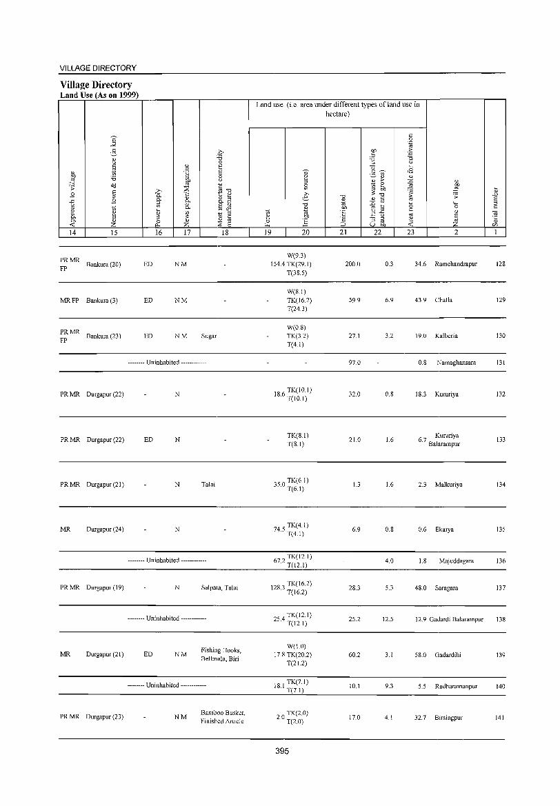
VILLAGE DIRECTORY
Village Directory Land Use (As on 1999)
'" ~ (1)
Z 14 15 16 17 18
;~ MR Bankura (20) ED NM
MR FP Bankura (3) ED NM
;~ MR Bankura (23) ED NM Sugar
-------- Uninhabited ------------
PR MR Durgapur (22) N
PR MR Durgapur (22) ED N
PR MR Durgapur (21) N Talai
MR Durgapur (24) N
-------- Uninhabited ------------
PRMR Durgapur (19) N Salpata, Talai
-------- Uninhabited ------------
Fishing Hooks, MR Durgapur (21) ED NM
Bellmala, Biri
-------- Uninhabited ------------
PRMR Durgapur (23) NM Bamboo Busket, Finished Article
Land use (i.e. area under different types ofland use in hectare)
19 20
W(9.3) 154.4 TK(29.1)
T(38.5)
W(8.1) TK(l6.2) T(24.3)
W(0.8) TK(3.2) T(4.1)
18.6 TK(lO.l) T(IO.I)
TK(S.I) T(8.1)
350 TK(6.1) · T(6.1)
74.5 TK(4.1) T(4.1)
672 TK(12.1) · T(12.1)
1283 TK(16.2) · T(l6.2)
254 TK(12.1) · T(12.1)
W(I.O) 17.8 TK(20.2)
T(21.2)
181 TK(7.1) · T(7.1)
2.0 TK(2 0) T(2.0)
395
21 22
200.0
59.9
27.1
97.0
32.0
21.0
1.3
6.9
28.3
25.2
60.2
10.1
17.0
23
0.3
6.9
3.2
O.S
1.6
1.6
O.S
4.0
5.3
12.5
3.1
9.3
4.1
2
34.6 Ramchandrapur
43.9 Challa
19.0 Kalberia
0.8 N amaghansara
18.3 Kururiya
6 7 Kururiya . Balarampur
2.3 Malkuriya
0.6 Ekarya
I.S Maj uddagara
48.0 Saragara
12.9 Gadardi Balarampur
58.0 Gadardihi
5.5 Radharamanpur
32.7 Birsingpur
128
129
130
131
132
133
134
135
136
137
138
139
140
141
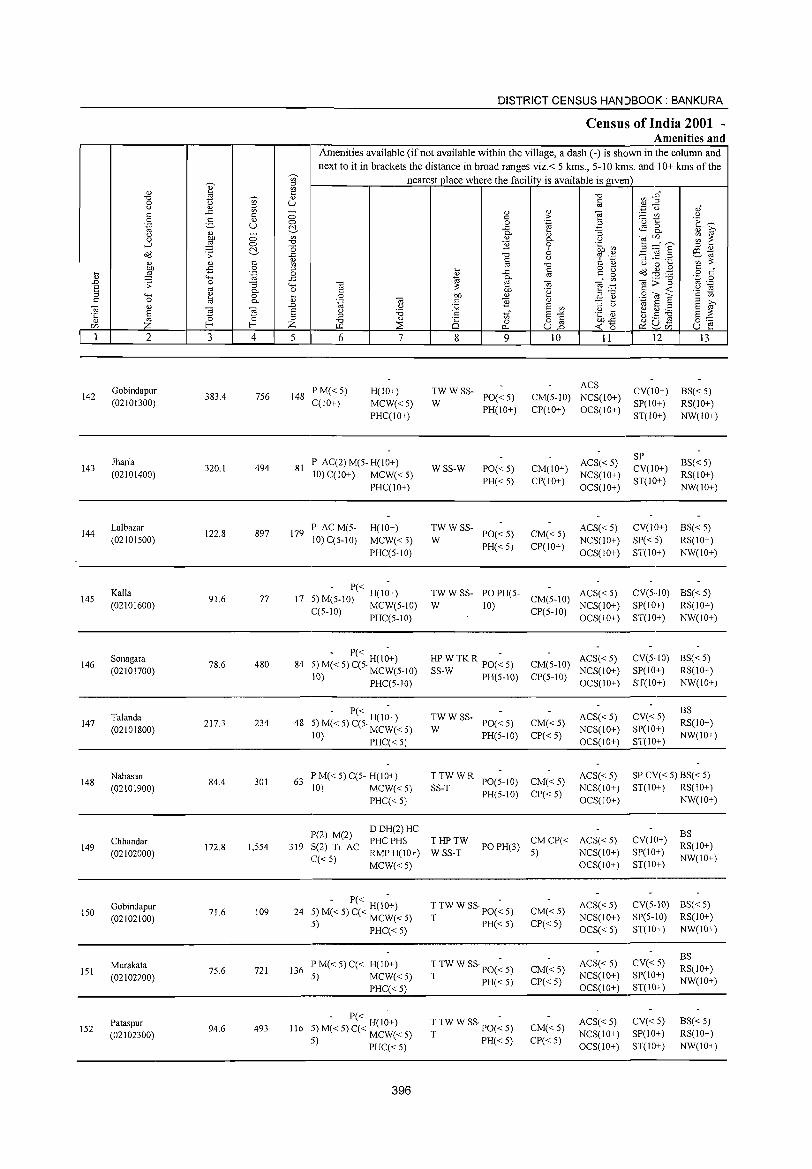
DISTRICT CENSUS HANDBOOK: BANKURA
Census of India 2001 -Amenities and
r--,--------r----r---,----I~~~~~~--~~~~~~--~~~~-~ Amenities available (if not available within the village, a dash (-) is shown in tbe column and
142
143
144
14S
146
147
2
Gobindapur (02101300)
Jharia (02101400)
Lalbazar (02101S00)
Kalla (02101600)
Sonagara (02101700)
Talanda (02101800)
3
383.4
320.1
122.8
91.6
78.6
217.3
'" :l
'" § u o o ~
4
756
494
897
77
480
234
next to it in brackets the distance in broad ranges viz.< 5 kms., 5-10 kms. and 10+ kms oftbe nearest place where the facility is available is given
5 6
148 PM«S) C(IO+)
7
H(IO+)
MCW«S) PHC(IO+)
81 P AC(2)M(S-H(10+) 10) C(IO+) MCW« 5)
PHC(IO+)
179 P AC M(S-10) C(5-10)
H(IO+)
MCW«5) PHC(5-10)
S M- P« H(I~+) 17 ) (S-IO) MCW(5-10)
C(S-10) PHC(S-IO)
5 M- P« H(I~+) 84 ) « 5) C(S· MCW(S-IO)
10) PHC(S-IO)
8 9
~WWSS- PO«S)
WSS-W
TWWSS-W
PH(IO+)
PO«S) PH«S)
PO«5) PH«S)
" > .~
" 0-o 6 ()
"0 §
OJ .~
" E '" E"'" 82 10 II
ACS CM(S-IO) NCS(10+) CP(IO+) OCS(IO+)
ACS« S) CM(IO+) NCS(10+) CP(IO+) OCS(IO+)
CM«S) CP(10+)
ACS« 5) NCS(IO+) OCS(IO+)
TW W SS- PO PH(5- ACS« 5) W 10) CM(S-IO) NCS(10+)
CP(S-IO) OCS(10+)
HPWTKR PO(~S) SS-W PH(5-10)
ACS« 5) CM(5-1O) NCS(10+) CP(5-10) OCS(IO+)
12
CV(IO+) SP(IO+) ST(IO+)
SP CV(IO+) ST(10+)
CV(10+)
SP«5) ST(10+)
13
BS«S) RS(IO+) NW(10+)
BS«S) RS(10+) NW(10+)
BS«S) RS(10+) NW(10+)
CV(S··IO) BS« S) SP( 10+) RS( 10+ ) ST(IO+) NW(IO+)
CV(5·1O) BS( < 5) SP(IO+) RS(10+) ST(10+) NW(IO+)
- P« - BS 48 5) M« 5) C(5. H(IO+) ~W W SS- PO« 5) CM« S) ACS« S) CV« 5) RS(IO+)
10) MCW« 5) PH(5-10) CP« 5) NCS(10+) SP(IO+) NW(IO+) ______________________ P_H_:C-'-«_;5_;.) _____________ 0_C_S-'-(I_O+~)_ ST(IO....;+)'--___ _
148
149
150
lSI
IS2
Nabasan (02101900)
Chhandar (02102000)
Gobindapur (02102100)
Murakata (02102200)
Pataspur (02102300)
84.4 301
172.8 I,S54
71.6 109
75.6 721
94.6 493
63 PM«5)C(5-H(10+) 10) MCW«5)
PHC« 5)
!P(2) M(2) 319 :5(2) Tr AC
C«S)
DDH(2)HC PHCPHS RMPH(10+) MCW«5)
- P« -24 5) M« 5) C« H(lO+)
5) MCW«5) PHC« 5)
136 P M« 5) C« H(IO+) 5) MCW«5)
PHC« 5)
116
- P« -5) M« 5) C« H(IO+) 5) MCW« 5)
PHC«5)
396
~S:~ W R PO(5-10) PH(5-10)
CM«5) CP«5)
ACS« 5) NCS(IO+) OCS(IO+)
THPTW WSS-T
PO PH(3) CM CP« ACS« 5) 5) NCS(10+)
T TW W SS· PO(~ 5)
T PH« 5)
T TW W SS· PO(~ 5)
T PH« 5)
T TW W SS· PO(~ 5)
T PH« 5)
CM«5) CP«5)
CM«5) CP«5)
CM«5) CP«5)
OCS(10+)
ACS« 5) NCS(10+)
OCS« 5)
ACS« 5) NCS(10+) OCS(10+)
ACS«5) NCS(10+) OCS(IO+)
SP CV« 5) BS« 5) ST(IO+) RS(10+)
NW(IO+)
CV(lO+) SP(10+) ST(10+)
BS RS(10+) NW(10+)
CV(5-10) BS« 5) SP(5-10) RS(IO+) ST(10+) NW(IO+)
CV«5) SP(IO+) ST(10+)
CV« S) SP(IO+) ST(IO+)
BS RS(IO+) NW(10+)
BS« 5) RS(IO+) NW(IO+)
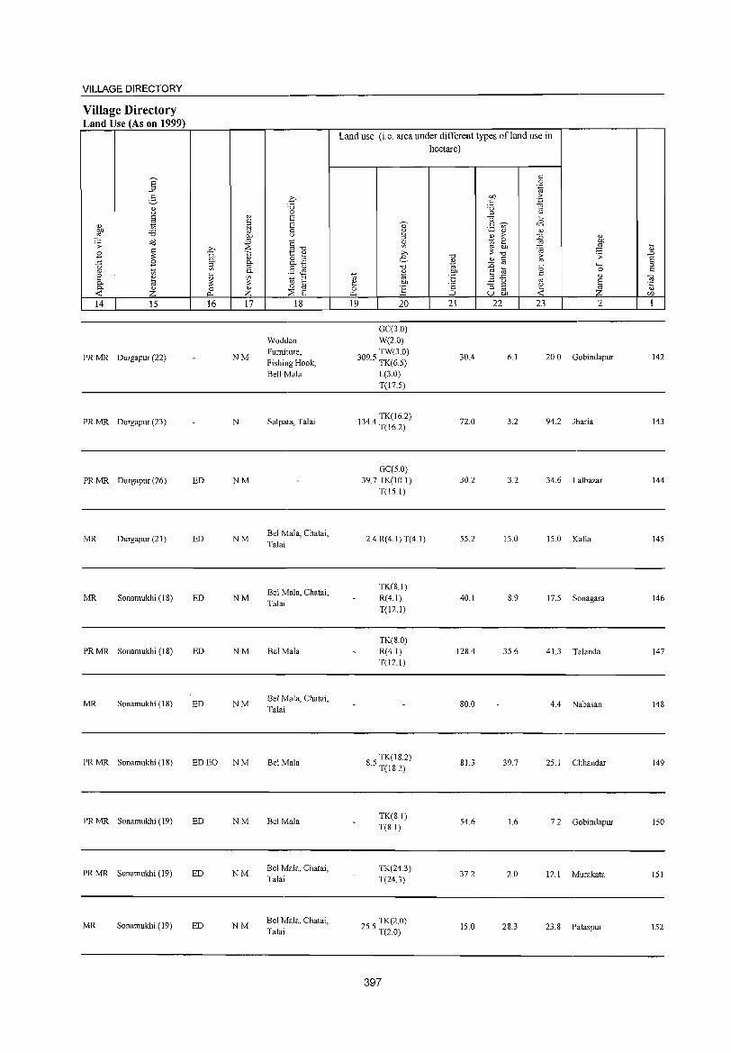
VILLAGE DIRECTORY
Village Directory Land Use (As on 1999)
14 15
PR MR Durgapur (22)
PR MR Durgapur (23)
PR MR Durgapur (26)
MR Durgapur (21)
MR Sonamukhi (IS)
PR MR Sonamukhi (IS)
MR Sonamukhi (18)
PR MR Sonamukhi (IS)
PRMR Sonamukhi (19)
PRMR Sonamukhi (19)
MR Sonamukhi (19)
16 17
NM
N
ED NM
ED NM
ED NM
ED NM
ED NM
ED EO NM
ED NM
ED NM
ED NM
18
Wodden Furniture, Fishing Hook, Bell Mala
Salpata, Talai
Bel Mala, Chatai, Talai
Bel Mala, Chatai,
Talai
Bel Mala
Bel Mala, Chatai, Talai
Bel Mala
Bel Mala
Bel Mala, Chalai, Talai
Bel Mala, Chalai, Talai
Land use (i.e. area under different types ofland use in
hectare)
19 20
GC(3.0) W(2.0)
3095 TW(3.0) · TK(6.5)
L(3.0) T(l7.5)
1344 TK(16.2) · T(16.2)
GC(S 0) 39.7 TK(IO I)
T(IS.I)
2.4 R(4.I)T(4.1)
TK(S.I) R(4.I)
T(12.!)
TK(S.O) R(4.1) T(12.1)
S S TK(IS2) · T(lS2)
TK(8.1) T(S.I)
TK(24.3) T(24.3)
255 TK(2.0) · T(2.0)
397
21 22
30.4
72.0
30.2
SS.2
40.1
12S.4
SO.O
S1.3
54.6
37.2
IS.O
23 2
6.1 20.0 Gobindapur
3.2 94.2 Jharia
3.2 34.6 Lalbazar
IS.O IS.O Kalla
S.9 17.5 Sonagara
35.6 41.3 Talanda
4.4 Nabasan
39.7 25. I Chhandar
1.6 7.2 Gobindapur
2.0 12.1 Murakala
28.3 23.S Pataspur
142
143
144
145
146
147
14S
149
150
151
152
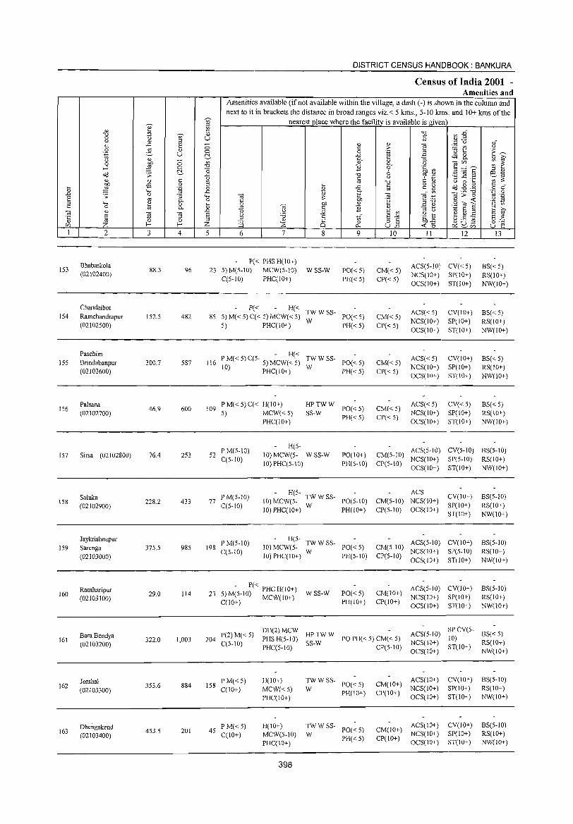
153
154
155
156
2
Bhabarkola (02102400)
Chandaibot Ramchandrapur (02102500)
Paschim
Brindabanpur (02102600)
Palsana (02102700)
157 Sirsa (02102800)
158
159
160
161
162
163
Saluka (02102900)
Jaykrishnapur Sarenga
(02103000)
Ramharipur (02103100)
BaraBendya (02103200)
Jorshal (02103300)
Dhengakend (02103400)
3 4
88.3 96
152.5 482
300.7 587
46.9 600
76.4 253
228.2 433
375.5 985
29.0 114
322.0 1,003
353.6 884
453.5 201
5
DISTRICT CENSUS HANDBOOK: BANKURA
Census of India 2001 -Amenities and
Amenities available (ifnot available within the village, a dash (-) is shown in the column and next to it in brackets the distance in broad ranges viz.< 5 krns., 5-10 !e.ms. and 10+ krns of the
nearest place where the facilitv is available is given
6 7 8
P« PHS H(10+) 23 5) M(5-10) MCW(5-10) W SS-W
C(5-10) PHC(!O+)
9
PO«5) PH«5)
P« H« TW W SS-85 5)M«5)C«5)MCW«5) W PO«5)
5) PHC(IO+) PH« 5)
10
CM«5) CP«5)
CM«5) CP« 5)
11 12
ACS(5-10) CV« 5) NCS(IO+) SP(10+) OCS( 10+ ) ST(1 0+ )
ACS« 5) NCS(IO+) OCS(IO+)
CV(IO+) SP(10+) ST(IO+)
13
BS« 5) RS(lO+) NW(!o+)
BS« 5) RS(IO+) NW(10+)
- H« 116 PIOM« 5) C(5- 5) MCW« 5) TW W SS- PO« 5)
) PHC(IO+) W PH« 5) CM«5)
CP« 5)
ACS«5) NCS(IO+) OCS(IO+)
CV(IO+) SP(IO+)
ST(IO+)
BS«5) RS(IO+) NW(IO+)
109 P M« 5) C« H(JO+) 5) MCW« 5)
PHC(IO+)
~_~WW PO«5) PH«5)
CM«5) CP«5)
ACS« 5) NCS(\O+) OCS(IO+)
CV«5) SP(IO+) ST(lO+)
BS« 5) RS(JO+) NW(IO+)
52 P M(5-10) C(5-1O)
H(5-10) MCW(5- W SS-W 10) PHC(5-10)
PO(IO+) CM(5-10) ACS(5-10) CV(5-10) BS(5-1O) PH(5-10) CP(5-10) NCS(JO+) SP(5-10) RS(IO+)
77 PM(5-1O) C(5-1O)
198 P M(5-1O) C(5-JO)
OCS(lO+) ST(IO+) NW(IO+)
H~ A~ 10) MCW(5- TWWSS- PO(5-1O) CM(5-10) NCS(lO+)
10) PHC(IO+) W PH(IO+) CP(5-1O) OCS(IO+)
CV(lO+) SP(IO+) ST(IO+)
H(5- TW W SS- ACS(5 10) CV(10+) 10) MCW(5- PO« 5) CM(5-10) -10) PHC(IO+) W PH(5-IO) CP(5-1O) NCS(10+) SP(5-10)
OCS(10+) ST(IO+)
BS(5-1O) RS(IO+) NW(IO+)
BS(5-10) RS(10+) NW(IO+)
- P« PHC H(IO+) 23 5) M(5-1O) MCW(IO+) WSS-W PO« 5)
PH(IO+)
ACS(5-1O) CV(IO+) CM(10+) NCS(IO+) SP(IO+)
BS(5-10) RS(IO+) NW(10+) C(lO+) CP(IO+) OCS(IO+) ST(10+)
(2 5) DH(2) MCW HP TW W ACS(5-1O) SP CV(S- BS( 5) 204 P )M« PHSH(5-10) POPH«5)CM«5) 10) <
C(5-10) PHC(5 10) SS-W CP(5 10) NCS(IO+) ST(IO+) RS(IO+) - - OCS(lO+) NW(lO+)
158 PM«5) C(10+)
45 PM«5) C(IO+)
H(IO+)
MCW«5) PHC(lO+)
H(10+) MCW(5-10) PHC(IO+)
398
~WWSS- PO«5)
PH(JO+)
:W W SS- 1'0« 5)
PH«5)
CM(IO+) ACS(JO+) NCS(IO+)
CP(IO+) OCS(lO+)
CV(\O+) SP(lO+) ST(lO+)
ACS(lO+) CV(lO+) CM(IO+) NCS(lO+) SP(10+) CP(10+) OCS(IO+) ST(IO+)
8S(5-10) RS(IO+) NW(lO+)
BS(5-10) RS(10+) NW(lO+)
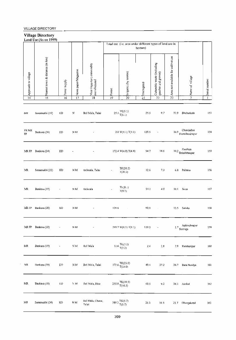
VILLAGE DIRECTORY
Village Directory Land Use (As on 1999)
a -'<
2-" <.)
* Q)
~ '6 0iJ .:;:
~ .8 ..c .8 <.)
'" "in [ ~ 0. " -< Z 14 15
MR Sonamukhi (19)
~: MR Bankura (24)
MR FP Bankura (24)
MR Sonamukhi (22)
MR Bankura (19)
MR FP Bankura (30)
MR FP Bankura (32)
MR Bankura (19)
MR Bankura (19)
MR Bankura (18)
MR Sonamukhi (24)
ED
ED
ED
ED
ED
ED
ED
ED
" c .~
bIJ
'" >-. ~ 0.. >:: 0. " ~ g.
0. ~
" ~ '" 0 " 0.. Z 16 17
N
NM
NM
NM
NM
NM
NM
NM
NM
NM
.0 '6 0 s E 0 <.)
§"O to; ~ o :l 0.1:) §<l':I "in :l
§ 0
:::E S 18
Bel Mala, Talai
Belmala, Talai
Behnala
Bel Mala
Bel Mala, Talai
Bel Mala, Rice
Bel Mala, Chatai, Talai
Land use (i.e. area under different types ofland use in hectare)
19 20
251 TK(6.1) · T(6.1)
2.0 W(4.1) T(4.1)
172.4 W(4.8) T(4.8)
124.6
TK(20.2) T(20.2)
TK(8.1) T(8.1)
249.7 W(4.1) T(4.1)
126 TK(3.2) · T(3.2)
1736 TK(23.0) · T(23.0)
2550 TK(10.5) · T(IO.5)
3893 TK(5 7) · T(5.7)
399
"0
~ bIJ
E
'" :J
21
25.5
129.5
94.7
12.6
54.2
90.0
120.0
2.4
49.4
40.5
26.3
bIJ c '6 :l U 2- ~ <n
" j ;>
e bIJ
"0
" § :D
8 ~ ..c <.)
"3 :l
'" U bIJ
22
9.7
18.6
7.3
4.0
2.8
37.2
9.3
10.5
c 0
'.g 'S "3
<.)
~
<8 " :D '" ~ ~ (5 C
'" ~ -< 23
" ~ .:;: <;-; 0
" S ~ 2
21. 9 Bhabarkola
16 9 Chandaibot . Ramchandrapur
102 Paschim . Brindabanpur
6.8 Palsana
10.1 Sirsa
13.5 Saluka
1. 7 Jaykrishnapur Sarenga
7.9 Ramharipur
38.7 Bara Bendya
38.3 Jorshal
21. 7 Dhengakend
~
" .D S :l c
~ " r/)
1
153
154
155
156
157
158
159
160
161
162
163
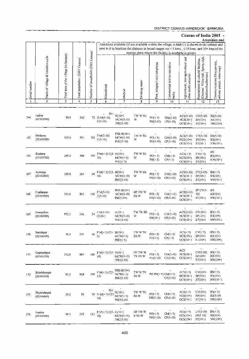
DISTRICT CENSUS HANDBOOK: BANKURA
Census of India 2001 -Amenities and
Amenities available (ifnot available within the village, a dash (-) is shown in the column and next to it in brackets the distance in broad ranges viz.< 5 kms., 5-10 kms. and 10+ kms of the
~
nearest place where the facilitv is available is given '" '0) ;::I
'" " 8 t:: "<j ~ :e~ "<j " 0 <> '" U t:: C,) " ;::I " '.c (,) ,," t:: .<:: l3 0 " 0)
] := til u t:: :>-0 ~ " 0 0 'g 'u 1:: E~ '~ U ~ ..<:: ~ 8.. u
~ ;:; 0- Ii) "3 " ~ 0 '" 0)
0- C,) '3C/) ~ ~ ....:I 0 "0 ~ 0 .~ en 3.....:'~ ~ "0 6 "3] .~
;::I 0)
Oil .;;: 13 "0 tp .~ ES-~ t:: u '" ::; 0) g c ;g " "0 t:: " C,) 0 ...
l 0 o .- Oil .g .g c " ... .~ 0 f ..<:: til '" g o c " '+-< .<:: 0-
'" '3;>"g '.g .g .D .;;: 0 "3 "-< '3 e ~ ""§::a § " 0- 0 § 01) t:: ...: .~ rg ..... " 0 Ii) bJ) 0) ~ E e 2<0] t:: en C 0 8 0- .~ '3 '" ~ '" E
;::I » ] 0) .D C,) ~ E '"
;::I C,)
E ~ § n ~ § g '6 '" to" E"'" .g t ~.S ] Ii) 0 i2 0)
8 0 o fa 01)"<:: §c::: C/) Z E-< E-< Z :::B ~ U.D "':'0 ~ ~V) U e I 2 3 4 5 6 7 8 9 10 11 12 13
164 Ladna
94.9 345 - P« H(I;+) TWWSS- ACS(5-10) CV(5-10) BS(5-10) 73 5)M(5-10) MCW(5-10) PO«5) CM(5-10) (02103500) W NCS(10+) SP(lO+) RS(IO+)
C(5-1O) PHC(5-10) PH(5-1O) CP(5-10) OCS(IO+) ST(10+) NW(lO+)
Methena PM(5-10) PHSH(IO+)
TWWSS- ACS(5-10) CV(5-10) BS(5-10) 165 429.8 501 103 MCW(5-10) PO«5) CM(5-10)
(02103600) q5-10) PHq5-10)
W PH(5-10) CP(5-10)
NCS(IO+) SP(IO+) RS(IO+) OCS(IO+) ST(lO+) NW(IO+)
Kushma P M« 5) q5- H(lO+) TWWSS- ACS« 5) CV«5) BS
166 296.0 766 140 PO«5) CM« 5) RS(10+) (02103700) 10) MCW«5) W
PH« 5) CP« 5) NCS(lO+) SP(IO+)
NW(lO+) PHq<5) OCS(10+) ST(IO+)
167 Joytunga
189.8 361 64 PM«5)C(5- H(IO+) TWWSS-
PO« 5) CM(5-1O) ACS(5-10) CV(5-10) BS«5)
(02103800) 10) MCW(5-10) W NCS(IO+) SP(lO+) RS(IO+) PHq5-10)
PH(5-10) CP(5-10) OCS(IO+) ST(JO+) NW(IO+)
Chadanpur PM(5-10) PHS H(lO+)
HPTWW ACS(5-10) SPCV(5- BS
168 (02103900)
353.0 802 140 C(5-10)
MCW(5-10) SS-W
PO«5) CM(5-1O) NCS(IO+)
10) RS(lO+) PHC(10+) PH(5-10) CP(5-10)
OCS(lO+) ST(IO+) NW(10+)
169 Swargabati
972.1 166 34 P M(5-10) H(IO+) TW TK SS- PO(~ 5) CM(5-10)
ACS(5-10) CV(IO+) BS« 5) (02104000) C(IO+) MCW(5-10) W PH(10+) CP(5-10)
NCS(IO+) SP(IO+) RS(IO+)
PHq5-10) OCS(IO+) ST(10+) NW(10+)
170 Harishpur
271 56 l' M« 5) q< H(10+) TWWTK
1'0«5) CM«5) ACS« 5) CV« 5) BS« 5)
(02104100) 70.4
5) MCW«5) SS-W NCS(IO+) SP(lO+) RS(IO+)
PHq<5) PH« 5) CP« 5)
OCS(IO+) ST(lO+) NW(lO+)
Gopinathpur P M« 5) C(5- H(lO+) HPTWW ACS
CV(5-10) BS« 5) 171
(02104200) 212.0 882 160
10) MCW(5-10) TKSS-W PO« 5) CM(5-10) NCS(IO+)
SP(IO+) RS(lO+)
PHC(5-10) PH(5-IO) CP(5-10) OCS(IO+)
ST(IO+) NW(IO+)
Brindabanpur PM«5)C(5- PHSH(IO+) TWWTK PO PH« 5) CM« 5)
ACS« 5) CY(IO+) BS«5) 172
(02104300) 91.3 968 198 MCW«5)
SS-W NCS(IO+) SP(IO+) RS(10+) 10) PHC(5-1O) CP(5-10)
OCS(IO+) ST(lO+) NW(IO+)
Shyamdaspuf . -< P« H(I;+) TWWTK PO«5) CM«5)
ACS«5) CY(JO+) BS« 5) 173
(02104400) 50.2 94 18 5.1 M( 5) C(5· MCW« 5) SS-W NCS(IO+) SP(IO+) RS(5-10)
10) PHC(5-10) PH(5-10) CP(5-10) OCS(IO+) ST(IO+) NW(IO+)
Amthia l' M« 5) C(5- H(IO+) HPTWW PO«5) CM«5)
ACS« 5) eY(5-IO) BS«5) 174
(02104500) 96.3 569 113
10) MCW(5-1O) RSS-W NCS(lO+) SP(5-IO) RS(IO+)
PHC(5-IO) PH(5-10) CP(5-10)
OCS(lO+) ST(IO+) NW(lO+)
400
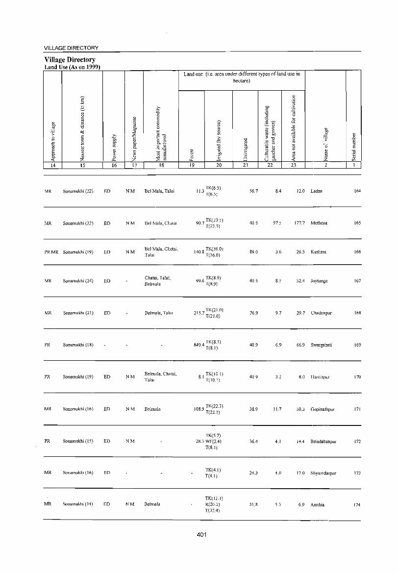
VILLAGE DIRECTORY
Village Directory Land Use (As on 1999)
E "'" g " " c ~ " 00 '0 ~ c(l .;;
~ .8 ..c .8 <.) oj ti e " 0.. til 0.. " ..:: z 14 15
MR Sonamukhi (22)
MR Sonamukhi (22)
PRMR Sonamukhi (19)
MR Sonamukhi (24)
MR Sonamukhi (21)
PR Sonamukhi (18)
PR Sonamukhi (19)
MR Sonamukhi (16)
PR Sonamukhi (15)
MR Sonamukhi (16)
MR Sonamukhi (14)
ED
ED
ED
ED
ED
ED
ED
ED
ED
ED
" c .~
'" ;>-. ::E
P.. '" " 0.. 0.. ::s '" '" "'-Ii> ~ ~ 0 " 0... Z 16 17
NM
NM
NM
NM
NM
NM
NM
.0 '0 0 8 S 0
" §"Cl "t:: " o ~ o..§ §~ ti § 0
::E S 18
Bel Mala, Talai
Bel Mala, Chatai
Bel Mala, Chatai, Talai
Chatai, Talai, Belmala
Belmala, Talai
Belmala, Chatai, Talai
Belmala
Belmala
Land use (i.e. area under different types of land use in hectare)
19 20
113 TK(6.5) · T(6.5)
907 TK(23.S) · T(23.5)
140 8 TK(36.0) · T(36.0)
996 TK(S.9) · T(8.9)
2157 TK(21.0) · T(2l.0)
8494 TK(8.1) · T(81)
81 TK(IO.I) · T(IO.I)
1089 TK(22.3) · T(22.3)
TK(5.7) 28.3 WF(2.4)
T(8.1)
TK(4.1) T(4.1)
TK(12.1) R(20.2) T(32.4)
401
"Cl
~ .~ t: '2 :J 21
00 c '0 ::s U g "Ui'
" B >-0
~ 5b ~ "Cl
" til :0
~ til ..c " "3 ::s oj
U 00
22
56.7 8.4
40.5 97.5
89.0 3.6
40.5 8.5
76.9 9.7
40.9 6.9
40.9 3.2
38.9 11.7
36.4 4.1
24.3 4.9
51.8 5.3
c 0
'.g .:: -3
<.)
~
<E " ~ " 9 'a ~
.;;
0 """' 0 c " oj
~ ~ 23 2
12.0 Ladna
177.7 Methena
26.5 Kushma
32.4 Joytunga
29.7 Chadanpur
66.9 Swargabati
8.0 Harishpur
30.3 Gopinathpur
14.4 Brindabanpur
17.0 Shyamdaspur
6.9 Amthia
Ii> .D 8 ::s c
-;:; '5 CIl
1
164
165
166
167
168
169
170
171
172
173
174
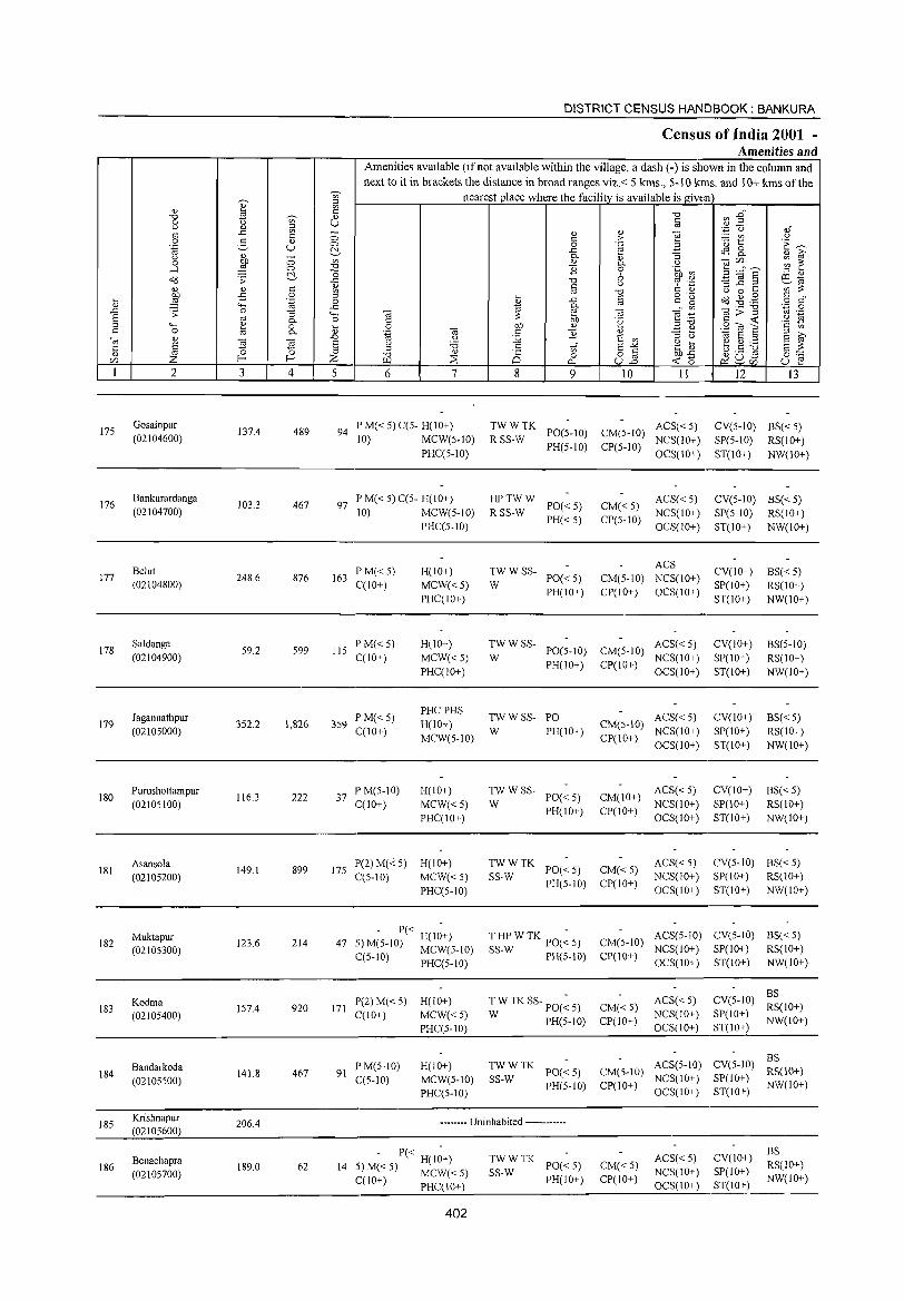
175
176
177
178
179
180
181
182
183
184
185
186
2
Gosainpur (02104600)
Bankurardanga (02104700)
Belut (02104800)
Saldanga
(02104900)
Jagannathpur (02105000)
Purushottampur (02105100)
Asansola (02105200)
Muktapur (02105300)
Kodma (02105400)
Bandarkoda (02105500)
Krishnapur (02105600)
Benachapra (02105700)
3
137.4
103.3
248.6
59.2
352.2
116.3
149.1
123.6
157.4
141.8
206.4
189.0
~ c: <l)
U
o o ~
§ .~
"3 0. o 0.
~ 4
489
467
876
599
1,826
222
899
214
920
467
62
DISTRICT CENSUS HANDBOOK: BANKURA
CensUlS of India 2001 -Amenities and
Amenities available (if not available within the village, a dash (-) is shown in the colunm and next to it in brackets the distance in broad ranges viz.< 5 krns., 5-10 killS. and 10+ krns of the
nearest place where the facility is available is given
5 6 7
94 PM«5)C(5- H(IO+) 10) MCW(5-1O)
PHC(5-10)
97 P M« 5) C(5- H(IO+) 10) MCW(5-10)
PHC(5-10)
163 PM« 5) C(10+)
liS PM«5) C(10+)
359 P M« 5) C(IO+)
37 IP M(5-1O) C(IO+)
H(IO+) MCW«5) PHC(IO+)
H(IO+)
MCW«5) PHC(IO+)
PHCPHS H(IO+) MCW(5-10)
H(IO+)
MCW«5) PHC(IO+)
175 1'(2)M(-<'5) H(10+) C(5-10) MCW« 5)
PHC(5-10)
,. - P« H(I;+) 47 -~ M(5-10) MCW(5-10)
C(5-10) PHC(5-10)
171 P(2)M«5) H(IO+) C(10+) MCW« 5)
1'HC(5-10)
91 P M(5-10) C(5-1O)
H(IO+) MCW(5-10) PHC(5-1O)
8
on o a.. 9 10 11
TWWTK ACS«5) R SS-W PO(5-10) CM(5-1O) NCS(lO+)
PH(5-10) CP(5-10) OCS(IO+)
HPTWW R SS-W PO« 5)
PH«5)
:WWSS- PO«5)
PH(IO+)
CM«5) CP(5-10)
ACS« 5) NCS(IO+) OCS(IO+)
ACS CM(5-10) NCS(IO+) CP(IO+) OCS(IO+)
TW W SS- ACS« 5) W PO(5-1O) CM(S-IO) NCS(IO+)
PH(IO+) CP(IO+) OCS(IO+)
12 13
CV(5-1O) BS« 5) SP(5-1O) RS(IO+) ST(IO+) NW(IO+)
CV(5-10) BS« 5) SP(5-10) RS(IO+) ST(IO+) NW(IO+)
CV(IO+) SP(IO+) ST(10+)
CV(IO+) SP(IO+) ST(10+)
BS« 5) RS(IO+) NW(IO+)
BS(5-10) RS(IO+) NW(IO+)
TWWSS- PO ACS« 5) CV(IO+) CM(5-10) NCS(IO+) SP(IO+) CP(10+) OCS(IO+) ST(IO+)
BS«5) RS(IO+) NW(IO+)
W PH(IO+)
TWWSS-PO« 5) PH(10+)
W ACS« 5) CV(IO+)
CM(10+) NCS(IO+) SP(IO+) CP(IO+) OCS(IO+) ST(IO+)
BS«5) RS(lO+) NW(IO+)
TWWTK SS-W 1'0« 5) CM« 5)
PH(5-10) CP(10+)
ACS« 5) NCS(IO+) OCS(IO+)
CV(5-1O) BS« 5) SP(IO+) RS(IO+) ST(IO+) NW(IO+)
T HP W TK 1'O(~ 5) CM(5-10) ACS(5-1O) CV(5-10) BS« 5) SS W NCS(IO+) S1'(10+) RS(IO+)
- PH(5-10) CP(lO+)
T W TK SS- 1'O(~ 5) CM« 5)
W 1'H(5-1O) C1'(IO+)
OCS(10+) ST(10+) NW(10+)
ACS«5) NCS(IO+) OCS(IO+)
CV(5-1O) ~~(IO+) SP(IO+) NW(IO+) ST(IO+)
TW W TK PO« 5) CM(S-IO) ACS(5-10) CV(5-10) ~~(10+) SS-W CP(IO) NCS(10+) S1'(10+) NW(IO+)
PH(5-1O) + OCS(IO+) ST(IO+)
-------- Uninhabited ------------
- P« H(I;+) 14 5) M« 5) MCW« 5)
CCl0+) PHC(IO+)
~~: TK PO« 5) PH(IO+)
402
CM«5) CP(IO+)
ACS«5) NCS(IO+) OCS(IO+)
CV(IO+) SP(IO+) ST(IO+)
BS RS(10+) NW(IO+)
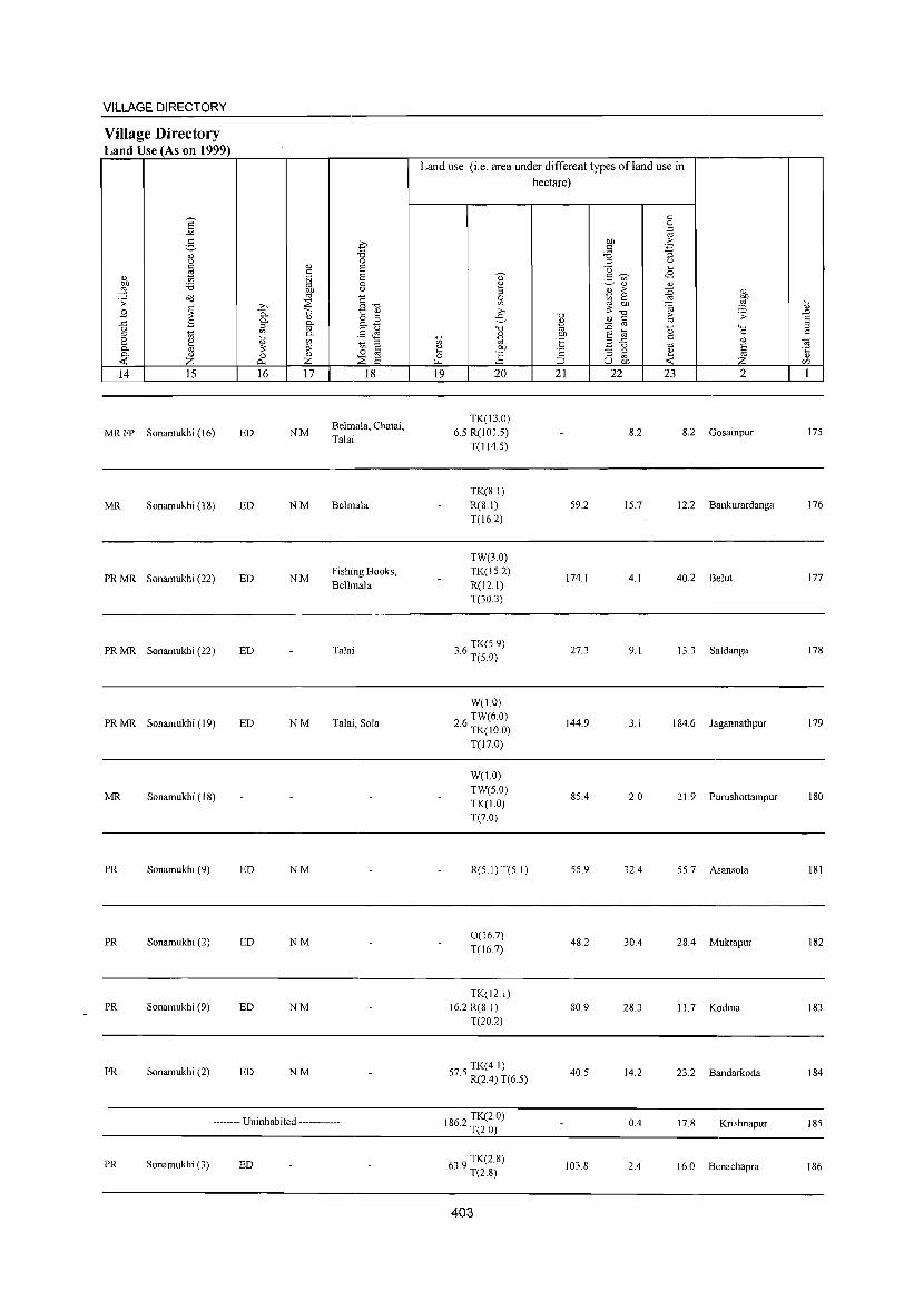
VILLAGE DIRECTORY
Village Directory Land Use (As on 1999)
14 15
MR FP Sonamukhi (16)
MR Sonamukhi (IS)
PR MR Sonamukhi (22)
PR MR Sonamukhi (22)
PR MR Sonamukhi (19)
MR Sonamukhi (18)
PR Sonamukhi (9)
PR Sonamukhi (2)
PR Sonamukhi (9)
PR Sonamukhi (2)
16 17
ED NM
ED NM
ED NM
ED
ED NM
ED NM
ED NM
ED NM
ED NM
18
Belmala, Chatai, Talai
Belmala
Fishing Hooks, Belhnala
Talai
Talai, SoJa
-------- Uninhabited ------------
PR Sonamukhi (3) ED
Land use (i.e. area under different types ofland use in hectare)
19 20
TK(13.0) 6.5 R(101.5)
T(114.5)
TK(8.1) R(S.I) T(16.2)
TW(3.0) TK(15.2) R(I2.I) T(30.3)
06 TK(S.9) o. T(5.9)
W(1.0) TW(6.0)
2.6 TK(10.0)
T(1TO)
W(l.O) TW(5.0) TK(1.0) T(7.0)
R(5.1)T(5.1)
0(16.7) T(16.7)
TK(12.1) 16.2 R(8 I)
T(20.2)
75 TK(4.1) 5. R(2,4) T(6.5)
1862 TK(2.0) . T(2.0)
639 TK(2.8) . T(2.8)
403
21 22
59.2
174.1
27.3
144.9
85,4
55.9
4S.2
80.9
40.5
103.8
23 2
8.2 8.2 Gosainpur
15.7 12.2 Bankurardanga
4.1 40.2 Belut
9.1 13.3 Saldanga
3.1 184.6 Jagannathpur
2.0 21. 9 Purushottampur
32,4 55.7 Asansola
30A 28,4 Muktapur
28.3 11.7 Kodma
14.2 23.2 Bandarkoda
0,4 17.8 Krishnapur
2.4 16.0 Benachapra
175
176
177
178
179
180
181
182
183
184
185
186
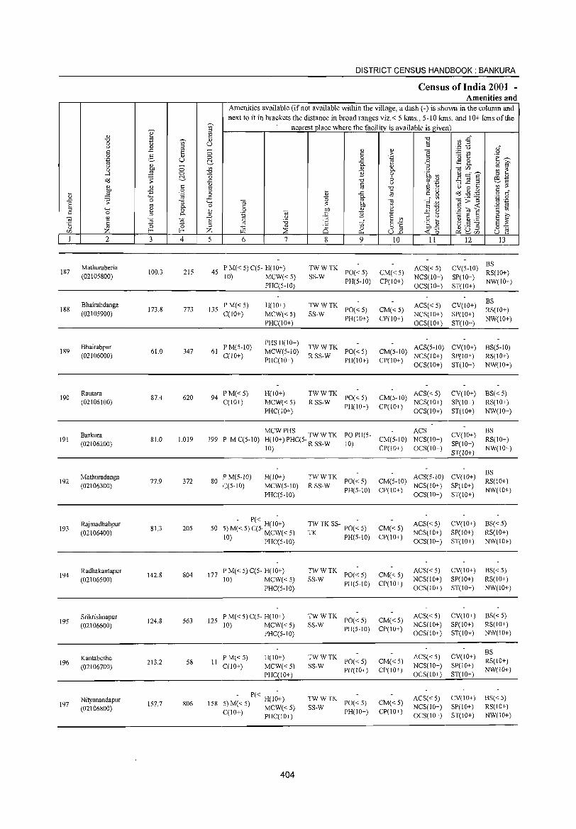
187
188
189
190
191
192
193
194
195
196
197
2
Mathuraberia (02105800)
Bhairabdanga (02105900)
Bhairabpur (02106000)
Rautara (02106100)
Barkura (02106200)
Mathuradanga (02106300)
Rajmadhabpur (02106400)
Radhakantapur (02106500)
Srikrishnapur (02106600)
Kantabeshe (02106700)
Nityanandapur (02106800)
3
100.3
173.8
61.0
87.4
81.0
77.9
81.3
142.8
124.8
213.2
157.7
o o ~
§ .~
"3 0.. o 0..
'" ~ 4
215
773
347
620
1,019
372
205
804
563
S8
806
DISTRICT CENSUS HANDBOOK: BANKURA
Census of India 2001 -Amenities and
Amenities available (if not available within the village, a dash (-) is shown in the column and next to it in brackets the distance in broad ranges viz.< 5 kms., 5-10 kms. and 10+ kms of the
nearest place where the facility is available is given
5 6 7
45 P M« S) CC5- H(IO+) 10) MCW«5)
PHCC5-1O)
135 I' M« 5) C(IO+)
H(IO+)
MCW«5) PHCCIO+)
61 PM(5-1O) C(lO+)
94 I'M«5) C(lO+)
PHS H(IO+) MCW(5-IO)
PHCCI0+)
H(10+)
MCW«5) PHC(10+)
8
TWWTK SS-W
'" o 0..
9
PO«5) PH(5-10)
TWWTK SS-W PO« 5)
PH(JO+)
TWWTK R SS-W PO« 5)
PH(IO+)
TWWTK R SS-W PO« 5)
PH(IO+)
<L)
> .~ 0.. o 6 u
]
'" .~
<1J
E '" E"'" 8~
10
CM«5) CP(IO+)
CM« 5) CP(IO+)
II
ACS« 5) NCS(IO+)
OCS(IO+)
ACS« 5) NCS(IO+) OCS(IO+)
12 I3
BS CV(5-10) RS(IO+) SP(IO+) NW(IO+) ST(IO+)
CV(IO+)
SP(IO+) ST(IO+)
BS RS(IO+)
NW(IO+)
CM(5-10) ACS(S-IO) CV(lO+) CP(IO+) NCS(lO+) SP{lO+)
OCS(IO+) ST(IO+)
BS(5-10) RS(lO+) NW(lO+)
ACS« 5) CM(5-10) NCS(lO+)
CI'(lO+) OCS(10+)
CV(10+) SP(lO+) ST(IO+)
BS«5) RS(IO+) NW(10+)
MCWPHS ACS 199 P M C(5-10) H(10+) I'HC(5. TW W TK PO PH(5- CM(5-10) NCS(IO+)
CV(lO+)
SI'(IO+)
ST(lO+)
BS RS(IO+) NW(IO+) 10) R SS-W 10) CI'(IO+) OCS(IO+)
80 IPM(5-1O) C(5-10)
H(lO+)
MCW(5-10)
PHC(5-10)
- P« -50 5) M« 5) C(5. H(lO+)
MCW«5) 10) PHC(5-1O)
177 P M« 5) C(5- H(JO+) 10) MCW«5)
PHCC5-10)
125 I' M« 5) C(5- H(IO+) 10) MCW«5)
PHC(S-IO)
11 I' M« 5) C(10+)
l-I(IO+)
MCW«5) PHC(10+)
- P« H(1;+) 5) M« 5) MCW« 5) C(lO+) PHC(IO+)
158
404
TWWTK R SS-W PO« 5)
I'H(5-10)
TW TK SS- I'O(~ S)
TK I'H(5-10)
TW W TK PO« 5)
SS-W PH(5-10)
TWWTK SS-W PO« 5)
PH(5-10)
TWWTK SS-W PO« 5)
PH(lO+)
TWWTK SS-W PO« 5)
PH(IO+)
CM(5-10) ACS(5-1O) CV(10+) CP(IO+) NCS(IO+) SP(10+)
CM« 5) CP(IO+)
CM«5) CP(IO+)
CM« 5) CP(IO+)
CM«5) CP(10+)
CM«5) CP(10+)
OCS(IO+) ST(JO+)
ACS«5) NCS(JO+) OCS(IO+)
ACS«5) NCS(IO+) OCS(lO+)
ACS« 5) NCS(IO+) OCS(IO+)
ACS« 5) NCS(10+) OCS(lO+)
ACS« 5) NCS(IO+) OCS(IO+)
CV(lO+)
SI'(IO+) ST(IO+)
CV(IO+) SI'(IO+) ST(IO+)
CV(IO+) SP(IO+) ST(10+)
CV(IO+) SP(IO+) ST(IO+)
CV(IO+) SP(IO+) ST(IO+)
BS RS(IO+) NW(IO+)
BS« 5) RS(10+) NW(IO+)
BS« 5) RS(IO+) NW(10+)
BS« 5) RS(10+) NW(10+)
BS RS(IO+) NW(IO+)
BS« 5) RS(IO+) NW(\O+)
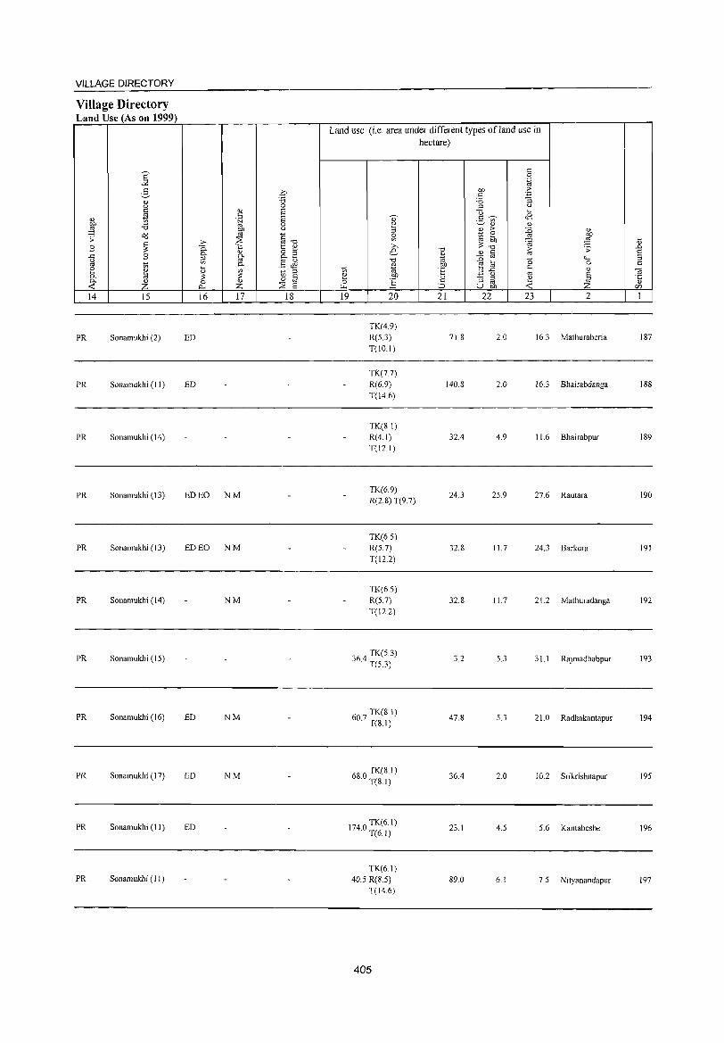
VILLAGE DIRECTORY
Village Directory Land Use (As on 1999)
14 15
PR Sonamukhi (2)
PR Sonamukhi (II)
PR Sonamukhi (14)
PR Sonamukbi (13)
PR Sonamukbi (13)
PR Sonamukhi (14)
PR Sonamukhi (15)
PR Sonamukhi (16)
PR Sonamukhi (17)
PR Sonamukhi (11)
PR Sonamukbi (II)
16 17 18
ED
ED
ED EO NM
ED EO NM
NM
ED NM
ED NM
ED
Land use (i.e. area under different types ofland use in hectare)
19 20
TK(4.9) R(S 3) T(IO.I)
TK(7.7) R(6.9) T(l4.6)
TK(8.1) R(4.1) T(12.1)
TK(6.9) R(2.S) T(9.7)
TK(6.5) R(S 7)
T(12.2)
TK(6.5) R(5.7) T(12.2)
'64 TK(5 3) .) . T(5.3)
607 TK(S.I) · T(S.I)
680 TK(S.I) · T(S.I)
1740 TK(6.I) · T(6.1)
TK(61) 40.5 R(8.5)
T(14.6)
405
21 22
71.S
140.8
32.4
24.3
32.S
32.S
3.2
47.S
36.4
23.1
89.0
23 2
2.0 16.3 Mathuraberia
2.0 16.3 Bhairabdanga
4.9 11.6 Bhairabpur
25.9 27.6 Rautara
11.7 24.3 Barkura
11.7 21.2 Mathuradanga
5.3 3 I. I Rajmadhabpur
5.3 21. 0 Radhakantapur
2.0 10.2 Srikrishnapur
4.5 5.6 Kantabeshe
6.1 7.5 Nityanandapur
IS7
188
IS9
190
191
192
193
194
195
196
197
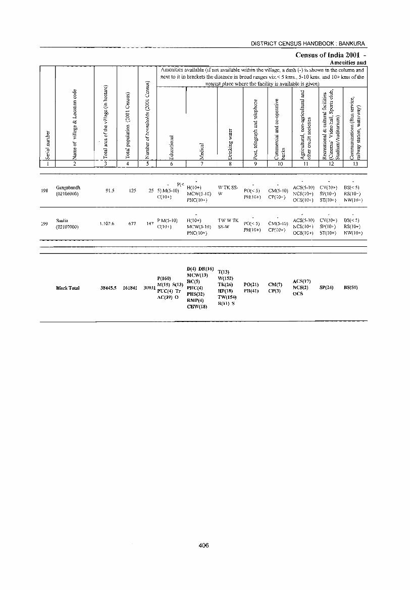
198
199
2
Gangabandh (02106900)
Saulia (02107000)
Block Total
3
91.5
1,102.6
38445.5
0:: o .~
::; 0-
2-
~ 4
125
677
161841
DISTRICT CENSUS HANDBOOK: BANKURA
Census of India 2001 -Amenities and
Amenities available (if not available within the village, a dash (-) is shown in the column and next to it in brackets the distance in broad ranges viz.< 5 kms., 5-10 kms. and 10+ kms of the
nearest glace where the facility is available is given
5 6 7
- P« H(I~+) 25 5) M(5-IO) MCW(5-IO)
C(10+) PHC(IO+)
147 PM(5-10) C(1O+)
P(160)
3093"[ M(IS) S(13) J PUC(4) Tr
AC(39) 0
H(10+)
MCW(S-IO) PHC(10+)
D(4) DB(16) MCW(13) BC(S) PBC(4) PBS(32) RMP(4) CBW(18)
406
8 9
~ TK SS- PO« 5)
PH(IO+)
TWWTK SS-W PO« 5)
PH(IO+)
T(13) W(I52) TK(26) PO(21) BP(18) PB(41) TW(154) R(ll) S
10 11 12
CM(5-IO) ACS(5-IO) CV(IO+) NCS(10+) SP(10+)
CP(IO+) OCS(IO+) ST(IO+)
ACS(5-1O) CV(10+) CM(5-IO) NCS(IO+) SP(IO+)
CP(lO+) OCS(IO+) ST(10+)
ACS(17) CM(7)
NCS(2) SP(24) CP(3)
OCS
13
BS« 5) RS(10+) NW(JO+)
BS«5) RS(IO+)
NW(10+)
BS(50)
VILLAGE DIRECTORY
Village Directory Land Use (As on 1999)
<I) bf)
,g .;;: .8 ..c u
'" 2 0-0-< 14
MR
PR
PR(lOO) MR(160 ) FP(16)
E "" 2-
<I)
'-' a to :a c<l
~ .8 to ~ <I)
Z 15
Sonamukhi (18)
Sonamukhi (19)
16 17
ED(137) N(152) EO(26) M(102)
18
Land use (i.e. area under different types ofland use in hectare)
19 20 21 22 23 2
769 TK(2.4) . T(2.4)
1.6 5.3 5.3 Gangabandh
457 0 TK(69.6)
.0 T(69 6)
GC(606.l9) W(204.86) TW(47.25) TK(2861.8)
8816.3 R(836.74) L(3)
WF(84.43) 0(424.55) T(5068.82)
407
477.5 36.6 61.5 Saulia
13208.3 2457.5 8894.7
198
199

I ~ :::> ~ « z o (/l
z o I« I(/l
w (.)
o
I- -(J
0:::: a
l-(/)
o ~
. ~ • 0 a
• § · ~ o
\ .
IV
~ :.: ct
(j)
~ [\3 ~ gJ ~ M ~ Z
g " t2
:.: ::> :::;; -0: Z 0 (j)
6
'. J /
..... a
..., Ci II)
§ '" OJ :> a
C!>
©
..... a t>Il) :> ... ;J
(j)
~ a 0. ;J
1 ~------------------------~----------------~ ~

VILLAGE AND TOWN DIRECTORY
AlphaliJeticallist of Villages (CD Block wise)
2001 Census location 1991 Census location Serial number Name of village code number code number
1 2 3 4
Name of the CD Block: Sonamukhi Code of the CD Block : 0009
Alampur 02107400 140160001000100004 2 Ali gang 02112200 140160001000100052 3 Amghata 02115200 140160001000100083 4 Amrita Para 02120400 140160001000100136 5 Amshol 02116400 140160001000100096 6 Aralkola 02123100 140160001000100163 7 Baghmari 02125200 140160001000100184 8 Baharpur 02121800 140160001000100150 9 Bahulia 02112700 140160001000100058
10 Baikunthapur (P) 02112300 140160001000100053 11 Balarampur 02124000 140160001000100172 12 BanParuHa 02118700 140160001000100119 13 Bandi Rampur 02108100 140160001000100011 14 Bank Simla 02108800 140160001000100018 15 Bara 02120700 140160001000100139 16 Bara N aryanpur 02114000 140160001000100071 17 Barachatra 02111000 140160001000100040 18 Baruibera 02119600 140160001000100128 19 Basu Nandanpur 02110400 140160001000100034 20 Basudebpur 02107500 140160001000100005 21 Basumara 02113300 140160001000100064 22 Belgaria 02108900 140160001000100019 23 Beloa 02117600 140160001000100108 24 Beshia 02120600 140160001000100138 25 Bhabanipur 02123300 140160001000100165 26 BhalukKhan 02118400 140160001000100116 27 Bhat Pushkarini 02123400 140160001000100166 28 Bhatpara 02121000 140160001000100142 29 Bhedomushal 02114900 140160001000100080 30 Bhu1a 02114100 140160001000100072 31 Bidyadharpur 02117100 140160001000100103 32 Birchandrapur 02108700 140160001000100017 33 Birsingpur 0211 1700 140160001000100047 34 Bneshe 02118800 140160001000100120 35 Bondalhati 02116700 140160001000100099 36 Brindabanpur 02118000 140160001000100112 37 Brojanathpur 02124100 140160001000100173 38 Chaitanpur 02116300 140160001000100095 39 Chakai 02109300 140160001000100023 40 Chakdhoyakure 02124700 140160001000100179 41 Chandansaer 02109700 140160001000100027 42 Chaulya 02110900 140160001000100039 43 Chhota Narayanpur 02107300 140160001000100003 44 Churamanipur 02114600 140160001000100077
411
DISTRICT CENSUS HANDBOOK: BANKURA
Alphlllbetical list of Villages (CD Block wise)
2001 Census location 1991 Census location Serial number Name of village code number code number
2 3 4
45 Dakshinsol 02115000 140160001000100081 46 Dariapur 02119200 140160001000100124 47 Dhan Sim~a 02121900 140160001000100151 48 Dharmapur 02116500 140160001000100097 49 Dhondar 02119300 140160001000100125 50 Dhulai 02108400 140160001000100014 51 Dhulat 02118200 140160001000100114 52 Dihipara 02107800 140160001000100008 53 Dubrajhati 02111200 140160001000100042 54 Goltor 02116200 140160001000100094 55 Gop Bandi 02113200 140160001000100063 56 Gopalpur 02125600 1401160001000100188 57 Gopdanga 02119500 1401160001000100127 58 Gopikantapur 02117200 140160001000100104 59 Gopinathpur 02121200 140160001000100144 60 Gopinathpur 02122600 140160001000100144 61 Gopinathpur 02124800 140160001000100158 62 GoursundeJrpur 02116900 140160001000100101 63 Gram Pushkarini 02107700 140160001000100007 64 Hamirhati 02113000 140160001000100061 65 Harishchandrapur 02109600 140160001000100026 66 Hikimband 02122900 140160001000100161 67 Hurhurjangar 02125500 140160001000100187 68 Ichharia 02122300 140160001000100155 69 Indkata 02115100 140160001000100082 70 Isabpur 02120100 140160001000100133 71 Jaga Mohanpur 02118500 140160001000100117 72 Jambani 02112400 140 Il6000 1 000 1 0005 5 73 Jamdoba 02122200 14011 60001000100154 74 Jashra 02113600 140160001000100067 75 Jaynagar 02107200 140160001000100002 76 Jaypur 02111500 140160001000100045 77 Jhujka 02124900 140160001000100181 78 Junshara 02119000 140160001000100122 79 Kalyanpur 02114800 140160001000100079 80 Kamardanga 02111400 140160001000100044 81 Kamargram 02123700 140160001000100169 82 Kanaipur 02122700 140160001000100159 83 Karachmani Khayarsol 02124500 140160001000100177 84 Karjbani 02112000 140160001000100050 85 Kashipur 02121600 140160001000100148 86 Katnia 02111600 140160001000100046 87 Kendua 02122000 140160001000100152 88 Keneti 02117400 140160001000100106 89 Kesheshol 02114400 140160001000100075 90 Khaer Bani 02117700 140160001000100109
412
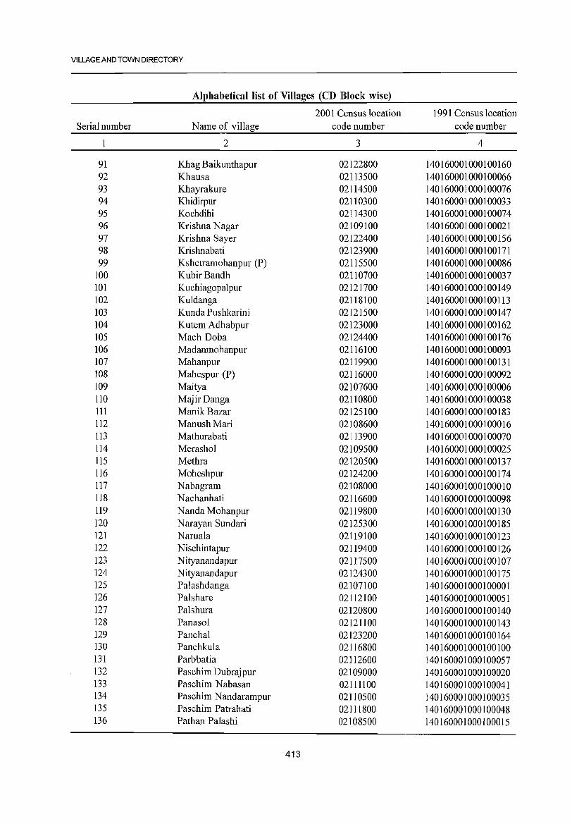
VILLAGE AND TOWN DIRECTORY
Alphabetical list of Villages (CD Block wise)
2001 Census location 1991 Census location Serial number Name of village code number code number
1 2 3 4
91 Khag Baikunthapur 02122800 140160001000100160 92 Khausa 02113500 140160001000100066 93 Khayrakure 02114500 140160001000100076 94 Khidirpur 02110300 140160001000100033 95 Kochdihi 02114300 140160001000100074 96 Krishna Nagar 02109100 140160001000100021 97 Krishna Sayer 02122400 140160001000100156 98 Krishnabati 02123900 140160001000100171 99 Kshetramohanpur (P) 02115500 140160001000100086
100 KubirBandh 02110700 140160001000100037 101 Kuchiagopalpur 02121700 140160001000100149 102 Kuldanga 02118100 140160001000100113 103 Kunda Pushkarini 02121500 140160001000100147 104 Kutem Adlhabpur 02123000 140160001000100162 105 Mach Doba 02124400 140160001000100176 106 Madanmohanpur 02116100 140160001000100093 107 Mahanpur 02119900 140160001000100131 108 Mahespur (P) 02116000 140160001000100092 109 Maitya 02107600 140160001000100006 110 MajirDanga 02110800 140160001000100038 111 Manik Bazar 02125100 140160001000100183 112 ManushMari 02108600 140160001000100016 113 Mathurabati 02113900 140160001000100070 114 Merashol 02109500 140160001000100025 115 Methra 02120500 140160001000100137 116 Moheshpur 02124200 140160001000100174 117 Nabagram 02108000 140160001000100010 118 Nachanhati 02116600 140160001000100098 119 Nanda Mohanpur 02119800 140160001000100130 120 Narayan Sundari 02125300 140160001000100185 121 Naruala 02119100 140160001000100123 122 Nischintapur 02119400 140160001000100126 123 Nityanandapur 02117500 140160001000100107 124 Nityanandapur 02124300 140160001000100175 125 Palashdanga 02107100 140160001000100001 126 Palshare 02112100 140160001000100051 127 Palshura 02120800 140160001000100140 128 Panasol 02121100 140160001000100143 129 Panchal 02123200 140160001000100164 130 Panchkula 02116800 140160001000100100 131 Parbbatia 02112600 140160001000100057 132 Paschim Dubrajpur 02109000 140160001000100020 133 Paschim N abasan 02111100 140160001000100041 134 Paschim Nandarampur 02110500 140160001000100035 135 Paschim Patrahati 02111800 140160001000100048 136 Pathan Palashi 02lO8500 140160001000100015
413
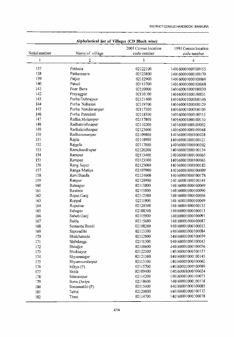
DISTRICT CENSUS HANDBOOK: BANKURA
Alphabetical list of Villages (CD Block wise)
2001 Census location 1991 Census location Serial number Name of village code number code number
2 3 4
137 Pathara 02122100 140160001000100153 138 Patharmara 02123800 140160001000100170 139 Patjor 02112900 140160001000100060 140 Patso1 02113700 140160001000100068 141 Pear Bera 02110000 140160001000100030 142 Prayagpur 02110100 140160001000100031 143 Purba Dubrajpur 02121400 140160001000100146 144 Purba Nabasan 02119700 140160001000100129 145 Purba N andarampur 02117300 140160001000100105 146 Purba Patrahati 02118300 140160001000100115 147 Radha Mohanpur 02117800 140160001000100110 148 Radhakrishnapur 02110200 140160001000100032 149 Radhakristmapur 02123600 140160001000100168 150 Radharamanpur 02109800 140160001000100028 151 Rajda 02118900 140160001000100121 152 Rajgo1a 02117000 140160001000100102 153 RamchandJrapur 02120200 140160001000100134 154 Rampur 02113400 140160001000100065 155 Rampur 02123500 140160001000100065 156 Rang Sayer 02125000 140160001000100182 157 Ranga Matiya 02107900 140160001000100009 158 Rani Balldh 02124600 140160001000100178 159 Ranpur 02120900 140160001000100141 160 Ratllapur 02113800 140160001000100069 161 Rautara 02115800 140160001000100090 162 RupatGanj 02112500 140160001000100056 163 Ruppa] 02111900 140160001000100049 164 Rupuisar 02120300 140160001000100135 165 Sahapur 02108300 140160001000100013 166 Saheb Gallj 02115900 140160001000100091 167 Salda 02115600 140160001000100087 168 Samanta B8illdi 02108200 140160001000100012 169 Sapuradihi 02115300 140160001000100084 170 Shalchaturia 02112800 140160001000100059 171 Shibdanga 02111300 140160001000100043 172 Shitaijor 02110600 140160001000100036 173 Shuksayer 02122500 140160001000100157 174 Shyamnagar 02121300 140160001000100145 175 Shyamsundarpur 02113100 140160001000100062 176 Si1tya (P) 02115700 140160001000100089 177 Simla 02109400 140160001000100024 178 Sitarampur 02114200 140160001000100073 179 SonaDwipa 02118600 140160001000100118 180 Sonamukhi (P) 02115400 140160001000100085 181 Telrui 02120000 140160001000100132 182 Tiura 02114700 140160001000100078
414
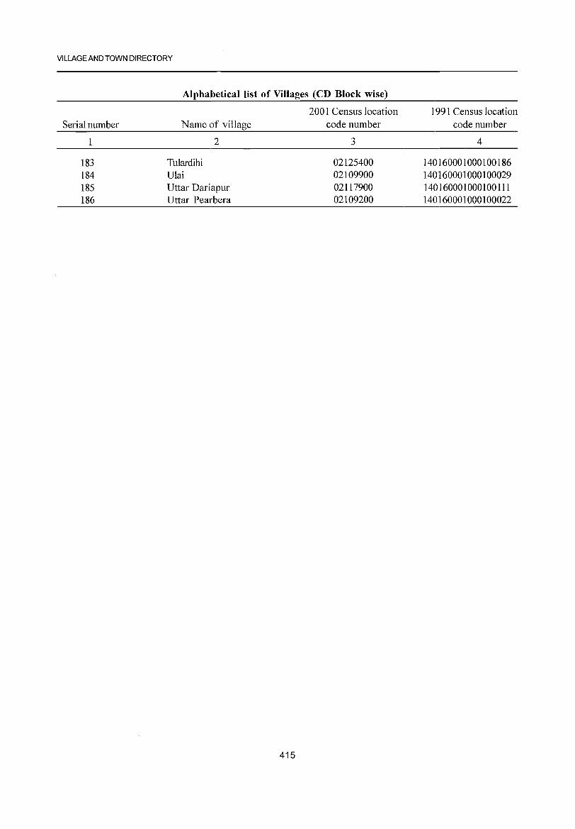
VILLAGE AND TOWN DIRECTORY
Alphabetical list of Villages (CD Block wise)
2001 Census location 1991 Census location Serial number N arne of village code number code number
1 2 3 4
183 Tu1ardihi 02125400 140160001000100186 184 U1ai 02109900 140160001000100029 185 Uttar Dariapur 02117900 140160001000100111 186 Uttar Pearbera 02109200 140160001000100022
415
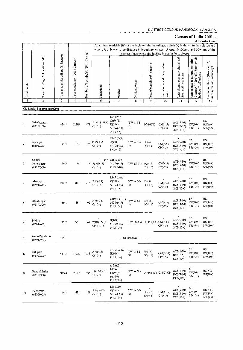
DISTRICT CENSUS HANDBOOK: BANKURA
Census ofIndia 2001 -Amenities and
Amenities available (if not available within the village, a dash (-) is shown in the colunm and next to it in brackets the distance in broad ranges viz.< 5 kms., 5-10 kms. and 10+ kms of the
~
nearest place where the facility is available is given Q) ~
" 2 '" "0 ~ -g" "d " 0 u '" U '" u " ~ '" '';::: u .?i -" _
" " "§ " '" 0 '" > ~ rI)
0 .2, " 'u 1:: .~ U
0 0 '.g B c:~ c:!- ..c ~ 2-
u " _
0- ~ :; " ~ a DO 0 '" " 0- u "e/) ~ ~ ..-l ,g 0 "d 1l 0 .~ ~ 3 ::=",? c:!- '0 6 ::l "
OIl .;;: ..c "d ~ '';::: '3 ~ .~ o:l-.; ~ '"
u ';;;;:
:W " '" '" "d '" " u 0 .... £ 0 ::l
~ ..c '" g 'g c(j ..g ,g " " ~ .~ 0 '" .,g § "-< ..c 0- _" '" _ .- " ..CJ .;;: 0 :; "" " ~ " l3>~ '" .-S '"
;;: '" - u -.; 0- 0 '" DO 'g ..... -
::l '+< e 0 ~ 0 DO " ::l "d BOla § t>
'" 0 '" 0- 'ia " c ] .:::: e
" " ..CJ u ;.g E '"
::l u ~ 5 .2 E ~ '5 § ~ ~ E u :.a c ti E-" .~ aJ ::l ~O~ §:: ::l "
<ll 8 o " DO-" e/) Z Z >I.l ~
0 u.2 « 0 u ~ "'"'
~ ~<Zl
I 2 3 4 5 6 7 8 9 10 11 12 13
CD Block: Sonamukhi (0009)
DHRMP
Palashdanga PM S PUC CHW(2)
TWWSS- ACS(5-10) SP BS
424.1 2,299 428 H(IO+) PO PH(5) CM«5) CV(10+) RS(IO+) (02107100) C(IO+) W NCS(5-10)
MCW«5) CP« 5) OCS(JO+)
ST(IO+) NW(IO+) PHC« 5)
RMPCHW SP
Jaynagar P M«5) H(10+) TWWSS- PH(4) ACS(5-10) BS
2 179.4 483 78 CM«5) CV(lO+) RS(lO+) (02107200) C(10+) MCW«5) W PO«5) NCS(5-10)
PHC«5) CP« 5)
OCS(IO+) ST(IO+) NW(10+)
Chhota P« DH H(IO+) ACS(5- 10)
SP BS
3 Narayanpur 56.3 94 19 5) M« 5) MCW«5) TW SS-TW PO« 5) CM«5) CV(IO+) RS(IO+)
(02107300) C(10+) PHC(5-10) PH« 5) CP«5) NCS(5-10)
ST(IO+) NW(10+) OCS(10+)
RMPCHW SP BS
4 Alampur
229.7 1,081 216 PM«5) H(IO+) TWWSS- PH(5)
CM« 5) ACS(5-10)
CV(10+) RS(IO+) (02107400) C(IO+) MCW« 5) W PO« 5)
CP« 5) NCS(5-10)
ST(10+) NW(10+) PHC« 5) OCS(10+)
Basudebpur lPM«5) CHWH(10+)
TWWSS- PH(5) ACS(5-10) SP BS
59.1 481 96 MCW«5) CM« 5) CV(IO+) RS(lO+) (02107500) C(10+)
PHC(IO+) W PO« 5)
CP« 5) NCS(5-10)
ST(IO+) NW(10+) OCS(10+)
ACS(5-1O) SP BS
6 Maitya
77.7 301 69 1'(10+) M« H(lO+)
TW SS-TW PH PO« 5) CM« 5) CV(IO+) RS(10+) (02107600)
5) C(10+) MCW«5)
CP«5) NCS(5-10)
ST(IO+) NW(IO+) PHC(IO+) OCS(IO+)
7 Gram Pushkarini (02107700)
184.1 -------- Uninhabited ------------
MCWCHW TWWSS- ACS(5-10)
SP BS Dihipara
411.3 1,428 255 P M«5)
H(10+) PH(19)
CM(5-10) CV(IO+) RS(IO+) 8 (02107800) C(lO+) W PO«5) NCS« 5)
PHC(IO+) CP« 5) OCS(IO+)
ST(lO+) NW(IO+)
DDH(2) MCW ACS(5-10)
SP BSNW Ranga Matiya P(4)M«5) TWWSS-
PO PH(l5) CM(2) CP CV(lO+) 9 (02107900)
915.4 2,627 495 C(lO+)
CHW(2) W NCS(5-1O) RS(10+)
H(10+) ST(10+)
PHC(IO+) OCS(10+)
DHCHW SP Nabagram 481 84
PM(5-10) H(IO+) TWWSS-PO«5) CM(5-10)
ACS(5-10) CV(IO+)
BS« 5) 10 74.1
C(JO+) MCW«5) W NCS(5-10) RS(IO+) (02108000) PH«5) CP« 5) 5T(l0+) PHC(lO+) OCS(JO+) NW(lO+)
416
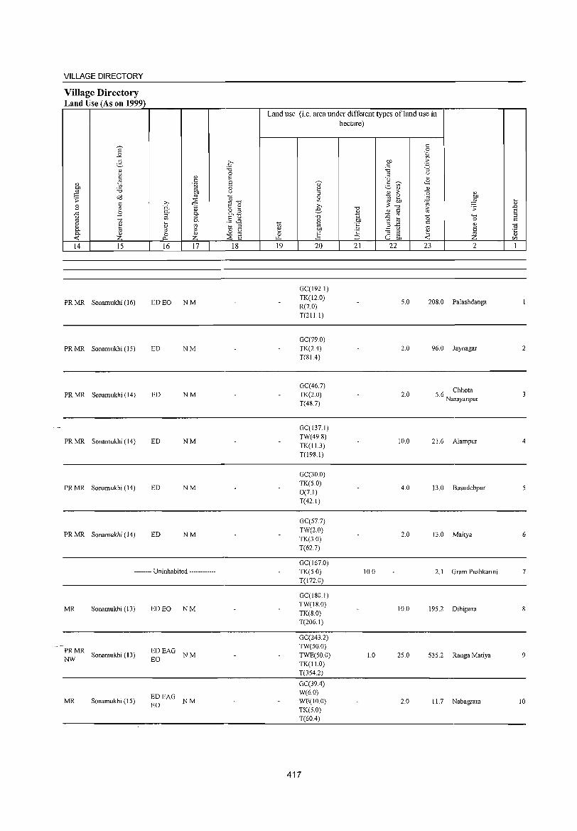
VILLAGE DIRECTORY
Village Directory Land Use (As on 1999)
14 15
PRMR Sonamukhi (16)
PRMR Sonamukhi (15)
PRMR Sonamukhi (14)
PRMR Sonamukhi (14)
PRMR Sonamukhi (14)
PRMR Sonamukhi (14)
16 17
ED EO NM
ED NM
ED NM
ED NM
ED NM
ED NM
-------- Uninhabited ------------
MR Sonamukhi (13) ED EO NM
PRMR EDEAG NW
Sonamukhi (13) EO
NM
EDEAG MR Sonamukhi (IS)
EO NM
18
Land use (i.e. area under different types ofland use in hectare)
19 20 21 22 23
GCCI92.I) TK(12.0)
5.0 208.0 R(7.0) T(211.I)
GCC79 0) TK(24) 2.0 96.0 T(81.4)
2
Palashdanga
Jaynagar
GC(467) 5.6 Chhota TK(2.0) 2.0
Narayanpur T(48.7)
GCCI37.1) TW(498)
10.0 21.6 Alampur TK(1l.3) T(198.1)
GCC30.0) TK(5.0)
4.0 13.0 Basudebpur 0(7.1) T(42.1)
GCC57.7) TW(2.0)
2.0 13.0 Maitya TK(3.0) T(62.7)
GCCI67.0) TK(5.0) 10.0 2.1 Gram Pushkarini T(172.0)
GCCI80.1) TW(18.0)
10.0 195.2 Dihipara TK(8.0) T(206.1)
GCC243.2) TW(50.0) TWE(50.0) 1.0 25.0 535.2 Ranga Matiya TK(I1.0) T(354.2)
GC(394) W(6.0) WE(IO.O) 2.0 11.7 Nabagram TK(5.0) T(604)
417
2
4
5
6
7
9
10
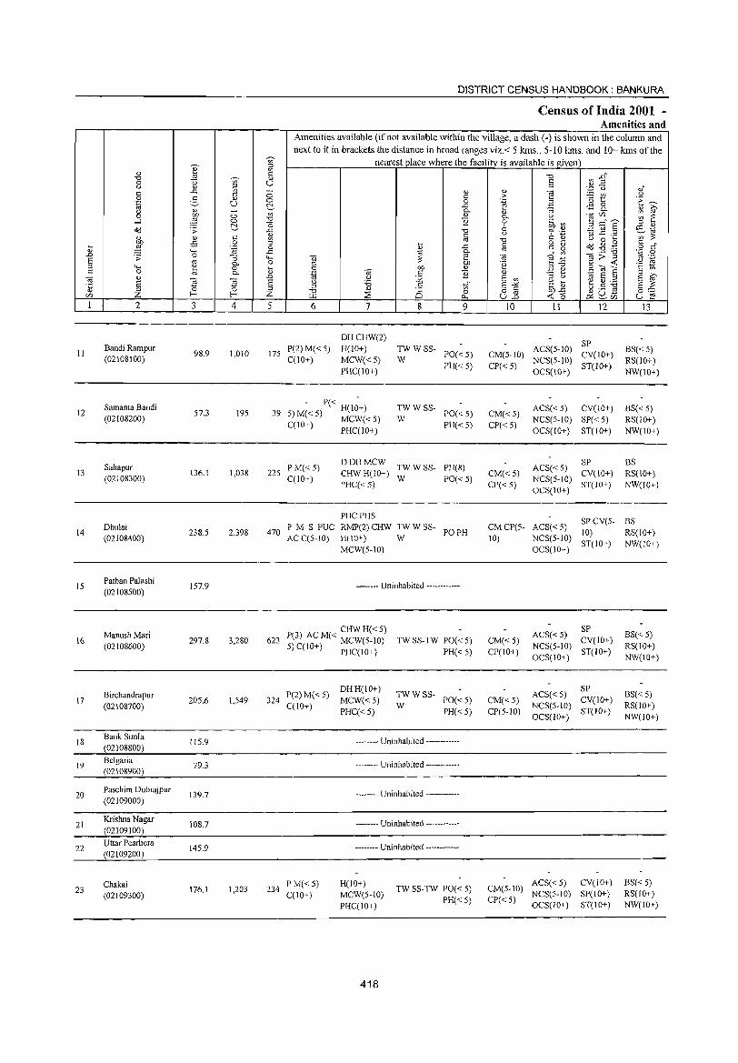
II
12
13
14
15
16
17
18
19
20
21
22
23
2
Bandi Rampur (02108100)
Samanta Bandi (02108200)
Sahapur (02108300)
Dhulai (02108400)
Pathan Palashi
(02108500)
ManushMari (02108600)
B irchandrapur (02108700)
Bank Simla (02108800)
Belgaria (02108900)
Paschim Dubrajpur (02109000)
Krishna Nagar
(02109100)
Uttar Pearbera (02109200)
Chakai (02109300)
3
98.9
57.3
136.1
238.5
157.9
297.8
205.6
115.9
79.3
139.7
108.7
145.9
176.1
o o f:!, c o .~
:; 0. o 0.
~ 4
1,010
195
1,038
2,398
3,280
1,549
1,203
DISTRICT CENSUS HANDBOOK: BANKURA
Census of India 2001 -Amenities and
I Amenities available (if not available within the village, a dash (-) is shown in the column and next to it in brackets the distance in broad ranges viz.< 5 krns., 5-10 krns. and 10+ krns of the
nearest place where the facility_ is available is given
u
5 6
175 P(2)M«5) C(lO+)
7
DHCHW(2) H(IO+)
MCW«5) PHC(10+)
- P« H(I;+) 39 5) M« 5) MCW« 5)
C(lO+) PHC(IO+)
8 9
TWWSS-PO«5) PH«5)
W
TWWSS-PO«5) PH« 5)
W
225 P M« 5) C(10+)
DOH MCW TW W SS- PH(8) CHW H(10+) W PO« 5) PHC«5)
PHCPHS
470 ? M S PUC RMP(2) CHW TW W SS- PO PH ACC(5-10) H(lO+) W
MCW(5-10)
-------- Uninhabited ------------
CHWH«5) 623 P(3) AC M« MCW(5-10)
5) C(lO+) PHC(IO+)
P(2)M«5) DHH(IO+) 324 C(IO+) MCW« 5)
PHC«5)
TW SS-TW PO« 5)
PH« 5)
TWWSS-W PO«5)
PH« 5)
-------- Uninhabited ------------
234 PM«5) C(lO+)
-------- Uninhabited ------------
-------- Uninhabited ------------
-------- Uninhabited ------------
-------- Uninhabited ------------
H(IO+) MCW(5-10) PHC(lO+)
418
TW SS-TW PO« 5) PH« 5)
10
CM(5-1O)
CP« 5)
CM«5) CP«5)
CM«5) CP« 5)
CMCP(5-10)
CM«5) CP(IO+)
CM« 5) CP(5-10)
11 12
SP ACS(5-10) CV(lO+) NCS(5-10) ST(lO+) OCS(10+)
ACS« 5) CV(IO+) NCS(5-10) SP« 5)
OCS(JO+) ST(IO+)
ACS« 5) SP NCS(5-1O) CV(10+) OCS(IO+) ST(IO+)
13
BS« 5) RS(10+) NW(lO+)
BS«5) RS(lO+) NW(IO+)
BS RS(10+) NW(lO+)
SPCV(5- BS ACS«5) 10) RS(lO+) NCS(5-10) ST(IO+) NW(lO+) OCS(IO+)
SP ACS«5) NCS(5-10) CV(IO+) OCS(10+) ST(lO+)
SP ACS«5) NCS(5-10) CV(IO+) OCS(IO+) ST(IO+)
BS« 5) RS(JO+) NW(lO+)
BS«5) RS(lO+) NW(IO+)
ACS« 5) CV(IO+) CM(5-10) NCS(5-1O) SP(lO+)
CP« 5) OCS(IO+) ST(IO+)
BS« 5) RS(IO+) NW(IO+)
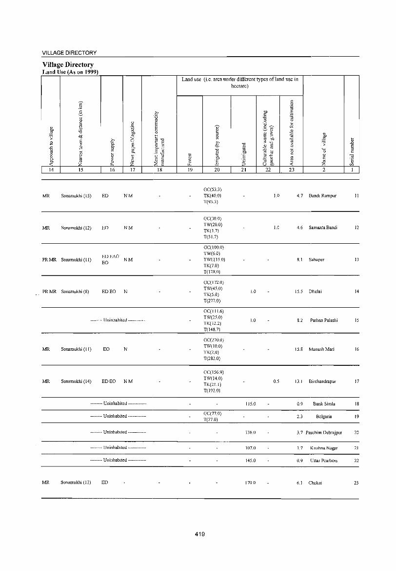
VILLAGE DIRECTORY
Village Directory Land Use (As on 1999)
14 15 16 17
MR Sonamukhi (15) ED NM
MR Sonamukhi (12) ED NM
PR MR Sonamukhi (II) EDEAG NM EO
PR MR Sonamukhi (8) ED EO N
-------- Uninhabited ------------
MR Sonamukhi (II) EO N
MR Sonamukhi (14) ED EO NM
-------- Uninhabited ------------
-------- Uninhabited ------------
-------- Uninhabited ------------
-------- Uninhabited ------------
-------- Uninhabited ------------
MR Sonamukhi (12) ED
18
Land use (i.e. area under different types ofland use in hectare)
<= 0
'.g b1l .~ <= '6 ""3
'" Q
~
" ~ ~ >-. e
"0
" on OJ ~ b1l
~ ~
U .... 5 'V> <B
" " B > ~ " ~ ~ ~ ~ . OJ
"0 "0 10
.:;: " " <= OJ ::0 '" 15 '-b1l E! ;; 0
'E ,::: ..c <= " Q '" § ·c :; '" " '" .... ~ U bIJ ..:: Z
19 20 21 22 23 2
GCC53.3) TK(40.0) 1.0 4.7 Bandi Rampur
T(93.3)
GCC30.0) TW(20.0) TK(1.7)
1.0 4.6 Samanta Bandi
T(S1.7)
GCCIOO.O) TW(6.0) TWE(IS.O) 8.1 Sahapur TK(7.0) T(128.0)
GCC I 72.0) TW(4S.0) TK(S.O)
1.0 IS.5 Dhulai
T(222.0)
GCCI I 1.6) TW(2S.0) TK(122)
1.0 8.2 Pathan Palashi
T(148.7)
GC(2700) TW(IO.O)
TK(2.0) 15.8 Manush Mari
T(282.0)
GCClS6.9) TW(14.0) TK(2L1)
O.S 13.1 Birchandrapur
T(192.0)
115.0 0.9 Bank Simla
GCC77.0) T(77.0)
2.3 Belgaria
136.0 3.7 Paschim Dubrajpur
107.0 1.7 Krishna Nagar
14S.0 0.9 Uttar Pearbera
170.0 6.1 Chakai
419
.... " .D E '" <=
-a '5 Ul
1
II
12
13
14
IS
16
17
18
19
20
21
22
23
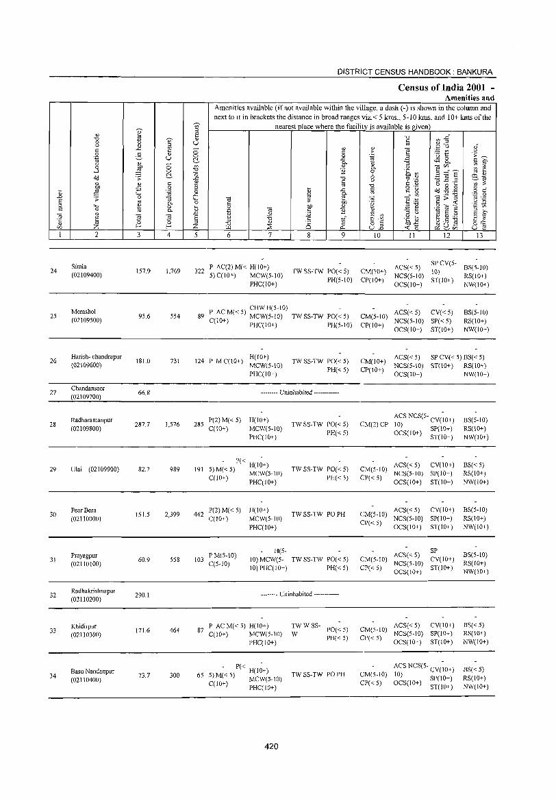
24
25
26
27
28
29
30
31
32
33
34
2
Simla (02109400)
Merashol (02109500)
Harish- chandra pur (02109600)
Chandansaer
(02109700)
Radharamanpur (02109800)
Ulai (02109900)
Pear Bera
(02110000)
Prayagpur (02110100)
Radhakrishnapur (02110200)
Khidirpur (02110300)
Basu Nandanpur (02110400)
3
157.9
95.6
181.0
66.8
287.7
82.2
151.5
60.9
290.1
171.6
73.7
~
'" ::l en C
" U
4
1,769
554
731
1,576
989
2,399
558
464
300
DISTRICT CENSUS HANDBOOK: BANKURA
Census of India 2001 -Amenities and
Amenities available (if not available within the village, a dash (-) is shown in the column and next to it in brackets the distance in broad ranges viz.< 5 kms., 5-10 kms. and 10+ kms of the
nearest place where the facility is available is given
5 6 7
322 P AC(2) M« H(lO+) 5) C(lO+) MCW(5-1O)
PHC(10+)
8 9
TW SS-TW PO« 5) PH(5-1O)
P AC M« 5) CHW H(5-1O) 89 C(10+) MCW(5-10) TW SS-TW PO« 5)
PHC(IO+) PH(5-10)
H(10+) 124 P M C(lO+) MCW(5-10)
PHC(10+)
TW SS-TW PO« 5) PH« 5)
-------- Uninhabited ------------
285 P(2) M« 5) H(IO+) C(IO+) MCW(5-IO)
PHC(10+)
- P« H(I~+) 191 5)M«5) MCW(5-1O)
C(lO+) PHC(IO+)
442 P(2) M« 5) H(10+) C(lO+) MCW(5-JO)
PHC(10+)
H(5-
TW SS-TW PO« 5) PH« 5)
TW SS-TW PO« 5)
PH«5)
TW SS-TW PO PH
103 P M(5-10) C(5-10)
10) MCW(5- TW SS-TW PO« 5) 10) PHC(10+) PH« 5)
-------- Uninhabited ------------
87 P AC M« 5) H(IO+) C(10+) MCW(5-1O)
PHC(10+)
- P« H(I~+) 65 5) M« 5) MCW(5-IO)
C(1O+) PHC(IO+)
420
:W W SS- PO« 5)
PH«5)
TW SS-TW PO PH
10
CM(IO+) CP(lO+)
II 12
ACS« 5) SP CV(5-10)
NCS(5-10) ST(IO+) OCS(10+)
ACS« 5) CV« 5) CM(5-1O) NCS(5-10) SP« 5) CP(IO+) OCS(IO+) ST(lO+)
13
BS(5-1O) RS(10+) NW(10+)
BS(5-10) RS(lO+) NW(lO+)
ACS« 5) SP CV« 5) BS« 5) CM(10+) NCS(5-10) ST(10+) RS(IO+) CP(IO+) OCS(10+) NW(10+)
CM(2)CP ACS NCS(5- CV(~O+) 10) OCS(IO+) SP(IO+)
ST(lO+)
ACS« 5) CV(lO+) CM(5-1O) NCS(5-10) SP(IO+) CP« 5) OCS(IO+) ST(IO+)
ACS« 5) CV(JO+) CM(5-1O) NCS(5-1O) SP(10+) CP« 5) OCS(IO+) ST(10+)
CM(5-1O) CP« 5)
ACS« 5) SP NCS(5-1O) CV(lO+) OCS(lO+) ST(IO+)
ACS« 5) CV(10+) CM(5-1O) NCS(S-IO) SP(JO+) CP« 5) OCS(lO+) ST(IO+)
CM(5-IO) CP« 5)
ACS NCS(5- CV(~O+) 10) SP(IO+) OCS(JO+) ST(IO+)
BS(5-1O) RS(IO+) NW(IO+)
BS« 5) RS(10+) NW(IO+)
BS(5-1O) RS(JO+) NW(10+)
BS(5-10) RS(10+) NW(lO+)
BS«5) RS(IO+) NW(IO+)
BS« 5) RS(IO+) NW(JO+)
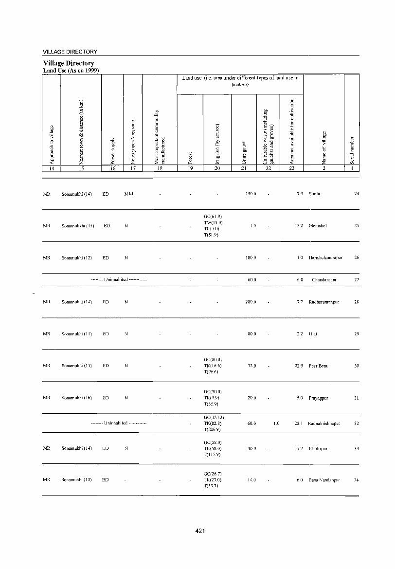
VILLAGE DIRECTORY
Village Directory Land Use (As on 1999)
~ Q) z
14 15
MR Sonamukhi (14)
MR Sonamukkhi (IS)
MR Sonamukhi (12)
16 17
ED NM
EO N
ED N
-------- Uninhabited ------------
MR Sonamukhi (14) ED N
MR Sonamukbi (II) ED N
MR Sonamukhi (II) ED N
MR Sonamukhi (16) ED N
-------- Uninhabited ------------
MR Sonamukbi (14) ED N
MR Sonamukbi (13) ED
18
Land use (i.e. area under different types ofland use in hectare)
19 20 21 22 23
ISO.O 7.9
GC(61.9) TW(IS.O)
I.S 12.2 TK(SO) T(SI.9)
ISO.O 1.0
60.0 6.8
280.0 7.7
2
Simla
Merashol
Harishchandrapur
Chandansaer
Radharamanpur
SO.O 2.2 Ulai
GC(800) TK(l6.6) 32.0 22.9 Pear Bera T(96.6)
GC(30.0) TK(S.9) 20.0 S.O Prayagpur T(3S.9)
GC(124.2) TK(S2.8) 60.0 1.0 22.1 Radhakrishnapur T(206.9)
GC(SS.O) TK(S8.0) 40.0 IS.7 Khidirpur T(l1S.9)
GC(26.7) TK(27.0) 14.0 6.0 Basu Nandanpur T(S3.7)
421
24
2S
26
27
28
29
30
31
32
33
34
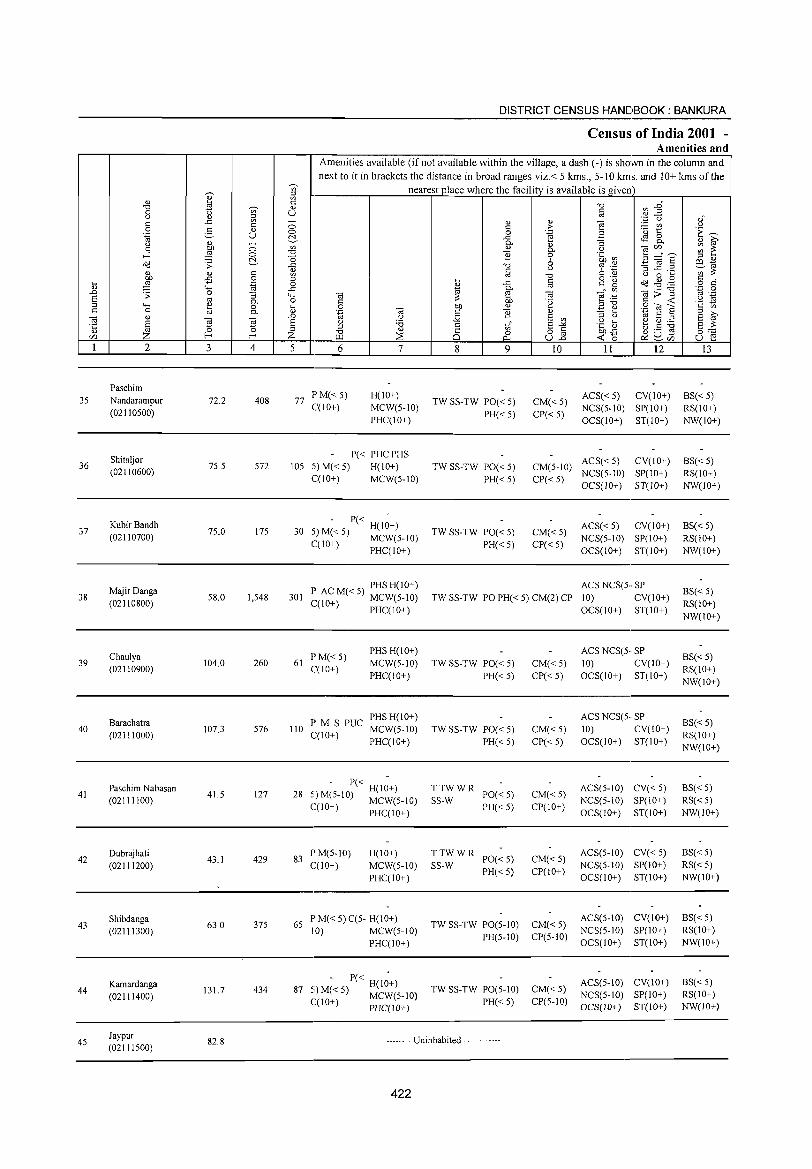
35
36
37
38
39
40
41
42
43
44
45
2
Paschim Nandarampur (02110500)
Shitaljor (02110600)
KubirBandh (02110700)
MajirDanga (02110800)
Chaulya (02110900)
Barachatra (02111000)
Paschim Nabasan (02111100)
Dubrajhati (02111200)
Shibdanga (02111300)
Kamardanga (02111400)
Jaypur (02111500)
3
72.2
75.S
75.0
58.0
104.0
107.3
41.5
43.1
63.0
131.7
82.8
o o ~ c o .~
'3 P.. o P..
'" ~ 4
408
S72
175
1,548
260
576
127
429
375
434
DISTRICT CENSUS HANDBOOK: BANKURA
Census of India 2001 -Amenities and
~
Amenities available (if not available within the village, a dash (-) is shown in the column and next to it in brackets the distance in broad ranges viz.< 5 kms., 5-10 kms. and 10+ kms of the
nearest place where the facility is available is given c " U
5 6 7
77 I'M«5) C(lO+)
H(lO+) MCW(5-10) PHC(IO+)
P« PHC PHS lOS 5) M« 5) H(IO+)
C(IO+) MCW(5-10)
- P« -30 5) M« 5) H(IO+)
C(IO+) MCW(5-IO) , PHC(IO+)
P AC M« 5) PHS H(IO+) 301 C(IO+) MCW(5-10)
, PHC(IO+)
61 PM«S) C(IO+)
PHS H(10+) MCW(5-10) PHC(IO+)
P M S PUC PHS H(IO+) 110 C(1 0+) MCW(S-IO)
PHC(IO+)
- P« -28 5) M(5-10) H(IO+)
(,(10+) MCW(5-10) , PHC(IO+)
83 P M(5-IO) C(10+)
H(IO+) MCW(S-IO) PHC(IO+)
65 P M« 5) C(5- H(IO+) 10) MCW(5-10)
I'HC(IO+)
. - P« H(1;+) 87 :,)M«5) MCW(5-1O)
C(lO+) PHC(IO+)
8 9
TW SS-TW PO« 5)
PH«5)
TW SS-TW PO« 5) PH«5)
TW SS-TW PO« S) PH«5)
10
CM«5) CP«5)
11 12
ACS«5) CV(IO+) NCS(5-10) SP(IO+) OCS(IO+) ST(lO+)
ACS«5) CV(IO+) CM(5-10) NCS(5-10) SP(IO+) CP« 5) OCS(JO+) ST(lO+)
CM«5) CP«5)
ACS«5) CV(IO+) NCS(5-10) SP(lO+) OCS(10+) ST(lO+)
ACS NCS(5·· SP TW SS-TW PO PH« 5) CM(2) CI' 10) CV(10+)
TW SS-TW PO« 5)
PH«5)
TW SS-TW PO« 5) PH«S)
TTWWR SS-W PO« S)
PH« 5)
TTWWR SS-W PO« 5)
I'H« 5)
TW SS-TW PO(5-10) PH(5-10)
TW SS-TW PO(5-10) PH«5)
CM«5) CP«5)
CM«S) CP«5)
CM«S) CP(IO+)
CM«5) CP(10+)
CM«5) CI'(5-10)
CM«5) CP(5-10)
OCS(IO+) ST(IO+)
ACS NCS(5· SP 10) CV(IO+) OCS(IO+) ST(lO+)
ACS NCS(S·· SP 10) CV(IO+) OCS(IO+) ST(IO+)
ACS(5-10) CV« S) NCS(5-1O) SP(10+) OCS(IO+) ST(lO+)
ACS(S-IO) CV« 5) NCS(5-1O) SP(IO+) OCS(IO+) ST(lO+)
ACS(5-1O) CV(lO+) NCS(5-10) SI'(IO+) OCS(IO+) ST(IO+)
ACS(5-10) CV(IO+) NCS(5-10) SI'(10+) OCS(IO+) ST(IO+)
-------- Uninhabited ------------
422
13
BS«5) RS(IO+) NW(IO+)
BS«5) RS(IO+) NW(JO+)
BS« S) RS(10+) NW(IO+)
BS« S) RS(IO+) NW(IO+)
BS«5) RS(10+) NW(IO+)
BS«S) RS(IO+) NW(IO+)
BS« 5) RS«5) NW(IO+)
BS«5) RS«5) NW(IO+)
BS«5) RS(IO+) NW(IO+)
BS«5) RS(IO+) NW(JO+)
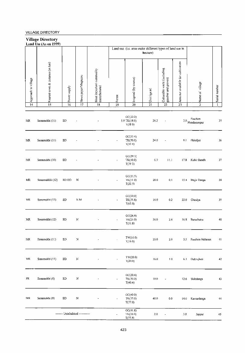
VILLAGE DIRECTORY
Village Directory Land Use (As on 1999)
14 15
MR Sonamukhi (II)
MR Sonamukhi (II)
MR Sonamukhi (10)
16
ED
ED
ED
MR Sonamukkhi (12) ED EO N
17
MR Sonamukhi (12) ED N M
MR Sonamukhi (12) ED N
MR Sonamukhi (II) ED N
MR Sonamukhi (II) ED N
PR Sonamukhi (8) ED N
MR Sonamukhi (9) ED N
-------- Uninhabited ------------
18
Land use (i.e. area under different types ofland use in hectare)
19 20
GC(20.0) 5.0 TK(18.0)
T(38.0)
GC(23A) TK(20.0) T(43A)
GC(29.3) TK(IO.0) T(39.3)
GC(IU)
TK(I1.0) T(22.5)
GC(30 0) TK(35.8) T(65.8)
GC(26.8) TK(25.0) T(51.8)
TW(16.0) T(16.0)
TW(20.0)
T(20.0)
GC(20A) TK(20.0) T(40A)
GC(40 0) TK(37.0)
T(77.0)
GC(41.8) TK(36.0) T(77.8)
423
21 22
26.2
24.0
6.9
20.0
16.0
36.0
20.0
16.0
10.0
40.0
2.0
23 2
30 Paschim . Nandarampur
8.1 Shitaljor
ILl 17.8 Kubir Bandh
0.1 15A Majir Danga
0.2 22.0 Chaulya
2.6 16.8 Barachatra
2.0 3.5 Paschim Nabasan
1.0 6.1 Dubrajhati
12.6 Shibdanga
0.0 14.6 Kamardanga
3.0 Jaypur
35
36
37
38
39
40
41
42
43
44
45
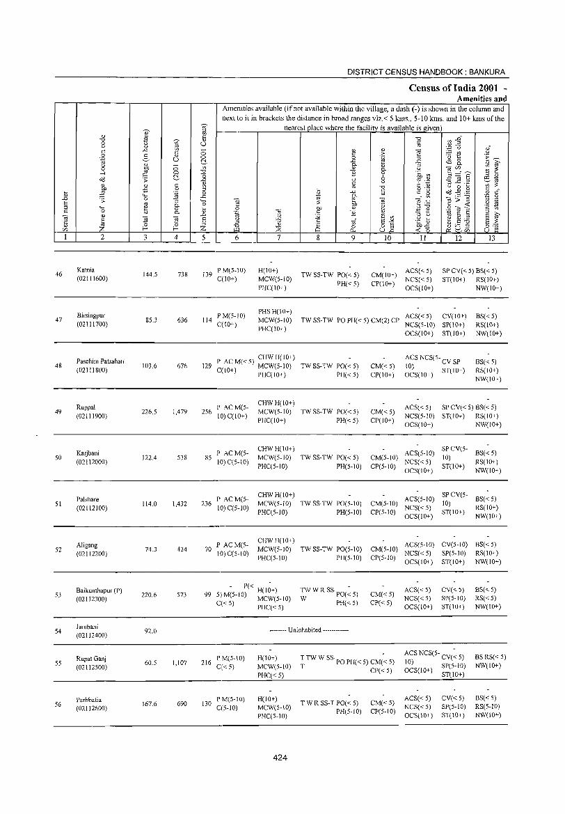
DISTRICT CENSUS HANDBOOK: BANKURA
Census of India 2001 -Amenities and
Amenities available (if not available within the village, a dash (-) is shown in the column and
next to it in brackets the distance in broad ranges viz. < 5 kms., 5-10 kms. and 10+ kms of the -;;;- nearest place where the facility is available is_given ;:I
" ~ '" so "0 VJ "'§" "0 ~ " 0 u '" U § " " ::l .~ '0 ,," ..<:: '" a " " 'iil c c c > ~t .~ 0 . .s " 0 0 .~ B i':~ 'ia U ~ ..c ~ 8. u " - c.
" "3 " ~ 0 ~ 0 '" " c. u "'§ c/)" --. ;;; ~
..-l 0 "0 1i 0 .~ CIl '0 E';ii § ::l " Oil .;; ~ ..<:: "0 6 ~ .~ 0:1 '" Ii c u ~ ...c:: ,_ ';;;;::: " " c '" "0 C " u 0 '" bJl -5 0 ::l '" <=
o ._ o<i ~ .'@ c " .... ,g '.g 0 " ..c ~" ~ o c
" ,.._
..<:: ro c. oo ._ "0 .~ .g .D .;; 0 "3 '- 'iil ~ ta 'iil ~ g>~ E oo c. 0 C
;::: bJl .~ ~~ 'S ~ ::l ,.._
" 0 il 0 bJl " .9 <u E c 0 B c. .~ 'iil c 1i " .=:: ~ ;:I >-'iil " .D .;,l :;;; E '"
::l u '" E ::l E ~ ~
ta S () .~] ~.5 ~ '5 E '0 '" "0 C
'" S"'" g:-:: Z ::l "0 " 8 o § f-< Z ~ 0 ~u~ r/) >l.l 0- U.D <t: '0 ~r/) U ~
1 2 3 4 5 6 7 8 9 10 11 12 13
46 Katnia
144.S 738 139 PM(5-10) H(IO+) ACS« 5) SP CV« S) BS« 5)
TW SS-TW PO« 5) CM(IO+) (02111600) C(10+) MCW(S-IO) PH« 5) CP(lO+)
NCS« 5) ST(lO+) RS(10+) PHC(IO+) OCS(10+) NW(IO+)
Birsingpur PM(S-IO) PHS H(lO+)
ACS« 5) CV(10+) BS« S) 47 8S.3 636 114 MCW(S-IO) TW SS-TW PO PH« 5) CM(2) CP
(02111700) C(10+) PHC(IO+)
NCS(S-IO) SP(10+) RS(IO+) OCS(IO+) ST(lO+) NW(10+)
Paschim Patrahati CHWH(IO+) ACS NCS(S- CV SP 8S« S)
48 103.6 676 129 P ACM«5) MCW(5-10) TW SS-TW PO« 5) CM« 5) 10) (02111800) C(10+) PHC(IO+) PH«5) CP(IO+) OCS(IO+) ST(IO+) RS(IO+)
NW(10+)
Ruppal P ACM(5-CHWH(IO+)
ACS« 5) SP CV« 5) BS« S) 49
(02111900) 226.5 1,479 256
10) C(IO+) MCW(5-1O) TW SS-TW PO« 5) CM«S)
NCS(5-10) ST(IO+) RS(IO+) PHC(IO+) PH« S) CP(10+)
OCS(10+) NW(IO+)
Karjbani I' ACM(5-CHW H(IO+)
ACS(5-1O) SPCV(5-
BS« 5) 50
(02112000) 122.4 538 8S
1'0) C(5-1O) MCW(5-10) TW SS-TW 1'0« 5) CM(5-1O)
NCS«5) 10)
RS(IO+) PHC(5-1O) PH(5-10) CP(5-10)
OCS(10+) ST(IO+)
NW(10+)
Palshare P ACM(S-CHWH(IO+)
ACS(S-IO) SPCV(5-
8S« 5) 51 114.0 1,432 236 MCW(S-IO) TW SS-TW PO(5-1O) CM(S-IO) 10)
(02112100) 10) C(S-IO) PHC(5-10) PH(5-10) CI'(5-10)
NCS«5) ST(IO+)
RS(IO+)
OCS(IO+) NW(IO+)
Aligang P ACM(5-CHWH(IO+)
ACS(5-10) CV(5-10) BS« 5) 52
(02112200) 74.3 424 70
10) C(5-10) MCW(5-10) TW SS-TW PO(5-10) CM(5-10)
NCS« 5) SP(5-1O) RS(10+) PHC(5-10) PH(5-10) CP(5-10)
OCS(IO+) ST(IO+) NW(10+)
S3 Baikunthapur (P)
220.6 S73 99 - P« H(I~+) TWWRSSpO(~5) CM«S)
ACS« S) CV«5) BS« 5)
(02112300) 5)M(5-10) MCW(5-1O) W PH«5) CP« 5)
NCS« 5) SP(5-10) RS«S) C« 5) PHC« 5) OCS(lO+) ST(IO+) NW(IO+)
54 Jambani
92.0 -------- Uninhabited ------------(02112400)
RupatGanj P M(5-10) H(lO+) T TW W SS· PO PH« 5) CM;< 5) ACS NCS(5- CV(~ 5) BS RS« 5)
55 (02112500)
60.5 1,107 216 0[<5) MCW(5-10)
T CP« 5) 10) SP(5-10) NW(IO+)
PHC« 5) OCS(IO+) ST(IO+)
Parbbatia 167.6 690 130
P M(5-IO) H(IO+) T W R SS-T PO« 5) CM« 5)
ACS«5) CV«S) BS« 5) 56
(02112600) C(5-10) MCW(5-1O) NCS«5) SP(5-1O) RS(5-10)
PHC(5-10) PH(5-1O) CP(5-1O)
OCS(lO+) ST(lO+) NW(lO+)
424
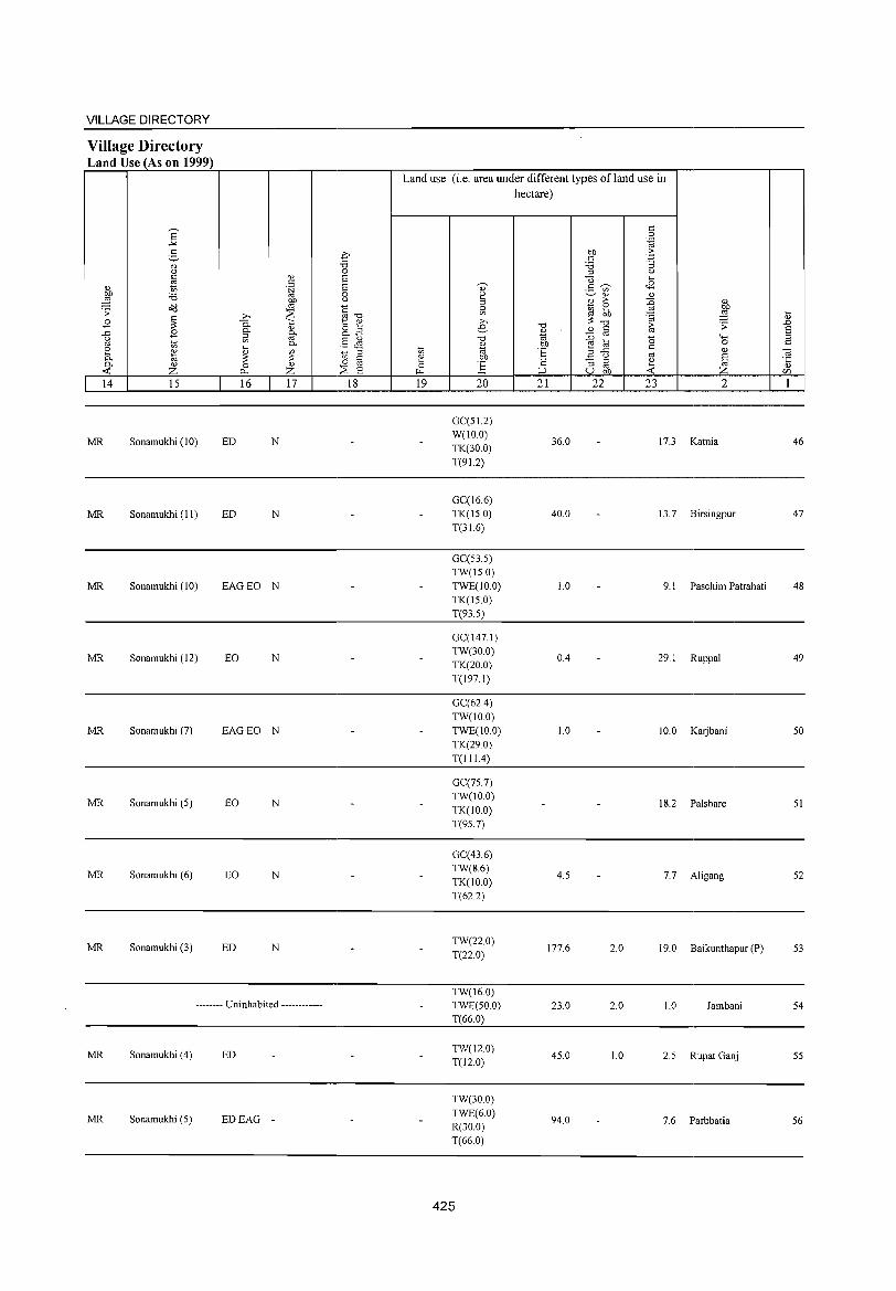
VILLAGE DIRECTORY
Village Directory Land Use (As on 1999)
14 15
MR Sonamukhi (10)
MR Sonamukhi (II)
MR Sonamukhi (10)
MR Sonamukhi (12)
MR Sonamukhi (7)
MR Sonamukhi (5)
MR Sonamukhi (6)
MR Sonamukhi (3)
16 17
ED N
ED N
EAGEO N
EO N
EAGEO N
EO N
EO N
ED N
-------- Uninhabited ------------
MR Sonamukhi (4) ED
MR Sonamukhi (5) EDEAG -
18
Land use (i.e. area under different types ofland use in hectare)
19 20
GC(51.2) W(IO.0) TK(30.0) T(91.2)
GC(16.6) TK(l50) T(31.6)
GC(53.5) TW(l5.0) TWE(IO.0) TK(l5.0) T(93.5)
GC(147.1) TW(30.0) TK(20.0) T(197.1)
GC(62A)
TW(IO.O) TWE(IO.0) TK(29.0) T(111.4)
GC(75.7) TW(IO.O) TK(lO.O) T(95.7)
GC(43.6) TW(8.6) TK(IO.0) T(62.2)
TW(220) T(22.0)
TW(16.0) TWE(50.0) T(66.0)
TW(12.0) T(12.0)
TW(30.0) TWE(6.0) R(30.0) T(66.0)
425
21 22
36.0
40.0
1.0
OA
1.0
4.5
177.6
23.0
45.0
94.0
23 2
17.3 Katnia
13.7 Birsingpur
9. I Paschim Patrahati
29.1 Ruppal
10.0 Karjbani
18.2 Palshare
7.7 Aligang
2.0 19.0 Baikunthapur (P)
2.0 1.0 Jambani
1.0 2.5 Rupat Ganj
7.6 Parbbatia
46
47
48
49
50
51
52
53
54
55
56
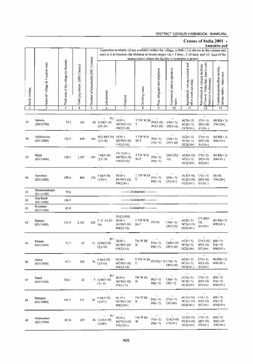
57
58
59
60
61
62
63
64
65
66
67
68
69
2
Bahulia
(02112700)
Shalchaturia
(02112800)
Patjor (02112900)
Hamirhati (02113000)
Shyamsundarpur (02113100)
Gop Bandi (02113200)
Basumara
(02113300)
Rampur (02113400)
Khausa
(02113500)
Jashra (02113600)
Patsol (02113700)
Ratnapur (02113800)
Mathurabati (02113900)
3 4
73.5 361
152.5 649
120.1 1,427
199.4 846
59.6
100.3
81.8
151.4 2,101
51.7 45
61.1 328
336.1 32
182.5 541
101.8 225
DISTRICT CENSUS HANDBOOK: BANKURA
Census of India 2001 -Amenities and
Amenities available (if not available within the village, a dash (-) is shown in the column and next to it in brackets the distance in broad ranges viz.< 5 kms., 5-10 kms. and 10+ kms of the
nearest place where the facility is available is given
5 6 7
P« H(lO+) 68 5)M(5-10) MCW(5-10)
C(5-10) PHC(5-10)
104 P(2) M(5-1O) H(10+) C(5-10) MCW(5-10)
293 P M(5-10) C(5-10)
170 IPM(5-10) C(10+)
PHC(5-10)
DHH(IO+) MCW(5-1O) PHC(5-10)
H(IO+) MCW(5-1O) PHC(1O+)
8
<1) c o .c P-
" ~ "0 § .c
~ " ~ tf o
p...
9
T TW W SS· PO(~-1O) T PH(5-10)
~S~; W R PO« 5) PH«5)
~S~; W R PO« 5) PH«5)
T TW W SS· PO(~ 5)
T PH«5)
-------- Uninhabited ------------
-------- Uninhabited ------------
-------- Uninhabited ------------
420 P M S C(5-10)
DH(2) PHS H(lO+) MCW(5-10) PHC(5-10)
,. - P« H(I~+) II _~M(5-10) MCW(5-1O)
C(5-IO) PHC(5-10)
TTWWR POPH SS-T
~W W SS- PO« 5)
PH«5)
" > .~
" P-o 6 u
""0 §
"' .~
" E en
g~ uB
10
CM«5) CP(5-10)
CM«5) CP(5-1O)
II
ACS« 5)
NCS« 5) OCS(1O+)
ACS«5) NCS« 5) OCS(1O+)
12
CY« 5) SP(5-10)
ST(IO+)
CY«5) SP(5-10) ST(IO+)
13
BS RS« 5) NW(IO+)
BS RS«5) NW(1O+)
CM CP(5- ACS(5-10) CY« 5) BS RS« 5) NW(IO+) 10) NCS« 5) SP(5-1O)
CM« 5) CP(IO+)
CM«5) CP(5-10)
OCS(IO+) ST(IO+)
ACS(5-10) CY« 5) NCS(5-10) SP(5-10) OCS(IO+) ST(10+)
BSRS NW(lO+)
ACS« 5) CY SP(5- BS RS« 5) 10)
NCS(5-10) ST(10+) NW(lO+) OCS(IO+)
ACS« 5) CM(5-1O) NCS« 5)
CP(5-10) OCS(IO+)
CY(5-10) BS« 5)
SP(5-10) RS« 5) ST(10+) NW(IO+)
54 I'M(5-1O) C(5-10)
H(lO+) MCWe5-10) I'HC(5-10)
T TW W SS· PH 1'0« 5) CM(~ 5)
T CP(5-10)
ACS«5) NCS« 5) OCS(IO+)
CY«5) SP(5-10) ST(IO+)
BSRS«5) NW(IO+)
,. - 1'« H(1~+) 7 -,) M(5-10) MCW(5-1O)
C« 5) PHC« 5)
95 PM(5-10) C(IO+)
H(IO+) MCW(5-IO) PHC(IO+)
,. - 1'« H(I~+) 38 -,) M(5-10) MCW(5-10)
C(IO+) PHC(IO+)
426
;;: W SS- PO« 5)
PH«5)
TWWSS-W 1'0«5)
PH«5)
;;: W SS- PO« 5)
PH«5)
CM« 5) CP«5)
CM«5) CP(IO+)
ACS« 5) NCS«5) OCS(10+)
CY«5) SP(5-10) ST(IO+)
ACS(5-1O) CY« 5) NCS(5-10) SP(5-10) OCS(IO+) ST(IO+)
ACS(5-10) CY« 5) CM(5-1O) NCS(5-1O) SP(5-10) CP(lO+) OCS(IO+) ST(IO+)
BS« 5) RS«5) NW(IO+)
BS« 5) RS« 5) NW(IO+)
BS« 5) RS(5-1O) NW(IO+)
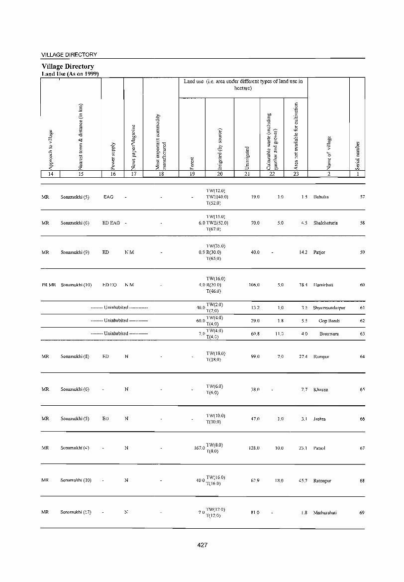
VILLAGE DIRECTORY
Village Directory Land Use (As on 1999)
E -'" e-'" (,)
~ " 00 'i3 ,g a'IJ .;; ~ .8
..r:: .8 u
" t> ~ ~ 0- " <C Z 14 15
MR Sonamukhi (5)
MR Sonamukhi (6)
MR Sonamukhi (9)
PR MR Sonamukhi (10)
'" . ~ 00
" .b ~ 0-'" 0- f@-::l
'" 0-
~ ~ 0 z ~
16 17
EAG
EDEAG -
ED NM
ED EO NM
-------- Uninhabited ------------
-------- Uninhabited ------------
-------- Uninhabited ------------
MR Sonamukhi (8) ED N
MR Sonamukhi (6) N
MR Sonamukhi (5) ED N
MR Sonamukhi (4) N
MR Sonamukhi (10) N
MR Sonamukhi (12) N
.0 'i3 0 6 6 0 u
§--o 1:: " 8.3 §JS _ ::l
Ul " o "
:::s 6 18
Land use (i.e. area under different types ofland use in hectare)
0) 2 ::l ~ >. e
"0
'" t> "' ~ 00 0 ] ~
19 20
TW(12.0) TWE(40.0) T(52 0)
TW(IS.O) 6.0 TWE(52.0)
T(67.0)
TW(3S.0)
0.9 R(30.0) T(65.0)
TW(l6.0) 4.0 R(30.0)
T(46.0)
400 TW(2.0) · T(2.0)
600 TW(4.0) · T(4.0)
20 TW(4.0) · T(4.0)
TW(18.0) T(18.0)
TW(60) T(6.0)
TW(10.0) T(IO.0)
1670 TW(8.0) · T(80)
400 TW(16.0) · T(16.0)
70 TW(12.0) · T(12.0)
427
"0
'" "' "E 'c ::J
21
19.0
70.0
40.0
106.0
13.2
29.0
60.8
99.0
38.0
47.0
128.0
62.9
81.0
r:: 0 .~
00 .::: r:: '3 'i3 ::l (,)
U ... 2- ~ <8
'" " '" 2 >- {j " ~ ~ ~ :W ::; "0 ~
.;; " fa ::0 '0 "'" e t;; 0
2 ..r:: r:: " (,) '" 8 "3 ::l ~ " " U 00 <C Z
22 23 2
1.0 1.5 Bahulia
5.0 4.5 Shalchaturia
14.2 Patjor
5.0 38.4 Hamirhati
1.0 3.5 Shyamsundarpur
1.8 5.5 Gop Bandi
11.0 4.0 Basumara
7.0 27.4 Rampur
7.7 Khausa
1.0 3.1 Jashra
10.0 23.1 Patsol
18.0 45.7 Ratnapur
I. 8 Mathurabati
~ ..0 8 ::l r::
OJ ·c '" '" 1
57
58
59
60
61
62
63
64
65
66
67
68
69
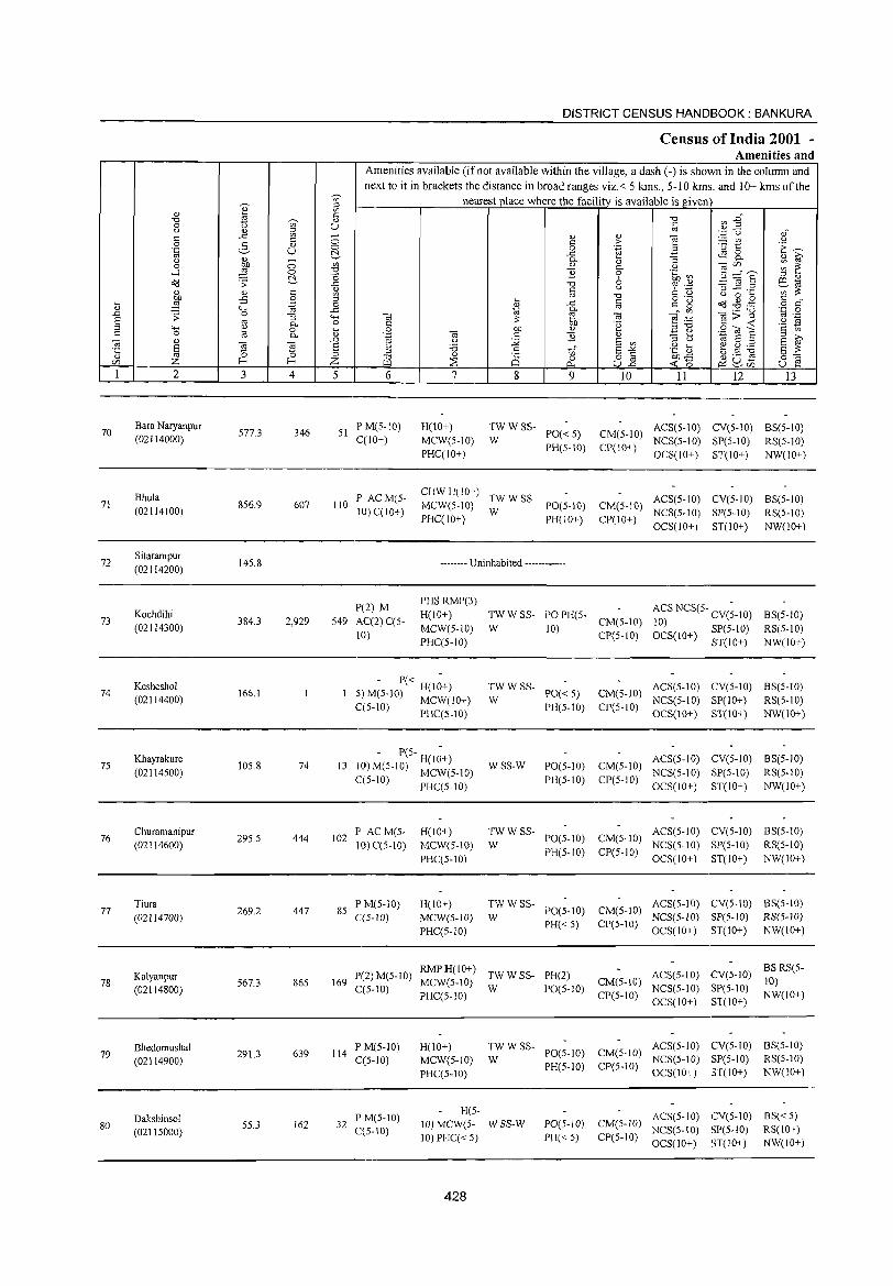
DISTRICT CENSUS HANDBOOK: BANKURA
Censliis of India 2001 -Amenities and
Amenities available (if not available within the village, a dash (-) is shown in the column and next to it in brackets the distance in broad ranges viz.< 5 kms., 5-10 kms. and 10+ kms of the
I ~ nearest place where the facility is available is given
4) '" c: "'" <n-§ "0
'"' " 0 U c <.) " ~ '" .~ u ,," ..c ;; " " "2 <:: <:: c > ii 19
<.) 0 2- " 'E ~ '"§ u 0 0 .~ B (.j. ..c tS 8-<.) " - 0..
" :; " ~
0 OJ) 0 '" " 0.. <.) 0iC/) ~ ~ ....:I ;g 0 ::2 }j 0 .~.~ 3;:::" S '" " CCl .;;: (.j. _g "'" 6 ~ _g .2 al "'
" c ~ c <.) C: t) ';;;~ " '" "'"
<.) 0 ...
9 -B 0 ... o ._ CCl~.g <:: " ... .~ 0 " ..c c
1=:" ~ o c " ""' ..c
~ e- '" 0i;;"8 .~ 0 ..0 .;;: 0 :; ""' til til f§ .t:
'" ._ § oJ 0.. 0 C OJ) .~ <:: -< '2 ~ ""' 4)
0 t> c OJ) 4) ","", 9'<0] c 0 l<! 0.. '';::: Oi c }j " ~ e "' E a ~ Oi " ..D '" <.) ii E '" '" <.)
'5 E "@
~ E (j :a c <0;" E"'" .g S ~.5 ~ E ~ '" " ::J ::J
" 8 8.2 OJ)..c "'" 0 oC:: CZl Z f-< Z '" ~ -< "
~u- u oJ r:>.. ~CZl
1 2 3 4 5 6 7 8 9 IO II 12 13
70 Bara Naryanpur
577.3 346 51 PM(5-10) H(lO+) TWWSS-
PO«5) CM(5-1O) ACS(S-10) CV(S-10) BS(S-IO)
(02114000) C(lO+) MCW(5-10) W NCS(5-10) SP(5-10) RS(S-10) PHqIO+)
PH(S-10) CP(lO+) OCS(IO+) ST(IO+) NW(IO+)
Bhula P ACM(5-CHW H(IO+)
TW W SS- ACS(5-10) CV(S-10) BS(S-IO) 71 856.9 607 110 MCW(S-IO) PO(S-IO) CM(S-10) (02114100) 10) C(IO+) W NCS(5·10) SP(5-10) RS(5-10) PHC(10+) PH(IO+) CP(10+)
OCS(10+) ST(10+) NW(10+)
72 Sitarampur
145.8 -------- Uninhabited ------------(02114200)
P(2) M PHSRMP(3)
ACS NCS(5- CV(;-10) 73
Kochdihi 384.3 2,929 549 AC(2) C(5-
H(IO+) TWWSS- POPH(5- BS(5-10) (02114300) MCW(5-10) W
CM(5-10) 10) RS(5-1O)
10) 10)
CP(5-10) OCS(10+) SP(5-1O) PHC(5-10) ST(lO+) NW(lO+)
74 Kesheshol
166.1 ._ - P« H(I~+) TWWSS-
PO« 5) CM(5-10) ACS(5-10) CV(5-10) BS(5-1O)
(02114400) ;~ M(5-10) MCW(IO+) W NCS(5-10) SP(lO+) RS(5-10) ~(5-1O) PHC(S-IO) PH(5-10) CP(5-10)
OCS(10+) ST(IO+) NW(IO+)
75 Khayrakure
105.8 74 13 - P(S- H(I~+)
WSS-W PO(5-10) CM(5-IO) ACS(5-10) CV(5-IO) BS(5-10)
(02114500) 1,0) M(5-1O) MCW(5-IO) PH(5-10) CP(5-1O)
NCS(5-10) SP(5-10) RS(5-10) C(5-1O) PHC(5-10) OCS(10+) ST(IO+) NW(IO+)
76 Churamanipur
295.5 444 102 P ACM(5- H(IO+) TWWSS-
PO(5-10) CM(5-1O) ACS(5-10) CV(5-1O) BS(5-1O)
(02114600) 10) C(5-10) MCW(5-10) W NCS(S-10) SP(5-10) RS(5-10)
PHC(5-10) PH(5-10) CP(5-IO)
OCS(lO+) ST(10+) NW(10+)
77 Tiura
269.2 447 85 P M(5-1O) H(10+) TWWSS-
PO(5-1O) CM(5-1O) ACS(5-10) CV(5-10) BS(S-IO)
(02114700) C(5-1O) MCW(5-lO) W PH« S) CP(S-10)
NCS(5-1O) SP(S-lO) RS(5-lO)
PHC(5-1O) OCS(IO+) ST(10+) NW(IO+)
Kalyanpur P(2) M(S-IO) RMPH(lO+)
TWWSS- PH(2) ACS(S-IO) CV(5-10) BSRS(5-
78 567.3 86S 169 MCW(5-10) CM(5-10) 10) (02114800) C(5-10)
PHqS-IO) W PO(5-10)
CP(5-1O) NCS(5-10) SP(5-1O)
NW(lO+) OCS(10+) ST(10+)
Bhedomushal 639 114
PM(5-1O) H(10+) TWWSS-PO(5-10) CM(5-10)
ACS(S-10) CV(5-1O) BS(5-1O) 79 291.3 C(5-10) MCW(5-10) W NCS(S-IO) SP(5-1O) RS(5-10) (02114900) PH(5-10) CP(5-1O)
PHC(5-10) OCS(IO+) ST(10+) NW(10+)
Dakshinsol P M(5-10) H(5-
ACS(5-10) CV(5-IO) BS«5) 80 55.3 162 32
C(S-10) 10) MCW(5- WSS-W PO(5-JO) CM(5-10)
NCS(S-10) SP(5-10) RS(10+) (02115000) 10) PHC« 5) PH« S) CP(5-10)
OCS(IO+) ST(IO+) NW(10+)
428
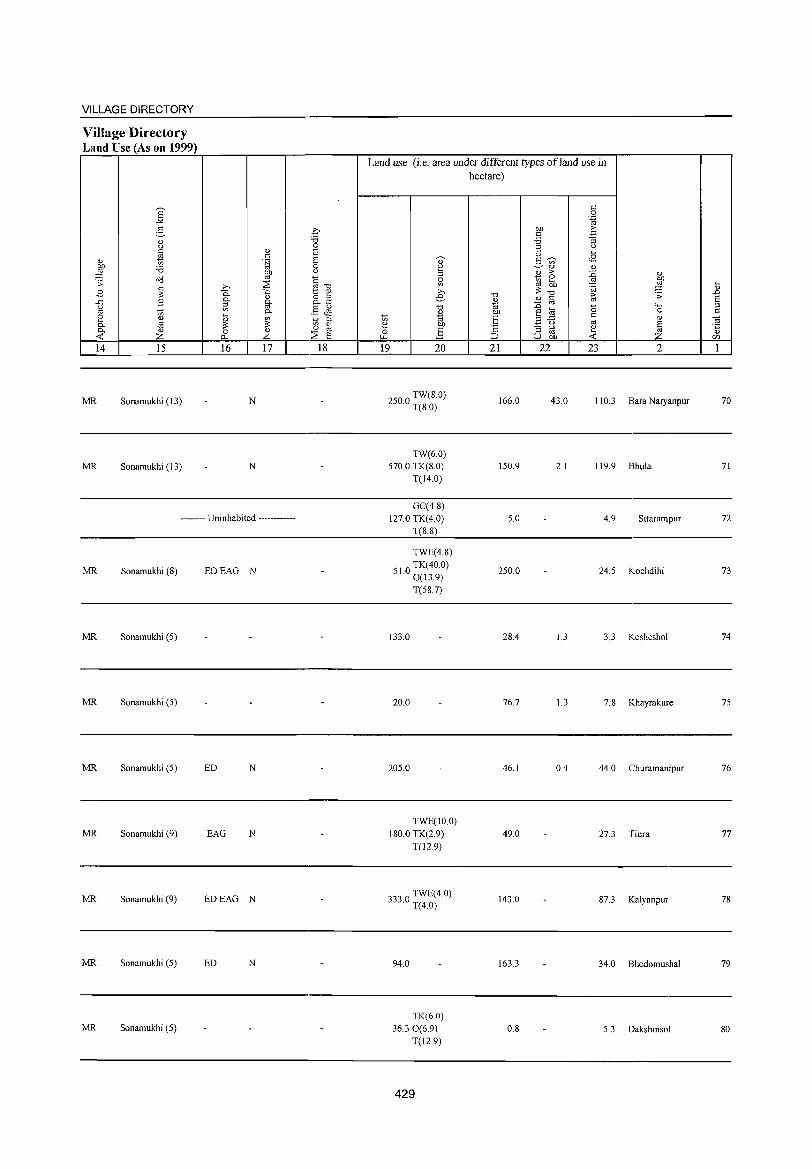
VILLAGE DIRECTORY
Village Directory Land Use (As on 1999)
14 15
MR Sonamukhi (13)
MR Sonamukhi (13)
16 17
N
N
-------- Uninhabited ------------
MR Sonamukhi (S) EDEAG N
MR Sonamukhi (5)
MR Sonamukhi (5)
MR Sonamukhi (5) ED N
MR Sonamukhi (9) EAG N
MR Sonamukhi (9) EDEAG N
MR Sonamukhi (5) ED N
MR Sonamukhi (5)
18
Land use (i.e. area under different types of land use in hectare)
19 20
2500 TW(8.0) · T(S.O)
TW(6.0) 570.0 TK(S.O)
T(14.0)
GC(4.S) 127.0 TK(4.0)
T(S.S)
TWE(4.S)
510 TK(40.0) · 0(13.9)
T(5S.7)
133.0
20.0
205.0
TWE(10.0)
IS0.0 TK(2.9)
1'(12.9)
3330 TWE(4.0) · 1'(4.0)
94.0
TK(6.0) 36.30(6.9)
1'(12.9)
429
21
166.0
150.9
5.0
250.0
2S.4
76.7
46.1
49.0
143.0
163.3
O.S
22 23 2
43.0 110.3 Bara Naryanpur
2.1 119.9 Bhula
4.9 Sitarampur
24.5 Kochdihi
1.3 3.3 Kesheshol
1.3 7.S Khayrakure
0.4 44.0 Churamanipur
27.3 1'iura
S7.3 Kalyanpur
34.0 Bhedomushal
5.3 Dakshinsol
70
71
72
73
74
75
76
77
7S
79
so
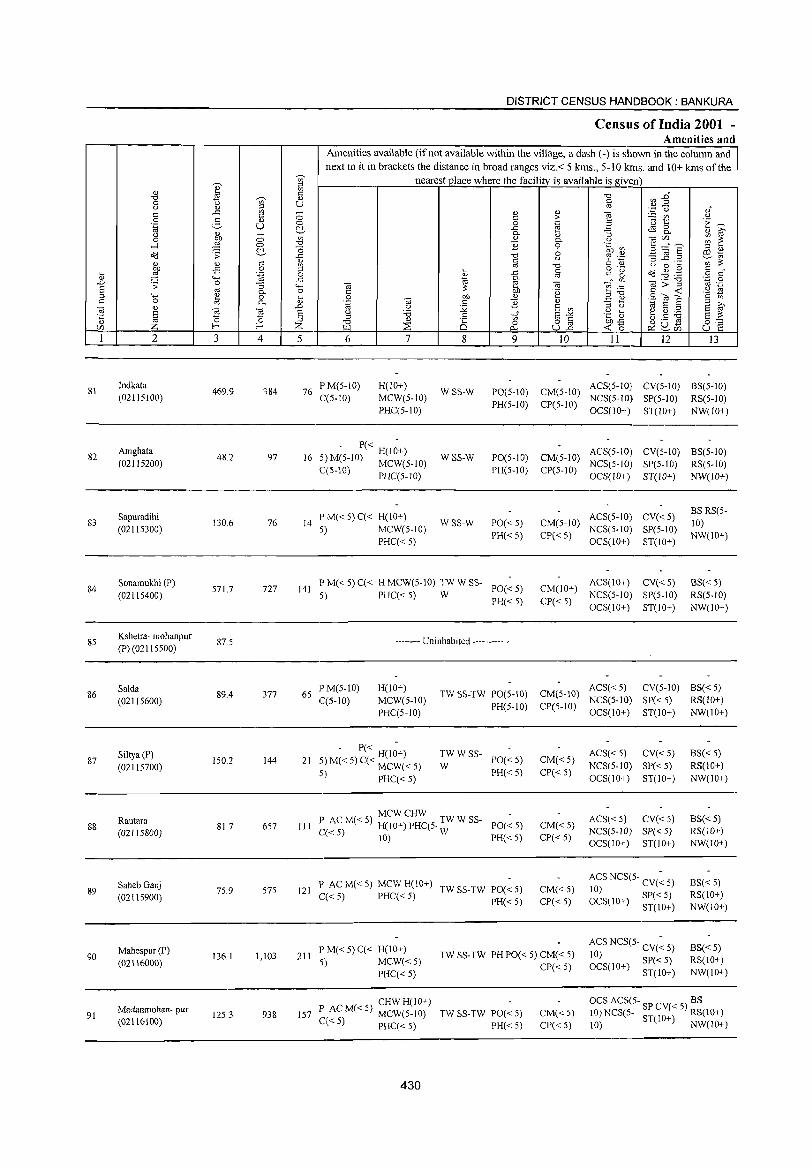
DISTRICT CENSUS HANDBOOK: BANKURA
Census of India 2001 -Amenities and
Amenities available (if not available within the village, a dash (-) is shown in the column and
next to it in brackets the distance in broad ranges viz.< 5 kms., 5-10 kms. and 10+ kms of the ';;' nearest ]Jlace where the facility is available is given
Q) ~ 0)
~ '" -g ~ :2" ""0 ~ 0) 0 if> U U 0) ::> oj
'.;:::i 0 0)" ..<: if> - <l) 0)
~ '" c:: 0 c:: > ;.:::: V'1 .~ 0 .s <l) 0 0 .~ ·G 1:: 1:~ .~ U ~ ..<: ~ 8.. " iO' u 0)
0 0- <l) :;
0 ~ if> " 0- u
~~E ~ ~ ..-l 0 ""0 "2 0 .~.~ ~ 0 0 ::> <\)
d?l .;; ..<: ""0 -3 ~ ,;::! f9_", c:: 1;l c: () C dJ if> ::: <\) <\)
'" ""0 u 0 ~
:W -5 0 ::> ~
o ._ o:d ~ .~ c: 0
..<: c: c" ~ " '.g 0 <l)
'" o c:
'-H ..c '" 0- OJ::;"g .~ .;:2 .D .;; 0 "3 <.;-; OJ ~ 0; ~~ § '" 0- 0 c: ::: .~ '" <C " '" <.;-; <l)
0 '"' 0 OJ) " ~ ~ SeaS '§ 1;; c:: 0 8 0.. <l) .~ OJ c: "2 <!J
:§ <!J ..D <.l :;;; E if> ::> <.l '" E ::> E iO'
~ 11 11 E u :e tf ",,,,, () ~ t.5 ~ E ::: ::> .= 'C !l)
" 0 ~ ::> ""0
<\) _ '" OJ)"<: 0:;:: Z ::s a 0 o oj ~~CI) en E-< ~ "-' U.n <Co u e 1 2 3 4 5 6 7 8 9 10 II 12 13
81 Indkata
469.9 384 PM(S-iO) H(lO+)
WSS-W PO(5-10) CM(5-10) ACS(S-IO) CV(S-IO) BS(S-IO)
76 (021ISI00) C(S-IO) MCW(S-IO)
PH(S-IO) CP(5-10) NCS(S-IO) SP(S-IO) RS(S-IO)
PHC(S-IO) OCS(lO+) ST(iO+) NW(IO+)
82 Amghata
48.2 97 16 - P« H(I~+)
WSS-W PO(5-10) CM(5-10) ACS(S-IO) CV(S-IO) BS(S-IO)
(021IS200) S) M(5-10) MCW(S-iO) NCS(S-IO) SP(S-IO) RS(S-iO) C(5-10) PHC(S-lO) PH(5-IO) CP(5-IO)
OCS(iO+) ST(lO+) NW(lO+)
Sapuradihi P M« 5) C« H(IO+) ACS(5-1O) CV«5) BS RS(S-
83 (02115300)
130.6 76 14 5) MCW(S-IO)
WSS-W PO«S) CM(5-10) NCS(5-10) SP(5-IO)
10)
PHC« 5) PH«5) CP« 5)
OCS(IO+) ST(IO+) NW(IO+)
84 Sonamukhi (P)
571.7 727 141 PM«S)C« HMCW(S-IO) TWWSS-
PO«5) CM(IO+) ACS(IO+) CV«5) BS« 5)
(02115400) S) PHC« S) W PH«5) CP«S)
NCS(S-IO) SP(S-IO) RS(S-iO) OCS(IO+) ST(IO+) NW(IO+)
8S Kshetra- mohanpur (P)(02115S00)
87.S -------- Uninhabited ___________ 0
86 Salda
89.4 377 65 IPM(5-iO) H(IO+)
TW SS-TW PO(S-IO) CM(5-10) ACS«S) CV(S-IO) BS« 5)
(02115600) C(5-10) MCW(5-10) NCS(S-IO) SP« S) RS(lO+)
PHC(S-IO) PH(S-IO) CP(5-1O)
OCS(lO+) ST(JO+) NW(lO+)
Siltya (P) ISO.2 144 21
- P« H(I~+) TWWSS-PO«5) CM«5)
ACS« 5) CV«5) BS« S) 87
(021IS700) ~) M« 5) C« MCW« S) W NCS(S-JO) SP«S) RS(IO+) -) PHC«S) PH« 5) CP« 5)
OCS(IO+) ST(lO+) NW(iO+)
Rautara MCWCHW W ACS« 5) CV« S) BS« 5)
88 81.7 657 III F' ACM«5) H(10+)PHC(5- T W SS- PO«5) CM«S) NCS(S-IO) SP« 5) RS(JO+) (02115800) C« 5) 10) W PH« 5) CP« 5) OCS(IO+) ST(JO+) NW(IO+)
Saheb Ganj P AC M« S) MCW H(10+) TW SS-TW PO« 5) CM«5)
ACS NCS(5- CV(~ 5) BS« 5) 89 75.9 575 121 C« 5) PHC« 5) 10) SP« 5) RS(10+) (02115900) PH« 5) CP« 5) OCS(10+) ST(IO+) NW(IO+)
Mahespur (P) PM«5)C« H(IO+) TWSS-TW PHPO«5)CM«5) ACS NCS(5- CV(~ 5) BS« S)
90 (02116000)
136.1 1,103 211 5) MCW«5) 10) SP«5) RS(IO+)
PHC« 5) CP« 5) OCS(IO+) ST(IO+) NW(lO+)
CHWH(lO+) OCS ACS(5- BS
91 Madanmohan- pur
125.3 938 157 P ACM«5) MCW(5-10) TW SS-TW PO« 5) CM«5) 10) NCS(5- SP CV« 5) RS(IO+) (02116100) C« 5) PHC« 5) PH« 5) CP« 5) 10) ST(IO+) NW(IO+)
430
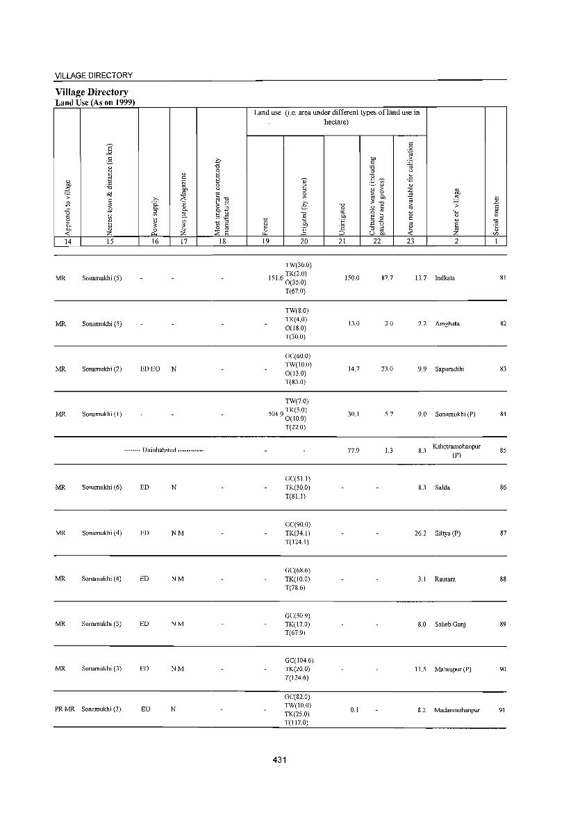
VILLAGE DIRECTORY
Village Directory Land Use (As on 1999)
E "'" 5
0> u C
1il " ~ 'B o<l .;;: c
B ~ ..c: B " '" to ::: 0>
0.. ~ 0.. '" -< z 14 15
MR Sonamukhi (5)
MR Sonamukhi (5)
MR Sonamukhi (2)
MR Sonamukhi (I)
0>
'" .~ OJ)
'" >-. ~ 0. " 0.. " g.. ~ 0.. t '" ~ ~ 0 " j:l., z 16 17
ED EO N
-------- Uninhabited ------------
MR Sonamukhi (6) ED N
MR Sonamukhi (4) ED NM
MR Sonamukhi (4) ED NM
MR Sonamukhi (3) ED NM
MR Sonamukhi (3) ED NM
PRMR Sonamukhi (2) EO N
0 'B 0 6 6 0 <>
§--o t: " g2 §~ to ::l 0 '" '" ~ 6 18
Land use (i.e. area under different types ofland use in hectare)
'" 0 .~
OJ) > c .p
'B :; ::l <> u '"'
" 2, ~ <£ '" ~ " " til >
~ " 0 ::: OJ)
'" '" OJ) a ,g t >-. -0
~-o iii .;;: .D e- " c 6
* '" -0 :0 -0 '+-< ::l
" OJ) r:_2 0 c to "' 'E '" '" OJ .a <> '" § ~ r 0: "3 ::l ~ '5 0 '" I-'< ::> u OJ) -< Z r/J
19 20 21 22 23 2 1
TW(30.0)
1516 TK(2.0) . 0(35.0)
150.0 87.7 13.7 Indkata 81
T(67.0)
TW(8.0) TK(4.0)
13.0 3.0 0(180)
2.2 Amghata 82
T(30.0)
GC(60.0) TW(IO.O)
14.7 23.0 9.9 Sapuradihi 83 0(13.0) T(83.0)
TW(7.0)
5049 TK(5 0) . 0(10.0)
30.1 5.7 9.0 Sonamukhi (P) 84
T(22.0)
77.9 1.3 8.3 Kshetramohanpur
85 (P)
GC(5L1) TK(30.0) 8.3 Salda 86 T(81.l)
GC(90.0) TK(34.1) 26.2 Siltya(P) 87 T(124.1)
GC(68.6) TK(IO.O) 3.1 Rautara 88 T(78.6)
GC(50 9) TK(17.0) 8.0 Saheb Ganj 89 T(67.9)
GC(1046) TK(20.0) 11.5 Mahespur (P) 90 T(l24.6)
GC(82.0) TW(IOO)
0.1 8.2 Madamnohanpur 91 TK(25.0) T(117.0)
431
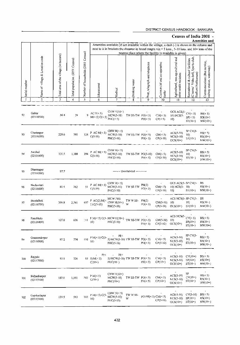
DISTRICT CENSUS HANDBOOK: BANKURA
Censills of India 2001 -Amenities and
Amenities available Cifnot available within the village, a dash C-) is shown in the column and next to it in brackets the distance in broad ranges viz.< 5 krns., 5-10 kms. and 10+ krns of the
';;;' nearest place where the facility is available is given ~ :> Q) ~ '" c: "0 ~~ '0 ~ Q) 0 u '" U c: u Q)' :> '" .~ u .,; c: ..c: '" 0 Q) Q)
~ c: c: '" ;..::: f/:l u
0 .g Q) 0 0 .~ 'u to: 'E ~ .~ u U ..c: -3 ~ 8- Q) ~ u Q) - c. 0 on 0 '" '" c. u "@r/l ~ ~ ....l ~ 0 '0 ] 0 .~ a3 !3 ="6 u '0 6 :> '" o(l .;;: ..c: '0 % '!i ~ ~.2 e- .. '" Q) c: Q)
~ (J
'" ~ [!l '0 <> 0 ... on ;S 0 ... c: o ._
o(l~g c: " .... :§ ""' 'g 0 '" ..c: '"
c: g o c: '" g- '';:: 0 ..c 0 ..c: j '" «l:;1l .;;: "3 'c; "8 "8 f .~
'" ._ S '" bb '2 ~ ~
c. c: .~ :>'0 c: -< g ""' 0 i) 0 on '" - " g~s 0 c. .~ "8 c ] " '3 0 .. S E ~ "8 '" ..c <> 1< S '" S g g § (.) 'i3 c: to" S-'" .~ ~ ~g~ S ~ '5 :>
'" 0 0 '0 " 8 0 o c bb..e:: {.)....... ro 0=-= r/l Z f-- f-- Z ..u :;E uB -< (5 ~u- u e 0.- ~r/l
I 2 3 4 5 6 7 8 9 10 11 12 J3
Gollor ACP«5) CHWH(IO+) OCS ACS(5- CV(~ 5) BS« 5) 92 56.4 39 9 M« 5) C« 5) MCW(5-IO) TW SS-TW PO« 5) CM«5) 10) NCS(S· SP« 5) (02116200) RS(IO+) PHC« 5) PH«5) CP«5) 10) ST(lO+) NW(IO+)
Chailanpur P AC M« 5) CHW H« 5) ACS(5-1O) SP CV(5-
BS« 5) 93
(02116300) 229.6 795 124 MCW(5-IO) TW SS-TW 1'0« 5) CM« 5) 10)
RS(10+) C(5-1O) PHC(5-10) PH« 5) CP(5-10) NCS(5-1O)
ST(10+) OCS(1O+) NW(1O+)
Amshol P ACM«5) CHWH«5) ACS(5-10) SP CV(5-
BS« 5) 94
(02116400) 121.5 1,188 194 C(5-10) MCW(5-1O) TW SS-TW PO(5-10) CM«5)
NCS(5-1O) 10)
RS(1O+) PHC(5-10) PH«5) CP(5-10)
OCS(IO+) ST(IO+)
NW(IO+)
95 Dharmapur
97.7 -------- Uninhabited ------------(02116500)
) CHW H« 5) PH(3)
OCS ACS(5- SP CV(5- BS
96 Nachanhati
80.4 262 51 I~ AC M« 5) MCW(5-1O) CM«5) 10) NCS(5- 10) RS(IO+) (02116600) L(5-10) PHC(5-10)
TW SS-TW 1'0« 5) CP(5-1O) 10) ST(IO+) NW(IO+)
I' AC(2) M« MCW PHS TWWSS- PH(2) ACS NCS(5 .. SP CV(5- BS
97 Bondalhati
306.8 2,541 457 CM(5-10) 10) 10) RS(IO+) (02116700) <i) C(5-IO) CHW H(10+) W PO«5)
- PHC(5-10) CP(5-IO) OCS(IO+) ST(IO+) NW(IO+)
98 Panchkula
127.0 606 III F' M« 5) C(5- MCW H(IO+)
TW SS-TW 1'0« 5) CM(5-IO) ACS NCS(5- CV(~ 5) BS« 5)
(02116800) 10) PHC(5-10) 10) SP(10+) RS(lO+) I'H« 5) CP(5-10) OCS(IO+) ST(lO+) NW(10+)
Goursunderpur - H« - ACS(S-IO)
SP CV(5-BS« S)
99 92.2 774 110 I' M« 5) C(5- 5) MCW(5-10) TW SS-TW 1'0« 5) CM« 5) 10) (02116900) 10) I'Hc(5-1O) I'H« 5) CP(5-10)
NCS(5-10) ST(lO+)
RS(lO+)
OC3(1O+) NW(1O+)
Rajgola 1'« H« ACS(5-10) CV(10+) BS« 5)
100 (02117000)
53.5 326 55 5) M«5) 5) MCW(5-10) TW SS-TW 1'0« 5) CM« 5) NCS(5-10) SI'(IO+) RS(IO+)
C{lO+) I'HC(IO+) PH« 5) CP(IO+) OCS(10+) ST(10+) NW(IO+)
CHWH(lO+) ACS(5-10)
SI' BS« 5) Bidyadharpur
187.0 1,101 202 I' M«5)
MCW(5-1O) TW SS-TW PO« 5) CM« 5) CV(JO+) 101 (02117100) C(lO+) NCS(5-JO) RS(10+)
PHC(IO+) PH«5) CP(IO+) OCS(IO+)
ST(JO+) NW(IO+)
CHWH« 5) TWWSS- ACS(5-10) CV(5-10) BS« 5)
102 Gopikantapur
139.5 563 102 P M« 5) C(5- MCW(5-10) PO PH« 5) CM« 5) RS(lO+) (02117200) 10) PHC(5-10) W CP(5-10)
NCS(5-1O) SP(IO+)
OCS(IO+) ST(IO+) NW(IO+)
432
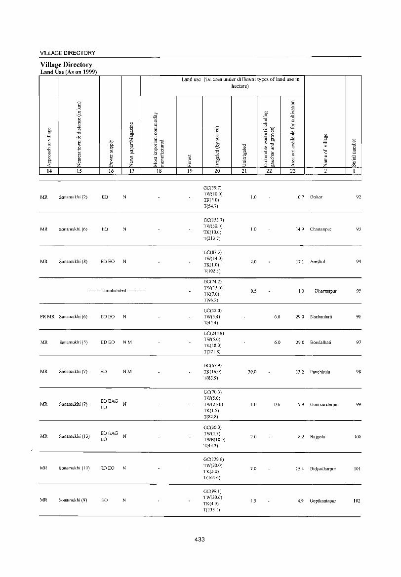
VILLAGE DIRECTORY
Village Directory Land Use (As on 1999)
S ..><
:3 " u
~ " ~ 'i3 o::l .;;: c
B ;;: .c B U oj 1;; [:: ~ p. p. " < Z 14 15
MR Sonamukhi (2)
MR Sonamukhi (6)
MR Sonamukhi (8)
" t: .~
gp .b ~ p.
" §" g-'" p.
~ ~ 0 " r:>.. Z 16 17
EO N
EO N
ED EO N
-------- Uninhabited ------------
PRMR Sonamukhi (6) ED EO N
MR Sonamukhi (5) ED EO NM
MR Sonamukhi (7) ED NM
EDEAG MR Sonamukhi (7)
EO N
MR Sonamukhi (13) EDEAG
N EO
MR Sonamukhi (10) ED EO N
MR Sonamukhi (9) EO N
.q -0 0 8 8 0 u
§-o t:: ~ o '" p. -§& 1;; '" til 0
::-iE 8 18
Land use (i.e. area under different types ofland use in hectare)
t: 0 '.g
co .£; t: 'i3 "3
'" u u ....
<8 " t:~ ._ '" ~ ~" "
* > {i ~ 0 [::
'" ~: ~ ~ » -0 [;; .;;: .!:> e.- " t: 8 " oj 1<; :n '+< '" "0 "0
~ .~ e ~ 0 c 1;; t:
" t:: ",.c oj ~ ~ co
_ u
8 ·c "3 '" ~ ~ oj ~ '" ~ ::> u co -< C/)
19 20 21 22 23 2 1
GC(39.7) TW(IO.0)
1.0 0.7 Goltor 92 TK(50) T(54.7)
GC(1537) TW(500)
1.0 14.9 Chaitanpur 93 TK(IO.0) T(2l3.7)
GC(87.3) TW(l4.0)
2.0 17.1 Amshol 94 TK(1.0)
T(102.3)
GC(74.2)
TW(15.0) 0.5 1.0 Dharmapur 95
TK(7.0) T(96.2)
GC(42.0) TW(3.4) 6.0 29.0 Nachanhati 96 T(45.4)
GC(248.8) TW(5.0)
6.0 29.0 Bondalhati 97 TK(180)
T(271.8)
GC(67.9) TK(16.0) 30.0 13.2 Panchkula 98 T(83.9)
GC(70.3) TW(5.0) TWE(6.0) 1.0 0.6 7.9 Goursunderpur 99 TK(1.5)
T(82.8)
GC(30.0) TW(3.3) TWE(IO.0)
2.0 8.2 Rajgola 100
T(43.3)
GC(129.6) TW(30.0)
7.0 15.4 Bidyadharpur 101 TK(5.0) T(I64.6)
GC(99.1) TW(30.0)
1.5 4.9 Gopikantapur 102 TK(4.0) T(133.1)
433
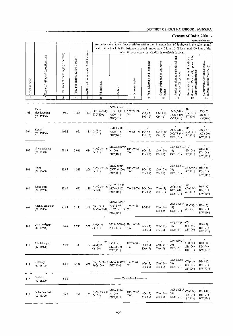
DISTRICT CENSUS HANDBOOK: BANKURA
Census of India 2001 -Amenities and
Amenities available (if not available within the village, a dash (-) is shown in the column and
next to it in brackets the distance in broad ranges viz.< 5 krns., 5-10 kms. and 10+ krns of the
~ '" nearest place where the facility is available is given
" " ~ a <:: "0 a'j :2" "0 ~ " 0 <> '" U <::
u " ::I " '..0 u of -'" '" 0 " " "§ § " " > - '" u
2- " '0 t E~ u 0 0 .~ 3 1il c:!.- ..r:: ~ 8.. u " 0 0..
" :; " ~
0 bO '" " 0.. u "@U1 ~ ~ ....:l :§ "" "0 "2 0 .~ ~ 3 :="S c:!.- o 6 ::I " o<J .:;: -'" -0 % .~ -3] .2 a:I 1i'i
<:: OJ '" U ';;;'~ j " ~ " "0 U 0 ....
£i 0 .... '" o ._
~ ~ .g § ,," .... .~ 0 ~
-'" " '" g OJ '- 0.. '.0 a .D ~ 0 ..r:: ~ _" '" ._ "0
:; '- g "@ g>~ " ._
S OJ 0.. 0 ~ 'R ~ .~ '2 ~ ::I '- ~ 0 .... .g bO " ::1"0 .g to E ~ " " 0 0.. " "@ <:: "2 " _ ....
::I ;:., "@ " a .D 1i'i u :.g E '"
::l () 1il S ::I E ~ S "@ § .g '6 <:: 1;;" E-'" .g _g b.5 ~ '5 :£ ~ '0 " is o <:: §:-:::
f- A :2: 0 uJ3 ~'O ~u~ U1 "" "" ~ U1 u e 1 2 3 4 5 6 7 8 9 10 II 12 13
Purba DDHRMP
SP 103 Nandarampur 91.0 1,225 223
P(2) AC M« CHW H(lO+) TWWSS-PO«5) CM« 5)
ACS(5-10) CY(IO+)
BS« 5) 5) C(lO+) MCW«5) W NCS(5-10) RS(lO+) (02117300)
PHC«5) PH« 5) CP« 5)
OCS(IO+) ST(lO+)
NW(IO+)
Keneti PM S RMPH(IO+)
ACS(5-IO) SP
BS«5) 104 404.8 957 187 MCW«5) TW SS-TW PO« 5) CM(5-10) CY(10+) (02117400) C(IO+) PHC(!o+) PH« 5) CP« 5)
NCS(5-10) ST(IO+)
RS(5-10) OCS(10+) NW(10+)
Nityanandapur MCW(2)SMP - ACS NCS(5- CY
BS(5-IO) 105 581.3 2,086 414 P ACM«5) H(10+) HPTWSS- PO«5) CM(IO+) 10) SP(IO+)
(02117500) C(lO+) PHC(IO+) TW PH« 5) CP«5) OCS(IO+) ST(IO+) RS(IO+) NW(IO+)
Beloa MCWSMP
HPTWSS- ACS NCS(5- SP CY( < 5) BS(;-I 0) 106
(02117600) 435.5 1,348 266 P AC M« 5) CHW H(lO+)
TW PO«5) CM(IO+) 10)
C(1 0+ ) PHC( 10+) PH« 5) CP« 5) OCS(IO+) ST(IO+) RS(10+) NW(IO+)
Khaer Bani CHWH«5)
ACS(5-10) SP
BS« 5) 107
(02117700) 103.4 697 140 P AC M« 5) MCW(5-1O) TW SS-TW PO(lO+) CM«5)
NCS(5-10) CY(10+)
RS(10+) C(5-1O) PHC(IO+) PH« 5) CP(IO+) OCS(IO+)
ST(IO+) NW(10+)
MCW(4) PHS ACS NCS(5- SP CY« 5) BS(~ S) Radha Mohanpur
158.5 2,777 518 P(3) M S RMPSMP TWWSS-
PO PH CM(IO+) 108 (02117800) AC(3)C(10+) CHW H(IO+) W ~0~S(10+) ST« 5) RS(lO+)
PHC(IO+) CP«5) NW(IO+)
Uttar Dariapur PM« 5) MCWH(IO+) HP TW SS- PO(~ 5) ACS NCS(5· CV
BS« 5) 109 64.6 1,780 327 CM(10+) 10) SP(IO+)
(02117900) C(10+) PHC(IO+) TW PH«5) CP« 5) OCS(IO+) ST(IO+) RS(IO+) NW(10+)
Brindabanpur - P« H(I;+) HP TW SS- PO(~ 5) CM(IO+) ACS NCS(5· CY(~ 5) BS(5-10)
110 163.9 40 7 5) M« 5) MCW« 5) 10) SP(IO+) (02118000) TW PH« 5) CP«5) RS(IO+)
C(10+) PHC(IO+) OCS(IO+) ST(lO+) NW(10+)
Kuldanga P(2) AC M« MeW H(lO+) TWWSS-PO«5) CM(IO+)
ACS NCS(5- CY(~ 5) BS(5-10) III 82.1 1,488 276 10)
(02118100) 5) C(lO+) PHC(10+) W PH« 5) CP« 5) OCS(10+) SP(IO+) RS(IO+)
ST(lO+) NW(10+)
112 Dhulat
63.3 -------- Uninhabited ------------(02118200)
MCWCHW HPTWSS- ACS NCS(5- CV(;O+) BS(5-1O) Purba Patrahati P AC M« 5) H(IO+) PO« 5) CM(lO+) 113 96.7 790 164 TW 10) S1'(IO+) RS(IO+) (02118300) C(IO+) PHC(IO+) PH«5) C1'«5) OCS(IO+) ST(IO+) NW(10+)
434
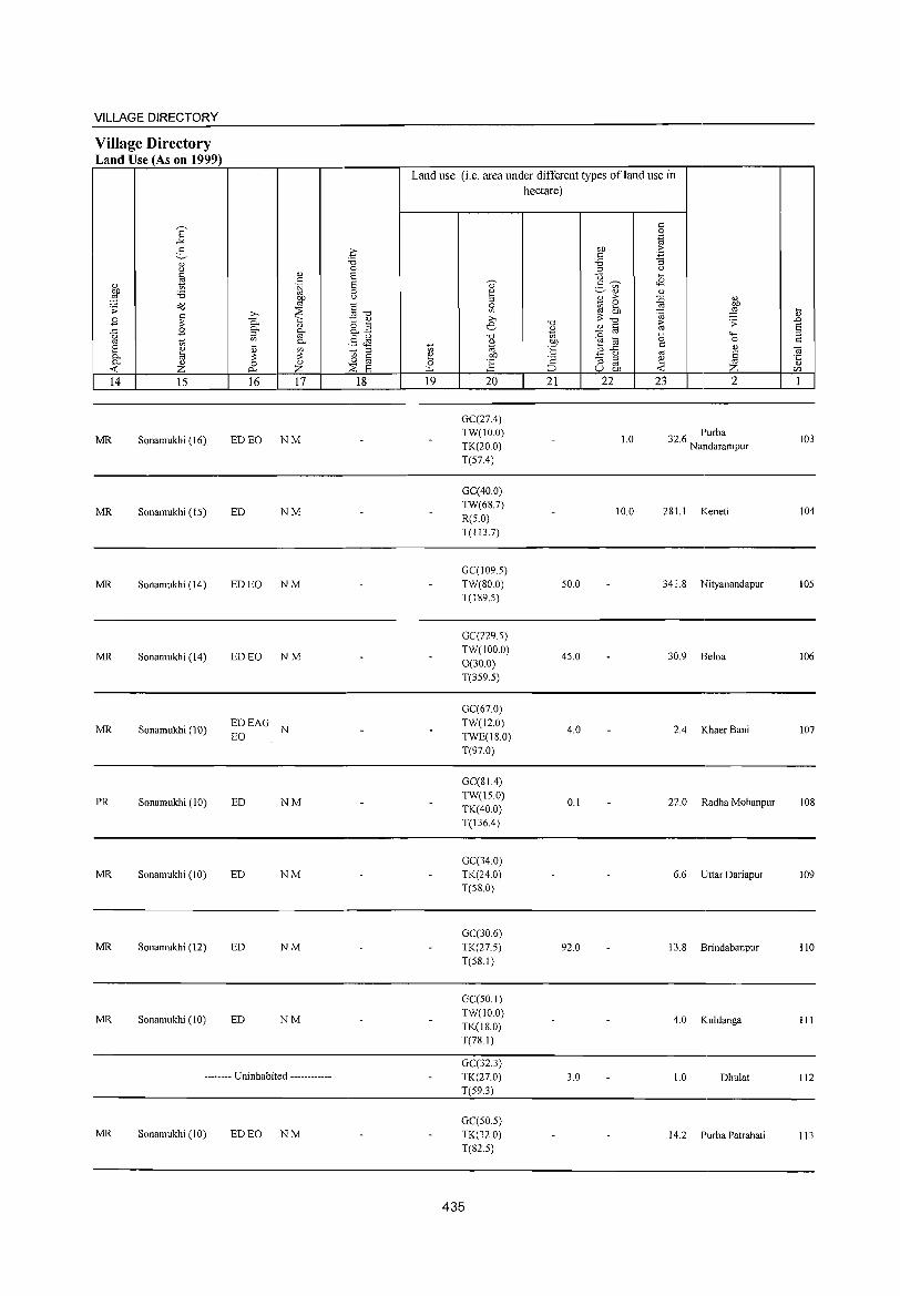
VILLAGE DIRECTORY
Village Directory Land Use (As on 1999)
14 15
MR Sonamukhi (16)
MR Sonamukhi (IS)
MR Sonamukhi (14)
MR Sonamukhi (14)
MR Sonamukhi (10)
PR Sonamukhi (10)
MR Sonamukhi (10)
MR Sonamukhi (12)
MR Sonamukhi (10)
16 17
ED EO NM
ED NM
ED EO NM
ED EO NM
EDEAG N EO
ED NM
ED NM
ED NM
ED NM
-------- Uninhabited ------------
MR Sonamukhi (10) ED EO NM
18
Land use (i.e. area under different types ofland use in hectare)
19 20
GC(27.4) TW(IO.0) TK(20.0) T(S7.4)
GC(40.0) TW(68.7) R(S.O) T(113.7)
GC(1095) TW(SO.O) T(189.S)
GC(229.S) TW(100.0) 0(30.0) T(3S9.S)
GC(67.0) TW(12.0) TWE(lS.0) T(97.0)
GC(81.4) TW(IS.O) TK(40.0) T(136.4)
GC(34 0) TK(24.0) T(58.0)
GC(30.6) TK(27.5) T(5S.I)
GC(50.1) TW(IO.0) TK(18.0) T(78.1)
GC(32.3) TK(27.0) T(59.3)
GC(50.5) TK(32.0) T(82.5)
435
21 22
SO.O
4S.0
4.0
0.1
92.0
3.0
1.0
10.0
23 2
32.6 Purba Nandarampur
281.1 Keneti
341.S Nityanandapur
30.9 Beloa
2.4 Khaer Bani
22.0 Radha Mohanpur
6.6 Uttar Dariapur
13.8 Brindabanpur
4.0 Kuldanga
1.0 Dhulat
14.2 Purba Patrahati
103
104
lOS
106
107
lOS
109
110
III
112
113
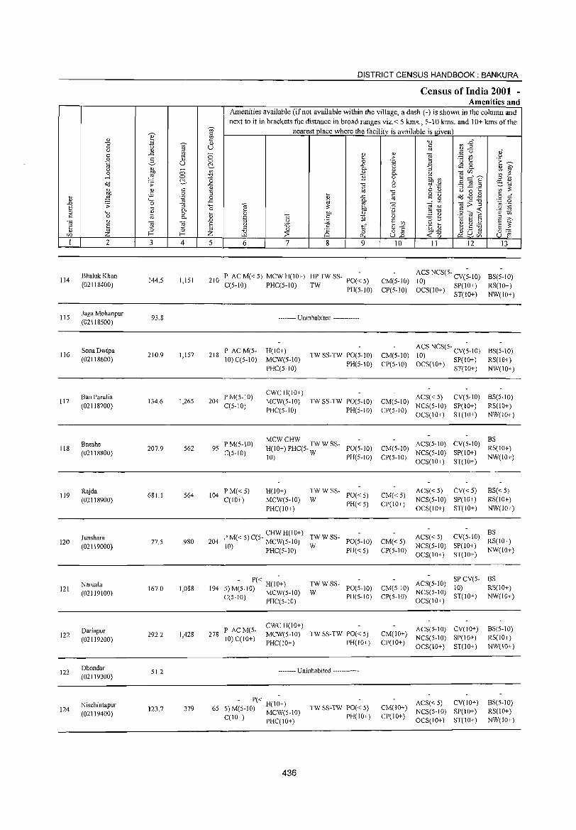
114
115
116
117
118
119
120
121
122
123
124
2
BhalukKhan (02118400)
Jaga Mohanpur (02118500)
Sona Dwipa (02118600)
Ban Parulia (02118700)
Bneshe (02118800)
Rajda (02118900)
Junshara (02119000)
Naruala (02119100)
Dariapur (02119200)
Dhondar (02119300)
Nischintapur (02119400)
3 4
144.5 1,151
93.8
210.9 1,157
134.6 1,26S
207.9 562
681.1 564
77.S 980
167.0 1,088
292.2 1,428
51.2
123.7 379
DISTRICT CENSUS HANDBOOK: BANKURA
Census of India 2001 -Amenities and
Amenities available (ifnot available within the village, a dash (-) is shown in the column and next to it in brackets the distance in broad ranges viz.< 5 kms., 5-10 kms. and 10+ kms of the
nearest place where the facility is available isgiven
5 6 7 8 9
210 P AC M« 5) MCW H(10+) HP TW SS- PO(~ 5)
C(5-10) PHC(5-1O) TW PH(5-10)
-------- Uninhabited ------------
218 P AC M(5-10) C(5-1O)
204 PM(S-IO) C(5-10)
H(IO+) MCW(S-IO) PHC(5-1O)
CWCH(IO+) MCW(S-IO)
PHC(5-10)
TW SS-TW PO(S-IO)
PH(S-IO)
TW SS-TW PO(S-IO) PH(S-IO)
95 P M(S-IO) C(5-1O)
MCWCHW H(IO+) PHC(5- TW W SS- PO(5-10)
10) W PH(5-1O)
104 P M« 5) C(10+)
H(10+) MCW(S-IO) PHC(IO+)
TWWSS-W PO«S)
PH« S)
CHWH(IO+) 204 I' M« 5) C(S- MCW(5-10) ~W W SS- 1'0(5-10)
10) PHC(5-10) PH« 5)
'" - P« H(I~+) 194 -~ M(5-10) MCW(5-10)
C(5-10) PHCC5-10)
278 P ACM(5-10) CCIO+)
CWCH(IO+) MCW(S-IO) PHC(IO+)
~W W SS- PO(S-1O)
PH(5-10)
TW SS-TW PO« S) PH(IO+)
-------- Uninhabited ------------
- P« H(1~+) 6S 5) M(S-IO) MCW(S-IO)
C(10+) PHC(IO+)
436
TW SS-TW PO« 5) PH(IO+)
10
CM(5-10) CP(5-1O)
CM(5-10) CP(S-IO)
11 12
ACS NCS(5- CV(~-IO) 10) OCS(10+) SP(IO+)
ST(IO+)
ACS NCS(5- CV(;-IO) 10) OCS(IO+) SP(IO+)
ST(lO+)
13
BS(5-1O)
RS(10+) NW(IO+)
BS(5-1O) RS(lO+) NW(lO+)
CM(S-IO) ACS« S) CV(S-IO) BS(S-lO) CP(S-IO) NCS(S-IO) SP(IO+) RS(IO+)
OCS(IO+) ST(IO+) NW(IO+)
CM(5-10) ACS(5-10)
CP(5-10) NCS(5-10) OCS(IO+)
BS CV(5-1O) RS(IO+)
SP(IO+) NW(IO+) ST(IO+)
CM«S) CP(IO+)
CM« 5) CP(5-10)
CM(S-IO) CP(5-10)
ACS« 5) CV« 5) NCS(5-10) SP(IO+) OCS(IO+) ST(lO+)
BS«5) RS(lO+) NW(IO+)
ACS« 5) NCS(5-10) OCS(10+)
BS CV(5-10) RS(IO+)
SP(10+) NW(IO+) ST(IO+)
SPCV(5- BS ACS(5-10) 10) RS(IO+)
NCS(5-10) ST(IO+) NW(IO+) OCS(1O+)
ACS(S-IO) CV(IO+) CM(IO+) NCS(S-IO) SP(IO+) CP(IO+) OCS(IO+) ST(IO+)
BS(5-10) RS(IO+) NW(IO+)
ACS« S) CV(IO+) CM(IO+) NCS(5-10) SP(IO+) CP(10+) OCS(IO+) ST{lO+)
BS(S-IO) RS(10+) NW(IO+)
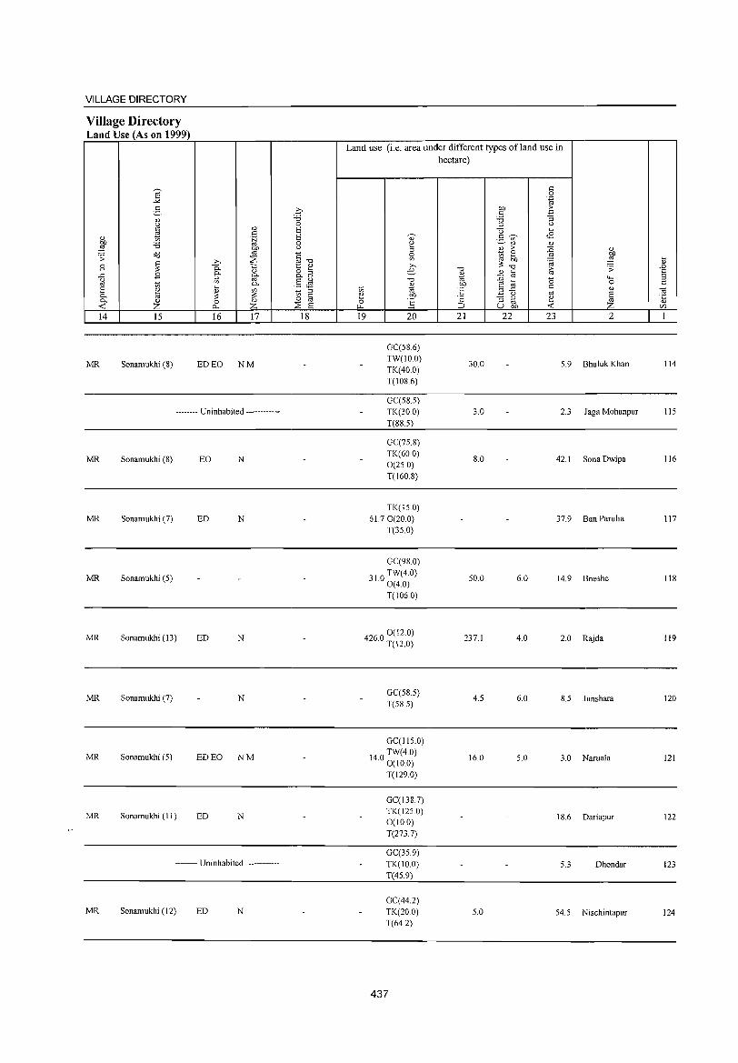
VILLAGE DIRECTORY
Village Directory Land Use (As on 1999)
14 15
MR Sonamukhi (S)
16 17
ED EO NM
-------- Uninhabited ------------
MR Sonamukhi (S) EO N
MR Sonamukhi (7) ED N
MR Sonamukhi (5)
MR Sonamukhi (13) ED N
MR Sonamukhi (7) N
MR Sonamukhi (5) ED EO NM
MR Sonamukhi (1 1 ) ED N
-------- Uninhabited ------------
MR Sonamukhi (12) ED N
18
Land use (i.e. area under different types ofland use in hectare)
19 20
GC(586) TW(lO.O) TK(40.0) T(lOS.6)
GC(58.5) TK(30.0) T(SS.5)
GC(75.8) TK(600) 0(25.0) T(160.8)
TK(15.0) 61.7 0(20.0)
T(35.0)
GC(9S0)
310 TW(4.0) · 0(4.0)
T(106.0)
4260 0 (12.0) · T(12.0)
GC(58.5) T(58.5)
GC(115.0)
140 TW(4.0) · 0(10.0)
T(129.0)
GC(138.7) TK(1250) 0(10.0) T(2737)
GC(35.9) TK(lO.O) T(45.9)
GC(44.2) TK(20.0) T(64.2)
437
21
30.0
3.0
8.0
50.0
237.1
4.5
16.0
5.0
22 23 2
5.9 Bhaluk Khan
2.3 Jaga Mohanpur
42.1 Sona Dwipa
37.9 Ban Parulia
6.0 14.9 Bneshe
4.0 2.0 Rajda
6.0 S.5 Junshara
5.0 3.0 Naruala
18.6 Dariapur
5.3 Dhondar
54.5 Nischintapur
... <l) .0
§ " «i ·c <l) t/)
114
115
116
117
118
119
120
121
122
123
124
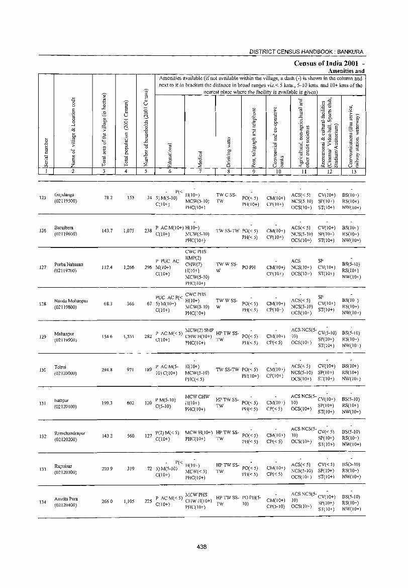
-v;-e ::l
" OJ
'" C
'1::l -v;- " 0 ti U (.) " ::l c ..c OJ -c 0 0 -3 " .~ U
0 ~
'" '" 0 OJ 0 00 .....l £ 0 '1::l
~ c: o'iJ .;;:
-5 " " c
~ 9 .,s 0
:u ...... .~ 0 ..c .D .;;: 0 "3 "-'
"' '" 0- 0 ::l ""' ~ 0 :u c 0 0--.; " ~
.0
E ~ E '5 Z ::l E-< E-< ;Z; r/)
I 2 3 4 5
Gopdanga 125 78.2 IS3 34
(02119S00)
126 Baruibera
143.7 1,07S 238 (02119600)
127 Purba Nabasan
112.4 J,266 296 (02119700)
Nanda Mohanpur 128 68.3 366 67
(02119800)
129 Mahanpur (02119900)
154.6 1,531 282
130 Telrui
(02120000) 294.8 971 189
Isabpur 131
(02120100) 199.3 602 120
Ramchandrapur 132
(02120200) 143.2 S60 127
Rupuisar 133
(02120300) 203.9 3J9 72
AmritaPara 134
(02120400) 266.0 1,105 225
DISTRICT CENSUS HANDBOOK: BANKURA
Census of India 2001 -Amenities and
Amenities available (if not available within the village, a dash ( -) is shown in the column and next to it in brackets the distance in broad ranges viz. < 5 kms., 5 -10 kms. and 10+ kms of the
nearest place where the facility is available is given
'1::l rIl -g" c '" :.; '0 ,,"
" " e > OJ (.) c ~ 1:: 'E ~ 0 .~ B ..r::: <I'! 0 0- " "3 -a~ " ~ " 0- '" ~ ~ ] 0 .~ a3 ~ -"~ .:, -3 ] .~ ::l '"
'1::l <.> 'F '.P e~ § '1::l C " (.) 0 .... OJ ;;: o ._ c " .... c
~ £ Od..1jg '" ..r::: '"
o c ~ 0- til';>15 '';::: 0
-.; 2 til e .-'.=: '" ._
C ;;: 00 '2 c <C '2 ~ 0 on " ::l'" .:2 '<3 ~ '-§ -.; c ] " 3 ti '01 "'
::l (.) :.;;; 8 OJ "' ~ (.) 'i3 .g] t.5 ~ ..g c E-'" E ;;: " 25 '" o iii 0'-' ~ 0 ~o ~u-r.ll 0... U.o ~r/) U 2
6 7 8 9 10 I1 12 13
- P« -TWCSS- ACS« 5) CV(lO+) S)M(S-lO) H(lO+) PO«S) CM(IO+)
BS(IO+)
C(IO+) MCW(S-IO) TW PH(IO+) CP(IO+)
NCS(S-IO) SP(IO+) RS(lO+) PHC(IO+) OCS(10+) ST(10+) NW(IO+)
P AC M(lO+) H(10+) ACS« S) CV(lO+) BS(IO+) TW SS-TW PO« S) CM(IO+)
C(10+) MCW(S-IO) PH«S) CP(lO+)
NCS(S-IO) SP(lO+) RS(IO+)
PHC(10+) OCS(IO+) ST(10+) NW(lO+)
CWCPHS
P PUC AC RMP(2)
ACS SP
M(JO+) CHW(2) TWWSS-
PO PH CM(JO+) NCS(JO+) CV(JO+) BS(5-10)
C{10+) H(IO+) W
CP(IO+) OCS(10+) ST(IO+) RS(lO+)
MCW(S-IO) NW(IO+)
PHC(IO+)
PUC AC P( < CWC PHS TWWSS- ACS« S)
SP BS(IO+) H(10+)
PO« 5) CM(IO+) CV(IO+) S) M(10+) MCW(5-10) W NCS(S-IO) RS(lO+) C(10+) PHC(IO+) PH«S) CP(IO+)
OCS(IO+) ST(IO+)
NW(lO+)
I' ACM«S) MCW(2) SMP HP TW SS-PO«S) CM(IO+)
ACS NCS(S· CV(;-IO) BS(5·10) CHW H(IO+) TW 10)
C(10+) OCS(IO+) SP(IO+) RS(10+) PHC(IO+) PH«5) CP« S)
ST(IO+) NW(IO+)
P ACM(S- H(lO+) TW SS-TW PO« 5) CM(10+)
ACS« S) CV(10+) BS(IO+)
10) C(10+) MCW(S-IO) PH(lO+) CP(lO+)
NCS(5-1O) SP(IO+) RS(lO+)
PHC« S) OCS(10+) ST(IO+) NW(IO+)
P M(5-to) MCWCHW
HP TW SS- PO(~ 5) ACS NCS(S- CV(;O+) BS(5·10)
H(IO+) CM(IO+) 10) SP(lO+) C(5-10) PHC(IO+) TW PH« 5) CP« 5) OCS(IO+) ST(iO+)
RS(10+)
NW(IO+)
pel) M« 5) MCWH(lO+) HPTWSS-PO«5) CM(IO+)
ACS NCS(5- CV(~ 5) BS(5-10)
C(IO+) PHC(JO+) TW 10) SP(IO+) RS(IO+) PH« 5) CP« 5) OCS(10+) ST(10+) NW(IO+)
- P« H(I~+) HP TW SS- PO(~ 5) CM(IO+) ACS« 5) CV«5) BS(S-IO)
5) M(5-1O) MCW« S) NCS(5-1O) SP(IO+) RS(IO+) TW PH«S) CP«S) C{1 0+) PHC( 10+) OCS(10+) ST(IO+) NW(IO+)
MCWPHS HPTWSS- POPH(S- ACS NCS(5- CV(;O+) BS(S-IO)
P AC M« 5) CHW H(IO+) CM(IO+) TW 10) 10) SP(IO+) RS(IO+)
C(lO+) PHC(10+) CP(S-IO) OCS(10+) 8T(10+) NW(lO+)
438
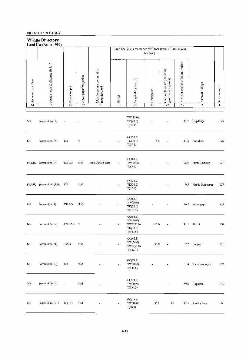
VILLAGE DIRECTORY
Village Directory Land Use (As on 1999)
14 15
MR Sonamukhi (12)
MR Sonamukhi (IS)
PR MR Sonamukhi (14)
16 17
ED N
ED EO NM
PR MR Sonamukkhi (13) ED NM
MR Sonamukhi (9) ED EO NM
MR Sonamukhi (12) EDEAG N
MR Sonamukhi (II) EAG NM
MR Sonamukhi (12) ED NM
MR Sonamukhi (14) NM
MR Sonamukhi (121) ED EO N M
18
Rice, Puffed Rice
Land use (i.e. area under different types ofland use in hectare)
19 20
TW(IS.O) TK(20.0) T(3S.0)
GC(67.S) TK(30.0) T(97.S)
GC(63.9) TW(20.0) T(83.9)
GC(37.7) TK(30 0) T(67.7)
GC(63.9) TW(20.0) TK(30.0) T(II3.9)
GC(S3.6) TW(SO.O)
TWE(30.0) TK(IO.O) T(143,6)
GC(42,1) TW(SO,O)
TWE(50,0) T(l42, I)
GC(7 1. 8) TW(70,0) T(141.8)
GC(74.2) TW(60,0) T(134,2)
GC(38.9) TW(40,0) T(78,9)
439
21 22
S.O
110,0
SO,O
SO.O
23 2
43.2 Gopdanga
41.2 Baruibera
28.S Purba Nabasan
O.S Nanda Mohanpur
40.7 Mahanpur
41.1 Telrui
7,2 lsabpur
1.4 Ramchandrapur
69,8 Rupuisar
3,6 133,S Amrita Para
12S
126
127
128
129
130
131
132
133
134
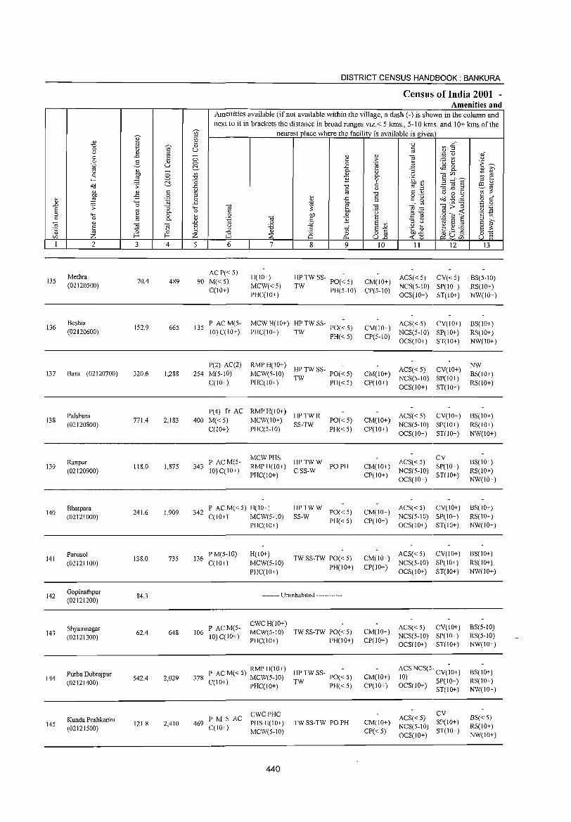
135
136
137
138
139
140
141
142
143
144
145
2
Methra (02120500)
Beshia (02120600)
Bara (02120700)
Palshura (02120800)
Ranpur (02120900)
Bhatpara (02121000)
I'anasol (02121100)
Gopinathpur (02121200)
Shyamnagar (02121300)
Purba Dubrajpur (02121400)
Kunda Pushkarini (02121500)
3 4
70.4 489
152.9 665
320.6 1,288
771.4 2,183
118.0 1,875
241.6 1,909
138.0 735
84.3
62.4 648
542.4 2,029
121.8 2,410
DISTRICT CENSUS HANDBOOK: BANKURA
Census of India 2001 -Amenities and
Amenities available (if not available within the village, a dash (-) is shown in the column and next to it in brackets the distance in broad ranges viz.< 5 kms., 5-10 krrs. and 10+ kms of the
nearest place where the facility is available is given
5 6
ACP«5) 90 1\1«5)
C(10+)
135 l' AC M(5-10)C(10+)
1'(2) AC(2) 254 M(5-10)
C(IO+)
7 8 9
H(IO+)
MCW«5) PHC(lO+)
HP TW SS- PO(~ 5)
TW PH(5-10)
MCW H(IO+) HP TW SS-PHC(IO+) TW 1'0« 5)
PH« 5)
RMP H(IO+) -MCW(5-10) HP TW SS- 1'0« 5)
PHC(IO+) TW 1'H« 5)
1'(4) Tr AC RMPH(10+) HPTWR
400 M« 5) MCW(10+) SS-TW PO«5) 1'H«5) C(10+) PHC(5-10)
343 I' ACM(5-110) C(IO+)
:;:(~g) HPTWW I'OPH + CSS-W
PHC(IO+)
342 I' AC M« 5) H(IO+) C(IO+) MCW(5-1O)
~_:W W 1'0« 5)
I'H« 5)
136 I'M(5-1O) C(IO+)
106 I' ACM(5-110) C(lO+)
PHC(IO+)
H(10+)
MCW(5-1O) I'HC(IO+)
TW SS-TW PO« 5) I'H(IO+)
-------- Uninhabited ------------
CWCH(IO+) MCW(5-10) PHC(IO+)
TW SS-TW 1'0« 5) I'H(IO+)
RMPH(IO+) -378 I' AC M« 5) MCW(5-10) HP TW SS- 1'0« 5)
C(10+) PHC(IO+) TW I'H« 5)
469 PM S AC C(IO+)
CWCPHC PHS H(lO+) MCW(5-10)
440
TW SS-TW PO PH
10
CM(10+) CP(5-10)
11 12
ACS« 5) CV« 5) NCS(5-10) SP(IO+) OCS(IO+) ST(IO+)
CM(IO+) ACS« 5) CV(IO+) C1'(5-10) NCS(5-10) SP(IO+)
OCS(IO+) ST(IO+)
ACS« 5) CV(IO+) CM(IO+) NCS(5-10) SP(IO+) CP(10+) OCS(IO+) ST(IO+)
ACS« 5) CV(IO+) CM(10+) NCS(5-1O) SP(IO+) CP(IO+) OCS(IO+) ST(IO+)
CM(IO+) CI'(IO+)
ACS«5) CV NCS(5-1O) SP(IO+) OCS(10+) ST(IO+)
ACS« 5) CV(IO+) CM(IO+) NCS(5-10) SI'(IO+) CI'(IO+) OCS(IO+) ST(IO+)
ACS« 5) CV(10+) CM(IO+) NCS(5-10) SP(IO+) CP(10+) OCS(IO+) ST(IO+)
ACS« 5) CV(IO+) CM(IO+) NCS(5-10) SI'(10+) CI'(IO+) OCS(10+) ST(10+)
CM(IO+) CI'(IO+)
CM(IO+)
CP«5)
ACS NCS(5 .. CV(~O+) 10) SI'(IO+) OCS(IO+) ST(IO+)
ACS« 5) CV NCS(5-1O) SI'(IO+) OCS(IO+) ST(IO+)
13
BS(5-10) RS(IO+) NW(10+)
BS(IO+) RS(IO+) NW(IO+)
NW BS(IO+) RS(IO+)
BS(IO+) RS(IO+) NW(IO+)
BS(IO+) RS(IO+) NW(10+)
BS(IO+) RS(IO+) NW(IO+)
BS(IO+) RS(10+) NW(IO+)
BS(5-10) RS(5-1O) NW(IO+)
BS(IO+) RS(IO+) NW(IO+)
BS«5) RS(IO+) NW(IO+)
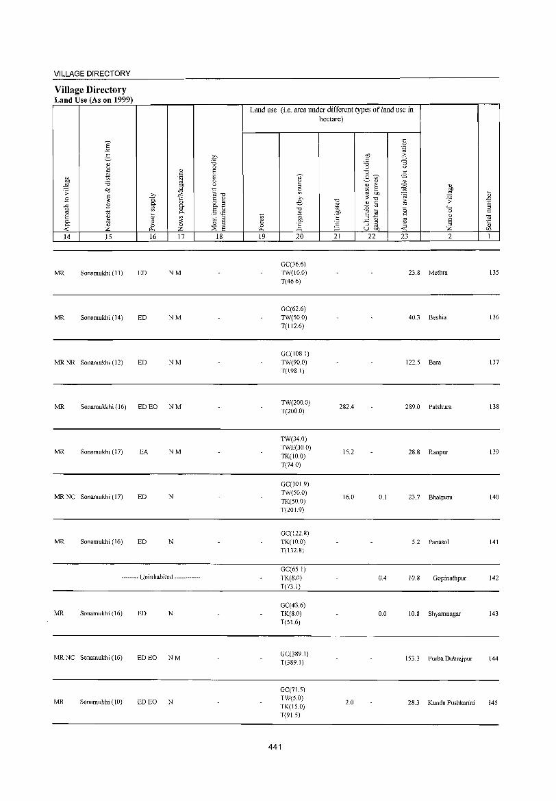
VILLAGE DIRECTORY
Village Directory Land Use (As on 1999)
Land use (i.e. area under different types ofland use in hectare)
E " 0
-'" .~
§ g "" ·5 " OJ "" ;;:; "3 u 0 ::l <>
~ OJ 6 u .... c
6 " " --. <8 " .~ .- '"
:W ;;:; 0 2 ~OJ OJ
liP u ::l OJ > :g <1.)
o(j <= ~ ~ 0
~ . ;; :::8 ~ .... ~
.... "
>, "'"" ~: OJ
.8 ~ 0.. '" 1:: " >,
"" ~ .;; .D
" 8.3 e- " § 6 ..<: .8 0-fil' " u ~ 5$ "" ~ :g .... 0 "-' ::l
'" ~ 0- " "" 0 c l3 .... "' " 2 ~ '" ~ ::l t> ~ °6 ::l"<: <1.) <il
0- ~ ~ ~ § 2 "" ~ u '" ~ ·c 'c - ::l 2 0- <1.) 0 " 0 ] ::l '" " -< Z 0. Z :::8 6 ~ :::> u "" -< <f}
14 15 16 17 18 19 20 21 22 23 2 1
GC(36.6)
MR Sonamukhi (11) ED NM TW(IO.0) 23.8 Methra 135 T(46.6)
GC(62.6) MR Sonamukhi (14) ED NM TW(50.0) 40.3 Beshia 136
T(112.6)
GC(108.1)
MRNR Sonamukhi (12) ED NM TW(90.0) 122.5 Bara 137 T(198.1)
MR Sonamukkhi (16) ED EO NM TW(200.0)
282.4 289.0 Palshura 138 T(200.0)
TW(34.0)
MR Sonamukhi (17) EA NM TWE(30.0)
15.2 28.8 Ranpur 139 TK(IO.0) T(74.0)
GC(101.9)
MRNC Sonamukhi (17) ED N TW(50.0)
16.0 0.1 23.7 Bhatpara 140 TK(50.0) T(201.9)
GC{l22.8) MR Sonamukhi (16) ED N TK(IO.0) 5.2 Panasol 141
T(132.8)
GC(65.1) -------- Uninhabited ------------ TK(S.O) 0.4 IO.S Gopinathpur 142
T(73.1)
GC(43.6) MR Sonamukhi (16) ED N TK(8.0) 0.0 10.8 Shyamnagar 143
T(S16)
MRNC Sonamukhi (16) ED EO NM GC(389.1)
153.3 Purba Dubrajpur 144 T(389.1)
GC(7L5)
MR Sonam ukhi (10) ED EO N TW(5.0) TK(l5.0)
2.0 28.3 Kunda Pushkarini 145
T(9L5)
441
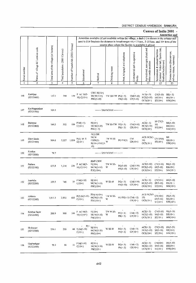
DISTRICT CENSUS HANIDBOOK : BANKURA
CensUls of India 2001 -Amenities and
Amenities available (if not available within the village, a dash (-) is shown in the column and
next to it in brackets the distance in broad ranges viz.< 5 kms., 5-10 kills. and 10+ kms of the
'"" nearest place where the facilitv is available is given
" " ~ til <= "0 ~ ~~ "0 t> ~ 0)
0 U) U <= 0) " ~ '" <= .r::: - 0) 0)
] '.p u " <= 0 <= .~ :.= rn " 0 g 0) 0 '0 1:: E~ '.g u 0
c::'- .r::: ~ 8.. <) " - 0- ~ "3 " ~ 0 1 0 U) " 0- " ] ~.~ ~ ~ ...:l 0 "0 ] 6 .~ ~ c::'- -0 ::l " o'(j .;; .r::: '0 oj ._ 3]§ co,,"
" <= ~ c <) C 't) ';;;';;:
~ .,s 0 ::l oj "0 o ._ " 0 .... <= •
[l .~ 0 ~ .r::: § c g Od ~ .g o c .D
4-< .r::: 0- U)
OJ>"g ',p 0 .;; 0 "3 "-< OJ ~ OJ ~ .~ oj ._
~ oj 0- 0 C ;;: "8 c <C .~ 19
4-< 0) 0 .... 0 OJ) 0) ::l"O ,"de c '" c 0 til 0- 0) .~ OJ c ] '" .=: ~ ::l ;>,
OJ 0)
~ .D " :.;;: E U) ::l " "" E ::l E ~ § ~ E <) '5 <) .... ~ d) ....... .c: ::l ::l 0)
== t) E -" .;:: Q)
go] §:= 0) '0 Ci 0 82 OJ).r::: C/l Z f--o Z ~ ;;S 0- <C '0 ce:~{/) u e I 2 3 4 5 6 7 8 9 10 11 12 13
Kashipur P ACM(5-CWC H(10+)
ACS« 5) CV(5-1O) BS«5) 146 137.1 798 159 MCW(S-IO) TW SS-TW PO« S) CM(5-IO) (02121600) 10) C(\O+)
PHC(5-1O) PH(5-1O) CP(5-1O) NCS(5-10) SP(IO+) RS(10+) OCS(IO+) ST(10+) NW(1O+)
147 Kuchiagopalpur
104.4 -------- Uninhabited ------------(02121700)
Baharpur P M« 5) H(10+) ACS«5) SPCV(5-
BS(5-10) 148 146.3 552 109 TW SS-TW PO« 5) CM(5-1O) 10)
(02121800) C(10+) MCW(S-10) PH« 5) CP(IO+)
NCS(5-10) ST(lO+)
RS{10+)
PHC« 5) OCS(lO+) NW(IO+)
D(3)DH
Dhan Simla P(4) M S MCW
TW WSS- CM ACS NCS(5- BS
149 (02121900)
964.6 5,327 1,054 C(10+)
CHW(S) W PO PH(3) CP(10+)
10) CV SP(6) RS(IO+)
H(IO+) PHC(5- OCS(IO+) ST(IO+) NW(IO+)
10)
150 Kendua
(02122000) 79.7 -------- Uninhabited ------------
RMPCHW
151 Pathara
433.8 1,214 236 P ACM(5- H(lO+) TWWSS-
PO(5-1O) CM{S-IO) ACS(5-10) CV(5-1O) BS(5-1O)
(02122100) 10) C(10+) MCW(5-1O) W PH(5-1O) CP(10+)
NCS(5-10) SP(5-1O) RS(lO+)
PHC(IO+) OCS(IO+) ST(10+) NW(10+)
152 Jamdoba
150.5 346 72 PM(5-1O) H(IO+)
WSS-W 1'0«5) CM(5-1O) ACS« 5) CV(IO+) BS(5-10)
(02122200) C(10+) MCW(S-IO) PH(5-10) CP(IO+)
NCS(5-10) SP(5-10) RS(lO+)
PHC(IO+) OCS(IO+) ST(lO+) NW(IO+)
Ichharia 1'(2) M(5-10) PHSH(IO+)
TWWSS- ACS NCS(5 .. CV(;O+) BS(5-10) 153 1,011.5 2,932 605 MCW(5-1O) PO PH« 5) CM« 5) 10)
(02122300) C(IO+) I'HC(IO+)
W CI'(\O+) OCS(IO+) SP(5-1O) RS(IO+)
ST(IO+) NW(lO+)
Krishna Sayer 189
PAC M(5- I-I(JO+) TWWSS-PO«5) CM« 5)
ACS« 5) CV(5-IO) BS(5-10) 154
(02122400) 200.9 900
10) C(IO+) MCW(S-IO) W NCS(5-10) SP(5-10) RS(IO+)
PHC(ID+) PH«5) CP(1O+)
OCS(IO+) ST(IO+) NW(10+)
Shuksayer 220.1 230 44
- P« H(I~+) WSS-W 1'0« 5) CM«5)
ACS« 5) CV(5-1O) BS(5-1O) 155
(02122500) 5) M(5-10) MCW(5-JO) NCS(5-JO) SP(5-10) RS(IO+) C(IO+) PHC(IO+) PH«5) CP(JO+)
OCS(1O+) ST(IO+) NW(1O+)
Gopinathpur 79.3 56 II
F'M(5-1O) I-I(10+) WSS-W 1'0« 5) CM« 5)
ACS«5) CV(lO+) BS(5-10) 156
(02122600) C(10+) MCW(5-10) NCS(5-lO) SP(5-10) RS(IO+)
PHC(10+) PH«S) CP(10+)
OCS(10+) ST(IO+) NW(IO+)
442
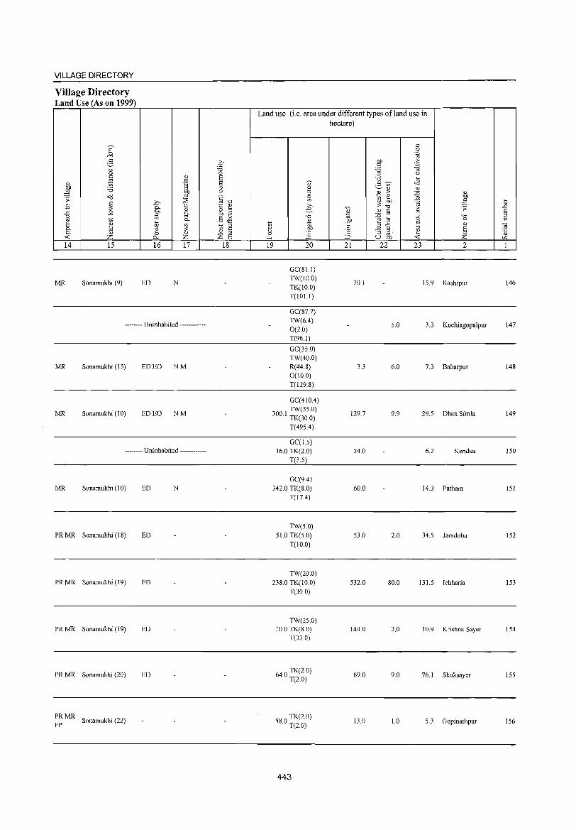
VILLAGE DIRECTORY
Village Directory Land Use (As on 1999)
14 15
MR Sonamukhi (9)
16 17
ED N
-------- Uninhabited ------------
MR Sonamukhi (15) ED EO NM
MR Sonamukhi (10) ED EO NM
-------- Uninhabited ------------
MR Sonamukhi (10) ED N
PRMR Sonamukhi (18) ED
PRMR Sonamukhi (19) ED
PR MR Sonamukhi (19) ED
PR MR Sonamukhi (20) ED
:;: MR Sonamukhi (22)
18
Land use (i.e. area under different types ofland use in hectare)
19 20
GC(8L1) TW(IO.O) TK(IO.0) T(lOl.l)
GC(877) TW(6.4) 0(2.0) T(96.1)
GC(35.0) TW(40.0) R(44.8) 0(10.0) T(129.8)
GC(410A) TW(55.0)
300.1 TK(30.0)
T(495.4)
GC(J5) 16.0 TK(2.0)
T(3.5)
GC(9A) 342.0 TK(8.0)
T(17A)
TW(5.0)
51.0 TK(5.0) T(IO.0)
TW(20.0) 238.0 TK(IO.0)
T(30.0)
TW(25.0) 10.0 TK(8 0)
T(33.0)
640 TK(2.0) . T(2.0)
580 TK(2.0) . T(20)
443
21
20.1
3.3
129.7
54.0
60.0
53.0
532.0
144.0
69.0
13.0
22 23 2
15.9 Kashipur
5.0 3.3 Kuchiagopalpur
6.0 7.3 Baharpur
9.9 29.5 Dhan Simla
6.2 Kendua
14.3 Pathara
2.0 34.5 Jamdoba
80.0 131.5 Ichharia
3.0 10.9 Kri shna Sayer
9.0 76.1 Shuksayer
1.0 5.3 Gopinathpur
146
147
148
149
150
151
152
153
154
155
156
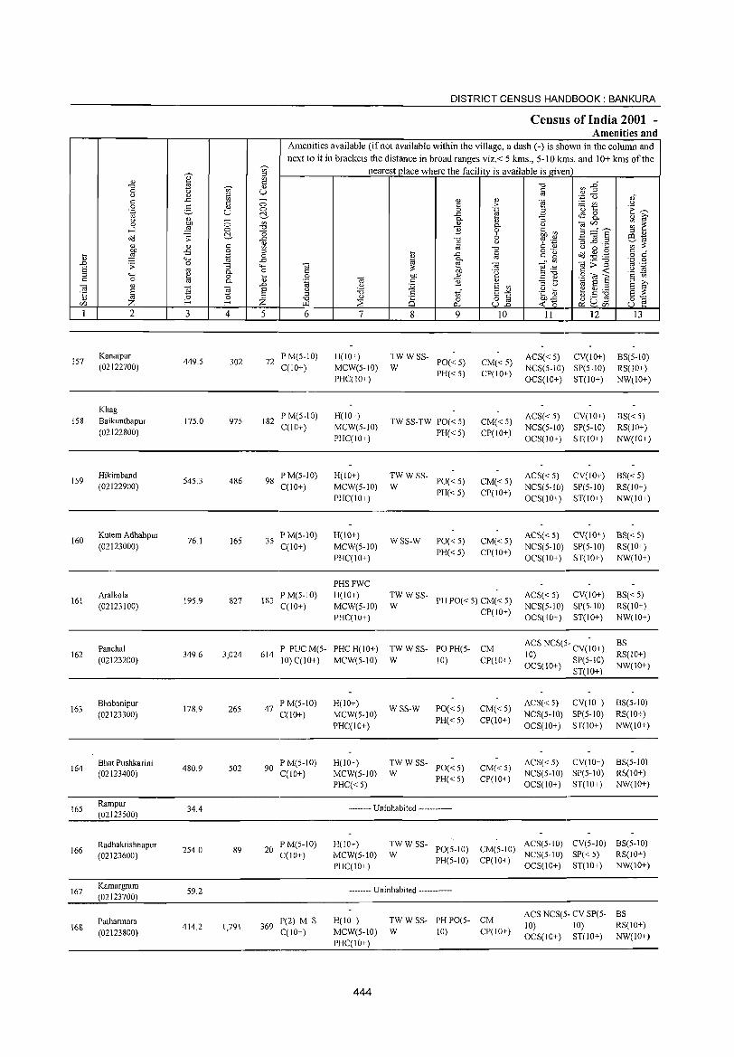
DISTRICT CENSUS HANDBOOK: BANKURA
Census of India 2001 -Amenities and
Amenities available (if not available within the village, a dash (-) is shown in the column and next to it in brackets the distance in broad ranges viz.< 5 kms., 5-10 kms. and 10+ kms of the
~
nearest_l)lace where the facility is available is given ~ :g
" ~ ;g
.", ~ EA .", " 0 '" U t: u " '" to 'z (.) ,," ..c '" - " " ] t: t: 0 t: > - '" .9 0 3 " 0 0 .~ .3 '0 t:: c:~ .~ u ~ ..c eS 8.. u " - 0..
" "3 " ~ 0 OIl 0 '" " 0.. U '"§r.f)n_ ~ ~ ....l ~ 0 .", 1l 0 .~ ~
~ "0 6 .3 ~ § ::l " ~ :; ..c .", 6 .~ 0:1 .,
" t: u "3 .c ._ --;;;~ " " t: '" to .", U 0 .... OIl -B 0 '" ~ "
o .-o(j ..g .g t: " .... ~ .~ 0 ..c " g o " " ""' ..c ., 0.. to OJ>-g '..c 0 ..0 .:; 0 "3 ""' OJ r:! 03 - '" to .-
S to 0.. 0 " ~ OIl 'e ~~ t: -< .~ :s
'" ""' " 0 ~ .S OIl " E ~ StilE t: '" t: 0 til 0.. 03 " 1l " '" >, 03 " ..0 ., U :.;;; E '"
::l u ., E '" S ~ § ~ ~ E u '5 " tif E-'" .g] ~ ~ ~ '5 '" '" " i§ 8] ~ u .s 8"" .", 0 ~o CZl Z E- E- Z ~ ::s "" ~ ~CZl u e 1 2 3 4 5 6 7 8 9 10 II 12 I3
IS7 Kanaipur
449.S 302 72 PM(S-IO) H(IO+) TWWSS-
PO«S) CM«S) ACS« S) CY(lO+) BS(S-IO)
(02122700) C(lO+) MCW(S-IO) W NCS(S-IO) SP(S-IO) RS(IO+) PHC(IO+)
PH« S) CP(IO+) OCS(IO+) ST(IO+) NW(IO+)
Khag PM(S-IO) H(lO+) ACS« S) CY(IO+) BS« S)
IS8 Baikunthapur 17S.0 975 182 TW SS-TW PO« 5) CM«S) (02122800)
C(lO+) MCW(S-IO) PH« S) CP(IO+)
NCS(S-IO) SP(S-IO) RS(IO+) PHC(lO+) OCS(IO+) ST(IO+) NW(IO+)
IS9 Hikimband
S4S.3 486 98 PM(S-IO) H(IO+) TWWSS-
PO«S) ACS«S) CY(lO+) BS« S)
(02122900) C(lO+) MCW(S-IO) W CM«S)
NCS(S-IO) SP(S-IO) RS(lO+) PHC(IO+)
PH«S) CP(IO+) OCS(lO+) ST(IO+) NW(lO+)
160 Kutem Adhabpur
76.1 165 3S P M(S-10) H(IO+)
WSS-W PO«S) CM«S) ACS«5) CY(10+) BS« 5)
(02123000) C(1O+) MCW(S-IO) PH«S) CP(lO+)
NCS(S-10) SP(S-IO) RS(10+)
PHC(IO+) OCS(lO+) ST(lO+) NW(IO+)
PHSFWC
161 Aralkola
195.9 827 183 PM(S-IO) H(IO+) TWWSS-
PH PO« 5) CM« S) ACS«S) CY(IO+) BS« S)
(02123100) C(IO+) MCW(S-IO) W NCS(S-IO) SP(S-IO) RS(IO+)
PHC(IO+) CP(IO+)
OCS(IO+) ST(IO+) NW(lO+)
Panchal P PUCM(S- PHC H(IO+) TWWSS- PO PH(S- CM ACS NCS(5- CY(;O+) BS
162 (02123200)
349.6 3,024 614 10) C(IO+) MCW(S-IO) W 10) CP(IO+)
10) RS(IO+) OCS(IO+) SP(S-IO) NW(IO+)
ST(IO+)
163 Bhabanipur
178.9 265 47 PM(5-IO) H(lO+)
WSS-W PO« S) CM«5) ACS«S) CY(lO+) BS(S-IO)
(02123300) C(lO+) MCW(S-IO) PH« S) CP(IO+)
NCS(S-IO) SP(S-IO) RS(lO+)
PHC(IO+) OCS(IO+) ST(IO+) NW(10+)
164 Bha! Pushkarini
480.9 502 90 P M(5-IO) H(IO+) TWWSS-
PO« S) CM«5) ACS«S) CY(lO+) BS(S-IO)
(02123400) C(10+) MCW(S-IO) W PH« S) CP(lO+)
NCS(5-1O) SP(S-IO) RS(lO+)
PHC«5) OCS(10+) ST(IO+) NW(IO+)
16S Rampur
34.4 -------- Uninhabited ------------(02123S00)
Radhakrishnapur 20
PM(5-IO) H(IO+) TWWSS-PO(5-1O) CM(S-IO)
ACS(5-1O) CY(S-IO) BS(S-IO) 166
(02123600) 2S4.0 89
C(IO+) MCW(S-10) W NCS(5-10) SP«5) RS(lO+)
PHC(10+) PH(S-10) CP(IO+)
OCS(10+) ST(10+) NW(10+)
167 Kamargram
59.2 -------- Uninhabited ------------(02123700)
ACS NCS(S- CY SP(S- BS Patbarmara P(2) M S H(IO+) TWWSS- PH PO(S- CM
10) 10) RS(lO+) 168 (02123800)
414.2 1,791 369 C(10+) MCW(S-IO) W 10) CP(IO+)
PHC(IO+) OCS(IO+) ST(IO+) NW(IO+)
444
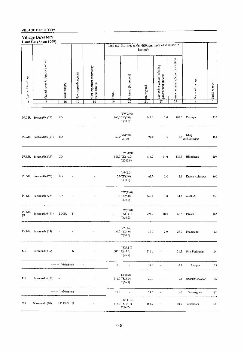
VILLAGE DIRECTORY
Village Directory Land Use (As on 1999)
14 15
PR MR Sonamukhi (22) ED
PR MR Sonamukkhi (24) ED
PR MR Sonamukhi (24) ED
PR MR Sonamukhi (22) ED
PR MR Sonamukhi (22) ED
16
~: MR Sonamukkhi (22) ED EO N
PR MR Sonamukhi (18)
MR Sonamukhi (16) N
17
-------- Uninhabited ------------
MR Sonamukkhi (10)
-------- Uninhabited ------------
MR Sonamukhi (JO) EDEAG N
18
Land use (i.e. area under different types ofland use in hectare)
19 20
TW(25.0) 163.0 TK(5.0)
T(30.0)
600 TK(7.0) . T(7.0)
TW(90.0) 181.0 TK(10.0)
T(JOO.O)
TW(5.0) 10.0 TK(5.0)
T(IO.0)
TW(25.0) 10.0 TK(5.0)
T(30.0)
TW(35.0) TK(150) T(50.0)
TW(6.0) 55.0 TK(4.0)
T(10.0)
TK(12.0)
305.00(14.7)
T(26.7)
17.0
GC(S.8) 211.0 TK(8.0)
T(l6.8)
37.0
TWE(IO.O) 173.0 TK(24.7)
T(34.7)
445
21 22
149.0
91.0
.131.0
41.0
140.1
224.0
82.0
128.0
17.3
20.0
21.3
188.0
23 2
2.0 105.5 Kanaipur
1.0 160 Khag . Baikunthapur
11.0 122.3 Hikimband
2.0 13.1 Kutem Adhabpur
1.0 14.8 Aralkola
10.0 65.6 Panchal
2.0 29.9 Bhabanipur
21.2 Bhat Pushkarini
0.1 Rampur
6.3 Radhakrishnapur
1.0 Kamargram
1 8.5 Patharmara
157
158
159
160
161
162
163
164
165
166
167
168
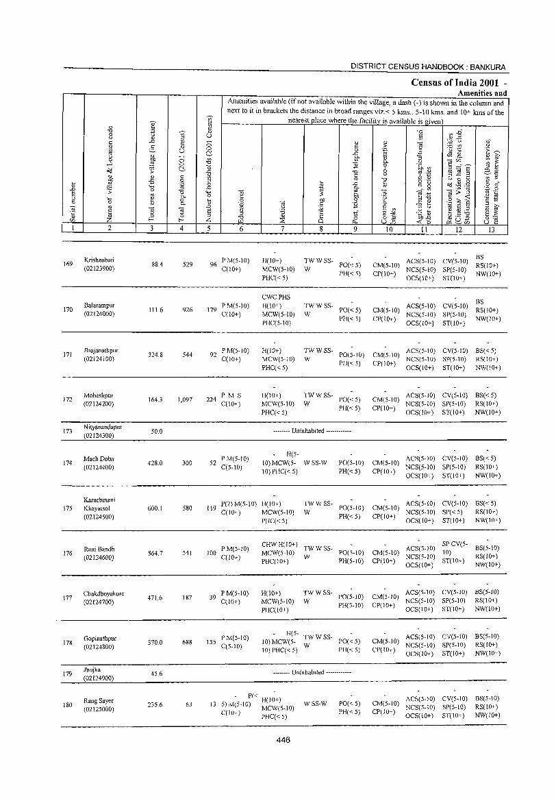
169
170
171
172
173
174
175
176
177
178
179
180
2
Krishnabati (02123900)
Balarampur (02124000)
Brojanathpur (02124100)
Moheshpur (02124200)
Nityanandapur (02124300)
Mach Doba (02124400)
Karachmani Khayarsol (02124500)
Rani Bandh (02124600)
Chakdhoyakure (02124700)
Gopinathpur (02124800)
Jhujka (02124900)
Rang Sayer (02125000)
3 4
88.4 529
111.6 926
324.8 544
164.3 1,097
50.0
428.0 300
600.1 580
864.7 541
471.6 187
370.0 688
45.6
235.6 63
DISTRICT CENSUS: HANDBOOK: BANKURA
Census of India 2001 -Amenities and
Amenities available (ifnot available within the village, a dash (-) is shown in the column and next to it in brackets the distance in broad ranges viz.< 5 kms., 5-10 kms. and 10+ kms of the
nearest place where the facility is available is given
5 6
96 P M(5-1O) C(10+)
179 P M(5-10) C(10+)
92 PM(5-10) C(10+)
224 PM S C(lO+)
52 PM(5-IO) C(5-10)
7
H(lO+) MCW(5-10) PHC«5)
CWCPHS H(lO+) MCW(5-10) PHC(5-1O)
H(IO+) MCW(5-1O) PHC« 5)
H(10+) MCW(5-10) PHC«5)
8 9
--:: W SS- PO« 5)
PH« 5)
TWWSS-W PO«5)
PH«5)
10 11 12 13
BS CM(5-10) ACS(5-10) CV(5-lO) RS(IO+) CP(IO+) NCS(5-10) SP(5-10) NW(IO+)
OCS(IO+) ST(10+)
CM(S-IO) CP{lO+)
BS ACS(5-10) CV(5-IO) RS(IO+) NCS(5-10) SP(5-lO) NW(IO+) OCS(IO+) ST(IO+)
TW W SS- ACS(5-1O) CV(5-IO) BS« 5) W PO(5-1O) CM(5-10) NCS(5-IO) SP(5-10) RS(lO+)
PH« 5) CP(IO+) OCS(10+) ST(IO+) NW(IO+)
TWWSS-W PO«5)
PH« 5)
ACS(5-10) CV(5-10) BS« 5) CM(S-IO) NCS(5-1O) SP(5-10) RS(IO+) CP(lO+) OCS(10+) ST(lO+) NW(lO+)
-------- Uninhabited ------------
H(5-10) MCW(5- WSS-W 10)PHC«5)
ACS(5-10) CV(5-10) BS« 5) PO(S-IO) CM(S-IO) NCS(5-10) SP(5-10) RS(IO+) PH« 5) CP(IO+) OCS(IO+) ST(IO+) NW(IO+)
119 P(2)M(5-10) H(IO+) C(lO+) MCW(5-lO)
TW W SS- ACS(5-10) CV(5-10) BS« 5) W PO(5-1O) CM(S-IO) NCS(5-IO) SP« 5) RS(lO+)
100 I'M(5-1O) C(10+)
39 P M(S-IO) C(lO+)
155 PM(5-10) C(S-IO)
PHC« 5) PH«5) CP(10+) OCS(1O+) ST(10+) NW(IO+)
CHW H(IO+) TW W SS- ACS(5-10) SP CV(5- BS(5-10) MCW(5-10) 1'0(5-10) CM(S-IO) 10)
C(l) W PH(5 10) CP(IO) NCS(5-1O) ST(IO+) RS(IO+) PH 0+ - + OCS(IO+) NW(JO+)
H(10+) MCW(5-IO) PHC(lO+)
TW W SS- ACS(5-1O) CV(5-lO) BS(5-10) W 1'0(5-10) CM(5-10) NCS(5-IO) SI'(5-10) RS(IO+)
PH(5-1O) CP(10+) OCS(IO+) ST(10+) NW(IO+)
H(5- TWWSS-10) MCW(S- W 1'0« 5) 10) PHC«5) PH«5)
-------- Uninhabited ------------
ACS(5-10) eV(5-10) BS(5-10) CM(S-IO) NCS(5-10) SP(S-IO) RS(IO+) CP(10+) OCS(IO+) ST(lO+) NW(IO+)
- P« H(I;+) 13 5)M(S-IO) MCW(S-IO) wss-w 1'0«5)
PH« 5)
ACS(5-10) CV(5-10) BS(5-10) CM(5-IO) NCS(5-10) SP(5-10) RS(IO+) CP(IO+) OCS(IO+) ST(IO+) NW(IO+) C(JO+) PHC« 5)
446
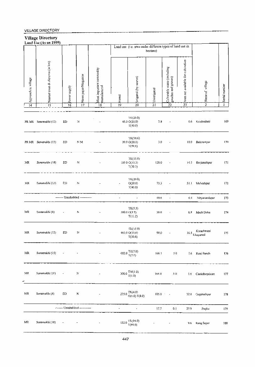
VILLAGE DIRECTORY
Village Directory Land Use (As on 1999)
E -'" g '" u
~ " :W '<:i o<l .. ;; ~ .8
..c .8 g
~ 0 k 0.
~ <1)
Z 14 15
PRMR Sonamukhi (12)
PR MR Sonamukhi (13)
MR Sonamukhi (18)
MR Sonamukhi (12)
" c .~
"" oj
;>., ::.'S 0. 'i:; 0. " ~ §'
0.
~ ~ 0 A.. Z 16 17
ED N
ED NM
ED N
ED N
-------- Uninhabited ------------
MR Sonamukhi (8) N
MR Sonamukhi (12) ED N
MR Sonamukhi (IS)
MR Sonamukhi (16) N
4-
MR Sonamukhi (8) ED N
-------- Uninhabited ------------
MR Sonamukhi (18)
.0 '<:i 0 E E 0 u
§ ":l 1:: '" o :J 0. . ..,
.5 (~ ~ " 0 a ::.'S 8
18
Land use (i.e. area under different types of land use in hectare)
19 20
TK(20.0) 4S.0 0(20.0)
T(40.0)
TK(39.6) 39.00(20.0)
T(S9.6)
TK(IS0) 160.00(IS.3)
T(30.3)
TK(20.0) 0(20.0) T(40.0)
TK(5.5) 380.00(S.7)
T(Il.2)
TK(lS 0) 463.00(IS.6)
T(30.6)
6820 TK(7.0) · T(7.0)
3000 TW(1.0) · T(l.O)
TK(4.0) 22S.0 0(4.0) T(8.0)
132 0 TK(94.0) · T(94.0)
447
"'" <1)
~ ~ t:: '2 ;::J
21
2.8
3.0
120.0
73.3
49.6
30.0
90.0
166.1
164.0
10S.0
17.7
"" c '<:i " U .!': ~ en
<1)
2l ;>
ia 2 "" ~ -0
<1) a ::0 oj til .3 ..c
u :; ::>
'" U "" 22
7.0
5.0
0.1
'" 0 '"§ .J; :; u ....
<8 <1)
::0 oj
~ ~ '0 '" oj
~ 23
" E ~ '-H 0
'" ~ 2
0.6 Krishnabati
10.0 Balarampur
14.S Brojanathpur
S1.1 Moheshpur
0.4 Nityanandapur
6.8 Mach Doba
16 S Karachmani . Khayarsol
2.6 Rani Bandh
1.6 Chakdhoyakure
32.0 Gopinathpur
27.9 Jhujka
9.6 Rang Sayer
t .!O> 8 ::>
'" 'iil .;::
'" '" I
169
170
171
172
173
174
175
176
177
178
179
180
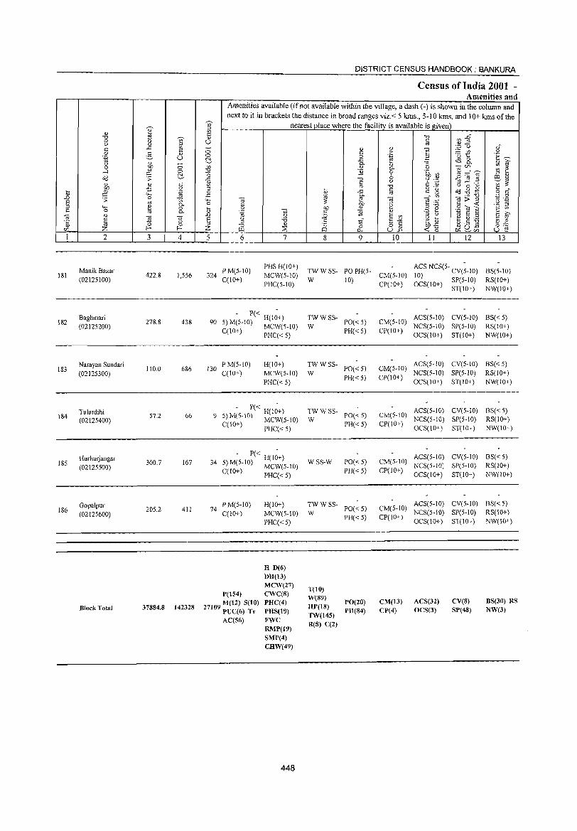
181
182
183
184
185
186
2
ManikBazar (02125100)
Baghmari (02125200)
Narayan Sundari (02125300)
Tulardihi (02125400)
Hurhurjangar (02125500)
Gopalpur (02125600)
Block Total
3
422.8
278.8
110.0
S7.2
300.7
205.2
37884.8
o §_ c o .~
:=; 0.. o 0..
4
1,556
438
686
66
167
411
142328
DISTRICT CENSUS HANDBOOK: BANKURA
Census of India 2001 -Amenities and
I Amenities available (if not available within the village, a dash (-) is shown in the column and next to it in brackets the distance in broad ranges viz.< 5 kms., 5-10 kms. and 10+ kms of the
nearest place where the facilitv is available is given
u
:i 6 7
324 P M(5-10) C(lO+)
PHS H(10+)
MCW(5-1O)
PHC(5-10)
5 - P« H(I~+) 90 ) M(5-10) MCW(5-10)
C(IO+) PHC« 5)
130 P M(5-1O) C(lO+)
H(JO+)
MCW(5-1O)
PHC«5)
- P« H(I~+) 9 S) M(S-IO) MCW(S-IO)
C(lO+) PHC« 5)
- P« H(I~+) 34 5) M(5-IO) MCW(5-10)
C(lO+) PHC« 5)
74 P M(5-JO) C(10+)
1'(154)
27109 M(I2) S(lO) PUC(6) T,. AC(56)
H(IO+)
MCW(S-IO)
PHC«5)
H D(6) DH(13) MCW(27) CWC(8) PHC(4) PHS(19) FWC RMP(19} SMP(4} CHW(49)
448
8 9 10 11 12 13
TW W SS- PO PH(5-W 10) CM(5-1O)
CP(IO+)
ACS NCS(S- CV(;-IO) 10) OCS(I 0+) SP( 5-10)
ST(10+)
BS(5-10)
RS(IO+)
NW(lO+)
TWWSS-PO« 5)
PH« 5) W
TWWSS-W PO«5)
PH« 5)
;;: W SS- PO« 5)
PH«5)
WSS-W PO«5)
PH« 5)
~W W SS- PO« 5)
PH«5)
T(IO)
W(S9) HP(18) TW(145)
R{S) C(2}
1'0(20)
PH(84)
ACS(5-1O) CV(5-10) BS« 5) CM(5-10) NCS(5-10) SP(5-10) RS(JO+) CP(lO+)
OCS(lO+) ST(IO+) NW(lO+)
ACS(5-IO) CV(5-1O) BS« 5) CM(5-10) NCS(5-1O) SP(5-10) RS(IO+) CP(10+)
OCS(lO+) ST(IO+) NW(lO+)
ACS(5-10) CV(5-10) BS« 5) CM(5-10) NCS(5-10) SP(5-10) RS(IO+)
CP(IO+) OCS(IO+) ST(lO+) NW(IO+)
ACS(5-IO) CV(5-1O) BS« 5) CM(5-1O) NCS(5-lO} SP(5-lO) RS(JO+)
CP(lO+) OCS(10+) ST(10+) NW(lO+)
ACS(5-10) CV(5-10) BS« 5) CM(5-10) NeS(5-10) SP(5-10) RS(10+)
CP(JO+) OCS(lO+) ST(lO+) NW(10+)
CM(13) CP(4)
ACS(32) OeS(3)
ev(s} SP(48)
BS(30) RS NW(3)
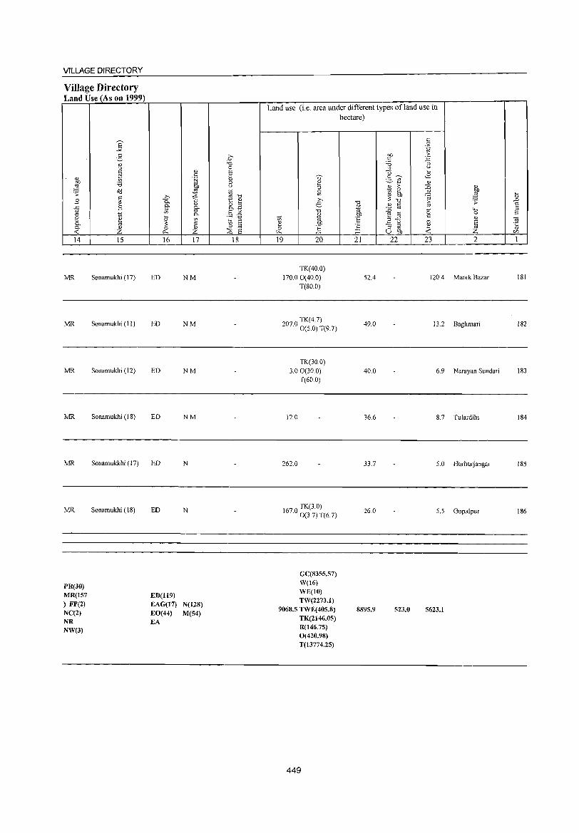
VILLAGE DIRECTORY
Village Directory Land Use (As on 1999)
14
MR
MR
MR
MR
MR
MR
PR(30) MR(157 ) FP(2) NC(2) NR NW(3)
15 16 17
Sonamukhi (17) ED NM
Sonamukhi (II) ED NM
Sonamukhi (12) ED NM
Sonamukhi (IS) ED NM
Sonamukkhi (17) ED N
Sonamukhi (IS) ED N
ED(1l9) EAG(17) N(128) EO(44) M(54) EA
18
Land use (i.e. area under different types ofland use in hectare)
19 20
TK(40.0) 170.00(40.0)
T(SO.O)
20 0 TK(4.7) 7. 0(5.0) T(9.7)
TK(30.0) 3.00(300)
T(60.0)
12.0
262.0
1670 TK(3.0) . 0(37) T(6.7)
GC(8355.57) W(16) WE(lO) TW(2273.1)
9068.5 TWE(405.8) TK(2I46.05) R(146.75) 0(420.98) T(13774.25)
449
21 22 23 2
52.4 120.4 Manik Bazar
49.0 13.2 Baghmari
40.0 6.9 Narayan Sundari
36.6 S.7 Tulardihi
33.7 5.0 HurhUljangar
26.0 5.5 Gopalpur
8895.9 523.0 5623.1
lSI
IS2
IS3
IS4
185
186

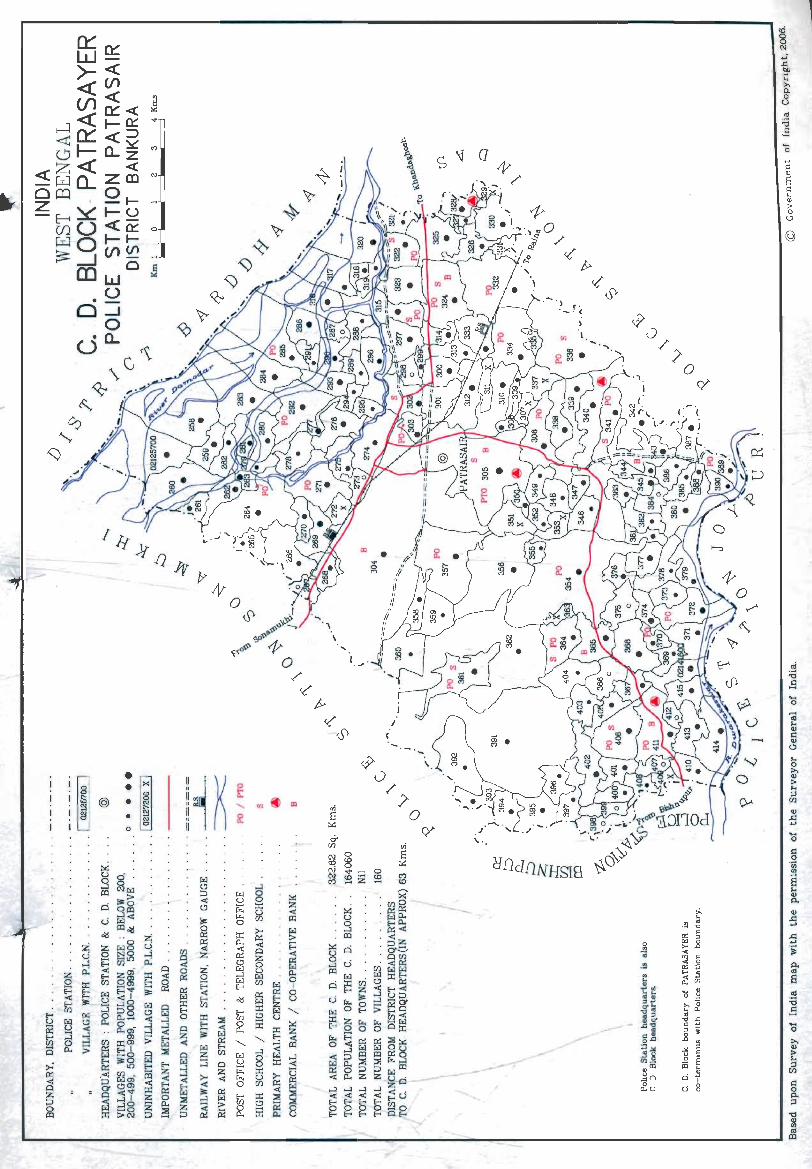
• u
: i~ • N a o
__ - __ -----
©
.... o
... o >-'" > ... ;j
[J)
'" ..d ....
>.
'" > ... ;j
[J)
I': o Po ;j
."
'" (Jl
<0 il1
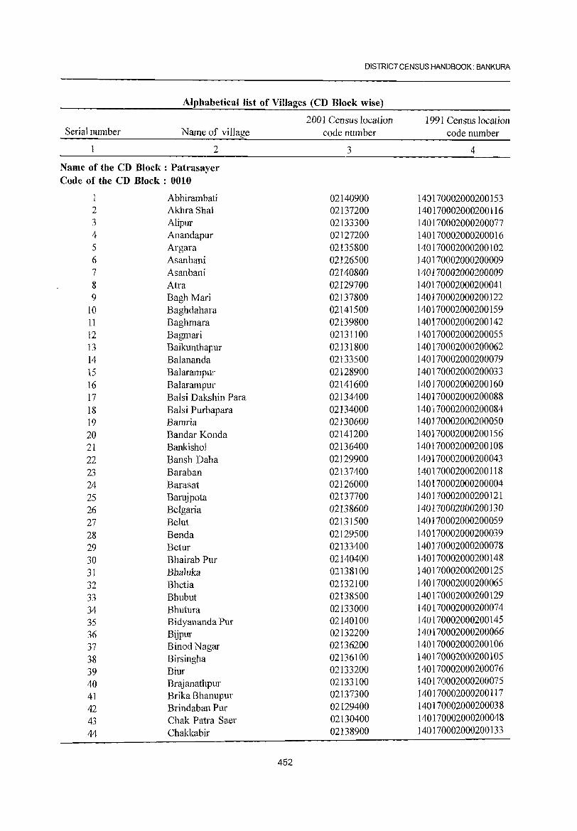
DISTRICT CENSUS HANDBOOK: BANKURA
Alphabetical list of Villages (CD Block wise)
2001 Census location 1991 Census location Serial number Name of village code number code number
2 3 4
Name of the CD Block: Patrasayer Code of the CD Block: 0010
Abhirambati 02140900 140170002000200153 2 Akhra Shal 02137200 140170002000200116 3 Alipur 02133300 140170002000200077 4 Anandapur 02127200 140170002000200016 5 Argara 02135800 140170002000200102 6 Asanbani 02126500 140170002000200009 7 Asanbani 02140800 140170002000200009 8 Atra 02129700 1401170002000200041 9 BaghMari 02137800 140170002000200122
10 Baghdahara 02141500 140170002000200159 11 Baghmara 02139800 140170002000200142 12 Bagmari 02131100 140170002000200055 13 Baikunthapur 02131800 140170002000200062 14 Balananda 02133500 140170002000200079 15 Balarampur 02128900 140170002000200033 16 Balarampur 02141600 140170002000200160 17 Balsi Dakshin Para 02134400 140170002000200088 18 Balsi Purbapara 02134000 140170002000200084 19 Bamda 02130600 140J70002000200050 20 Bandar Konda 02141200 140170002000200156 21 Bankishol 02136400 140170002000200108 22 Bansh Daha 02129900 140170002000200043 23 Baraban 02137400 140170002000200118 24 Barasat 02126000 140170002000200004 25 Barujpota 02137700 140170002000200121 26 BeIgaria 02138600 140170002000200130 27 Belut 02131500 140170002000200059 28 Benda 02129500 140170002000200039 29 Betur 02133400 140170002000200078 30 Bhairab Pur 02140400 140170002000200148 31 Bhaluka 02138100 140170002000200125 32 Bhetia 02132100 140170002000200065 33 Bhubut 02138500 140170002000200129 34 Bhutura 02133000 140170002000200074 35 Bidyananda Pur 02140100 140170002000200145 36 Bijpur 02132200 140170002000200066 37 BinodNagar 02136200 140170002000200106
38 Birsingha 02136100 140170002000200105
39 Biur 02133200 140170002000200076 40 Brajanathpur 02133100 1401713002000200075 41 Brika Bhanupur 02137300 1401713002000200117
42 Brindaban Pur 02129400 140170002000200038
43 Chak Patra Saer 02130400 140170002000200048
44 Chakkabir 02138900 140170002000200133
452
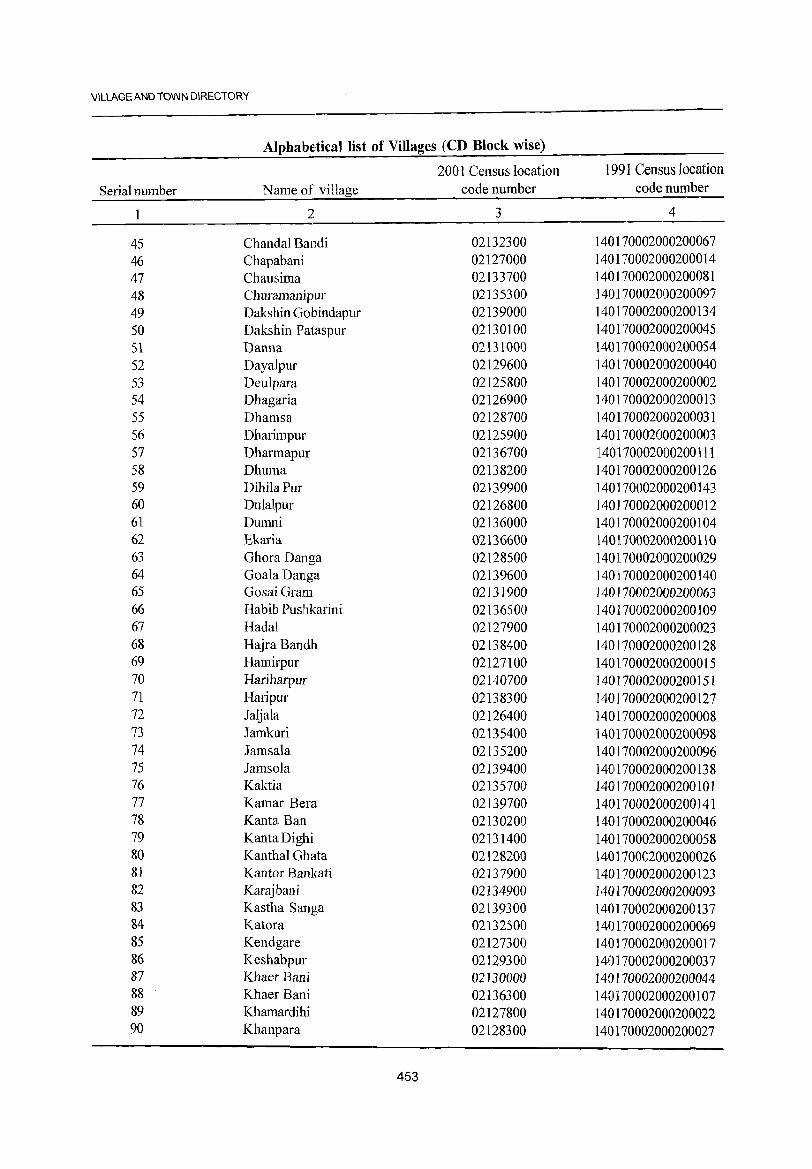
VILLAGE AND TOWN DIRECTORY
Alphabf:tical list of Villages (CD Block wise)
2001 Census location 1991 Census location Serial number Name of village code number code number
1 2 3 4
45 Chandal Bandi 02132300 140170002000200067 46 Chapabani 02127000 140170002000200014 47 Chausima 02133700 140170002000200081 48 Churamanipur 02135300 140170002000200097 49 Dakshin Gobindapur 02139000 140170002000200134 50 Dakshin Pataspur 02130100 140170002000200045 51 Danna 02131000 140170002000200054 52 Dayalpur 02129600 140170002000200040 53 Deulpara 02125800 140170002000200002 54 Dhagaria 02126900 140170002000200013 55 Dhamsa 02128700 140170002000200031 56 Dharimpur 02125900 140170002000200003 57 Dharmapur 02136700 140170002000200111 58 Dhuma 02138200 140170002000200126 59 DihilaPur 02139900 140170002000200143 60 Du1a1pur 02126800 140]70002000200012 61 Dumni 02136000 140170002000200104 62 Ekaria 02136600 140170002000200110 63 Ghora Danga 02128500 140170002000200029 64 Goa1a Danga 02139600 140170002000200140 65 GosaiGram 02131900 140170002000200063 66 Habib Puslhkarini 02136500 140170002000200109 67 Hadal 02127900 140170002000200023 68 Hajra Bandh 02138400 140170002000200128 69 Hamirpur 02127100 140170002000200015 70 Hariharpur 02140700 140170002000200151 71 Haripur 02138300 140170002000200127 72 Jaljala 02126400 140170002000200008 73 Jamkuri 02135400 140170002000200098 74 Jamsala 02135200 140170002000200096 75 Jamsola 02139400 140170002000200138 76 Kaktia 02135700 140170002000200101 77 Kamar Bera 02139700 140170002000200141 78 Kanta Ban 02130200 140170002000200046 79 KantaDighi 02131400 140170002000200058 80 KanthaI Ghata 02128200 140170002000200026 81 Kantor Bankati 02137900 140170002000200123 82 Karajbani 02134900 140170002000200093 83 Kastha Sanga 02139300 140170002000200137 84 Katora 02132500 140170002000200069 85 Kendgare 02127300 140170002000200017 86 Keshabpur 02129300 140170002000200037 87 Khaer Bani 02130000 140170002000200044 88 Khaer Bani 02136300 140170002000200107 89 Khamardihi 02127800 140170002000200022 90 Khanpara 02128300 140170002000200027
453
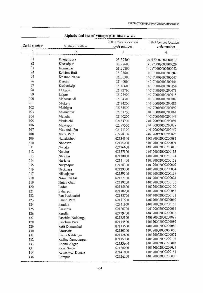
DISTRICT CENSUS HANDBOOK: BANKURA
Alphabetical list of Villages (CD Block wise)
2001 Census location 1991 Census location Serial number Name of village code number code number
1 2 3 4
91 Khejurmura 02137500 140170002000200119 92 Khosalpur 02127600 140170002000200020 93 Konnagar 02130800 140170002000200052 94 Krishna Bati 02133800 140170002000200082 95 Krishna Nagar 02130300 140170002000200047 96 Kurchi 02140000 140170002000200144 97 Kushadwip 02140600 140170002000200150 98 Lalband 02132700 140170002000200071 99 Lalpur 02127400 140170002000200018
100 Mahesnandi 02134300 140170002000200087 101 Mqjkuri 02134200 140170002000200086 102 Malbigha 02135500 140170002000200099 103 Mamudpur 02131700 140170002000200061 104 Mancha 02140200 140170002000200146 105 Maukuchi 02134700 140170002000200091 106 Muktapur 02127500 140170002000200019 107 MukundaPur 02141300 140170002000200157 108 Mura Para 02128100 140170002000200025 109 Nabakishor 02134100 140170002000200085 110 Nabasan 02135000 140170002000200094 111 Nahala 02126600 140170002000200010 112 Nandur 02137100 140170002000200115 113 Narangi 02138000 140170002000200124 114 Naricha 02141400 140170002000200158 115 Naryanpur 02126300 140170002000200007 116 Netkhara 02129000 140170002000200034 117 Nikunjapur 02139500 140170002000200139 118 Nimai Nagar 02127700 140170002000200021 119 Nutan Gram 02139200 140]70002000200136 120 Padua 02135600 140170002000200100 121 Paharpur 02130900 140170002000200053 122 Pan Pushkarini 02138700 140170002000200131 123 Panch Para 02131600 140170002000200060 124 Pandua 02141100 140170002000200155 125 Parashia 02126700 140170002000200011 126 Parulia 02129200 140170002000200036 127 Paschim Naldanga 02135100 140170002000200095 128 Paschim Para 02134500 140170002000200089 129 Patit Dommahal 02133600 140170002000200080 130 Patrasair 02130500 140170000000000000 131 Purba Naldanga 02132800 140170002000200072 132 Radha Damodarpur 02135900 140170002000200103 133 Radha Nagar 02133900 140170002000200083 134 Ram Nagar 02128000 140170002000200024 135 Rameswar Kunria 02141000 140170002000200154 136 Rampur 02126200 140170002000200006
454
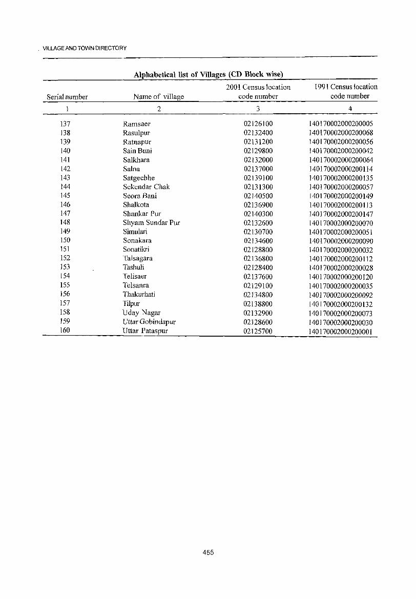
· VILLAGE AND TOWN DIRECTORY
Alphabetical list of Villages (CD Block wise)
Serial number
137 138 139 140 141 142 143 144 145 146 147 148 149 150 151 152 153 154 155 156 157 158 159 160
Name of village
2
Ramsaer Rasulpur Ratnapur SainBuni Salkhara Salna Satgechhe Sekendar Chak SeoraBani Shalkota Shankar Pur Shyam Sundar Pur Simulari Sonakara Sonatikri Talsagara Tashuli Telisaer Telsanra Thakurhati Tilpur Uday Nagar Uttar Gobindapur Uttar Pataspur
2001 Census location code number
3
02126100 02132400 02131200 02129800 02132000 02137000 02139100 02131300 02140500 02136900 02140300 02132600 02130700 02134600 02128800 02136800 02128400 02137600 02129100 02134800 02138800 02132900 02128600 02125700
455
1991 CensUlS location code number
4
140170002000200005 140170002000200068 140170002000200056 140170002000200042 140170002000200064 140170002000200114 140170002000200135 140170002000200057 140170002000200149 140170002000200113 140170002000200147 140170002000200070 140170002000200051 140170002000200090 140170002000200032 140170002000200112 140170002000200028 140170002000200120 140170002000200035 140170002000200092 140170002000200132 140170002000200073 140170002000200030 140170002000200001
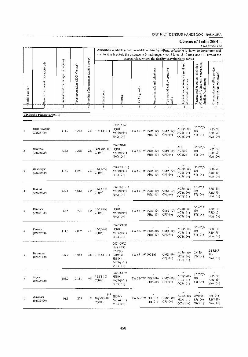
]' " "0 ~
0 (j '" (j '" ;:l
'" ..c '" '" 0 2- <J)
.~ u '" (j
~ ;; 0
.....l c::> 0-cld .;;:
'" <U " on £ .S
" :§ ..0
.... t;; .;;: 0 :; S OJ 0. :;; ""' '" 0 1;; " 0 0.
'" " E ~ ~ ·c "
., 0 U) Z f- f-
1 2 3 4
CD Block: Patrasayer (0010)
Uttar Pataspur SI3.7 1,232
(0212S700)
2 Deulpara
635.6 1,246 (0212S800)
Dharimpur 118.2 1,264
(02125900)
Barasat 4
(02126000) 329.S 1,612
Ramsaer 68.S 79S
(02126100)
6 Rampur
114.0 1,002 (02126200)
7 Naryanpur
47.2 1,084 (02126300)
Jaljala 503.0 2,111
(02126400)
Asanbani 9
(02126500) 91.8 273
.~
'" ~ '" " c.)
c::> c::> 0-00 .,,;
"(5 ..<:: .)
"' =, C> ..<::
<,..., c' ... Q.l
.D E ;:l
Z 5
DISTRICT CENSUS HANDBOOK: BANKURA
Census of India 2001 -Amenities and
Amenities available (if not available within the village, a dash (-) is shown in the column and next to it in brackets the distance in broad ranges viz.< 5 kms., 5-10 kms. and 10+ kms of the
nearest place where the facility is available is given
"0 '" ..0"
'" .~ E OJ
g '" ~ .~ <> ,,,"
> ~ t! <> 'E ~ 0 .~ ..c -3 ~ 0
0. 0. " [;;' " "'@ C/),,-., ~ ~ 0. <.l ] 6 .~ tf)
E~§ :;; '" -g ~ .~ ill ~ (j :;; ..c ._ ~~
OJ "0 '" '" <> 0 ... ... 8 0'- o'(:I.g.g g ,," ..c t:: g
~ 0. _" '" ",>"3 '';:; 0
'" e '" til .-
<:: on '8 ~ :~ '" ..: .~ rg 0 on <U ;:l -0
.S"<il E '" '" ~ ," .~ "iii <:: '2 '" "3 Q :;;
[;;' '-' :.;;; S '" t;; S :;; E
'" '6 '" E ~ .g ~ e g :.a E ~ ::l '" '0 " 8 0 o to ~-B gog 0:-::: [l.1 ~ 0.. U.D " ~ ~U) U e 6 7 8 9 ]0 11 12 13
RMPCHW SP CV(5-
2S3 P M C(I 0+) H(IO+)
TW SS-TW PO(S-IO) CM(S-IO) ACS(S-IO)
10) BS(5-10)
MCW(IO+) NCS(IO+) RS(S-10) PHC(IO+)
PH(S-IO) CP(IO+) OCS(IO+)
ST(IO+) NW(IO+)
CWCRMP ACS SP CV(S-
237 P(2) M(5-1O) H(to+)
TW SS-TW PO(S-IO) CM(S-IO) NCS(2) 10) BS(5-1O)
C(lO+) MCW(IO+) PH(5-10) CP(IO+) OCS(2) ST(lO+)
RS(S-IO) PHC(IO+) NW(IO+)
PM(S-IO) CHWH(IO+)
ACS(S-IO) SP CY(S-
BS(S-IO) 257 MCW(IO+) TW SS-TW PO(5-1O) CM(5-1O) 10)
C(lO+) PHC(IO+) PH(S-IO) CP(IO+)
NCS(IO+) ST(IO+)
RS(5-1O) OCS(IO+) NW(lO+)
P M(S-IO) CWCH(IO+)
ACS(5-10) SP CV(5-
BS(S-to) 334
C(lO+) MCW(IO+) TW SS-TW PO(S-IO) CM(5-10)
NCS(IO+) 10)
RS(5-1O) PHC(IO+) PH(S-IO) CP(IO+)
OCS(IO+) ST(IO+)
NW(IO+)
P M(5-1O) H(lO+) ACS(5-10) SPCV(5-
BS(S-IO) 154 TW SS-TW PO(5-10) CM(S-IO) 10)
C(lO+) MCW(IO+) PH(S-IO) CP(IO+)
NCS(10+) ST(IO+)
RS(S-IO)
PHC(IO+) OCS(IO+) NW(IO+)
CWCCHW SP CY(S-
213 P M(5-1O) H(lO+)
TW SS-TW PO(5-1O) CM(5-1O) ACS(5-1O)
10) BS(5-10)
C(lO+) MCW(lO+) PH(5-10) CP(10+)
NCS(IO+) ST(10+)
RS«5)
PHC(IO+) OCS(lO+) NW(IO+)
D(2)CWC PHSFWC RMP(2) ACS(5-10) CYSP
BS RS(5-
231 P MC(IO+) CHW(2) TW SS-TW PO PH CM(S-lO) 10)
H(IO+) CP(IO+) NCS(IO+) ST(10+)
NW(IO+)
MCW(IO+) OCS(IO+)
PHC(IO+)
CWCCHW SPCY(S-
403 PM(5-10) H(lO+)
TW SS-TW PO(5-10} CM(S-IO) ACS(5-IO)
10) BS(S-IO)
C(IO+) MCW(IO+) NCS(\O+) RS(S-IO) PH(5-1O) CP(IO+) ST(IO+)
PHC(IO+) OCS(lO+) NW(IO+)
- P(S- H(I;+) TW SS-TW PO(IO+) CM(5-10)
ACS(S-IO) CV(IO+) BS(IO+) 55 JO)M(S-lO) MCW(IO+) NCS(lO+) SP(IO+) RS(5-1O)
C(lO+) PHC(10+) PH(lO+) CP(IO+) OCS(IO+) ST(lO+) NW(IO+)
456
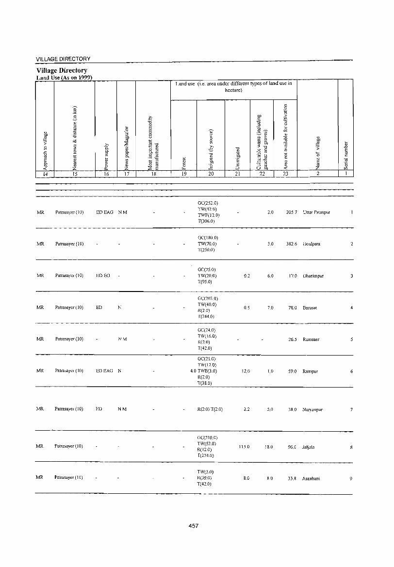
VILLAGE DIRECTORY
Village Directory Land Use (As on 1999)
14 15
MR Patrasayer (10)
MR Patrasayer (10)
MR Patrasayer (10)
MR Patrasayer (10)
MR Patrasayer (10)
MR Patrasayer (10)
MR Patrasayer (10)
MR Patrasayer (10)
MR Patrasayer (11)
16 17 18
EDEAG NM
ED EO
ED N
NM
EDEAG N
ED NM
Land use (i.e. area under different types of land use in hectare)
19 20 21 22 23
GC(2S2.0) TW(42.0)
2.0 205.7 TWE(l2.0) T(306.0)
GC(180.0) TW(70.0) 3.0 382.6 T(250.0)
GC(7S.0) TW(20.0) 0.2 6.0 17.0 T(95.0)
GC(2020) TW(40.0)
0.5 7.0 78.0 R(2.0) T(244 0)
GC(24.0) TW(16.0)
26.5 R(2.0) T(42.0)
GC(21.0) TW(12.0)
4.0 TWE(3.0) 12.0 1.0 59.0 R(2.0) T(38.0)
2
Uttar Pataspur
Deulpara
Dharimpur
Barasat
Ramsaer
Rampur
R(2.0) T(2.0) 2.2 5.0 38.0 Naryanpur
GC(210.0) TW(52.0)
115.0 18.0 96.0 Jaljala R(12.0) T(274.0)
TW(3.0) R(39.0) 8.0 8.0 33.8 Asanbani T(42.0)
457
2
3
4
6
7
8
9
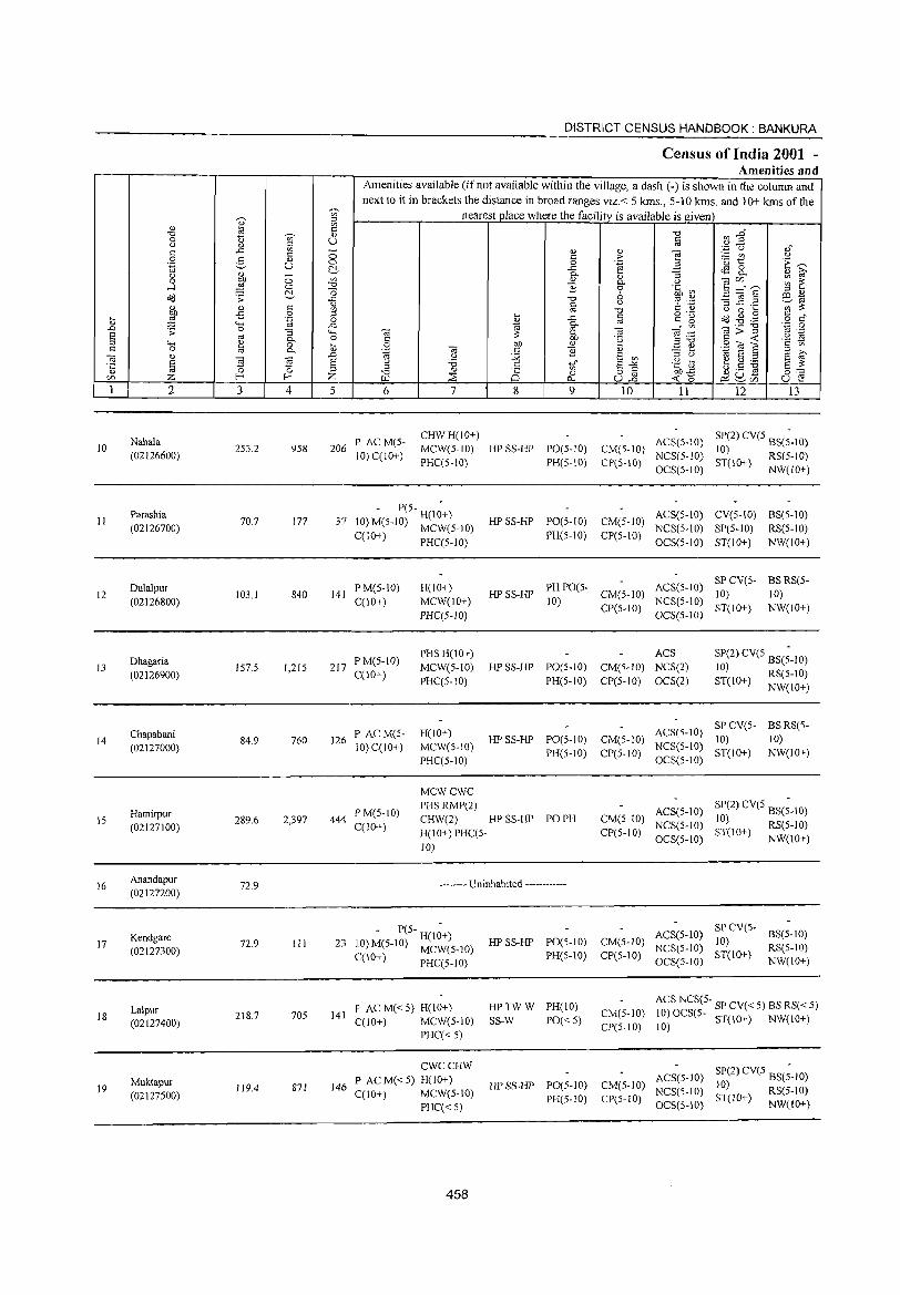
DISTRICT CENSUS HANDBOOK: BANKURA
Census of India 2001 -Amenities and
Amenities available (if not available within the village, a dash (-) is shown in the column and
next to it in brackets the distance in broad ranges viz.< 5 kms., 5-10 kms. and 10+ kms of the
~ '" nearest place where the facility is available is given OJ
" .,
~ "0 ~ " "0
VJ -§" 0 on U § Cj " ::l .,3 (j <: .c on _-
" " -a ,," 0 2-
<: C> '" ;> :.= en Cj ., C> 0 .~ ~
.<3 t: ·E ~ '~ u C!.- ..c: tS & " ~ Cj g}, - 0-0 0 '" 0)
0- <J -a Cll ;;; ~ ..-l ~ 0 "<:1 e 0 'C CI') 5 ::::"s '0 ::l " J8 ;; C!.- o<: "0 6 ~ .~ '3 _g .2 co 1il
" '" " § Cj b 'Ii) ';;;'~ " on "0 Cj 0 ...
:W ..c 0 ::l ... 0·-
Cd ~ .g § c" ~ c:;:; '.g 0 " .c t: <: D OJ '" ..0 0 .c
~ ~ " ", -a;;"§ 'N .g s .;; OJ
"3 "-' '" '" e .~ 0- 0 <: .~ <: <C '2 ~ ::l "-' ~ 0 ... 0 0/) " ::l " .9 d S ~ '" <: 0 OJ 0- " .~ -a '" "3 " - ,-
'" ;>, -a ., ..0 Cj :Q S on ::l c, 1il S '" S '" s 'Ei 'Ei s Cj '0 <: S-'" .~] ~.5 ~ s ~ .;:: OJ on
" £ 0 0 OJ "0 " 25 0 o <: 0:0= CI) f-< f-< Z "" ;:;; p_. ull « <:) ~2c/) u e 1 2 3 4 5 6 7 8 9 10 11 12 13
Nahala P ACM(S-CHWH(IO+)
ACS(S-IO) SP(2) CV(S BS(;-IO) 10
(02126600) 253.2 958 206
10) C(IO+) MCW(5-IO) HPSS-HP PO(S-IO) CM(5-IO)
NCS(5-IO) 10)
PHC(5-10) PH(5-10) CP(5-IO) ST(IO+) RS(5-10) OCS(5-10) NW(IO+)
II Parashia
70.7 177 37 - P(5- H(I~+)
HP SS-HP PO(5-IO) CM(5-10) ACS(5-IO) CV(5-10) BS(5-IO)
(02126700) 10) M(5-IO) MCW(5-10) NCS(5-IO) SP(5-10) RS(5-1O) C(10+) PHC(5-1O) PH(5-IO) CP(5-10)
OCS(5-IO) ST(IO+) NW(IO+)
Dulalpur PM(5-IO) H(IO+) PHPO(5- ACS(5-IO) SPCV(5- BS RS(5-
12 103.1 840 141 HP SS-HP CM(5-10) 10) 10) (02126800) C(IO+) MCW(IO+) 10)
CP(5-10) NCS(5-10)
ST(IO+) NW(IO+) PHC(5-1O) OCS(5-1O)
PM(5-IO) PHS H{IO+) ACS SP(2) CV(5 BS(;-IO)
13 Dhagaria
157.5 1,215 217 MCW(5-1O) HPSS-HP PO(5-10) CM(5-1O) NCS(2) ~{(IO+) RS(5-10) (02126900) C(IO+) PHC(5-10) PH(5-10) CP(5-10) OCS(2)
NW(IO+)
Chapabani PAC M(5- H(lO+) ACS(5-1O) SP CV(5- BS RS(5-
14 84.9 760 126 HPSS-HP PO(5-10) CM(5-10) 10) 10) (02127000) 10) C(IO+) MCW(5-10)
PH(5-10) CP(5-10) NCS{5-10)
ST(IO+) NW(lO+) PHC(5-1O) OCS(5-10)
MCWCWC
Hamirpur PM(5-10) PHSRMP(2)
ACS(5-10) SP(2) CV(5 BS(;-IO) 15 289.6 2,397 444 CHW(2) HPSS-HP PO PH CM(5-10) 10) RS(5-1O) (02127100) C(IO+)
H(lO+) PHC(5- CP(5-10) NCS(5-10)
ST(lO+) NW(IO+) ]0)
OCS(5-1O)
16 Anandapur
72.9 -------- Uninhabited ------------(02127200)
- P(5- H(I~+) ACS(5-1O) SPCV(5-
BS(5-10) Kendgare 23 HPSS-HP PO(5-1O) CM(5-1O) 10) 17 72.9 111 110) M(5-10) MCW(5-l0) NCS(5-10) RS(5-10) (02127300) PH(5-10) CP(5-10) ST(lO+) C(IO+) PHC(5-1O) OCS(5-1O) NW(IO+)
Lalpur po AC M« 5) H(IO+) HPTWW PHilO) CM(5-10)
ACS NCS(5- SP CV« 5) BS RS« 5) 18 218.7 705 141
C(IO+) MCW(5-10) SS-W PO«5) 10) OCS(5- ST(IO+) NW(lO+) (02127400) CP(5-10) 10)
PHC« 5)
CWCCHW SP(2) CV(5 BS(;-I 0)
MuktapuT P ACM«5) H(IO+) PO(5-10) CM(5-1O) ACS(5-10)
19 119.4 871 146 HPSS-HP NCS(S-IO) 10) RS(5-1O) (02127500) C(IO+) MCW(5-10) PH(5-10) CP(5-IO) ST(IO+) NW(IO+)
PHC« 5) OCS(5-10)
458
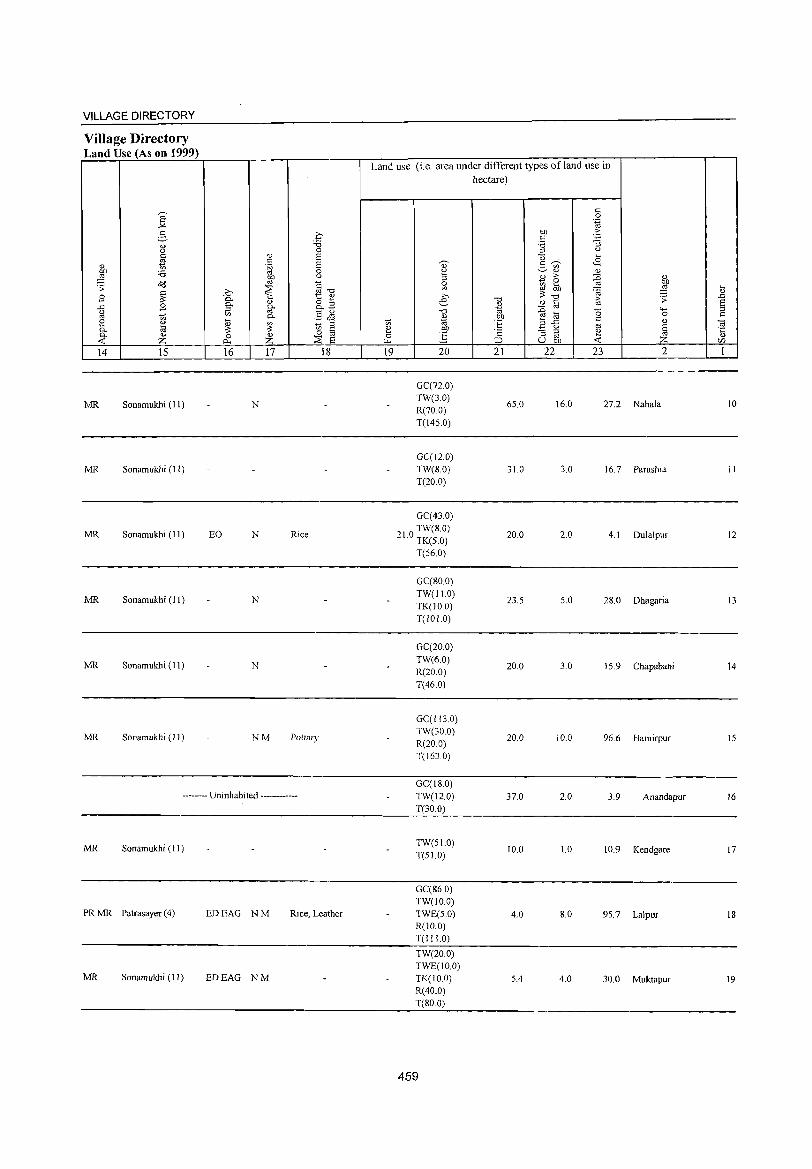
VILLAGE DIRECTORY
Village Directory Land Use (As on 1999)
14 15
MR Sonamukhi (11)
MR Sonamukhi (II)
MR Sonamukhi (II)
MR Sonamukhi (11)
MR Sonamukhi (II)
MR Sonamukhi (11)
16 17 18
N
EO N Rice
N
N
NM Pottary
-------- Uninhabited ------------
MR Sonamukhi (II)
PR MR Patrasayer (4) EDEAG NM Rice, Leather
MR Sonamukhi (11) EDEAG NM
Land use (Le. area under different types of land use in hectare)
19 20
GC(72.0)
TW(3.0)
R(70.0) T(145.0)
GC(J2.0)
TW(SO)
T(20.0)
GC(43.0)
TW(S.O) 21.0 TK(S.O)
T(56.0)
GC(80.0)
TW(11.0)
TK(10 0)
T(IOLO)
GC(20.0)
TW(6.0)
R(20.0)
T(46.0)
GC(113.0) TW(30 0)
R(20 0) T(1630)
GC(18.0)
TW(12.0)
T(30.0)
TW(5LO)
T(5!.O)
GC(86.0)
TW(IO.O) TWE(5.0)
R(IO.O) T(1 I 1.0)
TW(20.0)
TWE(IO.O) TK(lO.O)
R(40.0)
T(80.0)
459
21 22
65.0
31.0
20.0
23.5
20.0
20.0
37.0
10.0
4.0
5.4
23 2
16.0 27.2 Nahala
3.0 16.7 Parashia
2.0 4.1 Dulalpur
5.0 28.0 Dhagaria
3.0 15.9 Chapabani
10.0 96.6 Hamirpur
2.0 3.9 Anandapur
1.0 10.9 Kendgare
8.0 95.7 Lalpur
4.0 30.0 Muktapur
10
II
12
13
14
15
16
17
18
19
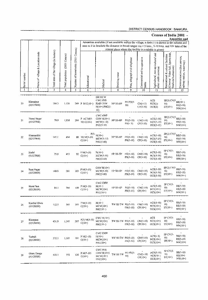
DISTRICT CENSUS HANDBOOK: BANKURA
Census of India 2001 -Amenities an d
Amenities available (ifnot available within the village, a dash (-) is shown in the column and
next to it in brackets the distance in broad ranges viz.< 5 krns., 5-10 krns. and 10+ krns of the ,",
~ cr, nearest place where the facility is available is given :~
" '" ,~
8 ,= CIJ~ .",
t) ~ " .",
0 (.) to u 0.> '" .,g '0
'" -= '" -- " " ] ,,"
0 2-to 0 '" ;;> :.:: rJJ u
" 0 '<3 t: E'"' .~ U 0 .~ C!. -= ~ 8. " ~ U 0.> - u, 0.. Cl) :;
0
~ 0 " 0.. '" ] ~~E ~ ~ .....l 0 "",' B 0 .~ ~ c:', "0 b :l " 0'8 .;; ..c: .", -32.2 co ~ " c u c;:s ';:: -;;~ gb .s c "', '" -0 '" Cl) '" 0 ~
:§ 0 :l'
I -= § g 'g o(j ~ ,g '" " il .~ c o '" .D "-' ..c 0..
_" <Il ._ -0 '_;= 0 .;;: 0 :; <..., «j e «j ]>~ '" ._
S '" 0.. 0 '" OJ) '2 e ::::: .S! 19
:l <..., i!:! 0 .... 0 OJ) " B;g .S til ] § <Il C 0 Cd 0.. " '-g «j '" ] Q) _ ,_
., S «j <1)
~ g .D u ~ E <Il
::> ,> S ~ ·c S 8
~ '6 t;" S~ .~ ~5 ~ g ~ s :>:
Cl) ~ 0 0 :l <l)
8 o § Ol) ..!: I;) .- ro t- t- Z :2: 0 &lUti
o~ Vl 0.., U..o -< ,5 U e 1 2 3 4 5 6 7 8 9 10 11 12 13
DHMCW
KhosaJpur CWCPHS
PHPO(S-ACS SP(3)CV(SBS(;0+)
20 (02127600)
184.3 1,130 249 P M C(10+) RMPCHW HPSS-HP CM«S) NCS(2) 10) H(IO+)PHC(S-
10) CP(5-1O) OCS(2) ST(lO+) RS(S-10)
10) NW(IO+)
CWCRMP SP(2) CV(5 BS(;-IO)
21 NimaiNagar
79.9 1,038 204 P AC M(S- CHW H(lO+)
HP SS-HP PO(5-10) CM(5-10) ACS(S-IO)
(02127700) MCW(5-1O) 10)
10) C(IO+) PH«S) CP(S-IO)
NCS(S-IO) ST(IO+) RS(S-IO) PHC(5-1O) OCS(S-IO) NW(IO+)
22 Khamardihi
14S.1 464 88 - P(S- H(I~+)
HPSS-HP PO(S-IO) CM(S-IO) ACS(5-10) SP(2) CV(5 BS(;-IO)
(02127800) 10) M(S-10) MCW(S-IO) NCS(5-1O) 10)
C(IO+) PHC(S-IO) PH(S-IO) CP(5-10) ST( 0+) RS(S-lO) OCS(5-1O) I NW(IO+)
Hadal PM(5-1O) H(10+) ACS(S-10) SPCV(S-
BS(5-10) 23
(02127900) 75.9 453 92
C(lO+) MCW(S-IO) HP SS-HP PO(S-IO) CM(5-10)
NCS(S-IO) 10)
RS(5-10)
PHC(S-IO) PH(S-IO) CP(S-IO)
OCS(S-IO) ST(lO+)
NW(IO+)
Ram Nagar P M(S-IO) CHWH(10+)
ACS(S-IO) SP(2) eV(S BS(;-10) 24 148.9 S81 103 MCW(5-10) HPSS-HP PO(5-10) CM(S-IO) 10)
(02128000) CCIO+) PHC(S-IO) PH(5-10) CP(5-1O)
NCS(S-IO) ST(lO+) RS(S-IO) OCS(S-10) NW(10+)
CWCCHW SP CV(5-
25 MuraPara
9S.1 794 IS9 P M(S-IO) H(10+)
HPSS-HP PO(S-10) CM(5-10) ACS(5-1O)
10) BS(S-IO)
(02128100) C(lO+) MCW(IO+) PH(S-IO) CP(IO+)
NCS(10+) ST(lO+)
RS(5-10)
PHC(lO+) OCS(IO+) NW(IO+)
Kanthal Ghata PM(S-10) H(IO+) ACS(5-10) SPCV(5-
BS(S-IO) 26 112.5 545 103 TW SS-TW PO(S-IO) CM(S-IO) 10)
(02128200) C(IO+) MCW(IO+) PH(S-IO) CP(10+)
NCS(IO+) ST(IO+)
RS(5-10)
PHC(IO+) OCS(IO+) NW(IO+)
P(2) M(5-10) CWCH(IO+) ACS SPCV(S-
BS(5-10) 27
Khanpara 431.9 1,14S 207 MCW(IO+) TW SS-TW PO(S-IO) CM(5-10) NCS(lO+) 10)
(02128300) C{lO+) PHC(IO+) PH(5-10) CP(IO+) OCS(IO+) ST(IO+)
RS(5-10)
NW(IO+)
CWCCHW SP CV(5-Tashuli
332,1 1,105 191 P M(S-IO) H(IO+)
TW SS-TW PO(5-1O) CM(S-IO) ACS«5)
10) BS(5-10)
28 (02128400) C{IO+) MCW(lO+) NCS(lO+) RS(5-1O)
PHC(lO+) PH(5-10) CP(IO+)
OCS(IO+) ST{lO+)
NW(lO+)
CWCPHS SPCV(5-GhoraDanga
773 136 PM(S-10) CHWH(IO+) TWSS-TW POPH(S- CM(5-10)
ACS(5-10) 10)
BS(5-10) 29 453,1
(02128S00) C(IO+) MCW(lO+) 10) CP(lO+)
NCS(10+) ST(lO+)
RS(lO+)
PHC(IO+) OCS(IO+) NW(IO+)
460
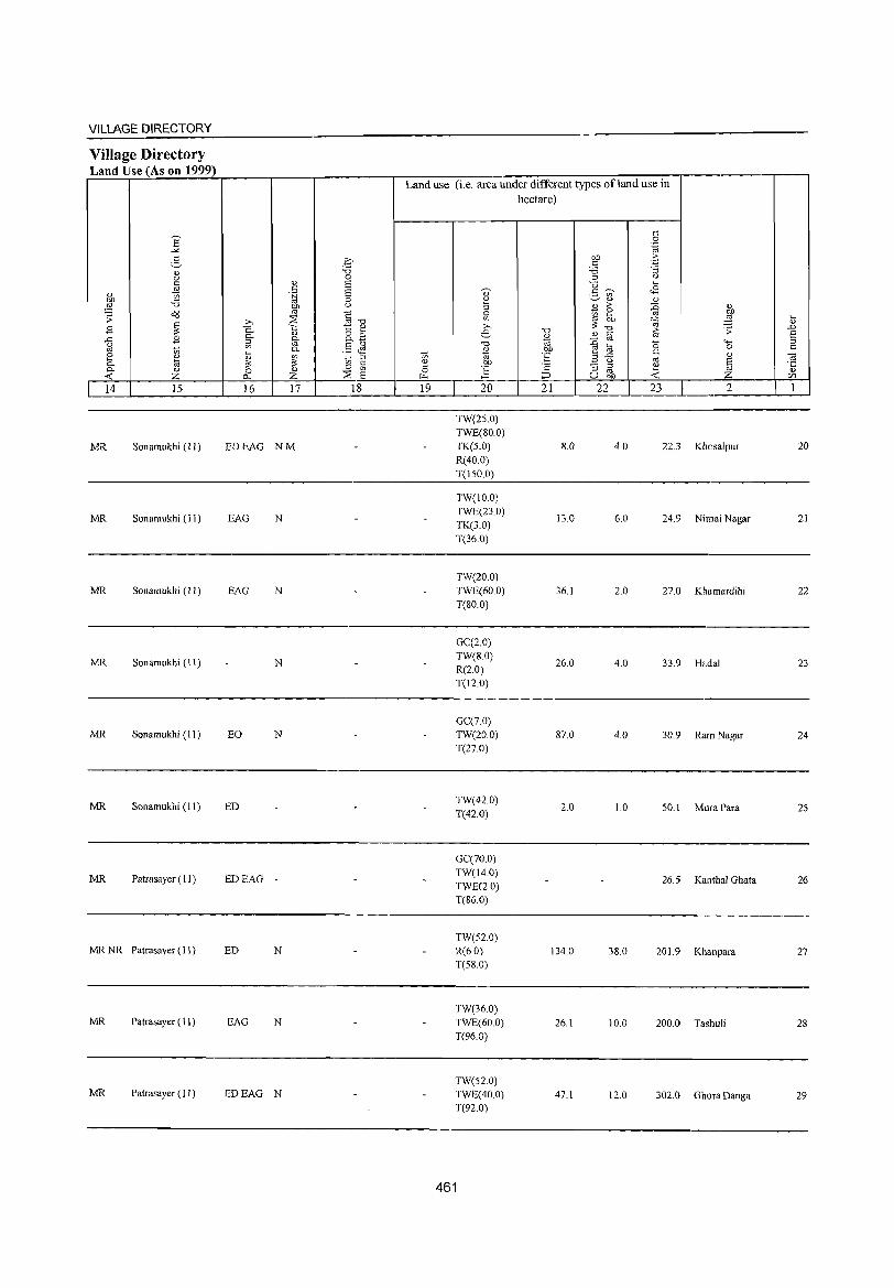
VILLAGE DIRECTORY
Village Directory Land Use (As on 1999)
14 15
MR Sonamukhi (II)
MR Sonamukhi (II)
MR Sonamukhi (II)
MR Sonamukhi (II)
MR Sonamukhi (II)
MR Sonamukhi (II)
MR Patrasayer (II)
MR NR Patrasayer (II)
MR Patrasayer ( II )
MR Patrasayer (II)
16 17 18
EDEAG NM
EAG N
EAG N
N
EO N
ED
EDEAG -
ED N
EAG N
EDEAG N
Land use (i.e. area under different types ofland use in hectare)
19 20
TW(25.0) TWE(80.0) TK(S.O) R(40.0) T(150.0)
TW(IO.O) TWE(23.0) TK(3.0) T(36.0)
TW(20.0) TWE(60.0) T(SO.O)
GC(2.0) TW(8.0) R(2.0) T(12.0)
GC(7.0) TW(20.0) T(27.0)
TW(42.0) T(42.0)
GC(70.0) TW(14.0) TWE(2.0) T(86.0)
TW(52.0) R(6.0) T(5S.0)
TW(36.0) TWE(60.0) T(96.0)
TW(52.0) TWE(40.0) T(92.0)
461
21 22
8.0
13.0
36.1
26.0
87.0
2.0
134.0
26.1
47.1
23 2
4.0 22.3 Khosalpur
6.0 24.9 Nimai Nagar
2.0 27.0 Khamardihi
4.0 33.9 Hadal
4.0 30.9 Ram Nagar
1.0 50.1 Mura Para
26.5 Kanthal Ghata
3S.0 20 I. 9 Khanpara
10.0 200.0 Tashuli
12.0 302.0 Ghora Danga
20
21
22
23
24
25
26
27
28
29

DISTRICT CENSUS HANDBOOK: BANKURA
Ctmsus of India 2001 -Amenities and
Amenities available (if not available within the village, a dash (-) is shown in the column and next to it in brackets the distance in broad ranges viz.< 5 kms., 5-10 kms. and 10+ kms of the
~
nearest place where the facility is available is given '" ;:l
~ '" ~ :2" " ~ Ii "0 "0 tl a 0 '" u ,," " " ;:l
',:j 0 .c '" " C!) OJ ~t .Sl c c <::> c >-0 5 " <::> 0 .~ Z i::~ '~ u !:::. .c tS R '" 6' " 0- C!) :J " ;:; '" Q) <.)
] CfJ",-._ ~ ~ 0 1 0-..1 <::> -0 B c 'r:::
E ~ § :> " ~ ",3 ,:, on '" ~~ o::J ~ "0 ('j .~ .c c () = ~ ,:::I ..c ._
'" :;:: c ,~
" 0 .... l '" <n ro "0 c ._ d8 ~ .g c " -B .9 " " -'" '" e" ~ c c ....
'oj 0 "@ 0- ro
~;;-g 'p 0 " "0 .r.: ~ OJ ~ .-=:
ro ._ ..c .;; :i 4. OJ :;:: ,9 ~ S '" 0. " C .~ :>"0 C -< :> <;.. .., c ,- C bD '" ~ ~ .S (ij E c '" a OJ c 'Ii
.., "l:tl 8 ;:1 S 6'
c 0 0. " .~
E '" :> () " ..!l " :.Q u .... ~ g :.a OJ ~ ~ ~ E: '.) :a .S t> E-'< .~ .e §~ '5 ::~ ;:l
" 82 g - "' C -0 0 0 ~u- u ~ (/) Z f-< f-< Z IJ.l ;:s 10-, -< 0 ~(/]
I 2 3 4 5 6 7 8 9 10 11 12 13
CWCRMP SP Uttar Gobilldapur PM(5-IO) H(IO+)
TW SS-TW PO(5-IO) CM(lO+) ACS(S-lO)
CV(IO+) BS(IO+) 30 150.7 1,112 200
NCS(IO+) RS(IO+) (02128600) C(IO+) MCW(IO+) PH(S-lO) CP(IO+) ST(10+)
PRC(IO+) aCS(lo+) NW(IO+)
- P(5- H(1~+) ACS(5-IO) SPCV(5-
BS(5-IO) Dhamsa HPSS-HP PO(5-10) CM(5-10) 10) 31 55.3 190 27 10) M(5-10) MCW(S-IO) NCS(5-IO) RS(S-lO) (02128700)
C(10+) PHC(5-10) PH(5-10) CP(5-10) OCS(5-1O)
ST(IO+) NW(lO+)
- P(S- H(I;+) ACS(5-IO) SPCV(S-
BS(5-IO) Sonatikri CM(5-10) 10) ST(S-32 101.5 462 8i' 10) M(S-IO) MCW(S-IO) HPSS-HP PO(S-IO)
NCS(5-IO) RS(5-JO) (02128800) C(IO+) PHC(S-IO) PH(S-IO) CP(S-IO)
OCS(S-IO) 10)
NW(lO+)
AC P(S-IO) CHWH(IO+) ACS(S-IO)
SP CV(S-BS(S-IO)
33 Balarampur
73.3 267 39 M(S-IO) MCW(5-10) HP SS-HP PO(5-10) CM(S-IO) NCS(S-IO)
10) RS(S-IO) (02128900)
C(JO+) PRC(S-IO) PH(S-IO) CP(S-IO) aCS(S-IO)
ST(IO+) NW(IO+)
CHW H(lO+) ACS(S-IO)
SPCV(S-BS(5-IO) Netkhara PM(IO+)
PO(S-IO) CM(5-IO) 10) 34 113.8 876 153 MCW(S-IO) HPSS-HP NCS(S-IO) RS(S-IO) (02129000) C(1O+)
PHC(S-IO) PH(S-IO) CP(5-IO) ST(10+) NW(IO+) OCS(5-IO)
Telsanra P(S- CHW H(IO+)
ACS(5-10) CV(IO+) BS(IO+) 35 65.2 41 I 76 10) M(S-IO) MCW(IO+) TW SS-TW PO(S-IO) CM(5-10)
NCS(lO+) SP(S-IO) RS(IO+) (02129100) C(lO+) PHC(IO+) PH(S-IO) CP(S-IO)
OCS(lO+) ST(JO+) NW(IO+)
CWCRMP(4) SP(2) CV(S BS(;-I 0) Parulia PM AC(2) CHWH(!o+)
HPSS-HP POPH(5-
CM(S-IO) ACS(S-IO)
10) RS(5-10) 36 315.5 2,158 414 C(10+) MCW(S-IO) 10) NCS(5-IO) (02129200)
CP(S-IO) ST(IO+) NW(IO+) PRC(S-IO) OCS(S-IO)
P( _ CHW(2) ACS(S-IO)
SP CV(5-BS(5-10) Keshabpur 5 H(IO+)
CM(5-IO) 10) 37 113.7 1,433 260 10) M(5-10) MCW(S-IO) HPSS-HP PO(5-10) NeS(S-IO) RS(5-IO) (02129300)
C(lO+) PHC(S-IO) PH(S-IO) CP(S-IO) OCS(5-10)
ST(lO+) NW(10+)
P(S- CRW(2) ACS(S-IO)
SP CV(5-BS(S-IO) Brindaban Pur H(IO+)
HPSS-HP PO(S-IO) CM(S-IO) 10) 38 60.5 227 49 10) M(S-IO) MCW(S-IO) NCS(S-IO) RS(5-10) (02129400) C(10+) PHC(5-10) PH(5-10) CP(5-1O)
OCS(5-IO) ST(IO+)
NW(IO+)
AC P(S-IO) CWCCHW(2) sp CV(S- BSRS(S-H(IO+) HI' TW SS- PO(;-IO) ACS(S-IO)
10) 10) Benda 70.5 313 57 M(5-IO) CM(S-IO)
NCS(S-IO) 39 MCW(S-IO) TW PH(S-IO) ST(IO+) NW(lO+) (02129500) C(1O+) CP(S-IO)
OCS(5-IO) PHC(S-IO)
462
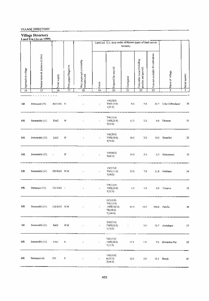
463
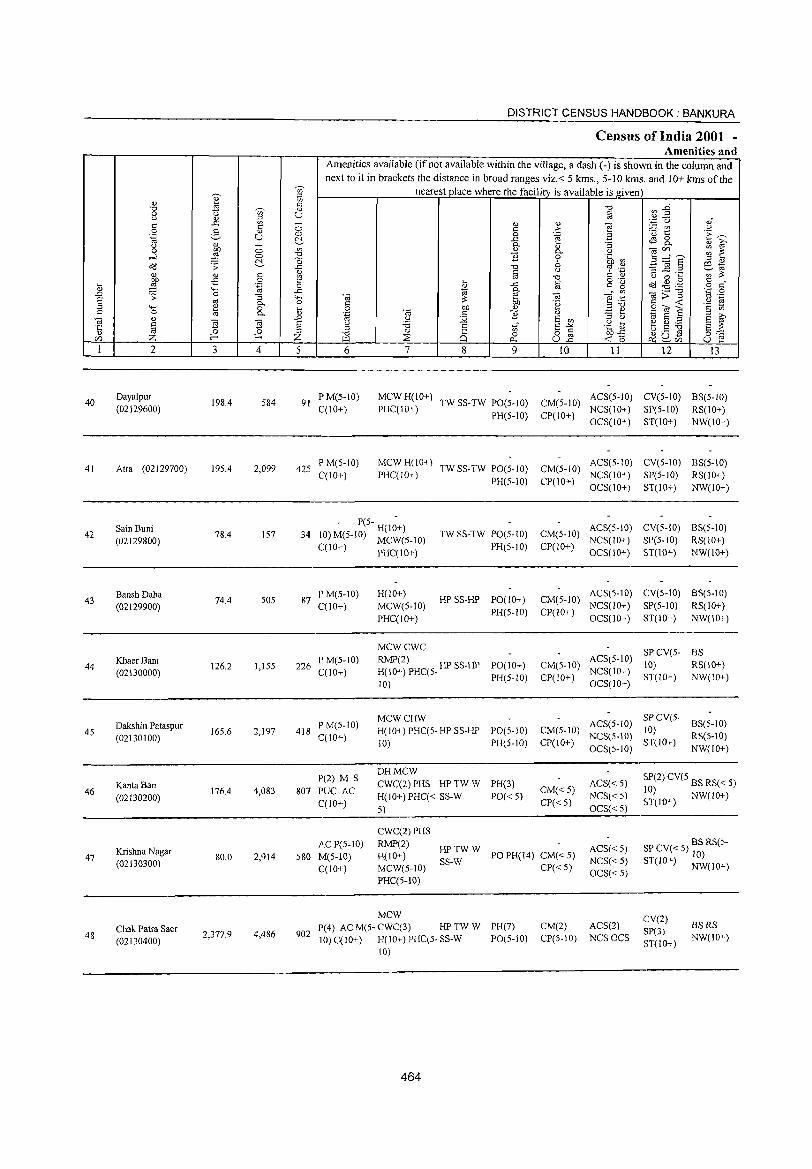
40
41
42
43
44
45
46
47
48
2
Daya1pur (02129600)
Alra (02129700)
Sain Buni (02129800)
BanshDaha (02129900)
KhaerBani (02130000)
Dakshin Palaspur (02130100)
KanIa Ban (02130200)
Krishna Nagar (02130300)
Chak Patra Saer (02130400)
3 4
198.4 584
195.4 2,099
78.4 157
74.4 50S
126.2 1,155
165.6 2,197
176.4 4,083
80.0 2,914
2,377.9 4,486
DISTRICT CENSUS HANDBOOK: BANKURA
Census of India 2001 -Amenities and
'" :::l
Amenities available (if not available within the village, a dash (-) is shown in the column and next to it in brackets the distance in broad ranges viz.< 5 kms., 5-10 kms. and 10+ kms of the
nearest place where the facility is available is given '" I~ (0 o
5 6
91 PM(5-10) C(IO+)
425 P M(S-IO) C(10+)
7 8 9
MCWH(10+) TWSS-TW PO(5-10) PHC(IO+) PH(5-10)
MCWH(IO+) PHC(IO+) TW SS-TW PO(S-IO)
PH(S-IO)
10 11 12 13
CM(5-10) ACS(5-10) CV(5-1O) BS(5-10) CP(IO+) NCS(IO+) SP(5-1O) RS(IO+)
OCS(IO+) ST(IO+) NW(IO+)
CM(5-10) ACS(5-IO) CV(S-IO) BS(5-IO) CP(IO+) NCS(IO+) SP(5-IO) RS(lO+)
OCS(IO+) ST(lO+) NW(IO+)
- P(5- H(I;+) 34 10) M(5-IO) MCW(5-10)
TW SS-TW PO(5-1O) CM(5-10) ACS(S-IO) CV(S-IO) BS(5-10) PH(5-IO) CP(10+) NCS(IO+) SP(5-1O) RS(IO+)
C(10+) PHC(IO+)
87 PM(S-IO) C(10+)
226 P M(5-1O) C(10+)
418 P M(5-1O) C(10+)
1'(2) M S 807 PUC AC
C(IO+)
H(lO+) MCW(S-IO) PHC(IO+)
HP SS-HP PO(IO+) PH(S-IO)
MCWCWC RMP(2) H(10+) PHC(S- HP SS-HP
10)
MCWCHW
PO(IO+) PH(5-10)
H(IO+) PHC(5- HP SS-HP PO(S-IO) 10) PH(5-10)
DHMCW CWC(2) PHS HP TW W
H(IO+) PHC« SS-W 5)
PH(3)
1'0« 5)
OCS(IO+) ST(IO+) NW(IO+)
CM(5-10) ACS(5-IO) CV(S-IO) BS(S-IO) CP(IO+) NCS(IO+) SP(5-10) RS(IO+)
OCS(IO+) ST(lO+) NW(IO+)
ACS(5-10) SP CV(5- BS CM(5-IO) 10) RS(1O+) CP(IO+) NCS(IO+) ST(IO+) NW(lO+)
OCS(IO+)
CM(5-IO) CP(10+)
CM« 5) CP«S)
ACS(S-IO) SP CV(5-10)
NCS(S-IO) ST(IO+) OCS(5-1O)
BS(5-10) RS(5-IO) NW(IO+)
ACS« 5) NCS« 5) OCS« S)
SP(2) CV(S BS RS« 5) 10) ST(IO+) NW(IO+)
AC P(S-IO) 580 M(S-IO)
C(lO+)
CWC(2) PHS RMP(2) H(lO+) MCW(5-1O) PHC(S-IO)
HPTWW SS-W
PO PH(14) CM« 5) ACS«S) NCS«5) OCS«S)
SP CV« 5) BS RS(5-10)
ST(IO+) NW(IO+)
902
MCW P(4) ACM(5-CWC(3) HPTW W 10) C(10+) H(IO+) PHC(S· SS-W
10)
464
PH(7) 1'0(5-10)
CP« 5)
CM(2) ACS(2) CP(5-IO) NCSOCS
CV(2) SP(3) ST(lO+)
BSRS NW(lO+)
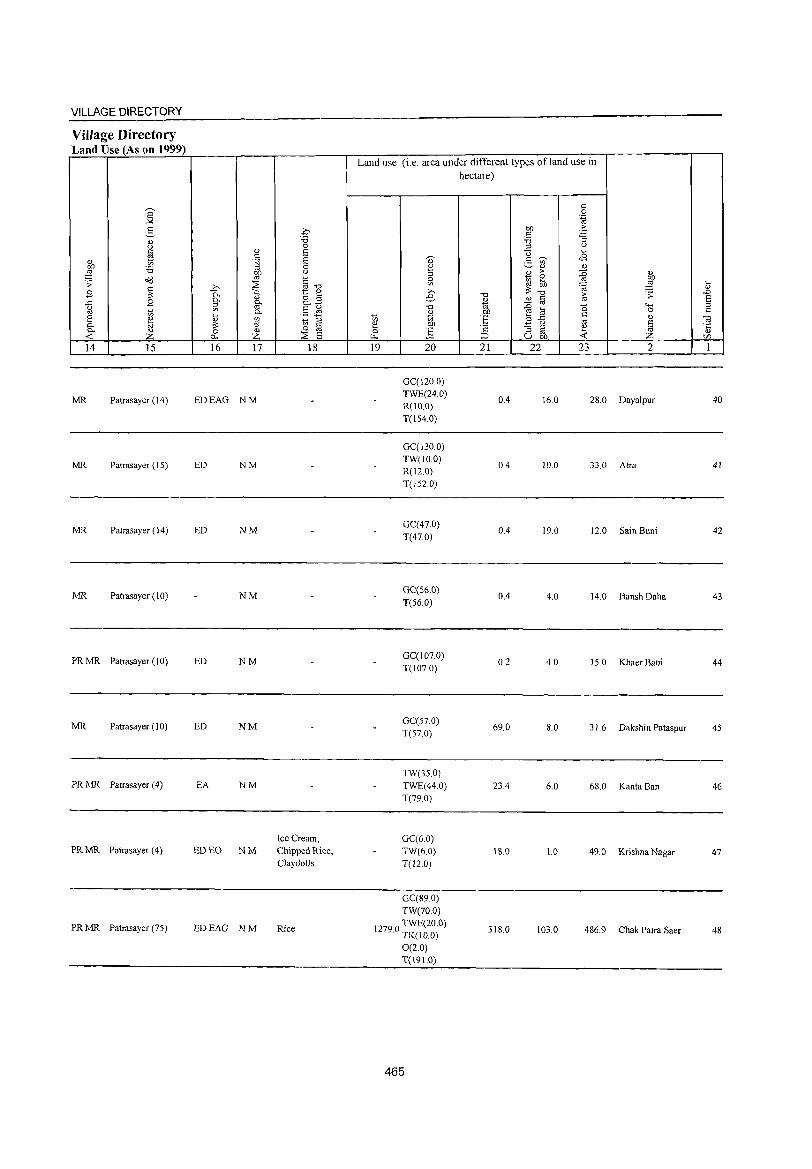
VILLAGE DIRECTORY
Village Directory Land Use (As on 1999)
14 15
MR Patrasayer (14)
MR Patrasayer (15)
MR Patrasayer (14)
MR Patrasayer (10)
PR MR Patrasayer (I 0)
MR Patrasayer (10)
PRMR Patrasayer (4)
PRMR Patrasayer (4)
PRMR Patrasayer (75)
16 17 18
EDEAG NM
ED NM
ED NM
NM
ED NM
ED NM
EA NM
Ice Cream, ED EO NM Chipped Rice,
Clayclolls
EDEAG NM Rice
Land use (i.e. area under different types ofland use in hectare)
19 20
GC(120.0) TWE(24.0) R(IO.O) T(154.0)
GC(130.o) TW(lo.0) R(120) T(l52 0)
GC(47.0) T(47.0)
GC(56.0) T(56.0)
GC(J07.o) T(J07.o)
GC(57.o) T(57.0)
TW(35.0) TWE(440) T(79.0)
GC(6.0) TW(6.0) T(12.0)
GC(89.0) TW(7o.o)
12790 TWE(20.0) . TK(IO.o)
0(2.0) T(l91.0)
465
21
0.4
0.4
0.4
0.4
0.2
69.0
23.4
18.0
318.0
22 23 2
16.0 28.0 Daya1pur
10.0 33.0 Atm
19.0 12.0 Sain Buni
4.0 14.0 Bansh Daha
4.0 15.0 Khaer Bani
8.0 31.6 Dakshin Pataspur
6.0 68.0 Kanta Ban
1.0 49.0 Krishna Nagar
103.0 486.9 Chak Patra Saer
40
41
42
43
44
45
46
47
48
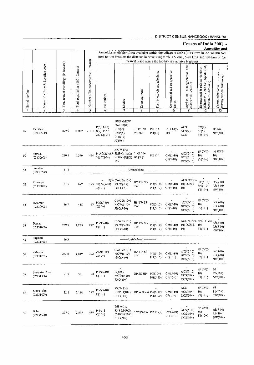
~,
'" ~
=: "
"', '" "0 ~ " 0 (.) '" U U <U :l
'" .c '" ;::; '" 0 3 '" 0 .~ U ~.
u '" -0 ~ 0 '" .....l 0 "'" ~ C5 o'd :;: .c ., " " '" '" bD -B 0 ::l .... ::§ .~ 0
" 4-< .c .D .:;: 0 "3 4-< s '" c. 0 ;:;J 4-< Q.)
0 [; C 0 a c. "@ " ~
.0
§ "@ s '5 (5 ::l Z f-' f-' Z CI)
1 2 3 4 5
49 Patrasair
872.9 10,002 2,13,[ (02130500)
50 Barnria
230.1 2,320 474 (02130600)
SI Sirnulari
S4.7 (02130700)
Konnagar 52
(02130800) 51.5 677 125
Paharpur S3 46.7 488 97
(02130900)
Danna 54
(02131000) 239.1 1,28S 242
SS Bagmari
76.3 (02131100)
S6 Ratnapur (02131200)
233.0 1,819 372
Sekendar Chak 57
(02131300) 91.9 501 94
S8 KantaDighi (02131400)
82.1 1,180 197
Belut 59 237.0 2,5S6 489
(02131500)
DISTRICT CENSUS HANDBOOK: BANKURA
Census of India 2001 -Amenities and
Amenities available (if not available within the village, a dash (-) is shown in the column and next to it in brackets the distance in broad ranges viz. < 5 kms., 5-10 kms. and 10+ kms of the
nearest place where the facility is available is given
"0 ~ .g" § '';:::'0 ,s
'" " ] '" ;> ~ t u 0 .~ 'E ~ .c ~ 0 c. "3 "- " ~ " c. .~ taCl) ~ ~ ] 0 3 ;:::"6' 6 ~ .$~ :l '"
"'" -3 .2 .2 r:!l -§
(.) .':: - ~~ "0 " '-' 0 .... ., .c " o 'Q o'd.g.§ § ~"
'" " " t;! c. "' ta:;'g .~ .g ta ::: '" ta e .~~
'" Ob T~ c <t: 'c ~ 0 b!) Q) ;:;J ,I 9co~ .~ "@ " ] Q) ~ ~~ t;! E ::l ;>.,
'-' :.;;; s '" ;:;J C'
S ~ u 'E " to" S". .~ 1: ~g:.a ;:;J 8:-::: "0 8 0 o § ~~~ ::2: <t: ~.
'" 0... U..o Co U e 6 7 8 9 10 11 12 13
DH(8)MCW
P(6) M(2) CWCPHC
ACS CV(2) S(2) PUC
PHS(2) THPTW PO TO CPCM(S-NCS(2) SP(5)
BS RS
AC C(lO+) RMP(5) WSS-T PH(48) 10)
OCS ST(IO+) NW(lO+)
CHW(4) H(lO+)
MCWPHS SP CV(5- BS RS(5-
P AC(2) M(5- SMP CHW(2) T HP TW PO PH CM(S-IO)
ACS(S-10) 10) 10)
10) C(lO+) H(IO+) PHC(5- W SS-T CP(S-IO)
NCS(S-IO) ST(10+) NW(lO+)
10) OCS(S-IO)
-------- Uninhabited ------------
P(S- CWC H(lO+) HPTWSS- ACS NCS(S- CV(~-lO) BS(5-1O)
10) M(5-1O) MCW«5) TW
PO(5-1O) CM(5-10) 10) OCS(5- SP(5-10) RS(S-10) C(lO+) PHC« 5) PH(5-10) CP(S-IO) 10) ST(10+) NW(10+)
PM(S-10) CWC H(IO+)
HP TW SS- PO(~-IO) ACS(S-10) SP CV(S-
BS(S-IO) MCW(5-10) CM(S-lO) 10)
C(lO+) PHC(5-10) TW PH(S-IO) CP(5-10)
NCS(S-10) ST(lO+)
RS(S-10)
OCS(S-IO) NW(lO+)
PM(S-10) CHWH(lO+)
HPTWSS- PO(;-IO) ACS NCS(5- SP(2) CV(S BS(;-10)
C(lO+) MCW(S-IO) CM(5-10) 10) OCS(5- 10) RS(S-10) PHC(5-10) TW PH(S-10) CP(S-10) 10) ST(10+) NW(IO+)
-------- Uninhabited ------------
P M(S-IO) CWCH(10+)
HPTWSS- ACS(5-10) SP CV(S-
BS(5-10) MCW(5-10) PO(S-IO) CM(5-IO) 10)
C(10+) PHC(5-1O)
TW PH(5-10) CP(IO+)
NCS(S-10) ST(10+)
RS(5-10)
OCS(5-10) NW(10+)
ACS(5-10) speV(s- BS
P M(S-10) H(10+) HP SS-HP PO(10+) CM(5-10) 10) RS(IO+)
C(10+) MCW(S-10) NCS(10+) PH(S-IO) CP(10+) ST(10+) NW(IO+)
PHC(lO+) OCS(10+)
MCWPHS ACS SP CV(S- BS PM(5-10)
RMPH(10+) HP W SS-W PO(S-10) CM(S-IO) NCS(10+) 10) RS(IO+) C(lO+)
PHC(10+) PH(S-10) CP(10+) OCS(10+) ST(10+) NW(10+)
DHMCW SPCV(5-PMS PHS RMP(2)
TW SS-TW PO PH(7) CM(S-IO) ACS(5-10)
10) BS(S-10)
C(lO+) CHWH(lO+) NCS(IO+) RS(10+) CP(JO+) ST(JO+)
PHC(10+) OCS(lO+) NW(IO+)
466
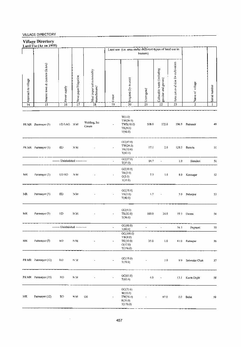
VILLAGE DIRECTORY
Village Directory Land Use (As on 1999)
14 15
PR MR Patrasayer (5)
PR MR Patrasayer (5)
16 17
EDEAG NM
ED NM
18
Welding, Ice Cream
-------- Uninhabited ------------
MR Patrasayer (5) ED EO NM
MR Patrasayer (5) ED NM
MR Patrasayer (5) ED NM
-------- Uninhabited ------------
MR Patrasayer (5) ED NM
PR MR Patrasayer (12) ED NM
PR MR Patrasayer (15) EO NM
MR Patrasayer (12) EO NM Oil
Land use (i.e. area under different types ofland use in hectare)
19 20
W(l.O)
TW(26.0) TWE(10.0) TK(9.0) T(46.0)
GC(47.0) TW(24.0) TK(12.0) T(83.0)
GC(37.0) T(37.0)
GC(30.0) TK(20) 0(3.0) T(35.0)
GC(38.0) TK(2.0) T(40.0)
GC(4.0) TK(32.0) T(36.0)
GC(60.0) T(60.0)
GC(100.0) TW(9.0) TK(30.0) 0(17.0) T(156.0)
GC(79 0) T(79.0)
GC(65.0) T(65.0)
GC(70.0) W(lO.O)
TW(70.0) R(20.0) T(170.0)
467
21
508.0
17.1
16.7
7.5
1.7
160.0
35.0
4.0
22 23 2
122.0 196.9 Patrasair
2.0 128.0 Bamria
l.0 Simulari
1.0 8.0 Konnagar
5.0 Paharpur
24.0 19.3 Danna
16.3 Bagmari
1.0 41.0 Ratnapur
3.0 9.9 Sekendar Chak
13.1 Kanta Dighi
67.0 0.0 Belut
49
50
51
52
53
54
55
56
57
58
59
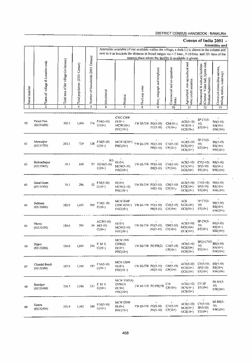
60
61
62
63
64
65
66
67
68
69
2
Panch Para
(02131600)
Mamudpur
(02131700)
Baikunthapur
(02131800)
Gosai Gram
(02131900)
Salkhara
(02132000)
Bhetia
(02132100)
Bijpur (02132200)
Chandal Bandi
(02132300)
Rasulpur (02132400)
Kalora
(02132500)
3
302.2
263.1
44.1
75.1
382.0
116.6
154.0
197.9
336.7
271.9
o
& c: o .~
'"5 0-o 0-
~ 4
1,964
739
640
286
1,452
29S
1,691
1,104
2,586
1,242
DISTRICT CENSUS HANDBOOK: BANKURA
Ctmsus of India 2001 -Amenities and
Amenities available (if not available within the village, a dash (-) is shown in the column and next to it in brackets the distance in broad ranges viz.< 5 kms., 5-10 kms. and 10+ kms of the
nearest place where the facility is available is given
5 6
376 P M(5-.10) C(10+)
138 P M(S-1O) C(10+)
7
CWCCHW
H(IO+)
MCW(IO+)
PHC(10+)
8 9 10
TW SS-TW PO(S-10) CM(10+) PH(S-10) CP(10+)
MCW H(lO+) TW SS-TW PO(S-IO) CM(5-JO) PHC(IO+) PH(5-10) CP(IO+)
11 12 13
ACS(5-10) SP CV(S- 8S(S-10) 10)
NCS(10+) ST(10+) RS(1O+) OCS(10+) NW(lO+)
ACS(5-JO) SP CV(S-10)
NCS(10+) ST(10+) OCS(10+)
BS(5-1O)
RS(lO+)
NW(IO+)
- P(S- H(1~+) 97 10) M(S-10) MCW(S-10)
TW SS-TW PO(S-IO) CM(S-10) ACS(S-lO) CV(S-IO) BS(S-IO)
C(10+) PHC(10+) PH(S-IO) CP(IO+) NCS(IO+) SP(S-10) RS(10+)
OCS(IO+) ST(IO+) NW(lO+)
52 PM(S-10) C(10+)
269 P M(S-10) C(10+)
AC P(5-1O)
54 M(S-IO)
C(1O+)
330 PM S C(10+)
197 P M(5-10) C(IO+)
537 P M S C(IO+)
248 P M(S-IO) C(!,O+)
H(10+) MCW(S-IO)
PHC(IO+)
TW SS-TW PO(S-10) CM(5-10) ACS(5-10) CV(S-IO) BS(5-10) NCS(IO+) SP(S-lO) RS(IO+)
PH(S-10) CP(10+) OCS(IO+) ST(10+) NW(!O+)
MCWRMP ACS SP CV(S- 8S(S-10) 10) CHWH(IO+) TWSS-TW PO(S-IO) CM(S-10) NCS(IO+)
PHC(IO+) PH(S-IO) CP(lO+) OCS(1O+) ST(lO+) RS(1O+) NW(lO+)
H(IO+)
MCW(S-IO)
PHC(10+)
MCWPHS
CHW(2)
H(10+)
PHC(10+)
MCWCHW H(IO+)
PHC(IO+)
MCW RMP(4)
TW SS-TW PO(S-IO) CM(5-1O)
PH(5-10) CP(10+)
ACS(S-10) SPCV(5- 8S(S-10) 10)
NCS(lO+) ST(IO+) RS(lO+) OCS(1O+) NW(1O+)
TW SS-TW PO PH(2) CM(S-10) ACS(5-1O) CP(10+) NCS(10+)
SP(2) CV(5 BS(;-IO) 10) ST(IO+) RS(IO+)
OCS(IO+) NW(lO+)
TWSS TW PO(S 10) CM(5-1O) ACS(S-1O) CV(S-IO) BS(5-1O) - - NCS(lO+) SP(S-10) RS(10+)
PH(5-10) CP(lD+) OCS(lO+) ST(10+) NW(10+)
CHW(3) TW SS-TW PO PH(18) CM H(10+) CP(10+)
ACS(5-10) CV SP NCS(10+) ST(1O+)
BS RS(5-
10) NW(10+)
PHC(10+)
MCWCHW H(IO+)
PHC(lO+)
468
OCS(10+)
SS TW PO(S 10) CM(5-10) ACS(5-10) TW - - NCS(lO+)
PH(5-10) CP(10+) OCS(IO+)
eV(S-IO) BS RS(5-10)
SP(5-1O) NW(JO+) ST(10+)
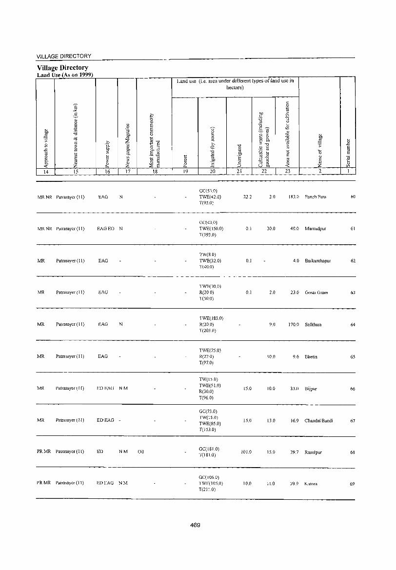
469
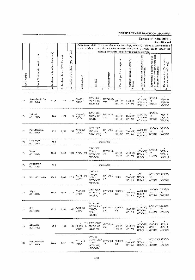
70
71
72
73
74
75
76
77
78
79
80
2
Shyam Sundar Pur (02132600)
Lalband (02132700)
Purba Naldanga
(02132800)
UdayNagar (02132900)
Bhutura (02133000)
Brajanathpur (02133100)
Bim (02133200)
Alipur (02133300)
Betur (02133400)
Balananda (02133500)
Patit Dommahal (02133600)
3 4
122.3 516
53.6 491
93.6 1,292
55.2
167.2 1,263
71.0
494.2 3,603
161.7 1,087
295.2 2,343
42.9 191
522.6 3,467
DISTRICT CENSUS HANDBOOK: BANKURA
Census of India 2001 -Amenities and
Amenities available (if not available within the village, a dash (-) is shown in the column and next to it in brackets the distance in broad ranges viz.< 5 kIDs., 5-10 kIDs. and 10+ kms of the
nearest place where the facility is available is given
5 6
114 P M(lO+) C(10+)
95 PM(5-IO) C(lO+)
238 P M(5-1O) C(IO+)
242 P M C(10+)
715 P(2) M(IO+) C(IO+)
214 P M(S-IO) C(lO+)
482 P M(5-1O) C(IO+)
7 8 9 10 11 12 13
CWCH(10+) -MCW(5-IO) HP TW ss- PO(5-IO) CM(S-IO) ACS(5-IO)
PHC(5-IO) TW PH(5-1O) CP(10+) NeS(10-!-)
SP CV(5- BS(5-10) 10) ST(10+) RS(5-IO)
eWCH(IO+) -MCW(5-IO) HPTWSS- PO(S-IO) CM(5-10)
PHC(IO+) TW PH(5-10) CP(lO+)
MCWCWC PHC PHS ~ TW ss- PO(5-10) CM(5-10)
CHWH(IO+) PH(5-10) CP(IO+)
-------- Uninhabited ------------
CWCCHW
H(lO+)
MCW(5-IO)
PHC(5-10)
HPTWSS- PO(~-IO) CM(5-IO)
TW PH(5-10) CP(IO+)
------- Uninhabited -----------
oeS(1o+)
ACS(5-IO) SP CV(5-10)
NCS(IO+) ST(lO+) OCS(10+)
NW(IO+)
BS(5-IO)
RS(5-IO) NW(lO+)
ACS(5-10) SP CV(5- BS RS(5-10) 10)
NCS(IO+) ST(10+) NW(IO+) oeS(lo+)
ACS(5-10) SP CV(5-10)
NCS(IO+) ST(IO+) OC$(I0+)
BS(S-IO)
RS(5-IO) NW(5-1O)
CWCPHS CHW(2)
H(IO+)
MCW(S-IO) PHC(5-IO)
HP TW SS- PO PH TW
ACS CM(S-IO) NeS(IO+)
CP(IO+) OCS(10+)
SP(2) eV(5 BS RS(5-10) 10)
ST(10+) NW(lO+)
eHW H(IO+) HP TW SS- PH PO(5-MCW(5-10) TW 10) CM(5-IO) PHC(lO+) CP(lO+)
Mcwewc
HCPHSRMP
CHW(2) H(lO+)
PHC(10+)
HP TW SS- PO PH( 5- CM( 5-10)
TW 10) CP(IO+)
ACS(5-10) SP eV(5- RS BS(S-10) 10)
NCS(IO+) ST(lO+) NW(lO,) OCS(10+)
ACS(5-10) SP(3) CV(S RS B3(S-10) 10)
NCS(10+) ST(IO+) NW(IO+) OCS(IO+)
P(5- CWCH(10+) HP TW SS - ACS(S-IO) eV(5-IO) B8(5-10) 31 10) M(5-10) MCW(S-IO) - PO(5-IO) CM(5-IO)
TW NCS(lO+) SP(5-1O) RS(5-1O) C(lO+) PHC(5-10) PH(5-IO) CP(IO+) OCS(IO+) ST(lO+) NW(IO+)
746 P(2) M S COOT)
CWC(2) RMP(2)CHW
H(IO+) MCW(S-IO)
PHC(S-10)
470
ACS HP TW SS- PO PH(5- CM(5-10) NCS(lO+)
TW 10) CP(lO+) OeS(lo+)
SP(2) CV(S BS RS(S-10) 10) ST(lO+) NW(IO+)
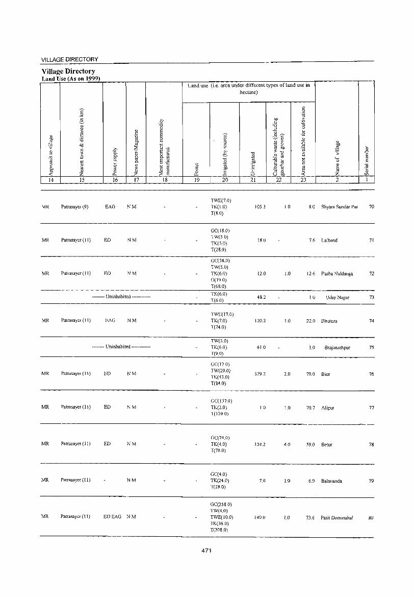
VILLAGE DIRECTORY
Village Directory Land Use (As on 1999)
14 15
MR Patrasayer (9)
MR Patrasayer (11 )
MR Patrasayer (11)
16 17
EAG NM
ED NM
ED NM
-------- Uninhabited ------------
MR Patrasayer (II) EAG NM
-------- Uninhabited ------------
MR Patrasayer (11 ) ED NM
MR Patrasayer (11) ED NM
MR Patrasayer (11) ED NM
MR Patrasayer (11) NM
MR Patrasa yer (11 ) EDEAG NM
18
Land use (i.e. area under different types of land use in hectare)
19 20
TWE(7.0) TK(1.0) T(S.O)
GC(IS.O) TW(5.0) TK(50) T(28.0)
GC(38.0)
TW(5.0) TK(6.0) 0(19.0) T(6S.0)
TK(6.0)
T(6.0)
TWE(I7.0)
TK(7.0) T(24.0)
TW(3.0) TK(6.0) T(9.0)
GC(12.0) TW(29.0) TK(43.0) T(84.0)
GC(137.0) TK(2.0) T(139.0)
GC(74.0) TK(4.0) T(n.O)
GC(4.0) TK(24.0) T(28.0)
GC(25S.0) TW(4.0) TWE(IO.O) TK(36.0) TOOS.O)
471
21 22
105.3
IS.O
12.0
48.2
120.2
61.0
329.2
1.0
154.2
7.0
140.0
23 2
1.0 8.0 Shyam Sundar Pur
7.6 Lalband
1.0 12.6 Purba Naldanga
1.0 UdayNagar
1.0 22.0 Bhutura
1.0 Brajanathpur
2.0 79.0 Biur
1.0 20.7 Alipur
4.0 59.0 BetuT
1.0 6.9 Balananda
1.0 73.6 Patit Dommahal
70
71
72
73
74
75
76
77
78
79
80
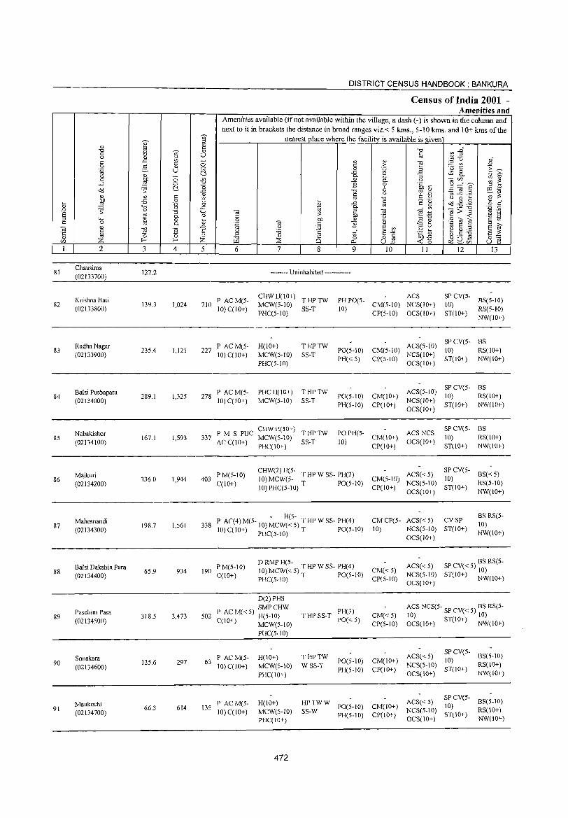
81
82
83
84
85
86
87
88
89
90
91
2
Chausima (02133700)
Krishna Bati (02133800)
Radha Nagar (02133900)
Balsi Purbapara (02134000)
Nabakishor (02134100)
Majkuri (02134200)
Mahesnandi (02134300)
Balsi Dakshin Para (02134400)
Paschim Para (02134500)
Sonakara (02134600)
Maukuchi (02134700)
3
122.2
139.3
235.4
289.1
167.1
336.0
198.7
6S.9
318.5
125.6
66.3
o o ~
" o .~
:; a. o a.
~ 4
1,024
1,121
1,325
1,593
1,944
1,561
934
2,473
297
614
DISTRICT CENSUS HANDBOOK: BANKURA
Census of India 2001 -Amenities and
Amenities available (if not available within the village, a dash (-) is shown in the column and next to it in brackets the distance in broad ranges viz.< 5 krns., 5-10 krns. and 10+ krns of the
nearest place where the facilitv is available is given
o o ~
'" "0 (3 ..c 0)
~ _g 4-< o ~ 0)
.0
§ Z 5 6
210 P ACM(S-10) C(1O+)
227 P ACM(S-10) C(lO+)
278 P AC M(S-10) C(10+)
7 8 9
0)
>-.~ 0)
a. o 6 u
" § OJ '0 i; E '" E-"" o " ull 10 11 12 13
-------- Uninhabited ------------
CHW H(lO+) T HP TW MCW(5-10) SS-T PHC(S-lO)
H(lO+) MCW(S-IO) PHC(S-IO)
THPTW SS-T
PHC H(IO+) T HP TW MCW(5-IO) SS-T
ACS PH PO(S- CM(S-IO) NCS(lO+)
10) CP(S-IO) OCS(IO+)
SP CV(5- BS(S-IO) 10) ST(10+) RS(5-1O)
NW(IO+)
SPCV(5- BS PO(5-10) CM(5-10) ACS(5-10) 10) RS(10+) PH« 5) CP(5-10) NCS(lO+) ST(10+) NW(lO+)
OCS(10+)
SP CV(5- BS PO(5-1O) CM(lO+) ACS(5-1O) 10) RS(lO+) PH(5-10) CP(10+) NCS(IO+) ST(IO+) NW(lO+)
OCS(IO+)
P M S PUC CHW H(IO+) T HP TW 337 AC C(1O+) MCW(S-IO) SS-T
PHC(IO+)
PO PH(5- CM(IO+) ACS NCS 10) CP(IO+) OCS(10+)
SPCV(S- BS 10) RS(IO+)
403 P M(5-1 0) C(lO+)
CHW(2) H(5- T HP W SS- PH(2) 10) MCW(5- T PO(S-IO) CM(5-10) 10) PHC(5-10) CP(lO+)
ST(IO+) NW(IO+)
ACS« 5) SP CV(5-10)
NCS(5-10) ST(IO+) OCS(IO+)
BS«5) RS(5-10) NW(lO+)
- H(5-338 P AC(4) M(5- 10)MCW« 5) T HP W SS- PH(4)
10) C(10+) PHC(S-IO) T PO(5-10)
CM CP(5- ACS« 5) CV SP 10) NCS(S-IO) ST(lO+)
OCS(IO+)
BS RS(5-10) NW(IO+)
190 PM(S-IO) C(10+)
o RMP H(5- T HP W SS- PH(4) 10)MCW«S)T PO(S-IO) CM«5)
ACS« 5) SP CV« 5) BS RS(5-10)
PHC(5-10) CP(5-10) NCS(5-1O) ST(lO+) NW(IO+) OCS(IO+)
0(2) PHS ) SMPCHW
I AC M« S) H(S-IO) 502 C(IO+) MCW(5-1O)
63 P ACM(5-10) C(10+)
135 P ACM(S-10) C(10+)
PHC(5-1O)
H(IO+) MCW(5-IO) PHC(IO+)
H(IO+) MCW(5-IO) PHC(IO+)
472
T HP SS-T PH(3) PO«5)
CM«5) CP(5-10)
THPTW WSS-T
PO(S-IO) CM(lO+) PH(5-10) CP(lO+)
ACS NCS(S·· SP CV« 5) BS RS(5-I~ I~ OCS(IO+) ST(lO+) NW(IO+)
ACS«5) SPCV(5- BS(S-IO) 10)
NCS(S-IO) ST(IO+) RS(IO+) OCS(IO+) NW(IO+)
HP TW W ACS« 5) SP CV(S- BS(5-10) PO(5-1O) CM(IO+) 10)
SS-W PH 10) CP(IO) NCS(5-10) ST(lO+) RS(IO+) (5- + OCS(10+) NW(lO+)
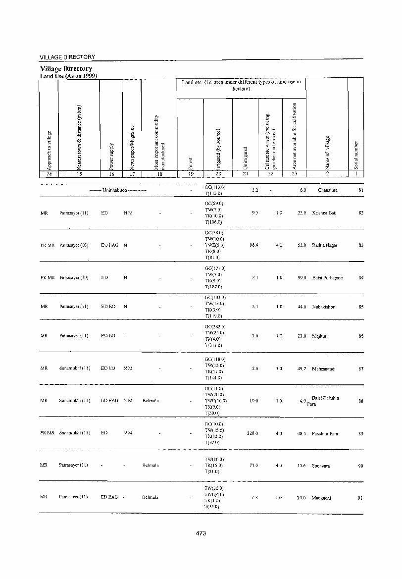
VILLAGE DIRECTORY
Village Directory Land U (A 1999) se son
Land use (i.e. area under different types ofland use in hectare)
c ]: 0
.~
2- .q bJ) :> c 'p
0) "'" 'i3 "5 (.) 0 '" u
~ 0) S <3 ~
c S ~ c ~ <B
0) .~ " ._ '" on 'i3 0 E::! ~" " :§ on (.)
'" 0) :> ::0 " o(l '" §-c:; Sl t; e ~
bJ) .;;: ~
;>, 2 ~: . iii :§ :;; B 0. ';:; t:: ~ ;>,
"'" :> ;;: .D 0. " o '" e
~ '-' c ro S ..c B '"
0. 0.- ::0 ro a 4-. :::> (.)
'" '" §Jl "0 bJ) OJ ~ 0 C ro t; 0. " ~ '" c
~ ~ t; -;0 'S ",..c " ~ " ~ t; '"
_ u
'" § ~ 0 iii ~ on 'c "5 ::l
~ 0. " 0 0) rf ] '" 0)
-< Z r:>.. Z 2 s ;::l u on Z U'J
14 15 16 17 18 19 20 21 22 23 2 1
-------- Uninhabited ------------GC(II3.0)
3.2 6.0 Chausima 81 T(1I3.0)
GC(89.0)
MR Patrasayer (II ) ED NM TW(70)
9.3 1.0 23.0 Krishna Bati 82 TK(IO.O) T(106.0)
GC(S8.0) TW(lO.O)
PRMR Patrasayer (10) EDEAG N TWE(S.O) 98.4 4.0 S2.0 Radha Nagar 83 TK(SO) T(81.0)
GC(171.0)
PRMR Patrasayer (10) ED N TW(7.0)
2.1 1.0 99.0 Balsi Purbapara 84 TK(90) T(IS7.0)
GC(103.0)
MR Patrasayer (II) ED EO N TW(GO)
3.1 1.0 44.0 Nabakishor 85 TK(3.0) T(119.0)
GC(282.0)
MR Patrasayer ( II ) ED EO TW(2S.0)
2.0 1.0 22.0 Majkuri 86 TK(4.0) T(311.0)
GC(1I8.0)
MR Sonam ukhi (II ) ED EO NM TW(IS.O)
2.0 3.0 49.7 Mahesnandi 87 TK(ll.O) T(l44.0)
GC(I1.0) TW(20.0)
4.9 Balsi Dakshin MR Sonamukhi (11) EDEAG NM Belmala TWE(lO.O) 10.0 1.0 88 TK(9.0)
Para
T(50.0)
GC(IO.O)
PRMR Sonamukhi (II) ED NM TW(lS.O) TK(120)
229.0 4.0 48.5 Paschim Para 89
T(37.0)
TW(16.0) MR Patrasayer (II) Belmala TK(lS.O) 77.0 4.0 13.6 Sonakara 90
T(31.0)
TW(30.0)
MR Patrasayer (11) EDEAG - Belmala TWE(4.0)
1.3 1.0 29.0 Maukuchi 91 TK(1.0) T(3S.0)
473
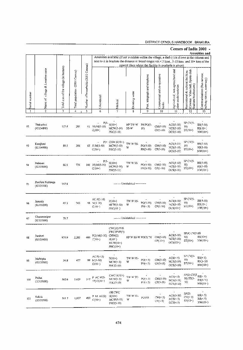
DISTRICT CENSUS HANDBOOK. BANKURA
Census of India 2001 -Amenities and
Amenities available (if not available within the village, a dash (-) is shown in the column and next to it in brackets the distance in broad ranges viz.< 5 kms., 5-10 kms. and 10+ kms of the
~
nearest place where the facility is available isgiven '" I ::s
" '" c "'" ~~ "'" ~ <i)
0 u '" U c " " g '" .~ "0 ,; c ..c: c ~; " " "j§ :=: r.Il <J C > 0 2, '" 0 0 .~ Tl 1:: ~~ .~ U ~3. -a B ~ 8. " " :; '" id' 0 1 8 '0 " 0- <J 01V) ::; ~ ...... ." "§ 0 '~ ~ ~ :::"8' (:!. ,5 6 ::s " <>(I .s: -'" "0 <J ~ :~ ~ ~.2
r:o .,
'" '" r:: <U iii ,;;", ['l ." <.> 0 ~
.... ~ -B 0
* ..c: c c g Cd .g ,g § d ',g ()
'" '" .... ..r::: g- o OJ ._ "0 .~ .g ~ .s: 0 :; 4-, 01 ~ OJ 01 ~ ]>~ S '" 0- c> r:: 6lJ '2 !3 ·8 ._ -S
" "" '" 0 ~. 0 OJ) " .S ~ S r:: OJ c 0 10 0. <I)' .~ '" c "§ '" ;!::: ~ " >-.
3 " .<;, 0> :;2 S <II " u til S " § ~ § l ] S " 'g r:: tf S"" .g !i3 2 ~:.a
" il .s ::s "'" 8 a o 8 ~-E ~0~ 8~ r:/) z z w ;:;: 0... U.n ~r:/)
1 2 3 4 5 6 7 8 9 10 11 12 13
Thakurhati - P(S-H(I~) HPTWW PHPO(5- ACS(5-10) SPCv(S-
BS(5-10) 92
(02134800) 112.4 281 61 10) M(S-1 0) MCW(5-10) SS-W 10)
CM(5-10) NCS(5-1O)
10) RS(IO+)
C(IO+) PHC(S-IO) CP(S-IO) OCS(S-IO)
3T(10+) NW(lO+)
Karajbani P« CHW H(lO+)
TWWSS- ACS(S-lO) SP CV(S-
BS(5-to) 93
(02134900) 89.5 306 65 5)M(S-10) MeW(S-IO)
W PO(5-1O) CM(S-10)
NCS(S-IO) 10)
RS(5-10) C(IO+) PHC(5-10) PH(5-10) CP(S-IO)
OCS(S-lO) ST(10+)
NW(lO+)
Nab.san - P(S- H(l~+) TWWSS- ACS(5-IO) SPCv(S-
BS(5-10) 94
(02135000) 66.5 774 146 10) M(5-IO) MCW(S-IO) W
PO(5-10) CM(S-lO) NCS(S-IO)
10) RS(S-IO)
C(1O+) PHC(S-IO) PH(S-IO) CP(5-10) OCS(S-IO)
ST(IO+) NW(IO,)
95 Paschim Naldanga
147.8 -------- Uninhabited ------------(02135100)
Jamsala AC P(S-IO)
H(IO+) TWWSS- ACS(5-1O) SP CV(S-
BS(5-IO) 96
(02135200) 65.3 243 48 M(5-IO)
MCW(S-IO) W PO(S-10) CM(5-1O)
NCS(S-IO) 10)
RS(IO+) C(IO+)
PHC(IO+) PH« 5) CP(S-lO)
OCS(lO+) ST(IO+)
NW(IO+)
97 Churamanipur
79.7 -------- Uninhabited ------------(02135300)
CWC(2) PHS
FWCRMP(3) 8P(4) CV(S BS Jamkuri
974.9 2,285 460 1'(2) M(5-IO) CHW(2)
HP W SS-W PO(2) PH CM(5-1O) ACS(5-10)
10) RS(IO+) 98 C(10+) H(IO+-) NCS(5-1O) (02135400) CP(10+) ST(10+) NW(IO+)
MCW(IO+) OCS(IO+)
PHC(IO+)
AC P« 5) H(lO+) TWWSS- ACS«S)
SPCV(5-BS« 5) Malbigha M(5-IO) PO«5) CM(5-1O) 10) 99 54.8 477 99
MCW«5) W NCS(5-10) RS(5-10) (02135500) C(IO+) PH«5) CP(S-IO) 8T(10+) PHC(5-10) OCS(S-IO) NW(IO+)
Padua PAC M(S-CWCH(IO+)
TWWSS- ACS«5) SP(2) CV(S BS(~ 5)
100 562.6 1,629 317 IO)C(IO+)
MCW«S) W
PO« 5) CM(S-JO) NCS(5-1O) 10) ST(5- RS(5-IO)
(02135600) PHC(5-1O) PH«5) CP(5-10) OCS(5-10) 10) NW(IO+)
DHCWC SP(2) Kaktia PM AC(2) H(IO+) TWWSS-
PO PH CM«5) ACS(5-10)
CV«5) BS« 5)
101 5017 1,9S7 403 W NCS« 5) RS« S) (02135700) C(10+) MCW(S-IO)
CP« S) 5:T(IO+) PHC(5-1O) OCS«5) NW(lO+)
474
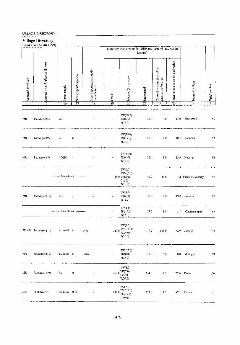
VILLAGE DIRECTORY
Village Directory Land Use (As on 1999)
MR Patrasayer (5)
MR Patrasayer (9)
MR Patrasayer (5)
ED
ED N
ED EO
-------- Uninhabited ------------
MR Patrasayer (l0) ED
-------- Uninhabited ------------
PR MR Patrasayer (10) EDEAG N Atta
MR Patrasayer (10) EDEAG N Rice
MR Patrasayer (10) ED N
MR Patrasayer (4) EDEAG NM
Land use (i.e. area under different types of land use in hectare)
TW(30.0) TK(6.0)
T(36.0)
TW(\8.0)
TK(l1.0)
T(29.0)
TW(14.0)
TK(4.0)
T(18.0)
TW(6.0)
TWE(6.0) 39.0 TK(2.0)
0(2.0) T(l6.0)
TW(8.0)
TK(6.0)
T(14.0)
TW(6.0)
TK([6.0)
T(n.O)
TW(20)
3170 TWEC14.0) · TK(4.0)
T(20.0)
TWE(5.0)
TK(8.0) T(nO)
TW(S.O)
2630 TK(7.0) · 0(5.0)
T(20.0)
W(1.0)
1480 TWE(3 0) · TK(35.0)
T(39.0)
475
59.4
46.0
30.0
49.0
30.3
37.0
419.0
30.0
234.0
259.0
4.0 13. 0 Thakurhati
4.0 10.5 Karajbani
3.0 15.5 Nabasan
39.0 4.8 Paschim Naldanga
8.0 13. 0 Jamsala
IS.O 2.7 Churamanipur
\56.0 62.9 Jamkuri
3.0 8.S MaJbigha
18.0 27.6 Padua
8.0 47.7 Kaktia
92
93
94
95
96
97
98
99
100
101
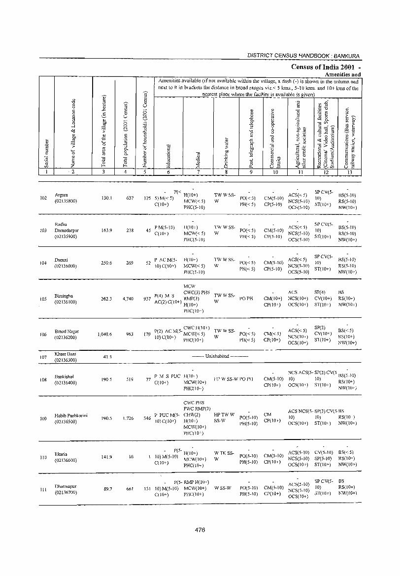
DISTRICT CENSUS HANDBOOK: BANKURA
Census of India 2001 -Amenities and
Amenities available (if not available within the village, a dash (-) is shown in the column and
next to it in brackets the distance in broad ranges viz.< 5 kms., 5-10 kms. and 10+ kms of the
d) '~ nearest place where the facility is available is given en ..g ~ " "" a'l:2" ';;;' " 0 () § <J .., ;:l
c: -'" '" _-" " ]
''';:: (,) ,,' 0 5 § 0 " ;> :.::: tr.I u
'-g U 0 0 .~ .<:; 1:: .~ ~
~ -'" ~ 8. " ~ ;::; Po "3 " ~ 0 '" '" Po .S! ;~E ;;; ~ >-l C> "0 }3 0 ,5 bb~ ;:l " dd ;:;: ~ ..c: "" " <? ';:: '3 ~.2 e1a <J
" '" " g~ " " " en ::: "' "" u 0 6 ,g -5 0 :, ... § o ,_ " " ii3 .~ Cl E ..c: c" ~ o(! ~:~ o " ""' .c: 0-
OJ;;"§ '';::;: 0
.D .;:;: 0 "3 ,,-, g ~ ~ OJ "'§ .:: '" ,-S '" 0- 0 '2 " ..:: .~ § ;:l "-' ~ 0 ,-, 0 OJ) " ;:j"" .S O! '8 " en " 0 "' Po " '~ OJ " }3 '" .=; ~ E ~ OJ '" 'Ei
.c " :.>; E '" ;:l " to E ::l
'5 E ~ E g :.a " 'tf E'>< .g ,[j ~.s ~ E ::: ~ 0 ;:l
~ '" .>:: 0 o § ~,5 0=-=
tI) f- f- Z ::2: Ci 0.., U.o ,::> o::u~ U e ~tI)
1 2 3 4 5 6 7 8 9 10 II 12 13
Argara - P« H(I~+) TWWSS- ACS« 5) SP CY(5-
BS(5-10) 102 130.1 637 12.5 5) M« 5) MCW« 5) PO«5) CM(5-1O) 10)
(02135800) W NCS(S-IO) RS(5-1O) C(10+) PHC(5-10) PH«5) CP(5-to)
OCS(5-10) ST(IO+)
NW(IO+)
Radha PM(5·10) H(IO+) TWWSS- ACS« 5)
SP CV(5-BS(5-10)
103 Damodarpur 163.9 218 45 C(10+) MCW«5) W
PO«5) CM(5-IO) NCS(5-lO)
10) RS(S-IO)
(02135900) PHC(5-10)
PH«5) CP(5-10) OCS(5-lO)
ST(lO+) NW(IO+)
Dumni P ACM(S- H(lO+) TWWSS- ACS« 5) SP CV(5-
BS(5-1O) 104
(02136000) 250.6 269 52
10) C(lO+) MCW« 5) W PO« 5) CM(S-IO)
NCS(5-10) 10)
RS(5-10) PHC(5-10)
PH«5) CP(5-10) OCS(5-10)
ST(10+) NW(IO+)
MCW CWC(3) PHS
TWWSS-ACS SP(4) BS
105 Birsingba
262.3 4,740 937 P(4) M S RMP(3) PO PH CM(lO+) NCS(10+) CY(IO+) RS(10+) (02136100) AC(2) C(10+) H(10+) W
CP(IO+) OCS(10+) ST(lO+) NW(lO+) PHC(IO+)
BinodNagar CWCH(IO+)
TWWSS- ACS«5) SP(2)
BS«S) 106 1,040.6 963 179 P(2) AC M(5- MCW« 5) PO«5) CM«5) CY(IO+)
(02136200) 10) C(10+) PHC(IO+) W PH« 5) CP(lO+)
NCS(IO+) ST(IO+)
RS(lO+) OCS(lO+) NW(IO+)
107 KhaerBani 4].5 -------- Uninhabited ------------(02136300)
Bankishol PM S PUC H(IO+) HP W SS-W PO PH CM(5-10)
NCS ACS(5- SP(2) eV(S BS(;-IO)
108 (02136400)
190.5 519 77 C(IO+) MCW(IO+) 10) 10) RS(IO+)
PHC(lO+) CP(IO+) OCS(IO+) ST(IO+) NW(lO+)
CWCPHS FWCRMP(2) ACS NCS(5- SP(3) CV(5 BS
Habib Pusbkarini P PUCM(5- CHW(2) HPTWW PO(5-10)
CM 10) 10) RS(IO+) 109 190.5 1,726 346
10) C(10+) H(IO+) SS-W CP(IO+) (02136500) PH(S-IO) OCS(IO+) ST(10+) NW(10+) MCW(IO+) PHC(IO+)
Ekaria - P(5- H(I~+) WTKSS-PO(5-1O) CM(5-1O)
ACS(5-10) CY(S-IO) BS«5) 110 141.9 10 W) M(S-10) MCW(lO+) W NCS(5-1O) SP(5-10) RS(lO+) (02136600)
C(10+) PHC(IO+) PH(5-10) CP(IO+) OCS(10+) ST(lO+) NW(IO+)
P(S- RMP H(IO+) ACS(5-1O) SPCV(5- BS
III Dharmapur 89.7 661 131 10) M(S-IO) MCW(lO+) WSS-W PO(5-lO) CM(5-1O)
NCS(5-1O) 10) RS(IO+)
(02136700) C(IO+) PHC(IO+) PH(5-10) CP(10+) OCS(IO+)
ST(IO+) NW(lO+)
476
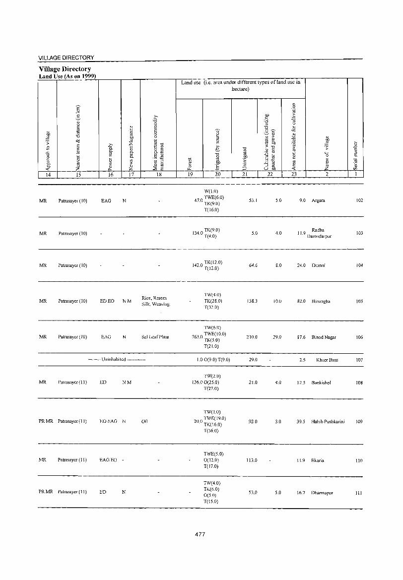
VILLAGE DIRECTORY
Village Directory Land Use (As on 1999)
14 15
MR Patrasayer (10)
MR Patrasayer (10)
MR Patrasayer (10)
MR Patrasayer (10)
MR Patrasayer(lO)
16 17 18
EAG N
Rice, Resom ED EO NM
Silk, Weaving.
EAG N Sal Leaf Plate
-------- Uninhabited ------------
MR Patrasayer (II ) ED NM
PRMR Patrasayer (II) EDEAG N Oil
MR Patrasayer (II) EAGEO -
PRMR Patrasayer (11) ED N
Land use (i.e. area under different types of land use in hectare)
19 20
W(l.O)
470 TWE(6.0) · TK(9.0)
T(16.0)
1340 TK(9 0) · T(9.0)
142 a TK(12.0) · T(12.0)
TW(4.0) TK(28.0) T(32.0)
TW(6.0)
7630 TWE(lO.O) · TK(5.0)
T(21.0)
1.00(9.0) T(9.0)
TW(20) 126.00(25.0)
T(27.0)
TW(1.0)
200 TWE(l9.0) · TK(16.0)
T(36 0)
TWE(5.0) 0(12.0) T(17.0)
TW(4.0) TK(6.0) 0(5.0) T(IS.O)
477
'" '" "" OIl
E '2 ~
21
53.1
5.0
64.6
138.3
210.0
29.0
21.0
92.0
113.0
53.0
c 0 .~
on .~ c '0 :i ::l '-'
U ~ .B 2- '" '" '" 2 ;> ::0
i(l 2 ..!:! OIl :;: '"
'0; ;>
'" s::: '" I '" '0 8 ..c c '-' '" :i ::l ~ '" U OIl -<
22 23
5.0
4.0
8.0
10.0
29.0
4.0
3.0
5.0
., ~ ~ 4-< 0
'" § Z 2
9.0 Argara
11.9 Radha Damodarpur
24.0 Dumni
82.0 Birsingha
17.6 Binod Nagar
2.5 KhaerBani
12.5 Bankishol
39.5 Habib Pushkarini
11.9 Ekaria
16.7 Dharrnapur
il .0 E ::l c ta ·c OJ
en 1
102
103
104
105
106
107
108
109
110
III
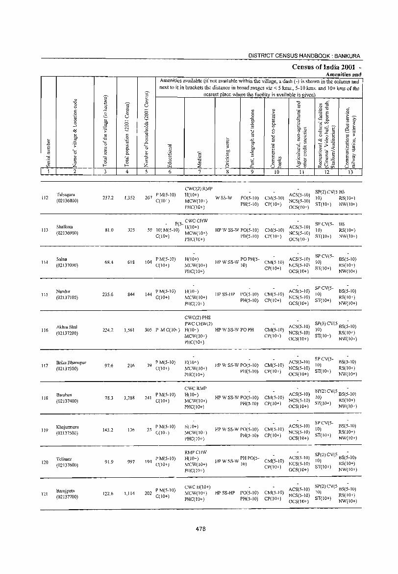
DISTRICT CENSUS HlANDBOOK : BANKURA
Census of India 2001 -Amenities and
Amenities available (if not available within the village, a dash (-) is shown in the column and next to it in brackets the distance in broad ranges viz.< 5 kms., 5-10 kms. and 10+ kms of the
~,
~, nearest place where the facility is available is given j ;:l
" ~,
c CI"l ~" "Cl
~ ,'" "Cl
8 Q U § " .~ u >l) c ..<:: '" - " " "§ '" 0 '" ;>- ~t u
0 5 <\) .~ ~ .~ u 0 0 "E a ~. .£' ~ 8. 1;1 - 0. i:l :; <Il i;;' 0 C) '" " 0. Q "§ C/),, ____ ~ ~ -l ;l C) "0 "2 0 .~ (f"j
~ 0 6 _g ~ § '" " O?J '': ..r:: "0 ~ .~ ~~ " '"
U ::1 .r:. ._ '" ::: <\) " c: Ul oj -0 c: <..l
<..l 0 " bJ) -5 0 ::> ~ o ".-o<j ~ ._g c: •
~ ;l '"§ 0 ~
..r:: ta s:: g o s:: "" ..<:: 0. V> Oi;;-g '..0 a
.0 '': 0 :; "-' Oil e Oil e .~~ oj '-s oj 0. 0 c: ::: bJ) .~ § ~ .~ E ::> 4-;
~ 0 " 0 Of) " Ee ~]s c: Ul s:: 0 0. " .~ Oil s:: "2 :::l >, Oi " .0 <..l :.'2 S Ul
:::l u g.s ~ E '" S ~ 'Ei s <..l '6 c: ,if s~ .~ [; E ::: '5 :::l
Z ~ ::> -0 <\) i§ o § Of),J:: 0:-::::
{/) Z >.Ll ::E rf U.o ~ ~, ~ ~ en U e 0
1 2 3 4 5 6 7 8 9 10 11 12 13
CWC(2)RMP SP(2) CV(S BS
112 Talsagara
237.2 1,3S2 267 P M(S-IO) H(IO+)
WSS-W PO(5-1O) CM(5-1O) ACS(5-IO)
10) RS(lO+) (02136800) C(lO+) MCW(IO+) NCS(S-IO)
PHC(!o+) PH(5-10) CP(lO+)
OCS(lO+) ST(lO+) NW(lO+)
Shalkota P(S- CWCCHW
ACS(5-IO) SPCV(5- BS
113 (02136900)
81.0 325 59 10) M(5-IO) H(IO+) HP W SS-W PO(5-1O) CM(5-1O) NCS(5-1O)
10) RS(lO+) C(lO+) MCW(10+) PH(S-IO) CP(lO+) ST(lO+) NW(IO+)
PHC(IO+) OCS(IO+)
Salna PM(5-1O) H(IO+) HP W SS-W PO PH(S- ACS(5-1O) SPCV(5-
BS(5-10) 114 68.4 618 104 CM(5-10) 10)
(02137000) C(lO+) MCW(IO+) 10) CP(IO+)
NCS(5-10) ST(IO+)
RS(10+)
PHC(IO+) OCS(IO+) NW(IO+)
Nandur PM(5-10) H(lO+) ACS(5-10) SP CV(5-
BS(5-10) 115 235.6 844 144 HP SS-HP PO(S-IO) CM(5-1O) 10)
(02137100) C(lO+) MCW(IO+) PH(S-10) CP(IO+)
NCS(5-10) ST(IO+)
RS(IO+)
PHC(IO+) OCS(IO+) NW(IO+)
CWC(2) PHS
AkhraShal FWCCHW(2)
ACS(5-1O) SP(3) CV(5 BS(;-IO) 116 224.2 1,561 305 P M C(lO+) H(IO+) HPW SS-W PO PH CM{5-10) 10)
(02137200) NCS(5-1O) ST(lO+) RS(IO+) MCW(IO+) CP(lO+) OCS(lO+) NW(IO+)
PHC(IO+)
Brika Bhanupur P M(S-IO) H(IO+) ACS(5-10) SPCV(5-
BS(5-10) 117 97.6 216 39 HP W SS-W PO(5-1O) CM(5-1O) 10)
(02137300) C(lO+) MCW(lO+) PH(S-IO) CP(10+)
NCS(5-10) ST(IO+)
RS(lO+)
PHC(IO+) OCS(IO+) NW(lO+)
CWCRMP SP(2) CV(5 BS(;-IO)
Baraban PM(5-10) H(IO+) HP W SS-W PO(5-1O) CM(5-10)
ACS(5-1O) 118
(02137400) 78.3 1,288 241
C(10+) MCW(lO+) NCS(5-IO) 10) RS(IO+)
PHC(IO+) PH(5-1O) CP(JO+)
OCS(lO+) ST(lO+) NW(lO+)
Khejurmura PM(5-10) H(IO+) ACS(5-10) SPCV(5-
BS(5-10) 119
(02137500) 143.2 136 2S
C(IO+) MCW(IO+) HP W SS-W PO(5-10) CM(5-10)
NCS(5-IO) 10)
RS(lO+)
PHC(10+) PH(5-1O) CP(IO+)
OCS(IO+) ST(lO+)
NW(IO+)
RMPCHW SP(2) CV(5 BS(;-IO)
Telisaer PM(5-1O) H(lO+) HP W SS-W PH PO(S- CM(5-10) ACS(5-10)
120 91.9 997 194 10) RS(lO+) (02137600) C(IO+) MCW(lO+) 10)
CP(10+) NCS(5-1O)
ST(IO+) NW(lO+) PHC(lO+) OCS(JO+)
Barujpota P M(5-10) CWCH(lO+) ACS(5-1O) SP(2) CV(S BS(;-10)
121 122.6 1,114 202 MCW(IO+) HP SS-HP 1'0(5-10) CM(5-1O) NCS(S-IO) 10) RS(IO+)
(02137700) C(10+) PHC(IO+) PH(5-10) CP(IO+) ST(IO+) NW(IO+) OCS(lO+)
478
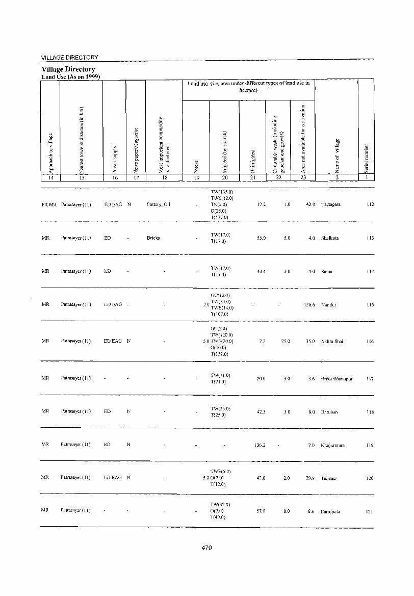
VILLAGE DIRECTORY
Village Directory Land Use (As on 1999)
s "" 3 "" u
* " ~ 'i3 o<l .;;
B ~ ..c B (.) OJ 1;; ::: " 0. ~ 0. " « Z 14 15
PR MR Patrasayer (11)
MR Patrasayer (11)
MR Patrasayer ( II)
MR Patrasayer (II)
MR Patrasayer (II)
MR Patrasayer ( 11)
MR Patrasayer (II)
MR Patrasayer (II)
MR Patrasayer (11)
MR Patrasayer (11)
.£ "0 0
"" E <= .~ E
0 OJ) u
'" §"O ~ .Q
'" 1:: "" 0. <J o ~ 0. g- o. ~ g .§ ~
~ 0.
" ~ 1;; ::l ~ 0 C 0 " OJ
I'.< Z ~ £: 16 17 18
EDEAG N Pottery, Oil
ED Bricks
ED
EDEAG
EDEAG N
ED N
ED N
EDEAG N
Land use (i.e. area under different types ofland use in hectare)
19 20
TW(135.0) TWE(12.0) TK(5.0) 0(25.0) T(I77.0)
TW(l7.0) T(17.0)
TW(l7.0) T(17.0)
GC(IO.0)
20 TW(83.0) . TWE(14.0)
T(107.0)
GC(2.0) TW(120.0)
5.0 TWE(20.0) 0(10.0) T(IS2.0)
TW(71.0) T(71.0)
TW(2S.0) T(25.0)
TWE(5.0) 5.00(7.0)
T(12.0)
TW(42.0) 0(7.0) T(49.0)
479
"0 <1) .. OJ)
'E '2 ;::J
21
17.2
55.0
44.4
7.2
20.0
42.3
136.2
43.0
57.0
c 0 '~
OJ) '" c ~ '6 ::l (.)
U .... 2- ~ <B
"" "" ~ '" :g <1) ::: ~ OJ) ~ ~ "0
~ ;;: " c
::0 OJ a "'" e ~ 0 ..c c
"" 3 (.) OJ E ::; ::l ~ '" '" U ell « z 22 23 2
1.0 42.0 Talsagara
5.0 4.0 Shalkota
3.0 4.0 Salna
126.6 Nandur
25.0 3S.0 Akhra Shal
3.0 3.6 Brika Bhanupur
3.0 8.0 Baraban
7.0 Khejurmura
2.0 29.9 Telisaer
8.0 8.6 Barujpota
t .J::J
~ <a '5 C/)
1
112
113
114
115
116
117
ll8
119
120
121
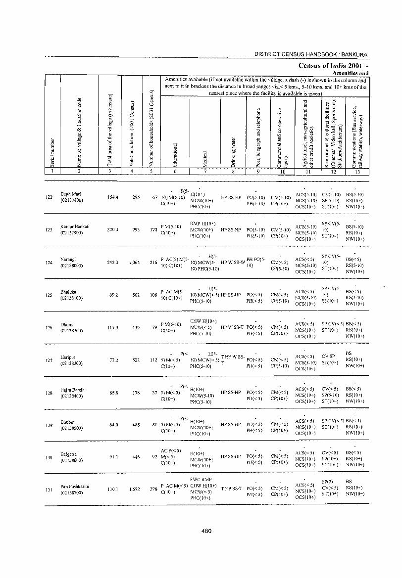
DISTRICT CENSUS HANDBOOK: BANKURA
Census of India 2001 -Amenities an d
Amenities available (if not available within the village, a dash (-) is shown in the column and
next to it in brackets the distance in broad ranges viz.< 5 kms., 5-10 kms. and ]0+ kms of the .~
'" nearest place where the facility is available is given
I ;J
" V>
"0
W § "0 ~~ 0 (.) ~ " " '"
.<: " " '"§ '';:: (.) ,,"
'" <:> ;.::: O'l .:e 0 2- " '" > .~ (.) C> 0 .~ B
.[) 1:: i::~ ~::, .<: ~ 8.
" " c. :J " t\i' 0 on 0 on " " ] ~~8 ~ ~ ..;J ::§ 0 .,~ '£ c. u
0 .~ ~ !::!- C) 6 ;J " OIl .;; .<; "0
~ :~ '3 1! .2 6.1tl " " '" " '" " V> is: ", OJ "0 " 0 ...
~ -£ 0 ~1 ... -'" § c g OIl .g .g § ~r g; 'fJ Cl B '->-; .<:: c. '" .- "0 ·z 0 .0 .;; 0 "3 4-, Cd ~ e Cd e ;; ta:> ;J '" .-E '" g- o c OJ) 'e § -< .~ N
::J '->-; <IJ ,-, .~ on " E ~ '" '" c 0 til c. Ol' ea '" ] " -'<lE s t\i' ea " ~ ~
.0 0 :Q E '" ;J " til E :>
~ E " 'B c 1;;" E -" .g t ~.5 ~ E is: ·c '" " ;J "0 " 25 0 o '" ~~ 0:-::::'
CI) f- Z (Ll ::2 ""' ul'l ~~rJ5 u E! 1 2 3 4 5 6 7 8 9 10 11 12 13
122 BaghMari
154.4 295 67 - P(S- H(I;+)
HP SS-HP PO(S-IO) CM(S-IO) ACS(5-10) CV(5-lO) BS(5-10)
10) M(S-IO) MCW(IO+) (02137800) C(lO+) PHC(IO+) PH(5-10) CP(IO+)
NCS(5-10) SP(5-10) RS(IO+) OCS(IO+) ST(IO+) NW(IO+)
Kantor Bankati PM(5-10) RMP H(IO+)
ACS(5-lD) SPCV(5-
BS(5-IO) 123
(02137900) 220.3 793 178
C(IO+) MCW(10+) HP SS-HP PO(S-IO) CM(S-IO)
NCS(5-IO) 10)
RS(IO+) PHC(IO+) PH(5-10) CP(10+)
OCS(IO+) ST(IO+)
NW(10+)
Narangi - H(5-
ACS«5) SPCV(5-
BS«5) 124 242.3 1,065 216 P AC(2)M(5- 10)MCW(5_ HPWSS_WPHPO(5- CM«5) 10)
(02138000) 10) C(IO+) 10) PHC(5-10) 10) CP(S-IO) NCS(5-10)
ST(IO+) RS(5-10)
OCS(IO+) NW(lO+)
Bhaluka P ACM(5-H(S-
ACS« 5) SPCV(S-
BS«5) 125
(02138100) 69.2 562 108
10) C(10+) 10) MCW( < 5) HP SS-HP PO« 5) CM«5)
NCS(S-IO) 10)
RS(S-IO) PHC(S-IO) PH« 5) CP(S-1O)
OCS(lO+) ST(IO+)
NW(IO+)
Dhuma PM(5-10) CHWH(lO+)
ACS« 5) SP CV« 5) BS« 5) 126
(02138200) 115.0 439 79
C(lO+) MCW«S) HPWSS-T PO«5) CM« 5)
NCS(IO+) ST(IO+) RS(IO+) PHC(5-10) PH«5) CP(IO+)
OCS(IO+) NW(IO+)
P« H(5- -ACS« 5) CVSP
BS Haripur 10) MCW«5) THPWSS- PO«5) 127 (02138300)
72.2 522 112 5)M« 5) CM«5) NCS(5-1O) ST(lO+)
RS(10+)
C(lO+) PHC(5-lO) T PH«5) CP(5-10) OCS(lO+)
NW(IO+)
HajraBandh 85.6 178 37
- P« H(l;+) HP SS-HP PO«5) CM« 5)
ACS« 5) CV«5) BS«5) 128
(02138400) 5) M« 5) MCW(5-l0) NCS(10+) SP(S-IO) RS(lO+) C(10+) PHC(5-lO) PH«S) CP(JO+)
OCS(lO+) ST(IO+) NW(lO+)
Bhubut 64.0 488 81
- P« H(I;+) HPSS-HP PO« 5) CM«5)
ACS«5) SP CV« 5) BS« 5) 129 5) M« 5) MCW(IO+) NCS(IO+) ST(10+) RS(IO+) (02138500) PH« 5) CP(IO+) C(IO+) PHC(lO+) OCS(IO+) NW(lO+)
Belgaria ACP« S)
H(lO+) ACS« 5) CV«5) BS«5) 130 9L1 446 92 M«5) HP SS-HP PO«5) CM«5)
(02138600) MCW(IO+) NCS(IO+) SP(IO+) RS(lO+) C(IO+)
PHC(IO+) PH«5) CP(IO+)
OCS(IO+) ST(JO+) NW(JO+)
FWCRMP SP(2) BS Pan Pushkarini P ACM«5) CHWH(JO+)
T HP SS-T PO«5) CM«5) ACS« 5)
CV«5) RS(IO+) 131 110.} 1,572 278 NCS(IO+) (02138700) C(IO+) MCW«5) PH« 5) CP(IO+) ST(IO+) NW(lO+)
PHC(IO+) OCS(10+)
480

VILLAGE DIRECTORY
Village Directory Land Use (As on 1999)
s "" 2-
<U (.)
0.> ~ OJ) 'i3 ,g .;; O(j
B ~ ] B
10 8 0.> p., la ~
<U z 14 15
MR Patrasayer (11 )
MR Patrasayer (11 )
MRNR Sonam ukhi (11)
MRNR Sonamukhi (11)
MR Sonam ukhi (II)
MR Sonamukhi (II)
MR Sonamukhi (11)
MR Bishnupur (II)
MR Bishnupur (11)
MR Sonamukhi (11 )
~ 0
<U E c .~ E
0
~ (.)
§." .D ~ 0- t:: <U <U 8.B §' 0.
Vl '" §Jl 0.
~ [ii 10 '" ~ <!) 0 0 ::2 "" Z E 16 17 18
ED
Belmala, Kurchi ED
Mala
ED N
ED NM
ED
ED
Bamboo Buske!
ED N
Land use (i.e. area under different types ofland use in hectare)
~
~ 0 Vl
e ."
10 ~ ~
OJ)
] ~
19 20 21 22 23 2
TW(25.0) T(25.0)
77.4 12.0 40.0 Bagh Mari
TW(70.0) 31.3 9.0 110.0 Kantor Bankati
T(70.0)
GC(40.0) TW(90.0)
27.3 6.0 75.0 Narangi TK(4.0) T(134.0)
GC(42.0) TK(4.0) 5.2 8.0 10.0 Bhaluka T(46.0)
TW(37.0) TK(3.0) 64.0 11.0 Dhuma T(40 0)
TW(45.0) TK(2.0) 13.2 l.0 1l.0 Haripur T(47.0)
GC(29.0) TW(S.O)
38.0 l.0 8.6 Hajra Bandh TK(l.O) T(3S.0)
GC(20.0) TW(20.0)
4.0 18.0 Bhuhut TK(2.0) T(42.0)
GC(S2.0) TW(l.O)
1.1 6.0 Belgaria TK(l.O) T(84.0)
GC(89.0) TW(lS.O) 0.1 l.0 5.0 Pan Pushkarini T(I04.0)
481
122
123
124
125
126
127
128
129
130
131

132
133
134
135
136
137
138
139
140
141
142
2
Tilpur (02138800)
Chalckabir (02138900)
Dakshin Gobindapur (02139000)
Satgechhe (02139100)
NutanGram (02139200)
Kastha Sanga (02139300)
Jamsola (02139400)
Nikunjapur (02139500)
GoalaDanga (02139600)
Kamar 8era (02139700)
8aghmara (02139800)
3 4
61.5 679
131.6 667
63.6 467
1,656.7 729
287.9 409
102.1 535
113.6 771
159.3 865
100.2 365
131.3 299
109.2 51
DISTRICT CENSUS HANDBOOK: BANKURA
Census of India 2001 -Amenities and
Amenities available (if not available within the village, a dash (-) is shown in the column and next to it in brackets the distance in broad ranges viz.< 5 kms., 5-:10 kms. and 10+ kms of the
nearest place where the facility is available is given
5 6
129 PM«5) C(10+)
7
H(lO+)
MCW«5) PHC(IO+)
8 9
HP SS-HP PO« 5)
PH« 5)
10
CM«5) CP(IO+)
11
ACS« 5) NCS(10+)
OCS(10+)
12 13
BS SP CV« 5) RS(IO+)
ST(10+) NW(IO+)
142 P M« 5) C(10+)
PHS H(!o+) MCW(5-10) PHC(5-10)
T HP SS-T PO PH(2l CM« 5) CP(5-10)
ACS« 5) NCS(10+) OCS(IO+)
SP CV« 5) as RS(5-10)
ST(10+) NW(IO+)
96 PM«5) C(lO+)
148 P M« 5) C(lO+)
CHW H(IO+) MCW(5-10) PHC(5-10)
H(!O+)
MCW«5) PHC(10+)
HP SS-HP PO« 5)
PH«5)
HP W SS-W PO« 5) PH« 5)
P AC M« 5) CWC H(lO+) TW W SS-83 MCW« 5) W PO« 5)
C(10+) PHC(IO+) PH« 5)
105 PM«5) C(IO+)
AC P« 5) 144 M« 5)
C(lO+)
ewc H(IO+) TW W SS-MCW« 5) W PO« 5) PHC(10+) PH«5)
ewe H(J 0+) TW W SS-MCW« 5) W PO« 5) PHC(10+) PH« 5)
CM« 5) CP(IO+)
CM« 5) CP(10+)
ACS« 5) NCS(JO+) OCS(IO+)
ACS« 5) NCS(10+) OCS(IO+)
8S SP CV« 5) RS(10+) ST(10+) NW(lO+)
SP CV« 5) BS« 5)
ST(lO+) RS(lO+) NW(10+)
ACS« 5) SP CV(S- 8S« 5) CM(5-10) NCS(10+) 10) RS(JO+) CP(IO+) ST(IO+)
OCS(IO+) NW(IO+)
ACS« 5) CM(5-10) NCS(lO+)
CP(10+) OCS(lO+)
ACS« 5) CM(5-10) NCS(IO+)
CP(IO+) OCS(IO+)
SP CV(5- BS« 5) 10) ST(IO+) RS(lO+)
NW(10+)
SP CV(5- BS( < 5) 10) ST(10+) RS(IO+)
NW(IO+)
MCWCHW 164 P AC M« 5) H(10+)
C(lO+) PHC(IO+) :w W SS- PH PO« 5) CM« 5)
CP(lO+)
ACS NCS(lO+) OCS(IO+)
SP CV« 5) BS« 5) ST(IO+) RS(IO+)
NW(IO+)
76 PM«5) C(IO+)
H(lD+)
MCW«5) PHC(IO+)
;: W SS- PO« 5)
PH«5)
P« CWCH(lO+) TWWSS-69 5) M« 5) MCW« 5) w PO« 5)
C(10+) PHC(IO+) PH« 5)
- P« H(I~+) 7 5)M«5) MCW«5)
C(lO+) PHC(lO+)
482
TW SS-TW PO« 5) PH« 5)
ACS« 5) CM(5-10) NCS(10+) Cpr I 0+) OCS( 10+)
CM« 5) CP(lO+)
ACS« 5) NCS(10+) OCS(lD+)
SP CV« 5) BS(5-10) 8T(10+) RS(IO+)
NW(10+)
SP CV« 5) BS« 5) ST(10+) RS(IO+)
NW(10+)
CM« 5) CP(10+)
ACS(5-10) eV(S-IO) 8S« 5) NCS(lO+) SP«5) RS(IO+) OCS(IO+) ST(IO+) NW(10+)
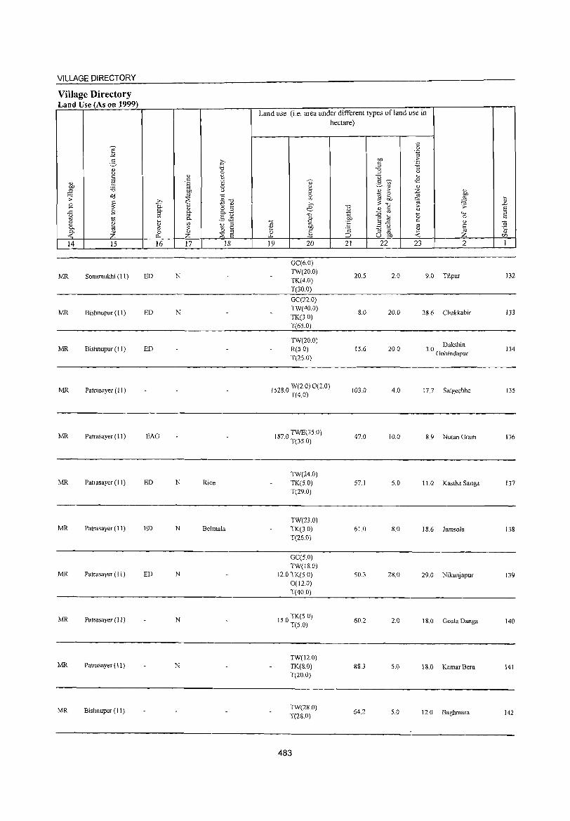
VILLAGE DIRECTORY
Village Directory Land Use (As on 1999)
e "" " '=' " u lii
1;1 ti 'i3 ~ o'd ';; ~ B
g B ti
[ " a ~ ~ 14 15
MR Sonamukhi (11)
MR Bishnupur (I I)
MR Bishnupur (I I)
MR Patrasayer (I 1 )
MR Patrasayer (11)
MR Patrasayer (11 )
MR Patrasayer (II)
MR Patrasayer (II)
MR Patrasayer (I I)
MR Patrasayer (11)
MR Bishnupur (11)
c 'i3 0
<u ;:; '" '~ ;:;
0 on (.) oj
~~ .b ~ 0. 1:: <J)
" o .... g- o. a.£ OJ '" 0. ,5 <i'l ~ '" ti ;::l ~ ~ " 0 "
0 '" p. z ~ ;:; 16 17 18
ED N
ED N
ED
EAG
ED N Rice
ED N Belmala
ED N
N
N
Land use (i,e, area under different types of land use in hectare)
19 20
GC(6,0) TW(20,0) TK(4,()
T(30,0)
GC(no) TW(40,0) TK(3,O) T(65,0)
TW(20,0) R(50) T(25,0)
1528,0 W(LO) 0(2,0) T(40)
187,0 TWE(35,0) T(35,0)
TW(24,0) TK(5,0) T(29,0)
TW(23,0) TK(3,0) T(26 0)
GC(5,0) TW(18,O)
12,0 TK(5,0) 0(12,0) T(400)
15,0 TK(5,O) T(5,0)
TW(12.0) TK(8.0) T(20,0)
TW(28,0) T(28,0)
483
21 22
20,5
8,0
15,6
103,0
47,0
57,1
61.0
50,3
60,2
88,3
64.2
23 2
2,0 9,0 Tilpur
20,0 38,6 Chakkabir
20,0 3 ° Dakshin , Gobindapur
4,0 17,7 Satgechhe
10,0 8,9 NutanGram
5,0 ILO Kastha Sanga
8,0 18,6 Jamsola
28,0 29,0 Nikunjapur
2,0 18,0 GoalaDanga
5,0 18.0 KamarBera
5.0 12,0 Baghmara
132
133
134
135
136
137
138
139
140
141
142
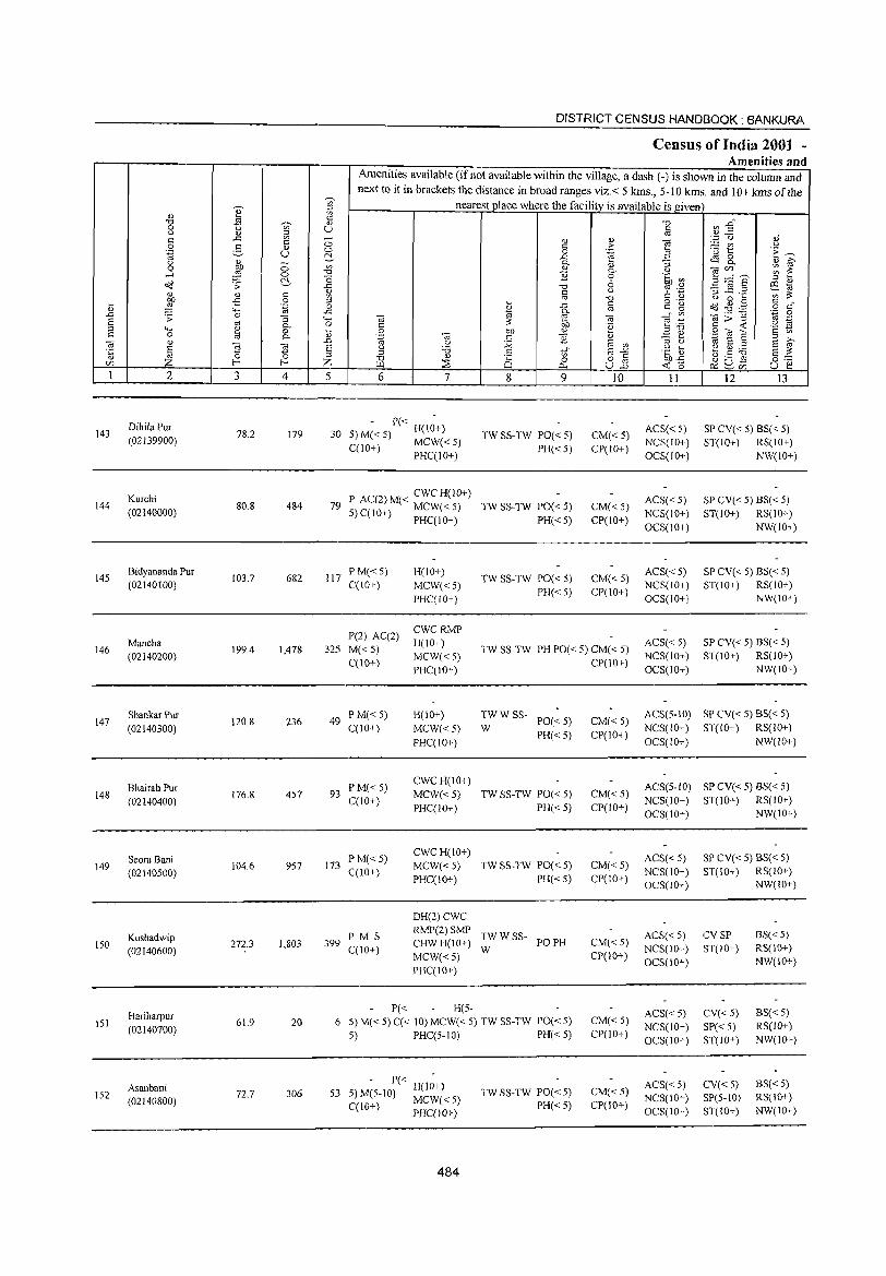
143
144
145
146
147
148
149
150
151
152
2
DihilaPur (02139900)
Kurchi (02140000)
Bidyananda Pur (02140100)
Mancha (02140200)
Shankar Pur (02140300)
Bhairab Pur (02140400)
Seora Bani (02140500)
Kushadwip (02140600)
Hariharpur (02140700)
Asanbani (02140800)
3 4
78.2 179
80.8 484
103.7 682
199.4 1,478
120.8 236
176.8 457
104.6 957
272.3 1,803
61.9 20
72.7 306
DISTRICT CENSUS HANDBOOK: BANKURA
Census of India 2001 -Amenities and
Amenities available (if not available within the village, a dash (-) is shown in the column and next to it in brackets the distance in broad ranges viz. < 5 kIns., 5-10 kIns. and 10+ kIns of the
nearest place where the facility is available is given
,-.)
.s.)
£1 =, Z 5 6 7
- P« H(IO+) 30 5) M« 5) MCW« 5)
C(JO+) PHC(IO+)
CWCH(IO+) 79 P AC(2)M« MCW«5)
5) C(lO+) PHC(IO+)
117 PM«5) C(lO+)
H(lO+)
MCW«5) PHC(JO+)
8 9
TW SS-TW PO« 5)
PH«5)
TW SS-TW PO« 5)
PH« 5)
TWSS-TW PO«5)
PH« 5)
10
CM« 5) CP(lO+)
CM« 5) CP(IO+)
CM«5) CP(IO+)
P(2) AC(2)
325 M« 5) C(lO+)
CWCRMP H(IO+)
MCW«5) PHC(IO+)
TW SS-TW PH PO« 5) CM« 5) CP(IO+)
49 PM« 5) C(lO+)
93 I'M« 5) C(10+)
173 PM«5) C'(IO+)
H(IO+)
MCW«5)
PHC(lO+)
CWCH(IO+)
MCW«5) PHC(IO+)
CWCH(IO+)
MCW«5)
PHC(lO+)
TW W SS- PO« 5)
W PH«5)
TW SS-TW PO« 5)
PH«5)
TW SS-TW PO« 5)
PH«5)
PM S 399 C(lO+)
DH(2)CWC RMP(2)SMP
TWWSS- POPH CHWH(lO+) W MCW«5) PHC(IO+)
P« H(5-6 5)M«5) C« 10) MCW«5) TWSS-TW PO«5)
5) PHC(5-10) PH« 5)
- P« H(I~+) 53 5) M(5-1O) MCW« 5)
C(W+) PHC(!o+)
484
TW SS-TW POe < 5) PH«5)
CM« 5)
CP(IO+)
CM« 5)
CP(lO+)
CM« 5) CP(lO+)
CM«5) CP(IO+)
CM« 5) CP(10+)
CM« 5) CP(lO+)
II
ACS« 5) NCS(IO+)
OCS(ID+)
ACS« 5) NCS(lO+)
OCS(lO+)
ACS«5) NCS(IO+)
OCS(IO+)
ACS« 5) NCS(IO+)
OCS(lO+)
12 13
SP CV« 5) BS« 5) ST(IO+) RS(10+)
NW(lO+)
SP CV« 5) BS« 5) ST(lO+) RS(IO+)
NW(lO+)
SP CV« 5) BS« 5) ST(IO+) RS(IO+)
NW(lO+)
SP CV« 5) BS« 5) ST(JO+) RS(IO+)
NW(IO+)
ACS(5-10) SP CV« 5) BS« 5)
NCS(IO+) ST(JO+) RS(IO+)
OCS(W+) NW(lO+)
ACS(5-1O) SP CV« 5) BS« 5)
NCS(JO+) ST(!o+) RS(IO+) OCS(lO+) NW(IO+)
ACS« 5) NCS(IO+) OCS(lO+)
SP CV« 5) BS« 5) ST(IO+) RS(IO+)
NW(IO+)
ACS« 5) CV SP BS« 5) RS(IO+) NW(IO+)
NCS(10+) ST(lO+)
OCS(lO+)
ACS« 5) NCS(lO+)
OCS(lO+)
ACS« 5) NCS(lO+) OC$(lO+)
CV« 5)
SP« 5) ST(lO+)
CV« 5) SP(5-10) ST(10+)
BS« 5) RS(IO+)
NW(lO+)
BS« 5) RS(lO+) NW(10+)
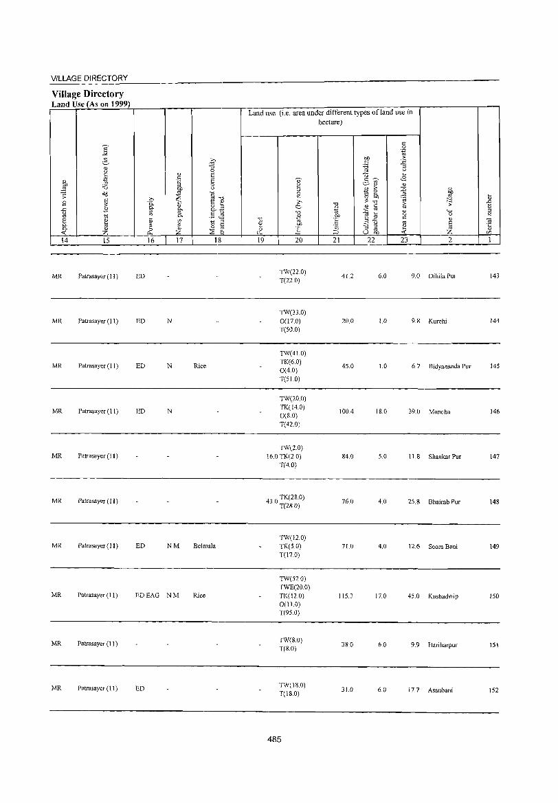
VILLAGE DIRECTORY
Village Directory L d U (A 1999) an se son
]: 3 0
<1J 'B (.) 0
~ <1J E c E <1J '1;j 01l 'B 0
~ bl) u
Cd "' §"Cl ';::': >, ~ B ~ 0. 1:; t: <1J
OJ o .... .-C B 0.. g. o..-§ ;;s (.)
'" .§ ~ til ;;; 0.. e ~ ~ ~ ;;; ;;s 0.. o a 0.. <1J 0 <1J
-< z p.. z ~ S 14 15 16 17 18
MR Patrasayer (11 ) ED
MR Patrasayer (11 ) ED N
MR Patrasayer (11) ED N Rice
MR Patrasayer (11) ED N
MR Patrasayer (11)
MR Patrasayer (II)
MR Patrasayer (II ) ED NM Beimaia
MR Patrasayer (11) EDEAG NM Rice
MR Patrasayer (11)
MR Patrasayer (II) ED
Land use (i.e. area under different types ofland use in
;;; ~ 0 ..,., 19
" 2 :::> 0 '" >,
e.-.",
<1J
"' .S'!' ~ 20
TW(220) T(22.0)
TW(33.0)
0(17.0) T(50.0)
TW(41.0)
TK(6.0) 0(4.0) T(51.0)
TW(20.0) TK(l4.0) O(S.O) T(42 0)
TW(2.0) 16.0 TK(2.0)
T(40)
43 0 TK(28.0) . T(28.0)
TWCl2.0) TK(S.O) T(17.0)
TW(52.0) TWE(20.0)
TK(12.0) 0(11.0) T(95.0)
TW(8.0) T(S.O)
TW(180) T(18.0)
485
hectare)
.",
~ OJ)
E 'c ::l 21
41.2
20.0
45.0
100.4
84.0
76.0
71.0
115.3
3S.0
31.0
c 0
'"§ Of) oS C
'B :; :;:s (.)
-;:; .... c ~ <8 .- '" ~<1J OJ 0.> ;>
~ OJ
~ e ~ ~: 'OJ >- .;;:
o.> t: til :g '" "" .... (; 0 ~ '" t: :;:s..c:
'" <1J
~ (.) E :; ::l ~ til gj, U -< Z 22 23 2
6.0 9.0 Dihila Pur
1.0 9.8 Kurchi
1.0 6.7 Bidyananda PUT
IS.0 39.0 Mancha
5.0 11.8 Shankar Pur
4.0 25.8 Bhairab Pur
4.0 12.6 Seora Bani
17.0 45.0 Kushadwip
6.0 9.9 Hariharpur
6.0 17.7 Asanbani
t ..c
~ "iii °t rfJ
I
143
144
145
146
147
148
149
ISO
lSI
152
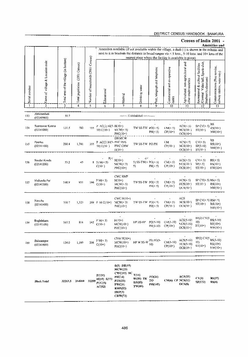
V' (i)
~ '1:S ~
0 <fl u (i) ::l t:: ..c <fl c 0 g (i)
.~ U u ill> ;:; 0
.-< ~ 0 ~ o<J '>
(i) '" t::
"" 1 £ 0 .~
'" ""' .D '> 0 "S § <II 0-4-< '" 0 t:: 0 til "--a (i)
~ -a -a ·c '0 ~ '" CI') f-
1 2 3 4
153 Abhirambati
50.7 (02140900)
Rameswar Kunria 154 131.5 780
(02141000)
155 Pandua
280.4 1,741 (02141100)
Bandar Konda 156
(02141200) 53.2 45
157 MukundaPur
148.9 951 (02141300)
158 Naricha
330.7 1,323 (02141400)
Baghdahara 159 165.2 814
(02141500)
Balarampur 160 134.0 1,185
(02141600)
Block Total 32261.5 164060
DISTRICT CENSUS HANDBOOK: BANKURA
Ce,nsus of India 2001 -Amenities and
Amenities available (if not available within the village, a dash (-) is shown in the column and next to it in brackets the distance in broad ranges viz. < 5 krns., 5-10 krns. and 10+ kms of the
Q;' nearest place where the facility is available is given '" <fl t:: (i)
U
<'" <'" ~:!. <n ~j
"() ..to: 2~ ::l C)
..c: 4-, c> t;
..0 E '" Z 5
ISS
355
8
166
269
162
206
(i) t:: 0
..c: 0-
'" 11 '1:S t:: OJ ... ..c: B 0-
-a ~ E t:: ~ 8 OJ) -a t:: 'E .,
" :.Q u '6 c tf ::l
ill ~ 8 0
"" 6 7 8 9
-------- Uninhabited ------------
P AC(2) M(5- H(IO+) 10) C(IO+) MCW«5)
PHC(iO+)
DHMCW P AC(2) M(5- PHC PHS 10) C(10+) FWCCHW
H(10+)
- P« H(l~+) 5)M«5) MCW«5) C(IO+) PHC(lO+)
PM«5) C(10+ )
P MC(10+)
PM« 5) C(lO+)
PM« 5) C(lO+)
CWCRMP H(10+)
MCW«5) PHC(IO+)
CWCH(IO+)
MCW«5) PHC(IO+)
H(lO+) MCW(IO+) PHC(10+)
CHWH(IO+) MCW(IO+) PHC(10+)
D(5) DR(IS) MCW(23)
TW SS-TW PO« 5)
PH« 5)
TW SS-TW PO PH
-« 5) SS-TW« PO« 5) 5) PH« 5)
TWSS-TW PO«5) PH«5)
TW SS-TW PO« 5) PH«5)
HP SS-HP PO(5-IO) PH(5-10)
HP W SS-W PH PO(5-10)
P(131)
32289 M(19) Sell) PTJC(5) AC(52)
CWC(65) HC T(14)
PRC(4) W(50) TK PHS(23) HP(SS)
FWC(6) TW(89) RMP(52)
PO(24) TO PH(145)
SMP(3) CHW(73)
486
'1:S C OJ
(i) e > .~ B (i) "S 0- u 0 .~ ~ 6 t? ';:1 u
'1:S § .~ §
t:" ~ -a ] ;i5 '8
(i) =: e e: en ::! <.)
E"" .~ [5
8.2 ~o5 ,:;,
10 11
ACS«5) CM« 5) CP(lO+)
NCS(lO+) OCS(IO+)
CM ACS«5) CP(IO+) NCS(lO+)
OCS(iO+)
ACS« 5) CM« 5)
NCS(10+) CP(lO+)
OCS(10+)
CM« 5) ACS« 5)
CP(IO+) NCS(10+) OCS(IO+)
ACS
CM«5) NCS(IO+) CP(IO+) OCS(IO+)
CM(5-10) ACS(5-1O)
CP(10+) NCS(5-1O) OCS(IO+)
ACS(5-IO) CM(5-IO) CP(JO+)
NCS(S-10) OCS(10+)
ACS(21) CM(6) CP NCS(ll)
OCS(8)
~ :2~
" -..;:: u :..::= en u 'u to: 'E ~ ~ 8- (i) i2 -am ~ ~ ~=5 ::l '" '3 ~.2 e~
<fl ;;: u 0 ""
~~~ § c" '.p 0
~>~ " ._ .~ g
.8 til S § <fl
., E '" s i2 e g ~ S ;;: JJ 0 b5 0""
U E 12 13
BS SP CV« 5) RS(10+) ST(10+) NW(10+)
BS CV«5)
RS(IO+) SP(5-10)
NW(10+) ST(iO+)
CV«5) BS« 5) SP«5) RS(lO+) ST(IO+) NW(lO+)
SP CV« 5) BS« 5) ST(10+) RS(lO+)
NW(lO+)
SP CV« 5) BS« 5) ST(IO+) RS(JO+)
NW(lO+)
SP(2) eV(5 BS(;-IO) 10) ST(IO+) RS(10+)
NW(IO+)
SP(2) CV(5 BS(;-IO) 10) ST(IO+) RS(10+)
NW(10+)
eV(9) SP(l72)
BS(37) RS(4)
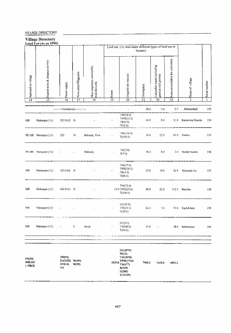
VILLAGE DIRECTORY
Village Directory Land Use (As on 1999)
14 15 16 17 18
-------- Uninhabited ------------
MR Bishnupur (11)
PR MR Patrasayer (J 1)
PR MR Patrasayer (1 J)
MR
MR
MR
MR
PR(20) MR(150 ) NR(5)
Patrasayer (II )
Bishnupur (J I)
Patrasayer (11)
Patrasayer (11 )
EDEAG N
ED N
EDEAG N
EDEAG N
ED(94) EAG(52) EO(14) EA
N
N(105) M(SO)
Belmala, Rice
Belmala
Brick
Land use (i.e. area under different types ofland use in hectare)
19 20
TW(24.0) TWE(22.0) TK(6.0) T(52.0)
TW(J09.0) T(1090)
TW(7.0) T(7.0)
TW(270) TWE(36.0)
TK(3.0) T(66.0)
TW(75.0) 12.0 TWE(25.0)
T(IOO.O)
GC(25 0) TW(250) T(50.0)
GC(S.O) TW(40.0) T(45.0)
GC(4973) W(lS) TW(3078)
S129 0 TWE(17S5) . TK(677)
R(439) 0(202)
T(1l139)
487
21
38.0
40.5
56.4
36.2
37.0
80.0
62.2
51.0
7969.3
22 23 2
3.0 9.7 Abhirambali
8.0 31.0 Rameswar Kunria
22.0 93.0 Pandua
8.0 2.0 Bandar Konda
19.0 26.9 Mukunda Pur
26.0 I J 2. 7 Naricha
3.0 50.0 Baghdahara
38.0 Balarampur
1433.0 6591.2
153
154
155
156
157
158
159
160

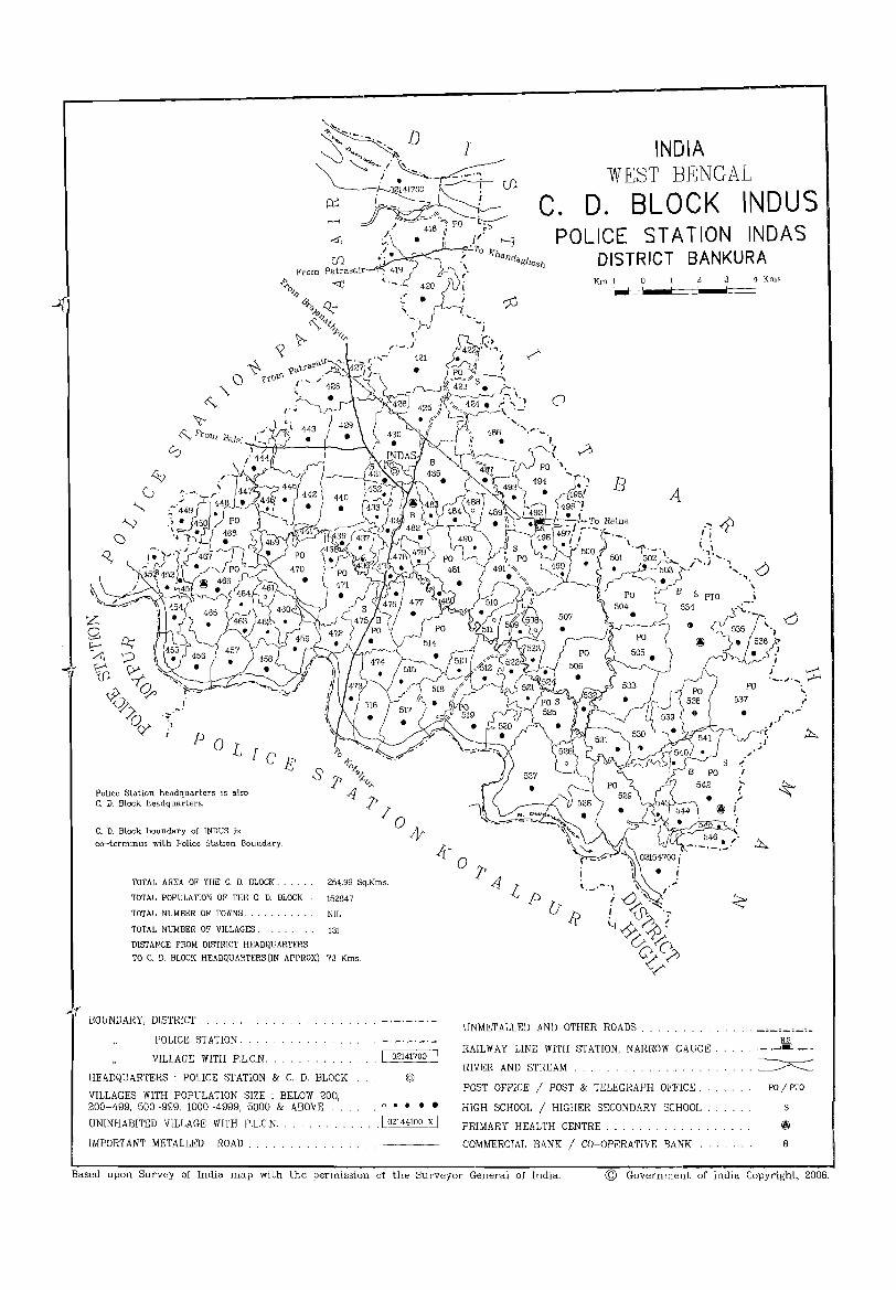
.... r
POL I Ce Police Station headquarters is also C. D. Block headquarters.
C. D. Block boundary of INDUS is
co-terminus with Police station Boundary.
TOTAL AREA OF THE C. D. BLOCK .. 254.99 Sq.Kms.
TOTAL POPULA TlON OF THE C. D. BLOCK.. 152847
TOTAL NUMBER OF TOWNS. . NIL
TOTAL NUMBER OF VILLAGES. 131
DISTANCE FROM DISTRICT HEADQUARTERS
TO C. D. BLOCK HEADQUARTERS (IN APPROX) 73 Kms .
BOUNDARY, DISTRICT ..
POLICE STATION.
VILLAGE WITH P.L.C.N.
HEADQUARTERS: POLICE STATION & C. D. BLOCK
VILLAGES WITH POPULATION SIZE : BELOW 200, 200-499, 500-999, 1000-4999, 5000 & ABOVE .
UNINHABITED VILLAGE WITH P.L.C.N.
IMPORTANT METALLED ROAD.
. I 02141700
@
• •• .1 02144100 X 1
I INDIA WEST BENGAL
C. D. BLOCK INDUS STATION INOAS
BANKURA POLICE
DISTRICT Km 1 0 ....
B
UNMETALLED AND OTHER ROADS.
2 3 .......
RAILWAY LINE WITH STATION, NARROW GAUGE .
RIVER AND STREAM .
POST OFFICE / POST & TELEGRAPH OFFICE.
HIGH SCHOOL / HIGHER SECONDARY SCHOOL
PRIMARY HEALTH CENTRE ..
COMMERCIAL BANK / CO-OPERATIVE BANK
4 Kms I
PO / PTO
S
B
Based upon Survey of India map with the permission of the Surveyor General of India. © Government of India Copyright, 2006.

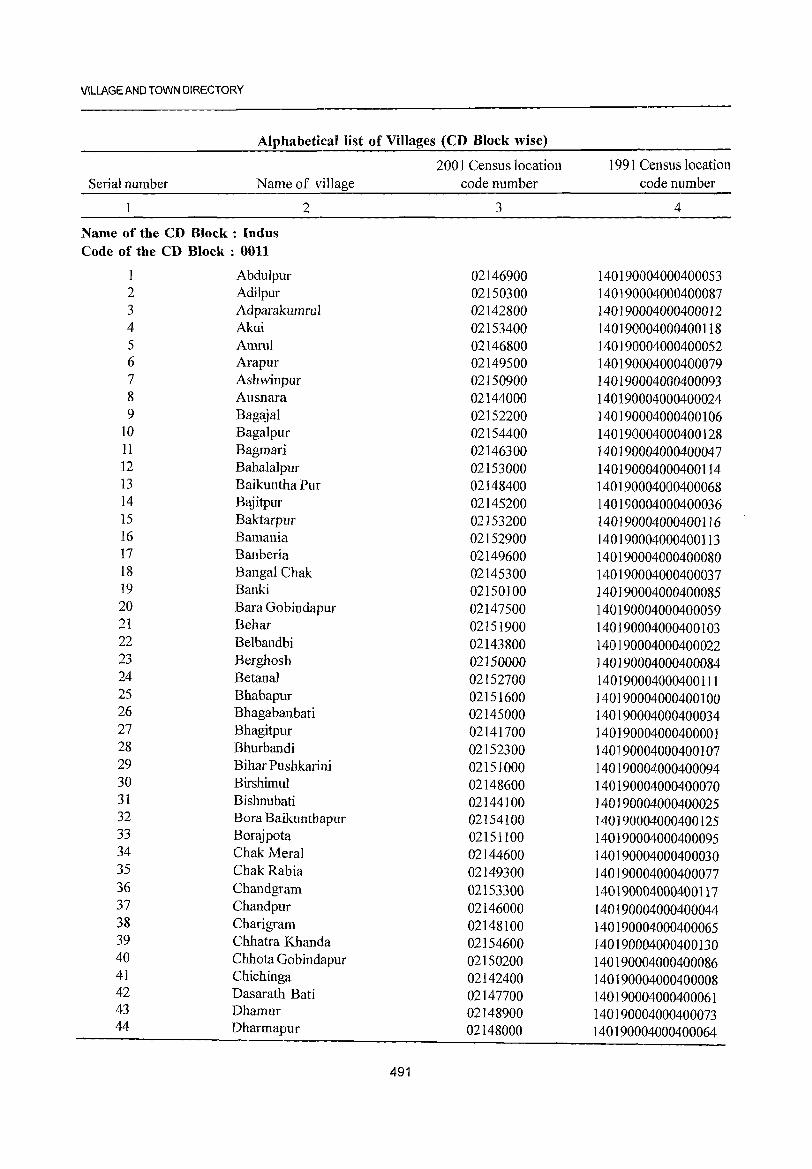
VILLAGE AND TOWN DIRECTORY
Alphabetkallist of Villages (CD Block wise)
2001 Census location 1991 Census location Serial number Name of village code number code number
2 3 4
Name of the CD Block: Indus Code of the CD Block: 0011
1 Abdulpur 02146900 140190004000400053 2 Adilpur 02150300 140190004000400087 3 Adparakumrul 02142800 140190004000400012 4 Akui 02153400 140190004000400118 5 Amrul 02146800 140]90004000400052 6 Arapur 02149500 140190004000400079 7 Ashwinpur 02150900 140190004000400093 8 Ausnara 02144000 140190004000400024 9 Bagajal 02152200 140190004000400106
10 Bagalpur 02154400 140190004000400128 11 Bagmari 02146300 140190004000400047 12 Bahalalpur 02153000 140190004000400114 13 Baikuntha Pur 02148400 140190004000400068 14 Bajitpur 02145200 140190004000400036 15 Baktarpur 02153200 140190004000400116 16 Bamania 02152900 140190004000400113 17 Banberia 02149600 140190004000400080 18 Bangal Chak 02145300 140190004000400037 19 Banki 02150100 140190004000400085 20 Bara Gobindapur 02147500 140190004000400059 21 Behar 02151900 140190004000400103 22 Belbandbi 02143800 140190004000400022 23 Berghosh 02150000 140190004000400084 24 Betanal 02152700 140190004000400111 25 Bhabapur 02151600 140190004000400100 26 Bhagabanbati 02145000 140190004000400034 27 Bhagitpur 02141700 140190004000400001 28 Bhurbandi 02152300 140190004000400107 29 Bihar Pushkarini 02151000 140190004000400094 30 Birshimul 02148600 140190004000400070 31 Bishnubati 02144100 140190004000400025 32 Bora Baikunthapur 02154100 140190004000400125 33 Borajpota 02151100 140190004000400095 34 Chak Meral 02144600 140190004000400030 35 Chak Rabia 02149300 140190004000400077 36 Chandgram 02153300 140190004000400117 37 Chand pur 02146000 140190004000400044 38 Charigrarn 02148100 140190004000400065 39 Chhatra IChanda 02154600 140190004000400130 40 Chhota Gobindapur 02150200 140190004000400086 41 Chichinga 02142400 140190004000400008 42 Dasarath Bati 02147700 140190004000400061 43 Dhamur 02148900 140190004000400073 44 Dharmapur 02148000 140190004000400064
491
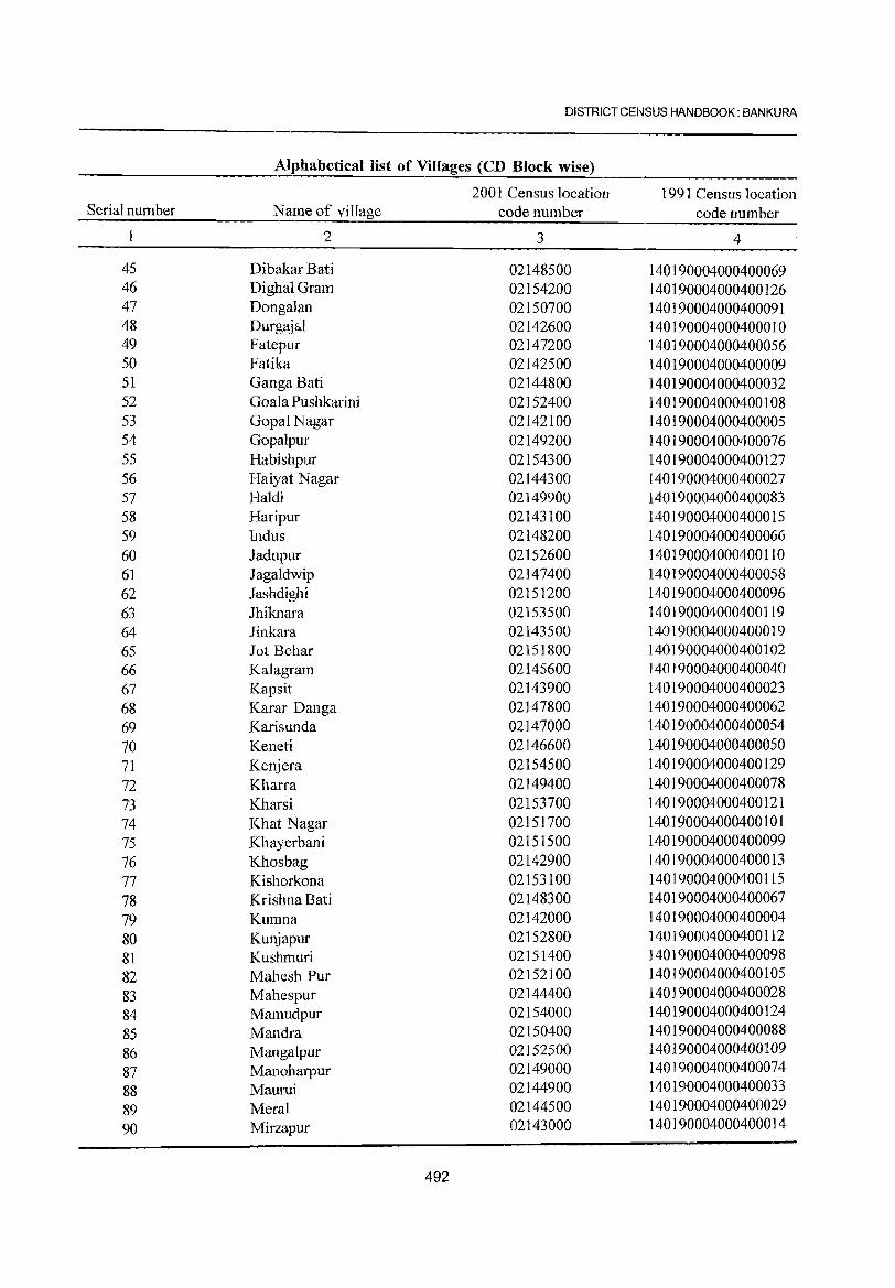
DISTRICT CENSUS HANDBOOK: BANKURA
Alphabetical list of Villages (CD Block wise)
2001 Census location 1991 Census location Serial number Name of village code number code number
2 3 4
45 Dibakar Bati 02148500 140190004000400069 46 DighalGram 02154200 140190004000400126 47 Dongalan 02150700 140190004000400091 48 Durgajal 02142600 140190004000400010 49 Fatepur 02147200 140190004000400056 50 Fatika 02142500 140190004000400009 51 Ganga Bati 02144800 140190004000400032 52 Goala Pushkarini 02152400 140190004000400108 53 GopalNagar 02142100 140190004000400005 54 Gopalpur 02149200 140190004000400076 55 Habishpur 02154300 140190004000400127 56 Haiyat Nagar 02144300 140190004000400027 57 Haldi 02149900 140190004000400083 58 Haripur 02143100 140190004000400015 59 Indus 02148200 140190004000400066 60 Jadupur 02152600 140190004000400110 61 Jagaldwip 02147400 140190004000400058 62 Jashdighi 02151200 140190004000400096 63 Jhiknara 02153500 140190004000400119 64 Jinkara 02143500 140190004000400019 65 Jot Behar 02151800 140190004000400102 66 Kalagram 02145600 140190004000400040 67 Kapsit 02143900 140190004000400023 68 Karar Danga 02147800 140190004000400062 69 Karisunda 02147000 140190004000400054 70 Keneti 02146600 140190004000400050 71 Kenjera 02154500 140190004000400129 72 Kharra 02149400 140190004000400078 73 Kharsi 02153700 140190004000400121 74 Khat Nagar 02151700 140190004000400101 75 Khayerbani 02151500 140190004000400099 76 Khosbag 02142900 140190004000400013 77 Kishorkona 02153100 140190004000400115 78 Krishna Bati 02148300 140190004000400067 79 Kumna 02142000 140190004000400004 80 Kunjapur 02152800 140190004000400112 81 Kushmuri 02151400 140190004000400098 82 Mahesh Pur 02152100 140190004000400105 83 Mahespur 02144400 140190004000400028 84 Mamudpur 02154000 140190004000400124 85 Mandra 02150400 140190004000400088 86 Mangalpur 02152500 140190004000400109
87 Manoharpur 02149000 140190004000400074
88 Maurui 02144900 140190004000400033
89 Meral 02144500 140190004000400029
90 Mirzapur 02143000 140190004000400014
492
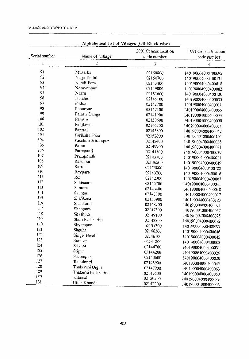
VILLAGE AND TOWN DIRECTORY
Alphabetical list of Villages (CD Block wise)
2001 Census location 1991 Census 1 ocati on Serial number Name of village code number code number
1 2 3 4
91 Musarbar 02150800 140190004000400092 92 Naga Tentu1 02154700 140190004000400131 93 Nandi Para 02143400 140190004000400018 94 Narayanpur 02149800 140190004000400082 95 Narra 02153600 140190004000400120 96 Nunduri 02145100 140190004000400035 97 Padua 02142700 1401910004000400011 98 Paharpur 02147100 140190004000400055 99 Pa1ash Danga 02141900 140190004000400003
100 Palashi 02150600 140190004000400090 101 Panjkona 02146700 140190004000400051 lO2 Pantrai 02145800 140190004000400042 103 Pariksha Para 02152000 140190004000400104 104 Paschim Srirampur 02145400 140190004000400038 105 Patan 02149700 140190004000400081 106 Patraganti 02145500 140190004000400039 107 Pratapmath 02143700 140190004000400021 108 Rasulpur 02146500 140190004000400049 109 Ratra 02153800 140190004000400122 110 Raypara 02143200 140190004000400016 111 Rol 02142300 140190004000400007 112 Sahisnara 02145700 140190004000400041 113 Santara 02146400 140190004000400048 114 Sauntari 02143300 140190004000400017 115 Shalikona 02153900 140190004000400123 116 Shankhrul 02148700 140]90004000400071 117 Shanpura 02147300 140190004000400057 118 Shashpur 02149100 140190004000400075 119 Shuri Pushkarini 02148800 140190004000400072 120 Shyampur 02151300 140190004000400097 121 Simulia 02146200 140190004000400046 122 Singer Bandh 02146100 140190004000400045 123 Somsar 02141800 140190004000400002 124 Srikara 02144700 140190004000400031 125 Sripur 02144200 140190004000400026 126 Srirampur 02143600 140190004000400020 127 Tentulmuri 02145900 140190004000400043 128 Thakurani Dighi 02147900 140190004000400063 129 Thakumi Pushkarini 02147600 140190004000400060 130 Tishanal 02150500 140190004000400089 131 Uttar Khanda 02142200 140190004000400006
493
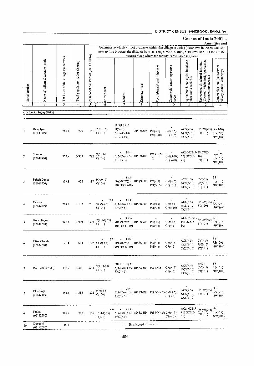
2
CD Block: Indus (0011)
2
3
4
5
6
7
8
9
10
Bhagitpur (02141700)
Somsar (02141800)
Palash Danga (02141900)
Kumna (02142000)
Gopal Nagar (02142100)
UtlarKhanda
(02142200)
Rol (02142300)
Chichinga (02142400)
Fatika (02142500)
Durgajal (02142600)
3 4
265.1 729
772.9 3,973
119.8 668
289.1 1,138
740.1 2,909
71.4 684
173.8 3,411
163.5 1,383
283.2 790
88.1
DISTRICT CENSUS HANDBOOK: BANKURA
Celilsus of India 2001 -Amenities and
Amenities available (if not available within the village, a dash C-) is shown in the column and next to it in brackets the distance in broad ranges viz.< 5 kIDs., 5-10 kIDs. and 10+ kIDs of the
nearest place where the facility is available is ,!!,iven
5 6
155 PM«5) C(lO+)
7
DDHRMP H(5-10) MCW(5-10) PHC(5-IO)
8 9
HP SS-HP PO« 5)
PH(5-IO)
10
CM« 5) CP(10+)
11 12 13
ACS( < 5) SP CV( < 5) BS(5-1 0)
NCS(5-IO) ST(IO+) RS(IO+)
OCS(5-IO) NW(IO+)
782 P(3) M C(lO+)
H« ACS NCS(5- SP CV(S. 5)MCW«5) HPSS-HP POPH(5- CM(5-IO) 10)OCS(:5- 10) BS«5) PHCC< 5) 10) CP(S-IO) 10) ST(10+) RS(lO+)
NW(lO+)
117 PM«5) CCIO+)
H(5-10) MCW(5- HP SS-HP PO« 5) 1 0) PHC(5-10) PH(5-1O)
CM« 5) CP(10+)
P« H« 201 5) M« 5) 5) MCW« 5) HP SS-HP PO« 5) CM« 5)
CP(5-10) C(10+) PHC« 5) PH« 5)
589 P(2) M( < 5) C(IO+)
P« 137 5) M« S)
C(10+)
684 P(2) M S C(lO+)
272 PM« 5) C(1 0+)
H(5-
10) MCW(5- HPSS·HP PO«5) 10) PHC(5-10) PH« 5)
H(5-
10) MCWeS. HP SS·HP PO« S) 10) PHC(5-10) PH« 5)
DHPHSH«
CM«5) CP«S)
CM«S) CP« 5)
5) MCW(S-10) HPSS-HP POPH(3) CM«5)
PHC« 5) CP« 5)
H« 5) MCW« 5) HP SS-HP PH PO« 5) CM« 5)
PHC« 5) CP« 5)
peS· H« 126 10) M( < 5) 5) MCW( < 5) HP SS-HP PH Poe < 5) CM( < 5)
C(10+) PHC« 5) CP« 5)
•• -•• --- Uninhabited ----.-------
494
ACS« 5) CV« 5) NCS(5-10) SP(S-IO) OCS(5-10) S1(10+)
BS RS(lO+)
NW(IO+)
ACS« 5) SP CV« S) BS NCS(5-10) ST(10+) RS(10+) OCS(5.10) NW(lO+)
ACS NCS(5- BS 10)OCS(5. SPCV«S) RS(IO+) 10) ST(IO+) NW(10+)
ACS« 5) CV« 5) NCS(5-10) SP(5-10)
OCS(5-1O) ST(IO+)
SP(2) ACS« 5) CV« 5) NCS(S-IO) ST(IO+) OCS(5-1O)
BS RS(lO+)
NW(IO+)
BS RS(lO+) NW(IO+)
BS ACS« 5) SP CV« 5) RS(IO+) NCS(S-IO) 3T(IO+) NW(IO+) OCS(5-IO)
ACS NCS(5- "P CV( 5) BS 10)OCS(5- ,) < RS(10+) 10) ST(IO+) NW(IO+)
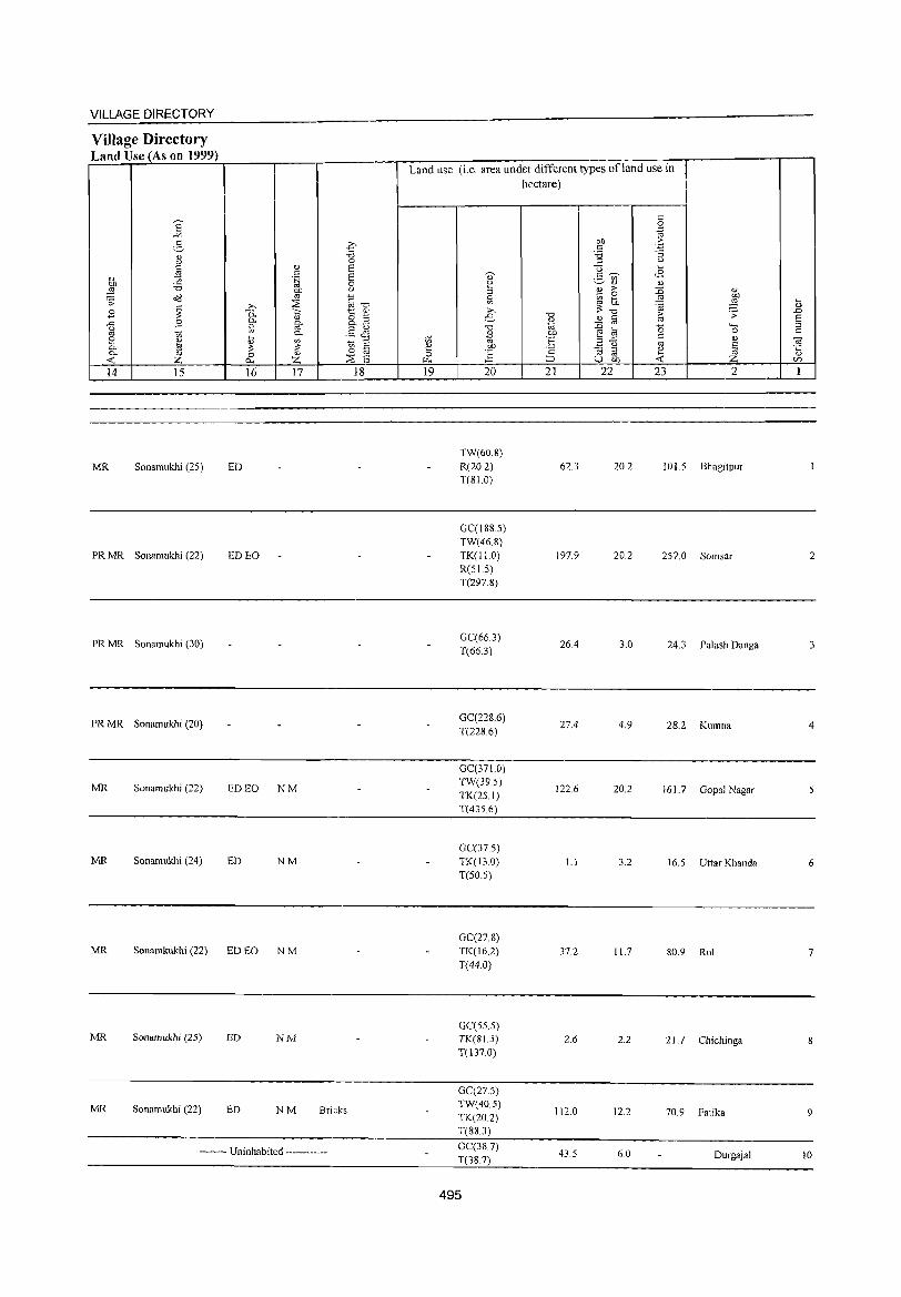
VILLAGE DIRECTORY
Village Directory Land Use (As on 1999)
8' ~
g " u
" ~ ~ :.a ~ o'(l
E ~ ..c: E t.)
'" t; e ~ "'-"'- 0)
-< Z 14 15
MR Sonarnukhi (25)
PRMR Sonamukhi (22)
PRMR Sonarnukhi (30)
PRMR Sonamukhi (20)
MR Sonamukhi (22)
MR Sonamukhi (24)
ED
ED EO
ED EO NM
ED NM
MR Sonamkukhi (22) ED EO N M
MR Sonamukhi (25) ED NM
MR Sonamukhi (22) ED NM Bricks
-------- Uninhabited ------------
Land use (i.e. area under different types ofland use in hectare)
TW(60.8) R(20.2) 62.3 20.2 1015 T(810)
GC(188.5) TW(46.8) TK(lI.O) 197.9 20.2 257.0 R(51.5) T(297.8)
GC(66.3) 26.4 3.0 24.3
T(66.3)
GC(228.6) 27.4 4.9 28.2 T(2286)
GC(371.0) TW(39.S)
122.6 20.2 161.7 TK(25I) T(435.6)
GC(37.5) TK(13.0) 1.1 3.2 16.5 T(50.5)
Bhagitpur
Somsar
Palash Danga
Kurnna
Gopal Nagar
Uttar Khanda
GC(27.8) TK(16.2) T(44.0)
37.2 11.7 80.9 Rol
GC(55.S) TK(SI.5) 2.6 2.2 21.7 Chichinga T(137.0)
GC(27.S) TW(40.5)
112.0 12.2 70.9 Fatika TK(20.2) T(883)
GC(387) 43.5 6.0 Durgajal T(38.7)
495
2
3
4
6
7
8
9
10
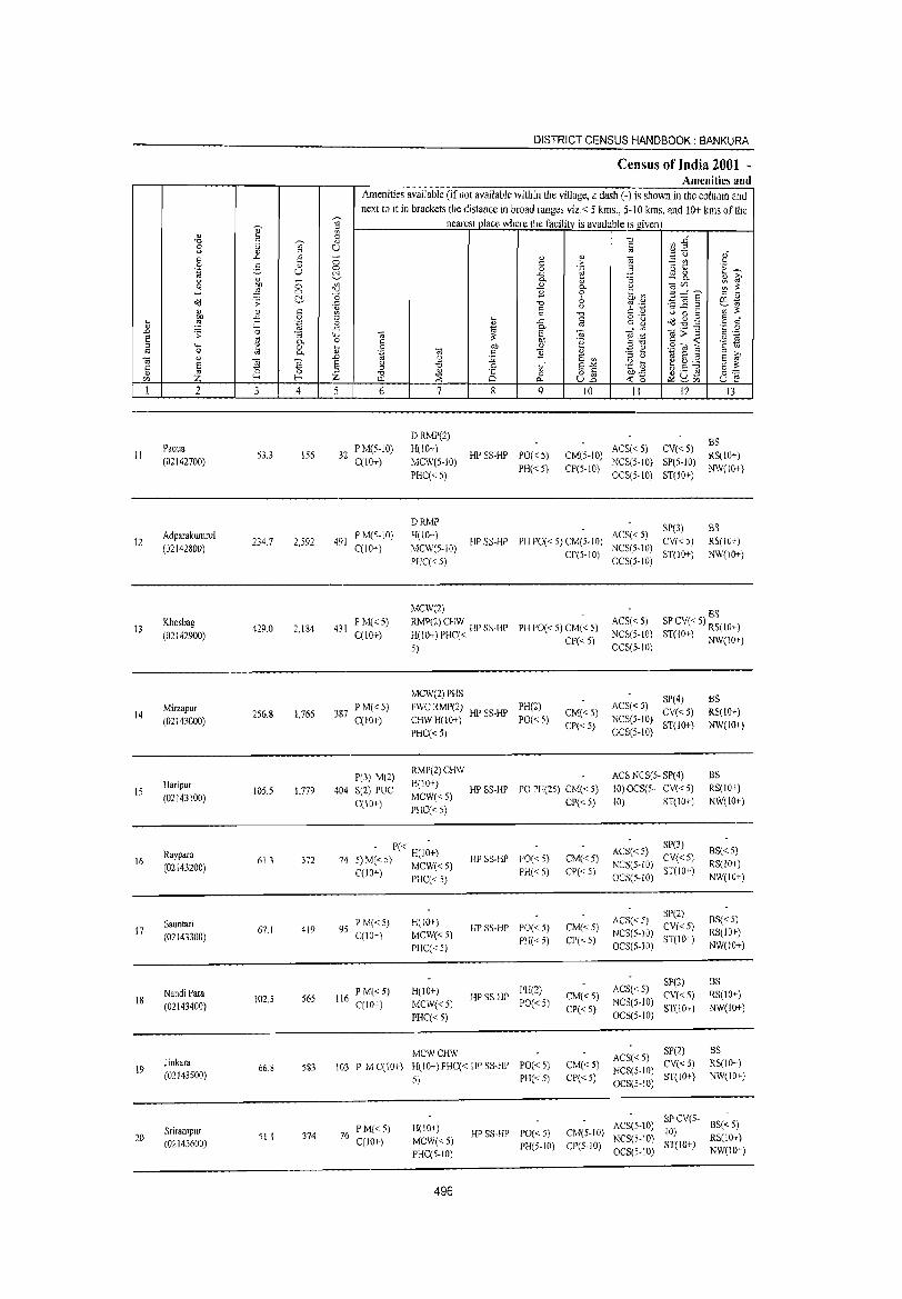
DISTRICT CENSUS HANDBOOK: BANKURA
Census of India 2001 -Amenities and
Amenities available (if not available within the village, a dash (.) is shown in the column and next to it in brackets the distance in broad ranges viz.< 5 kms., 5·10 kms. and 10+ kms of the
~
nearest place where the facility is available is given 3 " 1: '" El " '0 ~~ '8 '"'
OJ U U " " " ::l " '.c u " " .c t3 - '" " ~§ a c :- ;.:: f/l u
0 g " i3 t:: E~ .~ u a 0 .~ ~3 c:!- .<; tE 8. <> " 0 "- -;3 " ~ .3 E ~ OJ 0. " e C/J".-. ::; ~
'" ] 9 .~~ ~ ~ '0 ~~~ " " ~ ;; "" '0 0 01 ~ t) % .~ ~" g, " c 1,l ~ '0 U 0 ... '" '" "" 0 " ... o .- ad .g .g " , t5 :!:l ,;:: 'fJ 0 " .e § c: g o " ..c: 1ii 0- _r f/l <0>5 'z:: 0 .D .s: 0 :; ""' <0 ~ C;; " .-S '"
'" .. .~ ~ '" 0. 0 § bJ) .~ !3T3 § <: ::l .... ~ 0 il OJ) " ~ ~ "]"6 § t:i
" 0 0. .~ '" " ] " ro " .D U :;: S co ;j U
~ ~ ca Ei ~ 'E § ~ 'jg 8 g '6 .S to' E"'" .~ b
Ei '" 0 ::s ;Z ~ Q 0 o " 01)-5 ~u,:9 0;'::
'" Z I-< I-< Z 0. u2 <: 0 ~'" u l"! 1 2 3 4 5 6 7 8 9 10 II 12 13
DRMP(2) BS
II Padua
53.3 156 32 P M(5·1O) H(lO+)
HP SS·HP PO«5) CM(5·1O) ACS« 5) CV«S)
RS(10+) (02142700) C(1O+) MCW(S·10) NCS(5,tO) SP(S·10)
PHC« 5) PH«5) CP(S·IO)
OCS(5·10) ST(IO+) NW(lO+)
DRMP SP(3) BS 12
Adparakumrul 234.7 2,592 491
P M(5.10) H(lO+) HP SS·HP PH PO[< 5) CM[5·1O)
ACS« 5) CV« 5) RS(lO+)
(02142800) C(lO+) MCW(5·10) CP(5·tO)
NCS[5·IO) ST(lO+) NW(tO+)
PHC(<:5) OCS(5·IO)
MCW(2) BS
13 Khosbag
429.0 2.184 431 P M«5) RMP(2) CHW HP SS.HP PH PO« 5) CM« 5)
ACS« 5) SP CV« 5) RS(lO+) (02142900) C(IO+) H(W+)PHC«
CP«5) NCSCI·IO) ST(IO+) NW(lOT)
5) OCS(5·IO)
MCW(2} PHS SP(4) BS Mirzapur
256.8 1,766 387 PM«5) FWCRMP(2) HP SS·HP
PH(2) CM«5)
ACS«5) CV«5) RS(IO+) 14
(02143000) C(10+) CHWH(IO+) PO(<:5) NCS(5·10)
PHC« 5) CP«5} OCS(S-IO)
ST(IO+) NW(10+)
P(3) M(2) RMP(2)CHW ACS NCS(S· SP(4) BS
IS Haripur
105.5 1,779 404 S(2) PUC H(10+)
HP SS·HI' PO PH(25) CM« 5) 10) OC8(5· CV« 5) RS(IO+) (02143100) C(IO+)
MCW«5) CP« 5) 10) ST(!O+) NW(IO+) PHC« S)
. P« H(l~+) ACS« 5) Spell
BS«5) Raypara HP SS·HP PO« 5) CM«5) CV«5) 16 61.3 372 74 5)M«5) MCW«5) NCS(5-IO) RS(10+) (02143200) PH[<5) CP[<5) ST(lO+) C(IO+) PHC« 5) OCS(5.10) NW(lO+)
H(IO+) ACS« 5) SP(2)
BS«5) Sauntari PM«5} HP SS·HP PO« 5) CM«5) CV«5) 17 67.1 419 95 MCW«5) NCS(5·10) RS(10+) (02143300) C(lO+) PH[< 5) CP« 5) ST(IO+) PHC«5) OCS(S·IO) NW(IO+)
ACS« 5) SP(2) BS
Nandi Para PM«5) H(IO+) HPSS·HP
PH(2) CM«S) CV«5) RS(10+)
18 102,5 565 116 PO«5) NCS(5.10) (02143400) C{JO+) MCW«5) CP«5) ST(10+) NW(IO+) PHC« 5) OCS(5·IO)
MCWCHW SP(2) BS Iinkara H(IO+) PHC« HP SS-HP PO« 5) CM«5)
ACS« 5) CV«5) RS(lO+)
19 66.8 583 103 P M ClIO+) NCS(5·10) (02143500) 5) PH[<5) CP« 5) OCS(5·10) ST(lO+) NW(10+)
ACS(S.IO) SPCV(S·
BS«5) Srirampur PM«5) H(IO+) PO« 5) CM(5·1O) !O)
20 51.1 374 76 HP SS·HP NCS(S.10) RS[lO+) (02143600) C(JO+) MCW«5} PH(5·!O) CP(S.IO) ST(lO+)
PHC(5·10) OCS(5·10) NW(tO+)
496
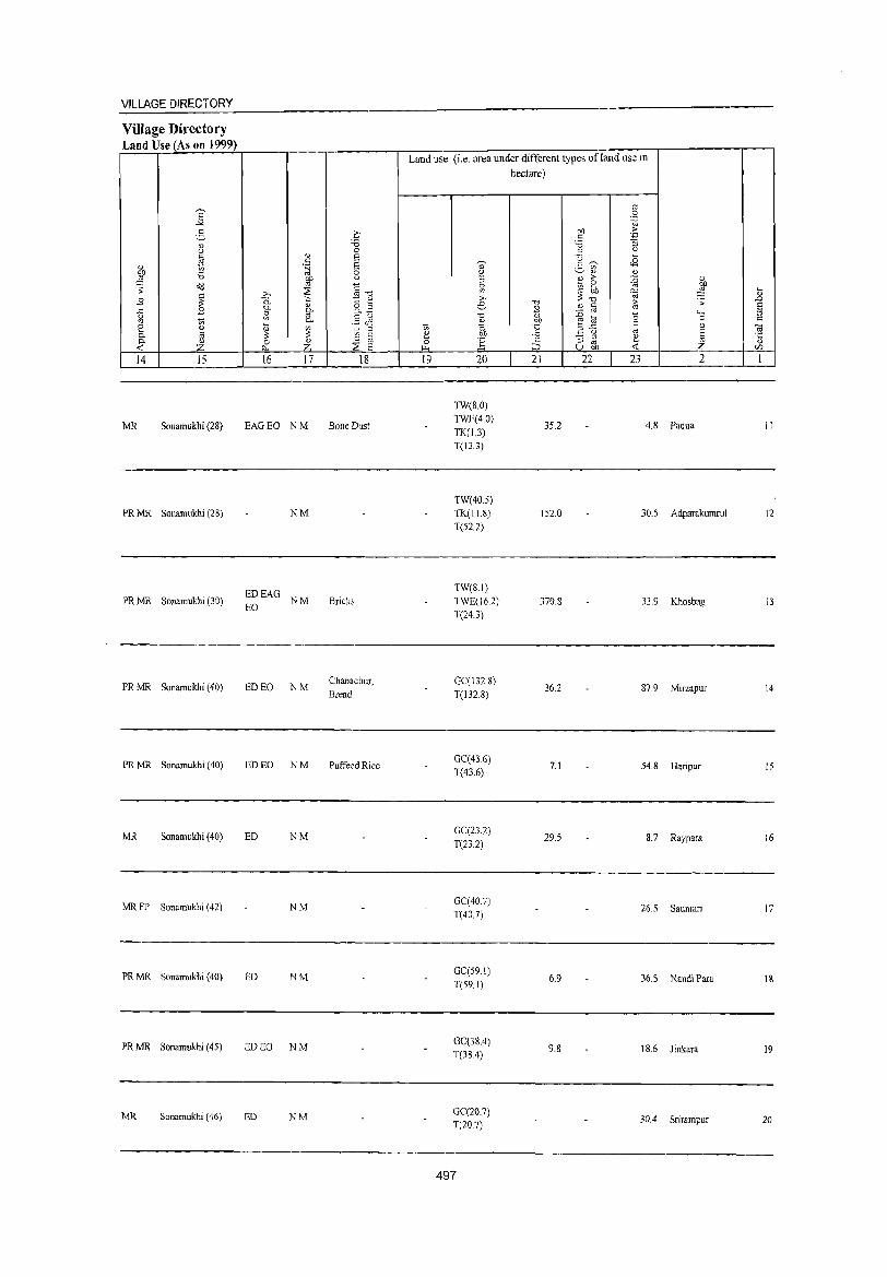
VILLAGE DIRECTORY
Village Directory Land Use (As on 1999)
E -""
S " u
" '" gj, 10 ,g 'i3
~ ;;: ~ .9
..r:; .8 g 10 2 ~ a.
~ " Z 14 15
MR Sonamukhi (28)
PRMR Sonamukhi (28)
PR MR Sonamukhi (30)
PR MR Sonamukhi (40)
PRMR Sonamukhi (40)
MR Sonamukhi (40)
MR FP Sonamukhi (42)
PR MR Sonamukhi (40)
PR MR Sonamukhi (45)
MR Sonamukhi (46)
" c .~
W >-, ~ is. C- " i;; g.
Po
~ '" if; a Z A..
16 17
EAGEO NM
NM
~~EAG NM
ED EO NM
ED EO NM
ED NM
NM
ED NM
ED EO NM
ED NM
.0 'i3 0 S S g iO «1"" t " 8.~ §<1'1 10 ::l
a @ ::s E
18
Bone Dust
Bricks
Chanachur, Bread
Puffeed Ri Ge
Land use (i.e. area under different types ofland use in hectare)
19 20
1W(8.0) TWE(4.0) TK(1.3) T(13.3)
TW(40.5)
TK(11.8)
T(52.2)
TW(S.I)
TWE(162) T(24.3)
GC(132.8) T(l32.8)
GC(416) T(43.6)
GC(23.2) T(23.2)
GC(40.7) T(40.7)
GC(59.1) T(59.1)
GC(38.4) T(38.4)
GC(20.7) T(20.7)
497
.",
2 m, t .;:: :J 21
35.2
152.0
370.8
36.2
7.1
29.5
6.9
9.8
c 0
'.g on ·E c
'i3 :; ::l u () ~ Jl S '" '" '" " >- :0 " "@ 0
" ~ bb ~ ;;: -0 1:; ;: " c
1 '" b "-< a 0 .<: c OJ u '" E :; ::l ~ '" ~ U on ..:
22 23 2
4.8 Padua
30.5 Adparakumrul
33.9 Khosbag
87.9 Mirzapur
54.8 Haripur
8.7 Raypara
26.5 Sauntari
36.5 Nandi Para
IS.6 Jinkara
30.4 Srirampur
~ .D E ::l c
"iii .t:: <>
<JJ
1
11
12
13
14
15
16
17
18
19
20
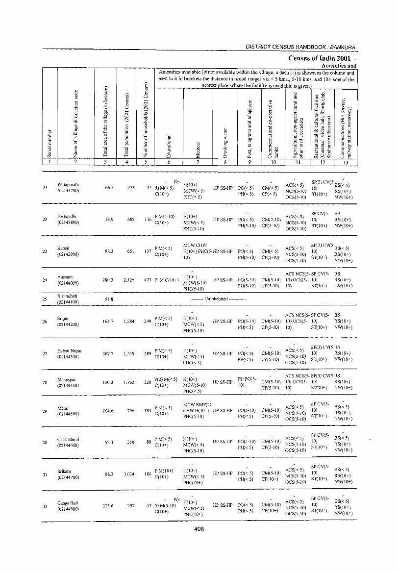
DISTRICT CENSUS HANDBOOK: BANKURA
Celllsus of India 2001 -Amenities and
Amenities available (if not available within the village, a dash (-) is shown in the column and
next to it in brackets the distance in broad ranges viz. < 5 lans., 5-10 lans. and 10+ kIns of the -, nearest place where the facility is available isg;iven ", ::>
i cr.'
Ul if " '" -0 -0
~ " § 0 U ,,- ,," " " '';: u <= ..c '" - " " ] ;.::: tI'} u <= 0 c ,.
.- 1:: E~ 0 g " 0 0 .~ Jg R .~ U ~, ..c
<l) i(;' Q..
" "3 u
~ 0 '" " 0. " -.;C/) ~ ~ 0
~ 0 -0 1i 0 .~ ~ li::::s ::s <l)
&d 'S: ~ ::2 -0 6 ~ .~ ""5] .2 ~~ <l) c u '" :s: " " <= '" OJ "0 a .~ <) C k
OJ .g . .g c " l .p 0 ::s ~ ..c c
~~ 5~ o c: ~ .~ 0
~ OJ ';:: 0 "-< ..c 1ii .- -0
to ~>~ '" ,-.D .s: 0 "3 ...... to :s: e .~~ '2 ~ ~ '" 0. 0 C OIl " '2 ::s "t. 9';;3"5 "-< ~ 0 k 0 to " '2 <IJ ,.!::! e:~ E i(;' 0
'" 0. <IJ .~ ::s '-' '\is E ::s " .D " :;; E '" .~ ~ b.S ~ ] § "Ii ~ E " '6 ,S: u;" ",-", E :s: ::s ::s " - " bl}....c: 0;':::: 0 -0 a 0 o '" "u ~ tZJ Z f-< f-< Z i-lI ::E 0.- U.n <CC P<:~C/) U e
I 2 3 4 5 6 7 8 9 !O II 12 13
Pratapmath - P« H(I~+) PO«5) CM«5)
ACS« 5) SP(2) CV(5 BS(~ 5) 21 66.3 275 55 5) M« 5) MCW« 5) HP SS-HP
NCS(5-1O) 10) RS(10+) (02143700) PH«5) CP«5) ST(IO+) NW(lO+) C(lO+) PHC« 5) OCS(5-1O)
ACS« 5) SPCV(5- BS
Belbandbi 53,9 683 116
PM(5-10) H(IO+) HP SS-HP PO« 5) CM(5-10) 10) RS(lO+) 22
MCW«S) NCS(S-IO) (02143800) C(IO+) PH(5-1O) CP(5-1O) ST(lO+) NW(IO+)
PHC(S-IO) OCS(5-10)
PM«5) MCWCHW
ACS« 5) SP(2) CV(5 BS(~ 5) 23
Kapsit 88,2 6S1 137 H(lO+) PHC(S- HP SS-HP PO«5) CM«S) 10) RS(IO+) (02143900) C(lO+)
10) PH(5-1O) CP(5-10) NCS(5-to)
ST(lO+) NW(10+) OCS(5-1O)
ACS NCS(5- SP CV(5- BS Ausnara
280.3 2,126 427 P M C(IO+) H(IO+)
HP SS-HP PO(5-10) CM(5-IO) 10) OCS(S- 10) RS(lO+) 24 MCW(S-IO) (02144000)
PH(S-IO) CP(S-IO) 10) ST(IO+) NW(IO+) PHC(S-IO)
25 Bishnubati
58.8 -------- Uninhabited ------------(02144100)
ACS NCS(S- SP CV(S- BS Sripur
165.7 1,284 249 PM«5) H(IO+)
HPSS-HP PO(5-10) CM(5-10) 10) OCS(5- 10) RS(IO+) 26 (02144200) C(!O+) MCW«5)
PH« 5) CP(5-10) 10) ST(IO+) NW(lO+) PHCC5-10)
ACS« 5) SP(3) CV(5 BS
Haiyat Nagar PM« 5) H(lO+) HP SS-HP PO«5) CM(5-10) 10) RS(JO+) 27 367.7 1,519 289
NCS(5-10) (02144300) C(lO+) MCW«5) PH« 5) CP(5-10) ST(10+) NW(IO+)
PHC«5) OCS(5-10)
PHPO(5-ACS NCS(5·· SP(3) CV(5 BS
Mahespur 320
P(2) M« 5) H(10+) lIP SS-HP CM(5-IO) 10) OCS(5- 10) RS(IO+) 28 150.3 1,762
MCW(5-1O) 10) (02144400) C(IO+) CP(S-IO) 10) ST(IO+) NW(IO+) PHC« 5)
MCWRMP(2) ACS« 5)
SP CV(5-BS«5) Meral PM«5) PO(5-10) CM(5-10) 10) 29 164.6 706 133 CHWH(IO+) HP SS-HP NCS(S-IO) RS(IO+) (02144500) C(l 0+)
PHC(S-IO) PH«S) CP(5-10) ST(IO+) NW(JO+) OCS(5-IO)
ACS«5) SPCV(S-
8S« 5) ChakMeral PM«5) H(IO+) CM(5-10) 10) 30 52.3 358 80 MCW«S)
HP SS-HP PO(5-10) NCS(S-IO) RS(lO+) (02144600) C(IO+)
PH« 5) CP(5-10) ST(IO+) NW(IO+) PHC(S-IO) OCS(5-IO)
ACS«5) SP CV(5-
BS«5) Srikara 68.3 1,034 184
PM(IO+) H(IO+) HPSS-HP PO«5) CM(5-1O) 10)
RS(IO+) 31 (02144700) C(lO+) MCW«5) NCS(5-1O) ST(IO+)
PHC(lO+) PH«5) CP(IO+)
OCS(5-1O) NW(IO+)
- P« H(I~+) ACS«5) SP CV(S-
BS« 5) 32
Ganga Bati 125.6 297 57 5) M(5-1O) MCW« 5) HP SS-HP PO« 5) CM(5-10)
NCS(5-1O) 10)
RS(JO+) (02144800) C(lO+) PHCCIO+) PH«5) CP(IO+)
OCS(S-IO) ST(lO+)
NW(IO+)
498
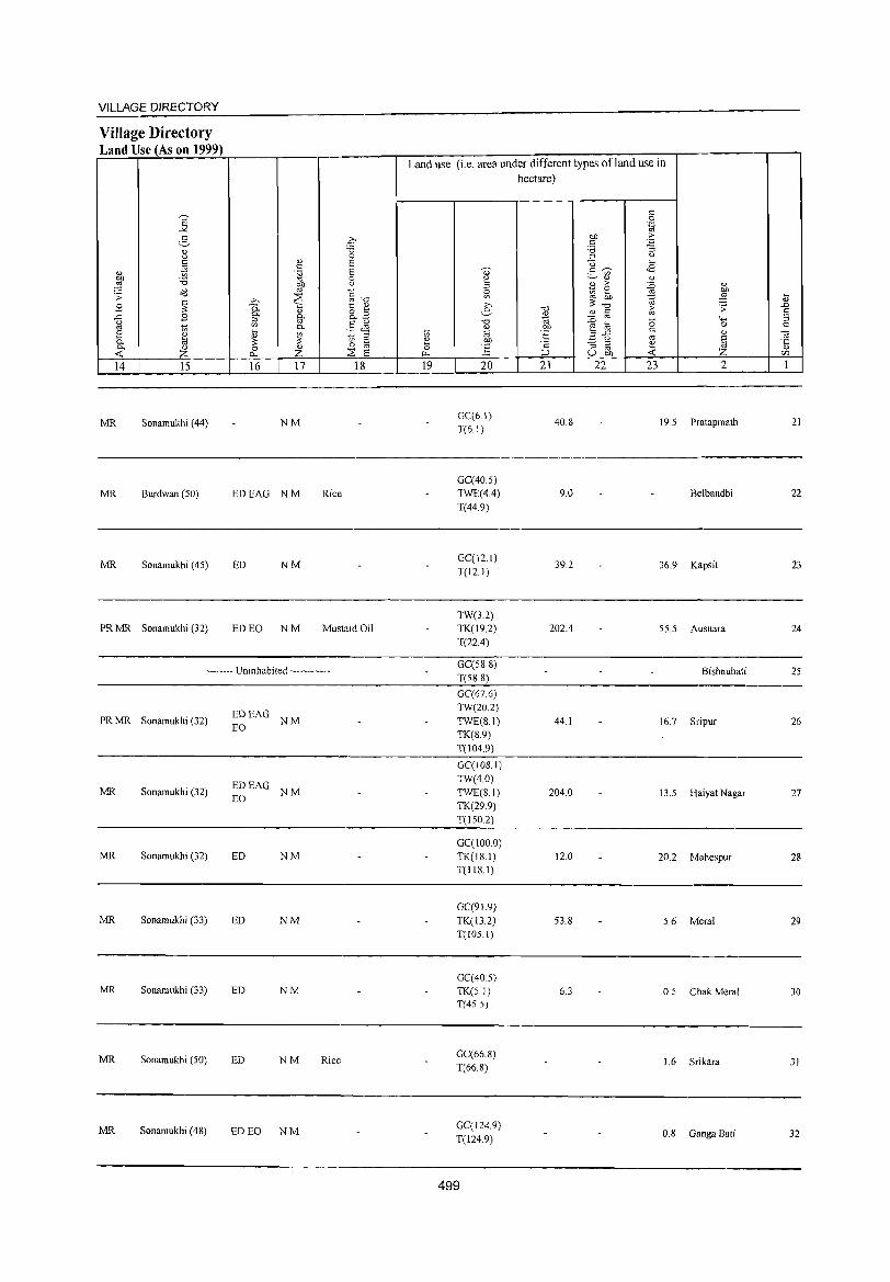
VILLAGE DIRECTORY
Village Directory Land Use (As on 1999)
14 15
MR Sonamukhi (44)
MR Burdwan (50)
MR Sonamukhi (45)
PR MR Sonamukhi (32)
16 17 18
NM
EDEAG NM Rice
ED NM
ED EO NM Mustard Oil
-------- Uninhabited ------------
PR MR Sonamukhi (32) ~~EAG NM
MR Sonamukhi (32) ~~EAG NM
MR Sonamukhi (32) ED NM
MR Sonamukhi (33) ED NM
MR Sonamukhi (33) ED NM
MR Sonamukhi (50) ED NM Rice
MR Sonamukhi (4S) ED EO NM
Land use (i.e. area under different types of land use in hectare)
19 20
GC(6.1)
T(6.1)
GC(40.5) TWE(4.4) T(44.9)
GC(12.1) T(12.1)
TW(3.2) TK(19.2) T(22.4)
GC(588) T(5S.8)
GC(67.6) TW(20.2) TWE(8.1) TK(S.9) T(104.9)
GC(IOS.I) TW(40) TWE(S.I) TK(29.9) T(150.2)
GC(100.0) TK(IS.I) T(1JS.l)
GC(91.9) TK(13.2) T(IOS.I)
GC(40.S)
TK(S.I) T(4S 5)
GC(66.8) T(66.S)
GC(124.9) T(124.9)
499
21
40.S
9.0
39.2
202.4
44.1
204.0
12.0
53.8
6.3
22 23 2
19.5 Pratapmath
Belbandbi
36.9 Kapsit
55.5 Ausnara
Bishnubati
16.7 Sripur
13.5 Haiyat Nagar
20.2 Mahespur
5.6 Meral
0.5 Chak Meral
1.6 Srikara
0.8 Ganga Bati
21
22
23
24
25
26
27
28
29
30
31
32
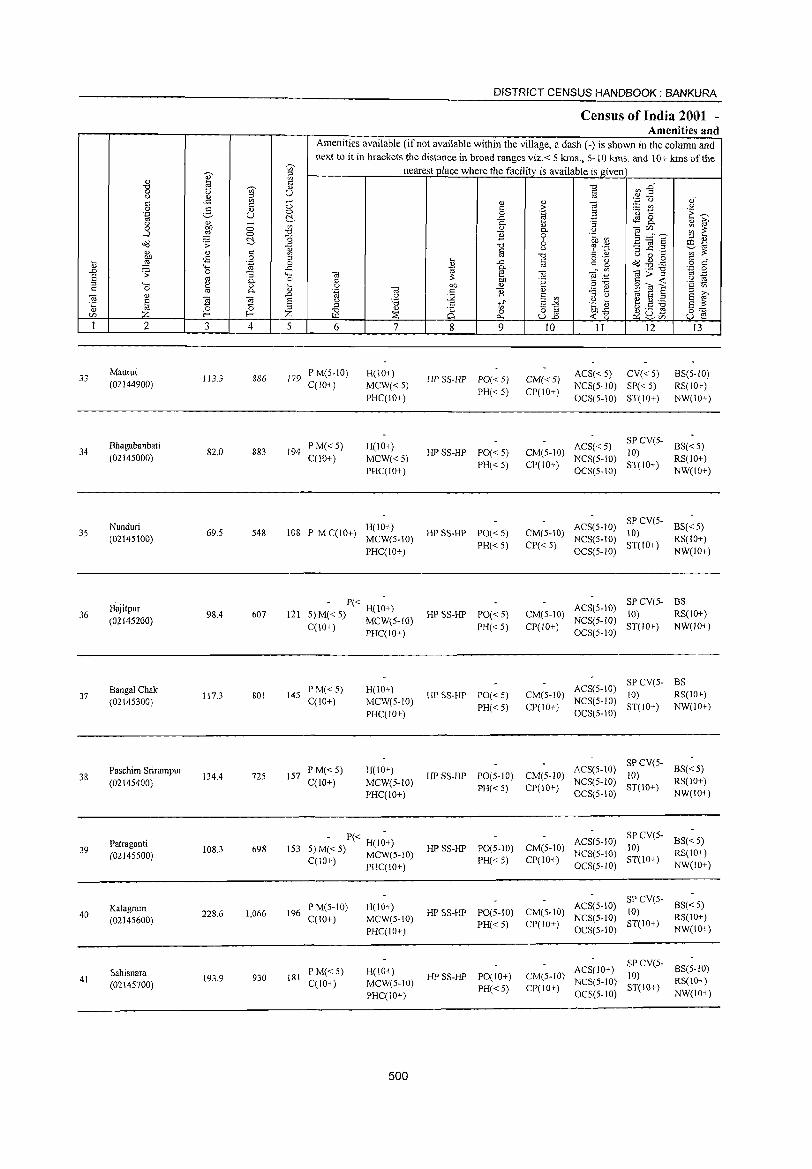
33
34
35
36
37
38
39
40
41
2
Maurui (02144900)
Bhagabanbati (02145000)
Nunduri (02145100)
Bajitpur (02145200)
Bangal Chak (02145300)
Paschim Srirampur (02145400)
Patraganti (02145500)
Kalagram (02145600)
Sahisnara (02145700)
3 4
113.3 886
82.0 883
69.5 548
98.4 607
117.3 801
134.4 725
108.3 698
228.6 1,066
193.9 930
DISTRICT CENSUS HANDBOOK: BANKURA
Census of India 2001 -Amenities and
Amenities available (if not available within the village, a dash (-) is shown in the column and next to it in brackets the distance in broad ranges viz.< 5 kms., 5-W kms. and 10+ kms of the
nearest place where the facili!y_ is available is given
5 6
17'9 P M(5-10) C(1O+)
194 PM« 5) C(10+)
7
H(IO+)
MCW« 5)
PHC(IO+)
H(lO+)
MCW«5)
PHC(IO+)
H(10+) 108 P M C(10+) MCW(S-IO)
PHC(lO+)
- P« H(I~+) 121 5) M« 5) MCW(5-10)
C(10+) PHC(IO+)
145 P M« 5) C(10+)
157 PM«5) C(lO+)
H(lO+)
MeW(5-to)
PHC(IO+)
H(IO+)
MCW(5-10)
PHC(IO+)
- P« H(1~+) 153 5) M« 5) MCW(5-10)
C(IO+) PHC(IO+)
196 P M(5-10) C(lO+)
181 P M« 5) C(lO+)
H(10+)
MCW(5-IO)
PHC(IO+)
H(IO+)
MCW(5-10)
PHC(10+)
500
8 9
HP SS-& PO« 5) PH«5)
HP SS-HP PO« 5)
PH« 5)
HP SS-HP PO« 5)
PH«5)
HP SS-HP PO« 5)
PH«5)
lIP SS-HP PO« 5)
PH«5)
HP SS-HP PO(5-to)
PH« 5)
10 11 12 13
CM« 5) CP(IO+)
ACS« 5) CV« 5)
NCS(5-10) SP« 5)
OCS(5-10) ST(IO+)
BS(5-10)
RS(IO+)
NW(IO+)
ACS« 5) CM(S-IO) NCS(5-IO)
CP(10+) OCS(5-1O)
CM(S-IO) ACS(S-IO) NCS(5-10)
CP« 5) OCS(5-10)
SP eV(s- BS« 5) 10) ST(IO+) RS(IO+)
NW(lO+)
SP CV(S- BS« 5) 10) ST(to+) RS(IO+)
NW(to+)
CM(5-10)
CP(IO+)
SPCV(5- BS ACS(5-IO) 10) RS(IO+)
NCS(5-1O) ST(lO+) NW(IO+) OCS(5-10)
CM(S-IO) CP(lO+)
SP CV(5- BS ACS(5-10) 10) RS(lO+)
NCS(5-10) ST(IO+) NW(10+) OCS(5-10)
CM(5-10) ACS(5-lO)
CP(lO+) NCS(5-1O) OCS(5-10)
SP CV(5- BS« 5)
10) RS(IO+) ST(JO+) NW(IO+)
HP SS-HP PO(5-10) CM(5-IO) ACS(5-10) PH( 5) CP(IO+) NCS(5-10)
SP CV(S- BS« 5)
10) RS(IO+)
< OCS(5-1O)
HP SS-HP PO(5-10) CM(5-IO) ACS(5-10) NCS(5-JO)
PH«5) CP(IO+) OCS(5-10)
ST(10+) NW(IO+)
SP CV(5- 8S« 5)
(0) RS(lO+) ST(JO+) NW(IO+)
& SS-HP POe I 0+)
PH«5)
CM(5-IO) CP(IO+)
s ) SP CV(5- BS(5-10) AC (10+ JO) NCS(5-10) ST(IO+) RS(IO+) OC5(5-10) NW(IO+)
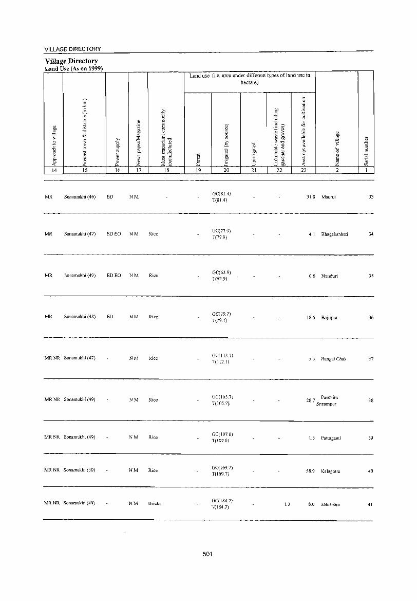
VILLAGE DIRECTORY
Village Directory Land Use (As on 1999)
14 15
MR Sonamukhi (46)
MR Sonamukhi (47)
MR Sonamukhi (49)
MR Sonamukhi (48)
MR NR Sonamukhi (47)
MR NR Sonamukhi (49)
MR NR Sonamukhi (49)
MR NR Sonamukhi (50)
MR NR Sonamukhi (49)
16 17 18
ED NM
ED EO NM Rice
ED EO NM Rice
ED NM Rice
NM Rice
NM Rice
NM RiCE:
NM Rice
NM Bricks
Land use (i.e. area under different types of land use in hectare)
10 ~ 0 ~
19
d)' ~ ::l 0 Ul ;>,
e .",
" ~ OJ)
J§ 20
GC(BL4) T(SL4)
GC(779) T(779)
GC(62.9) T(62.9)
GC(79.7) T(79.7)
GC(II2.I) T(II2I)
GC(I05.7) T(105.7)
GC{107.0) T(107.0)
GC(l69.7) T(l69.7)
GC(184.7) T(I847)
501
.",
" ~ .SP .~ ;:J
21
en c ~
::> -0 2- -;;;-
<U
~ ;> e OJ) ;; .",
" <:: ::c: '" ,_ e '" .2 .c
0 :; ::l
u '" en 22
1.3
t: 0 .~
·E :; (J ,_
<8 " ::c: " ~ ~ 0 t:
'" ~ 23
<1) en
::§ .:;
"" 0
" E ~ 2
31.8 Maurui
4.1 Bhagabanbati
6.6 Nunduri
1 8.6 Bajitpur
5.3 Bangal Chak
28.7 Paschim Snrampur
L 3 Patraganti
58.9 Kalagram
8.0 Sahisnara
,_
" ~ S § 0;
'5 c/j
1
33
34
35
36
37
38
39
40
41
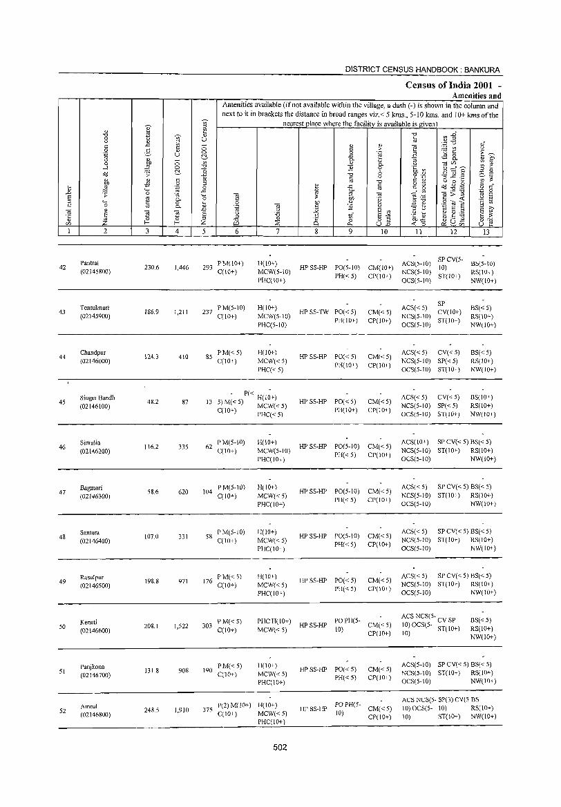
DISTRICT CENSUS HJ\NDBOOK : BANKURA
Census of India 2001 -Amenities and
Amenities available (if not available within the village, a dash (-) is shown in the column and next to it in brackets the distance in broad ranges viz.< 5 kms., 5-10 kms. and 10+ kms of the
~
-;;;- nearest place where the facility is available is given " " '" '" a c:; ~ j~ "d t) -;;;- 'U -0
0 U § <J " ~ t: ..c - '" " ""§
'.;j <) ,f c:; 0 >- ~ t ()
0 g '" c:;
.~ U 0 0 .~ ;:) E~ ~ ..c tS 8-
<J '" - 0- 0) -= " g 0 Of) 0 '" " 0- <J ~ ~nE ~ i': ...l ::§ 0 -0 ] 0 .~ ~ 2!. "0 6 " \I) o<:! .s: .<: -0 u ~ '';: -5 _g .a Ee-ta " " c:; 1;l 0:
0: " '" :;: oj -0 u 0 ....
1 f:i 0 ::l .... C 0'-
Qd .g . .@ § cf ... .~ 0 0) .<: ~n ~ " 4-< ..0: " 0- oj
to:;-g '.g ,9 .D .;;: 0 "3 '- to ~ to a oj 0- 0 0: :;:
.~ E .~ 0: --< () to
" ..... '" 0 .... 0 b.O '" ,,-0
~OlE '§ ~ 0: 0 la to - " 0- (i) .~ 0: ] '"3 b to " ] ~
.D u :Q S '" " a " S g '5 ~ § U ;a 0: ..J' S-'" .~ ~ ~ Ill·_ S :;:
~ " (i)
i§ ~ o § 8,£ g8"N I-< z -0 ::E 8~ C/) "" 0- U.D --< 0 ~ ~C/)
1 2 3 4 5 6 7 8 9 10 11 12 13
Pantrai PM(lO+) H(IO+) ACS(5-IO) SPCV(5-
BS(5-10) 42 230.6 1,446 293 HP SS-HP PO(5-10) CM(IO+) 10)
(02145800) C(10+) MCW(5-10) NCS(5-10) RS(10+) PHC(10+)
PH« 5) CP(IO+) OCS(5-10)
ST(IO+) NW(lO+)
Tentulmuri PM(5-10) H(10+) ACS« 5) SP
8S« 5) 43 186.9 1,211 237 HPSS-TW PO«5) CM«5) CV(IO+)
(02145900) C(10+) MCW(5-10) PH(IO+) C1'(IO+)
NCS(5-10) ST(10+)
RS(IO+) 1'HC(5-10) OCS(5-10) NW(IO+)
44 Chandpur
124.3 410 85 PM«5) H(lO+)
HP SS-HP PO«5) CM«5) ACS« 5) CV« 5) 8S« 5)
(02146000) C(10+) MCW«5) PH(10+) CP(IO+)
NCS(5-10) S1'« 5) RS(IO+)
1'HC« 5) OCS(5-1O) ST(IO+) NW(10+)
45 Singer Bandh
48.2 87 13 - 1'« H(I;+)
HP SS-HP PO« 5) CM«5) ACS« 5) CV«5) BS(10+)
(02146100) 5)M«5) MCW«5) 1'H(IO+) C1'(10+)
NCS(5-10) S1'« 5) RS(IO+) C(10+) PHC« 5) OCS(5-10) ST(lO+) NW(10+)
46 Simulia
116.2 335 62 1'M(5-10) H(10+)
HPSS-HP 1'0(5-10) CM«5) ACS(IO+) S1' CV« 5) 8S« 5)
(02146200) C(10+) MCW(5-10) 1'H«5) C1'(10+)
NCS(5-10) ST(10+) RS(10+)
PHC(10+) OCS(5-10) NW(IO+)
47 Bagmari
58.6 620 104 1'M(5-1O) H(10+)
HPSS·HP 1'0(5-10) CM«5) ACS« 5) S1' CV« 5) BS« 5)
(02146300) C(1O+) MCW{< 5) NCS(5-10) ST(IO+) RS(10+)
1'HC(10+) PH« 5) C1'(IO+)
OC5(5-10) NW(lO+)
48 Santara
107.0 331 58 PM(5-1O) H(lO+)
HP SS-HP 1'0(5-10) CM«5) ACS« 5) SP CV« 5) BS« 5)
(02146400) C(10+) MCW«5) PH« 5) CP(IO+)
NCS(5-1O) ST(IO+) RS(IO+)
PHC(IO+) OCS(5-10) NW(IO+)
49 Rasulpur
198.8 971 176 PM« 5) H(10+)
H1' SS-HP 1'0«5) CM«5) ACS«5) SP CV« 5) BS« 5)
(02146500) C(JO+) MCW«5) PH«5) CP(lO+)
NCS(5-10) ST(lO+) RS(IO+)
PHC(IO+) OCS(5-IO) NW(IO+)
Keneti PM«5) PHCH(10+) POPH(5- ACS NCS(5- CV SP BS«5) 50 208.1 1,522 303 HPSS-HP CM«5) 10) OCS(5. ST(IO+)
(02146600) C(10+) MCW«5) 10) RS(10+) CP(IO+) 10)
NW(IO+)
Panjkona 131.8 908 190
PM«5) H(10+) HP SS-HP 1'0« 5) CM«5)
ACS(5-10) SP CV« 5) BS« 5) 51
(02146700) C(10+) MCW«5) NeS(5-10) ST(lO+) RS(IO+)
PHC(IO+) PH«5) C1'(IO+)
OCS(5-10) NW(\O+)
P(2)M(!O+) H(IO+) PO PH(5-ACS NCS(5- SP(3) CV(S BS
Amrul 248.5 1,910 375 HPSS-HP CM«5) 10) OCS(S- 10) RS(10+) 52 C(10+) MCW«5) 10) (02146800) CP(IO+) 10) ST(10+) NW(IO+)
1'HC(IO+)
502
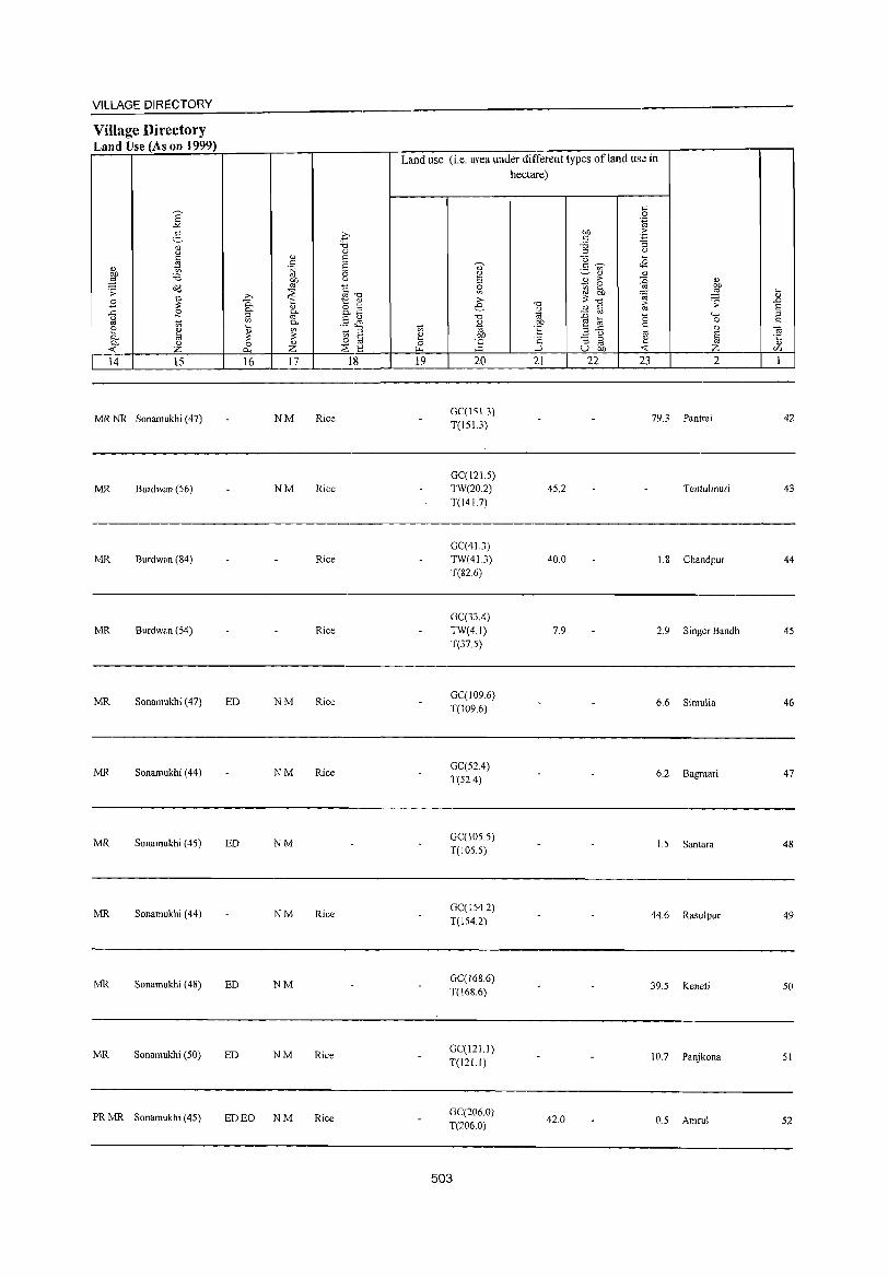
VILLAGE DIRECTORY
Village Directory Land Use (As on 1999)
MR NR Sonamukhi (47)
MR Burdwan (S6)
MR Burdwan (84)
MR Burdwan (54)
MR Sonamukhi (47)
MR Sonamukhi (44)
MR Sonamukhi (4S)
MR Sonamukhi (44)
MR Sonamukhi (48)
MR Sonamukhi (50)
PRMR Sonamukhi (45)
NM Rice
NM Rice
Rice
Rice
ED NM Rice
NM Rice
ED NM
NM Rice
ED NM
ED NM Rice
ED EO NM Rice
Land use (i.e. area under different types ofland use in hectare)
GC(lS1.3) T(lS1.3)
GC(121.5) TW(20.2) T(I41.7)
GC(41.3) TW(41.3) T(82.6)
GC(33.4) TW(4.1) T(37.5)
GC(109.6) T(109.6)
GC(52.4) T(S2.4)
GC(105.5) T(IOS.S)
GC(I542) T(154.2)
GC(168.6) T(168.6)
GC(121.1) T(121.1)
GC(206.0) T(206.0)
503
4S.2
40.0
7.9
42.0
79.3 Pantrai
Tentulmuri
L8 Chandpur
2.9 Singer Bandh
6.6 Simulia
6.2 Bagmari
1.5 Santara
44.6 Rasulpur
39.5 Keneti
10.7 Panjkona
0.5 Amru!
42
43
44
45
46
47
48
49
50
51
52
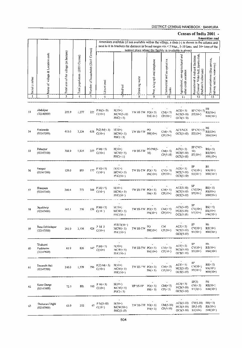
53
54
55
56
57
58
59
60
61
62
63
2
Abdulpur (02146900)
Karisunda (02147000)
Pabarpur (02147100)
Fatepur (02147200)
Shanpura (02147300)
Jagaldwip (02147400)
Bara Gobindapur (02147500)
Thakumi Pushkarini (02147600)
Dasaralh Bali (02147700)
KararDanga (02147800)
Thakurani Digbi (02147900)
3 4
205.9 1,277
415.0 3,224
306.9 1,824
129.0 893
300.4 771
145.1 776
261.0 2,156
83.9 826
240.0 1,579
72.5 881
63.9 252
DISTRICT CENSUS HANDBOOK: BANKURA
Ctmsus of India 2001 -Amenities and
Amenities available (if not available within the village, a dash (-) is shown in the column and next to it in brackets the distance in broad ranges viz. < 5 kms., 5-10 krns. and 10+ krns of the
nearest place where the facility is available is given
6
225 P M(5-10) C(1O+)
7
H(10+)
MCW(S-IO)
PHC«5)
658 P(2) M« 5) H(IO+) C(IO+) MCW« 5)
PHC«5)
357 PM«5) C(10+)
157 PM«5) C(lO+)
144 P M« 5) C(10+)
156 PM«5) C(10+)
428 PM 5 C(10+)
147 P M« 5) C(lO+)
H(10+)
MCW«5)
PHC«5)
H(IO+)
MCW«5) PHC(IO+)
H(10+)
MCW«5) PHC(10+)
H(IO+)
MCW«5) PHC(lO+)
PHS H(lO+)
MCW«5) PHC(IO+)
H(IO+)
MCW«5) PHC(IO+)
296 P(2) M« 5) H(IO+) C(lO+) MCW« 5)
PHC(10+)
165 P M«5) C(10+)
47 PM(5-10) C(1O+)
H(IO+)
MCW«5)
PHC«5)
H(IO+)
MCW(lO+) PHC(5-1O)
504
8
'" o 0..
9
TW SS-TW PO« 5) PH(JOI)
PO TW SS-TW PH(lO+)
10
CM«5) CP(IO+)
CM«5) CP(lO+)
11 12 13
BS ACS« 5) SP CV« 5) RS(lO+) NCS(S-IO) ST(10+) NW(10+) OCS(5-10)
BS ACS NCS SP CV« 5) RS(IO+) OCS(5-10) ST(IO+) NW(lO+)
TW SS-TW PO PH(5- CM« 5) ACS« 5) 10) CP(5-IO) NCS(5-IO)
SP CV(5- BS« 5) 10) ST(l0l) RS(IO+)
TW SS-TW PO« 5) PH(IO+)
TW SS-TW PO« 5)
PH«5)
TW SS-TW PO« 5) PH(10+)
PO TW SS-TW PH(IO+)
TW SS-TW POe < 5) PH(IO+)
TW SS-TW PO« 5) PH« 5)
HP SS-HP PO« 5) PH« 5)
TW SS-TW PO« 5) PH« 5)
CM«5) CP(IO+)
CM« 5) CP(10+)
CM« 5) CP(ta+)
CM
CP(IO+}
CM« 5) CP(IO+)
CM« 5) CP(IO+)
CM« 5) CP« 5)
OCS(5-1O)
SP ACS« 5) NCS(5-1O) CV(IO+)
OCS(5-10) ST(IO+)
SP ACS(5-1O) CV(lO+)
NCS(5-1O) ST(IO+) OCS(5-10)
SP ACS(5-10) CV(IO+)
NCS(5-10) ST(lO+) OCS(5-1O)
SP ACS«5) NCS(5-10) CV(IO+)
ST(IO+) OCS(5-10)
SP ACS« 5) NCS(5-10) CV(IO+)
OCS(5-10) ST(W+)
SP ACS« 5) NCS(5-10) CV(IO+) OCS(5-10) ST(IO+}
SP(3) ACS« 5) CV« 5) NCS(5-10) ST(lO+) OCS(5-10)
NW(IO+)
BS RS(IO+) NW(IO+)
BS« 5) RS(lO+) NW(10+)
BS« 5) RS(lO+) NW(IO+)
BS RS(lO+} NW(IO+)
BS RS(IO+) NW(IO+)
B5« 5) RS(IO+) NW(IO+)
BS RS(IO+)
NW(lO+)
ACS(5-10) eV(5-IO) BS« 5) CM(5-1O) NCS(5-10) SP(5-JO) RS(IO+) CP(5-to) OCS(5-10) ST(IO+) NW(lO+)
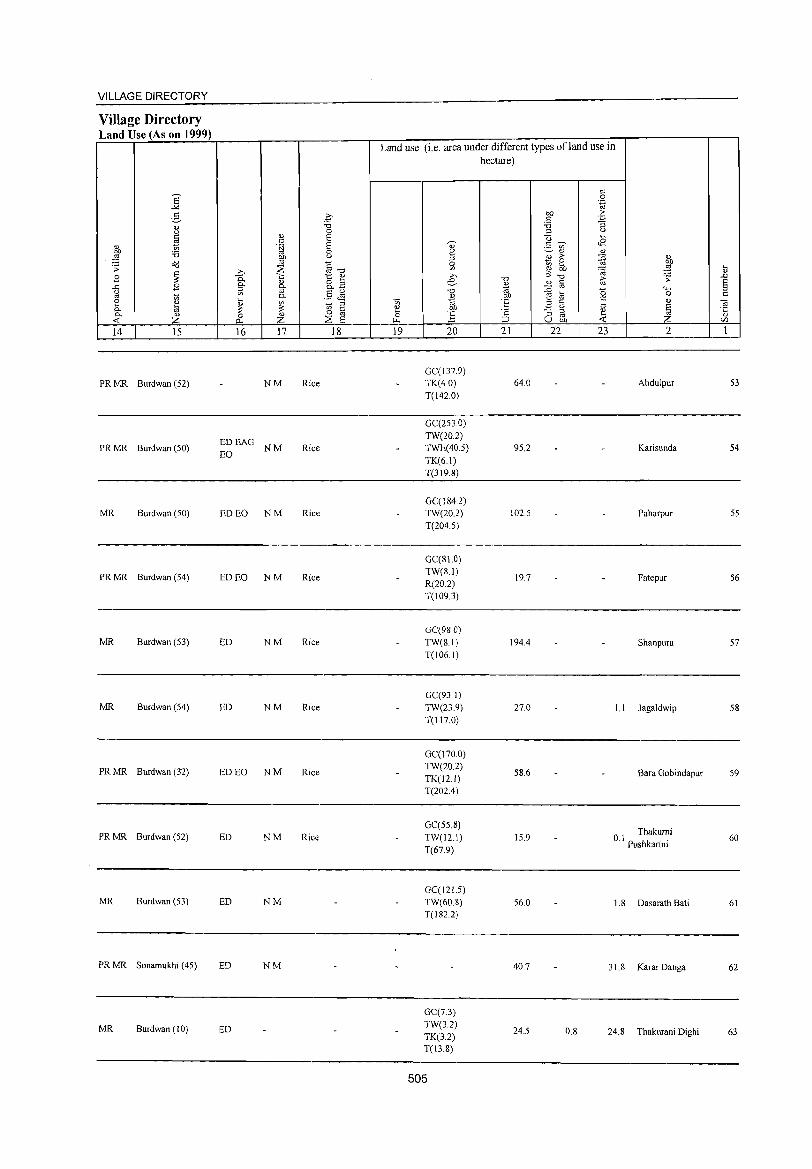
VILLAGE DIRECTORY
Village Directory Land U se (A son 1999)
Land use (i.e. area under different types ofland use in hectare)
'" E 0
..>< .~
E- .£ Ol) .:: '" '3 0) "0 :a
u 0 '" u
~ 0) E Q .... '" E 0) .=: ~ <B
" fJ "" :a 0 v ~ " " ,§ ~ u !oj '" ;> z " ~ 0
~ Cd §'"d 0 ((l .... -"! '"' 'r; ~ ~
VJ :;;: '0; 0)
.8 ~ t " '" '0 :;; 'r; ..c
" o ... e '" '" E 0- 0.£ " ..c .8 0.
~ - '" "" '" '" "0 ~ a (5 " if> '" .§ <i'1 0 c:: " t'i 0. " '" '" §. ~ i3 ~ ~ '" t'i 'til E ",..c:
'" E til :;; '" c:: ~ OJ) ~ u ·c ';:, - ::I !!. 0- <\) 0 " o '" ] ::I oj -2 " < z p.. z ~ E "" ::J U OJ) < C/l
14 15 16 17 18 19 20 21 22 23 2 1
GC(137.9) PRMR Burdwan (52) NM Rice TK(40) 64.0 Abdulpur 53
T(l42.0)
GC{253.0)
EDEAG TW(20.2)
PRMR Burdwan (50) NM Rice TWE(40.5) 95.2 Karisunda 54 EO
TK(6.1) T(319.8)
GC(l84.2) MR Burdwan (50) ED EO NM Rice TW(20.2) 102.5 Paharpur 55
T(204.5)
GC(SI.O)
PRMR Burdwan (54) ED EO NM Rice TW(8.1)
19.7 Fatepur 56 R(20.2) T(109.3)
GC(98.0) MR Burdwan (53) ED NM Rice TW(81) 194.4 Shanpura 57
T(1061)
GC(93.1) MR Burdwan (54) ED NM Rice TW(23.9) 270 U Jagaldwip 58
T(ll7.0)
GC(170.0)
PRMR Burdwan (32) ED EO NM Rice TW(20.2)
58.6 Bara Gobindapur 59 TK(12.1) T(202.4)
GC(558) Thakumi PRMR Burdwan (52) ED NM Rice: TW(12.1) 15.9 0.1 Pushkarini 60
T(67.9)
GC(12U) MR Burdwan (53) ED NM TW(60.8) 56.0 1.8 Dasarath Bati 61
T(182.2)
PRMR Sonamukhi (45) ED NM 40.7 31.8 KararDanga 62
GC(7.3)
MR Burdwan (10) ED TW(3.2) 24.5 0.8 24.8 Thakurani Dighi 63 TK(3.2)
T(13.S)
505
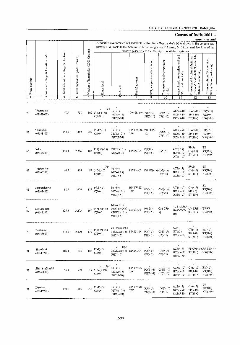
DISTRICT CENSUS HANDBOOK: BANKURA
Census of India 2001 -Amenities and
Amenities available (if not available within the village, a dash (-) is shown in the column and
next to it in brackets the distance in broad ranges viz.< 5 kms., 5-10 kms. and 10+ kms of the r'
nearest place where the facility is available is given '0 e "
'" " .;:; " -0 ~ ..g" -0 ., a u '" (..) " u '" :;; '" <=: ..c '" '" ]
'Jj 'U "," <=: c' " i
:.= (f.l u 0 ~ '" C> 0 '0 t: '/: ~ '.g U C:~ ..c r.S 8-(.) '" - "'- "3 '" ~ 0 ~ C> ", '" P- C) ca'" ~ 2: ..-l 0 -0' ]i 0 .~ ~ ~....:~
(:!. "0 6 " " cl1:l .;;: ..c ] l'f ',w .=:]§ ~td <=: 1A
C) :;:l ._
'" ::::
~ '" -0 C OJ U 0 a ;S 0 ;;;l o 'f:) <=: " .... '{i _g t ..c §
" Q ~ .g .~ o <=:
'" """ ., §" '..0 0 .D 0 " <n ._ -0 .;;: "3 <.- ca ~ e .-t: §>~ '" ._
E OJ g- o <=: :: OIl 'a ~ " """ " .... 0 01J " 2 .E~ Sl'?!e <=: 0 16 "'- " .~ ro t: ]i " ,. E " '" ca " .D u j2 E '" " " E ~ ~ ~
ca S u :;:; '£l? ~ ~ :.6 ·c '0 " c en E"'" g"" '"
:s -0 " 8 o § u ._ g f- Z ~
0 en "" A.. U.D «: C) ~uen u e:! 1 2 3 4 5 6 7 8 9 10 11 12 13
Dharmapur - P« -
ACS(5-IO) CV(5-IO) BS(5-IO) 64 80.4 551 109 5) M(5-10) H(10+) TW SS-TW PO« 5) CM(5-10) (02148000) MCW« 5) NCS(5-IO) SP(S-IO) RS(lO+)
C(10+) PHC(S-IO) PH(S-lO) CP(S-IO) OCS(5-IO) ST(IO+) NW(1O+)
65 Charigram
342.6 1,494 289 P M(5-10) H(IO+) HP TW SS- PO PH(5-
CM(5-10) ACS(5-1O) CV(S-IO) BS«S)
(02148100) C(10+) MCW(lO+) TW 10) CP(S-IO)
NCS(5-1O) SP(5-1O) RS(IO+)
PHC(5-10) OCS(5-IO) ST(lO+) NW(10+)
Indus P(2)M«5) PHCH(IO+) PH(IO) ACS«5) SpeS) BS
66 190.4 2,306 482 HPSS-HP CMCP CV«5) RS(IO+) (02148200) C(10+) MCW(5-1O) PO« 5) NCS(5-10)
ST(lO+) NW(lO+) OCS(5-10)
Krishna Bati - P« H(I~+) ACS« 5) SP(2) BS
67 (02148300)
66.7 408 89 5) M« 5) MCW« 5) HP SS-HP PH PO« 5) CM« 5) NCS(5-tO)
CV« 5) RS(lO+)
C(lO+) PHC« S) CP« S) OCS(5-10)
ST(lO+) NW(IO+)
H(IO+) HP TW SS- PO(~ 5) ACS(5-10) CV« 5) BS
68 Baikuntha Pur
91.7 909 179 PM«5)
CM«5) RS(IO+) (02148400) C(10+) MCW(lO+) TW PH«S) CP«S)
NCS(5-10) SP«S) NW(IO+)
PHC«5) OCS(5-10) ST(IO+)
MCWPHS ACS NCS(5- CV SP(8)
Dibakar Bati iP(3)M«5) FWCRMP(5) HPSS-HP
PH(2S) CM CP« BSRS 69
(02148500) 322.5 2,223 460
C(10+) CHWH(IO+) PO«5) S) 10) OCS(S- ST(lO+) NW(IO+)
PHC« S) 10)
P(2)M«5) DHCHWH« ACS
CV«5) BS« 5) 70
Birshimul 417.8 2,500 479 5) MCW«5) HP SS-HP PO« 5) CM«5) NCS(2)
(02148600) C(lO+) PHC«S) PH«5) CP« 5) OCS(5-10)
SP(S-IO) RS(IO+)
ST(lO+) NW(lO+)
Shankhru! PM«5) H« ACS« S) SP CV« 5) RS BS« 5)
71 186.1 1,046 185 C(10+)
5) MCW«5) HPSS-HP PO« S) CM«S) NCS(5-10) ST(IO+) NW(IO+) (02148700)
PHC«5) PH« 5) CP« 5) OeS(5-1O)
Shuri Pushkarini 130
- P« H(I;+) HPTWSS-PO(S.10) CM(5-tO)
ACS(5-1O) eV(S-IO) BS« 5) 72 S6.7 19 5) M(5-IO) MCW« S) TW NCS(5-1O) SP(5-1O) RS(IO+) (02148800) PH(S-IO) CP(5-10) C(lO+) PHC(5-10) OCS(5-10) ST(IO+) NW(IO+)
ACS« 5) CV« 5) BS
Dhamur P M« 5) H(tO+) HPTWSS-PO«5) CM(5-10) RS(lO+) 73 190.0 1,306 248
MCW(10+) TW NCS(5-10) SP(5-10) (02148900) C(lO+) PH(5-tO) CP(S-IO) NW(lO+) PHC(5-lO) OCS(5-to) ST(IO+)
506
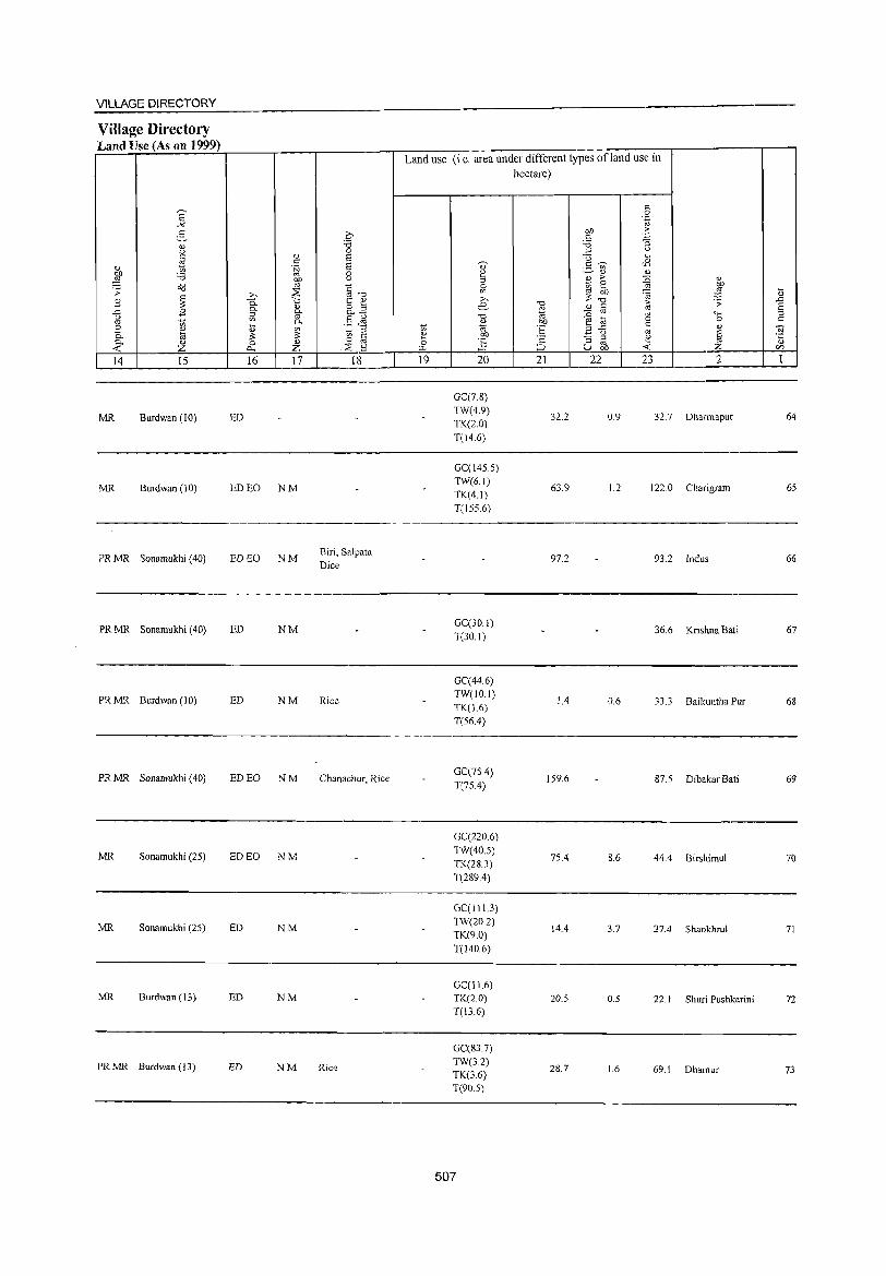
VILLAGE DIRECTORY
Village Directory Land Use (As on 1999)
MR Burdwan (10)
MR Burdwan (10)
PR MR Sonamukhi (40)
PRMR Sonamukhi (40)
PRMR Burdwan (10)
PRMR Sonamukhi (40)
MR Sonamukhi (25)
MR Sonamukhi (25)
MR Burdwan (13)
PRMR Burdwan (13)
ED
ED EO NM
ED EO NM
ED NM
ED NM
ED EO NM
ED EO NM
ED NM
ED NM
ED NM
Biri, Salpata
Dice
Rice
Chanachur, Rice
Rice
Land use (i.e. area under different types of land use in hectare)
GC(78) TW(49)
TK(2.0)
T(14.6)
GC(145.5) TW(6.1)
TK(4.1)
T(155.6)
GC(30.1)
T(30.1)
GC(44.6) TW(IO.I)
TK(L6) T(56.4)
GC(7S.4)
T(75.4)
GC(220.6)
TW(40.5)
TK(28.3) T(289.4)
GC(II13)
TW(20.2) TK(9.0)
T(l40.6)
GC(11.6) TK(2.0) T(I3.6)
GC(83.7) TW(3.2) TK(3.6) T(90.5)
507
32.2
63.9
97.2
14
159.6
75.4
14.4
20.5
28.7
0.9 32.7 OharmapuT
1.2 122.0 Charigram
93.2 Indus
36.6 Krishna Bali
0.6 33.3 Baikuntha Pur
87.5 Dibakar Bati
8.6 444 Birshimul
3.7 27.4 Shankhrul
0.5 22.1 Shuri Pushkarini
1.6 69.1 Dhamur
64
65
66
67
68
69
70
71
72
73
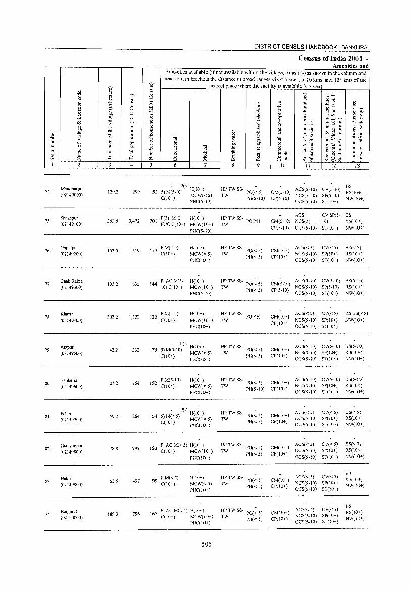
74
75
76
77
78
79
80
81
82
83
84
2
Manoharpur (02149000)
Shashpur (02149100)
Gopalpur (02149200)
ChakRabia (02149300)
Kharra
(02149400)
Arapur (02149500)
Banberia (02149600)
Palan (02149700)
Narayanpur (02149800)
Haldi (02149900)
Berghosh (02150000)
3 4
129.2 299
363.6 3,472
103.0 519
103.2 695
303.2 1,522
42.2 332
81.2 764
59.2 264
78.8 942
65.5 497
189.3 796
DISTRICT CENSUS HANDBOOK: BANKURA
Ctmsus of India 2001 -Amenities and
Amenities available (if not available within the village, a dash (-) is shown in the column and next to it in brackets the distance in broad ranges viz.< 5 krns., 5-10 krns. and 10+ krns of the
nearest place where the facilitv is available is given
5 6 7
- P« -53 5) M(5-10) H(IO+)
C(IO+) MCW« 5) PHC(5-10)
8 9 10 II 12 13
- BS HPTWSS- PO«5) CM(51O) ACS(5-10) eV(5-10) RS(10+) TW PH(5-1O) - NCS(5-10) SP(S-IO) NW(IO+)
CP(5-1O) OCS(5-10) ST(IO+)
701 P(3) M S H(10+) HP TW SS- PO PH PUC C(10+) MCW(10+) TW
ACS CV SP(5- BS
CM(S-IO) NCS(2) 10) RS(IO+)
115 P M«5) C(10+)
144 P AC M(S-10) C(10+)
335 P M« 5) C(10+)
PHC(5-IO)
H(IO+)
MCW« 5) PHC(10+)
H(IO+)
MCW(IO+)
PHC(5-1O)
H(IO+)
MCW(lO+)
PHC(10+)
- P« -75 5) M(5-1O) H(lO+)
C(IO+) MCW« 5) PHC(IO+)
152 PM(5-JO) C(10+)
H(lO+)
MCW«5) PHC(IO+)
- P« H(I~+) 54 5) M« 5) MCW« 5)
C(lO+) PHC(IO+)
163 P AC M« 5) H(IO+) C(IO+) MCW(10+)
99 PM« 5) C(10+)
PHC(10+)
H(lO+)
MCW« 5) PHC(lO+)
163 P AC M« 5) H(IO+) C(lO+) MCW(lO+)
PHC(IO+)
508
HP TW SS- PO ~ 5 TW ()
PH« 5)
HP TW SS- PO(~ 5)
TW PH«5)
HP TW SS- PO PH TW
HP TW SS- PO(~ 5)
TW PH{<5)
CP(5-10) OCS(5-10) ST(IO+) NW(IO+)
ACS« 5) CV« 5) CM(10+) NCS(S-H) SP(10+) CP(10+) OCS(5-1O) ST(IO+)
8S«5) RS(10+)
NW(10+)
CM{5-10) ACS(5-10) CV(S-IO) BS{5-10)
CP(5-1O) NCS(5-1O) SP(5-10) RS(lO+) OCS(5-10) ST(10+) NW(lO+)
ACS« 5) CV« 5) CM(IO+) NCS(5-IO) SP(IO+)
CP(10+) OCS(5-10) ST(10+)
RS B8«5) NW(lO+)
CM(IO+) ACS(5-1O) CV(5-1O) 8S(5-1O) CP(10+) NCS(S-IO) SP(IO+) RS(10+)
OCS(5-10) ST(10+) NW(10+)
HP TW SS- PO(~ 5) CM(IO+) ACS(5-10) CV(5-10) BS(5-10)
TW PH(5-10) CP(IO+) NCS(5-10) SP(IO+) RS(IO+)
HP TW SS- PO(~ 5)
TW PH«5)
HP TW SS- POe ~ 5)
TW PH« 5)
HP TW SS- PO(~ 5)
TW PH« 5)
7w TW SS- POre 5)
PH«5)
OCS(5-10) ST(lO+) NW(IO+)
ACS« 5) CV« 5) CM(IO+) NCS(5-lO) SP(lO+) CP(IO+) OCS(5-10) ST(lO+)
ACS« 5) CV« 5) CM(IO+) NCS(5-10) SP(lO+)
CP(IO+) OCS(5-10) ST(IO+)
ACS« 5) CV« 5) CM(IO+) NCS(5-1O) SP(10+)
CP(lO+) OCS(5-10) ST(IO+)
ACS« 5) CV« 5) CM(lO+) NCS(5-10) SP(10+)
CP(IO+) OCS(5-10) ST(10+)
B8«5) RS(IO+)
NW(lO+)
BS« 5) RS(IO+) NW(lO+)
BS RS(IO+) NW(IO+)
BS RS(IO+)
NW(lO+)
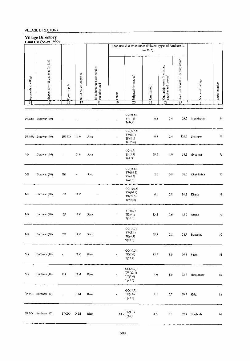
VILLAGE DIRECTORY
Village Directory L an dU se (A son 1999)
Land use (i.e. area under different types ofland use in hectare)
c: E 0
"" .~
:5 0 Oil >-c: . .;=
'" 'B 'B :; u 0 ;oj u g 0) E Q ~
c E <? .= (;) <8 0) t; .~
~ 'B 0 2 ~ '" '" OJ) u :::> '" >- :0 '" <!(l '" ~-o ~ ~ 0
'" Oil '" ~ .... . :;: :2 '" Oil ~ ~
~ ..2:> :::-0 " B 0- "i::; t '" ,.,
-0 i; .:;: ..c
B ~ " 8.z e- O) ~ @ E ..c: fir -0 ~ ~ ~ b ~ ::l u §~ 0 t:
'" t; 0- '" C [ ~ '" t; OJ ·E 3"5 <l.)
~ ~ tl a '" ~ ::: ::: ~ .!?P <= "3 ~ ~ 0- ~ 0 0) o '" J:i " « 0- z :2 a ~ ;:J u Oil '" 14 15 16 17 18 19 20 21 22 23 2 I
GC(98.6)
PRMR Burdwan (l0) TK(1.2) 0.1 OA 28.9 Manoharpur 74 T(99.8)
GC(177.8)
PRMR Burdwan (10) ED EO NM Rice TW(9.7)
40.1 2.4 125.5 Shashpur 75 TK(S.I) T(195.6)
GC(4.9) MR Burdwan (10) NM Rice TK(3.Z) 59.6 1.0 34.3 GopaJpur 76
T(SI)
GC(48.6)
MR Burdwan (10) ED Rice TW(16.Z)
2.0 0.8 31.0 Chak Rabia 77 TK(4.5) T(69.3)
GC(J60.3)
MR Burdwan (10) ED NM TW(IO.I) TK(Z9.6)
6.1 0.8 96.3 Kharra 78
T(200.0)
TW(9.3) MR Burdwan (10) ED NM Rice TK(6.1) 13.2 0.6 13.0 Arapur 79
T(l5.4)
GC(14.7)
MR Burdwan (10) ED NM Rice TW(SI) TK(4.J)
28.5 0.8 24.9 Banberia 80
T(27.0)
GC(20.0) MR Burdwan (10) NM Rice TK(24) 15.7 1.0 ZO.I Patan 81
T(22A)
GC(28.9)
MR Burdwan (10) ED NM Rice TW(12.1) TK(2A)
1.6 1.0 32.7 Narayanpur 82
T(43.5)
GC(21.2) PRMR Burdwan (10) NM Rice TK(2.0) 11.5 0.7 30.Z Haldi 83
T(23.Z)
PRMR Burdwan (10) ED EO NM Rice 619 TK(8.1) . T(8.1) 58.5 0.9 59.9 Berghosh 84
509
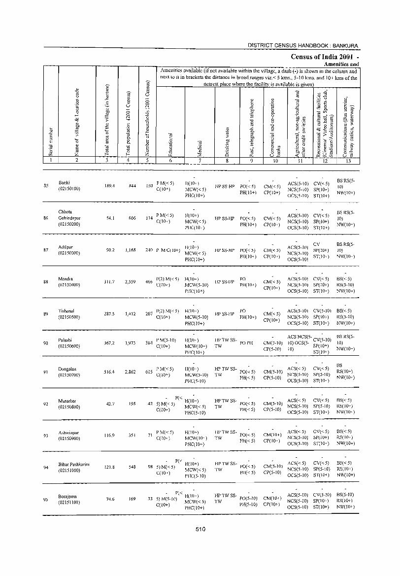
85
86
87
88
89
90
91
92
93
94
95
2
Banki (02IS0100)
Chhota Gobindapur (02150200)
Adilpur (021S0300)
Mandra (021S0400)
Tishanal (021S0500)
Palashi (02IS0600)
Dongalan (02150700)
Musarbar (02150800)
Ashwinpur (02 1 S0900)
Bihar Pushkarini (02151000)
BorajpQta (02151100)
3 4
189.4 844
S4.1 606
90.2 1,168
311.7 2,SS9
287.5 1,412
367.2 1,973
516.4 2,862
42.7 195
116.9 351
121.8 548
74.6 169
DISTRICT CENSUS HANDBOOK: BANKURA
Census of India 2001 -Amenities and
Amenities available (if not available within the village, a dash (-) is shown in the column and next to it in brackets the distance in broad ranges viz.< 5 kms., 5-10 kms. and 10+ kms of the
nearest place where the facility is available is given
5 6
150 PM«5) C(10+)
114 PM« 5) C(10+)
7
H(IO+)
MCW«S) PHC(IO+)
H(IO+)
MCW«5) PHC(lO+)
H(10+) 240 P M C(10+) MCW« 5)
PHC(IO+)
466 P(2)M«5) H(10+) C(lO+) MCW(S·IO)
PHC(10+)
267 P(2) M« 5) H(lO+) C(10+) MCW(S-IO)
384 P M(S-IO) C(IO+)
61S PM«5) C(10+)
PHC(1O+)
H(10+)
MCW(IO+)
PHC(IO+)
H(10+) MCW(5-1O)
PHC(S-IO)
- P« H(I~+) 42 S) M« 5) MCW« S)
C(lO+) PHC(S.10)
71 PM«5) C(IO+)
H(10+) MCW(lO+)
PHC(lO+)
- P« H(I;+) 98 S) M« 5) MCW« 5)
C(10+) PHC(S-IO)
. - P« H(l~+) 33 5) M(S-IO) MCW« S)
C(W+) PHC(IO+)
510
8 9
HP SS~HP PO« 5)
PH(10+)
HP SS-HP PO« 5) PH(10+)
HP SS-HP POe < 5)
PH(10+)
HPSS-HP PO PH(IO+)
HPSS-HP PO PH(IO+)
HP TW SS- PO PH TW
HP TW SS- POe ~ 5)
TW PH«S)
~TWSS- PO«5)
PH«5)
HP TW SS· PO(~ S)
TW PH«S)
HP TW SS- PO(~ 5)
TW PH« S)
10
CM« 5) CP(10+)
CM«5) CP(IO+)
CM« 5) CP(10+)
CM«S) CP(10+)
11 12
ACS(S-IO) CV« S) NCS(5-1O) SP(lO+)
OCS(S-10) ST(10+)
ACS(S-IO) CV« S) NCS(S-IO) SP(IO+)
OCS(5.1O) ST(IO+)
ACS(S-lO) ~:C10+) NCS(5-1O) ST(I 0+) OCS(S-IO)
ACS(5-10) CV« 5)
NCS(S-IO) SP(10+)
OCS(S-10) ST(10+)
13
BS RS(S-10)
NW(10+)
BS RS(S-10)
NW(IO+)
BS RS(S~
10) NW(lO+)
BS« 5)
RS(5-10)
NW(10+)
CM«5) CP(10+)
ACS(5-10) CV(5-10) BS«5)
NCS(S-IO) SP(IO+) RS(S·IO)
OCS(S-1O) ST(IO+) NW(lO+)
CM(S-IO)
CP(5-1O)
ACS NCS(5- CV(~-IO) 10) OCS(5- SP(lO+)
10) ST(lO+)
ACS«S) CV«S) CM(5-10) NCS(S-IO) SP(5-IO) CP(S-IO) OCS(5-1O) ST(IO+)
ACS«S) CV«S) CM(S-lO) NCS(S-lO) SP(5-10) CP(S.IO) OCS(S-IO) ST(IO+)
ACS« 5) CV« 5) CM(IO+) NCS(5-IO) SP(IO+)
CP(IO+) OCS(5-10) ST(10+)
ACS« 5) CV« 5) CM(S-10) NCS(S-IO) SP(S-IO)
CP(S-IO) OCS(S-IO) ST(IO+)
BS RS(S-10)
NW(10+)
BS RS(lO+) NW(IO+)
8S« 5) RS(IO+) NW(IO+)
BS«5) RS(IO+) NW(lO+)
BS«5) RS(IO+)
NW(IO+)
HP TW SS- PO(;-lO) CM(l0'l ACS(S-IO) CV(S-IO) BS(S·IO) TW NCS(S-10) SP(lO+) RS(IO+)
PH(5-10) CP(IO+) OCS(S.IO) ST(IO+) NW(lO+)
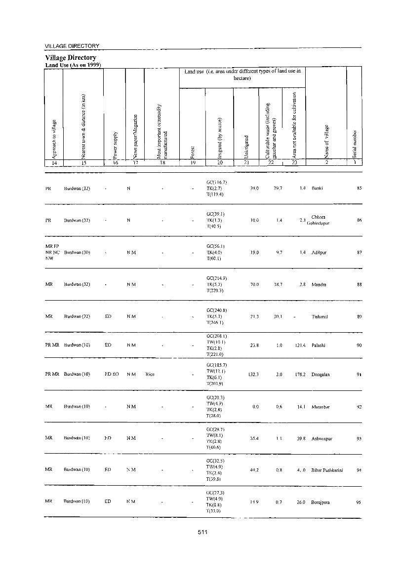
VILLAGE DIRECTORY
Village Directory Land Use (As on 1999)
14 15
PR Burdwan (32)
PR Burdwan (32)
MRFP NR NC Burdwan (30) NW
MR Burdwan (32)
MR Burdwan (32)
PRMR Burdwan(IO)
PR MR Burdwan (10)
MR Burdwan (10)
MR Burdwan (10)
MR Burdwan (10)
MR Bllrdwan (10)
16 17 18
N
N
NM
NM
ED NM
ED NM
ED EO NM Rice
NM
ED NM
ED NM
ED NM
Land use (i.e. area under different types of land use in hectare)
19 20
GC(JJ67) TK(2.7) T(119.4)
GC(39.1)
TK(1.3) T(40.S)
GC(56.1)
TK(4.0) T(60.1)
GC(214.9)
TK(5.3) T(220.3)
GC(240 8)
TK(S.3)
T(246.1)
GC(208.1)
TW(IO.I)
TK(2.8) T(22l.0)
GC(185.7)
TW(12.1)
TK(6.1)
T(203.9)
GC(20.3) TW(4.9)
TK(2.8) T(28.0)
GC(29.7) TW(8.1) TK(2.8) T(406)
GC(32 S)
TW(4.9)
TK(2.4)
T(39.8)
GC(27.3) TW(4.9)
TK(08) T(33.0)
511
21 22
39.0
10.0
19.0
70.0
21.3
23.8
132.3
0.0
35.4
40.2
14.9
23 2
29.7 1.4 Banki
1.4 23 Chhota . Gobindapur
9.7 1.4 Adilpur
18.7 2.8 Mandra
20.1 Tishanal
l.0 121.4 Palashi
2.0 178.2 Dongalan
0.6 14.1 Musarbar
1.1 39.8 Ashwinpllr
0.8 41.0 Bihar Pushkarini
0.7 26.0 Borajpota
85
86
87
88
89
90
91
92
93
94
95
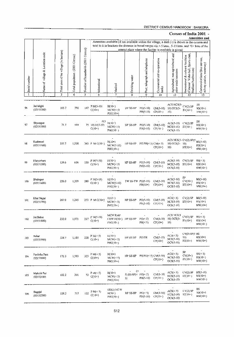
96
97
98
99
100
101
102
103
104
lOS
106
2
Jashdighi (02151200)
Shyampur (02151300)
Kushmuri (02151400)
Khayerbani (02151500)
Bhabapur (02151600)
Khat Nagar (02151700)
Jot Behar (02151800)
Behar (02151900)
Pariksha Para (02152000)
Mahesh PUT
(02152100)
Bagajal (02152200)
3 4
165.7 790
71.7 449
357.7 1,938
139.6 656
226.0 1,339
287.0 1,245
232.0 1,071
334.7 1,185
172.3 1,565
102.2 301
128.2 717
DISTRICT CENSUS HANDBOOK: BANKURA
Census of India 2001 -Amenities and
Amenities available (ifnot available within the village, a dash (-) is shown in the column and next to it in brackets the distance in broad ranges viz.< 5 krns., 5-10 krns. and 10+ krns of the
nearest place where the facility is available is given
5 6
147 P M(S-IO) C(IO+)
7
H(IO+)
MCW«5) PHC(IO+)
- P(s- -75 10)M(S-10) H(lO+)
MCW«5) C(lO+) PHC(IO+)
H(IO+) 363 P MC(10+) MCW(5-1O)
130 P M(S-10) C(1O+)
280 P M(5-10) C(lO+)
PHC(W+)
H(lO+)
MCW«5) PHC(IO+)
H(lO+) MCW(5-1O) PHC(10+)
253 P M C(lO+) H(lO+) MCW«5) PHC(IO+)
MCWRMP
8 9 10 11 12 13
ACS NCS(5- BS HP SS-HP PO(5-10) CM(5-10) 10) OCS(5- CY(2) SP RS(lO+)
PH(S-IO) CP(lO+) 10) ST(IO+) NW(IO+)
BS HP SS-HP PO(S-IO) CM(5-10) ACS(5-10) CY(2) SP RS(lO+)
PH(5-1O) CP(IO+) NCS(5-W) ST(IO+) NW(IO+) OCS(5-IO)
HP SS-HP PO PH« 5) CM« 5)
CP(lO+)
ACS NC~~5- CV(2) SP(5 8S(;-10) 10) OCS(->- 10) RS(10+)
10) ST(10+) NW(lO+)
ACS(5-1O) CV(2) SP BS« 5) HPSS-HP PO(5-1O) CM(5-10) NCS(5-10) ST(1O+) RS(!O+)
PH(5-10) CP(10+) OCS(5-10) NW(10+)
SP TW SS-TW PO(5-1O) CM(5-1O) ACS(5-1O) CV(lO+)
PH(lO+) CP(IO+) NCS(S-10) ST(lO+) OCS(5-10)
BS(5-10) RS(10+) NW(IO+)
HP SS-HP PO(5 10) CM(5 10) ACS« 5) CY(2) SP BS(5-10) - - NCS(5-IO) ST(lO+) RS(lO+)
PH(S-IO) CP(IO+) OCS(5.10) NW(IO+)
217 PM(5-1O) C(10+)
CHWH(10+) HPSS-HP PO«S) PHC(10+) PH« 5)
ACS NCS(5· CV(2) SP BS« 5) CM(5-10) 10) OCS(5- ST(lO+) RS(lO+) CP(10+) 10) NW(IO+)
238 P M«5) C(lO+)
323 PM«5) C(10+)
53 PI\1«5) C(10+)
132 PM« 5) C(lO+)
H(lO+) MCW«5) PHC(IO+)
H(10+)
MCW«5) PHC(JO+)
H(10+)
MCW«5) PHC(JO+)
HP SS-HP PO PH ACS« 5) CV(2) SpeS BS
CM(S-IO) NCS(5-10) 10) RS(IO+) CP(lO+) OCS(5-10) ST(IO+) NW(1O+)
ACS«5) SP HPSS-HP PHPO«5)CM(5-1O) NCS(5-1O) CY(lO+)
CP(10+) OCS(S-IO) ST(IO+)
BS« 5) RS(IO+) NW{lO+)
-« ACS« 5) CY(2) SP BS(5-10) 5) SS-HP« PO« 5) CM(5-10) NCS(S-IO) ST(IO+) RS(lO+) 5) PH(5-10) CP(10+) OCS(5.10) NW(!O+)
DH(2)MCW BS H(JO+) HP SS-HP PO« 5) CM(5-10) ACS« 5) CV(2) SP RS(IO+)
PHC(IO+) PH(5-10) CP(lO+) ~~~g~:~~ ST(lO+) NW(lO+)
512
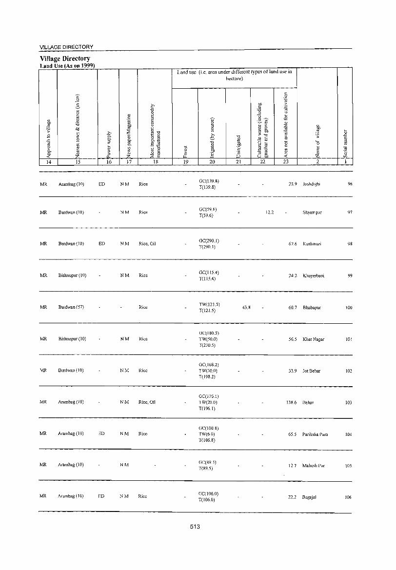
VILLAGE DIRECTORY
Village Directory Land Use (As on 1999)
14 15
MR Arambag (10)
MR Burdwan (10)
MR Burdwan (10)
MR Bishnupur (\ 0)
MR Burdwan (57)
MR Bishnupur (10)
MR Burdwan (10)
MR Arambag (10)
MR Arambag (10)
MR Arambag (10)
MR Arambag (10)
ED
ED
ED
ED
16 17 18
NM Rice
NM Rice
NM Rice, Oil
NM Rice
Rice
NM Rice
NM Rice
NM Rice, Oil
NM Rice,
NM
NM Rice
Land use (i.e. area under different types ofland use in hectare)
19 20
GC(!39.8) T(139.8)
GC(59.6) T(59.6)
GC(290.1) T(290.1)
GC(115.4) T(l15.4)
TW(121.5) T(121.5)
GC(ISO.5) TW(50.0) T(230.5)
GC(16S.2) TW(30.0) T(J982)
GC(J76.1) TW(20.0)
T(\96.1)
GC(100.8) TW(6.0) T(l06.8)
GC(89.5) T(89.5)
GC(106.0) T(106.0)
513
21
43.8
22 23 2
25.9 Jashdighi
12.2 Shyampur
67.6 Kushmuri
24.2 Khayerbani
60.7 Bhabapur
56.5 Khat Nagar
33.9 Jot Behar
138.6 Behar
65.5 Pariksha Para
12.7 Mahesh Pur
22.2 Bagajal
96
97
98
99
100
!OI
102
!O3
104
!Os
106
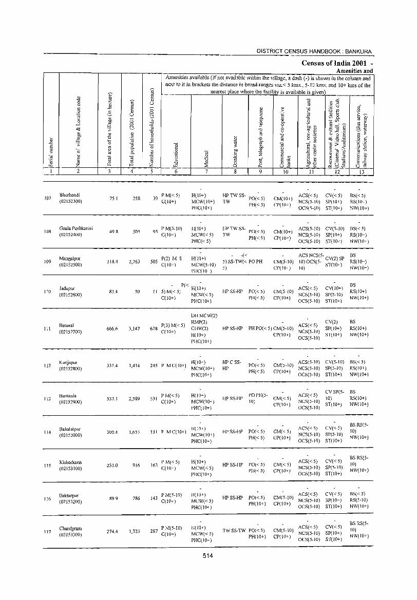
107
108
109
110
III
112
113
114
115
116
117
2
Bhurbandi (02152300)
Goala Pushkarini (02152400)
Mangalpur (02152500)
Jadupur (02152600)
Betanal (02152700)
Kunjapur (02152800)
Bamania (02152900)
Bahalalpur (02153000)
Kishorkona (02153100)
Baktarpur (02153200)
Chandgram (02153300)
3
75.1
49.8
218,4
83,4
666.6
331.4
537.1
300.4
231.0
89.9
274.4
o o ~
'" o .~
"3 0.. o 0..
4
258
505
2,763
50
3,147
1,414
2,589
1,653
916
786
1.323
DISTRICT CENSUS HANDBOOK: BANKURA
Census of India 2001 -Amenities and
Amenities available (ifnotavailable within the village, a dash (-) is shown in the column and next to it in brackets the distance in broad ranges viz.< 5 kms., 5-10 kms. and 10+ kms of the
nearest place where the facility is available is given
5 6
39 PM«5) C(IO+)
95 PM(5-10) C(lO+)
505 P(2) M S C(IO+)
7
H(10+) MCW(IO+) PHC(IO+)
H(lO+) MCW«5) PHC«5)
H(lO+) MCW(5-10) PHC(10+)
- P« H(I~+) II 5) M« 5) MCW« 5)
C(10+) PHC(10+)
638 P(3) M« 5) C(10+)
DHMCW(2) RMP(2) CHW(2) H(IG+) PHC(IO+)
H(IO+) 245 P MC(IO+) MCW(10+)
531 PM«5) C(1O+)
PHC(lO+)
H(IO+) MCW(IO+) PHCCI O+)
H(IO+) 331 P' M C(IO+) MCW(10+)
163 P M« 5) ct10+)
143 P M(5-tO) C(lO+)
287 P 1\1(5-10) C(IO+)
PHC(IO+)
H(IO+) MCW«5) PHC(lO+)
H(10+) MCW« 5) PHC(IO+)
H(lO+) MCW«5) PHC(lO+)
514
8 9
HP TW SS- PO(~ 5)
TW PH«5)
HP TW SS- PO(~ 5)
TW PH«5)
-« 5) SS-TW« PO PH 5)
HP SS-HP PO« 5) PH«5)
10 II 12
ACS« 5) CV« 5) CM(IO+) NCS(5-1O) SP(IO+) CP(lO+) OCS(5-IO) ST(IO+)
13
BS«5) RS(IO+) NW(IO+)
CM(10+) ACS(5-1O) CV(5-1O) BS« 5) CP(IO+) NCS(5·10) SP(1O+) RS(IO+)
OCS(5·1O) ST(1O+) NW(1O+)
ACS NCS(5- CV(2) SP BS CM(5-1O) 1O)OCS(5- ST(lO+) RS(lO+) CP(IO+) 10) NW(10+)
ACS«5) CV(IO+) CM(5-IO) NCS(5.10) SP(5-10) CP(10+) OCS(5-10) ST(10+)
BS RS(lO+) NW(10+)
HPSS-HP PHPO«5)CM(5-10) CP(IO+)
ACS« 5) CV(2) NCS(5-1O) SP(IO+) OCS(5-1O) ST(IO+)
BS RS(lO+) NW(IO+)
HPC SSHP
1'0«5) PH«5)
ACS(5·10) CV(5-1O) BS« 5) CM(5-1O) NCS(5-1O) SP(5-1O) RS(IO+) CP(IO+) OCS(5-10) ST(10+) NW(lO+)
HP SS-HP PO PH(5- CM« 5) 10) CP(IO+)
CV SP(5- BS ACS« 5) 10) RS(10+) NCS(5-IO) ST(IG+) NW(10+)
HP SS-HP PO« 5) PH«5)
HP SS-HP PO« 5) PH«5)
HP SS-HP PO« 5) PH(IO+)
TW SS-TW PO« 5) PH(10+)
CM«5) CP(IO+)
CM«5) CP(lO+)
OCS(5-10)
ACS« 5) CV« 5) NCS(S-10) SP(S-IO) OCS(5-10) ST(10+)
ACS( < 5) CV( < 5) NCS(5-10) SP(5-IO) OCS(5-10) ST(10+)
ACS«5) CV«5) CM(5-10) NCS(5-10) SP(lOI)
CP(IO+) OCS(5-1O) :5T(IO+)
ACS« 5) CV« 5) CM(5-10) NCS(5-1O) SP(IO+) CP(10+) OCS(5-1O) ST(IO+)
BSRS(5-10) NW(lO+)
BSRS(5-10) NW(lO+)
BS« 5) RS(5-10) NW{lO+)
BS RS(5-10) NW(lO+)
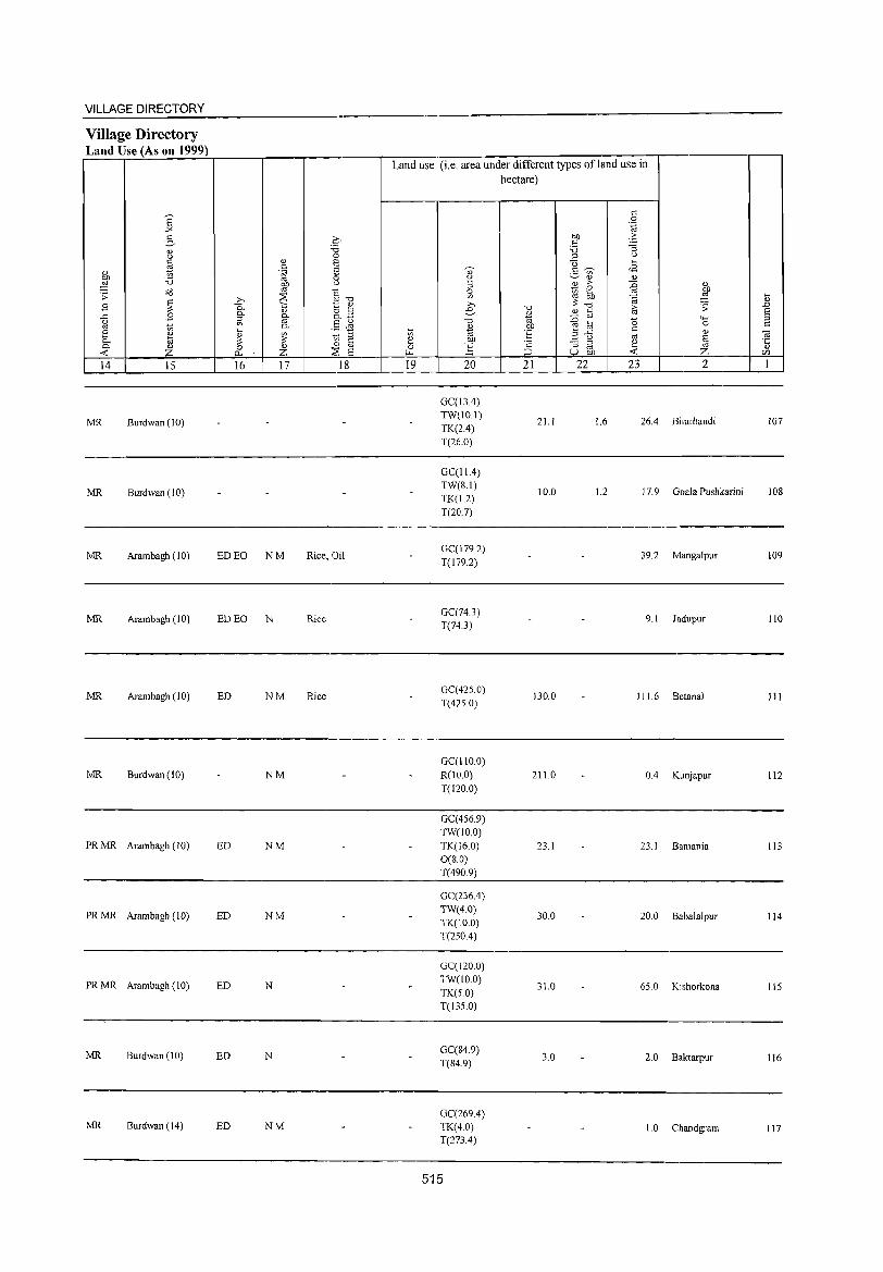
VILLAGE DIRECTORY
Village Directory Land Use (As on 1999)
14 15
MR Burdwan (10)
MR Burdwan (10)
MR Arambagh (10)
MR Arambagh (10)
MR Arambagh (10)
MR Burdwan (10)
PRMR Arambagh (10)
PRMR Arambagh (10)
PRMR Arambagh (10)
MR Burdwan (10)
MR Burdwan (14)
16 17 18
ED EO NM Rice, Oil
ED EO N Rice
ED NM Rice
NM
ED NM
ED NM
ED N
ED N
ED NM
Land use (i.e. area under different types ofland use in hectare)
19 20
GCCI3A) TW(IO.I)
TK(2A) T(26.0)
GC(lIA) TW(S.I)
TK(1.2) T(207)
GC(179.2)
T(179.2)
GCC74.3) T(74.3)
GC(42S.0)
T(425.0)
GCCIIO.O)
R(lO.O) T(120.0)
GCC456.9) TW(IOO)
TK(16.0) 0(8.0)
T(490.9)
GC(236.4)
TW(4.0)
TK(lO 0) T(250A)
GC(120.0)
TW(IO.O) TK(S.O) T(135.0)
GCC84.9) T(84.9)
GCC269.4) TK(4.0) T(273 A)
515
21
21.1
1O.0
130.0
211.0
23.1
30.0
31.0
3.0
22 23 2
1.6 26.4 Bhurbandi
1.2 17.9 Goala Pushkarini
39.2 Mangalpur
9.1 Jadupur
I I 1. 6 Betanal
OA Kunjapur
23.1 Bamania
20.0 Bahalalpur
65.0 Kishorkona
2.0 Baktarpur
1.0 Chandgram
107
108
109
110
III
112
113
114
115
116
117
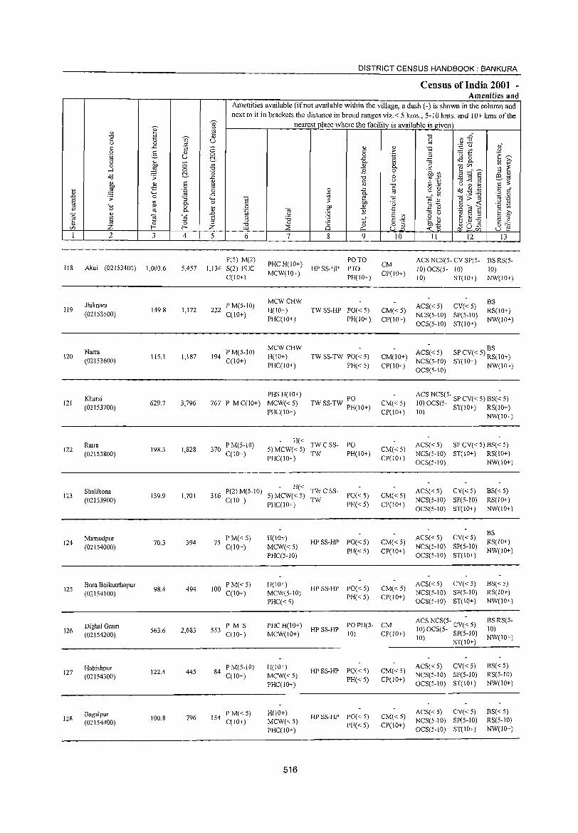
DISTRICT CENSUS HANDBOOK: BANKURA
Census of India 2001 -Amenities and
Amenities available (if not available within the village, a dash (-) is shown in the column and next to it in brackets the distance in broad ranges viz.< 5 krns., 5-10 krns. and 10+ kms of the
~,
nearest .place where the facility is available is given '" V ~ " ~
<: "0 ~ -§"' "0 ~ " 0 :g u " u " co ,,- ,,0
<: ..<: '" ;; " " ~ '.c (.)
0 g g; c: :>- ~~ " .~ U 0 0 .~ 'E '"" u. ..c: ~ 8-u " 0- ] " ~ 0 /;)j) ;; '" " 0- ",§CI'J,,_ ~ ~ .-l :§ 0 :9 B 0 .~ ~~ u. _g 6 _g ~ § :::l " o:d .;:; "0 '? .+:~ '" 1;; " .§ ~
c u ~ ..c ._ i'~ ~ os "0
<: ., u 0 ~ /;)j) ~
o ._, dd .g .g i> :§ 0 " ..<: c <: 0 0 CO .... "' co c)
..0 ..c: W
0- ° V) <ii>"3 .~ 0
E .;:; 0 '3 .... <ii 2 0; ] .-::: '-& co 0.. 0 § 01) .~ c ..: .2
:::l .... ~ 0 ~ QI) " ","0
9'Ol"E <: -:;; c 0 to 0.. " .~ 0; ::: B " .:=: e' g ~ 0; " ..0 u :.;;;; E '" '" u 1;; E :::l
§ ~ ~ E u '6 .~ b b.S] §~ ·c '" .5 '" E"'" " '" "0 " Q 0 8] ~-g <Zl Z f-< f-< Z ~ 2: <'l-. ~u~ u e ~<Zl
1 2 3 4 5 6 7 8 9 10 11 12 13
P(5) M(2) PHC H(IO+)
PO TO CM
ACS NCS(5- CY SP(5- BS RS(5-118 Akui (02153400) 1,003.6 5,457 1,134- S(2) PUC HP SS-HP PTO 10) OCS(5- 10) 10)
C(10+) MCW(IO+)
PH(IO+) CP(lO+)
10) ST(IO+) NW(IO+)
Jhiknara PM(5-10) MCWCHW
ACS«5) CY«5) BS
119 149.8 1,172 222 H(IO+) TW SS-HP PO« 5) CM«5) RS(10+) (02153500) C(10+)
PHC(lO+) PH(IO+) CP(IO+) NCS(S-IO) SP(5-10)
NW(lO+) OCS(5-ID) ST(IO+)
Narra PM(5-10) MCWCHW BS
120 115.1 1,187 194 H(IO+) TW SS-TW PO« 5) CM(IO+) ACS« 5) SP CV« 5) RS(IO+)
(02153600) C(lO+) PHC(IO+) PH« 5) CP(IO+)
NCS(5-1O) ST(IO+) NW(IO+) OCS(5-10)
Kharsi PHS H(lO+)
PO ACS NCS(S- SP CV« 5) BS(~ 5) 121
(02153700) 629.7 3,796 767 P M C(IO+) MCW«5) TW SS-TW PH(IO+) CM«5) 10) OCS(5· ST(IO+) RS(IO+)
PHC(IO+) CP(IO+) 10) NW(lO+)
Ratra PM(5-10) H«
TWCSS- PO ACS« 5) SP CV« 5) BS« 5) 122
(02153800) 198.3 1,828 370
C(10+) 5) MCW« 5)
TW PH(10+) CM« 5)
NCS(S-IO) ST(10+) RS(10+) PHC(IO+) CP(IO+)
OCS(S-10) NW(10+)
Shalikona P(2) M(5-10) H«
TWCSS- ACS« 5) CY«5) BS« 5) 123
(02153900) 139.9 1,701 316
C(lO+) 5) MCW« 5)
TW PO«5) CM« 5)
NCS(5-1O) SP(5-10) RS(IO+) PHC(IO+) PH«5) CP(10+)
OCS(5-10) ST(10+) NW(lO+)
ACS« 5) CY«5) BS
124 Mamudpur
70.3 394 75 PM«5) H(IO+)
HP SS-HP PO« 5) CM« 5) RS(lO+) (02154000) (;(10+) MCW«5)
PH« 5) CP(IO+) NeS(S-IO) SP(S-IO)
NW(IO+) PHC(5-10) OCS(5-1O) 8T(IO+)
125 Bora Baikunthapur
98.4 494 100 PM«5) H(IO+)
HP SS-HP PO«5) CM«5) ACS«5) CV« 5) BS« 5)
(02154100) C(10+) MCW(5-10) PH«5) CP(IO+)
NCS(5-1O) SP(5-IO) RS(lO+)
PHC«5) OCS(5-10) ST(IO+) NW(10+)
Dighal Gram PMS PHCH(lO+) POPH(5- CM ACS NCS(5- CV(~ 5) BS RS(5-
126 563.6 2,683 553 HPSS-HP 10) OeS(5- SP(S-IO) 10) (02154200) C(lO+) MCW(lO+) 10) CP(IO+)
10) ST(lO+) NW(IO+)
Habishpur PM(5-10) H(lO+) HP SS-HP PO«5) CM« 5)
ACS« 5) CY«5) BS« 5) 127 122.4 445 84
MCW«5) NCS(5-10) SP(5-10) RS(5-1O) (02154300) C(10+) PH« 5) CP(IO+)
PHC(10+) OCS(5-10) ST(IO+) NW(IO+)
Bagalpur PM«5) H(IO+) HPSS-HP PO«5) CM«5)
ACS« 5) ey« 5) BS« 5) 128 100.8 796 154
MCW«5) NCS(S-10) SP(5-10) RS(5-10) (02154400) C(lO+) PH«5) CP(IO+)
PHC(10+) OeS(5-IO) ST(10+) NW(lO+)
516
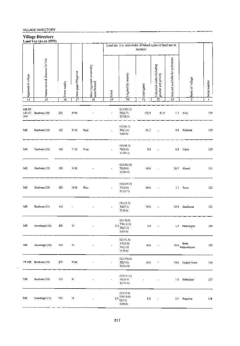
VILLAGE DIRECTORY
Village Directory Land Use (As on 1999)
14 15
MRFP NR NC Burdwan (28) NW
MR Burdwan (10)
MR Burdwan (10)
MR Burdwan (33)
MR Burdwan (35)
MR Burdwan (37)
MR Arambagh (10)
MR Arambagh (10)
PRMR Burdwan(10)
MR Burdwan (10)
MR Arambagh (10)
16 17 18
ED NM
ED NM Rice
ED NM Rice
ED NM
ED NM Rice
ED
ED N
ED N
ED NM
ED N
ED N
Land use (i.e. area under different types ofland use in hectare)
19 20
GCC762.3) TK(67) T(768.9)
GCCS2.3)
TK(1.6) T(83.9)
GC(98.7)
TK(6.6) T(JOS.3)
GC(56 1.0)
TK(S.O) T(569.0)
GC(129.2)
TK(S.O) T(137.2)
GCC22.7)
TK(7.3) T(30.0)
GCCSO.O)
20 TW(IO.O) . TK(S.O)
T(65.0)
GCC71.4) TW(2.0)
TK(S.O) T(78.4)
GCC530.0) TK(S.O) T(S3S.0)
GCCI17.0) TK(4.4)
T(121.4)
GC(700)
20 TW(IS.O) . 0(2.0)
T(90.0)
517
21
152.0
61.2
9.0
40.0
60.0
70.0
2.0
10.0
10.0
6.S
22 23 2
SI.O 1.7 Akui
4. S Jhiknara
O.S Narra
20.7 Kharsi
1.1 Ratra
39.9 Shalikona
1.3 Mamudpur
100 Bora . Baikunthapur
18.6 Dighal Gram
I. 0 Habishpur
2.0 Bagalpur
118
119
120
121
122
123
124
125
126
127
128
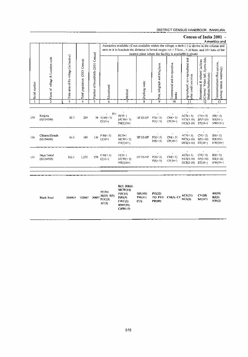
129
130
131
2
Kenjera (02154S00)
Chhatra Khanda (02154600)
Naga Tenlul (02154700)
Block Total
3 4
82.3 224
85.6 589
363.1 1,235
25498.5 152847
DISTRICT CENSUS HANDBOOK: BANKURA
Census of India 2001 -Amenities and
Amenities available (ifnot available within the village, a dash (-) is shown in the column and next to it in brackets the distance in broad ranges viz.< 5 knlS., 5-10 kms. and 10+ kms of the
nearest place where the facility is available is given
5 6 7
- P« H(l~+) 39 5) M« 5) MCW« 5)
C(IO+) PHC(IO+)
130 PM«5) C(IO+)
258 P M« 5) C(10+)
P(134)
30097 M(19) S(9) il'UC(3) AC(3)
H(to+)
MCW«5) PHC(IO+)
H(IO+)
MCW«5) PHC(IO+)
D(3) DH(6) MCW(14) PHC(4) PHS(S) FWC(2) RMP(20) CRW(13)
518
8 9
HP SS-HP PO« 5) PH«5)
HP SS-HP PO« 5)
PH«5)
HP SS-HP PO« 5) PH« 5)
" .:': ~ " 0. o .:, " ""0
iii OJ '~
" " on §§ U..o
10
CM«5) CP(IO+)
CM«5) CP(IO+)
CM«5) CP(IO+)
11 12
ACS« 5) CV« 5) NCS(S-IO) SP(S-IO) OCS(5-to) ST(lO+)
ACS« 5) CV« 5) NCS(S-IO) SP(S-IO)
OCS(S-IO) ST(IO+)
ACS« 5) CV« 5) NCS(5-1O) SP(5-IO)
OCS(5-1O) ST(IO+)
HP(109) TW(41) C(3)
PO(22) TO PTO CM(5) CP ACS(21) PR(80) NCS(S}
CV(28) SP(I07)
13
BS«5) RS(IOT)
NW(IO+)
BS« 5) RS(IOT)
NW(IO+)
BS«5) RS(5-IO)
NW(IO+)
BS(58) RS(3} NW(2)
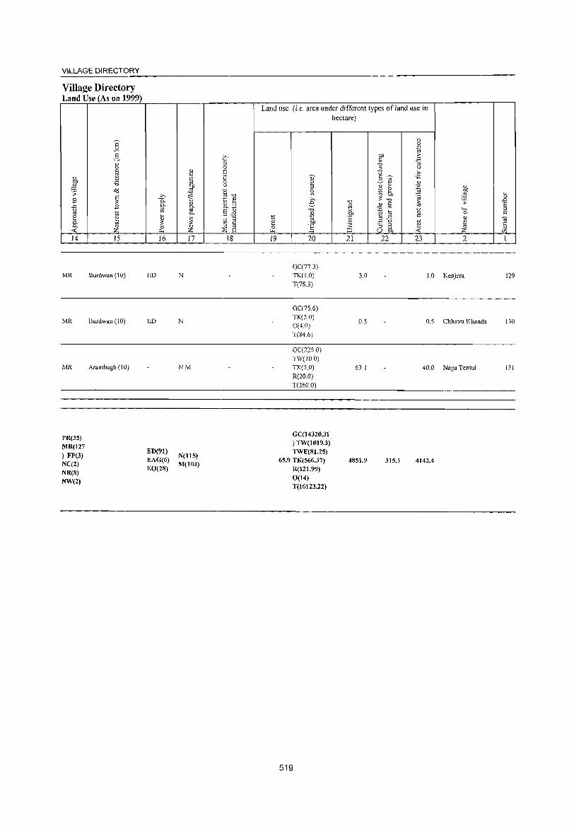
VILLAGE DIRECTORY
Village Directory Land Use (As on 1999)
<l) OJ)
~ .;;: B ..c
<> cd
[ 0-«:: 14
MR
MR
MR
PR(3S)
MR(127
) FP(3) NC(2)
NR(S) NW(2)
E "'" 2-0)
" " tl 'i3 till
~ S en ~
'" 0) z 15
Burdwan (10)
Burdwan (10)
Arambagh (10)
,., 0. g. en
lil
'" 0 p..
16
ED
ED
ED(91)
EAG(6) EO(2S)
'" <: .~ OJ
~ <l)
g-0-
~ <l) z 17
N
N
NM
N(llS) M(104)
C' -0 0 E E 0 ()
c: f! 13 §L E ,§~ Jg +, '" u, § 0 ";I s ,,~
18
Land use (i.e. area under different types ofland use in hectare)
t; ~ 0
"" 19
~
" 2 :J
~
e "'" 2 cd OJ)
~ 20
GC(77.3)
TK(1.0)
T(78.3)
GC(7S.6)
TK(S.O) 0(4.0)
T{84.6)
GC(22S.0) TW(IO.0) TK(S.O) R(20.0)
T(260 0)
GC(14320.31
) TW(1019.3) TWE(81.2S)
65.9 TK(S66.37)
R(121.99)
0(14) T(16123.22)
519
"'" '" 'oj .~ l::
';:: :;:J
21
3.0
0.5
63.1
4851.9
<: 0 .~
OJ) ·f " '5 :;
'" u ''is ... 2- ~ <8 en
'" OJ <l) > :n '" Ki
0 .r:! OJ)
'" bb . iii ~ "'" re .;::
'" § ~ a 0 '+<
0 !;; ..c s:: <l)
-§ u cd E ~ ~ OJ
u OJJ Z 22 23 2
1.0 Kenjera
0.5 ehha!ra Khanda
40.0 Naga Tentul
315.1 4142.4
lil .<:J E
'" s:: til '5 rJl
1
129
130
131

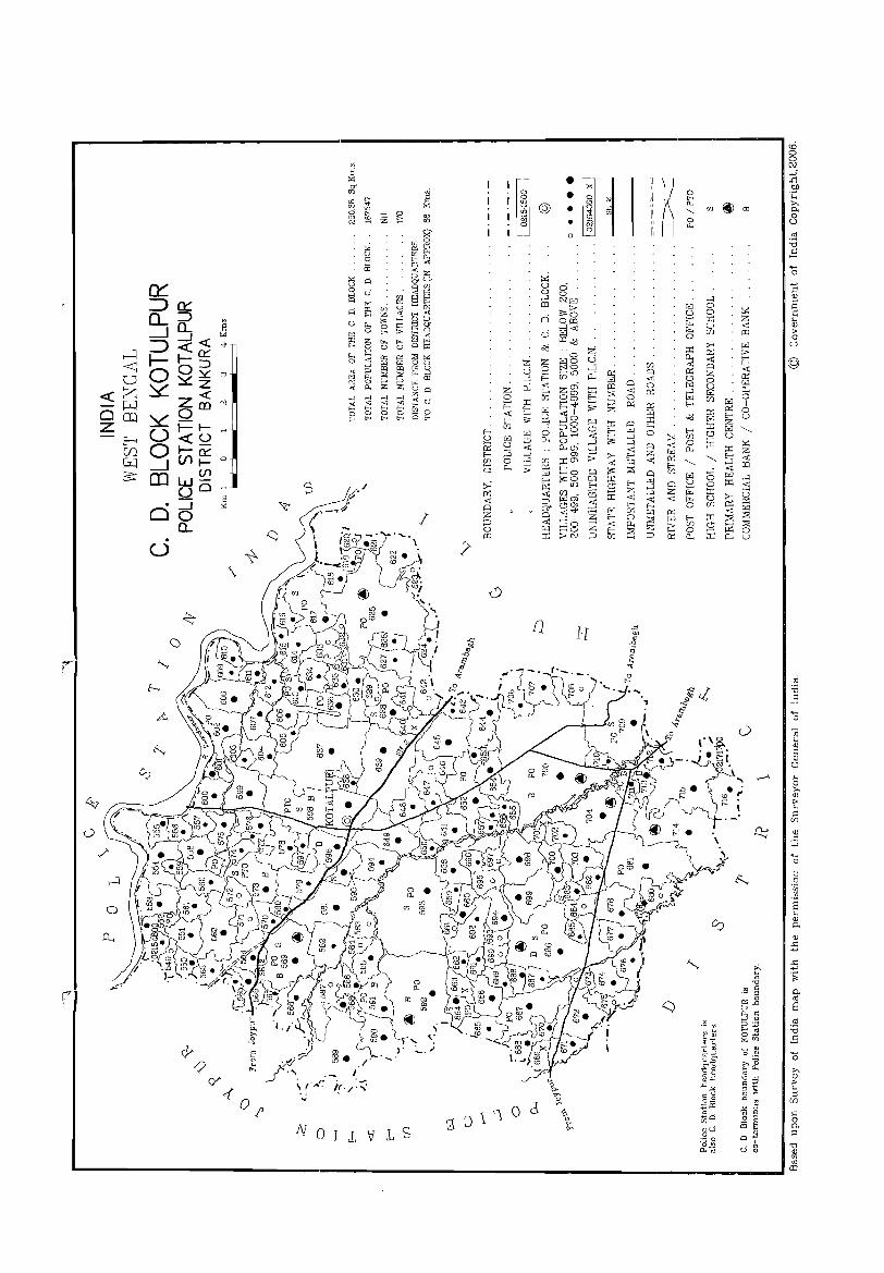
-------------------------------------------'--:---------------------------------~-:~~~~--:-~--:-------------l ~ § :i OJ)
! ~ • ~ ii h t t/] @l co .~ ~ ~ @:. =0 ~ ii ~ ~
s
.,., .'\ .-
\ ,.""~~ i(-/:~
! g II :<J I 0 ,s
f]
l '1 0 d 3_J
H
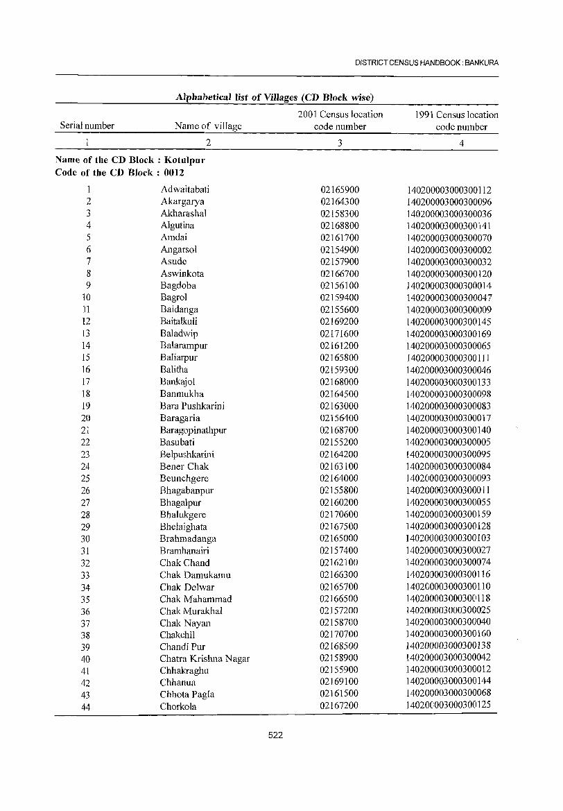
DISTRICT CENSUS HANDBOOK: BANKURA
Alphabetical Jist of ViIJages (CD Block wise)
2001 Census location 1991 Census location Serial number Name of village code number code number
2 3 4
Name of the CD Block: Kotulpur Code of the CD Block: 0012
Adwaitabati 02165900 140200003000300112 2 Akargarya 02164300 140200003000300096 3 Akharashal 02158300 140200003000300036 4 Algutina 02168800 140200003000300141 5 Amdai 02161700 140200003000300070 6 Angarsol 02154900 140200003000300002 7 Asude 02157900 140200003000300032 8 Aswinkota 02166700 140200003000300120 9 Bagdoba 02156100 140200003000300014
10 Bagrol 02159400 140200003000300047 11 Baidanga 02155600 140200003000300009 12 Baitalkuli 02169200 140200003000300145 13 Baladwip 02171600 140200003000300169 14 Balarampur 02161200 140200003000300065 15 Baliarpur 02165800 140200003000300111 16 Balitha 02159300 140200003000300046 17 Bankajol 02168000 140200003000300133 18 Banmukha 02164500 140200003000300098 19 Bara Pushkarini 02163000 140200003000300083 20 Baragaria 02156400 140200003000300017 21 Baragopinathpur 02168700 140200003000300140 22 Basubati 02155200 140200003000300005 23 Belpushkarini 02164200 140200003000300095 24 Bener Chak 02163100 140200003000300084 25 Beunchgere 02164000 140200003000300093 26 Bhagabanpur 02155800 140200003000300011 27 Bhagalpur 02160200 140200003000300055 28 Bhalukgere 02170600 140200003000300159 29 Bhelaighata 02167500 140200003000300128 30 Brahmadanga 02165000 140200003000300103 31 Bramhanairi 02157400 140200003000300027 32 Chak Chand 02162100 140200003000300074 33 Chak Damukamu 02166300 140200003000300116 34 Chak Delwar 02165700 140200003000300110 35 Chak Mahammad 02166500 140200003000300118 36 Chak Murakhal 02157200 140200003000300025 37 Chak Nayan 02158700 140200003000300040 38 Chakchi! 02170700 140200003000300160 39 Chandi Pur 02168500 140200003000300138 40 Chatra Krishna Nagar 02158900 140200003000300042 41 Chhakraghu 02]55900 140200003000300012 42 Chhanua 02169100 140200003000300144 43 Chhota Pagla 02161500 140200003000300068 44 Chorkola 02167200 140200003000300125
522
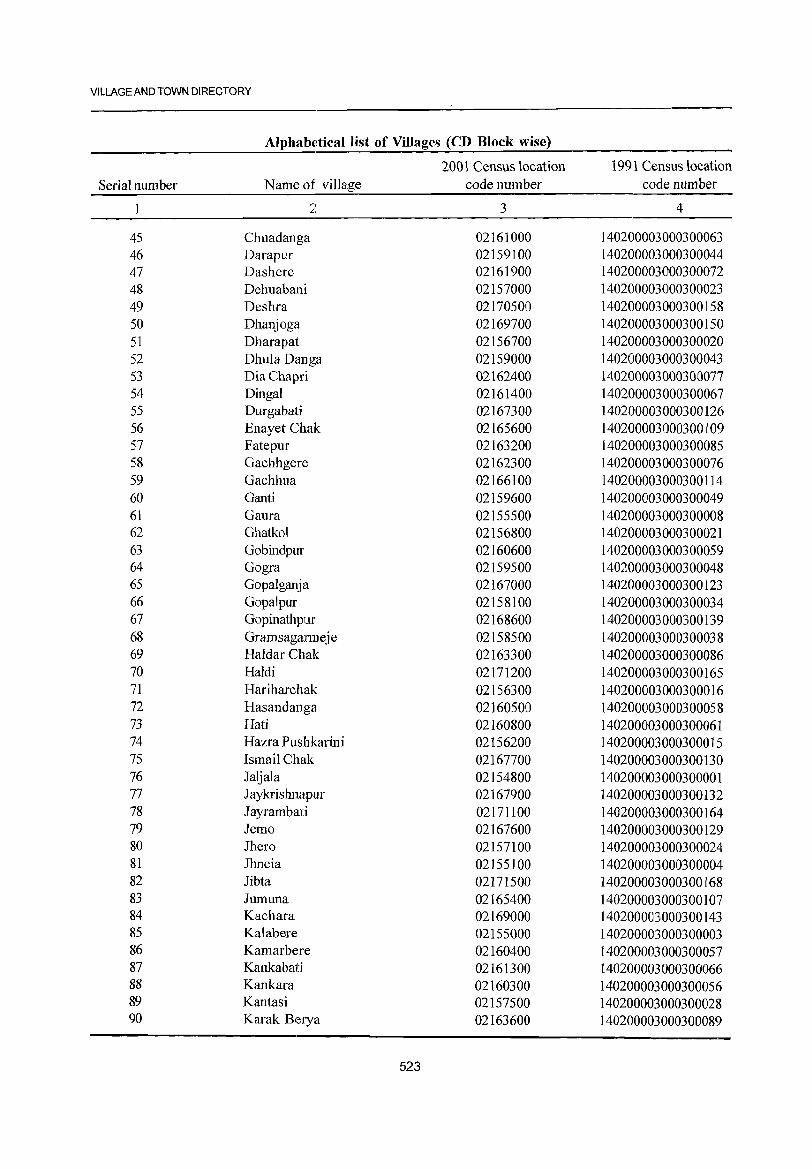
VILLAGE AND TOWN DIRECTORY
Alphabetical list of Villages (CD Block wise)
2001 Census location 1991 Census location Serial number Name of village code number code number
1 ~,
~. 3 4
45 Chuadanga 02161000 140200003000300063 46 Darapur 02159100 140200003000300044 47 Dashere 02161900 140200003000300072 48 Dehuabani 02157000 140200003000300023 49 Deshra 02170500 140200003000300158 50 Dhanjoga 02169700 140200003000300150 51 Dharapat 02156700 140200003000300020 52 Dhula Oanga 02159000 140200003000300043 53 DiaChapri 02162400 140200003000300077 54 Dingal 02161400 140200003000300067 55 Durgabati 02167300 140200003000300126 56 Enayet Chak 02165600 140200003000300109 57 Fatepur 02163200 140200003000300085 58 Gachhgere 02162300 140200003000300076 59 Gachhua 02166100 140200003000300114 60 Ganti 02159600 140200003000300049 61 Gaura 02155500 140200003000300008 62 Ghatkol 02156800 140200003000300021 63 Gobindpur 02160600 140200003000300059 64 Gogra 02159500 140200003000300048 65 Gopalganja 02167000 140200003000300123 66 Gopalpur 02158100 140200003000300034 67 Gopinathpur 02168600 140200003000300139 68 Gramsagarmeje 02158500 140200003000300038 69 Haldar Chak 02163300 140200003000300086 70 Haldi 02171200 140200003000300165 71 Hariharchak 02156300 140200003000300016 72 Hasandanga 02160500 140200003000300058 73 Hati 02160800 140200003000300061 74 Hazra Pushkarini 02156200 140200003000300015 75 Ismail Chak 02167700 140200003000300130 76 Jaljala 02154800 140200003000300001 77 Jaykrishnapur 02167900 140200003000300132 78 Jayrambati 02171100 140200003000300164 79 Jemo 02167600 140200003000300129 80 Jhero 02157100 140200003000300024 81 Jhneia 02155100 140200003000300004 82 Jibta 02171500 140200003000300168 83 Jumuna 02165400 140200003000300107 84 Kachara 02169000 140200003000300143 85 Kalabere 02155000 140200003000300003 86 Kamarbere 02160400 140200003000300057 87 Kankabati 02161300 140200003000300066 88 Kankara 02160300 140200003000300056 89 Kantasi 02157500 140200003000300028 90 Karak Berya 02163600 140200003000300089
523
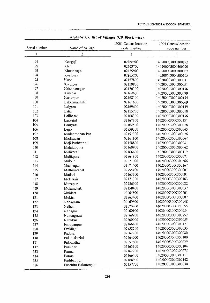
DISTRICT CENSUS HANDBOOK: BANKURA
Alphabetical list of Villages (CD Block wise)
2001 Census location 1991 Census location Serial number Name of village code number code number
2 3 4
91 Keleguji 02166900 140200003000300122 92 Khiri 02163700 140200003000300090 93 Khundanga 02159900 140200003000300052 94 Koa1para 02165200 140200003000300105 95 Kopa 02157800 140200003000300031 96 Kotu1pur 02159800 140200003000300051 97 Krishnanagar 02170300 140200003000300156 98 Kulahar 02164600 140200003000300099 99 Kunarpur 02168100 140200003000300134
100 Lakshmanlbati 02161600 140200003000300069 101 Lalgara 02169600 140200003000300149 102 Lalki 02155700 140200003000300010 103 Lallbazar 02168300 1401200003000300136 104 Lankajol 02167800 1401200003000300131 105 Laugram 02162500 140200003000300078 106 Lego 02159200 140200003000300045 107 Madanmohan Pur 02157300 140200003000300026 108 Madhuban 02161100 140200003000300064 109 Maj i Pushkarini 02158800 140200003000300041 110 Malakarpota 02160900 140200003000300062 111 Malikota 02166600 140200003000300119 112 Ma1ikpara 02161800 140200003000300071 113 Malpur 02171300 140200003000300166 114 Masinapur 02171400 140200003000300167 115 Mathuratapal 02155400 140200003000300007 116 Matiari 02163800 140200003000300091 117 Metelsair 02171000 140200003000300163 118 Mirzapur 02156900 140200003000300022 119 Mohanchak 02158400 140200003000300037 120 Muidara 02164800 140200003000300101 121 Mukha 02163400 140200003000300087 122 Nabagram 02169500 140200003000300148 123 Nalbuni 02170200 140200003000300155 124 Nanagar 02160100 140200003000300054 125 Nandagram 02169900 140200003000300152 126 Napukur 02160000 140200003000300053 127 Narayanpur 02166800 140200003000300121 128 0ta1dighi 02158200 140200003000300035 129 Padma 02162700 140200003000300080 130 Pal Puskarini 02164700 140200003000300100 131 Palbandha 02157600 140200003000300029 132 Panahar 02165100 140200003000300104 133 Panna 02162200 140200003000300075 134 Panua 02166400 140200003000300117 135 Parbbatipur 02168900 140200003000300142 136 Paschim Balarampur 02157700 140200003000300030
524
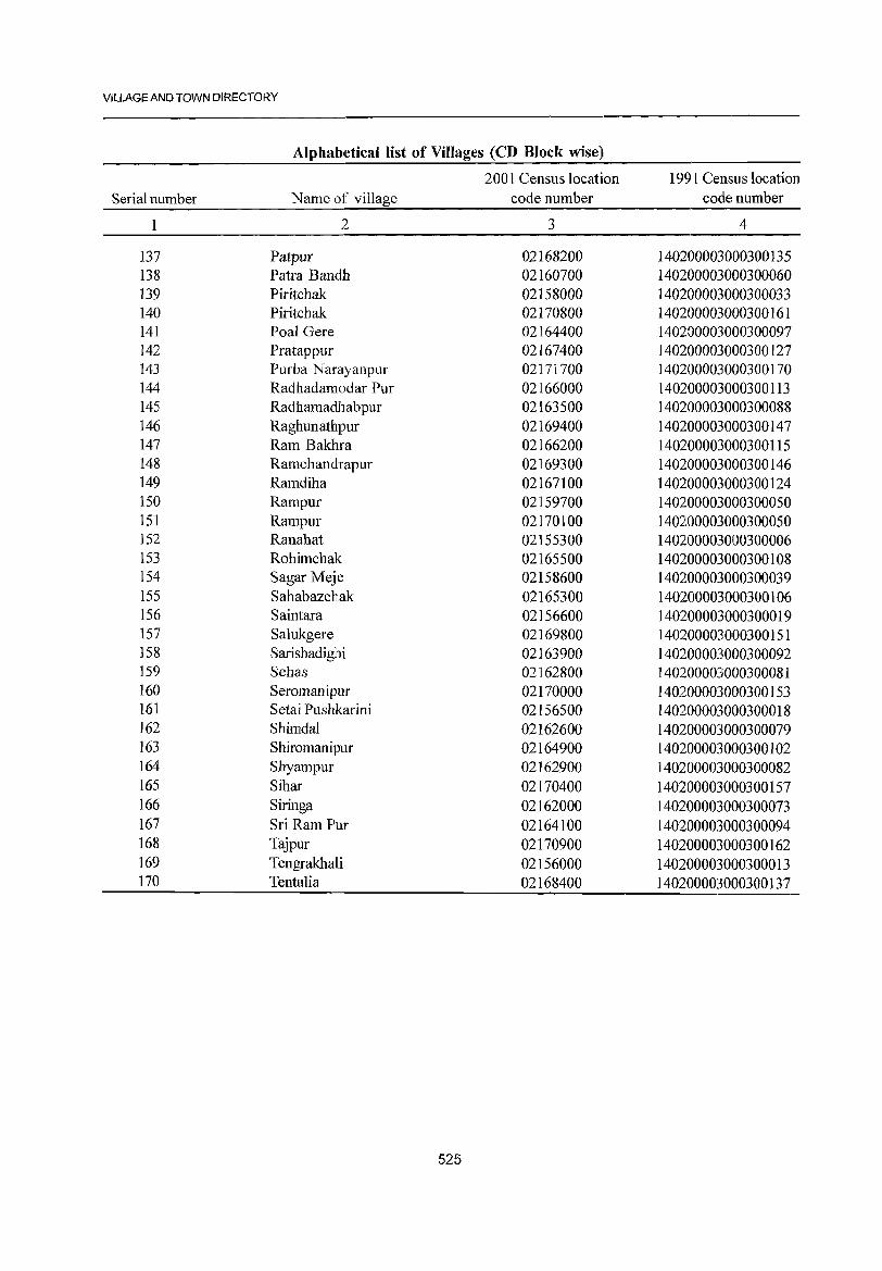
VILLAGE AND TOWN DIRECTORY
Alphabletical list of Villages (CD Block wise)
2001 Census location 1991 Census location Serial number Name of village code number code number
2 3 4
137 Patpur 02168200 140200003000300135 138 Patra Bandh 02160700 140200003000300060 139 Piritchak 02158000 140200003000300033 140 Piritchak 02170800 140200003000300161 141 Poal Gere 02164400 140200003000300097 142 Pratappur 02167400 140200003000300127 143 Purba Narayanpur 02171700 140200003000300170 144 Radhadamodar Pur 02166000 140200003000300113 145 Radhamadhabpur 02163500 140200003000300088 146 RaghunathJPur 02169400 140200003000300147 147 Ram Bakhra 02166200 140200003000300115 148 Ramchandrapur 02169300 140200003000300146 149 Ramdiha 02167100 140200003000300124 150 Rampur 02159700 140200003000300050 151 Rampur 02170100 140200003000300050 152 Ranahat 02155300 140200003000300006 153 Rohimchak 02165500 140200003000300108 154 Sagar Meje 02158600 140200003000300039 155 Sahabazchak 02165300 140200003000300106 156 Saintara 02156600 140200003000300019 157 Salukgere 02169800 140200003000300151 158 Sarishadighi 02163900 140200003000300092 159 Sehas 02162800 140200003000300081 160 Seromanipur 02170000 140200003000300153 161 Setai Pushkarini 02156500 140200003000300018 162 Shimda1 02162600 140200003000300079 163 Shiromanipur 02164900 140200003000300102 164 Shyampur 02162900 140200003000300082 165 Sihar 02170400 140200003000300157 166 Siringa 02162000 140200003000300073 167 Sri Ram Pur 02164100 140200003000300094 168 Tajpur 02170900 140200003000300162 169 Tengrakhali 02156000 140200003000300013 170 Tentu1ia 02168400 140200003000300137
525
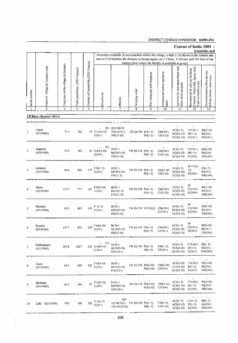
DISTRICT CENSUS H . .Il.NDBOOK : BANKURA
Census of India 2001 -Amenities and
Amenities available (if not available within the village, a dash (-) is shown in the column and next to it in brackets the distance in broad ranges viz.< 5 kms., 5-10 lans. and 10+ kms of the
~ ~ nearest place where the facility is available is given
OJ VI
" "0 ~ :2" "0 'Vi' <1) 0 u U til u <1) ;:; ',p C,) 0)"
" -" VI - <1) <1) "§ " 0 " > ;.::: til <.)
.S .g <1) 0 0 .~ 'u 1:: .~ ~
til U ~ -" .a ~ 8.. " ~ u <1) - Q. :l 0 ~ 0 VI <1) Q. <.) 'iilr/J VI ~
>-l 0 "0 E 0 .~ ~ S ="S rg " ~ "0 6 08 .s: -" "0 ~ .~ -3 jg .2 ~~ " <1) til u
<1) <1) VI "0 <.) 0 ... bJJ -£ 0 ;:;
~ " o ._
08.gg " " ~ :§ .~ 0 -" OJ ~ ~ o " "" -" til Q.
'iil;;5 '.c 0 .0 .s: 0 "3 "" "'@ ~ "'@ ""§:B OJ ._
~ OJ Q. 0 " :;: 'g " -<
<.) 1;1
"" ~ 0 ... 0 bJJ <1) E ~ SOla '2 &; 0 '" Q. <1) .~ 'iil c E ;:; ;>,
~ " .0 U :.;;; EO VI ::J U ~ E :l EO OJ
§ ] ~ E U '0 .5 t;;" EO"'" .~ ~ ~ ~ :.a E :;: ::J
" ~ ;:;
iE <1)
0 0 o § ~~ &0.'9 o~ r/J Z E--< Z :::E 0.. U.o ~r/J U EO 1 2 3 4 5 6 7 8 9 10 II 12 13
CD Block: Kotulpur (0012)
Jaljala P« D(2)MCW
ACS« 5) CV(IO+) 8S(5-1O) 71.1 392 75 5) M(S-IO) PHS H(IO+) TW SS-TW PO« S) CM(IO+) (02154800)
C(lO+) PHC(5-1O) PH« 5) CP(5-1O) NCS(5-10) SP« 5) RS(IO+) OCS(5-10) ST(IO+) NW(IO+)
2 Angarsol
57.6 183 29 - P« H(I~+)
TW SS-TW PO« 5) CM(lO+) ACS« 5) CV(lO+) 8S(5-10)
(02154900) 5) M(5-10) MCW(5-10) NCS(S-IO) SP« S) RS(lO+) C(JO+) PHC(5-1O) PH« 5) CP(5-10)
OCS(5-1O) ST(IO+) NW(lO+)
Kalabere P M« 5) H(IO+) ACS« 5) SP CV(5-
BS« 5) (02155000)
60.4 826 17S C(10+) MCW(5-10)
TW SS-TW PO« 5) CM(5-IO) NCS(S-IO)
10) RS(10+)
PHC« 5) PH«5) CP(5-10)
OCS(5-10) ST(10+)
NW(10+)
Jhneia IPM(5-10) H(IO+) ACS« 5) SP
BS(5-10) 4 117.7 777 141 TW SS-TW PO« 5) CM(10+) CV(IO+)
(021SSI00) C(IO+) MCW«5) PH« 5) CP(5-10)
NCS(S-IO) ST(IO+)
RS(IO+)
PHC(5-10) OCS(5-1O) NW(IO+)
Basubati I'MO H(IO+) ACS« 5) SP
8S(5-10) 85.9 803 169 TW SS-TW PO PH(2) CM(lO+) CV(IO+)
(02155200) C(IO+) MCW(S-IO) CP(IO+)
NCS(5-IO) ST(IO+)
RS(IO+)
PHC(5-10) OCS(5-1O) NW(IO+)
ACS« 5) SP
8S(5-10) 6
Ranahat 157.7 655 129
P M(S-tO) H(IO+) TW SS-TW PO« 5) CM(lO+) CV(lO+)
(02155300) C(IO+) MCW(S-IO) PH« 5) CP(IO+)
NCS(S-JO) ST(lO+)
RS(IO+)
PHC(5-10) OCS(5-JO) NW(lO+)
Mathuratapal 1,837 332
. - P« H(I~+) TW SS-TW PO« 5) CM«5)
ACS« S) CY(IO+) BS« 5) 7
(02155400) 307.8 S) M(S-IO) MCW(5-10) NCS(5-10) SI'«5) RS(10, )
C(lO+) PHC(10+) PH«5) CP(lO+) OCS(5-10) ST(10+) NW(lO+)
Gaura 650 126
P M(5-10) H(IO+) TW SS-TW PO(5-10) CM(5-10)
ACS(5-1O) CV(lO+) BS(5-1O) 8 68.5 C(lO+) MCW(5-IO) NCS(5-10) SI'« 5) RS(IO+) (02155500) PH(5-10) CP(IO+)
PHC(IO+) OCS(5-IO) ST(IO+) NW(IO+)
Baidanga PM(5-10) H(IO+) TW SS-TW PO(5-10) CM(5-IO)
ACS«5) CY(IO+) BS(5-1O) 9 65.3 464 87
C(10+) MCW(5-10) NCS(5-10) SP« 5) RS(IO+) (02155600) PH(5-10) CP(IO+) PHC(10+) OCS(5-10) 8T(10+) NW(IO+)
P M«5) H(5-
ACS« 5) CV« 5) BS« 5) 10 Lalki (02155700) 79.0 469 102
C(IO+) 10) MCW(5- TW SS-TW PO« 5) CM«5)
NCS(5-10) SP« 5) RS(lO+) 10) PHC(5-10) PH« 5) CP(5-10)
OCS(5-10) ST(IO+) NW(IO+)
526
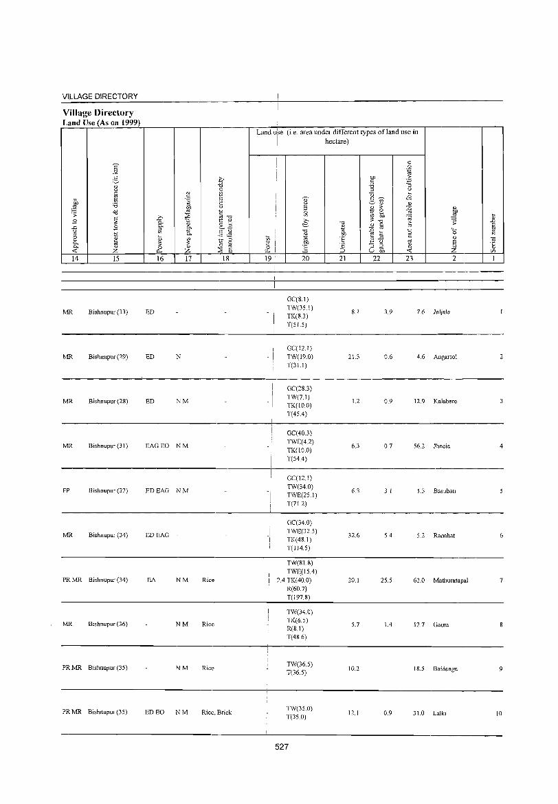
VILLAGE DIRECTORY
Village Directory Land Use (As on 1999)
14 15
MR Bishnupur (33)
MR Bishnupur (29)
MR Bishnupur (2S)
MR Bishnupur (31 )
FP Bishnupur (32)
MR Bishnupur (34)
PRMR Bishnupur (34)
MR Bishnupur (36)
PRMR Bishnupur (35)
PR MR Bishnupur (35)
16 17 18
ED
ED N
ED NM
EAGEO NM
EDEAG NM
EDEAG -
EA NM Rice
NM Rice
NM Rice
ED EO NM Rice, Brick
Land use (i.e. area under different types ofland lise in
I hectare)
I
-I
-I
-I
20
GC(S.I) TW{35 I) TK(S.3) T(5L5)
GC(12 I) TW(19.0) T(3!.1)
GC(2S.3) TW(7.1) TK(IO.O) T(45.4)
GC(40.3) TWE(4.2) TK(IO.O) T(54.4)
Ge(12 I) TW(34.0) TWE(25.1) T(712)
GC(34.0) TWE(325) TK(48.1) T(1l4.5)
TW(S 1. 8) TWE(15.4)
2.4 TK(40.0) R(60.7) T(197.8)
TW(34.0) TK(6.5) R(S.I) T(4S.6)
TW(36.5) T(36.5)
TW(35.0) T(35.0)
527
21
8.1
21.3
1.2
6.3
6.3
32.6
20.1
5.7
10.2
12.1
22 23 2
3.9 7.6 Jaljala
0.6 4.6 Angarsol
0.9 12.9 Kalabere
0.7 56.2 Jhneia
3.1 5.3 Basubati
5.4 5.2 Ranahat
25.5 62.0 Mathuratapal
1.4 12.7 Gaura
18.5 Baidanga
0.9 3!.0 Lalki
2
3
4
5
6
7
S
9
10
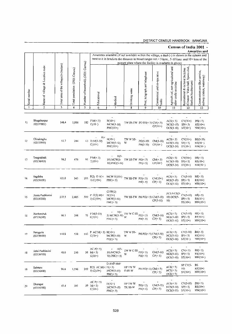
DISTRICT CENSUS HANDBOOK: BANKURA
Census of India 2001 -Amenities and
Amenities available (ifnot available within the village, a dash (-) is shown in the column and
next to it in brackets the distance in broad ranges viz.< 5 kms., 5-10 kms. and 10+ kms of the
~
';;)' nearest place where the facility is available is given :;J
'" <!.) '" ~
c: "0 ~1 '0 ~ '" 0 '" U c: u <!.) :;J OJ ,f c: ..c: '" 0 '" '" 1'!
'';::: Cj c c: ;> ;..::: en .3 0 g '" 0 0 .~ 'u t t:~ '~ U ~ ..c: B ~ 8-u '" 0 0- <!.) :; <!.) S
0 OJ) '" 2 0- u ~~hE ~ t: ....l ::'!l 0 ~ S 0 .~ ~ ;;;J '" o<l .;; ~ ..c: '0 6
~ .~ '32.2 a:I 1;1
'" c: '" c: u ';;~ '" '" <'l "0 U 0 .... OJ) -5 0 :;J o .~
~ ~ ,,g c :;; ,g 'ca 0 B ..c: a c is 0 c"
"" ..c: 0-'" 'iii::;:"§ '-§ 0
.0 .;; 0 :; 4-< 'iii ~ \:! 'iii "'§ .~ .~ § OJ 0- 0 C OJ) 'e c <: u
""" ~ 0 :;; 0 OJ) '" :;J'O .S Ci! E '2
c: 0 'iii 1i '" ~ " S S 0- '~ c: :3 t ~ " 'iii .0 .3 :.:;;; S '" 1;; S "
S ~ E u "0 C to" E'i;J ·c _g ~.S ] E ~ '0 :;J
'" :;J "0 '" 8 0 o OJ 0=-=
f/J Z f- f- Z f.l.l :2: p., U.o ~o ~ ~~ U E 1 2 3 4 5 6 7 8 9 10 11 12 13
11 Bhagabanpur
148.4 1,006 182 PM« 5) H(lO+)
TW SS-TW PO PH« 5) CM« 5) ACS« 5) CV(IO+) BS«5)
(02155800) C(lO+) MCW(5-1O) NCS(5-10) SP«5) RS(IO+) PHC(10+)
CP(lO+) OCS(5-10) ST(10+) NW(IO+)
Chhakraghu - P« -
TWW SS- ACS« 5) CV(IO+) BS(5-1O) 12 52.7 244 43 5)M(5-10) H(lO+) PO(5-10) CM(5-IO)
(02155900) C(101) MCW(S-IO) W PH(5-10) CP(IO+)
NCS(5-10) SP« 5) RS(10+) PHC(IO+) OCS(5-10) ST(IO+) NW(IO+)
Tengrakhal i PM«5) H(5-
ACS« 5) CV(IO+) BS«5) 13
(02156000) 98.2 476 91
C(10+) 10) MCW(5- TW SS-TW PO« 5) CM«5)
NCS(5-1O) SP« 5) RS(10+) 10) PHC(5-10) PH« 5) CP(IO+)
OCS(5-1O) ST(IO+) NW(10+)
14 Bagdoba
102.0 543 103 1'(2) OM« MCWH(IO+)
TW SS-TW PO« 5) CM(IO+) ACS«5) CV(5-1O) BS«5)
(02156100) 5) C(1O+) PHC«5) NCS(5-IO) SP« 5) RS(IO+) PH«5) CP« 5)
OCS(5-IO) ST(IO+) NW(IO+)
CHW(2) ACS NCS(S- CV(;-IO)
IS Hazra Pushkarini
232.5 2,485 510 I' 0(2)M« H(lO+)
TW SS-TW PH PO« 5) CM(5-1O) BS« 5)
(02156200) 5) C(IO+) MCW(S-IO) 10) OCS(5- SI'« 5) RS(IO+)
PHC« 5) CP(5-10) 10) ST(1O+) NW(IO+)
Hariharchak F'M(5-10) - H« -
ACS« 5) CV(S-IO) BS« 5) 16 90.1 398 73 5) MCW(5-10) TW W C SS 1'0« 5) CM(5-10)
(02156300) C(lO+) PHC« 5) W PH« 5) CP«S)
NCS(5-IO) SP« 5) RS(10+)
OCS(5-10) ST(IO+) NW(IO+)
17 Baragaria
144.8 538 llO P AC M« 5) H(10+) TWW SS-
PH PO« 5) CM(5-10) ACS«5) CV(5-1O) BS«5)
(02156400) C(1O+) MCW(5-10) W CP«5)
NCS(5-1O) SP« 5) RS(IO+)
PHC« 5) OCS(5-10) ST(1O+) NW(IO+)
Setai Pushkarini ACI'«5) H(5-
TW W C SSpO(~ 5) ACS« 5) CV« 5) BS« 5) 18
(02156500) 48.0 250 38 M«5) 10) MCW(5- CM(5-10)
NCS(5-10) SI'« 5) RS(IO+) C(10+) 10) PHC« 5) W I'H« 5) CI'« 5)
OCS(5-10) ST(IO+) NW(10+)
DRMPSMP SI'CV(5- BS Saintara
96.6 1,096 249 1'(2) AC M« H« 5) HPTWW
PH 1'0« 5) CM« 5) ACS« 5) 10) RS(IO+) 19 5) C(IO+) MCW(5-IO) OSS-W NCS« 5) (02156600) CI'« 5) ST(JO+) NW(JO+)
I'HC« 5) OCS« 5)
Dharapat AC P« 5)
H(10+) HPTWW ACS«5) CV(5-1O) BS«5) 20 42.4 281 59 M«5)
MCW(5-JO) TKSS-W PO« 5) CM(S-IO)
NCS(5-10) SP«5) RS(IO+) (02156700) C(10+) Pll« 5) CP« 5) PHC« 5) OCS(5-10) ST(IO+) NW(IO+)
528
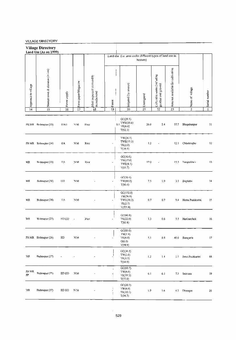
VILLAGE DIRECTORY
Village Directory Land Use (As on 1999)
E --" 5 " Q C
~ " ~ 'i3 O(l ;; ~ .8
.c: .8 u
'" to [ " til 0- Z -< 14 15
PRMR Bishnupur (33)
PRMR Bishnupur (34)
MR Bishnupur (33)
MR Bishnupur (30)
MR Bishnupur (2S)
MR Bishnupur (27)
PRMR Bishnupur (26)
MR Bishnupur (27)
PRMR Bishnupur (25)
FP
MR Bishnupur (27)
,2:;. :..c, " " ,1 c:
.~ " ,~
Of) " e<J +.
~ ,. {§ 1l >,
0.. <l) ~~ B Q. f,t ::l
.!Ls '" Q.
~ '" § :: <n
0 Z <~ ,~ 8 P.. -~
16 17 18
EAG NM Rice
EA NM Rice
EA NM Rice
ED NM
EA NM
ED EO Rice
ED NM
ED EO NM
ED EO NM
Landu se (i.e. area under different types ofland lise in hectare)
c: 0 .~
Of) > c ~ 'i3 :l U
u ... ~ <8 <> 2- ~
u " <l)
'" tl > ~ 11 ~ ~ ,g .... to '@ >, :: <l)
-0 -0 iii .;; .D e- " § S i -0 :E 0 4-< :l <l) e til 0 c: 1;; E .c: c:
" OJ '" 2 e<J ~ Of) u § '5 0 ] 'c "3 ~ ~
~ -< Z ~ u Of) C/l
19 I 20 21 22 23 2 1
I GC(29.5)
10 I TWE(26.6) 26.0 2.4 57.7 Bhagabanpur 11 I . TK(6.0) , T(62.1) I
I TW(24.1) TWE(13.3)
1.2 12.1 Chhakraghu 12 TK(2.0) T(39.4)
! GC(20.6)
-I TW(37.0)
17.0 15.5 Tengrakhal i 13 TWE(S.I)
I T(65.7)
I I GC(30.4) I TW(60.0) 7.5 1.0 3.1 Bagdoba 14 - !
T(90.4)
GC(172.0) TW(26.9)
- ! TWE(20.2) 0.7 0.7 9.4 Hazra Pushkarini IS TK(2.7) T(221.S)
GC(60.8)
-I TK(22.0) 1.3 0.6 5.S Hariharchak 16 T(82.8)
I
I GC(S5.0)
! TW(I.9) I TK(6.0) 5.1 O.S 40.0 Baragaria 17 -, I
0(60) I
I T(9S.9)
I GC(36.S)
-/ TW(3.0)
1.2 1.4 1.5 Setai Pushkarini 18 TK(4.5) T(44.0)
GC(60.7) TW(6.0) TK(IO.3)
6.1 6.1 7.3 Saintara 19
T(77.0)
GC(20.2) TW(4.0)
1.9 1.6 4.2 Dharapat 20 TK(IO.5) T(34.7)
529
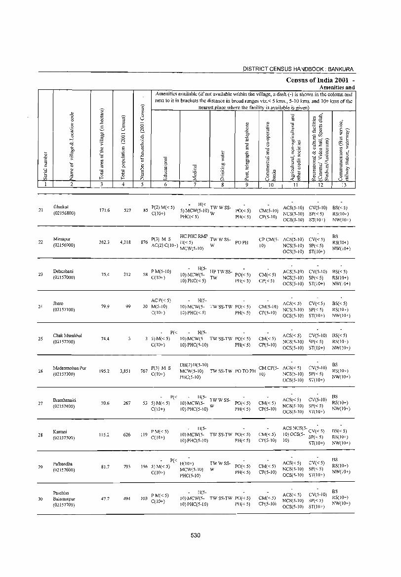
'V>
'" ~ ;;; <= -0 'V> <>
0 u u '" ;:l
t:: ..<: Ul 0 '" .~ 2 <1) u 0 (:'_
Q " ~
bI) Ul 0 0 ...:I ,g 0 -0
(:'_ 0 o(l .;;: ..<:
'" '" ~ " ~ £ 0 ;:l
Q; .~ 0 '0 ..c: .D .;;: "3 ""' ~ '" 0- 0
<;.... ~ 0 tl 0 '" 0--a '" .0 n ~ ~ '5 Ei
~ 0
Cfl f-< f-< Z 1 2 3 4 5
GhatkoI 21 171.6 527 85
(02156800)
Mirzapur 22 362.3 4,3 18 876
(02156900)
Dehuabani 23 75.4 312 58
(02157000)
Jhero 24
(02157100) 79.9 99 20
Chak Murakhal 25
(02157200) 74.4
Madanmohan Pur 26 19S.2 3,851 767
(02157300)
27 Bramhanairi
70.6 267 S3 (02157400)
Kantasi 28
(02157500) 115.2 626 119
Palbandha 793 156 29
(02157600) 81.7
Paschim 30 Ba[arampur 47.7 494 103
(02157700)
DISTRICT CENSUS HANDBOOK: BANKURA
Censills of India 2001 -Amenities and
Amenities available (if not available within the village, a dash (-) is shown in the column and
next to it in brackets the distance in broad ranges viz.< 5 kms., 5-10 Icms. and 10+ kms of the nearest place where the facility is available is given
-0 en ~" Iii .~ "0 ","
<> '" e c ;> :.= c/) u '0 1::: E~ 0 .~ 3 ..<: <E 0
" S 0.. "3 0-
" '" -ar/) ~ E: 0- u 11 'i' .~ ~ .2 ;:::" E :oJ <U
-0 0 '"5 ~.2 co~
u 9 .~ ~'" c Ul ;::
'" -0 !: '" U 0 .... o ._
'" .... ..<: iii '" 15 a(j~g 0 "," 0)
cti 0.. _" Ul -a;;:"g '';::::: 0
ca E -a '" ._ C ;:: bI) .~
E! .t:: §~~
.~ g <1) ;:l -0 C en 0 bI)
~ '" .~ -a c ] '" '3 t5 :oJ u 12 E Ul
., E ;:l
§ f u 'B .g] e ~ ~ :oJ c ,i E-" -0 " 25 0 o c u ._ Ctl
0:0= \.l4 ~ i>.. u15 ~o ~u- u e ~Cfl
6 7 8 9 10 II 12 13
P(2)M« 5) - H«
ACS(5-10) CV(5-10) BS« S) 5) MCW(5-IO) TW W SS- PO« 5) CM(5-IO) C(lO+)
PHC« 5) W PH« 5) CP(5-IO) NCS(5-1O) SP«5) RS(lO+) OCS(5-10) ST(IO+) NW(IO+)
P(3) M S HC PHC RMP TW W SS- CP CM(S- ACS(5-10) CV«5) BS
H«5) PO PH RS(IO+) AC(2) C(10+) MCW(5-10) W 10) NCS(5-10) SP«5)
NW(IO+) OCS(5-1O) ST(IO+)
PM(5-10) H(5-
~TWSS- PO(~5) ACS(5-10) CV(5-10) BS« 5) 10) MCW(5- CM«5)
C(10+) 10) PHC« 5) W PH«5) CP« 5)
NCS(5-10) SP« 5) RS(lO+) OCS(5-10) ST(IO+) NW(IO+)
AC P« 5) H(5-ACS« 5) CV«5) BS«5)
M(S-IO) 10) MCW(5- TW SS-TW PO« 5) CM(5-IO) NCS(5-10) SP« 5) RS(10+)
C(IO+) 10) PHC« 5) PH(<:S) CP(S-IO) OCS(5-10) ST(IO+) NW(IO+)
P« H(5-ACS« 5) CV(5-1O) BS«5)
5) M« 5) 10) MCW(5- TW SS-TW PO« 5) CM« 5) NCS(5-1O) SP« 5) RS(IO+)
CCIO+) 10) PHC(5-10) PH« S) CP(S-IO) OCS(5-10) ST(la+) NW(10+)
P(3) M S DH(2) H(5-10)
CMCP(5- ACS« 5) CV(5-10) BS
MCW(5-10) TW SS-TW PO TO PH RS(IO+) C(10+)
PHC(5-iO) 10) NCS(5-IO) SP« 5)
NW(lO+) OCS(5-10) ST(IO+)
P« - H(5-ACS«5) CV(S-IO)
BS
S)M«5) 10) MCW(5- TW W SS- PO«5) CM«5) RS(IO+)
C(IO+) 10)PHC(5-10) W PH« 5) CP(5-10) NCS(5-1O) SP« 5)
NW(IO+) OCS(5-10) ST(10+)
P M«5) H(5- ACS NCS(5- CV(~ 5) BS« 5)
C(10+) 10) MCW(5- TW SS-TW PO« 5) CM«5) 10) OCS(5- SP« 5) RS(10+) 10)PHC(5-10) PH« 5) CP(5-1O) 10) ST(lO+) NW(IO+)
- P« H(I~+) ACS« 5) CV« 5) BS
TWWSS-PO«5) CM«S) RS(10+)
5) M« 5) MCW(5-1O) W NCS(5-10) SP« 5) C(10+) PHC(5-1O) PH«5) CP(5-1O)
OCS(5-10) ST(IO+) NW(lO+)
H(5-ACS« 5) CV(S-IO)
BS P M« 5)
JO)MCW(5- TW SS-TW PO« 5) CM«5) RS(10+) C(10+) NCS(5-10) SP« 5)
10) PHC(5-1O) PH«5) CP(5-10) OCS(S-IO) ST(IO+)
NW(IO+)
530
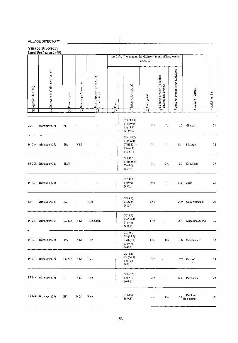
VILLAGE DIRECTORY
Village Directory Land Use (As on 1999)
14 15
MR Bishnupur (27)
PR MR Bishnupur (25)
PR MR Bishnupur (28)
PR MR Bishnupur (29)
MR Bishnupur (31)
PR MR Bishnupur (30)
PR MR Bishnupur (32)
PR MR Bishnupur (32)
PR MR Bishnupur (33)
PR MR Bishnupur (33)
16 17 18
ED
EA NM
EAG
ED Rice
ED EO NM Rice, Cloth
EA NM Rice:
ED EO NM Rice
NM Rice
ED NM Rice
Land lise (i.e. area under different types ofland use in I hectare)
191
I
I
-I
!
_I
I
I
i I
20
GC(113.3) TW(19.0) TK(I7.2) T(149.5)
GC(188.2) TW(36.0) TWE(12.8) TK(69.1) T(306.1)
GC(44.5) TWE(IS.O) TK(6.0) T(65.S)
GC(486) TK(9.0) T(S7.6)
GC(8.1) TW(2.0) T(IO.I)
GC(8.9) TW(34.4) TK(9.S)
T(S2.8)
GC(l6.1) TW(IS 9)
TWE(6.1) TK(9.S)
T(47.6)
GC(4.1) TW(S4.8) TK(IS.S) T(74.4)
GC(60.7) TK(7.1) T(67.8)
GC(38.8) T(38.8)
531
21
7.7
8.1
3.1
9.8
39.4
17.0
13.6
33.2
3.9
3.3
22 23 2
7.3 7.2 Ghatkol
8.1 40. I Mirzapur
3.4 3.3 Dehuabani
1.1 II.S Jhero
24.9 Chak Murakhal
125.4 Madanmohan Pur
0.3 9.0 Bramhanairi
7.7 Kantasi
10.0 Palbandha
0.8 48 Paschim . Balarampur
~
" .D
5 c
21
22
23
24
25
26
27
28
29
30
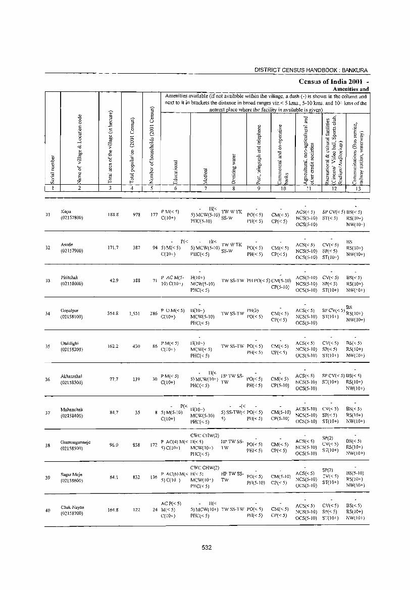
DISTRICT CENSUS HANDBOOK: BANKURA
Census of India 2001 -Amenities and
Amenities available (if not available within the village, a dash (-) is shown in the column and next to it in brackets the distance in broad ranges viz. < 5 kms., 5-10 kms. and 10+ kms of the
~
'V;' nearest place where the facility is available is given '" <l)
<1)
~ "0
@ 'V;' " "0 til ~ ...
0 t) C) § Q 0) iil <l)_ <1)"
C ..c:: - " <l) ta 'P 0
C '" C > :.= {I) u 0 5 <l) 0 0 .~ ~
'u ~ 'E ~ .~ U C'.- ..c:: cag. <l) i;;' & 0-u 0 V> <l) taf/) ;;; ~ 0 0- t)
....l ;§ 0 "0 E 0 .~ V) ~ :::=ns C'.- ] 6 '" " cid .;: -0 cd .S:? -3 1! .~ ill to 0) 0) §
OJ § U § .1a ';;:;; ~ '0 Q 0 ....
:W -fi .... cid ~ .f! c " ... .~ 0 0) ..c:: a c g o c <1) ""' ..c::
~ 0- 0'" ._ "0 'N .~ ..c .;: 0 :; ""' til ~ ta ] ."t: OJ> ::> E oj 0- 0 C Cll .~ § -<
""' <1) ::>'0 .- ~ ::> 0 iil 0 bJl OJ _-;as § U) c 0 til 0- .~ ta c E .!:! ~ to s ::> ~
<1) ..c u :.g E U) ::> u S ~
§ S ta E u '6 c "Ii E-'" 'fi ~ ~ .s :g s :;; C ::>
" 0 ::> -0 <l) 8 0 o § 0:-:::
CIl Z f- f- Z r.w ::;s 0.. U..c -< 0 ~ 8U5 U ~ 1 2 3 4 5 6 7 8 9 10 II 12 13
Kopa P M«5) - H« ACS«5) SP CV« 5) BS« 5) 31 188.8 978 177 5) MCW(5-1 0) TW W TK PO«5) CM« 5)
(02157800) C(10+) PHC(5-10) SS-W PH« 5) CP« 5) NCS(5-10) ST« 5) RS(IO+) OCS(5-10) NW(IO+)
Asude P« - H« ACS« 5) CV«5)
BS 32 171.7 387 94 5) M« 5) 5) MCW(5-10) TWWTK PO« 5) CM«5) RS(lO+)
(02157900) C(10+) PHC« 5) SS-W PH«5) CP« 5)
NCS(5-1O) SP« 5) NW(lO+)
OCS(5-1O) ST(IO+)
33 Piritchak
42.9 388 71 P ACM(5- H(IO+)
TW SS-TW PH PO« 5) CM(5-IO) ACS(5-1O) CV« 5) BS« 5)
(02158000) 10) C(IO+) MCW(5-IO) NCS(S-10) SP« 5) RS(IO+) PHC« 5)
CP(5-JO) OCS(5-10) ST(10+) NW(10+)
Gopalpur P OM« 5) H(10+) TW SS-TW PH(3) ACS« 5) BS
34 354.8 1,551 286 CM«5) SP CV« 5) RS(lO+) (02158100) C(IO+) MCW(S-IO) PO«S)
CP«5) NCS(S-IO) ST(lO+) NW(IO+)
PHC«5) OCS(5-10)
35 Otaldighi
162.2 430 86 I' MC< 5) H(lO+)
TW SS-TW POC< 5) CM« 5) ACS« 5) CV«5) BS«5)
(02158200) C(lO+) MCW«5) NCS(5-10) SP« 5) RS(IO+)
PHC« 5) PH«5) CP«5)
OCS(5-10) ST(lO+) NW(JO+)
Akharashal F'M«5) - H« ACS« 5) SP CV« 5) BS« 5)
36 77.7 139 30 5) MCW(IO+) HP TW SS- 1'0«5) CM« 5) (02158300) C(10+) PHC«5) TW PH« 5) CP(5-1O)
NCS(5-1O) ST(10+) RS(10+)
OCS(5-10) NW(10+)
Mohanchak - P« H(lZ+) -« ACS(S-IO) CV« 5) BS« 5) 37
(02158400) 84.7 35 8 5) M(5-1O) MCW(5-10) 5) SS-TW« 1'0« 5) CM(5-10)
NCS(5-10) SP« 5) RS(10+) C(10+) PHC« 5) 5) PHiz 5) CP(5-10)
OCS(5-10) ST(IO+) NW(IO+)
CWCCHW(2) SP(2) Gramsagarmeje
96.0 838 172 I' AC(4)M« H«5) HPTWSS-
PO« 5) CM«5) ACS« 5)
CV«5) BS« 5)
38 (02158500) 5)1 C(10+) MCW(10+) TW NCS(5-10) RS(10+)
PHC« 5) PH« 5) CP« 5)
OCS(5-10) ST(10+)
NW(IO+)
CWCCHW(2) SP(2) Sagar Meje I' AC(6) M« H« 5) HPTWSS-
PO« 5) CM(5-10) ACS«5)
CV«5) BS(5-1O)
39 (02158600)
84.1 832 136 5) C(IO+) MCW(IO+) TW NCS(5-IO) RS(10+)
PHC« 5) PH(5-10) CP« 5)
OCS(5-10) ST(IO+)
NW(10+)
ChakNayan ACP«5) H« ACS«5) eV« 5) BS«5)
40 164.8 122 24 M«5) 5)MCW(10+) TW SS-TW 1'0« 5) CM«5) NCS(S-lO) SP« 5) RS(IO+) (02158700) C(10+) PHC«5) PHiz 5) CP« 5) OCS(5-1O) ST(IO+) NW(IO+)
532
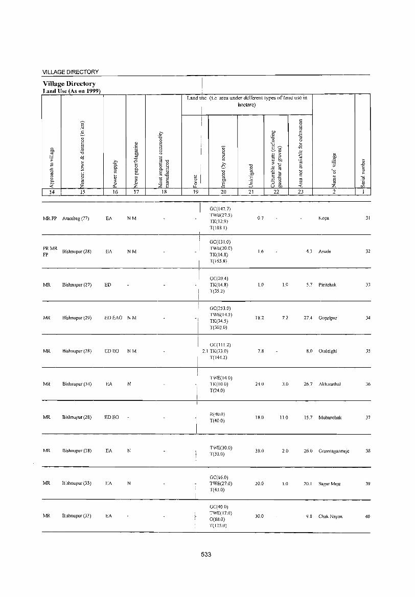
VILLAGE DIRECTORY
Village Directory Land Use (As on 1999)
'" ~ OJ
Z 14 15
MR FP Arambag (27)
PRMR FP Bishnupur (28)
MR Bishnupur (27)
MR Bishnupur (29)
MR Bishnupur (28)
MR Bishnupur (34)
MR Bishnupur (28)
MR Bishnupur (38)
MR Bishnupur (33)
MR Bishnupur (33)
16 17 18
EA NM
EA NM
ED
EDEAG NM
ED EO NM
EA N
ED EO
EA N
EA N
EA
Land r'se (i.e area under different types of land use in hectare)
19
_I
i ! ! I
!
-/
I
-I
20
GC(1477) TWE(27.S) TK(12.9) T(188.1)
GC(l310) TWE(20.0) TK(14.8)
T(165.8)
GC(20.4) TK(14.8) T(35.2)
GC(253.0) TWE(14.S)
TK(34.5) T(302.0)
GC(II12) 2.1 TK(33.0)
T(l44.2)
TWE(14.0) TK(IO.O) T(24.0)
R(40.0)
T(40.0)
TWE(30.0) T(30.0)
GC(16.0) TWE(27.0) T(43.0)
GC(40.0) TWE(17.0) 0(68.0) T(12S.0)
533
21
0.7
16
1.0
18.2
7.8
24.0
18.0
38.0
20.0
30.0
22 23 2
Kopa
4.3 Asude
1.0 5.7 Piritchak
7.2 27.4 Gopalpur
8.0 Otaldighi
3.0 26.7 Akharashal
11.0 15.7 Mohanchak
2.0 26.0 Gramsagarmeje
1.0 20.1 Sagar Meje
9.8 Chak Nayan
31
32
33
34
35
36
37
38
39
40
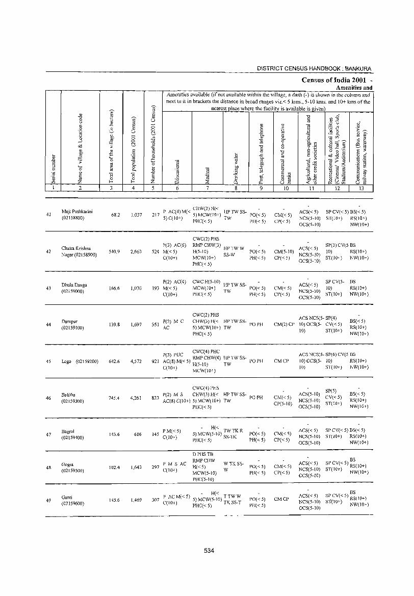
41
42
43
44
45
46
47
48
49
2
Maji Pushkarini (02158800)
Chatra Krishna
Nagar (02158900)
DhulaDanga (02159000)
Darapur
(02159100)
Lego (02159200)
Balitha (02159300)
Bagrol (02159400)
Gogra (02159500)
Ganti (02159600)
3
68.2
540.9
166.6
139.8
642.6
745.4
143.6
102.4
145.6
o o r::!-c o
'"@ "3 0-o 0-
~ 4
1,037
2,663
1,030
1,697
4,572
4,261
686
1,643
1,469
DISTRICT CENSUS HJ,NDBOOK : BANKURA
Census of India 2001 ~ Amenities and
Amenities available (if not available within the village, a dash (-) is shown in the column and next to it in brackets the distance in broad ranges viz.< 5 kms., 5-10 kms. and 10+ kms of the
nearest place where the facility is available is gi ven
5 6 7 8 9
CHW(2)H« 217 P AC(4) M« 5) MCW(IO+) HP TW SS- 1'0« 5)
5) C(10+) PHC« 5) TW PH« 5)
P(3) AC(6) 524 M« 5)
C(IO+)
CWC(2) PHS
RMP CHW(3) HP TW W H(5-10) MCW(IO+) SS-W
PHC«5)
PO« 5) PH«5)
P(2) AC(4) 193 M« 5)
C(lO+)
CWC H(5-1O) -MCW(lO+) HP TW SS- PO« 5)
PHC«5) TW PH«5)
CWC(2) PHS
351 P(2) M C AC
CHW(3) H« HP TW SS- PO PH 5) MCW(l 0+) TW
921
823
PHC« 5)
CWC(4)PHC 1'(3) PUC RMP CHW(4) HP TW SS-AC(8) M« 5) H(S-IO) TW C(10+) MCW(lO')
CWC(4) PHS P(2) M S CHW(3) H« HP TW SS-AC(S) C(IO+) 5) MCW(IO+) TW
PHC«5)
145 PM«5) C(IO+)
- H« 5) MCW(5-IO) TW TK R PHC« 5) SS-TK
PO PH
PO PH
PO«5) PH« 5)
D PHS TB
PM SAC RMPCHW 297 H« 5)
C(lO+) MCW(5-10) ~ TK SS- PO« 5)
PH« 5)
PHC(5-10)
- H« 307 P ACM«5) 5) MCW(5-10) TTWW
C(lO+) PHC« 5) TK SS-T
534
PO« 5)
PH«5)
'" > .~
15-9 o u
]
"' .~
'" E on
§-E ull
10
CM«5) CP« 5)
CM(5-10) CP«5)
CM«5) CP« 5)
11 12 13
ACS« 5) SP CV« 5) BS« 5) NCS(5-10) ST(IO+) RS(lO+) OCS(5-IO) NW(IO+)
ACS« 5) SP(3) CV(5 BS 10) RS(IO+)
NCS(5-10) ST(IO,) NW(IO+) OCS(5-IO)
SP CV(5- BS ACS« 5) 10) RS(lO+) NCS(5-IO) ST(IO+) NW(lO+) OCS(5-10)
ACS NCS(S- SP(4) CM(2) CP 10) OCS(5- CV« 5)
BS« 5) RS(lO+) NW(lO+)
CMCP
CM«5) CP(5-10)
CM«5) CP« 5)
CM« 5)
CP« 5)
CMCP
10) ST(IO+)
ACS NCS(S·· SP(6) CV(S BS 10) OCS(5- 10) RS(IO+) 10) ST(IO+) NW(lO+)
SP(5) ACS(5-10) CV«5) NCS(5-10) ST(IO+) OCS(5-10)
BS« 5) RS(lO+) NW(IO+)
ACS« 5) SP CV« 5) BS« 5) NCS(5-1O) ST(lO+) RS(IO+) OCS(5-1O) NW(IO+)
BS ACS« 5) SP CV« 5) RS(IO+) NCS(5-1O) ST(IO+) NW(IO+) OCS(5-10)
BS ACS« 5) SP CV« 5) RS(IO+) NCS(S-IO) ST(10+) NW(IO+) OCS(5-IO)
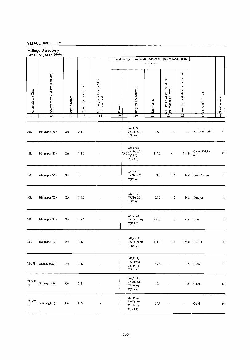
VILLAGE DIRECTORY
Village Directory Land Use (As on 1999)
MR Bishnupur (33)
MR Bishnupur (30)
MR Bishnupur (30)
MR Bishnupur (32)
MR Bishnupur (35)
MR Bishnupur (40)
MR FP Arambag (26)
PRMR Bishnupur (28)
FP
~: MR Arambag (25)
EA NM
EA NM
EA N
EA NM
EA NM
EA NM
EA NM
EA NM
EA NM
Land ~'se (i.e. area under different types of land use in hectare)
GC(16.0) TWE(28.0) T(44.0)
I GC(105.0)
:730 TWE(30.0) : . 0(59.0)
i T(1940)
,
- !
I I
-I I
GC(40.0) TWE(37.0) T(77.0)
GC(25.0) TWE(62.0) T(87.0)
GC(243.0) TWE(24S.0)
T(488.0)
GC(243.0) TWE(166.0) T(4090)
GC(42.4) TWE(9.0) TK(34.1) T(85.5)
GC(52.6) TWE(13.8) TK(IO.O) T(76.4)
GC(109.3) TWE(6.0) TK(14.1) T(129.4)
535
11.0
155.0
58.0
25.0
109.0
IILO
44.6
12.4
16.2
1.0
4.0
LO
1.0
8.0
1.4
12.2 Maj i Pushkarini
114.9 Chatra Krishna Nagar
30.6 Dhula Danga
26.8 Darapur
37.6 Lego
224.0 Balitha
13.5 Bagrol
13.6 Gogra
Ganti
41
42
43
44
45
46
47
48
49

50
51
52
53
54
55
56
57
58
59
2
Rampur (02159700)
Kotulpur (02159800)
Khundanga (02159900)
Napukur (02160000)
Nanagar (02160100)
Bhagalpur (02160200)
Kankara (02160300)
Kamarbere (02160400)
Hasandanga (02160500)
Gobindpur (02160600)
3
58.6
564.5
198.6
130.3
30.6
224.3
82.6
123.1
88.1
105.6
~ c 0)
U
o o ~ c o '~ ;:; 0.. o 0..
~ 4
246
7,118
1,566
595
1,148
1,388
287
516
488
730
DISTRICT CENSUS HANDBOOK: BANKURA
CenslIls of India 2001 -Amenities and
Amenities available (ifnot available within the village, a dash (-) is shown in the column and next to it in brackets the distance in broad ranges viz.< 5 kms., 5-10 kms. and 10+ kms of the
nearest place where the facility is available is given
5 6
45 PM«5) C(10+)
P(3) M S 1,503 PUC AC
C(IO+)
313 PM«5) C(lO+)
7 8 9
- H« 5) MCW(5-IO) TW W TK PO« 5)
PHC« 5) SS-W PH« 5)
HD(7)DA
DH(lO) PHS T TW TK NHRMP(7) CHW MCW(5- SS-T
10) PHC«5)
DDHH(5-1O)
PO PTa
PH« 5)
MCW(5-10) TW SS-TW PO« 5)
PHC(5-10) PH« 5)
- P« -5) M« 5) H(10+) ~: 0 SS- PO« 5)
PH« 5)
140 1'(10+) MCW(5-10) ~ PHC(lO+)
209 P M« 5) C(10+)
H(IO+)
MCW(5-10) PHC(IO+)
~: 0 SS- PO« 5)
PH(IO+)
H(JO+) 289 P M C(10+) MCW(5-10)
TWOSS- PO TW PH(lO+)
PHC(lO+)
- P« -55 5)M«5) H(JO+) TWOSS-
C(1O+) MCW(5-JO) PHC(JO+)
TW PO« 5) PH(IO+)
P« 103 5) M« 5)
C(JO+)
93 PM«5) C(IO+)
ACP« 5) ISS M« 5)
C(lO+)
H(5-10) MCW(5- TW SS-TW PO« 5) JO)PHC(5-10) PH«5)
H« -5) MCW(5-10) T W TK SS- PO« 5)
PHC(S-IO) T PH« 5)
H(5-10) MCW(5- TK SS-TK PO« 5)
10) PHC« 5) PH« 5)
536
10
CM«5) CP«5)
CM(2) CP(2)
CM«5) CP(lO+)
CM« 5) CP(10+)
II 12 13
ACS« 5) SP CV« 5) BS« 5) NCS(5-10) ST(IO+) RS(10+) OCS(5-10) NW(lO+)
ACS NCS(S- CV(2) 10) OCS(5- SP(7)
10) ST(10+)
ACS( < 5) CV( < 5)
NCS(5-lO) SP« 5) OCS(5-10) ST(IO+)
BS RS(JO+)
NW(IO+)
BS(5-lO)
RS(IO+) NW(10+)
ACS« 5) CV SP« 5) BS(JO+) NCS(5-lO) ST(IO+) RS(10+)
OCS(5-10) NW(10+)
ACS« 5) CV« 5) CM(5-10) NCS(5-lO) SP« 5)
CP(IO+) OCS(5-10) ST(IO+)
BS(10+)
RS(IO+) NW(lO+)
CM(IO+) CP(IO+)
ACS NCS(5- CV(~O+) 10) OCS(5- SP« 5)
10) ST(JO+)
BS(lO+)
RS(IO+) NW(IO+)
ACS« 5) CV(lO+) CM(IO+) NCS(5-10) SP« 5) CP(IO+) OCS(5-IO) ST(IO+)
BS(lO+)
RS(JO+) NW(IO+)
CM« S) CP«5)
CM« 5) CP« 5)
CM«5) CP(5-1O)
ACS« 5) CV« 5) NCS(5-10) SP« 5) OCS(5-IO) ST(IO+)
BS« 5) RS(IO+) NW(IO+)
ACS« 5) SP CV« 5) BS« 5) NCS(5-IO) ST(IO+) RS(IO+) OCS(S-10) NW(IO+)
ACS«5) CV«5) NCS(5-IO) SP«5) OCS(5-IO) ST(IO+)
BS« 5) RS(10+) NW(IO+)
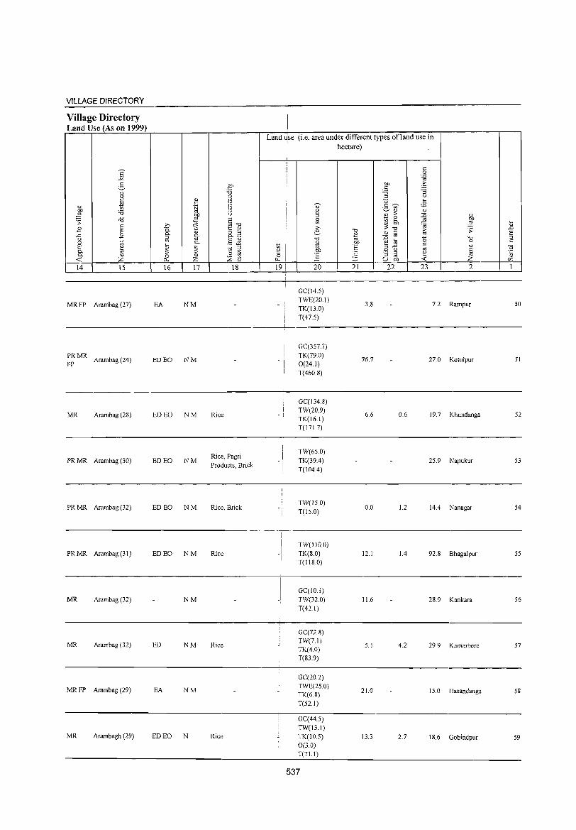
VILLAGE DIRECTORY
Village Directory Land Use (As on 1999)
E ..><
:3 " <.)
~ " ~ '6 a'(j .> ~ E
..c E g 1:;; 8 " ~ 0-0- " <: z 14 15
MRFP Arambag (27)
PRMR Arambag (24)
FP
MR Arambag (28)
PRMR Arambag (30)
PRMR Arambag (32)
PRMR Arambag (31)
MR Arambag (32)
MR Arambag (3Z)
MRFP Arambag (29)
MR Arambagh (29)
.i? "(; <>
" I: c 1= ·fJ <>
0[) (.)
OJ j: :::8 '" ,.
"" 0. '" 1.::: <l.) <l.) 8. B 0- 0-:J OJ .8 ~ <Il 0-
~ ~ t> '" ," '" 0 '" .~ '" "'""'
z ,~ 8 16 17 18
EA NM
ED EO NM
ED EO NM Rice
ED EO NM Rice, Pagri Products, Brick
ED EO NM Rice, Brick
ED EO NM Rice
NM
ED NM Rice
EA NM
ED EO N Ric(:
Land use (i.e. area under different types ofJand use in I hectare)
I
i
c .S 1;;
01) .::: c -3 '6 ::;l <.)
<J .... ~
3 -;c <8 " ~ " '" "
;> :g ~ ~ ~ ~ ~ ~ .... " '" "(; > .D e "" '" c ~ 8 2 OJ
"0 '" :0 (5 4..; ::;l
~ 01)
~ ~ c 0 c 1:;; "E ..c '" <il
~ 01) " '" § t: :; ::;l '" '5 E OJ -< ~ ;:J u 0[) Z (/)
19 20 21 22 23 2 1
GC(14.5) TWE(20.1)
3.8 7.2 Rampur 50 TK(l3.0) T(47.5)
I GC(357.7)
I TK(79.0) - i 76.7 27.0 Kotu1pur 51
0(24.1) ! T(460.8) I
GC(134.8) TW(20.9)
6.6 0.6 19.7 Khunclanga 52 TK(16.1)
i T(17l.7)
I TW(65.0)
-I TK(39.4) 25.9 Napukur 53 I T(104.4) ! I
!
TW(l5.0) 0.0 1.2 14.4 Nanagar 54
T(150)
I TW(1IO.0) -I TK(8.0) 12.1 1.4 92.8 Bhaga1pur 55
T(1l8.0)
GC(IO.l) TW(32.0) 11.6 28.9 Kankara 56 T(421)
GC(72.8) TW(7.1)
5. J 4.2 29.9 Kamarbere 57 TK(4.0) T(839)
GC(ZO.2) TWE(2S.0)
21.0 15.0 Hasandanga 58 TK(6.8) T(52.1)
GC(44.5) TW(13.1) TK(10.S) 13.3 2.7 18.6 Gobindpur S9 0(3.0) T(71.1)
537
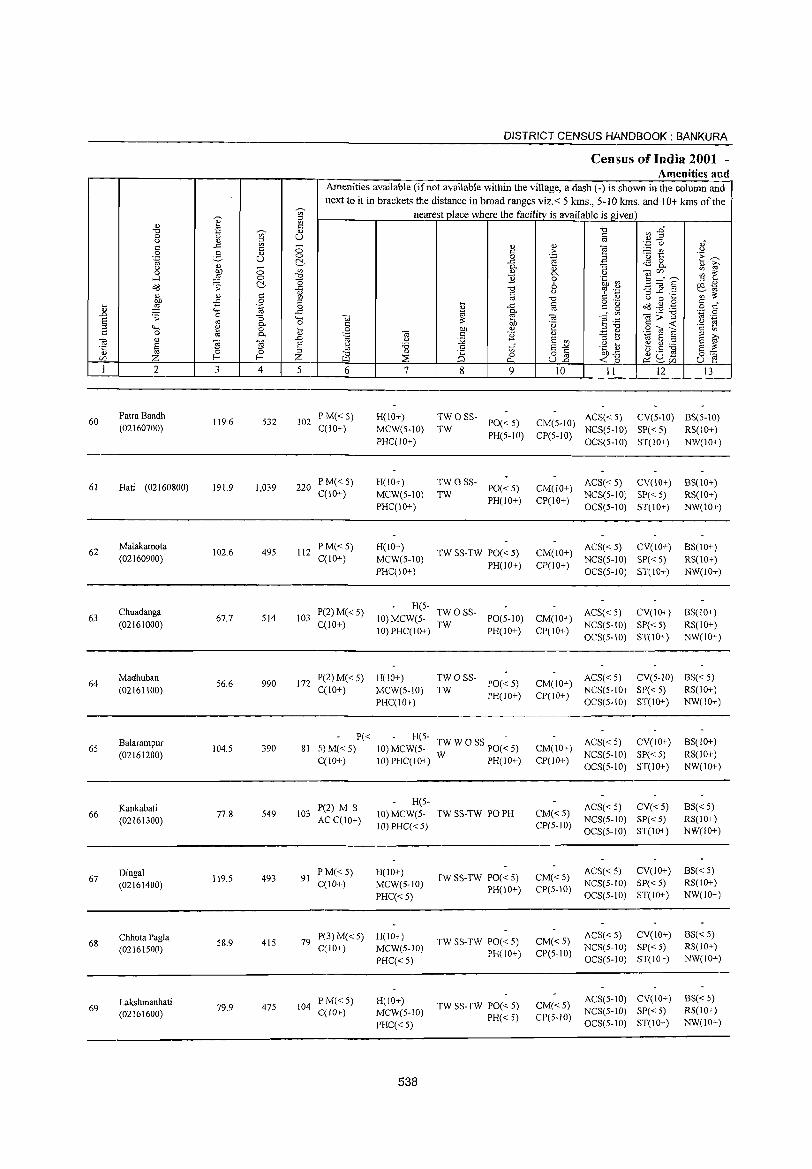
DISTRICT CENSUS HANDBOOK: BANKURA
Census of India 2001 -Amenities and
Amenities available (if not available within the village, a dash (-) is shown in the column and
next to it in brackets the distance in broad ranges viz.< 5 kms., 5-10 kms. and 10+ kms of the ~ nearest place where the facility is available is given ::l
0) e is -i:l ~ E~ "'" 2l ~ <l) 0 to U til u <l) ::l
'" ..c '" - ., ., e ''';:::: (.) oJ
'" 0 c > ;..:= {/) " 0 3 " 'u 1:: E~ .~ u 0 0 .~ El ~ .c ~ 8. "
0)
0 0- 0) :; <> ~ 0 ~ '" .,
0- " OJU) ~ ~ ....l 0 "'" ] 0 .~ ~ 3 _n'E "0 ::l 0)
cld .;; C ..c "'" 6 '3] .2 iJ:I 1;; <> <> c ~ g " c;:s '.p ';;;":;:
"'" '" <> " 0 ...
:W fi 0 ::l o .- s:: • .... .~ 0 I ..c s:: s:: g cld.g.§ o c <> """ ..c 0- ro '.p 0 ..0 0 '" '" OJ;;] .;; :; '+< ., '" e:g '" ._ § '" bb " 1;;
~ 0- 0 § .~ '" -< '§ tl 4-< 0 ... on <> E ~ .8 <i! E '" 0 0- 0) 'c OJ " ] 0)
~ S ::1
'" 0)
] ] ..0 "' U :;;; E '" ::l " E ~
S S u '0 c E-" .~ 1u ~ .5 :g E :;: '5 '" '" '" 0 0 ::l
"'" <I) i§ 82 15b.p 0"" Z f-- f-- Z :::s 0 ~ 2. ti U) ~ 0- -< 0 u 1":
1 2 3 4 5 6 7 8 9 10 11 12 13
60 Patra Bandh
119.6 532 102 P M«5) H(lO+) TWOSS- ACS« 5) CV(5-10) BS(5-10)
PO«5) CM(5-10) (02160700) C(lO+) MCW(5-10) TW PH(5-1O) CP(5-10)
NCS(5-10) SP«5) RS(IO+) PHC(IO+) OCS(5-1O) ST(IO+) NW(IO'_)
61 Hati (02160800) 191.9 1,039 220 p M«5) H(IO+) TWO SS-
PO«5) CM(JO+) ACS« 5) CV(IO+) BS(1O+)
C(JO+) MCW(5-10) TW PH(lO+) CP(lO+)
NCS(5-10) SP« 5) RS(IO+) PHC(IO+) OCS(5-10) ST(IO+) NW(lO+)
62 Malakarpota
102.6 495 112 P M«5) H(IO+)
TW SS-TW PO« 5) CM(JO+) ACS« 5) CV(IO+) BS(IO+)
(02160900) C(IO+) MCW(5-10) PH(lO+) CP(IO+)
NCS(5-10) SP« 5) RS(JO+) PHC(IO+) OCS(5-10) S1'(IO+) NW(lO+)
Chuadanga P(2) M« 5) H(5-
TWOSS- ACS« 5) CV(IO+) BS(IO+) 63
(02161000) 67.7 514 103
C(JO+) JO)MCW(5-
TW PO(5-10) CM(IO+)
NCS(5-10) SP«5) RS(IO+) IO)PHC(IO+) PH(lO+) CP(IO+)
OCS(S-IO) ST(IO+) NW(IO+)
64 Madhuban
56.6 990 172 P(2) M« 5) H(IO+) TWOSS-
PO«5) CM(IO+) ACS«5) CV(5-10) BS«5)
(02161100) C(IO+) MCW(5-IO) TW PH(IO+) CP(IO+)
NCS(S-IO) SP« 5) RS(IO+)
PHC(10+) OCS(5-IO) ST(10+) NW(IO+)
Balarampur P« H(S-
TW W 0 SS PO(~ 5) ACS« 5) CV(JO+) BS(10+) 65 104.5 390 81 5)M«5) 10)MCW(5- CM(IO+)
(02161200) W PH(lO+) NCS(5-1O) SP« 5) RS(IO+)
C(1O+) IO)PHC(IO+) CP(lO+) OCS(5-10) ST(IO+) NW(IO+)
Kankabati P(2) M S H(S-
ACS« 5) CV«5) B8« 5) 66
(02161300) 77.8 549 103
AC C(IO+) 10) MCW(5- TW SS-TW PO PH CM«5)
NCS(5-to) SP« 5) RS(lO+) lO)PHC« 5) CP(5-10)
OCS(5-JO) ST(IO+) NW(IO+)
Dingal 119.5 493 91
P M«5) H(lO+) TW SS-TW PO« 5) CM« S)
ACS« 5) CV(IO+) BS«5) 67 C(10+) MCW(5-10) NCS(5-IO) SP« 5) RS(lO+) (02161400) PH(IO+) CP(5-IO)
PHC«5) OCS(5-10) ST(IO+) NW(lO+)
Chhota Pagla 79 P(3) M« 5) H(IO+)
TW SS-TW PO« 5) CM« 5) ACS« 5) CV(IO+) BS« 5)
68 58.9 415 C(lO+) MCW(5-1O) NCS(S-IO) SP« 5) RS(IO+) (02161500) PH(10+) CP(5-10)
PHC« 5) OCS(5-10) ST(IO+) NW(IO+)
Lakshmanhati PM«5) H(IO+) TW SS-TW PO« 5) CM« 5)
ACS(S-IO) CV(IO+) BS« 5) 69 79.9 475 104
C(10+) MCW(5-IO) NCS(S-lO) SP« 5) RS(IO+) (02161600) PH« 5) CP(S-IO) PHC« 5) OCS(5-IO) ST(IO+) NW(IO+)
538
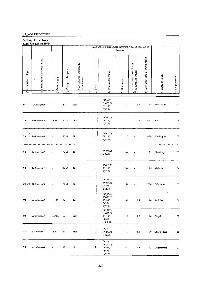
VILLAGE DIRECTORY
Village Directory Land Use (As on 1999)
Land ~se (i.e. area under different types ofland use in I hectare)
I I <:
S I 0
"" I .~
3 ~, I bI) -5 <: Q) ~3 '5 :l '-' () ::> '-' <: Q) IS U ... ~ <: <B
" .~ I:: 0) .5 --;;;-J '5 ,~
~ ~'" '" bI) " '" > {i 1;h ~ ~ ro I~ s: ~ 0
;;;S ~ ... ~ :@ ....
~ >, <.~ "'0 :::: Q)
B . 0. -;:; 1~ Q) >, -0 8 :;: .!:J
" ;~ B e <l.l '" E ..0 B 0. 0. '" ~ 1;1 - ro "" ::> '-' ro " '-' "0 ~ ~ -0 ro t; 0. .::::: ~ " bI) <: 0 <:
~ Q)
~ ~ 8 ~ t; "til E "..0 ro '" "' 8 '" on ~ () § 0 c - ::l ~ '5 0. '" 0 Q) ] " ro <r: z Il. Z ;~ S ~ ::J u on <r: z CfJ
14 15 16 17 18 19 20 21 22 23 2 1
GC(60.7)
MR Arambagh (36) NM Rice TW(33.2)
8.7 6.5 5.5 Patra Bandh 60 TK(5,0) T(989)
TW(85.0) MR Bishnupur (4O) ED EO NM Rice -/ TK(5,9) 51.1 2,7 47,2 Hati 61
i T(90,9)
1
I
I TW(51.0) MR Bishnupur (40) NM Rice -I TK(2,0) 1.7 47,9 Malakarpota 62
I T(53,0)
I
I
I
MR Bishnupur (42) NM Rice _I TW(40,0) 10,6 17,1 Chuadanga 63
i T(40,0)
I
TW(33,2) MR Bishnupur (41) NM Rice TK(20) 10,6 10,S lvIadhuban 64
T(35,2)
I
I GC(29, I) I
PRMR Bishnupur (36) NM Rice I TW(38,8)
5,6 22.0 Balarampur 65 I TK(9.0)
I T(76,9)
I GC(52,6) TW(13.0)
MR Arambagh (29) ED EO N Rice I TK(0,6) O,S 0.4 10.0 Kankabati 66 I 0(0,5) T(66,7)
GC(SS,2) TW(17.6)
MR Arambagh (30) ED EO N Rice TK(1.8) 1.0 0,7 9,6 Dingal 67 O(O.S) T(10S,3)
GC(4.1) MR Arambagh (3S) ED N Ric'~ TW(32.1) 1.1 5.7 16,0 Chhota Pagla 68
T(36,1)
GC(12,1) TW(420)
MR Arambagh (40) N Rice TK(O.4) 6,7 3,5 5,5 Lakshmanhati 69 0(97) T(64.3)
539
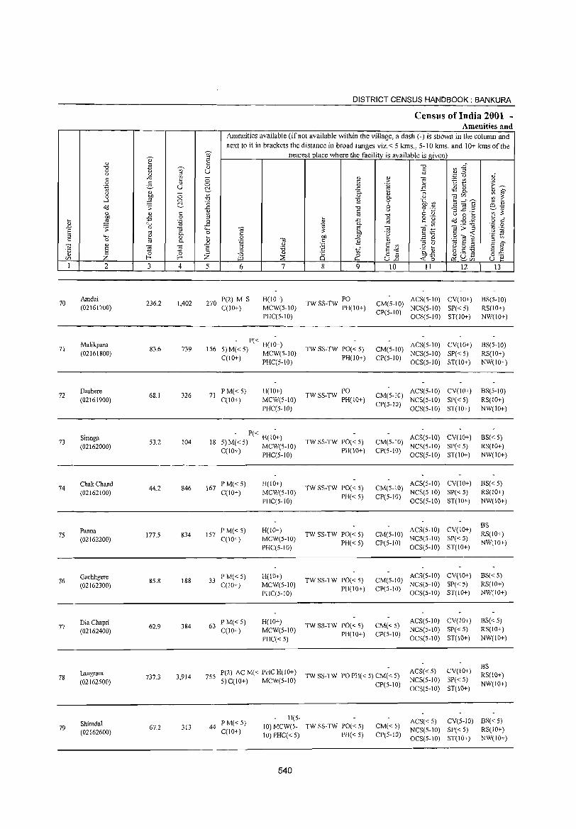
DISTRICT CENSUS HANDBOOK: BANKURA
Census of India 2001 -Amenities and
Amenities available (if not available within the village, a dash (-) is shown in the column and
next to it in brackets the distance in broad ranges viz.< 5 kms., 5-10 kms. and 10+ kms of the -;;- nearest place where the facility is available is giwn
" ;:l
'" <U lii <: "0 ~ .gh "0 -;;- <1)
0 u U <: () <1) ~ '" .~ '0 OJ"
" ..t:
" c: <1) 0) "§ :..= C/.I u <: ;> 0 2- " 0 0 .~ '0 ~ E~ .~ u ~ ..t: .a t$2 8-
" 0- "3 ~ ~ () c: '" <1) <1) C3r:/J 0 ~ 0- u
:g ~ .....l 0 "0 B 0 'a ~ 5 ;::::f E ~ a 6 o<J .;;: ..t: "0 -3 ~.2 ES.-ta <1) <: u ~ ';j
'" ~ <1) <1) c '" '" "0 <: <1) u 0 ""
:W -:5 0 ;:; .... <: o ._
o<J.g.@ c " ... '.g 0 " ..c <: g '~ .~ " <;..., ..c ~
0. '" '" C3>"'§ .D .;; 0 :; <;..., C3 ~ C3 ~:B § '" 0- 0 '" .~ <: ~ .8 M <;...,
~ 0 ... 0 OJ) <1) ;@ ~ 9<0] § '" c 0 0- 0) 'ij C3 c E Q)
"' S C3 <1) .D (J :Q E '" ;:l (J E ~
8 ~ Cd 6 u '6 8 ~" E"" .~ ~ f3 .S ~ 8 ~ '5 '" 0 ;::l ~
Q) '" 8.E OJ)..t: r:/J Z f-< Z :::8 Q 0
~ '0 ~ ~rZi 8] ~
1 2 3 4 5 6 7 8 9 10 11 12 13
70 Amdai
236.2 1,402 270 P(2) M S H(10+) PO ACS(5-1O) CV(IO+) BS(5-10)
TW SS-TW PH(IO+) CM(5-10) (02161700) C(lO+) MCW(5-IO)
CP(5-IO) NCS(5-IO) SP«5) RS(IO+)
PHC(5-10) OCS(5-1O) ST(lO+) NW(IO+)
71 Malikpara
83.6 739 156 - P« H(l~+)
TW SS-TW PO« 5) CM(5-10) ACS(5-1O) CV(IO+) BS(5-10)
(02161800) 5) M« 5) MCW(5-10) NCS(5-1O) SP«5) RS(IO+) C(10+) PHC(5-10) PH(IO+) CP(5-IO)
OCS(5-10) ST(IO+) NW(IO+)
Dashere p M«5) H(IO+) PO ACS(5-1O) CV(IO+) BS(5-10) 72
(02161900) 68.1 326 71
C(10+) MCW(5-10) TW SS-TW PH(10+) CM(5-10) NCS(5-10) SP« 5) RS(IO+)
PHC(5-10) CP(5-IO)
OeS(5-10) ST(IO+) NW(lO+)
73 Siringa
53.2 104 18 - P« H(I~+)
TW SS-TW PO« 5) CM(5-10) ACS(5-10) CV(lO+) BS« 5)
(02162000) 5)M« 5) MeW(5-10) PH(IO+) CP(5-10)
NCS(5-IO) SP« 5) RS(lO+) C(10+) PHC(5-1O) OCS(5-1O) ST(lO+) NW(IO+)
74 ChakChand
44.2 846 167 PM« 5) H(IO+)
TW SS-TW PO« 5) CM(5-10) ACS(5-to) CV(to+) BS«5)
(02162100) C(10+) MCW(5-10) PH«5) CP(5-10)
NCS(5-IO) SP« 5) RS(IO+)
PHC(5-10) OCS(S-IO) ST(IO+) NW(IO+)
ACS(5-10) CV(lO+) BS
75 Panna
177.5 834 157 PM«5) H(lO+)
TW SS-TW PO« 5) CM(5-IO) RS(lO+) (02162200) C(IO+) MeW(5-10)
PH« 5) CP(5-IO) NCS(S-IO) SP« 5)
NW(IO+) PHC(5-10) OCS(5-10) ST(IO+)
76 Gachhgere
8S.8 188 33 PM«S) H(IO+)
TW SS-TW PO« 5) CM(S-IO) ACS(S-IO) CV(IO+) BS« 5)
(02162300) C(IO+) MCW(5-IO) PH(IO+) CP(5-IO)
NCS(5-10) SP«5) RS(IO+)
PHC(S-IO) OCS(S-IO) ST(IO+) NW(IO+)
Dia Chapri 62.9 384 63
P M«5) H(lO+) TW SS-TW PO« 5) CM«5)
ACS(5-1O) CV(IO+) BS«5) 77
0(10+) MCW(5-IO) NCS(5-IO) SP«5) RS(lO+) (02162400) PH(IO+) CP(5-IO) PHC« 5) OCS(5-10) ST(IO+) NW(\O+)
CV(lO+) BS
Laugram 3,914 755
P(2) AC M« PHC H(10+) TW SS-TW PO PH( < 5) CM( < 5)
ACS« 5) RS(IO+) 78 737.3
5) C(IO+) MCW(5-10) NCS(5-to) SP« 5) (02162500) CP(5-IO) NW(IO+) OCS(5-10) ST(IO+)
Shimdal PM« 5) H(S-
ACS« 5) CV(5-1O) BS« 5) 79 67.2 313 44
C(10+) 10) MCW(5- TW SS-TW PO« 5) CM«5)
NCS(5-IO) SP« 5) RS(lO+) (02162600) 10) PHC« 5) PH«5) CP(5-10) OCS(5-10) ST(IO+) NW(IO+)
540
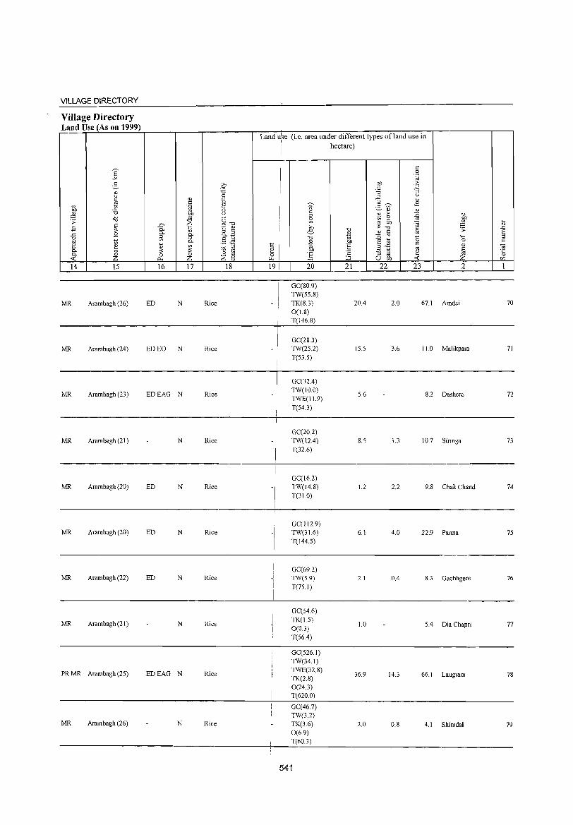
VILLAGE DIRECTORY
Village Directory Land Use (As on 1999)
MR Arambagh (26)
MR Arambagh (24)
MR Arambagh (23)
MR Arambagh (21)
MR Arambagh (20)
MR Arambagh (20)
MR Arambagh (22)
MR Arambagh (21)
PR MR Arambagh (25)
MR Arambagh (26)
ED N Rice
ED EO N Rice
EDEAG N Rice
N Rice
ED N Rice
ED N Rice
ED N Rice
N Rice
EDEAG N Rice
N Rice
Land u:se (i.e. area under different types ofland use in hectare)
I - !
I
-/
I
-I I I
I I
GC(80.9)
TW(55.8) TK(8.3)
0(1.8) T(146.8)
GC(28.3) TW(25.2) T(53.5)
GC(32A) TW(lO.O)
TWE(11.9)
T(54.3)
GC(20.2) TW(12A)
T(32.6)
GC(16.2)
TW(14.8)
T(31.0)
GC(112.9) TW(31.6)
T(144.5)
GC(69.2) TW(5.9)
T(75.1)
GC(54.6)
TK(L5)
0(0.3)
T(56A)
GC(526.1)
TW(34.1) TWE(32.8) TK(2.8) 0(24.3) T(620.0)
GC(46.7) TW(3.2)
TK(3.6) 0(6.9)
T(60.3)
541
20A
15.5
5.6
8.5
1.2
6.1
2.1
1.0
36.9
2.0
2.0 67.1 Amdai
3.6 11.0 Malikpara
8.2 Dashere
1.3 10.7 Siringa
2.2 9.8 Chak Chand
4.0 22.9 Panna
0.4 8.3 Gachhgere
5.4 Dia Chapri
14.3 66.1 Laugram
0.8 4.1 Shimdal
70
71
72
73
74
75
76
77
78
79

DISTRICT CENSUS HANDBOOK: BANKURA
Census of India 2001 -Amenities and
Amenities available (if not available within the village, a dash (-) is shown in the column and next to it in brackets the distance in broad ranges viz.< 5 kms., 5-10 kms. and 10+ kms of the
~
nearest place where the facility is available is given '" e '" ID~ " § "t:J "t:J _g
'§' c U '" ~ " "
0 u ., <) ., en
0 " > e '" .~ " ..c
" !: '0 1:: i":~ 0 .~ B 0 2- " 0
-<= <.S 0
~ ~ .~ U C!.- o. " 0. "
., - en ., 0. u tiir;/)
en C 0 01) 0 "t:J E 0 .~ ~ ;;~"8 ::l ., ....l ,g 0 "0
" ~ ~ ~ "t:J '? ';:: '3 ~,~ ';;~ o<l ;; ..c
c " '" !: ., " 0 ~ " " " en
'" "0 o ._ ~ .$5 .g c c"
0 ::l ~ -<= c
c:" ~ 0 en -5
" '" 'C 0 ~ .~ 0
0. -;;"g ::;
'6 ..c t; ~ tii ~ .~ g <t: f3 '.g ..D ~ " 4-< ] ~ 01) .~ <: in § '" 0. 0
00 '" ","t:J 8 'toE "-< ~ 0 ... .9 -a E ~ ~ OJ a '" '" ~ c 0 0. " til .s a on '" " a ..D " "'" .~ t ~ 9d ~ 51 .~ " tii g a " :0 " tor 5-'" u .= ~ ~ :::> o § 01)-<=
o ._ '0 0 '" "t:J " i§ 0 <t: 0 O;lu- u e! f-< f-< Z J.:Q ::;:;: Il.. U..D ~r;/)
r;/)
1 2 3 4 5 6 7 8 9 10 11 12 13
P M« 5) H(5-
ACS« 5) CV(5-1O) BS« 5) Padma 120.9 495 87 10) MCW(5- TW SS-TW PO« 5) CM«5)
NCS(5-1O) SP«5) RS(IO+) 80
C(IO+) (02162700) 10) PHC« 5) PH« 5) CP(5-1O)
OCS(5-10) ST(10+) NW(lO+)
PM S AC H(5-
ACS« 5) CV« 5) BS«5) 81 Sehas
195.2 2,130 377 10) MCW(5- TW SS-TW PO PH« 5) CM« 5) NCS(5-10) SP«5) RS(IO+) (02162800) C(lO+)
IO) PHC« 5) CP(5-1O) OCS(5-10) ST(10+) NW(lO+)
P« H« ACS« 5) CV« 5) BS«5)
82 Shyampur
49.7 193 41 5)M«5) 5) MCW(5-IO) TW SS-TW PO« 5) CM«S) NCS(S-IO) SP« 5) RS(IO+) (02162900)
C(IO+) PHC« 5) PH«5) CP(5-IO) OCS(5-10) ST(10+) NW(IO+)
P(2) M« 5) H(5-
ACS«5) CV(5-10) BS« 5) Bara Pushkarini 94.7 721 149 10) MCW(5- TW SS-TW PO« 5) CM«5)
NCS(5-1O) SP« 5) RS(lO+) 83
C(lO+) (02163000) 10) PHC« 5) PH(5-1O) CP(5-10)
OCS(5-IO) ST(IO+) NW(10+)
P« H(S-CV(5-10)
BS ACS(5-10)
RS(lO+) Bener Chak
46.3 62 13 5)M«S) 10) MCW(5- TW SS-TW PO« 5) CM«5) NCS(5-IO) SP«5)
84 NW(10+)
(02163100) C(IO+) 10) PHC« 5) PR(5-10) CP(S-10)
OCS(5-10) ST(IO+)
PM« 5) H(lO+) ACS« 5) CV(lO+) BS« 5) Fatepur 65.2 126 27 TW SS-TW PO« 5) CM«S)
NCS(5-10) SP« 5) RS(lO+) 85 (02163200) C(lO+) MCW(5-10)
PR(IO+) CP(5-IO) NW(IO+) PHC« 5) OCS(5-1O) ST(10+)
P« H(5-ACS« 5) CV(5-10) BS« 5) HaldarChak
81.8 191 40 5)M« 5) 10) MCW(5- TW SS-TW PO« 5) CM«5) NCS(5-10) SP« 5) RS(10+) 86
(02163300) C(lO+) 10) PHC« 5) PH(S-10) CP(5-lD)
OCS(5-1O) ST(IO+) NW(IO+)
P« H(5-AC5« S) CV(S-IO) BS« 5) Mukha
95.9 437 82 5) M« 5) 10) MCW(5- TW SS-TW PO« 5) CM« 5) NCS(5-10) SP«5) RS(lO+) 87
CP(S-IO) (02163400) C(10+) 10) PHC« 5) PH(5-10) OCS(5-10) ST(lO+) NW(IO+)
R(S- CV(5-1O) BS
P M« 5) CMCP(S- ACS« 5) RS(IO+) Radhamadhab- pur
67.3 643 129 10) MCW(5- TW SS-TW PO« 5) 10) NCS(5-10) SP« 5)
NW(lO+) 88
(02163500) C(lO~ ) 10) PHC« 5) PH(5-IO)
OC5(5-1O) 5T(10+)
H(S- ACS NCS(5- CV(~-JO) BS P NI« 5) PO PH(5- RS(IO+) Karak Berya 2,057 400 10) MCW(5- TW SS-TW 10) CM«5) 10) OCS(5- SP« 5) 89 1558 C(lO+) CP(5-1O) 10) ST(10+) NW(IO+) (02163600)
10) PHC« 5)
542
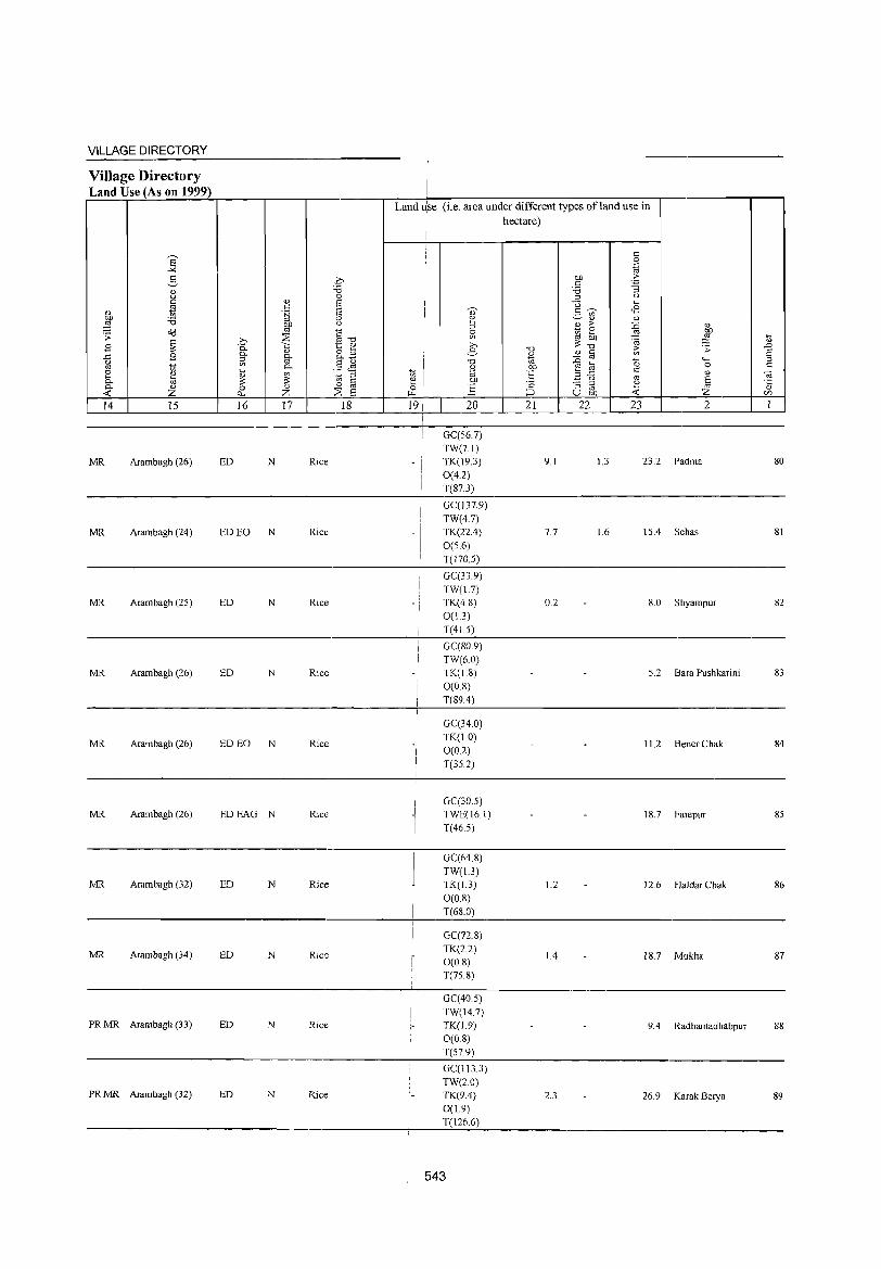
VILLAGE DIRECTORY
Village Directory Land Use (As on 1999)
MR Arambagh (26)
MR Arambagh (24)
MR Arambagh (25)
MR Arambagh (26)
MR Arambagh (26)
MR Arambagh (26)
MR Arambagh (32)
MR Arambagh (34)
PR MR Arambagh (33)
PR MR Arambagh (32)
ED N Rice
ED EO N Rice
ED N Rice
ED N Rice
ED EO N Rice
EDEAG N Rice
ED N Rice
ED N Rice
ED N Rice
ED N Rice
Land ~se (i.e. area under different types ofland use in
I - j
I I
-I !
i
I I
-) ! I
I
I
I hectare) i
GC(56.7)
TW(7.1) TK(J9.3)
0(4.2)
T(87.3)
GC(137.9)
TW(4.7) TK(22.4)
0(5.6) T(l70.5)
GC(33.9)
TW{1.7) TK(4.8)
0(13) T(41.5)
GC(80.9)
TW{6.0) TK(1.8)
O(OS) T(S9.4)
GC(34.0)
TK(! 0) 0(0.2) T(35.2)
GC(30.5) TWE(16.1)
T(46.5)
GC(64.S)
TW{1.3) TK(L3)
0(08) T(6S.0)
GC(72.S)
TK(2.2) O(O.S) T(75.S)
GC(40 5)
TW(14.7) TK(J9) O(OS) T(57.9)
GC(113.3)
TW(20) TK(9.4)
0(1.9) T(126.6)
543
9.1 u 23.2 Padma
7.7 1.6 15.4 Sehas
0.2 8.0 Shyampur
5.2 Bara Pushkarini
11.2 Bener Chak
IS.7 Fatepur
1.2 12.6 Haldar Chak
1.4 18.7 Mukha
9.4 Radhamadhabpur
2.3 26.9 Karak Berya
80
81
82
83
84
S5
86
87
88
89
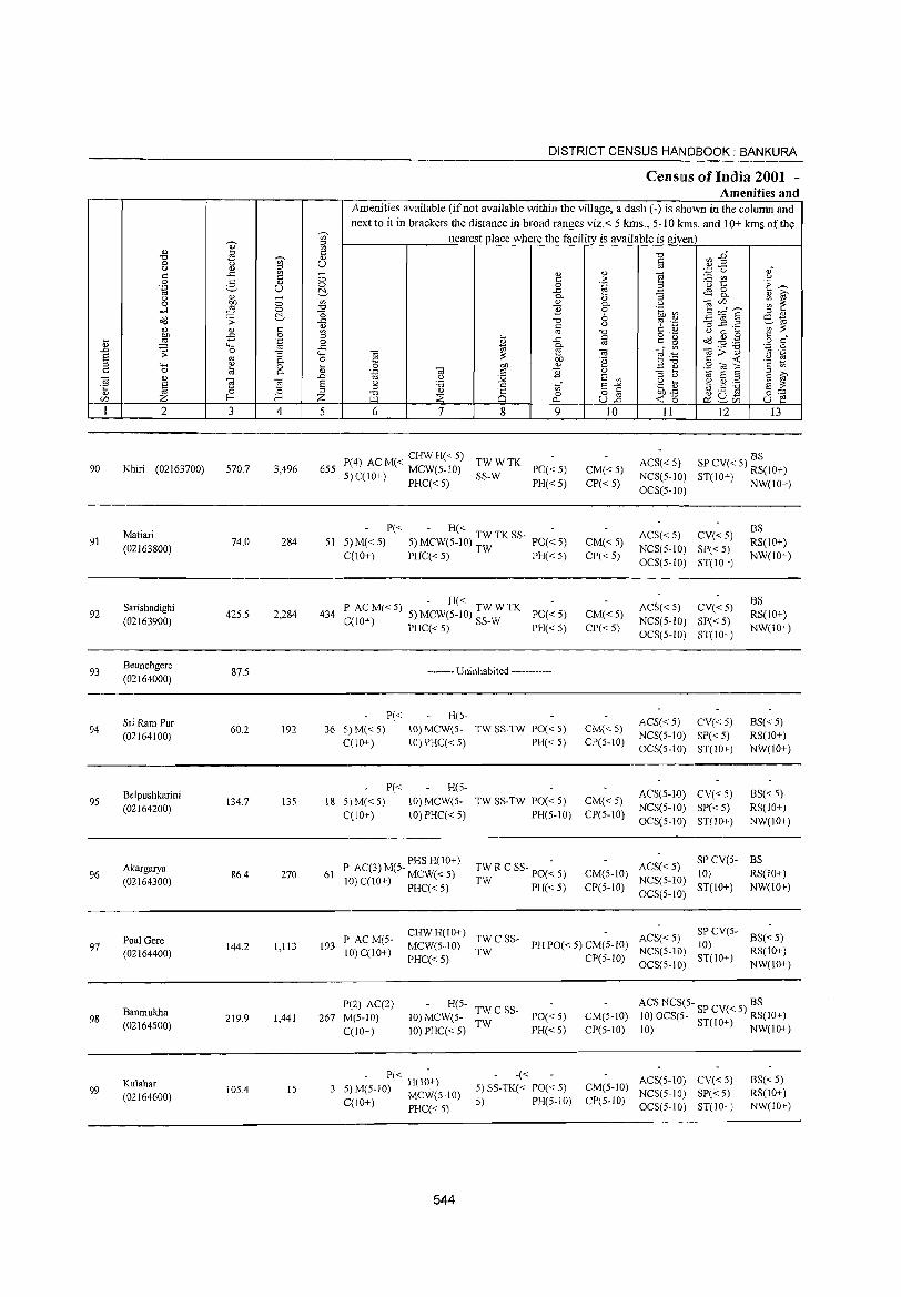
90
91
92
93
94
95
96
97
98
99
2
Khiri (02163700)
Maliari (02163800)
Sarishadighi (02163900)
Beunchgere (02164000)
Sri Ram Pur (02164100)
Belpushkarini (02164200)
Akargarya (02164300)
Poal Gere (02164400)
Banmukha (02164S00)
Kulahar (02164600)
3 4
570.7 3,496
74.0 284
425.5 2,284
87.5
60.2 192
134.7 135
86.4 270
144.2 1,113
219.9 1,441
105.4 15
DISTRICT CENSUS HANDBOOK: BANKURA
CenslllS of India 2001 -Amenities and
I Amenities available (if not available within the village, a dash (-) is shown in the column and next to it in brackets the distance in broad ranges viz.< 5 lans., 5-10 kms. and 10+ lans of the
nearest place where the facility is available is given
OJ U
5 6 7 8 9
P(4) ACM« CHWH«5) TWWTK 655 5) C(10+) MCW(5-1O) SS-W PO« 5)
PHC« 5) PH« 5)
P« - H« 51 5)M«5) 5) MCW(5-10) TWTKSS- PO«5)
C(lO+) PHC« 5) TW PH« 5)
- H« 434 P ACM«5) 5) MCW(5-10) TWWTK PO«5)
C(10+) PHC« 5) SS-W PH« 5)
P« 36 5) M« 5)
C(10+)
P« 18 5)M«5)
C(lO+)
-------- Uninhabited ------------
H(5-10) MCWe5- TW SS-TW PO« 5) 10) PHC« 5) PH« 5)
H(S-10) MCW(5- TWSS-TW PO«5) 10) PHC« 5) PH(5-lO)
P AC(3) M(5- PHS H(10+) 61 MCW« 5) TW R C SS- PO(~ 5)
TW PH«5) 10) C(lO+) PHC« 5)
10
CM«5) CP«5)
CM«5) CP«5)
CM«5) CP«S)
CM« 5) CP(S-IO)
CM« 5) CP(5-1O)
CM(5-1O) CP(5-IO)
11 12 I3
BS ACS« 5) SP CV« 5) RS(IO+) NCS(5-10) ST(lO+) NW(IO+) OCS(S-IO)
ACS« 5) CV« 5) NCS(5-10) SP« 5) OCS(S-IO) ST(lO+)
ACS« 5) CV« 5) NCS(5-10) SP« 5) OCS(5-10) ST(lO+)
ACS« 5) CV« 5) NCS(S-lO) SP« 5) OCS(5-10) ST(IO+)
ACS(5-1O) CV« 5) NCS(5-10) SP« 5) OCS(5-IO) ST(IO+)
BS RS(IO+) NW(IO+)
BS RS(IO+) NW(10+)
BS« 5) RS(IO+) NW(lO+)
BS« 5) RS(lO+) NW(IO+)
SP CV(5- BS ACS« 5) 10) RS(lO+) NCS(5-1O) ST(IO+) NW(lO+) OCS(5-IO)
SPCV(5-P ACM(5-
193 10) C(lO+)
CHW H(lO+) TW C SS-MCW(S-lO) TW PH PO« 5) CM(S-lO) PHC« 5) CP(5-10)
ACS«5) 10) NCS(5-10) ST(lO+) OCS(5-IO)
BS« 5) RS(IO+) NW(lO+)
P(2) AC(2) 267 M(S-IO)
C(IO+)
H(5- TWC SS-10) MCW(S- TW PO« S)
10) PHC« 5) PH« 5)
- P« H(l~+) 3 5) M(5-10) MCW(S-IO)
C(10+) PHC« 5)
-« 5) SS-TK« PO« 5) 5) PH(5-IO)
544
ACS NCS(5- .' BS CM(S-IO) 10) OCS(S- "p CV« 5) RS(JO+) CP(5-IO) 10) ST(IO+) NW(lO+)
ACS(5-IO) CV« 5) CM(5-1O) NCS(5-IO) SP« 5) CP(5-IO) OCS(5-1O) ST(lO+)
BS« 5) RS(IO+) NW(IO+)
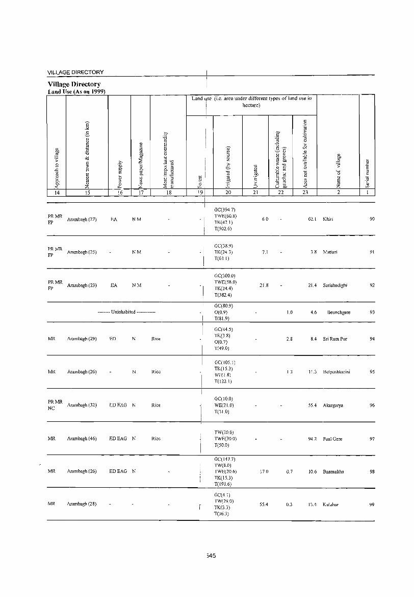
VILLAGE DIRECTORY
Village Directory Land Use (As on 1999)
14 15
;: MR Arambagh (27)
PRMR FP Arambagh (25)
PRMR FP Arambagh (23)
16 17
EA NM
NM
EA NM
-------- Uninhabited ------------
MR Arambagh (29) ED N Rice
MR Arambagh (26) N Rice
PRMR NC Arambagh (32) EDEAG N Rice
MR Arambagh (46) EDEAG N Rice
MR Arambagh (26) EDEAG N
MR Arambagh (28)
18
Land Jse (i.e. area under different types ofland use in
19
!
-I
I -I
i hectare) !
20
GC(394.7) TWE(60.8) TK(47.1) T(502.6)
GC(38.9) TK(24.3) T(63.1)
GC(300.0) TWE(58.0) TK(24.4)
T(382.4)
GC(80.9)
0(0.9) T(81.9)
GC(44.S) TK(3.8) 0(0.7) T(49.0)
GC(105.1) TK(IS.3) WF(1.8) T(122.1 )
GC(10.0)
WE(21.0)
T(31.0)
TW(20.0)
TWE(30.0) T(50.0)
GC(147.7) TW(8.0) TWE(20.6) TK(IS.3) T(191.6)
GC(4.1) TW(29.0) TK(3.3) T(36.3)
545
21
6.0
7.1
21.8
17.0
55.4
22 23 2
62.1 Khiri
3.8 Matiari
21.4 Sarishadighi
1.0 4.6 Beunchgere
2.8 8.4 Sri Ram Pur
1.3 11.3 Belpushkarini
55.4 Akargarya
94.2 Poal Gere
0.7 10.6 Banmukha
0.3 13.4 Kulahar
90
91
92
93
94
95
96
97
98
99
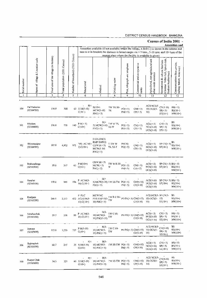
DISTRICT CENSUS HANDBOOK: BANKURA
Census of India 2001 -Amenities and
Amenities available (if not available within the village, a dash (-) is shown in the column and next to it in brackets the distance in broad ranges viz.< 5 kms., 5-10 kms. and 10+ kms of the
Vi' nearest place where the facility is available is given
I ;j
OJ 19 "0 Vl .g" "0 Vi' OJ 0 U c u OJ ~ co . .3 u oJ c ..c: - OJ OJ e c 0 t: > ;.:::: (/) u 0 :S OJ 'u t:: 'E ~ '.g U '" 0 .~ E c:!- ..t: ~ 8.. OJ ?i' u OJ ;; 0- :; 0 ~ '" Q) 0- u 03</) ~ ~ -l 0 "0 B 0 .~ ~ B:g8' c:!- o 6
;j OJ
<id .;; ..t: -0 Q ~ '.c "'3..c .2 o:l 1ij OJ t: ';;;';,: Q) Q) c '" '" "0 C Q) U 0 '-
:W -:S 0 '" .... ~
o .- ~ .@ .g § c" ~ '.g 0 Q) ..t: C g
"-< ..c: 1<1 0-" '" 03:;"g '.c 0 .D .;;: 0 :; "-< 03 e 19 "'§ .,!:::
co .-S co 0- 0 C
;,: bJ) c <t: u 1ij ::l "-< " 0 .... 0 bJ) " ~ ;j"O
.8 ca 8 '2 t; t: 0 til "- Q) ".g 03 c B OJ -3 b 1<1 S ;j
::l >,
~ " ..0 u :.;2 S <Il E ~ ~ ~ ~ S u '5 c t;;" S"'" .g ~ t.S ~ '"
;j
" §'=' Q) r- r- Z " :::E 8 0 o iii bJ)..t:
~ ~C/) rn J..Q Po. U..o ~o U e 1 2 3 4 5 6 7 8 9 10 11 12 13
100 Pal Puskarini
116.9 308 63 - P« H(I;+)
TW TK SS- POe ~ S) ACS NCS(5- CV(~.lO) BS« 5)
(02164700) S) M(S·IO) MCW(S-IO) CM«S) 10) OCS(S- SP« S) TK PH«S) CP« S)
RS(IO+) C(IO+) PHC« S) 10) ST(IO+) NW(IO+)
Muidara PM« 5) - H«
ACS« 5) CV«5) BS
101 136.8 7S0 143 S) MCW(S-IO) TW W TK PO«S) CM«S) RS(IO+) (02164800) C(\O+) PHC« S) SS-W PH«5) CP« 5)
NCS(5-10) SP« 5) NW(IO+)
OCS(5-10) ST«5)
DDADH(3)
Shiromanipur RMPSMP(2)
PH(26) ACS«5) BS
102 197.9 4,852 971 P(4) ACM« CHWH«S) TTWW CM«S) SP CV« 5) RS(IO+)
(02164900) :5) C(IO+) MCW(S.IO) TK SS-T PO« 5) NCS(5-10) ST(IO+) NW(IO+) CP«5) OCS(5-10)
PHC« 5)
Brahmadanga I'M(IO+) CHWH«5)
TW W RSSpO(~5) ACS« 5) SP CV« 5) BS« 5) 103 59.0 317 63 MCW«5) CM«5)
(02165000) C(IO+) PHC« 5) W PH«5) CP« 5)
NCS(5-IO) ST(IO+) RS(IO+) OCS(5-1O) NW(IO+)
Panahar F' ACM(5-H« ACS(S-IO) SP CV« 5) BS« 5)
104 (02165100)
179.0 945 196 10) C(10+)
S) MCW(S·IO) TW SS·TW PO« 5) CM(5·10) NCS(S-IO) ST(IO+) RS(lO+)
I'HC« 5) PH«5) CP(5-10) OCS(5-10) NW(IO+)
I' PUC MCWHC - ACS NCS(5- SP CV(5- BS
lOS Koalpara
246.5 2,113 432 AC(4)M(S- PHS RMP H(5. TW R C SS- PO PH« 5) CM(5-10) 10)OCS(S· 10) RS(IO+) (02165200)
10) C(IO+) 10) PHC« 5) TW CI'(5-10) 10) ST(IO+) NW(IO+)
Sahabazchak P ACM(5-. H(5-
ACS« 5) CV«5) BS« 5) 106 59.7 538 99 10) MCW(S- TW C SS- PH 1'0« S) CM(S·IO)
(02165300) 10) C(lO+) 10) PHC(5-10) TW CP(5-10) NCS(5-10) SP« 5) RS(10+)
OCS(5·10) ST(IO+) NW(IO+)
H(5- ACS NCS(5- CV(~-IO) BS Jumuna P M(5-10) TWC SS-
107 123.0 1,255 227 C(10+)
10) MCW(5-TW
PH PO« 5) CM(5-10) 10)OCS(5- 5P«5) RS(IO+) (02165400)
10)PHC« 5) CI'(5-1O) 10) ST(10+) NW(IO+)
Rohimchak P« H(S-
ACS« 5) CV« 5) BS«5) 108
(02165500) 60.7 215 35 5)M(5-1O) 10) MCW(5- TWSS·TW PO«5) CM(5-10)
NCS(5·10) SI'« 5) RS(10+) C(lO+) 10)PHC«5) PH« 5) CI'(5-10)
OCS(S-IO) ST(IO+) NW(10+)
P« H(5- ACS NCS(S- CV(;-IO) BS
109 Enayet Chak
54.3 321 60 5) M(5-10) 10) MCW(5- TW SS-TW PO« 5) CM(5-10) 10)OCS(5- SP«5) RS(IO+) (02165600) C(IO+) 10) I'HC« 5) PH« 5) CP(5-10) 10) ST(10+) NW(IO+)
546
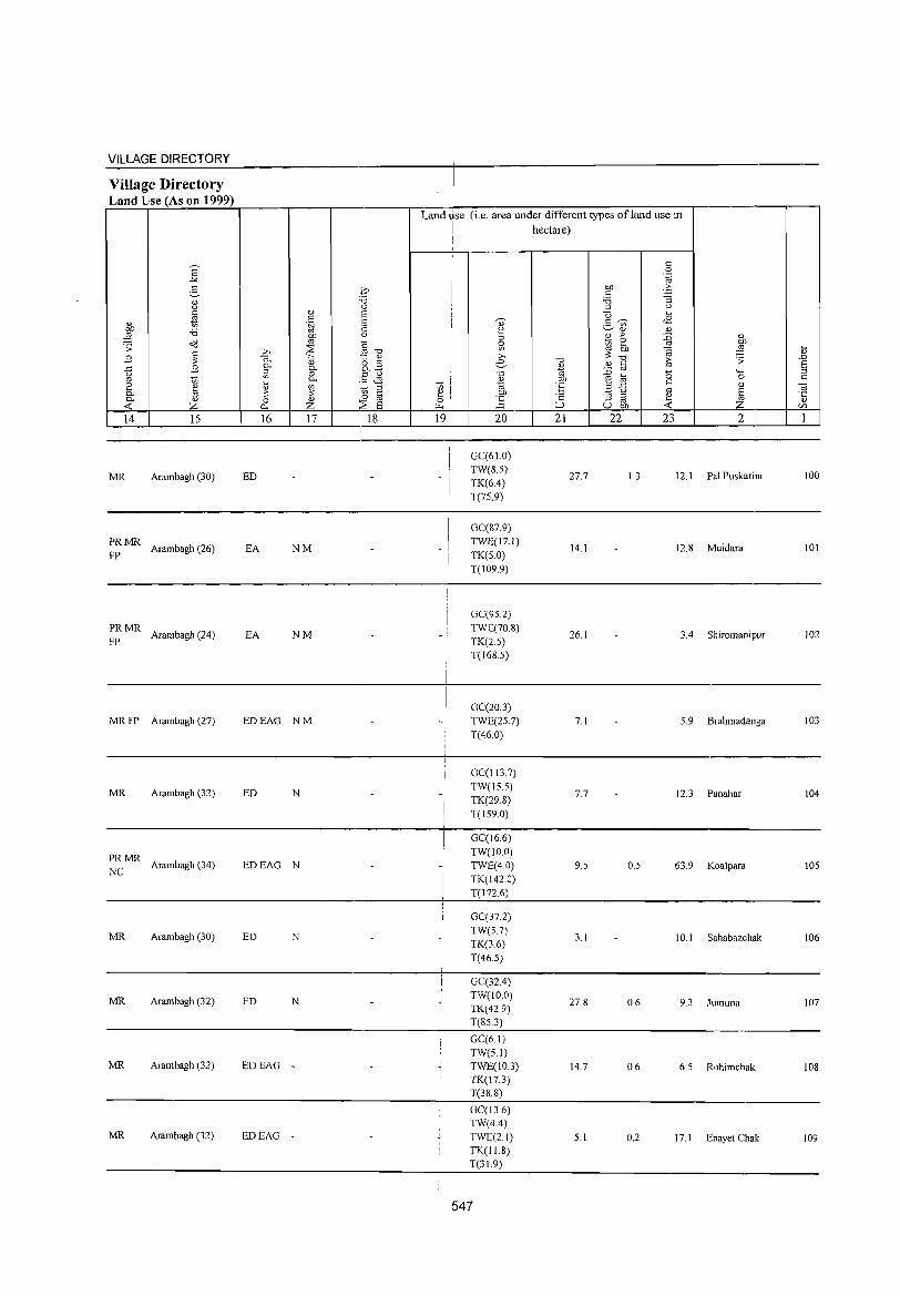
VILLAGE DIRECTORY
Village Directory Land Use (As on 1999)
]' 2-" <.> §
" to;
~ 'i3 o<l .;;: ~ B
..c: B <.>
'" 1;; (2 " 0- a 0- <!)
<t: Z 14 15
MR Arambagh (30)
PRMR Arambagh (26)
FP
PRMR Arambagh (24)
FP
MRFP Arambagh (27)
MR Arambagh (32)
PRMR NC
Arambagh (34)
MR Arambagh (30)
MR Arambagh (32)
MR Arambagh (32)
MR Arambagh (32)
.i~ :.t3 ,~
" E5 c: 1a '[;1 0 Of) 'C)
'" C ~ » '" "0
0. t " " o ... 0-
~ o..§ g 0- .§ ~ ... ~ " .~ § ;: ;:
0 <!) 0 0.- Z :~ E 16 17 18
ED
EA NM
EA NM
EDEAG NM
ED N
EDEAG N
ED N
ED N
EDEAG -
EDEAG -
I
Land*e (i.e. area under different types ofland use in
J hectare) !
c: 0 .~
Of) > c: ~ '6 ::l u
Q ... " g <8
~
~ <!) " B > :g " ~ ~ Of)
l(l ~ :§ i;) ;: » "0 .0 e "0
" § ~ ;;: E " "0 ~ :0 0 '-H ::l
" tlI)
~ a 0 c: 1;; ~ 'E ..c: c:
" ~ '" ~ tlI) u § '5 ] 'E :3 @ ~ ..... ::> u tlI) _6_ CIl
191 20 21 22 23 2 1
GC(61.0) TW(S.5)
27.7 1.3 12.1 Pal Puskarini 100 I TK(6.4)
I T(75.9)
I GC(87.9) I
-I TWE(17.1) 14.1 12.8 Muidara 101
TK(S.O) T(109.9)
GC(952) TWE(70.8)
26.1 3.4 Shiromanipur 102 - ; I TK(2S) I T(168.5)
GC(20.3) TWE(2S.7) 7.1 S.9 Brahmadanga 103 T(46.0)
GC(I13.7)
-I TW(IS.S)
7.7 12.3 Panahar 104 TK(29.8) T(IS9.0)
;
! GC(16.6)
-I
TW(10.0) TWE(4.0) 9.5 0.5 63.9 Koalpara lOS TK(142.0) T(I72.6)
GC(37.2) TW(S.7)
3.1 10.1 Sahabazchak 106 TK(3.6) T(46.S)
GC(32.4) TW(IO.O)
27.8 0.6 9.3 Jumuna 107 TK(42.9) T(8S.3)
GC(61) TW(S.I) TWE(10.3) 14.7 0.6 6.5 Rohimchak 108 TK(17.3) T(38.8)
GC(13.6) TW(4.4) TWE(2.1) 5.1 0.2 17.1 Enayet Chak 109 TK(11.8) T(31.9)
547
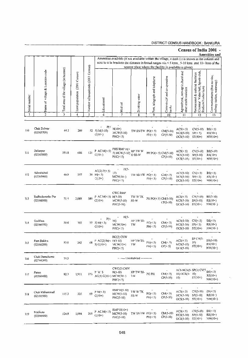
110
III
112
113
114
li5
116
117
118
119
2
ChakDelwar (02165700)
Baliarpur (02165800)
Adwaitabati (02165900)
Radhadamodar Pur (02166000)
Gachhua (02166100)
Ram Bakhra (02166200)
Chak Damukamu (02166300)
Panua (02166400)
Chak Mahammad (02166500)
Malikota (02166600)
3
44.2
191.8
46.9
71.4
50.6
53.0
74.3
82.3
115.3
124.8
o o ~
" o .~
:; c. o c.
~ 4
289
686
257
2,088
103
242
1,911
335
1,084
DISTRICT CENSUS HANDBOOK: BANKURA
Census of India 2001 -Amenities and
Amenities available (ifnot available within the village, a dash (-) is shown in the column and
next to it in brackets the distance in broad ranges viz.< 5 kms., 5-10 kms. and 10+ kms of the nearest place where the facility is available is given
5 6 7
- P« -52 5) M(5-10) H(lO+)
C(lO+) MCW(5-10) PHC«5)
8 9
TW SS-TW PO« 5) PH« 5)
10 1I 12 13
CM(5-1O) ACS« 5) CV(5-10) BS« 5) NCS(5-10) SP« 5) RS(IO+)
CP(S-lD) OCS(5-10) ST(IO+) NW(IO+)
P ACM«5) PHS RMP H« HPTWW ACS«5) 121 C(10+) 5) MCW(5-10) 0 SS-W PH PO« 5) CM(S-IO) NCS(5-10)
CV(5-10) BS(5-1O)
PHC«5) CP(5-10) OCS(5-10) SP(5-10) RS(IO+) ST(IO+) NW(IO+)
H(5-AC(2) P« 5) 10)
36 M«5) C(lO+) MCW(IO+)
PHC« 5)
TW SS-TW PO« 5) PH« 5)
CM«5) CP(5-IO)
ACS(5-IO) CV« 5) NCS(5-10) SP« 5) OCS(5-IO) ST(IO+)
BS«5) RS(lO+) NW(IO+)
380
CWCRMP P ACM«5) H(5-10) TWWTK ACS«5) CV(5-10) BS(5-10)
SS-W PH PO« 5) CM(5-lO) NCS(5-10) SP(5-1O) RS(10+) C(IO+) MCW(5-1O) PHC(5-10)
P« 10) 19 5) M« 5) MCW(IO+)
C(IO+) PHC« 5)
H(5-
HC(2)CHW 48 P AC(2) M« H(5-10)
5) C(IO+) MCW(IO+)
PHC« 5)
HP TW SS- PO(~ 5)
TW PH«5)
HPTWSS-TW PO« 5)
PH« 5)
-------- Uninhabited ------------
CWC(2)CHW
373 P M S H(5-1O) HP TW SS-AC(5) C(10+) MCW(IO+) TW
PO PH
PHC« 5)
69 PM« 5) C(10+)
RMP H(5-1 0) TW W TK MCW(S-IO) SS-W PO« 5) PHC(5-1O) PH« 5)
RMP H(J 0+) 205 P AC M« 5) MCW(S-IO)
C(lO+) PHC(5-1O)
548
TW SS-TW PO« S) PH« 5)
CP(S-lD) OCS(5-10) ST(10+) NW(IO+)
CM«5) CP(5-IO)
CM«5) CP« 5)
CM« 5) CP(5-IO)
CM« 5) CP(5-10)
ACS(5-10) CV« 5) NCS(5-10) SP( < 5) OCS(5-1O) ST(IO+)
BS« 5) RS(10+) NW(IO+)
ACS« 5) NCS(5-1O) OCS(5-1O)
SPCV(5- BS(5-10)
10) RS(IO+) ST(IO+) NW(IO+)
ACS NCS(5- SP(3) CV(5 BS(~ 5)
10) OCS(5- 10) RS(lO+) 10) ST(IO+) NW(JO+)
ACS« 5) eV(5-IO) BS« 5) NCS(5-1O) SP(5-1O) RS(IO+) OCS(5-10) ST(10+) NW(lO+)
ACS« 5) eV(5-IO) BS« 5) CM(S-IO) NCS(5-1O) SP(5-to) RS(IO+) CP(5-IO) OCS(5-10) ST(IO+) NW(IO+)
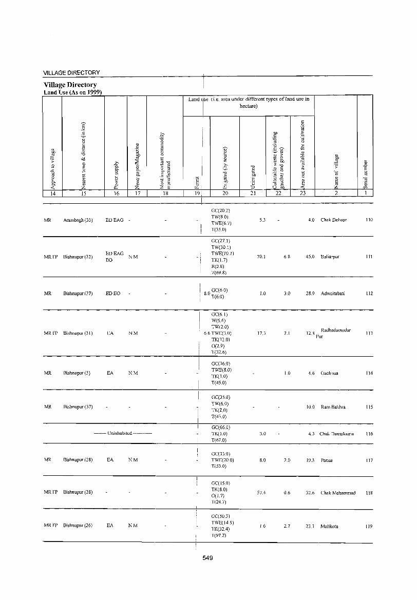
VILLAGE DIRECTORY
Village Directory Land Use (As on 1999)
14 15
MR Arambagh (33)
MR FP Bishnupur (32)
MR Bishnupur (37)
MR FP Bishnupur (31)
MR Bishnupur (3)
MR Bishnupur (37)
16 17
EDEAG -
EDEAG NM EO
ED EO
EA NM
EA NM
-------- Uninhabited ------------
MR Bishnupur (28) EA NM
MR FP Bishnupur (28)
MR FP Bishnupur (26) EA NM
18
Land use (i.e. area under different types of land use in
I hectare)
I
J "'I ~ o ~
191
I I
20
GC(20.2) TW(S.O) TWE(67)
T(35.0)
GC(27.1)
TW(30.1) TWE(10.1) TK(1.7) R(O.S) T(69.8)
I 80 GC(6.0) . T(6.0)
GC(6.1) W(6.6) TW(20)
6.6 TWE(3.0) TK(12.0) 0(2.9) T(32.6)
GC(36.0) TWE(S.O) TK(l.O) T(45.0)
GC(35.0) TW(6.0)
TK(2.0) T(43.0)
GC(66.0) TK(1.0)
T(67.0)
GC(33 0) TWE(20.0) T(53.0)
GC(15.0) TK(80) 0(1.7) T(247)
GC(50.3)
TWE(14.5) TK(32.4) T(97.2)
549
21
5.3
70.1
1.0
17.3
3.0
8.0
57.4
1.6
22 23
6.8
3.0
2.1
1.0
2.0
0.6
2.7
2
4.0 Chak Delwar
45.0 Baliarpur
28.9 Adwaitablilti
12.8 Radhadamodar Pur
4.6 Gachhua
10.0 Ram Bakhra
4.3 Chak Damukamu
19.3 Panua
32.6 Chak Mahammad
23.3 Malikota
110
III
112
113
114
115
116
117
118
119
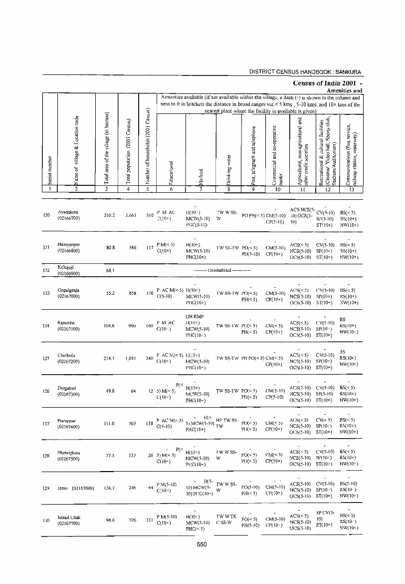
'0)' W " ~
c: "0 ~ " 0 '" u " " ;:l
'" c: ..t:: c: ::; 0 e- <l) 0 .~ u ~ " " ::; 0 ~ '" ....l 0 "0
~ '0 o(l .;; ..c:: <!)
" " " ~ OJ) o:S 0 il ;:§ .~ 0
"-< ..0 ..c:: .;; 0 "3 "-< s "' 0. 0 ;:l "-< ~ 0 ... " 0 0. <l)
Cd " 'Ei ..0
§ ~ S ·c " 0 ::l
<Il Z E-< E-< Z I 2 3 4 5
Aswinkota 120 310.2 1,661 310
(02166700)
121 Narayanpur
80.8 546 117 (02166800)
122 Keleguji
68.1 (02166900)
123 Gopalganja
55.2 858 176 (02167000)
124 Ramdiha
104.6 900 160 (02167100)
Chorkola 125 214.1 1,881 340
(02167200)
126 Durgabati
49.8 64 12 (02167300)
127 Pratappur
111.0 765 138 (02167400)
Bhelaighata 128
(02167500) 77.3 137 26
129 Jemo (02167600) 136.7 246 44
Ismail Chak 130
(02167700) 96.6 706 131
DISTRICT CENSUS HANDBOOK: BANKURA
Census of India 2001 -Amenities and
Amenities available (ifnot available within the village, a dash (-) is shown in the column and next to it in brackets the distance in broad ranges viz.< 5 kms., 5-10 kms. and 10+ kms of the
nearest place where the facility is available is given "0 ~ ~~ c: "' :.g (,) ,,' " " l'! (,)
" > ~ t! 0 .~ 'E ~ ..t:: .3 <S 0 0. <l) "3 0. <!) ie' OJ 0. " <a<ll :;; ~ '2 0 .~ ~ 5 ::::"6 6
::l <l)
"0 '3 ~.2 I'Q 1;; c: (,) 6 .~ ';;~ '" "0 00'"
il c: o ._
o(l .g . .g § d' ..c:: c: g 0. "' "@
_. '" -~-g ''';:: 0 <a ~ co '" ._ "' ~ i'j"'-o:r: .~ !§ c: 'e
.... _ 0 00 <l) ::l"O .S Ol a " '" .~ Cd " '2 <!) .=:: ~ ::l
0 :.Q S '" ;:l (,) 1<i S ::l S ie' 0 '0 E"'" .g ~ e ~ :.a E ~ ::l .S
"0 OJ
c:'5 Cl o " bJl..t:: g U a 0=-=
iJ-l ~ p.., u.2 -o:r: 0 c.::~CI') u e 6 7 8 9 10 II 12 13
PM AC H(IO+) TW WSS-ACS NCS(5- •
BS« 5) POPH(<: 5) CM(5-10) 10) OCS(5- CV(5-10)
C(IO+) MCW(5-10) W CP(5-10) 10) SP(5-10) RS(IO+)
PHC(5-1O) ST(10+) NW(IO+)
p M«5) H(lO+) TW SS-TW 1'0(<: 5) CM(5-10)
ACS(<:5) CV(5-1O) BS« 5) C(lO+) MCW(5-10)
PH(5-1O) CP(IO+) NCS(5-10) SP(IO+) RS(IO+)
PHCCIO+) OCS(5-1O) ST(10+) NW(10+)
-------- Uninhabited ------------
P AC M« 5) H(lO+) TW SS-TW 1'0(<: 5) CM(5-10)
ACS«5) CV(5-10) BS« 5) CC5-10) MCW(5-10)
PH«5) CP(IO+) NCS(5-10) SP(10+) RS(10+)
PHCCIO+) OCS(5-1O) ST(IO+) NW(IO+)
DHRMP BS
PM AC H(IO+) TW SS-TW 1'0« 5) CM« 5)
ACS«5) CV(5-10) RS(IO+)
C(lO+) MCW(5-10) PH«5) CP(IO+)
NCS(5-1O) SP(IO+) NW(IO+)
PHCCIO+) OCS(5-1O) ST(IO+)
P AC M« 5) H(IO+) ACS« 5) CV(5-IO) BS
TW SS-TW PH PO« 5) CM« 5) RS(IO-+-) C(lO+) MCW(5-10)
CP(IO+) NCS(5-10) SP(IO+)
NW(IO+) PHCCIO+) OCS(5-10) ST(IO+)
- 1'« H(I~+) TW SS-TW 1'0« 5) CM(5-1O)
ACS(5-10) CV(5-10) BS«5) 5) M«5) MCW(5-10)
PH«5) CP(S-IO) NCS(5-10) SP(5-10) RS(IO+)
C(lO+) PHC(lO+) OCS(5-10) ST(IO+) NW(IO+)
- H« ACS« 5) CV«5) BS«5) P AC M(<: 5) 5) MCW(5-10) HP TW SS- 1'0« 5) CM« 5) C(5-10) PHCCIO+) TW PH« 5) CP(IO+)
NCS(5-10) SP(IO+) RS(IO+)
OCS(5-1O) ST(IO+) NW(lO+)
- 1'« H(I~+) TWWSS-1'0«5) CM« 5)
ACS« 5) CV(5-10) BS«5) 5) M(<: 5) MCW(5-1O) W NCS(5-10) SP(10+) RS(IO+) CCI 0+) PHCCIO+) PH« 5) CP(IO+)
OCS(5-10) ST(IO+) NW(IO+) .
PM(5-10) H(5-
TWWSS- ACS(5-10) CV(5-10) BS(5-10)
C{lO+) 10) MCW(5-
W PO(S-IO) CM(5-IO)
NCS(5-10) SP(IO+) RS(IO+) 10) PHC(IO+) PH«5) CP(IO+)
OCS(5-10) ST(IO+) NW(IO+)
PM(5-10) H(IO+) TWWTK ACS« 5) SPCV(5-
BS« 5) PO« 5) CM(5-1O) 10)
CCIO+) MCW(5-1O) CSS-W NCS(S-IO) RS(lO+) PH(5-1O) CP(IO+) ST(IO+)
PHC« 5) OCS(5-10) NW(IO+)
550
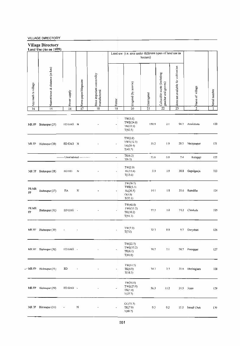
VILLAGE DIRECTORY
Village Directory Land Use (As on 1999)
MR FP Bishnupur (25)
MR FP Bishnupur (28)
EDEAG N
EDEAG N
-------- Uninhabited ------------
MR FP Bishnupur (28) ED EO N
PRMR Bishnupur (27) EA N
FP
PRMR Bishnupur (31)
FP EDEAG -
MR FP Bishnupur (30)
MR FP Bishnupur (30) EDEAG -
_/ MR FP Bishnupur (31) ED
MR FP Bishnupur (29) EDEAG -
MR FP Bishnupur (31) N
Lan~ use (i.e. area under different types ofland use in
i hectare)
TW(50)
TWE(24.0)
TK(33.5)
T(62.5)
TW(2.0)
TWE(12.1)
TK(29.4)
T(43.5)
TK(63)
T(6.3)
TW(2.0)
TK(l1.6)
T(13.6)
TW(26.5)
TWE(5.1)
TK(20.5)
0(1.0)
T(53.1)
TW(40.0)
TWE(l12)
TK(10.2)
T(6L3)
TW(7.0)
T(7.0)
TW(22.7)
TWE(12.2)
TK(6.1)
T(41.0)
TW(14.5)
TK(4.0) T(18.5)
TW(lOO)
TWE(25.9) TK(1.8)
T(37.7)
GC(73.7)
TK(70)
T(80.7)
551
150.9
15.2
53.6
0.9
14.1
77.5
32.3
39.2
34.7
56.3
0.3
2.1 94.7 Aswinkota
1.9 20.3 Narayanpur
0.8 7.4 Keleguji
1.9 38.8 Gopa1ganja
1.8 35.6 Ramdiha
1.0 74.2 Chorkola
0.8 9.7 Durgabati
2.1 28.7 PratappuT
2.5 21.6 Bhelaighata
11.2 31.5 Jemo
0.2 15.5 Ismail Chak
120
121
122
123
124
125
126
127
128
129
130

DISTRICT CENSUS HANDBOOK: BANKURA
Census of India 2001 -Amenities and
Amenities available (if not available within the village, a dash (-) is shown in the column and
next to it in brackets the distance in broad ranges viz.< 5 krns., 5- I 0 kms. and 10+ kms of the
~ '" nearest place where the facility is available is given ;;; " i c "0 ~ ~" ." <n- " 0 U c () " ;;; '" '.c; u ,," s: ..c c 0 " " e ~t:
() 0 S "
c > E~ .~ U 0 0 .~ B c:!.. ..c ~ 8-
() " - "- " ::; " [;f
0 :W 0 '" " "- {) Olc/J ~ ~ -l 0 "0 "2 0 .~ ~ ~ ~"S c:!.. -0 6 " " <ill .;;: ..c "0 ~ .~ ~] .2 8d " c 1;l c {)
'" ~ " '" "0 () 0 ~ OIl .p 0 " ~ c
o ._ o:d ~ . .g c "
~ ::§ .~ 0 " ..c c" ~ o s:
" <.;.., ..c ~
"- '" Ol;;-g 'C 0
.0 .;;: 0 :; <.;.., Ol '" Ol "§:B '" ._ ~ '" "- 0 c bb .~ c ...:: .~ !9
""' " 0 ~ 0 OIl " E ~ .S til E c '" 0 til "- " .~ Ol s: "2 d S " e [;f ~ " .0 {) :.g S <f> " {)
§ Ol g S {) 'i3 .5 ~" S-'< .g to ~ ;g:.a S ~ iil ~ ~ " " " 13 o ~ 0Il..c
(.) ._ C'ij
Z Z -0 :;s Ci ~U""" 0:-= c/J ~ 0.. U.D ...:: '0 ~C/J u ~ I 2 3 4 5 6 7 8 9 10 11 12 13
Lankajol P« CWC H(10+)
TWWTK ACS«5) CV(5-1O) BS«5) 131 15&.7 763 148 5)M(5-10) MCW(5-10) PO« 5) CM(5-10)
(02167800) C(10+) PHC« S)
CSS-W PH«5) CP(IO+)
NCS(5-IO) SP«5) RS(IO+) OCS(5-10) ST(IO+) NW(IO+)
Jaykrishnapur PM« 5) C(5- H(IO+) TWWTK ACS« 5) SP CV(5-
BS«5) 132 48.7 544 93 PO«5) CM(5-10) 10)
(02167900) [0) MCW(5-1O) RCSS-W PH(5-10) CP(IO+)
NCS(5-10) ST(IO+)
RS(IO+)
PHC« 5) OCS(5-10) NW(10+)
133 Bankajol
109.& 68 10 ,_ - P« H(J~+) TWWRC
PO« 5) CM(5-1O) ACS«5) CV(5-10) BS« 5)
(02168000) _»)M« 5) C(5- MCW(5_10) SS-W NCS(5-10) SP«5) RS(10+) 110) PHC« 5) PH(5-1O) CP(10+)
OCS(S-IO) ST(10+) NW(IO+)
Kunarpur 1'(4)M«5) H(JO+) TWWTK ACS« 5) SI'(2) BS
134 (02168100)
S14.6 3,801 730 C(5-JO) MCW(5-IO) CSS-W
PO I'H« 5) CM« 5) NCS(5-JO)
CV«5) RS(IO+)
I'HC«5) CI'(IO+)
OCS(5-10) ST(IO+) NW(IO+)
I'atpur PM(5-10) CWCH(IO+)
TWWTK ACS« 5) BS
135 76.7 796 lSI MCW(5-10) 1'0«5) CM«5) SI' CV« 5) RS(IO+) (02168200) C(5-10)
I'HC«5) CSS-W
I'H«5) CI'(IO+) NCS(5-10) ST(IO+) NW(IO+) OCS(S-IO)
Lallbazar PM S PHSH(lO+)
TWWTK ACS«S) CV(S-IO) BS
136 (02168300)
51.3 995 167 C(1O+)
MCW(5-10) CSS-W
PO«5) CM(5-lO) NCS(5-10) SP« 5)
RS(IO+)
I'HC« 5) PH(5-10) CP(lO+) OCS(5-10) ST(IO+)
NW(IO+)
Tentulia - P« H(I~+) TWWTK 1'0« 5) CM(5-IO)
ACS«5) CV(5-10) BS«5) 137
(02168400) 68.1 126 25 5)M(5-10) MCW(5-10) CSS-W NCS(S-IO) SP«S) RS(IO+)
C(10+) I'HC« 5) PH(S-IO) CP(10+) OCS(5-10) ST(IO+) NW(IO+)
Chandi Pur - H« -
ACS« S) CV(S-IO) BS«5) 138 41.9 234 42 P AC M« S) S) MCW(S-IO) TW SS-TW PO« S) CM«5)
(02168500) C(IO+) I'HC(IO+) I'H« 5) CI'(IO+) NCS(5-JO) SP(IO+) RS(IO+)
OCS(S-IO) ST(IO+) NW(IO+)
HC PHC PHS ACS NCS(5- CV(~-IO) BS
Gopinathpur P(2) M S RMP(2) TWWSS-PO PH
CM RS(10+) 139 (02168600)
682.0 3,72S 655 ACC(10+) H(10+) W CP(IO+) 10) OC8(S- SP(IO+)
MCW(5-10) 10) ST(IO+) NW(lO+)
Baragopinathpur 400 72
P ACM«5) H(IO+) TW SS-TW PO« 5) CM«5)
ACS« 5) CV(5-10) B8« 5) 140 69.8
C(10+) MCW(5-10) NCS(5-JO) SI'(IO+) RS(IO+) (02168700) PH«5) CP(IO+) I'HC(IO+) OCS(5-10) ST(IO+) NW(IO+)
552
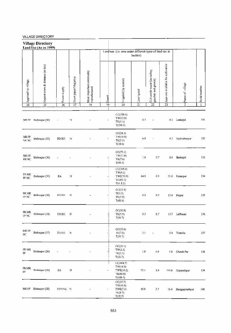
VILLAGE DIRECTORY
Village Directory Land Use (As on 1999)
Land use (i.e. area under different types ofland use in hectare)
~~14~L-__ ~15~ __ -L __ ~16~~~1~7~ _____ ~18~ __ ~ __ 1~~ __ ~ __ 2~O __ -L ___ 2_1 __ ~_2_2 __ ~ __ 2_3 __ L-. _____ 2 ____ ~~1~
MR FP Bishnupur (30)
MRFP NR NC Bishnupur (32)
MRFP NR NC Bishnupur (30)
PRMR FP NC Bishnupur (32)
PRMR FP NC Bishnupur (30)
~~ ~ Bishnupur (28)
MRFP NC Bishnupur (27)
PRMR FP Bishnupur (26)
PRMR FP Bishnupur (26)
MR FP Bishnupur (28)
N
ED EO N
EA N
ED EO N
ED EO N
ED EO N
EA N -i
EDEAG N
GC(138.4) TW(13.0) TK(3.1) T(lS4.S)
GC(243) TW(10.8) TK(35) T(386)
GC(79.1) TW(l3.4) TK(7.0) T(99.5)
GC(3096) TW(9.3) TWE(30.0) TK(69.3) T(418.2)
GC(53.4) W(1.5) TK(S.9) T(60.8)
GC(30 8) TK(S.9) T(36.7)
GC(52.6) TK(70) T(597)
GC(25 J)
TW(3.5) TK(S.l) T(33.7)
GC(404.7) TW(14.0) TWE(10.2) TK(60.6)
T(489.5)
GC(13.7) TW(IO.O)
TWE(7.2) TK(S.7) T(39.7)
553
0.1 4.1 Lankajol 131
6.0 4.2 Jaykrishnapur 132
1.0 0.7 8.6 Bankajol 133
64.9 O.S 31. 0 Kunarpur 134
0.2 0.4 15.4 Patpur 135
0.3 0.7 13.7 Lallbazar 136
3. J 5.4 TentuJia 137
1.8 0.6 5.8 Chandi Pur 138
75.1 2.8 114.6 Gopinathpur 139
10.0 3.7 16.4 Baragopinathpur 140
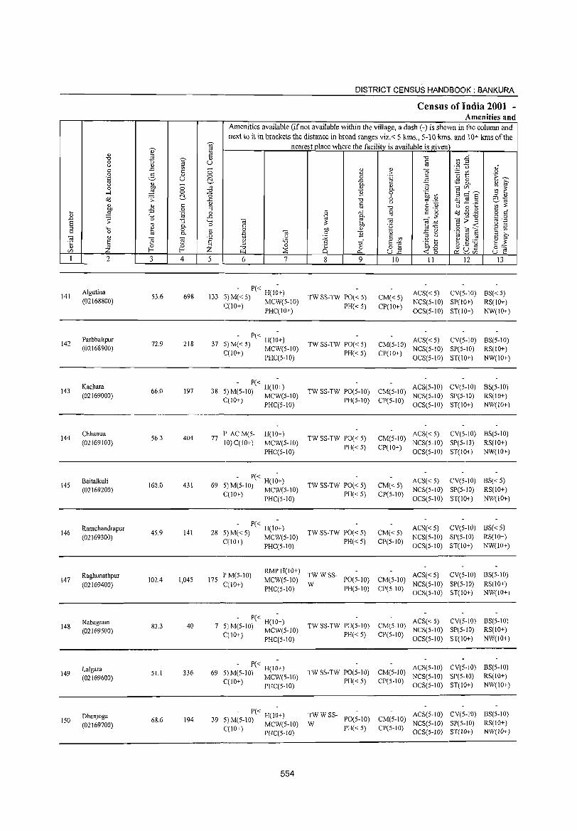
DISTRICT CENSUS HANDBOOK: BANKURA
Census of India 2001 -Amenities and
Amenities available (if not available within the village, a dash (-) is shown in the column and next to it in brackets the distance in broad ranges viz.< 5 kms., 5-10 kms. and 10+ kms of the
';;)' nearest place where the facility is available is given ;:s ., i ~ "t::J fJ'J -§" "t::J ';;)' .,
0 u § () Q.) ;:s .~ 'TI " c -= '" 0 Q.) Q.) e c c > :.= rj) u 0 2- Q.) ·0 t: E_..., .~ u 0 0 .~ E ~ -= ~ 8. <!) >-. "
Q.) - 0. <!) "3 ~ ~ 0 :W 0 '" <!) 0. OJ ] c/)" ,-, ....:l 0 "t::J 11 0 .~ ~ 0 E =a § ;:s Q.)
o(! .s: ~ -= "t::J 6 C!l -OJ OJ ._
';'~ ., c ~ c § .~ ~ ..c ..... <!) OJ "t::J OJ 0 ...
:W -:S 0 ;:s ... c o(! ~ .g c ~ .~ 0 ;i1 -= c g o c"
"-' -= 0. OJ
'" "iii>"B '';::: 0 .0 ;;: 0 "3 "-' (ij tb (ij ""§ :~ OJ .-S OJ ~ .~ "5 0. 0 C .~ ;:s"O C <C ;:s "" ~ 0 ... 0 b1) <!) .S to E c on C 0 OJ 0. Q.) .~ "iii c 11 Q.) '3 ~ ;:s >-. (ij <!) .0 OJ 12 E on til E ;:s
S ~ ·c § "Ei (ij s OJ :a c s "'" .g] ~.5 ~ '0 ;:s '" §c:: <!) 0 ;:s
"t::J <!) 8 o c
Z f--< f--< Z ::8 0 uE ~'6 ~ ~c/) IZl ~ r:>.. u f'! 1 2 3 4 5 6 7 8 9 10 11 12 13
Algutina - P« -
ACS« 5) CV(S-IO) BS«S) 141 53.6 698 133 5)M«S) H(IO+) TW SS-TW PO« 5) CM«S) (02168800) C(lO+) MCW(S-IO) PH« S) CP(IO+) NCS(S-IO) SP(IO+) RS(IO+)
PHC(IO+) OCS(S-IO) ST(IO+) NW(lO+)
Parbbatipur - P« -
ACS« 5) CV(S-IO) BS(S-IO) 142 72.9 218 37 5)M«S) H(IO+) TW SS-TW PO« 5) CM(S-IO)
(02168900) ('(10+) MCW(S-IO) PH«S) CP(IO+) NCS(S-IO) SP(S-IO) RS(IO+)
- PHC(5-10) OCS(5-10) ST(lO+) NW(lO+)
Kachara - P« -
ACS(S-IO) CV(5-10) BS(5-10) 143 66.0 197 38 5) M(S-IO) H(10+) TW SS-TW PO(S-IO) CM(S-IO)
(02169000) (,(10+) MCW(S-IO) PH(S-IO) CP(S-IO) NCS(S-IO) SP(S-IO) RS(IO+)
, PHC(5-1O) OCS(5-10) ST(IO+) NW(IO+)
144 Chhanua
56.3 404 77 P ACM(5- H(IO+)
TW SS-TW PO« 5) CM(5-10) ACS«5) CV(S-tO) BS(5-10)
(02169100) 10) C(IO+) MCW(5-10) PH«5) CP(10+)
NCS(5-1O) SP(5-1O) RS(IO+)
PHC(5-1O) OCS(S-IO) ST(IO+) NW(10+)
Baitalkuli - P« -
ACS« 5) CV(S-IO) BS«5) 145 160.0 431 69
H(lO+) TW SS-TW PO« 5) CM«S)
(02169200) 5) M(S-IO) MCW(S-IO) NCS(S-IO) SP(S-IO) RS(IO+) C(10+) PHC(5-1O) PH« 5) CP(5-1O)
OCS(5-IO) ST(IO+) NW(lO+)
146 Ramchandrapur
45.9 141 28 - P« H(l~+)
TW SS-TW PO« 5) CM«5) ACS« 5) CV(5-10) BS« 5)
(02169300) S)M«5) MCW(S-IO) NCS(S-IO) SP(S-IO) RS(IO+) C(1O+) PHC(S-IO) PH«5) CP(S-IO)
OCS(S-IO) ST(lO+) NW(10+)
Raghunathpur PM(S-IO) RMPH(10+)
TWWSS- ACS« 5) CV(5-10) BS(5-10) 147
(02169400) 102.4 1,045 175
C(IO+) MCW(5-10)
W PO(5-10) CM(5-10)
NCS(5-10) SP(5-IO) RS(10+) PHC(S-IO) PH(S-IO) CP(S-IO)
OCS(5-10) ST(lO+) NW(IO+)
148 Nabagram
83.3 40 7 - P« H(I;+)
TW SS-TW PO(5-10) CM(S-IO) ACS« 5) CV(5-10) BS(5-10)
(02169500) 5! M~-lO) MCW(5-10) NCS(5-IO) SP(5-10) RS(lO+) C(IO ) PHC(5-10) PH«5) CP(5-1O)
OCS(5-1O) ST(lO+) NW(IO+)
Lalgara 51.1 336 69
- P« H(I;+) TW SS-TW PO(5-10) CM(S-IO)
AC8(S-IO) CV(S-IO) BS(5-10) 149
(02169600) 5! M~-IO) MCW(5-1O) NCS(5-10) SP(5-IO) RS(IO+) C(IO ) PHC(5-10) PH«5) CP(5-10)
OC8(5-10) ST(IO+) NW(IO+)
Dhanjoga 194 39
- P« H(I;+) TWWSS-PO(5-1O) CM(S-lO)
ACS(S-IO) CV(S-IO) BS(S-IO) ISO 68.6 S!M~-10) MCW(S-IO) W NCS(S-to) SP(S-IO) RS(lO+) (02169700) PH«S) CP(S-IO)
C(IO ) PHC(S-1O) OC8(5-1O) ST(lO+ ) NW(lO+)
554
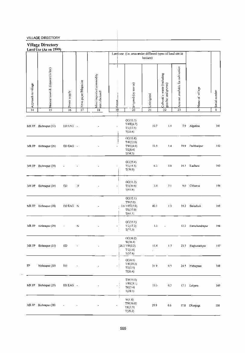
VILLAGE DIRECTORY
Village Directory Land Use (As on 1999)
14 15
MR FP Bishnupur (32)
MR FP Bishnupur (26)
MR FP Bishnupur (2S)
MR FP Bishnupur (30)
MR FP Bishnupur (28)
MR FP Bishnupur (29)
MR FP Bishnupur (3 I)
FP Bishnupur (30)
MR FP Bishnupur (29)
MR FP Bishnupur (28)
16 17 18
EDEAG -
EDEAG -
ED N
EDEAG N
N
ED
ED
EDEAG -
Lan~ use (i.e. area under different types ofland use in i hectare)
I
1~ 20
GC(13.3) TWE(6.7) TK(13.6) T(33.6)
GC(13.8) TW(12.0) TWE(4.0) TK(S.4) T(38.2)
GC(2S.4) TK(14.S) T(39.9)
GC(IJ.3) TK(306) T(41.9)
GC(12.1)
TW(S.O) i 3.6 TWE(7.0)
TK(37.0) T(6U)
GC(lS.l) TK(17.2) T(32.3)
! GC(16.2)
i W(16.4) 128.2 TW(3.2)
TK(1.6) T(37.4)
GC(4.6) TW(19.3) TK(2.S) T(26.4)
TW(16.0) TWE(91) TK(3.4) T(28.S)
W(1.8) TW(16.0)
TK(2.S) T(20.3)
555
21
10.7
13.S
6.3
3.4
80.1
I.S
11.4
31.9
10.3
29.9
22 23 2
1.4 7.9 Algutina
1.4 19.9 Parbbatipur
S.S 14. 1 Kachara
2.1 9.0 Chhanua
1.0 14.2 Baitalkuli
12.2 Ramchandrapur
1.7 23.7 Raghunathpur
O.S 24.S Nabagram
0.2 12.1 Lalgara
0.6 17.8 Dhanjoga
141
142
143
144
145
146
147
148
149
150
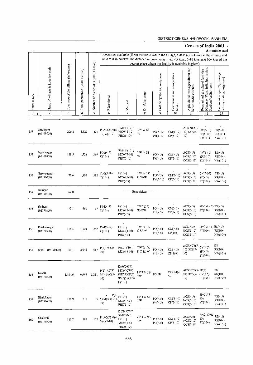
DISTRICT CENSUS HANDBOOK: BANKURA
Census of India 2001 -Amenities and
Amenities available (if not available within the village, a dash (-) is shown in the column and
next to it in brackets the distance in broad ranges viz.< 5 kms., 5-10 kms. and 10+ kms of the ~
nearest place where the facility is available is given ~ til ;::l
0) ~ til
<= "0 ~ E~ "0 ~ 0)
0 til U <= <.) ] ;::l OJ
'zj_ U '" til - 0) " "§ <= <= 0 t: > _ til
<.) 0 e- O) 0 0 ',g 3 'u 1:: .~ ~ .~ u !::!. .<: ~ 8-
<.) ~ - P- i; "3 " id-0 0 til " 0.. <.) ,,<Z> ~ ~ ....:! ~ 0 -0 ] 0 .~ ~ s ;:::"9' !::!. -0 6
;::l 0)
<>'IJ .;;: .<: "0 '? .~ ~ _g .3 ill 'i<i <= " <= <.) ';;;:;:
~ " til OJ "0 <= 0) <.) 0 .... £ 0 o .~ <= " .... ;::l il .<: g <= g CCl -8 .g ~ '~ 0 o '" " '>-< .<: 'i<i P- '" ,,;;] ',c 0
.D .;;: 0 "3 '+-< " e " "§~ OJ .~
S cd P- o <= :;: 00 '8 <= « <.) 'i<i
;::l '+-< " 0 ctl 0 00 0) 3 <v .~ OJ E '2 t) <= 0 a P- '.g " '" ] " '"3 tl 'i<i E ;::l
;::l >,
" 0) .D <.) :Q E til E OJ
£ ~ Ei s <.) 'B .::i tf E-'" .g ~ ~.S ~ E :;: ·c ;::l
" ~ ;::l -0
0)
Q 0 82 00'<: 0;;:::: if] I-< Z ~ ~ Cl.. « (5 ~ ~~ u e 1 2 3 4 5 6 7 8 9 10 11 12 13
Salukgere RMPH(10+)
TWWSS-ACS NCS(5- -
BS(5-10) 151 206.2 2,S27 427 P AC(2) M(5- MCW(S-10) PO(S-IO) CM(S-IO) 10) OCS(S- CV(5-10) (02169800) 10) C(5-1O) PHC(5-1O) W 10) SP(5-1O) RS(1O+)
PH(5-10) CP(5-10) ST(IO+) NW(IO+)
Nandagram PM«5) RMP H(IO+)
TWWSS- ACS«5) CV(5-10) BS«5) 152 188.5 1,924 319 MCW(5-10) PO«5) CM«5)
(02169900) C(IO+) W NCS(5-10) SP(5-10) RS(lO+) PHC(5-IO) PH«5) CP(5-10)
OCS(5-10) ST(10+) NW(10+)
153 Seromanipur
76.6 1,893 312 IPM(5-10) H(IO+) TWWTK
PO«5) CM(S-IO) ACS«5) CV(5-10) BS«5)
(02170000) C(10+) MCW(5-10) CSS-W PH(5-10) CP(S-IO)
NCS(5-10) SP«5) RS(10+) PHC«5) OCS(5-10) ST(IO+) NW(IO+)
154 Rampur (02170100)
62.0 -------- Uninhabited ------------
Nalbuni 72.7 462
PM«5) H(IO+) TWTKC PO« 5) CM« S)
ACS«5) SP CV« 5) 8S« 5) 155
(02170200) 97
C(IO+) MCW(S-IO) SS-TW NCS(5-10) ST(10+) RS(IO+)
PHC« 5) PH«5) CP(5-10)
OCS(5-10) NW(IO+)
Krishnanagar 116.5
PM(S-IO) H(IO+) TWWTK PO«5) CM«5)
ACS« 5) SP CV« 5) BS« 5) 156
(02170300) 1,504 262
C(10+) MCW(5-10) CSS-W NCS(5-IO) ST(10+) RS(10+)
PHC«5) PH«5) CP(IO+)
OCS(5-10) NW(10+)
PHCH(IO+) TWWTK ACS NCS(5- - BS
2,045 1'(3) MC(5-
PO«5) CM«5) 10) OCS(5- CV« 5) RS(1O+) 157 Sihar (02170400) 359.1 417 10) MCW(5-10) RCSS-W SP« 5)
PH« 5) CP(10+) 10) ST(10+) NW(1O+)
D(6)DH(4)
P(2) AC(9) MCWCWC CPCM«
ACS NCS(5- SP(2) BS
158 Deshra
1,184.6 6,694 1,281 M« 5) C(5- PHCRMP(5) HP TW SS- PO PH 10) OCS(5- CV« 5) RS(IO+) (02170500) SMP(3)CHW
TW 5) 10) ST(1O+) NW(lO+) 10)
H(IO+)
- P« H(I~+) HP TW SS- PO(~ 5) ACS«5) SPCV(5-
BS« 5) Bhalukgere CM(S-IO) 10) 159 116.9 212 35 5) M« 5) C(5· MCW« 5) NCS(5-IO) RS(IO+) (02170600) TW PH« 5) CP(S-IO) ST(IO+) 10) PHC(S-10) OCS(5-10) NW(IO+)
DDHCWC
Chakchil RMPSMP
HP TW SS- PO(~ 5) ACS« 5) SP(2) CV(5 BS(~ 5)
160 115.7 587 102 P AC(2) M« H(lO+) CM(S-IO) NCS(5-10) 10) RS(IO+)
(02170700) 5)C(5-10) MCW«5) TW PH«5) CP(5-10) OCS(5-10) ST(IO+) NW(10+)
PHC(5-10)
556
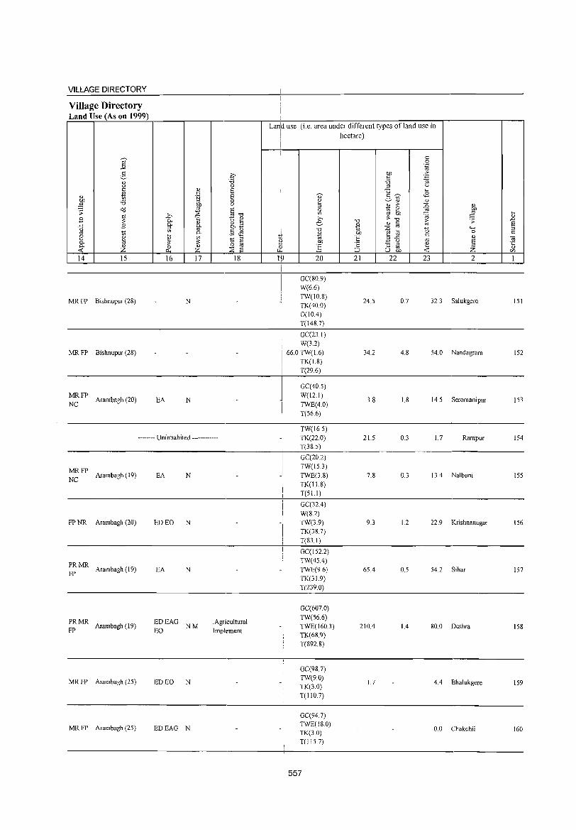
VILLAGE DIRECTORY
Village Directory Land Use (As on 1999)
14 15
MR FP Bishnupur (28)
MR FP Bishnupur (28)
MRFP NC Arambagh (20)
16 17 18
N
EA N
-------- Uninhabited ------------
MRFP NC Arambagh (19)
FP NR Arambagh (20)
PRMR Arambagh (19)
FP
~: MR Arambagh (19)
MR FP Arambagh (25)
MR FP Arambagh (25)
EA N
ED EO N
EA N
EDEAG EO NM
ED EO N
EDEAG N
.Agricultural Implement
Lan:d use (i.e. area under different types ofland use in
I hectare)
i
20
GC(80.9) W(6.6)
TW(10.8) TK(400) 0(104)
T(l487)
GC(23.1) W(3.2)
I
66.0 TW(1.6)
TK(1.8)
I T(29.6)
_I
-I i
I I
GC(40.5) W(12.1)
TWE(4.0)
T(56.6)
TW(16.5) TK(22.0) T(38.5)
GC(20.2) TW(15.3)
TWE(3.8)
TK(IL8) T(51.1)
GC(324)
W(8.2)
TW(3.9) TK(38.7)
T(83.1)
GC(152.2)
TW(45.4) TWE(9.6) TK(31.9)
T(239.0)
GC(607.0)
TW(56.6) TWE(160.3) TK(68.9)
T(892.8)
GC(98.7) TW(9.0) TK(3.0)
T(llO.7)
GC(94.7) TWE(180) TK(3.0) T(lIS.7)
557
21
24.5
34.2
3.8
21.5
7.8
9.3
65.4
210.4
1.7
22 23 2
0.7 32.3 Salukgere
4.8 54.0 Nandagram
1.8 14.5 Seromanipur
0.3 1.7 Rampur
0.3 13.4 Nalbuni
1.2 22.9 Krishnanagar
0.5 54.2 Sihar
1.4 80.0 Deshra
4.4 Bhalukgere
0.0 Chakchil
lSI
152
153
154
155
156
157
158
159
160
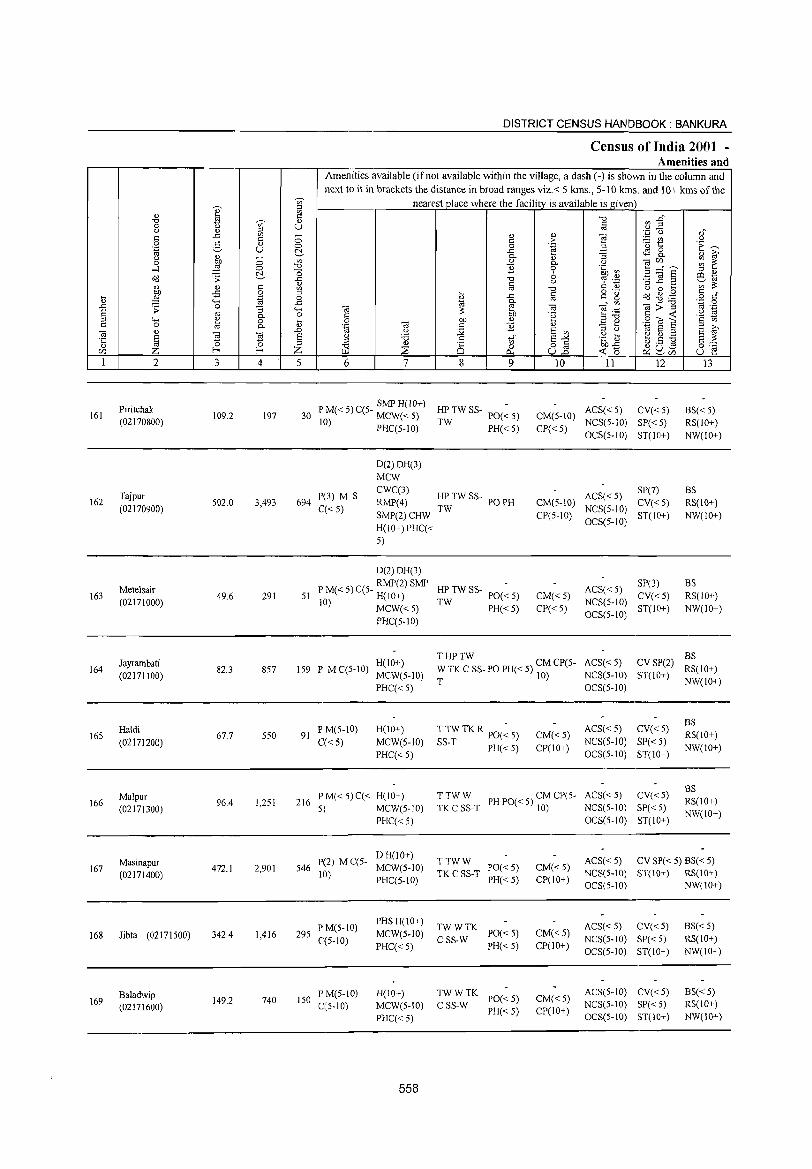
DISTRICT CENSUS HANDBOOK: BANKURA
Census of India 2001 -Amenities and
Amenities available (if not available within the village, a dash (-) is shown in the column and
next to it in brackets the distance in broad ranges viz.< 5 kms., 5-10 kms. and 10+ kms of the <I;' nearest place where the facility is available is given ::l
0) e Vl
'" -0 ..D '0 tl <I;' .,
0 u '" Vl ::l ::l to
0) _
() " '.0 <J ,f ..c Ul - ~ 0) e <= <= 0 ;> :.=: C/') ()
0 5 " 0 0 .~ .3 '0 t: E~ '~ u ~ ..c c$S 8.. " ~ " - 0- :; () Vl "
0) (ijr/J ~ ~ 0 ..& 0 0- ()
"'" 0 -0 ] 0 .~ ~ 3 ="6' ~ 0 6
::l .,
>'<l .;; ..c '0 ~ .~ '3 ~.2 CO"" 0) <= () ,;;;,,,,
~ 0) <= Vl to '0 () 0 ....
-5 .S ::l ~ § o ._
t\d ~ . .g <= ~ 0 ..c <= g o of
"'" "" ..c
"" 0- • Vl
(ij:;;:"g ',c 0
,D ;; 0 '3 "'" ] to (ij e .~ to ._
S «I 0 3: 5iJ 'e <= ~ .~ rg 0- ::l"O ::l "'" " 0 .... 0 on " .:::: e .9 til S <= Vl <= 0 t;; 0- 0) .~ (ij '" '2 " S ~ (ij "
.0 () :;;; E Vl ::l () "" E ::l
·c E ~ 'El E g 'i3 .5 'in E-" .g tl ~ ~ :a E '" " to 0 ::l
W3 0)
0 0 o <= on..<: o ..... ctS 0"" Z f-o f-o Z :2 u.2 ~o c:l u - u e r/J ~ ~r/j
1 2 3 4 5 6 7 8 9 10 11 12 13
Piritchak P M« 5) C(5- SMP H(lO+) HP TW SS- POe ~ 5) ACS« 5) CV«5) BS« 5) 161 109.2 197 30 J MCW«5) CM(5-10)
(02170800) 10) PHC(5-10) TW PH«S) CP« S) NCS(S-IO) SP« S) RS(lO+) OCS(S-IO) ST(lO+) NW(lO+)
O(2)DH(3)
MCW
Tajpur 1'(3) M S CWC(3)
HPTWSS- ACS«S) SP(7) BS
162 (02170900)
502.0 3,493 694 C« 5)
RMP(4) TW
POPH CM(5-10) NCS(5-JO)
CV«5) RS(10+)
SMP(2)CHW CP(5-IO) OCS(S-IO)
ST(10+) NW(JO+)
H(IO+)PHC« 5)
D(2)OH(3)
Metelsair PM«5)C(5- RMP(2)SMP HP TW SS- PO(~ S) ACS« 5)
SP(3) BS 163
(02171000) 49.6 291 51 H(lO+) CM« S)
NCS(S-JO) CV« S) RS(10+)
10) MCW«S) TW PH«5) CP«S) ST(lO+) NW(10+) PHC(S-JO)
OCS(5-10)
H(10+) THPTW
ACS«5) CV SP(2) BS
164 Jayrambati
82.3 8S7 IS9 po M C(S-10) W TK C SS- PO PH« 5) CM CP(S- RS(10+) (02171100) MCW(S-10) T 10) NCS(5-10) ST(10+)
PHC« 5) OCS(S-IO) NW(lO+)
P M(5-10) H(lO+) T TW TK R PO(~ 5) ACS«S) CV« 5) BS
165 Haldi
67.7 550 91 CM«5) RS(IO+) (02171200) C«5) MCW(S-IO) SS-T PH«5) CP(10+)
NCS(S-IO) SP« 5) NW(IO+)
PHC«5) OCS(5-1O) ST(10+)
PM«5)C« H(lO+) TTWW PH 1'0« 5) CM CP(5- ACS« 5) CV«S) as
Malpur 216 RS(10+) 166
(02171300) 96.4 1,2S1
5 ) MCW(S-IO) TK C SS-T 10) NCS(5-10) SP« 5)
PHC« 5) OCS(5-10) ST(IO+) NW(10+)
Masinapur p(2) MC(S-D H(lO+)
TTWW ACS«5) CV SP« 5) BS« 5) 167 472.1 2,901 S46 MCW(S-10) PO«5) CM«5)
(02171400) 10) PHC(5-10)
TKC SS-T PH«5) CP(IO+)
NCS(5-10) ST(10+) RS(IO+) OCS(5-10) NW(10+)
PM(5-10) PHS H(lO+)
TWWTK ACS« 5) CV«5) BS« 5) 168 Jibta (02171500) 342.4 1,416 29S
C(S-lO) MCW(5-10)
CSS-W 1'0« 5) CM«5)
NCS(5-10) SP«5) RS(10+) PHC« 5) PH« 5) CP(IO+)
OCS(5-10) ST(IO+) NW(IO+)
Baladwip PM(5-JO) H(lO+) TWWTK 1'0« 5) CM« 5)
ACS(5-10) CV«5) BS« 5) 169 149.2 740 ISO
C(5-10) MCW(5-10) CSS-W NCS(5-1O) SP« 5) RS(IO+) (02171600) PH« 5) CP(10+) PHC« 5) OCS(5-10) ST(lO+) NW(lO+)
558
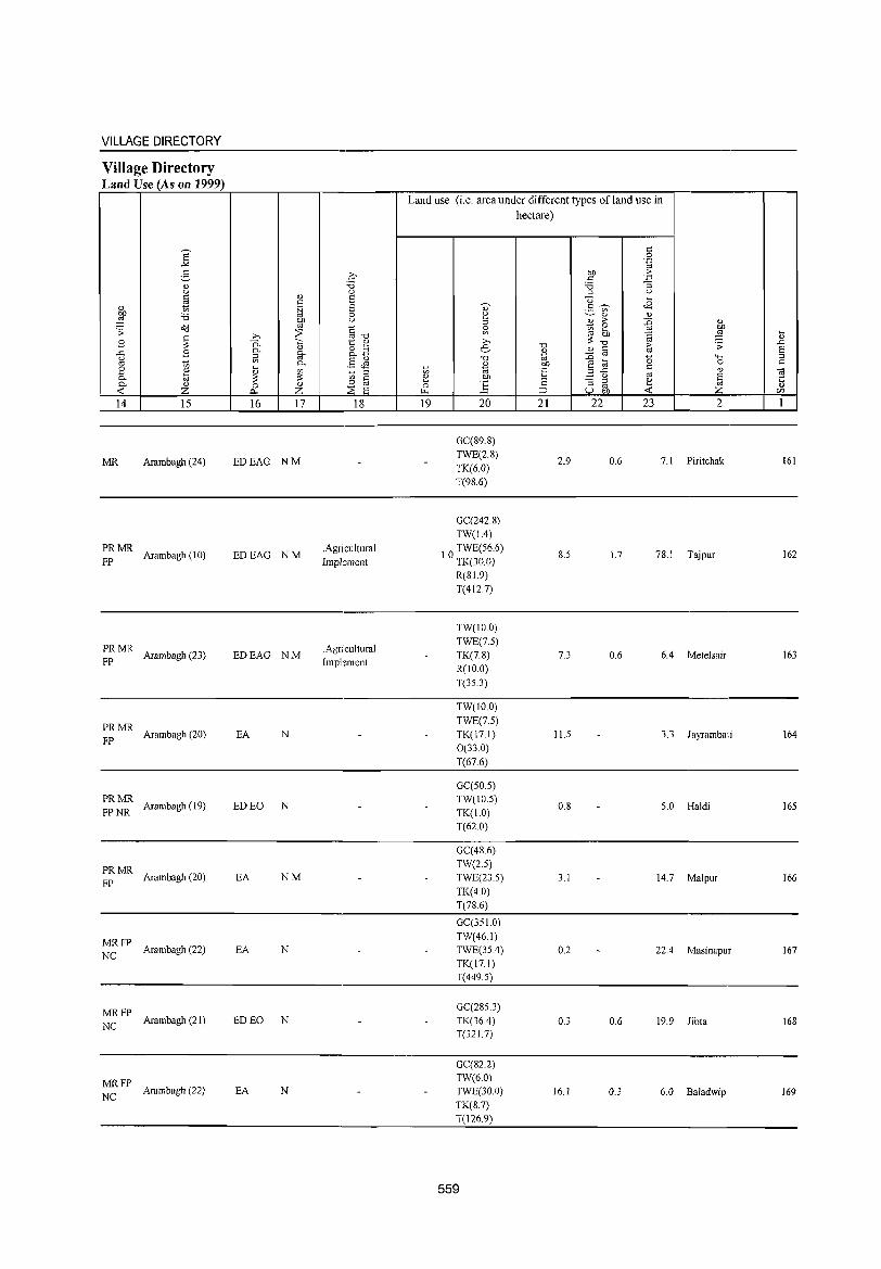
VILLAGE DIRECTORY
Village Directory Land Use (As on 1999)
Land use (i.e. area under different types of land use in
hectare)
S c: 0
..>< .~
:5 ~ OIl .~ c: 3 " :a :a (.) 0 ::> (.)
c: " 8 u ~
'" " <B " tl .~ 8 V .S (;)
:W :.0 0 ~ ~ " " ~ (.) ::> " :> ~ " o'd ~~ ~
~ 0 OIl .;; ~ '" ~
~ ~
"" '" OIl ~ ~ ~ '0 " B '0. ';::: t " ,..,
..0
" 8.2 e '0
" " (;; ;; E ..0 B 0- §- <l.) - '" (.) 5l .S Jl '0 ttl ~ a 0 4-< ::> oj tl 0- " OIl 0 " 2 " ~ '" tl ttl "E 3-5 c:
" "iti ~ ::> '" 0- til ~ '" c: e OIl til ·c
0- " 0 " o '" 0 ] c :; ::> e " -< z "'" z ;;S E ~ :::> u £h -< ~ en
14 15 16 17 18 19 20 21 22 23 2 1
GC(89.8)
MR Arambagh (24) EDEAG NM TWE(2.8)
2.9 0.6 7.1 Piritchak 161 TK(6.0) T(98.6)
GC(242.S) TW(1.4)
PRMR Arambagh (10) EDEAG NM
.Agricultural FP Impkment
TWE(56.6) 1.0 TK(30.0) 8.5 1.7 78.1 Tajpur 162
R(81.9) T(412.7)
TW(lO.O)
PRMR .Agricultura1 TWE(7.5)
Arambagh (23) EDEAG NM TK(7.8) 7.3 0.6 6.4 Metelsair 163 FP Implement
R(lO.O)
T(35.3)
TW(lO.O)
PRMR TWE(7.5)
FP Arambagh (20) EA N TK(17.1) 11.5 3.3 Jayrambati 164
0(33.0)
T(67.6)
GC(50.5) PRMR
Arambagh (19) ED EO N TW(1O.5)
O.S 5.0 Haldi 165 FPNR TK(1.0)
T(62.0)
GC(4S.6)
PRMR TW(2.5)
FP Arambagh (20) EA NM TWE(23.5) 3.1 14.7 Malpur 166
TK(4.0) T(78.6)
GC(351.0)
MRFP TW(46I)
NC Arambagh (22) EA N TWE(35.4) 0.2 22.4 Masinapur 167 TK(171) T(4495)
MRFP GC(285.3)
NC Arambagh (21) ED EO N TK(36.4) 0.3 0.6 19.9 Jibta 168 T(321.7)
GC(82.2)
MRFP TW(6.0)
NC Arambagh (22) EA N TWE(30.0) 16.1 0.3 6.0 Baladwip 169
TK(S.7) T(126.9)
559
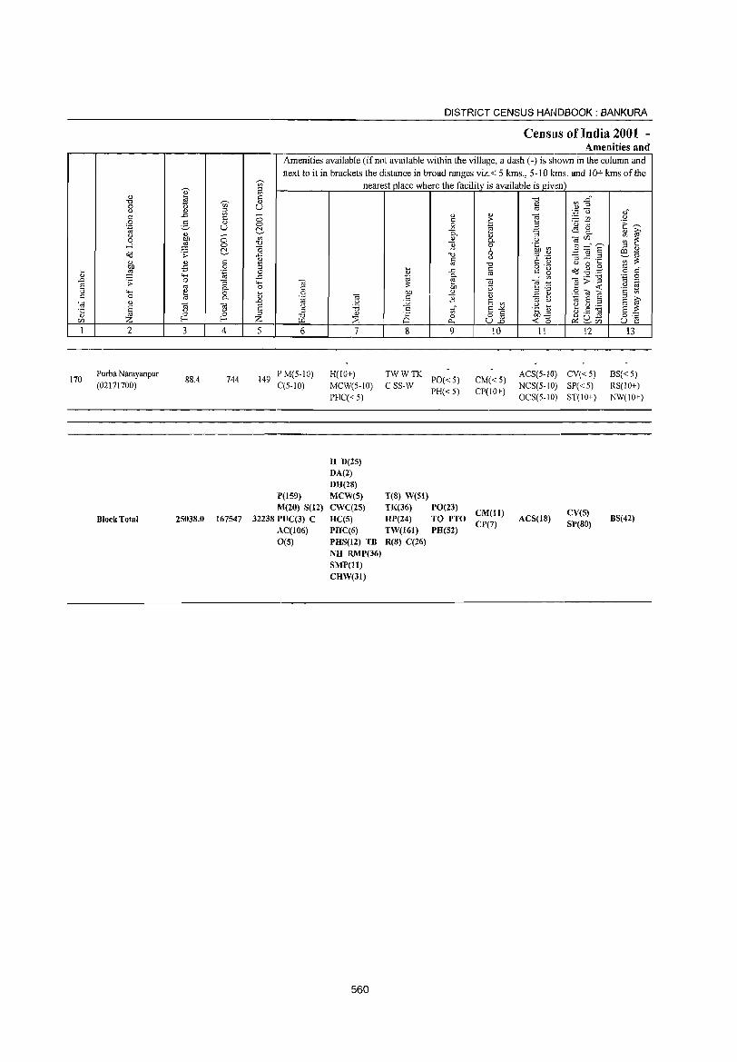
170
2
Purba Narayanpur (02171700)
Block Total
3 4
88.4 744
2S03S.0 167547
DISTRICT CENSUS HANDBOOK: BANKURA
Census of India 2001 -Amenities and
I Amenities available (ifnot available within the village, a dash (-) is shown in the column and next to it in brackets the distance in broad ranges viz. < 5 kms., 5- I 0 kms. and 10+ kms of the
nearest pJace where the facility_ is available is given
u
5 6
149 P M(5-IO) C(5-1O)
il'(159) M(20) S(12)
3223S lWC(3) C AC(106)
0(5)
7 8 9
H(lO+) MCW(5-tO) PHC« 5)
~~twTK PO« 5) PH«5)
H D(25) DA(2) DH(28) MCW(S) T(8) W(S1) CWC(2S) TK(36) PO(23) HC(S) HP(24) TO PTO PHC(6) TW(l61) PH(52) PHS(l2) TB R(S) C(26) NH RMP(36) SMP(ll) CHW(31)
560
10
CM« 5) CP(IO+)
CM(ll) CP(7)
II 12
ACS(5-J 0) CV( < 5) NCS(5-tO) SP«5) OCS(5-JO) ST(JO+)
ACS(lS) CV(S) SP(SO)
13
BS«5) RS(IO+) NW(JO+)
BS(42)
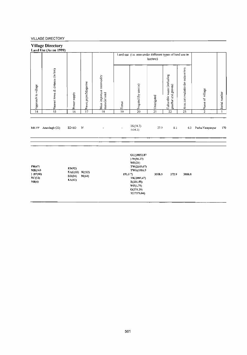
VILLAGE DIRECTORY
Village Directory Land Use (As on 1999)
14 15
MR FP Arambagh (22)
PR(47) MR(163
) FP(68)
NC(13) NR(4)
16 17
ED EO N
ED(92)
EAG(33) EO(34) EA(41)
N(132)
M(64)
18
Land use (i.e. area under different types ofland use in hectare)
c 0 .~
OIl ·E s:: ;C; " :l " C3 .... :S ~ <B
" 2 > :g 0
~ .... OIl ~
"Cl "Cl r. <l) <l) s:: ., ~
oj
-0 OIl ~ E .3 ..<:: s::
u oj
;:: " :::l ~ ~ ;:J u -<
19 20 21 22 23
" ~ .;; <.0..; 0 <l)
8 £ 2
TK(54.3) T(54.3)
27.7 0.2 6.3 Purba Narayanpur
GC(108S2.87 ) W(56.27)
WE(21) TW(2169.67) TWE(1916.9
191.07) TK(208S.47) R(201.SS)
WF(1.7S) 0(271.29) T(17576.84)
561
3108.5 272.9 3888.8
.... <l)
.D 8 :l c
OJ ·c <l)
r/)
1
170

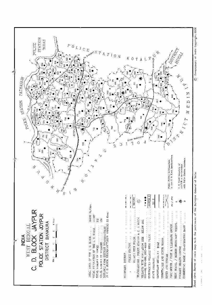
cD -
----------------------------------------------------------------------------------------------------------- a
"" I
~ /)
!; 'Y §
c; /) i 4" §
Ifr:: \ S
•
- . ........ 1
()
~
CO-
.\ . I
~
""
ui S ~ & [/]
r r
~
~
S
ui S ~
K 0 T A
J
I '~ . §l @ I I (;j
• 0
I
~ u 0' a a >-l N (ll
r::i "" a >-l
c.i W (ll
"<l
\ '" 0, Z v 0
a:>. "0 .-< , ~
~
~
ii
h ~
ii "-a
" 0. II
'_----
a N _,_-
1 '" ;a .5
©
..... a
'" " t c53 p o "~
"g ~
(Xl

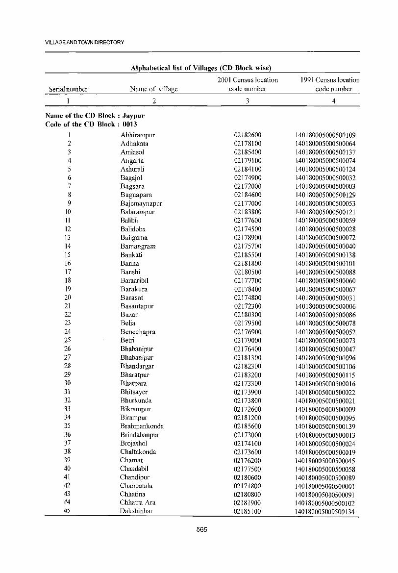
VILLAGE AND TOWN DIRECTORY
Alphabetical list of Villages (CD Block wise)
2001 Census location 1991 Census location Serial number Name of village code number code number
2 3 4
Name of the CD Block: Jaypur Code of the CD Block : 0013
1 Abhirampur 02182600 140180005000500109 2 Adhakata 02178100 140180005000500064 3 Amlasol 02185400 140180005000500137 4 Angaria 02179100 140180005000500074 5 Ashurali 02184100 140180005000500124 6 Bagajol 02174900 140180005000500032 7 Bagsara 02172000 140180005000500003 8 Baguapara 02184600 140180005000500129 9 Bajemaynapur 02177000 140180005000500053
10 Balarampur 02183800 140180005000500121 11 Balibil 02177600 140180005000500059 12 Balidoba 02174500 140180005000500028 13 Baliguma 02178900 140180005000500072 14 Bamangram 02175700 140180005000500040 15 Bankati 02185500 140180005000500138 16 Banna 02181800 140180005000500101 17 Banshi 02180500 140180005000500088 18 Baraaribil 02177700 140180005000500060 19 Barakura 02178400 140180005000500067 20 Barasat 02174800 140180005000500031 21 Basantapur 02172300 140180005000500006 22 Bazar 02180300 140180005000500086 23 Belia 02179500 140180005000500078 24 Benechapra 02176900 140180005000500052 25 Betri 02179000 140180005000500073 26 Bhabanipur 02176400 140180005000500047 27 Bhabanipur 02181300 140180005000500096 28 Bhandargar 02182300 140180005000500106 29 Bharatpur 02183200 140180005000500115 30 Bhatpara 02173300 140180005000500016 31 Bhitsayer 02173900 140180005000500022 32 Bhurkundla 02173800 140180005000500021 33 Bikrampur 02172600 140180005000500009 34 Birampur 02181200 140180005000500095 35 Brahmankonda 02185600 140180005000500139 36 Brindabanpur 02173000 140180005000500013 37 Brojashol 02174100 140180005000500024 38 Chaltakonda 02173600 140180005000500019 39 Chamat 02176200 140180005000500045 40 Chandabil 02177500 140180005000500058 41 Chandipur 02180600 140180005000500089 42 Chanpatala 02171800 140180005000500001 43 Chhatina 02180800 140180005000500091 44 Chhatra Ara 02181900 140180005000500102 45 Dakshinbar 02185100 140180005000500134
565
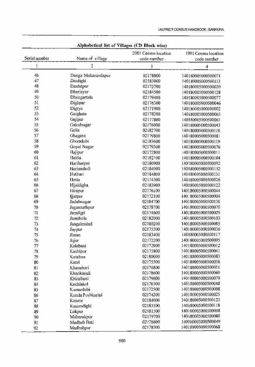
Ul5TRICT CENSUS HANDBOOK: BANKURA
Alphabetical list of Villages (CD Block wise)
2001 Census location 1991 Census location Serial number Name of village code number code number
1 2 3 4
46 Danga Makarandapur 02178800 140180005000500071 47 Dasdighi 02183000 140180005000500113 48 Daulatpur 02173700 140180005000500020 49 Dharisyer 02184500 140180005000500128 50 Dhengartala 02179400 140180005000500077 51 Dighpar 02176300 140180005000500046 52 Digrya 02171900 140180005000500002 53 Gaighata 02178200 140180005000500065 54 Gajipur 02177800 ] 40180005000500061 55 Gakulnagar 02176000 140180005000500043 56 Gelia 02182700 140180005000500110 57 Ghagara 02179800 140180005000500081 58 Ghoradubi 02183600 140180005000500119 59 Gopal Nagar 02179300 1401S0005000500076 60 Hajipur 02172800 1401S0005000500011 61 Haldu 02182100 140180005000500104 62 Hariharpur 02180900 140180005000500092 63 Harinashuli 02184900 140180005000500132 64 Hatbari 02184800 140180005000500131 65 Hetia 02174300 140180005000500026 66 Hijaldigha 02183900 140180005000500122 67 Hirapur 02176100 140180005000500044 68 Ijjatpur 02172100 1401180005000500004 69 Jadabnagar 02184700 140180005000500130 70 J agannathpur 02178700 140180005000500070 71 Jarndigri 02174600 140180005000S00029 72 Jamshola 02182000 14018000S000500103 73 J angalmahal 02180200 14018000S000S00085 74 Jaypur 02175300 140180005000500036 75 Jhean 02183400 140180005000500117 76 Jujur 02172200 140180005000500005 77 Kalabani 02172900 140180005000500012 78 Kashipur 02175800 14018000S000500041 79 Kataban 02180000 140180005000500083 80 Katul 02175500 14018000S000500038 81 Khanabari 02176800 140180005000500051 82 Kharikasuli 02178600 140180005000500069 83 Khiraibani 02179600 140180005000500079 84 Kuchiakol 02176500 140180005000500048 85 Kumardubi 02172500 140180005000500008 86 Kunda Pushkarini 02174200 140180005000500025 87 Kunrre 02184000 14018000S000500123 88 Kusumdighi 02183500 140180005000500118 89 Lokpur 02181500 140180005000500098 90 Mabarakpur 02179700 140180005000500080 9l MadhabBati 02176600 140180005000500049 92 Madhabpur 02178500 140180005000S00068
566
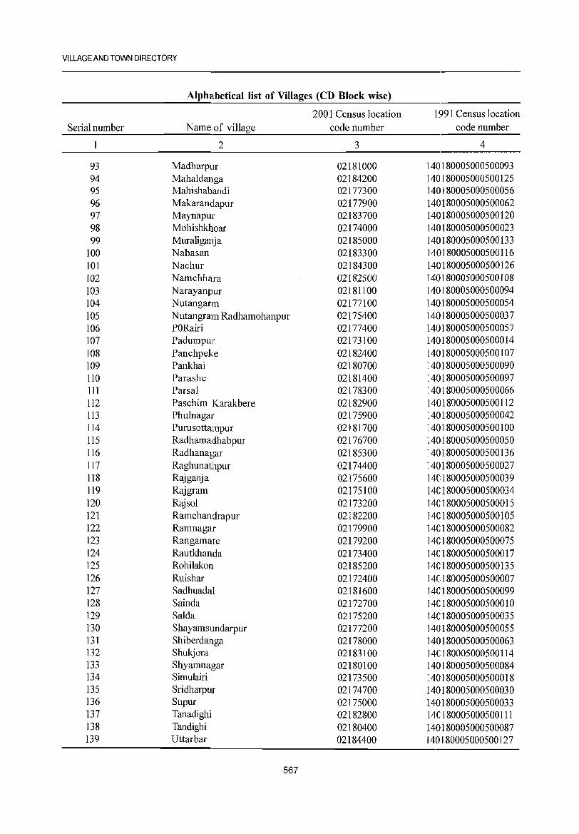
VILLAGE AND TOWN DIRECTORY
Alphalbeticallist of Villages (CD Block wise)
2001 Census location 1991 Census location Serial number Name of village code number code number
1 2 3 4
93 Madhurpur 02181000 140180005000500093 94 Maha1danga 02184200 140180005000500125 95 Mahishabandi 02177300 140180005000500056 96 Makarandapur 02177900 140180005000500062 97 Maynapur 02183700 140180005000500120 98 Mohishkhoar 02174000 140180005000500023 99 Mura1iganja 02185000 140180005000500133
100 Nabasan 02183300 140180005000500116 101 Nachur 02184300 140180005000500126 102 Namchhara 02182500 140180005000500108 103 Narayanpur 02181100 140180005000500094 104 Nutangarm 02177100 140180005000500054 105 Nutangram Radhamohanpur 02175400 140180005000500037 106 PORairi 02177400 140180005000500057 107 Padumpur 02173100 140180005000500014 108 Panchpeke 02182400 140180005000500107 109 Pankhai 02180700 140180005000500090 110 Parashe 02181400 140180005000500097 111 Parsa1 02178300 140180005000500066 112 Paschim Karakbere 02182900 140180005000500112 113 Phu1nagar 02175900 140180005000500042 114 Purusottampur 02181700 140180005000500100 115 Radhamadhabpur 02176700 140180005000500050 116 Radhanagar 02185300 140180005000500136 117 Raghunath.pur 02174400 140180005000500027 118 Rajganja 02175600 140180005000500039 119 Raj gram 02175100 140180005000500034 120 Raj sol 02173200 140180005000500015 121 Ramchandrapur 02182200 140180005000500105 122 Ramnagar 02179900 140180005000500082 123 Rangamate 02179200 140180005000500075 124 Rautkhanda 02173400 140180005000500017 125 Rohilakon 02185200 140180005000500135 126 Ruishar 02172400 140180005000500007 127 Sadhuadal 02181600 140180005000500099 128 Sainda 02172700 140180005000500010 129 Sa1da 02175200 140180005000500035 130 Shayamsundarpur 02177200 140180005000500055 131 Shiberdanga 02178000 140180005000500063 132 Shukjora 02183100 140180005000500114 133 Shyamnagar 02180100 140180005000500084 134 Simu1airi 02173500 140180005000500018 135 Sridharpur 02174700 140180005000500030 136 Supur 02175000 140180005000500033 137 Tanadighi 02182800 140180005000500111 138 Tandighi 02180400 140180005000500087 139 Uttarbar 02184400 140180005000500127
567
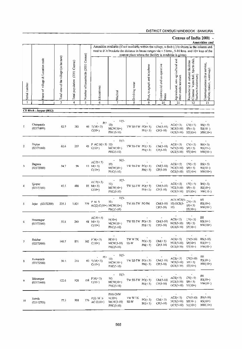
DISTRICT CENSUS HANDBOOK: BANKURA
Census of India 2001 -Amenities and
Amenities available (if not available within the village, a dash (-) is shown in the column and
next to it in brackets the distance in broad ranges viz.< 5 kms., 5-10 krns. and 10+ kms of the ~ nearest place where the facility is available is given
~ ~ " ~ c "'" ~ :s" "'" ~ " 0 u c
" " ;:l '" c .<:: '" ~ <U " ] ',p u ,;
c 0 c ;> ;.:::: CIl " 0 e- " 0 0 .~ ·u 1:: ·E ~ .~ U ~ .<:: tS g_ " D- :; " ~ " 00 0 "' " " "'§tI'J,,_ ;;; ~ 0 0. " ....l ,g 0 "'" ] 0 .~ ~
~ "0 6 .£l :a § ;:l " o(l :;: ..c "0 cp '.c; E9..1tf " &l c " ::s..c .....
"' :>: " c Ol "0 C " " 0 ....
:W -5 0 ;:l
~ c 0·- o(l..g.§ c .
il .~ 0 .<:: c g o C 4-< D- Ol
..0 ..c OJ .- "0 ·z 0 :;: 0 :; .... (ti e (ti ~ .-;:: g>~ Ol .-
§ Ol D- o c :>: 00 'e '2 ~ 4-< ~ 0 il 0 00 " ;:>"0 2"'8 C 0 D- 'ca
(ti c ] " ~ " ;:l ,..,
(ti " ..D u j;; E '" :5 ti OJ E ;:l E Ol ·c E ~ "El E .§ '8 .s ti' E-'" .g as b.5 ~ E :>:
'" 0 ;:l " " Z I-< I-< Z ::;s 0 0 8~ 00'<:: ~uU:i 0"" en ~ 0... « 0 u e
1 2 3 4 5 6 7 8 9 10 11 12 13
CD Block: Jaypur (0013)
P« H(5-
Chanpatala 62.9 283 46 5)M«5)
10) TW SS-TW PO« 5) CM(5-1O)
ACS« 5) CV« 5) BS« 5) (02171800)
C(lO+) MCW(10+)
PH« 5) CP(5-10) NCS(5-1O) 8P« 5) RS(lO+)
PHC(5-10) OCS(5-1O) ST(lO+) NW(lO+)
H(5-
2 Digrya
62.6 253 45 l' AC M« 5) 10)
TW SS-TW PO« 5) CM(5-IO) ACS« 5) CV«5) BS« 5)
(02171900) C(lO+) MCW(IO+) PH«5) CP(5-1O)
NCS(5-10) 5P« 5) RS(IO+) PHC(5-1O) OC5(5-1O) ST(lO+) NW(IO+)
ACP« 5) H(5-
3 Bagsara
54.7 96 13 M«5) 10)
TW 5S-TW 1'0« 5) CM(5-10) ACS« 5) CV«5) BS«5)
(02172000) MCW(IO+) NCS(5-10) SP« 5) RS(IO+) C(10+)
1'HC(5-10) PH«5) CP(5-10)
OCS(5-10) ST(IO+) NW(IO+)
ACp«5) H(5-
4 ljjatpur
45.5 486 85 M«5) 10)
TW SS-TW PO« 5) CM(5-10) ACS« 5) CV« 5) BS« 5)
(02172100) C(lO+)
MCW(IO+) 1'H« 5) CP(5-10)
NCS(5-10) SP« 5) RS(10+)
PHC(5-10) OCS(5-1O) ST(lO+) NW(IO+)
H(5-ACSNCS(5- - BS
Jujur (02172200) 235.1 1,821 379 PMS 10)
TW SS-TW PO PH CM(5-10) 10) OCS(5- CV« 5) RS(IO+) AC(2) C(10+) MCW(10+)
CP(5-10) 10) SP«5) NW(IO+) PHC(5-10) ST(IO+)
Basantapur ACP« 5)
H(IO+) ACS« 5) CV«5) BS
6 (02172300)
51.8 240 48 M«5) MCW(IO+)
TW SS-TW 1'0« 5) CM(5-IO) NCS(5-10) SP« 5)
RS(lO+)
C(IO+) PHC(5-1O)
PH« 5) CP(5-10) OCS(5-1O) ST(10+)
NW(lO+)
Ruishar 140.7 871 162
PM«5) H(IO+) TWWTK 1'0«5) CM«5)
ACS«5) CV(5-10) BS(5-10) 7
(02172400) C(10+) MCW(5-10) SS-W NCS(5-10) 5P(10+) RS(10+)
PHC(5-1O) PH«5) CP(5-1O)
OCS(5-1O) ST(IO+) NW(IO+)
- 1'« 10) H(5-
BS
8 Kumardubi
56.4 210 40 TWSS-TW 1'0«5) CM(5-IO) ACS« 5) eV(5-10)
RS(IO+) (02172500) 5)M« 5) MCW(IO+)
PH«5) CP(5-10) NCS(S-IO) S1'« 5)
NW(10+) C(IO+) 1'HC(5-10) OCS(5-1O) ST(lO+)
H(5- BS
9 Bikrampur
122.6 820 158 PM« 5) 10)
TW SS-TW 1'0« 5) CM(5-IO) ACS« S) CV« 5)
RS(IO+) (02172600) C(lO+) MCW(IO+)
PH«5) CP(5-10) NCS(5-1O) SP« 5)
NW(IO+) PHC(5-IO) OCS(5-1O) ST(IO+)
PHSCHW
Sainda 1'(2) M S H(IO+) TWWTK 1'0«5) CM«5)
ACS« 5) CV(5-l"O) BS(5-10) 10 77.3 908 136
ACC(IO+) MCW(5-IO) SS-W NCS(5-1O) SP(IO+) RS(IO+) (02172700) PH«S) ep(S-IO) PHC(5-1O) OCS(5-1O) ST(IO+) NW{lO+)
568
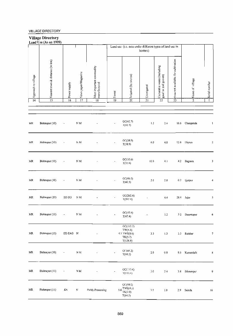
VILLAGE DIRECTORY
Village Directory Land Use (As on 1999)
14 15
MR Bishnupur (10)
MR Bishnupur (10)
MR Bishnupur (10)
MR Bishnupur (10)
MR Bishnupur (20)
MR Bishnupur (10)
MR Bishnupur (II)
MR Bishnupur (10)
MR Bishnupur (II)
MR Bishnupur (II)
16 17 18
NM
NM
NM
NM
ED EO NM
NM
EDEAG N
NM
NM
EA N Paddy Processing
Land use (i.e. area under different types ofland use in hectare)
19 20
GC(42.7)
T(42.7)
GC(38.9)
T(38.9)
GC(35.6)
T(35.6)
GC(40.S)
T(40.5)
GC(202.4)
T(202.4)
GC(47.4)
T(47.4)
GC(IIOJ)
TW(4.3)
4.1 TWE(8.6)
TK(S.7)
T(128.8)
GC(44.2)
T(44.2)
GC(1134)
T(113.4)
GC(58.0)
56 TWE(4.3) . TK(2.0)
T(64.3)
569
21
1.2
6.0
10.9
2.0
3.3
2.0
3.0
3.5
22 23 2
2.4 16.6 Chanpatala
4.0 13.8 Digrya
4.1 4.2 Bagsara
2.8 0.2 Ijjatpur
4.4 28.4 Jujur
1.2 3.2 Basantapur
1.3 3.3 Ruishar
0.8 9.5 Kumardubi
2.4 3.8 Bikrampur
1.0 2.9 Sainda
2
4
5
6
7
8
9
10
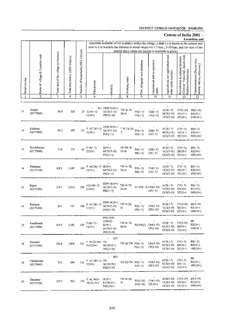
en ::l
<!) ~ Ul C
-0 E ~ <!) 0 u en U u <!) ~ <: ..<: -<: CO> 0 2, OJ .~ U CO>
t!., "
<!) -0 :W CO> '" ....l CO> -0
t!.- o o(l .;: ..c:: c 'l)
<!) <!) Ul
:W -£ 0 '" ... ""'
.~ 0 <!) ..c:: ..0 .;: 0 :; ..... a "' 0.. 0 g """' <!) 0 ...
0 ~ 0.. <J)
" <!) ..0
~ E E '§ E "' 0 ::l
m Z f- f- Z 1 2 3 4 5
Hajipur II 49.8 306 57
(02172800)
12 Kalabani
83.2 529 103 (02172900)
13 Brindabanpur
73.8 336 63 (02173000)
14 Padumpur
108.4 1,387 309 (02173100)
Rajsol 15 320.5 2,814 559
(02173200)
8hatpara 16
(02173300) 56.7 571 108
17 Rautkhanda
414.9 3,382 657 (02173400)
18 Simulairi
256.8 1,828 321 (02173500)
Chattakonda 79.5 690 114 19
(02173600)
Daulatpur 20
(02173700) 239.7 823 176
DISTRICT CENSUS HANDBOOK: BANKURA
Census of India 2001 -Amenities and
Amenities available (if not available within the village, a dash (-) is shown in the column and next to it in brackets the distance in broad ranges viz. < 5 krns., 5-10 kms. and 10+ krns of the
nearest place where the facility is available is given
~~ -0 <:
"' ',p u " <!) <!) ""§ <: > ~t " 'E ~ 0 .~ i3 ..<: <IS 0 0.. 'l) :; 0.. <!) il' " 0.. u "m ~ ~ ] 0 .~ ~ B...!"S
" '" " -0 :; ] .8 ~ ~
" "' .- ~~ a c ~ -0 t.) o 8 ... <: 0'- 5 ~f ~
..<:
"' <: g o(l ~ ."!;::
0.. en ,,;;"§l '.p 0
" f:! '" 1§ ;~ "' .-<: ~ OJ) .~ c « .~ g .~
OJ) " ",-0
.S '<i!] <: en
" c ] ~ ~ 1;j E '" il' .~ ;Q E Ul '" " a
" .~ lis ~.S ~ ::l -0 .= ,l E-'< a ~ -0 ~ {5 0 8.2 OJ)"<: 0:-:: eLi Cl. « -0 ~u- u ~ ~r:/)
6 7 8 9 10 II 12 13
P« CHW H(IO+) TWWTK ACS«5) CV(5-10) BS(5-10)
5) M« 5) MCW(5-IO) PO« 5) CM« 5) C(IO+) PHC(5-10)
SS-W PH«5) CP(5-10)
NCS(5-10) SP(lO+) RS(IO+) OCS(5-10) ST(lO+) NW(IO+)
P ACM«S) CHWH(IO+) ~ W TK SS- PO(~ 5) ACS«5) CV«S) 8S« 5) C(lO+) MCW(5-10) CM«5)
NCS(5-10) 5P(10+) R5(lO+) PHC«5) PH«5) CP«5)
OC5(5-10) ST(IO+) NW(IO+)
P M«5) H(IO+) HPTWW PO«5) CM«5)
ACS« 5) CV«5) BS« 5)
C(10+) MCW(5-10) SS-W NCS(5-IO) SP(10+) RS(IO+)
PHC« 5) PH« 5) CP« 5)
OCS(5-10) ST(lO+) NW(10+)
l' ACM«5) H(10+) TWWTK PO«5) CM«5)
ACS« 5) CV«5) BS« 5)
C(10+) MCW(5-10) SS-W PH«5) CP«5)
NCS(5-10) SP(lO+) RS(IO+)
PHC«5) OCS(5-10) ST(IO+) NW(lO+)
P(3)M« 5) CHW H(I 0+)
TWWTK ACS« 5) CV« 5) BS« 5) MCW(5-10) PH PO« 5) CM(5-1O)
C(10+) PHC« 5)
SS-W CP«5)
NCS(5-10) SP(10+) RS(IO+)
OCS(5-10) ST(IO+) NW(IO+)
CHW H(IO+) TWW SS- ACS« 5) CV(5-IO) 8S(5-1O) P ACM«S) MCW(5-IO) W
PO«5) CM(5-10) NCS(5-JO) SP(IO+) RS(10+) C(lO+) PHC(5-10) PH«5) CP(5-10) OCS(5-10) ST(10+) NW(lO+)
PHSRMP
CHW(2) TWWTK ACS«5) CV(5-10)
BS P M« 5)
H(10+) POPH(2) CM(5-IO) RS(tO+) C{lO+)
MCW(5-10) SS-W
CP(5-IO) NCS(S-IO) SP(lo+)
NW(10+)
PRC(5-10) OCS(5-10) ST(IO+)
H(5-
P AC(2) M« 10) TW SS-TW PO« 5) CM(5-10)
ACS« 5) CV«5) 6S« 5)
5) C(IO+) MCW(10+) PH« 5) CP(5-IO)
NCS(5-1O) SP(IO+) RS(IO+)
PRC(5-1O) OCS(5-1O) ST(lO+) NW(IO+)
H(5-BS
P AC M« 5) 10) TW SS-TW PO« 5) CM(5-IO)
ACS« 5) CV«5) RS(IO+)
C(lO+) MCW(IO+) NCS(5-1O) SP« 5) PH«5) CP(5-10) NW(lO+)
PHC(5-10) OCS(5-10) ST(IO+)
P ACM(5- H(IO+) TW WSS-PO(5-10) CM(5-IO)
ACS(5-tO) eV(5-tO) 6S(5-10)
10) C(IO+) MCW(IO+) W NCS(5-10) SP(IO+) RS(lO+) PH(5-10) CP(IO+)
PHC(IO+) OC5(5-1O) ST(lO+) NW(10+)
570
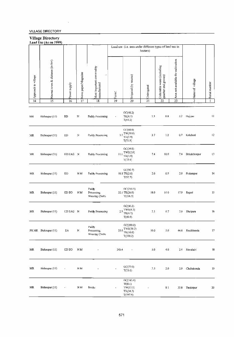
VILLAGE DIRECTORY
Village Directory Land Use (As on 1999)
MR Bishnupur (II)
MR Bishnupur (II)
MR Bishnupur (II)
MR Bishnupur (II)
MR Bishnupur (11)
MR Bishnupur (11)
PR MR Bishnupur (II)
MR Bishnupur (11)
MR Bishnupur (II)
MR Bishnupur (II)
ED N
ED N
EDEAG N
ED NM
ED EO NM
EDEAG N
EA N
ED EO NM
NM
NM
Paddy Processing
Paddy Processing
Paddy Processing
Padely Processing
Padely Processing, Weaving Cloths
Padely Processing
Paddy Processing, Weaving Cloths
Bricks
Land use (i.e. area under different types of land use in hectare)
GC(40.2) TK(4.1) T(44.3)
GC(60.0)
3 TW(IO.O)
.7 TK(3.9)
T(73.9)
GC(34.0)
II I TWE(2.0) · TK(1.9)
T(37.9)
GC(90.7) 10.8 TK(2.0)
T(n.7)
GC(21O.5) 32.1 TK(26.0)
T(236.5)
GC(40.2)
29 TWE(4.2) · TK(4.5)
T(49.0)
GC(290 0)
25 0 TWE(30.2) · TK(IO.O)
T(330.2)
245.4
GC(73 0) T(73.0)
GC(143.4) W(S.I) TW(12.1) TK(34.3) T(197.9)
571
1.5 O.S 3.2 Hajipur
3.7 12 0.7 Kalabani
7.4 10.0 7.4 Brindabanpur
2.0 0.9 2.0 Padumpur
18.0 16.0 17.9 Raj sol
2.1 0.7 2.0 Bhatpara
10.0 5.0 44.6 Rautkhanda
5.0 4.0 2.4 Simulairi
2.5 2.0 2.0 Chaltakonda
S.I 33.S Daulatpur
II
12
13
14
IS
16
17
IS
19
20
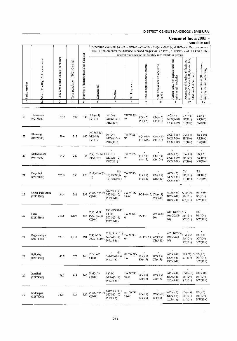
DISTRICT CENSUS HANDBOOK: BANKURA
Census of India 2001 -Amenities and
Amenities available (if not available within the village, a dash (-) is shown in the column and
next to it in brackets the distance in broad ranges viz.< 5 krns., 5-10 krns. and 10+ krns of the ~
nearest place where the facility is available is given '" ., :l
'" " 8 c "0 ~ :2~ "0 t5 " c 0 ~ u '" (j " :.e u oJ .c - " " ""§ c c 0 c > '" (j
0 2 " 0 0 .~ 3 ·0 t: ·E ~ .~ u ~ ..c ~ & " g u " - 0-
" :;
0 on 0 '" " 0- (j "§ (/),,- ~ ~ ....l 5 0 "0 E 0 .~ ~ C!- o 6 E ~ § :l " o'<l > ..c: "0 cp .~ ~1;1
" c u :::s .c ._ '" ::: " " c '" '" "0 C " (j 0 ...
:W -s 0 :l o .- a<3 ..g ,.@ c " i; .c c e" ~ o c i; .~ 0 '" ..... ..c ~ 0- .- "0 '';::: 0
..0 .s: 0 "3 4-< Ol e Ol ~~ ~>~ '" .-S '" 0- 0 c: ::: on .~ '2 ~ ;::! ""' ~ 0 ... 0 on " .:§ ~ gOt s c 0 0- " 'ia Ol c E " E g ~ "
..0 (j i2 E '" :l (j 1;1 E :l
E ~ "El E (j :.a c E "'" .~ d> ~ ~ ~ E ::: :l '" " '" 0 :l "0 " 8 0 8] on..c u ._ ro 0:-;:::
Ul Z f- f- Z >r.l ~ r:>. <t: 0 P:lu- u e '-' r/)
1 2 3 4 5 6 7 8 9 10 11 12 13
21 Bhurkunda
S7.2 712 147 PM« S) H(IO+) TWWSS- ACS« S) CV«S) BS«S)
PO«S) CM«S) (02173800) C(1O+) MCW(1O+) W PH«S) CP(IO+)
NCS(S-1O) SP(lO+) RS(IO+) PHC(IO+) OCS(S-IO) ST(lO+) NW(IO+)
Bhitsayer ACP(5-10)
H(lO+) TWWSS- ACS(5-10) CV(5-10) BS(S-IO) 22 179.4 912 165 M(5-IO) PO(5-10) CM(5-10)
(02173900) C(IO+)
MCW(10+) W PH(S-IO) CP(IO+)
NCS(S-IO) SP(IO+) RS(10+) PHC(10+) OCS(S-10) ST(IO+) NW(IO+)
23 Mohishkhoar
74.3 249 58 P(2) AC M« H(10+) TWWSS-
PO«S) CM«5) ACS« 5) CV«5) BS« 5)
(02174000) 5) C(IO+) MCW(S-IO) W PH«5) CP(IO+)
NCS(5-10) SP(10+) RS(lO+) PHC(IO+) OCS(S-IO) ST(IO+) NW(1O+)
Brojashol - H(S-
TWWSS- ACS«S) CV BS
24 205.5 550 120 P M« S) C(5- 10) MCW(5- PO«5) CM«5) SP(10+) RS(IO+) (02174100)
10) 10)PHC«5) W PH(5-1O) CP(S-IO)
NCS(5-IO) ST(IO+) NW(10+)
OCS(5-10)
25 Kunda Pushkarini
134.4 782 135 P ACM«S) CHWH(IO+) TWWTK
PO PH« 5) CM« 5) ACS(5-10) CV«5) BS(5-10)
(02174200) C(1O+) MCW(5-1O) SS-W CP(5-10)
NCS(S-IO) SP(IO+) RS(lO+) PHC(5-10)
OCS(S-IO) ST(IO+) NW(IO+)
PP) M S HC PHS RMP
ACS NCS(5- CV BS Hetia H(IO+) TWWSS- CMCP(5-
26 (02174300)
211.8 2,607 487 PUC AC(2) MCW(5-1O) W
PO PH 10)
10)OCS(5- SP(IO+) RS(IO+)
C(10+) PHC(5-10)
10) ST(IO+) NW(IO+)
Raghunathpur P(4) M S D PHS H(IO+) TW W SS- ACS NCS(5- -8S«5)
27 370.3 3,033 604 PO PH« 5) CM« 5) 10) OCS(5- CV« 5) (02174400) AC(3) C(IO+) MCW(5-10) W
CP(5-to) 10) SP(IO+) RS(IO+) PHC(5-10)
ST(IO+) NW(IO+)
Balidoba PM AC H« HP TW SS- PO(~ S) ACS(5-10) SP CV« 5) 8S« 5)
28 (02174S00)
143.9 673 140 C{lO+)
5)MCW«S) CM«S) NCS(5-10) ST(IO+) RS(IO+)
PHC« S) TW PH«5) CP« 5) OCS(5-10) NW(IO+)
Jamdigri 163
PM«S) H(IO+) TWWTK PO« 5) CM«5)
ACS(S-IO) CV(S-IO) BS(5-10) 29 79.3 848
C{lO+) MCW(S-IO) SS-W NCS(5-10) SP(IO+) RS(to+) (02174600) PH«5) CP(5-10) PHC(5-1O) OCS(S-IO) ST(IO+) NW(lO+)
Sridharpur CHWH(IO+)
HPTWW ACS« 5) CV« S) 8S«S) 30 340.1 621 129 P AC M« 5) MCW(5-1O)
SS-W PO«5) CM(S-IO)
NCS« S) SP(10+) RS(lO+) (02174700) C(10+) PHC« 5) PH«5) CP«5) OCS«S) ST(IO+) NW(IO+)
572
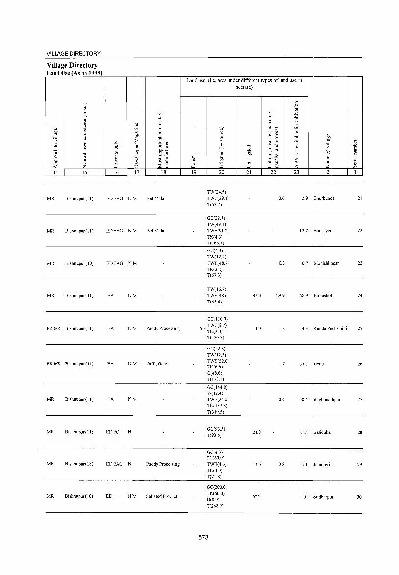
VILLAGE DIRECTORY
Village Directory Land Use (As on 1999)
14 15
MR Bishnupur (11)
MR Bishnupur (II)
MR Bishnupur (10)
MR Bishnupur (II)
PR MR Bishnupur (II)
PRMR Bishnupur (II)
MR Bishnupur (II)
MR Bishnupur (II)
MR Bishnupur (18)
MR Bishnupur (10)
16 17 18
EDEAG NM Bel Mala
EDEAG NM Bel Mala
EDEAG NM
EA NM
EA NM Paddy Processing
EA NM Grill., Gate
EA NM
ED EO N
EDEAG N Paddy Processing
ED NM Saltated Product
Land use (i.e. area under different types of land use in hectare)
19 20
TW(24.5) TWE(29.1)
T(53.7)
GC(22.1)
TW(49.1)
TWE(91.2) TK(4.3)
T(166.7)
GC(4.3) TW(12.2)
TWE(48.7) TK(22) T(67.3)
TW(16.7)
TWE(48.6)
T(65A)
GC(llO.O)
53 TWE(8.7) . TK(2.0)
T(120.7)
GC(52.8)
TW(12.5) TWE(52.6) TK(6.6)
0(48.6) T(l73.1)
GC(144.8)
W(12A) TWE(24.5)
TK(J37.8) T(319.5)
GC(93.5) T(93.5)
GC(4.3) PC(60 0)
TWE(4.6) TK(3.0) T(71.8)
GC(200.0) TK(60.0)
0(8.9) T(268.9)
573
21 22
41.3
3.0
28.8
2.6
67.2
23 2
0.6 2.9 Bhurkunda
12.7 Bhitsayer
0.3 6.7 Mohishkhoar
29.9 68.9 Brojashol
1.2 4.3 Kunda Pushkarini
1.7 37.1 Hetia
0.4 50A Raghunathpur
21.5 BaJidoba
0.8 4.1 lamdigri
4.0 Sridharpur
21
22
23
24
25
26
27
28
29
30
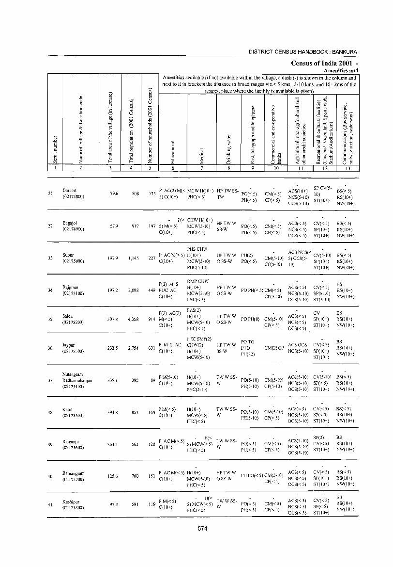
31
32
33
34
35
36
37
38
39
40
41
2
Barasat (02174800)
Bagajol (02174900)
Supur (02175000)
Rajgram (02175100)
Salda (02175200)
Jaypur (02175300)
Nutangram Radhamohanpur (02175400)
Katul (02175500)
Rajganja (02175600)
Bamangram (02175700)
Kashipur (02175800)
3
79.6
57.9
192.9
197.2
507.8
232.5
339.1
594.8
S64.5
125.6
97.3
o o ~ c o
'.g "'3 c. o c.
'El ~ 4
808
917
1,145
2,098
4,358
2,754
395
857
563
700
591
DISTRICT CENSUS HANDBOOK: BANKURA
Census of India 2001 -Amenities and
Amenities available (if not available within the village, a dash (-) is shown in the column and next to it in brackets the distance in broad ranges viz. < 5 lans., 5- I 0 kms. and 10+ kms of the
nearest place where the facility is available is given
5 6 7 8
'" o 0...
9 10 II 12 13
173 IP AC(2)M« MCWH(IO+) HPTWSS- PO(~5) :5) C(IO+) PHC« 5) TW PH« 5)
CM«5)
CP« 5)
ACS(10+)
NCS(5-1O)
OCS(5-10)
SP CV(5- BS« 5) 10) ST(JO+) RS(10+)
P« CHWH(JO+) HPTWW 197 5)M«5) MCW(5-10) SS-W PO«5) CM« 5)
CP« 5)
ACS« 5)
NCS« 5)
OCS« 5)
CV«5) SP(IO+)
ST(IO+) C(10+) PHC« 5) PH« 5)
227
PHSCHW
I' AC M« 5) H(IO+)
C(IO+) MCW(5-JO)
P(2) M S 449 PUC AC
C(lO+)
P(3) AC(3)
914 M« 5) C(10+)
631 PM S AC C(10+)
PHC(5-10)
RMPCHW H(10+)
MCW(5-10)
PHC« 5)
PHS(2)
H(IO+)
MCW(5-10)
PHC« 5)
PHCSMP(2)
CHW(2)
H(IO+)
MCW(5-10)
HPTWW PH(2)
o SS-W 1'0« 5) CM(5-10)
CP(5-10)
HPTWW o SS-W PO PH( < 5) CM( < 5) CP(5-10)
ACSNCS« -5) OCS(5- CV(5-10) 10) SP(IO+)
ST(10+)
ACS« 5) CV« 5) NCS(S-IO) SP(5-IO)
OCS(5-10) ST(5-10)
HP TW W PO PH(S) CM(5-10) ACS( < 5) o SS-W CP« 5) NCS« 5)
OCS« 5)
CV SP(IO+)
ST(IO+)
PO TO HPTWW PTO SS-W
PH(22)
ACS OCS CV« 5) CM(2) CP NCS(5-10) SP(IO+)
ST(IO+)
NW(10+)
BS« 5) RS(1O+)
NW(IO+)
BS«5) RS(IO+)
NW(IO+)
BS RS(IO+)
NW(10+)
BS RS(IO+)
NW(IO+)
BS RS(IO+)
NW(IO+)
89 P M(S-IO) C(10+)
H(IO+)
MCW(5-10)
PHC(5-10)
TW W SS- PO(5-1O) CM(5-10) ACS(5-10) CV(5-10) BS« 5) W NCS(5-1O) SP« 5) RS(10+)
PH(5-1O) CP(5-10) OCS(5-10) ST(10+) NW(IO+)
164 PM«5) C(10+)
H(lO+)
MCW«5)
PHC« 5)
TW W SS- ACS« 5) CV« 5) W PO(S-IO) CM(5-10) NCS(5-10) SP« 5)
PH(5-10) CP« 5) OCS(5-10) ST(10+)
H« 120 I' ACM«5) S)MCW«5) TWWSS- PO«5)
C(10+) PHC« 5) W PH« 5) CM«5)
CP« 5)
SP(2) ACS(5-10) CV« 5)
NCS(5-10) ST(lO+) OCS(5-10)
P AC M« 5) H(IO+) 151 C(IO+) MCW(5-10)
HP TW W PH 1'0« 5) CM(5-10) ACS« 5) o SS-W NCS« 5)
119 PM«5) 0(10+)
PHC«5)
H« TWWSS-5)MCW«5) W 1'0«5) PHC« 5) PH« 5)
574
CP« 5) OCS« 5)
CM«5)
CP«5)
ACS« 5)
NCS« 5)
OCS« 5)
CV« 5) SP(IO+) ST(IO+)
CV«5)
SP« 5)
ST(10+)
BS«5) RS(10+)
NW(IO+)
BS RS(IO+)
NW(IO+)
BS«5) RS(IO+) NW(IO+)
BS RS(IO+)
NW(IO+)
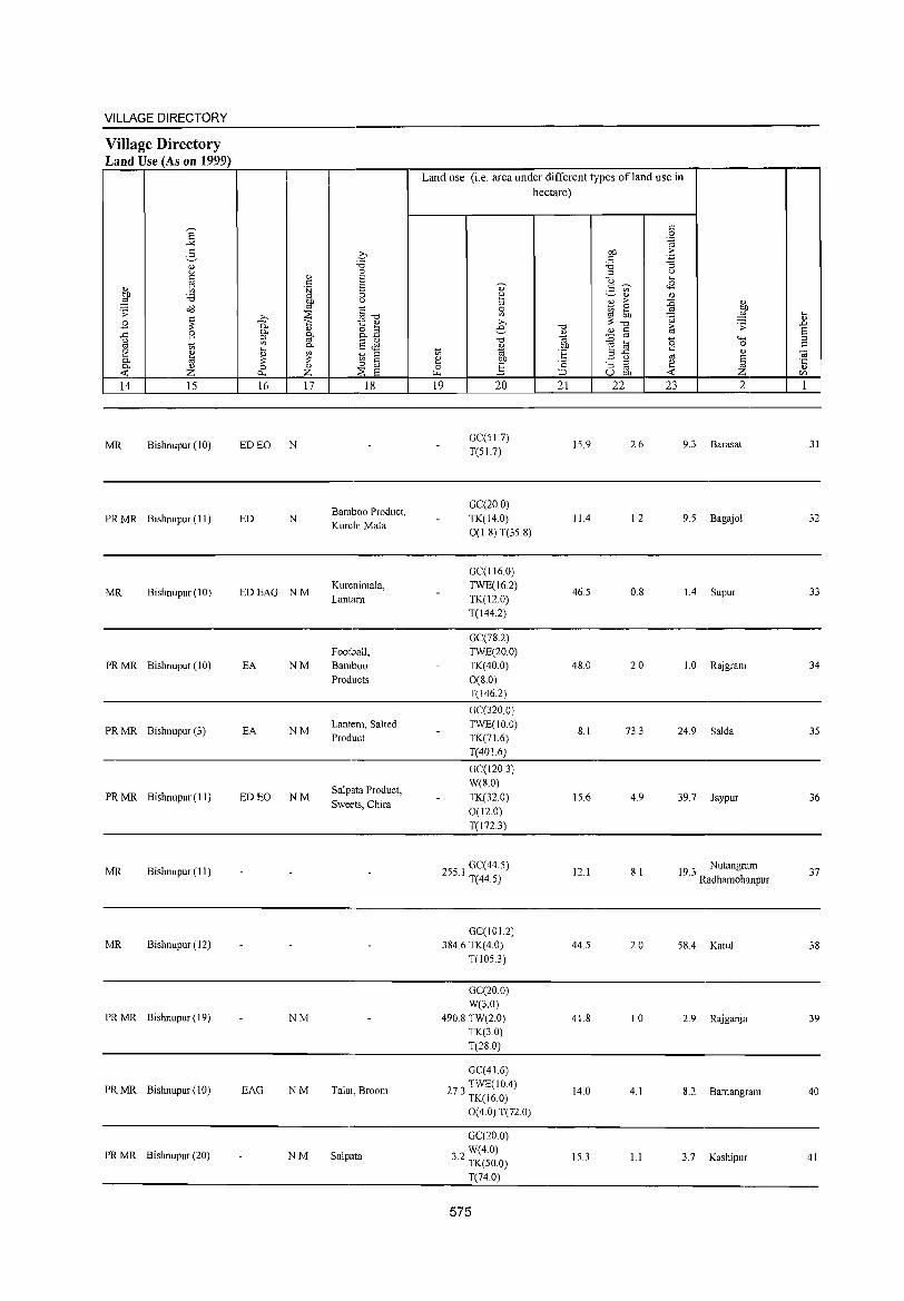
VILLAGE DIRECTORY
Village Directory Land Use (As on 1999)
MR Bishnupur (10)
PR MR Bishnupur (II)
MR Bishnupur (10)
PR MR Bishnupur (10)
PR MR Bishnupur (3)
PR MR Bishnupur (11)
MR Bishnupur (11)
MR Bishnupur (12)
PRMR Bishnupur(19)
PR MR Bishnupur (10)
PR MR Bishnupur (20)
ED EO N
ED N
EDEAG NM
EA NM
EA NM
ED EO NM
NM
EAG NM
NM
Bamboo Product, Kurchi Mala
Kurenimala, Lantarn
Football, Bamboo Products
Lantern, Salted Product
Salpata Product,
Sweets, Chira
Talai, Broom
Salpata
Land use (i.e. area under different types ofland use in hectare)
GC(S1.7) T(S1.7)
GC(20.0) TK(14.0) 0(1.8) T(3S.8)
GC(116.0) TWE(16.2) TK(12.0) T(144.2)
GC(78.2) TWE(20.0) TK(40.0) 0(8.0) T(146.2)
GC(320.0) TWE(IO.0) TK(71.6) T(40l.6)
GC(120.3) W(8.0)
TK(32.0) 0(12.0) T(1723)
255 I GC( 44.5) . T(44.5)
GC(101.2) 384.6 TK(4.0)
T(1053)
GC(20.0) W(3.0)
490.8 TW(2.0) TK(3.0) T(28.0)
GC(41.6)
27 3 TWE(IO.4) . TK(16.0)
0(4.0) T(n.O)
GC(20.0) W(4.0)
3.2 TK(50.0)
T(74.0)
575
15.9
11.4
46.5
48.0
8.1
15.6
12.1
44.5
41.8
14.0
15.3
2.6 9.3 Barasa!
1.2 9.5 Bagajol
0.8 1.4 Supur
2.0 1.0 Rajgram
733 24.9 Salda
4.9 39.7 Jaypur
8.1 19 3 Nutangram . Radhamohanpur
2.0 58.4 Kalu]
1.0 2.9 Rajganja
4.1 8.2 Bamangram
1.1 3.7 Kashi pur
31
32
33
34
35
36
37
38
39
40
41
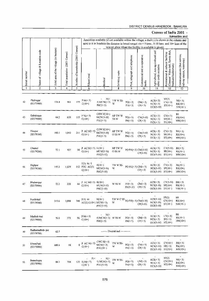
DISTRICT CENSUS HANDBOOK: BANKURA
Census of India 2001 -Amenities and
Amenities available (if not available within the village, a dash (-) is shown in the column and next to it in brackets the distance in broad ranges viz.< 5 kms., 5-10 lans. and 10+ kms of the
-;:;;- nearest place where the facility is available is given ::>
" e ~ ~ :Z~ '0 os -;:;;- " '0
0 'U U <:: <.) " ::l os '';:: 0 oi ..<:: '"
_ " " "§ <:: <:: 0 '" :> ;.::: rJ) <.)
0 3 " 0 0 '"§ E '" 1:: 'E ~ .~ u ~ ..c: ~ 8-" 0- ... ::; '" G' <.) C; " 0 ~ '" " 0- <.) e r/J,,-. ~ ~ ....l 0 '0 ] 0 .~ ~
~ "0 6 E ~ § ::> " o'd .;;: ..<:: '0 '? ._;:: 81i1
" iii <) :. ..c ._
'" ;;:: " " '" '" '0 '" " <.) 0 ... bD -5 0 ::l
o ._ o'd ~ . .g '" "
... ..c: § '" g l:i ::§ '.g 0 {l o '" '+-< ..s:: ~ _" '"
._ '0 ''';::: 0 ..0 .;;: 0 '3 '<-< "@ :;: {ij
~ .~ "@>~ os .-S os 0- 0 .~ .~ g ::l .. e 0 l:i 0 bD "
::>'0 .9 OJ S '" '" '" 0 os 0- '-@ {ij <:: ] .:::: ~ 6 ~ OJ " ..0 U :.g E '" ::> <.) 1;1 S ;:!
§ 'El ~ s " :.a '" E"" .g Es ~.S ~ s ;;:: li ::l '" ~
::l '0 " 8 o '" bD.p 0"" Z f-< Z ::s 0 ull ~ SU5 CIl U.l 0... <C 0 U ~ 1 2 3 4 5 6 7 8 9 10 11 12 13
Phu!nagar PM«5) H«
TWWSS- ACS«S) 8P(3)
BS« 5) 42 134.8 901 175 5) MCW«5) PO«5) CM«5) CV« 5) (02175900) C(10+) PHC«5)
W PH« 5) CP«5)
NCS«5) ST(IO+)
RS(IO+) OCS(S-IO) NW(IO+)
Gakulnagar PM«5) CHWH(IO+)
HPTWW ACS« 5) CV«5) BS
43 (02176000)
64.2 619 119 C(10+)
MCW(5-1O) SS-W
PO«5) CM(S-IO) NCS« 5) SP(IO+)
RS(IO+) PHC« 5) PH«5) CP« 5)
OCS« 5) ST(IO+) NW(IO+)
44 Hirapur
160.1 1,042 211 P AC M« 5) CHW H(IO+) HPTWW
PO«S) CM(5-1O) ACS« 5) CV« 5) B5« 5)
(02176100) C(IO+) MCW(5-1O) OSS-W NCS«5) SP(IO+) RS(IO+) J PHC« 5) PH« 5) CP« 5)
OCS« 5) ST(IO+) NW(lO+)
4S Chamat
72.1 457 98 I' ACM«5) H(10+) HPTWW
PO PH« 5) CM(S-lO) ACS« 5) CV(5-10) BS«5)
(02176200) C(10+) MCW(S-10) OSS-W CP(S-IO)
NCS« 5) SP(10+) RS(IO+) PHC(5-10) OCS(S-IO) ST(IO+) NW(IO+)
Dighpar P(3) M S
H(10+) TWWSS- ACS«5) CV«S) BS(IO+) 46 149.3 1,639 312 PUC AC(2) PO PH« 5) CM« 5)
(02176300) C(10+)
MCW(5-1O) W CP« 5)
NCS(S-IO) SP(IO+) RS(IO+)
PHC(5-10) OCS(5-10) ST(IO+) NW(IO+)
47 Bhabanipur
72.2 220 44 P AC M« 5) H(lO+)
WSS-W PO« 5) CM« 5) ACS« 5) CV(5-1O) BS« 5)
(02176400) C(10+) MCW(5-1O) PH(5-1O) CP«5)
NCS(5-IO) SP(IO+) RS(IO+)
PHC(S-IO) OCS(5-1O) ST(IO+) NW(IO+)
H(IO+) TW W C SS PO PH« 5) CM(-S-IO) ACS(5-10) SP(2) BS
48 Kuchiakol
319.6 3,898 748 P(4) M
CV(10+) RS(lO+) (02176500) AC(2) C(10+) MCW« 5) W CP(5-10)
NCS(5-10) ST(10+) NW(10+)
PHC(5-1O) OCS(5-1O)
H« ACS«5) CV«5) BS
49 MadhabBati
76.0 573 96 P M«5)
5) MCW«5) WSS-W PO«S) CM«5) RS(lO+) (02176600) C(10+)
PHC«S) PH«S) CP«S) NCS«5) SP« 5)
NW(10+) OCS(5-1O) ST(IO+)
50 Radhamadhab- pur
62.7 -------- Uninhabited ------------(02176700)
CWCH«5) TWWSS- ACS« 5) CV(10+) BS« 5) Khanabari P AC M« 5) MCW« 5) PO«5) CM« 5) 51 689.4 48 8 W NCS(5-10) SP« 5) RS(IO+) (02176800) C(IO+) PHC(IO+) PH«5) CP«5)
OCS(5-1O) ST(IO+) NW(IO+)
P« H« TWW SS- ACS« 5) SP(2)
BS« 5) Benechapra 5) MCW«5) PO« 5) CM« 5) CV(10+) 52 (02176900)
84.2 708 125 5) M« 5) W NCS« 5) RS(lO+)
C(IO+) PHC(5-IO) PH« 5) CP« 5) OCS(5-10)
ST(10+) NW(IO+)
576
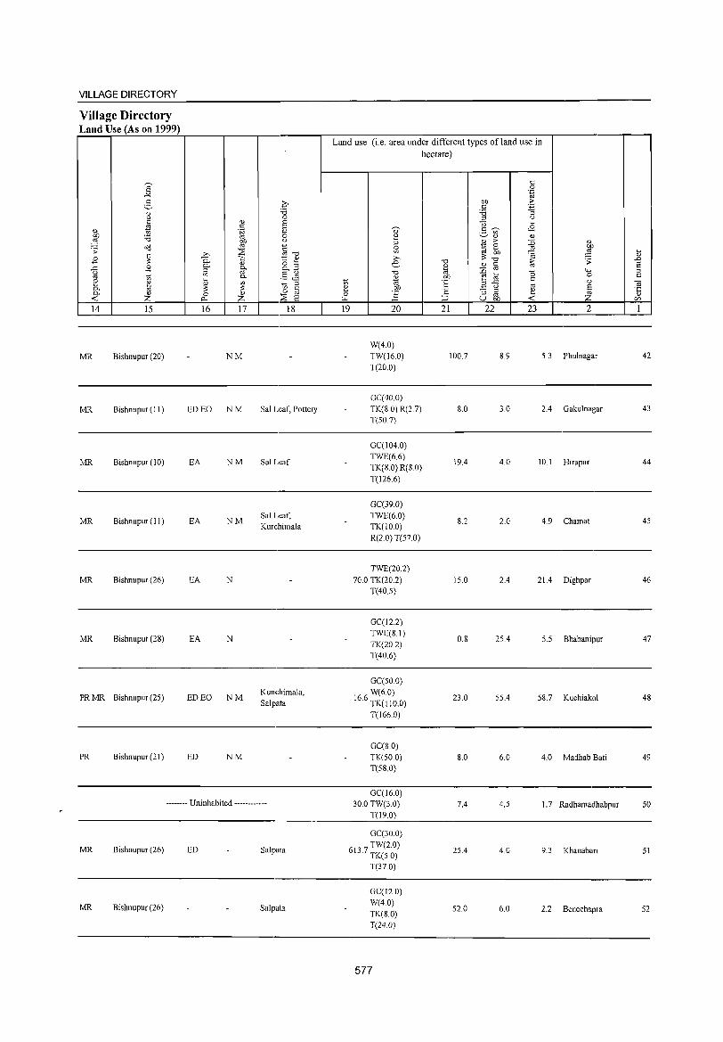
VILLAGE DIRECTORY
Village Directory Land Use (As on 1999)
a -" ~ " u
" " tl CO '6 ~ o'I:l . ;; E ~ ..c: B g 1;; E ~ 0-0- " ...: z 14 15
MR Bishnupur (20)
MR Bishnupur (II)
MR Bishnupur (10)
MR Bishnupur (11 )
MR Bishnupur (26)
MR Bishnupur (28)
PRMR Bishnupur (25)
PR Bishnupur (21)
'" 0:. 0-
iil t; ~ 0
p..
16
ED EO
EA
EA
EA
EA
ED EO
ED
q -0 0
Q) s . S s ~ 0
~ u
§-o ~ 1:: ~ " o ;;l §' 0. .....
§J9 0-
~ tl ;;l
0 § Z ::E s 17 18
NM
NM Sal Leaf, Pottery
NM Sal Leaf
NM Sal Leaf, Kurchimala
N
N
NM Kunchimala,
Salpata
NM
-------- Uninhabited ------------
MR Bishnupur (26) ED Salpata
MR Bishnupur (26) Salpata
Land use (i.e. area under different types ofland use in hectare)
t: 0 .~
co ;> t: ~ '5 ;;l u u ....
" t:~ <8 ._ en
~ '-' Q) " ~
;> :D Q)
~ 0
" ~ " .... .... ~: ~ " '" -0 ~ ;; .D e.- " § S " ., :D 0 ...... ;;l -0
Q) CO ~ ] 0 t: 1;; "til E c
" OJ .a u " ~ e CO '2 "3 ;;l ~ '5 0 ] " p., ;::J u CO ...: C/l
19 20 21 22 23 2 1
W(4.0) TW(16.0) 100.7 8.9 5.3 Phulnagar 42
T(20.0)
GC(40 0) TK(8 0) R(2.7) 8.0 3.0 2.4 Gakulnagar 43
T(50.7)
GC(104.0) TWE(6.6)
19.4 4.0 10.1 Hirapur 44 TK(8.0) R(8.0) T(126.6)
GC(39.0) TWE(6.0)
8.2 2.0 4.9 Chamat 45 TK(lO.O) R(2.0) T(57.0)
TWE(20.2) 70.0 TK(20.2) 15.0 2.4 21.4 Dighpar 46
T(40.5)
GC(12.2) TWE(8.1)
0.8 25.4 5.5 Bhabanipur 47 TK(20.2) T(406)
GC(50 0) W(6.0)
16.6 TK(IIO.O) 23.0 55.4 58.7 Kuchiakol 48
T(166.0)
GC(S 0) TK(50.0) S.O 6.0 4.0 MadhabBati 49 T(58.0)
GC(16.0) 30.0 TW(3.0) 7.4 4.5 1.7 Radhamadhabpur 50
T(19.0)
GC(30.0)
613 7 TW(2.0) . TK(50)
25.4 4.0 9.3 Khanabari 51
T(37.0)
GC(l20) W(40)
52.0 6.0 2.2 Benechapra 52 TK(S.O) T(24.0)
577
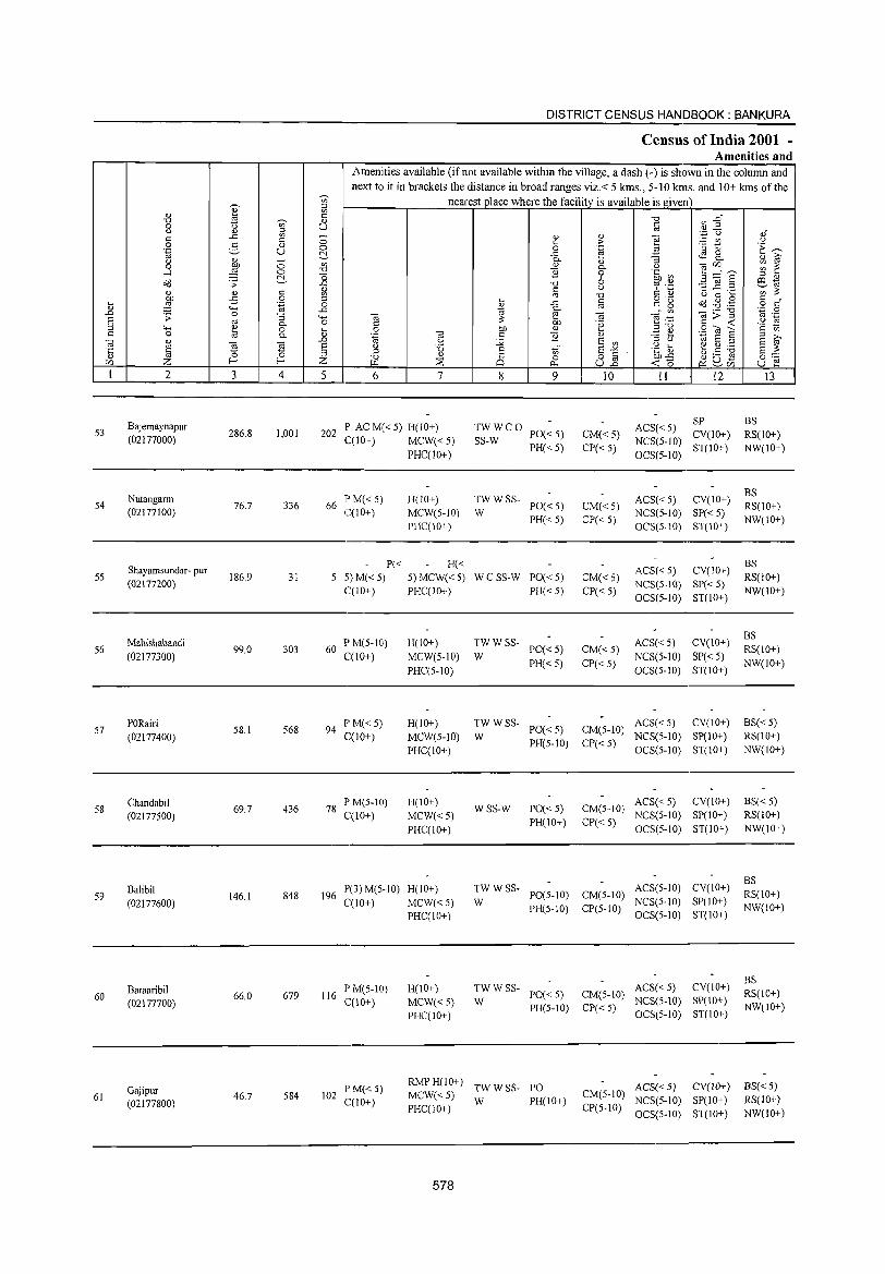
.... " .L E :::1 c
ca '5 U'l 1
53
54
5S
56
57
58
59
60
61
" -c:J 0
" " 0 .~
u 0
....:I o'<j
" :W ;;:
4-< e <l)
§ Z 2
Bajemaynapur (02177000)
Nutangann (02177100)
Shayamsundar- pur (02177200)
Mahishabandi
(02177300)
PORairi (02177400)
Chandabil (02177500)
Balibi! (02177600)
Baraaribil (02177700)
Gajipur (02177800)
~
i '" " " ..c '" c g " u <l) -Of) 0
::§ 0
C:!-;;: " c
..c 0
.;; .~
0 :; '" c.. " 0 t;J c..
~ 'El 0
f-< f-<
3 4
286.8 1,001
76.7 336
186.9 31
99.0 303
58.1 568
69.7 436
146.1 848
66.0 679
46.7 584
DISTRICT CENSUS HANDBOOK: BANKURA
Census of India 2001 -Amenities and
Amenities available C if not available within the village, a dash C-) is shown in the column and
next to it in brackets the distance in broad ranges viz.< 5 kms., 5-10 krns. and 10+ kms of the
'"' nearest place where the facilityis available is given :::1 '" C -c:J &3 :2~ " u c
'" '';::::; C) ,," - <l) <l) e 0 " > ;..:: (.I) " 0 0 .~ B '0 1:: .~ ~ C:!- ..c t.S g_ <l) i? c..
" :;
'" <l) c.. " OJU'l ~ ~ -c:J B 0 .~ a'J 3 ="8 o 6 :::1 " ..c -c:J '" ._ '3 ] .2
ill ., 1;l "
<.) 6 t) ';;;;:: '" -c:J " 0 .... :::1
o ._ 0(3 ~ .,g § s::"
~ ..c " " g 0 '" ..c ~ " '" OJ>]
'.0 0 4-< ca OJ ~ .~
'" ._ 0 c Of) .~ " -< " ., .... e Of) " :::1-c:J .9 'til 6 '2 tl <l) '-§ OJ " B " ~ ~ :::1 ;.,
.L u :.;;; E '" :::1 " '" E :::1 E '" e u 'd " tf E"'" .g ~ b.5 ~ E ;;:: :::1 :::1 -c:J <l)
25 0 o c Of)..c 0::: Z ~ ~ "'" u.2 -< a ~ S:l..ci) u ~ 5 6 7 8 9 10 11 12 13
P ACM«5) H(10+) TWWCO ACS« 5) SP BS
202 PO« 5) CM« 5) CV(10+) RS(10+) C(10+)
IPM«5) 66
C(10+)
P« 5)M«5) C(10+)
1'M(5-IO) 60
C(10+)
94 PM«5) C(10+)
78 PM(5-10) C(10+)
P(3) M(5-10) 196
C(10+)
116 P M(5-IO) C(10+)
102 1'M«5) C(10+)
MCW«5) PHC(10+)
H(IO+) MCW(5-10) PHC(10+)
H« 5) MCW« S) PHC(IO+)
H(lO+)
MCW(5-1O) PHC(5-10)
H(10+) MeW(5-10) PHC(lO+)
H(10+)
MCW«5) PHC(IO+)
H(lO+)
MCW«5) PHC(IO+)
H(10+) MCW«5) PHC(IO+)
SS-W PH« 5) CP« 5)
NCS(5-10) ST(IO+)
OCS(5-1O)
TWWSS- ACS«5) CV(lO+) PO«5) CM«5)
W PH« 5) CP« 5)
NCS(5-1O) SP« 5) OCS(5-10) ST(10+)
ACS«5) CV(10+) WCSS-W PO«5) CM«5)
NCS(5-10) SP« 5) PH«5) CP«5)
OCS(5-1O) ST(IO+)
TWWSS- ACS« 5) CV(IO+) PO«5) CM«5)
W PH«5) CP«5)
NeS(5-10) SP« 5) OCS(5-1O) ST(IO+)
TWWSS-PO«5) CM(5-10)
ACS« 5) CV(10+)
W PH(5-10) CP«5)
NCS(5-10) SP(10+) OCS(5-10) ST(IO+)
WSS-W PO«5) CM(5-1O) ACS«5) CV(IO+)
PH(IO+) C1'« 5) NCS(5-10) SP(lO+)
OCS(5-10) ST(JO+)
ACS(5-10) CV(IO+) TWWSS-PO(5-10) CM(5-10)
W NCS(5-10) SP(IO+) PH(5-1O) CP(5-10)
OCS(5-10) ST(IO+)
TW W SS- ACS« 5) CV(IO+) W PO« 5) CM(5-10) NCS(5-10) S1'(IO+)
PH(5-10) CP« 5) OCS(5-10) ST(IO+)
NW(lO+)
BS RS(IO+) NW(10+)
BS RS(10+) NW(IO+)
BS RS(lO+)
NW(IO+)
BS« 5) RS(10+) NW(10+)
BS«5) RS(10+) NW(IO+)
BS RS(IO+) NW(IO+)
BS RS(IO+) NW(IO+)
RMP H(10+) TW W SS- PO MCW« 5) W PH(IO+)
ACS« 5) CV(10+) BS« 5) CM(5-10) NCS(5-1O) SP(10+) RS(10+)
PHC(10+) CP(S-IO) OCS(5-1O) ST(IO+) NW(10+)
578
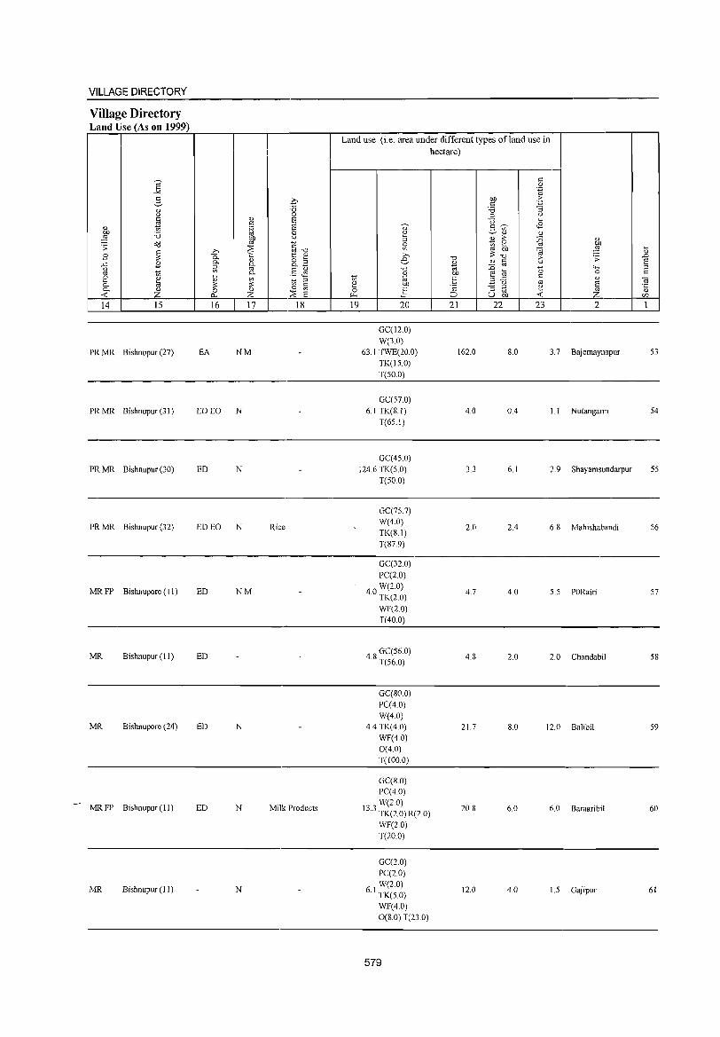
-
VILLAGE DIRECTORY
Village Directory Land Use (As on 1999)
S ""'" g
<1) u
~ <1) C1l '0 ~ ~ ;;: B ~ ..c B ()
" ~ 2 0. 0. ~ ..0: 14 15
PRMR Bishnupur (27)
PRMR Bishnupur (31)
PRMR Bishnupur (30)
PRMR Bishnupur (32)
MRFP Bishnupore (11)
MR Bishnupur (11)
MR Bishnupore (24)
MRFP Bishnupur (11)
MR Bishnupur (J 1)
0 'B 0
<1) S c .~ S c
G
" ~'"d ..Q ~ 1:: <1) 0- <1) 8.3 0- 0. ii1 " §J§ 0. ... " ?i '" :;: '" § 0 <1) 0
~ z :::E E 16 17 18
EA NM
ED EO N
ED N
ED EO N Rice
ED NM
ED
ED N
ED N Milk Products
N
Land use (i.e. area under different types ofland use in hectare)
c 0 .~
C1l ·f C 'B :;
'" ()
"0 ... ~ <8 " 5 '" 2 <l) <l)
'" <1) ;> :g <1)
g U; 2 C1l
" C1l ~ ~ il ;>, :;: "0 .0 e "0 <1) §
;> ;;: S <1) " "0 " ::0 - """' '" ~ C1l " ... 0 0 c ... " c U; "E ",..c
" " OJ e !?!' - () E "5 0 .!:i ;:: :; ~ e
~ po., ~ u OJ) <r: en 19 20 21 22 23 2 1
GC(12.0)
W(3.0)
63.1 TWE(20.0) 162.0 8.0 3.7 Bajemaynapur 53
TK(l5.0)
T(50.0)
GC(57.0)
6.1 TK(S.I) 4.0 0.4 l.l Nutangalm 54
T(65.I)
GC(45.0)
124.6 TK(5.0) 33 6.1 2.9 Shayamsundarpur 55
T(50.0)
GC(75.7) W(4.0)
2.0 2.4 6.S Mahishabandi 56 TK(8.1)
T(S7.9)
GC(32.0)
PC(2.0)
W(2.0) 4.0 TK(2.0) 4.7 4.0 5.5 PORairi 57
WF(2.0) T(40.0)
48 GC(56.0) . T(56.0)
4.8 2.0 2.0 Chandabil 58
GC(SO.O)
PC(40)
W(4.0) 4.4 TK(4.0) 21.7 S.O 12.0 Balibil 59
WF(40)
0(4.0) T(IOO.O)
GC(S.O) PC(4.0)
W(2.0) 13.3 TK(2.0) R(2.0) 20.8 6.0 6.0 Baraaribil 60
WF(20)
T(20.0)
GC(2.0)
pe(2.0)
61 W(2.0) . TK(5.0)
12.0 4.0 1.5 Gajipur 61
WF(4.0) 0(8.0) T(23.0)
579
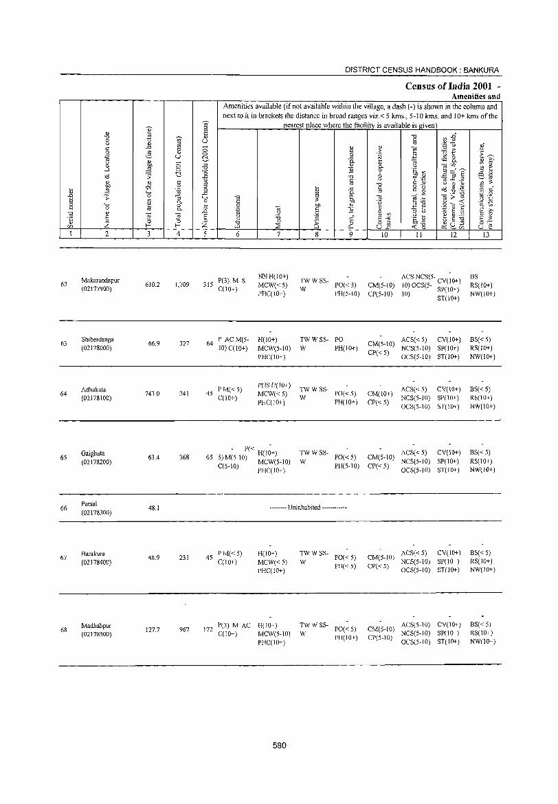
62
63
64
65
66
67
68
2
Makarandapur
(02177900)
Sbiberdanga
(02178000)
Adhakata
(02178100)
Gaighata
(02178200)
Parsal
(02178300)
Barakura
(02178400)
Madbabpur (02178500)
3
610.2
66.9
743.0
63.4
48.1
48.9
127.7
c o .~
"3 0-o 0-
~ r 4
1,709
327
241
368
231
967
DISTRICT CENSUS HAINDBOOK : BANKURA
Census of India 2001 -Amenities and
Amenities available (if not available within the village, a dash (-) is shown in the column and next to it in brackets the distance in broad ranges viz.< 5 kms., 5-10 kms. and 10+ kms of the
nearest place where the facility is available is given
5 6 7
315 P(3) M S C(10+)
NHH(IO+)
MCW«5)
PHC(lO+)
64 lP ACM(5- H(1O+)
10) CCIO+) MCW(S-iO)
PHC(lO+)
p M«5) PHS H(lO+)
45 C(10+)
MCW«S)
PHC(lO+)
65 - P« H(I~+)
5IM(5-IO) MCW(5-10)
C(5-10) PHC(IO+)
8 9
TWWSS-W PO« 5)
PH(5-10)
TWWSS- PO
W PH(10+)
TWWSS-
W PO«S)
PH(IO+)
TWWSS-PO«5)
W PH(S-IO)
-------- Uninhabited ------------
45 P M« 5) C(10+)
H(IO+)
MCW«5) PJ-IC(JO+)
172 P(3) M AC H(lO+) C(10+) MCW(5-10)
PHC(IO+)
580
:.: w SS- PO« 5)
PJ-I«5)
~W W SS- PO« 5)
PH(IO+)
10
CM(5-1O)
CP(5-10)
CM(S-10)
CP«5)
CM(lO+)
CP«5)
CM(S-IO)
CP« 5)
II 12
ACS NCS(5- CV(;O+)
10) OCS(5- SP(IO+)
10) ST(IO+)
ACS« 5) CV(IO+)
NCS(5-1O) SP(lO+)
OCS(5-1O) ST(lO+)
ACS« 5) CV(IO+)
NCS(5-1O) SP(IO+)
OCS(5-10) ST(10+)
ACS« 5) CV(IO+)
NCS(5-10) SP(JD+)
OCS(5-10) ST(IO+)
ACS« 5) CV(10+) CM(5-JO) NCS(5-1O) SP(IO+)
CP« 5) OCS(5-10) ST(JO+)
ACS(5-10) CV(IO+) CM(5-IO) NCS(5-10) SP(10+)
ep(5-10) OCS(5-10) ST(IO+)
13
BS RS(IO+)
NW(IO+)
BS« 5) RS(lO+)
NW(1O+)
BS« 5) RS(IO+)
NW(10+)
BS« 5)
RS(IO+)
NW(IO+)
BS« 5) RS(IO+) NW(lO+)
BS« 5) RS(IO+)
NW(IO+)
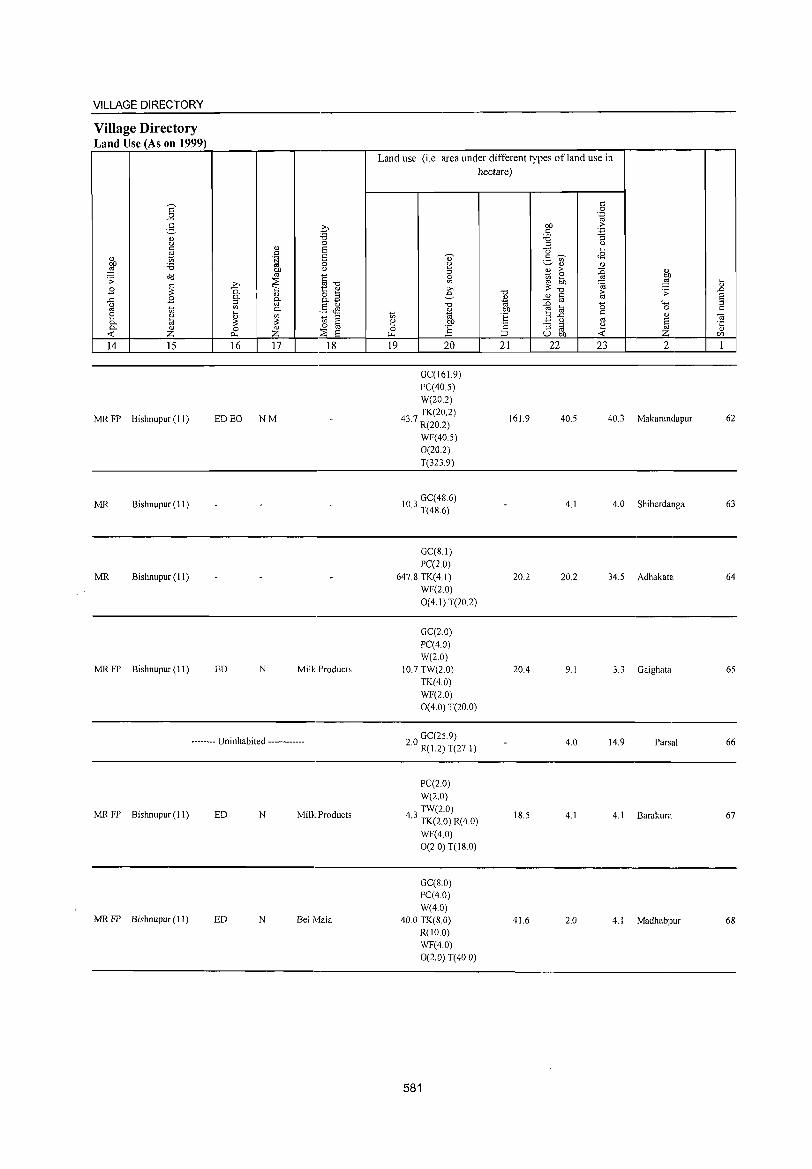
VILLAGE DIRECTORY
Village Directory Land Use (As on 1999)
14 15
MR FP Bishnupur (11)
MR Bishnupur (II)
MR Bishnupur (II)
MR FP Bishnupur (II)
16 17 18
ED EO NM
ED N Milk Products
-------- Uninhabited ------------
MR FP Bishnupur(ll) ED N Milk Products
MR FP Bishnupur(ll) ED N Bel Mala
Land use (i.e. area under different types ofland use in hectare)
19 20
GC(161.9) PC(40.5) W(20.2) TK(20.2)
43.7 R(20.2)
WF(40.5) 0(20.2) T(323.9)
103 GC(4S.6) . T(4S.6)
GC(S.I) PC(20)
647.8 TK(4.1) WF(2.0) 0(4.1) T(20.2)
GC(20) PC(40) W(2.0)
10.7 TW(2.0) TK(4.0) WF(2.0) 0(4.0) T(20.0)
GC(25.9) 2.0 R( 1.2) T(27.1)
PC(2.0) W(2.0) TW(2.0)
4.3 TK(2.0) R(4.0)
WF(4.0) 0(2.0) T(IS.O)
GC(S.O) PC(4.0) W(40)
40.0 TK(8.0) R(10 0) WF(4.0) 0(2.0) T(40 0)
581
21
161.9
20.2
20A
18.5
41.6
22 23 2
40.5 40.3 Makarandapur
4.1 4.0 Shiberdanga
20.2 34.5 Adhakata
9.1 3.3 Gaighata
4.0 14.9 Parsal
4.1 4.1 Barakura
2.0 4.1 Madhabpur
62
63
64
65
66
67
68
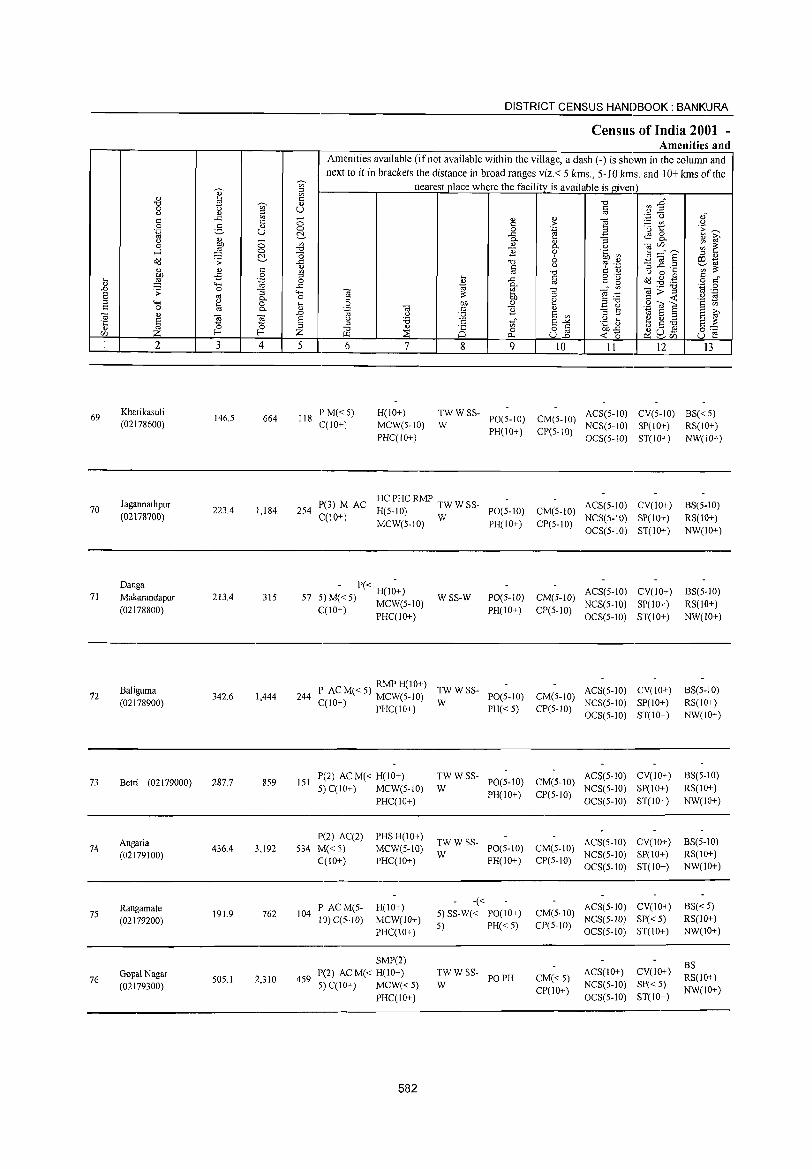
69
70
71
72
73
74
75
76
2
Kharikasuli (02178600)
J agannathpur (02178700)
Danga Makarandapur (02178800)
BaJiguma (02178900)
Belri (02179000)
Angaria (02179100)
Rangamate (02179200)
Gopal Nagar (02179300)
3 4
146.5 664
223.4 1,184
213.4 315
342.6 1,444
287.7 859
436.4 3,192
191.9 762
505.1 2,310
5
DISTRICT CENSUS HANDBOOK: BANKURA
Census of India 2001 -Amenities and
Amenities available (if not available within the village, a dash (-) is shown in the column and next to it in brackets the distance in broad ranges viz.< 5 kms., 5-10 kms. and 10+ kms of the
nearest place where the facility is available is given
6 7 8
g o
..<: 0-0)
e "0 §
1 0)
1l tl" o
0...
9 10 11 12 13
118 PM«5) C(IO+)
H(IO+) MCW(5-10) PHC(IO+)
:W W SS- 1'0(5-10) CM(5-10) ACS(5-IO) CV(5-1O) BS« 5) PH(IO+) CP(5-10) NCS(5-IO) SP(IO+) RS(JO+)
OCS(5-10) ST(IO+) NW(lO+)
HCPHCRMP 254 P(3) M AC H(5-10) TW W SS- PO(5-10) CM(5-1O) ACS(5-10) CV(IO+)
C(10+) MCW(5-1O) W PH(IO+) CP(5-10) NCS(5-10) SP(IO+)
BS(5·10) RS(10+) NW(IO+) OCS(5-1O) ST(IO+)
- P« H(I;+) 57 5)M«5) MCW(5-1O)
C(lO+) PHC(IO+)
WSS-W PO(5-1O) CM(5-1O) ACS(5-1O) CV(IO+) BS(5-1O) PH(IO+) CP(5-10) NCS(5-10) SP(IO+) RS(10+)
244
151
534
104
459
OCS(5-10) ST(lO+) NW(IO+)
RMPH(10+) P, A: M« 5) MCW(5-1O) :W W SS- 1'0(5-10) CM(5-1O) ACS(5-10) (.(10 ) PHC(IO+) PH« 5) CP(5-10) NCS(5-10)
OCS(5-10)
P(2) AC M« H(IO+) TWWSS-1'0(5-10) CM(5-10)
ACS(5-10) 5) C(IO+) MCW(5-10) W
PH(IO+) CP(5-10) NCS(5-10)
PHC(IO+) OCS(5-10)
P(2) AC(2) PHSH(IO+) TWWSS- ACS(5-10)
M«5) MCW(5-IO) W
1'0(5-10) CM(5-10) NCS(5-1O)
C(IO+) PHC(IO+) PH(IO+) CP(5-10) OCS(5-1O)
I' ACM(5- H(lO+) -«
ACS(5-10) 5)SS-W« PO(IO+) CM(5-1O)
10) C(5-10) MCW(IO+) 5) PH«5) CP(5-10)
NCS(5-1O)
PHC(10+) OCS(5-1O)
SMP(2) P{2) AC M« H(IO+) TWWSS-
PO PH CM«5) ACS(IO+)
5) C(IO+) MCW«5) W NCS(5-10)
PHC(IO+) CP(IO+)
OCS(5-1O)
582
CV(lO+) SP(IO+) ST(IO+)
CV(IO+) SP(lO+) ST(IO+)
CV(lO+) SP(lO+) ST(10+)
CV(lO+)
SP« 5) ST(IO+)
CV(lO+)
SP«5) ST(lO+)
BS(5-10) RS(IO+) NW(IO+)
BS(5-10) RS(IO+) NW(IO+)
BS(5-10) RS(IO+) NW(lO+)
BS«5) RS(IO+) NW(IO+)
BS RS(IO+) NW(IO+)
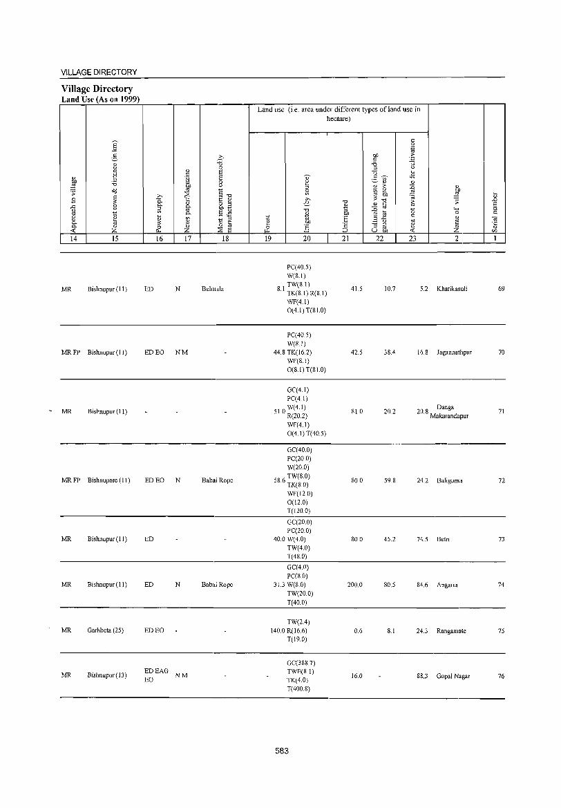
VILLAGE DIRECTORY
Village Directory Land Use (As on 1999)
14 15
MR Bishnupur (II)
MRFP Bishnupur(ll)
MR Bishnupur (11)
MR FP Bishnupore (11 )
MR Bishnupur (11)
MR Bishnupur (11)
MR Garhbeta (25)
MR Bishnupur (13)
16 17 18
ED N Behnala
ED EO NM
ED EO N Babad Rope
ED
ED N Babai Rope
ED EO
EDEAG EO NM
Land use (i,e, area under different types ofland use in hectare)
19 20
PC(40,5) W(8,1) TW(8,1)
8.1 TK(8.I)R(8,1)
WF(4.1) 0(4.1) T(81.0)
PC(405) W(8,1)
44.8 TK(16,2) WF(8.1) 0(8.1) T(81.0)
GC(4, J) PC(4.1) W(4.1)
51.0 R(20.2)
WF(4.1) 0(4.1)T(40.5)
GC(40,0) PC(20,0) W(20,0)
586 TW(8,0) , TK(8,0)
WF(l2,0) 0(12,0) T(120 0)
GC(20,0) PC(20.0)
40,0 W(4,0)
TW(4,0) T(48,0)
GC(4,0) PC(S,O)
31.3 W(8,0) TW(20,0)
T(40.0)
TW(2.4) 140,0 R(l6,6)
T(19,0)
GC(388,7) TWE(8.1) TK(4,O) T(400,8)
583
21 22 23 2
41.5 10.7 5.2 Kharikasuli
42.5 38.4 16.8 J agannathpur
81.0 20.2 208 Danga , Makarandapur
80,0 59,8 24,2 Baliguma
80,0 45,2 74,5 Betri
200,0 80,5 84,6 Angaria
0,6 8,1 24,3 Rangamate
16,0 88,3 Gopal Nagar
69
70
71
72
73
74
75
76
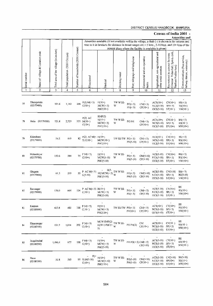
DISTRICT CENSUS HANDBOOK: BANKURA
Census of India 2001 -Amenities and
Amenities available (if not available within the village, a dash (-) is shown in the column and next to it in brackets the distance in broad ranges viz.< 5 kms., 5-10 kms. and 10+ kms of the
'Vi' nearest ~lace where the facility is available is given ~ :l
" " '" lSl " ] ~ :an '0 ~ " 0 U '" U u " '" ''::; () oi -" '" 0 " " ] " 5 :.::: rn u 0 g "
,. '" t:: 'E ~ 0 0 .~ .~ u C!.. -" ~ ~ " ~ U " - 0- " :;
0 OJ) 0 '" <1.l 0- t) ""§C/),,_ ~ ~ ....l ,g 0 '0 ] 0 .~ til '0 .fl '@ § :l <1.l
o(l .;;: C!.. -" '0 6 ro .~ etd " §
t) ~ ~
:i -" ._
'" '" " <1.l c: '" '0 " 0 ....
~ -5 0 ;:l o _
o(l~g '" " .... ..c: c: c: g o " il '.g 0 " '" "" -" ~ @- ~" '" OJ>] ',p 0
.D .;;: 0 :; "" OJ OJ '" ._ ~ on ~;g " 'til '" 0- 0 c: .~ k "" '2 tl "" ~ 0 .... 0 on OJ
.::! e SidE 0 "'- " '-g OJ c: ] " :l >,
] " .0 " ;.Q E '" :l " 'til E :l E ~ § ~ ~ E g :.a " tf E-'" .~ t> ~ ~ ~
;:l '0 " 8 0 o c: on -" u ._ Cd §:;::; en Z 1-< 1-< Z u::i ::E P- ull "" 15
~u- u e ~en
1 2 3 4 5 6 7 8 9 10 11 12 13
77 Dhengartala
101.6 1,143 206 P(2)M« 5) H(IO+) TWWSS-
PO«5) CM« 5) ACS(IO+) CV(IO+) BS«5)
(02179400) C(10+) MCW«5) W NCS(5-1O) SP«5) RS(IO+) PHC(IO+)
PH«5) CP(IO+) OCS(5-1O) ST(IO+) NW(lO+)
P(2) AC RMP(2)
7& Belia (02179500) 521.8 2,725 535 M(IO+) H(IO+) TWWSS-
PO PH CM« 5) ACS(IO+) CV(IO+) BS«5)
C(10+) MCW«5) W
CP(10+) NCS(5-10) SP«5) RS(10+)
PHC(10+) OCS(5-10) ST(10+) NW(IO+)
79 Khiraibani
54.3 459 82 P(2) AC M« H(IO+)
TW SS-TW PO« 5) CM« 5) ACS(IO+) CV(IO+) BS« 5)
(02179600) 5)C(10+) MCW(IO+) NCS(5-1O) SP«5) RS(IO+) PHC(IO+)
PH(5-10) CP(IO+) OCS(5-1O) ST(IO+) NW(IO+)
80 Mabarakpur
150.6 384 75 P M« 5) H(IO+) TWWSS-
PO«5) CM(5-10) ACS(S-IO) CV(IO+) BS« 5)
(02179700) C(10+) MCW(5-10) W NCS(5-10) SP« 5) RS(lO+) PHC(5-10)
PH(5-1O) CP(5-10) OCS(5-10) ST(IO+) NW(IO+)
Ghagara - H(5-
ACS(S-IO) CV(S-IO) BS« 5) 81 61.3 259 53 P ACM«S) 10) MCW«5) TWWSS- PO«5) CM(5-10)
(02179800) C(5-1O) PHC(5-1O) W PH(5-1O) CP(5-1O) NCS(5·1O) SP«5) RS(5-1O)
OCS(5-1O) ST(IO+) NW(10+)
I' AC M« 5) H(IO+) TWWSS- ACS(5-10) CV(lO+) BS
82 Ramnagar
170.0 664 134 PO«5) CM«5) RS(IO+) (02179900) C(10+) MCW«5) W
PH«5) CP(5-10) NCS(5-10) SP«5)
NW(IO+) PHC(5-1O) OCS(5-1O) ST(10+)
P M«5) H(lO+) ACS(IO+) CV(IO+) BS
83 Kataban
423.8 485 108 TW SS·TW PO« 5) CM«5) RS(10+) (02180000) C(10+) MCW«5)
PI-I(10+) CP(IO+) NCS(5-10) SP«5)
NW(IO+) PI-IC(IO+) OCS(5-10) ST(10+)
MCW SMP(2) TW W SS- ACS(IO+) CV(10+) BS
Shyamnagar PM«5) POPH(2)
CM RS(IO+) 84 (02180100)
131.7 1,014 202 C(10+)
1-1(10+) PI-IC« W CP(10+) NCS(5-1O) SP«5)
5) OCS(5-10) ST(IO+)
NW(10+)
ACS(5-1O) CV(IO+) BS
J angalmahal 198
P M« 5) 1-1(10+) TWWSS-PH PO« 5) CM« 5) RS(lO+) 85
(02180200) 1,490.4 977
C(10+) MCW«5) W NCS(5-10) 8P« 5)
PHC(5-IO) CP(5-1O)
OCS(5.10) ST(10+) NW(10+)
Bazar - 1'« H(I;+) TWWSS-PO(5-10) CM(5-1O)
ACS(5-1O) CV(5-1O) BS(5-10) 86 52.8 560 95 5) M(5-10) MCW(5-10) W NCS(5-1O) SP(IO+) RS(IO+) (02180300) PH(5-10) CP(IO+) C(10+) PI-IC(10+) OCS(5-10) ST(IO+) NW(lO+)
584
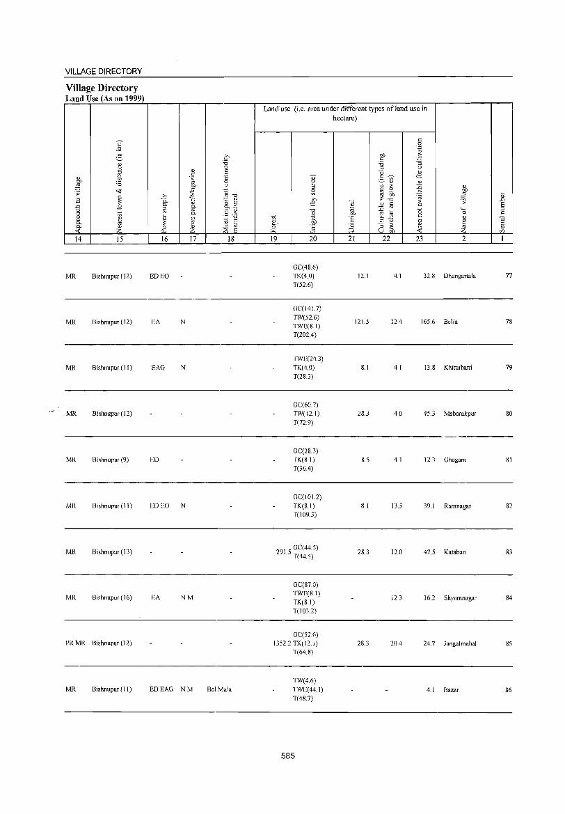
VILLAGE DIRECTORY
Village Directory Land Use (As on 1999)
14 15
MR Bishnupur (12)
MR Bishnupur (12)
MR Bishnupur (I I)
MR Bishnupur (12)
MR Bishnupur (9)
MR Bishnupur (II)
MR Bishnupur (13)
MR Bishnupur (16)
PR MR Bishnupur (12)
MR Bishnupur (II)
16 17 18
ED EO
EA N
EAG N
ED
ED EO N
EA NM
EDEAG NM Bel Mala
Land use (i.e. area under different types ofland use in hectare)
~, o
'" 19 20
GC(48.6) TK(4.0) T(52.6)
GC(141.7) TW(52.6) TWE(8.1) T(202.4)
TWE(24.3) TK(4.0) T(283)
GC(60.7) TW(12.1)
T(72.9)
GC(28.3) TK(8.1) T(36A)
GC(101.2) TK(8.1) T(1093)
291 5 GC(44.5) . T(44.5)
GC(87 0) TWE(8.1) TK(8.1) T(103.2)
GC(52.6) 1352.2 TK(12.1)
T(648)
TW(4.6) TWE(44.1) T(48.7)
585
21
12.1
121.5
8.1
28.3
8.5
8.1
28.3
28.3
22 23 2
4.1 32.8 Dhengartala
32A 165.6 Belia
4.1 13.8 Khiraibani
4.0 45.3 Mabarakpur
4.1 12.3 Ghagara
13.5 39.1 Ramnagar
12.0 47.5 Kataban
123 16.2 Shyamnagar
20A 24.7 Jangalmahal
4.1 Bazar
~ OJ
.D
§ C
77
78
79
80
81
82
83
84
85
86
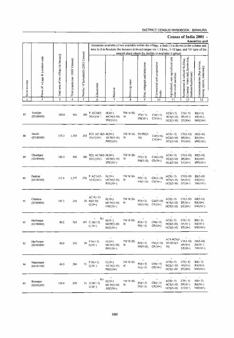
DISTRICT CENSUS HANDBOOK: BANKURA
Census of India 2001 -Amenities and
Amenities available (if not available within the village, a dash (-) is shown in the coiumn and next to it in brackets the distance in broad ranges viz.< 5 kms., 5-10 kms. and 10+ kms of the
'V;' nearest place where the facility is available isgiven ,-._ :l
" ~ '" <= ", '" .J:J' ", 'V;' " 0 U § ,,2 '" d.l :l '';:; U ,;r ..r:: '" - d.l " d c <= "" c ;> "§t! u 0 2 " 0 0 .~ 3 'E ~ .~ u ~ ..r:: ~ 8.. u d.l 0
0-" "3 d.l ~
0 on '" d.l 0- '" ~ ~~s ~ ~ ....l ~ "" "0 ] 0 .~ ~ ~ "0 6
:l d.l
OIl .;;: ..r:: "0 cd .~ .:g ~.~ e3-rtj " c u t= ~ '" ::: d.l d.l C '" OJ .", U 0 .... ,g -£ 0 :l .... §
0'- OIl .g . .g § d' .... '"§ 0 d.l ..c c g " 4-< ..c "'
0-'" d::;"g '_,;::j 0
.D .s: 0 ::; 4-< til e til ~ :~ '" .-a OJ 0- 0 C ::: on .~ c <t: '2 ~ :l 4-< ~ 0 .... 0 OIl Q) :l'" .:2 'ia E ~ " c 0 0- Q) .~ til c ] " :i ti :l >.
~ Q) .J:J '" j;l a '" "' a ::l a ~ a ~ ~ a u 'S a t; E-'" .g ti e g ~
il :l §c;: OJ :l "0 " 25 0 o c on ..r:: ~ U f! en Z f- f- Z u.4 ;:;s 0.. u.2 <t: (5 e<:~", u e I 2 3 4 5 6 7 8 9 10 11 12 13
87 Tandighi
140.8 961 189 P AC M(S- H(IO+) TWWSS-
PO« S) CM«S) ACS« 5) CV« 5) BS« 5)
(02180400) 10) C(IO+) MCW(S-IO) W PH(IO+) CP(IO+)
NCS(S-IO) SP(IO+) RS(IO+) PHC(IO+) OCS(5-1O) ST(10+) NW(10+)
88 Banshi
17S.3 1,792 355 P(2) ACM(5-H(l0+) TWWSS- PO PH(5- ACS«5) CV(5-1O) BS(S-IO)
(02180S00) 10) C(lO+) MCW(5-1O) W 10) CM(S-IO)
NCS(5-1O) SP(IO+) RS(IO+) PHC(IO+)
CP(IO+) OCS(5-IO) ST(IO+) NW(lO+)
89 Chandipur
185.4 892 180 P(2) AC M(5- H(IO+) TWWSS-
PO« 5) CM(5-10) ACS«5) CV(S-IO) BS(5-10)
(02180600) 10) C(10+) MCW(5-10) W PH(5-10) CP(IO+)
NCS(5-1O) SP(IO+) RS(IO+) PHC(IO+) OCS(5-10) ST(JO+) NW(IO+)
90 Pankhai
IS3.4 1,377 276 P ACM(5- H(IO+) TWWSS-
PO«S) CM(5-10) ACS«5) CV(5-10) 8S(S-IO)
(02180700) 10)C(10+) MCW(S-IO) W PH(S-IO) CI'(10+)
NCS(S-IO) SI'(IO+) RS(IO+) PHC(10+) OCS(5-1O) ST(lO+) NW(IO+)
Chhatina AC P« 5)
H(IO+) TWWSS- ACS« 5) CV(5-10) BS(5-1O) 91
(02180800) 142.3 314 58 M(5-1O)
MCW(5-1O) W PO«S) CM(S-IO)
NCS(S-10) SP(IO+) RS(lO+) C(10+)
PHC(IO+) PH(5-1O) CP(lO+)
OCS(5-10) ST(IO+) NW(IO+)
Hariharpur 80.2 724 147
- P« H(I;+) TWWSS-1'0« 5) CM« S)
ACS« 5) CV« 5) BS« 5) 92
(02180900) S)M«5) MCW(5-10) W NCS(5-10) SP(IO+) RS(IO+) C(lO+) PHC(lO+) PH« S) CP(IO+)
OCS(S-IO) ST(IO+) NW(IO+)
Madhurpur PM«S) H(IO+) TWWSS-PO«S) CM(5-10)
ACS NCS(S- CV(~-IO) BS(S-10) 93
(02181000) 96.9 3S2 78
C(lO+) MCW(5-10) W 10) OCS(S- 5P(IO+) RS(10+)
PHC(10+) PH(5-10) CP(IO+) 10) ST(IO+) NW(10+)
Narayanpur PM«5) H(IO+) TWWSS-PO« 5) CM«5)
ACS«5) CV« 5) BS« 5) 94
(02181100) 66.S 284 51
C(lO+) MCW(5-10) W NCS(5-10) SP(10+) RS(IO+)
PHC(lO+) PH«5) CP(IO+)
OCS(5-1O) ST(IO+) NW(10+)
Birampur - P« H(I~+) TWWSS-PO«5) CM« 5)
ACS« S) CV«5) BS«S) 95 210.4 259 51 5) M« 5) MCW(5-1O) W NCS(5-1O) SP(10+) RS(10+) (02181200) PH«5) CP(10+) C(JO+) PHC(10+) OCS(5-10) ST(IO+) NW(IO+)
586
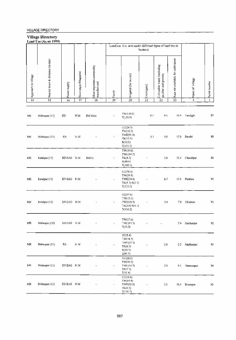
VILLAGE DIRECTORY
Village Directory Land Use (As on 1999)
14 15
MR Bishnupur (II)
MR Bishnupur (I I)
MR Katalpur (II)
MR Katalpur (II)
MR Katalpur (12)
MR Bishnupur (30)
MR Bishnupur (II)
MR Bishnupur (11)
MR Bishnupur (II)
16 17 18
ED NM Bel Mala
EA NM
EDEAG NM Bricks
EDEAG NM
EDEAG NM
EDEAG NM
EA NM
EDEAG NM
EDEAG NM
Land'use (i.e. area uuder different types ofland use in hectare)
19 20
TW(I30.0) T(130.0)
GC(24.5)
TW(10.3)
TWE(91.4) TK(12A)
R(12.6)
T(151.2)
TW(50.6)
TWE(44.7) TK(4.2) R(48.6)
T(148.1)
GC(78.3)
TW(24A) TWE(24A) TK(4.1) R(2.1)
T(133.3)
GC(97.6)
TW(12.4) TWE(165)
TK(3.6) R(4.1)
T(134.2)
TW(27.6) TWE(45.3)
T(72.8)
GC(8.4) TW(34.5)
TWE(33.3) TK(6.3) R(l0.3)
T(92.7)
GC(28.2) TW(10.2) TWE(14.7) TK(2.3) T(55A)
GC(56.6) TW(64.9) TWE(69.0) TK(4.3) T(194.7)
587
21 22
0.1
3.1
23 2
OA lOA Tandighi
4.0 17.0 Banshi
2.0 35.3 Chandipur
6.5 13.6 Pankhai
0.4 7.8 Chhatina
7A Hariharpur
2.0 2.2 Madhurpur
2.0 9.1 Narayanpur
5.3 10.4 Birampur
87
88
89
90
91
92
93
94
95
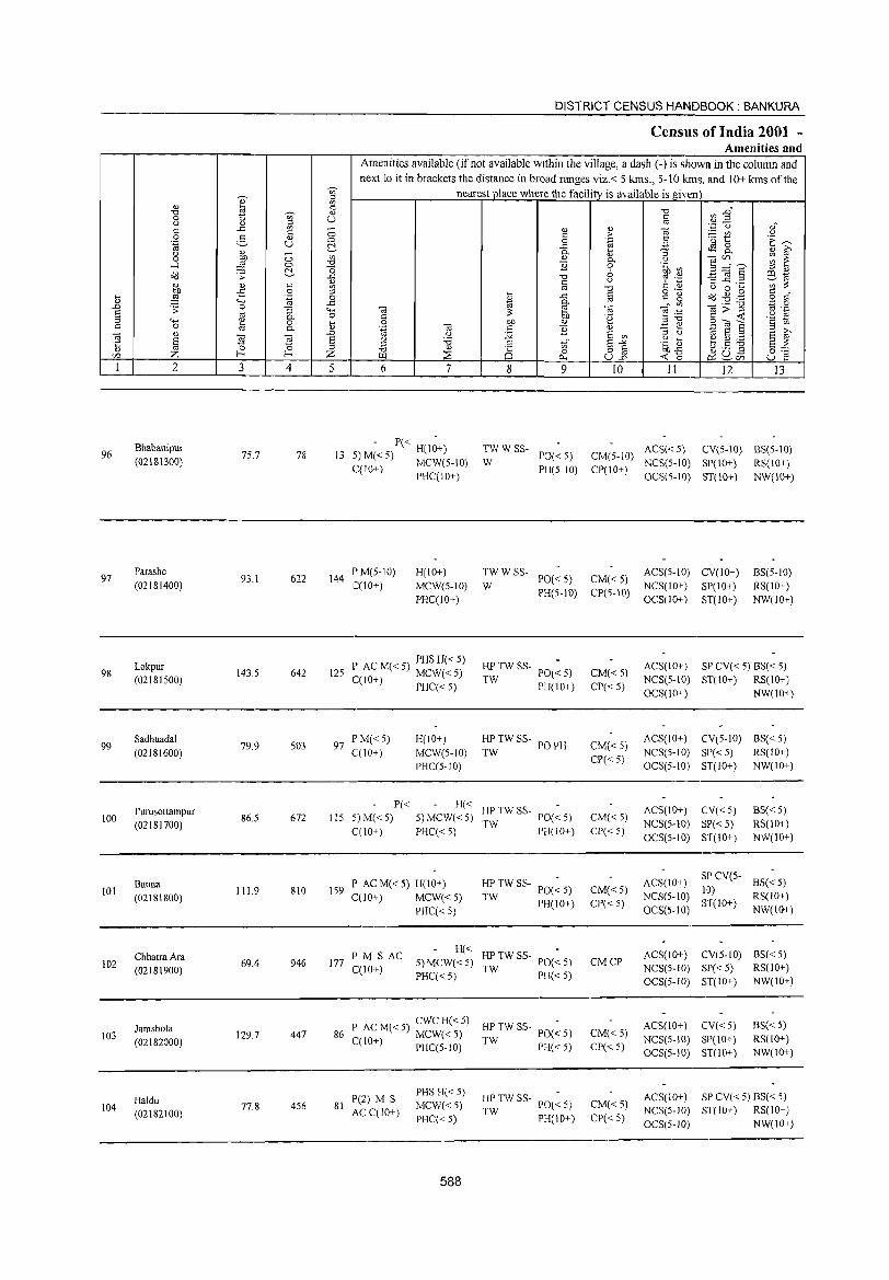
96
97
98
99
100
101
102
103
104
2
Bhabanipur
(0218\300)
Parashe (02181400)
Lokpur (02181500)
Sadhuadal (02181600)
Purusottampur (02181700)
Banna (02181800)
ChhatraAra (02181900)
Jamshola (02182000)
Haldu (02182100)
3 4
75.7 78
93.1 622
143.5 642
79.9 503
86.5 672
111.9 810
69.4 946
129.7 447
77.8 456
DISTRICT CENSUS HANDBOOK: BANKURA
Census of India 2001 -Amenities and
Amenities available (ifnot available within the village, a dash (-) is shown in the column and next to it in brackets the distance in broad ranges viz.< 5 kms., 5-10 kms. and 10+ kms ofthe
nearest place where the facility is available is given
5 6 7
- P« -13 S)M«S) H(\O+)
C(10+) MCW(5-10) PHC(IO+)
144 P M(S-10) C(lO+)
H(lO+) MCW(S-lO) PHC(IO+)
125 P AC M« 5) PHS H« 5) C(\O+) MCW«5) , PHC« S)
97 PM«S) H(IO+) C(10+) MCW(S-IO)
PHC(5-10)
P« H« lIS 5)M«5) S) MCW«S)
C(\O+) PHC« S)
P AC M« S) H(lO+) \S9
C(10+) MCW«5) PHC« 5)
PM S AC H«
177 S)MCW«S) C(lO+)
PHC« 5)
86 P ~CM«5) CWCH«5)
. MCW«5) C( 10+) PHC(S-IO)
P(2) M S PHS H« 5)
81 AC C(1O+)
MCW«5) PHC« 5)
588
8 9 IO 11 12 13
TWWSS- PO«5) CM(S-10) ACS«S) CV(5-10) BS(S-IO) W PH(5-10) CP(10+) NCS(S-IO) SP(IO+) RS(IO+)
W TWWSS-
PO« 5) CM« 5) PH(S-10) CP(S-IO)
HI' TW SS- poe: 5) CM«5) TW PH(IO+) CP«S)
HI' TW SS- PO PH CM«5} TW
CP« 5)
HP TW SS- POe ~ S) CM« 5) TW PH(10+) CP« S)
HI'TWSS-PO«S) CM«S)
TW PH(lO+) CP« 5)
HI' TW SS- poe: S)
TW PH«S) CMCP
HP TW SS- poe: 5) CM«5) TW PH«S) CP«S)
HI' TW SS- PO(~ 5) CM«5) TW PH(IO+) CP«5)
OCS(S-IO) ST(IO+) NW(IO+)
ACS(5-10) CV(10+) NCS(IO+) SP(IO+) OCS(1O+) ST(IO+)
BS(S-IO) RS(10+) NW(1O+)
ACS(\O+) SP CV« 5) BS« S) NCS(5-10) ST(10+) RS(IO+) OCS(10+) NW(\O+)
ACS(IO+) CV(S-1O) BS« S) NCS(S-10) SP« S) RS(IO+) OCS(S-IO) ST(10+) NW(IO+)
ACS(IO+) CV« 5) BS« S) NCS(5-10) SP« 5) RS(IO+) OCS(5-10) ST(IO+) NW(10+)
ACS(lO+) SPCV(5-
BS« S) 10)
NCS(S-IO) ST(IO+)
RS(lO+)
OCS(5-10) NW(IO+)
ACS(IO+) CV(S-IO) BS«S) NCS(S-IO) SP« 5) RS(lO+) OCS(5-1O) ST(IO+) NW(IO+)
ACS(IO+) CV« 5) BS« 5) NCS(S-IO) SP(10+) RS(10+) OCS(5-10) ST(10+) NW(10+)
ACS(lO+) SP CV« 5) BS« 5) NCS(5-10) ST(10+) RS(IO+)
OCS(5-10) NW(IO+)
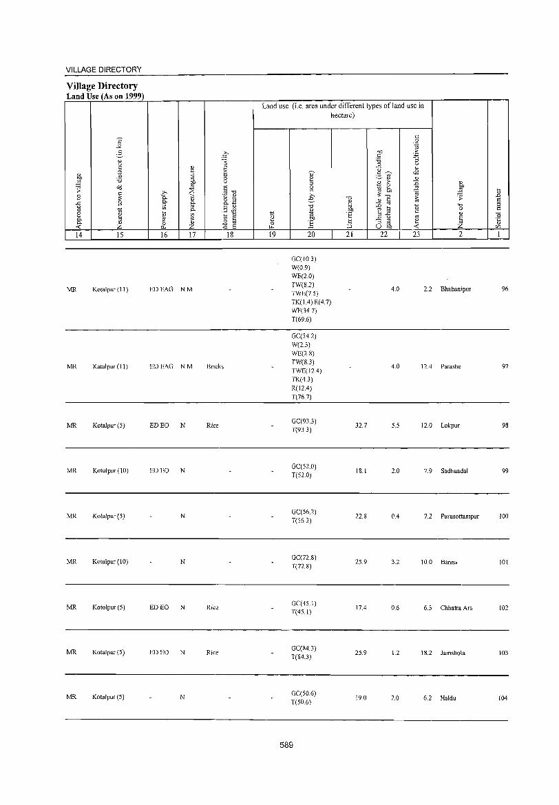
VILLAGE DIRECTORY
Village Directory Land Use (As on 1999)
14 15
MR Kotalpur (11)
MR Katalpur (11)
MR Kotalpur (5)
MR Kotulpur (10)
MR Kotalpur (5)
MR Kotalpur (10)
MR Kotolpur (5)
MR Kotalpur (5)
MR Kotalpur (5)
16 17 18
EDEAG NM
EDEAG NM Bricks
ED EO N Rice
ED EO N
N
N
ED EO N Rice
ED EO N Rice
N
Land use (i.e. area under different types of land use in hectare)
19 20
GC(IO.3) W(0.9)
WE(2.0)
TW(S.2) TWE(7.5) TK(1.4) R(4.7) WF(34.7) T(696)
GC(34.2)
W(2.3)
WE(2.8) TW(S.3) TWE(I24) TK(4.3)
R(l24) T(76.7)
GC(933)
T(933)
GC(52 0)
T(52.0)
GC(56.2)
T(56.2)
GC(72.S)
T(72.8)
GC(45.1) T(45.1)
GC(84.3) T(84.3)
GC(50.6)
T(50.6)
589
21 22
32.7
IS.1
22.8
25.9
17.4
25.9
19.0
23 2
4.0 2.2 Bhabanipur
4.0 12.4 Parashe
5.5 12.0 Lokpur
2.0 7.9 Sadhuadal
0.4 7.2 Purusottampur
3.2 10.0 Banna
0.6 6.3 Chhatra Ara
1.2 18.2 Jamshola
2.0 6.2 Haldu
96
97
98
99
100
101
102
103
104
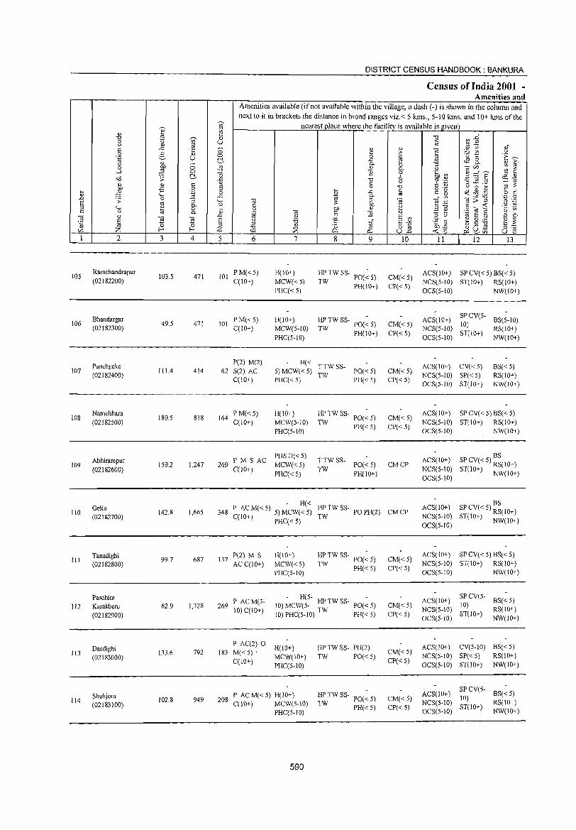
105
106
107
108
109
110
III
112
113
114
2
Ramchandrapur (02182200)
Bhandargar (02182300)
Panchpeke (02182400)
Namchhara (021 82S00)
Abhirampur (02182600)
Gelia (02182700)
Tanadighi (02182800)
Paschim Karakbere (02182900)
Dasdighi (02183000)
Shukjora (02183100)
3
103.5
49.5
111.4
189.5
159.2
142.8
99.7
62.9
133.6
102.8
'" o .~
;:; 0. o 0.
4
471
471
414
818
1,247
1,665
687
1,328
792
949
DISTRICT CENSUS HANDBOOK: BANKURA
Census of India 2001 -Amenities and
Amenities available (if not available within the village, a dash (-) is shown in the column and next to it in brackets the distance in broad ranges viz.< 5 kms., 5-10 kms. and 10+ kms of the
nearest place where the facility is available is given
5 6
101 PM«5) C(10+)
101 PM«S) C(IO+)
P(2) M(2)
62 S(2) AC C(10+)
164 PM«5) C(10+)
269 l' M S AC C(10+)
7
H(lO+)
MCW«5)
PHC«5)
H(lO+)
MCW(S-IO)
PHC(5-10)
8 9
~ TW SS- PO(~ 5)
T PH(IO-l-)
HP TW SS- PO(~ S)
TW PH(lO+)
H« T TW SS-5) MCW« 5) TW PO« 5) PHC« 5) PH« 5)
H(IO+)
MCW(S-lO)
PHC(S-IO)
PHSH«S)
MCW«5)
PHC«S)
HP TW SS- PO(~ 5)
TW PH«5)
TTW SS-TW PO«5)
PH(10+)
10
CM« 5)
CP« 5)
CM« 5)
CP«5)
CM« 5) CP«5)
CM«S)
CP« S)
CMCP
- H« 348 P AC M« 5) 5) MCW« 5) HP TW SS- PO PH(2) CM CP
C(10+) PHC«5) TW
137 P(2) M S ACC(IO+)
H(lO+)
MCW«5)
PHC(5-10)
HP TW SS- PO(~ 5)
TW PH« 5)
269 P AC M(5-10) C(lO-l-)
H(5-10) MCW(5- HP TW SS- PO« 5)
10) PHC(5-10) TW PH« 5)
P AC(2) 0 H(IO+)
183 M«5)· MCW(IO-l-)
CCIO+) PHC(5-IO)
208 P AC M« 5) H(10+) C(10+) MCW(S-IO)
PHC(5-IO)
590
HP TW SS- PH(2)
TW PO« 5)
HP TW SS- POe ~ 5) TW PH« 5)
CM«5) CP«5)
CM«5)
CP« 5)
CM«5)
CP«5)
CM« 5) CP« 5)
11 12 13
ACS(lO+) SPCV«5) BS«5)
NCS(S-IO) ST(IO+) RS(IO+)
OCS(5-1O) NW(IO+)
ACS(IO+) NCS(5-1O)
OCS(5-10)
SP CV(5- BS(S-IO) 10) ST(IO+) RS(IO+)
ACS(IO+) CV« S) NCS(5-1O) SP« 5) OCS(S-IO) ST(IO+)
NW(IO+)
BS« 5) RS(10+)
NW(IO+)
ACS(lO+) SPCV«S) BS«5) NCS(S-IO) ST(10+) RS(IO-l-)
OCS(5-10) NW(IO+)
BS ACS(10+) SP CV« 5) RS(IO+)
NCS(5-10) ST(10+) NW(IO+) OCS(5-10)
BS ACS(IO+) SPCV«5) RS(IO+)
NCS(5-10) ST(10+) NW(IO+) OCS(5.1O)
ACS(IO+) SP CV« 5) 8S« 5) NCS(S-IO) ST(10+) RS(10-l-)
OCS(5-10) NW(10+)
ACS(IO+) SP CV(5- BS« 5)
NCS(5-IO) 10) RS(IO+) 8T(10+)
OC8(5-IO) NW(IO+)
AC8(10+) CV(5-1O) BS« 5)
NCS(5-10) SP« 5) RS(10+)
OCS(5-10) ST(10+) NW(IO+)
ACS(IO+) SPCV{5- 8S«5) 10)
NCS(5-1O) ST(IO+) RS(IO+) OCS(5-10) NW(IO-l-)
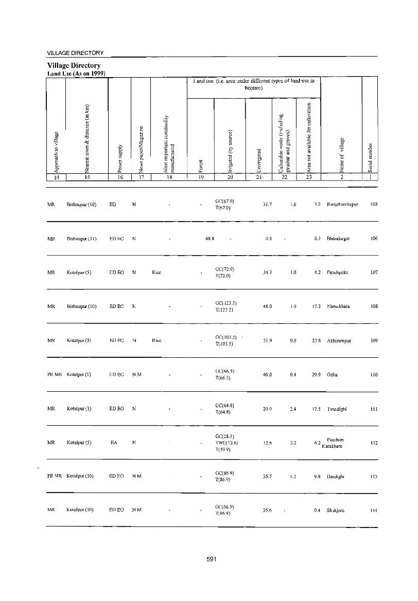
VILLAGE DIRECTORY
Village Directory Land Use (As on 1999)
E -" 5
<l.) u C
'" <l.) 1i) on ;;; ::§
o';;l .;;: ~ B
..0:: B u
'" 1i)
[ <l.)
ta ~
<l.)
Z 14 15
MR Bishnupur (10)
MR Bishnupur (II)
MR Kotolpur (5)
MR Bishnupur (10)
MR Kotalpur (5)
PR MR Kotalpur (1)
MR Kotulpur (1)
MR Kotulpur (5)
PRMR Kotulpur (10)
MR Kotul pur (10)
<l.) c § ~
b :::E 0. '" <l.)
~ it 0.
~ ~ 0 <l.)
~ z 16 17
ED N
ED EO N
ED EO N Rice
ED EO N
ED EO N Rice
EDEO NM
ED EO N
EA N
ED EO NM
ED EO NM
';., ,~
~3
'" S 8
'" u
'§ -0
'§ ~ 0.3
§~ .~ ;:l
'" § 0
:~ 8 18
Land use (Le. area under different types ofland use in hectare)
19
48.8
20
GC(67.0)
T(67.0)
GC(72.0)
T(72.0)
GC(123.2)
T(I232)
GC(103.5)
T(103.5)
GC(66.5)
T(66.5)
GC(64.8)
T(64.8)
GC(28.3) TWE(12.6)
T(40.9)
GC(86.9) T(86.9)
GC(66.9)
T(66.9)
591
21 22
31.7
0.5
34.3
48.0
31.9
46.0
20.0
12.6
35.7
35.6
23 2
1.6 3.2 Ramchanclrapur
0.3 Bhandargar
1.0 4.2 Panchpeke
1.0 17.3 Namchhara
0.0 23.8 Abhirampur
0.4 29.9 Gelia
2.4 12.5 Tanadighi
3.2 62 Paschim
. Karakbere
1.2 9.8 Dasdighi
0.4 Shukjora
105
106
107
108
109
110
111
112
113
114

~ U)
I '" '" U)
<= "0 -;;, '" 0 u 0 <Ll '" <= ..<:: U) ;::; ::: .S< 2- " u 0 1<i ~ " <\) ;::; 0 :W
U)
~ 0 "0
~ "0 o<l .s: -"
" <Ll <= & tlll -B .g '" '"' ~ 0
" "" 1<i ..<:: ..c .s: 0 "5 <;..; § '" <;..; <\) P- o 0 [; <= 0 8 0..
0; " "' ] ..c
E a 'E 15 '" ~ '" Z f-< Z r:/)
1 2 3 4 5
115 Bharatpur
210.6 1,593 305 (02183200)
116 Nabasan
161.9 1,077 212 (02183300)
117 Jhean
68.9 438 96 (02183400)
118 Kusumdighi
149.8 1,105 242 (02183500)
Ghoradubi 119 82.4 47 8
(02183600)
120 Maynapur
444.0 4,768 916 (02183700)
Balarampur 121
(02183800) 126.7 622 109
Hijaldigha 231.6 2,344 469 122
(02183900)
Kunrre 123
(02184000) 18S.2 1,426 300
Ashurali 124
(02184100) 430.6 3,624 703
DISTRICT CENSUS HANDBOOK: BANKURA
Census of India 2001 -Amenities and
Amenities available (if not available within the village, a dash (-) is shown in the column and next to it in brackets the distance in broad ranges viz.< 5 krns., 5-10 kms. and 10+ kms of the
nearest place where the facility is available is given "0 U) ..c"
<= ",.2 OJ <i '" Q) "§
'.p C,)
<= :> ~~ 0
E~ 0 .~ B -" ~ 8.. c.. :; '" 6-" P- o ] 1;/),, __ ~ ~ "B 0 .~ ~ 6 E~§ ::s '"
"0 '? ',c et\1 <= <) :3"'c ...... U) ::: OJ "0 <= " (.) 0 .... o .- <= "
i .c § <= g ~ ~ ,g o r::: §-
til til _" U) o;;;:""§ 'N .~ on e ;~ ::: .~ ","0 <= -< '2 tn .~ on '" .S< OJ E 0; ::: "B " .::: e
1<i a '" '" ~ 0 :.;;; a if> '" 0 E u ;;j In" a-" .g ~ ti.5 ~ sz " .S "0 " o § bO£ ::E Q 0 ~U- o .-~ ~ U..o -< 0 ~r:/) U e 6 7 8 9 10 11 12 13
P AC M« 5) H(lO+) HP TW SS- PO(~ 5) CM«5) ACS(lD+) CV(5.JO) BS«5)
C(lO+) MCW(5-10) TW PH« 5) CP«5) NCS(5-10) SP« 5) RS(lO+)
PHC(5-1O) OCS(5-10) ST(IO+) NW(IO+)
P ACM«5) H(lO+) HPTWW PO«S) CM(5-1O)
ACS« 5) CV(5-10) BS« 5) C(10+) MCW(S-IO) SS-W
PH«S) CP(S-JO) NCS« 5) SP(10+) RS(10+)
PHC(5-10) OCS(5-10) ST(10+) NW(10+)
PM«S)C« CHWH(10+) HPTWW PO«5) CM« 5)
ACS« 5) CV(5-10) BS« 5) S) MCW(S-IO)
OSS-W NCS«5) SP(IO+) RS(IO+) PHC(5-1O) PH« 5) CP(S-IO)
OCS(5-IO) ST(lO+) NW(lO+)
P(2) ACM« CHWH(lO+) TWWSS-PO«5) CM«5)
ACS« S) CV(lO+) BS« 5) '5) C(IO+) MCW(S-IO) W NCS(S-IO) SP«S) RS(IO+) . PHC(lO+) PH«5) CP« 5)
OCS(5-10) ST(IO+) NW(10+)
- P« -TWWSS- ACS« 5) CV(lO+) BS« 5) 5)M«5) H(10+) PO« S) CM«5)
C(IO+) MCW(5-10) W PH«S) CP«S)
NCS(5-10) SP« 5) RS(IO+) • PHC(lO+) OCS(5-10) ST(IO+) NW(IO+)
P(4) AC(4) DH(2) PHS
ACS NCS(5- CV(;O+) BS
M«5) H(10+) TWWSS-
PO TO PH CMCP IO)OCS(5- SP«5) RS(IO+)
C(lO+) MCW(5-10) W
10) ST(IO+) NW(IO+)
PHC(IO+)
PMSPUC H(IO+) -«
ACS« 5) CV«5) BS« 5)
C(IO+) MeW(S-IO) 5) SS-W« PO« 5) CM« 5)
NCS(S-10) SP(10+) RS(IO+)
PHC(5-10) 5) PH« 5) CP« 5)
aCS(S-IO) ST(10+) NW(lO+)
DHCPHC TWWSS- ACS«5) CV«5) BS«5)
P M S PHS H(IO+) PO PH« 5) CM« 5) W NCS(5-10) SP«5) RS(IO+) AC(2) C(IO+) MCW(5-10) CP« 5)
OCS(5-10) ST(IO+) NW(lO+)
P(2) ACM« H(IO+) TWWSS-PO«5) CM« 5)
ACS« 5) CV(IO+) BS«5)
5) C(10+) MCW(5-IO) W NCS(S-10) SP«5) RS(10+) PH« 5) CP« 5)
PHC(lO+) OCS(5-10) ST(IO+) NW(lO+)
D(2) PHS BS P(3) M AC H(IO+) TWWSS-
PO PH« 5) CM« 5) ACS«5) CV«5)
RS(IO+) OC(lO+) MCW(S-IO) W NCS(5-IO) SP(IO+)
CP« 5) NW(IO+) PHC(IO+) OCS(5-10) ST(10+)
592
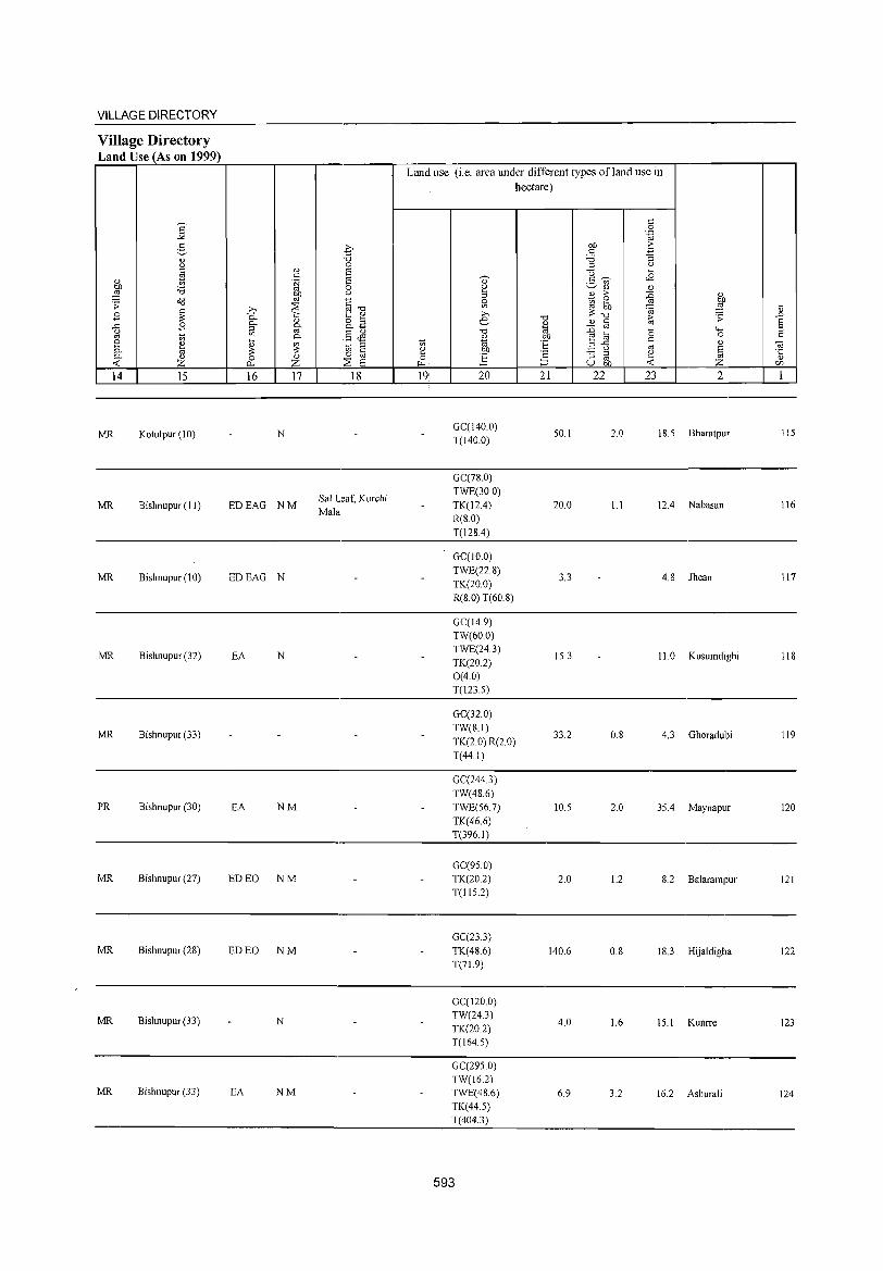
VILLAGE DIRECTORY
Village Directory Land Use (As on 1999)
14 15
MR Kotulpur (10)
MR Bishnupur (II)
MR Bishnupur (10)
MR Bishnupur (32)
MR Bishnupur (33)
PR Bishnupur (30)
MR Bishnupur (27)
MR Bishnupur (28)
MR Bishnupur (33)
MR Bishnupur (33)
16 17
N
EDEAO NM
EDEAO N
EA N
EA NM
ED EO NM
ED EO NM
N
EA NM
18
Sal Leaf, Kurchi Mala
Land use (i.e. area under different types ofland use in hectare)
19' 20
0C(140.0) T(140.0)
0C(78.0) TWE(30.0) TK(12.4) R(S.O) T(12S.4)
0C(10.0) TWE(22.S) TK(20.0) R(S.O) T(60.8)
0C(14.9) TW(60.0) TWE(24.3) TK(20.2) 0(4.0) T(123.5)
OC(32.0) TW(S.I)
TK(2 0) R(2 0) T(44.1)
0C(2443) TW(48.6) TWE(56.7) TK(46.6) T(396.1)
0C(95.0) TK(20.2) T(115.2)
0C(23.3) TK(48.6) T(71.9)
0C(120.0) TW(24.3) TK(20.2) T(164.5)
0C(295.0) TW(16.2) TWE(48.6) TK(44.5) T(404.3)
593
21
50.1
20.0
3.3
15.3
33.2
10.5
2.0
140.6
4.0
6.9
22 23 2
2.0 IS.5 Bharatpur
1.1 12.4 Nabasan
4.8 Jhean
11.0 Kusumdighi
0.8 4.3 Ohoradubi
2.0 35.4 Maynapur
1.2 S.2 Balarampur
0.8 18.3 Hijaldigha
1.6 15.1 Kunrre
3.2 16.2 Ashurali
115
116
117
118
119
120
121
122
123
124

DISTRICT CENSUS HANDBOOK: BANKURA
Census of India 2001 -Amenities and
Amenities available (ifnot available within the village, a dash (-) is shown in the column and
next to it in brackets the distance in broad ranges viz. < 5 krns., 5-10 krns. and 10+ kms of the 'V;' nearest_Qlace where the facility is available is given ;:l
<l) i '" '" "0 ~ :2" "0 'V;' <l) 0 u § u <l) ::l .~ <J 0)' ..<: Vl :::; <l) <))
~ '" '" - en U 0 2- " '" >- 'u 1:: E~ 0 0 .~ .~ u c:- ..<: ~ g_ " iii' u " - 0-
" :;
0 00 C> en " 0- u "'§ C/)",-.. ;;; ~ ....l ;! C> "0 ] 0 "§b ~ c:- o 6 E~§ ::l " o'<l .;;: ..<: "0 os ,_ e.~
" " u C: OJ ::l ..c ._
Ul ~ <l) <l) " '" os "0 () 0 .... 00 -= 0 ;:l ....
o ._ o'<l ~ ,g " ,
Ii; ;! '-§ 0 " ..<: § .:" ~ o " ...... ..<: ~ 0- ._ "d ";::: 0 ..0 .;;: 0 :; ...... '" r: '" ]>~
os ._
~ os c. 0 '"
~ 00 'e ~ .-::: '2 ~ ...... ~ 0 00 <l) ;:l"O .~ '<i! E 0 Ii; ~ " 0 c. .~ '" c ] <l) - .... § ~
'" " E ..0 u :.g S Ul
::l () 70 Ei ::l
g E s u 'i3 c S,.,. .g ~ f:! g ~ S ~ '5 ;:l in 0 0 ::l "d " 25 0 8~ 00"<: C,) ._ ro 0:-;:::::
'" Z f-< f-< Z '" ~ ":0 ~u~ u e P-. ~rJ)
1 2 3 4 5 6 7 8 9 10 11 12 13
Mahaldanga F(2) ACM« H(10+) ACS« 5) CV(IO+) BS
125 207,1 1,372 245 TW SS-TW PO« 5) CM«5) RS(IO+) (02184200) 5) CCI0+) MCW(5-1O)
PH«5) CP«5) NCS(5-10) SP« 5)
NW(lO+) PHCC< 5) OCS(5-10) ST(IO+)
Nachur o P« 5) M« H(IO+) -«
ACS«5) CV(IO+) BS
126 123.9 336 55 5) SS-W« PO«5) CM«S) RS(10+) (02184300) 5) CCIO+) MCW(10+)
S) PH(S-IO) CP«5) NCS(5-10) SP(lO+)
NW(lO+) PHCC< 5) OCS(5-10) ST(IO+)
Uttarbar F(3) AC HC PHC RMP TW W SS- ACS«5) CV(5-IO) BS«5)
127 666,8 3,519 640 M(lO+) H(10+) W PO PH« 5) CM« 5) (02184400)
C(lO+) MCW(10+) CP«5) NCS(5-1O) SP(IO+) RS(IO+) OCS(5-10) ST(IO+) NW(IO+)
Dharisyer P M« 5) CC5- H(IO+) -«
ACS«5) CV(IO+) BS«5) 128 138.1 237 48 5) SS-W« PO« 5) CM«5)
(02184500) 10) MCW(5-10) 5) PH«5) CP«5)
NCS(5-10) SP(IO+) RS(lO+)
PHCCIO+) OCS(5-1O) ST(IO+) NW(IO+)
Baguapara P ACM«5) H(10+) ACS«5) CV(5-10) BS
129 141.9 910 186 rw SS-TW PO« 5) CM«5) RS(lO+) (02184600) C(lO+) MCW(IO+)
PH(5-10) CP« 5) NCS(5-10) SP(IO+)
NW(IO+) PHCCI0+) OCS(5-10) ST(IO+)
P AC M« S) H(lO+) ACS« S) CV(5-10) BS
130 Jadabnagar
670.5 2,537 422 TW SS-TW PH PO« S) CM« 5) RS(10+) (02184700) C(lO+) MCW(10+)
CP« S) NCS(5-10) SP« 5)
NW(10+) PHCCIO+) OCS(5-10) ST(10+)
Hatbari ACP« 5)
H(10+) TWWSS- ACS«5) CV(5-10) BS«5) 131
(02184800) 107,5 698 104 M«5)
MCW(10+) W PO(5-1O) CM«5)
NCS(5-1O) SP(IO+) RS(lO+) C(lO+)
PHCCIO+) PH«5) CP«5)
OC8(S-10) 8T(l0+) NW(lO+)
Harinashuli 345.4 818 140
P AC M« 5) H(10+) TW SS-TW PO(5-10) CM«5)
ACS« 5) CV(S-IO) BS«5) 132
(02184900) C(lO+) MCW(IO+) NCS(5-1O) SP«5) RS(IO+)
PHCCIO+) PH(5-10) CP«5)
OCS(5-1O) ST(lO+) NW(IO+)
RMPH(IO+) ACS« 5) CV(5-10) BS« 5) Muraliganja
93.5 2,565 421 P AC 0 M« MCW(IO+) TW SS-TW PO« 5) CM«5) 133 (02185000) 5) C(10+) PHCCIO+) NCS(5-10) SP(IO+) RS(IO+)
PH«5) CP«5) OCS(5-10) ST(IO+) NW(IO+)
PHSRMP ACS NCS(5- CV(;-10) BS
Dakshinbar P(4) M S H(IO+) TWWSS-PO«5) CMCP RS(10+) 134 526.4 3,654 701
AC 0 C(lO+) MCW(5-1O) W 10) OCS(5- SP« 5) (02185100) PH(10+) 10) ST(IO+) NW(IO+)
PHCC5-10)
594
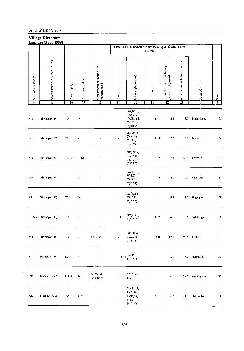
VILLAGE DIRECTORY
Village Directory Land Use (As on 1999)
14 15
MR Bishnupur (34)
MR Bishnupur (33)
MR Bishnupur (32)
MR Bishnupur (30)
PR Bishnupur (31)
PR MR Bishnupur (33)
MR Bishnupur (38)
MR Bishnupur (39)
MR Bishnupur (38)
MR Bishnupur (32)
16 17 18
EA N
ED
ED EO NM
N
ED N
ED N
ED Baluirope
ED
ED EO N HandMade BabuiRope
EA NM
Land use (i.e. area under different types ofland use in hectare)
19 20
GCC106.0) TW(20.2) TWE(12.1) TK(42.5) T(180.9)
GCC79.4) TW(8.1) TK(4.5) T(9\.9)
GC(4859) TW(7.3) TK(40.5) T(533.7)
GCCI12.0) W(20) TK(8.0) T(122.1)
GCCI21.5) TK(6.1)
T(127.5)
3906 GCC247.8) . T(247.8)
GCC30.6) TW(6.1) T(367)
189 I GCCI40.2) . T(140.2)
GCC66.0) T(66.0)
GCC441.7) TW(40) TWE(8.1) TK(S.I) T(46 1.9)
595
21 22
15.1
15.8
61.7
1.9
11.7
30.0
23.1
23 2
2.4 8.8 Mahaldanga
7.3 9.0 Nachur
8.5 62.9 Uttarbar
4.0 10.2 Dharisyer
6.4 S.O Baguapara
4.0 16.5 Jadabnagar
12.1 28.8 Hatbari
8.1 8.0 Harinashuli
4.1 23.5 Muraliganja
12.7 28.6 Dakshinbar
125
126
127
128
129
130
131
132
133
134
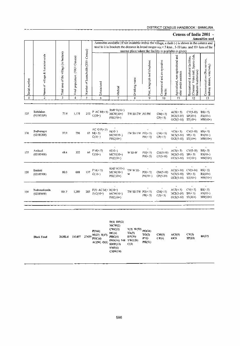
~
" ~ '0 t ~
0 '" " " 5l c ..s:: c 0 g .., .~ U
" ()
~ ;:; 0
...l 0
o<l '> ~ <1J Q) c
~ .,s 0 .... ""'
.~ " .0 '> 0 :; S oj 0. :l <.., Q)
0 C 0 8 0.
('3 (IJ
E ca ~ ·c 15 " ~ f- f-r:/)
I 2 3 4
135 Rohilakon
77.4 1,178 (02185200)
Radhanagar 136 97.0 296
(02185300)
137 Amlasol
48.4 322 (02185400)
Bankati 138
(02185500) 80,0 688
139 Brahmankonda
181.7 1,389 (02185600)
Block Total 26382.4 141497
-;;;-fil <= " U ;:; 0 C!. '" '0 '0 ..s:: " en
" 0 ..s::
""' 0
~ .0
§ Z 5
213
65
64
137
283
DISTRICT CENSUS HANDBOOK: BANKURA
Census of India 2001 ~
Amenities and Amenities available (if not available within the village, a dash (-) is shown in the column and next to it in brackets the distance in broad ranges viz,< 5 kms., 5-10 kms, and 10+ kms of the
nearest place where the facility is available is given
('3 C 0 .~ ('3
0
'" 'i3 :l '0 <1J
~ ~
6 7
P ACM«5) RMPH(IO+) C(lO+) MCW(lO+)
PHC(IO+)
AC OP«5) H(IO+)
M«5) C(10+)
MCW(JO+) PHC(10+)
I' M« 5) H(lO+) C(10+) MCW(10+)
PHC(10+)
P M«5) RMPH(IO+)
C(lO+) MCW(IO+) PHC(lO+)
1'(3) AC M( < H(lO+) 5) C(IO+)
P(166}
MCW(\O+)
PHC(IO+)
D(4) DH(2) MCW(2)
<l) c 0 ..s:: 0.
" "2 '0 c co ....
~ ..s:: Cl.
~ ;:: OJ) bJ) " c E :.;:; .8 ..s
Vl
0 0 0...
8 9
TW SS-TW PO PH
TW SS-TW PO« 5) PH«5)
WSS-W 1'0« 5) PH«5)
TWWSS-
W PO« 5) PH(lO+)
TW SS-TW PO« 5) PH« 5)
T(3) W(93) PO(24)
'0 t:
"' <l) '"§ ;. .~ B ~ :; 0. U 0 .~ ~ 6 u c;:s '';:: '0 t: " c 0'-oj c g
• Vl ('3 "§~ 'g B Q)
:3 b S en S"" .~ ~ o ~ bJ)..s:: U.o -< 15
10 11
ACS« 5) CM« 5) CP«5)
NeS(S-IO) OCS(5-IO)
ACS« 5) CM«5) CP«5)
NCS(5-IO) OCS(5-10)
CM(5-IO) ACS« 5)
CP(5-1O) NCS(5-10) OCS(5-10)
ACS(5-10) CM(5-IO)
NCS(5-10) CP(S-IO)
OCS(5-10)
CM«5) ACS«5) NCS(5-10)
CP« 5) OCS(5-IO)
~1 ".,p (.) OJ" :.=: TfJ 0 'u 1: 'E ~ ~ 8.. " ~ ('3r:/) ~ ~ 3 =:" E " " '3 ~ .2 ~~
en :;: U 0 .... o."d ~ .,g c " o c ('3";>'"§
'.0 0 co .-
c: -< .~ ri .9 OJ "2 C en
g ~ '" E " ~ g:.a E E ~ U ~ o ,-et: ~UJ U ~
12 I3
CV(5-IO) BS« 5) SP(10+) RS(10+) ST(IO+) NW(IO+)
CV(5-IO) 8S« 5) SP«5) RS(IO+)
ST(10+) NW(10+)
CV(5-IO) BS« 5) SP« 5) RS(IO+) ST(IO+) NW(IO+)
CV(5-10) BS« 5)
SP«5) RS(\O+)
ST(1O+) NW(\O+)
CV« 5) BS« 5) SP«5) RS(IO+)
5T(IO+) NW(IO+)
CWC(2)
HC(4) 27439 M(22) S(17) PHC(4)
P1JC(4) H
TK(9) TO(2) HP(3!) TW(126) PTO
CM(9)
CP(6)
ACS(9) OCS
CV(3) SP(23)
BS(37)
AC(96) 0(6) PHS(16) N ~ RMP(13)
SMP(6) CHW(18)
596
C(3} PR(S!)
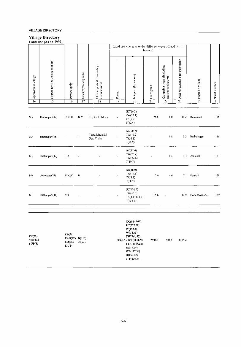
VILLAGE DIRECTORY
Village Directory Land Use (As on 1999)
14
MR
MR
MR
MR
MR
PR(22) MR(134 ) FP(8)
15
Bishnupur (39)
Bishnupur (38)
Bishnupur (39)
Arambag (37)
Bishnupur (41)
16 17
ED EO NM
EA
ED EO N
ED
ED(81) EAG(22) EO(35) EA(24)
N(115) M(63)
18
Dry Cell Battery
Hand Made Sal Pata Thala
Land use (i.e. area under different types ofland use in hectare)
19 20
GC(16.2) TW(12.1) TK(4.0)
T(32A)
GC(70.7) TW(l2.2) TK(4.1) T(86.9)
GC(17.6) TW(20.2) TWE(2.8) T(40.7)
GC(48 0) TW(12.1) TK(8.11 T(682)
GC(I01.2) TW(40.5) TK(4.1)R(8.3)
T(154.1)
GC(9844.02) PC(257.52) W(152.2) WE(4.75) TW(961.67)
5868.5 TWE(1144.53 ) TK(1368.22) R(216.24) WF(127.39) 0(159.82) T(14236.36)
597
21
24.8
0.6
15.6
2998.1
22 23 2
4.0 16.2 Rohilakon
0.8 9.3 Radhanagar
OA 7.3 Amlasol
4.0 7.1 Bankati
12.0 Brahmankonda
972.1 2307.4
~
" ..0 E ;::l c:
OJ .c: " C/l
135
136
137
138
139

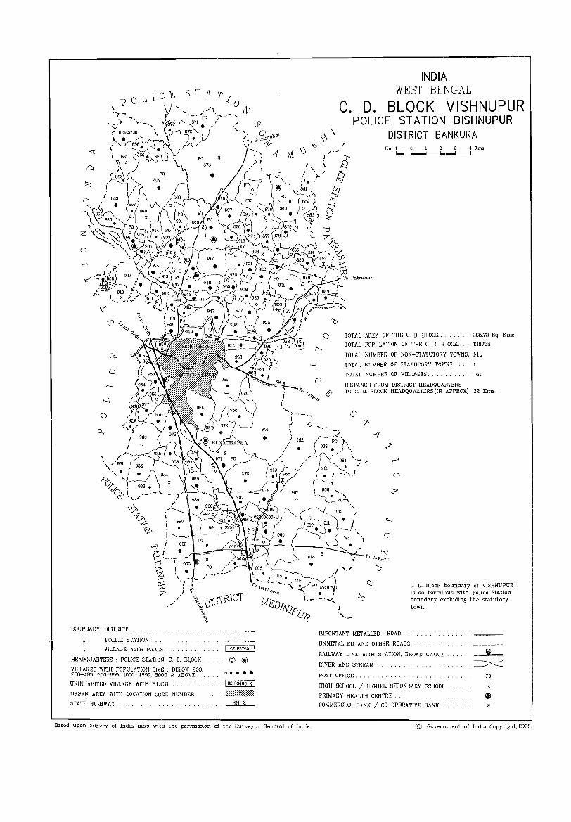
o
C. D.
INDIA WEST BENGAL
BLOCK VISHNUPUR ST AT ION BISHNUPUR POLICE
DISTRICT BANKURA Kml 23 4·Kms __ -=_-==_100_-===:1-====1
TOTAL AREA OF THE C. D. BLOCK. 365.73 Sq. Kms.
TOTAL POPULATION OF THE C. D. HLOCK. 136766
TOTAL NUMBER OF NON-STATUTORY TOWNS. NIL
>--< TOTAL NUMBER OF STATUTORY TOWNS.
o
\./'981
' .. /:i '. ~~. 983.
L'.l\ I ._.-'<.;' .'\../
J), f.,?> o ~
BOUNDARY, DISTRICT.
POLICE STA nON
VILLAGE WITH P.L.C.N.
HEADQUARTERS: POLICE STATION, C. D. BI.,OCK .
VILLAGES WITH POPULATION SIZE BELOW 200, 200-499, 500-999, 1000-4999, 5000 & ABOVE
UNINHABITED VILLAGE WITH P.L.C.N.
URBAN AREA WITH LOCA nON CODE NUMBER
STATE HIGHWAY
" _._._._ . I 02185700
@ ® o ••••
. I 02186400 X I
. ~ SH 2
Based upon Survey of India map with the permission of the Surveyor General of India.
TOTAL NUMBER OF VILLAGES. 161
DISTANCE FROM DISTRICT HEADQUARTERS TO C. D. BLOCK HEADQUARTERS (IN APPROX) 32 Kms.
.?>
;:> ,......
0
Z
o
'-< Jaypur
C. D. Block boundary of VISHNUPUR is co-terminus with Police Station boundary excluding the statutory town.
IMPORTANT METALLED ROAD.
UNMETALLED AND OTHER ROADS.
RAILWAY LINE WITH STATION, BROAD GAUGE
RIVER AND STREAM
POST OFFICE.
HIGH SCHOOL I HIGHER SECONDARY SCHOOL .
PRIMARY HEALTH CENTRE.
COMMERCIAL BANK / CO-OPERATIVE BANK. .
.~
PO
© Government of India Copyright, 2006.
DISTRICT CENSUS HANDBOOK: BANKUR/\
Alphab{~tical list of Villages (CD Block wise)
2001 Census location 1991 Census location Serial number N arne of village code number code number
2 3 4
Name of the CD Block: Vishnupur Code of the CD Block: 0014
Abantika 02194400 140150006000600088 2 AgunKumari 02201300 140150006000600159 3 Ajodhya 02186600 140150006000600010 4 Amdahara 02200100 140150006000600147 5 Amral 02190300 140150006000600047 6 Antare 02186700 140150006000600011 7 Arjunpur 02185900 140150006000600003 8 Astasol 02201500 140150006000600161 9 Balarampur 02186100 140150006000600005
10 Baliguma 02199200 140150006000600138 11 Banamalipur 02191200 140150006000600056 12 Bangele 02196500 140150006000600111 13 Bankati 02190100 140150006000600045 14 Bankati 02197700 140150006000600123 15 Bansh Kopa 02190200 140150006000600046 16 Bara Amlai 02197800 140150006000600124 17 Baramara 02200300 140150006000600149 18 Basantapur 02193700 140150006000600081 19 Basudebpur 02196100 140150006000600107 20 Beliara 02192100 140150006000600065 21 Belshula 02196300 140150006000600109 22 Belthya 02194500 140150006000600089 23 Benabendi 02196600 140150006000600112 24 Benachapra 02197200 140150006000600118 25 Benda 02190700 140150006000600051 26 Bendara 02189400 140150006000600038 27 Bhagaband 02185700 140150006000600001 28 Bhagarara 02188100 140150006000600025 29 Bhandarya 02200400 140150006000600150 30 Bhara 02188000 140150006000600024 31 Bhatra 02194200 140150006000600086 32 Binodbati 02185800 140150006000600002 33 Birra 02190600 140150006000600050 34 Chak Uparsol 02201400 140150006000600160 35 Chakchua Masina 02187500 140150006000600019 36 Chakdaha 02194800 140150006000600092 37 Chanchar 02199800 140150006000600144 38 Chandabi1a 02196900 140150006000600115 39 Chaubetya 02200500 140150006000600151 40 Chaugan 02195600 140150006000600102 41 Chhota Bankadaha 02200200 140150006000600148 42 Chitrang 02199100 140150006000600137 43 ChorKundu 02198400 140150006000600130 44 Chua Masina 02187300 140150006000600017
600
VILLAGE AND TOWN DIRECTORY
Alphabetical list of Villages (CD Block wise)
2001 Census location 1991 Census location Serial number Name of village code number code number
1 2 3 4
45 Chura Manipur 02195200 140150006000600096 46 Damoda1'pur 02186300 140150006000600007 47 Dapanjuri 02189600 140150006000600040 48 Darasol 02196800 140150006000600114 49 Dejhat 02192200 140150006000600066 50 Deuli 02194700 140150006000600091 51 Dhabani 02199000 140150006000600136 52 Dhangara 02192000 140150006000600064 53 Dhansol 02200700 140150006000600153 54 Dharampur 02187800 140150006000600022 55 Dharapatil 02191400 140150006000600058 56 Dhenga Pathar 02196000 140150006000600106 57 Dhengasol 02198200 140150006000600128 58 Dhirkona 02189700 140150006000600041 59 Dihar 02193800 140150006000600082 60 Domberya 02199500 140150006000600141 61 Dumohani 02196400 140150006000600110 62 Dundure 02197000 140150006000600116 63 Dwadas Bari 02195400 140150006000600098 64 Dwarika 02194600 140150006000600090 65 Ghugimura 02197500 140150006000600121 66 Gobardhanpur 02190000 140150006000600044 67 Gopalpu1' 02190900 140150006000600053 68 Gopalpur 02192900 140150006000600073 69 Gosainpur 02192800 140150006000600072 70 Gumut 02189100 140150006000600035 71 Harabati 02198100 140150006000600127 72 Harinagar 02187900 140150006000600023 73 Haripur 02191100 140150006000600055 74 Here Parbbat 02193300 140150006000600077 75 Hetagara 02199700 140150006000600143 76 Hikimdanga 02198700 140150006000600133 77 HiI~uri 02189000 140150006000600034 78 Hulmara 02200900 140150006000600155 79 Indkuri 02199300 140150006000600139 80 Jamuna Band (P) 02195300 140150006000600097 81 Jangal Bankati 02193000 140150006000600074 82 Jangal Mahal 02186800 140150006000600012 83 Janta 02193900 140150006000600083 84 Jharia 02197600 140150006000600122 85 Jiabandi 02201700 140150006000600163 86 Joykrishnapur 02194300 140150006000600087 87 Joyrampur 02189800 140150006000600042 88 Kadamdiha 02199900 140150006000600145 89 Kakila 02191600 140150006000600060 90 Kamar Pukur 02193200 140150006000600076
601
DISTRICT CENSUS HANDBOOK: BANKURA
Alphabetical list of Villages (CD Block wise)
2001 Census location 1991 Census location Serial number Name of village code number code number
2 3 4
91 Karoan 02187200 140150006000600016 92 Karra 02198500 140150006000600131 93 Katna 02193500 140150006000600079 94 Kelemele 02195100 140150006000600095 95 Khajra 02189300 140150006000600037 96 Khana Bari 02196700 140150006000600113 97 Kharikasulii 02197300 140150006000600119 98 Kharkata 02201100 140150006000600157 99 Khuliamuri 02198000 140150006000600126
100 KonarBandh 02191000 140150006000600054 101 Kulaijuri 02198800 140150006000600134 102 Kuldangar 02189200 140150006000600036 103 Kulupukur 02198600 140150006000600132 104 Kural Bari 02195700 140150006000600103 105 Kushtara 02195000 140150006000600094 106 KusumBani 02195500 140150006000600099 107 KusumDiha 02200600 140150006000600152 108 Layek Band 02186900 140150006000600013 109 Loharara 02186500 140150006000600009 110 Lohari 02198300 140150006000600129 III Madhuban 02193400 140150006000600078 112 Mahish Khoar 02192300 140150006000600067 113 Majdiha 02199600 140150006000600142 114 Majura 02198900 140150006000600135 115 Marar 02197100 140150006000600117 116 Mathura Bihari 02188400 140150006000600028 117 Matukpur 02188700 140150006000600031 118 Maula 02188500 140150006000600029 119 Mayara Pukur 02195900 140150006000600105 120 Muehdang 02190400 140150006000600048 121 Naer 02194000 140150006000600084 122 Nangal Bhanga 02187400 140150006000600018 123 Narayanpur 02192600 140150006000600070 124 Narikala 02187100 140150006000600015 125 Nityanandapur 02186000 140150006000600004 126 Paeha Dahara 02201200 140150006000600158 127 Paikpara 02191300 140150006000600057 128 Paschim Nischinatapur 02191500 140150006000600059 129 Patalpur 02186400 140150006000600008 130 Patlapur 02188900 140150006000600033 131 Pedda 02197900 140150006000600125 132 Penera 02193600 140150006000600080 133 Phulbani 02200800 140150006000600154 134 Pirragara 02197400 140150006000600120 135 Prakash 02192500 140150006000600069 l36 Pundurhati 02190500 140150006000600049
602
VILLAGE AND TOWN DIRECTORY
Alphabetical list of Villages (CD Block wise)
2001 Census location 1991 Census location Serial number Name of village code number code number
1 2 3 4
137 Purbba Nischintapur 02188800 140150006000600032 138 Radha Damodarpur 02193100 140150006000600075 139 Radhanagar 02189900 140150006000600043 140 Ramchandrapur 02188600 140150006000600030 141 Ramnagar 02192400 140150006000600068 142 Ramsundarpur 02189500 140150006000600039 143 Rani Khamar 02190800 140150006000600052 144 Rautara 02191700 140150006000600061 145 Saluka 02187700 140150006000600021 146 Sanatanpur 02188200 140150006000600026 147 Sancha 02186200 140150006000600006 148 Sankarlaiker Danga 02201600 140150006000600162 149 Shyamsundarpur 02194900 140150006000600093 150 Siharshul 02191900 140150006000600063 151 Siromanipur 02195800 140150006000600104 152 Tala 02188300 140150006000600027 153 Ta1dangra 02199400 140150006000600140 154 Tarajuri Gangarampur 02187000 140150006000600014 155 Tentul Ara 02187600 140150006000600020 156 Tentulia 02191800 140150006000600062 157 Thakurpur 02194100 140150006000600085 158 Tribanka 02196200 140150006000600108 159 Uliara 02192700 140150006000600071 160 Upar Amdahara 02200000 140150006000600146 161 Uparsol 02201000 140150006000600156
603
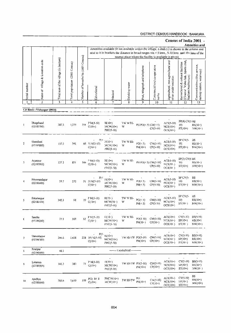
DISTRICT CENSUS HANDBOOK: BANKURA
Census of India 2001 -Amenities and
Amenities available (if not available within the village, a dash (-) is shown in the column and
next to it in brackets the distance in broad ranges viz. < 5 krns., 5-10 kms. and ) 0+ krns of the ~
nearest place where the facility is available is given ~ '" " <I) ~ if>
"d .is ~ [l "d ~ :2" a 0 '" U c u <l.) " co c: ..c '" ~ <l.) <l.)
'"§ '.p: CJ <l.)"
C 0 c > - '" CJ 0 3 0) .<3 t:: E~ ''§ u 0 a .~ a ~ .c tfS 8-'"
<l.)
0 0- <l.) '3 <l) ~
0 bJJ '" <l.) 0- 0 "'§ c/) ... r""-.. ~ ~ -l ,g 0 "d B 0 .~ ~ ~ -0 6 E~§ '" <l.)
<>'Il .;; ..0: "0 co ._ ill ~
~ s::: <l.) c '" C ~ " - ';'~ <I) ;g Ol "d '" 0 .... -B 0 0·- S cf .... .~ 0 ~ .c c
=" ~ <>'Il .g .g <l.) '0 .c 10 0- Ol
.- "d ',c 0 ..0 .;;: '3 <..., " e " "§:g " > "
Ol .-S co P- o C
;:; bJJ '8 c <C '2 ~ " <..., <I) a .... S OIl " E ~ SOls c 0 ~ 0- <l.) " c B " E ~ " OJ
~ " .0 10 u :.;;; S C/O " 0 10 8 "
. .: § E g '8 .5 t;;" E-'" .~ ~ e ~ il S ;:; <l.) "0 " ;E
<J)
0 0 o § ""..0: (.) ._ C1
0'-: r:/) Z f-< f-< Z ::B -< "0 ~U- u e 0.. U,.o '-' [/)
1 2 3 4 5 6 7 8 9 10 11 12 13
CD Block: Vishnupur (0014)
Bhagaband PM(S-10) H(10+) TWWSS- ACS(5-10) SP(4) CV(S BS
387.2 1,27S 2S4 PH PO« S) CM« S) 10) RS(IO+) (02185700) C(10+) MCW(10+) W NCS(10+) PHC(5-1O)
CP(S-ID) OCS(IO+)
ST(IO+) NW(IO+)
Binodbati - P« H(1~+) TWWSS- ACS(S·IO) SPCV(5- BS
2 110.3 341 66 5) M(5-10) MCW(IO+) PO«5) CM(5-IO) 10) RS(IO+) (02185800) W NCS(IO+)
C(IO+) PHC(S-IO) PH(IO+) CP(5-IO) OCS(IO+)
ST(IO+) NW(lO+)
Arjunpur PM(5-10) H(10+) TWWSS- ACS(5-IO) SP(2) CV(5 BS
(0218S900) 132.3 821 166
C(10+) MCW(10+) W PH PO« S) CM(S-lO)
NCS(10+) 10) RS(IO+)
PHC(S-IO) CP(S-IO)
OCS(IO+) ST(10+) NW(lO+)
Nityanandapur , - P« H(l~+) TWWSS- ACS(S-IO) SPCV(5· BS
4 (02186000)
59.7 232 51 -') M(S-10) MCW(lO+) W PO« 5) CM(5-10)
NCS(IO+) 10) RS(10+)
C(l 0+) PHC(S- 10) PH«S) CP(S-IO) OC5(1O+)
ST(IO+) NW(IO+)
Balarampur PM(5-1O) H(lO+) TWWSS- ACS(5-10) SPCV(5- BS
342.3 98 19 PO« 5) CM(5-10) 10) RS(lO+) (02186100) C(10+) MCW(IO+) W
PH«S) CP(5-10) NCS(IO+)
ST(lO+) NW(IO+) PHC(5-10) OCS(IO+)
6 Sancha
72.5 369 63 PM(S-IO) H(IO+) TW WSS-
PO(5-10) CM(S-IO) ACS(IO+) CV(5-10) BS(S-IO)
(02186200) C(IO+) MCW(IO+) W PH(IO+) CP(lO+)
NCS(IO+) SP(IO+) RS(IO+)
PHC(5-10) OCS(10+) ST(10+) NW(IO+)
Damodarpur 396.6 1,428 228
• P(S- H(I~+) TW SS-TW PO(5-IO) CM(S-IO)
ACS(IO+) eV(S-IO) BS(S-IO) 7
(02186300) 10)M(S-10) MCW(IO+) NCS{lO+) SP(10+) RS(IO+) C{lO+)
PHC(5-10) PH(IO+) CP(10+)
OCS(IO+) :5T(IO+) NW(IO+)
Patalpur 48.1 -------- Uninhabited ------------
(02186400)
Loharara 141.3 383 71
PM(5-10) H(lO+) TW SS-TW PO(5-1O) CM(5-1O)
ACS(10+) eV(5-10) BS(S-10)
(02186500) C(10+) MCW(10+) PH(IO+) CP(10+)
NCS(lO+) SP(IO+) RS(IO+)
PHC(5-1O) OCS(IO+) 5T(10+) NW(10+)
ACS(10+) CV(S-lOi BS
Ajodhya P(2) M S PHC H(10+) PO CM(S-IO) RS(IO+) 10 205.6 2,610 5S9
C(IO+) MCW(IO+) TW SS-TW PH(lO+) NCS(lO+) SP(IO+) (02186600) CP(IO+) NW(10+) OCS(IO+) 8T(10+)
604

VILLAGE DIRECTORY
Village Directory Land Use (As on 1999)
PR MR Bishnupur (27)
PR MR Bishnupur (26)
PR MR Bishnupur (25)
PRMR Bishnupur (25)
PRMR Bishnupur (27)
MR Bishnupur (27)
PRMR Bishnupur (23)
N Rice
EO Rice:
N Rice
EAG Rice
Rice
ED
EA NM
-------- Uninhabited ------------
PR Bishnupur (10) ED N
PR Bishnupur(IO) EA NM
Land use (i.e. area under different types ofland use in hectare)
1028 W(163.1) · T(163.1)
W(71.S) T(nS)
W(I01.I) T(lOIl)
WE(38.3) T(38.3)
W(95.9) 200.0 TW(30.0)
T(125.9)
28 W(36.4) · T(36.4)
809 TWE( 172.8) · T(172.8)
W(35 0) T(35.0)
W(IOO.4) T(IOO.4)
W(60.4) 0.4 TWE(IO.O)
T(70.4)
605
92.3
30.9
22.4
3.4
0.4
4.1
41.7
5.9
25.1
47.0
3.6 25.4 Bhagaband
53 2.7 Binodbati
4.5 4.5 Arjunpur
8.1 9.9 Nityanandapur
0.4 15.7 Balarampur
6.5 22.7 Sancha
35.2 65.9 Damodarpur
3.2 4.0 Patalpur
3.2 12.6 Loharara
16.2 71.7 Ajodhya
2
4
6
7
8
9
10
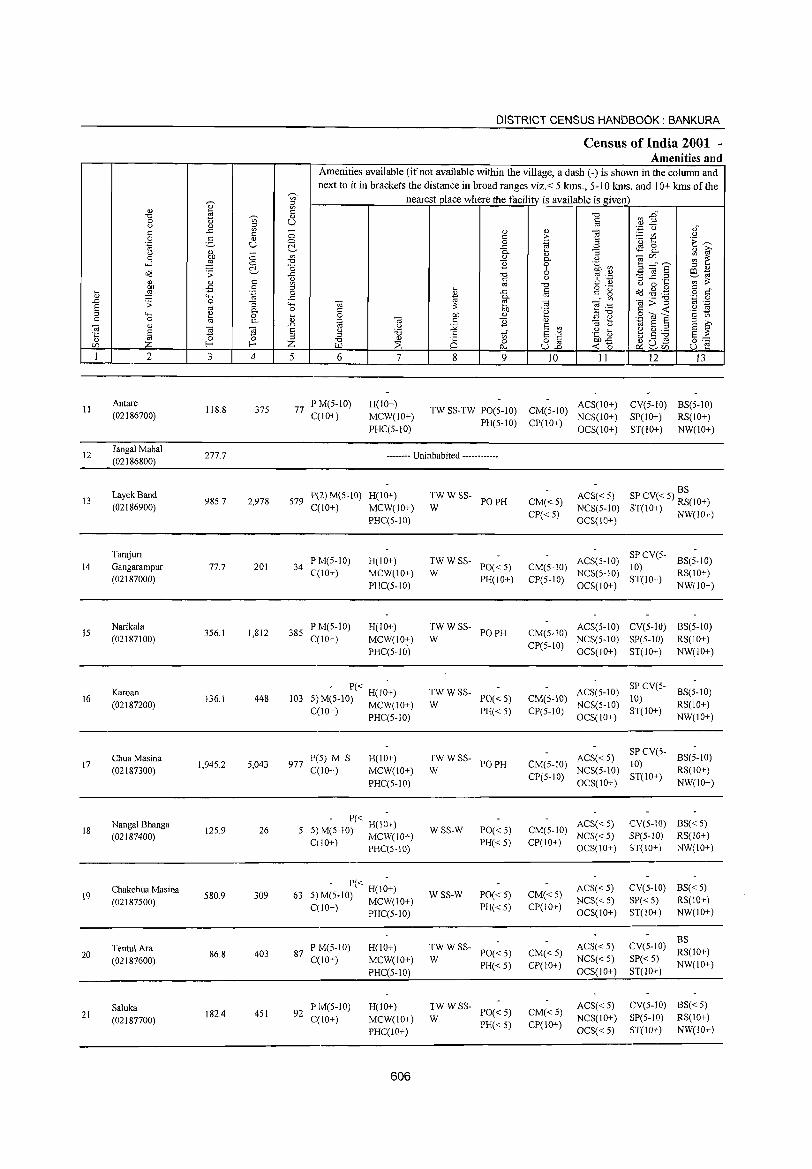
DISTRICT CENSUS HANDBOOK: BANKURA
Census of India 2001 -Amenities and
Amenities available (if not available within the village, a dash (-) is shown in the column and
next to it in brackets the distance in broad ranges viz.< 5 kms., 5-10 kms. and 10+ kms of the ,...., nearest place where the facility is available is given ~ '" ;::l
" ~ '" f3 '" § ~ :2" '0 ~ " 0 '" U <..l " g '';:: u ,f
'" ..c: - " " ] '" 0 '" > ._ '" 9 0 2- " '(3 1::
.~ U 0 0 .~ t':~ ~ ..c ~ 8..
" "- "3 " i;;' <..l b1) c: '" " " <ilC/l ~ ~ 0 "- " ....l ::"! 0 '0 ] 0 .~ til 3 -"s ~ '0 6 ;::l "
c!d .:;: ..c: '0 ro .~ -3]2 al 1;;
" " '" 1;l C <..l C t) ';;;:;: OJ '0 <..l 0 ....
~ .p 0 ;::l o ._
Od .g .g c .... .~ 0 ~ ..c c C" ~ o ","
" 4-< ..c '" "- OJ <il;;:-g
'';:: 0 .D .:;: 0 "3 4-< <il :;: ~ <il "§:e '" ._ 8 OJ 0. 0 '" b1J .~ '" --< .2 !S :::J 4-< ~ 0 .... 0 b1J " E ~ .9 O! S c '" '" 0 "- <U .~ <il " ] <U
1;l 8 :::J ;:l >,
<il " ] .D <..l :;;; E '"
::l <..l 8 ~ 8 ~ E <..l :a <..l ....
~.S ~ ·c :::J S 1i E-" .~ _g §::: " OJ 0 ;::l '0 <U Q 0 8] C/l z f-< f-< Z >.Ll ~ --< 0
<Uu_ u ~ p.. P::~C/l
I 2 3 4 5 6 7 8 9 10 11 12 13
II Antare
118.8 37S 77 PM(S-IO) H(10+) ACS(IO+) CV(5-1O) BS(5-1O)
TW SS-TW PO(S-IO) CM(S-IO) (02186700) C(IO+) MCW(lO+)
PR(S-IO) CP(IO+) NCS(IO+) SP(IO+) RS(IO+)
PHC(5-IO) OCS(10+) ST(IO+) NW(10+)
12 Jangal MahaI
277.7 -------- Uninhabited ------------(02186800)
Layek Band P(2) M(5-10) H(IO+) TWWSS- ACS« 5) BS
13 98S.7 2,978 S79 PO PH CM«5) SP CV« 5) RS(IO+) (02186900) C(10+) MCW(lO+) W
CP« 5) NCS(5-1O) ST(10+) NW(IO+)
PHC(5-IO) OCS(IO+)
Tarajuri PM(S-IO) H(IO+) TWWSS- ACS(S-IO)
SPCV(5-BS(5-10)
14 Gangarampur 77.7 201 34 PO«5) CM(5-1O) 10) C(IO+) MCW(IO+) W NCS(S-IO) RS(IO+)
(02187000) PHC(S-IO)
PH(IO+) CP(S-IO) OCS(IO+)
ST(IO+) NW(IO+)
IS Narikala
3S6.1 1,812 38S PM(5-10) H(10+) TWWSS-
PO PH CM(S-IO) ACS(5-10) CV(5-IO) 8S(5-10)
(02187100) C(lO+) MCW(10;) W CP(S-IO)
NCS(S-1O) SP(S-IO) RS(lO+)
PHC(5-1O) OCS(IO+) ST(IO+) NW(IO+)
Karoan - 1'« -
TWWSS- ACS(5-10) SPCV(5-
BS(5-10) 16 136.1 448 103 S M(S-IO) H(IO+) PO«5) CM(5-10) 10)
(02187200) J MCW(IO+) W PH«5) CP(5-10)
NCS(5-1O) ST(IO+)
RS(10+) C(lO+) PHC(S-IO) OCS(IO+) NW(IO+)
Chua Masina 1'(5) M S H(IO+) TWWSS- ACS« S) SPCV(5-
BS(5-10) 17
(02187300) 1,94S.2 S,043 977
C(10+) MCW(IO+) W PO PH CM(S-IO)
NCS(S-IO) 10)
RS(IO+)
PHC(S-1O) CP(S-IO)
OCS(lO+) ST(IO+)
NW(10+)
18 Nangal Bhanga
12S.9 26 S - 1'« H(I~+)
WSS-W 1'0«5) CM(S-IO) ACS« 5) eV(5-10) BS« 5)
(02187400) 5)M(S-IO) MCW(lO+) NCS« S) :SP(S-IO) RS(IO+) CiIO+) PHC(5-IO) PH« S) CP(IO+)
OCS(IO+) ST(IO+) NW(IO+)
19 Chakchua Masina
580.9 309 63 - 1'« H(I~+)
WSS-W 1'0«5) CM« 5) ACS«S) eV(S-IO) BS« S)
(02187S00) S)M(S·IO) MCW(10+) PH«S) CP(10+)
NCS« 5) SP« 5) RS(10+) C(lO+) PHC(S-1O) OCS(10+) ST(IO+) NW(IO+)
ACS« S) eV(S-IO) BS
Tentul Ara PM(5-10) H(10+) TWWSS-1'0« 5) CM« 5) RS(IO+) 20 86.8 403 87
C(10+) MCW(IO+) W NCS« S) SP«S) (02187600) PH«S) CP(IO+) NW(IO+)
PHC(5-10) OCS(10+) ST(10+)
Saluka PM(S-10) H(10+) TWWSS-1'0« 5) CM«5)
ACS«S) eV(S-IO) BS« S) 21 182.4 451 92
C(10+) MCW(lO+) W NCS(10+) SP(S-10) RS(lO+) (02187700) PH« 5) CP(10+)
PHC(lO+) OCS«5) ST(IO+) NW(lO+)
606
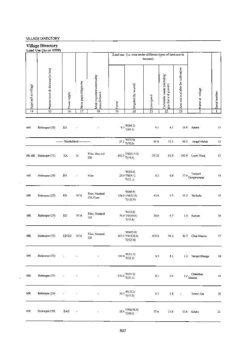
VILLAGE DIRECTORY
Village Directory Land Use (As on 1999)
'" ~ Z
14 15
MR Bishnupur (10)
16 17 18
ED
-------- Uninhabited ------------
PR MR Bishnupur (21)
MR Bishnupur (29)
MR Bishnupur (27)
MR Bishnupur (29)
MR Bishnupur (23)
MR Bishnupur (23)
MR Bishnupur (23)
MR Bishnupur (23)
MR Bishnupur (29)
EA N
ED
ED NM
ED NM
ED EO NM
EAG
Rice, Mustard Oil
Rice
Rice:, Mustard Oil, Flour
Rice, Mustard Oil
Rice, Mustard Oil
Land use (i.e. area under different types ofland use in hectare)
19 20
W(84.2) 9.7 T(84.2)
271 W(70.0) · T(70.0)
3' TWE(14.5)
45 .0 T( 14.5)
W(23.0) 23.9 TW(9.1)
T(32.1)
W(90.9) 128.3 TW(32 0)
T(122.9)
W(42.6) 55.0 TW(IO.O)
T(52.6)
W(403.8) 857.5 TW(120.0)
T(523.8)
1000 W(12.1) · T(12.1)
W(35.2) 533.4 T(35.2)
W(IO.2) 70.7 T(IO.2)
184 TWE(58.0) · T(S8.0)
607
21 22
4.1
84.8
353.0
8.3
43.0
20.0
419.0
4.5
8.1
4.1
77.6
4.1
15.3
61.0
0.8
9.3
6.7
59.2
8.1
2.0
1.8
15.8
23 2
16.8 Antare
80.5 Jangal Mahal
103.9 Layek Band
12.6 Tarajuri Gangarampur
52.7 Narikala
1.8 Karoan
85.7 Chua Masina
1.2 Nangal Bhanga
2.2 Chakchua Masma
Tentul Ara
12.6 Saluka
II
12
13
14
15
16
17
18
19
20
21
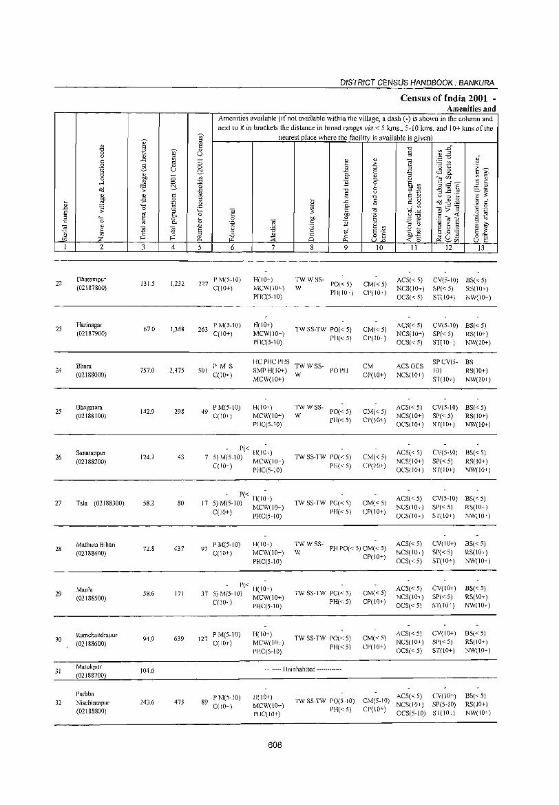
DISTRICT CENSUS HANDBOOK; BANKURA
Census of India 2001 -Amenities and
Amenities available (if not available within the village, a dash (-) is shown in the column and next to it in brackets the distance in broad ranges viz.< 5 kms., 5-10 kms. and 10+ kms of the
~
nearest place where the facility is available is given '" <U ::I '" '" t;; '" -0
rI) --§" -0 ~ '" 0 "0 en U '" (.) " ;:l os ·3 u " -'" en - '" '" ~ '" '" 0 '" > - '" (.) 0 E- '" 0 0 .~ a '(3 t: 'E ~ .~ u t!- ..c c.S 8- " ~ ~ - 0. "3 (.)
'" '" '" 1§ (/)""-' ~ ~ 0 0 0. (.)
.....l ~ 0 -0 "2 0 .~ ~ t!- o 6 E=;j~ ::I " <id .:; il -0 '? '.z:j
>Q 'til
'" (.) ::s ..c ._ ';;;'~ '" .£ '" '" os -0 '" '" (.) 0 ...
~ 0 ::I ... o ._
<id-l'lg '" . .... ..c '" c" £ .~ 0 ~ "' o '" <l) "-' .s:: 0. 0l;;;:"S ',;:1 0 .D .;; 0 "3 ..... 01 e 01 T§ .~ '" ._ s .. 0. 0 C ~ OIl 'e '" « '2 ~ ;:l '+< '" 0 .... 0 bI) '"
",-0 .9 -ro '8 c 0 \d 0. '" .~ til c "2 '" =: e :l >,
til " S .D .g J2 E '" '" (.) '" E '" a "' § s § (.)
-0 .8 8-'" .~ ~ t.9 ~ 8 ~ ·c '" '" '" 0 0 -0 '" 2S o c OJ).s:: 0"" :z: E- E- :z: :::s 0 u] « " ~ ~~ '" ~ p., u e 1 2 3 4 5 6 7 8 9 10 II 12 13
22 Dharampur
131.5 1,232 227 PM(5-10) H(lO+) TWWSS-
PO«5) CM«5) ACS« 5) CV(5-IO) BS« 5)
(02187800) C(IO+) MCW(10+) W PH(IO+) CP(IO+)
NCS(10+) SP«5) RS(10+) PHC(5-10) OCS«5) ST(10+) NW(IO+)
23 Harinagar
67.0 1,348 263 P M(5-10) H(10+)
TW SS-TW PO« 5) CM«5) ACS« 5) CV(5-10) BS« 5)
(02187900) C(10+) MCW(IO+) PH« 5) CP(IO+)
NCS(lO+) SP« 5) RS(lO+) PHC(5-1O) OCS«5) ST(IO+) NW(lO+)
Bhara PMS HC PHC PHS
TWWSS- CM ACSOCS SPCV(5- BS
24 (02188000)
757.0 2,475 501 C(10+)
SMPH(10+) W
PO PH CP(lO+) NCS(lO+)
10) RS(lO+) MCW(10+) ST(IO+) NW(IO+)
25 Bhagarara
142.9 298 49 PM(5-10) H(10+) TWWSS-
PO« 5) CM«5) ACS« 5) CV(5-10) BS«5)
(02188100) C(10+) MCW(10+) W PH« 5) CP(IO+)
NCS(10+) SP« 5) RS(IO+) PHC(5-10) OCS(IO+) ST(lO+) NW(lO+)
26 Sanatanpur
124.1 43 7 - P« H(I;+)
TW SS-TW PO« 5) CM«5) ACS« 5) CV(5-IO) BS«5)
(02188200) 5) M(5-1O) MCW(JO+) NCS(IO+) SP« 5) RS(IO+) C(JO+) PHC(5-10) PH« 5) CP(IO+)
OCS(IO+) ST(IO+) NW(IO+)
27 Tala (02188300) 58.2 80 17 - P« H(I~+)
TW SS-TW PO« 5) CM«5) ACS«5) CV(5-10) BS«5)
5) M(5-1O) MCW(lO+) NCS(IO+) SP« 5) RS(lO+) C(lO+) PHC(5-10) PH«5) CP(1O+)
OCS(IO+) ST(IO+) NW(IO+)
Mathura Bihari P M(5-1O) H(lO+) TWWSS-PH PO« 5) CM« 5)
ACS« 5) CV(lO+) BS« 5) 28
(02188400) 72.8 437 97
C(10+) MCW(10+) W NCS(IO+) SP« 5) RS(IO+)
PHC(5-10) CP(1O+)
OCS« 5) ST(1O+) NW(IO+)
Maula 58.6 171 37
- P« H(I~+) TW SS-TW PO« 5) CM«5)
ACS« 5) CV(IO+) BS« 5) 29 5) M(5-10) MCW(10+) NCS(lO+) SP« 5) RS(lO+) (02188500)
PH« 5) CP(10+) C(1O+) PHC(S-IO) OCS«5) ST(lo+) NW(IO+)
Ramchandrapur 94.9 639 127
PM(5-1O) H(lO+) TW SS-TW PO« 5) CM« 5)
ACS« 5) CV(IO+) BS« 5) 30
C(lO+) MCW(lo+) NCS(10+) SP«5) RS(10+) (02188600) PH«5) CP(lO+) PHC(5-10) OCS« 5) ST(10+) NW(IO+)
31 Matukpur
ID4.6 -------- Uninhabited ---------.--(02188700)
Purbba PM(5-10) H(10+) ACS« 5) CV(lO+) BS«5)
32 Nischintapur 243.6 473 89 C(lO+) MCW(10+)
TW SS-TW PO(5-10) CM(5-10) NCS(lO+) SP(5-10) RS(IO+)
(02188800) PHC(lo+) PH«5) CP(10+)
OCS(5-10) ST(1o+) NW(lO+)
608
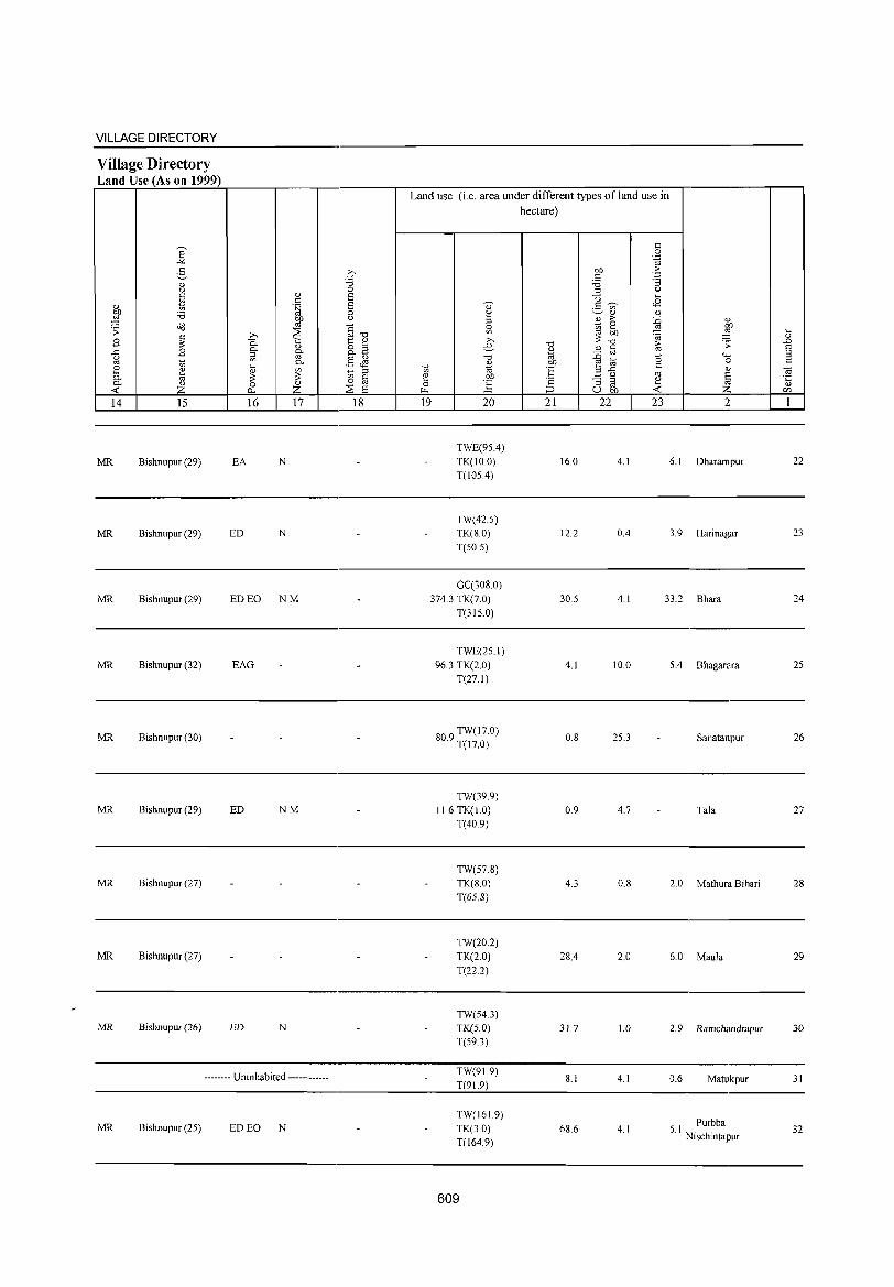
VILLAGE DIRECTORY
Village Directory Land Use (As on 1999)
14 15
MR Bishnupur (29)
MR Bishnupur (29)
MR Bishnupur (29)
MR Bishnupur (32)
MR Bishnupur (30)
MR Bishnupur (29)
MR Bishnupur (27)
MR Bishnupur (27)
MR Bishnupur (26)
16 17
EA N
ED N
ED EO NM
EAG
ED NM
ED N
-------- Uninhabited ------------
MR Bishnupur (25) ED EO N
18
Land use (i.e. area under different types ofland use in hectare)
19 20
TWE(9SA)
TK(IO.0) T(IOSA)
TW(42.S)
TK(S.O) T(50 5)
21 22 23
16.0 4.1
12.2 OA
2
6.1 Dharampur
3. 9 Hari nagar
GC(30S.0) 374.3 TK(7.0)
T(3IS.0)
30.S 4.1 33.2 Bhara
TWE(2S.I) 96.3 TK(2.0)
T(27.1)
809 TW(17.0) . T(l7.0)
TW(39.9) 11.6 TK(I.O)
T(40.9)
TW(57.8) TK(S.O) T(65.8)
TW(20.2) TK(2.0) T(22.2)
TW(54.3) TK(5.0) T(59.3)
TW(9L9) T(91.9)
TW(161.9) TK(30) T(164.9)
609
4.1
O.S
0.9
4.3
28A
31.7
8.1
68.6
10.0 5.4 Bhagarara
25.3 Sanatanpur
4.7 Tala
0.8 2.0 Mathura Bihari
2.0 6.0 Maula
1.0 2.9 Ramchandrapur
4.1 0.6 Matukpur
4.1 6 I Purbba . Nischintapur
22
23
24
25
26
27
28
29
30
31
32
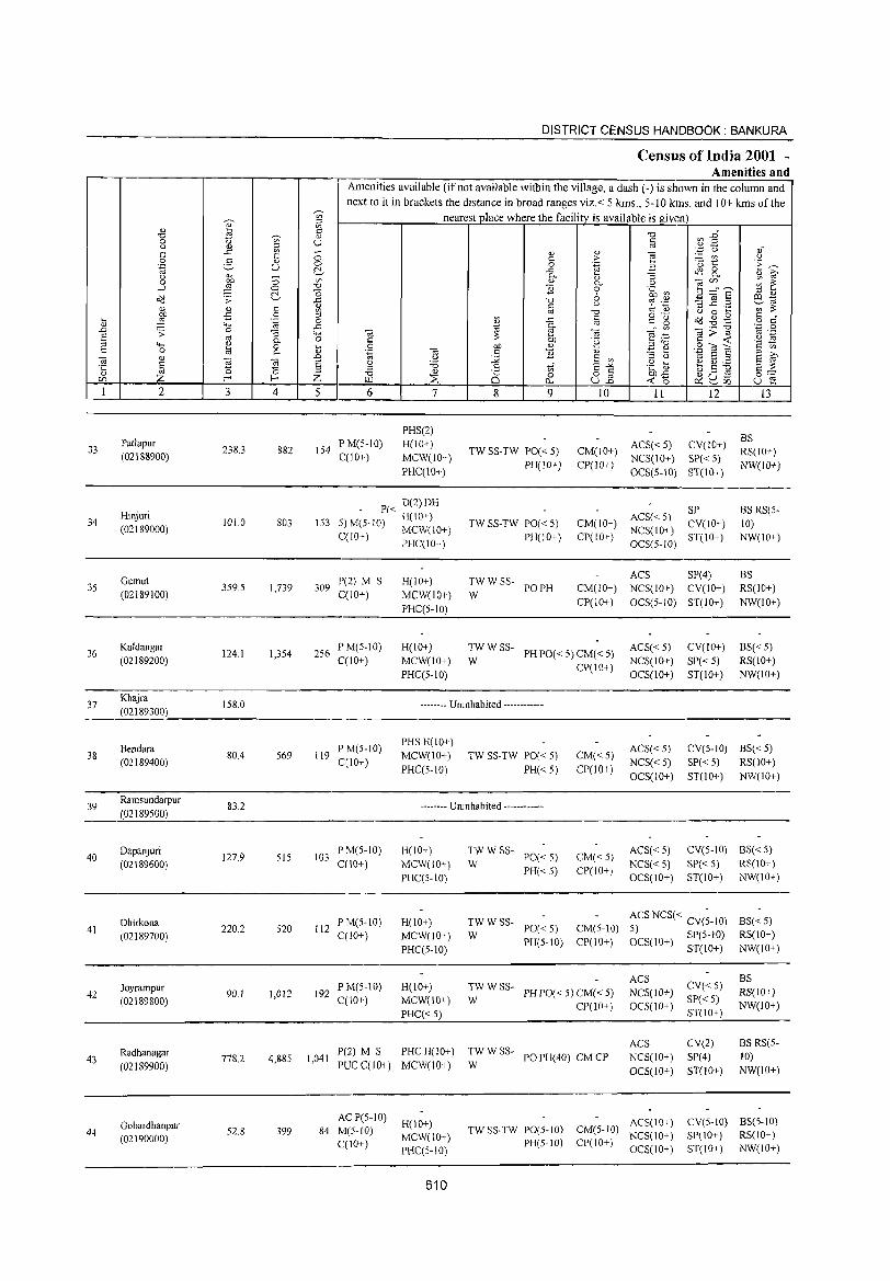
DISTRICT CENSUS HANDBOOK: BANKURA
Census of India 2001 ~
Amenities and Amenities available (ifnot available within the village, a dash (-) is shown in the column and
next to it in brackets the distance in broad ranges viz.< 5 kms., 5-10 kms. and 10+ kms of the
'"" nearest place where the facility is available is given '" '" Sl '" ~ § -0 ~ :2~ -0 ~
0 '" U " " <l) ::> ro
" -" '" ;:; <l) <l) "§
'.p () oi " c > ._ '" " 0 2- '" ·u 1:: .~ ~ .~ U 0 0 .~ a ~ ..c: 4S 8..
" ~ 0- 0; '" &i' ;:; '" '" '" ~~~ ~ ~ 0 ~ -0 B
0- " -l 0 "0 0 .~ ~ E ~ § " '" .::! .;;: ~ -" -0 6 ~ '';::: a:l 10
'" <l) § <l) " " :::$ ...c: ._ ';;;';;: '" '" -0 " '" <.) 0 ....
9 -:S :;l o ._
" 0 .... .~ i'! i; ..c " " g .::!~g o <: <l) 4-< 10 0- ro
'" OJ;;:-g '';:; 0
.0 .;;: 0 :3 "-< OJ e OJ e~ '" ._ s oj 0- 0 "
::: OJ) .~ " -< '8 ~ :;l "-< ~ 0 .... 0 OJ) '" a '" .9 OJ ~ t:: C 0. '" .~ '" .8 B '" '3 t> 10 S S &i' OJ '" 21 .0 <.) ..>< S '" S '" § <.) 'B .8 tf S-'" .~ ~ ~ g ~ E ::: '5 -0 ::>
Z 0 -0 OJ
Q c 82 ~u.s 0'= CIl f-< f-< Z ~ ::E 0.. ~o ~ '-' [J) u e 1 2 3 4 5 6 7 8 9 10 11 12 13
PHS(2) BS
33 Patlapur
238.3 882 154 PM(5-10) H(IO+)
TW SS-TW PO« 5) CM(IO+) ACS«5) CV(IO+)
RS(lO+) (02188900) C(10+) MCW(IO+) PH(IO+) CP(lO+)
NCS(10+) SP« 5) NW(lO+)
PHC(IO+) OCS(S-IO) ST(IO+)
Hinjuri P« D(2)DH
ACS« 5) SP BS RS(5-
34 1010 803 153 5) M(5-10) H(10+) TW SS-TW PO« 5) CM(lO+) CV(IO+) 10) (02189000) C(1O+) MCW(10+) PH(10+) CP(10+)
NCS(IO+) ST(IO+) NW(lO+)
- PHC(IO+) OC8(5-10)
Gumu! P(2) M S H(10+) TWWSS-ACS SP(4) BS
35 359.5 1,739 309 PO PH CM(IO+) NCS(lO+) CV(10+) RS(lO+) (02189100) C(10+) MCW(10+) W
CP(lO+) OCS(5-10) ST(10+) NW(10+) PHC(S-IO)
36 Kuldangar
124.1 1,354 256 P M(5-10) H(lO+) TWWSS-
PHPO« S) CM« 5) ACS«5) CV(IO+) BS« 5)
(02189200) C(10+) MCW(10+) W CP(IO+)
NCS(lO+) SP«5) RS(lO+)
PHC(5-1O) OCS(IO+) ST(lO+) NW(IO+)
37 Khajra
158.0 -------- Uninhabited ------------(02189300)
Bendara PM(5-10) PHS H(IO+)
ACS« 5) CV(5-10) BS« 5) 38
(02189400) 80.4 569 119
C{lO+) MCW(IO+) TW SS-TW PO« 5) CM«5)
NCS«5) SP« 5) RS(10+) PHC(5-10) PH«5) CP(JO+)
OCS(IO+) ST(IO+) NW(10+)
39 Ramsundarpur
(02189500) 83.2 -------- Uninhabited ------------
40 Dapanjuri
127.9 515 103 PM(S-10) H(10+) TWWSS-
PO« 5) CM«5) ACS« 5) CV(S-IO) BS« 5)
(02189600) C(10+) MCW(10+) W PH«5) CP(IO+)
NCS«5) SP« 5) RS(10+)
PHC(5-10) OCS(IO+) ST(IO+) NW(IO+)
Dhirkona 220.2 520 112
PM(5-1O) H(IO+) TWWSS-PO«5) CM(5-10)
ACS NCS« CV(~-10) BS« 5) 41
(02189700) C(10+) MCW(10+) W 5) SP(5-10) RS(10+)
PHC(5-1O) PH(5-10) CP(lO+) OCS(lO+) ST(IO+) NW(10+)
ACS CV«5)
BS Joyrampur
90.1 1,012 192 PM(5-10) H(IO+) TWWSS-
PHPO«5)CM«5) NCS(JO+) RS(lO+) 42 (02189800) CClO+) MCW(10+) W SP« 5)
PHC«5) CP(lO+) OCS(IO+)
ST(lO+) NW(IO+)
TWWSS-ACS CV(2) BS RS(5-
43 Radhanagar
778.2 4,885 1,041 P(2) M 8 PHCH(lO+)
PO PH( 40) CM CP NCS(10+) SP(4) 10) (02189900) PUC C(lO+) MCW(lO+) W
OC8(10+) ST(IO+) NW(lO+)
Gobardhanpur AC P(5-1O)
H(10+) ACS(IO+) CV(S-10) BS(5-10) 44 52.8 399 84 M(5-1O)
MCW(10+) TWSS-TW PO(S-IO) CM(5-10)
NCS(10+) SP(10+) RS(10+) (02190000) C(JO+) PH(5-IO) CP(10+) PHC(5-10) OCS(IO+) ST(IO+) NW(10+)
610
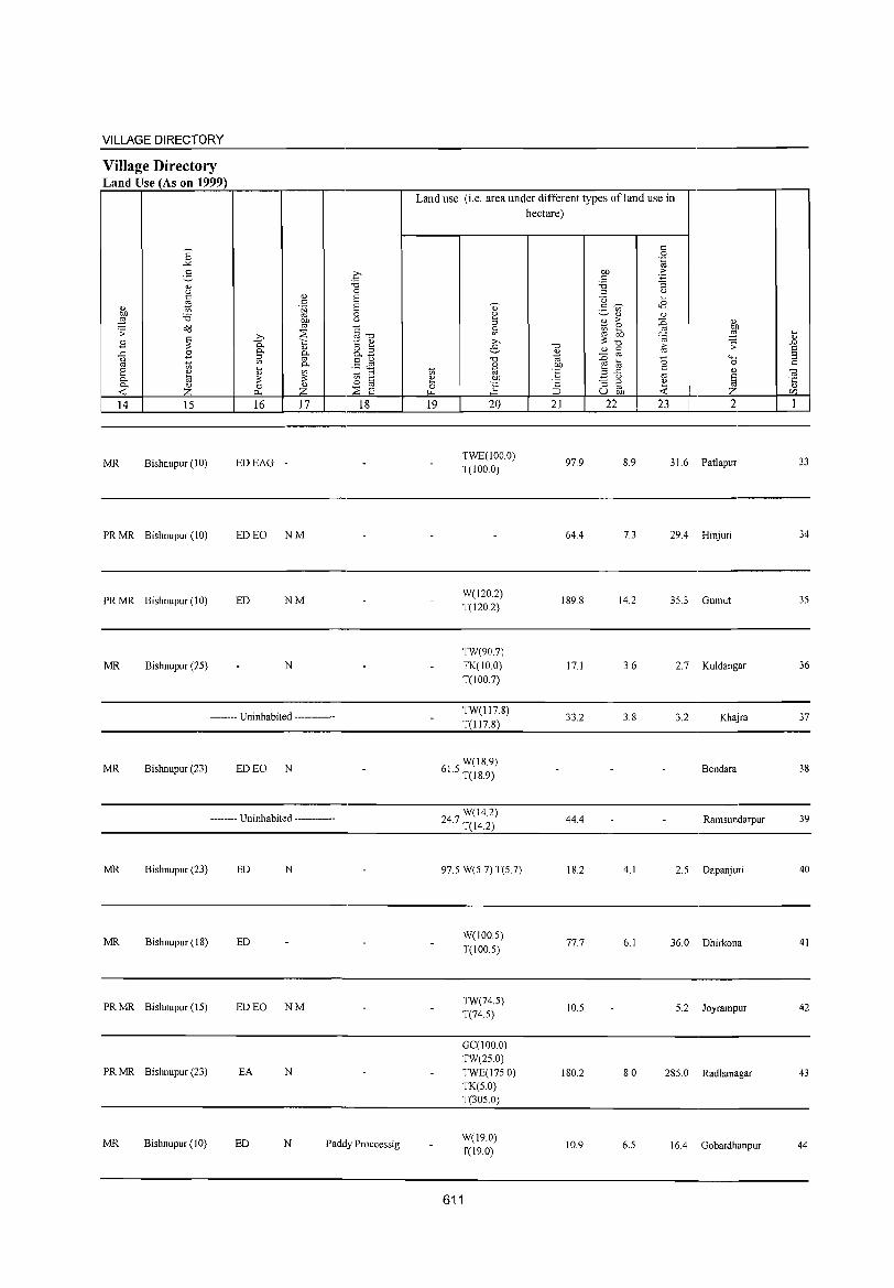
VILLAGE DIRECTORY
Village Directory Land Use (As on 1999)
E "'" :§_ " " c %l " OIl '6 ::§
.;;: o::J
~ B .r:: B " '" 1;; e ~ 0. 0. <U « z 14 15
MR Bishnupur (10)
PR MR Bishnupur (10)
PRMR Bishnupur (10)
MR Bishnupur (25)
" c .~
fJl ~ ,.,
Ci.. 0. " :; fil" '" 0. ~
" ~ ::: 0 ~ 0...
16 17
EDEAG -
ED EO NM
ED NM
N
-------- Uninhabited ------------
MR Bishnupur (23) ED EO N
------- Uninhabited ------------
MR Bishnupur (23) ED N
MR Bishnupur (18) ED
PRMR Bishnupur (15) ED EO NM
PRMR Bishnupur (23) EA N
q "" 0 E E 0
" OJ "'"" ~ e o '" 0. ....
.5 JS 1;; '" 0 til ~ E
18
MR Bishnupur (10) ED N Paddy Proccessig
Land use (i.e. area under different types of land use in hectare)
19 20
TWE(IOO.O) T(IOO.O)
W(120.2) T(120.2)
TW(907)
TK(1O.0)
T(100.7)
TW(l17.8)
T(l17.8)
W(18.9) 61.5 T(18.9)
W(14.2) 24.7 T(14.2)
97.5 W(5.7) T(5.7)
W(100 5)
T(100.5)
TW(74.5) T(74.5)
GC(100.0) TW(25.0)
TWE(17S.0) TK(5.0) T(305.0)
W(19.0) T(19.0)
611
"" <U
"' OIl 'E ·2 ::::J 21
97.9
644
189.8
17.1
33.2
44.4
18.2
77.7
10.5
180.2
10.9
c 0
°ia OIl ·5 c '6 "3 '" " u ~
g ~ <8 '" " <U
£ ;. :E
~ gJ e '" ::: OIl ~ "" i;; .;;:
<U C
:E '" (5 4-<
~ til 0
B ..c c: " " '" ~ "3 ~ e
u OIl « 22 23 2
8.9 31.6 Patlapur
7.3 29.4 Hinjuri
14.2 35.3 Gumut
3.6 2.7 Kuldangar
3.8 3.2 Khajra
Bendara
Ramsundarpur
4.1 2.5 Dapanjuri
6.1 36.0 Dhirkona
5.2 Joyrampur
8.0 285.0 Radhanagar
6.5 16.4 Gobardhanpur
~
" .0 E :; c:
"' '5 C/)
I
33
34
35
36
37
38
39
40
41
42
43
44
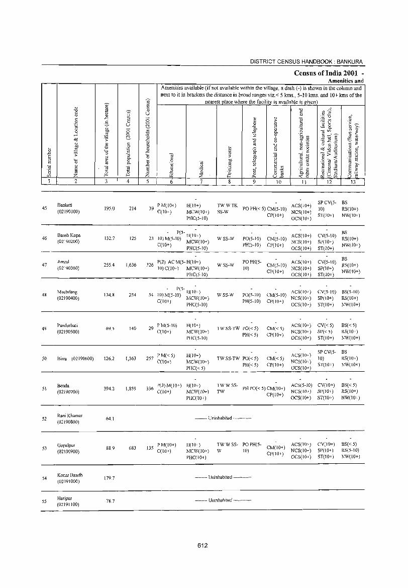
45
46
47
48
49
50
51
52
53
54
55
2
Bankati
(02190100)
Bansh Kopa (02190200)
Amral (02190300)
Muchdang (02190400)
Pundurhati (02190500)
Birra (02190600)
Benda (02190700)
Rani Khamar (02190800)
Gopalpur (02190900)
Konar Bandh (02191000)
Haripur (02191100)
3 4
195.0 214
132.7 125
255.4 1,636
134.8 254
69.5 140
126.2 1,363
394.2 1,8S9
64.1
88,9 683
179.7
78,7
DISTRICT CENSUS HANDBOOK: BANKURA
Census of India 2001 -Amenities and
Amenities available (if not available within the village, a dash (-) is shown in the column and next to it in brackets the distance in broad ranges viz.< 5 kms., 5-10 kms. and 10+ kms of the
nearest place where the facility is available is giVt:D
5 6
39 PM(JO+) C(lO+)
7
H(lO+) MCW(IO+) PHC(5-IO)
- P(5- -23 10) M(5-10) H(IO+)
C(IO+) MCW(IO+) PHC(5-10)
326 P(2) AC M(5- H(IO+) 10) C(lO+) MCW(IO+)
PHC(5-10)
- P(5- -54 ilO) M(5-1O) H(lO+)
C(IO+) MCW(10+) PHC(5-JO)
29 P M(S-IO) C(lO+)
257 PM«5) C(\O+)
H(IO+) MCW(lO+) PHC(5-1O)
H(IO+) MCW(JO+)
PHC« 5)
336 P(3) M(10+) H(IO+) C(10+) MCW(lO+)
PHC(lO+)
8 9 10 11
~::TK POPH«5)CM(5-10) ACS(lO+) CP(lO+) NCS(IO+)
WSS-W
WSS-W
WSS-W
OCS(IO+)
PO(5-10) CM(5-10) ACS(IO+) PH(5-10) CP(IO+) NCS(IO+)
OCS(IO+)
PO PH(S- CM(S-IO) ACS(IO+)
10) CP(lO+) NCS(lO+) OCS(IO+)
PO(5-1O) CM(5-10) ACS(IO+) PH(5-10) CP(IO+) NCS(IO+)
OC5(10+)
12 13
SP CV(5- BS 10) RS(lO+) ST(lO+) NW(IO+)
BS CV(S-IO) RS(10+)
SP(IO+) NW(IO+) ST(lO+)
BS CV(5-10) RS(IO+) SP(IO+) NW(lO+) ST(IO+)
CV(5-JO) BS(5-10) SP(IO+) RS(IO+) ST(lO+) NW(10+)
TW SS-TW PO« 5) PH« 5)
CM«5) CP(IO+)
ACS(lO+) CV« 5) NCS(IO+) SP« 5) OCS(lO+) ST(IO+)
BS« 5) RS(IO+) NW(IO+)
TW SS-TW PO« 5)
PH« 5) CM«5) CP(lO+)
ACS(lO+) NCS(10+) OCS(lO+)
SP CV(S- BS 10) RS(IO+) ST(JO+) NW(!o+)
TW W SS- ACS(5-10) CV(IO+) TW PHPO«S)CM(IO+) NCS(1O+) SP(lO+)
BS« 5) RS(lO+) NW(10+) CP(IO+) OCS(10+) ST(IO+)
-------- Uninhabited ------------
135 PM(IO+) C(1O+)
H(IO+) MCW(IO+) PHC(!o+)
TW W SS- PO PH(5- ACS(IO+) W 10) CM(IO+) NCS(lO+)
CP(10+) OCS(IO+)
-------- Uninhabited -----•.. -.-.
-------- Uninhabited ----------••
612
CV(IO+) SP(JO+) ST(JO+)
BS«5) RS(5-10) NW(IO+)
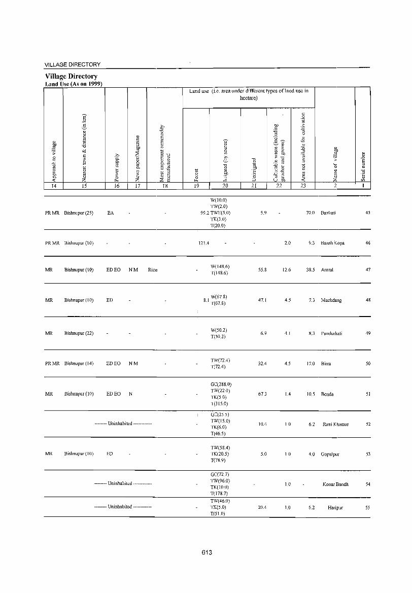
VILLAGE DIRECTORY
Village Directory Land Use (As on 1999)
E ..,. g " u C " '" .s
" to ~ bIl 'B ,g ~ o"<l ;;: ~
;.., ~ B 0. 0-
I!)
..c B 0-u ~ ro '" ~
~ 0-e I!) on
0- ;;: ;;: D.. I!) 0 ~ --< Z ~
14 IS 16 17
PR MR Bishnupur (25) EA
PR MR Bishnupur (10)
MR Bishnupur (10) ED EO NM Rice:
MR Bishnupur (10) ED
MR Bishnupur (22)
PRMR Bishnupur (14) ED EO NM
MR Bishnupur (10) ED EO N
-------- Uninhabited ------------
MR Bishnupur (10) ED
-------- Uninhabited ------------
-------- Uninhabited ------------
.q "0 0 E 8 0 u
§-o t: I!)
8.B §~
1;0 :l C 0 '" ::;s 8
18
Land use (i.e. area under different types ofland use in hectare)
19 20
W(lO.O) TW(2.0)
99.2 TWE(5.0) TK(3.0) T(20.0)
121.4
W(148.6) T(148.6)
W(678) 8.1 T(67.8)
W(50.2) T(50.2)
TW(72.4) T(72.4)
GC(288.0) TW(22.0)
TK(5.0) T(315.0)
GC(25.5) TW(15.0) TK(6.0) T(46.5)
TW(58.4) TK(20.5) T(78.9)
GC(72.7) TW(96.0) TK(IO.O) T(178.7)
TW(460) TK(5.0) T(51.0)
613
"0 '" ., bIl 'E ·E ::> 21
5.9
55.8
47.1
6.9
32.4
67.3
lOA
5.0
20A
c 0
'.g bIl 'b c 'B ""3 :l u
U ~
2- ~ <B on I!) I!)
2 >- :.0 " Kl ~ '" OJ)
~ :§ ;;: "0 >- .:; " c '" :.0 ro
0 """" ~ t;; 0
B ..c c " " ro E ""3 @ ~ ~ u bIl --<
22 23 2
70.0 Bankati
2.0 9.3 Bansh Kopa
12.6 38.5 Amral
4.5 7.3 Muchdang
4.1 8.3 Pundurhati
4.5 17.0 Birra
1.4 10.5 Benda
1.0 6.2 Rani Khamar
1.0 4.0 Gopalpur
1.0 Konar Bandh
1.0 6.2 Haripur
~ .c 8 :l c
OJ '5 CI"l
I
45
46
47
48
49
50
51
52
53
54
55

DISTRICT CENSUS HANDBOOK: BANKURA
Census of India 2001 -Amenities and
Amenities available (if not available within the village, a dash (-) is shown in the column and next to it in brackets the distance in broad ranges viz, < 5 kms" 5-10 krns. and 10+ kms of the
-;n nearest place where the facility is available is given OJ ;:l
'" ., ~
c "" U).§ "" -;n .,
0 u til u ., ;:l .~ Q .," c ..c '" ::; ., OJ e c c .~ ~ t <.)
0 g ., .~ ---.~ u 0 0 .. .a t!- ..c tS 8. ., 0. :;; "3 ., ~ <.)
00 ::; '" ., 1§ c/)" __ ~ E 0 p, <.)
....l ~ 0 "" 1l 9 .~ ~ t!- '0 E ~ § ;:l .,
o(l .;;: ..c '0 0 81a c :'A c <.) ~ '.;j ;:l ..c ._
'" :::: ., .,
"' '0 § .~ u 0 ...
~ .p 0 ;:l ... o(l ~ .g c " ... .~ 0 <ll ..c § " g o c ., "'" ..c
~ 0.
" '" ._ "" ',p 0 .to .;;: 0 "3 "'" '" 2 '" ~ .~ ~>~ '" ._
§ '" 0- 0 C ~ 'e '2 ~ "'" e 0 ... 0 00 ;:l'O S~S c 0 '" C. <ll .~ 03 s:: 1l ., ~ e E ~ 03 <ll
~ .D <.) :.Q E '"
;:l <.J ~ E ;:l
'C: a 03 E <.J '8 s:: 'iif E"" .g v e ~ ii a :::: '0 ;:l ;:l ., oj
"" .,
8 0 8_g 00 ..c g u .s 0'= <f) Z E- Z >.l.1 ~ 0- <0 ~ ~<f) u 2 1 2 3 4 5 6 7 8 9 10 II 12 13
56 Banamalipur
137.5 734 146 PM(5-IO) H(IO+) TWWSS- PH PO(5-
CM(IO+) ACS(5-JO) CV(IO+) BS«5)
(02191200) C(10+) MCW(lO+) W 10) CP(IO+)
NCS(10+) SP(IO+) RS(IO+) PHC(5-IO) OCS(IO+) ST(IO+) NW(IO+)
Paikpara P« RMP H(IO+)
TWWSS- ACS(5-IO) SPCV(5- BS
57 101.2 924 190 :5) M(5-10) MCW(IO+) PH PO« 5) CM« 5) 10) RS(IO+) (02191300)
C(lO+) PHC(S-IO) W
CP(lO+) NCS(IO+)
ST(lO+) NW(lO+) OCS(IO+)
Dharapati 1'(2) M(S-I 0) H(IO+) TW WR SS'PO(~O+) ACS(5-1O) BS .
58 273.7 1,304 255 CM«5) SI' CV« 5) RS(lO+) (02191400) C(10+) MCW(lO+)
W PH«5) CP(10+) NCS(IO+) ST(IO+) NW(IO+)
PHC(5-1O) OCS(IO+)
Paschim , - P« H(I;+) ACS(S-IO) SPCV(5-
8S« 5) 59 Nischinatapur 55.0 129 26 -') M(S-IO) MCW(IO+) TW SS-TW PO« 5) CM(S-IO)
NCS(IO+) 10)
RS(IO+) (02191500) C(10+) PHC(5-10) I'H«5) CP(10+)
OCS(10+) ST(IO+)
NW(lO+)
Kakila F'M(5-IO) PHC PHS
TWWRC ACS(5-10) CV SP(2) BS RS(5-
60 199.0 1,605 315 RMP H(IO+) PO«5) CM(5-10) 10) (02191600) C(lO+)
MCW(IO+) SS-W
PH(IO+) CI'(IO+) NCS(IO+) ST(IO+)
NW(IO+) OCS(IO+)
Rautara 387.3 1,192 238
PM(5-IO) H(lO+) TWWSS-PO«5) CM(S-IO)
ACS« 5) CV(5-10) BS«5) 61
(02191700) ('(10+) MCW(lO+) W NCS(IO+) SP(5-10) RS(IO+)
I'HC(5-IO) PH(5-10) CI'« 5)
OCS(IO+) ST(IO+) NW(IO+)
62 Tentulia
67.4 -------- Uninhabited ------------(02191800)
63 Siharshul
49.7 -------- Uninhabited ------------(02191900)
Dhangara PM«5) H(IO+) TWWSS- ACS« 5) CV(5-1O) BS RS(S-
64 161.2 560 118 PO«5) CM(5-1O) 10) (02192000) C(IO+) MCW(IO+) W
PH(5-10) CP« 5) NCS(lO+) SP(5-1O)
NW(IO+) PHC(S-IO) OCS(IO+) ST(IO+)
H(10+) ACS(5-JO) CV(5-JO) BSRS(5-
Beliara 2,298 381 P M C(IO+) TW SS-TW PO PH CM(IO+) 10) 65 136.7 MCW(IO+) NCS(IO+) SP(5-10) (02192100) CP(IO+) NW(IO+)
PHC(5-10) OCS(IO+) ST(IO+)
eV(5-10) BS
Dejhat 1,250 256 PM«5) H(10+)
TW SS-TW PO« 5) CM(IO+) ACS(5-10)
RS(IO+) 66 166.0 MCW(lO+) NCS(IO+) SP(5-10) (02192200) C(IO+) PH«5) CP(lO+) NW(JO+)
PHC(5-10) OCS(IO+) 3T(IO+)
614
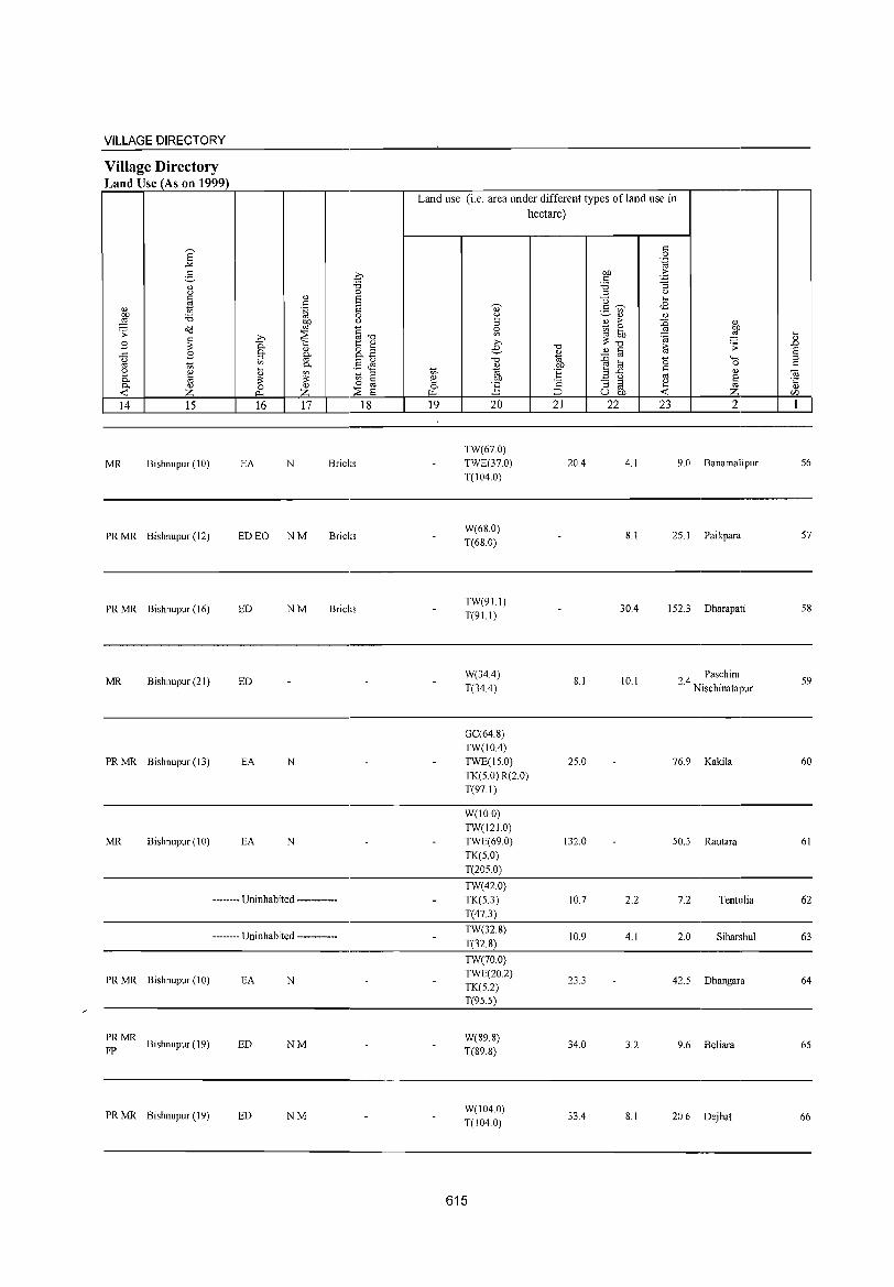
VILLAGE DIRECTORY
Village Directory Land Use (As on 1999)
14 15
MR Bishnupur (10)
PR MR Bishnupur (12)
PR MR Bishnupur (16)
MR Bishnupur (21)
PRMR Bishnupur (13)
MR Bishnupur (10)
16 17
EA N Bricks
ED EO NM Bricks
ED NM Bricks
ED
EA N
EA N
..•.•.. - Uninhabited ._-_._--_._-
..... _ .. Uninhabited •••••••.••••
PRMR Bishnupur (10) EA N
PRMR Bishnupur (J 9)
FP ED NM
PR MR Bishnupur (19) ED NM
18
Land use (i,e, area under different types ofland use in
hectare)
21 22 23 2 19 20 , __ --L_-'
TW(67,0) TWE(37,0) T(104,0)
W(68,0) T(68,0)
TW(91.1) T(91.1)
W(34A) T(34.4)
GC(64,8) TW(10A) TWE(15,0)
TK(5,0) R(2 0) T(97,1)
W(100) TW(121.0) TWE(69,0) TK(5,0) T(2050)
TW(42.0)
TK(S.3) T(47.3)
TW(32.8) T(32.8)
TW(70.0) TWE(20,2) TK(5.2) T(95.5)
W(89.8) T(89.8)
W(104.0) T(104.0)
615
20A 4, I
8,1
30A
8,1 10,1
25,0
132,0
10.7 2.2
10.9 4.1
23.3
34.0 3.2
334 8.1
9,0 Banamali pur 56
25, I Paikpara 57
152,3 Dharapati 58
24 Paschim , Nischinatapur
59
76,9 Kakila 60
50.3 Rautara 61
7.2 Tentulia 62
2.0 Siharshul 63
42.5 Dhangara 64
9.6 Beliara 65
20,6 Dejhat 66
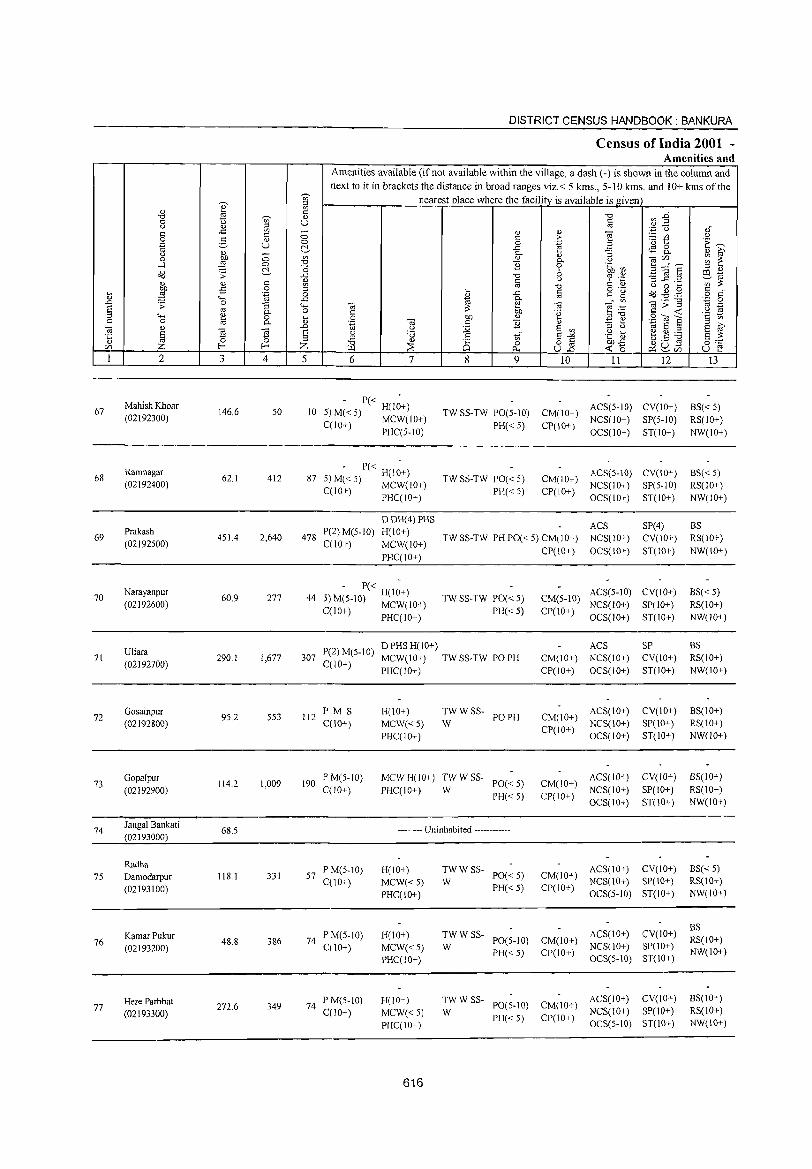
DISTRICT CENSUS HANDBOOK: BANKURA
Census of India 2001 -Amenities and
Amenities available (if not available within the village, a dash (-) is shown in the column and
next to it in brackets the distance in broad ranges viz.< 5 kms., 5-10 kms. and 10+ kms of the ~
nearest place where the facility is available is given e gj
'" <1) 0:: r/'J ~" -0 g ~ <1) -0
0 u '" U § (.) <1) ;:J .~ u oi 0:: ..c '" - <1) <1)
~ e 0 e > :..::: r/'J () 0 g <1)
'" 1:: E~ .~ u 0 0 .~ ~ c:!, ..c r.S8. <1) ~ (.) (1) 0- :;
:W 0 '" <1) " ~lfJ ~ ~ 0 0- (.)
.....:l 0 "0 ~ 0 '@; ~ 5 ::::"e -0 ;:J <1)
~ .;; ~ 6 CO ~ ..t:: -0 (.) '? 'p -3 ~ .~ ~co <1) e ~ 0:: '" :::: <1) co -0 e <1) u 0 .... OJ) -5 0 ;:J ... §
o ._ Od ~ .,§ 0:: "
il ,g .~ 0 " ..c:: 0:: g o 0:: .... ..c:: ~
0-" '" ~>-g '.0 0 ..0 ;; 0 :; ""' ~ ~ ~ ~ .-::
co ._
§ co 0- 0 e OJ) 'g e <c .~ !S ""' ~ 0 ... 0 OJ) <1) ;:J"O .2"<il E e '" .:: 0 0- <1)
.~ ~ 0:: ~ ~ ~ 1;; S E ~ ~ " .0 (.) :Q E '" ;:J (.)
E 3 ~ § u 'B .~ ~ ~~~ <5 ;:J 0:: '" E'"'" S ::::
" co 0 "0 <1)
8 o § OJ)..t:: ~ a .s 0"';: lfJ Z 1-< 1-< Z U-I ::E 0 <c "0 U ~ ~ U.o ~ ~(/) 1 2 3 4 5 6 7 8 9 10 11 12 13
Mahish Khoar - P« -
ACS(5-10) CV(IO+) BS« 5) 67 146.6 50 10 5) M« 5) H(IO+) TW SS-TW PO(5-10) CM(IO+) (02192300) C(IO+) MCW(lO+) PH«5) CP(lO+)
NCS(IO+) SP(S-IO) RS(IO+) PHC(5-IO) OCS(IO+) ST(IO+) NW(IO+)
Ramnagar - P« -
ACS(S-10) CV(IO+) BS«5) 68 62.1 412 87 5) M« 5) H(10+) TW SS-TW PO« 5) CM(IO+) (02192400) C(lO+) MCW(IO+) PH«5) CP(IO+)
NCS(10+) SP(S-10) RS(IO+) PHC(IO+) OCS(IO+) ST(10+) NW(IO+)
DDH(4) PHS ACS SP(4) BS
69 Prakash
451.4 2,640 478 P(2) M(S-IO) H(IO+)
TW SS-TW PH PO« 5) CM(JO+) NCS(10+) CV(10+) RS(IO+) (02192500) C(lO+) MCW(lO+)
PHC(10+) CP(IO+) OCS(IO+) ST(10+) NW(IO+)
70 Narayanpur
60.9 277 44 ') - P« H(l~+)
TWSS-TW PO«S) CM(5-10) ACS(5-IO) CV(IO+) BS« 5)
(02192600) -J M(S-IO) MCW(IO+) NCS(10+) SP(IO+) RS(lO+) C(10+) PHC(10+) PH«5) CP(IO+)
OCS(10+) ST(IO+) NW(IO+)
Uliara 1'(2) M(5-10) DPHSH(lO+) ACS SP BS
71 (02192700)
290.1 1,677 307 C(lO+)
MCW(IO+) TWSS-TW POPH CM(10+) NCS(IO+) CV(IO+) RS(IO+)
PHC(IO+) CP(IO+) OCS(IO+) ST(IO+) NW(IO+)
72 Gosainpur
9S.2 553 112 PM S H(IO+) TWWSS-
POPH CM(lO+) ACS(IO+) CV(10+) BS(IO+)
(02192800) C(10+) MCW«5) W CP(IO+)
NCS(IO+) SP(lO+) RS(IO+)
PHC(IO+) OCS(IO+) ST(IO+) NW(IO+)
73 Gopalpur
114.2 1,009 190 PM(5-10) MCWH(iO+) TWWSS-
PO« 5) CM(10+) ACS(lO+) CV(iO+) BS(iO+)
(02192900) C(10+) PHC(IO+) W PH«S) CP(IO+)
NCS(lO+) SI'(lO+) RS(IO+)
OCS(IO+) ST(IO+) NW(IO+)
74 J angal Bankati
68.5 -------- Uninhabited ------------(02193000)
Radha P M(S-IO) H(lO+) TWWSS- ACS(IO+) CV(lO+) BS«5)
75 Damodarpur 118.1 331 57 0(10+) MCW«5) W
PO«S) CM(IO+) NCS(IO+) SP(IO+) RS(lO+)
(02193100) PHC(lO+)
PH«5) CP(10+) OCS(5-10) ST(10+) NW(JO+)
ACS(lO+) CV(10+) BS
KamarPukur 48.8 386 74
P M(S-IO) H(lO+) TWWSS-PO(5-IO) CM(lO+) RS(lO+) 76 C(10+) MCW«5) W NCS(IO+) :51'(10+) (02193200) PH«5) CI'(IO+) NW(lO+)
PHC(IO+) OCS(5-10) ST(IO+)
Here Parbbat 349 74
I'M(5-10) H(IO+) TWWSS-PO(5-IO) CM(IO+)
ACS(IO+) CV(IO+) BS(IO+) 77 272.6
C(10+) MCW«S) W NCS(10+) SP(10+) RS(lO+) (02193300) PH«5) CP(10+) PHC(10+) OCS(5·10) ST(lO+) NW(IO+)
616
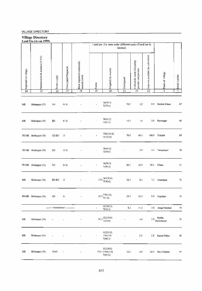
VILLAGE DIRECTORY
Village Directory Land Use (As on 1999)
14 15
MR Bishnupur (17)
MR Bishnupur (19)
PRMR Bishnupur (10)
PRMR Bishnupur (19)
PRMR Bishnupur (13)
MR Bishnupur (10)
PRMR Bishnupur (10)
16 17
ED NM
ED NM
ED EO N
ED NM
ED NM
ED EO N
ED N
-------- Uninhabited ------------
MR Bishnupur (10)
MR Bishnupur (10)
MR Bishnupur (10) EAG
18
Land use (i.e. area under different types of land use in hectare)
19 20
W(79.3)
T(79.3)
W(43.3) T(43.3)
TW(153.0)
T(153.0)
W(54.6)
T(54.6)
W(90.5)
T(90.5)
170 WF(50.6) · T(50.6)
557 TW(IO) · T(IO)
GC(425)
T(42.5)
915 GC(19.0) · T(19.0)
GC(355)
TW(5.0) T(40.5)
GC(38.6)
153.4 TWE(5.0) T(43.6)
617
"0
~ !"!' t:
';:: ::> 21
54.2
14.2
70.0
60.1
16.2
24.3
8.1
10.2
0: 0 .~
bJJ -5 ::: '0 "3 ::l (.)
0 ... 2- ~ ¢l
'" " " OJ >- :g " t; ~ bill OJ ~ ~! ;;:: "0 6
.:;. OJ 0:
::0 OJ '0
,+-,
~ til e, ..c " " (.) OJ E -3 ~ ~ ta
u OJ) Z 22 23 2
3.2 9.9 Mahish Khoar
16 3.0 Ramnagar
40.5 188.0 Prakash
2.0 4.3 Narayanpur
40.5 99.1 Uliara
8.1 3.3 Gosainpur
24.3 9.0 Gopalpur
14.2 3.8 Jangal Bankati
3.6 3.9 Radha Damodarpur
6.5 1.8 KamarPukur
4.9 60.5 Here Parbbat
... " .D
§ 0:
-a '5 r/)
1
67
68
69
70
71
72
73
74
75
76
77
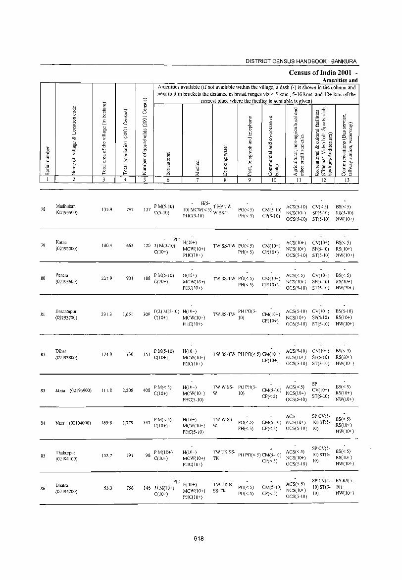
DISTRICT CENSUS HANDBOOK: BANKURA
Census of India 2001 -Amenities and
Amenities available (if not available within the village, a dash (-) is shown in the column and next to it in brackets the distance in broad ranges viz. < 5 kms., 5-10 kms. and 10+ kms of the
~
nearest place where the facility is available is given '" e '" " '" c a1 B~ '0 .s Vi' <1) '0
0 (.) U c (.) <1) ~ os ',p u <1)"
c ..c c :; " " e ~ Vl U 0 2- <1) c: ;> 'u t .~ ~ .~ u 0 0 .~ B C'.- ..c tS 8. <1) 10' " " - 0. (l) :; 0 F a '" <1)
0. (.) <aU) ~ ~ ...l 0 '0 B 0 .~ VJ B ~~E C'.- '0 6 '" <1) ~
ill ~ ;; ..c '0
" % .~ '3 ...c:: .2 ~os
c " c: '" :;: " " '" os '0 (.) 0 ~ bll -B 0 '" ~ c: g 'g o<J ~ .g c:
~ ,!;! .~ 0 ~
..c os o c" " '+-< ..c 0. Vl <a;;"§ ''';::; 0
"'" .;; 0 :; '+-< <a os Cil e:g os .-E os 0. 0 c: :;: on .~ c ~ .~ 19 '" '+-< ~ 0 ~ 0 bll " .3 OJ .9 <0 E c '" c: 0 os 0. " '.g Cil c B " "3 t> '" ;>, Cil " "'" " :.Q E '" 1;1 E '" E ~ 'C § ] ] E " '6 .5 ~ E .... .~ r; ~.S ] '" g"" " 0 0 '" '0 " '" o lii bll..t:: 0 0 U) Z f- f- Z iLl .::E 0... U"'" ~ (5 ~2i/) u E 1 2 3 4 5 6 7 8 9 10 11 12 13
Madhuban PM(5-1O) - H(S-
ACS(S-IO) CV«S) BS«5) 78 13S.9 797 127 10) MCW« S) T HIP TW PO«S) CM(S-IO) (02193400) C(5-10) PHC(S-IO) W SS-T PH«S) CP(S-IO)
NCS(IO+) SP(5-10) RS(5-10) OCS(S-IO) ST(S-IO) NW(IO+)
79 Katna
100.4 66S 120 - P« H(I~+)
TW SS-TW PO« S) CM(IO+) ACS(IO+) CV(JO+) BS« 5)
S) M(S-IO) MCW(IO+) (02193S00) C(IO+) PHC(IO+) PH«S) CP(IO+)
NCS(IO+) SP(S-IO) RS(lO+) OCS(S-IO) ST(S-IO) NW(IO+)
80 Penera
227.9 931 188 PM(S-IO) H(10+)
TW SS-TW PO« S) CM(IO+) ACS« S) CV(IO+) BS« S)
(02193600) C(lO+) MCW(IO+) NCS(IO+) SP(S-IO) RS(IO+) PHC(IO+)
PH« S) CP(IO+) OCS(S-IO) ST(S-IO) NW(IO+)
81 Basantapur
231.3 1,6S1 309 P(2)M(5-10) H(IO+) TW SS-TW PH 1'0(5- CM(IO+)
ACS(5-10) CV(IO+) BS(5-1O)
(02193700) qIO+) MCW(lO+) 10) CP(IO+)
NCS(lO+) SP(S-IO) RS(lO+) PHC(IO+) OCS(S-IO) ST(S-IO) NW(IO+)
82 Dihar
174.0 730 151 PM(5-10) H(IO+)
TW SS-TW PH PO« 5) CM(lO+) ACS(5-10) CV(IO+) BS« 5)
(02193800) C(lO+) MCW(IO+) CP(IO+)
NCS(IO+) SP(S-IO) RS(IO+)
PHC(IO+) OCS(5-10) ST(S-lO) NW(IO+)
TWWSS- PO PH(5- ACS«S) SP
BS«5) 83 (02193900) 111.8 2,208 408
PM«S) H(IO+) CM(5-10) CV(!O+) lanta
C(lO+) MCW(lO+) W 10) NCS(IO+) RS(lO+)
PHC(5-10) CP« 5)
OCS(S-IO) ST(S-IO)
NW(IO+)
PM«S) H(IO+) TWWSS-ACS SPCV(5-
BS«5) 84 Naer (02194000) 169.8 1,779 343
C(IO+) MCW(IO+) W 1'0« 5) CM(5-10) NCS(IO+) 10) ST(5-
RS(IO+)
PHC(5-10) PH« 5) CP«5) OCS(S-IO) 10)
NW(IO+)
Thakurpur PM(IO+) H(lO+) TW TK SS- PH PO« 5) CM(-S-IO) ACS« 5) SPCV(5-
BS«S) 85 152.7 591 98
C(IO+) MCW(lO+) NCS(IO+) 10) STC5-
RS(IO+) (02194100) TK CP«5) 10) PHC(lO+) OCS(5-10) NW(IO+)
- P« H(I~+) TWTKR ACS« 5) SP CV(5- BS RS(5-
Bhatra PO«5) CM(5-10) 10) ST(5- 10) 86 53.3 756 146 5) M(10+) MCW(lO+) SS-TK NCS(IO+) (02194200) PH« S) CP« 5) 10) NW(IO+) C(lO+) PHC(10+) OCS(S-IO)
618
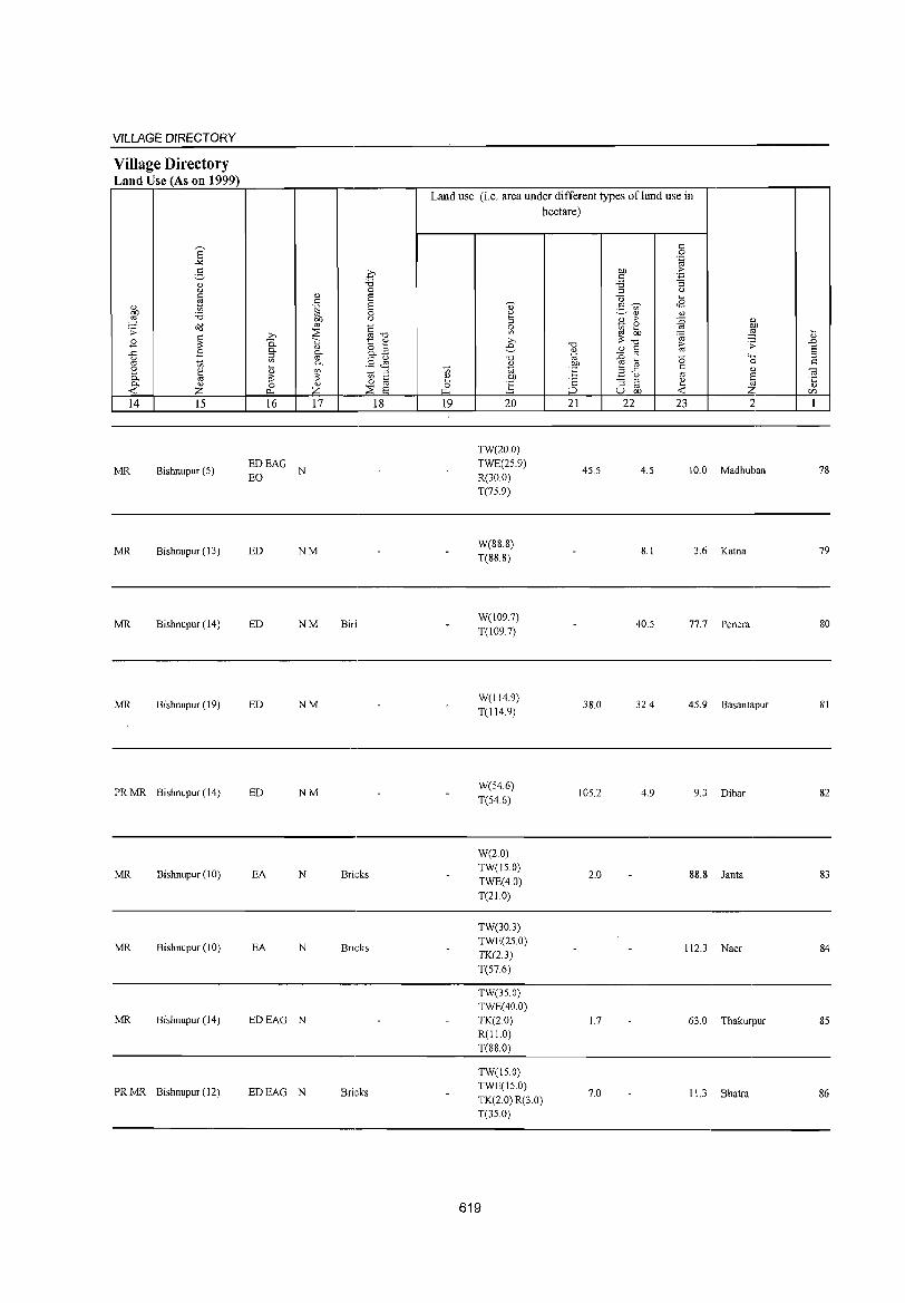
VILLAGE DIRECTORY
Village Directory Land Use (As on 1999)
E -" 3 0) u §
0) ti OJ) 'i3 ,g o(! '> ~ B
..c: B u
'" Ul
2 ~ <>< <>< 0)
<0:: Z 14 15
MR Bishnupur (5)
MR Bishnupur (13)
MR Bishnupur (14)
MR Bishnupur (19)
PRMR Bishnupur (14)
MR Bishnupur (10)
MR Bishnupur (10)
MR Bishnupur (14)
PRMR Bishnupur (12)
0)
" .~ OJ)
'" ;;.-, :::E 0.. >:; <><
0)
'" <>< Ul '" <>< ~ Q)
~ :;; 0 0)
""' z 16 17
EDEAG N EO
ED NM
ED NM
ED NM
ED NM
EA N
EA N
EDEAG N
EDEAG N
.£ "d 0 S S 0 u
§-o t:: 0)
8.2 §J1 ti '" § 0
:::E E 18
Biri
Brkks
Bricks
Bricks
Land use (i.e. area under different types of land use in hectare)
19 20
TW(20.0)
TWE(25.9) R(30.0)
T(75.9)
W(88.8) T(88.8)
W(l09.7)
T(1097)
W(114.9) T(114.9)
W(54.6)
T(54.6)
W(2.0) TW(IS.O)
TWE(4.0) T(2LO)
TW(30J) TWE(25.0) TK(2.3) T(57.6)
TW(3S.0) TWE(40.0) TK(20) R(ILO) T(88.0)
TW(IS.O) TWE(15.0) TK(2.0) R(3.0) T(35.0)
619
"d 0)
'i<i OJ)
"E ;::
;_:, 21
45.5
38.0
105.2
2.0
1.7
7.0
.:: 0
"E OJ) .::: .:: -3 'i3 '" u
U ~
3 ~ <B Ul 0) 0)
B ,.
~ 0)
~ OJ)
~ ,g :;; .(; -0 ,. '> 0) " '" ::0 oj
(5 "-'" til 0
.3 ..c: .:: " u '" E :J 8 ~ ~ u OJ) <0::
22 23 2
4.5 10.0 Madhuban
8.1 3.6 Katna
40.5 77.7 Pen era
32.4 45.9 Basantapur
4.9 9.3 Dihar
88.8 Janta
112.3 Naer
63.0 Thakurpur
11.3 Bhatra
dl .D E '" .::
OJ .~
rFJ
1
78
79
80
81
82
83
84
85
86
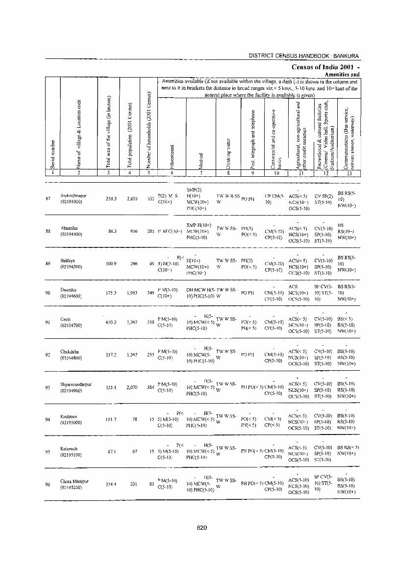
DISTRICT CENSUS HANDBOOK: BANKURA
Census of India 2001 _
Amenities and Amenities available (if not available within the village, a dash (-) is shown in the column and next to it in brackets the distance in broad ranges viz. < 5 krns., 5-10 kms. and 10+ krns of the - nearest place where the facility is available is given ~ '"
<1) 0) ~
~ '" "'" ~ E~ '0 ';/;' <1) 0 U c u <1)
~ '" '.0 (.) 0) c ..c: - <I) 0)
] 0 2-0 '" .2: - en U
.~ U 0 0 e '<3 1:: 'E ~ c:!- ..<: ~ 8.. u
~ - 0- <1) '3 '" ~ 0 0 '" <1) 0. U OlCll ~ ~ ..-l 0 '0 '3 0 .~ ~ 3d'S '0 ::> " dd .;;: c:!- ..c '0 b 6 .~ ~ .B .=: Ctl1ij
'" c <1) c u ';';l: '" '" co '0 u 0 ...
~ -B 0 ::> ... § o .-
dd -1:dl c " .... .~ 0 ~
..c: c 15 o c <1) "" fir .D 0 ..c '" Ol;;"g 'z 0 .;;: '3 ...... Ol Ol ~ .~
'" ._ § '" 0- 0 C
;l: bD T~ c ..; '2 ~ "" ~ 0 .... 0 OJ) 0) ::>'0 .9 OJ E c 0
'" 0- <1) .~ '" c '3 <1) .:=: ~ ::> >,
'" ., .D u S2 E '"
::> u 1i! E ::I E ~ '5 E ~ l a <) ;;:; c E"" .g ;-; b .5 :g ::l '" g"" _Z_ ;::l '0 <1)
is o ~ OJ)"<: CIl f- Z "-1 :::s 0 « -0 ~ ~U) U ~ 0.. U..o 1 2 3 4 5 6 7 8 9 10 11 12 13
SMP(2) BS RS(5-
87 Joykrisbnapur
258.3 2,655 533 P(2) M S H(IO+) TW W R SSpOPH CPCM(S- ACS«S) CV SP(2)
10) (02194300) C(IO+) MCW(10+) W 10) NCS(lO+) ST(5-1O) PHC(lO+) OCS(5-10)
NW(IO+)
Abantika RMP H(IO+)
TWWSS- PH(3) ACS« S) CV(S-IO) BS
88 86.3 956 20S P MqlO+) MCW(IO+) CM(S-IO) RS(IO+) (02194400)
PHq5-10) W PO«5)
CP(5-IO) NCS(IO+) SP(S-10)
NW(IO+) OCS(5-10) ST(5-IO)
Belthya - P« -
TWWSS- PH(2) ACS« 5) CV(S.IO) BSRS(5-
89 100.9 296 69 ")MC 10) H(10+) CM(S-IO) 10) (02194S00) -' ~- MCW(IO+) W PO« 5) NCS(IO+) SP(S-lO)
C(10+) PHqlO+) CP(5-10) OCS(S-IO) ST(S-IO)
NW(IO+)
Dwarika PM(S .. lO) DH MCW H(5- TW W SS-ACS SP CV(S. BS RS(5-
90 17S.3 1,963 349 POPH CM(S-IO) NCS(IO+) 10) ST(S- 10) (02194600) C(10+) 10) PHC(5-IO) W
CP(5-10) OCS(5-10) 10) NW(IO+)
Deuli PM(5-10) - H(S-
ACS« 5) CV(5-10) BS« 5) 91 410.2 1,367 258 10) MCW« 5) TW W SS- PO«5) CM(5-IO)
(02194700) C(S-10) PHC(5-10) W PH« 5) CP(5-IO)
NCS(10+) SP(5-10) RS(5-10)
OCS(5-10) ST(5-10) NW(10+)
Chakdaha P M(5-10) - H(S-
ACS«S) eV(5-10) BS(5-10) 92 137.2 1,367 2S5 10) MCW(S- TW W SS- PO PH CM(5-IO)
(02194800) C(5-10) 10) PHC(5-10) W CP(5-1O)
NCS(lO+) SP(S-10) RS(S-IO)
OCS(5-10) ST(S-10) NW(10+)
Shyamsundarpur PM(S-lO) - H(S-
ACS« 5) CV(5-10) BS(5-10) 93 135.4 2,070 364 10) MCW«5) TWWSS- PH PO« 5) CM(5-IO)
(02194900) C(5-10) PHC(S-10) W CP(S-IO)
NCS(10+) SP(S.IO) RS(5-IO)
OCS(S-10) ST(S-IO) NW(10+)
Kushtara P« - H(S-
ACS«5) CV(5-10) BS(5-1O) 94
(02195000) 101.7 78 15 5) M(S-lO) 10) MCW« 5) TW W SS- PO« 5) CM«5)
NCS(lO+) SP(S-10) RS(5-10) C(5-10) PHC(5-1O) W PH« S) CP« 5)
OCS(S-10) ST(S-IO) NW(lO+)
P« - H(S-ACS«5) CV(S-IO) BS RS« 5) Kelemele
67 15 S)M(5-10) 10) MCW« S) :W W SS- PH PO« S) CM(S-IO) 95 67.1 NCS(IO+) SP(5-10) NW(IO+) (02195100) C(5-10) PHC(5-IO) CP(5-10) OCS(5-10) ST(S-10)
PM(5-10) - H(5-
ACS(S-IO) SP CV(5-
BS(S.IO) Chura Manipur JO)MCW(S- :WWSS- PH PO« S) CM(S-10) 10)ST(5. 96 134.4 331 6J C(S .. IO) NCS(5-10) RS(5-IO) (02195200) 10) PHC(S-lO) CP(5-1O) 10)
OCS(5-IO) NW(10+)
620
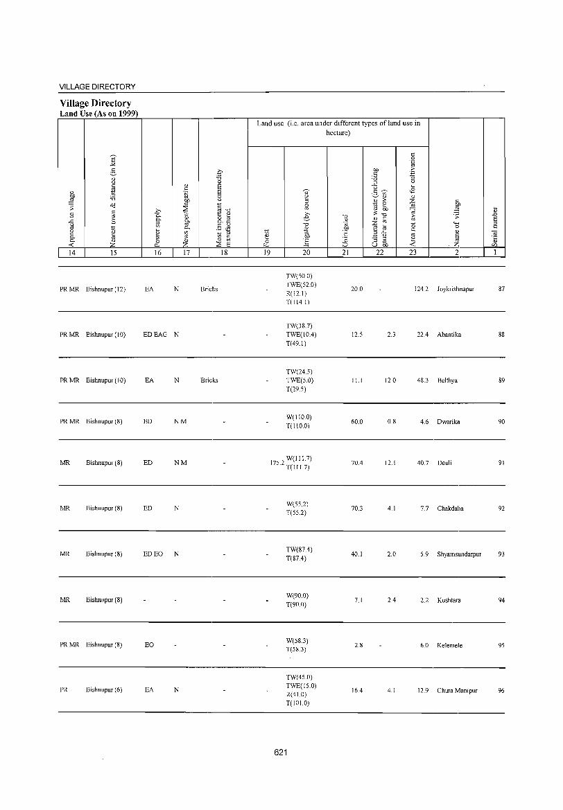
VILLAGE DIRECTORY
Village Directory Land Use (As on 1999)
E "" 3 " " fa
" to ~ :a
o<J .;;: .8 ~ ..<: .8 u os to 2 ~ 0-0- " ..0:: Z 14 15
PRMR Bishnupur (12)
PRMR Bishnupur (10)
PRMR Bishnupur (10)
PRMR Bishnupur (8)
MR Bishnupur (8)
MR Bishnupur (8)
MR Bishnupur (8)
MR Bishnupur (8)
PRMR Bishnupur (8)
PR Bishnupur (6)
c :a 0
" 8 " .~ 8
0
~ " ~"d :;;: .b >:::; t " 0- <1) ~B 0- §-~ .S JS 0-
~ ~ ~ ::;
'" " 0 " o OJ 0... Z :;;: 8 16 17 18
EA N Bricks
EDEAG N
EA N Bricks
ED NM
ED NM
ED N
ED EO N
EO
EA N
Land use (i.e. area under different types of land use in
~
'" ~ c ~
19
~
" ~ 0
'" >, e -0
" '" OJ)
] 20
TW(50.0) TWE(52.0) R(12.1) T(114.1)
TW(38.7) TWE(lO.4) T(49.1)
TW(24.5) TWE(5.0) T(29.5)
W(llO.O) T(IIO.O)
W(lI1.7) 175.2 T(I I 1.7)
W(55.2) T(552)
TW(87.4) T(87.4)
W(90.0)
T(90.0)
W(58.3) T(58.3)
TW(45.0) TWE(150) R(41.0) T(101.0)
621
hectare)
"0
" '" Oil
E ·2 ::J 21
20.0
12.5
11.1
60.0
70.4
70.3
40.1
7.1
2.8
16.4
" 0 .~
OJ) >
" ~ :a ::; " u ~
<8 2- ~ '" " " " > ~ " to 2 OJ) OJ OJ) ~ ::§ 3=-0 <1) § 1; .;;:
:0 -0 ""' e ta 0
" " ;;>..<: OJ ~ " .~ "3 ;;>
~ OJ U OJ)
22 23 2
124.2 Joykrishnapur
2.3 22.4 Abantika
12.0 48.3 Belthya
0.8 4.6 Dwarika
12.1 40.7 Deu1i
4.1 7.7 Chakdaha
2.0 5.9 Shyamsundarpur
2.4 2.2 Kushtara
6.0 Ke1emele
4.1 12.9 Chura Manipur
.... " .D 8 ;;> s::
'" "5 CZ>
1
87
88
89
90
91
93
94
95
96
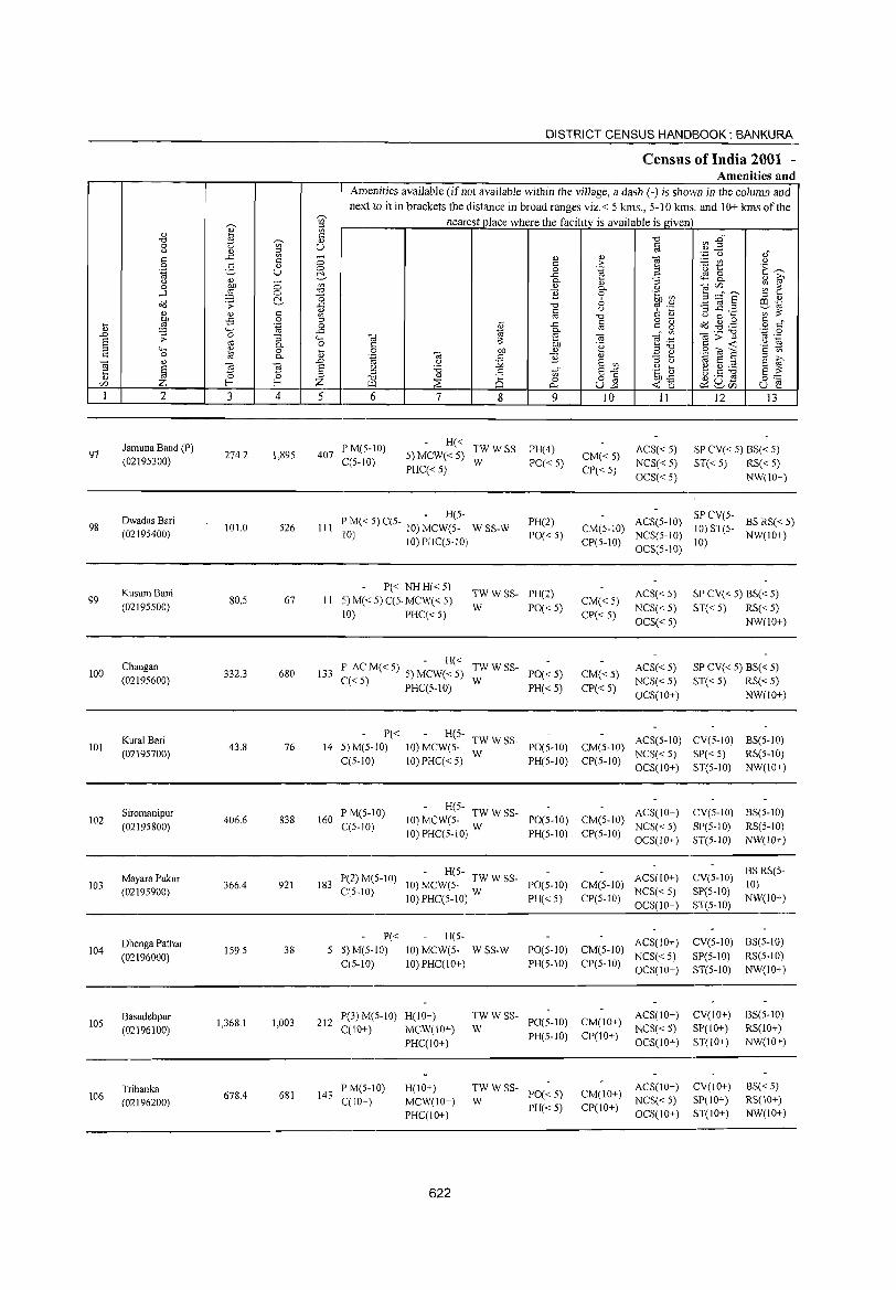
DISTRICT CENSUS HANDBOOK: BANKURA
Census of India 2001 -Amenities and
Amenities available (if not available within the village, a dash (-) is shown in the column and next to it in brackets the distance in broad ranges viz. < 5 kms., 5-10 kms. and 10+ kms of the
~
nearest place where the facility is available is given ~ en ;::I
" " en ti; C
§ ~ :@~ "d ~ " 0 t) en U Q " ;::I ',C u of
C ..0: '" - " " <d s:: 0 s:: >- - '" " 0 2- " 0 0 .~ .3 ·u t E~ .~ u ~ ..c tS 2- " ~ Q <1l 0 0-" :;
0 OJ) '" " 0- () -.;<Zl ~ ~ -1 ,g 0 "d ] 0 .~ Ul 5 =="6 2!- -0 6 :l " o<:! .~ ..c "tj td .~ ~ ~.::! ~~
c <1l C (j C: d) '" ~ j .s 0 ~ '" "tj o ._ (j 0 .... s:: , .... 'ta 0 il ..c c r:: g o<:! .g .g o s:: " '-H ..c ~ 0- '" ._ "d ''';:; 0
.L ~ 0 :; '-H <d e -.; - en ]>~ '" ._
E! cO 0- 0 C ~ bJ) .~ ~~ .~ ~ ;::I '0 " 0 il 0 01) " Z " ~<OE s:: '" c a 0- .~ -.; r:: ] " "'S tl ., E! ;::I g ~ -.; '" Cd ~
.D (j j2 E '" ~ § <.> 'i3 .~ ~ e g ~ ~~ '5 0 :l .§ en E-'"
"d ;:8 0 o § BD..c () ._ .s <Zl z f-< f-< Z ~ (:)
""' u-'" -< (5 ~ 8C1l u e I 2 3 4 5 6 7 8 9 10 11 12 13
Jamuna Band (P) P M(S-IO) H« TWWSS- PH(4) ACS«5) SP CV« 5) BS« 5) 97 274.2 1,895 407 5) MCW«5) CM«5) (02195300) C(5-10) W PO«5) NCS« 5) ST« 5) RS« 5)
PHC« 5) CP« 5) OCS« 5) NW(IO+)
DwadasBari - H(5-
PH(2) ACS(5-10) SP CV(5-
BS RS« 5) 98 101.0 S26 III 1'
oM«S)C(5- 10)MCW(S_ WSS-W CM(S-IO) 10) ST(5-
(02195400) II ) 10)PHC(5-10) PO« 5)
CP(5-IO) NCS(5-10)
10) NW(IO+)
OCS(5-10)
Kusum Bani 1'« NHH«5)
TWWSS- PH(2) ACS« S) SP CV« S) BS« 5) 99 80.5 67 II 5) M« 5) C(5. MCW« 5) CM«5)
(02195500) 10) PHC« S)
W PO«5) CP« 5)
NCS«5) ST«5) RS« 5) OCS«5) NW(IO+)
Chaugan - H«
TWWSS- ACS« 5) SP CV« 5) BS« 5) 100 332.3 680 133 po ACM«5) 5)MCW«5) PO«5) CM«5)
(02195600) C« 5) PHC(5-10) W
PH« 5) CP« 5) NCS«5) ST« 5) RS« 5) OCS(IO+) NW(IO+)
Kural Bari P« H(5-
TWWSS- ACS(5-1O) CV(5-10) BS(5-10) 101 43.8 76 14 5) M(5-1O) 10) MCW(5- PO(5-1O) CM(5-1O)
(02195700) W NCS« 5) SP« 5) RS(S-IO) C(5-1O) IO)PHC« 5) PH(5-IO) CP(5-10)
OCS(IO+) ST(5-10) NW(IO+)
Siromanipur 1'M(5-1O) - H(5-
ACS(IO+) CV(5-10) BS(5-10) 102 406.6 838 160 10) MCW(5- TW W SS- PO(5-IO) CM(5-IO)
(02195800) C(5-10) 10) PHC(5-1O) W PH(5-10) CP(5-10)
NCS« 5) SP(5-10) RS(S-IO)
OCS(10+) ST(5-1O) NW(IO+)
Mayara Pukur P(2)M(5-10) - H(S-
ACS(IO+) CV(5-1O) BSRS(5-
103 366.4 921 183 10) MCW(5- TW W SS- 1'0(5-10) CM(5-10) 10) (02195900) C(5-10)
10) PHC(5-1O) W PH«5) CP(5-10) NCS« S) SP(5-10)
NW(IO+) OCS(lO+) ST(5-1O)
Dhenga PatbaT P« H(S-
ACS(IO+) eV(5-10) BS(5-10) 104
(02196000) 159.5 38 5 5) M(5-10) 10) MCW(5- WSS-W PO(5-1O) CM(5-10)
NCS«5) :51'(5-10) RS(5-1O) C(5-1O) 10) PHC(IO+) PH(S-IO) CP(5-10)
OCS(IO+) ST(5-10) NW(IO+)
Basudebpur 1,368.1 1,003 212
P(3) M(5-IO) H(10+) TWWSS-PO(5-10) CM(IO+)
ACS(IO+) CV(IO+) BS(5-1O) 105
(02196100) C(IO+) MCW(lO+) W NCS« 5) 8P(10+) RS(IO+)
PHC(10+) PH(S-IO) CP(10+)
OCS(10+) ST(IO+) NW(IO+)
Tribanka 678.4 681 143
P ]11(5-10) H(10+) TWWSS-1'0« 5) CM(lO+)
ACS(IO+) CV(lO+) BS«S) 106 C(10+) MCW(IO+) W NCS« 5) SP(IO+) RS(IO+) (02196200) PH«5) C1'(IO+)
PHC(lO+) OCS(IO+) ST(IO+) NW(IO+)
622
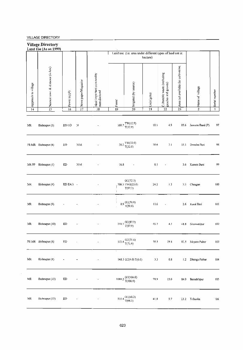
VILLAGE DIRECTORY
Village Directory Land Use (As on 1999)
MR Bishnupur (3)
PR MR Bishnupur (4)
MR FP Bishnupur (I)
MR Bishnupur (4)
MR Bishnupur (9)
MR Bishnupur (10)
PR MR Bishnupur (8)
MR Bishnupur (S)
MR Bishnupur (13)
MR Bishnupur (13)
ED EO N
ED NM
ED NM
EDEAG -
ED
ED
ED
ED
Land use (i.e. area under different types of land use in hectare)
TW(l2.9) 160.7 T(12.9)
20 2 TW(32.0) · T(32.0)
76.8
GC(72.3)
: 206.3 TWE(25.0) T(97.3)
89 GC(20.8) · T(20.8)
GC(87.9) 219.7 T(87.9)
123 4 GC(71.6) · T(71.6)
14S.1 GC(6.0) T(6 0)
IOS42 GC(106.0) · T(106.0)
5354 GC(68.3) · T(6S.3)
623
10.1
30.6
0.1
24.2
11.6
45.7
70.5
3.3
7S.9
41.8
4.9 85.6 Jamuna Band (P)
3. J 15. I Dwadas Bari
3.6 Kusum Bani
1.3 3.3 Chaugan
2.6 Kural Bari
4.5 48.8 Siromanipur
19.4 81.5 Mayara Pukur
0.8 1.2 Dhenga Pathar
15.0 84.0 Basudehpur
9.7 23.2 Trihanka
97
98
99
100
101
102
103
104
105
106
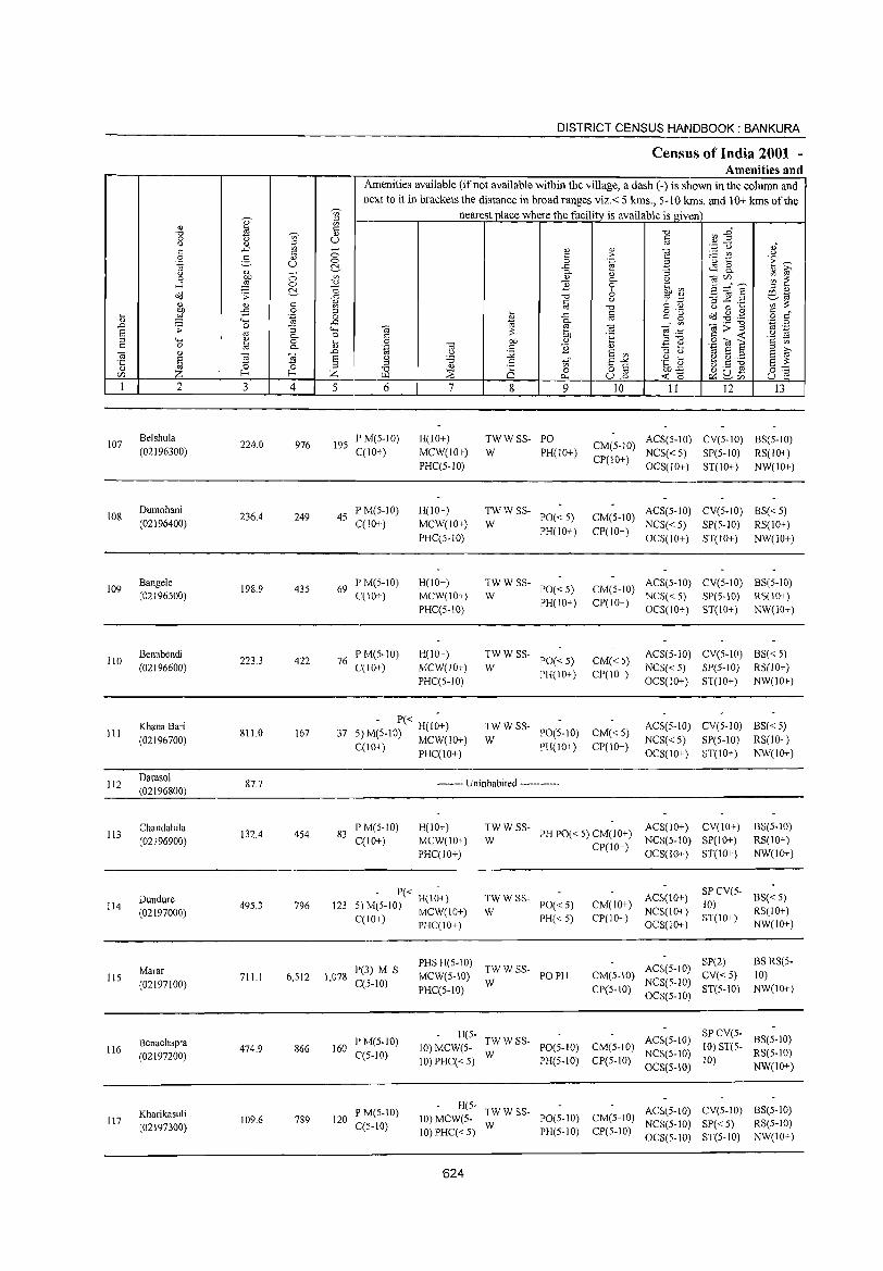
DISTRICT CENSUS HANDBOOK: BANKURA
Census of India 2001 -Amenities and
Amenities available (if not available within the village, a dash (-) is shown in the column and
next to it in brackets the distance in broad ranges viz.< 5 krns., 5-10 kms. and 10+ kms of the
OJ ~ nearest place where the facili!)' is available is given '" " ~ <' -0 ~ En -0 ';;;' <l)
0 <.> U § " <l) :;l ,; "
..c: '" - <!.) <!.) al ·z u
" 0 C ;> :..= tn u 0 g <!.) B 'u 1:: E~ .~ U 0 0 'g c:!- .c ~ 8- " i;' U <!.) - 0-
" :; 0 OJ) 0 V> " 0- <.) alr/) ;;; 2: ..J ~ 0 -0 ~ 0 .~ ~ ~ =::" E c:!- O 6 :;l " o(l .;; ..c: -0 oj .- S .2 .~ COd
" <' <l) " <.> C: ';) ';:;':;:: <!) '" '" -0 U 0 k
k ~ -£i 0 ;::l
f .c " g 'g o(l -8 .~ § ,,' .~ 0
" 4-< ..c: 0- '" '';:' 0 '" ._ "0
.D .;; 0 :; <;..; '" ~ al "§:g ]>~ oj ._
S '" u ~
0- 0 " 'g '§ ~ ;::l "" " 0 i3 0 OJ) <!) .a " .S:: til E c 0 8 0- .~ al c ] "3 ti d E al " .n (.) :.g E '" E i;'
l ] ~ E " '6 c 'in' E~ " k ~ ~ ~ E :;:: ·c .g '5; .s Q) 0 ;::l <!) ·c 0 o '" C) ._ til
0:::: <Zl f-< f-< Z ~ ~ 0 0.. U.D <C 0 ~U- U e ~<Zl
1 2 3 4 5 6 7 8 9 10 11 12 I3
107 Belshula
224.0 976 195 PM(5-IO) H(lO+) TWWSS- PO ACS(5-lO) CV(5-1O) BS(5-1O)
(02196300) C(10+) MCW(lO+) W PH(IO+) CM(5-10)
NCS«5) SP(5-1O) RS(10+) PHC(5-1O)
CP(10+) OCS(10+) ST(10+) NW(10+)
108 Dumohani
236.4 249 45 IP M(S-IO) H(10+) TWWSS-
1'0« 5) CM(5-1O) ACS(5-10) CV(5-10) BS« 5)
(02196400) C(10+) MCW(IO+) W NCS«5) SP(5-1O) RS(IO+) PHC(5-1O)
PH(10+) CP(10+) OCS(1O+) ST(IO+) NW(10+)
109 Bangele
198.9 435 69 PM(5-IO) H(IO+) TWWSS-
1'0« 5) CM(5-IO) ACS(5-10) CV(5-10) BS(5-10)
(02196500) C(IO+) MCW(IO+) W PH(IO+) CP(IO+)
NCS«5) SP(5-10) RS(IO+) PHC(S-IO) OCS(IO+) ST(IO+) NW(IO+)
110 Benabendi
223.3 422 76 PM(5-1O) H(lO+) TWWSS-
1'0«5) CM«5) ACS(S-IO) CV(5-1O) BS« 5)
(02196600) C(JO+} MCW(IO+} W NCS«5) SP(5-10) RS(IO+) PHC(5-10)
PH(IO+) CP(IO+) OCS(IO+) ST(lO+) NW(IO+)
111 KhanaBari
811.0 167 37 - P« H(I~+) TWWSS-
1'0(5-10) CM«S) ACS(5-1O) CV(5-1O) BS« 5)
(02196700) 5} M(5-IO) MCW(10+) W NCS« 5) SP(5-1O) RS(IO+) C(1O+) PHC(lO+) PH(IO+) CP(lO+)
OCS(IO+) ST(IO+) NW(IO+)
112 Darasol (02196800)
87.7 -------. Uninhabited ------------
113 Chandabila
132.4 454 83 PM(5-10) H(10+) TWWSS-
PH 1'0« 5) CM(lO+) ACS(IO+) CV(10+) BS(5-10)
(02196900) C(IO+) MCW(IO+) W CP(IO+)
NCS(5-10) 3P(10+) RS(IO+)
PHC(IO+) OCS(IO+) ST(lO+) NW(IO+)
Dundure - P« H(I~+) TWWSS- ACS(10+) SP CV(5-
BS« 5) 114
(02197000) 49S.3 796 123 5) M(S-10) MCW(IO+) W
PO« 5) CM(10+) NCS(lO+)
1[0) RS(10+)
C(IO+) PHC(lO+) PH« 5) CP(10+) OCS(IO+)
ST(10+) NW(IO+)
P(3) M S PHSH(S-IO)
TWWSS- ACS(5-10) 81'(2) BS RS(5-
liS Marar
711.1 6,512 1,078 MCW(S-IO) PO PH CM(5-10) CV« S) 10) (02197100) C(S·10)
PHC(5-10) W
CP(S-IO) NCS(5-10)
ST(S-IO) NW(IO+) OCS(5-10)
PM(5-1O) H(S-
TWWSS- ACS(5-1O) SPCV(S-
BS(5-10) Benachapra 160 10) MCW(5- PO(5-1O) CM(5-10) 10) ST(5-116
(02197200) 474.9 866
C(5-10) W NCS(5-10) RS(5-10) IO)PHC« 5) PH(5-1O) CP(5-1O)
OCS(5-10) 10)
NW(IO+)
Kharikasuli PM(5-10) H(5-
TWWSS- ACS(5-10) CV(5-1O) BS(5-1O) 117 109.6 789 120
C(5-10) 10) MCW(S-
W PO(S-IO) CM(5-IO)
NCS(5-10) SP« 5) RS(5-1O) (02197300) 10) PHC« 5) PH(5-10) CP(5-10) OCS(5-10) ST(5-10) NW(IO+)
624
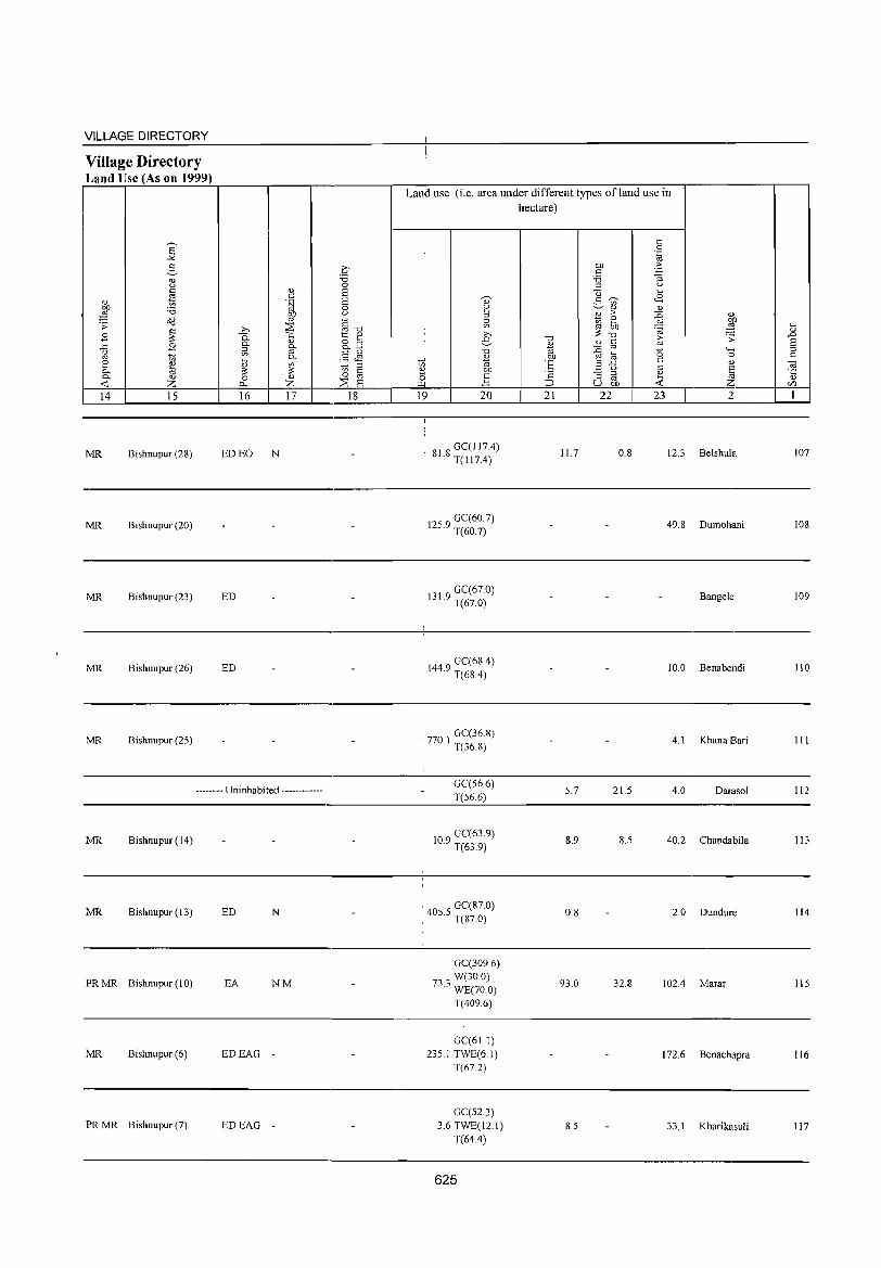
VILLAGE DIRECTORY
Village Directory Land Use (As on 1999)
E -'< <:: :.::-<!) () <::
tJl <U bJ)
'i3 ::§ 0i3 .;;: ~ B
.<: 2 u '" [ ~
'" 0- <!)
...: Z 14 15
MR Bishnupur (28)
MR Bishnupur (20)
MR Bishnupur (23)
MR Bishnupur (26)
MR Bishnupur (25)
<U c .~ bJ)
'" ~ >, 0.. <U 0-
~ 0-
'" 0-~ '" ;:: ;:: 0 <U
p.. Z 16 17
ED EO N
ED
ED
-------- Uninhabited ------------
MR Bishnupur (14)
MR Bishnupur (13) ED N
PRMR Bishnupur (10) EA NM
MR Bishnupur (6) EDEAG -
PRMR Bishnupur (7) EDEAG -
;§ 0 is is 0 t.>
§-o t:: <lJ .... o ;::l O-~
.5 J2 to ;::l
'" 0 ro ::;;: is
18
Land use (i.e. area under different types ofland use in
!
... '" 1:l 0 ~
19
~ <U
~ ~ >,
:S -0
<L>
"' Ol)
~ 20
81 8 GC(] ] 7.4) · T(117.4)
GC(60.7) 125.9 T(60.7)
131 9 GC(67.0) · T(67.0)
1449 GC(68.4) · T(68.4)
GC(36.8)
• 770.1 T(36 8)
GC(56.6) T(56.6)
109 GC(63.9) · T(63.9)
· 405 5 GC(87.0) · . T(87.0)
GC(309.6)
73 0 W(30.0) .0 WE(70.0)
T(409.6)
GC(61.1)
235.1 TWE(6.1) T(67.2)
GC(52.3) 3.6 TWE(12.1)
T(64.4)
625
hectare)
-0
%j OJ)
E t:
:J 21
11.7
5.7
8.9
0.8
93.0
8.5
'" 0 .~
bJ) ·s t:: 'i3 ::; ;::l u
"0 .... g ~ <8
'" <1) <1)
B > {i <L>
~ ~ ~ ~ ;:: -0 (; .:;: <U t::
=§ '" 0 '-til 0
.r: t:: <U 3 '" u is ::; ;::l e ro ~ U bJ) ...: 22 23 2
0.8 12.3 Belshula
49.8 Dumohani
Bangele
10.0 Benabendi
4.1 Khana Bari
21.5 4.0 Darasol
8.5 40.2 Chandabila
2.0 Dundure
32.8 102.4 Marar
172.6 Benachapra
33.1 Kharikasuli
.... <lJ
.D is ;::l t::
~ <lJ
C/l
1
107
108
109
110
III
112
113
114
115
116
117
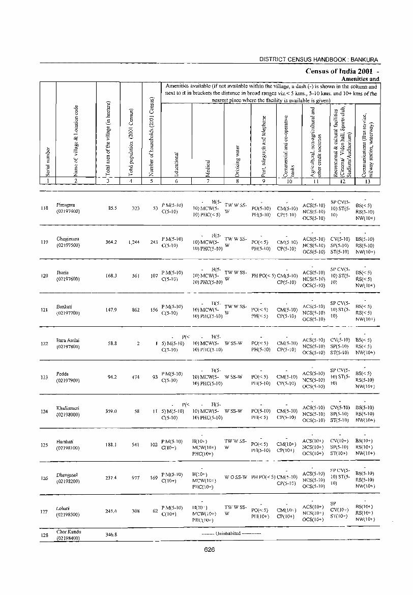
118
119
120
121
122
123
124
125
126
127
128
2
Pirragara (02197400)
Ghugimura (02197500)
Jharia (02197600)
Bankati (02197700)
BaraAmlai (02197800)
Pedda (02197900)
Khuliamuri (02198000)
Harabati (02198100)
DhengasoJ (02198200)
Lohari (02198300)
ChorKundu (02198400)
3 4
85.5 323
364.2 1,244
168.3 561
147.9 862
58.8 2
94.2 474
359.0 58
188.1 541
237.4 971
245.4 308
346.8
DISTRICT CENSUS HANDBOOK: BANKURA
Census of India 2001 -Amenities and
Amenities available (ifnot available within the village, a dash (-) is shown in the colunm and next to it in brackets the distance in broad ranges viz.< 5 kms., 5-10 kms. and 10+ kms of the
nearest place where the facility is available is given
5 6
53 P M(5-W) C(5-l0)
243 P M(5-1O) C(5-10)
107 if'M(S-IO) C(5-10)
156 P M(5-10) C(5-10)
P« 1 5)M(5-10)
C(5-10)
93 P M(5-1O) C(5-10)
P« I I 5) M(5-IO)
C(5-IO)
102 PM(5-10) C(lO+)
169 PM(5-10) C(IO+)
62 PM(5-10) C(IO+)
7 8
to o
0...
9
H(5- TW W SS-10) MCW(5- W PO(5-10) 10) PHC« 5) PH(5-10)
- H(5-10) MCW(5- TW W SS- PO« 5)
10) PRC(S-IO) W PH(5-10)
10
CM(5-IO) CP(5-10)
II 12
SPCV(5-ACS(5-IO) 10) ST(5-NCS(5-1O) 10) OCS(5-10)
l3
BS« 5) RS(5-1O) NW(\O+)
CM(5-1O) ACS(5-1O) CV(5-1O) BS(5-10) CP(5-lO) NCS(5-1O) SP(S-IO) RS(5-1O)
OCS(5-1O) ST(S-IO) NW(IO+)
- R(S-10) MCW(5- TW W SS- PH PO« 5) CM(S-IO) ACS(5-1O) 10) PHC(5-1O) W CP(5-10) NCS(S-IO)
OCS(S-IO)
SPCV(5-10) ST(5- BS« 5)
RS« 5) 10) NW(IO+)
- R(5-10) MCW(5- TW W SS- PO« 5)
10)PHC(5-10) W PH«5)
CM(5-10) ACS(5-1O) CP(S-IO) NCS(5-1O)
OeS(5-10)
SP CV(5-10) ST(5- BS« 5)
RS«5)
H(5-10) MCW(5- WSS-W 10)PHC(5-10)
H(5-10) MCW(5- W SS-W 10) PHC(5-10)
H(5-10) MCW(5- W SS-W 10) PHC(5-10)
\0) NW(IO+)
PO«5) PH(5-1O)
ACS(5-10) CV(5-10) BS« 5) CM(5-1O) NCS(5-10) SP(5-10) RS« 5) CP(5-10) OCS(5-1O) ST(5-10) NW(IO+)
PO« 5) CM(5-1O) ACS(5-10)
PR(5-10) CP(5-10) NCS(5-1O) OCS(5-1O)
SP CV(S- BS« 5) 10) 81'(5- RS(5-1O)
10) NW(10+)
ACS(S-IO) eV(S-IO) BS(5-10) PO(S-IO) CM(5-1O) NCS(5-1O) SP(5-10) RS(5-10) PH« 5) CP(5-1O) OCS(5-10) ST(5-10) NW(10+)
H(lO+) MCW(IO+) PHC(lO+)
TW W SS- ACS(IO+) W PO« 5) CM(IO+) NCS(lO+)
CV(10+) SP(5-10) ST(lO+)
BS(10+) RS(lO+) NW(10+)
H(lO+) MCW(IO+) PHC(lO+)
H(lO+) MCW(IO+) PHC(IO+)
PH(5-10) CP(IO+) OCS(lO+)
W 0 SS-W PH PO(.c 5) CM(5-1O) ACS(5-10) ~'~)~~«~- 8S(5-1O) NCS(S-lO) - RS(5-10)
TWWSS-W PO«5)
PH(IO+)
CP(5-10) OCS(5-10) 10) NW(IO+)
ACS(IO+) CM(1 0+) NCS(I 0+) CP(lO+) OCS(IO+)
SP CV(lO+) S1'(IO+)
BS(IO+) RS(IO+) NW(JO+)
-------- Uni nhabited ------------
626

VILLAGE DIRECTORY
Village Directory Land Use (As on 1999)
E "'" 2-" (J c '" " 1;;
bJJ :.a ,g oil . ;;: ~ B
g B ~
2 e 0. '" 0. " -0:: Z 14 15
MR Bishnupur (8)
MR Bishnupur (7)
MR Bishnupur (4)
MR Bishnupur (4)
MR B ishnupur (4)
MR Bishnupur (6)
MR Bishnupur (S)
MR Bishnupur (13)
MR Bishnupur (10)
MR Bishnupur (12)
Q)
<::: '[;j bO
'" ~ ,..,
0.. Q)
§' ~ on 0.
~ '" '" 0 z I'l-<
16 17
ED N
ED N
ED N
ED N
ED N
ED EO N
ED N
-------- Uninhabited ------------
.£'
.", 0 S S 0 (J
§ .", t:: Q)
&E §~ ~ " 0 § ::E s
18
Land use (i.e. area under different types ofland use in
~
'" 2 " 0 on ,.., e .",
Q)
~ "t;5 e bJJ 0 ] ~
19 20
33 6 GC(32. I) · T(32.1)
GC(lnl) IS1.3 TW(IO.0)
T(137.1)
GC(50.6) 48.6 TW(30.0)
T(SO.6)
992 GC(26.2) · T(26.2)
GC(16.0) TW(15.0) T(3I.O)
6 I GC(3S.5) · T(38.5)
GC(22.3) 297.9 TW(2I.5)
T(43.8)
1047 GC(80.5) · T(80.5)
1493 GC(44.4) · T(44.4)
862 GC(139.0) · T(1390)
323 GC(IO.0) · T(IO.0)
627
hectare)
.", Q)
"t;5
'E 'a ~
21
8.3
36.7
10.2
25.7
42.5
2.1
35.9
10.0
106.4
<::: 0 ',g
bO .~ c '3 :.a ::l (J
u ... ~ <B g '" " Q)
.!B 6 :g Q)
:W on ...
~; ~ ~ § i;; .;;:
~ a '0 """ 0 c Q)
.a~ '" -= @ e ~ U bJJ -0:: 22 23 2
6.9 4.6 Pirragara
9.4 36.4 Ghugimura
0.1 2.4 Jharia
12.3 Bankati
2.2 Bara Amlai
2.0 5.2 Pedda
5.3 10.1 Khuliamuri
3.0 Harabati
2.2 5.6 Dhengasol
10.2 Lohari
140.0 58.0 Chor Kundu
... '" .D S " c ] " CI)
I
lIS
119
120
121
122
123
124
125
126
127
128
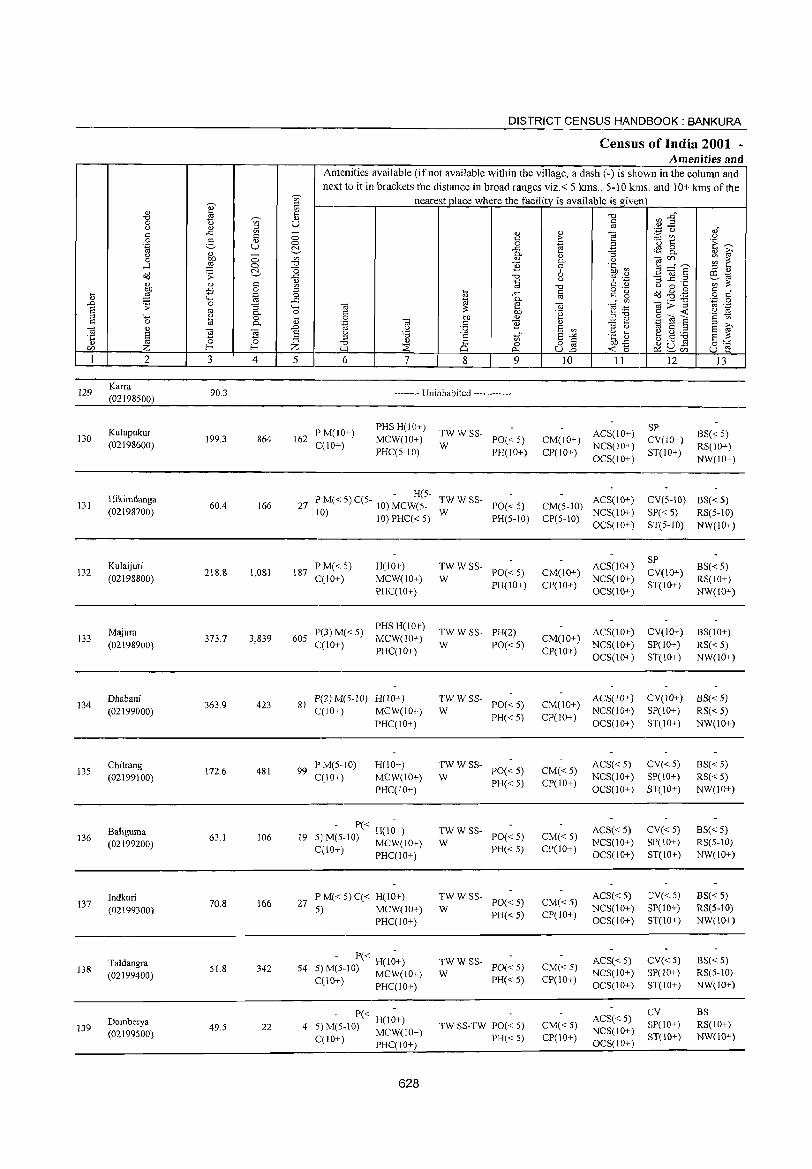
DISTRICT CENSUS HANDBOOK: BANKURA
Census of India 2001 -Amenities and
Amenities available (ifnot available within the village, a dash (-) is shown in the column and
next to it in brackets the distance in broad ranges viz.< 5 kms., 5-10 kms. and 10+ kms of the --;, nearest place where the facility is available is given
~ :::l
'" ~ .", en .DO "0 --;, '" 0 t; U c .~ ~ <.> '" 5l " .f c: ..c - (]) '" ""§ '" 0 c > :..::: V'l .9 0 5 '" '0 1:: '-§ U 0 0 .~ 3 [:;~
~ ..c ~ 8- : f " '" - 0-" "'5
0 ~ 0 V> '" 0. .~ ta'" ....l 0 "0 '2 0 3 ="S ~ "0 6 6b~ :::l " cl<l .;;: ..c .", 9 .~ '3 ~.~ P:J1<;
" '" " '7:::;: 1ili " '" '" '" .", '" " 00'" -£i 0 :::l o .- ad .g . .g c: °
il ,g .~ 0 j ..c '" c g o C "-< 0- " ..0 0 ..c Ul
._ "U .~ 0
'> "'5 '- "' e "' "'§ ::: g>~ " .-S " 0- 0 C 01) '2 .~ :§ ;j "-' ~ 0 i3 0 01) "
;j"U .S Cil S c '" c: 0 0- .~ "' s:: '2 " .:.::: ~
'" S '" E ~ :'§ '" .D .~ J2 S '" '" " § ~ 'El s u "0 C to" S ..:< u .... ~~:.a a :;: il ~
:::l :::s " is 82 .~£ ga.s "0 0 0:;::
r:/J Z f- Z >.a ::E ~ <C 0 P:::~CIl U e I 2 3 4 5 6 7 8 9 10 II 12 13
129 Karra
90.3 •. _ .. -•. Uninhabited ...• _.-....• (02198500)
Kufupukur PM(fO+) PHSH(IO+)
TWWSS- ACS(IO+) SP
BS« 5) 130 199.3 864 162 MCW(lO+) PO« 5) CM(IO+) CV(fO+) (02198600) C(IO+) W NCS(IO+) RS(IO+) PHC(S·IO) PH(IO+) CP(IO+)
OCS(10+) ST(IO+)
NW(W+)
Hikimdanga . H(5.
TWWSS· ACS(IO+) CV(5-IO) BS« 5) 131 60.4 166 27 P M« 5) C(5- 10) MCW(5. PO« 5) CM(5-10)
(02198700) 10) 10)PHC«5) W PH(5-10) CP(5-I0)
NCS(10+) SP« 5) RS(5-10) OCS(10+) ST(5-1O) NW(10+)
Kulaijuri P M« 5) H(10+) TWWSS· ACS(10+) SP
BS«5) 132 218.8 1,081 187 PO« 5) CM(IO+) CV(IO+)
(02198800) C(lO+) MCW(lO+) W PH(IO+) CP(IO+)
NCS(10+) ST(lO+)
RS(lO+) PHC(10+) OCS(10+) NW(IO+)
Majura P(3)M«S) PHS H(IO+)
TWWSS· PH(2) ACS(10+) CV(IO+) BS(IO+) 133
(02198900) 373.7 3,839 605
C(10+) MCW(10+)
W PO« 5) CM(IO+)
NCS(IO+) SP(IO+) RS«5) PHC(IO+) CP(IO+)
OCS(10+) ST(10+) NW(IO+)
134 Dhabani
363.9 423 81 P(2) M(S·JO) H(10+) TWWSS·
PO« 5) CM(10+) ACS(lO+) CV(JO+) BS« 5)
(02199000) C(IO+) MCW(lO+) W PH« 5) CP(IO+)
NCS(IO+) SP(IO+) RS«5) PHC(10+) OCS(10+) ST(10+) NW(IO+)
13S Chitrang
172.6 481 99 PM(S·IO) H(lO+) TWWSS·
PO«S) CM« 5) ACS« 5) CV« 5) BS«5)
(02199100) C(IO+) MCW(IO+) W PH« 5) CP(IO+)
NCS(10+) SP(IO+) RS«5) PHC(IO+) OCS(10+) ST(10+) NW(lO+)
Baliguma 19
. P« H(I~+) TWWSS· PO« 5) CM«5)
ACS« 5) CV« 5) BS« 5) 136
(02199200) 63.1 106 S) M(S·lO) MCW(lO+) W NCS(IO+) SP(lO+) RS(S.IO)
C(lO+) PHC(IO+) PH« 5) CP(IO+) OCS(IO+) ST(IO+) NW(lO+)
Indkuri 70.8 166 27
PM«5)C« H(IO+) TWWSS-PO« 5) CM« 5)
ACS«5) CV« 5) BS«5) 137
5) MCW(IO+) W NCS(lO+) SP(10+) RS(S·IO) (02199300) PH« 5) CP(JO+) PHC(lO+) OCS(IO+) ST(10+) NW(lO+)
Taldangra • P« H(l~+) TWWSS· PO« 5) CM«5)
ACS« 5) CV« 5) BS« 5) 138 S1.8 342 S4 5) M(5-1O) MCW(JO+) W NCS(IO+) SP(IO+) RS(S-10) (02199400) PH« 5) CP(IO+) C(10+) PHC(IO+) OCS(JO+) ST(lO+) NW(IO+)
- P« H(1~+) ACS« 5) CV BS
Domberya 4 TW SS· TW POe < 5) CM«5) SP(lO+) RS(IO+) 139 49.5 22 5) M(5-10) MCW(IO+) NCS(10+) (02199500) PH« 5) cpr 10+) 8T(10+) NW(10+) C(I 0+) PHC( 10+) OCS(IO+)
628

VILLAGE DIRECTORY
Village Directory Land Use (As on 1999)
8' ""'" e-'" <.)
~ " OJ) 'i3 ,g Od .;;: ~ .8
..t:: .8 <.) ro ~ 2 C1.)
0- R; 0- C1.)
-< Z 14 15
C1.) 0: .t;j gjl
~ .b 0-0-
C1.)
::l §-en 0-~ ~ ;: 0 <l.)
0.. Z 16 17
-------- Uninhabited ------------
MR Bishnupur (12) ED
MR Bishnupur (5)
MR Bishnupur (11) ED
MR Bishnupur (10) ED N
MR Bishnupur (10)
MR Bishnupur (10)
MR Bishnupur (l 0)
MR Bishnupur (10)
MR Bishnupur (10)
PR Bishnupur (10) ED
.£' ""Ci 0 S S 0 <.)
§""Ci 1:: '" 8.El .§ ~ ~ ::l
.~ til S
18
Land use (i.e. area under different types of land use in hectare)
~ :': 0
'"'" 19
0> 2 ::l 0 en
€ ""Ci
" 1i> on ] 20
GC(8.0) T(8.0)
83 8 GC(39.0) · T(39.0)
08 GC(162) · T(16.2)
28 GC(72.9) · T(72.9)
GC(152.1) TW(14.0) TK(15.0) T(181.1)
GC(168.3) 132.4 TW(2.4)
T(l70.7)
GC(108.5) TK(74) 0(72) T(123.1)
GC(8.5) 0(1.2) T(9.7)
GC(56.3) TW(2.0) 0(2.0) T(60.3)
GC(8.1) W(3.3) T(II.4)
TW(S.O) 28.1 0 (5.0) T(IO.O)
629
""Ci
'" 1i> .~ t:
·2 ::J 21
0.1
23.7
24.3
48.6
115.0
43.3
43.2
2.0
10.1
40.2
10.0
0: 0 .~
OJ) "S 0: 'i3 :; ::l <.)
<3 ... 2- ~ <8 <Il
" " *
>-~ '" 2 ~) ro OJ) ;: ·OJ
"0 [;; .;;: '" t::
::0 ro 0 """' e~ 0 t:: .a <.) ro " :; ::l " s
ro .. ro U on -< Z
22 23 2
6.5 75.7 Karra
15.0 37.8 Kulupukur
19.1 Hikimdanga
38.0 56.5 Kulaijuri
8.1 69.5 Majura
5.3 12.3 Dhabani
4.1 2.3 Chitrang
6.9 44.5 Baliguma
0.4 Indkuri
0.2 Taldangra
1.4 Domberya
... '" ..D
§ t::
0:;
"5 en 1
129
130
131
132
133
134
135
136
137
138
139
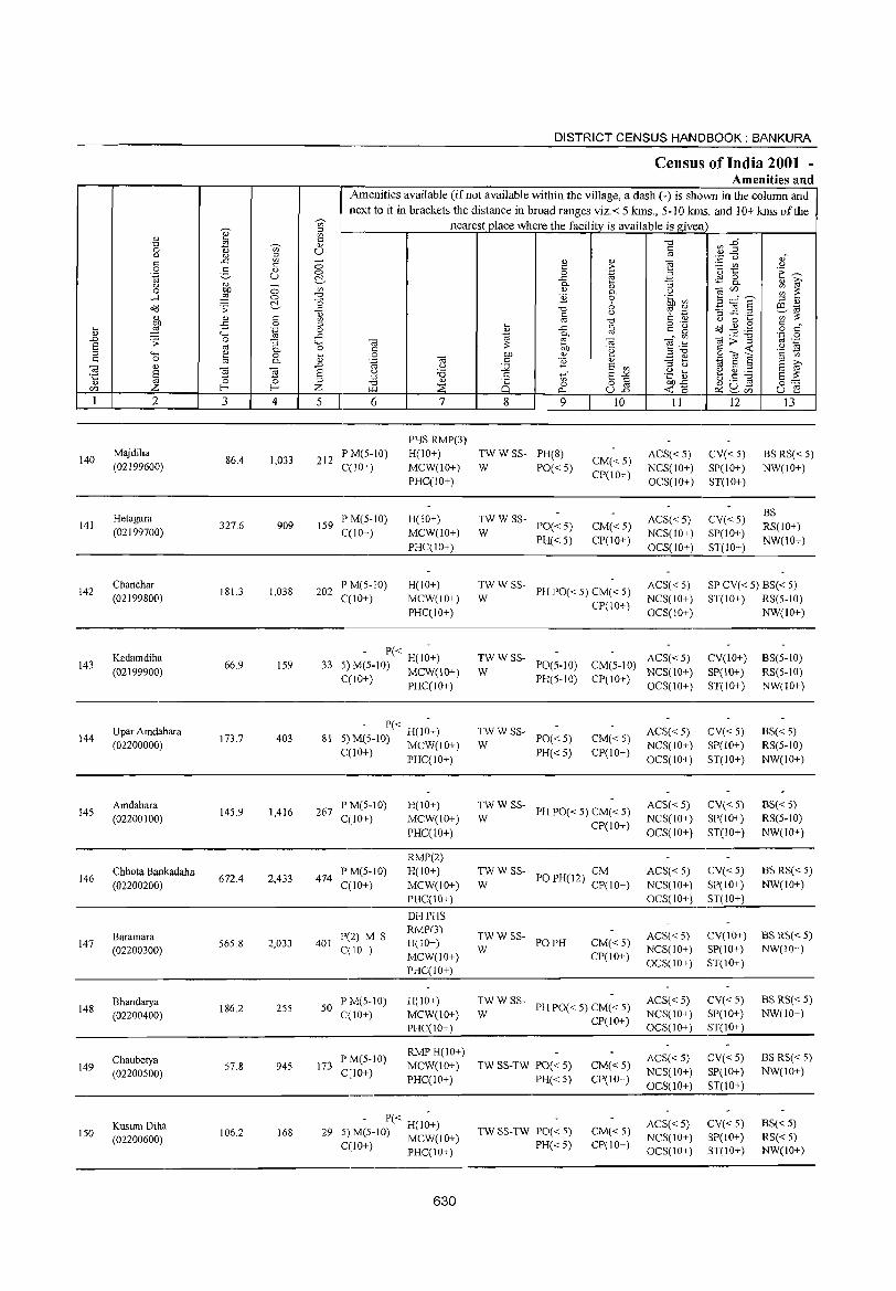
140
141
142
143
144
145
146
147
148
149
150
2
Majdiha (02199600)
Hetagara (02199700)
Chan char (02199800)
Kadamdiha (02199900)
Upar Amdahara (02200000)
Amdahara (02200100)
Chhota 8ankadaha (02200200)
Baramara (02200300)
Bhandarya (02200400)
Chaubetya (02200500)
Kusum Diha (02200600)
3
86.4
327.6
181.3
66.9
173.7
145.9
672.4
565.8
186.2
57.8
106.2
o o ~ s:: o .~
"3 c. o c.
E ~ 4
1,033
909
1,038
159
403
1,416
2,433
2,033
255
945
168
DISTRICT CENSUS HANDBOOK: BANKURA
Census of India 2001 -Amenities and
I Amenities available (if not available within the village, a dash (-) is shown in the column and next to it in brackets the distance in broad ranges viz. < 5 kms., 5- JO kms. and 10+ kms of the
nearest place where the facility is available is given
u
5 6
212 iP M(5-1O) C(lO+)
159 P M(5-1O) C(lO+)
202 PM(5-10) C(10+)
7
PHS RMP(3) H(IO+) MCW(lO+) PHC(lO+)
H(IO+) MCW(lO+) PHC(IO+)
H(IO+) MCW(IO+) PHC(IO+)
- P« H(I;+) 33 5) M(5-10) MCW(IO+)
C(10+) PHC(IO+)
- 1'« H(I;+) 81 5)M(5-10) MCW(IO+)
C(lO+) PHC(IO+)
267 P M(5-10) C(IO+)
474 PM(5-1O) C(lO+)
401 P(2) M S C(10+)
50 P M(5-10) C(10+)
173 P M(5-10) C(lO+)
H(IO+) MCW(IO+)
PHC(lO+)
RMP(2) H(!o+) MCW(lO+) PHC(IO+)
DHPHS RMP(3) H(IO+) MCW(lO+) PHC(IO+)
H(IO+) MCW(JO+) PHC(JO+)
RMPH(lO+) MCW(IO+) PHC(lO+)
- P« H(l;+) 29 5) M(5-1O) MCW(IO+)
C(10+) PHC(IO+)
630
8 9
TW W SS- PH(8)
W PO« 5)
TWWSS-W PO«5)
PH«5)
10
CM«5) CP(IO+)
CM«5) CP(10+)
W
TWWSS-PH 1'0« 5) CM« 5)
CP(IO+)
II
ACS« 5) NCS(IO+) OCS(IO+)
ACS« 5) NCS(IO+)
OCS(lO+)
ACS« 5) NCS(IO+) OCS(IO+)
TW W SS- ACS« 5) W PO(5-10) CM(5-10) NCS(IO+)
PH(5-10) CP(IO+) OCS(IO+)
TWWSS-W
PO«5) PH«5)
CM« 5) CP(lO+)
~W W SS- PH 1'0« 5) CM« 5)
CP(IO+)
TWWSS- CM W POPH(l2) CP(IO+)
TWW SS- POPH W
CM«5) CP(IO+)
W
TWW SS-PH PO« 5) CM« 5)
TW SS-TW PO« 5)
PH«5)
TW SS-TW PO« 5) PH« 5)
CP(JO+)
CM« 5) CP(IO+)
CM«5) CP(IO+)
ACS«5) NCS(IO+) OCS(IO+)
ACS« 5) NCS(lO+) OCS(lO+)
ACS« 5) NCS(IO+) OCS(IO+)
ACS«5) NCS(IO+) OCS(IO+)
ACS«5) NCS(IO+) OCS(IO+)
ACS« 5) NCS(IO+) OCS(lO+)
ACS« 5) NCS(IO+) OCS(IO+)
12
CV«5) SP(IO+) ST(lO+)
CV«5) SP(lO+)
ST(IO+)
13
BS RS« 5) NW(lO+)
BS RS(IO+) NW(lO+)
SP CV( < 5) 8S« 5) ST(IO+) RS(5-10)
CV(IO+) SP(IO+) ST(lO+)
CV«5) SP(IO+) ST(IO+)
CV«5) SP(lO+) ST(lO+)
CV«5) SP(IO+) ST(IO+)
CV(IO+) SP(IO+) ST(10+)
CV« 5) SP(IO+) ST(IO+)
CV«5) SP(IO+)
ST(lO+)
CV« 5) SP(IO+) ST(IO+)
NW(IO+)
8S(5-10)
RS{5-10) NW(IO+)
BS« 5) RS(5-1O) NW(IO+)
8S« 5) RS(5-10)
NW(IO+)
BS RS« 5) NW(IO+)
BS RS«5) NW(IO+)
BS RS« 5) NW(IO+)
BS RS« 5) NW(IO+)
BS« 5) RS« 5) NW(JO+)
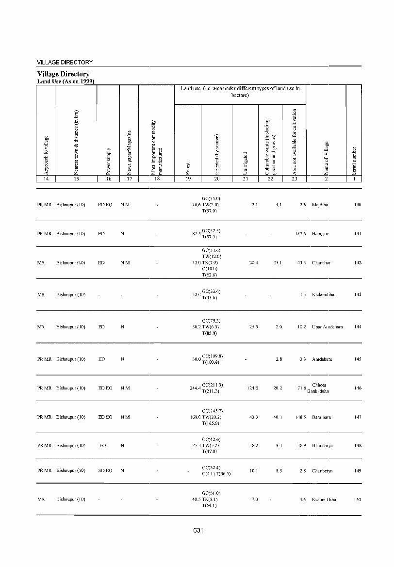
VILLAGE DIRECTORY
Village Directory Land Use (As on 1999)
E "" g " " ~ " 01) '6 ;J
o'd .;;
~ B ..c: B " Cd 1;; 2 Cl)
0. ~ 0. Cl)
-< Z 14 15
PRMR Bishnupur (10)
PRMR Bishnupur (10)
MR Bishnupur (10)
MR Bishnupur (10)
MR Bishnupur (10)
PRMR Bishnupur (10)
PRMR Bishnupur (10)
PRMR Bishnupur (10)
PRMR Bishnupur (10)
PRMR Bishnupur (10)
MR Bishnupur (10)
.0 '6 0
" S I: .~ S
0
l\f " C ~ :>. "'"'0 0. '" 1:: '" " &B 0- §-::l
'" §& 0-ki on ::l ;;: ;;: '" § 0 0 " ~ 0. Z E 16 17 18
ED EO NM
ED N
ED NM
ED N
ED N
ED EO NM
ED EO NM
EO N
ED EO N
Land use (i.e. area under different types ofland use in hectare)
I: 0 .~
01) ,..
I: ~ '6 ::l " '0 ....
<8 '" I:~ ._ '" 2 ~ Cl) Cl)
::l " ,..
::is " 0 1il ~ ..:2 01)
'" ;J .... ;;: .c;; " :>. "'0 ,D e "'0
" " ~ .;;
E ~ Cd
~ '+-< ::l "'0 .... 0 Cl) b1) 0 " 1;; B "E .... Cd " " ::l ..c:
'" ~ e 01) ~ " § '2 "3 ::l e 0 ] Cd Cl)
~ ;::J u 01) -< __6 c/)
19 20 21 22 23 2 1
GC(S5.0) 20.6 TW(2.0) 2.1 4.1 2.6 Majdiha 140
T(S7.0)
825 GC(57.S) · T(S7.5)
187.6 Hetagara 141
GC(33.6) TW(12.0)
32.0 TK(7.0) 20.4 23.1 43.3 Chanchar 142 0(10.0) T(62.6)
320 GC(33.6) · T(33.6)
1.3 Kadamdiha 143
GC(79.3) 50.2 TW(6.5) 25.5 2.0 10.2 U par Amdahara 144
T(85.8)
300 GC(109.8) · T(l09.8)
2.8 3.3 Amdahara 145
2444 GC(21 13) · T(21 1.3)
124.6 20.2 71 8 Chhota . Bankadaha
146
GC(1457) 168.0 TW(20.2) 43.3 40.1 148.5 Baramara 147
T(165.9)
GC(42.6) 75.3 TW(S.2) 18.2 8.1 36.9 Bhandarya 148
T(47.8)
GC(32.4) 10.1 8.5 2.8 Chaubetya 149
O(4.1)T(36.5)
GC(51.0) 40.5 TK(3.1) 7.0 4.6 Kusum Diha 150
T(54.1)
631
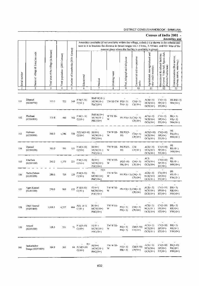
151
152
153
154
155
156
157
158
159
160
2
Dhansol (02200700)
Phulbani (02200800)
Hulmara (02200900)
Uparsol (02201000)
Kharkata (02201100)
Pacha Dahara (02201200)
AgunKumari (02201300)
Chak Uparsol (02201400)
Astasol (02201500)
Sankarlaiker Danga (02201600)
3
113.5
175.8
540.3
161.0
245.2
288.6
230.0
1,038.1
128.5
104.9
o o ~
'" o '.g '3 0-o 0-
"Ei o
f-;
4
722
460
1,246
791
1,375
729
909
4,257
331
361
DISTRICT CENSUS HANDBOOK: BANKURA
Census of India 2001 -Amenities and
Amenities available (if not available within the village, a dash (-) is shown in the column and next to it in brackets the distance in broad ranges viz. < 5 kms., 5- IO kms. and 10+ kms of the
nearest place where the facility is available is given
o o ~
'" "0
~ ~ o
..c "-< o ~ Q)
.D E ::J Z 5 6
149 P M(5-10) C(10+)
102 P M(5-10) C(lO+)
7
RMPH(IO+) MCW(10+) PHC(IO+)
PHSH(10+) MCW(IO+) PHC(lO+)
229 P(2) M(5-IO) H(lO+) C(10+) MCW(IO+)
PHC(10+)
8
'" o Cl...
9
TW SS-TW PO« 5)
PH« 5)
10
CM« 5) CP(IO+)
W
WTKSS-PH PO« 5) CM« 5)
CP(IO+)
TW W SS- PH PO(5-W 10) CM«5)
CP(lO+)
11
ACS« 5) NCS(IO+) OCS(10+)
ACS« 5) NCS(1O+) OCS(10+)
ACS(5-10) NCS(lO+) OCS(10+)
12
CV«5) SP(IO+) ST(10+)
CV«5) SP(IO+) ST(lO+)
13
BS RS« 5) NW(10+)
BS« 5) RS« 5) NW(10+)
BS CV(5-1O) RS(10+)
SP(IO+) NW(10+) ST(lO+)
BS 121 P M(5-10) H(10+) TW W SS- PH PO(5- CM ACS« 5) CV(5-10) RS(!O+)
C(10+) MCW(IO+) W 10) CP(lO+) NCS(IO+) SP(IO+) NW(10+) , ___ P_HC_C'-.I_O+_:.) _____________ O_C_S(;_IO_+_;_)_ ST(IO,_+.:_) ___ _
221 P M(5-1O) C(IO+)
129 P M(5-10) C(IO+)
152 P M(5-) 0) C(10+)
664 P(3) M S C(IO+)
P M(5-10) 71
C(10+)
H(lO+) MCW(10+) PHC(lO+)
H(5-
10) MCW(10+) PHC(10+)
H(lO+) MCW(10+) PHC(lO+)
H(lO+) MCW(10+) PHC(10+)
H(IO+) MCW(10+) PHC(IO+)
64 - P« H(lO+)
5) M(5-10) MCWCIO+)
C(lO+) PHC(lO+)
632
TWWSS-W PO(5-10) CM«5)
PH(IO+) CP(lO+)
TWWSS-W PH PO« 5) CM« 5)
CP(lO+)
TWWSS-W PH PO« 5) CM« 5)
CP(IO+)
TWWSS-W PO« 5)
PH« 5)
TWWSS-PO« 5)
W PH«5)
TWWSS-PO« 5)
W PH« 5)
CM« 5) CP(IO+)
CM(5-10) CP(1O+)
CM(5-10) CP(lO+)
ACS NCS(lO+) OCS(1O+)
ACS« 5) NCS(IO+) OCS(10+)
ACS« 5) NCS(10+) OCS(IO+)
ACS« 5) NCS(lO+) OCS(10+)
ACS« 5) NCS(IO+) OCS(IO+)
ACS«5) NCS(10+) OCS(IO+)
BS CV(5-1O) RS(10+) SP(10+) NW(IO+) ST(10+)
CV(IO+) SP(!O+) ST(lO+)
BS RS(IO+) NW(1O+)
CV(S-10) BS« 5) SP(lO+) RS(lO+) ST(lO+) NW(IO+)
CV(5-10) BS« 5) SP(IO+) RS(IO+) ST(10+) NW(10+)
CV(5-1O) BS« 5) SP(10+) RS(IO+) ST(IO+) NW(IO+)
eV(5-10) BS(5-10) SP(lO+) RS(lO+) ST(lO+) NW(\o+)
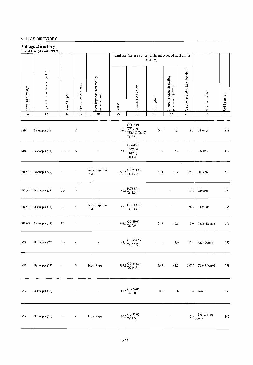
VILLAGE DIRECTORY
Village Directory Land Use (As on 1999)
14 15
MR Bishnupur (10)
MR Bishnupur (10)
PR MR Bishnupur (20)
PR MR Bishnupur (23)
PR MR Bishnupur (21)
PR MR Bishnupur (24)
MR Bishnupur (25)
MR Bishnupur (23)
MR Bishnupur (26)
MR Bishnupur (25)
16
N
ED EO N
ED N
ED N
ED
ED
N
ED
17 18
Babui Rope, Sal Leaf
Babui Rope, Sal Leaf
Babui Rope
Babui Rope
Land use (i.e. area under different types ofland use in hectare)
19 20
GC(l50) TW(8,9)
49.7 TK(5 0) 0(5 0)
T(338)
GC(68.4)
587 TW(5.6) · TK(7.0)
T(SlO)
221 8 GC(243.6) · T(243.6)
66 8 PC(83.0) · T(83.0)
530 GC(163.9) · T(163.9)
2060 GC(39.6) · T(39.6)
474 GC(137.6) · T(137.6)
5079 GC(244.9) · T(244.9)
886 GC(36.8) · T(36.8)
800 GC(22.0) · T(22.0)
633
21 22
20.1
21.0
34.4
2&.6
79.3
0.8
1.7
2.0
16.2
10.5
3.6
98.3
0,8
23 2
8.3 Dhansol
13.1 Phulbani
24.3 Hulmara
11.2 Uparsol
28.3 Kharka1a
3. 9 Pacha Dahara
41.4 Agun Kumari
107.8 Chak Uparsol
1.4 Astasol
2.9 Sankarlaiker Danga
151
152
153
154
155
156
157
158
159
160
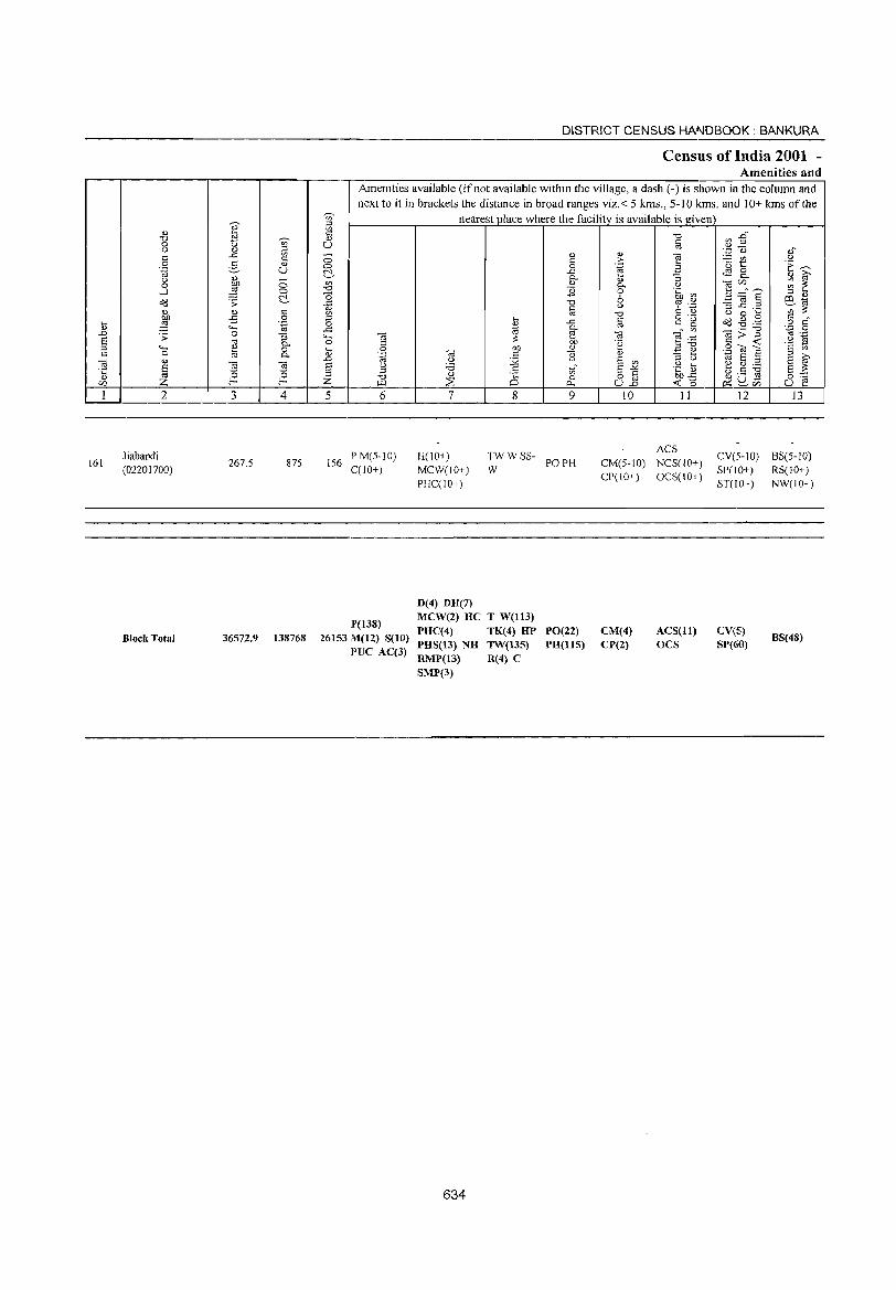
'OJ' u 19 '0 'U;' 0 '" '" OJ ::l
'" ..c: '" c:
0 § Q)
.~ U <l) <J 0 0 E ....J 0
~ o:::l .;;: <l) Q;) c: OJ) -B 0
iJ :§ "-E .... .D .;;: 0 '3 8 oj 0-:J .... '" 0
'" 0 a 0-Ol u
E ]l ~ .;:::
~ t2 <l) r:/J
1 2 3 4
Jiabandi 161
(02201700) 267.5 875
Block Total 36572.9 138768
DISTRICT CENSUS HANDBOOK: BANKURA
Census of India 2001 -Amenities and
Amenities available (if not available within the village, a dash (-) is shown in the column and next to it in brackets the distance in broad ranges viz.< 5 kms., 5-10 kms. and 10+ kms of the
'U;' ::l '" '" Q)
U
0 0 ~ Vl '0 a il Vl
_g 4-; "iO 0 " iJ 0
"-g .0 8 g ::l '0 Z ~
5 6
PM(5-IO) 156
C(lO+)
lP(138) 26153111(12) S(10)
I'VC AC(3)
nearest place where the facility is available is given
... '" 1;; :;: 00
'" '" <J 12 'i3 Q) .§
;:;E 0 7 8
H(lO+) TWWSS-MCW(IO+) W PHC(IO+)
D(4) DH(7) MCW(2) HC T W(ll3)
PHC(4) TK(4) HP PHS(13) NH TW(135) RMP(13) R(4) C SMP(3)
634
Q) c: 0 ..c: 0-<l)
'2 '0 s:: co ..c: 0-e OJ)
'" '2 tl 0
0.
9
PO PH
PO(22) PH(115)
Q)
>-.~
Q) 0-0 6 <J
'0 §
Ol '(3
t E '" E"" o § U.o
10
CM(5-IO) CP(IO+)
CM(4) CP(2)
'0 §
""§ B '3 <J
.~ ~ '? .~ c: u o ._ s:: g
'" ~ .~ :J'O .!: ~ :J U .g b en.c
-0:: 0 11
ACS NCS(IO+) OCS(IO+)
ACS(ll) OCS
d3~ ".p 0
~t c.S 8.. e c/)" __
_g~§ ::3..c ..... u 0 ...
Ocl .g .,g Ol>'g " -0:: SOlE 1;; E :J ~ g ~ u ,_ ~
~U-~r:/J
12
CV(5-1O) SP(IO+) ST(IO+)
CV(S) SP(60)
0.," <J
'E ~ <l) ~ ~ ~ ::s '" P4 1;; ';;:;: § ","
'';::: 0 '" .-.g ~ § '" 8 ~ g~
U ~ 13
BS(5-IO) RS(10+) NW(IO+)
BS(48)
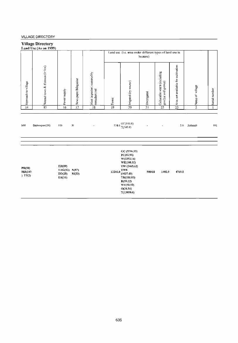
VILLAGE DIRECTORY
Village Directory Land Use (As on 1999)
14
MR
PR(50) MR(143 ) FP(2)
15
Bishnupur (28)
16
ED
ED(89) EAG(12) EO(25) EA(16)
17
N
N(87) M(33)
18
Land use (i.e. area under different types ofland use in hectare)
19 20
1246 GC(140.8) . T(140.8)
21 22 23 2
2.0 Jiabandi
GC (5596.99) PC(82.96) W(3393.14) WE(108.32) TW (2465.62) TWE
12266.0 (1037.49) 5084.0 1402.9 4769.5
TK(181.83) R(99.12) WF(50.59) 0(34.54) T(13050.6)
635
161

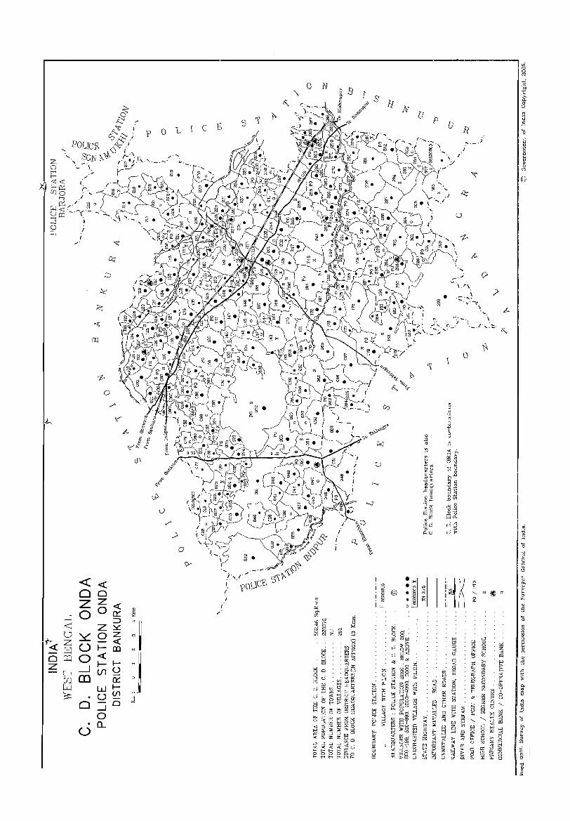
I
(
o
«« O~ 20 o «
a::: ::> ~ z « ~
U o _J
CD
z o I-m «II-u U1
a::: wIu Ul
o O_J o
00... u
p ° L c
o
o N J
s
-j·,l·"- £ i ?o\,\C
f
I
}f
p
•
u
, \
....
\. r\
\ - ...... -,'It'-~\

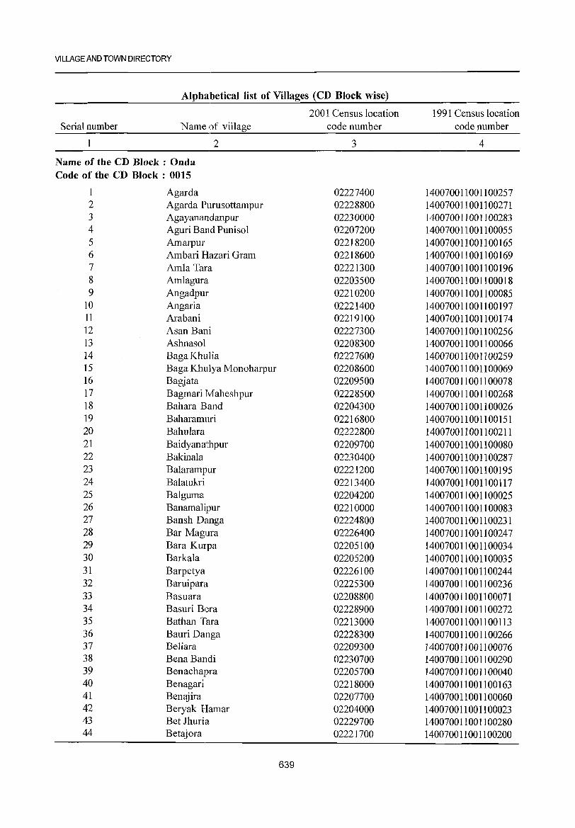
VILLAGE AND TOWN DIRECTORY
Alphabetical list of Villages (CD Block wise)
2001 Census location 1991 Census location Serial number Name of village code number code number
2 3 4
Name of the CD Block : Onda Code of the CD Block: 0015
1 Agarda 02227400 140070011001100257 2 Agarda Purusottampur 02228800 140070011001100271 3 Agayanandanpur 02230000 140070011001100283 4 Aguri Band Puniso1 02207200 140070011001100055 5 Amarpur 02218200 140070011001100165 6 Ambari Hazari Gram 02218600 140070011001100169 7 Am1a Tara 02221300 140070011001100196 8 Am1agura 02203500 140070011001100018 9 Angadpur 02210200 140070011001100085
10 Angaria 02221400 140070011001100197 11 Arabani 02219100 140070011001100174 12 Asan Bani 02227300 140070011001100256 13 Ashnasol 02208300 140070011001100066 14 BagaKhulia 02227600 140070011001100259 15 Baga Khulya Monoharpur 02208600 140070011001100069 16 Bagjata 02209500 140070011001100078 17 Bagmari Maheshpur 02228500 140070011001100268 18 Bahara Band 02204300 140070011001100026 19 Baharamuri 02216800 140070011001100151 20 Bahulara 02222800 140070011001100211 21 Baidyanathpur 02209700 140070011001100080 22 Bakina1a 02230400 140070011001100287 23 Balarampur 02221200 140070011001100195 24 Balatukri 02213400 140070011001100117 25 Balguma 02204200 140070011001100025 26 Banamalipur 02210000 140070011001100083 27 Bansh Danga 02224800 140070011001100231 28 Bar Magura 02226400 140070011001100247 29 Bara Kurpa 02205100 140070011001100034 30 Barkala 02205200 140070011001100035 31 Barpetya 02226100 140070011001100244 32 Baruipara 02225300 140070011001100236 33 Basuara 02208800 140070011001100071 34 Basuri Bera 02228900 140070011001100272 35 Bathan TaTa 02213000 140070011001100113 36 Bauri Danga 02228300 140070011001100266 37 Be1iara 02209300 140070011001100076 38 BenaBandi 02230700 140070011001100290 39 Benachapra 02205700 140070011001100040 40 Benagari 02218000 140070011 00 11 00 163 41 Benajira 02207700 140070011001100060 42 Beryak Hamar 02204000 140070011001100023 43 Bet Jhuria 02229700 140070011001100280 44 Betajora 02221700 140070011001100200
639
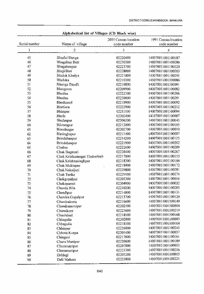
DISTRICT CENSUS HANDBOOK: BANKURA
Alph:llbetical list of Villages (CD Block wise)
2001 Census location 1991 Census location Serial number Name of village code number code number
1 2 3 4
45 Bhadul Danga 02220400 140070011001100187 46 Bhagaban Bati 02230300 140070011001100286 47 Bhagabanpur 02223700 140070011001100220 48 Bhaji Bari 02228000 140070011001100263 49 Bha1uk Khulya 02221800 140070011001100201 50 Bhaluka 02210300 140070011001100086 51 Bhanga Bandh 02210800 140070011001100091 52 Bhatgram 02209900 140070011 00 11 00082 53 Bhedua 02222300 140070011001100206 54 Bhedua 02230800 140070011001100291 55 Bheduasol 02210900 140070011001100092 56 Bhetiara 02222900 140070011001100212 57 Bhimpur 02211100 140070011001100094 58 Bhola 02202400 1401070011 00 11 00007 59 Bhulanpur 02206200 140070011001100045 60 Bikrampur 02212000 140070011001100103 61 Binodnagar 02202700 1400700]]001100010 62 Birsinghapur 02211400 140070011001100097 63 Brindabanpur 02214200 140070011001100125 64 Brindabanpur 02221900 140070011001100202 65 Chabra 02222600 140070011001100209 66 Chak Bagmari 02228400 140070011001100267 67 Chak Krishnanagar Thakurbari 02217000 140070011001100153 68 Chak Krishnasinghpur 02218300 140070011001100166 69 Chak Muktapur 02218900 140070011001100172 70 Chak N akaij uri 02229800 140070011001100281 71 Chak Tunka 02229100 140070011001100274 72 Chakgopalpur 02203300 1400170011001100016 73 ChakuparsoJ 02204900 140070011001100032 74 ChandaBila 02230200 140070011001100285 75 Chandipur 02214800 140070011001100131 76 Chandra Gopalpur 02213700 140070011001100120 77 Chandrakona 02216600 140070011001100149 78 Chandramonipur 02202100 140070011001100004 79 Charuikunr 02223600 140070011001100219 80 Chaulabad 02218500 1400700110011 00 168 81 Chhagulia 02202000 140070011001100003 82 Chhagulia 02218100 140070011001100164 83 Chhinpur 02226000 140070011001100243 84 Chhota Kurpa 02205400 140070011001100037 85 Chingani 02217800 140070011001100161 86 Chura Manipur 02220600 140070011001100189 87 Churamanipur 02207000 140070011001100053 88 Churamanipur 02223300 140070011001100216
89 Daldagi 02203200 140070011001100015 90 Dali- Mahara 02223800 140070011001100221
640
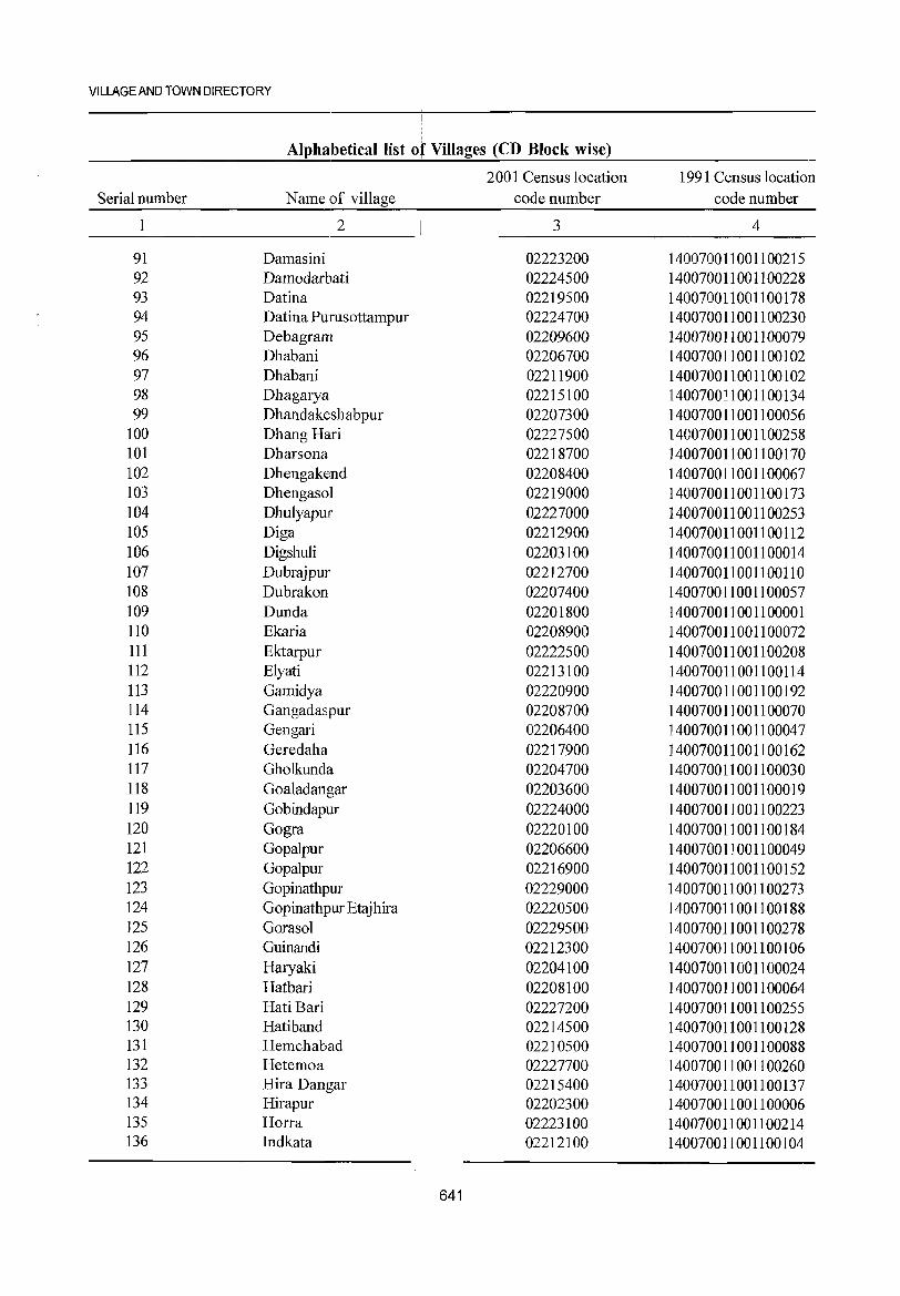
VILLAGE AND TOWN DIRECTORY
,
Alphabetical list of Villages (CD Block wise)
2001 Census location 1991 Census location Serial number Name of village code number code number
2 3 4
91 Damasini 02223200 140070011001100215 92 Damodarbati 02224500 140070011001100228 93 Datina 02219500 140070011001100178 94 Datina Purusottampur 02224700 140070011001100230 95 Debagram 02209600 140070011001100079 96 Dhabani 02206700 140070011001100102 97 Dhabani 02211900 140070011001100102 98 Dhagarya 02215100 140070011001100134 99 Dhandakeshabpur 02207300 140070011001100056
100 Dhang H31ri 02227500 140070011001100258 101 Dharsona 02218700 140070011001100170 102 Dhengake:nd 02208400 140070011001100067 103 Dhengasol 02219000 140070011001100173 104 Dhulyapur 02227000 140070011001100253 105 Diga 02212900 140070011001100112 106 Digshuli 02203100 140070011001100014 107 Dubrajpur 02212700 140070011001100110 108 Dubrakon 02207400 140070011001100057 109 Dunda 02201800 140070011001100001 110 Ekaria 02208900 140070011001100072 111 Ektarpur 02222500 140070011001100208 112 Elyati 02213100 140070011001100114 113 Gamidya 02220900 140070011001100192 114 Gangadaspur 02208700 140070011001100070 115 Gengari 02206400 140070011001100047 116 Geredaha 02217900 140070011001100162 117 Gholkunda 02204700 140070011001100030 118 Goaladangar 02203600 140070011001100019 119 Gobindapur 02224000 140070011001100223 120 Gogra 02220100 140070011001100184 121 Gopalpur 02206600 140070011001100049 122 Gopalpur 02216900 140070011001100152 123 Gopinathpur 02229000 140070011001100273 124 Gopinathpur Etajhira 02220500 140070011001100188 125 Gorasol 02229500 140070011001100278 126 Guinandi 02212300 140070011001100106 127 Haryaki 02204100 140070011001100024 128 Hatbari 02208100 140070011001100064 129 Hati Bari 02227200 140070011001100255 130 Hatiband 02214500 140070011001100128 131 Hemchabad 02210500 140070011001100088 132 Hetemoa 02227700 140070011001100260 133 Hira Dangar 02215400 140070011001100137 134 Hirapur 02202300 140070011001100006 135 Horra 02223100 140070011001100214 136 Indkata 02212100 140070011001100104
641
DISTRICT CENSUS HANDBOOK: BANKURA
Alphabetical list of Villages (CD Block wise)
2001 Census location 1991 Census location Serial number Name ~village code number code number 2 3 4
137 Indra 02224300 140070011001100226 138 Itapanchira 02212400 1400701011001100107 139 laba Balarampur 02208500 140070011001100068 140 Jadab Nagar 02227800 140070011001100261 141 I agannath Bati 02227900 140070011001100262 142 I agannathpur 02202600 140070011001100098 143 Jagannathpur 02211500 140070011001100098 144 lama Dhara 02230500 140070011001100288 145 lambani 02215700 140070011001100140 146 Jambedya 02217700 140070011001100160 147 lamdoba 02224600 140070011001100229 148 lamjuri 02206900 1401070011001100052 149 Jamra Madlhabpur 02224200 140070011001100225 150 lamtara 02214900 140070011001100132 151 lhati Bani 02228700 140070011001100270 152 Kadagot 02204500 140070011001100028 153 Kalla 02219700 140070011001100180 154 Kalyani 02203000 1400700111001100013 155 Kalyari 02225700 140070011001100240 156 Kamala 02209000 140070011001100073 157 Kamalpur 02211000 140070011001100093 158 Kamar Kata 02217400 140070011001100157 159 Kanaijuri 02229400 140070011001100277 160 Kanaipur 02216000 140070011001100143 161 Kanta Bari 02228200 140070011001100265 162 Karra 02210400 140070011001100087 163 Kawabasa 02205900 140070011001100042 164 Kelyajuri 02218400 140070011001100167 165 Khamarben) 02224400 1400170011001100227 166 Khapkata 02202200 140070011001100005 167 Khar Bari Badni 02228600 140070011001100269 168 Kharigara 02202800 140070011001100011 169 Kheruashol 02221600 140070011001100199 170 Kiabati 02206100 140070011001100044 171 Kochkhalui 02214100 140070011001100124 172 Kokilpur 02202900 140070011001100012 173 Kotalpur 02211700 140070011001100100 174 Krishna Nagar 02201900 140070011001100002 175 Krishna Nagar 02219600 140070011001100179 176 Krishna Singhpur 02217600 140070011001100159 177 Kumar Dallga 02216200 140070011 0011 00145 178 Kunchi Shol~~ 02222400 140070011001100207 179 Kundalia 02222200 140070011001100205 180 Kushte 02220300 140070011001100186 181 Lapur 02226300 140070011001100246 182 Lauda 02203400 140070011001100017
642
VILLAGE AND TOWN DIRECTORY
Alphabetical list oJ Villages (CD Block wise)
2001 Census location 1991 Census location Serial number Name of village code number code number
2 3 4
183 Lauria 02229300 140070011001100276 184 Layada D1llmarya 02204600 140070011001100029 185 Lodna 02210600 14007001]001100089 186 Lohari Brindaban 02214000 140070011001100123 187 Machhrakhi 02205300 14007001 ]_ 00 11 00036 188 Madan Mohanpur 02214700 140070011001100130 189 Madan Mohanpur 02221500 140070011001100198 190 Madanpur 02210700 140070011001100090 191 Madhabpur 02204800 ]40070011001100031 192 MahishDoba 02230600 140070011001100289 193 Maitha 02215600 140070011001100139 194 Majdiba 02221100 140070011001100194 195 Majura 02207900 140070011001100062 196 Makarko] 02222700 140070011001100210 197 Ma1ator 02209400 140070011001100077 198 Ma1pur 02226200 140070011001100245 199 MandarBani 02205500 140070011001100038 200 Mandiha 02219200 140070011001100175 201 Manipur 02212200 140070011001100105 202 Mankhamar 02209800 140070011001100081 203 Mathura 02226800 140070011001100251 204 Mauchura 02225900 140070011001100242 205 Maudi 02225100 140070011001100234 206 Mayata 02215000 140070011001100133 207 Medinipur 02219400 140070011001100177 208 Metyala 02206800 140070011001100051 209 Mohanpm 02229900 140070011001100282 210 Mouleswar 02219300 14007001]001100176 211 Muktapur 02229200 140070011001100275 212 Mukundabati 02210]00 140070011001100084 213 MukundaJPur 02223900 140070011001100222 214 Murakata 02213900 140070011001100122 215 Nabajibanpur 02223500 140070011001100218 216 Nakai Guri 02229600 140070011001100279 217 Nanda Bhanga 02223000 140070011001100213 218 Nayananandapur 02221000 140070011001100193 219 Niada 02218800 140070011001100171 220 Nikunjapur 02213200 140070011001100115 221 Nischintapur 02213500 140070011001100118 222 Nutangram 02207500 140070011001100058 223 01a 02212600 140070011001100109 224 Onda 02220000 140070011001100183 225 Paharpur 02212500 140070011001100108 226 Pal ash Bani 02206300 140070011001100046 227 Panbaraj 02206000 140070011001100043 228 Panch Danna 02216100 ]4007001100]100144
643
DISTRICT CENSUS HANDBOOK: BANKURA
Alphabetical list of Villages (CD Block wise)
2001 Census location 1991 Census location Serial number Name of vi1Iage code number code number
2 3 4
229 Panchami 02207800 1401070011001100061 230 Pantha 02215200 140070011001]00135 231 Patadubi 02207100 140070011001100054 232 Patangapuf 02230]00 140070011001100284 233 Pathar Kata 02225000 140070011001100233 234 Patlabani 02203700 140070011001100020 235 Patpuf 02225800 140070011001100241 236 Patra Hati 02220700 140070011001100190 237 Pecharah 02217100 140070011001100154 238 Phu1Baria 02223400 1400700111001100217 239 Pingmi 02213300 140070011001100116 240 Pitambarpur 02205600 ]40070011001100039 241 Prajabad 02220200 140070011001100185 242 Pratappur 02206500 ]40070011001100048 243 Punch a 02225600 140070011001100239 244 Pundra 02224100 140070011001100224 245 Puthia 02216300 140070011001100146 246 Radha Madhabpur 02226900 140070011001100252 247 Radhamohanpur 02202500 140070011001100008 248 Raghunath Nagar 02216700 140070011001100150 249 Raghunathpur 02219900 140070011001100182 250 Rajduha 02217500 140070011001100158 251 Ram Sagar 02226500 140070011001100248 252 Ramar ChUla Puan 02228100 140070011001100264 253 Ramar Gram 02214400 140070011001100127 254 Ramkrishnapur 02203800 140070011001100021 255 Ramnagar 02211800 140070011001100101 256 Rampur 02208000 140070011001100063 257 Rasiara 02215300 1400170011001100136 258 Rasiknagarpur 02204400 1400170011001100027 259 Ratanpur 02205000 1400170011001100033 260 Rautara 02205800 140070011001100041 261 Sabanpur 02215800 1400170011001100141 262 Sadishta 02216500 140070011001100148 263 Sahapur 02212800 1400170011001100111 264 Saheb Ganja 02207600 140070011001100059 265 Salghata 02213800 140070011001100121 266 Santor 02211200 1400700]1001100095 267 Sayer Bankra 02211600 140070011001100099 268 Shalihan 02213600 1400700]10011001]9 269 Sheora Ghati 02217200 140070011001100155 270 Shima Baid 02219800 140070011001100181 271 Shinhati 02227100 140070011001100254 272 Shirsha 02222000 140070011001100203 273 Shushina Gobindarampur 02214300 140070011001100126 274 Shyam Nagar 02217300 140070011001100156
644
VILLAGE AND TOWN DIRECTORY
Alphabetical list of Villages (CD Block wise)
I 2001 Census location 1991 Census location
Serial number Name of village code number code number
2 I 3 4
275 Siara 02222100 140070011001100204 276 Siarbada 02203900 1400700111001100022 277 Singar Gada 02224900 1400700 III 00 11 00232 278 SonatapaJ 02209200 140070011001100075 279 Srirampur 02215900 1400700111001100142 280 Suklai 02220800 140070011001100191 281 Sundarpur 02225400 140070011001100237 282 Sur Managar 02226700 140070011001100250 283 Surpa Nagar 02209100 140070011001100074 284 Tapoban 02211300 140070011001100096 285 Teghara 02226600 140070011001100249 286 Teliberia 02225500 140070011001100238 287 Tella 02216400 140070011001100147 288 TentulMuri 02215500 140070011001100138 289 Tilabani 02208200 140070011001100065 290 Tol Chandrakona 02214600 140070011001100129 291 Tunka 02225200 140070011001100235
645
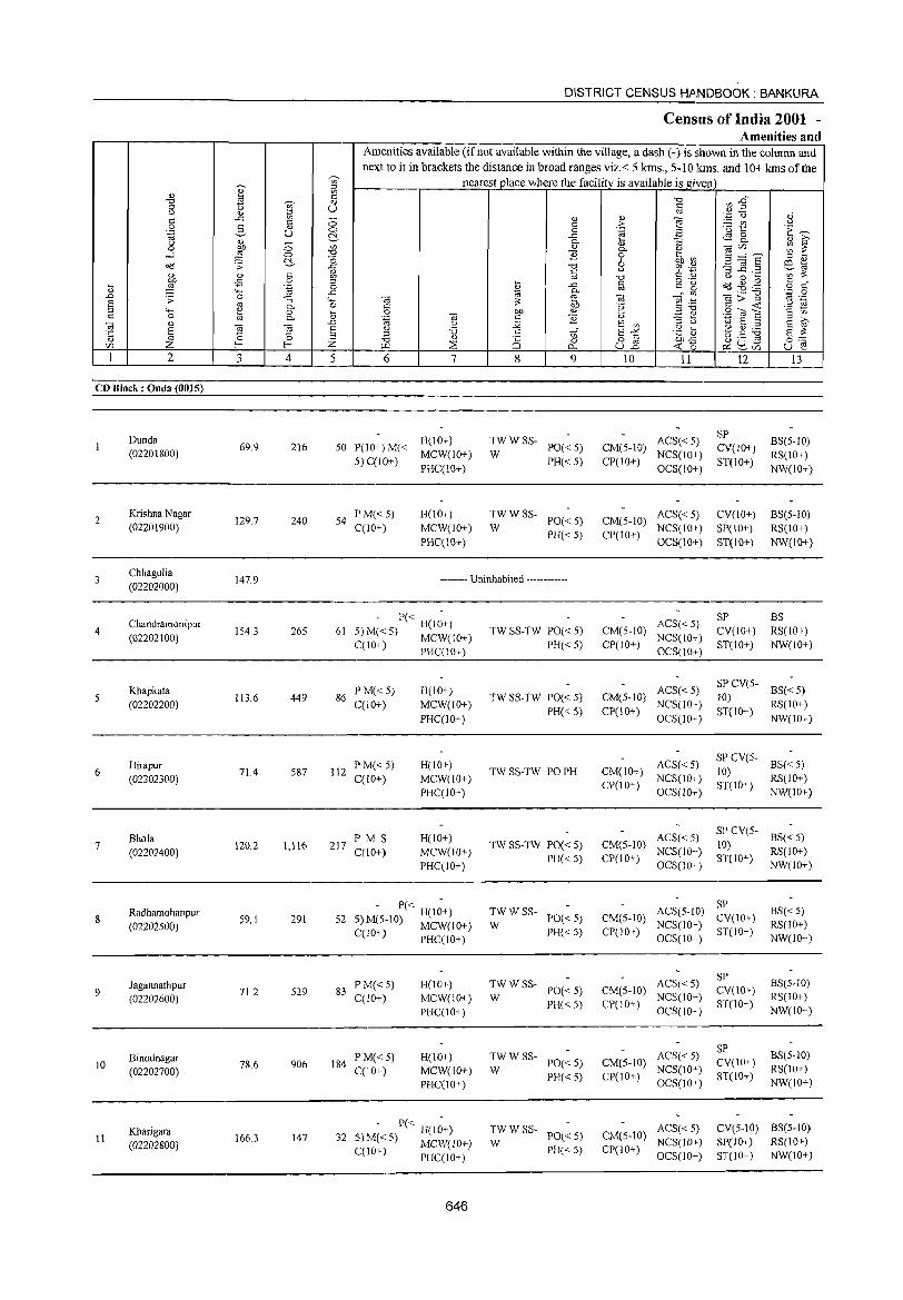
DISTRICT CENSUS HANDBOOK: BANKURA
Census of India 2001 -Amenities and
Amenities available (ifnot available within the village, a dash (-) is shown in the column and next to it in brackets the distance in broad ranges viz.< 5 kms., 5-10 kms. and 10+ kms of the
'" nearest place where the facility is available is _given ]' ::l
<I} '" s:: ..." ",..0 "0
"" <l)
0 C) U <:: Q)2 <.:J '" ::i OJ oJ s:: ..c: '" 0 <I} <> ~
'.0 0 <:: c >- - '" " 0 3 '" 0 0 .~ El 'u 1:: 'E ~ .~ u !::'.- ..c: ~8. '" 0- :; '" >-<.:J 0 ~ ~ 0 :§ en '" 0- '-' Oi<Zl
....l 0 -cl B 0 '§h ~ 3 ="8 "0 ::l <> ~ b ~ta 08 .s: ii ..."
" '}1 . .3 -3 _g .2 c '" ::: ., <> c ~ '" "0 C <l.> C) 0 ...
blJ -:5 0 t; <:: o ._
08 .g .g c 0
t; ;§ '"§ _g .<::
'" c g o C
'+-< Cd 0. '" o;:;::"g ';:::: 0
.0 .s: 0 :; "-< til ::: e til 1§ .~ '" .-S '" 0. 0 '" blJ 'e <:: -<: " OJ :l "-' e Oil <U ::l "0 .2 to E '2 tii 0 .... 0 ,;!;:! ~ '" 0 '" 0- <I} 'g til c: E <l> E ~ til
., ,.0 () ;;;;: E '" ::l " lil E ::l
E til til S u '0 c: E"'" .g ti ~.5 ~ E ::: ·c 0 0 ::l V} <> OJ ::l "0 " Ci 0 o c blJ..c: 0:::
<ZI Z f-; f-; Z \..L1 ~ "- ull « 0 ~ ~.n u e I 2 3 4 5 6 7 8 9 10 11 12 13
CD Block: Onda (0015)
Dunda H(IO+) TWWSS- ACS« 5) SP
BS(5-10) 69.9 216 50 P(IO+)M« PO« 5) CM(5-10) CV(IO+)
(02201800) 5) C(lO+)
MCW(10+) W PH« 5) CP(IO+)
NCS(IO+) ST(lO+)
RS(10+) PHC(10+) OCS(lO+) NW(IO+)
2 Krishna Nagar
129.7 240 54 PM« 5) H(lO+) TWWSS-
PO« 5) CM(5-10) ACS«5) CV(IO+) BS(5-1O)
(02201900) C(10+) MCW(lO+) W PH«5) CP(IO+)
NCS(IO+) SP(IO+) RS(lO+) PHC(lO+) OCS(10+) ST(10+) NW(lO+)
3 Chhagulia
147.9 -------- Uninhabited ------------(02202000)
Chandramonipur - P« H(l~+) ACS« 5) SP BS
4 (02202100)
1543 265 61 5) M«5) MCW(10+) TW SS-TW PO« 5) CM(5-IO) NCS(IO+)
CV(IO+) RS(IO+)
C(10+) PHql0+) PH« 5) CP(JO+) OCS(JO+)
ST(lO+) NW(lO+)
Khapkata PM« 5) H(IO+) ACS« 5) SP CV(5-
BS« 5) 5 1 13.6 449 86 TW SS-TW PO« 5) CM(5-]() ]()}
(02202200) C(IO+) MCW(IO+) PH« 5) CP(IO+)
NCS(IO+) ST(lO+)
RS(10+)
PHqIO+) OCS(IO+) NW(IO+)
Hirapur P M« 5) H(10+) ACS« 5) SP CV(5-
BS« 5) 6 71.4 587 112 TW SS-TW PO PH CM(lO+) 10)
(02202300) C(10+) MCW(IO+) CP(10+)
NCS(10+) ST(lO+)
RS(lO+)
PHqlO+} OCS(1O+) NW(1O+)
Bhola PMS H(10+) ACS«5) SP CV(S-
BS« 5) 7 120.2 1,116 217 TW SS-TW PO« 5) CM(5-10) 10}
(02202400) C(1O+) MCW(lO+) PH« S) CP(lO+)
NCS(lO+) ST(10+)
RS(lO+)
PHqIO+} OCS(10+) NW(IO+)
- P« H(I~+) TWWSS- ACS(5-10) SP
BS«5) 8
Radhamohanpur 59.1 291 52 PO« 5) CM(5-10) CV(lO+)
(02202500) S)M(5-IO) MCW(IO+) W PH« S) CP(10+)
NCS(IO+) ST(IO+)
RS(IO+) C(10+) PHC(IO+) OCS(IO+) NW(lO+)
l-I(IO+) TWWSS- ACS« 5) SP
BS(5-1O) Jagannathpur 83
PM«5) PO« 5) CM(5-10) CV(IO+) 9
(02202600) 71.2 529
C(lO+) MCW(IO+) W NCS(10+) RS(IO+)
PI-IqlO+) PH« 5) CP(IO+}
OCS(10+) ST(IO+)
NW(lO+)
TWWSS- ACS« 5) SP
BS(5-1O) Binodnagar PM«5) H(IO+) PO« 5) CM(5-10) CV(lO+) 10
(02202700) 78.6 906 184
C(lO+) MCW(10+) W NCS(IO+) RS(1O+)
PI-IC(IO+} PH« 5) CP(IO+)
OCS(lO+) ST(IO+)
NW(IO+)
Kharigara - P« H(I~+) TWWSS-PO« 5) CM(5-10)
ACS«5) CV(5-1O) BS(5-IO) 11 166.3 147 32 S) M« 5) MCW(lO+) W NCS(lD+) S1'(lD+) RS(lD+) (02202800) PH« 5) CP(10+) qlO+) PHC(IO+) OCS(10+) ST(10+) NW(1O+)
646
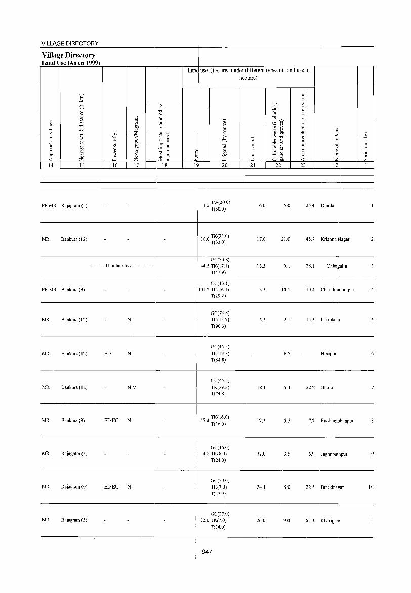
VILLAGE DIRECTORY
Village Directory Land Use (As on 1999)
14 15
PR MR Rajagram (S)
MR Bankura (12)
16 17
-------- Uninhabited ------------
PRMR Bankura (3)
MR Bankura (12) N
MR Bankura (12) ED N
MR Bankura (12) NM
MR Bankura (3) ED EO N
MR Rajagram (S)
MR Rajagram (6) ED EO N
MR Rajagram (S)
18
Lane use (i.e. area under different types ofland use in
I hectare)
I tol 0)1 .... ' Qo
.,..1
1~ 20
3 S TW(30.0) · T(30.0)
100 TK(33.0) · T(33.0)
GC(30.8) 44.5 TK(17.1)
T(47.9)
GC(J3. I) 101.2 TK(16.1)
T(29.2)
GC(74.8) TK(IS.7) T(90.6)
GC(4S.5) TK(J9.3) T(64.8)
GC(45.S)
TK(29.3) T(74.8)
174 TK(16.0) · T(J6.0)
GC(16.0) 4.8 TK(S.O)
T(24.0)
GC(20.0) TK(70) T(27.0)
GC(27.0) 32.0 TK(7.0)
T(34.0)
647
21
6.0
17.0
18.3
3.S
5.5
18.1
12.5
32.0
24.1
26.0
22 23 2
S.O 2S.4 Dunda
21.0 48.7 Krishna Nagar
9.1 28.1 Chhagulia
10.1 10.4 Chandramonipur
2.1 15.S Khapkata
6.7 Hirapur
5. I 22.2 Bhola
5.5 7.7 Radhamohanpur
3.5 6.9 Jagannathpur
5.0 22.S Binodnagar
9.0 65.3 Kharigara
2
4
5
6
7
8
9
10
II
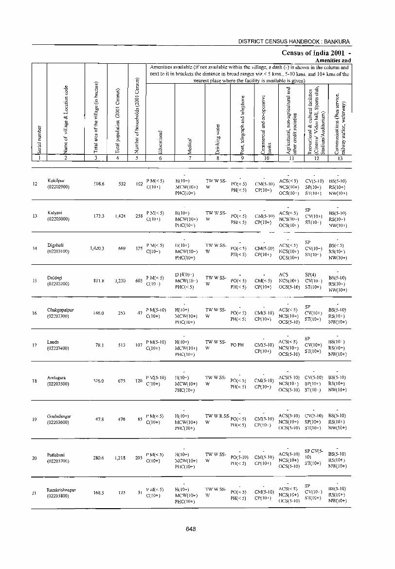
~
"' ~ ::l
" "' '" .::
'" ~ " 0 u u u '" ..<: "' ;; .:: § 0 g 0 .~ u ~
'" u ;; "' 0 g '" .....l 0 "0
O(l .;; ~ ..<:
'" '" '" .:: rg ~ -5 0
:;:; .~ 0 4-< ..<:: .D .;; 0 :; """' ~ '" 0- 0
"""' ~ 0 :;:; 0 0-
:"§ '" .D OJ ~ E E
" :;:; :£ ::l U) I-< I-< Z I 2 3 4 5
12 Kokilpur
108.6 532 102 (02202900)
Kalyani 13 173.3 1,424 258
(02203000)
Digshuli 14 1,420.3 669 125
(02203100)
Daldagi IS
(02203200) 811.8 3,230 603
Chakgopalpur 16 146.0 253 47
(02203300)
Lauda 17 78.1 513 107
(02203400)
Amlagura 326.0 675 120 18
(02203500)
19 Goaladangar
47.8 476 85 (02203600)
Patlabani 20
(02203700) 280.6 1,218 205
RamkrishnapuT 21
(02203800) 168.5 125 31
DISTRICT CENSUS HANDBOOK: BANKURA
Census of India 2001 -Amenities and
Amenities available (ifnot available within the village, a dash (-) is shown in the column and next to it in brackets the distance in broad ranges viz.< 5 kms., 5-10 kms. and 10+ kms of the
nearest place where the facility is available is given
'" "' .0" f;i "'..=! '.c u ","
'" '" OJ .:: > ~ t u
0 .~ § E~ ..<: <S 0 '" ~ 0- :; 0-
'" '" ",U) ;;; ~ ] 0- .~ 0 bOO') B ::::f"? ::l <v
'" 6 ro .~ "3 ~.2 C!l -u ~'" § s:': ~ "' ::: " u 0 >-< >-<
o ._ O(l ~.g § d ..<: c c g
~ '" ~ 0') -.;;;'g '.;:::: 0
-.; -.; ~:a
'" ._ .:: ::: .~ .:: -< .8 S 0 M '" E e .9 OJ S .:: '" .~ OJ c ] '" ::l ;>,
<) :.g E "' :l u til E ::l
E ~ u '6 .g ~ e ~ ~ ::l .:: r;f EO>: 8:;::: '" " 8 0 o c
~~ ~ u ,$
"'"' ~ 0... u13 p:: ~ U) u ~
6 7 8 9 10 11 12 13
PM«5) H(IO+) TWWSS-PO«5) CM(5-10)
ACS« 5) CV(5-IO) BS(5-10) qIO+) MCW(IO+) W
PH« 5) CP(IO+) NCS(IO+) SP(IO+) RS(IO+)
PHC(IO+) OCS(IO+) ST(IO+) NW(IO+)
PM«5) H(IO+) TWWSS- ACS« 5) SP
BS(5-1O) PO«5) CM(5-1O) CV(IO+)
C(10+) MCW(10+) W NCS(IO+) RS(IO+) PHC(lO+)
PH«5) CP(10+) OCS(IO+)
ST(10+) NW(IO+)
p M«5) H(lO+) TWWSS- ACS« 5) SP
BS« 5) PO«5) CM(5-1O) CV(IO+)
CCIO+) MCW(IO+) W NCS(IO+) RS(tO+) PHC(10+)
PH«5) CP(IO+) OCS(IO+)
ST(IO+) NW(10+)
PM« 5) D H(lO+)
TWWSS-ACS SP(4)
BS(5-10) C(IO+)
MCW(10+) W
PO« 5) CM«5) NCS(lO+) CV(IO+) RS(10+)
PHC« 5) PH«5) CP(10+) OCS(5-10) ST(IO+) NW(lO+)
P M(5-1O) H(IO+) TWWSS- ACS« 5) SP
BS(5·1O) PO«5) CM(5-10) CV(IO+)
C(IO+) MCW(IO+) W PH« 5) CP(10+)
NCS(JO+) ST(IO+)
RS(IO+) PHC(IO+) OCS(5-10) NW(IO+)
PM(5-1O) H(IO+) TWWSS- ACS« 5) SP
BS(IO+) PO PH CM(5-10) CV(IO+)
C(10+) MCW(10+) W CP(10+)
NCS(10+) ST(lO+)
RS(lO+) PHC(IO+) OCS(5-1O) NW(IO+)
P M(5-JO) H(lO+) TWWSS-PO« 5) CM(5-10)
ACS(5-10) CV(5-1O) BS(5-10)
C{lO+) MCW(IO+) W NCS(IO+) SP(IO+) RS(IO+)
PHCCIO+) PH«5) CP(10+)
OCS(5-10) ST(lO+) NW(10+)
P M« 5) H(IO+) TW W R SS PO(~ 5) CM(5·10) ACS(5-1O) eV(5-10) BS(5-1O)
C(10+) MCW(lO+) W PH«5) CP(IO+) NCS(10+) SP(IO+) RS(lO+)
PHC(IO+) OCS(5-10) ST(10+) NW(10+)
PM«5) H(IO+) TWWSS- ACS(5-1O) SP CV(S-
BS(5-10)
C(10+) MCW(IO+) W PO(5-10) CM(5-1O)
NCS(10+) 10)
RS(IO+)
PHC(IO+) PH«5) CP(IO+)
OCS(5-1O) ST(10+)
NW(lO+)
TWWSS- ACS« 5) SP
BS(5-1O) PM« 5) H(lO+) PO«S) CM(5-10) CV(lO+)
C(lO+) MCW(IO+) W NCS(IO+) RS(lO+) PH«5) CP(IO+) ST(IO+)
PHC(10+) OCS(5-1O) NW(IO+)
648
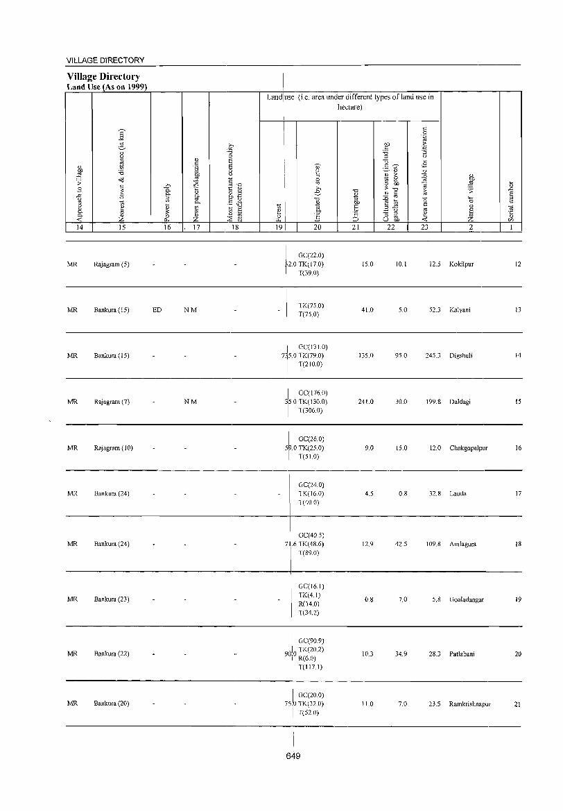
VILLAGE DIRECTORY ,
Village Directory Land Use (As on 1999)
Land use (i.e. area under different types ofland use in
hectare)
I '" 0 '-g
g q on .£; c
" "0 '0 '3 (J 0 :J (J
~ '" a u .... '" a ., c~ <8
~ '§j ._ '" '0 0 ~ ~" " ~ liP u
" ;> {j 0,)
O(j §u
0 ~ 0
~ . ;; :;E '" .... .... Ul ro OIl ~ ~ 2;> :SOu " B '" t:: '" ;>, .0 0.
" o !3 e u ~ § ~ .s:
~ ..c:: B §- g- o.. .... 0,)
"" '+-<
~ '" .§ ~ "d .g ~ 0 0 0. ~
Of)
8 ~ t '" ~ 'E B"f5 c 0,)
~ .~ :J t<I 0- g ~ ~ § ~ .!::9 '2 - '" " a ~ " :;:s a 0 ~ :J '" ~ :t " Z A.< Z ~ :::> u OIl rJ'J
14 15 16 17 18 19 20 21 22 23 2 1
I GC(22.0)
MR Rajagram (5) ro TK(17.0) 15.0 10.1 12.5 Kokilpur 12 T(39.0)
MR Bankura (IS) ED NM TK(750)
41.0 5.0 52.3 Kalyani 13 T(75.0)
I GC(!31.0) MR Bankura (15) 7rO TK(79.0) 135.0 95.0 245.3 Digshuli 14
T(2lO.0)
MR Rajagram (7) NM I GC(176.0)
241.0 30.0 199.8 Daldagi 15 TO TK(130.0) T(306.0)
GC(26.0) MR Rajagram ( 10) 5 .0 TK(25.0) 9.0 15.0 12.0 Chakgopalpur 16
T(S1.0)
GC(24.0) MR Bankura (24) TK(16.0) 4.5 0.8 32.8 Lauda 17
T(40 0)
MR Bankura (24) I Ge(40.5)
12.9 42.5 109.8 Amlagura 18 7 .6 TK(48.6)
\ T(89.0)
GC(16.1)
MR Bankura (23) TK(4.1)
0.8 7.0 5.8 Goaladangar 19 R(14.0) T(34.2)
I \ GC(90.9)
MR Bankura (22) 900 TK(20.2) 10.3 34.9 28.3 Patlabani 20 I R(6.0) T(1I7.1)
I
MR Bankura (20) \ GC(20.0)
75.0 TK(32.0)
I T(52.0)
11.0 7.0 23.5 Ramkrishnapur 21
I
I
I 649
I
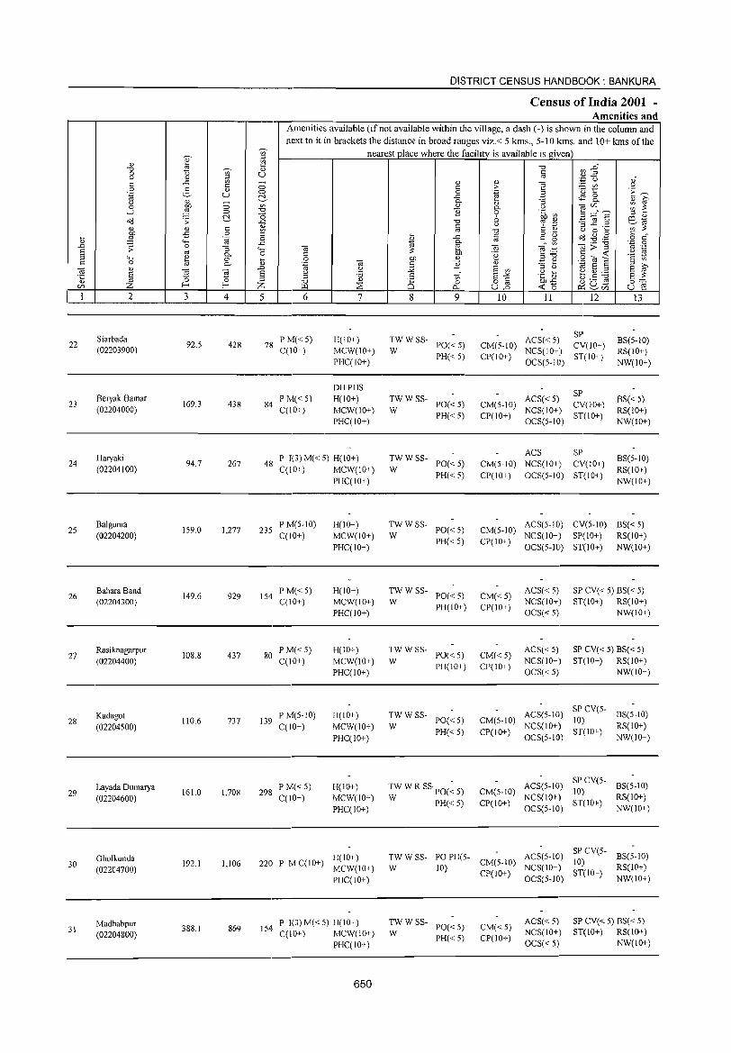
DISTRICT CENSUS HANDBOOK: BANKURA
Census of India 2001 -Amenities and
Amenities available (if not available within the village, a dash (-) is shown in the column and next to it in brackets the distance in broad ranges viz.< 5 kms., 5-10 kms. and 10+ kms of the
'" nearest place where the facility is available is given
" ;:::I
'" '" t<; '" "0 ~ :2~ "0 ~ <!) 0 "0 '" U '" r..> 0) ;:::I .,
'';:: C) ai ..<: U)
0 " " e '" '" '" > ;..= U'l r..> 0 2- '" 0 0 .~ B
.<:) 1:: E~ .~ u c:!.- ..<: $ 8- " ~ r..> '" - 0-
" :;
0 ~ 0 '" " 0- r..> OJ'" :;; ~ ....:I 0 "0 11 0 .~ ~ :; :::£6' c:!.- -0 6 ::l " Od .;;: ..c: "0 ., ._ 3.2 .2 ~"
'" <!) "
r..> C: ';) '" ~ ~ " '" ., "0 u 0 ....
-= 0 ::l o ._
tid .g . .§ " .... ~ .... ..<: '" c" ~ o ,," .~ 0 ~
., " '-H ..<: 0- ._ "0 ·z 0
..0 ;;: 0 :; 4-< OJ ~ OJ e;.g 1j>.:( ., ._
§ oj 0- 0 c: ~ '2 " " '-H '" 0 .... 0 01) " E ~ S20l a '2 t) c: 0 @ 0- '" ',g OJ " 11 " S ~ OJ " ..0 " Q E '" ::l " 01 E ;:::I
§ ~ ~ E " '6 .5 tf E-" .g ~ b.5 ~ E ~ '5 ::l ;:::I "0 '" 2S 0 8] 01)"<: 0;':::
'" Z f-< f-< Z "" :E -< "0 2:l u - u r: 0.. ~'" 1 2 3 4 5 6 7 8 9 10 11 12 13
Siarbada PM«5) H(lO+) TWWSS- ACS«5) SP
BS(5-10) 22 92.5 428 78 PO«5) CM(5-10) CV(IO+) (02203900) C(IO+) MCW(IO+) W NCS(IO+) RS(IO+) PHC(IO+)
PH«5) CP(IO+) OCS(5-1O)
ST(lO+) NW(10+)
DHPHS SP
23 Beryak Hamar
169.3 438 84 P M« 5) H(IO+) TWWSS-
PO«5) CM(5-10) ACS« 5)
CV(IO+) BS« 5)
(02204000) C(IO+) MCW(IO+) W NCS(IO+) RS(IO+) PHC(IO+)
PH«5) CP(IO+) OCS(5-1O)
ST(IO+) NW(IO+)
Haryaki P 1(3) M« 5) H(IO+) TWWSS-ACS SP
BS(5-10) 24 94.7 267 48 PO«5) CM(5-10) NCS(IO+) CV(IO+)
(02204100) C(lO+) MCW(IO+) W RS(10+) PHC(IO+)
PH«5) CP(IO+) OCS(5-10) ST(IO+) NW(IO+)
25 Balguma
159.0 1,277 235 PM(5-10) H(lO+) TWWSS-
PO«5) CM(5-10) ACS(5-10) CV(5-10) BS« 5)
(02204200) C(10+) MCW(IO+) W PH«5) CP(IO+)
NCS(IO+) SP(IO+) RS(lO+)
PHC(lO+) OCS(5-10) ST(lO+) NW(10+)
26 Bahara Band
149.6 929 154 PM«5) H(IO+) TWWSS-
PO«5) CM«5) ACS«5) SP CV« 5) BS« 5)
(02204300) C(lO+) MCW(IO+) W PH(lO+) CP(10+)
NCS(IO+) ST(IO+) RS(IO+)
PHC(IO+) OCS«5) NW(IO+)
Rasiknagarpur 108.8 437 80
PM«5) H(IO+) TWWSS-PO«5) CM«5)
ACS«5) SP CV« 5) BS« 5) 27
(02204400) C(IO+) MCW(lO+) W NCS(IO+) ST(IO+) RS(IO+)
PHC(IO+) PH(IO+) CP(IO+)
OCS« 5) NW(IO+)
Kadagot P M(5-10) H(10+) TWWSS- ACS(5-10) SP CV(5-
BS(5-10) 28 110.6 737 139 PO«5) CM(5-10) 10)
(02204500) C(1O+) MCW(IO+) W PH«5) CP(IO+)
NCS(lO+) ST(IO+)
RS(IO+)
PHC(lO+) OCS(5-1O) NW(IO+)
Layada Dumarya PM«5) H(IO+) TW W R SSpO(: 5) ACS(5-1O) SP CV(5-
BS(5-10) 29 161.0 1,708 298 CM(5-1O) 10)
(02204600) C(10+) MCW(IO+) W PH« 5) CP(lO+) NCS(IO+)
ST(IO+) RS(10+)
PHC(lO+) OCS(5-IO) NW(IO+)
Gholkunda H(IO+) TWWSS- POPH(5- ACS(5-IO) SP CV(5-
BS(5-10) 30 192.1 1,106 220 P M C(10+)
MCW(IO+) W 10) CM(5-10)
NCS(IO+) 10)
RS(IO+) (02204700) CP(IO+) ST(lO+) PHC(lO+) OCS(5-iO) NW(IO+)
Madhabpur P 1(3) M« 5) H(IO+) TWWSS-PO«5) CM« 5)
ACS« 5) SP CV« 5) BS« 5) 31
(02204800) 388.1 869 154·
C(IO+) MCW(IO+) W NCS(IO+) ST(IO+) RS(lO+)
PHC(lO+) PH«5) CP(IO+)
OCS« 5) NW(IO+)
650
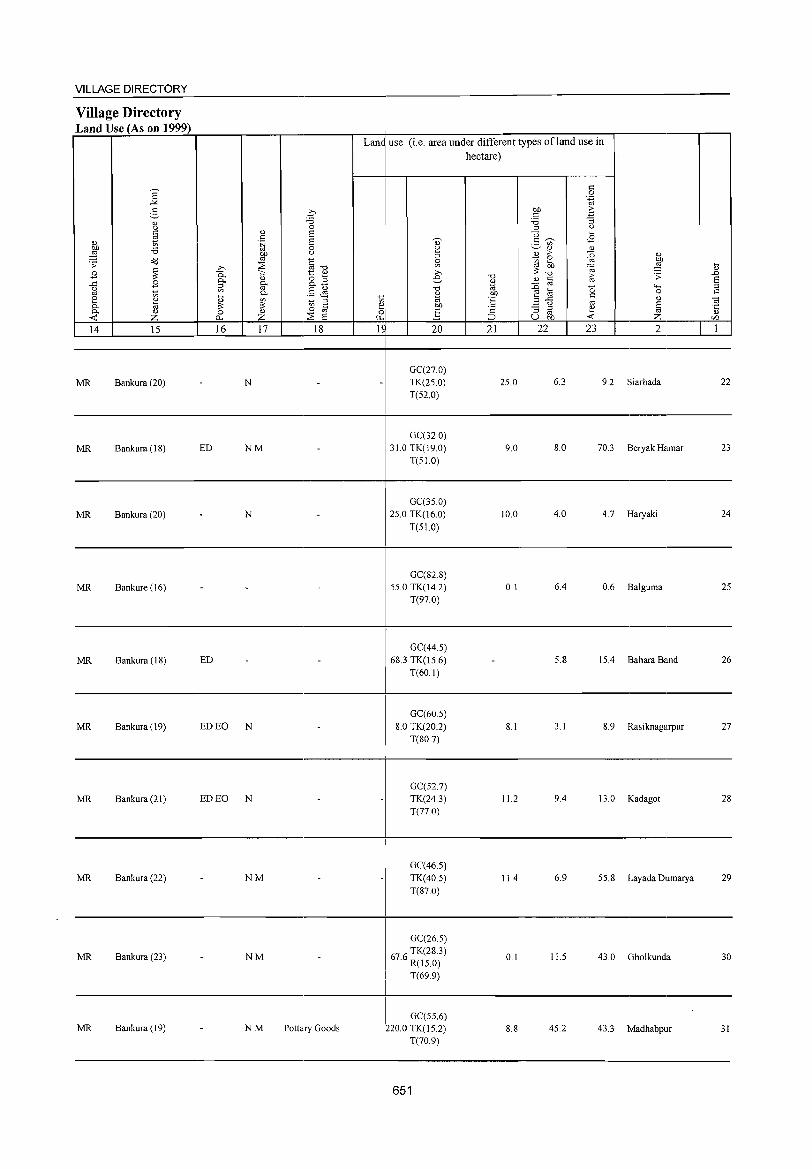
VILLAGE DIRECTORY
Village Directory Land Use (As on 1999)
14 15
MR Bankura (20)
MR Bankura (18)
MR Bankura (20)
MR Bankure (16)
MR Bankura (18)
MR Bankura (19)
MR Bankura (21 )
MR Bankura (22)
MR Bankura (23)
MR Bankura (19)
16 17 18
N
ED NM
N
ED
ED EO N
ED EO N
NM
NM
NM Pottary Goods
Lan~ use (i.e. area under different types ofland use in
I hectare)
IS
I
I
20
GC(27.0) TK(2S.0)
T(52.0)
GC(32 0) 310 TK(19.0)
T(5LO)
GC(35.0) 25.0 TK(16.0)
T(5LO)
GC(828) 55.0 TK(14.2)
T(97.0)
GC(44.5) 68.3 TK(l5.6)
T(60.1)
GC(605) 8.0 TK(20.2)
T(80.7)
GC(52.7) TK(24.3) T(nO)
GC(46.5) TK(40.5) T(87.0)
GC(26.5)
676 TK(28.3) . R(15.0)
T(69.9)
! GC(55.6) 220.0 TK(15.2)
! T(70.9)
651
21 22
25.0
9.0
10.0
0.1
8.1
112
11.4
0.1
8.8
23 2
6.3 9.2 Siarbada
8.0 70.3 Beryak Hamar
4.0 4.7 Haryaki
6.4 0.6 Balguma
5.8 15.4 Bahara Band
3.1 8.9 Rasiknagarpur
9.4 13.0 Kadagot
6.9 55.8 Layada Dumarya
11.5 43.0 Gholkunda
45.2 43.3 Madhabpur
22
23
24
25
26
27
28
29
30
31
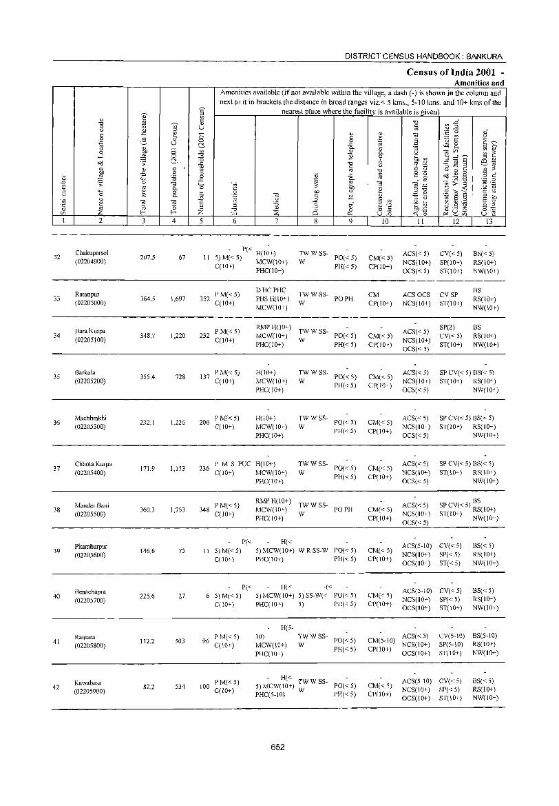
DISTRICT CENSUS HANDBOOK: BANKURA
Census of India 2001 -Amenities and
Amenities available (if not available within the village, a dash (-) is shown in the column and next to it in brackets the distance in broad ranges viz.< 5 kms., 5-10 Ions. and 10+ kms of the
~
nearest place where the facility is available is given ~ ~
" <= ~ :2~ -0 ~ 'U;' " -0 0 U c () " ;:; '" '.;:j u ,,' c ..c '" 0 '" '" 1§ c c > - '" <.) 0 2- Q) 0 0 .~ .3 "C:; to: E~ '.g u ~ ..c ~ 8. ., ~ Q) 0.. :; <.)
OJ) 0 '" '" '" -;;;C/l ~ 1: 0 0- <.)
...l ,g 0 -0 "Ii 0 .~ ~ 5 :'8 ~ -0 6 ;:; '" o(l .;;:
~ -0 ~ .~ '3 _g .2 e;:_"til
" c c <.)
'" :;; '" ~ '" -0 <.) 0 ....
~ -B 0 o ._
dd{lg c , .... .~ 0 ~ ..c c ~~ £ o c
'" """' ..c 0.. '" o;::;:-g ',c 0 .0 .;; 0 :; 4-< -;;; e -;;; ~ .~
'" ,_ S '" 0.. 0 C
:;; OJ) .~ C <I; .~ ~ ;:; 4-< '" 0 0 OJ) '" :l -0 ,S '?l E C 0 l<i 0.. liJ .~ -;;; C "Ii '" .=: e E ~ -;;; " .0 u :s;; E '" :l u "til S :l
E 0; -;;; ~
u :.a ,S ~" S-'" .g ii ~ g:.a E :;; 'C '0 0 :l '" '" '" "d Q)
0 0 o C OJJ-B ~ U .s 0:= V) Z f-< f-< Z W-1 ::E 0... u.2 <I; 0 ~ ~C/l u e 1 2 3 4 5 6 7 8 9 10 II 12 13
32 Chakuparsol
207.5 67 11 - P« H(I~+) TWWSS-
PO« 5) CM«5) ACS« 5) CV«5) BS«5)
(02204900) 5) M« 5) MCW(10+) W NCS(10+) SP(IO+) RS(lO+) C(1O+) PHC(IO+) PH« 5) CP(IO+)
OCS« 5) ST(10+) NW(IO+)
Ratanpur PM« 5) DHCPHC
TWWSS- CM ACSOCS CVSP BS
33 364.5 1,697 352 PHS H(10+) PO PH RS(IO+) (02205000) C(lO+) W CP(IO+) NCS(IO+) ST(10+)
MCW(IO+) NW(IO+)
Bara Kurpa PM« 5) RMPH(IO+)
TWWSS- ACS« 5) SP(2) BS
34 (02205100)
348.7 1,220 232 C(lO+)
MCW(10+) W
PO« 5) CM« 5) NCS(lO+)
CV«5) RS(10+) PHC(IO+) PH«5) CP(lO+)
OCS« 5) ST(IO+) NW(lO+)
35 Barkala
355.4 728 137 P M« 5) H(IO+) TWWSS-
PO« 5) CM« 5) ACS« 5) SP CV« 5) BS« 5)
(02205200) C(lO+) MCW(IO+) W NCS(IO+) ST(10+) RS(IO+)
PHC(10+) PH« 5) CP(lO+)
OCS« 5) NW(IO+)
36 Machhrakhi
232.1 1,226 206 P M« 5) H(10+) TWWSS-
PO«5) CM«5) ACS« 5) SP CV« 5) BS« 5)
(02205300) C(lO+) MCW(lO+) W PH«5) CP(10+)
NCS(IO+) ST(IO+) RS(IO+)
PHC(IO+) OCS« 5) NW(lO+)
37 Chhota Kurpa
171.9 1,153 236 PM S PUC H(lO+) TWWSS-
PO«5) CM«5) ACS« 5) SP CV« 5) BS« 5)
(02205400) C(IO+) MCW(IO+) W NCS(lO+) ST(JO+) RS(IO+)
PHC(IO+) PH«5) CP(lO+)
OCS« 5) NW(lO+)
RMPH(10+) TWWSS-
BS
38 MandarBani
360.3 1,753 348 P'M«5)
MCW(IO+) PO PH CM«5) ACS« 5) SP CV« 5) RS(IO+)
(02205500) C(lO+) PHC(JO+)
W CP(IO+)
NCS(IO+) ST(IO+) NW(lO+) OCS«5)
Pi tambarpur P« H«
ACS(5-1O) CV«5) BS« 5) 39
(02205600) 146.6 75 II 5) M« 5) 5) MCW(IO+) W R SS-W PO«5) CM« 5)
NCS(IO+) SP«5) RS(IO+) C(IO+) PHC(10+) PH« 5) CP(lO+)
OCS(IO+) ST«5) NW(IO+)
Benachapra P« H« -«
ACS(5-JO) CV«5) BS« 5) 40
(02205700) 225.6 27 6 5) M« 5) 5) MCW(lO+) 5) SS-W« PO«5) CM« 5)
NCS(IO+) SP« 5) RS(IO+) C(JO+) PHC(IO+) 5) PH«5) CP(IO+)
OCS(IO+) ST(IO+) NW(IO+)
H(5-
Rautara P M« 5) 10) TWWSS-PO«5) CM(5-10)
ACS« 5) eV(5-10) BS(5-10) 41
(02205800) 112.2 503 96
C(IO+) MCW(JO+) W NCS(IO+) SP(5-10) RS(lO+)
PHC(lO+) PH«5) CP(IO+)
OCS(IO+) ST(IO+) NW(IO+)
PM«5) - H« ACS(5-10) CV«5) BS« 5) Kawabasa
534 100 5) MCW(IO+) ~W W SS- PO« 5) CM« 5) 42 82.2 C(1O+) NCS(IO+) SP« 5) RS(lO+) (02205900)
PHC(5-IO) PH« 5) CP(IO+) OCS(IO+) ST(IO+) NW(JO+)
652
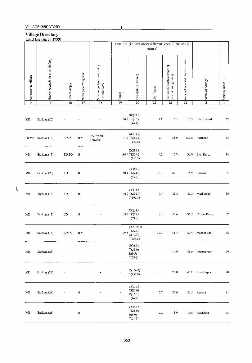
VILLAGE DIRECTORY -
Village Directory Land Use (As on 1999)
Lanl use (i.e. area under different types of land use in hectare)
E c 0
.;,: .~
2- ~ OJ) .:': c -3 0.> :.0
u 0 ::l u C 0.> S U .... ~ c <8 0.> .~ S ., c ~ .- '"
:W '6 0 2 ~o.> 0.>
~ u ::l 0.> > :g 0.>
o(:! §-o 0 ~ 0
~ ;; ~
'" ... ... '" '" OJ) ~ ~ .b :: -0 0.>
B 0- t:: 0.> ;>-. -0 t;; .;; ..c
B 0- 0.> ~B e- o.> 0.> C E .<: ~ g. "t;j ::0 '" '"' ::l <.) .5 & -0 0 '" 1;; 0- OJ OJ) ~] 0 c e ~ ~ '" ::l ~: "t;j 0E: c
" ~ 0- '" :: on 8 bJ) ~ <.) '" S 0 .... ' ] 's:: - ::l
~ 0- 0.> 0 0.> ~
0' :::l '" :£ 0.>
<C Z 0... Z E ~I ::J U OJ) r:/l
14 15 16 17 18 g 20 21 22 23 2 1
-GC(42.0)
MR Bankura (20) - - - 140.0 TK(2.1) 7.8 5.1 10.5 Chakuparso1 32 T(44.1)
Car Wheel, GC(7L2)
PRMR Bankura (16) ED EO NM Thrasher
71.6 TK(50.6) 7.1 35.0 129.0 Ratanpur 33 T(121.8)
GC(92.9)
MR Bankura (17) ED EO N - 180.0 TK(20.2) 4.2 15.3 36.0 BaraKurpa 34 T(113.2)
GC(60.7)
MR Bankura (20) ED N - 160.1 TK(24.3) 13.3 82.1 15.0 Barkala 35
T(85.0)
GC(75.8)
MR Bankura (18) ED N - 30.0 TK(30A) 9.7 33.8 52.3 Machhrakhi 36 T(106.2)
GC(51 A)
MR Bankura (17) ED N - 33.0 TK(18.2) 8.3 30.6 30.5 Chhota Kurpa 37 T(69.6)
GC(125.6)
MR Bankura (15) ED EO NM - 395 TK(20.2) 32.0 51.7 81.4 MandarBani 38 . 0(10.0)
T(I55.8) -GC(66.6)
MR Bankura (23) - - - - TK(3.0) - 12.0 55.6 Pitambarpur 39 R(9.5)
T(79.0)
MR Bankura (24) - - 0(154.0) - 28.0 43.6 Benachapra 40 - T(154.0)
-GC(33.0)
MR Bankura (24) N - TK(1.0) 0.7 39.0 26.5 Rautara 41 - R(12.0)
T(46.0)
GC(40.5)
MR Bankura (23) - N - -TK(5.0)
12.2 8.0 10.5 Kawabasa 42 R(6.0) T(51.5)
653
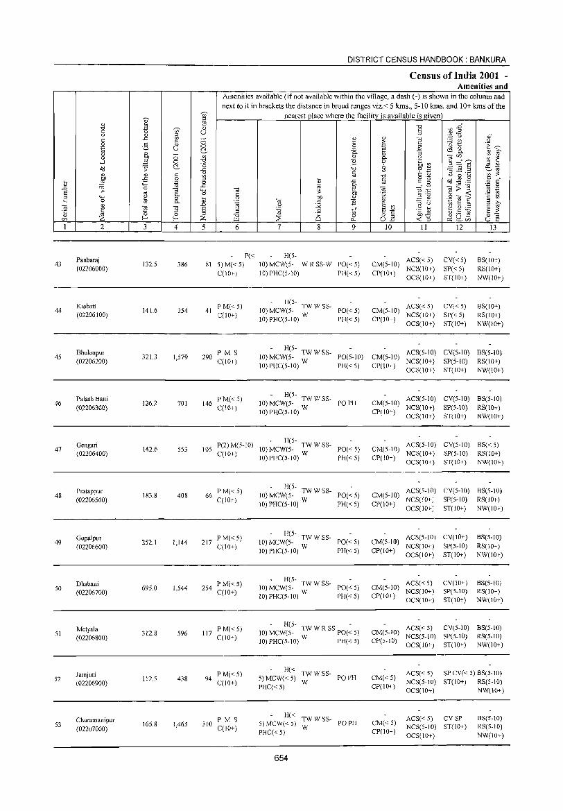
DISTRICT CENSUS HANDBOOK: BANKURA
Census of India 2001 -Amenities and
Amenities available (if not available within the village, a dash (-) is shown in the column and
next to it in brackets the distance in broad ranges viz.< 5 kms., 5-10 lans. and 10+ lans of the ~
nearest place where the facility is available is given
I ;g
'" <Il
"0 ';i' $ "0 ~ E~ 0 u " <J <!) :l 0) '~ 0 oJ ..c: '" ~ 1! '" e " " <:) 2: ~t <J
0 g <!) E~ '-g u <:) 0
'" .a ~ ..c: ~8. <J '" - c. al :; '" i;;' 0 bJ) <:) '" '" g. <J Cd[/)
;;; ~ ....:I ~ 0 "0 B .~ ~ ~=~ ~ ] 6 :l '" o<l ;; "0 <.) '" ._ -=5 ~ ._ CXl",
<!) " C: ~ ';;';;: '" <!) " :g " "0 <.) 0 ... 00 ..c: .S ~
o ._ o'd .g .,g " . ... ~ .:::: ..2 '" ..c: § =" ~ o "
'" '" '" c.
Cd>~ '';:: 0
,t:J .;; 0 "3 "-" Cd ;;: tn Cd ~:a " ._
S 0) c. 0 <= .~ " <C .9 rg :l """ ~ 0 al 0 00 '" E ~ S<oa " '" " 0 c. .~ Cd " 11 '" E i;;' Cd '" on u :_g E '" :l U 'i:S E :l
§ (ii ] E <J :a .= S~ .~ [> ~ Cl)._ s ::: '5 (5 ::s ::s '" 8 (.).5 ~
Z f- ,:: Z "0 ::s Ci o " bJ).c ~u~ 0'-=
[/) f.Ll 0.. ull <C (5 ~[/) u e 1 2 3 4 5 6 7 8 9 10 11 12 13
Panbaraj P« H(5-ACS« 5) CV«5) BS(IO+)
43 132.5 386 81 5)M« 5) 10) MCW(5- WRSS-W PO«5) CM(5-1O) (02206000)
C(IO+) 10) PHC(5-10) PH«5) CP(IO+) NCS(10+) SP« S) RS(10+) OCS(10+) ST(IO+) NW(IO+)
Kiabati PM«S) - H(5-
ACS« 5) CV«5) BS(IO+) 44 141.6 254 41 10) MCW(5- TW W SS- PO« 5) CM(S-IO)
(02206100) C(1O+) 10)PHC(S-10) W PH«5) CP(IO+)
NCS(IO+) SP« S) RS(IO+) OCS(10+) ST(lO+) NW(10+)
Bhulanpur PMS - H(S-
ACS(5-10) CV(5-10) BS(5-10) 4S 321.3 I,S79 290 10) MCW(5- TW W SS- PO(5-10) CM(5-10)
(02206200) C(10+) 1O)PHC(5-10) W PH« S) CP(10+) NCS(IO+) SP(5-10) RS(lO+) OCS(IO+) ST(IO+) NW(lO+)
Palash Bani PM«5) - H(5-
ACS(5-IO) CV(5-1O) BS(5-10) 46 126.2 701 146 10) MCW(5- TW W SS- PO PH CM(5-1O)
(02206300) C(10+) IO)PHC(5-10) W CP(IO+)
NCS(10+) SP(5-10) RS(10+) OCS(1O+) ST(lO+) NW(IO+)
Gengari P(2) M(5-1O) - H(5-
ACS(5-10) CV(5-10) BS« 5) 47 142.6 553 lOS 10) MCW(S- TW W SS- PO« 5) CM(5-10)
(02206400) C(10+) 10)PHC(5-IO) W PH« 5) CP(10+)
NCS(10+) SP(5-10) RS(10+) OCS(IO+) ST(IO+) NW(IO+)
Pratappur P M« 5) - H(5-
ACS(5-IO) CV(5-IO) BS(5-1O) 48 183.8 408 66 10) MCW(5- TW W SS- PO«5) CM(5-10)
(02206500) C(IO+) 10)PHC(5-10) W PH«5) CP(10+)
NCS(lO+] SP(S-IO) RS(IO+) OCS(IO+) ST(10+) NW(IO+)
Gopalpur P M«5) - H(5-
ACS(5-10) CV(IO+) BS(5-1O) 49 252.1 1,144 217 10) MCW(5- TW W SS- PO«5) CM(5-JO)
(02206600) C(IO+) 10) PHC(5-10) W
NCS(IO+) SP(S-IO) RS(10+) PH«5) CP(lO+)
OCS{lO+) ST(lO+) NW(lO+)
Dhabani p M«5) - H(5-
ACS« 5) CV(lO+) BS(5-10) 50 69S.0 1,544 254 10) MCW(5- TW W SS- PO«5) CM(5-10)
(02206700) C(JO+) 10) PHC(5-1O) W PH« 5) CP(IO+) NCS(IO+) SP(5-1O) RS(IO+) OCS(10+) ST(IO+) NW(10+)
Metyala PM«5) H(5- -
ACS«5) CV(5-IO) BS(5-1O) 51 312.8 596 117 10) MCW(S- TW W R SS· PO« 5) CM(5-IO)
(02206800) C(10+) 1O)PHC(5-IO) W PH«5) CP(5-10) NCS(S-IO) SP(S-IO) RS(5-10) OCS{lO+) ST(lO+) NW(IO+)
Jamjuri PM« 5) H« TWWSS- ACS« 5) SP CV« 5) BS(5-10)
52 112.5 438 94 5) MCW«5) PO PH CM« 5) (02206900) C(IO+)
PHC«5) W
CP(IO+) NCS(S-IO) ST(10+) RS(S-10) OCS(10+) NW(10+)
Churamanipur PM S H« TWWSS- ACS« 5) CVSP BS(5-10)
S3 16S.8 1,465 310 5) MCW« 5) PO PH CM« 5) (02207000) C(10+)
PHC« 5) W
CP(IO+) NCS(5-IO) ST(IO+} RS(5-10)
OCS(10+) NW(10+)
654
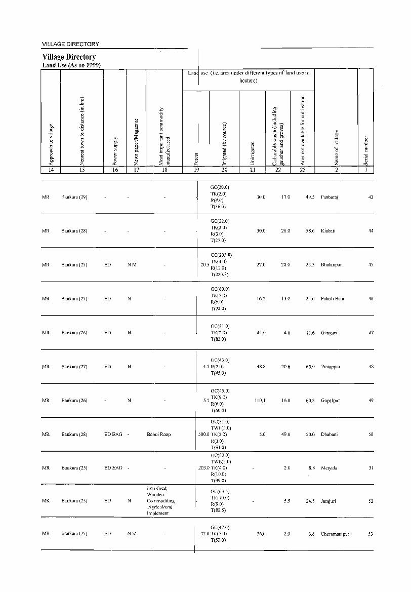
VILLAGE DIRECTORY
Village Directory Land Use (As on 1999)
E "'" 3 " u
~ " OJ) 'B ;l del .:;:
~ B B ..c
u
'" ~ e " 0- S 0- " -< z 14 15
MR Bankura (29)
MR Bankura (28)
MR Bankura (25)
MR Bankura (25)
MR Bankura (26)
MR Bankura (27)
MR Bankura (26)
MR Bankura (28)
MR Bankura (25)
MR Bankura (25)
MR Bankura (25)
b 0. §: </) ,_ ~ ~ 16
-
ED
ED
ED
ED
-
EDEAG
EDEAG
ED
ED
q "0 0
" t:: .~ OJ)
S S 0 <J
co ::s \::: " "-'" "-~ " Z
§"O 1:: " o ,_ o..g .5 <.is ~
:;; § 0
::s s 17 18
-
NM
-
N -
N -
-
N -
N -
- Babui Roap
- -
Iron Gred, Wooden
N Commodities, .Agricultural Implement
NM -
Lane use (i.e. area under different types ofland use in
hectare)
t:: 0 .~
OJ) .:0: t:: '3 'B :;; <J
U ,_
g 'V> <B " " 2 ;>
~ ~ §b ::; ~
"0 "0 ~ " " t::
'" =§ co
0 OJ) S ·E 3 ..c c
<J co
~ "5 :;;
~ '" u OJ)
., U
5 Sl » e
-c:l
" ~I t<i '" OJ)
~ :§ l~ 20 21 22 23
I
GC(30.0)
" :W .:;: 4-< 0
" § Z 2
-I
TK(2.0) R(4.0)
30.0 17.0 49.5 Panbaraj
T(36.0)
GC(22.0)
-TK(2.0)
30.0 26.0 58.6 Kiabati R(3.0) T(27.0)
GC(203.8)
203 TK(4.0) . R(13.0)
27.0 28.0 25.3 Bhulanpur
T(220.8)
GC(60.0) TK(7.0)
16.2 13.0 24.0 Palash Bani R(6.0) T(73.0)
GC(810) TK(2.0) 44.0 4.0 11.6 Gengari T(83.0)
GC(43.0) 4.5 R(2.0) 48.8 20.6 65.0 Pratappur
T(45.0)
GC(45.0)
57 TK(9.0) . R(6.0)
110.1 16.0 60J Gopalpur
T(60.0)
GC(810) TWE(5.0)
500.0 TK(2.0) 5.0 49.0 50.0 Dhabani R(3.0) T(91.0)
GC(80.0) TWE(5.0)
203.0 TK(4.0) - 2.0 8.8 Metyala R(IO.O) T(99.0)
GC(63.5)
- TK(IO.0) 5.5 24.5 Jamjuri
R(9.0) T(82.5)
GC(470) 72.0 TK(5 0) 36.0 2.0 3.8 Churamanipur
T(52.0)
... " .<:> E :l
" OJ ·5 (/)
1
43
44
45
46
47
48
49
50
51
52
53
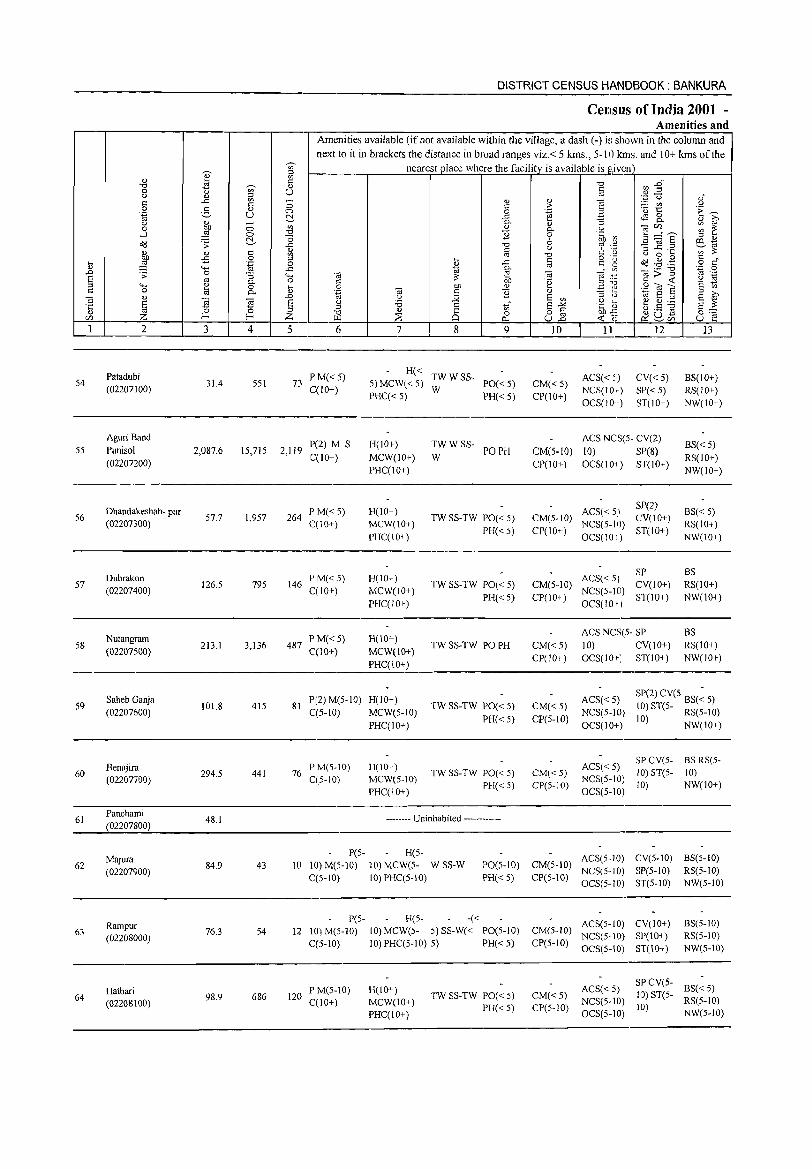
Vi' ::>
" ~ '" " "t:> ~ " 0 u '" U {) " ::l c: ..c: V> c: c 0 '5
<I) 0
.~ U ~ u ~ ~
0 0 '" ...l ~ 0 '"d
~ -0 o'IJ .:; ..c:
" " " c '" ! -£ 0 ::> .... .~ 0
" "-' ..c: ..0 .:; 0 "3 4-< 8 ro 0- 0 ::> 4-< 1:! 0 ... c: 0 ro 0- " '" " ..0
·c § ~ ~ 8
" ::l
<Zl Z f-< Z 1 2 3 4 5
Patadubi 54 31.4 551 73
(02207100)
AguriBand
55 Punisol 2,087.6 15,715 2,119 (02207200)
Dhandakeshab- pur 56
(02207300) 57,7 1,957 264
Dubrakon 57
(02207400) 126.5 795 146
Nutangram 58 213.1 3,136 487
(02207500)
59 Saheb Ganja
101.8 415 81 (02207600)
Benajira 60 294.5 441 76
(02207700)
61 Panchami
48.1 (02207800)
Majura 62
(02207900) 84.9 43 10
Rampur 63
(02208000) 76.3 54 12
Hatbari 64
(02208100) 98.9 686 120
DISTRICT CENSUS HANDBOOK: BANKURA '-------------------------------------CelllSUS of India 2001 -
Amenities and Amenities available (ifnot available within the village, a dash (-) i~; shown in the column and
kms. and 10+ kms of the ven
next to it in brackets the distance in broad ranges viz.< 5 kms., 5-10 nearest place where the facility is available is ,gi
-0
" ro
" " e c ,. 0 '.g 3 ..c: 0- 0) "3 <I) 0- u '2 0 ·c
6 OJ) '"d ro. iii u <': .
'"d ~ ..c: §
o·
* " 0-
'" '" ~ '" ] ~ c: 'e 0 OJ) " ~l '.g '" c '2 " {) ''';;: E on ::l <
g '6 :: '" 8-'" .g !
'"d " Q 0 o @ OJ)~
~ ~ 0... U..o ...:: 1 6 7 8 9 10 11 12 13
PM«5) H«
TWWSS- ACS« 5) CV«5) BS(lO+) 5) MCW« 5) PO« 5) CM« 5)
C(10+) PHC« 5)
W PH« 5) CP(10+)
NCS(lO+) SP« 5) RS(IO+) OCS(IO+) ST(10+) NW(IO+)
P(2) M S H(IO+) TWWSS-ACS NCS(S- CV(2)
BS« 5) PO PH CM(5-10) !O) SP(8)
C(lO+) MCW(10+) W CP(10+) OCS(IO+) ST(IO+)
RS(10+) PHC(IO+) NW(IO+)
PM«5) H(10+) ACS«5) SP(2)
BS« 5) C(10+) MCW(10+)
TW SS-TW PO« 5) CM(5-10) NCS(S-lil)
CV(10+) RS(10+)
PHC(10+) PH« 5) CP(10+)
OCS(10+) ST(IO+)
NW(lO+)
PM«5) H(10+) ACS« 5) SP BS
C(10+) MCW(IO+) TW SS-TW PO« 5) CM(5-10)
NCS(5-I(I) CV(10+) RS(lO+)
PHC(lO+) PH« 5) CP(10+)
OCS(lO+) ST(10+) NW(10+)
PM«5) H(lO+) ACS NCS(5- SP BS
TW SS-TW PO PH CM« 5) 10) CV(IO+) RS(10+) C(10+) MCW(lO+)
CP(IO+) OCS(IO+; ST(IO+) NW(10+) PHC(lO+)
P(2) M(5-JO) H(IO+) TW SS-TW PO« 5) CM«5)
ACS«5) SP(2} CV(S BS(~ 5}
C(5-1O) MCW(5-10) NCS(5-lO) 10) ST(5- RS(5-lO)
PHC(IO+) PH« 5) CP(S-lO)
OCS(IO+) 10) NW(10+)
PM(5-10) H(10+) ACS« 5) SP CV(5- BS RS(5-
TW SS-TW PO« 5) CM« 5) 10) ST(5- 10) C(5-10) MCW(S-10)
PH« 5) CP(5-10) NCS(5-IO)
10) NW(10+) PHC(10+) OCS(5-10)
-------- Uninhabited ------------
P(5- H(5-ACS(5-10) CV(5-10) BS(5-1O)
10) M(S-IO) 10) MCW(5- WSS-W PO(5-10) CM(S-IO) NCS(5-1O) SP(5-10) RS(5-10)
C(5-IO) 10) PHC(5-10) PH« 5} ep(S-IO) OCS(5-10) 5T(5-1O) NW(5-1O)
P(S- H(5- -« ACS(5-1O) CV(IO+) BS(5-1O) 10) M(5-10) 10) MCW(5- 5) SS-W« PO(5-1O) CM(5-10)
NCS(5-10) SP(10+) RS(5-10) C(:i-JO) 10) PHC(5-1 0) 5) PH«5) CP(5-lO)
OCS(5-10) ST(\o+) NW(5-IO)
PM(5-10) H(IO+) ACS« 5) SP CV(5-
BS« 5)
C(10+) MCW(IO+) TW SS-TW PO« 5) CM«5)
NCS(5-1O) 10) ST(5-
RS(5-10)
PHC(lO+) PH« 5) CP(5-IO)
OCS(5-1O) 10)
NW(5-10)
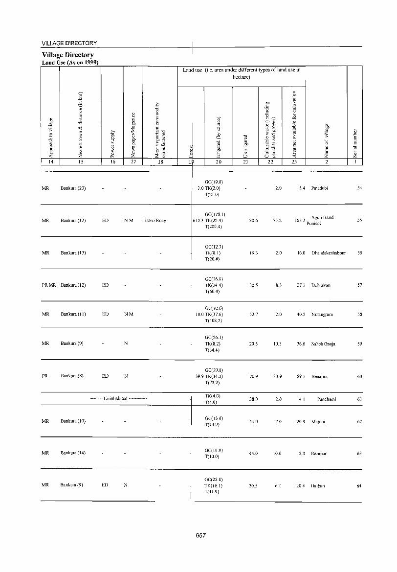
VILLAGE DIRECTORY
Village Directory Land Use (As on 1999)
E -'" 2,
(1.) u to: fl (1.)
OJ) '5 ::§ ~ .;; ~ B
.t:: B u
'" '" 2 ~ 0. 0. (1.)
-< Z 14 15
MR Bankura (23)
MR Bankura (12)
MR Bankura (13)
PRMR Bankura(12)
MR Bankura (11)
MR Bankura (9)
PR Bankura (8)
(1.)
'" .~ OJ)
'" >-. ~ 0. 0.
(1.)
~ [if 0.
~ '" ;> 0 (1.)
o_, z 16 17
ED NM Babui Roap
ED
ED NM
N
ED N
-------- Uninhabited ------------
MR Bankura (10)
MR Bankura (14)
MR Bankura (9) ED N
Lan' use (i.e. area under different types ofland use in hectare)
GC(19.0) 3.0 TK(2.0)
T(2LO)
GC(I78.l) 610.3 TK(22A)
T(200A)
GC(12.3) TK(S.I) T(20A)
GC(36 0) TK(24A) T(60A)
GC(70 6) 10.0 TK(37.6)
T(IOS.2)
GC(26.l) TK(S.2) T(34A)
GC(39.0) 39.9 TK(34.2)
T(73.2)
TK(4.0) T(4.0)
GC(13.0) T(13.0)
GC(IO.O) T(10.0)
GC(25.8) TK(I6.1) T(4L9)
657
3S.6
19.3
305
52.7
20.5
70.9
38.0
44.0
44.0
30.5
2.0
75.2
2.0
8.3
2.0
10.3
20.9
2.0
7.0
10.0
6.1
5.4 Patadubi
163.2 Aguri Band Pumsol
16.0 Dhandakeshabpur
27.3 Dubrakon
40.2 N utangram
36.6 Saheb Ganja
89.5 Benajira
4.1 Panchami
20.9 Majura
12.3 Rampur
20.4 Hatbari
54
55
56
57
58
59
60
61
62
63
64
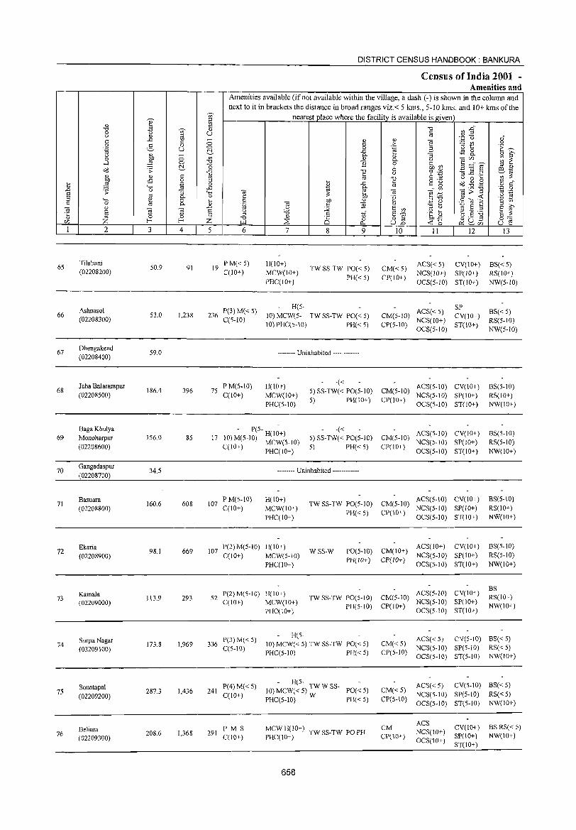
DISTRICT CENSUS HANDBOOK: BANKURA
CensllIs of India 2001 -Amenities and
Amenities available (ifnot available within the village, a dash (-) is shown in the colnmn and
next to it in brackets the distance in broad ranges viz.< 5 kms., 5-10 kms. and 10+ kms of the ~
nearest place where the facility is available is given '" ~
;:l .. '" " '0 ~ :2" '0 'Qi' .. 0 u U c u '" ;:l Ol
" c .c '" - <!) <!) e ·z u c 0 c ;> ~ U'l U
0 5 '" 0 _g .~ B 'u 1:: E~ .~ u ~ 49 8.. u '" 0 0- '" "3 '" ~ 0 on '" <!) 0- 0 -.;'" ~ ~ ....1 ~ 0 '0 1l l' .~ ~ :s ;::£,? ~ -0 ;:l ..,
Oil .;;: .c '0 0 ~ '';::: 'B _g .2 ill 1<l
'" '" c '" c u ';;;'~ '" Ol '0 C OJ U 0 ~ OJ) .;:; 0 ;:l
i> c o ._
O?J .g ,.g c " ~ ~ .~ 0 ..c: c g o c '" ""' .c 10 0- Ol
'" -.;;>11 '0 0 .0 .;;: 0 "3 ""' -.; Ol -.; ~ :=: Ol .-E Ol ~ .... .2 2 0- 0 C OJ) '§ c <C :::l ""' e 0 ~ 0 OJ) <!) :::1'0
2til'S C 'J> C 0 Ol 0- '" .~ -.; C ] '" - '" ;:l »
-.; '" }i }i ..0 U :;;; E '" "3 Q 10 E ;:l E Ol
§ e u 'i3 ,~ I-< ~.8 ~ '0: ::l
== '" 8-'" bD~ e ~
'" 0 ~ :::1 '0 '" o § 0::::
Z I--< Z :::s is 0 ~ ~ rn '" I.l.l ~ U..o <C 15 u f'! 1 2 3 4 5 6 7 8 9 10 II 12 i3
65 Tilabani
50.9 PM« 5) H(10+) ACS« 5) CY(IO+) BS« 5) 91 19 TW SS-TW PO« 5) CM« 5) (02208200) C(10+) MCW(lO+)
PH«5) CP(IO+) NCS(IO+) SP(IO+) RS(IO+)
PHC(10+) OCS(5-1O) ST(IO+) NW(5-1O)
Ashnasol P(3)M«5) H(5-
ACS«S) SP
BS«5) 66 53.0 1,238 236 10) MCW(5- TW SS-TW PO« 5) CM(5-10) CY(IO+) (02208300) C(5-1O) 10) PHC(5-10) PH« 5) CP(S-IO)
NCS(lO+) ST(lO+)
RS(5-1O) OCS(5-10) NW(5-1O)
67 Dhengakend
59.0 -------- Uninhabited ------------(02208400)
J aba Balarampur PM(5-10) H(lOT) -«
ACS(5-10) CV(10+) BS(5·10) 68 186.4 396 75 5) SS-TW« PO(5-10) CM(5-10)
(02208500) C(10+) MCW(10T) NCS(5.10) SP(IO+) RS(lO+) PHC(5-10)
5) PH(IOT) CP(IOT) OCS(5-10) ST(lO+) NW(lO+)
BagaKhulya - P(S- H(1~+) -« ACS(5-10) CY(IO+) BS(5-10)
69 MonoharpuT 156.0 85 17 lO)M(5-10) MCW(5-IO) 5)SS-TW« PO(S-IO) CM(S-IO) NCS(5-10) SP(10+) RS(5·10)
(02208600) C(lO+) PHC(IO+) s) PH«5) CP(IO+) OeS(5-10) ST(IO+) NW(IO+)
70 Gangadaspur
34.5 .----••• Uninhabited .----------. (02208700)
71 Basuara
160.6 608 107 P M(S-IO) H(IO+)
TW SS-TW PO(5-10) CM(5-10) ACS(5-10) eV(1o+) BS(5-10)
(02208800) e(1o+) MCW(IO+) PH« 5) CP(IO+)
NCS(S·IO) SP(10+) RS(10+)
PHC(IO+) OeS(5-10) ST(10+) NW(IO+)
72 Ekaria
98.1 669 107 P(2) M(5-1O) H(lO+) WSS-W PO(S-10) CM(10+)
ACS(lO+) CV(10+) BS(5-10)
(02208900) C(10+) MCW(5-10) PH(!O+) CP(lO+)
NCS(5-10) SP(10+) RS(5-1O)
PHC(IO+) OCS(5·10) ST(IO+) NW(IO+)
ACS(5-10) CV(10+) BS
73 Kamala
113.9 293 52 P(2)M(5-10) H(IO+)
TW SS-TW PO(5-1O) CM(5·10) RS(10+) (02209000) C(10+) MCW(lO+)
PH(5-10) CP(10+) NCS(5-10) SP(IO+)
NW(10+) PHC(IO+) OCS(5-10) ST(10+)
Surpa Nagar P(.3)M« S) H(5-
ACS« 5) eV(S-IO) BS« 5) 74
(02209100) 173.8 1,969 336
C(S-IO) 10) MCW« 5) TW SS-TW PO« 5) CM« 5)
NeS(S-IO) SP(5-10) RS«5) PHC(5-1O) PH«S) CP(5-10)
OCS(5-10) ST(5-10) NW(lO+)
P(4) M« 5) - H(5-
ACS« 5) CV(5-to) BS« 5) Sonatapal 287.3 1,436 241 10) MCW« 5) TW W SS- PO«5) eM« 5) 75 C(10+) NCS(5-10) SP(S-IO) RS« 5) (02209200) PHC(5-10) W PH«5) ep(5-10)
OCS(S·IO) ST(5-1O) NW(lO+)
CM ACS
CV(10+) BS RS« 5) Beliara PMS MCWH(IO+) TW SS-TW PO PH NCS(lO+) 76 208.6 1,368 291
C(IO+) PHC(lO+) CP(lO+) SP(lO+) NW(IO+) (02209300) oeS(1o+) ST(10+ )
658
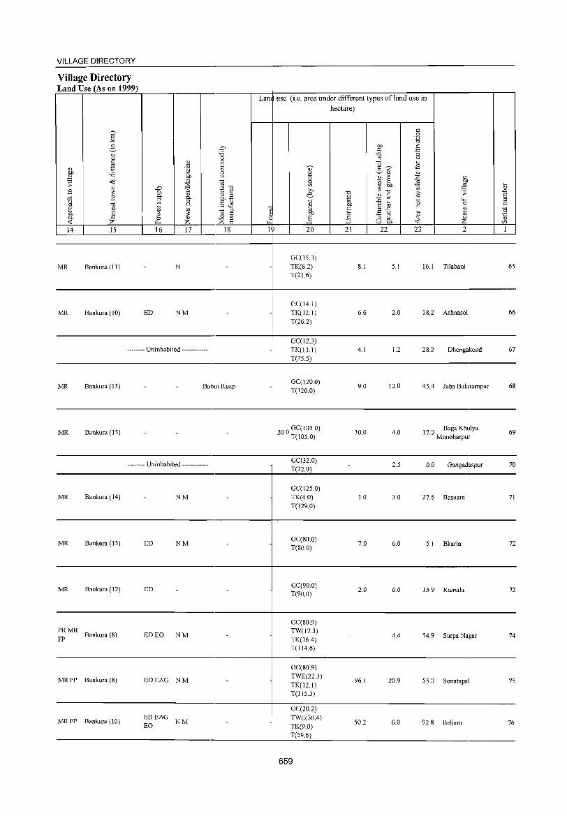
VILLAGE DIRECTORY ~--~------------------------------~------------------------------------------Village Directory Land Use (As on 1999) r=~~~~~~r----.---'-'------'--~--~----~~----~~~~'---------'--' Lan use (i,e, area under different types ofland use in
hectare)
14 15 16 17 18 1 20 21 22 23 2 1 ~~~ ____ ~ ____ ~ ____ L-__ ~ __ ~~ __ ~ __ 4-~ __ ~~~ __ ~ __ ~-=~~~~-L ____ ~ ____ L-~
MR Bankura (II) N
GC(IS,3)
TK(6,2) T(2J6)
8,1 S, I 16, I Tilabani 6S
----------------------------------------~--------------------------------------------
MR Bankura (10) ED NM
-------- Uninhabited ------------
MR Bankura (IS) BabuiRoap
GC(14,1)
TK(12,1)
T(26.2)
GC(12.3) TK(l3,1) T(25.5)
GC(120,0) T(120,0)
6,6 2,0 18,2 Ashnasol 66
4,1 1.2 28,2 Dhengakend 67
9,0 12,0 4S,4 Jaba Balarampur 68
------------------------------------------~----------------------------------------.---------
MR Bankura (IS)
MR Bankura (14)
-------- Uninhabited ------------
NM
20 0 GC( IOS,O) , T(IOS,O)
GC(32,0) T(32,0)
GC(125,O)
TK(4,0)
T(129,0)
10,0 4,0
2.5
1.0 3,0
17 0 Baga Khulya , Monoharpur
0,0 Gan gadaspur
27,6 Basuara
69
70
71
----------------------------------------~--------------------------------------------
MR Bankura (IS) ED NM GC(80,0)
T(80,0) 7,0 6,0 5, I Ekaria 72
----------------------------------------~--------------------------------------------
MR Bankura (12) ED GC(900) T(90,0)
2,0 6,0 15,9 Kamala 73
-----------------------------'-----------+---------------------------------------------
~ MR Bankura (8) ED EO NM
MR FP Bankura (8) EDEAG NM
MR FP Bankura (10) EO EDEAG
NM
GC(80,9)
TW(l73) TK(16,4) T(114,6)
GC(80,9)
TWE(22,3)
TK(12,l) T(ll5.3)
GC(20,2) TWE(30,4) TK(9,0)
T(S9,6)
I 659
4,4 S4,9 Surpa Nagar 74
96,1 20,9 SS,O Sonatapal 75
SO,2 6,0 92,8 Beliara 76
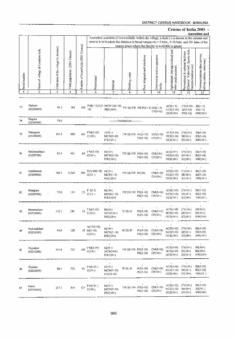
77
78
79
80
81
82
83
84
85
86
87
2
Malator
(02209400)
Bagjata (02209500)
Debagram
(02209600)
Baidyanathpur (02209700)
Mankhamar (02209800)
Bhatgram (02209900)
Banamalipur (02210000)
Mukundabati
(02210100)
Angadpur (02210200)
Bhaluka (02210300)
Karra (02210400)
3
91.1
79.0
105.5
83.4
18S.2
72.0
172.7
94.8
107.9
80.1
227.2
~ c <>
U
4
562
609
401
2,328
114
281
128
755
572
814
DISTRICT CENSUS HANDBOOK: BANKURA
Census of India 2001 -Amenities and
I Amenities available (ifnot available within the village, a dash (-) is shown in the column and next to it in brackets the distance in broad ranges viz.< 5 kms., 5-10 kms. and 10+ kIDs of the
nearestpJace where the facility is available is given
<> u
5 6 7 8 9 IO II 12 13
103 PM«5)C(5- MCWH(5-10) 10) PHC(lO+) TW SS-TW PH PO« 5) CM« 5)
CP(5-10)
ACS« 5) CV(S-IO) 88« 5) NCS(S-IO) SP(S-IO) RS« 5) OCS(IO+) ST(5-1O) NW(lO+)
-------- Uninhabited ------------
100 PM(5-10) C(lO+)
6S P M(5-10) C(IO+)
H(lO+) MCW(S-IO) PHCCIO+)
H(IO+) MCW(S-IO) PHC(IO+)
390 1'(2) M(5-10) H(10+) C(lO+) MCW« 5)
PHC(lO+)
23 F'M S C(10+)
53 P M(5-10) C(lO+)
AC P(S-IO) 19 M(5-10)
C(lO+)
140 P M(S-IO) C(lO+)
91 P M(10+) C(lO+)
137 I'M(IO+) C(10+)
H(10+) MCW(S-IO) PHC(IO+)
H(IO+) MCW(IO+) PHC(lO+)
H(IO+) MCW(5-10) I'HC(10+)
H(10+) MCW(IO+) I'HC(IO+)
H(10+) MCW(5-10) PHCC5-10)
H(IO+) MCW(5-IO) PHC(lO+)
660
TW SS-TW PO(5-10) PH(5-10)
TW SS-TW PO(5-1O) PH(5-10)
TW SS-TW PO PH
CM(5-10) ACS(5-10) CV(IO+) NCS(S-IO) SP(IO+)
CP(10+) OCS(1O+) ST(IO+)
ACS(IO+) CV(IO+) CM(IO+) NCS(S-IO) SP(IO+) CP(IO+) OCS(10+) ST(10+)
CM(S-10) ACS(5-10) CV(IO+) CI'(IO+) NCS(S-10) SI'(IO+)
OCS(1O+) ST(IO+)
TW SS-TW PO(S-IO) CM(5-10) ACS(5-10) CV(IO+) I'H(S-IO) CI'(IO+) NCS(5-10) SI'(10+)
WSS-W
WSS-W
1'0(5-10) PH(5-10)
1'0(5-10) PH(5-10)
TW SS-TW 1'0(5-10) PH(5-10)
WSS-W 1'0(5-10) PH(S-10)
OCS(10+) ST(IO+)
CM(5-IO) ACS(5-1O) CV(IO+) NCS(5-1O) SI'(l 0+)
CP(10+) OCS(IO+) ST(IO+)
CM(5-1O) ACS(5-IO) CV(10+) CI'(IO+) NCS(5-IO) SP(IO+)
OCS(IO+) ST(lO+)
CM(S-IO) ACS(5-1O) CV(10+) NCS(5-10) SI'( 10+)
CP(IO+) OCS(IO+) ST(IO+)
ACS(5-10) CV(IO+) CM(5-1O) NCS(5-10) SP(lO+) CP(lO+) OCS(IO+) ST(IO+)
ACS(5-1O) CV(lO+) TW SS-TW PO(5-1O) CM(5-10) NCS(5-1O) SP(lO+)
PH(5-10) CP(IO+) OCS(10+) ST(10+)
8S(5-10) RS(S-IO) NW(IO+)
8S(5-10) RS(5-10) NW(10+)
8S(5-1O) RS(5-10) NW(IO+)
BS(5-10) RS(5-10) NW(lO+)
BS(IO+) RS(IO+) NW(IO+)
BS(5-10) RS(5-10) NW(IO+)
BS(IO+) RS(10+) NW(IO+)
BS(5-10) RS(5-10) NW(10+)
BS(5-1O) RS(IO+) NW(lO+)
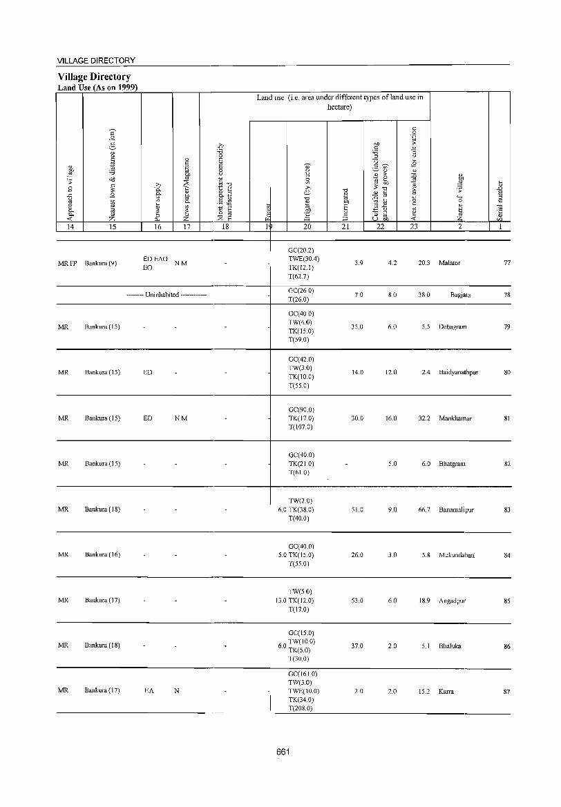
VILLAGE DIRECTORY -----------------------------,-----------+---------------------------------------------Village Directory Land Use (As on 1999) r---.-~----~~----._--_r-,-------.--4~~----~~~------~~~-.---------.---,
Lan use (i,e. area under different types ofland use in
14 15
MR FP Bankura (9)
16 17
EDEAG NM EO
18 20
GC(20.2) TWE(30A) TK(l2.1) T(62.7)
hectare)
21 22 23 2
3.9 4.2 20.3 Malator 77
----------------------------------------,_--~~~-------------------------------------GC(26 0) -------- Uninhabited ------------
MR Bankura (15)
MR Bankura (15) ED
MR Bankura (15) ED NM
MR Bankura (15)
T(26.0)
GC(40.0) TW(4.0) TK(150) T(59.0)
GC(42.0) TW(3.0) TK(IO.O) T(55.0)
GC(90.0) TK(17.0) T(107.0)
GC(40.0) TK(210) T(61.0)
7.0
35.0
14.0
30.0
8.0 38.0 Bagjata 78
6.0 5,5 Debagram 79
12.0 2.4 Baidyanathpur 80
16.0 32.2 Mankhamar 81
5.0 6.0 Bhatgram 82
----------------------------------------4---------------------------------------------MR Bankura (18)
TW(2.0) 6.0 TK(38.0)
T(40.0) 51.0 9.0 66.7 Banamalipur 83
----------------------------------------,_--------------------------------------------
MR Bankura (16) GC(40,0)
5.0 TK(15.0) T(55.0)
26.0 3,0 5,8 Mukundabati 84
------------------------------------~----------------------------------.--------
MR Bankura (17)
MR Bankura (IS)
MR Bankura (I 7) EA N
TW(50) }3,0 TK(12 0)
T(17,0)
GC(15,0)
60 TW(IO,O) , TK(5,0)
T(30,0)
GC(161.0) TW(3,0) TWE(JO,O) TK(34,0) T(208,0)
661
53.0 6,0 IS,9 Angadpur 85
37,0 2,0 5, I Bhaluka 86
2,0 2,0 15,2 Karra 87
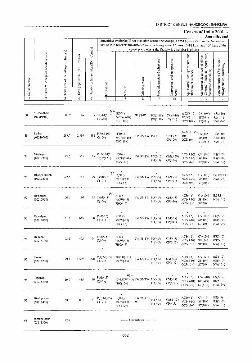
88
89
90
91
92
93
94
95
96
97
98
2
Hemchabad (02210500)
Lodna (02210600)
Madanpur (02210700)
Bhanga Bandh (02210800)
Bheduasol (02210900)
Kama1pur (02211000)
Bhimpur (02211100)
Santor (02211200)
Tapoban (02211300)
Birsinghapur
(02211400)
Jagannathpur (02211500)
3 4
80.9 69
284.7 2,799
97.6 565
108.5 463
120.0 156
141.3 645
93.6 493
179.3 1,632
119.9 415
158.5 807
62.4
DISTRICT CENSUS HANDBOOK: BANKURA
Census of India 2001 -Amenities and
Amenities available (if not available within the village, a dash (-) is shown in the column and next to it in brackets the distance in broad ranges viz.< 5 kms., 5-10 kms. and 10+ kms ofthe
nearest place where the facility is available is given
5 6 7
- P(5- -17 10) M(5-1O) H(10+)
C(5-IO) MCW(5-10) PHC(10+)
484 PM(5-10) C(lO+)
85 P AC M(5-10) C(10+)
H(IO+)
MCW(5-1O) PHC(IO+)
H(IO+)
MCW(S-IO) PHC(10+)
- P« -76 5) M« 5) H(IO+)
C(IO+) MCW« 5) PHC« 5)
- P« -25 5)M«5) H(IO+)
C(lO+) MCW«5) PHC« 5)
90 PM«5) C(10+)
94 PM«5) C{IO+)
H(IO+)
MCW«5)
PHC« 5)
H(10+)
MCW«5) PHC« 5)
8 9 10 II 12
WSS-W PO(5-IO) CM(5-1O) ACS(5-10) CV(10+) PH(5-1O) CP(lO+) NCS(5-10) SP(10+)
OCS(10+) ST(10+)
TW SS-TW PO PH CM«S) CP(10+)
ACS NCS(5- CV(;O+) 10) OCS(10+) SP(IO+)
ST(lO+)
TW SS-TW PO(5-IO) CM(S-IO) ACS(5-10) CV(10+) PH( 5) CP(IO+) NCS(S-IO) SP(IO+)
< OCS(IO+) ST(10+)
TW SS-TW PO« 5)
PH« 5)
TW SS-TW PO« 5)
PH« 5)
TW SS-TW PO« 5)
PH«5)
TW SS-TW PO« 5)
PH«5)
CM« 5) CP(lO+)
CM«5) CP(IO+)
CM« 5) CP(IO+)
CM«5) CP(5-10)
ACS« 5) CV(IO+) NCS(5-1O) SP(IO+)
OCS(IO+) ST(IO+)
ACS« 5) CV(lO+) NCS(5-10) SP(IO+)
OCS(10+) ST(IO+)
ACS« 5) CV(IO+)
NCS(5-1O) SP(IO+) OCS(IO+) ST(IO+)
ACS« 5) CV(IO+) NCS(5-1O) SP(lO+)
OCS(IO+) ST(IO+)
298 P(2)M«5) PHCH(lO+) TWSS-TWPO«5) C(lO+) MCW« 5) PH« 5)
CM« 5) CP(5-10)
ACS« 5) CV(IO+) NCS(5-10) 8P(10+) OCS(IO+) 8T(10+)
13
BS(5-10) RS(10+)
NW(10+)
8S(5-1O) RS(5-1O) NW(IO+)
8S(5-10)
RS(5-10) NW(10+)
BS RS« 5) NW(lO+)
BSRS NW(IO+)
BS(5-1O)
RS(5-1O) NW(lO+)
8S(5-1O) RS(5-10)
NW(IO+)
BS(5-10) RS(5-10) NW(10+)
69 PM«5) C(10+)
H(5-
10) MCW« 5) TW SS-TW PO« 5)
PHC(10+) PH« 5)
CM« 5) CP(5-10)
ACS« 5) CV(5-IO) 8S(5-1O) NCS(5-1O) SP(5-10) RS(5-10)
OCS(IO+) ST(5-10) NW(IO+)
151 P(2) M« 5) H(10+) C(lO+) MCW« 5)
PHC(IO+)
TW W 0 SS PO(~ 5)
W PH«5)
-------- Uninhabited ------------
662
ACS« 5) CV« 5) CM(5-10) NeS(5-10) SP(IO+)
CP« 5) OCS(JO+) ST(10+)
BS« 5) RS(5-IO) NW(10+)
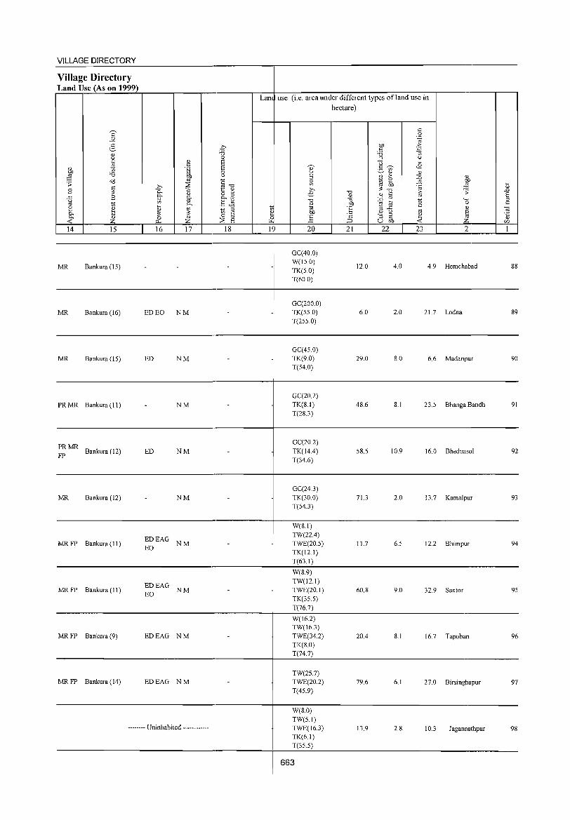
VILLAGE DIRECTORY -------------------------------------4------------------------------------------Village Directory Land Use (As on 1999) r---.-~----~~----._--_r-,-------~-4--~----~~~------~~~-.------.---,---,
Lan use (i.e, area under different types ofland use in hectare)
14 15 16 17 18 1 20 21 22 23 2 1 ~~~ ____ ~ ____ L-~ __ ~~~ __ ~~ __ ~~4_-J--~~~--~--L-~~~-=~~----~----~~
----------------------------------------,_--------------------------------------------
MR Bankura (IS)
GC(40,0) W(IS,O)
TK(S,O)
T(60.0)
12.0 4,0 4,9 Hemchabad 88
-------------------------------------------4----------------------------------------,---------
MR Bankura (16)
MR Bankura (IS)
PR MR Bankura (11)
PRMR Bankura (12)
FP
MR Bankura (12)
ED EO NM
ED NM
NM
ED NM
NM
GC(200,0) TK(SS,O)
T(2SS,0)
GC(4S,0)
TK(9,0) T(S4,0)
GC(20,2) TK(8,I) T(28,3)
GC(20,2)
TK(l4.4) T(34,6)
GC(24.3) TK(30,0) T(54.3)
6,0 2.0 21.7 Lodna 89
29,0 8,0 6,6 Madanpur 90
48,6 8,1 23,S Bhanga Bandh 91
58,5 10,9 16,0 Bheduasol 92
71.3 2,0 13,7 Kamalpur 93
-------------------------------,------------+-------------------------------------------------
MR FP Bankura (II) EDEAG NM EO
W(8,1)
TW(22.4) TWE(20,S) TK(12.1)
11.7 6,S 12,2 Bhimpur 94
______________________________________________ ~---T~(6-3-,I~)----------------------------------________ __
MR FP Bankura (11) EDEAG EO NM
MR FP Bankura (9) EDEAG NM
MR FP Bankura (14) EDEAG NM
W(8.9) TW(l2,1) TWE(20,1) TK(35.5)
T(767)
W(I6,2) TW(16.3) TWE(34,2) TK(8,O) T(74,7)
TW(25.7) TWE(20,2)
T(45.9)
60,8
20.4
79,6
9,0 32,9 Santor 9S
8,1 16.7 Tapoban 96
6,1 27,0 Birsinghapur 97
------------------------------------_4------------------------------------------W(8,0)
..•..... Uninhabited •.•...•••... 13,9 2,8 10.3 Jagannathpur 98
TW(5,1) TWE(16,3) TK(6,1) T(35.5)
------------------------------------~----~~----------------------------------
I 663
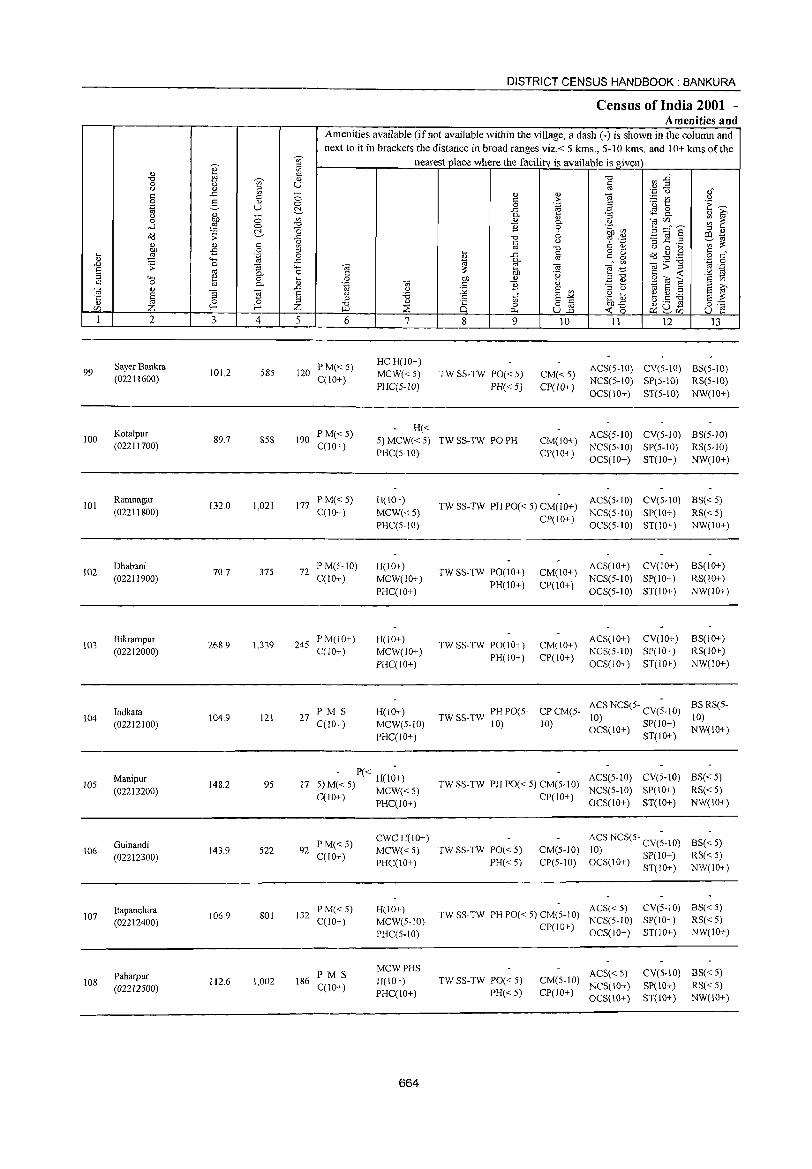
99
100
101
102
103
104
105
106
107
108
2
Sayer Bankra (02211600)
Kotalpur (02211700)
Ramnagar (02211800)
Dhabani (02211900)
Bikrampur (02212000)
Indkata (02212100)
Manipur (02212200)
Guinandi (02212300)
Itapanchira (02212400)
Paharpur (02212500)
3 4
101.2 585
89.7 858
132.0 1,021
70.7 375
268.9 1,339
104.9 121
148.2 95
143.9 522
106.9 801
112.6 1,002
DISTRICT CENSUS HANDBOOK: BANKURA
Census of India 2001 -Amenities and
Amenities available (if not available within the village, a dash (-) is shown in the column and next to it in brackets the distance in broad ranges viz.< 5 krns., 5-10 kms. and 10+ krns of the
nearestpJace where the facility is available is given
5 6
120 PM« 5) C(10+)
7
HCH(1O+)
MCW« 5) PHC(5-1O)
H«
8
tf o c.. 9
TW SS-TW PO« 5)
PH« 5)
10
CM«5) CP(lO+)
J 1 12 13
ACS(5-10) CV(S-IO) BS(5-10) NCS(S-IO) SP(S-IO) RS(5-10)
OCS(IO+) ST(5-10) NW(IO+)
190 P M« 5) C(lO+)
5) MCW« 5) TW SS-TW PO PH PHC(5-10}
CM(IO+) ACS(5-1O) CV(5-10) BS(5-1O) CP(IO+) NCS(S-IO) SP(5-10) RS(5-1O)
OCS(1O+) ST(lO+) NW(lO+)
177 P M« 5) C(IO+)
72 P M(5-1O) C(lO+)
245 PM(IO+) C(10+)
27 PM S C(10+)
H(10+)
MCW«S) PHC(5-10}
H(lO+)
MCW(lO+)
PHC(IO+)
H(10+) MCW(IO+)
PHCCIO+)
H(lO+) MCW(5-10)
PHC(lO+)
- P« -17 5'1 M« 5) H(lO+)
) MCW«5) C{10+) PHC(10+)
92 PM«5) C(lO+)
132 P M« 5) C(IO+)
186 PM S C{lO+)
CWCH(\o+)
MCW« 5) PHC(IO+)
H(IO+) MCW(5-10)
PHCC5-10)
MCWPHS
H(IO+) PHC(lO+)
664
TWSS-TW PHPO«5) CM(lO+) ACS(5-IO) CV(5-IO) BS«5) NCS(5-IO) SP(IO+) RS« 5)
TW SS-TW PO(IO+)
PH(lO+)
TW SS-TW PO(IO+) PH(lO+)
CP(1O+) OCS(5-10) ST(IO+) NW(IO+)
ACS(IO+) CV(lO+) CM(IO+) NCS(5-10) SP(1O+)
CP(lO+) OCS(5-10) ST(1O+)
ACS(lO+) CV(IO+) CM(10+) NCS(5-10) SP(IO+) CP(IO+) OCS(IO+) ST(lO+)
BS(lO+) RS(IO+)
NW(lO+)
BS(IO+) RS(IO+)
NW(IO+)
TWSS-TW PHPO(5- CPCM(5-10) 10)
ACS NCS(5- CV(~-IO) 10) SP(IO+) OCS(10+) ST(IO+)
BS RS(5-10) NW(IO+)
ACS(5-10) CV(5-IO) BS« 5) TWSS-TW PHPO«5)CM(5-10) NCS(5-10) SP(lO+) RS«5)
CP(IO+) OCS(IO+) ST(IO+) NW(IO+)
TW SS-TW PO« 5)
PH« 5)
CM(5-10)
CP(S-IO)
ACS NCS(5- CV(;-IO)
10) SP(lO+) OCS(10+) 3T(10+)
BS« 5) RS«5) NW(IO+)
ACS« 5) CV(5-10) BS« 5) TW SS-TW PH PO« 5) CM(5-10) NCS(5-1O) SP(IO+) RS« 5)
CP(IO+) OCS(IO+) ST(IO+) NW(JO+)
TW SS-TW PO« 5) PH« 5)
ACS« 5) CV(S-IO) BS« S) CM(5-10) NCS(lO+) SP(IO+) RS«5)
CP(lO+) OCS(10+) 8T(10+) NW(IO+)
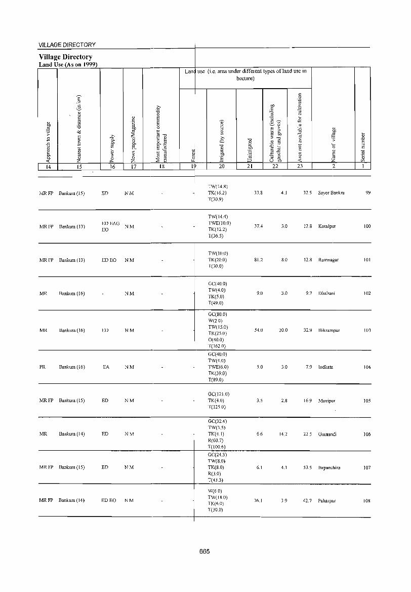
VILLAGE DIRECTORY ----------------------------------------+---------------------------------------------Village Directory Land Use (As on 1999) r~~~~~~~,_----,,--_.~,-------~~+---~----~~~~----~~--~,----------,---,
Lan use (i,e, area under different types ofland use in
MR FP Bankura (15) ED NM TW(14,8)
TK(162) T(30,9)
hectare)
33,8 4,1 32,5 Sayer Bankra 99
----------------------------------------4---------------------------------------------
MR FP Bankura (13) ~~EAG NM
TW(14.4) TWE(IO,O)
TK(12,2)
T(36,5)
37.4 3.0 12,8 Kotalpur 100
-------------------------------------------~-------------------------------------------------
MR FP Bankura (13) ED EO NM TW(IO,O)
TK(20,0) T(30,0)
81.2 8,0 12,8 Ramnagar 101
----------------------------------------4---------------------------------------------
MR Bankura (16) NM
GC(40,0) TW(4,0)
TK(5,O) T(49,0)
9,0 3,0 9,7 Dhabani 102
----------------------------------------4---------------------------------------------
MR Bankura (16) ED NM
GC(80,O) W(2,0)
TW(15,0) TK(25,O)
0(40.0)
54,0 20,0 32,9 Bikrampur 103
T(162,0) ----------------------------------------4---~--~------------------------------------
PR Bankura (16) EA
MR FP Bankura (15) ED
NM
NM
GC(40.0) TW(4,0)
TWE(60)
TK(39,0)
T(89.0)
GC(121.0) TK(4.0) T(125,0)
5,0 3,0 7,9 Indkata 104
3.5 2,8 16,9 Manipur 105
----------------------------------------4---------------------------------------------
MR Bankura (14) ED NM
GC(32,4) TW(3,5)
TK(4,1) R(60,7)
6,6 14,2 22,5 Guinandi 106
T(100,6) ------------------------------------~--~~~--------------------------.--------
GC(24,J)
MR FP Bankura (15) ED NM TW(8,O) TK(8,0) R(3,O)
6,1 4,1 53,5 Itapanchira 107
T(43.3) ------------------------------------~----~~----------------------------------
MR FP Bankura (14) ED EO NM
W(6,O) TW(18,O) TK(60) T(30,O)
665
36,1 3,9 42,7 Paharpur 108
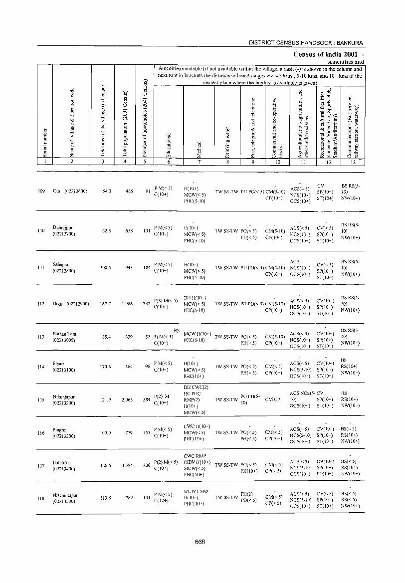
~
'" ;::l
~ '" <!) <= "0 <l)
0 " '" u " ~
;::l
'" 0 " " c 5 " 0 '-g U c:!. " ~ - '" 0 0 .... ~ 0 "0
0 o<! .;;: c:!. {l " " " '" 00 £ 0 ;::l
~ ~ .~ 0 "-< -" .D .;; 0 "3 '15 § " 0-
"-< ~ 0 ~ s:: 0 0-
~ " .D
iii £! £! § <l) 0 0 [/) Z f-< f-< Z 1 2 3 4 5
109 Ola (02212600) 54.3 465 81
Dubrajpur 110 62.3 658 131
(02212700)
Sabapur III 100.5 943 184
(02212800)
112 Diga (02212900) 167.7 1,986 332
Bathan Tara 113 85.4 339 55
(02213000)
Elyati 114 170.6 564 98
(02213100)
Nikunjapur 115 121.9 2,063 384
(02213200)
Pingrui 116 109.0 779 157
(02213300)
Balatukri 117
(02213400) 126.6 1,384 230
Nischintapur 118
(02213500) 119.5 782 151
DISTRICT CENSUS HANDBOOK: BANKURA
Census of India 2001 -Amenities and
Amenities available (if not available within the village, a dash (-) is shown in the column and next to it in brackets the distance in broad ranges viz.< 5 kms., 5-10 kms. and 10+ kms of the
nearest place where the facility is available is given
"0 ~~ § <l) <l)
~ ~ " ,f
c > '" " .<:) t:: 'E ~ c .~ -" <$ c " ~ 0-" :; 0-
" 0- " "§ en,,_.., ~ ~ 1i 0 .~ ~ _g~§ :> 0)
"0 6 OJ ._ ~Cd c " C: "S) ::$ ...c ._
'" ~ " "0 U 0 ~ ~ c
o ._ dd ~ ,g § d'
~ -" c g 0- " '" "a;;:"§ '';::' 0
"a ~ OJ "§:a " ._
" ~ .~ <= <t: ·s ~ 0 00 " .:E ~ S2'ia] .~ OJ " ] " 1;; 8 :> u :.g 8 '"
;::l u 8 ~ u ~, c tf 8""" .g t> t5 .S ~ 8 ~ ;::l "0 <l)
8 0 82 00-;5 0:: I.ll ~ C>... <t: 0 ~S~ u 1:! 6 7 8 9 10 11 12 13
P M« 5) H(lO+) ACS« 5) CV BS RS(5-
TW SS-TW PH PO« 5) CM(5-10) SP(lO+) 10) C(lO+) MCW« 5)
CP(IO+) NCS(IO+)
ST(IO+) NW(IO+) PHC(5-10) OCS(IO+)
P M«5) H(10+) ACS« 5) CV«5) BS RS(5-
TW SS-TW PO« 5) CM(5-10) 10) ecIO+) MCW{< 5)
PH«5) CP(lO+) NCS(IO+) SP(IO+)
NW(IO+) PHC(5-10) OCS(IO+) ST(IO+)
P M«5) H(IO+) ACS
CV«5) BS RS(5-
TW SS-TW PH PO« 5) CM(5-10) NCS(10+) 10) C(lO+) MCW«5) SP(lO+)
PHC(5-1O) CP(IO+) OCS(IO+)
ST(IO+) NW(IO+)
P(3)M« 5) DH H(IO+)
ACS« 5) CV(IO+) BSRS(5-
C(lO+) MCW«5) TW SS-TW PH PO« 5) CM(5-1O)
NCS(IO+) SP(IO+) 10)
PHC(5-10) CP(IO-r) OCS(IO+) ST(JO+)
NW(IO+)
- P« ACS« 5) CV(IO+)
BS RS(5-5)M«5) MCWH(IO+) TW SS-TW PO« 5) CM(5-10) 10) C(1O+) PHC(5-10) PH«5) CP(IO+)
NCS(IO+) SP(IO+) NW(IO+)
OCS(IO+) ST(IO+)
PM« 5) H(IO+) ACS« 5) CV(IO+) BS
TWSS-TW PO«5) CM« 5) RS(JO+) C(10+) MCW« 5)
PH«5) CP(IO+) NCS(5-1O) SP(IO+)
NW(IO+) PHC(IO+) OCS(IO+) ST(IO+)
DHCWC(2)
p(2) M HCPHC
TW SS-TW PO PH(5-ACS NCS(5- CV BS
RMP(7) CMCP 10) SP(10+) RS(JO+) C(lO+)
H(IO+) 10)
OCS(IO+) ST(IO+) NW(IO+)
MCW«5)
PM«5) CWCH(IO+)
ACS«5) CV(10+) BS« 5) MCW«5) TW SS-TW PO« 5) CM« 5)
C(IO+) PHC(IO+) PH«5) CP(IO+)
NCS(5-10) SP(IO+) RS(IO+)
OCS(IO+) ST(IO+) NW(IO+)
CWCRMP P(2) M« 5) CHWH(IO+)
TW SS-TW 1'0« 5) CM«5) ACS« 5) CV(IO+) BSC < 5)
C(10+) MCW«5) NCS(S-IO) SP(10+) RS(IO+) PH(IO+) CP« 5)
PHC(lO+) OCS(IO+) ST(IO+) NW(IO+)
P M« 5) MCWCHW
PH(2) ACS« 5) CV«5) BS«5) H(IO+) CM«5)
C(IO+) TW SS-TW PO« 5) NCS(5-IO) SP(IO+) RS« 5) PHC(IO+) CP« 5)
OeS(IO+) ST(IO+) NW(IO+)
666
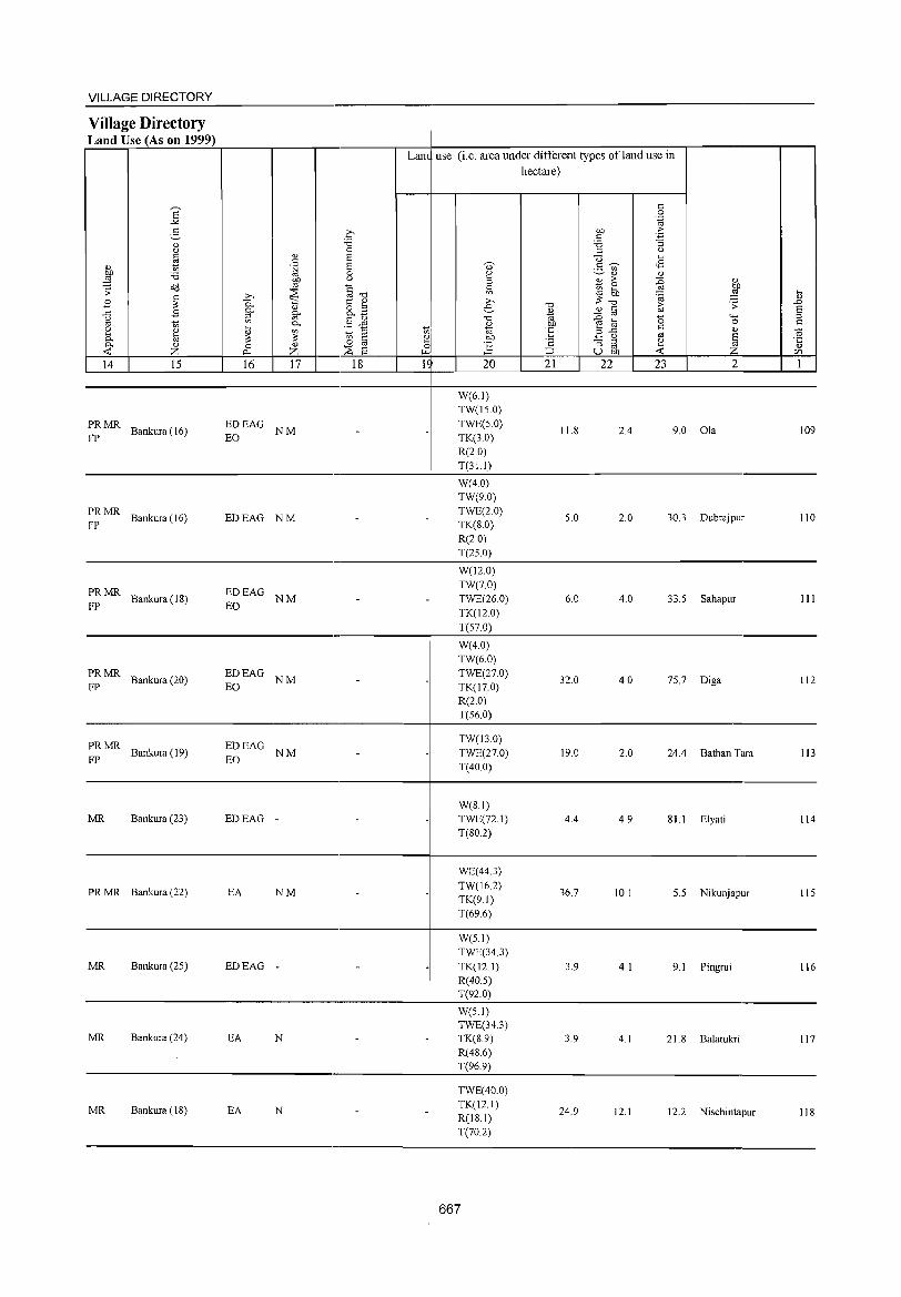
VILLAGE DIRECTORY ~--------------------------------------~---------------------------------------------
Village Directory Land Use (As on 1999)
~MR Bankura(16) EDEAG NM EO
Lane use (i.e. area under different types ofland use in hectare)
W(6.1) TW(lS.O) TWE(S.O) TK(3.0) R(2.0)
11.8 2.4 9.0 Ola 109
________________________________ . ___________ -+ ____ T~(3_1._1)~ ______________________________________ __
~: MR Bankura (16)
~: MR Bankura (IS)
EDEAG NM
EDEAG NM EO
W(4.0) TW(9.0) TWE(2.0) TK(8.0) R(2.0) T(2S.0)
W(l2.0) TW(70) TWE(26.0) TK(12.0)
5.0 2.0 30.3 Dubrajpur 110
6.0 4.0 33.5 Sahapur III
______________________________ . ___________ ~---T~(5-7-.0~)-----------------------------------____ __
~ MR Bankura (20)
PRMR FP Bankura (19)
MR Bankura (23)
EDEAG NM EO
EDEAG NM EO
EDEAG -
W(4.0) TW(6.0) TWE(27.0) TK(l7.0) R(20) T(56.0)
TW(13.0) TWE(27.0) T(40.0)
W(SI) TWE(72.I) T(SO.2)
32.0 4.0 75.7 Diga 112
19.0 2.0 24.4 Bathan Tara 113
4.4 4.9 SI.1 Elyati 114
----------------------------------------4---------------------------------------------
PR MR Bankura (22)
MR Bankura (25)
MR Bankura (24)
EA NM
EDEAG -
EA N
WE(44.3)
TW(16.2) TK(9.1) T(69.6)
W(5.1) TWE(34.3)
TK(l2.1) R(40.5) T(92.0)
W(5.1) TWE(34.3) TK(S.9) R(4S.6)
36.7 10.1 5.5 Nikunjapur 115
3.9 4.1 9.1 Pingrui 116
3.9 4.1 21. S Balatukri 117
___________________________________________ -+ ____ T~(9_6_.9~) ________________________________________ _
MR Bankura (18) EA N
TWE(40.0) TK(12.1) R(IS.I) T(70.2)
24.9 12.1 12.2 Nischintapur 118
------------------------------------~------------------------------------------
667
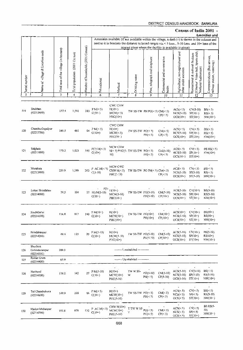
DISTRICT CENSUS HANDBOOK: BANKURA
Census of India 2001 -Amenities and
Amenities available (if not available within the village, a dash (-) is shown in the column and
next to it in brackets the distance in broad ranges viz.< 5lans., 5-10 kms. and 10+ lans of the ~ nearest place where the facility is available is given
I ::l
'" en
-a 5 -a ~ "§" 0 '§ u @ (.) '" :.g () c ..c '" - '" <1)
] oJ c 0 c > TIt u
0 S <1)
E~ .~ u 0 0 .~ ~ ..c ~ 8.. {) '" - 0- <1) :; Q) i:;'
0 bJ) 0 '" " 0- {)
~~s ~ ~ .....l ::§ 0 -a 1i 0 .~ [/)
~ 0 6 '" <1) cld .:;;: ..c -a d .~ '3] .2 co 1;i (!.) (!.) s:: " c u C Q) ';;;"::; '" '" ] (.) 0 ....
~ -£ 0 '" i o .-
o?J .g A~ c " .... .~ 0 ..c c g o c '" "" 0-.0 0 ..c ...:'"
_._ "'0 '.;j 0 .:;;: '"3 <..., (ti e '" g:>~ '" .-S '" 0- 0 C bJ) '2 ~;:a .8 E '" <...,
~ 0 .... 0 bJ) " .a '" .S (U E s:: '" s:: 0 0- '" .~ '" c 1i (!.) - .... g i:;' ~
.., ~ ~
..c '" ~ E '" '" u 1;i S ;:; § S u :.a .g t t.5 ~ ;:; c:
'" 8"'" 8 ~ '"
;:l -a '" 8 o c bJ)..c 0:0: Z f- f- Z ::E 0 ~ 2.ri5 ell f.I.l 0.- u.2 ~ 0 u e 1 2 3 4 5 6 7 8 9 10 11 12 J3
CWCCHW
119 Shalihan
157.4 1,561 PM«5) H(lO+) ACS« 5) CV(5-10) BS« 5) 313 TW SS-TW PH PO« 5) CM« 5) (02213600) C(lO+) MCW«5) CP« 5)
NCS(5-10) SP(lO+) RS« 5) PHCCIO+) OCS(IO+) ST(IO+) NW(10+)
CWCCHW
120 Chandra Gopalpur
146.5 461 94 P M«5) H(IO+)
TW SS-TW POC< 5) CM« 5) ACS« 5) CV«5) BS«5)
(02213700) C(lO+) MCW«5) NCS(5-1O) SP(1O+) RS«5) PHCC1O+)
PH« 5) CP«5) OCS(IO+) ST(10+) NW(IO+)
Salghata P(2) M« 5) MCWCHW
ACS« 5) CV« 5) BSRS«5) 121 170.2 1,02S 185 H« 5) PHC(S- TW SS-TW PO« S) CM(S-IO) (02213800) CCIO+) NCS(5-IO) SP(IO+) NW(IO+)
10) PH« 5) CP«5) OCS(1O+) ST(IO+)
Murakata MCWCWC
ACS« 5) CV« 5) 8S«5) 122 230.9 1,288 263 :~ AC M« 5) CHW H« 5) TW SS-TW PO PH« 5) CM« 5)
(02213900) ~(5-1O) PHCC5-10) CP«S) NCS(5-10) SP(5-1O) RS«5) OCS(IO+) ST(5-10) NW(IO+)
123 Lohari Brindaban
74.5 104 17 - P(S- H(I~+)
TW SS-TW PO(5-IO) CM(5-1O) ACS(5-1O) CV(IO+) BS(5-1O)
(02214000) 10) M(S-IO) MCW(5.1O) NCS(S-IO) SP(lO+) RS(5-10) C(10+) PHC(lO+) PH(5-10) CP(lO+)
OCS(10+) ST(10+) NW(IO+)
124 Kochkhalui
114.8 812 140 P M(10+) H(IO+)
TW SS-TW PO(IO+) CM(IO+) ACS(lO+) CV(lO+) BS(IO+)
(02214100) C(IO+) MCW(IO+) PH(lO+) CP(10+)
NCS(5-10) SP(IO+) RS(IO+)
PHC(IO+) OCS(10+) ST(IO+) NW(lO+)
125 Brindabanpur
49.4 135 20 PM(5-10) H(10+)
TW SS-TW PO(5-IO) CM(5-10) ACS(5-10) CV(10+) BS(5-10)
(02214200) C(lO+) MeW(S-IO) PH(5-IO) CP(IO+)
NCS(S-IO) SP(10+) RS(IO+)
PHC(IO+) OCS(IO+) ST(IO+) NW(IO+)
Shushina 126 Gobindarampur 289.5 -------- Uninhabited ------------
(02214300)
127 RamarGram
65.9 -------- Uninhabited ------------(02214400)
Hatiband 142
PM(5-1O) H(IO+) TW WSS-PO(5-10) CM(5-JO)
ACS(5-10) eV(S-IO) BS« 5) 128
(02214500) 119.2 27
C(10+) MCW(10+) W NCS(S-IO) SP(S-IO) RS(5-10)
PHCC5-10) PH« 5) CP(S-IO)
OC3(5-10) ST(lO+) NW(10+)
Tol Chandrakona 218
PM« 5) H(lO+) TW SS-TW PO« 5) CM«5)
ACS«5) CV« 5) BS« 5) 129 149.9 46
C(10+) MCW(10+) NCS«S) SP« 5) RS(5-10) (02214600) PH«5) CP«5) PHC(5-10) OCS«5) ST(10+) NW(10+)
CHWH(lO+) T TW W SS· POe ~ S) ACS« 5) CV«5)
BS RS(S-Madan Mohanpur
191.6 878 172 P AC M« 5) MCW(10+) CM«5) ]0) 130 NCS«5) SP«5) (02214700) CpO+) PHC(S-IO) T PH« 5) CP«5) NW(lO+) OCS« 5) ST(IO+)
668
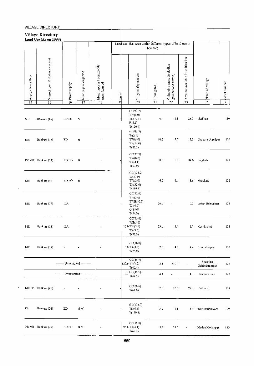
VILLAGE DIRECTORY
Village Directory Land Use (As on 1999) ~~~~~~~~----.----r-,-----~---4--~----~~=-----~~~~-r---------.---'
Lane use (i.e. area under different types ofland use in hectare)
14 15 16 17 18 15 20 21 22 23 2 1 ~~~ ____ ~ ____ L-~ __ L-~~ __ ~~ __ ~~4-~ __ ~~-L __ ~ __ L-~ __ L_-=~~ ____ ~ ___ ~~~
----------------------------------------,_--------------------------------------------GC(93.7)
MR Bankura (IS) ED EO N
TW(6.0) TK(l2.1) R(8.1)
4.1 8.1 2S.2 Shalihan 119
T(120.0) ----------------------------------------4---~--~------------------------------------
MR Bankura (16) ED N
GC(60.7) W(2.1) TW(6.0) TK(14.6)
40.5 5.7 17.0 Chandra Gopalpur 120
T(83.3) --------------------------------------------4----~~-----------------------------------------
PR MR Bankura (12) ED EO N
MR Bankura (9) ED EO N
GC(37.9) TW(8.0) TK(4.1) T(50.0)
GC(135.2) W(30.0) TW(2.0) TK(32.6)
30.6 5,7 84,0 Salghata 121
6.S 6,1 18.6 Murakata 122
___________________________________________ -4 ____ T~(1_9_9.~&)~ ______________________________________ _
MR Bankura (17) EA
MR Bankura (I &) EA
-
GC(22.0) TW(3.0) TWE(IO.O) TK(4.0) 0(15.0) T(S4.0)
GC(S5.0) WE(5.0)
IS.O TW(3.0) TK(9.0)
20.0 0.5 Lohari Brindaban 123
23.0 3.0 1.8 Kochkhalui 124
T(n.O) ----------------------------------------,_--~~--------------------------------------
MR Bankura (17) GC(18.0)
3.0 TK(8.0) T(26.0)
2.0 4.0 144 Brindabanpur 125
----------------------------------------,_--~~~------------------------------------GC(454) -------- Uninhabited ------------ 2.1 110.4
Shushina Gobindarampur
126 130.6 TK(J.O) T(464)
----------------------------------------,_--~~~------------------------------------133 GC(44,S) -------- Uninhabited ------------
MR FP Bankura (21)
FP Bankura (24) ED NM
PR MR Bankura (20) ED EO NM
. T(44.5)
GC(68.6) T(68.6)
GC(133.3) TK(6.1) T(139.4)
GC(58.0) 95.8 TK(4.1)
T(62.0)
669
4.1 4.1 RamarGram 127
2.0 20.5 28. I Hatiband 128
2.1 3.1 54 Tol Chandrakona 129
5.3 28.5 Madan Mohanpur 130
DISTRICT CENSUS HANDBOOK: BANKURA
Census of India 2001 -Amenities and
Amenities available (if not available within the village, a dash (-) is shown in the column and
next to it in brackets the distance in broad ranges viz.< 5 kms., 5-10 kms. and 10+ kms of the ~
nearest place where the facility is available is given '" 'i :::l
" '" E '" '0 '" .DO '0 V>' " 0 u U c Q) .3 u " ~ '" ",;;; C) ". c .<: c ;; " " ] :.= V) .~ 0 2, " c .2: 'u 1:
.~ U 0 0 "til c:~ ~ ..c ~ 8. " 0- :;:; :; " ~ u
~ ;; on " ",if) ~ ~ 0 0- .2 ...:l 0 '0 '2 0 E ~~~ '0 5b~ ::i "
~ .;;: ~ {3 '0 ,:, o:l ~
§ <) ~ .~ :; ..c ._ ';;~ " " c '" '0 u 0 ...
~ £ 0 :::l ... C o .- Cd .g .g c • ... '"§ 0 ~ .<:
'" c g o c
" <H 0-.D 0 ..c e '" ta;;:'g '+:j 0 .;;: "3 ""' ta ~ ta e~ '" .-S '" 0- 0 C 00 'E t: « '2 * ::l <;-; " 0 :;:; 0 00 " ~ ~ .S a E c 0 a 0- .~ '" t: B " :::l '" ta " .D U :!2 E '"
::l (.) "til E :::l a '" £ ~ 3 ~
(.) 'i3 E c "" .~ E3 ~ ~ ~ a ~ '':; 0 :::l
" Ul - t: ~u.s " '0 Ci 0 o '" 00'<: 0'= if) l- I- ;z: ~ ~ 0- U.o « (5 ~ ~CIl U e 1 2 3 4 5 6 7 8 9 10 II 12 13
131 Chandipur
89.7 774 159 P ACM«5) MCWCWC
TWSS-TW PO«5) CM« 5) ACS« 5) CV«S) BS«5)
H«5) (02214800) C(10+) PHC(IO+) PH« 5) CP«5) NCS(5-10) SP(IO+) RS« 5) OCS(5-10) ST(10+) NW(lO+)
CWCCHW
132 Jamtara
83.5 392 70 P ACM«5) H(10+)
TW SS-TW PO« 5) CM(lO+) ACS(5-10) CV«5) BS« 5)
(02214900) C(10+) MCW«5) PH«5) CP« 5)
NCS(S-IO) SP(10+} RS«5} PHC(IO+) OCS(5-1O) ST(10+) NW(IO+)
Mayata ACP« 5) CWCH(IO+)
ACS(5-1O) CV«5) BS« 5) 133 85.7 71 16 M«5) MCW«5) TW SS-TW PO« 5) CM(5-10) (02215000)
C(10+) PHC(lO+) PH«5) CP« 5) NCS(5-IO) SP(IO+) RS«5) OCS(5-1O) ST(IO+) NW(IO+)
134 Dhagarya (02215100)
54.5 ----.--- Uninhabited ------------
Pantha l' CM«5) CWCH(lO+} ACS(5-10) CV«5) BS«5) 135 83.2 181 36 ,A MCW«5) TW SS-TW 1'0« S) CM(5-10)
(02215200) C(IO+) PHC(IO+) 1'H« S) CP«5) NCS(5-1O) SP(lO+) RS« 5) OCS(lO+) ST(IO+) NW(10+)
136 Rasiara
ISO.O 1,454 241 PM«5) H(lO+)
TW SS-TW PO(IO+) CM(5-1O) ACS(5-10) CV(lO+) BS(IO+)
(02215300) C(lO+) MCW«5) PH(IO+) C1'(lO+)
NCS(5-1O) SP(10+) RS(lO+)
PHC(10+) OCS(IO+) ST(IO+) NW(10+)
137 HiraDangar
87.S 328 64 PM«5) H(lO+)
TW SS-TW PO« S) CM«5) ACS« 5) CY(lO+) BS«5)
(02215400) C(IO+) MCW«5) PH«5) CP(lO+)
NCS(S-IO) SP(IO+) RS(lO+)
PHC(lO+) OCS(IO+) ST(IO+) NW(lO+)
ACS NCS(5- CV(~O+) BS Tenlul Muri P M« 5) H(IO+)
TW SS-TW PO« 5) CM« S) RS(IO+) 138 (02215500)
213.2 976 196 C(lO+) MCW«5) 10) SP(10+)
PHC(IO+) PH« 5) CP(10+) OCS(IO+) ST(10+) NW(IO+)
AC P« 5) HPR SS- ACS« 5) CV(IO+)
BS Maitha M(S-IO)
H(JO+) PO«5) CM«S) RS(IO+) 139 68.2 391 85
MCW«5) HP NCS« 5) SP(IO+) (02215600) C(IO+) PH(IO+) CP« 5) NW(IO+)
PHC«5) OCS(IO+) ST(IO+)
140 Jambani
53.9 -------- Uninhabited ------------(02215700)
CWCCHW
Sabanpur P M«5) H(IO+) TWSS-TW PO«5) CM(5-10)
ACS(S-IO) eY(S-IO) BS(S-IO) 141 155.4 519 92
C(lO+) MCW(5-1O) NCS(S-10) SP(IO+) RS(S-IO) (02215800) PH(5-10) CP(5-10) PHC(5-10) OCS(S-IO) ST(IO+) NW(10+)
670
VILLAGE DIRECTORY ~~~=---~----------------------------~------------------------------------------Village Directory
I Land Use (As on 1999) r=~~~~~~----.----r-------.~~--~--~~~~~~~~~.----------r--.
Land use (i.e. area under different types ofland use in hectare)
----------------------------------------+---------------------------------------------
MR Bankura (16) ED N GC(38.3) TK(4.1) T(42.4)
6.5 21.9 18.9 Chandipur 131
-------------------------------------------~----------------------------------------.---------
MR Bankura (20)
MR Bankura (18)
ED N GC(663) TK(8.1) T(74.4)
GC(72.8) TK(4.I) T(769)
6.5 1.2 1.3 Jamtara 132
0.8 4.1 3.9 Mayata 133
-----------------------------------.-------------~-----------------------------------------------------
-------- Uninhabited ------------
MR Bankura (18)
GC(3S.6) TW(1.0) TK(4.9) T(4LS)
GC(688) TK(41) 0(40) T(769)
3.1
2. I
4.1 5.9 Dhagarya 134
1.2 3.0 Pantha 135
----------------------------------------+----------------------------------------------
MR Bankura (18) EDEAG NM
W(2.0) TWE(16.0) TK(37.0) T(55.0)
10.2 24.2 60.6 Rasiara 136
-----------------------------._----------+----------------------------------------------
MR Bankura (26)
PR MR Bankura (27)
PR MR Bankura (26)
MR Bankura (25)
ED EO N
N
ED EO NM
-------- Uninhabited ------------
N
TK(16.4) R(24.1) 0(14.1) T(54.5)
TW(48.1) TK(SO.4) 0(21.0) T(149.5)
TW(36.5) T(36.S)
TW(S.I) TK(8.9) R(20.2) T(37.2)
TW(16.1) TK(60.7) R(33.3) T(IIO.I)
371
4.1 8.1 20.8 Hira Dangar 137
36.7 8.1 18.9 Tentul Muri 138
7.8 7.5 16.5 Maitha 139
8.1 4.1 4.6 Jambani 140
22.3 8.6 14.5 Sabanpur 141
142
143
144
145
146
147
148
149
150
151
152
2
Srirampur (02215900)
Kanaipur
(02216000)
Panch Danna (02216100)
Kumar Danga (02216200)
Puthia (02216300)
TeBa (02216400)
Sadishta (02216500)
Chandrakona (02216600)
Raghunath Nagar (02216700)
Baharamuri (02216800)
Gopalpur (02216900)
3
71.0
111.1
230.2
95.5
52.8
87.7
97.2
188.0
167.4
186.9
82.2
~ c <l)
U
§ .~
"3 c.. o c..
~ 4
575
52
563
1,007
1,683
414
811
1,188
1,075
1,404
1,348
DISTRICT CENSUS HANDBOOK: BANKURA
Census of India 2001 -Amenities and
Amenities available (ifnot available within the village, a dash (-) is shown in the column and next to it in brackets the distance in broad ranges viz. < 5 kms., 5-10 kms. and 10+ kms of the
nearest place where the facility is available is given
5 6
AC P« 5) 101 M«5)
C(IO+)
6 PM«5) C(10+)
123 P M«5) C(IO+)
198 1'M«5) (;(10+)
P(2) M(2) 351 S(2) PUC
C(IO+)
77 PM«5) C(lO+)
7
MCWCHW H«5) PHC(IO+)
H(lO+)
MCW«5) PHC(10+)
MCWCHW
8 9
TWRSS-PO«5) PH(5-10)
TW
TW SS-TW PO« 5) PH«5)
H(lO+) PHC(5- TW SS-TW PO« 5)
10) PH« 5)
DH(2)H(5-1O) HPTW MCW(IO+) T.,. PHC(5-1O) WSS-l
D H« 5) MCW(IO+)
PHC«5)
THPTW WSS-T
1'H(6) PO«5)
PO TO PTO PH(l5)
H(lO+) MCW(lO+) 1'HC« 5)
TW W SS- PH(2)
W PO« 5)
PHSCHW
162 l' AC M« 5) H(lO+) C(10+) MCW(10+)
T TW W SS· PH(12) T PO« 5)
PHC«5)
CHW H(lO+) 216 P ACM«5) MCW(IO+) TTWWSS·PH(2)
CCIO+) 1'HC(5-1O) T 1'0« 5)
CHWH(lO+) 228 P AC M« 5) MCW(IO+) T TW W SS·PH(2)
C(10+) PHC«5) T PO«5)
CHWH(10+) -296 P ACM«5) MCW(10+) TTWWSS' PO«5)
C(10+) PHC«5) T PH«5)
272 P AC M« 5) H(10+) C(!O+) MCW(IO+)
PHC« 5)
TWWSS-PO« S)
PH«S) W
672
<l) ;. .~
<l) c.. 9 o ()
"0 § -a .~
<l)
E '" E "" 82 10 11 12 13
CM(5-10) ACS(5-10) CV(5-10) BS(5-10) CP(5-10) NCS(S-IO) SP(10+) KS(5-1O)
CM«5) CP« 5)
CM« 5) CP«5)
CM«5) C1'« 5)
CM«5) CP«5)
CM«5) CP«5)
CM«5) CP«5)
CM« 5) CP«5)
CM« 5) CP«5)
CM« 5) CP« 5)
CM«5) CP«5)
OCS(5-10) ST(IO+) NW(IO+)
ACS(5-1O) CV« 5) NCS(5-10) SP(IO+) OCS(5-1O) ST(IO+)
ACS(5-10) CV« 5) NCS(5-10) SP(10+) OCS(5-IO) ST(lO+)
ACS« 5) NCS« 5) OCS« 5)
ACS« 5) NCS« 5) OCS« 5)
ACS« 5) NCS« 5) OCS« 5)
ACS« 5) NCS«5) OCS« 5)
ACS«5) NCS«5) OCS« 5)
ACS« 5) NCS« 5)
OCS« 5)
ACS« 5)
NCS« 5) OCS« 5)
ACS« 5) NCS«5) OCS« 5)
CV«5) SP« 5) ST(IO+)
CV«5) SP«5) ST(IO+)
CV«5) SP«5) ST(IO+)
CV«5) SP«5) ST(IO+)
CV« 5) SP« 5) ST(10+)
CV«S) SP« 5) :>T(10+)
CV«5) SP« 5) ST(IO+)
CV«5) SP«5) ST(lO+)
BS«5) RS« 5) NW(lO+)
BS« 5)
RS«5) NW(10+)
RS BS« 5) NW(IO+)
BSRS NW(IO+)
BS RS«S) NW(10+)
BS RS« 5) NW(lO+)
BS« 5) RS« 5) NW(10+)
BS« 5) RS« 5) NW(10+)
8S« 5) RS«5) NW(IO+)
BS«5) RS«5) NW(10+)
VILLAGE DIRECTORY
Village Directory Land Use (As on 1999)
14 IS
MR Bankura (25)
MR Bankura (25)
MR Bankura (22)
MR FP Bishnupur (18)
~: MR Bishnupur (16)
PR MR Bankura (21)
PR MR Bankura (19)
MR Bankura (21)
MR Bankura (22)
MR Bankura (23)
MR Bankura (24)
16 17 18
N
ED N
EA N
ED EO NM
ED NM
ED NM
ED NM
ED NM
ED NM
ED NM
Lane use (i.e. area under different types of land use in hectare)
20
TW(25.0) TK(l05) R(20.2) T(55.7)
SO 9 TK(20.2) . T(20.2)
GC(4S.5) TW(13.5) TK(72.S) T(134.S)
GC(16.0) TW(S.O) TWE(6.0) TK(6.0) T(36.0)
GC(1.4) TW(2.0) TK(5.2) T(S.6)
GC(71.2) TK(6.1) T(77.3)
GC(51.8) TK(20.2) T(n.O)
GC(150.5) TK(12.1) T(162.7)
GC(92.9) TK(JO.I) T(l03.1)
GC(122.5) TK(2.0) T(124.5)
GC(32.2) TK(4.1) T(36.3)
673
21 22
5.0
3.0
10.1
28.0
30.0
30.8
30.5
23 2
4.1 6.3 Srirampur
1.6 5.3 Kanaipur
20.2 65.1 Panch Danna
2.0 29.5 Kumar Danga
14.2 Puthia
4.1 6.4 Tella
S.1 17.1 Sadishta
S.I 17.2 Chandrakona
5.0 2S.5 Raghunath Nagar
17.0 45.4 Baharamuri
3.2 12.2 Gopalpur
142
143
144
145
146
147
148
149
ISO
lSI
152
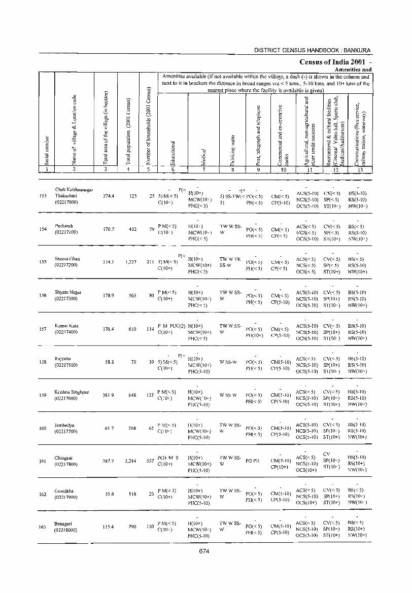
DISTRICT CENSUS HANDBOOK: BANKURA
Census of India 2001 -Amenities and
Amenities available (if not available within the village, a dash (-) is shown in the column and next to it in brackets the distance in broad ranges viz.< 5 krns., 5-10 krns. and 10+ kms of the
~
nearest place where the facility is available is given en
I:! =' <J <!J
~ :2~ "'" J3 ~ <U -g 0 " '" u " <J iil oj
.~ u 0)"
s:: ..t: - <U <U
] s:: a s:: > :.:::: CI"J " 0 2- <U ·0 t:: ·E ~ .~ u a 0 .~ c:!- ..t: 4S 8.. <U 0- :; <U iii'
" C; <U
~ 2: 0 :W ~ <U 0- U Ole/) .....l 0 E 0 'fn a3 3 ="'6 c:!- O 6
::l 0)
Oil .> ..<:: "'" ~] .2 ill ~
<l) s:: <U s:: " '? 'C ';'~ <l) '" oj "'" s:: <l) '-' 0 ....
~ o:B 0 ::l .... § 0·- Oil .g . .g s:: " .... .~ 0 <U ..t: c~ ~ o s::
<U .... ..t:
~ 0- .- "'" ·c 0
..D .> 0 :; '+-< t;l ~ t;l ] .-=: 11>..< oj .-
6 oj 0- 0 s:: 'e '2 ~ ::l "-' ~ 0 :;; 0 01) <U ::l"'" S"E s:: 0 oj 0- .~ t;l s:: ] <U .::: ~ 1<i 6 ::l E iii' t;l <U t;l
..D " ~ E '" ::l " § ~ 6 u '6 .g d> e ~ ~ E ::: 't 0 =' .S t{ 6-" =' "'"
<))
Q 0 o s:: 01)..t: JJU.s 0;'::: CI) Z f-< f-< Z "-l :;E p.. ull ..: 0 ~CI) u r:: 1 2 3 4 5 6 7 8 9 10 11 12 13
Chak Krishnanagar - P« - -« ACS(5-1O) CV«5) BS(5-1O) 153 Thakurbari 274.4 125 25 5)M«5) H(lO+) 5) SS-TW« PO« 5) CM«5)
(02217000) C(lO+) MCW(lO+) 5) PH«5) CP(S-IO) NCS(S-IO) SP« 5) RS(5-10)
PHC«5) OCS(5-10) ST(IO+) NW(IO+)
154 Pecharah
170.7 432 PM«5) H(IO+) TWWSS- ACS«5) CV«5) 8S« 5) 79 PO« 5) CM«5) (02217100) C(IO+) MCW(lO+) W NCS«5) SP« 5) RS(5-10)
PHC« 5) PH«5) CP«5)
OCS(5-10) ST(IO+) NW(IO+)
Sheora Ghati - P« -
TWWTK ACS«5) CV«5) 8S«5) 155 1I4.1 1,227 211 5)M«5) H(lO+) PO«5) CM« 5) (02217200) qlO+) MCW(IO+) SS-W PH«5) CP« 5)
NCS« 5) SP« 5) RS(5-1O) ~ PHC« 5) OCS« 5) ST(IO+) NW(IO+)
156 Shyam Nagar
178.9 563 80 PM«5) H(lO+) TWWSS-
PO« 5) CM«5) ACS(5-IO) CV«5) BS(5-10)
(02217300) C(lO+) MCW(IO+) W NCS(5-10) SP(lO+) RS(5-10)
PHC«5) PH« 5) CP(5-10)
OCS(5-10) ST(IO+) NW(lO+)
157 KamarKata
176.4 610 114 P M PUC(2) H(JO+) TWWSS-
PO« 5) CM«5) ACS(5-IO) CV«5) BS(5-1O)
(02217400) C(IO») MCW(10+) W NCS(S-IO) SP(IO+) RS(S-IO)
PHC« 5) PH(IO+) CP(5-JO)
OCS(5-10) ST(lO+) NW(lO+)
158 Rajduha
58.8 79 10 - P« H(I~+)
WSS-W PO«5) CM(5-10) ACS« 5) CV«5) 8S(5-1O)
(02217500) 5: M~< 5) MCW(lO+) NCS(5-10) SP(lO+) RS(5-10) C(lO ) PHC(5-10) PH«5) CP(5-10)
OCS(5-1O) ST(IO+) NW(lO+)
159 Krishna Singhpur
361.9 648 133 P M« 5) H(IO+)
WSS-W PO«5) CM(5-10) ACS«5) CV«5) BS(5-10)
(02217600) C(lO+) MCW(IO+) PH« 5) CP(5-10)
NCS(5-10) SP(IO+) RS(5-JO)
PHC(5-10) OCS(5-10) ST(IO+) NW(IO+)
160 Jambedya
61.7 368 63 PM«5) H(lO+) TWWSS·
PO«5) CM(5-IO) ACS(5-IO) CV« 5) BS(5-10)
(02217700) C(IO+) MCW(lO+) W PH«5) CP(S-IO)
NCS(5-10) SP(IO+) RS(5-10)
PHC(5-10) OCS(5-10) ST(lO+) NW(IO+)
ACS«5) CV
BS(5-1O) Chingani 387.7 3,244 537
P(3) M S H(lO+) TWWSS-PO PH CM(5-1O) SP(IO+) 161
(02217800) 0[10+) MCW(IO+) W NCS(5-IO) RS(IO+)
PHC(5-10) CP(IO+)
OCS(lO+) ST(lO+)
NW(IO+)
Geredaha 23
P M« 5) H(IO+) TWWSS-PO«5) CM(5-IO)
ACS« 5) CV«5) BS« 5) 162 55.6 118
C(IO+) MCW(IO+) W NCS(5-JO) SP(lO+) RS(lO+) (02217900) PH«5) CP(5-1O)
PHC(5-10) GCS(IO+) ST(IO+) NW(IO+)
Benagari 790 150
P M«5) H(IO+) TWWSS-PO«5) CM(5-10)
ACS«5) CV«5) 8S« 5) 163
(02218000) 1\5.4
C(10+) MCW(IO+) W NCS(5-1O) SP(lO+) RS(IO+)
PHC(S-IO) PH«5) CP(5-1O)
OCS(5-1O) ST(10+) NW(JO+)
674
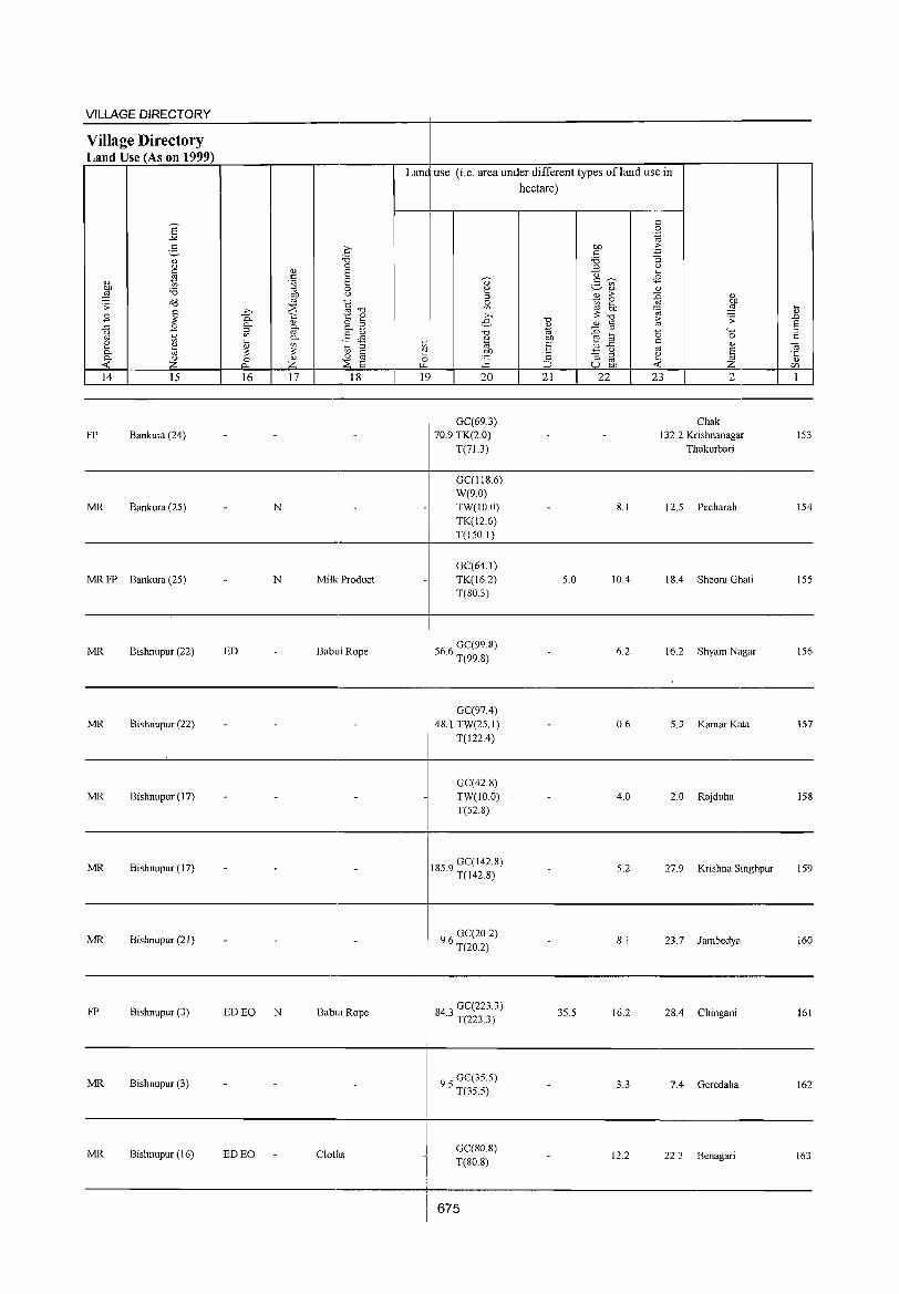
VILLAGE DIRECTORY ------------------------------------~----------------------------------.-------Village Directory Land Use (As on 1999) r=~~~~~~,_----r_--_.------_.~~--~----~~~----~~~~_.--------_.--_,
Land use (i.e. area under different types ofland use in
14 IS 16
FP Bankura (24)
MR Bankura (25)
17 18
N
20
GC(69.3) 70.9 TK(2.0)
T(71.3)
GC(118.6) W(9.0) TW(IO.O) TK(12.6)
hectare)
21 22
8.1
23 2
Chak 13 2.2 Kri shnanagar
Thakurbari
12.5 Pecharah
153
154
T(150.1) -----------------------------------------------~----~~---------------------------------------------
MR FP Bankura (25) N
MR Bishnupur (22) ED
MR Bishnupur (22)
MR Bishnupur (17)
MR Bishnupur (17)
MR Bishnupur (21) - -
FP Bishnupur (3) ED EO N
MR Bishnupur (3)
MR Bishnupur (16) ED EO
Milk Product
Babui Rope
-
-
Babui Rope
Cloths
GC(64.1) TK(16.2) T(BO.3)
566 GC(99.8) · T(99.8)
GC(97.4) 4B.I TW(25.1)
T(122.4)
GC(42.8) TW(lO.O) T(52.B)
185.9 GC(142.B) T(142.8)
96 GC(20.2) · T(20.2)
84' GC(223.3) .J T(223.3)
95 GC(35.5) · T(35.5)
GC(80.8) T(80.8)
675
5.0 10.4 18.4 Sheora Ghati ISS
6.2 16.2 Shyam Nagar 156
0.6 5.3 Kamar Kata 157
4.0 2.0 Rajduha 158
5.2 27.9 Krishna Singhpur 159
- 8.1 23.7 Jambedya 160
35.5 16.2 28.4 Chingani 161
3.3 7.4 Geredaha 162
12.2 22.3 Benagari 163
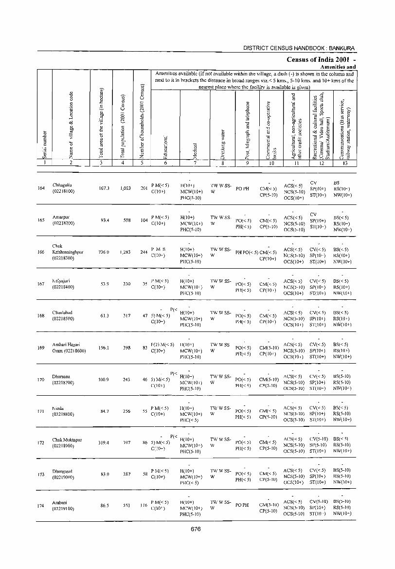
164
16S
166
167
168
169
170
171
172
173
174
2
Chhagulia (02218100)
Amarpur (02218200)
Chak Krishnasinghpur (02218300)
Kelyajuri (02218400)
Chaulabad (02218500)
Ambari Hazari Gram (02218600)
Dharsona (02218700)
Niada (02218800)
Chak Muktapur (02218900)
Dhengasol (02219000)
Arabani (02219100)
3
167.3
93.4
736.0
S3.9
61.3
156.1
100.9
84.7
319.4
83.0
86.5
C> C> t!-
4
1,003
598
1,283
230
317
398
243
256
397
287
551
DISTRICT CENSUS HANDBOOK: BANKURA
Census of India 2001 -Amenities and
Amenities available (if not available within the village, a dash (-) is shown in the column and next to it in brackets the distance in broad ranges viz. < 5 kms., 5-10 kms. and 10+ kms of the
nearest place where the facility is available is given
C> o t!-~
1 o -'" 'H o .._ Q)
..0 E ::s Z 5 6
201 PM«5) C(lO+)
104 P M« 5) C(JO+)
244 PM S C(lO+)
3S PM«5) C(IO+)
7
H(IO+)
MCW(lO+)
PHC(S··IO)
H(lO+) MCW(10+) PHC(S-IO)
H(IO+) MCW(IO+)
PHC(5-to)
H(IO+) MCW(IO+) PHC(5-10)
- P« -47 5)M«5) H(IO+)
C(lO+) MCW(IO+) , PHC(5-1O)
83 P(2)M«5) H(IO+) C(10+) MCW(IO+)
PHC(5-10)
- P« -H(IO+)
46 5) M« 5) MCW(10+) C(lO+) PHC(5-1O)
55 PM«5) C(10+)
H(IO+) MCW(IO+)
PHC« 5)
- P« -H(IO+)
86 5) M« 5) MCW(10+)
C(lO+) PHC(5-10)
58 PM«5) C(!O+)
116 PM«5) C(IO+)
H(lO+) MCW(lO+)
PHC« 5)
H(JO+) MCW(IO+) PHC(S-IO)
676
8
'" o 0...
9
:WWSS- POPH
TWWSS-PO« S) PH«S)
W
10
CM« 5) CP(S-IO)
CM« S) CP(S-IO)
II 12
ACS«5) CV NCS(S-tO) SP(to+) OCS(lO+) ST(IO+)
ACS«5) CV NCS(5-IO) SP(IO+) OCS(5-tO) ST(IO+)
I3
BS RS(IO+) NW(IO+)
8S« 5) RS(IO+) NW(IO+)
:W W SS- PH PO« 5) CM« 5)
CP(IO+)
ACS« 5) CV« 5) NCS(S-IO) SP(lO+)
OCS(10+) ST(IO+)
BS« 5) RS(10+) NW(lO+)
TWWSS-PO«5) PH«5)
W
:W W SS- PO« 5)
PH« 5)
:W W SS- PO« 5)
PH« 5)
TWWSS-W PO«5)
PH«5)
~W W SS- PO« 5)
PH« 5)
TWWSS-W PO«5)
PH«5)
:W w SS- PO« 5)
PH« 5)
TW WSS- POPH W
CM«5) CP(IO+)
CM« 5) CP(IO+)
ACS« 5) CV« 5) NCS(5-to) SP(IO+) OCS(10+) ST(lO+)
ACS«5) CV«5) NCS(S-IO) SP(lOI)
OCS(IO+) ST(10+)
ACS« 5) CV« 5) CM(5-IO) NCS(5-1O) SP(IO+)
CP{lO+) OCS(IO+) ST(lO+)
ACS« 5) CV« 5) CM(5-10) NCS(S-IO) SP(IO+) Cpe5-10) OCS(5-10) ST(IO+)
CM«5) CP(5-1O)
ACS« 5) CV« 5) NCS(5-10) SP(IO+) OCS(5-1O) ST(IO+)
8S« 5) RS(IO+) NW(lO+)
BS« 5) RS(IOI)
NW(IO+)
8S« 5) RS(IO+) NW(IO+)
BS(5-10) RS(S-IO) NW(lO+)
8S« 5) RS(5-10) NW(IO+)
CM«5) CP(5-10)
ACS« 5) CV(5-10) 8S« 5)
CM«5) CP(5-1O)
NCS(5-10) SP(S-IO) RS(S-IO) OCS(5-1O) ST(IO+) NW(IO+)
ACS« 5) Cv« 5) NCS(5-10) SP(10+) OCS(10+) ST(IO+)
BS(5-1O) RS(S-IO) NW(IO+)
ACS« 5) CV(5-IO) BS(5-10) CM(S-IO) NCS(S-IO) SP(IO+) RS(5-10) CP(5-1O) OCS(5-1O) ST(lO+) NW(10+)
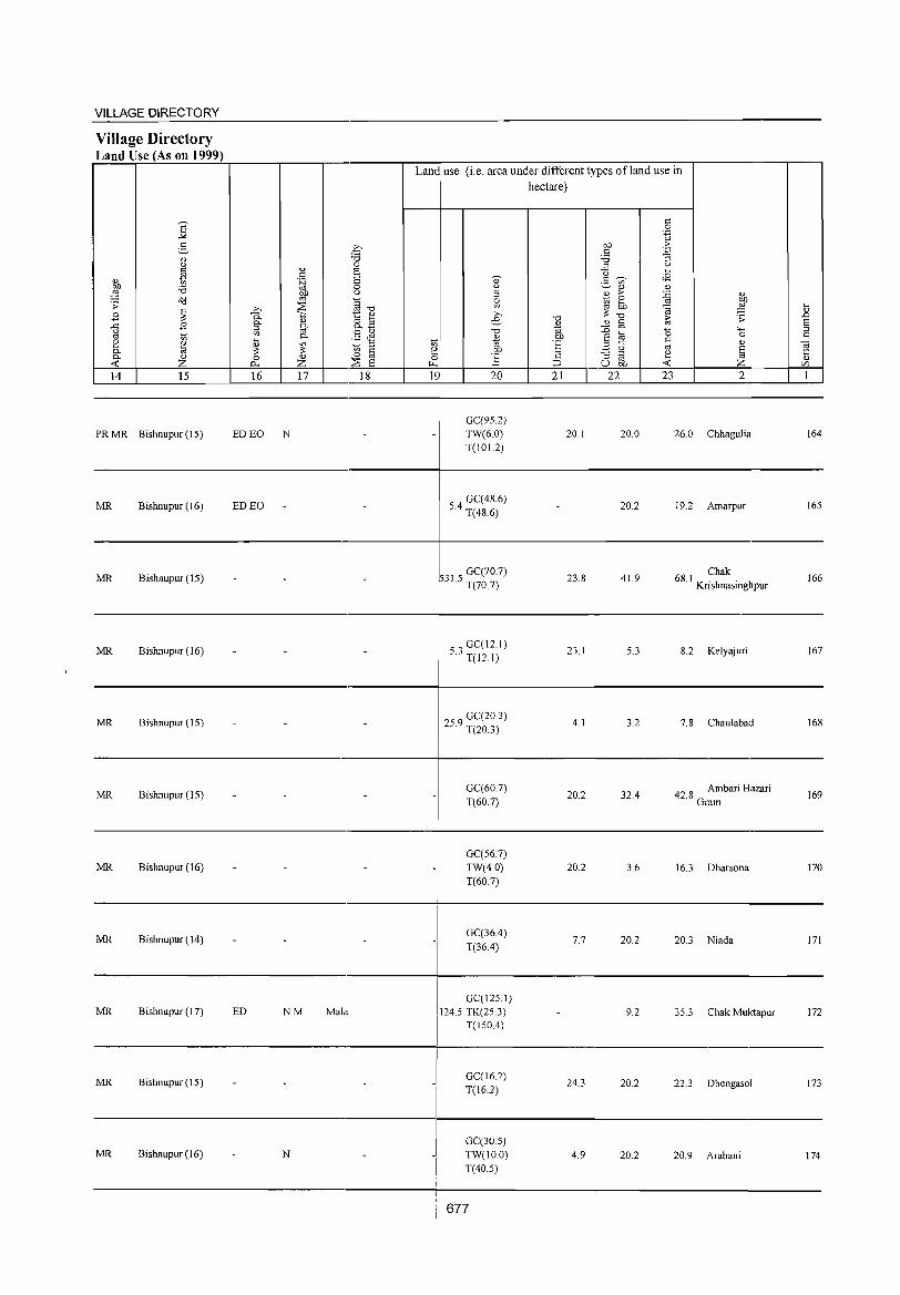
VILLAGE DIRECTORY ~~~~~~~----------------------~----------------------------------.-------
Village Directory Land Use (As on 1999)
14 15
PR MR Bishnupur (15)
MR Bishnupur (16)
MR Bishnupur (15)
MR Bishnupur (16)
MR Bishnupur (15)
MR Bishnupur (15)
MR Bishnupur (16)
MR Bishnupur (14)
MR Bishnupur (17)
MR Bishnupur(J5)
MR Bishnupur (16)
16 17 18
ED EO N
ED EO
ED NM Mala
N
Land use (i.e. area under different types ofland use in hectare)
19, 20
-GC(95.2) TW(6.0) T(I 0 1.2)
4 GC(48.6) 5. T(48.6)
GC(70.7) 31.5 T(70.7)
53 GC(12.1) . T(12.1)
259 GC(20.3) . T(20.3)
GC(60.7) T(60.7)
GC(56.7) TW(4.0) T(60.7)
_I GC(36.4)
I 1(364)
GC(125 I) 1245 TK(25 3)
I T(150A)
_I
.1
GC(162) T(16.2)
GC(30.5) TW(lO.O) T(40.5)
677
21
20.1
-
23.8
23.1
4.1
20.2
20.2
7.7
24.3
4.9
22 23
20.0
20.2
41.9
5.3
3.2
32.4
3.6
20.2
9.2
20.2
20.2
2
26.0 Chhagulia
19.2 Amarpur
68 I Chak . Krishnasinghpur
8.2 Kelyajuri
7.8 Chaulabad
42.8 Ambari Hazari Gram
16.3 Dharsona
20.3 Niada
35.3 Chak Muktapur
22.3 Dhengasol
20.9 Arabani
164
165
166
167
168
169
170
171
172
173
174
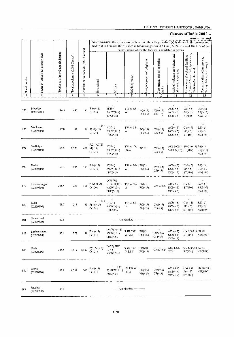
175
176
177
178
179
180
181
182
183
184
185
2
Mandiha (02219200)
Mouleswar (02219300)
Medinipur (02219400)
Datina (02219500)
Krishna Nagar (02219600)
Kalla (02219700)
Shima Baid (02219800)
Raghunathpur (02219900)
Onda (02220000)
Gogra (02220100)
Prajabad (02220200)
3
144.5
147.8
360.0
159.3
228.4
63.7
67.4
87.6
315.5
158.9
84.9
o o ~
4
495
87
2,373
886
725
218
272
5,617
1,732
DISTRICT CENSUS HANDBOOK: BANKURA
Census of India 2001 -Amenities and
Amenities available (if not available within the village, a dash (-) is shown in the colunm and next to it in brackets the distance in broad ranges viz.< 5 kms., 5-10 Ions. and 10+ kms of the
nearest place where the facili!Y_is available is given
o o ~
'" "0
] ~ = o
..c
'0 iil .0
§ Z 5 6
91 PM«5) C(10+)
7
H(IO+) MCW(10+)
PHC« 5)
P« H(10+) 16 5) M« 5) MCW(lO+)
C(lO+) PHC« 5)
P(2) AC(2)
460 M«5) C(lO+)
183 PM« 5) C(1O+)
158 P M S AC C(IO+)
H(lO+)
MCW(IO+)
PHC«5)
H(lO+) MCW(IO+)
PHC«5)
D(2) PHS CHWH(IO+) MCW(IO+)
PHC(5-10)
- P« H(I;+) 39 5)M«5) MCW(lO+)
C(10+) PHC« 5)
8 9
:WWSS- PO«5)
PH«5)
TWWSS-PO« 5) PH« 5)
W
TWWTK POPH SS-W
TW W SS- PH(3) W PO« 5)
TW W SS- PH(2)
W PO« 5)
TWWSS-PO«5)
PH« 5) W
-------- Uninhabited -----------
58 PM«5) C(lO+)
DH(3) H« 5) T HP TW
MCW(10+) W SS-T PHC« 5)
PH(2)
PO« 5)
P(3) M« 5) DH(2) PRC 1,102 H«S)
T HP TW PH(20)
C(10+) MCW(lO+) W SS-T PO« 5)
363 PM« 5) C(IO+)
- H« HPTWW 5) MCW(IO+) SS-W PO« 5) PHC« 5) PH« 5)
-------- Uninhabited ------------
678
10
CM« 5) CP« 5)
CM«5)
CP«5)
II
ACS« 5) NCS« 5)
OCS« 5)
ACS« 5)
NCS« 5)
OCS«5)
12
CV« 5) SP« 5)
ST(10+)
CV« 5) SP« 5) ST(IO+)
13
BS« 5) RS(5-1O)
NW(10+)
BS« 5) RS« 5) NW(10+)
CM« 5)
CP« 5)
ACS NCS« SP CV« 5) BS« 5)
5)OCS«5) ST(ID+) RS(5-10)
CM« 5)
CP« 5)
ACS«5) NCS« 5)
OCS« 5)
CM CP(2) ACS« 5) NCS« 5)
CM« 5) CP« 5)
CM«5)
CP« 5)
OCS« 5)
ACS« 5)
NCS« 5)
OCS« 5)
ACS«5)
NCS«5) OCS«5)
CM(2) CP ~~~ NCS
CM« 5)
CP« 5)
ACS«5)
NCS«5)
OCS«5)
CV«5) SP« 5) ST(IO+)
CVSP ST(lO+)
CV«5)
SP« 5) ST(IO+)
NW(IO+)
BS« 5) RS« 5) NW(lO+)
BS« 5) RS(5-l0)
NW(IO+)
BS« 5) RS« 5) NW(10+)
CV SP« 5) BS RS
ST(l 0+) NW(l 0+)
CV SP« 5) BS RS ST(10+) NW(IO+)
CV«5) SP« 5) ST(IO+)
BS RS« 5) NW(!o+)
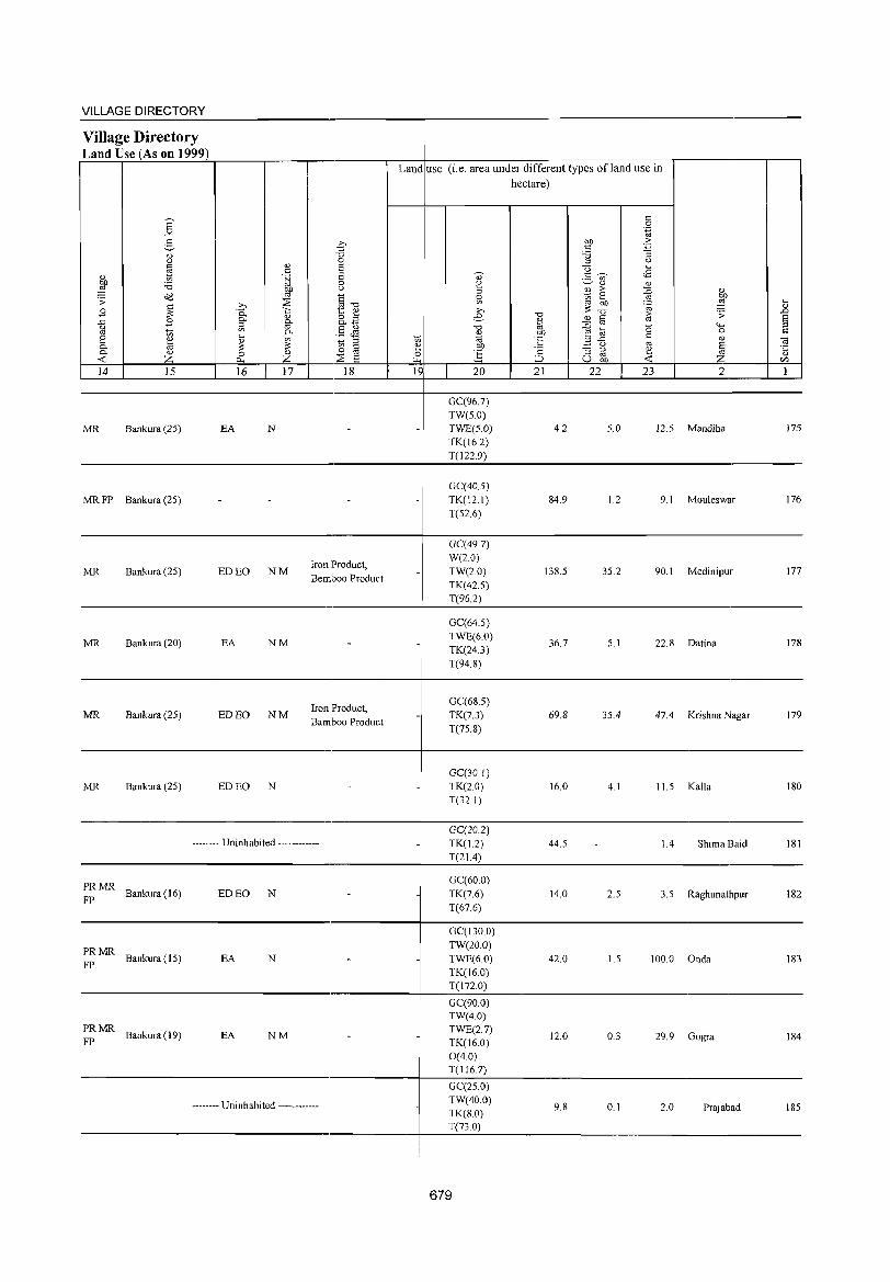
VILLAGE DIRECTORY
Village Directory Land Use (As on 1999)
Land use (i.e. area under different types ofland use in hectare)
L-~14~~ ____ ~15~ __ ~ __ ~16~~~1~7~ ___ .~1~8 ____ L-~1~9 __ ~ __ ~2~O __ ~ __ ~2~1 __ ~~2~2 __ ~~2~3 __ ~ ____ ~2 ____ ~ __ 1~
MR Bankura (25)
MR FP Bankura (25)
MR Bankura (25)
MR Bankura (20)
MR Bankura (25)
MR Bankura (25)
PRMR FP Bankura (16)
~~ MR Bankura (15)
PRMR FP Bankura (19)
EA N
ED EO NM
EA NM
ED EO NM
EDEO N
Iron Product, Bemboo Product
Iron Product, Bamboo Product
-------- Uninhabited ------------
ED EO N
EA N
EA NM
-------- Uninhabited ------------
GC(967) TW(5.0) TWE(5.0) TK(162) T(122.9)
GC(40.5) TK(121) T(52.6)
GC(497) W(2.0) TW(2.0) TK(42.5) T(962)
GC(64.5) TWE(6.0) TK(24.3) T(94.8)
GC(68.5) TK(7.3) T(75.8)
GC(301) TK(20) T(321)
GC(20.2) TK(1.2) T(21.4)
GC(60.0) TK(7.6) T(67.6)
GC(130.0) TW(20.0) TWE(6.0) TK(l6.0) T(172.0)
GC(90.0 TW(4.0) TWE(2.7) TK(16.0) 0(4.0) T(116.7)
GC(25.0) TW(40.0) TK(S.O) T(73 0)
679
4.2
84.9
138.5
36.7
69.8
16.0
44.5
14.0
42.0
12.0
9.8
5.0 12.5 Mandiha 175
1.2 9.1 Mouleswar 176
35.2 90.1 Medinipur 177
5.1 22.8 Datina 178
35.4 47.4 Krishna Nagar 179
4.1 11.5 Kalla 180
1.4 Shima Baid 181
2.5 3.5 Raghunathpur 182
1.5 100.0 Onda 183
0.3 29.9 Gogra 184
0.1 2.0 Prajabad 185
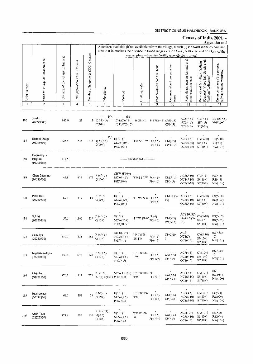
DISTRICT CENSUS HANDBOOK: BANKURA
Census of India 2001 -Amenities and
Amenities available (if not available within the village, a dash (-) is shown in the column and
next to it in brackets the distance in broad ranges viz.< 5 kms., 5-10 kms. and 10+ kms of the -;;;-- nearest place where the facility is available is given Q)' ~
<l)
~ <=: "t:l ~ ~" "t:l --;;;- <U
0 U <=: () '" ~ '" ..r:: - '" '" ~
".p u ","
c <=: 0 c > ._ '" " 0 g '" 0 0 .~ '0 t:: 'E ~ .~ u C'.. ..c ~ g <1) ~ () '" - 0-
'" :;
0 OJ) 0 '" '" 0- () "2'" :;: ~ -l ~ C> "t:l "2 0 '§b ~ 5 ::::",? C'.. <5 6 " <l) ~ .;;: ..c -0 :g ~ .S! o:! -
" % '-g ~~ '" c <1) t: ~ ~ '" -0 () 0 '"' <5 0 .... c
o ._ ~-I:lg <=: r:: ~ ~ 4-< .~ 0 %l
..c '"
c g 0 ..c 0-
Tf .~ o;;>"§l .~ .S ..0 .;;: 0 '"3 4-< "2 ::: ~ 0;
~ § '" 0 c l~ c <t: () 0- ,,-0 .;:;
'- ~ 0 OJ 0 on " .S OJ ] c 0 '" 0. .~ 0; <=: "2 <1) ~ ~ 1;; E E ~ 0; <l) .D () :;;; E '" '" ()
~ ~ E () 'a .g a t ,s ~ '5 ~ '" .S t; E-'" E ::: '" "t:l <1)
0 0 82 OJJ<5 0"" c/J !-< Z ~ ~ p., <t: 0 ~u- u e: ~C/J
I 2 3 4 5 6 7 8 9 10 II 12 13
Kushte P« H(5-ACS« 5) CV« 5) BSRS« 5) 186 142.9 29 8 5) M« 5) 10) MCW(5- HP SS-HP PH PO« 5) CM« 5) (02220300)
C(10+) 10) PHC(5-10) CP« 5) NCS« 5) SP« 5) NW(IO+) OCS« 5) ST(IO+)
Bhadul Danga - P« -
ACS« 5) CV(5-10) BS(5-10) 187 236.4 635 118 5) M«5) H(10+) TW SS-TW PO« 5) CM«5) (02220400) . C(lO+) MCW(10+) PH«5) CP(5-10) NCS(5-10) SP«5) RS« 5)
PHC(IO+) OCS(5-10) ST(10+) NW(10+)
Gopinathpur 188 Etajhira 112.5 -------- Uninhabited ------------
(02220500)
Chura Manipur P M«5) CHWH(lO+)
ACS(5-10) CV«5) BS« 5) 189
(02220600) 45.8 912 177
C(10+) MCW«S) TW SS-TW PO« 5) CM(S-IO)
NCS(5-10) SP(IO+) RS«5) PHC(IO+) PH« 5) CP«5) OCS(5-IO) ST(IO+) NW(IO+)
190 PatraHati
69.1 417 87 1'MS H(lO+)
T TW SS-W 1'0« 5) CMCP(5- ACS« 5) CV(5-1O) BS(5-1O)
(02220700) C(10+) MCW(lO+) PH«5)
10) NCS(5-IO) SP« 5) RS(5-10) 1'HC(lO+) OCS(5-1O) ST(IO+) NW(IO+)
191 Suklai
59.5 1,160 219 P'M«5) H(IO+) T TW SS-W PH(4) CM«5)
ACS NCS(5- CV(~-IO) BS(5-1O) (02220800) C(10+) MCW(10+) PO« 5) 10) OCS(5- S1'« 5) RS(5-1O)
PHC(IO+) CP(5-1O) 10) ST(IO+) NW(lO+)
Gamidya P M« 5) DHH(IO+)
HPTWR CPCM« ACS
CV(S-IO) BSRS(5-
192 219.0 835 163 MCW«5) PO«5) NCS(2) 10) (02220900) C(1O+)
PHC« 5) SS-TW
PH«5) 5)
OCS« 5) SP(IO+)
NW(IO+) ST(IO+)
Nayananandapur PM«5) H(lO+) HP TW SS- PO(~ 5) ACS« 5) CV(IO+) BS RS(5-
193 130.1 675 128 CM«5) 10) (02221000) C(IO+) MCW«5) TW PH(IO+) CP« 5)
NCS(5-1O) SP(lO+) NW(IO+)
PHC« 5) OCS« 5) ST(IO+)
ACS« S) CV(lO+) BS
Majdiha PM S MCWH(lO+) HPTWSS- PO CM«5) RS(IO+) 194
(02221100) 176.1 1,112 259
AC(2) C(10+) PHC« 5) TW PH(IO+) NCS(5-10) SP(10+) CP«5)
OCS« 5) ST(10+) NW(lO+)
Balarampur 65.0 198 38
P M« 5) H(!O+) HP TW SS- PO(~ 5) CM«5) ACS« 5) CV(IO+) BS«5)
195 (02221200) C(10+) MCW«5) TW PH(IO+)
NCS(5-IO) SP(IO+) RS(10+)
PHC« 5) CP« 5)
OCS(S-IO) ST(IO+) NW(IO+)
Amla Tara P PUC(2)
H(IO+) TWWSS- ACS(!O+) CV(lO+) BS« 5) 196 373.8 595 116 M{< 5)
MCW«S) W PO«5) CM«5) NCS(S-IO) SP(lO+) RS(IO+) (02221300) C(10+) PH(IO+) CP«S)
PHC« 5) OCS« 5) ST(IO+) NW(IO+)
680
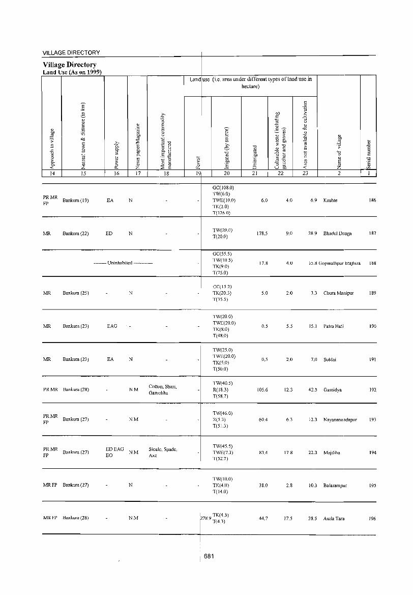
VILLAGE DIRECTORY ------------------------------------~-----------------------------------------Village Directory Land Use (As on 1999)
~: MR Bankura (19)
MR Bankura (22)
EA N
ED N
-------- Uninhabited ------------
MR Bankura (2S)
MR Bankura (23) EAG
MR Bankura (23) EA
PR MR Bankura (28)
~: MR Bankura (27)
N
N
NM
NM
Cotton, Shari, Gamchha
Land use (i.e. area under different types ofland use in hectare)
GC(108.0) TW(6.0) TWE(IO.0) TK(2.0) T(126.0)
TW(20.0) T(20.0)
GC(SS.S) TW(lOS) TK(9.0) T(7S.0)
GC(15.2) TK(20.3) T(3S.5)
TW(20.0) TWE(20.0) TK(8.0) T(48.0)
TW(2S.0) TWE(20.0) TK(S.O) T(SO.O)
TW(40.S) R(18.3) T(S8.7)
TW(46.0) R(S.3) T(SL3)
6.0
178.S
17.8
S.O
O.S
O.S
IOS.6
60.4
4.0 6.9 Kushte
9.0 28.9 Bhadul Danga
4.0 15.8 Gopinathpur Etajhira
2.0 3.3 Chura Manipur
S.S IS.I Patra Hati
2.0 7.0 Suklai
12.3 42.5 Gamidya
6.3 12.3 Nayananandapur
186
187
188
189
190
191
192
193
----------------------------------------~--------------------------------------------
:: MR Bankura (27)
MR FP Bankura (27)
MR FP Bankura (28)
EDEAG NM EO
N
NM
Sicule, Spade, Axe
TW(45.S) TWE(7.3) T(S27)
TW(IO.O) TK(4.0) T(14.0)
ens 9 TK(4.3) . T(4.3)
681
83.4
38.0
44.7
17.8 22.3 Majdiha 194
2.8 10.3 Balarampur 195
17.5 28.5 Amla Tara 196
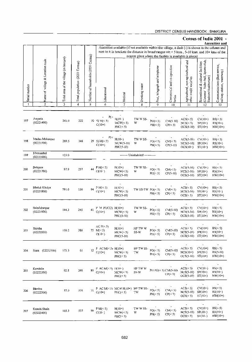
197
198
199
200
201
202
203
204
205
206
207
2
Angaria (02221400)
Madan Mohanpur (02221500)
Kheruashol (02221600)
Betajora (02221700)
Bhaluk Khulya (02221800)
Brindabanpur
(02221900)
Shirsha (02222000)
Siara (02222100)
Kundalia (02222200)
Bhedua (02222300)
Kunchi Shole (02222400)
3 4
341.0 322
269.5 148
123.0
97.9 257
791.0 530
144.3 245
110.2 380
173.3 61
92.8 390
57.0 374
165.3 537
DISTRICT CENSUS HANDBOOK: BANKURA
Census of India 2001 -Amenities and
Amenities available (if not available within the village, a dash (-) is shown in the column and next to it in brackets the distance in broad ranges viz.< 5 kms., 5-10 kms. and 10+ kms of the
nearest place where the facility_ is available is given
5 6 7
- P« -70 5}M«5) H(lO+)
C(lO+) MCW« 5) PHC«5)
- P« -29 5) M« 5) H(10+)
C(lO+) MCW(S-10) PHC(5-1O)
8
TWWSS-W
TWWSS-W
g o
..c c.. " E
'" o
"'"' 9
PO«5) PH«5)
PO«5) PH«5)
-------- Uninhabited ------------
44 P M« 5) C(10+)
94 P M« 5) C(10+)
H(IO+)
MCW«5) PHC(5-IO)
H(lO+)
MCW«5) PHC(5-10)
41 I' M I'UC(2) H(lO+) C(10+) MCW« 5)
PHC(5-JO)
ACP«5) 75 M«5)
C(lO+)
H(IO+)
MCW«5) PHC(5-1O)
12 F' AC M« 5) H(IO+) C(IO+) MCW« 5)
I'HC« 5)
TWWSS-PO«5) PH«5)
W
TW SS-TW PO« 5)
PH«5)
TWWSS-PO«5)
PH«5) W
~_~WW PO«5) PH« 5)
HP TW SS- 1'0(: 5)
TW PH«5)
10 II 12
CM(5-IO) ACS« 5) CV(lO+) NCS« 5) SP(10+)
CP« 5) OCS(5-10) ST(IO+)
CM«5) CP(5-IO)
CM«5) CP(5-1O)
CM«5) CP« 5)
ACS(5-IO) CV(IO+) NCS(5-10) SP(lO+) OCS(IO+) ST(IO+)
ACS(5-10) CV(10+) NCS(5-10) SP(10+) OCS(5-IO) ST(lO+)
ACS« 5) CV(IO+) NCS(5-10) SP(IO+)
OCS« 5) ST(IO+)
ACS« 5) CV(lO+) CM(5-10) NCS(5-tO) SP(lO+)
CI'« 5) OeS(5-1O) ST(lO+)
ACS« 5) CV(10+) CM(5-10) NCS(5-10) SI'(10+)
CP« 5) OeS(5-10) ST(IO+)
ACS« 5) eV(IO+) CM(5-10) NCS(IO+) SI'(IO+)
CP« 5) OCS(5-1O) ST(lO+)
80 I' AC M« 5) H(lO+) HPTWW ACS«5) CV(10+) SS-W PH 1'0« 5) CM(5-1O) NCS(5-10) SI'(IO+) C(IO+) MCW«5)
PHC« 5)
71 P ACM«5) MCWH(10+) ~:TWSS- PO«5) C(lO+) I'HC« 5) PH« 5)
90 PM«5) C(10+)
H(JO+)
MCW«5) I'HC« 5)
682
TWWSS-1'0« 5) PH« 5)
W
CP« 5) aCS(5-IO) ST(IO+)
CM«5) CP« 5)
CM« 5)
CP« 5)
ACS« 5) CV(10+) NCS(5-10) SI'(10+) OCS« 5) ST(10+)
ACS« 5) CV(10+) NCS(5-1O) SI'(10+) OCS« 5) ST(lO+)
I3
BS« 5) RS(lO+) NW(IO+)
BS« 5) RS(lO+) NW(IO+)
BS« 5) RS(10+) NW(lO+)
BS« 5) RS(10+)
NW(IO+)
BS« 5) RS(IO+) NW(lO+)
BS« 5) RS(lO+) NW(IO+)
BS«5) RS(5-10)
NW(IO+)
BS« 5) RS(IO+) NW(IO+)
6S« 5) RS(IO+) NW(10+)
BS« 5) RS(10+) NW(10+)
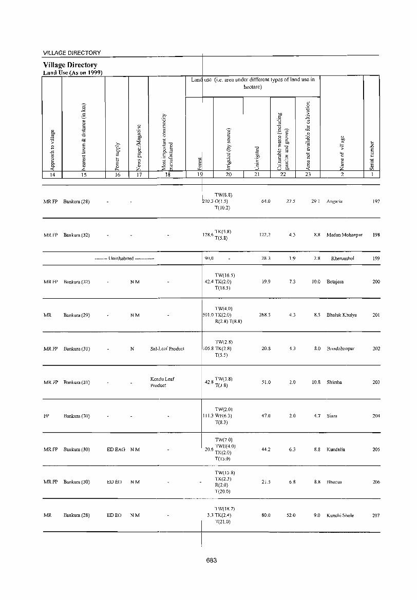
VILLAGE DIRECTORY ~~~~~-------------------------r--------------------------------------Village Directory Land Use (As on 1999) r=~~~~~~~.-----.----r--------~--4---~----~~~------~~--~.-----------.---,
Lane use (i.e. area under different types ofland use in
MR FP Bankura (28)
MR FP Bankura (32)
MR FP Bankura (32)
MR Bankura (29)
MR FP Bankura (31 )
MRFP Bankura(31)
FP Bankura (30)
MR FP Bankura (30)
MR FP Bankura (30)
MR Bankura (28)
-------- Uninhabited ------------
NM
NM
N
EDEAG NM
ED EO NM
ED EO NM
Sal-Leaf Product
KenduLeaf Product
20
TW(8.8) 1210.30(1.5)
T(10.2)
1286 TK(S.S) · T(S.S)
90.0
TW(16.S) 42.4 TK(2.0)
T(18.S)
TW(4.0) SOLO TK(2.0)
R(2.S) T(S.8)
TW(2.8) 10S.S TK(2 8)
T(S.S)
42 S TW(3.S) · T(3.S)
TW(2.0) 111.3 WF(6.3)
T(S.3)
TW(7.0)
206 TWE(4.0) · TK(2.0)
T(13.0)
TW(15.8) TK(2.3) R(20) T(20.0)
TW(IS.7) 3.3 TK(2.4)
T(21.0)
• 683 I
hectare)
21 22 23 2
64.0 27.5 29. I Angaria 197
122.2 4.3 S.S Madan Mohanpur 198
2S.3 1.9 2.S Kheruashol 199
19.9 7.3 10.0 Betajora 200
26S.S 4.3 S.S Bhaluk Khulya 201
20.8 4.3 8.0 Brindabanpur 202
S1.0 2.0 10.8 Shirsha 203
47.0 2.0 4.7 Siara 204
44.2 6.3 8.S Kundalia 20S
21.5 6.8 8.8 Bhedua 206
SO.O S2.0 9.0 Kunchi Shole 207
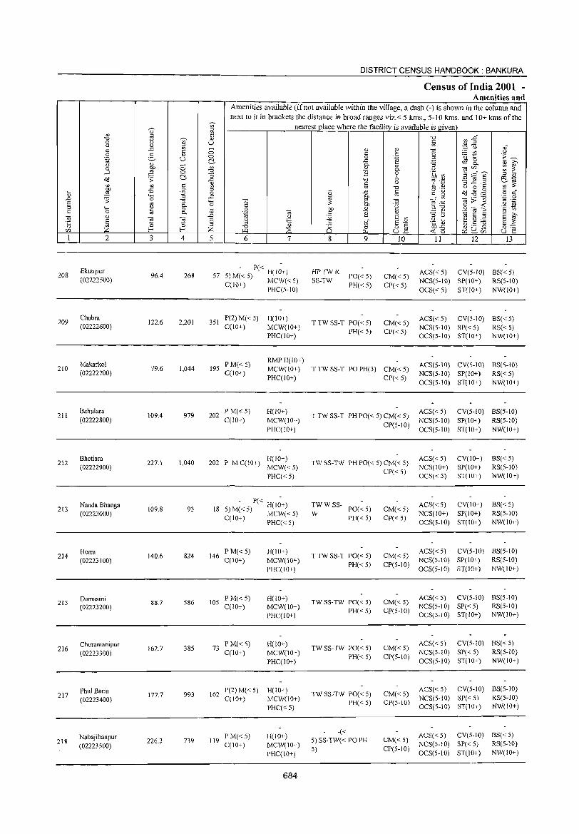
208
209
210
211
212
213
214
215
216
217
218
2
Ektarpur (02222500)
Chabra (02222600)
Makarkol (02222700)
Bahulara (02222800)
Bhetiara (02222900)
Nanda Bhanga (02223000)
Horra (02223100)
Damasini (02223200)
Churamanipur (02223300)
Phul Baria (02223400)
Nabajibanpur (02223500)
3 4
96.4 268
122.6 2,201
79.6 1,044
109.4 979
227.1 1,040
109.8 93
140.6 824
88.7 586
162.7 385
177.7 993
226.3 739
DISTRICT CENSUS HANDBOOK: BANKURA
Census of India 2001 -Amenities and
Amenities available (if not available within the village, a dash (-) is shown in the column and next to it in brackets the distance in broad ranges viz.< 5 kms., 5-10 kms. and 10+ kms of the
nearest place where the facility is available is given
5 6 7
- P« -57 5) M«5) H(IO+)
C(10+) MCW« 5) PHC(5·10)
351 P(2) M« 5) C(10+)
195 P M« 5) C(10+)
202 PM« 5) C(lO+)
H(lO+)
MCW(IO+) PHC(IO+)
RMPH(lO+)
MCW(IO+)
PHC(IO+)
H(lO+)
MCW(10+)
PHC(lO+)
H(lO+) 202 P M C(IO+) MCW« 5)
PHC« 5)
- P« -18 5) M« 5) H(IO+)
C(10+) MCW« 5) PHC{< 5)
146 PM«5) CCIO+)
105 PM« 5) CC10+)
73 PM« 5) C(10+)
162 P(2) M« 5) C(10+)
119 PM«5) C(10+)
H(10+)
MCW(lO+)
PHC(lO+)
H(10+) MCW(lO+) PHC(10+)
H(lO+)
MCW(IO+)
PHC(IO+)
H(IO+) MCW(IO+)
PHC« 5)
H(10+)
MCW(10+)
PHC(JO+)
684
8
HPTWR SS-TW
9
PO« 5) PH« 5)
T TW SS-T PO« 5) PH« 5)
10
CM« 5) CP« 5)
CM«5) CP«5)
T TW SS-T PO PH(3) CM« 5)
CP« 5)
T TW SS-T PH PO« 5) CM« 5)
CP(5-10)
TW SS-TW PH PO« 5) CM« 5) CP«5)
TWWSS-W PO«5)
PH«5)
T TW SS-T PO« 5)
PH«5)
TW SS-TW PO« 5) PH« 5)
TW SS-TW PO« 5)
PH«5)
TW SS-TW PO« 5) PH« 5)
-« 5) SS-TW« PO PH
5)
CM« 5)
CP« 5)
CM«5) CP(5-1O)
CM«5) CP(5-1O)
CM«5) CP(5-1O)
CM« 5) CP(5-1O)
CM« 5) CP(5-1O)
11 12 13
ACS« 5) CV(5-10) BS« 5) NeS(5-10) SP(IO+) RS(5-10)
OCS« 5) ST(10+) NW(lO+)
ACS« 5) CV(5-IO) BS« 5)
NCS(S-IO) SP« 5) RS« 5) OCS(5-10) ST(10+) NW(IO+)
ACS(5-IO) CV(5-IO) BS(5-1O)
NCS(5-10) SP(10+) RS« 5)
OCS(5-10) ST(10+) NW(IO+)
ACS« 5) CV(5-1O) BS(5-IO)
NCS(5-10) SP(10+) RS(5-1O)
OCS(5-10) ST(lO+) NW(IO+)
ACS« 5) NCS(lO+)
OCS« 5)
CV(IO+) SP(IO+)
ST(IO+)
ACS«5) CV(10+) NCS(IO+) SP(IO+)
OCS(5-10) ST(lO+)
BS«5) RS(5-10)
NW(IO+)
BS«5) RS(5-10)
NW(lO+)
ACS« 5) CV(5-1O) BS(5-10) NCS(5-10) SP(IO+) RS(S-IO)
OCS(5-10) ST(10+) NW(10+)
ACS« 5) CV(5-IO) BS(5-10) NCS(5-10) SP«5) RS(5-10) OCS(5-10) ST(IO+) NW(10+)
ACS«5) CV(5-IO) BS«5)
NCS(5-IO) SP« 5) RS(5-10) OCS(5-10) ST(10+) NW(lO+)
ACS« 5) CV(5-IO) BS(5-IO)
NCS(5-IO) SP« 5) RS(5-10) OCS(5-10) ST(IO+) NW(10+)
ACS« 5) CV(5-IO) BS« 5)
NCS(5-10) SP«5) RS(5-IO)
OCS(5-10) ST(IO+) NW(IO+)
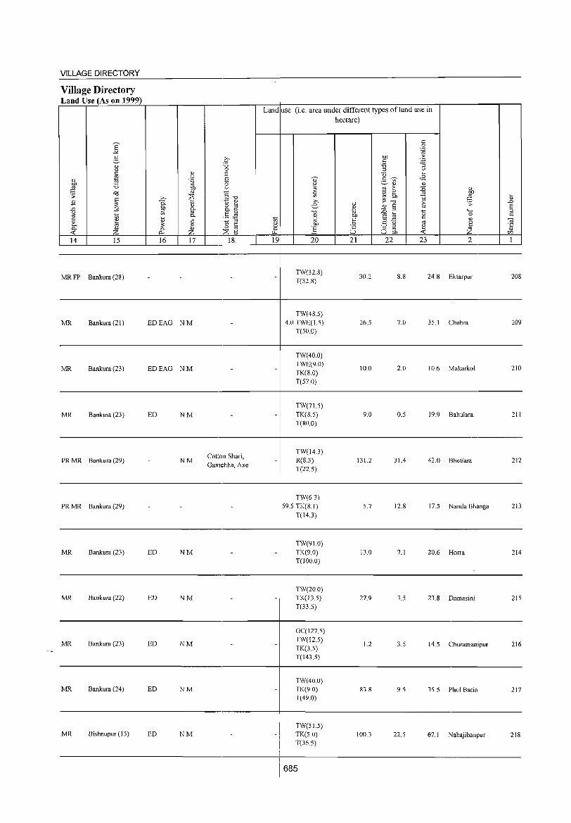
VILLAGE DIRECTORY
Village Directory Land Use (As on 1999)
14 15 16 17 18
Land use (i.e. area under different types ofland use in hectare)
19 20 21 22 23 2
------------------------------------------,_----------------------------------------------
MR FP Bankura (28)
MR Bankura (21)
MR Bankura (23)
MR Bankura (23)
PR MR Bankura (29)
PR MR Bankura (29)
MR Bankura (23)
MR Bankura (22)
MR Bankura (23)
MR Bankura (24)
MR Bishnupur (15)
EDEAG NM
EDEAG NM
ED NM
NM
ED NM
ED NM
ED NM
ED NM
ED NM
Cotton Shari, Gal11(:hha, Axe
TW(32.8) T(32.8)
TW(48.5) 4.0 TWE(IS)
T(50.0)
TW(40.0) TWE(9.0) TK(8.0) T(57.0)
TW(71S) TK(8.5) T(80.0)
TW(l4.3) R(8.3)
T(22.5)
TW(63)
59.5 TK(81) T(143)
TW(91.0) TK(9.0) T(IOO.O)
TW(200) TK(l3.5)
T(33.5)
GC(127.5) TW(l2.5)
TK(3.5) T(143.5)
TW(40.0) TK(90) T(49.0)
TW(31.5) TK(S.O) T(36.5)
30.2
26.5
10.0
9.0
131.2
5.7
13.0
27.9
1.2
1003
8.8 24.8 Ektarpur 208
7.0 35.1 Chabra 209
2.0 10.6 Makarkol 210
0.5 19.9 Bahulara 211
31.4 42.0 Bhetiara 212
12.8 17.5 Nanda Bhanga 213
7.1 20.6 Horra 214
3.5 23.8 Damasini 215
3.5 14.5 Churamanipur 216
9.5 35.5 Phul Saria 217
225 67.1 NabaJlbanpur 218
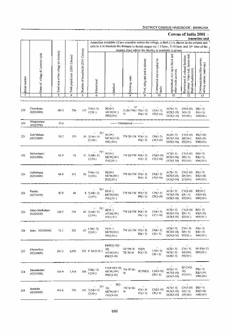
0;-
" B "0 ~
0 Cj '" Cj 1l " c '" c 0 e- O)
.~ u Cj ~ ;; 0 -l ~ 0
C!.-Cd .;;:
&. <1.l C -5 0 .... ,g .~
'" "-< .D .;;: 0 ""3 a til g-;:l
"""' ~
'" 0 '" 0..
""iii 0)
a 2i '" '5 '" 0 ~ rf) Z f-<
1 2 3 4
Charuikunr 219 189.3 726
(02223600)
220 Bhagabanpur
57.4 (02223700)
221 DaliMahara
93.2 157 (02223800)
222 Mukundapur
61.4 52 (02223900)
223 Gobindapur
66.8 451 (02224000)
224 Pundra
82.9 44 (02224100)
225 Jamra Madhabpur
128.5 259 (02224200)
226 Indra (02224300) 71.1 353
Khamarbere 227
(02224400) 261.2 2,693
Damodarbati 228 105.9 1,419
(02224500)
Iamdoba 229 504.6 790
(02224600)
~
'" " '" '" '" u -0 0 C!.-'" "0 o ..c '" '" " 0
..c """' o :u
.D
§ Z 5
133
34
II
92
8
45
67
DISTRICT CENSUS HANDBOOK: BANKURA
Census of India 2001 -Amenities and
Amenities available (if not available within the village, a dash (-) is shown in the column and next to it in brackets the distance in broad ranges viz.< 5 kms., 5-10 kms. and 10+ kms of the
nearest place where the facility is available is given "0
Ul ..g" '" '" .~ u 0)"
<!) '" e c > ~t '-' ·E ~ 0 .~ ;:: ..c <.is 0 0.. '" ""§ 0.. 0) ~ <1.l 0.. -a Vl ~ ~ E 0 .~ ~ S ::£ E 6
;:l 0)
"0 6 .~ -3 E .2 e_to c '-' ;g ::: '" "0 I.) 0 ....
~ g "g o'?J .g . .@ 0) ..c c 0 c"
~ 0.. <:l
'" .~ "0 .~ 0
'" ffi, ""iii ~::a "jg>~ .~ u c: .§ ·2 .~ -a
OJ) '" E ~ ~(OS C 13 '" to E ;:;J ;:l
(d Cj 12 E '" ;:l Cj
E f g '6 c: 'in" a"" .g ~ ~.S ~ "0 '" 8 0 o '" OJ)..c §:-;:: [.l.l :::s 0... ull "::0 ~ ~rh u e 6 7 8 9 10 11 12 13
PM« 5) H(lO+) -«
ACS« 5) CV(5-10) BS« 5) 5) SS-TW« PO« 5) CM«5)
C(IO+) MCW(IO+) 5) PH«5) CP(5-IO)
NCS(5-10) SP« 5) RS« 5) PHC(IO+) OCS(5-IO) ST(lO+) NW(IO+)
-------- Uninhabited ------------
- P« H(I;+) TW SS-TW PO« 5) CM« 5)
ACS«5) CV(5-IO) BS(5-10) 5)M«5) MCWe5-10) NCS(5-IO) SP(IO+) RS(5-10) C(10+) PHC(IO+) PH« 5) CP(5-10)
OCS(5-10) ST(IO+) NW(IO+)
- P« H(I;+) TW SS-TW PO« 5) CM(5-10)
ACS«5) CV(5-10) BS« 5) 5) M« 5) MCW(IO+)
PH« 5) CP(5-1O) NCS(5-IO) SP«5) RS« 5)
C(lO+) PHC(IO+) OCS(5-10) ST(10+) NW(lO+)
PM«5) H(10+) TW SS-TW PO« 5) CM«5)
ACS«5) CV(5-1O) BS«5) C(10+) MCW(lO+)
PH« 5) CP(5-1O) NCS(5-10) SP(10+) RS(5-10)
PHC(IO+) OCS(5-IO) ST(lO+) NW(IO+)
- P« H(I~+) TW SS-TW PO« 5) CM« 5)
ACS« 5) CV(5-1O) BS(IO+) 5) M( < 5) MCW(I 0+) NCS(5-10) SP«5) RS(5-10) 12(10+) PHC(lO+) PH« 5) CP(5-10)
OCS(5-10) ST(10+) NW(lO+)
- P« H(I~+) TW SS-TW PO« 5) CM«5)
ACS« 5} CV(5-1O) BS« 5) 5) M« 5) MCW(IO+}
PH« 5) CP(5-IO) NCS(5-IO) SP« 5) RS(5-10)
C(IO+) PHC(IO+) OCS(5-IO) ST(IO+) NW(IO+)
F'M«5) H(IOI) TW SS-TW PO« 5) CM« 5)
ACS« 5) CV{< 5) 8S« 5)
C(IO+) MCW(IO+) NCS(S-IO) SP«5) RS« 5)
PHC(IO+) PH« 5) CP«5)
OCS(S-IO) ST(IO+) NW(JO+)
RMP(2)H(5-
535 P M C(IO+) 10) HPTWW PH(8)
CM«5) ACS« 5) CV«5) BS RS«5)
MCW(lO+) TK SS-W PO« 5) NCS« 5) SP(lO+) NW(IO+)
PHC(5-1O) CP« 5)
OCS« 5) ST(lO+)
P M« 5) CRWH(5-1O)
TWWSS- ACS«5) SPCV(5-
B3«5) MCW(IO+) PO PR(5) CM(S-IO) 10) 304
C(10+) W NCS(5-10) RS(5-10) PHC(5-10) CP«5) ST(IO+)
OCS(5-10) NW(IO+)
P« H(5-
10) TWWSS- ACS« 5) eV(S-IO) BS« 5) 141 5) M«5)
MCW(IO+) W PO« 5) CM(5-IO)
NCS(5-10) SP« 5) RS(5-10) C(10+) PH« 5) CP«S)
PHC(5-10) OCS(5-1O) ST(IO+) NW(IO+)
686

VILLAGE DIRECTORY
Village Directory Land Use (As on 1999)
B
14 15
MR Bishnupur (15)
16 17
ED NM
-------- Uninhabited ------------
MR Bankura (24)
MR Bankura (24)
MR Bankura (22) ED EO NM
MR Bankura (22) NM
MR Bankura (23) ED NM
MR Bankura (24) ED
PRMR Bishnupur (II)
FP EA NM
MR Bishnupur (II) EDEAG EO NM
MR Bishnupur (11) EDEAG NM
18
Land use (i.e. area under different types ofland use in hectare)
19 20
TW(148.0) TK(10.0) T(158.0)
TW(lO.O) T(IO.0)
TW(10.4) TK(6.4) T(16.8)
GC(14.5) TW(14.0) TK(10.9) T(39.4)
GC(37.0) TW(18.0) T(55.0)
GC(12.0) TW(IO.O) TK(5.0) T(27.0)
TW(20.0) T(200)
TW(4.0) TK(5.0) T(9.0)
GC(IOO.O) TW(20.0) TWE(6.0) TK(12.0) 0(16.0) T(l54.0)
GC(51.0) TW(5.0)
1.0 TWE(5.0) TK(2.0) T(63.0)
GC(119.0)
3570 TWE(6.0) . TK(8.0)
T(l33.0)
687
21 22
10.0
29.5
65.1
13.1
2.0
21.5
81.5
53.6
9.3
20.0
23 2
2.5 18.8 Charuikunr
9.0 8.9 Bhagabanpur
4.0 7.4 Da1i Mahara
1.5 7.4 Mukundapur
3.5 6.3 Gobindapur
17.0 17.4 Pundra
9.5 17.5 Jamra Madhabpur
2.0 6.5 Indra
7.9 90.0 Khamarbere
2.0 19.9 Damodarbati
8.0 6.6 Jamdoba
219
220
221
222
223
224
225
226
227
228
229
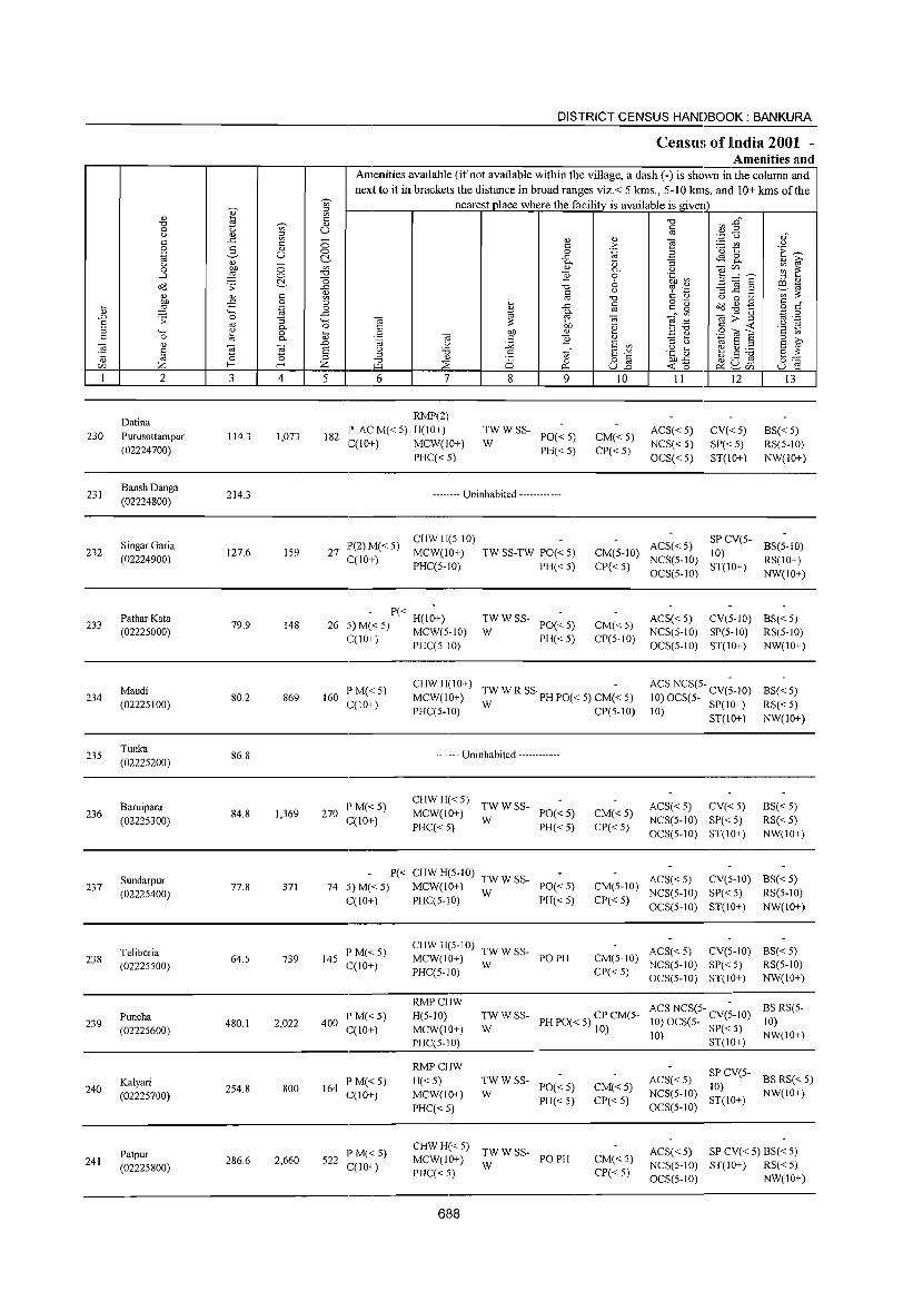
230
231
232
233
234
235
236
237
238
239
240
241
2
Datina Purusottampur (02224700)
BanshDanga (02224800)
Singar Garia (02224900)
Pathar Kata (02225000)
Maudi (02225100)
Tunka (02225200)
Baruipara (02225300)
Sundarpur (02225400)
Teliberia (02225500)
Puncha (02225600)
Kalyari (02225700)
Patpur (02225800)
3
114.3
214.3
127.6
79.9
80.2
86.8
84.8
77.8
64.5
480.1
254.8
286.6
o o C!-c: o
'-g :; 0. o 0.
~ 4
1,073
159
148
869
1,369
371
739
2,022
800
2,660
DISTRICT CENSUS HANDBOOK: BANKURA
Census of India 2001 -Amenities and
Amenities available (if not available within the village, a dash (-) is shown in the column and next to it in brackets the distance in broad ranges viz.< 5 krns., 5-10 kms. and 10+ kms of the
nearest place where the facility is available is given
5
182
6 7
RMP(2) P AC M« 5) H(IO+) C(10+) MCW(IO+)
PHC«5)
8 9
;:' W SS- PO« 5)
PH«5)
-------- Uninhabited ------------
27 1'(2) M( < 5) C(10+)
CHWH(5-10) MCW(10+) PHC(5-1O)
- P« H(I~+) 26 5) M« 5) MCW(5-10)
C(IO+) PHC(5-10)
TW SS-TW PO« 5) PH« 5)
~W W SS- PO« 5)
PH«5)
" > .~
" 0. o 6 <.>
§ 0:;
'e " E '" E"" 8E 10
CM«5) CP« 5)
CM(5-10) CP«5)
CM«5) CP(5-1O)
160 P M« 5) C(IO+)
CHW H(IO+) -MCW(IO+) TWWRSS· PHPO«5)CM«5)
270 I'M«5) C(10+)
PHC(5-10) W CP(5-1O)
-------- Uninhabited ------------
CHWH«5) TWWSS-MCW(IO+) W PO« 5) PHC« 5) PH« 5)
CM«5) CP«5)
II
ACS« 5) NCS« 5) OCS« 5)
12
CV« 5) SP«5) ST(10+)
ACS« 5) SP CV(5-10)
NCS(5-10) ST(10+) OCS(5-10)
13
BS«5) RS(5-1O) NW(IO+)
BS(5-1O) RS(IO+) NW(IO+)
ACS« 5) CV(5-1O) BS« 5) NCS(5-10) SP(5-10) RS(5-10) OCS(5-10) ST(IO+) NW(IO+)
ACS NCS(5- CV(~-IO) 10) OCS(5- SP(IO+)
10) ST(10+)
ACS« 5) CV« 5) NCS(5-1O) SP« 5) OCS(5-10) ST(IO+)
BS«5) RS«5) NW(10+)
BS«5) RS« 5) NW(IO+)
P« CHWH(5-10) TWWSS-74 5) M« 5) MCW(IO+) W PO« 5)
C(10+) I'HC(5-10) PH« 5)
ACS« 5) CV(5-1O) BS« 5) CM(5-10) NCS(5-10) SP« 5) RS(5-10)
CP« 5) OCS(5-10) ST(10+) NW(10+)
145 l' M« 5) C(IO+)
400 P M«5) C(10+)
164 l' M« 5) C(10+)
522 l' M« 5) C(10+)
CHW H(5-1 0) TW W SS-MCW(IO+) W PO PH PHC(5-10)
ACS« 5) CV(5-10) BS« 5) CM(5-10) NCS(5-IO) SI'« 5) RS(5-1O) CI'« 5) OCS(5-1O) ST(IO+) NW(IO+)
RMPCHW H(5-10) MCW(10+) I'HC(5-IO)
TW W SS- PH PO« 5) CP CM(5-W 10)
ACS NCS(5- CV(~-IO) 10) OCS(5- SP« 5)
10) ST(IO+)
BS RS(5-10) NW(10+)
RMPCHW
H«5) MCW(IO+)
PHC« 5)
~W W SS- PO« 5)
PH« 5)
CHWH«5) TWWSS-MCW(IO+) W PO PH PHC«5)
688
CM«5) CP«5)
CM«5) CP«5)
ACS( < 5) SP CV(5- BS RS( < 5)
NCS(5-10) 10) NW(IO I) OeS(5-10) ST(IO+)
ACS« 5) SP CV« 5) BS« 5) NeS(5-10) ST(IO+) RS« 5) OeS(5-1O) NW(IO+)
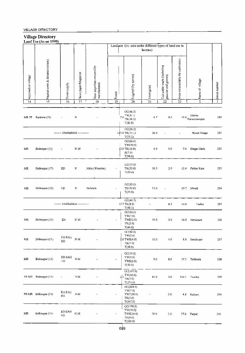
VILLAGE DIRECTORY --------------------------------------4-----------------------------------------Village Directory Land Use (As on 1999) r=~~~~~~~r_----r_--_r--------,~--+-~~----~~~------~~~~r----------r--~
Land use (i.e. area under different types ofland use in
14 15 16 17 18
MR FP Bankura (25) N
-------- Uninhabited ------------
MR Bishmpar (I I) NM
MR Bishnupur (17) ED N Mala (W oaden)
19 20
GC(48.5) TW(8.1)
7.6 TK(26.2)
T(S2.S)
GC(20.2) 13.0TK(IS.I)
T(3S.3)
GC(60.0) TW(20.0)
13.0 TK(I6.0) R(2.0) T(9S.0)
GC(3S.0) TK(200) T(SS.O)
hectare)
21 22 23
4.7 4.2
36.0
4.0 5.0
10.5 2.0
2
15.0 Datina Purusottampur
Bansh Danga
7.6 Singar Garia
12.4 Pathar Kata
230
231
232
233
-------------------------------------------------~----------------------------------------------------
MR Bishnupur (15) ED N BeImaIa
-------- Uninhabited ------------
MR Bishnupur (11) EA NM
GC(3S.0) TK(20.0) T(SS.O)
GC(40.3) I .7 TK(80)
T(4S.3)
GC(3S.0) TW(3.0) TWE(3.0) TK(2.0)
15.0
8.3
19.0 3.0
10.2 Maudi 234
14.6 Tunka 235
16.S Baruipara 236
T(46.0) ----------------------------------.-----------~--~~----------------------------------.-------
MR Bishnupur (11)
MR Bishnupur (II)
PR MR Bishnupur (11)
PR MR Bishnupur (11)
MR Bishnupur (II)
EDEAG NM EO
EDEAG NM EO
NM
~~EAG NM
EDEAG NM EO
GC(40.0) TW(3.0)
.0 TWE(4.0) TK(I.O) T(4S.0)
GC(20.0) TW(4.0) TWE(6.0) T(30.0)
I GC(2430)
2,0 TW(46.0)
I TK(20) T(291.0)
GC(208.0) TW(7.0) TWE(30.0) TK(2.0) T(247.0)
GC(190.0) TW(10.0) TWE(20.0) TK(6.0)
! T(226.0)
15.0 4.0 8.S Sundarpur 237
9.0 8.0 17.5 Teliberia 238
S1.0 2.0 104. I Puncha 239
3.0 4.8 Kalyari 240
20.0 3.0 37.6 Patpur 241
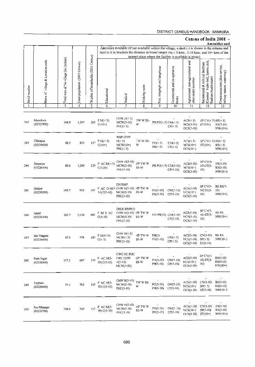
242
243
244
245
246
247
248
249
250
2
Mauchura
(02225900)
Chhinpur
(02226000)
Barpetya
(02226100)
Malpur (02226200)
Lapur
(02226300)
Bar Magura
(02226400)
Ram Sagar
(02226500)
Teghara
(02226600)
Sur Managar
(02226700)
3 4
146.8 1,395
88.2 825
80.6 1,209
108.7 924
IOS.7 3,450
47.S 774
107.2 697
77.2 703
196.0 769
DISTRICT CENSUS HANDBOOK: BANKURA
Census of India 2001 -Amenities and
I Amenities available (if not available within the village, a dash (-) is shown in the column and next to it in brackets the distance in broad ranges viz.< 5 lans., 5-10 kms. and 10+ lans of the
nearest place where the facility is available is given
u
5 6
263 P M« 5) C(IO+)
147 P M« S) C(IO+)
7 8
" c: o
..<: 0.
" ]
9 10
CHW H« 5) TW W SS-MCW(5-10) W PH PO« S) CM« 5)
PHC« 5) CP« S)
RMPCHW
H«5) MCW(IO+)
PHC«S)
TWWSS-
W PO«5) PH«S)
CM«5) CP«S)
11 12 13
ACS« 5) SP CV« 5) BS« 5) NCS(5-1O) ST(IO+) RS(S-IO)
OCS(5-IO) NW(IO+)
ACS« S) NCS(IO+) OCS(IO+)
SP CV« 5) BS« S) ST(lO+) RS« S)
NW(IO+)
P ACM«S) CHWH(5-10) HPTWW ACS(51O) 229 < MCW(S-IO) PH PO« 5) CM(5-10) -
SP CV(S-10) ST(5- BS(5-10)
C(J-10) PHC(5-10) SS-W CP(5-10) NCS(lO+) OCS(5-IO)
10) RS(5-10) NW(IO+)
197
DHRMP
PAC OM(5-CHWH(5-10) HP TW W ACS(5-10) SP CV(5- BS RS(5-SS-W PO(S-IO) CM(5-1O) NCS(lO+) 10) ST(5- 10) 10) C(5-10) MCW(5-10)
PH(5-10) CP(5-1O) OCS(5-1O) 10) NW(IO+)
681 P M S AC C(S-IO)
183 P M(S-IO) C«S)
155 P AC M(5-10) C(5-10)
155 P ACM(5-10) C(5-1O)
152 P AC M(5-10) C(S-IO)
PHC(5-10)
DH(4) RMP(2)
CHW H(5-10) HP TW W
MCW(5-10) SS-W
PHC(S-tO)
POPH(IO) CM(S-IO)
CP(5-tO)
CHW H« 5) HP TW W PH(3)
MCW« 5) SS-W PO(5-10) CM« 5) PHC(5-10) CP« 5)
SP CV(SACS(5-10) 10) ST(5-NCS(5-10) 10) OCS(S-to)
BS RS NW(IO+)
ACS(5-10) CV(5-10) BS RS
NCS(5-1O) SP« 5) NW(lO+)
OCS(5-10) ST(5-1O)
CWCHCPHC
FWC CHW HP TW W PO(5-1O) CM(5-10) ACS(5-10) ~~)~~g~ BS(5-1O) H(5-IO) SS-W PH(S-IO) CP(S 10) NCS(IO+) 10) RS(5-10) MCW(5-10) - OCS(5-1O) NW(IO+)
CHW H(5-10) TW W SS- ACS(5-10) CV(5-10) 8S(5-10) MCW(5-1O) W PO(5-1O) CM(5-1O) NCS(lO+) SP«5) RS(5-10)
PHC(5-10) PH(5-10) CP(5-IO) OCS(5-10) ST(5-10) NW(IO+)
CHW H(5-10) HP TW W ACS(5-1O) CV(5-1O) 8S(5-1O) MCW(S-IO) SS-W PO(5-10) CM(S-tO) NCS(IO+) SP(5-IO) RS(5-10) PHC(5-10) PH(5-10) CP(5-1O) OCS(5-1O) ST(IO+) NW(lO+)
690
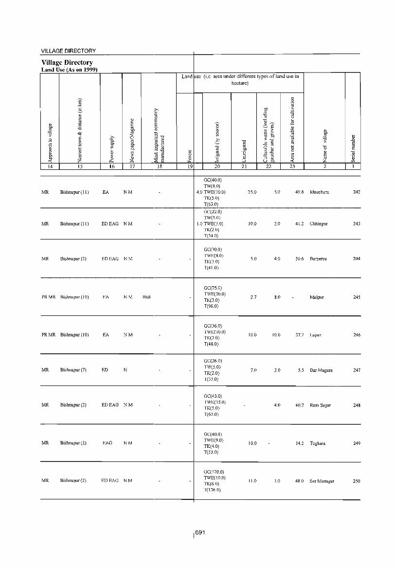
VILLAGE DIRECTORY -Village Directory Land Use (As on 1999) -
Land Ise (i.e. area under different types ofland use in hectare)
E t: 0
-'" . .g
2- .£' 00 > t: ~ " "0 :a
g " 0 OJ " 6 u ....
" ~ . S 6 0) t:~ <8 ~
._ '" I :0 0 ~
~Q.) " 00 " %l > ::0 " o(! '" §-o ~ 2 '" 00 .;; .Q ~ '" 00 ~ :§ i>
B ~ 0- 1:: ~ >,
i :;: "0
10 .;; .D 0- " o ;:l e- " '" S ..t: B OJ &} O-~
"0 ::0 '" '0 "'" ::I g '" '" 0- .§ J1 " 00 ~~ 0 t:
t: 2 " ~ ~ ~ § ~ "iiJ E '" " OJ 0- a ~ .~ ~ u [ij 0 '6 :; ::I ~ ·5 0- Z 0 " :s J:i '" <C ~ Z 6 "" ::J U OIl <C Z en -14 15 16 17 18 19 20 21 22 23 2 1
-GC(40.0) TW(8.0)
MR Bishnupur (11 ) EA NM .. 4.0 TWE(IO.O) 25.0 5.0 49.8 Mauchura 242 TK(S.O) T(63.0)
GC(22.0) TW(S.O)
MR Bishnupur (II) EDEAG NM .. 1.0 TWE(5.0) 10.0 2.0 41.2 Chhinpur 243 TK(20) T(34 0)
GC(30.0)
MR Bishnupur (2) EDEAG NM .. TWE(8.0) S.O 4.0 30.6 Barpetya 244
TK(3.0) T(41.0)
GC(7S.0)
PRMR Bishnupur (10) EA NM Bidi .. TWE(20.0) 2.7 8.0 .. Malpur 245
TK(3.0) T(98.0)
-
GC(36.0)
PRMR Bishnupur (10) EA NM .. .. TWE(10.0) 10.0 10.0 37.7 Lapur 246
TK(2.0) T(48.0)
GC(26.0)
MR Bishnupur (7) ED N .. .. TW(5.0)
7.0 2.0 5.5 Bar Magura 247 TK(2.0) T(33.0)
-
GC(43.0)
MR Bishnupur (2) EDEAG NM .. .. TWE(15.0) 4.0 40.2 Ram Sagar 248
TK(5.0) T(63.0)
GC(40.0)
MR Bishnupur (2) EAG NM .. .. TWE(9.0) 10.0 .. 14.2 Teghara 249
TK(4.0) T(53.0)
GC(120.0)
MR Bishnupur (2) EDEAG NM .. TWE(10.0) 11.0 1.0 48.0 Sur Managar 2S0
TK(6.0) T(136.0)

DISTRICT CENSUS HANDBOOK: BANKURA
Census of India 2001 -Amenities and
Amenities available (if not available within the village, a dash (-) is shown in the column and
next to it in brackets the distance in broad ranges viz.< 5 kms., 5-JO lkms. and 10+ kms of the
~ ~ nearest place where the facility is available is given
" C/O
'" ~ :2" -0 tl ~ " -0
0 '" u '" 0 " '" '" '"
..c: ~ ~ " " "§ '';= u ,,"
0 '" > ._ '" 0 0 5 " 'u 1:: .~ ~ .~ u 0 0 .~ 2 ~ ..c: ~ 8.. 0 " 0
0.. " :; ~ ~
0 E {j " 0.. 0 e r/) .. __
~ ~ ....:I 0 -0 "£ 0 .~ a'S
o(l .;;: ~ ..c: "0 6 ~ '_;j .fl~§ E9"tTJ
" '" ~ c: 0 ::s..c ..... '" :>: " OJ "0 '" " u ~ B bIl -5 0 ::l ... '"
o ._ '" " ~ ,!;! .~ 0 ~
..c: '" g o(l "0 ._ o c: '- 0.. " .n ~
..c: " '" "2;;:11 .~ 0
0 :; "-< "2 e "2 e :!:: <d ._
S '" 0- 0 '" ~ OJ) .~ '" < o '" ::l 4-< ~ 0 ~ 0 bIl "
",-0 :2.., ] '2 t;j
'" 0 ~ '" 0.. '-g "2 c: B " '"3 tl 'Fil E '" » "2 " .n {) :s2 E '" S '" .;::
~ ~ ~ S 0 '6 =: tt E-'" .g ~ ~.5 ~ E ~ ::l
" ::l "0 " Cs J> 82 bIl..c: oc.::
C/) f-< Z ~ :;;E <0 ~u~ u e ~C/)
1 2 3 4 5 6 7 8 9 10 11 12 13
Mathura PM(5-10) H(5-
ACS(5-10) CV(5-10) BS(5-10) 251 147.7 405 90 10) MCW(5- TW SS-TW PO(5-10) CM(5-10)
(02226800) C(5-1O) 10) PHC(5-10) PH(S-IO) CP(S-IO)
NCS(IO+) SP« 5) RS(5-lO) OCS(S-IO) ST(S-IO) NW(lO+)
Radha Madhabpur P(S- - H(5-
ACS(S-IO) CV(S-IO) 8S(S-IO) 252 9S.2 89 21 10)M(5-1O) 10) MCWe5- TW R SS- PO(5-10) CM(5-10)
(02226900) C(5-1O) 10) PHC(S-IO) TW PH(5-10) CP(5-10)
NCS(\O+) SP« 5) RS(5-1O) OCS(5-10) ST(5-IO) NW(IO+)
Dhulyapur PAC M(5-- H(5-
ACS(S-IO) eV(5-10) BS(5-1O) 2S3 146.6 474 101 10) MCW(S- HPTWW PO(5-10) CM(5-10)
(02227000) 10) C(5-JO) 10) PHC(S.IO) SS-W PH(S-IO) CP(S-IO) NCS(JO+) SP« 5) RS(5-10) OeS(S-IO) ST(5-10) NW(lO+)
DPHSCHW SPCV(5- BS RS(5-
254 Shinhati
100.2 934 209 P M S PUC H(S-IO) HPTWW PH(6)
CMCP ACS(5-IO)
10) ST(5- 10) (02227100) ACC(5-10) MCW(5-JO) SS-W PO(5-10) NCS(S-IO)
PHC(5-1O) OCS(5-10) 10) NW(IO+)
Hati Bari AC OP(5- - H(S-
ACS(5-1O) CV(5-10) BS(5-1O) 255
(02227200) 161.2 370 81 10)M(5-10) 10) MCW(5- TWWSS- PO(5-10) CM(5-IO)
NCS(IO+) SP« 5) RS(S-IO) C(S-IO) IO)PHC(S-IO) W PH(S-IO) CP(5-1O)
OCS(5-10) ST(5-10) NW(IO+)
H(S-
256 Asan Bani
121.3 372 66 PM«5) 10) TWWSS-
PO(5-10) CM(5-10) ACS(5-10) CV(S.IO) BS(5-10)
(02227300) C(lO+) MCW(IO+) W PH(S-IO) CP(S-IO)
NCS(IO+) SP(5-1O) RS(S-IO)
PHC(5-10) OCS(IO+) ST(IO+) NW(IO+)
H(S-
2S7 Agarda
191.4 1,410 281 PM«S) 10) HPTWW
POPH CM(IO+) ACS(5-10) CV(IO+) BS«5)
(02227400) C(IO+) MCW(lO+) TKSS-W CP(IO+) NCS(S-IO) SP(lO+) RS(lO+)
PHC(IO+) OCS(S-IO) ST(IO+) NW(IO+)
- P« H(5- .
DhangHari 5)M« 5) ;::~W(lO+)
HPTWW AC3(S-10) CV(IO+) B3« S) 258
(02227500) 108.4 273 46 TK R SS-W PO PH« 5) CM(IO+) NCS(S-IO) SP(lO+) RS(S-IO)
C(10+) PHC(5-10) CP(10+) OCS(S-lO) ST(lO+) NW(IO+)
BagaKhulia PM« S) - H« ACS(5-10) CV(lO+) BS«5)
259 (02227600)
402.S 602 131 C(lO+)
S)MCW(IO+) ~~~~tw PHPO«S)CM(lO+) NCS(S-IO) SP(IO+) RS« 5) PHC« 5) CP(IO+) OCS(S-IO) ST(IO+) NW(lO+)
P« - H« ACS«5) SP CV« S) BS« S) 260
Hetemoa 108.7 140 33 5) M«5) 5) MCW(lO+) : W SS- PO«S) CM«5)
(02227700) C(IO+) PHC«5) PH« 5) CP« S) NCS(10+) ST(lO+) RS« 5)
OCS(IO+) NW(10+)
692
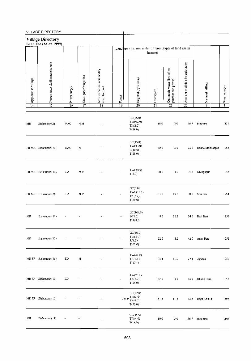
VILLAGE DIRECTORY
Village Directory Land Use (As on 1999) .---'-~----~~----.----r-------~--~--------~~~----~~~~-r------'---r--,
Land pse (i.e. area under different types ofland use in
14 15 16
MR Bishnupur (2) EAG
17 18
NM
19 20
GC(25 0) TWE(2.0) TK(2.0) T(29.0)
hectare)
21 22 23 2
80.0 2.0 36.7 Mathura 251
---------------------------------------------4-------------------------------------------------
PR MR Bishnupur (10) EAG N
PRMR Bishnupur (10) EA NM
PRMR Bishnupur (2) EA NM
MR Bishnupur (10) -
MR Bishnupur (11) - -
MRFP Bishnupur (16) ED N
MRFP Bishnupur (10) ED -
-
MRFP Blshnupur (10)
MR Bishnupur (II)
-
-
- -
- -
- -
- -
GC(15.0) TWE(3.0) R(IO.O) T(28.0)
TWE(SO) T(S.O)
GC(9.0) TWE(18.0) TK(2.0) T(29.0)
GC(106.0) W(l.O) T(107.0)
GC(50.0) TW(8.0) R(4.0) T(62.0)
TW(40.0) TK(7.1) T(47. I)
TW(20.0) TK(8.0) T(28.0)
GC(22.0) TW(5.0) r5
.0
TK(9.0) T(36.0)
GC(15.0) TW(4.0) T(190)
1
693
40.0 5.0 22.2 Radha Madhabpur 252
100.0 3.0 35.6 Dhulyapur 253
31.0 10.2 30.0 Shinhati 254
8.0 22.2 24.0 HatiBari 255
12.7 4.6 42.0 Asan Bani 256
105.4 11.9 27.1 Agarda 257
62.0 3.5 14.9 DhangHari 258
51.5 11.5 38.5 Baga Khulta 259
30.0 3.0 56.7 Hetemoa 260
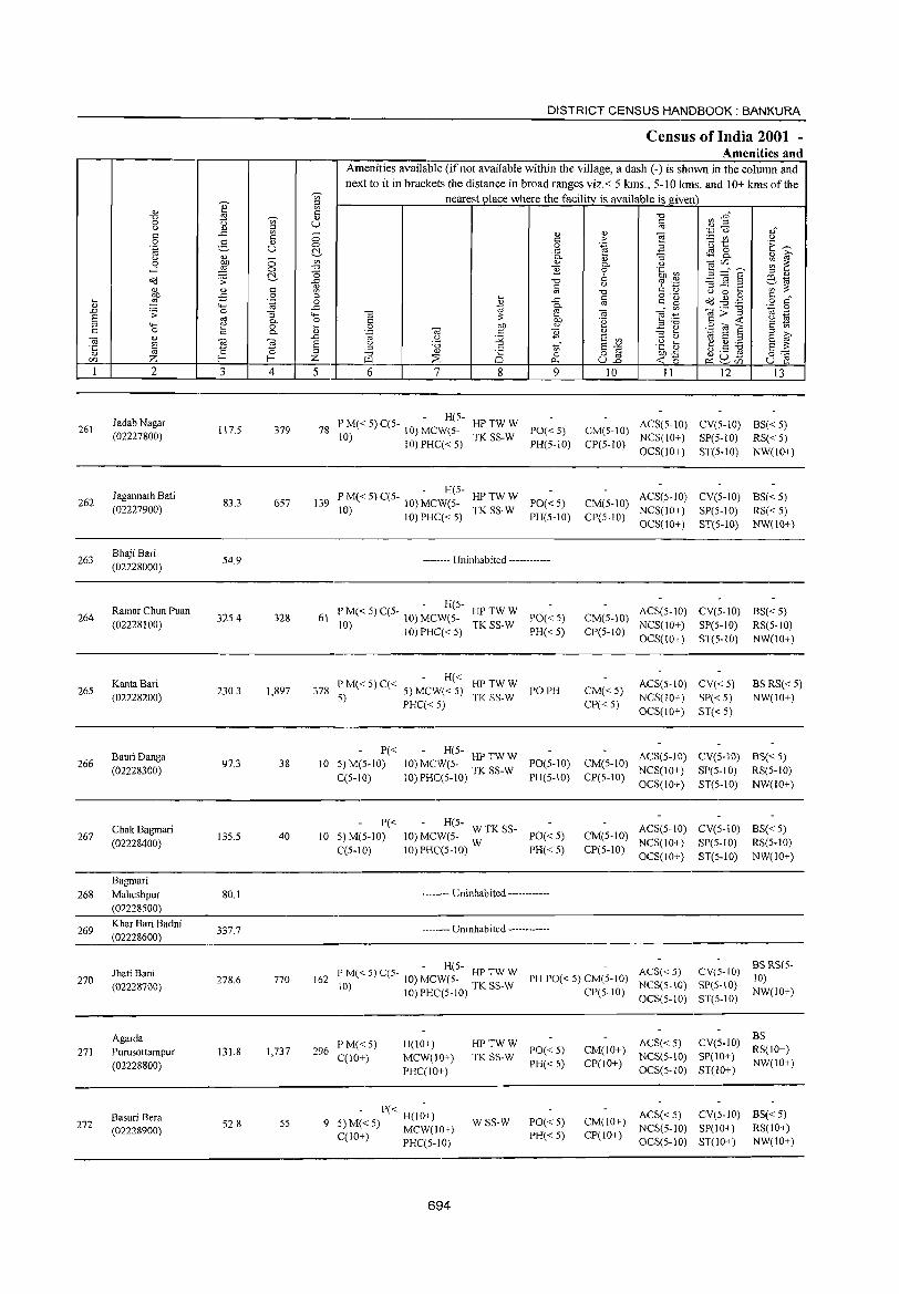
261
262
263
264
265
266
267
268
269
270
271
272
2
Jadab Nagar (02227800)
J agannath Bati (02227900)
Bhaji Bari (02228000)
Ramar Chun Puan (02228100)
KantaBari (02228200)
Bauri Danga (02228300)
Chak Bagmari (02228400)
Bagmari Maheshpur (02228S00)
Khar Bari Badni (02228600)
Jhati Bani (02228700)
Agarda Purusottampur (02228800)
Basuri Bera (02228900)
3
117.5
83.3
S4.9
32S.4
230.3
97.3
135.5
80.1
337.7
278.6
131.8
52.8
~ '" c " U
o o ~ c o
".g :; 0.. o 0..
0;
~ 4
379
657
328
1,897
38
40
770
1,737
SS
5
DISTRICT CENSUS HANDBOOK: BANKURA
Census of India 2001 -Amenities and
Amenities available (if not available within the village, a dash (-) is shown in the column and next to it in brackets the distance in broad ranges viz.< 5 kms., 5-10 kms. and 10+ kms of the
nearest place where the facility is available isgiven
6 7 8 9 10 II 12 13
- H(5-78 P M« 5) C(5- 10) MCW(S- HP TW W PO« S)
10) TK SS-W 10) PHC« 5) PH(5-10)
CM(S-IO) ACS(5-1O) CV(5-10) BS«5) NCS(JO+) SP(5-10) RS« S)
CP(5-10) OCS(lO+) ST(5-10) NW(IO+)
- H(5-139 PM«S)C(5- 10) MCW(5- HPTWW PO«5)
10) 10) PHC« S) TK SS-W PH(5-1O)
CM(5-IO) ACS(5-10) CV(5-10) BS« S) NCS(10+) SP(S-IO) RS« S)
-------- Uninhabited ------------
- H(5-61 PM«5)C(5- 10) MCW(5- HPTWW PO«S)
10) 10) PHC« 5) TK SS-W PH« 5)
H« 378 P M« 5) C« 5) MCW« 5) HP TW W PO PH
5) PHC« 5) TK SS-W
P« - H(5-10 5)M(S-IO) 10) MCW(5- HPTWW PO(S-IO)
C(S-10) 10)PHC(S-lO) TK SS-W PH(S-IO)
P« - H(S-10 5) M(5-1O) 10) MCW(S- W TK SS- PO« 5)
C(5-10) 10) PHC(5-IO) W PH« 5)
-------- Uninhabited ----------
----.. --- Uninhabited ------------
CP(5-10) OCS(JO+) ST(5-10) NW(IO+)
ACS(5-1O) CV(S-IO) BS« 5) CM(5-10) NCS(IO+) SP(5-10) RS(5-10) CP(S-IO) OCS(10+) ST(5-10) NW(10+)
CM« S) CP«S)
ACS(5-10) CV« 5) NCS(lO+) SP« 5) OCS(10+) ST« 5)
BS RS« S) NW(lO+)
ACS(5-10) CV(5-10) BS« 5) CM(5-1O) NCS(JO+) SP(S-IO) RS(5-1O) CP(S-IO) OCS(10+) ST(S-IO) NW(10+)
ACS(5-10) CV(S-lO) BS« S) CM(S-IO) NCS(10+) SP(S-IO) RS(5-10) CP(S-IO) OCS(10+) ST(S-IO) NW(IO+)
- H(S-162 P M« 5) C(5- 10) MCW(S- HP TW W PH PO« S) CM(5-1O) ACS« 5)
10) lO)PHC(S-IO) TK SS-W CP(5-10) NCS(S-IO)
CV(5-10) BS RS(S-10)
SP(S-IO) NW(IO+)
296 I' M« S) C(IO+)
H(10+) MCW(JO+) PHC(IO+)
- P« H(l~+) 9 S) M« 5) MCW(10+)
C(IO+) PHC(S-IO)
694
HPTWW TK SS-W 1'0« S)
PH«5)
WSS-W PO« S) PH«S)
OCS(S-IO)
ACS« S) CM(IO+) NCS(5-10) CP(IO+) OCS(S-IO)
ST(S-IO)
BS CV(S-10) RS(IO+) SP(lO+) ST(lO+) NW(IO+)
ACS« S) CV(S-IO) BS« S) CM(lO+) NCS(5-1O) SP(10+) RS(lO+) CP(IO+) OCS(S-IO) ST(10+) NW(IO+)
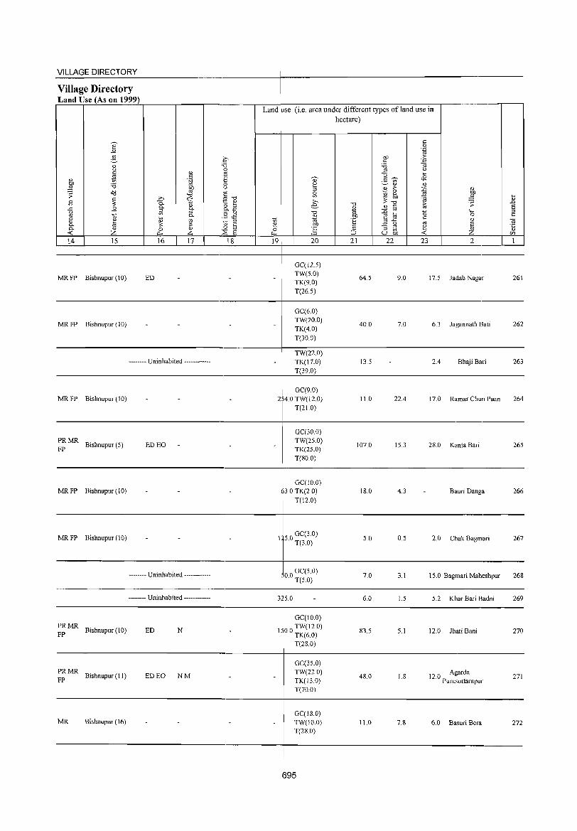
VILLAGE DIRECTORY
Village Directory Land Use (As on 1999)
14 15
MR FP Bishnupur (10)
MRFP Bishnupur(10)
16 17
ED
-------- Uninhabited ------------
18
Land use (i.e. area under different types of land use in hectare)
19 20
GC(12.S) TW(S.O)
TK(9.0) T(26.5)
GC(6.0) TW(20.0) TK(4.0) T(30.0)
TW(22.0) TK(17.0)
21
64.5
40.0
13.5
22 23 2
9.0 17.5 Jadab Nagar
7.0 6.3 Jagannath Bati
2.4 Bhaji Bari
261
262
263
__________________________________________ ~--T~(~39~0~)---------------------------------------__
MRFP Bishnupur(10)
:: MR Bishnupur (5) ED EO
MR FP Bishnupur (10)
MR FP Bishnupur (10)
-------- Uninhabited ------------
-------- Uninhabited ------------
PRMR FP Bishnupur (10) ED N
~: MR Bishnupur (11) ED EO NM
MR Bishnupur (16)
GC(9.0) 2 4.0 TW(12.0)
T(21.0)
GC(30.0) TW(25.0) TK(25.0) T(80.0)
GC(1O.0) 3.0 TK(2.0)
T(12.0)
1 50 GC(3.0) · T(3.0)
00 GC(S.O) · T(50)
3 5.0
GC(to.O)
1 00 TW(12.0) · TK(6.0)
T(28.0)
GC(35.0) TW(22.0) TK(13.0) T(70.0)
GC(lS.O) TW(10.0) T(28.0)
11.0
107.0
18.0
5.0
7.0
6.0
83.5
48.0
11.0
22.4
15.3
4.3
0.5
3.1
1.5
5.1
1.8
7.8
17.0 Ramar Chun Puan
28.0 Kanta Bari
- Bauri Danga
2.0 Chak Bagmari
15.0 Bagmari Maheshpur
5.2 Khar Bari Badni
12.0 Jhati Bani
12.0 Agarda Purusottampur
6.0 Basuri Bera
264
265
266
267
268
269
270
271
272
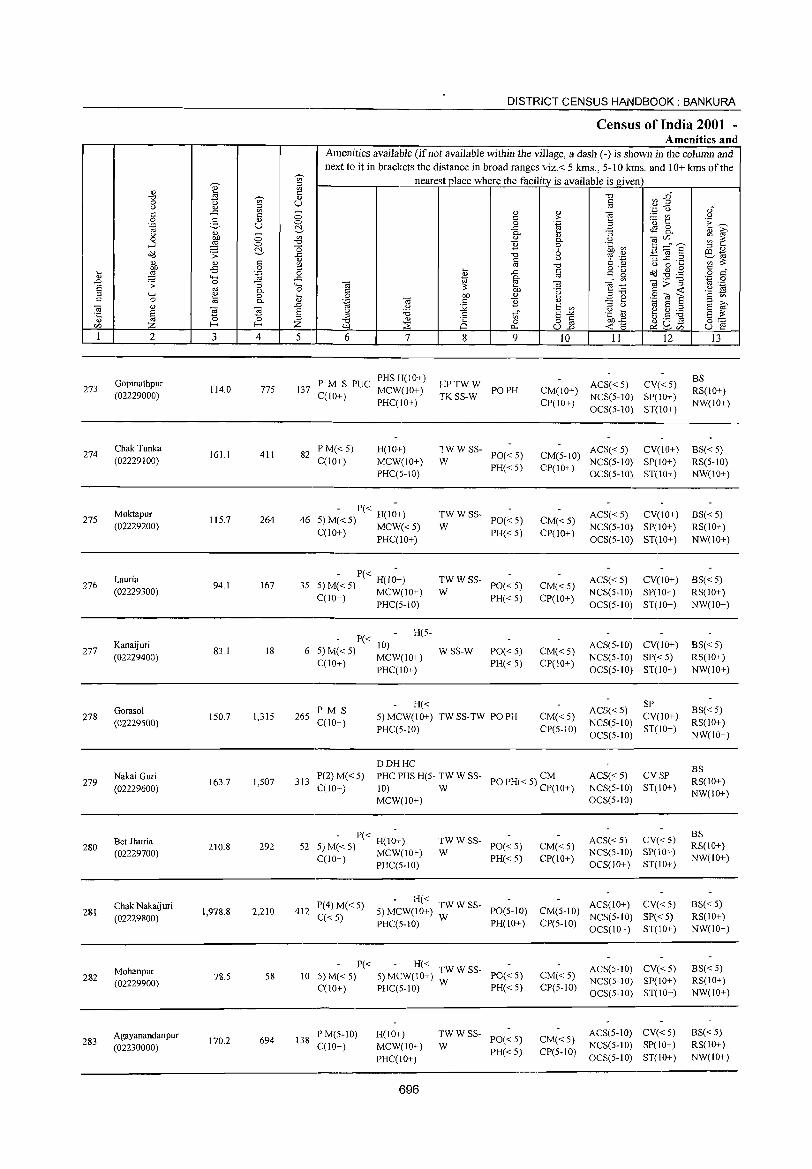
~
'" ::l
'" ~ j3
'" tl ~ " 8 '" U '" ::l ..c '" -c c 0 .8 g " U 0
'§ c:!-~ 0 '" 0
.J ::§ 0 '" a <1<l .;;: c:!- ..c
c 1;l j <I)
.,s 0 ::l .... .~ 0
" 4-< ..c .L ~ 0 "3 4-; 6 '" 0.. 0 ::l 4-; ~ 0 :u c 0 0..
Cil " ~ .L
§ ~ 6 '5 ::s r/) Z E- E- Z 1 2 3 4 5
Gopinathpur 273 114.0 775 137
(02229000)
274 Chak Tunka
161.1 411 82 (02229100)
Muktapur 27S IIS.7 264 46
(02229200)
Lauria 276 94.1 167 3S
(02229300)
277 Kanaijuri
83.1 18 6 (02229400)
Gorasol 278
(02229500) 150.7 1,315 265
279 Nakai Guri (02229600)
163.7 I,S07 313
Bet Jhuria 280
(02229700) 210.8 292 52
Chak Nakaijuri 281
(02229800) 1,978.8 2,210 412
Mohanpur 282
(02229900) 78.S S8 10
Agayanandanpur 694 138 283
(02230000) 170.2
DISTRICT CENSUS HANDBOOK: BANKURA
Census of India 2001 -Amenities and
Amenities available (if not available witbin tbe village, a dash (-) is shown in the column and next to it in brackets the distance in broad ranges viz. < 5 kms., 5- I 0 ].ans. and 10+ kms of the
nearest place where the facility is available is given
~ :3~ '" c '" ","
" " j§ <.)
c > ~ '" u 'u 1:: 'E ~ 0 .~ ..c ~ 0
0.. :; 0.. " ~ " " "§ C/)"'-" ;;; 1: 0.. u ] 0 .~ a3 ::l :::: § ::l "
'" 6 ~ '" e~
iii u 9 ''::; :; ..c ._ '" :;; '" c " u 0 .... o ._
~ ~ . .§ § ~" I ..c iii c" ~ ~ Ol>"§ '.,i:j 0
'" '" Ol~ '" ._
.~ OJ) 'e s:.a c <t: '2 ~ OJ) " .8 O! S Cil C ] <1) .=: ~ ::l ..., u :.g 6 '"
::l <.) ..., 6 ::l 6 ~ u 'i5 to" .g [> ~ .S ~ 6 :;; ::l .= 6"'" '" " ti 0 o iii OJ)..c 0:: il.1 ~ "'" U.L <t: 15 ~U~ U E! ~r/)
6 7 8 9 10 II 12 13
PM S PUC PHSH(lO+)
HPTWW ACS«5) CV«5) BS
MCW(IO+) PO PH CM(lO+) RS(IO+) C(lO+)
PHC(IO+) TKSS-W
CP(IO+) NCS(5-IO) SP(lO+)
NW(IO+) OCS(5-IO) ST(IO+)
PM«5) H(lO+) TWWSS- ACS«5) CV(IO+) BS«S) PO« S) CM(5-IO)
C(IO+) MCW(IO+) W PH« 5) CP(IO+)
NCS(S-IO) SP(IO+) RS(S-lO) PHC(S-IO) OCS(5-10) ST(IO+) NW(IO+)
- P« -TWWSS- ACS« 5) CV(lOl) nS«S) S) M« 5) H(IO+) PO« S) CM«5)
C(10+) MCW«5) W PH« S) CP(lO+)
NCS(S-IO) SP(IO+) RS(IO+) PHC(IO+) OCS(5-IO) ST(IO+) NW(10+)
- P« -TWWSS- ACS«5) CV(lO+) BS« 5) S) M« S) H(IO+) PO« S) CM«S)
C(IO+) MCW(lO+) W PH« 5) CP(IO+)
NCS(5-10) SP(lO+) RS(lO+) PHC(S-IO) OCS(S-IO) ST(lO+) NW(IO+)
- P« 10) H(5-
WSS-W PO« 5) CM«5) ACS(5-10) CV(IO+) BS«5)
5) M«5) MCW(lO+) NCS(S-IO) SP« S) RS(IO+) C(IO+) PHC(IO+) PH« S) CP(IO+)
OCS(S-IO) ST(IO+) NW(10+)
PMS H« ACS« 5)
SP BS«S)
5)MCW(10+) TWSS-TW POPH CM«5) CV(IO+) C(IO+)
PHC(5-IO) CP(S-IO) NCS(S-IO)
ST(IO+) RS(10+)
OCS(5-10) NW(lO+)
DDHHC BS
P(2) M«S) PHC PHS H(S- TW W SS-PO PH« S) g~IO+) ACS«5) CVSP
RS(lO+) C(lO+) 10) W NCS(5-1O) ST(IO+)
NW(lO+) MCW(lO+) OCS(S-lO)
- P« H(!;+) ACS«5) CV«5) BS
TWWSS-PO« 5) CM« 5) RS(IO+) 5) M« 5) MCW(IO+) W NCS(S-IO) SP(IO+) PH«S) CP(10+) NW(lO+) C(lO+) PHC(5-10) OCS(lO+) ST(IO+)
P(4)M«5) - H« ACS(lO+) CV«5) BS« 5) 5)MCW(10+) TWWSS- PO(5-10) CM(S-IO)
C« 5) PHC(S-lO) W PH(IO+) CP(S-IO) NCS(S-IO) SP« S) RS(IO+)
OCS(lO+) ST(IO+) NW(lO+)
P« - H« ACS(S-IO) CV«S) BS« S) 5) M« 5) S)MCW(IO+) ;;: W SS- PO« 5) CM«S) NCS(5-IO) SP(IO+) RS(lO+) C(10+) PHC(5-10) PH« 5) CP(5-1O)
OCS(5-10) ST(IO+) NW(IO+)
PM(S-IO) H(IO+) TWWSS-PO« 5) CM« S)
ACS(5-1O) CV« 5) BS«S)
C(10+) MCW(lO+) W NCS(5-10) SP(IO+) RS(IO+)
PHC(lO+) PH«5) CP(5-1O)
OCS(S-lO) ST(IO+) NW(IO+)
696
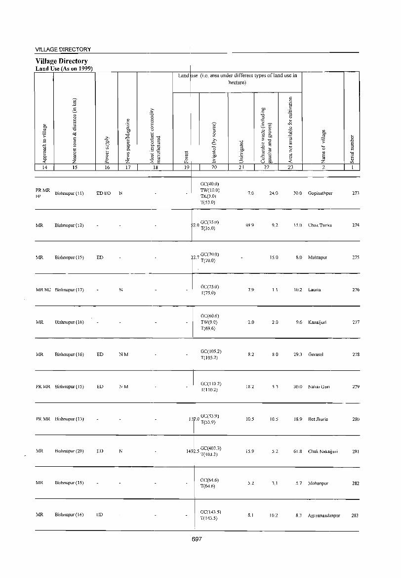
VILLAGE DIRECTORY
Village Directory Land Use (As on 1999)
14 15
:~ MR Bishnupur (11)
MR Bishnupur (12)
MR Bishnupur (IS)
MRNC Bishnupur (17)
MR Bishnupur (16)
MR Bishnupur (16)
PRMR Bishnupur(IS)
PR MR Bishnupur (13)
16 17 18
ED EO N
ED
- N -
- - -
ED NM -
ED NM
Land use (i.e. area under different types ofland use in hectare)
19 20
-
-
-
GC(40.0) TW(lO.O) TK(3.0) T(S3.0)
20 GC(3S.0) · T(3S.0)
27 GC(70.0) · T(70.0)
GC(7S.0) T(7S.0)
GC(60.6) TW(9.0) T(69.6)
GC(IOS.2)
T(105.2)
GC(1102) T(110.2)
11 0 GC(53.9) · T(53.9)
21 22
7.0
49.9
7.9
2.0
8.2
18.2
10.5
23 2
24.0 30.0 Gopinathpur
9.2 IS.0 Chak Tunka
IS.0 8.0 Muktapur
1.1 10.2 Lauria
2.0 9.6 Kanaijuri
8.0 29.3 Gorasol
5.3 30.0 Nakai Guri
10.5 18.9 Bet Jhuria
.... " .D S ::l
'" ~ " rFJ
273
274
27S
276
277
278
279
280
--------------------------------------------~------------------------------------------------
MR Blshnupur (20) ED
MR Bishnupur (15)
MR Bishnupur (16) ED
N GC(403.3)
1492.5 T(403.3)
GC(64.6) T(64.6)
GC(143.5) T(143.5)
15.9 5.2 61.8 Chak NakaIJun 281
5.2 3.1 5.7 Mohanpur 282
8.1 10.2 8.3 Agayanandanpur 283
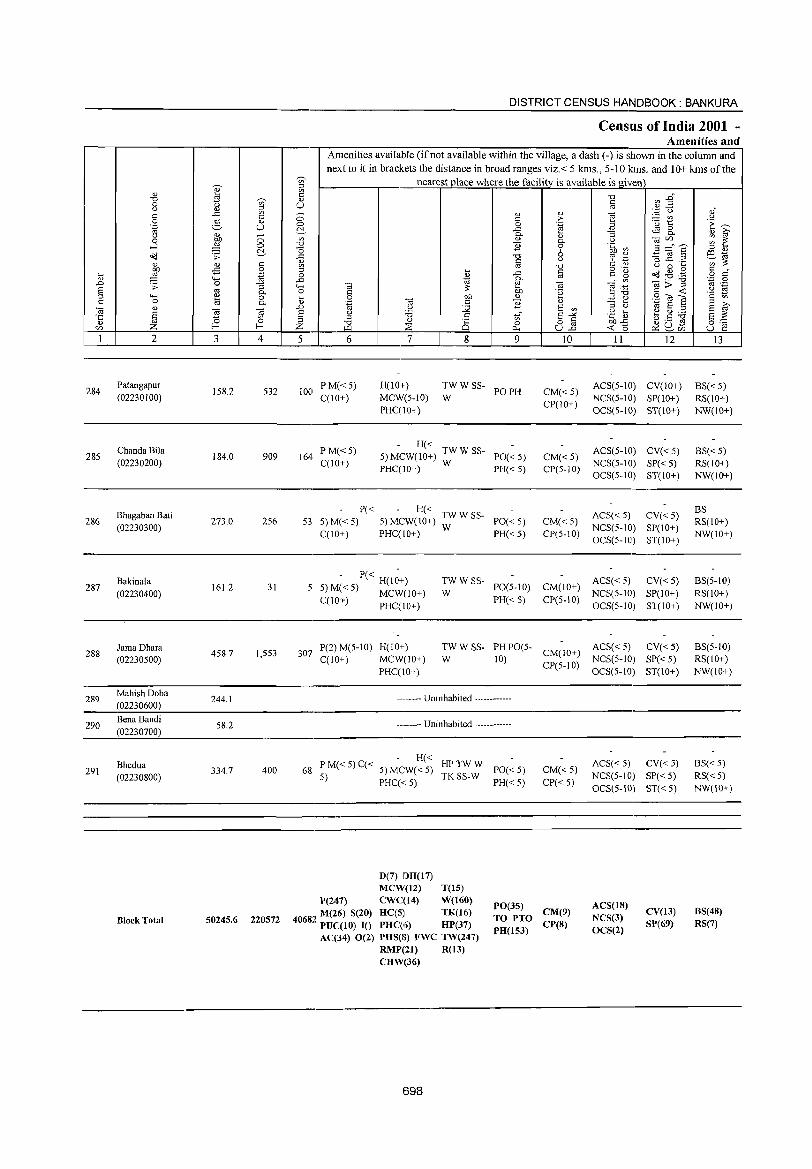
284
285
286
287
288
289
290
291
2
Patangapur
(02230100)
Chanda Bila
(02230200)
Bhagaban Bati
(02230300)
Bakinala
(02230400)
Jama Dhara (02230500)
MahishDoba
(02230600)
BenaBandi
(02230700)
Bhedua
(02230800)
Block Total
3 4
158.2 532
184.0 909
273.0 256
161.2 31
458.7 1,553
244.1
58.2
334.7 400
50245.6 220572
DISTRICT CENSUS HANDBOOK: BANKURA
Census of India 2001 -Amenities and
w Amenities available (if not available within the village, a dash (-) is shown in the column and next to it in brackets the distance in broad ranges viz.< 5 kms., 5-10 kms. and 10+ kms of the
nearest place where the facility is available is given c: '" U
5 6
100 PM« 5) C(lO+)
164 PM«5) C(10+)
P« 53 5) M« 5)
C(IO+)
7
H(lO+) MCW(5-10) PHC(10+)
8
'" o 0..
9
~WWSS- POPH
- H« 5)MCW(1O+) TWWSS- PO«5)
PHC(IO+) W PH« 5)
H« TWW SS-5) MCW(10+) W PO« 5) PHC(IO+) PH« 5)
- P« H(I~+) 5 5) M« 5) MCW(JO+)
TWWSS-PO(5-10)
C(IO+) PHC(JO+) W
PH«S)
10
CM«5) CP(IO+)
CM«5) CP(5-10)
CM« 5) CP(5-10)
11 12
ACS(5-IO) CV(lO+) NCS(5-10) SP(lO+) OCS(5-10) ST(10+)
ACS(5-10) CV« 5) NCS(5-IO) SP« 5) OCS(5-IO) ST(IO+)
ACS« 5) CV« 5) NCS(5-IO) SP(IO+) OCS(5-10) ST(lO+)
CM(JO+) ACS« 5) CV« 5) CP(5-10) NCS(5-1O) SP(10+)
OCS(5-10) ST(JO+)
307 P(2)M(5-JO) H(JO+) TW W SS- PH PO(5- ACS« 5) CV« 5) W 10) CM(IO+) NCS(5-JO) SP« 5)
CP(5-10) OCS(5-1O) ST(IO+) C(10+) MCW(lO+)
PHC(lO+)
-------- Uninhabited ------------
-------- Uninhabited ------------
) C( H« HPTWW 68 P M« 5 < 5) MCW« 5) PO« 5)
5) TK SS-W PHC« 5) PH« 5)
D(7) ]l)H(17) MCW(12) T(lS)
CM«5) CP« 5)
P(247) CWC(14) W(160)
"' M(26) S(20) HC(5) TK(16) 4068" PUC(IO) 10 PHC(6) HP(37)
PO(35) CM(9) TO PTO
AC(34) 0(2) PHS(S) FWC TW(247) PH(153) CP(S)
RMP(21) R(13) CHW(36)
698
ACS« 5) CV« 5) NCS(5-10) SP« 5) OCS(5-JO) ST« 5)
ACS(lS) NCS(3) OCS(2)
CV(13) SP(69)
13
BS« 5) RS(lO+) NW(lO+)
BS« 5) RS(IO+) NW(10+)
BS RS(lO+) NW(10+)
BS(5-1O) RS(IO+) NW(IO+)
BS(5-IO) RS(lO+) NW(IO+)
BS« 5) RS« 5) NW(JO+)
BS(4S) RS(7)
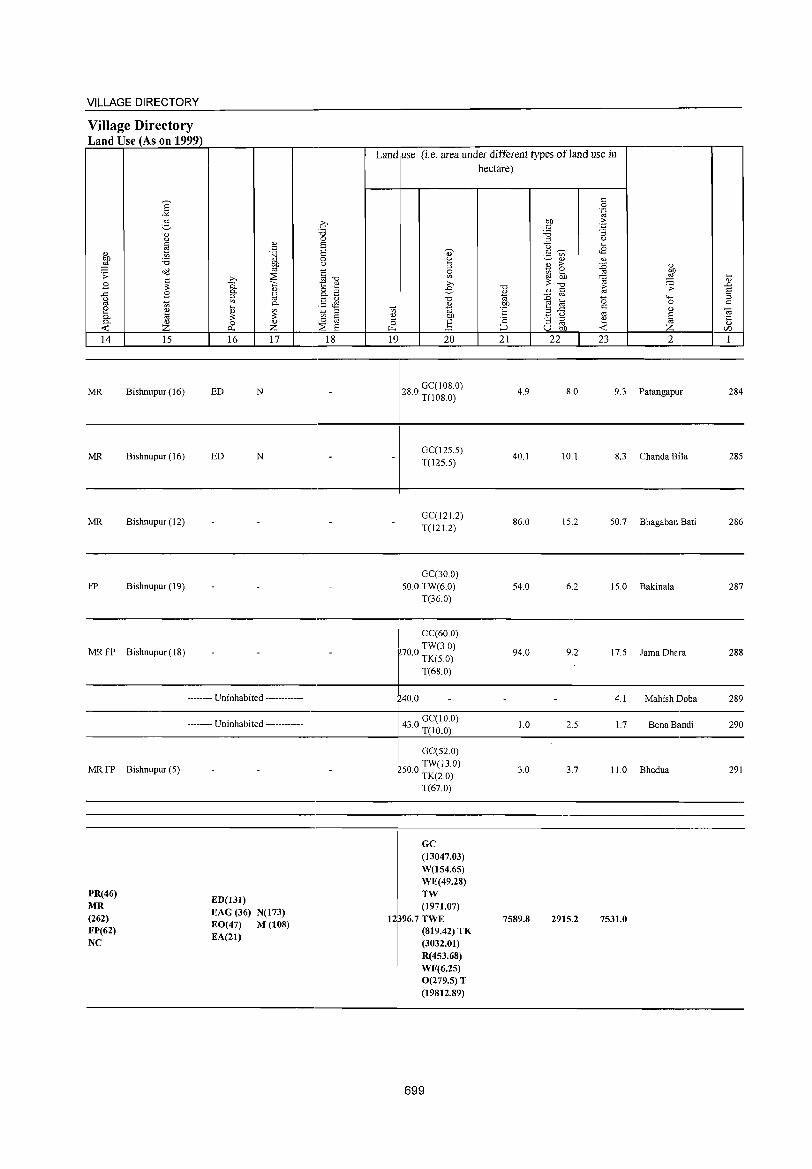
VILLAGE DIRECTORY ----------------------------,---------~-----------------------------------------Village Directory Land Use (As on 1999) ~~~~~~~~----._--_r--,-----_.~~--~----~~~----~~~~_r------.--_.--,
Land use (i,e, area under different types ofland use in
E -'< g " u
" ~ <\.)
blJ 'i3 ;:§ ~ ;;: ~
>-,
B C. Cl. ..<: B ::l u '" '" tl
2 ~ ... ~ 0-
c. Z 0 <C ~
14 15 16
MR Bishnupur (16) ED
MR Bishnupur (16) ED
" " 't-j blJ co
~ <\.)
~ 0-
~ <U
Z 17
N
N
C :a 0 s S 0 ()
§-o 1:: " tiE §Jl t;; ::l 0 til ~ 6
18 19 20
28 ° GC( 108,0) , T(108,0)
GC(12S,S) T(12S,S)
hectare)
" 0 .~
blJ .?: " -'§ 'i3 ::l u u li 2- 'V>
'" " 1l > :0 " 0
..& ~ bb ~ i;:; ;J: ';a "0 "0 > ';;: .D '-' '" Iii ro 6
'" :g 0 '-H ::l blJ ~ 0 " °E B ..<: " " ~ () to g '2 "3 ::l e co <\.)
::::J U blJ <C Z VJ
21 22 23 2 1
4,9 8,0 9,3 Patangapur 284
40,1 10,1 8,3 Chanda Bila 28S
-----------------------------------------4----------------------------------------------
MR Bishnupur (12)
FP Bishnupur (19)
MR FP Bishnupur (18)
-------- Uninhabited ------------
GC(121.2) T(12 1.2)
GC(30,0) SO,O TW(6,0)
T(36.0)
GC(60,O)
700 TW(3,0) , TK(S,O)
T(68,0)
40,0
86,0
S4,0
94,0
IS,2 SO,7 Bhagaban Bati 286
6,2 1S,0 Bakinala 287
9,2 17,5 Jama Dhara 288
4,1 MahishDoba 289
-------------------------------------------_,--~~~~------------------------------,---------4" ° GC(IO,O) j, T(IO.O)
MR FP Bishnupur (S)
PR(46) MR (262) FP(62) NC
-------- Uninhabited ------------
ED(I31) EAG (36) N(173) EO(47) M (108) EA(21)
GC(52,0) TW(13.0)
rSO,O TK(2,0)
T(67,0)
GC (13047.03) W(154.65) WE(49.28) TW (1971.07)
12396.7 TWE (819.42)TK (3032.01) R(453.68) WF(6.25) O(279.5)T (19812.89)
699
1.0 2,S 1. 7 Bena Bandi 290
3,0 3,7 11.0 Bhedua 291
7589.8 2915.2 7531.0

« o z
o
« 0::::« (9c:t:: zG «~ 00 _J_J «« 1-1-
z
« a:: ::::) ~ z « m
:y:2fu«o Ol-a:: _J(/)f-mw~
o Dd
0....
* ~ ~~
E "
\ r·"" ~ /
....
t;..,
'<:
['...,
CJ)
~
U ,_;
,_:\
/ 0
p_,
:\_O6. 1>')"\_
,
E-< '-' ~ E-< rn 6 ,,_; p: <>: r:::, Z ::0 0 III
. 0 I g i~ ." @ I ~ . 0
I
"'1
:z: z <3 0
...i g:: Z
p; ..: E-<
0 ~ Ul
E::: E-< !Oil ..: f; '-' E-< ::1 UJ Oil 0
I'l " 0,
'-' <>: ::1 >-J 0 S; Ul 0. 0::
I'l E-< 0:: ..: ::0 Of Cl ..: I'l p::
- 'C"' {.)
'A ,_..;
\
\ ~ i h
" . I .,. l/) .,. I
.- ,..___,
ii ~ t ii ...... Ul ~ '"
II it II
rol '-' r;:; ""' 0
~ 0,
Ul ..: Cl 0:; ..: <.0 0 r£I 0:; >-J
1'.1 p: E-< I'l ~ 01; E-< E-< 0 ::.l Ul Cl ..: 0 z Oil 0,
..: 0:; ......._ E-<
Cl Ul r£I
I'l H r:::, 8 H Z
""' <>: ..: ""' E-< 0
"" 0:; ::.l "" E-< Z :> f/]
::0 ~ 0 0,
I'l ~ " ..:
>-J H H
>-J
:;: >< ..: .....
< I'l Cl f;= ::.l Oil ~
~ 8 E-< Z
< ~ < cc E-< Z ~ 0:;
0 z < 0,
::0 E-< 2§ f/]

VILLAGE AND TOWN DIRECTORY
Alphabetical list 0 Villages (CD Block wise)
2001 Census location Serial number Name of village code number
1 2 3
Name of the CD Block: Taldangra Code of the CD Block: 0016
1 Adhkara 02241300 2 Amdangra 02243800 3 Amjor 02241100 4 Am1atara 02239000 5 Asnasol 02238500 6 Asnasundarpur 02238400 7 Asthasol 02244900 8 Ata 02239900 9 Aulia 02235600
10 Baghdoba 02234300 11 Baharagarya 02240000 12 Balarampur 02231300 13 Bali Bandh 02235100 14 Banktor 02239100 15 Banskopa 02240800 16 Baralakshanpur 02237900 17 Barameshya 02237500 18 Belasuli Shyamsundarp~r 02232100 19 Beldangra 02231600 20 Belsulya 02239200 21 Bendalakshanpur 02238000 22 Bhaluka 02238200 23 Bhalldarkaki 02243900 24 Bhalldia 02231800 25 Bhedua 02237200 26 Bhetuadanga 02241900 27 Bhimara 02233800 28 Bhutamamaheshpur 02236800 29 Bibarda 02231400 30 Brahmandhara 02231200 31 Bralunalldliha 02233100 32 Brindabanpur 02244600 33 Chak Nutangram 02232700 34 Chakjambedia 02241600 35 Chakkulclliha 02234800 36 Chakmajuriprasadpur 02242400 37 Chakshyampur 02239700 38 Chandabila 02243100 39 Chandkuri 02232200 40 Chenchurya 02237800 41 Chenchurya 02238800 42 Chunalu 02233900 43 Churamanipur 02237300 44 Dangjuri 02231500 45 Deulbhira 02241800 46 Deuli 02236700 47 Dhengashimul 02236100
703
1991 Census location code number
4
140140012001200105 140140012001200130 140140012001200103 140140012001200082 140140012001200077 140140012001200076 140140012001200141 140140012001200091 140140012001200048 140140012001200035 140140012001200092 140140012001200005 140140012001200043 140140012001200083 140140012001200100 140140012001200071 140140012001200067 140140012001200013 140140012001200008 140140012001200084 140140012001200072 140140012001200074 140140012001200131 140140012001200010 1401400]2001200064 140140012001200111 140140012001200030 140140012001200060 140140012001200006 140140012001200004 140140012001200023 140140012001200138 140140012001200019 140140012001200108 140140012001200040 140140012001200116 140140012001200089 140140012001200123 140140012001200014 140140012001200070 140140012001200080 140140012001200031 140140012001200065 140140012001200007 140140012001200110 140140012001200059 140140012001200053
DISTRICT CENSUS HANDBOOK: BANKURA
Alphabetical list of Villages (CD Block wise)
2001 Census location 1991 Census location Serial number Name of village code number code number
1 2 3 4 48 Dhobajor 02240700 140140012001200099 49 Dhuakaki 02244700 140140012001200139 50 Dolbagicha 02234000 140140012001200032 51 Domakonda 02243500 140140012001200127 52 Douni 02242500 140140012001200117 53 Dunduria 02240600 140140012001200098 54 Gamarbani 02245000 140140012001200142 55 Ghagar 02234400 140140012001200036 56 Golakpur. 02245300 140140012001200145 57 Harakona 02237100 140140012001200063 58 Harmasra 02233600 140140012001200028 59 Harulia 02236900 140140012001200061 60 Hatpara 02236400 140140012001200056 61 Jafla 02237400 140140012001200066 62 Jambedia 02242000 140140012001200112 63 Jarkapaksara 02234100 140140012001200033 64 Jashodanandapur 02240300 140140012001200095 65 Jaypur 02241500 140140012001200107 66 Iemua 02235900 140140012001200051 67 Iiakanali 02240400 140140012001200096 68 Jugda 02236200 140140012001200054 69 Kadamara 02232500 140140012001200017 70 Kadma 02235500 140140012001200047 71 Kajla 02239800 140140012001200090 72 Kali 02232300 140140012001200015 73 Kamardiha 02232000 140140012001200012 74 Kanaipur 02240900 140140012001200101 75 Kaniari 02244300 1401400]2001200135 76 Karalljabedia 02234200 1401140012001200034 77 Keshatara 02233700 140140012001200029 78 Khalgram 02231900 140140012001200011 79 Khatbanda 02237000 140140012001200062 80 Khichka 02235400 140140012001200046 81 Kiasol 02233300 140140012001200025 82 Koisuli 02235800 140140012001200050 83 Kukutia 02241400 140140012001200106 84 Kuldiha 02234700 140140012001200039 85 Kusmi 02236500 140140012001200057 86 Lalbandh 02241700 140140012001200109 87 Lodda 02233400 140140012001200026 88 Machla 02239500 140140012001200087 89 Mahada 02232400 140]40012001200016 90 Mahishakanali 02235000 1401400]2001200042 91 Mahulbera 02242600 140140012001200]18 92 Maibandhi 02235300 140140012001200045 93 Majuriprasadpur 02242900 140140012001200121 94 Mamrasol 02244400 140140012001200136 95 Manara 02231000 140140012001200002 96 Mandi 02243600 140140012001200128
704
VILLAGE AND TOWN DIRECTORY
AlPh~betiCallist J Villages (CD Block wise)
2001 Census location 1991 Census location Serial number Name ~)f village code number code number
1 2 3 4
97 Manikmara 02240200 140140012001200094 98 Manipur 02230900 140140012001200001 99 Marasol 02233500 140140012001200027
100 Methena 02242800 140140012001200120 101 Murakati 02244200 140140012001200134 102 Nabagram 02235200 140140012001200044 103 Nachankonda 02243400 140140012001200126 104 Nachna 02236300 140140012001200055 105 Narattampur 02235700 140140012001200049 106 Nityanandapur 02237700 140140012001200069 107 Nutangram 02240500 140140012001200097 108 Paika 02231700 140140012001200009 109 Painada Modarpur 02232600 140140012001200018 110 Panchmura 02241200 140140012001200104 111 Parirdihi 02242700 140140012001200119 112 Parulia 02239400 140140012001200086 113 Paryardang 02232900 140140012001200021 114 Patharjora 02244500 140140012001200137 115 Patharkura 02234500 140140012001200037 116 Pedda 02233000 140140012001200022 117 Phulmati 02239300 140140012001200085 118 Punesa 02239600 140140012001200088 119 Radhamohanpur 02236600 140140012001200058 120 Radhanagar 02241000 140140012001200102 121 Raghunath pur 02232800 140140012001200020 122 Raj pur 02245100 140140012001200143 123 Resiagara 02242100 140140012001200113 124 Sabrakon 02244800 140140012001200140 125 Saharghati 02238700 140140012001200079 126 Saldaha 02245200 140140012001200144 127 Saltara 02244000 140140012001200132 128 Satmau1i 02243300 140140012001200125 129 Shyampur 02240100 140140012001200093 130 Shyamsundarpur 02237600 140140012001200114 131 Shyamsundarpur 02242200 140140012001200114 132 Sitarampur 02243000 140140012001200122 133 Sonajhor 02244100 140140012001200133 134 Sulgi 02233200 140140012001200024 135 Surbhaga Band 02231100 140140012001200003 136 Sushunia 02234900 140140012001200041 l37 Taldangra 02238900 140140012001200081 138 Taltala 02236000 140140012001200052 139 Tatar 02242300 140140012001200115 140 Telanbandi 02238100 140140012001200073 141 Tilabani 02234600 140140012001200038 142 Tilaghagri 02238600 140140012001200078 143 Tirra 02243700 140140012001200129 144 Tulderya 02238300 140140012001200075 145 Uparsol 02243200 140140012001200124
705
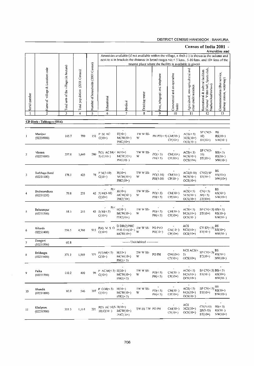
2
CD Block: Taldangra (0016)
2
3
4
Manipur (02230900)
Manara (02231000)
Surbhaga Band (02231100)
Brahmandhara (02231200)
3
165.7
357.8
178.1
79.8
o o ~ c o .~
""[ o 0.
~ 4
799
1,695
423
235
DISTRICT CENSUS HANDBOOK: BANKURA
Census of India 2001 -Amenities and
Amenities available (if not available within the village, a dash (-) is shown in the column and next to it in brackets the distance in broad ranges viz.< 5 krns., 5-10 krns. and 10+ krns of the
nearest place where the facilitv is available is given
5 6 7
151 PM AC C(lO+)
H(IO+) MCW(IO+) PHC(IO+)
280 P(3) AC M« H(IO+) 5)C(10+) MCW(IO+)
78 PM(5-1O) C(10+)
PHC(IO+)
H(IO+) MCW(IO+) PHC(IO+)
- P« H(I;+) 42 5) M(5-10) MCW(IO+)
C(10+) PHC(IO+)
8 9 10 11 12 13
TW W SS- ACS« 5) W PH PO« 5) CM(lO+) NCS(lO+)
SPCV(5- BS 10) RS(IO+)
TWWSS-PO«5) PH«5)
W
:W W SS- PO(5-IO)
PH(5-10)
:W W SS- PO« 5)
PH« 5)
CPt I 0+ ) OCS( 10+ )
ACS« 5) CM(lO+) NCS(lO+) CP(IO+) OCS(IO+)
ST(IO+) NW(IO+)
SP CV(5- BS« 5) 10) ST(lO+) RS(IO+)
NW(IO+)
CM(IO+) CP(IO+)
ACS(5-10) CV(2) SP ~~(IO+) NCS(lO+) ST(lO+) OCS(lO+) NW(lO+)
ACS« 5) CM(IO+) NCS(lO+) CP(IO+) OCS(IO+)
CV«5) SP«5) ST(IO+)
BS RS(IO+) NW(IO+)
-------------------------------------
6
7
9
10
11
Balarampur (02231300)
Bibarda (02231400)
Dangjuri (02231500)
Beldangra (02231600)
Paika (02231700)
Bhandia (02231800)
Khalgram (02231900)
58.3 253
556.5 4,760
60.8
371.3 1,969
110.2 490
95.9 546
355.3 1,114
- P« H(I;+) 43 5)M«5) MCW(IO+)
C(10+) PHC(lO+)
TWWSS-PO«5) PH«5)
W
P(4) M S 0 DDH(2)PHC TWWSS- POPTO 915 C(10+) PHS 0 H(JO+) W PH(10+)
MCW(IO+)
-------- Uninhabited ------------
373 P(3) M« 5) H(IO+) C(IO+) MCW(IO+)
PHC«5)
96 P AC M« 5) H(IO+) C(IO+) MCW(IO+)
PHC« 5)
107 P 0 M« 5) H(IO+) C(10+) MCW(IO+)
PHC«5)
221 P(2) ACM(5-H(10+) 10) C(10+) MCW(IO+)
PHC(IO+)
706
TWWSS-PO PH
W
:WWSS- PO«5)
PH«5)
:W W SS- PO« 5)
PH«5)
TW SS-TW PO PH
ACS« 5) CM(IO+) NCS(lO+) CP(IO+) OCS(lO+)
ACS CM(IO+) NCS(10+) CP(IO+) OCS(IO+)
SP CV« 5) BS« 5) ST(IO+) RS(IO+)
NW(IO+)
CV SP« 5) ~~(1O+) ST(IO+) NW(IO+)
NCS ACS« SP CV« 5) BS CM(IO+) 5) RS(IO+) CP(IO+) OCS(IO+) ST(IO+) NW(IO+)
ACS«5) CM(IO+) NCS(IO+) CP(IO+) OCS(IO+)
ACS« 5) CM(IO+) NCS(lO+) CPt I 0+) OCS(1 0+)
ACS CM(IO+) NCS(IO+) CP(IO+) OCS(IO+)
SP CV« 5) BS« 5) ST(IO+) RS(IO+)
NW(lO+)
BS SP CV« 5) RS(10+) ST(IO+) NW(IO+)
CV(5-IO) RS«5) SP(5-1O) RS(IO+) ST(IO+) NW(JO+)
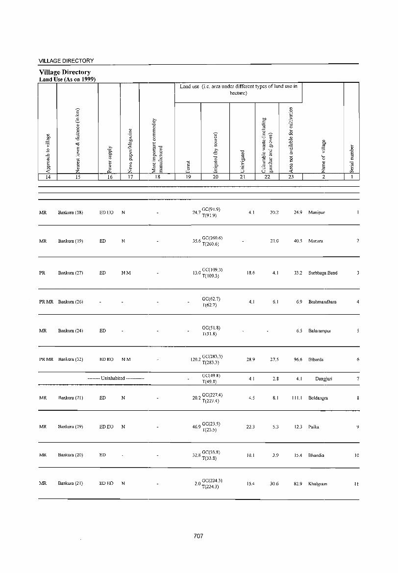
VILLAGE DIRECTORY ------------------------------------~----------------------------------.-------
Village Directory Land Use (As on 1999) ~~~~~~~,_----._--._------_.~~--~----~~=_----~~~~_r--------~--,
Land use (i.e. area under different types of land use in hectare)
-
MR Bankura (IS) ED EO N . 247 GC(91.9) 4.1 20.2 24.9 Manipur I · T(91.9)
-
MR Bankura (19) ED N . '56 GC(260.6) J . T(260.6) 210 40.5 Manara 2
PR Bankura (27) ED NM - 13 0 GC( I 09.3) IS.6 4.1 33.2 Surbhaga Band 3 · T(I09.3)
PRMR Bankura (26) - - - - GC(62.7) 4.1 6.1 6.9 Brahmandhara 4
T(62.7)
MR Bankura (24) ED - - - GC(5 1. S) - - 6.5 Balarampur 5
T(51.8)
-PRMR Bankura (32) ED EO NM - 202 GC(2S3.3) 28.9 27.5 96.6 Bibarda 6
· T(283.3)
--------- Uninhabited ------------ - GC(49.8)
4.1 2.8 4.1 Dangjuri 7 T(49.8) -
MR Bankura (21) ED N - 202 GC(227.4) 4.5 8.1 111.1 Beldangra 8 · T(227.4)
-
MR Bankura (19) ED EO N - 469 GC(23.5) 22.3 5.3 12.3 Paika 9 · T(23.5)
MR Bankura (20) ED Ge(338)
10.1 3.9 15.4 Bhandia 10 - 32.8 T(33.8)
MR Bankura (21) ED EO N - 20 GC(224.3) · T(224.3)
15.4 30.6 82.9 Khalgram II
707
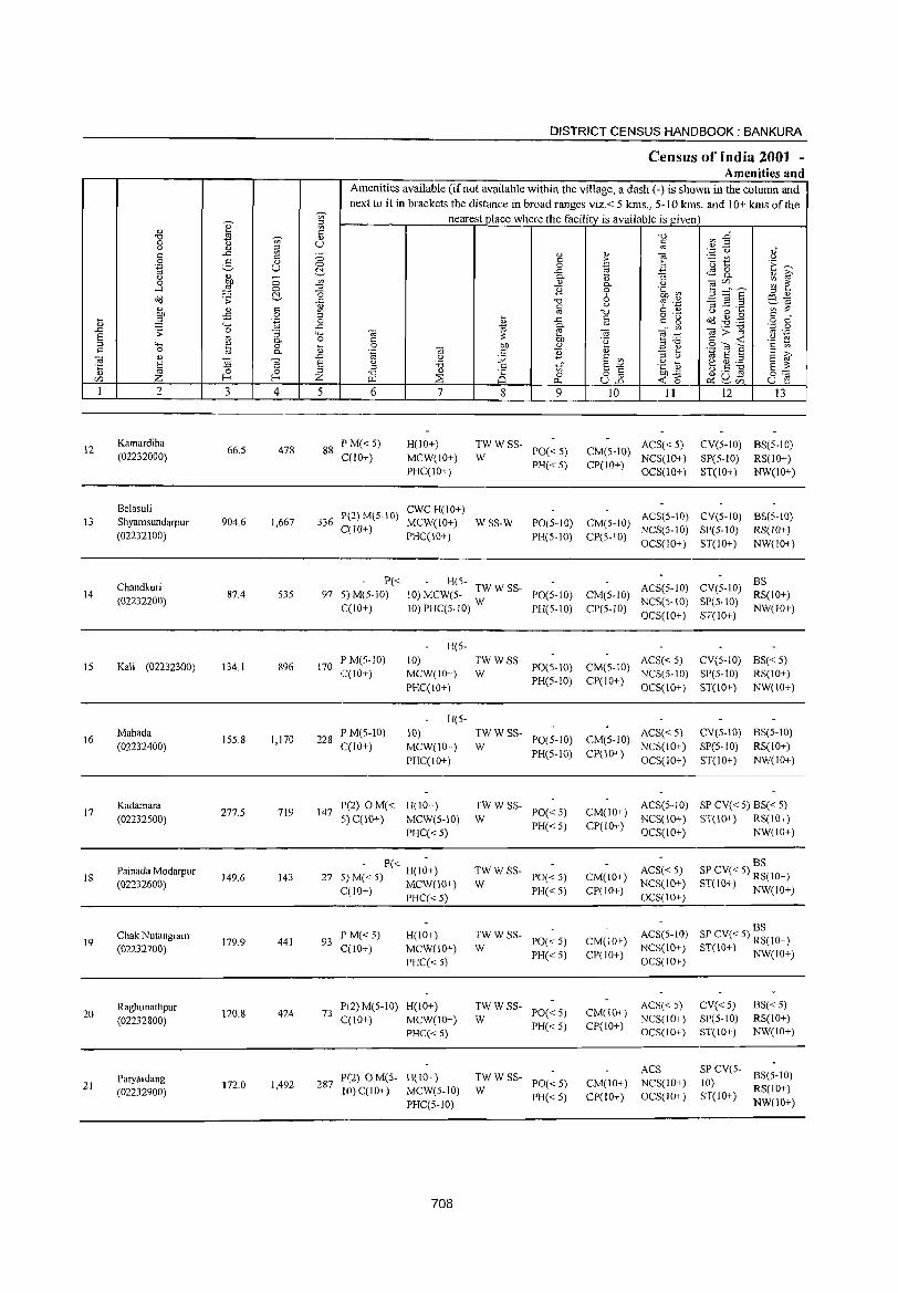
DISTRICT CENSUS HANDBOOK: BANKURA
Census of India 2001 -Amenities and
Amenities available (if not available within the village, a dash (-) is shown in the column and
next to it in brackets the distance in broad ranges viz.< 5 kms., 5-10 kms. and 10+ kms of the
" ~ nearest place where the facility is available is given
" ~ ~ -c ~ E" -c 'V;' <1)
0 u c (.) " iii '" '';::: u ,," c ..c: ;:; " " "§ " c ,_
~ t (.) 0 2- <1) ·E ~ .~ u 0 0 .~ <3 t:!.- ..c: <S 8. (.) '" - 0- <l) :; <l) i? 0 OJ) 0 Ul " 0- (.) OJ</) ~ ~ -l :§ -c "3 0
"0 0 .~ Ul 5 ::::"8 " " d;;j ;;: t:!.- o " e?,~ ..c: -c 6 '£ '315 .:a " " c " § (.)
Ul i:: ~ -c u 0 ~
:W -:5 0 ~ c o ._
~ .g .,g c " d; .~ 0 " ..c: c g o C
"-< ..c: 1;1 0- '" '" OJ>] '.t;: 0
..D .;;: 0 :; "-< OJ ~ OJ ""§::§ '" ._
S '" 0- 0 c i:: .~ c ~ .~ N " '- <l)
0 ... 0 OJ) " E ~ 9~S " '" c 0 8 0- " .~ .", c "3 " a i? OJ " ~
..D (.) :;;; s Ul " () 1;1 S " a "<i3 a (.) :.0 c a -'" ·c Q3 e g;.a a :: '5 ~ :l Ul
'" " -c '" 8 8.2 OJ)-C () ._ S 0:::: </) Z f- Z >r.1 ~ 0 <Co ~ 2, </) u e 0...
1 2 3 4 5 6 7 8 9 10 II 12 13
12 Kamardiha
66.5 478 88 P M« 5) H(10+) TWWSS- ACS« 5) CV(5-10) BS(5-10)
PO« 5) CM(S-10) (02232000) C(lO+) MCW(IO+) W PH«5) CP(IO+)
NCS(IO+) SP(5-1O) RS(lO+) PHC(10+) OCS(10+) ST(IO+) NW(IO+)
Belasuli P(2)M(5-IO)
CWCH(IO+) 13 Shyamsundarpur 904.6 1,667 336 MCW(IO+) WSS-W PO(5-10) CM(5-10)
ACS(5-10) CV(5-IO) BS(5-10)
(02232100) C(lO+)
PHC(IO+) PH(5-10) CP(5-10) NCS(5-IO) SP(5-1O) RS(IO+) OCS(IO+) ST(IO+) NW(lO+)
Chandkuri P« - H(5-ACS(5-1O) CV(5-10)
BS 14
(02232200) 87.4 535 97 5) M(5-1O) 10) MCW(5- TWWSS- PO(S-IO) CM(5-1O)
NCS(5-10) SP(5-10) RS(JO+)
C(IO+) 10) PHC(5-10) W PH(5-10) CP(5-1O) OCS(IO+) ST(lO+)
NW(IO+)
H(5-
15 Kali (02232300) \34.1 896 170 P M(S-IO) 10) TWWSS-
PO(5-10) CM(5-10) ACS« 5) CV(5-10) BS«5)
C(IO+) MCW(IO+) W NCS(5-1O) SP(5-10) RS(IO+)
PHC(10+) PH(5-1O) CP(lO+)
OCS(10+) ST(10+) NW(IO+)
H(5-
\6 Mahada
155.8 1,170 228 PM(5-10) 10) TWWSS-
PO(5-10) CM(5-10) ACS« 5) CV(S-IO) BS(S-IO)
(02232400) C(IO+) MCW(IO+) W NCS(IO+) SP(5-10) RS(IO+)
PHC(IO+) PH(5-10) CP(IO+)
OCS(IO+) ST(10+) NW(IO+)
17 Kadamara
277.5 719 147 1'(2) OM« H(lO+) TWWSS-
PO«5) CM(IO+) ACS(5-10) SP CV« 5) BS« 5)
(02232500) 5) C(lO+) MCW(S··10) W NCS(IO+) ST(IO+) RS(IO+)
PHC« 5) PH« 5) CP(IO+)
OCS(IO+) NW(IO+)
- P« -ACS« 5)
BS
18 Painada Modarpur
149.6 143 27 H(IO+) TWWSS-
PO«5) CM(IO+) SP CV« 5) RS(JO+) (02232600) 5) M« 5) MCW(IO+) W NCS(IO+) ST(IO+) NW(IO+)
CCIO+) PHC« 5) PH«5) CP(IO+) OCS(IO+)
BS Chak Nutangram
179.9 441 93 P M«5) H(IO+) TWWSS-
PO«5) CM(IO+) ACS(5-1O) SP CV« 5) RS(IO+) 19
(02232700) C(10+) MCW(10+) W PH«5) CP(IO+)
NCS(IO+) ST(IO+) NW(IO+) PHC«5) OCS(IO+)
Raghunathpur \20.8 424 73
P(2) M(5-10) H(10+) TWWSS-PO«5) CM(10+)
ACS« 5) CV«5) BS«5) 20
(02232800) C(10+) MCW(IO+) W NCS(IO+) SP(5-1O) RS(10+)
PHC« 5) PH«5) CP(IO+)
OCS(IO+) ST(lO+) NW(IO+)
TWWSS-ACS SP CV(5-
BS(5-10) Paryardang 287
P(2) o Me5- H(IO+) PO«5) CM(lO+) NCS(IO+) 10) 21 172.0 1,492
10) C(IO+) MCW(5-1O) W RS(IO+) (02232900) PH«5) CP(IO+) OCS(IO+) ST(lO+) PHC(5-IO) NW(lO+)
708
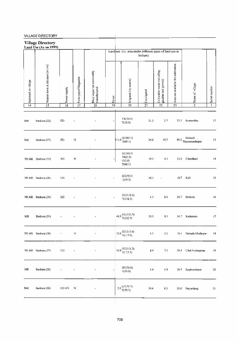
VILLAGE DIRECTORY ------------------------------------~-----------------------------------------Village Directory Land Use (As on 1999) ~~~~~----~r_----r_--_.---------.---+---------~~--------~~--~.----------.---,
Land use (i.e. area under different types ofland use in
'6 -'" :5 " " §
" t;
.& '6 's: o(l
B ~ .c B " "' t; ::: ~ 0. 0. " -< Z 14 15 16
MR Bankura (22) ED
MR Bankura (27) ED N
PRMR Bankura (10) ED N
PRMR Bankura (26) ED -
PR MR Bankura (26) ED
MR Bankura (30) - -
PRMR Bankura (26) - N
PRMR Bankura (27) ED -
MR Bankura (26)
MR Bankura (30) ED EO N
17 18 19
-
- -
-
- -
-
-
-
20
TK(IO.O) T(IO.0)
II 0 GC(60.1) · T(60.1)
GC(40.3) TK(S.O)
0(3.0) T(48.3)
GC(59.3) T(593)
GC(118.2) T(118.2)
469 GC(132.7) · T(132.7)
130 GC(Il7.0) · T(Il7.0)
109 GC(113.3) · T(113.3)
GC(76.0) T(76.0)
20 GC(70.7) · T(70.7)
709
hectare)
" ~n ~
" .;;: ..0 E .... ::>
0 " " (i3 f;j .§ Z '" 21 22 23 2 I
31.3 2.7 22.5 Kamardiha 12
24.6 19.7 89 2 Belasuli . Shyamsundarpur
13
19.5 4.1 15.5 Chandkuri 14
56.1 18.7 Kali 15
4.1 8.9 24.7 Mahada 16
55.0 8.1 34.7 Kadamara 17
4.1 5.3 10.4 Painada Modarpur 18
8.9 7.3 39.5 Chak Nutangram 19
4.6 0.8 39.5 Raghunathpur 20
54.4 9.3 35.6 Paryardang 21
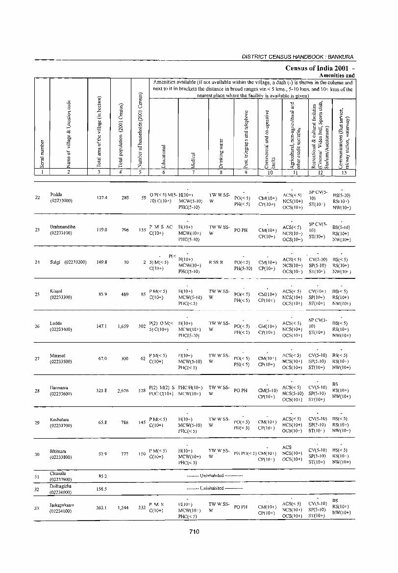
22
23
24
25
26
27
28
29
30
31
32
33
2
Pedda (02233000)
Brahmandiha (02233100)
Sulgi (02233200)
Kiasol (02233300)
Lodda (02233400)
Marasol (02233500)
Harmasra (02233600)
Keshatara (02233700)
Bhimara (02233800)
Chunalu (02233900)
Dolbagicha (02234000)
Jarkapaksara (02234100)
3 4
127.4 289
119.0 796
149.8 10
85.9 489
147.1 1,659
67.0 300
32S.8 2,676
6S.8 786
52.9 777
85.2
156.5
263.1 1,244
DISTRICT CENSUS HANDBOOK: BANKURA
Census of India 2001 -Amenities and
Amenities available (ifnot available within the village, a dash (-) is shown in the column and next to it in brackets the distance in broad ranges viz. < 5 kms., 5-10 kms. and 10+ kms of the
nearest place where the facility is available is given
5 6 7
59 0 P« 5) M(5- H(lO+) 10) C(1O+) MCW(5-10)
155 PM S AC C(lO+)
PHC(S-IO)
H(IO+)
MCW(lO+)
PHC(5-IO)
- P« -2 5)M«5) H(IO+)
C(1O+) MCW(lO+) PHC(S-IO)
85 P M«5) C(10+)
H(IO+)
MCW(5-IO)
PHC«S)
302 P(2) OM« H(lO+) 5) C(10+) MCW(IO+)
62 P M« 5) C(IO+)
PHC(5-10)
H(IO+) MCW(S-IO)
PHC«5)
528 P(2) M(2) S PHCH(IO+) PUCC(IO+) MCW(10+)
145 PM«S) C(IO+)
H(IO+) MCW(5-10)
PHC«5)
8 9
TWWSS-PO«5) PH« 5)
W
TW W SS- PO PH W
RSS-R PO«5) PH(5-1O)
:; W SS- PO« S)
PH« 5)
:W W SS- PO« 5)
PH« 5)
:W W SS- PO« 5)
PH« 5)
TWWSS- POPH W
:;WSS- PO«5)
PH« 5)
10 11
ACS« 5) CM(lO+) NCS(IO+) CP(IO+)
OCS(IO+)
ACS« 5) CM(IO+) NCS(lO+) CP(IO+)
OCS(IO+)
ACS«5) CM(IO+) NCS(IO+)
CP(IO+) OCS(lO+)
CM(lO+) ACS« 5) CP(IO+) NCS(IO+)
OCS(IO+)
. CM(IO+) ACS«5) CP(IO+) NCS(IO+)
CM(IO+)
CP(IO+)
OCS(IO+)
ACS«5) NCS(10+)
OCS(lO+)
ACS« 5) CM(5-10) NCS(5-10)
CP(IO+) OCS(IO+)
ACS« 5) CM(IO+) NCS(IO+) CP(IO+) OeS(!O+)
150 PM«5) qIO+)
H(IO+) MCW(IO+)
PHC« 5)
ACS :W W SS- PH PO« 5) CM(lO+) NCS(IO+)
CP(IO+) OCS(IO+)
232 P M S C(lO+)
-------- Uninhabited ------------
-------- Uninhabited ------------
H(IO+)
MCW(lO+)
PHC«S)
710
TW W SS- PO PH W
ACS« 5) CM(lO+) NCS(IO+) CP(IO+) OCS(IO+)
12 13
SP CV(5- BS(5-10) 10) ST(IO+) RS(IO+)
NW(IO+)
SP CV(5- BS(5-10) 10) ST(IO+) RS(IO+)
NW(IO+)
CV(5-1O) BS« 5) SP(5-10) RS(IO+)
ST(IO+) NW(IO+)
CV(10+)
SP(IO+)
ST(IO+)
BS«5) RS(IO+)
NW(lO+)
SP CV(5- BS« 5) 10) ST(IO+) RS(IO+)
NW(IO+)
CV(S-IO) BS« S) SP(5-1O) RS(IO+)
ST(IO+) NW(IO+)
CV(S-IO) :~(IO+) SP(5-1O) NW(IO+) ST(IO+)
eV(5-IO) BS« 5) SP(5-10) RS(IO+) ST(IO+) NW(IO+)
CV(5-10) BS« 5) SP(5-1O) RS(IO+)
ST(IO+) NW(IO+)
BS CV(S-IO) RS(IO+)
SP(S-W) NW(10+) ST(IO+)
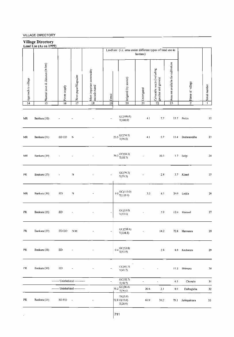
VILLAGE DIRECTORY ~~~~~~------------------------~-----------------------------------------Village Directory Land Use (As on 1999) ~~~~~~~~----~---r-------.~~--~----~~=-----~~~~-r--------~--,
Land use (i.e. area under different types ofland use in hectare)
14 15 16 17 18 19 20 21 22 23 2
----------------------------_._----------+--------------------------------------------
MR Bankura (32) GC(IOO.O) T(IOO.O)
4.1 7.7 15.7 Pedda 22
----------------------------_._----------+--------------------------------------------
MR Bankura (31 ) ED EO N 235 GC(74.5) · T(74.5)
4.1 5.7 11.4 Brahmandiha 23
----------------------------------------+--------------------------------------------
MR Bankura (30)
PR Bankura (33) N
MR Bankura (30) ED N
PR Bankura (25) ED
PR Bankura (27) ED EO NM
-
PR Bankura (28) ED _
PR Bankura (30) ED _
---•• -.- Uninhabited .. -.--------
.-.---.- Uninhabited --.-•.••• --.
-PR Bankura (33) ED EO
_
_ _
_
_ _
.
_
79 0 GC(58.3)
.0 T(58.3)
GC(79.3) T(79.3)
08 GC(119.0) · T(I19.0)
GC(53.0) T(53.0)
GC(238.8) T(238.8)
04 GC(53.8) · T(53.8)
GC(41.7) T(41.7)
GC(78.7) T(78.7)
79 3 GC(36.4) · T(36.4)
TK(5.0) 72.80(15.0)
T(20.0)
711
10.5 1.7 Sulgi 24
2.8 3.7 Kiasol 25
3.2 4.1 20.0 Lodda 26
2.0 12.0 Marasol 27
_ 14.2 72.8 Harmasra 28
_ 2.8 8.8 Keshatara 29
_ _ 11.2 Bhimara 30
_ _ 6.5 Chunalu 31
30.6 2.1 8.0 Dolbagicha 32
60.9 30.2 79.1 Jarkapaksara 33

0)' ~ U)
0) ttl " "0 ts ';;;' 0) 0 U <.l <I) '" "
..c: ~ _
0 2- 0) 0
'.g u 0 ~
<.l <I) - U) 0 ~ 0 -l 0 "0
~ "0 o(j .:; .e 0) 0) "
<I) U)
.... ~ -B 0 '" '.g 0 <I) "" .e .!:l .:; 0 ;:; """' 8 '" 0- 0
'" "" <I) 0 t " 0 ttl 0-
] <I)
~ -;;; .0
§ 8 ~ '" U) Z f-< Z
1 2 3 4 5
34 Karanjabedia
209.6 555 III (02234200)
35 Baghdoba
83.2 (02234300)
36 Ghagar
110.9 380 66 (02234400)
37 Patharkura
100.0 504 101 (02234500)
Tilabani 38 139.8 99 13
(02234600)
39 Kuldiha
158.3 626 124 (02234700)
Chakkuldiha 40 93.9 502 90
(02234800)
41 Sushunia
96.9 171 31 (02234900)
42 Mahishakanali
69.7 82 17 (02235000)
Bali Bandh 43
(02235100) 45.4 131 23
Nabagrarn 44
(02235200) 110.9 335 61
DISTRICT CENSUS HANDBOOK: BANKURA
Census of India 2001 -Amenities and
Am enities available (if not available within the village, a dash (-) is shown in the column and nex t to it in brackels lhe distance in broad ranges viz.< 5 krns., 5-10 krns. and 10+ krns of the
nearest place where the facility is available is given
"0 ~ E~ § <I)"
<U <I) e § <.l
" > U) " 0 .~ .3 ·6 1:: ·E ~ .e <is 0 0- ;:; 0- 0) ~ <Ll 0- .2 ] ~~E ~ ~ 1i 0
~ .~ '" 0) "0 6 -3 ~.Z e3..ta t: " C d) U) ~
'" "0 o .- " 0 .... " " .... .e " t: is t\d ~ ,g o t: " '" til §- _" U) <ii;:;""§ '.p 0
<ii <ii '" .-~ '" ~ " ~ " blJ 'e ..... - " -< '§ ~ 0 blJ <Ll ","0 .S:: (ij a ".g -;;; t: 1i <I) .:!:::: ~
.~ :.;;; E U) :::l u '" S :::l 8 ~
" .~ ~ ~.S ~ :::l "0 5 '" a""" a ~ "0 " P 0 o " Cl).e
~u~ 00= U.l ~ ~ <.J_2 -< 0 ~U) u e 6 7 8 9 10 11 12 13
PM«5) H(IO+) TWWSS-PO«5) CM(IO+)
ACS(5-10) CV(5-1O) BS«5) C(IO+) MCW(IO+) W
PH«5) CP(IO+) NCS(lO+) SP(5-10) RS(IO+)
PHC« 5) OCS(lO+) ST(IO+) NW(IO+)
-------- Uninhabited ------------
PM«5) H(IO+) TWWSS-PO«5) CM(IO+)
ACS(5-1O) CV(IO+) BS«5) C(IO+) MCW(IO+) W
PH«5) CP(IO+) NCS(lO+) SP(5-10) RS(IO+)
PHC(5-10) OCS(lO+) ST(IO+) NW(IO+)
• - P« H(l;+) TWWSS-PO«5) CM(IO+)
ACS(5-10) CV(IO+) BS«5) :J)M« 5) MCW(IO+) W NCS(IO+) SP(5-10) RS(IO+) 12(10+) PHC(5-1O) PH«5) CP(IO+)
OCS(lO+) ST(IO+) NW(IO+)
- P« -TWWSS- ACS(5-10) CV(IO+) BS« 5) H(IO+)
PO«5) CM(IO+) 5) M« 5) MCW(S-IO) W NCS(IO+) SP(S-IO) RS(10+) 12(10+) PHC(5-10) PH«5) CP(IO+)
OCS(lO+) ST(IO+) NW(IO+)
P(2)M«5) H(IO+) TWWSS-PO«5) CM(IO+)
ACS«5) CV(5-1O) BS«5) 12(10+) MCW(IO+) W
PH«5) CP(lO+) NCS(10+) SP(5-10) RS(IO+)
PHC« 5) OCS(IO+) ST(IO+) NW(IO+)
IPM«5) ACS(5-10) CV(5-1O) BS
H(IO+) TWW SS-PO«5) CM(IO+) RS(IO+)
12(10+) MCW(IO+) W PH«5) CP(IO+)
NCS(10+) SP(5-1O) NW(IO+)
PHC« 5) OCS(lO+) ST(IO+)
- P« H(I;+) ACS(5-1O) CV(5-10) BS
TWWSS-PO«5) CM(IO+) RS(IO+) 5)M«5) MCW(IO+) W PH«5) CP(IO+)
NCS(lO+) SP(5-10) NW(IO+) C(10+) PHC« 5) OCS(IO+) ST(IO+)
- P« H(l~+) TWWSS-PO«5) CM(5-10)
ACS« 5) CV(5-10) 8S« 5) 5) M« 5) MCW(IO+) W NCS(lO+) SP(5-10) R8(10+) 12(10+) PHC« 5) PH«5) CP(IO+)
OCS(lO+) ST(IO+) NW(IO+)
ACS« 5) CV(5-10) BS
p M«5) H(IO+) TWWSS-PO«5) CM(5-1O) RS(IO+)
12(10+) MCW(IO+) W NCS(IO+) SP(5-10) PH«5) CP(IO+) NW(IO+)
PHC« 5) OCS(lO+) ST(IO+)
P(2) M« 5) H(10+) TWWSS-PO«5) CM(5-10)
ACS« 5) CV(5-1O) B8«5)
C(lO+) MCW(IO+) W NCS(IO+) SP(5-10) RS(IO+) PH« 5) CP(IO+)
PHC« 5) OCS(IO+) ST(IO+) NW(IO+)
712
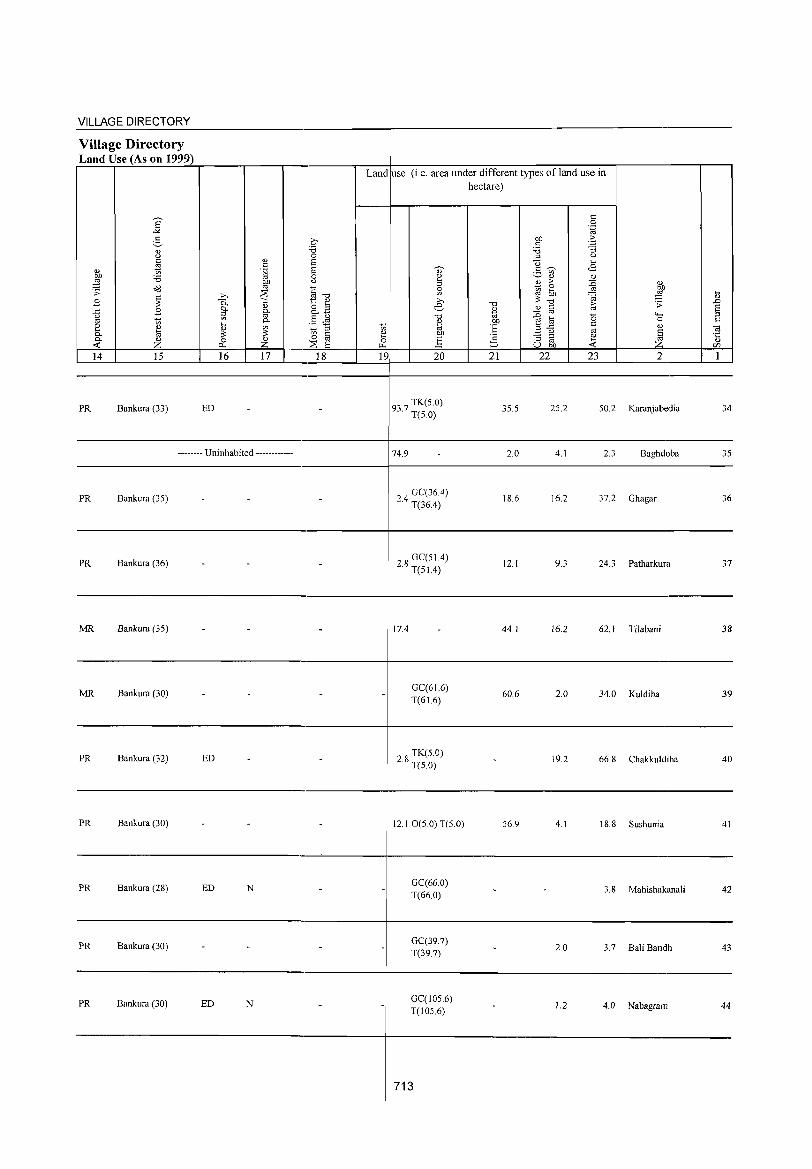
VILLAGE DIRECTORY
Village Directory Land Use (As on 1999) r=~~~~~~'_----.----r-'-----~---4--~----~~~----~~~~-r----------r--,
Land use (i,e, area under different types of land use in hectare)
14 15 16 17 18 19 20 21 22 23 2
-----------------------------,-----------+--------------------------------------------
PR Bankura (33) ED 937 TK(5,0) , T(5,0)
35,5 25,2 50,2 Karanjabedia 34
--------------------------------------------4--------------------------------------------------------- Uninhabited ------------
PR Bankura (35)
74,9
24 GC(36.4) , T(36.4)
2,0
18,6
4,1 2,3 Baghdoba 35
16.2 37.2 Ghagar 36
----------------------------------------+---------------------------------------------
PR Bankura (36) 28 GC(51.4) . T(51.4) 12.1 9.3 24.3 Patharkura 37
----------------------------------------+---------------------------------------------
MR Bankura (35) 17.4 44.1 16.2 62. 1 Tilabani 38
MR Bankura (30) - - - - GC(61.6) 60.6 2.0 34.0 Kuldiha 39
T(61.6)
-
PR Bankura (32) ED - - 28 TK(5.0) . T(5.0) - 19.2 66,8 Chakkuldiha 40
PR Bankura (30) - - 12.1 0(50) T(5.0) 56.9 4.1 18.8 Sushunia 41
-
PR Bankura (28) ED N - -GC(66.0) - - 3.8 Mahishakanali 42 T(66.0)
-PR Bankura (30) - - - - GC(39.7) - 2.0 3.7 Bali Bandh 43 T(39.7)
PR Bankura (30) ED N - - GC(105.6) - 1.2 4.0 Nabagram 44 T(l05.6)
-
713
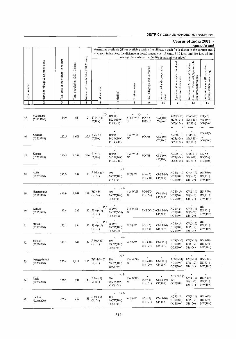
45
46
47
48
49
50
2
Maibandhi (02235300)
Khichka (02235400)
Kadma (02235500)
Aulia (02235600)
Narattampur (02235700)
Koisuli (02235800)
3
58.9
222.5
330.S
195.0
656.9
133.4
o o r::'--c: o .~
"3 0-o 0-
~ 4
611
1,608
1,249
148
1,948
222
DISTRICT CENSUS HANDBOOK: BANKURA
Census of India 2001 -Amenities and
Amenities available (if not available within the village, a dash ( -) is shown in the column and next to it in brackets the distance in broad ranges viz.< 5 krns., 5-10 krns. and 10+ krns of the
nearest place where the facility is available is given
o <:)
r::'--on
"0
~ ~ '+.; o ... " .D a ::l z 5 6 7
- P« -121 5) M« 5) H(10+)
C(10+) MCW(IO+) PHC« 5)
325 P M« 5) C(lO+)
236 IP M S C(10+)
35 PM(S-10) C(10+)
379 1'(3) M C(10+)
H(IO+)
MCW(lO+) 1'HC(5-10)
H(IO+) MCW(10+) PHC(5-10)
H(S-
10) MCW(IO+)
PHC(lO+)
H(5-
10)
MCW(IO+) PHC(10+)
- 1'« -42 5)M«S) H(10+)
C(10+) MCW(5··10) , PHC« 5)
8
-«
" c o
..<:; 0-
" "Ii
9
5) SS-W« PO« 5)
5) PH« 5)
TW W SS- PO PH W
TW W SS- PO PH W
WSS-W PO«S) PH(S-IO)
TW W SS- PO PTO
W PH(IO+)
10 II 12 I3
CM(10+) ACS(5-1O) CV(5-10) BS« 5) CP(10+) NCS(10+) SP(5-10) RS(10+)
CM(10+) CP(IO+)
OCS(10+) ST(IO+) NW(IO+)
ACS(5-10) CV(5-1O) BS RS(5-10)
NCS(IO+) SP(5-10) NW(10+) OCS( 10+) ST( 10+)
CM(10+) ACS(5-1O) CV(IO+) C1'(10+) NCS(10+) SP(5-10)
BS«5) RS(10+)
NW(lO+) OCS(10+) ST(10+)
CM(5-1O) ACS(S-IO) CV(5-10) BS(5-1O)
CP(IO+) NCS(IO+) SP(S-IO) RS(IO+) OCS(IO+) ST(10+) NW(IO+)
ACS«5) CM(IO+) NCS(IO+)
CP(1 0+) OCS( I 0+)
CV(5-10) BS(5-10)
SP(5-10) RS(10+)
ST(IO+) NW(IO+)
TW W SS- ACS« S) W PHPO«5)CM(5-10) NCS(lO+)
BS CV(5-10) RS(IO+)
CP(IO+) OCS(10+) SP(5-10) NW(IO+) ST(IO+) -------------------------------
51
52
53
54
55
Jemua (0223S900)
Taltala (02236000)
Dhengashimul (02236100)
Jugda (02236200)
Nachna (02236300)
171.1 134
160.S 267
276.4 1,112
128.1 741
195.2 280
- P« -28 5) M« S) H(IO+)
C(lO+) MCW(IO+) PHC«5)
S4 P'M(S-lO) C(10+)
H(5-10)
MCW(IO+)
PHC(IO+)
H(5-
215 P(2) M« 5) 10) C(10+) MCW(IO+)
143 I' M« 5) C(IO+)
53 P M«5) C(10+)
PHC(IO+)
H(5-
10) MCW(10+) I'HC(IO+)
H(5-
10) MCW(IO+) PHC(IO+)
714
WSS-W
WSS-W
1'0«5)
PH« 5)
PO(S-10)
PH(IO+)
~W W SS- PO(5-10)
PH(IO+)
~W W SS- PO« 5)
PH(IO+)
WSS-W PO«S) PH(IO+)
ACS«5) CM(5-10) NCS(IO+)
CP(IO+) OCS(10+)
CV(5-1O) :~(IO+) SP(5-10) NW(IO+) ST(IO+)
CM(IO+) ACS(5-10) CV(S-IO) 8S(5-10) NCS(IO+) SP(S-IO) RS(IO+)
CP(IO+) OCS(IO+) ST(IO+) NW(IO+)
CM(IO+) ACS(5-10) CV(S-IO) BS(S-IO) NCS(IO+) SP(5-10) RS(IO+)
CP(IO+) OCS(10+) ST(10+) NW(IO+)
CM(S-10) CP(10+)
ACS NCS(5- CV(;-IO)
10) SP(5-1O) 8S(S-10) RS(lO+) NW(IO+) OCS(lO+) ST(IO+)
CM(5-1O) ACS« 5) NCS(10+)
CP(IO+) OCS(IO+)
CV(5-IO) 8S(5-IO)
SP(5-10) RS(IO+) ST(IO+) NW(IO+)
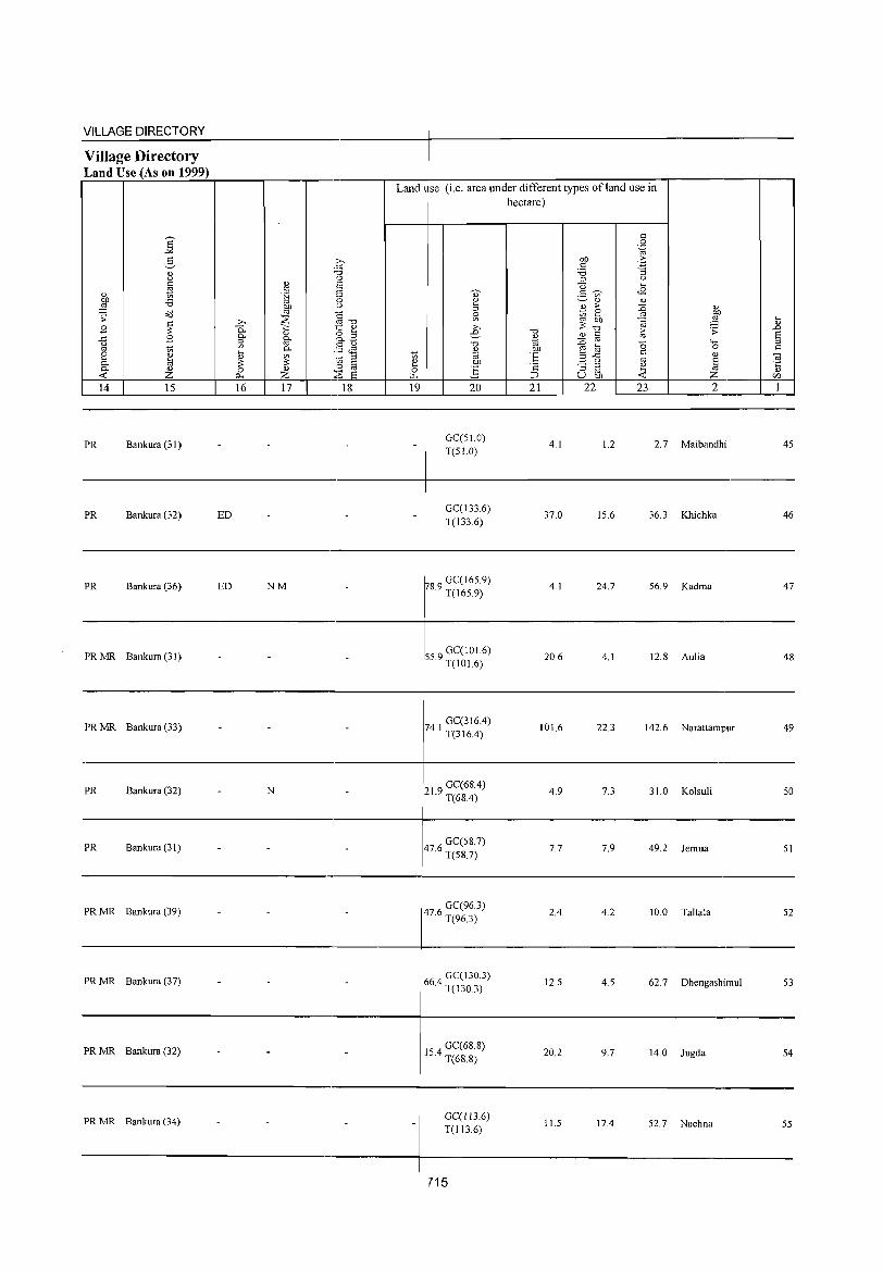
VILLAGE DIRECTORY ,
Village Directory
'Land Use (As on 1999) ~--.-~------~,----,----.--------~--~~,-----,-,-~------~~~~-.----------~--,
Land 1 se (i,e. area under different types ofland use in
PR Bankura (31) GC(51.0) T(SI.O)
hectare)
4,1 1.2 2,7 Maibandhi 45
-----------------------------------------~-------------------------------------------
PR Bankura (32) ED
PR Bankura (36) ED NM
PR MR Bankura (31)
PRMR Bankura (33) - -
PR Bankura (32) - N
PR Bankura (31) - -
PRMR Bankura (39) - -
PR MR Bankura (37)
PRMR Bankura (32) - -
PRMR Rankura (34) - -
-
-
-
--
-
-
-
-
- -
GC(133,6) T(133,6)
~8 9 GC(165,9) , T(165,9)
559 GC(I01.6) , T(101.6)
74 I GC(316A) , T(316A)
219 GC(6SA) . T(68A)
476 GC(58,7) ' T(5S,7)
476 GC(96,3) ' T(963)
664 GC(I30,3) , T(130,3)
154 GC(68,8) ' T(68.8)
GC(l13.6) T(113,6)
715
37,0 15,6 36,3 Khichka 46
4,1 24,7 56,9 Kadrna 47
20,6 4,1 12,8 Aulia 48
101.6 22,3 142,6 Narattarnpur 49
4,9 7,3 31.0 Kolsuli 50
7,7 7,9 49.2 Jernua 51
2A 4,2 10,0 Tallala 52
12,5 4,5 62.7 Dhengashirnul 53
20,2 9,7 14.0 Jugda 54
11.5 17.4 52,7 Nachna 55
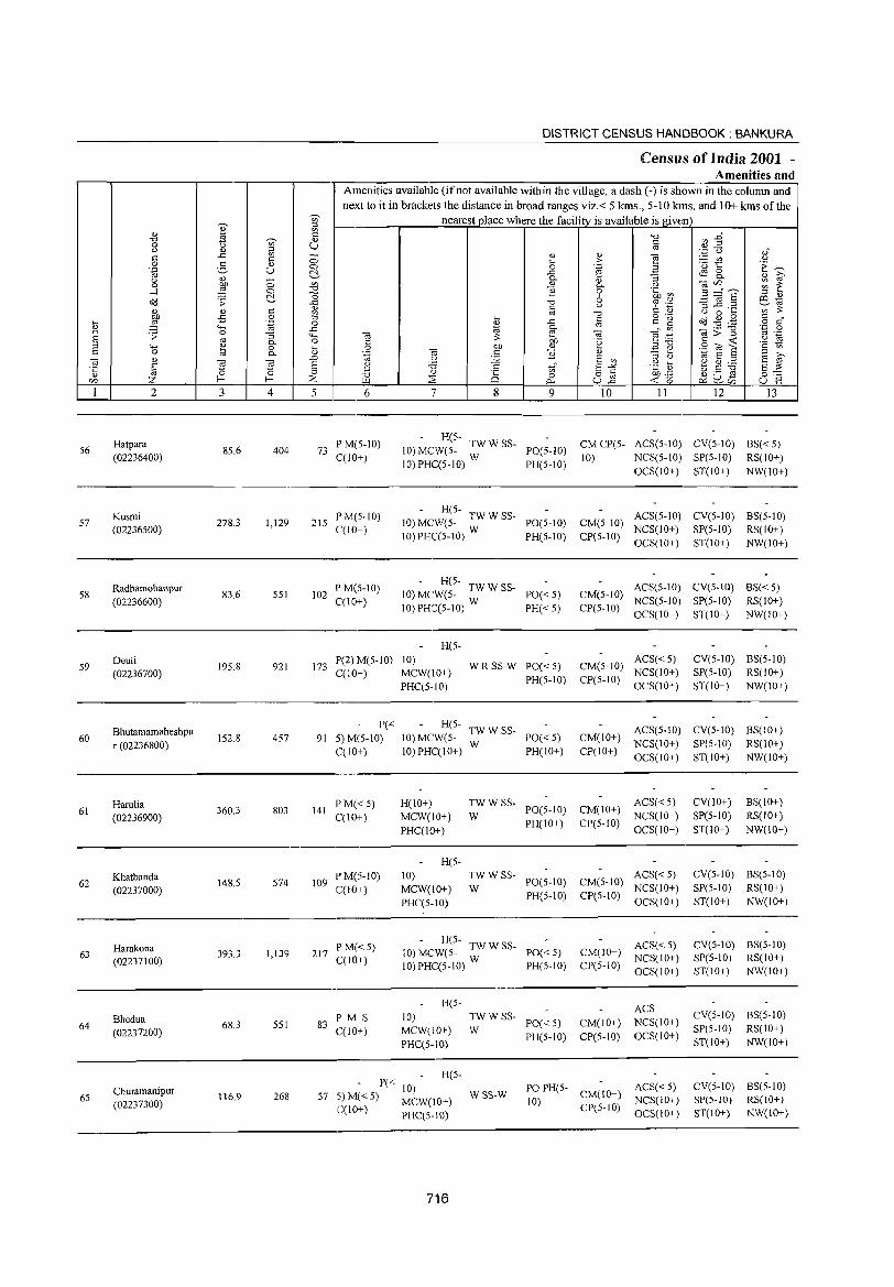
DISTRICT CENSUS HANDBOOK: BANKURA
CenslIIs of India 2001 -Amenities and
Amenities available (if not available within the village, a dash (-) is shown in the column and
next to it in brackets the distance in broad ranges viz.< 5 lans., 5-10 kms. and 10+ lans of the <i>' nearest place where the facility is available is given ::l
0) ~ '" C -0 ",..0 "d .s ~ U 0 u '" § .~ ~ u " ::l 0)" ..c '" ;; " 0) "§ § c c ;> :.::: CIl u g " .(3 to: ·E ~ .~ U 0 0 .~ B
~ ..c ~ 8-u " ::; 0.
" ;:; " i:;'
0 ~ {j " 0. U ",C/O ~ ~ ...l 0 ] 0 .~ ~ 5 ="6' ~ "0 6 ::l " ~ .;;:
il -0 c;J '.+j -3 .E .2 ill-.; c u ';;;' iJ: 0) " c '" '" -0 C " u 0 ... ,g .,s 0 ::l ... o .- ~ .g .g c "
~ '.g 0 ~ ..c c c g o c
4-; ..c 0. '" '" ",;;"§l ·z 0 .D .;;: 0 ;:; '-M -a ?> 2 -a ~ ."";::: '" .-S '" 0. 0 C bJ) "e c ~ u -.;
::l"d '2 1;) ::l 4-; ~ 0 ... 0 bJ) " .=: e .S? OJ 1: c 0 0. " '.g ·OJ c ] " ::l ;>,
'" 0) .D U :;;; E '"
::l U -.; S ::l S '"
~ '" ~ § U '5 c E-'"' .g a; ~g~ E iJ: ·c 0 ::l en
" -0 " i§ o c bJ)..c ~ U .s 0:::: Z f-< f-< % ~ 0 u2 ~ 0 on ~ p., e<:~CI"l u 2
1 2 3 4 5 6 7 8 9 10 11 12 13
Hatpara PM(5-10) - H(5-
CMCP(5- ACS(5-10) CV(5-10) 8S«5) 56 85.6 404 73 10) MCWe5- TW W SS- PO(5-10)
(02236400) C(IO+) 10) PHC(5-1O) W PH(5-10)
10) NCS(5-10) SP(5-10) RS(IO+) OCS(lO+) ST(lO+) NW(lO+)
Kusmi PM(5-1O) - H(5-
ACS(5-10) CV(5-10) 8S(5-10) 57 278.3 1,129 215 10) MCWe5- TW W SS- POe5-1O)
(02236500) C(10+) 10) PHC(5-10) W
CM(5-10) NCS(10+) SP(5-10) RS(IO+)
PH(5-1O) CP(5-10) OCS(IO+) ST(IO+) NW(IO+)
Radhamohanpur P M(5-10) - H(5-
ACS(5-10) CV(5-10) 8S« 5) 58 83.6 551 102 10) MCW(5- TWWSS- PO« 5) CM(5-1O)
(02236600) C(lO+) 10) PHC(5-10) W
NCS(5-10) Spe5-10) RSeIO+) PH« 5) CP(5-10)
OCS(10+) ST(10+) NW(IO+)
H(5-
59 Oeuli
195.8 921 173 P(2) M(5-10) 10)
WRSS-W PO«5) CM(5-10) ACS« 5) CV(5-1O) 8S(5-10)
(02236700) C(IO+) MCW(10+) PH(5-1O) CP(5-10)
NCS(10+) SP(5-1O) RS(IO+)
PHC(5-10) OCS(IO+) ST(10+) NW(IO+)
Bhutamamaheshpu P« H(5-
TWWSS- ACS(5-10) CV(5-1O) BS(IO+) 60
r (02236800) 152.8 457 91 5)M(5-10) 10) MCW(5-
W PO« 5) CM(IO+)
NCS(10+) SP(5-10) RS(IO+) C(10+) IO)PHC(IO+) PH(lO+) CP(IO+)
OCS(10+) ST(IO+) NW(IO+)
Harulia 360.3 803
PM«5) H(10+) TWWSS-PO(S-IO) CM(IO+)
ACS«5) CV(IO+) BS(10+) 61
(02236900) 141
C(10+) MCW(10+) W NCS(lO+) SP(5-10) RS(lO+)
PHC(IO+) PH(lO+) CP(5-10)
OCS(IO+) ST(IO+) NW(lO+)
H(5-
Khatbanda P M(S-IO) 10) TWWSS-PO(5-10) CM(5-10)
ACS« 5) CV(5-1O) 8S(5-10) 62
(02237000) 148.5 574 109
C(10+) MCW(IO+) W NCS(IO+) Spe5-10) RSeIO+)
PHC(5-10) PH(5-1O) CP(5-10)
OCS(10+) ST(IO+) NW(IO+)
Harakona p M«5) H(5- TWW SS ACS«5) CV(5-IO) BS(5-10) 63 393.3 1,139 217 10) MCWe5- - pac""" 5) CM(IO+)
(02237100) C(lO+) 10) PHC(5-10) W NCS(IO+) SP(5-10) RS(IO+)
PH(5-1O) CP(5-10) OCS(lO+) ST(IO+) NW(lO+)
R(5-ACS
Bhedua P M S 10) TWWSS-PO«5) CM(IO+) NCS(IO+)
CV(5-1O) BS(5-10) 64
(02237200) 68.3 551 83
C(10+) MCW(IO+) W SP(5-10) RSeIO+)
PHC(5-10) PH(5-1O) CP(5-10) OCS(IO+)
ST(IO+) NW(lO+)
P(""" R(5-
Churamanipur 10) PO PH(5- ACS«5) CV(5-10) BS(5-10) 65 116.9 268 57 5) M« 5) MCW(IO+)
WSS-W 10)
CM(IO+) NCS(lO+) SP(5-1O) RS(IO+) (02237300) C(10+) CP(5-10) PHC(5-10) OCS(IO+) ST(lO+) NW(10+)
716
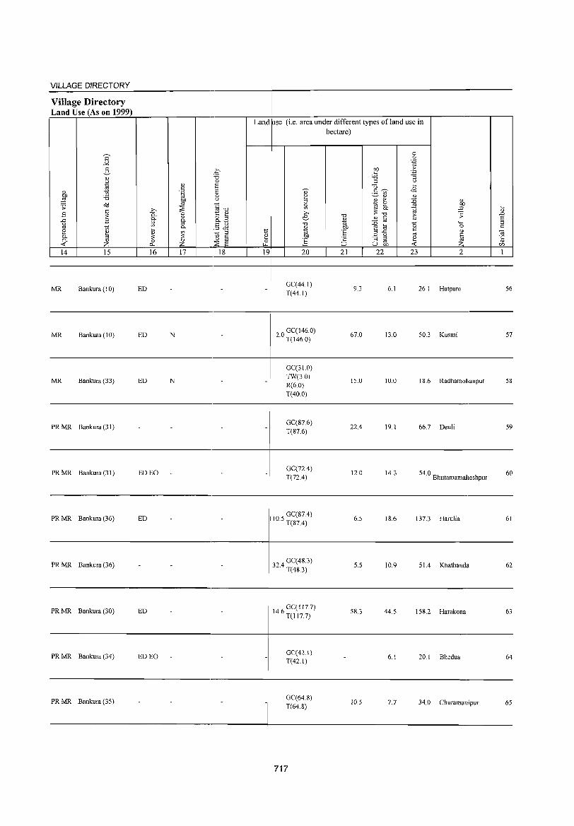
VILLAGE DIRECTORY
Village Directory Land Use (As on 1999)
s "" 2-'"' u C
<l) * ~ :a 'S2 o<l
B ~ ..c B u
'" '" ~ '"' til <1.>
<C Z 14 15
MR Bankura (I 0)
MR Bankura (10)
MR Bankura (33)
PRMR Bankura (31)
PRMR Bankura (31)
PR MR Bankura (36)
PR MR Bankura (36)
..Q 0. 0.
~
~ 0
p...
16
ED
ED
ED
-
ED EO
ED
.€ ''0 0
'"' 2 c .~ 2
0 gp u
~ §-o ';:; t '"' <l) o 3 go 0. 0 0. §~ '" ~ § :;:
0
Z ::E 2 -17 18
-
-
N -
-
N -
-
- -
-
- -
Land use (i.e. area under different types ofland use in hectare)
'" 2 " 5l ;.., e
"0
'"' ~ "til ~ co 0 E '" 19 20
-
-
-
GC(44.1) T(44.1)
20 GC(146.0) · T(146.0)
GC(31.0) TW(3.0) R(6.0) T(40.0)
GC(87.6) T(87.6)
GC(72.4) T(72.4)
GC(87.4) 110.5 T(87.4)
324 GC(48.3) · T(48.3)
'0
%i .~ t: '2 ::::> 21
9.3
67.0
15.0
22.4
12.0
6.5
5.5
c 0
':g co 'E c :a "3
" u () '"' 2- ~ <8
'" '"' '"' ~
;> :0 ~ 0
50 '" ~ :;: "0 ii; .;;: <l) § :0 0 .....
~ to c 0 ..c
'" <> u a "3 " ~
'" ~ u co <C 22 23 2
6.1 26.1 Hatpara
13.0 50.3 Kusmi
10.0 18.6 Radhamohanpur
19.1 66.7 Deuli
14.3 54.0 Bhutamamaheshpur
18.6 137.3 Harulia
10.9 51.4 Khatbanda
iil .D 2 " c 0; ·c " c/)
1
56
57
58
59
60
61
62
----------------------------_._----------+---------------------------------------------PR MR Bankura (30) ED
PRMR Bankura (34) ED EO -
-
PRMR Bankura (35) - -
- -
- -
146 GC(1l7.7) · T(1177)
GC(42.1) T(42.1)
GC(64.8) T(648)
717
58.3 44.5 158.2 Harakona 63
- 6.1 20.1 Bhedua 64
10.5 7.7 34.0 Churamanipuf 65
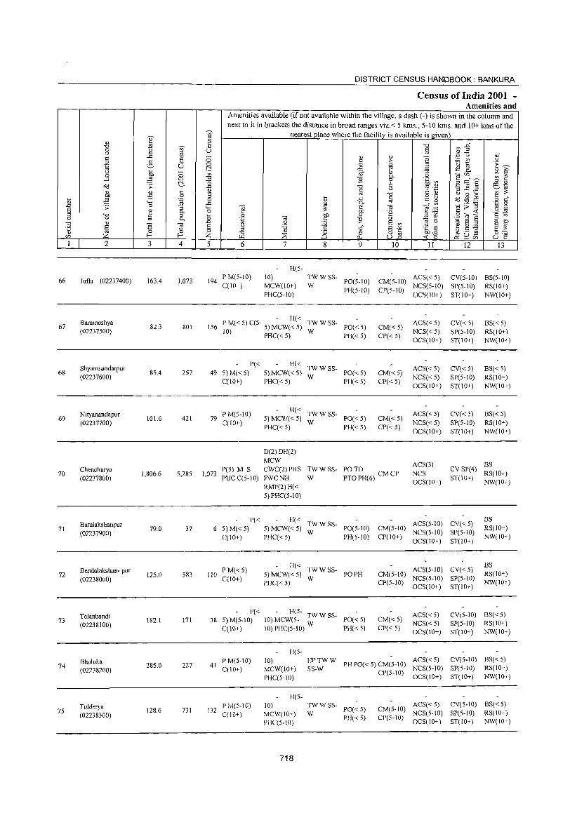
DISTRICT CENSUS HANDBOOK: BANKURA
Census of India 2001 -Amenities and
Amenities available (if not available within the village, a dash (-) is shown in the colunm and next to it in brackets the distance in broad ranges viz.< 5 kms., 5-10 !ems. and 10+ kms of the
~
'" nearest place where the facility is available is given ::l <l) i '" <::
a3~ '0 'Vi' ., -0
0 U c <.) .,
~ '" C .!: ~
" ., '..;::l 0 ,;-
c 0 > "§ - '" u .s 2- <l) c U 0 0 .~ B ·u 1:: E~
'" ~ .!: ~ 8.. (.) " - "'- ;3 '" i(;> 0 l 0 v> <l)
<l) u
] CI1""-'" ~ ~ "0 "'-...J 0 ] 0 .~ en e- -0 6 E ~ § ::l .,
o'Cl .;; .!: "0 6 .~ e~ ~
., c ~ c u ::l .!: ._ '" :;:
£ 0 ::l '" -0 g 'g u 0 ... c " ... ,g .~ 0 <> .!: C o'Cl..gg o c
" ...... ..c 1il "'- '" '.0 0 .D .;; 0 :; "" ] e ""iii -" '" ""iii;;"B '" .-8 '" 0. 0 :;: on .~ ~ .~ c <r: .~ S
S ...... e 0 <> .s on ., Ee .8 (\l] c v>
0 '" 0. ""iii c ] <l) 8 i(;> Cil " ~ $§ .n t<i u J2 E v> ::l u '" 8
"5 8 § .§ ;:a c ,if 8-'< .~] ~.S ~ 8 :;: ~ ~ z 2 8 0 o c 0:-:::
<:rJ f-< "" 0- ull <r: b p!u~ u e I 2 3 4 5 6 7 8 9 10 II 12 I3
H(5-
66 Jatla (02237400) 163.4 1,073 194 P M(5-10) (0) TWWSS-
PO(S-IO) CM(S-IO) ACS« 5) CV(5-10) 8S(5-1O)
C(IO+) MCW(IO+) W NCS(5-1O) SP(5-IO) RS(IO+) PHC(S-IO)
PH(5-10) CP(5-10) OCS(JO+) ST(IO+) NW(JO+}
Barameshya - H«
TWWSS- ACS« 5) CV« 5) 67 82.3 801 156 P t( < 5) C(5- 5) MCW( < 5) PO« 5) CM« 5)
BS« 5} (02237500)
I ) PHC« 5) W CP« 5)
NCS«5) SP(5-10) RS(IO+) PH«5)
OCS(lO+) ST(IO+) NW(lO+)
Shyamsundarpur P« H«
TWWSS- ACS« 5) CV«5) BS« 5) 68 85.4 257 49 5)M«5) 5) MCW«5) PO«5) CM« 5)
(02237600) W NCS« 5) SP(5-IO) RS(IO+) C(lO+) PHC« 5) PH« 5) CP« 5)
OCS(10+) ST(IO+) NW(10+)
Nityanandapur P M(5-10) H«
TWWSS- ACS« 5) CV« 5) BS«5) 69 101.6 421 79 5) MCW«5) PO« 5) CM«5)
(02237700) C(lO+) PHC«5)
W PH«5) CP« 5)
NCS«5} SP(5-JO) RS(IO+) OCS(IO+) ST(IO+) NW(IO+)
D(2)DH(2)
MeW ACS(3) BS
Chenchurya P(5) M S CWC(2) PHS TWWSS- PO TO CVSP(4) 70 1,806.6 5,285 1,073 PTO PH(6) CM CP NCS RS(IO+)
(02237800) PUC C(S-IO) FWCNH W OCS(IO+)
ST(IO+) NW(IO+)
RMP(2)H« 5} PHC(5-IO)
Baralakshanpur P« H«
TWWSS- ACS(5-IO} CV«5) BS
71 (O2237900)
79.0 37 6 5) M«5) 5) MCW«5) W
PO(5-JO) CM(5-JO) NCS(5-JO) SP(5-10)
RS(IO+)
C(10+) PHC«S) PH(5-10) CP(IO+) OCS(IO+) ST(IO+)
NW(IO+)
Bendalakshan- pur P M«5) H«
TWWSS- ACS(5-1O) CV«5) BS
72 125.0 583 110 5) MCW«5) PO PH CM(5-JO) RS(10+) (02238000) C(10+)
PHC«5) W
CP(S-IO) NCS(5-IO) SP(5-1O)
NW(IO+) OCS(IO+) ST(IO+)
Telanbandi P« - H(5-
ACS« 5) CV(S-IO) B8« 5) 73
(02238100) 182.1 171 38 5)M(S-10) (0) MCW(S- TW W SS- PO« S) CM« 5)
NCS«5) SP(5-10) RS(IO+) C(IO+) (0) PHC(5-10) W PH« S) CP« S)
OC8(10+) ST(IO+) NW(IO+)
H(5-
Bhaluka 227 41
P M(5-10) 10) HPTWW PH PO« 5) CM(S-IO)
ACS« 5) eV(5-10) BS« 5) 74
(02238200) 285.0
C(10+) MCW(lO+) SS-W NCS(5-IO) SP(S-IO) RS(IO+)
PHC(5-1O) CP(5-10)
OCS(IO+) ST(IO+) NW(IO+)
H(5-
Tulderya 731
PJI.1(5-10) 10) TWWSS-PO«S) CM(5-10)
ACS«S} eV(S-IO) 8S« S) 75 128.6 132
C(lO+) MCW(IO+) W NCS(5-IO) SP(S-IO) RS(IO+) (02238300) PH« 5) CP(5-IO) PHC(5-IOj OCS(IO+) ST(IO+) NW(JO+)
718

VILLAGE DIRECTORY ~==~~~~~---------------------~-------------------------------------Village Directory ~L=a~nd~U~se~(~A=s~o~n~1~9~9~9)~ ____ ~ __ ~r--_______ ~ __ 4-~~ ____ ~~~ ____ --~~--~r----------r----'
Land use (i.e. area under different types ofland use in hectare)
------------------------------.----------~-------------------------------------------
PR MR Bankura (31) ED GC(112.1) T(112.1)
31.6 0.4 19.3 Jafla 66
------------------------------------~-----------------------------------------
MR Bankura (3 I ) ED N GC(50 0) T(50.0)
7.0 25.3 Barameshya 67
------------------------------------~-----------------------------------------
MR Bankura (31) ED N
MR Bankura ( 10) ED N
PRMR Bankura (27) ED NM
FP
PR MR Bankura (22) ED N
-
-
Grill 1
GC(79.0) T(79.0)
50 GC(66.0) · T(66.0)
430 GC(198.0) · T(198.0)
GC(30 0) T(30.0)
6.4 Shyamsundarpur 68
- 10.0 20.6 Nityanandapur 69
89.0 235.0 141.6 Chenchurya 70
11.0 11.0 27.0 Baralakshanpur 71
----------------------------------------+--------------------------------------------
PR MR Bankura (27) ED N
MR Bankura (23) ED -
MR Bankura (26) ED EO -
-
MR Bankura (30) -
-
-
-
30 GC(49.0) · T(49.0)
1510 GC(II.O) · T(11.0)
GC(30.2) 39.2 TK(6.3)
T(36.4)
GC(58.7) 8.6 TK(1.2)
T(59.9)
719
8.0 5.0 60.0 Bendalakshanpur 72
- 2.0 18.1 Telanbandi 73
4.1 3.2 2.1 Bhaluka 74
- 6.1 14.1 Tulderya 75
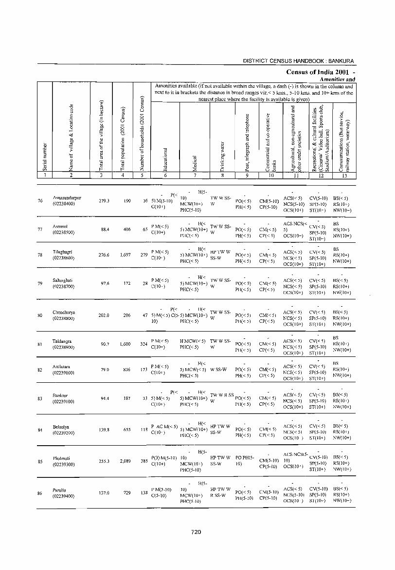
"V;' 'Q)' :::l
en
" til c: "0 ~ " 0 t> en u t) " ~ c: .;;;; c: 0 0 2- " 0 .~ u ~ t) " - en 0 :W 0 -l 0 "0
~ "0 Oil .:;: .c:
" " c: <l)
OJ) -E 0 ~ ~ ~ .~ 0
" '- ..c: .;;;; :;: 0 :; ""' § "' Co 0 '- " 0 .... c: 0 til Co "
~ " ~ ~ -'"
§ E "
:::l <Zl Z f- f- Z 1 2 3 4 5
76 Asnasundarpur
279.3 190 36 (02238400)
Asnasol 77 88.4 406 65
(02238500)
Tilaghagri 78 276.6 1,697 279
(02238600)
Saharghati 79 97.6 172 28
(02238700)
Chenchurya 80 202.0 206 47
(02238800)
Taldangra 81
(02238900) 90.7 1,600 324
82 Amlatara
79.0 836 173 (02239000)
Banktor 83
(02239100) 94.4 187 33
Belsulya 84
(02239200) 139.8 655 118
Phulmati 85
(02239300) 25S.3 2,089 385
Parulia 86
(02239400) 137.0 729 138
DISTRICT CENSUS HANDBOOK: BANKURA
Census of India 2001 -Amenities and
Amenities available (if not available within the village, a dash (-) is shown in the column and next to it in brackets the distance in broad ranges viz.< 5 kms., 5-10 krns. and 10+ kms of the
nearest place where the facility is available is given
6 7 8
P« H(5-
5) M(5-1O) 10) TWWSS-
CC lO+) MCW(IO+) W PHC(5-10)
PM«5) - H«
5)MCW(10+) TWW SS-C(lO+)
PHC« 5) W
PM«5) - H«
5) MCW(IO+) HP TW W C(lO+) PHC« 5) SS-W
PM«5) - H«
5)MCW(1O+) TWWSS-C(lO+)
PHC«5) W
- P« - H« 5) M« 5) C(5. 5) MCW(lO+) TW W SS-
10) PHC« 5) W
PM«5) HMCW«5) TWWSS-C(10+) PHC«5) W
PM« 5) H«
5) MCW«5) WSS-W C(lO+)
PHC« 5)
" " o ..c: Co
" E
9
PO« 5) PH« 5)
PO« 5) PH« 5)
PO« 5) PH«5)
PO« 5) PH«5)
PO«5) PH« 5)
PO« 5) PH« 5)
PO« 5) PH« 5)
P« H« TW W R SS PO(~ 5) 5) M«5) 5) MCW(IO+) W PH« 5) C(1O+) PHC«5)
- H« HPTWW P AC M« 5) 5) MCW(lO+) SS-W
PO«5) C(JO+) PHC« 5) PH« 5)
H(5-P(3) M(5-10) 10) HPTWW PO PH(5-
C(IO+) MCW(lO+) SS-W 10) PHC(S·IO)
H(5-PM(5-1O) 10) HPTWW
PO« 5) C(5-10) MCW(IO+) RSS-W
PH(5-10) PHC(S··JO)
720
" ;>
.~
" Co o 6 u
"0 §
<a .~
" E en E-'" o § u.;;;; 10
CM(5-10) CP(5-10)
CM«5) CP«5)
CM«5) CP«5)
CM«5) CP« 5)
CM«5) CP«5)
CM«5) CP«5)
CM«5) CP«S)
CM«5) CP«S)
CM«5) CP«S)
CM(5-10) CP(S-lO)
CM(5-10) CP(5-10)
II 12 13
ACS«5) CV(5-10) BS«5) NCS(S-IO) SP(5-10) RS(lO+) OCS(IO+) ST(IO+) NW(IO+)
ACS NCS« CV(~ 5) BS 5) RS(IO+) OCS(IO+) SP(5-10) NW(IO+)
ST(IO+)
ACS« 5) CV«5) 8S RS(IO+)
NCS« 5) SP(5-10) NW(IO+)
OCS(IO+) ST(IO+)
ACS«5) CV« 5) BS«5) NCS« 5) SP(5-10) RS(lO+) OCS(IO+) ST(IO+) NW(IO+)
ACS« 5) CV« 5) 8S« 5) NCS« 5) SP(5-10) RS(lO+) OCS(IO+) ST(10+) NW(lO+)
ACS« 5) CV«5) BS
NCS« 5) SP(5-10) RS(IO+)
OCS(10+) ST(IO+) NW(IO+)
ACS«5) CV«5) BS RS(IO+)
NCS« S) SP(5-1O) NW(IO+)
OCS(IO+) ST(IO+)
ACS« 5) CV«5) BS«5) NCS« 5) SP(5-10) RS(10+) OCS(IO+) ST(lO+) NW(lO+)
ACS« 5) CV«5) 8S« 5) NCS« 5) SP(5-1O) RS(JO+) OCS(lO+) ST(IO+) NW(lO+)
ACS NCS(5- CV(;-lO) BS« 5) 10) OCS(1 0+) SP(S-lo) RS(IO+)
ST(IO+) NW(lO+)
ACS«5) CV(5-10) BS« 5) NCS(5-10) SP(5-lO) RS(IO+) OCS(lO+) ST(!O+) NW(lO+)
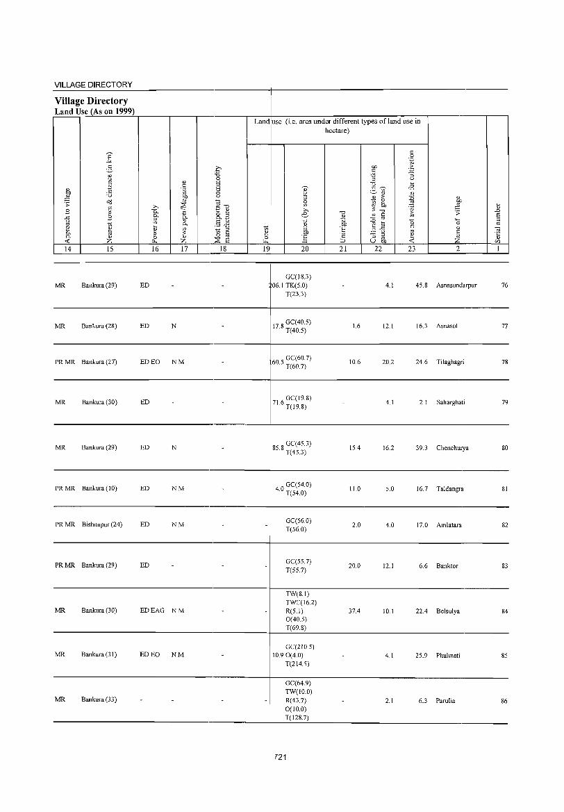
VILLAGE DIRECTORY ~~~~~~~---------------'-----------r------------------------------------------
Village Directory
'Land Use (As on 1999) ==~~~~~~,-----,---,---'-----'--~------------~----~~~~-r---------r--I
Land use (i,e, area under different types ofland use in hectare)
---------------------------------,----------~-------------------------------------------------
MR Bankura (29) ED
MR Bankura (28) ED N
GC(18.3) 06,1 TK(5,0)
T(23,3)
178 GC(40.5) , T(40,5)
4,1 45.8 Asnasundarpur 76
1.6 12,1 16.3 Asnasol 77
---------------------------------------~-----------------------------------------
PR MR Bankura (27) ED EO NM 605 GC(60,7) , T(60,7)
10,6 20.2 24.6 Tilaghagri 78
--------------------------------------------4-------------------------------------------------
MR Bankura (30) ED 71 6 GC(19,8) , T(19,8)
4,1 2,1 Saharghati 79
---------------------------------------~-----------------------------------------
MR Bankura (29) ED
PR MR Bankura (10) ED
N
NM
858 GC(45,3) , T(45,3)
40 GC(54,0) , T(54,0)
15.4 16.2 39.3 Chenchurya 80
11.0 5,0 16.7 Taldangra 81
------------------------------------~------------------------------------------
PR MR Bishnupur (24) ED NM GC(56,0) T(56,0)
2,0 4,0 17,0 Amlatara 82
------------------------------------~-----------------------------------------
PR MR Bankura (29) ED GC(55,7) T(55,7)
20,0 12.1 6.6 Banktor 83
------------------------------------~------------------------------------------
MR Bankura (30)
MR Bankura (31)
EDEAG NM
ED EO NM
TW(8,1) TWE(162) R(5,1) 0(40,5) T(69,8)
GC(210.5) 10,90(4,0)
T(214.5)
37.4 10,1 22.4 Belsulya 84
4,1 25.9 Phulmati 85
------------------------------------~-----------------------------------------GC(64,9)
MR Bankura (33) TW(IO,O) R(43,7) 0(10,0) T(128.7)
2,1 6.3 Parulia 86
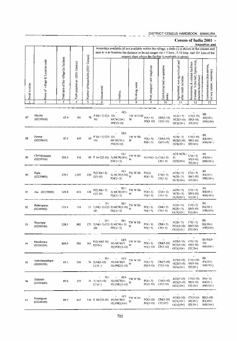
DISTRICT CENSUS HANDBOOK: BANKURA
Census of India 2001 -Amenities and
Amenities available (if not available within the village, a dash (-) is shown in the column and next to it in brackets the distance in broad ranges viz.< 5 kms., 5-10 kms. and 10+ kms of the ., ~ nearest place where the facility is available is _given
en
'" til [i "0 ~ E" "0
'"" 0 t> u § u _g ~ ',p <) 1f c ::; '" '" ] c c ;;- :.= V1 0 g '" ·u t:: ·E ~ :g u 0 0 .~
~ _c $ 8.. u ~ - P-'" "3 '" r;,
0 0 en '" P- C) ] (/)""-' ~ ~ ....:I ~ 0 "0 B 0 .~ V) "0 E ~ § ::l " o<l .;;: ~ ~ "0 6 6 .~ ill "'
'" c § C) ::l _c ._
';;;;; <U en "0 U 0 '-
,go _c 0 ;:;s o ._
C " :;; _c c c g 0(3 ~ .g :;; 4:: '.g ~ '" o c ta @- Ol;>"'§
'.0 0 .D .;; 0 "3 ..... Ol Ol _,.~ '" ._
S '" P- o C ;; 50 "§ E!~ c ..: '2 ~ ;:;s ""' '" 0 '- 0 00 '" B <u .S til E c 0 a P- '" '.g Ol c ] '" ::; b ~ r;, Ol " .D C) :.;;; E en ~ S :;$
~ s § u '0 .~ ~ b.5 .~ ·c § ;:;s .s tf E"'" S ;; '" ~ "0 '" is 0 82 OJ)_C 0'-'
C/) z z ~ ::E "- ..: b ~ ~Vl u ~ I 2 3 4 5 6 7 8 9 10 II 12 13
H(S-BS Machla P M« S) C(5- 10) TWWO SS PO(~ S) ACS«5) CV(5-1O)
87 65.4 381 78 CM(5-10) RS(IO+) (02239S00) 10) MCW(IO+) W PH(5-1O) CP(5-10)
NCS(S-IO) SP(5-10) NW(IO+)
PHC(5-10) OCS(10+) ST(10+)
H(S-BS Punesa P M« S) C(5- 10) TWWSS- ACS« 5) CV(5-10)
88 47.S 409 69 PO« 5) CM(S-IO) RS(IO+) (02239600) 10) MCW(lO+) W
PH« 5) CP(5-10) NCS(S-IO) SP(5-1O)
NW(10+) PHC(S··IO) OCS(IO+) ST(IO+)
Chakshyampur - H« ACS NCS« CV(~ 5) BS 89
(02239700) 200.3 S16 96 P M C(5-1O) 5)MCW(10+) TWWSS- PO PH« S) CM« 5) 5) RS(IO+)
PHC« 5) W CP« 5) OCS(lO+) SP(5-1O) NW(IO+) ST(lO+)
Kajla P(2)M«5) - H«
PH(2) ACS« 5) CV« 5) BS
90 270.1 1,203 220 5) MCW(5-10) TW W SS- CM« 5) RS(IO+) (02239800) C(S-IO)
PHC«5) W PO«5)
CP«5) NCS« 5) SP(5-1O)
NW(IO+) OCS(lO+) ST(lO+)
P(2)M« 5) - H«
ACS«5) CV«5) BS
91 Ala (02239900) 329.8 612 126 C(S-IO)
5) MCW(IO+) TW W SS- PO« 5) CM« 5) NCS«5) SP(S-IO)
RS(IO+) PHC«5) W PH« S) CP«S)
OCS(IO+) ST(IO+) NW(IO+)
- P« - H« ACS« 5) CV« 5)
BS
92 Baharagarya
155.4 118 21 5) M« 5) C(5. 5) MCW(S-IO) :W W SS- PO«S) CM«5) RS(IO+) (02240000)
10) PHC« 5) PH« S) CP« S) NCS« 5) SP(5-10)
NW(IO+) OCS(10+) ST(IO+)
Shyampur P« H«
TWWSS- ACS« 5) CV« 5) BS
93 228.5 882 175 5) M« 5) C(5. 5) MCW« 5) PO« S) CM«5) RS(IO+) (02240100)
10) PHC« 5) W
PH«S) CP« 5) NCS(5-10) SP(5-tO)
NW(lO+) OCS(lO+) ST(IO+)
Manikmara P(2)M(S-lO) - H(5-
ACS(S-IO) CV« S) BS RS(5-
94 864.9 916 163 10) MCW(5- TWWSS- PO«S) CM(S-IO) 10) (02240200) C(10+)
10) PHC(S-IO) W PH(S-IO) CP(S-IO) NCS(5-10) SP(5-1O)
NW(lO+) OCS(IO+) ST(IO+)
P« - H(5- ACS(5-10) CV(5-10) BS
Jashodanandapur 356 74 5)M(5-10) 10) MCW(5- TW W S5- PO«5) CM(5-1O) RS(IO+) 95
(02240300) 87.3 NCS(S-IO) SP(5-1O)
C(10+) 10) PHC(5-10) W PH(5-10) CP(5-10) OCS(IO+) ST(IO+)
NW(IO+)
Jiakanali P« - H(S- ACS(5-10) CV(5-10) BS« 5)
96 87.0 155 31 5) M(5-10) 10) MCW(5- TW W SS- PO« S) CM(5-10) NCS(5-IO) SP(5-10) RS(IO+) (02240400) C(lO+) 10) PHC(S-!O) W P1I(S-IO) CP(5-IO) OCS(IO+) ST(IO+) NW(lO+)
H(S- ACS(S-IO) eV(S-IO) BS(5-10) Nutangram 116 P M C(5-IO) 10) MCW(5- TW W SS- PO(5-1O) CM(S-IO) 97 99.7 637 NCS(IO+) SP(lO+) RS(IO+) (02240500) 10)PHC(10+) W PH(5-10) CP(IO+) OCS(IO+) ST(lO+) NW(lO+)
722
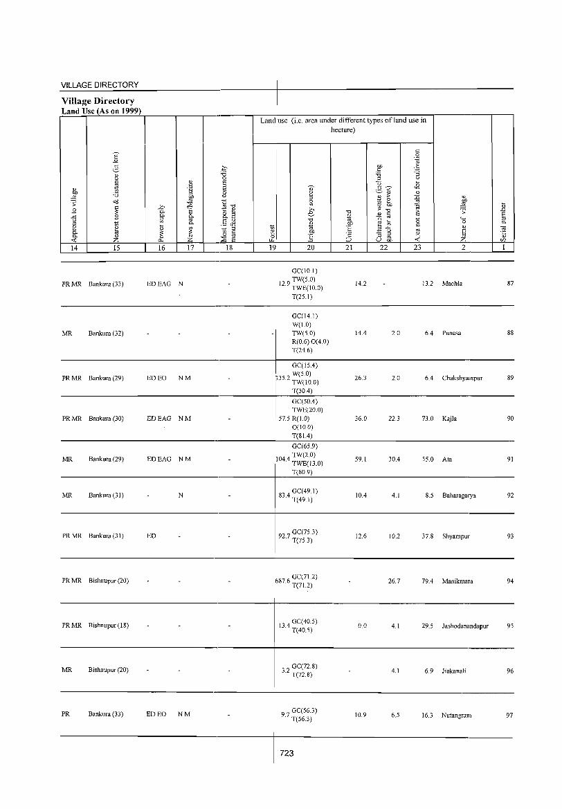
VILLAGE DIRECTORY
Village Directory Land Use (As on 1999) r=~~~~--~'_----'----'------~--~--~----~~=-----~~~~-'---------'--I
Land use (i.e. area under different types ofland use in hectare)
L-~14~L-__ ~1~5 ____ ~~16~~~17 __ L___.~18~ __ ~~1~9r-~ __ ~2~O __ ~~2~1~~~2=2~~ __ 2~3 __ ~ ____ 2 ____ ~ __ 1~
-------------------------------------------~-------------------------------------------------
PR MR Bankura (33) EDEAG N
GC(ID.I)
129 TW(5.0) · TWE(IO.O)
T(25.1)
14.2 13.2 Machla 87
-------------------------------------------~-------------------------------------------------
MR Bankura (32)
GC(14.1) W(1.0) TW(5.0) R(0.6) 0(4.0) T(24.6)
14.4 2.0 6.4 Punesa 88
----------------------------------------~--------------------------------------------GC(15.4)
PR MR Bankura (29) ED EO NM 352 W(5.0) · TW(IO.O)
26.3 2.0 6.4 Chakshyampur 89
______________________________ . ___________ -r ___ T~(3_0._4)~ ____________________________________ __
PR MR Bankura (30) EDEAG NM
GC(50.4) TWE(20.0)
57.5 R(1.0) 0(10.0)
36.0 22.3 73.0 Kajla 90
_________________________________________ -r ___ T~(8_1_.4~) ______________________________________ _
GC(65.9)
MR Bankura (29) EDEAG NM 1044 TW(2.0) · TWE(l3.0)
59.1 30.4 55.0 Ata 91
___________________________________________ ~----T~(8-0-9)~------------------------------------__ __
MR Bankura (31) N 834 GC(49.1) · T(49.1)
10.4 4.1 8.5 Baharagarya 92
----------------------------------------~--------------------------------------------
PRMR Bankura(31) ED 92 7 GC(75.3) · T(75.3) 12.6 10.2 37.8 Shyampur 93
--------------------------------.-----------~-------------------------------------------------
PR MR Bishnupur (20)
PR MR Bishnupur (18)
MR Bishnupur (20) - -
PR Bankura (33) ED EO NM
-
-
-
-
687.6 GC(71.2) T(71.2)
13 4 GC( 40.5) · T(40.5)
32 GC(72.8) · T(n.8)
97 GC(56.3) · T(563)
723
26.7 79.4 Manikmara 94
0.0 4.1 29.5 Jashodanandapur 95
4.1 6.9 Jiakanali 96
10.9 6.5 16.3 Nutangram 97
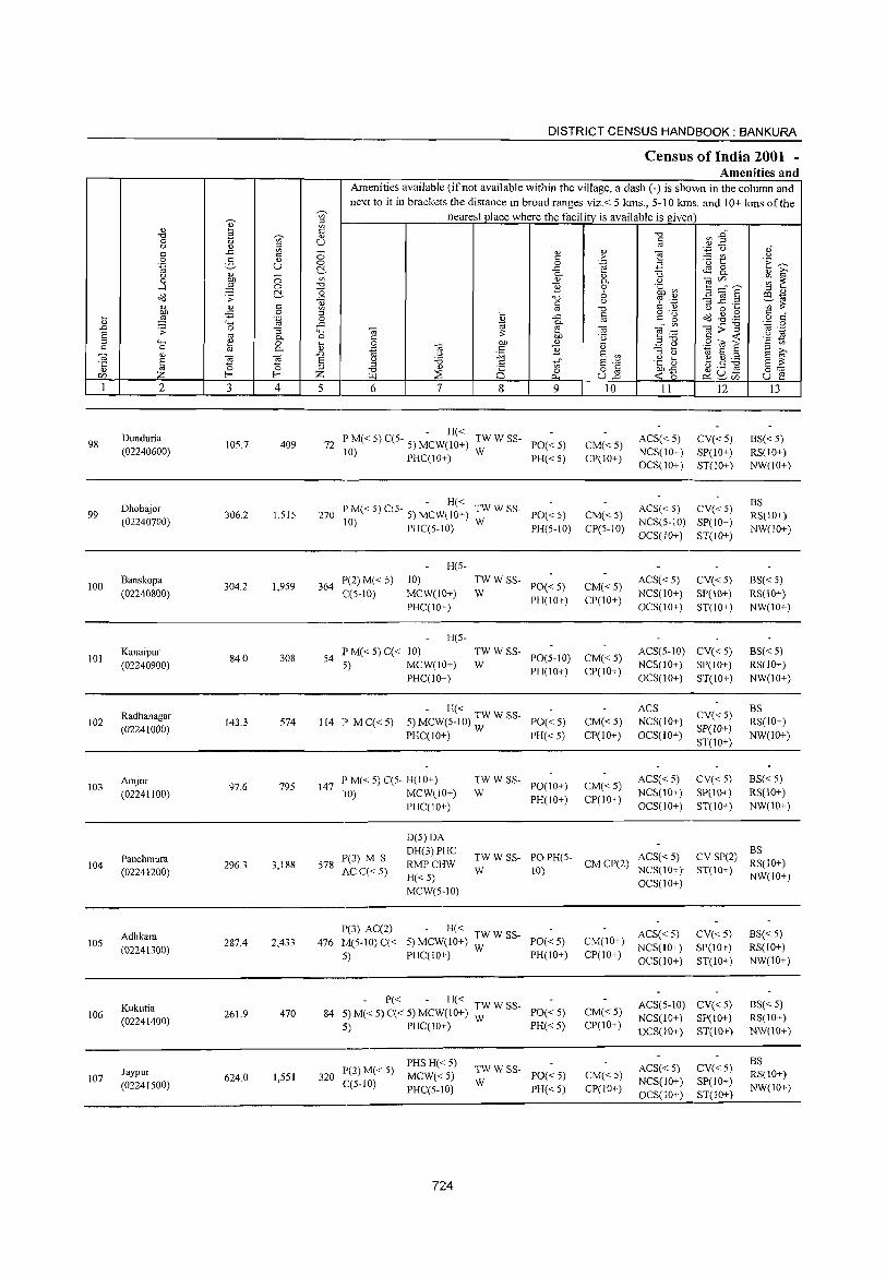
DISTRICT CENSUS HANDBOOK: BANKURA
Census of India 2001 -Amenities and
Amenities available (ifnot available within the village, a dash (-) is shown in the column and next to it in brackets the distance in broad ranges viz. < 5 kms., 5-10 kms. and 10+ kms of the
~
nearest place where the facility is available is given '" ::l
" ~ '" C "0 Vl .g" "0 ~ " 0 u '" u a u 0 ::l . .3 u 0"
c ..r: '" - " 0
] c 0 c > ;.: V) u 0 :5 0 0 0 .~ ·u 1:: ·E ~ .~ u ~ ..r: 4S 8. u " 0 0- " :; " ?i' 0 on '" " 0- '-' til(/) ~ ~ ....l ~ 0 "0 ] 0 .~ ~ 3 ::::" a ~ "0 6 " " o<l .;;: ..r: § '-' <? .,c 3 ~.2 e3-1<:l
" 0) c &l I "0 c " '-' 0 ~ en ;;: ,g ..c 0 " '- @ o ._
d8 ..g .g c " ~ ,;:: .~ 0 " ..c c g o c
..c 1<:l §" '" til;;""§ "N .g ..0 .;;: 0 :; """' OJ til ""§ .~ E '" 0- 0 C ;;: 5D .~ ::l "0 C -o:t: '2 ~ ::l """' " 0 ... 0 /)j) " ~ 0 .9 O! E c 0 til 0- 0) .~ -a c ] " - ~ " »
til 0) ..0 '-' :.;;; E '" ::l '-' 1<:l E ::l E '"
~ ~ ~ E 'i3 c E-" .e: t e ~ ~ E ;;: '5 ::l ::l
" C§ '" o c on..c ~ U .s f-< z ""0 ~ 0 u2 -o:t: 0
0:: (/) ~ 0... e<:~(/) u e 1 2 3 4 5 6 7 8 9 10 11 12 13
Dunduria - H« ACS« 5) CV«5) BS« 5) 98 105.7 409 72 PM«5)C(5- 5) MCW(10+) TWWSS- PO«5) CM«5)
(02240600) 10) PHC(10+) W PH«5) CP(10+) NCS(10+) SP(lO+) RS(lO+) OCS(10+) ST(IO+) NW(IO+)
Dhobajor - H«
ACS« 5) CV« 5) BS
99 306.2 1,515 270 PM«5)C(5- 5) MCW(IO+) TWWSS- PO«5) CM«5) RS(IO+) (02240700) 10) PHC(5-10) W PH(5-10) CP(5-10)
NCS(5-10) SP(IO+) NW(IO+)
OCS(lO+) ST(IO+)
H(5-
100 Banskopa
304.2 1,959 364 P(2)M« 5) 10) TWWSS-
PO«5) CM«5) ACS« 5) CV«5) BS« 5)
(02240800) C(5-10) MCW(IO+) W PH(lO+) CP(IO+)
NCS(10+) SP(10+) RS(10+) PHC(1O+) OCS(lO+) ST(10+) NW(10+)
H(5-
101 Kanaipur
84.0 308 54 P M« 5) C« 10) TWWSS-
PO(5-10) CM«5) ACS(5-10) CV«5) BS« 5)
(02240900) .5) MCW(10+) W PH(IO+) CP(IO+)
NCS(10+) SP(IO+) RS(IO+) PHC(10+) OCS(10+) ST(10+) NW(lO+)
- H« ACS CV«5)
BS 102
Radhanagar 143.3 574 114 P MC«5) 5) MCW(5-1O) TW W SS- PO«5) CM« 5) NCS(lO+) R8(lO+)
(02241000) PHC(1O+) W PH« 5) CP(IO+) OC8(10+) 8P(IO+)
NW(IO+) 8T(IO+)
Amjor 97.6 795 147
l' M« 5) C(5- H(10+) TWWSS-PO(IO+) CM«5)
ACS« 5) CV«5) B8«5) 103
(02241100) \0) MCW(10+) W NCS(lO+) SP(IO+) RS(IO+)
PHC(IO+) PH(IO+) CP(10+)
OC8(10+) ST(IO+) NW(10+)
D(5)OA OH(3)PHC
TWWS8- POPH(5- ACS« 5) CV SP(2) BS
104 Panchmura
296.3 3,188 578 1'(3) M 8
RMPCHW CM CP(2) RS(IO+) (02241200) AC C« 5)
H«5) W 10) NCS(lO+} ST(IO+)
NW(IO+)
MCW(5-10) OCS(10+)
1'(3) AC(2) - H« AC8« 5) CV«5) BS« 5) Adhkara 287.4 2,433 476 M(5-10)C« 5) MCW( 10+) TW W 8S- PO« 5) CM(IO+) 105 NCS(IO+) 8P(10+) RS(IO+) (02241300)
5) PHC(JO+) W PH(IO+) CP(IO+) OC8(10+) ST(10+) NW(lO+)
Kukutia - P« - H« TW W 88-PO«5) CM«5)
AC8(5-10) CV«5) B8« 5) 106 261.9 470 84 5)M«5)C«5)MCW(10+) W NCS(10+) SP(lO+) RS(IO+) (02241400) 5) PHC(IO+) PH« 5) CP(JO+)
OCS(lO+) ST(IO+) NW(IO+)
PHS H« 5) AC8« 5) CV«5) BS
Jaypur P(2) M« 5) MCW«5)
TWW SS-PO«5) CM«5) RS(IO+) 107 624.0 1,551 320
C(5-IO) W NC8(JO+) SP(10+) (02241500) PHC(5-10) PH« 5) CP(IO+) NW(1O+) OCS(10+) ST(IO+)
724
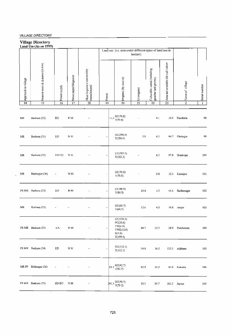
VILLAGE DIRECTORY -----------------------------------------4--------------------------------------------Village Directory Land Use (As on 1999) r==~~~~~~~._----._----._--------.----4--------------~------~--~~-,-----------,r---,
Land use (i.e. area under different types of land use in
MR Bankura (33) ED NM 11 ' GC(70.S) .J T(70 8)
hectare)
4.1 19.5 Dunduria 98
----------------------------------------4--------------------------------------------
MR Bankura (31) ED NM GC(206.4) T(206A)
5.0 4.1 90.7 Dhobajor 99
----------------------------------------4--------------------------------------------
MR Bankura (33) ED EO NM
MR Bishnupur (36) NM
GC(2023) T(2023)
GC(70.S) T(70.S)
4.1
O.S
97.S Banskopa 100
12.3 Kanaipur 101
----------------------------------------4--------------------------------------------PR MR Bankura (35) ED NM GC(S6.9)
T(S6.9) lOA 1.5 44.6 Radhanagar 102
----------------------------------------4--------------------------------------------
MR Bankura (33) GC(60.7) T(60.7)
12.6 4.5 19.8 Amjor 103
----------------------------------------~-------------------------------------------
PR MR Bankura (33) EA
PR MR Bankura (34) ED
NM
NM
GC(159A) PC(20.0) TW(4.0) TWE(12.0) R(4.0) T(199.4)
GC(112.1) T(1121)
44.5 23.5 28.9 Panchmura 104
34.0 16.2 125.1 Adhkara 105
----------------------------------------~-------------------------------------------
MR FP Bishnupur (36)
PR MR Bankura (35) ED EO NM
61 1 GC(42.7) . T(42.7)
81 3 GC(70.2) . T(70.2)
42.9
10.5
34.2 S1.0 Kukutia 106
59.7 202.3 Jaypur 107
--------------~------------------------~-------------------------------------------
725

DISTRICT CENSUS HANDBOOK: BANKURA
Census of India 2001 -Amenities and
t\menities available (if not available within the village, a dash (-) is shown in the column and
next to it in brackets the distance in broad ranges viz.< 5 kms., 5-10 kms. and 10+ kms of the ~ nearest place where the facility is available is_given '0)' ;:1
'" " a c I "0 ,DO "0
~ " 0 1) U c '" ;:1
" " Ol ,,- ,f ..c: </> ;:; " " "§ '..;:::::i u
C § c :> :.= ell " 0 5 0 0 .~ .3 '" "§ E~ '.g U ~ ..c <lS c.. " ~ " ~ - c.. :; 0 0 '" " 0- " 03r/) ;;: i: .....l ~ 0 "0 ] 0 .~ a3 B ~"E '0 " " o'<l .;; ~ ..c "0 6 e,1;;
c " c " ~ 'z "'5 .c .= '" :;: " Q) '" Ol "Cl C " " 0 ~ 00 -5 0 ;:1 o ._ ~ ~.g c ~ ..c C
c" £ o CO t ,g .~ 0 " "'" ..c: 1;; 0- Ol
g>~ .~ 0 ,D .;;: 0 "5 <..,. g f.'! 03 ~:.a Ol ._
S oj 0- 0 :;: 00 'e '2 ~ " "'" Q) 0 ~ 0 00 " E e .02 <0 E c 0 ~ 0- " .~ -OJ c ] " ;:1 ;>,
03 " ,D u :;:;; E '" " u ta E ~ E Ol
§ ~ ] s g 'i3 c ...; E"" u ~ ~ ~ :.a E :;: '5 0 ;:1 "0 " 8 0 o § .~ .B (,) ._ ro
o '" Z f- f- Z ::E "u ~ U f.'! r/) f.Ll '" U,D --< 0 p::~r/)
1 2 3 4 5 6 '1 8 9 10 11 12 13
Chakjambedia "P« H(5-
TWWSS- ACS« 5) CV«5) BS« S) 108 220.3 171 30 5) M« 5) C(5· ~bW(lO+) PO« 5) CM«5) (02241600) W NCS(lO+) SP(IO+) RS(lO+) 10) PHCCIO+) PH(IO+) CP(lO+)
OCS(lO+) ST(IO+) NW(IO+)
Lalbandh - H« ACS« S) CV« 5)
BS 109 69.3 1,033 143 P MCC<S) 5) MCW(S-IO) TW W SS- PO« S) CM« 5) RS(IO+) (02241700)
PHCCIO+) W PH«S) CP(10+) NCS(lO+) SP(lO+)
NW(IO+) OCS(10+) ST(IO+)
Deulbhira - H« ACS
CV«5) BS
110 98.S 627 96 PM«5)C« 5)MCW(10+) TWWSS- PO«5) CM«5) NCS(IO-I) RS(IO+) (02241800)
5) PHCCIO+) W PH«S) CP(IO+) OCS(10+) SP(IO+)
NW(IO+) ST(IO+)
Bhetuadanga P M« 5) C(5- - H« TWWSS- ACS« 5) CV«5) BS« 5) 111 77.7 562 85 . 5) MCW(IO+) PO«S) CM«S) (02241900)
10) PHC(10+) W PH« 5) CP(IO+)
NCS(IO+) SP(IO+) RS(lO+)
OCS(IO+) ST(10+) NW(JO+)
Jambedia PM«5)C« H«
ACS« 5) CV« 5) BS« 5) 112
(02242000) 98.8 369 68
:5) 5) MCW(IO+) WRSS-W PO«5) CM«5)
NCS(IO+) SP(lO+) RS(IO+) PHCC1O+) PH« 5) CP(10+)
OCS(IO+) ST(IO+) NW(10+)
Resiagara - P« - H«
ACS«5) CV« 5) BS«S) 113 84.4 118 21 5) M« 5) C« 5) MCW(IO+) ~W W SS- PO«5) CM« S)
(02242100) 5) PHC«5) PH«5) CP(IO+)
NCS(IO+) SP(10+) RS(IO+)
OCS(IO+) ST(lO+) NW(lO+)
- H« ACS«5) CV«5)
BS
114 Shyamsundarpur
438.4 1,096 200 l' M«5) C« 5) MCW(IO+) TW W SS- PO«5) CM«5) RS(IO+)
(02242200) 5) PHC(IO~) W PH«5) CP(lO+) NCS(IO+) SP(IO+)
NW(IO+) OCS(IO+) ST(IO+)
P« H« ACS(5-1O) CV(5-10) BS(5-1O) 115 Tatar (02242300) 168.0 24 4 5)M(5-1O) 5) MCW(lO+) WSS-W PO«5) CM(5-10)
NCS(IO+) SP(IO+) RS(lO+) C(S-IO) PHCCIO+) PH(5-10) CP(10+)
OCS(IO+) ST(IO+) NW(10+)
Chakmajuri- 1'(2) AC(3) H« ACS(5-10) CV(5-10) BS« 5) 116 prasadpur 1,048.9 1,031 198 M«5)CC5- 5) MCW(IO+) TW SS-TW PO(5-10) CM(IO+)
NCS(IO+) SP(IO+) RS(IO+) (02242400) 10) PHC(10+) PH« 5) CP(IO+)
OCS(10+) ST(lO+ ) NW(IO+)
Douni l' Tr AC(3)
H(10+) PO ACS(5-10) CV(5-10) BS(5-10) 117 695.9 1,145 217 M«5) C(S-
MCW(S-IO) TW SS-TW PH(IO+) CM(IO+) NCS(S-IO) SP(IO+) RS(IO+) (02242S00)
10) CP(IO+) PHC(10+) OCS(IO+) ST(IO+) NW(IO+)
Mahulbera P M«5) H(IO+) HI' TWSS-PO«5) CM(lO+)
ACS(lO+) CV(lO+) BS(10+) 118 62.7 719 138
C(IO+) MCW(5 .. 10) TW NCS(IO+) SP(IO+) RS(lO+) (02242600) PH(lO+) CP(lO+) PHC(lO+) OCS(10+) ST(10+) NW(IO+)
726
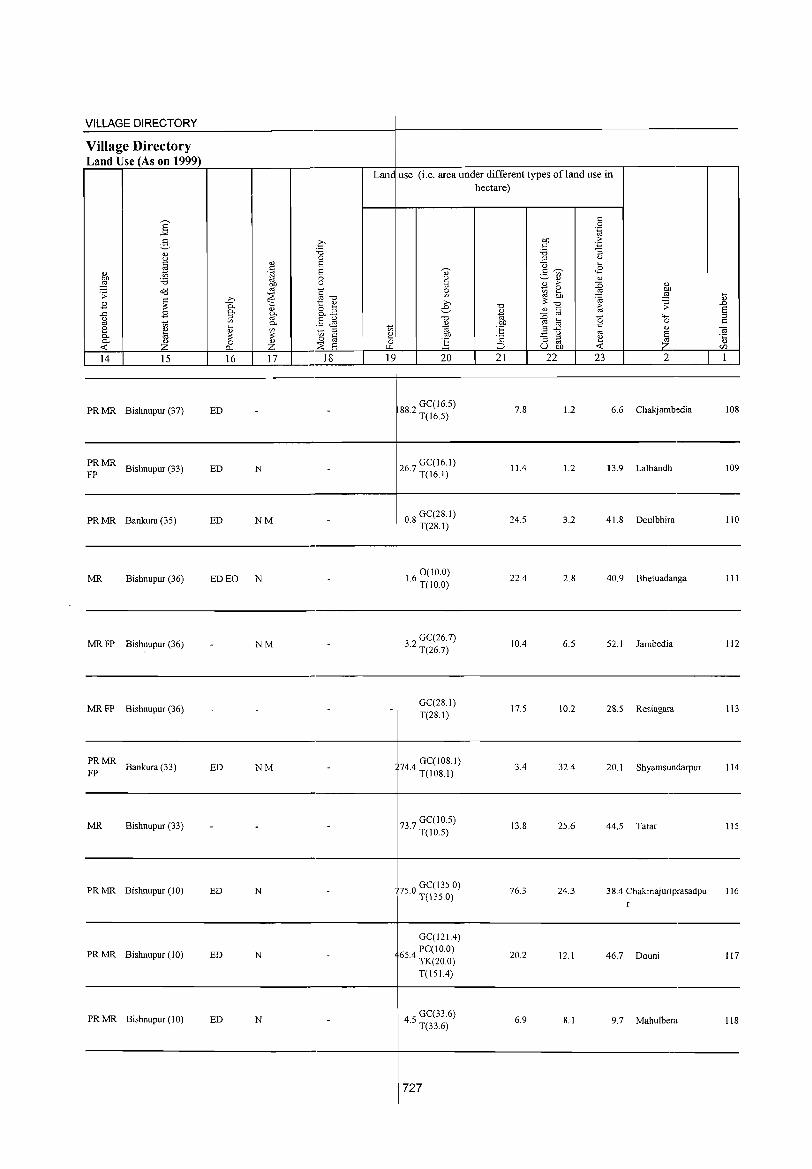
VILLAGE DIRECTORY
Village Directory Land Use (As on 1999)
Lane use (i.e. area under different types ofland use in hectare)
14 15 16 17 18 19 20 21 22 23 2 1 ~~~ ____ ~ ____ ~~~~ __ ~ __ ~~ __ ~~+-~ __ ~ __ ~~~~ __ ~ __ L-~ __ ~ ________ ~ __ ~
PR MR Bishnupur (37) ED 882 GC(16.5) · T(l6.5)
7.8 1.2 6.6 Chakjambedia 108
----------------------------------------+--------------------------------------------PRMR FP Bishnupur (33) ED
PR MR Bankura (35) ED
N
NM
267 GC(16.1) · T(16.1)
08 GC(28.1) · T(28.1)
11.4 1.2 13.9 Lalbandh 109
24.5 3.2 41.8 Deulbhira 110
--------------------------------._-----------+-------------------------------------------------
MR Bishnupur (36) ED EO N
MRFP Bishnupur (36) - NM
MRFP Bishnupur (36) - -
PRMR Bankura (33)
FP ED NM
MR Bishnupur (33) - -
PRMR Bishnupur (10) ED N
PRMR Bishnupur (10) ED N
PRMR Bishnupur (10) ED N
-
-
-
-
-
-
-
-
-
-
16 0 (10.0) · T(lO 0)
32 GC(26.7) · T(26.7)
GC(28.1) T(2S.I)
744 GC(IOS.I) · T(IOS.I)
737 GC(10.5) · T(10.5)
750 GC(135.0) · T(1350)
GC(121.4)
654 PC(IO.0) · TK(20.0)
T(151.4)
45 GC(33.6) · T(33.6)
727
22.4 2.8 40.9 Bhetuadanga III
10.4 6.5 52.1 Iambedia 112
17.5 10.2 28.5 Resiagara 113
3.4 32.4 20.1 Shyamsundarpur 114
13.S 25.6 44.5 Tatar 115
76.3 24.3 38.4 Chakmajuriprasadpu 116 r
20.2 12.1 46.7 Douni 117
6.9 S.l 9.7 Mahulbera I1S
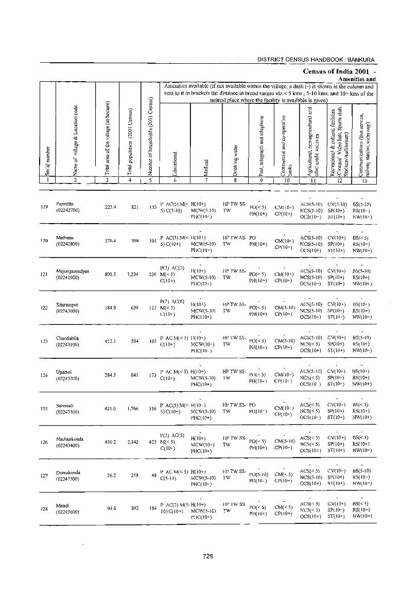
119
120
121
122
123
124
125
126
127
128
2
Parirdihi (02242700)
Methena (02242800)
Majuriprasadpur (02242900)
Sitarampur (02243000)
Chandabila (02243100)
Uparsol
(02243200)
Satmauli (02243300)
Nachankonda (02243400)
Domakonda (02243500)
Mandi (02243600)
3
223.4
176.4
800.3
184.9
452.1
284.3
421.0
436.2
56.2
94.8
o o ~ c o .~
"3 0. o 0.
~ 4
821
508
1,234
639
594
841
1,766
2,142
258
892
DISTRICT CENSUS HANDBOOK: BANKURA
Census of India 2001 -Amenities and
I Amenities available (if not available within the village, a dash (-) is shown in the column and next to it in brackets the distance in broad ranges viz.< 5 kms., 5-10 1ans. and 10+ kms of the
nearest place where the facilitv is available is given
u
5 6 7
153 P AC(S)M« H(10+) 5) C(S-IO) MCW(S-IO)
PHC(IO+)
101 P AC(3) M« H(10+) 5) C(lO+) MCW(5-10)
P(2) AC(3) 226 M« 5)
C(lO+)
P(2) AC(6) 122 M«5)
C(10+)
PHC(IO+)
H(IO+) MCW(5-10) PHC(IO+)
H(IO+) MCW(S-IO) PHC(10+)
105 P ACM«5) H(IO+) C(lO+) MCW(IO+)
PHC(IO+)
173 P AC M« 5) H(lO+) C(lO+) MCW(5-1O)
PHC(lO+)
356 P AC(S) M« H(IO+) 5) C(IO+) MCW(5-10)
P(2) AC(5) 423 M« 5)
C(10+)
PHC(IO+)
H(IO+) MCW(10+) PHC(IO+)
48 P AC M« 5) H(IO+) C(5-1O) MCW(5-IO)
PHC(lO+)
184 P AC(3)M(5-H(10+) 10) C(lO+) MCW(5-10)
PHC(IO+)
728
8 9
HPTWSS-TW PO« 5)
PH(10+)
HPTWSS- PO TW PH(IO+)
HP TW SS- POC - 5)
TW PH(70+)
HP TW SS- PO(~ 5)
TW PH(lO+)
HPTW SS-TW PO« 5)
PH(IO+)
HPTWSS- -TW PO«5)
PH(IO+)
HPTWSS- PO TW PH(IO+)
HPTWSS-TW PO«5)
PH(10+)
HPTW SS-PO(5-lO) PH(IO+)
TW
HPTW SS-TW PO«5)
PH(10+)
10 11 12 13
CM(IO+) CP(lO+)
ACS(S-10) CY(S-IO) BS(S-IO) NCS(5-10) SP(lO+) RS(10+) OCS(IO+) ST(IO+) NW(lO+)
CM(10+) ACS(5-10) CY(lO+) CP(lO+) NCS(5-10) SP(IO+)
OCS(lO+) ST(IO+)
CM(IO+) ACS(5-10) CY(IO+) CP(lO+) NCS(5-10) SP(lO+)
OCS(IO+) ST(10+)
CM(5-10) ACS(5-10) CV(IO+) NCS(5-IO) SP(lO+)
CP(JO+) OCS(10+) ST(IO+)
CM(5-1O) ACS(5-1O) CY(IO+) NCS« 5) SP(10+)
CP(IO+) OCS(IO+) ST(IO+)
CM(IO+) CP(10+)
ACS(5-1O) CY(10+) NCS« 5) SP(10+) OCS(lO+) ST(lO+)
CM(IO+) ACS« 5) NCS«5)
CP(10+) OCS(10+)
CY(10+) SP(lO+) ST(lO+)
CM(5-10) ACS«5) NCS«5)
CV(lO+) SP(10+) ST(lO+) CP(10+) OCS(10+)
CM«5) CP(IO+)
CM« 5) CP(10+)
ACS« 5) CY(IO+) NCS(S-10) SP(10+) OCS(10+) ST(10+)
ACS« 5) NCS« 5) OCS(lO+)
CY(IO+) SP(lO+) ST(lO+)
BS«5) RS(IO+) NW(lO+)
BS(5-10) RS(lO+) NW(IO+)
BS(10+) RS(IO+) NW(IO+)
8S(5-10) RS(10+) NW(10+)
BS(IO+) RS(IO+) NW(lO+)
ES« 5) RS(lO+) NW(10+)
BS«5) RS(IO+) NW(10+)
BS(5-10) RS(IO+) NW(lO+)
8S« 5) RS(IO+) NW(IO+)
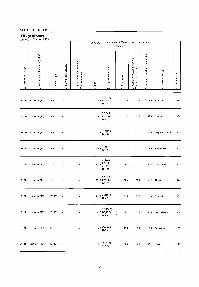
VILLAGE DIRECTORY
Village Directory Land Use (As on 1999) r=~~~~~~----.----r-------.~~~~--~~~----~~~~'---------r--.
Land use (i.e. area under different types of land use in hectare)
----------------------------------------+---------------------------------------------
PR MR Bishnupur (12) ED N
PR MR Bishnupur (13) ED N
GC(77.8) 4.1 TW(5.0)
T(828)
GC(54.2) 14.6 TW(IO.O)
T(64.2)
60.8
63.1
24.3 51.5 Parirdihi 119
16.2 18.3 Methena 120
----------------------------------------+---------------------------------------------
PRMR Bishnupur(12) ED N 03 I GC(IOO.O) · T(IOO.O)
41.6 60.7 94.8 Majuriprasadpur 121
----------------------------------------+---------------------------------------------
PR MR Bishnupur (12) ED N 068 GC(I1.3) · T(I1.3)
21.0 20.2 25.5 Sitarampur 122
--------------------------------------------+-------------------------------------------------
PR MR Bishnupur (13) ED N
GC(90.9) TW(IO.O)
77.2 O( I 0.0)
T(110.9)
8.1 15.5 40.3 Chandabila 123
----------------------------------------+---------------------------------------------
PR MR Bishnupur (10) ED N
PR MR Bishnupur (15) ED EO N
GC(63.9) 10 1.2 TW( I 0.0)
T(73.9)
627 GC(157.8) · T(J57.8)
50.2
30.9
18.2 40.8 Uparsol 124
24.3 45.3 Satmauli 125
----------------------------------------+---------------------------------------------
PR MR Bishnupur (15) ED EO N GC(190.2)
45.3 TK(lO.O) T(200.2)
38.6 56.7 95.4 Nachankonda 126
------------------------------------_,-----------------------------------------
PRMR Bishnupur(JS) ED 69 GC(20.2) · T(20.2)
20.2 3.2 5.6 Domakonda 127
----------------------------------------+---------------------------------------------PR MR Bishnupur (17) ED EO N 28 GC(40.5)
· T(40.5) 32.4 4.1 15.1 Mandi 128
----------------------------------------+--------------------------------------------
'29
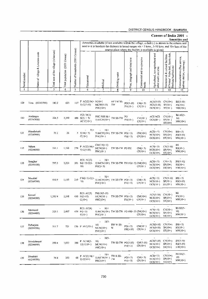
DISTRICT CENSUS HANDBOOK: BANKURA
CenslLls of India 2001 -Amenities and
Amenities available (ifnot available within the village, a dash (-) is shown in the column and next to it in brackets the distance in broad ranges viz.< 5 kms., 5-10 kms. and 10+ kms of the
';n' nearest place where the facility is available is given
I " OJ '" C "0 r.fl ~" "0
~ OJ
0 U c () OJ '" "-c ..<: ~ OJ OJ "§
"';::: C,) OJ" - '" () 0 2- <J 8 c: .:e: <3 t:: E~ .~ u 0 OJ a t'.. ..<: ~ g OJ 0- il :; OJ » () c; ~ ~ 0 ~ '" <J 0- () oa(/J
...J 0 ~ '2 0 .~ ~ 5=S " <!) o'<l .;; t'.. ..g "0 (, '" ._ '3 jg .2 co ~
() ~'" ., OJ C C C Q) '" ::: '" '" ] () 0 ...
E .p 0 '" ... g "g ~~~ § ~" ~ <...., ".g 0 OJ ..<: .D 0 ..<: OJ c.
'" .~ .g s .;; '"
:; '-H oa ::: ti, OJ e:g OJ :> :s 0- 0 C "g § <I; ._ '" :s '-H '" 0 0 bl) '" E e § "\;; c 0 t;; 0- ~ "-§ OJ c '2 OJ '.g ] E
OJ OJ .D () :;;; s '" " () s itl' "§ § ~ ~ § () '6 .:: 1i S.,. .g ~ eg:e s ::: ::l
"0 OJ
Ci 0 82 bl)"<: (.) .- co 0:= (/J Z f-< Z ~ ;;E r:>-. <1;0 ~u~ u r;! ~(/J
1 2 3 4 5 6 7 8 9 10 11 12 13
129 Tirra (02243700) 182.2 623 117 P AC(2) M« H(IO+) HPTWSS-
PO(5-1O) CM«5) ACS(5-lO) CV(lO+) BS(5-1O)
5) C(5-10) MCW(5-1O) TW PH(10+) CP(IO+)
NCS(5-10) SP(IO+) RS(IO+) PHC(IO+) OCS(IO+) ST(IO+) NW(IO+)
Amdangra P(2) M(2)
PHC PHS H« T PO ACSNCS CV(IO+) BS RS(5-
130 224.5 2,340 486 S(2) I Tr CM(IO+) 10) (02243800) 5) MCW(10+) TW SS- W PH(IO+) OCS(IO+) SP(IO+) AC C(lO+) CP(IO+)
ST(IO+) NW(10+)
Bhandarkaki P« H« ACS« 5) CV(IO+) BS« 5) 131 75.2 26 5 5) M«5) 5)MCW(10+) TWSS-TW PO«5) CM(IO+)
(02243900) C(10+) PHC(IO+) PH« 5) CP(IO+)
NCS(lO+) SP(IO+) RS(5-10) OCS(IO+) ST(lO+) NW(IO+)
Saltara P AC(2) M« CWC H« 5) ACS« 5) CV(5-1O) BS
132 (02244000)
161.1 1,350 278 5) C(5-10) MCW(IO+) TW SS-TW PO PH CM«5) NCS(lO+) SP(10+)
RS(IO+)
PHC(IO+) CP(IO+) OCS(10+) ST(IO+)
NW(IO+)
Sonajhor P(3) AC(3) H«
ACS«5) CV«5) BS(5-10) 133 797.3 2,222 391 M« 5) C(5- 5) MCW(lO+) TW SS-TW PH PO« 5) CM(IO+)
(02244100) 10) PHC«5) CP(lO+)
NCS(IO+) SP(IO+) RS(IO+) OCS(10+) ST(lO+) NW(10+-)
Murakati - H«
ACS« 5) CV(5-1O) 8S« 5) 134 410.9 1,150 219 P M« 5) C(5- 5) MCW(10+) TW SS-TW PO« 5) CM«5)
(02244200) 10) PHC(IO+) PH«5) CP(IO+) NCS(IO+) SP(IO+) RS(S-IO) OCS(IO+) ST(1O+) NW(IO+)
1'(3) AC(S) PHS H(5-10) ACS(5-1O) CV(IO+)
BS
135 Kaniari
1,292.9 2,248 430 M(5-1O) MCW(10+) TW SS-TW PO« 5) CM(IO+) RS(lO+) (02244300)
C(10+) PHC(10+) PH(IO+) CP(IO+) NCS(10+) SP(IO+)
NW(IO+) OCS(IO+) ST(IO+)
Mamrasol P(3) AC(4) H«
ACS« 5) CV(IO+) BS RS(5-
136 (02244400)
323.5 2,407 476 M«5) 5)MCW(10+) TWSS-TW PO PH«5) CM(IO+) NCS(IO+) SP(10+)
10)
C(10+) PHC(IO+) CP(lO-t-) OCS(10+) ST(10-t-)
NW(IO+)
H(5-
Patharjora 721 136 P M C(IO+) 10) TWWSS-
PO« 5) CM(lO+) ACS(5-10) CV(IO+) BS« 5)
137 3117 (02244500) MCW(10+) W
PH(S.IO) CP(IO+) NCS(5-10) SP(IO+) RS(10+)
PHC(IO+) OCS(IO-t-) ST(IO+) NW(IO-t-)
H(5-
Brindabanpur 390.4 1,033 188
P ACM(S- 10) TW SS-TW PO(5-10) CM(S-IO)
ACS(5-10) CV(IO+) BS(5-10) 138 10) C(lO+) MCW(lO+) NCS(IO+) SP(IO+) RS(5-10) (02244600) PH« 5) CP(IO+)
PHC(IO+) OCS(IO+) ST(IO+) NW(IO+)
P AC(2) M( < 5) ~cw(7b:) TW R SS- ACS« 5) CV(lO+) BS RS(5-
Dhuakaki 78.8 353 68 PO«5) CM«5) 10) 139 NCS(IO+) SP(lO+) (02244700) 5) CCIO+) PHC(IO+) TW PH« 5) CP(IO+) NW(lO+)
OCS(lO+) ST(IO+)
730
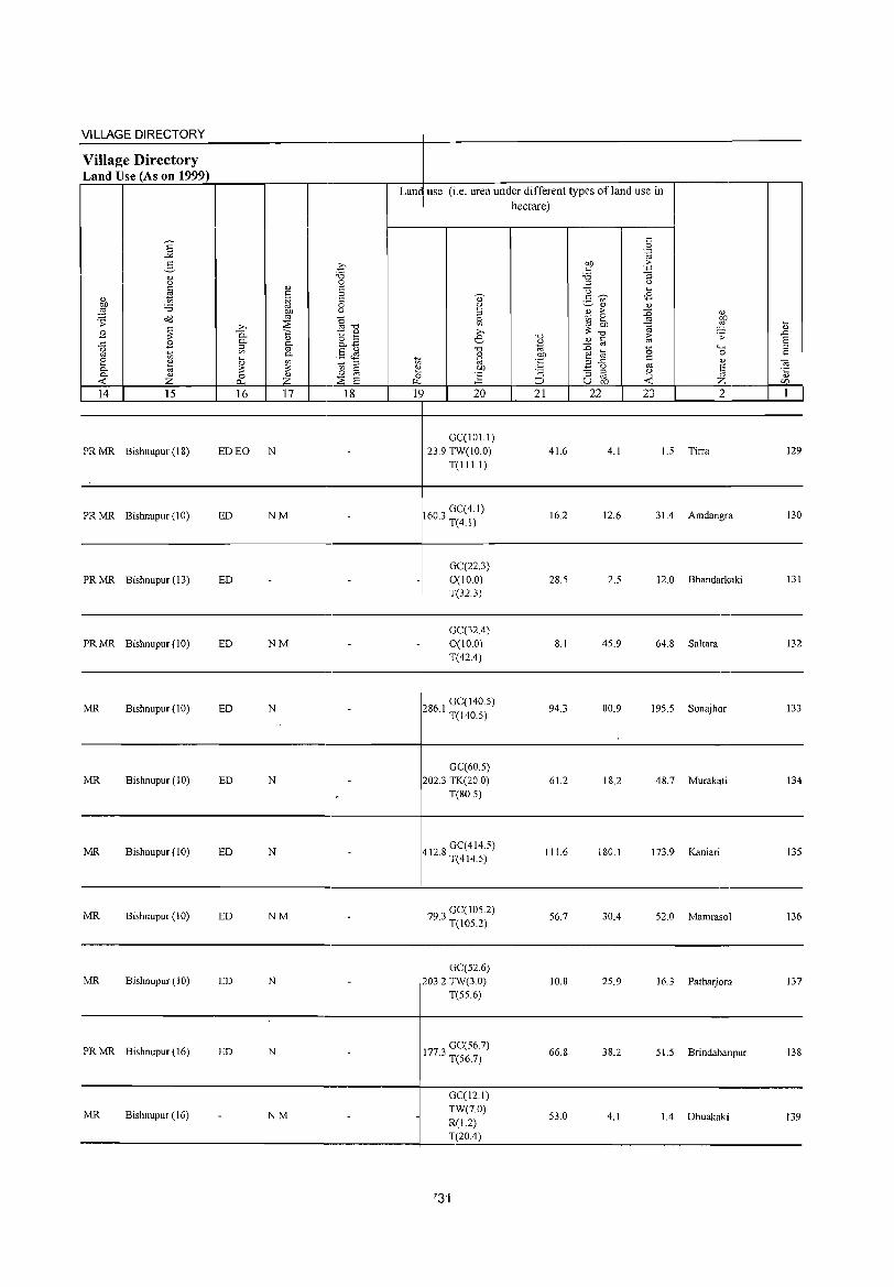
VILLAGE DIRECTORY ~~~~~--------------------------~-----------------------------------------Village Directory Land Use (As on 1999)
Land use (i.e. area under different types ofland use in hectare)
----------------------------------------4---------------------------------------------
PR MR Bishnupur (18) ED EO N
PR MR Bishnupur (10) ED NM
PR MR Bishnupur (13) ED
PRMR Bishnupur(IO) ED NM
GCCIOl.l) 23.9 TW(IO.O)
T(I I 1.I)
1603 GCC4.1) · T(4.1)
GCC22.3) 0(10.0) T(32.3)
GCC32.4) 0(10.0) T(42.4)
41.6
16.2
28.5
8.1
4.1 1.5 Tirra 129
12.6 31.4 Amdangra 130
2.5 12.0 Bhandarkaki 131
45.9 64.8 Saltara 132
------------------------------------------------~-----------------------------------------------------
MR Bishnupur (10) ED N 286 I GCCI40.5) · T(l40.5)
94.3 80.9 195.5 Sonajhor 133
----------------------------------------+---------------------------------------------
MR Bishnupur (10) ED N GCC60.5)
202.3 TK(20.0) T(80.5)
61.2 18.2 48.7 Murakati 134
----------------------------------------4---------------------------------------------
MR Bishnupur (10) ED N
MR Bishnupur (10) ED NM
GCC414.5) 412.8 T(414.5)
79 3 GCC I 05.2) · T(l05.2)
111.6
56.7
180.1 173.9 Kaniari 135
30.4 52.0 Mamrasol 136
----------------------------------------+---------------------------------------------
MR Bishnupur (l0) ED
PRMR Bishnupur(16) ED
MR Bishnupur (16)
N
N
NM
GCC52.6) 203.2 TW(3.0)
T(55.6)
1773 GCC56.7) · T(56.7)
GCCI2.1)
10.8 25.9 16.3 Patharjora 137
66.8 38.2 51.5 Brindabanpur 13&
53.0 4.1 1.4 Dhuakaki 139 TW(7.0) R(1.2) T(20.4)
---------------------------.----------4--~:~~-----------------------------------
'3'1
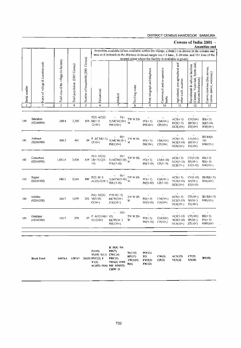
140
141
142
143
144
145
2
Sabrakon
(02244800)
Asthasol (02244900)
Gamarbani (02245000)
Rajpur (02245100)
Saldaha
(02245200)
Golakpur
(02245300)
Block Total
3
248.4
408.5
1,051.4
686.5
364.7
13S.7
34974.4
o o c:'-0:: o .~
"R o c.
~ 4
2,300
441
2,424
5,644
1,079
279
128747
DISTRICT CENSUS HANDBOOK: BANKURA
Census of India 2001 -Amenities and
Amenities available (ifnot available within the village, a dash (-) is shown in the column and next to it in brackets the distance in broad ranges viz.< 5 kms., 5-10 kms. and 10+ kms of the
nearest place where the facility_ is available is given
5 6 "1 8
V> o
0...
9
P(3) AC(2)
458 M« 5) C(10+)
- H« 5)MCW(IO+) TWWSS- 1'0«5)
PHC(IO+) W PH(10+)
- H« 94 P AC M« 5) 5) MCW(IO+) TW W SS- 1'0« 5)
C(1O+) PHC(IO+) W PH(IO+)
1'(3) AC(2) - H« 419 M« 5) C(5- 5) MCW(S-10) TW W SS- 1'0« 5)
10) PHC(5-10) W pH(S-IO)
P(2) M S - H« TWWSS-889 AC(S) C(10+) 5) MCW(S-IO) W PO« 5)
pHC(5-10) pH(S-10)
P(2) AC(2) 201 M(5-IO)
C(10+)
PHSH« 5) MCW(lO+) 1'HC(IO+)
TWWSS-W 1'0« 5)
PH(S-IO)
H(5-
57 P AC(2) M« 10) 5) C(lO+) MCW(lO+)
TWWSS-W PO« 5)
PH(5-IO) pHC(JO+)
H D(8) DA
1'(163) DH(7) WellS) M(19) S(1I) CWC(4) HP(17)
242S6 PUC(2) I PHC(4) TW(129) Tr(2) PHS(6) FWC 6 AC(82) 0(6) NH RMP(3) R()
CHW 0
732
PO(21) TO PTO(3) PH(22)
10
CM(IO+) CP(10+)
CM(IO+) CP(IO+)
II
ACS« 5) NCS« S) OCS(lO+)
12
CV(IO+) SP(10+) ST(IO+)
ACS« 5) CV(IO+) NCS(5-10) S1'(10+) OCS(10+) ST(IO+)
13
BS«5) RS(S-10) NW(IO+)
BS RS(S-10) NW(10+)
ACS« 5) CV(S-IO) BS« 5) CM(5-10) NCS(5-1O) SP(10+) RS« 5) CP(5-1O) OCS(IO+) ST(5-IO) NW(IO+)
CM(10+) Cp(S-10)
CM(IO+) CP(IO+)
CM(lO+) CP(10+)
CM(3) CP(3)
ACS« 5) CV(S-IO) BS RS« 5) NCS(5-1O) Sp(IO+) NW(IO+)
OCS(IO+) ST(5-1O)
ACS« 5) CV(10+) NCS(5-10) SP(IO+) OCS(IO+) ST(IO+)
ACS(5-1O) CV(IO+) NCS(5-1O) SP(IO+) OCS(IO+) ST(10+)
ACS(lS) NCS(3)
CV(S) SP(20)
BS RS«5) NW(lO+)
BS« 5) RS«5) NW(IO+)
BS(48)
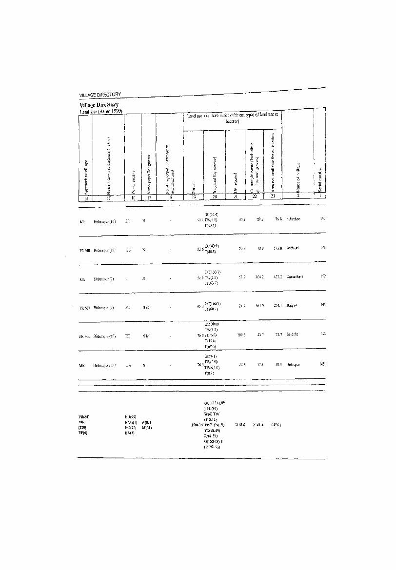
VILLAGE DiRECTORY
Village Directory Land Use (As (Ill 1999)
14 15
MR Bisrumpur (10}
PlMR BiswupufI.iO;
MR Bi,hnupur (9)
PR MR Bi'hnupm (9)
PR MR BiiJulUp",(10)
PR(M) MR [120J FJ'(6)
Bishnupur (2Q)
16 17
ED N
En
N
ED NM
ED NM
EA N
£0(99)
EAG(4) :"'(81) EO[l2) lIf(31) RA(1)
18
Land lise (i.~. area under different types of land USe in hectare)
19 2ll
XUe.oJ) 70.'1 TW(4.0)
T(4O.4)
826 GC(405) T(405)
0eI.160.7) 506 TW(3.0)
T(i637\
nJ GC(1607) 1(160.7)
GC{38.(,)
TW',5.3) 70.0 TK(Mj
0(19.0)
r(6S.0)
Ge(41)
769 W;(1.0) . TVIE(lO)
T(8.!)
GC(11131.S9 ) rC(30) \V(6)TW (l15.!!]
ln84G.1 TWE P4.l9) TK(93.4~)
R(61.5S) 0(150.48) r (ll767.111
21 22 23 2
40.S "20.2 76 <s Sabrakon
70 B 40.9 173.8 Asth&sol
50.' 3(41 411. Z Gamarbani
21.. 161.9 244.1 Rajpuf
109.3 417
20.3 12.1 18.3 Golakpur
3168.6 2741.4 6456.1
I j
~
1
1 ] C/l
1
14J
141
142
143
144
J45
Related Documents