DEMs are an integral part of any geospatial analysis. A DEM is a digital model or 3D representation of a terrain's surface - created from terrain elevation data. Geoimage's internal processing team can apply two variations of DEMs (DSM or DTM) to your satellite imagery depending on your requirements. Digital Surface Models (DSMs) represent the Earth's surface as well as all objects on it. This includes the heights of physical features such as buildings, roads and vegetation on top of the bare Earth. Digital Terrain Models (DTMs) represent the bare ground surface in which all the cultural features such as buildings and trees are removed. DEMs can be used for, but is not restricted to: DEMs DEMs Digital Elevation Models • Extracting terrain parameters • Modelling water flow or mass movement • Creation of relief maps • Terrain analysis in geomorphology and physical geography • Flood modelling • Watershed analysis • Engineering and infrastructure • Contour generation • Slope analysis for bushfire risk • Mobile network analysis Applied Spatial Intelligence Features and benefits: • Worldwide availability of satellite data without any access restrictions • Large area coverage • Resolution from very high to regional • Fast processing time

Welcome message from author
This document is posted to help you gain knowledge. Please leave a comment to let me know what you think about it! Share it to your friends and learn new things together.
Transcript
DEMs are an integral part of any geospatial analysis.
A DEM is a digital model or 3D representation of a terrain's surface - created from terrain elevation data. Geoimage's internal processing team can apply two variations of DEMs (DSM or DTM) to your satellite imagery depending on your requirements.
Digital Surface Models (DSMs) represent the Earth's
surface as well as all objects on it. This includes the
heights of physical features such as buildings, roads
and vegetation on top of the bare Earth.
Digital Terrain Models (DTMs) represent the bare
ground surface in which all the cultural features
such as buildings and trees are removed.
DEMs can be used for,but is not restricted to:
DEMsDEMsDigital Elevation
Models
• Extracting terrain parameters
• Modelling water flow or mass
movement
• Creation of relief maps
• Terrain analysis in geomorphology and
physical geography
• Flood modelling
• Watershed analysis
• Engineering and infrastructure
• Contour generation
• Slope analysis for bushfire risk
• Mobile network analysis
Applied Spatial Intelligence
Features and benefits:
• Worldwide availability of satellite
data without any access restrictions
• Large area coverage
• Resolution from very high to
regional
• Fast processing time
What Geoimage can offer you
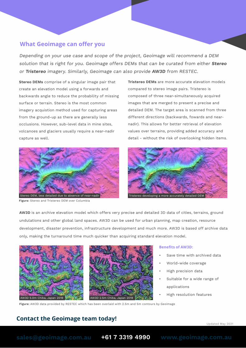
Stereo DEMs comprise of a singular image pair that
create an elevation model using a forwards and
backwards angle to reduce the probability of missing
surface or terrain. Stereo is the most common
imagery acquistion method used for capturing areas
from the ground-up as there are generally less
occlusions. However, sub-level data in mine sites,
volcanoes and glaciers usually require a near-nadir
capture as well.
Depending on your use case and scope of the project, Geoimage will recommend a DEM
solution that is right for you. Geoimage offers DEMs that can be curated from either Stereo
or Tristereo imagery. Similarly, Geoimage can also provide AW3D from RESTEC.
Tristereo DEMs are more accurate elevation models
compared to stereo image pairs. Tristereo is
composed of three near-simultaneously acquired
images that are merged to present a precise and
detailed DEM. The target area is scanned from three
different directions (backwards, fowards and near-
nadir). This allows for better retrieval of elevation
values over terrains, providing added accuracy and
detail - without the risk of overlooking hidden items.
Figure: Stereo and Tristereo DEM over Columbia
AW3D is an archive elevation model which offers very precise and detailed 3D data of cities, terrains, ground
undulations and other global land spaces. AW3D can be used for urban planning, map creation, resource
development, disaster prevention, infrastructure development and much more. AW3D is based off archive data
only, making the turnaround time much quicker than acquiring standard elevation model.
Figure: AW3D data provided by RESTEC which has been overlaid with 2.5m and 5m contours by Geoimage
• Save time with archived data
• World-wide coverage
• High precision data
• Suitable for a wide range of
applications
• High resolution features
Benefits of AW3D:
AW3D 5.0m Chiba, Japan 2019 AW3D 2.5m Chiba, Japan 2019
Stereo DEM, less detailed due to absence of near-nadir Tristereo developing a more accurately detailed DEM
Contact the Geoimage team today!
+61 7 3319 4990 www.geoimage.com.au
Updated May 2021
Related Documents