Developing effective warning systems: Ongoing research at Ruapehu volcano, New Zealand Graham S. Leonard a, ⁎ , David M. Johnston a , Douglas Paton b , Amy Christianson c,1 , Julia Becker a , Harry Keys d a GNS Science, PO Box 30368, Lower Hutt, New Zealand b University of Tasmania, School of Psychology, Bag 1-342, Launceston, Tasmania, Australia c University of Canterbury, Department of Geological Sciences, Private Bag 4800, Christchurch, New Zealand d Department of Conservation, Private Bag, Turanga Place, Turangi, New Zealand Received 31 October 2006; accepted 11 December 2007 Available online 2 May 2008 Abstract Purpose: This paper examines the unique challenges to volcanic risk management associated with having a ski area on an active volcano. Using a series of simulated eruption/lahar events at Ruapehu volcano, New Zealand, as a context, a model of risk management that integrates warning system design and technology, risk perceptions and the human response is explored. Principal results: Despite increases in the observed audibility and comprehension of the warning message, recall of public education content, and people's awareness of volcanic risk, a persistent minority of the public continued to demonstrate only moderate awareness of the correct actions to take during a warning and failed to respond effectively. A relationship between level of staff competence and correct public response allowed the level of public response to be used to identify residual risk and additional staff training needs. The quality of staff awareness, action and decision- making has emerged as a critical factor, from detailed staff and public interviews and from exercise observations. Staff actions are especially important for mobilising correct public response at Ruapehu ski areas due to the transient nature of the visitor population. Introduction of education material and staff training strategies that included the development of emergency decision-making competencies improved knowledge of correct actions, and increased the proportion of people moving out of harm's way during blind tests. Major conclusions: Warning effectiveness is a function of more than good hazard knowledge and the generation and notification of an early warning message. For warning systems to be effective, these factors must be complemented by accurate knowledge of risk and risk management actions. By combining the Ruapehu findings with those of other warning system studies in New Zealand, and internationally, a practical five-step model for effective early warning systems is discussed. These steps must be based upon sound and regularly updated underpinning science and be tied to formal effectiveness evaluation, which is fed back into system improvements. The model presented emphasises human considerations, the development of which arguably require even more effort than the hardware components of early warning systems. © 2007 Elsevier B.V. All rights reserved. Keywords: Ruapehu; lahar; warning; simulation; training 1. Introduction Volcanic risk is the product of human interaction with a natural physical process. It is generally accepted that public hazard education, communication and engagement of those at risk provides an essential foundation to effective risk manage- ment and the development of community resilience (Johnston et al., 1999; Johnston et al., 2000; Paton et al., 2001; Twigg, Available online at www.sciencedirect.com Journal of Volcanology and Geothermal Research 172 (2008) 199 – 215 www.elsevier.com/locate/jvolgeores ⁎ Corresponding author. Tel.: +64 4 570 8799; mobile: +64 21 306 078; fax: +64 4 570 4600. E-mail addresses: [email protected] (G.S. Leonard), [email protected] (D.M. Johnston), [email protected] (D. Paton), [email protected] (A. Christianson), [email protected] (H. Keys). 1 Present address: University of Alberta, Department of Earth & Atmospheric Sciences, 1-26 Earth Sciences Building, Edmonton, Alberta T6E 2E3, Canada. 0377-0273/$ - see front matter © 2007 Elsevier B.V. All rights reserved. doi:10.1016/j.jvolgeores.2007.12.008

Welcome message from author
This document is posted to help you gain knowledge. Please leave a comment to let me know what you think about it! Share it to your friends and learn new things together.
Transcript
Available online at www.sciencedirect.com
l Research 172 (2008) 199–215www.elsevier.com/locate/jvolgeores
Journal of Volcanology and Geotherma
Developing effective warning systems: Ongoing researchat Ruapehu volcano, New Zealand
Graham S. Leonard a,⁎, David M. Johnston a, Douglas Paton b,Amy Christianson c,1, Julia Becker a, Harry Keys d
a GNS Science, PO Box 30368, Lower Hutt, New Zealandb University of Tasmania, School of Psychology, Bag 1-342, Launceston, Tasmania, Australia
c University of Canterbury, Department of Geological Sciences, Private Bag 4800, Christchurch, New Zealandd Department of Conservation, Private Bag, Turanga Place, Turangi, New Zealand
Received 31 October 2006; accepted 11 December 2007Available online 2 May 2008
Abstract
Purpose: This paper examines the unique challenges to volcanic risk management associated with having a ski area on an active volcano. Using aseries of simulated eruption/lahar events at Ruapehu volcano, New Zealand, as a context, a model of risk management that integrates warningsystem design and technology, risk perceptions and the human response is explored.Principal results: Despite increases in the observed audibility and comprehension of the warning message, recall of public education content, andpeople's awareness of volcanic risk, a persistent minority of the public continued to demonstrate only moderate awareness of the correct actions totake during a warning and failed to respond effectively. A relationship between level of staff competence and correct public response allowed thelevel of public response to be used to identify residual risk and additional staff training needs. The quality of staff awareness, action and decision-making has emerged as a critical factor, from detailed staff and public interviews and from exercise observations. Staff actions are especiallyimportant for mobilising correct public response at Ruapehu ski areas due to the transient nature of the visitor population. Introduction ofeducation material and staff training strategies that included the development of emergency decision-making competencies improved knowledgeof correct actions, and increased the proportion of people moving out of harm's way during blind tests.Major conclusions: Warning effectiveness is a function of more than good hazard knowledge and the generation and notification of an earlywarning message. For warning systems to be effective, these factors must be complemented by accurate knowledge of risk and risk managementactions. By combining the Ruapehu findings with those of other warning system studies in New Zealand, and internationally, a practical five-stepmodel for effective early warning systems is discussed. These steps must be based upon sound and regularly updated underpinning science and betied to formal effectiveness evaluation, which is fed back into system improvements. The model presented emphasises human considerations, thedevelopment of which arguably require even more effort than the hardware components of early warning systems.© 2007 Elsevier B.V. All rights reserved.
Keywords: Ruapehu; lahar; warning; simulation; training
⁎ Corresponding author. Tel.: +64 4 570 8799; mobile: +64 21 306 078; fax:+64 4 570 4600.
E-mail addresses: [email protected] (G.S. Leonard),[email protected] (D.M. Johnston), [email protected](D. Paton), [email protected] (A. Christianson), [email protected] (H. Keys).1 Present address: University of Alberta, Department of Earth & Atmospheric
Sciences, 1-26 Earth Sciences Building, Edmonton, Alberta T6E 2E3, Canada.
0377-0273/$ - see front matter © 2007 Elsevier B.V. All rights reserved.doi:10.1016/j.jvolgeores.2007.12.008
1. Introduction
Volcanic risk is the product of human interaction with anatural physical process. It is generally accepted that publichazard education, communication and engagement of those atrisk provides an essential foundation to effective risk manage-ment and the development of community resilience (Johnstonet al., 1999; Johnston et al., 2000; Paton et al., 2001; Twigg,
200 G.S. Leonard et al. / Journal of Volcanology and Geothermal Research 172 (2008) 199–215
2002; Gregg et al., 2004). In most communities where volcanicrisk exists, risk management involves a relatively stablepopulation to whom risk communication can be directed andfor which risk management strategies can be developed overtime. This stability is, however, not always present.
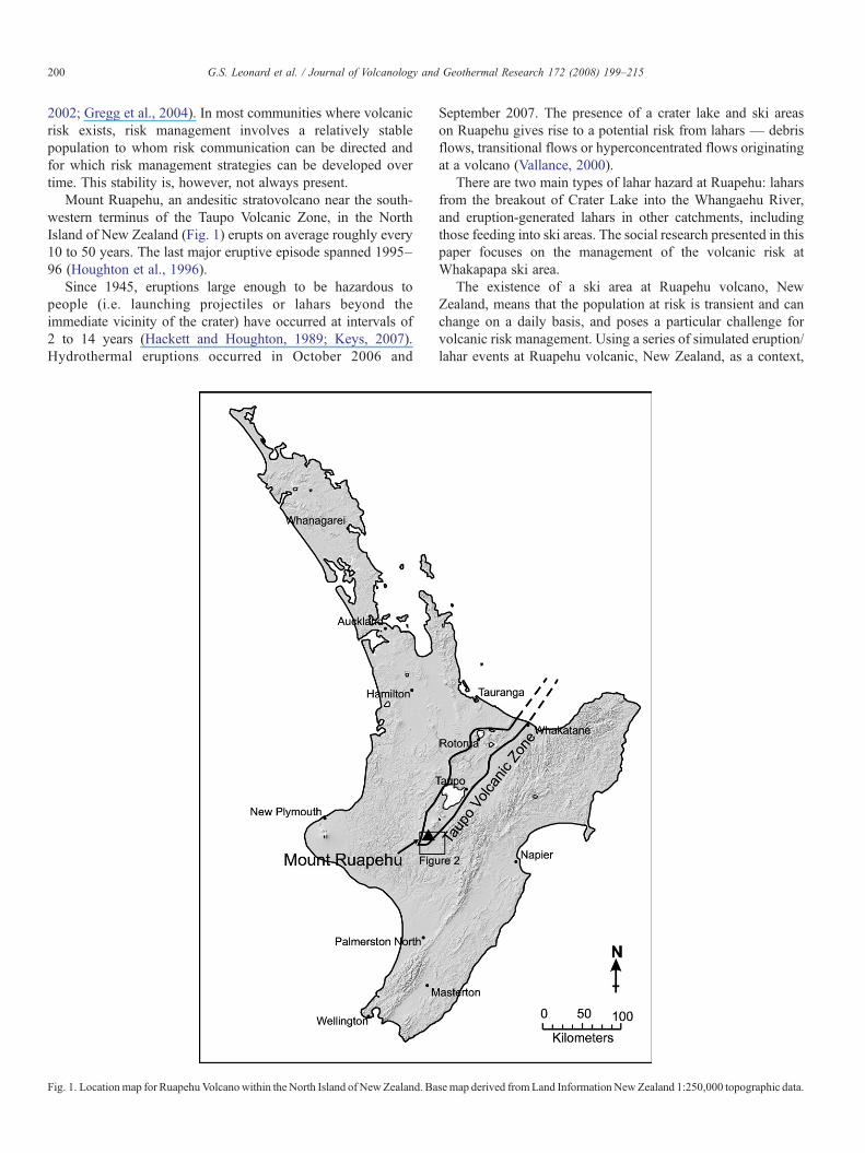
Mount Ruapehu, an andesitic stratovolcano near the south-western terminus of the Taupo Volcanic Zone, in the NorthIsland of New Zealand (Fig. 1) erupts on average roughly every10 to 50 years. The last major eruptive episode spanned 1995–96 (Houghton et al., 1996).
Since 1945, eruptions large enough to be hazardous topeople (i.e. launching projectiles or lahars beyond theimmediate vicinity of the crater) have occurred at intervals of2 to 14 years (Hackett and Houghton, 1989; Keys, 2007).Hydrothermal eruptions occurred in October 2006 and
Fig. 1. Locationmap for RuapehuVolcanowithin the North Island of NewZealand. Ba
September 2007. The presence of a crater lake and ski areason Ruapehu gives rise to a potential risk from lahars — debrisflows, transitional flows or hyperconcentrated flows originatingat a volcano (Vallance, 2000).
There are two main types of lahar hazard at Ruapehu: laharsfrom the breakout of Crater Lake into the Whangaehu River,and eruption-generated lahars in other catchments, includingthose feeding into ski areas. The social research presented in thispaper focuses on the management of the volcanic risk atWhakapapa ski area.
The existence of a ski area at Ruapehu volcano, NewZealand, means that the population at risk is transient and canchange on a daily basis, and poses a particular challenge forvolcanic risk management. Using a series of simulated eruption/lahar events at Ruapehu volcanic, New Zealand, as a context,
semap derived fromLand InformationNewZealand 1:250,000 topographic data.
201G.S. Leonard et al. / Journal of Volcanology and Geothermal Research 172 (2008) 199–215
this paper discusses how integrating warning system design andtechnology with human-response characteristics can inform thedevelopment of an effective risk management strategy. Theresults of this work are integrated with those of other warningsystem studies in New Zealand and internationally to adapt apractical model (Sections 2 and 3) of effective early warnings tothe unique situation at Ruapehu that must cater for a transientpopulation (e.g., skiers and tourists/sightseers, Sections 4through 6). The Ruapehu results also act to highlight theimportance of work beyond the generation and notification of awarning message necessary to achieving effective warningresponse.
The presence of the ski area on Ruapehu introduces twosignificant human components. One comprises those employedto run ski area operations. The other is the population of skiers.The transient nature of the latter makes them considerably moredependent on the emergency responders (i.e., ski area staff inthis case) to guide their effective response to a warning thanwould be the case in most other situations in which hazardwarning systems are developed. This paper thus brings a uniqueperspective to the risk management literature, outlining workthat has been undertaken to understand how the relationshipbetween ski area staff and the public can be incorporated intothe warning system.
In most cases where warnings systems are included involcanic risk management programs, their developmentinvolves the relationship between scientific and technical
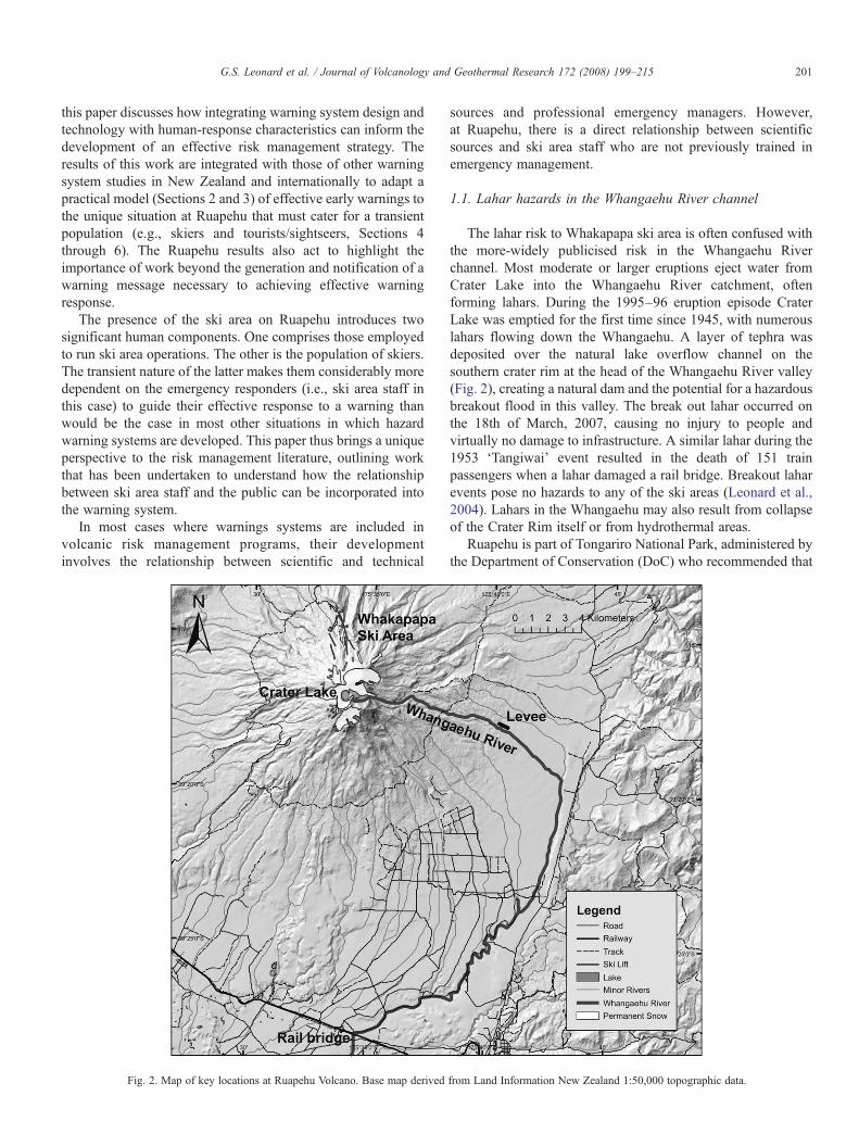
Fig. 2. Map of key locations at Ruapehu Volcano. Base map derived
sources and professional emergency managers. However,at Ruapehu, there is a direct relationship between scientificsources and ski area staff who are not previously trained inemergency management.
1.1. Lahar hazards in the Whangaehu River channel
The lahar risk to Whakapapa ski area is often confused withthe more-widely publicised risk in the Whangaehu Riverchannel. Most moderate or larger eruptions eject water fromCrater Lake into the Whangaehu River catchment, oftenforming lahars. During the 1995–96 eruption episode CraterLake was emptied for the first time since 1945, with numerouslahars flowing down the Whangaehu. A layer of tephra wasdeposited over the natural lake overflow channel on thesouthern crater rim at the head of the Whangaehu River valley(Fig. 2), creating a natural dam and the potential for a hazardousbreakout flood in this valley. The break out lahar occurred onthe 18th of March, 2007, causing no injury to people andvirtually no damage to infrastructure. A similar lahar during the1953 ‘Tangiwai’ event resulted in the death of 151 trainpassengers when a lahar damaged a rail bridge. Breakout laharevents pose no hazards to any of the ski areas (Leonard et al.,2004). Lahars in the Whangaehu may also result from collapseof the Crater Rim itself or from hydrothermal areas.
Ruapehu is part of Tongariro National Park, administered bythe Department of Conservation (DoC) who recommended that
from Land Information New Zealand 1:50,000 topographic data.
202 G.S. Leonard et al. / Journal of Volcanology and Geothermal Research 172 (2008) 199–215
no engineering intervention at the tephra barrier be allowed(Department of Conservation, 1999). Instead they recom-mended (a) the development of a warning and response system,(b) the development of revised land-use and hazard responseplans in potential lahar zones and (c) further investigation of alevee (reviewed in Hancox et al., 2001) near the spill-over pointof the Whangaehu River into the Tongariro River which drainsto Lake Taupo. Of these recommendations, the levee was com-pleted in early 2002, around the same time that the EasternRuapehu Lahar Alarm & Warning System (ERLAWS) was putin place (Section 1.3). The overall system of risk mitigation(plans, structure and other actions) is summarised by Keys(2007). This includes revised event response plans andmodification of land-use. Once the overall system was inplace the residual risk was low and intervention at the crater wasconsidered unnecessary by the Government.
The risk-mitigation planning process has been analysed indetail by Galley et al. (2004) and the following is a briefsummary from that work. Response plans have been preparedby local government and other stakeholders for areas likely tobe affected by lahars in the Whangaehu River. Some of theorganisations developed an “all-hazards” approach to responseplanning, with many components applicable to a range ofhazards, rather than planning specifically for the dam-breaklahar. More organisations will hopefully follow this approach inthe future. The all-hazard approach enhances future responsecapability, and allowed the actual break out to act as a case studyfor integrated emergency management.
The lahar response process is complicated by the geographicextent of the affected area, and the consequent multi-agencyand multi-jurisdictional context in which response will occur.Strategies that accommodate multiple entities within the warn-ing process drew on analyses of the inter-organisationalresponse conducted following the 1995 and 1996 eruptions(Paton et al., 1998; Paton et al., 1999).
The communications and coordination issues (e.g., termino-logical issues, lead agencies etc.) raised are rendered more
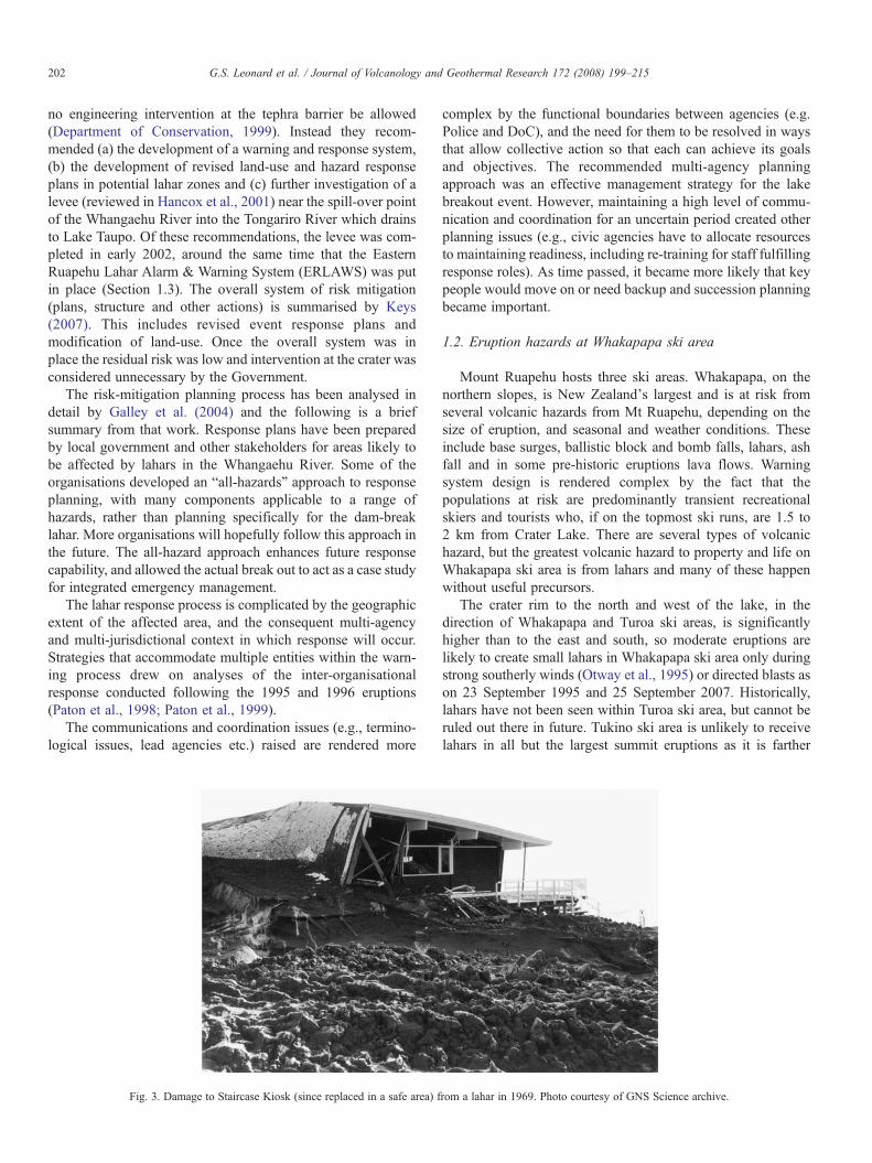
Fig. 3. Damage to Staircase Kiosk (since replaced in a safe area) f
complex by the functional boundaries between agencies (e.g.Police and DoC), and the need for them to be resolved in waysthat allow collective action so that each can achieve its goalsand objectives. The recommended multi-agency planningapproach was an effective management strategy for the lakebreakout event. However, maintaining a high level of commu-nication and coordination for an uncertain period created otherplanning issues (e.g., civic agencies have to allocate resourcesto maintaining readiness, including re-training for staff fulfillingresponse roles). As time passed, it became more likely that keypeople would move on or need backup and succession planningbecame important.
1.2. Eruption hazards at Whakapapa ski area
Mount Ruapehu hosts three ski areas. Whakapapa, on thenorthern slopes, is New Zealand's largest and is at risk fromseveral volcanic hazards from Mt Ruapehu, depending on thesize of eruption, and seasonal and weather conditions. Theseinclude base surges, ballistic block and bomb falls, lahars, ashfall and in some pre-historic eruptions lava flows. Warningsystem design is rendered complex by the fact that thepopulations at risk are predominantly transient recreationalskiers and tourists who, if on the topmost ski runs, are 1.5 to2 km from Crater Lake. There are several types of volcanichazard, but the greatest volcanic hazard to property and life onWhakapapa ski area is from lahars and many of these happenwithout useful precursors.
The crater rim to the north and west of the lake, in thedirection of Whakapapa and Turoa ski areas, is significantlyhigher than to the east and south, so moderate eruptions arelikely to create small lahars in Whakapapa ski area only duringstrong southerly winds (Otway et al., 1995) or directed blasts ason 23 September 1995 and 25 September 2007. Historically,lahars have not been seen within Turoa ski area, but cannot beruled out there in future. Tukino ski area is unlikely to receivelahars in all but the largest summit eruptions as it is farther
rom a lahar in 1969. Photo courtesy of GNS Science archive.
203G.S. Leonard et al. / Journal of Volcanology and Geothermal Research 172 (2008) 199–215
away, and is not in a direct drainage path, from the mountainsummit. Current warnings research is focusing on Whakapapaski area, but will in future expand at least to include Turoa skiarea.
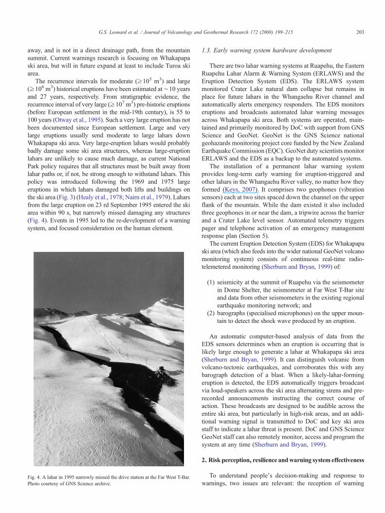
The recurrence intervals for moderate (≥105 m3) and large(≥106 m3) historical eruptions have been estimated at∼10 yearsand 27 years, respectively. From stratigraphic evidence, therecurrence interval of very large (≥107 m3) pre-historic eruptions(before European settlement in the mid-19th century), is 55 to100 years (Otway et al., 1995). Such a very large eruption has notbeen documented since European settlement. Large and verylarge eruptions usually send moderate to large lahars downWhakapapa ski area. Very large-eruption lahars would probablybadly damage some ski area structures, whereas large-eruptionlahars are unlikely to cause much damage, as current NationalPark policy requires that all structures must be built away fromlahar paths or, if not, be strong enough to withstand lahars. Thispolicy was introduced following the 1969 and 1975 largeeruptions in which lahars damaged both lifts and buildings onthe ski area (Fig. 3) (Healy et al., 1978; Nairn et al., 1979). Laharsfrom the large eruption on 23 rd September 1995 entered the skiarea within 90 s, but narrowly missed damaging any structures(Fig. 4). Events in 1995 led to the re-development of a warningsystem, and focused consideration on the human element.
Fig. 4. A lahar in 1995 narrowly missed the drive station at the Far West T-Bar.Photo courtesy of GNS Science archive.
1.3. Early warning system hardware development
There are two lahar warning systems at Ruapehu, the EasternRuapehu Lahar Alarm & Warning System (ERLAWS) and theEruption Detection System (EDS). The ERLAWS systemmonitored Crater Lake natural dam collapse but remains inplace for future lahars in the Whangaehu River channel andautomatically alerts emergency responders. The EDS monitorseruptions and broadcasts automated lahar warning messagesacross Whakapapa ski area. Both systems are operated, main-tained and primarily monitored by DoC with support from GNSScience and GeoNet. GeoNet is the GNS Science nationalgeohazards monitoring project core funded by the New ZealandEarthquake Commission (EQC). GeoNet duty scientists monitorERLAWS and the EDS as a backup to the automated systems.
The installation of a permanent lahar warning systemprovides long-term early warning for eruption-triggered andother lahars in the Whangaehu River valley, no matter how theyformed (Keys, 2007). It comprises two geophones (vibrationsensors) each at two sites spaced down the channel on the upperflank of the mountain. While the dam existed it also includedthree geophones in or near the dam, a tripwire across the barrierand a Crater Lake level sensor. Automated telemetry triggerspager and telephone activation of an emergency managementresponse plan (Section 5).
The current Eruption Detection System (EDS) for Whakapapaski area (which also feeds into the wider national GeoNet volcanomonitoring system) consists of continuous real-time radio-telemetered monitoring (Sherburn and Bryan, 1999) of:
(1) seismicity at the summit of Ruapehu via the seismometerin Dome Shelter, the seismometer at Far West T-Bar siteand data from other seismometers in the existing regionalearthquake monitoring network; and
(2) barographs (specialised microphones) on the upper moun-tain to detect the shock wave produced by an eruption.
An automatic computer-based analysis of data from theEDS sensors determines when an eruption is occurring that islikely large enough to generate a lahar at Whakapapa ski area(Sherburn and Bryan, 1999). It can distinguish volcanic fromvolcano-tectonic earthquakes, and corroborates this with anybarograph detection of a blast. When a likely-lahar-formingeruption is detected, the EDS automatically triggers broadcastvia loud-speakers across the ski area alternating sirens and pre-recorded announcements instructing the correct course ofaction. These broadcasts are designed to be audible across theentire ski area, but particularly in high-risk areas, and an addi-tional warning signal is transmitted to DoC and key ski areastaff to indicate a lahar threat is present. DoC and GNS ScienceGeoNet staff can also remotely monitor, access and program thesystem at any time (Sherburn and Bryan, 1999).
2. Risk perception, resilience andwarning systemeffectiveness
To understand people's decision-making and response towarnings, two issues are relevant: the reception of warning
204 G.S. Leonard et al. / Journal of Volcanology and Geothermal Research 172 (2008) 199–215
messages in a timely manner, and the relationship betweenwarnings and capacity to respond. It is generally assumed byemergency management agencies that warnings will be treatedat face value, accepted and acted upon. This assumption is not,however, always justified. For example, recent research ontsunami warnings (Johnston et al., 2005) found that people maychoose not to respond to warnings for several reasons, includingbeliefs regarding the avoidability of the hazard, placing a highervalue on reuniting with family, not wishing to appear foolish ifthey evacuate because of a false alarm, or assuming others willcome to their rescue no matter what happens.
Ensuring effective response to warnings at Ruapehu isfurther complicated by the transient nature of ski area visitorsand their limited familiarity with the lahar threat. In addition toconsidering the needs and expectations of the intended recip-ients of warnings, this circumstance places greater emphasis onthe role of ski area staff to guide the public response. They haveto assume this role for real in highly stressful and potentiallydangerous conditions and under conditions of uncertainty andurgency. An integral component of the warning system is theirability to function and direct the public response (who will have
Fig. 5. Effective early wa
varying levels of knowledge, may be scared or anxious forthemselves and other family members, etc.) under theseconditions (Paton et al., 2005).
The management of natural hazard risk relies on balancingthree risk reduction strategies: (1) land-use planning and buildingcodes; (2) effective early warning systems; and (3) natural processmodification (e.g. engineering solutions such as levees). Themostresilient strategy cannot be achieved without comprehensiveawareness of both the advantages and the limitations of all threeduring the initial risk reduction strategy development process.There is a common reliance on early warning systems (with avariety of definitions and scopes depending on the mental modelof those proposing it) in lieu of changes to land-use planning andbuilding codes, often because the latter are considered to be verydifficult, undesirable, or uneconomic. This has happened to alarge extent at the Ruapehu ski areas, where the desire to maintainaccess to skiing results in relatively high-risk land-use andtherefore a strong reliance on early warning systems (and someuse of building codes, with some at risk buildings, lift structuresand queue areas moved). The danger in the Ruapehu case is thatthe reliance on an early warning system always produces some
rning systems model.
205G.S. Leonard et al. / Journal of Volcanology and Geothermal Research 172 (2008) 199–215
residual risk, particularly as many of those required to respondwill be unfamiliar with the hazard and how to respond to it.
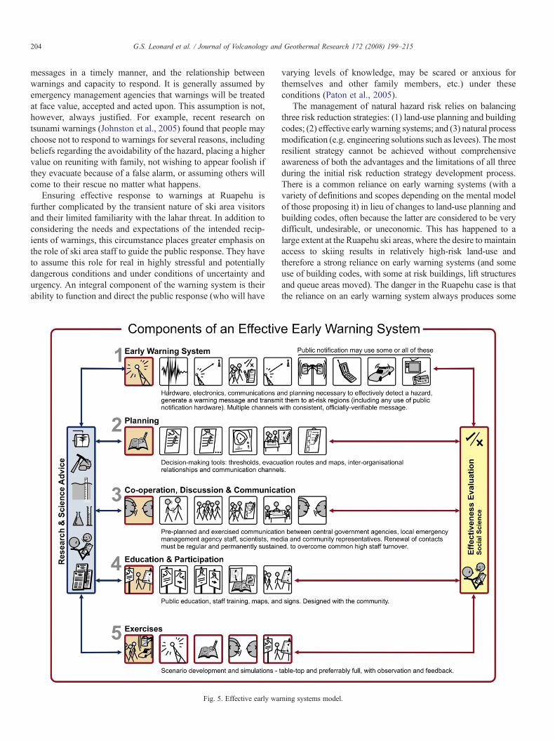
3. Effective early warning systems: developing a practicalfive-step model
An effective warning system must be underpinned by good(a) natural process and hazard event research (e.g., identifyingthe source and nature of the lahar risk in a specific area); and(b) impact research (e.g., hazardmaps) and vulnerability research.Globally, the proportion of this latter ‘applied’ research publishedis greatly outweighed by the volume of the former ‘pure’ research(Chester et al., 2002). At Ruapehu, a range of natural processesand hazard event research has been undertaken (e.g. summarisedand analysed in Otway et al., 1995; Hancox et al., 2001) tocomplement the applied research presented here. It is to a dis-cussion of this applied work that the paper now turns.
Earlywarning research has increasingly recognised the need for‘people-centred warning systems’ (e.g., Basher, 2006; Gurstein,2005). Basher (2006) argues that linear warnings systems areinherently limited in their effectiveness due to the chain betweenpeople and the hazard which they visualise as a warning system.Basher promotes an integrated (non-linear) systemsmodel of earlywarning systems including political-administrative supportingentities, the district and community actors and the researchcommunity, with multiple linkages and feedback lines betweencomponents. The situation at Ruapehu is further complicated bythe transient nature of those likely to be on the mountain (e.g.,recreational skiers, tourists), most of whom are not members of theformal clubs that form one basis of the organized communityresponse. In communities at risk from several hazards, it isessential to consider the implementation of a warning system in anall-hazards context (Paton, 2003; Basher, 2006). Leonard et al.(2006a) discuss the New Zealand all-hazard National WarningSystem context within which Ruapehu warnings fit.
A practical five-step process for the development of effectiveearly warning systems is presented in Fig. 5, which is closelyaligned with Basher's (2006) theoretical integrated systemsmodel. By drawing upon the results of the social research atRuapehu described in this paper, this model is adapted to suit themanagement of the lahar risk on the ski area. The model places aheavy emphasis on social relationship factors (e.g., integratingtechnical requirements with cooperation and communicationrather than the communication hardware alone), participation,education (and thus improved risk perception), exercising andevaluation. These are the most critical and most often over-looked or underemphasised aspects of achievingwarning systemeffectiveness (Sorensen, 2000; OEM and ODGAMI, 2001;Paton et al., 2001; Twigg, 2002; Mileti et al., 2004; Paton et al.,2005). The 2000 eruption of Mount Usu, Hokkaido, Japanprovides a good example of a community where a long-termcooperative approach consistent with this five-step model led tohighly effective eruption evacuation (refer to Okada et al., 2006).
This model is currently in effect for both the EDS andERLAWS warning systems at Ruapehu, and in other hazardcontexts including New Zealand all-hazard regional warningsystems, and New Zealand's national tsunami preparedness
plan. It has been well-received by emergency managementstakeholders as clear and easy to follow. However, the presenceof a transient at risk population at Ruapehu makes it necessary toadapt this model to accommodate the unusual aspects of thewarning context (e.g., public unfamiliarity, management by skiarea staff rather than professional emergency managers) atRuapehu. The model was presented as part of the proceedings ofthe United Nations International Strategy for Disaster Reduction(UN/ISDR) Third International Conference on Early Warnings(March 27–29, 2006, Bonn, Germany). It is consistent with thestrategic questions set out as ‘four elements of effective warningsystems’ by the UN/ISDR Platform for the Promotion of EarlyWarnings (UN/ISDR-PPEW, 2005), the recommendations of theGlobal Survey of Early Warning systems (UN/ISDR, 2006), and‘Developing Early Warning Systems: A Checklist’ (UN/ISDR-PPEW, 2006). Emergency management practitioners havecommented that provision of cartoons within the model en-hances its accessibility, providing for reinforcement of the keyconcepts, especially across languages.
3.1. Step 1: early warning hardware and public notification
Early warning and notification hardware is probably whatmost people associate with a ‘warning system’. This includessystems to detect and verify an event, generate a warning mes-sage and notify people who need to make a decision based uponthat message. The components that fall into a person's definitionof a ‘warning system’ vary with their role in a community or theirexpectations about what is an appropriate response to a warning.For example, a member of the public may assume that all of thesecomponents are covered by a system and someone will phys-ically direct their actions in the event, avoiding the need for anydecision-making (Leonard et al., 2004). The further four steps(Sections 3.2 to 3.5) accommodate these interpretive issues.
Early warning infrastructure is usually critical to effectivewarning, the exception being when natural warnings occur(Gregg et al., 2007). In any case where natural warnings are apossibility there is a risk that the development of an infrastructure-based warning system will transfer responsibility away fromnatural warnings.
For the public notification system to be assured as reliablethere must be redundancy, permanently ongoing testing andmaintenance, and assured backed up power supply. (Gruntfestand Huber, 1989; OEM and ODGAMI, 2001; Darienzo et al.,2005). The majority of simulation exercises at Whakapapa haveuncovered hardware failures, prompting more regular testing ofhardware between exercises from 2004 onwards.
There has been substantial work published on the ideal contentand nature of warning messages (e.g. Mileti et al., 2004; Mileti,2004). Effective systems require clear, concise and consistentsignals and messages, with redundancy. The Partnership forPublicWarnings (PPW, 2003) concludes that an effectivewarningsystemmessages should: be focused on people at risk; be capableof reaching people irrespective of what they are doing; be easy toaccess and use; not create added risk; be reliable; provide appro-priate lead time so people can have a chance to protect themselves;and generate authenticated messages.
Table 1Key options available for public notification of early warning messages (as wellas natural warning signs), grouped into five key categories. Modified fromLeonard et al. (2006b)
Via natural warningsVia institutional staff to those in their careVia structured organisations and groups to publicVia 3rd party hardware and/or staff
Aircraft hailers/bannersAmateur radioBillboardsCall-in phone lineCell broadcastE-mailsGPS receiversPagersPolice/fire mobile PA loud-speakersPower line messagingRadio announcementRadio data systemsRoute alert (door-to-door)SMS text messagingTelephone auto-diallerTelephone treesTelevisionTourist radioWebsites/WAP etc.
Via warning-dedicated hardwareFixed PA loud-speakersFlares, explosivesMobile PA loud-speakersTone-only sirensTone-activated alert radio
206 G.S. Leonard et al. / Journal of Volcanology and Geothermal Research 172 (2008) 199–215
For warning messages to be effective they need to be clearand understandable; accurate; frequent; credible; specific to thesituation of the recipient (and user); and give specific advice onwhat the effect will be and what to do to reduce the risk from theimpending hazard event (Mileti and Sorensen, 1990; Sorensen,2000; Aguirre, 2004).
The public notification options must be carefully consideredfrom a pool of dozens of options. These broadly fall under thefive categories: via (1) natural warnings; (2) institutional staff tothose in their care; (3) structured organisations and groups topublic; (4) third party hardware and/or staff; and (5) warning-dedicated hardware (Table 1; Leonard et al., 2006b). Regarding(4) and (5), recent research in Hawaii (Gregg et al., 2007) foundthat familiarity with the routine siren tests and test frequency hasnot greatly influenced levels of understanding of the meaning ofthe siren. Similar findings emerged at Ruapehu. While someproblems may be technological and/or topographical, socialfactors such as the stress associated with hearing a warning mayaffect understanding and responsiveness to the voice message.This work reiterates the need to afford considerable importanceto (2) and (3) in warning system planning.
3.2. Step 2: effective warning system planning
Effective planning refers to the documentation of reliableplanning (with ongoing review) of all steps of the warning systemmodel, including decision-making, response roles, message
content, message dissemination lists, and communication proto-cols (Galley et al., 2004). Documented plans for the nature andfrequency of renewal of education (including maps, signage andall other tools) and engagement are necessary. Over time these canbe refined using feedback from public surveys followingexercises and warnings (Paton et al., 2003; Johnston et al.,2005; Crawford, 2006).
Response agencies should plan in writing for what can, andespecially what cannot, be expected to be included in a warningmessage and the actions that will be taken based on thatinformation at given times (Mileti and Sorensen, 1990; Webb(compiler), 2005). New underpinning research needed to improvewarning effectiveness (e.g. hazard process research, technologyimprovements for detection etc.) needs to be identified includingthe frequency and details of evaluation of the system. Evaluationat Ruapehu's ski areas has taken the form of the risk perceptionsurveys, quantitative observations of system exercises and semi-structured interviews presented in this paper. For the ERLAWSsystem, a survey of preparedness perceptions was conductedacross all response agencies, in anticipation of the dam-breakevent to provide a baseline with which to compare post-eventdebriefing. The importance of testing the human component ofthe ERLAWS response plans was evident in that early evaluationsof the system at Ruapehu showed failures at points whereassumptions were made in place of documented arrangements(especially in terms of boundaries of authority between agencies,communication weaknesses and amongst functional units withinagencies). These results led to improvements in response plansincluding backup proceedures.
Accommodating demographic diversity, and the quality of therelationship (e.g., trust) between communities and the source ofwarnings, and using this to guide community engagement wouldordinarily play a key role in planning (Voight, 1990; Gaillard,2002; Tobin and Whiteford, 2002; Becker et al., in press), but thetransient nature of the population at risk at Ruapehu makes thisuntenable. Diversity issueswere accommodated to the extent that,in addition to the response agencies and other organisations(including GNS Science and universities)involved, severalcommunity groups, such as kayakers, anglers, trampers andlocal communities, whose members may be affected by the event,were involved in the ERLAWS response-planning phase.Notwithstanding, the situation and Ruapehu poses a differentchallenge, placing more emphasis on ski area staff managing theresponse to warnings. Planning at the ski areas need toaccommodate the relationship between staff and scientific sourcesand, subsequently, between ski area staff and the public in theplanning and exercise processes.
3.3. Step 3: discussion, communication and participation
The public education at Ruapehu ski areas would not have itscurrent level of penetration without a commitment and desire todisplay, and proactively explain, education materials within themountain lodges. Members of the Ruapehu Mountain ClubsAssociation participate in the development of education mate-rials, providing input and critique. The development of all of thesystem steps at the ski areas would also not be possible without
207G.S. Leonard et al. / Journal of Volcanology and Geothermal Research 172 (2008) 199–215
the cooperation of DoC, RAL and GNS Science/GeoNet at botha management and operational staff level. For effective responseto early warning messages it is necessary to: (a) develop rela-tionships for fast and trusted communication in a warningsituation (the process described in this paragraph; (b) testcommunication channels (hardware and suitability of planning);(c) accommodate problems associated with staff turnover(Galley et al., 2004); and (d) develop media for educating atransient at risk population.
3.4. Step 4: education and engagement
While systematic evaluation research is limited (Sorensen,2000), evidence suggests that well-designed public educationinitiatives increase public hazard knowledge and warningresponsiveness. Public education through hazard/evacuationmaps, media releases (built upon engagement with the media asa partner), brochures/posters, meetings, internet resources etc. arecritical to understanding of warning system details and the rangeof suitable responses (Mileti et al., 2004). Mileti (2004) suggeststhat public education should at least address who will issue thewarning message(s), its content, its timing, and the media used tocommunicate riskmessages. It is also important to include in eachmessage what should be done in response to that warningmessage. When dealing with a transient population such as a skiarea, these activities must be complemented with training for staffwho will have to interpret warnings relevant to the area in whichthey work and for those members of the public present in theseareas. They will also have to manage the public response (andpublic reactions that can range from anger to fear and anxiety) to afar greater extent thanwould be the casewhen dealingwith a staticpopulation with greater awareness of their risk.
Training for emergency management, response and manage-rial staff must be regular and permanently sustained toovercome ongoing staff turnover (Galley et al., 2004). Theactions of staff are a key determinant on the effective responseof the public to an early warning system. Staff behaviour atRuapehu has been a key factor in the effective response of thepublic to the warning system (Christianson, 2006).
Signage plays a critical role in increasing public awareness ofhazards and warning systems, and maximising effectivenessof earlywarnings (Dengler, 2005). Signs andmaps showing hazardzones, evacuation routes and safe zones (including key hazardfacts) should all be used. Permanently scheduled checking forreplacement/maintenance is also necessary. Agreed and widelydistributed evacuationmaps are a requirement for public awarenessand effective warning response (Crawford, 2005).
Educational materials must be tailored to the community.The development of maps should carefully consider both who(e.g., infrequent users of the ski areas who may have to orientatethemselves during bad weather) will be using them and whattype of projection and map content they best comprehend. Astudy of comprehension of volcano hazard map content atSoufriere Hills Volcano, Montserrat, showed oblique aerialphotographs to be the most effective (Haynes et al., 2006),whereas a similar study at Tongariro Volcano, New Zealand(Coomer and Leonard, 2005) showed a plan-view map to be
significantly more effective than an oblique photo. This mayrelate to the different user groups — less well educated withlimited map-reading experience in the former, and hikers usingtheir own plan-view map for their trip in the latter. One mustconsider where skiers, who may have little experience of inter-preting mountain terrain or navigating, sit on this continuum.Lack of familiarity means that skiers may not be able to identifytheir position relative to safe areas, and this problem can becompounded by bad weather.
The main challenge in implementing this step to accom-modate a transient population, is how to develop the capacity ofski area staff to respond in ways that support the effectiveresponse of less frequent users of Ruapehu (e.g. visiting or first-time skiers). Because it involves the dynamic relationshipbetween people who have no contact with one another except inthe event of an eruption, the development of this capacity is onethat is best viewed as an iterative process. It is closely linked tothe fifth step in the process, exercises and tests, and the as-sociated evaluation.
3.5. Step 5: exercises and blind tests
This component is critical. Exercising and blind testing haveseparate purposes, and both are essential for any hazard thatdoes not have an annual or perhaps biannual frequency of realevents (e.g. actively erupting volcanoes such as Soufriere Hillsin Montserrat, or hurricanes). Even Baños, Ecuador, a townwhich was evacuated in 1999 and which experiences regular ashfalls, discovers many deficiencies in its evacuation effectivenesseach time they are exercised (Leonard et al., 2005).
Exercises should be undertaken regularly, preferablyannually. However, the frequency is a balance between positivemaintained readiness and awareness, and negative socialdisruption, which is a combined decision amongst warningsystem operators, response agencies and those being warned. AtWhakapapa two exercises are normally held each ski season,one early on, primarily for final training purposes, and one laterin the season primarily for evaluation. Simulations test the otherfour steps of effective warning systems: the functioning ofhardware systems; effectiveness of planning; communicationand information sharing; maps, signage and response agencytraining; and, most importantly, how effectively people areremoved from harm's way.
3.6. Effectiveness evaluation
Evaluation generally takes the form of (a) surveying of riskand response–action perceptions and (b) observations ofexercises and blind tests.Without the quantitative and qualitativedatasets acquired for Ruapehu, we would not have been able toascertain what is and is not working and what we should changein our concept of an optimally effective warning system.
Perception surveys give a glimpse of risk perception andaction intentions. The translation of these into correct decisionsand actions (or not) can be documented by the observation ofexercises. Monitoring and improvement of warning effective-ness is performed by observing simulation drills, researching
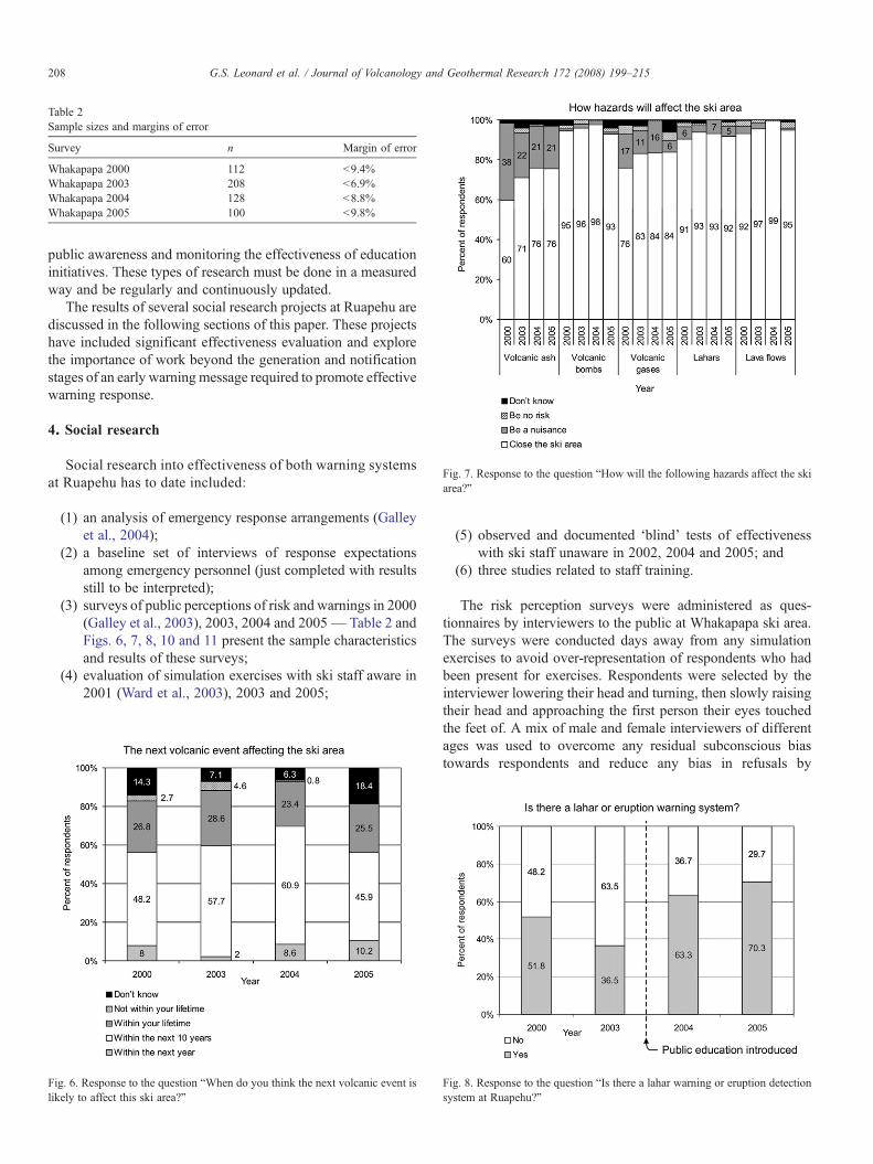
Table 2Sample sizes and margins of error
Survey n Margin of error
Whakapapa 2000 112 b9.4%Whakapapa 2003 208 b6.9%Whakapapa 2004 128 b8.8%Whakapapa 2005 100 b9.8%
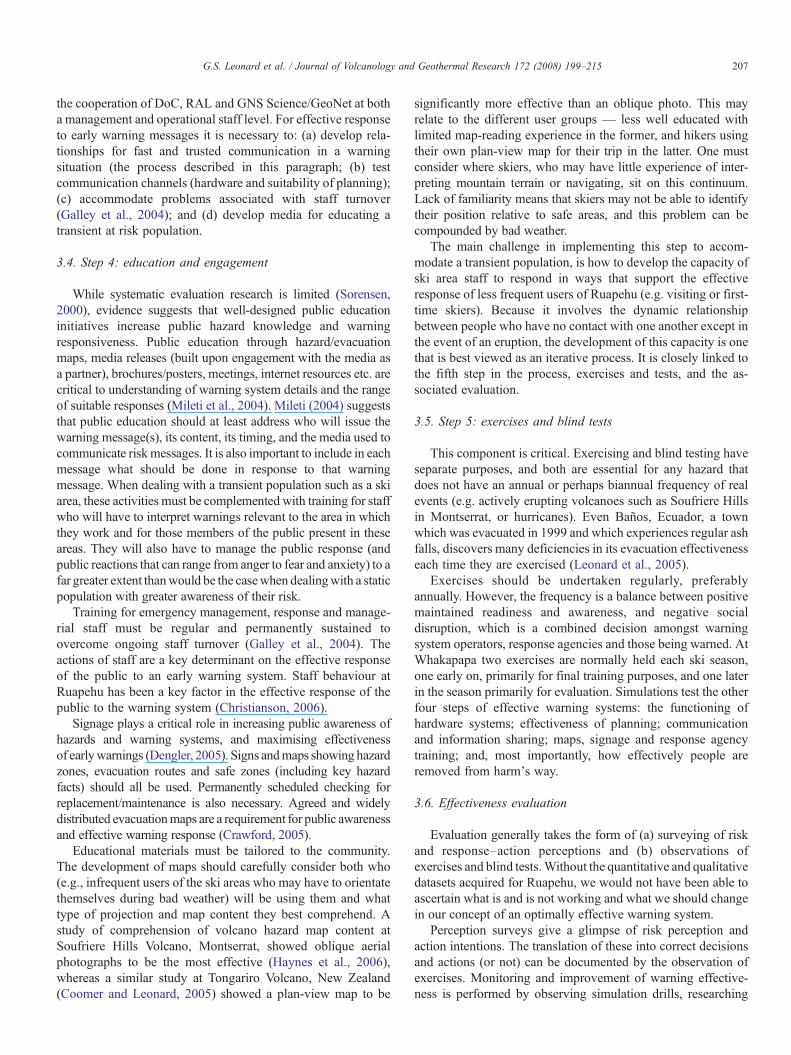
Fig. 7. Response to the question “How will the following hazards affect the skiarea?”
208 G.S. Leonard et al. / Journal of Volcanology and Geothermal Research 172 (2008) 199–215
public awareness and monitoring the effectiveness of educationinitiatives. These types of research must be done in a measuredway and be regularly and continuously updated.
The results of several social research projects at Ruapehu arediscussed in the following sections of this paper. These projectshave included significant effectiveness evaluation and explorethe importance of work beyond the generation and notificationstages of an early warning message required to promote effectivewarning response.
4. Social research
Social research into effectiveness of both warning systemsat Ruapehu has to date included:
(1) an analysis of emergency response arrangements (Galleyet al., 2004);
(2) a baseline set of interviews of response expectationsamong emergency personnel (just completed with resultsstill to be interpreted);
(3) surveys of public perceptions of risk and warnings in 2000(Galley et al., 2003), 2003, 2004 and 2005— Table 2 andFigs. 6, 7, 8, 10 and 11 present the sample characteristicsand results of these surveys;
(4) evaluation of simulation exercises with ski staff aware in2001 (Ward et al., 2003), 2003 and 2005;
Fig. 6. Response to the question “When do you think the next volcanic event islikely to affect this ski area?”
(5) observed and documented ‘blind’ tests of effectivenesswith ski staff unaware in 2002, 2004 and 2005; and
(6) three studies related to staff training.
The risk perception surveys were administered as ques-tionnaires by interviewers to the public at Whakapapa ski area.The surveys were conducted days away from any simulationexercises to avoid over-representation of respondents who hadbeen present for exercises. Respondents were selected by theinterviewer lowering their head and turning, then slowly raisingtheir head and approaching the first person their eyes touchedthe feet of. A mix of male and female interviewers of differentages was used to overcome any residual subconscious biastowards respondents and reduce any bias in refusals by
Fig. 8. Response to the question “Is there a lahar warning or eruption detectionsystem at Ruapehu?”
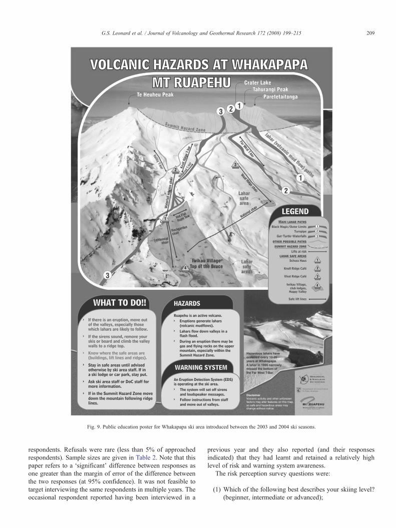
Fig. 9. Public education poster for Whakapapa ski area introduced between the 2003 and 2004 ski seasons.
209G.S. Leonard et al. / Journal of Volcanology and Geothermal Research 172 (2008) 199–215
respondents. Refusals were rare (less than 5% of approachedrespondents). Sample sizes are given in Table 2. Note that thispaper refers to a ‘significant' difference between responses asone greater than the margin of error of the difference betweenthe two responses (at 95% confidence). It was not feasible totarget interviewing the same respondents in multiple years. Theoccasional respondent reported having been interviewed in a
previous year and they also reported (and their responsesindicated) that they had learnt and retained a relatively highlevel of risk and warning system awareness.
The risk perception survey questions were:
(1) Which of the following best describes your skiing level?(beginner, intermediate or advanced);
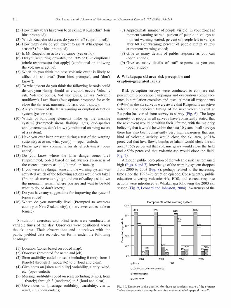
Fig. 10. Response to the question (by those respondents aware of the system)“What components make up the warning system at Whakapapa ski area?”
210 G.S. Leonard et al. / Journal of Volcanology and Geothermal Research 172 (2008) 199–215
(2) How many years have you been skiing at Ruapehu? (fourbins prompted);
(3) Which Ruapehu ski areas do you ski at? (unprompted);(4) How many days do you expect to ski at Whakapapa this
season? (four bins prompted);(5) Is Mt Ruapehu an active volcano? (yes or no);(6) Did you ski during, or watch, the 1995 or 1996 eruptions?
(circle responses(s) that apply) (conditional on knowingthe volcano is active);
(7) When do you think the next volcanic event is likely toaffect this ski area? (Four bins prompted, and ‘don'tknow’);
(8) To what extent do you think the following hazards coulddisrupt your skiing should an eruption occur? Volcanicash, Volcanic bombs, Volcanic gases, Lahars (Volcanicmudflows), Lava flows (four options prompted for each:close the ski area, nuisance, no risk, don't know);
(9) Are you aware of the lahar warning or eruption detectionsystem (yes or no);
(10) Which of following elements make up the warningsystem? (Prompted: sirens, flashing lights, loud-speakerannouncements, don't know) (conditional on being awareof a system);
(11) Have you ever been present during a test of the warningsystem?(yes or no, what year(s) — open ended);
(12) Please give any comments on its effectiveness (openended);
(13) Do you know where the lahar danger zones are?(unprompted, coded based on interviewer awareness ofthe correct answers as ‘all’, ‘some’ or ‘none’);
(14) If you were in a danger zone and the warning system wasactivated which of the following actions would you take?(Prompted: move to high ground out of valleys; ski downthe mountain, remain where you are and wait to be toldwhat to do, or don't know);
(15) Do you have any suggestions for improving the system?(open ended);
(16) Where do you normally live? (Prompted to overseascountry or New Zealand city), (interviewer codes male orfemale).
Simulation exercises and blind tests were conducted atvariable times of the day. Observers were positioned acrossthe ski area. Their observations and interviews with thepublic yielded data recorded on forms under the followingheadings:
(1) Location (zones based on coded map);(2) Observer (prompted for name and job);(3) Siren audibility coded on scale including 0 (not), from 1
(barely) through 3 (moderate) to 5 (loud and clear);(4) Give notes on [siren audibility] variability, clarity, wind,
etc. (open ended);(5) Message audibility coded on scale including 0 (not), from
1 (barely) through 3 (moderate) to 5 (loud and clear);(6) Give notes on [message audibility] variability, clarity,
wind, etc. (open ended);
(7) Approximate number of people visible [in your zone] atmoment warning started; percent of people in valleys atmoment warning started; percent of people left in valleysafter 60 s of warning; percent of people left in valleysat moment warning ended;
(8) Give as many details of public response as you can(open ended);
(9) Give as many details of staff response as you can(open ended).
5. Whakapapa ski area risk perception anderuption-generated lahars
Risk perception surveys were conducted to compare riskperception to education campaigns and evacuation compliancerates in simulation exercises and tests. Almost all respondents(N94%) in the six surveys were aware that Ruapehu is an activevolcano. The perceived timing of the next volcanic event atRuapehu has varied from survey to survey (Fig. 6). The largemajority of people in all surveys have consistently stated thatthe next event would be within their lifetime, with the majoritybelieving that it would be within the next 10 years. In all surveysthere has also been consistently very high awareness that anykind of volcanic activity would close the ski area, (N91%perceived that lava flows, bombs or lahars would close the skiarea, N76% perceived that volcanic gases would close the fieldand N59% perceived that volcanic ash would close the field;Fig. 7).
Although public perception of the volcanic risk has remainedhigh (Figs. 6 and 7), knowledge of the warning system droppedfrom 2000 to 2003 (Fig. 8), perhaps related to the increasingtime since the 1995–96 eruption episode. Consequently, publiceducation covering volcanic risk, EDS, and correct responseactions were introduced at Whakapapa following the 2003 skiseason (Fig. 9, Leonard and Johnston, 2004). Awareness of the
211G.S. Leonard et al. / Journal of Volcanology and Geothermal Research 172 (2008) 199–215
lahar warning, or EDS, by name, almost doubled at Whakapapabetween 2003 and 2004 from 34% to 63%, and increased to70% of respondents in 2005 (Fig. 8).
Amongst those aware of the warning system, the proportionof respondents who stated that the warning system involvessirens has remained high (over 84%) (Fig. 10). The proportionof respondents who also identified loud-speaker announcementsat Whakapapa decreased slightly for those surveyed atWhakapapa from 2000 to 2003 (from 59% to 57%) but rosefollowing the introduction of public education to 68% in 2004.However, it has dropped back to 57% in 2005. The proportionof respondents incorrectly stating flashing lights at Whakapapahad increased from 2000 to 2003, but dropped again in 2004and 2005. The proportion stating ‘don't know’ rose from 2003to 2004 and then dropped off slightly in 2005 (Fig. 10).
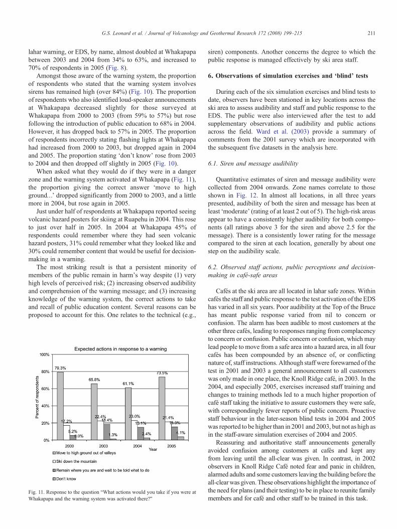
When asked what they would do if they were in a dangerzone and the warning system activated at Whakapapa (Fig. 11),the proportion giving the correct answer ‘move to highground…’ dropped significantly from 2000 to 2003, and a littlemore in 2004, but rose again in 2005.
Just under half of respondents at Whakapapa reported seeingvolcanic hazard posters for skiing at Ruapehu in 2004. This roseto just over half in 2005. In 2004 at Whakapapa 45% ofrespondents could remember where they had seen volcanichazard posters, 31% could remember what they looked like and30% could remember content that would be useful for decision-making in a warning.
The most striking result is that a persistent minority ofmembers of the public remain in harm's way despite (1) veryhigh levels of perceived risk; (2) increasing observed audibilityand comprehension of the warning message; and (3) increasingknowledge of the warning system, the correct actions to takeand recall of public education content. Several reasons can beproposed to account for this. One relates to the technical (e.g.,
Fig. 11. Response to the question “What actions would you take if you were atWhakapapa and the warning system was activated there?”
siren) components. Another concerns the degree to which thepublic response is managed effectively by ski area staff.
6. Observations of simulation exercises and ‘blind’ tests
During each of the six simulation exercises and blind tests todate, observers have been stationed in key locations across theski area to assess audibility and staff and public response to theEDS. The public were also interviewed after the test to addsupplementary observations of audibility and public actionsacross the field. Ward et al. (2003) provide a summary ofcomments from the 2001 survey which are incorporated withthe subsequent five datasets in the analysis here.
6.1. Siren and message audibility
Quantitative estimates of siren and message audibility werecollected from 2004 onwards. Zone names correlate to thoseshown in Fig. 12. In almost all locations, in all three yearspresented, audibility of both the siren and message has been atleast ‘moderate’ (rating of at least 2 out of 5). The high-risk areasappear to have a consistently higher audibility for both compo-nents (all ratings above 3 for the siren and above 2.5 for themessage). There is a consistently lower rating for the messagecompared to the siren at each location, generally by about onestep on the audibility scale.
6.2. Observed staff actions, public perceptions and decision-making in café-safe areas
Cafés at the ski area are all located in lahar safe zones. Withincafés the staff and public response to the test activation of the EDShas varied in all six years. Poor audibility at the Top of the Brucehas meant public response varied from nil to concern orconfusion. The alarm has been audible to most customers at theother three cafés, leading to responses ranging from complacencyto concern or confusion. Public concern or confusion, which maylead people to move from a safe area into a hazard area, in all fourcafés has been compounded by an absence of, or conflictingnature of, staff instructions. Although staff were forewarned of thetest in 2001 and 2003 a general announcement to all customerswas only made in one place, the Knoll Ridge café, in 2003. In the2004, and especially 2005, exercises increased staff training andchanges to training methods led to a much higher proportion ofcafé staff taking the initiative to assure customers they were safe,with correspondingly fewer reports of public concern. Proactivestaff behaviour in the later-season blind tests in 2004 and 2005was reported to be higher than in 2001 and 2003, but not as high asin the staff-aware simulation exercises of 2004 and 2005.
Reassuring and authoritative staff announcements generallyavoided confusion among customers at cafés and kept anyfrom leaving until the all-clear was given. In contrast, in 2002observers in Knoll Ridge Café noted fear and panic in children,alarmed adults and some customers leaving the building before theall-clearwas given.These observations highlight the importance ofthe need for plans (and their testing) to be in place to reunite familymembers and for café and other staff to be trained in this task.
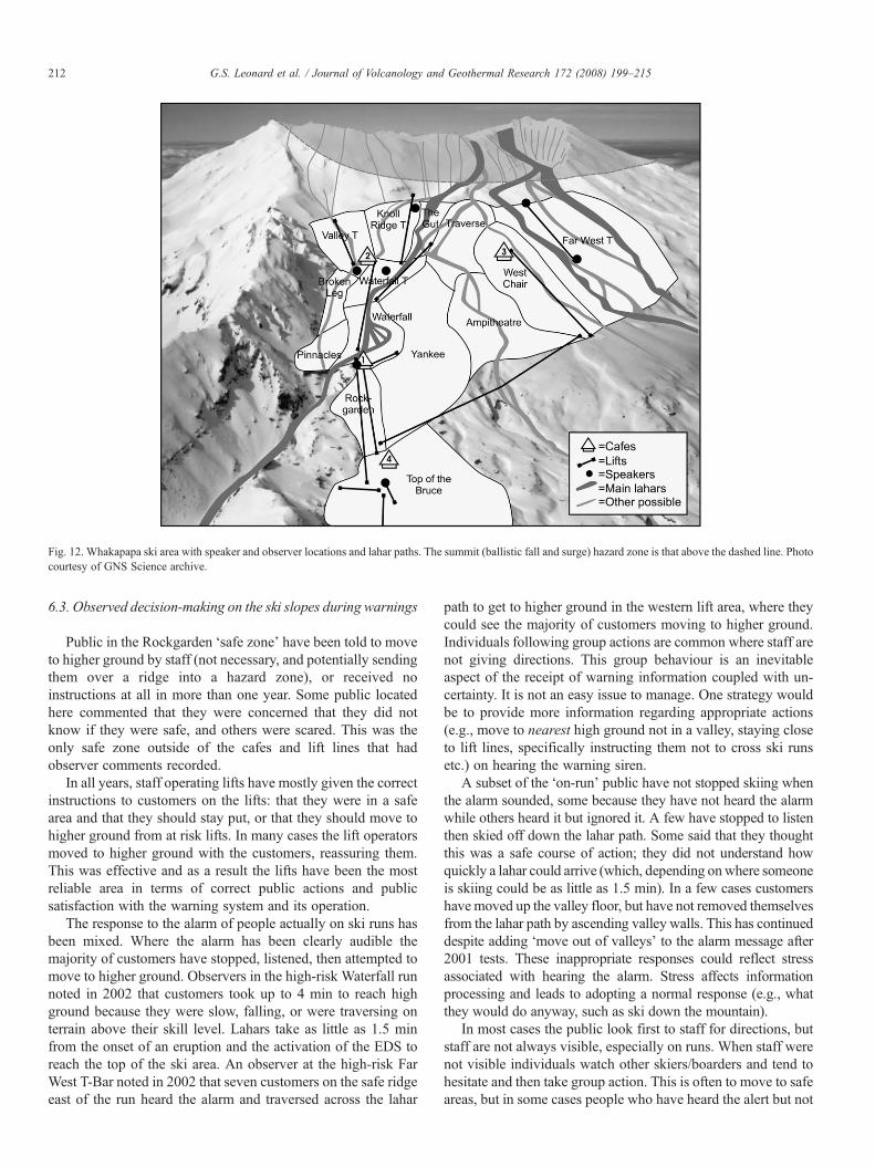
Fig. 12. Whakapapa ski area with speaker and observer locations and lahar paths. The summit (ballistic fall and surge) hazard zone is that above the dashed line. Photocourtesy of GNS Science archive.
212 G.S. Leonard et al. / Journal of Volcanology and Geothermal Research 172 (2008) 199–215
6.3. Observed decision-making on the ski slopes during warnings
Public in the Rockgarden ‘safe zone’ have been told to moveto higher ground by staff (not necessary, and potentially sendingthem over a ridge into a hazard zone), or received noinstructions at all in more than one year. Some public locatedhere commented that they were concerned that they did notknow if they were safe, and others were scared. This was theonly safe zone outside of the cafes and lift lines that hadobserver comments recorded.
In all years, staff operating lifts have mostly given the correctinstructions to customers on the lifts: that they were in a safearea and that they should stay put, or that they should move tohigher ground from at risk lifts. In many cases the lift operatorsmoved to higher ground with the customers, reassuring them.This was effective and as a result the lifts have been the mostreliable area in terms of correct public actions and publicsatisfaction with the warning system and its operation.
The response to the alarm of people actually on ski runs hasbeen mixed. Where the alarm has been clearly audible themajority of customers have stopped, listened, then attempted tomove to higher ground. Observers in the high-risk Waterfall runnoted in 2002 that customers took up to 4 min to reach highground because they were slow, falling, or were traversing onterrain above their skill level. Lahars take as little as 1.5 minfrom the onset of an eruption and the activation of the EDS toreach the top of the ski area. An observer at the high-risk FarWest T-Bar noted in 2002 that seven customers on the safe ridgeeast of the run heard the alarm and traversed across the lahar
path to get to higher ground in the western lift area, where theycould see the majority of customers moving to higher ground.Individuals following group actions are common where staff arenot giving directions. This group behaviour is an inevitableaspect of the receipt of warning information coupled with un-certainty. It is not an easy issue to manage. One strategy wouldbe to provide more information regarding appropriate actions(e.g., move to nearest high ground not in a valley, staying closeto lift lines, specifically instructing them not to cross ski runsetc.) on hearing the warning siren.
A subset of the ‘on-run’ public have not stopped skiing whenthe alarm sounded, some because they have not heard the alarmwhile others heard it but ignored it. A few have stopped to listenthen skied off down the lahar path. Some said that they thoughtthis was a safe course of action; they did not understand howquickly a lahar could arrive (which, depending onwhere someoneis skiing could be as little as 1.5 min). In a few cases customershave moved up the valley floor, but have not removed themselvesfrom the lahar path by ascending valley walls. This has continueddespite adding ‘move out of valleys’ to the alarm message after2001 tests. These inappropriate responses could reflect stressassociated with hearing the alarm. Stress affects informationprocessing and leads to adopting a normal response (e.g., whatthey would do anyway, such as ski down the mountain).
In most cases the public look first to staff for directions, butstaff are not always visible, especially on runs. When staff werenot visible individuals watch other skiers/boarders and tend tohesitate and then take group action. This is often to move to safeareas, but in some cases people who have heard the alert but not
213G.S. Leonard et al. / Journal of Volcanology and Geothermal Research 172 (2008) 199–215
received staff directions stay put in the lahar path. There is also arisk that family members will take actions to reunite themselveswith others, possibly putting themselves into the path of danger.During tests, ski patrollers have been sent down high-risk zonesto guide skiers off of the runs. This is generally effective andcustomers move in the correct direction quickly once instructed.However, in a real lahar emergency patrollers will probably notbe present in all high-risk zones. In some cases during testspatrollers have taken up to 5 min to reach the bottom of an atrisk but more distant run where a lahar will take longer to arrive.
In 2005, the first quantitative estimations were made of theproportion of people at risk and moved to safety over the courseof simulation exercises. In the staff-aware and blind testsrespectively, there were estimated to be 953 and 605 peoplevisible to observers, and 314 and 108 of those in high-risk areas;132 and 84 of these, respectively, were observed to be in thevalleys within high-risk areas. By the end of the exercises therewere still estimated to be 23 and 5 people, respectively, in thevalleys in the high-risk areas — most or all of these wouldprobably be fatalities if lahars again followed these paths. Thesefigures are rough estimates given by observers, in areas withmultiple observers their observations were averaged. Note alsothat not all parts of the ski area are visible to observers.
6.4. Staff training
During the first warning system test observed (2001), despitegeneric staff training for volcanic hazards, the rate of correctactions of staff during the exercise was low. As a result theauthors conducted three separate studies (Galley et al., 2003;Ward et al., 2003; Christianson, 2006) of staff training for laharresponse at Whakapapa.
Staff were surveyed after they received training. One findingfrom this studywas that there was a relatively good understandingof the nature of lahars, the length of time in which staff needed toact and the gravity of the risk (Christianson, 2006). However,perspectives on the nature of that risk varied. Awareness of initialstaff actions to move skiers to higher ground out of valleys wasrelatively high, but understanding of what to do following thisinitial action was limited.
These observations highlight the need to develop staffmember'sability to understand and be able to respond to public needs andexpectations. When accommodating the human dimension withtransient groups, the range of issues that can influence the effectiveresponse to warnings is both substantial and varied.
When planning for volcanic hazard management trainingtraditional approaches to training needs analysis are inappropriatesince the responses required fall well outside normal operatingparameters (e.g., the staff and public needs that can arise arepeculiar to rare eruptions events), and more innovativeapproaches are required (Paton and Flin, 1999; Paton et al.,1999; Paton, 2001). The process of eliciting public views, andassessing the degree of fit between public needs and expectationsand staff capabilities tomeet these needs, is important andmakes asubstantial contribution to identifying issues to be included insubsequent training programs for staff. Volcanic event responsetraining needs for ski area personnel was first developed byWard
et al. (2003) and expanded upon by Christianson (2006), Thefuture development of staff competencies requires incorporatingtraining needs analysis into evaluation. One approach to trainingneeds analysis was developed following the 1995–96 Ruapehueruption (Paton and Flin, 1999; Paton et al., 1999). This approachcomplements existing staff skills and knowledge with compe-tencies derived from a person, job and organisational analysisprocess (Paton and Flin, 1999; Paton et al., 1999; Paton et al.,2001; Paton and Auld, 2006) designed to ensure that staffcompetencies can manage the hazard characteristics (from bothlahar activity and the public response) encountered duringatypical volcanic episodes. The output of this process not onlyidentifies training needs, it also identifies the kinds of demands(e.g., dealing with public anxiety) that should be modelled infuture simulations. This can include simulating operational (e.g.,crisis decision-making, emergency plan implementation, delegat-ing responsibility, managing pubic anxiety) demands andensuring that the simulation contributes to developing staffcompetencies that can assist the effective performance ofemergency roles (e.g., developing stress resilience, peer support).
Whakapapa ski area is operated by Ruapehu Alpine Lifts(RAL) who share responsibility for public safety from volcanichazards with DoC. RAL have been and continue to be committedto implementing recommendations from the response-planningand training studies and have already significantly changed theirtraining methods in response to the issues identified in the studiesdiscussed here.
7. Conclusions
There is a substantial amount of work, beyond the generationand notification of an early warning message, required to achievean optimum rate of correct decision-making and action based uponthat warning. The practical five-step model discussed here foreffective warning systems emphasises these additional consid-erations,which arguably require evenmore effort than the hardwarecomponent of earlywarning systems.Wehave seen atRuapehu thathigh levels of risk perception, or even understanding of the correctactions to take, do not necessarily lead to optimum effectiveness.
Accurate risk perception and the knowledge and motivationneeded to act correctly on a warning message have been shown atWhakapapa ski area to be positively correlated to the human-response-focused Steps 2 through 5 of the model; especially theprovision of public education and appropriate staff actions. Apersistent minority of the public who do not respond correctly hasbeen seen from the evaluation of regular exercises; these peoplemay benefit from improvements in the actions of staff. Evaluationof all aspects of the warning system has been essential and has fedback into and improved the risk management process.
While accurate risk perception is important, and should remaina focus for public outreach, additional attention is required todevelop the capacity of ski area staff to direct the responseprocess. The need for further work on this topic emerged fromevaluation of simulated emergencies, but not, as yet, fromresponse to an actual lahar threat. The blind tests reported on heredo not fully emulate the psychological stress that members of thepublic and ski area staff would experience. The significance of
214 G.S. Leonard et al. / Journal of Volcanology and Geothermal Research 172 (2008) 199–215
accommodating the latter in future planning stems from the im-pact that stress has on the performance of emergency roles (Patonand Flin, 1999). The actual response environment would beconsiderably more challenging than the simulated one. While it isnot possible to manage this aspect in members of the public, it ispossible to do so for staff. Future training can address the devel-opment of operational (e.g., crisis decision-making, emergencyplan implementation, delegating responsibility, managing pubicanxiety etc.) competencies and developing stress resilience (Patonand Flin, 1999; Paton and Auld, 2006). At Whakapapa, the mostimportant staff response (the primary interface between staff andskiers) has been seen to be that of lift operators, and as a resulttraining has subsequently been focussed in this area.
Sustaining and improving a warning system in the long termis one of the largest challenges (Twigg and Lavell, 2006) to thesuccessful implementation of a warning system. Ongoingcommitment to, and evaluation and improvement of, the five-step model described here will make a substantial contributionto managing volcanic hazard risk at Ruapehu.
Acknowledgements
This manuscript benefited from the constructive reviews andrecommendations of J. Ewert and one anonymous reviewer. Theauthors appreciated the partnership and support of RuapehuAlpine Lifts and the Ruapehu Mountain Clubs Association(Inc.). The research at Ruapehu was funded by the Foundationfor Research Science and Technology with contribution fromthe Department of Conservation.
References
Aguirre, B., 2004. Homeland security warnings: lessons learned and unlearned.International Journal of Mass Emergencies and Disasters 22, 103–115.
Basher, R., 2006. Global early warning systems for natural hazards: systematicand people-centred. Philosophical Transactions of the Royal Society A 364,2167–2182.
Becker, J., Johnston, D., Lazrus, H., Crawford, G., Nelson, D., in press. Use oftraditional knowledge in emergency management for tsunami hazard: a casestudy from Washington State in the Pacific Northwest. Disaster Preventionand Management.
Chester, D.K., Dibben, C.J.L., Duncan, A.M., 2002. Volcanic hazard assessmentin western Europe. Journal of Volcanology & Geothermal Research 115,411–435.
Christianson, A.N., 2006. Assessing and improving the effectiveness of stafftraining and warning system response at Whakapapa and Turoa ski areas,Mt. Ruapehu. M.Sc. Thesis, University of Canterbury, Christchurch.
Coomer, M.A., Leonard, G.S., 2005. Tongariro crossing hazard awarenesssurvey: public perceptions of the volcanic hazard danger. Science Report2005/37. Institute of Geological & Nuclear Sciences, Lower Hutt.
Crawford, G., 2005. Tsunami ready communities: no overnight solution. NaturalHazards Observer 5–6.
Crawford, G.L., 2006. Developing tsunami ready communities: translatingscientific research into useable emergency management products, Proceed-ings of the 8th U.S. National Conference on Earthquake Engineering, April18–22, 2006. Earthquake Engineering Research Institute, San Francisco,CA, USA.
Darienzo, M., Aya, A.L., Crawford, G.L., Gibbs, D., Whitmore, P.M., Wilde, T.,Yanagi, B.S., 2005. Local tsunami warning in the pacific coastal UnitedStates. Natural Hazards 35, 111–119.
Dengler, L., 2005. The role of education in the National Tsunami HazardMitigation Program. Natural Hazards 35, 141–153.
Department of Conservation, 1999. Environmental and risk assessment for themitigation of the hazards from Ruapehu Crater Lake. Assessment ofEnvironmental Effects Report. Department of Conservation, Turangi.
Gaillard, J.C., 2002. Territorial and ethno-cultural implications of a volcanic crisis:the Mount Pinatubo (Philippines) 1991 eruption. Annales de Geographie 627,574–591.
Galley, I., Leonard, G.S., Johnston, D.M., Balm, R., Paton, D., 2004. TheRuapehu lahar emergency response plan development process: an analysis.Australasian Journal of Disaster and Trauma Studies 2004–1, 1–33.
Galley, I., Paton, D., Johnston, D., Becker, J., 2003. Lahar response management atWhakapapa Ski Field, Ruapehu: staff development and public safety. ScienceReport 2003/6. Institute of Geological and Nuclear Sciences, Lower Hutt.
Gregg, C.E., Houghton, B.F., Paton, D., Johnston, D.M., Swanson, D.A.,Yanagi, B.S., 2007. Tsunami warnings: understanding in Hawai'i. NaturalHazards 40, 71–87.
Gregg, C.E., Houghton, B.F., Paton, D., Swanson, D.A., Johnston, D.M., 2004.Community preparedness for lava flows from Mauna Loa and Hualālaivolcanoes, Kona, Hawai'i. Bulletin of Volcanology 66, 531–540.
Gruntfest, E.C., Huber, C., 1989. Status report on flood warning systems in theUnited States. Environmental Management 13, 279–286.
Gurstein, M., 2005. Tsunami warning systems and the last mile towardscommunity based and ICTenabled disaster response systems. The Journal ofCommunity Informatics 1, 14–17.
Hackett, W.R., Houghton, B.F., 1989. A facies model for a Quaternary andesiticcomposite volcano: Ruapehu, New Zealand. Bulletin of Volcanology 51, 51.
Hancox, G.T., Keys, H.J.R., Webby, M.G., 2001. Assessment and mitigation ofdam-break lahar hazards fromMr Ruapehu Crater Lake following the 1995–96 eruptions. Proceedings of Technical Groups 29: Proceedings of theGeotechnical Society 2001 Symposium, Christchurch, New Zealand.IPENZ, Wellington, pp. 385–408.
Haynes, K., Barclay, J., Lake, I., Pidgeon, N., 2006. An evaluation of volcanichazard maps as a communication tool. Proceedings, Cities on Volcanoes 4,Quito, Ecuador.
Healy, J., Lloyd, E.F., Rishworth, D.E.H., Wood, C.P., Glover, R.B., Dibble, R.R.,1978. The eruption ofRuapehu,NewZealand, on 22 June 1969. Department ofScientific and Indistrial Research Bulletin 224, Lower Hutt. 80 pp.
Houghton, B.F., Neall, V.E., Johnston, D.M., 1996. Eruption: Mount Ruapehuawakes. Penguin Books (NZ) Ltd, Auckland. 48 pp.
Johnston, D., Paton, D., Crawford, G.L., Ronan, K., Houghton, B., Burgelt, P.,2005. Measuring tsunami preparedness in Coastal Washington, UnitedStates. Natural Hazards 35, 173.
Johnston, D.M., Bebbington, M.S., Lai, C.D., Hougthon, B.F., Paton, D., 1999.Volcanic hazard perceptions: comparative shifts in knowledge and risk.Disaster prevention and management 8, 118–126.
Johnston, D.M., Houghton, B.F., Neall, V.E., Ronan, K.R., Paton, D., 2000.Impacts of the 1945 and 1995–1996 Ruapehu eruptions, New Zealand: anexample of increasing societal vulnerability. Geological Society of AmericaBulletin 112, 720–726.
Keys, H.J.R., 2007. Lahars of Ruapehu Volcano, New Zealand, and riskmitigation. Annals of Glaciology 45, 155–162.
Leonard, G.S., Johnston, D.M., 2004.Volcanic hazards atWhakapapa,MtRuapehu.unpublished brochure/map. Institute of Geological and Nuclear Sciences,Lower Hutt.
Leonard, G.S., Johnston, D.M., Paton, D., 2006a. Effective all-hazard warningsystem development and community resilience: Results from ongoing multi-hazard research in New Zealand, USA and Australia., Proceedings,International Conference on Early Warnings III, 27–29 March 2006. UnitedNations International Strategy for Disaster Reduction, Bonn, Germany.
Leonard, G.S., Johnston, D.M., Saunders, W., Paton, D., 2006b. Assessment ofAuckland Civil Defence and Emergency Management Group warning systemoptions. Science Report 2006/02. Institute of Geological & Nuclear Sciences,Lower Hutt.
Leonard, G.S., Johnston, D.M., Williams, S., Cole, J.W., Finnis, K., Barnard, S.,2005. Impacts and management of recent volcanic eruptions in Ecuador:lessons for New Zealand. Science Report 2005/20. Institute of Geological &Nuclear Sciences, Lower Hutt.
Leonard, G.S., Kelman, I., Johnston, D.M., 2004. Residential impacts,perceptions and preparedness related to the Lower Hutt City February
215G.S. Leonard et al. / Journal of Volcanology and Geothermal Research 172 (2008) 199–215
2004 flooding: preliminary results. Science Report 2004/38. Institute ofGeological & Nuclear Sciences, Lower Hutt.
Mileti, D., Nathe, S., Gori, P., Greene, M., Lemersal, E., 2004. Public HazardsCommunication and Education: The State of the Art. Natural HazardsInformer, Issue 2, Boulder.
Mileti, D.S., 2004. Communicating emergency public information. Notes fromTraining Course, Revision 2. Natural Hazards Center, Boulder.
Mileti, D.S., Sorensen, J.H., 1990. Communication of emergency publicwarnings. Oak Ridge National Laboratory, Oak Ridge.
Nairn, I.A., Wood, C.P., Hewson, C.A.Y., 1979. Phreatic eruptions of Ruapehu:April 1975. New Zealand Journal of Geology and Geophysics 22, 155–173.
OEM & ODGAMI, 2001. Tsunami Warning Systems and Procedures guidancefor local officials. Special Paper 35. Oregon EmergencyManagement (OEM)and Oregon Department of Geology and Mineral Industries (ODGAMI),Portland.
Okada, H., Mimatsu, S., Sato, T., Ebina, T., Tanabe, T., 2006. Decades-longCultural Activities forMitigating Volcanic Hazards, and Their Consequencesat the 2000 Mt. Usu Eruption, Japan. Proceedings, Cities on Volcanoes 4.Quito, Ecuador.
Otway, P.M., Hodgson, K.A., Nairn, I.A., 1995. Whakapapa ski fields laharstudy. Science Report 1995/39. Institute of Geological and NuclearSciences, Lower Hutt.
Paton, D., 2001. Crisis Information & Decision Management in EmergencyOperations Centres: A new approach to assessing training needs. ReportACC/EOC-2001/1. Auckland City Council, Auckland.
Paton, D., 2003. Disaster preparedness: a social-cognitive perspective. DisasterPrevention and Management 12, 210–216.
Paton, D., Auld, T., 2006. Resilience in emergency management: managing theflood. In: Paton, D., Johnston, D. (Eds.), Disaster Resilience: An integratedapproach. Charles C. Thomas, Springfield, IL, pp. 267–287.
Paton, D., Flin, R., 1999. Disaster stress: an emergency managementperspective. Disaster Prevention and Management 8, 261–267.
Paton, D., Johnston, D., Houghton, B., 1998. Organisational responses to avolcanic eruption. Disaster Prevention and Management 7, 5–13.
Paton, D., Johnston, D., Houghton, B., Becker, J., Crumbie, G., 2003. Tsunamipreparedness in coastal Washington State. Journal of the American Societyof Professional Emergency Managers 10, 97–108.
Paton, D., Johnston, D., Houghton, B., Flin, R., Ronan, K., Scott, B., 1999.Managing natural hazard consequences: informationmanagement and decisionmaking. Journal of theAmerican Society of Professional EmergencyManagers6, 37–48.
Paton, D., Millar, M., Johnston, D.M., 2001. Community resilience to volcanichazard consequences. Natural hazards 24, 157–169.
Paton, D., Smith, L.M., Johnston, D., 2005. When good intentions turn bad:promoting natural hazard preparedness. Australian Journal of EmergencyManagement 20, 25–30.
Partnership for Public Warning (PPW), 2003. A National Strategy for IntegratedPublic Warning Policy and Capability. Report 2003-01. Partnership forPublic Warning, McLean, VA.
Sherburn, S., Bryan, C.J., 1999. The eruption detection system; Mt. Ruapehu,New Zealand. Seismological Research Letters 70, 505–511.
Sorensen, J.H., 2000. Hazard warning systems: review of 20 years of progress.Natural Hazards Review 1, 119–125.
Tobin, G.A., Whiteford, L.M., 2002. Community resilience and volcano hazard:the eruptions of Tungurahua and evacuation of the Faldas in Ecuador.Disasters 26, 28–48.
Twigg, J., 2002. The human factor in early warnings: risk perception andappropriate communications. In: Zschau, J., Kuppers, A.N. (Eds.), Earlywarning systems for natural disaster reduction. Springer, Berlin, pp. 19–26.
Twigg, J., Lavell, J., 2006. Disaster Early Warning Systems: People, Politics andEconomics. Disaster Studies Working Paper 16. Benfield Hazard ResearchCentre, London.
UN/ISDR Platform for the Promotion of Early Waring (UN/ISDR-PPEW),2005. The International Early Warning Programme (IEWP). United NationsInternational Strategy for Disaster Reduction (UN/ISDR), Bonn.
UN/ISDR Platform for the Promotion of Early Waring (UN/ISDR-PPEW),2006. Developing Early Warning Systems: A Checklist. United NationsInternational Strategy for Disaster Reduction (UN/ISDR), Bonn.
United Nations International Strategy For Disaster Reduction (UN/ISDR), 2006.Global Survey of Early Warning Systems. United Nations InternationalStrategy for Disaster Reduction (UN/ISDR), Geneva.
Vallance, J.W., 2000. Lahars. In: Sigurdsson, H., Houghton, B., McNutt, S.,Rymer, H., Stix, J. (Eds.), Encyclopedia of Volcanoes. Academic Press, SanDiego, CA, pp. 601–616.
Voight, B., 1990. The 1985 Nevado del Ruiz volcano catastrophe: anatomy andretrospection. Journal of Volcanology & Geothermal Research 44, 349–386.
Ward, R., Paton, D., Johnston, D., Becker, J., 2003. Whakapapa Ski Field,Ruapehu lahar warning system: A review of training issues. Science Report2003/7. Institute of Geological and Nuclear Sciences, Lower Hutt.
Webb (compiler), T.H., 2005. Review of New Zealand's preparedness for tsunamihazard, comparison to risk and recommendations for treatment. Science Report2005/162. Institute of Geological and Nuclear Sciences, Lower Hutt.
Related Documents