Geomatics A solution SOS I nostri contatti Geomatics for disaster management and survey Tiziano Cosso Genoa, 30 October 2013

Welcome message from author
This document is posted to help you gain knowledge. Please leave a comment to let me know what you think about it! Share it to your friends and learn new things together.
Transcript

Geomatics A solution SOS I nostri contatti
Geomatics for disaster management and survey
Tiziano Cosso
Genoa, 30 October 2013
Geomatics A solution SOS I nostri contatti
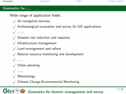
Geomatics for.....
Wide range of application fields:√
Air navigation services√
Archaeological excavation and survey for GIS applications√
.......√
Disaster risk reduction and response√
Infrastructure management√
Land management and reform√
Natural resource monitoring and development√
......√
Urban planning√
......√
Meteorology√
Climate Change-Environmental Monitoring
1 / 22
Geomatics for disaster management and survey
Geomatics A solution SOS I nostri contatti
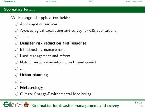
In recents years....
two aspects influence the approach to geomatics
Open data and Crowdmapping
⇓
⇓
Data are updated and updatablenear real time
large amount of any kind ofsensors in our cities
⇓
⇓there are many real-time
information that would be usefulto be gathered and organized
2 / 22
Geomatics for disaster management and survey

Geomatics A solution SOS I nostri contatti
Open data and Crowdmapping
google map is considered.....historical map
3 / 22
Geomatics for disaster management and survey
Geomatics A solution SOS I nostri contatti
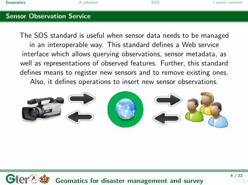
Sensor Observation Service
The SOS standard is useful when sensor data needs to be managedin an interoperable way. This standard defines a Web service
interface which allows querying observations, sensor metadata, aswell as representations of observed features. Further, this standarddefines means to register new sensors and to remove existing ones.
Also, it defines operations to insert new sensor observations.
4 / 22
Geomatics for disaster management and survey

Geomatics A solution SOS I nostri contatti
Real time information and updated geographical data are useful for....
Inundation↓
5 / 22
Geomatics for disaster management and survey

Geomatics A solution SOS I nostri contatti
Genoa critical area
Aerial image
6 / 22
Geomatics for disaster management and survey
Geomatics A solution SOS I nostri contatti
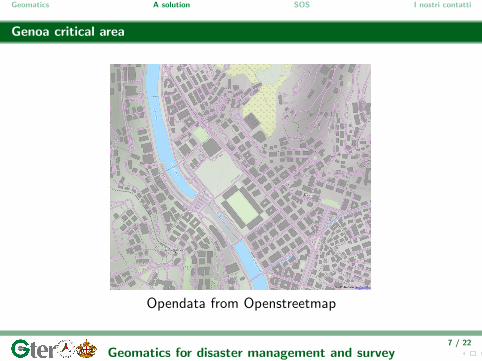
Genoa critical area
Opendata from Openstreetmap
7 / 22
Geomatics for disaster management and survey

Geomatics A solution SOS I nostri contatti
Genoa critical area
Technical cartography
8 / 22
Geomatics for disaster management and survey
Geomatics A solution SOS I nostri contatti
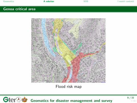
Genoa critical area
Flood risk map
9 / 22
Geomatics for disaster management and survey
Geomatics A solution SOS I nostri contatti
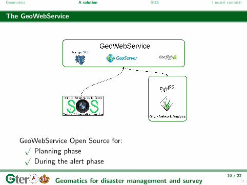
The GeoWebService
GeoWebService Open Source for:√
Planning phase√During the alert phase
10 / 22
Geomatics for disaster management and survey
Geomatics A solution SOS I nostri contatti
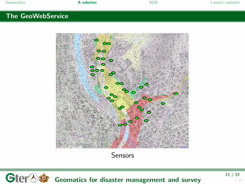
The GeoWebService
Sensors
11 / 22
Geomatics for disaster management and survey
Geomatics A solution SOS I nostri contatti
The storm is arriving....
12 / 22
Geomatics for disaster management and survey
Geomatics A solution SOS I nostri contatti
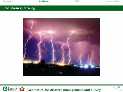
The storm is arriving....
13 / 22
Geomatics for disaster management and survey

Geomatics A solution SOS I nostri contatti
The storm is arriving
14 / 22
Geomatics for disaster management and survey

Geomatics A solution SOS I nostri contatti
The storm is arriving....
15 / 22
Geomatics for disaster management and survey
Geomatics A solution SOS I nostri contatti
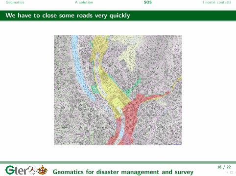
We have to close some roads very quickly
16 / 22
Geomatics for disaster management and survey
Geomatics A solution SOS I nostri contatti
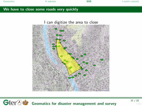
We have to close some roads very quickly
I can digitize the area to close
17 / 22
Geomatics for disaster management and survey

Geomatics A solution SOS I nostri contatti
We have to close some roads very quickly
The system automatically switch on the sensor to close
18 / 22
Geomatics for disaster management and survey

Geomatics A solution SOS I nostri contatti
We have to close some roads.....very quickly
19 / 22
Geomatics for disaster management and survey

Geomatics A solution SOS I nostri contatti
We have to close some roads.....very quickly
We are evaluating different solution to create virtual gate
20 / 22
Geomatics for disaster management and survey
Geomatics A solution SOS I nostri contatti
Inundation with empty roads
21 / 22
Geomatics for disaster management and survey

Geomatics A solution SOS I nostri contatti
Conclusions
GIS solution for√
Systematize geographical data from different sources on a singleplatform
√Provide a support in prevention activity
√Integrate a tool for management of real time data coming fromSensor
√System for remote control to close the streets
↓With a complete Open Source solution
22 / 22
Geomatics for disaster management and survey

Thanks for the attention
Via Greto di Cornigliano 6r16152 Genova
www.gter.it
Quest’ opera e distribuita con licenza Creative Commons Attribuzione - Condividi allo stesso modo 3.0 Unported.
Related Documents