Copyright 2005 - Coast Guard Auxiliary Association, Inc. 1 Chapter 3 Navigating The Waterways

Copyright 2005 - Coast Guard Auxiliary Association, Inc. 1 Chapter 3 Navigating The Waterways.
Dec 25, 2015
Welcome message from author
This document is posted to help you gain knowledge. Please leave a comment to let me know what you think about it! Share it to your friends and learn new things together.
Transcript
Copyright 2005 - Coast Guard Auxiliary Association, Inc. 1
Chapter 3
Navigating The Waterways

Copyright 2005 - Coast Guard Auxiliary Association, Inc. 2
AIDS TO NAVIGATION
ATONS

Copyright 2005 - Coast Guard Auxiliary Association, Inc. 3
C.G. Maintains ATONS

Copyright 2005 - Coast Guard Auxiliary Association, Inc. 4
ATONS
Right side of channel from seaNUN buoys,
Red colors
Even numbers
Red, Right, Returning
Copyright 2005 - Coast Guard Auxiliary Association, Inc. 5
AIDS TO NAVIGATION
Experimental Slide
Elements of A Chart(click above to open interactive chart)


Copyright 2005 - Coast Guard Auxiliary Association, Inc. 10
Lighted Buoys
Right side of channelRed color, Red light, Even numbers (82)
Left side of channelGreen color, Green light, Odd numbers (81)

Copyright 2005 - Coast Guard Auxiliary Association, Inc. 11
ATONSDAYMARKS-USED IN SHALLOW WATER RATHER THAN BUOYS

Copyright 2005 - Coast Guard Auxiliary Association, Inc. 12
ATONS
BEACONS ARE DAYMARKS WITH LIGHTS

Copyright 2005 - Coast Guard Auxiliary Association, Inc. 13
ATONS

Copyright 2005 - Coast Guard Auxiliary Association, Inc. 14
NAVIGATION AIDS
JUNCTION BUOY
USES LETTERS INPLACE OF NUMBERS
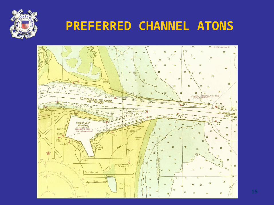
Copyright 2005 - Coast Guard Auxiliary Association, Inc. 15
PREFERRED CHANNEL ATONS
Copyright 2005 - Coast Guard Auxiliary Association, Inc. 16
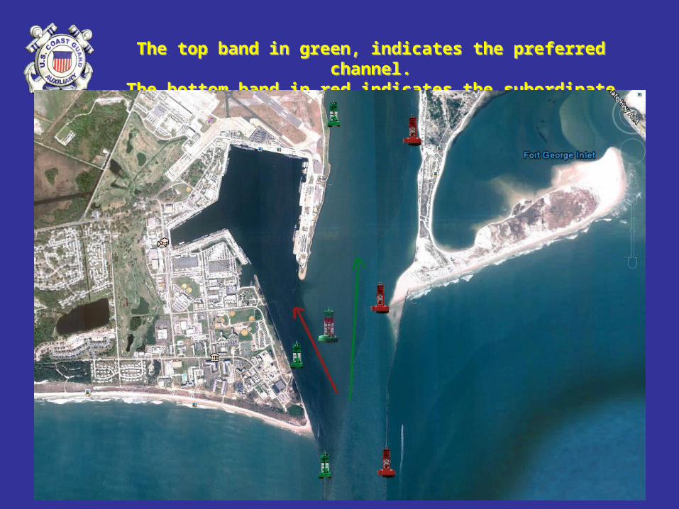
The top band in green, indicates the preferred channel.The bottom band in red indicates the subordinate channel.
The top band in green, indicates the preferred channel.The bottom band in red indicates the subordinate channel.

Copyright 2005 - Coast Guard Auxiliary Association, Inc. 17
Entrance to Naval Station Mayport Harbor(the subordinate channel)
Entrance to Naval Station Mayport Harbor(the subordinate channel)

Copyright 2005 - Coast Guard Auxiliary Association, Inc. 18
ATONS• Junction Daymark in Shallow Water
Assume this boat is Approaching From the Preferred Channel
Assume this boat is Approaching From the Preferred Channel

Copyright 2005 - Coast Guard Auxiliary Association, Inc. 19
Waterway Marks

Copyright 2005 - Coast Guard Auxiliary Association, Inc. 20
Waterway Marks

Copyright 2005 - Coast Guard Auxiliary Association, Inc. 21
PREFERRED CHANNEL ATONS

Copyright 2005 - Coast Guard Auxiliary Association, Inc. 22
ATONS
Isolated Danger AreaMay be passed on all sides.
Approach with Caution.
Isolated Danger AreaMay be passed on all sides.
Approach with Caution.

Copyright 2005 - Coast Guard Auxiliary Association, Inc. 23
• Non-Lateral Marks - US Aids
Non-Lateral Aids
Daymark
Spherical Buoy(unlighted)
1

Copyright 2005 - Coast Guard Auxiliary Association, Inc. 24
ST. JOHNS RIVERSAFE WATER BUOY

Copyright 2005 - Coast Guard Auxiliary Association, Inc. 25
OBSTRUCTING NAVIGATION
• It is illegal to:• Anchor in a channel• Tie up to a buoy or ATON• Tamper with, deface, or move any
ATON• Obstruct a pier, wharf, boat ramp
Copyright 2005 - Coast Guard Auxiliary Association, Inc. 26
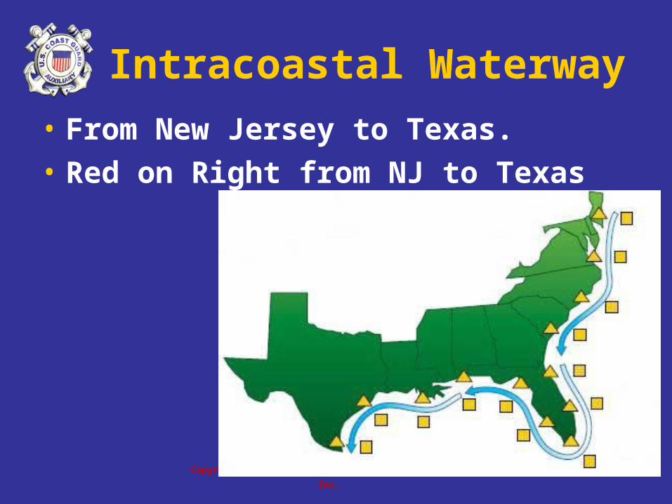
Intracoastal Waterway• From New Jersey to Texas.
• Red on Right from NJ to Texas
Copyright 2005 - Coast Guard Auxiliary Association, Inc. 27
Intracoastal Waterway
1
2
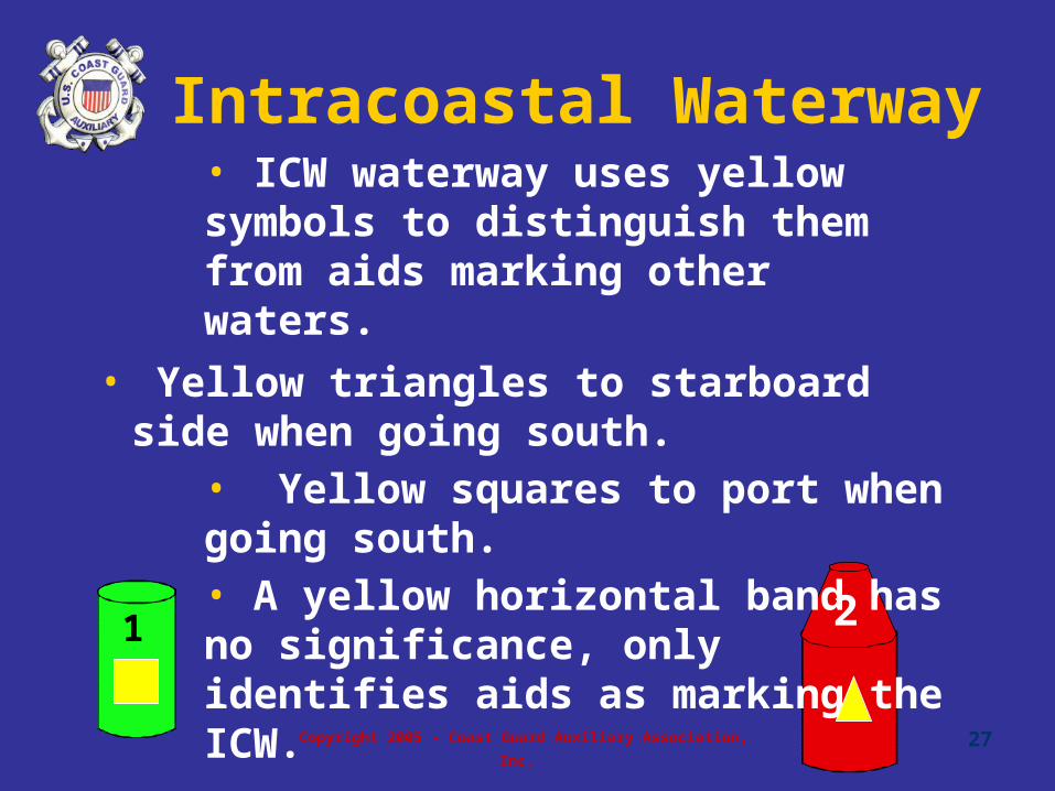
• ICW waterway uses yellow symbols to distinguish them from aids marking other waters.
• Yellow triangles to starboard side when going south.
• Yellow squares to port when going south. • A yellow horizontal band has no significance, only identifies aids as marking the ICW.

ICWICW

Copyright 2005 - Coast Guard Auxiliary Association, Inc. 29
ICW DAY MARKERS/BEACONS

Copyright 2005 - Coast Guard Auxiliary Association, Inc. 30
ICW DAY MARKERS/BEACONS
SHARED WATERWAY

Copyright 2005 - Coast Guard Auxiliary Association, Inc. 31
Western Rivers
• Used on Mississippi and tributaries
• Not numbered
• Numbers below daybeacons• Indicate distance from mouth of river
1
2
3

Copyright 2005 - Coast Guard Auxiliary Association, Inc. 32
Non-Lateral Aids
Include Private MarkersOf Various Shapes And SizesInclude Private MarkersOf Various Shapes And Sizes
Mooring Buoys Which Are For Legally Securing Your Boat Away From A Dock Instead of Dropping An Anchor
Mooring Buoys Which Are For Legally Securing Your Boat Away From A Dock Instead of Dropping An Anchor
AndAnd
Copyright 2005 - Coast Guard Auxiliary Association, Inc. 33
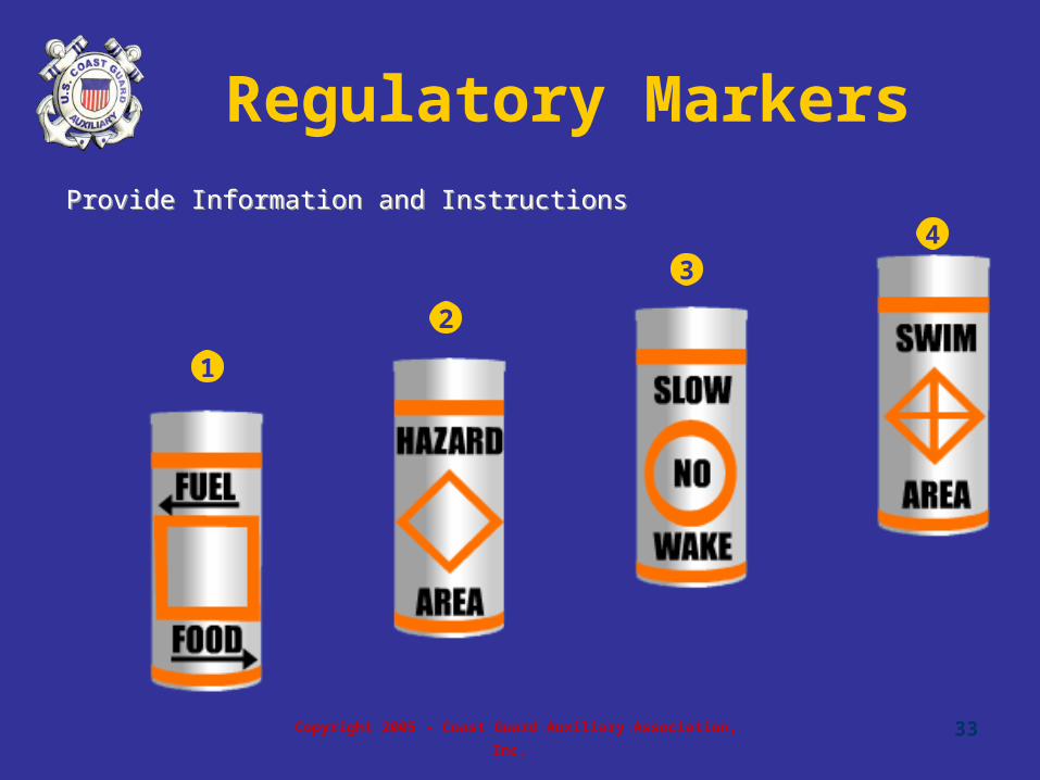
Regulatory Markers
1
2
34
Provide Information and InstructionsProvide Information and Instructions

Copyright 2005 - Coast Guard Auxiliary Association, Inc. 34
REGULATORY MARKERS
This Marker defines slow speed boundaries at the channel’s edgeThis Marker defines slow speed boundaries at the channel’s edge
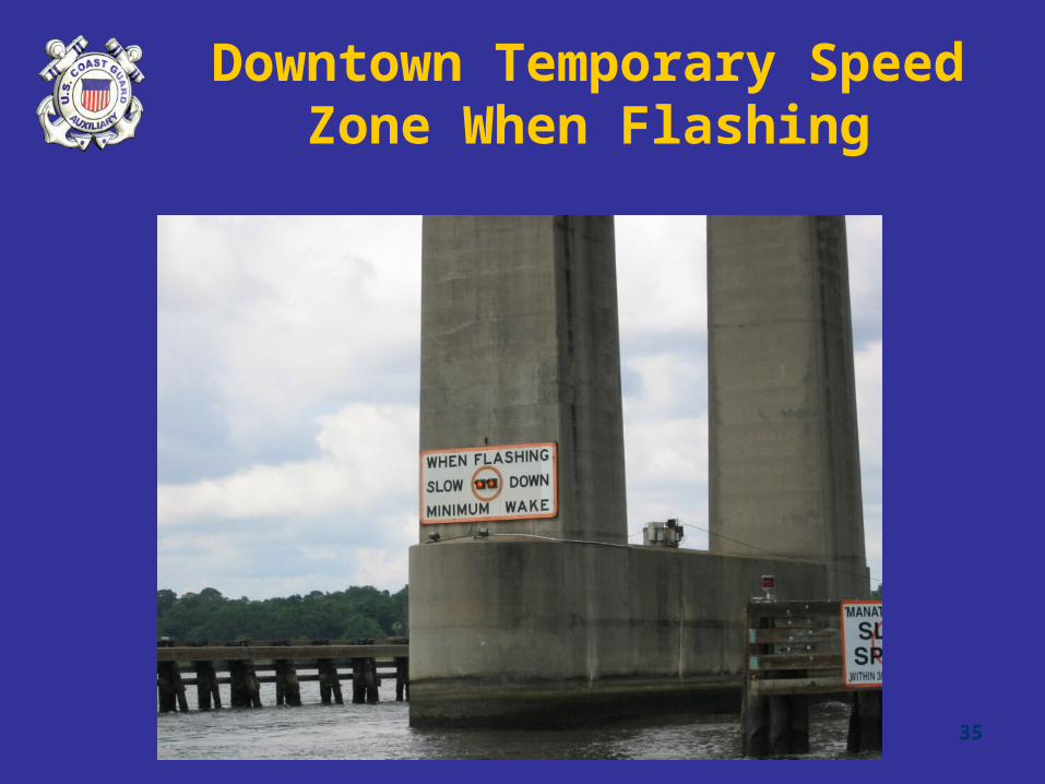
Copyright 2005 - Coast Guard Auxiliary Association, Inc. 35
Downtown Temporary Speed Zone When Flashing

Copyright 2005 - Coast Guard Auxiliary Association, Inc. 36
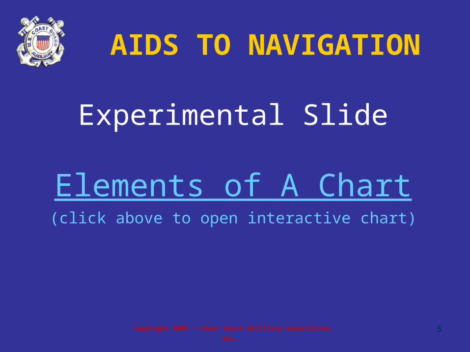
• Charts• Why important?• What information is
contained?
Navigating on Water
1

The Elements of a Chart
Copyright 2005 - Coast Guard Auxiliary Association, Inc. 38
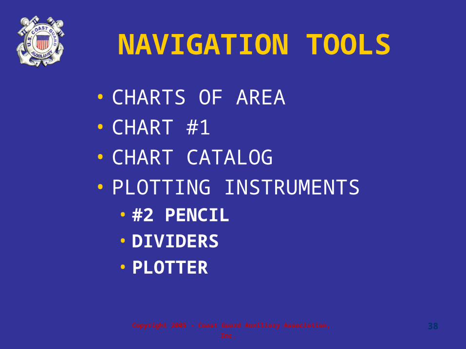
NAVIGATION TOOLS
• CHARTS OF AREA
• CHART #1
• CHART CATALOG
• PLOTTING INSTRUMENTS• #2 PENCIL• DIVIDERS• PLOTTER

Copyright 2005 - Coast Guard Auxiliary Association, Inc. 39
Most Valuable Tool

Copyright 2005 - Coast Guard Auxiliary Association, Inc. 40
Steering Compass
• Magnetic North
What is the
lubber line?
1

41© 2003, RJ Sweet, “GPS for Mariners,” Reprinted with permission© 2003, RJ Sweet, “GPS for Mariners,” Reprinted with permission
We Steer to Magnetic We Steer to Magnetic NorthNorth
GPS can be set to display magnetic direction

42© 2003, RJ Sweet, “GPS for Mariners,” Reprinted with permission© 2003, RJ Sweet, “GPS for Mariners,” Reprinted with permission
Magnetic CourseMagnetic Course
Compass Rose is a convenient Reference

Copyright 2005 - Coast Guard Auxiliary Association, Inc. 43
Piloting
Pre-Planning Routes by Compass Heading, Estimated Speed and Arrival TimePre-Planning Routes by Compass Heading, Estimated Speed and Arrival Time

Copyright 2005 - Coast Guard Auxiliary Association, Inc. 44
Provides Position as:
• Latitude and Longitude
• Direction, if moving
• Speed over bottom, if moving
• Chart Plotter GPS
• Position on chart
GLOBAL POSITIONING SYSTEMS (GPS)
45© 2003, RJ Sweet, “GPS for Mariners,” Reprinted with permission© 2003, RJ Sweet, “GPS for Mariners,” Reprinted with permission
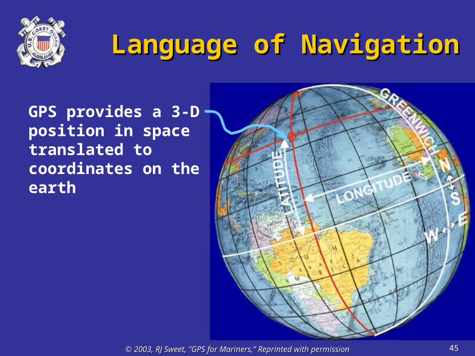
Language of NavigationLanguage of Navigation
GPS provides a 3-D position in space translated to coordinates on the earth

46© 2003, RJ Sweet, “GPS for Mariners,” Reprinted with permission© 2003, RJ Sweet, “GPS for Mariners,” Reprinted with permission
Locate Position on ChartLocate Position on Chart
GPS “Position”Corresponds to A Position On The ChartRead in “Degrees”“Minutes” and “Seconds”
Information on real-world
objects provided by
charts.

Dangers Of Lowhead Dams
• Low Head Dams Are a danger
to boaters…….
….From both above and below.From above they are hard to see.Below, turbulent waters
….From both above and below.From above they are hard to see.Below, turbulent waters
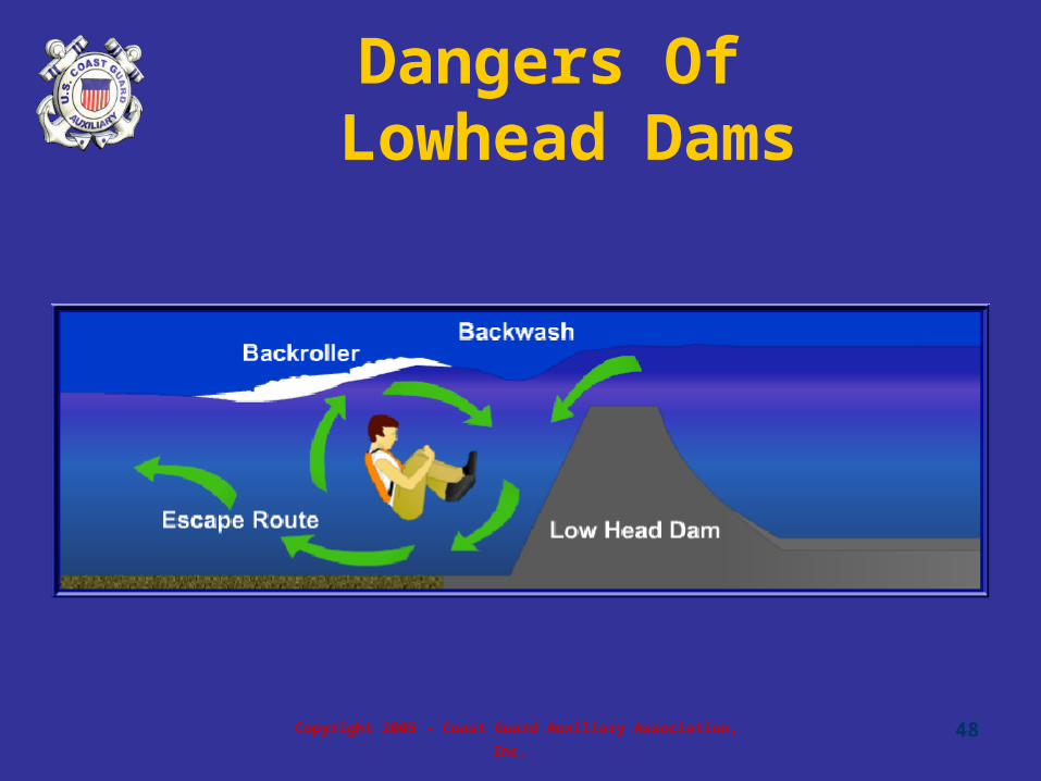
Copyright 2005 - Coast Guard Auxiliary Association, Inc. 48
Dangers Of Lowhead Dams

Copyright 2005 - Coast Guard Auxiliary Association, Inc. 49
Locks
• Commercial traffic has priority
• Communication: channel 13 VHF-FM marine
1
2

Copyright 2005 - Coast Guard Auxiliary Association, Inc. 50
stand clear
approach
enter
Traffic Signals At Locks
Copyright 2005 - Coast Guard Auxiliary Association, Inc. 51
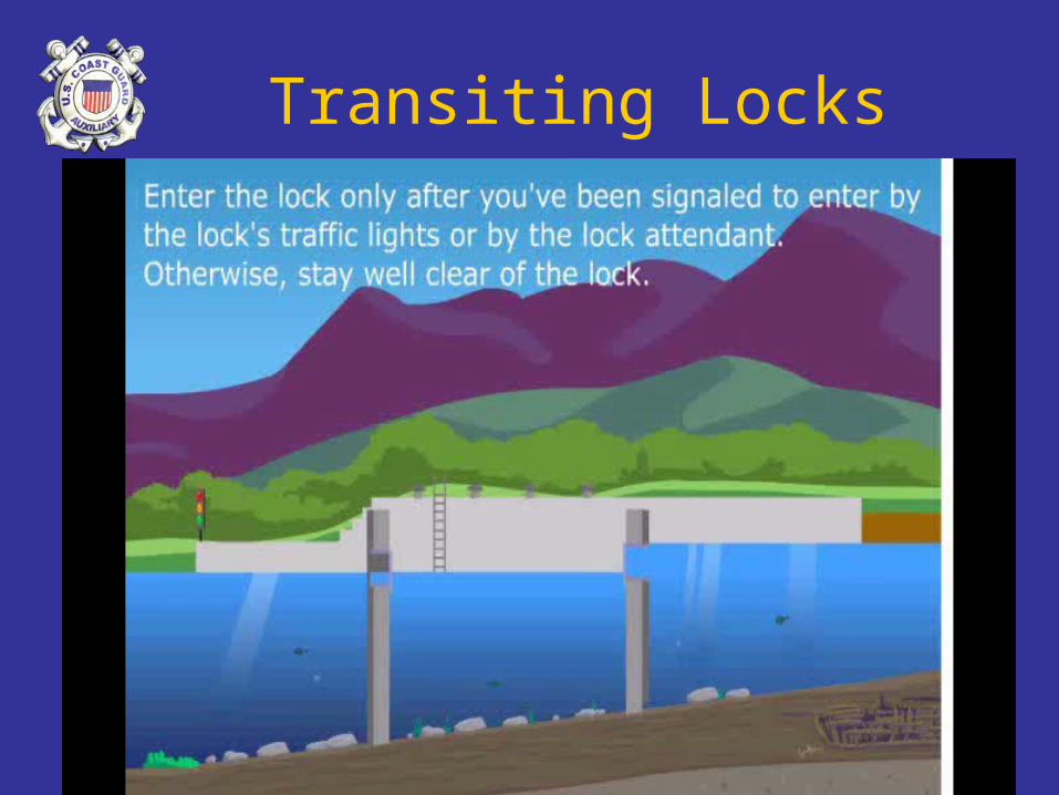
Transiting Locks
Copyright 2005 - Coast Guard Auxiliary Association, Inc. 52
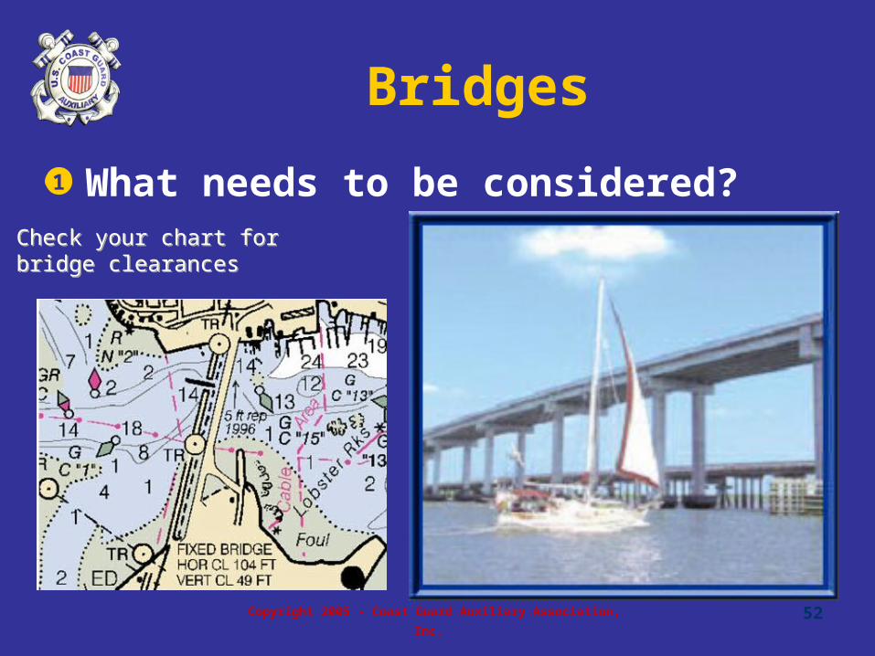
Bridges
• What needs to be considered?1
Check your chart for bridge clearancesCheck your chart for bridge clearances
Copyright 2005 - Coast Guard Auxiliary Association, Inc. 53
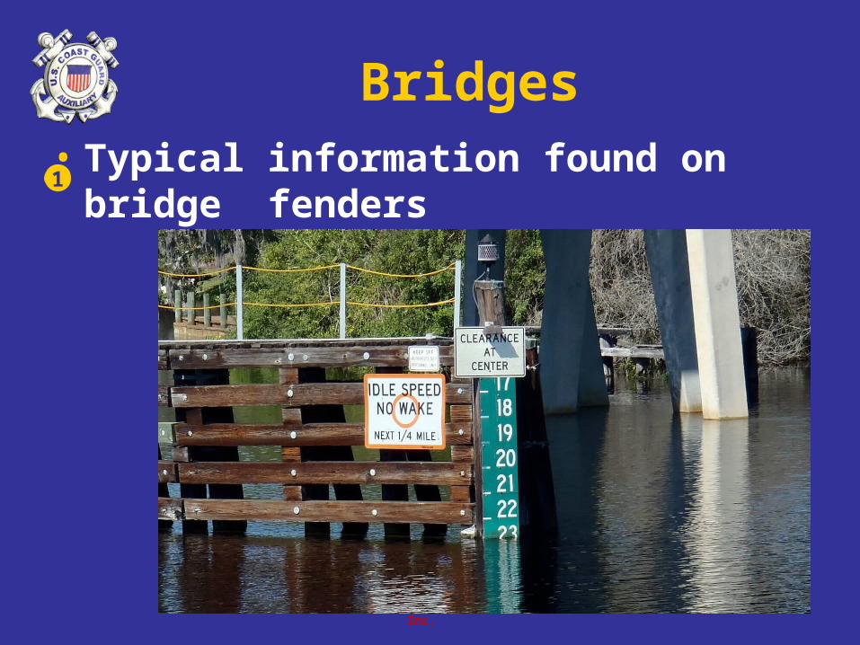
Bridges• Typical information found on bridge
fenders1

Copyright 2005 - Coast Guard Auxiliary Association, Inc. 54
Check Clearance

Copyright 2005 - Coast Guard Auxiliary Association, Inc. 55
Tides On Coastal Waters
• Gravitational forces of the moon and sun
• Tides fluctuate by many feet
• Docking affected by tide
• Local knowledge
• Don’t run aground
1
2
3
4
5
Copyright 2005 - Coast Guard Auxiliary Association, Inc. 56
Chapter 3 Review

Copyright 2005 - Coast Guard Auxiliary Association, Inc.
57
Review Exercises
• An Aid To Navigation is any object external to the boat that 1. Helps a boater pilot a boat safely, 2. aids a boater in finding a position, and 3.___
• Warns a boater of danger• Marks the best fishing holes• Marks an area with water depths of at least 50 feet• Provides a place to tie to
1
a
b
c
d
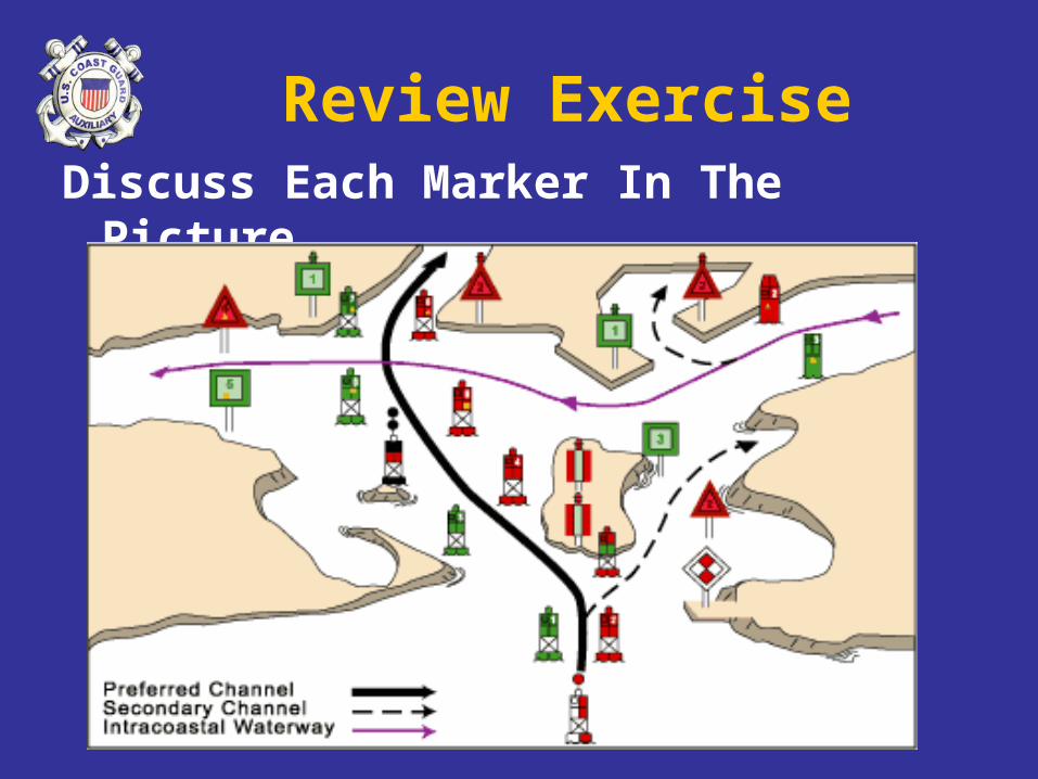
Review ExerciseDiscuss Each Marker In The Picture

Copyright 2005 - Coast Guard Auxiliary Association, Inc. 59
Review Exercises
• You are returning from sea and want to stay safely in the preferred channel. On what side of your boat would you keep a red and green horizontally-banded marker if the top band is red?
• Either side would be appropriate.• Port• You would stop and turn around (you are in an
exclusion area).• starboard
4
a
b
c
d

Copyright 2005 - Coast Guard Auxiliary Association, Inc. 60
Review Exercises
• Regulatory markers with orange circles and black lettering indicate:
• controlled areas.• dangerous areas.• exclusion areas where boats should keep out.• general information for the area.
9
a
b
c
d
Copyright 2005 - Coast Guard Auxiliary Association, Inc. 61
End Chapter 3
Related Documents