1 Coordination Group Meteorological Satellites on Energy Fluxes in the Earth System Jörg Schulz Axel Andersson 1 , Karsten Fennig 1 , Marc Schröder 1 , Christian Klepp 2 , Stephan Bakan 3 1 CM SAF / Deutscher Wetterdienst, Offenbach 2 Universität Hamburg 3 Max-Planck-Institut für Meteorologie, Hamburg

Coordination Group Meteorological Satellites on Energy Fluxes in the Earth System
Dec 30, 2015
Coordination Group Meteorological Satellites on Energy Fluxes in the Earth System. Jörg Schulz Axel Andersson 1 , Karsten Fennig 1 , Marc Schröder 1 , Christian Klepp 2 , Stephan Bakan 3 1 CM SAF / Deutscher Wetterdienst, Offenbach 2 Universität Hamburg - PowerPoint PPT Presentation
Welcome message from author
This document is posted to help you gain knowledge. Please leave a comment to let me know what you think about it! Share it to your friends and learn new things together.
Transcript
1
Coordination Group Meteorological Satelliteson Energy Fluxes in the Earth System
Jörg Schulz
Axel Andersson1, Karsten Fennig1, Marc Schröder1,Christian Klepp2 , Stephan Bakan3
1CM SAF / Deutscher Wetterdienst, Offenbach2Universität Hamburg
3Max-Planck-Institut für Meteorologie, Hamburg

3rd WDAC, National University of Ireland, Galway, Ireland, 6-7 May 2014
Observations Needed for Fluxes
• Energy fluxes at top of atmosphere and surface are not directly measured with satellite instruments;
• Surface fluxes are parameterised or derived using complex models;
• Parameterisations and models need basic meteorological, oceanographic and terrestrial base variables (TCDRs or ECVs in GCOS language) that describe the atmosphere and surface (see cross-walk in John Bates talk);
• This is where long-term measurements from CGMS satellites and some data products can contribute.

3rd WDAC, National University of Ireland, Galway, Ireland, 6-7 May 2014
Example: Surface Radiation Budget
• Questions include:
• uncertainty in aerosol-cloud interaction and associated indirect radiative effects in climate
models;
• uncertainty in radiative forcing due to an insufficient quantification of land-surface
properties, their changes, and land-atmosphere interactions.
• Basic is SW and LW broadband radiometer and Total Solar Irradiance Monitor;• In addition one needs:
Water vapour (many operational missions contribute);
Cloud properties (mixture of research and operational missions);
Aerosol (no real (polarimetric) mission exists but some operational, e.g. GOME-2 can
contribute);
Surface properties (albedo and others).
Overall coordination of observations and data records shall be part of the architecture
for climate monitoring from space and be dealt with in the CEOS-CGMS WG Climate.
Went back to GCOS XIV, Doc 22a, 2008: Review of observation strategy/vision for Earth Radiation Budget

3rd WDAC, National University of Ireland, Galway, Ireland, 6-7 May 2014
03 04 05 06 07 08 09 10 11 12 13 14 15 16 17 18 19 20 21 22 23 24 25 26 27 28 29 30 31 32 33 34 35 36 37 38 39 40YEAR...
METEOSAT SECOND GENERATION
METEOSAT THIRD GENERATION
EUMETSAT POLAR SYSTEM (EPS)
METEOSAT-8
METEOSAT-9
METEOSAT-10
MSG-4/METEOSAT-11*
MTG-I-1 : IMAGERY
MTG-S-1: SOUNDING
MTG-I-2: IMAGERY
MTG-I-3: IMAGERY MTG-S-2: SOUNDING
MTG-I-4: IMAGERY METOP-A
METOP-B
METOP-C
EPS-SECOND GENERATION (EPS-SG)
METOP-SG: SOUNDING AND IMAGERY
METOP-SG: MICROWAVE IMAGERY
JASON
JASON-2
JASON-3
SENTINEL-6 (JASON-CS)
03 04 05 06 07 08 09 10 11 12 13 14 15 16 17 18 19 20 21 22 23 24 25 26 27 28 29 30 31 32 33 34 35 36 37 38 39 40YEAR...
Mandatory Programmes
Optional Programmes
The Relevance of Operational Programmes: Decades of Observations for Climate Monitoring
METEOSAT FIRST GENERATION: USEFUL DATASINCE 1982
Continues NOAA series of AVHRRR, HIRS, AMSU-A
Continues Jason-1, TOPEX POSEIDON
Sentinel-4 onboard MTG-I satellites
Sentinel-5 onboard METOP-SG-A satellites
MSG 1-3 carries GERB which will not be continued

3rd WDAC, National University of Ireland, Galway, Ireland, 6-7 May 2014
Climate Data Processing Coordination at EUMETSAT
Slide: 5
EUMETSAT Climate Monitoring Implementation Plan
Contains a lot of data sets that you need. EUMETSAT Secretariat
EUMETSAT Working Group on Data Set Generation
• Organises processing considering dependencies
• Agrees standards for output, e.g. CF compatibility, formats, doi registration, etc.
• Facilitates needed activities for reanalyses and obs4mips

3rd WDAC, National University of Ireland, Galway, Ireland, 6-7 May 2014
Surface Albedo: All Geo vs. MODIS
Lattanzio et al., 2013, Land Surface Albedo from Geostationary Satellites: A Multiagency Collaboration within SCOPE-CM Bull. Amer. Soc., DOI:10.1175/BAMS-D-11-00230.1
MODIS (MCD43C3)
5 GEO
3rd WDAC, National University of Ireland, Galway, Ireland, 6-7 May 2014
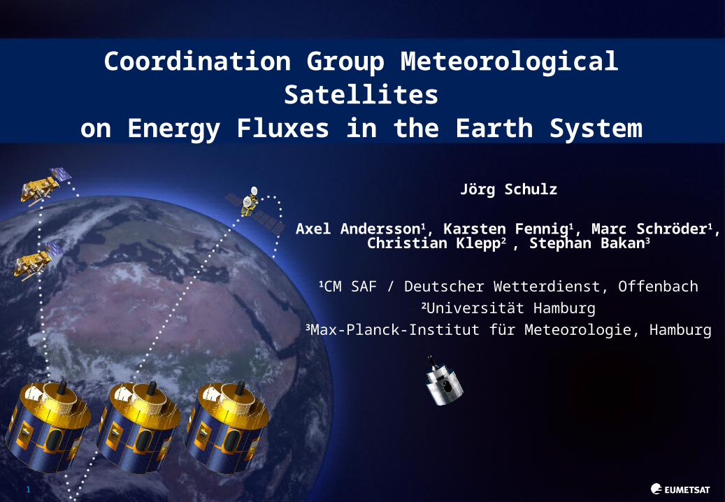
FSW FSW and Surface Albedo: Where to meet?
SATELLITE
Model (standard_output.xls)
FSW : Surface Downwelling Shortwave Radiation
FSW : Surface Upwelling Shortwave Radiation
DHR: Black Sky Albedo
BHRiso: White Sky Albedo
The BHR (Blue sky albedo) can be estimated from satellites measurements and models
(DHR * fdir) + (BHRiso * fdiff) = BHR= FSW / FSW
SW Downwelling radiation (e.g., CM SAF SIS)
FSW can be estimated from satellite measurement
Requires consistency at all levels of processing, we may not be there yet.
Recommend to add blue sky albedo to model output at daily scale.
83rd WDAC, National University of Ireland, Galway, Ireland, 6-7 May 2014
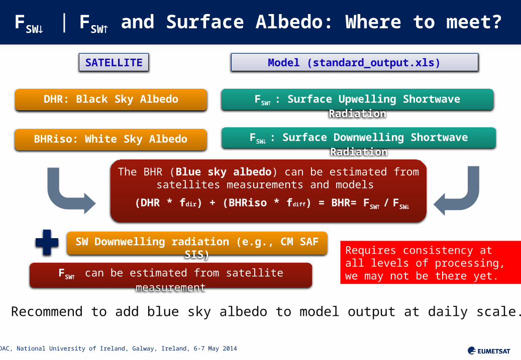
Sensor, Satellite resp. Parameter Release
date Period Coverage
Fundamental Climate Data Record (FCDR)
SSM/I, SSMIS Microwave Radiances 2012 1987 – 2008 global
Climate Data Record (CDR)
SEVIRICloud parameters, aerosol optical depth
2012 2004 – 2009Europe &
Africa
GERB/SEVIRITop of atmosphere radiative fluxes
2012 2004 – 2009Europe &
Africa
MVIRI/SEVIRICloud parameters, surface radiation parameters, land surface temp., FTH
2011 1983 – 2005Europe &
Africa
AVHRR GACCloud parameters, surface radiation parameters, incl. albedo
2012 1982 – 2009 global
SSM/I, SSMISHOAPS 3.2 (precip, evap, hum., wind, …)
2011 1987 – 2008global ice free
ocean
ATOVSWater vapour and Temperature profile
2013 1998 – 2008 global
CM SAF Climate Data Records
All CDR‘s are accessible via DOI Numbers

3rd WDAC, National University of Ireland, Galway, Ireland, 6-7 May 2014
HOAPS 3.2Hamburg Ocean Atmosphere Parameters and Fluxes from Satellite Data
Climatology of water cycle parameters over the ocean
precipitation, evaporation and freshwater flux (+related variables)
First release through CM SAF in cooperation with MPI-Meteorology and University of Hamburg
Sustained development path
Algorithm Theoretical Basis Document (ATBD), Product User Manual (PUM), Validation Report available
Gridded data products (0.5°): Monthly mean, 6-hourly composite
Instantaneous data available on request
http://wui.cmsaf.eu
http://www.hoaps.org
http://dx.doi.org/10.5676/EUM_SAF_CM/HOAPS/V0019

3rd WDAC, National University of Ireland, Galway, Ireland, 6-7 May 2014
Based on passive microwave data
intercalibrated CM SAF SSM/I FDCR (interim)
Entire SSM/I record usable for climate: 1987 – 2008
Improved data quality control of level 1 data
Neural network based precipitation retrieval
Evaporation derived through bulk flux algorithm (COARE 3.0)
E = (ρa/ρ
w) CE U (qs - qa)
AVHRR Pathfinder SST as input for turbulent fluxes
New OI-based gap filling and diurnal cycle corrections
Freshwater Flux: E - P
HOAPS 3.2Hamburg Ocean Atmosphere Parameters and Fluxes from Satellite Data
10

3rd WDAC, National University of Ireland, Galway, Ireland, 6-7 May 2014
HOAPS 3.2
11
3rd WDAC, National University of Ireland, Galway, Ireland, 6-7 May 2014
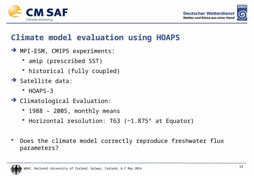
Climate model evaluation using HOAPS
MPI-ESM, CMIP5 experiments:
amip (prescribed SST)
historical (fully coupled)
Satellite data:
HOAPS-3
Climatological Evaluation:
1988 – 2005, monthly means
Horizontal resolution: T63 (~1.875° at Equator)
Does the climate model correctly reproduce freshwater flux parameters?
12

3rd WDAC, National University of Ireland, Galway, Ireland, 6-7 May 2014
Precipitation MPI-ESM - HOAPS

3rd WDAC, National University of Ireland, Galway, Ireland, 6-7 May 2014
Evaporation MPI-ESM - HOAPS

3rd WDAC, National University of Ireland, Galway, Ireland, 6-7 May 2014
Freshwater Flux MPI-ESM - HOAPS
3rd WDAC, National University of Ireland, Galway, Ireland, 6-7 May 2014
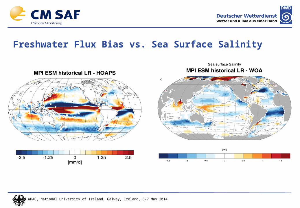
Freshwater Flux Bias vs. Sea Surface Salinity
3rd WDAC, National University of Ireland, Galway, Ireland, 6-7 May 2014
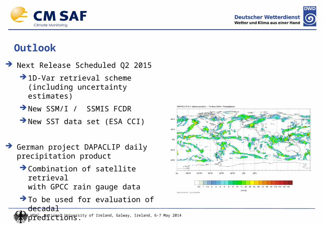
Outlook
Next Release Scheduled Q2 2015
1D-Var retrieval scheme (including uncertainty estimates)
New SSM/I / SSMIS FCDR
New SST data set (ESA CCI)
German project DAPACLIP daily precipitation product
Combination of satellite retrievalwith GPCC rain gauge data
To be used for evaluation of decadal predictions.
Related Documents