105 COBISS: 1.08 ACTA CARSOLOGICA 31/1 9 105-122 LJUBLJANA 2002 Prejeto / received: 16. 4. 2002 1 Department of Geology. Faculty of Science. University of Malaga. 29071 MALAGA, SPAIN, e-mails: fcarrasco@uma.es, vadillo@uma.es, andreo@uma.es 2 Nerja Cave Foundation. Carretera de Maro s/n. 29787 NERJA, MALAGA, SPAIN, e-mail: baena@vnet.es 3 Instituto Geológico y Minero de España. C/ Ríos Rosas, 23. 28003 MADRID, SPAIN, e-mail: jj.duran@igme.es CONTROL OF ENVIRONMENTAL PARAMETERS FOR MANAGEMENT AND CONSERVATION OF NERJA CAVE (MALAGA, SPAIN) PREGLED OKOLJSKIH PARAMETROV PRI VODENJU IN VAROVANJU JAME NERJA (MÁLAGA, [PANIJA) FRANCISCO CARRASCO 1 & IÑAKI VADILLO 1 & CRISTINA LIÑÁN 2 & BARTOLOMÉ ANDREO 1 & JUAN JOSÉ DURÁN 3

Welcome message from author
This document is posted to help you gain knowledge. Please leave a comment to let me know what you think about it! Share it to your friends and learn new things together.
Transcript
105
COBISS: 1.08
ACTA CARSOLOGICA 31/1 9 105-122 LJUBLJANA 2002
Prejeto / received: 16. 4. 2002
1 Department of Geology. Faculty of Science. University of Malaga. 29071 MALAGA, SPAIN,e-mails: [email protected], [email protected], [email protected]
2 Nerja Cave Foundation. Carretera de Maro s/n. 29787 NERJA, MALAGA, SPAIN,e-mail: [email protected]
3 Instituto Geológico y Minero de España. C/ Ríos Rosas, 23. 28003 MADRID, SPAIN,e-mail: [email protected]
CONTROL OF ENVIRONMENTAL PARAMETERS FORMANAGEMENT AND CONSERVATION OF NERJA CAVE
(MALAGA, SPAIN)
PREGLED OKOLJSKIH PARAMETROV PRI VODENJU INVAROVANJU JAME NERJA (MÁLAGA, [PANIJA)
FRANCISCO CARRASCO 1 & IÑAKI VADILLO 1 & CRISTINA LIÑÁN2 &BARTOLOMÉ ANDREO 1 & JUAN JOSÉ DURÁN 3
Acta carsologica, 31/1 (2002)
106
Izvle~ek UDK: 504.05:551.44(60)
Francisco Carrasco & Iñaki Vadillo & Cristina Liñán & Bartolomé Andreo & Juan José Durán: Pregledokoljskih parametrov pri vodenju in varovanju jame Nerja (Málaga, [panija)
V povpre~ju obi{~e jamo Nerja ve~ kot 500.000 ljudi letno. Od leta 1993 je v jami instalirana mre`a monitoringa,ki vsako uro meri {tevilne parametre, da bi ugotovili vplive obiskovalcev na podzemno okolje. Od 1991izvr{ujejo hidrokemi~ne meritve vode v curkih v jami in pri naravnih iztokih iz karbonatnega vodonosnika.Zvezna merjenja fizikalno kemijskih parametrov prenikajo~e vode, dnevni odtok, kakor tudi temperatura inrelativna vla`nost zraka, koncentracija CO
2 in temperatura skale ka`ejo ~lovekov vpliv. Glavne spremembe
okoljskih parametrov so naslednje: 1. zra~na temperatura zraste za 0,2 °C na vsakih 1000 obiskovalcev nadan; 2. relativni porast relativne zra~ne vlage med 2 in 3 %, ki v poletnih dneh dose`e nasi~enost;3. koncentracija CO
2 v zraku narase do vrednosti med 500 in 700 ppm v obdobju manj{ega obiska in za
desetkratno izhodi{~no vrednost ob ~asu velikega obiska (2.800 ppm); 4. temperatura skale narase med0,02 °C do 0,15 °C na dan in 5. P
CO2 prenikajo~e vode izkazuje spremembe, nara{~ajo~e med velikim obiskom
in padajo~i indeks nasi~enosti karbonatnih mineralov.Klju~ne besede: jama Nerja, ~lovekov vpliv, okoljski parametri, hidrokemija, varovanje.
Abstract UDC: 504.05:551.44(60)
Francisco Carrasco & Iñaki Vadillo & Cristina Liñán & Bartolomé Andreo & Juan José Durán:Control of environmental parameters for management and conservation of Nerja Cave (Malaga, Spain)
The Nerja Cave receives on average more than 500,000 visitors per year. In order to know the possible impactin the underground environment by human visits, a monitoring network was installed since 1993, to controlhourly several parameters. Also, since 1991 a hydrochemical control has been carried out in the drip waterpoints of the cave and in the natural discharge points of the carbonate aquifer. This continuous record ofphysical-chemical parameters of drip water, its daily outflow, as well as temperature and relative humidity inthe air, CO
2 concentration and rock temperature shows the human influence. The main changes in environ-
mental parameters are the following: 1. cave air temperature rises 0.2 °C by 1000 visitors/day; 2. a dailyincrease between 2 and 3 % in relative air humidity, reaching saturation on summer days; 3. CO
2 concentra-
tion in air increases up to values between 500 and 700 ppm during low visitability periods and 10 times thebackground value during high visitability periods (2.800 ppm); 4. temperature of the rock rises between 0.02°C and 0.15 °C/day, and (5) P
CO2 of drip water also presents variations, increasing during the big influx of
visits and decreasing the saturation index of carbonated minerals.Key words: Nerja Cave, anthropic influence, environmental parameters, hydrochemistry, conservation.
107
INTRODUCTION
Karstic cavities are domains which have been traditionally studied from a speleological orscientific approach (Trombe 1952) but in the last few years the interest has become economic(Mangin & D’Hulst 1995; Huppert et al. 1993). Everyday, there are many cavities visited by thepublic that constitute important economic activities in the region where they are situated. Visitsproduce an impacts in the underground environment: variations of the climatic parameters (tem-perature, humidity and CO
2), contamination and changes of the physic-chemical parameters of
the groundwater and rock alteration. Microflora (algae, principally) also appears at places in thecavities where light and water coexist. These problems have been identified in several caves, i.e.:Altamira Cave (Fernández et al. 1986), Grande del Vento Cave (Bertolani et al. 1991), Pech-Merle Cave (Mangin et al. 1991), Nerja Cave (Carrasco et al. 1995, 1999), Maravillas Cave(Pulido et al. 1997) and Gargas Cave (Mangin et al. 1999), among others. The anthropic impacton the underground environment is an interesting line of research; it is necessary to regulate thevisits to the caves for an adequate explotation and management of this resource (Cigna 1993).
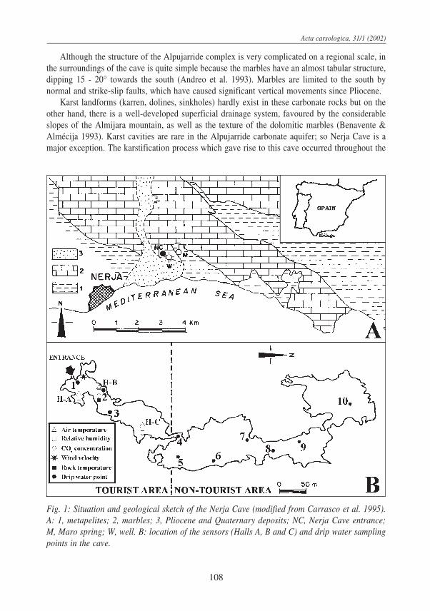
This work illustrates the human impact on the environmental parameters and on the dripwater in the Nerja Cave, a tourist cave situated in the south of Spain (Andalusia), 50 km to theeast of Malaga city and less than 1 km from the Mediterranean sea (Fig. 1A).
The cave extends almost 5 km in chambers and galleries with a difference between the lowestand highest points of 70 m and a volume of 300,000 m3. The cave is practically horizontaland covers an approximate surface of 140,000 m2, 700 m in length and 200 m in width. Thelargest galleries are mainly oriented N35E in the southern area and N-S in the northern area,which coincides with the principal fracturation lines. The cave entrance is situated at an elevationof 158 m.
It was discovered in 1959 and was opened to the public the following year. Since then, it hasbeen a very visited natural attraction in Spain, with more than 500,000 visitor per year. Its popu-larity is influenced by its location in a major tourist zone (Costa del Sol) and by the beauty of thechambers and speleothems that can be found there. Two parts can be distinguished in the cave(Fig. 1B): the tourist area, restricted to a one-third of the cave nearest the entrance, and the non-touristic area, which is made up of the other two-thirds of the cavity, only visited by occasionalgroups of researchers, speleologists and by speleotourists.
GEOLOGICAL AND HYDROGEOLOGICAL SETTINGS
From a geological standpoint, the cave is situated in the Almijara unit, belonging to theAlpujarride complex of the Internal Zone of the Betic Cordillera (Sanz de Galdeano 1986; Andreoet al. 1993). This complex has two lithological formations (Fig. 1A): a lower formation, made upof metapelites of Paleozoic age and an upper one made up of carbonate rocks of middle-upperTriassic. At the base of this latter formation outcrop white dolomitic marbles whilst at its topappears blue calcareous marbles. The cave is developed in the dolomitic marbles which are highlyfractured. In some places, this rock is completely shattered, giving rise to a typical sugar texture,with grains made up of single dolomite crystals. Outside the cave, detrital Neogene depositsoutcrop discordantly over the Alpujarride rocks (Fig. 1A).
F. Carrasco & I. Vadillo & C. Liñán & B. Andreo & J.J. Durán: Control of environmental parameters for management ...
Acta carsologica, 31/1 (2002)
108
Although the structure of the Alpujarride complex is very complicated on a regional scale, inthe surroundings of the cave is quite simple because the marbles have an almost tabular structure,dipping 15 - 20° towards the south (Andreo et al. 1993). Marbles are limited to the south bynormal and strike-slip faults, which have caused significant vertical movements since Pliocene.
Karst landforms (karren, dolines, sinkholes) hardly exist in these carbonate rocks but on theother hand, there is a well-developed superficial drainage system, favoured by the considerableslopes of the Almijara mountain, as well as the texture of the dolomitic marbles (Benavente &Almécija 1993). Karst cavities are rare in the Alpujarride carbonate aquifer; so Nerja Cave is amajor exception. The karstification process which gave rise to this cave occurred throughout the
Fig. 1: Situation and geological sketch of the Nerja Cave (modified from Carrasco et al. 1995).A: 1, metapelites; 2, marbles; 3, Pliocene and Quaternary deposits; NC, Nerja Cave entrance;M, Maro spring; W, well. B: location of the sensors (Halls A, B and C) and drip water samplingpoints in the cave.
109
Pliocene and the Pleistocene. During the temperate and hot periods of the Quaternary age enor-mous quantities of calcite or aragonite deposits were generated (Durán et al. 1993).
The Triassic marbles outcroping in Sierra Almijara constitute an aquifer of regional impor-tance (IGME 1983; SGOP 1991, Andreo & Carrasco 1993a), which recharge is produced mainlyby infiltration of rainwater. The aquifer discharge, apart from wells, is produced by a series ofsprings, with Maro spring as the most important one. This spring is situated less than 1 km to theeast of the cave (Fig. 1A), at an elevation of 120 m. The outflow of the spring varies between 20l/s and 1600 l/s, with a mean value of 250 l/s. The Maro spring has a typical karstic behaviourbecause it responds very quickly to rainwater with a increasing outflow and dilution of the chemi-cal composition of the water (Andreo & Carrasco 1993a; Carrasco et al. 1996; Liñán et al. 2000).
The cave is actually in the vadose zone of the aquifer, several metres above the water table,because of sea-level changes and neotectonic activity of faults limiting the aquifer to the south.
CLIMATIC CHARACTERISTICS OF THE STUDY AREA
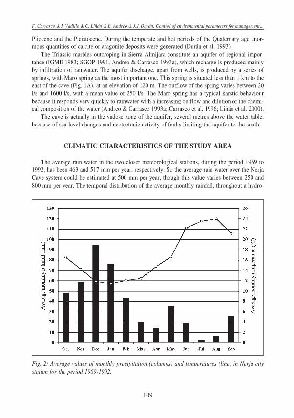
The average rain water in the two closer meteorological stations, during the period 1969 to1992, has been 463 and 517 mm per year, respectively. So the average rain water over the NerjaCave system could be estimated at 500 mm per year, though this value varies between 250 and800 mm per year. The temporal distribution of the average monthly rainfall, throughout a hydro-
Fig. 2: Average values of monthly precipitation (columns) and temperatures (line) in Nerja citystation for the period 1969-1992.
F. Carrasco & I. Vadillo & C. Liñán & B. Andreo & J.J. Durán: Control of environmental parameters for management ...
Acta carsologica, 31/1 (2002)
110
logical year, has a decreasing trend from the months with major precipitation (November to Janu-ary) to the dry months (July and August), with a relative maximum in May (Fig. 2). The averageannual temperature in the nearest meteorological station of Nerja city is 16.5°C, with a maximumvalue in August (24.0°C) and minimum in January (11.4°C).
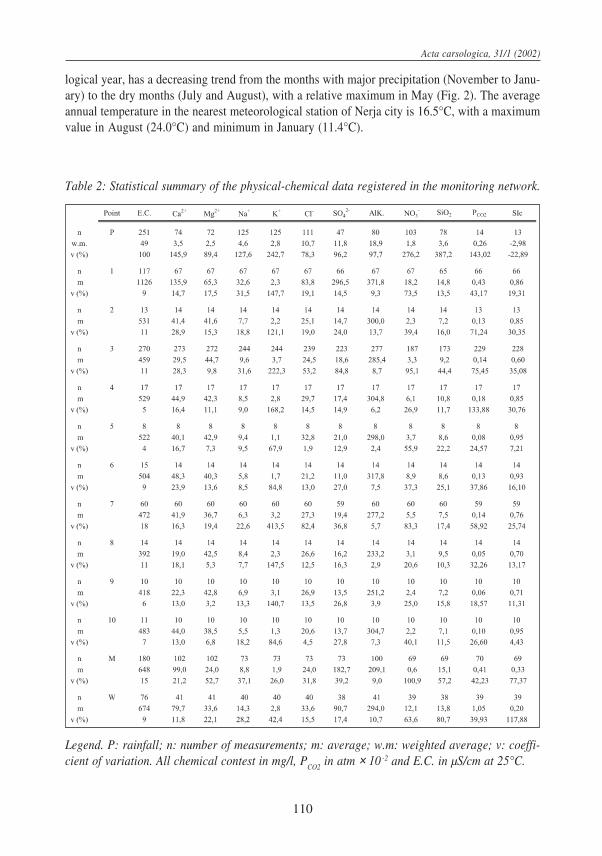
Legend. P: rainfall; n: number of measurements; m: average; w.m: weighted average; v: coeffi-cient of variation. All chemical contest in mg/l, P
CO2 in atm × 10 -2 and E.C. in µS/cm at 25°C.
Table 2: Statistical summary of the physical-chemical data registered in the monitoring network.
111
In 1991 a meteorological station was installed outside the cave, for rainfall and temperaturerecording and for chemical and isotopic monitoring. During the last ten years (1991-2001) theaverage rainfall over the cave has been 445 mm per year. The minimum value was 145 mm in thehydrological year 1994/95, coinciding with a drought period in southern Spain, and the maximumvalue was 819 mm in 1996/97.
Rain water in the meteorological the cave station has a hydrochemical facies ranged from so-dium-chloride to calcium-bicarbonate, a slightly acid pH (6.06 as mean value) and an average elec-trical conductivity of 49 µS/cm (Table 2), which varies between 12 and 443 µS/cm, being higherwhen the amount of rainfall decreases. In certain rainy periods water shows high K+ content (up to50 mg/l) and Cl- (up to 60 mg/l), according to Carrasco et al. (1996, 1999) and Liñán et al. (1999).
NUMBER OF VISITORS GOING INTO THE CAVE
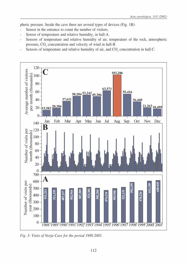
The average flux of visits to the cave is 560,000 visitors per year throughout the periodbetween 1988-2001 (Fig. 3A). The monthly distribution (Fig. 3B) is very similar for differentyears, with a minimum number of visitors in January-February and November-December (be-tween 9,000-33,000 visitors/month) and a maximum number in August (between 83,000-119,000visitors/month). The number of visitors can vary daily between 200 and 3,500 persons; some daysreaching up to 5,000 persons.
The curve of the monthly average number of visitors for the same period (Fig. 3C) shows anasymetric bell-shaped morphology, with maximum in August (103,286 visitors) and minimum inJanuary (15,582 visitors).
All underground parameters suffer an impact when cave is opened to the public. This envi-ronmental impact depends mainly, on external factors as (1) number of visits and (2) its duration,and inherent factors to the cave, i.e. (3) cave volume and (4) natural capacity of ventilation. Theduration of the cave visit is estimated in one hour, and during this time, one person contributeswith 60 calories and 40 grams of water vapour, and exhales around 20 litres of CO
2 (Marion
1985; Andrieux 1988). So, the human presence in the cave provokes an increase of temperature,humidity and CO
2. All these factors are characteristics of underground environment, specially
CO2 because of its influence in the processes of CaCO
3 dissolution and precipitation.
ANTHROPIC INFLUENCE ON THE ENVIRONMENT OF THE CAVE
Monitoring pointAfter the discovery of the cave in 1959 some modifications were made for tourist habilitation
in the external third part of the cave. These modifications have carried out several changes bothinside and outside the cave: an artificial entrance, the lighting of the halls, habilitation of touristroutes and one permanent area to celebrate the Nerja Cave music festivals. All these modifica-tions, together with the high number of visits produce significant changes in the karst environ-ment. For knowing and studying these changes, a monitoring network system was installed in1993 (Fig. 1B), that records hourly environmental parameters outside and inside the cave. Out-side, the choosen parameters were temperature, relative humidity, CO
2 concentration and atmos-
F. Carrasco & I. Vadillo & C. Liñán & B. Andreo & J.J. Durán: Control of environmental parameters for management ...
Acta carsologica, 31/1 (2002)
112
pheric pressure. Inside the cave there are several types of devices (Fig. 1B):- Sensor in the entrance to count the number of visitors.- Sensor of temperature and relative humidity, in hall-A.- Sensors of temperature and relative humidity of air, temperature of the rock, atmospheric
pressure, CO2 concentration and velocity of wind in hall-B.
- Sensors of temperature and relative humidity of air, and CO2 concentration in hall-C.
Fig. 3: Visits of Nerja Cave for the period 1988-2001.
113
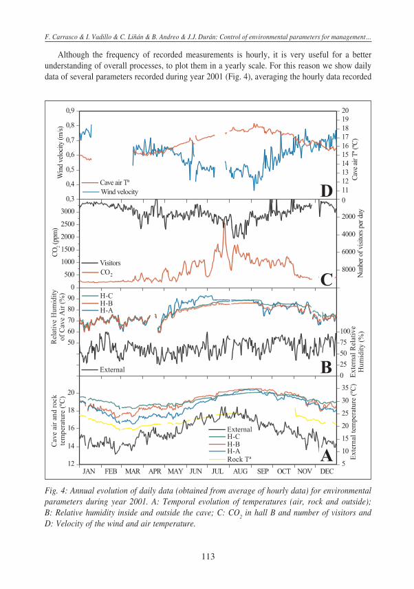
Although the frequency of recorded measurements is hourly, it is very useful for a betterunderstanding of overall processes, to plot them in a yearly scale. For this reason we show dailydata of several parameters recorded during year 2001 (Fig. 4), averaging the hourly data recorded
Fig. 4: Annual evolution of daily data (obtained from average of hourly data) for environmentalparameters during year 2001. A: Temporal evolution of temperatures (air, rock and outside);B: Relative humidity inside and outside the cave; C: CO
2 in hall B and number of visitors and
D: Velocity of the wind and air temperature.
F. Carrasco & I. Vadillo & C. Liñán & B. Andreo & J.J. Durán: Control of environmental parameters for management ...
Acta carsologica, 31/1 (2002)
114
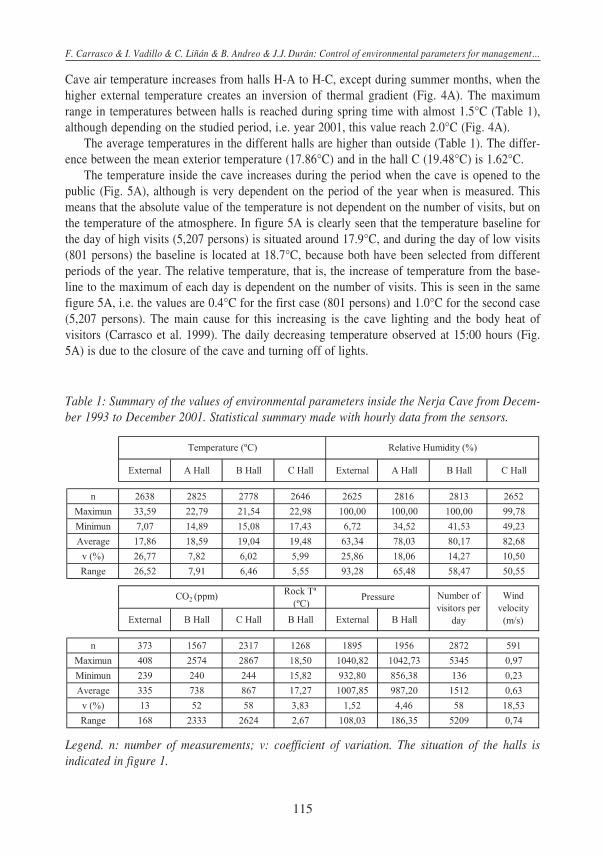
in each sensor. A statistical summary of the whole temporal series of data (since 1993 to 2001) isexposed in Table 1.
Temperature of the cave airAll temperatures inside the cave follows the same wave pattern than the external one, al-
though a delay between outer and inner temperature exists. Whilst external temperature reach itsmaximum at the end of July-beginning of August and its minimum at the end of February (Fig.4A), inside the heat transfer to the cave is produced with a delay of approximately one month.
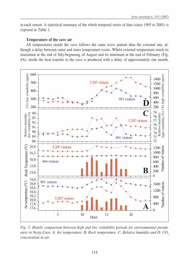
Fig. 5: Hourly comparison between high and low visitability periods for environmental param-eters in Nerja Cave. A: Air temperature; B: Rock temperature; C: Relative humidity and D: CO
2
concetration in air.
115
Cave air temperature increases from halls H-A to H-C, except during summer months, when thehigher external temperature creates an inversion of thermal gradient (Fig. 4A). The maximumrange in temperatures between halls is reached during spring time with almost 1.5°C (Table 1),although depending on the studied period, i.e. year 2001, this value reach 2.0°C (Fig. 4A).
The average temperatures in the different halls are higher than outside (Table 1). The differ-ence between the mean exterior temperature (17.86°C) and in the hall C (19.48°C) is 1.62°C.
The temperature inside the cave increases during the period when the cave is opened to thepublic (Fig. 5A), although is very dependent on the period of the year when is measured. Thismeans that the absolute value of the temperature is not dependent on the number of visits, but onthe temperature of the atmosphere. In figure 5A is clearly seen that the temperature baseline forthe day of high visits (5,207 persons) is situated around 17.9°C, and during the day of low visits(801 persons) the baseline is located at 18.7°C, because both have been selected from differentperiods of the year. The relative temperature, that is, the increase of temperature from the base-line to the maximum of each day is dependent on the number of visits. This is seen in the samefigure 5A, i.e. the values are 0.4°C for the first case (801 persons) and 1.0°C for the second case(5,207 persons). The main cause for this increasing is the cave lighting and the body heat ofvisitors (Carrasco et al. 1999). The daily decreasing temperature observed at 15:00 hours (Fig.5A) is due to the closure of the cave and turning off of lights.
Table 1: Summary of the values of environmental parameters inside the Nerja Cave from Decem-ber 1993 to December 2001. Statistical summary made with hourly data from the sensors.
Legend. n: number of measurements; v: coefficient of variation. The situation of the halls isindicated in figure 1.
F. Carrasco & I. Vadillo & C. Liñán & B. Andreo & J.J. Durán: Control of environmental parameters for management ...
Acta carsologica, 31/1 (2002)
116
Temperature of the rockRock temperature is approximately between 1.0°C and 2.0°C lower than temperatures of air
in the different halls, with a mean value of 17.27°C (Table 1). The yearly evolution presents thesame wave trend than air temperature of the cave, with a range of variation of 2.67°C (Table 1and Fig. 4A).
The opening of the cave also creates modifications in the rock temperature, although withsmaller amplitudes than the air. In a day with a small number of visitors, the daily increases areabout 0.02°C and in a day of high flux of visitors the daily increase is 0.15°C (Fig. 5B).
Relative humidity of the cave airThe average relative humidity is similar in the three monitoring points of the cave, with
values between 78 and 83% (Table 1). On an annual scale, the temporal evolution of relativehumidity within the cave shows lower values during autumn and winter, and maximum valuesduring summer (Fig. 4B). These changes in relative humidity are basically due to variations in thedrip flow within the cave. Because vapour water saturation is raised during summer months,when rock temperature is lower than that of the cave air (Fig. 4A), process of condensationcannot be absolutely rejected.
Figure 5C shows daily increases in relative humidity of the air of 2-3%, as a consequence ofthe water vapour exhaled by visitors (Carrasco et al. 1999).
Carbon dioxideWithin the cave, the concentration of CO
2 in the air varies according to the season, coinciding
with the temporal evolution of air temperature and relative humidity inside the cave (Fig. 4C).These variations are mainly due to natural factors such as seasonal fluctuations of the CO
2 content
in the soil (Atkinson, 1977; Troester and White, 1984); of drip water flow and rate of naturalventilation within the cave (Fig. 4D), but are also due to human factors (the CO
2 produced by
visitors to the cave). Thus, during summer, the CO2 concentration inside the cave reach its maxi-
mum value (above 2,500 ppm, table 1 and Figure 4), coinciding with (1) a lower index of naturalventilation (Fig. 4D), (2) a greater drip flow (which introduces water rich in CO
2 from the soil)
and (3) higher number of visitors. In winter, CO2 concentration inside the cave reach its mini-
mum, similar to that measured in the external atmosphere, due to a more effective natural ventila-tion, reduced drip water flow (resulting in a lower input of CO
2 into the cave) and lower number
of visitors.Each day, there is an increase in CO
2 concentration during the opening hours and a decrease
during closure, both at midday and during the night (Fig. 5D). During a day of few visitors, theminimum values, during the night, are 250 ppm according to the natural concentration in the earthatmosphere, but can reach 400-450 ppm during the daily periods of visits. During days of majorvisitors, CO
2 concentration can reach maximums of thousands of ppm (Fig. 5D).
One of the main factor that influence the CO2 concentration is the natural ventilation of the
cave system. By way of Radon concentration measurements in the air of the cave (Cañete 1997;Dueñas et al. 1999) the index of ventilation was calculated. This index varies between 0.2 m3/s inspring-summer and 2.8 m3/s in autumn-winter, what indicates a higher renovation of the air dur-ing the latter period than the former one. This evidence is supported with the values of windvelocity (Fig. 4D).
117
ANTHROPIC IMPACT ON THE WATER
Monitoring points and analytical methodologyHydrochemical monitoring of two types of groundwater began in October 1991: the drip
water inside the cave and the water of the phreatic zone. The first water was sampled at 10 points(Fig. 1B) until March 1993; but after a statistical study of the whole data (Andreo & Carrasco1993b; Carrasco & Andreo 1993; Carrasco et al. 1995, 1996) the network was reduced to onepoint (number 3 in figure 1A). The second type of water was sampled in the Maro spring (pointM, figure 1A) and in a well used for water supply (point W, figure 1A). The sampling periodicityhas varied in the studied period: monthly, between 1991 and December 1993; fortnightly, be-tween January 1994 and October 1995 and weekly from November 1995 to present time.
In any case, pH, temperature and electrical conductivity were measured in the field. In labora-tory, the alkalinity (HCO
3-) was measured by volumetry with H
2SO
4 and Ca2+ and Mg2+ by
complexometry with EDTA, the same day when sampled. Major components were analysed: Cl-
by argentometry, SO4
2- by gravimetry, SiO2 and NO
3- by spectrophotometry, and Na+ and K+ by
flame photometry. Analyses with balance errors over 5% were not considered.
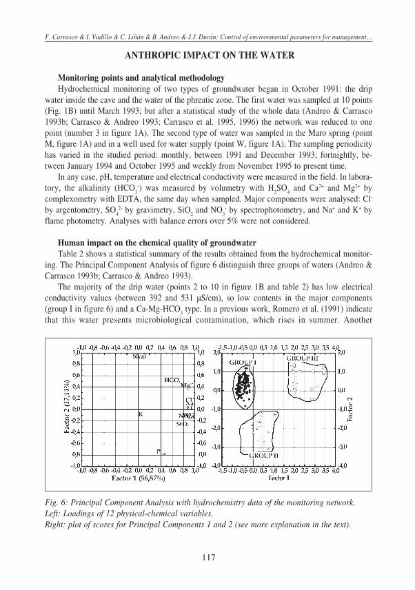
Human impact on the chemical quality of groundwaterTable 2 shows a statistical summary of the results obtained from the hydrochemical monitor-
ing. The Principal Component Analysis of figure 6 distinguish three groups of waters (Andreo &Carrasco 1993b; Carrasco & Andreo 1993).
The majority of the drip water (points 2 to 10 in figure 1B and table 2) has low electricalconductivity values (between 392 and 531 µS/cm), so low contents in the major components(group I in figure 6) and a Ca-Mg-HCO
3 type. In a previous work, Romero et al. (1991) indicate
that this water presents microbiological contamination, which rises in summer. Another
Fig. 6: Principal Component Analysis with hydrochemistry data of the monitoring network.Left: Loadings of 12 physical-chemical variables.Right: plot of scores for Principal Components 1 and 2 (see more explanation in the text).
F. Carrasco & I. Vadillo & C. Liñán & B. Andreo & J.J. Durán: Control of environmental parameters for management ...
Acta carsologica, 31/1 (2002)
118
anthropogenic impact related with the drip water and the lighting is the growing of green algae(Ruiz-Sanchez et al. 1991).
The samples taken from the phreatic zone of the aquifer (group II) have a Ca-HCO3-SO
4 type
of water for point M and a Ca-Mg-HCO3 type for point W (figure 1 and table 2). The electrical
conductivity is slightly higher than the group I, 648 at point M and 674 µS/cm at point W.Nevertheless the most mineralised water comes from point 1 in Hall A (group III in figure 6),
which is HCO3-SO
4 Ca-Mg type, and the electrical conductivity between 895 and 1453 µS/cm,
because of the higher content in all the components analysed. This water corresponds to the waterpumped from the well (W) which is used for watering the gardens, passes through the anthropicsoil and drips inside the cave. The concentration factor of the well water in the process of infiltra-tion is approximately 1.5 for the electrical conductivity and carbonate parameters (HCO
3-, Ca2+
and Mg2+), whereas this factor is superior to 2.0 for Cl- and Na+ and reaches 3.2 in the SO4
2-
content. The flow towards the interior of the cave produces a reconcentration in all the majorcomponents, particularly in SO
42- (297 mg/l as mean value), Cl- (84 mg/l) and Na+ (33 mg/l),
which come both of rainfall and anthropic soil origin. In the vicinity of point 1 there are someother drip points, not considered here, that show the same hydrochemical features.
So the human intrusion in the Nerja Cave produces impacts on the natural quality of thegroundwater, because of the anthropic activities in garden zones and in the services installed.
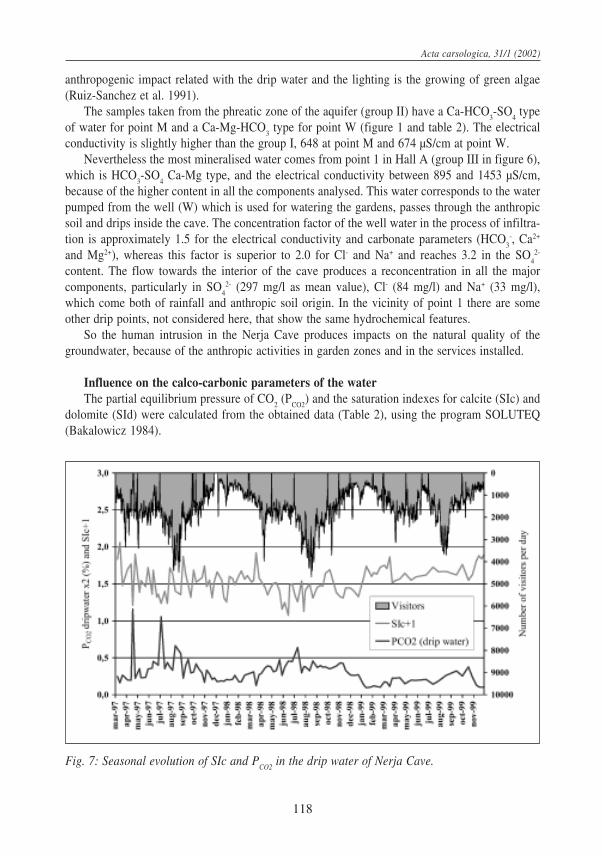
Influence on the calco-carbonic parameters of the waterThe partial equilibrium pressure of CO
2 (P
CO2) and the saturation indexes for calcite (SIc) and
dolomite (SId) were calculated from the obtained data (Table 2), using the program SOLUTEQ(Bakalowicz 1984).
Fig. 7: Seasonal evolution of SIc and PCO2
in the drip water of Nerja Cave.
119
Normally the drip water is supersaturated with respect to calcite (SIc = 0.60-0.95) and dolo-mite (SId = 1.67-2.17) and presents P
CO2 values varying 0.05-0.18 × 10⁻² atm. Point 1 presents
higher values in these parameters SIc = 0.86, SId = 1.64, PCO2
= 0.43 × 10⁻² atm, because it comesfrom the well and passes through the garden soil where a relatively important biological activitytakes place, producing more CO
2 than in the soil which exists above the rest of the cavity.
The seasonal evolution of PCO2
in the drip water (Fig. 7) shows, in general, low values inwinter and high values in summer. This temporal evolution of the P
CO2 in water is related to
natural factors: the rainfall that infiltrates dissolves the CO2 produced in the soil by biological
activity and is transported towards the cave. Although PCO2
in water has a natural origin, proc-esses in which visitors are involved might not be absolutely neglected, because in summer thereare more visitors, introducing more CO
2 into the atmosphere of the cave. The increasing in P
CO2
produces a disminution in the SIc values and an alteration of the speleothems may occur.
CONCLUSIONS
In the caves open to the public, such as the Nerja Cave, the considerable number of visitorsproduces an impact on the environmental parameters inside the cave and on the hydrochemicalcharacteristics of the groundwater.
Main daily changes in environmental parameters are the following: cave air temperature risesto 0.2°C per 1,000 visitors, temperature of the rock rises between 0.02°C and 0.15°C, relative airhumidity increases to 2-3%, nearly reaching saturation on some summer days and the carbondioxide concentration can reach values 10 times greater than the natural mean value.
The majority of drip water has low mineralisation, it is HCO3 Mg-Ca type. In addition, the
PCO2
of the water drip increases in summer. This PCO2
increase produces a disminution in the SIcvalues and alteration of the speleothems may occur.
Condensation processes might occur, because during some summer days the relative humidityin the cave atmosphere reaches 100%, which could originate water unsaturated in calcite able todissolve CaCO
3 from the spelothems. Moreover, in sites where drip water and light coexist, green
algae appears.In the areas inside the cave but closer to the entrance, the drip water sampled is very mineral-
ised and HCO3-SO
4 Ca-Mg type, because it is water pumped from a well, used for watering the
garden. So this drip water has high concentration in SO4
2-, Cl- and Na+, originated from dissolu-tion of these components in the anthropic soil and reconcentration of the rainfall
ACKNOWLEDGEMENTS
To the Nerja Cave Foundation for its financial assistance to carry out this study. This study isalso a contribution of the Research Group RNM-308 of the Andalusian Government to the ProjectIGCP 448 of UNESCO and Pb98-1397.
F. Carrasco & I. Vadillo & C. Liñán & B. Andreo & J.J. Durán: Control of environmental parameters for management ...
Acta carsologica, 31/1 (2002)
120
REFERENCES
Andreo, B. & Carrasco, F., 1993a: Estudio hidrogeológico del entorno de la Cueva de Nerja. In:Geología de la Cueva de Nerja (Carrasco F. ed). Trabajos sobre la Cueva de Nerja, 3:163-187.
Andreo, B. & Carrasco, F., 1993b: Estudio geoquímico de las aguas de infiltración de la Cueva deNerja. In: Geología de la Cueva de Nerja (Carrasco F. ed). Trabajos sobre la Cueva deNerja, 3: 299-328.
Andreo, B. & Carrasco, F. & Sanz de Galdeano, C., 1993: Estudio geológico del entorno de laCueva de Nerja. In: Geología de la Cueva de Nerja (Carrasco F. ed). Trabajos sobre laCueva de Nerja, 3: 25-50.
Andrieux, C., 1988: Influence del’homme sur l’environnement climatique souterrain. Actes desJournées Trombes, Moulis, Ariège, 1: 96-122.
Atkinson, T.C., 1977: Carbon dioxide in the atmosphere of the unsaturated zone: an importantcontrol of groundwater hardness in limestones. J. Hydrol., 35: 111-123.
Bakalowicz, M., 1984: Water chemistry of some karst environments in Norway. Norks. Geogr.Tidsskr 38: 209-214.
Benavente, J. & Almécija, C., 1993: Estudio geomorfológico del entorno de la Cueva de Nerja.In: Geología de la Cueva de Nerja (Carrasco F. ed). Trabajos sobre la Cueva de Nerja, 3:119-158.
Bertolani, M. & Cigna, A. & Maccio, S. & Morbidelli, L. & Sighnolfi, G., 1991: The kasrt system“Grotta Grande del Vento-Grotta del Fuime” and the conservation of its environment.Proceedings of the International Conference on environmental changes in karst areas,Univ. Padova, 13: 289-298.
Cañete, S., 1997: Concentraciones en Radón e intercambio de aire en la Cueva de Nerja. Tesis deLicenciatura, Univ. Málaga, 84 p, unpublished.
Carrasco, F. & Andreo, B., 1993: Características de las aguas de infiltración de la Cueva de Nerja(Málaga). Geogaceta, 14: 9-12.
Carrasco, F. & Andreo, B. & Benavente, J. & Vadillo, I., 1995: Chemistry of the Nerja Cavesystem (Andalusia, Spain). Cave and Karst Science, 21 (2): 27-32.
Carrasco, F. & Andreo, B. & Liñán, C. & Vadillo, I., 1996: Consideraciones sobre el funcionamientohidrogeológico del entorno de la Cueva de Nerja (provincia de Málaga). Jornadas sobreRecursos Hídricos en regiones kársticas, Vitoria, 249-263.
Carrasco, F. & Andreo, B. & Vadillo, I. & Durán, J.J. & Liñán, C., 1999: El medio ambientesubterráneo de la Cueva de Nerja (Málaga). Modificaciones antrópicas. In: The scientificstudy of karstic cavities as a contribution to geological knowledge (Andreo B., CarrascoF. and Durán J.J., eds.), 323-334.
Cigna, A., 1993: Environmental management of tourist caves: the examples of Grotta di Castellanaand Grotta Grande del Vento, Italy. Environmental Geol., 21: 173-180.
Dueñas C. & Fernández M.C. & Cañete S. & Carretero J. & Liger E., 1999: 222Rn concentrations,natural flow rate and the radiation exposure levels in the Nerja Cave. Atmospheric Envi-ronment, 33: 501-510.
Durán, J.J. & Grün, R. & Ford, D., 1993: Dataciones geocronológicas (métodos ESR y series deUranio) en la Cueva de Nerja. Implicaciones evolutivas, paleoclimáticas y neotectónicas.
121
In: Geología de la Cueva de Nerja (Carrasco F. ed). Trabajos sobre la Cueva de Nerja, 3:233-248.
Fernández, P.L. & Gutiérrez, I. & Quindós, L.S. & Soto, J. & Villar, E., 1986: Natural ventilationof the Paintings Room in the Altamira Cave. Nature, 321: 586-588.
Huppert, G. & Burri, E. & Forti, P. & Cigna, A., 1993: Effects of tourist development on cavesand karst. Catena supplement, 25: 251-268.
IGME 1983: Informe n° 10 sobre el Sistema Acuífero n° 41: calizas y dolomías triásicas de laSierra Almijara-Sierra de Lújar. Memoria y anejos.
Liñán C. & Andreo B. & Carrasco F. & Vadillo I., 1999: Hidrodinámica e hidroquímica de lasaguas de goteo de la Cueva de Nerja. In: The scientific study of karstic cavities as a contri-bution to geological knowledge (Andreo B., Carrasco F. and Durán J.J, eds.), 393-402.
Liñán C. & Andreo, B. & Carrasco, F., 2000: Caracterización hidrodinámica e hidroquímica delmanantial de Maro (Sierra Almijara, provincia de Málaga). Geogaceta, 27: 95-98.
Mangin, A. & Bakalowicz, M. & Andrieux, C. & D´Hulst, D. & Daffis, J., 1991: Etude de l’environnement souterrain de la Grotte du Pech-Merle Cabbrerets (Lot). Report du CentreNational de la Reserche Scientifique, 45 p.
Mangin, A. & D´Hulst, D., 1995: Fréquentation des grottes touristiques et conservation. Méthoded´approche pour en étudier les effets et proposer une réglementation. SimposioInternazionale Grotte turistiche e Monitoraggio Ambientale, Stazione Scient, Bossea, Italia,117-145.
Mangin, A. & Bourges, F. & D´Hulst, D., 1999: La conservation des grottes ornées: un problèmede stabilité d’un système naturel (l’exemple de la grotte préhistorique de Gargas, Pyrénéesfrançaises). C.R. Acad. Sci. Paris, 329: 295-301.
Marion, J.B. & Homyak, W.F., 1985: General Physics with Bioscience Essay. John Wiley and Sons.Pulido-Bosch, A. & Martin-Rosales, W. & López-Chicano, M. & Rodríguez-Navarro, C.M. &
Vallejos, A., 1997: Human impact in a tourist karstic cave (Aracena, Spain). Environmen-tal Geol., 31: 142-149.
Romero, P. & Borrego, J.J. & De Vicente, A. & Moriñigo, A. & Martínez-Manzanares, E. &Arrabal, F. & Florido, J.A. & Avilés, M. & Cornax, R. & Codina, J.C. & Arcos, M.L.,1991: Estudio microbiológico y químico de las aguas de la Cueva de Nerja (Málaga). In:Investigación biológica y edafológica de la Cueva de Nerja (Marín F. & Carrasco F.,eds). Trabajos sobre la Cueva de Nerja, 2: 45-109.
Ruiz Sánchez, I. & Marín-Girón, F. & Ojeda, F. & Marín-Olalla, F. & Berros, J. & Marín- Olalla,E., 1991: Estudio macroscópico “in situ” y microscópico-ecológico de pequeñas zonas deflora verde (algas verdes y verdeazuladas) del interior de la Cueva de Nerja. In:Investigación Biológica y edafológica de la Cueva de Nerja (Marín F. & Carrasco F.,eds). Trabajos sobre la Cueva de Nerja, 2: 113-125.
Sanz de Galdeano, C., 1986: Structure et stratigraphie du secteur oriental de la Sierra Almijara(Zone Alpujárride, Cordilléres Bétiques). Estudios Geol., 42: 281-289.
SGOP 1991: Estudio hidrogeológico de las Sierras Tejeda, Almijara y Guájares (Málaga y Gra-nada). Technical report.
Troester J.M. & White, W.B., 1984: Seasonal fluctuations in the carbon dioxide partial pressurein a cave atmosphere. Water Resources Research, 20: 153-156.
Trombe F., 1952: Traité de Speleologie. Payot. París.
F. Carrasco & I. Vadillo & C. Liñán & B. Andreo & J.J. Durán: Control of environmental parameters for management ...
Acta carsologica, 31/1 (2002)
122
PREGLED OKOLJSKIH PARAMETROV PRI VODENJU IN VAROVANJUJAME NERJA (MÁLAGA, [PANIJA)
Povzetek
Jama Nerja je v ju‘ni [paniji, v Andaluziji, 50 km vzhodno od Málage in manj kot kilometerod morja. Jama je razdeljena na dva dela: turisti~ni obsega tretjino jame v vhodnem delu, neturisti~nidel pa obsega ostali dve tretjini v notranjem delu, ki ga le ob~asno obi{~e skupina raziskovalcevali speleologov. Jama je skoraj vodoravna, z volumnom okoli 300.000 m3. Najve~ji rovi so vsmeri S - J in N3 5E, kar sovpada z glavnimi smermi razpok.
Z geolo{kega vidika le‘i Nerja v Betijskih Kordiljerah, v kompleksu Alpujarride, v zgornjemdelu enote Almijara. To enoto sestavljata paleozojska metapelitska formacija v spodnjem delu,nad njo pa karbonatna formacija. Sama jama je razvita v dolomitnih marmorjih te zadnje formacije.Zaradi neotektonske aktivnosti je jama danes v nezasi~eni coni vodonosnika.
Klima tega podro~ja je tipi~na sredozemska, s srednjo letno temperaturo 16,5 °C, v razponumed 11,4 °C januarja in 24 °C avgusta. Srednja letna koli~ina padavin je 500 mm, ki pa soneenakomerno razporejene, z de‘jem od novembra do januarja in suhim poletjem.
Jama je bila odkrita 1959 in naslednjega leta odprta za obisk. Od takrat si je jamo ogladaloveliko {tevilo obiskovalcev, preko 500.000 letno. Tak obisk seveda vpliva na jamo: spreminjajose klimatski pokazatelji (temperatura, vla‘nost in koli~ina CO
2), onesna‘enje in spremembe
fizikalno-kemijskih lastnosti vode in spremembe na kamnini. Kjer sta svetloba in voda, se pojavljamikroflora (predvsem alge). Zaradi tega so potrebne obse‘ne raziskave pokazateljev okolja terfizi~nih in kemi~nih lastnosti vode, tako v jami kot tudi na povr{ju.
Da bi ugotovili vpliv turisti~nega obiska na podzemeljsko okolje, je bila 1993 vzpostavljenaopazovalna mre‘a (monitoring), ki naj bi spremljala razli~ne pokazatelje (temperaturo zraka inskale, relativno vla‘nost, koncentracijo CO
2, zra~ni pritisk in hitrost vetra) v enournih presledkih.
Od 1991 je uvedeno spremljanje hidrokemi~nih pokazateljev v kapljajo~i vodi in v iztoku izkarbonatnega vodonosnika. To zvezno spremljanje fizikalno-kemijskih lastnosti v kapljajo~i vodi,njene dnevne koli~ine, kot tudi temperature in vla‘nosti zraka, koncentracije CO
2 in temperature
skale ka‘ejo na vpliv ~loveka.Dnevne spremembe okoljskih pokazateljev so: na vsakih 1000 obiskovalcev se temperatura
zraka zvi{a za 0,2 °C, temperatura skale zraste od 0,02 °C do 0,15 °C, relativna vla‘nost zraka za2-3 % in v poletnih dneh skoraj dose‘e zasi~enje in koncentracija ogljikovega dioksida lahkodose‘e desetkrat ve~je vrednosti od naravnega povpre~ka.
Najve~ji del kapljajo~e vode ima zelo nizko mineralizacijo tipa HCO-3 Mg2+, Ca2+ in ka‘e
mikrobiolo{ko kontaminacijo, posebno poleti, ko je najve~ obiskovalcev. Povrhu se v kapljajo~ivodi ka‘ejo spremembe P(CO
2), in sicer nara{~anje poleti, kar sovpada z ve~jim obiskom, in
padanje indeksa zasi~enosti s karbonatnimi minerali, zaradi ~esar lahko pride do razpadanjakapnikov. Lahko pride tudi do procesa kondenzacije, saj je poleti temperatura skale ni‘ja odjamskega zraka, relativna vla‘nost pa dose‘e 100 %, kar spet lahko da vodo, nezasi~eno s kalcitomin torej sposobno razgrajevati kapnike.
V zunanjem coni tistega dela jame, ki je namenjen obisku, ka‘ejo vzorci kapljajo~e vodevisoko mineralizacijo tipa HCO-
3, SO2-
4, Ca2+, Mg2+, saj gre za vodo, ki jo ~rpajo iz vodnjaka in
uporabljajo kot pitno vodo in za namakanje. Ta kapljajo~a voda ima torej visoke koncentracijeSO2-
4, Cl- in Na+, ki jih izpira iz vrtnih prsti.
Related Documents