Journal of Social Archaeology 2014, Vol. 14(1) 87–111 ! The Author(s) 2013 Reprints and permissions: sagepub.co.uk/journalsPermissions.nav DOI: 10.1177/1469605313509182 jsa.sagepub.com Article Considering the wet homelands of indigenous Massachusetts Jonathan K. Patton Massachusetts Historical Commission, Boston, MA, USA Abstract This paper uses ideas developed by Ian McNiven in his analysis of ethnographic and archeological data for indigenous relationships with the sea in northeastern Australia, in combination with regional New England ethnographic and archeological scholarship to offer an alternative way to think about indigenous culture in Massachusetts as wet and dry aspects of indigenous homelands within a hydrogeographic perspective using fresh and saltwater drainages. This way to think is based on local people’s accumulated knowledge that conceptualizes water and landscapes as animated seascapes and spir- itscapes of a homeland, incorporating cognitive aspects of navigation and watercraft construction and use. Keywords hydrogeography in archeology, seascapes, homelands, navigation, watercraft construction The Commonwealth of Massachusetts, within the southern portion of the penin- sula of New England in the northeastern United States, is a bounded political space initially conceived in the 17th century following Anglo-European colonial conven- tions of property delineation, use, and ownership. This state overlaid a set of boundaries on deep time cultural spaces and important places of the Native American people (e.g. Bruchac, 2005) and their ancestors who had lived many generations here, since at least the retreat of the glaciers ca. 13,000 years ago. Corresponding author: Jonathan K. Patton, Massachusetts Historical Commission, 220 Morrissey Blvd., Boston, MA 02356, USA. Email: [email protected] at PENNSYLVANIA STATE UNIV on February 18, 2016 jsa.sagepub.com Downloaded from

Welcome message from author
This document is posted to help you gain knowledge. Please leave a comment to let me know what you think about it! Share it to your friends and learn new things together.
Transcript

Journal of Social Archaeology
2014, Vol. 14(1) 87–111
! The Author(s) 2013
Reprints and permissions:
sagepub.co.uk/journalsPermissions.nav
DOI: 10.1177/1469605313509182
jsa.sagepub.com
Article
Considering the wethomelands of indigenousMassachusetts
Jonathan K. PattonMassachusetts Historical Commission, Boston, MA, USA
Abstract
This paper uses ideas developed by Ian McNiven in his analysis of ethnographic and
archeological data for indigenous relationships with the sea in northeastern Australia, in
combination with regional New England ethnographic and archeological scholarship to
offer an alternative way to think about indigenous culture in Massachusetts as wet and
dry aspects of indigenous homelands within a hydrogeographic perspective using fresh
and saltwater drainages. This way to think is based on local people’s accumulated
knowledge that conceptualizes water and landscapes as animated seascapes and spir-
itscapes of a homeland, incorporating cognitive aspects of navigation and watercraft
construction and use.
Keywords
hydrogeography in archeology, seascapes, homelands, navigation, watercraft
construction
The Commonwealth of Massachusetts, within the southern portion of the penin-sula of New England in the northeastern United States, is a bounded political spaceinitially conceived in the 17th century following Anglo-European colonial conven-tions of property delineation, use, and ownership. This state overlaid a set ofboundaries on deep time cultural spaces and important places of the NativeAmerican people (e.g. Bruchac, 2005) and their ancestors who had lived manygenerations here, since at least the retreat of the glaciers ca. 13,000 years ago.
Corresponding author:
Jonathan K. Patton, Massachusetts Historical Commission, 220 Morrissey Blvd., Boston, MA 02356, USA.
Email: [email protected]
at PENNSYLVANIA STATE UNIV on February 18, 2016jsa.sagepub.comDownloaded from

The indigenous people of Massachusetts are presented here as members ofBragdon’s Ninnimissinuok (1996: xi) and Harper’s Northeast WoodlandsHunting complex (1999: 1) that suggest inter- and intra-generational relationships,familiarity, and sharing of identities within the places and spaces that would laterbe defined within the Commonwealth of Massachusetts.
The current boundaries of Massachusetts include extensive water resources,multiple river drainages, and a coastline that incorporates many hundred squarekilometers of freshwater, estuarine, and saltwater environments. A drainage-basedarcheological model of ancient occupation and settlement, defined by multiplemajor and minor river drainages (Figure 1) including, from west to east, theHousatonic, the Connecticut, the Blackstone, Quaboag, Sudbury/Assabet/Concord, Merrimack, Charles, Neponset, Taunton, and Coastal Cape Cod andIslands, is most effective to think about occupation and land use in Massachusetts.
The Pleistocene to Holocene environmental evolution of drainages inNew England and Massachusetts, as glacial lakes were created and drained(Curran, 2003; Nicolas, 1999), and coastal areas inundated or subject to rebound,can be conceived through multiple generations of indigenous creation stories, oraltraditions, and shared memories (e.g. Bruchac, 2005; Simmons, 1970, 1986). Thedrainage conception should be understood to apply all the way out to the edge ofthe continental shelf, to what was the coast, ca. 11,000 years ago. The differenti-ation of ‘‘coast’’ within this definition is thus a relative, fluid definition (see Bell,2009b; Erlandson and Fitzpatrick, 2006; Ford, 2011 for additional discussion).
Figure 1. Massachusetts drainages (http://www.mass.gov/eea/docs/eea/water/watersheds-
map.pdf).
88 Journal of Social Archaeology 14(1)
at PENNSYLVANIA STATE UNIV on February 18, 2016jsa.sagepub.comDownloaded from
The nature of sea level change over the course of the Holocene is primary to ourunderstanding of the changing intersections of land, water, and people’s inter-actions with them in Massachusetts. Postglacial Holocene isostatic rebound andsea level change, long considered in the region’s archeology from the environmentalperspective, have been receiving renewed attention in cultural resources survey ofcurrent offshore renewable energy development (e.g. Robinson, 2002; Robinsonand Waller, 2002; Robinson et al., 2003, 2004; and the Rhode Island’s SpatialArea Management Plan, http://seagrant.gso.uri.edu/oceansamp/) and by coastalmanagers and indigenous communities (eg. Bell, 2009a, 2009b).
The indigenous inhabitants of the bounded space now called theCommonwealth of Massachusetts understood the flow of waters. The dendriticnature of the waterways within these drainages and ecotones within coastal andestuarine marshes, springs, swamps, and upland riverine and freshwater lake areashas been lived with and on for many generations.
For example, the Wampanoag people of Aquinnah on the island of Martha’sVineyard tell of their ancestors walking to the island, which was uplands along thecoastal plain, and later regularly paddling around Cape Cod and among the islandsof Buzzard’s Bay, Martha’s Vineyard, and Nantucket (Coombs, 2003; Peters,2002).
This regional scholarship, in combination with ideas developed by Ian McNiven(2003) in his analysis of ethnographic and archeological data for Aboriginal rela-tionships with the sea in northeastern Australia, offers an alternative way to thinkabout indigenous culture in Massachusetts as wet and dry aspects of indigenoushomelands to complement existing land-based models. This way to think is basedon local people’s knowledge that conceptualizes water and landscapes as animatedspiritscapes of a homeland, incorporating cognitive aspects of navigation andwatercraft construction and use. These elements will be discussed in the contextof regional research in archeology and ethnohistory, with examples from south-eastern Massachusetts.
The wet homeland
Among the Australian Aboriginal people, the sea and land interfaces are viewedcosmologically through the lense(s) of human interactions with the spirit world(s)and the Dreamtime stories. There exist cosmological definitions for perceptions ofenvironment, space, time, and material culture, and people are continually enga-ging with their world through these lenses in a dynamic way. Features of the sea(and landscape) are created by ancestral beings. Use of the sea (and land) ismediated by long-term patterns of customary tenure and reinforced through ritualsto maintain and negotiate boundaries and interfaces, and through these inter-actions, maintain individual and group identities.
Ritual interactions may be both active and passive, including formal ceremoniesof renewal and distribution to maintain social and spiritual balance (see Vitelli,2010 for this in New England), or proper ways of doing, such as hunting rituals
Patton 89
at PENNSYLVANIA STATE UNIV on February 18, 2016jsa.sagepub.comDownloaded from

(see Harper, 1999; Westerdahl, 2005), with propitious offerings to ensure successand safety during the hunt. These comprehensive cosmological ways to think areappropriate to apply for understanding indigenous culture in Massachusetts. Insuch a conception, the water and the land are separate physical elements, butinseparable within the cognitive cosmological universe.
McNiven’s ideas resonate within existing regional New England ethnohistoricalindigenous scholarship (e.g. Bragdon, 1996, 2006, 2010; Simmons, 1986), especiallyin contemporary scholarly conceptions of indigenous homelands (Bruchac, 2005;Handsman, 2008; Handsman and Lamb Richmond, 1995). The homeland com-prises multiple landscapes and ‘‘taskscapes’’ (Ingold, 1993; see also Cronon 1983).The homeland includes ‘‘an extensive network of paths connected all these livingsites to one another and to a network of traditional resource locations: fishing sites,groves of nut trees, burned over fields, wetlands, shellfish collecting places, andcoastal beaches where stranded whales were sometimes found’’ (Handsman, 2010:7). The homeland implicitly includes ‘‘maritime cultural landscapes’’ as describedby Westerdahl (2005, 2011) and codified in recent publications, including journals(e.g. Erlandson and Fitzpatrick, 2006) and edited volumes (e.g. Ford, 2011: 4, 5).The key difference is that cognition in the context of maritime indigenous peoplesmust be primarily spiritual. McNiven’s ideas of the ‘‘seascape’’ that focus the viewfrom the water to the land and vice versa symbiotically through a spiritual, asopposed to a strictly environmental view, are appropriate for understanding therelationship to water of past indigenous peoples in Massachusetts.
The homelands have their wet and dry aspects, and the interfaces of wet and dryare places of spiritual power through their liminality and boundedness (Bragdon,1996: 192; cf. Hamell, 1987). The wet aspect of the homelands encompasses allwaters, whether springs, bogs, swamps, wetlands, small inland lakes, kettleholeponds, tributary streams, large rivers, marshes, or greens of sandy eelgrass bedsor open saltwater bays, and deep blue waters offshore. The wet/dry interfaces occurwithin spiritscapes, based on a cyclical, experiential knowledge gained throughapprenticeships and stories over many generations within a holistic, cyclical world-view inseparable from the spiritual.
Interconnections among natural and physical elements, such as winds, direc-tions, tides, colors, weather and seasons, deities and spiritual beings, and traditionsof interaction and intercession, are critical to understanding homelands in the wetand dry. These cosmological connections have been amply described among theNinnimissinuok (see especially Bragdon, 1996: 184–193, 2009: 28–38; Simmons,1986: 38–41).
Core cosmological beliefs and oppositions may be seen as instruments or toolswithin a spiritual navigational framework and toolkit on the land and the water.For example, the southwest is understood to be a favorable direction inAlgonquian cosmology, the prevailing traditional burial orientation in SouthernNew England (Simmons, 1970; Vitelli, 2010; Williams, 1997), associated with ben-evolent deities such as Cantantowwit and Hobbomok and ‘‘dry’’ colors, such asblue and white. Conversely, the northeast direction is associated with malevolent
90 Journal of Social Archaeology 14(1)
at PENNSYLVANIA STATE UNIV on February 18, 2016jsa.sagepub.comDownloaded from

deities such as Chepi and ‘‘wet’’ colors such as black and red. The northeast is theprevalent direction of winter storm winds in coastal Massachusetts, the so-calledNor’easters that can cause great damage to coastal areas. This southwest–northeastopposition balances spiritual associations and weather patterns in Massachusettsand may be fundamental to navigation across boundaries throughout these home-lands, especially in watercraft, as will be discussed in the context of the BostonHarbor Islands.
The wet homeland is a constantly revised collective cultural knowledge on spir-itual, natural, and physical patterns and associations that may change over time; ofdeities and rituals associated with geographic land/water interfaces, winds, cur-rents, tides, wave patterns, celestial movements, water depths and types (saltversus fresh/interior versus coastal/slow versus fast waters), shallows, snags,rapids, eddies, best beaching and launching grounds, portages, fresh water loca-tions, food sources (shellfish banks, fishing holes, anadromous fish run shallows,eel grass beds, drift whale beaches, etc.), and raw material sources and locationsconnected by water.
Hydrologically central locations of spiritual importance, such as ancestral burialplaces and deep time occupation locations, may also be of special importance.These locations serve to literally ground and interconnect the wet and dry aspectsof the homeland through the ancestors and spirits that reside there and who can be(re)visited during journeys to reinforce identities. Archeology has been conductedat several of these important places, such as at the Wampanucket Complex onAssawompsett Pond (Robbins, 1980) and Annasnappet Brook/Pond (Doucetteand Cross, 1997) within the middle and upper Taunton River drainage, and theMillbury III Site within the middle Blackstone River drainage (Leveillee, 1998).The archeology done at these locations can have added significance, as part of thereinforcement of homelands, when viewed hydrologically.
Navigation
The individual navigator’s perspectives are also integral to movement within thewet homeland, including his or her knowledge of their own skills, their watercraft,its abilities and limitations, and those of their crew, to define and guide the givenjourney. The sharing and transmission of such knowledge is understood to bethrough oral traditions and physical signs. The use of some established form ofwind compass or wind, weather, and swell refraction based navigational ‘‘system’’for green (coastal) and blue (offshore out of site of land) water travel has not beendemonstrated for Massachusetts, but is certainly feasible given the cosmologicalconnections mentioned earlier. For comparison, the ancient ‘‘PolynesianNavigation System’’ Te Nohoanga Te Matangi (George, 2012) in the western andcentral Pacific is based on a 32-point wind compass, celestial star pairings, andunderstandings of wave refraction patterns.
If indigenous peoples of Massachusetts employed an equivalent system for localconditions, then resolution of the cultural and natural variables involved may
Patton 91
at PENNSYLVANIA STATE UNIV on February 18, 2016jsa.sagepub.comDownloaded from

further illuminate past patterns of movement within homelands. The essence of any‘‘system’’ is the constant study and multigenerational living in a given area, tounderstand first the local patterns of the waters and lands, so that these feelingsand knowledge may then be applied in other places where similar patterns may bereadily observed. The Polynesian practice of teaching young navigators by havingthem float for hours in tide pools, to feel the winds, tides, and currents, is oneexample of this intimacy with the waters that must be cultivated to produce acompetent navigator.
Typical offshore inter-island voyages in the Pacific would continue throughnights and days, with certain times of the day and night more favorable for iden-tifying navigational information, e.g. moon and sun rises, star rises and sets, birdand marine animal patterns. Similarly, modern analogs of coastal canoe voyages byCharles Blanchard (1999, 2002) on the western coast of Florida, along knownancient and historic period canoe trail routes of the Calusa people, have demon-strated that coastal travel by canoe uses the full 24 h to obtain the most favorablepaddling conditions along a given route. The paddler must work in harmony withthe wind, currents, weather patterns, geography, and celestial patterns. If condi-tions are unfavorable, then the navigator may decide to pause the journey, to rest,conduct spiritual reconnections, restock supplies locally, and repair gear, untilconditions are again favorable.
This realization is fundamental to our understanding of the dry/wet interfaces ascritical to continuity of the cyclical relationship of people and place. As on land,the water journey serves to reinforce and maintain spiritual and social connectionsand the homeland itself through the multitude of small actions done during the actof moving. The importance of the connections of daily living cycles with celestialbodies, including the Moon, Sun, and principal constellations, has been shownamong Massachusetts indigenous peoples (e.g. Bradgon, 1996, 2009). The connec-tion of the Moon to daily and yearly tidal cycles is especially important to considerwithin the wider seasonal cycles of habitation movement from coast to interior andback again that are observed archeologically during at least the Archaic Period inMassachusetts.
As noted especially in Maine and Massachusetts, the use of toponyms is criticalto place identification in the homeland (Krim, 1982; Prins and McBride, 2007: 110)along coastal routes. The name of a place is the reason why that place is important,intrinsically, spiritually, and in its assistance to navigation on the way to otherplaces (see Cook, 2007 for an extensive discussion of colonial Maine canoe routes).Perhaps the knowledge of navigation within the wet homeland and the relation-ships for the sharing of its experiences and rituals, were limited to transmissionbetween and among those individuals most comfortable with the water. They couldpotentially, but not necessarily, have the additional attributes to be navigators. Asin our own society, not everyone in a given group wants or is able to be a waterperson or navigator and embrace the floating life, or process themselves from landto water and back again. Cook (2007: 2) refers to this lifestyle as ‘‘canoe behavior’’among the indigenous peoples of Maine.
92 Journal of Social Archaeology 14(1)
at PENNSYLVANIA STATE UNIV on February 18, 2016jsa.sagepub.comDownloaded from

Figuring importantly into the wet homeland, as has been noted for the dry land,is the consideration of a gendering of spaces. As noted by Bragdon (1996) andClements (2010), the conventional understanding of water and gender amongSouthern New England indigenous peoples, from the Late Woodland Period(approximately 1000 years before present) through the historical period indicatesthat the littoral zones were female spaces, for collecting of shellfish etc., versus thedeep waters, reachable only with constructed watercraft, reserved for men’s fishingand hunting activities. However, the multiple important female sachems ofNantucket and Martha’s Vineyard in the historical period (e.g. Bradgon, 2010)and the importance of Granny Squant in company with Maushop, inWampanoag oral tradition (Simmons, 1970, 1986), suggest that gender divisionsshould not be viewed rigidly, but rely, as with other aspects of living in the home-land, on situational understandings of individual and collective spiritual and socialcapital. The ability of a navigator therefore is not necessarily associated withgender.
Navigation is also predicated on the assumption of conservative engagementwith the water, as the navigator minimizes risk through comprehensive prepar-ation, knowledge, and skill, to only commit maximum resources for good reasonsas evaluated in the moment. Reserves of resources, energy, and spiritual supportmay be expended to the edge of safety and beyond if the risk is justified. Forexample, the decision to paddle in poor conditions to rescue another individualor to secure an injured animal during the hunt may be made if the risk is justified.What constitutes justified risk is cultural, but the risk factors in navigation high-light the essentially circumstantial, and dangerous, nature of water interactions.
Wet and dry interfaces
Within this context of navigational risk assessment, and as has been noted earlier,the wet to dry interface is a liminal place of boundary negotiation. The decision tolaunch, and the act of floating, a canoe, is the primary example of this change ofstate. Following Tilley (2002), canoes, whether implicitly or explicitly, have a cen-tral place as artifacts at the interfaces of homelands because ‘‘they can act as agentsof reproduction or innovation according to the manner in which they are bothappropriated and transmitted. . .they have their own form of communicativeagency’’ (Tilley, 2002: 25). The hull–land to hull–water interface is a place of lim-inality, as the canoe achieves displacement. The paddlers must shift their attentionfrom the spiritual and natural elements of the land to those of the water, andperhaps explicitly or implicitly attend ritually to the different risks in the acts ofshifting.
The beach, as an intertidal zone inundated twice daily, may be especially import-ant in such acts of cognitive cosmological negotiation. In coastal Massachusetts,the interfaces of tidal salt and flowing fresh waters occur at multiple places within agiven drainage, and these locations, as well as other convergences and prominentterrain features, would be powerfully liminal places. Canoe navigation with eastern
Patton 93
at PENNSYLVANIA STATE UNIV on February 18, 2016jsa.sagepub.comDownloaded from

Massachusetts drainages may include staging from coastline to river to lake tocoastline, and implies continual use and revision of accumulated knowledge ofmany generations to journey safely and effectively on both salt and fresh waters.
When sitting or kneeling in a canoe or kayak, the paddler’s eye level is approxi-mately 2–3 ft off the surface of the water. This vertical distance, in combinationwith the slight curvature of the earth serves to define the paddler’s visual perspec-tive from the water to the land. Such a perspective is especially apparent in open,blue water spaces, where horizons serve to define the constantly changing interfacesof land, sea, and sky. Modern kayak navigation texts (e.g. Burch, 1999: 125–127)quantify this relationship of vision from the water to the land based on an assumedheight off the water for a paddler of 2 ft, the square root of which gives amaximum view distance of 1.5 mile, assumed to be a constant. This value canthen be added to the square root of the height of viewed land (e.g. promontory,headland, island, etc.) to determine the geographic range or distance off shore forthat land feature. The use of a measurement device, such as a body part (hand,arm, fingers) or fixed length, such as a paddle shaft or kamal stick and stringarrangement, can also be used to measure the height of a feature to determinerelative distances and to take bearings of prominent features to gauge relativeprogress on the water.
Because of the curvature of the earth, the highest landforms, and the othernatural features that signify them, such as cloud formations and seabird flocks,are seen first from the water. Colors, contrasts, and visibility are contingent andvariable from the water; filtered through navigational knowledge the interface ofwater to land varies with distance. Prominent landward features are specific tocertain areas of coastal Massachusetts. Large shell middens shining white andblue/purple along the Cape Cod shoreline, the multihued cliffs of Gay Head inAquinnah, and the particular cloud and fog formations that hug the islands ofNantucket and Martha’s Vineyard, are prominent navigational features visibleoffshore.
The following examples serve to further illustrate wet homelands in southeasternMassachusetts.
Massachusetts drainages
Taunton River
The Taunton River drainage in southeastern Massachusetts and eastern RhodeIsland (Figure 2) is historically a thruway east to west and north to south, throughwater routes such as the documented Wampanoag Canoe Passage (http://www.tauntonriver.org/canoepassmaps access.htm). This route is a northeast–southwest link in a favored cosmological direction between the North River(with access to Cape Cod Bay) and the Taunton River (with access toNarragansett Bay). As noted in the Massachusetts Historical Commission’sInventory of Historic and Archaeological Assets of the Commonwealth
94 Journal of Social Archaeology 14(1)
at PENNSYLVANIA STATE UNIV on February 18, 2016jsa.sagepub.comDownloaded from

(and Thorbahn, 1984), ancient Native American archeological sites with repeatedoccupations over many generations are identified along the feeder streams of theTaunton River, such as the Nemasket River, Town River, Three Mile River,Hockomock River, and Mattapoisett River. Sites are located at junctions ofthese feeder streams with the Taunton River. Judicious portages also allownorth–south water connections to Buzzards Bay, by and through the larger andsmall lakes of the drainage: Assawompsett Pond, Lake Nippenicket, LakeSabbatia, Stump Pond, Robbins Pond, Monponsett Pond, and Quittacas Pond.
As noted earlier, the locations of several deep time archeologically documentedspecial places that include ancestral burials, such as at Wampanucket and Betty’sNeck on Assawompsett Pond, have been identified archeologically within the
Figure 2. Taunton River drainage (http://www.horsleywitten.com/tauntonwatershed/
Documents/Watershed%20map.pdf).
Patton 95
at PENNSYLVANIA STATE UNIV on February 18, 2016jsa.sagepub.comDownloaded from

Taunton River drainage (see Robbins, 1980: 1–7). These locations are hydrologic-ally central within the drainage and may have served as focal points for spiritualreconnections during movements throughout southeastern Massachusetts.
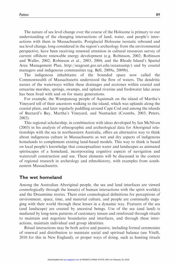
Nantucket Sound
Nantucket Sound, Buzzard’s Bay, including the islands of Gosnold County, easternNarragansettBayandNantucket, andMartha’sVineyardcircumscribe thewethome-lands of theWampanoag people (Figure 3). Prominent island landforms and littoralfeatures atAquinnahonMartha’sVineyard, suchas theGayHeadCliffs,Tuckernuckand Nomans Island, and the Devil’s Bridge, are associated with the Wampanoagcreation stories of Maushop and Squant (Simmons, 1986) and would be integral tothe island homeland of navigators fishing or coasting in that vicinity, both as visuallandmarks, hazards to navigation, and as places of ritual and reconnection.
The contrasting whiteness of coastal shell middens are visibly bright monuments(cf. Sassaman, 2010) to anchor travel routes, serving a prominent points of refer-ence. The use of these land and sea marks (Westerdahl, 2005, 2011) as directional
Figure 3. Nantucket Sound (http://www.charts.noaa.gov/OnLineViewer/
AtlanticCoastViewerTable.shtml 13273).
96 Journal of Social Archaeology 14(1)
at PENNSYLVANIA STATE UNIV on February 18, 2016jsa.sagepub.comDownloaded from
ranges, whereby two points are kept in line to maintain a given direction, for inter-island travel within the Sound is highly likely, as the distances between WoodsHole and the north shore of the Vineyard are entirely visible on a clear day. TheSound between Waquoit Bay, the Bass River, or any of several other points alongthe southern shores of Cape Cod to Monomoy Island, are southern courses toNantucket, with only a few miles of open water where either the coast or the island,or their proxy indicators, are not visible. The swift tidal current patterns and pre-dominant southerly summer winds, the so-called afternoon seabreeze from thesouthwest, within Nantucket Sound may also have served to locate paddlers inopen water without visible land.
The close association of Maushop with whales in Wampanoag stories is a corerelationship in the wet homeland here, as the harvesting of drift whales in thecolonial period (Little and Andrews, 2010) is known to have been limited to specificbeaches in specific sachemships on Nantucket and Martha’s Vineyard. Other pela-gic creatures, such as sharks, swordfish, dolphins, and seals, some of which haveappeared in archeological contexts in northern and southern New England (e.g.Andrews, 1986; Betts et al., 2012; Bradley et al., 1998; Handley, 1996), also havespecific relationships with people spiritually and functionally as food, statusmarkers, and spiritual guides. The historical continuity of Wampanoag shellfishing,fishing, marine hunting, and commercial whaling is well documented,indicating the longevity of wet homelands (see e.g. Bell (2009a, 2009b),Handsman (2010), Nicolas (2002, 2005), and Peters (2006) and the sources citedin those studies).
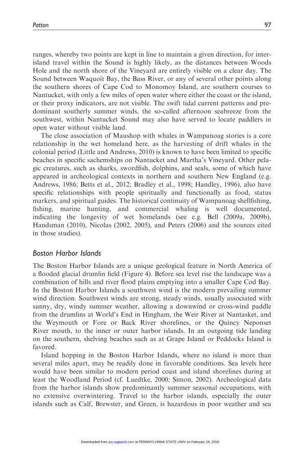
Boston Harbor Islands
The Boston Harbor Islands are a unique geological feature in North America ofa flooded glacial drumlin field (Figure 4). Before sea level rise the landscape was acombination of hills and river flood plains emptying into a smaller Cape Cod Bay.In the Boston Harbor Islands a southwest wind is the modern prevailing summerwind direction. Southwest winds are strong, steady winds, usually associated withsunny, dry, windy summer weather, allowing a downwind or cross-wind paddlefrom the drumlins at World’s End in Hingham, the Weir River at Nantasket, andthe Weymouth or Fore or Back River shorelines, or the Quincy NeponsetRiver mouth, to the inner or outer harbor islands. In an outgoing tide landingon the southern, shelving beaches such as at Grape Island or Peddocks Island isfavored.
Island hopping in the Boston Harbor Islands, where no island is more thanseveral miles apart, may be readily done in favorable conditions. Sea levels herewould have been similar to modern period coast and island shorelines during atleast the Woodland Period (cf. Luedtke, 2000; Simon, 2002). Archeological datafrom the harbor islands show predominantly summer seasonal occupations, withno extensive overwintering. Travel to the harbor islands, especially the outerislands such as Calf, Brewster, and Green, is hazardous in poor weather and sea
Patton 97
at PENNSYLVANIA STATE UNIV on February 18, 2016jsa.sagepub.comDownloaded from
conditions. The northeast wind brings poor weather and inauspicious cosmologicalconditions, suggesting that travel during the winter in this area was not undertakenregularly.
The division of material culture noted by Luedtke (1997, 2000) on ThompsonIsland is interpreted to mark a territorial division between northern and southerngroups—suggested by the presence of lithics from the northern Boston Basin appear-ing at sites only on the north side of that island—may indicate the particular centralspiritual position of Thompson Island in the wet homeland(s) of Boston Harbor.Thompson Island is oriented generally northeast–southwest and occupies a positionat the tidal mouth of the Neponset River to the west, the Castle Island channelaround Dorchester Neck to the north, and the Quincy Bay shoreline to the south.
In a prevailing southerly wind, paddling to Thompson Island from the CharlesRiver and Boston Neck is an upwind, tidally assisted route to land on the northernbeaches, or to sweep around the northern or southern tips of the island to land onthe level shelving beaches of the southern side. Similarly, from the south, the cross-ing is crosswind or downwind in the summer to the southern side of the island,across shorter stretches of water. Paddling north around the tips of the island fromthe south side has the potential to be more difficult in an adverse tide and a north-erly wind, into the open stretches of the harbor, which would generate steep choppy
Figure 4. Boston Harbor Islands (http://www.charts.noaa.gov/OnLineViewer/
AtlanticCoastViewerTable.shtml 13270).
98 Journal of Social Archaeology 14(1)
at PENNSYLVANIA STATE UNIV on February 18, 2016jsa.sagepub.comDownloaded from

waves blowing onto the island. These potential route variables suggest a seasonaland directional asymmetry of access at Thompson Island.
These three drainage examples have presented preliminary use of a paddlingperspective to offer additional insights into existing land and waterscapes. Theconsideration of material culture related to watercraft construction to completethe picture is difficult in Massachusetts. The differential nature of organic materialpreservation in the region means that proxy material culture signifying elements ofthe wet homelands must also be considered.
Considering proxy material culture
Population estimates from the archeological perspective for the Paleo Indian,Archaic, and Woodland Periods (ca. 13,500 years ago to 450 years ago) are stilla subject of debate among the regional New England archeological community(see for example Bernstein, 2006). Seasonal movements between interior and coastare noted especially for the Woodland Period and early colonial Period from the16th century, and an increase in habitation within coastal areas, and especially athydrological features, such as springs, kettle hole ponds, fall lines, riverine topo-graphic features (e.g. oxbows, sharp bends, headwaters, intersections), salinityinterfaces, tidal estuaries, and islands, is noted over time (Bragdon, 1996).
In Northern New England and the Maritime Provinces, including the state ofMaine (Bourque, 2001: 91–92; Cook, 2007; Prins and McBride, 2007), strong indi-genous (water) trail networks, with prominent natural landmarks and archeo-logical signatures, have been maintained through prehistory into the colonialperiod. The work of Charles Blanchard (1999, 2002) in Florida, as noted earlier,has also succeeded in replicating travel patterns within Gulf of Mexico coastalwater trail networks. However, previous regional archeological studies inMassachusetts have used drainage models that prioritize a landward environmen-tally determinist view (e.g. Dincauze and Mulholland, 1977; Thorbahn, 1984) andhinted at the need to further understand cultural interactions at the land/waterinterface (Luedtke, 1983, 1997). City and town reconnaissance studies developed bythe Massachusetts Historical Commission since the 1980s have identified specificland trail networks, but identified only general water trails in major rivers, lakes,and streams, as documented in historic sources.
Archeological recovery of material culture associated with the wet aspect of thehomeland, including watercraft and marine occupations such as fishing, is inhibitedby differential preservation in Massachusetts and the glaciated Northeast. Hencethe archeological story of Massachusetts, that has not maintained a robust con-tinuity of historical indigenous watercraft use, comparable to Northern NewEngland, has been limited to the relative chronological stylistic sequence ofpreserved material culture, including lithic materials, types, tool forms, and pot-tery, within a temporal framework of radiocarbon dates from charred vegetalmacrobotanicals, with limited nonmaterial cultural connections.
Patton 99
at PENNSYLVANIA STATE UNIV on February 18, 2016jsa.sagepub.comDownloaded from

Those rare instances of marine material culture preservation in Massachusettsdrainages, such as dugout canoes and fishweirs (e.g. Nicolas, 1999; Robinson andStedtler, 2011) have served as markers for this less archeologically visible part. Thematerial culture associated with maritime activities is primarily organic, includinganimal and vegetal materials that have been modified, such as bone harpoonpoints, woven netting, and wooden or animal-based watercraft, such as dugoutcanoes, bark canoes, or skin boats. Differential preservation therefore prioritizesthe need to consider proxy material culture from a wet homeland perspective toidentify marine-related activities from those portions of the archeological recordthat are preserved.
Proxy marine material culture may include types of projectile points andground-stone tool forms, considered to be associated with deep water fishingusing harpoons, inshore net, or line fishing within weighted woven nets or lines,and use of heavy ground stone blade forms, described as axes, gouges, adzes, andcelts, to process trees during the construction of dugout canoes. Systematic experi-mental archeology for these activities has not been pursued in Massachusetts,although the reproduction of dugout canoes is regularly practiced using historicaltechniques at the living history museum Plimoth Plantation in Plymouth,Massachusetts.
The discernible presence of proxy artifacts can also be problematic (e.g. Rainey,2000) in the cases of some watercraft designs considered to be made and used inancient Massachusetts, such as skin boats and bark canoes, which rely on cuttingtools that may normally be carried as part of personal or group toolkits, such asbone needles and lithic knife forms. Historically, bark-covered canoes were con-structed with minimal tools (see Jennings, 2002: 59–63 for a construction sequence),including a hatchet and crooked-knife or mocotaugan (http://www.mocotauganthe-book.com/) The mocotaugan, with a curved iron blade is an evolution of a haftedbeaver incisor. It is the ideal tool for shaping straight grain woods such as the spruceand cedar required for the gunwales, ribs, and interior structure of a bark canoe.
Similarly, for animal parts and skin processing, the semicircular ulu knife formof stone or metal is the historically documented implement of choice in arctic skinboat construction (Golden, 2006; Heath and Arima, 2004; Petersen, 1986). Theseimplements also have gendered associations among subarctic and arctic peoples,with the ulu associated with female activities, and the crooked-knife a male imple-ment (Adney and Chappelle, 1983; Jennings, 2002) consistent with male and femalegendered divisions of labor in watercraft construction and use in these cultures (seealso Westerdahl, 2011: 299). The frame is constructed by men and the coveringsewn by women.
The presence of beaver teeth, needles or stone drills, bone handles or ulu (semi-lunar) knife forms within archeological assemblages in Massachusetts could beinferred to suggest the potential for a watercraft construction toolkit. However,as Rainey notes, the use of direct analogy for these associations, especially ofthe ulu tool form, in Massachusetts, should be tentative, and other data sourcesare required.
100 Journal of Social Archaeology 14(1)
at PENNSYLVANIA STATE UNIV on February 18, 2016jsa.sagepub.comDownloaded from

The prevalence of ulu or semilunar forms and ground stone woodwork-ing tools—gouges, adzes, axes, and scrapers—in Archaic period artifact assem-blages in Massachusetts suggests the potential for watercraft constructionduring the Archaic Period (8500 to 3000 years ago). The Woodland Period(3000 to 450 years ago) in Massachusetts could include both dugout canoesor birch-bark canoes based on extension of historical period ethnographic infor-mation and contemporary oral traditions, as described below. The regionalranges of raw materials such as paper birch, ash and spruce, and relative consid-eration of tree diameter and type as related to dugout canoe constructionmust be further contextualized to understand the relative use of these craft inhomelands.
Watercraft use and construction
The particulars of a given watercraft design, such as the given carrying capacity forpeople, gear, and/or raw materials, are culturally proscribed (e.g. Tilley, 2002).Current archeological and ethnographic literature describes indigenous southernNew England precolonial period watercraft functionally as a predominantly sub-tractive design where material is removed–described as the logboat or dugoutcanoe (e.g. Plane, 1991; Volmar, 2006). The Nipmuc and Wampanoag peoples ofMassachusetts oral traditions are supported by this research and their dugouts arecalled mishoon or mushoonash.
Generally within southeastern Massachusetts, including Cape Cod and theislands, the dugout canoe appears to have been preferred among the Wampanoagpeoples. Western and Central Massachusetts within the Connecticut River drainageand northern Massachusetts within the Merrimack River drainage probably alsosaw birch bark canoes, within the range of the paper birch as materials permittedthrough collection or trade. Changes in the design of dugout canoes for freshwaterversus saltwater uses are also documented (see Plane, 1991). Large seagoing dugoutsare documented in the early 17th century, facilitating extensive inter-island andcoastal connections that probably had origins in deep time. Further back into theArchaic period, bark and/or skin boats may have been constructed instead.Communication of method and materials was probably prevalent within the exten-sive trade in lithics and other special materials (e.g. shell, steatite, copper, etc.)exchanged among homeland sources within the wider eastern Atlantic coastalregion.
The dugout
Dugout canoes are hollowed and scraped tree trunks with shaped bows, sterns, andsections. Constructed in multiple lengths from variable types of hard and softwoods (oak, elm, pine, chestnut, etc.), dugouts are predominantly heavy dependingon the type of wood used, and laterally unstable to inexperienced paddlers. Asnoted by Plane (1991) and Yentsch (1981), accidents and drownings associated
Patton 101
at PENNSYLVANIA STATE UNIV on February 18, 2016jsa.sagepub.comDownloaded from

with later colonial use of dugouts, by both skilled and inexperienced paddlers, weresubstantially documented in the historical record.
The act of sinking dugout canoes with stones, at least in freshwater lakes,is observed in archeological contexts in Massachusetts (Figure 5; Robinson andStedtler, 2011). Functionally, this practice preserves the canoe by keeping thewooden structure moist and serves as a kind of storage during winter ice or as cam-ouflage. After multiple cycles of ‘‘burial’’ and recovery, the canoe becomes water-logged and does not float again after the stones are removed. The spiritualimplications of this action within the homeland may be multiple and significant; asa ritual, perhaps as an offering. The sinking locationmay also be highly significant, asterritorial or route markers to reinforce or impose group identity boundaries or guid-ance to cross particular water bodies in a ferry context. The heavy, dugout canoesprevalent in Massachusetts during at least the Woodland and Colonial periods weretypically made for use on particular waterbodies, and were infrequently portaged,suggesting the potential formaintenance of canoe ferry ‘‘chains’’ within drainages, toallow travel along trails consisting of both land and water navigational reaches.
The dugout construction process is extensive, historically using a combination offire, stone, shell, and later metal, woodworking tools to gradually work the treetrunk to the desired shape. The art of this construction lay in choosing the appro-priate tree, as a check or deformity discovered in the inner layers of the tree duringconstruction might ruin the intended hull shape. Subsequent repairs to these craft,such as those noted on extant historical period examples (Fowler, 1975;
Figure 5. Rock-filled dugout in Lake Quinsigamond, Worcester County, Massachusetts
(www.projectmishoon.homestand.com/mishoonphotos.htm).
102 Journal of Social Archaeology 14(1)
at PENNSYLVANIA STATE UNIV on February 18, 2016jsa.sagepub.comDownloaded from
Kevitt, 1968; Petzold, 1961; Plane, 1991), were not ever as robust as the originalwood. Because of their solid construction these individuals are sturdy and long-lived, and will carry forward momentum once moving, but are not maneuverablerelative to other potential watercraft designs, such as those composite designs morecommonly associated with Northern New England and subarctic regions: the birchbark canoe and the skin boats, such as the qayaq and umiak. (For a detaileddiscussion of baidarka, qayaq, and umiak structure and gear in Aleut andGreenlandic, see for example Dyson, 1986; Golden, 2006; Heath and Arima,2004, and Petersen, 1986).
Bark and skin craft
The composite designs require a variety of organic materials to construct, andutilize multiple species of woods and wood products such as tree sap; andanimal products, such as fat, skins, sinews, and bone, which are altered withstone or later metal tools, and combined into a vessel. Composite craft could beconstructed with bark of the paper birch (Betula papyifera) or other barks such aselm or chestnut, over a framework of spruce and cedar, and lashed together withspruce root and waterproofed with sap (Adney and Chappelle, 1983; Jennings,2002). These individuals are easily repairable, relatively light, easily driven, port-able, and maneuverable with paddle or pole in fast moving waters and will ridelightly on ocean swells. They represent the material culmination of many gener-ations of traditional natural knowledge.
Skin-covered craft are equally light, maneuverable, and flexible, but requirereplacement of the entire skin covers at regular intervals. Pinniped skins, such asthose from varieties of seals and walrus, were preferred by subarctic and arcticgroups for the covering of their watercraft. However, the utility of skin coveringsrapidly decreases in temperate climates as the skins degrade in sunlight and warmwaters, as for example the rapid degradation of the walrus skin covers of Aleutianbaidarkas during their attempted use by 19th-century Russian-American Companytraders in Polynesia (Dyson, 1986: 56). In Northern New England, alternate skintypes were used, such as moosehide-covered canoes for expedient freshwater rivertrips from upstream hunting locations in Maine by Penobscot peoples (Prins andMcBride, 2007), but not for extended offshore use, for which the historical Micmacand Penobscot peoples preferred bark canoes (Jennings, 2002).
The use of caribou, seal, or walrus-covered watercraft may be inferred forearly Holocene postglacial occupations of Massachusetts, in which some formof boreal tundra conditions were prevalent, and glacial lakes extensive(e.g. Loring, 1980). Historical parallels from Canadian Inuit groups indicatethat caribou skin-covered kayaks were used to hunt migrating caribou at rivercrossings (Figure 6) in a seasonally predictable pattern. The timing of huntingmay be directly correlated to the selection of pinniped and caribou skins at theirpreferred stages of maturity and season for production of clothing and kayakcoverings.
Patton 103
at PENNSYLVANIA STATE UNIV on February 18, 2016jsa.sagepub.comDownloaded from

Well-documented Paleoindian period occupations, such as the Bull Brook site inEssex County, Massachusetts, offer tantalizing functional hints of the potential foruse of skin-covered kayaks in similar ways. The relative topographical position ofBull Brook on a flat elevation at converging navigable waterways above theAtlantic coastal plain, at the confluence of a waterway and offshore islandknown as Jeffrey’s Ledge, and the extensive lithic assemblage (Robinson et al.,2009), suggests adequate skilled labor and resources to construct kayaks for effi-cient hunting of migrating large mammals. The layout of the Bull Brook Site andits artifact distribution is inferred to represent spatial divisions of specialization inmale and female labor. Based on historical parallels from arctic cultures (Golden,2006; Heath and Arima, 2004; Petersen, 1986), activities at this location could haveincluded the sewing of tight, waterproof garments, and perhaps also the skin coversfor kayaks.
Conclusions: Thinking watercraft and wet homelands
Regardless of construction method the watercraft is literally organic and is con-structed within traditional ways of knowing and doing. The watercraft may bepossibly considered metaphorically or literally as animate, or potentially gendered,and recognized as ‘‘he’’, ‘‘she’’, or ‘‘them’’. Comparative ethnography (e.g.Steinbright, 2001) shows that among other indigenous maritime peoples ofNorth America, watercraft may be integral to individual and group identity.The following song lyrics embody this conception for the Alaskan Inupiat
Figure 6. Canadian inuit Caribou Qayaq (Arima, 1994).
104 Journal of Social Archaeology 14(1)
at PENNSYLVANIA STATE UNIV on February 18, 2016jsa.sagepub.comDownloaded from
people: ‘‘I sing to the seas, I sing to my kayak. It is a part of my body, we fly uponthe waves. It is my companion, my brother, it is my wife. If we die on the sea, wedie together. If we go down together, we remain together. If I die an old man it willrest upon my grave, and still we go on together. And still we remain together’’(Old Inupiat Song, translated by David Hunsacker in Steinbright, 2001: 72).
The animation of watercraft acknowledges the potential position of a particularvessel or group of vessels in the homeland, simultaneously as a spiritual and intan-gible, nonmaterial aspects of culture and as functional, material things. A heuristicof the canoe as a ‘‘floating individual’’ especially encompasses taphonomic pro-cesses familiar to archeologists that transform organic artifacts, but also the con-cept of use-life when viewed as material culture in transformation. Turgeon’s(1997) example of the metal kettle, where an object can have multiple cultural‘‘lives’’ with multiple beginnings, middles, and ends, before passing into an archeo-logical context, may be applied to stone-filled dugout canoes.
The particular design of the canoe may also have important implications for itsrelative position in a homeland. The heavy, solid dugout canoe, less portable than abark canoe, or skin boat, may have as consequence been perceived primarily as anobject to be used to move between and among places. In contrast, the bark canoe,or skin boat as noted for the Alaskan Inuipiat people, that is readily portaged by anindividual and which accompanies one on a hunt or journey, may be more likely tobe perceived as a relation, friend, or guide at times. This observation follows thehistoric period documentation of dugout canoes in northeastern Massachusetts asnumerous, common, and utilitarian (Plane, 1991), comparable to the family car ofthe modern period.
As watercraft were constructed from natural materials, which themselves hadthe potential to possess spiritual force (see Crosby, 1993 for discussions of manitouin Massachusetts; Prins and McBride, 2007 and Bruchac, 2005 for expressions ofmanitou among the Wabanaki of Northern New England), it is appropriate withinthe homeland that this spirit extended situationally to the created vessel, as anamalgamation of multiple natural resources which possessed the energy of theirraw materials (see also Tilley, 2002). As Kathleen J. Bragdon has noted: ‘‘Theworld of the northern hunting peoples from whom the Massachusetts were des-cended was peopled with spirits, sometimes called manitou, who could be called tothe aid of an individual or who could serve as personal guides. . .Inanimate objects,in our sense, were not regarded as inanimate by hunting people, for anything could,under certain circumstances, behave like a person and so have power as well’’(Bragdon, 1991: 28).
Regional linguistic data for Massachusetts suggest that watercraft themselvesare grammatically classified as inanimate. There is no linguistic evidence in con-sulted documentary sources for a grammatical animate noun describing ‘‘boat’’ inSouthern New England (e.g. Goddard and Bragdon, 1988; Trumbull, 1903;Williams, 1997). The modern Wompanaak language (Baird, 2000) explains thatthe noun for canoe-mush8n-is not animate because it does not possess the charac-teristics of an animate object. However, the paddle is considered to be animate
Patton 105
at PENNSYLVANIA STATE UNIV on February 18, 2016jsa.sagepub.comDownloaded from

because it possesses animate traits, such as allowing something to move in a circle,and causes an object (the canoe) to move forward. Similarly, waves are consideredto be animate, but the ocean is not.
The dugout mush8n (mishoon/mushoon/mishoonash) may then be considered, fol-lowing Tilley (2002: 52), as a ‘‘contradiction container’’ and a ‘‘vehicle of power andsocial relations that contains contradictions in social life. . .which cannot be discussedin language or negotiated in social practice’’. This ability of watercraft to contain andconnect is essential to understanding the past in Massachusetts. Watercraft, and thecognition that accompanies their construction andusewithin awet homeland, shouldbe considered as intrinsic to indigenous culture inMassachusetts, even though extantmaterial representations are rare in the current archeological record.
This paper has offered a wet way to think about indigenous culture inMassachusetts to complement existing land-based perspectives. The wet home-land prioritizes the water view in considerations of proxy material culturegrounded in gendered conceptions of navigation, watercraft construction, anduse potential. Ian McNiven’s ideas about Aboriginal relationships with the seain northeastern Australia (2003) have helped to frame ways to think aboutsimilar experiences in Massachusetts. Several drainage examples have beenoffered with a paddler’s perspective to emphasize that the wet and dry scapesmust be considered together spiritually, to obtain a more balanced view of thewhole.
References
Adney ET and Chappelle HI (1983) The Bark Canoes and Skin Boats of North America.Washington, DC: Smithsonian Institution Press.
Andrews JC (1986) Indian fish and fishing off coastal Massachusetts. Bulletin of theMassachusetts Archaeological Society 47(2): 42–45.
Arima E (1994) Caribou and Igulik Inuit Kayaks. Arctic 47(2): 193–195.
Baird J (2000) An Introduction to Wompanaak Grammar. Boston: MIT Press.Bell EL (2009a) Cultural resources on the New England Coast and Continental Shelf:
Research, regulatory, and ethical considerations from a Massachusetts perspective.
Coastal Management 37(1): 17–53.Bell EL (2009b) Nantucket Sound Wampanoag traditional cultural property. National
Register of Historic Places Eligibility Opinion. Boston: Massachusetts Historical
Commission.Bernstein DJ (2006) Long-term continuity in the archaeological record from the coast of
New York and Southern New England, USA. Journal of Island and Coastal Archaeology1: 271–284.
Betts MW, Blair SE and Black DW (2012) Perspectivism, mortuary symbolism, and human--shark relationships on the maritime peninsula. American Antiquity 77(4): 624–645.
Blanchard C (1999) Analogy and indigenous canoe use in Southwest Florida. Florida
Anthropological Society Publication 14: 23–42.Blanchard C (2002) Canoe navigation in the northern reaches of Charlotte Harbor. Florida
Anthropological Society Publication 15: 35–48.
106 Journal of Social Archaeology 14(1)
at PENNSYLVANIA STATE UNIV on February 18, 2016jsa.sagepub.comDownloaded from

Bourque BJ (2001) Twelve Thousand Years: American Indians in Maine. Lincoln: University
of Nebraska Press.Bradley JW, Spiess AE and Early G (1998) Mass-strandings of the long-finned pilot whale
on Cape Cod: Implications for Native American subsistence and settlement. Bulletin of
the Massachusetts Archaeological Society 59(1): 4–13.Bragdon KJ (1991) Vernacular literacy and Massachusett World View, 1650–1750. In:
Peter Benes (ed.) Algonkians of New England: Past and Present. Annual proceedingsof the Dublin seminar for New England Folklife. Boston, MA: Boston University,
pp.35–41.Bragdon KJ (1996) Native Peoples of Southern New England, 1500–1650. Norman:
University of Oklahoma Press.
Bragdon KJ (2010) Island queens: Women sachems on Martha’s Vineyard and Nantucket inthe colonial period. In: Chilton ES and Rainey ML (eds) Nantucket & Other NativePlaces. New York: SUNY Press, pp. 87–102.
Bruchac MM (2005) Earthshapers and placemakers: Algonkian Indian stories and the land-scape. In: Smith C and Wobst M (eds) Indigenous Archaeologies Decolonizing Theory andPractice. New York: Routledge, pp. 57–80.
Burch D (1999) Fundamentals of Kayak Navigation. Guilford, CT: The Globe Pequot Press.
Clements JM (2010) Sarah and the Puritans: Feminist contributions to New EnglandHistorical Archaeology. Archaeologies: Journal of the World Archaeology Congress7(1): 97–120.
Cook DS (2007) Above the Gravel Bar: The Native Canoe Routes of Maine. Solon, ME: PolarBear & Company.
Coombs L (2003) Maushop brings his people home, dugout canoe trip to Martha’s
Vineyard. Available at: http://www.plimouth.org/discover/wampanoag-life/maush-op.php (accessed May 2010).
Cronon W (1983) Changes in the Land: Indians, Colonists and the Ecology of New England.
New York: Hill and Wang.Crosby CA (1993) The Algonkian spiritual landscape. In: Benes P (ed.) Algonkians of New
England: Past and Present. Annual proceedings of the Dublin seminar for New EnglandFolklife. Boston, MA: Boston University, pp. 35–41.
Curran K (2003) Geochronology from archaeology: An example from the Connecticut RiverValley. In: Cremeens DL and Hart JP (eds) Geoarchaeology of Landscapes in theGlaciated Northeast. New York: New York State Museum Bulletin 497, pp. 151–162.
Dincauze DF and Mulholland MT (1977) Early and middle archaic site distributions andhabitats in Southern New England. Annals of the New York Academy of Sciences 288:439–456.
Doucette DL and Cross JR (1997) Annasnappet Pond Archaeological District: AnArchaeological Data Recovery Program, North Carver, Massachusetts. Vols I, II andIII. Pawtucket, RI: Public Archaeology Laboratory, Inc. Report No. 580.
Dyson G (1986) Baidarka. Anacortes, WA: Alaska Northwest Publishing Company.Erlandson JM and Fitzpatrick SM (2006) Oceans, islands and coasts: Current perspectives
on the role of the sea in human prehistory. Journal of Island and Coastal Archaeology 1:5–32.
Ford B (2011) Introduction. In: Ford BL (ed.) The Archaeology of Maritime Landscapes.New York: Springer Science Press, pp. 1–10.
Patton 107
at PENNSYLVANIA STATE UNIV on February 18, 2016jsa.sagepub.comDownloaded from

Fowler WS (1975) A review of dugout-making. Bulletin of the Massachusetts Archaeological
Society 37(1): 1–6.George M (2012) Polynesian navigation and Te Lapa—the flashing. Time and Mind: The
Journal of Archaeology, Consciousness and Culture 5(2): 135–174.
Goddard I and Bragdon KJ (1988) Native Writings in Massachusett. Philadelphia, PA:American Philosophical Society.
Golden H (2006) Kayaks of Greenland: The History and Development of the GreenlandicHunting Kayak 1500–2000. Portland, OR: White House Grocery Press.
Hamell GR (1987) Mythical realities and European contact in the Northeast during thesixteenth and seventeenth centuries. Man in the Northeast 33: 63–87.
Handley BM (1996) Role of the shark in Southern New England’s prehistory: Deity or
dinner? Bulletin of the Massachusetts Archaeological Society 57(1): 27–34.Handsman RG (2008) Landscapes of memory in Wampanoag Country and the monuments
upon them. In: Rubertone P (ed.) Archaeologies of Placemaking: Monuments, Memories
and Engagement in Native North America. One World Archaeology Series. Walnut Creek,CA: Left Coast Press, pp. 161–193.
Handsman RG (2010) First Whalers: Wampanoag Indian Communities and the New Bedford
Whaling Industry, 1825–1925. Boston, MA: New Bedford Whaling National Historical
Park, Northeast Regional Office, National Park Service.
Handsman RG and Lamb Richmond T (1995) Confronting colonialism. The Mohican and
Schaghticoke peoples and us. In: Schimdt PR and Patterson TC (eds) Making Alternative
Histories, the Practice of Archaeology and History in Non-Western Settings. Santa Fe,
NM: School of American Research Press, pp. 87–117.
Harper RK (1999) To render the gods of the water propitious: Hunting and human-
animal relations in the Northeast Woodlands. PhD Dissertation, University of
Connecticut.
Heath JD and Arima E (2004) Eastern Arctic Kayaks, History, Design, Technique.Fairbanks: University of Alaska Press.
Ingold T (1993) The temporality of the landscape. World Archaeology 25(2): 152–174.
Jennings J (2002) The Canoe: A Living Tradition. Canada: Firefly Books.
Kevitt CB (1968) Indigenous dugout discovered at Weymouth. Bulletin of the Massachusetts
Archaeological Society 30(1): 1–4.
Krim AJ (1982) Acculturation of the New England landscape: Native and English toponymy
of Eastern Massachusetts. In: Benes P and Benes JM (eds) New England Prospect: Maps,
Place Names, and the Historic Landscape. The Dublin Seminar for New England Folklife.
Boston, MA: Boston University, pp. 69–132.
Leveillee A (1998) ‘‘An Old Place, Safe and Quiet’’: Program of Archaeological DataRecovery Millbury III Cremation Complex, Millbury, Massachusetts. Vols. I and II.Pawtucket, RI: Public Archaeology Laboratory, Inc., Report No. 396.
Little EA and Andrews JC (2010) Drift whales at Nantucket: The kindness of Moshup.In: Chilton ES and Rainey ML (eds) Nantucket & Other Native Places. Binghamton, NY:SUNY University Press, pp. 63–86.
Loring S (1980) Paleo-Indian hunters and the Champlain Sea: A presumed association. Man
in the Northeast 19: 15–38.Luedtke B (1983) Preliminary report on the Shattuck farm site. Man in the Northeast 25:
65–74.
108 Journal of Social Archaeology 14(1)
at PENNSYLVANIA STATE UNIV on February 18, 2016jsa.sagepub.comDownloaded from

Luedtke B (1997) Lithic procurement and use on the Boston Harbor Islands. Paper pre-
sented at the annual meeting of the Society for American Archaeology, Nashville, TN.Manuscript on file, Massachusetts Historical Commission.
Luedtke B (2000) Archaeology on the Boston Harbor Islands after 25 years. Bulletin of the
Massachusetts Archaeological Society 61(1): 1–11.McNiven I (2003) Archaeology of Australian indigenous seascapes. World Archaeology
35(3): 329–349.Nicolas GP (1999) A light but lasting footprint: Human influences on the northeastern
landscape. In: Levine MA, Sassaman KE and Nasseny MS (eds) The ArchaeologicalNortheast. Westport, CT: Bergin & Garvey, pp. 25–38.
Nicolas MA (2002) Mashpee Wampanoags of Cape Cod, the whalefishery, and seafaring’s
impact on community development. American Indian Quarterly 26(2): 327–350.Nicolas MA (2005) New maritime history and Southern New England Indians. In: Campisi
J (ed.) Eighteenth Century Native Communities of Southern New England in the Colonial
Context. Mashantucket, CT: Mashantucket Pequot Museum & Research Center,pp. 212–230.
Peters P (2002) Indian voyage echoes history, Canku Ota. Available at: http://www.tur-tletrack.org/Issue02/Co08242002/CO_08242002_Voyage.htm (accessed November
2008).Peters RL (2006) Consulting with the bone keepers: NAGPRA Consultations and
Archaeological Monitoring in the Wampanoag territory. In: Kerber JE (ed.) Cross-
Cultural Collaborations: Native Peoples and Archaeology in the Northeastern UnitedStates. Lincoln: University of Nebraska Press, pp. 32–43.
Petersen HC (1986) Skinboats of Greenland, Ships and Boats of the North, Volume 1.
Roskilde: The National Museum of Denmark.Petzold A (1961) The Eaton site: A dugout workshop. Bulletin of the Massachusetts
Archaeological Society 22(3–4): 47–48.
Plane AM (1991) New England’s logboats: Four centuries of watercraft. Bulletin of theMassachusetts Archaeological Society 52(1): 8–17.
Prins HEL and McBride B (2007) Asticou’s Island Domain: Wabanaki Peoples at MountDesert Island 1500–2000, Acadia National Park, Ethnographic Overview and Assessment,
Volume 1 and 2. Boston, MA: National Park Service, Northeast Regional EthnographyProgram.
Rainey ML (2000) An historic perspective on contemporary classification systems: The case
of the Ground Stone Ulu. Bulletin of the Massachusetts Archaeological Society 61(2):34–44.
Robbins M (1980) Wampanucket: An Archaeological Report. Attleboro: Trustees of the
Massachusetts Archaeological Society, Inc.Robinson BS, Ort JC, Eldridge WA, et al. (2009) PaleoIndian aggregation and social context
at Bull Brook. American Antiquity 74(3): 423–447.
Robinson DS (2002) Recent approaches to assessing the archaeological potential for sub-merged ancient Native American Cultural Resources in the Northeastern U.S. In:Paper presented at the conference of the New England Anthropological Association,Bridgewater, MA. Manuscript on file, Massachusetts Historical Commission.
Robinson DS, Ford B, Herbster H, et al. (2003) Marine Archaeological SensitivityAssessment, Cape Wind Energy Project, Nantucket Sound, Massachusetts. Pawtucket,RI: Public Archaeology Laboratory, Inc.
Patton 109
at PENNSYLVANIA STATE UNIV on February 18, 2016jsa.sagepub.comDownloaded from
Robinson DS, Ford B, Herbster H, et al. (2004) Marine Archaeological Reconnaissance
Survey, Cape Wind Energy Project, Nantucket Sound, Massachusetts. Pawtucket, RI:Public Archaeology Laboratory, Inc.
Robinson DS and Stedler C (2011) Project Mishoon: A status report. In: Paper presented
at the 2011 conference on New England Archaeology, University of Massachusetts,Amherst, MA. Manuscript on file, Massachusetts Historical Commission.
Robinson DS and Waller Jr JN (2002) Phase I Underwater Reconnaissance Survey forSubmerged Prehistoric Cultural Resources, Hubline Mainline and Deer Island Lateral
Offshore Gas Transmission Pipeline Project, Boston, Massachusetts. Pawtucket, RI:Public Archaeology Laboratory, Inc.
Sassaman KE (2010) The Eastern Archaic, Historicized. Lanham, MD: Altamira Press.
Simmons WS (1970) Cautantowwit’s House: An Indian Burial Ground on the Island ofConanicut in Narragansett Bay. Providence, RI: Brown University Press.
Simmons WS (1986) Spirit of the New England Tribes. Indian History and Folklore,
1620–1984. Hanover, NH: University of New England Press.Simon BG (2002) Boston Harbor: The shape of things past and present. Bulletin of the
Massachusetts Archaeological Society 63(2): 2–10.Steinbright J (ed.) (2001) Qayaqs & Canoes, Native Ways of Knowing. Anchorage: Alaska
Native Heritage Center.Thorbahn PF (1984) Survey and Planning Project Completion Report, Prehistoric
Land Use Zones Along the Taunton River. Pawtucket, RI: Public Archaeology
Laboratory, Inc.Tilley C (2002) The metaphorical transformations of Wala Canoes. In: Buchli V (ed.) The
Material Culture Reader. New York: Berg Press, pp. 23–55.
Trumbull JH (1903) Natick Dictionary. Bureau of American Ethnography Bulletin 25.Washington, DC: Smithsonian Institution.
Turgeon L (1997) The tale of the kettle: Odyssey of an intercultural object. Ethnohistory
44(1): 1–29.Vitelli G (2010) Equilibrium, well-being, and exchange: The basis of Algonquian mortuary prac-
tice in seventeenth century Southern NewEngland. PhD dissertation. University of Reading.Volmar M (2006) The dugout Canoe Project. Bulletin of the Massachusetts Archaeological
Society 67(1): 25–33.Westerdahl (2005) Seal on land, elk at sea: Notes on and applications of the ritual landscape
at the seaboard. International Journal of Nautical Archaeology 34(1): 2–23.
Westerdahl (2011) The binary relationship of sea and land. In: Ford BL (ed.) The Archaeologyof Maritime Landscapes. New York: Springer Science Press, pp.291–310.
Williams R (1997) A Key into the Language of America, Vol 1643, Facsimile of 5th edn.
Bedford, MA: Applewood Books.Yentsch AE (1981) Death, misfortune and communal responsibility in seventeenth century
New England. Paper presented at the 41st conference on early American History of the
Institute of Early American History and Culture, Millersville, PA. Manuscript on file,Massachusetts Historical Commission.
110 Journal of Social Archaeology 14(1)
at PENNSYLVANIA STATE UNIV on February 18, 2016jsa.sagepub.comDownloaded from

Author Biography
JonathanK. Patton is anArcheologist andPreservation Planner at theMassachusettsHistorical Commission, M.A. University of Massachusetts-Boston, HistoricalArchaeology 2007, and serves on the Massachusetts Board of UnderwaterArchaeological Resources. He worked for 15 years as a professional boat-builder,and is an avid kayaker.
Patton 111
at PENNSYLVANIA STATE UNIV on February 18, 2016jsa.sagepub.comDownloaded from
Related Documents
![Apartheid [Sólo lectura] - Universidad Icesi · 2.3 Creación de Homelands Los Homelands eran estados independientes asignados a los negros africanos, quienes perdían la ciudadanía](https://static.cupdf.com/doc/110x72/5c69bdad09d3f2e4178b8362/apartheid-solo-lectura-universidad-icesi-23-creacion-de-homelands-los.jpg)