Page 1 THE SEBRING REGIONAL AIRPORT AND INDUSTRIAL PARK COMMUNITY REDEVELOPMENT AGENCY COMMUNITY REDEVELOPMENT PLAN UPDATE Date of Adoption: November 19, 2015 SECOND UPDATE The original plan was prepared by Community Redevelopment Advisors, LLC, Tampa, Florida, for the Sebring Regional Airport and Industrial Park Community Redevelopment Agency. The First Updated Plan was prepared by Sebring Airport Authority Staff, and was adopted on September 18, 2012. This Second Updated Plan was prepared by Sebring Airport Authority Staff. And was adopted on November 19, 2015.

Welcome message from author
This document is posted to help you gain knowledge. Please leave a comment to let me know what you think about it! Share it to your friends and learn new things together.
Transcript

Page 1
THE SEBRING REGIONAL AIRPORT AND INDUSTRIAL PARK COMMUNITY
REDEVELOPMENT AGENCY
COMMUNITY REDEVELOPMENT
PLAN UPDATE Date of Adoption:
November 19, 2015
SECOND UPDATE
The original plan was prepared by Community Redevelopment Advisors, LLC, Tampa, Florida, for the Sebring Regional Airport and Industrial Park Community Redevelopment Agency. The First Updated Plan was prepared by Sebring Airport Authority Staff, and was adopted on September 18, 2012. This Second Updated Plan was prepared by Sebring Airport Authority Staff. And was adopted on November 19, 2015.

TABLE OF CONTENTS
I. INTRODUCTION AND PURPOSE
II. PLAN SUMMARY
III. LEGAL DESCRIPTION OF THE COMMUNITY REDEVELOPMENT AREA AND THE
REASON FOR THE BOUNDARIES
IV. COMPATIBILITY WITH AIRPORT MASTER PLAN
V. COMMUNITY REDEVELOPMENT AREA DESCRIPTION:
A. OPEN SPACE AND STREET LAYOUT AND BUILDING GUIDELINES AND USES.
B. UTILITIES, INFRASTRUCTURE AND PUBLIC IMPROVEMENTS C. PRESENT LAND USE D. NO HOUSING WITHIN THE CRA BOUNDARIES
VI. PROPOSED PUBLICLY FUNDED CAPITAL PROJECTS AND OTHER PROPOSED
PROJECTS WITHIN THE CRA
VII. PLANNED PROJECT COSTS, PROPOSED SOURCES OF FUNDING AND INDEBTEDNESS OF COMMUNITY REDEVELOPMENT AGENCY
VIII. TIME TO COMPLETE INCREMENT FUNDED PROJECTS
IX. PLANNED ACTIONS IN AREA - PRIORITY CRA WORK PROGRAM
X. SAFEGUARDS PURSUANT TO THE PLAN
XI. CONTROLS, RESTRICTIONS AND COVENANTS ON LAND TO BE LEASED OR SOLD XII. EXHIBITS

Page - 3 -
I . INTRODUCTION AND PURPOSE
The Community Redevelopment Second Plan Update (Second Plan Update) for the Sebring Regional Airport and Industrial Park Community Redevelopment Area (CRA), guides the redevelopment of the area previously designated by the Highlands County Board of County Commissioners as a slum and blighted area. Once adopted by the County Board, the Second Plan Update will be in effect for the CRA and the governing body of the Sebring Regional Airport and Industrial Park Redevelopment Agency (the “Agency”) will implement the Second Plan Update. The original Plan allowed for amendments or modifications after its initial adoption (Exhibit B-1). The First Update to the Plan was adopted September 18, 2012 (Exhibit B-2). This Plan Update is the second modification to the original Plan. The Second Plan Update contains the planned actions and proposed projects to complete the redevelopment, rehabilitations, land acquisitions, demolition and removal of structures, and other improvements as proposed to be carried out in the Agency. Zoning changes, maximum densities and building requirements for the CRA have been adopted and are included in Sebring Regional Airport Minimum Development Standards, dated May 2006 (Exhibit D-1). I I . SECOND PLAN UPDATE SUMMARY
The objective of the Second Plan Update is to continue to maximize the redevelopment and rehabilitation of the CRA by utilizing private enterprise. The Second Plan Update includes the planned and proposed actions necessary to implement the Second Plan Update, to continue to remove the impediments of slum and blight in the CRA that are obstacles to the sound economic growth and job creation envisioned by the Second Plan Update. The Second Plan Update contains the projects, funding required and authorizes the financing necessary to implement the Second Plan Update including the use of Tax Increment financing. The Second Plan Update includes improvements to the four main activities in the CRA: 1) continued growth of the Airport and related aviation improvements; 2) continued expansion of the Industrial Park as a competitive master planned facility with an aggressive capital improvement program; 3) further improvements to the Sebring International Raceway to maintain its position as a major revenue source for the CRA's operations; 4) and sponsorship of the U.S. Sport Aviation Expo annual event. The Sebring International Raceway and the U.S. Sport Aviation Expo both serve as a major tourism draw for Highlands County; and as a major marketing asset for the Airport and Industrial Park.

Page - 4 -
III. LEGAL DESCRIPTION OF THE COMMUNITY REDEVELOPMENT AREA AND THE REASONS FOR THE BOUNDARIES
The legal description is found in Exhibit A. The Second Plan Update does not provide for any modification of the original boundaries of the CRA. The reasons for the boundaries of the CRA are the following: The boundaries contain all the land presently owned by the Sebring Airport Authority and Industrial Park and contain the areas presently designated as slum and blighted. The boundaries also contain activity centers for economic growth in the CRA, the Aviation Facility, the Industrial Park lands and the Sebring International Raceway.
IV. COMPATIBILITY WITH THE AIRPORT MASTER PLAN The Second Plan Update, is compatible with the Sebring Regional Airport, Airport Master Plan Update, dated February 10, 2004 (the Airport Master Plan) and the adopted Airport Layout Plan. The CRA Plan Update is also compatible with Highlands County Comprehensive 2030 Plan. The aviation improvements contemplated in the Airport Master Plan do not conflict with the proposed projects and planned actions in the CRA. In fact, the Aviation Master Plan Update complements the objectives of the Second Plan Update, maximizing the redevelopment and rehabilitation of the Area by private enterprise. The Airport Master Plan and Airport Layout Plan are incorporated into the Second Plan Update as supplemental technical documents, and made an integral part of the Second Plan Update. The Airport Master Plan is attached as Exhibit C-1 and the Airport Layout Plan is attached as Exhibit C-2.
V. COMMUNITY REDEVELOPMENT AREA DESCRIPTION
A. Plans for open space and streets have been developed for the CRA, as set forth in the Sebring Regional Airport Minimum Development Standards, dated May, 2006, and attached as Exhibit D-1. The Land Development Exhibit, prepared by Atkins Engineering, dated October 1, 2015, attached as Exhibit D-2, depicts the street layout and open space within the CRA, and identifies the Development Area acreage.
B. An updated schematic of the existing utilities (Water and Sewer), owned by the City of Sebring, is attached as Exhibit F. Planned infrastructure development and public improvements for the CRA are listed in Section VI of the Plan Update.
C. Present land uses for the CRA are designated by Highlands County as the I-2 Industrial District and the A-1, Airport District. The Highlands County Code of Ordinances Land Development Regulations for the I-2 Industrial District are attached as Exhibit E-1. The Highlands County Code of Ordinances Land Development Regulations for the A-1 Airport District are attached as Exhibit E-2.

Page - 5 -
D. No residential use is planned for the CRA. Residential uses did not exist within the CRA at the time it was established, and Federal Aviation Authority regulations limit residential development.
VI. PROPOSED PUBLICLY FUNDED CAPITAL PROJECTS AND OTHER PROPOSED PROJECTS WITHIN THE CRA.
Project Description Total Cost Local Funds
Roadway Improvements
Haywood Taylor Blvd Resurfacing - Phase I (US98 - CR623) $450,000.00 $200,000.00 Design and Construction Haywood Taylor Blvd Resurfacing - Phase II (CR623 - Terminal building)
$800,000.00 $400,000.00
Design and Construction Resurfacing Carroll Shelby Dr $1,300,000.00 $260,000.00 Design and Construction Webster Turn Dr Realignment $400,000.00 $360,000.00 Design, permitting, and construction Webster Turn Dr Resurfacing $170,000.00 $153,000.00 Design and Construction Ulmann Dr Resurfacing $150,000.00 $75,000.00 Design and Construction Misc. Roadway Resurfacing (Victory Ln, Alan Jay Way, Authority Ln, Challenger Dr.)
$200,000.00 $100,000.00
Design and Construction
Haywood Taylor Blvd Extension $1,500,000.00 $300,000.00 Design, permitting, and construction New Intersection (Kennilworth (CR623) and Airport Rd (Haywood Taylor Blvd)
$250,000.00 $125,000.00

Page - 6 -
Design, permitting, and construction Airport Signage - entrance and way finding signage $150,000.00 $150,000.00 Design and Construction Airside Improvements
Runway 1-19 & Taxiway A Extension (7,000' total) $9,400,000.00 $235,000.00
Design, permitting, and construction Runway 1-19 & Taxiway A Extension (10,000' total) $12,000,000.00 $300,000.00 Design, permitting, and construction Runway 1-19 Rehab and Widening (150' Width) $3,000,000.00 $75,000.00 Design, permitting, and construction AWOS Replacement $250,000.00 $125,000.00 Environmental Assessment for Future Runway $750,000.00 $15,000.00 Aviation Related Commerce Park $6,000,000.00 $200,000.00 Installation of Runway 14-32 Edge Lighting $1,000,000.00 $25,000.00 Design and construction Taxiway A Rehab $1,500,000.00 $37,500.00 Design and construction Catalyst Project $3,000,000.00 $600,000.00 Construction and Construction Management Aircraft Mall Hangar Complex $5,000,000.00 $125,000.00 Design, Permitting, Construction and Construction Management
Construct Taxiway Bravo $3,400,000.00 $85,000.00 Update Design and Construction

Page - 7 -
Construct Southeast Apron $4,250,000.00 $106,250.00 Design, permitting, and construction Terminal Apron Rehabilitation/Reconstruction - Phase I $2,000,000.00 $50,000.00 Design, permitting, and construction Terminal Apron Rehabilitation/Reconstruction - Phase II $1,750,000.00 $43,750.00 Design, permitting, and construction Terminal Apron Rehabilitation/Reconstruction - Phase III
$1,750,000.00 $43,750.00
Design, permitting, and construction Install Instrument Landing System (ILS) and Approach Lighting System
$750,000.00 $18,750.00
Design, permitting, and construction New Air Traffic Control (ATC) Tower $4,000,000.00 $100,000.00 Design, permitting, and construction Rehabilitation/Maintenance Air Traffic Control Tower $100,000.00 $50,000.00 New High Mast Apron Lighting $300,000.00 $150,000.00 Design and construction Airfield Drainage Rehab $3,000,000.00 $150,000.00 Phased bidding and construction West Pond Expansion $600,000.00 $120,000.00 Commercial Aircraft Manufacturing or MRO Facility (w/ associated infrastructure).
$5,000,000.00 $1,000,000.00
Design, permitting, and construction Landside Improvements
Rail Spur Rehab (start of rail yard to main line) $500,000.00 $250,000.00 Design, permitting, and construction

Page - 8 -
New Rail Spur/Side Track $400,000.00 $200,000.00 Design, permitting, and construction Cleaning of Drainage Canals $500,000.00 $500,000.00 Intermodal Rail Facility (to include passenger and freight) $10,000,000.00 $500,000.00 Design, permitting, and construction Raceway Infrastructure: Rehabilitation of existing pavement, utilities, and facilities.
$2,000,000.00 $400,000.00
Design, permitting and construction Commercial Industrial Park Building (spec): Design, permit, construct
$1,500,000.00 $300,000.00
Manufacturing Facility $2,000,000.00 $750,000.00 Includes Design, Permitting, Construct with Infrastructure
Commercial Aviation Hangar: Design, permit and construct $1,500,000.00 $150,000.00
Building 60 Rehabilitation: Design, permit and rehabilitate (including adjacent ramp)
$1,000,000.00
$900,000.00
Security Fencing: Upgrading of Airport boundary perimeter fencing, camera and equipment
$750,000.00 $50,000.00
Design, permitting, and construction Terminal Building Expansion: Design, permit and construct
$2,000,000.00 $80,000.00
New Emergency Services Joint Use Facility A.R.F.F. $10,000,000.00 $1,000,000.00 Design, permitting, construction and management New Fuel Farm or Existing Fuel Farm Expansion $1,200,000.00 $240,000.00 Design, permitting, and construction Transit Village: Rental Car, Bus, Taxi $2,500,000.00 $500,000.00
Page - 9 -
New Expo Site: Design, permit and construct $200,000.00 $200,000.00 Regional Drainage Flowage: Spring Lake $500,000.00 $250,000.00 Decommission of Spray Fields $150,000.00 $150,000.00 Travel Plaza: Gas/CNG Station and Amenities $4,000,000.00 $800,000.00 Makerspace (Community Center providing technology, manufacturing equipment and educational opportunities to the public, to enable design, prototype and manufacture of items): Planning, design, construction of facilities, purchase of equipment and technology
$150,000.00 $150,000.00
Land Acquisition
Acquisition of Davis Property $5,000,000.00 $2,500,000.00 Legal, appraisals, engineering, and permitting Acquisition of Sod Farm Property $6,000,000.00 $3,000,000.00 Legal, appraisals, engineering, and permitting Acquisition of Land for future mitigation needs $1,500,000.00 $750,000.00 Legal, appraisals, engineering, permitting, and construction Acquisition of TECO Plant site $750,000.00 $375,000.00 Legal, appraisals, engineering, and permitting Acquisition of Spring Lake Buffer $1,000,000.00 $500,000.00 Legal, appraisals, engineering, and permitting Planning Studies
Stormwater Master Plan Update & Permitting $250,000.00 $125,000.00 Airport Master Plan Update $750,000.00 $18,750.00 Development of Lease and Sale Restrictions and Development Regulations and Standards $10,000.00 $10,000.00

Page - 10 -
Strategic Business & Marketing Plan $250,000.00 $237,500.00 Development of GIS Utility Database $150,000.00 $75,000.00 Development of GIS Lease Database $100,000.00 $75,000.00 Airport Boundary Survey $75,000.00 $67,500.00 Implementation of Land Development Plan $100,000.00 $50,000.00 marketing of available parcels and facilities, appraisals, real estate counsel, graphics and studies, legal counsel Design Standards and Plat Lease Holds $80,000.00 $16,000.00 Sector Plan / Overlay Zoning Plan $100,000.00 $5,000.00 Air Service Study and Marketing Plan $100,000.00 $2,500.00 Airside Center Improvements
Replacement of Furniture Fixtures and Equipment $100,000.00 $100,000.00 Replace Carpet, Wallpaper and Paint $20,000.00 $20,000.00 Mechanicals: HVAC $70,000.00 $70,000.00 Airside Center Envelope -Renewal/Replacement $1,500,000.00 $750,000.00 Roof Outside Trim - Window Casings, Pillars Lighting Fixtures Parking Lot Improvements/Maintenance U.S. Sport Aviation Annual Expo Sponsorship $900,000.00 $900,000.00
Grand Total
$133,825,000.00
$22,795,250.00

Page - 11 -
VII. PLANNED PROJECT COSTS, PROPOSED SOURCES OF FUNDING AND
INDEBTEDNESS OF COMMUNITY REDEVELOPMENT AGENCY The planned project costs of redevelopment in the CRA are estimated at $133,675,000.00. Proposed sources of funding for the total cost of all improvements less local costs include federal, state and local government sources, bank loans and in-kind contributions from local government. Local costs, the project costs anticipated to be paid from the revenues deposited in the redevelopment trust fund are estimated at $22,645,250.00. The local costs are anticipated to be indebtedness of the Agency proposed to be incurred for the planned and proposed projects and the indebtedness is anticipated to be repaid with increment revenues.
Highlands County authorizes the issuance of bonds and other indebtedness by the Agency, pursuant to Section 163.385, Florida Statutes, to finance the projects identified in this Second Plan Update. Revenue bonds, notes and other obligations issued pursuant to the Community Redevelopment Act (Sections 163.330 – 163.463, Florida Statutes), are to be paid solely from revenues deposited in the Redevelopment Trust Fund.
The Agency may also establish a public-private partnership pursuant to Section 287.05712, Florida Statutes, or pursuant to other statutory power, for purposes of financing or procuring the proposed projects within the CRA. The Agency may provide its own capital, or the proceeds of debt issuances, or may lend funds, to a private entity to support the public projects identified in this Second Plan Update.
VIII. TIME TO COMPLETE INCREMENT FUNDED PROJECTS
The Second Plan Update provides for the extension of the time certain for completion of redevelopment financed with increment revenues, as set forth in the original Plan. All proposed and planned projects in the CRA that are to be funded by increment revenues are to be completed by the 2045.
IX. PLANNED ACTIONS IN CRA - PRIORITY CRA WORK PROGRAM
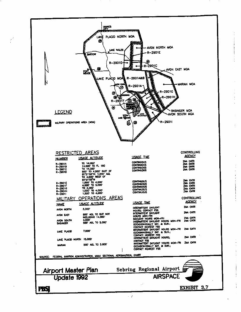
The CRA includes within its boundaries, aviation facilities (see Airport Master Plan, Exhibit C for the scope and extent of planned aviation facility growth and the framework for the development of both the aeronautical and non-aeronautical properties) and Industrial Park land, in addition to the Sebring International Raceway. The Second Plan Update’s projects list per section VI specifically addresses planned improvements to aviation, industrial and Raceway portions of the CRA.

Page - 12 -
The Industrial Park lands in the CRA are a significant economic resource for Highlands County. Economic development projects, such as locating manufacturing plants, distribution facilities, and research and development enterprises continue to be goals of the CRA. Economic development projects and activities that continue to further the development of the Industrial Park while also creating jobs are an integral part of the Second Plan Update’s project list in Section VI.
Generally, any CRA economic activity that encourages private enterprise and any economic development project that supports the goal of job creation and tourism, and improvement, renovation, expansion, and construction of aviation, industrial and Raceway infrastructure and development; or any activity that is undertaken by the Agency to facilitate and support these goals and projects in the CRA is considered to be compatible with this Second Plan Update and in accord with the intent of the State's Community Redevelopment Act. Agency expenditures for promotional marketing and advertising designed to attract tourism or result in job creation, and improve aviation, industrial, and Raceway infrastructure; or encourage general development and redevelopment in the CRA Area are compatible with this Second Plan Update and in accord with the intent of the State’s Community Redevelopment Act. X. SAFEGUARDS PURSUANT TO THE PLAN
The Agency has adopted rules and regulations that will insure that the work of redevelopment in the CRA will be carried out pursuant to the Second Plan Update. These rules and regulations will continue to be updated, as needed. At a minimum the Agency will undertake the following actions on an annual basis to further this purpose;
A. Conduct an annual independent audit of the finances and operations of the Agency; and
B. File with the Board of County Commissioners and the State Auditor General, on or before March 31 of each year, a report of Agency activities for the preceding fiscal year, and include in the report a complete financing statement setting forth the Agency’s assets, liabilities, income, and operating expenses as of the end of such fiscal year.

XI. CONTROLS, RESTRICTIONS AND COVENANTS ON LAND TO BE LEASED OR SOLD
Lease and sale restrictions, controls, covenants and other land development regulations and standards will be prepared and adopted by the Agency as one of its priority projects listed in Section VI. Until the adoption of these lease and sale restrictions, controls and covenants the Agency will be guided by the standards established and used by the Sebring Airport Authority and its customary practices. Land development regulations for the CRA Area have been adopted by Highlands County. XII. EXHIBITS
A. LEGAL DESCRIPTION OF THE COMMUNITY REDEVELOPMENT AREA (as included in Highlands County Ordinance No. 96-26 Establishing the Sebring Regional Airport and Industrial Park Community Redevelopment Agency)
B-1 ORIGINAL SEBRING REGIONAL AIRPORT AND INDUSTRIAL PARK COMMUNITY REDEVELOPMENT AGENCY COMMUNITY REDEVELOPMENT PLAN dated November 26, 1996
B-2 FIRST UPDATED SEBRING REGIONAL AIRPOR AND INDUSTRIAL
PARK COMMUNITY REDEVELOPMENT PLAN, dated September 18, 2012
C-1 SEBRING REGIONAL AIRPORT, AIRPORT MASTER PLAN UPDATE,
dated February 20, 2004 C-2 SEBRING REGIONAL AIRPORT, AIRPORT MASTER PLAN UPDATE -
AIRPORT LAYOUT PLAN, dated December 11, 2013 D-1 SEBRING REGIONAL AIRPORT MINIMUM DEVELOPMENT
STANDARDS dated May 2006
D-2 LAND DEVELOPMENT EXHIBIT prepared by ATKINS ENGINEERING, dated October 1, 2015.
E-1 HIGHLANDS COUNTY CODE OF ORDINANCES LAND
DEVELOPMENT REGULATIONS (2009) FOR I-2 INDUSTRIAL DISTRICT
E-2 HIGHLANDS COUNTY CODE OF ORDINANCES LAND
DEVELOPMENT REGULATIONS (2009) FOR A-1 AIRPORT DISTRICT

Page - 14 -
F. SCHEMATIC OF EXISTING UTILITIES


Bev
Typewritten Text
Exhibit A


THE SEBRING REGIONAL AIRPORT AND INDUSTRIAL PARK COMMUNITY
REDEVELOPMENT AGENCY
COMMUNITY REDEVELOPMENT
PLAN UPDATE
The original plan was prepared by Community Redevelopment Advisors, LLC., Tampa, Florida, for the Sebring Regional Airport and Industrial Park Community Redevelopment Agency. The updated plan was prepared by Sebring Airport Authority Staff on September 18, 2012

Page - 2 -
TABLE OF CONTENTS
I. INTRODUCTION AND PURPOSE
II. PLAN SUMMARY
III. LEGAL DESCRIPTION OF THE COMMUNITY REDEVELOPMENT AREA AND THE
REASON FOR THE BOUNDARIES
IV. COMPATIBILITY WITH AIRPORT MASTER PLAN
V. AREA REDEVELOPMENT DESCRIPTION:
A. OPEN SPACE AND STREET LAYOUT AND BUILDING GUIDELINES AND USES.
B. UTILITIES, INFRASTRUCTURE AND PUBLIC IMPROVEMENTS C. PRES ENT LAND U SE
VI. PROPOSED PUBLICLY FUNDED CAPITAL PROJECTS AND OTHER PROPOSED
PROJECTS WITHIN THE AREA
VII. PLANNED PROJECT COSTS, PROPOSED SOURCES OF FUNDING AND INDEBTEDNESS OF AGENCY
VIII. TIME TO COMPLETE INCREMENT FUNDED PROJECTS
IX. PLANNED ACTIONS IN AREA - PRIORITY CRA WORK PROGRAM
X. SAFEGUARDS PURSUANT TO THE PLAN
XI. CONTROLS, RESTRICTIONS AND COVENANTS ON LAND TO BE LEASED OR SOLD
XII. EXHIBITS

Page - 3 -
I. INTRODUCTION AND PURPOSE
The Community Redevelopment Plan Update (Plan Update) for the Sebring Regional Airport and Industrial Park Area, which together make up the Community Redevelopment Agency (CRA) guides the redevelopment of the area previously designated by the Highlands County Board of County Commissioners as a slum and blighted area. Once adopted by the County Board, the Plan Update will be in effect for the CRA and the governing body will direct the CRA to implement the Plan Update. The original Plan allowed for amendments or modifications after its initial adoption. This Plan Update is the first modification to the original Plan.
The Plan Update contains all the planned actions, proposed projects, proposed financings to complete the redevelopment, rehabilitations, land acquisitions, demolition and removal of structures, and other improvements as proposed to be carried out in the CRA. Zoning changes, maximum densities and building requirements for the CRA have been adopted and are included in Sebring Regional Airport Minimum Development Standards (Exhibit D). I I . PLAN UPDATE SUMMARY
The objective of the Plan Update is to continue to maximize the redevelopment and rehabilitation of the CRA by utilizing private enterprise. The Plan Update includes the planned and proposed actions necessary to implement the Plan Update, to continue to remove the impediments of slum and blight in the CRA that are obstacles to the sound economic growth and job creation envisioned by the Plan Update. The Plan Update contains the projects, funding required and means of financing necessary to implement the Plan Update including the use of Tax Increment financing. The Plan Update includes improvements to the four main activities in the CRA: 1) continued growth of the Airport and related aviation improvements; 2) continued expansion of the Industrial Park as a competitive master planned facility with an aggressive capital improvement program; 3) further improvements to the Sebring International Raceway to maintain its position as a major revenue source for the CRA's operations; 4) and sponsorship of the U.S. Sport Aviation Expo annual event. The Sebring International Raceway and the U.S. Sport Aviation Expo both serve as a major tourism draw for Highlands County; and as a major marketing asset for the Airport and Industrial Park. III. LEGAL DESCRIPTION OF THE COMMUNITY REDEVELOPMENT AREA
AND THE REASONS FOR THE BOUNDARIES
The legal description is found in Exhibit A. The Plan Update does not provide for any modification of the original boundaries of the CRA. The reasons for the boundaries of the CRA are the following: The boundaries contain all the land presently owned by the Sebring Airport Authority and Industrial Park and contain the areas presently designated as slum and blighted.

Page - 4 -
The boundaries also contain activity centers for economic growth in the CRA, the Aviation Facility, the Industrial Park lands and the Sebring International Raceway.
IV. COMPATIBILITY WITH THE AIRPORT MASTER PLAN
The CRA Plan Update, and therefore the CRA Plan itself is compatible with the Sebring Regional Airport, Airport Master Plan Update, dated February 10, 2004 (the Airport Master Plan) and is also compatible with Highlands County Comprehensive 2030 Plan. The aviation improvements contemplated in the Airport Master Plan do not conflict with the proposed projects and planned actions in the CRA. In fact, the Aviation Master Plan Update complements the objectives of the Plan Update, maximizing the redevelopment and rehabilitation of the Area by private enterprise. The Airport Master Plan is incorporated into the Plan Update as a supplemental technical document, attached as Exhibit C and made an integral part of the Plan Update.
V. AREA REDEVELOPMENT DESCRIPTION
A. Plans for open space and streets have been developed for the CRA, as set forth in the Sebring Regional Airport Minimum Development Standards, dated May, 2006, and attached as Exhibit D.
B. A schematic of the existing utilities (Water and Sewer), owned by the City of Sebring, is attached as Exhibit E. Planned infrastructures and public improvements for the CRA Area are listed in Section VI of the Plan Update.
C. Present land uses for the CRA Area are designated as the I-2 Industrial District and the A-1, Airport District. For further detail see the links below: http://www.sebring-airport.com/DevInfo-I2.html http://www.sebring-airport.com/DevInfo-A1.html

Page - 5 -
VI. PROPOSED PUBLICLY FUNDED CAPITAL PROJECTS AND OTHER PROPOSED PROJECTS WITHIN THE CRA AREA.
Project Description
Total Cost
Local Funds
Airfield Drainage Evaluation
$104,770
$524
Includes Plans and Specs
Runway 18-36 Rehabilitation
$5,898,856
$465,000
Includes design and construction
Runway 18-36 Extension
$10,282,500
$399,000
Includes Benefit Cost Analysis, Environmental
Assessment, Design, Permitting and Construct
ATC Tower Rehabilitation
$100,000
$20,000
Master Plan Update
$750,000
$18,750
Airmall Commercial Hangar Complex
$5,000,000
$1,000,000
Terminal Apron Rehabilitation
$2,550,000
$116,250
Includes design and construction
New Emergency Services Joint Use Facility
$4,500,000
$900,000
Includes design and construction
Construct Taxiway Bravo
$1,827,147
$19,921
Fuel Farm (Phase II)
$800,000
$160,000
Includes design and construction
Resurfacing of Carroll Shelby Dr.
$1,300,000
$260,000
Haywood Taylor Blvd. Phase I Security
$300,000
$150,000
Airport Zoning Project
$150,000
$30,000
Rubick Project/IONGNO
$4,000,000
$500,000
Air Service Study
$100,000
$2,500
Re-surfacing of Haywood Taylor Blvd
$810,000
$162,000
West Pond Expansion
$600,000
$120,000
Environmental Assessment for Future Runway
$500,000
$12,500
Runway 14L-32R & Assoc. Taxiways and Aprons
$1,800,000
$45,000
Includes Design and Permitting
Runway 14L-32R & Assoc. Taxiways and Aprons - PH 1
$15,000,000
$375,000
Construct
Runway 14L-32R & Assoc. Taxiways and Aprons - PH 11
$15,000,000
$375,000
Construct
Catalyst Project - Construction
$5,000,000
$500,000
Page - 6 -
& Construction Management
Manufacturing Facility
$2,000,000
$750,000
Includes Design, Permitting, Construct
with infrastructure
Wireless Broadband Connection for Sebring International
$70,000
$70,000
Raceway and Sebring Airport Authority
Rail Spur Rehab
$457,408
$228,704
Aviation Related Commerce Park
$4,000,000
$200,000
Sod Farm Land Swap (Includes pond relocation)
$1,500,000
$100,000
Turfcare Renovations
$650,000
$0
Security Fencing (Phase III)
$400,000
$0
EAA Youth Eductional Building
$250,000
$7,500
Design & Development Standards
$10,000
$5,000
Construct A.R.F.F
$6,000,000
$2,000,000
Building and Purchase Equipment
$4,000,000
$0
Land Acquisition Airport Road
$150,000
$30,000
Land Acquisition - Spring Lake Buffer
$3,500,000
$700,000
Support current and future projects relating to renovation, expansion, job creation, infrastructure development and other related activities on the Sebring Regional Airport by any existing or future tenant of the Sebring Airport Authority (or approved sub-lessee).
$20,000,000
$2,000,000
Repair, Maintenance or Operating funds for the Sebring Airport Authority, if financial assistance is required due to loss of large tenant or revenue stream
$1,000,000
$1,000,000
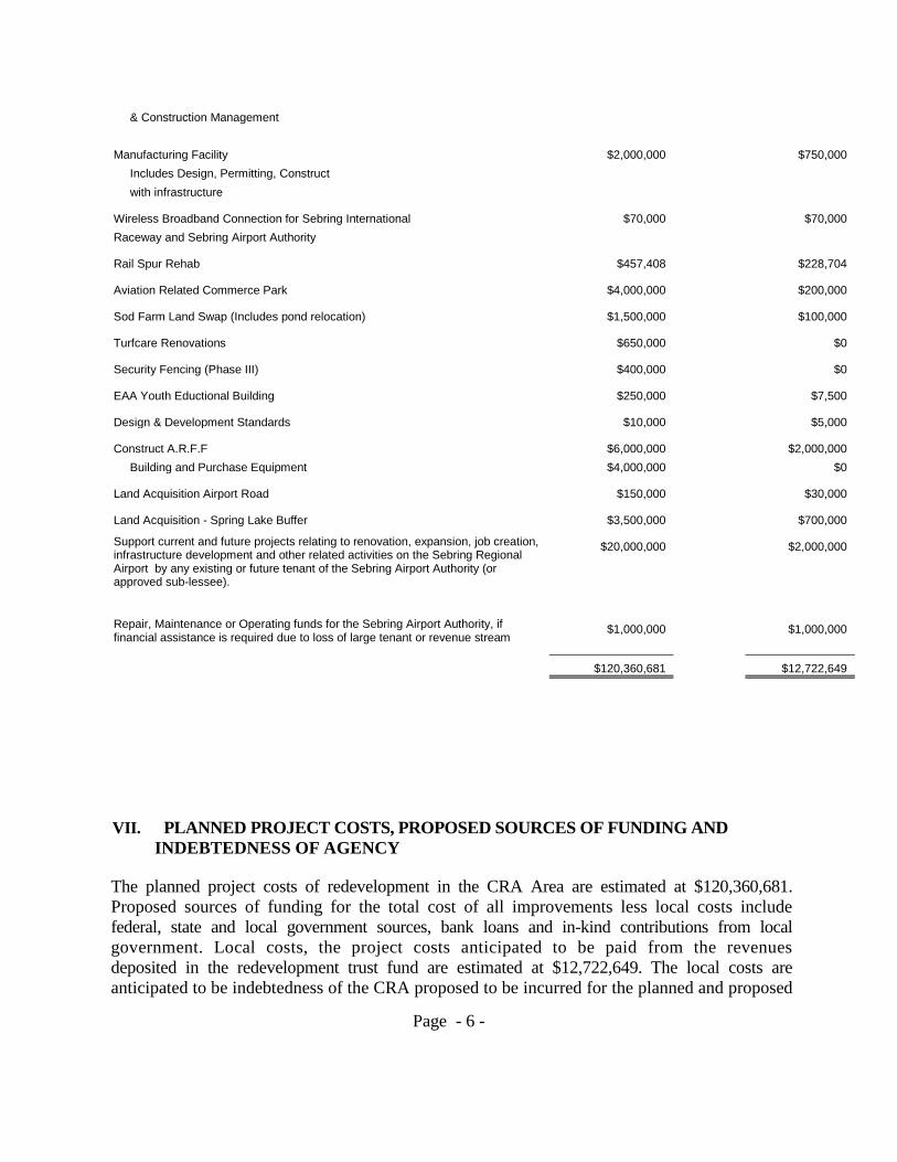
$120,360,681
$12,722,649
VII. PLANNED PROJECT COSTS, PROPOSED SOURCES OF FUNDING AND
INDEBTEDNESS OF AGENCY
The planned project costs of redevelopment in the CRA Area are estimated at $120,360,681. Proposed sources of funding for the total cost of all improvements less local costs include federal, state and local government sources, bank loans and in-kind contributions from local government. Local costs, the project costs anticipated to be paid from the revenues deposited in the redevelopment trust fund are estimated at $12,722,649. The local costs are anticipated to be indebtedness of the CRA proposed to be incurred for the planned and proposed
Page - 7 -
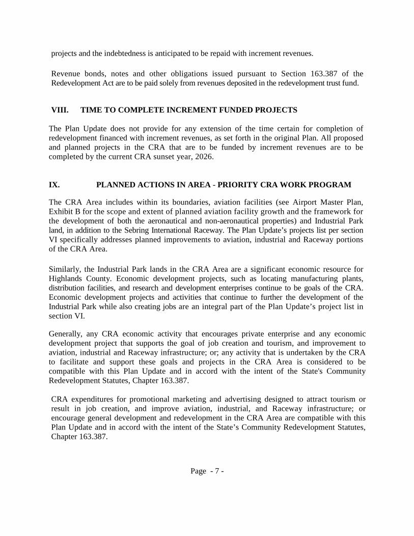
projects and the indebtedness is anticipated to be repaid with increment revenues.
Revenue bonds, notes and other obligations issued pursuant to Section 163.387 of the Redevelopment Act are to be paid solely from revenues deposited in the redevelopment trust fund.
VIII. TIME TO COMPLETE INCREMENT FUNDED PROJECTS
The Plan Update does not provide for any extension of the time certain for completion of redevelopment financed with increment revenues, as set forth in the original Plan. All proposed and planned projects in the CRA that are to be funded by increment revenues are to be completed by the current CRA sunset year, 2026.
IX. PLANNED ACTIONS IN AREA - PRIORITY CRA WORK PROGRAM
The CRA Area includes within its boundaries, aviation facilities (see Airport Master Plan, Exhibit B for the scope and extent of planned aviation facility growth and the framework for the development of both the aeronautical and non-aeronautical properties) and Industrial Park land, in addition to the Sebring International Raceway. The Plan Update’s projects list per section VI specifically addresses planned improvements to aviation, industrial and Raceway portions of the CRA Area.
Similarly, the Industrial Park lands in the CRA Area are a significant economic resource for Highlands County. Economic development projects, such as locating manufacturing plants, distribution facilities, and research and development enterprises continue to be goals of the CRA. Economic development projects and activities that continue to further the development of the Industrial Park while also creating jobs are an integral part of the Plan Update’s project list in section VI.
Generally, any CRA economic activity that encourages private enterprise and any economic development project that supports the goal of job creation and tourism, and improvement to aviation, industrial and Raceway infrastructure; or; any activity that is undertaken by the CRA to facilitate and support these goals and projects in the CRA Area is considered to be compatible with this Plan Update and in accord with the intent of the State's Community Redevelopment Statutes, Chapter 163.387. CRA expenditures for promotional marketing and advertising designed to attract tourism or result in job creation, and improve aviation, industrial, and Raceway infrastructure; or encourage general development and redevelopment in the CRA Area are compatible with this Plan Update and in accord with the intent of the State’s Community Redevelopment Statutes, Chapter 163.387.

Page - 8 -
X. SAFEGUARDS PURSUANT TO THE PLAN
The CRA has adopted rules and regulations that will insure that the work of redevelopment in the CRA Area will be carried out pursuant to the Plan Update. These rules and regulations will continue to be updated, as needed. At a minimum the CRA will undertake the following actions on an annual basis to further this purpose;
A. Conduct an annual independent audit of the finances and operations of the CRA; and
B. File with the Board of County Commissioners and the State Auditor General, on or before March 31 of each year, a report of CRA activities for the preceding fiscal year, and include in the report a complete financing statement setting forth the CRA’s assets, liabilities, income, and operating expenses as of the end of such fiscal year.
XI. CONTROLS, RESTRICTIONS AND COVENANTS ON LAND TO BE LEASED
OR SOLD
Lease and sale restrictions, controls, covenants and other land development regulations and standards will be prepared and adopted by the CRA as one of its priority projects listed in Section VI. Until the adoption of these lease and sale restrictions, controls and covenants the CRA will be guided by the standards established and used by the Sebring Airport Authority and its customary practices. Land development regulations for the CRA Area have been adopted by Highlands County.
XII. EXHIBITS
A. LEGAL DESCRIPTION OF THE COMMUNITY REDEVELOPMENT AREA (as included in Sebring Airport Authority Enabling Act – 2565)
B. COMMUNITY REDEVELOPMENT PLAN dated Nov. 26, 1996 – ON DISK
Page - 9 -
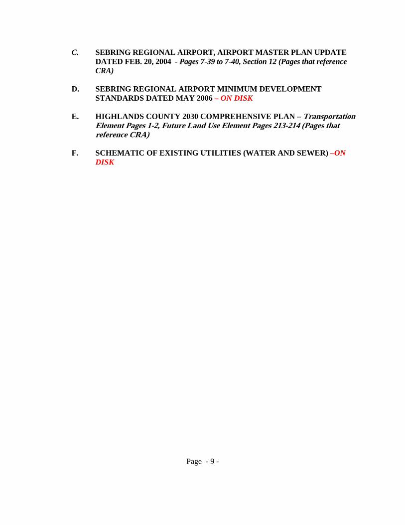
C. SEBRING REGIONAL AIRPORT, AIRPORT MASTER PLAN UPDATE DATED FEB. 20, 2004 - Pages 7-39 to 7-40, Section 12 (Pages that reference CRA)
D. SEBRING REGIONAL AIRPORT MINIMUM DEVELOPMENT STANDARDS DATED MAY 2006 – ON DISK
E. HIGHLANDS COUNTY 2030 COMPREHENSIVE PLAN – Transportation
Element Pages 1-2, Future Land Use Element Pages 213-214 (Pages that reference CRA)
F. SCHEMATIC OF EXISTING UTILITIES (WATER AND SEWER) –ON DISK

EXHIBIT liAr,
CHAPTER 95- 5.26 HS 2565, First Engrossed.
House B111 Ho.Jl ~ 5(., 5 A bill to ~e entitled
An act relating to the Sebring' Airport
Authority, Highlands County~ amending chapter
67-2070, Laws of Florida, as amended7 allowing
the authority to contract with and provide
services to other governmental entities at
other airports, airfields, and related
facilities1 providing an effective date.
WHEREAS, THE Sebring Airport Authority owns and
operates a Regional Airport and Industrial Park, and !•
WHEREAS, the Sebring Airport Authority may have ! opportunities from time to time to contract with Other igovernmental entities to operate other airports, airfields, i
and related facilities, NOW, THEREFORE,
Be It Enacted by the Legislature of the State of Florida:
Section 1. Section 3 of chapter 67-2070, Laws of
Florida, is amended to read:
Section 3. ~ The Sebring Airport Authority shall
exercise its powers and jurisdiction over the property now
known as IISebring Air TerminaP and/or "Sebring Industrial Air

I
EXHIBIT "A" CONTINUED
The West Half (W1/2) of Section 4; All of
Section 5, less and except that portion of the
North Half (Nl/2) lying West of the canal and
the Railroad right-of-way spur~ the· Southeast . l
Quarter rSE1/4) of the Southeast Quarter
(SE1/4) of Section 6; All of Section 7 r less
and except that portion'of the Wesb Half (W'/2)
lying northerly of State Road No. 623 and West
of the canal, All of Section 8~ the West Half
(W1/2) of Section 9J and that part of Section
18 lying North and West of the airport access
road, less and except the following land deeded
to the Humane Society generally described as
being a 10-acre tract lying adjacent to the
westerly boundary of the Hendricks Field access
road and adjacent to and South of the north
boundary of Section 18, Township 35 South,
Range 30 East, more particul~rly described as
follows: commencing as a point of be9innin~ at
the intersection of the ~esterly boundary of
Hendricks Field access road {said road being
'00 feet in Width, being 50 feet on either side
of said center line) with the North boundary of
Section 18, Township 35 souch , Range 30 East,
Highlands County, Florida, thence South
89°01 '45" West along the North boundary of
follows: Commencing as a point of beginning at
the intersection of the westerly boundary of
Hendricks Field access road (said road being
100 feet in width, being 50 feet on either side
of said center line) with the North boundary of
! ~._ ..
! I ! I
I,. I
I:
r: r I i J i ;
i
1
I

I ~..
EXHIBIT "A II CONTINUED
Section 18 a distance of 505.70 feet to a
point, thence South 01 DS4'30" East a distance
of 908.84 feet to a point, thence North
88605 130" East a distance of. SOO.OO feet to a . .
point on the westerly boundary of Hendricks
Field access road, thence North 01°54'30" West
along the westerly boundary of the Hendr~ck8
Field access road a distance of 718.68 feet to
a point of curve, thence along a curve to the
right having a radius of 2,914.79 feet an arc
and except that portion'of the West Half (W1!2)
lying northerly of'State Road No. 623 and West
of the canal, All of Section 8; the West Half
(W1/2) of Section 9, and that part of Section
18 lying North and West of the airport access
:•
I road, less and except the follo~in9 land deeded
to the Humane Society generally described as
~ ..
I being a 10-acre tract lying adjacent to the
westerly boundary of the Henaricks Field access
road and adjacent to and South of the north
boundary of Section 18, Township 35 South,
Range 30 East, more particul~rly described as
follows: Commencing as a point of beginning at
the intersection of the westerly boundary of
Hendricks Field access read (said road being
100 feet in width, being 50 feet on either side
of said center line) with the North boundary of

EXHIBIT "Au CONTINUED
Section 18, Township 35 South, Range 30 East,
Highlands County, Florida, thence South
89°01 145" West alon9 the North boundary of
Section 18 a distance of 505.70 feet to a
point, thence South Q'·54130~ East a distance
of 908.84 feet to 8 point, thence North
88°05'30" East a distance of 500.00 feet to a
point on the westerly boundary of Hendricks
Field a~cess road, thence North 01.54'30" West
along the westerly boundary of the Hendricks
Field access road. a distance of 718.68 feet to
a point of curve, thence along a curve to the
rlght having a radius of 2,91!.79 feet an arc
distance of 181.32 feet 'to the point of
beginning.
All of the above described land lying in
Township 35 South, Range 30 East, Highlands
County, Florida.
All of that property now owned by the city of Sebring.
and known as Sebring Air Terminal shall be gratuitously
transferred and conveyed to the Sebring Airport Authority,
sUbject to any reservations or·restrictions of record or
existing leases, and subject to the restriction that none of
said property may be sold at any time without the consent of
the City of Sebring.

EXHIBIT "A" CONTINUED
(b) The Sebring Airport Authorit~ is authorized to
exercise its powers over properties in addition to the Sebring
Regional AirEort,and Industrial Park so long as they are
exercised ~ursuant to oont~acts with other governmental
~ntities for the operation and supervision of other airports,
airfields, and related facilities.
SectIon 2. Para9raph (n) is added to section 6 of
chapter 67-2070, Laws of Florida, as amended by chapter 89
484, Laws of Florida, to read:
Section 6. The Sebring Airport Authority is hereby
authorized and empowered:
1n) To contract with other governmental entities to
0Eerate airports, airfields, and other related facilities and
services, including providing all personnel, tools, equipment,
supervision, and other materials and serv~ces required
~•,.. therefor.


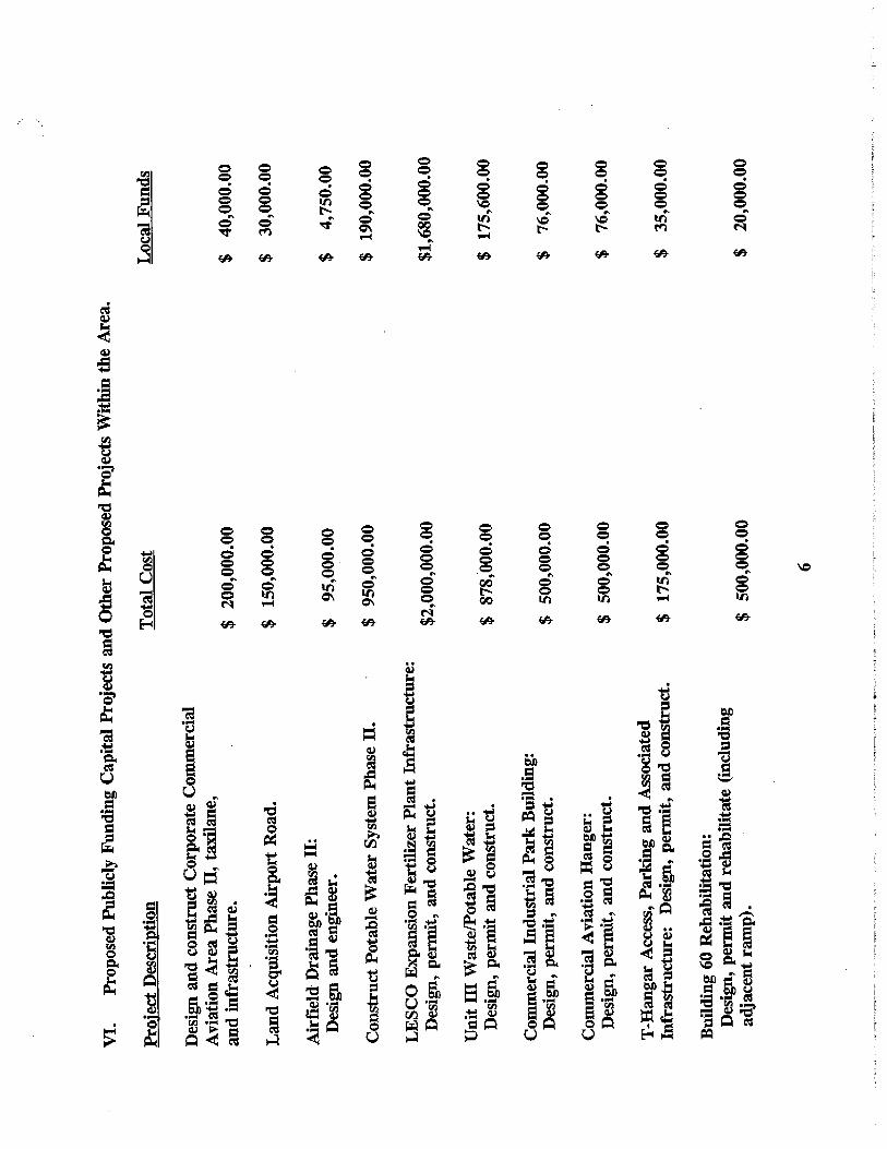


Table 7-29. Employee Automobile Parking Requirements
2000 2001 2006 2011 2016 2021
ifotal annual 67,422 73,256 88,033 98,506 108,275 118,270 ~nplanements r-----------~----~- c----------- ----------- --------- f------------ t--~
Existing employee parking capacity 22 22 22 22 22 22 No.)
Employee parking 27 29 35 39 43 47 required (No.)
Deficiency (5) (7) (13) (17) (21) (25)
Existing employee 8,271 8,271 8.271 8,271 8,271 8,271 parking area (sq ft)
Employee parking 10,788 11,721 14.085 15,761 17,324 18,923 area required (sq ft)
Deficiency (2,517) (3,450) (5,814) (7,490) (9,053) (10,652) Source: FAA AC 15015360-13 Planning and Design Guidelines for Airport Terminal Facilities and PBS&J 2002
Again, if significant commercial service develops at SEF. employee-parking requirements will also increase dramatically. Using the methodology described earlier. it is anticipated that an additional 12 employee spaces will be required, which is approximately 4,800 sq ft.
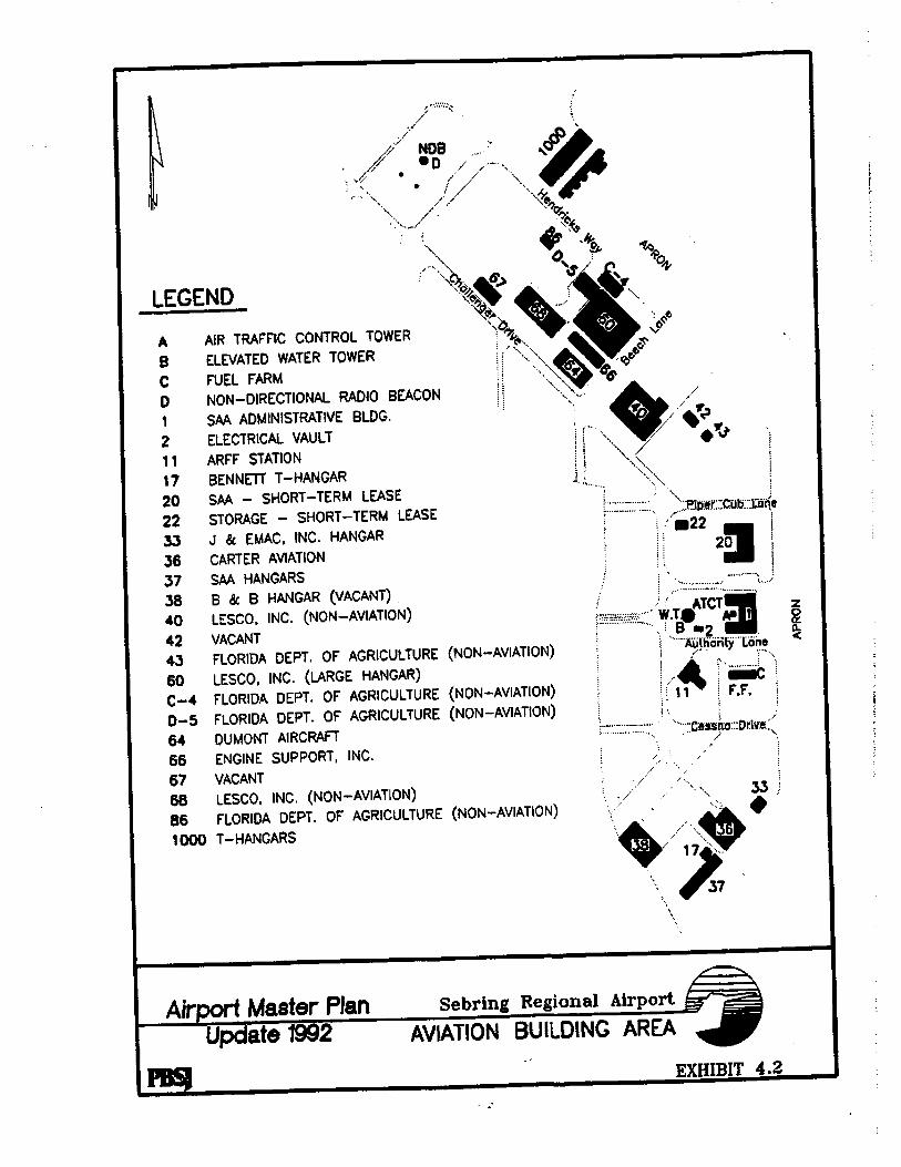
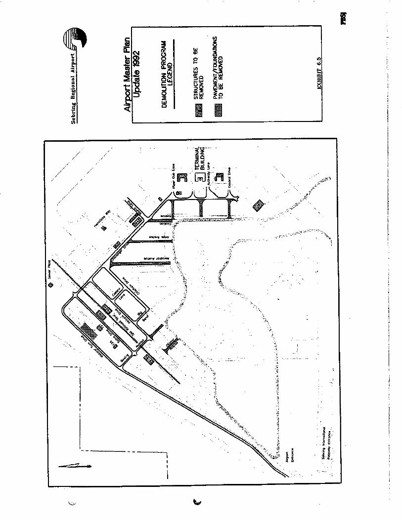
7.5.3 Airport Industrial Park
The Sebring Regional Airport Industrial Park is a significant revenue source for both the Airport and Highlands County .. Therefore, SEF Airport Management, as well as local business owners, has aggressively pushed compatible development. Unique to SEF is the fact that it is not only a Foreign Trade Zone (FTZ), FTZ 215, but that it has initiated a Community Redevelopment Agency (CRA) to provide incentives to businesses.
According to a survey conducted by the International Trade Commission, the presence of an FTZ was found to provide a significant incentive in plant site location decisions due to cost savings and improved inventory control. Through the use of FTZs, U.S.-based production is placed on more equal footing with production in a foreign country, and FTZs have had a significant impact in retaining U.S. production and employment as well as stimulating new activity.
In addition, the SAA provides an incentive program to businesses locating to the Sebring Airport and Industrial Park. In 1996, Sebring Regional Airport and Industrial Park property was designated as a Florida Community Redevelopment Area giving the SAA and its Community Redevelopment Agency (CRA) the ability to provide financing assistance and other incentives to businesses leasing land and building facilities on the Airport and Industrial Park property. Financing incentives available include:
• Offsetting or deferring lease payments through the use of the SAA's CRA's Tax Increment Trust Fund
2/18/04 Sebring Regional Airport Master Plan Update 7-39
Marcia
Highlight
Marcia
Highlight
Marcia
Typewritten Text
Marcia
Typewritten Text
EXHIBIT C.
Marcia
Typewritten Text
Marcia
Typewritten Text
Marcia
Typewritten Text
Marcia
Typewritten Text

• Loans to assist in financing site improvements, parking lot construction, and special infrastructure needs.
Sebring Regional Airport and Industrial Park is the only combined GA facility and industrial park in Florida offering these incentives.
As discussed in Chapter 5, the Sebring Regional Airport and Industrial Park's current footprint is approximately 1, 700 acres. A total of 1 ,200 acres are currently available, with approximately 570 acres of developable property located within the Airport Industrial Park. Parcels available range in size from one acre to 600 acres. In order to attract tenant business to the industrial park and encourage development of the remaining land area, a number of items are suggested. If possible, the Airport should develop a comprehensive development plan that identifies business segments, locations, and minimum standards for construction and maintenance within the industrial park. It is important to identify available parcels by number, acreage, utilities, and lease/buy costs, for proposals and financial analysis by prospective tenants. These requirements should be completed in the short- to mid-term of the planning period, to allow proper marketing and development of the Airport Industrial Park.
Refining the industrial park at SEF is an ongoing process. Although, many antiquated buildings and structures have been removed and relocated, there are still many that need overhaul. Several buildings along Hairpin Drive are dilapidated and should be demolished. Clearing unusable buildings and structures will open areas for development of new facilities.
Also, construction of roadway, utility, and drainage infrastructure is necessary to create value and attract potential tenants to the industrial park. (See Master Drainage Study.) At SEF, ground access to the industrial park is often altered by events hosted by the Sebring International Raceway and by the poor condition of access and internal roadways. Pavement overlays, repainting, and additional lanes are necessary to ensure adequate infrastructure as discussed in the ground access section of this chapter. There is also a need for adequate parking for employee automobiles and for oversized transport vehicles within the park.
7.5.4 General Aviation (GA) Areas
Currently, GA activities at SEF include flight training, recreational flying, aircraft maintenance, med-evac, military, and corporate operations. The facilities associated with these operations include, aircraft storage buildings, aircraft apron areas for hangars and tie-downs, and fuel storage facilities.
7.5.4.1 Aircraft Storage Buildings
As discussed in Chapter 6, six T-hangar buildings (52 units), and seven conventional hangars currently exist at SEF, and store approximately 88 percent of the total based aircraft at the Airport. Based on data obtained in the inventory portion of the Master Plan, it is estimated that the conventional hangars accommodate on average two aircraft per hangar. Therefore, T-hangars accommodate approximately 70 percent of all stored aircraft. while the conventional hangars provide storage for the remaining 18 percent.
2/18/04 Sebring Regional Airport Master Plan Update 7-40
Marcia
Highlight
Marcia
Highlight

2/18/04 Sebring Regional Airport Master Plan Update 12-1
FINANCIAL FEASIBILITYSebring Regional Airport
12.1 INTRODUCTION AND PURPOSE
The Financial Feasibility Analysis is used to analyze Sebring Regional Airport’s (SEF)historical and projected revenue and expenditures while determining whether it isfinancially viable to implement the Airport master plan’s capital development program(CDP) as a commercial non-subsidized airport. The objective of this updated financialanalysis is twofold:
Estimate the capital and operating costs for the various components that comprisethe capital improvement program.
Determine if it is feasible for the Airport to generate sufficient revenues to repaycapital and operating costs.
In order to achieve these objectives, several subtasks were performed:
Projections of potential operating revenues Comparison of operating revenues/capital and operating costs Identification of funding shortfalls Identification of potential additional funding sources Feasibility/cash flow analysis
12.2 SEBRING REGIONAL AIRPORT - INDEPENDENT OPERATING ENTITY
SEF is administered by the Sebring Airport Authority (SAA) established by act of theFlorida Legislature on August 1, 1967 and amended by House Bill Number 1086 onJune 19, 1989. The SAA was created for the purpose of planning, developing, andmaintaining a comprehensive airport and industrial complex, and constitutes a publicinstrumentality. A seven-member board governs the SAA and its operations consist ofleasing industrial properties and supervising Airport and utility operations.
The SAA operates as a single enterprise fund under the fund accounting framework ofgovernmental accounting and is exempt from federal income taxes. Within thisframework, an enterprise fund accounts for operations in a manner similar to privatebusiness enterprises where the intent of the governing body is that costs (expensesincluding depreciation) of providing goods and services to the general public on acontinuing basis be financed or recovered primarily through user charges. Theenterprise fund is accounted for on a cost of services or “capital maintenance”measurement focus. This means all assets and liabilities (whether current or non-current) associated with its activity are included on its balance sheet. Reported fundequity (net total assets) is segregated into contributed capital and retained earningscomponents.
12

2/18/04 Sebring Regional Airport Master Plan Update 12-2
12.2.1 Foreign Trade Zone
A significant incentive for business development at SEF is attributed to the ForeignTrade Zone (FTZ). The FTZ Board, Chaired by the U.S. Department of Commerce,authorized FTZ status on July 26, 1997 to the SAA. The Zone, designated by the FTZBoard as FTZ Number 215, not only assists in economic development of SEF and itsassociated industrial park tenants, but businesses throughout Highlands County as well. SEF became the 16th FTZ in Florida.
A survey, conducted by the International Trade Commission, found that the presence ofan FTZ was the fourth most identifiable factor in plant site location decisions. Accordingto the U.S. Department of Commerce, FTZs have been found to provide customers costsavings and improved inventory control. Through the use of FTZs, U.S. basedproduction is placed on more equal footing with production in a foreign country. Inaddition, FTZs have a significant impact in retaining U.S. production and employment as well as stimulating new activity.
12.2.2 Community Redevelopment Agency
The Sebring Regional Airport and Industrial Park Community Redevelopment Agency(CRA) was established by county ordinance on December 17, 1996. It is a legallyseparate entity from the SAA, but since SAA’s board of directors also serves as theCRA’s board, it is reported as a blended component unit.
The SAA makes available the State of Florida’s Community Redevelopment incentivesprogram to businesses locating at SEF and the industrial park. In 1996, SEF andindustrial park property was designated a Florida CRA. This designation enables SEFthe ability to provide financing assistance and other incentives to businesses leasingland and building facilities on the Airport and industrial park property. Financialassistance for companies choosing to locate facilities at the Airport can make asignificant difference to a company’s bottom line. These incentives can include offsetting or deferring lease payments through the use of the Authority’s CRA’s Tax IncrementTrust Fund and loans to assist in financing site improvements, parking lot construction,and special infrastructure needs.
In 1997, two Airport tenants, LESCO Inc. and Hancor, Inc., were assisted by the CRA in the financing of their improvements. Sebring Regional Airport and Industrial Park is theonly combined general aviation (GA) facility and industrial park in Florida offering theseincentives. (25)
In addition, the CRA provides an additional revenue source to the both Highland County and the Airport through tax revenues on developed land and facilities located within theAirport and Industrial Park property line. This revenue is used not only to provideassistance to businesses locating their operations on the Airport and industrial parkproperty, but also for future Airport and industrial development. The current programallows the CRA to collect taxes on developed land at a rate of 85 percent and buildingsand other facilities at a rate of 95 percent.
Marcia
Highlight
Marcia
Highlight

2/18/04 Sebring Regional Airport Master Plan Update 12-3
12.3 PROJECT DEVELOPMENT COST VS. POTENTIAL REVENUES
Based on the full build-out scenario as depicted on the Airport Layout Plan (ALP), thedevelopment costs for the preferred development option in current dollars (2002) aresummarized in Table 12-1. These costs are based upon current (2002) unit prices andinclude a 10 percent contingency fee. The cost estimates are based upon unadjusted2002 dollars and are calculated for order-of-magnitude purposes only. Actualconstruction costs will vary based upon variations in labor, materials, and constructioncosts, inflation, and other unforeseeable economic factors.
Table 12-1. Summary of Costs Estimates – Full Build-Out 2002 Dollars
DevelopmentPeriod Total Federal State Local Private Funding
Short–Term(2001– 2006) $121,809,614 $74,966,318 $32,564,968 $13,410,902 $867,425
Medium – Term (2007 – 2011) $215,096,886 $105,112,743 $84,278,107 $23,952,694 $1,753,343
Long-Term (2012 – 2021) $102,446,644 $49,095,150 $31,256,514 $2,914,781 $19,180,200
TotalDevelopment
Costs $439,353,144 $229,174,211 $148,099,590 $40,278,376 $21,800,968Source: PBS&J, 2002Note: Includes JACIP costs
The detailed 20-year capital improvement program cost estimates, by short- (2001-2006), medium- (2007-2011), and long-term (2012-2021) development phases, aredepicted in Chapter 11, Tables 11-5 through 11-7, respectively. The cost estimatesinclude land acquisitions, planning, construction, engineering, and total developmentcosts. Tables 11-5 through 11-7 depict projected eligibility costs based upon currentfederal and state eligibility criteria only, and do not represent a commitment for fundingby the respective funding sources. In addition, it is important to note that projectswill be managed as local funds become available rather than adhering to a stricttimeline.
12.3.1 Historical Airport Financial Statements
Prior to 1993, SEF operated at a net loss. However, as a result of both a change ofmanagement and the transfer of the Sebring International Raceway from an internalmanagement to a tenant type relationship, SEF was able to operate at a net gain. Thisallowed SAA management to focus on developing the Airport and Industrial Park into amajor economic generator for Sebring and Highlands County.
As part of this development strategy, Management established a surplus account forfuture required funds and procedures to insure compliance with the FDOT grantagreement that requires grantees to have sufficient funds to pay for the portion of the

2/18/04 Sebring Regional Airport Master Plan Update 12-4
project not covered by FDOT grant. The surplus fund was initially based upon thefollowing three major financial commitments:
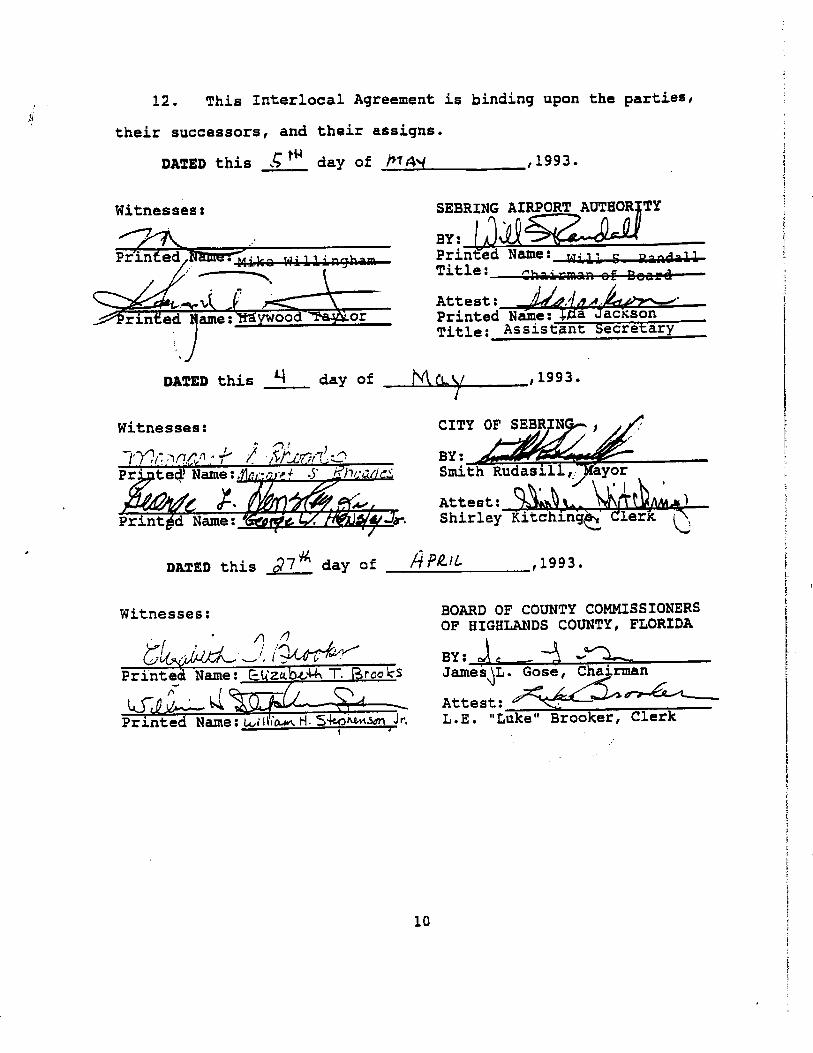
Interlocal agreement Debt refinancing Military funding
In May 1993, the City of Sebring, Highlands County, and the SAA entered into aninterlocal agreement to assist the SAA in funding construction, reconstruction andimprovements to key public facilities. The agreement, which committed $1,335,000 overfive years, provided the Airport the ability to obtain matching fund grants. As a result,significant development in and around the Airport has been achieved.
Further, in order to achieve the SAA’s goal of becoming self-reliant, debt refinancingbecame critical. Therefore, under the new management, the SAA refinanced all debts in February of 1992 with a commitment toward retiring the debt service. This debtconsolidation accomplished a 57.5 percent reduction in debt service.
In 1994, the SAA entered into an agreement with the Department of Defense (DOD) toprovide “hot fueling” to military aircraft. This direct billing agreement to fuel militaryaircraft has resulted in fuel flowage fees averaging $500,000 to $1,000,000 annually.This has provided a positive cash flow to the Airport, thus, limiting operating losses after depreciation.
SEF’s revenue and expenditure sources for the years 1992 through 2000 are discussedin more detail in the following sections. It is important to note that prior to 2000, SAA’sStatements of Revenue and Expenses reported a net loss based upon existingGovernment Auditing Standards issued by the Comptroller General of the United States. This, however, was misleading since it did not take into account SAA’s additional funding sources.
However, as of the year 2000, Government Auditing Standards were changed to allowContributions not previously recorded to be included in the Airport’s Statements ofRevenue and Expenses. Applying these auditing standards to previously reportedfinancial statements, revealed a cumulative net surplus through the year 2000.Furthermore, in 2001, the Authority changed its accounting estimates relating todepreciation, which resulted in a net income increase of $514,749.
12.3.1.1 Revenue Sources
SEF collects revenues from a variety of sources. These sources include Airportrevenues and federal, state, and local (city/county) commitments. Airport revenuesconsist of income generated from the following activities:
Land and building leases Hangar rental Fixed base operation Special events/test track rental Water and sewer fee Fire protection fee Miscellaneous revenue (interest, etc.)

2/18/04 Sebring Regional Airport Master Plan Update 12-5
Table 12-2 provides the basis of income from the Airport’s various revenue sources asreported by SAA, Airport Funds, Actual Revenues, 2000.
As shown in Table 12-3, aviation related revenues (i.e., fixed base operations) accountfor approximately 30 percent, whereas industrial rental revenues account forapproximately 49 percent of total operating revenues for the period of 1999-2000. Table12-2 shows a detailed listing of revenue sources and depicts percentage of revenue bysource and percent of total revenues for FY 2000. Table 12-3 and Figure 12-1demonstrate that the Airport is not reliant on any one source of revenue. However,revenue associated with non-aviation related sources outweighs revenue associatedwith aviation related sources. Therefore, emphasis should be placed in attracting bothaviation and non-aviation users in order to provide a more equitable split betweenaviation and non-aviation related resources.
Table 12-2. Detailed Revenue Categories for 2000
Type of Revenue Revenue Source Revenue (2000)Percent of Total
Revenue
Operating Industrial Rentals $951,851 49% Water Revenue $55,801 3% Sewer Revenue $86,289 4%
Test Track Rentals $95,291 5% Fixed Base Operations $576,783 30%
Fire Protection Fees $40,776 2% Fire Support Fee $0 0%
Miscellaneous Revenue $141,940 7%
Total Operating Revenue $1,948,731 100%
Non-Operating Interest Income $86,710 3% Contributions $23,034 1%
Capital Contributions $3,345,691 97% Grant Revenue $0 0%
Insurance Claim Proceeds $0 0% Gain on Sale of Investments $0 0%
Total Non-operating Revenue $3,455,435 100%
Total Revenues $5,404,166

2/18/04 Sebring Regional Airport Master Plan Update 12-6
Figure 12-1. Revenue Sources
$0
$500,000
$1,000,000
$1,500,000
$2,000,000
$2,500,000
$3,000,000
$3,500,000O
per
atin
g R
even
ues
Revenue (2000)
Industrial Rentals
Water Revenue
Sewer Revenue
Test Track Rentals
Fixed Base Operations
Fire Protection Fees
Fire Support Fee
Miscellaneous Revenue
Interest Income
Contributions
Capital Contributions
Source: SAA, Airport Funds, Actual Revenues, 2000
Airport Leases
The SAA leases various types of industrial buildings and land with terms ranging frommonth-to-month to 45-year agreements. All of the SAA’s leases are classified asoperating leases. Substantially all of the SAA’s investments in land, buildings, andracetrack improvements are bound by/or are held for lease as of September 30, 2000.

2/18
/04
Seb
ring
Reg
iona
l Airp
ort
Mas
ter
Pla
n U
pdat
e 12
-7
Tab
le 1
2-3.
Rev
enu
e S
ou
rces
Rev
enu
e S
ou
rce
1992
1993
1994
1995
1996
1997
1998
1999
2000
Op
erat
ing
Rev
enu
e:
Ind
ust
ria
l Re
nta
ls$
69
7,4
56
$6
77
,71
5$
69
8,1
52
$7
03
,51
1$
75
4,6
30
$8
94
,65
2$
87
7,7
59
$9
08
,77
1$
95
1,8
51
Wat
er R
even
ue$1
2,55
8$2
0,58
5$2
2,50
1$1
8,10
3$2
3,98
2$3
7,44
4$4
7,27
3$5
5,41
4$5
5,80
1S
ewer
Rev
enue
$33,
802
$24,
671
$23,
986
$27,
388
$39,
423
$50,
750
$55,
932
$68,
786
$86,
289
Te
st T
rack
ren
tals
$34,
392
$45,
840
$47,
734
$46,
494
$55,
521
$74,
396
$77,
209
$88,
320
$95,
291
Fix
ed
Ba
se O
pe
ratio
ns
$9
8,2
13
$1
57
,38
9$
41
6,1
30
$4
45
,75
0$
29
7,8
34
$3
12
,17
3$
32
4,7
89
$3
49
,36
6$
57
6,7
83
Fire
Pro
tect
ion
Fee
s$2
7,12
8$2
4,76
8$2
8,28
2$2
5,56
2$2
9,01
1$3
7,26
8$3
6,43
6$3
7,67
1$4
0,77
6F
ire S
uppo
rt F
ee$2
6,30
0$7
,950
$9,5
04$9
,000
$8,8
50$9
,500
$7,8
50$4
,700
$0M
isce
llane
ous
Rev
enue
$5,6
13$4
,809
$7,1
57$2
0,11
1$1
4,12
9$8
3,80
3$4
7,03
0$5
4,10
5$
14
1,9
40
To
tal O
per
atin
g R
even
ue
$935
,462
$963
,727
$1,2
53,4
46$1
,295
,919
$1,2
23,3
80$1
,499
,986
$1,4
74,2
78$1
,567
,133
$1,9
48,7
31
To
tal N
on
-Op
era
tin
gR
even
ue In
tere
st In
com
e$6
03$3
,215
$3,2
44$3
,607
$714
$32,
013
$45,
871
$56,
328
$86,
710
Con
trib
utio
ns$0
$0$0
$0$0
$52,
997
$70,
260
$29,
500
$23,
034
Ca
pita
l Co
ntr
ibu
tion
s -
Gra
nts
an
d O
ther
sN
o D
ata
$544
,617
$694
,308
$2,5
01,9
54$1
,051
,895
$3,1
16,8
15$1
,796
,621
$1,4
01,2
47$3
,345
,691
Gra
nt R
even
ue$0
$0$0
$0$0
$0$1
16,3
58In
tere
st E
xpen
se($
50,5
21)
($49
,411
)($
45,8
09)
($37
,314
)($
27,9
97)
($53
,391
)($
76,6
23)
($91
,663
)($
122,
486)
Insu
ranc
e C
laim
Pro
ceed
s$0
$14,
486
$0$0
$0$0
Ga
in (
Lo
ss)
on
dis
po
sal o
f as
sets
$0$0
($66
,189
)$0
$0($
2,12
9)$2
6,16
8($
1,34
8)($
45,3
44)
Gai
n on
Sal
e of
Inve
stm
ents
$1,8
29$0
$0$0
$0$0
$0$2
,500
$0M
isce
llane
ous
Exp
ense
$0$0
$0$0
$0$0
($1,
558)
($12
,335
)($
7,37
6)
To
tal N
on
-op
erat
ing
Inco
me
($48
,089
)$5
12,9
07$5
85,5
54$2
,468
,247
$1,0
24,6
12$3
,146
,305
$1,9
77,0
97$1
,384
,229
$3,2
80,2
29
To
tal R
even
ue
$887
,373
$1,4
76,6
34$1
,839
,000
$3,7
64,1
66$2
,247
,992
$4,6
46,2
91$3
,451
,375
$2,9
51,3
62$5
,228
,960
Sou
rce:
Ann
ual f
inan
cial
sta
tem
ents
and
aud
itor's
repo
rt

2/18/04 Sebring Regional Airport Master Plan Update 12-8
Table 12-4 is a schedule of future rent revenue minimums from non-cancelableoperating leases as of September 30, 2000.
Table 12-4. Operating Leases
Year Ending September 30, Amount2001 $901,8222002 $556,5362003 $551,286
Total Minimum Future Rentals $2,009,644Source: Sebring Airport Authority financial statements and auditors report, September 30, 2000
Furthermore, a material part of the SAA’s rent revenue is dependent upon three majorcustomers. Total rent approximations are found in Table 12-5.
Table 12-5. Major Customers
Percentage of Total Rent Revenue 2000 1999LESCO, Inc. 44% 43%
Sebring International Raceway, Inc. 33% 29%Lin Pac, Inc. 11% 13%
Total 88% 85%Source: Sebring Airport Authority financial statements and auditors report, September 30, 2000
Cash Flow Contributions
Cash flow information refers to the in-flow and outflow of cash assets. For the purposesof the Statement of Cash Flows, the SAA considers all highly liquid investments(including restricted assets) with maturity of three months or less when purchased to becash equivalents. In the case of the SAA, cash assets are usually associated withinterest earnings or payments. However, during 1999, the SAA received a non-cashdonation in the form of common stock in the amount of $29,250. The stock donationswere recorded at fair market value at the date of donation.
Deposits and Investments
Cash and cash equivalents consist of restricted and unrestricted funds. Restricted fundsrepresent proceeds from interlocal agreements, funds received at the end of the year tocover payables related to various grant projects, and lease deposits. Cash and cashequivalents as of September 30, 2000 and 1999 are recorded in Table 12-6.
2/18/04 Sebring Regional Airport Master Plan Update 12-9
Table 12-6. Cash and Cash Equivalents
Deposit/Investment 2000 1999
Unrestricted cash $ 293,777 $ 289,643 Restricted cash Design build project $ 877,081 Waste/potable water project $ 708,727 $ 751,951 Other projects $ 49,506 $ 75,261 Community redevelopment agency $ 22,788 $ 8,005 Lease deposits $ 8,792 $ 10,842
Total cash and cash equivalents $ 1,960,671 $ 1,135,702
Classified as: Petty cash and demand deposits $ 105,755 $ 146,330 Local government surplus trust funds $ 1,854,916 $ 989,372
Total $ 1,960,671 $ 1,135,702 Source: Sebring Airport Authority financial statements and auditors report, September 30, 2000
Aggregate bank balances on September 30, 2000 and 1999 were $1,960,671 and$1,135,702, respectively. The SAA’s cash and time deposits are entirely covered byfederal depository insurance and are subject to collateral requirements pursuant toSection 280.07, Florida Statutes.
Property and Equipment
A portion of the Airport’s revenues is associated with fixed assets, which consists ofproperty and equipment. Property and equipment purchased or acquired is carried athistorical cost. Donated or contributed assets are recorded at estimated fair value oractual cost, if known. Additions, improvements, and capital outlays that significantlyextend the useful life of an asset are capitalized, in addition to public domain(“infrastructure”) fixed assets like roads, curbs, runways, and waste/potable watersystems. Other costs incurred for repairs and maintenance are expended as incurred.
Prior to October 1, 2001, the estimated fixed asset depreciation schedule was basedupon a straight-line depreciation on all assets over estimated useful lives as shown inTable 12-7.

2/18/04 Sebring Regional Airport Master Plan Update 12-10
Table 12-7. Fixed Asset Depreciation Schedule
Fixed Asset YearsBuildings 40Infrastructure 25-40Improvements 15-30Vehicles 5-15Equipment 3-10
Source: Sebring Airport Authority financial statements and auditors report, September 30, 2000
However, in 2001, the Authority changed its accounting estimates relating todepreciation. The estimated service lives for buildings, wastewater facilities andwastewater infrastructure were increased from the previous lives of 15 to 30 years tonew lives of 40 years. Further, railroad spur lives were increased from 20 years to 25years, road lives were increased from 15 years to 20 years and roof repair lives wereincreased from a range of 10 to 15 years to 20 years. Sebring Management believes that the new lives are a more accurate reflection of actual useful lives, and, as a result of the change, 2001 net income increased by $514,749. (Sebring Airport Authority, 2001 and2002 Financial Statements).
Property and equipment on September 30, 2000 and 1999 is summarized in Table 12-8.
Table 12-8. Fixed Assets
Assets 2000 1999
Land, buildings, and infrastructure $ 22,598,212 $ 15,961,515Vehicles and tractors $ 96,621 $ 369,777 Machinery and equipment $ 289,810 $ 273,581 Office furniture, fixtures, and equipment $ 357,901 $ 103,731 Race track improvements $ 1,475,111 $ 1,522,170
Total $ 24,817,655 $ 18,230,774Less: accumulated depreciation $ 7,900,183 $ 7,256,552
Net property and equipment $ 16,917,472 $ 10,974,222Construction in progress* $ 87,609 $ 1,298,311
Total $ 17,005,081 $ 12,272,533Source: Sebring Airport Authority financial statements and auditors report, September 30, 2000

2/18/04 Sebring Regional Airport Master Plan Update 12-11
Construction in progress is composed of the elements in Table 12-9.
Table 12-9. Construction in Progress
Project Authorization Commitment
Expended to September 30,
2000 1999
Sebring Custom Tanning $ - $ - $ - $ 517,301LESCO Expansion $ 95,000 $ 89,892 $ 5,108 $ 5,108Building 60 rehabilitation $ - $ - $ - $ 17,641Entrance Road CR 523 to US 98 $ 1,028,166 $ 1,027,563 $ 603 $ 603LESCO rail spur $ - $ - $ - $ 278,940Potable water system improvement $ 655,900 $ 574,002 $ 81,898 $ 43General aviation terminal building $ - $ - $ - $ 362,442Hancor road/rail $ - $ - $ - $ 37,548T-hangar access/parking $ - $ - $ - $ 18,940T-hangar phase II $ - $ - $ - $ 59,745
Total $ 1,779,066 $ 1,691,457 $ 87,609 $ 1,298,311Source: Sebring Airport Authority financial statements and auditors report, September 30, 2000 and 1999
Operating Subsidies and Grants
Operating subsidies and grants that finance current operations are recorded as non-operating revenue when earned. Contributions and grants from federal, state, and localsources received prior to October 1, 2000, for the purpose of purchasing or constructing capital assets, were recorded as contributed capital. Depreciation on such assets ischarged back against contributed equity.
Contributed Capital
Contributed Capital represents capital contributions from other governmental agenciesand customers.
Cash and Cash Equivalents
Cash and cash equivalents consist of unrestricted and restricted funds. Restricted fundsrepresent (1) proceeds from interlocal agreements, (2) funds received at the end of theyear to cover payables related to various grant projects, and (3) lease deposits.
12.3.1.2 Expenses
Historic expenses are classified for the purpose of this summary as personnel andoperating expenses in the form of contractual services, professional services, andgeneral operating expenses. Personnel expenses are those expenses associated with

2/18/04 Sebring Regional Airport Master Plan Update 12-12
full and part-time Airport employees, which include salaries, taxes, and benefits.Operating expenses include utilities, supplies, maintenance, insurance, and othermiscellaneous expenses associated with the operations of SEF.
Table 12-10 shows the Airport’s expenses from 1992-2000.
Pension Plan
All full-time and part-time employees working in a regularly established position for theSAA are participants in the Florida Retirement System, a defined plan authorized byChapter 112, Florida Statutes, which is controlled by the State Legislature andadministered by the State of Florida, Department of Management Services, Division ofRetirement. The system is a cost-sharing, multiple-employer public employee retirement system. The plan covers a total of approximately 592,000 full-time employees of various governmental units within the State of Florida.
The SAA has no responsibility to the system other than to make periodic paymentsrequired by the Florida statutes. The Florida Division of Retirement issues a publiclyavailable financial report that includes financial statements and required supplementalinformation.
Participating employer contributions are based upon statewide rates established by theState of Florida. The SAA’s contributions during fiscal years 2000, 1999, and 1998, were $39,368, $51,923, and $56,120, respectively, equal to the actuarially determinedcontribution requirements for each year. The SAA has determined, in accordance withGASB Statement No. 27, that there was no pension liability before or at transition.
Long-Term Debt
Long-term debt as of September 30, 2000, and 1999 consisted of the following, depicted in Table 12-11.

2/18
/04
Seb
ring
Reg
iona
l Airp
ort
Mas
ter
Pla
n U
pdat
e 12
-13
Ta
ble
12
-10
. 1
99
2-2
00
0 E
xp
en
se
s
Exp
ense
So
urc
e19
9219
9319
9419
9519
9619
9719
9819
9920
00
Pe
rso
na
l Se
rvic
es
$2
52
,69
5$
23
9,1
81
$3
51
,25
9$
43
2,2
15
$4
73
,32
5$
37
5,3
23
$4
35
,38
5$
46
8,9
28
$5
04
,45
1C
ontr
actu
al S
ervi
ces
$1,8
18$1
8,70
2$2
0,57
7$1
4,89
3$3
8,63
9$5
9,97
0$1
42,1
85$1
42,4
65$2
38,5
71P
rofe
ssio
na
l Se
rvic
es
$3
3,0
53
$6
8,4
99
$1
03
,89
1$
11
1,2
39
$1
07
,07
3$
15
0,6
97
$2
70
,37
0$
15
1,1
57
$2
06
,86
5G
en
era
l Op
era
ting
$4
30
,79
4$
44
6,4
13
$5
02
,34
0$
63
2,3
26
$5
47
,06
5$
58
9,6
88
$6
23
,94
8$
62
3,3
10
$8
87
,15
8
To
tal O
per
atin
g E
xpen
ses
$718
,360
$772
,795
$978
,067
$1,1
90,6
73$1
,166
,102
$1,1
75,6
78$1
,471
,888
$1,3
85,8
60$1
,837
,045
Oth
er I
nter
est E
xpen
se $
(50
,521
) $
(4
9,41
1) $
(4
5,80
9) $
(3
7,31
4) $
(27
,997
) $
(53
,391
) $
(76
,623
) $
(91
,663
) $
(12
2,48
6)
Loss
on
disp
osal
of
prop
erty
$-
$-
$
(66
,189
) $
- $
- $
(
2,12
9) $
- $
(1
,348
) $
(
45,3
44)
Mis
cella
neou
s E
xpen
se $
- $
- $
- $
- $
- $
- $
(1
,558
) $
(12
,335
) $
(7,3
76)
To
tal O
ther
Exp
ense
s $
(50
,521
) $
(4
9,41
1) $
(11
1,99
8) $
(3
7,31
4) $
(27
,997
) $
(55
,520
) $
(78
,181
) $(
105,
346)
$
(175
,206
)
Tot
al E
xpen
ses
befo
re
depr
ecia
tion
$768
,881
$822
,206
$1,0
90,0
65$1
,227
,987
$1,1
94,0
99$1
,231
,198
$1,5
50,0
69$1
,491
,206
$2,0
12,2
51
Dep
reci
atio
n $
(415
,750
) $
(39
6,97
5) $
(43
5,40
5) $
(51
0,12
8) $
(569
,248
) $
(55
6,82
4) $
(772
,557
) $(
893,
565)
$(1
,009
,275
)
To
tal E
xpen
dit
ure
s$1
,184
,631
$1,2
19,1
81$1
,525
,470
$1,7
38,1
15$1
,763
,347
$1,7
88,0
22$2
,322
,626
$2,3
84,7
71$3
,021
,526
Sou
rce:
Seb
ring
Airp
ort A
utho
rity
finan
cial
sta
tem
ents
and
aud
itors
repo
rt, 1
992
thro
ugh
2000

2/18/04 Sebring Regional Airport Master Plan Update 12-14
Table 12-11. Long-Term Debt
2000 1999Revenue Notes, Draw No. B-1-1, payable to Florida Local Government Finance Commission, collateralized by certain grant funds and incremental tax revenues from the Community Redevelopment Agency
$3,000,000 $ -
Revenue certificate payable – Bank of America 257,044 286,763
Sebring Airport Authority Water and Sewer Bonds, Series 1997A, payable to U.S. Department of Agriculture, Rural Utilities Service
911,100 920,200
Sebring Airport Authority Water and Sewer Bonds, Series 1997B, payable to U.S. Department of Agriculture, Rural Utilities Service
365,100 368,700
Note payable to State of Florida, Office of Tourism, Trade and Economic Development
165,663 172,270
Interest free note payable to Haywood O. Taylor 24,251 30,718
Total 4,723,158 1,778,651
Less current portion 1,577,931 49,015
Long-term portion $3,145,227 $1,729,636Source: Sebring Airport Authority financial statements and auditors report, September 30, 2000
Maturities of long-term debt as of September 30, 2000, are as follows in Table 12-12.
Table 12-12. Long Term Debt Maturity
Year Ending September 30, Amount2001 $1,577,9312002 246,2452003 21,9272004 47,0972005 1,497,872
Thereafter 1,332,086
Total $4,723,158Source: Sebring Airport Authority financial statements and auditors report, September 30, 2000

2/18/04 Sebring Regional Airport Master Plan Update 12-15
1992-2000 Historical Financial Analysis
During the period cited, 1992 through 2000, SEF has maintained a yearly net gain.Revenues have continued to offset expenses primarily due to FBO and industrial tenantleases, as well as various sources of capital contributions. In addition, throughout theeight years, all aviation indicators increased, including annual aircraft operations (1.6percent), average annual fuel sold (3.0 percent), and fuel revenues (4.0 percent), andrevenues associated with the industrial park and Sebring International Raceway alsoincreased.
Tables 12-13 and 12-14 and Figure 12-2 depict the historical analysis of key aviationindicators, revenues, expenditures, and profits and losses for the period 1992 through2000.
12.3.1.3 Projected Revenue Forecast Analysis (2001-2021)
Revenues the Airport generates now and in the future will continue to come primarilyfrom commissions on services provided, hangar and building rental fees, land leases,and fuel sales. Additional revenues can be achieved through the implementation oflanding fees on aircraft over 75,000 lb gross landing weight (GLW), terminal fees,automobile parking fees, and potential passenger facility charges (PFCs) when airlineservice is initiated. However, the greatest opportunity to generate significant revenues to implement the recommended development will be associated with the use ofundeveloped and underutilized land areas within the existing Airport property as well ascontiguous property currently in negotiation. The success of the Airport to qualify forbonding and attaining financial sustainability rests with the successful marketing anddevelopment of the industrial park, commerce park, and GA and commercial aviationservices. In addition, capital contributions have historically represented more than 60%of total revenues. Therefore, projected capital contributions through the year 2021represent approximately 60% of total estimated development costs. These contributionsinclude: line item appropriations (EDA), public private partnerships, bonding, lines ofcredit, various Interlocal Agreements, and private funding sources
In addition, a significant source of revenue is obtained through the CRA program and its associated interest. However, at the time of this writing, the County had expressed itsdesire to dismantle this program in 2005 when its charter is up for renewal. As a result,an analysis of projected revenues was performed with and without CRA funding in order to determine the ability of the Airport to fund its capital improvement program without this funding.
Table 12-15 and Figure 12-3 project revenue and expenditures for the selecteddevelopment with the assistance of CRA Funding. Table 12-16 and Figure 12-4demonstrate the anticipated revenue and expenditures likely to occur with the planneddevelopment without the assistance of CRA Funding.
Marcia
Highlight
Marcia
Highlight

2/18
/04
Seb
ring
Reg
iona
l Airp
ort
Mas
ter
Pla
n U
pdat
e 12
-16
Tab
le 1
2-13
. S
tate
men
t o
f E
xpen
dit
ure
s Y
ears
199
2-2
000
Exp
ense
So
urc
e19
9219
9319
9419
9519
9619
9719
9819
9920
00
Pe
rso
na
l se
rvic
es
$2
52
,69
5$
23
9,1
81
$3
51
,25
9$
43
2,2
15
$4
73
,32
5$
37
5,3
23
$4
35
,38
5$
46
8,9
28
$5
04
,45
1C
ontr
actu
al s
ervi
ces
$1,8
18$1
8,70
2$2
0,57
7$1
4,89
3$3
8,63
9$5
9,97
0$1
42,1
85$1
42,4
65$2
38,5
71P
rofe
ssio
nal s
ervi
ces
$33,
053
$68,
499
$103
,891
$111
,239
$107
,073
$150
,697
$270
,370
$151
,157
$206
,865
Ge
ne
ral o
pe
ratin
g$
43
0,7
94
$4
46
,41
3$
50
2,3
40
$6
32
,32
6$
54
7,0
65
$5
89
,68
8$
62
3,9
48
$6
23
,31
0$
88
7,1
58
To
tal O
per
atin
g E
xpen
ses
$718
,360
$772
,79
5$9
78,0
67$1
,190
,673
$1,1
66,1
02$1
,175
,678
$1,4
71,8
88$1
,385
,860
$1,8
37,0
45
Dep
reci
atio
n$
(415
,750
)$
(396
,975
)$
(435
,405
)$
(510
,128
)$(
569,
248)
$ (
556,
824)
$ (7
72,5
57)
$(89
3,56
5)$(
1,00
9,27
5)
Net
Op
erat
ing
Exp
end
itu
res
$1,1
34,1
10$1
,169
,770
$1,4
13,4
72$1
,700
,801
$1,7
35,3
50$1
,732
,502
$2,2
44,4
45$2
,279
,425
$2,8
46,3
20S
ourc
e: S
AA
Fin
anci
al S
tate
men
ts a
nd A
udito
r’s R
epor
t (19
92-2
001)
and
PB
S&
J, 2
002

2/18
/04
Seb
ring
Reg
iona
l Airp
ort
Mas
ter
Pla
n U
pdat
e 12
-17
Tab
le 1
2-14
. H
isto
rica
l A
nal
ysis
of
Air
po
rt R
even
ues
an
d E
xpen
ses
Typ
e R
even
ue
1992
1993
1994
1995
1996
1997
1998
1999
2000
Tot
al O
pera
ting
Rev
enue
$935
,462
$963
,727
$1,2
53,4
46$1
,295
,919
$1,2
23,3
80$1
,499
,986
$1,4
74,2
78$1
,567
,133
$1,9
48,7
31
Tot
al O
pera
ting
Exp
ense
$718
,360
$772
,795
$978
,067
$1,1
90,6
73$1
,166
,102
$1,1
75,6
78$1
,471
,888
$1,3
85,8
60$1
,837
,045
Ope
ratin
g In
com
e B
efor
e D
epre
ciat
ion
$217
,102
$190
,932
$275
,379
$105
,246
$57,
278
$324
,308
$2,3
90$1
81,2
73$1
11,6
86
Dep
reci
atio
n($
415,
750)
($39
6,97
5)($
435,
405)
($51
0,12
8)($
569,
248)
($55
6,82
4)($
772,
557)
($89
3,56
5)($
1,00
9,27
5)
Ne
t O
pe
rati
ng
Ga
in (
Lo
ss
)($
198,
648)
($20
6,04
3)($
160,
026)
($40
4,88
2)($
511,
970)
($23
2,51
6)($
770,
167)
($71
2,29
2)($
897,
589)
Ra
tio
of
Op
era
tin
g R
ev
en
ue
s t
o
Op
erat
ing
Exp
end
itu
res
1.30
1.25
1.28
1.09
1.05
1.28
1.00
1.13
1.06
Tot
al N
on-o
pera
ting
Re
venu
e (E
xpen
se)
($48
,089
)$5
12,9
07$5
85,5
54$2
,468
,247
$1,0
24,6
12$3
,146
,305
$1,9
77,0
97$1
,384
,229
$3,2
80,2
29
An
nu
al N
et In
com
e (L
oss
)($
246,
737)
$306
,864
$425
,528
$2,0
63,3
65$5
12,6
42$2
,913
,789
$1,2
06,9
30$6
71,9
37$2
,382
,640
Cu
mu
lati
ve N
et In
com
e (L
oss
)$3
,031
,516
$3,3
38,3
80$3
,763
,908
$5,8
27,2
73$6
,339
,915
$9,2
53,7
04$1
0,46
0,63
4$1
1,13
2,57
1$1
3,51
5,21
1
Sou
rce:
SA
A F
inan
cial
Sta
tem
ents
and
Aud
itor’s
Rep
ort (
1992
-200
1) a
nd P
BS
&J,
200
2

2/18/04 Sebring Regional Airport Master Plan Update 12-18
Figure 12-2. Historical Analysis of Airport Revenues and Expenses
$0
$500,000
$1,000,000
$1,500,000
$2,000,000
$2,500,000
1992
1993
1994
1995
1996
1997
1998
1999
2000
Years
Do
lla
rs Total Operating Revenue
Total Operating Expense
Based upon the recommended future development, projection of each revenue sourcewas conducted. Aviation leases and rents are predicted to increase as the Airportdevelops the northeast GA area, south (commerce park), midfield, and industrial park.Assuming land acquisition and development begin in 2003, it is assumed that 10 percentof the land areas will be acquired and leased. It is also assumed that by 2015 all landareas will be acquired and approximately 80 percent leased throughout the planningperiod. Therefore, based upon the current land lease rate of $0.20 per square foot andan average 70 percent occupancy of the commerce park, north GA aviation area,midfield, as well as the existing leaseholds, potential annual revenues of all landleaseholds could exceed $1-million by 2021. A similar revenue projection was performedfor industrial buildings and hangar revenue, which currently make up approximately 50percent of SEF’s total revenue, resulting in lease revenues, which are anticipated toexceed $11-million annually.
Fuel sales associated with GA, commercial, and military aircraft were based uponanticipated operations and historic 2000 fuel charges. Fuel flowage fees represent asignificant revenue source at SEF. Therefore, based upon existing and forecast futurefuel flowage demand, it was determined that fuel sales, on the whole, could exceed $41 million by the year 2021.
Terminal revenue projections associated with the airside service center and theproposed commercial terminal complex are based upon the square footage of the facility times the existing and future cost per square foot. Currently, the Sebring Airside Centerrental rate per square foot is $4.00. In the case of the commercial terminal facility, a rate of $3.00 per square foot was used based upon similarly sized airports in the state.Therefore, by applying the square foot rates to the respective terminals as they increase in area, annual terminal revenues, for both the Airside Service Center and CommercialTerminal Facility, could exceed $245,000 by 2021, with only a 70 percent occupancyrate.

2/18/04 Sebring Regional Airport Master Plan Update 12-19
Potential airfield revenues are derived primarily from landing fees. Assuming a directcorrelation between Airfield revenues and commercial operations (i.e., landings),potential airfield revenues could exceed $32,000 by 2021, since it is anticipated thatsignificant commercial service will not begin until approximately 2014 or later.
Revenues derived from automobile parking are considered another potential source ofsignificant revenue. Parking fees can typically represent one of the largest revenuegenerators at commercial service airports. The projection analysis was conducted based upon existing and future space requirements as well as an average public parking ratefor commercial airports of similar size to SEF. Therefore, based upon a factor of oneparking space turnover rate per space per day, 60 percent occupancy rate, and anaverage parking rate of $2.50 per day, parking revenues could exceed $245,000 by2021.
Other revenues (i.e., utilities) forecasts were simple straight-line projections based uponhistoric (1992 through 2000) revenues. It is anticipated, however, that other revenueswill exceed $32 million or $19 million with or without CRA Funding, respectively, by theyear 2021.
Depreciation projection was based upon an historic average percentage of 35 percent of depreciation to total annual revenues with and without CRA funding before depreciation. Maintaining this percentage throughout the forecast period, depreciation will increasefrom $1,009,275 in 2000 to approximately $30 million with CRA funding, or $26 millionwithout CRA funding for the year ending 2021.
Total operating expenses, with the exception of anticipated development costs, weredeveloped based upon an historic rate of growth between the years 1997 and 2000. Inaddition, remaining expenses were based upon an historical average of the associatedexpense compared to total operating expenditures, which was then applied throughoutthe planning period. As a result, total expenditures with and without CRA Fundingrevenue for the year 2021 were approximately $39 million and $34 million, respectively.
Marcia
Highlight
Marcia
Highlight
Marcia
Highlight
Marcia
Highlight
Marcia
Highlight

Sebring Regional Airport
Sebring, Florida
Minimum Development Standards Prepared for:
Sebring Airport Authority
Prepared by:
PBS&J
May 2006

SEBRING REGIONAL AIRPORT DEVELOPMENT STANDARDS PAGE ii
Table of Contents
1 Purpose................................................................................................................ 1
1.1 Goals ......................................................................................................... 1 1.2 Objectives.................................................................................................. 1
2 Land Uses ............................................................................................................ 1
2.1 Prohibited Uses ......................................................................................... 2 2.2 Enclosed Processing................................................................................. 2 2.3 Nuisance Factors and Hazards ................................................................. 2 2.4 Federal Aviation Administration Requirements ......................................... 2 2.5 Application Process and Review Procedures............................................ 2
3 General Requirements........................................................................................ 3
3.1 Codes ........................................................................................................ 3 3.2 Minimum Lot Size/Width/Depth ................................................................. 3 3.3 Density and Floor Area Ratio .................................................................... 3 3.4 Maximum Impervious Surface and Open Space Minimum ....................... 3 3.5 Building Location and Height..................................................................... 3 3.6 Building Orientation ................................................................................... 3 3.7 Building/Mechanical Equipment ................................................................ 4 3.8 Setbacks.................................................................................................... 4 3.9 Appearance ............................................................................................... 4 3.10 Approved Types of Construction and Materials ........................................ 4 3.11 Sound Attenuation..................................................................................... 5 3.12 Outside Storage ........................................................................................ 5 3.13 Security ..................................................................................................... 5 3.14 Fencing...................................................................................................... 5 3.15 Vehicular Access....................................................................................... 5 3.16 Driveways and Loading Areas................................................................... 5 3.17 Roads ........................................................................................................ 6 3.18 Utilities....................................................................................................... 6 3.19 Refuse Collection Area.............................................................................. 6 3.20 Antennas and Satellite Dishes .................................................................. 6 3.21 Lighting...................................................................................................... 6 3.22 Fire Suppression ....................................................................................... 7 3.23 Drainage Permits....................................................................................... 7
4 Signage ................................................................................................................ 7
4.1 Regulatory Signage................................................................................... 8 4.2 Temporary Signage................................................................................... 8 4.3 Permitted Signage..................................................................................... 8 4.4 Prohibited Signage .................................................................................... 8
5 Parking ................................................................................................................. 9

SEBRING REGIONAL AIRPORT DEVELOPMENT STANDARDS PAGE iii
6 Landscape Development Guidelines ................................................................ 9
6.1 General Landscape Requirements............................................................ 9 6.2 Planting Requirements ............................................................................ 10 6.3 Parking Lots ............................................................................................ 10 6.4 Building Areas ......................................................................................... 11 6.5 Plant Material Selection........................................................................... 11 6.6 Plant List.................................................................................................. 12 Appendix A …………………………………………………………………….14

SEBRING REGIONAL AIRPORT DEVELOPMENT STANDARDS PAGE 1
1. PURPOSE
The purposes of the Development Standards are to establish standards for development of the parcels within the Sebring Regional Airport and to create a safe, high-quality, efficient, and aesthetically pleasing facility. The development standards maintain a level of consistency throughout the Airport while providing flexibility for development. Control of the design, development, and construction activities undertaken by the developer are essential to achieving these goals. The Minimum Operating Standards established for the Sebring Regional Airport are separate from these Minimum Development Standards and shall remain in full force and effect.
1.1 Goals
The goal of the development standards is to create and maintain a positive ambiance and strong sense of community throughout the Airport, while promoting fair and equitable competition among its tenants. The standards identify functional, architectural, and site design treatments to enhance the visual appearance of all development at the Airport, provide for design flexibility, and conform to all appropriate governing standards.
These development standards incorporate a basic level of architectural and site design features which incorporate safe and convenient vehicular use areas, landscape, lighting, and signage treatment, providing a comprehensive plan for building design and site development.
1.2 Objectives
The objectives of the development standards work to:
• Create high-quality facilities.
• Assure that all development is aesthetically attractive and presents a pleasing appearance.
• Promote efficient land use.
• Assure compatibility of all Airport development.
• Designate adequate separation of buildings.
• Provide ample off-street parking with appropriate landscaping to screen vehicle and equipment storage areas.
• Maintain controlled airfield access corridors to ensure access to the flight line for vehicles from non-airfield properties.
• Maintain public landside access.
• Maximize use of aircraft ramp areas.
• Conform to current Federal Aviation Administration (FAA) and Transportation Security Administration (TSA) safety and security regulations.
2. LAND USES
The land uses for the Airport shall complement and enhance the aviation aspect of the Sebring Regional Airport. There shall be a mix of aviation and aviation-related uses as well as commercial, light industrial, manufacturing, and office uses. These industries

SEBRING REGIONAL AIRPORT DEVELOPMENT STANDARDS PAGE 2
shall not be detrimental to the health and welfare of the Airport and adjacent residential communities by the noise level or by the emission of odors, dust, smoke, or fumes.
2.1 Prohibited Uses
Prohibited uses are defined in the applicable Airport zoning classification.
2.2 Enclosed Processing
All processing of materials shall be conducted in a fully enclosed permanent structure.
2.3 Nuisance Factors and Hazards
No business, trade, activity, or operation, which shall be noxious, offensive, or illegal; or which shall be contrary to any regulations, including, without limitations, those of the Federal EPA, the State of Florida Department of Environmental Protection (FDEP), or Highlands County, or which shall cause an emission of dust, smoke, odors, fumes, radiation, noise, or vibrations, which may be or become a nuisance or an unreasonable annoyance to the occupants of any adjacent or neighboring site, shall be conducted. All on-site operations and activities shall be conducted with reasonable and appropriate precautions against radiation, fire, explosion, and other hazards. No on-site operations or activities which require or involve the use, storage, generation, or disposal of “toxic wastes” or “hazardous materials,” as defined in or under any federal, state, or local regulations, or as defined by the Airport Authority shall be allowed, other than in conformity with these regulation and as specifically approved by the Airport Authority.
2.4 Federal Aviation Administration Requirements
These minimum development standards apply to lease areas within the Airport boundary. Within this facility, there are certain requirements enforced by the FAA. No lighting, communication, emissions, building locations, or operational aspects of any sort shall be permitted that would potentially interfere with airport, aircraft, or navigational aid operations. All airside and landside facilities shall be in full compliance with all dimensional criteria and standards set forth by both the Authority and the FAA. All proposed improvements will be coordinated with the approved Airport Layout Plans as to location, airfield geometry, and height constraints.
2.5 Application Process and Review Procedures
Review Procedures and Developer’s Checklist are outlined at the end of this document and in Appendix A. Prospective development will be submitted to the FAA by authority staff for airspace approval for proposed on-airport development. All plans and construction drawings for buildings, paved areas, and other facilities shall meet at least the minimum development standards set forth in this document and shall require prior approval of the Authority. All facilities shall be in conformance with the adopted Airport Layout Plan (ALP) that indicates the locations and limitations of all Airport facilities. All buildings and other improvements will be in the locations so specified. In addition to specific design standards for the Sebring Regional Airport, all facilities are subject to the applicable standards and regulations of the FAA; the State of Florida; and Highlands County, Florida. Copies of all plans and specifications, including building elevations and finish samples shall be provided to the Authority for their approval. Approval by the Authority shall precede submission to other regulatory agencies, and shall be subject to their review.

SEBRING REGIONAL AIRPORT DEVELOPMENT STANDARDS PAGE 3
Requests for information and assistance should be directed to:
Mike Willingham Executive Director Sebring Regional Airport 128 Authority Lane Sebring, FL 33870 863-655-6444 (voice) 863-655-6447 (fax)
3. GENERAL REQUIREMENTS
3.1 Codes
All hangars, buildings, and other structures, whether permanent or temporary, shall conform to local, state, or national building and safety codes, and national fire protection codes applicable for the intended use. Such compliance will be reviewed and approved by the City of Sebring Building Department.
3.2 Minimum Lot Size/Width/Depth
The minimum lot width is 150 feet and the minimum lot depth is 200 feet. Constrained parcels that do not meet the minimum criteria may be approved by the Airport Authority on an individual basis.
3.3 Density and Floor Area Ratio (FAR)
The density of the lot shall be dictated by the maximum allowable floor area ratio (FAR). The maximum allowable FAR for each lot shall be .33 of the lot size.
3.4 Maximum Impervious Surface and Open Space Minimum
The maximum area of impervious surface shall not exceed 80 percent of the gross lot acreage. The minimum open space area shall be 10 percent of the total gross lot acreage. Open space shall be composed of all unpaved areas, less landscaped parking lot islands.
3.5 Building Location and Height
The location of buildings shall be consistent with the adopted Airport Layout Plan (ALP). Buildings shall not be closer than the building restriction line as defined in the ALP. In addition to the minimum setback, no structures may be of such a height as to penetrate the imaginary surfaces shown on the Federal Aviation Regulations Part 77 drawing and the ALP. Height limitations on the entire Airport shall comply with FAA requirements for transitional surfaces and for line-of-sight from the Air Traffic Control Tower (ATCT) to all taxiways and aprons.
3.6 Building Orientation
For buildings contiguous with the Airport Operations Area (AOA) fence, a distinct entrance for airside and landside users shall be provided. Building footprints shall be presented on the site plan. Buildings on each site shall be oriented to minimize service docks, dumpsters, refuse collection areas, stockpiles, and overhead doors to public view.

SEBRING REGIONAL AIRPORT DEVELOPMENT STANDARDS PAGE 4
3.7 Building/Mechanical Equipment
All mechanical equipment, including all roof-mounted equipment and satellite dishes, shall be enclosed or screened so as to be an integral part of the architectural design and not in public view.
If the mechanical equipment is located on the roof of the structure, it shall be screened from view by using an opaque parapet wall. The parapet wall is an extension of the exterior walls. The parapet wall shall reflect the color and materials of the primary building. Non-glare or non-reflective material shall be utilized for any mechanical equipment that is roof mounted. Additionally, all roof appurtenances projecting above the roof, such as exhaust fans, heating and air conditioning units, condensers, elevator equipment, plumbing vents, and stacks shall be screened from view.
3.8 Setbacks
All parking areas and buildings shall be set back from the airfield ramps, taxiways, and other areas used by aircraft, in compliance with standards established by the FAA or as required by these design standards:
• Setbacks for structures, including buildings, from all aviation areas shall be those established by the FAA for structures adjacent to taxiways or ramps.
• Building and parking setbacks shall be consistent with or exceed those specified in the Highlands County Land Development Code.
• Setbacks from roads: the following setbacks are to govern distances from edge to right-of-way to buildings and paved areas for vehicles such as parking, loading, and maneuvering areas:
Setback from: To Building: To Paved Areas:
Road right-of-way 25 feet 15 feet
Side yard 15 feet 15 feet
Rear yard 20 feet 20feet
3.9 Appearance
Exterior colors and textures shall be approved by the Authority. The Authority reserves the right to disapprove exterior materials or finishes that it feels would detract from the overall visual impression of the Airport.
Since the roofs will be highly visible from aircraft using the Airport, equipment located on roofs shall be reasonably screened. Signs, lettering, designs, or other graphics shall not be placed, painted, or otherwise located on roofs.
3.10 Approved Types of Construction and Materials
The objective of the Authority is to ensure that all new construction is of high quality and utilizes materials and finishes which will maintain their appearance with low maintenance. Accordingly:
• Hangars and hangar-type buildings shall be constructed with steel, aluminum, or masonry exteriors with non-glare roofing. All exterior metal surfaces shall have a durable finish applied at the point of manufacture. All exposed masonry shall be waterproofed.

SEBRING REGIONAL AIRPORT DEVELOPMENT STANDARDS PAGE 5
• All building drawings and specifications shall be approved by the Authority staff prior to construction.
• Building materials that produce glare or other effects that are hazardous to aircraft operation shall not be permitted. Windows and large areas are to be composed of non-reflective glass.
3.11 Sound Attenuation
Noise levels produced by installed equipment and operations in or near areas where the public is present shall be managed and contained to reasonable levels compatible with occupied operations facilities.
3.12 Outside Storage
All outside storage of equipment or other materials shall be screened by an opaque screen utilizing the same or similar materials as the main building. Equipment shall not be stored in areas fronting the landside access road. The location of outside storage areas and materials used for screening shall be a part of the site plan submitted to the Authority.
3.13 Security
Development shall be designed, constructed, and separated in a manner that assists the Authority in controlling access from the landside to the airside. Security access points shall be designated on the site plan submitted to the Authority, and shall fully comply with all applicable standards set forth by the Security Plan.
3.14 Fencing
Security fencing shall be provided between aircraft and non-aircraft areas to prevent uncontrolled access, to limit pedestrian and vehicular interference with aircraft movements, and to provide security for parked aircraft. Security fencing must comply with the FAA standard detail for chain link fence. Chain link fence approved as part of the site plan and integral to the building shall be black vinyl coated.
3.15 Vehicular Access
Vehicular access to aircraft shall minimize crossing of aircraft operating areas. Automobile parking shall be provided for aircraft storage hangars in locations that do not interfere with aircraft operations. No vehicle parking shall be provided on ramp areas except for necessary service vehicles.
Airside pedestrian and vehicular access to buildings normally open to the public shall avoid crossing aircraft operations areas.
3.16 Driveways and Loading Areas
Driveways and other curb cuts will typically not exceed two per lease areas. Landscaping and signage shall not obstruct lines of sight for traffic entering and exiting the highway.
All truck loading docks and areas shall be visually screened from public view. No loading docks or areas shall be permitted on the fronts of buildings except for warehouse operations with proper screening approved by the Authority. All loading areas shall be designed to enable all truck maneuvering to occur in the parking area, not on the street

SEBRING REGIONAL AIRPORT DEVELOPMENT STANDARDS PAGE 6
system. Open storage in loading areas is prohibited. Loading areas shall be identified in the site plan.
3.17 Roads
The roads shall be paved with asphaltic concrete, designed and engineered to withstand a vehicle load of 100,000 lb gross vehicle weight (GVW). The minimum width of the road shall be two lanes with area to expand to four lanes, if necessary. The width of the right-of-way shall be 80 feet and designed to meet criteria established by the Highlands County Land Development Code. Also, roads shall comply with the Florida Department of Transportation Roadway and Traffic Design Standards for Road and Bridge Construction.
3.18 Utilities
All common utilities are available in the right-of-way adjacent to the road. All utilities within the lease area shall be underground.
Temporary power poles are permissible while the primary structure is being constructed, but shall be removed prior to the time the Certificate of Occupancy (C.O.) is issued. Power poles shall not be placed within the roadway sight lines.
A plan indicating water and sewer facilities to be installed for the project will be provided to the Authority along with the site plan for the project. This plan should conform to the requirements all applicable regulatory agencies.
3.19 Refuse Collection Area
All outdoor refuse collection areas shall be visually screened from public view, adjacent properties, and the airfield by an opaque screen utilizing the same or similar materials as the main building it serves. No refuse collection area shall be permitted in the front yard.
The location of refuse collection areas and materials used for screening shall be designate on the site plan submitted to the Authority.
3.20 Antennas and Satellite Dishes
No antenna or satellite dish for transmissions or reception of television signals or any other form of electromagnetic radiation shall be erected, used, or maintained outside any building, without the prior written approval of the Authority.
3.21 Lighting
The exterior of the building must be lighted for security purposes. Wall-mounted fixtures may be utilized. However, they should be shielded to prevent spillage of excessive light onto the adjacent property.
Plans for lighting shall be included with the submittal to the Authority for approval. Lighting in parking areas shall be a uniform style throughout the development, as approved by the Authority. Where pedestrian walkways are not adequately illuminated by street lighting or parking lot lighting, uniform walkway lights shall be used consistent with the style and design of the street lighting system. Any plaza, courtyard, terrace, or other exterior pedestrian area adjacent to buildings or incorporated as part of the individual site plan shall use lighting compatible with the lighting styles of the walkway and parking area. Architectural lighting shall be restricted to concealed up-lighting or

SEBRING REGIONAL AIRPORT DEVELOPMENT STANDARDS PAGE 7
down-lighting. Such lighting shall be restrained in design and levels of illumination so as to not be a hazard to Airport operations.
3.22 Fire Suppression
Structure fire protection shall conform to the minimum development standards for fire suppression established by the National Fire Protection Association.
3.23 Drainage/Permits
As part of the design package submitted for Authority approval, a grading plan shall be prepared in accordance with the Master Drainage Plan on record with the South Florida Water Management District (SFWMD).
• The use of landscaped earth mounds for screening and variety is encouraged along with the integration of berms where practical to create a comprehensively designed drainage/landscaping/pedestrian system.
• A preliminary drainage plan shall be submitted to the Authority staff for review prior to submittal to the SFWMD.
• Drainage shall be accommodated using stormwater collections systems and stormwater treatment/attenuation ponds. The stormwater collection system shall include pre-treatment swales, inlets, pipes, and other means to collect (and treat where possible) stormwater runoff and convey to the master stormwater ponds.
• Paved surfaces shall be graded to a series of area drains or catch basins and networked into the Airport drainage system. Roof drainage shall not be allowed to drain or splash onto any paved surface, but shall connect into the central drainage system for the Airport. Curb and gutter for parking areas will be used to direct and convey drainage.
• Unpaved areas within and adjacent to the runway/taxiway system and other aircraft operating areas shall have grades complying with FAA standards and requirements.
• All drainage facilities shall be sized in support of existing, proposed, and future site conditions. Computations supporting the drainage designs shall be submitted to the Authority staff for their advance review and approval.
• All site plans shall comply with applicable federal, state, local and Sebring Regional Airport stormwater management requirements.
The signage for the Sebring Regional Airport Industrial Park should create identity and functionally communicate information and directions. All signs shall fit aesthetically into the landscape with a simple, coordinated signage and graphic system. The goal is to contribute to the overall design unity of the project.
4. SIGNAGE
The signage for the Panama City-Bay County International Airport should create identity and functionally communicate information and directions. All signs shall fit aesthetically into the landscape with a simple, coordinated signage and graphic system. The goal is to contribute to the overall design unity of the project.
A signage plan shall be submitted at the time of site plan submittal for review by the Airport Authority staff. Location, size, dimension, materials/finishing, and lighting shall be

SEBRING REGIONAL AIRPORT DEVELOPMENT STANDARDS PAGE 8
indicated. All signage shall be located out of roadway visibility sight line triangles and away from airside areas. No signs shall be erected off leased premises, other than the signage program implemented by the Sebring Regional Airport.
4.1 Regulatory Signage
Regulatory signage in the area will be used to define emergency access, such as fire zones, service vehicle areas, and handicapped accessible areas. It is meant to define specific points that are limited to overall use. The Airport Authority staff shall review and approve the regulatory signage at time of site plan review.
4.2 Temporary Signage
Temporary signage is transient in nature and disposable and shall be removed within five calendar days. Temporary signs shall not exceed 48 SF. The placement of the sign shall not be on public property nor in a roadway visibility triangle. The removal of the sign shall be the sole responsibility of the person or company sponsoring the event.
Temporary event signs must be pre-approved by the Sebring Airport Authority staff.
Temporary construction signs are permitted and are limited to 48 SF and shall be removed within five working days of the issuance of a Certificate of Occupancy (CO).
4.3 Permitted Signage
Permitted signs include the following:
• Wall signs – Placed on the façade of the primary structure.
• Ground signs – Located between the front façade of the building and the right-of-way.
• Awning signs - Located over the primary entrance of the building.
4.4 Prohibited Signage
Prohibited signs include the following and are not eligible for a special exception:
• Beacons or flashing lights
• Billboards
• Snipe signs (any sign of any material whatsoever that is attached in any way to a utility pole, tree, fence post, or any other similar object)
• Portable signs, except for use as a special event sign
• Any sign that encompasses an inflatable animal, person, or object, except for special events
• Signs imitating or resembling official traffic or government signs or signals
• Roof signs
• Advertising flags
• Signs placed on vehicles or trailers, which are parked or located for the primary purpose of displaying said sign
• Signs that create traffic or pedestrian hazards

SEBRING REGIONAL AIRPORT DEVELOPMENT STANDARDS PAGE 9
• Bench signs
• Signs erected on public property including public right-of-way by a private entity unless authorized by the Airport Authority staff
5. PARKING
Sufficient off-street parking shall be provided for each building to meet the minimum requirements of City of Sebring Land Development Code (LDC). Parking shall be designed in a safe and coordinated manner for the entire site. The parking area shall be integrated and designed so as to enhance the visual appearance of the property. Parking areas and spaces shall be identified on the site plan. Specific requirements are as follows:
• Parking spaces shall be 10 ft x 20 ft. Parking lot design shall be developed throughout the site to provide efficient and safe means of traffic and pedestrian circulation.
• No parking shall be permitted in streets
• All parking areas shall be paved with curb and gutter.
• Parking in areas between buildings and roads shall be acceptable if parking areas are screened from roadways by landscaping.
• One landscape island for every eight spaces shall be installed throughout the parking area. See Landscape Requirements for Parking Areas.
• Hangar spaces shall be based on one space for 1,000 square feet.
• Large industrial space requirements subject to adjustments based on employees and shift requirements are subject to revision by Sebring Regional Airport staff.
6. LANDSCAPE DEVELOPMENT GUIDELINES
6.1 General Landscape Requirements
A landscape plan shall be part of every development package. A landscape and irrigation plan, prepared by a Florida-registered Landscape Architect, at a scale of 1”=20’ to 1”=40’, shall be submitted, along with the development plans by the tenant to the Airport Authority for approval.
• In general, a minimum of 10 percent of the total lease area shall be landscaped. All front yards shall have a minimum of two-thirds of the required parking setback area landscaped with acceptable trees, shrubs, or ground covers other than grass. Landscaping shall be distributed evenly on site. Typically, landscaping is used to screen and/or enhance parking lots, blank walls, and refuse bin areas, and to accent entry ways.
• Landscaping shall include trees, shrubs, and ground covers other than grass. A plant materials list with sizes and quantities will be part of the review process. The attached plant list is a guide to plant types and sized appropriate to the area. Proposed plants must meet the standards of Florida #1, as given in “Grades and Standards for Nursery Plants,” State of Florida, Department of Agriculture and Consumer Services, Tallahassee (97T-05, second edition, February 1998) and amendments thereto, for the highest quality available. Plants shall meet the size
SEBRING REGIONAL AIRPORT DEVELOPMENT STANDARDS PAGE 10
requirements set forth by the landscape architect or designer at the time of installation to create an immediate design impact.
• All landscaped and grassed areas shall be provided with 100 percent coverage by an automatic underground irrigation system. Planting areas shall drain within themselves, not onto paved pedestrian surfaces. Shop drawing review of irrigation design will be required for coverage and safety.
• All landscaped and grassed areas will be maintained in accordance with the approved plan.
6.2 Planting Requirements
Canopy trees shall be planted a minimum of 25 feet apart, or greater in order to prevent overlapping of canopies at maturity. Canopy tree-lined streets are encouraged and may be planted in the right-of-way providing they are a minimum of ten feet from the paved roadway edge and coordinated with utility locations. The minimum size of canopy trees shall be three inches caliper. The minimum size of shrub shall be 30 inches in height and three gallons.
Landscaping shall not be located in an area that may interfere with visibility of pedestrian or vehicular traffic. Plantings, other than grass, shall be restricted around fire hydrants so as not to obstruct access.
6.3 Parking Lots
When off-street facilities are provided for parking or any other vehicular uses, such facilities shall conform to the minimum landscape requirements set forth in these design standards. All landscaped areas shall be protected from vehicular encroachment by a six-inch curb for all parking areas.
Parking lots in excess of 1,500 SF, or five parking spaces, shall provide interior landscaped areas in accordance with the following requirements:
• Strategic placement of landscaped areas shall divide and break up the expanse of paving and guide traffic flow and direction.
• For parking lots in excess of 1,500 SF, or five parking spaces, there shall be one landscaped area for every 15 parking spaces. Each area shall have a minimum dimension of 10 ft x 20 ft. These landscaped islands shall be surfaced with at least one tree, and a minimum of 50 percent shrub coverage, the remaining area to be sodded or planted with groundcover, supported by an irrigation system.
• Each row of parking spaces shall terminate in a required landscaped area containing one canopy or understory tree with the remaining area landscaped with sod, shrubs, or groundcover.
• Entry drives into parking areas shall be landscaped in a manner that incorporates the design with adjoining buffer areas. The landscape shall visually emphasize the parking area and offer to drivers and pedestrians an attractive appearance from the street which relates to the building landscape entry.
• Medians between parking bays shall be landscaped with no less than two approved trees per 50 linear feet. Medians shall also be planted with a minimum of 50 percent coverage of shrubs, the remainder being sodded or planted with groundcover. Medians that incorporate sidewalks shall integrate the landscaping with the layout of the walkway and shall be subject to the same restrictions as other parking area

SEBRING REGIONAL AIRPORT DEVELOPMENT STANDARDS PAGE 11
medians. The area of walkways shall be excluded from computations regarding the minimal 50 percent coverage of shrubs.
Islands at the ends of parking bays shall be landscaped in the same fashion as medians, with at least one approved tree per island and a minimum of 50 percent coverage of shrubs, the remainder being sodded or planted with groundcover.
All parking islands and medians shall be protected from vehicular encroachment by six -inch curbs.
6.4 Building Areas
Front areas of the buildings shall present an attractive appearance emphasizing and reinforcing the major entry of the structure. The landscaping shall incorporate a mix of approved trees, shrubs, and groundcover in a design appropriate to the scale and design of the building. A mix of shrubs and groundcover shall be planted across the front façade of the building, exclusive of walks, entries, and courtyards extending beyond the immediate front façade. Trees shall be incorporated into the landscape design of the front areas to provide accent, and to frame the main entry of the building. Additional shrubbery and groundcover in areas beyond the required foundation planting are encouraged and shall be incorporated into the overall landscape plan.
All perimeter landscaping shall be located adjacent to the building façade, including entrance areas, plazas, and courtyards. There shall be a minimum of two feet between the building façade and the intended maintained edge of the plants installed. Building perimeters shall be planted at a minimum ratio of 100 SF of planting beds per 1,000 SF of building ground floor area.
The use of planters is recommended in small spaces where a height change and landscape relief is desirable. Seating courtyards, eating areas, and plazas incorporated within the landscape design are highly encouraged to provide a friendly atmosphere to employees and guests. If used, raised planters shall be waterproof and have proper irrigation and drainage provided, as well as hose bibs in case of irrigation failure.
6.5 Plant Material Selection
The demonstrated plant list is a guide to recommended plant types. Minimal size is as follows.
The minimum installed tree size requirement is three-inch caliper. The caliper of multi-trunk trees shall be calculated using the total caliper of all trunks. Understory trees shall have a minimum one and a half inch caliper. Hedges shall have a minimum height of 24 inches at time of planting, and shall be 36 inches within one year of planting. When a continuous hedge is required the plants shall be planted at a maximum spacing of 36 inches. The incorporation of two inches of organic compost into the top six inches of parent soil is required for all planting beds. One type of mulch only shall be used within one planting area.
Acceptable types of mulch include:
• Pine bark
• Pine straw
• Shredded pine bark for annual beds
• Cypress bark

SEBRING REGIONAL AIRPORT DEVELOPMENT STANDARDS PAGE 12
Existing trees and native vegetation shall be protected during construction per Highlands County Development Code.
6.6 Plant List
BOTANICAL NAME COMMON NAME
Canopy Trees Ilex opaca American Holly Magnolia grandiflora Southern Magnolia Magmolia virginiana Sweet Highlands Pinus palustris Longleaf Pine Prunus caroliniana Cherry Laurel Quercus laurifolia Laurel Oak Quercus myrtifolia Myrtle Oak Quercus virginiana Live Oak Sabal palmetto Cabbage Palm Taxodium distichum Bald Cypress Ulmus pavifolia Drake Elm Understory Trees Cornus florida Common Dogwood Ilex cassine Dahoon Holly Ilex vomitoria Yaupon Holly Lagerstroemia indica Crapemyrtle Prunus angustifolia Chickasaw Plum Large Shrub Myrica cerifera Wax Myrtle Osmanthus americanus Wild Olive Rhododendron austrinum Florida Azalea Raphiolepsis indica Indian Hawthorn Viburnum suspensum Sandankwa Viburnum Medium Shrub Chrysobalanus icaco Coco Plum Illicium floranum Florida Anise Serenoa repens (silver form) Saw Palmetto Low Shrub/Ground Cover

SEBRING REGIONAL AIRPORT DEVELOPMENT STANDARDS PAGE 13
Ilex vomitoria “nana” Dwarf Yaupon Holly Iris spp. African Iris Liriope spp. Liriope Serenoa repens (green form) Saw Palmetto Sod St. Augustine “Floratam” St. Augustine (Irrigated) Bahia spp. Bahia (Non-Irrigated)

SEBRING REGIONAL AIRPORT DEVELOPMENT STANDARDS PAGE 14
APPENDIX A
DEVELOPER’S CHECKLIST
Responsibility
Date Activity Staff Authority Developer
Pre-Execution
1. Letter of interest
2. Letter of response
3. Conceptual site plan
4. Project development agreement
Lease Execution
1. Legal description
Post-Execution
1. Submission of Occupant’s Master
Plan and Schematic Design
2. General plan review
3. Submission of FAA Airspace Study
Checklist and Line-of-Sight Review
4. Coordination with regulatory agencies
including all necessary permits
5. Preparation of construction plans and
specifications
6. Approval of construction plans and
specifications
7. Compliance with bond and insurance
requirements
8. Pre-construction meeting
9. Notice of construction completion
10. Airport Authority compliance inspection
prior to occupancy

SEBRING REGIONAL AIRPORT DEVELOPMENT STANDARDS PAGE 15
Responsibility
Date Activity Staff Authority Developer
11. Submission of reproducible record
drawings and electronic file
12. SFWMD permit closeout by design
engineer

Adopted Effective Date: August 23, 2011
TRANSPORTATION ELEMENT
Table of Contents
OBJECTIVE 1:
OBJECTIVE 2:
OBJECTIVE 3: OBJECTIVE 4: OBJECTIVE 5: OBJECTIVE 6: OBJECTIVE 7: OBJECTIVE 8: OBJECTIVE 9:
SAFE, CONVENIENT, EFFICIENT MULTI-MODAL TRANSPORTATION
SYSTEM ••••••••••••••••••••••••••••••••••••••••••••••••••••••••••••••••••••••••••••••••••••••••••••••••••••••• 1 TRANSPORTATION SYSTEM COORDINATED WITH FUTURE LAND USE
MAP ••••••••.••••••••.••..•••••.••••••••••••••••••••••••••••••••••••••••••••••••••••••••••••••••••••••••••••••••• 4 COORDINATED TRANSPORTATION PLANNING PROCESS .......................... 6 PROVISION OF EFFICIENT TRANSIT SERVICES ••••••••••••••••••••••••••••••••••••••• 28 PROTECTION OF EXISTING AND FUTURE PUBLIC RIGHTS-OF-WAY •••• 28 AIRPORTS AND RELATED FACILITIES ••••••••••••••••••••••••••••••••••••••••••••••••••••• 29 ACCESS MANAGEMENT •••••••••••••••••••••••••••••••••••••••••••••••••••••••••••••••••••••••••••• 30 ROADWAY MANAGEMENT AND MAINTENANCE STANDARDS ••••••••••••••••• 32 DEvELOPMENT STANDARDS FOR UNPAVED ROADS ••••••••••••••••••••••••••••••• 35
OBJECTIVE 10: SCENIC HIGHWAYS ••••••••••••••••••••••••••••••••••••••••••••••••••••••••••••••••••••••••••••••••••• 35 IDENTIFY ROADWAY FUNDS •••••••••••••••••••••••••••••••••••••••••••••••••••••••••••••••••••• 37 OBJECTIVE 11:
OBJECTIVE 12: REGIONAL TRANSPORTATION INTER-CONNECTIVITY ••••••••••••••••••••••••••• 37
GOAL: HIGHLANDS COUNTY SHALL IMPLEMENT A SAFE, BALANCED, EFFICIENT AND COMPREHENSIVE MULTI-MODAL TRANSPORTATION SYSTEM THAT ADEQUATELY SERVES THE CURRENT AND PROJECTED TRANSPORTATION NEEDS OF ALL RESIDENTS AND VISITORS WITHIN THE 2010 TO 2030 PLANNING PERIOD AND EFFICIENTLY MOVES GOODS TO AND THROUGH THE COUNTY.
OBJECTIVE 1: SAFE, CONVENIENT, EFFICIENT MULTI-MODAL TRANSPORTATION
SYSTEM
Highlands County shall provide for a safe, convenient and energy efficient Multi-Modal Transportation System, for its residents and visitors.
Policy 1.1: Multi-Modal Transportation System
Facilitate a Multi-Modal Transportation System that shall consider:
A. Consider implementation options for a public transit system serving the population centers within the County thus reducing vehicle miles traveled, providing for an energy savings and connecting those within the population who do not have access to the automobile, an opportunity to
Highlands County 2030 Comprehensive Plan Transportation Element
Page 1
Marcia
Typewritten Text
EXHIBIT E.
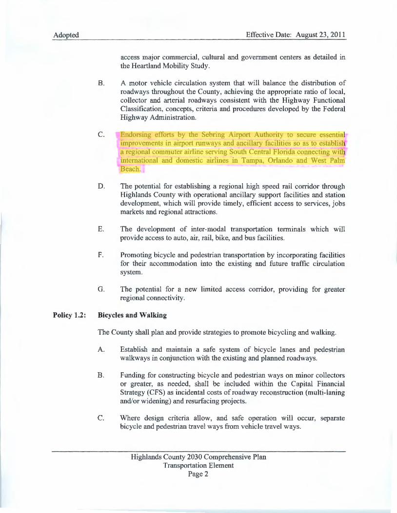
Adopted
Policy 1.2:
Effective Date: August 23, 2011
access major commercial, cultural and government centers as detailed in the Heartland Mobility Study.
B. A motor vehicle circulation system that will balance the distribution of roadways throughout the County, achieving the appropriate ratio of local, collector and arterial roadways consistent with the Highway Functional Classification, concepts, criteria and procedures developed by the Federal Highway Administration.
C. Endorsing efforts by the Sebring Airport Authority to secure essential improvements in airport runways and ancillary facilities so as to establish a regional commuter airline serving South Central Florida connecting with international and domestic airlines in Tampa, Orlando and West Palm Beach.
D. The potential for establishing a regional high speed rail corridor through Highlands County with operational ancillary support facilities and station development, which will provide timely, efficient access to services, jobs markets and regional attractions.
E. The development of inter-modal transportation terminals which will provide access to auto, air, rail, bike, and bus facilities .
F. Promoting bicycle and pedestrian transportation by incorporating facilities for their accommodation into the existing and future traffic circulation system.
G. The potential for a new limited access corridor, providing for greater regional connectivity.
Bicycles and Walking
The County shall plan and provide strategies to promote bicycling and walking.
A. Establish and maintain a safe system of bicycle lanes and pedestrian walkways in conjunction with the existing and planned roadways.
B. Funding for constructing bicycle and pedestrian ways on minor collectors or greater, as needed, shall be included within the Capital Financial Strategy (CFS) as incidental costs of roadway reconstruction (multi-laning and/or widening) and resurfacing projects.
C. Where design criteria allow, and safe operation will occur, separate bicycle and pedestrian travel ways from vehicle travel ways.
Highlands County 2030 Comprehensive Plan Transportation Element
Page 2
Marcia
Highlight
Marcia
Highlight

Adopted Effective Date: August 23, 2011
specify any needed improvements, and a schedule for their implementation, including any conditions that require public facility improvements, be in place concurrent with the impacts of the proposed development.
F. Wetlands on the property shall be protected by recording of a restrictive conservation easement.
G. Payment for transportation impacts shall be required pnor to beginning development as follows:
a. The payment of the transportation assessment cost at the time of concurrency will be made according the Highlands County Land Development Regulations and will also be based upon the proportionate fair share cost calculated as part of an approved Traffic Study submitted through the County ' s concurrency review process.
b. Impact fee credits will be granted according to the procedures identified in Highlands County Proportionate Fair Share Ordinance and Impact Fee Ordinance.
50. CPA-06-359LS: (Sebring Airport Authority) Approximately 120.0 acres located in the southeast comer of the Sebring Airport Authority complex, changing the land use from "Public/Quasi-Public" to "Industrial". The proposed land use amendment will facilitate the Airport Authority to effectively administer the Airport ' s Master Plan and to more clearly describe the environment and the uses that are allowed.
Proposed Site Specific Conditions:
A. Environmental clearance, if required, of impacts to Wetlands, Cutthroat Grass Seeps, and Xeric Uplands will be necessary prior to development. No development order or permit will be issued unless prescribed environmental mitigation is accomplished. Concurrency assessment for traffic circulation, central wastewater, potable water, solid waste disposal, storm water drainage, and recreation and open space will be required prior to development. All development orders and permits will specify any needed improvements, and a schedule for their implementation, including any conditions that require public facility improvements, be in place concurrent with the impacts of the proposed development.
B. A traffic study shall be required using Highlands County approved methodology for Comprehensive Plan amendments.
Highlands County 2030 Comprehensive Plan Future Land Use Element
Page 213
Marcia
Highlight
Marcia
Highlight

Adopted Effective Date: August 23, 2011
The applicant or the applicant's traffic consultant or agent shall discuss the methodology with both the County Planning and Engineering staff before proceeding with development of the study.
C. Central water and wastewater are required.
D. Industrial uses not allowed will be the same as those not allowed in the A-1 Zoning District. A restrictive easement will be recorded in favor of the Board of County Commissioners restricting the industrial uses.
E. The maximum industrial development shall be limited to 2,090,880 sq. ft. (FAR 0.4).
F. The property shall be developed in Phases as follows with an approved Traffic Study submitted through the County's concurrency review process prior to development in each phase:
Phase 1, Phase 2, Subsequent thru the year thru the year Phases, Maximum
2010 2015 Site Development Maximum Industrial
500,000 1,000,000 2,090,880 Floor Area
G. Payment for transportation impacts shall be required prior to beginning development as follows:
a. The payment of the transportation assessment cost at the time of concurrency will be made according the Highlands County Land Development Regulations and will also be based upon the proportionate fair share cost calculated as part of an approved Traffic Study submitted through the County ' s concurrency review process.
b. Impact fee credits will be granted according to the procedures identified in Highlands County Proportionate Fair Share Ordinance and Impact Fee Ordinance.
51. CPA-06-366LS: (Arlan Sapp/Mark, Inc.) Approximately 66.0 acres generally located in Section 27, Township 33S, Range 28E on the east shore of Lake Anoka between South Lake Blvd. and Marble Avenue (Garrett) extended, changing the land use from "Agriculture" to "High Density Residential" .
Highlands County 2030 Comprehensive Plan Future Land Use Element
Page 214


SEBRING REGIONAL AIRPORT MASTER PLAN UPDATE
FINAL REPORT
PREPARED FOR: SEBRING AIRPORT AUTHORITY
PREPARED BY:
PBS&J ORLANDO, FLORIDA
FEBRUARY 2004
Cover photo provided by Mike Willingham ©

TABLE OF CONTENTS
2/18/04 Sebring Regional Airport Master Plan Update ii
TABLE OF FIGURES ................................................................................................................xi
TABLE OF TABLES................................................................................................................xiv
CHAPTER ONE.......................................................................................................................1-1 GOALS AND OBJECTIVES .................................................................................................1-1
1.1 General Guidelines.................................................................................................1-1 1.2 Goals and Objectives .............................................................................................1-2
1.2.1 Goal No. 1 .....................................................................................................1-3 1.2.2 Goal No. 2 .....................................................................................................1-3 1.2.3 Goal No. 3 .....................................................................................................1-4 1.2.4 Goal No. 4 .....................................................................................................1-4 1.2.5 Goal No. 5 .....................................................................................................1-4 1.2.6 Goal No. 6 .....................................................................................................1-5 1.2.7 Goal No. 7 .....................................................................................................1-5 1.2.8 Goal No. 8 .....................................................................................................1-5 1.2.9 Goal No. 9 .....................................................................................................1-6 1.2.10 Goal No. 10 ...................................................................................................1-6
1.3 Tasks......................................................................................................................1-6 1.4 Prior Planning Documentation ................................................................................1-9 1.5 Airport Management .............................................................................................1-10
CHAPTER TWO ......................................................................................................................2-1 EXISTING AIRPORT FACILITIES, STATISTICS, AND ENVIRONMENT.............................2-1
2.1 Overview and Description.......................................................................................2-1 2.2 Airport History.........................................................................................................2-1 2.3 Airport Location ......................................................................................................2-4 2.4 Meteorological Information .....................................................................................2-4 2.5 Existing Airside Facilities ........................................................................................2-7
2.5.1 Runways........................................................................................................2-7 2.5.1.1 Pavement Strength/Condition................................................................2-7 2.5.1.2 Safety Areas .......................................................................................2-10 2.5.1.3 Runway Protection Zone.....................................................................2-11 2.5.1.4 Runway Object Free Areas (ROFA) ....................................................2-12
2.5.2 Taxiways......................................................................................................2-12 2.5.2.1 Pavement Strength/Condition..............................................................2-13 2.5.2.2 Safety Areas .......................................................................................2-14 2.5.2.3 Taxiway Object Free Area...................................................................2-14 2.5.2.4 Taxiway Safety Area ...........................................................................2-14
2.5.3 Lighting and Markings..................................................................................2-15 2.5.3.1 Identification Lighting ..........................................................................2-15 2.5.3.2 Obstruction Lighting ............................................................................2-15 2.5.3.3 Approach Lighting ...............................................................................2-15 2.5.3.4 Runway Edge Lighting ........................................................................2-16 2.5.3.5 Taxiway Lighting .................................................................................2-16 2.5.3.6 Apron Lighting.....................................................................................2-16
2.5.4 Navigational Aids .........................................................................................2-17 2.5.4.1 Terminal Area Navigational Aids and Landing Aids .............................2-17
2.5.5 General Aviation Facilities ...........................................................................2-18 2.5.5.1 Terminal Facilities ...............................................................................2-18 2.5.5.2 Aircraft Storage Buildings....................................................................2-21 2.5.5.3 Airport Apron Area ..............................................................................2-23
TABLE OF CONTENTS
2/18/04 Sebring Regional Airport Master Plan Update iii
2.5.5.4 Aviation Tenants .................................................................................2-25 2.5.5.5 Non-Aviation Tenants..........................................................................2-29
2.6 Existing Landside Facilities...................................................................................2-34 2.6.1 GA Automobile Parking................................................................................2-34 2.6.2 Terminal Building Curb Frontage .................................................................2-36 2.6.3 Support Facilities .........................................................................................2-36
2.6.3.1 Airport Maintenance ............................................................................2-36 2.6.3.2 Airport Police Department ...................................................................2-36 2.6.3.3 Aircraft Rescue and Fire Fighting ........................................................2-36 2.6.3.4 Fuel Storage .......................................................................................2-36
2.6.4 Ground Access System ...............................................................................2-37 2.6.5 Utilities.........................................................................................................2-37 2.6.6 Sebring International Raceway ....................................................................2-39 2.6.7 Stormwater/Drainage...................................................................................2-41 2.6.8 Wetland Inventory........................................................................................2-41
2.7 Airspace and Approach Procedures .....................................................................2-41 2.7.1 Airspace Management and Approach Procedures .......................................2-44 2.7.2 Airspace Structure .......................................................................................2-44 2.7.3 Delegation of Air Traffic Control Responsibilities..........................................2-50 2.7.4 En Route Navigational Aids .........................................................................2-50
2.8 Land Use..............................................................................................................2-51 2.8.1 Currently Vacant and Underutilized Land.....................................................2-51
2.8.1.1 Davis Property ....................................................................................2-52 2.8.1.2 South Property ....................................................................................2-52 2.8.1.3 East Property ......................................................................................2-52
2.9 Area-Wide Plans ..................................................................................................2-53 2.9.1 Highlands County Comprehensive Plan.......................................................2-53 2.9.2 Central Florida Strategic Regional Policy Plan (SRPP) ................................2-53 2.9.3 Florida Airport System Plan .........................................................................2-55 2.9.4 National Plan of Integrated Airport Systems.................................................2-55
2.10 Airports in the Region ...........................................................................................2-56 2.10.1 Lakeland Linder Regional Airport (LAL) .......................................................2-56 2.10.2 Lake Wales Municipal Airport (X07) .............................................................2-58 2.10.3 Arcadia Municipal Airport (X06) ...................................................................2-58 2.10.4 Winter Haven Municipal Airport (GIF) ..........................................................2-58 2.10.5 Avon Park Municipal Airport (AVO) ..............................................................2-59 2.10.6 Bartow Municipal Airport (BOW) ..................................................................2-59 2.10.7 Wauchula Municipal Airport (F37) ................................................................2-60 2.10.8 MacDill Air Force Base Auxiliary Field (AGR) ..............................................2-60
2.11 Summary..............................................................................................................2-60
CHAPTER THREE ..................................................................................................................3-1 EXISTING SOCIO-ECONOMIC INFLUENCES ....................................................................3-1
3.1 General Overview...................................................................................................3-1 3.2 Population ..............................................................................................................3-1
3.2.1 Distribution and Size ......................................................................................3-2 3.2.2 Recent Changes in Population.......................................................................3-3 3.2.3 Population Projections ...................................................................................3-5
3.3 Demographics ........................................................................................................3-6 3.3.1 Age................................................................................................................3-6 3.3.2 Education.......................................................................................................3-7

TABLE OF CONTENTS
2/18/04 Sebring Regional Airport Master Plan Update iv
3.4 Employment ...........................................................................................................3-8 3.4.1 Potential Employment Trends ......................................................................3-10 3.4.2 Employment Projections ..............................................................................3-10
3.5 Income .................................................................................................................3-11 3.5.1 Income Projections ......................................................................................3-12
3.6 Socio-Economic Activity .......................................................................................3-12 3.6.1 Agriculture ...................................................................................................3-12 3.6.2 Tourism........................................................................................................3-13 3.6.3 Other ...........................................................................................................3-14
3.7 Transportation ......................................................................................................3-14 3.8 Other Factors .......................................................................................................3-15 3.9 Aviation Industry Factors ......................................................................................3-16 3.10 Summary..............................................................................................................3-17
CHAPTER FOUR ....................................................................................................................4-1 HISTORICAL AVIATION ACTIVITY STATISTICS ...............................................................4-1
4.1 Based Aircraft.........................................................................................................4-1 4.2 Annual Aircraft Operations......................................................................................4-2
4.2.1 Local GA Operations......................................................................................4-2 4.2.2 Itinerant GA Operations .................................................................................4-2 4.2.3 Military Operations.........................................................................................4-3 4.2.4 Helicopter Operations ....................................................................................4-4 4.2.5 Instrument Operations ...................................................................................4-4
4.3 Peak Operations.....................................................................................................4-4 4.4 Aircraft Parking.......................................................................................................4-5 4.5 General Aviation Passengers and Automobile Parking...........................................4-6
4.5.1 GA Passengers..............................................................................................4-6 4.5.2 Auto Parking ..................................................................................................4-7
4.6 Fuel Sales ..............................................................................................................4-7 4.7 Statistical Summary................................................................................................4-8
CHAPTER FIVE ......................................................................................................................5-1 PROJECTION OF AVIATION DEMAND ..............................................................................5-1
5.1 Introduction ............................................................................................................5-1 5.1.1 Objective........................................................................................................5-1 5.1.2 Methodology ..................................................................................................5-2
5.1.2.1 External Factors – September 11, 2001 ................................................5-2 5.2 Forecast of Based Aircraft ......................................................................................5-3
5.2.1 FAA Terminal Area Forecast (TAF)................................................................5-6 5.2.2 Market Share Analysis ...................................................................................5-6 5.2.3 Based Aircraft Population Ratio .....................................................................5-8 5.2.4 Regression Analysis ....................................................................................5-11 5.2.5 Selected Based Aircraft Forecast.................................................................5-13 5.2.6 Based Aircraft Fleet Mix Forecast ................................................................5-15
5.3 Forecast of Annual Aircraft Operations.................................................................5-16 5.3.1 2001 FAA Terminal Area Forecast (TAF).....................................................5-16 5.3.2 Florida Department of Transportation (FDOT) Aviation Forecast .................5-16 5.3.3 FAA Master Record – Form 5010 ................................................................5-16 5.3.4 Florida Aviation System Plan (FASP)...........................................................5-18
5.3.4.1 Total General Aviation Operations ......................................................5-18 5.3.4.2 Central Regional Forecast of GA Operations ......................................5-19
5.3.5 1994 Airport Master Plan .............................................................................5-19

TABLE OF CONTENTS
2/18/04 Sebring Regional Airport Master Plan Update v
5.3.6 Based Aircraft Ratio.....................................................................................5-19 5.3.7 Market Share Analysis .................................................................................5-19 5.3.8 Ratio Analysis ..............................................................................................5-23 5.3.9 Regression Analysis ....................................................................................5-26 5.3.10 Selected Aircraft Operations Forecast .........................................................5-26 5.3.11 Local GA Operations Forecast.....................................................................5-28
5.3.11.1 Market Share Analysis of Local Operations.........................................5-29 5.3.11.2 Ratio Analysis of Local Operations......................................................5-29 5.3.11.3 Local Operations Selected Forecast....................................................5-34
5.4 Military Operations................................................................................................5-37 5.5 Breakdown of Total Aircraft Operations ................................................................5-39 5.6 Annual Operations per Aircraft Type.....................................................................5-40 5.7 Fuel Flowage........................................................................................................5-42
5.7.1 General Aviation Fuel Flowage ....................................................................5-42 5.7.2 Military Operations Fuel Flowage.................................................................5-45
5.8 Peak Activity.........................................................................................................5-45 5.9 Instrument Approach Activity ................................................................................5-48 5.10 Aircraft Parking.....................................................................................................5-51 5.11 General Aviation (GA) Passengers and Automobile Parking ................................5-51
5.11.1 General Aviation Passengers.......................................................................5-51 5.11.2 Automobile Parking......................................................................................5-54
5.12 Commercial Service Activity .................................................................................5-55 5.13 Forecast Summary ...............................................................................................5-56
CHAPTER SIX.........................................................................................................................6-1 DEMAND CAPACITY ANALYSIS ........................................................................................6-1
6.1 Introduction ............................................................................................................6-1 6.2 General ..................................................................................................................6-1 6.3 Airspace Capacity ..................................................................................................6-2
6.3.1 Airspace Limitations.......................................................................................6-2 6.3.1.1 Military Airspace....................................................................................6-2
6.3.2 Instrument Approach Limitations....................................................................6-4 6.4 Airfield Capacity .....................................................................................................6-7
6.4.1 Airfield Operational Capacity..........................................................................6-7 6.4.1.1 Runway Orientation, Utilization, and Wind Coverage ............................6-8 6.4.1.2 Airfield Operational Capacity Parameters and Assumptions................6-10 6.4.1.3 Airfield Capacity Calculations ..............................................................6-14
6.4.2 Aircraft Group Capacity Demand .................................................................6-19 6.4.2.1 Corporate and General Aviation ..........................................................6-19 6.4.2.2 Commercial and Charter Service ........................................................6-21
6.4.3 Heavy Cargo................................................................................................6-22 6.4.4 Antique Aircraft ............................................................................................6-24 6.4.5 Small Aircraft Transportation System (SATS) ..............................................6-24
6.5 Airside Areas........................................................................................................6-24 6.5.1 Terminal Capacity........................................................................................6-25 6.5.2 Aircraft Storage Buildings ............................................................................6-26 6.5.3 Apron Area ..................................................................................................6-27
6.5.3.1 Conventional Hangar Apron ................................................................6-28 6.5.3.2 Aircraft Tie-Down Apron......................................................................6-28 6.5.3.3 Helicopter Tie-Down Analysis..............................................................6-29
6.6 Fuel Storage.........................................................................................................6-29
TABLE OF CONTENTS
2/18/04 Sebring Regional Airport Master Plan Update vi
6.7 Landside Capacity................................................................................................6-31 6.7.1 Ground Access and Terminal Roads ...........................................................6-31 6.7.2 Automobile Parking......................................................................................6-32
6.8 Non-Aviation Use .................................................................................................6-34 6.8.1 Airport Industrial Park ..................................................................................6-34 6.8.2 Sebring International Raceway ....................................................................6-34
6.9 Summary..............................................................................................................6-35
CHAPTER SEVEN ..................................................................................................................7-1 DEMAND CAPACITY ANALYSIS ........................................................................................7-1
7.1 General ..................................................................................................................7-1 7.2 Airport Reference Code..........................................................................................7-1
7.2.1 Airport Role....................................................................................................7-1 7.2.2 Airport Reference Code (ARC) ......................................................................7-1
7.2.2.1 Aircraft Approach Category ...................................................................7-1 7.2.2.2 Airplane Design Group..........................................................................7-2 7.2.2.3 Existing Airport Reference Code ...........................................................7-2
7.2.3 Critical Aircraft ...............................................................................................7-3 7.2.3.1 Determination of Critical Aircraft............................................................7-3
7.3 Airfield Requirements .............................................................................................7-5 7.3.1 Future Airfield Facility Design Requirements .................................................7-5
7.3.1.1 Facility Design Criteria ..........................................................................7-7 7.3.1.2 Design Visibility Minimums..................................................................7-16
7.3.2 FAR Part 77 Surface and Approach Requirements......................................7-18 7.3.2.1 Pavement Determination.....................................................................7-20 7.3.2.2 Navigational Aid (NAVAID) Requirements...........................................7-22
7.3.3 Airfield Lighting, Signage, and Pavement Markings .....................................7-23 7.3.3.1 Airfield Lighting ...................................................................................7-23 7.3.3.2 Airfield Signage...................................................................................7-23 7.3.3.3 Pavement Markings ............................................................................7-24
7.3.4 Airfield Requirements for Commercial Airport Certification...........................7-24 7.3.5 Summary of Airfield Requirements and Future Capacity..............................7-24
7.4 Terminal Area Requirements................................................................................7-25 7.4.1 Methodology ................................................................................................7-25 7.4.2 Existing Terminal Building............................................................................7-26
7.4.2.1 Concessions .......................................................................................7-27 7.4.2.2 Restrooms...........................................................................................7-31 7.4.2.3 Airport Authority and Management Facilities .......................................7-31 7.4.2.4 Terminal Circulation, Mechanical, and Maintenance Space ................7-31
7.4.3 Future Commercial Terminal Facility............................................................7-32 7.5 Landside Requirements........................................................................................7-33
7.5.1 Ground Access and Terminal Roads ...........................................................7-33 7.5.1.1 Primary Access Roads........................................................................7-34 7.5.1.2 Terminal Access Roads ......................................................................7-35 7.5.1.3 Terminal Frontage Road and Curb Frontage.......................................7-35 7.5.1.4 Service Roads.....................................................................................7-35
7.5.2 Automobile Parking......................................................................................7-36 7.5.2.1 GA Terminal Public Parking Requirements .........................................7-36 7.5.2.2 Commercial Terminal Parking Requirements ......................................7-38 7.5.2.3 Employee Parking Requirements ........................................................7-38
7.5.3 Airport Industrial Park ..................................................................................7-39
TABLE OF CONTENTS
2/18/04 Sebring Regional Airport Master Plan Update vii
7.5.4 General Aviation (GA) Areas........................................................................7-40 7.5.4.1 Aircraft Storage Buildings....................................................................7-40 7.5.4.2 Conventional Hangar Apron ................................................................7-41 7.5.4.3 Aircraft Tie-Down Apron......................................................................7-42 7.5.4.4 Helicopter Tie-Down Analysis..............................................................7-43
7.5.5 Aircraft Fuel Storage....................................................................................7-43 7.5.6 Airport Rescue and Firefighting....................................................................7-44 7.5.7 Airport Security and Fencing........................................................................7-45 7.5.8 Land Acquisition ..........................................................................................7-46
7.6 Summary..............................................................................................................7-46
CHAPTER EIGHT ...................................................................................................................8-1 DEVELOPMENT PLANS......................................................................................................8-1
8.1 General ..................................................................................................................8-1 8.1.1 Airfield Development......................................................................................8-1 8.1.2 Land Use/Land Acquisition ............................................................................8-2 8.1.3 Landside Facilities – Building Areas...............................................................8-2 8.1.4 Landside Facilities – Surface Access.............................................................8-3
8.2 Development Considerations..................................................................................8-4 8.3 Alternative I - No Build/Limited Development..........................................................8-6
8.3.1 GA Airport Security Recommendations..........................................................8-6 8.4 Alternative II – Constrained Development.............................................................8-10
8.4.1 Airside Configuration....................................................................................8-10 8.4.1.1 Runways .............................................................................................8-10 8.4.1.2 Taxiway System Improvements...........................................................8-18 8.4.1.3 Aprons ................................................................................................8-19 8.4.1.4 Air Traffic Control Tower .....................................................................8-19
8.4.2 Environmental Assessment..........................................................................8-20 8.4.3 Regional Airspace and Approach Procedures..............................................8-20
8.4.3.1 Terminal Instrument Approach Procedures .........................................8-21 8.4.4 Land Use and Land Acquisition ...................................................................8-25
8.4.4.1 Airport Operations ...............................................................................8-25 8.4.4.2 Airfield Security and Fencing...............................................................8-25 8.4.4.3 Fuel Storage .......................................................................................8-26 8.4.4.4 Airport Commerce Park.......................................................................8-28 8.4.4.5 Industrial Park .....................................................................................8-28 8.4.4.6 Corporate, Military, and Light General Aviation Areas .........................8-29 8.4.4.7 Low Density Uses for Approach/Transition Zones...............................8-29
8.4.5 Landside Facilities - Buildings......................................................................8-30 8.4.5.1 Terminal Facility ..................................................................................8-30 8.4.5.2 General Aviation and Related Aeronautical Development Areas .........8-33 8.4.5.3 Airport Commerce Park.......................................................................8-35
8.4.6 Landside Facilities – Surface Access...........................................................8-35 8.4.6.1 Roadway Access.................................................................................8-38 8.4.6.2 Roadway/Airport Signage....................................................................8-41
8.5 Alternative III – Unconstrained Development ........................................................8-41 8.5.1 Airside Development....................................................................................8-49
8.5.1.1 Runways .............................................................................................8-49 8.5.1.2 Taxiways .............................................................................................8-50 8.5.1.3 Aprons ................................................................................................8-51 8.5.1.4 Air Traffic Control Tower .....................................................................8-51

TABLE OF CONTENTS
2/18/04 Sebring Regional Airport Master Plan Update viii
8.5.2 Environmental Assessment..........................................................................8-51 8.5.3 Airspace and Approach Procedures.............................................................8-51
8.5.3.1 Terminal Instrument Approach Procedures .........................................8-52 8.5.4 Land Use and Land Acquisition ...................................................................8-61
8.5.4.1 Airport Operations ...............................................................................8-63 8.5.4.2 Airport Industrial Park..........................................................................8-63 8.5.4.3 Corporate and Light General Aviation Areas .......................................8-64 8.5.4.4 Cargo/Potential Heavy Maintenance ...................................................8-67 8.5.4.5 Military and Special Use......................................................................8-67 8.5.4.6 Non-Aviation/Commercial/Light Industrial............................................8-69 8.5.4.7 Mixed Use...........................................................................................8-69 8.5.4.8 Low Density Uses for Approach/Transition Zones...............................8-69
8.5.5 Landside Development – Building Areas......................................................8-70 8.5.5.1 Terminal Buildings...............................................................................8-70 8.5.5.2 Air Cargo/Heavy Maintenance Facilities..............................................8-75 8.5.5.3 General Aviation and Related Aeronautical Development Areas .........8-75 8.5.5.4 Commerce Park ..................................................................................8-80
8.5.6 Landside Facilities – Surface Access...........................................................8-80 8.5.6.1 Roadway Access.................................................................................8-80 8.5.6.2 Roadway/Airport Signage....................................................................8-86 8.5.6.3 Railroad Access ..................................................................................8-86
8.6 Evaluation of Alternatives .....................................................................................8-88 8.7 Recommended Alternative ...................................................................................8-89
CHAPTER NINE......................................................................................................................9-1 ENVIRONMENTAL OVERVIEW...........................................................................................9-1
9.1 Background ............................................................................................................9-1 9.2 Airport Noise...........................................................................................................9-1
9.2.1 Major Assumptions ........................................................................................9-2 9.2.1.1 Existing/Future Development Scenarios................................................9-2 9.2.1.2 Day/Night Operations............................................................................9-2
9.2.2 Runway Utilizations .......................................................................................9-3 9.2.3 Flight Tracks and Air Traffic Distribution.........................................................9-3 9.2.4 Existing Activity Levels and Fleet Mix (2000 Base Case) ...............................9-4
9.2.4.1 Day/Night Distribution by Aircraft Category ...........................................9-4 9.2.4.2 Average Daily Operations by Stage Length...........................................9-5 9.2.4.3 Distribution of Traffic by Flight Tracks ...................................................9-5
9.2.5 Existing Noise Contours.................................................................................9-5 9.2.6 Future Aircraft Activity Levels and Fleet Mix ..................................................9-6
9.2.6.1 Operations Growth ................................................................................9-6 9.2.6.2 Facilities Improvements.........................................................................9-6 9.2.6.3 Fleet Mix ...............................................................................................9-6 9.2.6.4 Average Daily Operations .....................................................................9-8
9.2.7 Future Noise Contours...................................................................................9-8 9.2.8 Conclusions ...................................................................................................9-9
9.3 Compatible Land Use...........................................................................................9-11 9.3.1 Highlands County ........................................................................................9-11
9.4 Social Impacts ......................................................................................................9-11 9.4.1 Relocation of any Residences or Businesses ..............................................9-12 9.4.2 Alteration of Surface Transportation Patterns ..............................................9-12 9.4.3 Division or Disruption of Established Communities ......................................9-13

TABLE OF CONTENTS
2/18/04 Sebring Regional Airport Master Plan Update ix
9.4.4 Disruption of Orderly, Planned Development ...............................................9-13 9.4.5 Appreciable Change in Employment ............................................................9-13 9.4.6 Environmental Justice..................................................................................9-13
9.5 Induced Socio-Economic Impacts.........................................................................9-14 9.5.1 Trends in Population Movement and Growth ...............................................9-14 9.5.2 Public Service Demands..............................................................................9-14 9.5.3 Business and Economic Activity ..................................................................9-14
9.6 Air Quality.............................................................................................................9-15 9.7 Water Quality........................................................................................................9-15 9.8 Department of Transportation Act, Section 4(f).....................................................9-16 9.9 Historical, Architectural, Archeological, and Cultural Resources...........................9-16 9.10 Biotic Communities...............................................................................................9-16 9.11 Endangered or Threatened Species .....................................................................9-17 9.12 Wetlands ..............................................................................................................9-18
9.12.1 Airport Soil Types ........................................................................................9-18 9.12.2 Permitting and Approvals.............................................................................9-19
9.13 Floodplains...........................................................................................................9-22 9.14 Coastal Zone Management ..................................................................................9-22 9.15 Coastal Barriers....................................................................................................9-22 9.16 Wild and Scenic Rivers.........................................................................................9-23 9.17 Prime, Unique, and State Significant Farmland ....................................................9-23 9.18 Energy Supply and Natural Resources.................................................................9-24 9.19 Light Emissions ....................................................................................................9-24 9.20 Solid Waste Impact...............................................................................................9-24 9.21 Hazardous Waste Impacts....................................................................................9-25 9.22 Construction Impacts............................................................................................9-26 9.23 Cumulative Impacts..............................................................................................9-27 9.24 Summary..............................................................................................................9-27
CHAPTER TEN .....................................................................................................................10-1 AIRPORT LAYOUT PLAN SET..........................................................................................10-1
10.1 General ................................................................................................................10-1 10.2 Cover Sheet .........................................................................................................10-1 10.3 Airport Layout Plan...............................................................................................10-1
10.3.1 Existing Facilities .........................................................................................10-2 10.3.2 Future Facilities ...........................................................................................10-2
10.4 Approach and Runway Protection Zone Plans....................................................10-15 10.5 Part 77 Airspace Surfaces ..................................................................................10-15 10.6 Land Use and Noise Contours............................................................................10-20 10.7 Airport Property Map ..........................................................................................10-20
CHAPTER ELEVEN ..............................................................................................................11-1 COST ESTIMATES, CONSTRUCTION PHASING, AND CAPITAL IMPROVEMENT PROGRAM..............................................................................................11-1
11.1 Construction Phasing ...........................................................................................11-1 11.2 Cost Estimate.......................................................................................................11-8 11.3 Capital Improvement Program............................................................................11-12
CHAPTER TWELVE .............................................................................................................12-1 FINANCIAL FEASIBILITY..................................................................................................12-1
12.1 Introduction and Purpose......................................................................................12-1 12.2 Sebring Regional Airport – Independent Operating Entity.....................................12-1

TABLE OF CONTENTS
2/18/04 Sebring Regional Airport Master Plan Update x
12.2.1 Foreign Trade Zone .....................................................................................12-2 12.2.2 Community Redevelopment Agency............................................................12-2
12.3 Project Development Cost vs. Potential Revenues...............................................12-3 12.3.1 Historical Airport Financial Statements ........................................................12-3
12.3.1.1 Revenue Sources................................................................................12-4 12.3.1.2 Expenses ..........................................................................................12-11 12.3.1.3 Projected Revenue Forecast Analysis (2001-2021)...........................12-15
12.4 Other Revenue Sources .....................................................................................12-22 12.5 Summary............................................................................................................12-24
CHAPTER THIRTEEN...........................................................................................................13-1 JOINT AUTOMATED CAPITAL IMPROVEMENT PLAN (JACIP)......................................13-1
REFERENCES ....................................................................................................................... R-1
APPENDIX A.......................................................................................................................... A-1

TABLE OF FIGURES
2/18/04 Sebring Regional Airport Master Plan Update xi
CHAPTER ONE.......................................................................................................................1-1 1-1 Steps in the Master Planning Process ....................................................................1-8 1-2 Sebring Regional Airport Authority........................................................................1-11
CHAPTER TWO ......................................................................................................................2-1 2-1 Location Map..........................................................................................................2-5 2-2 Vicinity Map............................................................................................................2-6 2-3 Airport Layout Plan.................................................................................................2-8 2-4 Airport Diagram ......................................................................................................2-9 2-5 Sebring Airside Center-Landside..........................................................................2-19 2-6 Sebring Airside Center-Airside .............................................................................2-19 2-7 Terminal Building Location ...................................................................................2-20 2-8 Aircraft Storage Facilities......................................................................................2-22 2-9 Aircraft Apron Area...............................................................................................2-24 2-10 Aviation Tenants...................................................................................................2-26 2-11 Major Non-Aviation Tenants .................................................................................2-30 2-12 Landside Facilities................................................................................................2-35 2-13 Airport Access and Roadway System...................................................................2-38 2-14 Sebring International Raceway.............................................................................2-40 2-15 Existing Drainage Map .........................................................................................2-42 2-16 Airfield Master Drainage Plan ...............................................................................2-43 2-17 FAA Airspace Classification..................................................................................2-47 2-18 Airspace Classification Detail ...............................................................................2-48 2-19 Regional Airspace ................................................................................................2-49 2-20 Miami Center Airspace Coverage.........................................................................2-50 2-21 Land Use..............................................................................................................2-52 2-22 Potential Development .........................................................................................2-54 2-23 Airports in the Region ...........................................................................................2-57
CHAPTER THREE ..................................................................................................................3-1 3-1 Highlands County Historical Population from 1980-1999 ........................................3-2 3-2 Annual Population Growth Rates Highlands County vs. Florida..............................3-5 3-3 Highlands County Percent of Population by Age Group in 2000 .............................3-6 3-4 Highlands County Predicted Percent of Population by Age Group in 2015 .............3-7 3-5 Highlands County Industrial Mix .............................................................................3-8 3-6 Highlands County Employment vs. Unemployment ..............................................3-10
CHAPTER FOUR ....................................................................................................................4-1 4-1 General Aviation Passengers .................................................................................4-6
CHAPTER FIVE ......................................................................................................................5-1 5-1 Existing Based Aircraft Forecasts ...........................................................................5-4 5-2 Existing Based Aircraft Forecasts ...........................................................................5-6 5-3 Selected and Supporting Based Aircraft Forecasts...............................................5-13 5-4 Existing Aircraft Operations Forecasts..................................................................5-18 5-5 Existing Aircraft Operations Forecasts..................................................................5-18 5-6 Market Share Analysis..........................................................................................5-23 5-7 Selected and Supporting Operations Forecasts....................................................5-26 5-8 Local Aircraft Operations Selected Forecast.........................................................5-37 5-9 Aircraft Operations Forecast by Type ...................................................................5-40 5-10 Fleet Mix Annual Operations by Aircraft Type.......................................................5-42

TABLE OF FIGURES
2/18/04 Sebring Regional Airport Master Plan Update xii
CHAPTER SIX.........................................................................................................................6-1 6-1 SEF Surrounding Airspace .....................................................................................6-5 6-2 GPS Approach to Runway 36.................................................................................6-6 6-3 All Weather and IFR Windrose Data.......................................................................6-9 6-4 Existing Taxiway System......................................................................................6-13 6-5 Annual Service Volume vs. Annual Demand.........................................................6-18
CHAPTER SEVEN ..................................................................................................................7-1 7-1 FAR Part 77 Imaginary Surfaces ..........................................................................7-19 7-2 Typical Terminal Site Relationship for Non-Hub Airports ......................................7-28
CHAPTER EIGHT ...................................................................................................................8-1 8-1 Alternative I - No Build/Limited Development..........................................................8-9 8-2 Alternative II - Constrained Development .............................................................8-14 8-3 Runway 36 Terminal Instrument Approach Procedures........................................8-24 8-4 Proposed Land Use..............................................................................................8-31 8-5 Terminal Development .........................................................................................8-32 8-6 Public Emergency Facilities..................................................................................8-36 8-7 Airport Commerce Park Development ..................................................................8-37 8-8 Proposed Roadway Development ........................................................................8-39 8-9 Alternative III - Unconstrained Development.........................................................8-48 8-10 Runway 32R Straight Line Approach and Missed Approach Procedures..............8-54 8-11 Runway 32R 60° Turning Approach and Missed Approach Procedures ...............8-56 8-12 Runway 14L Straight Line Approach and Missed Approach Procedures ..............8-58 8-13 Runway 14L 60° Turning Approach and Missed Approach Procedures................8-60 8-14 Land Acquisition and Development ......................................................................8-62 8-15 Airport Industrial Park ...........................................................................................8-65 8-16 Corporate and Light GA Development ..................................................................8-66 8-17 Air Cargo, Heavy Maintenance, Military, and Special Use ....................................8-68 8-18 Commercial Terminal Facility ...............................................................................8-73 8-19 On Airfield Public Emergency Facilities - Midfield .................................................8-78 8-20 Proposed Roadway Alignments............................................................................8-81 8-21 Proposed Rail Spur Realignment and High Speed Rail Station ............................8-87
CHAPTER NINE......................................................................................................................9-1 9-1 Existing Noise Contours (2000) and Land Use .......................................................9-7 9-2 Future Noise Contours (2021) and Land Use .......................................................9-10
CHAPTER TEN .....................................................................................................................10-1 10-1 Cover Sheet .........................................................................................................10-3 10-2 Existing Facilities Drawing....................................................................................10-4 10-3 Airport Layout Plan...............................................................................................10-5 10-4 General Aviation Terminal Area Plan..................................................................10-13 10-5 Commercial Terminal Area Plan.........................................................................10-14 10-6 Runway 14L/32R and 14R/32L Inner Portion of the Approach Surface Drawing.10-16 10-7 Runway 18/36 and 14U/32U Inner Portion of the Approach Surface Drawing ....10-17 10-8 FAR Part 77 Airport Airspace Drawing (Airport Vicinity View) .............................10-18 10-9 FAR Part 77 Airport Airspace Drawing (Approach Surface Views)......................10-19 10-10 Existing Land Use and Noise Contours (2001) ...................................................10-21 10-11 Future Land Use and Noise Contours (2021) .....................................................10-22 10-12 Exhibit ‘A’ Property Map .....................................................................................10-23

TABLE OF FIGURES
2/18/04 Sebring Regional Airport Master Plan Update xiii
CHAPTER ELEVEN ..............................................................................................................11-1 11-1 Phase I Development (2001-2006) .....................................................................11-21 11-2 Phase II Development (2007-2011) ....................................................................11-30 11-3 Phase III Development (2012-2021) ...................................................................11-36 11-4 Complete Phased Development .........................................................................11-37
CHAPTER TWELVE .............................................................................................................12-1 12-1 Revenue Sources.................................................................................................12-6 12-2 Historical Analysis of Airport Revenues and Expenses.......................................12-18 12-3 Projection of Airport Revenues and Expenses With Community… .....................12-20 12-4 Projection of Airport Revenues and Expenditures Without Community… ...........12-21

TABLE OF TABLES
2/18/04 Sebring Regional Airport Master Plan Update xiv
CHAPTER TWO ......................................................................................................................2-1 2-1 Runway Specifications .........................................................................................2-10 2-2 Runway Conditions...............................................................................................2-10 2-3 Runway Safety Area Specifications ......................................................................2-11 2-4 Runway Protection Zone (RPZ) Dimensions.........................................................2-11 2-5 Runway Object Free Area (ROFA) Dimensions....................................................2-12 2-6 Taxiway System ...................................................................................................2-13 2-7 Taxiway Safety Area Standards............................................................................2-15 2-8 Airside Facilities ...................................................................................................2-17 2-9 Aviation Tenants...................................................................................................2-33 2-10 Non-Aviation Tenants ...........................................................................................2-34 2-11 Sebring Regional Airspace ...................................................................................2-46 2-12 Navigational Aids..................................................................................................2-51
CHAPTER THREE ..................................................................................................................3-1 3-1 Statistical Comparison of Highlands County to Surrounding Counties ....................3-3 3-2 Population and Growth Rate Highlands County vs. Florida.....................................3-4 3-3 Estimated Population and Growth Rates Highlands County vs. Florida ..................3-5 3-4 Projected Population Growth for Florida, Highlands, and Surrounding Counties.....3-6 3-5 Highlands County Major Manufacturers and Distributors ........................................3-9 3-6 Employment Projections Comparing Highlands County, the South Central….......3-11 3-7 Historical Income Highlands County vs. Florida....................................................3-11 3-8 Projected Income Highlands County vs. Florida ...................................................3-12
CHAPTER FOUR ....................................................................................................................4-1 4-1 Based Aircraft (1990–2001)....................................................................................4-1 4-2 Local GA Operations ..............................................................................................4-2 4-3 Itinerant GA Operations..........................................................................................4-3 4-4 Military Operations..................................................................................................4-3 4-5 Historical Peak Hourly Operations ..........................................................................4-5 4-6 Historical Aircraft Parking Demand .........................................................................4-5 4-7 General Aviation Passengers .................................................................................4-6 4-8 Historical Automobile Parking Demand...................................................................4-7 4-9 Monthly Fuel Sales .................................................................................................4-9 4-10 Historical Statistical Summary ..............................................................................4-10
CHAPTER FIVE ......................................................................................................................5-1 5-1 Based Aircraft Forecasts ........................................................................................5-5 5-2 Market Share Forecast Analysis Based Aircraft......................................................5-7 5-3 Based Aircraft to Pilot Population Ratio ..................................................................5-9 5-4 Based Aircraft General Population Ratio ..............................................................5-10 5-5 Regression Analysis .............................................................................................5-12 5-6 Based Aircraft Forecasts ......................................................................................5-14 5-7 Based Aircraft Forecast by Type...........................................................................5-15 5-8 General Aviation Aircraft Operations Forecast......................................................5-17 5-9 Operations Per Based Aircraft Forecasts..............................................................5-20 5-10 Market Share Analysis Forecasts Annual Aircraft Operations...............................5-21 5-11 Aircraft Operations to Pilot Ratio Forecasts ..........................................................5-24 5-12 Aircraft Operations Regression Analysis...............................................................5-27 5-13 Selected Aircraft Operations Forecasts ................................................................5-28 5-14 Market Share Forecast Local Aircraft Operations .................................................5-30 5-15 Ratio Analysis Pilot Population Compared to Local Aircraft Operations................5-32

TABLE OF TABLES
2/18/04 Sebring Regional Airport Master Plan Update xv
5-16 Local Aircraft Operations Socioeconomic Regression Analysis ............................5-35 5-17 Selected Forecast Local GA Operations...............................................................5-36 5-18 Military Operations Forecast.................................................................................5-38 5-19 Aircraft Operations Forecast by Type ...................................................................5-39 5-20 Annual Operations by Aircraft Type ......................................................................5-41 5-21 Fuel Flowage Forecast .........................................................................................5-43 5-22 Military Fuel Sales Forecast .................................................................................5-45 5-23 Annual Operations Peak Hour Forecast ...............................................................5-46 5-24 Local Operations Peak Hour Forecast..................................................................5-47 5-25 Itinerant Operations Peak Hour Forecast..............................................................5-48 5-26 Regional Instrument Activity .................................................................................5-49 5-27 Instrument Activity Forecast .................................................................................5-50 5-28 Aircraft Parking Forecast ......................................................................................5-52 5-29 Based Aircraft Parking..........................................................................................5-53 5-30 Forecast of General Aviation Passengers.............................................................5-54 5-31 Forecast of Automobile Parking Spaces...............................................................5-55 5-32 Comparison of Airport Planning and TAF Forecast...............................................5-57 5-33 Summary of Airport Operations ............................................................................5-58
CHAPTER SIX.........................................................................................................................6-1 6-1 Sebring Regional Airspace .....................................................................................6-3 6-2 Runway Utilization (Percent) ..................................................................................6-8 6-3 FAA Aircraft Classifications ..................................................................................6-11 6-4 Airfield Capacity Factors.......................................................................................6-15 6-5 Annual Service Volume vs. Demand ....................................................................6-18 6-6 Corporate/GA Opportunity Cost............................................................................6-20 6-7 Commercial Service Opportunity Costs Based Upon Aircraft Type.......................6-21 6-8 Typical Commercial Jet Freight Fleet ...................................................................6-23 6-9 Commercial Freight Aircraft Estimated Opportunity Cost by Aircraft .....................6-23 6-10 Terminal Capacity Versus Demand ......................................................................6-26 6-11 Existing and Projected Aircraft Storage Demand ..................................................6-27 6-12 Existing and Projected Demand for Aircraft Tie-Downs ........................................6-29 6-13 AvGas Fuel Demand ............................................................................................6-30 6-14 GA Jet A Fuel Demand.........................................................................................6-30 6-15 Military Jet A Fuel Demand...................................................................................6-30 6-16 Peak Month AvGas Storage Capacity (Gallons) ...................................................6-31 6-17 Monthly Jet A Fuel Storage Capacity (Gallons) ....................................................6-31 6-18 Auto Parking Capacity Versus Demand................................................................6-33 6-19 Existing Airport Automobile Parking......................................................................6-33
CHAPTER SEVEN ..................................................................................................................7-1 7-1 Existing Aircraft ......................................................................................................7-4 7-2 Future Critical Aircraft.............................................................................................7-6 7-3 Future Runway Planning and Design Criteria .........................................................7-7 7-4 Proposed Runway Improvements...........................................................................7-9 7-5 Geometrical Design Standards for Runway 18-36 ................................................7-10 7-6 Geometrical Design Standards for Runway 14-32 ................................................7-11 7-7 Geometrical Design Standards for Future Turf Runway........................................7-12 7-8 Geometric Design Standards for Future Commercial Runway..............................7-13 7-9 Separation Standards for Runway 18-36 ..............................................................7-14 7-10 Separation Standards for Runway 14-32 ..............................................................7-14 7-11 Separation Standards for Future Turf Runway......................................................7-15
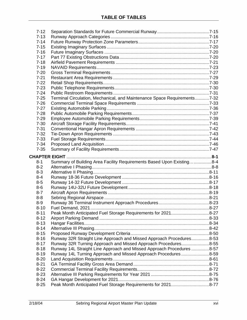
TABLE OF TABLES
2/18/04 Sebring Regional Airport Master Plan Update xvi
7-12 Separation Standards for Future Commercial Runway .........................................7-15 7-13 Runway Approach Categories ..............................................................................7-16 7-14 Future Runway Protection Zone Parameters........................................................7-17 7-15 Existing Imaginary Surfaces .................................................................................7-20 7-16 Future Imaginary Surfaces ...................................................................................7-20 7-17 Part 77 Existing Obstructions Data .......................................................................7-20 7-18 Airfield Pavement Requirements ..........................................................................7-21 7-19 NAVAID Requirements.........................................................................................7-23 7-20 Gross Terminal Requirements..............................................................................7-27 7-21 Restaurant Area Requirements ............................................................................7-29 7-22 Retail Shop Requirements....................................................................................7-30 7-23 Public Telephone Requirements...........................................................................7-30 7-24 Public Restroom Requirements ............................................................................7-31 7-25 Terminal Circulation, Mechanical, and Maintenance Space Requirements...........7-32 7-26 Commercial Terminal Space Requirements .........................................................7-33 7-27 Existing Automobile Parking .................................................................................7-36 7-28 Public Automobile Parking Requirements.............................................................7-37 7-29 Employee Automobile Parking Requirements.......................................................7-39 7-30 Aircraft Storage Facility Requirements..................................................................7-41 7-31 Conventional Hangar Apron Requirements ..........................................................7-42 7-32 Tie-Down Apron Requirements ............................................................................7-43 7-33 Fuel Storage Requirements..................................................................................7-44 7-34 Proposed Land Acquisition ...................................................................................7-46 7-35 Summary of Facility Requirements .......................................................................7-47
CHAPTER EIGHT ...................................................................................................................8-1 8-1 Summary of Building Area Facility Requirements Based Upon Existing…..............8-4 8-2 Alternative I Phasing...............................................................................................8-8 8-3 Alternative II Phasing............................................................................................8-11 8-4 Runway 18-36 Future Development .....................................................................8-16 8-5 Runway 14-32 Future Development .....................................................................8-17 8-6 Runway 14U-32U Future Development ................................................................8-18 8-7 Aircraft Apron Requirements ................................................................................8-19 8-8 Sebring Regional Airspace ...................................................................................8-21 8-9 Runway 36 Terminal Instrument Approach Procedures........................................8-23 8-10 Fuel Demand, 2021..............................................................................................8-27 8-11 Peak Month Anticipated Fuel Storage Requirements for 2021..............................8-27 8-12 Airport Parking Demand .......................................................................................8-33 8-13 Hangar Facilities...................................................................................................8-34 8-14 Alternative III Phasing...........................................................................................8-42 8-15 Proposed Runway Development Criteria ..............................................................8-50 8-16 Runway 32R Straight Line Approach and Missed Approach Procedures..............8-53 8-17 Runway 32R Turning Approach and Missed Approach Procedures......................8-55 8-18 Runway 14L Straight Line Approach and Missed Approach Procedures ..............8-57 8-19 Runway 14L Turning Approach and Missed Approach Procedures ......................8-59 8-20 Land Acquisition Requirements ............................................................................8-61 8-21 GA Terminal Facility Gross Area Demand ............................................................8-71 8-22 Commercial Terminal Facility Requirements.........................................................8-72 8-23 Alternative III Parking Requirements for Year 2021 ..............................................8-75 8-24 GA Hangar Development for 2021........................................................................8-76 8-25 Peak Month Anticipated Fuel Storage Requirements for 2021..............................8-77

TABLE OF TABLES
2/18/04 Sebring Regional Airport Master Plan Update xvii
8-26 Evaluation of Alternatives .....................................................................................8-89 8-27 Recommended Alternative Phasing......................................................................8-90
CHAPTER NINE......................................................................................................................9-1 9-1 Percentage of Total Night Operations.....................................................................9-3 9-2 Existing Aircraft Runway Utilizations.......................................................................9-3 9-3 Existing Aircraft Operations and Fleet Mix ..............................................................9-4 9-4 Percent Existing Aircraft Departures by Stage Length ............................................9-5 9-5 Future Aircraft Operations and Fleet Mix (2021) .....................................................9-8 9-6 Percent Future Aircraft Departures by Stage Length ..............................................9-8 9-7 Comparison of Noise Contour Areas ......................................................................9-9 9-8 Endangered or Threatened Species .....................................................................9-20 9-9 Rare and Endangered Plants and Animals Potentially Occurring on Sebring…....9-21
CHAPTER TEN .....................................................................................................................10-1 10-1 Staged Development Plans ..................................................................................10-6
CHAPTER ELEVEN ..............................................................................................................11-1 11-1 Twenty-Plus-Year Construction Phasing ..............................................................11-2 11-2 Preferred Alternative – Cost Estimate Phase I: Short-Term Improvements...........11-9 11-3 Preferred Alternative – Cost Estimate Phase II: Intermediate-Term… ................11-10 11-4 Preferred Alternative – Cost Estimate Phase III: Long-Term Improvements .......11-11 11-5 Capital Improvement Program Phase I (2002-2006)...........................................11-13 11-6 Capital Improvement Program Phase II (2007-2011)..........................................11-22 11-7 Capital Improvement Program Phase III (2012-2021).........................................11-31
CHAPTER TWELVE .............................................................................................................12-1 12-1 Summary of Cost Estimates – Full Build-Out 2002 Dollars ...................................12-3 12-2 Detailed Revenue Categories for 2000.................................................................12-5 12-3 Revenue Sources.................................................................................................12-7 12-4 Operating Leases .................................................................................................12-8 12-5 Major Customers ..................................................................................................12-8 12-6 Cash and Cash Equivalents .................................................................................12-9 12-7 Fixed Asset Depreciation Schedule ....................................................................12-10 12-8 Fixed Assets.......................................................................................................12-10 12-9 Construction in Progress ....................................................................................12-11 12-10 1999-2000 Expenses..........................................................................................12-13 12-11 Long-Term Debt .................................................................................................12-14 12-12 Long-Term Debt Maturity....................................................................................12-14 12-13 Statement of Expenditures Years 1992-2000 .....................................................12-16 12-14 Historical Analysis of Airport Revenue and Expenses.........................................12-17 12-15 Projection of Airport Revenues and Expenses With Community… .....................12-20 12-16 Projection of Airport Revenues and Expenses Without Community… ................12-21 12-17 Schedule of Expenditures of Federal Awards .....................................................12-23 12-18 Schedule of State Financial Assistance..............................................................12-24
CHAPTER THIRTEEN...........................................................................................................13-1 13-1 JACIP...................................................................................................................13-2

2/18/04 Sebring Regional Airport Master Plan Update 1-1
GOALS AND OBJECTIVES Sebring Regional Airport 1.1 GENERAL GUIDELINES The goals and objectives will be used as general guidelines for development of the Master Plan Update. This chapter provides general direction to the study with respect to the development of concepts and plans relating to the future development of Sebring Regional Airport (SEF). The general approach is to consider alternative Airport development plans, necessary to provide a “balanced” Airport system. The proposed alternatives will address landside/airside facilities, non-aviation development, and the Airport’s role in Highlands County as well as its influence on the adjacent counties of South Central Florida. The following are some of the key objectives:
• Identify airside, landside, and airfield improvements for a 20+-year planning period. • Recommend land use options on and in the vicinity of the airfield to further optimize
the economic aspects of the Airport while enhancing safety and operational capacity. • Establish an implementation schedule for short-, intermediate-, and long-term
improvements and associated financial feasibility. • Identify short-term requirements and recommend short-term funding opportunities to
be incorporated in the Florida Department of Transportation (FDOT) Joint Automated Capital Improvement Program (JACIP).
• Ensure that short-term actions and recommendations do not preclude long-term planning options.
• Incorporate the interests of the public, Airport users, and government agencies into the planning process.
• Reflect current comprehensive land use (off- and on-Airport property) and make recommendations as to compatible land uses and the appropriate steps necessary to ensure proper zoning and noise impacts minimization.
• Quantify the economic impact of the Airport, including the Foreign Trade Zone (FTZ) on surrounding communities.
• Address any major environmental issues that are directly related to the continued development of the Airport with an evaluation of viable alternatives/solutions.
Since the existing 1994 Airport Master Plan Update the Airport has changed significantly in its role of serving the Highlands County area and the aviation system. The following key conditions and issues at the Airport will be evaluated with respect to changes that have occurred since the 1994 Master Plan Update. Key issues include:
• Aviation activity (general aviation operations, military aircraft, design aircraft, and Airport role in the Florida system plan)
• Condition of Airport buildings, equipment, and facilities • Change in design aircraft, including assessment of runway capabilities and
capacities associated with potential change in design aircraft. • Pavement condition
Since the previous Airport Master Plan Update was conducted in 1994, the Airport has changed significantly in its role of serving the Highlands County area.
1

2/18/04 Sebring Regional Airport Master Plan Update 1-2
• Environmental conditions • Active land acquisition program • Land use on and in the vicinity of the airfield • Existence of new structures and airfield improvements affecting navigable airspace
in the Airport’s approaches and vicinity • Flight training activities • Medical Evacuation (AeroMed) activities • Sebring internal raceway long-range plans • Commerce/industrial park development for revenue diversification • Ground access • Infrastructure improvements • Inventory of permitted projects (in process and pending) • Need for increased security measures 1.2 GOALS AND OBJECTIVES The goal of the Master Plan Update is to provide SEF with detailed planning guidance to ensure that Airport facilities and associated land uses will be adequate to meet short-, intermediate-, and long-term aviation demand. This document will serve as a management guide for the implementation of necessary improvements to meet potential aviation activity demand over a planning period of 20+ years, through the end of 2021. The City of Sebring, FDOT, and Highlands County share the funding for the 2002 Sebring Regional Airport Master Plan. Coordination of this study with appropriate local, regional, and national agencies will be maintained throughout the preparation of this Master Plan. In addition, public input will be requested both formally and informally at public hearings before the Sebring Airport Authority (SAA) Board of Directors at key milestones in the planning project. This Master Plan is prepared in accordance with Federal Aviation Administration (FAA) Advisory Circulars AC 150/5370-6A Airport Master Plans and AC 150-5300-13, Change 6 Airport Design, in conjunction with the FDOT’s Guidebook for Airport Master Planning and other related standards. Furthermore, current guidance will be incorporated from the FAA Airports District Office (Orlando), FDOT Aviation Office, SAA, and other local government agencies. Planning efforts of the city, county, region, state, and nation have been coordinated in the Master Plan to provide the most preeminent plan for the benefit of SEF and all of the participating organizations. The Master Plan provides an effective written and graphic representation of the ultimate development of the Airport and associated land uses adjacent to the Airport, while establishing a schedule of priorities and phasing for the various improvements proposed. The planning document presents a conceptual development plan, over a 20+-year period, for the Airport. Realistic master planning is a continuing and evolutionary process due to the justification and funding required during the implementation process. Many adjustments are likely to take place to meet the changing industry before facilities are designed, approved, and built to completion. An approved Airport Master Plan provides long-range recommendations for development of an airport and is essential for an airport to qualify for federal and/or state assistance for realization of the plan. Government assistance is provided in the form of
An approved Airport Master Plan provides long-range recommenda-tions for development of an airport and is essential for an airport to qualify for federal and/or state assistance for realization of the plan.

2/18/04 Sebring Regional Airport Master Plan Update 1-3
financial grants to the airport sponsor. The grants are provided by the FAA and by the FDOT budgetary processes via Joint Participation Agreements (JPA). Due to significant changes at SEF, the SAA has taken the initiative to plan for changes, which will not only impact the Airport, but the City of Sebring, Highlands County and the region as well. Through continuous and effective planning, the SAA will maintain and increase its role as an economic asset to the City of Sebring, Highlands County, and the surrounding areas. In order to address a number of internal and external factors, which may have an impact on SEF, a list of goals and objectives were identified to guide the study effort. These goals and objectives follow and are not in any order of priority. 1.2.1 Goal No. 1 Continue to meet and enhance the level of service provided to all Airport users. Objectives:
• Provide adequate runway capacity for estimated demand in terms of aircraft type and annual and hourly operations.
• Provide adequate runway length to meet existing and forecast operations needs. • Provide opportunities for development of services associated with potential air
carrier, charter, and corporate GA, cargo, military, flight training, and recreational flying operations.
• Provide for potential integration of commercial and non-commercial operations. • Provide other aviation related support facilities required for a full range of aviation
services 1.2.2 Goal No. 2 Provide guidelines for future development, while satisfying anticipated demand. Objectives:
• Implementation of non-aviation development to enhance revenue diversification. • Provide adequate airside and landside facilities to meet anticipated demand, and if
required, FAA Part 139 and Title 49 Code of Federal Regulations, Parts 1540, 1542 and 1544 (formerly FAR Part 107) requirements.
• Effectively market potential commercial and non-commercial aviation facilities. • Develop self-sustaining commerce and industrial parks, which will benefit the Airport
and community as a whole.

2/18/04 Sebring Regional Airport Master Plan Update 1-4
1.2.3 Goal No. 3 Provide an Airport that is safe and reliable. Objectives:
• Provide navigational aids (NAVAIDS), flight support services, and meteorological facilities, which enhance the safety and reliability of operations under all weather conditions.
• Protect FAA mandated safety areas, runway protection zones (RPZs), and other clear zones.
• Minimize possible obstructions to air navigation. • Provide adequate fire fighting, rescue and emergency services, access roads,
facilities, equipment, and personnel to maintain minimum response time under all conditions.
• Ensure that airside and landside operations and facilities meet all applicable security standards.
• Ensure that aircraft parking facilities are adequately sized and easy to negotiate. • Develop facilities to meet the demands of the current and future critical aircraft. 1.2.4 Goal No. 4 Develop the Airport and its vicinity to minimize negative environmental impacts. Objective:
• Identify the major environmental issues of concern. • Minimize potential environmental impacts, and provide special attention to
minimizing noise impacts, air and water pollution, and wetland impacts. • Provide a facility, which minimizes adverse effects on other environmental concerns.
1.2.5 Goal No. 5 Promote the development of compatible land use in undeveloped areas within the Airport vicinity. Objectives:
• Promote land use planning and development objectives, for on- and off-Airport land use, which are compatible with the anticipated long-range needs of the Airport and the community as a whole.
• Designate areas for future development (i.e., air cargo, heavy aircraft maintenance, commercial service, military refueling, hangar homes, commerce park, etc.).
• Locate Airport facilities so that growth may be controlled through land-use planning and zoning.

2/18/04 Sebring Regional Airport Master Plan Update 1-5
1.2.6 Goal No. 6 Develop an Airport that supports local and regional economic goals while accommodating new opportunities or shifts in development patterns. Objectives:
• Achieve a level of service and user convenience such that the Airport is a positive factor in regional economic development decisions.
• Achieve capacities of the airfield, the terminal area systems, FTZ, industrial park, and commerce park so that the Airport may be an attractive location for commercial air service, airline maintenance, cargo, and other aviation related commercial activities.
• Provide appropriate and achievable commercial opportunities adjacent to and on the Airport.
• To assure economic feasibility, identify an equitable distribution of user charges; distribute the burden of capital investment, maintenance, and operating costs, while keeping overall costs within an acceptable level.
• Identify financial alternatives and funding sources available for the implementation of aviation and non-aviation projects.
• Quantify financial resources available for project funding. • Develop an airport layout plan (ALP) that easily integrates with existing and
proposed transportation infrastructure, to encourage economic growth. 1.2.7 Goal No. 7 Minimize aircraft delay associated costs to all airfield users (i.e. military operations, recreational pilots, experimental aircraft, flight training facilities, etc.). Objectives:
• Minimize airspace congestion and delays for GA aircraft and potential air carrier through procedural changes and/or provision of additional NAVAIDS.
• Minimize airside congestion through construction of runways, taxiways, and aprons, when the costs of providing the additional capacity are less than the additional operating costs associated with aircraft delays.
1.2.8 Goal No. 8 Ensure adequate and convenient ground access to the Airport. Objectives:
• Provide safe access and easy-to-follow signs to Airport roadways and facilities. • Provide adequate lane capacity on roads leading to the Airport, to serve existing and
future activity. • Provide adequate land capacity on internal circulation roadways serving functional
areas (terminal, GA, industrial park, raceway, etc.). • Provide parking facilities (for GA, terminal, industrial park, etc.) that are conveniently
located and easily accessible. • Incorporate rail service opportunities into Airport development plans.
2/18/04 Sebring Regional Airport Master Plan Update 1-6
• Maintain close coordination with Regional Planning Council, Metropolitan Planning Organizations (MPO), FDOT, and other transportation groups.
1.2.9 Goal No. 9 Minimize the impact of noise on neighboring residents and noise-sensitive land uses through noise abatement and mitigation. Objectives:
• Design and select noise abatement measures that minimize the number of people exposed to noise above Day-Night Noise Level (DNL) greater than 65 decibels, if applicable.
• In selecting noise abatement actions, avoid actions that would adversely affect capacity, impose restrictions on Airport use that would be discriminatory, or that could erode prudent margins of safety.
• Design and select (if necessary) land-use mitigation measures for noise sensitive land uses exposed to aircraft noise between 65 and 75 decibels.
• To the extent possible, maximize any environmental noise mitigation projects that may be eligible for FAA funding assistance.
• When necessary, encourage local construction restrictions to reduce impact of Airport/aviation and raceway noise.
• Consider possible changes to development and real estate restrictions or disclosures to reduce potential conflicts.
1.2.10 Goal No. 10 Develop an Airport that is consistent with federal, state, regional, and local plans. Objectives:
• Develop the Airport as the region’s chosen aviation alternative and make it consistent with national, state, regional and metropolitan system plans.
• Develop the Airport in accordance with local land use and transportation plans. These goals and objectives reflect policy goals to be reached through the master planning process. They include the ultimate development of self-supporting facilities to serve the existing and future aviation needs of the region; the achievement of compatible land uses in the vicinity of the Airport; and provisions for the type of development that will yield the most public benefit of the investment represented by the Airport. Finally, these goals must be manageable within existing limitations of funds and design principles. 1.3 TASKS Some of the key tasks involved in the master planning process include: evaluating existing and anticipated aviation activity, existing and future facilities, environmental constraints, and the Airport’s overall participation in the national and state aviation system plan. An important component of the Airport Master Plan process provides a public forum for the development of the study, and includes the following steps:

2/18/04 Sebring Regional Airport Master Plan Update 1-7
• Data Collection and Evaluation – Inventory of existing Airport facilities. • Activity Projection – Forecasts of future growth at SEF. • Demand/Capacity Analysis – Identifying constraints/impacts of forecasts on
operational capacities. • Facility Requirements Development – Identifying capacity enhancements/needs to
airside and landside facilities. • Airport Plan Development – Graphic representation of existing and proposed
development. • Cost Estimating and Financial Planning – Developing a realistic revenue plan to
implement the Capital Improvement Program. • Project Coordination – Consensus participation to facilitate implementation of the
Master Plan. • Public Involvement – Public information processing to obtain input for the master
planning process.
A graphic representation of this process is depicted in Figure 1-1, Steps in the Master Planning Process. Ultimately, this Master Plan Update will provide SEF, the City of Sebring, Highlands County, and federal and state officials, information and guidance to manage and develop facilities to meet the forecasted growth for the next 20+ years.
The Master Plan will provide information and guidance to manage and develop facilities to meet the forecast growth for the next 20+ years.
2/18/04 Sebring Regional Airport Master Plan Update 1-8
Figure 1-1. Steps in the Master Planning Process

2/18/04 Sebring Regional Airport Master Plan Update 1-9
1.4 PRIOR PLANNING DOCUMENTATION A major goal in the master planning process is the need to update information and plans at strategic intervals with recommended development concepts. This updating is necessary since prior Airport projects may have changed due to evolving conditions or policies in the political, social, and economic environment. The demand for scheduled services, GA services, or other aviation services may fluidly adjust in response to changes in the environment, and/or role of the Airport. Highlights of planning projects and infrastructure development during the last ten+ years include the following projects:
• Master Plan Update • Apron Rehabilitation, Phase II • Haywood Taylor Boulevard • Apron Rehabilitation, Phase III and IV • Potable Water Plant • Wastewater Treatment Plant • T-Hangars, 30 Units • Demolition Program, Phase I • Community Redevelopment Authority • Group 44, Inc. • Lockwood Aviation • Leza Aircam Manufacturing • Ulmann Drive • Hancor, Inc. • SIR, Inc. Master Plan • Lesco Expansion and Rail Service • Apron Rehabilitation, Phase IV • Leza Lane • Sebring Custom Tanning Facilities • Wastewater Pond Clean-up Removal • South Florida Water Management District (SFWMD) Stormwater Master Plan • Master Drainage Plan Implementation, Phase I • Airport Road Land Acquisition. Current and recently completed projects include:
• Chateau Elan Lodge • Rail Spur Rehabilitation • Sebring Airside Center • Air Traffic Control Tower, Relocation and Rehabilitation • Commercial Hangars • T-Hangars, Ten Units • Building 60 Rehabilitation This master plan document will identify and address new issues as well as address any unresolved or uncompleted projects from previous planning efforts. Some of the issues include the following:

2/18/04 Sebring Regional Airport Master Plan Update 1-10
• Airport Road Intersection and Widening • Commerce Park Concept Phase • SAA Development Standards • Master Plan Update • Taxiway A, Phase I • Runway 18-36 Pavement Maintenance • Everglades Seasoning Facility • Commercial Hangars, Phase II • Air Service Study • Automated Weather Observing System (AWOS) 1.5 AIRPORT MANAGEMENT The Airport management of SEF consists of an Airport Authority governed by a volunteer Board of Directors. The organization chart for the Airport is outlined in Figure 1-2.

2/18/04 Sebring Regional Airport Master Plan Update 1-11
Figure 1-2. Sebring Regional Airport Authority

2/18/04 Sebring Regional Airport Master Plan Update 2-1
EXISTING AIRPORT FACILITIES, STATISTICS, AND ENVIRONMENT Sebring Regional Airport 2.1 OVERVIEW AND DESCRIPTION As outlined in the Federal Aviation Administration (FAA) Advisory Circular (AC) 150/5070-61, Airport Master Plans, and the Florida Department of Transportation (FDOT) Guide to Airport Master Planning, the initial step in the Master Plan for Sebring Regional Airport (SEF) is the collection and evaluation of information about the Airport and the area it serves. This chapter provides a physical inventory and description of facilities and services now provided by and at the Airport. Inventory will include:
• Background information about the Sebring area and a description of development that has recently taken place at the Airport.
• Population and socioeconomic information, which provides a sign of possible future development in the Sebring area.
• A comprehensive review of the existing regional plans and studies to determine potential influence on the development and implementation of the Airport Master Plan.
An accurate and complete inventory is essential to the success of any master-planning document. The objective of the inventory task is to provide background information essential to the completion of the Master Plan Update. The inventory task for SEF was accomplished through physical inspection of the facilities, field interviews, telephone interviews, and review of appropriate administrative records. Additional information was gained from documents and studies about the Airport and the Sebring area. These documents include the Airport Master Plan Update, November 1994, the existing Airport Layout Plan (ALP), 1993, Sebring Airport Authority (SAA) Financial Statements, Sebring Flight Service Center’s fuel and aircraft operations records, and miscellaneous reports generated by the University of Florida Bureau of Economic and Business Research. This chapter provides a general description of SEF and its service area. It describes data relevant to the Airport’s history, geographic location, climate, and operational role in today’s aviation environment. 2.2 AIRPORT HISTORY In 1940, several representatives of the City of Sebring traveled to Washington D.C. to lobby for a military facility in the Sebring area. For patriotic and financial reasons, the city wished to offer facilities to support the war effort while boosting the area’s economy. The representatives argued that Sebring offered a central location in the state, existing railroad, power, water, and housing availability, and an enduring record of cooperation by city officials and citizens. Almost one year later, a site was selected south of Sebring for Highlands County’s first United States (U.S.) Air Corps Flying Training Command. The command would serve as a pilot training base concurrently supporting approximately 1,500 men and officers and 250 cadets. In order to accommodate the facility, the City of Sebring bought the property
This chapter provides a general description of SEF and its service area. It describes data relevant to the Airport’s history, geographic location, climate, and operational role in today’s aviation environment.
2

2/18/04 Sebring Regional Airport Master Plan Update 2-2
and leased 9,200 acres to the Secretary of War. The lease amount of $1.00 per year for 99 years allowed the command to concentrate on attracting operations. The U.S. Government advertised a legal notice for bids on the Basic Flying School at Sebring, Florida through the U.S. Engineering Department in June 1941. According to Army Air Corps Colonel Leonard H. Rodreck, who designed the base, supervised construction of the base, and became the first commanding officer of the base, "a larger area than was necessary for a flying training base was requested of the city and, as a result, it was possible to design the layout plan for the runways so they could be greatly increased in width and more than doubled in length to accommodate any future designed type of military aircraft." (1) By the end of 1941, the base had become the first Combat Crew Training School. Entire crews including pilots, copilots, navigators, bombardiers, aerial engineers, radio operators, and gunners received detailed training in Sebring. On January 29, 1942, the first B-17 Flying Fortress landed at Hendricks Field. The Flying Fortresses avidly used the airfield to provide in-depth training for U.S. bombing crews. In January 1942, the base was named Hendricks Field in memory of First Lieutenant Laird Woodruff Hendricks, a native of Ocala, Florida. In the beginning, the base consisted of four runways, 150 feet (ft) by 5,000 ft, with directional bearings N-S, NE-SW, E-W, and NW-SE. Hendricks Field also included an aircraft parking apron and several landside buildings and facilities. By mid-1942, the runways were widened to 300 ft, and the perimeter taxiways were constructed. Late in 1942, the function of Hendricks Field again changed becoming exclusively a First Pilots flying school for B-17s. At the end of World War II, on December 31, 1945, Hendricks Field was deactivated. The air base property was declared surplus to the needs of the U.S. Government and the lease became void. The U.S. surrendered the property and the existing facility to the City of Sebring in January 1946. The airfield, roadways, utilities, some buildings, various equipment and miscellaneous items were released to the city with typical restrictions concerning utilization of the land and Airport. At that point in time, many of the facilities were either sold or demolished to make way for future development. On February 21, 1946, the City was awarded a temporary permit to operate Hendricks Field as a civilian Airport. Soon after receiving the permit, the City Council of Sebring appointed an Airport Committee to oversee the operation of the Airport. Initially, the City Council was reluctant to assume responsibility as custodian of the field because of the high annual maintenance expenses. To compensate for the cost of maintenance, the City agreed to lease the field with an agreement that they would not expend any money other than revenues derived from subletting facilities at the field. A few days later, the Sebring Flying Service introduced the first commercial operation from Hendricks Field as two passenger flights departed from the field. In May 1946, the city began airfield operations under a Right of Entry Permit. The permit stipulated that the airfield, three hangars, and all buildings immediately adjacent to the landing area be turned over to the City of Sebring. The first two tenants on the Airport opened for business, Eighth Air Depot and Veterans' Airlines; both provided aircraft repair and maintenance services. The City of Sebring agreed to take over management of the Airport in January 1947. The Airport's name was changed to Sebring Air Terminal to avoid confusion with the Airport’s

2/18/04 Sebring Regional Airport Master Plan Update 2-3
previous function and to attract industry to the field. Although they were unable to secure absolute title to the field, six buildings connected with the field's water supply, nine buildings associated with sewage, nine administrative buildings involved in care of the field, one building that enclosed electrical equipment, one building that enclosed telegraphic equipment, and eight buildings that enclosed equipment for the repair of aircraft were transferred to the control of the City of Sebring. Under the terms of the transfer from the U.S. Government, the Airport buildings could only be used for aviation-related purposes. At that time, the Army Air Force reserved the right to use 25 percent of the capacity of the field during peacetime. Some 221 other buildings on the base remained the property of the government. Upon assuming management of the field, the City sold some of the property. Essentially, the remaining territory forms the existing Airport property line. The Government released all of the old Hendricks Field properties to the City of Sebring to allow for the development of industry, trade, and air transportation at the Sebring Air Terminal. Then in June 1947, the City of Sebring purchased the railroad system at Hendricks Field for $4,000. It was not until November 1958, that the City Council passed an ordinance establishing an Airport Advisory Committee to make recommendations to the City of Sebring relative to the operation, management, and control of the Sebring Air Terminal. In 1967, the city turned over the deed of the Airport to the SAA, formed by the State Legislature. Under the SAA in the early 1970s, an industrial park was planned and created. The Airport name was changed to Sebring Airport and Industrial Park. Airport improvements consisted of the installation of taxiway lights on the two connecting taxiways, a non-directional radio beacon (NDB) in 1970, runway lighting on 18-36, a new rotating beacon in 1972, and runway lighting on 14-32 in 1983. During 1981, the Authority sold 35 acres of land to the Sebring Utilities Commission to form the current Airport property boundaries. The Airport is now identified in the Florida State Aviation System as the Sebring Regional Airport, or SEF, and owns approximately 1,770 acres of property (2) In the past ten years, SEF has completed a number of projects to further improve the Airport, including apron rehabilitation, rail spur rehabilitation, building and road rehabilitation, and air traffic control tower (ATCT) relocation and rehabilitation. The Airport initiated Phase I of a demolition plan to remove functional obsolete structures comprising more than 30 buildings on the property. In addition to constructing several commercial hangars and T-hangars, the Airport also built a brand new terminal building, known as the Sebring Airside Center. The Airport has executed a number of environmental projects, including a potable water plant, wastewater treatment plant, master stormwater and drainage plan and implementation, and wastewater pond removal and clean-up. Projects are underway to widen the Airport access road, to fully develop the commerce park, and to construct Taxiway A, a full-length taxiway parallel to Runway 18-36. The SAA is also in the process of constructing more commercial hangars and installing an aviation weather observation station (AWOS).
In the past ten years, SEF has completed a number of projects to further improve the Airport, including apron rehabilitation, rail spur rehabilitation, building and road rehabilitation, and air traffic control tower (ATCT) relocation and rehabilitation.
2/18/04 Sebring Regional Airport Master Plan Update 2-4
2.3 AIRPORT LOCATION SEF is located in the south central portion of Highlands County about seven statute miles southeast of Sebring, Florida. The City of Sebring is approximately the geographical center of the Florida peninsula. See Figure 2-1 and 2-2 for a location map and vicinity map of the Airport. Off-Airport access to SEF consists of both vehicular and rail service. US Highway 27 provides a major north-south highway, linking the City of Sebring with Interstate (I)-4 and I-75 to the north and Miami/Ft. Lauderdale to the south. SEF is located approximately five miles east of US 27 and is accessed by US Highway 98 and Airport Road. State Road 623 provides access to the Airport from downtown Sebring. The Seaboard System Railroad provides rail transportation linkage with freight service furnished by a spur from the main track into the center of the industrial park. The rail spur was recently renovated using funds provided by an FDOT grant and is owned by the SAA. According to SEF’s reference point coordinates, based on the North American Datum (NAD 83), are latitude 27°27’23.050” north and longitude 81°20’32.640” west. The Airport’s elevation is 63 ft above mean sea level (AMSL). 2.4 METEOROLOGICAL INFORMATION Weather conditions are an important consideration in the planning and development of an Airport. Temperature is a critical factor in determining runway length, and wind speed and direction determine runway orientation. Also, the frequency of cloud cover limiting local area visibility affects the need for navigational aids (NAVAIDS) and lighting. These issues will be discussed in further detail in Chapter 6, “Demand/Capacity Analysis and Facility Requirements.” Sebring benefits from a relatively moderate climate. The mean minimum temperature is 62.5 degrees Fahrenheit (F) and the mean maximum temperature is 83.1 degrees F. On average, the hottest month is August, ranging from a median high temperature of 92.6 degrees F to a median low temperature of 74.1 degrees F. The coolest month is typically December, with a mean high temperature of 71.7 degrees F and a median low temperature of 51.3 degrees F. Average monthly precipitation for the area is 4.6 inches (in) and there are no recorded snowfalls. (3)
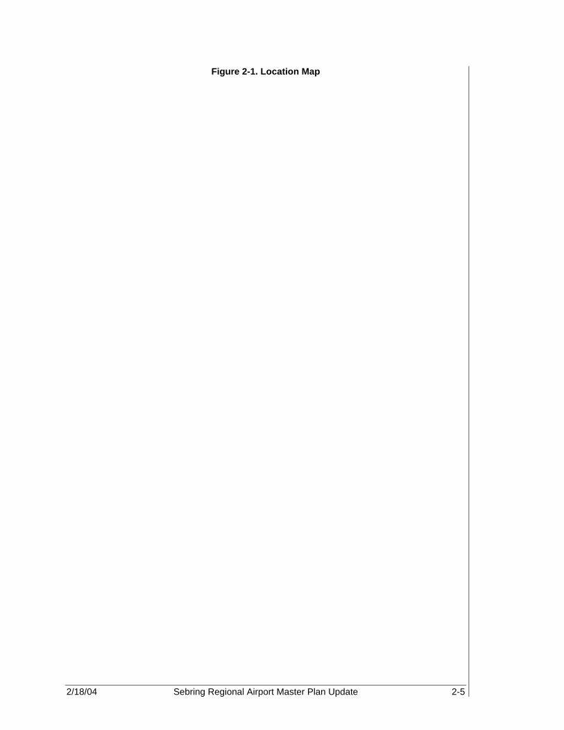
2/18/04 Sebring Regional Airport Master Plan Update 2-5
Figure 2-1. Location Map
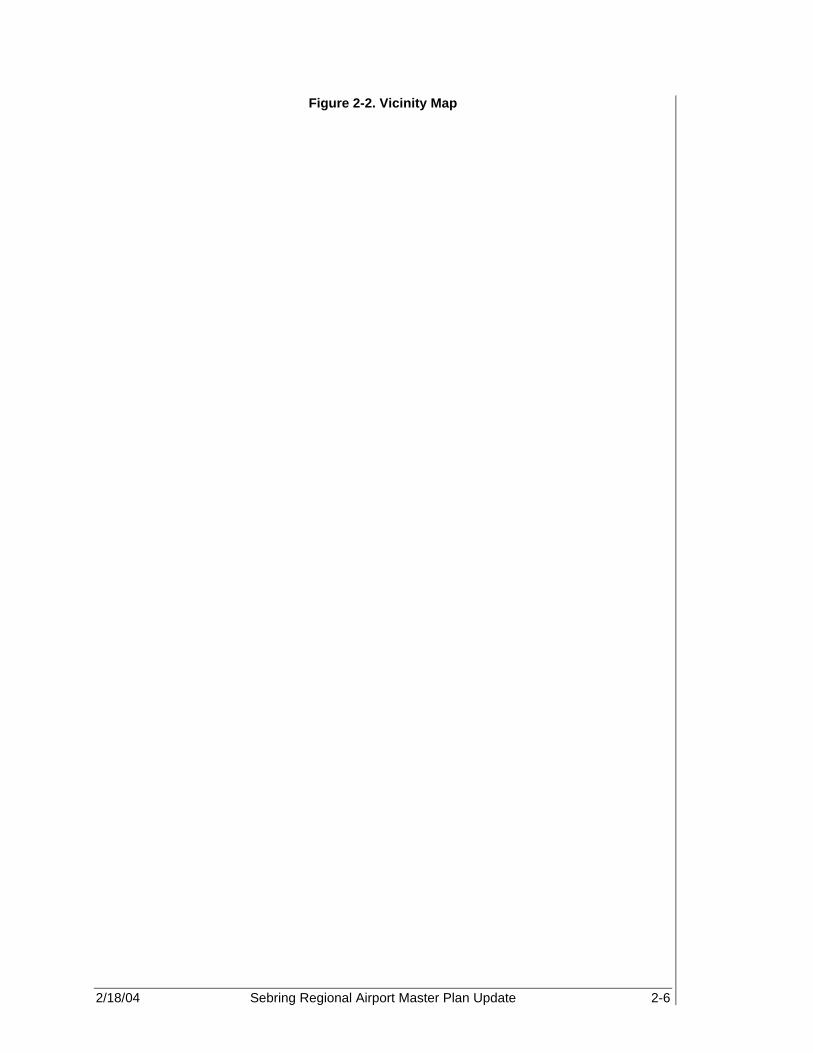
2/18/04 Sebring Regional Airport Master Plan Update 2-6
Figure 2-2. Vicinity Map

2/18/04 Sebring Regional Airport Master Plan Update 2-7
2.5 EXISTING AIRSIDE FACILITIES The identification, location, and potential of existing aviation facilities to meet the Airport’s daily needs are an essential element of the master planning process. The existing airside facilities at SEF are described in the following pages, and include runways, taxiways, aprons, airfield lighting, NAVAIDS, terminal area facilities, aircraft maintenance facilities, flight training facilities, hangar and aircraft storage facilities, and fuel storage areas. The ALP graphic depicted in Figure 2-3 and the Airport diagram in Figure 2-4 serve as an overview of the existing airside and landside facilities at SEF. 2.5.1 Runways The SEF airfield consists of two active runways and one closed runway. Runway 18-36, the primary runway, is situated in a north-south orientation. Runway 14-32 is used for crosswind operations and is situated in a northwest-southeast orientation. Neither runway is certified for air carrier use. Runway 04-22 is closed. 2.5.1.1 Existing Pavement Strength/Condition Runway 18-36 measures approximately 5,224 ft long and 100 ft wide with 100-ft wide paved shoulders. According to the FAA Airport Facility Directory, Southeast U.S. (Effective 13, June 2002 to 8 August, 2002), the pavement consists of an existing asphalt surface over a concrete base and is capable of supporting 26,000 pounds (lb) for single-wheel load (SWL), 50,000 lb for double-wheel load (DWL), and 85,000 lb for dual-tandem wheel load (DTWL). The original concrete runway was constructed during World War II and consisted of a 7-in thick non-reinforced concrete pavement measuring approximately 5,190 ft long and 300 ft wide. In 1988, the center 100 ft of the concrete runway was crushed for base material and 5 in of asphalt surface (P-401) was placed. At the time of this writing, Runway 18-36 is undergoing pavement rehabilitation, and is, therefore, observed to be in excellent condition. Runway 14-32 measures approximately 5,000 (Mr. Kevin Flowers, Lead Cartographer, FAA/NOAA, July 31, 2002) ft long and 300 ft wide and was observed to be in very poor condition based upon the 1998 pavement condition index findings as described in the Florida Airport Pavement Evaluation, Sebring Regional Airport, conducted by Eckrose/Green Associates Inc. The pavement consists of 7-in thick concrete and was also originally constructed during World War II. This runway has a displaced threshold of 650 (Mr. Kevin Flowers, Lead Cartographer, FAA/NOAA) ft at runway end 14, making the active runway length approximately 4,350 ft. (Based on 5,000 ft – 650 ft = 4,350 ft.) The runway is capable of supporting 26,000 lb for SWL, 50,000 lb for DWL, and 85,000 lb for DTWL. See Tables 2-1 and 2-2 for details concerning runway specifications and conditions.
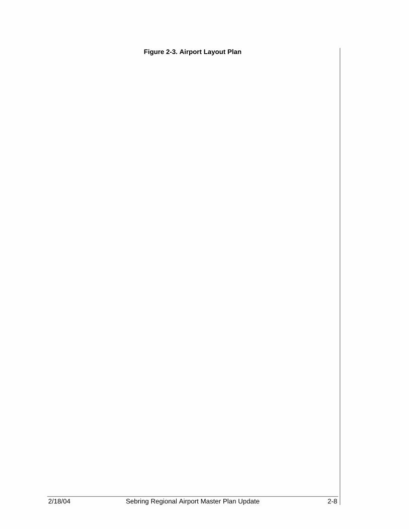
2/18/04 Sebring Regional Airport Master Plan Update 2-8
Figure 2-3. Airport Layout Plan

2/18/04 Sebring Regional Airport Master Plan Update 2-9
Figure 2-4. Airport Diagram

2/18/04 Sebring Regional Airport Master Plan Update 2-10
Table 2-1. Runway Specifications
Runway 18-36 Runway 14-32 Runway
04-22 Status Primary Crosswind Closed Total Length (ft) 5,224 5,000 Active Runway Width (ft) 100 300’
Displaced Threshold (ft) no 650’
Surface Material Asphalt Concrete Load Bearing Capacity by Gear Type SWL (lb) 26,000 26,000 DWL (lb) 50,000 50,000 DTWL (lb) 85,000 85,000 Approach Slope 20:1,34:1 20:1,20:1 Effective Gradient 0.11% 0.15%
Latitude 27°27' 45.49" 27°26’ 53.76” 27°27’ 44.09” 27°27’ 09.18” Longitude 81°20' 35.09" 81°20’ 34.90” 81°20’ 49.85” 81°20’ 10.49” True Bearing 179°48’ 21.60” 134°49’ 37.20” Source: Sebring Airport Authority, 2001,
FAA Airport Facility Directory, Southeast U.S. (Effective 13, June 2002 to 8 August, 2002) National Aeronautical Charting Office, 2002, FDOT Surveying and Mapping Office, 2002
Table 2-2. Runway Conditions
Runways Approximate
Dimensions (ft) Pavement Type Condition
Airplane Design Group
18-36 5,224 x 100 Asphalt with concrete overlay Good D-II
14-32 5,000 x 300 Concrete Good B-II Sources: Sebring Airport Authority, 2001,
National Aeronautical Charting Office, 2002, FDOT Surveying and Mapping Office, 2002
2.5.1.2 Safety Areas The runway safety area (RSA) is centered on the runway centerline. Its dimensional standards are based upon the Aircraft Design Group that normally utilizes that runway. In addition, the RSA has the following design requirements:
• Cleared and graded with no potentially hazardous surface variations. • Drained by grading or storm sewers to prevent water accumulation. • Capable of supporting aircraft rescue and fire fighting equipment and the occasional
passage of aircraft without causing structural damage. • Free of objects, except for those needed because of function. (4)
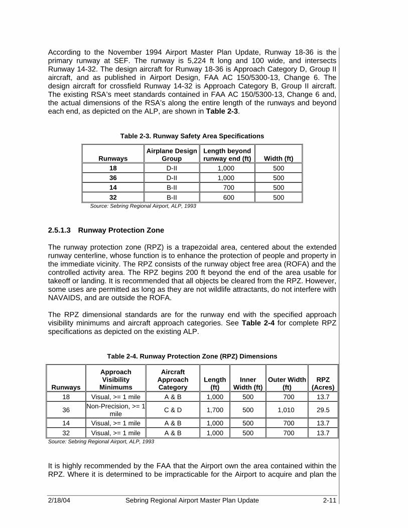
2/18/04 Sebring Regional Airport Master Plan Update 2-11
According to the November 1994 Airport Master Plan Update, Runway 18-36 is the primary runway at SEF. The runway is 5,224 ft long and 100 wide, and intersects Runway 14-32. The design aircraft for Runway 18-36 is Approach Category D, Group II aircraft, and as published in Airport Design, FAA AC 150/5300-13, Change 6. The design aircraft for crossfield Runway 14-32 is Approach Category B, Group II aircraft. The existing RSA’s meet standards contained in FAA AC 150/5300-13, Change 6 and, the actual dimensions of the RSA’s along the entire length of the runways and beyond each end, as depicted on the ALP, are shown in Table 2-3.
Table 2-3. Runway Safety Area Specifications
Runways Airplane Design
Group Length beyond runway end (ft) Width (ft)
18 D-II 1,000 500 36 D-II 1,000 500 14 B-II 700 500 32 B-II 600 500
Source: Sebring Regional Airport, ALP, 1993 2.5.1.3 Runway Protection Zone The runway protection zone (RPZ) is a trapezoidal area, centered about the extended runway centerline, whose function is to enhance the protection of people and property in the immediate vicinity. The RPZ consists of the runway object free area (ROFA) and the controlled activity area. The RPZ begins 200 ft beyond the end of the area usable for takeoff or landing. It is recommended that all objects be cleared from the RPZ. However, some uses are permitted as long as they are not wildlife attractants, do not interfere with NAVAIDS, and are outside the ROFA. The RPZ dimensional standards are for the runway end with the specified approach visibility minimums and aircraft approach categories. See Table 2-4 for complete RPZ specifications as depicted on the existing ALP.
Table 2-4. Runway Protection Zone (RPZ) Dimensions
Runways
Approach Visibility
Minimums
Aircraft Approach Category
Length (ft)
Inner Width (ft)
Outer Width (ft)
RPZ (Acres)
18 Visual, >= 1 mile A & B 1,000 500 700 13.7
36 Non-Precision, >= 1 mile C & D 1,700 500 1,010 29.5
14 Visual, >= 1 mile A & B 1,000 500 700 13.7 32 Visual, >= 1 mile A & B 1,000 500 700 13.7
Source: Sebring Regional Airport, ALP, 1993 It is highly recommended by the FAA that the Airport own the area contained within the RPZ. Where it is determined to be impracticable for the Airport to acquire and plan the

2/18/04 Sebring Regional Airport Master Plan Update 2-12
land uses within the RPZ, recommendation status exists. This area should be free of land uses that create glare, smoke, or other hazards to air navigation. Also, the construction of residences, fuel-handling facilities, churches, schools, and offices is not recommended in the RPZ. 2.5.1.4 Runway Object Free Areas (ROFA) The ROFA is centered on the runway centerline and must be clear of aboveground objects protruding above the RSA edge elevation. Except where precluded by other clearing standards, it is acceptable to place objects in the ROFA that are necessary for navigational or aircraft ground maneuvering purposes. It is also acceptable to taxi and hold aircraft in the ROFA.
Table 2-5. Runway Object Free Area (ROFA) Dimensions
Runways
Approach Visibility
Minimums Airplane Design
Group
Length Beyond Runway End (ft) Width (ft)
18 Visual, >= 1 mile D-II 1,000 800
36 Non-Precision, >= 1 mile D-II 1,000 800
14 Visual, >= 1 mile B-II 300 500 32 Visual, >= 1 mile B-II 300 500
Source: Sebring Regional Airport, ALP, 1993 AC 150/5300-13 Change 6
2.5.2 Taxiways SEF has a number of taxiways and connectors that range in width from 35 to 75 ft. The majority of the system is concrete with a rated strength of 30,000 lb for SWL, with the exception of taxiway connectors A-3 and A-4, which are concrete with an asphalt overlay. A-3 and A-4 are rated at 60,000 lb for DWL. Reference Table 2-6 for description, designation, width, type, and load bearing weight details for the SEF taxiway system.

2/18/04 Sebring Regional Airport Master Plan Update 2-13
Table 2-6. Taxiway System
Description Designation Width
(ft) Type Load Bearing
Weight (lb) Connector Taxiway A-2 75 C 30,000 SWL Connector Taxiway A-3 35 CA 60,000 DWL Connector Taxiway A-4 35 CA 60,000 DWL Apron Edge Taxiway B-1 35 C 30,000 SWL Apron Edge Taxiway B-2 35 C 30,000 SWL Apron Edge Taxiway B-3 35 C 30,000 SWL Connector Taxiway B-4 75 C 30,000 SWL Perimeter (between R/W ends 18 and 22) 75 C 30,000 SWL
Perimeter (between R/W ends 22 and 32) 75 C 30,000 SWL
Perimeter (between R/W ends 32 and 36) 75 C 30,000 SWL
Source: Sebring Airport Authority, 2001, FAA Airport Facility Directory, Southeast U.S. (Effective 13, June 2002 to 8 August, 2002), Sebring Regional Airport, ALP, 1993
Note: C refers to Concrete; CA refers to Concrete with Asphalt overlay.
2.5.2.1 Pavement Strength/Condition Taxiway connector A-2 joins the approach end of Runway 18 to the approach end of Runway 14 on the northwest quadrant of the airfield. The connector is 75 ft wide, and is comprised of concrete pavement. It can withstand a load bearing weight of 30,000 lb for SWL. Based upon physical observation and the 1998 PCI inspection, the existing pavement condition for Taxiway A-2 is considered good. Taxiway connector A-3, a ‘stub’ taxiway, provides access from the central portion of the Airport apron area to the intersection of Runways 14-32 and 18-36, approximately 1,250 ft from Runway 14 displaced threshold and 1,450 ft from Runway 18. The stub is 35 ft wide with 30-ft shoulders on each side and consists of concrete with an asphalt overlay. It can withstand a load bearing weight of 60,000 lb for DWL, and its pavement condition is designated as good. Taxiway connector A-4, a ‘stub’ taxiway, provides access from the southern portion of the Airport apron area to Runway 36 approximately 1,700 ft from the approach threshold. The connector is 35 ft wide with 30-ft shoulders on each side and consists of concrete with an asphalt overlay. It can withstand a load bearing weight of 60,000 lb for DWL. However, based upon physical observation and the 1998 Eckrose Green Report, Taxiway A-4 is in very poor condition. Apron edge Taxiways B-1, B-2, and B-3 serve as the eastern boundary of the Airport apron. Taxiway B-1 borders the northern portion of the ramp and runs parallel to Runway 14-32 separated by 500 ft. Taxiway B-2 borders the southern portion of the ramp and is parallel to the closed runway, 04-22. Taxiway B-3 borders the central portion of the ramp and is parallel to Runway 18-36 separated by 500 ft. This taxiway system is also 35 ft wide and consists of concrete pavement. Taxiways B-1, B-2, and B-

2/18/04 Sebring Regional Airport Master Plan Update 2-14
3 can withstand a load bearing weight of 30,000 lb for SWL aircraft, but are all considered in very poor condition based upon the last inspection. Taxiway connector B-4 joins the approach end of Runway 14 with the north end of the Airport apron area. The connector is 75 ft wide and consists of concrete pavement. It can withstand a load bearing weight of 30,000 lb for SWL aircraft, but its pavement condition index rates Taxiway B-4 as very poor. Currently, a full-length, parallel taxiway to the west of Runway 18-36 is under construction. Taxiway A will be 50 ft wide and will be separated from 18-36 by approximately 400 ft. The taxiway will consist of asphalt pavement and will be strength rated to bear 80,000 lb for DWL aircraft. 2.5.2.2 Safety Areas In addition to safety areas associated with runways, there are object free areas (OFAs) and safety areas associated with taxiways and taxilanes as well. The associated safety area dimensions are centered on the taxiway centerline and are based upon the associated aircraft design group utilizing the facility. 2.5.2.3 Taxiway Object Free Area The taxiway object free area (TOFA) clearing standards prohibit service vehicle roads, parked airplanes, and aboveground objects, except for objects that need to be located in the TOFA for air navigation or aircraft ground-maneuvering purposes. Vehicles may operate within the TOFA provided they give right-of-way to oncoming aircraft by either maintaining a safe distance ahead or behind the aircraft or by exiting the TOFA to let the aircraft pass. 2.5.2.4 Taxiway Safety Area The taxiway safety area (TSA) follows the same design criteria as the runway safety area, but does not have the same dimensional criteria. Centered on the taxiway centerline, the airplane design group designates its dimensional standards. Based upon this information, the TSAs at SEF range from approximately 79 ft to 214 ft wide and extend along the length of the taxiways. Table 2-7 provides design standards concerning the TSAs at SEF.

2/18/04 Sebring Regional Airport Master Plan Update 2-15
Table 2-7. Taxiway Safety Area Standards
Description Airplane
Design Group
TSA Width
(ft)
TOFA Width
(ft) A-2 V 214 320 A-3 II 79 131 A-4 II 79 131 B-1 II 79 131 B-2 II 79 131 B-3 II 79 131 B-4 V 214 320
Perimeter (between R/W ends 18 and 22) V 214 320
Perimeter (between R/W ends 22 and 32) V 214 320
Perimeter (between R/W ends 32 and 36) V 214 320
Source: Sebring Regional Airport, ALP, 1993 FAA Part 150/5300-13 Change 7, Airport Design
2.5.3 Lighting And Markings A variety of lighting aids are available at SEF to facilitate identification, approach, landing, and taxiing operations at night and in adverse weather conditions. The systems, categorized by function, are further described in the following sections. 2.5.3.1 Identification Lighting A rotating airport beacon light universally indicates the location and presence of an airport. The beacon is equipped with an optical system that projects two beams of light (one green and one white), 180 degrees apart. At SEF the beacon is located approximately 50 ft south of the Sebring Airside Center adjacent to the fuel farm. 2.5.3.2 Obstruction Lighting Obstructions in the vicinity of the Airport, that cannot be removed, are marked or lighted to warn pilots of their presence. These obstructions may be identified for pilots on approach charts and on the official Airport Obstruction Chart, published by the National Oceanic and Atmospheric Administration. 2.5.3.3 Approach Lighting Approach lighting systems (ALS) are used in the approaches to runways as adjuncts to electronic NAVAIDS for the final portion of instrument flight rules (IFR) approaches and visual guides for nighttime approaches under visual flight rules (VFR) conditions. The approach lighting system provides the pilot with visual clues concerning aircraft alignment; roll angle, height, and position relative to the runway threshold.

2/18/04 Sebring Regional Airport Master Plan Update 2-16
At SEF, the only runways equipped with ALS are Runways 18 and 36. Each of these runway ends features a precision approach path indicator (PAPI) system. The PAPI is a system of lights located near the runway end, which provides the pilot with visual descent guidance information during an approach to the runway. This type of installation has a visual range of approximately four miles. PAPIs are relatively newer and more efficient systems than their predecessors, vertical approach slope indicator (VASI) systems. Runway 18-36 is equipped with a 4-light PAPI system at each end. 2.5.3.4 Runway Edge Lighting Runway edge lighting is used to outline the edges of a runway during periods of darkness and/or restricted visibility. These systems are classified in accordance with their intensity or brightness. At SEF, Runway 18-36 is equipped with medium intensity runway lights (MIRL), while Runway 14-32 has no runway edge lighting system. 2.5.3.5 Taxiway Lighting The final segment of flight commences with the taxi operation to the terminal gate, parking apron, or aircraft hangar. Taxiway lighting delineates the taxiway edges or centerline, providing guidance to pilots during periods of low visibility and at night. The most commonly used type of taxiway lighting is known as medium intensity taxiway lighting (MITL). MITL consists of a series of blue fixtures located at a minimum of 200 ft intervals along the taxiway edges. This system provides lighting for the taxiway up to the Airport apron area. Connector taxiways A-2, A-3, and B-3 had MITL installed in 1988. The remaining taxiways are not illuminated at this time. 2.5.3.6 Apron Lighting With the exception of the medium intensity taxiway lightsMITL on taxiway connector B-3 and some ambient light from the air service center, there is no lighting for the Airport apron area. Table 2-8 provides an overview of airside facilities including approach aids, lighting, and markings.

2/18/04 Sebring Regional Airport Master Plan Update 2-17
Table 2-8. Airside Facilities
Pavement Approach Aids Lighting Markings Runways:
18 PAPI-4 MIRL Non-Precision
36 Global Positioning System (GPS), PAPI-4 MIRL Non-Precision
14 None None Visual 32 None None Visual
Taxiways: A-2 NA MITL Visual A-3 NA MITL Visual A-4 NA None Visual B-1 NA None Visual B-2 NA None Visual B-3 NA MITL Visual B-4 NA None Visual
Source: PBS&J Airport Layout Plan, 1993 Note: Aiming point markers are needed for non-precision GPS – global positioning system
2.5.4 Navigational Aids NAVAIDS include any visual or electronic device, either airborne or on the ground, that provides point-to-point guidance information or position data of an aircraft in flight. A couple of types of NAVAIDS are utilized at SEF. Ground based electronic NAVAIDS that are located on or near the Airport are classified as enroute NAVAIDS, terminal area NAVAIDS, and landing aids. 2.5.4.1 Terminal Area Navigational Aids and Landing Aids Included in this group are NAVAIDS located at or near the airfield for the purpose of providing aircraft guidance information while arriving, departing, or overflying the area under any weather condition. Landing aids provide either precision or non-precision approaches to an airport or runway. Currently, however, SEF is equipped with only a non-precision approach on Runway 36. As mentioned in Section 2.5.3.3, PAPIs are utilized at SEF. The Airport has a lighted wind tetrahedron with an unlighted segmented circle located adjacent and to the west of Runway 18-36 in front of taxiway connector B-3. There is also an unlighted wind cone located adjacent and to the east of Runway 18-36. According to the instrument approach procedures published in U.S. Terminal Procedures, Southeast, Volume 3 of 4, 13 June 2002, a very high frequency omni-directional range tactical air navigation (VORTAC) instrument is located in nearby LaBelle. The VORTAC is located approximately 37.7 nautical miles to the south of the Airport and transmits radio waves on Channel 41 (military frequency) and 110.4 Kilohertz (Khz) for civilian use.
2/18/04 Sebring Regional Airport Master Plan Update 2-18
A VORTAC is a facility consisting of two components, VOR (VHF omni directional range) and TACAN (tactical aircraft control and navigation), and provides three individual services: VOR azimuth, TACAN azimuth, and TACAN distance measuring equipment (DME) at one site. Although consisting of more than one component, incorporating more than one operating frequency, and using more than one antenna system, a VORTAC is considered to be a unified flight NAVAID. No published approach exists utilizing the VORTAC; however, pilots can use the NAVAID for en route and terminal air navigation. Since the Airport is a former military facility, there is a historical ATCT on the premises. The ATCT was recently relocated northwest of the Airside Center, slightly north of the Group 44 hangar, during the construction of the new Airside Center. The ATCT is an unequipped functional tower that is only occupied during major racing events. 2.5.5 General Aviation Facilities General aviation (GA) activity at SEF consists primarily of recreational, corporate, and medical helicopter operations. The Authority has a special fueling contract with the U.S. Department of Defense making them one of only two civilian groups in the country trained to fuel military helicopters while the engines are engaged. Because of this “hot” fueling contract there is a significant amount of military helicopter operations, and, until recently, air cargo operations. Thus, a variety of aviation facilities are located at the Airport. 2.5.5.1 Terminal Facilities Fall 2000 marked the opening of the new 18,450 sq ft Sebring Airside Air Center. This facility is a classic example of Mediterranean architecture typical of South Florida and serves as an impressive gateway to the city of Sebring and Highlands County (see Figures 2-5 and 2-6). With over 6,400 sq ft of office space, the Airside Center is also the home of the Sebring Airport Authority (SAA). The building is located on the west side of the airfield, adjacent to the central portion of the aircraft apron area (see Figure 2-7, Terminal Building Location). The Airside Center provides various amenities to pilots, passengers, commuter airlines, and SAA. Sherianne's Runway Café is located in the south wing of the building and occupies approximately 3,000 sq ft, which includes kitchen and patio space. The restaurant features indoor dining, as well as an outdoor ramp-side eating area. The interior of the restaurant is adorned with World War II memorabilia. The galleria is decorated with artwork illustrating the historical eras of the 12 Hours of Sebring race. Four commercial retail spaces, public restrooms, a waiting lounge, Fixed Base Operator (FBO)/information desk, and designated areas for passenger baggage claim, airline ticket sales, and car rental are located within the Airside Center. For the pilot, the Airside Center provides a complete pilot facility with lounge, restrooms, and showers. Pilots have full access to a communication room for flight planning and weather services. There is also a special event room and a multipurpose room available within the terminal.
Since the Airport is a former military facility, there is a historical ATCT on the premises.

2/18/04 Sebring Regional Airport Master Plan Update 2-19
Figure 2-5. Sebring Airside Center - Landside
Figure 2-6. Sebring Airside Center - Airside

2/18/04 Sebring Regional Airport Master Plan Update 2-20
Figure 2-7. Terminal Building Location

2/18/04 Sebring Regional Airport Master Plan Update 2-21
2.5.5.2 Aircraft Storage Buildings Storage needs for GA aircraft reflect local climatic conditions. In addition, the size and sophistication of the Airport’s based aircraft fleet reflects the type of hangar storage needs at the Airport. In general, aircraft with higher values are more likely to be stored in larger, more secure facilities. There are three types of hangar spaces available at SEF, commercial/corporate hangars, T-hangars, and shade hangars based upon information from SAA. Out of the total 84 aircraft, including one helicopter and eight ultralights, based at SEF in 2001, 52 aircraft are stored in T-hangars and at least 15 are stored in conventional type hangars. The remaining aircraft are stored on the aircraft tie-down apron. The existing shade hangars are closed and planned to be demolished. See the aircraft storage facility layout in Figure 2-8. T-Hangar Facilities T-hangar facilities at SEF consist of seven buildings. Six buildings, containing a total of 52 stalls for aircraft storage, are located at the north side of the aircraft apron area. The former shade T-Hangars located on the south portion of the aircraft apron area are closed and will be removed. Of the 52 stalls, 40 were built to house multi-engine aircraft and 12 were constructed to house single-engine aircraft. All T-hangars are currently occupied, and there is a significant demand by current Airport users and other potential tenants. As of the year 2000, more than 60 percent (52 ÷ 84 = 61.9%) of based aircraft are stored in T-hangars. The total T-hangar area is approximately 300,000 sq ft with 10,000 sq ft designated for single-engine aircraft and 290,000 sq ft designated for multi-engine aircraft. Due to the outstanding demand for aircraft storage facilities at SEF, at the time of this writing, a 10-unit T-hangar facility was in the process of being designed and constructed in the vicinity of the existing T-hangar facilities. Therefore, for the purposes of this plan, 62 T-hangar units will be used as the historic base for future development. Conventional Hangar Facilities “Conventional” or “commercial” hangar is a term used to describe large open bay hangars capable of accommodating multiple aircraft in a community setting. Such community hangars are typically owned and operated by an FBO. Conventional hangars are also used to describe corporate hangars where a business may own one or two business aircraft stored in a privately owned hangar. A review of the Airport’s existing conventional hangars shows there are seven conventional hangar facilities on the SEF field based upon information obtained from SAA. The hangars provide approximately 118,800 sq ft of aircraft storage and maintenance space. The conventional hangar facility at the far north end of the Airport apron area is a 46,400 sq ft facility that has space for five tenants. The conventional hangar located farthest south on the Airport apron houses two tenants, while one tenant per hangar occupies the remaining facilities.
2/18/04 Sebring Regional Airport Master Plan Update 2-22
Figure 2-8. Aircraft Storage Facilities

2/18/04 Sebring Regional Airport Master Plan Update 2-23
However, at the time of this writing, two additional convention (commercial) hangars were in the process of being built on the Northside Apron. These facilities will provide a total of eight additional aircraft storage units. 2.5.5.3 Airport Apron Area Apron area on the field, shown in Figure 2-9, consists of basically one continuous section bordering the west portion of the airfield. The apron area is in excess of 1.1 million sq ft extending in a north-south orientation. The apron area is used for aircraft tie-down stations and access to the Airport’s runways. The apron is comprised of concrete and has a load bearing weight of 30,000 lb SWL. Throughout the past ten years, the Airport has been involved in four phases of apron rehabilitation. The rehabilitation includes concrete replacement, crack repair, and repair of spauled surfaces. Due to the rehabilitation program the apron is currently in good condition. Conventional Hangar Apron Conventional hangar apron is required to allow aircraft room to taxi in and out of hangar facilities. Typically, the FAA recommends that the amount of hangar apron equal the amount of storage space inside the hangar. Approximately 200,000 sq ft of apron space is designated as conventional hangar apron. The area is not limited in the amount of apron space, however, it is located in a disadvantaged area of the airport and its overall condition is inadequate. See Figure 2-9, Aircraft Apron Area. Based Aircraft Apron FAA guidelines recommend tie-down space for all based aircraft not stored in hangar facilities. At present, 10 aircraft require tie-down storage. Based upon the planning ratio of 900 sq ft (300 sq yd) per aircraft, approximately 9,000 sq ft of pavement are necessary to meet existing based aircraft tie-down storage. Currently, there are a total of 40 tie-down spaces, or approximately 36,000 sq ft of space at SEF for based or transient aircraft. The largest tie-down area is located on the Airside Terminal Center ramp. There are also tie-down areas near J. B. Aircraft and Carter Aviation. It is important to note that the majority of tie-down spaces are designated as multi-purpose, neither specifically designated for single-engine or multi-engine aircraft. Transient Aircraft Apron Tourist activities, area businesses and industries, and the availability of maintenance and FBO services attract transient aircraft to the Airport. The transient ramp is used for the loading and unloading of passengers, for short-term parking by aircraft utilizing FBO or maintenance facilities, or for those who are simply visiting the area. Usually, the total transient apron parking requirements are based upon the maximum number of parked aircraft anticipated at the Airport at a one time. As a result, 200,000 sq ft of apron space are currently designated for transient apron parking.

2/18/04 Sebring Regional Airport Master Plan Update 2-24
Figure 2-9. Aircraft Apron Area

2/18/04 Sebring Regional Airport Master Plan Update 2-25
2.5.5.4 Aviation Tenants From pilot support to aircraft maintenance to emergency services, SEF has a variety of aviation-related operators on the premises. Equally distributed along the north-south axis of the Airport apron area, these operators are located in single corporate facilities and multi-component structures. Information concerning existing tenants was obtained from tenant surveys, site visits, and SAA. See Figure 2-10, Aviation Tenants, for a location map of these operations. Sebring Flight Center Sebring Flight Center is the Airport’s only full-service FBO. The Flight Center is located in the newly completed Sebring Airside Center and offers a variety of services to pilots, passengers, and Airport visitors. The Flight Center provides fuel, parking, hangars, a pilot’s lounge, supplies, car rentals, telephones, restrooms, showers, a library, cable TV, a flight planning room, and on-line DTN weather computers. Because the Airport is designated as a foreign trade zone (FTZ), fuel purchased from the Flight Center for offshore flights is not subject to U.S. fuel taxes. The Flight Center offers competitive prices compared to other airports in the area for Chevron fuel in 100LL and Jet A. Aero-Med II Based at the Airport since June 1994, Aero-Med II is a Level I Trauma Unit specializing in air transport. Aero-Med is not strictly associated with one hospital; however, the main base of operations occurs at the Tampa General Hospital. Aero-Med facilities at SEF, located slightly south of the Sebring Regional Airside Center, include two singlewide trailers with living quarters and a helipad consisting of a stacked-rock surface. The unit’s one BK117-B Eurocopter logs approximately 650 operations annually and they purchase approximately 70,000 gallons of Jet-A fuel per year from the SAA. Currently there is a need to relocate Aero-Med facilities to a new location on Airport property. In the past few years the Airport has improved the aesthetic value of the property by demolishing dilapidated buildings, rehabilitating buildings and pavement, and constructing a new terminal and parking area. The existing Aero-Med facility consists of modular units not in keeping with the architectural standards of the terminal area. Barr-Cliff Aircraft Repair Barr-Cliff Aircraft Repair is located in the new conventional hangar located on the northernmost portion of the Airport apron area, leasing approximately 4,000 sq ft of hangar space. Barr-Cliff is an aircraft maintenance operation specializing in annual inspections and routine maintenance of ultralight and experimental aircraft. The company also conducts sheet metal repair, fabric covering and repair, and supplemental type certificate (STC) modifications and installation. Customers can also visit Barr-Cliff to participate in FAA and Federal Communication Commission (FCC) computer testing programs.
The existing Aero-Med facilities do not meet the architectural and/or aesthetic standards of the Airport.

2/18/04 Sebring Regional Airport Master Plan Update 2-26
Figure 2-10. Aviation Tenants

2/18/04 Sebring Regional Airport Master Plan Update 2-27
Carter Aircraft, Inc. Carter Aircraft, Inc. initiated operations at the Airport in 1976, and is an FAA approved airframe repair station specializing in small aircraft repair, maintenance, and painting. Carter provides annual inspections, 100-hour inspections, corrosion removal, and major airframe repair. The Carter Aircraft Engine Division conducts custom Lycoming and Continental engine overhauls, cylinder exchange and repair. Carter and J.B. Aircraft co-lease the existing 10,000 sq ft facility, which includes hangar, storage, and office space. As determined necessary, future plans may include refurbishing the existing building or building a new facility. Currently, Carter does not lease apron space or tie-downs, nor do they sell any type of fuel. Two-thirds of their business comes from east and west coast transients. Carter employs six full-time personnel. Civil Air Patrol Civil Air Patrol (CAP) is a United States Air Force (USAF) emergency service search and rescue aerospace education and cadet program, which established operations at the Airport in 1991. The CAP is a component of the USAF and is the agent of the Secretary of the Air Force, authorized to confer Air Force assigned mission status to certain of its own missions. Experimental Aircraft Association Experimental Aircraft Association (EAA) Chapter #803 is a non-profit organization of aviation enthusiasts, established at the Airport in 1991, promoting private aviation to youth and to the public in general. Group 44 Group 44 houses a private collection of vintage automobiles and aircraft, which was established at SEF in 1994. Group 44 currently occupies a spotless, 16,000-ft facility, which houses a hangar, office, restrooms, storage, and fabrication shop. The hangar is typically open to the public, so visitors can peruse the collection of vintage aircraft and automobiles. J.B. Aircraft Engine Services, Inc. J. B. Aircraft Engine Services, Inc. has been conducting aircraft engine overhauls at SEF since August 1998. J. B. specializes in power plant repair and maintenance on small piston-driven single- and multi-engine aircraft. As previously mentioned, J. B. co-leases a 10,000 sq ft building with Carter Aircraft. The building is approximately 30 years old and is in poor condition. The parking facilities are unpaved grass and gravel areas. Ground access to the facility is in need of improvement as well. J. B.’s business consists of transient pilots from the east and west coast of Florida (i.e., Okeechobee, Naples, Ft. Pierce, etc.). Unfortunately, transient traffic from the north is limited by Avon Park Bombing Range activity. J. B. and Carter usually host 10-12 aircraft at a time. J. B. employs five full-time staff members.

2/18/04 Sebring Regional Airport Master Plan Update 2-28
Leza Aircam Corporation Leza Aircam Corporation opened for business at SEF in September 1997, manufacturing light aircraft kits. Leza has of a 40-year lease for the property on which their new 42,000 sq ft hangar is built. Lockwood Aviation, Inc. Lockwood Aviation, Inc. opened its doors in January 1994. The business is three-fold, including: Lockwood Aviation, Lockwood Aviation Supply, and Lockwood Aviation Repair. Lockwood Aviation is a flight school that provides flight instruction, aircraft rental, ground school, and testing services. Lockwood Aviation Supply is a distributor of parts and accessories for light aircraft, including Rotax Aircraft Engines. Lockwood Aviation Repair is an FAA-licensed and authorized Kodiak Service Center for Rotax Aircraft Engines. Lockwood’s existing leasehold includes a two-story, 10,000 sq ft building on the south portion of the Airport apron area, directly south of the Sebring Airside Center. The building consists of 4,500 sq ft of hangar space that usually hosts up to five aircraft per week. The remainder of the facility is designated as office, shop, storage, lobby, lounge, and restrooms. Because most orders are shipped via miscellaneous ground carriers, Lockwood does not lease apron space for aircraft parking. It, however, does have adequate automobile parking facilities to meet existing needs. The paved automobile parking lot is capable of accommodating approximately 15 vehicles at a time. However, ground access to this facility is in need of major improvement. Lockwood Aviation, Inc. is one of only two Rotax distributors in the nation. If growth continues, Lockwood plans to expand the facility and increase staff. Currently, Lockwood employs 11 full-time staff members, and has recently added a 3,000 sq ft anchor store adjacent to its existing facilities. P.J. Aircraft, Inc. P. J. Aircraft, Inc. is an aircraft maintenance shop specializing in Mooney aircraft. P. J. provides maintenance, repair, and inspections of small single- and twin-engine aircraft of all makes, including Cessna, Piper, Beech, and Mooney. P. J. also provides delivery and pick-up service of aircraft throughout the state of Florida. Routine maintenance usually takes a week, but annual overhauls could take up to eight weeks. P. J. has two full-time mechanics on staff. P. J. currently leases 5,200 sq ft in the new commercial hangar located at the northernmost portion of the Airport apron area. Approximately 450 sq ft is designated as office, storage, and restrooms. The remaining 4,750 sq ft is used for hangar space. Typically, P. J. hosts a maximum of five aircraft at a time. Spectrum Aircraft, Inc. Spectrum Aircraft, Inc. is a sales point and distributor for single- and twin-sport aircraft manufactured by Aeroprakt, Ltd. The company offers light and very-light, but not ultralight, aircraft that are very competitive in performance and price to other similar single and twin sport aircraft on the market today. They also import, sell, service,

2/18/04 Sebring Regional Airport Master Plan Update 2-29
evaluate, and assist in the building of experimental aircraft. Spectrum employs one full-time employee, in addition to the owner. Spectrum leases approximately 4,000 sq ft in the new conventional hangar located at the northernmost portion of the Airport apron area. Approximately 500 sq ft are designate as office, storage, and restroom areas. The remaining portions are used as hangar space housing three to four aircraft at a time. Spectrum does not lease apron or automobile parking space at this time. 2.5.5.5 Non-Aviation Tenants Based upon site visits and tenant surveys, it was found that non-aviation tenants at SEF represent a variety of industries. Members of the automobile racing, hotel, and fertilizer industries, as well as a wide variety of manufacturers have selected SEF for operational headquarters. Figure 2-11 illustrates major non-aviation tenants located on Airport property. Chateau Elan Hotel and Spa Chateau Elan Hotel and Spa is located on the southwest perimeter of the Airport adjacent to the Sebring International Raceway. The four-story, 81-room facility opened in Spring 2000 and experiences peak business during race weeks. Amenities include: spa, restaurant, lounge, banquet halls, meeting rooms, pool, workout room, Jacuzzi, gift shop, business center, and air-conditioned tent adjoining the main facility. The hotel and spa employ approximately 50 staff members. More information on Chateau Elan will be provided in Chapter 3, “Socio-Economic Influences.” Davis Cattle Davis Cattle is a family-owned cattle company, which owns over 1,000 acres of property adjacent to the northeast border of SEF. SAA has a ten-year option to purchase the Davis parcel for future development. Gulf Kist Sod Gulf Kist Sod, established in 1995, is a sod farm adjacent to SEF. As Airport drainage is a key issue in the strong relationship between Gulf Kist Sod and SEF, these two organizations have worked together in the past. Hancor, Inc. Hancor, Inc. located its operation at SEF in 1997. Hancor is a producer of high-density polyethylene plastic drainage pipe (HDPE pipe). This piping is typically used for agricultural, residential, commercial, highway, and storm sewer construction. Hancor distributes piping throughout the U.S. and foreign markets. There are 51 full-time employees with a total annual payroll of $1.8 million.

2/18/04 Sebring Regional Airport Master Plan Update 2-30
Figure 2-11. Major Non-Aviation Tenants

2/18/04 Sebring Regional Airport Master Plan Update 2-31
Hobby Hill Gifts Hobby Hill provides commercial shopping inside the Sebring Airside Center, with miscellaneous souvenirs, race memorabilia, and other seasonal items. The shop supports one full-time position at the Airport. Lesco, Inc. Lesco, Inc. has been operating from the SEF since 1981. As the U.S.’s largest manufacturer and distributor of a broad line of turf care and golf course maintenance products for the professional segment of the green industry, Lesco is one the County’s largest employers with over 100 employees and total annual payroll of approximately $1 million. Linpac Plastics Linpac Plastics has been an Airport tenant since the early 1970s, manufacturing polystyrene products, supplying the food industry with Styrofoam products, egg cartons and trays, and other insulating containers and materials. Also one of the County’s largest employers, Linpac has 130 full-time and 20 part-time employees at the Airport with a total annual payroll of approximately $3.2 million. Panoz Racing School Panoz Racing School is located on the southern portion of the Sebring International Raceway leasehold. The school provides safe, real-life racing instruction for the racing novice or enthusiast. Racing programs consist of classroom instruction and car control exercises in the Panoz Grand Tour Racing Arena (GT-RA), the only purpose-built GT racing sports car used in a racing school anywhere in the world. 1-800-Partyshop 1-800-Partyshop, operating at the Airport since 1998, is a multi-level direct marketing company known throughout the country for the sale and distribution of party supplies. Partyshop products are generally sold through home parties. With corporate headquarters approximately five miles from the Airport along I-98N, Partyshop leases a 22,000 sq ft building on the Airport, which serves as a major distribution center for its line of products. Currently, there are 30 employees on staff with 18 working at the Airport warehouse. RANS, Inc. Rans, Inc. at SEF consists of an East coast sales office, showroom and distribution center for light aircraft as well as offering flight instruction to clients. Highland Bowhunters Highland Bowhunters of Sebring is a Charter member of the National Field Archery Association.

2/18/04 Sebring Regional Airport Master Plan Update 2-32
Sebring Custom Tanning Sebring Custom Tanning established its operation at SEF in 1987. This internationally known company specializes in tanning a variety animal hides, from the average to the unique. Custom Tanning processes approximately $2 million - $3 million worth of animal skins each year, and employs five full-time and two part-time employees. The business has operated on the Airport property since 1987. The current facility is 14,500 sq ft of processing and storage space and 1,500 sq ft of office space, for a total of 16,000 sq ft. The automobile parking facilities are adequate and road access is good. Future plans include a possible addition of 10,000 sq ft to the existing building. Sebring International Raceway Sebring International Raceway held its first race in 1950 and has made a name for itself in the automotive racing industry. The raceway includes a year-round track available for rent for sporting events, and is home to the 12 Hours of Sebring International Grad Prix of Endurance Race. The Raceway employs approximately 15 full-time staff and 20-25 part-time staff in the off-season. During race week and special events, 50-75 contract workers are hired as servers, parking attendants, ticketing agents, and ushers. The Sebring International Raceway location offers a permanent road course with three different circuit layouts, including the classic 17-turn, 3.7 mile, “12 Hours of Sebring” configuration. The Raceway will be discussed in greater detail in Chapter 3, “Existing Socio-Economic Influences.” Sherianne’s Runway Café Sherianne’s Runway Café, located in the new Airside Center, has been located at the Airport since 1996, but has been under new management and ownership since 1998. The Café serves breakfast and lunch and specialized Catering and banquet facilities are available. Skip Barber Racing School Skip Barber Racing School is an automotive racing school located within the leasehold of the Sebring International Raceway. The Skip Barber racing school has been in operation for more than 25 years, and offers a range of automotive entertainment, education, and competition. The school maintains a nationwide presence from four base locations. The four satellites, Laguna Seca Raceway, Lime Rock Park, Road America, and Sebring International Raceway, house a combined fleet of 130 race cars and 70 production vehicles as well as administrative offices for over 150 instructors. Industrial Park The Sebring Airport Industrial Park is presently confined along the northwest border of the SEF property. The park was established in the early 1970s and FTZ status was awarded in 1997 for the entire 2,000-acre Airport property. The park is a full-service operation with excellent rail sites available. There are also considerable tax benefits
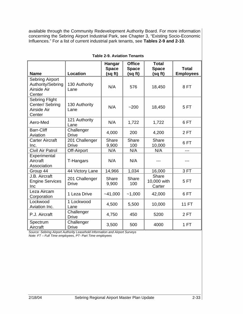
2/18/04 Sebring Regional Airport Master Plan Update 2-33
available through the Community Redevelopment Authority Board. For more information concerning the Sebring Airport Industrial Park, see Chapter 3, “Existing Socio-Economic Influences.” For a list of current industrial park tenants, see Tables 2-9 and 2-10.
Table 2-9. Aviation Tenants
Name Location
Hangar Space (sq ft)
Office Space (sq ft)
Total Space (sq ft)
Total Employees
Sebring Airport Authority/Sebring Airside Air Center
130 Authority Lane N/A 576 18,450 8 FT
Sebring Flight Center/ Sebring Airside Air Center
130 Authority Lane N/A ~200 18,450 5 FT
Aero-Med 121 Authority Lane N/A 1,722 1,722 6 FT
Barr-Cliff Aviation
Challenger Drive 4,000 200 4,200 2 FT
Carter Aircraft Inc.
201 Challenger Drive
Share 9,900
Share 100
Share 10,000 6 FT
Civil Air Patrol Off-Airport N/A N/A N/A --- Experimental Aircraft Association
T-Hangars N/A N/A --- ---
Group 44 44 Victory Lane 14,966 1,034 16,000 3 FT J.B. Aircraft Engine Services Inc
201 Challenger Drive
Share 9,900
Share 100
Share 10,000 with
Carter 5 FT
Leza Aircam Corporation 1 Leza Drive ~41,000 ~1,000 42,000 6 FT
Lockwood Aviation Inc.
1 Lockwood Lane 4,500 5,500 10,000 11 FT
P.J. Aircraft Challenger Drive 4,750 450 5200 2 FT
Spectrum Aircraft
Challenger Drive 3,500 500 4000 1 FT
Source: Sebring Airport Authority Leasehold Information and Airport Surveys Note: FT – Full Time employees, PT- Part Time employees

2/18/04 Sebring Regional Airport Master Plan Update 2-34
Table 2-10. Non-Aviation Tenants
Tenant Description Address Leasehold Employees Hancor Inc Pipe Manufacturer 1 Ulmann Drive 35,445 sq ft 51 FT
Lesco Inc Turf and Golf Course Care
425 Haywood Taylor Blvd 343,428 sq ft 100+ FT
Linpac Plastics Polystyrene Manufacturer 116 Chicane Drive 160,857 sq ft 130 FT/
20 PT
1800Partyshop Party Supply Distribution 185 Sabre Drive 21,368 sq ft 30 FT
Sebring Custom Tanning
Animal Hide Preparation
429 Webster Turn Drive 22,697 sq ft 5 FT/
2 PT Chateau Elan &
Spa Hotel 150 Midway Drive 50+ FT
Davis Cattle Agricultural Land Only Land Only 10 FT Gulf Kist Sod Sod Farm Land Only Land Only 15 FT
Highland Bowhunters
Hunting Organization Off-Airport Off-Airport NA
Hobby Hill Gifts Gifts 130 Authority Lane 250 sq ft 3 FT Panoz Racing
School Automotive Racing
School 100 Earwood Blvd N/A 20 FT
Sebring International
Raceway Automotive Racing 113 Midway Drive N/A 15 FT/
25 FP
Sherrianne's Runway Café Restaurant 130 Authority Lane 3,000 sq ft 18 FT
Skip Barber Racing School
Automotive Racing School
108 Golden Eagle Drive N/A 15 FT
Source: Sebring Airport Authority, Sebring Airport Authority Leasehold Information, and PBS&J Airport Surveys, 2002 2.6 EXISTING LANDSIDE FACILITIES Landside facilities at SEF consist of miscellaneous aviation support facilities, ground access, utilities, commercial properties, and environmental data. Refer to Figure 2-12 for a location map of major landside facilities. 2.6.1 GA Automobile Parking The main GA parking lot is adjacent to the existing terminal building and contains approximately 80 paved and marked automobile parking spaces. There are also miscellaneous parking areas behind several of the hangars on the north and south ends of the Airport.

2/18/04 Sebring Regional Airport Master Plan Update 2-35
Figure 2-12. Landside Facilities
2/18/04 Sebring Regional Airport Master Plan Update 2-36
2.6.2 Terminal Building Curb Frontage The current curb frontage available directly in front of the Sebring Regional Airside Center is equivalent to ten to twelve mid-size vehicles and includes two lanes of traffic around the curb: one thru lane and one loading/unloading lane. Terminal curb frontage provides space for passenger and baggage drop-off and pick-up. Currently, SEF has sufficient building curb frontage space on the Airside Terminal Building to meet existing demand. 2.6.3 Support Facilities Several support facilities serve important roles in ensuring the efficiency and safety of aviation operations at SEF. These services include Airport maintenance, police, and fueling services, and are key players in the support of the Airport. 2.6.3.1 Airport Maintenance The task of supervising the maintenance of the Airport belongs to the SAA. Maintenance equipment and offices are located in a building on the northwest side of the Airport. FAA guidelines indicate maintenance-building needs are directly related to the amount of paved areas and activity levels at the Airport. For instance, increases in runway, taxiway, and apron pavement, combined with increasing activity levels, will result in the need to provide additional maintenance building space. Currently, Frank’s Lawn Care provides the landscaping and lawn maintenance services. 2.6.3.2 Airport Police Department The Highlands County Sheriff’s Office (HCSO) provides law enforcement services for the Airport. HCSO is capable of responding to any existing emergency or law enforcement needs of the Airport. The Craig D. Graybill, Jr. Security Service provides additional security services for the Airport and industrial park. Security services to the Airport are provided 24-hours per day, seven days a week. 2.6.3.3 Aircraft Rescue and Fire Fighting The DeSoto City Volunteer Fire Department (DVFD) provides aircraft rescue and fire fighting (ARFF) services to the Airport, with backup services provided by the City of Sebring Fire Department. The fire protection system has been designed to obtain a favorable rating from the International Organization of Standardization (ISO) to maintain attractive tenant insurance rates. 2.6.3.4 Fuel Storage The fuel farm is owned by the SAA, and fuel is distributed by the Sebring Flight Center. No other tenant is allowed to sell fuel to airport users. The Authority offers Chevron 100 Low Lead and Jet-A fuel. The fuel farm is located due south of the Sebring Regional Airside Center and consists of two aboveground 10,000-gallon tanks equipped with meters, filters, and emergency shut-off systems. In addition, the Airport has one 750-gallon Avgas truck, three 5,000-gallon Jet A trucks, and one 1,200-gallon Jet A truck. Some of the trucks are currently slated for sale, and the Airport is planning to include self-fueling facilities in its list of future amenities.

2/18/04 Sebring Regional Airport Master Plan Update 2-37
The Authority has a special fueling contract with the U.S. Department of Defense and with Avon Park Air Force Range. Through negotiations, SAA contracts with Defense Energy Support Center (DESC) to provide fuel at a variable rate that changes weekly according to their price adjustment procedures. The fuel farm’s location within FTZ #215 allows for other purchase incentives as well. 2.6.4 Ground Access System The existing transportation network of the region is important in assessing the future development of the Airport. Off-Airport access to SEF consists of both vehicular and rail service. US Highway 27 provides a major north-south highway, which links the City of Sebring with I-4 and I-75 to the north and Miami/Ft. Lauderdale to the south. SEF is located approximately five miles east of US 27 and is accessed by US Highway 98 and Airport Road. State Road 623 provides access to the Airport from downtown Sebring. State highways 17 and 17A further enhance general circulation in the area of the Airport. The Seaboard System Railroad provides rail transportation linkage with freight service provided by a spur from the main track into the center of the industrial park. The rail spur has recently been renovated using funds provided by an FDOT grant. Figure 2-13 illustrates the airport access and roadway system. 2.6.5 Utilities The availability and capacity of the utilities serving SEF are important factors in determining future development. The primary concern is the availability of adequate water, sewer, and power sources. All of these utilities are currently available at the Airport. Highlands County is famous for its quality water, as much of its spring water is bottled and sold all over the U.S. Municipal water is provided from deep wells in the Florida aquifer running beneath the county. Unlike the coastal areas of Florida, there is no saltwater intrusion problem. Each municipality has a locally owned and managed plant that is operated under the jurisdiction of the Florida Public Service Commission. (5) The entire potable water system at the Airport has been renovated to meet the needs of all current and future demand of aviation and non-aviation tenants. The Airport is a self-sufficient system that is serviced by three wells. First, the water is pumped to a 375,000-gallon raw water reservoir at the ground level. The water treatment system includes chlorination and high service pumping. To maintain the utmost efficiency, the Airport installed distribution pipes ranging from 6 to 16 inches in diameter. System reliability has been further enhanced by the addition of on-site emergency power generation. (6) Municipally owned and operated collection and treatment facilities, as well as privately owned plants, provide sewage disposal services to the area. The on-site facilities for sewer collection, treatment, and disposal of wastewater have recently been constructed to have an initial phase capacity of 90,000 gallons per day. A municipal and countywide solid waste disposal system provides garbage collection services.

2/18/04 Sebring Regional Airport Master Plan Update 2-38
Figure 2-13. Airport Access and Roadway System
2/18/04 Sebring Regional Airport Master Plan Update 2-39
Florida Power Corporation, a Fortune 500 utility, operates an integrated power system to provide the Airport’s electrical power. Eighteen steam units and 43 combustion turbines serve the system with a total net generating capacity of 7,563 megawatts (MW). In addition, Florida Power maintains sufficient reserve capacity to meet the needs of any new business or industry. A 7.2 kilovolt (KV) transmission line serves the industrial park. Standard service is a single-phase, three-wire, or three-phase, four-wire. Standard voltages are 120 volts Alternating Current (VAC)/240 VAC, 120 VAC/208 VAC, and 277 VAC/480 VAC. (7) In Highlands County, Liquid Petroleum (LP) Gas is available through distributors and natural gas is available in some areas. 2.6.6 Sebring International Raceway The Sebring International Raceway leasehold encompasses approximately 400 acres at the southern portion of SEF, as shown in Figure 2-14, Sebring International Raceway. It includes of a quarter mile-long pit row and garage area with a four-story tower, elevated viewing, and hospitality suites, and a track which can be configured for various length races. The raceway has become a local tradition, involving second and third generation spectators and participants. Founded over a half a century ago, the raceway is the home of the internationally known “12 Hours of Sebring” endurance race. Thousands of people visit the area each year, including race teams, drivers, major vendors, and race fans from all over the world. The endurance race is held in conjunction with other preliminary events, including the Historic Sports Car Race. The raceway is the home of many historic events and exciting training facilities. Located on the raceway leasehold, are two major racing schools. The Panoz Racing School operates within a new 7,500 sq ft facility on the southern portion of the raceway property. The Skip Barber Racing School is located on the eastern boundary of the leasehold and utilizes two buildings for classroom training, as well as sharing rights to the track. The raceway also remains busy approximately 250 days of the year with testing being conducted by some of the biggest names in racing, corporate events, sports car club races, and other special events. To support the raceway events and year-round use a new hotel has been added to the complex. Sebring’s Chateau Elan Lodge is a four-story hotel located near the raceway’s hairpin turn. The Lodge features a health spa, Jacuzzi, pool, and upscale restaurant. (8)
The Sebring International Raceway leasehold encompasses approximately 400 AC at the southern portion of SEF.

2/18/04 Sebring Regional Airport Master Plan Update 2-40
Figure 2-14. Sebring International Raceway
2/18/04 Sebring Regional Airport Master Plan Update 2-41
2.6.7 Stormwater/Drainage Currently, the SEF stormwater/drainage system includes a number of ditches, culverts, watersheds, and retention basins. The system collects runoff from the runways, taxiways, and apron areas and allows flow of runoff to Arbuckle Creek. Phase one of the master drainage plan contains a retention pond near the new water treatment facility. There are approximately 19 internal discharge points, and seven (see Figure 2-15) external discharge points on Airport property. See Figure 2-15 for the Existing Drainage Map, Discharge Locations, and Major Watersheds. The South Florida Water Management District (SFWMD) approved the current Master Drainage Plan for SEF in December 2001. The Master Drainage Plan serves as a planning guide for future design and development of internal drainage systems. According to the plan, the purpose is to maintain the adequacy of stormwater management facilities, meet regulatory requirements, and provide a basis for approval of any permits necessary for future development. The plan incorporates information from the entire Airport property, including both aviation and non-aviation uses. The plan shows that SEF will have the facilities to meet state-mandated regulations, to meet mitigation requirements, and to maintain flexibility meeting short-term and long-term expansion goals. This topic will be discussed in greater detail in the environmental chapter. 2.6.8 Wetland Inventory Also included in the SEF Master Drainage Plan is an identification of existing wetland areas. True to the characteristics of central inland Florida, the Airport has a number of areas designated as wetland areas by the SFWMD and the Army Corp of Engineers (ACOE). There are 11.13 AC of preserved wetlands on the south portion of Airport property. Scattered along the northeast to southeast boundary of the Airport, there are 12.73 AC of proposed impacted wetlands. Also, there are approximately 128.65 AC of proposed preserved wetlands to the northeast of the Airport. Refer to Figure 2-16, Airfield Master Drainage Plan, for more detail. 2.7 AIRSPACE AND APPROACH PROCEDURES The National Airspace System (NAS) is defined as the common network of U.S. airspace, including air navigation facilities, airports, and landing areas, aeronautical charts and information, associated rules, regulations, and procedures, technical information, personnel, and materials. System components shared jointly with the military are also included. Airspace in and around SEF is unique due to its proximity to Avon Park Airport and MacDill Air Force Base Auxiliary Airport. As a result, SEF’s airspace operations are somewhat restricted by the military operating areas (MOAs) and restricted areas (RAs) associated with the Avon Park Bombing Range, which is located within the RAs.

2/18/04 Sebring Regional Airport Master Plan Update 2-42
Figure 2-15. Existing Drainage Map

2/18/04 Sebring Regional Airport Master Plan Update 2-43
Figure 2-16. Airfield Master Drainage Plan
2/18/04 Sebring Regional Airport Master Plan Update 2-44
2.7.1 Airspace Management and Approach Procedures Airspace Management is defined as the “direction, control, and handling of flight operations in the volume of air that overlies the geopolitical borders of the U.S. and its territories” (Federal Aviation Regulation, Airman's Information Manual (FAR/AIM 2002)). Created under the Federal Aviation Act of 1958 to enforce safety, the FAA was placed under the jurisdiction of Congress. The FAA establishes policies, designations, and flight rules to protect aircraft in the airfield and en route environment, and in special use airspace (SUA) areas identified for military or other governmental activities. Management of this resource considers how airspace is designated, used, and administered to best accommodate the individual and common needs of military, commercial, and GA. Because of these multiple and sometimes competing demands, the FAA considers all aviation airspace requirements in relation to airport operations, Federal Airways, Jet Routes, military flight training activities, and other special needs to determine how the NAS can best be structured to satisfy all user requirements.
The FAA has designated four types of airspace above the U.S. They are controlled, SUA, other, and uncontrolled airspace.
• Controlled airspace is categorized into five separate classes: Class A, B, C, D, and E airspace. These classes identify airspace that is controlled, airspace supporting airport operations, and designated airways affording en route transit from place to place. Air Traffic Controlled Assigned Airspace (ATCAA) falls into this type of airspace. The classes also dictate pilot qualification requirements, rules of flight that must be followed, and the type of equipment necessary to operate within that airspace.
• SUA is designated as airspace within which flight activities are conducted that require confinement of participating aircraft, or place operating limitations on non-participating aircraft. Prohibited areas, restricted areas, warning areas, and military operations areas are examples of SUA.
• Other airspace consists of advisory areas, areas that have specific flight limitations or designated prohibitions, areas designated for parachute jump operations, military training routes (MTRs) and aerial refueling tracks (ARTs).
• Uncontrolled airspace is designated Class G and has no specific prohibitions associated with its use.
2.7.2 Airspace Structure Airspace is classified as controlled or uncontrolled. Controlled airspace is supported by ground-to-air communications, NAVAIDS, and air traffic services. In September 1993, the FAA reclassified major airspace. The new classifications are graphically depicted in Figure 2-17, FAA Airspace Classifications, with airspace requirements listed in Figure 2-18. Types of controlled airspace include:
• Class A airspace, which includes all airspace between 18,000 ft MSL and 60,000 ft MSL (as well as waters within 12 nautical miles [nm] of the coast of the 48 contiguous states).
2/18/04 Sebring Regional Airport Master Plan Update 2-45
• Class B Airspace (formerly referred to as the terminal control area), which includes all airspace from the airport’s established elevation up to 10,000 ft MSL, and consists of four airspace layers.
• Class C airspace (formerly referred to as the airport radar service area), which includes all airspace from that airport’s established elevation up to 4,000 ft MSL, and consists of two airspace layers.
• Class D airspace (formerly referred to as the airport traffic area) for airports with ATCTs, which normally extends from the surface to 2,500 ft above an airport’s established elevation (charted in MSL), and includes control zones and airport traffic areas.
• Class E airspace, which includes all controlled airspace other than Class A, B, C, or D. Class E airspace extends upward from either the surface of the designated altitude to overlying or adjacent controlled airspace. Class E airspace includes transition areas and control zones for airports without ATCTs.
• Class G airspace, which is uncontrolled airspace, begins at the surface and rises to the base of the overlying airspace.
Only those areas that pertain to SEF (Class E, Restricted Airspace and Military Operating Areas) are described further. The Miami Air Route Traffic Control Center (ARTCC) is responsible for en route control of all aircraft operating in an IFR flight into the Sebring area. See Figure 2-19, Regional Airspace. Controlled airspace directly associated with SEF includes Class E, which is depicted on the Miami Sectional Aeronautical Chart, January 2002, by a graduated magenta band surrounding the Airport, and SUA, which includes warning areas and MOAs and is depicted by blue and red outlines. The Class E Airspace surrounding SEF has its floor 700 ft above the surface. Class E Airspace allows aircraft to transition to or from the MOA into the airport control zone. Within warning areas, while multiple use of the airspace is not prohibited, avoidance is advised during time of military training use. Joint use of MOAs is also allowed. Pilots flying in MOAs are responsible to employ “see and avoid” standards of flight safety. Both warning areas and MOAs are plotted on aeronautical charts so all pilots are aware of their location and the potential for military flight training in the airspace. MOAs associated with the Avon Park Bombing Range and MacDill AFB Auxiliary Airport (AGR) operations limit SEF’s airspace operations. The restricted areas, as indicated in Figure 2-19, indicate those areas that are continuously in effect and limit where aircraft can operate. As indicated, most of the areas restrict civilian aircraft to fly below 14,000 ft MSL. The MOA is considerably larger than the restricted areas and is in effect intermittently during daylight hours Monday through Friday, and occasionally on weekends, but does allow aircraft to fly lower than 7,000 ft on a limited basis. (Miami Aeronautical Sectional Chart, January 2002) Restricted airspace (RA) to the northeast of SEF, though not entirely prohibited to flight activity, are areas in which unauthorized incursion is not only illegal, but also extremely dangerous. Restricted areas are identified on aeronautical Sectional Charts by a defined area marked with the letter "R," followed by a number. Altitudes and times differ for each restricted area. These areas generally contain operations that do not mix well with aircraft such as artillery firing, guided missiles, or aerial gunnery. Permission to fly in

2/18/04 Sebring Regional Airport Master Plan Update 2-46
restricted areas can be given by ATCT. Table 2-11 lists specific RAs and MOAs in the region surrounding SEF.
Table 2-11. Sebring Regional Airspace
RESTRICTED AREAS
Number Usage Altitude Usage Time Controlling
Agency R-2901A To 14,000’ Continuous ZMA CNTR R-2901B 14,000’ to FL 180 Continuous ZMA CNTR R-2901C To 14,000’ Continuous ZMA CNTR
R-2901D 500’ to 4,000’ East of 81 21’ 00” W; 1,000’ AGL to 4,000’
West of 81 21’ 00” West Continuous ZMA CNTR
R-2901E 1,000” to 4,000’ Continuous ZMA CNTR R-2901F 4,000’ to 5,000’ Continuous ZMA CNTR R-2901G To 5,000’ Continuous ZMA CNTR R-2901H 1,000’ to 4,000’ Continuous ZMA CNTR R-2901I 1,500’ to 4,000’ Continuous ZMA CNTR
MILITARY OPERATIONS AREAS
Name Usage Altitude Usage Time Controlling
Agency
Avon North 5,000’ Intermittent daylight hours: contact FSS ZMA CNTR
Avon East 500’ AGL to But not including 14,000’
Intermittent daylight hours Mon-Fri ZMA CNTR
Avon South 4,000’ Daylight hours Mon – Fri ZMA CNTR
Basinger 500’ AGL to 5,000’
Intermittent daylight hours Mon-Fri occasionally Sat & Sun.; contact nearest FSS
ZMA CNTR
Lake Placid 7,000’
Intermittent daylight hours Mon-Fri occasionally Sat & Sun.; contact nearest FSS
ZMA CNTR
Lake Placid North 15,000’ Intermittent daylight
hours; contact FSS ZMA CNTR
Marian 500’ AGL to 5,000’
Intermittent daylight hours Mon-Fri occasionally Sat & Sun.; contact nearest FSS
ZMA CNTR
Source: Department of Transportation, U.S. Terminal Procedures Southeast, Volume 3 of 4, November 1, 2001

2/18/04 Sebring Regional Airport Master Plan Update 2-47
Figure 2-17. FAA Airspace Classification

2/18/04 Sebring Regional Airport Master Plan Update 2-48
Figure 2-18. Airspace Classification Detail

2/18/04 Sebring Regional Airport Master Plan Update 2-49
Figure 2-19. Regional Airspace
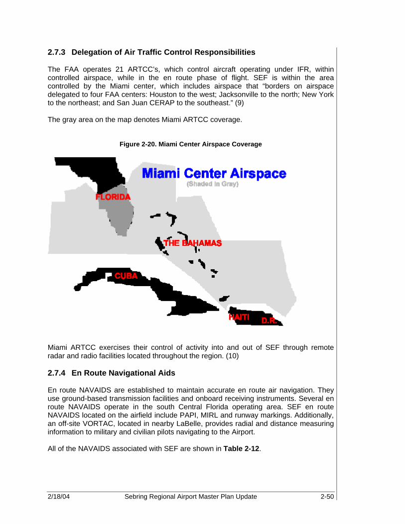
2/18/04 Sebring Regional Airport Master Plan Update 2-50
2.7.3 Delegation of Air Traffic Control Responsibilities The FAA operates 21 ARTCC’s, which control aircraft operating under IFR, within controlled airspace, while in the en route phase of flight. SEF is within the area controlled by the Miami center, which includes airspace that “borders on airspace delegated to four FAA centers: Houston to the west; Jacksonville to the north; New York to the northeast; and San Juan CERAP to the southeast.” (9) The gray area on the map denotes Miami ARTCC coverage.
Figure 2-20. Miami Center Airspace Coverage
Miami ARTCC exercises their control of activity into and out of SEF through remote radar and radio facilities located throughout the region. (10) 2.7.4 En Route Navigational Aids En route NAVAIDS are established to maintain accurate en route air navigation. They use ground-based transmission facilities and onboard receiving instruments. Several en route NAVAIDS operate in the south Central Florida operating area. SEF en route NAVAIDS located on the airfield include PAPI, MIRL and runway markings. Additionally, an off-site VORTAC, located in nearby LaBelle, provides radial and distance measuring information to military and civilian pilots navigating to the Airport. All of the NAVAIDS associated with SEF are shown in Table 2-12.

2/18/04 Sebring Regional Airport Master Plan Update 2-51
Table 2-12. Navigational Aids
Approach Aids Runway 18 Runway 36 Runway 14 Runway 32 PAPI-4 Yes Yes No No Runway Lighting MIRL MIRL No No Runway Marking Visual Visual Visual Visual GPS Yes
Source: Sebring Regional Airport, 2001, FAA Airport Facility Directory, Southeast U.S. (Effective 13, June 2002 to 8 August, 2002), Sebring Regional Airport, ALP, 1993
2.8 LAND USE Highlands County Board of County Commissioners, in conjunction with appointive advisory planning and zoning agencies, regulates the land use within the municipalities of Avon Park, Lake Placid, and Sebring, as well as the unincorporated areas. The Planning and Zoning Board is an advisory board with members appointed by the Commissioners, and has offices located at the county courthouse complex. Land utilization plans, whether city, county, or regional, should consider existing and future activities of the Airport. Currently, the properties to the north and west of the Airport property are zoned for agriculture, according to the Future Land Use Element (FLUE Policy 1.3.E.1). To the southwest, there is some land designated for industrial use (FLUE Policy 1.3.E.10) mixed in with agriculturally zoned properties. The majority of the southern border of the Airport is adjacent to residentially zoned areas, designated as vested subdivisions (FLUE Policy 2.3, Policy 10.1 Table, Policy 13.E.13). Vested subdivisions also comprise the southeastern border up to the area directly east of the Airport. From this point to the north, the land has been zoned for agricultural utilization. The property belonging to the SAA is zoned as public lands (FLUE Policy 1.3.E.5). See Figure 2-21, Land Use. The public use is not considered a zoning category for the regulation of land uses. The recommendation of zoning classifications will be addressed in the planning process. 2.8.1 Currently Vacant and Underutilized Land Within the Airport boundary, portions of the land are utilized for aviation, industrial, agricultural, and commercial purposes. Agriculture zoning surrounds the majority of the Airport, but portions to the south and east are zoned for residential usage. The Airport views these areas, especially the designated agricultural zoned areas, as potential development areas, and designates these areas as future aviation and industrial development. The northwest portion of the Airport property is set-aside for the industrial park. There is much opportunity for marketing and development of the areas within the park. Finally, the Sebring International Raceway encompasses the area of the Airport to the southwest.

2/18/04 Sebring Regional Airport Master Plan Update 2-52
Figure 2-21. Land Use
Source: http://sebring-airport.com
2.8.1.1 Davis Property The Davis Property is located along the north and northeast border of the existing Airport property (see Figure 2-22, Potential Development). SAA has a binding option for 1,000 acres. The purchase of this land would allow for a master mitigation strategy to be developed for the Airport using Arbuckle Creek; provide land for additional aviation development, such as new runway, aprons, buildings, and other associated infrastructure; as well as to provide additional land for sound mitigation. The size and location of the Davis property make it an ideal platform for a variety of business developments. 2.8.1.2 South Property Along the southern border of the Davis property, to the east of Runway 18-36, there is an adjacent property that is being considered for potential residential development (see Figure 2-22, Potential Development). A possible use for this property is hangar homes, allowing residents who are also involved in aviation to have homes adjacent to or directly on Airport property. This would provide unique and additional revenue while providing for the establishment of a compatible land use. The opportunity is subject to on-going discussions and negotiations with the landowner. 2.8.1.3 East Property The eastern property is already part of the current Airport leasehold. This property is located directly east of Runway 18-36. With the closure of Runway 4-22, a significant amount of land became available (see Figure 2-22, Potential Development). One potential option for this land is for light industrial development, whether aviation or non-aviation related. This, again, will provide an additional revenue stream to the Airport

2/18/04 Sebring Regional Airport Master Plan Update 2-53
Authority. In addition, light industrial development between the airside and potential residential development will provide additional sound mitigation. 2.9 AREA-WIDE PLANS Throughout the master planning process, it is extremely important to coordinate the goals of the Master Plan with the goals of area wide plans. Planning occurs at the national, state, and local levels; therefore, these plans must be included in the documentation of the Airport Master Plan. For the Sebring Regional Airport Master Plan, it is necessary to incorporate countywide, regional, statewide, and national planning goals. 2.9.1 Highlands County Comprehensive Plan The Countywide Plan was developed by the Highlands County Commission and the Countywide Planning Authority to develop a future land use plan with a managed growth perspective coordinating all the elements in the plan. The plan focuses on capital improvements, traffic circulation, infrastructure, housing, conservation, recreation, coastal, and intergovernmental coordination. The plan has goals, policies, and economic assumptions in a general format to serve as a basis for rational decisions and review of plans submitted by local governments. The goal of the transportation element is to develop a transportation system that provides for all the movement needs of people and goods in both purpose and mode. The plan maintains that the transportation system should be adequate to serve the growth of the County and its socioeconomic function, while serving all segments of the County’s population. Another goal is to maximize use of existing facilities and minimize negative environmental impacts on the ecosystem and neighborhoods. The plan mandates the coordination of the transportation system with other public facilities as a major source of support in the recognition of the role of tourism. The plan also mandates provision of safety standards and movement of industrial and commercial goods with minimal interference. 2.9.2 Central Florida Strategic Regional Policy Plan (SRPP) The five counties of DeSoto, Hardee, Highlands, Okeechobee, and Polk consist of nearly 5,000 sq mi of inland territory and form the basis for the Central Florida region. The region’s Strategic Regional Policy Plan (SRPP) serves as a long-range planning guide for physical, economic, and social development. The SRPP simply provides direction to steer the region toward a more healthy and sustainable future. The plan addresses the issues of natural resources, economic development, regional transportation, affordable housing, and emergency preparedness. This region is the only Aviation Planning Region in the State of Florida without commercial air service. Due to the projected population growth, economic activity, and free trade areas, overall aviation activity is expected to increase dramatically. One of the main goals of the SRPP is to prepare for that growth by improving the transportation infrastructure and substructures, develop key facilities, and prioritize projects for the utmost efficiency.
This region is the only Aviation Planning Region in the State of Florida without commercial air service.
2/18/04 Sebring Regional Airport Master Plan Update 2-54
Figure 2-22. Potential Development

2/18/04 Sebring Regional Airport Master Plan Update 2-55
2.9.3 Florida Airport System Plan The Florida Aviation System Plan (FASP) is the FDOT’s 20-year aviation system plan for development at Florida’s publicly owned airports. The FASP is a continuing planning process supported by multiple databases that provide current data on Florida’s aviation industry. Because the plan must reflect and keep pace with Florida’s dynamic aviation industry, it addresses new and challenging areas of study in addition to the well-established aviation planning disciplines. The plan incorporates such topics as intermodal transportation networking, economic impact of airports on the local community and the state of Florida, and development of long-range visions and strategies through strategic planning. FASP further enhances the FDOT’s primary goal for aviation, which is - providing a quality system that meets the current and future growth needs of Florida. SEF is classified within the Continuing Florida Aviation System Planning Process (CFASPP) Central Florida Region, which consists of twelve other Airports. The other Airports categorized within the Central Florida Region are:
• Lakeland-Linder Regional Airport (Lakeland) • Lake Wales Municipal Airport (Lake Wales) • Arcadia Municipal Airport (Arcadia) • Winter Haven Municipal Airport (Winter Haven) • Avon Park Municipal Airport (Avon Park) • Bartow Municipal Airport (Bartow) • Wauchula Municipal Airport (Wauchula) • Chalet Suzanne Air Strip (Lake Wales) • Jack Browns Sea Plane Base (Winter Haven) • Okeechobee County Airport (Okeechobee) • River Ranch Airport (River Ranch) • South Lakeland Airport (Mulberry)
2.9.4 National Plan of Integrated Airport Systems The National Plan of Integrated Airport Systems (NPIAS) was submitted to Congress in accordance with Section 47103 of Title 49 of U.S. Code. The plan identifies 3,344 existing airports that are significant to national air transportation, and contains estimates that $35.1 billion in infrastructure development, eligible for Federal aid, will be needed over the next five years to meet the needs of all segments of civil aviation. A primary purpose of the NPIAS is to determine eligibility of the significant airports to receive grants under the Airport Improvement Program (AIP). The NPIAS is composed of all commercial service airports, all reliever airports, and selected GA airports. The NPIAS includes a section on the condition and performance of the airport system, highlighting six topics: safety, capacity, pavement condition, financial performance, accessibility, and noise. The findings are generally favorable, indicating that the system is safe, convenient, well maintained, and largely supported by rents, fees, and taxes paid by users. Problems are apparent in specific areas, with a large number of people exposed to high noise levels and delays due to airfield and ground access congestion at some of the busiest airports.

2/18/04 Sebring Regional Airport Master Plan Update 2-56
The NPIAS classifies the SEF as a GA airport. GA airports may be included in the NPIAS if they account for enough activity and are at least 20 miles from the nearest NPIAS airport. There are 2,472 GA airports in the NPIAS, according to the FAA. GA airports included in the plan have an average of 29 based aircraft and account for approximately 37 percent of the nation’s GA fleet. GA airports are a convenient source of air transportation and are particularly important to rural areas, such as Highlands County. SEF has approximately 84-based aircraft and 64,000 operations per year. 2.10 AIRPORTS IN THE REGION It is essential to note the location and operating characteristics of other airports in the region served by the airport under study. These airports compete for GA activity in the region, and, thereby, affect the amount of air traffic as a whole. In addition, airports compete for federal or state resources in terms of development grant funding and air traffic control staff services, which also influence system planning. Traffic from airports in close proximity may also affect the interaction of traffic to and from neighbors outside of the region. Airspace interaction is defined as the potential for conflicts among aircraft on approach or departure to other airfields and may require the defining or adjustments of operating procedures at the affected airports. SEF is directly affected by high performance air traffic and ATC procedures from AGR. The number of public use airports in a region can affect both the overall market demand for services as well as airspace and airport congestion. To clarify the point, the following sub-sections provide some background information on the significant airports in the Sebring and surrounding areas. Figure 2-23 depicts the airports in the region surrounding Sebring and Highlands County. 2.10.1 Lakeland Linder Regional Airport (LAL) Lakeland Linder Regional Airport (LAL) is located approximately 56 statute miles to the northwest of SEF and four miles southwest of Lakeland. The Airport is owned and operated by the City of Lakeland and the Airport administration personnel. LAL consists of two grooved, asphalt runways, both in good condition. Runway 05-23 is 5,000 ft long and 150 ft wide and is situated in an east-west orientation. Runway 05-23 is rated for 60,000 lb SWL, 73,000 lb DWL, and 135,000 lb DTWL. This runway is equipped with high intensity runway edge lighting (HIRL), a medium intensity approach lighting system with runway alignment indicator lights (MALSR), and an instrument landing system (ILS). Runway 09-27 is 8,500 ft long and 150 ft wide and is situated in a southwest-northeast orientation. Runway 09-27 is rated for 40,000 lb SWL, 60,000 lb DWL, and 100,000 lb DTWL. This runway is equipped with MIRL and four-light PAPIs. LAL hosts approximately 224 based aircraft on the field, the majority of which are single-engine aircraft, and hosts approximately 201,000 operations per year. There are several FBOs at the Airport that provide fuel services, major engine repair, major airframe repair, charter flights, flight instruction, aircraft rental, aircraft sales, and miscellaneous pilot support services.

2/18/04 Sebring Regional Airport Master Plan Update 2-57
Figure 2-23. Airports in the Region

2/18/04 Sebring Regional Airport Master Plan Update 2-58
2.10.2 Lake Wales Municipal Airport (X07) Lake Wales Municipal Airport (X07) is located 6 statute miles to the north of SEF and two miles west of Lake Wales. The Airport is owned and operated by the City of Lake Wales. X07 consists of two asphalt runways. Runway 06-24 is 3,999 ft long and 100 ft wide and consists of asphalt. The existing asphalt is in fair condition with signs of cracking. Grass is growing through some cracked areas. This runway is rated at 15,000 lb SWL and is equipped with MIRL and 4-light PAPIs at each runway end. Runway 17-35 is 3,999 ft long and 75 ft wide, and consists of asphalt in good condition. This runway is rated at 15,000 lb SWL and is not equipped with any lighting or NAVAIDS. This runway is not equipped with lights and is closed to all turbine-powered aircraft. X07 has approximately 32 based aircraft on the field, most of which are single-engine aircraft. There are approximately 20,000 operations per year. The Airport FBOs offer fuel services, hangar and tiedowns, major engine repair, major airframe repair, flight instruction, and aircraft rental. There is ultralight and sky diving activity on and in the vicinity of the Airport. 2.10.3 Arcadia Municipal Airport (X06) Arcadia Municipal Airport (X06) is located 30 statute miles to the southwest of SEF and one mile southeast of Arcadia. The Airport is owned and operated by the City of Arcadia. X06 consists of two runways. Runway 05-23 is 3,700 ft long by 75 ft wide. This runway consists of asphalt and is in good condition. The strength rating for this pavement is unknown. However, it is equipped with MIRL. Runway 13-31 is 2,780 ft long and 140 ft wide. This runway consists of a turf surface in fair condition. The strength rating for this surface is also unknown. This runway is not equipped with lighting or NAVAIDS. X06 hosts approximately 28 based aircraft on the airfield, the majority of which are single-engine aircraft. There are approximately 19,370 operations per year. X06 services include fuel services, pilot support services, major engine repair, major airframe repair, aircraft painting, aircraft interiors, flight instruction, and aircraft rental. 2.10.4 Winter Haven Municipal Airport (GIF) Winter Haven Municipal Airport (GIF), or Gilbert’s Field, is located 25 statute miles to the north of SEF and three miles northwest of Winter Haven. The Airport is owned and operated by the City of Winter Haven. GIF consists of two asphalt runways. Runway 04-22 is 5,006 ft long and 100 ft wide and is in fair condition. This runway is rated at 30,000 lb SWL and is equipped with MIRL and two-light PAPIs at each end.

2/18/04 Sebring Regional Airport Master Plan Update 2-59
Runway 11-29 is 3,999 ft long and 100 ft wide and is in good condition. This runway is rated at 12,500 lb SWL and is not equipped with lighting or NAVAIDS. MLB GIF hosts approximately 153 based aircraft on the airfield, the majority of which are single-engine aircraft. There are approximately 60,000 operations per year. GIF FBO’s provide fuel services, pilot support services, major engine repair, major airframe repair, flight instruction, aircraft rental, aircraft sales, and charter flights. There is a seaplane base on the north side of the Airport and there is glider and ultralight activity in the vicinity of the Airport. 2.10.5 Avon Park Municipal Airport (AVO) Avon Park Municipal Airport (AVO) is located 15 statute miles northwest of SEF and two miles west of Avon Park. The Airport is owned and operated by the City of Avon Park. AVO consists of two asphalt runways in fair to poor condition. Runway 04-22 is 5,364 ft long and 75 ft wide and is oriented in a southwest-northeast configuration. This runway is rated at 26,000 lb SWL and is equipped with MIRL and four-light PAPIs on both runway ends. Runway 09-27 is 3,825 ft long and 75 ft wide and is oriented in an east-west configuration. This runway is rated at 10,000 lb SWL and is not equipped with lights or visual NAVAIDS. Of the approximately 61 aircraft based on the field, most are single-engine aircraft. There are approximately 32,000 aircraft operations per year. The Airport services include flight instruction, aircraft rental, and aircraft sales. 2.10.6 Bartow Municipal Airport (BOW) Bartow Municipal Airport (BOW) is located 42 statute miles to the north of SEF and four miles northeast of Bartow. The Airport is owned and operated by the Bartow Municipal Airport Development Authority. BOW consists of three asphalt runways. Runway 05-23 is 5,000 ft long and 100 ft wide and is in fair condition. This runway is rated at 35,000 lb SWL, 60,000 lb DWL, and 110,000 lb DTWL. Runway 05-23 is equipped with MIRL and 4-light PAPIs at each end. Runway 9L-27R is 5,001 ft long and 150 ft wide and is in good condition. The pavement strength rating for runway 9L-27R is unknown. This runway is equipped with MIRL, 4-light PAPIs at each end, and nonprecision instrument markings. Runway 9R-27L runs parallel to runway 9L-27R. Runway 9R-27L is 4,400 ft long and 150 ft wide and is in good condition. The pavement strength rating for runway 9R-27L is unknown. This runway is not equipped with lighting or NAVAIDS. BOW hosts approximately 101 based aircraft on the airfield, the majority of which are single-engine aircraft. There are approximately 55,000 operations per year. BSO FBOs provide fuel services, pilot support services, major engine repair, major airframe repair, avionics services, flight instruction, aircraft rental, aircraft sales, agricultural operations,

2/18/04 Sebring Regional Airport Master Plan Update 2-60
and aerial surveying. There is ultralight activity on and in the vicinity of the Airport, as well as aerobatic flight activity. 2.10.7 Wauchula Municipal Airport (F37) Wauchula Municipal Airport (F37) is located approximately 29 statute miles west of SEF and five miles southwest of Wauchula. The Airport is owned and operated by the City of Wauchula. F37 consists of one asphalt runway configured in a north-south orientation. Runway 18-36 is 4,000 ft long and 75 ft wide and is in good condition. The runway is equipped with MIRL, but no NAVAIDS are installed. There are approximately 42 based aircraft at F37 and 8,200 operations per year. Airport amenities include fuel services, minor airframe repair, major engine repair, flight training, aircraft sales, and aircraft rental. 2.10.8 MacDill Air Force Base Auxiliary Field (AGR) MacDill Air Force Base Auxiliary Field (AGR) is located approximately 12 miles northeast of SEF and eight miles north east of Avon Park within the Avon Park Air Force Range. The Airport is owned by the United States Air Force (USAF) and is used primarily by the 1st Combat Support Group Tactical Command (SPT GP TAC). AGR consists of one asphalt runway configured in a southwest-northeast orientation. Runway 05-23 is 8,000 ft long and 150 ft wide and is equipped with MIRL. AGR is used primarily as a training facility for the nation’s combat aircraft and crews. 2.11 SUMMARY The information in this section provides the foundation upon which the remaining elements of the Master Plan process will be developed. Information on current infrastructure and operations will serve as a basis for the development of forecasts of aviation activity and facility requirements. This information will provide guidance to assess potential changes to facilities and/or procedures necessary to meet the goals of the Airport planning process. Analysis of the inventory of Airport facilities determines and prepares for the needs presented by the Airport users in the short-, intermediate, and long-term. Thus, the inventory of existing conditions is the first step in the complex process to determine those steps that are needed to meet projected aviation demands in the community. The information collected as a basis for the analysis and forecasting of future Airport activity and facilities is based upon year 2001 numbers.

2/18/04 Sebring Regional Airport Master Plan Update 3-1
EXISTING SOCIO-ECONOMIC INFLUENCES Sebring Regional Airport 3.1 GENERAL OVERVIEW Levels of aviation activity at local and regional airports can be generally predicted from the size and wealth of the surrounding community. These characteristics can be defined for a region from a variety of statistical information published regularly in Florida by professional demographers at the University of Florida’s Bureau of Economic and Business Research (BEBR). The purpose of this section is to identify and define key social and economic characteristics in the Highland County region from which forecasts of aviation activity are developed. Communities surrounding an airport closely influence demand for a wide range of aviation services that airports provide. The better equipped the airport is to provide these services, the stronger the demand. Although local and regional population is a primary driver, demand for these services may well extend beyond definable regional, state, or even national boundaries. The demand for aviation services can generally be related to key statistics, which, when combined, profile the larger community served by the local airport. Aviation services can include commercial air carrier, flight training, maintenance, cargo, and storage of private aircraft. Usually the level of demand is directly related to the size and composition of the regional population. The population may be described in terms of earnings (the ability to pay for services) and the employment providing such earnings. The statistical link between these social and economic indicators provides a gauge of the community’s predictable demand for aviation services. This can be used as a base to forecast likely future aviation activity. Any necessary airport facilities can then be planned accordingly. The following section describes key population, employment, and income trends in Highlands County as they relate to aviation activity. 3.2 POPULATION When using socioeconomic factors to develop aviation forecasts, it is critical to define the service area correctly. Sebring Regional Airport (SEF) is located approximately 8 miles southeast of Sebring in the north-central portion of Highlands County. Encompassing 1,107 square miles of Florida’s heartland, Highlands County is located on the rolling hills of Central Florida’s ridge area and lake country. Over 85 percent of the state’s population is within a 150-mile radius, which means SEF has access to over 12 million potential customers. Highlands County has three incorporated cities. Sebring is the county seat and has a population of 8,856. Avon Park is the northern-most city with a population of 8,162, and is one of the heaviest citrus-producing areas in the state. Lake Placid is the Caladium Capital of the World, and has a population of 1,412. The population of the
The purpose of this section is to identify and define key social and economic characteristics in the Highland County region from which forecasts of aviation activity are developed.
3

2/18/04 Sebring Regional Airport Master Plan Update 3-2
unincorporated area totals 62,713. Over the past 20 years, the entire population of Highlands County has gradually increased as shown by Figure 3-1.
Figure 3-1. Highlands County Historical Population from 1980-1999
40,000
45,000
50,000
55,000
60,000
65,000
70,000
75,000
80,000
85,000
1980
1982
1984
1986
1988
1990
1992
1994
1996
1998
Source: University of Florida, Bureau of Economic and Business Research, Florida County Perspectives, 2000.
Located equal distance from eight commercial service airports, of which seven have international designation, SEF has tremendous growth potential in the hub and spoke network. This growth potential is recognized by programming SEF as a future air carrier Airport supported by commuter service linkage to the Central Florida region. Currently, SEF and Avon Park Municipal Airport (AVO) provide public facilities to serve the Highlands County general aviation (GA) market. In addition, five other private facilities combine to make up the aircraft base for Highlands County. 3.2.1 Distribution and Size Highlands County covers approximately 1,107 square miles, including 77.9 square miles of water areas. Highlands County is located in central Florida and shares borders with Polk, Osceola, Okeechobee, Glades, Charlotte, DeSoto, and Hardee County. Approximately 77 percent of the County population, or 62,713 individuals, reside in the County’s unincorporated areas. The remainder of the population resides in the three cities within the County: Avon Park (8,162), Lake Placid (1,412), and Sebring (8,856). Table 3-1 provides a comparison of population and size between Highland County and the surrounding counties.

2/18/04 Sebring Regional Airport Master Plan Update 3-3
Table 3-1. Statistical Comparison of Highlands County to Surrounding Counties
Population
(1999) Property (square
miles) Highlands 81,143 1,106.4 Charlotte 136,773 859.3 DeSoto 28,438 639.6 Glades 9,867 986.2 Hardee 22,594 638.4 Okechobee 35,510 892.0 Osceola 157,376 1,506.5 Polk 474,704 2,010.2 Source: University of Florida, Bureau of Economic and Business Research,
Florida Statistical Abstract, 2000.
The population density of the County is 79 persons per square mile of land, while the population density of the state of Florida is 284 persons per square mile. In comparison, the population density of Pinellas County, the most densely populated county in the state, is 3,208 persons per square mile and the least densely populated county, Liberty, has a population density of 10 persons per square mile. 3.2.2 Recent Changes in Population Table 3-2 shows that over the past 20 years, Highlands County has experienced an average growth in population of 2.9 percent, while the state of Florida only experienced a 2.4 percent growth. That gap decreased over the past 10 years as the County experienced an average growth in population of 2.1 percent, and the state of Florida experienced a 2.0 percent growth. Looking at the average change over the past five years, Florida’s 2.0 percent average growth in population has certainly bypassed the County as the population growth has slowed to 1.4 percent average.

2/18/04 Sebring Regional Airport Master Plan Update 3-4
Table 3-2. Population and Growth Rate Highlands County vs. Florida
Highlands Florida Population Growth Rate Population Growth Rate
1980 47,526 9,747,411 1981 49,428 4.0% 10,102,000 3.6% 1982 51,375 3.9% 10,361,520 2.6% 1983 52,669 2.5% 10,575,340 2.1% 1984 54,686 3.8% 10,881,570 2.9% 1985 56,497 3.3% 11,219,460 3.1% 1986 58,207 3.0% 11,545,720 2.9% 1987 61,224 5.2% 11,907,840 3.1% 1988 63,734 4.1% 12,270,410 3.0% 1989 66,112 3.7% 12,617,110 2.8% 1990 68,432 3.5% 12,937,930 2.5% 1991 70,609 3.2% 13,195,950 2.0% 1992 72,157 2.2% 13,424,420 1.7% 1993 73,203 1.4% 13,608,630 1.4% 1994 75,860 3.6% 13,878,900 2.0% 1995 77,270 1.9% 14,149,317 1.9% 1996 77,996 0.9% 14,411,563 1.9% 1997 79,536 2.0% 14,712,922 2.1% 1998 80,458 1.2% 15,000,475 2.0% 1999 81,143 0.9% 15,322,040 2.1%
Average change over past 20 years 2.9% 2.4% Average change over past 10 years 2.1% 2.0% Average change over past 5 years 1.4% 2.0%
Source: University of Florida, BEBR, Florida County Perspectives, 2000 The Highlands County population numbers show a gradual, but consistent increase over the past 20 years. However, the growth rate throughout the past five years appears to be slowing. It is important to note that the state of Florida population numbers also show a gradual, but consistent increase over the past 20 years, but the growth rate in the past five years has remained consistent. Figure 3-2 provides a comparison of the annual population growth rates of Highlands County to the State of Florida.

2/18/04 Sebring Regional Airport Master Plan Update 3-5
Figure 3-2. Annual Population Growth Rates Highlands County vs. Florida
0
1
2
3
4
5
6
1981
1982
1983
1984
1985
1986
1987
1988
1989
1990
1991
1992
1993
1994
1995
1996
1997
1998
1999
Year
% In
crea
se
Highlands Florida
Source: University of Florida, BEBR, Florida County Perspectives, 2000
3.2.3 Population Projections The numbers illustrated by Table 3-3 show a continuing increase in population in Highlands County for the next two decades, consistent with the growth rate for the state of Florida. Following 25 years of growth, the expected 5.8 percent increase in population will be followed by a period of decreased growth spanning 2020 to 2025.
Table 3-3. Estimated Population and Growth Rates Highlands County vs. Florida
Population Projections Highlands %Change Florida %Change
1999 81,143 0.85% 15,322,040 2.00% 2000 81,424 0.35% 15,551,871 1.50% 2005 89,300 9.67% 16,882,800 8.56% 2010 95,800 7.28% 18,121,300 7.34% 2020 109,400 14.20% 20,725,000 14.37% 2025 116,100 6.12% 22,014,100 6.22% Source: University of Florida, BEBR, Florida Statistical Abstract, 2000
It is also important to take into account the population projections for the surrounding counties, which are projected to experience significant growth throughout the next couple of decades as well. In fact, practically all of Highlands County and the surrounding areas are expected to grow in proportion to the state of Florida. Table 3-4 provides a breakdown of predictions for population in the area.

2/18/04 Sebring Regional Airport Master Plan Update 3-6
Table 3-4. Projected Population Growth for Florida, Highlands, and Surrounding Counties
1999 2005 2010 2020 2025 Avg. % change
Florida 15,322,040 16,882,800 18,121,300 20,725,000 22,014,100 9.53 Highlands 81,143 89,300 95,800 109,400 116,100 9.41 Charlotte 136,773 155,500 170,400 201,900 217,700 12.40 DeSoto 28,438 31,700 33,700 38,000 40,200 9.08 Glades 9,867 11,000 11,800 13,400 14,300 9.76 Hardee 22,594 23,200 23,600 24,400 24,700 2.26 Okechobee 35,510 38,700 41,000 46,100 48,500 8.14 Osceola 157,376 189,400 215,200 270,500 298,300 17.49 Polk 474,704 516,800 550,000 619,400 653,400 8.35 Source: Florida Statistical Abstract, 2000 3.3 DEMOGRAPHICS 3.3.1 Age Economic activity, especially in relation to demand for aviation services, is closely linked to the age demographics of the regional population group. Highlands County ranks number one in the state for residents 65 and older, as 37 percent of the county’s population fits within this category. The county’s median age in 2000 was 54.5 years, also ranking number one in the state. Figure 3-3 illustrates the percent of population categorized by age group in the year 2000.
Figure 3-3. Highlands County Percent of Population by Age Group in 2000
Highlands County Percent of Population by Age Group in 2000
15%
9%
17%
22%
37%0-14
15-24
25-44
45-64
65 and over
Source: University of Florida, BEBR, Florida County Perspectives, 2000

2/18/04 Sebring Regional Airport Master Plan Update 3-7
Population age projections indicate that the 65 and over category will be surpassed by an increase in the age 18-64 category by the year 2015, as shown in Figure 3-4.
Figure 3-4. Highlands County Predicted Percent of Population by Age Group in 2015
Highlands County Predicted Percent of Population by Age Group in 2015
15%
45%
40%under 18
18-64
65 and over
Source: University of Florida, BEBR, Florida County Perspectives, 2000
As they approach retirement, people are more likely to use the Airport and its services for a variety of reasons, such as leisure travel, and visits with family and friends. This age group is also a draw for out-of-state travelers visiting local family members. In addition, aviation services are often required to finalize burials. 3.3.2 Education There are 19 public schools in the Highlands County area and approximately 10,219 school-aged children. Currently, the school system is in a transitional stage from small to middle-sized district designation by the Florida Department of Education. The district maintains the best characteristics of both designations by providing a close sense of family with the capability of offering advanced curriculums. The high school graduation rate is 70 percent, while the high school drop out rate is 4.2 percent. In 1999, 554 students completed high school and 412 students enrolled in the state university system. Approximately, 18 percent of the area’s workers have a 4-year college degree, and 42 percent have education beyond a high school diploma. South Florida Community College (SFCC) is the only local resource for higher education. The school is located in the Avon Park community and enrolls approximately 4,500 full-time students per year. Opened in 1966, SFCC is an established institution of higher learning that provides quality services, cultural experiences, collegiate athletics, informational services, and other programs that enrich the quality of community life (11). With funding through the Federal Workforce Investment Act of 1998 and State of Florida Workforce Innovation Act of 2000, the Heartland Workforce Investment Board, Inc. provides education and training, job placement, and other employee assistance

2/18/04 Sebring Regional Airport Master Plan Update 3-8
programs. A cooperative effort of this board, the SFCC, and other local state agencies have formed a comprehensive “one-stop system” that will meet the labor and training needs of business and industry in the Highlands County area. This working relationship is also shared by the Economic Development Commission for the development and implementation of programs in recruitment, job training, and placement (12). 3.4 EMPLOYMENT The Highlands County economy is tied to a variety of industries. Figure 3-5 identifies the distribution of Highlands County Industrial Mix, which was obtained from the Florida Statistical Abstract, 2000.
Figure 3-5. Highlands County Industrial Mix
Highlands County Industrial Mix
33%
28%
21%
5%
4%
3%
3%
3%
Agriculture
Services
Retail trade
Manufacturing
Construction
Finance, insurance, andreal estate
Transportation
Wholesale trade
Source: University of Florida, BEBR, Florida County Perspectives, 2000 According to the Highlands County Economic Development Commission Survey of Labor Force Availability, September 2000, approximately 99,700 adults age 18 and over within a 40-mile radius of Sebring are in the labor force. Seventy-six percent are employed full-time, 17 percent are employed part-time, and 7 percent are not currently employed. The average worker travels 12 miles to work, and spends an average of 18 minutes on the commute. Twenty-five percent of the labor force has experience in general manufacturing or mechanical occupations, including 12 percent who have experience in engine mechanics. Nine percent reported having experience in occupations related to aircraft manufacturing. The median age of the labor force is 43 and the average earnings per job are $21,195.
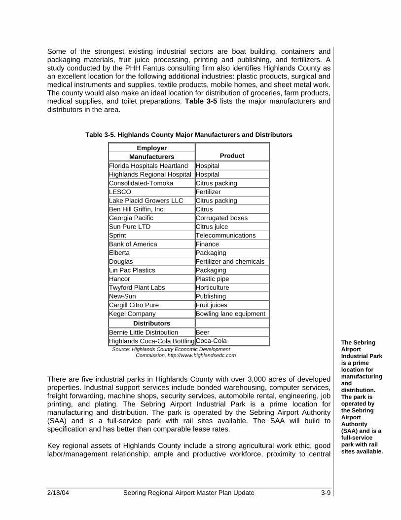
2/18/04 Sebring Regional Airport Master Plan Update 3-9
Some of the strongest existing industrial sectors are boat building, containers and packaging materials, fruit juice processing, printing and publishing, and fertilizers. A study conducted by the PHH Fantus consulting firm also identifies Highlands County as an excellent location for the following additional industries: plastic products, surgical and medical instruments and supplies, textile products, mobile homes, and sheet metal work. The county would also make an ideal location for distribution of groceries, farm products, medical supplies, and toilet preparations. Table 3-5 lists the major manufacturers and distributors in the area.
Table 3-5. Highlands County Major Manufacturers and Distributors
Employer Manufacturers Product
Florida Hospitals Heartland Hospital Highlands Regional Hospital Hospital Consolidated-Tomoka Citrus packing LESCO Fertilizer Lake Placid Growers LLC Citrus packing Ben Hill Griffin, Inc. Citrus Georgia Pacific Corrugated boxes Sun Pure LTD Citrus juice Sprint Telecommunications Bank of America Finance Elberta Packaging Douglas Fertilizer and chemicals Lin Pac Plastics Packaging Hancor Plastic pipe Twyford Plant Labs Horticulture New-Sun Publishing Cargill Citro Pure Fruit juices Kegel Company Bowling lane equipment
Distributors Bernie Little Distribution Beer Highlands Coca-Cola Bottling Coca-Cola
Source: Highlands County Economic Development Commission, http://www.highlandsedc.com
There are five industrial parks in Highlands County with over 3,000 acres of developed properties. Industrial support services include bonded warehousing, computer services, freight forwarding, machine shops, security services, automobile rental, engineering, job printing, and plating. The Sebring Airport Industrial Park is a prime location for manufacturing and distribution. The park is operated by the Sebring Airport Authority (SAA) and is a full-service park with rail sites available. The SAA will build to specification and has better than comparable lease rates. Key regional assets of Highlands County include a strong agricultural work ethic, good labor/management relationship, ample and productive workforce, proximity to central
The Sebring Airport Industrial Park is a prime location for manufacturing and distribution. The park is operated by the Sebring Airport Authority (SAA) and is a full-service park with rail sites available.
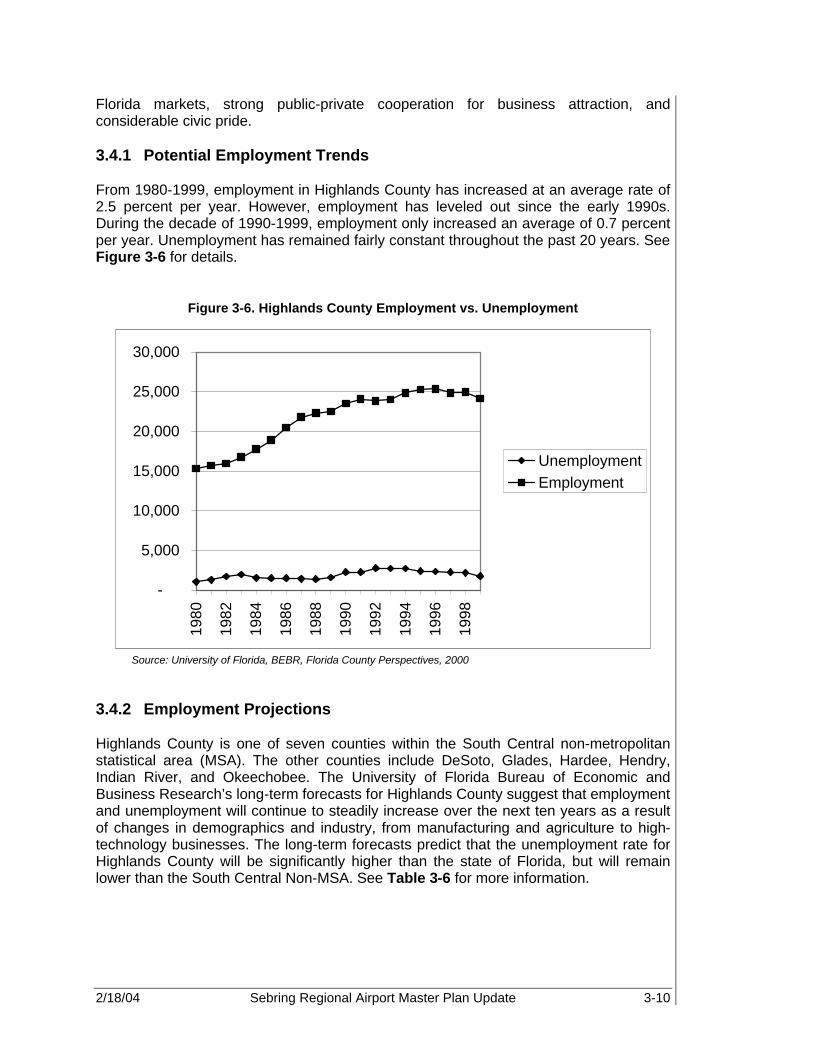
2/18/04 Sebring Regional Airport Master Plan Update 3-10
Florida markets, strong public-private cooperation for business attraction, and considerable civic pride. 3.4.1 Potential Employment Trends From 1980-1999, employment in Highlands County has increased at an average rate of 2.5 percent per year. However, employment has leveled out since the early 1990s. During the decade of 1990-1999, employment only increased an average of 0.7 percent per year. Unemployment has remained fairly constant throughout the past 20 years. See Figure 3-6 for details.
Figure 3-6. Highlands County Employment vs. Unemployment
-
5,000
10,000
15,000
20,000
25,000
30,000
1980
1982
1984
1986
1988
1990
1992
1994
1996
1998
UnemploymentEmployment
Source: University of Florida, BEBR, Florida County Perspectives, 2000
3.4.2 Employment Projections Highlands County is one of seven counties within the South Central non-metropolitan statistical area (MSA). The other counties include DeSoto, Glades, Hardee, Hendry, Indian River, and Okeechobee. The University of Florida Bureau of Economic and Business Research’s long-term forecasts for Highlands County suggest that employment and unemployment will continue to steadily increase over the next ten years as a result of changes in demographics and industry, from manufacturing and agriculture to high-technology businesses. The long-term forecasts predict that the unemployment rate for Highlands County will be significantly higher than the state of Florida, but will remain lower than the South Central Non-MSA. See Table 3-6 for more information.

2/18/04 Sebring Regional Airport Master Plan Update 3-11
Table 3-6. Employment Projections Comparing Highlands County, the South Central Non-MSA, and the State of Florida
1999 2000 2001 2005 2010 Highlands County Nonagricultural wage/salary jobs 19,500 20,000 20,400 21,800 23,500 Unemployment rate (%) 6.8 6.6 6.9 7.1 7.5 South Central Non-MSA Nonagricultural wage/salary jobs 90,300 92,600 94,600 102,300 111,200 Unemployment rate (%) 8.1 7.9 8.2 8.3 8.8 Florida Nonagricultural wage/salary jobs 6,876,800 7,074,800 7,205,600 7,838,100 8,597,200 Unemployment rate (%) 3.9 3.8 4.2 4.2 4.6
Source: University of Florida, BEBR, Florida Long-term Economic Forecast 2000, Volume 1 and 2 3.5 INCOME Per capita income is the most direct indicator of prosperity. The following table compares historical per capita income (PCPI) in Highlands County to PCPI for the state of Florida. During this 20-year historical period, the average per capita income in Highlands County has been increasing. However, the average per capita income is still less than the state average for that same time period. Table 3-7 shows historical income patterns for the county and the state.
Table 3-7. Historical Income Highlands County vs. Florida
Income 1980 1985 1990 1995 1999 Highlands Total personal income ($1,000) 421,106 719,786 1,139,979 1,452,882 1,721,412
Per capita personal income ($) 8,861 12,740 16,659 18,803 21,215
Florida Total personal income ($1,000) 98,881,848 166,949,255 258,479,049 333,525,354 423,755,500
Per capita personal income ($) 10,144 14,878 19,978 23,572 27,657
Source: University of Florida BEBR, Florida Long-term Economic Forecast 2000, Volume 1 and 2 According to the Florida County Perspectives, Highlands County ranks in the middle of the pack for incomes adjusted for price level index and non-farm values, but the county ranks number one in income from dividends, interest, and rent. In 1998, Highlands County recorded earnings of $699 million in comparison to the state’s reported earnings of $248.4 billion. The majority of earnings stem from wage and salary disbursements (70.4 percent), while portions are a result of proprietor’s income (20 percent) and other labor income (9.7 percent).

2/18/04 Sebring Regional Airport Master Plan Update 3-12
3.5.1 Income Projections Consistent with the population and employment projections, the University of Florida forecasts project income to grow steadily until 2005 with a substantial surge by the year 2010. Total Highland County income is projected to increase from $1.8 billion in 2000 to $2.9 billion in 2010, an average annual increase of 18 percent. This is slightly lower than the anticipated 22 percent of growth in statewide income. Refer to Table 3-8 for more details.
Table 3-8. Projected Income Highlands County vs. Florida
Projected Income 2000 2001 2005 2010 Highlands Total personal income (millions) 1,823 1,904 2,298 2,946 Per capita personal income (millions of 92 dollars) 20,921 21,318 22,801 25,122
Florida Total personal income (millions) 452,982 478,685 598,193 801,941 Per capita personal income (millions of 92 dollars) 25,426 25,992 28,054 31,426
Source: University of Florida, BEBR, Florida Long-term Economic Forecast 2000, Volume 1 and 2 3.6 SOCIO-ECONOMIC ACTIVITY An area’s socio-economic profile can have a direct relationship to the demand for aviation related services. The following sections describe the characteristics of the Sebring and Highlands County area. 3.6.1 Agriculture According to the University of Florida Bureau of Economic and Business Research data contained in the Florida Statistical Abstract 2000, there are 779 farms in Highlands County totaling 489,579 acres. The use of the farms varies from cropland, woodland, pastureland, integrated land, and miscellaneous. The average size of a farm in this area is 628 acres and the average market value per farm is approximately $1.2 million. Highlands County ranks fourth in the state of Florida for total citrus production, with 9.75 percent of the state total. The county ranks number one in the production of Valencia oranges, producing over 54.7 percent of the state’s Valencia orange crop. It is estimated that citrus production accounts for more than $200 million in annual economic benefits to the area. The greatest use of land area in Highlands County comes from the cattle industry. Over 60 percent of the total 700,000 acres of land in the county are used for cattle grazing. The county currently ranks second in the state of Florida for beef cattle, which includes 68,000 head of beef production brood cows that have calved at least once. Highlands County also ranks second in the state for total number of cattle of all classes, beef and dairy. There are over 112,000 total cattle grazing on over 425,000 acres of land (Florida
2/18/04 Sebring Regional Airport Master Plan Update 3-13
County Perspectives, 2000). The state of Florida markets over $480 million of cattle each year. Recently, Highlands County received over $31 million in annual gross sales for the more than 300 beef cattle producers (13). 3.6.2 Tourism Highlands County has 26 licensed hotels and motels providing a total of 1,256 units available for tourist rental. Rental condominiums and transient apartment buildings combine for approximately 640 available units. In addition, there are approximately 3,700 licensed recreational vehicle (RV) parking spaces and approximately five campgrounds available for tourists. There are also 157 food service establishments with a total seating volume of 13,800 people. In 2000, the highly touted, Chateau Elan Hotel and Spa opened its doors to the public. Chateau Elan features a four-story design located near the famous “hairpin turn” of the Sebring International Raceway. The lodge serves as the anchor facility for meetings, conferences, and racing and training programs. Chateau Elan Hotel and Spa was designed to recreate the tradition of the famous Chateau Elan, a five star resort near Road Atlanta in Georgia. The Lodge features a health spa, pool, and Jacuzzi, as well as an acclaimed restaurant. Tourists visit Highlands County for a variety of offerings. The county features approximately 50,000 acres of open water distributed among 72 pristine fresh water lakes, serving as excellent sites for many water sports. The oldest state park in Florida, Highlands Hammock State Park, is a 4,896 acre wildlife preserve that is filled with nature trails, camping, and picnic facilities. The county offers many heritage-based activities including ranch and grove tours, other wildlife preserves, and historical museums. A two-hour drive can take you to either coast of Florida or to major shopping areas north or south. Warm, fresh air offers a daily invitation to enjoy outdoor activities such as golf, fishing, tennis, boating, or simply relaxing. Recently, the Lake Placid community received honors as “Florida’s Outstanding Rural Community” and is known as the Caladium Capital of the World. Highlands County hosts two civic auditoriums with seating capacities of 250-350 people. There are 14 shopping centers and one regional mall in the area. The mile-long mall is located in Avon Park and is a focal point for year-round community activities, including the Annual Avon Park Mall Festival in March. The newly restored historic downtown Sebring hosts the Annual Arts Festival, one of the top-rated art shows in the state. Historical attractions include the Avon Park Museum, the Lake Placid Historical Museum, and the Sebring Historical Society’s Lakeside Archives. SEF plays a valuable role in the tourism industry, especially since the Sebring International Raceway is located within the Airport boundary. The Raceway is one of America’s oldest and most famous road racing tracks and is the mecca of sports car racing, hosting the famous 12 Hours of Sebring endurance auto race every March. Each year, nearly 100,000 people from all over the world attend this race. The raceway also hosts the Historic Sports Car Race, Trans-Am series racing, Panoz Racing School, Skip Barber Racing School, and a wide variety of daily testing by some of the biggest names in racing, corporate events, club races, and driving schools. The raceway pumps thousands of dollars into the local economy and helps make the name Sebring known throughout the world as one of the greatest motor sport racing facilities.

2/18/04 Sebring Regional Airport Master Plan Update 3-14
3.6.3 Other The Avon Park Air Force Range also shares territory within the borders of Highlands County and Polk County, approximately nine miles east of the city of Avon Park and 95 miles east of MacDill Air Force Base. The 106,000-acre facility is the world’s largest bombing and gunnery range east of the Mississippi River. By landmass, the range is the second largest military installation in Florida after Eglin Air Force Base. The range has been a partner in the growth of Highlands County since its installation in 1942. It has been instrumental in the training of aircrews for combat duty in World War II, the Cold War, Korea, Vietnam, Southeast Asia, Operation Just Cause in Panama, the Gulf War, Operation Urgent Fury in Grenada, Operation Restore Democracy in Haiti, and the Kosovo Air Campaign (14). The range continues to serve as an important training facility for active and reserve military units as well as providing other non-operational programs, which substantially contribute to the Highlands County economy. The range provides a unique example of dual land use enhancing the economy through operational expenses and job creation. According to the Year 2000 Economic Impact Analysis, the range provides an economic impact of approximately $70 million and creates a total of 1,294 jobs in the community (15). The range’s expansive area and remote location make the facility an excellent training location for the military’s new Air Expeditionary Force (AEF) concept. AEF is an operational training technique for teaching controlled, crisis management in the early stages in unfamiliar environments. Also, the Air Force Reserves have examined the possibility of developing a coordinate search and rescue training operation for both air and ground troops. This activity could potentially yield an undetermined number of full-time positions at the range and bring over 900 military personnel into the community for training annually (16). 3.7 TRANSPORTATION The existing transportation network of the region is another factor that is important in the assessment of development potential of the Airport. Highlands County, one of the most centrally located counties in Florida, takes full advantage of the state’s transportation systems. U.S. Highway (US) 27, US 98, and state road 70 cross Highlands County and provide ready access to I-4, I-75, I-95, and the Florida Turnpike. Highlands County is well served by various modes of transportation. The county hosts a number of major carriers of interstate and intrastate motor freight. Greyhound Bus Lines serves all three incorporated cities and Annett Travel provides local transportation service, as well as chartered bus travel in the area. Railroad freight service, provided by CSX Transportation, Inc., includes sidetrack service to several industrial areas. Passenger service is provided by Amtrak, which has scheduled arrivals and departures from Sebring.
2/18/04 Sebring Regional Airport Master Plan Update 3-15
3.8 OTHER FACTORS Sebring and Highlands County is a community where progress is at the center of attention by local civic, business, and government leaders. Since Highlands County is a community planning for the future, it offers an outstanding business climate. The Economic Development Commission of Highlands County (EDC), in cooperation with the Private Industry Council, the Heartland Workforce Development Board, the Wages Program, and the County Planning Department, work diligently to support the interests of expanding and attracting new business and industry to the area. Highlands County showcases a wide variety of assets, which attract industry to the area. There are considerable cost savings for labor-intensive business and industry, as well as low manufacturing and clerical wages. The county is also known as a provider of a low cost of living, especially in regards to land and housing, and a wealth of civic pride. Overall, Highlands County has an accommodating tax structure, sizable labor pool, close proximity to other Florida markets, and strong public/private cooperation for business attraction. Also, local developers will build to suit with attractive lease or purchase options. Of the 701,709 acres in Highlands County, 3,500 acres are zoned for industrial development. A survey, conducted by the International Trade Commission, found that the presence of a foreign trade zone (FTZ) was the fourth most identifiable factor in plant site location decisions. FTZ’s provide customs services at a cost savings and encourage improved inventory control. Through the use of FTZ’s, U.S.-based production is placed on more equal footing with production in a foreign country. In addition, FTZ’s have had a significant impact in retaining U.S. production and employment as well as stimulation of new activity. One such development is the Sebring Airport Industrial Park. The SEF’s entire 2,000-acre area is designated as Foreign Trade Zone #215 and is a prime location for manufacturing and distribution. The full-service park is operated by the SAA and rail service is readily available. Many businesses are engaged in foreign trade within Foreign Trade Zone #215, which was authorized by the U.S. Department of Commerce’s Foreign Trade Zones Board in 1997. Two enterprise zones on the Airport offer excellent incentives to businesses, including development incentives, accommodating tax climate and tax credits, and a low cost of living. The SAA makes the State of Florida's Community Redevelopment incentives program available to businesses that choose to locate at the Sebring Industrial Park. In 1996, Sebring Regional Airport & Industrial Park property was designated as a Florida Community Redevelopment Area, thus giving SAA and its Community Redevelopment Agency (CRA) the ability to provide financing assistance and other incentives to businesses leasing land and building facilities on the Airport and industrial park property. These incentives may include offsetting or deferring lease payments through the use of the Authority's CRA's Tax Increment Trust Fund, or loans to assist in financing site improvements, parking lot construction, and special infrastructure needs. As mentioned previously, Highlands County offers a range of tax incentives to businesses that locate and create new jobs within its Rural Enterprise Zone. These incentives consist of sales and use tax credits, including, but not limited to, a sales tax refund on business machinery, equipment, and building materials purchased for use in
Sebring and Highlands County is a community where progress is at the center of attention by local civic, business, and government leaders.

2/18/04 Sebring Regional Airport Master Plan Update 3-16
the enterprise zone. The Qualified Target Industry Tax Refund (QTI) program provides an inducement for target industry to locate new facilities in Florida or expand existing facilities in Florida. The program provides tax refunds of $3,000 per new job created. This incentive is increased to $6,000 per job, if the company locates in a rural county or enterprise zone. Higher awards are available to companies paying very high wages. To qualify for the QTI program, a company must create at least ten new jobs (or a 10 percent increase for expanding Florida companies), pay at least 15 percent above the average area wage, have a significant positive impact on the community, and have local support (17). Other enterprise zone incentives available for new or expanded businesses include a credit or corporate income tax equal to 96 percent of ad valorem taxes paid up to a maximum of $50,000 annually, if 20 percent or more of employees reside in the enterprise zone. The credit is limited to $25,000 annually, if less than 20 percent of employees reside in the zone. Currently, the Jobs Tax Credit incentive offers a tax credit of 10 percent of monthly wages for new hires, with an increase to 15 to 20 percent if employees are residents of the enterprise zone. The tax credit may be taken against corporate income tax or sales and use tax. Beginning in January 2002, businesses located within the enterprise zone will also receive a higher tax credit for a longer period when creating new jobs and hiring zone residents. The base Job Tax Credit will be 30 percent of monthly wages for new jobs created in a rural enterprise zone. The length of the credit is extended to 24 months, if the employee is employed for 24 months. Businesses located in a rural enterprise zone will also become eligible to receive the base Jobs Tax Credit for hiring any person living in a rural county. There are other economic indicators associated with Highlands County, as well. The total value of building permits in 1998 was $69.5 million and taxable sales were approximately $645 million. The cost of living in Highlands County is slightly lower than the national average and the state of Florida with a price level index of 93.22. Members of the financial community actively support the Highlands County Economic Development Commission in recruiting new business and industry and encouraging the expansion of the existing businesses and industries. Members of the financial community include Big Lake National Bank, Wauchula State Bank, First Union National Bank, Highlands Independent Bank, Huntington National Bank, Sun Trust Bank, Bank of America, Heartland National Bank, Community Bank, and Mid Florida Schools Federal Credit Union. Funds are readily available for a number of commercial purposes including site acquisitions, construction, purchase of machinery and equipment, and obtaining working capital through state and federal agencies. Additionally, the Board of Commissioners of Highland County, in support of economic development, established the Highlands County Industrial Development Authority, which provides for industrial revenue bond financing (18). 3.9 AVIATION INDUSTRY FACTORS Although socioeconomic factors are an important determinant of passenger demand, the future structure of the aviation industry will also have a major impact on the level and type of activity and how that activity is translated into aircraft operations. Factors include average aircraft size, load factor, operations, military operations, fueling, and potential

2/18/04 Sebring Regional Airport Master Plan Update 3-17
development in the regional carrier industry, and potential trends in air cargo and GA (to be discussed in Chapter 4). 3.10 SUMMARY A variety of historical and forecast socioeconomic information related to the City of Sebring and Highlands County has been collected for use in various elements of the Master Plan. This combined information is essential to determining air transportation service level requirements, as well as forecasting the number of based aircraft and operations at the Airport. These forecasts are normally keyed to the economic strength of the region and its ability to sustain a strong economic base over an extended period of time. This type of data provides valuable insight into the trends and character of the community as well as highlighting market opportunities for the Airport itself.

2/18/04 Sebring Regional Airport Master Plan Update 4-1
HISTORICAL AVIATION ACTIVITY STATISTICS Sebring Regional Airport Historical aviation data for the Sebring Regional Airport (SEF) is evaluated in this chapter in order to provide a reliable baseline for potential future demand. As part of this analysis, such trends as based aircraft, annual operations, peaking characteristics, itinerant aircraft parking, general aviation (GA) passengers, automobile parking, and fuel sales will be evaluated. The intent of this analysis is to provide a baseline upon which future aviation demand and activity may be modeled, and thus, determine a feasible development plan. 4.1 BASED AIRCRAFT The number of based aircraft at an airport facility is dependant upon availability of storage facilities, fuel, and repair stations, as well as the number of active pilots found in the region served by the Airport. In the case of SEF, based upon 2001 Federal Aviation Administration (FAA) Master Records (5010 Forms), 84 aircraft, including one helicopter and eight ultralights, are based at the Airport. The number and type of based aircraft at SEF compared to other airports will give Airport management and local, regional, and state planning officials a reflection of overall Airport performance. Table 4-1 lists the number of based aircraft by type at SEF over the past ten years.
Table 4-1. Based Aircraft (1990-2001)
Piston Turbine
Year Single Engine
Multi-Engine
Turbo Prop
Jet Helicopter Ultralight
Total Aircraft
1990 26 6 0 0 0 0 32 1991 28 7 0 0 2 0 37 1992 40 3 0 0 0 0 43 1993 30 9 0 0 0 4 43 1994 30 9 0 0 1 3 43 1995 30 9 0 0 1 3 43 1996 37 12 0 0 1 4 54 1997 57 18 0 0 1 8 84 1998 57 18 0 0 1 8 84 1999 57 18 0 0 1 8 84 2000* 57 18 0 0 1 8 84 2001* 57 18 0 0 1 8 84
Source: *Sebring Regional Airport Records, FAA 5010 Forms (Years 2000 and 2001) Sebring Master Plan Update, 1994 (Years 1991 & 1992), PBS&J FAA/Terminal Area Forecast (TAF), 2001 (Years 1993-1999)
The intent of this analysis is to provide a baseline upon which future aviation demand and activity may be modeled, and thus, determine a feasible development plan.
4

2/18/04 Sebring Regional Airport Master Plan Update 4-2
4.2 ANNUAL AIRCRAFT OPERATIONS 4.2.1 Local GA Operations According to FAA Advisory Circular (AC) 150/5070-7, local operations are “arrivals and departures of aircraft which operate in the local traffic pattern or within sight of the tower and are known to be departing for, or arriving from, flights in local practice areas within a 20-nautical mile radius of the airport and/or tower”. An analysis of local GA operations provides a snapshot of development as well as a baseline for future projections, which will be discussed in later sections. The information on local operations at SEF was gathered from the FAA’s Airport Master Record (Form 5010) data, Terminal Area Forecasts, and Sebring Airport Authority (SAA) Data. Conflicts between these reports were noted for the years 1996 through 2001. For forecasting purposes, this anomaly was adjusted, in a later section, to represent a trend over time. Local GA operations are represented in Table 4-2.
Table 4-2. Local GA Operations
Year Local GA Operations 1990 4,500 (1) 1991 8,000 (1) 1992 13,000 (1) 1993 13,000 (2) 1994 13,000 (2) 1995 13,000 (2) 1996 20,500 (3) 1997 13,000 (3) 1998 27,500 (3) 1999 28,875 (3) 2000 30,375 (3) 2001 31,549 (4)
Source: (1) FAA Master Record 5010 (1989-1992), (2) FAA TAF, 2001 (3) Sebring Regional Airport Statistics, and (4) FAA Master Record, Form 5010, 2001
4.2.2 Itinerant GA Operations All operations that do not involve aircraft that are currently based at SEF are considered itinerant. Itinerant operations for SEF are based upon historical FAA 5010 forms, Sebring Regional Airport Authority Data, and Terminal Area Forecast (TAF) information. Like the local GA operations data, conflicts were noted between the historical FAA TAF data and the SAA data, especially for the years 1996 through 1998. This appears to be a reporting anomaly, and therefore, will be reviewed during the trend forecast analysis in later sections. (See Table 4-3.)

2/18/04 Sebring Regional Airport Master Plan Update 4-3
Table 4-3. Itinerant GA Operations
Year Itinerant GA Operations 1990 15,000 (1) 1991 19,500 (1) 1992 22,500 (1) 1993 22,500 (2) 1994 21,000 (2) 1995 21,000 (2) 1996 25,200 (3) 1997 23,000 (3) 1998 32,200 (3) 1999 34,238 (3) 2000 35,835 (3) 2001 42,610 (4)
Source: (1) FAA Master Record 5010 (1990-1992), (2)FAA TAF, 2001 (1992-1995) (3) Sebring Regional Airport Statistics (1996-2000) (4) FAA Master Record 5010, 2001 (www.gcr1.com/5010forms)
4.2.3 Military Operations Military operations at SEF are considered itinerant since military aircraft are not based at SEF facilities. Because of a special fueling contract with the U.S. Department of Defense and with Avon Park Air Force Range, military operations occur with great frequency at SEF. In addition, the SAA staff is one of only two civilian groups in the country trained to “hot fuel” military helicopters. Military operations at SEF are denoted in Table 4-4.
Table 4-4. Military Operations
Year Military Operations 1990 500 (1) 1991 500 (1) 1992 500 (1) 1993 500 (2) 1994 500 (2) 1995 500 (2) 1996 2,500 (3) 1997 500 (3) 1998 2,000 (3) 1999 1,000 (3) 2000 1,000 (3) 2001 500 (4)
Source: (1) FAA Master Record 5010 (1990-1992), (2)FAA TAF, 2001 (1992-1995) (3) Sebring Regional Airport Statistics (1996-2000) (4) FAA Master Record 5010, 2001 (www.gcr1.com/5010forms)

2/18/04 Sebring Regional Airport Master Plan Update 4-4
4.2.4 Helicopter Operations The majority of helicopter operations at SEF are associated with AeroMED (Tampa General Health Care), a Level I trauma unit specializing in air transport. AeroMED has been based at SEF since 1994. The unit uses one BK117-B Eurocopter, and averages 650 operations annually. 4.2.5 Instrument Operations At SEF, Runway 36 is equipped with a 4-light precision approach path indicator (PAPI-4) and is designed for a global positioning system (GPS) non-precision instrument approach. Current FAA TAF data reports instrument flight rules (IFR) activity to be less than 1,000 operations annually, and is, thus, reported as zero. However, NOAA climatic data shows that IFR weather occurs approximately five percent of the time. Therefore, this percentage will be used to forecast instrument operations through the planning period. The potential for additional precision and non-precision approaches are currently being considered, and are dependent upon the type of aircraft and potential number of IFR operations forecast for SEF. This will be discussed in more detail in later sections. 4.3 PEAK OPERATIONS During the year, aircraft operations may have periods of heightened activity. These peak periods may be associated with a one-time event, a yearly scheduled event, or multiple factors that may coincide. These peak periods, which may occur on a regular basis, are often times caused by external influences in the region and market areas. Possible influences could be the warm weather conditions, increased military activity, air shows, festivals, or sporting events. Typically, SEF’s peak period occurs during the spring, and usually coincides with the 12 Hours of Sebring International Grand Prix of Endurance Race. However, other smaller peaks in activity, historically, have been associated with the Highlands County Annual Arts Festival, the Hendrick’s Field Air Fest, the Sebring Aerobatics Championship, and the Sebring Speed Fest. Due to the lack of an operating air traffic control tower (ATCT) on the airfield, except during March, which coincides with the Sebring International Raceways sporting events, peak operations were determined through the evaluation of available fuel records. Through discussions with the SAA and Sebring Flight Center and an analysis of fuel receipts, the peak period of aircraft activity at SEF was determined to be February through September. Based upon this information, the month of March appears to be the busiest month for GA activity at SEF while July seems the busiest month for military activity. By utilizing the peak percentage of fuel sales for these months, peak operations were calculated to be approximately 58 percent higher than that of an average month during the year. This equates to a total of 9,835 operations during the peak month in 2001. The average day was obtained by dividing the peak month by the average days in a month (approximately 30.42). The peak hour was calculated by determining 12 percent of the average day of the peak month. By utilizing this formula, the peak hour at SEF for 2001 was 39 operations. (See Table 4-5.) Peak operations will be forecast through the 20+-year planning period and discussed in greater detail in Chapter 5.
Typically, SEF’s peak period occurs during the spring, and usually coincides with the 12 Hours of Sebring International Grand Prix of Endurance Race.

2/18/04 Sebring Regional Airport Master Plan Update 4-5
Table 4-5. Historical Peak Hourly Operations
Year Total Operations
Peak Monthly
Operations Peak Daily Operations
Peak Hourly Operations
1991 28,000 3,689 121 15 1992 36,000 4,743 156 19 1993 36,000 4,743 156 19 1994 34,500 4,545 149 18 1995 34,500 4,545 149 18 1996 48,200 6,350 209 25 1997 36,500 4,808 158 19 1998 61,700 8,128 267 32 1999 64,113 8,446 278 33 2000 67,210 8,854 291 35 2001 74,659 9,835 323 39
Source: SEF MPU, 1994 (Years 1991-1992) FAA TAF, 2001 (Years 1993-1995) SAA 5010 Forms, 2001 (Years 1996-2001) Note: Monthly peak of 58.08% ~58.1% based upon fuel sales (28,211.1 - 17,845.6 / (28,211.1))
4.4 AIRCRAFT PARKING Based and itinerant aircraft at SEF currently share the 122,210 sq yd (approximately 1.1 million square feet) of available apron space. It is estimated that 12 percent of based aircraft and one half of the busy hour itinerant aircraft will require tie-down space at any one time. By applying this formula, approximately 10 based aircraft and 11 itinerant aircraft currently require apron tie-down space. (See Table 4-6.) Future aircraft parking requirements will be discussed in more detail in later sections.
Table 4-6. Historical Aircraft Parking Demand
Year Peak Hour Operations Based Aircraft
Parking Itinerant Aircraft
Parking 1991 15 4 5 1992 19 5 6 1993 19 5 6 1994 18 5 6 1995 18 5 6 1996 25 6 7 1997 19 10 6 1998 32 10 9 1999 33 10 9 2000 35 10 10 2001 39 10 11
Source: Sebring Airport Authority and PBS&J, 2002

2/18/04 Sebring Regional Airport Master Plan Update 4-6
4.5 GENERAL AVIATION PASSENGERS AND AUTOMOBILE PARKING 4.5.1 GA Passengers A record of GA passengers for SEF does not currently exist. Therefore, based upon the level and type of operations, an estimate of the current level of GA passengers was determined. This was accomplished utilizing the typical load carried by the GA fleet as published in the FAA’s aviation economic guidelines, Estimating the Economic Impact of Airports. Standards set forth in this document establish a guideline of three passengers per itinerant operations and 0.9 passengers per local operation. Table 4-7 and Figure 4-1 illustrate the estimated level of GA passenger activity at SEF from 1990 to 2001.
Table 4-7. General Aviation Passengers
Year Local
Operations Local
Passengers Itinerant
Operations Itinerant
Passengers Total
Passengers 1990 4,500 4,050 15,000 45,000 49,050 1991 8,000 7,200 19,500 58,500 65,700 1992 13,000 11,700 22,500 67,500 79,200 1993 13,000 11,700 22,500 67,500 79,200 1994 13,000 11,700 21,000 63,000 74,700 1995 13,000 11,700 21,000 63,000 74,700 1996 20,500 18,450 25,200 75,600 94,050 1997 13,000 11,700 23,000 69,000 80,700 1998 27,500 24,750 32,200 96,600 121,350 1999 28,875 25,988 34,238 102,714 128,702 2000 30,375 27,338 35,835 107,505 134,843 2001 31,549 28,394 42,610 127,830 156,224 Source: Sebring Regional Airport, FAA 5010 Forms, FAA TAF, 2002 and PBS&J, 2002
Figure 4-1. General Aviation Passengers
General Aviation Passengers
0
20,000
40,000
60,000
80,000
100,000
120,000
140,000
1990
1991
1992
1993
1994
1995
1996
1997
1998
1999
2000
2001
Years
Pas
sen
ger
s
Local Passengers
Itinerant Passengers

2/18/04 Sebring Regional Airport Master Plan Update 4-7
4.5.2 Auto Parking The main automobile parking lot at SEF is located adjacent to the Sebring Airside Terminal Building. This main lot has approximately 100+ spaces available that may be used for public parking. Parking associated with various tenants and T-hangar facilities are located adjacent to those tenant facilities. Based upon the estimated GA passenger data, previously discussed, and a planning factor of 1.3 parking spaces for a busy hour passenger, approximately 92 parking spaces are currently required to meet 2001 passenger demand. (See Table 4-8.) Forecasts, which may affect automobile parking and other Airport facilities, will be discussed in detail in later sections.
Table 4-8. Historical Automobile Parking Demand
Year
Peak Hour Total
Operations
Peak Hour Itinerant
Operations
Peak Hour Local
Operations Total
Passengers
Total Automobile
Parking Demand
1991 15 10 5 34 44 1992 19 12 7 42 55 1993 19 12 7 42 55 1994 18 11 7 39 51 1995 18 11 7 39 51 1996 25 14 11 52 68 1997 19 12 7 42 55 1998 32 18 14 67 87 1999 33 18 15 68 88 2000 35 19 16 71 92 2001 39 23 16 83 108
Source: Sebring Regional Airport 5010 Forms and PBS&J, 2002 4.6 FUEL SALES Sebring Regional Airport is a designated Foreign Trade Zone (FTZ #215). Therefore, fuel purchased at the Airport for offshore flights is not subject to some taxes, resulting often times in a significant cost savings. The fuel farm is owned and by SAA and is distributed by the Sebring Flight Center. No other tenant is allowed to sell fuel on-Airport to the public. The fuel farm is located due south of the Sebring Regional Airside Center and consists of two aboveground 10,000-gallon tanks equipped with meters, filters, and emergency shut-off systems. In addition, the Airport has one 750-gallon Avgas truck, three 5,000-gallon Jet A trucks, and one 1,200-gallon Jet A truck. In addition, as mentioned previously, SAA has a special fueling contract with the U.S. Department of Defense and with Avon Park Air Force Range. Through negotiations, SAA contracts with Defense Energy Support Center (DESC) to provide fuel at a variable rate. The fuel farm’s location within FTZ #215 also allows for additional purchase incentives.

2/18/04 Sebring Regional Airport Master Plan Update 4-8
Sebring Flight Center fuel records show reoccurring fuel purchase peaks during the months of February through April, and again in August through October. These peaks are denoted in Table 4-9, which depicts historical fuel sales as reported by the Sebring Flight Center and Sebring Airport Management. 4.7 STATISTICAL SUMMARY SEF has seen fluctuations of based aircraft and operations over the past fifteen years. However, both based aircraft and GA activity has, on average, increased at a steady growth rate. The increase in based aircraft is the direct result of the construction of new hangar facilities and the Sebring Airside Terminal Center. Various improvements at SEF have allowed the Airport to become an economic generator for the City of Sebring and Highlands County. Since the Airport is host to a variety of events, such as: the Sebring Aerobatic Championship, Hendricks Field Airfest, Historic Sports Car Racing, Sebring Speed Fest, as well as the most famous, The 12 hours of Sebring Endurance Challenge, it is well-positioned for future growth. The Airport provides a unique resource to the county since it is designated as an FTZ, it maintains a fueling contract with the Department of Defense, and it is home to the AeroMED Level I Trauma Unit. Based upon these factors, it appears that growth at SEF will continue, requiring additional Airport facility and capacity enhancements. Table 4-10 presents a summary of the statistics identified in this section. These statistics will provide the baseline for the 20+-year forecasts, which are discussed in Chapter 5.

2/18/04 Sebring Regional Airport Master Plan Update 4-9
Table 4-9. Monthly Fuel Sales
1999 2000 2001 AVGAS JET A MIL JET TOTAL AVGAS JET A MIL JET TOTAL AVGAS JET A MIL JET TOTAL
January 5,097.8 11,749.0 2,756 19,602.8 5,246.60 7,627.0 101,094 113,967.6 5,674.7 11,754.1 2,521.0 19,949.8 February 6,006.3 6,349.2 8,749 21,104.5 6,313.63 11,423.7 8,071 25,808.3 9,248.8 11,901.3 3,851.0 25,001.1 March 7,683.4 21,679.1 12,191 41,553.5 5,050.90 26,083.6 5,351 36,485.5 8,013.9 19,905.2 292.0 28,211.1 April 10,037.1 7,345.3 782 18,164.4 7,606.20 7,419.0 0 15,025.2 10,974.5 7,759.5 223.0 18,957.0 May 4,841.8 9,557.1 1,966 16,364.9 4,644.90 11,378.0 5,419 21,441.9 8,150.1 6,322.5 432.0 14,904.6 June 3,436.2 6,276.9 3,264 12,977.1 4,870.70 10,978.4 0 15,849.1 4,855.9 6,204.0 200.0 11,259.9 July 4,584.2 6,486.2 471 11,541.4 4,350.52 7,360.8 872 12,583.3 4,915.3 3,265.3 11,261.0 19,441.6 August 3,400.6 5,935.4 2,974 12,310 5,285.30 4,149.5 90 9,524.8 5,757.2 5,512.8 3,136.0 14,406.0 September 2,980.5 4,030.8 0 7,011.3 5,241.50 7,539.9 0 12,781.4 4,778.8 3,700.3 0.0 8,479.1 October 6,096.2 7,942.8 169 14,208.0 5,419.60 6,170.6 0 11,590.2 --- --- --- --- November 7,251.4 5,158.8 1,657 14,067.2 7,481.90 10,223.3 0 17,704.6 --- --- --- --- December 4,043.5 10,645.2 659 15,347.7 5,503.90 13,314.1 2,189 21,007.0 --- --- --- ---
Total 65,459.0 103,155.8 35,638.0 204,252.8 67,015.70 116,128.0 123,086.0 313,768.9 62,369.2 76,325.0 21,916.0 160,610.2 Source: Sebring Regional Airport and Sebring Flight Center Records, 1999, 2000, and January to September 2001.
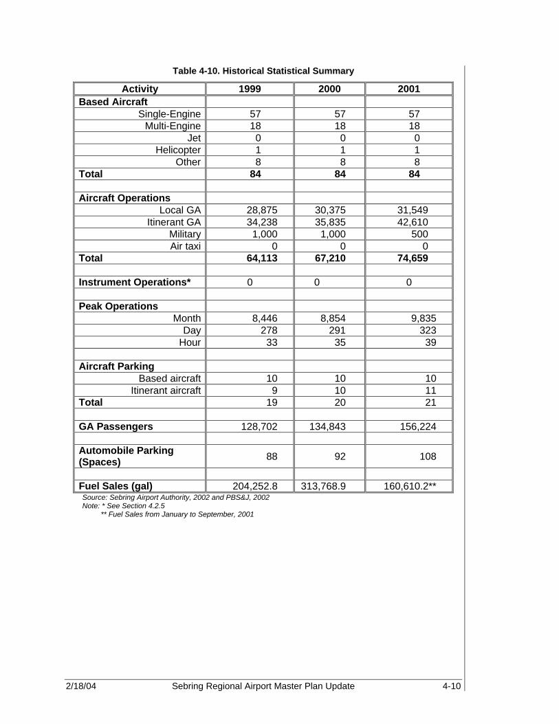
2/18/04 Sebring Regional Airport Master Plan Update 4-10
Table 4-10. Historical Statistical Summary
Activity 1999 2000 2001 Based Aircraft
Single-Engine 57 57 57 Multi-Engine 18 18 18
Jet 0 0 0 Helicopter 1 1 1
Other 8 8 8 Total 84 84 84 Aircraft Operations
Local GA 28,875 30,375 31,549 Itinerant GA 34,238 35,835 42,610
Military 1,000 1,000 500 Air taxi 0 0 0
Total 64,113 67,210 74,659 Instrument Operations* 0 0 0 Peak Operations
Month 8,446 8,854 9,835 Day 278 291 323
Hour 33 35 39 Aircraft Parking
Based aircraft 10 10 10 Itinerant aircraft 9 10 11
Total 19 20 21 GA Passengers 128,702 134,843 156,224 Automobile Parking (Spaces) 88 92 108
Fuel Sales (gal) 204,252.8 313,768.9 160,610.2** Source: Sebring Airport Authority, 2002 and PBS&J, 2002 Note: * See Section 4.2.5 ** Fuel Sales from January to September, 2001
2/18/04 Sebring Regional Airport Master Plan Update 5-1
PROJECTION OF AVIATION DEMAND Sebring Regional Airport 5.1 INTRODUCTION An Airport Master Plan provides an estimate of activity from which future facility needs will be determined for the 20+-year planning period. Projections of aviation demand are an important element of the Sebring Regional Airport (SEF) Master Plan Update, as these projections provide the basis for:
• Determining the Airport’s future role regarding the types of aircraft that may need to be accommodated as well as the overall type of future demand.
• Evaluating the capacity of existing Airport facilities to meet projected aviation demand.
• Estimating the type and size of airside and landside facilities required in future years. The forecast items will include based aircraft, annual aircraft operations, peak month, day, and hour operations, fuel sales, instrument approach and operations activity, itinerant aircraft parking, and general aviation (GA) passengers and auto parking. The forecast information will be used to determine the facility requirements at SEF from an aviation demand and capacity analysis of the forecasted activity in relation to the existing airfield conditions and services. This analysis and facility recommendations will be discussed in later sections. This chapter provides projections of activity at the Airport from 2000 (baseline year) through the year 2021. The assumptions underlying the activity projections are documented throughout this chapter. 5.1.1 Objective The object of the activity forecasts is to estimate, in a logical manner, the anticipated growth and future Airport activity at SEF. These forecasts provide a guide for the future development of airport facilities in order to ensure that safe and efficient operational capacity is achieved. The forecasts are based upon a number of historic and current sources, which were acquired through previous aviation forecasts and databases, as well as objective and subjective techniques, in order to assess potential growth at SEF and in the regional market area. The forecasts will present annual information from the base year of 2000 to the end of the forecast period (2021). The year 2000 was chosen as the base year for the forecast assumptions due to the events of the September 11 terrorist attacks and the resulting aftermath. The historic 2001-year data, which is denoted in DOT Form 5010, states that SEF’s annual operations for the year would be 74,659. This information appears unlikely since GA operations, which comprise the majority of aviation activity, were grounded for approximately one week. However, the Federal Aviation Administration (FAA) determined that this incident is not expected to have a mid- or long-term effect on aviation performance. Therefore, in order to obtain a realistic estimate of forecast growth at SEF to develop future capacity requirements, the year 2000 historical data would best demonstrate the operations at SEF through the year 2021.
The object of the activity forecasts is to estimate, in a logical manner, the anticipated growth and future Airport activity at SEF. These forecasts provide a guide for the future development of airport facilities in order to ensure that safe and efficient operational capacity is achieved.
5

2/18/04 Sebring Regional Airport Master Plan Update 5-2
5.1.2 Methodology Various methods of forecasting aviation demand exist and are widely used throughout the industry. The FAA and other government agencies recommend that airports establish positive correlations with the communities they serve. SEF is equipped with a non-functional tower, which is used primarily during racing events, and, therefore, cannot provide accurate historical data of aircraft operations. There is, however, a mechanical counter that tracks movement on the airfield, but this information is limited. Therefore, a relationship between socioeconomic factors and local, state, and national aviation operations was established in order to develop future projection of aviation activity at the Airport. The resulting socio-economic factors were then compared to SEF operations as recommended in the GRA, Inc. Model for Estimating General Aviation Operations at Non-Towered Airports (prepared for Statistics and Forecast Branch, FAA), using a number of statistical methodologies, such as ratio analyses, market share analyses, regression techniques, and annual average growth rates (AAGR). Previous forecasts and their accuracy over time will also be considered in identifying historical trends and their relation to national, state, and local socioeconomic and aviation activities. These methods have been applied to develop accurate forecasts at SEF and will be discussed in greater detail throughout this chapter. Additionally, the activity forecasts in this section have been developed in accordance with the standards and guidelines set forth in FAA Advisory Circulars 150/5070-7 and 150/5300-13 Change 6, Forecasting Aviation Activity By Airport, FAA, 2001, the Florida Department of Transportation (FDOT) Guidebook for Airport Master Planning, and other applicable federal and state publications. 5.1.2.1 External Factors – September 11, 2001 As a direct result of the events of the September 11, 2001 terrorist attacks and the resultant economic recession and downturn in world economic activity, the FAA aviation forecasts predict slower growth in the demand for aviation products and services than was previously published. In addition, these recent events have also increased the risk and uncertainty of both short- and long-term forecasts. FAA GA forecasts rely heavily on analysts’ judgments and expert opinions with regard to the expected impacts as well as the timing of the recovery from these events. In addition, GA aircraft were grounded due to FAA “No Fly” zone restrictions imposed on the operation of aircraft in particular security sensitive areas of the country. Many flight schools also curtailed pilot training as new restrictions were imposed. At SEF, the events of September 11th curtailed operations for approximately one week. According to Sebring Flight Center records, the local FBO, three aircraft operations were recorded on September 11 prior to the FAA airspace shutdown. No aircraft operations were recorded again until September 16th. In addition, when comparing AvGas sales for the first six months of 2001 and 2000, AvGas fuel sales were up by approximately 32.79 percent. Yet, when reviewing fuel sale records for the month of September 2001 and 2000, a significant drop in both AvGas and Jet A fuel sales was revealed, which coincides with the grounding of the GA fleet.

2/18/04 Sebring Regional Airport Master Plan Update 5-3
According to the FAA Office of Aviation Policy and Plans, GA operations nationwide are in a decline, especially among the piston aircraft fleet. However, the one bright spot for GA, according to the FAA, is the business/corporate segment of the industry with the increased growth of fractional ownership. It appears that the fallout from September has spurred interest in fractional and corporate aircraft ownership, thus, providing new growth opportunities (19). In the case of SEF, based upon information received from the Sebring Flight Center and SAA, aircraft operations have remained robust throughout the last quarter of 2001 and first quarter of 2002. This is directly attributed to SEF’s corporate, military, and experimental aircraft activity as well as its lack of flight training. Since the Airport is marketing itself to both corporate/fractional owners and potential commuter airlines, it is anticipated that growth at SEF will increase steadily over the 20+-year planning period. Because the historical data for the year 2001 is skewed as a result of the events of September 11th, it was determined that the year 2000 would be a more accurate base year for the 20+-year forecast period. In the short-term, the forecasts may not match recorded information for the years 2002 and 2003. However, in the mid- to long-term the forecasts for the Airport will be more reliable. 5.2 FORECAST OF BASED AIRCRAFT The following database forecasts were used in determining the forecast of based aircraft information at SEF:
• Florida Aviation System Plan (FASP), 1999-2021 • Airport Master Plan, 1994 • FAA Terminal Area Forecast (TAF), 2001 • Fiscal Years 2002-2013, FAA Aerospace Forecasts The following statistical methods, as recommended by the FAA’s Forecasting Aviation Activity By Airport methodology, were used to obtain individual forecast projections and develop a range of forecast possibilities:
• Ratio Analysis • Regression Analysis on Socio-Economic Trends • Market Share Analysis. The primary forecast variable for Sebring Regional Airport is fuel sales since they offer the most reasonable, and complete records. Most other forecasts can be derived from projected growth in this variable. Additionally, ratio analyses of national, state, and regional based aircraft; national, state, and county populations; and national, state, and county pilot populations were used to select the most accurate forecast. Before forecasting based aircraft, historical information was gathered and verified through the use of FAA TAF and Airport Master Record (5010) documentation. These documents represent based aircraft numbers at SEF, as reported to the FAA from 1990 to the time of this writing. Historical based aircraft on a national, state, and regional basis were also collected from the FAA Aerospace Forecasts and FDOT Aviation Forecasts to

2/18/04 Sebring Regional Airport Master Plan Update 5-4
aid in establishing a historical trend and analysis comparison. In addition, the FAA TAF, 1994 Master Plan, and Continuing Florida Aviation System Planning Process (Central Florida Region) (CFASSP) also provide historical and forecast based aircraft data. Based upon historic information as discussed in Chapter 4, there are 84 current based aircraft at SEF for the year 2000. This year will be used as the starting point for the based aircraft projection based upon the previous discussion. Table 5-1, and Figures 5-1 and 5-2 represent the historical and forecast based aircraft information reported by available existing forecasts. Figure 5-1 shows both the historical and forecast estimates of based aircraft at SEF. As can be seen, there are a number of variations in the historical accounts of based aircraft at SEF, which results in divergent forecast results. Therefore, the FAA Master Record, Form 5010, which is based upon reported SAA data is used as the historical baseline for all based aircraft forecast analyses for SEF. Figure 5-2 represents the FAA’s and FDOT’s forecast of total based aircraft throughout the nation, state, and Central Florida Region. This data will be used in determining what percentage of each of these markets SEF based aircraft represent. As can be noted from Figure 5-2, a modest growth is expected for national (0.54%), state (1.36%), and regional (1.42%) based aircraft through the planning forecast period.
Figure 5-1. Existing Based Aircraft Forecasts
0
20
40
60
80
100
120
140
1988
1990
1992
1994
1996
1998
2000
2002
2004
2006
2008
2010
2012
2014
2016
2018
2020
Year
Bas
ed A
ircr
aft
TAF (1) SEF 5010 (2) SEF Only FASP (3) SEF 94 MP (4)

2/18/04 Sebring Regional Airport Master Plan Update 5-5
Table 5-1. Based Aircraft Forecasts
Airport Forecasts National State Region
Year TAF (1) SEF 5010
(2) SEF Only FASP (3)
SEF 94 MP (4) U.S.(5)
Florida Statewide FASP (3)
CFASPP Central
Region (3) 1980 59 1981 65 1982 69 1983 75 1984 75 1985 75 1986 42 1987 42 1988 42 42 25 12,049 593 1989 21 21 21 12,907 685 1990 24 32 24 23 12,612 640 1991 32 37 32 32 12,172 674 1992 43 43 43 37 12,089 693 1993 43 43 43 40 12,095 702 1994 43 43 43 44 12,076 693 1995 43 43 43 48 12,158 765 1996 54 54 54 52 191,129 12,579 781 1997 84 84 84 53 192,414 13,032 837 1998 84 84 84 55 204,710 13,178 837 1999 84 84 76 56 219,464 13,294 846 2000 84 84 94 58 217,533 13,246 814 Historic 2001 84 84 95 59 216,150 13,414 826 Forecast 2002 84 97 60 214,350 13,584 837 2003 84 98 62 213,950 13,756 849 2004 84 99 63 214,490 13,931 861 2005 84 101 65 215,690 14,107 873 2006 84 102 66 216,895 14,286 886 2007 84 104 68 218,250 14,480 899 2008 84 105 69 219,755 14,676 911 2009 84 107 71 221,210 14,875 924 2010 84 109 73 222,410 15,077 937 2011 84 110 74 223,360 15,281 951 2012 84 112 76 224,310 15,496 965 2013 84 113 225,260 15,714 978 2014 84 115 227,448 15,936 992 2015 84 117 229,657 16,160 1,006 2016 84 118 231,887 16,387 1,020 2017 84 120 234,139 16,618 1,035 2018 84 122 236,413 16,852 1,050 2019 84 123 238,709 17,089 1,065 2020 84 125 241,027 17,330 1,080 2021 84 126 243,368 17,574 1,095
AAGR 2000-2021
(%) 0.00% -- 1.40% -- 0.54% 1.36% 1.42%
Source: (1) FAA Terminal Area Forecast, 2001 (2) FAA Airport Master Record, (3) Florida Aviation Systems Plan (FASP) (4) 1994 Sebring Regional Airport Master Plan (5) FAA Aerospace Forecasts - Fiscal Years Based upon Table 27, Active GA and Air Taxi Aircraft

2/18/04 Sebring Regional Airport Master Plan Update 5-6
Figure 5-2. Existing Based Aircraft Forecasts
0
50,000
100,000
150,000
200,000
250,000
300,000
1988
1990
1992
1994
1996
1998
2000
2002
2004
2006
2008
2010
2012
2014
2016
2018
2020
Year
Bas
ed A
ircr
aft
CFASPP Central Region (3) U.S.(5) Florida Statewide FASP (3)
5.2.1 FAA Terminal Area Forecast (TAF) The FAA TAF (see Table 5-1) depicts historical data from 1980 to 2000 and estimates based aircraft forecasts through the year 2015. However, the TAF forecast shows no growth after 1997, the last year of available data. Therefore, the TAF was used primarily as an indication of the historical trend of the past 20 years and not as a viable forecast of based aircraft. 5.2.2 Market Share Analysis As stated in the FAA Aerospace Forecasts and FDOT Aviation Forecasts, this forecast was determined by using the total market share of based historical aircraft at SEF in relation to historical national, state, and regional aircraft in order to determine a percentage or share of Sebring’s based aircraft to the total market. This allowed the future based aircraft for SEF to be estimated through the year 2021. As shown in Table 5-2, the three market-share forecasts vary considerably depending upon the ratio of based aircraft, with the state and regional forecasts growing at the rate of (1.35%) compared to the national forecast (0.54%). Due to the higher aviation growth rates in the southern region of the United States, the market share analysis illustrates higher forecasts of based aircraft for the state and regional market as compared to the rest of the nation.

2/18/04 Sebring Regional Airport Master Plan Update 5-7
Table 5-2. Market Share Forecast Analysis Based Aircraft
National State Region
Year National (1) Market Share
Based Aircraft State
Market Share
Based Aircraft (Florida)
Central Florida
CFASPP Region
Market Share
Based Aircraft
Historical
1988 12,049 593 1989 12,907 685 1990 32 12,612 0.25% 32 640 5.00% 32 1991 37 12,172 0.30% 37 674 5.49% 37 1992 43 12,089 0.36% 43 693 6.20% 43 1993 43 12,095 0.36% 43 702 6.13% 43 1994 43 12,076 0.36% 43 693 6.20% 43 1995 43 12,158 0.35% 43 765 5.62% 43 1996 191,129 0.03% 54 12,579 0.43% 54 781 6.91% 54 1997 192,414 0.04% 84 13,032 0.64% 84 837 10.04% 84 1998 204,710 0.04% 84 13,178 0.64% 84 837 10.04% 84 1999 219,464 0.04% 84 13,294 0.63% 84 846 9.93% 84 2000 217,533 0.04% 84 13,246 0.63% 84 814 10.32% 84 Historic 2001 216,150 0.04% 84 13,414 0.63% 84 826 10.17% 84 Forecast 2002 214,350 0.04% 86 13,584 0.63% 86 837 10.17% 85 2003 213,950 0.04% 86 13,756 0.63% 87 849 10.17% 86 2004 214,490 0.04% 86 13,931 0.63% 88 861 10.17% 88 2005 215,690 0.04% 86 14,107 0.63% 89 873 10.17% 89 2006 216,895 0.04% 87 14,286 0.63% 90 886 10.17% 90 2007 218,250 0.04% 87 14,480 0.63% 91 899 10.17% 91 2008 219,755 0.04% 88 14,676 0.63% 92 911 10.17% 93 2009 221,210 0.04% 88 14,875 0.63% 94 924 10.17% 94 2010 222,410 0.04% 89 15,077 0.63% 95 937 10.17% 95 2011 223,360 0.04% 89 15,281 0.63% 96 951 10.17% 97 2012 224,310 0.04% 90 15,496 0.63% 98 965 10.17% 98 2013 225,260 0.04% 90 15,714 0.63% 99 978 10.17% 99 2014 227,448 0.04% 91 15,936 0.63% 100 992 10.17% 101 2015 229,657 0.04% 92 16,160 0.63% 102 1,006 10.17% 102 2016 231,887 0.04% 93 16,387 0.63% 103 1,020 10.17% 104 2017 234,139 0.04% 94 16,618 0.63% 105 1,035 10.17% 105 2018 236,413 0.04% 95 16,852 0.63% 106 1,050 10.17% 107 2019 238,709 0.04% 95 17,089 0.63% 108 1,065 10.17% 108 2020 241,027 0.04% 96 17,330 0.63% 109 1,080 10.17% 110 2021 243,368 0.04% 97 17,574 0.63% 111 1,095 10.17% 111
AAGR 2000-2021
(%) 0.54% 0.17% 0.70% 1.36% -0.03% 1.32% 1.42% -0.07% 1.35%
Source: FAA Aerospace Forecasts-Fiscal Years 2000-2012, FDOT Aviation Forecasts 2000, and PBS&J, 2002 (1) FAA Forecast, 2002-2013 (Total Combined AC Ops. At Airports with FAA and Contract Traffic Control Service)
2/18/04 Sebring Regional Airport Master Plan Update 5-8
5.2.3 Based Aircraft Population Ratio Another method used to estimate future based aircraft at SEF is a ratio analyses, which involves the conversion of numbers into ratios. The definition of a ratio is “the relative size, expressed as the number of times one quantity is contained in another.” (Basic Business Statistics, Concepts and Applications, p. 14.) Ratios allow the comparison of one set of numbers or forecasts to another. Since ratios look at relationships, a forecast of one size can be directly compared to a second or collection of forecasts, which may be larger or smaller. Ratios are a method of comparison that are not dependent on the size of the data source and provide a broader basis for comparison than do raw numbers. (20) Therefore, based aircraft at SEF was compared to the national and county general populations and pilot populations in order to determine the ratio between these factors. As shown in Tables 5-3 and 5-4, six population scenarios were created and are based on population forecasts from the United States Bureau of the Census and the Florida county rankings. These are Highlands County population ratio, state population ratio, national population ratio, Highlands County pilot population, state pilot population, and national pilot population ratio. Based aircraft forecasts were then developed by establishing a ratio of historical based aircraft to general population and to pilot population, and then projecting future based aircraft based upon the population forecasts. The ratio between based aircraft and pilot population or total population data is determined by dividing the population by the historical number of based aircraft. Thus, using the year 2001 ratio between based aircraft and population as the standard, forecasts of future based aircraft at SEF were estimated. These forecasts help establish a reasonable range of based aircraft forecasts. Table 5-3 shows the ratio of forecast based aircraft at SEF to the national, state and county pilot populations. Table 5-4 shows the ratio analysis of forecast based aircraft at SEF to total national, state, and county total population.

2/18/04 Sebring Regional Airport Master Plan Update 5-9
Table 5-3. Based Aircraft to Pilot Population Ratio
National State Region
Year Pilots Ratio Based Aircraft
Florida Pilots * Ratio
Based Aircraft
County Pilots* Ratio
Based Aircraft
1988 1989 1990 573,909 17,935 32.0 42,691 1,334 32.0 191 6.0 32.0 1991 571,731 15,452 37.0 42,529 1,149 37.0 190 5.1 37.0 1992 568,175 13,213 43.0 42,265 983 43.0 189 4.4 43.0 1993 561,280 13,053 43.0 41,752 971 43.0 187 4.3 43.0 1994 557,593 12,967 43.0 41,477 965 43.0 186 4.3 43.0 1995 639,184 14,865 43.0 47,547 1,106 43.0 213 5.0 43.0 1996 622,261 11,523 54.0 46,288 857 54.0 207 3.8 54.0 1997 616,342 7,337 84.0 45,848 546 84.0 205 2.4 84.0 1998 618,298 7,361 84.0 45,993 548 84.0 206 2.5 84.0 1999 635,472 7,565 84.0 47,271 563 84.0 212 2.5 84.0 2000 625,583 7,447 84.0 46,535 554 84.0 208 2.5 84.0 Historic 2001 649,957 7,738 84.0 48,348 576 84.0 217 2.6 84.0 Forecast 2002 646,215 7,738 83.5 48,070 576 83.5 215 2.6 83.5 2003 648,215 7,738 83.8 48,218 576 83.8 216 2.6 83.7 2004 653,820 7,738 84.5 48,635 576 84.5 218 2.6 84.4 2005 661,975 7,738 85.6 49,242 576 85.6 221 2.6 85.5 2006 671,380 7,738 86.8 49,942 576 86.8 224 2.6 86.7 2007 680,785 7,738 88.0 50,641 576 88.0 227 2.6 87.9 2008 690,940 7,738 89.3 51,397 576 89.3 230 2.6 89.2 2009 701,095 7,738 90.6 52,152 576 90.6 234 2.6 90.5 2010 711,250 7,738 91.9 52,907 576 91.9 237 2.6 91.8 2011 721,405 7,738 93.2 53,663 576 93.2 240 2.6 93.2 2012 731,560 7,738 94.5 54,418 576 94.5 244 2.6 94.5 2013 741,715 7,738 95.9 55,174 576 95.9 247 2.6 95.8 2014 747,871 7,738 96.7 55,631 576 96.7 249 2.6 96.6 2015 754,078 7,738 97.5 56,093 576 97.5 251 2.6 97.4 2016 760,336 7,738 98.3 56,559 576 98.3 253 2.6 98.2 2017 766,646 7,738 99.1 57,028 576 99.1 255 2.6 99.0 2018 773,009 7,738 99.9 57,501 576 99.9 258 2.6 99.8 2019 779,425 7,738 100.7 57,979 576 100.7 260 2.6 100.7 2020 785,893 7,738 101.6 58,460 576 101.6 262 2.6 101.5 2021 792,416 7,738 102.4 58,945 576 102.4 264 2.6 102.3
AAGR 2000-2021
(%) 1.13% 0.18% 0.95% 1.13% 0.18% 0.95% 1.13% 0.19% 0.94%
Source: National And local pilots estimated from FAA Aerospace Forecasts - Fiscal Year 2000-2012 & 2001 Florida County Rankings
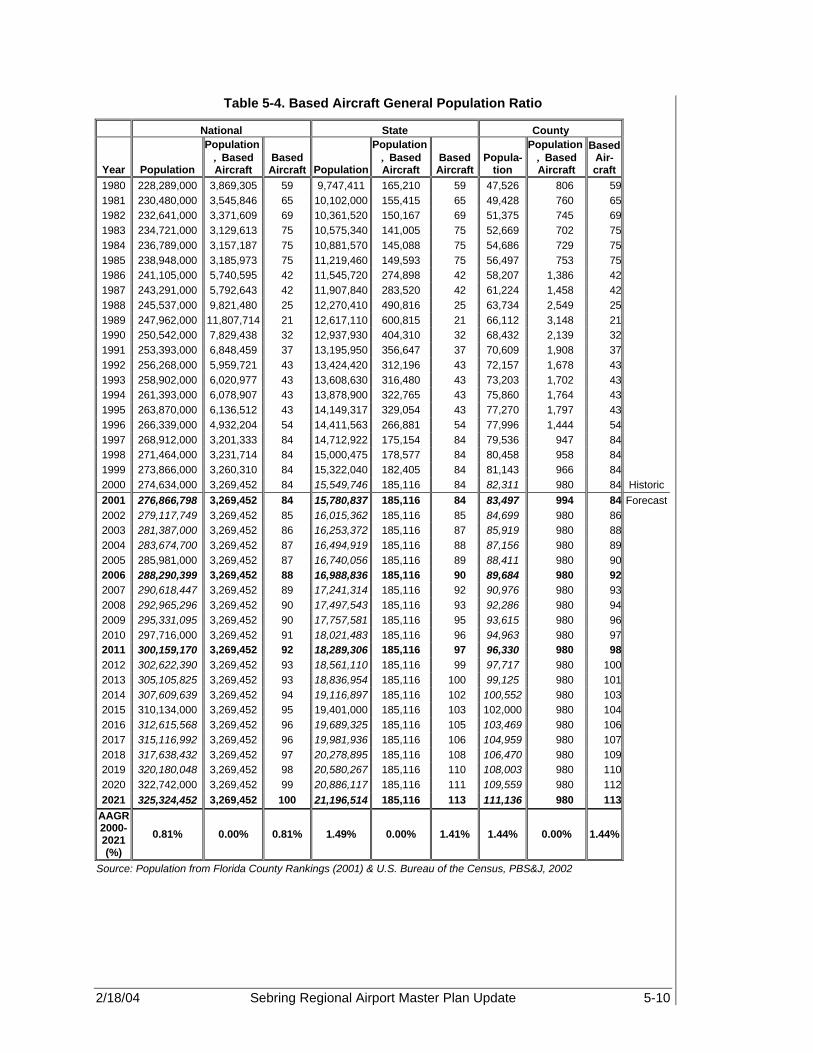
2/18/04 Sebring Regional Airport Master Plan Update 5-10
Table 5-4. Based Aircraft General Population Ratio
National State County
Year Population
Population ÷ Based Aircraft
Based Aircraft Population
Population ÷ Based Aircraft
Based Aircraft
Popula-tion
Population ÷ Based Aircraft
Based Air-craft
1980 228,289,000 3,869,305 59 9,747,411 165,210 59 47,526 806 59 1981 230,480,000 3,545,846 65 10,102,000 155,415 65 49,428 760 65 1982 232,641,000 3,371,609 69 10,361,520 150,167 69 51,375 745 69 1983 234,721,000 3,129,613 75 10,575,340 141,005 75 52,669 702 75 1984 236,789,000 3,157,187 75 10,881,570 145,088 75 54,686 729 75 1985 238,948,000 3,185,973 75 11,219,460 149,593 75 56,497 753 75 1986 241,105,000 5,740,595 42 11,545,720 274,898 42 58,207 1,386 42 1987 243,291,000 5,792,643 42 11,907,840 283,520 42 61,224 1,458 42 1988 245,537,000 9,821,480 25 12,270,410 490,816 25 63,734 2,549 25 1989 247,962,000 11,807,714 21 12,617,110 600,815 21 66,112 3,148 21 1990 250,542,000 7,829,438 32 12,937,930 404,310 32 68,432 2,139 32 1991 253,393,000 6,848,459 37 13,195,950 356,647 37 70,609 1,908 37 1992 256,268,000 5,959,721 43 13,424,420 312,196 43 72,157 1,678 43 1993 258,902,000 6,020,977 43 13,608,630 316,480 43 73,203 1,702 43 1994 261,393,000 6,078,907 43 13,878,900 322,765 43 75,860 1,764 43 1995 263,870,000 6,136,512 43 14,149,317 329,054 43 77,270 1,797 43 1996 266,339,000 4,932,204 54 14,411,563 266,881 54 77,996 1,444 54 1997 268,912,000 3,201,333 84 14,712,922 175,154 84 79,536 947 84 1998 271,464,000 3,231,714 84 15,000,475 178,577 84 80,458 958 84 1999 273,866,000 3,260,310 84 15,322,040 182,405 84 81,143 966 84 2000 274,634,000 3,269,452 84 15,549,746 185,116 84 82,311 980 84 Historic 2001 276,866,798 3,269,452 84 15,780,837 185,116 84 83,497 994 84 Forecast 2002 279,117,749 3,269,452 85 16,015,362 185,116 85 84,699 980 86 2003 281,387,000 3,269,452 86 16,253,372 185,116 87 85,919 980 88 2004 283,674,700 3,269,452 87 16,494,919 185,116 88 87,156 980 89 2005 285,981,000 3,269,452 87 16,740,056 185,116 89 88,411 980 90 2006 288,290,399 3,269,452 88 16,988,836 185,116 90 89,684 980 92 2007 290,618,447 3,269,452 89 17,241,314 185,116 92 90,976 980 93 2008 292,965,296 3,269,452 90 17,497,543 185,116 93 92,286 980 94 2009 295,331,095 3,269,452 90 17,757,581 185,116 95 93,615 980 96 2010 297,716,000 3,269,452 91 18,021,483 185,116 96 94,963 980 97 2011 300,159,170 3,269,452 92 18,289,306 185,116 97 96,330 980 98 2012 302,622,390 3,269,452 93 18,561,110 185,116 99 97,717 980 100 2013 305,105,825 3,269,452 93 18,836,954 185,116 100 99,125 980 101 2014 307,609,639 3,269,452 94 19,116,897 185,116 102 100,552 980 103 2015 310,134,000 3,269,452 95 19,401,000 185,116 103 102,000 980 104 2016 312,615,568 3,269,452 96 19,689,325 185,116 105 103,469 980 106 2017 315,116,992 3,269,452 96 19,981,936 185,116 106 104,959 980 107 2018 317,638,432 3,269,452 97 20,278,895 185,116 108 106,470 980 109 2019 320,180,048 3,269,452 98 20,580,267 185,116 110 108,003 980 110 2020 322,742,000 3,269,452 99 20,886,117 185,116 111 109,559 980 112 2021 325,324,452 3,269,452 100 21,196,514 185,116 113 111,136 980 113
AAGR 2000-2021 (%)
0.81% 0.00% 0.81% 1.49% 0.00% 1.41% 1.44% 0.00% 1.44%
Source: Population from Florida County Rankings (2001) & U.S. Bureau of the Census, PBS&J, 2002

2/18/04 Sebring Regional Airport Master Plan Update 5-11
5.2.4 Regression Analysis Another projection of based aircraft growth can be developed using regression analysis. Regression analysis is a widely accepted technique used in forecasting to define the mathematical relationship between changes in two or more variables over time. The relationship is stated as the correlation between such factors as growth in population and growth in the number of based aircraft. The measure for the reliability of forecasts obtained through regression analysis is (R-Squared - R2), or the coefficient of correlation. The closer the value of this coefficient is to one (or 100%), the more reliable the forecast. The coefficient is a measure of the activity to be forecasted (such as based aircraft or aircraft operations) and other variables known or believed to influence the activity. In aviation, these other variables include wealth, growth in population, and/or growth in employment. However, in order to conduct a meaningful analysis of the relationship between aviation activity and social or economic indicators, consistent and reliable historical data are required for all variables. In the case of GA airports, the available historical data is often non-linear. Unless the available historical based aircraft data is arranged in a coherent format that lends itself to regression analysis, meaningful regression analysis cannot be performed. By applying a linear fit to the data, fluctuations in the data, arising from factors related to aviation activity changes at the airport, are removed and a linear historical trend is created that is related to the socio-economic trends of the county or region. A regression analysis using this linear trend and the historical population growth of the county resulted in a coefficient of correlation (R2) value of 96.8 percent. Therefore, it can be stated that nearly 96.8 percent of the growth in based aircraft at SEF can be explained by growth in the general county population. This forecast is considered reliable since the (R2) value is close to 100 percent, and therefore, proves that there is a strong relation between local socioeconomic data and based aircraft at SEF. Based aircraft projections using this regression analysis are presented in Table 5-5.
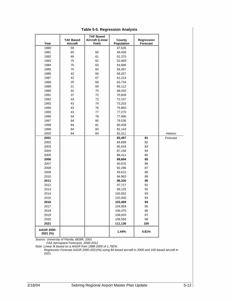
2/18/04 Sebring Regional Airport Master Plan Update 5-12
Table 5-5. Regression Analysis
Year TAF Based
Aircraft
TAF Based Aircraft (Linear
Feet) County
Population Regression
Forecast 1980 59 47,526 1981 65 60 49,428 1982 69 61 51,375 1983 75 62 52,669 1984 75 63 54,686 1985 75 64 56,497 1986 42 66 58,207 1987 42 67 61,224 1988 25 68 63,734 1989 21 69 66,112 1990 32 70 68,432 1991 37 72 70,609 1992 43 73 72,157 1993 43 74 73,203 1994 43 76 75,860 1995 43 77 77,270 1996 54 78 77,996 1997 84 80 79,536 1998 84 81 80,458 1999 84 83 81,143 2000 84 84 82,311 Historic 2001 83,497 81 Forecast 2002 84,699 82 2003 85,919 83 2004 87,156 84 2005 88,411 85 2006 89,684 85 2007 90,976 86 2008 92,286 87 2009 93,615 88 2010 94,963 89 2011 96,330 90 2012 97,717 91 2013 99,125 92 2014 100,552 93 2015 102,000 93 2016 103,469 94 2017 104,959 95 2018 106,470 96 2019 108,003 97 2020 109,559 98 2021 111,136 100
AAGR 2000-2021 (%) 1.44% 0.81%
Source: University of Florida, BEBR, 2001 FAA Aerospace Forecasts, 2000-2012 Note: Linear fit based on a AAGR from 1988-2000 of 1.782%
Regression Forecast AAGR 2000-2021(%) using 84 based aircraft in 2000 and 100 based aircraft in 2021.

2/18/04 Sebring Regional Airport Master Plan Update 5-13
Table 5-5 (Continued). Regression Analysis
Regression Analysis
The regression equation is Based Aircraft (Linear Fit) = 26.28 +0.000659 Population
Predictor Coefficient Standard Error of the Coefficient T-value P-value
Constant 26.28 1.91 13.76 0 Population 0.000659 2.757E-05 23.89 0
R-Squared 96.80% R-Squared (Adj) 96.60%
5.2.5 Selected Based Aircraft Forecast The selected based aircraft forecast is based upon the average of the market share, ratio, operations per based aircraft, and socio-economic regression analyses. This resulted in an AAGR of approximately 1.07 percent. This growth rate appears to be in line with current growth at the Airport, especially since there is currently limited aircraft storage space available. If more storage space does become available, it is likely that an increase in based aircraft operations could occur. However, based upon this current growth rate, 105 aircraft are likely to be based at SEF by 2021.
Figure 5-3. Selected and Supporting Based Aircraft Forecasts
80
85
90
95
100
105
110
115
2001
2003
2005
2007
2009
2011
2013
2015
2017
2019
2021
Year
Bas
ed A
ircr
aft
General Population Ratio(National)General Population Ratio(State)General Population Ratio(County)Market Share (National)
Market Share (State)
Market Share (County)
Pilot Population Ratio(National)Pilot Population Ratio(State)Pilot Population Ratio(County)Regression Forecast
Selected Forecast

2/18/04 Sebring Regional Airport Master Plan Update 5-14
Table 5-6. Based Aircraft Forecasts
General Population Ratio Market Share Pilot Population Ratio Regression Selected Forecast
Year
Based Aircraft
(National)
Based Aircraft (State)
Based Aircraft
(County)
Based Aircraft
(National)
Based Aircraft (State)
Based Aircraft (County)
Based Aircraft
(National)
Based Aircraft (State)
Based Aircraft (County)
Based Aircraft
Based Aircraft
2000 84 84 84 84 84 84 84 84 84 -- 84 Historic 2001 84 84 84 84 84 84 84 84 84 81 84 Forecast 2002 85 85 86 86 86 85 84 84 83 82 85 2003 86 87 88 86 87 86 84 84 84 83 85 2004 87 88 89 86 88 88 84 84 84 84 86 2005 87 89 90 86 89 89 86 86 85 85 87 2006 88 90 92 87 90 90 87 87 87 85 88 2007 89 92 93 87 91 91 88 88 88 86 89 2008 90 93 94 88 92 93 89 89 89 87 90 2009 90 95 96 88 94 94 91 91 91 88 92 2010 91 96 97 89 95 95 92 92 92 89 93 2011 92 97 98 89 96 97 93 93 93 90 94 2012 93 99 100 90 98 98 95 95 94 91 95 2013 93 100 101 90 99 99 96 96 96 92 96 2014 94 102 103 91 100 101 97 97 97 93 97 2015 95 103 104 92 102 102 97 97 97 93 98 2016 96 105 106 93 103 104 98 98 98 94 99 2017 96 106 107 94 105 105 99 99 99 95 101 2018 97 108 109 95 106 107 100 100 100 96 102 2019 98 110 110 95 108 108 101 101 101 97 103 2020 99 111 112 96 109 110 102 102 101 98 104 2021 100 113 113 97 111 111 102 102 102 100 105
AAGR 2000-2021
(%) 0.81% 1.41% 1.44% 0.70% 1.32% 1.35% 0.95% 0.95% 0.94% 0.81% 1.07%
Source: FAA Aerospace Forecast 2000-2012, Florida County Rankings (1999 & 2001), U.S. Bureau of the Census, FDOT Aviation Forecast, FAA TAF (2001) and PBS&J, 2002 Note: * AAGR for regression forecasts from 2002 to 2021. AAGR (%) may differ slightly due to rounding.

2/18/04 Sebring Regional Airport Master Plan Update 5-15
5.2.6 Based Aircraft Fleet Mix Forecast Future Airport requirements will be based, in part, on the type of based aircraft expected at SEF. The FAA divides based aircraft into the following categories: single-engine piston, multi-engine piston, turbo prop, jet, rotorcraft, and other. Aircraft by type and forecast year are presented in Table 5-7. All aircraft types are expected to increase or remain consistent at SEF during the forecast period. The growth in single-engine and multi-engine piston aircraft is inline with the type of growth and customer base at SEF. If facilities are built to accommodate larger business jets, this growth rate is likely to increase to some degree.
Table 5-7. Based Aircraft Forecast by Type
Piston Turbine
Year Single Engine Multi-
Engine Turbo Prop Jet Helicopter Ultralight
Total Aircraft
1990 26 6 0 0 0 0 32 1991 28 7 0 0 2 0 37 1992 40 3 0 0 0 0 43 1993 30 9 0 0 0 4 43 1994 30 9 0 0 1 3 43 1995 30 9 0 0 1 3 43 1996 37 12 0 0 1 4 54 1997 57 18 0 0 1 8 84 1998 57 18 0 0 1 8 84 1999 57 18 0 0 1 8 84 2000 57 18 0 0 1 8 84 Historic 2001 57 18 0 0 1 8 84 Forecast 2002 58 18 0 0 1 8 85 2003 58 18 0 0 1 8 85 2004 58 18 0 0 1 8 86 2005 59 19 0 0 1 8 87 2006 60 19 0 0 1 8 88 2007 60 19 0 0 1 8 89 2008 61 19 0 0 1 9 90 2009 62 20 0 0 1 9 92 2010 63 20 0 0 1 9 93 2011 64 20 0 0 1 9 94 2012 64 20 0 0 1 9 95 2013 65 21 0 0 1 9 96 2014 66 21 0 0 1 9 97 2015 67 21 0 0 1 9 98 2016 67 21 0 0 1 9 99 2017 69 22 0 0 1 10 101 2018 69 22 0 0 1 10 102 2019 70 22 0 0 1 10 103 2020 71 22 0 0 1 10 104 2021 71 23 0 0 1 10 105
Percent of Fleet 67.86% 21.43% 0.00% 0.00% 1.19% 9.52% 100.00%
AAGR 2000 - 2021 (%)
1.07%
Source: FAA Aerospace Forecast - Fiscal Years 2002-2013 and PBS&J, 2002
2/18/04 Sebring Regional Airport Master Plan Update 5-16
5.3 FORECAST OF ANNUAL AIRCRAFT OPERATIONS A variety of forecast information was available for projecting future aircraft operations at SEF. These include: Florida Aviation System Plan (FASP), 1994 Master Plan, FAA Aerospace Forecasts 2002-2013, FAA 5010 and TAF, and FDOT Aviation Forecasts. All of these resources were used in developing the preferred aircraft operations forecast for this study. Tables 5-8 and Figures 5-4 and 5-5 illustrate the existing aircraft operations forecasts. 5.3.1 2001 FAA Terminal Area Forecast (TAF) Again, the FAA TAF (see Table 5-8) depicts historical data from 1988 to 2000 and estimates annual aircraft operations through the year 2021. However, the TAF forecast shows no growth after 1997, and predicts no growth from the year 1999, the last year of available data, through 2015. The TAF is used primarily as an indication of the historical trend of the past 20 years and not as a viable forecast of based aircraft. These data were extrapolated to the end of the planning period for preparing the selected activity forecasts. 5.3.2 Florida Department of Transportation (FDOT) Aviation Forecast The forecast developed by the FDOT provides an analysis of total GA operations in the state of Florida. This information will be used in both the market share and ratio methodology in order to determine SEF’s percentage of the total Florida GA market. The FDOT has assigned a growth of 1.73 percent for total GA operations in the state, which is higher than the national percentage of 1.05 percent (see Table 5-8). However, this has historically been correct due to Florida’s prominence as a flight training center as well as its 300+ days of sunshine per year. 5.3.3 FAA Master Record – Form 5010 Historical data for SEF as reported by the Airport itself is recorded on the FAA Master Record, Form 5010. When comparing the FAA’s TAF and the Form 5010 annual aircraft operations data, a discrepancy for the years 1988-1991 and 1996-1998 was found. The TAF recorded significantly higher annual aircraft operations for those years than did SAA. Utilizing a linear historical trend analysis, which is based upon the average annual compound growth rate between the years 1998 and 2000, it was determined that 566,451 operations will occur in 2021 (see Table 5-8).

2/18/04 Sebring Regional Airport Master Plan Update 5-17
Table 5-8. General Aviation Aircraft Operations Forecast
Airport Operations Data National GA Operations
State GA Operations
Regional GA
Operations
Year TAF (1) 5010 (2)
1994 SEB MP
(3)
FASP Forecasts
(4)
GA/Mil US Forecasts
(5)
FASP Forecasts
(4)
Central Florida
CFASPP Forecasts
(6) 1988 41,193 20,000 20,000 41,193 7,483,562 377,627 1989 42,254 21,500 21,500 42,254 8,142,733 378,150 1990 43,350 20,000 20,000 43,350 8,520,880 390,389 1991 45,328 28,000 28,000 45,328 8,295,432 360,020 1992 36,000 36,000 36,000 36,000 8,086,252 376,418 1993 36,000 36,000 39,542 36,000 7,826,636 387,690 1994 34,500 34,500 43,433 34,500 7,551,654 379,596 1995 34,500 34,500 47,706 34,500 7,437,291 403,613 1996 34,500 48,200 52,400 34,500 37,845,200 7,436,160 414,971 1997 121,900 36,500 53,862 121,900 39,356,900 7,718,499 535,555 1998 121,900 61,700 55,365 121,900 40,828,000 7,819,874 529,533 1999 64,113 64,113 56,910 64,113 42,950,100 8,145,458 462,235 2000 64,113 67,210 58,498 66,213 42,790,100 8,397,018 489,684 Historic 2001 64,113 74,659 60,130 67,644 40,538,800 8,518,775 500,261 Forecast 2002 64,113 82,620 61,725 69,106 40,274,700 8,642,297 511,067 2003 64,113 91,430 63,363 70,599 43,348,400 8,767,610 522,106 2004 64,113 101,180 65,044 72,125 43,862,200 8,894,741 533,383 2005 64,113 111,969 66,769 73,684 44,382,800 9,023,714 544,904 2006 64,113 123,909 68,540 75,276 44,910,300 9,154,687 556,637 2007 64,113 137,122 70,359 77,033 45,444,900 9,318,831 569,050 2008 64,113 151,744 72,225 78,831 45,962,700 9,485,917 581,740 2009 64,113 167,925 74,141 80,671 46,487,100 9,656,000 594,713 2010 64,113 185,831 76,108 82,553 47,018,000 9,829,132 607,975 2011 64,113 205,647 78,127 84,480 47,555,600 10,005,316 621,511 2012 64,113 227,576 80,200 86,135 48,100,000 10,192,425 634,063 2013 64,113 251,843 82,328 87,823 48,651,200 10,383,034 646,869 2014 64,113 278,698 84,512 89,544 49,208,716 10,577,207 659,933 2015 64,113 308,417 86,754 91,298 49,772,622 10,775,011 673,261 2016 64,113 341,305 89,055 93,087 50,342,989 10,976,515 686,858 2017 64,113 377,699 91,418 94,911 50,919,893 11,181,787 700,730 2018 64,113 417,975 93,843 96,770 51,503,407 11,390,897 714,882 2019 64,113 462,545 96,332 98,666 52,093,608 11,603,918 729,319 2020 64,113 511,869 98,888 100,599 52,690,573 11,820,923 744,049 2021 64,113 566,451 101,511 104,580 53,294,378 12,042,001 759,075
AAGR 2000-2021
(%) 0.00% 10.68% 2.66% 2.20% 1.05% 1.73% 2.11%
Source: (1) FAA Terminal Area Forecast, 2001 (2) FAA Airport Master Record, 2001 (3) 1994 Sebring Regional Airport Master Plan (4) Florida Aviation Systems Plan (FASP), 1988-2021 (5) FAA Aerospace Forecasts - Fiscal Years 2002-2013 (Total FAA and Contract ATC) (6) CFASPP Central Region is 3.68% of Total Florida (FASP Forecast) Operations PBS&J, 2002

2/18/04 Sebring Regional Airport Master Plan Update 5-18
Figure 5-4. Existing Aircraft Operations Forecasts
010,000,00020,000,00030,000,00040,000,00050,000,00060,000,000
1988
1990
1992
1994
1996
1998
2000
2002
2004
2006
2008
2010
2012
2014
2016
2018
2020
Year
Op
erat
ion
s
GA/Mil US Forecasts (5)
Central Florida CFASPP Forecasts (6)
FASP Forecasts (4)
Figure 5-5. Existing Aircraft Operations Forecasts
0
100,000
200,000
300,000
400,000
500,000
600,000
1988
1990
1992
1994
1996
1998
2000
2002
2004
2006
2008
2010
2012
2014
2016
2018
2020
Year
Op
erat
ion
s
TAF (1) 5010 (2) 1994 SEB MP (3)
5.3.4 Florida Aviation System Plan (FASP) There are two forecasts produced through the FASP: Total General Aviation Operations for the State of Florida and the CFASPP Central Region Forecast of GA operations. 5.3.4.1 Total General Aviation Operations The FASP evaluates the total GA traffic in the state of Florida. Using historic data as well as trends in the region, the FASP forecast 12,042,001 total GA operations for the year ending 2021. Utilizing the AAGR of 1.73 percent, based upon the forecast annual

2/18/04 Sebring Regional Airport Master Plan Update 5-19
operations for the years 2000 and 2021, it was determined that for the year ending 2021, annual GA operations in the state would equal 12,042,001 operations. This information will be used in the market share analysis to determine the amount of GA operations directly attributed to SEF. See Table 5-8. 5.3.4.2 Central Regional Forecast of GA Operations The FASP also produces an analysis of GA operations for each region as well as for each airport in that particular region. Again, the Central Florida CFASPP, of which SEF is a part, utilizes historical trend line data to forecast future GA operations in the region through the year 2010. As a result, the CFASPP forecast 621,511 GA operations for the year ending 2011. Again, using the AAGR of 2.11 percent, it was determined that 759,075 GA operations could be attributed to the central Florida region (see Table 5-8). 5.3.5 1994 Airport Master Plan The 1994 Master Plan predicted that SEF’s operations by the year 2012 would include some commercial service operations. As of yet, this has not occurred. However, the infrastructure that has been put into place is conducive to the development of commercial operations. For the year 2012, the 1994 Master Plan forecast 80,200 operations. Using the AAGR of 2.68 percent as demonstrated between the years 1998 and 2012, the forecast for the year 2021 is predicted to be 101,511 operations (see Table 5-8). 5.3.6 Based Aircraft Ratio One of the methodologies approved by the FAA is that total aircraft operations are tied to based aircraft at an airport. This theory is demonstrated in Table 5-9. The FAA ratio for operations per based aircraft for small, non-towered airports, according to FAA Order 5090.3C, Chapter 3, is 637 operations per based aircraft. However, based upon historical data, it was determined that the factor for operations per based aircraft is approximately 289. Using this factor as well as the forecast for based aircraft at SEF, it was determined that approximately 35,105 local operations are forecast to occur in the year 2021. 5.3.7 Market Share Analysis The market share analysis is similar to that methodology used in the based aircraft forecast. In order to forecast future SEF annual aircraft operations, National, state, and regional (CFASPP) operations data was divided by historical SEF aircraft operations in order to determine what share of the total operations could be attributed to SEF. Future SEF annual aircraft operations were determined by taking the growth rates for the years 1990 through 2000, and adding it to the market share for the year 2001 in order to obtain a standard market share factor for national, state, and regional data. This resulted in a prediction of SEF operations for 2021 of 105,664, 115,632, and 122,682 based upon national, state, and regional forecast data. This resulted in an average forecast of 114,659 for the year 2021, which is an AAGR of 2.17 percent. Table 5-10 and Figure 5-6 demonstrate the relationship between the national, state, and county aircraft operations to the historical SEF annual operations.
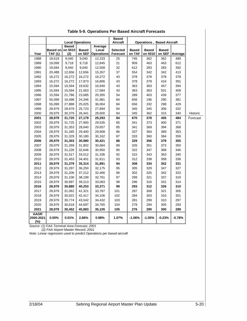
2/18/04 Sebring Regional Airport Master Plan Update 5-20
Table 5-9. Operations Per Based Aircraft Forecasts
Local Operations Based Aircraft Operations ÷ Based Aircraft
Year Based on TAF (1)
Based on 5010
(2) Based on SEF
Average Local
Operations Selected Forecast
Based on TAF
Based on 5010
Based on SEF Average
1988 18,619 9,040 9,040 12,233 25 745 362 362 489 1989 19,099 9,718 9,718 12,845 21 909 463 463 612 1990 19,594 9,040 9,040 12,558 32 612 283 283 392 1991 20,488 12,656 12,656 15,267 37 554 342 342 413 1992 16,272 16,272 16,272 16,272 43 378 378 378 378 1993 16,272 16,272 17,873 16,806 43 378 378 416 391 1994 15,594 15,594 19,632 16,940 43 363 363 457 394 1995 15,594 15,594 21,563 17,584 43 363 363 501 409 1996 15,594 21,786 23,685 20,355 54 289 403 439 377 1997 55,099 16,498 24,346 31,981 84 656 196 290 381 1998 55,099 27,888 25,025 36,004 84 656 332 298 429 1999 28,979 28,979 25,723 27,894 84 345 345 306 332 2000 28,979 30,379 26,441 28,600 84 345 362 315 340 Historic 2001 28,979 31,720 27,179 29,293 84 670 378 405 484 Forecast 2002 28,979 31,725 27,900 29,535 85 341 373 400 371 2003 28,979 31,353 28,640 29,657 85 341 369 394 368 2004 28,979 31,345 29,400 29,908 86 337 364 389 363 2005 28,979 31,329 30,180 30,162 87 333 360 384 359 2006 28,979 31,303 30,980 30,421 88 329 356 379 355 2007 28,979 31,269 31,802 30,684 89 326 351 373 350 2008 28,979 31,226 32,646 30,950 90 322 347 368 346 2009 28,979 31,517 33,512 31,336 92 315 343 363 340 2010 28,979 31,453 34,401 31,611 93 312 338 358 336 2011 28,979 31,379 35,314 31,891 94 308 334 352 331 2012 28,979 31,297 36,250 32,175 95 305 329 347 327 2013 28,979 31,206 37,212 32,466 96 302 325 342 323 2014 28,979 31,106 38,199 32,761 97 299 321 337 319 2015 28,979 30,997 39,213 33,063 98 296 316 331 314 2016 28,979 30,880 40,253 33,371 99 293 312 326 310 2017 28,979 31,062 41,321 33,787 101 287 308 321 305 2018 28,979 30,922 42,417 34,106 102 284 303 316 301 2019 28,979 30,774 43,542 34,432 103 281 299 310 297 2020 28,979 30,618 44,697 34,765 104 279 294 305 293 2021 28,979 30,452 45,883 35,105 105 276 290 300 289
AAGR 2000-2021
(%) 0.00% 0.01% 2.66% 0.98% 1.07% -1.06% -1.05% -0.23% -0.78%
Source: (1) FAA Terminal Area Forecast, 2001 (2) FAA Airport Master Record, 2001
Note: Linear regression used to predict Operations per based aircraft

2/18/04 Sebring Regional Airport Master Plan Update 5-21
Table 5-10. Market Share Analysis Forecasts Annual Aircraft Operations
National State Regional
Year Total GA/Mil
US (1) SEB GA
Operations
SEF Share of National
GA Operations
Total GA Florida - FASP (2)
SEB GA Operations
SEF Share of State GA Operations
Total GA Central Florida
CFASPP Region
(3) SEB GA
Operations
SEF Share of Regional
GA Operations
Average Operations
1988 0 20,000 7,483,562 20,000 0.27% 377,627 20,000 5.30% 20,000 1989 0 21500 8,142,733 21500 0.26% 378,150 21500 5.69% 21500 1990 0 20,000 8,520,880 20,000 0.23% 390,389 20,000 5.12% 20,000 1991 0 28,000 8,295,432 28,000 0.34% 360,020 28,000 7.78% 28,000 1992 0 36000 8,086,252 36000 0.45% 376,418 36000 9.56% 36000 1993 0 36,000 7,826,636 36,000 0.46% 387,690 36,000 9.29% 36,000 1994 0 34,500 7,551,654 34,500 0.46% 379,596 34,500 9.09% 34,500 1995 0 34500 7,437,291 34500 0.46% 403,613 34500 8.55% 34500 1996 37,845,200 48,200 0.13% 7,436,160 48,200 0.65% 414,971 48,200 11.62% 48,200 1997 39,356,900 36,500 0.09% 7,718,499 36,500 0.47% 535,555 36,500 6.82% 36,500 1998 40,828,000 61,700 0.15% 7,819,874 61,700 0.79% 529,533 61,700 11.65% 61,700 1999 42,950,100 64,113 0.15% 8,145,458 64,113 0.79% 462,235 64,113 13.87% 64,113 2000 42,790,100 67,210 0.16% 8,397,018 67,210 0.80% 489,684 67,210 13.73% 67,210 Historic 2001 40,538,800 74,659 0.18% 8,518,775 74,659 0.88% 500,261 74,659 14.92% 74,659 Forecast 2002 40,274,700 79,851 0.20% 8,642,297 82,987 0.96% 511,067 82,599 16.16% 81,812 2003 43,348,400 85,945 0.20% 8,767,610 84,190 0.96% 522,106 84,383 16.16% 84,839 2004 43,862,200 86,963 0.20% 8,894,741 85,411 0.96% 533,383 86,205 16.16% 86,193 2005 44,382,800 87,996 0.20% 9,023,714 86,649 0.96% 544,904 88,067 16.16% 87,571 2006 44,910,300 89,041 0.20% 9,154,687 87,907 0.96% 556,637 89,964 16.16% 88,971 2007 45,444,900 90,101 0.20% 9,318,831 89,483 0.96% 569,050 91,970 16.16% 90,518 2008 45,962,700 91,128 0.20% 9,485,917 91,088 0.96% 581,740 94,021 16.16% 92,079 2009 46,487,100 92,168 0.20% 9,656,000 92,721 0.96% 594,713 96,117 16.16% 93,669 2010 47,018,000 93,220 0.20% 9,829,132 94,383 0.96% 607,975 98,261 16.16% 95,288 2011 47,555,600 94,286 0.20% 10,005,316 96,075 0.96% 621,511 100,448 16.16% 96,937 2012 48,100,000 95,366 0.20% 10,192,425 97,872 0.96% 634,063 102,477 16.16% 98,572 2013 48,651,200 96,458 0.20% 10,383,034 99,702 0.96% 646,869 104,547 16.16% 100,236 2014 49,208,716 97,564 0.20% 10,577,207 101,567 0.96% 659,933 106,658 16.16% 101,930

2/18/04 Sebring Regional Airport Master Plan Update 5-22
Table 5-10 (Continued). Market Share Analysis Forecasts Annual Aircraft Operations
2015 49,772,622 98,682 0.20% 10,775,011 103,466 0.96% 673,261 108,812 16.16% 103,653 2016 50,342,989 99,813 0.20% 10,976,515 105,401 0.96% 686,858 111,010 16.16% 105,408 2017 50,919,893 100,956 0.20% 11,181,787 107,372 0.96% 700,730 113,252 16.16% 107,193 2018 51,503,407 102,113 0.20% 11,390,897 109,380 0.96% 714,882 115,539 16.16% 109,011 2019 52,093,608 103,283 0.20% 11,603,918 111,426 0.96% 729,319 117,872 16.16% 110,861 2020 52,690,573 104,467 0.20% 11,820,923 113,509 0.96% 744,049 120,253 16.16% 112,743 2021 53,294,378 105,664 0.20% 12,042,001 115,632 0.96% 759,075 122,682 16.16% 114,659
AAGR 2000-
2021 (%) 1.05% 2.18% 1.73% 2.62% 2.11% 2.91% 2.58%
Source: (1) Historic Data from FAA Aerospace Forecasts - Fiscal Years 2002-2013 (Total FAA and Contract ATC) (2) Historic Data from Florida Aviation Systems Plan (FASP), 1988-2021 (3) In 2000, CFASPP Central Region was 5.838% of Total Florida (FASP Forecast) GA Operations PBS&J, 2002

2/18/04 Sebring Regional Airport Master Plan Update 5-23
Figure 5-6. Market Share Analysis
70,000
80,000
90,000
100,000
110,000
120,000
2001
2002
2003
2004
2005
2006
2007
2008
2009
2010
2011
2012
2013
2014
2015
2016
2017
2018
2019
2020
2021
Year
Op
erat
ion
s
SEB (National) SEB (State)
SEB (Regional) SEB (Average)
5.3.8 Ratio Analysis A ratio analysis as described is based upon a relationship between, in this case, the number of active pilots in the system and the number of operations at SEF. A ratio between total U.S. pilots, Florida pilots, and Highland County (regional) pilots to the historical number of operations at Sebring revealed a correlation trend. Thus, using a fixed ratio throughout the 20+-year forecast period, forecasts of annual operations for SEF were determined. The ratio analysis used here compares pilot populations in the nation, state, and county to operations at SEF. In all cases, the difference between the forecasts based upon national, state, and county forecasts were nominal, 101,870 for each, which gives viability to the forecasts. Taking the average of these three forecasts, 101,870 aircraft operations are predicted to occur at SEF for the year ending 2021. This represents an AAGR of 2 percent. Table 5-11 depicts the aircraft operations to pilot ratio forecasts.

2/18/04 Sebring Regional Airport Master Plan Update 5-24
Table 5-11. Aircraft Operations to Pilot Ratio Forecasts
National State Regional
Year Pilots Ratio GA
Operations Pilots * Ratio GA
Operations Pilots * Ratio GA
Operations Average
Operations 1988 20,000 20,000 20,000 20,000 1989 21,500 21,500 21,500 21,500 1990 573,909 0.0348 20,000 42,691 0.4685 20,000 191 104.5966 20,000 20,000 1991 571,731 0.0490 28,000 42,529 0.6584 28,000 190 146.9931 28,000 28,000 1992 568,175 0.0634 36,000 42,265 0.8518 36,000 189 190.1739 36,000 36,000 1993 561,280 0.0641 36,000 41,752 0.8622 36,000 187 192.5101 36,000 36,000 1994 557,593 0.0619 34,500 41,477 0.8318 34,500 186 185.7088 34,500 34,500 1995 639,184 0.0540 34,500 47,547 0.7256 34,500 213 162.0033 34,500 34,500 1996 622,261 0.0775 48,200 46,288 1.0413 48,200 207 232.4904 48,200 48,200 1997 616,342 0.0592 36,500 45,848 0.7961 36,500 205 177.7468 36,500 36,500 1998 618,298 0.0998 61,700 45,993 1.3415 61,700 206 299.5146 61,700 61,700 1999 635,472 0.1009 64,113 47,271 1.3563 64,113 212 302.8170 64,113 64,113 2000 625,583 0.1074 67,210 46,535 1.4443 67,210 208 322.4628 67,210 67,210 Historical 2001 649,957 0.1149 74,659 48,348 1.5442 74,659 217 344.7690 74,659 74,659 Forecast 2002 646,215 0.1286 83,075 48,070 1.7282 83,075 215 385.8552 83,075 83,075 2003 648,215 0.1286 83,332 48,218 1.7282 83,332 216 385.8552 83,332 83,332 2004 653,820 0.1286 84,053 48,635 1.7282 84,053 218 385.8552 84,053 84,053 2005 661,975 0.1286 85,101 49,242 1.7282 85,101 221 385.8552 85,101 85,101 2006 671,380 0.1286 86,310 49,942 1.7282 86,310 224 385.8552 86,310 86,310 2007 680,785 0.1286 87,519 50,641 1.7282 87,519 227 385.8552 87,519 87,519 2008 690,940 0.1286 88,825 51,397 1.7282 88,825 230 385.8552 88,825 88,825 2009 701,095 0.1286 90,130 52,152 1.7282 90,130 234 385.8552 90,130 90,130 2010 711,250 0.1286 91,436 52,907 1.7282 91,436 237 385.8552 91,436 91,436 2011 721,405 0.1286 92,741 53,663 1.7282 92,741 240 385.8552 92,741 92,741 2012 731,560 0.1286 94,047 54,418 1.7282 94,047 244 385.8552 94,047 94,047 2013 741,715 0.1286 95,352 55,174 1.7282 95,352 247 385.8552 95,352 95,352 2014 747,871 0.1286 96,144 55,631 1.7282 96,144 249 385.8552 96,144 96,144 2015 754,078 0.1286 96,942 56,093 1.7282 96,942 251 385.8552 96,942 96,942 2016 760,336 0.1286 97,746 56,559 1.7282 97,746 253 385.8552 97,746 97,746 2017 766,646 0.1286 98,557 57,028 1.7282 98,557 255 385.8552 98,557 98,557

2/18/04 Sebring Regional Airport Master Plan Update 5-25
Table 5-11 (Continued). Aircraft Operations to Pilot Ratio Forecasts
2018 773,009 0.1286 99,375 57,501 1.7282 99,375 258 385.8552 99,375 99,375 2019 779,425 0.1286 100,200 57,979 1.7282 100,200 260 385.8552 100,200 100,200 2020 785,893 0.1286 101,032 58,460 1.7282 101,032 262 385.8552 101,032 101,032 2021 792,416 0.1286 101,870 58,945 1.7282 101,870 264 385.8552 101,870 101,870
AAGR 2000-2021
(%) 1.13% 2.00% 1.13% 2.00% 1.13% 2.00% 2.00%
Source: National And local pilots estimated from FAA Aerospace Forecasts - Fiscal Year 2002-2013 FDOT Aviation Forecasts 2000-2020
2/18/04 Sebring Regional Airport Master Plan Update 5-26
5.3.9 Regression Analysis A regression analysis assumes that operations at an airport are directly affected by economic factors. This forecast is useful especially if 10+ years of historical data are available, and there are no significant data variances in any of the factors. For SEF the total population and employment figures for the State of Florida were used since limiting economic information to only Highlands County would have provided serious inadequacies in the forecast. Due to Sebring’s location in relation to major cities in Florida, as well as it being the home of the Sebring Race Track, it was determined that using the socio-economic data for the entire state would allow for a better correlation between operations and socioeconomic data. This resulted in a coefficient of correlation, R2, of 99.87 percent, which is considered reliable. As a result, using the year 2000 as the base year for operations, 67,210 operations are predicted for the year 2021, which equals an estimated 125,760 operations, a 3.38 percent AAGR over this period. Based upon the measure for the reliability of forecasts through regression, this forecast will be used to determine the selected forecast. Table 5-12 shows the regression analysis and forecast results. 5.3.10 Selected Aircraft Operations Forecast The selected aircraft operations forecast for SEF is based upon the average of four viable forecasts representing the low (101,870), median (114,659), and high (125,760) range of the forecast spectrum for potential GA aircraft operations at Sebring. This resulted in a median forecast prediction of 114,096 annual aircraft operations, based upon a 2.55 percent AAGR for the years 2000 through 2021. Table 5-13 shows the selected operations forecasts and Figure 5-7 shows the forecast analysis in graphical form.
Figure 5-7. Selected and Supporting Operations Forecasts
60,000
70,000
80,000
90,000
100,000
110,000
120,000
130,000
2001
2002
2003
2004
2005
2006
2007
2008
2009
2010
2011
2012
2013
2014
2015
2016
2017
2018
2019
2020
2021
Year
Op
erat
ion
s
Regression Analysis Forecasts Average Market Share
Average Pilot Population Ratio Selected Forecast
2/18/04 Sebring Regional Airport Master Plan Update 5-27
Table 5-12. Aircraft Operations Regression Analysis
Year Annual GA Operations
Annual Operations (Linear Fit)
Florida Population
Florida Employment Regression
1988 20,000 15,637 9,747,411 5,066,657 1989 21,500 19,546 10,102,000 5,260,783 1990 20,000 23,455 10,361,520 5,387,338 1991 28,000 27,364 10,575,340 5,294,323 1992 36,000 31,273 10,881,570 5,358,729 1993 36,000 35,182 11,219,460 5,571,471 1994 34,500 39,091 11,545,720 5,799,356 1995 34,500 43,000 11,907,840 5,996,037 1996 48,200 46,909 12,270,410 6,183,238 1997 36,500 50,818 12,617,110 6,414,422 1998 61,700 54,727 12,937,930 6,636,483 1999 64,113 58,636 13,195,950 6,876,800 2000 67,210 62,545 13,424,420 7,074,800 Historic 2001 13,608,630 7,205,600 64,031 Forecast 2002 13,878,900 7,358,600 67,362 2003 14,149,317 7,516,600 70,681 2004 14,411,563 7,663,800 73,916 2005 14,712,922 7,838,100 77,620 2006 15,000,475 8,021,400 81,110 2007 15,322,040 8,184,200 85,122 2008 15,549,746 8,326,000 87,895 2009 15,780,837 8,459,200 90,736 2010 16,015,362 8,597,200 93,612 2011 16,253,372 8,806,331 96,351 2012 16,494,919 9,020,549 99,125 2013 16,740,056 9,239,979 101,935 2014 16,988,836 9,464,746 104,782 2015 17,241,314 9,694,980 107,665 2016 17,497,543 9,930,815 110,586 2017 17,757,581 10,172,387 113,544 2018 18,021,483 10,419,835 116,540 2019 18,289,306 10,673,303 119,574 2020 18,561,110 10,932,936 122,647 2021 18,836,954 11,198,885 125,760
AAGR 2000-2021
(%) 1.63% 2.21% 3.38%
Regression Analysis
The regression equation is Annual Operations (Linear Fit) = - 104961 + 0.0138 Population - 0.00261 Employment
Predictor Coefficient Standard
Error of the Coefficient
T-value P-value
Constant -104961.000 2161.000 -48.57 0 Population 0.0137525 0.0009723 14.14 0
Employment -0.0026130 0.0017880 -1.46 0.175 R-Squared 99.87% R-Squared (Adj) 99.70% Source: UF BEBR, 2000, FAA Master Record 5010, and PBS&J, 2002

2/18/04 Sebring Regional Airport Master Plan Update 5-28
Table 5-13. Selected Aircraft Operations Forecasts
Year
Average Pilot Population
Ratio
Average Market Share
Regression Analysis
Forecasts Selected Forecast
1988 20,000 20,000 20,000 20,000 1989 21,500 21,500 21,500 21,500 1990 20,000 20,000 20,000 20,000 1991 28,000 28,000 28,000 28,000 1992 36,000 36,000 36,000 36,000 1993 36,000 36,000 36,000 36,000 1994 34,500 34,500 34,500 34,500 1995 34,500 34,500 34,500 34,500 1996 48,200 48,200 48,200 48,200 1997 36,500 36,500 36,500 36,500 1998 61,700 61,700 61,700 61,700 1999 64,113 64,113 64,113 64,113 2000 67,210 67,210 67,210 67,210 Historic 2001 74,659 74,659 64,031 71,116 Forecast 2002 83,075 81,812 67,362 77,416 2003 83,332 84,839 70,681 79,618 2004 84,053 86,193 73,916 81,387 2005 85,101 87,571 77,620 83,431 2006 86,310 88,971 81,110 85,464 2007 87,519 90,518 85,122 87,720 2008 88,825 92,079 87,895 89,599 2009 90,130 93,669 90,736 91,512 2010 91,436 95,288 93,612 93,445 2011 92,741 96,937 96,351 95,343 2012 94,047 98,572 99,125 97,248 2013 95,352 100,236 101,935 99,174 2014 96,144 101,930 104,782 100,952 2015 96,942 103,653 107,665 102,753 2016 97,746 105,408 110,586 104,580 2017 98,557 107,193 113,544 106,431 2018 99,375 109,011 116,540 108,309 2019 100,200 110,861 119,574 110,212 2020 101,032 112,743 122,647 112,141 2021 101,870 114,659 125,760 114,096
AAGR 2000-2021
(%) 2.00% 2.58% 3.03% 2.55%
Source: FAA Aerospace Forecast – Fiscal Year 2000-2012 FDOT Aviation Forecast PBS&J, 2002
5.3.11 Local GA Operations Forecast A breakdown of local and itinerant GA operations was determined in order to provide the user with an analysis of future GA passengers, automobile parking, aircraft facilities, fuel demand, and fleet mix. The methodology used to determine total annual operations at SEF was used to provide the breakdown of local airport operations compared to national, state and regional operations.

2/18/04 Sebring Regional Airport Master Plan Update 5-29
In 2001, local GA operations (excluding military operations) at SEF equaled approximately 42 percent of total operations. It is expected that this ratio will remain stable in the future. 5.3.11.1 Market Share Analysis of Local Operations Using the Market Share methodology, as shown in previous analyses, local aircraft operations at SEF were compared to national, state, and regional aircraft operations, thus, providing a percentage or correlation between local operations and each of these forecasts. This analysis provides a low, median, and high forecast of predicted local operations at SEF. Taking the average of the four predicted estimated SEF local aircraft operations, it was determined that approximately 50,100 local aircraft operations are predicted to occur at SEF in year 2021. 5.3.11.2 Ratio Analysis of Local Operations A ratio analysis provides a direct correlation between pilot populations and local operations. This methodology often provides an accurate prediction of local GA operations at an airport since local, and in some cases regional, pilot populations, for the most part, hangar their aircraft at the local facility. SEF, and to some extent all of Florida, is a little different since there is a large population of “Snow Birds”. These are individuals who are not permanent residents of the state of Florida, but who come to live in the state during the winter months. These individuals often base their aircraft at SEF either all year or for the season. This is why the national pilot population provides an excellent correlation between local operations and pilot population. Thus, based upon national, state, and county pilot populations, the analysis produced the following forecasts for the year 2021: 46,157 equally. Therefore, an average of this value predicts 46,157 local operations for the year 2021. See Table 5-15.

2/18/04 Sebring Regional Airport Master Plan Update 5-30
Table 5-14. Market Share Forecast Local Aircraft Operations
National State Regional
Year
Total GA/Mil US
(1) SEF GA
Operations
SEF Share of National
GA Operations
Total GA Florida - FASP (2)
SEF GA Operations
SEF Share of State GA Operations
Total GA Central Florida
CFASPP Region (3)
SEF GA Operations
SEF Share of Regional
GA Operations
Average Operations
1988 4,500 7,483,562 4,500 0.0601% 377,627 4,500 1.1917% 4,500 1989 4,838 8,142,733 4,838 0.0594% 378,150 4,838 1.2793% 4,838 1990 4,500 8,520,880 4,500 0.0528% 390,389 4,500 1.1527% 4,500 1991 8,000 8,295,432 8,000 0.0964% 360,020 8,000 2.2221% 8,000 1992 13,000 8,086,252 13,000 0.1608% 376,418 13,000 3.4536% 13000 1993 13,000 7,826,636 13,000 0.1661% 387,690 13,000 3.3532% 13,000 1994 13,000 7,551,654 13,000 0.1721% 379,596 13,000 3.4247% 13,000 1995 13,000 7,437,291 13,000 0.1748% 403,613 13,000 3.2209% 13000 1996 37,845,200 20,500 0.0542% 7,436,160 20,500 0.2757% 414,971 20,500 4.9401% 20,500 1997 39,356,900 13,000 0.0330% 7,718,499 13,000 0.1684% 535,555 13,000 2.4274% 13,000 1998 40,828,000 27,500 0.0674% 7,819,874 27,500 0.3517% 529,533 27,500 5.1933% 27,500 1999 42,950,100 28,875 0.0672% 8,145,458 28,875 0.3545% 462,235 28,875 6.2468% 28,875 2000 42,790,100 30,375 0.0710% 8,397,018 30,375 0.3617% 489,684 30,375 6.2030% 30,375 Historic 2001 40,538,800 31,549 0.0778% 8,518,775 31,549 0.3703% 500,261 31,549 6.3065% 31,549 Forecast 2002 40,274,700 33,699 0.0837% 8,642,297 36,810 0.4259% 511,067 36,638 7.1689% 35,716 2003 43,348,400 36,271 0.0837% 8,767,610 37,344 0.4259% 522,106 37,429 7.1689% 37,015 2004 43,862,200 36,701 0.0837% 8,894,741 37,885 0.4259% 533,383 38,238 7.1689% 37,608 2005 44,382,800 37,137 0.0837% 9,023,714 38,435 0.4259% 544,904 39,064 7.1689% 38,212 2006 44,910,300 37,578 0.0837% 9,154,687 38,993 0.4259% 556,637 39,905 7.1689% 38,825 2007 45,444,900 38,025 0.0837% 9,318,831 39,692 0.4259% 569,050 40,795 7.1689% 39,504 2008 45,962,700 38,459 0.0837% 9,485,917 40,403 0.4259% 581,740 41,704 7.1689% 40,189 2009 46,487,100 38,897 0.0837% 9,656,000 41,128 0.4259% 594,713 42,634 7.1689% 40,887 2010 47,018,000 39,342 0.0837% 9,829,132 41,865 0.4259% 607,975 43,585 7.1689% 41,597 2011 47,555,600 39,792 0.0837% 10,005,316 42,616 0.4259% 621,511 44,556 7.1689% 42,321 2012 48,100,000 40,247 0.0837% 10,192,425 43,413 0.4259% 634,063 45,455 7.1689% 43,038 2013 48,651,200 40,708 0.0837% 10,383,034 44,225 0.4259% 646,869 46,373 7.1689% 43,769 2014 49,208,716 41,175 0.0837% 10,577,207 45,052 0.4259% 659,933 47,310 7.1689% 44,512

2/18/04 Sebring Regional Airport Master Plan Update 5-31
Table 5-14 (Continued). Market Share Forecast Local Aircraft Operations
2015 49,772,622 41,647 0.0837% 10,775,011 45,894 0.4259% 673,261 48,265 7.1689% 45,269 2016 50,342,989 42,124 0.0837% 10,976,515 46,752 0.4259% 686,858 49,240 7.1689% 46,039 2017 50,919,893 42,607 0.0837% 11,181,787 47,627 0.4259% 700,730 50,235 7.1689% 46,823 2018 51,503,407 43,095 0.0837% 11,390,897 48,517 0.4259% 714,882 51,249 7.1689% 47,620 2019 52,093,608 43,589 0.0837% 11,603,918 49,425 0.4259% 729,319 52,284 7.1689% 48,433 2020 52,690,573 44,088 0.0837% 11,820,923 50,349 0.4259% 744,049 53,340 7.1689% 49,259 2021 53,294,378 44,593 0.0837% 12,042,001 51,291 0.4259% 759,075 54,417 7.1689% 50,100
AAGR 2000-2021
(%) 1.05% 1.85% 1.73% 2.53% 2.11% 2.82% 2.41%
Source: (1) Historic Data from FAA Aerospace Forecasts - Fiscal Years 2002-2013 (Total FAA and Contract ATC) (2) Historic Data from Florida Aviation Systems Plan (FASP), 1988-2021 (3) CFASPP Central Region is 3.68% of Total Florida (FASP Forecast) Operations PBS&J, 2002

2/18/04 Sebring Regional Airport Master Plan Update 5-32
Table 5-15. Ratio Analysis Pilot Population Compared to Local Aircraft Operations
National State Regional
Year Pilots Ratio Local GA
Operations Pilots * Ratio Local GA
Operations Pilots * Ratio Local GA
Operations
Average Local GA
Operations 1988 4,500 4,500 4,500 4,500 1989 4,838 4,838 4,838 4,838 1990 573,909 0.0078 4,500 42,691 0.1054 4,500 191 23.5342 4,500 4,500 1991 571,731 0.0140 8,000 42,529 0.1881 8,000 190 41.9980 8,000 8,000 1992 568,175 0.0229 13,000 42,265 0.3076 13,000 189 68.6739 13,000 13,000 1993 561,280 0.0232 13,000 41,752 0.3114 13,000 187 69.5175 13,000 13,000 1994 557,593 0.0233 13,000 41,477 0.3134 13,000 186 69.9772 13,000 13,000 1995 639,184 0.0203 13,000 47,547 0.2734 13,000 213 61.0447 13,000 13,000 1996 622,261 0.0329 20,500 46,288 0.4429 20,500 207 98.8808 20,500 20,500 1997 616,342 0.0211 13,000 45,848 0.2835 13,000 205 63.3071 13,000 13,000 1998 618,298 0.0445 27,500 45,993 0.5979 27,500 206 133.4951 27,500 27,500 1999 635,472 0.0454 28,875 47,271 0.6108 28,875 212 136.3817 28,875 28,875 2000 625,583 0.0486 30,375 46,535 0.6527 30,375 208 145.7344 30,375 30,375 Historic 2001 649,957 0.0485 31,549 48,348 0.6525 31,549 217 145.6906 31,549 31,549 Forecast 2002 646,215 0.0582 37,641 48,070 0.7831 37,641 215 174.8307 37,641 37,641 2003 648,215 0.0582 37,758 48,218 0.7831 37,758 216 174.8307 37,758 37,758 2004 653,820 0.0582 38,084 48,635 0.7831 38,084 218 174.8307 38,084 38,084 2005 661,975 0.0582 38,559 49,242 0.7831 38,559 221 174.8307 38,559 38,559 2006 671,380 0.0582 39,107 49,942 0.7831 39,107 224 174.8307 39,107 39,107 2007 680,785 0.0582 39,655 50,641 0.7831 39,655 227 174.8307 39,655 39,655 2008 690,940 0.0582 40,246 51,397 0.7831 40,246 230 174.8307 40,246 40,246 2009 701,095 0.0582 40,838 52,152 0.7831 40,838 234 174.8307 40,838 40,838 2010 711,250 0.0582 41,429 52,907 0.7831 41,429 237 174.8307 41,429 41,429 2011 721,405 0.0582 42,021 53,663 0.7831 42,021 240 174.8307 42,021 42,021 2012 731,560 0.0582 42,613 54,418 0.7831 42,613 244 174.8307 42,613 42,613 2013 741,715 0.0582 43,204 55,174 0.7831 43,204 247 174.8307 43,204 43,204 2014 747,871 0.0582 43,563 55,631 0.7831 43,563 249 174.8307 43,563 43,563

2/18/04 Sebring Regional Airport Master Plan Update 5-33
Table 5-15 (Continued). Ratio Analysis Pilot Population Compared to Local Aircraft Operations 2015 754,078 0.0582 43,924 56,093 0.7831 43,924 251 174.8307 43,924 43,924 2016 760,336 0.0582 44,289 56,559 0.7831 44,289 253 174.8307 44,289 44,289 2017 766,646 0.0582 44,656 57,028 0.7831 44,656 255 174.8307 44,656 44,656 2018 773,009 0.0582 45,027 57,501 0.7831 45,027 258 174.8307 45,027 45,027 2019 779,425 0.0582 45,401 57,979 0.7831 45,401 260 174.8307 45,401 45,401 2020 785,893 0.0582 45,777 58,460 0.7831 45,777 262 174.8307 45,777 45,777 2021 792,416 0.0582 46,157 58,945 0.7831 46,157 264 174.8307 46,157 46,157
AAGR 2000-2021 (%) 1.13% 2.01% 1.13% 2.01% 1.13% 2.01% 2.01%
Source: National And local pilots estimated from FAA Aerospace Forecasts - Fiscal Year 2002-2013 FDOT Aviation Forecasts 2000-2020

2/18/04 Sebring Regional Airport Master Plan Update 5-34
5.3.11.3 Local Operations Selected Forecast The selected forecast for local airport operations is based upon the average of several forecasts, Operations per Based Aircraft (OPBA), Regression Analysis, Market Share and Pilot Ratio Analysis. The regression analysis used the same socio-economic data, employment, and population that were applied in Table 5-12, Aircraft Operations Regression Analysis, but applied it to historical local operations only to obtain a correlation between local operations and these factors. This analysis produced an R2 of 99.8 percent. This is significant since local aircraft operations are more often affected by local socio-economic factors than transient aircraft operations. The regression analysis resulted in a prediction of 64,351 local operations for the year 2021. This represents the high end of the selected forecast graph. See Table 5-16 and Figure 5-8 for the local operations regression forecasts. Historically, local operations at SEF have represented approximately 42 percent of total annual aircraft operations (excluding military operations). By applying the OPBA ratios calculated earlier in this section it was predicted that approximately 35,105 local GA aircraft operations in 2021 would be attributed to local aircraft. The methodology used to determine the Market Share forecast and Pilot Ratio forecast for Total Annual Aircraft Operations at SEF was applied to SEF local aircraft operations. This resulted in two average estimates of local aircraft operations based upon these two methodologies. Comparing SEF local operations to national, state, and regional aircraft operations resulted in a market share based average forecast prediction of 50,100 local operations in 2021. Also, by comparing local operations to national, state, and local pilot populations resulted in an average forecast of 46,157 local operations for SEF in 2001. Since there is variability amongst the forecast results, it was determined that an average of the four forecasts would provide the best prediction of local operations through the forecast period. This yielded a prediction of 48,928 selected local operations for the year 2021 with an AAGR of 2.37 percent (see Table 5-17 and Figure 5-8).

2/18/04 Sebring Regional Airport Master Plan Update 5-35
Table 5-16. Local Aircraft Operations Socioeconomic Regression Analysis
Year
Annual Local GA
Operations
Annual Local
Operations (Linear Fit)
Florida Population
Florida Employment Regression
1988 4,500 1,870 9,747,411 5,066,657 1989 4,838 4,103 10,102,000 5,260,783 1990 4,500 6,336 10,361,520 5,387,338 1991 8,000 8,569 10,575,340 5,294,323 1992 13,000 10,802 10,881,570 5,358,729 1993 13,000 13,035 11,219,460 5,571,471 1994 13,000 15,268 11,545,720 5,799,356 1995 13,000 17,501 11,907,840 5,996,037 1996 20,500 19,734 12,270,410 6,183,238 1997 13,000 21,967 12,617,110 6,414,422 1998 27,500 24,200 12,937,930 6,636,483 1999 28,875 26,433 13,195,950 6,876,800 2000 30,375 28,666 13,424,420 7,074,800 Historic 2001 13,608,630 7,205,600 29,206 Forecast 2002 13,878,900 7,358,600 31,103 2003 14,149,317 7,516,600 32,993 2004 14,411,563 7,663,800 34,835 2005 14,712,922 7,838,100 36,944 2006 15,000,475 8,021,400 38,931 2007 15,322,040 8,184,200 41,216 2008 15,549,746 8,326,000 42,794 2009 15,780,837 8,459,200 44,412 2010 16,015,362 8,597,200 46,050 2011 16,253,372 8,806,331 47,609 2012 16,494,919 9,020,549 49,188 2013 16,740,056 9,239,979 50,788 2014 16,988,836 9,464,746 52,409 2015 17,241,314 9,694,980 54,050 2016 17,497,543 9,930,815 55,713 2017 17,757,581 10,172,387 57,397 2018 18,021,483 10,419,835 59,102 2019 18,289,306 10,673,303 60,830 2020 18,561,110 10,932,936 62,579 2021 18,836,954 11,198,885 64,351
AAGR 2000-2021
(%) 1.63% 2.21% 3.93%
Regression Analysis
The regression equation is Annual Operations (Linear Fit) = - 47442 + 0.00622 Population - 0.00118 Employment
Predictor Coefficient Standard
Error of the Coefficient
T-value P-value
Constant -67021.000 1235.000 -54.29 0 Population 0.0078561 0.0005554 14.14 0
Employment -0.0014930 0.0010220 -1.46 0.175 R-Squared 99.87% R-Squared (Adj) 99.70% Source: UF BEBR, 2000, FAA Master Record 5010, and PBS&J, 2002

2/18/04 Sebring Regional Airport Master Plan Update 5-36
Table 5-17. Selected Forecast Local GA Operations
Year Average OPBA
Forecasts
Average Pilot Population
Ratio Average Market
Share
Regression Analysis
Forecasts Selected Forecast
1988 12,233 4,500 4,500 4,500 6,433 1989 12,845 4,838 4,838 4,838 6,839 1990 12,558 4,500 4,500 4,500 6,515 1991 15,267 8,000 8,000 8,000 9,817 1992 16,272 13,000 13,000 13,000 13,818 1993 16,806 13,000 13,000 13,000 13,951 1994 16,940 13,000 13,000 13,000 13,985 1995 17,584 13,000 13,000 13,000 14,146 1996 20,355 20,500 20,500 20,500 20,464 1997 31,981 13,000 13,000 13,000 17,745 1998 36,004 27,500 27,500 27,500 29,626 1999 27,894 28,875 28,875 28,875 28,630 2000 28,600 30,375 30,375 30,375 29,931 Historic 2001 29,293 31,549 31,549 29,206 30,399 Forecast 2002 29,535 37,641 35,716 31,103 33,499 2003 29,657 37,758 37,015 32,993 34,356 2004 29,908 38,084 37,608 34,835 35,109 2005 30,162 38,559 38,212 36,944 35,969 2006 30,421 39,107 38,825 38,931 36,821 2007 30,684 39,655 39,504 41,216 37,765 2008 30,950 40,246 40,189 42,794 38,545 2009 31,336 40,838 40,887 44,412 39,368 2010 31,611 41,429 41,597 46,050 40,172 2011 31,891 42,021 42,321 47,609 40,960 2012 32,175 42,613 43,038 49,188 41,754 2013 32,466 43,204 43,769 50,788 42,557 2014 32,761 43,563 44,512 52,409 43,311 2015 33,063 43,924 45,269 54,050 44,077 2016 33,371 44,289 46,039 55,713 44,853 2017 33,787 44,656 46,823 57,397 45,666 2018 34,106 45,027 47,620 59,102 46,464 2019 34,432 45,401 48,433 60,830 47,274 2020 34,765 45,777 49,259 62,579 48,095 2021 35,105 46,157 50,100 64,351 48,928
AAGR 2000-2021 (%) 0.98% 2.01% 2.41% 3.64% 2.37%
Source: PBS&J 2002

2/18/04 Sebring Regional Airport Master Plan Update 5-37
Figure 5-8. Local Aircraft Operations Selected Forecast
25,00030,00035,00040,00045,00050,00055,00060,00065,000
2001
2002
2003
2004
2005
2006
2007
2008
2009
2010
2011
2012
2013
2014
2015
2016
2017
2018
2019
2020
2021
Year
Lo
cal G
A O
per
atio
ns
Average Pilot Population Ratio Average Market ShareRegression Analysis Forecasts Selected ForecastOPBA Forecasts
5.4 MILITARY OPERATIONS GA activity at SEF consists primarily of recreational, corporate, and medical helicopter operations. However, there is a significant amount of military helicopter operations as a result of the “hot” fueling contract with the U.S. Department of Defense (DOD). The SAA staff is one of only two civilian groups in the country trained to “hot fuel” military helicopters. Military helicopters and C-130 aircraft represent the type of military aircraft currently using SEF. Other high performance and transport military aircraft do not currently use SEF due to a safety requirement, which requires a field length of approximately 8,500 feet. As a result, it is predicted, unless there is a significant change in the facilities (i.e. longer runways), that military operations will remain stable through the year 2021, as shown in Table 5-18.
The SAA staff is one of only two civilian groups in the country trained to “hot fuel” military helicopters.
2/18/04 Sebring Regional Airport Master Plan Update 5-38
Table 5-18. Military Operations Forecast
Year Military Operations 1990 500 1991 500 1992 500 1993 500 1994 500 1995 500 1996 2,500 1997 500 1998 2,000 1999 1,000 2000 1,000 Historic 2001 1,000 Forecast 2002 1,000 2003 1,000 2004 1,000 2005 1,000 2006 1,000 2007 1,000 2008 1,000 2009 1,000 2010 1,000 2011 1,000 2012 1,000 2013 1,000 2014 1,000 2015 1,000 2016 1,000 2017 1,000 2018 1,000 2019 1,000 2020 1,000 2021 1,000
AAGR 2000-2021 (%) 0.00%
Source: FAA Master Record 5010 (1990-1992), FAA TAF, 2001 (1992-1995) Sebring Regional Airport Statistics (1996-2000), FAA Master Record 5010
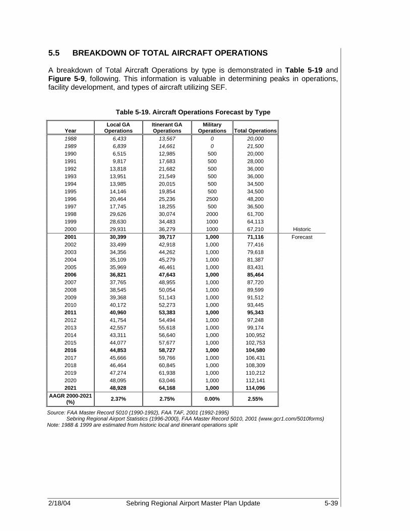
2/18/04 Sebring Regional Airport Master Plan Update 5-39
5.5 BREAKDOWN OF TOTAL AIRCRAFT OPERATIONS A breakdown of Total Aircraft Operations by type is demonstrated in Table 5-19 and Figure 5-9, following. This information is valuable in determining peaks in operations, facility development, and types of aircraft utilizing SEF.
Table 5-19. Aircraft Operations Forecast by Type
Year Local GA
Operations Itinerant GA Operations
Military Operations Total Operations
1988 6,433 13,567 0 20,000 1989 6,839 14,661 0 21,500 1990 6,515 12,985 500 20,000 1991 9,817 17,683 500 28,000 1992 13,818 21,682 500 36,000 1993 13,951 21,549 500 36,000 1994 13,985 20,015 500 34,500 1995 14,146 19,854 500 34,500 1996 20,464 25,236 2500 48,200 1997 17,745 18,255 500 36,500 1998 29,626 30,074 2000 61,700 1999 28,630 34,483 1000 64,113 2000 29,931 36,279 1000 67,210 Historic 2001 30,399 39,717 1,000 71,116 Forecast 2002 33,499 42,918 1,000 77,416 2003 34,356 44,262 1,000 79,618 2004 35,109 45,279 1,000 81,387 2005 35,969 46,461 1,000 83,431 2006 36,821 47,643 1,000 85,464 2007 37,765 48,955 1,000 87,720 2008 38,545 50,054 1,000 89,599 2009 39,368 51,143 1,000 91,512 2010 40,172 52,273 1,000 93,445 2011 40,960 53,383 1,000 95,343 2012 41,754 54,494 1,000 97,248 2013 42,557 55,618 1,000 99,174 2014 43,311 56,640 1,000 100,952 2015 44,077 57,677 1,000 102,753 2016 44,853 58,727 1,000 104,580 2017 45,666 59,766 1,000 106,431 2018 46,464 60,845 1,000 108,309 2019 47,274 61,938 1,000 110,212 2020 48,095 63,046 1,000 112,141 2021 48,928 64,168 1,000 114,096
AAGR 2000-2021 (%) 2.37% 2.75% 0.00% 2.55%
Source: FAA Master Record 5010 (1990-1992), FAA TAF, 2001 (1992-1995) Sebring Regional Airport Statistics (1996-2000), FAA Master Record 5010, 2001 (www.gcr1.com/5010forms) Note: 1988 & 1999 are estimated from historic local and itinerant operations split
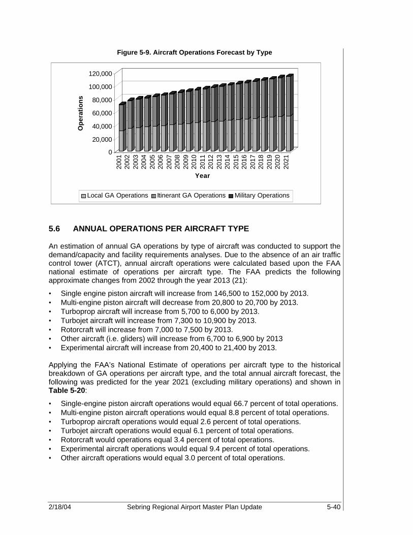
2/18/04 Sebring Regional Airport Master Plan Update 5-40
Figure 5-9. Aircraft Operations Forecast by Type
0
20,000
40,000
60,000
80,000
100,000
120,000O
per
atio
ns
2001
2002
2003
2004
2005
2006
2007
2008
2009
2010
2011
2012
2013
2014
2015
2016
2017
2018
2019
2020
2021
Year
Local GA Operations Itinerant GA Operations Military Operations
5.6 ANNUAL OPERATIONS PER AIRCRAFT TYPE An estimation of annual GA operations by type of aircraft was conducted to support the demand/capacity and facility requirements analyses. Due to the absence of an air traffic control tower (ATCT), annual aircraft operations were calculated based upon the FAA national estimate of operations per aircraft type. The FAA predicts the following approximate changes from 2002 through the year 2013 (21):
• Single engine piston aircraft will increase from 146,500 to 152,000 by 2013. • Multi-engine piston aircraft will decrease from 20,800 to 20,700 by 2013. • Turboprop aircraft will increase from 5,700 to 6,000 by 2013. • Turbojet aircraft will increase from 7,300 to 10,900 by 2013. • Rotorcraft will increase from 7,000 to 7,500 by 2013. • Other aircraft (i.e. gliders) will increase from 6,700 to 6,900 by 2013 • Experimental aircraft will increase from 20,400 to 21,400 by 2013. Applying the FAA’s National Estimate of operations per aircraft type to the historical breakdown of GA operations per aircraft type, and the total annual aircraft forecast, the following was predicted for the year 2021 (excluding military operations) and shown in Table 5-20:
• Single-engine piston aircraft operations would equal 66.7 percent of total operations. • Multi-engine piston aircraft operations would equal 8.8 percent of total operations. • Turboprop aircraft operations would equal 2.6 percent of total operations. • Turbojet aircraft operations would equal 6.1 percent of total operations. • Rotorcraft would operations equal 3.4 percent of total operations. • Experimental aircraft operations would equal 9.4 percent of total operations. • Other aircraft operations would equal 3.0 percent of total operations.

2/18/04 Sebring Regional Airport Master Plan Update 5-41
Table 5-20. Annual Operations by Aircraft Type
Year Piston Engine
Single Engine
Multi-Engine Turbine Turboprops Turbojets Rotorcraft Experimental Other
Total GA Operations
2000 51,899 45,479 6,419 3,885 1,754 2,131 2,176 6,211 2,039 66,210 Historic 2001 54,822 48,009 6,812 4,185 1,865 2,319 2,319 6,618 2,173 70,117 Forecast 2002 59,643 52,228 7,415 4,617 2,014 2,602 2,496 7,273 2,389 76,416 2003 61,255 53,649 7,606 4,832 2,076 2,756 2,572 7,496 2,462 78,618 2004 62,541 54,802 7,739 5,038 2,125 2,913 2,635 7,661 2,512 80,387 2005 64,033 56,137 7,895 5,267 2,182 3,086 2,708 7,852 2,571 82,431 2006 65,511 57,462 8,049 5,503 2,237 3,266 2,780 8,041 2,628 84,464 2007 67,155 58,933 8,222 5,761 2,298 3,463 2,860 8,252 2,693 86,720 2008 68,501 60,144 8,357 6,001 2,348 3,653 2,927 8,426 2,745 88,599 2009 69,866 61,372 8,494 6,250 2,398 3,852 2,996 8,602 2,798 90,512 2010 71,241 62,610 8,630 6,508 2,449 4,059 3,066 8,780 2,851 92,445 2011 72,580 63,819 8,761 6,771 2,497 4,274 3,134 8,955 2,903 94,343 2012 73,919 65,028 8,891 7,041 2,545 4,496 3,203 9,129 2,955 96,248 2013 75,267 66,246 9,022 7,322 2,593 4,729 3,273 9,305 3,007 98,174 2014 76,494 67,358 9,136 7,599 2,636 4,963 3,338 9,466 3,054 99,952 2015 77,733 68,481 9,251 7,886 2,679 5,206 3,404 9,629 3,102 101,753 2016 78,983 69,616 9,367 8,182 2,722 5,460 3,471 9,794 3,150 103,580 2017 80,245 70,762 9,483 8,489 2,764 5,724 3,539 9,961 3,199 105,431 2018 81,519 71,920 9,599 8,806 2,807 5,999 3,608 10,129 3,247 107,309 2019 82,804 73,088 9,716 9,135 2,849 6,285 3,677 10,299 3,297 109,212 2020 84,101 74,268 9,833 9,474 2,891 6,583 3,748 10,471 3,346 111,141 2021 85,410 75,460 9,951 9,825 2,932 6,893 3,820 10,645 3,396 113,096
AAGR 2000-2021
(%) 2.40% 2.44% 2.11% 4.52% 2.48% 5.75% 2.72% 2.60% 2.46% 2.58%
Source: FAA Aerospace Forecasts - Fiscal Years 2002-2013 PBS&J, 2002
Note: Excludes military operations.

2/18/04 Sebring Regional Airport Master Plan Update 5-42
Figure 5-10. Fleet Mix Annual Operations by Aircraft Type
0
20,000
40,000
60,000
80,000
100,000
120,000
2000
2001
2002
2003
2004
2005
2006
2007
2008
2009
2010
2011
2012
2013
2014
2015
2016
2017
2018
2019
2020
2021
Year
GA
Op
erat
ion
s Other
Experimental
Rotorcraft
Turbine
Pistons
5.7 FUEL FLOWAGE Fuel storage and capacity are primary concerns for airport operators and FBOs. Because of increasing operations, fuel sales are expected to increase as well. A correlation of historical fuel sales and historic operations was established and applied to the preferred operations forecast to determine if it is necessary to improve or expand the existing fuel facilities. However, due to the nature of the fleet mix at SEF, it was necessary to determine what percentage of both local and transient operations were piston and those that were turbine. Using the information presented in Table 5-20, Annual Operations by Aircraft type, it was possible to determine the demand for both Avgas and Jet-A fuel. Based upon this information, it was determined that 50 percent of experimental aircraft use Avgas while the remaining 50 percent used other types of fuel. Furthermore, the majority of rotorcraft operations, approximately 70 percent, are turbine. As a result, a breakdown of operations by type is shown in Table 5-21. 5.7.1 General Aviation Fuel Flowage Fuel projections for GA were developed using an average ratio of gallons of fuel sold to the number of operations. This resulted in an average of 1.18 gallons of fuel per GA piston operation and 12.18 gallons of fuel per GA turbine operation. The fuel volumes include avgas for piston-powered operations and Jet-A for turbine-powered aircraft and rotorcraft. By applying this ratio to the preferred operational forecast, it is estimated that a total of 110,647 gallons of Avgas and 237,777 gallons of Jet A are forecast to be sold at SEF annually by 2021. Table 5-21 illustrates the total fuel volume as well as the breakdown between Jet A and Avgas fuel sales volume projected for SEF.

2/18/04 Sebring Regional Airport Master Plan Update 5-43
Table 5-21. Fuel Flowage Forecast
Avgas Fuel Flow by Type
Year Pistons Single Engine
Multi-Engine Turbine Turboprops Turbojets Rotorcraft Experimental Other Total
2000 61,366 53,775 7,590 0 0 0 772 3,672 1,206 67,016 Historic 2001 64,822 56,767 8,055 0 0 0 823 3,912 1,285 70,842 Forecast 2002 70,523 61,755 8,768 0 0 0 885 4,300 1,412 77,120 2003 72,429 63,435 8,994 0 0 0 912 4,432 1,456 79,229 2004 73,949 64,799 9,150 0 0 0 935 4,529 1,485 80,899 2005 75,714 66,378 9,336 0 0 0 960 4,642 1,520 82,836 2006 77,462 67,944 9,517 0 0 0 986 4,754 1,554 84,755 2007 79,405 69,684 9,722 0 0 0 1,014 4,878 1,592 86,890 2008 80,997 71,115 9,882 0 0 0 1,038 4,981 1,623 88,639 2009 82,610 72,567 10,043 0 0 0 1,063 5,086 1,654 90,413 2010 84,236 74,032 10,204 0 0 0 1,087 5,191 1,686 92,200 2011 85,820 75,460 10,360 0 0 0 1,112 5,294 1,717 93,942 2012 87,403 76,890 10,513 0 0 0 1,136 5,397 1,747 95,684 2013 88,998 78,330 10,667 0 0 0 1,161 5,501 1,778 97,438 2014 90,448 79,645 10,803 0 0 0 1,184 5,596 1,806 99,035 2015 91,913 80,974 10,939 0 0 0 1,207 5,693 1,834 100,647 2016 93,391 82,315 11,075 0 0 0 1,231 5,790 1,862 102,275 2017 94,883 83,671 11,213 0 0 0 1,255 5,889 1,891 103,918 2018 96,389 85,039 11,350 0 0 0 1,280 5,988 1,920 105,577 2019 97,909 86,421 11,488 0 0 0 1,304 6,089 1,949 107,251 2020 99,443 87,816 11,627 0 0 0 1,329 6,191 1,978 108,942 2021 100,991 89,225 11,766 0 0 0 1,355 6,293 2,008 110,647
AAGR 2000-2021 (%) 2.40% 2.44% 2.11% 2.72% 2.60% 2.46% 2.42%

2/18/04 Sebring Regional Airport Master Plan Update 5-44
Table 5-21 (Continued). Fuel Flowage Forecast
Jet-A Fuel Flow by Type
Year Pistons Single Engine
Multi-Engine Turbine Turboprops Turbojets Rotorcraft Experimental Other Total
2000 0 0 0 47,320 21,363 25,957 18,557 37,831 12,420 116,128 Historic 2001 0 0 0 50,974 22,721 28,253 19,777 40,305 13,237 124,294 Forecast 2002 0 0 0 56,238 24,536 31,702 21,279 44,295 14,548 136,361 2003 0 0 0 58,861 25,290 33,571 21,933 45,657 14,995 141,446 2004 0 0 0 61,369 25,891 35,478 22,471 46,662 15,301 145,803 2005 0 0 0 64,163 26,575 37,588 23,088 47,825 15,657 150,733 2006 0 0 0 67,037 27,248 39,789 23,703 48,977 16,007 155,725 2007 0 0 0 70,175 27,989 42,187 24,385 50,258 16,400 161,218 2008 0 0 0 73,095 28,599 44,496 24,962 51,318 16,718 166,093 2009 0 0 0 76,132 29,214 46,918 25,548 52,393 17,041 171,114 2010 0 0 0 79,276 29,826 49,449 26,140 53,477 17,366 176,258 2011 0 0 0 82,477 30,419 52,057 26,725 54,540 17,684 181,426 2012 0 0 0 85,774 31,002 54,772 27,312 55,602 17,999 186,687 2013 0 0 0 89,191 31,588 57,602 27,909 56,673 18,316 192,089 2014 0 0 0 92,567 32,116 60,451 28,464 57,654 18,603 197,287 2015 0 0 0 96,058 32,638 63,420 29,024 58,648 18,894 202,624 2016 0 0 0 99,667 33,158 66,509 29,595 59,654 19,185 208,101 2017 0 0 0 103,403 33,675 69,728 30,173 60,667 19,482 213,724 2018 0 0 0 107,271 34,193 73,079 30,761 61,691 19,778 219,502 2019 0 0 0 111,271 34,706 76,565 31,356 62,729 20,079 225,435 2020 0 0 0 115,405 35,211 80,194 31,958 63,776 20,382 231,522 2021 0 0 0 119,687 35,716 83,971 32,570 64,836 20,685 237,777
AAGR 2000-2021 (%) 4.52% 2.48% 5.75% 2.72% 2.60% 2.46% 3.47%
Source: Sebring Airport Authority Fuel Sales, 1988-2001 FAA Forecasts-Fiscal Year 2000-2012 FAA Master Record, Form 5010, PBS&J, 2002

2/18/04 Sebring Regional Airport Master Plan Update 5-45
5.7.2 Military Operations Fuel Flowage Military fuel projections were developed in much the same manner as GA. A ratio between Jet A fuel sold to the military in relation to future military operations was developed. This resulted in an average of 123.086 gallons of fuel per Military operation. By applying this ratio to the preferred forecast of military operations, it is estimated that approximately 123,086 gallons of fuel will be sold to the military in 2021. Table 5-22 illustrates the total fuel volume expected from military operations through the year 2021.
Table 5-22. Military Fuel Sales Forecast
Year Military Fuel Sales 2000 123,086 Historic 2001 123,086 Forecast 2002 123,086 2003 123,086 2004 123,086 2005 123,086 2006 123,086 2007 123,086 2008 123,086 2009 123,086 2010 123,086 2011 123,086 2012 123,086 2013 123,086 2014 123,086 2015 123,086 2016 123,086 2017 123,086 2018 123,086 2019 123,086 2020 123,086 2021 123,086
AAGR 2000-2021 (%) 0.00%
Source: Sebring Regional Airport Fuel Sales Statistics
5.8 PEAK ACTIVITY Peak hour activity tests an airport’s ability to accommodate demand as represented by an increased level of activity that occurs with somewhat predictable frequency. The determination of peak activity will aid in the development and sizing of airport facilities to meet the heightened demand. FAA defines the theoretical “peak hour operations” as the total number of aircraft operations and passengers expected to use the airport, averaged for two adjacent peak hours of a typical peak time or busiest hour on record. The most common methodology of converting the forecasts to an hourly demand baseline is the Average Day/Peak Month (AD/PM). To determine the average day of the peak month, the peak month must first be identified. Since there is no staffed air traffic facility at SEF to record aircraft movements, with the exception of during the Sebring 12 hour race, fuel sales from the Sebring Flight Office were used to determine period of
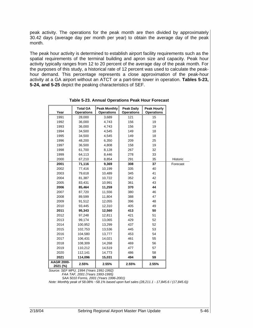
2/18/04 Sebring Regional Airport Master Plan Update 5-46
peak activity. The operations for the peak month are then divided by approximately 30.42 days (average day per month per year) to obtain the average day of the peak month. The peak hour activity is determined to establish airport facility requirements such as the spatial requirements of the terminal building and apron size and capacity. Peak hour activity typically ranges from 12 to 20 percent of the average day of the peak month. For the purposes of this study, a historical rate of 12 percent was used to calculate the peak-hour demand. This percentage represents a close approximation of the peak-hour activity at a GA airport without an ATCT or a part-time tower in operation. Tables 5-23, 5-24, and 5-25 depict the peaking characteristics of SEF.
Table 5-23. Annual Operations Peak Hour Forecast
Year Total GA
Operations Peak Monthly
Operations Peak Daily Operations
Peak Hourly Operations
1991 28,000 3,689 121 15 1992 36,000 4,743 156 19 1993 36,000 4,743 156 19 1994 34,500 4,545 149 18 1995 34,500 4,545 149 18 1996 48,200 6,350 209 25 1997 36,500 4,808 158 19 1998 61,700 8,128 267 32 1999 64,113 8,446 278 33 2000 67,210 8,854 291 35 Historic 2001 71,116 9,369 308 37 Forecast 2002 77,416 10,199 335 40 2003 79,618 10,489 345 41 2004 81,387 10,722 352 42 2005 83,431 10,991 361 43 2006 85,464 11,259 370 44 2007 87,720 11,556 380 46 2008 89,599 11,804 388 47 2009 91,512 12,055 396 48 2010 93,445 12,310 405 49 2011 95,343 12,560 413 50 2012 97,248 12,811 421 51 2013 99,174 13,065 429 52 2014 100,952 13,299 437 52 2015 102,753 13,536 445 53 2016 104,580 13,777 453 54 2017 106,431 14,021 461 55 2018 108,309 14,268 469 56 2019 110,212 14,519 477 57 2020 112,141 14,773 486 58 2021 114,096 15,031 494 59
AAGR 2000-2021 (%) 2.55% 2.55% 2.55% 2.55%
Source: SEF MPU, 1994 (Years 1991-1992) FAA TAF, 2001 (Years 1993-1995) SAA 5010 Forms, 2001 (Years 1996-2001)
Note: Monthly peak of 58.08% ~58.1% based upon fuel sales (28,211.1 - 17,845.6 / (17,845.6))
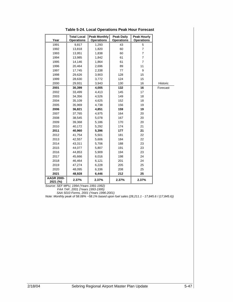
2/18/04 Sebring Regional Airport Master Plan Update 5-47
Table 5-24. Local Operations Peak Hour Forecast
Year Total Local Operations
Peak Monthly Operations
Peak Daily Operations
Peak Hourly Operations
1991 9,817 1,293 43 5 1992 13,818 1,820 60 7 1993 13,951 1,838 60 7 1994 13,985 1,842 61 7 1995 14,146 1,864 61 7 1996 20,464 2,696 89 11 1997 17,745 2,338 77 9 1998 29,626 3,903 128 15 1999 28,630 3,772 124 15 2000 29,931 3,943 130 16 Historic 2001 30,399 4,005 132 16 Forecast 2002 33,499 4,413 145 17 2003 34,356 4,526 149 18 2004 35,109 4,625 152 18 2005 35,969 4,738 156 19 2006 36,821 4,851 159 19 2007 37,765 4,975 164 20 2008 38,545 5,078 167 20 2009 39,368 5,186 170 20 2010 40,172 5,292 174 21 2011 40,960 5,396 177 21 2012 41,754 5,501 181 22 2013 42,557 5,606 184 22 2014 43,311 5,706 188 23 2015 44,077 5,807 191 23 2016 44,853 5,909 194 23 2017 45,666 6,016 198 24 2018 46,464 6,121 201 24 2019 47,274 6,228 205 25 2020 48,095 6,336 208 25 2021 48,928 6,446 212 25
AAGR 2000-2021 (%) 2.37% 2.37% 2.37% 2.37%
Source: SEF MPU, 1994 (Years 1991-1992) FAA TAF, 2001 (Years 1993-1995) SAA 5010 Forms, 2001 (Years 1996-2001)
Note: Monthly peak of 58.08% ~58.1% based upon fuel sales (28,211.1 - 17,845.6 / (17,845.6))

2/18/04 Sebring Regional Airport Master Plan Update 5-48
Table 5-25. Itinerant Operations Peak Hour Forecast
Year
Total Itinerant
Operations
Peak Monthly
Operations Peak Daily Operations
Peak Hourly
Operations 1991 17,683 2,330 77 9 1992 21,682 2,856 94 11 1993 21,549 2,839 93 11 1994 20,015 2,637 87 10 1995 19,854 2,616 86 10 1996 25,236 3,325 109 13 1997 18,255 2,405 79 9 1998 30,074 3,962 130 16 1999 34,483 4,543 149 18 2000 36,279 4,779 157 19 Historic 2001 39,717 5,232 172 21 Forecast 2002 42,918 5,654 186 22 2003 44,262 5,831 192 23 2004 45,279 5,965 196 24 2005 46,461 6,121 201 24 2006 47,643 6,276 206 25 2007 48,955 6,449 212 25 2008 50,054 6,594 217 26 2009 51,143 6,737 221 27 2010 52,273 6,886 226 27 2011 53,383 7,032 231 28 2012 54,494 7,179 236 28 2013 55,618 7,327 241 29 2014 56,640 7,462 245 29 2015 57,677 7,598 250 30 2016 58,727 7,737 254 31 2017 59,766 7,873 259 31 2018 60,845 8,015 263 32 2019 61,938 8,160 268 32 2020 63,046 8,305 273 33 2021 64,168 8,453 278 33
AAGR 2000-2021
(%) 2.75% 2.75% 2.75% 2.75%
Source: SEF MPU, 1994 (Years 1991-1992) FAA TAF, 2001 (Years 1993-1995) SAA 5010 Forms, 2001 (Years 1996-2001)
Note: Monthly peak of 58.08% ~58.1% based upon fuel sales 5.9 INSTRUMENT APPROACH ACTIVITY An instrument approach to an airport is an actual Instrument Flight Rules (IFR) approach conducted in IFR weather and differs from an instrument operation, which may be conducted in either Visual Flight Rules (VFR) or IFR weather. Activity levels under these conditions often differ considerably at Sebring since they do not have an FAA ATCT in full-time operation. As a result, during IFR conditions, many pilots will not or are not certified to fly. Instrument approach activity at SEF is controlled by Miami Approach Control Center, and SEF weather conditions are recorded at Avon Park Airport, some ten nautical miles (nm) to the northeast. Discussions with Miami Approach Control Center revealed that

2/18/04 Sebring Regional Airport Master Plan Update 5-49
IFR operations and/or approaches to SEF are not maintained at the center. However, the FAA maintains and reports instrument approach and operations data at its Air Traffic Activity Data System (ATADS), the official source for air traffic activity for Airport and instrument operations counts. See Table 5-26. Historically, SEF’s instrument operations were less than 1,000 operations; therefore, they are not recorded on the ATADS. In addition, according to the weather data obtained from the National Climatic Data Center, VFR conditions exist 95 percent of the time at Sebring. Thus, it was anticipated that instrument approaches to SEF would occur 5 percent of the time. See Tables 5-26 and 5-27.
Table 5-26. Regional Instrument Activity
Total Ops (2001)
Instrument Operation
Percent Operations
Instrument Approaches
Percent Approaches
Vero Beach 216,722 36,913 17% 497 1% Melbourne 192,153 39,076 20% 164 0% Lakeland
Linder 201,443 19,755 10% 1,057 5%
Average 203,439 31,915 16% 573 2% Estimate for
Sebring 71,116 11,183 16% 559 5%
Source: FAA Air Traffic Activity Data System (ATADS), March 2002 Instrument operations and approaches have been forecast for SEF by evaluating SEF and regional instrument activity. Based upon the information obtained from the ATADS data, it was determined that the Vero Beach, Melbourne, and Lakeland Linder Regional Airports would provide the best estimate of potential instrument operations at SEF. Therefore, the ratio of instrument approaches to instrument operations for airports in the region was determined and applied to the reported instrument approaches at SEF. This established the predicted number of instrument operations at SEF for 2001. Instrument approaches were then forecast as a percentage of annual operations. Through this analysis, instrument operations are forecast to increase from 10,569 in 2000 to 17,942 by 2021. Instrument approaches are forecast to increase from 528 in 2000 to 897 in 2021. Table 5-27 depicts the forecast of instrument operations and approaches for SEF through the 20+-year planning period.

2/18/04 Sebring Regional Airport Master Plan Update 5-50
Table 5-27. Instrument Activity Forecast
Year Total
Operations Instrument Operations (16% of
Total Operations)
Instrument Approaches (5% of Instrument
Operations) 1991 28,000 4,403 220 1992 36,000 5,661 283 1993 36,000 5,661 283 1994 34,500 5,425 271 1995 34,500 5,425 271 1996 48,200 7,579 379 1997 36,500 5,740 287 1998 61,700 9,702 485 1999 64,113 10,082 504 2000 67,210 10,569 528 Historic 2001 71,116 11,183 559 Forecast 2002 77,416 12,174 609 2003 79,618 12,520 626 2004 81,387 12,798 640 2005 83,431 13,119 656 2006 85,464 13,439 672 2007 87,720 13,794 690 2008 89,599 14,090 704 2009 91,512 14,390 720 2010 93,445 14,694 735 2011 95,343 14,993 750 2012 97,248 15,292 765 2013 99,174 15,595 780 2014 100,952 15,875 794 2015 102,753 16,158 808 2016 104,580 16,445 822 2017 106,431 16,736 837 2018 108,309 17,032 852 2019 110,212 17,331 867 2020 112,141 17,634 882 2021 114,096 17,942 897
AAGR 2000-2021 (%) 2.55% 2.55% 2.55%
Source: SEF MPU, 1994 (Years 1991-1992) FAA TAF, 2001 (Years 1993-1995) SAA 5010 Forms, 2001 (Years 1996-2001) PBS&J, 2002
Note: Instrument Operation: Instrument procedure and/or approach conducted in either Visual Flight Rules (VFR) or Instrument Flight Rules (IFR) weather conditions. Instrument Approach: Instrument approach conducted under actual IFR weather conditions (ceiling less than 1,000 feet and visibility less than 3 miles).

2/18/04 Sebring Regional Airport Master Plan Update 5-51
5.10 AIRCRAFT PARKING Peak hour operations at SEF will help identify the need for improved or expanded apron facilities to accommodate expected aviation parking demand. As discussed in Chapter 4, aircraft parking by means of tie-downs was forecast using a formula of 12 percent for based aircraft and one half of the peak hour itinerant aircraft. This results in 10 based aircraft and 10 itinerant (including military) aircraft in 2000 and 13 based aircraft and 17 itinerant aircraft in 2021, which would require aircraft tie-down space. This is an increase of approximately 1.26 percent for based aircraft parking and 2.56 percent for itinerant aircraft parking over the planning period. Tables 5-28 and 5-29 illustrate the aircraft parking demand (tie-down, itinerant parking, and hangar parking) throughout the planning period. 5.11 GENERAL AVIATION (GA) PASSENGERS AND AUTOMOBILE
PARKING 5.11.1 General Aviation Passengers Passenger forecasts will be used to determine the required capacity and improvement for such facilities as the terminal building. GA passengers were forecast using a formula of 0.9 passengers for each local operation and three passengers for every itinerant operation as indicated in the FAA’s Estimating the Economic Impact of Airports. Thus, by multiplying the number of operations by the correct passenger coefficient, the number of GA passengers for the planning period was determined and is presented in Table 5-30.

2/18/04 Sebring Regional Airport Master Plan Update 5-52
Table 5-28. Aircraft Parking Forecast
Year Total GA
Operations Itinerant
Operations Local
Operations Military
Operations
Peak Hourly Total
Operations
Tie-Down Aircraft Parking
Itinerant Aircraft Parking
1991 28,000 17,683 9,817 500 15 4 5 1992 36,000 21,682 13,818 500 19 5 6 1993 36,000 21,549 13,951 500 19 5 6 1994 34,500 20,015 13,985 500 18 5 5 1995 34,500 19,854 14,146 500 18 5 5 1996 48,200 25,236 20,464 2500 25 6 7 1997 36,500 18,255 17,745 500 19 10 5 1998 61,700 30,074 29,626 2000 32 10 8 1999 64,113 34,483 28,630 1000 33 10 9 2000 67,210 36,279 29,931 1000 35 10 10 Historic 2001 71,116 39,717 30,399 1000 37 10 11 Forecast 2002 77,416 42,918 33,499 1000 40 10 11 2003 79,618 44,262 34,356 1000 41 10 12 2004 81,387 45,279 35,109 1000 42 10 12 2005 83,431 46,461 35,969 1000 43 10 12 2006 85,464 47,643 36,821 1000 44 11 13 2007 87,720 48,955 37,765 1000 46 11 13 2008 89,599 50,054 38,545 1000 47 11 13 2009 91,512 51,143 39,368 1000 48 11 14 2010 93,445 52,273 40,172 1000 49 11 14 2011 95,343 53,383 40,960 1000 50 11 14 2012 97,248 54,494 41,754 1000 51 11 14 2013 99,174 55,618 42,557 1000 52 12 15 2014 100,952 56,640 43,311 1000 52 12 15 2015 102,753 57,677 44,077 1000 53 12 15 2016 104,580 58,727 44,853 1000 54 12 16 2017 106,431 59,766 45,666 1000 55 12 16 2018 108,309 60,845 46,464 1000 56 12 16 2019 110,212 61,938 47,274 1000 57 12 16 2020 112,141 63,046 48,095 1000 58 12 17 2021 114,096 64,168 48,928 1000 59 13 17
AAGR 2000-2021
(%) 2.55% 2.75% 2.37% 0.00% 2.55% 1.26% 2.56%
Source: SEF MPU, 1994 (Years 1991-1992) FAA TAF, 2001 (Years 1993-1995) SAA 5010 Forms, 2001 (Years 1996-2001) PBS&J, 2002
Note: Tie-Down Aircraft Parking = 12% of Based Aircraft (Rounded to the nearest decimal) Itinerant Parking = 0.5 * (Peak Hour Itinerant and Military Operations) - (Rounded to the nearest decimal)
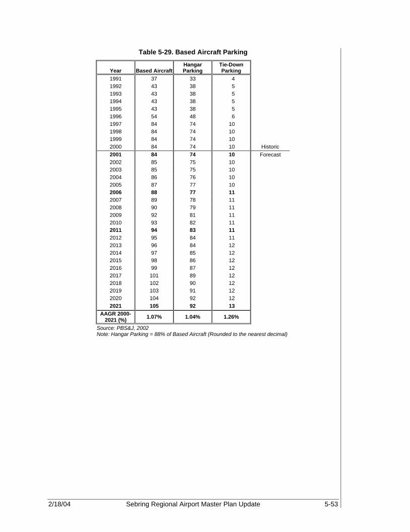
2/18/04 Sebring Regional Airport Master Plan Update 5-53
Table 5-29. Based Aircraft Parking
Year Based Aircraft Hangar Parking
Tie-Down Parking
1991 37 33 4 1992 43 38 5 1993 43 38 5 1994 43 38 5 1995 43 38 5 1996 54 48 6 1997 84 74 10 1998 84 74 10 1999 84 74 10 2000 84 74 10 Historic 2001 84 74 10 Forecast 2002 85 75 10 2003 85 75 10 2004 86 76 10 2005 87 77 10 2006 88 77 11 2007 89 78 11 2008 90 79 11 2009 92 81 11 2010 93 82 11 2011 94 83 11 2012 95 84 11 2013 96 84 12 2014 97 85 12 2015 98 86 12 2016 99 87 12 2017 101 89 12 2018 102 90 12 2019 103 91 12 2020 104 92 12 2021 105 92 13
AAGR 2000-2021 (%) 1.07% 1.04% 1.26%
Source: PBS&J, 2002 Note: Hangar Parking = 88% of Based Aircraft (Rounded to the nearest decimal)

2/18/04 Sebring Regional Airport Master Plan Update 5-54
Table 5-30. Forecast of General Aviation Passengers
Year Local
Operations Local
PassengersItinerant
Operations Itinerant
PassengersTotal
Passengers 1990 4,500 4,050 15,000 45,000 49,050 1991 8,000 7,200 19,500 58,500 65,700 1992 13,000 11,700 22,500 67,500 79,200 1993 13,000 11,700 22,500 67,500 79,200 1994 13,000 11,700 21,000 63,000 74,700 1995 13,000 11,700 21,000 63,000 74,700 1996 20,500 18,450 25,200 75,600 94,050 1997 13,000 11,700 23,000 69,000 80,700 1998 27,500 24,750 32,200 96,600 121,350 1999 28,875 25,988 34,238 102,714 128,702 2000 30,375 27,338 35,835 107,505 134,843 Historic 2001 30,399 27,359 39,717 119,152 146,511 Forecast 2002 33,499 30,149 42,918 128,753 158,902 2003 34,356 30,920 44,262 132,786 163,706 2004 35,109 31,598 45,279 135,836 167,434 2005 35,969 32,372 46,461 139,384 171,756 2006 36,821 33,139 47,643 142,928 176,066 2007 37,765 33,988 48,955 146,866 180,854 2008 38,545 34,691 50,054 150,163 184,854 2009 39,368 35,431 51,143 153,430 188,862 2010 40,172 36,155 52,273 156,820 192,975 2011 40,960 36,864 53,383 160,148 197,012 2012 41,754 37,578 54,494 163,482 201,061 2013 42,557 38,301 55,618 166,853 205,154 2014 43,311 38,980 56,640 169,921 208,901 2015 44,077 39,669 57,677 173,031 212,699 2016 44,853 40,367 58,727 176,181 216,549 2017 45,666 41,099 59,766 179,297 220,396 2018 46,464 41,818 60,845 182,534 224,351 2019 47,274 42,546 61,938 185,814 228,360 2020 48,095 43,286 63,046 189,137 232,422 2021 48,928 44,036 64,168 192,504 236,540
AAGR 2000-2021
(%) 2.30% 2.30% 2.81% 2.81% 2.71%
Source: Sebring Regional Airport, FAA 5010 Forms, FAA TAF, 2002 and PBS&J, 2002
5.11.2 Automobile Parking Automobile parking forecasts have been developed using a factor of 1.3 parking spaces per busy hour passenger as suggested in the Transportation Research Boards publication, Measuring Airport Landside Capacity. These forecasts will be used in a later section to determine the facility requirements and the extent, if necessary, of improvements to the parking area. Table 5-31 illustrates the forecast parking spaces throughout the 20+-year planning period.

2/18/04 Sebring Regional Airport Master Plan Update 5-55
Table 5-31. Forecast of Automobile Parking Spaces
Year Peak Hourly
Total Operations Peak Hour
Passengers Total Automobile Parking Demand
1991 15 34 44 1992 19 42 55 1993 19 42 55 1994 18 39 51 1995 18 39 51 1996 25 52 68 1997 19 42 55 1998 32 67 87 1999 33 68 88 2000 35 71 92 Historic 2001 37 76 99 Forecast 2002 40 83 108 2003 41 85 111 2004 42 87 113 2005 43 89 116 2006 44 91 118 2007 46 94 122 2008 47 96 125 2009 48 98 127 2010 49 100 130 2011 50 102 133 2012 51 104 135 2013 52 107 139 2014 52 109 142 2015 53 111 144 2016 54 113 147 2017 55 115 150 2018 56 117 152 2019 57 119 155 2020 58 121 157 2021 59 123 160
AAGR 2000-2021
(%) 2.55% 2.65% 2.65%
Source: Sebring Regional Airport, FAA 5010 Forms, FAA TAF, 2002 and PBS&J, 2002 Note: Peak Hour Passengers and Total Automobile Parking (Rounded to the nearest decimal)
5.12 COMMERCIAL SERVICE ACTIVITY SEF has been identified, since 1987 in Florida Aviation System Plan, as a future commercial service facility to meet the capacity requirements of the Central Florida region. The Airport acreage and central location, as well as foreign trade zone (FTZ), within the regional market makes SEF a prime candidate for commuter service within the timeframe of this study. As a result, an air service study is currently being conducted to determine the type and likelihood of commercial passenger operations at SEF. It is important to note that with the increasing trend of regional jets and the ability of these aircraft to produce profitable routes where previous attempts have failed, future

2/18/04 Sebring Regional Airport Master Plan Update 5-56
commercial service at SEF from such regional carriers as ASA and ComAir may be realized. Therefore, the existing terminal facilities, itinerant aircraft parking areas, and Part 139 certifications should be maintained and obtained in the event scheduled service is established. The commercial service at SEF may occur before 2006 if attempts are made to attract carriers from nearby airports. If such efforts are successful, a detailed study of forecast commercial operations should be completed to ensure adequate capacity is provided to meet the increased demand. 5.13 FORECAST SUMMARY The aviation forecasts developed in this section reflect reasonable and acceptable methods of forecasting. The year 2000 historical aircraft operations for SEF were used as the base year for the 20+ year forecasts. This information was obtained from a variety of sources, including FAA 5010 reported data, historical fuel sales, Sebring Flight Center data, aircraft electronic counter, and some recorded ATCT data. FAA TAF data predicted that 64,113 aircraft operations would occur for the year ending 2000. However, the SAA reported 67,210 aircraft operations for the year ending 2000. This reporting discrepancy is the result of the FAA using the year 1999 as its base year for the 15 year forecast period. The TAF for SEF predicts a flat-line or zero percent growth rate. This is unlikely since, according to the FAA Aerospace Forecasts for Fiscal Years 2002-2013, GA growth nationwide will have an average annual growth rate of 1.6% for both itinerant and local aircraft operations. For SEF, an average annual growth rate of two percent was determined based upon a variety of forecast methodologies for the 20+-year planning period. This growth rate is considered conservative since the SAA is looking to expand its GA facilities as well as institute limited commercial service. Growth at SEF over the past five years has increased at an average annual rate of more than eight percent. Thus, a zero-percent growth as reported by the FAA TAF for SEF is considered unlikely. Tables 5-32 and 5-33 present a summary of the GA and military operations forecasts, which were developed in this chapter. These forecasts will be used in later sections to develop demand/capacity analysis and facility requirements over the forecast period. FAA Washing is currently reviewing the forecasts and any changes or updates to the forecasts will be included as an addendum to this document.

2/18/04 Sebring Regional Airport Master Plan Update 5-57
Table 5-32. Comparison of Airport Planning and TAF Forecast
Airport AF/TAF
Year Forecast TAF (%
Difference) Passenger Enplanements Base yr 2000 0 0 0.00% Base yr + 6yr 2006 0 0 0.00% Base yr + 11yr 2011 0 0 0.00% Base yr + 16yr 2016 0 0 0.00% Base yr + 21yr 2021 0 0 0.00% Commercial Operations Base yr 2000 0 0 0.00% Base yr + 6yr 2006 0 0 0.00% Base yr + 11yr 2011 0 0 0.00% Base yr + 16yr 2016 0 0 0.00% Base yr + 21yr 2021 0 0 0.00% Total Operations Base yr 2000 67,210 64,113 4.83% Base yr + 6yr 2006 85,464 64,113 33.30% Base yr + 11yr 2011 95,343 64,113 48.71% Base yr + 16yr 2016 104,580 64,113 63.12% Base yr + 21yr 2021 114,096 64,113 77.96%

2/18/04 Sebring Regional Airport Master Plan Update 5-58
Table 5-33. Summary of Airport Operations
A. Forecast Levels and Growth Rates AIRPORT NAME: SEF Specify base year: 2000 AAGR (%)
Base Yr Level Base Yr + 1 yr
Base Yr + 6 yr
Base Yr + 11 yr
Base Yr + 16 yr
Base Yr + 21 yr
Base Yr to +1 yr
Base Yr to +6 yr
Base Yr to +11 yr
Base Yr to +16 yr
Base Yr + 21 yr
Air Carrier 0 0 0 0 0 0 0.0% 0.0% 0.0% 0.0% 0.0% Commuter 0 0 0 0 0 0 0.0% 0.0% 0.0% 0.0% 0.0%
TOTAL 0 0 0 0 0 0 0.0% 0.0% 0.0% 0.0% 0.0% Operations
Itinerant Air Carrier 0 0 0 0 0 0 0.0% 0.0% 0.0% 0.0% 0.0% Commuter/Air
Taxi 0 0 0 0 0 0 0.0% 0.0% 0.0% 0.0% 0.0%
Total Commercial Operations
0 0 0 0 0 0 0.0% 0.0% 0.0% 0.0% 0.0%
General Aviation 36,279 39,717 47,643 53,383 58,727 64,168 9.5% 4.6% 3.6% 3.1% 2.8% Military 1,000 1,000 1,000 1,000 1,000 1,000 0.0% 0.0% 0.0% 0.0% 0.0% Local
General Aviation 29,931 30,399 36,821 40,960 44,853 48,928 1.6% 3.5% 2.9% 2.6% 2.4%
Military 0 0 0 0 0 0 0.0% 0.0% 0.0% 0.0% 0.0% TOTAL OPERATIONS 67,210 71,116 85,464 95,343 104,580 114,096 5.8% 4.1% 3.2% 2.8% 2.6%

2/18/04 Sebring Regional Airport Master Plan Update 5-59
Table 5-33 (Continued). Summary of Airport Operations
Instrument Approaches 528 559 672 750 822 897 5.8% 4.1% 3.2% 2.8% 2.6%
Peak Hour Operations 35 37 44 50 54 59 5.8% 4.1% 3.2% 2.8% 2.6%
Cargo/Mail (Enplaned + Deplaned Tons) 0 0 0 0 0 0 0.0% 0.0% 0.0% 0.0% 0.0%
Based Aircraft
Single Engine (Non-jet) 57.0 57.0 59.7 63.8 67.2 71.3 0.0% 5.0% 12.0% 18.0% 25.0%
Multi Engine (Non-jet) 18.0 18.0 18.9 20.1 21.2 22.5 0.0% 5.0% 12.0% 18.0% 25.0%
Jet Engine 0.0 0.0 0.0 0.0 0.0 0.0 0.0% 0.0% 0.0% 0.0% 0.0% Helicopter 1.0 1.0 1.0 1.1 1.2 1.3 0.0% 5.0% 12.0% 18.0% 25.0% Other 8.0 8.0 8.4 9.0 9.4 10.0 0.0% 5.0% 12.0% 18.0% 25.0%
TOTAL 84.0 84.0 88.0 94.0 99.0 105.0 0.0% 0.8% 1.0% 1.0% 1.1%
B. Operational Factors
Base Yr Level Base Yr + 1 yr
Base Yr + 6 yr
Base Yr + 11 yr
Base Yr+ 16 yr
Base Yr + 21 yr
Average Aircraft Size (Seats)
Air Carrier 0 0 0 0 0 0 Commuter 0 0 0 0 0 0
Average Enplaning Load Factor
Air Carrier 0.00% 0.00% 0.00% 0.00% 0.00% 0.00% Commuter 0.00% 0.00% 0.00% 0.00% 0.00% 0.00%
Local GA Operations per Based Aircraft (Based on selected forecasts)
356 362 418 436 453 466

02/18/2004 Sebring Regional Airport Master Plan Update 6-1
DEMAND CAPACITY ANALYSIS Sebring Regional Airport 6.1 INTRODUCTION A key step in the Master Plan process is developing requirements of airport facilities, which will allow for airside and landside evolution over the term of the planning period. By comparing the existing conditions of the Airport to predicted growth projections based upon both existing and future aircraft usage as reported, the Airport can define requirements for runways, taxiways, aprons, terminal, and other related facilities to accommodate growth over the short-, intermediate-, and long-terms. Demand-capacity analysis aids in the identification of airport deficiencies, surpluses, and opportunities for future development. This chapter of the Master Plan will analyze the ability of the current facilities at the Sebring Regional Airport (SEF) to meet both the forecast planning activity levels shown in Chapter 5, Projection of Aviation Demand, as well as to meet anticipated aircraft group category demand. Using Federal Aviation Administration (FAA) methodologies and typical sizing factors, the aviation projections are converted into facility requirements that will be discussed in Chapter 7 over the 20+-year planning period. 6.2 GENERAL An essential step in the process of predicting airport needs is the determination of an airport’s current capacity to accommodate anticipated demand. Demand-capacity analyses yield information, which is used to design the airport layout plan and stage facility development. This study was developed to determine the capacity of SEF to accommodate anticipated aviation demand. There are two inter-related types of aviation demand: Operational Demand and Aircraft Group Category Demand. Each of these demand types effect capacity and development at an airport. Demand associated with operational capacity is determined through an analysis of the Air Service Volume (ASV). The ASV determines an airport’s annual capacity based upon historic and forecast operations and fleet mix. It does not take into account, however, significant changes in aircraft group categories, which do not historically or currently exist at an airport in significant number. This is a deficiency in the airport capacity analysis. ASV only accounts for deficiencies in runway use, aircraft fleet mix, weather conditions, etc. that would be encountered based upon the existing aircraft group category and usage. In order to compensate for this deficiency, capacity and demand based upon potential aircraft group category was determined. The Airport Group Category demand analysis evaluates not only the existing fleet mix, but also anticipated future fleet mix based upon a variety of external and internal factors unique to each particular airport. In the case of SEF, potential changes in roadway infrastructure, introduction of high speed rail, existing military fueling contracts, foreign trade zone designation, existing demand by sophisticated corporate and regional jet aircraft, testing facility for Small Aircraft Transportation System (SATS), etc., all effect airport infrastructure, such as runway length, strength, navigational aids (NAVAIDS), etc.
6

02/18/2004 Sebring Regional Airport Master Plan Update 6-2
Three separate facility groups, each with the potential to constrain growth, were investigated. The maximum obtainable airport capacity could be dependent upon the limitations of any one of the following:
• Airspace Capacity • Airfield Capacity • Landside Capacity 6.3 AIRSPACE CAPACITY Airspace capacity at an airport can be impacted when the flight paths of air traffic at nearby airports, or local navigational aids (NAVAIDS), interact to affect operations at the study airport. Additionally, obstructions near or in the approaches to an airport, that require aircraft to alter flight paths to avoid the obstruction, can limit the number of aircraft processed, and adversely affect airspace capacity. Therefore, a review of the obstructions, airports, special use airspace and associated approach procedures that surround SEF was completed to determine airspace capacity. Figure 6-1 illustrates the overall airspace surrounding SEF, as depicted in FAA Miami Sectional Aeronautical Chart, 69th Edition, September 6, 2001. 6.3.1 Airspace Limitations As discussed in Chapter 2, the Miami Air Route Traffic Control Center (ARTCC) controls the airspace in the Sebring area, and is responsible for en route control of all aircraft operating under instrument flight rules (IFR) in the Sebring area. Controlled airspace associated with SEF includes Class E, airspace that includes all controlled airspace other than Class A, B, C, or D, and special use airspace (SUA), which includes warning areas, restricted areas, military training routes (MTRs), and military operating areas (MOAs). While multiple use of the airspace is not prohibited within warning areas and MOAs, avoidance is advised during time of military training use. Joint use of MOAs is allowed; however, pilots flying within the MOAs are responsible to employ “see and avoid” standards of flight safety. Warning areas, restricted areas, MTRs, and MOAs are plotted on aeronautical charges so that pilots are aware of their location and the potential of military flight training in the vicinity. 6.3.1.1 Military Airspace SEF is located within the Lake Placid MOA. MOAs and other SUAs associated with the Avon Park Bombing Range and MacDill Air Force Base Auxiliary Airport (AGR) limit SEF’s airspace operations. The restricted areas, as indicated in Figure 6-1, indicate those areas that are continuously in effect and limit where non-military aircraft can operate. As indicated, most of the areas restrict civilian aircraft to fly below 14,000 ft mean sea level (MSL). The Lake Placid MOA, in which SEF, Avon Park (AVO) and Lake Wales (X07) Airports are located, is in effect intermittently during daylight hours Monday through Friday, and occasionally on weekends, but does allow aircraft to fly lower than 7,000 feet on a limited basis. Table 6-1 lists specific restricted areas and MOAs in the region surrounding SEF.
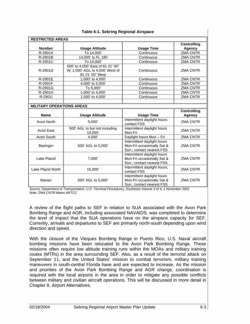
02/18/2004 Sebring Regional Airport Master Plan Update 6-3
Table 6-1. Sebring Regional Airspace
RESTRICTED AREAS
Number Usage Altitude Usage Time Controlling
Agency R-2901A To 14,000’ Continuous ZMA CNTR R-2901B 14,000’ to FL 180 Continuous ZMA CNTR R-2901C To 14,000’ Continuous ZMA CNTR
R-2901D 500’ to 4,000’ East of 81 21’ 00” W; 1,000’ AGL to 4,000’ West of
81 21’ 00” West Continuous ZMA CNTR
R-2901E 1,000” to 4,000’ Continuous ZMA CNTR R-2901F 4,000’ to 5,000’ Continuous ZMA CNTR R-2901G To 5,000’ Continuous ZMA CNTR R-2901H 1,000’ to 4,000’ Continuous ZMA CNTR R-2901I 1,500’ to 4,000’ Continuous ZMA CNTR
MILITARY OPERATIONS AREAS
Name Usage Altitude Usage Time Controlling
Agency
Avon North 5,000’ Intermittent daylight hours: contact FSS ZMA CNTR
Avon East 500’ AGL to but not including 14,000’
Intermittent daylight hours Mon-Fri ZMA CNTR
Avon South 4,000’ Daylight hours Mon – Fri ZMA CNTR
Basinger 500’ AGL to 5,000’ Intermittent daylight hours Mon-Fri occasionally Sat & Sun.; contact nearest FSS
ZMA CNTR
Lake Placid 7,000’ Intermittent daylight hours Mon-Fri occasionally Sat & Sun.; contact nearest FSS
ZMA CNTR
Lake Placid North 15,000’ Intermittent daylight hours; contact FSS ZMA CNTR
Marian 500’ AGL to 5,000’ Intermittent daylight hours Mon-Fri occasionally Sat & Sun.; contact nearest FSS
ZMA CNTR
Source: Department of Transportation, U.S. Terminal Procedures, Southeast Volume 3 of 4, 1 November 2001 Note: ZMA CNTR Miami ARTCC A review of the flight paths to SEF in relation to SUA associated with the Avon Park Bombing Range and AGR, including associated NAVAIDS, was completed to determine the level of impact that the SUA operations have on the airspace capacity for SEF. Currently, arrivals and departures to SEF are primarily north-south depending upon wind direction and speed. With the closure of the Vieques Bombing Range in Puerto Rico, U.S. Naval aircraft bombing missions have been relocated to the Avon Park Bombing Range. These missions often require low altitude training runs within the MOAs and military training routes (MTRs) in the area surrounding SEF. Also, as a result of the terrorist attack on September 11, and the United States’ mission to combat terrorism, military training maneuvers in south-central Florida have and are expected to increase. As the mission and priorities of the Avon Park Bombing Range and AGR change, coordination is required with the local airports in the area in order to mitigate any possible conflicts between military and civilian aircraft operations. This will be discussed in more detail in Chapter 8, Airport Alternatives.

02/18/2004 Sebring Regional Airport Master Plan Update 6-4
6.3.2 Instrument Approach Limitations Currently, approaches to SEF are primarily visual only. However, there is a published global positioning system (GPS) and VHF Omnidirectional Range and Tactical Aircraft Control and Navigation (VORTAC) approach associated with Runway 36, which uses the following waypoints, La Belle, Embru, and POPMM, to provide a straight approach to Runway 36. Figure 6-2 illustrates the GPS approach procedure to Runway 36 for SEF. As discussed in Chapter 2, and further demonstrated in this chapter, the airspace surrounding SEF is somewhat limited by SUA associated with the Avon Park Bombing Range and AGR. Terminal instrument approach procedures associated with Instrument Landing System (ILS), Microwave Landing System (MLS), and/or GPS approach procedures require a final approach distance of approximately 50,000 feet for a Cat I instrument approach, as well as designated missed approach and departure procedures. Depending upon the size, weight, and maneuverability of the aircraft, these operating procedures may cause infiltration into the restricted areas located to the east of SEF. Limited approach and departure procedures to Runway 18 could be mitigated by initiating coordination and approach procedures between the bombing range and SEF. In addition, current approaches to Runways 14-32 appear to skim the edge of the restricted areas. Therefore, this runway configuration allows for limited intrusion into such SUA. Though the airspace surrounding SEF is constrained as a result of the location of SUA (MOAs and restricted areas), the number of aircraft operations is not completely limited by airspace restrictions. Increases in aircraft operations at SEF will not exceed the airspace capacity in its existing configuration. Continued coordination between ARTCC, AVO, ARG and the other airports in the region will ensure that safe and efficient operations continue, while maintaining the smallest amount of delay possible. However, limitations to potential instrument approach operations at SEF do exist, and could potentially restrict development on existing Runways 14-32 and 18-36. Such an instrument operation would require significant analysis and coordination to ensure that conflicts with the bombing range and SEF are avoided.
Increases in aircraft operations at SEF will not exceed the airspace capacity in its existing configuration. However, limitations on additional approaches at SEF do exist.

02/18/2004 Sebring Regional Airport Master Plan Update 6-5
Figure 6-1. SEF Surrounding Airspace

02/18/2004 Sebring Regional Airport Master Plan Update 6-6
Figure 6-2. GPS Approach to Runway 36

02/18/2004 Sebring Regional Airport Master Plan Update 6-7
6.4 AIRFIELD CAPACITY As discussed earlier, airfield capacity consists of two types of demand: operational capacity and aircraft group category demand. Airfield operational capacity is defined as the number of aircraft that can be safely accommodated on the runway-taxiway system at a given point in time. Delay is the difference between “constrained” and “unconstrained” aircraft operating time, usually expressed in minutes. As demand approaches capacity, individual aircraft delay is increased. Successive hourly demands exceeding the hourly capacity will result in unacceptable delays. Aircraft delays can still occur even when the total hourly demand is less than hourly capacity if the demand during a portion of that hour exceeds the capacity during that hour. Aircraft group category demand/capacity is based upon the type of aircraft group category that can safely use the Airport based upon available airport facilities and infrastructure. This type of demand evaluates capacity in relation to potential opportunity costs in order to determine if significant demand for infrastructure development exists. If limiting infrastructure exists, i.e. runway length inadequate to accommodate potential aircraft group or groups demand for facilities, then it is likely that the Airport will loose its competitive edge in the marketplace. 6.4.1 Airfield Operational Capacity Operational demand and capacity analysis of airfield or airside systems and facilities, such as the Airport’s runways and taxiways, results in calculated hourly capacities for Visual Flight Rules (VFR) and IFR conditions. Additionally, an ASV, which identifies the total number of aircraft operations that may be accommodated at the Airport without excessive delay, is also calculated. Since the magnitude and scheduling of user demand is relatively uncontrollable, especially at a general aviation (GA) airport, reductions in aircraft delay can best be achieved by improving airfield facilities to increase overall capacity. Airfield capacity is quantified by two calculable factors:
• Weighted hourly capacity (Cw) is the theoretical number of aircraft that can be accommodated by the Airport in an hour, considering all runway use configurations.
• ASV is the Airport’s theoretical annual operational capacity. To determine Cw and ASV and conduct the capacity analysis, a number of prime determinates specific to SEF must be identified. These include:
• Meteorological conditions • Runway use configuration • Aircraft mix (based upon existing aircraft group demand) • Percent arrivals • T&G operations • Exit taxiways The FAA defines operational capacity as a reasonable estimate of the Airport’s annual capacity that would be encountered over a year’s time. The parameters, assumptions, and calculations required for this analysis are included in the following sections.

02/18/2004 Sebring Regional Airport Master Plan Update 6-8
6.4.1.1 Runway Orientation, Utilization, and Wind Coverage Ideally, the active runway should match the wind direction as closely as possible. To a lesser extent, runway use is also determined by proximity to the terminal area, available runway length, and instrumentation. At SEF, use of more than one runway for arrivals and departures is rare since SEF is a non-towered Airport. Runway 18-36, which is aligned to the north and south, is the primary runway in use at SEF, while Runway 14-32, aligned to the northwest-southeast, is used as the crosswind runway. The use and orientation of Runways 18-36 and 14-22 were evaluated to determine the capacity of the airfield, which is the sum of capacities determined for each operation (takeoff and landing). Each operation is defined by its direction, which is often influenced by wind, available instrument approaches, noise abatement procedures, airspace restrictions, and/or other operating parameters. The runway use configurations used for capacity calculations considered runway orientations of 14-32 and 18-36 in various combinations. The operations were evaluated utilizing the intersecting or open “V” runway design, Model #43, (FAA AC 150/5060-5, Airport Capacity and Delay) under VFR and IFR conditions. Runway use was determined through an analysis of statistical wind data obtained from the National Oceanic and Atmospheric Administration’s (NOAA’s) National Climatic Data Center (NCDC) in Asheville, North Carolina, as well as information provided by the tenants and Airport management. This information was analyzed to determine the percent of operations that typically utilize each runway, based on the type of aircraft, wind direction, and overall weather conditions. The resulting runway utilizations will later be factored into the capacity calculations for the airfield. Table 6-2 presents runway utilization for VFR and IFR conditions at SEF.
Table 6-2. Runway Utilization (Percent)
Runway VFR Conditions IFR Conditions
14 10.0% 0.0% 32 5.0% 0.0% 18 20.0% 0.0% 36 61.1% 3.0%
Closed 0.9% Source: NOAA, NCDC May 2002, Sebring Airport Authority and Sebring Flight Center
The single most important criterion for runway orientation is wind coverage. The runways should provide the maximum opportunity for takeoff and landing into the wind. The FAA requires the crosswind coverage of the runway systems to be at least 95 percent. To determine the wind coverage at SEF, a wind analysis was completed using Version 4.2D of the FAA’s computer program, Airport Design for Microcomputers. Crosswind components of 10.5, 13, and 16 knots were applied where appropriate. Figure 6-3 illustrates the resulting wind rose for SEF.

02/18/2004 Sebring Regional Airport Master Plan Update 6-9
Figure 6-3. All Weather and IFR Windrose Data

02/18/2004 Sebring Regional Airport Master Plan Update 6-10
Crosswind coverage and maximum crosswind components are applied to runways based on the overall size of the aircraft utilizing the runway, and the FAA design group (A, B, C, or D) applied. Therefore, crosswind components of 10.5, 13, and 16 knots were applied to Runways 18-36 and 14-32 based on the existing and anticipated aircraft design group for the two runways. The wind analysis yielded 99.61 percent coverage for all weather conditions, and 99.54 percent coverage for IFR conditions with a 13-knot crosswind. These percentages were the result of utilizing Runway 14-32 for crosswind coverage for all weather conditions only. Only Runway 18-36 is equipped for instrument procedures, therefore, crosswind coverage is unavailable. 6.4.1.2 Airfield Operational Capacity Parameters and Assumptions Calculated airfield operational capacity is developed by methods, parameters, and assumptions described in FAA Advisory Circular (AC) 150/5060-5, Airport Capacity and Delay. The calculations are based on the runway utilizations that produce the highest sustainable capacity consistent with existing air traffic rules, practices, and guidelines. The criteria and values used in the AC 150/5060-5 are typical of U.S. airports with similar runway configurations, and are designed to enable calculation of airport capacity as accurately as possible. The parameters and assumptions identified in this section were used to calculate the airfield capacity for SEF. Aircraft Mix Index The FAA has developed a classification system for aircraft, based on size, weight, and performance. Table 6-3 illustrates this classification as it is presented in the FAA AC 150/5060-5. This classification is used to develop an aircraft mix, which is the relative percentage of operations conducted by each of the four classes of aircraft (A, B, C, and D). The aircraft mix is used to calculate a “mix index”, which is used in airfield capacity studies. The FAA defines the mix index as a mathematical expression, %(C+3D), which represents the percent of Class C aircraft, plus three times the percent of Class D aircraft. The following is a list of the mix indices that may be used in capacity calculations.
• 0 to 20 • 21 to 50 • 51 to 80 • 81 to 120 • 121 to 180 The current facilities at the Airport can accommodate all four classes of aircraft (A-D). However, a review of base year operations by each class of aircraft at SEF determined that operations were divided across the four classes (A-D) of aircraft at approximately 86, 11, 3, and 0 percent, respectively. This is an estimate since there were discrepancies in aircraft reporting. Utilizing this information, the base year mix index at SEF, for purposes of airfield capacity calculations, is 3.0 percent. Additionally, based upon the forecasts presented in Chapter 5, the mix index was estimated for cardinal forecast years of 2006, 2011, 2016, and 2021, resulting in 3.40, 3.6, 3.9, and 4.0 percent, respectively. The mix index for these years will be used to determine the ratio of demand to total capacity at each cardinal year. This analysis will be discussed in the capacity calculations section of this chapter.
A review of base year operations by each class of aircraft at SEF determined that operations were divided across the four classes of aircraft at 86, 11, 3 and 0 percent, respectively.

02/18/2004 Sebring Regional Airport Master Plan Update 6-11
Table 6-3. FAA Aircraft Classifications
Aircraft Class Max. Cert. Takeoff
Weight (lb) Number of Engines
Wake Turbulence Classification
A Single B
12,500 or less Multi
Small (S)
C 12,500 – 300,000 Multi Large (L) D Over 300,000 Multi Heavy (H)
Source: FAA AC 150/5060-5, Airport Capacity and Delay Percent Arrivals The percent of arrivals is the ratio of arrivals to total operations. It is typically safe to assume that the total annual arrivals will equal total departures, and that average daily arrivals will equal average daily departures. Interviews with the fixed base operators (FBOs) and aviation tenants at SEF confirmed that arrivals equal departures. Therefore, an arrival percentage of 50 percent was used for the airfield capacity calculations. Percent Touch and Go The T&G percentage is the ratio of landings with an immediate takeoff, to total operations. This type of operation is typically associated with flight training. The number of T&G operations normally decreases as the number of air carrier operations increases, demand for service and number of total operations approach runway capacity, and/or weather conditions deteriorate. Typically, T&G operations are assumed to be between zero and 50 percent of total operations. Since SEF does not have an air traffic control tower (ATCT), limited information was available to determine what percentage of the total operations at SEF are T&G. However based upon interviews and discussions with the Sebring Flight Center and local aviation tenants, T&G operations on average account for less than 30 percent of total operations Taxiway Factors Taxiway entrance and exit locations are an important factor in determining the capacity of an airport’s runway system. Runway capacities are highest when full-length, parallel taxiways, and ample runway entrance and exit taxiways are available, but no active runway crossings exist. FAA Advisory Circular 150/5060-5 identifies the criteria for determining taxiway exit factors at an airport. The criteria for exit factors are generally based on the mix index and the distance the taxiways are from the threshold and each other. Because the mix index for SEF was calculated to be 3.0 for the base year, and forecast to be 4.0 by 2021, only exit taxiways that are between 2,000 and 4,000 feet from the threshold, spaced at least 750 feet apart, were considered, and contributed to the taxiway exit factor. Taxiways that met these parameters were considered in completing the capacity calculations for all directions and all conditions. Taxiway exits were evaluated for northerly and southerly flow for Runway 18-36 and northwesterly and southeasterly flow for Runway 14-32, during VFR and IFR conditions. The number of exit taxiways available for each runway can impact runway capacity. Runway 18-36 has two exit taxiways in addition to those located at the runway thresholds. There are two taxiways available for Runway 14-32. However, based on this
It is estimated that touch and go operations account for approximately 30 percent of total operations at SEF.

02/18/2004 Sebring Regional Airport Master Plan Update 6-12
information and the location of the taxiways, it was determined that on average a total of one taxiway met the requirements contributing to the taxiway exit factor. Thus, using Figures 3-27 and A3-2B, Hourly Capacity in a Non Radar Environment from AC 150/5060-5, the taxiway exit factor identified for Runway 18-36 was 0.85 for VFR operations, and 1.00 for IFR operations, and will be used in the capacity calculations for north and south operations. For Runway 14-32, the taxiway exit factor was 0.80 for VFR operations only. The maximum factor available for both weather conditions is 1.0. Figure 6-4 illustrates the existing taxiway system at SEF. It should be noted that improvements to the taxiway system are currently underway; therefore, it is anticipated that any current deficiencies in the taxiway system will be alleviated. All necessary improvements to the taxiway system and airfield capacity will be discussed further in Chapter 7, Facility Requirements. General Airspace Limitations As discussed in Section 6.3, Airspace Capacity, airspace surrounding SEF is moderately constrained as a result of SUA associated with the Avon Park Bombing Range and AGR. Instrument operations are severely limited since SEF doesn’t have an active ATCT on site. Miami ARTCC provides air traffic route control in the area. Also, as a result of the September 11, closure of the Vieques Bombing Range in Puerto Rico, and the changing mission of the military, it is expected that military traffic in the area surrounding SEF will increase. Thus, greater coordination between the military and civilian airports in the area is recommended. Future development at SEF will need to be coordinated to some extent with military operations in order to avoid potential conflicts between aircraft, and to efficiently utilize local airspace. This will be discussed in more detail in the facility requirements and development alternative chapters, Chapter 7 and Chapter 8, respectively, of this working paper. One of the considerations raised in the last Master Plan included the potential closure of Runway 14-32 and the reopening of Runway 4-22. Based upon information from local pilots, this is more in-line with current wind conditions. However, Runway 4-22 was dismantled as part of the parallel taxiway project on Runway 18-36. In addition, the orientation of Runway 4-22 would have caused conflicts with civilian aircraft entering the restricted area located along the approach path to Runway 4. Additional limiting airspace capacity factors that have been identified at SEF include potential limitations to an ILS approach to Runway 18 as a result of the proximity of the military restricted areas and AVO. An ILS approach requires a longer final approach path to the runway. This may cause conflicts to the restricted area due to low flying training runs as well as potential conflicts with approaches to AVO and AGR. The airspace and overall approach requirements for ILS and other instrument approaches are significant, and the addition of a north approach to SEF would likely cause considerable conflicts with existing approaches to AVO and AGR, in addition to potential encroachment into military restricted airspace. Future instrument approach procedures at SEF will need to be coordinated with the range to limit conflicts associated with different types of aircraft.

02/18/2004 Sebring Regional Airport Master Plan Update 6-13
Figure 6-4. Existing Taxiway System

02/18/2004 Sebring Regional Airport Master Plan Update 6-14
Since SEF is not equipped with an active ATCT, and only Runway 36 is equipped for a non-precision instrument approach, these factors were considered in the airfield capacity calculations. It is important to note that these factors have a significant affect on airport capacity since, in times of especially inclement weather conditions (IFR), aircraft operations at SEF are limited or cease all together. Runway Instrumentation The capacity calculations for SEF include one primary runway and one crosswind runway. The primary runway, 18-36, provides GPS and NDB approach capabilities from Runway 36. Additionally, air traffic control (ATC) facilities, equipment, and services within the region are adequate to carry out operations in a radar and non-radar environment. Weather Influences Weather data obtained from the NCDC identified that IFR conditions (ceiling greater than or equal to 200 but less than 1,000 feet, and/or visibility greater than or equal to ½ mile, but less than 3 miles) occur approximately 5 percent of the time. The Airport is considered closed to landing aircraft in IFR conditions when cloud ceiling or visibility is below 250 feet and ½ mile, respectively, approximately .9-percent of the time. The prevalent wind direction is from the northeast. 6.4.1.3 Airfield Capacity Calculations The airfield operational capacity calculations in this section were performed using the parameters and assumptions discussed above. These calculations also utilize data from the preferred aviation demand forecast, as presented in Chapter 5, for portions of the capacity calculations. The following sections outline the hourly capacities in VFR and IFR conditions, as well as the annual service volume for SEF. The capacity of SEF to accommodate projected increases in aircraft operations was conducted in accordance to procedures contained in FAA AC 150/5060-5, Airport Capacity and Delay. Table 6-4 provides the existing airfield configuration capacity analysis for the Airport.
The lack of an instrument approach, ATCT, and location in relation to military airspace were all identified as having a potentially negative affect on SEF overall airport capacity.

02/18/2004 Sebring Regional Airport Master Plan Update 6-15
Table 6-4. Airfield Capacity Factors
Runway Use
Condition
Hourly Capacity
Base (C*)
Touch and Go Factor
(T)
Exit Rating
(E)
Hourly Capacity (C* x T x E)
Weight Factor
(W)
Percent-age Use
VFR
Percent-age Use IFR
Takeoff 18 Landing 18 VFR
108 1.13 .85 103.734 1 20%
Takeoff 18 Landing 18 IFR
0 0 0 0 4 0%
Takeoff 36 Landing 36 VFR
108 1.13 .85 103.734 1 61.1%
Takeoff 36 Landing 36 IFR
31 1.00 1.00 31 4 3.0%
Takeoff 14 Landing 14 VFR
108 1.13 .80 97.63 1 10%
Takeoff 14 Landing 14 IFR
0 0 0 0 4 0%
Takeoff 32 Landing 32 VFR
108 1.13 .80 97.63 1 5%
Takeoff 32 Landing 32 IFR
0 0 0 0 4 0%
Airport Closed 0 0 0 0 25 .9%
TOTAL 96.1% 3.9% Notes: Maximum Hourly Capacity = 103.734
Hourly Capacity = (Column 2 x Column 3 x Column 4) Weighted Hourly Capacity Cw=E (Column 5 x Column 6 x Column 7)/E(Column 6 x Column 7) = Daily Demand Ratio (D) with Aircraft Mix Index of 0% to 20% o 67,210/285.6 = 235.36 Hourly Demand Ratio (H) with Aircraft Mix Index of 0% to 20% o 235.36/35 = 8.16 Annual Service Volume (Cw x D x H) = The weight factor calculation for both IFR and VFR conditions is as outlined in the methodology found in FAA AC 150/5060-5, Airport Capacity and Delay, Table 3-1 Since Runway 36 is equipped with GPS, the majority of IFR operations are performed on this runway
Hourly VFR Capacity The hourly VFR capacities for Runways 18-36 and 14-32 were calculated based on the guidance and procedures in FAA AC 150/5060-5, Airport Capacity and Delay. The hourly VFR capacity was calculated to be 104 operations per hour and 98 operations per hour, respectively. The following equation and calculations present the step-by-step method that was utilized to calculate the hourly VFR capacities, based on the guidance provided in FAA AC 150/5060-5.

02/18/2004 Sebring Regional Airport Master Plan Update 6-16
Hourly VFR Equation
Hourly Capacity Base (C*) x Touch & Go Factor (T) x Exit Factor (E) = Hourly Capacity Runway 18-36 Hourly Capacity Runway 14-32 Hourly Capacity
C* x T x E = C C* x T x E = C 108 x 1.13 x 0.85 = 104 108 x 1.13 x .80 = 98
These hourly capacities will be used to determine the Cw and the annual service volume (ASV) calculations for the SEF. Hourly IFR Capacity Since SEF does not have radar coverage and is not equipped with an ILS, it was necessary to follow the analysis described in Chapter 4, Special Applications, in FAA AC 150/5060-5 to determine the IFR capacity of the airfield. Thus, using the wind information obtained from AVO NOAA, IFR conditions occur approximately 3.9 percent of the time. Of that 3.9 percent, approximately .9 percent of the time IFR conditions prohibit the use of the Airport, thus, effectively closing the Airport to flight operations. Using Figure 4-15, Hourly Capacity in Non-Radar Environment, in FAA AC 150/5060-5, it was determined that the hourly capacity base for the Airport is equal to 31 operations. During IFR operations, T (the Touch and Go Factor) will always equal 1.00. Therefore, the IFR hourly capacity for Runway 36, the only runway equipped for instrument operations, was calculated to be 31 operations per hour under IFR conditions. The hourly IFR capacity equation and calculations are shown below. Hourly IFR Equation
Hourly Capacity Base (C*) x Touch & Go Factor (T) x Exit Factor (E) = Hourly Capacity Runway 36 Hourly Capacity Runway 14, 18, and 32 Hourly Capacity
C* x T x E = C C* x T x E = C
31 x 1.0 x 1.0 = 31 0 x 1.0 x 0 = 0
Weighted Hourly Capacity (Cw) The Cw for SEF is determined by multiplying the hourly capacity x weighted factor x percent of runway use which is then divided by the weight factor x runway percent of use for all runway configurations. This represents the maximum number of hourly operations that can occur at the Airport, based upon the airfield configuration, before significant operational delay is encountered. For SEF, the Cw equals 78.48 operations per hour.
Cw = (C1 x W1 x P1) + (C2 x W2 x P2)/(W1 x P1) + (W2 x P2)

02/18/2004 Sebring Regional Airport Master Plan Update 6-17
Annual Service Volume (ASV) The ASV is the maximum number of annual operations that can occur at the Airport before an assumed maximum operational delay value is encountered. The ASV is calculated based on the existing runway configuration, aircraft mix, and the parameters and assumptions identified herein, and incorporates the hourly VFR and IFR capacities calculated previously. Utilizing this information and the guidance provided in FAA AC 150/5060-5, the ASV for existing conditions at SEF was calculated to be 150,701 operations. It should be noted that the ASV represents the existing airfield capacity in its present configuration, with one north-south primary runway and one crosswind runway. The equation and calculations used to obtain the ASV were taken from the FAA AC, and are presented following. ASV Equation
Weighted Hourly Capacity (Cw) x Annual/Daily Demand (D) x Daily/Hourly Dem. (H) = Annual Service Volume (ASV)
ASV Calculation
Cw x D x H = ASV
78.48 x 235.32 x 8.16 = 150,701 The ASV calculations are based on the previously mentioned parameters and assumptions, and are directly derived from the guidance provided in FAA AC 150/5060-5, Airport Capacity and Delay. The results of the airfield capacity calculations represent an in-depth airport specific analysis, and have been deemed appropriate and necessary for this level of airport master planning effort. Furthermore, the current aviation demand in number of aircraft operations for the base year 2000 at the Airport, as presented in Chapter 5 of this document, is 67,210 operations. This equals approximately 44.60 percent of the present ASV. Additionally, according to the FAA, the following guidelines should be used to determine necessary steps as demand reaches designated levels.
• 60 percent of ASV: Threshold at which planning for capacity improvements should begin.
• 80 percent of ASV: Threshold at which planning for improvements should be complete and construction should begin.
• 100 percent of ASV: Airport has reached the total number of annual operations (demand) the airport can accommodate, and capacity-enhancing improvements should be made to avoid extensive delays.
Table 6-5 and Figure 6-5 illustrate the preferred aviation demand forecast for SEF, based upon Chapter 5 forecasts, and its relation to the Airport’s ASV under VFR and IFR conditions. Based upon existing demand criteria, planning of additional capacity enhancing projects will be needed during 2008, or when the 90,421 operations mark (60 percent of ASV) is crossed. If, however, the Airport’s role changes from a GA to a transport/commercial service facility as predicted by the National Plan of Integrated Airport Systems (NPIAS) and Continuing Florida Aviation System Plan (CFASP), then
The ASV for existing conditions at SEF was calculated to be150,701 operations.

02/18/2004 Sebring Regional Airport Master Plan Update 6-18
demand levels are expected to change. Capacity-enhancing improvements would include, but are not limited to, runway extensions, runway construction, runway instrumentation, and/or taxiway improvements. A detailed review of operational capacity enhancing facility requirements will be discussed in Chapter 7, Facility Requirements.
Table 6-5. Annual Service Volume vs. Demand
Year Aircraft Mix
Index Annual
Operations Annual Service Volume (ASV)
Percent of ASV
2000 3.0% 67,210 150,701 44.60% 2006 3.4% 85,464 150,701 56.71% 2011 3.6% 95,343 150,701 63.27% 2016 3.9% 104,580 150,701 69.40% 2021 4.0% 114,096 150,701 75.71%
Source: FAA AC 150/5060-5, Airport Capacity and Delay and PBS&J, 2002
Figure 6-5. Annual Service Volume vs. Demand
0
20,000
40,000
60,000
80,000
100,000
120,000
140,000
160,000
2000 2006 2011 2016 2021
Operations 60% Capacity
80% Capacity 100% Capacity
According to these calculations, the Airport will achieve 60 percent operational capacity during the year 2008. In addition, should operational capacity constraints occur at other local airports such as AVO and/or operational requirements change, there could be an increase in demand and, thus, a need for greater capacity at SEF. This demand will trigger the need for additional facilities, such as an ATCT and/or an additional runway, which could increase the capacity of the Airport to potentially 355,000 annual aircraft operations. (22)
The Airport will achieve 60 percent operational capacity in 2008.

02/18/2004 Sebring Regional Airport Master Plan Update 6-19
6.4.2 Aircraft Group Capacity Demand Based upon operational demand alone, SEF should not plan for additional capacity enhancing projects until the year 2008, or when the 90,421 operations mark (60 percent of ASV) is crossed. However, the Sebring Airport Authority (SAA) is determined to maintain or increase its position in the community as an economic generator. Therefore, airport development is considered highly desirable. As a result, an Aircraft group capacity demand analysis was performed. Aircraft Group Capacity Demand is based upon a group or groups of aircraft that have or are anticipated to use SEF in the future if certain infrastructure improvements are made. According to the 1994 Airport Layout Plan, the existing ARC for SEF is Category D-II. Based upon current information received from SAA and Sebring Flight Center, it was determined that there is currently demand for airport facilities by aircraft designated under Category D-IV with the potential for aircraft usage by category D-V aircraft. Currently, aircraft designated within the Class D-IV category use SEF on an irregular basis due to runway length constraints. Operators of more sophisticated and larger aircraft have stated that they would use the Airport if facilities were in place to meet their needs. Potential users include corporate aircraft, fractional ownership aircraft, turboprop and turbojet GA aircraft, commercial and charter service aircraft, special use aircraft, and heavy cargo aircraft. Based upon discussions with existing and potential users, Sebring Flight Center, tenants, and SAA, the number of aircraft in the D-IV aircraft group category would likely increase if adequate runway length was available. In order to determine the anticipated effect of this demand on SEF, opportunity cost analyses for each potential user was determined. 6.4.2.1 Corporate and General Aviation First, like many smaller, regional airports in Florida, SEF receives significant revenue from non-aviation sources, such as the Sebring International Raceway and Airport Industrial Park. As part of its development and revenue diversification strategy, SAA plans to develop a commerce park within its boundaries to attract aviation and non-aviation tenants as well as additional T-hangar facilities. Thus, providing additional sources of revenue. Businesses can and do, to some degree, attract aircraft operations. Historically, aircraft operations at SEF increase significantly during the months of March and September, coinciding with a variety of auto racing events. In addition, attendees often fly larger aircraft, such as the Gulfstream II and Learjet 25. However, due to limited runway length and instrument approach capabilities, many users who would like to use the Airport are prohibited from doing so. This problem is not new. There have already been several instances when aircraft typically used by fractional ownership companies have been forced to bus their passengers from SEF due to inadequate takeoff runway length associated with pavement, hot weather or other conditions. As a result, potential income associated with this and similar operations at SEF are lost, thus, representing lost opportunities or an opportunity cost. Based upon the forecast

02/18/2004 Sebring Regional Airport Master Plan Update 6-20
aircraft mix for SEF over the 20+-year planning period, turbine aircraft, especially turbojet aircraft, are expected to grow at an average annual growth rate of 5.75 percent. Thus, turbine operations at SEF are expected to represent 8.69 percent of the total aircraft operations at SEF. Again this number is somewhat deceiving since it is merely based upon historical data and does not take into account the number of aircraft that cannot use the Airport due to facility, especially runway, limitations. Based upon letters from potential users and discussions with Airport management, Table 6-6 shows the type and estimated revenue generation of aircraft that would utilize the Airport if adequate runway length were available.
Table 6-6. Corporate/GA Opportunity Costs
Aircraft Passen-
gers
Minimum Field
Length (2) (ft)
Fuel Capacity (Gallons)
Estimated Fuel
Revenue
Estimated Maximum Landing Weight
(lb)
Estimated Landing
Fees Fractional Ownership Fleet (1) Falcon 2000 8 to 19 5,440 1,841 $3,497.90 13,424 $10.07 Challenger 604 19 5,700 2,941 $5,587.90 18,729 $14.05 Airbus Corporate Jet 124 6,300 10,800 $20,520.00 79,900 $59.93 ERJ 140 44 6,463 11,435 $21,726.50 41,226 $30.92
Business/GA Aircraft Learjet 60 12 5,450 1,181 $2,243.90 8,281 $7.25 Gulfstream IV 19 5,450 4,370 $8,303.00 27,730 $20.80 Boeing Business Jet 2 to 100+ 5,450 10,000 $19,000.00 67,000 $50.25 Source: Aviation Week and Space Technology Handbook, January 1999 and PBS&J, 2002 Note: (1) Based upon information obtained from FlexJet and Bombardier Business Jets
(2) For Insurance and Safety purposes, requires additional 200+ ft of runway due to hot day or wet pavement. Max. Landing Weight = Gross Weight - Empty Weight - Fuel Capacity
Again, this table represents potential lost revenue to the Airport since the Airport will not obtain landing fees, fuel sales, aircraft parking fees, automobile parking fees, concession sales, etc. from these potential aircraft operations. Furthermore, most businesses require enough runway length to accommodate their insurance safety requirements for the hottest day of the year and/or wet pavement. Both of these environs have and will continue to affect takeoff field length requirements; therefore, an additional 200 feet of runway length is suggested to meet the takeoff field length requirements of the most demanding aircraft within either the fractional ownership or corporate/GA fleet. In order for SEF to capitalize on this existing demand, either an extension to an existing runway or construction of a new runway would be required. In addition, the installation of a precision instrument approach on one or more runway end would allow the Airport to support aircraft during inclement weather conditions.
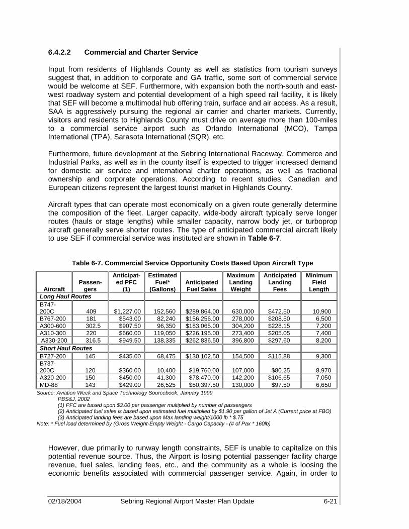
02/18/2004 Sebring Regional Airport Master Plan Update 6-21
6.4.2.2 Commercial and Charter Service Input from residents of Highlands County as well as statistics from tourism surveys suggest that, in addition to corporate and GA traffic, some sort of commercial service would be welcome at SEF. Furthermore, with expansion both the north-south and east-west roadway system and potential development of a high speed rail facility, it is likely that SEF will become a multimodal hub offering train, surface and air access. As a result, SAA is aggressively pursuing the regional air carrier and charter markets. Currently, visitors and residents to Highlands County must drive on average more than 100-miles to a commercial service airport such as Orlando International (MCO), Tampa International (TPA), Sarasota International (SQR), etc. Furthermore, future development at the Sebring International Raceway, Commerce and Industrial Parks, as well as in the county itself is expected to trigger increased demand for domestic air service and international charter operations, as well as fractional ownership and corporate operations. According to recent studies, Canadian and European citizens represent the largest tourist market in Highlands County. Aircraft types that can operate most economically on a given route generally determine the composition of the fleet. Larger capacity, wide-body aircraft typically serve longer routes (hauls or stage lengths) while smaller capacity, narrow body jet, or turboprop aircraft generally serve shorter routes. The type of anticipated commercial aircraft likely to use SEF if commercial service was instituted are shown in Table 6-7.
Table 6-7. Commercial Service Opportunity Costs Based Upon Aircraft Type
Aircraft Passen-
gers
Anticipat-ed PFC
(1)
Estimated Fuel*
(Gallons) Anticipated Fuel Sales
Maximum Landing Weight
Anticipated Landing
Fees
Minimum Field
Length Long Haul Routes B747-200C 409 $1,227.00 152,560 $289,864.00 630,000 $472.50 10,900 B767-200 181 $543.00 82,240 $156,256.00 278,000 $208.50 6,500 A300-600 302.5 $907.50 96,350 $183,065.00 304,200 $228.15 7,200 A310-300 220 $660.00 119,050 $226,195.00 273,400 $205.05 7,400 A330-200 316.5 $949.50 138,335 $262,836.50 396,800 $297.60 8,200 Short Haul Routes B727-200 145 $435.00 68,475 $130,102.50 154,500 $115.88 9,300 B737-200C 120 $360.00 10,400 $19,760.00 107,000 $80.25 8,970 A320-200 150 $450.00 41,300 $78,470.00 142,200 $106.65 7,050 MD-88 143 $429.00 26,525 $50,397.50 130,000 $97.50 6,650
Source: Aviation Week and Space Technology Sourcebook, January 1999 PBS&J, 2002 (1) PFC are based upon $3.00 per passenger multiplied by number of passengers (2) Anticipated fuel sales is based upon estimated fuel multiplied by $1.90 per gallon of Jet A (Current price at FBO) (3) Anticipated landing fees are based upon Max landing weight/1000 lb * $.75
Note: * Fuel load determined by (Gross Weight-Empty Weight - Cargo Capacity - (# of Pax * 160lb) However, due primarily to runway length constraints, SEF is unable to capitalize on this potential revenue source. Thus, the Airport is losing potential passenger facility charge revenue, fuel sales, landing fees, etc., and the community as a whole is loosing the economic benefits associated with commercial passenger service. Again, in order to

02/18/2004 Sebring Regional Airport Master Plan Update 6-22
accommodate this type of demand at SEF, a new runway and associated commercial infrastructure will have to be developed. This will be discussed in more detail in the Facilities Requirements and Alternatives chapters, Chapters 7 and 8, respectively. 6.4.3 Heavy Cargo As mentioned earlier, in addition to corporate, GA, and commercial passenger demand, there exists a demand for cargo services. Cargo service demand at SEF is not related to the express package market, but rather to the transportation of raw goods, such as those used in manufacturing and/or high-end ticket items such as racecars. Existing demand for heavy cargo services via air transportation is currently limited. However, it is anticipated that air cargo demand will be directly influenced by aviation and non-aviation development at the Airport. An existing source of demand is associated with the Sebring International Raceway. Since the racetrack is available year round for training, as well as a variety of racing activities, competitive air cargo operations may entice teams from around the world to ship their cars and equipment to SEF rather than transport them via ship and truck. As interest in racing continues to grow and new opportunities arise, it is likely that Sebring International Raceway will attract more racing participants and visitors from around the globe. SEF is designated as a Foreign Trade Zone (FTZ) offering a variety of tax breaks to potential users. FTZ procedures allow domestic activity involving foreign items to take place as if it were outside the U.S. Customs territory, thus offsetting customs advantages available to overseas producers who export in competition with products made in the U.S. (http://ia.ita.doc.gov/FTZpage). FTZs benefit companies since “goods entering FTZs are not subject to custom’s tariffs until the goods leave the Zone and are formally entered into U.S. Customs Territory. Merchandise that is shipped to foreign countries from FTZs is exempt from duty payments. This is especially useful to firms that import components in order to manufacture finished projects for export.” (http://ia.ita.doc.gov/FTZpage) Thus, the importation of raw goods from around the world to SEF will allow aviation and non-aviation related businesses within the FTZ to be more competitive in both the domestic and international market. Part of SAA’s long-term development plan includes construction and expansion of its industrial and commerce parks. As a result, businesses located within these commerce parks are likely to reap the benefits of the FTZ. It is anticipated that as commercial development grows the demand for heavy cargo service will also increase. Table 6-8 shows the type of aircraft typically used in each market segment, while Table 6-9 provides an estimate of potential revenue associated with development of this market demand.

02/18/2004 Sebring Regional Airport Master Plan Update 6-23
Table 6-8. Typical Commercial Jet Freight Fleet
Domestic International Medium Narrow-Body
(Payload Capacity from 60,000 to 120,000 lb)
Medium Wide-Body (Payload Capacity from
70,000 to 140,000 lb) Large Wide-Body (Payload Capacity over 140,000 lb)
B707-320 A310-300 B-747-100 B757-200 A300B4 B747-200 DC-8-50 A300-600 B747-300 DC-8-60 B767-300 B-747-400 DC-8-70 DC-10-10 DC-10-30/40
Source: Air Cargo Management Group/Cargo Facts, October 1998
Table 6-9. Commercial Freight Aircraft Estimated Opportunity Cost by Aircraft
Aircraft Landing
Weight (lb)
Estimated Landing Fee per
Operation (1) Field
Length
Fuel Capacity
(gal)
Estimated Fuel
Sales per Operation (2)
Cargo Capacity
Medium Narrow Body: B757-200 210,000 $157.50 7,800 58,300 $110,770.00 84,350DC-8-50 230,000 $172.50 10,000 110,428 $209,813.20 63,500DC-8-60 240,000 $180.00 10,000 112,438 $213,632.20 66,665Medium Wide Body A310-300F 273,400 $205.05 7,400 94,700 $179,930.00 88,400A300-600 310,000 $232.50 7,400 76,300 $144,970.00 120,800B767-300 326,000 $244.50 9,600 163,550 $310,745.00 60,450DC-10-10 363,500 $272.63 9,810 192,382 $365,525.80 70,618L-1011-200F 368,000 $276.00 9,200 126,000 $239,400.00 125,000Large Wide Body: B747-200 630,000 $472.50 10,900 245,600 $466,640.00 245,300B747-300 605,000 $453.75 10,900 273,600 $519,840.00 177,900B-747-400 652,000 $489.00 9,800 265,000 $503,500.00 244,470DC-10-30/40 436,000 $327.00 10,700 166,000 $315,400.00 177,000MD-11 481,500 $361.13 10,000 111,000 $210,900.00 254,500Source: PBS&J, 2002 Note: (1) Landing Fee is based upon $.75 per 1,000 lb
(2) Fuel Sales is based upon Fuel Capacity x $1.90 gallons Fuel Capacity = Gross Weight - Empty Weight-Cargo Capacity Landing Fee information taken from Tweed New Haven Regional Airport
However, SEF cannot attract heavy freight aircraft without significant infrastructure development. Typically, freighter aircraft, which are usually refurbished passenger aircraft, especially from long-haul markets, require a runway length of greater than 8,000 ft. Thus, in order for SEF to capitalize on this market demand, construction of a 10,000 ft runway is recommended. Otherwise, SEF will never be able to capitalize on this demand, and, thus, the potential revenue associated with heavy cargo aircraft would become an opportunity cost to the Airport.

02/18/2004 Sebring Regional Airport Master Plan Update 6-24
6.4.4 Antique Aircraft SEF is home to a number of antique aircraft, primarily War Birds from World War I and II. Based upon successes at other airports and demand by current users at SEF, SAA is evaluating the cost and revenue potential associated with installing a parallel turf runway to Runway 14-32. Older GA aircraft, such as warbirds, use turf runways, since they decrease the amount of wear on the aircraft by providing a softer landing surface. Even though the potential exists for SEF to become a commercial airport, SAA does not want to loose touch with the needs of its existing tenants. Since SEF hosts a number of Aerobatic shows and is home to a number of antique aircraft, the development of a turf runway will incur a minimum cost to the Airport but will reap a variety of benefits associated with GA development, i.e. aircraft storage, hangar homes, etc. Based upon discussions with existing and potential aircraft tenants as well as other GA users, a turf runway at SEF would be welcomed. 6.4.5 Small Aircraft Transportation System (SATS) Another possible source of revenue for SEF is through the NASA SATS program. Currently, SAA is working with SATS members and providing testing facilities for SATS aircraft at the Airport. The SATS program is a partnership among various organizations including NASA, the FAA, U.S. Aviation Industry, state and local aviation officials and universities. The system partners intend to relieve the nation’s current problems of highway gridlock and airport delays. At equivalent highway system cost, SATS is anticipated to reduce transportation times to more communities by half in ten years and two-thirds in 25 years. A significant need for a small aircraft transportation system currently exists. The Nation’s 30 major airports are overwhelmed with increased air traffic, thus leading to frequent delays and cancellations. The SATS system would utilize the over 5000 small airports already in place across the country and would allow air service to smaller communities. SATS aircraft provide another source of potential demand at SEF. These high-performance aircraft, however, require less takeoff field length than traditional turbine aircraft and are far quieter. As a result, the aircraft demand associated with smaller GA aircraft and SATS experimental aircraft could be met on a runway field length of less than 4,000 ft. This demand would potentially allow the Airport to reconfigure existing runway infrastructure in order to meet this demand as well as increase the overall operational capacity of the Airport. The demand will allow SEF to continue to concurrently meet both its GA and Commercial Service demand. It is anticipated that the SATS program will be fully operational in the next 10 to 15 years. 6.5 AIRSIDE AREAS Currently, activity at SEF consists of recreational, corporate, military, medical, and helicopter operations. However, if commercial service is initiated, then a variety of facility requirements and infrastructure upgrades will be required based upon CFR 49 Part 139, Airport Certification. This will be discussed in more detail in Chapters 7 and 8, Facility Requirement and Development Plans, respectively.

02/18/2004 Sebring Regional Airport Master Plan Update 6-25
Outside of the airfield, the principal types of facilities that can constrain capacity at an airport are terminal buildings, aircraft hangars, aircraft parking positions, vehicular parking lots, and fuel capacity. As discussed in Chapter 2, a variety of aviation facilities are located at the Airport. The facilities most associated with the GA operations include aircraft storage buildings (T-hangars and conventional hangars), apron for conventional hangars, and aircraft tie-down apron. In addition, SEF recently completed construction of a new GA terminal facility in the fall of 2000. The following sections compare the existing capacity of these facilities with the projected demand over the planning period. Specific facility requirements for each area will be identified in Chapter 7. 6.5.1 Terminal Capacity This section identifies the existing capacity of the current terminal facility at the Airport and compares it to the projected demand. Once the comparison of existing capacity and demand in relation to projected activity is completed, the overall capacity and adequacy of the existing terminal facilities will be evaluated, to determine necessary facility requirements and future improvements to the various components. The demand for terminal space at a GA airport relates to the need for facilities that can accommodate both pilots and passengers at an airport. Normally these facilities include a lounge for pilots and passengers, a flight planning room, rest rooms, and administration offices. The recently opened Sebring Flight Center has an area of 18,450 sq ft The building, which is located on the west side of the airfield, is home to the SAA, Runway Café Restaurant, and the Sebring Flight Center. The Airside Center also provides a complete pilot facility with lounge, restrooms, and showers. Pilots have access to the communication room for flight planning and weather services as well as a special event room and multipurpose room located within the terminal facility. The open design allows for four commercial retail spaces, public restrooms, a waiting lounge, FBO/information desk, and designated areas for future passenger baggage claim, airline ticket sales, and car rental. The primary consideration for GA terminal design under federal guidelines is that the facility be capable of handling the amount of passengers, pilots, and visitors associated with peak hour operations. This consideration is presented in Appendix 5 of AC 150/5300-13 Airport Design, which provides guidelines for small airport buildings, including GA terminals. Additional guidelines were found in AC 150/5040-2, Aviation Demand and Airport Facility Design Forecasts, Appendix 2, and “General Aviation Terminal Buildings”. By assessing peak demand, minimum square footage allotments are assigned to the facility to derive terminal space requirements. Peak usage of the terminal was calculated from forecast aircraft operations and is summarized in Table 6-10 for the 20+-year forecast period. Although future needs will depend upon FBO services, corporate business use, and the potential for both charter and limited air taxi operations, for planning purposes, a structure based upon 150 sq ft per peak hour pilot/passenger factor was used to estimate gross GA terminal area. It is important to note that if SEF plans to initiate

02/18/2004 Sebring Regional Airport Master Plan Update 6-26
commercial service at the Airport, a structural requirement of at least 200 sq ft per peak hour passenger will be needed to determine future terminal facility needs. Table 6-10 presents the demand capacity relationship for the terminal building at SEF.
Table 6-10. Terminal Capacity Versus Demand (Existing Capacity = 18,450 sq ft)
Year Peak Hour
Pilot/Passenger Square Feet (sq ft) Factor
Forecast Demand (sq ft)
Long-Term Planning
Requirement (sq ft)*
2000 105 150 sq ft 15,767 25,227 2001 113 150 sq ft 16,886 27,018 2006 135 150 sq ft 20,309 32,494 2011 151 150 sq ft 22,711 36,338 2016 166 150 sq ft 24,954 39,927 2021 182 150 sq ft 27,254 43,607
Source: FAA AC 150/5360-9 Planning and design of Airport Terminal Facilities at Non-Hub Locations and PBS&J, 2002
Note: *Long-term planning requirement equals an additional 60 percent of total forecast demand The previous analysis assumes 1.9 persons, including one pilot and .9 passengers, for every peak hour local operation and four persons, one pilot and three passengers, per every itinerant peak hour operation. The long-term planning requirement applies a 60 percent factor to demand to allow for ample time for the next stage of improvements. Based on current runway capacity estimates, additional terminal building capacity may not be required at SEF until 2006. However, future expansion to the terminal building will be required depending upon the needs of the FBO as well as the potential for commercial service. Future improvements and specific facility requirements relating to this will be broken down into functional areas, and will be discussed further in Chapter 7, Facility Requirements. 6.5.2 Aircraft Storage Buildings Buildings used to store aircraft can generally be categorized as:
• T-hangars: Normally sized for single class A or B aircraft. Structure consists of multiple units.
• Port-a-ports: Normally sized for single class A or B aircraft. Structure is a single unit. • Corporate/conventional hangars: Normally sized for single class C and turboprop
aircraft. • Service hangars: Normally used by multiple class A and B aircraft, but in some
instances turboprop and class C types. Service hangars (and in some instances corporate and larger T-hangars) are used to store more than one aircraft depending upon the hangar owner’s arrangement with the aircraft owner. In many instances, service hangars house maintenance operations and do not have the capability to store aircraft.

02/18/2004 Sebring Regional Airport Master Plan Update 6-27
Three types of aircraft storage buildings are currently available at the Airport, and include T-hangars and conventional hangars. The existing T-hangar facilities, at the time of this writing, at SEF total seven buildings, which contain a total of 62 units for aircraft storage. Of the 62 available storage units, 50 are sized for typical twin-engine GA aircraft, while the remaining 12 are sized for single-engine aircraft only. 52 T-hangar units are currently occupied. Since there is significant demand for additional stalls, it is expected that the additional 10 T-hangar units currently under construction will be occupied shortly after completion. Currently, there are seven conventional hangar facilities at SEF that provide approximately 118,800 sq ft of aircraft storage and maintenance space. These hangars currently house an estimated 15 aircraft. In addition, two additional conventional (commercial) hangars, which include four storage units each, are currently being built. Therefore, for all extensive purposes, SEF’s existing conventional hangar facilities will consist of 15 units, and will, therefore, be the base for the future demand and development analysis. Demand for storage space of GA aircraft typically reflects the local climatic conditions and the type of aircraft. Generally, multi-engine, turboprop, and jet aircraft require hangar facilities. Furthermore, SEF is home to numerous experimental aircraft, also requiring hangar facilities. In Florida, a general rule of thumb is that 85 percent of based aircraft owners will desire hangar space for aircraft storage, primarily for protection from weather, and for lower maintenance costs. Currently, approximately 88 percent of based aircraft at SEF are stored in hangar facilities, with a growing demand from owner’s of based aircraft for additional hangar space. Based on this information, Table 6-11 shows the demand for aircraft storage space, in total number of aircraft, over the planning period.
Table 6-11. Existing and Projected Aircraft Storage Demand
2000 (Existing) 2006 2011 2021 Forecast Based Aircraft
84 88 94 105
Total Aircraft
Requiring Storage*
74 77 83 92
Source: PBS&J, 2002 Note: Approximately 88% of aircraft at SEF require hangar storage throughout planning period
6.5.3 Apron Area Apron space should be provided for 100 percent of the transient (non-based) itinerant aircraft, and based aircraft that are not hangared. Parking areas designated for transient aircraft should accommodate peak day demand when the number of transients will be at its maximum. However, the recommended parking spaces are not intended to have the
Approximately 88 percent of based aircraft at SEF are stored in hangar facilities, with a growing demand for additional hangar space.

02/18/2004 Sebring Regional Airport Master Plan Update 6-28
capacity for handling increased aircraft activity as a result of special events, such as the “12 Hours of Sebring” auto race and air show. The existing aircraft apron at SEF totals approximately 1.1 million sq ft (122,210 sq yd) and could accommodate approximately 340 aircraft based upon a criterion of 360 sq yd per aircraft. (Note: Typically, 300 sq yd is required for based aircraft, usually single engine piston, and 360 sq yd for itinerant aircraft, usually multi-engine piston.) In the event that the Airport provides service to larger corporate and charter aircraft, the footprint requirement will likely be 10% greater than the wingspan and length of the aircraft. The Airport currently has approximately 40 designated tie-down spaces. Currently, on the average day, peak month, there are approximately seven unhangared-based aircraft on the Airport (many of which would be hangared at SEF if space were available). During the typical peak periods as many as 15-20 transient, out-of-town aircraft are on the apron at one time. Abandoned pavements and grassy areas are currently utilized at SEF for aircraft parking overflow during the “12 Hours of Sebring” auto race, which is considered an atypical peak period. 6.5.3.1 Conventional Hangar Apron Conventional hangar apron is required to park aircraft of various sizes, adjacent to the hangars. Currently, the conventional hangar apron areas at SEF are limited since they are being used for non-aviation purposes. As discussed in Chapter 2, the FAA recommends that the hangar apron equal the amount of storage space located within the hangar itself. It is estimated that approximately 22,222 sq yd (200,000 sq ft) of conventional hangar apron space currently exist at the Airport. Thus, additional conventional hangar apron capacity is not necessary to meet the projected demand at this time. With the addition of these hangar facilities, apron space equal to the hangar area must be identified and included. The total amount of necessary conventional hangar apron space will be determined by the amount of hangar space required and will be discussed further in Chapter 7. 6.5.3.2 Aircraft Tie-Down Apron Approximately ten percent of based aircraft at every airport will not require hangar space. These remaining non-hangared aircraft will require tie-down positions on GA apron. Sizing criteria for tie-down positions vary according to aircraft size, including space for circulation and fueling. In addition, itinerant traffic typically does not utilize hangar space. Therefore, since 88 percent of based aircraft, are estimated to require hangar space, tie-downs should be planned to accommodate the remaining based aircraft, and one-half of the busy-hour itinerant aircraft. The existing based and itinerant GA aircraft tie-down apron space available at SEF is approximately 1.1 million sq ft (122,210 sq yd). However, SEF does not officially designate apron as tie-down or conventional categories. Although more space is available, there are only 40 tie-down spaces encompassing approximately 4,000 sq yd (36,000 sq ft). Founded on the based aircraft forecast and the GA operations forecast, Table 6-12 shows the projected demand for tie-down apron. The total area of tie-down apron required to meet the projected demand will be identified in Chapter 7, Facility Requirements.

02/18/2004 Sebring Regional Airport Master Plan Update 6-29
Table 6-12. Existing and Projected Demand for Aircraft Tie-Downs
2000 (Existing) 2006 2011 2021 Forecast Based
Aircraft Requiring Tie-Down
10 11 11 13
Busy Hour Itinerant Aircraft requiring Tie-
Down* 9 12 14 17
Total Aircraft Requiring Tie-Down 20 23 25 29
Source: FAA AC 150/5300-13 Airport Design and PBS&J, 2002 Notes: *Busy hour itinerant aircraft tie down demand is equal to 50% of the busy hour itinerant aircraft
6.5.3.3 Helicopter Tie-Down Analysis In 2000, the Airport designated an area located on the landside portion of the Sebring Flight Center for helicopter parking by Aero-Med II. A BK117-B Eurocopter was selected as the design-critical type to determine typical space needs for helicopters on the airfield. Applying this model, space requirements for each helicopter, including safety area, is calculated to be 14,884 sq ft (a 122 by 122 foot area) or approximately 1,654 sq yd. 6.6 FUEL STORAGE SEF is unusual since it currently provides fuel to military aircraft through a Department of Defense contract. This contract, SEF’s designation as a foreign trade zone (FTZ), and various local events such as the “12 hours of Sebring” have increased the demand for fuel compared to other airports in the area. Thus, using the fuel flowage analysis in Chapter 5, existing and future demand for fuel facilities was identified. For the year 2000, it was determined that an annual demand for approximately 66,879 gallons of AvGas exists at SEF, compared to 116,115 gallons of Jet A fuel. An additional requirement of 123,086 gallons of Jet A was determined to meet the year 2000 military aircraft demand. Existing and future demand projections for AvGas, Military Jet A Fuel, and GA Jet A fuel are presented in the following Tables 6-13 through 6-15. Fueling records from 1996-2000 indicate that approximately 22 percent of all fuel sales were Avgas while the remaining 78 percent were Jet A sales.

02/18/2004 Sebring Regional Airport Master Plan Update 6-30
Table 6-13. AvGas Fuel Demand
Year Estimated Piston Operations*
Gallons per
Operation
Annual Fuel
Demand (gal)
Single Engine Multi Engine Rotorcraft Experimental Other Total 2000 45,479 6,419 653 3,106 1,020 56,677 1.18 66,879 2001 48,009 6,812 696 3,309 1,087 59,913 1.18 70,697 2006 57,462 8,049 834 4,021 1,314 71,680 1.18 84,582 2011 63,819 8,761 940 4,477 1,452 79,449 1.18 93,750 2016 78,983 9,367 1,041 4,897 1,575 95,863 1.18 113,118 2021 75,460 9,951 1,146 5,323 1,698 93,577 1.18 110,420 Source: PBS&J, 2002 Note: *Piston operations include single engine and multi-engine aircraft (100%), rotorcraft (30%), experimental (50%), and
other (50%) Numbers differ slightly from forecast due to rounding errors
Table 6-14. GA Jet A Fuel Demand
Year Estimated Turbine Operations
Gallons Per
Operation Annual Fuel
Demand Turboprops Turbojets Rotorcraft Experimental Other Total
2000 1,754 2,131 1,523 3,106 1,020 9,533 12.18 116,115 2001 1,865 2,319 1,624 3,309 1,087 10,204 12.18 124,280 2006 2,237 3,266 1,946 4,021 1,314 12,784 12.18 155,707 2011 2,497 4,274 2,194 4,477 1,452 14,894 12.18 181,405 2016 2,722 5,460 2,430 4,897 1,575 17,084 12.18 208,078 2021 2,932 6,893 2,674 5,323 1,698 19,520 12.18 237,751
Source: PBS&J, 2002
Table 6-15. Military Jet A Fuel Demand
Year Turbine Operations Estimated Gallons
Per Operation Annual Fuel
Demand 2000 1000 123 123,086 2001 1000 123 123,000 2006 1000 123 123,000 2011 1000 123 123,000 2016 1000 123 123,000 2021 1000 123 123,000
Source: PBS&J, 2002 A 30-day storage requirement for aviation fuel is normal for GA airports such as SEF. Using peak month operations, the following storage requirements and resultant capacity percentages were determined for the Airport and are presented in Table 6-16 and 6-17. The additional 60 percent factor used to identify facility-planning requirements was then programmed into the fuel storage demand for long-term planning.
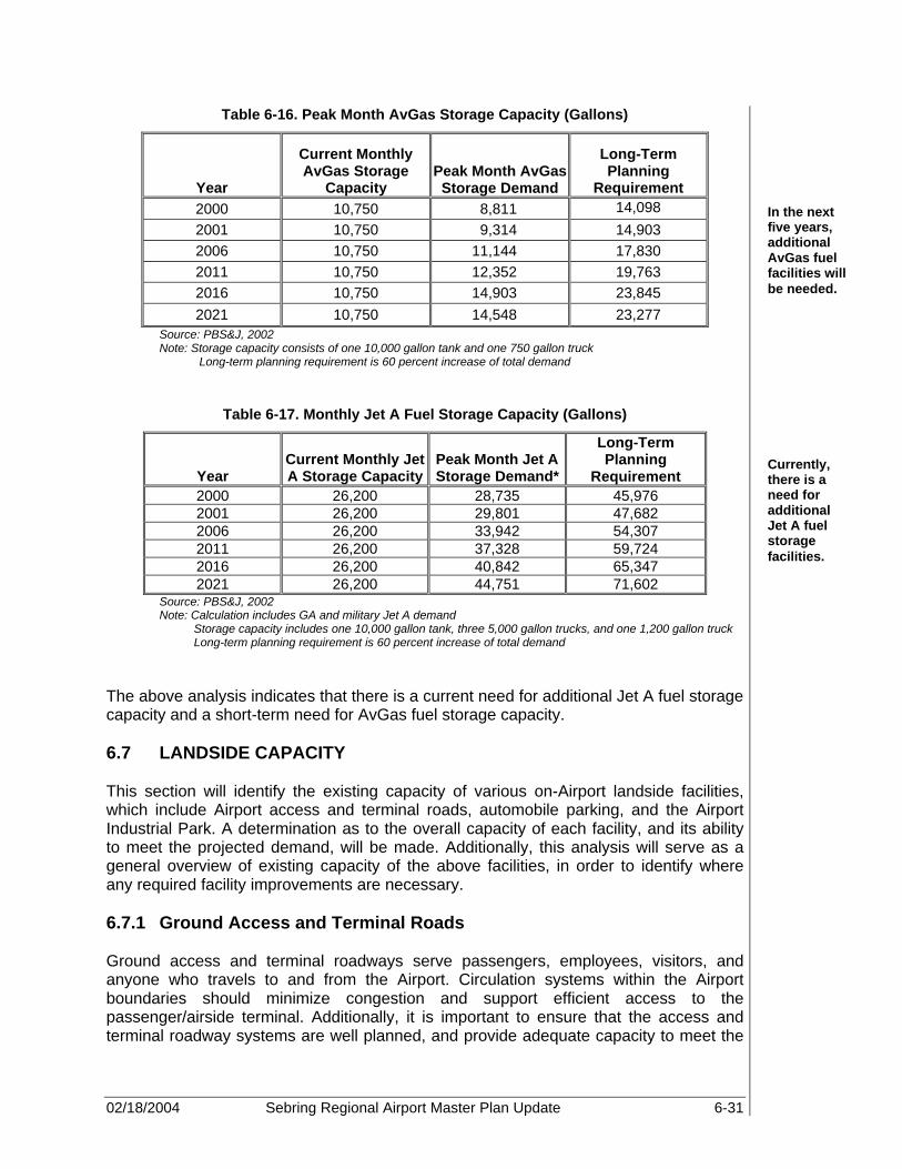
02/18/2004 Sebring Regional Airport Master Plan Update 6-31
Table 6-16. Peak Month AvGas Storage Capacity (Gallons)
Year
Current Monthly AvGas Storage
Capacity Peak Month AvGas Storage Demand
Long-Term Planning
Requirement 2000 10,750 8,811 14,098
2001 10,750 9,314 14,903 2006 10,750 11,144 17,830 2011 10,750 12,352 19,763 2016 10,750 14,903 23,845 2021 10,750 14,548 23,277
Source: PBS&J, 2002 Note: Storage capacity consists of one 10,000 gallon tank and one 750 gallon truck
Long-term planning requirement is 60 percent increase of total demand
Table 6-17. Monthly Jet A Fuel Storage Capacity (Gallons)
Year Current Monthly Jet A Storage Capacity
Peak Month Jet A Storage Demand*
Long-Term Planning
Requirement 2000 26,200 28,735 45,976 2001 26,200 29,801 47,682 2006 26,200 33,942 54,307 2011 26,200 37,328 59,724 2016 26,200 40,842 65,347 2021 26,200 44,751 71,602
Source: PBS&J, 2002 Note: Calculation includes GA and military Jet A demand
Storage capacity includes one 10,000 gallon tank, three 5,000 gallon trucks, and one 1,200 gallon truck Long-term planning requirement is 60 percent increase of total demand
The above analysis indicates that there is a current need for additional Jet A fuel storage capacity and a short-term need for AvGas fuel storage capacity. 6.7 LANDSIDE CAPACITY This section will identify the existing capacity of various on-Airport landside facilities, which include Airport access and terminal roads, automobile parking, and the Airport Industrial Park. A determination as to the overall capacity of each facility, and its ability to meet the projected demand, will be made. Additionally, this analysis will serve as a general overview of existing capacity of the above facilities, in order to identify where any required facility improvements are necessary. 6.7.1 Ground Access and Terminal Roads Ground access and terminal roadways serve passengers, employees, visitors, and anyone who travels to and from the Airport. Circulation systems within the Airport boundaries should minimize congestion and support efficient access to the passenger/airside terminal. Additionally, it is important to ensure that the access and terminal roadway systems are well planned, and provide adequate capacity to meet the
Currently, there is a need for additional Jet A fuel storage facilities.
In the next five years, additional AvGas fuel facilities will be needed.

02/18/2004 Sebring Regional Airport Master Plan Update 6-32
projected demand imposed by vehicular traffic. The roadway system must be able to accommodate peak levels of activity without creating excessive or unwarranted delay. Ground access to SEF is available via CSX rail line or highway. US Highway 98 is the major east-west route and lies 1 mile south of the Airport Industrial Park. US Highway 27 is the major north-south corridor located approximately 4.5 miles west. These roads along with US Highway 70 and other state highways link the area to the Florida Turnpike, I-4, I-95, and I-75. Currently, there are two access points to SEF. The main entrance is via the intersection of Kenilworth Boulevard and Airport Road. Kenilworth Boulevard provides access from downtown Sebring while Airport Road provides access to State Road 98. However, the existing geometry is not able to accommodate the expected increase in capacity as discussed in Chapter 5, Airport Forecasts, and, therefore, the intersection will be redesigned or reconfigured to meet demand. Furthermore, an entrance road should provide both the Airport and Sebring International Raceway the opportunity to create a strong identity. The entrance road continues onto the Airport property and divides into Webster Turn Drive, which provides access to the industrial park, and Haywood Taylor Boulevard, which connects with Challenger Drive and Authority Lane, to provide access to the Sebring Flight Center. The second entrance, known as the South Access Road, runs south along the Sebring International Raceway southern leasehold boundary. This entrance provides access into the Davis Property. Presently, the entrance does not provide direct access to the main terminal facility, it is not commonly used to access the Airport. In addition, rail access is available at SEF. A rail spur, owned and operated by the Authority (SAA), connects the Sebring Industrial Park to the CSX mainline to the east of the Airport. This mainline is being considered as a possible corridor for future highspeed rail. It is recommended that ground access circulation into the industrial park and main Airport facilities be upgraded as a result of road realignment and storm water drainage studies. Improvements to the primary access roads, terminal access roads, and terminal frontage and curb areas will be discussed further in Chapter 7, Facility Requirements. 6.7.2 Automobile Parking There are no exact parameters, which can be applied to determine automobile parking requirements at GA airports. During development, areas should be reserved for parking with adequate room for expansion. However, using the guidelines noted in FAA AC 150/5360-13, Planning and Design Guidelines for Airline Terminal Facilities, a realistic forecast of demand can be determined. Historically, at an origin and destination airport, 40 to 85 percent of the originating passengers arrive in private automobiles. Consequently, adequate public parking facilities are a valuable part of good terminal design. Automobile parking facilities are not only intended to provide space for passengers, but also for employees and visitors. The FAA suggests providing parking spaces for 1.3 times the number of peak hour passengers. When developing plans for an automobile parking lot, a planner must reserve approximately 350 to 400 sq ft, including lanes for each parked automobile. However, it is important to note that parking at GA airports are usually spread around the airport. Historically, GA operators with

02/18/2004 Sebring Regional Airport Master Plan Update 6-33
aircraft storage facilities on airport typically use these hangars to store their vehicle when they are out of town. Thus, the following estimate of automobile parking demand for SEF is presented in Table 6-18, using a forecast factor representative of peak hour operations and pilot/passenger demand, as well as public and employee parking demand. The formula used is based upon one space per peak hour pilot/passenger plus 50 percent weight factor for Airport employees and general public parking demand.
Table 6-18. Auto Parking Capacity Versus Demand
Year
Peak Hour
Pilot/Pax
Peak Hour Pilot/Pax Demand (Spaces)
Peak Hour Public &
Employee Demand
Total Auto Parking Demand
(Spaces)
Long Term Planning
Requirement (Spaces)
2000 105 137 53 189 219 2001 113 146 56 203 234 2006 135 176 68 244 282 2011 151 197 76 273 315 2016 166 216 83 299 346 2021 182 236 91 327 378
Source: PBS&J, 2002 Based upon this analysis, it would appear that automobile parking at SEF is inadequate. However, since automobile parking is divided between various areas of the airport, as shown in Table 6-19, Existing Airport Automobile Parking, there is adequate space in the short-term to meet anticipated demand.
Table 6-19. Existing Airport Automobile Parking
Number of Spaces Location on Airport Public Private Employee Total
Terminal 70 10 Corporate 35 Tullius 20 Leza 40 Other Private 12 SAA 12 Lockwood 10 JB/Carter 5 Total 70 122 22 214

02/18/2004 Sebring Regional Airport Master Plan Update 6-34
However, if commercial service becomes a reality at SEF, a significant amount of parking will be needed. Therefore, it is recommended that the long-term planning requirement of a minimum of 378 parking spaces be reserved. This will be discussed in more detail in Chapter 7, Facility Requirements. 6.8 NON-AVIATION USE 6.8.1 Airport Industrial Park Industrial and commerce parks are often valuable methods for an Airport to diversify its revenue sources, and capitalize on land that may otherwise go unused by aviation business and activities. A well planned and executed industrial or commerce park can generate significant amounts of revenue that the Airport may use for virtually any purpose, including operational and facility improvements on the airside, as well as other areas of Airport property. The industrial park at SEF is an identified area of land that has been reserved for the development of non-aviation businesses, and/or those businesses that do not require access to the airside facilities. Currently, the Airport consists of a total of 1,770 acres of developable land, of which 1,200 acres are still available. Lease parcels are available from one acre to 600 acres parcels. Approximately 570 acres of the total 1,200 acres available for development are located within the Airport Industrial Park. The industrial park is located along the northwest border of the SEF property, and is currently occupied by six tenants. As a result, approximately 68 percent of the available land remains and may be developed as demand warrants. In 1997, the Sebring Regional Airport and Industrial Park was designated as Foreign Trade Zone (FTZ) Number 215. This allows for a variety of cost savings to current tenants as well as attractant to future development at the Airport. Additional demand for industrial development at SEF could consist of both aviation and non-aviation development. The existing capacity of the industrial park is expected to meet any immediate demand for development, but will require short-term improvements and possible expansion during the planning period. At the time of this writing, a high-end, stand alone facility was in the process of being developed within the Airport Industrial Park. Specific facility requirements associated with Airport Industrial Park development will be discussed in detail in Chapters 7 and 8. 6.8.2 Sebring International Raceway The Sebring International Raceway leasehold encompasses approximately 400 acres at the southern portion of the SEF property. The property includes the quarter mile long pit row and garage area, four-story tower, elevated viewing stands, hospitality suites, and the Chateau Elan Lodge. Events at the Sebring International Raceway are one of the main attractants at the Airport. During the “12 hours of Sebring” in March, aircraft from all over the country travel to SEF. Aircraft range from small single-engine piston to large corporate aircraft. This trend continues on and off for at least 250 days per year since testing, corporate events,

02/18/2004 Sebring Regional Airport Master Plan Update 6-35
sports car club races, and other special events occur at the raceway, attracting people from all over the world. Also, since SEF is designated as an FTZ, racecars from all over the world could be flown to SEF for minimal costs if adequate runway length were available. Demand associated with the races and special events directly affects the overall demand for runway, taxiways, aircraft parking, tie-down, fuel, ground access, automobile parking, terminal facilities, etc. Demand associated with the Sebring Raceway, Chateau Elan Lodge and Spa, Sherianne’s Runway Café as well as a variety of special air events at the Airport effect the demand for services as well as the Airfield configuration requirements. This will be discussed in more detail in Chapter 7, Airport Facilities, and Chapter 8, Alternatives. 6.9 SUMMARY In estimating the capacity of the existing SEF operational areas, the primary elements of airfield capacity were examined to determine the Airport's ability to accommodate anticipated levels of aviation activity. The results indicate that:
• Airspace in the vicinity of the Airport does have limitations for additional instrument approach procedures, but will likely accommodate future aviation activity through coordination with local military authorities.
• Additional IFR approach capabilities in a southeast-northwest orientation may be required to reduce existing approach minimums and improve IFR capacity.
• Runway orientation is adequate, based on existing and historical wind characteristics. • Total airside and landside capacity will need to be increased to meet the projected
demand associated with both GA and Commercial aircraft operations. • Initiation of commercial service will require SEF to meet the facility guidelines stated
under CFR 49 Part 139, Airport Certification. • Improvements to the primary Airport access and terminal roads will be necessary to
ensure adequate capacity for vehicular traffic. • Potential development of a high-speed rail facility at SEF will fuel demand for
commercial service. • Additional automobile parking capacity and facilities will be required to meet forecast
demand for public and employee parking. • The Airport Industrial Park has adequate capacity for additional development and will
likely meet the future demand for non-aviation business at the Airport. However, buildings and roadways are in need of improvement.
• Sebring International Raceway, the Runway Café, Chateau Elan’s Lodge and Spa as well as a variety of local and aviation related events significantly influence demand at SEF.
• The existing aircraft parking and hangar facilities will not adequately satisfy forecast demand, and expansion will be required.
• Existing fuel facilities are inadequate to meet forecast demand for monthly Jet A and AvGas fuel loads.
Presently, an Air Service Study for Highlands County is being performed concurrently with this document.

02/18/2004 Sebring Regional Airport Master Plan Update 6-36
Capacity and demand requirements have been determined for essentially all aspects of SEF’s operations. These calculations, which are based on various components, should be regarded as generalized planning tools, which assume attainment of forecast levels as described in Chapter 5 as well as demand associated with potential general aviation and commercial aircraft operations. It is important to note; however, that SAA is aggressively marketing to a number of commercial air carrier operators and business developers. In addition to potential commercial air carrier service, Airport management is also promoting the Airport as an engine for economic development in Highlands County. As a result, SAA is promoting various special events, business and commercial development, and land acquisition options. These marketing initiatives, especially the initiation of commercial service, will trigger a variety of facility requirements including CFR 14 Part 139, Airport Certification Requirements. These development initiatives are discussed in more detail in Chapters 7 and 8, Facility Requirements and Development Plans. Should the forecasts prove conservative, proposed developments that will be recommended as a result of the demand/capacity analysis should be advanced in schedule. Likewise, if traffic growth materializes at a slower rate than forecast, deferral of expansion would be prudent.

2/18/04 Sebring Regional Airport Master Plan Update 7-1
FACILITY REQUIREMENTS Sebring Regional Airport 7.1 GENERAL This chapter of the Master Plan Update identifies the facility requirements necessary to meet projected demand at Sebring Regional Airport (SEF), as documented in Chapters 5, Projection of Aviation Demand, and 6, Demand Capacity Analysis. Before conceptual planning can commence, it is important that the facility requirements necessary to accommodate demand be identified. This information will serve as a basis for alternative development for future expansion and phasing concepts based upon anticipated forecast activity levels. 7.2 AIRPORT REFERENCE CODE The Federal Aviation Administration (FAA) classifies criteria applicable to the design of airfield and airport components for a specific airport type. Using the Airport Reference Code (ARC) and Design (Critical) Aircraft, the FAA determines specific design standards as set forth in FAA AC 150/5300-13, Airport Design. 7.2.1 Airport Role SEF is currently designated as a general aviation (GA) airport primarily serving recreational flyers, corporate activity generally associated with the Sebring Raceway and Industrial Park, medical emergency service helicopter operations (AeroMed II), and military operations associated with the Department of Defense (DOD) refueling contract. However, according to both the National Plan of Integrated Airport Systems (NPIAS), 2000-2013, and the Continuing Florida Aviation System Plan, SEF should be re-categorized as a transport (TR) and commercial service airport in the near future based upon overall aviation demand and its centralized location within the State. 7.2.2 Airport Reference Code (ARC) The purpose of the ARC is to size airport facilities according to the performance and dimensions of the most demanding (critical) aircraft regularly using the field. The ARC is based on the approach speed (approach category) and wingspan (design group) of the design aircraft. 7.2.2.1 Aircraft Approach Category The aircraft approach category is an operational characteristic relating to the approach speed of an aircraft. Approach categories are based on a factor of 1.3 times aircraft stall speed in landing configuration at maximum landing weight. Approach categories are represented by a letter designation, as depicted in the following list:
7

2/18/04 Sebring Regional Airport Master Plan Update 7-2
Aircraft Approach Categories
Category A: Speed less than 91 knots. Category B: Speed 91 knots or more, but less than 121 knots. Category C: Speed 121 knots or more, but less than 141 knots. Category D: Speed 141 knots or more, but less than 166 knots. Category E: Speed 166 knots or more.
7.2.2.2 Airplane Design Group Airplane design group is a physical characteristic defined by an aircraft’s wingspan. While approach speeds only affect runway design, wingspan affects the design of taxiways, taxilanes, and aprons. A Roman numeral, as described below, depicts the airplane design group.
Airplane Design Group
Group I: Up to, but not including, 49 ft. Group II: 49 ft up to, but not including, 79 ft. Group III: 79 ft up to, but not including, 118 ft. Group IV: 118 ft up to, but not including, 171 ft. Group V: 171 ft up to, but not including, 214 ft. Group VI: 214 ft up to, but not including, 262 ft.
Once this is determined, the ARC dictates the majority of the design criteria for the airside facilities. These design criteria include:
• Runway and taxiway separation • Runway and taxiway dimensions, strength, and configuration • Safety zones and safety area dimensions • Obstacle clearance standards 7.2.2.3 Existing Airport Reference Code According to the 1994 Sebring Regional Airport Master Plan Update and associated 1993 Airport Layout Plan, design standards and planning criteria were based upon the Gulfstream IV (defined in AC150/5300-13 as D-II). As a result, the airfield requirements were designed to accommodate a critical aircraft equivalent to aircraft group category D-II. This means that runways, hangars, taxiways, taxi lanes, apron, and other facilities were built for aircraft in this category, including a number of larger business jet aircraft and military aircraft. Most GA aircraft fall within the A and B categories, while most corporate, commercial, and military transport aircraft fall into the C and D categories. Depending upon aircraft use, initiation of commercial service, and/or various infrastructure improvements at SEF, the ARC is expected to change in the near future. It is important to note that the ARC is used to set basic size and strength factors to be considered for the design of airport pavement and facilities. The ARC, however, does not constitute a categorical limitation on aircraft size, and larger and/or faster aircraft may use the Airport.

2/18/04 Sebring Regional Airport Master Plan Update 7-3
The decision to use an airfield is based upon weather, aircraft load, and performance. The FAA places the responsibility for this decision solely on the pilot-in-command (PIC) of a particular aircraft. Thus, SEF can accommodate larger or faster aircraft under given conditions as determined safe by the operator. However, it is important to note that larger aircraft have greater negative impact on runway, taxiway, and apron pavements. Also, aircraft with larger wingspans require wider runways, taxiways, and safety areas. larger and faster aircraft begin to utilize SEF more often, the preservation of safety will become even more important. In fact, special safety requirements would become necessary in the existing airfield conditions. 7.2.3 Critical Aircraft Determining the critical aircraft is instrumental in developing an airport’s design criteria and determining the ARC. The critical aircraft of an airport is based primarily on the aircraft with the highest approach speed and longest wingspan making substantial use of the airport on a regular basis. FAA Order 5090.3B, Field Formation of the NPIAS, defines substantial use as 500 or more annual itinerant aircraft operations or scheduled commercial service. Today, aircraft typically using SEF include a wide range of basic training, experimental, business single- and twin-engine piston, turboprop twins and jets, and turbine-driven helicopters, as reflected in the forecasts of aviation activity shown in Chapter 5. The FAA defines the most demanding aircraft in terms of the greatest runway requirement (based upon aircraft approach speed) and pavement and building separation requirements related to wingspan (required wingtip clearances). A final criterion is that the aircraft must be in regular service (operations) at the Airport. An operation is either a takeoff or landing. For planning purposes, the number of takeoffs is assumed to equal the number of landings. Based upon the most current fleet mix data obtained from the Sebring Airport Authority (SAA) and Sebring Flight Center for the years ending 2000 and 2001, the C-130, Hercules, represents the critical design aircraft. Table 7-1 tabulates dimensions and performance characteristics of typical aircraft in the existing fleet at SEF. This tabulation is not comprehensive, but rather lists typical aircraft in the fleet utilizing the airfield. The aircraft are listed in ascending order from least to most demanding. 7.2.3.1 Determination of Critical Aircraft Existing By applying the criteria discussed above to SEF’s current fleet mix, it was noted that aircraft with the highest approach speeds and longest wingspans belong to the turboprop and turbojet aircraft group. Therefore, based upon that criteria, the Lockheed Martin, C-130 Hercules, represents the most demanding aircraft currently utilizing SEF’s facilities on a regular basis. The C-130 is designated as a C-IV under the Aircraft Design Group criteria. Thus, design and planning criteria should meet the requirements of Group C-IV aircraft.

2/18/04 Sebring Regional Airport Master Plan Update 7-4
Table 7-1. Existing Aircraft
Aircraft Model (Approach Speed –
knots)
Wing-span (ft-in)
Length (ft–in)
Maximum Takeoff Reqmt.
(ft)
Maximum Landing Reqmt.
(ft)
Approximate Approach
Speed (knots)
Aircraft Category
Single-Engine (Piston)
Cessna 150 32.7 23.8 735 445 55 A-I Mooney Ranger 36.1 24.8 1,395 1,550 72 A-I Piper Arrow 35.4 24.7 1,610 1,400 54.7 A-I Cirrus Design
SR-20 35.2 26 1,960 2,040 65.17 A-I
Multi-Engine (Piston)
Piper Seminole 38.6 27.6 2,200 1,490 54.7 A-I Beech Baron 37.8 29.8 2,300 2,450 74.7 A-I Rotorcraft Bell Jet Ranger 39 --- --- --- --- --- Bell Long Ranger 45 --- --- --- --- --- Bell 222 57.3 --- --- --- --- --- AH-64 Apache 58.1 --- --- --- --- --- Turboprop
Beech King Air B200 54.5 43.8 2,579 2,845 103.4
B-II
Douglas DC-3 95 64.5 6,850 4,720 36.6 A-III
Lockheed C130 (Hercules) 132.6 106.1 4,700 2,550
130.0
C-IV
Turbofan Cessna CitationJet 46.8 42.6 3,080 2,750 98 B-II Beech Jet 400A 43.5 48.4 4,169 2,960 121.7 C-I Learjet 25 35.6 47.6 4,000 3,100 137 C-I
Dassault Falcon Jet 900C 63.4 66.3 4,935 3,520
106.0
B-II
Gulfstream III 77.8 83.1 5,110 3,180 136 C-II Source: Sebring Flight Center, Sebring Airport Authority, Sebring Regional Airport Fleet Mix, 2001, Aviation Week and
Space Technology Sourcebook, 1999, and AC 150/5300-13-7, Airport Design, 2001. Note: Approach speed is approximately 24.8% of normal cruising speed.
1 MPH equals .8689758 knots
Future As discussed in Chapters 5, Projection of Aviation Demand, and 6, Demand Capacity Analysis, it is anticipated that use of the Airport by Corporate-type aircraft is likely to increase. Corporate aircraft range in size from multi-engine piston aircraft to regional jets. Typical business aircraft include: the Gates Learjet 60 (L-60), Gulfstream IV/V (G-IV/V), Boeing Business Jet (BBJ), Falcon 2000, Challenger 604, Airbus Corporate Jet, and ERJ 140. In addition, demand for commercial airline service is growing. Potential stimuli include the Florida Department of Transportation’s (FDOT) evaluation to develop a roadway

2/18/04 Sebring Regional Airport Master Plan Update 7-5
system that will connect Highlands County with the Florida Turnpike System and Interstate 4 as well as the potential for SEF to become a High Speed Rail Terminus point. As a result, it is anticipated that these initiatives as well as visitor and local demand will spur the initiation of commercial service. In addition to potential commercial service, SEF may also attract heavy air cargo operators since SEF is home to an Industrial Park, International Raceway, and future commerce park as well as being designated as a Foreign Trade Zone. Table 7-2, Future Critical Aircraft, lists potential aircraft associated with each of these types of activities. It is anticipated that during wet or extremely hot weather conditions that the minimum takeoff length field requirement will increase by approximately 200 ft or more due to safety concerns. Based upon this analysis, SEF’s airside facilities should be planned and designed initially for Category D-IV and then D-V group aircraft. 7.3 AIRFIELD REQUIREMENTS Once airfield capacity and demand, in terms of both aircraft group category and activity, have been identified, specific facility requirements necessary to enhance capacity must be determined. The following sections will identify necessary improvements to various facilities and equipment on the airfield, in order to correct any existing aircraft demand capacity problems, and increase overall capacity to meet the projected demand and overall forecast level of aircraft activity. 7.3.1 Future Airfield Facility Design Requirements In order to meet the facility demands of both existing and future critical aircraft groups, SEF must meet FAA design standards as defined in FAA AC 150/5300-13, Airport Design. As a result, a number of infrastructure improvements need to be planned and developed, as shown in Tables 7-3 through 7-19, in order to meet the requirements of the existing and anticipated, critical aircraft group categories: B-I, B-II, D-IV and D-V. Each of these aircraft categories relates to a specific type of operation: i.e., general aviation, corporate, and commercial/heavy cargo, respectively. As a result, the following infrastructure development is recommended to meet existing and anticipated demand as noted in Chapter 6, Demand Capacity Analysis.
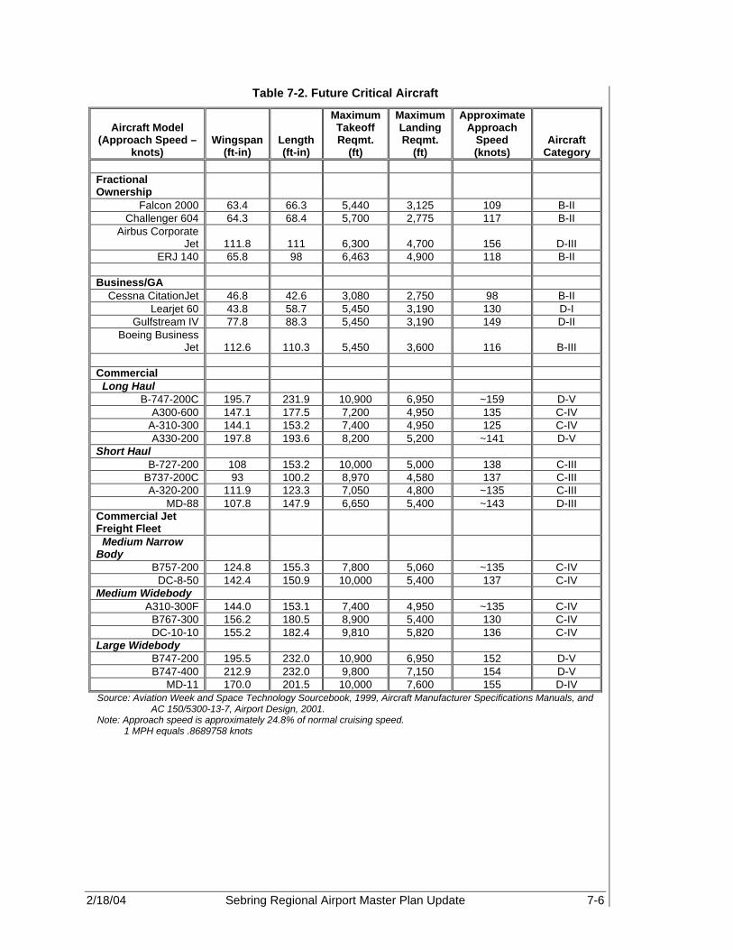
2/18/04 Sebring Regional Airport Master Plan Update 7-6
Table 7-2. Future Critical Aircraft
Aircraft Model (Approach Speed –
knots) Wingspan
(ft-in) Length (ft-in)
Maximum Takeoff Reqmt.
(ft)
Maximum Landing Reqmt.
(ft)
Approximate Approach
Speed (knots)
Aircraft Category
Fractional Ownership
Falcon 2000 63.4 66.3 5,440 3,125 109 B-II Challenger 604 64.3 68.4 5,700 2,775 117 B-II
Airbus Corporate Jet 111.8 111 6,300 4,700
156
D-III
ERJ 140 65.8 98 6,463 4,900 118 B-II Business/GA Cessna CitationJet 46.8 42.6 3,080 2,750 98 B-II
Learjet 60 43.8 58.7 5,450 3,190 130 D-I Gulfstream IV 77.8 88.3 5,450 3,190 149 D-II
Boeing Business Jet 112.6 110.3 5,450 3,600
116
B-III
Commercial Long Haul
B-747-200C 195.7 231.9 10,900 6,950 ~159 D-V A300-600 147.1 177.5 7,200 4,950 135 C-IV
A-310-300 144.1 153.2 7,400 4,950 125 C-IV A330-200 197.8 193.6 8,200 5,200 ~141 D-V
Short Haul B-727-200 108 153.2 10,000 5,000 138 C-III
B737-200C 93 100.2 8,970 4,580 137 C-III A-320-200 111.9 123.3 7,050 4,800 ~135 C-III
MD-88 107.8 147.9 6,650 5,400 ~143 D-III Commercial Jet Freight Fleet
Medium Narrow Body
B757-200 124.8 155.3 7,800 5,060 ~135 C-IV DC-8-50 142.4 150.9 10,000 5,400 137 C-IV
Medium Widebody A310-300F 144.0 153.1 7,400 4,950 ~135 C-IV
B767-300 156.2 180.5 8,900 5,400 130 C-IV DC-10-10 155.2 182.4 9,810 5,820 136 C-IV
Large Widebody B747-200 195.5 232.0 10,900 6,950 152 D-V B747-400 212.9 232.0 9,800 7,150 154 D-V
MD-11 170.0 201.5 10,000 7,600 155 D-IV Source: Aviation Week and Space Technology Sourcebook, 1999, Aircraft Manufacturer Specifications Manuals, and
AC 150/5300-13-7, Airport Design, 2001. Note: Approach speed is approximately 24.8% of normal cruising speed.
1 MPH equals .8689758 knots

2/18/04 Sebring Regional Airport Master Plan Update 7-7
Table 7-3. Future Runway Planning and Design Criteria
Runway Designation
Existing Runway Design Criteria
Future Runway Design Criteria Future Design Aircraft
Runway 18-36 D-II D-IV C-130, Hercules, and Airbus Corporate Jet
Runway 14-32 B-II B-II Cessna CitationJet Turf GA Runway N/A B-I ‘P-51 Mustang’ Commercial Runway N/A D-V A330, B-747, etc
Source: SAA, 2002, and PBS&J, 2002 The primary factors affected by the planning criteria are the clearances from runways and taxiways to parked aircraft, buildings and other potential obstacles, as well as aircraft operational facility dimensions. The recommended runway lengths were tabulated based upon information obtained from specific aircraft specification manuals and FAA AC 150/5300-13, Aircraft Design Index. The critical aircraft group category designates the airfield design criteria, i.e., runway length and width, taxiway separation, safety area, etc. Currently, the most demanding aircraft using SEF’s facilities are the Gulfstream III business jet, Learjet 35/36, and the C-130 Hercules military transport. However, in the near future, it is anticipated that SEF will transition from a GA Airport to a commercial service airport. Therefore, it is likely that the ARC will change from a D-II to a D-V aircraft category in order to meet the demands of anticipated commercial and cargo service. 7.3.1.1 Facility Design Criteria Airfield improvements are developed according to the established ARC for the Airport, and then for each particular runway. Due to changes in design aircraft, the existing facility design criteria, ARC D-II, is expected to change to an ARC D-V. Runway Requirements Currently, SEF can accommodate 100 percent of small airplanes (less than 12,500 lb maximum gross takeoff weight), which require a runway length of approximately 3,500 feet. Runway length criterion is based upon the maximum runway length needed, on a hot and/or wet day, for a fully loaded aircraft to take off. However, in order to accommodate 100 percent of the corporate and regional jet aircraft market, a runway length requirement of approximately 6,700 ft is recommended to meet the minimum takeoff requirements for approach category D aircraft (aircraft greater than 60,000 lb maximum gross takeoff weight). Corporate and regional jet users are considered the most likely users of Runway 18-36. Therefore, a provision for an extension of 1,476 feet on Runway 18-36, for a total runway length of 6,700 feet, should be planned in order to safely accommodate D-IV aircraft. Existing conditions at SEF do not meet all of the criteria of runway and taxiway design standards for Category D-IV aircraft (see Table 7-4). The current length of Runway 18-36 is 5,224 feet. Also, because of previous military use, the existing pavement width is 300 feet wide. However, only 100 feet of the width is designated or utilized for the

2/18/04 Sebring Regional Airport Master Plan Update 7-8
runway. Current FAA standards, based upon Federal Aviation Regulation (FAR) AC 150-5300-13 Airport Design Change 7, require a runway to be marked 150 feet wide in order to meet the current D-IV ARC rating. Currently, Runway 14-32 is 5,000 x 300 feet, with a 650 ft displaced threshold, and easily meets the current B-II ARC rating. Its width of 300 feet is considered non-standard for a civilian runway configuration. However, Runway 14-32 is likely to remain designated as a GA runway. Since high-speed corporate and regional jets are likely to use Runway 18-36, Runway 14-32 is expected to accommodate the existing general aviation fleet at SEF. The northern ramp at the threshold of Runway 14 is prime real estate for the development of new T-hangars. It is important to seek commercial opportunities, as well as preserve safety in this area. Shortening Runway 14-32 at the north end would allow for both of these suggestions by eliminating a runway crossing zone and opening up the north ramp. As a result, it will become necessary to add length to the south end of the Runway 14-32. It is necessary to maintain approximately 3,500 ft, to accommodate the anticipated critical aircraft, the CitationJet, which is designated as a B-II. Additional runway length is not needed on 14-32 since it easily accommodates most current and future GA aircraft, as long as 3,500 ft is maintained. As discussed in Chapter 6, Demand Capacity Analysis, a number of antique aircraft, WWI and WWII War Birds, are either based at SEF or visit frequently. War Bird pilots have stated that paved runways tend to put undue stress on their aircraft. Therefore, in an effort to meet demand and isolate the Warbirds and other antique aircraft from typical GA aircraft, a 3,000 ft GA Turf Runway at SEF is recommended. This runway should be designed to accommodate special experimental and antique aircraft, and is suggested that the design category be a B-I. Aircraft of this type do not have high approach speeds, nor long wingspans. Therefore, using the design criteria for a B-I aircraft is expected to easily accommodate these aircraft with a minimum cost to the Airport. As discussed in Chapter 6, commercial and cargo aircraft at SEF will require runway field lengths of greater than 7,000 feet. Due to constraints associated with military airspace, land acquisition, noise, roadway and railroad alignment, etc., the existing Runway 18-36 runway field length cannot expanded to more than 6,700 feet. Therefore, in order to accommodate commercial demand, a provision should be made to design a commercial runway to accommodate Category D-V aircraft. Thus, based upon the field length requirements shown in Table 7-2, Future Critical Aircraft, an initial length of 8,500 feet is recommended with a potential expansion to 10,000 feet, if demand warrants. A potential benefit associated with the initial 8,500 ft runway field length is that it meets United States Military Airport Field Length criteria for high speed, military aircraft. Thus, with the addition of the new runway in conjunction with the Department of Defense (DOD) Hot Fuel Contract, it is anticipated that military operations at SEF will increase.
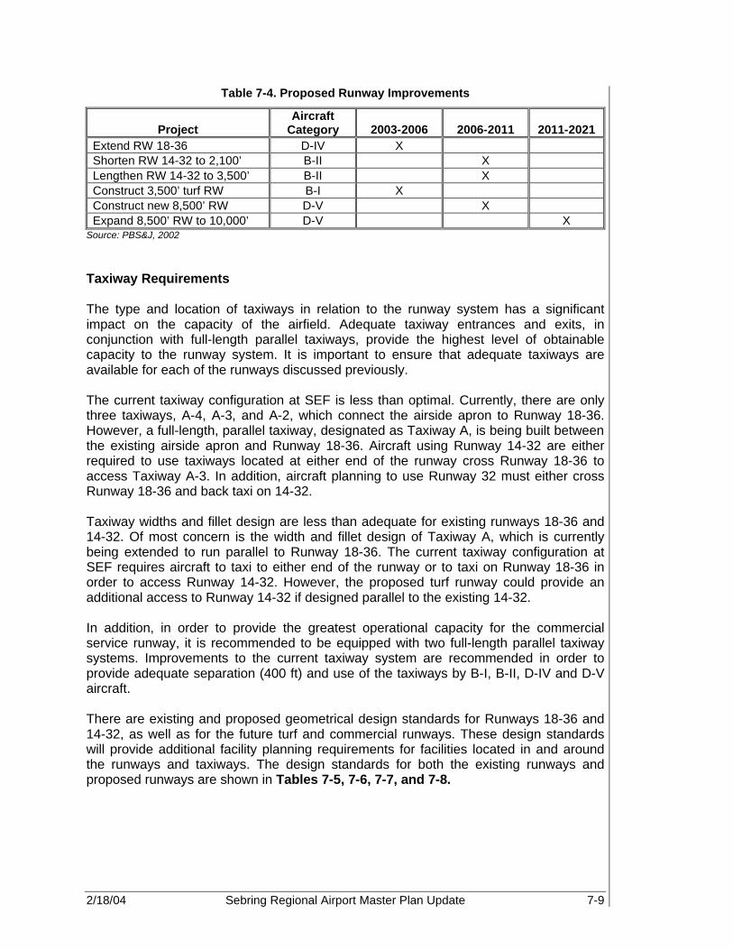
2/18/04 Sebring Regional Airport Master Plan Update 7-9
Table 7-4. Proposed Runway Improvements
Project Aircraft
Category 2003-2006 2006-2011 2011-2021 Extend RW 18-36 D-IV X Shorten RW 14-32 to 2,100’ B-II X Lengthen RW 14-32 to 3,500’ B-II X Construct 3,500’ turf RW B-I X Construct new 8,500’ RW D-V X Expand 8,500’ RW to 10,000’ D-V X
Source: PBS&J, 2002 Taxiway Requirements The type and location of taxiways in relation to the runway system has a significant impact on the capacity of the airfield. Adequate taxiway entrances and exits, in conjunction with full-length parallel taxiways, provide the highest level of obtainable capacity to the runway system. It is important to ensure that adequate taxiways are available for each of the runways discussed previously. The current taxiway configuration at SEF is less than optimal. Currently, there are only three taxiways, A-4, A-3, and A-2, which connect the airside apron to Runway 18-36. However, a full-length, parallel taxiway, designated as Taxiway A, is being built between the existing airside apron and Runway 18-36. Aircraft using Runway 14-32 are either required to use taxiways located at either end of the runway cross Runway 18-36 to access Taxiway A-3. In addition, aircraft planning to use Runway 32 must either cross Runway 18-36 and back taxi on 14-32. Taxiway widths and fillet design are less than adequate for existing runways 18-36 and 14-32. Of most concern is the width and fillet design of Taxiway A, which is currently being extended to run parallel to Runway 18-36. The current taxiway configuration at SEF requires aircraft to taxi to either end of the runway or to taxi on Runway 18-36 in order to access Runway 14-32. However, the proposed turf runway could provide an additional access to Runway 14-32 if designed parallel to the existing 14-32. In addition, in order to provide the greatest operational capacity for the commercial service runway, it is recommended to be equipped with two full-length parallel taxiway systems. Improvements to the current taxiway system are recommended in order to provide adequate separation (400 ft) and use of the taxiways by B-I, B-II, D-IV and D-V aircraft. There are existing and proposed geometrical design standards for Runways 18-36 and 14-32, as well as for the future turf and commercial runways. These design standards will provide additional facility planning requirements for facilities located in and around the runways and taxiways. The design standards for both the existing runways and proposed runways are shown in Tables 7-5, 7-6, 7-7, and 7-8.

2/18/04 Sebring Regional Airport Master Plan Update 7-10
Table 7-5. Geometric Design Standards for Runway 18-36
Standards ARC D-II Existing
Dimensions Future ARC
D-IV
Runway width 100 100 150
Runway shoulder width 10 100 25
Runway blast pad width 120 120 200
Runway blast pad length 150 150 200
Runway safety area width 500 500 500
Runway safety area length beyond runway end 1,000 1,000 1,000
Runway obstacle free zone width 400 400 400
Runway obstacle free zone length beyond runway end 200 200 200
Runway object free area width 800 800 800
Runway object free area length beyond runway end 1,000 1,000 1,000
Runway Centerline to Parallel Taxiway 300 400 400
Taxiway width 35 35 to 75 75
Taxiway shoulder width 25 10 to 30 25
Taxiway safety area width 171 79 to 214 171
Taxiway object free area width 259 131 to 320 259
Source: Sebring Regional Airport Layout Plan, 1998, and FAA AC 150/5300-13: Airport Design Note: All measurements are in feet

2/18/04 Sebring Regional Airport Master Plan Update 7-11
Table 7-6. Geometric Design Standards for Runway 14-32
Standards ARC B-II Existing
Dimensions Future
ARC B-II
Runway width 100 300 300
Runway shoulder width 10 10 10
Runway blast pad width 95 95 95
Runway blast pad length 150 150 150
Runway safety area width 150 150 150
Runway safety area length beyond runway end 300 700 (Rwy 14)
600 (Rwy 32)
700 (Rwy 14) 600
(Rwy 32) Runway obstacle free zone width 250 250 250
Runway obstacle free zone length beyond runway end 200 200 200
Runway object free area width 500 500 500
Runway object free area length beyond runway end 300 300 300
Runway Centerline to Parallel Taxiway 240 NA 240
Taxiway width 35 29 to 75 29 to 75
Taxiway shoulder width 10 10 to 30 10 to 30
Taxiway safety area width 79 79 to 214 79 to 214
Taxiway object free area width 131 130.6 130.6
Source: Sebring Regional Airport ALP 1998 and FAA AC 150/5300 Airport Design Note: All measurements are in feet

2/18/04 Sebring Regional Airport Master Plan Update 7-12
Table 7-7. Geometric Design Standards for Future Turf Runway
Standards Future ARC
B-I
Runway width 75
Runway shoulder width 10
Runway blast pad width 80
Runway blast pad length 100
Runway safety area width 120
Runway safety area length beyond runway end 240
Runway obstacle free zone width 250
Runway obstacle free zone length beyond runway end 200
Runway object free area width 400
Runway object free area length beyond runway end 240
Runway Centerline to Parallel Taxiway 225
Taxiway width 25
Taxiway shoulder width 10
Taxiway safety area width 49
Taxiway object free area width 89
Source: Sebring Regional Airport ALP 1998 and FAA AC 150/5300 Airport Design
Note: All measurements are in feet

2/18/04 Sebring Regional Airport Master Plan Update 7-13
Table 7-8. Geometric Design Standards for Future Commercial Runway
Geometrical Standards Future
ARC D-V Runway width 150 Runway shoulder width 35 Runway blast pad width 220 Runway blast pad length 400 Runway safety area width 500 Runway safety area length beyond runway end 1000
Runway obstacle free zone width 400 Runway obstacle free zone length beyond runway end 200
Runway object free area width 800 Runway object free area length beyond runway end 1000
Runway Centerline to Parallel Taxiway 400
Taxiway width 75 Taxiway shoulder width 35 Taxiway safety area width 214 Taxiway object free area width 320 Source: Sebring Regional Airport Layout Plan, 1998, and
FAA AC 150/5300-13: Airport Design Note: All measurements are in feet
Apron Requirements The existing aircraft parking aprons at SEF meet the required FAA standards for both D-IV and D-V ARC designations. The current separation from Runway 18-36 centerline to the aircraft parking apron is 525 feet. The separation from Taxiway A centerline to the aircraft parking apron is 300 feet. The future location of Taxiway A (construction already in progress) in this area will maintain a minimum separation from taxiway centerline to apron edge of approximately 200 feet. As shown in Table 7-9, the minimum distance required from the Runway 18-36 centerline to apron parking is 500 feet. The minimum taxiway centerline to apron edge (fixed or moveable object) separation is 129.5 feet. Therefore, separation distances meet or exceed FAA standards and thus allow area for apron expansion. Existing and recommended separation distances for runways and taxiways on the airfield for both existing and proposed runways are described in Tables 7-9, 7-10, 7-11, and 7-12.
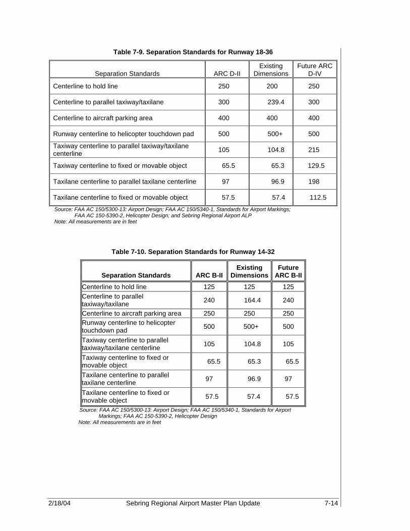
2/18/04 Sebring Regional Airport Master Plan Update 7-14
Table 7-9. Separation Standards for Runway 18-36
Separation Standards ARC D-II Existing
Dimensions Future ARC
D-IV
Centerline to hold line 250 200 250
Centerline to parallel taxiway/taxilane 300 239.4 300
Centerline to aircraft parking area 400 400 400
Runway centerline to helicopter touchdown pad 500 500+ 500
Taxiway centerline to parallel taxiway/taxilane centerline 105 104.8 215
Taxiway centerline to fixed or movable object 65.5 65.3 129.5
Taxilane centerline to parallel taxilane centerline 97 96.9 198
Taxilane centerline to fixed or movable object 57.5 57.4 112.5
Source: FAA AC 150/5300-13: Airport Design; FAA AC 150/5340-1, Standards for Airport Markings; FAA AC 150-5390-2, Helicopter Design; and Sebring Regional Airport ALP
Note: All measurements are in feet
Table 7-10. Separation Standards for Runway 14-32
Separation Standards ARC B-II Existing
Dimensions Future
ARC B-II
Centerline to hold line 125 125 125 Centerline to parallel taxiway/taxilane 240 164.4 240
Centerline to aircraft parking area 250 250 250 Runway centerline to helicopter touchdown pad 500 500+ 500
Taxiway centerline to parallel taxiway/taxilane centerline 105 104.8 105
Taxiway centerline to fixed or movable object 65.5 65.3 65.5
Taxilane centerline to parallel taxilane centerline 97 96.9 97
Taxilane centerline to fixed or movable object 57.5 57.4 57.5
Source: FAA AC 150/5300-13: Airport Design; FAA AC 150/5340-1, Standards for Airport Markings; FAA AC 150-5390-2, Helicopter Design
Note: All measurements are in feet

2/18/04 Sebring Regional Airport Master Plan Update 7-15
Table 7-11. Separation Standards for Future Turf Runway
Separation Standards Future
ARC B-I
Centerline to hold line 125 Centerline to parallel taxiway/taxilane 225
Centerline to aircraft parking area 200 Runway centerline to helicopter touchdown pad 500
Taxiway centerline to parallel taxiway/taxilane centerline 69
Taxiway centerline to fixed or movable object 44.5
Taxilane centerline to parallel taxilane centerline 64
Taxilane centerline to fixed or movable object 39.5
Source: FAA AC 150/5300-13: Airport Design; FAA AC 150/5340-1, Standards for Airport Markings; FAA AC 150-5390-2, Helicopter Design; and Sebring Regional Airport ALP
Note: All measurements are in feet
Table 7-12. Separation Standards for Future Commercial Runway
Separation Standards Future
ARC D-V
Centerline to hold line 300 Centerline to parallel taxiway/taxilane 300
Centerline to aircraft parking area 400 Runway centerline to helicopter touchdown pad 500
Taxiway centerline to parallel taxiway/taxilane centerline 267
Taxiway centerline to fixed or movable object 160
Taxilane centerline to parallel taxilane centerline 245
Taxilane centerline to fixed or movable object 138
Source: FAA AC 150/5300-13: Airport Design; FAA AC 150/5340-1, Standards for Airport Markings; FAA AC 150-5390-2, Helicopter Design; and Sebring Regional Airport ALP
Note: All measurements are in feet

2/18/04 Sebring Regional Airport Master Plan Update 7-16
7.3.1.2 Design Visibility Minimums Approach visibility minimums are dependent upon the designated runway approach category, visual, non-precision and precision. The type of approach and associated visibility minimums affect key airport safety standards governing operational pavement separations, runway protection zone (RPZ) dimensions, and safety area standards. In its current 2002 configuration, SEF has an approach visibility minimum of 1 3/4-mile and ceiling of 640 feet for non-precision global positioning system (GPS) approaches to Runway 36. The GPS circling approach requires a slightly higher ceiling of 720 feet and 2-mile horizontal visibility. Runways 18, 14, and 32 are visual runways with standard visual flight rule (VFR) visibility minimums of 3 miles horizontally and a 1,000 foot ceiling. In the immediate future, however, it is recommended that Runway 36 be remarked as a precision approach runway. Installation of an Instrument Landing System (ILS) and associated equipment on Runway 36 will allow aircraft to utilize SEF during inclement weather conditions as well as allow for greater runway use flexibility. Installation of a Category I ILS approach will allow aircraft to have an approach visibility minimum of one-mile horizontal visibility. In addition, Runway 18 will be remarked to allow for limited non-precision approach procedures to occur from the north of the field, while Runways 14 and 32 will remain visual only. Future runway approach categories are described in Table 7-13.
Table 7-13. Runway Approach Categories
Runways Approach Category Design Visibility Minimums Runway 18 Non-precision instrument Not lower than 1-mile Runway 36 Precision instrument (Cat I) Not lower than ¾ -mile Runway 14 Visual Not lower than 1-mile Runway 32 Visual Not lower than 1-mile
Proposed GA runway Visual Not lower than 1-mile Proposed commercial runway Precision instrument (Cat I) Not lower than ¾ -mile
Source: PBS&J, 2002 Runway Protection Zone (RPZ) Dimensions The standards governing the geometry of the runway are also dependent on the visibility minimums and the ARC classification. These standards affect the orientation and geometry of aircraft parking areas and placement of related facilities. The existing and recommended standards for all runway improvements at SEF are listed in Table 7-14. In addition, desirable visibility minimums affect the size of the RPZ. It is of critical importance for the Airport to protect these approaches through an aggressive program of land acquisition or aviation easements. Protection of the approaches is a vital safety concern to the public.
The standards governing the geometry of the runway are also dependent on the visibility minimums and the airport reference code classification.
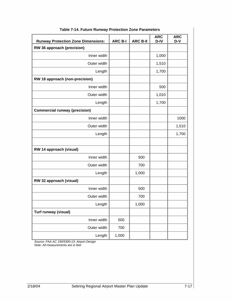
2/18/04 Sebring Regional Airport Master Plan Update 7-17
Table 7-14. Future Runway Protection Zone Parameters
Runway Protection Zone Dimensions: ARC B-I ARC B-II ARC D-IV
ARC D-V
RW 36 approach (precision)
Inner width 1,000
Outer width 1,510
Length 1,700
RW 18 approach (non-precision)
Inner width 500
Outer width 1,010
Length 1,700
Commercial runway (precision)
Inner width 1000
Outer width 1,510
Length 1,700
RW 14 approach (visual)
Inner width 500
Outer width 700
Length 1,000
RW 32 approach (visual)
Inner width 500
Outer width 700
Length 1,000
Turf runway (visual)
Inner width 500
Outer width 700
Length 1,000
Source: FAA AC 150/5300-13: Airport Design Note: All measurements are in feet

2/18/04 Sebring Regional Airport Master Plan Update 7-18
7.3.2 Far Part 77 Surfaces and Approach Requirements Federal Aviation Regulations (FAR) Part 77, Objects Affecting Navigable Airspace, is the regulation that “establishes standards for determining obstructions to navigable airspace.” The obstructions are determined primarily by superimposing the Part 77 “imaginary surfaces” over the airport and vicinity. Any object which penetrates these surfaces is considered an obstruction to air navigation. FAR Part 77 requires that certain runway imaginary surfaces be established and identified and meet certain obstruction clearance requirements as follows:
• Primary Surface – The surface longitudinally centered on a runway extending along the RPZ width and 200 feet beyond each end of the runway.
• Horizontal Surface – A horizontal plane located 150 feet above the established airport elevation. The perimeter of this surface is developed swinging arcs of specified radii from the center of each runway’s primary surface end and connecting the adjacent arcs with lines tangent to these arcs.
• Transitional Surface - Extends upward and outward at right angles to the runway centerline extending at a ratio of 7 to 1 from the sides of the primary surface and from the sides of the approach surface. The transitional surface clearances may dictate runway/building separation depending upon the type of runway and/or aircraft using the airport as opposed to lateral clearance criteria established in FAA AC 150/5300-13.
• Conical Surface – Extends outward and upward from the periphery of the horizontal surface at a slope of 20 to 1 for a total horizontal distance of 4,000 feet.
• Approach Surface – Longitudinally centered on the extended runway centerline extending outward and upward from each end of the primary surface. It is located at each end of the runway and based on the type of available or planned approach.
• Runway Protection Zone – Defines a trapezoidal portion of the runway approach surface, normally beginning 200 feet from the runway end and symmetrical about the runway. The RPZ size is dependent on the type of approach. It is desirable that all property beneath a RPZ be owned, or controlled through easement, by the airport, in order to insure obstruction infringement.
Dimensions of the “imaginary surfaces” are derived from the type of approach and the type of aircraft operating at the Airport. Runway 36 at SEF is a non-precision approach runway with visibility minimums of 1 ¾ mile. Runways 18, 14, and 32 are visual approach runways. Federal regulations require that Part 77 surfaces of the most demanding approach be applied to the entire runway. Therefore, Runway 18-36 must be designed in conjunction with the imaginary surfaces associated with the non-precision approach to Runway 36. The existing requirements of the Part 77 surfaces for both runways at SEF are shown in Figure 7-1 and Table 7-15. Existing Part 77 obstructions are shown in Table 7-16, while Table 7-17 depicts future imaginary surfaces.

2/18/04 Sebring Regional Airport Master Plan Update 7-19
Figure 7-1. FAR Part 77 Imaginary Surfaces
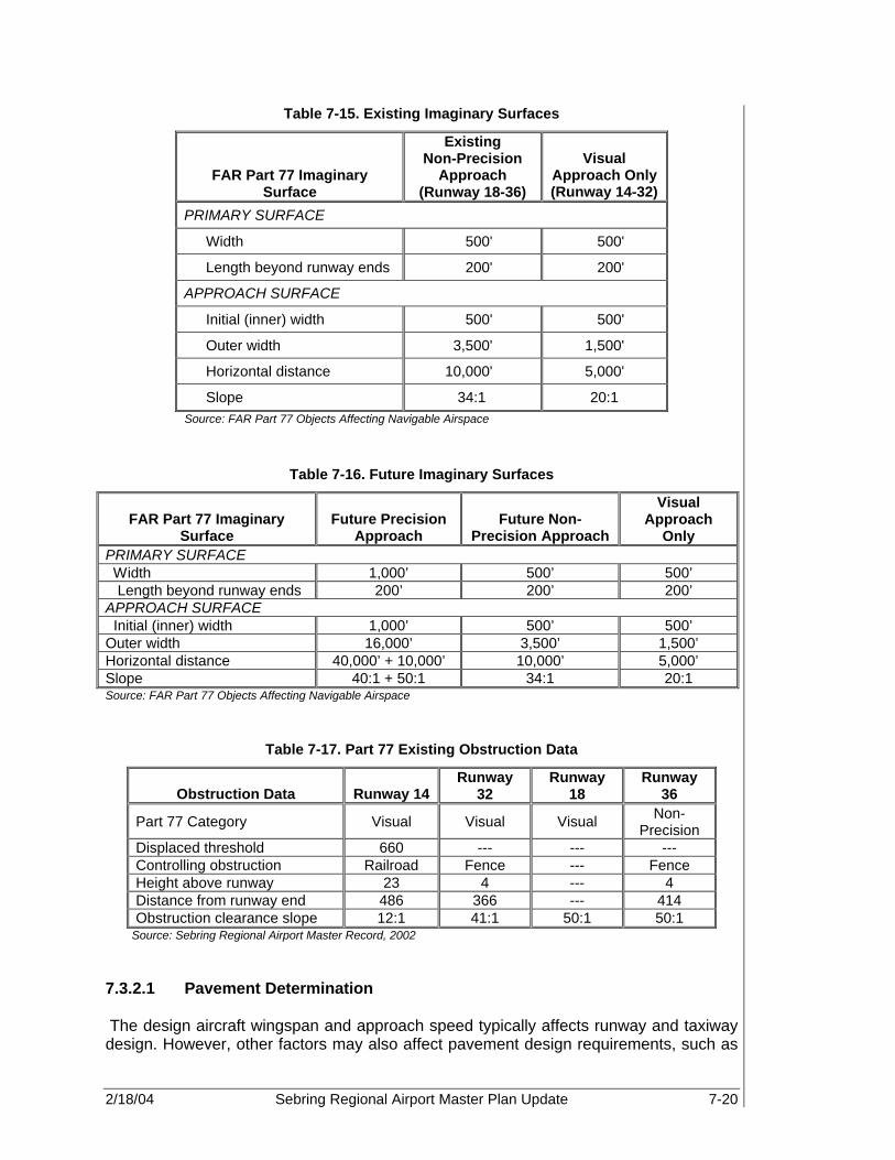
2/18/04 Sebring Regional Airport Master Plan Update 7-20
Table 7-15. Existing Imaginary Surfaces
FAR Part 77 Imaginary Surface
Existing Non-Precision
Approach (Runway 18-36)
Visual Approach Only (Runway 14-32)
PRIMARY SURFACE
Width 500' 500'
Length beyond runway ends 200' 200'
APPROACH SURFACE
Initial (inner) width 500' 500'
Outer width 3,500' 1,500'
Horizontal distance 10,000' 5,000'
Slope 34:1 20:1 Source: FAR Part 77 Objects Affecting Navigable Airspace
Table 7-16. Future Imaginary Surfaces
FAR Part 77 Imaginary Surface
Future Precision Approach
Future Non-Precision Approach
Visual Approach
Only PRIMARY SURFACE Width 1,000’ 500’ 500’ Length beyond runway ends 200’ 200’ 200’ APPROACH SURFACE Initial (inner) width 1,000’ 500’ 500’ Outer width 16,000’ 3,500’ 1,500’ Horizontal distance 40,000’ + 10,000’ 10,000’ 5,000’ Slope 40:1 + 50:1 34:1 20:1 Source: FAR Part 77 Objects Affecting Navigable Airspace
Table 7-17. Part 77 Existing Obstruction Data
Obstruction Data Runway 14 Runway
32 Runway
18 Runway
36
Part 77 Category Visual Visual Visual Non-Precision
Displaced threshold 660 --- --- --- Controlling obstruction Railroad Fence --- Fence Height above runway 23 4 --- 4 Distance from runway end 486 366 --- 414 Obstruction clearance slope 12:1 41:1 50:1 50:1
Source: Sebring Regional Airport Master Record, 2002 7.3.2.1 Pavement Determination The design aircraft wingspan and approach speed typically affects runway and taxiway design. However, other factors may also affect pavement design requirements, such as

2/18/04 Sebring Regional Airport Master Plan Update 7-21
landing gear configuration, gross takeoff weight, weather conditions, etc. Pavement strength is based upon the criteria of the design aircraft, wingspan and approach speed, as well as landing gear configuration (i.e., single wheel, dual wheel, etc.), and the known or forecast number of operations of aircraft with the heaviest maximum gross takeoff weight. The dual tandem wheel (DTW), 155,000 lb Hercules C-130 is the existing design aircraft at SEF. However, the runway and main taxiway pavement strengths at SEF are not adequate to accommodate the load of this aircraft. Runway 18-36 is rated for 85,000 lb DTW load. This is approximately 55 percent of the maximum takeoff weight for the C-130. Additionally, the Boeing Business Jet 1, which is the anticipated future design aircraft, has a DTW load of 171,000 lb. Therefore, based upon inventory data, and a review of Airport records, the condition of airfield pavements has been determined, and necessary improvements identified. Utilizing this information, Table 7-18 shows the existing airfield pavement that will require replacement and/or maintenance within the first ten years of this study. As mentioned, Runway 18-36 is only rated for 85,000 lb DTW load. Therefore, improvements to the runway load bearing capabilities are necessary as shown in Table 7-18.
Table 7-18. Airfield Pavement Requirements
Pavement Area Existing
Condition Required Action Proposed Timeframe
Runway 18-36 Good Overlay/strengthening/ extension 2002-2004
Runway 14-32 Very Poor Overlay/reconstruction 2006-2009
Runway 4-22 Closed Closed, abandoned
and partially demolished
1999
Taxiway A Good Expand/overlay 2002-2004 Taxiway A-1 Excellent New 2002 Taxiway A-2 Good Reconstructed 2002 Taxiway A-3 Good Expand/overlay 2003 Taxiway A-4 Very Poor Overlay/reconstruction 2003 Taxiways to T-Hangars Excellent Overlay 2010 Taxiway B-1 Very Poor Overlay 2004 Taxiway B-2 Very Poor Overlay 2005 Taxiway B-3 Very Poor Overlay 2004
Taxiway B-4 Very Poor to Fail
Overlay/reconstruction 2004
Apron Very Poor Overlay/reconstruction 2004-2005 Perimeter between RW ends 18 & 22* Poor Closed and abandoned 2000
Perimeter between RW ends 22 & 32* Poor Closed and abandoned 2002
Perimeter taxiway between RW 36 and 32* Poor Closed and abandoned 2002
* Denotes pavement sections that were not included in the 1998 PCI Inspection, thus existing condition based upon physical observation only. Source: Florida Airport Pavement Evaluation, Sebring Regional Airport, Eckrose/Green Associates Inc. 1998 and PBS&J. 2002

2/18/04 Sebring Regional Airport Master Plan Update 7-22
7.3.2.2 Navigational Aid (NAVAID) Requirements En route NAVAIDS are established to maintain accurate en route air navigation via ground based transmission facilities and on board receiving instruments. SEF’s en route NAVAIDS currently located on the airfield includes PAPIs, MIRL, and runway markings. Additionally, an offsite VORTAC located at nearby LaBelle provides radial and distance measuring information to military and civilian pilots. Furthermore, there is a published GPS non-precision approach to Runway 36. Precision approach path indicators (PAPI) currently exist on the primary Runway 18-36. At the time of this writing, runway end identifier lights (REILs) were in the process of being installed on Runway 18-36. It is recommended that some type of generic visual glide slope indicator (GVGI), such as the PAPI and runway end identifier lights (REILs), be provided for all visual or non-precision approaches to the Airport. The available instrument approaches and NAVAIDS at an airport have a measurable impact on overall airfield capacity, especially when considering instrument flight rules (IFR) hourly capacity. As discussed in Chapter 6, SEF is located within a Military Operating Area (MOA) and adjacent to restricted areas associated with the MacDill Auxiliary Airfield. As a result, future instrument approach procedures to SEF may be limited. However, additional NAVAID facilities, and specific instrument approaches and procedures, may be acquired and implemented at SEF to increase capacity and ensure safety during IFR conditions. Based on a review of the existing NAVAIDS at the Airport, and the anticipated demand as shown in Chapters 5 and 6, specific improvements to the existing NAVAID and approach system at SEF have been identified. It is recommended that both Runway 36 and at least one end of the proposed new runway be equipped with an instrument landing system (ILS). Depending upon the orientation and separation of these two runways, it could be possible to provide dual ILS capabilities. This may effectively separate lighter GA aircraft from commercial and/or military operations. Thus, IFR hourly and general airfield capacity would be increased, and the ability to provide future separate GA and commercial terminal buildings and overall operations would be protected. Table 7-19 shows the NAVAID requirements, according to runway, necessary to increase Airport capacity and ensure operational safety during IFR conditions. These requirements have been deemed necessary to complement the proposed runway and taxiway improvements previously discussed.
Additional navigational aid facilities, and specific instrument approaches and procedures, may be acquired and implemented at Sebring Regional Airport to increase capacity and ensure safety during instrument landing system conditions.

2/18/04 Sebring Regional Airport Master Plan Update 7-23
Table 7-19. NAVAID Requirements
Runway Existing NAVAIDS Proposed NAVAIDS Extended RW 18 PAPI-4/REILs GPS/PAPI-4/REILs
Extended RW 36 GPS/ PAPI-4/REILs PAPI-4/Category I
ILS/Localizer/GPS/MALSR/REILs
Shortened RW 14 None MIRL/GPS/PAPI-4 Extended RW 32 None MIRL/GPS/PAPI-4 Future turf runway N/A MIRL/GPS
Future commercial RW N/A PAPI-4/Category I
ILS/localizer/GPS/MALSR/REILs
Source: Sebring Regional Airport, Airport Layout Plan, and PBS&J, 2002 Note: PAPI-4 – 4-box precision approach path indicator
MALSR – medium intensity approach lighting system with runway alignment indicator lights The above-mentioned additions and relocations are based on operational demands, and, therefore, will be eligible for federal and state funding. 7.3.3 Airfield Lighting, Signage, and Pavement Markings 7.3.3.1 Airfield Lighting Existing runway lighting at SEF consists of the following systems:
• MIRL Runway 18-36 • Medium Intensity Taxiway Lighting (MITL) are located on connector Taxiways A-2, A-
3, and B-3 • Runway threshold lighting on Runway 18-36 Future improvements to the airfield lighting systems at SEF should include:
• High intensity runway lighting (HIRL) system on Runway 18-36 • Pilot controlled, medium intensity runway lighting (MIRL) system on Runways 14-32
and 14U-32U • HIRL system on the proposed commercial runway • MALSRs in conjunction with a Category I ILS on both Runway 36 and the proposed
commercial runway • REILs on Runways 14-32 and 14U-32U • MITL systems on all associated taxiways Additionally, overhead lighting should be provided, at a minimum, on the commercial terminal aprons, to ensure safe operations and security of the apron area. Overhead lighting is also recommended for the GA apron areas. 7.3.3.2 Airfield Signage Based on inventory data, there is little existing airfield signage at SEF. Therefore, additional signage and improvements to existing signage should be considered in conjunction with all future airfield projects. Projects that are recommended in this study, and would require signage updates, include: new runway construction, runway

2/18/04 Sebring Regional Airport Master Plan Update 7-24
extensions, taxiway extensions and/or construction, and terminal apron expansion. Signage, in accordance with FAA guidelines, should be incorporated into the design and construction of each project. 7.3.3.3 Pavement Markings The runway markings at SEF should be appropriately relocated to coincide with completion of the proposed runway extensions, taxiway extensions, and any necessary improvements to the apron area. Visual runway and taxiway markings should be included in the design and construction of new runways and taxiways. 7.3.4 Airfield Requirements for Commercial Airport Certification In order to provide commercial service for aircraft with more than 19 seats, an airport must be certified under CFR 49, Part 139, Airport Certification Manual. This manual outlines the physical, procedural, and policies necessary for an airport to provide commercial service. A partial list of requirements is shown following:
• Airport Fencing • Designated Airport ARFF Facilities and equipment • Lighted Wind Cone • Airport Beacon • Segmented Circle • Airfield Signage 7.3.5 Summary of Airfield Requirements and Future Capacity In determining the facility requirements necessary to correct inadequate facilities, and increase the airfield capacity of SEF to accommodate the forecast demand, the following airfield requirements were identified:
• Extend, widen, and mark Runway 18-36 to 6,700 feet long by 150 feet wide, and overlay existing runway to accommodate takeoff and landing of military heavy corporate aircraft, and commercial regional jet aircraft.
• Shorten north end, lengthen south end, and mark Runway 14-32 to 3,500 feet long by 100 feet wide, and overlay.
• Construct 3,000 x 75 ft parallel turf runway to 14-32. • Construct new commercial runway, initially 8,500 x 150, with potential expansion to
10,000 x 150 feet. • Extend parallel Taxiway A to full length of Runway 18-36 and include entrance/exit
taxiways at the west end of the runway. • Construct full length parallel taxiway on east side of Runway 18-36 and include
several entrance/exit taxiways. • Construct two parallel taxiways on either side of the new commercial runway and
include 6 to 8 entrance/exit taxiways. • Install equipment necessary, and obtain a Category I ILS approach, Localizer
approach, GPS approach, and medium intensity approach lighting system with runway alignment indicator lights (MALSR) for new runway.
• Install Category I ILS on Runway 36, and install REILs equipment on Runway 18.

2/18/04 Sebring Regional Airport Master Plan Update 7-25
7.4 TERMINAL AREA REQUIREMENTS This section will identify specific requirements of the terminal facilities necessary to meet the projected passenger activity levels as well as identify general criteria for a potential commercial terminal facility. Individual terminal area facilities are examined in terms of their general spatial requirements to accommodate the future forecast passenger and aircraft activity levels. Alteration of these facilities may be necessary to meet specific forecast levels. Currently, only one terminal building exists at SEF, the Sebring Airside Center, which was designed to meet both the needs of its current GA customers and to accommodate future small commercial aircraft operations. Designated areas for passenger baggage claim, airline ticket sales, and car rental facilities are located within the existing Airside Center. In addition to the Sebring Flight Center, the local FBO, SAA offices, and Sherianne’s Runway Café, an additional four commercial leasehold spaces currently occupy the Airside Service Center. However, anticipated commercial development at SEF will require a designated commercial service terminal building. As a result, maintaining the existing airside service center facilities while planning for future development of a commercial terminal facility will be addressed to facilitate the potential for air charter or commercial service operations at SEF. Usage of the existing SEF terminal facility, can be divided into independent activities, which also require spatial analysis to accommodate peak-hour activities and determine facility requirements. These include: a pilot lounge, a flight planning area, Airport management and operations, public restrooms, and concessions. 7.4.1 Methodology An airport’s ability to successfully respond to change often hinges on the proper design of the terminal area. Since every airport is unique, planners must consider every component of the terminal and support areas to ensure that all elements are adequate to meet the imposed demand. In addition to future growth, peak travel periods impose the most severe demand and overall strain on the capacity of terminal facilities. Therefore, if an airport is to provide an acceptable level of service, facilities must be planned to cope with above average traffic flows that are typically caused by these periodic fluctuations in demand. At SEF, these peaks occur in the form of lunchtime traffic to Sherrianne’s Runway Café and special events hosted by the Sebring International Raceway. One method of planning for peak periods involves utilizing peak hour passenger volume, developed from the average day of the peak month baseline. Unlike annual enplanements, which are only a relative indicator of airport size, peak hour statistics more accurately describe demand based on specific user patterns. The peak hour element identifies the number of enplaned, deplaned, or total passengers boarding or disembarking from aircraft in an elapsed hour of the average day of the peak month. Peak hour data is not the absolute peak activity to occur, nor the total number of persons occupying the terminal at any one time. Rather, peak hour data provides design level of activity highly correlated to daily-enplaned passenger activity. Additionally, the number of persons in the terminal during peak periods, including visitors and employees, is also directly related to peak-hour passengers, whose volumes are generally considered the
2/18/04 Sebring Regional Airport Master Plan Update 7-26
standard, by which terminal facilities are sized. Peak hour information for SEF was presented in Chapter 5, Projection of Aviation Demand. Every airport has its own distinct peaking characteristics, due to a number of factors. Once the peaking factors have been identified, as developed in the forecasts in Chapter 5, an analysis and comparison of existing capacity with existing and projected peak demand can be made. This will result in identifying terminal facilities that will likely need capacity enhancing improvements and expansion. Additionally, every effort must be made to provide a simplified and unobstructed flow of vehicles, passengers, aircraft, etc., in and about the terminal building and support areas. The primary terminal functions and ancillary activities should be located with respect to the functional flow design. Examples of critical flow functions in relation to terminal area layout and design, as suggested by the FAA, are illustrated in Figure 7-2. The sources for terminal planning guidance include the FAA, International Air Transport Association (IATA), Transportation Research Board (TRB), and the International Civil Aviation Organization (ICAO). Some of the documents utilized in the terminal demand/capacity analysis include FAA AC 150/5360-13 Planning and Design for Airport Terminal Facilities, FAA AC 150/5360-9 Planning and Design of Airport Terminal Facilities at Non-hub Locations, and IATA Airport Terminal Reference Manual. The guidelines presented in these documents, in conjunction with the knowledge and expertise of the consultant, have been used to determine the demand and associated requirements for the designated planning period of this study. 7.4.2 Existing Terminal Building The Sebring Airside Center currently accommodates commercial retail space, public restrooms, a lounge, fixed base operator (FBO) space, an information desk, and Airport administration space. However, the facility is also equipped to handle future necessities, such as airline ticket sales, a passenger waiting area, and car rental counters. The existing domestic terminal building was completed in 2000, and has a total of approximately 18,450 sq ft. It has been determined that approximately 150 sq ft per peak hour passenger, which includes space for visitors and employees, will provide sufficient space for the previously mentioned activities. The projected requirements for the gross domestic terminal area, based on the forecast passengers and peak hour passenger factors, are shown in Table 7-20.

2/18/04 Sebring Regional Airport Master Plan Update 7-27
Table 7-20. Gross Terminal Requirements
2000 2001 2006 2011 2016 2021 Peak hour pilot/passengers 105 112 135 151 166 182
Existing terminal building area (sq ft) 18,450 18,450 18,450 18,450 18,450 18,450
Gross terminal building area requirements (sq ft) 15,767 16,790 20,309 22,711 24,954 27,254
Surplus/(Deficiency) 2,683 1,660 (1,859) (4,261) (6,504) (8,804) Source: PBS&J, 2002
As shown in Table 7-20, the existing terminal building is sufficient to meet the demand forecast in Chapter 5, until 2006. However, if commercial service begins in the near future, demand would increase while capacity remains the same. Therefore, expansion to the existing Airside Center or development of a commercial terminal facility would be required during the planning period to accommodate commercial service demand.
Within the terminal building, independent amenities exist, which require individual spatial analysis to accommodate the peak hour activity. Utilizing the general sizing requirement discussed previously, a break down of the existing terminal space compared to the forecast demand follows. 7.4.2.1 Concessions A wide variety of concessions are typically located within commercial terminal buildings, but not necessarily in GA terminal facilities. However, SEF is an exception to the rule. The Sebring Airside Center hosts a gift shop, aviation accessory store, renowned restaurant, waiting lounge, flight planning center/communication room, pilot rest area, special event area, multi-purpose room, and public restrooms and telephones. The following sections overview the facility requirements for domestic concessions provided by SEF.

2/18/04 Sebring Regional Airport Master Plan Update 7-28
Figure 7-2. Typical Terminal Site Relationship for Non-Hub Airports
Source: FAA AC 150/5360-9 Planning and Design of Airport Terminal Facilities at Non-hub Locations

2/18/04 Sebring Regional Airport Master Plan Update 7-29
Food Services There is currently one restaurant in the main terminal facility at SEF. Sherrianne’s Runway Café has approximately 91 seats and equates to a combined area of approximately 3,000 sq ft. Typical sizing for restaurant facilities is determined by usage factors (average daily transactions divided by average day/peak month enplanements), and turnovers (average daily users/transactions divided by the number of available seats). Average daily use factors for an airport the size of SEF are usually between 15 and 20 percent. However, because the quality atmosphere, service, and menu attract numerous non-aviation related users in addition to pilots and passengers, the usage factor for the Café is approximately 271 percent. Typically, the desired turnover rate is between 10 and 15 people average per seat per day. The Café at SEF has a turnover rate of approximately 5 persons per seat per day. Area requirements per seat are estimated between 35 and 40 sq ft to accommodate for food preparation, kitchen, movement areas, and employee stations. Table 7-21 shows the area requirements based upon this information, for the sizing of the restaurant and lounge areas. According to this analysis, the restaurant is in need of expansion to meet the existing demand.
Table 7-21. Restaurant Area Requirements
2000 2001 2006 2011 2016 2021 Average daily enplanements 185 201 241 270 297 324 Average daily users 500 543 653 731 803 877 Daily turnover rate (persons/seat) 5.49 5.49 5.49 5.49 5.49 5.49 Existing seats 91 91 91 91 91 91 Required seats* 91 99 119 133 146 160 Surplus/(Deficiency) 0 (8) (28) (42) (55) (69) Existing restaurant area (sq ft) 3,000 3,000 3,000 3,000 3,000 3,000 Required restaurant area 3,640 3,955 4,753 5,318 5,846 6,385 Surplus/(Deficiency) (640) (955) (1,753) (2,318) (2,846) (3,385) Source: PBS&J, 2002. Note: Does not consider initiation of commercial service. News and Gift Shops Currently, four commercial leaseholds, surrounding the main terminal corridor, are located within the Sebring Airside Center. Recommended sizing for gift shops and other commercial leaseholds in terminal buildings, based upon FAA guidelines, is 600 to 700 sq. ft. per million annual enplanements, with a minimum size of 150 sq ft. Table 7-22 shows the space requirements for a retail establishment at SEF based upon an existing leaseholder.

2/18/04 Sebring Regional Airport Master Plan Update 7-30
Table 7-22. Retail Shop Requirements
2000 2001 2006 2011 2016 2021 Annual enplanements 67,422 73,256 88,033 98,506 108,275 118,270 Existing retail area (sq ft) 500 500 500 500 500 500 Required retail area 150 150 150 150 150 150 Surplus/(Deficiency) 350 350 350 350 350 350 Source: PBS&J, 2002
Telephones Standard industry planning for public telephones suggests 100 to 110 sq ft per one million enplanements. However, due to the widespread use of cellular telephones by the traveling public, this factor has been reduced by 30 percent. Areas with public telephones should be located in proximity to the ticket lobby, baggage claim area, or restaurant facilities. Typically, each telephone requires approximately 9 sq ft. Based on the sizing criteria above, Table 7-23 shows the estimated public telephone requirements for the domestic terminal at SEF. The public telephone facilities are adequate in number, size, and location for the duration of the planning period.
Table 7-23. Public Telephone Requirements
2000 2001 2006 2011 2016 2021 Annual enplanements 67,422 73,256 88,033 98,506 108,275 118,270 Existing public telephones 2 2 2 2 2 2 Required public telephones 1 1 1 1 1 1 Surplus/(Deficiency) 1 1 1 1 1 1 Existing telephone area (sq ft) 20 20 20 20 20 20 Required telephone area 9 9 9 9 9 9 Surplus/(Deficiency) 11 11 11 11 11 11 Source: PBS&J, 2002

2/18/04 Sebring Regional Airport Master Plan Update 7-31
7.4.2.2 Restrooms Restroom space allowances within airports vary extensively. Not only must public restrooms be sized for anticipated peak-hour building occupancies, but they must also encompass applicable local, state, and federal codes, including the Americans with Disabilities Act. Currently, the women’s and men's restrooms total approximately 700 and 500 sq ft in area, respectively. Restroom facilities should be at locations convenient to the departure area, ticket lobby, restaurant facilities, or baggage claim areas. At most terminal buildings, the main restroom facilities can be grouped in one centralized location, typically near the public lobby area. Additionally, private toilet facilities are sometimes provided in conjunction with operational and administrative facilities in non-public-use areas. Standard planning requirements for public restrooms recommend 1,500 to 1,800 sq ft per 500 peak-hour passengers. Table 7-24 shows the required space for public restrooms. With over 1,200 sq ft of public restroom space, SEF facilities are more than adequate to meet demand of the peak hour activity.
Table 7-24. Public Restroom Requirements
2000 2001 2006 2011 2016 2021 Peak hour pilots/passengers 105 112 135 151 166 182 Existing restroom area (sq ft) 1,200 1,200 1,200 1,200 1,200 1,200 Required restroom area 315 336 406 454 499 545 Surplus/(Deficiency) 885 864 794 746 701 655 Source: PBS&J, 2002
7.4.2.3 Airport Authority and Management Facilities Airport management facilities vary according to the size of the staff and type of operations performed. Thus, requirements for administrative space must be matched to individual airports. Currently, the SAA occupies offices in the northernmost portion of the terminal building. The total office area, including conference and reception space, totals approximately 6,400 sq ft. It is assumed that demand for administrative space will increase as the SAA staff grows. However, the current management facilities are only 80 percent occupied. Therefore, the SAA actually has room to grow for several years. The existing administration space should be sufficient for the duration of the planning period. 7.4.2.4 Terminal Circulation, Mechanical, and Maintenance Space In addition to identifying the size requirements of the major functions of the terminal, space for less obvious functions must be identified and planned. Circulation space will be required to connect the major functions, such as hallways and other needs. The amount of circulation space required for the gross terminal area varies from approximately 20 to 30 percent, depending upon the layout, size, and degree of centralization. For planning purposes, a factor of 25 percent is used. Therefore, an area of approximately 2,925 sq ft is required by 2006, 3,650 sq ft by 2010, and 4,050 sq ft by 2021 for circulation areas based on peak hour projections. For the existing terminal building (18,450 sq ft), approximately 4,613 sq ft should be designated as circulation areas.

2/18/04 Sebring Regional Airport Master Plan Update 7-32
For building mechanical systems such as heating, ventilation, air conditioning, electrical, and telephone equipment, the requirement is approximately 15 percent of the total gross terminal area. In addition to mechanical system space, building columns, walls, etc., should occupy approximately 5 percent of gross terminal requirements. Finally, space for maintenance, janitorial supplies, and security office space is required. This space will vary depending upon the type of maintenance and storage facilities available in other buildings owned by the SAA. As a minimum for preliminary planning, 5 percent of total gross terminal area will be used at SEF. However, information from Chapter 2 shows that there is a separate facility for Airport maintenance and storage located in the industrial park. The previous percentages determined for building requirements will be held constant throughout the planning period because no major changes are foreseen at this time. Table 7-25 indicates the space requirements for circulation, mechanical, and maintenance needs, based upon gross terminal area requirements of the peak hour GA passengers. As stated earlier, the existing Sebring Airside Center is sufficient to meet existing demand, but must be increased as enplanements increase and terminal expansion occurs throughout the planning period.
Table 7-25. Terminal Circulation, Mechanical, and Maintenance Space Requirements
2000 2001 2006 2011 2016 2021 Gross terminal space requirements (sq ft) 15,767 16,790 20,309 22,711 24,954 27,254
General circulation 3,942 4,198 5,077 5,678 6,239 6,814
Building mechanical 2,365 2,519 3,046 3,407 3,743 4,088
Building columns/walls 788 840 1,015 1,136 1,248 1,363
Maintenance facilities and security offices 788 840 1,015 1,136 1,248 1,363
Total circulation, mechanical, and maintenance 7,883 8,395 10,154 11,356 12,477 13,627
Source: PBS&J, 2002 7.4.3 Future Commercial Terminal Facility The existing Airside Center was designed to accommodate limited commercial air service operations at SEF. However, at the time of this writing, efforts have been underway to obtain both commercial scheduled and charter air carrier service at SEF. If anticipated demand and infrastructure improvements are made, then it is likely that SEF will require a specific stand-alone commercial facility to be located near the proposed 10,000 ft commercial service runway. Therefore, a long-term provision for planning and development of a commercial terminal building is necessary. To this end, as suggested by FAA Advisory Circular 150/5360-13, Planning and Design Guidelines for Airport Terminal Facilities, a standard of 150 sq ft per peak hour passenger is recommended. Thus, by utilizing the forecast peak hour passengers drawn from expected commercial service operations and passengers based upon expected commercial aircraft usage as discussed in Chapter 6, Demand Capacity Requirements, it is estimated that the
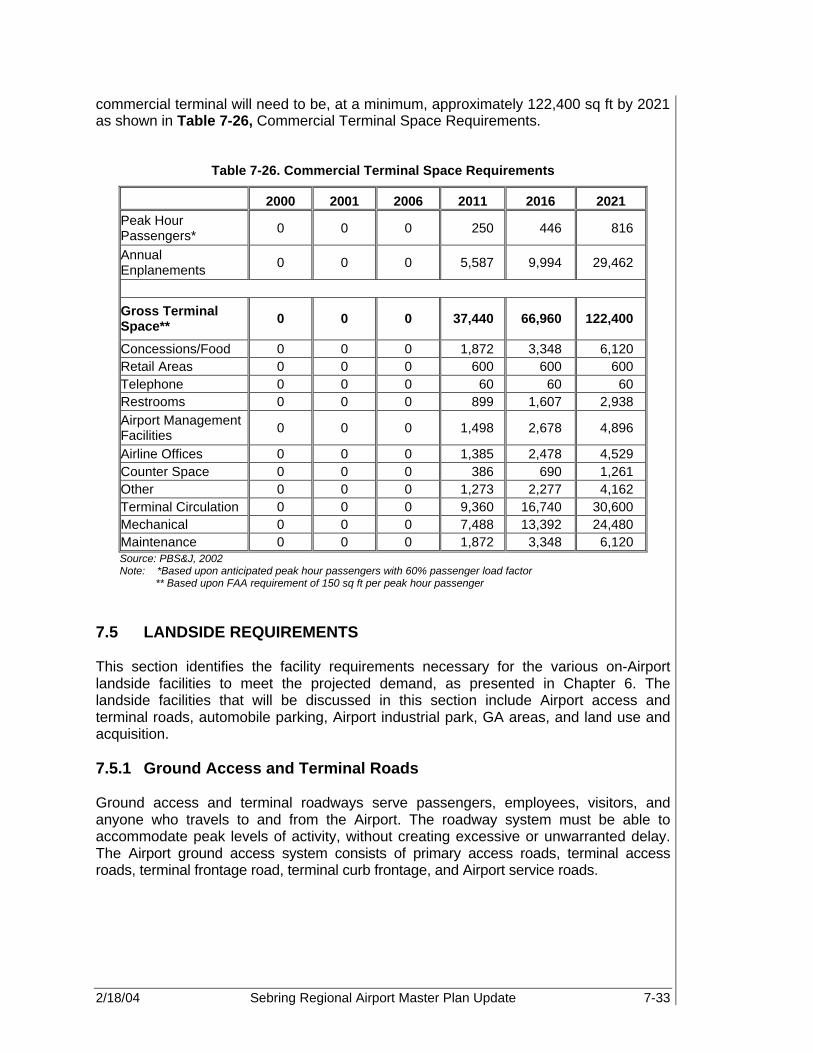
2/18/04 Sebring Regional Airport Master Plan Update 7-33
commercial terminal will need to be, at a minimum, approximately 122,400 sq ft by 2021 as shown in Table 7-26, Commercial Terminal Space Requirements.
Table 7-26. Commercial Terminal Space Requirements
2000 2001 2006 2011 2016 2021 Peak Hour Passengers* 0 0 0 250 446 816
Annual Enplanements 0 0 0 5,587 9,994 29,462
Gross Terminal Space** 0 0 0 37,440 66,960 122,400
Concessions/Food 0 0 0 1,872 3,348 6,120 Retail Areas 0 0 0 600 600 600 Telephone 0 0 0 60 60 60 Restrooms 0 0 0 899 1,607 2,938 Airport Management Facilities 0 0 0 1,498 2,678 4,896
Airline Offices 0 0 0 1,385 2,478 4,529 Counter Space 0 0 0 386 690 1,261 Other 0 0 0 1,273 2,277 4,162 Terminal Circulation 0 0 0 9,360 16,740 30,600 Mechanical 0 0 0 7,488 13,392 24,480 Maintenance 0 0 0 1,872 3,348 6,120 Source: PBS&J, 2002 Note: *Based upon anticipated peak hour passengers with 60% passenger load factor
** Based upon FAA requirement of 150 sq ft per peak hour passenger 7.5 LANDSIDE REQUIREMENTS This section identifies the facility requirements necessary for the various on-Airport landside facilities to meet the projected demand, as presented in Chapter 6. The landside facilities that will be discussed in this section include Airport access and terminal roads, automobile parking, Airport industrial park, GA areas, and land use and acquisition. 7.5.1 Ground Access and Terminal Roads Ground access and terminal roadways serve passengers, employees, visitors, and anyone who travels to and from the Airport. The roadway system must be able to accommodate peak levels of activity, without creating excessive or unwarranted delay. The Airport ground access system consists of primary access roads, terminal access roads, terminal frontage road, terminal curb frontage, and Airport service roads.

2/18/04 Sebring Regional Airport Master Plan Update 7-34
7.5.1.1 Primary Access Roads In a practical manner, it is necessary to focus attention on a small subset of the road network providing access to the Airport. Although many roads may support the Airport infrastructure indirectly, it is unnecessary to improve roads that only host a small percentage of Airport traffic. On the contrary, improving an airport’s primary access roads is worthy of much time and attention and should be considered a central goal. It is ideal for primary access roads to be well marked, clearly visible, easy to navigate, and free from obstruction and congestion. Primary access to SEF is provided in two locations. The main entrance, by way of Kenilworth Boulevard and Airport Road, actually splits, providing access to the industrial park via Webster Turn Drive and the main Airport facilities via Haywood Taylor Boulevard. The south entrance, adjacent to the Sebring International Raceway, travels along the Raceway’s southern boundary continuing to the eastern edge of the aircraft operating area (AOA). The south entrance eventually connects with the Davis Property. There are major issues associated with each of the primary access points at SEF. The main entrance is a two-lane road that also serves as the entrance road for the Sebring International Raceway. At certain times throughout the average day, and especially during special events, the main entrance to the Airport is plagued by congestion. At times, one of the lanes is even blocked off to filter traffic into the raceway. This is not only annoying to Airport employees and tenants, but also to Airport and industrial park visitors. Improvements to this intersection should include additional lanes, realignment, and repaving. It is also necessary to maintain appropriate signage for travelers to navigate with ease. The south access point serves as more of a perimeter road, than a main entrance. The road was originally constructed to prevent Airport neighbors from entering the AOA. The road does not completely surround the Airport, but could still serve as an excellent perimeter service road for Airport administration and maintenance vehicles if fencing were installed in the future. Additional access routes and roadway improvements will be necessary if development of the east side of the Airport is completed. Current roadway access into this area is extremely limited, and is primarily associated with local two lane routes used for residential traffic. Industrial and commerce park traffic as well as commercial park traffic will require capacity enhancements to existing roadways and development of additional airport roads. As part of Airport development, both a northern and southern access roadway system should be considered. As part of the roadway improvements, adequate signage along major roadway arteries as well as local routes should be improved in order to attract business as well as facilitate locating the Airport. Anticipated future development of the Airport will likely include development and realignment of the south access road as well as new development of a new, north access road. This will be discussed in more detail in Chapter 8, Development Plans.

2/18/04 Sebring Regional Airport Master Plan Update 7-35
7.5.1.2 Terminal Access Roads Terminal access roads connect the primary Airport access roads with the terminal buildings and parking facilities. The terminal access road should be designed to allow smooth channeling of traffic into the appropriate lanes, for safe and unobstructed access to the terminal curbs, parking lots, and other public facilities. Traffic circulation should be one-way in a counterclockwise direction for convenience of right-side passenger loading and unloading. Recirculation of vehicles to the passenger terminal should be permitted, by providing a recirculation road that includes ingress and egress lanes for the primary access road. Where necessary, traffic streams should be separated at an early stage, with appropriate signage, to avoid congestion and assure lower traffic volume on the terminal frontage roads. FAA AC 150/5360-13, Planning and Design for Airport Terminal Facilities, recommends that terminal area access roads should accommodate 900 to 1,200 vehicles per lane per hour, with a minimum of two 12-foot lanes. Additionally, recirculation roads should accommodate approximately 600 vehicles per hour per lane, with standard lane widths of 12 feet each. The existing terminal access road at SEF, Haywood Taylor Boulevard, has one lane in each direction, and provides the recommended level of vehicular capacity. A proposed extension of the Terminal Access Road from the terminal to an intersection point of the South Access Road is currently being evaluated. This will provide a loop around the Sebring International Raceway and access to the new commerce park. If commercial service is initiated, future expansion to the terminal access road will become necessary to meet the demand. Typically, minimum terminal access roads include a four-lane road with bi-directional traffic. 7.5.1.3 Terminal Frontage Road and Curb Frontage The terminal frontage road is that section of the terminal access road directly in front of the terminal building. This section of roadway directs vehicular traffic to the front of the terminal building. The number of traffic lanes typically increases in this section of the terminal access roadway, to allow for vehicles stopping at the enplaning and deplaning terminal curbs, vehicular maneuvering, and sufficient travel lanes for through traffic. The terminal frontage road is a critical element in maintaining vehicular flow with minimum congestion as part of the overall terminal access roadway system. Although SEF is currently without scheduled commercial service, the Airport has sufficient space to accommodate future air traffic. The terminal frontage includes two lanes of traffic, one through lane and one right-side loading/unloading lane. The frontage road offers drivers recirculation with little complication. In addition, the curb frontage allots space for approximately 10 to 12 mid-size vehicles. However, as demand increases the need for expansion should be monitored and assessed. 7.5.1.4 Service Roads Service roadways can be categorized as general-use or restricted-use roads. General use roads allow for the delivery of goods and services in the terminal area. Restricted access roads are restricted to Airport vehicles only (i.e., Airport management, fire, police, etc.), and serve areas of the airfield where public vehicles are not allowed due to safety and/or security reasons. SEF has no designated service roadways. As previously mentioned, the

2/18/04 Sebring Regional Airport Master Plan Update 7-36
south access road would be an ideal candidate for a restricted-use service road. However, since there is no security fencing currently installed at the Airport, the road can be and is accessed by the public. Designation of Airport service roads, in conjunction with adding security fencing, is favored. As the improvements proposed in this chapter are implemented, the need for adequate service roads will become more apparent. Planning and design of additional service roads should be completed to fulfill safety and security requirements and assist Airport officials in day-to-day operations. 7.5.2 Automobile Parking Automobile parking facilities accommodate pilots, passengers, visitors, and employees. Based upon site visits and tenant surveys, the existing parking areas at SEF currently have a total of approximately 214 parking spaces that are comprised of public, semi-private, and employee parking. Parking is free of charge to all Airport users.
Table 7-27. Existing Automobile Parking
Number Of Spaces Square Footage Area Public Private Employee Total Public Private Employee Total
Terminal 70 33,429 10 5,571 Corporate 35 21,593 Tullius 20 6,058 Leza 40 11,200 12 4,041 SAA 12 2,700 Lockwood 10 2,500 JB/Carter 5 1,600 TOTAL 70 122 22 214 33,429 46,992 8,271 88,692 Source: SAA, Site Visits and Tenant Surveys, 2002 The following sections will identify the future requirements for these parking areas. 7.5.2.1 GA Terminal Public Parking Requirements Airport automobile parking requirements are directly dependent on the existing and predicted peak hour GA operations. At SEF in 2000, there were approximately 30 peak-hour operations recorded. Fifty percent of the peak hour is attributed to local traffic, while 50 percent is attributed to itinerant traffic. General planning guidelines suggest that for every local GA operation, approximately .9 passengers are expected, and for every itinerant GA operation, approximately three passengers are expected. Therefore, the total peak hour GA pilots and passengers for 2000 are equal to 105 and are estimated to reach 182 by 2021. This study assumes that for every GA passenger approximately 1.3 parking spaces are required. However, for SEF, it is also important to consider the amount of visitors, which are attracted to Sherrianne’s Runway Café for lunch and special events hosted by the Sebring International Raceway. The required number of public parking spaces was

2/18/04 Sebring Regional Airport Master Plan Update 7-37
increased by 30 percent to account for this adjustment. Exercising these considerations, it is estimated that approximately 115 public parking spaces are necessary to meet the existing demand. Based upon this information, the existing public parking available is inadequate to meet demand for the base year. Table 7-28 illustrates this analysis, based upon FAA guidelines, through the 20+-year planning period.
Table 7-28. Public Automobile Parking Requirements
2000 2001 2006 2011 2016 2021 Peak hour GA operations 35 37 44 50 54 59
Peak hour local 16 16 19 21 23 25 Peak hour itinerant 19 21 25 28 31 33 Peak hour GA pilots/passengers 105 113 135 151 166 182
Peak hour local 30 30 36 40 44 48 Peak hour itinerant 75 83 99 111 122 133 Required GA auto parking spaces 136 146 176 197 216 236
Existing GA auto parking spaces 192 192 192 192 192 192
Required adjusted GA auto parking spaces*
177 190 229 256 281 307
Surplus/(Deficiency) 15 2 (37) (64) (89) (115)
Existing GA auto parking area 80,421 80,421 80,421 80,421 80,421 80,421
Required GA auto parking area 70,957 76,101 91,524 102,353 112,461 122,827
Surplus/(Deficiency) 9,464 4,320 (11,103) (21,932) (32,040) (42,406)
Source: PBS&J, 2002 Note: * Adjusted requirements include 30% increase to accommodate for lunchtime traffic from industrial park, raceway,
and local community and special events hosted by the Sebring International Raceway. There are several items worthy of mention pertaining to SEF’s public automobile parking. It is important to mention that Table 7-28 does not account for condition, access, or convenience of the parking facilities. SEF T-hangars have no designated parking areas. However, a number of users park their automobiles in the hangar facilities, which was not accounted for in this analysis. Yet, with the introduction of new security regulations at both commercial and GA airports around the country, automobile parking within the airside area will likely be unacceptable. Therefore, it is suggested that additional parking facilities should be planned to meet the potential demand associated with these and other potential changes, which may occur
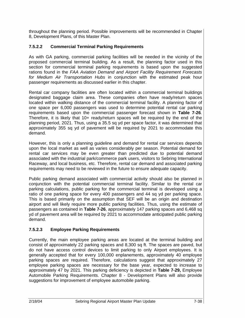
2/18/04 Sebring Regional Airport Master Plan Update 7-38
throughout the planning period. Possible improvements will be recommended in Chapter 8, Development Plans, of this Master Plan. 7.5.2.2 Commercial Terminal Parking Requirements As with GA parking, commercial parking facilities will be needed in the vicinity of the proposed commercial terminal building. As a result, the planning factor used in this section for commercial terminal parking requirements is based upon the suggested rations found in the FAA Aviation Demand and Airport Facility Requirement Forecasts for Medium Air Transportation Hubs in conjunction with the estimated peak hour passenger requirements as discussed earlier in this chapter. Rental car company facilities are often located within a commercial terminal buildings designated baggage claim area. These companies often have ready/return spaces located within walking distance of the commercial terminal facility. A planning factor of one space per 6,000 passengers was used to determine potential rental car parking requirements based upon the commercial passenger forecast shown in Table 7-26. Therefore, it is likely that 10+ ready/return spaces will be required by the end of the planning period, 2021. Thus, using a 35.5 sq yd per space factor, it was determined that approximately 355 sq yd of pavement will be required by 2021 to accommodate this demand. However, this is only a planning guideline and demand for rental car services depends upon the local market as well as varies considerably per season. Potential demand for rental car services may be even greater than predicted due to potential demand associated with the industrial park/commerce park users, visitors to Sebring International Raceway, and local business, etc. Therefore, rental car demand and associated parking requirements may need to be reviewed in the future to ensure adequate capacity. Public parking demand associated with commercial activity should also be planned in conjunction with the potential commercial terminal facility. Similar to the rental car parking calculations, public parking for the commercial terminal is developed using a ratio of one parking space for every 400 passengers and 44 sq yd per parking space. This is based primarily on the assumption that SEF will be an origin and destination airport and will likely require more public parking facilities. Thus, using the estimate of passengers as contained in Table 7-26, approximately 147 parking spaces and 6,468 sq yd of pavement area will be required by 2021 to accommodate anticipated public parking demand. 7.5.2.3 Employee Parking Requirements Currently, the main employee parking areas are located at the terminal building and consist of approximately 22 parking spaces and 8,300 sq ft. The spaces are paved, but do not have access control devices to limit parking to only Airport employees. It is generally accepted that for every 100,000 enplanements, approximately 40 employee parking spaces are required. Therefore, calculations suggest that approximately 27 employee parking spaces are necessary for the base year, expected to increase to approximately 47 by 2021. This parking deficiency is depicted in Table 7-29, Employee Automobile Parking Requirements. Chapter 8 - Development Plans will also provide suggestions for improvement of employee automobile parking.

2/18/04 Sebring Regional Airport Master Plan Update 7-39
Table 7-29. Employee Automobile Parking Requirements
2000 2001 2006 2011 2016 2021 Total annual enplanements 67,422 73,256 88,033 98,506 108,275 118,270
Existing employee parking capacity (No.)
22 22 22 22 22 22
Employee parking required (No.) 27 29 35 39 43 47
Deficiency (5) (7) (13) (17) (21) (25) Existing employee parking area (sq ft) 8,271 8,271 8,271 8,271 8,271 8,271
Employee parking area required (sq ft) 10,788 11,721 14,085 15,761 17,324 18,923
Deficiency (2,517) (3,450) (5,814) (7,490) (9,053) (10,652) Source: FAA AC 150/5360-13 Planning and Design Guidelines for Airport Terminal Facilities and PBS&J 2002 Again, if significant commercial service develops at SEF, employee-parking requirements will also increase dramatically. Using the methodology described earlier, it is anticipated that an additional 12 employee spaces will be required, which is approximately 4,800 sq ft. 7.5.3 Airport Industrial Park The Sebring Regional Airport Industrial Park is a significant revenue source for both the Airport and Highlands County.. Therefore, SEF Airport Management, as well as local business owners, has aggressively pushed compatible development. Unique to SEF is the fact that it is not only a Foreign Trade Zone (FTZ), FTZ 215, but that it has initiated a Community Redevelopment Agency (CRA) to provide incentives to businesses. According to a survey conducted by the International Trade Commission, the presence of an FTZ was found to provide a significant incentive in plant site location decisions due to cost savings and improved inventory control. Through the use of FTZs, U.S.-based production is placed on more equal footing with production in a foreign country, and FTZs have had a significant impact in retaining U.S. production and employment as well as stimulating new activity. In addition, the SAA provides an incentive program to businesses locating to the Sebring Airport and Industrial Park. In 1996, Sebring Regional Airport and Industrial Park property was designated as a Florida Community Redevelopment Area giving the SAA and its Community Redevelopment Agency (CRA) the ability to provide financing assistance and other incentives to businesses leasing land and building facilities on the Airport and Industrial Park property. Financing incentives available include:
• Offsetting or deferring lease payments through the use of the SAA's CRA's Tax Increment Trust Fund

2/18/04 Sebring Regional Airport Master Plan Update 7-40
• Loans to assist in financing site improvements, parking lot construction, and special infrastructure needs.
Sebring Regional Airport and Industrial Park is the only combined GA facility and industrial park in Florida offering these incentives. As discussed in Chapter 5, the Sebring Regional Airport and Industrial Park’s current footprint is approximately 1,700 acres. A total of 1,200 acres are currently available, with approximately 570 acres of developable property located within the Airport Industrial Park. Parcels available range in size from one acre to 600 acres. In order to attract tenant business to the industrial park and encourage development of the remaining land area, a number of items are suggested. If possible, the Airport should develop a comprehensive development plan that identifies business segments, locations, and minimum standards for construction and maintenance within the industrial park. It is important to identify available parcels by number, acreage, utilities, and lease/buy costs, for proposals and financial analysis by prospective tenants. These requirements should be completed in the short- to mid-term of the planning period, to allow proper marketing and development of the Airport Industrial Park. Refining the industrial park at SEF is an ongoing process. Although, many antiquated buildings and structures have been removed and relocated, there are still many that need overhaul. Several buildings along Hairpin Drive are dilapidated and should be demolished. Clearing unusable buildings and structures will open areas for development of new facilities. Also, construction of roadway, utility, and drainage infrastructure is necessary to create value and attract potential tenants to the industrial park. (See Master Drainage Study.) At SEF, ground access to the industrial park is often altered by events hosted by the Sebring International Raceway and by the poor condition of access and internal roadways. Pavement overlays, repainting, and additional lanes are necessary to ensure adequate infrastructure as discussed in the ground access section of this chapter. There is also a need for adequate parking for employee automobiles and for oversized transport vehicles within the park. 7.5.4 General Aviation (GA) Areas Currently, GA activities at SEF include flight training, recreational flying, aircraft maintenance, med-evac, military, and corporate operations. The facilities associated with these operations include, aircraft storage buildings, aircraft apron areas for hangars and tie-downs, and fuel storage facilities. 7.5.4.1 Aircraft Storage Buildings As discussed in Chapter 6, six T-hangar buildings (52 units), and seven conventional hangars currently exist at SEF, and store approximately 88 percent of the total based aircraft at the Airport. Based on data obtained in the inventory portion of the Master Plan, it is estimated that the conventional hangars accommodate on average two aircraft per hangar. Therefore, T-hangars accommodate approximately 70 percent of all stored aircraft, while the conventional hangars provide storage for the remaining 18 percent.

2/18/04 Sebring Regional Airport Master Plan Update 7-41
Based on the demand/capacity analysis, storage for 88 percent of the Airport’s based aircraft is required throughout the planning period, and will be divided among T-hangars and conventional hangars. Thus, considering the existing conditions, including both t-hangars and commercial hangars being built at the time of this writing, Table 7-30 shows the T-hangar and conventional hangar requirements over the planning period.
Table 7-30. Aircraft Storage Facility Requirements
2000 2001 2006 2011 2016 2021
Forecast based aircraft 84 84 88 94 99 105
Total aircraft requiring storage 74 74 77 83 87 92
Existing conventional hangars 7 7 15 15 15 15 Conventional hangars required 7 7 8 8 9 9 Surplus/(Deficiency) 0 0 7 7 6 6
Existing T-hangar units 52 52 62 62 62 62
T-hangar units required 52 52 54 58 61 65
Surplus/(Deficiency) 0 0 8 4 1 (3) Source: PBS&J 2002
It should be noted that these numbers reflect information presented by the aviation activity forecast, but do not reflect the demand defined by the number of people on the SEF waiting list for hangar space. The numbers also neglect to represent the addition of larger, more sophisticated aircraft, which typically accompany commercial and corporate activities. It should also be noted that although corporate hangars do not currently exist at SEF, corporate hangars could be used to meet the storage hangar requirements. However, consideration must be given to the number and size of aircraft stored in each hangar in order to provide adequate storage facilities. Currently, there is one hangar structure that is used as a warehouse by a non-aviation tenant. 7.5.4.2 Conventional Hangar Apron It is necessary for an airport to provide sufficient conventional hangar apron space for parking and maneuvering of aircraft around the hangar facility. It is important to mention that apron areas at SEF are not officially designated as conventional or tie-down. The FAA recommends that conventional hangar apron area should equal the amount of storage space located within the hangar itself. Currently, SEF hosts approximately 118,800 sq ft (13,199 sq yd) of conventional hangar space and 200,000 sq ft (22,222 sq yd) of conventional hangar apron. As hangar needs are expected to increase, so is the need for more conventional apron area. The average size of the existing conventional hangars at SEF is 15,000 sq ft. By utilizing FAA guidance, and applying an average of

2/18/04 Sebring Regional Airport Master Plan Update 7-42
15,000 sq ft to each conventional hangar required, Table 7-31 shows the total amount of conventional hangar apron space required over the planning period.
Table 7-31. Conventional Hangar Apron Requirements
2000 2001 2006 2011 2016 2021 Existing conventional hangars 7 7 15 15 15 15 Existing conventional hangar apron (sq ft) 200,000 200,000 200,000 200,000 200,000 200,000 Conventional hangars required 7 7 8 8 9 9 Conventional hangar apron required (sq ft) 118,800 118,800 13,800 13,800 28,800 43,800 Surplus/(Deficiency) 81,200 81,200 186,200 186,200 171,200 156,200
Source: PBS&J 2002 The calculations show current conventional apron areas are adequate to meet demand throughout the course of the planning period. However, it is important to remember that these calculations only consider raw numbers. Location and condition of the apron space is not factored into this equation. Site visits to SEF revealed inadequacies in the pavement condition and access to apron from some hangar facilities. Improvements will be suggested in the following chapter. 7.5.4.3 Aircraft Tie-Down Apron Since 88 percent of based aircraft are estimated to require hangar space, tie-downs should be planned to accommodate 12 percent of all based aircraft, and one-half of the busy-hour itinerant aircraft. The existing GA aircraft tie-down apron space available at SEF is approximately 1,062,400 sq ft (118,044 sq yd). Sizing criteria for tie-down positions vary according to aircraft size, including space for circulation and fueling. FAA AC 150/5300-13 indicates that planning for 2,700 sq ft (300 sq yd) for each based aircraft and 3,250 sq ft (360 sq yd) for each busy itinerant aircraft will provide sufficient space for a mix of GA aircraft types. It is important to mention that SEF does not officially designate apron areas for conventional, based aircraft tie-down, or transient tie-down apron. Much of the apron included in the tie-down totals is underutilized. In fact, only 40 tie-down spaces are installed at SEF. It is also important to note that condition, access, and location of the apron in vicinity to hangar facilities is not included in this analysis. However, suggestions for improving utilization of the apron facilities are provided in Chapter 6-Demand Capacity Analysis. Table 7-32 illustrates the surplus of tie-down apron space at SEF.

2/18/04 Sebring Regional Airport Master Plan Update 7-43
Table 7-32. Tie-Down Apron Requirements
2000 2001 2006 2011 2016 2021 Existing based aircraft tie-down apron 531,200 531,200 531,200 531,200 531,200 531,200
Forecast based aircraft requiring tie-down
10 10 11 11 12 13
Based aircraft apron requirements (sq ft) 27,216 27,216 28,512 30,456 32,076 34,020
Surplus/(Deficiency) 503,984 503,984 502,688 500,744 499,124 497,180 Existing itinerant tie-down apron (sq ft) 531,200 531,200 531,200 531,200 531,200 531,200
Busy hour itinerant aircraft 9 10 12 14 15 17
Total itinerant tie-down apron required (sq ft)
30,636 33,540 40,233 45,080 49,593 54,188
Surplus/(Deficiency) 500,564 497,660 490,967 486,120 481,607 477,012 Total existing tie-down apron (sq ft) 1,062,400 1,062,400 1,062,400 1,062,400 1,062,400 1,062,400
Total required tie-down apron (sq ft) 57,852 60,756 68,745 75,536 81,669 88,208
Surplus/(Deficiency) 1,004,548 1,001,644 993,655 986,864 980,731 974,192 Source: PBS&J, 2002 7.5.4.4 Helicopter Tie-Down Analysis The SAA has allotted approximately 14,844 sq ft for helicopter operations at SEF, specifically for use by Aero-Med II. Although the space for this operation is adequate, the location and condition of the facility is inadequate. The current helipad consists of an unpaved surface with no markings or signage. A doublewide trailer serves as the administration building and crew quarters. In addition, the facility is in close vicinity of the Airport fuel farm. It is favored to construct a new helipad at a relocated venue to provide more adequate facilities, to meet the needs of the Airport and its valuable tenants, and to promote safety and efficiency at SEF. 7.5.5 Aircraft Fuel Storage The SAA owns and operates the fuel farm at SEF, which provides 100LL Avgas and Jet A fuel. Avgas equipment includes one 10,000-gallon aboveground tank and one 750-gallon truck. Jet A equipment includes one 10,000-gallon aboveground tank, one 1,200-gallon trucks, and three 5,000-gallon trucks. However, some of these trucks are currently posted for sale. By comparing the demand illustrated in Chapter 5 of this plan to the existing capacity, it is obvious that the fuel farm is adequate to meet Avgas demand in the early stages of the planning period, but by 2006 additional capacity may be necessary. However, there is an existing need for additional Jet A storage at SEF that is forecasted to exceed 18,000 gallons by 2021, if additional facilities are not purchased.

2/18/04 Sebring Regional Airport Master Plan Update 7-44
Table 7-33 shows the requirements for fuel storage equipment for Avgas and Jet A fuel. It is important to mention that the SAA is currently considering the addition of self-fueling facilities at SEF. However, if new tanks are not added, the requirements for both types of fuel will increase, while capacity will remain stagnant.
Table 7-33. Fuel Storage Requirements
2000 2001 2006 2011 2016 2021 Existing 100LL capacity (gallons) 10,750 10,750 10,750 10,750 10,750 10,750
Forecast peak 100LL requirements 8,811 9,314 11,144 12,352 14,903 14,548
Surplus/(Deficiency) 1,939 1,436 (394) (1,602) (4,153) (3,798)
Existing Jet A capacity (gallons) 26,200 26,200 26,200 26,200 26,200 26,200
Forecast peak Jet A requirements* 28,735 29,801 33,942 37,328 40,842 44,751
Surplus/(Deficiency) (2,535) (3,601) (7,742) (11,128) (14,642) (18,551) Source: PBS&J, 2002
Note: * includes both GA and Military Jet A demand. Peak Monthly Avgas and Jet A-GA requirements are based upon 58.1 percent increase over the average monthly demand. Peak Monthly Jet A-Military requirements are based upon 31.0 percent increase over the average monthly demand for Avgas and Jet A-GA.
Existing fuel storage conditions are adequate to accommodate estimated demand for 100LL Avgas until 2006. By 2021, approximately 4,000 gallons of additional capacity will be necessary. An incremental need for more Jet A fuel storage equipment is visible at the present time. To meet demand for the 20-year planning period, it is necessary to add approximately 18,551 gallons of Jet A capacity to the fuel farm. Any combination of aboveground tanks and trucks will be sufficient to meet these requirements. Addition of fuel trucks for both fuel types may be necessary, if any of the existing fleet is sold. Based on site visits and tenant interviews, in addition to aviation fuel, there is a vast interest in purchasing automobile fuel at SEF. Offering automobile fuel is favored for a variety of reasons. Many experimental aircraft utilize regular unleaded fuel as opposed to Avgas or Jet A. Thus, experimental aircraft pilots and aviation mechanics need this type of service. Providing automobile fuel provides convenience to Airport tenants, patrons, and service vehicles. In addition, this is a potential market for the SAA to incorporate into the existing fuel sales revenue mix. 7.5.6 Airport Rescue and Firefighting The DeSoto City Volunteer Fire Department (DVFD) provides aircraft rescue and fire fighting (ARFF) services to the Airport, with back-up service provided by the City of Sebring Fire Department.
2/18/04 Sebring Regional Airport Master Plan Update 7-45
It is recommended that SEF obtain and maintain ARFF equipment and shall be listed as Index Category C. The index C category is determined by the five (5) daily departures of an air carrier aircraft that is at least 126 feet but less than 159 feet in length. ARFF equipment appropriate to this index will be provided during all carrier operations with over 30 passenger seats, unless otherwise reduced in accordance with Federal Aviation Regulations (FAR) Part 139.319. The Airport ARFF Department has the capability to increase to Index D and E within 12 hours notice to operations area. Currently, the Airport does not have scheduled commercial service, and therefore, is not required to have Part 139 certification. As a result, ARFF services located on the Airport are not required. However, should SEF obtain commercial service, than it is likely that ARFF services should be located on the airfield. Facility improvements to meet the increased activity would consist of an ARFF building to house emergency vehicles, supplies, and at least two rapid intervention ARFF vehicles. 7.5.7 Airport Security and Fencing Currently, there are no FAA or Transportation Security Administration (TSA) security guidelines in place for GA airports. However, based upon recommendations from NBAA and AOPA, the AAAE General Aviation Airports Security Task Force recommended:
• GA Airports should prepare a comprehensive airport security plan, which would be subject to periodic review and approval by the TSA.
• GA Airports should be required to install adequate outdoor area lighting to help improve the security of (a) aircraft parking and hangar areas, (b) fuel storage areas, and (c) access points to aircraft operations area (AOA).
• Criminal record background checks should be required on all airport, FBO and airport tenant employees with access to the AOA. Criteria similar to that used in FAR 107 should be developed to determine what offenses would disqualify individuals from being granted such access.
• GA Airports should install security fencing to help prevent unauthorized access to AOA, fuel facilities and other sensitive areas.
• GA Airports should be required to install signage around the AOA, fuel facilities and other sensitive areas to deter unauthorized entry.
In addition, it is recommended that four different categories for a federal security program at GA airports be established based upon the criteria of the airport’s location, runway length and number of based aircraft. In the case of SEF, it currently falls under Security Category 3. A Category 3 airport is defined as “an airport located outside of Class B airspace with a runway length of 4,000 feet or greater, and/or more than 50 based aircraft” (Draft: General Aviation Airport Security Task Force Recommendations, Pg 6). Since SEF has limited fencing in and around the AOA and other critical areas, improved airport perimeter access security is highly recommended. Even though SEF is not certified to accept commercial service operations via CFR 49 Part 139, fencing is recommended due to a variety of safety concerns associated with runway incursions, obstacle clearance, wildlife hazards, facility protection, etc. In order to protect the integrity of the Airport Operating Area (AOA), it is recommended that fencing of approximately six feet in height topped with three strands of barbed wire be installed around the existing airside and fuel farm facilities. Access to the airside secure areas

2/18/04 Sebring Regional Airport Master Plan Update 7-46
should be limited to those who are or are being escorted by someone who is authorized by SAA to have access to the AOA. In addition, access to the AOA via Sherrianne’s Runway Café should be prohibited. Fencing of the AOA and Fuel Farm facilities is anticipated to require approximately 75,000 linear feet of fencing, and at least fourteen to seventeen vehicle gates. Appropriate gate apparatus will need to be installed, and all future airside property acquired by the Airport should also be fenced. Maintenance access to the fence should be provided by a perimeter access road located within the property line. Any additional buildings or parking areas constructed on the Airport should have adequate security lighting. 7.5.8 Land Acquisition Airport property currently consists of over 1,770 acres that are designated for various uses. As new runway construction, runway extensions, and other facility improvements begin, additional lands will need to be acquired. Land acquisition will be necessary to gain compliance with FAA directives, and avoid the development of incompatible land uses in the vicinity of SEF. The land acquired under the incompatible land use category will help prevent the development of residential and other incompatible land uses on existing vacant land in the vicinity of SEF. A total of 2,700+ acres have been identified as necessary land acquisition over the planning period. The list below illustrates the projects requiring land acquisition, and the land area required.
Table 7-34. Proposed Land Acquisition
Project Necessary Land Acquisition Runway 18-36 extension and Runway 32R
extension ~80 acres
Rail Line Relocation ~603 Construction of Runway 14U-32U None Construction of Runway 14L-32R ~1,000 acres Aviation Mixed Use Development ~803 acres
SAA rail spur relocation ~40 acres South access road relocation and Buffer ~159 acres
Incompatible land use ~200 acres Total ~2,885 acres
Source: PBS&J, 2002 7.6 SUMMARY This section has identified the general facility requirements necessary to meet the 20+-year unconstrained aviation demand. Prior to the actual physical layout of these facilities, refinement of specific facilities must be accomplished in order to enable the Airport and Industrial Park to be developed in a coherent, logical, and safe manner. The facility requirements are based upon anticipated demand and forecast aviation activity. Additional facility requirements will become necessary if SEF becomes a commercial service Airport. If this happens, additional requirements will need to be implemented.

2/18/04 Sebring Regional Airport Master Plan Update 7-47
A summary of facility requirements has been compiled in Table 7-35.
Table 7-35. Summary of Facility Requirements
Planning Stage Requirements Item Existing 2006 2011 2021
Airside Facilities Runway 18-36: Length/width 5,224’ x 100’ 7,000’ x 150’ NC NC
Strength 30,000 SG 50,000 DG 85,000 DT
75,000 SG 150,000 DG 300,000 DT
NC NC
Approach aids:
RW 18 PAPI-4/MIRL/REILs PAPI-4/HIRL NC NC
RW 36 GPS/PAPI-4/MIRL/REILs
PAPI-4/ ILS/GPS/
MALSR/HIRL NC NC
Runway 14-32: Length/width 4,351’ x 300’ 3,500 x 100’ NC NC
Strength 30,000 SG 30,000 SG 60,000 DG 100,000 DT
NC NC
Approach aids:
RW 14 MIRL/REILs/GPS/PAPI-4 NC NC
RW 32 MIRL/REILs/GPS/PAPI-4 NC NC
Proposed Turf Runway:
Length/width 3,000’ x 75’ NC NC
Approach aids MIRL/REILs/ GPS NC NC
Proposed Runway: Length/width NA 6,000 x 150’ 8,500 x 150’ 10,000’ x 150’
Strength NA 100,000 DG 300,000 DT NC NC
Approach aids NA PAPI-4/REILs
ILS/GPS/ MALSR/HIRL
NC NC
Taxiway System: Twy A ~2,000’ x 50’ 7,000’ x 50’ NC NC Twy A-1 100’ x 50’ NC NC NC Twy A-2 100’ x 75’ NC NC NC Twy A-3 480’ x 39’ NC NC NC Twy A-4 480’ x 39’ NC NC NC Twy B-1 1,620’ x 100’ NC NC NC Twy B-2 700’ x 100’ NC NC NC Twy B-3 1,620’ x 100’ Closed NC NC Twy B-4 1,300’ x 100’ Closed NC NC Runway 18-36 Full Parallel
(West Side)
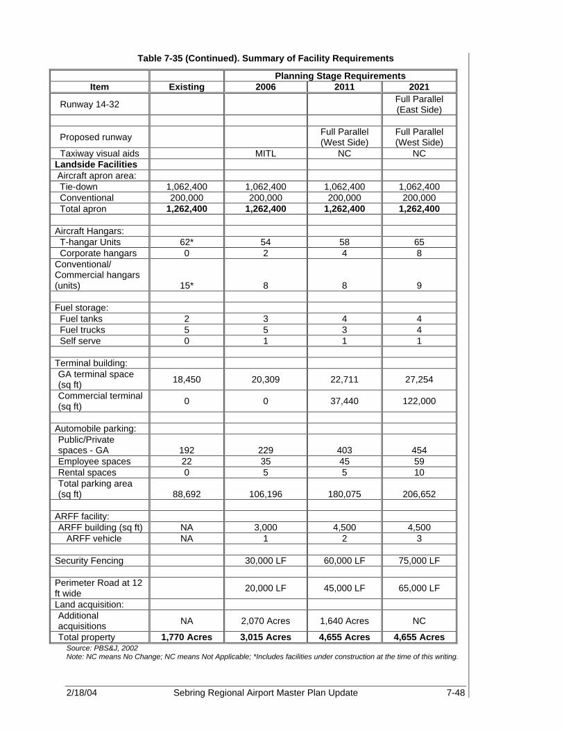
2/18/04 Sebring Regional Airport Master Plan Update 7-48
Table 7-35 (Continued). Summary of Facility Requirements
Planning Stage Requirements Item Existing 2006 2011 2021
Runway 14-32 Full Parallel (East Side)
Proposed runway Full Parallel (West Side)
Full Parallel (West Side)
Taxiway visual aids MITL NC NC Landside Facilities Aircraft apron area: Tie-down 1,062,400 1,062,400 1,062,400 1,062,400 Conventional 200,000 200,000 200,000 200,000 Total apron 1,262,400 1,262,400 1,262,400 1,262,400 Aircraft Hangars: T-hangar Units 62* 54 58 65 Corporate hangars 0 2 4 8 Conventional/ Commercial hangars (units) 15* 8 8 9 Fuel storage: Fuel tanks 2 3 4 4 Fuel trucks 5 5 3 4 Self serve 0 1 1 1 Terminal building: GA terminal space (sq ft) 18,450 20,309 22,711 27,254
Commercial terminal (sq ft) 0 0 37,440 122,000
Automobile parking: Public/Private spaces - GA 192 229 403 454 Employee spaces 22 35 45 59 Rental spaces 0 5 5 10 Total parking area (sq ft) 88,692 106,196 180,075 206,652
ARFF facility: ARFF building (sq ft) NA 3,000 4,500 4,500
ARFF vehicle NA 1 2 3 Security Fencing 30,000 LF 60,000 LF 75,000 LF Perimeter Road at 12 ft wide 20,000 LF 45,000 LF 65,000 LF
Land acquisition: Additional acquisitions NA 2,070 Acres 1,640 Acres NC
Total property 1,770 Acres 3,015 Acres 4,655 Acres 4,655 Acres Source: PBS&J, 2002 Note: NC means No Change; NC means Not Applicable; *Includes facilities under construction at the time of this writing.

2/18/04 Sebring Regional Airport Master Plan Update 8-1
DEVELOPMENT PLANS Sebring Regional Airport 8.1 GENERAL The primary objective of this chapter is to identify an overall development plan for Sebring Regional Airport (SEF) that will meet the Airport’s long-term aviation needs. Now that airside and landside facility requirements have been identified that will satisfy expected demand, the next step in the master planning process is to evaluate potential ways in which these facilities can be provided. This chapter applies the facility needs as shown in Chapter 7, to various Airport development alternatives. Since the combination of possible alternatives is limitless, intuitive judgment was applied to those alternatives that have the greatest potential for implementation. These choices will provide the underlying rationale for the preferred recommendation. Implementation of the selected alternatives will be defined in subsequent chapters. In general, three major functional areas were considered in identifying the development alternatives. These include airside (runways, taxiways, and navigational aids [NAVAIDS]), land use and land acquisition, and landside facilities (building areas and surface access). In order for SEF to accommodate the level of aviation activity forecast for the ensuing 20-year planning period, certain airside and landside facilities will require improvement or expansion. Each development alternative relates to the operational requirements of the Airport, the users, and community needs for service and facilities. As a result, airport development concepts will be divided into the following sections:
• Airfield Development • Land Use and Land Acquisition • Landside Facilities – Building Areas • Landside Facilities – Surface Access All areas were examined, both individually and collectively, to ensure the orderly evolution of a final master plan concept that is functional, efficient, cost effective, and compatible with the environment. 8.1.1 Airfield Development Airfield facilities are, by their very nature, a focal point of an airport complex. Because of their role, and the fact that they physically dominate a great deal of an airport’s property, airfield facility needs are often the most critical factor in the determination of viable airport development alternatives. In particular, the runway system requires the greatest commitment of land area and is often the greatest influence on the identification and development of other airport facilities. Furthermore, the runway and taxiway system directly affects the efficiency of aircraft movements, both on the ground and in the surrounding airspace. The runway and taxiway system also limits the ability of an airport to handle certain aircraft, which directly affects the types of air service an airport can offer or accommodate. Finally, the efficiency of aircraft movement is affected by local approach and departure procedures,
8
In order for SEF to accommodate the level of aviation activity forecast for the ensuing twenty-year planning period, certain airside and landside facilities will require improvement or expansion.

2/18/04 Sebring Regional Airport Master Plan Update 8-2
which are influenced by local restrictions associated with noise, airspace congestion, and other considerations. SEF is an important regional general aviation (GA) airport, attracting a variety of users as a result of its unique facilities and events, such as the 12-Hours of Sebring; Chateau Elan Spa; and Sherrianne’s Restaurant, the local restaurant on the Airport. On a typical day, corporate jet aircraft, helicopters, and single and multi-engine piston GA aircraft mingle on the airfield. However, due to existing runway takeoff length limitations, which are acerbated during wet, hot or humid weather conditions that require additional takeoff length, larger corporate and fractional ownership aircraft use the Airport infrequently. The airfield’s current configuration of two open runways has accommodated air traffic levels reasonably well, to date. However, increases in GA traffic as well as the potential for commercial passenger traffic will likely strain airport capacity and limit the ability of the Airport to efficiently handle both the anticipated rise in traffic and the change in fleet mix. To address these issues, it will be necessary to expand the overall capacity of the airfield to address operational and aircraft group capacity demand. This will entail extensions and the potential construction of runways, in addition to associated taxiways, to aid in accommodating the expected increase in traffic as well as the aircraft fleet mix anticipated to use the Airport in both the short- and long-term. 8.1.2 Land Use and Land Acquisition The objective of the Land Use and Land Acquisition Analysis is to evaluate the impacts that the alternative airfield and landside improvements will have on the use of land within the Airport boundary, on contiguous parcels and on the community as a whole. In addition to land required for airside use, the Sebring Airport Authority (SAA) can support a wide variety of discretionary uses on the Airport including: Airport related commercial service businesses, aviation related business, aviation/aerospace manufacturers, non-aviation industrial/commercial users, and low density uses in the approach and transition areas. Each of these areas is described in the following sections. 8.1.3 Landside Facilities – Building Areas All landside facilities, particularly building areas, are ideally developed to be in balance with the airfield/airspace facilities. At SEF, these areas include:
• Terminal facilities • GA and related aeronautical development areas • Commerce park The focus of this section is to evaluate those building areas directly related to supporting aviation activity. Non-aviation buildings on-Airport were evaluated in a cursory manner, merely considering location, function, and future utility, and compatibility with aviation operations.

2/18/04 Sebring Regional Airport Master Plan Update 8-3
Building area alternatives were conceptualized with the goal of developing a facilities development plan that exhibits the following characteristics:
• Flexibility: A plan that is demand-responsive, and can adjust over time to changes in quantifiable demands as well as changes in the nature of demands.
• Vision: A plan that addresses probable future aviation trends and technologies, as well as trends in other transportation arenas.
• Definition: A plan that sets a sure course of action, and is clearly supported and realistic.
• Order: A plan that views each part of the landside system as an interrelated part of the whole Airport – and of a global and regional transportation system.
• Balance: A plan that can extend the landside to its required fullest extent while maintaining balance with the capacity of the fully expanded airside.
• Convenience: A plan that enables the SAA and its tenants to achieve a high level of public service.
• Stability: A plan that properly guides small increments of growth and modification that the SAA and its tenants may need over time.
• Economic Soundness: A plan that enables the SAA and its tenants to prosper over the years.
• Suitability: A plan that meets the needs of the tenants and its users. Table 8-1 presents a cursory summary of estimated building area facility requirements derived from the previous chapter. These requirements are presented in terms of Planning Activity Levels (PALs), which emphasize that it is future increases in activity that “trigger” the requirement for expanding or upgrading major facilities at the Airport, not time-dependent forecasts. These requirements were used as the basis for the formulation and evaluation of alternative building area concepts. Therefore, actual activity levels may vary from the estimated time frames of occurrence outlined in this report. These requirements are based on analysis of facilities at SEF and comparisons with other major US airports that currently accommodate activity levels equivalent to the future levels projected for the Airport. Considering the seemingly endless range of possibilities for building areas, broad alternatives were first developed in their long-range configuration to a limited extent of detail, to understand their potential and reasonableness. These concepts were then narrowed according to their ability to meet the characteristics described previously, and resulted in a number of alternatives for the landside areas. 8.1.4 Landside Facilities – Surface Access To provide adequate levels of service to accommodate all Airport users, the SAA has been working with Highland’s County and the Florida Department of Transportation (FDOT) to ensure adequate vehicular capacity on the primary surface access roads and to reduce overall traffic congestion. Projects underway or in planning are discussed in the following alternative development sections. Further coordination with appropriate local and state officials will likely be required in order to continue to provide the most appropriate and effective means of ensuring adequate ground access to the Airport.

2/18/04 Sebring Regional Airport Master Plan Update 8-4
Table 8-1. Summary of Building Area Facility Requirements Based Upon Existing Operational Capacity Demand
Planning Activity Levels (Demand)
Existing
2000 PAL 1 2006
PAL 2 2011
PAL 3 2021
Activity Annual enplanements 67,421 88,033 98,506 118,270 Aircraft operations General aviation 66,210 84,464 94,343 113,096 Military 1,000 1,000 1,000 1,000 Total operations 67,210 85,464 95,343 114,096 Requirements Terminal complex Terminal building (sq ft) 18,450 20,309 22,711 27,254 Curbside (lin ft)* 120 120 120 120 Parking spaces Public** 192 229 256 307 Rental car 0 0 0 0 Employee 22 35 39 47 Total parking spaces 214 264 295 354 General aviation T-hangars 62* 54 58 65 Conventional hangars 15* 8 8 9
Conventional hangar apron (sq ft) 200,000 133,800 133,800 163,800 GA tie-down apron (sq ft) 1,062,400 68,745 81,669 88,208 Source: PBS&J, 2002 and SAA, 2002 Note: * Includes 10 T-Hangar and Commercial Hangar Units currently under design at time of this writing.
Based upon Forecast Information and GA Facility Requirements 8.2 DEVELOPMENT CONSIDERATIONS Prior to determining the ultimate alternatives, various airside, land use and land acquisition, and landside requirements were identified in Chapter 7, Facility Requirements. The evaluation criteria for each of these requirements may vary with each particular functional area. In general, similar criteria were used to measure the effectiveness and the feasibility of the various growth options available. Criteria used for the alternatives review and evaluation process can be grouped into four general categories. These include:

2/18/04 Sebring Regional Airport Master Plan Update 8-5
1. Operational – Any selected development alternative should be capable of meeting the Airport’s facility needs for the planning period. Further, preferred options should resolve any existing or future deficiencies as they relate to Federal Aviation Administration (FAA) design and safety criteria.
2. Environmental – Airport growth and expansion has the potential to impact the Airport’s environs. Therefore, the selected plan should seek to minimize environmental impacts in the areas outside the Airport’s boundaries. Proposed alternatives should also seek to obtain a reasonable balance between expansion needs and off-site acquisition and relocation needs. The preferred development plan should also recognize sensitive environmental features that may be impacted, and thus, evaluated herein.
3. Cost – Some alternatives may result in excessive costs as a result of expansive construction, acquisition, or other development requirements. In order for a preferred alternative to best serve the Airport and the community, it must satisfy development needs at a reasonable cost.
4. Feasibility – The selected alternatives should be capable of being implemented. Therefore, they must be acceptable to the FAA, FDOT, city government, Highlands County and the community served by the Airport. The preferred development options should proceed along a path that supports the area’s long-term economic development and diversification objectives.
These evaluation criteria will address economic, operational, environmental, and other important issues which are crucial to making strategic long-range planning decisions. The following sections will use these criteria in evaluating those alternatives which best meet the Airport’s long-term planning goals and development needs. The SAA is solely responsible for producing enough revenues to allow the Airport to continue to operate. To meet this goal, the SAA has developed various revenue producing uses such as an industrial park, special event facilities, and other non-aviation revenue sources. Potential alternatives for SEF consist of the following:
• Alternative I – No Build/Limited Development • Alternative II – Constrained Development • Alternative III – Unconstrained Development The first alternative investigates the options and possible repercussions of limited demand based future development. In Alternative I, projects underway would be completed and the existing facilities preserved, but future developments to the Airport would be limited to those necessary to meet limited demand and resolve operational capacity issues. Alternative II investigates the options available if future development is based upon modernization of existing facilities, safety and security related improvements, and minimal facility expansion. Such future development will be confined to existing airport leaseholds and will not encompass the acquisition of any new property. Maximizing existing land and alternative land uses of existing leaseholds will be required. Alternative III investigates the possibilities available with an unconstrained approach to future development at SEF. This alterative would consider not only existing leasehold
2/18/04 Sebring Regional Airport Master Plan Update 8-6
property but the acquisition of additional adjacent property as well. It will include all constrained development as well as provide for Airport expansion in order to meet both existing and future demand associated with SEF becoming a commercial service facility. Each alternative will be identified and discussed in the context of potential airside configuration; potential land use and acquisition; and proposed landside facilities, buildings, and surface access, in order to obtain an reliable recommendation for future development. 8.3 ALTERNATIVE I - NO BUILD/LIMITED DEVELOPMENT While any evaluation of alternatives can also include a “no action” alternative, this would effectively reduce the quality of services being provided, and potentially affect the Sebring area’s ability to accrue additional economic growth. In general, the viability of the Airport as an economic generator for the Highlands County Metropolitan Area as well as surrounding counties would be stifled by such a development approach. This alternative would limit the future development at SEF to the existing airfield configuration and those projects necessary to meet forecast demand, including those that are underway at the time of this writing, such as rehabilitation and extension of Taxiway A. Additional development, with the exception of privately funded projects, would be limited over the 20-year planning period to those projects needed to meet demand. Thus, the existing Airport facilities would be maintained at their current level until development is absolutely necessary. Proposed development under Alternative I is shown in Table 8-2, Alternative I Phasing, and Figure 8-1, Alternative I – No Build/Limited Development. 8.3.1 GA Airport Security Recommendations In the aftermath of the September 11, 2001 attacks, airport security came under intense scrutiny. Historically, GA airports have not been high-security facilities, and the federal government has not, to date, regulated GA airport security as it has done to commercial service airports. However, the main terrorist threat against GA and GA airports is the possible theft or hijacking of aircraft for use as potential terrorist weapons. Although no official ruling concerning GA airport security has been made at the time of this writing, various organizations (i.e., National Business Aviation Association (NBAA), Aircraft Owners and Pilots Association (AOPA), American Association of Airport Executives (AAAE), Airport Council International – North America (ACI-NA), etc.) have been working with the FAA and Transportation Security Administration (TSA) to develop a list of recommendations. As a result, the AAAE General Aviation Airport Security Task Force convened to develop a list of potential security guidelines. These include: • For security purposes, four different categories for a federal security program at GA
airports should be established based upon the airport’s location, runway length, and number of based aircraft. Thus, based upon this criteria, SEF is designated as a Category 3 Airport, which is defined as an “airport located outside Class B airspace with a runway length of 4,000 feet or greater, and/or more than 50 based aircraft”.
This alternative would limit the future development at SEF to the existing airfield configuration and those projects necessary to meet forecast demand, including those that are underway at the time of this writing, such as rehabilitation and extension of Taxiway A.

2/18/04 Sebring Regional Airport Master Plan Update 8-7
• All four categories of GA airports should prepare a comprehensive airport security plan, which would be subject to periodic review and approval by the TSA.
• All four categories of GA airport should be required to install adequate outdoor area lighting to help improve the security of (a) aircraft parking and hangar areas, (b) fuel storage areas, and (c) access points to the aircraft operations area.
• Criminal record background checks should be required on all airport, fixed base operator (FBO) and airport tenant employees with access to the aircraft operations area (AOA). Criteria similar to that used in FAR Part 107 should be developed to determine what offenses would disqualify individuals from being granted access.
• All GA airports should install security fencing to help prevent unauthorized access to the aircraft operations area, fuel facilities, and other sensitive areas.
• All GA airports should be required to install signage around the AOA, fuel facilities, and other sensitive areas to deter unauthorized entry.
However, it is important to note that under the current rules, security-related expenses at GA airports are not usually eligible for funding under the Airport Improvement Program (AIP). Therefore, the ability of the large majority of GA airports to implement the various recommendations will be contingent upon the provision of extensive financial assistance from federal, state, and local governments.

2/18/04 Sebring Regional Airport Master Plan Update 8-8
Table 8-2. Alternative I Phasing
Phase I (2001-2006)
Phase II (2007-2011)
Phase III (2012-2021)
Expand employee parking Close Hairpin Drive Obtain 5,000 gallon Jet A tank
Rehabilitation of Runway 18-36
Obtain 2,000 gal Jet A Truck
Construct, mark, and light parallel taxiway (Taxiway A) to
Runway 18-36
Build joint use ARFF and MedEvac facilities
Obtain 1 ARFF rapid response vehicles
Build roadway extension into Spring Lake
Haywood Taylor Blvd extension
Building 60 Roof Repairs Install Security Fencing and
Gates
Widen and Reconstruct Webster Turn Blvd
Expand Boeing Avenue Source: PBS&J, 2002 Note: ARFF – aircraft rescue and fire fighting
MedEvac – medical evacuation operation
Under Alternative I, the Airport would continue to be restricted to smaller GA aircraft and lack sufficient capacity for the larger corporate (i.e., Boeing Business Jet), cargo and commercial activity. This alternative will fail to meet the previously discussed development evaluation criteria and the overall goal of the Airport to become a commercial service facility. In general, the viability of the Airport as an economic generator for the City of Sebring and surrounding counties would be stifled by such a development approach.

2/18/04 Sebring Regional Airport Master Plan Update 8-9
Figure 8-1. Alternative I - No Build/Limited Development (Use ALP and Aerial)

2/18/04 Sebring Regional Airport Master Plan Update 8-10
8.4 ALTERNATIVE II – CONSTRAINED DEVELOPMENT Alternative II retains all future Airport development to the existing Airport leaseholds while maximizing available land use. This approach seeks to utilize available but underdeveloped land areas to increase the generation of revenues in order to make the Airport more profitable. Alternative II is designed to meet the forecast demand presented in Chapters 5 and 6, and utilize additional development to increase revenue sources for the Airport. In order to meet the anticipated demand/capacity, and thus, achieve increased revenue, the Airport Reference Code (ARC) of Runway 18-36 should be changed from a D-II to D-IV, thereby changing the design aircraft and the separation and design standards at the Airport. This change is necessary in order to capitalize on corporate aircraft and limited commercial and military aircraft usage. Alternative II would ensure that GA activity would no longer be limited by inadequate facility infrastructure. The following sections outline the development proposed in Alternative II. Additionally, phasing of the proposed projects included in Alternative II is shown in Table 8-3. The overall development can be seen in Figure 8-2, Alternative II - Constrained Development. Table 8-3 outlines the proposed projects and timeframe for development at SEF under Alternative II, Constrained Development. This alternative limits the majority of development to the existing property. Any additional land acquisition is associated with runway safety and protection areas as required by the FAA. 8.4.1 Airside Configuration The airfield’s current configuration of two runways has, to date, accommodated air traffic levels reasonably well. However, potential development of commercial operations and increased military operations, combined with continued high levels of GA operations, will put a strain on Airport capacity and limit the ability of the Airport to efficiently handle the anticipated rise in traffic. To address these issues, it will be necessary to expand the operational capacity of the airfield to effectively accommodate anticipated increases in traffic, as well as the aircraft mix projected to use the Airport. Under Alternative II, this entails extending Runway 18-36, shortening and lengthening Runway 14-32, and constructing GA Utility Runway 14U-32U, in conjunction with associated taxiway development. 8.4.1.1 Runways Since SEF was originally designed as a military training base, its airfield configuration consists of three runways formed in a triangular pattern. Currently, however, only Runways 18-36 and 14-32 are active. Runway 4-22 is closed and partially demolished. Runway 18-36 is designated as the primary runway and is marked for a non-precision instrument approach. It is approximately 5,224 x 100 feet, and is equipped with medium intensity runway lights (MIRL) and a non-precision approach on Runway 36. Runway 14-32 is designated as the crosswind runway. It is currently 5,000 x 300 feet, with a 650 ft displaced threshold, and is designated as a visual runway only.
Alternative Two retains all future Airport development to the existing Airport leaseholds while maximizing available land use.

2/18/04 Sebring Regional Airport Master Plan Update 8-11
Table 8-3. Alternative II Phasing
Phase I Phase II Phase III (2001-2006) (2007-2011) (2012-2021)
Planning Environmental Assessment for
Runway 18-36 Extension Design GPS/Non-precision approach to Runway 14-32
Land Acquisition for Runway 18.
Design GPS/Non-precision approach to Runway 14U-32U
Perform ATCT Site Selection Study
Obtain Part 139, Airport Certification
Phase III Drainage
Design GPS/Non-precision approach to Runway 18
Design Terminal Expansion
Environmental Assessment for Runway 18-36
Design Extension for Runway 18-36
Airside
Extend and Widen Runway 18-36 to 7000’ x 150’
Design/Construct Taxiway B (parallel to 18-36 on East Side) and associated stub taxiways
Pavement Rehabilitation of Runway 18-36 (150,000 lb DG
and 300,000 lb DTW)
Shorten, rehabilitate and lengthen Runway 14-32 to 3500
x 100 ft.
Mark (Precision) and Light (HIRL) Runway 18-36
Install pilot controlled MIRL on Runway 14-32
Design and grade Runway 14U-32U
Install pilot controlled MIRL on Runway 14U-32U
Extend, widen and light Taxiway A
Install REILs and PAPI-4 on Runway 14-32
Install MALSR and Localizer on Runway 36
Install REILs and PAPI-4 on Runway 14U-32U
Mark displaced threshold on Runway 36
Design/Construct connector taxiways between Rwys 14-32
and 14U-32U
Design/construct turnoff to Twy B from Rwy 14-32
Construct connector taxiways between Rwys 36, 32 and 32U
as well as Twy B.

2/18/04 Sebring Regional Airport Master Plan Update 8-12
Table 8-3 (Continued). Alternative II Phasing
Phase I Phase II Phase III (2001-2006) (2007-2011) (2012-2021)
Terminal Area
Expand Public Parking Area Expand Air Service Terminal Building West Apron Expansion
Relocate Aero-Med facilities Realign and expand Terminal Access Road
Relocate/Replace existing Fuel Farm Construct Rental Car Parking
Expand Employee Parking
Expand, Rehabilitate and Widen Haywood Taylor Blvd.
Expand Public Parking Area Northwest GA
Access Taxiways Design/construct one eight-unit T-hangar facility T-Hangar Construction
Rehabilitate, mark and Expand West Apron
Design/construct one conventional hangar
Design/construct three corporate hangars
Design/Construct one, eight-unit T-Hangar facility
Install Self-Service Octane 88 facility
South GA
Design/Construct Public Emergency Facility (i.e., ARFF
and MedEvac Units)
Design/Construct one conventional hangar
Design/construct four additional corporate hangars
Expand, rehabilitate, relocate and extend South Airport
Access Road
Design/construct four corporate hangars
Install additional fuel farm facility equipped with ten 10,000 gal.
Jet A tanks
Install Roadway Signage Apron Rehabilitation on the West side
Construct access road to Spring Lake community Fuel Farm development
Purchase one rapid response vehicles for ARFF station
Install additional fuel farm facility equipped with ten 10,000 gal Jet
A tanks

2/18/04 Sebring Regional Airport Master Plan Update 8-13
Table 8-3 (Continued). Alternative II Phasing
Phase I Phase II Phase III (2001-2006) (2007-2011) (2012-2021)
Industrial Park
Relocate SAA Railroad Spur Expand and realign Airport Road Expand Industrial Park
Fill Pond 200 at the existing end for Runway 18 Install additional signage
Expand and reconstruct Webster Turn Drive Install additional utilities
Expand Boeing Avenue Expand Industrial Park Expand Ulmann Drive Close Hairpin Drive
Commerce Park
New Commerce Park – Phase I New Commerce Park – Phase II Install and mark apron Fuel Storage Expansion
Install Fuel Farm Facilities Sell old and obtain new fuel trucks
Airfield
Relocate CSX Railroad Line Relocate/Construct New ATCT
Install Security/Perimeter Fencing
Install Security Perimeter Road
Source: PBS&J, 2002 Note: ATCT – air traffic control tower
GPS – global positioning system HIRL – high intensity runway lights PAPI – precision approach path indicator MALSR – medium intensity approach lighting system with runway alignment indicator lights

2/18/04 Sebring Regional Airport Master Plan Update 8-14
Figure 8-2. Alternative II - Constrained Development
2/18/04 Sebring Regional Airport Master Plan Update 8-15
Based upon both existing and anticipated demand at SEF, it was determined that high performance corporate aircraft, regional jet as well as existing military operations, would either begin or continue to use SEF’s facilities if adequate runway and taxiway facilities were made available. Based upon the fleet mix analysis as well as demand discussed in Chapters 5 and 6, it is recommended that an extension to Runway 18-36 be planned for the near future. An extension will allow more demanding aircraft, such as the Embraer 145, Learjet 45, Gulfstream V, etc., to use SEF’s facilities on a more regular basis. This is anticipated to result in a change of ARC for SEF from a D-II to a D-IV, which is based upon a critical aircraft combination of the Airbus Corporate Jet (D-III) and Lockheed Martin C-130 Hercules transport aircraft (C-IV). Extend Runway 18-36 Based upon information obtained from the SAA, Sebring Flight Service Center, and the demand and facility needs evaluations performed in Chapters 6 and 7, SEF can accommodate the majority of GA aircraft on its existing runway field length with the exception of high performance corporate and regional jet aircraft. Both categories of aircraft are used not only by private users, but fractional ownership companies, such as FlexJet. At its current field length, these aircraft may be (and historically have been) subject to payload limitations, depending upon weather conditions, or have opted not to use the Airport at all due to limited takeoff field lengths. Therefore, in order to meet both existing and forecast fleet mix demand as well as allow for the potential for regional air transport operations, it will be necessary to extend and widen Runway 18-36 to 7,000 x 150 ft. In addition, the runway’s load bearing weight capabilities should be increased to 75,000 lb single wheel load (SWL), 150,000 lb dual wheel load (DWL), and 300,000 lb dual tandem wheel (DTW) load. This will accommodate the demand for increased takeoff field length during times of poor weather for both existing and anticipated corporate and air transport aircraft. Based upon both the forecasts, discussed in Chapter 5, and demand, discussed in Chapter 6, use of Runway 18-36 by large corporate aircraft such as the Gulfstream IV and V and Learjet 35 are expected to not only continue but to increase throughout the 20-year planning period. In addition, use of typical fractional ownership aircraft, i.e., Airbus Corporate Jet, Embraer 145, etc., and the potential for air transport service justifies the increase in runway field length to 7,000 x 150 ft in order to safely and efficiently meet the needs of the new fleet mix. As part of the development, Runway 36 will be upgraded to a Category I precision approach and Runway 18 to a non-precision approach. Therefore, the following changes in NAVAIDS, runway lighting, and markings will occur as shown in Table 8-4.
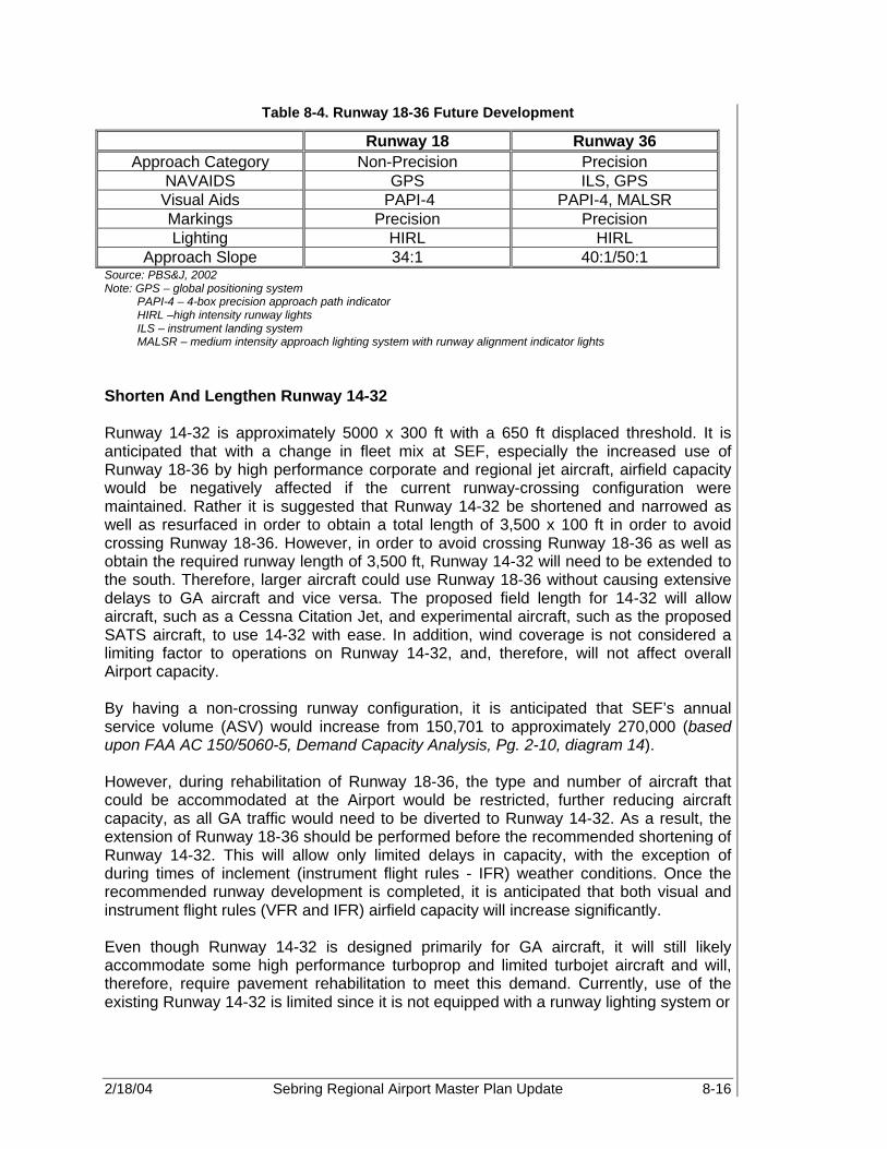
2/18/04 Sebring Regional Airport Master Plan Update 8-16
Table 8-4. Runway 18-36 Future Development
Runway 18 Runway 36 Approach Category Non-Precision Precision
NAVAIDS GPS ILS, GPS Visual Aids PAPI-4 PAPI-4, MALSR Markings Precision Precision Lighting HIRL HIRL
Approach Slope 34:1 40:1/50:1 Source: PBS&J, 2002 Note: GPS – global positioning system
PAPI-4 – 4-box precision approach path indicator HIRL –high intensity runway lights ILS – instrument landing system MALSR – medium intensity approach lighting system with runway alignment indicator lights
Shorten And Lengthen Runway 14-32 Runway 14-32 is approximately 5000 x 300 ft with a 650 ft displaced threshold. It is anticipated that with a change in fleet mix at SEF, especially the increased use of Runway 18-36 by high performance corporate and regional jet aircraft, airfield capacity would be negatively affected if the current runway-crossing configuration were maintained. Rather it is suggested that Runway 14-32 be shortened and narrowed as well as resurfaced in order to obtain a total length of 3,500 x 100 ft in order to avoid crossing Runway 18-36. However, in order to avoid crossing Runway 18-36 as well as obtain the required runway length of 3,500 ft, Runway 14-32 will need to be extended to the south. Therefore, larger aircraft could use Runway 18-36 without causing extensive delays to GA aircraft and vice versa. The proposed field length for 14-32 will allow aircraft, such as a Cessna Citation Jet, and experimental aircraft, such as the proposed SATS aircraft, to use 14-32 with ease. In addition, wind coverage is not considered a limiting factor to operations on Runway 14-32, and, therefore, will not affect overall Airport capacity. By having a non-crossing runway configuration, it is anticipated that SEF’s annual service volume (ASV) would increase from 150,701 to approximately 270,000 (based upon FAA AC 150/5060-5, Demand Capacity Analysis, Pg. 2-10, diagram 14). However, during rehabilitation of Runway 18-36, the type and number of aircraft that could be accommodated at the Airport would be restricted, further reducing aircraft capacity, as all GA traffic would need to be diverted to Runway 14-32. As a result, the extension of Runway 18-36 should be performed before the recommended shortening of Runway 14-32. This will allow only limited delays in capacity, with the exception of during times of inclement (instrument flight rules - IFR) weather conditions. Once the recommended runway development is completed, it is anticipated that both visual and instrument flight rules (VFR and IFR) airfield capacity will increase significantly. Even though Runway 14-32 is designed primarily for GA aircraft, it will still likely accommodate some high performance turboprop and limited turbojet aircraft and will, therefore, require pavement rehabilitation to meet this demand. Currently, use of the existing Runway 14-32 is limited since it is not equipped with a runway lighting system or

2/18/04 Sebring Regional Airport Master Plan Update 8-17
approach aids. In order to increase the overall capacity of the Airport, the following lighting, markings, and approach aids are recommended and shown in Table 8-5.
Table 8-5. Runway 14-32 Future Development
Runway 14 Runway 32 Approach Category Non-Precision* Non-Precision*
NAVAIDS GPS GPS Visual Aids REILs, PAPI-4 PAPI-4, REILs Markings Non-Precision Non-Precision Lighting MIRL MIRL
Approach Slope 34:1 34:1 Source: PBS&J, 2002.
Construct New GA Runway, 14U-32U Recreational GA operations represent more than 98 percent of SEF’s total operations with military operations representing less than 2 percent. Sport, vintage ‘Warbird’, and experimental aircraft enthusiasts who utilize the Airport regularly perform a significant portion of those GA operations. According to the forecast information in Chapter 5, it is anticipated that GA aircraft use will continue to increase. Furthermore, the use of experimental aircraft is expected to increase throughout the planning period. Therefore, since GA activity, especially experimental operations, is forecast to continue growing, these operations will remain a major contributing factor to Airport operations. Thus, based upon comments by these users, construction of a turf runway parallel to existing Runway 14-32 is recommended to meet both the existing and forecast demand. Turf runways, according to vintage aircraft enthusiasts, produce less “wear and tear” on the aircraft. This runway would be equipped with visual NAVAIDS, including runway end identification lights (REILs) and medium intensity runway lights (MIRLs), which will be controlled by pilot radio. This will not only allow pilots to use the runway at night, but to choose to utilize the paved 14-32 or the turf utility runway. Furthermore, since no on-airfield equipment is required, a global positioning system (GPS) approach should be designed for Runway 14R-32L and the turf runway. The proposed turf (utility) runway should be marked as 14U-32U. The recommended dimensions for this runway are 3,000 x 75 feet. It is anticipated that in the future the runway may serve as a taxilane to the paved Runway 14-32, if needed; therefore, a separation of 400 ft is recommended. The recommended development for Runway 14U-32U is described in Table 8-6.

2/18/04 Sebring Regional Airport Master Plan Update 8-18
Table 8-6. Runway 14U-32U Future Development
Runway 14U Runway 32U Approach category Visual/Non-Precision* Visual/Non-Precision*
NAVAIDS GPS GPS Visual aids REILs REILs Markings Visual/Basic Visual/Basic Lighting MIRL MIRL
Approach slope 20:1 20:1 Source: PBS&J, 2002 Note: *Primary use is for visual aircraft only. However, if aircraft is equipped with GPS equipment, then may perform
non-precision approach to this runway. Demolish Runway 4-22 The abandoned Runway 4-22 is closed and partially demolished. The existing base and sub-base for this runway could be reused as sub-base for future taxiways, as was done for the existing Taxiway A extension. 8.4.1.2 Taxiway System Improvements To ensure that adequate taxiways are available for each of the runway improvements discussed previously, and to provide the highest level of obtainable capacity to the runway system, adequate taxiway entrances and exits, and full-length parallel taxiways would be constructed as follows:
• Construct a new parallel Taxiway B on the east side of Runway 18-36 and include six connector taxiways. Several of these connectors will connect with the planned Commerce Park Complex.
• Extend and widen parallel Taxiway A to 7,000 x 75 feet on the west side of Runway 18-36 and add two additional connector taxiways.
• Construct a new parallel Taxiway C on the west side of Runway 14-32 and include three connector taxiways. These connectors will connect with the planned Commerce Park Complex.
• Remove closed taxiways along the east side of the Airport property (i.e., B-3 and B-4).
• Construct a connector taxiway from Runways 14U-32U to proposed parallel Taxiway B.
• Construct turn-off for aircraft on Runway 14-32 to access parallel taxiway B. • Construct holding connector taxiways at ends of Runway 18 and 32 to allow aircraft
to prepare for departure in areas that are not disruptive to other departing aircraft and to improve the overall airfield operating efficiency.
• Construct and strengthen taxiways and connectors associated with Runway 18-36 to accommodate heavier aircraft.
• Equip all taxiways with medium intensity taxiway lights (MITLs). When completed, these improvements will provide appropriate access to and from all runways, ensuring enhanced operational safety, capacity, and airfield efficiency.

2/18/04 Sebring Regional Airport Master Plan Update 8-19
Runway and taxiway improvements are graphically depicted in Figure 8-2, Alternative II - Constrained Development. 8.4.1.3 Aprons The rehabilitation of the existing terminal apron should be accomplished to extend the useful life of the existing apron pavement. Based upon the facility assessment performed in Chapter 7, there is an excess of available apron space for both conventional and tie-down aircraft requirements. However, much of this pavement is in poor condition; and therefore, rehabilitation is critical. In addition, in conjunction with development of the proposed Airport Commerce Park Complex, to be discussed in more detail in later sections, it is recommended that approximately 1000+ sq yd of apron space be constructed around the perimeter of the proposed development and adjacent to Taxiway B, Runway 14-32, and former Runway 4-22. Proposed aircraft apron requirements are shown in Table 8-7.
Table 8-7. Aircraft Apron Requirements
Apron Facility Existing Apron Area (sq yd) Future Apron Area (sq yd)
Total aircraft tie-down 13,200 13,200 Based aircraft 6,600 6,600
Transient aircraft 6,600 6,600
Conventional hangar apron 23,997.6* 23,997.6 Commerce park apron NA 1,000
Total apron facilities 48,620 49,620
Source: PBS&J, 2002 SEF Inventory Note: * Includes additional 1,777.6 sq yd of apron space associated with 8 unit commercial hangar development in
2002-2003. 8.4.1.4 Air Traffic Control Tower The existing ‘open air’ air traffic control tower (ATCT) dates back to World War II, and is currently located on the landside portion of the Airport, northwest of the Sebring Airside Center (see Figure 8-2). The ATCT was recently renovated through an Intermodal Surface Transportation Efficiency Act of 1991 (ISTEA) grant. An ISTEA grant provides Federal grant monies for the enhancement of transportation facilities. Presently, the ATCT is occupied by FAA Air Traffic Controllers only during the 12 hours of Sebring and other major sporting events. Since development at SEF is designed to meet the demand of high performance corporate aircraft as well as potential commercial air transport service, it is likely that relocation and/or construction of a new ATCT facility is needed. It is recommended that an independent ATCT site selection study be undertaken in coordination with the FAA to determine the most appropriate location for the relocated ATCT. As an initial suggestion, a potential site for the new tower has been identified in the east midfield development area, east of Runway 18-36 in the open triangle area north of the

2/18/04 Sebring Regional Airport Master Plan Update 8-20
anticipated commerce park development. The new site is positioned in a more secure location, and would provide superior and unobstructed line of sight to all major approach and ground operation surfaces, with minimal shadowing. It is recommended that the cab floor height be located at a minimum of 60 feet above ground level (AGL). The suggested site is depicted in Figure 8-2, Alternative II - Constrained Development. 8.4.2 Environmental Assessment A complete environmental assessment (EA) will be required for the extension of Runway 18-36 and potentially for the extension of Runway 32. An EA for construction of the Turf Runway, 14U-32U, is deemed unnecessary. Each EA must be completed before design and construction begins. Additionally, initial improvements should begin within the first five years of the Master Plan, as a result of increased demand. 8.4.3 Regional Airspace and Approach Procedures Airspace in and around SEF is unique since it is located within the Lake Place Military Operating Area, which is associated with the MacDill Air Force Base Auxiliary Airport and Avon Park Bombing Range. As a result, SEF’s operations are somewhat constrained due to the proximity of various restricted and warning areas associated with military operations. As discussed in Chapter 2, Existing Airport Facilities, Statistic,s and Environment, controlled airspace directly associated with SEF includes Class E, which is depicted on the Miami Sectional Aeronautical Chart, November 2002, by the graduated magenta band surrounding the Airport, and Special Use Areas (SUAs), which includes restricted and warning areas as well as military operating areas (MOAs), and are depicted by red and blue outlines. The Class E Airspace surrounding SEF has its floor 700 ft above the surface. Class E Airspace allows aircraft to transition to or from the MOA into the airport control zone. Within warning areas, while multiple use of the airspace is not prohibited, avoidance is advised during time of military training use. Joint use by military and civilian traffic of MOAs is also allowed. However, pilots flying in MOAs are responsible for employing “see and avoid” standards of flight safety. MOAs associated with the Avon Park Bombing Range and MacDill AFB Auxiliary Airport (AGR) operations limit SEF’s airspace operations. The restricted areas, as indicated in Figure 8-3, Runway 36 Terminal Instrument Approach Procedures, designate those areas that are continuously in effect and limit where aircraft can operate. As indicated, most of the areas restrict civilian aircraft to fly below 14,000 ft mean sea level (MSL). The MOA is considerably larger than the restricted areas and is in effect intermittently during daylight hours Monday through Friday, and occasionally on weekends, but does allow aircraft to fly lower than 7,000 ft on a limited basis. (23) Restricted airspace (RA) to the northeast of SEF, though not entirely prohibited to flight activity, contains areas in which unauthorized incursion is not only illegal, but also extremely dangerous. Restricted areas are identified on aeronautical sectional charts by a defined area marked with the letter "R," followed by a number. Altitudes and times differ for each restricted area. These areas generally contain operations that do not mix

2/18/04 Sebring Regional Airport Master Plan Update 8-21
well with aircraft, such as artillery firing, guided missiles, or aerial gunnery. Permission to fly in restricted areas can be given by ATCT. Table 8-8 lists specific RAs and MOAs in the region surrounding SEF.
Table 8-8. Sebring Regional Airspace
RESTRICTED AREAS
Number Usage Altitude Usage Time Controlling
Agency R-2901A To 14,000’ Continuous ZMA CNTR R-2901B 14,000’ to FL 180 Continuous ZMA CNTR R-2901C To 14,000’ Continuous ZMA CNTR
R-2901D 500’ to 4,000’ East of 81 21’ 00” W; 1,000’ AGL to 4,000’
West of 81 21’ 00” West Continuous ZMA CNTR
R-2901E 1,000” to 4,000’ Continuous ZMA CNTR R-2901F 4,000’ to 5,000’ Continuous ZMA CNTR R-2901G To 5,000’ Continuous ZMA CNTR R-2901H 1,000’ to 4,000’ Continuous ZMA CNTR R-2901I 1,500’ to 4,000’ Continuous ZMA CNTR
MILITARY OPERATIONS AREAS
Name Usage Altitude Usage Time Controlling
Agency
Avon North 5,000’ Intermittent daylight hours: contact FSS ZMA CNTR
Avon East 500’ AGL to But not including 14,000’
Intermittent daylight hours Mon-Fri ZMA CNTR
Avon South 4,000’ Daylight hours Mon – Fri ZMA CNTR
Basinger 500’ AGL to 5,000’
Intermittent daylight hours Mon-Fri occasionally Sat & Sun.; contact nearest FSS
ZMA CNTR
Lake Placid 7,000’
Intermittent daylight hours Mon-Fri occasionally Sat & Sun.; contact nearest FSS
ZMA CNTR
Lake Placid North 15,000’ Intermittent daylight
hours; contact FSS ZMA CNTR
Marian 500’ AGL to 5,000’
Intermittent daylight hours Mon-Fri occasionally Sat & Sun.; contact nearest FSS
ZMA CNTR
Source: Department of Transportation, U.S. Terminal Procedures Southeast, Volume 3 of 4, November 1, 2001 Note: ZMA Center: Miami Air Route Traffic Control Center. FSS: Flight Service Station 8.4.3.1 Terminal Instrument Approach Procedures As part of the overall development plan at SEF, it is recommended that Runway 36 be equipped with a Category I ILS thereby allowing aircraft to perform precision approaches into the Airport. This will allow pilots greater flexibility during inclement weather conditions. However, due to the proximity of special use airspace in and around SEF, it

2/18/04 Sebring Regional Airport Master Plan Update 8-22
was necessary to develop potential terminal instrument approach procedures (TERPS) for Runway 36. TERPS consist of both approach and missed approach procedures, see Figure 8-3, Runway 36 Terminal Instrument Approach Procedures. The approach procedure consists of an initial, intermediate, and final approach path. Using en route NAVAIDS, aircraft can line up with the center of the runway prior to runway visual contact. Designated altitudes and waypoints associated with the approach are published in the FAA Approach Charts. See Table 8-9, Runway 36 Terminal Instrument Approach Procedures, for dimensions, approximate altitudes, and approach slope. Since a designated restricted area is located due north of Runway 18-36, it was necessary to determine the impact of the precision approach procedures in relation to the military use airspace. Thus, a generalized TERPs approach was developed to determine if there could be any conflicts associated with Runway 18-36 approach and departure procedures. TERPs consist of two sections, an approach and missed approach. The approach section consists of three pieces: initial, intermediate, and final, which are associated with specific altitudes, lengths, widths, and approach slopes. The missed approach section includes section one, which is centered around the runway and section two, allowing aircraft to exit or re-enter the approach traffic pattern. As shown in Figure 8-3, a straight-line approach, 180 degree left turn missed approach, and straight missed approach were analyzed to determine if any potential conflicts could occur between military and civilian operations. Missed Approach Procedure is based upon typical straight missed approach. Altitude calculations are based upon 250 ft/NM descent gradient for initial approach, 150 ft/NM descent gradient for intermediate approach, 318 ft/NM descent gradient for final approach, and 318 ft/NM climb for the missed approach segment.

2/18/04 Sebring Regional Airport Master Plan Update 8-23
Table 8-9. Runway 36 Terminal Instrument Approach Procedures
Approach Segment
Segment Length
Segment Width on either side of Runway Centerline
Estimated Beginning Minimum Altitudes
In Feet
Primary (NM) Secondary (ft)
Initial Approach (NM) 16.22 2 6076.12 8,147
Intermediate Approach (NM) 8.83 1 2,500 4,092
W (ft) X (ft) Y (ft)
Final Approach (ft) 50,000 2,200 3,876 2,500 2,768
Minimum Straight Course Distance (ft)
12,759.84 852.15 1,198 1,705 819
Decision Height (1) (ft) 1,460 445.46 835.478 1,190.92 151
Final Approach End Widths (ft) --- 400 300 300 ----
Clear Zone (ft) 200 1000
Touchdown Crossing Threshold (ft)
0 NA NA NA 75
Estimated Rwy. End Elevation (ft) 58
Straight- Missed Approach (1)
Primary Width (NM)
Secondary Width (NM)
Approximate Beginning Altitude (ft)
Segment 1 (NM) 1.5 1 NA 151
Segment 2 (NM) 13.5 4 2 628
Turning Missed Approach (2)
Primary Width (NM)
Secondary Width (NM)
Approximate Beginning Altitude (ft)
Segment 1A (ft) 1,460 0.13 NA 151
Segment 1B (ft) 7,654 1 NA 227
Segment 1C (NM) 1.5 0.42 NA 151
Segment 2 (NM) 13.5 4 2 628

2/18/04 Sebring Regional Airport Master Plan Update 8-24
Figure 8-3. Runway 36 Terminal Instrument Approach Procedures
2/18/04 Sebring Regional Airport Master Plan Update 8-25
As a result of this analysis, limited interaction occurs between civilian and military operations. Therefore, a precision approach is recommended for Runway 36 since it will allow greater flexibility to the Airport user and increase safety. 8.4.4 Land Use and Land Acquisition The objective of the land use analysis is to evaluate the impacts of the proposed alternative airfield and landside improvements associated with Alternative II on the use of land within the Airport’s property, contiguous parcels and the community as a whole. Furthermore, in addition to aviation related services, SEF can and does support a wide variety of discretionary uses on the Airport, including: Airport related commercial service businesses, aviation related services, aviation manufacturers, non-aviation manufacturers, non-aviation commercial/industrial use, etc. Each of these areas is described in the following sections. 8.4.4.1 Airport Operations As part of the development process, additional easements will be needed to comply with FAA directives as well as avoid potential incompatible land use in the vicinity of SEF. Potential easements associated with the proposed development require the following:
• Runway 18-36 extension to the north, including runway safety areas (RSAs) and runway protection zones (RPZs).
• Runway 32 extension to the southeast, including RSA and RPZ. • Construction of Runway 14U-32U, including RSA and RPZ. • Any areas identified as incompatible land use. Since Alternative II does not include acquisition of land, the Airport must negotiate with the owners and operators of the property to mitigate any possible incompatible existing or future land use or obstructions. Although the physical runway facilities for Runway 18-36, 14-32, and 14U-32U remain within the existing property line, easements are required to meet FAA RSA/RPZ requirements. If an agreement cannot be reached, then the Airport must either purchase the property or limit development so that the RSA and RPZ fall within the existing Airport property line. Such constraints could limit both GA and commercial service operations at SEF, and limit land available for both aviation and non-aviation use. 8.4.4.2 Airfield Security and Fencing As discussed in Alternative I, SEF is designated as a Security Category 3 Airport since it has runways longer than 4,000 ft and is not located near a major metropolitan area. As such, the Airport must consider the implementation of new security equipment and procedures based upon the recommendations of the AAAE General Aviation Airports Security Task Force. Perimeter security and fencing of key areas, i.e., AOA, fuel farm, ATCT, etc. will be needed in order to limit uncontrolled access to these critical areas. Security and maintenance access should be provided through perimeter roads located inside and along the fence line. Furthermore, any additional buildings or parking areas

2/18/04 Sebring Regional Airport Master Plan Update 8-26
constructed on Airport property should have adequate security fencing, gates, and lighting. If future scheduled commercial service is obtained, a comprehensive security program would be required in accordance with TSA 1540-1545 regulations and CFR 49 Part 139, Airport Certification. These regulations will, at a minimum, require the complete fencing of the airfield perimeter and use of controlled access points to secure the airfield and prevent uncontrolled access. 8.4.4.3 Fuel Storage From fuel flowage forecasts derived in Chapter 5, Projection of Aviation Demand, it was determined that 360,751 gallons of Jet A and 110,420 gallons of AvGas would be needed by 2021 to meet total anticipated GA and military operations. Currently, the existing fuel farm, which consists of two 10,000-gallon tanks, is located to the southwest of the existing Airside Service Center. It is recommended that the fuel farm be expanded and relocated to the northwest of Runway 18-36 and expanded to 40,000 sq ft in order to accommodate a total of four fuel tanks. In addition to increases in fuel storage capacity, fuel delivery is also expected to increase. This is primarily due to the increase in expected jet operating procedures. To meet this demand, four fuel trucks (approximately 19,200 gallons) are required. Provisions for a self-serve fueling area for small GA aircraft, located to the north of the field, adjacent to the former Runway 14 threshold, should be considered. By allowing small based and itinerant aircraft users to perform self-fueling operations, the number of AvGas carrying fuel trucks will be reduced, allowing existing trucks to service larger itinerant aircraft. Potential fuel flowage capacity requirements associated with commercial service operations were not determined within the forecast of potential operations shown in Chapter 5, Forecast Operations. However, based upon the analysis discussed in Chapter 6, Demand Capacity Analysis, and Chapter 7, Facility Requirements, for anticipated aircraft use, it is anticipated that over two million gallons of Jet A fuel would be needed to meet commercial demand for the year 2021 (see Table 8-10). In order to meet this anticipated demand, additional facilities, tanks and trucks, will be needed and, thus, added to the recommended levels discussed earlier. An analysis of the monthly-recommended fuel requirements is shown in Table 8-11. It is important to note that the number of tanks required will be affected by the overall tank capacity. For this analysis, a standard tank size of 10,000 gallons was used. Based upon peak monthly demand discussed in Chapter 6, Demand/Capacity Analysis, the following fuel demand for 2021 was determined:
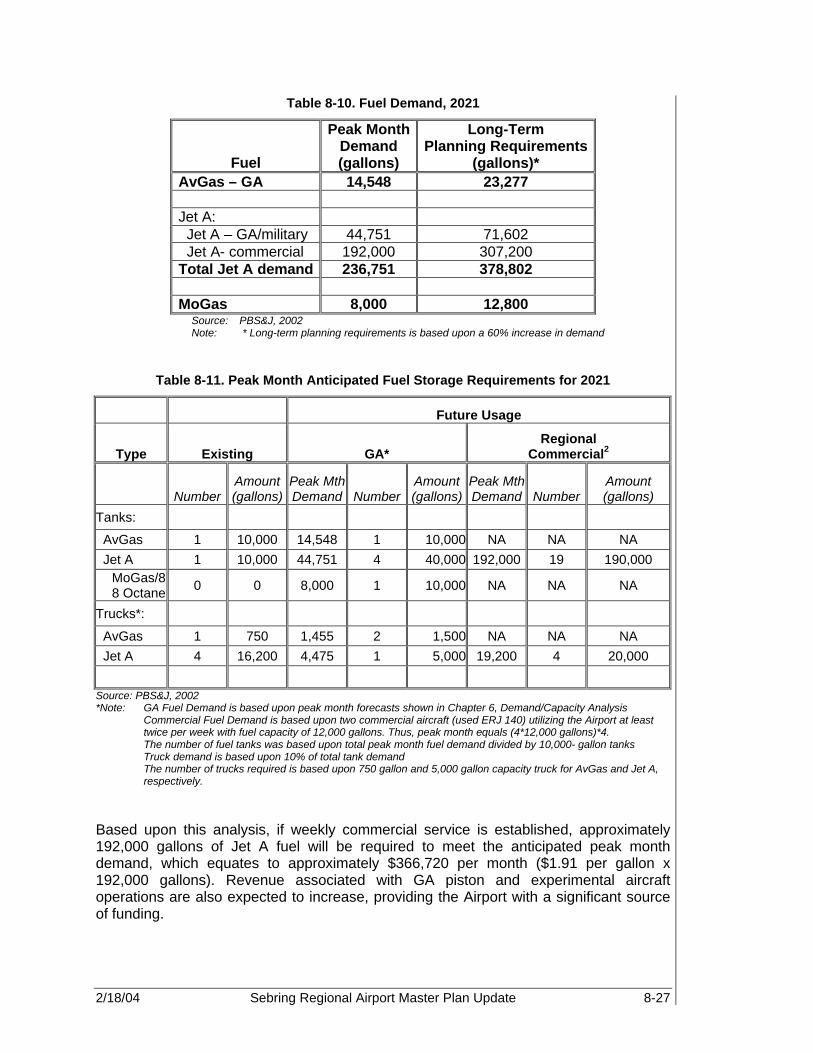
2/18/04 Sebring Regional Airport Master Plan Update 8-27
Table 8-10. Fuel Demand, 2021
Fuel
Peak Month Demand (gallons)
Long-Term Planning Requirements
(gallons)* AvGas – GA 14,548 23,277 Jet A: Jet A – GA/military 44,751 71,602 Jet A- commercial 192,000 307,200 Total Jet A demand 236,751 378,802 MoGas 8,000 12,800
Source: PBS&J, 2002 Note: * Long-term planning requirements is based upon a 60% increase in demand
Table 8-11. Peak Month Anticipated Fuel Storage Requirements for 2021
Future Usage
Type Existing GA* Regional
Commercial2
Number Amount (gallons)
Peak Mth Demand Number
Amount (gallons)
Peak Mth Demand Number
Amount (gallons)
Tanks:
AvGas 1 10,000 14,548 1 10,000 NA NA NA Jet A 1 10,000 44,751 4 40,000 192,000 19 190,000
MoGas/88 Octane 0 0 8,000 1 10,000 NA NA NA
Trucks*:
AvGas 1 750 1,455 2 1,500 NA NA NA Jet A 4 16,200 4,475 1 5,000 19,200 4 20,000
Source: PBS&J, 2002 *Note: GA Fuel Demand is based upon peak month forecasts shown in Chapter 6, Demand/Capacity Analysis
Commercial Fuel Demand is based upon two commercial aircraft (used ERJ 140) utilizing the Airport at least twice per week with fuel capacity of 12,000 gallons. Thus, peak month equals (4*12,000 gallons)*4. The number of fuel tanks was based upon total peak month fuel demand divided by 10,000- gallon tanks Truck demand is based upon 10% of total tank demand The number of trucks required is based upon 750 gallon and 5,000 gallon capacity truck for AvGas and Jet A, respectively.
Based upon this analysis, if weekly commercial service is established, approximately 192,000 gallons of Jet A fuel will be required to meet the anticipated peak month demand, which equates to approximately $366,720 per month ($1.91 per gallon x 192,000 gallons). Revenue associated with GA piston and experimental aircraft operations are also expected to increase, providing the Airport with a significant source of funding.
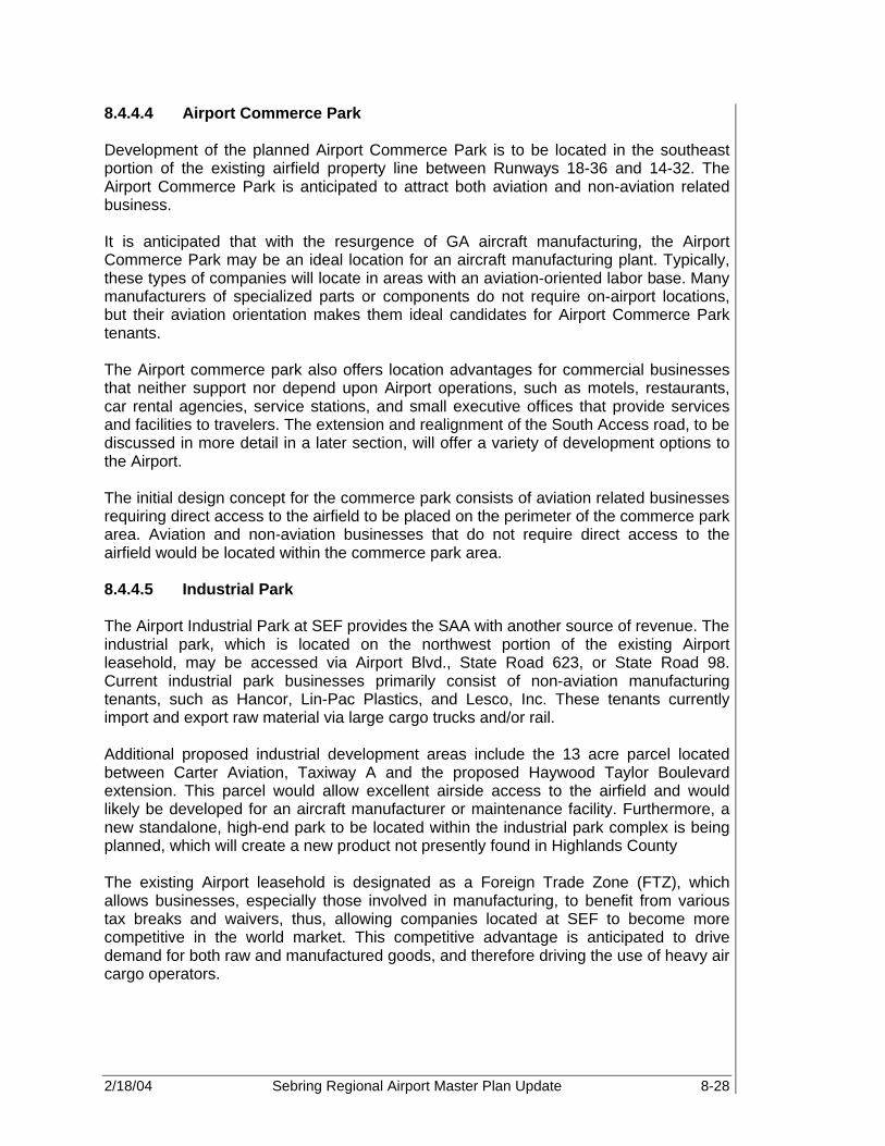
2/18/04 Sebring Regional Airport Master Plan Update 8-28
8.4.4.4 Airport Commerce Park Development of the planned Airport Commerce Park is to be located in the southeast portion of the existing airfield property line between Runways 18-36 and 14-32. The Airport Commerce Park is anticipated to attract both aviation and non-aviation related business. It is anticipated that with the resurgence of GA aircraft manufacturing, the Airport Commerce Park may be an ideal location for an aircraft manufacturing plant. Typically, these types of companies will locate in areas with an aviation-oriented labor base. Many manufacturers of specialized parts or components do not require on-airport locations, but their aviation orientation makes them ideal candidates for Airport Commerce Park tenants. The Airport commerce park also offers location advantages for commercial businesses that neither support nor depend upon Airport operations, such as motels, restaurants, car rental agencies, service stations, and small executive offices that provide services and facilities to travelers. The extension and realignment of the South Access road, to be discussed in more detail in a later section, will offer a variety of development options to the Airport. The initial design concept for the commerce park consists of aviation related businesses requiring direct access to the airfield to be placed on the perimeter of the commerce park area. Aviation and non-aviation businesses that do not require direct access to the airfield would be located within the commerce park area. 8.4.4.5 Industrial Park The Airport Industrial Park at SEF provides the SAA with another source of revenue. The industrial park, which is located on the northwest portion of the existing Airport leasehold, may be accessed via Airport Blvd., State Road 623, or State Road 98. Current industrial park businesses primarily consist of non-aviation manufacturing tenants, such as Hancor, Lin-Pac Plastics, and Lesco, Inc. These tenants currently import and export raw material via large cargo trucks and/or rail. Additional proposed industrial development areas include the 13 acre parcel located between Carter Aviation, Taxiway A and the proposed Haywood Taylor Boulevard extension. This parcel would allow excellent airside access to the airfield and would likely be developed for an aircraft manufacturer or maintenance facility. Furthermore, a new standalone, high-end park to be located within the industrial park complex is being planned, which will create a new product not presently found in Highlands County The existing Airport leasehold is designated as a Foreign Trade Zone (FTZ), which allows businesses, especially those involved in manufacturing, to benefit from various tax breaks and waivers, thus, allowing companies located at SEF to become more competitive in the world market. This competitive advantage is anticipated to drive demand for both raw and manufactured goods, and therefore driving the use of heavy air cargo operators.

2/18/04 Sebring Regional Airport Master Plan Update 8-29
Development associated with potential air cargo and foreign trade zone operations will require the expansion of the existing Airport Industrial Park facilities. Currently, several old buildings are slated for demolition, which will provide room for additional development. Roadway access, which will be discussed in more detail in later sections, is crucial for continued development within the Industrial Park. Expansion and realignment of key surface roads and rail facilities, will provide SEF with significant opportunities for development as well as additional revenue sources. See Figure 8-2, Alternative II - Constrained Development, for development recommendations. 8.4.4.6 Corporate, Military, and Light General Aviation Areas Currently, GA activity at Sebring is confined primarily to the north, south, and east of the Sebring Airside Center. The extension of Runway 18-36 will likely attract larger corporate aircraft, thus causing demand for not only fuel, but storage facilities as well. Shortening Runway 14-32 on the north end will allow increased development on the northwest side of Runway 18-36, which will allow for increased storage capacity. Development of the turf runway (14U-32U) and Runway 14-32 will also encourage GA development within the proposed commerce park as well as on the southeast section of Runway 14U-32U. This southeast section would be designated for light aircraft GA development, which may include T-hangars, small conventional hangars, FBO facilities, etc. Military fueling is currently performed on the apron located in front of the Sebring Airside Center. A designated area, preferably close to the relocated fuel farm, is recommended. It is anticipated that military operations will remain steady over the course of the 20-year planning period. Access to the existing north-side apron, currently home to the T-Hangar complex, can be obtained via Airport road. South-side access to the GA facilities can be obtained via the South Access Road. This access road is currently used as an access road/driveway to the Davis Property. The proposed land use areas are illustrated in Figure 8-4, Proposed Land Use. 8.4.4.7 Low Density Uses for Approach/Transition Zones Many airports have been successful in developing low-density recreational facilities in approach/departure zones. Golf courses are frequently regarded as a good use in these areas, although clubhouses should not be located within the RPZ. Ball fields may be developed adjacent to the RPZ; however, care must be exercised in order to avoid potential placement of large concentrations of persons within the RPZ. Caution should also be exercised before planning recreational facilities, even on an interim basis, in areas reserved for future aeronautical development. The required relocation of such facilities may require special environmental approvals. When considering potential land uses within high noise zones, consideration should be given to the land use guidelines included in the FAA recommended Airport Noise Compatibility Program, which specifies the level of noise reduction that should be

2/18/04 Sebring Regional Airport Master Plan Update 8-30
included in structures, local zoning, and general compatibility of various types of land uses. The proposed land use areas are illustrated in Figure 8-4, Proposed Land Use. 8.4.5 Landside Facilities – Buildings As mentioned earlier, landside facilities, particularly building areas, are designed to balance airfield facility needs. In the case of SEF, these areas of development include:
• Terminal facilities • GA and related aeronautical development areas • Commerce park The focus is to evaluate building areas that may directly relate to supporting aviation activity at SEF. Non-aviation buildings on-Airport were evaluated in a cursory manner. 8.4.5.1 Terminal Facility The terminal area as indicated on Figure 8-5, Terminal Development, represents constrained development. In this alternative, the expansion of the existing terminal building, as justified in Chapter 7, would be implemented. Expansion would include rental car, taxi staging, and sufficient public and employee parking to meet expected demand through the year 2021. The relocation of such facilities as the fuel farm and Aero-Med facilities would be implemented to allow renovation and expansion of the existing Sebring Airside Center. Expansion of the existing common landside parking facility and development of the land parcel adjacent to the Sebring Airside Center will provide parking facilities for existing and future aviation service clients as well as potential rental car facilities.

2/18/04 Sebring Regional Airport Master Plan Update 8-31
Figure 8-4. Proposed Land Use

2/18/04 Sebring Regional Airport Master Plan Update 8-32
Figure 8-5. Terminal Development

2/18/04 Sebring Regional Airport Master Plan Update 8-33
Automobile Parking In order to accommodate anticipated automobile parking requirements associated with both GA and commercial aviation development at SEF, an additional 93 parking spaces and 3,792 sq yd of pavement will be needed by the end of 2021. This is based upon forecasts shown in Chapter 5, Projection of Aviation Demand, and the facility requirements discussed in Chapter 7, Facility Requirements. As shown in Table 8-12, based upon anticipated corporate and commercial demand for rental car services, ten rental car ready/return spaces will be required by the year 2021. This equates to a total of approximately 355 sq yd of paved area. In addition to rental car parking, public parking for anticipated commercial activity will be necessary if commercial service is instituted at SEF. Therefore, based upon the anticipated aircraft usage and enplanement forecast discussed in Chapter 6, Demand Capacity Analysis and Chapter 7, Facility Requirements, an additional 30 parking spaces, approximately 1,332 sq yd of pavement area, will be required by 2021 to accommodate the total commercial parking demand. Therefore, Alternative II proposes a total terminal parking area expansion of 3,792 sq yd to meet demand.
Table 8-12. Airport Parking Demand
Existing Parking Spaces
Existing Pavement
Area (sq yd)
Future Parking Spaces
Future Pavement
Area (sq yd) GA Public Parking- Terminal 70 3,714 50 2,506
Visitor Parking NA* NA 48 2,131 Employee Parking 22 919 47 2,103
Commercial Service Parking NA NA 30 1,332 Rental Car Parking NA NA 10 355
Private Parking 122 5,221 122 5,221
Total 214 9,855 307 13,647
Source: PBS&J, 2002 Note: Existing Visitor Parking is included in GA Public Parking.
8.4.5.2 General Aviation and Related Aeronautical Development Areas Hangars The Airport’s hangar facilities are currently operating at 100 percent capacity. Design and construction of an additional Ten T-hangar unit and 8 commercial hangar units were underway at the time of this writing, but will not entirely meet forecast demand; and therefore, additional hangars are needed. An additional 12 T-hangar units and eight corporate hangars are planned under Alternative II development. Six corporate hangars are to be located to the southeast of Runway 18-36, with the remainder located near the Airport terminal facilities. The 74 T-hangar units will share

2/18/04 Sebring Regional Airport Master Plan Update 8-34
access with both the conventional and corporate hangars to the northwest of Runway 18-36 along the former end of Runway 14-32. While this development exceeds the capacity requirements based on forecasts determined in Chapter 5, Alternative II not only seeks to maximize the utilization of land areas within the existing leasehold, and increase Airport revenue generation, but also to provide opportunity for additional growth. Demand for T-hangars in the state of Florida exceeds the ability of the FDOT and airports alike to meet that demand. Therefore, if SEF were to construct T-hangars beyond those forecast, it will likely attract new-based aircraft tenants. Existing and future aircraft storage facilities associated with Alternative II development is shown in Table 8-13.
Table 8-13. Hangar Facilities
Hangar Facilities
Existing Hangars
Future Hangars
Conventional hangar 15 9 Corporate hangar 0 8 T-hangar 62 74 Existing Hangars include facilities under construction Source: PBS&J, 2002
Public Emergency Facilities Currently, the DeSoto City Volunteer Fire Department (DVFD) provides fire-fighting services, with back-up service provided by the City of Sebring Fire Department. Plans are underway to establish a fire station at SEF in order to provide service to both the Airport and surrounding communities. Aero-Med II, a Level I Trauma Unit specializing in air transport, has been based at SEF for several years. Aero-Med’s current facilities are located just south of the Sebring Airside Service Center, and include two singlewide trailers and a helipad for the BK117-B Euro copter. It is recommended that a joint use facility be developed for the Aircraft Rescue and Fire Fighting (ARFF) and Aero-Med II, allowing for consolidated rescue services while providing for future development at the Airport. Currently, the Airport does not have any scheduled commercial service operations. Therefore, ARFF services at the Airport are not required. However, in order for SEF to receive commercial service operations of 30 passenger seats or greater, it will need to have a designated Airport ARFF facility. It is suggested, however, that SAA designate and equip at least one fire fighting rapid response vehicle for Airport use only. However, if significant commercial service is instituted at SEF, then it is likely that both additional equipment and facilities will be required to meet the demand.

2/18/04 Sebring Regional Airport Master Plan Update 8-35
The proposed location of the ARFF and Aero-Med facility is shown in Figure 8-6, Public Emergency Facilities. 8.4.5.3 Airport Commerce Park The proposed Airport Commerce Park is designed as a mixed use of aviation and non-aviation related development areas and will be located on the east side of the Airport, south of the junction formed between Runway 18-36 and Runway 14-32. Since this area is totally undeveloped, it will allow a unique opportunity for additional commercial development. Further, since Runway 18-36 is being designed to meet the needs of the heavier GA/corporate aircraft and limited commercial service operations, and Runway 14-32 and 14U-32U are being designed to handle smaller GA aircraft, the Commerce Park would be a prime location for a potential FBO, maintenance, and/or avionics operation. Access to both of these runways will be obtained via surrounding aprons and taxiways. Development of additional corporate and light GA operations in this area will allow the Airport to meet forecast demand for GA facilities. By utilizing otherwise vacant space for both aviation and non-aviation related uses, the Airport will be able to increase potential revenues through additional revenue diversification and additional land leases. However, full utility and drainage infrastructure for this area will be required. This will include, but is not limited to, water and sewer lines, electric power, telephone, and curb and gutter roadways with associated drainage points. The Airport Commerce Park development concept is illustrated in Figure 8-7, Airport Commerce Park Development. 8.4.6 Landside Facilities – Surface Access To provide adequate levels of service to accommodate all Airport users, the SAA has been working with Highlands County to ensure adequate vehicular capacity on the primary surface access roads, and reduce overall traffic congestion. Recommended and existing projects associated with landside development are discussed in more detail in later sections. Further coordination with the appropriate local and state officials will likely be required in order to continue to provide the most appropriate and effective means of ensuring adequate ground access to the Airport.
2/18/04 Sebring Regional Airport Master Plan Update 8-36
Figure 8-6. Public Emergency Facilities

2/18/04 Sebring Regional Airport Master Plan Update 8-37
Figure 8-7. Airport Commerce Park Development

2/18/04 Sebring Regional Airport Master Plan Update 8-38
8.4.6.1 Roadway Access Additional access routes and roadway improvements will be required in conjunction with the proposed development on the east side of the Airport. Roads in this area are rural two lane routes primarily used by residential and agricultural traffic. Industrial and commercial traffic associated with both aviation and non-aviation development will require capacity enhancements to these roadways, construction of extensions to existing roads, and potential new roads and general infrastructure. Proposed Roadway Alignments associated with Alternative II development are shown in Figure 8-8, Proposed Roadway Developments. Kenilworth Road and Airport Road As previously mentioned in Chapter 6, the main entrance to the Airport facilities is via the intersection of Kenilworth Boulevard and Airport Road. However, the existing geometry is not able to handle the expected capacity as discussed in Chapter 5. Therefore, the intersection will be redesigned and reconfigured. Airport Road, off of the State Road 98 intersection, has already been redesigned to meet the anticipated demand. Construction of Airport Road and associated roadways within the airport property are expected to begin in 2003. Presently, the SAA only owns the property to the northwest of Airport Road. However, in order to allow continued development, acquisition of additional property along the southeast is recommended. See Figure 8-8 for proposed roadway development. Webster Turn Drive The existing Webster Turn Drive is located within the industrial park on the west side of SEF. Access is via State Route 623 and Airport Road. The existing roadway provides access into the Airport Industrial Park. The intent of this development is to reconstruct and widen Webster Turn Drive in order allow for continued use by heavy cargo trucks. See Figure 8-8 for proposed roadway development.

2/18/04 Sebring Regional Airport Master Plan Update 8-39
Figure 8-8 Proposed Roadway Development

2/18/04 Sebring Regional Airport Master Plan Update 8-40
South Access Road The existing South Access Road is a two-lane roadway, which was designed to not only serve the southern portion of the Airport and recommended development, but to provide access to the Davis Property. The previous Master Plan recommended that the South Access Road remain intact in order to serve the Airport, proposed Commerce Park development, and the Davis Family. Currently, the South Access Road is being relocated and realigned to the south and is defined as an existing right-of-way associated with the Sebring International Raceway leasehold expansion. However, based upon the proposed extension of Runway 18-36 and Runway 14-32 and development of Runway 14U-32U, it is recommended that the existing South Access Roadway be expanded and relocated even further south to run along the south edge of the current Airport property line. This realignment will address safety issues associated with Runway 36 and 32 expansions. In addition, this will provide supplemental land for development as well as needed separation between the Runway 18-36 facilities and public roadways. A buffer zone and curb and gutter design are recommended in order to mitigate potential noise associated with the roadway, Sebring International Raceway, and Airport operations. The South Access Road will also become the main entrance for the southern portion of the Airfield. Four connecting roadways are proposed:
• Haywood Taylor Blvd. extension • Commerce park entrance road • Two proposed ARFF controlled access roads to Spring Lake Community from the
south access road These extensions will provide additional and efficient access to the Airport property, needed separation between airside facilities, as well as an efficient access to the Spring Lake Community for primarily public emergency services. As part of the development plan, the South Access Road should be expanded to a four lane highway in order to facilitate access to the south and east side of the Airport. In addition, a buffer zone is recommended between the South Access Road and the community in order to limit noise associated with Airport and raceway operations. This could include land acquisition south of the southern Airport boundary, which includes eight-resident and vacant lots. With the extension of Haywood Taylor Blvd., which will connect to the South Access Road, access capacity to both the Raceway and the Airport itself will be improved. In addition, the South Access Road will provide the main access point to the proposed commerce park development. As part of the commerce park development plan, a proposed 150-foot roadway right-of-way is planned. Furthermore, as part of the Airport Fire and Rescue Development, two additional controlled access connector roadways for redundancy should be built which will connect the Airport to the housing community located to the south of its current property line. This will allow the community to be provided effective fire fighting services. See Figure 8-8 for proposed roadway developments.
2/18/04 Sebring Regional Airport Master Plan Update 8-41
Haywood Taylor Boulevard Extension The Haywood Taylor Boulevard extension would provide an additional access point to the main Airport facilities as well as the Sebring Raceway. The existing roadway currently terminates in the vicinity of the Sebring Airside Terminal Building. However, based upon the proposed development as well as input from the raceway, a 2000-plus foot extension is recommended to tie the existing roadway to the proposed realigned South Access Road. It is recommended that this roadway be expanded to four-lanes with designated turning lanes into both the raceway and airside terminal facilities in order to increase capacity and efficiency of this roadway. In addition, this extension will also allow the ARFF to have quick response access to the airfield and surrounding facilities. See Figure 8-8 for proposed roadway development. 8.4.6.2 Roadway/Airport Signage Clear and understandable signage along primary access roads is necessary for Airport development. Directing individuals to the Airport is extremely important to the success of airport businesses. Currently Airport signage along State Road 27 and 98 is minimal. Therefore, signage improvements and/or installation along these routes are recommended. In addition, the signage along Airport Road is difficult to understand. Therefore, additional and improved signage is recommended both along the Airport access road and on the Airport property itself. 8.5 ALTERNATIVE III – UNCONSTRAINED DEVELOPMENT Alternative III expands upon the development discussed in Alternative II, and includes unconstrained development of all Airport property and the acquisition of all required land area in and around SEF. This alternative will not only provide for all the Airport’s land requirements for the foreseeable future, but will also provide the necessary development and facility improvements to meet or exceed the forecast demand presented in Chapters 5 and 6. The following sections outline the development proposed in Alternative III. Phasing of projects associated with Alternative III is shown in Table 8-14, and overall development is graphically represented in Figure 8-9.
Alternative Three expands upon the development discussed in Alternative Two, and includes unconstrained development of all Airport property and the acquisition of all required land area in and around SEF.

2/18/04 Sebring Regional Airport Master Plan Update 8-42
Table 8-14. Alternative III Phasing
Phase I Phase II Phase III (2001-2006) (2007-2011) (2012-2021)
Land Acquisition Acquire 2,000 acres for associated development
Acquire 885 acres for associated development
Planning
Environmental assessment for Runway 18-36 extension
Design GPS/non-precision approach to Runway 14R-
32L
Perform ATCT site selection study
Design GPS/non-precision approach to Runway
14U-32U
Perform drainage study Obtain Part 139, Airport Certification
Design GPS/non-precision approach to Runway 18
Environmental Assessment for Runway 14L-32R
Design terminal expansion Design Runway 14L-32R
Design Commercial Terminal Facilities
Airside
Extend and widen Runway 18-36 to 7,000’ x 150’
Design/construct Taxiway B (parallel to 18-36 on east side) and associated stub
taxiways
Expand Runway 14L-32R to 10,000 ft
Pavement rehabilitation of Runway 18-36 (150,000 lb DG
and 300,000 lb DTW)
Shorten, rehabilitate, and lengthen Runway 14-32 to
3,500 x 100 ft
Design and build apron area on the east side of Runway
14L-32R
Mark (precision) and light (HIRL) Runway 18-36
Install pilot controlled MIRL on Runway 14-32 Develop cargo apron
Close Taxiways B-3 and B-4 Install pilot controlled MIRL on Runway 14U-32U
Design/construct cargo buildings
Design and grade Runway 14U-32U
Install REILs and PAPI-4 on Runway 14R-32L
Design/construct heavy maintenance facilities
Design/construct Special Use
Apron associated primarily with Military operations
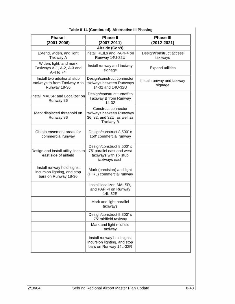
2/18/04 Sebring Regional Airport Master Plan Update 8-43
Table 8-14 (Continued). Alternative III Phasing
Phase I Phase II Phase III (2001-2006) (2007-2011) (2012-2021)
Airside (Con’t) Extend, widen, and light
Taxiway A Install REILs and PAPI-4 on
Runway 14U-32U Design/construct access
taxiways
Widen, light, and mark Taxiways A-1, A-2, A-3 and
A-4 to 74'
Install runway and taxiway signage Expand utilities
Install two additional stub taxiways to from Taxiway A to
Runway 18-36
Design/construct connector taxiways between Runways
14-32 and 14U-32U
Install runway and taxiway signage
Install MALSR and Localizer on Runway 36
Design/construct turnoff to Taxiway B from Runway
14-32
Mark displaced threshold on Runway 36
Construct connector taxiways between Runways 36, 32, and 32U, as well as
Taxiway B
Obtain easement areas for commercial runway
Design/construct 8,500’ x 150' commercial runway
Design and install utility lines to east side of airfield
Design/construct 8,500’ x 75' parallel east and west
taxiways with six stub taxiways each
Install runway hold signs, incursion lighting, and stop
bars on Runway 18-36
Mark (precision) and light (HIRL) commercial runway
Install localizer, MALSR, and PAPI-4 on Runway
14L-32R
Mark and light parallel taxiways
Design/construct 5,300’ x 75' midfield taxiway
Mark and light midfield taxiway
Install runway hold signs,
incursion lighting, and stop bars on Runway 14L-32R

2/18/04 Sebring Regional Airport Master Plan Update 8-44
Table 8-14 (Continued). Alternative III Phasing
Phase I Phase II Phase III (2001-2006) (2007-2011) (2012-2021)
GA Terminal Area
Expand, rehabilitate, and widen Haywood Taylor Blvd
Expand air service terminal building
Expand public parking area Realign and expand terminal access road West Apron expansion
Relocate Aero-Med II facilities Construct rental car parking Expand public parking
Relocate fuel farm Expand employee parking
Design/construct two conventional hangars Expand public parking area
Commercial Terminal Area
Design commercial terminal facilities
Construct commercial terminal building (~122,000
sq ft) Expand public parking
Construct terminal access road, including curbside
areas Expand rental car parking
Construct employee parking area
Construct public parking area
Construct rental car parking area
Design/construct commercial apron area
Install utilities
Construct TSA building requirements

2/18/04 Sebring Regional Airport Master Plan Update 8-45
Table 8-14 (Continued). Alternative III Phasing
Phase I Phase II Phase III (2001-2006) (2007-2011) (2012-2021)
Midfield GA
Design/construct roadway from Arbuckle Creek Road
to Airport
Construct heavy maintenance facilities
Design/construct heavy commercial apron areas Construct heavy cargo facilities
Construct fuel farm (~ 70 Jet A tanks) Designate military fueling area
Design/construct 2 conventional hangars
Design/construct 3 corporate hangars
Design/construct 2 corporate hangars
Expand fuel farm (~ 40 Jet A tanks))
Northwest GA
Install self-service Octane 88 facility T-hangar construction
Rehabilitate, mark, and expand West Apron Close Hairpin Drive

2/18/04 Sebring Regional Airport Master Plan Update 8-46
Table 8-14 (Continued). Alternative III Phasing
Phase I Phase II Phase III (2001-2006) (2007-2011) (2012-2021)
South GA Design/construct public
emergency facility (i.e., ARFF and MedEvac units)
Design/construct one conventional hangar
Design/construct four additional corporate hangars
Expand, rehabilitate, relocate and extend south Airport
access road
Design/construct four corporate hangars
Install additional fuel farm facility
Install roadway signage Apron rehabilitation on the west side
Construct Two access roads to Spring Lake community
Fuel farm development on west side of Runway 18-36
(1 AvGas and 4 Jet A)
Purchase one rapid response vehicles for ARFF station
Construct two, eight unit T-hangars
Construct two, eight unit T-hangars
Industrial Park
Relocate SAA rail spur Expand and realign Airport Road Expand industrial park
Fill pond at the existing end for Runway 18 Install additional signage
Expand and rehabilitate Webster Turn Drive Install additional utilities
Expand and Extend Ulmann Drive Expand industrial park
Expand Boeing Avenue Close Hairpin Turn Drive
Commerce Park Phase I Commerce Park
Development Phase II Commerce Park
Development
Install associated signage Fuel storage expansion
Install and mark apron Sell old and obtain new fuel trucks
Install fuel farm facilities Design/construct six corporate hangars
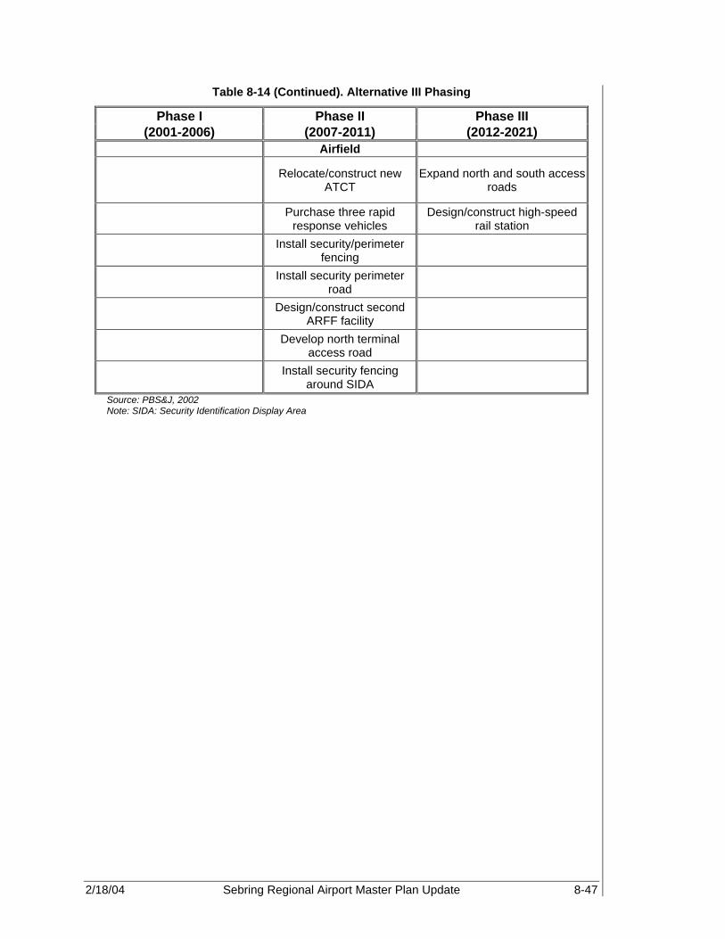
2/18/04 Sebring Regional Airport Master Plan Update 8-47
Table 8-14 (Continued). Alternative III Phasing
Phase I Phase II Phase III (2001-2006) (2007-2011) (2012-2021)
Airfield
Relocate/construct new ATCT
Expand north and south access roads
Purchase three rapid response vehicles
Design/construct high-speed rail station
Install security/perimeter fencing
Install security perimeter road
Design/construct second ARFF facility
Develop north terminal access road
Install security fencing around SIDA
Source: PBS&J, 2002 Note: SIDA: Security Identification Display Area

2/18/04 Sebring Regional Airport Master Plan Update 8-48
Figure 8-9. Alternative III – Unconstrained Development

2/18/04 Sebring Regional Airport Master Plan Update 8-49
8.5.1 Airside Development Airside development at SEF is critical to meet both existing and anticipated demand for the 20-year planning period. Since Airfield facilities are critical to Airport development, the following runway configurations are recommended for Alternative III:
• Rehabilitate and Lengthen Runway 18-36 • Shorten and Lengthen Runway 14-32 • Construct GA/Utility Runway • Construct Commercial Service Runway As discussed, the current airfield configuration accommodates existing air traffic levels. However, in recent years, increased use of the Airport by high performance corporate aircraft has exposed the need for new and expanded airfield facilities to accommodate these types of aircraft. As discussed in Chapter 6, Demand/Capacity Analysis, aircraft category demand will fuel airfield development. Furthermore, demand for air transport service and potential cargo operations associated with industrial and commerce park development and Sebring International Raceway operations, suggests that construction of a commercial service runway is needed in the near future. Therefore, it will be necessary to expand the operational capacity of the airfield to effectively accommodate anticipated increases in traffic, as well as potential aircraft mix anticipated to use the Airport. 8.5.1.1 Runways As discussed, SEF currently has two active runways, Runway 18-36, the primary runway, and Runway 14-32, the crosswind runway. Based upon existing and anticipated demand discussed in Alternative II, development recommendations included:
• Extending Runway 18-36 • Shortening Runway 14 and lengthening Runway 32 • Constructing 14U-32U However, the recommended extension of Runway 18-36 to 7,000 ft will only meet part of the commercial air transport demand. Yet, due to noise, airspace, environmental, land acquisition, and other limiting factors, Runway 18-36 cannot be extended past this length. As shown in Chapter 6, Demand Capacity Analysis, heavy air transport and cargo operations require a runway length of almost 10,000 ft. As a result of this anticipated demand, a commercial runway configuration of 10,000 x 150 ft is recommended.

2/18/04 Sebring Regional Airport Master Plan Update 8-50
Table 8-15. Proposed Runway Development Criteria
Runways Criteria 18-36 14R-32L 14U-32U 14L-32R Length 7,000 3,500 3,000 10,000 Width 150 100 200 150 ARC D-IV B-II B-I D-V
Approach Non-precision Precision Visual Visual Visual Visual Preci-
sion Preci-sion
NAVAIDS GPS ILS GPS GPS GPS GPS GPS/ ILS
GPS/ MALSR/ILS
Visual aids PAPI-4 PAPI-4,
MALSR REILs, PAPI-4
REILs, PAPI-4
REILs, Papi-4
REILs, PAPI-4
REILs, PAPI-4, MALSR
REILs, PAPI-
4, MALS
R Markings Precision Visual Visual Precision Lighting HIRL MIRL MIRL HIRL
Slope 34:1 40:1/50:1 20:1 20:1 20:1 20:1 40:1/50:1
40:1/50:1
Source: PBS&J, 2002 Construction Of Commercial Runway As part of the commercial air transport market demand as well as potential heavy air cargo demand associated with trans-Atlantic operations, construction of a 10,000 x 150 ft commercial runway is recommended. This runway will be designed and equipped to accommodate D-V aircraft. Associated runway development criteria under this alternative development plan are shown in Table 8-15 and Figure 8-9, Alternative III - Unconstrained Development. 8.5.1.2 Taxiways Recommended Taxiway development for Alternative III includes all of the taxiway improvements recommended for Alternative II as well as the following:
• Construct parallel Taxiway D, to be located to the west side of Runway 14L-32R, designed to handle heavy air transport aircraft with six entrance and exit taxiways.
• Construct parallel Taxiway E, to the east side of Runway 14R-32L, designed to accommodate heavy air transport traffic, and equipped with six entrance and exit taxiways.
• Construct 5,300 x 75 ft perpendicular Taxiway F, to connect the midfield area and provide access for aircraft to use either Runway 18-36 or 14L-32R.
All taxiways will be equipped with MITL. See Figure 8-9, Alternative III - Unconstrained Development, for a graphical depiction of the airfield facilities.
2/18/04 Sebring Regional Airport Master Plan Update 8-51
8.5.1.3 Aprons In addition to the rehabilitation of the existing Airport apron and development discussed in Alternative II, it is anticipated that an additional 200+ acres of apron will be required to support anticipated commercial service operations and ancillary development. Proposed commercial apron will be designed to accommodate heavy commercial and cargo aircraft usage. Apron pavement sections associated with airport development will be designed in accordance with the apron’s potential users. It is anticipated that full apron development associated with Runway 14L-32R, the commercial terminal building, ATCT, ARFF/MedEvac, and heavy maintenance and cargo facilities will occur over 10+ years. See Figure 8-9, Alternative III - Unconstrained Development, for a description of the proposed apron areas. 8.5.1.4 Air Traffic Control Tower Construction of a new air traffic control (ATC) facility is required based upon proposed airfield development. As a result, it is recommended that an independent ATCT site selection study be undertaken in coordination with the FAA to determine the most appropriate location for the tower. Based upon the initial development design considerations, a potential site for the new tower has been identified within the new midfield area between Runways 14U-32U and 14R-32L. This location is positioned in a more secure area and is located at the approximate center of the Airport property area. This site is anticipated to provide superior views of the Airport at its ultimate 20-year build-out. The site also appears to provide excellent and unobstructed line-of-site to all major approach and ground operations surfaces. It is recommended that the cab floor height will be based off of a line of site study. However, for cost estimate purposes, a minimum 100 ft agl is used. The suggested site is depicted in Figure 8-9, Alternative III - Unconstrained Development. 8.5.2 Environmental Assessment A complete environmental assessment (EA) will be required for the extension of Runway 18-36 and the construction of Runway 14L-32R. Each EA must be completed before design and construction begins. Additionally, initial improvements should begin within the first five years of the Master Plan, as a reactive measure to increased demand, and should include the extension of Runway 18-36. 8.5.3 Airspace and Approach Procedures The FAA has designated four types of airspace above the U.S.: controlled, SUA, other, and uncontrolled airspace. Controlled airspace is categorized into five separate classes: Class A, B, C, D, and E. These classes identify airspace that is controlled, airspace supporting airport operations, and designated airways affording en route transit from place to place. The classes also dictate pilot qualification requirements, rules of flight that must be followed, and the type of equipment necessary to operate within that airspace. SUA is designated as airspace within which flight activities are conducted that require confinement of participating aircraft, or place operating limitations on non-participating aircraft.
2/18/04 Sebring Regional Airport Master Plan Update 8-52
In the case of SEF, the Airport is currently surrounded by both SUA and Class E airspace. Since SEF is located within the Lake Placid MOA, approach and departure procedures to and from SEF must be coordinated with Miami Air Route Traffic Control Center (ZMA CNTR) to avoid conflicts with high-speed military aircraft. However, based upon the planned development, SEF’s airspace will be classified as Class D. Class D airspace (referred to as the airport traffic area) for airports with ATCTs, which normally extends from the surface to 2,500 ft above an airport’s established elevation (charted in MSL), and includes control zones and airport traffic areas. Thus, aircraft operating under IFR conditions in the en route phase of flight must contact Miami Air Route Traffic Control Center (ARTCC) when operating within the area. In addition, aircraft exiting or entering the 10 nautical mile radius of SEF will need to contact the ATCT on field for approach, departure, and ground control instructions. With both commercial and GA infrastructure development, it is likely that GA and commercial activity will increase in keeping with the airfield development. Therefore, coordination with on-airport ATC is crucial in order to avoid potential operational conflicts. 8.5.3.1 Terminal Instrument Approach Procedures Due to the proximity of special use airspace associated with military operations in and around SEF, instrument approach procedures associated with the development of Runway 14L-32R were developed to determine if there were any potential conflicts. Following the TERPs requirements designated in FAA Order 8260.3B and 8260.36A, Category I ILS approach and missed approach procedures were developed for Runway 14L-32R. Using en route NAVAIDS, existing flight paths, and standard TERPs procedures, the following approach patterns for Runway 14L and 32R were developed. See Figure 8-10, Runway 32R Straight Line Approach and Missed Approach Procedures. The expected distances, coordinates, and likely altitudes for both approach and missed approach procedures on either end of Runway 14L-32R (see Tables 8-16 through 8-19) were also determined based upon the formulas designated in FAR Order 8360.36A for Cat I Instrument Procedures. The missed approach procedure is based upon typical straight missed approach. Altitude calculations are based upon 250 ft/NM descent gradient for initial approach, 150 ft/NM descent gradient for intermediate approach, 318 ft/NM descent gradient for final approach, and 318 ft/NM climb for missed approach segment.

2/18/04 Sebring Regional Airport Master Plan Update 8-53
Table 8-16. Runway 32R Straight Line Approach and Missed Approach Procedures Aircraft Category D-V
Approach Segment Segment Length
Segment Width on either side of Runway Centerline
Minimum Beginning
Altitudes* (ft)
Primary
(NM) Secondary
(ft) Initial Approach (NM) 22.9 2 1 9,542
Intermediate Approach (NM) 7 1 2,500 3,817
W X Y
Final Approach (Ft) 50,000 2200 3876.115 2500 2,767
Minimum Straight Course Distance (Ft)
12,760 859 2,072 2,933 818
Decision Height (Ft.) 3,038 509 1,027 1,460 309
Final Approach End Widths (Ft) 400 300 300
Clear Zone (Ft) 200 1000 NA NA 150
Touchdown Threshold (Ft) 0 NA NA NA 75
Straight Missed Approach (1)
Segment Length (NM)
Primary (NM)
Secondary (NM)
Estimated Beginning
Altitude Segment 1 1.5 0.13 NA 309 Segment 2 13.5 4 2 786
Turning Missed Approach (2)
Segment Length (NM)
Primary (NM)
Secondary (NM)
Estimated Beginning
Altitude Segment 1A 0.50 0.51 NA 309 Segment 1B 1.00 0.13 NA 468 Segment 1C 1.5 0.51 NA 309 Segment 2 13.5 4 2 786 Source: PBS&J, 2002

2/18/04 Sebring Regional Airport Master Plan Update 8-54
Figure 8-10. Runway 32R Straight Line Approach and Missed Approach Procedures

2/18/04 Sebring Regional Airport Master Plan Update 8-55
Table 8-17. Runway 32R Turning Approach and Missed Approach Procedures Aircraft Category D-V
Approach Segment Segment Length
Segment Width on either side of Runway Centerline
Minimum Beginning
Altitudes* (ft)
Primary
(NM) Secondary
(ft) Initial Approach (NM) 22.9 2 6,076 9,542
Intermediate Approach (NM) 7 1 2,500 3,817
W X Y Final Approach (ft) 50,000 2,200 6,076 8,576 2,767 Final Approach Turn Radius (NM) 1.4
Final Approach Turn (ft) 37,240 1,741 4,704 6,643 2,099
Minimum Straight Course Distance (ft) 12,760 859 2,072 2,933 818
Decision Height (ft) 3,038 509 1,027 1,460 309
Final Approach End Widths (ft) 400 300 300
Clear Zone (ft) 200 1000 NA NA 150 Touchdown Threshold (ft) 0 NA NA NA 75
Straight Missed Approach (1)
Segment Length (NM)
Primary (NM)
Secondary (NM)
Estimated Beginning Altitude (ft)
Segment 1 1.5 0.13 NA 309 Segment 2 13.5 4 2 786
Turning Missed Approach (2)
Segment Length (NM)
Primary (NM)
Secondary (NM)
Estimated Beginning Altitude (ft)
Segment 1A 0.47 0.51 NA 309 Segment 1B 1.03 0.13 NA 458 Segment 1C 1.5 0.51 NA 309 Segment 2 13.5 4 2 786 Source: PBS&J, 2002

2/18/04 Sebring Regional Airport Master Plan Update 8-56
Figure 8-11. Runway 32R 60° Turning Approach and Missed Approach Procedures

2/18/04 Sebring Regional Airport Master Plan Update 8-57
Table 8-18. Runway 14L Straight Line Approach and Missed Approach Procedures Aircraft Category D-V
Approach Segment Segment Length
Segment Width on Either Side of Runway Centerline
Minimum Beginning
Altitudes* (ft)
Primary
(NM) Secondary
(ft) Initial Approach (NM) 16.1 2 1 7,954
Intermediate Approach (NM) 7.75 1 2,500 3,929
W X Y Final Approach (ft) 50,000 2200 3876.115 2500 2,767
Minimum Straight Course Distance (ft) 12,760 859 2,072 2,933 818
Decision Height (ft) 3,038 509 1,027 1,460 309
Final Approach End Widths (ft) 400 300 300
Clear Zone (ft) 200 1000 NA NA 150 Touchdown Threshold (ft) 0 NA NA NA 75
Straight Missed Approach (1)
Segment Length (NM)
Primary (NM)
Secondary (NM)
Estimated Beginning Altitude
Segment 1 1.5 0.13 NA 309 Segment 2 13.5 4 2 786
Turning Missed Approach (2)
Segment Length (NM)
Primary (NM)
Secondary (NM)
Estimated Beginning Altitude
Segment 1A 0.47 0.51 NA 309 Segment 1B 1.03 0.13 NA 458 Segment 1C 1.5 0.51 NA 309 Segment 2 13.5 4 2 786 Source: PBS&J, 2002

2/18/04 Sebring Regional Airport Master Plan Update 8-58
Figure 8-12. Runway 14L Straight Line Approach and Missed Approach Procedures

2/18/04 Sebring Regional Airport Master Plan Update 8-59
Table 8-19. Runway 14L Turning Approach and Missed Approach Procedures Aircraft Category D-V
Approach Segment Segment Length
Segment Width on either side of Runway Centerline
Minimum Beginning
Altitudes* (ft)
Primary
(NM) Secondary
(ft) Initial Approach (NM) 6 2 6,076 5,581
Intermediate Approach (NM) 7 1 2,500 4,129
W X Y Final Approach (ft) 57,009 2,452 6,830 9,638 3,134 Final Approach Turn Radius (NM) 1.4
Final Approach Turn (ft) 44,249 1,993 5,458 7,705 2,466
Minimum Straight Course Distance (ft) 12,760 859 2,072 2,933 818
Decision Height (ft) 3,038 509 1,027 1,460 309
Final Approach End Widths (ft) 400 300 300
Clear Zone (ft) 200 1000 NA NA 150 Touchdown Threshold (ft) 0 NA NA NA 75
Straight Missed Approach (1)
Segment Length (NM)
Primary (NM)
Secondary (NM)
Estimated Beginning Altitude (ft)
Segment 1 1.5 0.13 NA 309 Segment 2 13.5 4 2 786
Turning Missed Approach (2)
Segment Length (NM)
Primary (NM)
Secondary (NM)
Estimated Beginning Altitude (ft)
Segment 1A 0.47 0.51 NA 309 Segment 1B 1.03 0.13 NA 458 Segment 1C 1.5 0.51 NA 309 Segment 2 13.5 4 2 786 Source: PBS&J, 2002

2/18/04 Sebring Regional Airport Master Plan Update 8-60
Figure 8-13. Runway 14L 60° Turning Approach and Missed Approach Procedures

2/18/04 Sebring Regional Airport Master Plan Update 8-61
Based upon this analysis, a curved approach and straight or curved missed approach procedure will allow the most flexibility to aircraft using Runway 14L. The configuration of the Runway was designed to allow aircraft using Runway 14L-32R to avoid infiltrating the military restricted areas located to the north and east of SEF. Again, a straight missed approach from the North will only limit aircraft attempting to re-enter the terminal traffic pattern rather quickly. However, the turning missed approach will allow Aircraft to obtain a higher altitude in less time as well as quickly reenter the traffic pattern. 8.5.4 Land Use and Land Acquisition The purpose of the land use and land acquisition analysis is to evaluate the potential impacts associated with the Alternative III airfield and landside improvements. These improvements are expected to impact not only land within the Airport’s boundary, but contiguous parcels and the community as well. As in Alternative II, the extensions of Runways 18-36 and 32L and construction of Runway 14U-32U, together with other Alternative III facility improvements will require the acquisition of additional land area. The land area will be necessary to maintain compliance with FAA directives and avoid incompatible land uses in the vicinity of SEF. A total of approximately 2,885 acres has been identified as necessary land acquisition over the planning period for Alternative III. Specific development and land acquisition requirements are shown in Table 8-20, Land Acquisition Requirements, and Figure 8-14, Land Acquisition and Development.
Table 8-20. Land Acquisition Requirements
Proposed Development Necessary Land Acquisition Runway 18-36 extension and Runway 32R
extension ~80 acres
Rail Line Relocation ~603 acres Construction of Runway 14U-32U None Mixed Use Aviation Development ~803 acres Construction of Runway 14L-32R 1,000 acres
SAA rail spur relocation ~40 acres South access road relocation and Buffer ~159 acres
Incompatible land use ~200 acres Total ~2885 acres
Source: PBS&J, 2002 In addition to the land use analysis described in Alternative II, the following areas will be described in more detail in the following sections.
• Airport related commercial service businesses • Aviation related business • Aviation manufacturing • Non-aviation commercial use

2/18/04 Sebring Regional Airport Master Plan Update 8-62
Figure 8-14. Land Acquisition and Development

2/18/04 Sebring Regional Airport Master Plan Update 8-63
8.5.4.1 Airport Operations As part of the airfield development process, additional land area will need to be acquired not only to provide room for development but also to maintain compliance with FAA directives and avoid incompatible land use in the vicinity of SEF. The majority of land to be acquired consists of pasture, farmland, and land currently zoned as residential. Acreage necessary for acquisition is broken down as follows:
• Runway 18-36 extension to the north and south, including RSA and RPZ. • Runway 32L extension to the southeast, including RSA and RPZ. • Construction of Runway 14U-32U to the southeast, including RSA and RPZ. • Construction of Runway 14L-32R for entire length of runway, the RSA, and RPZ. • Commercial Service Development to the east of existing property line. • Areas identified as incompatible land use. Acquisitions of land for Airport development and runway expansion would ensure that both expansion and development of GA and commercial service operations would no longer be limited by inadequate facilities. The purpose of which is to make the Airport more attractive to operators of large passenger and cargo aircraft, which are currently utilized elsewhere. The establishment of future Airport development on the east side of both the current and future airfield will maximize use of available lands while providing increased Airport protection and generation of revenue. Land use and zoning patterns required for airfield expansion will offer new opportunities for both aviation and non-aviation development on adjacent and contiguous parcels. In addition, construction of Runway 14L-32R and 14U-32U provides a significant track of land between the two runways that would be ideal for commercial aviation development. Furthermore, with construction of Runway 14U-32U and the improvements to Runways 18-36 and 14R-32L, GA development will be positively affected. 8.5.4.2 Airport Industrial Park As discussed in Alternative II, the Airport Industrial Park located on the west side of the Airport, see Figure 8-15, Airport Industrial Park, consists primarily of non-aviation related tenants. However, these large manufacturing tenants, as well as the Sebring International Raceway, may be the impetus for the development of heavy cargo handling demand. The planned roadway enhancements and rail access will likely offer new opportunities to the tenants and provide an additional revenue source from the Airport. The industrial park has played a significant role in providing a location for non-aviation businesses while providing a considerable source of revenue to the Airport. These firms generally do not require access to the airfield, but some do however, require access to Highway 98 and to the SAA rail spur. These businesses are important not only the fiscal health of the Airport itself, but to Highlands County as well. Firms located within the Airport Industrial Park property may benefit from various opportunities available for businesses located within FTZ.

2/18/04 Sebring Regional Airport Master Plan Update 8-64
8.5.4.3 Corporate and Light General Aviation Areas As mentioned earlier, there are two potential development sites for corporate and light GA development (see Figure 8-16, Corporate and Light GA Development). Due to airspace, noise, wind, and other restrictions, there is a large distance (approximately 5,300 ft) between Runway 14U-32U and Runway 14L-32R. This large separation lends itself to development of a two-in-one airport design. Runways 18-36, 14R-32L, and 14U-32U were designed to accommodate corporate and GA operations. Therefore, it is recommended that these operations remain to the west side of the airfield property in order to limit potential interaction with heavy commercial or cargo aircraft operations, which could lead to potential operational capacity delays. At this time, corporate and GA aircraft parking is located on the west side of Runway 18-36 on both the north and south aprons. GA activity has been accommodated by the Sebring Airside Center and Sebring Flight Service Center, the local FBOs. Facilities that could be designated for smaller and lighter GA aircraft may be located on the parcel of land between Runway 14R-32L and 14U-32U. Additional T-hangar development is dependent upon not only existing GA demand but future GA demand potential associated with potential demand associated with hangar home communities. Larger corporate and GA operations are anticipated to remain, with the exception of some potential aviation businesses located within the commerce park, on the west side of Runway 18-36. Development in this area would include corporate and conventional hangars as well as additional apron and other aircraft parking areas. Access to the existing westside area can be obtained via Airport Blvd or through the Haywood Taylor extension via the South Access Road. New eastside GA development also would be easily accessed by the Southern Access Road extension to the Airfield midfield.

2/18/04 Sebring Regional Airport Master Plan Update 8-65
Figure 8-15. Airport Industrial Park

2/18/04 Sebring Regional Airport Master Plan Update 8-66
Figure 8-16. Corporate and Light GA Development

2/18/04 Sebring Regional Airport Master Plan Update 8-67
8.5.4.4 Cargo/Potential Heavy Maintenance With the development of heavy cargo and commercial passenger service, cargo warehouse facilities and associated infrastructure will be needed to meet the anticipated demand. Furthermore, this demand is likely to stimulate the development of heavy maintenance facilities. As a result, development of both heavy cargo and maintenance facilities is recommended for the Northwest side of Runway 14L-32R in order to mitigate the interaction between commercial passenger traffic and heavy truck traffic associated with these facilities. Infrastructure requirements will include taxiway access, ramp area, hangar and warehouse facilities, roadway and potential rail access. The recommended sites are shown on Figure 8-17, Air Cargo, Heavy Maintenance, Military, and Special Use. 8.5.4.5 Military and Special Use As previously discussed, MacDill Air Force Base Auxiliary Field is located approximately 12 miles northeast of SEF and eight miles northeast of Avon Park. The field is located within the Avon Park Air Force Bombing Range, and is home to the 1st Combat Support Group Tactical Command (SPT GP TAC). Use of SEF by military aircraft, primarily helicopters and C-130 aircraft, is significant due to the fact that SAA staff are one of only two civilian groups in the Country trained to “hot fuel” military helicopters. The SAA has a long-term agreement with the United States Department of Defense (US DOD) and with Avon Park Air Force Range to provide fuel at a variable rate, based upon Defense Energy Support Center (DESC) requirements. It is anticipated that with the construction of the new 10,000 sq ft runway that military operations on the airfield will increase. Furthermore, it is anticipated that there will also be an increase in fixed wing military aircraft usage. However, due to the proximity of the MacDill Air Force Base, it is highly unlikely that military operations will be based at SEF. Still apron area with access to fuel facilities should be designed to accommodate the anticipated usage by military aircraft and helicopters. It is likely that this area will be located somewhere near Runway 14L-32R, preferably on the west side of the runway, adjacent to air cargo and heavy maintenance facilities, in order to take advantage of the anticipated runway length of 10,000 sq ft. This area will be developed to withstand the anticipated weight of the aircraft as well as the separation standards needed for both normal and “hot fueling” operations. The recommended military and special use area is highlighted in Figure 8-17, Air Cargo, Heavy Maintenance, Military, and Special Use.

2/18/04 Sebring Regional Airport Master Plan Update 8-68
Figure 8-17. Air Cargo, Heavy Maintenance, Military, and Special Use

2/18/04 Sebring Regional Airport Master Plan Update 8-69
8.5.4.6 Non-Aviation/Commercial/Light Industrial SEF currently provides the region with several specialized operations: GA services, medical air support, and sites and support services for the development of the commercial/industrial sector. While all but the last of these functions are directly dependent on the ability of SEF to provide facilities that meet their respective need, economic development is not specifically dependent upon the operational capabilities of the Airport. While proximity or access to Airport services may be desirable for some industrial firms, most of the potential tenants may not have an aviation connection. Instead, the Airport may provide a site and support services as an alternative location within the overall availability of properties that are zoned and master-planned for commercial/industrial uses in the area. In that sense, the Airport sites compete with other locations that are developed by private firms, individuals, non-profit foundations, and other municipal agencies. Many commercial/industrial/retail uses that develop on Airport property are Airport-related (e.g. hotels, car rental companies, or service stations), but do not necessarily need to be located on Airport property. They do so based upon the availability of sites, convenience, and other market considerations. As much as practical, the non-aviation properties that develop on Airport property should be developed in ways that enhance the air operations and support those functions that are directly dependent upon Airport services. This may include temporary uses for properties that are scheduled for future runways, taxiways, and terminal or other aviation facilities, to assure they are available for Airport development when the need arises. 8.5.4.7 Mixed Use While the SAA should give priority consideration in its real estate policy to firms that are aviation oriented, it should not preclude using available properties to attract other industrial/commercial activities. Creating strong business activities near the Airport will create beneficial economic effects and a favorable business climate for the potential attraction of aviation-related companies. In order to maintain flexibility while taking advantage of opportunities that arise from fluctuations or evolution in market demand, areas adjacent to the existing industrial park and commerce park areas will be designated as areas reserved for mixed-use development. That is, these areas will be available not only for aviation-related development, but also for non-aviation office, industrial, or retail use, depending on the demands of the market. This approach maximizes opportunities for utilization of land in this area to make the Airport a viable location for a variety of industries and businesses. 8.5.4.8 Low Density Uses for Approach/Transition Zones There is a small area that will lie within the approach/transition zone, for future Runway 14L-32R, which is not suitable for most industrial or commercial uses because of height limits or obstacle-free zone criteria. This area falls within the runway protection zone (RPZ) and approach zone at the Runway 32R end.

2/18/04 Sebring Regional Airport Master Plan Update 8-70
Many airports have been successful in developing low-density recreational facilities in approach/departure zones. Golf courses are frequently regarded as a good use in these areas, although clubhouses should not be located inside the RPZ. Ball fields may be developed outside of the RPZ, although caution needs to be used when placing similar facilities in approaches in order to avoid potential placement of large concentrations of persons within the RPZ. Caution should also be exercised before planning recreational facilities, even on an interim basis, in areas reserved for future aeronautical development. The required relocation of such facilities may require special environmental approvals. When considering potential land uses within high noise zones, consideration should be given to the land use guidelines included with the Airport’s approved Noise Compatibility Program, which specifies the level of noise reduction which should be included in structures, local zoning, and the general compatibility of various types of land uses. See Figure 8-14, Land Acquisition and Development. 8.5.5 Landside Development – Building Areas As mentioned earlier, landside facilities, particularly building areas, are designed to balance airfield facility needs. In the case of Alternative III, these areas of development include:
• Terminal Facilities o GA Terminal Facilities o Commercial Terminal Facilities
• GA and Related Aeronautical Development Areas • Commerce Park The focus is to evaluate building areas that may directly relate to supporting aviation activity at SEF. Non-aviation buildings on-Airport were evaluated in a cursory manner. 8.5.5.1 Terminal Buildings The passenger terminal complex includes the terminal building, airline aircraft parking aprons, roadway circulation, public parking, and support facilities. The objectives behind formulation of the terminal complex alternatives are to ensure the balanced, timely development of passenger terminal facilities, aircraft parking positions, curbside and roadway improvements, and public parking. In addition to these overall planning objectives, the following specific criteria have been established:
• Minimizing passenger-walking distance. • Providing convenient passenger loading and unloading. • Providing an equal level of service and access to all terminals from the parking
areas. • Maintaining operational flexibility. • Permitting future expansion facilities with minimal disruption of Airport operations, in
accordance with planning activity level estimates.

2/18/04 Sebring Regional Airport Master Plan Update 8-71
Sebring Airside Center – GA Terminal Building The existing Sebring Airside Center at SEF is located on the west side of the Airport, and was designed to meet the demands of its GA customers as well as future small commercial aircraft operations. It is approximately 18,450 sq ft, and includes designated areas for passenger baggage claim, airline ticket sales, and car rental facilities. In addition, the local FBO, Sebring Flight Service Center; SAA Offices; Sherianne’s Runway Café; and four additional retail tenants rent space within the Sebring Airside Center. Based upon forecast peak GA operations through the year 2021, as shown in Chapter 7, Facility Requirements, it is shown that the Airside Center does not meet the anticipated demand. By the year 2021, it is anticipated that 27,254 sq ft of GA terminal space will be required to meet demand. This is an increase of almost 9,000 sq ft. In addition, the need for expansion of GA terminal facilities becomes more pressing if a 60 percent increase in peak hour pilot and passenger demand, as well as an additional local peak hour demand occurs. Based upon this increase, GA terminal facilities in 2021 should equal 44,007, a 25,000+ sq ft increase over the existing Airside Center to meet unconstrained demand. This anticipated increase in both pilot and passenger usage is based upon expected increases in the number and overall size of GA aircraft usage. Therefore, passenger load values, especially associated with corporate and charter aircraft operations, are expected to increase. Furthermore, a significant portion of the expected Airside Center expansion will be associated with the local restaurant, Sherrianne’s Runway Café, in order to meet both existing and anticipated demand. Anticipated constrained and unconstrained terminal facility area demand for the Sebring Air Service Center is described below in Table 8-21, GA Terminal Facility Gross Area Demand, and shown in Figure 8-5, Terminal Development.
Table 8-21. GA Terminal Facility Gross Area Demand
Year Existing Constrained Unconstrained* 2000 18,450 15,767 25,627 2006 18,450 20,309 32,894 2011 18,450 22,711 36,738 2021 18, 450 27,254 44,007
Source: PBS&J, 2002 Note: * Unconstrained Forecast is based upon 60% increase in both GA Peak Pilot/Passenger Traffic and an
additional 400 sq ft for local community demand. ((Peak Hour Pilot/Pax Demand * 1.60)+4 = Unconstrained Demand.)
Furthermore, based upon the proposed development, the Airside Center will primarily accommodate GA operations (i.e., corporate, some military, GA, etc.). Therefore, additional facilities will need to be developed in order to meet anticipated demand, such as rental car, taxi staging and sufficient public and employee parking to meet the anticipated demand.

2/18/04 Sebring Regional Airport Master Plan Update 8-72
As mentioned in Alternative II, relocation of the fuel farm and Aero-Med facilities are necessary to provide room for Airside Center facility expansion. Expansion of the existing common landside parking facility to serve existing and future aviation service clients as well as development of the current parcel of land adjacent to the terminal facility will allow for development of public, rental and employee parking facilities. Commercial Terminal Building As previously discussed in Chapters 6 and 7, efforts to obtain airline service were underway at the time of this writing and are expected to continue. Therefore, a provision for a commercial terminal facility is warranted. Since it is desirable to separate GA operations from commercial service operations, Alternative III proposes construction of a new terminal facility to the west of the proposed commercial runway, 14L-32R, in the new midfield area. The new terminal building would be constructed midway along Runway 14L-32R, south of the air cargo, heavy maintenance and commercial hangar facilities. This will provide efficient access to the primary runway and adequate terminal apron for commercial activity. Additionally, based upon forecast information shown in Chapter 6 and recommended capacity enhancements shown in Chapter 7, a total building area of approximately 122,400 sq ft is recommended.
Table 8-22. Commercial Terminal Facility Requirements
2000 2001 2006 2011 2016 2021 Peak Hour Passengers* 0 0 0 250 446 816
Annual Enplanements 0 0 0 5,587 9,994 29,462
Gross Terminal Space** 0 0 0 37,440 66,960 122,400 Concessions/Food 0 0 0 1,872 3,348 6,120 Retail Areas 0 0 0 600 600 600 Telephone 0 0 0 60 60 60 Restrooms 0 0 0 899 1,607 2,938 Airport Management Facilities 0 0 0 1,498 2,678 4,896
Airline Offices 0 0 0 1,385 2,478 4,529 Counter Space 0 0 0 386 690 1,261 Other 0 0 0 1,273 2,277 4,162 Terminal Circulation 0 0 0 9,360 16,740 30,600 Mechanical 0 0 0 7,488 13,392 24,480 Maintenance 0 0 0 1,872 3,348 6,120
Source: PBS&J, 2002 Note: * Based upon anticipated peak hour passengers and 60% load factor
** Based upon FAA requirement of 150 sq ft per peak hour passenger See Figure 8-18, Commercial Terminal Facility.

2/18/04 Sebring Regional Airport Master Plan Update 8-73
Figure 8-18. Commercial Terminal Facility

2/18/04 Sebring Regional Airport Master Plan Update 8-74
In addition to the commercial terminal, maintenance and public emergency facilities will be required. Alternative III proposes that maintenance and public emergency facilities be located within the Midfield Area just south of the proposed Taxiway F (Midfield Taxiway) adjacent to the Commercial Service Terminal Building. Automobile Parking Based upon the anticipated demand associated with both commercial and GA passenger enplanements, it is anticipated that approximately 314 parking spaces, approximately 13,479 sq yd of pavement, will need to be designated for automobile parking development. Commercial passenger development at SEF, based upon the analysis shown in Chapter 7, Facility Requirements, and anticipated commercial passengers shown in Chapter 6, Demand Capacity Analysis, is estimated to be 58,924 passengers. The estimated passenger enplanements are based upon a 60 percent load factor for an A310-300, 220 passenger capacity, and B737-200C, 120-passenger capacity, and 720 combined total yearly operations. Therefore, anticipated public parking requirements associated with the commercial terminal building were determined to be approximately 147 spaces, based upon the FAA terminal planning criteria of one parking space for every 400 passengers. In addition, rental car demand associated with commercial passenger operations at SEF was based upon the criteria of one rental car requirement for every 6,000 passengers. Therefore, rental car demand in the vicinity of the commercial terminal facilities is 10 parking spaces (58,924 passengers/6,000 passengers). Alternative III seeks to separate the GA facilities from the commercial facilities and construct a new commercial terminal facility on the east side of the Airfield. Therefore, all terminal-parking requirements will be met by the proposed parking area located on the east side of the Airport adjacent to the proposed commercial terminal facility. In addition, due to various infrastructure improvements proposed in this alternative, it is likely that GA passenger traffic will also increase. This is primarily due to increased use of the Airport by larger aircraft with higher overall load factors. GA peak hour demand is based upon an anticipated 60 percent increase in passenger enplanements for the year 2021. Using this formula, 307 public parking spaces will be required in the vicinity of the Airside Center and in the designated GA areas. Additionally, it is anticipated, as discussed in Alternative II, that minimum rental car facilities will be required. Anticipated rental car demand based upon GA passenger demand was estimated at five cars. Additional parking facilities will also need to be developed or expanded to meet the demand associated with increased operations and passenger enplanements. Table 8-23 describes in detail the parking requirements associated with the anticipated GA and commercial service operations.

2/18/04 Sebring Regional Airport Master Plan Update 8-75
Table 8-23. Alternative III Parking Requirements for Year 2021
GA Commercial Total
Parking Areas Parking Spaces
Pavement Area
(sq yd) Parking Spaces
Pavement Area (sq yd)
Parking Spaces
Pavement Area (sq yd)
Employee 47 2,103 12 524 59 2,626 Public/Private 307 13,634 147 6,547 454 20,181
Rental Car 5 177.5 10 349 15 526
TOTAL 359 15,914 169 7,420 528 23,333 Source: PBS&J, 2002 Note: *GA Public Parking Requirements are based upon anticipated 60% increase in Peak Hour
Pilot/Passenger demand as well as an additional 30% increase associated with Local Parking Demand * Commercial Parking requirements are based upon anticipated commercial demand as discussed in Chapters 6 and 7.
8.5.5.2 Air Cargo/Heavy Maintenance Facilities The amount of truck and delivery van traffic that can be generated from an air cargo complex is an important consideration, as is the ability to expand apron and sorting facilities. Since the critical design aircraft are generally larger than other commercial aircraft in the fleet, consideration must be given to the greater wingspans and tail heights, which ideally push the facilities farther away from the runways and taxiways. A dedicated cargo facility, that would include several large cargo warehouses proposed on the west side of Runway 14L-32R, would have direct airside access to Taxiway D. The area provides a good location from the standpoint of proximity to the airfield, separation from the passenger terminal complex, and access to the SAA rail spur and Ulmann Drive, northern access route. A proposed layout for the air cargo area is depicted in Figure 8-17, Air Cargo, Heavy Maintenance, and Special Use Development. This layout provides for the development of traditional air cargo sortation and storage facilities, apron, and future expansion potential. It appears that the concept would work effectively to meet air cargo demands, as well as provide an attractive area for potential future cargo tenants. New taxiway, ramp area, hangar, and warehouse facilities should be constructed on the northeast side of the airfield, as part of the cargo development in order to serve future air cargo and heavy maintenance demands. 8.5.5.3 General Aviation and Related Aeronautical Development Areas Development areas at SEF associated with GA and other related development consists of: aircraft storage facilities, fuel farms, fire and rescue facilities, and Airport Commerce Park. These facilities will be discussed in detail in the following sections.

2/18/04 Sebring Regional Airport Master Plan Update 8-76
Hangars Alternative III maximizes development on the west side of the Airport for GA hangars. In doing so, the capacity requirements derived from the forecasts in Chapter 5 are met and additional 60 percent capacity is provided to increase aviation related lease revenue. Total hangar development includes an additional 41 T-hangar units and 13 corporate hangars. Two 14-unit T-hangar facilities will be located at the existing T-hangar area to the northwest of Runway 18-36; the remainder will be constructed in the open area surrounding runways 14R-32L and 14U-32U. This is expected to meet the anticipated demand associated with a potential hangar home community at the Airport. Six corporate hangars are proposed to be located within the new commerce park facility, while the remainder are expected to be scattered along the east and west side of Runway 14L-32R and along midfield Taxiway F. Associated apron and taxiway connections will be rehabilitated or constructed in order to simplify access to the airside facilities. Future aircraft storage facilities are shown in Table 8-24, GA Hangar Development for 2021, and shown in Figure 8-16, Corporate and Light GA Development.
Table 8-24. GA Hangar Development for 2021
Hangar Type Existing Facilities Recommended
Facilities* Conventional 15 15
T-hangar 62 103 Corporate 0 13
Total hangars 77 131
Source: PBS&J, 2002 Note: * Recommended Facilities is based upon 60% increase in forecast hangar demand Public Emergency Facilities The DVFD currently provides fire-fighting services at the Airport, with back-up service provided by the City of Sebring Fire Department. Plans are underway to establish a fire station at SEF in order to provide service to both the Airport and the surrounding communities. In order to provide coverage for both the Airport and the local community, a potential location for the ARFF station could be at the south side of the Airport along the proposed Haywood Taylor Blvd. extension. This extension, along with other proposed roadway developments, would allow fire rescue to service the communities located to the south of the existing and proposed Airport leaseholds. However, as part of the commercial service development as required by CFR 49 Part 135, SEF will need to have an additional designated ARFF on the field that will cover the Airport only. This facility should be equipped with enough rapid response vehicles and fire fighting solution to cover a Class D category aircraft.

2/18/04 Sebring Regional Airport Master Plan Update 8-77
Also based at SEF is Aero-Med II, a Level I Trauma Unit specializing in air transport. Aero-Med’s current facilities are located just south of the Sebring Airside Center, and include two singlewide trailers and a helipad for the BK117-B Eurocopter. It is recommended that a joint-use facility be developed for the ARFF and Aero-Med II. This combined facility will allow consolidated rescue services while providing future development on the Airport. As a result, it is recommended that an independent site selection study be undertaken in coordination with the FAA and Airport management to determine the most appropriate location for the ARFF facility. Based upon the initial development design considerations, a potential site for the new ARFF/Aero-Med facility has been identified within the new midfield area between Runways 14U-32U and 14L-32R along the midfield taxiway. This location should allow the ARFF station full coverage of the Airport facilities. The two proposed locations for the ARFF and Aero-Med facility are shown in Figure 8-19, On Airfield Public Emergency Facilities - Midfield, and Figure 8-6, Public Emergency Facilities. Fuel Farm From the anticipated peak month fuel flowage requirements as shown in Table 8-25, the following fuel demand is anticipated for the year 2021:
• AvGas – approximately 23,277gallons (176,673 gal for 2021) • Jet A - approximately 1,687,552 gallons (19,968,601 gal for 2021) • MoGas- approximately 12,800 gallons (153,600 gal for 2021)
Table 8-25. Peak Month Anticipated Fuel Storage Requirements for 2021
Future Usage
Type Existing GA* Commercial*
Peak Mth Amount Peak Mth Amount Number
Amount (gallons) Demand Number (gallons) Demand Number (gallons)
Tanks: AvGas 1 10,000 23,277 2 20,000 0 0 0 Jet A 1 10,000 71,602 7 70,000 1,615,950 162 1,620,000
MoGas/88 Octane 0 0 12,800 1 10,000 0 0 0
Trucks: AvGas 1 750 2,328 3 2,250 0 0 0 Jet A 4 16,200 7,160 1 5,000 161,595 32 160,000
Source: PBS&J, 2002 Notes: GA Peak Month Demand is based upon 60% increase in forecast fuel demand
Commercial Peak Month Demand is based upon regional jet demand (shown in Alternative II) and 11 A310-300 operations and 11 B737-200C operations. Thus, (11*119,050 gallons) + (11*10,440 gallons) + (192,000 gallons) 10,000 gallons was used as standard for fuel tanks Truck demand is based upon 10 percent of total Peak Month tank demand AvGas truck capacity is 750 gallons Jet A truck capacity is 5,000 gallons

2/18/04 Sebring Regional Airport Master Plan Update 8-78
Figure 8-19. On Airfield Public Emergency Facilities – Midfield

2/18/04 Sebring Regional Airport Master Plan Update 8-79
Relocation of existing fuel farm and development of additional fuel farms at various points around the airfield is imperative to meet anticipated fuel demand for the year 2021, as described previously. The current location of the existing fuel farm is inadequate to meet short-term GA demand and is prohibitive to development of the Airside Service Center. Therefore, at least four fuel facilities of various sizes should be placed around the Airfield in order to meet the proposed demand. Provisions for a self-serve fueling area to provide AvGas and possibly MoGas for small GA and experimental aircraft should be considered. Placement of the self-fueling facility is recommended near the T-hangar complex and the former Runway 14 threshold. Self-fueling is anticipated to reduce the demand for AvGas fuel trucks by allowing small based and itinerant aircraft to perform “self-fueling” operations. This will limit the number of required AvGas trucks and allow the existing fuel trucks to service larger itinerant aircraft. The fuel farm will be located on a secure area and should be surrounded by additional fencing and signage. Fuel trucks can access the facility via Haywood Taylor Blvd. Another combined AvGas and Jet A fuel farm facility should be developed on the west side of the Airport in order to meet the demand from regional jet and GA jet and piston operations. This potential fuel farm is recommended to be located near the southern portion of Runway 18-36 near the existing aircraft maintenance areas. This will allow the fuel farm to be located within a secure area, provide ease of access to both aircraft and fuel trucks via the South Access Road and the Haywood Taylor Blvd. extension. This farm should consist of at least four tanks, one tank designated for AvGas and three tanks designated for Jet A fuel. The approximate fuel capacity of this fuel farm is recommended to be 5,000 gallons of AvGas and 30,000 gallons of Jet A, requiring an approximate area of 5,000 sq yd. With the proposed midfield and east side development of the Airport, demand for Jet A fuel will be significant. Therefore, it is recommended that two fuel farms be developed, with one in the midfield area and the other along the east side of Runway 14L-32R. This will provide coverage for the expected commercial passenger, cargo, and increased military operations associated with the east side development. It is estimated that with development of facilities at SEF that military fuel demand will increase by approximately 60 percent over the forecast fuel demand for the year 2021. This is likely since the proposed commercial runway will be capable of accommodating all anticipated aircraft used by the military as well as the SEF’s on-going contract with the DOD. It is anticipated that peak monthly military fuel demand will equate to approximately 21,000 gallons of Jet A fuel. Fueling facilities for military operations should be located near the designated apron area for military operations on the east side of Runway 14L-32R. Commercial fuel flow demand for the peak month was based upon both regional, medium narrow-body, and medium wide-body anticipated peak monthly operations. Based upon anticipated demand discussed in Chapters 6 and 7, it is likely that 16 regional jet, 22 narrow-body jet, and 22 medium-wide-body jet operations will occur in the peak month for the year 2021. Using this estimate of anticipated operations and

2/18/04 Sebring Regional Airport Master Plan Update 8-80
aircraft fuel requirements, anticipated peak month commercial fuel demand was estimated to be 1,615,950 gallons. In addition to increased storage capacity, fuel delivery is also expected to increase. This is mostly due to the forecast increase in jet operations and the large fuel requirements associated with these aircraft. To meet this demand as well as the fuel demand associated with military operations, additional fuel trucks will also likely be required. Storage facilities for MoGas or automotive gasoline may also be considered to facilitate not only the operation of fuel trucks and other Airport vehicles but also to meet the experimental aircraft fuel demand. Potential fuel farm locations associated with this development are shown in Figure 8-9, Alternative III - Unconstrained Development. 8.5.5.4 Commerce Park As discussed in Alternative II, the proposed Airport Commerce Park is to be located between the juncture of Runway 14R-32L and Runway 18-36 on the southeast portion of the current Airport leasehold. The Commerce Park will consist of mixed-use aviation and non-aviation businesses. Access to Runways 32L and 36 will be via the perimeter apron and taxiways. A diagram of the proposed parcels and development is shown in Figure 8-14, Land Acquisition and Development. 8.5.6 Landside Facilities – Surface Access Surface access will be critical to the development of SEF. Both roadway and rail access development from the north and south to the existing infrastructure and proposed midfield and west side development areas will be necessary to provide access to the proposed commercial terminal infrastructure, as well as heavy maintenance and cargo facilities. 8.5.6.1 Roadway Access Primary access to SEF is provided in two locations. The main entrance, by way of Kenilworth Blvd. and Airport Road, provides access to the Industrial Park via Webster Turn Blvd. and the main Airport facilities via Haywood Taylor Blvd. In addition, the south entrance, referred to as the Southern Access Road, runs along the Sebring International Raceway’s southern boundary, continuing to the eastern edge of the Air Operating Area (AOA), and finally connecting with the Davis Property. Proposed extensions and expansions of existing roadways as well as potential development of new access points will need to be done in conjunction with FDOT since existing highways in and around SEF may need to be expanded in order to handle the anticipated influx of traffic. Further discussion with FDOT will be needed to develop an appropriate traffic system to meet the anticipated demands associated with this Airport development plan. Figure 8-20, Proposed Roadway Alignments, shows the potential access points to both the GA and commercial development areas.

2/18/04 Sebring Regional Airport Master Plan Update 8-81
Figure 8-20. Proposed Roadway Alignments

2/18/04 Sebring Regional Airport Master Plan Update 8-82
North Access As previously discussed, there are major issues associated with each of the primary access points into the Airport. The main entrance is a two-lane road that also serves as the major access point for the Sebring International Raceway, Airport Industrial Park, and GA facilities. At various times during an average day, the main entrance is hampered by significant congestion associated with Airport, industrial park, and raceway users. Congestion and delays are especially high during the 12 Hours of Sebring and other special events. Suggested entrance road improvements include additional lanes, realignment, traffic signals, and repaving. Currently, primary access into the Airport is via Highway 98 or State Road 623. Airport Road, which runs along the west side of the Airport property line, provides the main access into the Airport property. Airport Road splits near the entrance of the industrial park into Webster Turn Blvd, which runs through the industrial park to the north, and continues east and south to become Haywood Taylor Blvd, which is the main circulation point to the west side of the Airport and Sebring Air Service Building. In order to accommodate the anticipated increase in vehicular traffic associated with the Airport, Industrial Park and Raceway, it is recommended that Airport Road, Webster Turn Drive, Ulmann Drive and Haywood Taylor Blvd be expanded to bi-directional, multiple lane highways. A roadway expansion to at least three bi-directional lanes with designated turning lanes and appropriate traffic signals is recommended in order to limit congestion associated with aviation and non-aviation operations. In addition, as mentioned in Alternative II, expansion and extension of Ulmann Drive to the northeast is recommended in order to provide a northern access point to the midfield areas. A proposed northern access from the northeast via Arbuckle Creek Road could provide additional circulation capacity to the Midfield Area and proposed commercial service, heavy cargo, and maintenance developments. Coordination with FDOT will be required in order to provide appropriate access to the Airport facilities. Proposed northern access roadway alignments are shown on Figure 8-20, Proposed Roadway Alignments. South Access Currently, the South Access Road serves primarily as a perimeter road. The road was originally designed to prevent Airport neighbors from entering the AOA in order to get to their property on the east side of the Airport. This roadway does not completely surround the Airport, but does provide an access point to potential east side development. However, as part of the Sebring International Raceway leasehold expansion, the South Access Road is being relocated and realigned to the south and is defined as an existing right-of-way. Yet, based upon the proposed extension of Runway 18-36 and Runway 14R-32L and development of Runway 14U-32U, it is recommended that the existing South Access Roadway be expanded and relocated even further south to run along the south edge of the current Airport property line. This realignment will address safety issues associated with Runway 36 and 32 expansions. In addition, this will provide

2/18/04 Sebring Regional Airport Master Plan Update 8-83
supplemental land for development as well as needed separation between the Runway 18-36 facilities and public roadways. A buffer zone and curb and gutter design are recommended in order to mitigate potential noise associated with the roadway, Sebring International Raceway, and Airport operations. The South Access Road will also become the main entrance for the southern portion of the Airfield. Four connecting roadways are proposed:
• Haywood Taylor Blvd. Extension • Commerce Park Entrance Road • Two proposed ARFF controlled access roads to Spring Lake Community from the
South Access Road These extensions will provide additional and efficient access to the Airport property, needed separation between airside facilities, as well as an efficient access to the Spring Lake Community for primarily public emergency services. In order to accommodate potential vehicular demand associated with GA, commercial and commerce park development, it is recommended that the South Access Road be expanded to a six-lane, bi-directional roadway with designated turn lanes and traffic signals. The roadway should be extended eastward, running parallel to Interstate 98. The South Access Road will be designed to provide vehicular access to the existing west side GA development area via Haywood Taylor Blvd Extension, the proposed Airport Commerce Park via a perpendicular access road, the Midfield and Commercial Terminal Facilities via a Terminal Access Road. As part of this development and expansion, appropriate curb and ditch ponding requirements will need to be developed. In addition, a buffer zone is recommended between the South Access Road and the community in order to limit noise associated with Airport and raceway operations. This could include land acquisition south of the south airport property boundary, which includes eight-resident and vacant lots. With the extension of Haywood Taylor Blvd., which will connect to the South Access Road, access capacity to both the Raceway and the Airport itself will be improved. In addition, the South Access Road will provide the main access point to the proposed commerce park development. As part of the commerce park development plan, a proposed 150-foot roadway right-of-way is planned. Furthermore, as part of the Airport Fire and Rescue Development, two additional controlled access connector roadways for redundancy should be built which will connect the Airport to the housing community located to the south of its current property line. This will allow the community to be provided effective fire fighting services. See Figure 8-20 for proposed roadway alignments.

2/18/04 Sebring Regional Airport Master Plan Update 8-84
Internal Access Road/Perimeter Roadway Service roadways can be categorized as either general use or restricted use roadways. General use roadways allow for the delivery of goods and services to the terminal area. Whereas, restricted access roads are restricted to Airport vehicles only (Airport operations, police, fire, etc.), and serve areas where public access is not allowed due to safety and/or security requirements. Currently, SEF does not have any designated service roadways. As part of the commercial development plan discussed in this alternative, designated service roads should be constructed in conjunction with appropriate security fencing. Perimeter fencing of the AOA and Security Identification Display Area (SIDA) areas is necessary to promote a safe and secure airport. Appropriate security fencing and security/safety procedures must be in place before SEF will be allowed to provide commercial service operations. The main service road will be located within the AOA and run parallel to the Airport perimeter fence. Additional roadways to significant infrastructure, such as maintenance facilities, SIDA, ATCT, ARFF/MedEvac facilities, etc., will be designed to provide maximum access to these facilities. In addition, the service roads are designed to provide the efficient movement of vehicles on the airfield in case of emergency. Adequate markings and only designated vehicles will be allowed to use this roadway, and all drivers will be required to take a driver training course. See Figure 8-20, Proposed Roadway Alignments, for proposed internal access roadway alignment. Terminal Access/Circulation Road Terminal access roads connect the primary Airport access roads with terminal facilities. The terminal access road should be designed to allow for the smooth channeling of traffic into appropriate lanes, for safe and unobstructed access to terminal curbs, parking lots, and other facilities. In order to avoid congestion and assure lower traffic volume on the terminal frontage roads, traffic streams should be separated as early as possible. The terminal frontage road is that section of the terminal access road located directly in front of the terminal building for the purpose of arrival and departure traffic. The number of traffic lanes typically increases in the sections located directly in front of the main terminal facility to allow for vehicles stopping at the enplaning and deplaning terminal curbs, vehicular maneuvering, and sufficient travel lanes for through traffic. This roadway is critical in promoting the flow of traffic in and around the Airport terminal building. The existing and proposed alignments of the terminal access roads for both the Airside Service Center and the proposed commercial terminal facilities are critical to the overall development at the Airport. See Figure 8-20, Proposed Roadway Alignments, for proposed terminal access and circulation road alignments.

2/18/04 Sebring Regional Airport Master Plan Update 8-85
Sebring Airside Center Terminal Access and Curb Frontage The existing terminal access road at SEF is Haywood Taylor Blvd, a two-lane roadway, which provides access to the Airside Service Center. The current roadway meets the FAA capacity criteria of 900 to 1,200 vehicles per hour per lane, but its current alignment is inadequate to meet the needs of the Airport’s tenants. As a result, an extension and expansion of the existing Haywood Taylor Blvd, as described in Alternative II, is recommended. This consists of a four lane bi-directional roadway with counter clockwise vehicular flow around the front of the Sebring Airside Center. In addition, a proposed southward extension of approximately 2,000+, feet in order to connect with the Southern Access Road, is recommended. This will allow vehicular circulation from both the north and south sides of the Airport. However, capacity demand is anticipated to be less than that described in Alternative II since the Airside Center circulation road will generally accommodate GA operations, Airside Center visitor traffic, and the Sebring International Raceway traffic. Coordination with the Sebring International Raceway is recommended since potential development at the Raceway will have a significant impact upon the proposed roadway development. Terminal frontage space associated with enplaning and deplaning passengers is less critical for designated GA terminal facilities. However, it is recommended that the terminal frontage road be expanded from two to three lanes in order to offer a through lane, lane for parking facilities, and a right-side loading/unloading lane. Existing curb frontage space can accommodate up to 12 mid-size vehicles. Dependent upon the overall growth in GA passengers and operations, expansion of the terminal curb frontage is expected to be minimal. Commercial Terminal/Midfield Access and Curb Frontage Using the guidelines described in FAA AC 150/5360-13, Planning and Design for Airport Terminal Facilities, terminal area access roads should accommodate 900 to 1,200 vehicles per lane per hour, with a minimum of two 12-foot lanes. Additionally, re-circulation roads should accommodate approximately 600 vehicles per hour per lane, with standard widths of 12 feet each. In the case of the SEF Commercial Terminal Building, the terminal circulation roadway will be aligned to follow the face of the terminal building. The terminal circulation roadway will provide departure and arrival terminal curb frontage on the east side. This roadway will consist of four lanes, the first for arrival and departure curb front parking, the second for parking, and the third and fourth for flow-through traffic. It is suggested that the Terminal Circulation Road form a loop in order to reunite with either the proposed south or north entrance roads. Illustrated in Figure 8-20, Proposed Roadway Alignments, the terminal circulation roadway system will include separate roadway access point to the midfield development area as well as parking facilities.

2/18/04 Sebring Regional Airport Master Plan Update 8-86
8.5.6.2 Roadway/Airport Signage As described in Alternative II, clear and understandable signage along primary access roads is necessary for Airport development. Directing individuals to the Airport is extremely important to the success of airport businesses. Currently Airport signage along State Road 27 and 98 is minimal. Therefore, signage improvements and/or installation along these routes are recommended. In addition, the signage along Airport Road is difficult to understand. Therefore, additional and improved signage is recommended both along the Airport access road and on the Airport property itself. Implementation of on-Airport signage to direct visitors to the Sebring International Raceway, Airport Industrial Park, Airport Commerce Park, and GA and commercial aviation facilities is needed. In addition, main entrance signs should be placed at the junction of Airport Road and the South and North Access Roads. 8.5.6.3 Railroad Access The main CSX rail line runs north of the existing Airport property, and is used primarily for the transport of cargo. The Authority’s rail spur, which runs off the main line, is located within the Airport Industrial Park. Since it is anticipated that the industrial park tenants, to some extent, will be the motivation for heavy air cargo service, it is likely that cargo rail usage at SEF will increase. As a result, the effective transportation of goods on the Airport property will become critical. Therefore, an additional rail spur in the vicinity of the air cargo facilities on the east side of the Airport is recommended. As part of the FDOT High-Speed Rail Initiative, consideration is being given to the development of a high-speed rail station in or on the vicinity of SEF. This passenger rail line would allow the City of Sebring and Highlands County to be connected to South and Central Florida economic centers. Consideration for using the existing CSX Rail Corridor is currently being considered. In addition, the existing SAA rail spur provides transportation for raw goods and products to and from the Airport Industrial Park. It is anticipated that with the development of airfreight cargo facilities, use of the spur will increase since it provides a low-cost and efficient method for the transference of goods in and around the State of Florida. See Figure 8-21, Proposed Rail Spur Realignment and Rail Station, for proposed rail alignment and railroad terminus station.
2/18/04 Sebring Regional Airport Master Plan Update 8-87
Figure 8-21. Proposed Rail Spur Realignment and Rail Station

2/18/04 Sebring Regional Airport Master Plan Update 8-88
8.6 EVALUATION OF ALTERNATIVES The Airport development plans described previously outline the necessary development and facility improvements to not only meet forecast demand as presented in Chapter 5, but to ultimately ensure competitiveness and financial viability for the Airport and provide both the Airport and surrounding community with the greatest benefits considering the goals of the SAA. The process utilized in assessing airside and landside development alternatives involved an analysis of long-term requirements and growth potential. Current and future Airport design standards were reflected in the analysis of runway and taxiway needs, with special consideration given to FAA required RSAs. As design standards are further modified, revisions to the plan may be needed, which may affect future development options. As any good long-range planning tool, the final master-planning concept should remain flexible to unique issues and opportunities that may be presented to the Airport. Furthermore, changes in market conditions and aircraft demand may dictate the acceleration or delay of projects. In order to determine the best course of action for SAA to take with regards to future development, Alternatives One, Two, and Three were each evaluated based upon the following general criteria:
• Operational – Does the selected development alternative meet the Airport’s facility needs for the planning period as well as resolve any existing or future deficiencies as they relate to FAA design and safety criteria?
• Environmental – Does potential Airport growth and expansions significantly impact the Airport’s environs? Does the plan seek to minimize environmental impacts in the areas outside the Airport’s boundaries as well provide a reasonable balance between expansion needs and off-site acquisition and relocation needs while recognizing potentially sensitive environmental issues?
• Cost – Does the plan include excessive costs associated with expansive construction, acquisition, or other development requirements?
• Feasibility – Is the selected alternative capable of being implemented? Also, is the plan acceptable to the FAA, FDOT, city government, Highlands County and the community served by the Airport? The preferred development option should proceed along a path that supports the area’s long-term economic development and diversification objectives.
Therefore, based upon this criteria, an objective scale of 1 to 5, with one being the lowest and five the highest, was used to evaluate the each of the proposed alternatives. This is shown in Table 8-27.

2/18/04 Sebring Regional Airport Master Plan Update 8-89
Table 8-26. Evaluation of Alternatives
Operational Criteria Alternative I Alternative II Alternative III Operational 1 3 5 Environmental 5 4 4 Cost 5 3 3 Feasibility 2 5 5 Total 13 15 17
Source: PBS&J, 2002 8.7 RECOMMENDED ALTERNATIVE Alternative III is the preferred development alternative. This program outlines the necessary development and facility improvements to not only meet the forecast demand presented in Chapter 5, but also meets the community demand for commercial service. This alternative was evaluated in the context of the previously discussed development criteria as follows:
• Operational – Alternative III will meet or exceed the identified Airport needs through the year 2021. This alternative will not only correct existing operational restrictions at the Airport, but also proposes improvements to avoid future deficiencies and expand operations. The development proposed in Alternative III will enhance the safety, security, and efficiency of the Airport to a greater degree than that discussed in Alternative I and II.
• Environmental – Although Alternative III has the highest degree of potential environmental impacts, these impacts are mitigated due to the type and previous use of acquired land. Further discussion of potential environmental impacts and mitigation efforts will be analyzed in Chapter 9, Environmental Evaluation.
• Cost – The development costs associated with Alternative III can be offset through proper phasing, grants, and tenant agreements. Furthermore, Alternative III will diversify the Airport’s revenue sources and increase potential revenue sources as compared to the other two alternatives discussed. This will prove beneficial to the Airport’s Economic position as well as provide greater economic rewards to both the City of Sebring and Highlands County.
• Feasibility – Alternative III supports the overall goal of the Sebring Airport Authority, Highlands County, FDOT, and the FAA to promote aviation and economic growth. Additionally, this alternative will meet the needs of Sebring as a community. Furthermore, full implementation of the development program contained in Alternative III is possible with proper phasing and financial planning.
Alternative Three is the preferred development alternative. This program outlines the necessary development and facility improvements to not only meet the forecast demand presented in Chapter 5, but also meets the community demand for commercial service.

2/18/04 Sebring Regional Airport Master Plan Update 8-90
Table 8-27. Recommended Alternative Phasing
Phase I Phase II Phase III (2001-2006) (2007-2011) (2012-2021)
Land Acquisition Acquire 2,000 acres for associated development
Acquire 885 acres for associated development
Planning
Environmental assessment for Runway 18-36 extension
Design GPS/non-precision approach to Runway 14R-
32L
Perform ATCT site selection study
Design GPS/non-precision approach to Runway
14U-32U
Perform drainage study Obtain Part 139, Airport Certification
Design GPS/non-precision approach to Runway 18
Environmental Assessment for Runway 14L-32R
Design terminal expansion Design Runway 14L-32R
Design Commercial Terminal Facilities
Airside
Extend and widen Runway 18-36 to 7,000’ x 150’
Design/construct Taxiway B (parallel to 18-36 on east side) and associated stub
taxiways
Expand Runway 14L-32R to 10,000 ft
Pavement rehabilitation of Runway 18-36 (150,000 lb DG
and 300,000 lb DTW)
Shorten, rehabilitate, and lengthen Runway 14-32 to
3,500 x 100 ft
Design and build apron area on the east side of Runway
14L-32R
Mark (precision) and light (HIRL) Runway 18-36
Install pilot controlled MIRL on Runway 14-32 Develop cargo apron
Close Taxiways B-3 and B-4 Install pilot controlled MIRL on Runway 14U-32U
Design/construct cargo buildings
Design and grade Runway 14U-32U
Install REILs and PAPI-4 on Runway 14R-32L
Design/construct heavy maintenance facilities
Design/construct Special Use
Apron associated primarily with Military operations

2/18/04 Sebring Regional Airport Master Plan Update 8-91
Table 8-27 (Continued). Recommended Alternative Phasing
Phase I Phase II Phase III (2001-2006) (2007-2011) (2012-2021)
Airside (Con’t) Extend, widen, and light
Taxiway A Install REILs and PAPI-4 on
Runway 14U-32U Design/construct access
taxiways
Widen, light, and mark Taxiways A-1, A-2, A-3 and
A-4 to 74'
Install runway and taxiway signage Expand utilities
Install two additional stub taxiways to from Taxiway A to
Runway 18-36
Design/construct connector taxiways between Runways
14-32 and 14U-32U
Install runway and taxiway signage
Install MALSR and Localizer on Runway 36
Design/construct turnoff to Taxiway B from Runway
14-32
Mark displaced threshold on Runway 36
Construct connector taxiways between Runways 36, 32, and 32U, as well as
Taxiway B
Obtain easement areas for commercial runway
Design/construct 8,500’ x 150' commercial runway
Design and install utility lines to east side of airfield
Design/construct 8,500’ x 75' parallel east and west
taxiways with six stub taxiways each
Install runway hold signs, incursion lighting, and stop
bars on Runway 18-36
Mark (precision) and light (HIRL) commercial runway
Install localizer, MALSR, and PAPI-4 on Runway
14L-32R
Mark and light parallel taxiways
Design/construct 5,300’ x 75' midfield taxiway
Mark and light midfield taxiway
Install runway hold signs,
incursion lighting, and stop bars on Runway 14L-32R

2/18/04 Sebring Regional Airport Master Plan Update 8-92
Table 8-27 (Continued). Recommended Alternative Phasing
Phase I Phase II Phase III (2001-2006) (2007-2011) (2012-2021)
GA Terminal Area
Expand, rehabilitate, and widen Haywood Taylor Blvd
Expand air service terminal building
Expand public parking area Realign and expand terminal access road West Apron expansion
Relocate Aero-Med II facilities Construct rental car parking Expand public parking
Relocate fuel farm Expand employee parking
Design/construct two conventional hangars Expand public parking area
Commercial Terminal Area
Design commercial terminal facilities
Construct commercial terminal building (~122,000
sq ft) Expand public parking
Construct terminal access road, including curbside
areas Expand rental car parking
Construct employee parking area
Construct public parking area
Construct rental car parking area
Install utilities
Design/construct commercial apron area
Construct TSA building requirements

2/18/04 Sebring Regional Airport Master Plan Update 8-93
Table 8-27 (Continued). Recommended Alternative Phasing
Phase I Phase II Phase III (2001-2006) (2007-2011) (2012-2021)
Midfield GA
Design/construct roadway from Arbuckle Creek Road
to Airport
Construct heavy maintenance facilities
Design/construct heavy commercial apron areas Construct heavy cargo facilities
Construct fuel farm (~ 70 Jet A tanks) Designate military fueling area
Construct 5,000 sq ft maintenance storage
building
Design/construct 2 conventional hangars
Design/construct 3 corporate hangars
Design/construct 2 corporate hangars
Expand fuel farm (~ 40 Jet A tanks)
Northwest GA
Install self-service Octane 88 facility T-hangar construction
Rehabilitate, mark, and expand West Apron Close Hairpin Drive

2/18/04 Sebring Regional Airport Master Plan Update 8-94
Table 8-27 (Continued). Recommended Alternative Phasing
Phase I Phase II Phase III (2001-2006) (2007-2011) (2012-2021)
South GA Design/construct public
emergency facility (i.e., ARFF and MedEvac units)
Design/construct one conventional hangar
Design/construct four additional corporate hangars
Expand, rehabilitate, relocate and extend south Airport
access road
Design/construct four corporate hangars
Install additional fuel farm facility
Install roadway signage Apron rehabilitation on the west side
Construct Two access roads to Spring Lake community
Fuel farm development on west side of Runway 18-36
(1 AvGas and 4 Jet A)
Purchase two rapid response vehicles for ARFF station
Construct two, eight unit T-hangars
Construct two, eight unit T-hangars
Industrial Park
Relocate SAA rail spur Expand and realign Airport Road Expand industrial park
Fill pond at the existing end for Runway 18 Install additional signage
Expand and rehabilitate Webster Turn Drive Install additional utilities
Expand and Extend Ulmann Drive Expand industrial park
Expand Boeing Avenue Commerce Park
Phase I Commerce Park Development
Phase II Commerce Park Development
Install associated signage Fuel storage expansion
Install and mark apron Sell old and obtain new fuel trucks
Install fuel farm facilities Design/construct six corporate hangars
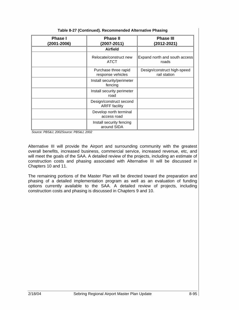
2/18/04 Sebring Regional Airport Master Plan Update 8-95
Table 8-27 (Continued). Recommended Alternative Phasing
Phase I Phase II Phase III (2001-2006) (2007-2011) (2012-2021)
Airfield
Relocate/construct new ATCT
Expand north and south access roads
Purchase three rapid response vehicles
Design/construct high-speed rail station
Install security/perimeter fencing
Install security perimeter road
Design/construct second ARFF facility
Develop north terminal access road
Install security fencing around SIDA
Source: PBS&J, 2002Source: PBS&J, 2002 Alternative III will provide the Airport and surrounding community with the greatest overall benefits, increased business, commercial service, increased revenue, etc, and will meet the goals of the SAA. A detailed review of the projects, including an estimate of construction costs and phasing associated with Alternative III will be discussed in Chapters 10 and 11. The remaining portions of the Master Plan will be directed toward the preparation and phasing of a detailed implementation program as well as an evaluation of funding options currently available to the SAA. A detailed review of projects, including construction costs and phasing is discussed in Chapters 9 and 10.

2/18/04 Sebring Regional Airport Master Plan Update 9-1
ENVIRONMENTAL OVERVIEW Sebring Regional Airport 9.1 BACKGROUND One of the goals of this Master plan is to provide viable solutions to any major environmental issues that affect the development of the Airport. The purpose of this chapter in particular is to provide a complete overview of the existing environmental conditions at the Sebring Regional Airport (SEF). This chapter is not intended to serve as a formal Environmental Assessment (EA), as defined by FAA Order 5050.4A Airport Environmental Handbook. However, the chapter is organized in accordance with guidelines set forth by the order and should be used as a base should an EA be requested in the future. The order mandates that airports address potential impacts to 20 specific categories. The 20 categories to be discussed in the following sections include:
• Airport noise • Compatible land use • Social impacts • Induced socio-economic impacts • Air quality • Water quality • Department of Transportation Act, Section 4(f) • Historic, architectural, archeological, and cultural resources • Biotic communities • Endangered and threatened species • Wetlands • Floodplains • Coastal zone management program • Coastal barriers • Wild and scenic rivers • Farmland • Energy supply and natural resources • Light emissions • Solid waste impact • Construction impacts For the purpose of this overview, these environmental categories will only be addressed as they apply specifically to SEF or will otherwise be noted as not applicable. This environmental overview highlights those potential environmental impacts that may require a more detailed analysis in a formal EA for the preferred development alternative. 9.2 AIRPORT NOISE Noise is the most apparent impact that an airport has on the environment, with the majority of complaints received from nearby residents; and therefore, necessitates the majority of mitigation efforts. The FAA recommends the average day-night sound level
9

2/18/04 Sebring Regional Airport Master Plan Update 9-2
(DNL) in decibel values, the national standard for measuring airport noise. The FAA has determined that a sound level of 65 DNL or less is compatible with most residential land uses. Therefore, noise levels greater than this measurement should be contained within the Airport property lines to the greatest extent possible. In areas around the Airport where noise levels exceed 65 DNL, other methods of mitigation, such as land acquisition, zoning requirements, and the purchase of easements, may be utilized as possible remedies for incompatible land use. The noise analysis conducted in this Master Plan utilizes the FAA Integrated Noise Model (INM) Version 6.0c software. In order to establish a national standard for comparing noise impacts, INM analysis of airport noise levels is required by the FAA. However, the noise analysis completed in this Master Plan does not constitute a CFR Part 150 Noise Study. 9.2.1 Major Assumptions 9.2.1.1 Existing/Future Development Scenarios Two cases were modeled. The base case contours reflect the Airport fleet mix and activity levels, as they exist in the year 2000. The future case contours reflect changes in the noise footprint as influenced by an increase in annual operations and new airfield development. Other significant changes between the existing and future scenarios include the transition to use of FAR Part 36 Stage III aircraft in the corporate jet segment of the fleet mix. Also assumed is an extension of Runway 18-36, realignment of the existing Runway 14-32, construction of a parallel turf runway (Runway 14U-32U), and construction of a paved 10,000 foot parallel runway (Runway 14L-32R) to the east of existing Runway 14-32. The following identifies the runway dimensions, as input into the INM model, for the year 2021.
• Runway 18-36 – 7,000 ft x 150 ft • Runway 14R-32L – 3,500 ft x 100 ft • New Parallel Turf Runway 14U-32U – 3,000 ft x 75 ft • New Parallel Paved Runway 14L-32R – 10,000 ft x 150 ft The future scenario assumes aviation activity will be accommodated with the full build-out scenario (preferred alternative) of the development plans discussed in Chapter 8. 9.2.1.2 Day/Night Operations The INM computer program computes the impact of night operations by multiplying their perceived sound intensity level by a factor of 10. The FAA, for the purposes of noise modeling, defines night operations as those that take place between the hours of 10 p.m. and 7 a.m. Most traffic at SEF flies during the daytime hours. However, a percentage of operations can reasonably be assumed to take place at night. The day/night split was calculated from historical usage percentages. Night operations are assumed to remain the same across the planning period for all categories of operations. The percentages are listed, for the existing and future cases, in Table 9-1.
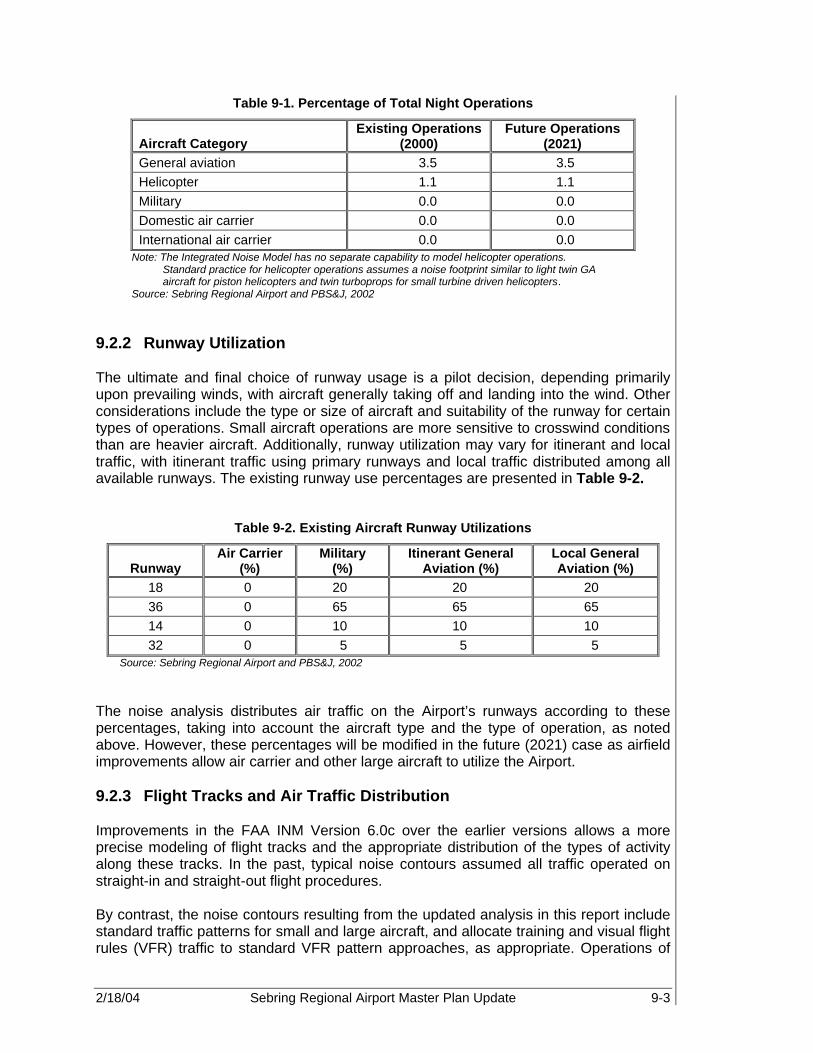
2/18/04 Sebring Regional Airport Master Plan Update 9-3
Table 9-1. Percentage of Total Night Operations
Aircraft Category Existing Operations
(2000) Future Operations
(2021) General aviation 3.5 3.5 Helicopter 1.1 1.1 Military 0.0 0.0 Domestic air carrier 0.0 0.0 International air carrier 0.0 0.0
Note: The Integrated Noise Model has no separate capability to model helicopter operations. Standard practice for helicopter operations assumes a noise footprint similar to light twin GA aircraft for piston helicopters and twin turboprops for small turbine driven helicopters.
Source: Sebring Regional Airport and PBS&J, 2002 9.2.2 Runway Utilization The ultimate and final choice of runway usage is a pilot decision, depending primarily upon prevailing winds, with aircraft generally taking off and landing into the wind. Other considerations include the type or size of aircraft and suitability of the runway for certain types of operations. Small aircraft operations are more sensitive to crosswind conditions than are heavier aircraft. Additionally, runway utilization may vary for itinerant and local traffic, with itinerant traffic using primary runways and local traffic distributed among all available runways. The existing runway use percentages are presented in Table 9-2.
Table 9-2. Existing Aircraft Runway Utilizations
Runway Air Carrier
(%) Military
(%) Itinerant General
Aviation (%) Local General Aviation (%)
18 0 20 20 20 36 0 65 65 65 14 0 10 10 10 32 0 5 5 5
Source: Sebring Regional Airport and PBS&J, 2002 The noise analysis distributes air traffic on the Airport’s runways according to these percentages, taking into account the aircraft type and the type of operation, as noted above. However, these percentages will be modified in the future (2021) case as airfield improvements allow air carrier and other large aircraft to utilize the Airport. 9.2.3 Flight Tracks and Air Traffic Distribution Improvements in the FAA INM Version 6.0c over the earlier versions allows a more precise modeling of flight tracks and the appropriate distribution of the types of activity along these tracks. In the past, typical noise contours assumed all traffic operated on straight-in and straight-out flight procedures. By contrast, the noise contours resulting from the updated analysis in this report include standard traffic patterns for small and large aircraft, and allocate training and visual flight rules (VFR) traffic to standard VFR pattern approaches, as appropriate. Operations of

2/18/04 Sebring Regional Airport Master Plan Update 9-4
larger turboprop and small corporate jet aircraft are modeled straight in, as appropriate, for the existing global positioning system (GPS) approach. All departures, with the exception of training traffic on touch-and-go flight tracks, are modeled as straight-out. Such departures may be modified to comply with changes in Airport operations procedures or land-use considerations as deemed necessary. The resulting noise contours reflect the following flight track and air traffic distribution assumptions:
• Traffic pattern altitudes are Federal Aviation Administration (FAA)/INM standard for SEF.
• Light general aviation (GA) twins and singles perform standard VFR pattern entry approaches, or follow the touch-and-go circuit.
• Turboprops and small corporate jets, as appropriate, perform straight-in approaches/departures.
• Stage lengths (or distance to be traveled) affect aircraft weight and the power required for departure, and therefore, the amount of noise generated for take-off and climb-out maneuvers.
• The helicopter fleet dominates turbine-driven rotorcraft. • FAA standard approach/departure procedures for all aircraft types, as modeled by
INM default parameters, were applied. • All aircraft types present at the Airport were modeled according to standard INM
aircraft contained within INM databases or INM aircraft-equivalents. 9.2.4 Existing Activity Levels and Fleet Mix (2000 Base Case) 9.2.4.1 Day/Night Distribution by Aircraft Category Modeling of the noise exposure contours requires that known average annual traffic be separated by aircraft category, type of operation, and the time that the operation takes place. Table 9-3 categorizes operations, based on the existing level of activity as estimated by forecasts of aviation activity in Chapter 5 of this report.
Table 9-3. Existing Aircraft Operations and Fleet Mix
Type of Service Aircraft Type (INM Aircraft) 2000 Annual Operations General aviation Single-piston (GASEPV) 48,009 Twin-piston (BEC58P) 6,812 Jet (LEAR 35) 2,319 Total: 57,140 Helicopter Jet Ranger 1,200 Bell 222 619 Apache (military) 500 Total: 2,319 Military C-130 (C130) 500 Total: 500 Experimental & other Single engine (GASEPF) 8,791 Total: 8,791 Source: Sebring Regional Airport and PBS&J, 2002
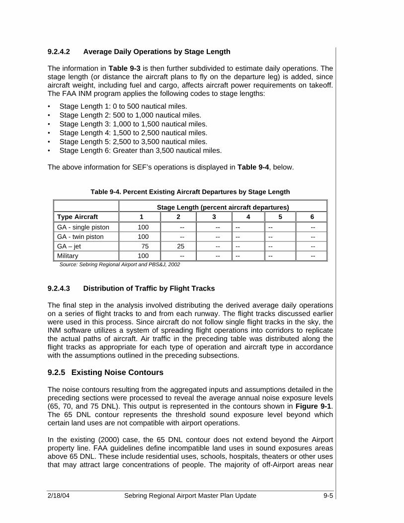
2/18/04 Sebring Regional Airport Master Plan Update 9-5
9.2.4.2 Average Daily Operations by Stage Length The information in Table 9-3 is then further subdivided to estimate daily operations. The stage length (or distance the aircraft plans to fly on the departure leg) is added, since aircraft weight, including fuel and cargo, affects aircraft power requirements on takeoff. The FAA INM program applies the following codes to stage lengths:
• Stage Length 1: 0 to 500 nautical miles. • Stage Length 2: 500 to 1,000 nautical miles. • Stage Length 3: 1,000 to 1,500 nautical miles. • Stage Length 4: 1,500 to 2,500 nautical miles. • Stage Length 5: 2,500 to 3,500 nautical miles. • Stage Length 6: Greater than 3,500 nautical miles. The above information for SEF’s operations is displayed in Table 9-4, below.
Table 9-4. Percent Existing Aircraft Departures by Stage Length
Stage Length (percent aircraft departures) Type Aircraft 1 2 3 4 5 6
GA - single piston 100 -- -- -- -- -- GA - twin piston 100 -- -- -- -- -- GA – jet 75 25 -- -- -- -- Military 100 -- -- -- -- -- Source: Sebring Regional Airport and PBS&J, 2002
9.2.4.3 Distribution of Traffic by Flight Tracks The final step in the analysis involved distributing the derived average daily operations on a series of flight tracks to and from each runway. The flight tracks discussed earlier were used in this process. Since aircraft do not follow single flight tracks in the sky, the INM software utilizes a system of spreading flight operations into corridors to replicate the actual paths of aircraft. Air traffic in the preceding table was distributed along the flight tracks as appropriate for each type of operation and aircraft type in accordance with the assumptions outlined in the preceding subsections. 9.2.5 Existing Noise Contours The noise contours resulting from the aggregated inputs and assumptions detailed in the preceding sections were processed to reveal the average annual noise exposure levels (65, 70, and 75 DNL). This output is represented in the contours shown in Figure 9-1. The 65 DNL contour represents the threshold sound exposure level beyond which certain land uses are not compatible with airport operations. In the existing (2000) case, the 65 DNL contour does not extend beyond the Airport property line. FAA guidelines define incompatible land uses in sound exposures areas above 65 DNL. These include residential uses, schools, hospitals, theaters or other uses that may attract large concentrations of people. The majority of off-Airport areas near
2/18/04 Sebring Regional Airport Master Plan Update 9-6
SEF are designated as vacant, commercial, and/or agricultural land use. Thus, no current incompatible land uses currently exist near the Airport; however, as the Airport continues to grow and aircraft operations increase, incompatible land uses may become evident. The FAA recommends that airports acquire a property interest, such as easements or outright ownership of such property. Zoning controls can also be effective, but are subject to change by other interests whose goals may not be the same as those of the Airport management. 9.2.6 Future Aircraft Activity Levels and Fleet Mix Future sound exposure levels at SEF are influenced by several key changes to the existing case. These include the following topics. 9.2.6.1 Operations Growth Significant growth is projected for aviation activity at SEF over the 20+-year planning period. Operations in 2021 are forecast to be approximately 59 percent over existing (year 2000) activity levels. Much of the growth is projected in jet aircraft activity, as well as significant growth in helicopter and experimental aircraft activity. The increased jet operations can be expected to have the most significant effect on sound exposure levels in areas on and near the Airport. 9.2.6.2 Facilities Improvements The year 2021 scenario assumes full build-out of the preferred development alternative, which includes a runway extension to Runway 18-36, and the new parallel Runways 14U-32U and 14L-32R, east of the existing Runway 14-32, as described previously. The airfield improvements are programmed in response to projected growth in commercial and cargo aircraft activity that is forecast over the planning period. Additionally, the airfield improvements will allow SEF to increase overall Airport capacity and accommodate the forecast level of demand. 9.2.6.3 Fleet Mix In order to estimate the future sound exposure levels, the existing (2000) case was modified to reflect the increased operations in each aircraft type as projected by the forecasts of aviation activity. In addition, certain representative aircraft types in the corporate fleet mix were replaced with new-generation aircraft that are compliant with the more stringent FAR Part 36 Stage III noise emission standards. Though there is no timetable for GA/corporate aircraft compliance at the time of this analysis, it is estimated that such requirements will begin in the mid- to long-term phases of the planning period. Additionally, large commercial aircraft, such as the Airbus 330 and Boeing 747, were added with minimal operations (500 annually), as proposed for the new 10,000-foot parallel runway 14L-32R. The 2021 aircraft fleet mix and associated operations are presented in Table 9-5.

2/18/04 Sebring Regional Airport Master Plan Update 9-7
Figure 9-1. Existing Noise Contours (2000) and Land Use

2/18/04 Sebring Regional Airport Master Plan Update 9-8
Table 9-5. Future Aircraft Operations and Fleet Mix (2021)
Type of Service Aircraft Type (INM Aircraft) 2021 Annual Operations General aviation Single-piston (GASEPV) 75,460 Twin-piston (BEC58P) 9,951 Jet - stage 3 (GIV) 6,893 Total: 92,304 Helicopter Jet Ranger 2,521 Bell 222 799 Apache (military) 500 Total: 3,820 Military C-130 (C130) 500 Total: 500 Experimental & other Single engine (GASEPF) 14,041 Total: 14,041 Air carrier A330-300 500 Total: 500 Source: Sebring Regional Airport and PBS&J, 2002
9.2.6.4 Average Daily Operations As in the existing (2000) case, the average annual operations were subdivided to obtain average daily operations by aircraft category, distribution of traffic by runway, and departure stage lengths. The percentage of aircraft departures presented in Table 9-4 was modified slightly to reflect the increase in aircraft activity and destinations, as well as the addition of large commercial and/or cargo aircraft. As in the existing case, the number of takeoffs (departures) is assumed to equal the number of landings (arrivals). Table 9-6 presents departure stage lengths by aircraft type.
Table 9-6. Percent Future Aircraft Departures by Stage Length
Stage Length (percent aircraft departures) Type Aircraft 1 2 3 4 5 6
GA - single piston 100 -- -- -- -- -- GA - twin piston 90 10 -- -- -- -- GA – jet 75 25 -- -- -- -- Military 100 -- -- -- -- -- Air carrier/cargo -- -- 75 25 -- -- Source: Sebring Regional Airport and PBS&J, 2002
9.2.7 Future Noise Contours The INM computer program produced sound exposure level contours by processing the modifications to the existing case scenario, including growth in aircraft activity, changes

2/18/04 Sebring Regional Airport Master Plan Update 9-9
to the fleet mix, and new runway construction. The resulting future-case contours are illustrated in Figure 9-2. The future noise contours (2021) continue to remain within the proposed airport property line included in the full build out alternative. Most noteworthy of the future noise contours is a decrease in the size of the 70 and 75 DNL contours, and thus, the highest sound exposure levels on and near the airfield. The total decrease in size can be attributed to the reassignment of aircraft to the new and realigned runways that are included in the full build out for 2021. This allows the airfield to accommodate a larger number of aircraft operations over a greater number of runway configurations and land area, thereby reducing the concentration of noise in specific areas and decreasing the overall aggregate noise that is currently experienced on and off the airfield. Although the 70 and 75 DNL noise contours decrease with the reassignment of aircraft activity as described previously, the lower levels of noise exposure, specifically 60 and 65 DNL contours, increase. Additionally, if GA operations increase beyond what is forecast, or if commercial aviation activity increases more rapidly than projected, all noise contours (60 DNL through 75 DNL) will expand in direct proportion and create a much larger noise footprint than currently shown for the year 2021. Thus, the noise contours at SEF will ultimately increase in size as the number of runways and capability of the existing runways increases in conjunction with increased aircraft activity and size. 9.2.8 Conclusions Table 9-7 documents an increase in size of the 60 and 65 DNL noise contours and decrease in the size of the 70 and 75 DNL noise contours for the future (2021) case scenario. The increase in the 60 and 65 DNL levels amounts to approximately 22 and 20 percent respectively, while the decrease in the 70 and 75 levels amounts to approximately 75 and 99 percent, respectively, of the area covered by the contours in the existing (2000) case.
Table 9-7. Comparison of Noise Contour Areas
Contour Existing (2000) Future (2021) Expansion/Reduction (+/-)
60 DNL 0.69 sq mi 0.88 sq mi + 0.19
65 DNL 0.36 sq mi 0.47 sq mi + 0.11
70 DNL 0.32 sq mi 0.13 sq mi - 0.19
75 DNL 0.02 sq mi 0.00 sq mi -0.02
Source: PBS&J, 2002

2/18/04 Sebring Regional Airport Master Plan Update 9-10
Figure 9-2. Future Noise Contours (2021) and Land Use

2/18/04 Sebring Regional Airport Master Plan Update 9-11
As shown in Figure 9-2, the future noise contours remain contained within the Airport property line. Additionally, the 70 and 75 DNL contours are reduced significantly under the proposed airfield configuration. The future airfield configuration allows the total aircraft activity to be spread out over a larger area and additional runway use configurations, thus minimizing the concentration of noise in specific areas. However, a “tail” of the 60 DNL contour extends north and south off the departure ends of Runway 18-36. This is likely due to the high level of corporate jet activity that is projected for this runway. Though, the 60 DNL contour is below the threshold set by the FAA for incompatible land use (65 DNL and above) this contour illustrates areas where increased aircraft operations or aircraft activity above that which is forecast in this Master Plan will likely push the 65 DNL contour. Therefore, land use controls such as acquisition and/or easements should be considered in these areas. Additionally, land use controls and avigation easements may be considered in conjunction with the proposed parallel air carrier/cargo runway (14L-32R). Though forecast operations are low enough to maintain an extremely low sound exposure level through 2021, any increase above that which is projected could rapidly increase the noise contours associated with this runway. Coordination with federal, state, and local officials should be completed in conjunction with the proposed development at SEF in order to minimize adverse noise impacts and ensure compatible land use within the vicinity of the Airport. 9.3 COMPATIBLE LAND USE Another objective of this overview and the master planning process is to ensure compatibility of land use between SEF and the surrounding community. During the planning phase, compatibility issues such as development on- and off-Airport, increased aircraft operations, and/or changes in aircraft type operating at SEF could arise. 9.3.1 Highlands County Land in the vicinity of SEF is owned by Highlands County. Land areas to the northwest, north, and northeast of Airport property are currently zoned for agriculture under Florida Land Use (FLUE) Policy 1.3.E.1. Land areas to the southeast and south are currently designated for regional impact development under FLUE Policy 1.3.E.12. Small land areas to the southwest of Airport property are zoned industrial use under FLUE Policy 1.3.E.10. Airport property is currently zoned for public use under FLUE Policy 1.3.E.5. 9.4 SOCIAL IMPACTS There are a number of potential social implications to consider when evaluating the environmental impacts of airport development. Impacts must be considered if the following conditions apply:
• Relocation of business and/or residence • Alteration of surface transportation patterns • Division or disruption of established communities • Disruption of orderly planned development • Creation of an appreciable change in employment.

2/18/04 Sebring Regional Airport Master Plan Update 9-12
If any relocation of commercial or residential properties is required, compensation shall be made under the Uniform Relocations Assistance and Real Property Acquisition Policies Act of 1970, as amended by the Surface Transportation and Uniform Relocation Act of 1987 and its implementing regulations (49 CFR Part 24). If potentially impacted properties cannot be acquired through a land acquisition program prior to the start of each specific project, the guidelines set forth in these regulating documents must be followed to mitigate impacts on the affected residences. Additionally, any areas with concentrated populations of people belonging to a single race, national origin, or low income bracket must be identified and evaluated under the requirements of Environmental Justice to ensure that they are not receiving a disproportionate share of adverse environmental impacts (e.g., high levels of noise exposure) in relation to other areas in the vicinity of the Airport. The following is a discussion of each of these potential impact categories in relation to the proposed development. 9.4.1 Relocation of Residences or Businesses The proposed development contained in the preferred alternative has limited potential impact on residential properties in the vicinity of SEF. However, as part of the realignment and expansion of the South Access Road, it is recommended that the Authority acquire several residential properties and vacant lots located to the South of the existing Airport property line. This will allow a sound and light buffer to be constructed between the Airport and Sebring International Raceway and the residential properties located within the Spring Lake development. In addition, based upon the proposed extension of Runway 18-36, there may be limited impacts on businesses located in the Industrial Park as well as to the owners of the Sod Farm to the north of the Airfield. These locations must be acquired according to the guidelines of the Uniform Relocations Assistance and Real Property Acquisition Policies Act of 1970, as discussed above, to mitigate impacts associated with the proposed development. Additionally, further analysis to identify the extent and total number of properties affected must be completed in the environmental studies associated with each development project. 9.4.2 Alteration of Surface Transportation Patterns Implementation of the proposed development option will result in various improvements to the Airport’s entrance roads as well as relocation and realignment of the SAA railroad spur. At the time of this writing, Airport Road, off of State Road 98, was being redesigned to meet the anticipated demand associated with Airport development. Furthermore, as part of the Sebring International Raceway leasehold expansion to the south, the South Access Road relocation was designated a defined right-of-way in 2002.
However, a variety of other access road improvements were discussed in Chapter 8. Therefore, the following upgrades to the surface roadways around the Airport are recommended:
• Realign the South Access Road to the south, along the current south Airport property line, while expanding the road to a six-lane, bi-directional roadway.
Implementation of the proposed development option will result in various improvements to the Airport’s entrance roads as well as relocation and realignment of the SAA railroad spur.

2/18/04 Sebring Regional Airport Master Plan Update 9-13
• Expand and extend Haywood Taylor Blvd to connect with the South Access Road. • Expand and Realign Airport Blvd to a six-lane, bi-directional highway. • Expand Webster Turn Blvd to a four lane, bi-directional roadway • Expand and extend Allman Drive to provide access to the Midfield Area from the
Northwest. • Develop an additional roadway access to both the midfield development area and
heavy cargo and maintenance area on the east side of the Airport via Arbuckle Creek Road.
• Construct a two lane, bi-directional Commerce Park Access Road. • Develop Commercial Terminal Roadway to a six-lane, bi-directional roadway
(primarily an extension of the South Access Road). • Develop a two-lane, bi-directional traffic lane to the south via the South Access Road
to provide access to the Spring Lake development area. A variety of surface access development is recommended as part of the preferred development in order to accommodate the anticipated vehicular traffic that will be using these roadways. The new roadway alignments will improve access in and around the Airport and are not anticipated to disrupt any residential or business activity. In addition to roadway expansion and realignment, the existing CSX rail corridor and spur, located within the Airport Industrial Park, will need to be realigned further north in order to avoid conflicts with the proposed extension to Runway 18-36 and the 10,000 ft commercial runway. Also, the CSX railroad corridor will be expanded to allow for the development of high-speed passenger rail service to the Airport. Development of a proposed rail terminal station is recommended to be located on the existing rail line to the East of the Airport property. 9.4.3 Division or Disruption of Established Communities The proposed development will require the acquisition of both residential and non-residential property. However, the acquisition of these properties will not result in the division of any established community. 9.4.4 Disruption of Orderly, Planned Development It is anticipated that the proposed development scenario will not interfere with any local planned developments. 9.4.5 Appreciable Change in Employment Short-term or temporary increases in employment will be realized as a result of construction of the proposed facilities. With development of both the industrial and commerce parks, as well as the anticipated midfield and east side commercial services development, substantial increases in employment in both Highlands County and the City of Sebring are anticipated. 9.4.6 Environmental Justice Currently, Airport development and operations do not inflict social impacts on any areas with concentrated populations of people belonging to a single race, national origin, or

2/18/04 Sebring Regional Airport Master Plan Update 9-14
low-income bracket. Therefore, no specific analysis is necessary at this time. However, plans for future development may warrant further analysis. 9.5 INDUCED SOCIO-ECONOMIC IMPACTS For major airport development proposals, there is the potential for induced or secondary impacts on surrounding communities. These impacts are usually associated with large-scale development projects, but will not normally be significant except where there are also significant impacts in other categories, especially noise, land use, or direct social impacts. An airport is determined to have significant socio-economic impact if it affects the following:
• Trends in population movement and growth • Public service demands • Business and economic activity The following is a discussion of each of these potential socioeconomic impacts with regard to the proposed development. 9.5.1 Trends in Population Movement and Growth Land uses surrounding SEF consist of a combination of residential, agricultural and open space lands. Most new residential construction in the airport area is occurring to the south of the Airport. Due to the fact that the proposed development is anticipated to take place almost entirely on Airport property, and on agricultural property purchased for such development (i.e., Davis Property and the Sod Farm, located to the north of the existing airfield), implementation of the proposed development will not have a significant impact on local trends in population movement and growth. 9.5.2 Public Service Demands The proposed development at SEF is expected to generate a significant increase in demand for public services such as the provision for public utilities (water, sewer, electric, trash disposal, etc), transportation services (public transportation and road access) and public services (police and fire protection), which would overtax the existing service capabilities. It is assumed that there will be significant impact to public service demands as a result of implementation of the proposed development, and therefore, coordination with local public works departments to ensure capacity is critical. 9.5.3 Business and Economic Activity The proposed development is not expected to significantly affect the economic development of Highlands County. However, as the landside and industrial park development continues to grow and attract more users to the Airport, there could be an increase in economic activity for the local economy. There will be a short-term increase in local employment while the facilities are being constructed, and significant long-term increases in local revenues primarily from the midfield and east airside development areas.
2/18/04 Sebring Regional Airport Master Plan Update 9-15
Airport development on this scale is likely to occur at SEF within the long-term of this study, and impacts that may be associated with such development will need to be analyzed. An EA, which is required for each major development project, will study the possible impacts of each major proposed development and describe in detail the possible induced socio-economic impacts that may be expected. Currently, Airport development and operations do not impact these areas of concern. However, plans for future development may warrant further analysis. 9.6 AIR QUALITY The Environmental Protection Agency (EPA) is responsible for implementation and enforcement of the guidelines established by the Federal Clean Air Act and updated amendments to regulate air quality. The Clean Air Act Amendments of 1977 prohibit federal agencies from providing financial assistance, issuing license, permit or approval, or generally supporting any activity not in conformance to the State Implementation Plan (SIP). The purpose of the SIP is to demonstrate the state’s intention to comply with federal air quality standards. To protect public health, standards of air pollutants are quantified by National Ambient Air Quality Standards (AAQS). The SIP applies to those areas of the state of Florida that are considered to be non-attainment areas for pollutants regulated through the primary and secondary AAQS. The SEF area, Highlands County, is considered to be an attainment area; therefore, the SIP does not apply and its provisions are not enforced in the Airport area. It is the role of the FAA to ensure that all Federal airport actions, such as financial awards and grants, conform to the SIP for controlling air pollution impacts. Since the state of Florida does not have Indirect Source Review (ISR) requirements, compliance with state and federal guidelines is accomplished by reviewing the Airport’s forecast for aviation activities. For GA airports, according to the Airport Environmental Handbook (FAA Order 5050.4A), Chapter 5, if projected operations are less than 180,000 annually and projected passengers are less than 1.3 million annually, then no air quality analysis is necessary. Twenty-year projections for SEF show approximately 114,096 annual operations and approximately 236,540 annual passengers for 2021 (based upon Chapter 5, Forecasts). Therefore, no air quality analysis is required. As a whole, air quality at SEF and Highlands County is compliant with state and federal legislation. However, as initiated by the Airport Act of 1982, an air quality certification from the State of Florida is required prior to any construction to ensure that state and federal air quality standards will be maintained throughout the course of the project. 9.7 WATER QUALITY Water quality at SEF is regulated by federal and state legislation. The Federal Water Pollution Control Act, as amended by the Clean Water Act, requires the Sebring Airport Authority (SAA) to establish water control standards, control discharges into surface and subsurface waters, develop waste treatment management plans and practices, and issue permits for discharges and for dredged or filled materials into surface waters. The Fish and Wildlife Service Coordination Act requires consultation with the U.S. Fish and Wildlife Service and appropriate state agencies when any alteration and/or impounding

2/18/04 Sebring Regional Airport Master Plan Update 9-16
of water resources is expected. Additionally, the Federal National Pollution Discharge Elimination System (NPDES) provides regulations that govern the quality of stormwater discharged into the water resources of the U.S. Permitting requirements for construction that exceed five acres are specified by NPDES and are administered by the Florida Department of Environmental Protection (FDEP). Coordination with both the FDEP and the appropriate Florida Water Management District is necessary to ensure water quality at SEF meets current standards. However, NPDES permits will be required for the proposed development. Additionally, the Airport drainage system and plans for expansion of this system will be discussed further in the master drainage plan being completed in conjunction with this document. 9.8 DEPARTMENT OF TRANSPORTATION ACT, SECTION 4(F) Section 4(f) of the Department of Transportation Act prohibits the Secretary of the Interior from approving any program or project that requires use of any publicly owned land from a public park, recreation area, wildlife/waterfowl refuge, or historic site, unless the following conditions apply. First, the Secretary may approve the program or project if there is no feasible and prudent alternative to the use of such land. Second, the Secretary may approve the program or project if it includes all possible planning to minimize harm resulting from the use. While the Secretary of the Interior serves as the primary enforcer for this legislation, assistance may be received from the U.S. Fish and Wildlife Service and the Army Corps of Engineers. The proposed development will take place on existing and contiguous agricultural property purchased for this development. Since no known section 4(f) lands have been identified in the immediate vicinity of the Airport, development is not expected to impact any of the above-mentioned lands. 9.9 HISTORICAL, ARCHITECTURAL, ARCHEOLOGICAL, AND
CULTURAL RESOURCES The National Historic Preservation Act of 1966 and the Archeological and Historic Preservation Act of 1974 provide protection against development impacts that would disrupt the historical, architectural, archeological, or cultural qualities of the property. Based upon information received from the Florida Department of State and the County Department of Historical Resources, no sites of historical, archaeological, architectural, or cultural significance are located on or near the Airport property. Therefore, it can be concluded that implementation of the proposed Airport development program will have no impact on any such sites. 9.10 BIOTIC COMMUNITIES The Fish and Wildlife Coordination Act (48 Statute 401 as amended; 16 USC et seq.) takes into consideration the possible impacts that airport development projects may have on the surrounding habitat and wildlife. Section Two of this Act requires consultation with the U.S. Fish and Wildlife Service, the U.S. Department of the Interior, and the state agencies that regulate wildlife and water resources. In the case of water resources, this would particularly apply to such instances where proposed development by any public or private agency would result in modification of the flow and/or shape or

2/18/04 Sebring Regional Airport Master Plan Update 9-17
watershed of any stream or body of water. Under this act, the U.S. Fish and Wildlife Service has authority to provide comments and recommendations concerning vegetation and wildlife resources, and the State Department of Fish and Wildlife may provide comments and recommendations if deemed necessary. The Airport lands, including the lands to be acquired as part of the proposed development, can be characterized as a series of generalized vegetative communities. Many of these communities have been disturbed from their natural state for several decades by Airport or related facilities development, agricultural activity, or other human intervention. The character of vegetative communities is significant because the varying classes of vegetative cover provide habitat for wildlife, some of which are identified as species of note or of special concern by the relevant ecological legislation. Soil types, comparative elevation, and drainage characteristics in turn help determine the wetland or upland characteristics, and thereby, the type of dominant vegetation and subsequent habitat provided. A site survey that can be used to assess specific vegetative community types on-site, and the possible presence of threatened and endangered species, should be completed during the EA process for each project. It is recommended that a species-specific survey methodology be utilized over the entire Airport property to ascertain the definitive presence, population density, and location of all threatened and endangered species of interest. As recommended in the previous Master Plan document, an investigation of biotic communities in and around SEF was performed as part of the Stormwater Drainage study. This information is contained in the text. In addition, a Bird Study associated with the State of the Art landfill located within five nautical miles of the Airport is currently being conducted. 9.11 ENDANGERED OR THREATENED SPECIES The Endangered Species Act of 1973 requires each federal agency to ensure that actions authorized, funded, or carried out by that agency not jeopardize continued existence of any endangered or threatened species, or result in destruction or adverse modification of any endangered or threatened species’ habitat. Section seven of the Act states that federal agencies must review their actions, if those actions will affect a listed species or its habitat they must consult with the U.S. Fish and Wildlife Service. The State Department of Fish and Wildlife has the responsibility of identifying, listing, and protecting endangered and/or threatened species. During the consultation process, the U.S. Fish and Wildlife Service will determine the significance of potential impacts and methods to mitigate and/or eliminate them so that the involved agency’s project may be completed. Prior to the commencement of any development activity, it is recommended that a detailed, site-specific, and species-oriented survey be performed in order to establish actual populations of listed species, and thereby, determine what type and degree of mitigation may be required. According to the U.S. Fish and Wildlife and a review of the Florida Natural Areas Inventory (FNAI), the special concern, threatened, and endangered species, under Federal Law, found to occur in Highlands County are listed in Table 9-8. Of the species

2/18/04 Sebring Regional Airport Master Plan Update 9-18
of animal and plant life listed, those listed in Table 9-9 have been observed on Airport property. Additional species may be present on the Airport, but have not been observed. A detailed flora and fauna review will be necessary for each major development project in order to identify the specific types and numbers of threatened and endangered species present on Airport property and any associated mitigation measures necessary. Any possible impact to these species or any other, caused by the implementation of the proposed development projects, should be assessed prior to construction. 9.12 WETLANDS The two important federal laws regulating wetlands are the River and Harbors Act (RHA) of 1899, and the Clean Water Act (CWA). The focus of the RHA is protection of water navigation, while the focus of the CWA is prevention of water pollution. Additionally, the North American Wetlands Conservation Act of 1989 assigns preservation responsibilities to all federal agencies whose jurisdiction may involve the management or disposal of lands and waters under their control. The U.S. Army Corps of Engineers and EPA have very broad definitions of navigable waterways and may encompass any wetland contiguous with waters of the U.S. Other agencies with non-regulatory responsibilities to create or protect wetlands include the U.S. Fish and Wildlife Service, the National Marine Fisheries Service, and the Soil Conservation Service. A portion of the Airport site consists of limited spermatic wetlands. The off-site property to the northwest and northeast have wetlands drained primarily by Arbuckle Creek, which serves as a major drainage corridor to Lake Istokopa located approximately two miles to the south. A Stormwater Master Plan was conducted concurrently with the development of this Master Plan Update. A limited number of areas on and off the existing airport property have been identified. These areas do not include existing and potential stormwater drainage areas that may also be classified as wetland areas, but will not be impacted by the proposed development. Potential wetland impacts associated with the proposed development are expected to be minimal. But, further review of possible wetland impacts on or in the vicinity of the Airport will be conducted during the EA process for each proposed development project. 9.12.1 Airport Soil Types Review of the Highlands County Soil Conservation Service Maps for the Airport area indicate that the majority of the existing and future Airport property consists of five soils, all classified as sand, with nearly level, and poor to moderately drained soils formed from marine deposits. These soils are typical along the lower slopes of the upland ridge. Urban land soil classification consists of a mixture of soil types resulting from disturbing and mixing of existing soils during the construction of the original military base.

2/18/04 Sebring Regional Airport Master Plan Update 9-19
9.12.2 Permitting and Approvals It will first be necessary to obtain the required permits and approvals from the various jurisdictional state regulatory agencies and local municipalities before any of the proposed development projects can be implemented. Environmental permitting (drainage) is primarily conducted under the jurisdiction of the Florida Department of Environmental Regulation. Additionally, permits may also have to be obtained from Southwest Florida Water Management District (SFWMD), Army Corps of Engineers (ACOE), and the EPA, as well as Highlands County. Impacts to ditches that do provide quality treatment will require a minimal 1 to 1 compensatory mitigation. As an example, a vegetative ditch that was designed, permitted, and constructed to provide stormwater quality treatment prior to discharge off site, will need to be relocated and designed/constructed to provide the same amount of water quality treatment as was provided prior to relocation. If runoff from additional impervious areas is added to the ditch, the ditch must be designed, permitted, and constructed to provide quality treatment for the additional runoffs. At the time of this writing, the Sebring Airport Authority submitted an application to the South Florida Water Management District for the Sebring Airport Conceptual Stormwater Master Plan, Permit Number 28-00459-P. The Application was a request for an Environmental Resource Permit to authorize Conceptual Approval of a surface water management system to serve 2,141 acres of commercial/industrial development. The South Florida Water Management District staff recommended approval of the application with conditions. According to the permit application, runoff from developed and undeveloped lands are primarily routed to dry detention ponds prior to discharging into on-site existing ditches or other wetlands before ultimately discharging into Lake Istokpoga. A system of dry ponds was proposed primarily due to FAA requirements to minimize bird attractions and to provide a system, which would not have a pre-treatment requirement.

2/18/04 Sebring Regional Airport Master Plan Update 9-20
Table 9-8. Endangered or Threatened Species
Common Name Scientific Name Federal Classification
Status Animal:
American Alligator Alligator mississippiensis Special Concern Animal:
Eastern Indigo Snake Drymarchon corais couperi Threatened Blue-tailed Mole Skink Eumeces egregious lividus Threatened
Sand Skink Neoseps reynoldsi Threatened Florida Scrub Jay Aphelocoma coerulescens Threatened Crested Caracara Caracara plancus Threatened
Bald Eagle Haliaeetus leucocephalus Threatened Plant:
Florida Bonamia Banamia grandiflora Threatened Pigeon Wing Clitoria fragrans Threatened
Scrub Buckwheat Eriogonum longifolium var gnaphalifolium
Threatened
Paper-like Nailwort Paronychia chartacea ssp chartacea
Threatened
Animal: Florida Grasshopper
Sparrow Ammodramus savannarum
floridanus Endangered
Peregrine Falcon Falco peregrinus Endangered Wood Stork Mycteria americana Endangered
Red-cockaded Woodpecker Picoides borealis Endangered Florida Panther Felis concolor coryi Endangered
Plant: Pygmy Fringe Tree Chionanthus pygmaeus Endangered
Short-leaved Rosemary Conradina brevifolia Endangered Avon Park Rabbit Bells Crotalaria avonensis Endangered Garrett’s Scrub Balm Dicerandra christmanii Endangered
Scrub Mint Dicerandra frutescens Endangered Wedge-leaved button
snakeroot Eryngium cuneifolium Endangered
Highlands Scrub Hypericum Hypericum cumulicola Endangered Florida Blazing Star Liatris ohlingerae Endangered Britton’s Beargrass Nolina brittoniana Endangered Lewton’s polygala Polygala lewtonii Endangered Hairy Jointweed Polygonella basiramia Endangered
Small’s Jointweed Polygonella myriophylla Endangered Scrub Plum Prunus geniculata Endangered Chaffseed Schwalbea americana Endangered
Carter’s warea Warea carteri Endangered Scrub ziziphus Ziziphus celata Endangered
Perforate Reindeer Lichen Cladonia perforata Endangered Source: Florida Natural Areas Inventory for Highland County (www.fnai.org)

2/18/04 Sebring Regional Airport Master Plan Update 9-21
Table 9.9. Rare and Endangered Plants and Animals Potentially Occurring on Sebring Regional Airport
PLANTS Scientific Name Common Name
Andropogon arctatus Pine-woods bluestem Aristida rhizomophora Florida three-awned grass
Coelorachis tuberculosa Piedmont jointgrass Drosera intermedia Spoon-leaved sundew
Hartwrightia floridana Hartwrightia Hypericum edisonianum Edison’s ascyrum
Justicia crassifolia Thick-leaved water-willow Lilium catesbaei Southern red lily
Panicum abscissum Cutthroat grass Platanthera integra Yellow fringeless orchid
Zephyranthes simpsonii Rain lily REPTILES AND AMPHIBIANS
Scientific Name Common Name Rana capito Gopher frog
Alligator mississippiensis American alligator Crotalus adamanteus Eastern diamondback rattlesnake
Drymarcheon corais couperi Eastern indigo snake Gopherus polyphemus Gopher tortoise
Pituophis melanoleucus mugitus Florida pine snake BIRDS
Scientific Name Common Name Accipiter cooperii Cooper’s hawk
Ammodramus savannarum floridanus Florida grasshopper sparrow Aramus guarauna Limpkin
Ardea alba Great egret Buteo brachyurus Short-tailed hawk Caracara plancus Crested caracara Egretta caerulea Little blue heron
E. thula Snowy egret E. Tricolor Tricolored heron
Falco sparverius paulus Southeastern American kestral Grus canadensis pratensis Florida sandhill crane
Ixobrychus exilis Least bittern Mycteria americana Wood stork Nyctanassa violacea Yellow-crowned night heron Nycticorax nycticorax Black-crowned night heron
Pandion haliaetus Osprey Picoides villosus Hairy woodpecker
Plegadis falcinellus Glossy ibis Speotyto cunicularia floridana Florida burrowing owl
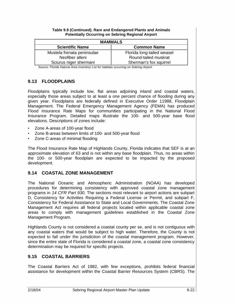
2/18/04 Sebring Regional Airport Master Plan Update 9-22
Table 9.9 (Continued). Rare and Endangered Plants and Animals Potentially Occurring on Sebring Regional Airport
MAMMALS Scientific Name Common Name
Mustela frenata peninsulae Florida long-tailed weasel Neofiber alleni Round-tailed muskrat
Sciurus niger shermani Sherman’s fox squirrel Source: Florida Natural Area Inventory List for habitats occurring on Sebring Airport
9.13 FLOODPLAINS Floodplains typically include low, flat areas adjoining inland and coastal waters, especially those areas subject to at least a one percent chance of flooding during any given year. Floodplains are federally defined in Executive Order 11988, Floodplain Management. The Federal Emergency Management Agency (FEMA) has produced Flood Insurance Rate Maps for communities participating in the National Flood Insurance Program. Detailed maps illustrate the 100- and 500-year base flood elevations. Descriptions of zones include:
• Zone A-areas of 100-year flood • Zone B-areas between limits of 100- and 500-year flood • Zone C-areas of minimal flooding The Flood Insurance Rate Map of Highlands County, Florida indicates that SEF is at an approximate elevation of 63 and is not within any base floodplain. Thus, no areas within the 100- or 500-year floodplain are expected to be impacted by the proposed development. 9.14 COASTAL ZONE MANAGEMENT The National Oceanic and Atmospheric Administration (NOAA) has developed procedures for determining consistency with approved coastal zone management programs in 14 CFR Part 930. The sections most relevant to airport actions are subpart D, Consistency for Activities Requiring a Federal License or Permit, and subpart F, Consistency for Federal Assistance to State and Local Governments. The Coastal Zone Management Act requires all federal projects located within applicable coastal zone areas to comply with management guidelines established in the Coastal Zone Management Program. Highlands County is not considered a coastal county per se, and is not contiguous with any coastal waters that would be subject to high water. Therefore, the County is not expected to fall under the jurisdiction of the coastal management program. However, since the entire state of Florida is considered a coastal zone, a coastal zone consistency determination may be required for specific projects. 9.15 COASTAL BARRIERS The Coastal Barriers Act of 1982, with few exceptions, prohibits federal financial assistance for development within the Coastal Barrier Resources System (CBRS). The

2/18/04 Sebring Regional Airport Master Plan Update 9-23
CBRS consists of undeveloped coastal barriers along the Atlantic and Gulf coasts. Maps identifying the CBRS are available for inspection in the offices of the U.S. Fish and Wildlife Service. Highlands County is not considered a coastal county per se, and is not contiguous with any coastal waters that would be subject to high water. The county is located near the geographic center of the Florida peninsula and not within any of the coastal barrier areas designated by the CBRS. Therefore, the county is not expected to fall under the jurisdiction of the coastal management program. However, since the entire state of Florida is considered a coastal zone, a coastal zone consistency determination may be required for specific projects. 9.16 WILD AND SCENIC RIVERS The Wild and Scenic Rivers Act preserves certain rivers with outstanding natural, cultural, and recreational characteristics. These areas are eligible to be afforded protection under the act if they are free-flowing and possess remarkable scenic, recreational, geologic, fish and wildlife, historic, cultural, or other similar values. Under the provisions of this act, federal agencies cannot assist by loan, grant, license, or otherwise, the construction of any water resources project that would have direct and adverse impacts on river values. In fact, the act restricts development within 1,000 feet of identified wild and scenic rivers. The U.S. Park Service administers river segments under this legislation. The Florida Department of Natural Resources is the state agency charged with oversight of the wild and scenic rivers in the state. According to the National List of Inventory Rivers, there are only two rivers in Florida designated as wild and scenic; the Loxahatchchee River located in Palm Beach County and the Wekiva River located in Seminole County. No rivers for the National Inventory of Wild and Scenic Rivers or Florida Outstanding Waters are within the areas of the proposed development. Therefore, it can be concluded that the proposed development will not impact any rivers designated as wild and scenic. 9.17 PRIME, UNIQUE, AND STATE SIGNIFICANT FARMLAND The Farmland Protection Policy Act (FPPA) authorizes the Department of Agriculture (USDA) to develop criteria for identifying the effects of federal programs on the conversion of farmland to nonagricultural uses. The guidelines apply to federal activities or responsibilities that involve undertaking, financing, or assisting construction or improvement projects, or acquiring, managing, or disposing of federal lands and facilities. Prime farmland is defined as land best suited for producing food, feed, forage, fiber, and oilseed crops. This land has the quality, growing season, and moisture supply necessary to produce sustained crop yields with minimal energy and economic input. If farmland is to be converted to a non-agricultural use by a federally funded project, consultation with the U.S. Department of Agriculture Soil Conservation Service is necessary to determine whether the farmland is classified as “prime” or “unique”. If it is, the FPPA requires rating the farmland conversion impacts based upon length of time farmed, amounts of farmland

2/18/04 Sebring Regional Airport Master Plan Update 9-24
remaining in that area, level of local farm support services, and the level of urban land in the area. In addition, state or local significant farmland is, “other than prime or unique farmland, that is of statewide or local importance for the production of food, feed, fiber, forage, or oilseed crops, as determined by the appropriate state or local government agency.” (24) All proposed development identified will be contained within the existing and future Airport property. As a result, no prime or unique farmland is to be converted to other uses either directly or indirectly through induced development. 9.18 ENERGY SUPPLY AND NATURAL RESOURCES Energy supply and natural resources may be affected by increased development at SEF. Changes in demand for electrical power will occur due to increased electrical requirements associated with airfield lighting, navigational equipment, terminal development, and tenant facilities and business operations. Proper planning with the appropriate city and county officials will limit and/or eliminate any possible negative impacts associated with increased energy demands. With concern to the potential impact upon natural resources in and around the Airport, it appears that the proposed development will affect no natural resources of a unique nature or in short supply. However, as part of the development process, an EA will be performed for each major project; and therefore, impact upon natural resources will be considered and evaluated. 9.19 LIGHT EMISSIONS Standards do not exist for light emission impacts on residential areas. However, measures can and should be taken to mitigate the effect of airport light emissions upon incompatible areas within the vicinity of the Airport. Buffer zones consisting of vegetation or earthen berms should be constructed to shield residential areas. Likewise, non-airport light emissions must be prevented from creating misleading and/or dangerous situations for aircraft operating at or in the immediate vicinity of SEF. This can be accomplished through the use of zoning and land-use planning as well as local ordinances to limit incompatible development in and around the Airport. The proposed development will result in lighting improvements associated with both airside and landside development projects. Therefore, effective measures should be initiated as part of the development plan to limit the potential impacts of the Airport on residential property to the south and the effects of potential residential development on the Airport. 9.20 SOLID WASTE IMPACT Laws that control solid waste management include the Resource Conservation and Recovery Act and FAA Order 5200.5A. The Resource Conservation and Recovery Act provides for safe disposal of discarded materials, regulates hazardous waste, promotes recycling, and establishes criteria for sanitary landfills. FAA Order 5200.5A provides guidance concerning establishment, elimination or monitoring of landfills, open dumps, or waste disposal facilities on or near airports. Under this order, waste disposal sites

2/18/04 Sebring Regional Airport Master Plan Update 9-25
within 10,000 feet of any runway end used by turbine powered aircraft, are considered incompatible with airport operations. However, the State Department of Environmental Protection has primary responsibility for regulating landfills and overseeing programs associated with solid waste. An increase in solid waste is expected during the periods of construction and upon completion of the proposed commerce park, commercial terminal, cargo, maintenance, and various GA facilities. These facilities will likely increase the production of solid waste and solid waste disposal at the Airport. However, coordination with state and local officials should be completed as part of the development plan in order to ensure that adequate capacity for the increase in solid waste disposal exists and is readily available to support the new facilities. Disposal of solid waste from the SEF area and fixed base operator (FBO) facilities is currently handled on a contractual basis and picked up biweekly. There are two landfill sites in Highlands County, owned and operated by the County Public Works department. A review, including a bird study, was conducted in order to determine if there is or will be potential bird hazards along the approach and departure path of runways as a result of the landfill sites. Results of this research, and consultation with local officials, indicate that bird hazards associated with the landfills are minimal. The DeSoto City Landfill is located approximately three to four nautical miles southwest of the Airport property. The Highlands County Solid Wastewater Management facility is located less than 1.5 nautical miles to the northeast of the existing terminal building. Therefore, due to its proximity to the Airfield, a bird hazard potential study was conducted to determine if there is a significant wildlife hazard to the Airport’s operations (i.e., aircraft approaches and departures). Based upon the research conducted, it can be concluded that implementation of the proposed development will not significantly alter the type, quantity, collection techniques, or disposal methods of solid waste at the Airport. Furthermore, bird hazards associated with the location and type of airfield developments is minimal. A wildlife study is being done concurrently with the Airport Master Plan Update. As such, according to the Bird Study, since the Highland County Solid Waste Management Center is designated as a “clean facility”, it does not appear to attract significant flocks of birds. 9.21 HAZARDOUS WASTE IMPACTS The potential to create or require the handling of hazardous waste must be evaluated when determining the impacts associated with Airport development. Though none of the proposed development projects contained in this document are anticipated to create or require the handling of hazardous materials, certain existing areas on the Airport may have potential hazardous waste impacts on future development. Since many of the buildings located on the Airport property were constructed more than 30 years ago, asbestos may exist in the form of floor tile, insulation, or pipe. Prior to the demolition of any structures, a certified asbestos consultant/contractor should be retained to survey the structures and inventory any findings of asbestos materials. Removal and disposal activities should be conducted according to the following federal regulations:
Although none of the proposed development projects contained in this document are anticipated to create or require the handling of hazardous materials, certain areas on the Airport may have potential hazardous waste impacts in the future.

2/18/04 Sebring Regional Airport Master Plan Update 9-26
• 40 CFR 763.120: EPA Worker Protection Rule • 29 CFR 1926.58: OSHA Asbestos Standard for the Construction Industry • 29 CFR 1910.1001: OSHA Asbestos Standard for General Industry If any dumpsites are discovered or rediscovered during demolition or construction of facilities, a certified consultant/contractor should be retained to assess the sites for hazardous materials. Any hazardous materials found should be disposed of in accordance with applicable federal and state regulations. 9.22 CONSTRUCTION IMPACTS During periods of development, extensive construction activities may occur. Construction activities may include, but are not limited to, earthmoving activities, delivery of equipment and materials, and removal of debris associated with runways and taxiways. The potential for impacts to off-Airport communities in the vicinity of the Airport is greatest during the initial stages of development. These impacts may consist of increased traffic on local roads, noise, mud, dust, and other effects associated with the activity of heavy construction vehicles. All possible impacts related to development projects are minor and temporary. Nevertheless, the SAA will exercise best practices to contain and minimize the impact of construction during building phases of projects proposed in the development plan. During ground clearing operations and runway, taxiway, apron, and terminal construction, potential temporary impacts such as dust, noise, and soil erosion shall be limited through the engineering specification and contractor implementation of temporary environmental controls. Specific reference shall be made, within the engineering plans and specifications prepared for the projects, that will incorporate the items contained in FAA AC 150/5370-10, Item P-156, Temporary Air and Water Pollution, Soil Erosion and Siltation Control. Temporary pollution controls should include but are not limited to such items as:
• Limiting work activities to normal business hours when possible • No open burning • Wetting of active equipment work areas • Covering of all trucks hauling loose materials • Seeding of inactive work areas with fast growing grasses • Placement of hay bales and silt fences in sloped work areas • Disposal of construction debris in properly licensed landfills All environmental construction controls required by the FAA, the Florida Department of Environmental Regulation, the South Florida Water Management District (SWFMD), the ACOE, Highlands County, and the Florida Department of Transportation shall be incorporated by reference in the construction plans, specifications, and permits that will be obtained for the project. By implementing the above-listed pollution controls during the construction of the proposed development, construction impacts should be limited.

2/18/04 Sebring Regional Airport Master Plan Update 9-27
9.23 CUMULATIVE IMPACTS National Environmental Policy Act (NEPA) requires the evaluation of the environmental consequences, including secondary and cumulative impacts, of all federal actions. Secondary impacts are defined as those that are “caused by an action and are later in time or farther removed in distance but are reasonably foreseeable” (40 CFR 1508.8). Cumulative impacts are broadly defined as those that “result from the incremental impacts of an action when added to other past and reasonably foreseeable future actions” (40 CFR 1508.7). The overall and total development plan included in the preferred alternative, as presented in the preceding pages of this document, will likely result in some level of future secondary and cumulative impacts as Airport capacity, operations, and overall activity increases. Such impacts are likely to include, but may not be limited to, areas such as local transportation routes and traffic volumes, land use and community growth, industrial and commercial business activity, and overall demand for public services. Additionally, disruptions to area residences and businesses from periodic construction associated with Airport development is anticipated. Coordination with state and local officials will be necessary during each project to ensure any future secondary and/or cumulative impacts are identified and adequate public facilities and services are planned to meet the long-term needs of the Airport and local community. 9.24 SUMMARY This chapter serves as a cursory review of the potential for environmental impacts that may be associated with the proposed Airport development. Further environmental studies, such as an EA or Environmental Impact Statement (EIS), will be necessary for some of the proposed development discussed within this Master Plan, as required by NEPA. Project specific impacts and any necessary mitigation measures will be determined and identified in these environmental documents.
2/18/04 Sebring Regional Airport Master Plan Update 10-1
AIRPORT LAYOUT PLAN SET Sebring Regional Airport 10.1 GENERAL Airport plan sets consist of several drawings which graphically depict the locations of existing and planned airfield and landside facilities in addition to pertinent ancillary information such as property lines, set-back lines, and approach slopes with obstructions denoted. The airport plan set for Sebring Regional Airport (SEF) presents, in graphic format, the proposed development of the Airport to meet forecast aviation demand and the overall goals of SEF and the Sebring Airport Authority (SAA). The complete set of plans include the following:
• Cover Sheet • Existing Facilities Drawing • Airport Layout Plan (ALP) • Terminal Area Plan • Approach and Runway Protection Zone Plans • Part 77 Airspace Surfaces • Existing and Future Land Use and Noise Contours • Exhibit ‘A’ Property Map This chapter will present the drawings with a brief discussion of each. The ALP set is provided in conjunction with this report document and has been prepared according to the design requirements set forth in this document, the Federal Aviation Administration (FAA) Advisory Circulars (FAA AC 150/5300-13 Change 7, Airport Design, Appendix X and FAA AC 150/5070-6A, Airport Master Plans, as well as FAR Part 77, Obstructions to Air Navigation), and Florida Department of Transportation (FDOT) Guidebook for Airport Master Planning. 10.2 COVER SHEET The cover sheet (Figure 10-1) serves as an introduction to the ALP set. It includes the name of the Airport, the FDOT Working Project Identification (WPI) number, location map, vicinity map, and an index of drawings. 10.3 AIRPORT LAYOUT PLAN Two of the main components of the Airport Master Plan Set are the existing and future Airport Layout Plans (ALPs). The future ALP is the primary planning document for the Airport and is a graphic representation, to scale, of existing and proposed Airport facilities, their location, dimensional and clearance data, and the overall infrastructure of the Airport, including runways, taxiways, and aprons. It also includes information on the Airport’s location, existing and future runways, meteorological conditions, and other pertinent data. FAA and FDOT officials refer to the ALP when considering grant applications for development assistance and off-airport development within the vicinity of the Airport.
10

2/18/04 Sebring Regional Airport Master Plan Update 10-2
10.3.1 Existing Facilities Included in the SEF plan set is a copy of the existing airport layout drawing (ALP) shown in Figure 10-2, which is a graphic representation, to scale, of the Airport in its current configuration (year 2000). The drawing shows all existing Airport facilities, their location, pertinent dimensions and clearance information, and the runway and taxiway infrastructure. 10.3.2 Future Facilities The future ALP drawing for SEF, shown in Figure 10-3, is a graphic representation of the recommended infrastructure development as discussed in Chapter 8 and Table 10-1, Staged Development Plans, through the year ending 2021. The ALP was developed in accordance with the design criteria and guidelines contained in FAA Advisory Circular 150/5300-13, Change 7, Airport Design, and the FDOT Guidebook for Airport Master Plans. The information and analysis presented in Chapter 7, “Facility Design Criteria,” of the FDOT guidebook discusses in detail the design requirements that pertain to SEF and have been incorporated into the ALP. The ALP highlights several recommended areas for future development: the Commerce Park, Northwest GA, Midfield, ground access and GA and commercial terminal areas. Commerce Park Development The proposed commerce park development, as shown on the ALP sheet (Figure 10-3) is located to the south of the intersection between Runway 18-36 and Runway 14R-32L. This design includes roadways, proposed lots, aircraft apron, and other services necessary to attract aviation and non-aviation tenants that are compatible with current Airport development. Northwest GA Development The future ALP identifies both the existing and proposed aviation facilities on the west side of the airfield. Development to the north and west of Runway 18-36 on the former threshold of Runway 14 includes proposed structures, roadway access, and apron. Also included is the existing and proposed GA storage and other structures located to the north of the existing Sebring Airside Center. Midfield Development The midfield development area, located between Runway 18-36 and proposed runway 14L-32R, consists of several smaller contiguous parcels which are recommended for several potential GA uses, such as aircraft storage, maintenance, cargo, etc. As part of this development, a graphical representation of roadways, utility development, signage, and other services necessary to attract both aviation and non-aviation development is shown in the future ALP sheet, Figure 10-3.
FAA and FDOT officials refer to the ALP when considering grant applications for development assistance and off-airport development within the vicinity of the Airport.

2/18/04 Sebring Regional Airport Master Plan Update 10-3
Figure 10-1. Cover Sheet

2/18/04 Sebring Regional Airport Master Plan Update 10-4
Figure 10-2. Existing Facilities Drawing

2/18/04 Sebring Regional Airport Master Plan Update 10-5
Figure 10-3. Airport Layout Plan

2/18/04 Sebring Regional Airport Master Plan Update 10-6
Table 10-1. Staged Development Plans
Phase I (2001-2006)
Phase II (2007-2011)
Phase III (2012-2021)
Land Acquisition Acquire 2,665 acres for associated development
Acquire 220 acres for associated development
Planning
Environmental assessment for Runway 18-36 extension
Design GPS/non-precision approach to Runway 14R-
32L
Land Acquisition for Runway 18
Design GPS/non-precision approach to Runway
14U-32U
Perform ATCT site selection study
Obtain Part 139, Airport certification
Perform drainage study Environmental Assessment for Runway 14L-32R
Design GPS/non-precision approach to Runway 18 Design Runway 14L-32R
Design terminal expansion Design commercial terminal facilities
Airside
Extend and widen Runway 18-36 to 7,000’ x 150’
Design/construct Taxiway B (parallel to 18-36 on east side) and associated stub
taxiways
Expand Runway 14L-32R to 10,000 ft
Pavement rehabilitation of Runway 18-36 (150,000 lb DG
and 300,000 lb DTW)
Shorten, rehabilitate, and lengthen Runway 14-32 to
3,500 x 100 ft
Design and build apron area on the east side of Runway
14L-32R
Mark (precision) and light (HIRL) Runway 18-36
Install pilot controlled MIRL on Runway 14-32 Develop cargo apron
Close Taxiways B-3 and B-4 Install pilot controlled MIRL on Runway 14U-32U
Design/construct cargo buildings
Design and grade Runway 14U-32U
Install REILs and PAPI-4 on Runway 14R-32L
Design/construct heavy maintenance facilities
Design/construct Special Use
Apron associated primarily with military operations

2/18/04 Sebring Regional Airport Master Plan Update 10-7
Table 10-1 (Continued). Staged Development Plans
Phase I (2001-2006)
Phase II (2007-2011)
Phase III (2012-2021)
Airside (Con’t) Extend, widen, and light
Taxiway A Install REILs and PAPI-4 on
Runway 14U-32U Design/construct access
taxiways
Widen, light, and mark Taxiways A-1, A-2, A-3, and
A-4 to 74'
Install runway and taxiway signage Expand utilities
Install two additional stub taxiways to from Taxiway A to
Runway 18-36
Design/construct connector taxiways between Runways
14-32 and 14U-32U
Install runway and taxiway signage
Install MALSR and Localizer on Runway 36
Design/construct turnoff to Taxiway B from Runway
14-32
Mark displaced threshold on Runway 36
Construct connector taxiways between Runways 36, 32, and 32U, as well as
Taxiway B
Design and install utility lines to east side of airfield
Design/construct 8,500’ x 150' commercial runway
Install runway hold signs, incursion lighting, and stop
bars on Runway 18-36
Design/construct 8,500’ x 75' parallel east and west
taxiways with six stub taxiways each
Mark (precision) and light (HIRL) commercial runway
Install localizer, MALSR, and PAPI-4 on Runway
14L-32R
Mark and light parallel taxiways
Design/construct 5,300’ x 75' midfield taxiway
Mark and light midfield taxiway
Install runway hold signs, incursion lighting, and stop bars
on Runway 14L-32R

2/18/04 Sebring Regional Airport Master Plan Update 10-8
Table 10-1 (Continued). Staged Development Plans
Phase I (2001-2006)
Phase II (2007-2011)
Phase III (2012-2021)
GA Terminal Area
Expand, rehabilitate, and widen Haywood Taylor Blvd
Expand air service terminal building
Expand public parking area Realign and expand terminal access road West Apron expansion
Relocate Aero-Med II facilities Construct rental car parking Expand public parking
Relocate fuel farm Expand employee parking
Design/construct two conventional hangars Expand public parking area
Commercial Terminal Area
Design commercial terminal facilities
Construct commercial terminal building (~122,000
sq ft) Expand public parking
Install utilities Construct terminal access road, including curbside
areas Expand rental car parking
Construct employee parking area
Construct public parking area
Construct rental car parking area
Design/construct commercial apron area
Construct TSA building requirements
2/18/04 Sebring Regional Airport Master Plan Update 10-9
Table 10-1 (Continued). Staged Development Plans
Phase I (2001-2006)
Phase II (2007-2011)
Phase III (2012-2021)
Midfield GA
Design/construct roadway from Arbuckle Creek Road
to Airport
Construct heavy maintenance facilities
Design/construct heavy commercial apron areas Construct heavy cargo facilities
Construct fuel farm (~ 70 Jet A tanks) Designate military fueling area
Design/construct 2 conventional hangars
Design/construct 3 corporate hangars
Design/construct 2 corporate hangars
Expand fuel farm (~ 40 Jet A tanks or equivalent))
Northwest GA
Construct access taxiways T-hangar construction
Rehabilitate, mark, and expand West Apron Close Hairpin Drive
Design/construct one conventional hangar
Design/construct three corporate hangars
Design/construct one, 14-unit T-hangar facility
Construct fuel farm with AvGas tanks
Install self-service Octane 88 facility

2/18/04 Sebring Regional Airport Master Plan Update 10-10
Table 10-1 (Continued). Staged Development Plans
Phase I (2001-2006)
Phase II (2007-2011)
Phase III (2012-2021)
South GA Design/construct public
emergency facility (i.e., ARFF and MedEvac units)
Design/construct one conventional hangar
Design/construct four additional corporate hangars
Expand, rehabilitate, relocate and extend south Airport
access road
Design/construct four corporate hangars
Install additional fuel farm facility
Install roadway signage Apron rehabilitation on the west side
Construct two access roads to Spring Lake community
Fuel farm development on west side of Runway 18-36
(1 AvGas and 4 Jet A)
Purchase one rapid response vehicles for ARFF station
Construct two, eight unit T-hangars
Construct two, eight unit T-hangars
Industrial Park
Relocate SAA rail spur Expand and realign Airport Road Expand industrial park
Fill pond at the existing end for Runway 18 Install additional signage
Expand and rehabilitate Webster Turn Drive Install additional utilities
Expand and Extend Ulmann Drive Expand industrial park
Expand Boeing Avenue Close Hairpin Turn Drive
Commerce Park
Phase I Commerce Park Development
Phase II Commerce Park Development
Install associated signage Fuel storage expansion
Install and mark apron Sell old and obtain new fuel trucks
Design/construct three corporate hangars
Design/construct three corporate hangars
Install fuel farm facilities

2/18/04 Sebring Regional Airport Master Plan Update 10-11
Table 10-1 (Continued). Staged Development Plans
Phase I (2001-2006)
Phase II (2007-2011)
Phase III (2012-2021)
Airfield
Install security/perimeter fencing
Relocate/construct new ATCT
Expand north and south access roads
Install security perimeter road Purchase three rapid response vehicles
Design/construct high-speed rail station
Design/construct second ARFF facility
Install remainder of security/perimeter fencing
Develop north terminal access road
Install remainder of perimeter road
Install security fencing around SIDA
Source: PBS&J, 2002 Note: ATCT – air traffic control tower
GPS – global positioning system DG – dual gear DTW – dual tandem wheel HIRL – high intensity runway lights MIRL – medium intensity runway lights REILs – runway end identification lights PAPI-4 – 4-box precision approach path indicator MALSR – medium intensity approach lighting system with runway alignment indicator lights MedEvac – medical evacuation operation TSA – taxiway safety area ARFF – aircraft rescue and fire fighting SIDA – security information display area
Ground Access Ground access and resulting land uses are depicted on the ALP, Figure 10-3. The ALP sheet identifies the proposed realignment and expansion of the South Access Road to the south to ensure placement outside the runway safety area (RSA) for the newly extended runways 36 and 32L. The ALP also depicts the expansion and extension of Airport Blvd, Haywood Taylor Blvd, and Webster Turn Blvd. Tentative development of a northern access road via Arbuckle Creek Road to the north of the acquired Airport property is also shown. In addition to surface roads, expansion and realignment of the existing SAA railroad spur and CSX rail corridor is recommended in order to avoid conflicts with Runway 14L-32R and allow for development of high-speed passenger rail service at the Airport. Terminal Area Plans Included on the future ALP sheet, Figure 10-3, is the existing and recommended terminal area development for both the Airside Service Center and the Commercial Terminal Facilities. Terminal infrastructure development at SEF will occur along both the existing Sebring Airside Center as well as the proposed commercial terminal area adjacent to Runway 14L-32R. The Sebring Airside Center expansion and associated development is shown in more detail on the General Aviation Terminal Area Plan,
2/18/04 Sebring Regional Airport Master Plan Update 10-12
Figure 10-4, while the proposed commercial development is shown in Figure 10-5, Commercial Terminal Area Plan. Both terminal area plans highlight the respective terminal facilities, including the terminal building, aircraft parking apron, automobile parking, rental car and ready/return parking as well as any other facilities located in and around the existing or proposed terminal areas. The General Aviation Terminal Area Plan zooms in on the existing GA Sebring Airside Center, which is located to the west of Runway 18-36. This plan includes the recommended expansion of the Sebring Airside Center to the south in order to accommodate increased corporate and GA traffic growth, as well as expansion of terminal parking, terminal curb, roadway access, and realignment of Terminal Access Road. Commercial facilities, shown in Figure 10-5, Commercial Terminal Area Plan, are located within the midfield development area and include the proposed commercial terminal building, aircraft and automobile parking areas, as well as roadway access alignment and terminal curb design.

2/18/04 Sebring Regional Airport Master Plan Update 10-13
Figure 10-4. General Aviation Terminal Area Plan

2/18/04 Sebring Regional Airport Master Plan Update 10-14
Figure 10-5. Commercial Terminal Area Plan

2/18/04 Sebring Regional Airport Master Plan Update 10-15
10.4 APPROACH AND RUNWAY PROTECTION ZONE PLANS The Approach and Runway Protection Zone drawings show both plan and profile views for each runway protection zone (RPZ) and associated approaches as shown on the ALP. The purpose of these plans is to locate and document existing objects, which represent obstructions to navigable airspace, as well as the existing and proposed approach slopes for each runway. Additionally, the drawing shows the proposed runway extensions and the ground profile along the extended centerline beyond each runway end. The approach and runway protection zone plans for all runways are shown in Figures 10-6 and 10-7. 10.5 PART 77 AIRSPACE SURFACES Federal Aviation Regulation (FAR) Part 77, “Objects Affecting Navigable Airspace,” prescribes airspace standards, which establish criteria for evaluating navigable airspace. Airport imaginary surfaces are established relative to the Airport and runways. The size of each imaginary surface is based on the runway category with respect to the existing and proposed visual, non-precision, or precision approaches for that runway. The slope and dimensions of the respective approach surfaces are determined by the most demanding, existing or proposed, approach for each runway. The imaginary surfaces definitions include:
• Primary Surface – A rectangular area symmetrically located about the runway centerline and extending a distance of 200 feet beyond each runway threshold. Its elevation is the same as that of the runway.
• Horizontal Surface – An oval shaped, flat area situated 150 feet above the published Airport elevation. Using a 10,000-foot arc, which is centered 200 feet beyond each runway end, then connecting the arcs with a line tangent to those arcs determines its dimensions. The horizontal surface elevation for SEF is 213 feet above mean sea level (AMSL).
• Conical Surface – A sloping area whose inner perimeter conforms to the shape of the horizontal surface. It extends outward for a distance of 4,000 feet measured horizontally, and slopes upward at 20:1. SEF’s conical surface extends upward to an elevation of 413 feet AMSL.
• Transitional Surface – There are three different transitional surfaces. The first is off the sides of the primary surface, the second is off the sides of the approach surface, and the last is outside the conical surface and pertains to precision runways only. All transitional surfaces have slopes of 7:1 that are measured perpendicular to the runway centerline.
• Approach Surface – This surface begins at the ends of the primary surface and slopes upward at a predetermined ratio while at the same time flaring out horizontally. The width and elevation of the inner ends conform to that of the primary surface, while the slope, length, and outer width are determined by the runway service category and existing or proposed instrument approach procedures.
Existing objects, which penetrate above Part 77 surfaces, are tabulated on the drawings. The table contains data on the object elevation, elevation of the imaginary surface, and any action necessary to mitigate the penetration. Figures 10-8 and 10-9, show all Part 77 area surfaces for the Airport.
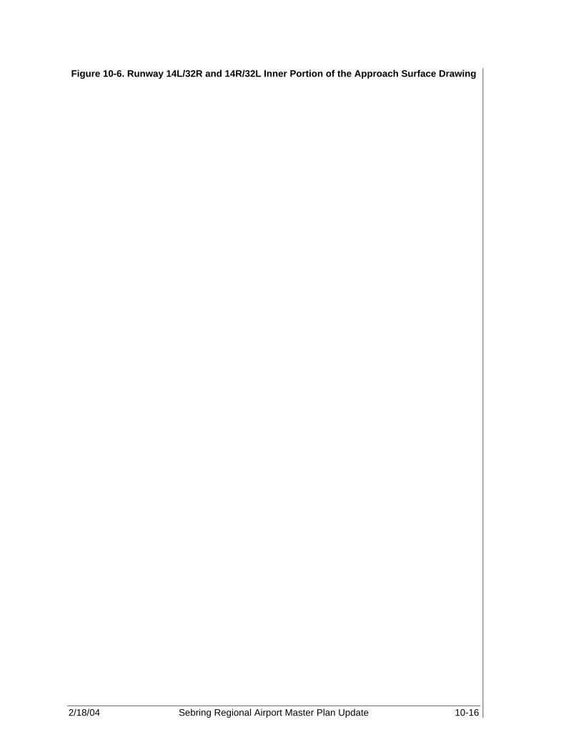
2/18/04 Sebring Regional Airport Master Plan Update 10-16
Figure 10-6. Runway 14L/32R and 14R/32L Inner Portion of the Approach Surface Drawing
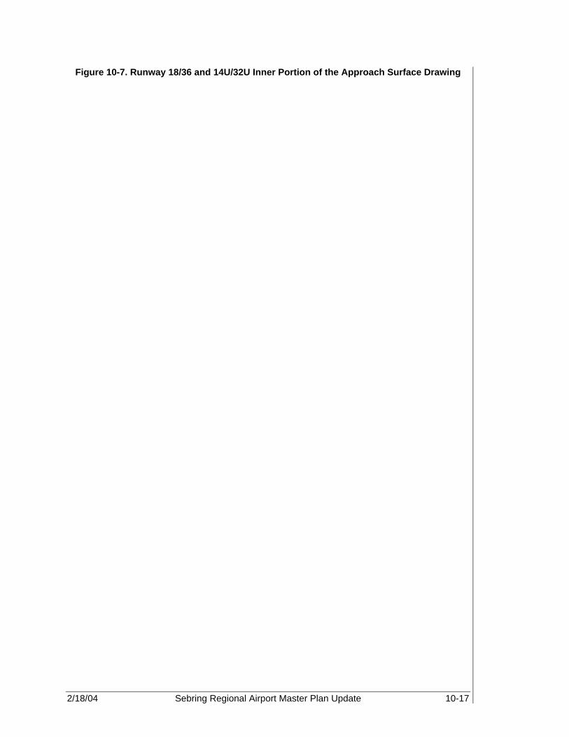
2/18/04 Sebring Regional Airport Master Plan Update 10-17
Figure 10-7. Runway 18/36 and 14U/32U Inner Portion of the Approach Surface Drawing

2/18/04 Sebring Regional Airport Master Plan Update 10-18
Figure 10-8. FAR Part 77 Airport Airspace Drawing (Approach Vicinity View)

2/18/04 Sebring Regional Airport Master Plan Update 10-19
Figure 10-9. FAR Part 77 Airport Airspace Drawing (Approach Surface Views)
2/18/04 Sebring Regional Airport Master Plan Update 10-20
10.6 LAND USE AND NOISE CONTOURS Figure 10-10, Existing Land Use and Noise Contours Plan (2001), and Figure 10-11, Future Land Use and Noise Contours (2021), depict existing land use and noise contours for the years 2001 and 2021, respectively. Both the existing and future land use drawings illustrate land use both on and off Airport property. On both sheets, noise contours for 2001 and 2021, as shown in Chapter 9, Environmental Overview, have been superimposed onto each respective land use drawing in order to provide local authorities guidance and to help ensure aviation compatible zoning is maintained in the future. 10.7 AIRPORT PROPERTY MAP The Airport Property Map presents the Airport property line and a history of Airport land purchases and acquisitions. Bearings and approximate distances from cardinal points define the Airport property line. The types of property acquisitions or transactions are presented in tables on the Exhibit “A” Data Sheet and include the date of each property acquisition and the federal project number where applicable. Aviation easements, to be acquired in perpetuity, are also indicated. The Exhibit “A” Property Map and Data Sheet for SEF are shown in Figure 10-12.

2/18/04 Sebring Regional Airport Master Plan Update 10-21
Figure 10-10. Existing Land Use and Noise Contours (2001)

2/18/04 Sebring Regional Airport Master Plan Update 10-22
Figure 10-11. Future Land Use and Noise Contours (2021)

2/18/04 Sebring Regional Airport Master Plan Update 10-23
Figure 10-12. Exhibit ‘A’ Property Map

2/18/04 Sebring Regional Airport Master Plan Update 11-1
COST ESTIMATES, CONSTRUCTION PHASING, AND CAPITAL IMPROVEMENT PROGRAM Sebring Regional Airport The preceding chapters, including the Facility Requirements and Development Plans, identified the types of projects needed for Sebring Regional Airport (SEF) to meet the anticipated demand associated with commercial service development. As discussed in Chapter 8, Development Plans, Alternative III was selected as the preferred development option due to its ability to meet the existing demands and goals of the Sebring Airport Authority (SAA). Therefore, the projects included in this alternative will be considered as part of the Airport capital improvement program (CIP) for the 20-year (2001-2021) planning period. The CIP includes projects, which represent the Airport’s needs, such as continuing maintenance, improvement of facilities to comply with federal and state aviation regulations, and additional facilities to keep pace with increasing demand for aviation services. Additionally, the proposed facilities reflect changes in the economic conditions as well as reflect SAA’s primary goal of having the Airport be an economic generator for future development in Highlands County. As part of the development process, project phasing, as discussed in previous chapters, is included in the CIP in order to manage the costs associated with these development projects. 11.1 CONSTRUCTION PHASING This section applies a general schedule to the proposed Airport development projects. The schedule represents a prioritized Airport development plan to meet federal and state regulatory issues, increases in aviation demand, and/or economic development concerns. Projects that appear in the first phase are of greatest importance and have the least tolerance for delay. Additionally, some projects included in an early phase may be a prerequisite for other planned improvements in the long-term phase. The 20+-year planning period is divided into three phases as follows:
• Phase I: Short-Term (0 to 5 years), 2001 - 2006 • Phase II: Mid-Term (6 to 10 years), 2007-2011 • Phase III: Long-Term (11 to 20 years), 2012-2021 Therefore, the phasing of individual projects should undergo periodic review to determine the need for changes based upon variations in forecast demand, available funding, economic conditions, and/or other factors that influence airport development. It should be noted that other projects not foreseen in this report may be identified in the future and would likely necessitate changes in the phasing of projects and overall CIP. Phasing for the projects included in the preferred development option as well as projects already denoted in the SEF CIP for the years 2002-2008 are shown in Table 11-1.
The projects included in this alternative will be considered as part of the Airport capital improvement program (CIP) for the 20-year (2001-2021) planning period.
11

2/18/04 Sebring Regional Airport Master Plan Update 11-2
Table 11-1. Twenty-Plus-Year Construction Phasing
Phase I Phase II Phase III (2001-2006) (2007-2011) (2012-2021)
JACIP (2002-2008)
Rehab Runway 18-36 Wastewater design and
construction of Southside Unit III development
Construct, mark, and light Parallel Taxiway – Phase III
Construction Runway 14L-32R, associated taxiways and aprons
Construct, mark, and light Parallel Taxiway, Phase IV Rail extension to land acquisition
Design, permit, and construct corporate aviation area
Phase I construction R/W 14L-32R and associated taxiways
and aprons
Design/construct new fuel farm Phase III land acquisition for land use compatibility
Security enhancements Water improvements, Southside Unit III development
Environmental assessment 18-36 extension
Runway 14L-32R, associated taxiways and aprons- Phase II
Wireless broadband infrastructure project
Water and wastewater improvements, design, future
aviation development northeast
GIS project Design and construct taxiway Construct/expand terminal
facilities Access road to commercial
aviation development Design/construct phase II of
the master drainage plan Land acquisition, phase I,
1,000 acres Design/construction of Runway
18-36 extension Design/construct new ARFF
building Security fencing - plan, design
and construct Water and wastewater
improvements, design, and construction of southeast
development area
T- and commercial hangars (20 T-hangars)
Environmental assessment for Runway 14L-32R (formerly 9-
27)
Airfield drainage
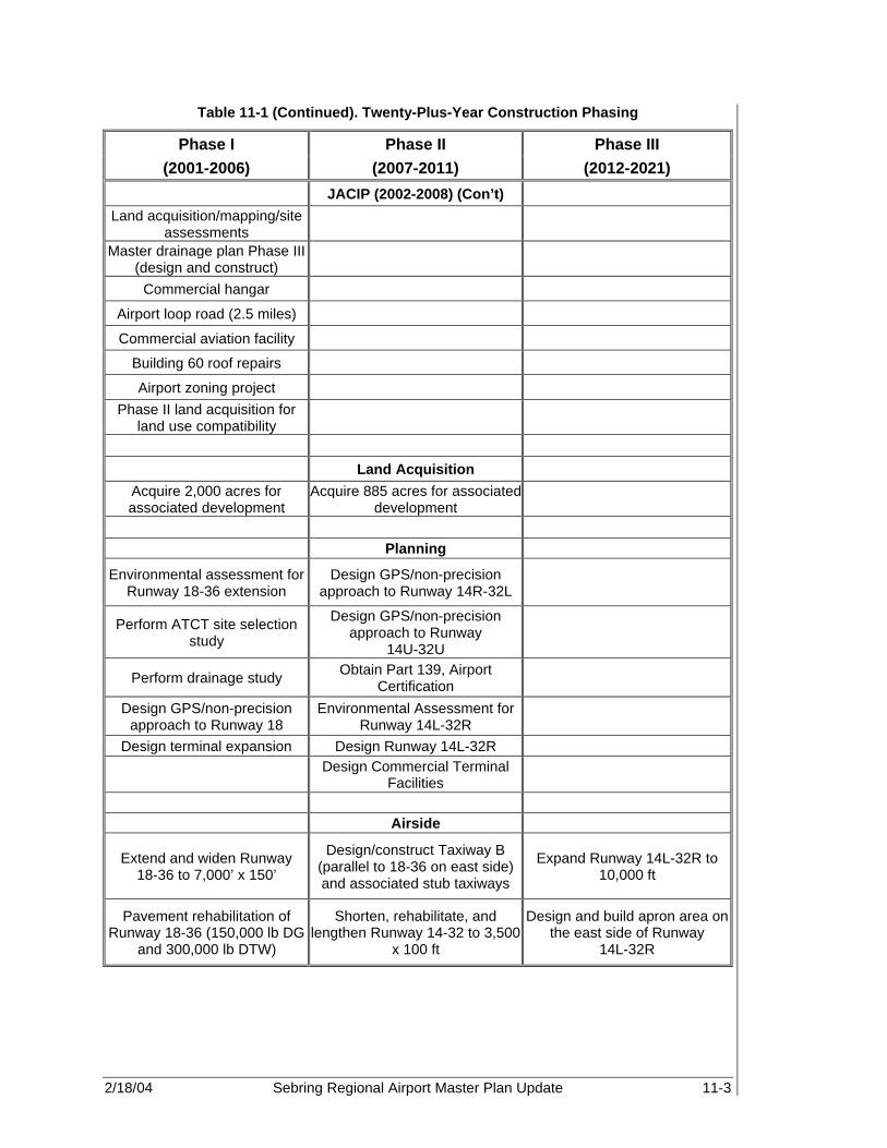
2/18/04 Sebring Regional Airport Master Plan Update 11-3
Table 11-1 (Continued). Twenty-Plus-Year Construction Phasing
Phase I Phase II Phase III (2001-2006) (2007-2011) (2012-2021)
JACIP (2002-2008) (Con’t) Land acquisition/mapping/site
assessments Master drainage plan Phase III
(design and construct)
Commercial hangar Airport loop road (2.5 miles) Commercial aviation facility
Building 60 roof repairs Airport zoning project
Phase II land acquisition for land use compatibility
Land Acquisition
Acquire 2,000 acres for associated development
Acquire 885 acres for associated development
Planning
Environmental assessment for Runway 18-36 extension
Design GPS/non-precision approach to Runway 14R-32L
Perform ATCT site selection study
Design GPS/non-precision approach to Runway
14U-32U
Perform drainage study Obtain Part 139, Airport Certification
Design GPS/non-precision approach to Runway 18
Environmental Assessment for Runway 14L-32R
Design terminal expansion Design Runway 14L-32R
Design Commercial Terminal Facilities
Airside
Extend and widen Runway 18-36 to 7,000’ x 150’
Design/construct Taxiway B (parallel to 18-36 on east side) and associated stub taxiways
Expand Runway 14L-32R to 10,000 ft
Pavement rehabilitation of Runway 18-36 (150,000 lb DG
and 300,000 lb DTW)
Shorten, rehabilitate, and lengthen Runway 14-32 to 3,500
x 100 ft
Design and build apron area on the east side of Runway
14L-32R

2/18/04 Sebring Regional Airport Master Plan Update 11-4
Table 11-1 (Continued). Twenty-Plus-Year Construction Phasing
Phase I Phase II Phase III (2001-2006) (2007-2011) (2012-2021)
Airside (Con’t) Mark (precision) and light
(HIRL) Runway 18-36 Install pilot controlled MIRL
on Runway 14-32 Develop cargo apron
Close Taxiways B-3 and B-4 Install pilot controlled MIRL on Runway 14U-32U
Design/construct cargo buildings
Design and grade Runway 14U-32U
Install REILs and PAPI-4 on Runway 14R-32L
Design/construct heavy maintenance facilities
Extend, widen, and light Taxiway A
Install REILs and PAPI-4 on Runway 14U-32U
Design/construct access taxiways
Widen, light, and mark Taxiways A-1, A-2, A-3 and
A-4 to 74'
Install runway and taxiway signage
Expand utilities to East Apron Area
Install two additional stub taxiways to from Taxiway A to
Runway 18-36
Design/construct connector taxiways between Runways
14-32 and 14U-32U
Install runway and taxiway signage
Install MALSR and Localizer on Runway 36
Design/construct turnoff to Taxiway B from Runway
14-32
Design/construct Maintenance Apron
Mark displaced threshold on Runway 36
Construct connector taxiways between Runways 36, 32, and 32U, as well as
Taxiway B
Acquire land for commercial runway
Design/construct 8,500’ x 150' commercial runway
Design and install utility lines to east side of airfield
Design/construct 8,500’ x 75' parallel east and west
taxiways with six stub taxiways each
Install runway hold signs, incursion lighting, and stop
bars on Runway 18-36
Mark (precision) and light (HIRL) commercial runway
Designate and Light portion of Apron as Emergency Staging
Area
Install localizer, MALSR, and PAPI-4 on Runway
14L-32R
Mark and light parallel taxiways
Design/construct 5,300’ x 75' midfield taxiway

2/18/04 Sebring Regional Airport Master Plan Update 11-5
Table 11-1 (Continued). Twenty-Plus-Year Construction Phasing
Phase I Phase II Phase III
(2001-2006) (2007-2011) (2012-2021) Airside (Con’t)
Mark and light midfield taxiway
Install runway hold signs,
incursion lighting, and stop bars on Runway 14L-32R
GA Terminal Area
Expand, rehabilitate, and widen Haywood Taylor Blvd
Expand air service terminal building
Relocate Aero-Med II facilities Realign and expand terminal access road West Apron expansion
Relocate fuel farm Construct rental car parking Expand public parking
Design/construct two conventional hangars Expand employee parking
Acquire Emergency Generator Expand public parking area
Commercial Terminal Area
Construct commercial terminal building Expand public parking
Construct terminal access road, including curbside
areas Expand rental car parking
Construct employee parking area
Expand Commercial Terminal Building
Construct public parking area
Construct rental car parking area
Install utilities
Design/construct commercial apron area
Construct TSA building requirements

2/18/04 Sebring Regional Airport Master Plan Update 11-6
Table 11-1 (Continued). Twenty-Plus-Year Construction Phasing
Phase I Phase II Phase III (2001-2006) (2007-2011) (2012-2021)
Midfield GA
Design/construct roadway from Arbuckle Creek Road
to Airport
Construct heavy maintenance facilities
Design/construct heavy commercial apron areas Construct heavy cargo facilities
Construct fuel farm (~ 70 Jet A tanks) Designate military fueling area
Construct 5,000 sq ft maintenance storage
building
Design/construct 2 conventional hangars
Design/construct 3 corporate hangars
Design/construct 2 corporate hangars
Expand fuel farm (~ 40 Jet A tanks)
Northwest GA
Install self-service Octane 88 facility T-hangar construction
Rehabilitate, mark, and expand West Apron Close Hairpin Drive

2/18/04 Sebring Regional Airport Master Plan Update 11-7
Table 11-1 (Continued). Twenty-Plus-Year Construction Phasing
Phase I Phase II Phase III (2001-2006) (2007-2011) (2012-2021)
South GA Design/construct public
emergency facility (i.e., ARFF and MedEvac units)
Design/construct one conventional hangar
Design/construct four additional corporate hangars
Expand, rehabilitate, relocate and extend south Airport
access road
Design/construct four corporate hangars
Install additional fuel farm facility
Install roadway signage Apron rehabilitation on the west side
Construct Two access roads to Spring Lake community
Fuel farm development on west side of Runway 18-36
(1 AvGas and 4 Jet A)
Purchase two rapid response vehicles for ARFF station
Construct two, eight unit T-hangars
Construct two, eight unit T-hangars
Industrial Park
Relocate SAA rail spur Expand and realign Airport Road Expand industrial park
Fill pond at the existing end for Runway 18 Install additional signage
Expand and rehabilitate Webster Turn Drive Install additional utilities
Expand and Extend Ulmann Drive Expand industrial park
Expand Boeing Avenue Commerce Park
Phase I Commerce Park Development
Phase II Commerce Park Development
Install associated signage Fuel storage expansion
Install and mark apron Sell old and obtain new fuel trucks
Install fuel farm facilities Design/construct six corporate hangars

2/18/04 Sebring Regional Airport Master Plan Update 11-8
Table 11-1 (Continued). Twenty-Plus-Year Construction Phasing
Phase I Phase II Phase III (2001-2006) (2007-2011) (2012-2021)
Airfield
Relocate/construct new ATCT
Expand north and south access roads
Purchase three rapid response vehicles
Design/construct high-speed rail station
Install security/perimeter fencing
Install security perimeter road
Design/construct second ARFF facility
Develop north terminal access road
Install security fencing around SIDA
Source: PBS&J, 2002 and SEF JACIP 2002-2008 Note: JACIP – joint automated capital improvement program
GIS – geographic information system ARFF – aircraft rescue and fire fighting GPS – global positioning system ATCT – air traffic control tower DG – dual gear DTW – dual tandem wheel HIRL – high intensity runway lights MIRL – medium intensity runway lights REILs – runway end identification lights PAPI-4 – 4-box precision approach path indicator MALSR- medium intensity approach lighting system with runway alignment indicator lights MedEvac – medical evacuation operation TSA – taxiway safety area SIDA – security identification display area
11.2 COST ESTIMATE In order to determine the approximate funding for the planning period, it was necessary to identify both the potential development costs associated with the preferred development option and the existing joint automated capital improvement program (JACIP) projects. These costs are based upon unit prices and include a 25 percent contingency fee. Cost estimates are based upon unadjusted 2002 dollars and are calculated for order-of-magnitude purposes only. Actual construction costs will vary based upon inflation, variations in labor, changes in materials and construction cost as well as other unforeseeable economic factors. Furthermore, federal and state grant assistance can also vary from year to year. Therefore, review of the development costs and overall CIP should be undertaken as economic conditions warrant. A breakdown of development costs per recommendation of FDOT is included in Appendix A.

2/18/04 Sebring Regional Airport Master Plan Update 11-9
Table 11-2. Preferred Alternative – Cost Estimate Phase I: Short-Term Improvements (2001-2006)

2/18/04 Sebring Regional Airport Master Plan Update 11-10
Table 11-3. Preferred Alternative – Cost Estimate Phase II: Intermediate-Term Improvements (2007-2011)

2/18/04 Sebring Regional Airport Master Plan Update 11-11
Table 11-4. Preferred Alternative – Cost Estimate Phase III: Long-Term Improvements (2012-2021)

2/18/04 Sebring Regional Airport Master Plan Update 11-12
11.3 CAPITAL IMPROVEMENT PROGRAM The objective of this section is to outline the CIP for SEF for the next 20 years and provide a brief description of the projects included. Special attention has been placed upon the first five years, Phase I, of the CIP. These projects have been identified as the most critical to the Airport in terms of correcting substandard facilities and attracting new business to the Airport. On the following pages, projects are identified and denoted in each phase of the Airport’s CIP. Additionally, a graphic representation of the airfield has been included after each phase of the CIP, Figures 11-1, 11-2, and 11-3. The complete 20+-year development is shown in Figure 11-4.
The projects that are part of the first five years of the CIP, Phase I, are considered to be the most critical in terms of correcting substandard facilities and attracting new business to the Airport.

2/18/04 Sebring Regional Airport Master Plan Update 11-13
Table 11-5. Capital Improvement Program Phase I (2001-2006)
Estimated Year Project Description and Title Total Cost
2002 Rehab Runway 18-36 $ 350,000 This project entails crack repair, asphalt surface
refurbishment, and re-marking of Runway 18-36. After crack repair, a Thermoplastic Coal Tar Emulsion Slurry Seal will be spread. After refurbishment is complete the entire runway will be repainted with non-precision markings
2002 Construct, Mark & Light Parallel Taxiway – Phase III $ 948,350
This project entails construction of the middle section of Full-length Parallel Taxiway Alpha. Work includes: constructing 50' x 1600' of new pavement, installing taxiway lighting and placement of new airfield signage. Connecting Twy A3 will be reconstructed as well.
Subtotal for 2002 $ 1,298,350
2003 Construct, Mark & Light Parallel Taxiway, Phase IV $ 875,000 This project entails construction of the northern section of
Full-length parallel Taxiway Alpha, and includes constructing 50' x 1100' of new pavement, installing taxiway lighting, and placement of new airfield signage.
2003 Design, Permit and Construct Corporate Aviation Area $ 300,000 This project will update and improve the area between or
recent phase of T-hangars to the West, and the relocated Control Tower to the East. The site will be permitted; demolition performed as required, access road, parking, lighting and signage constructed/installed.
2003 Design/Construct and Relocate Fuel Farm $ 400,000 As identified is the existing and future master plan, the fuel
farm has be designated for relocation, the appropriate new location will be identified in the new Master Plan project. Project will also include a self-service fuel island as identified in the past MPU
2003 Security Enhancements $ 750,000 To comply with pending GA security requirements
forthcoming from FAA/TSA.
2003 Environmental Assessment 18-36 Extension $ 200,000 The project will access the environmental impact relating to
the extension of Runway 18-36 and Taxiway Alpha

2/18/04 Sebring Regional Airport Master Plan Update 11-14
Table 11-5 (Continued). Capital Improvement Program Phase I (2001-2006)
2003 Wireless Broadband Infrastructure Project $ 300,000 To provide infrastructure for implementation of affordable,
easy access to broadband internet capability for Airport Authority and its tenants
2003 GIS Project $ 418,700 The benefits of a GIS application at SEF will be recognized
by all levels of management and the operating units within the SAA organization
2003 Construct/Expand Terminal Facilities $ 142,500 Expand existing Air Service Center
2003 Perform ATCT Site Selection Study $ 75,000 The planned development will require an active ATCT;
therefore, a site selection study is needed to determine the best location for the ATCT.
2003 Design GPS/Non-precision approach to Runway 18 $ 20,000 This involves a study done in conjunction with the FAA
Airways Office in Atlanta to develop a published non-precision approach to Runway 18.
2003 Design/Grade Runway 14U-32U $ 1,666,667 This project involves the preparation and design of the
Turf/Utility Runway parallel to the existing Runway 14L-32R.
2003 Relocate MED-EVAC Facilities $ 30,000 As part of the Terminal development plan, AeroMed
Facilities will be relocated to the new ARFF facility along the South portion of the Airport.
2003 Rehabilitate, mark and Expand West Apron $ 67,333 As part of SAA's development plan to expand service at the
Airport, rehabilitation and expansion of the existing apron facilities becomes critical.
2003 Fill Pond at the existing end for Runway 18 $ 5,000 This project involves the removal and grading of pond 222
which is currently located on the North side of Runway 18; thereby providing room for future runway expansion

2/18/04 Sebring Regional Airport Master Plan Update 11-15
Table 11-5 (Continued). Capital Improvement Program Phase I (2001-2006)
2003 Relocate SAA Rail spur $ 11,880,000 Relocation of the SAA Rail Spur farther North coincides
with the planned North Apron GA development as well as the extension of Runway 18-36 and associated taxiways.
2003 Building 60 Roof Repairs - Phase I $ 567,868 Design and Rehabilitate Building 60
2003 Install Emergency Generator $ 20,000 Install Emergency Generator in or near GA terminal
building to provide electricity for airfield lighting and navigation during times of emergencies
Subtotal for 2003 $ 17,718,068
2004 Access Road to Commercial Aviation Area $ 625,000 As identified in the 1994 Master Plan, the project will
provide landside access to a planned commercial aviation development that will support many types of general and commercial aviation uses.
2004 Commerce Park Taxiway $ 1,275,000 Will provide aviation access to new Commerce Park at
SEF. The Commerce Park will provide both airside and landside development areas.
2004 Phase II Master Drainage Plan (Commerce Park) $ 650,000 The project will include the permit modification, design and
construction of a new stormwater system in support of the new commerce park located between runways 36 and 32. The park will have airfield access and drainage and conveyance will be for a dry stormwater system.
2004 Land Acquisition - Phase I $ 3,000,000 This includes the 1000+ acres required to meet
development.
2004 Extension of Runway 18-36 $ 1,500,000 This project includes the construction of a 1776-foot
extension to the northern end of Runway 18-36 as well as widening the entire runway from 100 to 150 feet.
2004 ARFF Building $ 2,000,000 Construct ARFF building to meet Part 139 goal and to
attract air carrier service.
2004 Security Fencing $ 465,000 This project will provide compliance with present and future
airfield security and safety regulations.

2/18/04 Sebring Regional Airport Master Plan Update 11-16
Table 11-5 (Continued). Capital Improvement Program Phase I (2001-2006)
2004 Light Runway 18-36 $ 20,000,000 This project includes upgrading the existing lighting on
Runway 18-36 to a High Intensity Runway Lighting System (HIRL) in conjunction with the ILS as required by FAA Advisory Circular 150/5300-13.
2004 Mark Runway 18-36 $ 1,050,000 This project includes upgrading the runway markings on
Runway 18/36 to precision instrument markings in conjunction with the ILS as required by FAA Advisory Circular 150/5340-1H, Standards for Airport Markings.
2004 Extend and Widen Taxiway A $ 2,500,000 Extend and widen Taxiway A to 7,000 ft to match the
extension of Runway 18-36. In addition, widen Taxiway A to meet FAA taxiway design requirements as denoted in FAA Advisory Circular 150/5300-13.
2004 Light Taxiway A $ 280,000 This project includes the installation of Medium Intensity
Taxiway Lighting (MITL) on the entire length of Taxiway A
2004 Mark Taxiway A $ 525,000 This project includes all necessary markings to meet the
requirements for design group D-IV aircraft.
2004 Overlay Taxiway A $ 725,556 This project involves the strengthening of the existing
taxiway pavement to meet the requirements of existing and future aircraft demand.
2004 Widen Taxiways A-2 through A-4 $ 1,275,000 This project involves widening the existing stub taxiways
from 35' to 75' to meet FAA Advisory 150/5300-13 for Category D-IV aircraft.
2004 Rehabilitate Twys A-2 through A-4 $ 1,083,333 This project includes the rehabilitation and strengthening of
existing taxiway pavement to accommodate the weight of the design group aircraft.
2004 Light Taxiways A-1 through A-4 $ 80,000 This project includes the installation of Medium Intensity
Taxiway Lighting (MITL) on the entire length of all stub taxiways A-1 through A-4
2004 Mark Taxiways A-1 through A-4 $ 150,000 This project includes all necessary markings to meet the
requirements for design group D-IV aircraft.
2004 Design/construct two conventional hangars $ 1,300,000 This project involves the construction of two, 10,000 ft (100'
x 100') conventional/commercial hangars in the vicinity of the GA terminal Area, and includes associated apron and automobile parking.

2/18/04 Sebring Regional Airport Master Plan Update 11-17
Table 11-5 (Continued). Capital Improvement Program Phase I (2001-2006)
2004 Purchase one rapid response vehicles for ARFF station $ 300,000 This project involves the purchase of one rapid response
vehicle for the new Public Emergency/ARFF facilities in order to provide adequate coverage for Spring Lake, SEF and the Industrial Park.
2004 Expand and extend Ulmann Drive $ 1,980,000 As part of the northern GA development, Ulmann drive will
be expanded to a four land, bi-directional roadway and extended into the North GA development area.
2004 Expand and rehabilitate Webster Turn Drive $ 900,000 Webster Turn Drive is the main access point to the
Industrial Park; therefore, this project will expand the roadway to a four-land bi-directional roadway paved to meet the demands of heavy industrial traffic.
2004 Phase I Commerce Park Development - 2 mile Roadway $ 3,960,000 This project includes the design/construction of an
approximately 2-mile roadway into the Commerce Park, which will connect to the South Access Road.
2004 Install two additional stub taxiways to Runway 18-36 $ 9,875,000 As part of the Runway Extension, two additional stub
taxiways will be constructed to provide access to Taxiway A.
2004 Apron Emergency Lighting (40,000 sq ft) $ 16,000 Install emergency lighting on a 40,000 SF section of
existing apron to provide an emergency staging area
Subtotal for 2004 $ 55,514,889
2005 2.5 miles Airport Loop Road $ 3,437,000 Expansion of the Airport Loop Road by 2.5 miles, thereby
completing the roadway circulation system required for the raceway and new commerce park.
2005 Land Acquisition and New Runway Study $ 520,000 This EA will provide a road map for compliance with all
state and federal mandates, as well as local issues such as noise and land use.
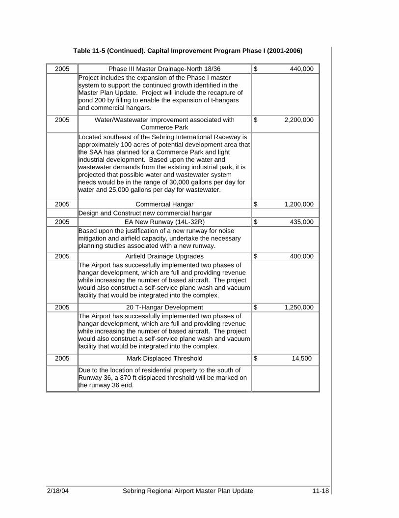
2/18/04 Sebring Regional Airport Master Plan Update 11-18
Table 11-5 (Continued). Capital Improvement Program Phase I (2001-2006)
2005 Phase III Master Drainage-North 18/36 $ 440,000 Project includes the expansion of the Phase I master
system to support the continued growth identified in the Master Plan Update. Project will include the recapture of pond 200 by filling to enable the expansion of t-hangars and commercial hangars.
2005 Water/Wastewater Improvement associated with Commerce Park
$ 2,200,000
Located southeast of the Sebring International Raceway is approximately 100 acres of potential development area that the SAA has planned for a Commerce Park and light industrial development. Based upon the water and wastewater demands from the existing industrial park, it is projected that possible water and wastewater system needs would be in the range of 30,000 gallons per day for water and 25,000 gallons per day for wastewater.
2005 Commercial Hangar $ 1,200,000 Design and Construct new commercial hangar
2005 EA New Runway (14L-32R) $ 435,000 Based upon the justification of a new runway for noise
mitigation and airfield capacity, undertake the necessary planning studies associated with a new runway.
2005 Airfield Drainage Upgrades $ 400,000 The Airport has successfully implemented two phases of
hangar development, which are full and providing revenue while increasing the number of based aircraft. The project would also construct a self-service plane wash and vacuum facility that would be integrated into the complex.
2005 20 T-Hangar Development $ 1,250,000 The Airport has successfully implemented two phases of
hangar development, which are full and providing revenue while increasing the number of based aircraft. The project would also construct a self-service plane wash and vacuum facility that would be integrated into the complex.
2005 Mark Displaced Threshold $ 14,500
Due to the location of residential property to the south of Runway 36, a 870 ft displaced threshold will be marked on the runway 36 end.

2/18/04 Sebring Regional Airport Master Plan Update 11-19
Table 11-5 (Continued). Capital Improvement Program Phase I (2001-2006)
2005 Install Rwy Hold Signs, incursion lighting & stop bars on Rwy 36
$ 340,000
This project includes the installation of various signage, lighting and other markings necessary to meet safety standards as denoted in FAA Advisory Circular 150/5300-13
2005 Develop Rental Car Facilities $ 21,900 This project involves the design/construction of rental car
parking facilities adjacent to the existing Airside Service Center.
2005 Install Roadway Signage $ 200,000 As part of the South GA development and associated
Commerce Park development, associated Roadway Signage along Airport Road and the South Access Road will be implemented.
2005 Construct two controlled access roads to Spring Lake community
$ 45,000
Two controlled access roadways connecting the South Access Road and the Spring Lake Community will be designed and constructed to meet both the community and airport firefighting needs.
2005 Close Hairpin Turn Drive $ 10,000 As part of the industrial park and airport roadway
realignment, Hairpin Turn Drive will be closed.
2005 Rehabilitate Boeing Avenue $ 300,000 As part of the expansion and extension of Boeing Avenue
to a four-lane, bi-directional roadway, it will connect the industrial park (Webster Turn Blvd) to Airport Road.
2005 Install associated signage $ 250,000 As part of the roadway realignments and extension of the
South Access Road and Commerce Park, signage needs to be implemented.
2005 Install and mark apron $ 7,316,400 Design/install and mark apron within the Commerce Park
facilities adjacent to Runways 18-36 and 14-32
2005 Phase I Commerce Park Development - Fuel Farm $ 150,000 Install three, 10,000-gallon fuel tanks within the Commerce
Park for corporate aircraft and maintenance use.
2005 RWY 18-36 ILS, GPS, Localizer and MALSR $ 2,000,000 This project includes the installation of equipment
associated with a precision approach to Runway 36 and non-precision approach to Runway 18.
Subtotal for 2005 $ 20,529,800

2/18/04 Sebring Regional Airport Master Plan Update 11-20
Table 11-5 (Continued). Capital Improvement Program Phase I (2001-2006)
2006 Land Acquisition (Davis Property) $ 2,500,000 This project would assist in acquiring property directly
northeast and contiguous to SEF's current boundaries. This property is under a binding option to SAA.
2006 Airport Zoning Study $ 150,000 Undertake an aggressive zoning and land use planning that
will include updating the current ordinance to meet state requirements and address local issues.
2006 Building 60 Roof Repairs $ 100,000 Replace existing roof on Building 60
2006 Commercial Hangar Development $ 400,000 Commercial aviation development
2006 Land Acquisition (South of South Access Road) $ 1,435,000 This project will allow the acquisition of a number of lots
directly south and contiguous to SEF's boundaries. This purchase would provide a buffer between the Airport and the residential communities in the area.
2006 Construct two, eight unit T-Hangars $ 800,000 As part of the Midfield Development, two eight unit T-
Hangars will be constructed to meet aircraft storage demands.
Subtotal for 2006 $ 5,385,000 Phase I Construction Total $ 100,446,107 Phase I Fees $ 21,363,507 Phase I Development Total $ 121,809,614

2/18/04 Sebring Regional Airport Master Plan Update 11-21
Figure 11-1. Phase I Development (2001-2006)

2/18/04 Sebring Regional Airport Master Plan Update 11-22
Table 11-6. Capital Improvement Program Phase II (2007-2011)
Estimated Year Project Description and Title Cost
2007 Construct Commercial Runway, Taxiways and Apron -
Phase I $ 10,000,000.00
Design and implementation of new commercial runway, taxiways and aprons.
2007 Airport Land Acquisition (20 Acres Reimbursement) $ 83,222.00 Airport land acquisition for reimbursement for property
purchased along Airport Road (20 acres) per JPA.
2007 Rail Spur extension to Expanded Industrial Park $ 1,500,000.00 Rail extension to land acquisition to increase marketability
to new area of industrial park.
2007 Wastewater Design/Construction - South Side Expansion $ 3,400,000.00
Based on planned development and water and wastewater demands from the existing industrial park, it is projected that possible water and wastewater needs would be in the range of 100,000 gpd for water and 90,000 for wastewater. Implementation of the planned development will necessitate expansion of the wastewater treatment and effluent disposal system. The existing wastewater plant was planned to be doubled in capacity from the existing 90,000 gpd to 180,000 gpd.
2007 Phase III Land Acquisition for land use compatibility $ 1,435,000.00 The acquisition of an additional 1,000 acres of property
adjacent to the Airport for future development and noise abatement
2007 Water Improvements - South Side Expansion $ 2,100,000.00 This project includes rehabilitation of the potable water
distribution associated with the 200-acre development area to the south of the Sebring International Raceway.
2007 Design GPS/Non-precision Approach (Rwy 14R/32L) $ 30,000.00 This involves a study done in conjunction with the FAA
Airways Office in Atlanta to develop a published non-precision approach to Runway 14R-32L
2007 Design GPS/Non-precision Approach (Rwy 14U/32U) $ 30,000.00 This involves a study done in conjunction with the FAA
Airways Office in Atlanta to develop a published non-precision approach to Runway 14U/32U.
2007 Extend Runway 14-32 by 1200 ft $ 1,333,333.33 Extend Runway 32 end by 1200 ft in order to meet the
3500' length requirement for the critical aircraft.

2/18/04 Sebring Regional Airport Master Plan Update 11-23
Table 11-6 (Continued). Capital Improvement Program Phase II (2007-2011)
2007 Shorten Runway 14 by 2700 ft $ 4,500,000.00 Shorten Runway 14 by 2700' in order to avoid crossing
Runway 18-36, and thereby limit potential runway incursions.
2007 Rehabilitate remaining 14-32 $ 638,888.89 This project entails crack repair, asphalt surface
refurbishment, and remarking of Runway 14R-32L. After crack repair, a Thermoplastic Coal Tar Emulsion Slurry Seal will be spread. The runway will then be remarked with non-precision markings
2007 T-Hangar Construction (14 unit each) $ 800,000.00 Construct two 14 unit T-Hangar facility including access
taxiway and all necessary marking and utility relocation/installation
2007 Design/Construct one conventional hangar $ 260,000.00 Construction of one 10,000 SF (100' x 100') conventional
hangar, including associated apron and auto parking.
2007 Expand and realign Airport Road $ 4,125,000.00 Expand and realign Airport Road to a six lane, bi-directional
Roadway with associated signage and traffic signals.
Subtotal for 2007 $ 30,235,444.22
2008 Water/Wastewater Improvement associated with Industrial Park
$ 8,600,000.00
Development of the 1,000 acres parcel to the east of the existing airport property line. Based on the configuration of water and wastewater demands from the existing industrial park, it is projected that up to 600 acres of developable acres would be available and water and wastewater system needs could be 300,000 gpd and 270,000 gpd, respectively. Due to present location of existing water and wastewater infrastructure, it is likely that an independent water and wastewater system will be required.
2008 Construct Commercial Runway, Taxiways and Apron - Phase II
$ 20,000,000.00
Phase II development of commercial runway and associated infrastructure

2/18/04 Sebring Regional Airport Master Plan Update 11-24
Table 11-6 (Continued). Capital Improvement Program Phase II (2007-2011)
2008 Install pilot controlled MIRL on Runway 14U-32U $ 150,000.00 This project involves the installation of radio-controlled
Medium Intensity Runway Lighting (MIRL)_ on Runway 14U-32U to avoid potential visual confusion with Runway 14R-32L.
2008 Install pilot controlled MIRL on Runway 14R-32L $ 175,000.00 This project involves the installation of radio-controlled
Medium Intensity Runway Lighting (MIRL)_ on Runway 14R-32L to avoid potential visual confusion with Runway 14U-32U.
2008 Install REILs on Runway 14R-32L $ 50,000.00 This project involves the installation of Pilot Controlled
Runway End Indicator Lights on the Threshold of either end of Runway 14R/32L
2008 Insert PAPI-4 on Runway 14R-32L $ 50,000.00 This project involves the purchase and installation of
Precision Approach Path Indicator Lights on both ends of Runway 14R-32L.
2008 Construct Rental Car Parking $ 17,750.00 Construct 355 SY of designated Rental Car Parking lot in
the vicinity of the Airside Service Center to serve GA users. This project includes all lighting, signage and markings required.
2008 Construct Fuel Farm (~ 70 Jet A Tanks) $ 3,500,000.00 This project includes the installation of 70 (or equivalent),
10,000 gallon Jet A, above ground fuel storage tanks and all necessary piping and equipment to make a full and complete operating system
2008 Install additional utilities $ 1,300,000.00 This project involves the expansion and installation of
utilities to the commerce park area
2008 Sell old and obtain new fuel trucks $ 600,000.00 This involves the sale of several older fuel trucks that SEF
currently owns. Three, 5000-gallon state-of-the-art fuel trucks will replace the existing trucks.
2008 Design/Construct connector taxiways between Rwys 14R-32L and 14U-32U
$ 888,888.89
Construct 35 ft connector taxiways between Runways 14R-32L and 14U-32U to provide access to GA Apron Area
Subtotal for 2008 $ 35,331,638.89

2/18/04 Sebring Regional Airport Master Plan Update 11-25
Table 11-6 (Continued). Capital Improvement Program Phase II (2007-2011)
2009 Install MITL on Taxiway B and 4 stub taxiways $ 292,000.00 Install MITL on Taxiway B and associated Taxiways as
recommended in FAA Advisory 150/5300-13
2009 Mark Taxiway B and four stub taxiways $ 547,500.00 Mark Taxiway B and associated Taxiways as
recommended in FAA Advisory 150/5300-13
2009 Construct Commercial Runway, Taxiways and Apron - Phase III
$ 1,275,000.00
Implementation of new runway and facilities 2009 Install REILs and PAPI-4 on Runway 14U-32U $ 150,000.00
This project involves installing Runway End Indicator Lights (REILs) and Precision Approach Path Indicator Lights, which are pilot controlled, on either end of Runway 14U-32U.
2009 Design/Construct Roadway from Arbuckle Creek Road to Airport (5 miles)
$ 9,900,000.00
This project will be done in conjunction with the FDOT and will involve the development and construction of the north airport access road. The North Airport Access Road will be designed to be a four-lane, bi-directional roadway connecting Arbuckle Creek Road to the north end of the Airport, thereby providing access to the Midfield and East side development.
2009 Design/construct heavy commercial apron areas $ 11,111.11 Design and Construct 111 SY heavy commercial apron
area primarily for use by heavy cargo or military aircraft within the north midfield development area.
2009 Design/construct four corporate hangars $ 520,000.00 Construct four, 6400 SF corporate hangar structures
including 1000 SY associate apron each and 500 SY automobile parking facilities each.
2009 Construct two, eight unit T-Hangars $ 400,000.00 Construct Two, eight unit T-Hangar buildings including
access taxiway and all necessary markings and utility relocation or installation
2009 Install additional signage $ 150,000.00 Install additional roadway signage associated with
Industrial Park development and roadway expansions and realignments.
2009 Expand and Extend South Access Road (5 miles) $ 9,900,000.00 Expand South Access Road in order to provide access to
planned commercial development

2/18/04 Sebring Regional Airport Master Plan Update 11-26
Table 11-6 (Continued). Capital Improvement Program Phase II (2007-2011)
2009 Install Security Perimeter Road $ 7,500,000.00 Install initial, 20,000 LF, section of the Airport perimeter
road.
2009 Install Utilities $ 1,060,000.00 Begin phase I of utility expansion and installation in the
Midfield and East Airport area as part of commercial development
2009 Design/construct three Corporate Hangars $ 3,880,500.00 Within the Commerce Park, design/construct three 6,400
SF corporate hangars to meet existing and anticipated aircraft storage demand.
2009 Land Acquisition for Development $ 2,595,000.00 Acquire an additional 865 acres north of the Davis Property
to accommodate commercial development
2009 Obtain Part 139, Airport Certification. $ 80,000.00 This project includes developing an Airport Emergency
Plan and Security Plan and meeting the requirements necessary to obtain Airport Certification for Commercial Aircraft Operations.
2009 Relocate/Construct New ATCT $ 3,000,000.00 Construction of new state-of-the-art ATCT facility designed
with the cab floor height approximately 100 ft above ground level (AGL)
2009 Expand Public Parking Area $ 283,200.00 Expand public parking facilities adjacent to the existing Air
Service Center by approximately 5,664 SY
2009 Design/Construct second ARFF Facility $ 2,000,000.00 The project includes the construction of a 4,200 SF ARFF
and Med-Evac facility to meet Airport Emergency Service needs as designated under FAR Part 139.
2009 Design/Construct Taxiway B (parallel to 18-36 on East Side) and associated stub taxiways (Phase I)
$ 4,833,333.33
This project entails construction of a parallel taxiway serving future aviation related development on the southeastern side of Runway 18-36. This work includes constructing 15,000 SY of new pavement, installing taxiway lighting, and placement of new airfield signage.
2009 Design/construct 5,300 x 75' midfield taxiway $ 4,416,666.67 This project includes the construction of a 5,300 x 75 foot
midfield taxiway, which will allow access to both the east and west side of the airfield.

2/18/04 Sebring Regional Airport Master Plan Update 11-27
Table 11-6 (Continued). Capital Improvement Program Phase II (2007-2011)
2009 Fuel Farm development on west side of Rwy 18-36 (1 AvGas and 4 Jet A)
$ 225,000.00
Construct/install one, 5000 gallon and 4, 10000 gallon above ground fuel tanks on the west side of runway, and includes all necessary piping and equipment to make a full and functional fuel farm facility.
Subtotal for 2009 $ 53,019,311.11
2010 Expand Air Service Terminal Building $ 2,200,000.00 This project involves the expansion of the existing Air
Service Center by approximately 8,000 SF and includes all associated utilities, signage and markings.
2010 Implementation of New Commercial Runway $ 1,800,000.00 Development of commercial runway 14L-32R and
associated development.
2010 Realign and expand Terminal Access Road $ 45,000.00 This project, as part of the realignment and expansion of
the Haywood Taylor Blvd., will expand the Terminal Frontage Road of the Air Service Center from two to three lanes in order to provide easier flow through of traffic. Terminal curb frontage is expected to increase by only 40+ feet based upon expected demand.
2010 Expand Employee Parking $ 83,000.00 Expand employee parking in the vicinity of the Air Service
Center by approximately 1,666 SY in order to accommodate employee-parking demand.
2010 Construct Commercial Terminal Building (~66,960 SF) $ 16,740,000.00 This project includes the design and construction of a
~66,000+ SF commercial terminal facility adjacent to proposed Runway 14L-32R on the East side of the Midfield Development Area.
2010 Construct Terminal Access Road, including Curbside areas (4-miles)
$ 7,920,000.00
This project involves the construction of an approximate 4-mile terminal access road that connects with the existing South Access Road to provide access to the Commercial Terminal Facilities. In addition, the terminal frontage road will consist of three lanes in order to facilitate the flow of traffic in and around the terminal building.

2/18/04 Sebring Regional Airport Master Plan Update 11-28
Table 11-6 (Continued). Capital Improvement Program Phase II (2007-2011)
2010 Design/Construct Commercial Apron Area $ 333,300.00 This project includes the construction of a 4,444 SY
commercial terminal apron. All necessary markings, lightings, and utility installation/construction are included in this project.
2010 Expand Industrial Park $ 39,000.00 As part of the airport's overall development, demand for
industrial park parcels is expected to increase. Therefore, it is recommended that SAA expand the Industrial Park by 13 acres to meet demand.
2010 Phase II Commerce Park Development $ 8,000,000.00 This portion of the development includes the expansion of
the roadway, utilities, signage, markings, etc throughout the rest of the Commerce Park property to meet anticipated demand for facilities.
Subtotal for 2010 $ 37,160,300.00
2011 Construct Employee Parking Area $ 88,000.00 This project entails the development of 1,760 SY of
employee parking facilities on the east side of the airfield, adjacent to the Commercial Terminal Facilities. This project includes all necessary lighting, signage and markings
2011 Construct Public Parking Area $ 297,000.00 This project entails the development of 5,940 SY of public
parking facilities on the east side of the airfield, adjacent to the Commercial Terminal Facilities. This project includes all necessary lighting, signage and markings
2011 Construct Rental Car Parking Area $ 35,500.00 This project entails the development of 710 SY of rental car
facilities on the east side of the airfield, adjacent to the Commercial Terminal Facilities. This project includes all necessary lighting, signage and markings
2011 Construct TSA Building Requirements $ 1,200,000.00 As per the new security requirements as designated by
TSA 49 CFR 1540-1542, the Transportation Security Administration requires 6,000 SF of office space for their personnel within the commercial terminal or within the general vicinity.
2011 Fuel Storage Expansion (5, 10,000 Gal) $ 250,000.00 This project includes the installation of five, 10,000 gallon
Jet A, above ground fuel storage tanks and all necessary piping and equipment to make a full and complete operating system

2/18/04 Sebring Regional Airport Master Plan Update 11-29
Table 11-6 (Continued). Capital Improvement Program Phase II (2007-2011)
2011 Design/construct three Corporate Hangars $ 1,950,000.00 Design and construct three additional corporate hangars
within the Commerce Park, and include approximately 3000 SY of adjacent apron space and 1500 SY of public parking space.
2011 Expand Security Fence to 60,000 LF $ 7,500,000.00 This project involves the expansion of the 8 foot security
fence another 15,000 Linear Feet around the airfield facilities.
2011 Expand Perimeter Road $ 9,375,000.00 Expand the Perimeter Road to allow access to the midfield
development area.
2011 Purchase two rapid response vehicles $ 600,000.00 This project includes the purchase of two rapid response
vehicles to meet the fire-fighting requirements as designated under FAR Part 139.
Subtotal for 2011 $ 21,295,500.00 Total Phase II Construction Costs $ 177,042,194.22 Total Phase II Fees $ 38,054,691.67 Phase II Total Development Costs $ 215,096,885.89
2/18/04 Sebring Regional Airport Master Plan Update 11-30
Figure 11-2. Phase II Development (2007-2011)

2/18/04 Sebring Regional Airport Master Plan Update 11-31
Table 11-7. Capital Improvement Program Phase III (2012-2021)
Estimated Year Project Description and Title Cost
2012 Expand utilities (~2 miles) $ 2,112,000.00 Expand existing utilities (water, sewer, gas, electric) an
additional two miles to allow development on the east and west side of Runway 14L-32R.
2012 Construct Heavy Maintenance Facilities $ 13,500,000.00 Construction of a 90,000 SF (300 x 300) heavy
maintenance facility, and 90,000 SY of apron and 5000 SY of auto parking space. This project also includes all associated utility installation on the North Midfield Apron Area.
2012 Design/Construct 5 Corporate Hangars $ 650,000.00 Construct five additional 6,400 SF (80 x 80) corporate
hangars including 1000 SY apron and 50 SY of auto parking in the South GA development area. The project includes all marking and utilities relocation/installation.
2012 Design/Construct 2 Conventional Hangars $ 520,000.00 Construct two additional 10,000 SF Conventional Hangars
within the Midfield Area, including associated apron and auto parking requirements.
2012 Expand Security Fence to 75,000 LF $ 3,750,000.00 Expand the security fencing an additional 15,000 LF to
completely encompass the airfield.
Subtotal for 2012 $ 20,532,000.00
2013 Develop Heavy Maintenance Apron $ 1,000,000.00 Develop 10,000 SY Heavy Maintenance Apron on the
North Midfield portion along Taxiway D and Taxiway F.
2013 Expand Fuel Farm (~ 40 Jet A Tanks)) $ 2,000,000.00 This project includes expanding the existing Midfield Fuel
Farm by 40, 10,000-gallon tanks (or equivalent0. All necessary piping, lighting, marking and other equipment to make a full and complete operating system are included.
Subtotal for 2013 $ 3,000,000.00
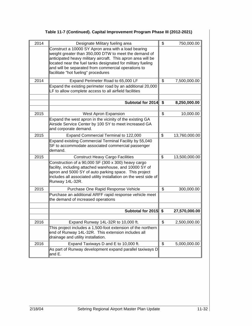
2/18/04 Sebring Regional Airport Master Plan Update 11-32
Table 11-7 (Continued). Capital Improvement Program Phase III (2012-2021)
2014 Designate Military fueling area $ 750,000.00 Construct a 10000 SY Apron area with a load bearing
weight greater than 350,000 DTW to meet the demand of anticipated heavy military aircraft. This apron area will be located near the fuel tanks designated for military fueling and will be separated from commercial operations to facilitate "hot fueling" procedures
2014 Expand Perimeter Road to 65,000 LF $ 7,500,000.00 Expand the existing perimeter road by an additional 20,000
LF to allow complete access to all airfield facilities
Subtotal for 2014 $ 8,250,000.00
2015 West Apron Expansion $ 10,000.00 Expand the west apron in the vicinity of the existing GA
Airside Service Center by 100 SY to meet increased GA and corporate demand.
2015 Expand Commercial Terminal to 122,000 $ 13,760,000.00 Expand existing Commercial Terminal Facility by 55,040
SF to accommodate associated commercial passenger demand.
2015 Construct Heavy Cargo Facilities $ 13,500,000.00 Construction of a 90,000 SF (300 x 300) heavy cargo
facility, including attached warehouse, and 10000 SY of apron and 5000 SY of auto parking space. This project includes all associated utility installation on the west side of Runway 14L-32R.
2015 Purchase One Rapid Response Vehicle $ 300,000.00 Purchase an additional ARFF rapid response vehicle meet
the demand of increased operations
Subtotal for 2015 $ 27,570,000.00
2016 Expand Runway 14L-32R to 10,000 ft. $ 2,500,000.00 This project includes a 1,500-foot extension of the northern
end of Runway 14L-32R. This extension includes all drainage and utility installation.
2016 Expand Taxiways D and E to 10,000 ft. $ 5,000,000.00 As part of Runway development expand parallel taxiways D
and E.
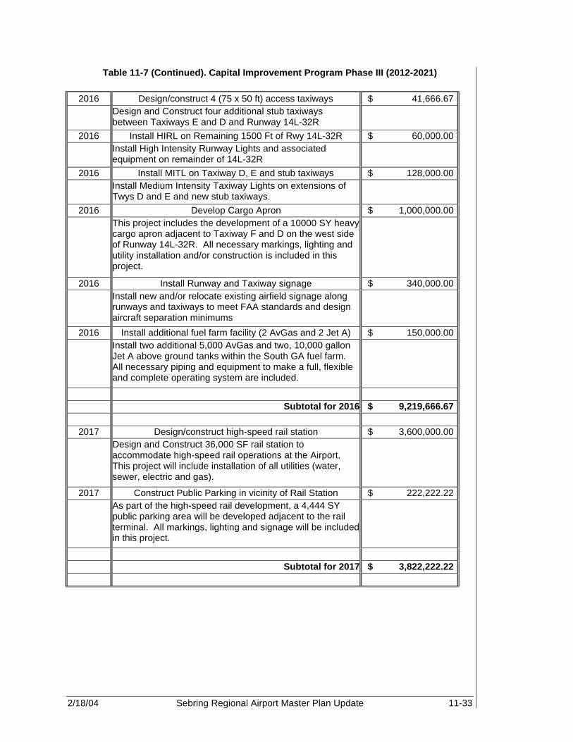
2/18/04 Sebring Regional Airport Master Plan Update 11-33
Table 11-7 (Continued). Capital Improvement Program Phase III (2012-2021)
2016 Design/construct 4 (75 x 50 ft) access taxiways $ 41,666.67 Design and Construct four additional stub taxiways
between Taxiways E and D and Runway 14L-32R
2016 Install HIRL on Remaining 1500 Ft of Rwy 14L-32R $ 60,000.00 Install High Intensity Runway Lights and associated
equipment on remainder of 14L-32R
2016 Install MITL on Taxiway D, E and stub taxiways $ 128,000.00 Install Medium Intensity Taxiway Lights on extensions of
Twys D and E and new stub taxiways.
2016 Develop Cargo Apron $ 1,000,000.00 This project includes the development of a 10000 SY heavy
cargo apron adjacent to Taxiway F and D on the west side of Runway 14L-32R. All necessary markings, lighting and utility installation and/or construction is included in this project.
2016 Install Runway and Taxiway signage $ 340,000.00 Install new and/or relocate existing airfield signage along
runways and taxiways to meet FAA standards and design aircraft separation minimums
2016 Install additional fuel farm facility (2 AvGas and 2 Jet A) $ 150,000.00 Install two additional 5,000 AvGas and two, 10,000 gallon
Jet A above ground tanks within the South GA fuel farm. All necessary piping and equipment to make a full, flexible and complete operating system are included.
Subtotal for 2016 $ 9,219,666.67
2017 Design/construct high-speed rail station $ 3,600,000.00 Design and Construct 36,000 SF rail station to
accommodate high-speed rail operations at the Airport. This project will include installation of all utilities (water, sewer, electric and gas).
2017 Construct Public Parking in vicinity of Rail Station $ 222,222.22 As part of the high-speed rail development, a 4,444 SY
public parking area will be developed adjacent to the rail terminal. All markings, lighting and signage will be included in this project.
Subtotal for 2017 $ 3,822,222.22

2/18/04 Sebring Regional Airport Master Plan Update 11-34
Table 11-7 (Continued). Capital Improvement Program Phase III (2012-2021)
2018 Expand Rental Car Parking (~10 spaces) $ 19,444.44 This project involves the expansion of Rental Car facilities
in the vicinity of the Commercial Terminal Facilities by approximately 389 SY, and includes all necessary lighting, signage and markings.
2018 Construct Fuel Farm (~ 30 Jet A Tanks) $ 1,500,000.00 Construction of three, 10,000 gallon, above ground fuel
tanks within the south GA fuel farm, and includes all necessary piping and equipment to make a full and complete operating system.
2018 Design/construct four additional corporate hangars $ 520,000.00 Design and Construct four, 6400 sf, corporate hangars
within the South GA area to meet demand. Apron, auto parking and utility installation are included.
Subtotal for 2018 $ 2,039,444.44
2019 Expand Public Parking (~50 spaces) $ 111,111.11 This project involves the expansion of public parking
facilities in the Midfield and commercial terminal area by approximately 2,222 SY. This project includes all necessary lighting, signage and markings.
2019 Expand North and South Access Roads $ 4,125,000.00 This project involves the expansion of both the north and
south main access roads to six lane, bi-directional roadways in order to accommodate expected demand associated with development.
Subtotal for 2019 $ 4,236,111.11
2020 Expand Public Parking (~30 Spaces) $ 66,666.67 Expand Public Parking in the vicinity of the Airside Service
Center to meet anticipated demand. Approximately 1,333 SY of pavement will be needed and all necessary lighting, signage and markings are included.
2020 Expand Industrial Park $ 9,000.00 Obtain an additional 3 acres of land North of the existing
industrial park for continued development.
Subtotal for 2020 $ 75,666.67

2/18/04 Sebring Regional Airport Master Plan Update 11-35
Table 11-7 (Continued). Capital Improvement Program Phase III (2012-2021)
2021 Design and Build Apron area on the East side of Runway 14L-32R (600 SY)
$ 60,000.00
Design/Build 600 SY apron, including all utilities and markings, on the east side of Runway 14L-32R to meet future development needs.
Subtotal for 2021 $ 60,000.00 Total Construction Costs $ 78,805,111.11 Total Fees $ 23,641,533.33 Total Development Cost - Phase III $ 102,446,644.44

2/18/04 Sebring Regional Airport Master Plan Update 11-36
Figure 11-3. Phase III Development (2012-2021)

2/18/04 Sebring Regional Airport Master Plan Update 11-37
Figure 11-4. Complete Phased Development

2/18/04 Sebring Regional Airport Master Plan Update 12-1
FINANCIAL FEASIBILITY Sebring Regional Airport 12.1 INTRODUCTION AND PURPOSE The Financial Feasibility Analysis is used to analyze Sebring Regional Airport’s (SEF) historical and projected revenue and expenditures while determining whether it is financially viable to implement the Airport master plan’s capital development program (CDP) as a commercial non-subsidized airport. The objective of this updated financial analysis is twofold:
• Estimate the capital and operating costs for the various components that comprise the capital improvement program.
• Determine if it is feasible for the Airport to generate sufficient revenues to repay capital and operating costs.
In order to achieve these objectives, several subtasks were performed:
• Projections of potential operating revenues • Comparison of operating revenues/capital and operating costs • Identification of funding shortfalls • Identification of potential additional funding sources • Feasibility/cash flow analysis 12.2 SEBRING REGIONAL AIRPORT - INDEPENDENT OPERATING
ENTITY SEF is administered by the Sebring Airport Authority (SAA) established by act of the Florida Legislature on August 1, 1967 and amended by House Bill Number 1086 on June 19, 1989. The SAA was created for the purpose of planning, developing, and maintaining a comprehensive airport and industrial complex, and constitutes a public instrumentality. A seven-member board governs the SAA and its operations consist of leasing industrial properties and supervising Airport and utility operations. The SAA operates as a single enterprise fund under the fund accounting framework of governmental accounting and is exempt from federal income taxes. Within this framework, an enterprise fund accounts for operations in a manner similar to private business enterprises where the intent of the governing body is that costs (expenses including depreciation) of providing goods and services to the general public on a continuing basis be financed or recovered primarily through user charges. The enterprise fund is accounted for on a cost of services or “capital maintenance” measurement focus. This means all assets and liabilities (whether current or non-current) associated with its activity are included on its balance sheet. Reported fund equity (net total assets) is segregated into contributed capital and retained earnings components.
12

2/18/04 Sebring Regional Airport Master Plan Update 12-2
12.2.1 Foreign Trade Zone A significant incentive for business development at SEF is attributed to the Foreign Trade Zone (FTZ). The FTZ Board, Chaired by the U.S. Department of Commerce, authorized FTZ status on July 26, 1997 to the SAA. The Zone, designated by the FTZ Board as FTZ Number 215, not only assists in economic development of SEF and its associated industrial park tenants, but businesses throughout Highlands County as well. SEF became the 16th FTZ in Florida. A survey, conducted by the International Trade Commission, found that the presence of an FTZ was the fourth most identifiable factor in plant site location decisions. According to the U.S. Department of Commerce, FTZs have been found to provide customers cost savings and improved inventory control. Through the use of FTZs, U.S. based production is placed on more equal footing with production in a foreign country. In addition, FTZs have a significant impact in retaining U.S. production and employment as well as stimulating new activity. 12.2.2 Community Redevelopment Agency The Sebring Regional Airport and Industrial Park Community Redevelopment Agency (CRA) was established by county ordinance on December 17, 1996. It is a legally separate entity from the SAA, but since SAA’s board of directors also serves as the CRA’s board, it is reported as a blended component unit. The SAA makes available the State of Florida’s Community Redevelopment incentives program to businesses locating at SEF and the industrial park. In 1996, SEF and industrial park property was designated a Florida CRA. This designation enables SEF the ability to provide financing assistance and other incentives to businesses leasing land and building facilities on the Airport and industrial park property. Financial assistance for companies choosing to locate facilities at the Airport can make a significant difference to a company’s bottom line. These incentives can include offsetting or deferring lease payments through the use of the Authority’s CRA’s Tax Increment Trust Fund and loans to assist in financing site improvements, parking lot construction, and special infrastructure needs. In 1997, two Airport tenants, LESCO Inc. and Hancor, Inc., were assisted by the CRA in the financing of their improvements. Sebring Regional Airport and Industrial Park is the only combined general aviation (GA) facility and industrial park in Florida offering these incentives. (25) In addition, the CRA provides an additional revenue source to the both Highland County and the Airport through tax revenues on developed land and facilities located within the Airport and Industrial Park property line. This revenue is used not only to provide assistance to businesses locating their operations on the Airport and industrial park property, but also for future Airport and industrial development. The current program allows the CRA to collect taxes on developed land at a rate of 85 percent and buildings and other facilities at a rate of 95 percent.
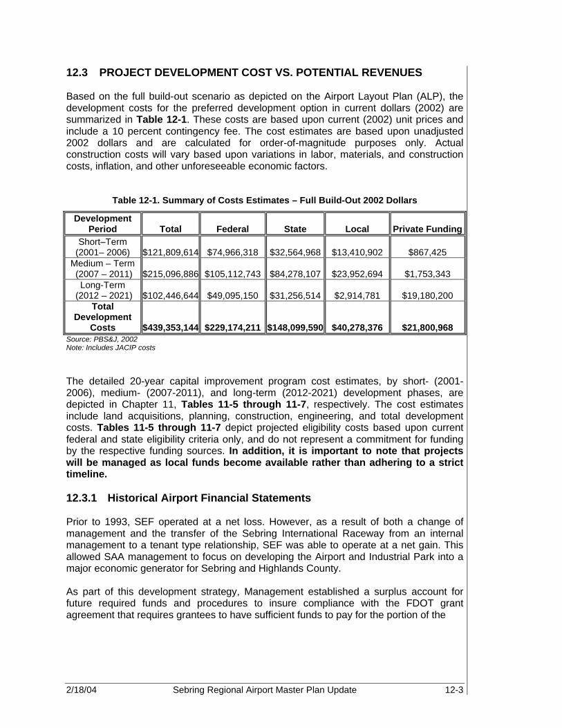
2/18/04 Sebring Regional Airport Master Plan Update 12-3
12.3 PROJECT DEVELOPMENT COST VS. POTENTIAL REVENUES Based on the full build-out scenario as depicted on the Airport Layout Plan (ALP), the development costs for the preferred development option in current dollars (2002) are summarized in Table 12-1. These costs are based upon current (2002) unit prices and include a 10 percent contingency fee. The cost estimates are based upon unadjusted 2002 dollars and are calculated for order-of-magnitude purposes only. Actual construction costs will vary based upon variations in labor, materials, and construction costs, inflation, and other unforeseeable economic factors.
Table 12-1. Summary of Costs Estimates – Full Build-Out 2002 Dollars
Development Period Total Federal State Local Private Funding
Short–Term (2001– 2006) $121,809,614 $74,966,318 $32,564,968 $13,410,902 $867,425
Medium – Term (2007 – 2011) $215,096,886 $105,112,743 $84,278,107 $23,952,694 $1,753,343
Long-Term (2012 – 2021) $102,446,644 $49,095,150 $31,256,514 $2,914,781 $19,180,200
Total Development
Costs $439,353,144 $229,174,211 $148,099,590 $40,278,376 $21,800,968 Source: PBS&J, 2002 Note: Includes JACIP costs The detailed 20-year capital improvement program cost estimates, by short- (2001-2006), medium- (2007-2011), and long-term (2012-2021) development phases, are depicted in Chapter 11, Tables 11-5 through 11-7, respectively. The cost estimates include land acquisitions, planning, construction, engineering, and total development costs. Tables 11-5 through 11-7 depict projected eligibility costs based upon current federal and state eligibility criteria only, and do not represent a commitment for funding by the respective funding sources. In addition, it is important to note that projects will be managed as local funds become available rather than adhering to a strict timeline. 12.3.1 Historical Airport Financial Statements Prior to 1993, SEF operated at a net loss. However, as a result of both a change of management and the transfer of the Sebring International Raceway from an internal management to a tenant type relationship, SEF was able to operate at a net gain. This allowed SAA management to focus on developing the Airport and Industrial Park into a major economic generator for Sebring and Highlands County. As part of this development strategy, Management established a surplus account for future required funds and procedures to insure compliance with the FDOT grant agreement that requires grantees to have sufficient funds to pay for the portion of the
2/18/04 Sebring Regional Airport Master Plan Update 12-4
project not covered by FDOT grant. The surplus fund was initially based upon the following three major financial commitments:
• Interlocal agreement • Debt refinancing • Military funding In May 1993, the City of Sebring, Highlands County, and the SAA entered into an interlocal agreement to assist the SAA in funding construction, reconstruction and improvements to key public facilities. The agreement, which committed $1,335,000 over five years, provided the Airport the ability to obtain matching fund grants. As a result, significant development in and around the Airport has been achieved. Further, in order to achieve the SAA’s goal of becoming self-reliant, debt refinancing became critical. Therefore, under the new management, the SAA refinanced all debts in February of 1992 with a commitment toward retiring the debt service. This debt consolidation accomplished a 57.5 percent reduction in debt service. In 1994, the SAA entered into an agreement with the Department of Defense (DOD) to provide “hot fueling” to military aircraft. This direct billing agreement to fuel military aircraft has resulted in fuel flowage fees averaging $500,000 to $1,000,000 annually. This has provided a positive cash flow to the Airport, thus, limiting operating losses after depreciation. SEF’s revenue and expenditure sources for the years 1992 through 2000 are discussed in more detail in the following sections. It is important to note that prior to 2000, SAA’s Statements of Revenue and Expenses reported a net loss based upon existing Government Auditing Standards issued by the Comptroller General of the United States. This, however, was misleading since it did not take into account SAA’s additional funding sources. However, as of the year 2000, Government Auditing Standards were changed to allow Contributions not previously recorded to be included in the Airport’s Statements of Revenue and Expenses. Applying these auditing standards to previously reported financial statements, revealed a cumulative net surplus through the year 2000. Furthermore, in 2001, the Authority changed its accounting estimates relating to depreciation, which resulted in a net income increase of $514,749. 12.3.1.1 Revenue Sources SEF collects revenues from a variety of sources. These sources include Airport revenues and federal, state, and local (city/county) commitments. Airport revenues consist of income generated from the following activities:
• Land and building leases • Hangar rental • Fixed base operation • Special events/test track rental • Water and sewer fee • Fire protection fee • Miscellaneous revenue (interest, etc.)

2/18/04 Sebring Regional Airport Master Plan Update 12-5
Table 12-2 provides the basis of income from the Airport’s various revenue sources as reported by SAA, Airport Funds, Actual Revenues, 2000. As shown in Table 12-3, aviation related revenues (i.e., fixed base operations) account for approximately 30 percent, whereas industrial rental revenues account for approximately 49 percent of total operating revenues for the period of 1999-2000. Table 12-2 shows a detailed listing of revenue sources and depicts percentage of revenue by source and percent of total revenues for FY 2000. Table 12-3 and Figure 12-1 demonstrate that the Airport is not reliant on any one source of revenue. However, revenue associated with non-aviation related sources outweighs revenue associated with aviation related sources. Therefore, emphasis should be placed in attracting both aviation and non-aviation users in order to provide a more equitable split between aviation and non-aviation related resources.
Table 12-2. Detailed Revenue Categories for 2000
Type of Revenue Revenue Source Revenue (2000) Percent of Total
Revenue Operating Industrial Rentals $951,851 49%
Water Revenue $55,801 3% Sewer Revenue $86,289 4% Test Track Rentals $95,291 5% Fixed Base Operations $576,783 30% Fire Protection Fees $40,776 2% Fire Support Fee $0 0% Miscellaneous Revenue $141,940 7% Total Operating Revenue $1,948,731 100%
Non-Operating Interest Income $86,710 3% Contributions $23,034 1% Capital Contributions $3,345,691 97% Grant Revenue $0 0% Insurance Claim Proceeds $0 0% Gain on Sale of Investments $0 0% Total Non-operating Revenue $3,455,435 100% Total Revenues $5,404,166

2/18/04 Sebring Regional Airport Master Plan Update 12-6
Figure 12-1. Revenue Sources
$0
$500,000
$1,000,000
$1,500,000
$2,000,000
$2,500,000
$3,000,000
$3,500,000O
per
atin
g R
even
ues
Revenue (2000)
Industrial Rentals
Water Revenue
Sewer Revenue
Test Track Rentals
Fixed Base Operations
Fire Protection Fees
Fire Support Fee
Miscellaneous Revenue
Interest Income
Contributions
Capital Contributions
Source: SAA, Airport Funds, Actual Revenues, 2000
Airport Leases The SAA leases various types of industrial buildings and land with terms ranging from month-to-month to 45-year agreements. All of the SAA’s leases are classified as operating leases. Substantially all of the SAA’s investments in land, buildings, and racetrack improvements are bound by/or are held for lease as of September 30, 2000.

2/18/04 Sebring Regional Airport Master Plan Update 12-7
Table 12-3. Revenue Sources
Revenue Source 1992 1993 1994 1995 1996 1997 1998 1999 2000 Operating Revenue:
Industrial Rentals $697,456 $677,715 $698,152 $703,511 $754,630 $894,652 $877,759 $908,771 $951,851Water Revenue $12,558 $20,585 $22,501 $18,103 $23,982 $37,444 $47,273 $55,414 $55,801Sewer Revenue $33,802 $24,671 $23,986 $27,388 $39,423 $50,750 $55,932 $68,786 $86,289
Test Track rentals $34,392 $45,840 $47,734 $46,494 $55,521 $74,396 $77,209 $88,320 $95,291Fixed Base Operations $98,213 $157,389 $416,130 $445,750 $297,834 $312,173 $324,789 $349,366 $576,783
Fire Protection Fees $27,128 $24,768 $28,282 $25,562 $29,011 $37,268 $36,436 $37,671 $40,776Fire Support Fee $26,300 $7,950 $9,504 $9,000 $8,850 $9,500 $7,850 $4,700 $0
Miscellaneous Revenue $5,613 $4,809 $7,157 $20,111 $14,129 $83,803 $47,030 $54,105 $141,940
Total Operating Revenue $935,462 $963,727 $1,253,446 $1,295,919 $1,223,380 $1,499,986 $1,474,278 $1,567,133 $1,948,731 Total Non-Operating Revenue
Interest Income $603 $3,215 $3,244 $3,607 $714 $32,013 $45,871 $56,328 $86,710 Contributions $0 $0 $0 $0 $0 $52,997 $70,260 $29,500 $23,034
Capital Contributions - Grants and Others No Data $544,617 $694,308 $2,501,954 $1,051,895 $3,116,815 $1,796,621 $1,401,247 $3,345,691
Grant Revenue $0 $0 $0 $0 $0 $0 $116,358 Interest Expense ($50,521) ($49,411) ($45,809) ($37,314) ($27,997) ($53,391) ($76,623) ($91,663) ($122,486)
Insurance Claim Proceeds $0 $14,486 $0 $0 $0 $0 Gain (Loss) on disposal of
assets $0 $0 ($66,189) $0 $0 ($2,129) $26,168 ($1,348) ($45,344)Gain on Sale of Investments $1,829 $0 $0 $0 $0 $0 $0 $2,500 $0
Miscellaneous Expense $0 $0 $0 $0 $0 $0 ($1,558) ($12,335) ($7,376)
Total Non-operating Income ($48,089) $512,907 $585,554 $2,468,247 $1,024,612 $3,146,305 $1,977,097 $1,384,229 $3,280,229
Total Revenue $887,373 $1,476,634 $1,839,000 $3,764,166 $2,247,992 $4,646,291 $3,451,375 $2,951,362 $5,228,960 Source: Annual financial statements and auditor's report

2/18/04 Sebring Regional Airport Master Plan Update 12-8
Table 12-4 is a schedule of future rent revenue minimums from non-cancelable operating leases as of September 30, 2000.
Table 12-4. Operating Leases
Year Ending September 30, Amount 2001 $901,822 2002 $556,536 2003 $551,286
Total Minimum Future Rentals $2,009,644 Source: Sebring Airport Authority financial statements and auditors report, September 30, 2000
Furthermore, a material part of the SAA’s rent revenue is dependent upon three major customers. Total rent approximations are found in Table 12-5.
Table 12-5. Major Customers
Percentage of Total Rent Revenue 2000 1999 LESCO, Inc. 44% 43%
Sebring International Raceway, Inc. 33% 29% Lin Pac, Inc. 11% 13%
Total 88% 85%
Source: Sebring Airport Authority financial statements and auditors report, September 30, 2000
Cash Flow Contributions Cash flow information refers to the in-flow and outflow of cash assets. For the purposes of the Statement of Cash Flows, the SAA considers all highly liquid investments (including restricted assets) with maturity of three months or less when purchased to be cash equivalents. In the case of the SAA, cash assets are usually associated with interest earnings or payments. However, during 1999, the SAA received a non-cash donation in the form of common stock in the amount of $29,250. The stock donations were recorded at fair market value at the date of donation. Deposits and Investments Cash and cash equivalents consist of restricted and unrestricted funds. Restricted funds represent proceeds from interlocal agreements, funds received at the end of the year to cover payables related to various grant projects, and lease deposits. Cash and cash equivalents as of September 30, 2000 and 1999 are recorded in Table 12-6.

2/18/04 Sebring Regional Airport Master Plan Update 12-9
Table 12-6. Cash and Cash Equivalents
Deposit/Investment 2000 1999
Unrestricted cash $ 293,777 $ 289,643 Restricted cash Design build project $ 877,081 Waste/potable water project $ 708,727 $ 751,951 Other projects $ 49,506 $ 75,261 Community redevelopment agency $ 22,788 $ 8,005 Lease deposits $ 8,792 $ 10,842 Total cash and cash equivalents $ 1,960,671 $ 1,135,702 Classified as: Petty cash and demand deposits $ 105,755 $ 146,330 Local government surplus trust funds $ 1,854,916 $ 989,372 Total $ 1,960,671 $ 1,135,702 Source: Sebring Airport Authority financial statements and auditors report, September 30, 2000
Aggregate bank balances on September 30, 2000 and 1999 were $1,960,671 and $1,135,702, respectively. The SAA’s cash and time deposits are entirely covered by federal depository insurance and are subject to collateral requirements pursuant to Section 280.07, Florida Statutes. Property and Equipment A portion of the Airport’s revenues is associated with fixed assets, which consists of property and equipment. Property and equipment purchased or acquired is carried at historical cost. Donated or contributed assets are recorded at estimated fair value or actual cost, if known. Additions, improvements, and capital outlays that significantly extend the useful life of an asset are capitalized, in addition to public domain (“infrastructure”) fixed assets like roads, curbs, runways, and waste/potable water systems. Other costs incurred for repairs and maintenance are expended as incurred. Prior to October 1, 2001, the estimated fixed asset depreciation schedule was based upon a straight-line depreciation on all assets over estimated useful lives as shown in Table 12-7.

2/18/04 Sebring Regional Airport Master Plan Update 12-10
Table 12-7. Fixed Asset Depreciation Schedule
Fixed Asset Years Buildings 40 Infrastructure 25-40 Improvements 15-30 Vehicles 5-15 Equipment 3-10
Source: Sebring Airport Authority financial statements and auditors report, September 30, 2000
However, in 2001, the Authority changed its accounting estimates relating to depreciation. The estimated service lives for buildings, wastewater facilities and wastewater infrastructure were increased from the previous lives of 15 to 30 years to new lives of 40 years. Further, railroad spur lives were increased from 20 years to 25 years, road lives were increased from 15 years to 20 years and roof repair lives were increased from a range of 10 to 15 years to 20 years. Sebring Management believes that the new lives are a more accurate reflection of actual useful lives, and, as a result of the change, 2001 net income increased by $514,749. (Sebring Airport Authority, 2001 and 2002 Financial Statements).
Property and equipment on September 30, 2000 and 1999 is summarized in Table 12-8.
Table 12-8. Fixed Assets
Assets 2000 1999 Land, buildings, and infrastructure $ 22,598,212 $ 15,961,515 Vehicles and tractors $ 96,621 $ 369,777 Machinery and equipment $ 289,810 $ 273,581 Office furniture, fixtures, and equipment $ 357,901 $ 103,731 Race track improvements $ 1,475,111 $ 1,522,170 Total $ 24,817,655 $ 18,230,774 Less: accumulated depreciation $ 7,900,183 $ 7,256,552 Net property and equipment $ 16,917,472 $ 10,974,222 Construction in progress* $ 87,609 $ 1,298,311 Total $ 17,005,081 $ 12,272,533 Source: Sebring Airport Authority financial statements and auditors report, September 30, 2000

2/18/04 Sebring Regional Airport Master Plan Update 12-11
Construction in progress is composed of the elements in Table 12-9.
Table 12-9. Construction in Progress
Project Authorization Commitment
Expended to September 30,
2000 1999
Sebring Custom Tanning $ - $ - $ - $ 517,301 LESCO Expansion $ 95,000 $ 89,892 $ 5,108 $ 5,108 Building 60 rehabilitation $ - $ - $ - $ 17,641 Entrance Road CR 523 to US 98 $ 1,028,166 $ 1,027,563 $ 603 $ 603 LESCO rail spur $ - $ - $ - $ 278,940 Potable water system improvement $ 655,900 $ 574,002 $ 81,898 $ 43 General aviation terminal building $ - $ - $ - $ 362,442 Hancor road/rail $ - $ - $ - $ 37,548 T-hangar access/parking $ - $ - $ - $ 18,940 T-hangar phase II $ - $ - $ - $ 59,745 Total $ 1,779,066 $ 1,691,457 $ 87,609 $ 1,298,311
Source: Sebring Airport Authority financial statements and auditors report, September 30, 2000 and 1999 Operating Subsidies and Grants Operating subsidies and grants that finance current operations are recorded as non-operating revenue when earned. Contributions and grants from federal, state, and local sources received prior to October 1, 2000, for the purpose of purchasing or constructing capital assets, were recorded as contributed capital. Depreciation on such assets is charged back against contributed equity. Contributed Capital Contributed Capital represents capital contributions from other governmental agencies and customers. Cash and Cash Equivalents Cash and cash equivalents consist of unrestricted and restricted funds. Restricted funds represent (1) proceeds from interlocal agreements, (2) funds received at the end of the year to cover payables related to various grant projects, and (3) lease deposits. 12.3.1.2 Expenses Historic expenses are classified for the purpose of this summary as personnel and operating expenses in the form of contractual services, professional services, and general operating expenses. Personnel expenses are those expenses associated with

2/18/04 Sebring Regional Airport Master Plan Update 12-12
full and part-time Airport employees, which include salaries, taxes, and benefits. Operating expenses include utilities, supplies, maintenance, insurance, and other miscellaneous expenses associated with the operations of SEF. Table 12-10 shows the Airport’s expenses from 1992-2000. Pension Plan All full-time and part-time employees working in a regularly established position for the SAA are participants in the Florida Retirement System, a defined plan authorized by Chapter 112, Florida Statutes, which is controlled by the State Legislature and administered by the State of Florida, Department of Management Services, Division of Retirement. The system is a cost-sharing, multiple-employer public employee retirement system. The plan covers a total of approximately 592,000 full-time employees of various governmental units within the State of Florida. The SAA has no responsibility to the system other than to make periodic payments required by the Florida statutes. The Florida Division of Retirement issues a publicly available financial report that includes financial statements and required supplemental information. Participating employer contributions are based upon statewide rates established by the State of Florida. The SAA’s contributions during fiscal years 2000, 1999, and 1998, were $39,368, $51,923, and $56,120, respectively, equal to the actuarially determined contribution requirements for each year. The SAA has determined, in accordance with GASB Statement No. 27, that there was no pension liability before or at transition. Long-Term Debt Long-term debt as of September 30, 2000, and 1999 consisted of the following, depicted in Table 12-11.

2/18/04 Sebring Regional Airport Master Plan Update 12-13
Table 12-10. 1992-2000 Expenses
Expense Source 1992 1993 1994 1995 1996 1997 1998 1999 2000
Personal Services $252,695 $239,181 $351,259 $432,215 $473,325 $375,323 $435,385 $468,928 $504,451Contractual Services $1,818 $18,702 $20,577 $14,893 $38,639 $59,970 $142,185 $142,465 $238,571Professional Services $33,053 $68,499 $103,891 $111,239 $107,073 $150,697 $270,370 $151,157 $206,865General Operating $430,794 $446,413 $502,340 $632,326 $547,065 $589,688 $623,948 $623,310 $887,158 Total Operating Expenses $718,360 $772,795 $978,067 $1,190,673 $1,166,102 $1,175,678 $1,471,888 $1,385,860 $1,837,045 Other Interest Expense $ (50,521) $ (49,411) $ (45,809) $ (37,314) $ (27,997) $ (53,391) $ (76,623) $ (91,663) $ (122,486) Loss on disposal of property $ - $ - $ (66,189) $ - $ - $ (2,129) $ - $ (1,348) $ (45,344) Miscellaneous Expense $ - $ - $ - $ - $ - $ - $ (1,558) $ (12,335) $ (7,376) Total Other Expenses $ (50,521) $ (49,411) $ (111,998) $ (37,314) $ (27,997) $ (55,520) $ (78,181) $(105,346) $ (175,206) Total Expenses before depreciation $768,881 $822,206 $1,090,065 $1,227,987 $1,194,099 $1,231,198 $1,550,069 $1,491,206 $2,012,251 Depreciation $(415,750) $ (396,975) $ (435,405) $ (510,128) $(569,248) $ (556,824) $(772,557) $(893,565) $(1,009,275) Total Expenditures $1,184,631 $1,219,181 $1,525,470 $1,738,115 $1,763,347 $1,788,022 $2,322,626 $2,384,771 $3,021,526
Source: Sebring Airport Authority financial statements and auditors report, 1992 through 2000

2/18/04 Sebring Regional Airport Master Plan Update 12-14
Table 12-11. Long-Term Debt
2000 1999 Revenue Notes, Draw No. B-1-1, payable to Florida Local Government Finance Commission, collateralized by certain grant funds and incremental tax revenues from the Community Redevelopment Agency
$3,000,000 $ -
Revenue certificate payable – Bank of America 257,044 286,763 Sebring Airport Authority Water and Sewer Bonds, Series 1997A, payable to U.S. Department of Agriculture, Rural Utilities Service
911,100 920,200
Sebring Airport Authority Water and Sewer Bonds, Series 1997B, payable to U.S. Department of Agriculture, Rural Utilities Service
365,100 368,700
Note payable to State of Florida, Office of Tourism, Trade and Economic Development 165,663 172,270
Interest free note payable to Haywood O. Taylor 24,251 30,718 Total 4,723,158 1,778,651 Less current portion 1,577,931 49,015 Long-term portion $3,145,227 $1,729,636
Source: Sebring Airport Authority financial statements and auditors report, September 30, 2000 Maturities of long-term debt as of September 30, 2000, are as follows in Table 12-12.
Table 12-12. Long Term Debt Maturity
Year Ending September 30, Amount 2001 $1,577,931 2002 246,245 2003 21,927 2004 47,097 2005 1,497,872
Thereafter 1,332,086
Total $4,723,158 Source: Sebring Airport Authority financial statements and auditors report, September 30, 2000

2/18/04 Sebring Regional Airport Master Plan Update 12-15
1992-2000 Historical Financial Analysis During the period cited, 1992 through 2000, SEF has maintained a yearly net gain. Revenues have continued to offset expenses primarily due to FBO and industrial tenant leases, as well as various sources of capital contributions. In addition, throughout the eight years, all aviation indicators increased, including annual aircraft operations (1.6 percent), average annual fuel sold (3.0 percent), and fuel revenues (4.0 percent), and revenues associated with the industrial park and Sebring International Raceway also increased. Tables 12-13 and 12-14 and Figure 12-2 depict the historical analysis of key aviation indicators, revenues, expenditures, and profits and losses for the period 1992 through 2000. 12.3.1.3 Projected Revenue Forecast Analysis (2001-2021) Revenues the Airport generates now and in the future will continue to come primarily from commissions on services provided, hangar and building rental fees, land leases, and fuel sales. Additional revenues can be achieved through the implementation of landing fees on aircraft over 75,000 lb gross landing weight (GLW), terminal fees, automobile parking fees, and potential passenger facility charges (PFCs) when airline service is initiated. However, the greatest opportunity to generate significant revenues to implement the recommended development will be associated with the use of undeveloped and underutilized land areas within the existing Airport property as well as contiguous property currently in negotiation. The success of the Airport to qualify for bonding and attaining financial sustainability rests with the successful marketing and development of the industrial park, commerce park, and GA and commercial aviation services. In addition, capital contributions have historically represented more than 60% of total revenues. Therefore, projected capital contributions through the year 2021 represent approximately 60% of total estimated development costs. These contributions include: line item appropriations (EDA), public private partnerships, bonding, lines of credit, various Interlocal Agreements, and private funding sources In addition, a significant source of revenue is obtained through the CRA program and its associated interest. However, at the time of this writing, the County had expressed its desire to dismantle this program in 2005 when its charter is up for renewal. As a result, an analysis of projected revenues was performed with and without CRA funding in order to determine the ability of the Airport to fund its capital improvement program without this funding. Table 12-15 and Figure 12-3 project revenue and expenditures for the selected development with the assistance of CRA Funding. Table 12-16 and Figure 12-4 demonstrate the anticipated revenue and expenditures likely to occur with the planned development without the assistance of CRA Funding.

2/18/04 Sebring Regional Airport Master Plan Update 12-16
Table 12-13. Statement of Expenditures Years 1992-2000
Expense Source 1992 1993 1994 1995 1996 1997 1998 1999 2000
Personal services $252,695 $239,181 $351,259 $432,215 $473,325 $375,323 $435,385 $468,928 $504,451Contractual services $1,818 $18,702 $20,577 $14,893 $38,639 $59,970 $142,185 $142,465 $238,571Professional services $33,053 $68,499 $103,891 $111,239 $107,073 $150,697 $270,370 $151,157 $206,865General operating $430,794 $446,413 $502,340 $632,326 $547,065 $589,688 $623,948 $623,310 $887,158 Total Operating Expenses $718,360 $772,795 $978,067 $1,190,673 $1,166,102 $1,175,678 $1,471,888 $1,385,860 $1,837,045 Depreciation $ (415,750) $ (396,975) $ (435,405) $ (510,128) $(569,248) $ (556,824) $ (772,557) $(893,565) $(1,009,275) Net Operating Expenditures $1,134,110 $1,169,770 $1,413,472 $1,700,801 $1,735,350 $1,732,502 $2,244,445 $2,279,425 $2,846,320
Source: SAA Financial Statements and Auditor’s Report (1992-2001) and PBS&J, 2002

2/18/04 Sebring Regional Airport Master Plan Update 12-17
Table 12-14. Historical Analysis of Airport Revenues and Expenses
Type Revenue 1992 1993 1994 1995 1996 1997 1998 1999 2000 Total Operating Revenue $935,462 $963,727 $1,253,446 $1,295,919 $1,223,380 $1,499,986 $1,474,278 $1,567,133 $1,948,731
Total Operating Expense $718,360 $772,795 $978,067 $1,190,673 $1,166,102 $1,175,678 $1,471,888 $1,385,860 $1,837,045
Operating Income Before Depreciation $217,102 $190,932 $275,379 $105,246 $57,278 $324,308 $2,390 $181,273 $111,686 Depreciation ($415,750) ($396,975) ($435,405) ($510,128) ($569,248) ($556,824) ($772,557) ($893,565) ($1,009,275)
Net Operating Gain (Loss) ($198,648) ($206,043) ($160,026) ($404,882) ($511,970) ($232,516) ($770,167) ($712,292) ($897,589) Ratio of Operating Revenues to
Operating Expenditures 1.30 1.25 1.28 1.09 1.05 1.28 1.00 1.13 1.06
Total Non-operating Revenue (Expense) ($48,089) $512,907 $585,554 $2,468,247 $1,024,612 $3,146,305 $1,977,097 $1,384,229 $3,280,229
Annual Net Income (Loss) ($246,737) $306,864 $425,528 $2,063,365 $512,642 $2,913,789 $1,206,930 $671,937 $2,382,640
Cumulative Net Income (Loss) $3,031,516 $3,338,380 $3,763,908 $5,827,273 $6,339,915 $9,253,704 $10,460,634 $11,132,571 $13,515,211
Source: SAA Financial Statements and Auditor’s Report (1992-2001) and PBS&J, 2002

2/18/04 Sebring Regional Airport Master Plan Update 12-18
Figure 12-2. Historical Analysis of Airport Revenues and Expenses
$0
$500,000
$1,000,000
$1,500,000
$2,000,000
$2,500,000
1992
1993
1994
1995
1996
1997
1998
1999
2000
Years
Do
llars Total Operating Revenue
Total Operating Expense
Based upon the recommended future development, projection of each revenue source was conducted. Aviation leases and rents are predicted to increase as the Airport develops the northeast GA area, south (commerce park), midfield, and industrial park. Assuming land acquisition and development begin in 2003, it is assumed that 10 percent of the land areas will be acquired and leased. It is also assumed that by 2015 all land areas will be acquired and approximately 80 percent leased throughout the planning period. Therefore, based upon the current land lease rate of $0.20 per square foot and an average 70 percent occupancy of the commerce park, north GA aviation area, midfield, as well as the existing leaseholds, potential annual revenues of all land leaseholds could exceed $1-million by 2021. A similar revenue projection was performed for industrial buildings and hangar revenue, which currently make up approximately 50 percent of SEF’s total revenue, resulting in lease revenues, which are anticipated to exceed $11-million annually. Fuel sales associated with GA, commercial, and military aircraft were based upon anticipated operations and historic 2000 fuel charges. Fuel flowage fees represent a significant revenue source at SEF. Therefore, based upon existing and forecast future fuel flowage demand, it was determined that fuel sales, on the whole, could exceed $41 million by the year 2021. Terminal revenue projections associated with the airside service center and the proposed commercial terminal complex are based upon the square footage of the facility times the existing and future cost per square foot. Currently, the Sebring Airside Center rental rate per square foot is $4.00. In the case of the commercial terminal facility, a rate of $3.00 per square foot was used based upon similarly sized airports in the state. Therefore, by applying the square foot rates to the respective terminals as they increase in area, annual terminal revenues, for both the Airside Service Center and Commercial Terminal Facility, could exceed $245,000 by 2021, with only a 70 percent occupancy rate.
2/18/04 Sebring Regional Airport Master Plan Update 12-19
Potential airfield revenues are derived primarily from landing fees. Assuming a direct correlation between Airfield revenues and commercial operations (i.e., landings), potential airfield revenues could exceed $32,000 by 2021, since it is anticipated that significant commercial service will not begin until approximately 2014 or later. Revenues derived from automobile parking are considered another potential source of significant revenue. Parking fees can typically represent one of the largest revenue generators at commercial service airports. The projection analysis was conducted based upon existing and future space requirements as well as an average public parking rate for commercial airports of similar size to SEF. Therefore, based upon a factor of one parking space turnover rate per space per day, 60 percent occupancy rate, and an average parking rate of $2.50 per day, parking revenues could exceed $245,000 by 2021. Other revenues (i.e., utilities) forecasts were simple straight-line projections based upon historic (1992 through 2000) revenues. It is anticipated, however, that other revenues will exceed $32 million or $19 million with or without CRA Funding, respectively, by the year 2021. Depreciation projection was based upon an historic average percentage of 35 percent of depreciation to total annual revenues with and without CRA funding before depreciation. Maintaining this percentage throughout the forecast period, depreciation will increase from $1,009,275 in 2000 to approximately $30 million with CRA funding, or $26 million without CRA funding for the year ending 2021. Total operating expenses, with the exception of anticipated development costs, were developed based upon an historic rate of growth between the years 1997 and 2000. In addition, remaining expenses were based upon an historical average of the associated expense compared to total operating expenditures, which was then applied throughout the planning period. As a result, total expenditures with and without CRA Funding revenue for the year 2021 were approximately $39 million and $34 million, respectively.

2/18/04 Sebring Regional Airport Master Plan Update 12-20
Table 12-15. Projection of Airport Revenues and Expenses With Community Redevelopment Agency Revenue
Aircraft Airport Airport Ratio Non-operating Annual Cumulative Year Operations Revenues Expenditures Rev/Exp Rev/Exp Profit (Loss) Profit (Loss) 1997 36,500 $1,499,986 $1,175,678 1.28 $3,178,318 $2,861,999 $9,201,914 1998 61,700 $1,474,278 $1,471,888 1.00 $2,022,968 $1,205,771 $10,459,475 Historical 1999 64,113 $1,567,133 $1,385,860 1.13 $1,440,557 $674,160 $11,134,794 2000 67,210 $1,948,731 $1,837,045 1.06 $3,366,939 $2,327,410 $13,459,981 2001 74,659 $1,863,875 $1,683,173 1.11 $639,146 $93,752 $13,608,963 2006 138,042 $3,916,363 $4,316,691 0.91 $2,673,297 $1,409,630 $13,910,544 Forecast 2011* 154,365 $10,855,302 $5,105,628 2.13 $3,623,889 $8,352,438 $31,457,168 2016 169,312 $24,301,328 $5,890,452 4.13 $5,232,379 $22,465,165 $114,991,760 2021 185,074 $63,874,070 $8,013,960 7.97 $10,152,336 $64,409,655 $352,388,318 Source: SAA Financial Statements and Auditors Report and PBS&J, 2003 Note: * Commercial Service begins
Figure 12-3. Projection of Airport Revenues and Expenses With Community Redevelopment Agency Revenue
0
50,000,000
100,000,000
150,000,000
200,000,000
250,000,000
300,000,000
350,000,000
400,000,000
1997 1998 1999 2000 2001 2006 2011* 2016 2021
Aircraft Operations
Airport Revenues
Airport Expenditures
Annual Profit (Loss)
Cumulative Profit (Loss)

2/18/04 Sebring Regional Airport Master Plan Update 12-21
Table 12-16. Projection of Airport Revenues and Expenditures Without Community Redevelopment Agency Revenue
Aircraft Airport Airport Ratio Non-operating Annual Cumulative Year Operations Revenues Expenditures Rev/Exp Rev/Exp. Profit (Loss) Profit (Loss) 1997 36,500 $ 1,499,986 $ 1,175,678 1.28 $ 3,178,318 $ 2,861,999 $ 9,201,914 1998 61,700 $ 1,474,278 $ 1,471,888 1.00 $ 2,022,968 $ 1,205,771 $ 10,459,475 Historical 1999 64,113 $ 1,567,133 $ 1,385,860 1.13 $ 1,440,557 $ 674,160 $ 11,134,794 2000 67,210 $ 1,948,731 $ 1,837,045 1.06 $ 3,366,939 $ 2,327,410 $ 13,459,981 2001 74,659 $ 1,863,875 $ 1,683,173 1.11 $ 639,146 $ 93,752 $ 13,608,963 2006 138,042 $ 2,014,170 $ 4,316,691 0.47 $ 2,477,479 $ (688,380.90) $ 11,812,533 Forecast 2011* 154,365 $ 5,399,313 $ 5,105,628 1.06 $ 3,081,124 $ 2,353,684 $ 25,458,414 2016 169,312 $ 15,480,596 $ 5,890,452 2.63 $ 4,017,312 $ 12,429,367 $ 104,955,961 2021 185,074 $ 50,922,935 $ 8,013,960 6.35 $ 6,958,633 $ 48,264,816 $ 336,243,479 Source: SAA Financial Statements and Auditors Report and PBS&J, 2003 Note: * Commercial Service begins
Figure 12-4. Projection of Airport Revenues and Expenditures Without Community Redevelopment Agency Revenue
-50,000,000
0
50,000,000
100,000,000
150,000,000
200,000,000
250,000,000
300,000,000
350,000,000
400,000,000
1997 1998 1999 2000 2001 2006 2011* 2016 2021
Aircraft Operations
Airport Revenues
Airport Expenditures
Annual Profit (Loss)
Cumulative Profit (Loss)

2/18/04 Sebring Regional Airport Master Plan Update 12-22
12.4 OTHER REVENUE SOURCES Federal Financial Assistance The Airport receives airport development funding from two primary sources: the Federal Aviation Administration (FAA) and Florida Department of Transportation (FDOT). The FAA, through the Airport Improvement Program (AIP), funds GA airports by two means: GA entitlement and AIP discretionary funds. The Airport has typically received AIP discretionary funding for federally eligible projects, usually reserved for construction or reconstruction of runways and taxiways, non-exclusive use aprons, navigational aids, federal air traffic control towers, passenger terminal buildings (non-revenue areas only), primary airport access roads, and land acquisition. Most eligible FAA project costs are eligible up to 90 percent, with the remaining 10 percent typically shared evenly between the FDOT and the Airport. The 1999 reauthorization of the AIP legislation (AIR 21) set aside funding specifically reserved for GA airports. GA entitlement funding offers eligible airports opportunity to receive up to $150,000 dollars per year for eligible FAA projects. Currently, SEF is not eligible for FAA GA entitlement funding. Should the Airport attract commercial passenger and cargo service, it may become eligible for AIP Entitlement and Cargo Entitlement funding in the future. Should the Airport obtain scheduled passenger service, not only will the Airport become eligible for AIP entitlement (funding formula is based upon the number of annual passengers in excess of 10,000 per year), but SEF will become eligible to impose PFCs. The FAA allows for entitlement airports to issue PFCs of $1.00 up to $4.50 on each enplaned passenger leaving the Airport. PFC funds remain at the Airport and can be used for FAA eligible development projects at the Airport. In addition, several federal assistance-funding programs (other than FAA) are available to Airports. These include the following:
• Economic Development Assistance Grants (EDA) managed by the U.S. Department of Commerce – offers grants to finance industrial park development.
• Rural Economic Development Grants, managed by and issued thorough the U.S. Department of Agriculture (USDA) – offers grants to finance industrial park development, infrastructure development, road and railroad development, etc.
• Transportation Act for the 21st Century (TEA-21) – airport is eligible for access road development and intermodal-related projects.
To date, the SAA received federal assistance through direct programs, which is reflected in the Schedule of Expenditures of Federal Awards (Table 12-17). Under Office of Management and Budget (OMB) Circular A-133, a major program is defined as a program whose federal expenditures during the applicable year exceed the larger of $300,000 or 3 percent of such total expenditures.
SEF is eligible for up to 90 percent of FAA project costs.
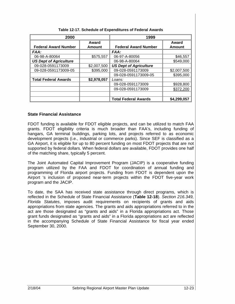
2/18/04 Sebring Regional Airport Master Plan Update 12-23
Table 12-17. Schedule of Expenditures of Federal Awards
2000 1999
Federal Award Number Award
Amount Federal Award Number Award
Amount FAA: FAA: 06-98-A-80064 $575,557 06-97-A-80056 $46,557 US Dept of Agriculture 06-98-A-80064 $549,000 09-028-0591173009 $2,007,500 US Dept of Agriculture 09-028-0591173009-05 $395,000 09-028-0591173009 $2,007,500 09-028-0591173009-05 $395,000 Total Federal Awards $2,978,057 Loans: 09-028-0591173009 $928,800 09-028-0591173009 $372,200 Total Federal Awards $4,299,057
State Financial Assistance FDOT funding is available for FDOT eligible projects, and can be utilized to match FAA grants. FDOT eligibility criteria is much broader than FAA’s, including funding of hangars, GA terminal buildings, parking lots, and projects referred to as economic development projects (i.e., industrial or commerce parks). Since SEF is classified as a GA Airport, it is eligible for up to 80 percent funding on most FDOT projects that are not supported by federal dollars. When federal dollars are available, FDOT provides one half of the matching share, typically 5 percent. The Joint Automated Capital Improvement Program (JACIP) is a cooperative funding program utilized by the FAA and FDOT for coordination of annual funding and programming of Florida airport projects. Funding from FDOT is dependent upon the Airport ‘s inclusion of proposed near-term projects within the FDOT five-year work program and the JACIP. To date, the SAA has received state assistance through direct programs, which is reflected in the Schedule of State Financial Assistance (Table 12-18). Section 216.349, Florida Statutes, imposes audit requirements on recipients of grants and aids appropriations from state agencies. The grants and aids appropriations referred to in the act are those designated as “grants and aids” in a Florida appropriations act. Those grant funds designated as “grants and aids” in a Florida appropriations act are reflected in the accompanying Schedule of State Financial Assistance for fiscal year ended September 30, 2000.
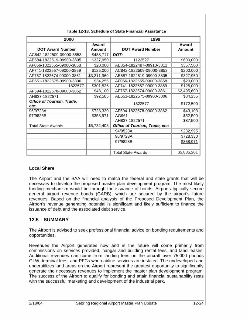
2/18/04 Sebring Regional Airport Master Plan Update 12-24
Table 12-18. Schedule of State Financial Assistance
2000 1999
DOT Award Number Award
Amount DOT Award Number Award
Amount AC842-1822509-09000-3853 $488,717 DOT: AE584-1822519-09900-3805 $327,950 1122527 $600,000 AF056-1822555-09000-3858 $20,000 AB854-1822487-09910-3811 $357,500 AF741-1822557-09000-3859 $125,000 AC842-1822509-09000-3853 $200,000 AF757-1822574-09000-3861 $3,211,969 AE587-1822519-09900-3805 $327,950 AE651-1822575-09900-3806 $34,255 AF056-1822555-09000-3858 $20,000
1822577 $301,526 AF741-1822557-09000-3859 $125,000 AF594-1822578-09000-3862 $43,100 AF757-1822574-09000-3861 $2,495,600 AH837-1822571 $92,585 AE651-1822575-09900-3806 $34,255 Office of Tourism, Trade, etc:
1822577 $172,500
96/9728A $728,330 AF594-1822578-09000-3862 $43,100 97/9828B $358,971 AG961 $52,500 AH837-1822571 $87,500 Total State Awards $5,732,403 Office of Tourism, Trade, etc: 94/9528A $232,995 96/9728A $728,330 97/9828B $358,971 Total State Awards $5,836,201 Local Share The Airport and the SAA will need to match the federal and state grants that will be necessary to develop the proposed master plan development program. The most likely funding mechanism would be through the issuance of bonds. Airports typically secure general airport revenue bonds (GARB), which are secured by the airport’s future revenues. Based on the financial analysis of the Proposed Development Plan, the Airport’s revenue generating potential is significant and likely sufficient to finance the issuance of debt and the associated debt service. 12.5 SUMMARY The Airport is advised to seek professional financial advice on bonding requirements and opportunities. Revenues the Airport generates now and in the future will come primarily from commissions on services provided, hangar and building rental fees, and land leases. Additional revenues can come from landing fees on the aircraft over 75,000 pounds GLW, terminal fees, and PFCs when airline services are instated. The undeveloped and underutilizes land areas on the Airport represent the greatest opportunity to significantly generate the necessary revenues to implement the master plan development program. The success of the Airport to qualify for bonding and attain financial sustainability rests with the successful marketing and development of the industrial park.

2/18/04 Sebring Regional Airport Master Plan Update 13-1
JOINT AUTOMATED CAPITAL IMPROVEMENT PLAN (JACIP) Sebring Regional Airport This section includes the Airport’s annually mandated Joint Automated Capital Improvement Plan (JACIP) for the years 2002-2008 as required by the Federal Aviation Administration (FAA) and Florida Department of Transportation (FDOT). It is the JACIP process that coordinates the programming and funding of airport projects statewide by the FAA and FDOT for the next five years. The updated JACIP contained herein reflects projects that were identified and prioritized by Sebring Airport Authority (SAA) without the benefit of this fully completed Master Plan document. Therefore, the priority of development identified in the JACIP does not exactly reflect what is contained within this Master Plan document for fiscal year 2002. However, the subsequent years (2003-2007) emulates the Master Plan’s development program, with few exceptions. Future annual updates to the JACIP can be adjusted to resolve any differences between the fiscal year 2002 JACIP and the 2000-2021 Airport Master Plan Update’s recommended development schedule. The development program discussed in Chapter 11, Construction Phasing and Capital Improvement Plan, and Chapter 12, Financial Feasibility, illustrates the development necessary for the Airport to meet its goal of becoming financially independent. The Master Plan’s recommended development program provides a balance between the need for increased revenues against the cost of development. Thus, the Master Plan’s development program presents a strategy for the Airport to follow to increase revenues in a timely manner by developing the large available land areas on-airport for leasing opportunities, while minimizing, to the extent possible, the high costs of development. The following pages represent the project reports printed from the JACIP program as updated in November 2002.
13

2/18/04 Sebring Regional Airport Master Plan Update 13-2
Table 13-1. JACIP
Year Project Description Amount
2002 Rehabilitation 18-36
This project entails crack repair, asphalt surface refurbishment, and re-marking of Runway 18-36. After crack repair, a Thermoplastic Coal Tar Emulsion Slurry Seal will be spread. After refurbishment is complete the
entire runway will be repainted with non-precision markings.
$ 350,000
2002 Phase III, Construction of Taxiway A
This project entails construction of the middle section of Full-Length Parallel Taxiway Alpha. Work includes: constructing 50' x 1600' of new pavement, installing
taxiway lighting, and placement of new airfield signage. Connecting Twy A3 will be reconstructed as well.
$ 948,350
2003 Security Enhancements per 9/11 To comply with pending GA security requirements forthcoming from FAA/TSA. $ 750,000
2003 Phase IV, Construction of Taxiway A
This project entails construction of the northern section of Full-length parallel Taxiway Alpha, and includes
constructing 50' x 1100' of new pavement, installing taxiway lighting, and placement of new airfield signage.
$ 875,000
2003 EA Extension 18/36 The project will access the environmental impact relating to the extension of Runway 18-36 and Taxiway Alpha. $ 200,000
2003 Corporate Aviation Area
This project will update and improve the area between or recent phase of T-hangars to the west, and the relocated
control tower to the east. The site will be permitted; demolition performed as required; and access road, parking, lighting, and signage constructed/installed.
$ 300,000

2/18/04 Sebring Regional Airport Master Plan Update 13-3
Table 13-1 (Continued). JACIP
2003 Wireless Broadband Infrastructure To provide infrastructure for implementation of affordable, easy access to broadband internet capability for the SAA
and Airport tenants. $ 300,000
2003 Implement GIS The benefits of a GIS application at SEF will be
recognized by all levels of management and the operating units within the SAA organization.
$ 418,700
2003 Relocate Fuel Farm
As identified is the existing and future master plan, the fuel farm has be designated for relocation, the appropriate new
location will be identified in the new master plan project. Project will also include a self-service fuel island as
identified in the past MPU.
$ 400,000
2003 Construct New GA Terminal Building Expand existing Sebring Airside Center. $ 142,500 2003 Master Plan Update $ 67,250 2003 Design and Rehabilitation of Building 60 $ 567,868
2004 Extension of Runway 18-36 This project includes the construction of a 1,776-foot
extension to the northern end of Runway 18-36, as well as widening the entire runway from 100 to 150 feet.
$ 1,500,000
2004 Commerce Park Taxiway This project will provide aviation access to new commerce park at SEF. The commerce park will provide both airside
and landside development areas. $ 1,275,000
2004 1,000 Acre Land Acquisition The SAA has an option on adjacent land allowing for
expansion of the airfield to allow for larger aircraft usage and mitigate noise.
$ 3,000,000
2004 Phase II Master Drainage Plan (Commerce Park)
This project will include the permit modification, design, and construction of a new stormwater system in support of
the new commerce park located between Runways 36 and 32. The park will have airfield access and drainage
and conveyance will be for a dry stormwater system.
$ 650,000

2/18/04 Sebring Regional Airport Master Plan Update 13-4
Table 13-1 (Continued). JACIP
2004 ARFF Building Construct ARFF building to meet Part 139 goal and to attract air carrier service. $ 2,000,000
2004 Access Road to Commercial Aviation Area
As identified in the 1994 Master Plan, the project will provide landside access to a planned commercial aviation development that will support many types of general and
commercial aviation uses.
$ 625,000
2004 Security Fencing This project will provide compliance with present and future airfield security and safety regulations. $ 465,000
2005 2.5 miles Airport Loop Road This project involves expanding the Airport Loop Road by
2.5 miles, thereby completing the roadway circulation system required for the raceway and new commerce park.
$ 3,437,000
2005 Land Acquisition and New Runway Study
This EA will provide a road map for compliance with all state and federal mandates, as well as local issues such
as noise and land use. $ 520,000
2005 Phase III Master Drainage-North 18/36
This project includes the expansion of the Phase I master system to support the continued growth identified in the
Master Plan Update. The project will include the recapture of pond 200 by filling, to enable the expansion of T-
hangars and commercial hangars.
$ 440,000
2005 Water/Wastewater Improvement Associated with Commerce Park
Located southeast of the Sebring International Raceway is approximately 100 acres of potential development area on
which the SAA has planned a commerce park and light industrial development. Based upon the water and
wastewater demands from the existing industrial park, it is projected that possible water and wastewater system
needs would be in the range of 30,000 gallons per day for water and 25,000 gallons per day for wastewater.
$ 2,200,000
2005 Commercial Hangar Design and construct new commercial hangar. $ 1,200,000

2/18/04 Sebring Regional Airport Master Plan Update 13-5
Table 13-1 (Continued). JACIP
2005 EA New Runway (14L-32R)
Based upon the justification of a new runway for noise mitigation and airfield capacity, this project will undertake
the necessary planning studies associated with a new runway.
$ 435,000
2005 Airfield Drainage Upgrades
Given the age of the drainage pipes, this project is for an evaluation of the existing Airport storm sewer drainage
system from the airside portion of the Airport to their respective outfall locations.
$ 400,000
2005 20 T-Hangar Development
The Airport has successfully implemented two phases of hangar development, which are full and providing revenue while increasing the number of based aircraft. The project
would also construct a self-service plane wash and vacuum facility that would be integrated into the complex.
$ 1,250,000
2006 Land Acquisition (Davis Property) This project would assist in acquiring property directly northeast and contiguous to SEF's current boundaries.
This property is under a binding option to the SAA. $ 2,500,000
2006 Airport Zoning Study
This project will undertake an aggressive zoning and land use planning that will include updating the current
ordinance to meet state requirements and address local issues.
$ 150,000
2006 Building 60 Roof Repairs Replace existing roof on Building 60. $ 100,000 2006 Commercial Hangar Development Commercial aviation development. $ 400,000
2006 Land Acquisition (South of South Access Road)
This project will allow the acquisition of a number of lots directly south and contiguous to SEF's boundaries. This purchase would provide a buffer between the Airport and
the residential communities in the area.
$ 1,435,000

2/18/04 Sebring Regional Airport Master Plan Update 13-6
Table 13-1 (Continued). JACIP
2007 Construct Commercial Runway, Taxiways and Apron - Phase I
This project consists of design and implementation of new commercial runway, taxiways, and aprons. $10,000,000
2007 Airport Land Acquisition (20 Acres Reimbursement)
Airport land acquisition for reimbursement for property purchased along Airport Road (20 acres) per JPA. $ 83,222
2007 Rail Spur Extension to Expanded Industrial Park
Rail extension to land acquisition to increase marketability to new area of industrial park. $ 1,500,000
2007 Construct Commercial Runway, Taxiways and Apron - Phase II
Phase II development of commercial runway and associated infrastructure. $20,000,000
2007 Construct Commercial Runway, Taxiways and Apron - Phase III Implementation of new runway and facilities. $ 1,800,000
2007 Wastewater Design/Construction - South Side Expansion
Based on planned development and water and wastewater demands from the existing industrial park, it is projected that possible water and wastewater needs would
be in the range of 100,000 gpd for water and 90,000 for wastewater. Implementation of the planned development will necessitate expansion of the wastewater treatment and effluent disposal system. The existing wastewater plant was planned to be doubled in capacity from the
existing 90,000 gpd to 180,000 gpd.
$ 3,400,000
2007 Water Improvements - South Side Expansion
This project includes rehabilitation of the potable water distribution associated with the 200-acre development
area to the south of the Sebring International Raceway. $ 2,100,000

2/18/04 Sebring Regional Airport Master Plan Update 13-7
Table 13-1 (Continued). JACIP
2008 Design/Construct Taxiway East of Runway 18/36
This project entails construction of a parallel taxiway serving future aviation related development on the
southeastern side of Runway 18-36. This work includes constructing 15,000 sq yd of new pavement, installing
taxiway lighting, and placement of new airfield signage.
$ 1,275,000
2008 Water/Wastewater Improvement Associated with Industrial Park
Development of the 1,000 acres parcel to the east of the existing Airport property line. Based on the configuration
of water and wastewater demands from the existing industrial park, it is projected that up to 600 acres of developable acres would be available and water and wastewater system needs could be 300,000 gpd and
270,000 gpd, respectively. Due to the present location of existing water and wastewater infrastructure, it is likely
that an independent water and wastewater system will be required.
$ 8,600,000
Note: GA – general aviation TSA – Transportation Security Administration GIS – geographic information system SEF – Sebring Regional Airport MPU – Master Plan Update ARFF – aircraft rescue and fire fighting EA – environmental assessment JPA – joint participation agreements GPD – gallons per day

REFERENCES
2/18/04 Sebring Regional Airport Master Plan Update R-1
1. http://www.sebring-airport.com .........................................................................................2-2
2. http://www.sebring-airport.com .........................................................................................2-3
3. www.weather.com ............................................................................................................2-4
4. FAA AC 150/5300-13, Change 6 ....................................................................................2-10
5. http://www.highlandsedc.com .........................................................................................2-37
6. http://sebring-airport.com................................................................................................2-37
7. http://sebring-airport.com................................................................................................2-39
8. Source: Tenant Surveys and Site Visit............................................................................2-39
9. Miami ARTCC Website...................................................................................................2-50
10. http://www.faa.gov/ats/zmaartc/intro.htm ........................................................................2-50
11. http://www.sfcc.cc.fl.us .....................................................................................................3-7
12. http://www.highlandsedc.com ...........................................................................................3-8
13. http://www.sebringflchamber.com...................................................................................3-13
14. Avon Park Air Force Range, Year 2000 Economic Impact Analysis................................3-14
15. Avon Park Air Force Range, Year 2000 Economic Impact Analysis................................3-14
16. Avon Park Air Force Range, Year 2000 Economic Impact Analysis................................3-14
17. http://www.highlandsedc.com .........................................................................................3-16
18. www.highlandsedc.com..................................................................................................3-16
19. FAA Aerospace Forecasts, Executive Summary, Fiscal Years 2002-2013 .......................5-3
20. Basic Business Statistics, Concepts and Applications, p. 25 ............................................5-8
21. FAA Aerospace Forecasts – Fiscal Years 2002-2013.....................................................5-40
22. FAA AC 150/5060, Figure 2-1, “Capacity and ASV for Long Range Planning.................6-19
23. Miami Aeronautical Sectional Chart, November 2002.....................................................8-20
24. Airport Environmental Handbook, Order 5050.4A, p. 35 .................................................9-26
25. www.sebring-airport.com................................................................................................12-2

2/18/04 Sebring Regional Airport Master Plan Update A-1
APPENDIX A

Breakdown of Development Costs
2002 2003 2004 2005 2006 2007 2008 2009 2010 2011 2012 2013 2014 2015 2016 2017 2018 2019 2020 2021Total Development Cost JACIP Projects (2001-2008) 1,298,350$ 3,954,068$ 9,515,000$ 9,882,000$ 4,585,000$ 18,518,222$ 28,600,000$ 1,275,000$ -$ Planning -$ 95,000$ -$ -$ -$ 60,000$ 80,000$ -$
0.3 Engineering,Fees and Contingencies -$ 4,100,700$ 13,799,967$ 3,194,340$ 240,000$ 3,497,167$ 2,019,492$ 14,720,793$ 11,148,090$ 6,388,650$ 6,159,600$ 900,000$ 2,475,000$ 8,271,000$ 2,765,900$ 1,146,667$ 611,833$ 1,270,833$ 22,700$ 18,000$ Land Acquisition -$ -$ -$ -$ -$ 2,595,000$ -$ Construction -$ 13,669,000$ 45,999,889$ 10,647,800$ 800,000$ 11,657,222$ 6,731,639$ 49,069,311$ 37,160,300$ 21,295,500$ 20,532,000$ 3,000,000$ 8,250,000$ 27,570,000$ 9,219,667$ 3,822,222$ 2,039,444$ 4,236,111$ 75,667$ 60,000$
Subtotal 1,298,350$ 21,818,768$ 69,314,856$ 23,724,140$ 5,625,000$ 33,732,611$ 37,351,131$ 67,740,104$ 48,308,390$ 27,684,150$ 26,691,600$ 3,900,000$ 10,725,000$ 35,841,000$ 11,985,567$ 4,968,889$ 2,651,278$ 5,506,944$ 98,367$ 78,000$ 0.0566 Interest on Capital @ 5% 73,487$ 1,234,942$ 3,923,221$ 1,342,786$ 318,375$ 1,909,266$ 2,114,074$ 3,834,090$ 2,734,255$ 1,566,923$ 1,510,745$ 220,740$ 607,035$ 2,028,601$ 678,383$ 281,239$ 150,062$ 311,693$ 5,568$ 4,415$
Total Development Cost 1,371,837$ 23,053,710$ 73,238,076$ 25,066,926$ 5,943,375$ 35,641,877$ 39,465,205$ 71,574,194$ 51,042,645$ 29,251,073$ 28,202,345$ 4,120,740$ 11,332,035$ 37,869,601$ 12,663,950$ 5,250,128$ 2,801,340$ 5,818,638$ 103,934$ 82,415$
Total Local Development Cost JACIP Projects (2001-2008) 64,918$ 761,382$ 1,436,750$ 1,916,056$ 1,550,934$ 2,707,806$ 2,720,000$ 2,783,750$ -$ -$ -$ -$ -$ -$ -$ -$ -$ -$ -$ -$ Planning -$ 4,750$ -$ -$ -$ 3,000$ -$ 4,000$ -$ -$ -$ -$ -$ -$ -$ -$ -$ -$ -$ -$
0.3 Engineering,Fees and Contingencies -$ 432,285$ 1,189,798$ 219,599$ 48,000$ 575,683$ 220,996$ 272,198$ 1,011,365$ 341,625$ 119,130$ 45,000$ 123,750$ 211,050$ 138,295$ -$ 22,500$ 6,667$ 5,350$ 900$ Land Acquisition -$ -$ -$ -$ -$ -$ -$ 519,000$ -$ -$ -$ -$ -$ -$ -$ -$ -$ -$ -$ -$ Construction -$ 1,440,950$ 3,965,994$ 731,995$ 160,000$ 1,918,944$ 736,653$ 907,325$ 3,371,215$ 1,138,750$ 397,100$ 150,000$ 412,500$ 703,500$ 460,983$ -$ 75,000$ 22,222$ 17,833$ 3,000$
Subtotal 64,918$ 2,639,367$ 6,592,543$ 2,867,650$ 1,758,934$ 5,205,433$ 3,677,649$ 4,486,273$ 4,382,580$ 1,480,375$ 516,230$ 195,000$ 536,250$ 914,550$ 599,278$ -$ 97,500$ 28,889$ 23,183$ 3,900$ 0.0566 Interest on Capital @ 5% 3,674$ 149,388$ 373,138$ 162,309$ 99,556$ 294,628$ 208,155$ 253,923$ 248,054$ 83,789$ 29,219$ 11,037$ 30,352$ 51,764$ 33,919$ -$ 5,519$ 1,635$ 1,312$ 221$
Total Local Development Cost 68,592$ 2,788,755$ 6,965,681$ 3,029,959$ 1,858,490$ 5,500,061$ 3,885,804$ 4,740,196$ 4,630,633$ 1,564,164$ 545,449$ 206,037$ 566,602$ 966,314$ 633,197$ -$ 103,019$ 30,524$ 24,496$ 4,121$


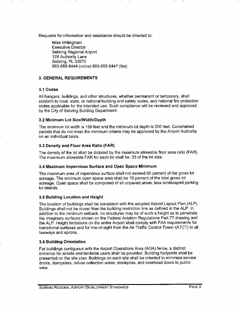


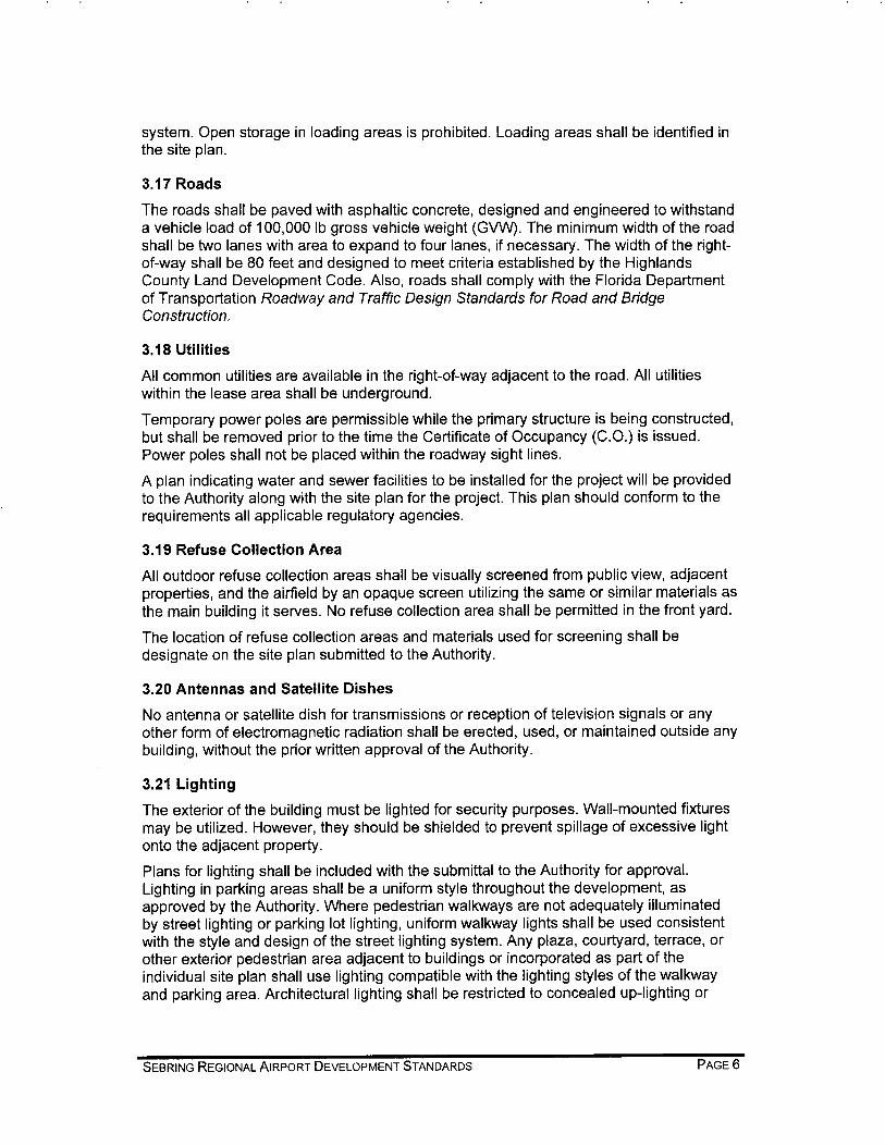


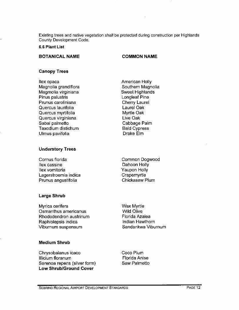


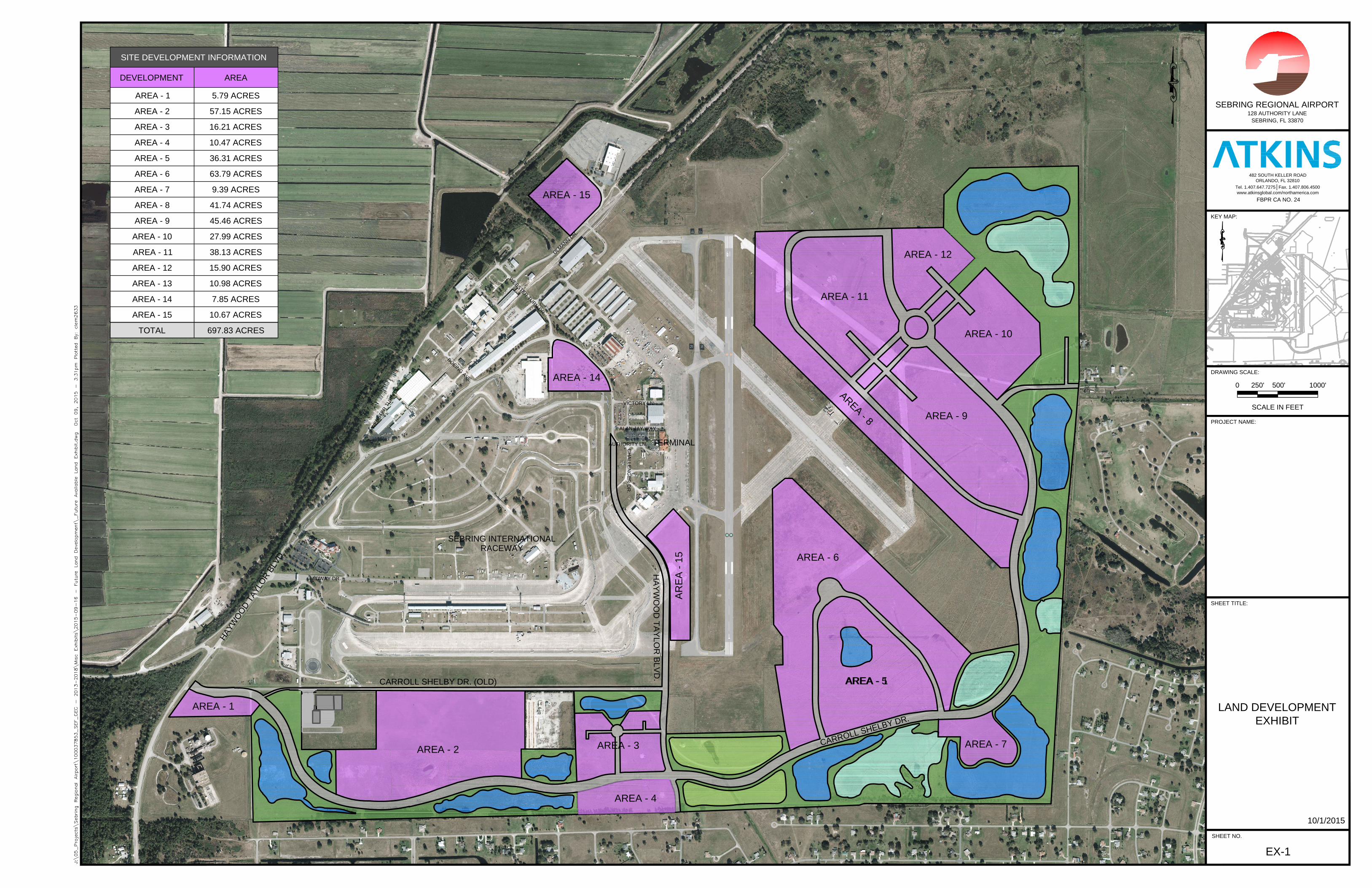
AREA - 14
AREA - 15
AREA - 1
AREA - 2
AREA - 3
AREA - 4
AREA - 1
A
R
E
A
-
8
AREA - 9
AREA - 10
AREA - 12
AREA - 11
AREA - 7
AREA - 5
AREA - 6
AR
EA
- 15
SEBRING REGIONAL AIRPORT
128 AUTHORITY LANE
SEBRING, FL 33870
PROPOSED
RANS HANGAR
FBPR CA NO. 24
482 SOUTH KELLER ROAD
ORLANDO, FL 32810
Tel. 1.407.647.7275│Fax. 1.407.806.4500
www.atkinsglobal.com/northamerica.com
SHEET NO.
SHEET TITLE:
PROJECT NAME:
KEY MAP:
DRAWING SCALE:
LAND DEVELOPMENT
EXHIBIT
EX-1
SCALE IN FEET
1000'500'250'0
CARROLL SHELBY DR. (OLD)
H
A
Y
W
O
O
D
T
A
Y
L
O
R
B
L
V
D
.
HA
YW
OO
D T
AY
LO
R B
LV
D.
SEBRING INTERNATIONAL
RACEWAY
TERMINAL
SITE DEVELOPMENT INFORMATION
DEVELOPMENT AREA
5.79 ACRESAREA - 1
57.15 ACRESAREA - 2
16.21 ACRESAREA - 3
697.83 ACRESTOTAL
C
A
R
R
O
L
L
S
H
E
L
B
Y
D
R
.
10.47 ACRESAREA - 4
36.31 ACRESAREA - 5
63.79 ACRESAREA - 6
9.39 ACRESAREA - 7
41.74 ACRESAREA - 8
45.46 ACRESAREA - 9
27.99 ACRESAREA - 10
38.13 ACRESAREA - 11
15.90 ACRESAREA - 12
10.98 ACRESAREA - 13
7.85 ACRESAREA - 14
10.67 ACRESAREA - 15
VICTORY LN.
ALAN JAY WAY
CH
ALLE
NG
ER
D
R.
W
E
B
S
T
E
R
T
U
R
N
D
R
.
U
L
M
A
N
N
D
R
.
B
O
E
I
N
G
A
V
E
.
W
E
B
S
T
E
R
T
U
R
N
D
R
.
MIDWAY DR.
AUTHORITY LN.
10/1/2015


Highlands County Code of Ordinances
Land Development Regulations
Section 12.05.283. A-1 airport district. A. Intent. The A-1, airport district, is designed to accommodate airport uses which
involve certain influences and hazards, but which are essential for the economic viability of the area. This district is designed to protect adjacent residential areas while at the same time ensuring adequate areas for airport and economic development activities. This district is designed to provide adequate space in appropriate locations for uses that serve economic development and the needs of the motoring and aviation related public. The A-1, airport district, should serve the major transportation interchanges of vehicle, rail and air transportation.
B. Permitted principal uses and structures. In the A-1, airport district, the
following uses and their accessory uses are permitted, unless prohibited in subsection E. below:
1. At any location within the district that is not within 500 feet of a
residentially zoned property or recreation or drainage facilities that are a part of that residential development:
a. Any use permitted in the I-2 industrial district;
b. Any use permitted in the B-3 business district;
c. Any use permitted in the BC-2 business campus, research, and
light manufacturing park district;
d. Any use permitted in the CG-1 campground district;
e. Airports and aviation related uses;
f. Automobile raceways;
g. Cultural and recreational services;
h. Transient habitation; hotels and motels;
i. Motor vehicle rentals;
j. Food and beverage services;
k. Food service; takeout; and

l. Public transport, communication, and utility services.
2. At any location:
a. Any use permitted in the O office district;
b. Any use permitted in the B-1 neighborhood business district;
c. Government administrative services;
d. Automotive parking; and
e. Mixed use transit residential development, otherwise known as
hangar homes. C. Permitted uses as special exceptions. Reserved. D. Signs. No signs intended to be read from off the premises, except:
1. Signs as permitted in B-2
2. Temporary construction sign: Same as for R-3. E. Prohibited uses.
1. Uses not specifically permitted.
2. Sexually oriented businesses.
3. Rifle range.
4. Animal slaughterhouse or abattoir; asphalt manufacture or refining; paving plant; corrosive acid manufacture including hydrochloric, nitric, sulphurous and sulfuric acids; bone distillation; blast furnace; creosote manufacture or treatment; coke oven; distillation of coal tar, petroleum, refuse, grain of wood; drilling, production or refining of petroleum or inflammable liquids; fat rendering; fertilizer manufacture, except the cold compounding of non-odorous materials foundry; gunpowder, manufacture or storage of fireworks or other explosives, except as incidental to a permitted use; incineration, reduction or storage of garbage, offal, dead animals (not including the Highlands County Animal Control Department), refuse, rancid fats; glue size or gelatin manufacture, where the processes used include the refining or recovering of products from fish, animal refuse or offal (not including the tanning of animal hides); house wrecking yards, used building material yards; junkyards,

automobile wrecking yards; salvage yard; paper and pulp mills; pyroxylin and pyroxylin product manufacture; rubber manufacture from raw materials; smelting or refining of metals ores; steel manufacture by Bessemer, open hearth or other process; steel mills, rolling mills, blooming mills; stock yards or feeding pens; tallow, grease or lard manufacture or refining from animal fat; extraction of animal, vegetable or fish fat and oils; poisons, poison gases; acids, batteries.
5. Landfill.
6. Store, recycle, or mulch, soil, sand, muck and natural vegetative material.
7. Correctional or penal institution.
F. Buffer. Where a use is established in a portion of an A-1 zoned district, which
abuts property that is zoned residential, the airport or other developer of said use shall provide a transitional protective yard Type A, pursuant to the requirements of Article 11 of Chapter 12 of the land development regulations.
G. Height limits. All structures, including towers, are not to exceed the height
requirements established by the FAA for land side improvements. All airspace management and approach procedures are to take precedence in setting height limitations on all structures. When adjacent to residential uses, towers are not to be located any closer than 500 feet.
(Ord. No. 05-06-05)
The code may be found in its entirety on line at hcbcc.net – choose: Development Services – choose: Chapter 12 Land Development Regulations. Highlands County Zoning Department, 501 S. Commerce, Sebring, FL 33870, 863-402-6638/6640.


8" WM
8" WM
8" TEC
O W.W
.
MH
MH MH
MHMH
4"
4 "
4 "
4 "
4 "
4 "
4 "
0
150
300
75
10" P
VC WM
8" TECO W.W.
8" TEC
O W.W
.
8" TECO W.W.
10" P
VC WM
8" WM
2" PVC WM
10" WM12" WM
8" WM
12" WM
12" WM
12" WM
12" WM
12" WM
12" WM
12" WM
8" PW 8" PW
8" PW
16" WM
12" WM
16" WM
12" WM
12" WM
12" WM
12" WM
12" WM
12" WM
12" WM 1"
WM
12" WM
CATVUNDERGROUND
VAULT
8" WM FH
6" WM
6" WM
6" WM
1.5" WM
12" WM
12" WM
12" WM
12" WM
8" WM
12" WM
2" W
M8" FIRE
LINE
BK FL
PREV
12" WM
12" WM
12" WM
12" WM
10" WM 10"
WM
10" WM
10" WM
10" WM
8" WM
12"
12"
12" WM
2" WM
2" WM
6" WM
6" WM
12" WM
12" WM
6"WM
12" WM 12" WM
8"
10"12"
12"
2" WATER LINE
2" WATER LINE
2" WATER LINE
2" WATER LINE
8" WM
8" WM
8" WM
8" W
M8" W
M
8" W
M
12" WM
12" WM
12" WM
12" WM
12" WM
2" WM 2" WM
8" WM
1" WM
12" WM
16" WM
8" WM8" WM8" WM8" WM
8" W
M8" WM
8" WM
8" WM
6" FM
6" FM
6" FM
6" FM
8" TEC
O W.W
.
6" FM
6" FM
6" FM
6" FM
4" FM
4" FM
6" FM
4" FM
6" FM
4" FM
6" FM
10" SAN
8" SAN
8" SAN
REPLACE
520 LF OF 8
" S.S.
10" SAN
6" SAN
10" SAN
12" SAN
12" SAN
8" SAN
12" SAN
6" FM SAN 6" FM SAN
6" FM
SAN6" FM SAN
6" FM SAN
6" FM SAN
6" FM
6" FM
8" SAN
6" SAN
SAN MH
SAN MH
6" SAN
8" SAN8" SAN
8" SAN
8" SAN
8" SAN
6" SAN
8" SAN
8" SAN
6" SAN
8" SAN
8" SAN
8" SAN
8" S AN
8" SAN
8" SAN
8" SAN
8" SAN
8" SAN
8" SAN
6" WM
3" HDPE WM
2" SCH 80 PVC WM
8" W
M
8" W
M1 1/2" INS
IDE 8" LIN
E
8" SAN
8" SAN
4" FM
4" FM
4" FM
8" SAN
8" SAN
8" SAN
8" SAN
8" SAN
8" SAN
2" WM
8" W
M8" SAN 8" SAN
8" SAN
8" WM
8" WM 8" WM
2" WM
8" WM
8" WM
8" WM
8" WM
8" SAN
8" SAN
8" SAN
8" SAN
4" FM4" FM
8" SAN
8" SAN
8" SAN 8" SAN 8" SAN 8" SAN 8" SAN 8" SAN 8" SAN12" WM
8" WM
8" WM
8" WM
8" WM
8" WM
8" WM
TELE
TELE
TELE
TELE
6" PVC
IRR6" PVC IRR
TECO LINE
4" SAN
4" SAN
4" SAN
6" SAN
12" WM
12" WM
2" FM2" W
M
4" PVC SAN
6" WM
12" WM
5/8"5/8"
8" PVC
6" PVC
2" FM
2" FM
INSTALLED
W/4" C
ASING
8" SAN
8" SAN
8" WM8" WM
4" SAN
12" SAN
ABANDONED
LIFT S
TATION
2" GM
2" GM
6" GM
6" GM
6" GM
1" GM
6" GM
6" GM
6" GM
6" GM
6" GM
6" GM
6" GM
6" GM
6" GM
FIBER OPTICGLOBAL STARLINES NOT VERIFIED
2" GM
BK FLPREV
FIBER OPTICGLOBAL STARLINES NOT VERIFIED
6" GM
2" GM
2" GM
2" GM
2" GM
2" GM
6" GM4" GM
4" GM
4" GM
2" GM
EXISTING SEWERLEGEND
SEWER ABANDONED (OR REMOVED)EXISTING WATER
WATER ABANDONED (OR REMOVED)
GAS (TO BE ADDED)ELECTRIC (TO BE ADDED)BURIED TELEPHONE (PARTIALLY KNOWN)
SPRAY FIELD LINEPUMP STATIONGRINDER PUMP
SOME BASED ON 1958 SKETCHGLOBAL STAR FIBER OPTICS
Source: Esri, DigitalGlobe, GeoEye, Earthstar Geographics, CNES/Airbus DS, USDA, USGS, AEX, Getmapping, Aerogrid, IGN, IGP, swisstopo, and the GIS User Community
¹0 1,200 2,400600
Feet
wawr2620
Line
wawr2620
Line
wawr2620
Text Box
STORMWATER INLETS & PIPES
wawr2620
Text Box
EXHIBIT PLOTTED 9-2015
Related Documents