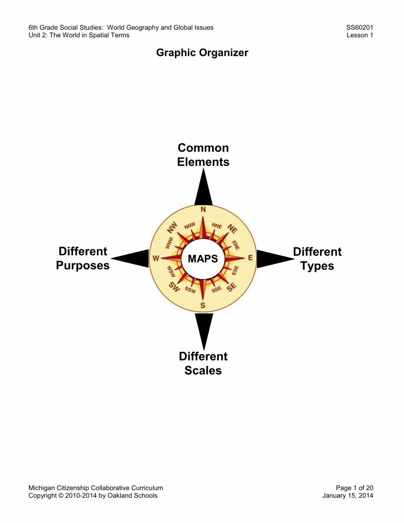
6th Grade Social Studies: World Geography and Global Issues SS60201 Unit 2: The World in Spatial Terms Lesson 1 Michigan Citizenship Collaborative Curriculum Page 1 of 20 Copyright © 2010-2014 by Oakland Schools January 15, 2014 Graphic Organizer MAPS Common Elements Different Scales Different Purposes Different Types

Welcome message from author
This document is posted to help you gain knowledge. Please leave a comment to let me know what you think about it! Share it to your friends and learn new things together.
Transcript
6th Grade Social Studies: World Geography and Global Issues SS60201 Unit 2: The World in Spatial Terms Lesson 1
Michigan Citizenship Collaborative Curriculum Page 1 of 20 Copyright © 2010-2014 by Oakland Schools January 15, 2014
Graphic Organizer
MAPS
Common Elements
Different Scales
Different Purposes
Different Types
6th Grade Social Studies: World Geography and Global Issues SS60201 Unit 2: The World in Spatial Terms Lesson 1
Michigan Citizenship Collaborative Curriculum Page 2 of 20 Copyright © 2010-2014 by Oakland Schools January 15, 2014
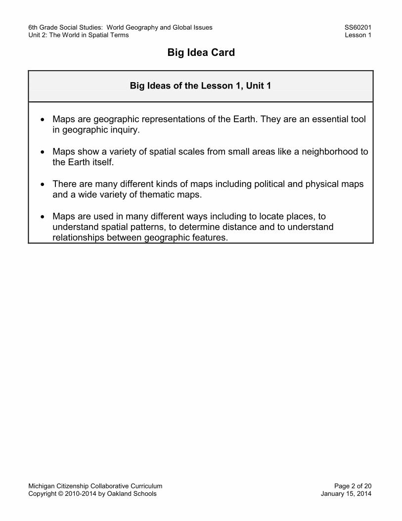
Big Idea Card
Big Ideas of the Lesson 1, Unit 1
x Maps are geographic representations of the Earth. They are an essential tool
in geographic inquiry. x Maps show a variety of spatial scales from small areas like a neighborhood to
the Earth itself. x There are many different kinds of maps including political and physical maps
and a wide variety of thematic maps.
x Maps are used in many different ways including to locate places, to understand spatial patterns, to determine distance and to understand relationships between geographic features.
6th Grade Social Studies: World Geography and Global Issues SS60201 Unit 2: The World in Spatial Terms Lesson 1
Michigan Citizenship Collaborative Curriculum Page 3 of 20 Copyright © 2010-2014 by Oakland Schools January 15, 2014
Word Cards
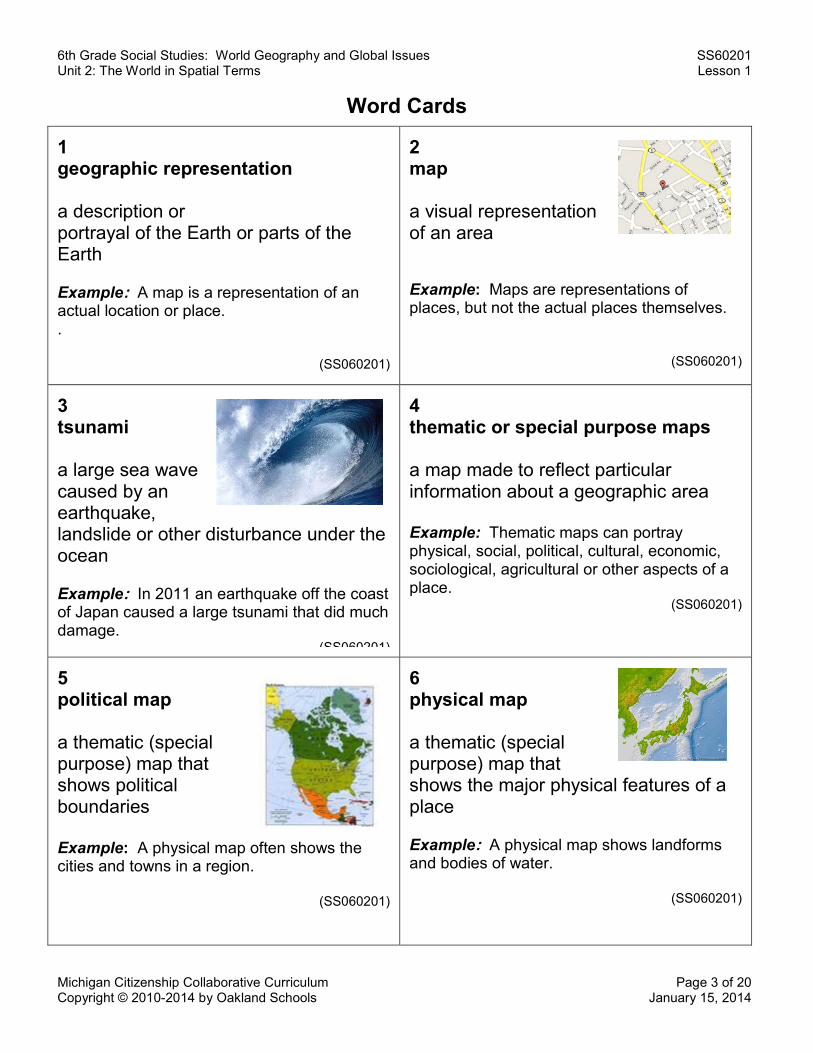
1 geographic representation
a description or portrayal of the Earth or parts of the Earth
Example: A map is a representation of an actual location or place. .
(SS060201)
2 map
a visual representation of an area Example: Maps are representations of places, but not the actual places themselves.
(SS060201)
3 tsunami
a large sea wave caused by an earthquake, landslide or other disturbance under the ocean
Example: In 2011 an earthquake off the coast of Japan caused a large tsunami that did much damage.
(SS060201)
4 thematic or special purpose maps
a map made to reflect particular information about a geographic area Example: Thematic maps can portray physical, social, political, cultural, economic, sociological, agricultural or other aspects of a place.
(SS060201)
5 political map a thematic (special purpose) map that shows political boundaries Example: A physical map often shows the cities and towns in a region.
(SS060201)
6 physical map a thematic (special purpose) map that shows the major physical features of a place
Example: A physical map shows landforms and bodies of water.
(SS060201)
6th Grade Social Studies: World Geography and Global Issues SS60201 Unit 2: The World in Spatial Terms Lesson 1
Michigan Citizenship Collaborative Curriculum Page 4 of 20 Copyright © 2010-2014 by Oakland Schools January 15, 2014
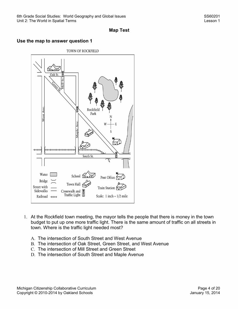
Map Test
Use the map to answer question 1
1. At the Rockfield town meeting, the mayor tells the people that there is money in the town budget to put up one more traffic light. There is the same amount of traffic on all streets in town. Where is the traffic light needed most?
A. The intersection of South Street and West Avenue B. The intersection of Oak Street, Green Street, and West Avenue C. The intersection of Mill Street and Green Street D. The intersection of South Street and Maple Avenue
6th Grade Social Studies: World Geography and Global Issues SS60201 Unit 2: The World in Spatial Terms Lesson 1
Michigan Citizenship Collaborative Curriculum Page 5 of 20 Copyright © 2010-2014 by Oakland Schools January 15, 2014
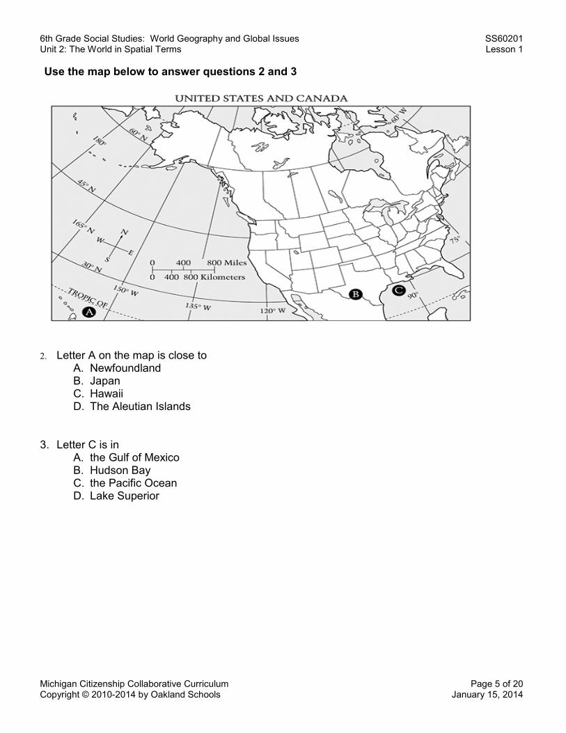
Use the map below to answer questions 2 and 3
2. Letter A on the map is close to A. Newfoundland B. Japan C. Hawaii D. The Aleutian Islands
3. Letter C is in A. the Gulf of Mexico B. Hudson Bay C. the Pacific Ocean D. Lake Superior
6th Grade Social Studies: World Geography and Global Issues SS60201 Unit 2: The World in Spatial Terms Lesson 1
Michigan Citizenship Collaborative Curriculum Page 6 of 20 Copyright © 2010-2014 by Oakland Schools January 15, 2014
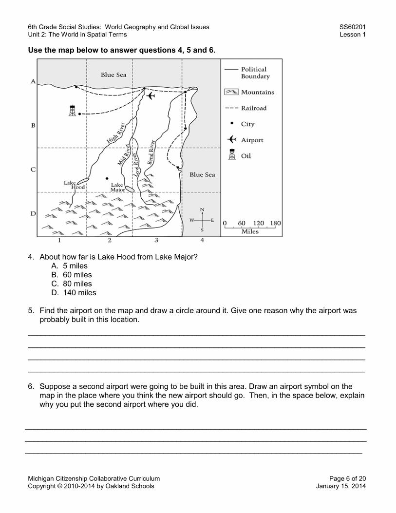
Use the map below to answer questions 4, 5 and 6.
4. About how far is Lake Hood from Lake Major?
A. 5 miles B. 60 miles C. 80 miles D. 140 miles
5. Find the airport on the map and draw a circle around it. Give one reason why the airport was probably built in this location.
______________________________________________________________________________ ______________________________________________________________________________ ______________________________________________________________________________ ______________________________________________________________________________
6. Suppose a second airport were going to be built in this area. Draw an airport symbol on the
map in the place where you think the new airport should go. Then, in the space below, explain why you put the second airport where you did.
_______________________________________________________________________________ _______________________________________________________________________________ ______________________________________________________________________________
6th Grade Social Studies: World Geography and Global Issues SS60201 Unit 2: The World in Spatial Terms Lesson 1
Michigan Citizenship Collaborative Curriculum Page 7 of 20 Copyright © 2010-2014 by Oakland Schools January 15, 2014
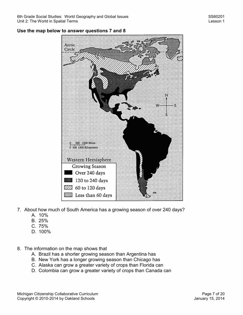
Use the map below to answer questions 7 and 8
7. About how much of South America has a growing season of over 240 days?
A. 10% B. 25% C. 75% D. 100%
8. The information on the map shows that A. Brazil has a shorter growing season than Argentina has B. New York has a longer growing season than Chicago has C. Alaska can grow a greater variety of crops than Florida can D. Colombia can grow a greater variety of crops than Canada can
6th Grade Social Studies: World Geography and Global Issues SS60201 Unit 2: The World in Spatial Terms Lesson 1
Michigan Citizenship Collaborative Curriculum Page 8 of 20 Copyright © 2010-2014 by Oakland Schools January 15, 2014
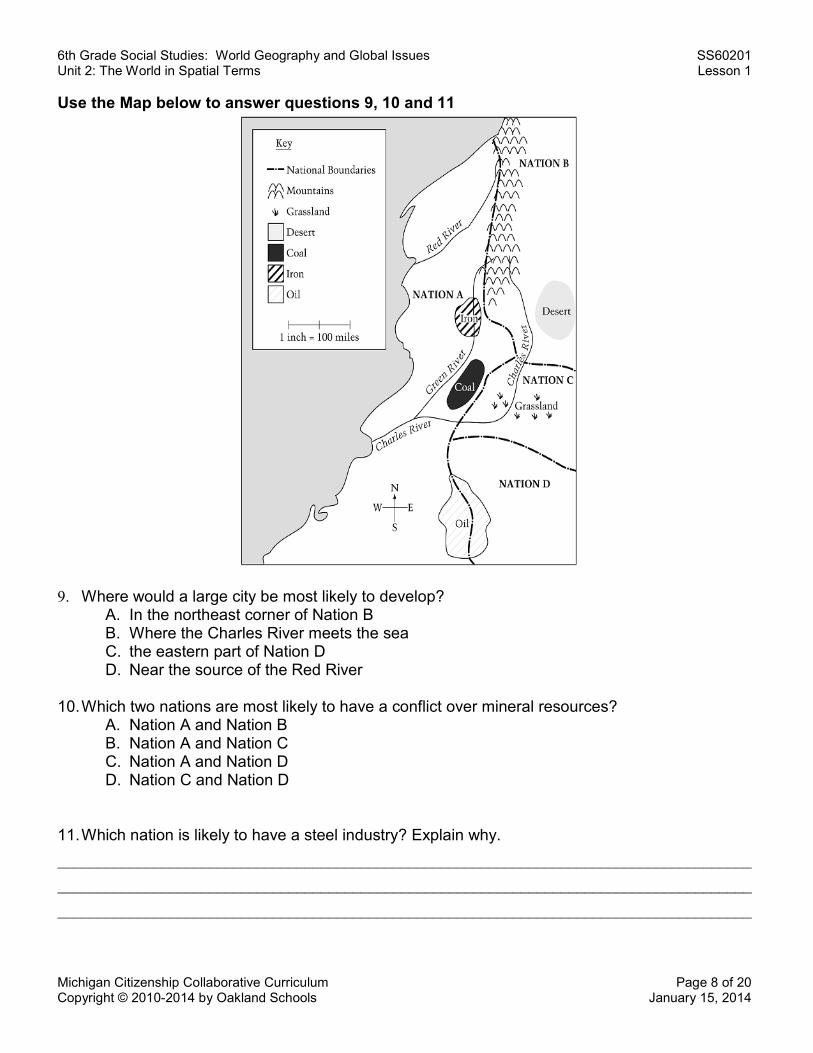
Use the Map below to answer questions 9, 10 and 11
9. Where would a large city be most likely to develop?
A. In the northeast corner of Nation B B. Where the Charles River meets the sea C. the eastern part of Nation D D. Near the source of the Red River
10. Which two nations are most likely to have a conflict over mineral resources?
A. Nation A and Nation B B. Nation A and Nation C C. Nation A and Nation D D. Nation C and Nation D
11. Which nation is likely to have a steel industry? Explain why. _______________________________________________________________________________________ _______________________________________________________________________________________ _______________________________________________________________________________________
6th Grade Social Studies: World Geography and Global Issues SS60201 Unit 2: The World in Spatial Terms Lesson 1
Michigan Citizenship Collaborative Curriculum Page 9 of 20 Copyright © 2010-2014 by Oakland Schools January 15, 2014
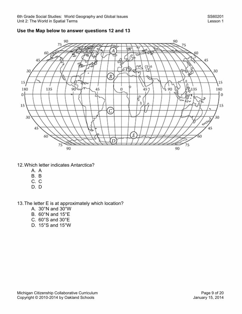
Use the Map below to answer questions 12 and 13
12. Which letter indicates Antarctica? A. A B. B C. C D. D
13. The letter E is at approximately which location? A. 30°N and 30°W B. 60°N and 15°E C. 60°S and 30°E D. 15°S and 15°W
6th Grade Social Studies: World Geography and Global Issues SS60201 Unit 2: The World in Spatial Terms Lesson 1
Michigan Citizenship Collaborative Curriculum Page 10 of 20 Copyright © 2010-2014 by Oakland Schools January 15, 2014
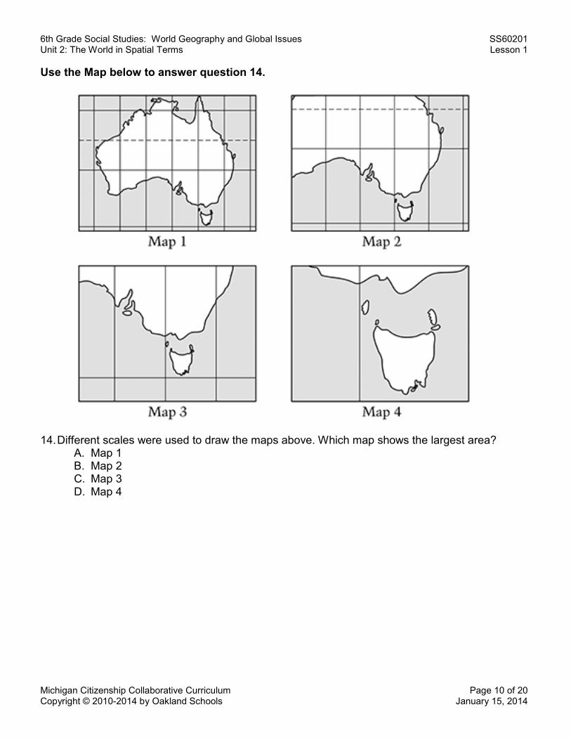
Use the Map below to answer question 14.
14. Different scales were used to draw the maps above. Which map shows the largest area? A. Map 1 B. Map 2 C. Map 3 D. Map 4
6th Grade Social Studies: World Geography and Global Issues SS60201 Unit 2: The World in Spatial Terms Lesson 1
Michigan Citizenship Collaborative Curriculum Page 11 of 20 Copyright © 2010-2014 by Oakland Schools January 15, 2014
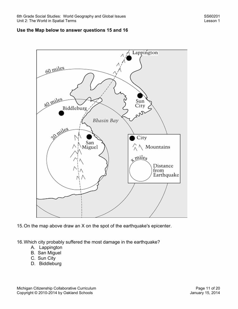
Use the Map below to answer questions 15 and 16
15. On the map above draw an X on the spot of the earthquake's epicenter.
16. Which city probably suffered the most damage in the earthquake?
A. Lappington B. San Miguel C. Sun City D. Biddleburg
6th Grade Social Studies: World Geography and Global Issues SS60201 Unit 2: The World in Spatial Terms Lesson 1
Michigan Citizenship Collaborative Curriculum Page 12 of 20 Copyright © 2010-2014 by Oakland Schools January 15, 2014
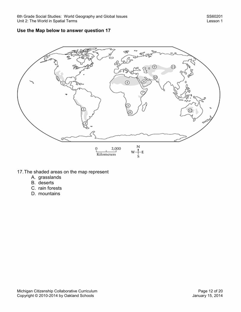
Use the Map below to answer question 17
17. The shaded areas on the map represent
A. grasslands B. deserts C. rain forests D. mountains
6th Grade Social Studies: World Geography and Global Issues SS60201 Unit 2: The World in Spatial Terms Lesson 1
Michigan Citizenship Collaborative Curriculum Page 13 of 20 Copyright © 2010-2014 by Oakland Schools January 15, 2014
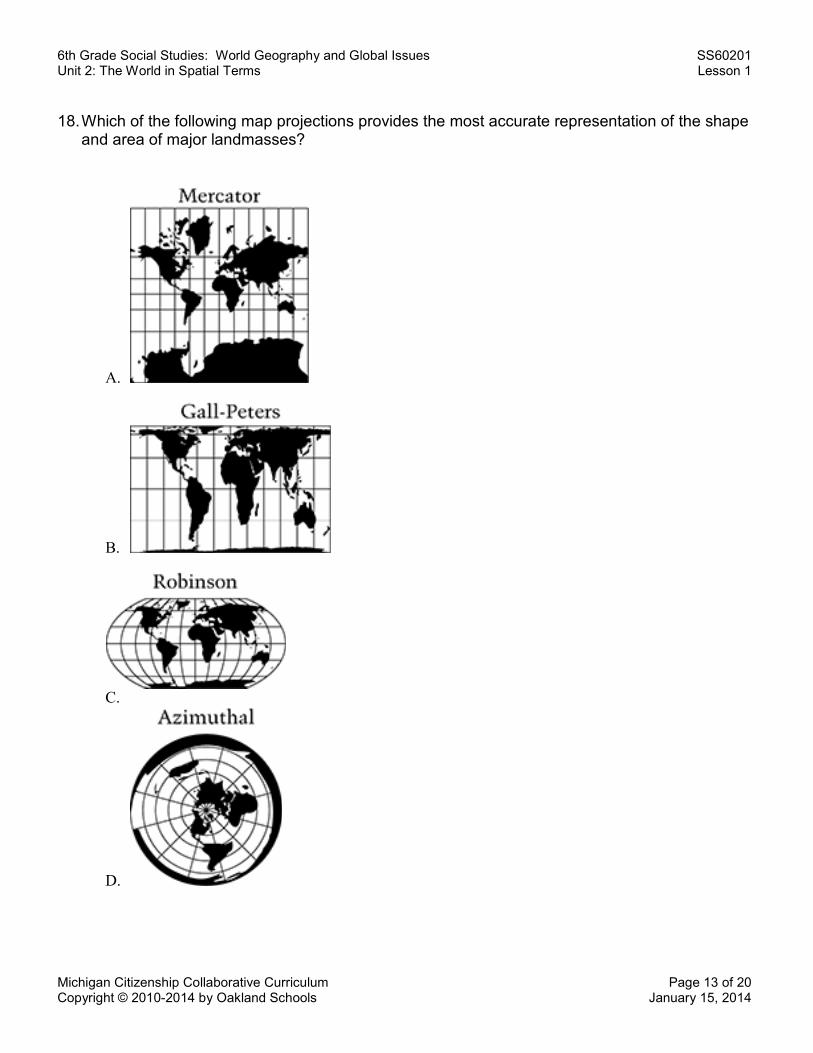
18. Which of the following map projections provides the most accurate representation of the shape
and area of major landmasses?
A.
B.
C.
D.
6th Grade Social Studies: World Geography and Global Issues SS60201 Unit 2: The World in Spatial Terms Lesson 1
Michigan Citizenship Collaborative Curriculum Page 14 of 20 Copyright © 2010-2014 by Oakland Schools January 15, 2014
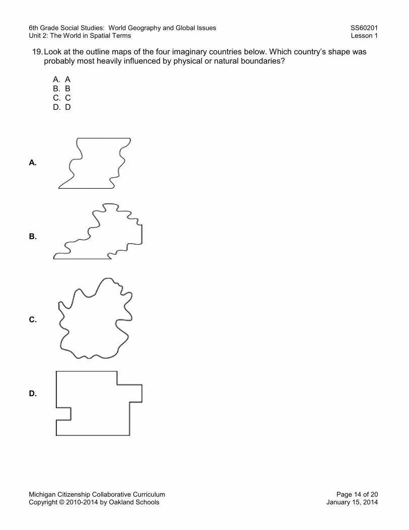
19. Look at the outline maps of the four imaginary countries below. Which country’s shape was probably most heavily influenced by physical or natural boundaries?
A. A B. B C. C D. D
A. B. C. D.
6th Grade Social Studies: World Geography and Global Issues SS60201 Unit 2: The World in Spatial Terms Lesson 1
Michigan Citizenship Collaborative Curriculum Page 15 of 20 Copyright © 2010-2014 by Oakland Schools January 15, 2014
Map Test Answer Key
Note: Questions 1 – 11 are from the Grade 4 NAEP Geography test, questions 12 – 16 are from the 8th grade test and questions 17 – 19 are from the Grade 12 test.
1. B 2. C 3. A 4. D 5. Scoring Guide: Score and Description
Complete Response correctly locates the airport and explains its location. Partial Response locates the airport correctly, but does not explain its location. OR Response explains the location but does not locate the airport on the map. Unacceptable Response does not locate the airport on the map or explain its location. Examples of possible credited responses: 1. Close to city/cities 2. Close to other forms of transportation 3. References to having lots of space or appropriate space suitable for an airport
6. Scoring Guide: Score and Description Complete Response places the airport in a geographically appropriate place and explains the choice in a logical manner. Partial Response places the airport in a geographically appropriate place but the explanation is unacceptable or missing. OR Response places the airport inappropriately but provides acceptable explanation. Unacceptable The response does not place the airport in a geographically appropriate place or provide an acceptable explanation. Examples of possible credited responses: Geographically Appropriate Places:
1. Any location except the Blue Sea, the mountains, or cases where the intersection of the body and wings of the plane is on top of a railroad, oil rig, river, or lake.
2. The airport MAY overlap a city. Explanations:
1. To access towns 2. To access recreational areas such as the coast, mountains, lakes, or rivers
6th Grade Social Studies: World Geography and Global Issues SS60201 Unit 2: The World in Spatial Terms Lesson 1
Michigan Citizenship Collaborative Curriculum Page 16 of 20 Copyright © 2010-2014 by Oakland Schools January 15, 2014
7. C 8. D 9. B 10. C 11. Scoring Guide
Score & Description Complete
The response identifies Nation A and explains that it has both the coal and iron needed to make steel.
Partial The response identifies Nation A with an incorrect, incomplete (it contains iron or coal), or no explanation; for example, it explains that Nation A is probable because it is the biggest country, or has access to the ocean.
Inappropriate The response does not identify Nation A. (Response may or may not explain that both iron and coal are needed to make steel.)
Notes: Complete
• As long as response lists both coal and iron, ignore references to oil, or the relationship of iron to steel. • Accept "all the mineral resources" as indicating both iron and coal. • Accept A if it stands alone without the word country or nation, and it clearly is not part of a sentence.
Inappropriate
• If student identifies Country A and another country, response is inappropriate. Must have Country A alone to receive credit.
• Do not accept "many resources," "a couple of resources" or "it has all the materials."
12. D 13. C 14. A 15. Scoring Guide
Score & Description Complete The response shows an X close to the center of the 20-mile circle. Partial The response shows the intersection of X on or inside the 20-mile circle but not on or in the central template as described for level 3. Inappropriate The response shows the intersection of X outside the 20-mile circle or the response includes multiple X's.
16. B 17. B 18. C 19. C
6th Grade Social Studies: World Geography and Global Issues SS60201 Unit 2: The World in Spatial Terms Lesson 1
Michigan Citizenship Collaborative Curriculum Page 17 of 20 Copyright © 2010-2014 by Oakland Schools January 15, 2014
PowerPoint Notes – Page 1
1. Where do you think the basketball came from?
2. How do you think the basketball got to Alaska?
3. Draw a map showing the route the basketball probably took. Add in as much detail and as
many labels as you can:
6th Grade Social Studies: World Geography and Global Issues SS60201 Unit 2: The World in Spatial Terms Lesson 1
Michigan Citizenship Collaborative Curriculum Page 18 of 20 Copyright © 2010-2014 by Oakland Schools January 15, 2014
PowerPoint Notes – Page 2
4. How did the basketball actually get to Alaska? 5. What is a tsunami? 6. What four things can cause a tsunami?
1 2 3 4
7. Describe the location of the epicenter of the 2011 Japanese earthquake. 8. Describe the physical geography of Japan.
9. How does the physical geography of Japan appear to impact the population of Japan?
6th Grade Social Studies: World Geography and Global Issues SS60201 Unit 2: The World in Spatial Terms Lesson 1
Michigan Citizenship Collaborative Curriculum Page 19 of 20 Copyright © 2010-2014 by Oakland Schools January 15, 2014
PowerPoint Notes – Page 3
10. What does the map on Slide 29 show?
11. What does the map on Slide 30 show?
12. How might this map be used to explain how the basketball got to Alaska?
13. What does the map on Slide 31 show?
14. According to the maps on Slide 32, what is a major difference between the tsunamis illustrated on the maps?
15. According to the map on Slide 34 what is the tsunami threat in the Great Lakes region?
16. According to the map on Slide 36, has there ever been a tsunami in the Great Lakes?
17. What are three things you could do to investigate the accuracy of the map regarding tsunami in the Great Lakes?
1 2 3
6th Grade Social Studies: World Geography and Global Issues SS60201 Unit 2: The World in Spatial Terms Lesson 1
Michigan Citizenship Collaborative Curriculum Page 20 of 20 Copyright © 2010-2014 by Oakland Schools January 15, 2014
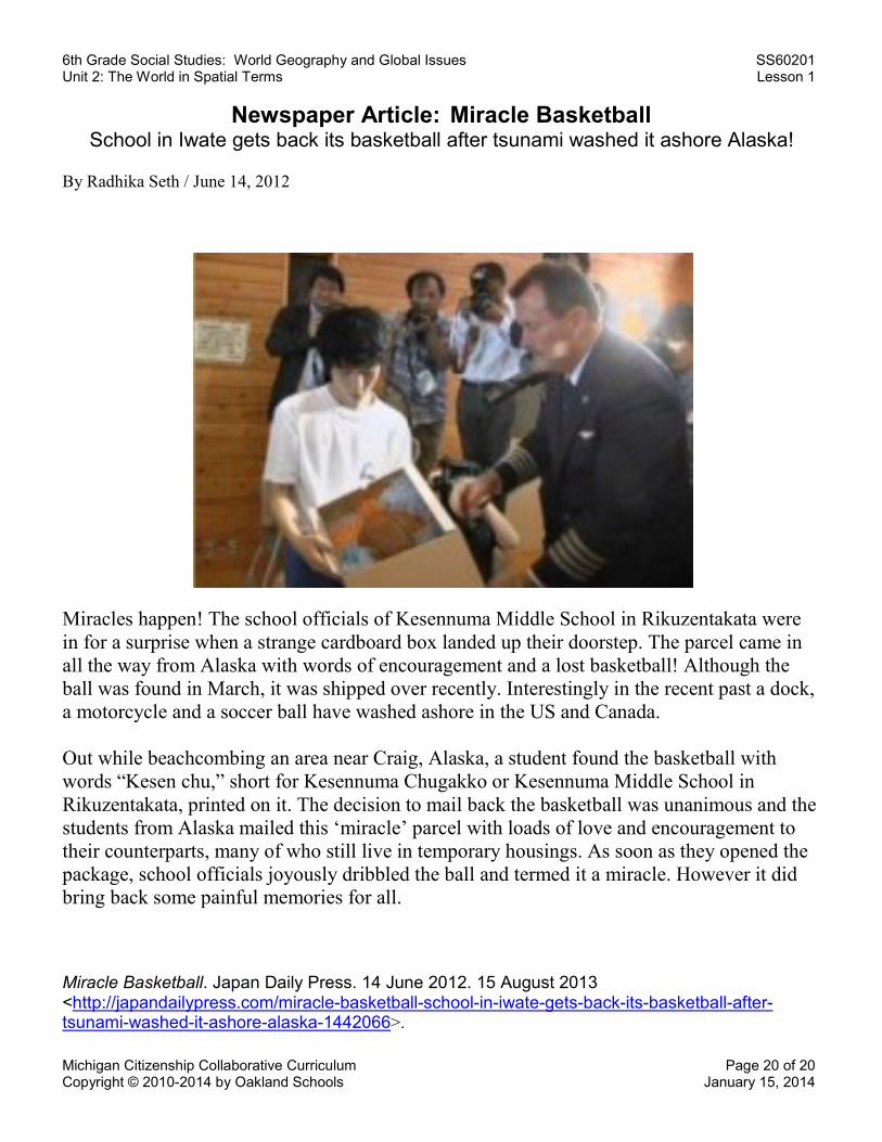
Newspaper Article: Miracle Basketball School in Iwate gets back its basketball after tsunami washed it ashore Alaska!
By Radhika Seth / June 14, 2012
Miracles happen! The school officials of Kesennuma Middle School in Rikuzentakata were in for a surprise when a strange cardboard box landed up their doorstep. The parcel came in all the way from Alaska with words of encouragement and a lost basketball! Although the ball was found in March, it was shipped over recently. Interestingly in the recent past a dock, a motorcycle and a soccer ball have washed ashore in the US and Canada. Out while beachcombing an area near Craig, Alaska, a student found the basketball with words “Kesen chu,” short for Kesennuma Chugakko or Kesennuma Middle School in Rikuzentakata, printed on it. The decision to mail back the basketball was unanimous and the students from Alaska mailed this ‘miracle’ parcel with loads of love and encouragement to their counterparts, many of who still live in temporary housings. As soon as they opened the package, school officials joyously dribbled the ball and termed it a miracle. However it did bring back some painful memories for all.
Miracle Basketball. Japan Daily Press. 14 June 2012. 15 August 2013 <http://japandailypress.com/miracle-basketball-school-in-iwate-gets-back-its-basketball-after-tsunami-washed-it-ashore-alaska-1442066>.
Related Documents