Climate Services Provided by the Colorado Climate Center Mark Losleben and Nolan Doesken Colorado Climate Center Atmospheric Science Department Colorado State University Presented July 28, 2005, Boulder, CO

Climate Services Provided by the Colorado Climate Center Mark Losleben and Nolan Doesken Colorado Climate Center Atmospheric Science Department Colorado.
Dec 20, 2015
Welcome message from author
This document is posted to help you gain knowledge. Please leave a comment to let me know what you think about it! Share it to your friends and learn new things together.
Transcript

Climate Services Provided by the Colorado Climate Center
Mark Losleben andNolan DoeskenColorado Climate CenterAtmospheric Science DepartmentColorado State UniversityPresented July 28, 2005, Boulder, CO

Beginnings After the State Climatologist positions were
abolished by the federal government in the early 1970s, many states gradually established state funded climate offices. Many were at land-grant universities.
The Colorado Climate Center was established at Colorado State University in 1974 within the Colorado Agricultural Experiment Station.

Who Are We? Roger A. Pielke, Sr.
Professor, Atmospheric Science and State Climatologist, [email protected]
Nolan J. DoeskenClimatologist and Senior Research Associate,
Odie BlissCoordinator, [email protected]
Marty OseckySystem Administrator

What We Do….

Climatic Research Instrument Comparison Studies, Drought, Snow,
Variability and Trends, Impacts and Modeling, etc.
Fraction of Colorado in Drought Based on 48 month SPI
(1890 - May 2004)
0.0
0.1
0.2
0.3
0.4
0.5
0.6
0.7
0.8
0.9
1.0
1890
1892
1894
1896
1898
1900
1902
1904
1906
1908
1910
1912
1914
1916
1918
1920
1922
1924
1926
1928
1930
1932
1934
1936
1938
1940
1942
1944
1946
1948
1950
1952
1954
1956
1958
1960
1962
1964
1966
1968
1970
1972
1974
1976
1978
1980
1982
1984
1986
1988
1990
1992
1994
1996
1998
2000
2002
2004
Year
Fra
cti
on
(in
perc
en
t)

Data Acquisition and Archive Elements: temperature, precipitation, snow, wind, solar,
evaporation, soil temperatures, humidity, cloud cover

Monitor the Climate of Colorado Drought, flooding, blizzards, tornadoes, temperature
extremes, Heating/Cooling Degree Data, etc.

Disseminate Information Farmers, ranchers, consultants, engineers, print and
broadcast media, water resources, utilities, construction, lawyers, federal, state and local governments, schools, universities, and many others.
HOW? Website, phone, fax, email, publications and conferences
http://ccc.atmos.colostate.edu(970) 491-8545 phone
(970) 491-3314 fax

http://ccc.atmos.colostate.edu

What Are Climate Services? Colorado’s experience in Climate Services:
appropriate and accessible data, studied and analyzed, and applied to important situations.
But it all comes down to the data…

How Do We Monitor Our Climate?

National Weather Service Collaboration
Picture of a standard coop station, potentially map showing coop station location (CO, WRCC map)
Cooperative Weather Stations
in Colorado
Typical Cooperative Weather Station

USDA, Natural Resources Conservation Service
NRCS Snotel Sites for Colorado
Typical NRCS Snotel Site

State Engineer’s Office

U.S. Geological Survey

And all the others collecting weather and climate data

Automated Surface Observing System (ASOS)
Denver International Airport ASOS, Photo courtesy of the National Weather Service

Automated Weather Observing System (AWOS)

School Weather Stations

Colorado Department of Transportation (CDOT)
** Not a very good picture, maybe you can find one…

Urban Drainage and Flood Control District (UDFCD) ALERT system
New ALERT weather station & stream gage on Marston Lake North Drainageway.

Colorado Climate Center Monitoring Activities Fort Collins Historic Weather Station –
Continuous observations from 1889 to presentFORT COLLINS, COLORADO
0
5
10
15
20
25
30
1890
1893
1896
1899
1902
1905
1908
1911
1914
1917
1920
1923
1926
1929
1932
1935
1938
1941
1944
1947
1950
1953
1956
1959
1962
1965
1968
1971
1974
1977
1980
1983
1986
1989
1992
1995
1998
2001
2004
Year
Yea
rly
Pre
cipi
tatio
n (in
ches
)

CoAgMetWeather Data for Agriculture Automated weather stations
with daily and hourly readings of: Temperature Humidity Wind Precipitation Solar energy Evapotranspiration
http://www.coagmet.com
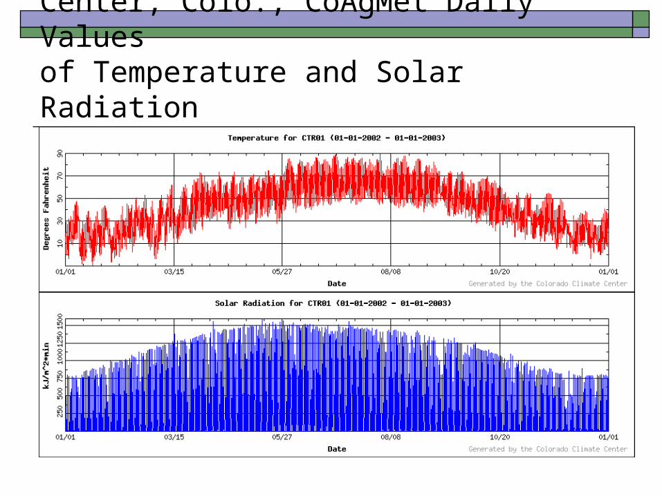
Center, Colo., CoAgMet Daily Valuesof Temperature and Solar Radiation

Applications of Climate Monitoring

Applications of Climate Monitoring Standardized Precipitation Index Map

Applications of Climate Monitoring Water Management and Irrigation Scheduling

Applications of Climate Monitoring Extreme Precipitation
Study
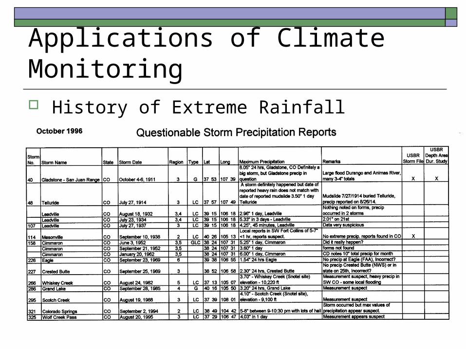
Applications of Climate Monitoring History of Extreme Rainfall

Applications of Climate Monitoring
March 2003 Snow storm aftermath in Fort Collins

Common Theme from Climate Monitoring Applications is –
““Inadequate Spatial Density of Precipitation Data”Inadequate Spatial Density of Precipitation Data”
Feb

?? How About Remote Sensing ??CSU-CHILL Radar Site

Remote Sensing is Great – ButGround Calibration is Crucial
Red Arrow indicates location of CoCo RaHS observer. Resulting hailpad and retrieved hailstones. CoCo RaHS observations are also providing valuable spotter information to the National Weather Service.
Contour map of hail quadrature parameter (HQP) showing potential hail damage from a severe thunderstorm in Douglas County, CO, in July 2002. The data were produced from the CSU-CHILL Polametric Radar. CoCo RaHS data are being used as ground validation for the CSU-CHILL hail and rainfall products.

How can we gather more data without breaking the bank??

Community Collaborative Rain, Hail and Snow Network

The Origin of CoCoRaHSThe Fort Collins Flood of July 28, 1997

What is CoCoRaHS?CoCoRaHS is a unique, non-profit community based network of volunteers of all ages and backgrounds working together to measure and map precipitation (rain, hail and snow).

CoCoRaHS: Simple tools to study rain
Rain Gauge Example Station

CoCo RaHS Gauge in March 2003 Snowstorm
Arapahoe County CoCo RaHS observer near Cherry Creek, Colorado

CoCoRaHS: : Simple Tools to Study Hail
Hail Pad
Damaged Hail Pad

Example Hail Pad Stands

CoCoRaHS -- Supplementing NWS Cooperative Program to Improve Precipitation Measurements.

Fort Collins Daily Rainfall Examples
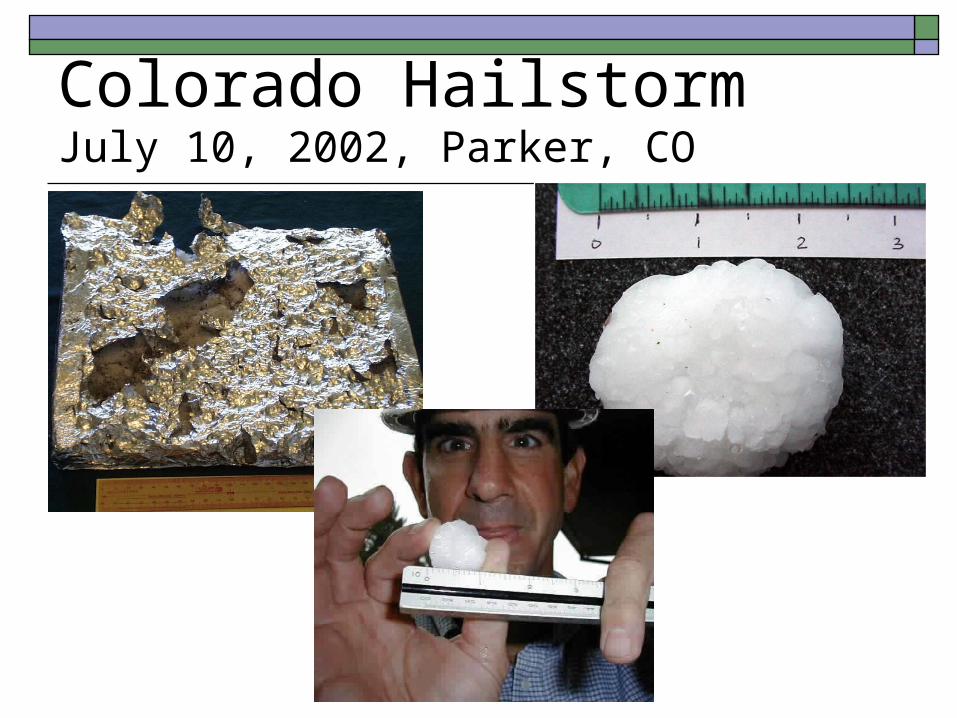
Colorado HailstormJuly 10, 2002, Parker, CO

Expanded Hail Information from Web Site
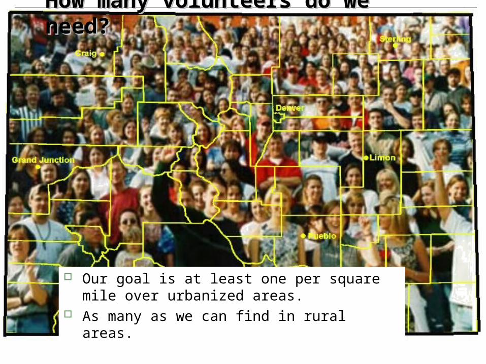
How many volunteers do we How many volunteers do we need?need?
Our goal is at least one per square mile over urbanized areas.
As many as we can find in rural areas.

Participating CoCoRaHS States

For More Information, Visit theCoCoRaHS Web Site
Support for this project provided by Informal Science Education Program,National Science Foundationandmany local charter sponsors.
http://www.cocorahs.org
Colorado Climate CenterData and Power Point Presentations available for downloading
http://ccc.atmos.colostate.edu click on “Drought” then click on “Presentations”
Related Documents


