City of Maryville Policy Manual for Stormwater Quality Management RESIDENTIAL COMMERCIAL BUSINESS INDUSTRIAL

Welcome message from author
This document is posted to help you gain knowledge. Please leave a comment to let me know what you think about it! Share it to your friends and learn new things together.
Transcript

City of Maryville Policy Manual for
Stormwater Quality Management
RESIDENTIAL COMMERCIAL
BUSINESS INDUSTRIAL
elcome to the City of Maryville, a progressive city located in the foothills of the Great Smoky Mountains. Maryville strives to be the best location for your business interest by placing the right amount of emphasis on development requirements which set high standards to ensure quality development and
planning growth. Careful attention is given to the water quality in our local streams and other water resources, which results in a distinctively pleasing community in which to live, work and play.
W This policy manual provides supplemental policies and technical guidance for developers, architects, engineers and property owners that must comply with the City of Maryville’s Stormwater Quality Management and Vegetated Buffer Ordinance. The objectives of Maryville’s stormwater quality management program are: • To protect streams within Maryville from pollutants that may result from land
development after construction has ceased; • To comply with the requirements of the State of Tennessee Municipal Separate
Storm Sewer System (MS4) permit. Contact the City of Maryville Engineering and Public Works Department (865-273-3302) if you have questions pertaining to this policy manual or the associated Stormwater Quality Management ordinance.
Reference Acknowledgements Although this manual was developed to provide specific information for stormwater quality management in the City of Maryville, significant portions of this manual were developed or copied from regulations and guidance from other communities. Portions of the text in this manual were developed from verbiage presented in the Georgia Stormwater Management Manual, the Knox County Stormwater Management Manual and the City of Knoxville Land Development Manual. The text from these manuals was suitably modified and/or referenced so as to meet the City of Maryville’s stormwater needs. This paragraph serves as an acknowledgement of the use of text from these manuals, and shall be considered as a general reference to these sources of information. In general, references to these sources are not made individually in the chapters of this manual. City of Maryville Engineering and Public Works staff will provide an electronic copy of the Knox County Stormwater Management Manual to any citizen who requests one.

Table of Contents Acronyms ..........................................................................................................................iv 1.0 – Background.........................................................................................................1-14 2.0 – The Water Quality Management Plan ...............................................................15-18 3.0 – Water Quality Protection ...................................................................................19-30 4.0 – Channel Erosion Protection ................................................................................... 31 5.0 – Water Quality Buffers ........................................................................................32-38 6.0 – BMP Inspection and Maintenance ....................................................................39-42 7.0 – References............................................................................................................. 43 Appendix A – Definitions................................................................................................A-1 Appendix B – WQMP Checklist......................................................................................B-1 Appendix C – As-Built Checklist.................................................................................... C-1 Appendix D – Special Pollutant Abatement Permit ....................................................... D-1 Appendix E – Covenant for Permanent Maintenance of Water Quality BMPs...............E-1
City of Maryville, TN iii Stormwater Quality Policy Manual

Acronyms ARAP ............ Aquatic Resource Alteration Permit BMP ............. Best Management Practice CGP .............. Construction General Permit CPv .............. Channel Protection Volume CRS............... Community Rating System DO................. Dissolved Oxygen ESA............... Endangered Species Act FEMA ............ Federal Emergency Management Agency MEP .............. Maximum Extent Practicable MS4 .............. Municipal Separate Storm Sewer System NFIP.............. National Flood Insurance Program NOI................ Notice of Intent NOT............... Notice of Termination NPDES ......... National Pollutant Discharge Elimination System NRCS............ National Resource Conservation Service (formerly the SCS) SCS............... Soil Conservation Service SPAP............. Special Pollutant Abatement Permit SWPPP ......... Stormwater Pollution Prevention Plan TDEC ........... Tennessee Department of Environment and Conservation TMDL ........... Total Maximum Daily Load TVA ............... Tennessee Valley Authority TSS ............... Total Suspended Solids
City of Maryville, TN iv Stormwater Quality Policy Manual
USFWS ......... United States Fish and Wildlife Service WQMP .......... Water Quality Management Plan WQv ............. Water Quality Volume
City of Maryville, TN v Stormwater Quality Policy Manual

1.0 Background Development increases both the concentration and types of pollutants carried by runoff. As it runs over rooftops and lawns, parking lots and industrial sites, stormwater picks up and transports a variety of contaminants and pollutants to downstream waterbodies. The loss of the original topsoil and vegetation removes a valuable filtering mechanism for stormwater runoff. The cumulative impact of development and urban activities, and the resultant changes to both stormwater quantity and quality in the entire land area that drains to a stream, river, lake or estuary determines the conditions of the waterbody. This land area that drains to the waterbody is known as its watershed. Urban development within a watershed has a number of direct impacts on downstream waters and waterways. These impacts include: • Changes to stream flow; • Changes to stream geometry; • Degradation of aquatic habitat; and, • Water quality impacts.
1.1 Changes to Stream Flow Urban development alters the hydrology of watersheds and streams by disrupting the natural water cycle. This results in: • Increased Runoff Volumes – Land surface changes can dramatically increase the
total volume of runoff generated in a developed watershed. • Increased Peak Runoff Discharges – Increased peak discharges for a developed
watershed can be two to five times higher than those for a watershed prior to development. This is depicted in Figure 1-1.
• Greater Runoff Velocities – Impervious surfaces and compacted soils, as well as
improvements to the drainage system such as storm drains, pipes and ditches, increase the speed at which rainfall runs off land surfaces within a watershed.
• Increased Frequency of Bankfull and Near Bankfull Events – Increased runoff
volumes and peak flows increase the frequency and duration of smaller bankfull and near bankfull events which are the primary channel forming events.
• Increased Flooding – Increased runoff volumes and peaks also increase the
frequency, duration and severity of out-of-bank flooding.
City of Maryville, TN 1 Stormwater Quality Policy Manual

• Lower Dry Weather Flows (Baseflow) – Reduced infiltration of stormwater runoff
causes streams to have less baseflow during dry weather periods and reduces the amount of rainfall recharging groundwater aquifers.
Figure 1-1. Runoff Hydrograph under Pre-and Post-Development Conditions
10-Year Storm
0
10
20
30
40
50
60
70
80
90
0 25 50 75 100 125
Minutes
Dis
char
ge
Post-Development Pre-
Development
1.2 Changes to Stream Geometry The changes in the rates and amounts of runoff from developed watersheds directly affect the morphology, or physical shape and character, of Tennessee’s creeks and streams. This is depicted graphically in Figure 1-2. Some of the impacts due to urban development include:
Figure 1-2. Physical Stream Changes Due to Watershed Development
City of Maryville, TN 2 Stormwater Quality Policy Manual

• Stream Widening and Bank Erosion – Stream channels widen to accommodate and
convey the increased runoff and higher stream flows from developed areas. More frequent small and moderate runoff events undercut and scour the lower parts of the streambank, causing the steeper banks to slump and collapse during larger storms. Higher flow velocities further increase streambank erosion rates. A stream can widen many times its original size due to post-development runoff.
• Stream Downcutting – Another way that streams accommodate higher flows is by
downcutting their streambed. This causes instability in the stream profile, or elevation along a stream’s flow path, which increases velocity and triggers further channel erosion both upstream and downstream.
• Loss of Riparian Tree Canopy – As streambanks are gradually undercut and slump
into the channel, the trees that had protected the banks are exposed at the roots. This leaves them more likely to be uprooted during major storms, further weakening bank structure.
• Changes in the Channel Bed Due to Sedimentation – Due to channel erosion and
other sources upstream, sediments are deposited in the stream as sandbars and other features, covering the channel bed, or substrate, with shifting deposits of mud, silt and sand.
• Increase in the Floodplain Elevation – To accommodate the higher peak flow rate, a
stream’s floodplain elevation typically increases following development in a watershed due to higher peak flows. This problem is compounded by building and filling in floodplain areas, which cause flood heights to rise even further. Property and structures that had not previously been subject to flooding may now be at risk.
1.3 Impacts to Aquatic Habitat Along with changes in stream hydrology and morphology, the habitat value of streams diminishes due to development in a watershed. Impacts on habitat include: • Degradation of Habitat Structure – Higher and faster flows due to development can
scour channels and wash away entire biological communities. Streambank erosion and the loss of riparian vegetation reduce habitat for many fish species and other aquatic life, while sediment deposits can smother bottom-dwelling organisms and aquatic habitat.
• Loss of Pool-Riffle Structure – Streams draining undeveloped watersheds often
contain pools of deeper, more slowly flowing water that alternate with “riffles” or shoals of shallower, faster flowing water. These pools and riffles provide valuable habitat for fish and aquatic insects. As a result of the increased flows and sediment loads from urban watersheds, the pools and riffles disappear and are replaced with more uniform, and often shallower, streambeds that provide less varied aquatic habitat.
City of Maryville, TN 3 Stormwater Quality Policy Manual

• Decline of Abundance and Biodiversity – When there is a reduction in various
habitats and habitat quality, both the number and the variety, or diversity, of organisms (wetland plants, fish, macroinvertebrates, etc.) are also reduced. Sensitive fish species and other life forms disappear and are replaced by those organisms that are better adapted to the poorer conditions. The diversity and composition of the benthic, or streambed, community have frequently been used to evaluate the quality of urban streams. Aquatic insects are a useful environmental indicator as they form the base of the stream food chain.
Fish and other aquatic organisms are impacted not only by the habitat changes brought on by increased stormwater runoff quantity, but are often also adversely affected by water quality changes due to development and resultant land use activities in a watershed.
1.4 Water Quality Impacts Nonpoint source pollution, which is the primary cause of polluted stormwater runoff and water quality impairment, comes from many diffuse sources, many of which are the result of human activities within a watershed. Nonpoint source pollution is the leading source of water quality degradation in Maryville. Water quality degradation in urbanizing watersheds starts when development begins. Erosion from construction sites and other disturbed areas contribute large amounts of sediment to streams. As construction and development proceed, impervious surfaces replace the natural land cover and pollutants from human activities begin to accumulate on these surfaces. During storm events, these pollutants are then washed off into the streams. Stormwater also causes discharges from sewer overflows and leaching from septic tanks. Due to the magnitude of the problem it is important to understand the nature and sources of urban stormwater pollution. Table 1-1 summarizes the major stormwater pollutants and their effects. Some of the most frequently occurring pollution impacts to urban streams and their sources are: • Reduced Oxygen in Streams – The decomposition process of organic matter uses
up dissolved oxygen (DO) in the water, which is essential to fish and other aquatic life. As organic matter is washed off by stormwater, dissolved oxygen levels in receiving waters can be rapidly depleted. If the DO deficit is severe enough, fish kills may occur and stream life can weaken and die. In addition, oxygen depletion can affect the release of toxic chemicals and nutrients from sediments deposited in a waterway.
• All forms of organic matter in urban stormwater runoff such as leaves, grass
clippings and pet waste contribute to the problem. In addition, there are a number of non-stormwater discharges of organic matter to surface waters such as sanitary sewer leakage and septic tank leaching.
City of Maryville, TN 4 Stormwater Quality Policy Manual

Table 1-1. Major Stormwater Pollutants and Their Potential Effects
Constituents
Effects
Sediments - Suspended Solids, Dissolved Solids, Turbidity
Stream turbidity Habitat changes Recreation/aesthetic loss Contaminant transport Filling of lakes and reservoirs
Nutrients - Nitrate, Nitrite, Ammonia, Organic Nitrogen, Phosphate, Total Phosphorus
Algae blooms Eutrophication Ammonia and nitrate toxicity Recreation/aesthetic loss
Microbes - Fecal Coliforms, Fecal Streptococci, Viruses, E.Coli, Enterocci
Ear/intestinal infections Shellfish toxicity Recreation/aesthetic loss
Organic Matter - Vegetation, Sewage, Other Oxygen Demanding Materials
Dissolved oxygen depletion Odors Fish kills
Toxic Pollutants - Heavy Metals (cadmium, copper, lead, zinc), Organics, Hydrocarbons, Pesticides/Herbicides
Human & aquatic toxicity Bioaccumulation in the food chain
Thermal Pollution
Dissolved oxygen depletion Habitat changes
Trash and debris Recreation/aesthetic loss
• Microbial Contamination – The level of bacteria, viruses and other microbes found in
urban stormwater runoff often exceeds public health standards for water contact recreation such as swimming and wading. Microbes can also contaminate shellfish beds, preventing their harvesting and consumption and increasing the cost of treating drinking water. The main sources of these contaminants are sewer overflows, septic tanks, pet waste, and urban wildlife such as pigeons, waterfowl, squirrels, and raccoons.
• Nutrient Enrichment – Runoff from urban watersheds contains increased nutrients
such as nitrogen or phosphorus compounds. Increased nutrient levels are a problem as they promote weed and algae growth in lakes, streams and estuaries. Algae blooms block sunlight from reaching underwater grasses and deplete oxygen in bottom waters. In addition, nitrification of ammonia by microorganisms can consume dissolved oxygen, while nitrates can contaminate groundwater supplies. Sources of nutrients in the urban environment include washoff of fertilizers and vegetative litter, animal wastes, sewer overflows and leaks, septic tank seepage, detergents, and the dry and wet fallout of materials in the atmosphere.
• Hydrocarbons – Oils, greases and gasoline contain a wide array of hydrocarbon
compounds, some of which have shown to be carcinogenic, tumorigenic and
City of Maryville, TN 5 Stormwater Quality Policy Manual

mutagenic in certain species of fish. In addition, in large quantities, oil can impact drinking water supplies and affect recreational use of waters. Oils and other hydrocarbons are washed off roads and parking lots, primarily due to leakage from vehicle engines. Other sources include the improper disposal of motor oil in storm drains and streams, spills at fueling stations and restaurant grease traps.
• Toxic Materials – Besides oils and greases, urban stormwater runoff can contain a
wide variety of other toxicants and compounds including heavy metals such as lead, zinc, copper, and cadmium, and organic pollutants such as pesticides, PCBs, and phenols. These contaminants are of concern because they are toxic to aquatic organisms and can bioaccumulate in the food chain. In addition, they also impair drinking water sources and human health. Many of these toxicants accumulate in the sediments of streams and lakes. Sources of these contaminants include industrial and commercial sites, urban surfaces such as rooftops and painted areas, vehicles and other machinery, improperly disposed household chemicals, landfills, hazardous waste sites and atmospheric deposition.
• Sedimentation – Eroded soils are a common component of urban stormwater and a
pollutant in their own right. Excessive sediment can be detrimental to aquatic life by interfering with photosynthesis, respiration, growth and reproduction. Sediment particles transport other pollutants that are attached to their surfaces including nutrients, trace metals and hydrocarbons. High turbidity due to sediment increases the cost of treating drinking water and reduces the value of surface waters for industrial and recreational use. Sediment also fills ditches and small streams and clogs storm sewers and pipes, causing flooding and property damage. Sedimentation can reduce the capacity of reservoirs and lakes, block navigation channels, fill harbors and silt estuaries. Erosion from construction sites, exposed soils, street runoff, and streambank erosion are the primary sources of sediment in urban runoff.
• Higher Water Temperatures – As runoff flows over impervious surfaces such as
asphalt and concrete, it increases in temperature before reaching a stream or pond. Water temperatures are also increased due to shallow ponds and impoundments along a watercourse as well as fewer trees along streams to shade the water. Since warm water can hold less dissolved oxygen than cold water, this “thermal pollution” further reduces oxygen levels in urban streams. Temperature changes can severely disrupt certain aquatic species, such as trout and stoneflies, which can survive only within a narrow temperature range.
• Trash and Debris – Considerable quantities of trash and other debris are washed
through storm drain systems and into streams, lakes and bays. The primary impact is the creation of an aesthetic “eyesore” in waterways and a reduction in recreational value. In smaller streams, debris can cause blockage of the channel, which can result in localized flooding and erosion.
City of Maryville, TN 6 Stormwater Quality Policy Manual

1.6 Stormwater Hotspots Stormwater hotspots are areas of the urban landscape that often produce higher concentrations of certain pollutants, such as hydrocarbons or heavy metals, than are normally found in urban runoff. These areas merit special management and the use of specific pollution prevention activities and/or structural stormwater controls. The City of Maryville requires additional measures for developments and redevelopments that propose such hotspot land uses. The additional measures necessary to control hotspot pollution of streams are regulated through the Special Pollutant Abatement Permit (SPAP). Examples of stormwater hotspots include, but are not limited to:
• Gas/fueling stations • Kennels, feed lots, etc. • Vehicle maintenance areas • Loading and transfer areas • Vehicle washing / steam cleaning • Landfills • Auto recycling facilities • Construction sites • Outdoor material storage areas • Industrial sites • Plant nurseries, agricultural areas • Industrial rooftops
1.7 Stormwater Quality Treatment Rationale This section provides background on the formulation of the water quality volume standard. This standard requires 80% removal of total suspended solids (TSS) from post-construction stormwater runoff based on capture of the 85th percentile storm event.
1.7.1 Regulatory Overview The NPDES Phase II regulation requires that the City of Maryville (and other Phase II regulated communities) develop, implement, and enforce a stormwater management program that reduces the discharge of pollutants from the regulated jurisdiction “to the maximum extent practicable (MEP)”. MEP is a technology-based discharge standard that was designed for the reduction of pollutant discharges and established in the Clean Water Act. Using guidance provided by the Environmental Protection Agency (EPA), Maryville can achieve the MEP standard by instituting a stormwater management program that implements and requires best management practices (BMPs) that are designed to protect water quality. No further guidance on MEP is provided by EPA or by the Tennessee Department of Environment and Conservation (TDEC). Control measure 5 of the National Pollutant Discharge Elimination System (NPDES) Phase II Permit presents the requirements for the control of post-construction (i.e., after development) stormwater runoff. Quoting directly from the NPDES Permit for the State of Tennessee, regulated cities and counties (including Maryville) must:
“Develop, implement, and enforce a program to address storm water runoff from new development and redevelopment projects that disturb greater than or equal to one acre, including projects less than one acre that are part of a larger common plan of development or sale, that discharge into your small MS4. Your program must ensure that controls are in place that would prevent or minimize water quality impacts;
City of Maryville, TN 7 Stormwater Quality Policy Manual

Develop and implement strategies which include a combination of structural and/or non-structural best management practices appropriate for your community; and Develop and implement a set of requirements to establish, protect and maintain water quality buffers in areas of new development and redevelopment. Use an ordinance or other regulatory mechanism to address post-construction runoff from new development and redevelopment projects to the extent allowable under State or local law.”
As a result of these requirements, Maryville must implement a requirement for new developments and redevelopments to control stormwater quality using both structural (i.e., constructed) and non-structural (i.e., site planning) best management practices (BMPs). This requirement must be fully implemented no later than 2008. The NPDES Phase II regulation also requires that Maryville focus stormwater management on controlling discharges of pollutants of concern to local impaired streams. Based on the State of Tennessee’s 303(d) list of “impaired” streams, the largest pollutant in Maryville is sedimentation.
1.7.2 Attaining the Water Quality Standard The basic goal of the NPDES Phase II regulation is to reduce the water quality impacts of development. The preferred approach to meet this goal and comply with the NPDES permit is called the “Water Quality Volume method” or “WQv method”. The WQv method is based on a minimum water quality control goal of 80% removal of TSS for the 85th percentile storm event from post-construction stormwater runoff (i.e., after construction of a site is completed. TSS is a commonly used representative stormwater pollutant for measuring sedimentation.
There are a number of factors that support the use of an 80% TSS removal standard as a minimum level water quality goal in Maryville. 1. The Tennessee 303(d) list indicates that sedimentation (i.e., sediment) is a
significant pollutant of concern in local streams. This fact alone requires that Maryville implement a stormwater management program that, at least in part, focuses on the removal of sediment from stormwater discharges in order to achieve compliance with the NPDES Phase II regulations to the maximum extent practicable.
2. The use of TSS as an “indicator” pollutant for sediment is well-established. 3. The control of TSS leads to indirect control of other pollutants of concern that can
adhere to suspended solids in stormwater runoff. In fact, some research shows that a large fraction of many other pollutants of concern are either reduced along with TSS, or at rates proportional to the TSS reduction.
4. A treatment standard of 80% is not a numeric standard, but a “best available
technology” standard. In other words, the 80% TSS removal level is reasonably attainable using properly designed, constructed and maintained structural
City of Maryville, TN 8 Stormwater Quality Policy Manual

stormwater BMPs (for typical ranges of TSS concentration found in stormwater runoff). This standard is supported with research data from numerous research projects and compiled by the International Stormwater Best Management Practices (BMP) Database evaluation project, titled Determining Urban Stormwater Best Management Practices Removal Efficiencies, June, 2000.
The WQv method can meet the goal of 80% TSS removal using a two-pronged approach. First, it encourages the reduction of imperviousness (and therefore pollution) from developed sites through incentives for non-structural BMPs, such as natural conservation areas and water quality buffers. Second, it requires treatment of any remaining stormwater runoff with structural controls. This method allows Maryville to meet its water quality goals and regulatory requirements, yet still allows developers flexibility in their site designs. The WQv is calculated for the 85th percentile storm event using a value of 1.1 inches of rainfall. Thus, a stormwater management system designed for the WQv will treat the runoff from all storm events of 1.1 inches or less, as well as the first 1.1 inches of runoff for all larger storm events. Detailed information on the calculation of the WQv and % TSS removal for a development or redevelopment site are presented in Chapter 3. It is important to note that Maryville is not alone in implementing an 80% TSS removal standard, or the WQv method. Knox County as well as many states, including Maryland, Massachusetts, North Carolina, Georgia, and Florida have set similar statewide TSS goals and have research data to support BMPs meeting this reduction goal. Further, a number of other communities in Tennessee, the State of Georgia and the Commonwealth of Virginia have implemented a WQv type of method as the statewide water quality control approach. The BMP design and maintenance guidance from these states can be used to implement a water quality control program that is appropriate to meet Maryville’s needs.
1.8 Channel Protection (CPv)
1.8.1 Background The increase in the frequency, velocity, and duration of bankfull flow conditions in stream channels after a rainfall event is the primary cause of streambank erosion. Such erosion is common in Maryville, usually in channels and streams where the cumulative effect of development has caused lengthy, increased post-rainfall discharges. The sediment released as a result of streambank erosion is a likely major source of sediment pollutant loads in Maryville streams. Excessive sediment can impact a stream’s ability to remain ecologically viable and provide a healthy habitat for aquatic species. Streambank erosion can cause damaging hydraulic changes in a stream, including excessive widening, deepening, and undercutting. Figure 1-3 presents an example of this problem located on a nearby Tennessee stream. Such changes can be detrimental to the ability of the stream to remain hydraulically stable in the long-term. Moreover, streambank erosion is a common source of complaints from citizens that experience property damage due to fallen trees or outbuildings, or property loss due to widening streams.
City of Maryville, TN 9 Stormwater Quality Policy Manual

Figure 1-3. Example of Significant Streambank Erosion
1.8.2 Design Criteria and Policies Maryville requires all developments and redevelopments to adhere to channel protection criteria, herein called the channel protection volume (CPv). This standard requires that the runoff volume from the 1-year frequency, 24-hour storm be detained for no less than a 24-hour period. In the design of the channel protection control, the 24-hour detention period shall be measured from the approximate center-of-mass of inflow to the approximate center-of-mass of outflow. Downstream channel protection provided by an alternative approach may be considered in lieu of controlling the CPv, provided that sufficient hydrologic and hydraulic analysis shows that the alternative approach will offer adequate channel protection from erosion. Downstream channel protection provided by an alternative approach must be approved by the Director of Engineering and Public Works or his/her designee.
1.9 Applicable Local Ordinances Stormwater issues do not stand in isolation, but are intimately tied to other aspects of land use and development. The Water Quality Management and Vegetated Buffers Ordinance works in conjunction with the following ordinances to regulate land development within the City of Maryville:
City of Maryville, TN 10 Stormwater Quality Policy Manual

Construction Standards, Specifications, Design Criteria, Policies and Guidelines for the Governing of the Stormwater Utility of the City of Maryville, Tennessee (Stormwater Utility Standards) The Stormwater Utility Standards regulate the design and construction of storm drainage facilities for purposes of stormwater quantity control and floodplain management. The Stormwater Utility Standards strive to limit the dangers of personal injury, and/or property or environmental damage that may be caused by stormwater runoff. The responsibilities of property owners and the stormwater utility are called out, as well as the method for determining cost share for improvements downstream of new developments. Maryville Land Development Regulations The Land Development Regulations include zoning as well as subdivision requirements. The zoning plan is typically the first consideration of a developer in the site planning process. The ordinance also regulates the layout and construction of buildings on the lot to be developed, as well as specifying setbacks, easements, rights-of-way and other aspects of the subdivision process. Finally, the Land Development Regulations also control the use of floodways and floodplains within the City.
Maryville Land Development and Public Works Standards The Land Development and Public Works Standards provide detailed design criteria and construction specifications for the drainage and road systems within the city.
The design and permitting guidance within these ordinances and standards should be used in concert with that given in this Policy Manual. In order to guide developers and citizens through the process, the City of Maryville has published:
Site Plan Approval Process for the City of Maryville The Approval Process document has flows charts, contact information, plan submittal requirements and information on all permits necessary for land development. Copies of all the listed documents can be obtained at http://www.maryvillegov.com.
1.10 Applicable State and Federal Regulations There are several State and Federal regulations that impact upon stormwater as well as City of Maryville regulations. These regulations are discussed below.
1.10.1 Tennessee Construction General Permit The State of Tennessee General NPDES Permit for Discharges of Stormwater Associated with Construction Activities is henceforth referred to as the “Construction General Permit” (CGP). Applicable to all areas of the State of Tennessee, the CGP is intended to regulate the pollution prevention and the control of wastes during construction activities. Specific to site developments, the CGP emphasizes the application of best management practices for purposes of erosion prevention and sediment control and the control of other construction related materials and wastes. In general, the CGP authorizes point source discharges of stormwater from construction
City of Maryville, TN 11 Stormwater Quality Policy Manual

activities that result in the disturbance of one acre or more of total land area. Projects or developments of less than one acre of land disturbance are required to obtain authorization under the CGP if the construction activities at the site are part of a larger common plan of development or sale. Further, there are permit provisions for development less than one acre of land disturbance, and for construction support activities. The CGP is administered by the Tennessee Department of Environment and Conservation (TDEC). Development owners or operators can obtain CGP coverage by filing a Notice of Intent (NOI) with TDEC prior to initiating construction activities. A Stormwater Pollution Prevention Plan (SWPPP) and applicable permit fees must be submitted with the NOI. Both the CGP and the City of Maryville require that development owners or operators obtain coverage under the CGP and provide proof of such coverage (in the form of a Notice of Coverage) prior to obtaining a grading permit from the City. Further, the CGP requires that the owner or operator also submit the CGP Notice of Termination (NOT) to TDEC. The CGP, along with the NOI, NOT and inspection documentation forms can be obtained from the local TDEC office, or on-line at: http://www.state.tn.us/environment.
1.10.2 Aquatic Resource Alteration Permit (ARAP) Persons who conduct any activity that involves the alteration of waters of the State must obtain a State ARAP, and possibly a Federal Section 401 Certification. ARAPs and 401 Certifications are administered by TDEC. The Section 401 Certification is required for projects involving the discharge of dredged or fill material into waters of the United States (US), or wetlands. An ARAP is required for any alteration of State waters, including wetlands that do not require a federal permit. Examples of stream alteration activities that require an individual ARAP include: • dredging, widening, straightening, or bank stabilization; • levee construction if excavation or fill of a stream channel is involved; • channel relocation; • water withdrawals, diversions or dams; • flooding, excavating, draining and/or filling a wetland; and, • bridge construction. Not every activity requires a separate, individual permit. TDEC issues general permits for specific stream alterations that cause minimum impact to water quality. Typically little or no paperwork is involved with these permits. Typically, the following activities are eligible for a general ARAP permit:
City of Maryville, TN 12 Stormwater Quality Policy Manual

• construction of boat launching ramps; • alteration of wet weather conveyances; • construction of road crossings of waters; • utility line crossings; • bank stabilization; • sand and gravel dredging; • bridge scour repair; • stream restoration and habitat enhancement; and, • alteration of up to one acre of isolated wetlands.
1.10.3 Section 404 (Wetlands) Permit Section 404 of the Clean Water Act establishes a program to regulate the discharge of dredged and fill material into waters of the United States, including wetlands. Activities in waters of the United States that are regulated under this program include fills for development, water resource projects (such as dams and levees), infrastructure development (such as highways and airports), and conversion of wetlands to uplands for farming and forestry. The US Army Corps of Engineers administers the 404 permit program. The program governs such activities on all surface waters, such as inland waters, lakes, rivers, streams and their tributaries; interstate waters and their tributaries; wetlands adjacent to the above (e.g., swamps, marshes, bogs, or other land areas); and isolated wetlands and lakes, intermittent streams, and other waters where degradation could affect interstate commerce. Section 404 permits (and possibly Section 10 permits) are required for stormwater activities that may impact natural wetlands.
1.10.4 26a Permits for Shoreline Construction The Tennessee Valley Authority (TVA) administers a permit program that governs shoreline construction along, across, or in the Tennessee River or any of its tributaries. Thus, TVA’s jurisdiction for the 26a permit extends to the limits of the Tennessee River watershed. In accordance with TVA requirements, the permit applied to construction in the 500-year floodplain or to the upper limits of TVA flowage rights, whichever is higher, for developments located along regulated rivers (tailwaters) and TVA reservoirs (e.g., Fort Loudoun Lake). Along off-reservoir, unregulated streams and rivers, jurisdiction is typically applied to the limits of the 100-year floodplain. More information on the TVA 26a permit can be found at http://www.tva.gov.
1.10.5 Section 9 and 10 Permits for Navigable Waters Sections 9 and 10 of the Rivers and Harbors Act of 1899 address the construction of bridges and other potential modifications or alterations of navigable waters of the United States. A Section 9 permit is required for construction of a bridge or other structure
City of Maryville, TN 13 Stormwater Quality Policy Manual

spanning navigable waters of the United States, without fill or dredging. The United States Coast Guard, as a part of the Department of Homeland Security, administers Section 9 permits. Section 10 permits are issued for fill, dredging, and other alterations of navigable waters. Section 10 permits are administered by the United States Army Corps of Engineers.
1.10.6 Endangered Species Act The Federal Endangered Species Act (ESA) of 1973 protects plants and animals that are listed by the government as “endangered” or “threatened”. The ESA makes it unlawful for any landowner to harm an endangered animal, or to significantly modify an endangered animal’s habitat. This applies to both public and private lands. More information on the Endangered Species Act can be gathered from the Tennessee Wildlife Resources Agency (http://www.state.tn.us/twra), or the United States Fish and Wildlife Service (www.fws.gov).
City of Maryville, TN 14 Stormwater Quality Policy Manual

2.0 Water Quality Management Plan The Water Quality Management Plan (WQMP) is defined as the engineering plan for the design of best management practices within a proposed development or redevelopment. The WQMP also provides the City of Maryville with appropriate and required information for water quality buffers and WQv reduction areas. This section of the manual includes specific requirements and information on WQMP contents and approval requirements.
2.1 General Policies The following policies shall apply to WQMPs: 1. Per Section 5 of Maryville’s Stormwater Quality Management and Vegetated Buffer
Ordinance, issuance of a grading and/or building permit will be contingent on approval of the WQMP.
2. The WQMP must be submitted as part of, and at the same time as, the larger
subdivision or site plan for the development or redevelopment, along with any required plan review fees. The WQMP will be reviewed for compliance with the Stormwater Quality Management Ordinance, Stormwater Utility Standards, this manual, and any other applicable local requirements. Only complete WQMPs will be accepted for review.
3. A checklist that provides a complete inventory of the required contents of a WQMP is
presented in Appendix B-1 of this manual. Use of this checklist is required, to ensure submittal of a complete plan and expedite the plan review process. The WQMP shall include, at a minimum, the elements listed in the checklist, unless the element is not applicable to the project. These requirements should be checked as “not applicable.” Omission of any required items renders the plans incomplete, and they will be returned to the applicant, or their engineer, so that they may be completed. When the WQMP is submitted, the applicant must attach a signed copy of the checklist to certify that a complete package is being submitted.
4. The applicant may also be required to meet State and Federal regulations for
construction activities that will have an impact on Waters of the State, wetlands, sinkholes and threatened or endangered species. It is the responsibility of the applicant to thoroughly review, understand and adhere to all applicable local, state and federal laws and regulations with regard to site development and property regulations when submitting the WQMP. Copies of all applicable State and Federal permits must be provided to the local plan review agency as part of the WQMP.
5. An executed maintenance covenants document must be included in the WQMP for
grading and/or building permits to be granted.
City of Maryville, TN 15 Stormwater Quality Policy Manual

2.2 Endangered Species Act Review
2.2.1 Background The MS4 Permit requires the local jurisdiction to consider the potential impacts of stormwater discharges on species that are listed as endangered or threatened under the Endangered Species Act (ESA) and on habitat that is designated as “critical” under the ESA. Because of these requirements, any proposed development that is located within, or discharges stormwater runoff to, an area designated as containing threatened species, endangered species, or critical habitat (as defined by the ESA) shall be reviewed by the United States Fish and Wildlife Service (USFWS) prior to submittal of a WQMP. If USFWS determines that the proposed development may, or will, impact an endangered or threatened species, or critical habitat, an informal consultation may be required by USFWS to determine the BMPs that will mitigate the potential ESA-related impacts. Often, such impacts will be construction related, and therefore will impact the design of erosion prevention and sediment control measures. It is the responsibility of the property owner to work with USFWS to ensure compliance with the ESA. Local governments are not the regulatory agencies tasked with enforcing the ESA, and therefore the City of Maryville cannot advise the property owner on ESA compliance practices and options. The City cannot expedite USFWS reviews and informal consultations. Therefore, person(s) responsible for proposed developments should consider the additional time required to coordinate with USFWS when preparing development and construction schedules and costs. Questions regarding a USFWS consultation for any particular site should be forwarded to the USFWS office in Cookeville, Tennessee. Contact information for USFWS is as follows:
Lee Barclay U.S. Fish and Wildlife Service
446 Neal Street Cookeville, TN 38501
931-528-6481 In order to facilitate an understanding of when ESA Reviews are needed, the City of Maryville has a Threatened and Endangered Species Buffer Map which must be used to determine which proposed developments will require review by USFWS. This map is prepared and maintained by the USFWS, and is available from the City for use by the general public. The map will be updated as needed to remain current. Contact information for the map is as follows:
Dale Jayne City of Maryville Engineering and Public Works
416 W. Broadway Maryville, TN 37801
865-273-3302
City of Maryville, TN 16 Stormwater Quality Policy Manual

2.2.2 Policies City of Maryville policies related to the ESA review are as follows: 1. Proposed developments or redevelopments that are required to submit a WQMP and
that are located within an area identified on the Threatened and Endangered Species Buffer Map, or are located in a watershed that discharges to a buffered stream shown on the map, must undergo an ESA review by USFWS.
2. A copy of the results of the USFWS determination must be provided, in writing, with
all WQMP plans submitted to the local jurisdiction. Further, the WQMP must also present, in detail, the BMPs that have been accepted by USFWS to mitigate ESA-related impacts. A copy of the BMP acceptance by USFWS must also be provided. WQMPs that do not comply with these requirements will not be accepted for review.
3. BMPs that are utilized to mitigate ESA-related impacts must be:
• approved by USFWS (or other agency as designated by USFWS); • and, included in the WQMP, or other plan as appropriate, and must be identified
on such plan(s) as “USFWS-accepted BMPs”. 4. Once the City of Maryville has approved the WQMP, USFWS-accepted BMPs that
are shown on WQMPs will be enforced by the City as a matter of compliance with approved plans. Variations from USFWS-accepted BMPs shown on approved plans without a copy of written acceptance of such variations by USFWS will result in a notice of violation, a stop work order and the requirement for corrective action to return to the requirements of the approved WQMP or resubmittal of a revised WQMP to USFWS for another ESA review.
2.3 Performance Bonds A performance bond may be required by the City of Maryville when a water quality management plan is required. The purpose of the performance bond is to ensure that the person(s) responsible for constructing the water quality best management practices or protecting or establishing the water quality buffer completes the work in an appropriate manner. The performance bond provides assurance to the City of Maryville that it will be reimbursed if it must assume the costs of corrective measures and/or work not completed by the responsible person(s) according to the required specifications and approved plans. The dollar amount of the performance bond will be determined by the Director of Engineering and Public Works or his/her designee based on the information presented in the WQMP. General policies regarding release of a performance bond are as follows. 1. An accurate as-built drawing showing all water quality best management facilities
and the boundaries of all water quality buffer areas and water quality volume reduction areas must be completed.
City of Maryville, TN 17 Stormwater Quality Policy Manual

2. Portions of the property that will be used for the stormwater quality management
must be recorded as a permanent easement and/or access easement, as appropriate for each BMP, buffer area or reduction area.
3. If found within the boundaries of the development, any one of the following items
could keep areas or activities from being released from the performance bond:
a. areas of erosion or unstabilized areas; b. potential for discharges of sediment, or construction-related and other wastes;
c. engineering or structural deficiencies or maintenance issues associated with
water quality best management practices;
d. unsafe conditions;
e. unhealthy, damaged or poorly growing vegetation in a water quality buffer.
2.4 As-Built Drawings In addition to the policies and requirements for as-built drawings that are stated in the City of Maryville Land Development and Public Works Standards, policies pertaining to the inclusion of water quality features on as-built drawings are as follows: 1. The as-built drawings shall reflect the as-constructed condition of the water quality
BMP(s) located on the property, and shall include sufficient information to demonstrate substantial conformance with the approved WQMP.
2. The as-built drawings shall include the elements contained in the As-Built drawing
checklist presented in Appendix C-1 of this manual. Only complete as-built drawings will be accepted.
3. In the event that submittal of a revised WQMP is required, the revision shall include a
description of the discrepancies between the site conditions and the prior approved WQMP, along with design calculations that demonstrate that the as-constructed conditions comply with local water quality management facility requirements.
4. Should the as-constructed conditions be shown to have a negative impact on
flooding, maintenance, erosion or water quality, other mitigation measures and proposed design plans to mitigate any potential impacts from the development may be required.
City of Maryville, TN 18 Stormwater Quality Policy Manual

3.0 Water Quality Protection This chapter presents the policies, criteria and calculation methods for water quality treatment and channel protection requirements stated in Sections 7 and 8 of Maryville’s Stormwater Quality Management and Vegetated Buffer Ordinance. This chapter does not provide criteria and calculation guidance for stormwater quantity (e.g., hydraulic drainage design, detention/retention) design; please refer to the Maryville Land Development and Public Works Standards for stormwater quantity regulations. While this manual does not address local stormwater quantity design requirements, site designers should note that design criteria for water quality, channel protection and stormwater quantity can often be blended together. This enables the sizing and design of structural stormwater controls to address the overall stormwater impacts from a development site. When stormwater design criteria are considered as a set, the site designer can control the range of design events, from the smallest amounts of runoff that are treated for water quality, to the required design storms for detention. Figure 3-1 graphically illustrates the relative volume requirements of the various stormwater controls and demonstrates that, in some cases, the controls can be "nested" within one another (i.e., the volumes controlled for flood protection also contains the volumes controlled for channel protection volume and water quality treatment).
Figure 3-1. Integration of Stormwater Controls Extreme
Flood Protection (Qp50 through Qp100)
Overbank Flood Protection (Qp2 through Qp25)
Channel Protection
Water Quality
Treatment
City of Maryville, TN 19 Stormwater Quality Policy Manual

3.1 General Policies The following general policies shall apply to all water quality management and channel protection design calculations. 1. Stormwater runoff resulting from post-development conditions must be routed at
appropriately small time intervals through water quality treatment and channel protection BMPs, as appropriate, using either hand calculations or computer models that are widely accepted among engineering professionals.
2. All design computations utilized in the design of water quality BMPs and channel
erosion protection devices must be prepared by a registered engineer proficient in the field of hydrology and hydraulics and licensed to practice engineering in the State of Tennessee.
3. The methods used for hydrologic computational analysis for water quality treatment
and channel protection devices shall be in accordance with Volume 2, Chapter 3 of the Knox County Stormwater Management Manual. This policy does not apply to computational analysis for water quantity purposes (site drainage, detention and retention). Required computational methods for water quantity purposes are contained in the Maryville Land Development and Public Works Standards.
3.2 Water Quality Treatment Section 7 of Maryville’s Stormwater Quality Management and Vegetated Buffer Ordinance requires that stormwater runoff discharging from new development or redevelopment sites be treated to remove pollutants prior to discharge from the site. This requirement shall be implemented in accordance with the Water Quality Treatment Minimum Standard and associated policies presented in items 1 through 5 below. Policies that are specific to individual design calculations and/or BMPs are included later in this chapter. 1. Water Quality Treatment Minimum Standard: Water quality treatment BMPs shall
be designed to remove, at a minimum, 80% of the average annual post-development total suspended solids (TSS) load from the stormwater volume required for water quality treatment, called the water quality treatment volume (WQv), which shall be calculated for the entire site. This standard is also referred to in this manual as “the 80% TSS removal standard”.
2. The WQv shall be calculated using the equations presented in section 3.2.1 of this
manual. Percent (%) TSS removal shall be calculated using the equations presented in section 3.2.2 of this manual. All WQv and % TSS calculations must be included in the WQMP.
3. The structural BMPs deemed acceptable for use to attain the Water Quality Minimum
Treatment Standard are listed in Table 3-1. Table 3-1 also presents the % TSS removal value assigned to each BMP. This value shall be used to calculate the total weighted % TSS removal for the development site, using the equations presented in section 3.2.2 of this manual.
City of Maryville, TN 20 Stormwater Quality Policy Manual

4. It is presumed that a structural BMP complies with the % TSS removal value shown
in Table 3-1 if the structural BMPs are selected, designed, constructed and maintained in accordance with the design criteria specified in Volume 2, Chapter 4 of the Knox County Stormwater Management Manual. Only those BMPs that are published in Volume 2, Chapter 4 of the Knox County Stormwater Management Manual are permitted for use as water quality BMPs. Other BMPs are prohibited, unless approved by the City of Maryville.
Table 3-1. TSS Removal % for Structural BMPs
Structural BMP TSS Removal % General Application BMPs
Wet Pond 80 Wet Extended Detention 80
Micropool Extended Detention Pond 80 Multiple Pond System 80
Dry Extended Detention Pond 60 Conventional Dry Detention Basins 10
Shallow Wetland 75 Extended Detention Shallow Wetland 75
Pond/Wetland System 75 Pocket Wetland 75
Bioretention Area 85 Sand Filters (Surface and Perimeter) 80
Infiltration Trench 90 WQ Dry Swales 90
Wet Swales 75 Filter Strip 50
Grass Channel1 30 Gravity (oil-grit) Separator 30
Limited Application BMPs Organic Filter 80
Underground Sand Filter 80 Submerged Gravel Wetland 75
Alum Treatment System 90 Proprietary Treatment Controls 102
Underground Detention 10 1 – Refers to open channel practice not designed for water quality. 2 – Provisional % TSS Removal value pending third party information.
5. Proprietary treatment controls, such as catch basin inserts and flow-thru package devices, shall be assigned a provisional % TSS value of 10% pending the receipt of valid third party confirmation of a higher % TSS value by the City of Maryville. It is the responsibility of the person submitting the WQMP to provide this third party
City of Maryville, TN 21 Stormwater Quality Policy Manual

confirmation. Such confirmation shall be provided in accordance with the Policies for New or Proprietary BMPs presented in Volume 2, Chapter 2, Section 2.2.2.1 of the Knox County Stormwater Management Manual.
3.2.1 Calculation of the Water Quality Volume (WQv) The volume of water that must be treated to the 80% TSS removal standard is called the water quality volume (WQv). Compliance with the 80% TSS removal standard requires the calculation of the WQv for the entire development site. To obtain the lowest WQv for the site, this calculation should be performed after better site design practices that may be envisioned for the site have been considered and are included in design plans. The WQv shall be calculated using Equation 3-1, as follows:
Equation 3-1 12
PRvAWQv =
where: WQv = water quality volume of the site (acre-feet); P = rainfall depth for the 85% storm event in Maryville (1.1 inches); Rv = runoff coefficient; and, A = site area (acres). The runoff coefficient (Rv) shall be calculated using Equation 3-2. Equation 3-2 IRv 0092.0015.0 += I = percent impervious area of the site (see Equation 3-6 below). 3.2.1.1 The Determination of Percent Imperviousness Impervious areas are impermeable surfaces that prevent the percolation of water into the soil. Impervious surfaces include, but are not limited to, paved surfaces such as walkways, sidewalks, patios, parking areas and driveways, packed gravel or soil, and structure rooftops. Other examples of impervious areas are paved recreation areas including pool houses and pool decks intended for use as a multi-family private or public recreation area, paved athletic courts, and storage buildings. The percent impervious area (I) that is used to determine WQv is calculated using Equation 3-3.
Equation 3-3 %100XAI
I A=
where: IA = cumulative area of all impervious surfaces on the site (acres); A = site area (acres).
City of Maryville, TN 22 Stormwater Quality Policy Manual

The determination of the impervious area (IA) in order to calculate WQv shall be performed in the following manner: 1. For residential subdivisions that will be served by one or more water quality BMPs,
impervious area percentages shall be determined using percent (%) impervious values that were developed by the Soil Conservation Service (SCS). Where the average lot size of a subdivision or a drainage area within the subdivision falls between the lot size categories shown in Table 3-2, the site designer may interpolate the % impervious value based on Table 3-2.
Table 3-2. Percent Impervious Area Values for Subdivisions
Residential Lot Size Range1 % Impervious ⅛ acre or less 65
¼ acre 38 ⅓ acre 30 ½ acre 25 ¾ acre 22.52
1 acre 20 2 acres and greater 15
1 – Includes lots and streets. Common areas must be measured separately. 2 – The % impervious value is interpolated from SCS data.
The values shown in Table 3-2 shall be utilized only for the portion of the subdivision that is covered by individual residential lots and streets. Other areas, such as common areas for recreation or meeting facilities, shall be added separately in the calculation of IA. If lot sizes within a single subdivision fall into more than one of the lot size ranges listed in Table 3-2, the site designer shall consider the total amount of imperviousness in each lot range separately in the determination of the percent impervious value. An example calculation of the percent impervious area for a residential subdivision can be found in Volume 2, Chapter 2 of the Knox County Stormwater Management Manual.
2. For planned unit developments where the building and paving footprints are known, as well as all nonresidential developments, IA shall be determined from the measured impervious footprints for all impervious areas as defined above. It is required that the footprint for all impervious surfaces in the proposed development and the calculation of IA be shown in the stormwater management plan.
After the development and/or redevelopment of the property is complete, property improvement activities that do not require the submittal of a water quality management plan will not require recalculation of the impervious percentage and WQv.
3.2.2 Calculation of the % TSS Removal The % TSS removal for the BMPs proposed for a new development or redevelopment must be calculated using the equations presented in this section. Example calculations
City of Maryville, TN 23 Stormwater Quality Policy Manual

of % TSS removal are included in Volume 2, Chapter 4 of the Knox County Stormwater Management Manual. 3.2.2.1 Multiple BMPs Equation 3-4 is an area-weighted TSS reduction equation that accounts for the TSS reduction that is contributed from each water quality BMP that is installed on the site. This equation is applicable to those developments or redevelopments where multiple BMPs are used to treat the WQv. If only one BMP is utilized for WQv treatment, then the % TSS removal value is equal to the one assigned to the BMP (see Table 3-1). Equation 3-4 is applicable in situations where a site has multiple subwatersheds that flow to different BMPs, and none of the BMPs is placed downstream of another BMP.
Equation 3-4 )...(
)...(%
21
1
221
11
n
n
nn
n
AAA
ATSSATSSATSSTSS
+++
+++=
∑
∑
where: TSSn = TSS removal percentage for each structural BMP located on-site (%); An = the area draining to each BMP (acres). 3.2.2.2 BMPs in Series It will often be the case that the site designer will want to use two or more BMPs (structural and/or non-structural) in series, where stormwater treated in one BMP is discharged into another BMP for further treatment. Such BMP combinations are also called treatment trains. How and why BMPs might be used in treatment trains is discussed in Volume 2, Chapter 4 of the Knox County Stormwater Management Manual. This section presents the calculation of the total % TSS removal for treatment trains. Equation 3-5 is used to calculate the total % TSS removal for a treatment train comprised of two or more structural BMPs.
Equation 3-5 100
)( BABAtrain
TSSTSSTSSTSSTSS ×−+=
where: TSStrain = total TSS removal for treatment train (%); TSSA = % TSS removal of the first (upstream) BMP, from Table 3-1 (%) TSSB = % TSS removal of the second (downstream) BMP, from Table 3-1 (%). For development sites where the treatment train provides the only water quality treatment on the site, TSStrain must be greater than or equal to 80%. For development sites that have other structural BMPs for water quality treatment that are not included in the treatment train, TSStrain must be included in Equation 3-4 in the calculation of the overall % TSS removal for the site.
City of Maryville, TN 24 Stormwater Quality Policy Manual

3.2.2.3 Calculation of % TSS Removal for Flow-through Situations BMPs within treatment trains may sometimes be separated by a contributing drainage area. In this case, equation 3-5 cannot be used, since some of the flow entering the downstream BMP has not been treated by the upstream BMP. This section presents the calculation of the total % TSS removal for flow-through situations. To calculate the total % TSS removal for a treatment train separated by a contributing drainage area, Equation 3-6 shall be used.
Equation 3-6
( )
BA
AABBBAA
trainAA
TSSATSSATSSATSSTSS
+
−++
= 100100
where: TSStrain = total TSS removal for treatment train (%); TSSA = % TSS removal of the first (upstream) BMP, from Table 3-1 (%) TSSB = % TSS removal of the second (downstream) BMP, from Table 3-1 (%) AA = Area draining to BMP A AB = Area draining to BMP B. For development sites where the treatment train provides the only stormwater treatment on the site, TSStrain must be greater than or equal to 80%.
3.2.3 Reducing the Water Quality Volume This section provides guidance and policies related to reducing the WQv, and therefore the size and cost of structural BMPs. There are two general avenues for reducing the WQv: impervious area reductions through the use of Better Site Design methods; and, employing one or more of the WQv Reductions that are accepted by the City of Maryville. Both approaches are discussed in limited detail below. The reader is referred to the Knox County Stormwater Management Manual for more in-depth guidance and technical criteria associated with methods used to lessen the WQv. It should be noted that neither of these approaches are required by the City of Maryville to attain the 80% TSS removal standard on a development or redevelopment site. 3.2.3.1 The Use of Better Site Design Methods It is important to remember that the WQv is proportional to impervious area, such that the amount of stormwater runoff requiring treatment increases as impervious area increases. In other words, the more you pave, the more you treat. Therefore, to reduce the amount of stormwater runoff that must be treated, the developer must find ways to reduce site imperviousness. Reductions in imperviousness are beneficial from a water quality management standpoint. Decreases in impervious area equate to less runoff, lower post-development peak discharges, and typically lower pollutant discharges. This can result in lower water quality management costs, as structural BMPs, channel protection, and flooding protection controls can be smaller in size. A strong incentive for the use of Better Site Design practices is provided via the WQv
City of Maryville, TN 25 Stormwater Quality Policy Manual

method (since it is proportional to impervious area). Better Site Design can be defined as a combination of non-structural design approaches intended to reduce the impacts of stormwater runoff from development through the conservation of natural areas, reduction of impervious areas, and integration of non-structural water quality BMPs. Such practices are often collectively referred to as “non-structural practices” or “non-structural BMPs”. By implementing a combination of these non-structural approaches, it is possible to reduce the amount of runoff and pollutants that are generated from a site and provide for some non-structural on-site treatment and control of runoff. The reader is referred to Volume 2, Chapter 5 of the Knox County Stormwater Management Manual for more detailed information on Better Site Design practices, and ways to incorporate such practices into the site planning and design process. 3.2.3.2 WQv Reductions Another method for decreasing the WQv is the use of prescribed WQv Reductions. WQv Reductions are specific Better Site Design practices that can reduce the volume of stormwater runoff and possibly provide some water quality treatment (i.e., % TSS removal). The basic premise of the WQv reduction system is to recognize the water quality benefits of certain site design practices by allowing for a reduction in the WQv. If a developer incorporates one or more of the WQv Reductions in the design of the site, the requirement for capture and treatment of the WQv will be reduced. Site designers are encouraged to utilize as many WQv Reductions as they can on a site. Greater reductions in stormwater storage volumes can be achieved when many reductions are combined (e.g., disconnecting rooftops and protecting natural conservation areas). The WQv Reductions available for use in the City of Maryville are listed in Table 3-3. Technical design requirements for each WQv Reduction are presented in Volume 2, Chapter 5 of the Knox County Stormwater Management Manual. General requirements and policies applicable to all the WQv Reductions are as follows. 1. WQv Reductions can only be claimed if the area or practice for which Reduction is
requested conforms to all of the required minimum criteria and conditions stated in Volume 2, Chapter 5, Section 5.2 of the Knox County Stormwater Management Manual. WQv Reductions will not be given to areas or practices that do not conform to the criteria and conditions. The intent of this policy is to avoid situations that could lead to a WQv Reduction being granted without the corresponding reduction in pollution attributable to an effective better site design practice.
City of Maryville, TN 26 Stormwater Quality Policy Manual

Table 3-3. Summary of WQv Reductions Reduction Description
Reduction 1:
Natural area preservation
Undisturbed natural areas are conserved on a site, thereby retaining their pre-development hydrologic and water quality characteristics.
Reduction 2:
Stream and vegetated buffers
Stormwater runoff is treated by directing sheet flow runoff through a naturally vegetated or forested buffer as overland flow.
Reduction 3:
Vegetated channels Vegetated channels are used to provide stormwater treatment.
Reduction 4:
Impervious area disconnection
Overland flow filtration/infiltration zones are incorporated into the site design to receive runoff from rooftops and other small impervious areas.
Reduction 5:
Environmentally sensitive large lot neighborhood
A group of site design techniques are applied to low and very low density residential development.
2. WQv Reductions cannot be claimed twice for an identical area of the site (e.g.
claiming reduction for stream buffers and disconnecting rooftops for the same site area is not allowed).
3. General Better Site Design practices and techniques performed that are not in
compliance with the criteria and conditions stated herein and in Volume 2, Chapter 5, Section 5.2 of the Knox County Stormwater Management Manual will not be awarded WQv Reductions. However, it is important to remember that these practices, which reduce the overall impervious area on a site, reduce the total amount of stormwater runoff generated by a site, and thus reduce the required WQv.
3.2.4 Removal of Pollutants other than Sediment Stormwater can be negatively impacted by many pollutants other than sediment. These pollutants can have very different pathways into the stormwater system, modes of transport, rates of breakdown and effects on the environment. For this reason, they must be handled on a case-by-case basis. A Special Pollution Abatement Permit (SPAP) may be required for new developments and redevelopments on the basis of: 1) land use or type of business; 2) a history of air or water pollution at a site; 3) a history of air or water pollution by an owner/operator at other sites; 4) the potential to impact environmentally sensitive areas, such as wetlands; or 5) at the discretion of the Director of Engineering and Public Works or his/her designee upon sound engineering judgment. A SPAP form is provided in Appendix D-1 of this manual. SPAPs are required for the following hotpot land uses:
City of Maryville, TN 27 Stormwater Quality Policy Manual

Vehicle maintenance, washing or storage facilities. Pollution prevention activities
for vehicle maintenance, washing, or storage land uses must focus on spill prevention and cleanup, oil and other fluid and material recycling, pre-treatment of wash water or runoff from maintenance areas, staff education on proper pollution prevention techniques, and customer education about the activities that are or are not acceptable on the premises. For businesses where vehicles will be stored, pollution prevention activities must also include routine inspection of the vehicles for leaks or discharges. Drip pans must be used to capture leaks and discharges until the vehicle can be maintained or fluids should be drained completely from vehicles that will remain unused. Discharges of wash water resulting from the hosing or cleaning of vehicles, equipment and/or facilities is considered an illegal non-stormwater discharge. Therefore, wash water must be prevented from entering the stormwater system. These activities could include blocking the stormwater system or diverting the wash water into a pre-treatment measure and then into the sanitary sewer system.
Recycling and salvage yard facilities. Where the land use is a business that recycles or salvages vehicles or other equipment, the pollution prevention practices for that site should address draining the equipment of all fluids before storage. If the storage area is uncovered, pre-treatment controls are required to treat additional pollutants that could result from the storage or deterioration of the equipment or vehicles before the runoff discharges to a traditional BMP.
Restaurants, grocery stores, and other food service facilities. Grease and organic pollutants are typically encountered around restaurants, grocery stores, and other food service facilities. Pre-treatment to remove such pollutants prior to discharging to traditional BMPs is required, in order to prevent clogging of downstream BMPs and the stormwater system. As well, wash water from equipment and/or facility cleaning activities must either be discharged to the sanitary sewer or be pre-treated prior to discharging to a traditional BMP.
Facilities that temporarily or permanently house animals outside. Animal housing facilities, such as veterinary clinics, boarding facilities, livestock stables, hatcheries and animal shelters, have the potential to deliver higher than normal bacterial loadings to the stormwater system. High counts of bacteria in streams and rivers can cause water quality impairments, but can also cause illnesses in people. Pollution prevention practices for these types of facilities must include pet waste management practices, such as collecting and properly disposing of pet waste at landfills or wastewater treatment facilities. Animal bedding should be removed when soiled and properly disposed. Wood shavings or chips must not be allowed to migrate into the stormwater system.
A SPAP is not required for outfalls that have been previously permitted through the state’s NPDES program. A copy of the NPDES permit must be submitted to the Maryville Department of Engineering and Public Works. Typically, the need for a SPAP is identified during WQMP review.
To obtain coverage under a SPAP, the property or business owner must submit a SPAP application form and the appropriate application fee. In the event that a SPAP is
City of Maryville, TN 28 Stormwater Quality Policy Manual

required for a new development or redevelopment site, grading and/or water quality management plans will not be approved until the SPAP application form and any appropriate application fee has been received and approved by the City. The SPAP application requires supporting documentation for the proposed BMP(s), including BMP specifications and maintenance information. An As-Built Certification must be included for any structural BMPs installed at the site.
Once issued, the SPAP will be valid for five (5) years and must be renewed prior to the expiration date. SPAP renewal requires completion and submittal of an updated application form, including supporting documentation for the stormwater BMP(s) installed at the site, and payment of any appropriate application fee.
Coverage under a SPAP must be renewed if, at any time during the five-year permit period, pollution pre-treatment devices or stormwater BMPs that are reflected in the current SPAP are removed or otherwise significantly altered. A SPAP application that reflects the proposed modifications, along with a SPAP application fee, must be submitted to and approved by Engineering and Public Works prior to instituting the changes. Renewal of a SPAP is not required for routine BMP maintenance and repair activities or for replacement of poorly functioning or failed BMPs as long as the replacement is similar to, in form and function, and serves the same purpose as the original BMP. The following minimum standards shall be addressed in the SPAP application form:
Employees and/or staff of the business or land use type shall be trained annually on the requirements of the SPAP, specifically addressing pollution source controls such as spill control and cleanup, proper waste management, chemical storage, and fluids management with vehicle servicing. The type of training shall be tailored to and appropriate for the land use or business. Documentation of the training shall be maintained with the SPAP and made available to City personnel upon request.
Parking lots shall be swept monthly to remove gross solids. Waste gathered during sweeping activities shall be disposed of properly.
Animal waste shall be prevented from entering streams, sinkholes, wetlands, ponds or any other component of the storm drain system. Controls shall be instituted to collect the animal waste and properly treat or dispose of it.
Structural BMPs that have been designed to specifically address the target pollutants associated with the land use shall be utilized where appropriate to reduce pollutant loadings. This requirement does not alleviate new developments and redevelopments from water quality treatment design criteria for total suspended solids (TSS), as discussed in Chapter 3. BMPs that are implemented to comply with SPAP minimum standards can factor into the % TSS calculation, provided that they have TSS removal capabilities. Table 3-4 presents target pollutants for the land uses required to obtain coverage under a SPAP.
Structural BMPs shall be inspected and maintained by the owner/permittee. Inspections must be conducted at least annually. Maintenance shall be conducted as needed and as required by the manufacturer or as required by Engineering and
City of Maryville, TN 29 Stormwater Quality Policy Manual

Public Works. Documentation of such inspections shall be maintained by the owner and made available to City personnel upon request.
Table 3-4. Target Pollutants for SPAP Permitted Land Uses
Land use Target Pollutant Vehicle, truck or equipment maintenance, fueling, washing or storage areas including but not limited to: automotive dealerships, automotive repair shops, and car wash facilities
Oil, grease, detergents, solids, metals
Recycling and/or salvage yard facilities Oil, grease, metals Restaurants, grocery stores, and other food service facilities Oil, grease, trash Commercial facilities with outside animal housing areas including animal shelters, fish hatcheries, kennels, livestock stables, veterinary clinics, or zoos
Bacteria, nutrients
Other producers of pollutants identified by the Director of Engineering and Public Works or his/her designee by information provided to or collected by him/her or his/her representatives, or reasonably deduced or estimated by him/her or his/her representatives from engineering or scientific study
As identified by the Director of Engineering and Public Works or his/her designee
City of Maryville, TN 30 Stormwater Quality Policy Manual
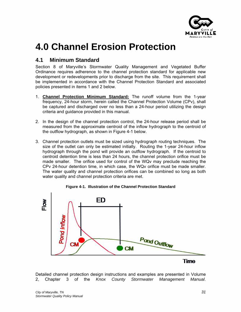
4.0 Channel Erosion Protection 4.1 Minimum Standard Section 8 of Maryville’s Stormwater Quality Management and Vegetated Buffer Ordinance requires adherence to the channel protection standard for applicable new development or redevelopments prior to discharge from the site. This requirement shall be implemented in accordance with the Channel Protection Standard and associated policies presented in items 1 and 2 below. 1. Channel Protection Minimum Standard: The runoff volume from the 1-year
frequency, 24-hour storm, herein called the Channel Protection Volume (CPv), shall be captured and discharged over no less than a 24-hour period utilizing the design criteria and guidance provided in this manual.
2. In the design of the channel protection control, the 24-hour release period shall be
measured from the approximate centroid of the inflow hydrograph to the centroid of the outflow hydrograph, as shown in Figure 4-1 below.
3. Channel protection outlets must be sized using hydrograph routing techniques. The
size of the outlet can only be estimated initially. Routing the 1-year 24-hour inflow hydrograph through the pond will provide an outflow hydrograph. If the centroid to centroid detention time is less than 24 hours, the channel protection orifice must be made smaller. The orifice used for control of the WQv may preclude reaching the CPv 24-hour detention time, in which case, the WQv orifice must be made smaller. The water quality and channel protection orifices can be combined so long as both water quality and channel protection criteria are met.
Figure 4-1. Illustration of the Channel Protection Standard
Detailed channel protection design instructions and examples are presented in Volume 2, Chapter 3 of the Knox County Stormwater Management Manual.
City of Maryville, TN 31 Stormwater Quality Policy Manual

5.0 Water Quality Buffers Water quality buffers are naturally vegetated areas that are located along the edge of streams, lakes, ponds, reservoirs, and wetlands. Section 10 of Maryville’s Stormwater Quality Management and Vegetated Buffer Ordinance requires water quality buffers on waterbodies for all new developments and redevelopments. The City must incorporate requirements for water quality buffers into its stormwater management program in order to comply with State permits. While most water quality buffer requirements are stated in Section 10 of Maryville’s Stormwater Quality Management and Vegetated Buffer Ordinance, this Chapter provides additional policies and guidance relevant to establishing and maintaining water quality buffers in the City of Maryville.
5.1 Vegetation and Planting Guidance Sections 11-14 of Maryville’s Stormwater Quality Management and Vegetated Buffer Ordinance states the minimum vegetative target for each type of buffer (i.e., stream, pond, wetland) that may be required. The ordinance also contains requirements for the improvement of vegetation for purposes of establishing new buffers in areas where the existing vegetation does not, and will not through natural succession, meet the minimum vegetative target for the buffer area. The City of Maryville discourages the introduction or propagation of plants considered as nuisance, non-native (also termed “exotic”) and/or invasive plant species, such as honeysuckle, privet, ivy and kudzu. When establishment of a water quality buffer is required by the City, non-native and/or invasive plant species will not be permitted. Details on appropriate vegetation for water quality buffer areas, detailed information on streambank and buffer restoration techniques, planting guidelines and lists of native plant species can be found from the following sources: • Tennessee Valley Authority’s Riparian Restoration webpage, located at
www.tva.com/river/landandshore/stabilization/index.htm
• Tennessee Valley Authority’s Native Plant Finder webpage, located at www.tva.com/river/landandshore/stabilization/plantsearch.htm;
• Banks and Buffers: A guide to selecting native plants for streambanks and shorelines. Contact information to obtain this publication is provided at www.tva.com/river/landandshore/stabilization/websites.htm;
• the Tennessee Exotic Plant Pest Council website, located at www.tneppc.org; and
• the Natural Resource Conservation Service (NRCS) www.nrcs.gov.
City of Maryville, TN 32 Stormwater Quality Policy Manual

5.2 Buffer Enhancement Plans Section 14 of Maryville’s Stormwater Quality Management and Vegetated Buffer Ordinance requires submittal of a buffer enhancement plan when a buffer must be established or improved. The required components of a buffer enhancement plan are listed below. Omission of any required items renders the WQMP incomplete, and the WQMP will be returned to the applicant without review. The components listed below are included in the WQMP checklist, which is presented in Appendix B-1 of this manual. 1. name, address, email address, and phone number of property owner; 2. name, address, email address, and phone number of the applicant, if different from
the property owner; 3. location map showing the property in relation to adjacent properties, streets, and
nearby watercourses; 4. basic application information, including a description of the need for the buffer
improvement (e.g., current vegetation does not meet the required minimum vegetative target);
5. the dates of the development of the buffer enhancement plan and date of any revisions;
6. a drawing or plan that shows the location of the buffer in relation to the existing or planned development and to any streams, rivers, lakes, ponds, or wetlands.
7. the limits of the area proposed for buffer establishment or improvement, showing the limits of disturbance, grubbing, and grading (if permitted);
8. practices used for erosion prevention and sediment control during establishment of the vegetation;
9. any existing or proposed stream crossings or buffer encroachments; 10. copies of State and/or Federal permits allowing the crossing or encroachment, if
applicable; 11. description and/or drawings indicating the species and density of proposed
vegetation, in accordance with the vegetation requirements stated in Section 14 of Maryville’s Stormwater Quality Management and Vegetated Buffer Ordinance;
12. descriptions and/or drawings indicating the planting practices that will be utilized; 13. an implementation schedule for clearing, grubbing and planting activities; and, 14. a maintenance and monitoring schedule for one full growing season, including
specification of proposed watering plans and schedule.
5.3 Guidance on Water Quality Buffer Averaging This section provides guidance for buffer averaging. Buffer averaging can be utilized, if approved by the City through the variance process, to adjust the required buffer width, allowing some flexibility for site development. Using buffer averaging, the width of the buffer can be varied with the criteria stated in Section 11.5 of Maryville’s Stormwater Quality Management and Vegetated Buffer Ordinance, so long as a minimum average width of fifty (60) feet is maintained and the minimum width at any location is thirty (30) feet. Figures 5-1 and 5-2 illustrate the use of buffer averaging for a residential and commercial development.
City of Maryville, TN 33 Stormwater Quality Policy Manual
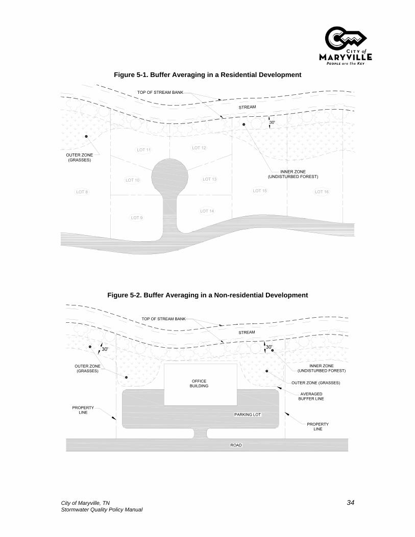
Figure 5-1. Buffer Averaging in a Residential Development
STREAM
TOP OF STREAM BANK
30'
OUTER ZONE (GRASSES)
INNER ZONE (UNDISTURBED FOREST)
LOT 8
LOT 9
LOT 10
LOT 11 LOT 12
LOT 13
LOT 14
LOT 15 LOT 16
Figure 5-2. Buffer Averaging in a Non-residential Development
STREAM
TOP OF STREAM BANK
30'
PARKING LOT
OFFICEBUILDING
ROAD
AVERAGED BUFFER LINE
INNER ZONE (UNDISTURBED FOREST)
OUTER ZONE (GRASSES)
PROPERTY LINE
PROPERTY LINE
OUTER ZONE(GRASSES)
30'
City of Maryville, TN 34 Stormwater Quality Policy Manual
5.3.1 Example Calculation This section provides an example calculation of water quality buffer averaging. Consider a development site that is bounded by 500 linear feet of stream, measured following the stream channel. Only one side of the stream is located within the boundaries of the site to be developed. The example site before and after buffer averaging is applied is presented in Figures 5-3 and 5-4. The example calculation is below. Constants: Total linear length of buffer = 500 ft Required width of buffer = 60 ft Step 1. Calculate the total required area of buffer. The total linear length of the buffer is 500 feet (ft). The required width of the buffer (without averaging) is 60 ft. Total required area of buffer = length of buffer x width of buffer = 500 ft x 60 ft = 30,000 ft2 Step 2. Calculate maximum allowed length of buffer that has the minimum allowed buffer width: Maryville allows a maximum of 50% of the total length of the buffer to have a width comprised only of inner zone. Step 2 will determine the maximum length of buffer that can have the minimum allowed buffer width of 30 feet. Maximum length of 30 ft buffer = length of buffer x 50%
= 500 ft x 50% = 250 linear feet
Therefore, 250 linear feet of the buffer can have the minimum width of 30 feet. Step 3. Calculate total area of buffer that has the minimum allowed buffer width and determine remaining buffer area required. Inner only buffer area = Length of inner only buffer x 30 ft width = 250 ft x 30 ft = 7500 ft2 Necessary buffer area remaining = Total required area of buffer – Inner only buffer
= 30,000 ft2 – 7500 ft2 = 22,500 ft2 Step 4. Determine the width of remaining buffer. Length of Remaining buffer = Total length – Length of inner only buffer = 500 ft – 250 ft
= 250 ft Width of remaining buffer = 22,500 ft2 / 250 ft = 90 ft
City of Maryville, TN 35 Stormwater Quality Policy Manual

Therefore, 250 linear feet of buffer will have a minimum 30 ft width and an additional 250 ft of buffer will have a minimum width of 90 ft, with an overall buffer width average of 60 ft. If more variation in the buffer width is desired, steps 3 and 4 can be repeated using variable buffer widths until an average standard width of 60 feet is achieved keeping the total required area of the buffer constant. The results of this buffer averaging example are shown in Figures 5-3 and 5-4 below.
Figure 5-3. Example Site Before Buffer Averaging
DEVELOPMENT BOUNDARY
DEVELOPMENT BOUNDARY
500' (LENGTH)
TOP OF STREAM BANK
STREAM
REQUIREDBUFFER AREA
(30,000 SQUARE FEET)
60' (WIDTH) 90°
STREAM
ROAD
Figure 5-4. Example Site After Buffer Averaging
DEVELOPMENT BOUNDARY
DEVELOPMENT BOUNDARY
STREAM
500' (LENGTH)
ROAD
TOP OF STREAM BANK
STREAM
90' (WIDTH)
250' (LENGTH)
250' (LENGTH)REQUIRED
BUFFER AREA(30,000 SQUARE FEET)
30' (WIDTH) 90°
90°
City of Maryville, TN 36 Stormwater Quality Policy Manual

5.4 Signage Policies for Water Quality Buffers Permanent boundary marker signs are required prior to recording the final plat to ensure that adjacent property owners are aware of the buffer. The Director of Engineering and Public Works or his/her designee can provide guidance on obtaining the appropriate signage. The following general policies shall apply to buffer boundary markers: 1. In general, buffer boundary markers must be located on the lot lines at the
intersection of the landward edge of the buffer, and at other locations which will approximately delineate the buffer boundary. For single lot site developments, markers, if required, shall be posted every 100 feet along the buffer boundary. For subdivisions where multiple lots are located along the buffer, a buffer boundary marker shall be located at the intersection of every other lot line with the landward edge of the buffer.
2. Buffer boundary markers shall include the statement “Water Quality Buffer – Do Not Disturb”.
3. Where possible, the markers should be mounted to a tree larger than three (3) inches in diameter. Where it is not possible to mount the marker to a tree, a treated wood, metal, or plastic signpost must be used. The post must extend below the ground surface at least twenty-four (24) inches.
4. The boundary markers must be mounted between four (4) and six (6) feet above the ground surface.
5.5 Level Spreaders Level spreaders are structures that are designed to dissipate energy of concentrated flow and distribute it as sheet flow over a large surface area. For water quality buffers, level spreaders are used to maintain the function of buffers by transitioning concentrated flows of stormwater runoff that will enter the buffer into sheet flow. Water quality buffers are most effective for water quality treatment when shallow sheet flow is discharged to them. This creates a shallow flow that has a high surface contact area, increasing infiltration and the effectiveness of filtration. In contrast, concentrated flow can cause erosion in the buffer area, and limits the effectiveness of plants to filter-out pollutants. Level spreaders are simple structures that consist of the following elements: • a pipe, ditch, or swale through which concentrated flow enters the spreader; • an energy dissipater that slows the water; • a level lip provided by the construction of a berm, concrete chute, or other permanent
material or a shallow linear trench. The purpose of this component is to distribute runoff perpendicularly over the lip at the same depth for the entire length of the structure.
The following policies shall apply to level spreaders used in water quality buffer areas: 1. Level spreaders are required where concentrated flows of stormwater runoff would
discharge overland through the water quality buffer, and where the water quality buffer is intended for use as a water quality treatment control to meet the 80% TSS removal requirement or gain a WQv Reduction. Sheet flow must be ensured through
City of Maryville, TN 37 Stormwater Quality Policy Manual
the buffer for a % TSS removal value to be allowed and/or the stream and vegetated buffer reduction to be granted.
2. The design of the level spreader shall be in accordance with the specifications stated in Volume 2, Chapter 7 of the Knox County Stormwater Management Manual.
3. Flows of water already treated to the 80% TSS removal standard that are encountered for storms greater than the 1-year design storm can be piped beneath the buffer to the waterbody (with prior approval by the Director of Engineering and Public Works or his/her designee), provided that proper outfall protection is employed and channel protection and peak flow control criteria have been met.
City of Maryville, TN 38 Stormwater Quality Policy Manual

6.0 Inspection and Maintenance Section 25 of Maryville’s Stormwater Quality Management and Vegetated Buffer Ordinance requires property owners to inspect and maintain all structural and non-structural water quality and channel protection BMPs. This requirement includes all structural BMPs, areas that receive a WQv Reduction (Section 3.2, Table 3-3), and water quality buffer areas. City of Maryville policies pertaining to private ownership and maintenance of water quality and channel protection BMPs are listed below.
6.1 Covenants & Private Ownership Policies 1. The owner of water quality and channel protection BMPs, areas receiving a WQv
reduction and water quality buffer areas must maintain such stormwater features in such manner as to maintain their full and intended function. More specifically:
a. Structural BMPs, which are listed in Section 3.2, Table 3-1 of this manual, must
be maintained such that the BMP can perform to the standard of 80% TSS removal. Property owners shall inspect and maintain structural BMPs in accordance with the inspection and maintenance guidelines for the specific BMPs located on the property that are presented in Volume 2, Chapter 4, Sections 4.3 and 4.4 of the Knox County Stormwater Management Manual.
b. Areas that receive a WQv Reduction shall be maintained in accordance with the design criteria stated in Volume 2, Chapter 5, Section 5.2 of the Knox County Stormwater Management Manual.
c. Water quality buffer areas shall be maintained in accordance with Section 25 of Maryville’s Stormwater Quality Management and Vegetated Buffer Ordinance and the requirements stated in this manual.
3. When a property undergoes development or redevelopment, the property owner
must enter into permanent maintenance agreements for structural and non-structural BMPs located on the property as a condition of approval of the WQMP. This is accomplished by completing and submitting the “Covenants for Permanent Maintenance of Water Quality Best Management Practices” (also called the “Maintenance Covenants”). A blank copy of the Maintenance Covenants is presented in Appendix E-1 of this manual. The Maintenance Covenants must be executed by the property owner and the City of Maryville as a condition of approving the WQMP.
4. The Maintenance Covenants shall be accompanied by a plan of the property that
shows the location and extent of all structural BMPs, WQv Reduction areas, and water quality buffer areas. Metes and bounds describing the easements surrounding each feature must be supplied. The size of each easement shall be as described in the appropriate BMP section within Volume 2, Chapter 4, Sections 4.3 and 4.4 of the Knox County Stormwater Management Manual. Each feature will be clearly identified by type of feature (e.g., water quality buffer, structural BMP, WQv Reduction area). Structural BMPs and WQv Reduction areas must be specifically identified by type (e.g., bioretention area, impervious area disconnection WQv
City of Maryville, TN 39 Stormwater Quality Policy Manual

reduction area). Water quality buffer areas must include a depiction of the boundary of each zone and the intended target vegetation (e.g., inner zone – forest vegetation, outer zone – dense grass).
5. The City of Maryville will inspect each BMP on a periodic basis to ensure that the
property owner is maintaining each BMP in proper condition to achieve its intended function. Right-of-entry for City inspections, and subsequent corrective actions by the City of Maryville if required, is provided by Section 24 of Maryville’s Stormwater Quality Management and Vegetated Buffer Ordinance.
6.2 Guidance for the Disposal of Sediments from Structural BMPs Many of the structural BMPs (presented in Volume 2, Chapter 4 of the Knox County Stormwater Management Manual) that are utilized to prevent stormwater pollutants from entering the waters of the state will accumulate sediment deposits over time and will require maintenance and cleaning to ensure that they continue to work efficiently. Depending on the characteristics of the drainage area to each structural BMP, there could be a wide nature of substances contained within the sediments. The appropriate sediment disposal method will depend on the type of contamination, if any, in the soil. Proper assessment and disposal of accumulated sediment is necessary to ensure that the sediment removed from structural BMPs does not cause discharge of pollutants to the environment. The text in this section shall be regarded as City of Maryville policy for proper assessment and disposal of accumulated sediments that are removed from structural BMPs. (Note: the text below was adapted for the City of Maryville from the City of Knoxville Land Development Manual – Policy 11, June 2003.) When properly designed, structural BMPs will accumulate significant quantities of sediment over time. Sediment gradually reduces the available stormwater storage capacity. A rule of thumb for BMPs such as detention ponds, extended detention ponds and stormwater ponds is that approximately 1% of the storage volume capacity associated with the 2-year design storm can be lost annually due to accumulated sediment. Therefore, approximately 20% of a pond’s total storage capacity can be lost within 20 years. In addition to long-term maintenance, sediment disposal is usually necessary during the construction process. Erosion prevention and sediment control practices and devices are not 100% effective at reducing and eliminating all sediment. Therefore, the developer must ensure that the designed detention volume has been restored and that all graded surfaces have been completely stabilized at the end of construction. Policies pertaining to sediment disposal from structural BMPs are as follows: 1. Structural BMPs shall be inspected on a regular basis to determine the impact of
sedimentation on the capacity. The frequency of inspection is dependent upon the upstream land use(s), type of BMP, and other factors. Inspections should occur during dry weather and wet weather conditions.
City of Maryville, TN 40 Stormwater Quality Policy Manual

2. In general, remove sediment before significant accumulation can occur using a
combination of equipment methods and hand shoveling. Typical intervals for sediment removal will be every 5 to 7 years for some BMP types, 10 to 20 years for others. Typical intervals for sediment removal for sediment forebay or other pretreatment settling basins will be once a year.
3. Specific guidance on inspection and maintenance frequency and activities is
provided in Volume 2, Chapter 4, Sections 4.3 and 4.4 of the Knox County Stormwater Management Manual.
4. If the structural BMP meets any of the following criteria, then the structural BMP
owner must contact the Tennessee Department of Environment and Conservation (TDEC) for further regulations and recommended disposal guidelines.
a. known contaminants are contained in the stormwater runoff that discharges to
the structural BMP or in the sediment that has accumulated in the structural BMP;
b. the structural BMP receives stormwater runoff from an industrial site; c. the structural BMP receives stormwater runoff from a fueling center; d. the structural BMP receives stormwater runoff from one or more commercial
businesses with a total parking area of at least 120,000 square feet or 400 parking spaces;
e. the Director of Engineering and Public Works or his/her designee has reason to believe that contaminants are present based upon scientific or engineering information.
5. If the structural BMP does not meet any of the above criteria, or if the sediment has
been tested and is determined to be free of contamination, then the following disposal practices are allowed:
a. disposal at a Class III or Class IV landfill; b. use for fill material, cover material or land spreading on the project site; c. other disposal materials as approved by the Director of Engineering and Public
Works or his/her designee . 6. All sediment which is disposed onsite must be prevented from re-entering the
structural BMP, or entering any other BMP, drainage channel or culvert, natural creeks or streams, or any other component of the stormwater drainage system.
The following table is a list of local landfills that may accept sediment. Contact each landfill for costs and regulations associated with sediment disposal. This list is not exhaustive.
City of Maryville, TN 41 Stormwater Quality Policy Manual

Table 6-1. Local Landfills for Sediment Disposal
Landfill Location Phone Type
Blount County Sanitary Landfill 240 Long Powers Rd Friendsville, TN 865-995-2892 Sanitary
Burnett-Armstrong Demolition Landfill
3330 Delrose Avenue Knoxville, Tennessee 865-525-6645 Demolition
Poplar View Class III/IV Landfill 7826 Rutledge Pike Knoxville, Tennessee 865-525-7720 Demolition
Ridgeview Demolition Landfill 8723 Oak Ridge Highway Knoxville, Tennessee 865-690-9436 Demolition
Yarnell Demolition Landfill, LLC 1550 Lamon Quarry Road Knoxville, Tennessee 865-470-0023 Demolition
Chestnut Ridge Landfill & Recycling Center
240 Fleenor Mill Road Heiskell, Tennessee (Anderson County)
865-457-7810 Sanitary
City of Maryville, TN 42 Stormwater Quality Policy Manual

7.0 References Atlanta Regional Council (ARC). Georgia Stormwater Management Manual Volume 2
Technical Handbook. 2001. City of Knoxville. Land Development Manual. City of Knoxville Engineering Department,
Stormwater Division, June 2006. Knox County, Tennessee. Knox County Stormwater Management Manual. 2006.
City of Maryville, TN 43 Stormwater Quality Policy Manual

Appendix A - Definitions The definitions provided in this appendix shall apply to the requirements contained in this manual. These definitions pertain to stormwater quality management only. The reader is referred to Maryville’s Stormwater Quality Management and Vegetated Buffer Ordinance for definitions that are not included in this section. As-Built. As-constructed, field-verified plans signed and sealed by a registered professional engineer and/or a registered land surveyor, both licensed to practice in the State of Tennessee, showing contours, elevations, grades, locations, drainage and hydraulic structures, and detention basin volumes. City. The City of Maryville, Tennessee Detailed Plans. A set of plans containing all information necessary to construct a safe and useful development per all local, state and federal regulations. Detailed plans must be stamped by a Licensed Engineer. Plan Review. The review of detailed plans or water quality management plans by the City of Maryville engineering and/or planning department, and/or other administrative agencies or utilities for conformance to applicable City of Maryville development regulations and standards. Engineer. A qualified civil engineer registered and currently licensed to practice engineering in the State of Tennessee. Engineering. The preparation of plans, specifications, and estimates for, and the contract administration of the construction of streets, drainage facilities, utilities and other similar public works installed within a subdivision or site development for public or private use. Vegetation. Collection of plant life, including trees, shrubs, bushes, and grasses. Zoning Ordinance. The duly adopted Zoning Ordinance of the City of Maryville.
City of Maryville, TN A-1 Stormwater Quality Policy Manual

Appendix B – WQMP Checklist
City of Maryville, TN B-1 Stormwater Quality Policy Manual

Date:________________________________ Number of times reviewed (including this one):______________________Project Name:_____________________________________________ Type of review requested:____________________Address:__________________________________________________________________________________________
Nature of Variances:_________________________________________________________________________________
GENERAL INFORMATION1. Date(s) of preparation and any revision(s).2. Seal/signature of responsible engineer.3. Vicinity map including:
a. North arrowb. Scalec. Adjacent roadwaysd. Boundary lines of sitee. Onsite and nearby watercoursesf. Other necessary information to locate the development site
4. Maps (to scale) which clearly show:a. The following lines with accurate bearings and distances:
----
b. The location of the----
c.
d.---
e.f.g. Finished floor and grade at foundation elevations of all existing structuresh. Cut and fill quantities for site worki. Impervious area information for the site
-
500-year floodplain
Water Quality Buffers
For non-residential sites, and for residential subdivisions or lots where the location and footprint of impervious surfaces are known, provide location and footprint area for all impervious surfaces, including buildings, roadways, driveways, sidewalks, parking lots, and out-buildings.
Required minimum floor elevations (MFEs)An Environmental Features Inventory, which shows the boundaries of streams (stream namesmust be shown if known), wetlands, sinkholes, springs, steep slopes (≥15%), forested areas andgrassed areas. This requirement may be superseded where a regional conservation plan exists.In such cases, the environmental features and protection corridors identified in the plan must beshown.
100-year regulatory floodway
Property boundaries
Right-of-way lines of streets and/or Joint Public EasementsUtility access or other easements
100-year floodplain
Lot lines
MARYVILLE, TENNESSEE
This checklist presents the required elements of a stormwater management plan. This checklist must be submitted toMaryville Engineering and Public Works along with the stormwater management plan. Each element presented in this listmust be checked "Yes", as applicable to the site. Checks placed under the "No" column must be justified in a writtenstatement attached to this checklist. Elements of the stormwater management plan that are not applicable for the site mustbe marked as "N/A".
Zoning Classifications:___________________________ Variances? (BZA, Use on Review, Co. Commission, etc.)
WATER QUALITY MANAGEMENT PLAN CHECKLIST
A description of the existng and proposed (if different from existing) vegetation in the waterquality buffer areas must be included on the site plan, or as a separate description. Forexample, a statement on the site plan such as “undisturbed forest vegetation”, or “earlysuccessional forest” is sufficient for the inner zone of a stream buffer provided that the existingvegetation, in fact, meets one of these descriptions.
The statement "Water Quality Buffer. Do Not Disturb" clearly shown.
Roof drainage directionsDimensioned existing and proposed structures on and within 15 feet of the property boundaries
Location, width, outer boundary, and zone boundaries (on streams)
Yes No N/A
Yes No
Yes No N/AYes No N/A
Yes No N/AYes No N/A
Yes No N/AYes No N/AYes No N/A
Yes No N/AYes No N/AYes No N/AYes No N/A
Yes No N/AYes No N/AYes No N/AYes No N/AYes No N/AYes No N/AYes No N/AYes No N/A
Yes No N/AYes No N/A
Yes No N/AYes No N/AYes No N/AYes No N/AYes No N/AYes No N/AYes No N/AYes No N/A
Yes No N/AYes No N/A
Yes No N/A
Yes No N/AYes N/AYes No N/A
Yes No N/AYes No N/AYes No N/AYes No N/AYes No N/AYes No N/A
Yes No N/A
Yes No N/AYes No N/A
City of Maryville, TN B-2 Stormwater Quality Policy Manual

GENERAL INFORMATION (CONTINUED)i. Impervious area information for the site (continued)
-
5.
6.
7.
8.9.
10.
11.
DRAINAGE REPORT 1.
a.b.c.d.e.
f.
g.
2.a.b.
3.a.
b.
c.
d.4.
a.
b.
c.
5. Hydrology Sectiona.
b.
c.
Description of the methodologies, assumptions, and procedures used in preparing the report.
Effect of proposed grading and/or construction on major drainage conveyances
Brief summary of the purpose of the report in relation to the project (e.g., subdivision, single-lotresidential, single-lot non-residential, etc.)
Description of all applicable development standards, policies, stormwater requirements, andfloodplain regulations to which the proposed development must adhere
Map showing project is not in threatened species, endangered species or critical habitat areas;or a letter from TWRA giving approval for management practices.
Title of report
Summary table listing all runoff concentration points, corresponding drainage areas, calculatedpeak discharges for pre- and post-development conditions, and differences in discharges
Drainage maps (drawn to scale) for pre- and post-development conditions which clearly depictcontributing watersheds, sub-basins, runoff concentration points, site outfalls, flow patterns,measured flow lengths, and topographic elevations and contoursHydrologic data sheets, for both pre- and post-development conditions for each runoffconcentration point including time of concentration calculations, rainfall intensities, runoffcoefficients or curve numbers, and peak discharges
Description of the existing and proposed land use/project, drainage patterns, naturalwatercourses, drainage problems, and floodplain status within the developmentSummary of any previous hydrologic/hydraulic studies or other information which pertain to thedevelopment or property
Introduction
Objectives and Procedures Section
Location map showing the project in relation to adjacent properties, streets, and nearbywatercourses
All report pages, including any appendices, shall be numbered sequentially.
Project name, address, and Building Permit File number, if applicableName, address, email address, and phone number of applicant
List of all tables and illustrations
A blank box, 1.5 inches (width) x 0.5 inches (height). "For City of Maryville Use Only" shall be justwritten above or below the box.
Table of Contents
Construction notes, specifications, and design details for any existing stormwater systemcomponents
Dates and reference number of the soils report(s) together with the names, addresses andphone numbers of the firm(s) or individual(s) who prepared the report(s)
Seal/signature of the Tennessee Registered Professional Civil Engineer responsible for preparingthe report
Horizontal controlThe following statement is required on all stormwater management plans:
Established benchmark of known elevation to which every other elevation is referenced
"Adequate drainage, erosion and sediment control measures, best management practices, and/orother stormwater management facilities shall be provided and maintained at all times duringconstruction. Damages to adjacent property and/or the construction site caused by the contractor's or property owner's failure to provide and maintain adequate drainage and erosion/sediment control forthe construction area shall be the responsibility of the property owner and/or contractor."
Name, address, email address, and phone number of engineering firm responsible for reportpreparation
Date of report completion/submittal and dates of any revisions
Recommendations included in the soils engineering or engineering geology reportincorporated in the plans and/or specifications
For residential subdivisions where the location(s) and footprint(s) for buildings are unknown, provide the impervious footprint for roadways, and the assigned % impervious value(s) for the site, or different areas of the site, as appropriate for the lot-layout. Percent impervious values are found in Chapter 3 of the Policy Manual for Water Quality Management. This option can only be utilized for residential sites.
Cover Sheet
Yes No N/A
Yes No N/A
Yes No N/AYes No
Yes No N/AYes No N/AYes No N/AYes No N/AYes No N/AYes No N/A
Yes No N/AYes No N/AYes No N/AYes No N/AYes No N/AYes No N/AYes No N/AYes No N/AYes No N/AYes No N/A
Yes No N/AYes No N/AYes No N/AYes No N/A
Yes No N/AYes No N/A
Yes No N/A
Yes No N/AYes No N/A
Yes No N/AYes No N/A
Yes No N/AYes No N/A
Yes No N/AYes No N/A
Yes No N/A
Yes No N/AYes No N/A
Yes No N/AYes No N/A
Yes No N/AYes No N/A
No N/AYes
Yes No N/A
Yes No N/A
Yes No N/AYes No N/A
City of Maryville, TN B-3 Stormwater Quality Policy Manual

DRAINAGE REPORT (CONTINUED)5. Hydrology Section (continued)
d.
6. Hydraulics Sectiona.b.
c.d.
7.a.
-
--
-
-
-----
b.
c.
d.
e.
f.
g.h.i.
Location, dimensions, elevations, contours, characteristics, cross sections, profiles, and detailsfor all existing and proposed drainage facilities, retaining walls, cribbings, and other protectivedevices
Cross-sections of all open channels and stormwater management facilities basins, includingdesign water surface elevation(s)
Location, size, and type(s) of inflow and outflow structures
Stormwater Management Facility design details and cross-sections. Capacity, discharge(s),spillways, and the 100-year flood elevation for all stormwater management facilities. Shadingof the area inundated by the 100-year flood elevation is recommended.
Description of how the overall stormwater facility design will comply with City water quality,channel protection, overbank flooding, and extreme flooding design criteria
Water quality volume (WQv) calculations. This will include calculations of total impervious area,the WQv for the entire site before and after consideration of any applicable WQv reductions, andthe design WQv and percent removal of total suspended solids (% TSS) for each stormwatermanagement facility that is designed for the purposes of water quality treatment.
Summary table for the downstream hydrologic analysis, including drainage areas, calculatedpeak discharges for pre- and post-development conditions, and differences in discharges at theoutfall(s) of the site, each downstream tributary junction, and each public or major privatedownstream stormwater conveyance structure to the point(s) in the stormwater system where thearea of the portion of the site draining into the system is less than or equal to 10% of the totaldrainage area above that point
Rip-rap length, width, depth, and D50 size
Open channel design and capacity computations
All supporting data, printouts, tables, nomographs, etc., which are referenced in the report
Site plan (to scale) which clearly shows the locations and dimensions of all proposed stormwatermanagement system components that will be constructed in order to comply with the stormwatersystem criteria defined in the Water Quality and Vegetated Buffers Ordinance and LandDevelopment/Public Works Standards. This includes stormwater management facilities utilizedfor stormwater quality treatment, channel protection, overbank flood protection, and extreme floodprotection. At a minimum, the site plan shall include the following:
Stormwater Management System Section
Design computations for all culverts, storm drains, inlets, and street sections. Storm drain designshall include a labeled schematic of the storm drain network, design discharges, pipe capacities,profiles, outlet velocity, and hydraulic grade line
Location, size (if applicable), and description of any WQv reductions that have been included inthe WQv calculation. Sufficient information must be presented for each reductioned area to showthat the area or BMP conforms with the Design/Implementation Criteria presented for thereduction in Volume II Chapter 5 of the Knox County Stormwater Management Manual.Examples of such information include, but are not limited to, a description of existing andproposed vegetation, proposed vegetation management, contributing flow path length,contributing slope percentage, level spreader design calculations, soils permeability and flowvelocity.
Roof drainage direction(s) and finish floor elevations of all buildings
Location and size of access facilities, including ramps, roadways and easements, if applicable
Approximate location and size of all drainage, water quality, and other easementsBoundaries of common areas or private “stormwater facility” easements, if applicableMaximum water surface elevations, limits of ponding, and typical facility cross-section(s)Flow arrows, drainage divides, contours, and finished grades
Plotted inflow and outflow hydrographs (preferably superimposed)If retaining walls are utilized, include free-body diagrams showing all forces, moments, andcomputations required for determining factors of safety against sliding and overturning.
Detailed reservoir routing calculation sheets for all required design storms
Channel protection volume (CPv) calculations performed in accordance with the design criteriastated in the Policy Manual for Stormwater Quality ManagementCalculations to show compliance with overbank flood protection (Qp25) and extreme floodprotection (Qp100) design criteria, including detention volume computations, if applicable
Yes No N/AYes No N/A
Yes No N/AYes No N/AYes No N/AYes No N/A
Yes No N/A
Yes No N/AYes No N/A
Yes No N/A
Yes No N/AYes No N/AYes No N/A
Yes No N/A
Yes No N/A
NoYes N/A
Yes No N/AYes No N/AYes No N/AYes No N/AYes No N/AYes No N/AYes No N/AYes No N/AYes No N/AYes No N/A
Yes No N/A
Yes No N/A
Yes No N/A
Yes No N/AYes No N/A
Yes No N/AYes No N/AYes No N/AYes No N/AYes No N/AYes No N/A
Yes No N/A
City of Maryville, TN B-4 Stormwater Quality Policy Manual

DRAINAGE REPORT (CONTINUED)8.
a.
b.c.d.e.f.g.
9.a.b.
10. Referencesa.
11. Appendicesa.
WATER QUALITY BUFFER ENHANCEMENT PLAN
1.
2.
3.
4.
5.
6.7.
8.
PRELIMINARY OPERATIONS & MAINTENANCE PLAN1.
2.
An accounting of potential off-site drainage from surface or sinkhole overflow sources.
Evidence of appropriate consideration of any relevant State or Federal permits.
A brief description of how the proposed development and/or public improvements will adhere toapplicable stormwater quality, quantity, and/or floodplain regulations and mitigate any impactscreated by the development.
A map that accurately identifies the stormwater system location and components (e.g., stormwaterpond, micropool extended detention pond, pipes, ditches, water quality buffers, etc.) that are locatedon the property. This map also must show the locations of drainage and access easements. Thelanguage used to identify each BMP in the map must be consistent with the BMP names used inPolicy Manual for Stormwater Quality Management and on any inspection checklists included in theO&M Plan.
Appendices may be used for hydrologic, hydraulic, reservoir-routing calculations, etc., and othermaterial not suited for inclusion in the main body of the report.
“Inspection Checklist and Maintenance Guidance” sheet(s) for each type of BMP that is located onthe property. At a minimum, the appropriate template checklist(s) provided in Volume 2 of the KnoxCounty Stormwater Management Manual must be utilized for the O&M Plan. However, site designers may modify the templates to include inspections and maintenance elements as needed andappropriate for the BMPs.
If submitting as a component of a stormwater management plan, a drawing or plan that shows thelocation of the buffer in relation to the existing or planned development and to any community waters.The plan should display the area proposed for restoration or enhancement, showing the limits ofdisturbance, grubbing, and grading (if permitted).Best management practices for erosion prevention and sediment control during the vegetationrestoration or enhancement.Any existing or proposed stream crossings or buffer encroachments. Copies of state and/or federalpermits allowing the crossing or encroachment, if applicable.Description and/or drawings indicating the species and density of proposed vegetation, inaccordance with the vegetation requirements stated in the Policy Manual for Stormwater QualityManagement.Descriptions and/or drawings indicating the planting practices that will be utilized.
Pre- and post-development sinkhole storage volume.Calculations supporting establishment of the sinkhole no-fill line, if applicable.
The following information must be shown for all sinkholes located fully or partially on-site.Sinkhole Floodplain and Drainage Calculations
Back-up calculations for any adjustments to the sinkhole no-fill line.
Provide a listing of pertinent sources of analysis and design procedures used.
An implementation schedule for buffer enhancement activities.
A maintenance and monitoring plan for one full growing season, including specification of proposedwatering plans and schedule.
When water quality buffers must be disturbed or a landowner/developer wants to enhance an existing buffer, a water quality buffer enhancement planwill be required. These plans must contain the following information, at a minimum:
Summary and ConclusionsA brief summary of the analyses and conclusions presented in the drainage report.
Basic application information, including a description of the need for the buffer enhancement; thedates of the development of the buffer enhancement plan and date of any revisions; location mapshowing the property in relation to adjacent properties, streets, and nearby watercourses; name,address, email address, and phone number of property owner; name, address, email address, andphone number of the applicant, if different from the property owner.
Calculations supporting establishment of the sinkhole floodplain elevation, if applicable.
A topographic map showing pre- and post-development contours and sinkhole floodplainelevations based on plugged sinkhole throat conditions (0 cfs outflow) for all sinkholes located on-site or partially on-site.
Yes No N/AYes No N/A
Yes No N/AYes No N/A
Yes No N/AYes No N/A
Yes No N/A
Yes No N/AYes No N/A
Yes No N/AYes No N/A
Yes No N/AYes No N/A
Yes No N/A
Yes No N/AYes No N/A
Yes No N/AYes No N/A
Yes No N/AYes No N/A
Yes No N/AYes No N/AYes No N/AYes No N/A
Yes No N/A
Yes No N/AYes No N/A
Yes No N/AYes No N/AYes No N/AYes No N/A
Yes No N/A
Yes No N/AYes No N/AYes No N/AYes No N/A
City of Maryville, TN B-5 Stormwater Quality Policy Manual

Appendix C – As-Built Checklist
City of Maryville, TN C-1 Stormwater Quality Policy Manual

CERTIFICATION REQUIREMENTS:
1.2.3.4.5.
6.
7.
8.
1.2.3.4.
5.
CITY OF MARYVILLE, TENNESSEEAS-BUILT CHECKLIST
Certifying engineer:_____________________________ Certifying surveyor (as-built):______________________________________Date:________________________________ Property owner:________________________________________________________
Project Name:________________________________________________________________________________________________Address:____________________________________________________________________________________________________
D.
Proposed use of this property:___________________________________________________________________________________
The as-built process is necessary in order for a construction bond or performance bond to be released, as described in the Policy Manual for Stormwater Quality Management and Public Works Standards.
____________________________
Submit as-built drawings which meet the minimum requirements of this checklist.Submit complete stormwater design calculations (signed & stamped by a professionalengineer) showing that the as-built conditions meet the minimum design criteria in theMaryville Stormwater Quality Manual and Public Works Standards. Include all inputs andmethods.
DateA.
Ensure that all roadway, drainage, stormwater BMPs, and water quality structure easementsare properly delineated on a recorded plat.
______________
B.
C.______________ Submit roadway material inspection reports by a qualified geotechnical firm (if not inspecteddirectly by Maryville Engineering).
Ensure that the Operations and Maintenance Plan is recorded at the Blount County Registerof Deeds and also denoted on the recorded plat.Submit a statement from a registered geotechnical engineer certifying that any retaining walls4 feet or taller, that may potentially affect public right-of-way or safety of the general public,have been constructed in accordance with the approved design plan.
AS-BUILT DRAWINGS - GENERAL INFORMATION:
______________
______________
E.
F.
Are all drainage structures located in the drainage easement?
Is each drainage structure labeled with top and invert elevations, size, material, and detail #?Is pump system data included (location, pump make and model, capacity, switch design, inletand discharge sizes, maximum and minimum water surface, and head-flow curves)?
Are the footprints for all impervious surfaces constructed as part of the approved StormwaterManagement Plan?
Are all drainage pipes and structures located correctly on the drawings?Is each drainage pipe labeled with slope, length, size or diameter, material, and inverts?
Does each as-built drawing contain the following statement along with the registeredEngineer's stamp, signature, and license number:Based on site observations and/or information provided by a registered Land Surveyor, I herebycertify that all grading, drainage, structures, and/or systems, erosion and sediment control practicesincluding facilities, and vegetative measures have been completed in substantial conformance withthe approved plans and specifications.
Does each as-built drawing contain the following statement along with the Registered LandSurveyors' stamp, signature, and license number:I hereby certify that I have surveyed the land boundaries and easements shown hereon inaccordance with accuracy requirements for a Category I survey and that the ratio for precision of theunadjusted survey is not less than 1:10,000. I further certify that I have located all natural andmanmade features shown hereon in accordance with the current Standards of Practice as adopted bythe Tennessee State Board of Examiners for Land Surveyors. I certify the location, elevation anddescription of these features.
Does each as-built drawing contain survey benchmarks or other reference point?
Does the title block have same project name, address, and contact persons as original plans?
AS-BUILT DRAWINGS - STORM DRAINAGE STRUCTURES (Pipes, Culverts, Bridges, Inlets, Endwalls, Junction Boxes, Catch Basins, etc.):
Are seal and signature for the certifying Engineer & Surveyor shown on the as-built drawings?
Does each as-built drawing contain a north arrow, bar scale, and coordinates?Is construction complete and have disturbed areas been adequately stabilized to prevent soilerosion?
Yes No N/A
Yes No N/A
Yes No N/AYes No N/A
Yes No N/AYes No N/A
Yes No N/A
Yes No N/AYes No N/A
Yes No N/AYes No N/A
Yes No N/A
Yes No N/A
Yes No N/A
Yes No N/A
Yes No N/A
Yes No N/A
Yes No N/A
City of Maryville, TN C-2 Stormwater Quality Policy Manual
1.
2.3.4.
5.
6.
7.
8.9.
10.
1.
2.
3.4.
1.1. Natural area preservation reduction2. Managed area preservation reduction3. Stream and vegetated buffers reduction4. Vegetated channels reduction5. Impervious area disconnection reduction6. Environmentally sensitive large-lot neighborhood reduction
2.
3.
4.
5.
6.
7.
8.
Are water quality buffer areas clearly marked on the plan with the statement "Water QualityBuffer. Do Not Disturb." ?
AS-BUILT DRAWINGS - WATER QUALITY BUFFERSAre water quality buffers shown and labeled correctly on drawings (outer boundaries and zoneboundaries, if applicable, should be shown)?
Do stormwater BMPs provide for the capture and discharge of the channel protection volumeover no less than a 24-hour period? Are computations provided that are adequate to supportthe channel protection standard?Do stormwater BMPs provide for the attenuation of the peak discharges for the 1-, 2-, 5-, 10-,and 25-year storm events in accordance with the Maryville standards? Are computationsprovided adequate to prove attenuation?
Are manufacturer's identification number, make, model, and size for all proprietory BMPsshown on the plans? Does the property's Operation and Maintenance Manual include and address each type of BMP?
Which WQv reductions were received in the development of this site (check all that apply):
For reductions 5 and 6: Are locations of disconnected downspouts clearly indicated on thedrawings and labeled with the statement "This downspout shall remain disconnected from theimpervious surfaces and shall forever be discharged onto pervious surfaces".
The following questions pertain to water quality reduction areas only.
Have permanent markers been installed correctly on the site?Is the type of legal instrument (convenants, deed restriction, etc.) that will be used to serve andmaintain the buffer stated on the drawing?
AS-BUILT DRAWINGS - WATER QUALITY REDUCTION AREAS
Has minimum freeboard of 1 foot been provided between 100-year storm and top of berm?
Do all plan views correctly show stormwater BMPs at a readable scale, with 1-foot contourswhere 2-foot contours do not show sufficient detail?Are locations and invert elevations for all pipe/ditch outfalls into stormwater BMPs shown?Are BMP and access easements shown and labeled? Are all conflicts avoided?
Do stormwater BMPs provide for the treatment of the water quality volume to a minimumstandard of 80% TSS removal, in accordance with the Maryville StormWater QualityManagement Policy Manual? Are computations provided that are adequate to support 80% TSSremoval?
AS-BUILT DRAWINGS - STORMWATER BMPs
Does the plan include accurate details of outlet structures, including all orifices and weirs, suchas size, diameter, invert elevation, means of anchoring, underdrain systems, etc?
For reductions 1, 2, 3, and 6: Does the plan clearly show the outer boundaries of all openspaces, and indicate the intended vegetation and use of space?For reduction 2: Does the plan include a Vegetative Management Plan that indicates how thevegetation in the Managed Area will be managed in a stormwater-friendly manner?
For reduction 6, is the type of legal instrument (convenants, deed restrictions, etc.) that will beused to limit imperviousness and open space development in the neighborhood indicated onthe drawing?
For reductions 4 and 6: Are the location of the vegetated channels clearly indicated on thedrawing and constructed in conformance with design requirements stated in the MaryvilleStormwater Quality Manual? Provide slope, length, size, and vegetation type (e.g., fescuegrass, bermuda grass, etc.).
For reductions 5 and 6: Do impervious area disconnections conform to the design requirementsstated in the Policy Manual for Stormwater Quality Management?For reduction 6, are the maximum lot density, the total impervious cover percentage, and openspaces shown and correctly labeled on the drawings?
Yes No N/A
NoYes N/A
Yes
No N/A
Yes No N/A
Yes No N/A
Yes No N/A
Yes No N/AYes No N/A
Yes No
Yes No N/A
Yes No N/AYes No N/A
Yes No N/AYes No N/AYes No N/AYes No N/A
No N/AYes
No N/A
Yes
N/ANoYes
N/ANoYes
N/ANoYes
Yes No N/A
N/A
N/ANoYes
City of Maryville, TN C-3 Stormwater Quality Policy Manual

Appendix D – Special Pollutant Abatement Permit
City of Maryville, TN D-1 Stormwater Quality Policy Manual
Please submit Check with Special Pollution Abatement Plan. Date:
For sections 1-10, write the supporting information in the box provided or attach an exhibit labeling which section it is in reference to. Provide complete data in a legible and clearly organized format. A) Legal Name of Facility: B) Mailing Address: Physical Location: Watershed Name: Parcel Number: C) Supporting Information: 1. Name of contact person for plan compliance, including job title, address, and phone numbers. The contact person shall be responsible for keeping records of incidents such as significant spills of toxic pollutants or other discharges which may affect stormwater runoff quality. The contact person shall document and record all inspections and maintenance activities. 2. Description of the facility, nature of work performed, and type of facility. 3. Attach a site map of the facility with buildings, parking, drives, materials loading and access areas, dumpsters, type of each impervious surface, ditches, pipes, catch basins, drainage basin limits, area of facility, acreage of offsite water drainage onto facility, discharge points to “Water of the State” or “Community Waters” with name of the water or channel. This map will be a minimum scale of 1”=50’. STAFF USE ONLY Date Received:
Reviewer:
Plan Number:
City of Maryville, TN D-2 Stormwater Quality Policy Manual

4. Submit an instruction plan to provide employees at all levels within the company a knowledge of methods to prevent stormwater runoff pollution. The plan shall identify periodic dates for such training and methods used. Submit a site-specific spill protection plan that deals with actual hazardous materials and emergency response equipment at the site. 5. A narrative description of significant materials (as defined by 40 CFR 122.26) that are currently or in the past have been treated, stored or disposed outside; method of onsite storage or disposal; materials management practices used to minimize contact of these materials with stormwater runoff for the past three years; materials loading and access area; material disposal area, location and description of existing structural and non-structural control measures to reduce pollutants in stormwater runoff; and a description of any treatment the stormwater receives. 6. Attach a record of available sampling data describing pollutants in stormwater discharges, if available. Carefully research using historical data from previous owner/operator, government records, and investigation reports. 7. Write or attach a preventive maintenance program that includes regular inspection and maintenance of all stormwater management devices (such as cleaning grit chambers and catch basins). Maintenance program shall also include inspecting and testing plant equipment and systems to uncover conditions that could potentially cause breakdowns or failures resulting in discharges of pollutants to surface waters or to groundwater.
City of Maryville, TN D-3 Stormwater Quality Policy Manual

8. Submit a maintenance schedule for sweeping or vacuuming the facility parking areas to prevent washout from deposited emissions laden with hydrocarbons, oxides, salts, metals, worn pavement particulates, hydrocarbons, trash, debris, garbage, metal, tire particles, brake lining particles and various chemicals from the wear and deterioration of vehicles. In the event of remedial work or action, submit a cleanup schedule for debris or material storage areas. 9. Description of other ways the facility plans to implement programs to reduce the discharge of pollutants to stormwater runoff. Provide estimated quantity of stormwater flow, direction of flow, and an estimate of the types of pollutants which are likely to be present in stormwater discharges associated with industrial activity for each area of the facility. Designate each area of the facility as having high, medium or low potential for stormwater pollution and explain rationale. 10. Attach plans, details and specifications that show construction of new structures to protect discharges into “Waters of the State” or into “Community Waters”. Common examples include an appropriately-sized grit chamber, oil skimmer, oil/water separator, media filtration inserts, etc. Vegetative measures such as grassed swales, constructed wetlands, existing woods or a detention basin are commonly used to supplement structural measures.
City of Maryville, TN D-4 Stormwater Quality Policy Manual
D) Certification and signatures: Verify that the certification on this plan is read, thoroughly understood, and signed by the appropriate persons. CERTIFICATION AND SIGNATURE (MUST BE SIGNED BY PRESIDENT, OWNER, OR RANKING OFFICIAL) “I certify under penalty of law that I have personally examined and am familiar with the information submitted in this document and attached exhibits. Based on my inquiry of those individuals immediately responsible for obtaining the information, I believe that the submitted information is true, accurate and complete. I am aware that there are significant penalties for submitting false information, including the possibility of a fine or imprisonment.” Printed Name: Title: Signature: Date: ACCEPTANCE OF RESPONSIBILITY FOR PLAN COMPLIANCE (MUST BE SIGNED BY CONTACT PERSON) “I also certify under penalty of law that I have personally examined and am familiar with the information submitted in this document and attached exhibits. Based on my investigations, I believe that the submitted information is true, accurate and complete. I am aware that there are significant penalties for submitting false information, including the possibility of a fine or imprisonment.” Printed Name: Title: Signature: Date:
(a) Some facilities which are not yet constructed may not have selected a permanent contact person who will ultimately be responsible for plan compliance. In these instances, the contact person may be a technical person within the company who is generally responsible for environmental compliance issues.
(b) The president, owner, or other ranking official who certifies this document is responsible for keeping local government up-to-date concerning the name of the contact person. The president, owner, or other ranking official who certifies this document is also responsible for notifying the local government if he is no longer an official with the company.
If any information changes or is subsequently found to be in error, please resubmit necessary pages of the Special Pollution Abatement Plan along with new signatures and dates. Submit this plan with the Water Quality Management Plan for the proposed
development or redevelopment.
City of Maryville, TN D-5 Stormwater Quality Policy Manual

Appendix E – Covenants for Permanent Maintenance of Water Quality Best Management Practices
City of Maryville, TN E-1 Stormwater Quality Policy Manual
COVENANTS FOR PERMANENT MAINTENANCE OF WATER QUALITY BEST MANAGEMENT PRACTICES
________________, (an individual/ a Tennessee or other state corporation/ partnership) with its (office/ residence) located at ________, (hereinafter "Property Owner") grants these Covenants for Maintenance of Water Quality Best Management Practices (hereinafter "Covenants") on this the ____day of ___.
WITNESSETH:
WHEREAS, the City of Maryville Stormwater Quality Management and Vegetated Buffers Ordinance requires property owners to enter into permanent maintenance agreements for stormwater and/or water quality facilities before the property is developed.
NOW THEREFORE, as a condition of the Engineering and Public Works Department’s issuance of a Certificate of Occupancy or approval of a Final Plat, the property owner warrants, covenants, and grants as follows:
1. That they will fully execute a stormwater maintenance facility and stormwater maintenance documents and the Engineering Department shall record the same in the Register’s Office for Blount County.
The Property owner further warrants that they are the owner of the property located in The City of Maryville (hereinafter “City”) at ________________________________________________ and that a final map and plat has been prepared, said map and plat being prepared by ______________________on the ______day of _______.
The Property owners further agree that said map and plat shall be recorded in the Register’s Office as soon as the recording of this stormwater agreement takes place and a copy of the recorded plat and map be furnished to the City of Maryville Engineering Department.
2. The Property Owner desires to develop all or a portion of the above described property according to the Grading Permit issued by the City based on the Property Owner’s site/subdivision plan entitled _________ dated _________ and prepared by __________________________ (hereinafter “Plan”).
3. The Property Owner will construct and maintain the water quality facilities in strict accord with the Plan, specifications, calculations, and conditions required by the Engineering and Public Works Department.
4. The Property Owner shall provide a surety bond, letter of credit, or cash bond acceptable to the City and in an amount to be determined by the Engineering and Public Works Department in a sum sufficient to guarantee that the water quality facilities are constructed in accordance with the plan.
City of Maryville, TN E-2 Stormwater Quality Policy Manual

5. To ensure that subsequent property owners have notice of these Covenants and
the obligations therein, the Property Owner will include in all instruments conveying any or all of the above described property on which the stormwater and/or water quality facilities are located, the specific instrument numbers referencing these Covenants and the recorded subdivision plat indicated in paragraph 12 herein.
6. The Property Owner will maintain the approved stormwater and/or water quality facilities in good working order acceptable to the City Engineering and Public Works Department. Minimum maintenance of said facilities shall include sediment, debris, oil, hydrocarbons, and foreign materials removal; cutting and removal of woody vegetation on an annual basis; and keeping emergency spillways functional and clear of woody vegetation and debris so that the operation and capacity of the stormwater and/or water quality facilities continue to meet the standards in said Plan.
7. In order to provide access to stormwater and/or water quality facilities by personnel, vehicles and equipment, the Property Owner will provide a twenty (20) foot wide access with an easement from a public street in strict accord with the Plat and any additional conditions required by the Engineering Department. The Property Owner further covenants that no structure or building will be erected on the access easement; that no woody vegetation will be allowed to grow on the access easement; and that no use will be made which will interfere with the use of said easement for the purpose of accessing the facilities. If access to the facilities is obstructed and the City is required to remove the obstruction the City will follow the notice procedure, double lien, and collection process as set forth in paragraph 9 herein. In addition the easement provided above is further described by Metes and Bounds in said Plan.
8. Property Owner grants permission to the City, its agents and employees, to enter upon the property to inspect and monitor said facilities whenever the City deems necessary and further for the City or its agents to repair, replace, maintain, and reconstruct said facilities as permitted herein.
9. (a) If the City determines that the water quality facilities are not being maintained in good working order, and gives written notice to the current property owner to repair, replace, reconstruct, or maintain said facilities within a reasonable time, and the property owner fails to comply with the City's notice within the time specified, Property Owner authorizes the City or its agents to enter upon the Property to repair, reconstruct, replace or perform maintenance on said facilities at the Property Owner's expense.
(b) Property Owner further authorizes the City to place a lien for double the amount of said expenses of repair, maintenance or reconstruction against the property.
(c) If the Property Owner fails to pay the City after forty-five (45) days written notice, the Property Owner authorizes the City to collect said expenses from the Property Owner through the appropriate legal action, with the Property Owner to be liable for the reasonable expenses of collection, court costs, and attorney fees.
(d) Property Owner recognizes, however, that this remedy does not obligate the City to maintain or, repair any stormwater facilities and/or water quality facilities or restrict the City from pursuing other or additional legal remedies against the Property Owner.
City of Maryville, TN E-3 Stormwater Quality Policy Manual

10. These Covenants shall be binding on the Property Owner's heirs, administrators,
executors, successors, and assigns, and any and all subsequent property owners. Upon conveyance of the Property, these Covenants shall transfer to and be binding upon the new property owner and the original Property Owner shall be released from any and all responsibilities and obligations under these Covenants.
11. These Covenants are permanent and shall run with the land.
12. Property Owner shall, upon the recording of these Covenants, record a plat showing and accurately defining the easements for stormwater and/or water quality facilities and the access easements to these facilities on a survey plat of record. The survey plat must reference the instrument number where these Covenants are recorded and contain a note that the property owner is responsible for maintaining the facility.
13. The Engineering and Public Works Department will record the Covenants and the Property Owner shall be responsible for providing to the Engineering Department a check made payable to the Blount County Register of Deeds in the amount sufficient to pay for the said recording. The property of the recorded document shall be returned to the property owner and a copy to the City Law Department before the final plat is signed by the Engineering Department and before all or any portion of the property is transferred or conveyed.
14. Upon Property Owner’s satisfaction of all duties set forth in this Covenant and proof of same, the property owner may make application to the City for the return or refund of the bond, letter of credit, or cash bond.
IN WITNESS WHEREOF, WE HAVE SET OUR HANDS,
THIS _______ DAY OF _________________, ________.
PROPERTY OWNER/AUTHORIZED AGENT:
(Print name here) __________________________________
(Sign name here) __________________________________
THE CITY OF MARYVILLE, TENNESSEE
___________________________________ By: The City of Maryville Mayor
STATE OF TENNESSEE ) COUNTY OF BLOUNT )
City of Maryville, TN E-4 Stormwater Quality Policy Manual

Before me, the undersigned authority, a Notary Public at Large of the State of
Tennessee, personally appeared_______________________________, the property owner, with whom I am personally acquainted, and who, upon oath, executed the foregoing instrument for the purposes therein contained.
WITNESS my hand and official seal at office in The City of Maryville, Tennessee this the _______, day of ______________, _____.
____________________________________ NOTARY PUBLIC
My Commission Expires:___________________
STATE OF TENNESSEE ) COUNTY OF BLOUNT )
Before me, the undersigned authority, a Notary Public at Large of the State of Tennessee, personally appeared ______________________________, with whom I am personally acquainted, and who, upon oath, executed the foregoing instrument for the purposes therein contained, and who further acknowledged that he or she is the _____of _______ and is authorized by_______ to execute this instrument on behalf of same.
WITNESS my hand and official seal at office in The City of Maryville, Tennessee this the _______, day of ______________, _____.
____________________________________ NOTARY PUBLIC
My Commission Expires:___________________
STATE OF TENNESSEE ) COUNTY OF BLOUNT )
City of Maryville, TN E-5 Stormwater Quality Policy Manual

Before me, the undersigned authority, a Notary Public at Large of the State of
Tennessee, personally appeared ________________________________, with whom I am personally acquainted, and who, upon oath, executed the foregoing instrument for the purposes therein contained, and who further acknowledged that he or she is the Mayor of The City of Maryville, Tennessee and is authorized by The City of Maryville, Tennessee to execute this instrument on its behalf.
WITNESS my hand and official seal at office in The City of Maryville, Tennessee this the _______, day of ______________, _____.
___________________________________ NOTARY PUBLIC
My Commission Expires:___________________
STATE OF TENNESSEE )
COUNTY OF BLOUNT )
APPROVED AS TO LEGAL FORM:
CONTRACT NO:_________________
____________________________________ __________________ THE CITY OF MARYVILLE LAW DIRECTOR DATE
City of Maryville, TN E-6 Stormwater Quality Policy Manual
Related Documents


