United States Department of Agriculture Cibola National Forest Draft Land Management Plan Draft Environmental Impact Statement DEIS Volume 2, Appendices Bernalillo, Catron, Cibola, Lincoln, McKinley, Sandoval, Sierra, Socorro, Torrance, and Valencia Counties, New Mexico Forest Service Cibola National Forest MB-R3-03-29 August 2019

Welcome message from author
This document is posted to help you gain knowledge. Please leave a comment to let me know what you think about it! Share it to your friends and learn new things together.
Transcript

United States Department of Agriculture
Cibola National Forest Draft Land Management Plan Draft Environmental Impact Statement DEIS Volume 2, Appendices Bernalillo, Catron, Cibola, Lincoln, McKinley, Sandoval, Sierra, Socorro, Torrance, and Valencia Counties, New Mexico
Forest Service Cibola National Forest MB-R3-03-29 August 2019

In accordance with Federal civil rights law and U.S. Department of Agriculture (USDA) civil rights regulations and policies, the USDA, its Agencies, offices, and employees, and institutions participating in or administering USDA programs are prohibited from discriminating based on race, color, national origin, religion, sex, gender identity (including gender expression), sexual orientation, disability, age, marital status, family/parental status, income derived from a public assistance program, political beliefs, or reprisal or retaliation for prior civil rights activity, in any program or activity conducted or funded by USDA (not all bases apply to all programs). Remedies and complaint filing deadlines vary by program or incident.
Persons with disabilities who require alternative means of communication for program information (for example, Braille, large print, audiotape, American Sign Language, etc.) should contact the responsible Agency or USDA’s TARGET Center at (202) 720-2600 (voice and TTY) or contact USDA through the Federal Relay Service at (800) 877-8339. Additionally, program information may be made available in languages other than English.
To file a program discrimination complaint, complete the USDA Program Discrimination Complaint Form, AD-3027, found online at Filing a USDA Program Discrimination Complaint, https://www.ascr.usda.gov/filing-program-discrimination-complaint-usda-customer, and at any USDA office or write a letter addressed to USDA and provide in the letter all of the information requested in the form. To request a copy of the complaint form, call (866) 632-9992. Submit your completed form or letter to USDA by: (1) mail: U.S. Department of Agriculture, Office of the Assistant Secretary for Civil Rights, 1400 Independence Avenue, SW, Washington, D.C. 20250-9410; (2) fax: (202) 690-7442; or (3) email: [email protected] .
USDA is an equal opportunity provider, employer, and lender.
We make every effort to create documents that are accessible to individuals of all abilities; however, limitations with our word processing programs may prevent some parts of this document from being readable by computer-assisted reading devices. If you need assistance with this document, please contact the Cibola National Forest at (505) 346-3900.
Cover photo: Western front range of the Sandia Mountains within the Sandia Ranger District. The Sandia Ranger District is located in central New Mexico, adjacent and east of the middle Rio Grande Valley (William Stone Photography).

Draft Environmental Impact Statement for the Cibola National Forest Draft Land Management Plan
McKinley, Cibola, Sandoval, Bernalillo, Torrance, Valencia, Lincoln, Socorro, Catron, and Sierra Counties, New Mexico
Lead Agency: USDA Forest Service
Cooperating Agencies: Acoma Pueblo, Bernalillo County, Bureau of Land Management, Canon de Carnuel, Catron County, Chilili Land Grant, Cibola County, City of Albuquerque, City of Gallup, City of Grants, Ciudad Soil and Water Conservation District, Claunch-Pinto Soil and Water Conservation District, Coronado Soil and Water Conservation District, East Torrance Soil and Water Conservation District, Edgewood Soil and Water Conservation District, Kirtland Air Force Base, Lava Soil and Water Conservation District, Lincoln County, Manzano Land Grant, McKinley County, McKinley Soil and Water Conservation District, Merced del Pueblo de Torreon, National Park Service, New Mexico Department of Agriculture, New Mexico Department of Cultural Affairs-Historic Properties Division, New Mexico Department of Game and Fish, New Mexico Environment Department, New Mexico Land Grant Council, Pueblo de Cochiti, Pueblo of Isleta, Pueblo of San Felipe, Pueblo of Santa Ana, Salado Soil and Water Conservation District, San Antonio de Las Huertas Land Grant, Sandoval County Fire Department, Sierra County, Sierra Soil and Water Conservation District, Socorro County, Tajique Land Grant, Torrance County, Valencia Soil and Water Conservation District, Village of Magdalena
Responsible Official: Steven Hattenbach, Forest Supervisor Cibola National Forest and National Grasslands 2113 Osuna Rd NE Albuquerque, NM 87113
For Information Contact: Sarah Browne, Forest Planner Cibola National Forest and National Grasslands 2113 Osuna Rd NE Albuquerque, NM 87113 (505) 346-3900

Draft Environmental Impact Statement for the Cibola National Forest Land Management Plan
i
Contents Appendix A: Public Engagement and Coordination with Other Planning Efforts ................1
Introduction .......................................................................................................................1 Public Engagement Activities and Milestones by Date .......................................................1 Comment Review Process................................................................................................7
Appendix B. Description of the Analysis Process ................................................................ 12 Vegetation Analysis .......................................................................................................... 12
Timber Suitability Analysis ........................................................................................... 12 Vegetation Dynamics Modeling ..................................................................................... 26
Cibola National Forest Climate Change Vulnerability Analysis (CCVA) - Synthesis ............. 94 Methods ....................................................................................................................... 94 Results Summary .......................................................................................................... 94 Definitions .................................................................................................................... 94
Recreation Analysis .......................................................................................................... 99 Social Economic Impact Analyses ..................................................................................... 99
Forest Contribution and Economic Impact Analyses ...................................................... 100 Scenery .......................................................................................................................... 101 Infrastructure Analysis, Process, and Assumptions............................................................ 102
Appendix C: Wilderness Recommendation Process .......................................................... 105 Introduction ................................................................................................................... 105 Inventory of Lands that may be Suitable for Inclusion in the National Wilderness Preservation System ........................................................................................................................... 105
Phase 1 Inventory Process and Criteria ......................................................................... 106 Phase 2 Inventory Process and Criteria ......................................................................... 108 Phase 3 Inventory Process............................................................................................ 111
Evaluation of Lands that may be Suitable for Inclusion in the National Wilderness Preservation System ........................................................................................................................... 113
Phase 1 Evaluation Process and Criteria........................................................................ 113 Applying Evaluation Criteria ....................................................................................... 114 Phase 1 Evaluation Process Conducted ......................................................................... 121
Phase 1 Evaluation Results .............................................................................................. 123 Phase 2 Evaluation Process ............................................................................................. 123
Overall Wilderness Characteristics Finding – Differences from Phase 1 to Phase 2 .......... 124 Criterion 4 and Plus Sign ............................................................................................. 124 Distinction between Evaluation and Analysis Phases ..................................................... 124 March 2017 Phase 2 Evaluation Meetings ..................................................................... 127 Overall Wilderness Characteristics Findings ................................................................. 128
Phase 2 Evaluation Results .............................................................................................. 129 Analysis of Lands that may be Suitable for Inclusion in the National Wilderness Preservation System ........................................................................................................................... 153
Analysis Process and Criteria ....................................................................................... 153 Next Steps- Possible Recommendation ......................................................................... 212
Attachment A. Substantially Noticeable Definition Matrix ................................................ 213 Defining “Substantially Noticeable” ............................................................................. 213 Assumptions Developed When Applying the Substantially Noticeable Definition Matrix . 213 Finalization of Forest Service Handbook Directives during Phase 2 Inventory ................. 215 Applying the Substantially Noticeable Definition Matrix ............................................... 215
Attachment B. Detailed Inventory Results ........................................................................ 224

Contents
Draft Environmental Impact Statement for the Cibola National Forest Land Management Plan
ii
Attachment C. Inventory Phase Team and Team Members ................................................ 249 Attachment D. Inventory and Evaluation Phases Meeting Schedule and Timeline ............... 252 Attachment E. Phase 1 Evaluation Data Protocol .............................................................. 254 Attachment F: Evaluation Criteria and Narrative Form ...................................................... 261 Attachment G. Phase 1 Evaluation Criteria Threshold Definitions ...................................... 269 Attachment H. Phase 2 Evaluation Criteria Threshold Definitions ...................................... 272 Attachment I. Instructions to Determine Overall Wilderness Characteristics Finding for Phase 2 Evaluation ................................................................................................................... 276 Attachment J. Phase 1 and Phase 2 Evaluation Team and Team Members .......................... 278 Attachment K. Phase 1 and Phase 2 Evaluation Meeting Schedule and Timeline ................. 281 Attachment L. Analysis Phase Team ................................................................................ 283 Attachment M. Analysis Phase Meeting Schedule and Timeline ........................................ 284
Appendix D: Documentation of the Wild and Scenic Rivers Eligibility Process ................ 285 Coordination with Previous Eligibility Study .................................................................... 285 Eligibility Study for Land Management Plan Revision ...................................................... 286
Step 1: Identify Named Streams ................................................................................... 286 Step 2: Establish a Core Wild and Scenic River Team.................................................... 286 Step 3: Identify Region of Comparison for Outstandingly Remarkable Values ................ 287 Step 4: Define Criteria for Outstandingly Remarkable Values ........................................ 287 Step 5: Identify Free-flowing Named Streams ............................................................... 287 Step 6: Evaluate Named Streams and Determine if they Possess Outstandingly Remarkable Values ........................................................................................................................ 289 Step 7: Review Level of Development along Eligible Streams and Determine their Classification .............................................................................................................. 289 Step 8: Coordinate with Ranger Districts and Landscape Teams on Preliminary Findings 291 Step 9: Develop Draft Land Management Plan Direction for Eligible Wild and Scenic Rivers .................................................................................................................................. 291 Step 10: Public Participation ........................................................................................ 291
Results of Ineligible and Eligible Wild and Scenic Rivers.................................................. 292 Documentation of Eligibility ........................................................................................... 309 Management of Eligible Wild and Scenic Rivers .............................................................. 317
Appendix E: Crosswalk for At-Risk Wildlife Species (Proposed Action) .......................... 319
Appendix F: Crosswalk for At-Risk Fish and Plant Species (Proposed Action) ................ 359
List of Tables
Table 1. Public engagement milestones ....................................................................................7 Table 2. Characteristics of timber volume measures ................................................................ 15 Table 3. Timber production suitability classification for all alternatives (acres)1........................ 16 Table 4. Sustained yield limit for the Cibola National Forest (all alternatives)........................... 19 Table 5. Estimated annual acreage of vegetation management practices planned for the first and
second decades under alternative A ................................................................................ 20 Table 6. Estimated annual acreage of vegetation management practices planned for the first and
second decades under alternative B................................................................................. 20 Table 7. Estimated annual acreage of vegetation management practices planned for the first and
second decades under alternative C................................................................................. 21 Table 8. Estimated annual acreage of vegetation management practices planned for the first and
second decades under alternative D. ............................................................................... 21

Contents
Draft Environmental Impact Statement for the Cibola National Forest Land Management Plan
iii
Table 9. Planned wood product output for the first and second decades of the plan for alternative A.................................................................................................................................. 22
Table 10. Planned wood product output for the first and second decades of the plan for alternative B .................................................................................................................................. 23
Table 11. Planned wood product output for the first and second decades of the plan for alternative C .................................................................................................................................. 24
Table 12. Planned wood product output for the first and second decades of the plan for alternative D.................................................................................................................................. 25
Table 13. Description of model states for ponderosa pine and dry mixed conifer ....................... 27 Table 14. Juniper Grass vegetation type seral state proportions (%) for desired conditions (DC),
reference conditions (RC), and current and projected proportions and overall departure under alternative A ................................................................................................................. 30
Table 15. Juniper grass vegetation type seral state proportions (%) for desired conditions (DC), reference conditions (RC), and current and projected proportions and overall departure under alternative B ................................................................................................................. 32
Table 16. Juniper grass vegetation type seral state proportions (%) for desired conditions (DC), reference conditions (RC), and current and projected proportions and overall departure under alternative C ................................................................................................................. 34
Table 17. Juniper grass vegetation type seral state proportions (%) for desired conditions (DC), reference conditions (RC), and current and projected proportions and overall departure under alternative D ................................................................................................................. 36
Table 18. Dry mixed conifer vegetation type seral state proportions (%) for desired conditions (DC), reference conditions (RC), and current and projected proportions and overall departure under alternative A ........................................................................................................ 38
Table 19. Dry mixed conifer vegetation type seral state proportions (%) for desired conditions (DC), reference conditions (RC), and current and projected proportions and overall departure under alternative B ........................................................................................................ 40
Table 20. Dry mixed conifer vegetation type seral state proportions (%) for desired conditions (DC), reference conditions (RC), and current and projected proportions and overall departure under alternative C ........................................................................................................ 42
Table 21. Dry mixed conifer vegetation type seral state proportions (%) for desired conditions (DC), reference conditions (RC), and current and projected proportions and overall departure under alternative D ........................................................................................................ 44
Table 22. Wet mixed conifer vegetation type seral state proportions (%) for desired conditions (DC), reference conditions (RC), and current and projected proportions and overall departure under alternative A ........................................................................................................ 46
Table 23. Wet mixed conifer vegetation type seral state proportions (%) for desired conditions (DC), reference conditions (RC), and current and projected proportions and overall departure under alternative B ........................................................................................................ 48
Table 24. Wet mixed conifer vegetation type seral state proportions (%) for desired conditions (DC), reference conditions (RC), and current and projected proportions and overall departure under alternative C ........................................................................................................ 50
Table 25. Wet mixed conifer vegetation type seral state proportions (%) for desired conditions (DC), reference conditions (RC), and current and projected proportions and overall departure under alternative D ........................................................................................................ 52
Table 26. Madrean pine-oak woodland vegetation type seral state proportions (%) for desired conditions (DC), reference conditions (RC), and current and projected proportions and overall departure under alternative A .............................................................................. 54
Table 27. Madrean pine-oak woodland vegetation type seral state proportions (%) for desired conditions (DC), reference conditions (RC), and current and projected proportions and overall departure under alternative B .............................................................................. 56

Contents
Draft Environmental Impact Statement for the Cibola National Forest Land Management Plan
iv
Table 28. Madrean pine-oak woodland vegetation type seral state proportions (%) for desired conditions (DC), reference conditions (RC), and current and projected proportions and overall departure under alternative C .............................................................................. 58
Table 29. Madrean pine-oak woodland vegetation type seral state proportions (%) for desired conditions (DC), reference conditions (RC), and current and projected proportions and overall departure under alternative D .............................................................................. 60
Table 30. Pinyon-Juniper evergreen shrub vegetation type seral state proportions (%) for desired conditions (DC), reference conditions (RC), and current and projected proportions and overall departure under alternative A .............................................................................. 62
Table 31. Pinyon-juniper evergreen shrub vegetation type seral state proportions (%) for desired conditions (DC), reference conditions (RC), and current and projected proportions and overall departure under alternative B .............................................................................. 64
Table 32. Pinyon-juniper evergreen shrub vegetation type seral state proportions (%) for desired conditions (DC), reference conditions (RC), and current and projected proportions and overall departure under alternative C .............................................................................. 66
Table 33. Pinyon-juniper evergreen shrub vegetation type seral state proportions (%) for desired conditions (DC), reference conditions (RC), and current and projected proportions and overall departure under alternative D .............................................................................. 68
Table 34. Pinyon-juniper grass vegetation type seral state proportions (%) for desired conditions (DC), reference conditions (RC), and current and projected proportions and overall departure under alternative A ........................................................................................................ 70
Table 35. Pinyon-juniper grass vegetation type seral state proportions (%) for desired conditions (DC), reference conditions (RC), and current and projected proportions and overall departure under alternative B ........................................................................................................ 72
Table 36. Pinyon-juniper grass vegetation type seral state proportions (%) for desired conditions (DC), reference conditions (RC), and current and projected proportions and overall departure under alternative C ........................................................................................................ 74
Table 37. Pinyon-juniper grass vegetation type seral state proportions (%) for desired conditions (DC), reference conditions (RC), and current and projected proportions and overall departure under alternative D ........................................................................................................ 76
Table 38. Pinyon-juniper woodland vegetation type seral state proportions (%) for desired conditions (DC), reference conditions (RC), and current and projected proportions and overall departure under alternative A .............................................................................. 78
Table 39. Pinyon-juniper woodland vegetation type seral state proportions (%) for desired conditions (DC), reference conditions (RC), and current and projected proportions and overall departure under alternative B .............................................................................. 80
Table 40. Pinyon-juniper woodland vegetation type seral state proportions (%) for desired conditions (DC), reference conditions (RC), and current and projected proportions and overall departure under alternative C .............................................................................. 82
Table 41. Pinyon-juniper woodland vegetation type seral state proportions (%) for desired conditions (DC), reference conditions (RC), and current and projected proportions and overall departure under alternative D .............................................................................. 84
Table 42. Ponderosa pine forest vegetation type seral state proportions (%) for desired conditions (DC), reference conditions (RC), and current and projected proportions and overall departure under alternative A ........................................................................................................ 86
Table 43. Ponderosa pine forest vegetation type seral state proportions (%) for desired conditions (DC), reference conditions (RC), and current and projected proportions and overall departure under alternative B ........................................................................................................ 88
Table 44. Ponderosa pine forest vegetation type seral state proportions (%) for desired conditions (DC), reference conditions (RC), and current and projected proportions and overall departure under alternative C ........................................................................................................ 90

Contents
Draft Environmental Impact Statement for the Cibola National Forest Land Management Plan
v
Table 45. Ponderosa pine forest vegetation type seral state proportions (%) for desired conditions (DC), reference conditions (RC), and current and projected proportions and overall departure under alternative D ........................................................................................................ 92
Table 46. The synthesis of the Cibola NF CCVA. (Table 46 was based on an approach used for Bureau of Land Management lands in New Mexico. See table 47 for key to ERU codes.) .. 96
Table 47. Ecological response unit codes, subclasses, and system types.................................... 99 Table 48. Phase 1 inventory results for stand-alone areas greater than 5,000 acres ................... 107 Table 49. Phase 1 inventory results for areas adjacent to existing wilderness or recommended
wilderness study areas ................................................................................................. 108 Table 50. Comparison of phase 1 and phase 2 inventory results. ............................................ 110 Table 51. Comparison of phase 1, 2, and 3 inventory results .................................................. 112 Table 52. Notable differences between phase 1 and phase 2 evaluation on the Mt. Taylor Ranger
District ....................................................................................................................... 128 Table 53. Notable differences between phase 1 and phase 2 evaluation on the Magdalena Ranger
District ....................................................................................................................... 128 Table 54. Notable differences between phase 1 and phase 2 evaluation on the Mountainair Ranger
District ....................................................................................................................... 128 Table 55. Notable differences between phase 1 and phase 2 evaluation on the Sandia Ranger
District ....................................................................................................................... 128 Table 56. Phase 1 and phase 2 wilderness characteristics evaluation results on the Mt. Taylor
Ranger District ............................................................................................................ 130 Table 57. Phase 1 and phase 2 wilderness characteristics evaluation results on the Magdalena
Ranger District ............................................................................................................ 132 Table 58. Phase 1 and phase 2 wilderness characteristics evaluation results on the Mountainair
Ranger District ............................................................................................................ 146 Table 59. Phase 1 and phase 2 wilderness characteristics evaluation results on the Sandia District
.................................................................................................................................. 149 Table 60. Summary of evaluated areas with recommendations ............................................... 158 Table 61. Substantially noticeable definition matrix table ...................................................... 217 Table 62. Mount Taylor Ranger District detailed inventory results ......................................... 224 Table 63. Magdalena Ranger District detailed inventory results ............................................. 230 Table 64. Mountainair Ranger District detailed inventory results ........................................... 244 Table 65. Sandia Ranger District detailed inventory results ................................................... 246 Table 66. Steering committee for land management plan revision, phase 1 and 2 inventory ..... 249 Table 67. Inventory team for land management plan revision, phase 1 and 2 inventory............ 249 Table 68. District interdisciplinary teams for land management plan revision, phase 1 and 2
inventory .................................................................................................................... 249 Table 69. Extended team for land management plan revision, phase 1 and 2 inventory ............ 250 Table 70. Steering committee for land management plan revision, phase 3 inventory .............. 250 Table 71. Inventory interdisciplinary team for land management plan revision, phase 3 inventory
.................................................................................................................................. 251 Table 72. Extended team for land management plan revision, phase 3 inventory ..................... 251 Table 73. Meeting schedule and timeline for the inventory and evaluation process .................. 252 Table 74. Criteria considerations and data protocol used for evaluation for Criterion 1: Apparent
Naturalness ................................................................................................................. 255 Table 75. Criteria considerations and data protocol used for evaluation for Criterion 2:
Outstanding opportunities for solitude, primitive and unconfined recreation, or both........ 257 Table 76. Criteria considerations and data protocol used for evaluation for Criterion 4: Unique
and outstanding qualities.............................................................................................. 258 Table 77. Criteria considerations and data protocol used for evaluation for Criterion 5:
Manageability ............................................................................................................. 259

Contents
Draft Environmental Impact Statement for the Cibola National Forest Land Management Plan
vi
Table 78. Criteria and rating for wilderness characteristic Criterion 1: Apparent naturalness .... 269 Table 79. Criteria and rating for wilderness characteristic Criterion 2: Solitude and primitive and
unconfined recreation .................................................................................................. 270 Table 80. Criteria and rating for wilderness characteristic Criterion 3: Stand-alone area less than
5,000 acres.................................................................................................................. 270 Table 81. Criteria and rating for wilderness characteristic Criterion 4: Unique and outstanding
qualities ...................................................................................................................... 270 Table 82. Criteria and rating for wilderness characteristic Criterion 5: Management ................ 271 Table 83. Criteria and ratings for wilderness characteristic Criterion 1: Apparent naturalness .. 272 Table 84. Criteria and ratings for wilderness characteristic Criterion 2: Solitude and primitive and
unconfined recreation .................................................................................................. 273 Table 85. Criteria and ratings for wilderness characteristic Criterion 3: Stand-alone area less than
5,000 acres.................................................................................................................. 273 Table 86. Criteria and ratings for wilderness characteristic Criterion 4: Unique and outstanding
qualities ...................................................................................................................... 274 Table 87. Criteria and ratings for wilderness characteristic Criterion 5: Management .............. 275 Table 88. Steering committee for land management plan revision phase 1 evaluation .............. 278 Table 89. Evaluation interdisciplinary team for land management plan revision phase 1 evaluation
.................................................................................................................................. 278 Table 90. Extended team for land management plan revision phase 1 evaluation ..................... 279 Table 91. Steering committee for land management plan revision, phase 2 evaluation ............. 279 Table 92. Phase 2 evaluation interdisciplinary team .............................................................. 280 Table 93. Extended team for land management plan revision, phase 2 evaluation .................... 280 Table 94. Meeting schedule and timeline for the phase 1 evaluation process ........................... 281 Table 95. Meeting schedule and timeline for the phase 2 evaluation process ........................... 282 Table 96. Committee for land management plan revision for analysis..................................... 283 Table 97. Analysis interdisciplinary team ............................................................................. 283 Table 98. Meeting schedule and timeline for the analysis process. .......................................... 284 Table 99. Summary of outstandingly remarkable values criteria ............................................. 288 Table 100. Classification criteria for wild, scenic, and recreational river areas ........................ 290 Table 101. Summary of findings of eligible wild and scenic rivers on the Cibola .................... 293 Table 102. Streams deemed ineligible for wild and scenic river designation on the Mount Taylor
Ranger District ............................................................................................................ 298 Table 103. Streams deemed ineligible for wild and scenic river designation on the Magdalena
Ranger District ............................................................................................................ 301 Table 104. Streams deemed ineligible for wild and scenic river designation on the Mountainair
Ranger District ............................................................................................................ 306 Table 105. Streams deemed ineligible for wild and scenic river designation on the Sandia Ranger
District ....................................................................................................................... 308 Table 106. Wild and scenic river eligibility summary for Agua Remora, Mt. Taylor Ranger
District ....................................................................................................................... 309 Table 107. Wild and scenic river eligibility summary for Little Water Canyon, Mt. Taylor District
.................................................................................................................................. 310 Table 108. Wild and scenic river eligibility summary for Water Canyon #1, Mt. Taylor District
.................................................................................................................................. 311 Table 109. Wild and scenic river eligibility summary for Rinconada, Mt. Taylor District ........ 312 Table 110. Wild and scenic river eligibility summary for West Red Canyon, Magdalena District
.................................................................................................................................. 313 Table 111. Wild and scenic river eligibility summary for Tajique Canyon, Mountainair District
.................................................................................................................................. 314 Table 112. Wild and scenic river eligibility summary for Las Huertas Creek, Sandia District ... 316

Contents
Draft Environmental Impact Statement for the Cibola National Forest Land Management Plan
vii
Table 113. Crosswalk between at-risk species, key ecological conditions, key threats, and primary plan components that provide for viability .................................................................... 320
Table 114. Crosswalk between at-risk species, key ecological conditions, key threats, and primary plan components that provide for persistence ................................................................ 359
List of Figures
Figure 1. Vegetation Dynamics Development Tool state-and-transition model for ponderosa pine and dry mixed conifer .................................................................................................... 28
Figure 2. Current and projected seral state proportions compared to desired conditions for juniper grass vegetation type, alternative A ................................................................................ 31
Figure 3. Current and projected seral state proportions compared to desired conditions for juniper grass vegetation type, alternative B................................................................................. 33
Figure 4. Current and projected seral state proportions compared to desired conditions for juniper grass vegetation type, alternative C................................................................................. 35
Figure 5. Current and projected seral state proportions compared to desired conditions for juniper grass vegetation type, alternative D ................................................................................ 37
Figure 6. Current and projected seral state proportions compared to desired conditions for dry mixed conifer vegetation type, alternative A ................................................................... 39
Figure 7. Current and projected seral state proportions compared to desired conditions for dry mixed conifer vegetation type, alternative B.................................................................... 41
Figure 8. Current and projected seral state proportions compared to desired conditions for dry mixed conifer vegetation type, alternative C.................................................................... 43
Figure 9. Current and projected seral state proportions compared to desired conditions for dry mixed conifer vegetation type, alternative D ................................................................... 45
Figure 10. Current and projected seral state proportions compared to desired conditions for wet mixed conifer vegetation type, alternative A ................................................................... 47
Figure 11. Current and projected seral state proportions compared to desired conditions for wet mixed conifer vegetation type, alternative B.................................................................... 49
Figure 12. Current and projected seral state proportions compared to desired conditions for wet mixed conifer vegetation type, alternative C.................................................................... 51
Figure 13. Current and projected seral state proportions compared to desired conditions for wet mixed conifer vegetation type, alternative D ................................................................... 53
Figure 14. Current and projected seral state proportions compared to desired conditions for Madrean pine-oak woodland vegetation type, alternative A .............................................. 55
Figure 15. Current and projected seral state proportions compared to desired conditions for Madrean pine-oak woodland vegetation type, alternative B .............................................. 57
Figure 16. Current and projected seral state proportions compared to desired conditions for Madrean pine-oak woodland vegetation type, alternative C .............................................. 59
Figure 17. Current and projected seral state proportions compared to desired conditions for Madrean pine-oak woodland vegetation type, alternative D .............................................. 61
Figure 18. Current and projected seral state proportions compared to desired conditions for pinyon-juniper evergreen shrub vegetation type, alternative A .......................................... 63
Figure 19. Current and projected seral state proportions compared to desired conditions for pinyon-juniper evergreen shrub vegetation type, alternative B .......................................... 65
Figure 20. Current and projected seral state proportions compared to desired conditions for pinyon-juniper evergreen shrub vegetation type, alternative C .......................................... 67
Figure 21. Current and projected seral state proportions compared to desired conditions for pinyon-juniper evergreen shrub vegetation type, alternative D .......................................... 69

Contents
Draft Environmental Impact Statement for the Cibola National Forest Land Management Plan
viii
Figure 22. Current and projected seral state proportions compared to desired conditions for pinyon-juniper grass vegetation type, alternative A.......................................................... 71
Figure 23. Current and projected seral state proportions compared to desired conditions for pinyon-juniper grass vegetation type, alternative B .......................................................... 73
Figure 24. Current and projected seral state proportions compared to desired conditions for pinyon-juniper grass vegetation type, alternative C .......................................................... 75
Figure 25. Current and projected seral state proportions compared to desired conditions for pinyon-juniper grass vegetation type, alternative D.......................................................... 77
Figure 26. Current and projected seral state proportions compared to desired conditions for pinyon-juniper woodland vegetation type, alternative A ................................................... 79
Figure 27. Current and projected seral state proportions compared to desired conditions for pinyon-juniper woodland vegetation type, alternative B ................................................... 81
Figure 28. Current and projected seral state proportions compared to desired conditions for pinyon-juniper woodland vegetation type, alternative C ................................................... 83
Figure 29. Current and projected seral state proportions compared to desired conditions for pinyon-juniper woodland vegetation type, alternative D ................................................... 85
Figure 30. Current and projected seral state proportions compared to desired conditions for ponderosa pine forest vegetation type, alternative A ........................................................ 87
Figure 31. Current and projected seral state proportions compared to desired conditions for ponderosa pine forest vegetation type, alternative B......................................................... 89
Figure 32. Current and projected seral state proportions compared to desired conditions for ponderosa pine forest vegetation type, alternative C......................................................... 91
Figure 33. Current and projected seral state proportions compared to desired conditions for ponderosa pine forest vegetation type, alternative D ........................................................ 93

Appendix A: Public Engagement and Coordination with Other Planning Efforts
Draft Environmental Impact Statement for the Cibola National Forest Land Management Plan
1
Appendix A: Public Engagement and Coordination with Other Planning Efforts Introduction The following is a summary of the Cibola National Forest’s public engagement process during revision of the draft land management plan. The Cibola staff kicked off efforts to revise the 1985 plan in 2012, and in April 2014, they released a Draft Assessment Report of Ecological, Social, and Economic Conditions, Trends, and Risks to Sustainability. Public comments received help to further refine the assessment report and led to an extensive identification of needs to change the 1985 plan. Needs-for-change statements were developed collaboratively, both internally and externally, by comparing conclusions from the respective topic areas of the assessment with the plan direction of the 1985 plan. These statements paint a picture of strategic changes necessary to address issues identified in the assessment and present a vision for future management of the Cibola National Forest. Cibola personnel built upon these previous efforts in the release of the preliminary draft land management plan in summer 2016 and has since incorporated comments received on the preliminary release as part of the further development of the draft land management plan and draft environmental impact statement that was shared with the public and cooperating agencies in the fall of 2018.
Per the 2012 Planning Rule, Cibola personnel have made efforts to engage the public frequently and innovatively throughout the planning process. This has included conventional methods such as public meetings and information sharing via social media as well as more innovative approaches. The Cibola’s collaborative public engagement approaches have included the development of cooperating agencies, nongovernmental organizations, and other special interest groups organized around each of the four mountain ranger districts that are currently operating as district collaborative groups along with the formation of the Cibola Shared Stewardship Collaborative.
Public Engagement Activities and Milestones by Date Following is a summary of public engagement activities organized by milestones to date that illustrate the Cibola’s public engagement since 2012. See table 1 for a list of these milestones including tribal consultation milestones. Detailed tribal consultation since the plan revision began in 2012 is available in the administrative record under “Consultation”.
November 2012: Plan Revision Kickoff During November 2012, Cibola personnel held a total of six public meetings around the national forest to announce the kickoff of plan revision activities and to seek comment and input on the assessment report.
May 2014: Draft Assessment Release During May 2014, seven public, two tribal, and one technical meetings were held around the Cibola. At this time, key findings from the draft assessment report were presented and comments were requested. In June, the public was again engaged and asked to participate in two rounds of collaborative work sessions to help the Cibola draft statements of needs for change to the current plan. A total of eight public and four tribal collaborative work sessions were held at this time. In response to a request, the informal comment period that began with the release of the draft assessment report was extended through the end of July. In February 2015, the needs for change statements were released and a notice of intent to prepare an environmental impact statement was published in the Federal Register. This began the official 45-day scoping period for the environmental impact statement.

Appendix A: Public Engagement and Coordination with Other Planning Efforts
Draft Environmental Impact Statement for the Cibola National Forest Land Management Plan
2
2014-2015: Needs for Change Development and Notice of Intent Draft needs for change statements were developed and presented to Cibola users and interested citizens through various media, including collaborative work sessions held in each ranger district. During the work sessions, relationships with and among stakeholders were established or strengthened; information was shared; and self-convened, self-directed groups were organized around key issues. At these work sessions, input was gathered to inform needs-for-change statements that was ultimately published in a Federal Register Notice of Intent announcement on February 9, 2015 (80 Fed. Reg. 6945, 2015). In summary, the needs for change consisted of needs throughout the plan, across multiple resource areas, ecological integrity, cultural and historic resources, areas of tribal importance, multiple uses, recreation, designated areas, infrastructure, land status and ownership, use and access, energy, minerals, and special uses. This announcement conveyed that the Cibola intended to develop a revised land management plan based on identified needs for change, would develop plan alternatives, and would analyze the alternative’s respective effects on the environment.
Spring 2015: Landscape Teams Kickoff Landscape teams were formed in April of 2015 in response to concern about the traditional model of the Forest Service hosting public meetings where information developed internally was disseminated to the public and comment was requested not being adequate. Members of the public wanted a more active role in shaping future management of the lands that they use and enjoy. This prompted the Cibola to reevaluate the previous public engagement strategy and to look for innovative ways to involve the public that were within the bounds of existing law and regulations. The Cibola initiated memoranda of understanding with cooperating agencies to help with the environmental analysis in the land management plan revision process. The cooperating agencies included Federal and State agencies, local governments, tribes, and land grants that are units of State government. There are currently 43 cooperating agencies.
The National Environmental Policy Act allows for a lead Federal agency, in this case the Cibola, to invite other units of government to participate in the environmental analysis process (40 CFR 1501.6; 1508.5). Those units of government are identified as those that have jurisdiction by law, including the authority to approve (such as grant permits), veto, or finance all or part of implementing the proposed action, or those with special expertise. Special expertise includes experience regarding statutory responsibility, agency mission or related program expertise (more than an interest in a proposed action); expertise needed to help the lead agency meet a statutory responsibility; expertise developed to carry out an agency mission; related program expertise or experience; or expertise regarding the proposed actions’ relationship to the objectives of regional, State and local land use plans, policies and controls. This formal relationship allows the Cibola to request the participation of each agency early in the environmental analysis process and to use the analyses and proposals of cooperating agencies to the extent possible. Cooperating agencies are able to participate in scoping to identify significant issues, to develop information, and to assist in preparation of environmental analyses.
Five interdisciplinary teams were formed by organizing a group of cooperating agencies around each of the four ranger districts, plus one forestwide team. Interdisciplinary teams consisted of a group of specialists who worked together on projects that required multiple skills sets or areas of expertise and were referred to during 2015 and 2016 as “landscape teams.”

Appendix A: Public Engagement and Coordination with Other Planning Efforts
Draft Environmental Impact Statement for the Cibola National Forest Land Management Plan
3
Cooperating agencies participated as an extended interdisciplinary team with the Cibola in land management plan revision tasks and milestones. The role of the cooperating agencies during 2015 and 2016 was to co-convene and co-design the public engagement process, outreach to include diverse stakeholders and interests, provide information to the Cibola per their relevant expertise, and review all public comments and provide recommendations as part of the extended interdisciplinary team to the Forest Service.
The interaction between the Cibola and the cooperating agencies working together consisted of a collaborative interdisciplinary approach where agency members provided their expertise and recommendations in the development of various land management plan revision products. The following products and meetings were generated in conjunction with the cooperating agencies during 2015 and 2016: co-hosting and co-designing public workshops; review of public comments; development of draft desired conditions, objectives, standards, and guidelines; participation in the wilderness inventories (phases 1, 2, and 3) and wilderness evaluation meetings; draft management area and draft alternative recommendations in the July 2016 Cibola preliminary draft plan.
Members of the Mount Taylor, Magdalena, and Mountainair interdisciplinary teams developed vision statements for the Cibola preliminary draft plan. The Sandia vision statement was developed in 2018 as there was not a vision statement in the July 2016 preliminary draft plan version. Following are the vision statements by ranger district interdisciplinary team.
Mount Taylor Vision Statement We envision a landscape that is sustained in health by and through a commitment to stewardship as our most basic and deeply held value.
We envision a landscape that is sustained collaboratively by a rich and growing partnership of individuals, groups, and institutions, recognizing the legal status of the USDA Forest Service as the government’s designated management agency representing the people of the United States, and appreciating its commitment to partnership as a guiding principle of informed functioning. We are mutually committed to finding common ground and using that commonality as a strong basis for continuing success.
We envision a landscape that is managed in a manner which respects and recognizes the historic, cultural, and spiritual significance of the area to multiple constituencies, both native and nonnative, and both protects and facilitates appropriate access to areas which are considered special places.
We envision a landscape that is managed for multiple sustainable uses; for vegetation, for wildlife, for valued water resources, for reduced risk of wildfire, for forest industries, for raw materials, for viable agriculture, for recreation and for tourism. We recognize that some specific portions of the landscape may merit special management area emphasis within a policy of multiple use, but we believe that the principle that potentiates and ensures multiple use of our forest is access.
We envision a landscape that is actively managed to develop and sustain healthy local economies. Fundamental to our local economies are ranching and other agriculture, forest products industries, extraction industries, and tourism. These activities entail stewardship and responsible planning, with proper attention to sustainable use and public health. Granted this approach, they are to be encouraged in forest management policy. Viable local economies are intimately linked to good forest management.

Appendix A: Public Engagement and Coordination with Other Planning Efforts
Draft Environmental Impact Statement for the Cibola National Forest Land Management Plan
4
We envision a landscape that is enhanced by a proactive policy of educating and informing the public, one which involves outreach to local schools, clubs, community groups, and businesses. Education also plays an important role in tourism. Visitors to our forest should have access to user-friendly information, both centrally and on-site, that enriches their understanding and elevates their appreciation of our forest.
We envision a landscape that is managed with attention to dynamic action. Planning should be strategic, and action should be efficient and effective. Good customer service is important and is fundamental to effective collaboration. We see collaboration as key to long-term success, and we plan to use our partnerships to create consensus and actively both pursue and acquire funding to further our vision of a healthily functioning forest.
Magdalena Vision Statement We support the vision of continued historical multiple uses including grazing, hunting, recreation, mining and forest products. We also support the vision of continued sustainability of the national forest through responsible resource management and support of local communities through responsible land and water development, utilization of the national forest, and continued partnerships with research entities such as the Magdalena Ridge Observatory, the Langmuir Laboratory for Atmospheric Research and the Karl G. Jansky Very Large Array.
Mountainair Vision Statement We support an emphasis on watershed health through sustainability, regeneration and protection of natural resources while ensuring that local communities benefit from the national forest through improved water quality and quantity, forest-related economic development opportunities, and access for traditional and multiple uses. We support an over-arching emphasis on watershed health to help ensure a positive legacy for future generations.
Sandia Vision Statement The vision of the uniquely urban Sandia Ranger District is to promote, preserve, restore, and enhance the landscape for traditional and contemporary multiple uses for current and future generations. This will be achieved through collaborative stewardship and community engagement that protects flora, fauna, historic and cultural properties and artifacts, and watersheds and manages fire risk, natural resources, and year-round recreational and educational opportunities.
2014-2015 Wilderness Inventory A draft inventory map of lands that may be suitable for inclusion in the National Wilderness Preservation System was released in September 2014. In addition to the static maps, an interactive collaborative mapping tool was also released online that allowed the public to make spatially explicit comments on individual polygons as well as see and respond to comments that others had left. A series of four meetings were held around the Cibola and a 60-day informal comment period was initiated. Additional presentations about the wilderness inventory and evaluation processes were made to various user groups around central New Mexico per request. Because of the high level of interest in this process, the Cibola incorporated public comments received and released a set of phase 2 inventory maps, a draft substantially noticeable matrix, draft evaluation criteria, and other plan materials (described below) in July 2015 and started an informal 60-day comment period at that time. A total of 11 public meetings were held in conjunction with these releases.

Appendix A: Public Engagement and Coordination with Other Planning Efforts
Draft Environmental Impact Statement for the Cibola National Forest Land Management Plan
5
2015-2017 Wilderness Evaluation Comments received during the 2015 informal comment period on the wilderness inventory informed the phase 3 inventory maps and the draft evaluation criteria. The Cibola co-convened with the cooperating agencies to conduct wilderness evaluation for each ranger district between December 2015 and February 2016. The evaluation criteria were applied to the phase 3 inventory maps and the draft wilderness evaluation findings were released in July 2016, along with the preliminary draft plan. Upon release, an informal 45-day comment period began for all of these materials.
In the summer of 2016, the Cibola held a series of public workshops in cooperation with the cooperating agencies to gather input on the phase 1 evaluation results, in addition to the preliminary draft plan and draft alternatives, which contained recommended wilderness areas. Following these public workshops, and based upon Regional Office review and consideration of public comment, the Cibola decided to revisit parts of the evaluation process, resulting in the phase 2 evaluation results.
The steps for the phase 2 evaluation process are identified within the wilderness appendix. Public involvement for the updated phase 2 evaluation results occurred in the fall of 2018.
2016 Wild and Scenic Rivers Eligibility Process As part of the land management plan revision process, the Forest Service is instructed to conduct a comprehensive inventory and evaluation to determine which rivers on the Cibola are eligible for inclusion in the National Wild and Scenic Rivers System. Forest Service Handbook 1909.12 was used to determine which rivers on the Cibola were eligible. These draft eligibility findings were released in July 2016 with the preliminary draft plan and other materials and an informal 45-day comment period began. The eligible reaches from the updated eligibility study were also released for public comment during the fall of 2018.
2014-2016 Species of Conservation Concern Species of conservation concern are defined as species (other than federally recognized threatened, endangered, proposed, or candidate species) that are known to occur in the plan area and for which the regional forester has determined that the best available scientific information indicates substantial concern about the species’ capability to persist over the long-term in the plan area. Species of conservation concern are used to ensure that plan components provide the coarse filter and fine filter ecological conditions necessary for species viability on the national forest. The Cibola consulted New Mexico Department of Game and Fish, the U.S. Fish and Wildlife Service, and species experts to develop a proposed species of conservation concern list and presented that list in the draft assessment report that was released in May 2014. Additions have been made to the list several times per public comment, more information becoming available, and the release of final Forest Service Handbook 1909.12 directives. Species of conservation concern are ultimately a Regional Forester decision, unlike other pieces of the plan revision process for which the Forest Supervisor is the responsible official. The Regional Forester concurred with the proposed species of conservation concern list in March 2016 and to the addition of the Rio Grande sucker and Rio Grande Chub in September 2018. The list does not become final until the record of decision for the draft land management plan is signed.

Appendix A: Public Engagement and Coordination with Other Planning Efforts
Draft Environmental Impact Statement for the Cibola National Forest Land Management Plan
6
2016 Preliminary Draft Plan In addition to the phase 2 wilderness inventory products that were released in July 2015, draft forestwide desired conditions and draft vision statements for each of the four districts were also released. A total of 11 public meetings were held at this time to present these materials and an informal 60-day comment period began. The comments received were used to revise those materials and in July 2016, a preliminary draft plan was released, which in addition to the forestwide desired conditions and vision statements also included standards, objectives, management approaches, designated areas, management areas, recommended wilderness, draft recreation opportunity spectrum maps, draft scenic integrity levels, draft wilderness evaluation findings, draft wild and scenic river eligibility findings, and a set of options for alternative development. A series of nine public meetings and one tribal meeting were held and an informal 45-day comment period occurred.
2016-Present: Formation of District Collaboratives and the Cibola Shared Stewardship Collaborative In 2016, the cooperating agencies participated in a workshop with the Cibola in an effort to expand public participation in the planning efforts. A collaborative was formed for each ranger district as well as the forestwide Cibola Shared Stewardship Collaborative. Each collaborative includes a mix of cooperating agencies and representative members of a variety of interest groups. The collaborative functions as an oversight group to coordinate efforts among the ranger district collaborative groups.
The Mountainair, Sandia, and Magdalena Ranger District collaboratives have all decided to move forward as collaboratives with a mix of original cooperating agencies from the district landscape teams and representatives from special interest groups and non-governmental organizations. The Mt. Taylor landscape team has decided to convene the original cooperating agencies on the landscape team to provide the Cibola with comments during the remainder of plan revision, as is allowed in a provision within their memoranda of understanding.
2016-2018 Development of Draft Plan and Draft Alternatives The Cibola initiated the development of the draft environmental impact statement in January 2016 with the drafting of the affected environment sections by resource topic area and the purpose and need for the proposed draft land management plan. Components of the draft plan that were further developed and refined between 2016 and 2018 included plan language, location, and descriptions of proposed management areas on the Cibola; timber suitability including modeling and calculations by alternative; objectives and measures; and plan monitoring.
Further development of the significant issues and proposed alternatives occurred throughout this time frame. Public comments received during the informal public comment period in 2016 from the release of the preliminary draft plan were compiled and addressed by Cibola resource specialists. Revision of the draft plan has also consisted of a regional consistency effort of plan components between the Cibola, the Santa Fe National Forest, and the Carson National Forest. The Cibola released a version of the draft plan and draft environmental impact statement to the public and cooperating agencies in the fall of 2018 in conjunction with open house public meetings at each ranger district. Content changes made as a result of comments received from cooperating agencies were incorporated into the current versions of the draft plan and draft environmental impact statement where applicable and not in conflict with existing law, regulation, and policy.

Appendix A: Public Engagement and Coordination with Other Planning Efforts
Draft Environmental Impact Statement for the Cibola National Forest Land Management Plan
7
Comment Review Process In addition to the formal scoping comment period that was initiated in February 2015, the Cibola has informally requested comments from the public at each milestone and with the release of each draft product during the plan revision process to date. These comments have been integral in informing development of the draft land management plan and developing alternatives for the environmental analysis process. Comments have been submitted in a variety of formats including email, hard copy via postal mail or other carrier, hand-delivered to the forest, through a Forest Service internet portal, at public meetings, or via fax.
The Comment Analysis and Response Application, or CARA, is a web-based tool that the Forest Service uses to track, analyze, and respond to public comments on projects. One of the most useful features of CARA is the public reading room which allows any member of the public to read any or all of the comments received on a particular project. Use of this public reading room has been integral to the Cibola’s efforts to be open and transparent during plan revision. In addition to the public reading room function, the Cibola has used CARA to track, analyze, and summarize comments. Interdisciplinary teams assign resource or process specific codes to each comment. This allows the comments to easily be sorted and summarized and issues identified. These issues are then used to drive alternative development during the environmental analysis process.
Comment analysis in 2016 was conducted by interdisciplinary teams consisting of core planning team members, Forest Service specialists at both the Supervisors Office and district offices, district rangers, staff officers, cooperating agencies, and the Forest Supervisor. The comment content analysis followed a systematic process of reading, coding, and summarizing the comments that were submitted. This process ensured that every comment was read, analyzed, and considered. The comments that were most helpful were those that were unique and specifically related to the particular topic or product released for public review.
After the comment period on the draft environmental impact statement, comments will be reviewed to determine whether changes need to be made to the draft plan or the environmental impact statement. Forest Service responses to substantive comments will be included in this appendix in the final environmental impact statement.
Table 1. Public engagement milestones Dates Activity Associated Products or Process
September 2012
Initiated discussions about land management plan revision with tribes during routine project consultation meetings.
• Tribal Consultation
November 2012 Initial outreach and kickoff of land management plan revision of the 1985 plan for the 4 mountain ranger districts. Public meetings were held in Albuquerque, Tijeras, Mountainair, Corona, Torreon, and Magdalena; and at Cibola and McKinley County Commissions in Gallup and Grants. Received public input on conditions, trends, and risks to resources, goods, and services provided by the Cibola.
• Communication Strategy • Presentations on process • Public Comments
March 2013 Presentation about plan revision efforts to Southern Pueblos Council at Isleta Resort and Casino.
• Tribal Consultation Presentation on process

Appendix A: Public Engagement and Coordination with Other Planning Efforts
Draft Environmental Impact Statement for the Cibola National Forest Land Management Plan
8
Dates Activity Associated Products or Process April 2014 Released the draft assessment report on
ecological, social, and economic conditions, trends, risks to sustainability for public review and comment.
• Public Comments • First draft Assessment Report
April 2014 Presentation about status of plan revision efforts to Southern Pueblos Council at Acoma Pueblo.
• Tribal Consultation • Presentations on process
May 2014 Held public meetings in 8 communities to discuss the draft assessment report (Albuquerque, Grants, Magdalena, Mountainair, Santa Fe, Socorro, Tijeras, and Torreon).
• Public Comments • First draft Assessment Report
June 2014 Four Intertribal collaborative work sessions to discuss draft assessment report held in Gallup, Grants, and Albuquerque.
• Tribal Consultation • First draft Assessment Report
June – July 2014
Public work sessions were held in 6 communities to discuss needs for change to the plan (Gallup, Grants, Socorro, Albuquerque, Mountainair, and Torreon).
• Public Comments • Needs for Change
August 2014 Initial development of phase 1 draft of wilderness inventory process and maps
• Phase 1 draft Wilderness Inventory Process Report with Results and Maps
September – November 2014
Began process for identifying and inventorying lands that may be suitable for wilderness consideration. Introduced the online Collaborative Mapping Tool. Held first round of meetings in 5 locations (Albuquerque, Cañon de Carnuel, Grants, Mountainair, and Socorro). Continued public input on needs for change, started input on Phase 1 draft inventory process and maps.
• Public Comments • Needs for Change • Phase 1 draft Wilderness Inventory
Process Report with Results and Maps
• Collaborative Mapping Tool
Dec. 2014 – Jan. 2015
Began reviewing public input on needs for change and phase 1 draft inventory process report with results and maps to develop phase 2 draft inventory process report with results and maps for review.
• Needs for Change • Phase 2 draft Wilderness Inventory
Process with Maps
Feb. 2015 Published a notice of intent to prepare an environmental impact statement in the Federal Register, needs for change document, and assessment report based on public input. (60 day comment period).
• Public Comments • Notice of Intent to start revision
process • Needs for Change • Final Assessment Report
April 2015 Received public input from notice of intent to prepare an environmental impact statement, needs for change document, and assessment report. Used input to develop preliminary draft land management plan and options for alternatives (released in July 2015).
• Needs for Change • Final Assessment Report • Preliminary Draft Plan • Preliminary Issues and Alts.
April 2015 Kick-off meeting of cooperating agencies to co-convene and improve the public engagement process. Formed 4 landscape teams (1 at each district) and 1 oversight team as part of Forest Service interdisciplinary team (5 teams total).
• Revised Communication Strategy • Memorandums of Understanding
with Cooperating Agencies for Landscape Teams

Appendix A: Public Engagement and Coordination with Other Planning Efforts
Draft Environmental Impact Statement for the Cibola National Forest Land Management Plan
9
Dates Activity Associated Products or Process May – July 2015
Co-convened interdisciplinary team and landscape teams members and developed draft visions, desired conditions, and management area maps for the preliminary draft plan. Coordinated design and outreach plan for public meetings, field trips, web and news releases and public review of phase 2 draft wilderness inventory process report with results and maps and phase 1 draft wilderness evaluation process report.
• Design and Outreach Plan • First draft Visions • First draft Desired Conditions • First draft Management Areas • Phase 2 draft Wilderness Inventory
Process Report with Results and Maps
• Phase 1 draft Wilderness Evaluation Process Report
July – Sept. 2015
Forest Service and landscape teams co-hosted 11 public workshops and field trips to review draft visions, desired conditions, management area maps, and phase 2 draft wilderness inventory process report with results and maps and phase 1 draft wilderness evaluation criteria for lands that may be suitable for wilderness (60-day comment period). Meeting locations: Placitas, Gallup, Corona, Ramah, Grants, Magdalena, Albuquerque, Mountainair, Truth or Consequences, Canuel, and Torreon
• Public Comments • First draft Visions • First draft Desired Conditions • First draft Management Areas • Phase 2 draft Wilderness Inventory
Process Report with Results and Maps
• Phase 1 draft Wilderness Evaluation Criteria
Oct. 2015 - June 2016
Cibola specialists and landscape teams jointly reviewed and coded public comments and developed a preliminary draft plan with draft roles and contributions, core themes, visions, desired conditions, standards and guidelines, management areas (with wilderness recommendations), monitoring questions, and alternatives with options. Cibola specialists developed phase 3 draft wilderness inventory process report with results and maps and phase 1 draft wilderness evaluation process report and results with maps that may be suitable for wilderness.
• Preliminary Draft Plan • (see details for public release in July
2016)
March 2016 The Cibola and the landscape teams jointly designed a Shared Stewardship Workshop to reach out to non-governmental interests to build a more collaborative process for revising and implementing the plan. The landscape teams were expanded by formation of Cibola Shared Stewardship Collaborative and 4 local collaborative groups (at different stages) based on shared landscapes and led by collaborative interests.
• Public Engagement Strategy
March 2016 The Cibola hosted a 3-day draft land management plan development retreat in Albuquerque for the landscape teams.
• Development of interdisciplinary Forest-wide Plan components
• Review of niche and vision statement

Appendix A: Public Engagement and Coordination with Other Planning Efforts
Draft Environmental Impact Statement for the Cibola National Forest Land Management Plan
10
Dates Activity Associated Products or Process July - August 2016
Co-hosted 9 public workshops with Forest Service and landscape teams to release preliminary draft plan, management areas (with wilderness recommendations), and alternatives via web, news releases, collaborative workshops for public comment (45-day comment period). Workshops were held in Albuquerque, Bernalillo, Corona, Gallup, Grants, Mountainair, Tijeras, and Truth or Consequences.
• Public Comments • Preliminary Draft Plan with: • First draft Roles and Contributions • First draft Core Themes • Second draft Visions • Second draft Desired Conditions • First draft Standards and Guidelines • Second draft Management Areas • First draft Monitoring Questions • First draft Alternatives and Options
for draft environmental impact statement
• Phase 3 draft Wilderness Inventory Process Report with Results and Maps
• Phase 1 draft Wilderness Evaluation Process Report with Results and Maps
August 2016 Intertribal Workshop on the review of preliminary draft plan held in Albuquerque.
• Tribal Consultation
Sept. 2016 – April 2017
Forest Service and landscape team interdisciplinary teams jointly reviewed public comments in fall 2016. Cibola specialists made recommendations for developing the draft plan based on public comments to date (roles, contributions, core themes, visions, desired conditions, objectives, standards and guidelines, management areas, and monitoring). Began development of the draft environmental impact statement needs (draft significant issues, draft wilderness evaluation results, and draft alternatives).
• Review of Public Comments • Draft Plan (all sections) • Draft environmental impact
statement: • Draft Significant Issues • Draft Alternatives • Phase 2 draft Wilderness Evaluation
Process Report with Results and Maps
Jan. 2017 Kickoff meeting with specialists to initiate development of draft environmental impact statement and analysis of draft plan process.
• Draft environmental impact statement analysis process
• Affected Environment March –June 2017
Regional Office direction and joint review for consistency of plans between Carson, Cibola, and Santa Fe National Forests.
• Draft Plan
June 2017 Hired contractor for land management plan process • Draft environmental impact statement
Aug. 2017 Intertribal meeting on land management plan revision and results of consistency reviews (Carson, Cibola and Santa Fe National Forests)
• Tribal Consultation • Consistent Plan Direction
Aug. - Oct. 2017
Further revisions to land management plan direction including core themes, objectives, and management areas. Finalized wilderness analysis criteria and determined which potential wilderness areas to further analyze in alternatives.
• Draft Land Management Plan • Revised Core Themes • Revised Significant Issues • Draft Wilderness Analysis Process
Results and Maps • Draft Alternatives
Aug. – Oct. 2017
Review of draft land management plan components for Northern New Mexico Policy with New Mexico Land Grants
• Consistent Plan Direction

Appendix A: Public Engagement and Coordination with Other Planning Efforts
Draft Environmental Impact Statement for the Cibola National Forest Land Management Plan
11
Dates Activity Associated Products or Process Nov.-Dec. 2017 Finalized DEIS significant issues and alternatives • Draft environmental impact
statement: Issues and Alternatives Jan. 2018 Further development of objectives by alternatives
and units of measure • Environmental Analysis Process
Jan. 2018 Kickoff meeting of specialists for DEIS analysis • Environmental Effects Feb. - August 2018
Finished Draft Plan and DEIS for Regional Office review
• Draft Plan (for review) • Draft environmental impact
statement (for review) Summer 2018 Meetings with collaboratives and cooperating
agencies to discuss Memoranda of Understanding, status of reviews, future involvement and process
• Collaborative meetings
September 2018
Regional Office review of Draft Plan and draft environmental impact statement
• Draft Plan • Draft environmental impact
statement Sept-Dec 2018 Developed briefing materials for Regional Office
review • Regional Forester, Washington
Office, and USDA Secretary Briefings
Sept-Dec 2018 Regional Office review of briefing materials • Regional Forester, Washington Office, and USDA Secretary Briefings
September 2018
Open House meetings with participation by general public, cooperating agencies, and members of the Cibola Shared Stewardship Collaborative and the Mount Taylor, Magdalena, Mountainair, and Sandia Collaboratives
• Open house meetings: • Mt. Taylor, Grants Baptist Church
9/18/18 • Sandia, UNM Continuing Education
Center 9/20/18 • Mountainair, Dr. Saul Center 9/25/18 • Magdalena, Fine Arts Building
9/26/18 Nov 2018-June 2019
Specialists revised draft plan and draft environmental impact statement based on Regional Office review.
• Draft Plan • Draft environmental impact
statement February 28, 2019
Regional Forester, Washington Office, and USDA Secretary briefings and Hill visits.
• Approval for release of documents
August 2019 (TBD)
Notice of availability for public review of draft plan and draft environmental impact statement, including wilderness recommendations and (90 day public comment period). Host collaborative workshops with Cibola Shared Stewardship Collaborative and Mount Taylor, Magdalena, Mountainair, and Sandia Collaboratives.
• Notice of Availability to Comment • Formal letters to public • Draft Plan and Draft environmental
impact statement
Fall 2019 (TBD) Formal consultation with Tribes • Tribal Consultation

Draft Environmental Impact Statement for the Cibola National Forest Land Management Plan
12
Appendix B. Description of the Analysis Process This section supplements the methods in the effects analysis for chapter 3 of the draft environmental impact statement. This supplemental information provides increased transparency for the processes, assumptions, and logic used in what are necessarily complex analysis processes. Associated files (such as spreadsheets, digital maps, and databases) are on record in the Cibola Supervisor’s Office.
Vegetation Analysis Timber Suitability Analysis Suitability is the appropriateness of applying certain resource management practices to a particular area of land in consideration of the relevant social, economic, and ecological factors. Suitability is determined based on compatibility with desired conditions and objectives in the plan area. Descriptions of the criteria used in making the determinations are provided along with the results. The identification of an area as suitable for a particular use or uses is guidance for project and activity decision making and is not a commitment or a final decision approving projects and activities. It also does not mean that a particular use will or will not occur in the area. The suitability of lands need not be identified for every use or activity; however, per the 2012 Planning Rule, all plans must identify those lands that are not suitable for timber production.
Identification of Lands as Not Suitable and Suitable for Timber Production
Introduction Harvest of timber on National Forest System lands occurs for many different reasons, including ecological restoration, community protection in wildland-urban interfaces, habitat restoration, protection of municipal water supplies, and production of timber, pulp for paper, specialty woods for furniture, and fuel as a renewable energy source—all of which can support local businesses and employment. While timber harvest often occurs on lands classified as suitable for timber production, much of the forest products (such as timber, firewood, and other products) generated on the Cibola have been, and will continue to be, produced as a result of restoration and fire protection activities on lands classified as not suitable for timber production.
Background The National Forest Management Act guides land management planning on national forests and grasslands. Congress enacted the Act in 1976 and, like all laws, it is a product of the social and political issues at that time. Beginning in the 1950s, the Forest Service was called upon to provide large amounts of wood products for the marketplace, and did so, using industrial forest management techniques that emphasized maximum production. As harvest levels increased over the decades, Congress and members of the public became increasingly concerned about the impacts of intensive forest management on national forests. The National Forest Management Act was enacted in response to those public concerns, most notably, concerns associated with clearcutting. Consequently, the law has numerous timber-specific management requirements that focus on the appropriate regulation of harvest practices, especially clearcutting.

Appendix B. Methodologies and Analysis Processes
Draft Environmental Impact Statement for the Cibola National Forest Land Management Plan
13
The political environment and social values related to national forest management have substantially changed since the National Forest Management Act was enacted. The largely utilitarian views of the 1950s have given way to a balanced and integrated view of national forest management. Timber harvest may be considered a resource use (as described in the Act) or a tool (an activity to improve or restore healthy forest conditions). The agency now focuses land management plans on desired conditions (outcomes) rather than on production of goods and services (outputs). This shift in management direction affects how the agency presently analyzes the National Forest Management Act required timber harvest suitability and sustained yield limit.
Timber Production Suitability Analysis The National Forest Management Act requires the agency to determine the suitability of National Forest System lands for timber production and has specific requirements for timber suitability analysis in land management plans. The agency makes a distinction between timber harvest as a resource use (timber production) and timber harvest as a management tool to achieve desired conditions.1 This analysis consists of some very specific timber production terminology.
Timber production is the purposeful growing, tending, harvesting, and regeneration of regulated crops of trees to be cut into logs, bolts, or other round sections for industrial or consumer use” (36 CFR 219.19). The following definitions are in the Forest Service Handbook, (FSH) 1909.12, chapter 60, section 60.5.
Projected wood sale quantity (PWSQ) is the estimated quantity of timber and all other wood products that is expected to be sold from the plan area for the plan period. The projected wood sale quantity consists of the projected timber sale quantity as well as other woody material such as fuelwood, firewood, or biomass that is also expected to be available for sale. The projected wood sale quantity includes volume from timber harvest for any purpose based on expected harvests that would be consistent with the plan components. The projected wood sale quantity is also based on the planning unit’s fiscal capability and organizational capacity. Projected wood sale quantity is not a target nor a limitation on harvest, and is not an objective unless the responsible official chooses to make it an objective in the plan.
The projected timber sale quantity (PTSQ) is the estimated quantity of timber meeting applicable utilization standards that is expected to be sold during the plan period. As a subset of the projected wood sale quantity, the projected timber sale quantity includes volume from timber harvest for any purpose from all lands in the plan area based on expected harvests that would be consistent with the plan components. The projected timber sale quantity is also based on the planning unit’s fiscal capability and organizational capacity. Projected timber sale quantity is neither a target nor a limitation on harvest, and it is not an objective unless the responsible official chooses to make it an objective in the plan.
The sustained yield limit (SYL) is the amount of timber, meeting applicable utilization standards, which can be removed from a national forest annually in perpetuity on a sustained-yield basis.2 It is the volume that could be produced in perpetuity on lands that may be suitable for timber production. Calculation of the limit includes volume from lands that may be deemed not suitable for timber production after further analysis during the planning process. The calculation of the sustained yield limit is not limited by land management plan desired condition, other plan components, or the planning unit's fiscal capability and organizational capacity. The sustained yield limit is not a target but is a limitation on harvest, except when the plan allows for a departure.
1 2012 Planning Rule (36 CFR 219.11(a)) and directives (FSH 1909.12, Chapter 60, sections 61 thru 61.3) 2 National Forest Management Act at section 11, 16 U.S.C. 1611; 36 CFR 219.11(d)(6)

Appendix B. Methodologies and Analysis Processes
Draft Environmental Impact Statement for the Cibola National Forest Land Management Plan
14
The general analysis process first identifies lands that may be suitable for timber production:
1. Screens are applied to identify “lands not suitable for timber production” based on legal and technical factors. No timber harvest is permitted on the following lands for any purpose:3
a. Lands on which timber production is prohibited or lands withdrawn from timber production
b. Lands on which technology to harvest timber is not currently available without causing irreversible damage
c. Lands on which there is no reasonable assurance that lands can be adequately restocked within 5 years of final regeneration harvest
d. Land that is not forest land4
2. Forest lands5 that remain after this screening are termed “lands that may be suitable for timber production.” This classification does not vary by land management plan alternative.
3. “Lands suitable for timber production” based on compatibility with desired conditions and objectives6 are a subset of “lands that may be suitable for timber production” and may vary by land management plan alternative. Analysis of alternatives allows the responsible official to identify where timber production is compatible with the desired conditions established through the land management planning process.7 Planners should identify lands suitable for timber production based on compatibility with desired conditions and objectives by determining if meeting and sustaining desired conditions and objectives would involve developing and maintaining regulated forest structure using planned, periodic timber harvest activities and planned regeneration of the stand. Timber production may not be the key management objective for the area. However, if regulated forest structure conditions maintained by periodic forest harvest and regeneration would be either consistent with or necessary for achieving and maintaining land management goals and desired conditions (such as fuel conditions, wildlife habitat, or other conditions), these lands should be classified as suitable for timber production, and harvest quantity projections are included in projected wood sale quantity and projected timber sale quantity calculations. While projected wood sale quantity and projected timber sale quantity may vary by plan alternative, sustained yield limit does not (table 2). Designation of lands suitable for timber production based on compatibility with desired conditions and objectives does not imply that management will be focused on maximizing timber yields, only that periodic harvests are expected to occur as a tool for meeting land condition outcomes, including regulated forest structure. Areas that are economically unfeasible to harvest should not be included in lands suitable for timber production based on compatibility with desired conditions and objectives.
3 Refer to Forest Service Handbook 1909.12, chapter 60, sections 61.11-61.14 and the 2012 Planning Rule at 36 CFR 219.11(a). 4 Land that is at least 10 percent occupied by forest trees of any size or formerly having had such tree cover and not currently developed for nonforest use. 5 See previous footnote. 6 Forest Service Handbook 19091.12, chapter 60, section 61.2 7 Areas recommended for wilderness, wilderness study areas, and eligible or suitable wild river segments are not suitable for timber production to maintain their wild character should designation eventually occur. The remaining lands after subtracting the lands that are suited from the lands that may be suited are not suited for timber production because it is not compatible with the land area’s desired conditions and objectives (36 CFR 219.11(a)(1)(iii)).

Appendix B. Methodologies and Analysis Processes
Draft Environmental Impact Statement for the Cibola National Forest Land Management Plan
15
4. Lands not suitable for timber production, based on compatibility with desired conditions and objectives, are determined through the analysis of alternatives process during land management plan development.8 These are lands where periodic timber harvest is unpredictable, unnecessary, or undesirable to achieve management goals, but harvest is permitted where necessary to achieve plan- or project-level resource protection objectives. Timber harvest may be scheduled as a planned activity on these lands, and harvest quantity projections are included in the projected wood sale quantity and projected timber sale quantity calculations.
Table 2. Characteristics of timber volume measures
Characteristic
Sustained Yield Limit (SYL)
Projected Wood Sale Quantity
(PWSQ)
Projected Timber Sale Quantity
(PTSQ) Based on lands that may be suitable for timber production
Yes No No
Based on quantity sold from all lands in plan area No Yes Yes Based on the assumption that all lands that may be suitable for timber production are managed for timber production
Yes No No
Limited by plan components, fiscal capability, and organizational capacity
No Yes Yes
All volume meets utilization standards1 Yes No Yes Includes salvage or sanitation harvest volume No No No Varies by alternative environmental impact statement2
No Yes Yes
1. Specifications for merchantable forest products offered in a timber sale. 2. A departure limit shares the characteristics of a sustained yield limit, except that it is unique for an alternative that uses a
departure from sustained yield limit to more quickly meet overall multiple-use objectives and achieve the plan’s desired conditions and objectives. To do so, the responsible official may decide to increase the expected sale of timber above the sustained yield limit for the first decade of the plan, and for a second decade if necessary. In a departure, the sustained yield limit is replaced by a departure limit that represents the maximum amount of timber meeting utilization standards that can be sold for the first or second decade of the plan. The departure limit can be different for each of these two decades. The departure limit is only applicable to a departure alternative considered in the appropriate environmental document. In all other respects, the assumptions for its calculation are the same as for the sustained yield limit (Forest Service Manual 1909.12, chapter 64, section 64.33).
The timber production suitability analysis for the Cibola determined that out of 1,617,316 total acres of National Forest System lands, 88,403 acres may be suitable for timber production; total lands suitable for timber production varies by alternative (table 3).
8 Forest Service Handbook 1909.12, chapter 60, section 61.2

Appendix B. Methodologies and Analysis Processes
Draft Environmental Impact Statement for the Cibola National Forest Land Management Plan
16
Table 3. Timber production suitability classification for all alternatives (acres)1 Classification Alternative A Alternative B Alternative C Alternative D
A. Total National Forest System lands in the plan area
1,617,316 1,617,316 1,617,316 1,617,316
B. Lands not suitable for timber production due to legal or technical reasons
Alternative A Alternative B Alternative C Alternative D
Not forest land 1,216,030 1,216,030 1,216,030 1,216,030 Forest with low reforestation potential2 140,932 140,932 140,932 140,932 Slopes >40% 350,652 350,652 350,652 350,652 Designated wilderness 138,278 138,278 138,278 138,278 Bernalillo Watershed RNA 1,031 1,031 1,031 1,031 Langmuir Research Site and Magdalena Ridge Observatory
30,487 30,487 30,487 30,487
T’uf Shur Bien Preservation Trust Area 9,930 9,930 9,930 9,930 Military reserves 19,749 19,749 19,749 19,749 Inventoried roadless areas 239,144 239,144 239,144 239,144 Mexican spotted owl protected activity centers
43,715 43,715 43,715 43,715
Riparian areas, drainages, springs 48,695 48,695 48,695 48,695 Recreation sites, administration sites, road withdrawals, watershed withdrawals, experimental areas
58,989 58,989 58,989 58,989
Total3 1,528,913 1,528,913 1,528,913 1,528,913 C. Lands that may be suitable for timber production (A−B)
88,403 88,403 88,403 88,403
D. Total lands suitable for timber production because timber production is compatible with the desired conditions and objectives established by the plan4
88,403 84,025 87,717 82,389
E. Lands not suitable for timber production because timber production is not compatible with the desired conditions and objectives established by the plan (C−D)5
Alternative A Alternative B Alternative C Alternative D
Place-based management areas 0 3,393 0 0 Proposed research natural areas 0 0 0 0 Conservation management areas 0 0 659 0 Recommended wilderness areas 0 985 27 6,014 Total 0 4,378 686 6,014 F. Total lands not suitable for timber production (B+E)
1,528,913 1,533,291 1,529,599 1,534,927
1. GIS map of land classified as suitable for timber production for each alternative is available as part of the project record. 2. From Terrestrial Ecological Unit Inventory (TEUI) database. 3. Total acreage is less than sum of individual acreages because some individual areas overlap each other and are only counted
once. For example, if the same acre of designated wilderness also has more than 40% slope, it counts as one acre. 4. Includes restoration management areas. 5. Where not already excluded because of legal or technical reasons (classification B)

Appendix B. Methodologies and Analysis Processes
Draft Environmental Impact Statement for the Cibola National Forest Land Management Plan
17
Sustained Yield Limit Analysis Areas classified as lands that may be suitable for timber production provide the basis for calculating the sustained yield limit of the national forest.9 These lands are usually designated by mapping, and managers should recognize that within larger areas classified as lands that may be suitable for timber production there may be scattered inclusions of areas that are more appropriately managed as lands classified as unsuitable for timber production.
Questions have arisen about whether (1) sustained yield limit estimates should incorporate other multiple-use considerations, (2) it is an estimate based only on existing inventory data, or (3) it should represent the highest potential yield from a national forest. The sustained yield limit should be calculated using vegetation management strategies and assumptions that are appropriate for the forest type and that achieve and maintain a regulated forest condition for lands suitable for timber production based on compatibility with desired conditions and objectives. It is not necessary to select a management strategy that maximizes production, only one that sustains production over the long term. The strategy should take into account basic environmental factors that would affect timber production such as fire risk, insects and diseases, soil conditions, and other factors needed to sustain production. These same management assumptions should be used for developing the sustained yield limit estimates for lands not suitable for timber production based on compatibility with desired conditions and objectives, even though regulated forest production is not planned or desirable for these lands.
The sustained yield limit is an estimate of the amount of commercial wood products that may be sustainably harvested over a long period. This estimate assumes that forest vegetation on these lands is structured in a desired, regulated condition (balance of tree age and structural stages by area). In reality, the forest vegetation on most lands is not in a regulated condition, so planners use growth simulation models to estimate sustainable harvest levels. Short-term harvest levels on lands where timber production is a regular, predictable activity would tend to fluctuate until those lands are at a desired, regulated condition and then remain steady around that level on lands suitable for timber production based on compatibility with desired conditions and objectives. For lands not suitable for timber production based on compatibility with desired conditions and objectives, a regulated forest vegetation condition is not likely to be a desired objective, but the potential sustained yield of these lands is estimated by assuming a regulated condition.
Southwestern Region Approach to Analysis of Sustained Yield and Timber Harvest Levels Determination of land suitability for uses and desired conditions for these lands (and their contributions to socioeconomic and ecological sustainability) are the vision that drives the land management plan revision and implementation process. The Southwestern Region has adopted a regionally consistent set of forest management strategies designed to promote sustained yield and consistency with desired conditions for all forest vegetation types as a starting point for land management plan revisions. Due to this common vision for management outcomes (desired, regulated forest conditions), it is reasonable to analyze the sustained yield limit in a consistent fashion for all national forests in the Southwestern Region.
9 36 CFR 219.11(d)(6) and FSH 1909.12, chapter 60, section 64.31

Appendix B. Methodologies and Analysis Processes
Draft Environmental Impact Statement for the Cibola National Forest Land Management Plan
18
The following assumptions were used as the basis for the sustained yield limit analysis:
Sustained yield limit calculations are based upon uneven-aged forest management systems for the following forest vegetation types:
• Ponderosa pine and its subtypes, ponderosa pine–bunchgrass and ponderosa pine–Gambel oak (assumes management favors dominance of ponderosa pine)
• Mixed conifer–frequent fire (assumes management favors dominance of shade intolerant species)
• Mixed conifer with aspen (assumes management favors dominance of wind-firm species—Douglas-fir, southwestern white pine)
• Lower-elevation spruce-fir (assumes management favors dominance of wind-firm species—Douglas-fir, southwestern white pine)
Uneven-aged management analysis assumptions:
• Group selection cutting • A 20- or 30-year cutting cycle, 6 age classes, group/patch sizes and density increase by vegetation
type as forest conditions become progressively more mesic • Some analysis strategies combine group selection cutting with mid-cycle intermediate thinning • Target matrix density varies by vegetation type
Sustained yield limit calculations are based upon an even-aged forest management system for the following forest vegetation type:
• Upper-elevation spruce-fir (assumes management favors shade-tolerant species—Engelmann spruce, subalpine fir)
The even-aged management strategy analysis assumes:
• Establishment of even-aged regeneration (natural, artificial, or both) • Clearcutting or patch-cutting (with or without reserves)10 • Rotation age at or after culmination of mean annual increment (CMAI)
Analysis Methods:
• Regionwide Forest Inventory and Analysis (https://www.fia.fs.fed.us/) plot data, sorted by vegetation type and site index (SI)
• Forest Vegetation Simulator (FVS) (https://www.fs.fed.us/fvs/) – Regionally calibrated:
♦ Diameter growth ♦ Stand density mortality ♦ Tree senescence mortality ♦ Seen tree defect ♦ Merchantable cubic feet volumes (5 inches or larger in diameter at breast height (DBH), 4-
inch minimum top diameter inside bark or DIB) ♦ Merchantable board feet volumes (9 inches or larger DBH, 6-inch minimum top DIB) ♦ Natural tree regeneration
10 Silvics of subalpine fir and Engelmann spruce (susceptibility to windthrow, historic fire regime, and other factors) are not suited to uneven-aged management.

Appendix B. Methodologies and Analysis Processes
Draft Environmental Impact Statement for the Cibola National Forest Land Management Plan
19
The Cibola’s sustained yield limit is 1.6 million cubic feet (7.2 million board feet) per year and does not vary by alternative (table 4). The sustained yield limit is not a target but is a limitation on harvest, except when the plan allows for a departure. A departure limit shares the characteristics of a sustained yield limit, except that it is unique for an alternative that uses a departure from sustained yield limit to more quickly meet overall multiple-use objectives and achieve the plan’s desired conditions and objectives. In a departure, the sustained yield limit is replaced by a departure limit that represents the maximum amount of timber meeting utilization standards that can be sold for the first or second decade of the plan. The departure limit can be different for each of these two decades. In all other respects, the assumptions for its calculation are the same as for the sustained yield limit (Forest Service Manual 1909.12, chapter 64, section 64.33).
Table 4. Sustained yield limit for the Cibola National Forest (all alternatives)
Forest Type
Uneven-aged yield (9”+ dbh board feet per acre per year)
Uneven-aged yield (5”+ dbh cubic feet per acre per year)
Cibola acres
Board Feet per year
Cubic Feet per year
Ponderosa pine/grass (low SI)
75.4 15.5 13,499 1,017,794 209,228
Ponderosa pine/grass (high SI, 30-year cut cycle)
115.9 23.6 1,742 201,869 41,105
Ponderosa pine/Gambel oak (low SI)
71.8 15.6 48,087 3,452,650 750,158
Ponderosa pine/Gambel oak (high SI, 30-year cut cycle)
111.4 23.4 11,097 1,236,207 259,670
Dry mixed conifer (all SI, 30-year cut cycle)
93.8 22.9 9,262 868,731 212,089
Wet mixed conifer (all SI, 30-year cut cycle)
89.6 24.7 2,287 204,897 56,484
Spruce-fir mix (all SI, 30-year cut cycle)
99.6 27.9 2,430 242,028 67,797
Total sustained yield limit per year
NA NA NA 7,224,176 1,596,531
Sustained yield limit per decade (millions)
NA NA NA 72 16
NA = not applicable
Production of timber and other wood products, including fuelwood, is influenced mostly by the alternative-specific amounts of mechanical treatment and to a lesser degree by the amount of land classified as suitable timber. Planned vegetation management acreage (table 5–table 8)11 varies by alternative as determined by (1) alternative-specific objectives for vegetation management activities and (2) Vegetation Dynamics Development Tool-modeled seral state proportions where these activities are planned to occur.
11 Planned activities, as listed in alternative-specific objective acres, are given as a range of acres. Values in these tables were calculated using the midpoint of those ranges.

Appendix B. Methodologies and Analysis Processes
Draft Environmental Impact Statement for the Cibola National Forest Land Management Plan
20
As a result, wood product output (table 9–table 12) also varies by alternative. These output estimates are based on regionally developed coefficients that relate acres treated to volume outputs by state class, treatment type, and vegetation community.12 While the activity and output acreages are based on the annual proposed alternative-specific acreages extending over the next two decades, the plan must be revised at least once every 15 years.
Under all alternatives, the projected timber sale quantity for the first two decades is higher than the sustained yield limit because the Cibola’s timberlands are historically overstocked; therefore, more timber needs to be removed to achieve desired conditions than would be available and necessary to remove under sustained-yield conditions. This higher, total projected timber sale quantity is called the departure (from sustained yield limit) limit. The difference between the departure limit and the sustained yield limit is called the departure increment.
Table 5. Estimated annual acreage of vegetation management practices planned for the first and second decades under alternative A
Characteristic First decade Second decade Ponderosa Pine Forest NA NA
Thin from below to target basal area 132 105 Group selection with matrix thin 2,333 2,232 Shelterwood seed cut to target basal area (even-aged) 319 292 Total Ponderosa Pine Treatments 2,784 2,629
Dry Mixed Conifer NA NA Free-thin all sizes to target basal area 597 588 Group selection with matrix thin 278 280 Total Dry Mixed Conifer Treatments 876 868
Total Treatments (all vegetation types) 3,659 3,497 NA = not applicable
Table 6. Estimated annual acreage of vegetation management practices planned for the first and second decades under alternative B
Characteristic First decade Second decade Ponderosa Pine Forest NA NA
Thin from below to target basal area 155 132 Group selection with matrix thin 2,287 2,187 Shelterwood seed cut to target basal area (even-aged) 296 219 Total Ponderosa Pine Treatments 2,738 2,538
Dry Mixed Conifer NA NA Free-thin all sizes to target basal area 566 583 Group selection with matrix thin 270 247 Total Dry Mixed Conifer Treatments 836 830
Total Treatments (all vegetation types) 3,574 3,368 NA = not applicable
12 Available as part of the project record.
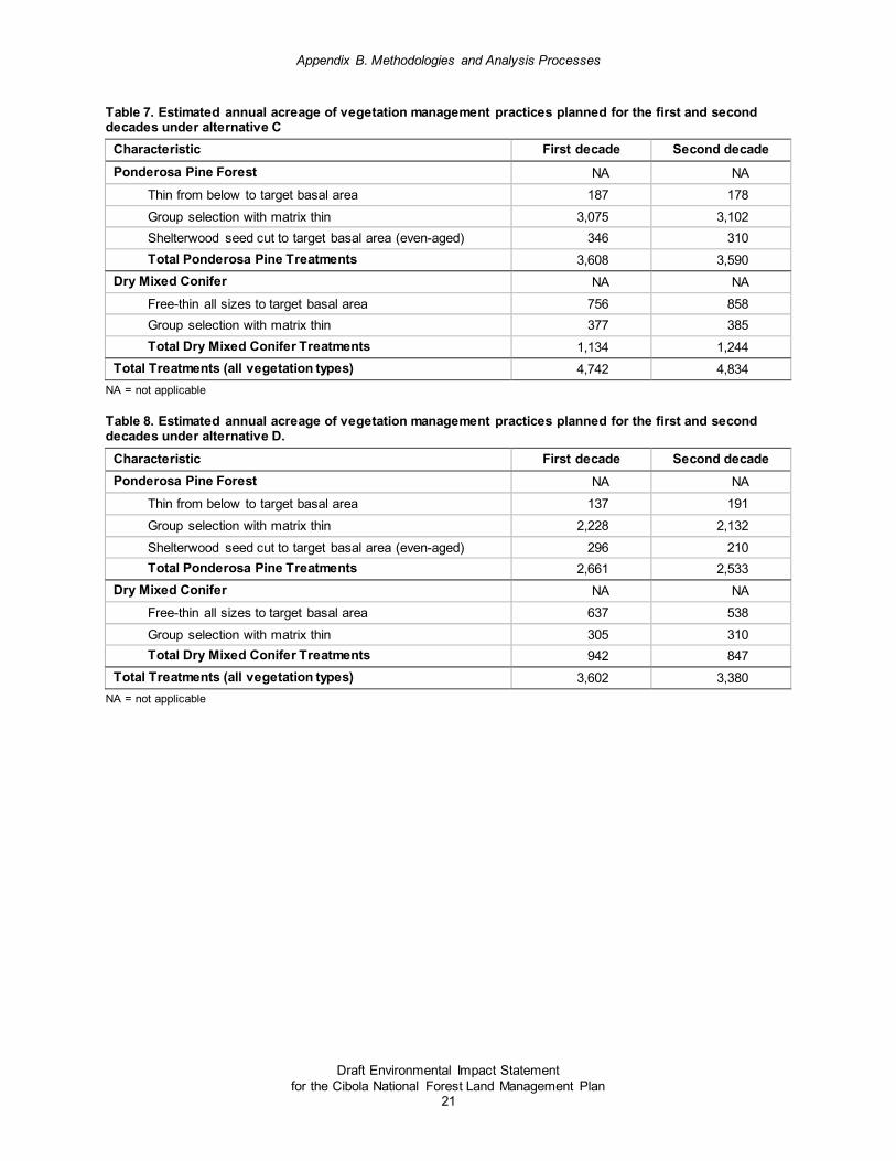
Appendix B. Methodologies and Analysis Processes
Draft Environmental Impact Statement for the Cibola National Forest Land Management Plan
21
Table 7. Estimated annual acreage of vegetation management practices planned for the first and second decades under alternative C
Characteristic First decade Second decade Ponderosa Pine Forest NA NA
Thin from below to target basal area 187 178 Group selection with matrix thin 3,075 3,102 Shelterwood seed cut to target basal area (even-aged) 346 310 Total Ponderosa Pine Treatments 3,608 3,590
Dry Mixed Conifer NA NA Free-thin all sizes to target basal area 756 858 Group selection with matrix thin 377 385 Total Dry Mixed Conifer Treatments 1,134 1,244
Total Treatments (all vegetation types) 4,742 4,834 NA = not applicable
Table 8. Estimated annual acreage of vegetation management practices planned for the first and second decades under alternative D.
Characteristic First decade Second decade Ponderosa Pine Forest NA NA
Thin from below to target basal area 137 191 Group selection with matrix thin 2,228 2,132 Shelterwood seed cut to target basal area (even-aged) 296 210 Total Ponderosa Pine Treatments 2,661 2,533
Dry Mixed Conifer NA NA Free-thin all sizes to target basal area 637 538 Group selection with matrix thin 305 310 Total Dry Mixed Conifer Treatments 942 847
Total Treatments (all vegetation types) 3,602 3,380 NA = not applicable

Appendix B. Methodologies and Analysis Processes
Draft Environmental Impact Statement for the Cibola National Forest Land Management Plan
22
Table 9. Planned wood product output for the first and second decades of the plan for alternative A
Sustained Yield Limit (SYL) = 16 MMCF1 (72 MMBF)2 per decade
Decade 1
MMCF
Decade 1
MMBF
Decade 1
Tons
Decade 2
MMCF
Decade 2
MMBF
Decade 2
Tons Departure increment 17 57 NA 17 63 NA Departure limit 33 129 NA 33 135 NA Timber Products: Volumes other than salvage or sanitation volumes that meet timber product utilization standards
NA NA NA NA NA NA
A. Lands suitable for timber production MMCF MMBF Tons MMCF MMBF Tons A1. Sawtimber3 25 120 381,375 26 126 390,371 A2. Other products4 5.2 NA 76,287 4.7 NA 68,564
B. Lands not suitable for timber production MMCF MMBF Tons MMCF MMBF Tons B1. Sawtimber5 1.9 8.9 28,374 2.0 9.4 29,044 B2. Other products6 0.39 NA 5,676 0.35 NA 5,101
C. Projected Timber Sale Quantity (PTSQ) (A1+A2+B1+B2)
33 129 491,712 33 135 493,079
D. Other Estimated Wood Products Fuelwood, biomass, and other volumes that do not meet timber product utilization standards MMCF MMBF Tons MMCF MMBF Tons
D1. Softwood fuelwood7 0.70 NA 0.19 0.84 NA 0.23 D2. Hardwood fuelwood8 1.07 NA 0.41 1.10 NA 0.43 D3. Aspen9 0.29 NA 0.07 0.26 NA 0.06
E. Projected Wood Sale Quantity (PWSQ) (C+D1+D2+D3)
35 NA 491,713 35 NA 493,080
NA = not applicable 1. MMCF = millions of cubic feet; 2. MMBF = millions of board feet 3. Industrial softwood species meeting sawtimber specifications (9”+ in diameter at breast height – DBH), harvested from lands suitable for timber production. 4. Industrial softwood species not meeting sawtimber specifications (5–9” DBH), harvested from lands suitable for timber production. 5. Industrial softwood species meeting sawtimber specifications (9”+ DBH), harvested from lands not suitable for timber production. 6. Industrial softwood species not meeting sawtimber specifications (5–9” DBH), harvested from lands not suitable for timber
production. 7. Fuelwood (nonindustrial softwood species 5”+ DBH). 8. Fuelwood (other hardwood species 5”+ DBH) 9. Aspen (5”+ DBH).

Appendix B. Methodologies and Analysis Processes
Draft Environmental Impact Statement for the Cibola National Forest Land Management Plan
23
Table 10. Planned wood product output for the first and second decades of the plan for alternative B
Sustained Yield Limit (SYL) = 16 MMCF1 (72 MMBF)2 per decade
Decade 1
MMCF
Decade 1
MMBF
Decade 1
Tons
Decade 2
MMCF
Decade 2
MMBF
Decade 2
Tons Departure increment 17 56 NA 15 57 NA Departure limit 32 129 NA 31 129 NA Timber Products: Volumes other than salvage or sanitation volumes that meet timber product utilization standards
NA NA NA NA NA NA
A. Lands suitable for timber production MMCF MMBF Tons MMCF MMBF Tons A1. Sawtimber3 25 120 377,649 25 120 370,527 A2. Other products4 5.0 NA 73,346 4.4 NA 64,087
B. Lands not suitable for timber production MMCF MMBF Tons MMCF MMBF Tons B1. Sawtimber5 1.9 8.9 28,097 1.9 9.0 27,567 B2. Other products6 0.37 NA 5,457 0.32 NA 4,768
C. Projected Timber Sale Quantity (PTSQ) (A1+A2+B1+B2)
32 129 484,550 31 129 466,949
D. Other Estimated Wood Products Fuelwood, biomass, and other volumes that do not meet timber product utilization standards MMCF MMBF Tons MMCF MMBF Tons
D1. Softwood fuelwood7 0.72 0.20 0.82 0.23 0.72 0.20 D2. Hardwood fuelwood8 1.00 0.39 1.02 0.39 1.00 0.39 D3. Aspen9 0.31 0.07 0.25 0.06 0.31 0.07 E. Projected Wood Sale Quantity (PWSQ) (C+D1+D2+D3)
35 484,551 34 466,950 35 484,551
NA = not applicable 1. MMCF = millions of cubic feet; 2. MMBF = millions of board feet 3. Industrial softwood species meeting sawtimber specifications (9”+ DBH), harvested from lands suitable for timber production. 4. Industrial softwood species not meeting sawtimber specifications (5–9” DBH), harvested from lands suitable for timber production. 5. Industrial softwood species meeting sawtimber specifications (9”+ DBH), harvested from lands not suitable for timber production. 6. Industrial softwood species not meeting sawtimber specifications (5–9” DBH), harvested from lands not suitable for timber
production. 7. Fuelwood (nonindustrial softwood species 5”+ DBH). 8. Fuelwood (other hardwood species 5”+ DBH) 9. Aspen (5”+ DBH).

Appendix B. Methodologies and Analysis Processes
Draft Environmental Impact Statement for the Cibola National Forest Land Management Plan
24
Table 11. Planned wood product output for the first and second decades of the plan for alternative C
Sustained Yield Limit (SYL) = 16 MMCF1 (72 MMBF)2 per decade
Decade 1
MMCF
Decade 1
MMBF
Decade 1
Tons
Decade 2
MMCF
Decade 2
MMBF
Decade 2
Tons Departure increment 26 92 NA 30 118 NA Departure limit 42 164 NA 46 190 NA Timber Products: Volumes other than salvage or sanitation volumes that meet timber product utilization standards
NA NA NA NA NA NA
A. Lands suitable for timber production MMCF MMBF Tons MMCF MMBF Tons A1. Sawtimber3 32 153 485,343 36 177 539,692 A2. Other products4 6.5 NA 96,406 6.1 NA 89,423
B. Lands not suitable for timber production MMCF MMBF Tons MMCF MMBF Tons B1. Sawtimber5 2.4 11.3 36,110 2.7 13.1 40,153 B2. Other products6 0.49 NA 7,173 0.45 NA 6,653
C. Projected Timber Sale Quantity (PTSQ) (A1+A2+B1+B2)
42 164 625,031 46 190 675,921
D. Other Estimated Wood Products Fuelwood, biomass, and other volumes that do not meet timber product utilization standards MMCF MMBF Tons MMCF MMBF Tons
D1. Softwood fuelwood7 0.88 0.24 1.26 0.35 0.88 0.24 D2. Hardwood fuelwood8 1.30 0.50 1.43 0.55 1.30 0.50 D3. Aspen9 0.41 0.10 0.36 0.08 0.41 0.10
E. Projected Wood Sale Quantity (PWSQ) (C+D1+D2+D3)
44 625,032 49 675,922 44 625,032
NA = not applicable 1. MMCF = millions of cubic feet; 2. MMBF = millions of board feet 3. Industrial softwood species meeting sawtimber specifications (9”+ DBH), harvested from lands suitable for timber production. 4. Industrial softwood species not meeting sawtimber specifications (5–9” DBH), harvested from lands suitable for timber production. 5. Industrial softwood species meeting sawtimber specifications (9”+ DBH), harvested from lands not suitable for timber production. 6. Industrial softwood species not meeting sawtimber specifications (5–9” DBH), harvested from lands not suitable for timber
production. 7. Fuelwood (nonindustrial softwood species 5”+ DBH). 8. Fuelwood (other hardwood species 5”+ DBH) 9. Aspen (5”+ DBH).

Appendix B. Methodologies and Analysis Processes
Draft Environmental Impact Statement for the Cibola National Forest Land Management Plan
25
Table 12. Planned wood product output for the first and second decades of the plan for alternative D
Sustained Yield Limit (SYL) = 16 MMCF1 (72 MMBF)2 per decade
Decade 1
MMCF
Decade 1
MMBF
Decade 1
Tons
Decade 2
MMCF
Decade 2
MMBF
Decade 2
Tons Departure increment 16 54 NA 15 57 NA Departure limit 32 126 NA 31 129 NA Timber Products: Volumes other than salvage or sanitation volumes that meet timber product utilization standards
NA NA NA NA NA NA
A. Lands suitable for timber production MMCF MMBF Tons MMCF MMBF Tons A1. Sawtimber3 25 118 373,642 25 120 368,935 A2. Other products4 5.1 NA 74,704 4.3 NA 62,668
B. Lands not suitable for timber production MMCF MMBF Tons MMCF MMBF Tons B1. Sawtimber5 1.9 8.8 27,799 1.8 8.9 27,449 B2. Other products6 0.38 NA 5,558 0.32 NA 4,662
C. Projected Timber Sale Quantity (PTSQ) (A1+A2+B1+B2)
32 126 481,702 31 129 463,714
D. Other Estimated Wood Products Fuelwood, biomass, and other volumes that do not meet timber product utilization standards MMCF MMBF Tons MMCF MMBF Tons
D1. Softwood fuelwood7 0.71 0.19 0.84 0.23 0.71 0.19 D2. Hardwood fuelwood8
0.97 0.38 1.04 0 0.97 0.38
D3. Aspen9 0.33 0.08 0.28 0.06 0.33 0.08 E. Projected Wood Sale Quantity (PWSQ) (C+D1+D2+D3) 34 481,703 33 463,714 34 481,703
NA = not applicable 1. MMCF = millions of cubic feet; 2. MMBF = millions of board feet 3. Industrial softwood species meeting sawtimber specifications (9”+ DBH), harvested from lands suitable for timber production. 4. Industrial softwood species not meeting sawtimber specifications (5–9” DBH), harvested from lands suitable for timber production. 5. Industrial softwood species meeting sawtimber specifications (9”+ DBH), harvested from lands not suitable for timber production. 6. Industrial softwood species not meeting sawtimber specifications (5–9” DBH), harvested from lands not suitable for timber
production. 7. Fuelwood (nonindustrial softwood species 5”+ DBH). 8. Fuelwood (other hardwood species 5”+ DBH) 9. Aspen (5”+ DBH).

Appendix B. Methodologies and Analysis Processes
Draft Environmental Impact Statement for the Cibola National Forest Land Management Plan
26
Vegetation Dynamics Modeling Background Overall vegetation structure was analyzed using mapping and ecosystem modeling for current conditions and future (15, 100, and 1,000-year) trends for major Cibola vegetation types based on data sources of the Forest Service Southwestern Region and modeled using the Vegetation Dynamics Development Tool (VDDT) (ESSA 2006) (figure 1). VDDT software is a nonspatial model that allows the user to model vegetation change over time as a series of vegetation states that differ in size class, canopy cover, dominance type, and storiedness, and movement of vegetation among states (transitions) (ESSA 2006). Various disturbance agents affecting the transitions are incorporated (such as surface fire, stand-replacing fire, grazing, and insect outbreaks). By varying the types and rates of disturbance in the model, the effects on vegetation of different disturbance regimes, such as current and historic fire regimes, or different management treatments, such as fire suppression, prescribed burning, and mechanical fuels treatments, can be tested. These models summarize and synthesize the current state of scientific knowledge for vegetation dynamics. Additionally they provide land management planners and managers with powerful tools for understanding, investigating, and demonstrating the effects of alternative scenarios for the management of vegetation on the Cibola.
The current condition of a vegetation type is compared to its respective reference condition and desired condition under the natural range of variation. This comparison examines the proportion of each seral stage (“state”) under current conditions relative to its respective proportion under reference and desired conditions. Reference conditions in this assessment (based on Wahlberg et al. 2015) were derived from multiple sources including research (dendrochronology, stand reconstruction, and so forth), empirical data, and state-and-transition models.
Some model states exist today (“contemporary”) that did not exist historically and are not considered desirable, such as uncharacteristically overstocked stands, or early seral states that appear incapable of natural forest regeneration. Hence, these contemporary states only appear under current and projected seral states in the model (table 13) and are grouped using “rules” with the nearest equivalent state under desired or reference conditions for purposes of determining departure. Model state descriptions, state-and-transition models (and their inputs), and output files, as well as Vegetation Dynamics Development Tool software and user guide, are on file at the Cibola National Forest Supervisor’s Office.

Appendix B. Methodologies and Analysis Processes
Draft Environmental Impact Statement for the Cibola National Forest Land Management Plan
27
Table 13. Description of model states for ponderosa pine and dry mixed conifer State Description
A Grass, forb, shrubland; <10% canopy cover B Seeding/sapling, open; <10% canopy cover C Small trees, open; 10-30% canopy cover; 5-10″ diameter class D Medium trees, open, single story; 10-30% canopy cover; 10-20″ diameter class E Very large trees, open, single story; 10-30% canopy cover; 20+″ diameter class F Seeding/sapling, closed; >30% canopy closure; 0-5″ diameter class G Small trees, closed; >30% canopy closure; 5-10″ diameter class H Medium trees, closed, single story; >30% canopy closure; 10-20” diameter class I Very large trees, closed, single story; >30% canopy closure; 20+″ diameter class J Medium trees, open, multistory; 10-30% canopy closure; 10-20″ diameter class K Very large trees, open, multistory; 10-30% canopy closure; 20+″ diameter class L Medium trees, closed, multistory; >30% canopy closure; 10-20″ diameter class M Very large trees, closed, multistory; >30% canopy closure; 20+" diameter class N Uncharacteristic state; <10% canopy cover; large openings unlikely to regenerate in a timely fashion

Appendix B. Methodologies and Analysis Processes
Draft Environmental Impact Statement for the Cibola National Forest Land Management Plan
28
Figure 1. Vegetation Dynamics Development Tool state-and-transition model for ponderosa pine and dry mixed conifer

Appendix B. Methodologies and Analysis Processes
Draft Environmental Impact Statement for the Cibola National Forest Land Management Plan
29
Model Inputs
All Vegetation Types Insect and disease – Regionally consistent probabilities were used. Outcomes were based on regionally consistent Forest Vegetation Simulator (FVS) modeling.
Wildfire – Regionally consistent probabilities for fire severity type were used. Outcomes were based on regionally consistent Forest Vegetation Simulator (FVS) modeling. Input acreages for wildfire were based on total annual acres incurring wildfire (from alternative-specific objectives) multiplied by proportion of Cibola area occupied by each vegetation type.
Artificial stocking (replanting) of stands – based on acres of land determined to be suitable for timber production for each vegetation type (see “Timber Suitability Analysis” in this appendix).
Mechanical treatment and prescribed fire – All alternative-specific objective acres for mechanical treatment and prescribed fire were proportioned among Ponderosa Pine Forest and Dry Mixed Conifer because of their unique combination of: (1) abundance on the Cibola, (2) departure from desired conditions, (3) dependence on historically frequent, low-intensity fire regimes, and (4) preponderance (85 percent) in wildland-urban interface (61 and 24 percent, respectively).
Ponderosa Pine Forest and Dry Mixed Conifer Treatments Total treatment acreages for each type of management (mechanical, prescribed fire) were based on alternative-specific objective acres multiplied by proportional activity on the Cibola from 1986 to 2016; ponderosa pine forest acreage treated was three times dry mixed conifer acreage treated, and future activity is expected to occur in the same relative proportions.
Mechanical treatment type was based on current and projected management strategy:
• Ponderosa Pine Forest
♦ 85 percent group selection (uneven-aged management) – states H, I, L, M
♦ 10 percent shelterwood cut – states H, I, L, M
♦ 5 percent thin from below – states H, I
• Dry Mixed Conifer
♦ 2/3 free-thin to target basal area – states C, D, E, F, G, J, K
♦ 1/3 group selection (uneven-aged management) – states H, I, L, M
Prescribed fire severity type was based on average Cibola management activity from 1986 to 2016:
• Ponderosa Pine Forest and Dry Mixed Conifer
♦ 90 percent low-severity fire
♦ 10 percent moderate-severity fire

Appendix B. Methodologies and Analysis Processes
Draft Environmental Impact Statement for the Cibola National Forest Land Management Plan
30
Model Outputs Output for modeled vegetation types is presented in tables and graphs below:
• seral state proportions (%) for desired conditions (DC), reference conditions (RC), and current and projected proportions and overall departure in table 14–table 45
• current and projected seral state proportions compared to desired conditions in figure 2–figure 3313
Table 14. Juniper Grass vegetation type seral state proportions (%) for desired conditions (DC), reference conditions (RC), and current and projected proportions and overall departure under alternative A
State DC RC
Current w/o
rules Current w/rules
More than 15 years w/o
rules
More than 15 years
w/rules
More than 100
years w/o
rules
More than 100
years w/rules
More than 1000 years w/o
rules
More than 1000 years
w/rules
A 5 5 42 42 32 32 9 9 2 2 B 25 25 8 45 2 22 0 3 0 1 C B B 37 19 2 1 D 50 50 3 3 21 21 32 32 22 22 E B B 0 1 0 0 F 10 10 7 7 12 12 3 3 1 1 G 10 10 3 3 13 13 53 53 73 73
DC Departure 57 32 47 63 RC Departure 57 32 47 63
13 State proportion percentages rounded to nearest integer; percentage between 0 and 0.5 represented by “0”; percentage of zero represented by dash. Empty cell signifies contemporary state that was grouped (using “rules”) with appropriate desired or reference condition state (see cells in DC or RC column with letter designating destination state in “w/rules” column).

Appendix B. Methodologies and Analysis Processes
Draft Environmental Impact Statement for the Cibola National Forest Land Management Plan
31
Figure 2. Current and projected seral state proportions compared to desired conditions for juniper grass vegetation type, alternative A

Appendix B. Methodologies and Analysis Processes
Draft Environmental Impact Statement for the Cibola National Forest Land Management Plan
32
Table 15. Juniper grass vegetation type seral state proportions (%) for desired conditions (DC), reference conditions (RC), and current and projected proportions and overall departure under alternative B
State DC RC
Current w/o
rules Current w/rules
More than 15 years w/o
rules
More than 15 years
w/rules
More than 100
years w/o
rules
More than 100
years w/rules
More than 1000 years w/o
rules
More than 1000 years
w/rules A 5 5 42 42 33 33 9 9 3 3 B 25 25 8 45 2 22 0 3 0 1 C B B 37 19 2 1 D 50 50 3 3 20 20 33 33 24 24 E B B 0 0 0 0 F 10 10 7 7 12 12 3 3 1 1 G 10 10 3 3 13 13 51 51 71 71
DC Departure 57 32 46 61 RC Departure 57 32 46 61

Appendix B. Methodologies and Analysis Processes
Draft Environmental Impact Statement for the Cibola National Forest Land Management Plan
33
Figure 3. Current and projected seral state proportions compared to desired conditions for juniper grass vegetation type, alternative B

Appendix B. Methodologies and Analysis Processes
Draft Environmental Impact Statement for the Cibola National Forest Land Management Plan
34
Table 16. Juniper grass vegetation type seral state proportions (%) for desired conditions (DC), reference conditions (RC), and current and projected proportions and overall departure under alternative C
State DC RC
Current w/o
rules Current w/rules
More than 15
years w/o
rules
More than 15
years w/rules
More than 100
years w/o
rules
More than 100
years w/rules
More than 1000 years w/o
rules
More than 1000 years
w/rules A 5 5 42 42 32 32 9 9 3 3 B 25 25 8 45 3 22 0 3 0 1 C B B 37 19 2 1 D 50 50 3 3 21 21 34 34 25 25 E B B 0 1 0 0 F 10 10 7 7 12 12 3 3 1 1 G 10 10 3 3 13 13 51 51 70 70
DC Departure 57 32 46 60 RC Departure 57 32 46 60

Appendix B. Methodologies and Analysis Processes
Draft Environmental Impact Statement for the Cibola National Forest Land Management Plan
35
Figure 4. Current and projected seral state proportions compared to desired conditions for juniper grass vegetation type, alternative C

Appendix B. Methodologies and Analysis Processes
Draft Environmental Impact Statement for the Cibola National Forest Land Management Plan
36
Table 17. Juniper grass vegetation type seral state proportions (%) for desired conditions (DC), reference conditions (RC), and current and projected proportions and overall departure under alternative D
State DC RC
Current w/o
rules Current w/rules
More than 15 years w/o
rules
More than 15 years
w/rules
More than 100
years w/o
rules
More than 100
years w/rules
More than 1000 years w/o
rules
More than 1000 years
w/rules A 5 5 42 42 33 33 9 9 3 3 B 25 25 8 45 2 22 0 3 0 1 C B B 37 19 2 1 D 50 50 3 3 20 20 33 33 24 24 E B B 0 0 0 0 F 10 10 7 7 12 12 3 3 1 1 G 10 10 3 3 13 13 51 51 71 71
DC Departure 57 32 46 61 RC Departure 57 32 46 61

Appendix B. Methodologies and Analysis Processes
Draft Environmental Impact Statement for the Cibola National Forest Land Management Plan
37
Figure 5. Current and projected seral state proportions compared to desired conditions for juniper grass vegetation type, alternative D

Appendix B. Methodologies and Analysis Processes
Draft Environmental Impact Statement for the Cibola National Forest Land Management Plan
38
Table 18. Dry mixed conifer vegetation type seral state proportions (%) for desired conditions (DC), reference conditions (RC), and current and projected proportions and overall departure under alternative A
State DC RC
Current w/o
rules Current w/rules
More than 15 years w/o
rules
More than 15 years
w/rules
More than 100
years w/o
rules
More than 100
years w/rules
More than 1000 years w/o
rules
More than 1000 years
w/rules A 9 20 4 9 1 22 1 20 1 19 B A A 0 2 2 3 C 3 10 12 12 2 2 1 1 1 1 D 60 60 1 2 2 7 1 17 1 19 E D D - 0 4 5 F A A 1 19 17 15 G 3 5 48 48 30 30 12 12 11 11 H 25 5 20 30 15 40 6 50 4 51 I H H 0 3 9 10 J D D 1 2 2 1 K D D - 2 10 12 L H H 10 18 20 18 M H H 0 3 15 19 N A A 3 0 - 0
DC Departure 58 55 46 43 RC Departure 69 62 53 52

Appendix B. Methodologies and Analysis Processes
Draft Environmental Impact Statement for the Cibola National Forest Land Management Plan
39
Figure 6. Current and projected seral state proportions compared to desired conditions for dry mixed conifer vegetation type, alternative A

Appendix B. Methodologies and Analysis Processes
Draft Environmental Impact Statement for the Cibola National Forest Land Management Plan
40
Table 19. Dry mixed conifer vegetation type seral state proportions (%) for desired conditions (DC), reference conditions (RC), and current and projected proportions and overall departure under alternative B
State DC RC
Current w/o
rules Current w/rules
More than 15 years w/o
rules
More than 15 years
w/rules
More than 100
years w/o
rules
More than 100
years w/rules
More than 1000 years w/o
rules
More than 1000 years
w/rules A 9 20 4 9 1 23 1 20 1 20 B A A 0 2 2 3 C 3 10 12 12 1 1 1 1 1 1 D 60 60 1 2 2 7 1 17 1 20 E D D - 0 4 5 F A A 1 19 17 16 G 3 5 48 48 29 29 12 12 11 11 H 25 5 20 30 15 39 6 50 4 48 I H H 0 3 9 10 J D D 1 3 2 2 K D D - 2 9 12 L H H 10 18 21 16 M H H 0 3 15 18 N A A 3 0 0 0
DC Departure 58 55 46 42 RC Departure 69 62 53 49
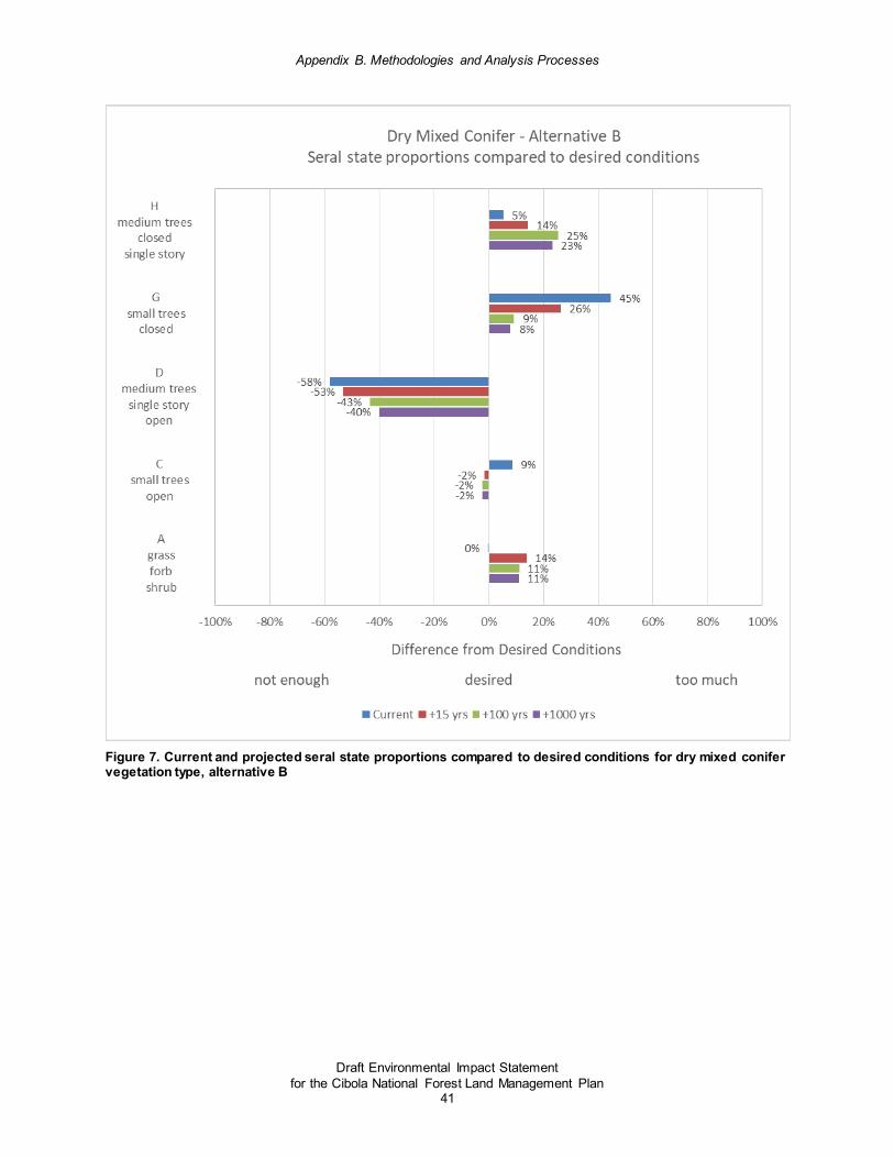
Appendix B. Methodologies and Analysis Processes
Draft Environmental Impact Statement for the Cibola National Forest Land Management Plan
41
Figure 7. Current and projected seral state proportions compared to desired conditions for dry mixed conifer vegetation type, alternative B

Appendix B. Methodologies and Analysis Processes
Draft Environmental Impact Statement for the Cibola National Forest Land Management Plan
42
Table 20. Dry mixed conifer vegetation type seral state proportions (%) for desired conditions (DC), reference conditions (RC), and current and projected proportions and overall departure under alternative C
State DC RC
Current w/o
rules Current w/rules
More than 15 years w/o
rules
More than 15 years
w/rules
More than 100
years w/o
rules
More than 100
years w/rules
More than 1000 years w/o
rules
More than 1000 years
w/rules A 9 20 4 9 1 23 1 22 1 21 B A A 0 3 3 3 C 3 10 12 12 2 2 1 1 1 1 D 60 60 1 2 2 9 1 21 1 24 E D D - 1 4 6 F A A 1 19 18 17 G 3 5 48 48 28 28 12 12 11 11 H 25 5 20 30 15 38 6 44 4 42 I H H 0 3 8 8 J D D 1 3 3 2 K D D - 3 12 15 L H H 10 17 18 15 M H H 0 3 13 15 N A A 3 - 0 -
DC Departure 58 52 41 38 RC Departure 69 59 48 45

Appendix B. Methodologies and Analysis Processes
Draft Environmental Impact Statement for the Cibola National Forest Land Management Plan
43
Figure 8. Current and projected seral state proportions compared to desired conditions for dry mixed conifer vegetation type, alternative C

Appendix B. Methodologies and Analysis Processes
Draft Environmental Impact Statement for the Cibola National Forest Land Management Plan
44
Table 21. Dry mixed conifer vegetation type seral state proportions (%) for desired conditions (DC), reference conditions (RC), and current and projected proportions and overall departure under alternative D
State DC RC
Current w/o
rules Current w/rules
More than 15 years w/o
rules
More than 15 years
w/rules
More than 100
years w/o
rules
More than 100
years w/rules
More than 1000 years w/o
rules
More than 1000 years
w/rules A 9 20 4 9 1 22 1 20 1 20 B A A 0 3 2 3 C 3 10 12 12 2 2 1 1 1 1 D 60 60 1 2 2 6 1 17 1 21 E D D - 0 3 5 F A A 1 19 17 17 G 3 5 48 48 30 30 13 13 10 10 H 25 5 20 30 15 40 6 50 4 48 I H H 0 3 9 9 J D D 1 3 2 2 K D D - 1 10 12 L H H 10 18 20 17 M H H 0 4 15 19 N A A 3 0 0 0
DC Departure 58 55 46 42 RC Departure 69 62 53 49

Appendix B. Methodologies and Analysis Processes
Draft Environmental Impact Statement for the Cibola National Forest Land Management Plan
45
Figure 9. Current and projected seral state proportions compared to desired conditions for dry mixed conifer vegetation type, alternative D

Appendix B. Methodologies and Analysis Processes
Draft Environmental Impact Statement for the Cibola National Forest Land Management Plan
46
Table 22. Wet mixed conifer vegetation type seral state proportions (%) for desired conditions (DC), reference conditions (RC), and current and projected proportions and overall departure under alternative A
State DC RC
Current w/o
rules Current w/rules
More than 15 years w/o
rules
More than 15 years
w/rules
More than 100
years w/o
rules
More than 100
years w/rules
More than 1000 years w/o
rules
More than 1000 years
w/rules A 1 1 3 3 1 1 0 0 0 0 B 21 21 8 8 9 9 6 6 4 4 C 29 29 3 47 6 52 11 53 12 52 D C C 31 25 16 16 E 49 49 - - 1 8 1 27 2 30 F E E - 3 9 10 G - - - - 0 0 1 1 1 1 H - - - - 0 0 0 0 0 0 I - - - - 0 0 0 0 1 1 J - - - - 0 0 0 0 0 0 K - - 3 3 0 0 0 0 0 0 L - - 35 35 25 25 8 8 8 8 M C C 13 22 26 25 N E E - 1 2 2 O E E - 4 14 16 P - - 1 1 2 2 1 1 1 1 Q - - 2 2 1 1 1 1 1 1 R - - - - 0 0 1 1 1 1 S - - - - 0 0 1 1 1 1
DC Departure 62 53 37 37 RC Departure 62 53 37 37

Appendix B. Methodologies and Analysis Processes
Draft Environmental Impact Statement for the Cibola National Forest Land Management Plan
47
Figure 10. Current and projected seral state proportions compared to desired conditions for wet mixed conifer vegetation type, alternative A

Appendix B. Methodologies and Analysis Processes
Draft Environmental Impact Statement for the Cibola National Forest Land Management Plan
48
Table 23. Wet mixed conifer vegetation type seral state proportions (%) for desired conditions (DC), reference conditions (RC), and current and projected proportions and overall departure under alternative B
State DC RC
Current w/o
rules Current w/rules
More than 15 years w/o
rules
More than 15 years
w/rules
More than 100
years w/o
rules
More than 100
years w/rules
More than 1000 years w/o
rules
More than 1000 years
w/rules A 1 1 3 3 1 1 0 0 0 0 B 21 21 8 8 9 9 6 6 4 4 C 29 29 3 47 6 52 11 53 11 52 D C C 31 25 16 16 E 49 49 - - 1 8 1 27 1 30 F E E - 3 9 10 G - - - - 0 0 1 1 1 1 H - - - - 0 0 0 0 0 0 I - - - - 0 0 0 0 0 0 J - - - - 0 0 0 0 0 0 K - - 3 3 0 0 0 0 0 0 L - - 35 35 25 25 9 9 8 8 M C C 13 21 26 24 N E E - 0 2 2 O E E - 4 15 17 P - - 1 1 2 2 1 1 1 1 Q - - 2 2 1 1 1 1 1 1 R - - - - 0 0 1 1 1 1 S - - - - 0 0 1 1 1 1
DC Departure 62 53 38 36 RC Departure 62 53 38 36

Appendix B. Methodologies and Analysis Processes
Draft Environmental Impact Statement for the Cibola National Forest Land Management Plan
49
Figure 11. Current and projected seral state proportions compared to desired conditions for wet mixed conifer vegetation type, alternative B

Appendix B. Methodologies and Analysis Processes
Draft Environmental Impact Statement for the Cibola National Forest Land Management Plan
50
Table 24. Wet mixed conifer vegetation type seral state proportions (%) for desired conditions (DC), reference conditions (RC), and current and projected proportions and overall departure under alternative C
State DC RC
Current w/o
rules Current w/rules
More than 15 years w/o
rules
More than 15 years
w/rules
More than 100
years w/o
rules
More than 100
years w/rules
More than 1000 years w/o
rules
More than 1000 years
w/rules A 1 1 3 3 1 1 0 0 0 0 B 21 21 8 8 9 9 6 6 5 5 C 29 29 3 47 6 53 11 52 11 52 D C C 31 25 16 16 E 49 49 - - 1 8 1 27 2 30 F E E - 3 9 10 G - - - - 0 0 1 1 1 1 H - - - - 0 0 0 0 0 0 I - - - - 0 0 1 1 1 1 J - - - - 0 0 0 0 0 0 K - - 3 3 0 0 0 0 0 0 L - - 35 35 24 24 9 9 8 8 M C C 13 22 25 24 N E E - 0 2 2 O E E - 4 15 16 P - - 1 1 2 2 1 1 1 1 Q - - 2 2 1 1 1 1 1 1 R - - - - 0 0 1 1 1 1 S - - - - 0 0 1 1 1 1
DC Departure 62 53 38 36 RC Departure 62 53 38 36

Appendix B. Methodologies and Analysis Processes
Draft Environmental Impact Statement for the Cibola National Forest Land Management Plan
51
Figure 12. Current and projected seral state proportions compared to desired conditions for wet mixed conifer vegetation type, alternative C

Appendix B. Methodologies and Analysis Processes
Draft Environmental Impact Statement for the Cibola National Forest Land Management Plan
52
Table 25. Wet mixed conifer vegetation type seral state proportions (%) for desired conditions (DC), reference conditions (RC), and current and projected proportions and overall departure under alternative D
State DC RC
Current w/o
rules Current w/rules
More than 15 years w/o
rules
More than 15 years
w/rules
More than 100
years w/o
rules
More than 100
years w/rules
More than 1000 years w/o
rules
More than 1000 years
w/rules A 1 1 3 3 1 1 0 0 0 0 B 21 21 8 8 9 9 6 6 4 4 C 29 29 3 47 6 52 11 53 11 52 D C C 31 25 16 16 E 49 49 - - 1 8 1 27 1 30 F E E - 3 9 10 G - - - - 0 0 1 1 1 1 H - - - - 0 0 0 0 0 0 I - - - - 0 0 0 0 0 0 J - - - - 0 0 0 0 0 0 K - - 3 3 0 0 0 0 0 0 L - - 35 35 25 25 9 9 8 8 M C C 13 21 26 24 N E E - 0 2 2 O E E - 4 15 17 P - - 1 1 2 2 1 1 1 1 Q - - 2 2 1 1 1 1 1 1 R - - - - 0 0 1 1 1 1 S - - - - 0 0 1 1 1 1
DC Departure 62 53 38 36 RC Departure 62 53 38 36

Appendix B. Methodologies and Analysis Processes
Draft Environmental Impact Statement for the Cibola National Forest Land Management Plan
53
Figure 13. Current and projected seral state proportions compared to desired conditions for wet mixed conifer vegetation type, alternative D

Appendix B. Methodologies and Analysis Processes
Draft Environmental Impact Statement for the Cibola National Forest Land Management Plan
54
Table 26. Madrean pine-oak woodland vegetation type seral state proportions (%) for desired conditions (DC), reference conditions (RC), and current and projected proportions and overall departure under alternative A
State DC RC
Current w/o
rules Current w/rules
More than 15 years w/o
rules
More than 15 years
w/rules
More than 100
years w/o
rules
More than 100
years w/rules
More than 1000 years w/o
rules
More than 1000 years
w/rules
A 4 4 61 61 38 38 3 3 1 1 B 5 5 5 7 7 10 1 2 0 1 C 13 24 9 9 5 5 1 1 0 0 D 60 60 0 0 13 13 10 10 4 4 E B B 1 3 1 1 F 3 3 19 19 21 21 16 16 8 8 G 15 4 4 4 13 13 68 68 86 86
DC Departure 75 56 66 76 RC Departure 75 66 77 87

Appendix B. Methodologies and Analysis Processes
Draft Environmental Impact Statement for the Cibola National Forest Land Management Plan
55
Figure 14. Current and projected seral state proportions compared to desired conditions for Madrean pine-oak woodland vegetation type, alternative A

Appendix B. Methodologies and Analysis Processes
Draft Environmental Impact Statement for the Cibola National Forest Land Management Plan
56
Table 27. Madrean pine-oak woodland vegetation type seral state proportions (%) for desired conditions (DC), reference conditions (RC), and current and projected proportions and overall departure under alternative B
State DC RC
Current w/o
rules Current w/rules
More than 15 years w/o
rules
More than 15 years
w/rules
More than 100
years w/o
rules
More than 100
years w/rules
More than 1000 years w/o
rules
More than 1000 years
w/rules
A 4 4 61 61 38 38 3 3 1 1 B 5 5 5 7 7 10 1 3 0 1 C 13 24 9 9 4 4 1 1 0 0 D 60 60 0 0 14 14 10 10 4 4 E B B 1 3 1 1 F 3 3 19 19 21 21 16 16 8 8 G 15 4 4 4 13 13 68 68 86 86
DC Departure 75 57 67 76 RC Departure 75 66 78 87

Appendix B. Methodologies and Analysis Processes
Draft Environmental Impact Statement for the Cibola National Forest Land Management Plan
57
Figure 15. Current and projected seral state proportions compared to desired conditions for Madrean pine-oak woodland vegetation type, alternative B

Appendix B. Methodologies and Analysis Processes
Draft Environmental Impact Statement for the Cibola National Forest Land Management Plan
58
Table 28. Madrean pine-oak woodland vegetation type seral state proportions (%) for desired conditions (DC), reference conditions (RC), and current and projected proportions and overall departure under alternative C
State DC RC
Current w/o
rules Current w/rules
More than 15 years w/o
rules
More than 15 years
w/rules
More than 100
years w/o
rules
More than 100
years w/rules
More than 1000 years w/o
rules
More than 1000 years
w/rules
A 4 4 61 61 38 38 3 3 1 1 B 5 5 5 7 7 10 1 3 0 1 C 13 24 9 9 5 5 1 1 0 0 D 60 60 0 0 13 13 10 10 4 4 E B B 1 3 2 1 F 3 3 19 19 20 20 16 16 9 9 G 15 4 4 4 14 14 68 68 85 85
DC Departure 75 57 66 76 RC Departure 75 66 77 87

Appendix B. Methodologies and Analysis Processes
Draft Environmental Impact Statement for the Cibola National Forest Land Management Plan
59
Figure 16. Current and projected seral state proportions compared to desired conditions for Madrean pine-oak woodland vegetation type, alternative C

Appendix B. Methodologies and Analysis Processes
Draft Environmental Impact Statement for the Cibola National Forest Land Management Plan
60
Table 29. Madrean pine-oak woodland vegetation type seral state proportions (%) for desired conditions (DC), reference conditions (RC), and current and projected proportions and overall departure under alternative D
State DC RC
Current w/o
rules Current w/rules
More than 15 years w/o
rules
More than 15 years
w/rules
More than 100
years w/o
rules
More than 100
years w/rules
More than 1000 years w/o
rules
More than 1000 years
w/rules
A 4 4 61 61 38 38 3 3 1 1 B 5 5 5 7 7 10 1 3 0 1 C 13 24 9 9 4 4 1 1 0 0 D 60 60 0 0 14 14 10 10 4 4 E B B 1 3 1 1 F 3 3 19 19 21 21 16 16 8 8 G 15 4 4 4 13 13 68 68 86 86
DC Departure 75 57 67 76 RC Departure 75 66 78 87

Appendix B. Methodologies and Analysis Processes
Draft Environmental Impact Statement for the Cibola National Forest Land Management Plan
61
Figure 17. Current and projected seral state proportions compared to desired conditions for Madrean pine-oak woodland vegetation type, alternative D

Appendix B. Methodologies and Analysis Processes
Draft Environmental Impact Statement for the Cibola National Forest Land Management Plan
62
Table 30. Pinyon-Juniper evergreen shrub vegetation type seral state proportions (%) for desired conditions (DC), reference conditions (RC), and current and projected proportions and overall departure under alternative A
State DC RC
Current w/o
rules Current w/rules
More than 15 years w/o
rules
More than 15 years
w/rules
More than 100
years w/o
rules
More than 100
years w/rules
More than 1000 years w/o
rules
More than 1000 years
w/rules
A 5 5 34 34 23 23 4 4 2 2 B 55 55 1 18 3 21 1 9 1 8 C B B 17 14 7 6 D 40 40 2 2 9 9 37 37 45 45 E B B 0 4 1 1 F - - 37 37 26 26 11 11 8 8 G - - 9 9 22 22 40 40 38 38
DC Departure 75 66 50 51 RC Departure 75 66 50 51

Appendix B. Methodologies and Analysis Processes
Draft Environmental Impact Statement for the Cibola National Forest Land Management Plan
63
Figure 18. Current and projected seral state proportions compared to desired conditions for pinyon-juniper evergreen shrub vegetation type, alternative A

Appendix B. Methodologies and Analysis Processes
Draft Environmental Impact Statement for the Cibola National Forest Land Management Plan
64
Table 31. Pinyon-juniper evergreen shrub vegetation type seral state proportions (%) for desired conditions (DC), reference conditions (RC), and current and projected proportions and overall departure under alternative B
State DC RC
Current w/o
rules Current w/rules
More than 15 years w/o
rules
More than 15 years
w/rules
More than 100
years w/o
rules
More than 100
years w/rules
More than 1000 years w/o
rules
More than 1000 years
w/rules
A 5 5 34 34 23 23 4 4 2 2 B 55 55 1 18 3 21 1 9 1 8 C B B 17 14 7 6 D 40 40 2 2 8 8 37 37 44 44 E B B 0 4 1 1 F - - 37 37 26 26 11 11 8 8 G - - 9 9 22 22 39 39 37 37
DC Departure 75 66 50 50 RC Departure 75 66 50 50

Appendix B. Methodologies and Analysis Processes
Draft Environmental Impact Statement for the Cibola National Forest Land Management Plan
65
Figure 19. Current and projected seral state proportions compared to desired conditions for pinyon-juniper evergreen shrub vegetation type, alternative B

Appendix B. Methodologies and Analysis Processes
Draft Environmental Impact Statement for the Cibola National Forest Land Management Plan
66
Table 32. Pinyon-juniper evergreen shrub vegetation type seral state proportions (%) for desired conditions (DC), reference conditions (RC), and current and projected proportions and overall departure under alternative C
State DC RC
Current w/o
rules Current w/rules
More than 15 years w/o
rules
More than 15 years
w/rules
More than 100
years w/o
rules
More than 100
years w/rules
More than 1000 years w/o
rules
More than 1000 years
w/rules
A 5 5 34 34 23 23 4 4 2 2 B 55 55 1 18 3 20 1 9 1 8 C B B 17 13 7 6 D 40 40 2 2 8 8 36 36 44 44 E B B 0 4 1 1 F - - 37 37 26 26 12 12 9 9 G - - 9 9 22 22 38 38 37 37
DC Departure 75 66 50 50 RC Departure 75 66 50 50

Appendix B. Methodologies and Analysis Processes
Draft Environmental Impact Statement for the Cibola National Forest Land Management Plan
67
Figure 20. Current and projected seral state proportions compared to desired conditions for pinyon-juniper evergreen shrub vegetation type, alternative C

Appendix B. Methodologies and Analysis Processes
Draft Environmental Impact Statement for the Cibola National Forest Land Management Plan
68
Table 33. Pinyon-juniper evergreen shrub vegetation type seral state proportions (%) for desired conditions (DC), reference conditions (RC), and current and projected proportions and overall departure under alternative D
State DC RC
Current w/o
rules Current w/rules
More than 15 years w/o
rules
More than 15 years
w/rules
More than 100
years w/o
rules
More than 100
years w/rules
More than 1000 years w/o
rules
More than 1000 years
w/rules
A 5 5 34 34 23 23 4 4 2 2 B 55 55 1 18 3 21 1 9 1 8 C B B 17 14 7 6 D 40 40 2 2 8 8 37 37 44 44 E B B 0 4 1 1 F - - 37 37 26 26 11 11 8 8 G - - 9 9 22 22 39 39 37 37
DC Departure 75 66 50 50 RC Departure 75 66 50 50

Appendix B. Methodologies and Analysis Processes
Draft Environmental Impact Statement for the Cibola National Forest Land Management Plan
69
Figure 21. Current and projected seral state proportions compared to desired conditions for pinyon-juniper evergreen shrub vegetation type, alternative D

Appendix B. Methodologies and Analysis Processes
Draft Environmental Impact Statement for the Cibola National Forest Land Management Plan
70
Table 34. Pinyon-juniper grass vegetation type seral state proportions (%) for desired conditions (DC), reference conditions (RC), and current and projected proportions and overall departure under alternative A
State DC RC
Current w/o
rules Current w/rules
More than 15 years w/o
rules
More than 15 years
w/rules
More than 100
years w/o
rules
More than 100
years w/rules
More than 1000 years w/o
rules
More than 1000 years
w/rules A 5 5 30 30 16 16 3 3 2 2 B 25 25 4 25 5 18 2 7 2 6 C B B 20 9 2 2 D 50 50 2 2 13 13 19 19 20 20 E B B 0 4 3 2 F 10 10 35 35 30 30 15 15 12 12 G 10 10 8 8 22 22 56 56 60 60
DC Departure 50 44 51 51 RC Departure 50 44 51 51

Appendix B. Methodologies and Analysis Processes
Draft Environmental Impact Statement for the Cibola National Forest Land Management Plan
71
Figure 22. Current and projected seral state proportions compared to desired conditions for pinyon-juniper grass vegetation type, alternative A

Appendix B. Methodologies and Analysis Processes
Draft Environmental Impact Statement for the Cibola National Forest Land Management Plan
72
Table 35. Pinyon-juniper grass vegetation type seral state proportions (%) for desired conditions (DC), reference conditions (RC), and current and projected proportions and overall departure under alternative B
State DC RC
Current w/o
rules Current w/rules
More than 15 years w/o
rules
More than 15 years
w/rules
More than 100
years w/o
rules
More than 100
years w/rules
More than 1000 years w/o
rules
More than 1000 years
w/rules A 5 5 30 30 17 17 3 3 2 2 B 25 25 4 25 6 18 2 7 2 7 C B B 20 9 2 2 D 50 50 2 2 12 12 19 19 20 20 E B B 0 4 3 3 F 10 10 35 35 31 31 16 16 12 12 G 10 10 8 8 22 22 55 55 59 59
DC Departure 50 45 51 51 RC Departure 50 45 51 51

Appendix B. Methodologies and Analysis Processes
Draft Environmental Impact Statement for the Cibola National Forest Land Management Plan
73
Figure 23. Current and projected seral state proportions compared to desired conditions for pinyon-juniper grass vegetation type, alternative B

Appendix B. Methodologies and Analysis Processes
Draft Environmental Impact Statement for the Cibola National Forest Land Management Plan
74
Table 36. Pinyon-juniper grass vegetation type seral state proportions (%) for desired conditions (DC), reference conditions (RC), and current and projected proportions and overall departure under alternative C
State DC RC
Current w/o
rules Current w/rules
More than 15 years w/o
rules
More than 15 years
w/rules
More than 100
years w/o
rules
More than 100
years w/rules
More than 1000 years w/o
rules
More than 1000 years
w/rules A 5 5 30 30 17 17 3 3 2 2 B 25 25 4 25 6 18 2 7 2 7 C B B 20 9 2 2 D 50 50 2 2 13 13 20 20 20 20 E B B 0 4 3 3 F 10 10 35 35 31 31 16 16 12 12 G 10 10 8 8 22 22 54 54 59 59
DC Departure 50 44 50 50 RC Departure 50 44 50 50

Appendix B. Methodologies and Analysis Processes
Draft Environmental Impact Statement for the Cibola National Forest Land Management Plan
75
Figure 24. Current and projected seral state proportions compared to desired conditions for pinyon-juniper grass vegetation type, alternative C

Appendix B. Methodologies and Analysis Processes
Draft Environmental Impact Statement for the Cibola National Forest Land Management Plan
76
Table 37. Pinyon-juniper grass vegetation type seral state proportions (%) for desired conditions (DC), reference conditions (RC), and current and projected proportions and overall departure under alternative D
State DC RC
Current w/o
rules Current w/rules
More than 15 years w/o
rules
More than 15 years
w/rules
More than 100
years w/o
rules
More than 100
years w/rules
More than 1000 years w/o
rules
More than 1000 years
w/rules A 5 5 30 30 17 17 3 3 2 2 B 25 25 4 25 6 18 2 7 2 7 C B B 20 9 2 2 D 50 50 2 2 12 12 19 19 20 20 E B B 0 4 3 3 F 10 10 35 35 31 31 16 16 12 12 G 10 10 8 8 22 22 55 55 59 59
DC Departure 50 45 51 51 RC Departure 50 45 51 51

Appendix B. Methodologies and Analysis Processes
Draft Environmental Impact Statement for the Cibola National Forest Land Management Plan
77
Figure 25. Current and projected seral state proportions compared to desired conditions for pinyon-juniper grass vegetation type, alternative D

Appendix B. Methodologies and Analysis Processes
Draft Environmental Impact Statement for the Cibola National Forest Land Management Plan
78
Table 38. Pinyon-juniper woodland vegetation type seral state proportions (%) for desired conditions (DC), reference conditions (RC), and current and projected proportions and overall departure under alternative A
State DC RC
Current w/o
rules Current w/rules
More than 15 years w/o
rules
More than 15 years
w/rules
More than 100
years w/o
rules
More than 100
years w/rules
More than 1000 years w/o
rules
More than 1000 years
w/rules A 10 10 24 24 36 36 45 45 46 46 B 5 5 3 27 5 18 7 14 7 13 C B B 23 12 5 5 D 10 10 2 2 15 15 24 24 24 24 E B B 1 1 2 1 F 15 15 35 35 16 16 7 7 7 7 G 60 60 13 13 15 15 10 10 10 10
DC Departure 55 45 57 58 RC Departure 55 45 57 58

Appendix B. Methodologies and Analysis Processes
Draft Environmental Impact Statement for the Cibola National Forest Land Management Plan
79
Figure 26. Current and projected seral state proportions compared to desired conditions for pinyon-juniper woodland vegetation type, alternative A

Appendix B. Methodologies and Analysis Processes
Draft Environmental Impact Statement for the Cibola National Forest Land Management Plan
80
Table 39. Pinyon-juniper woodland vegetation type seral state proportions (%) for desired conditions (DC), reference conditions (RC), and current and projected proportions and overall departure under alternative B
State DC RC
Current w/o
rules Current w/rules
More than 15 years w/o
rules
More than 15 years
w/rules
More than 100
years w/o
rules
More than 100
years w/rules
More than 1000 years w/o
rules
More than 1000 years
w/rules A 10 10 24 24 37 37 45 45 45 45 B 5 5 3 27 5 17 7 14 7 14 C B B 23 12 5 5 D 10 10 2 2 15 15 24 24 24 24 E B B 1 1 1 2 F 15 15 35 35 16 16 6 6 7 7 G 60 60 13 13 15 15 10 10 10 10
DC Departure 55 45 58 58 RC Departure 55 45 58 58

Appendix B. Methodologies and Analysis Processes
Draft Environmental Impact Statement for the Cibola National Forest Land Management Plan
81
Figure 27. Current and projected seral state proportions compared to desired conditions for pinyon-juniper woodland vegetation type, alternative B

Appendix B. Methodologies and Analysis Processes
Draft Environmental Impact Statement for the Cibola National Forest Land Management Plan
82
Table 40. Pinyon-juniper woodland vegetation type seral state proportions (%) for desired conditions (DC), reference conditions (RC), and current and projected proportions and overall departure under alternative C
State DC RC
Current w/o
rules Current w/rules
More than 15 years w/o
rules
More than 15 years
w/rules
More than 100
years w/o
rules
More than 100
years w/rules
More than 1000 years w/o
rules
More than 1000 years
w/rules A 10 10 24 24 36 36 44 44 45 45 B 5 5 3 27 5 18 7 14 7 14 C B B 23 12 5 5 D 10 10 2 2 15 15 25 25 24 24 E B B 1 1 2 2 F 15 15 35 35 16 16 7 7 7 7 G 60 60 13 13 15 15 10 10 11 11
DC Departure 55 45 58 58 RC Departure 55 45 58 58

Appendix B. Methodologies and Analysis Processes
Draft Environmental Impact Statement for the Cibola National Forest Land Management Plan
83
Figure 28. Current and projected seral state proportions compared to desired conditions for pinyon-juniper woodland vegetation type, alternative C

Appendix B. Methodologies and Analysis Processes
Draft Environmental Impact Statement for the Cibola National Forest Land Management Plan
84
Table 41. Pinyon-juniper woodland vegetation type seral state proportions (%) for desired conditions (DC), reference conditions (RC), and current and projected proportions and overall departure under alternative D
State DC RC
Current w/o
rules Current w/rules
More than 15 years w/o
rules
More than 15 years
w/rules
More than 100
years w/o
rules
More than 100
years w/rules
More than 1000 years w/o
rules
More than 1000 years
w/rules A 10 10 24 24 37 37 45 45 45 45 B 5 5 3 27 5 17 7 14 7 14 C B B 23 12 5 5 D 10 10 2 2 15 15 24 24 24 24 E B B 1 1 1 2 F 15 15 35 35 16 16 6 6 7 7 G 60 60 13 13 15 15 10 10 10 10
DC Departure 55 45 58 58 RC Departure 55 45 58 58

Appendix B. Methodologies and Analysis Processes
Draft Environmental Impact Statement for the Cibola National Forest Land Management Plan
85
Figure 29. Current and projected seral state proportions compared to desired conditions for pinyon-juniper woodland vegetation type, alternative D

Appendix B. Methodologies and Analysis Processes
Draft Environmental Impact Statement for the Cibola National Forest Land Management Plan
86
Table 42. Ponderosa pine forest vegetation type seral state proportions (%) for desired conditions (DC), reference conditions (RC), and current and projected proportions and overall departure under alternative A
State DC RC
Current w/o
rules Current w/rules
More than 15 years w/o
rules
More than 15 years
w/rules
More than 100
years w/o
rules
More than 100
years w/rules
More than 1000 years w/o
rules
More than 1000 years
w/rules A - - 5 7 2 3 1 1 1 1 B 2 - 1 5 2 9 2 11 2 10 C 2 - 9 9 8 8 5 5 5 5 D - - 5 5 4 6 1 6 1 7 E D D 0 2 5 6 F B B 4 7 9 8 G 2 - 41 41 34 34 26 26 26 26 H 15 - 23 31 16 32 6 31 5 29 I H H 0 2 3 3 J 79 100 2 2 6 9 6 21 6 22 K J J 0 3 15 16 L H H 8 12 16 15 M H H 0 2 6 6 N A A 1 0 0 0
DC Departure 77 70 58 57 RC Departure 98 91 79 78

Appendix B. Methodologies and Analysis Processes
Draft Environmental Impact Statement for the Cibola National Forest Land Management Plan
87
Figure 30. Current and projected seral state proportions compared to desired conditions for ponderosa pine forest vegetation type, alternative A

Appendix B. Methodologies and Analysis Processes
Draft Environmental Impact Statement for the Cibola National Forest Land Management Plan
88
Table 43. Ponderosa pine forest vegetation type seral state proportions (%) for desired conditions (DC), reference conditions (RC), and current and projected proportions and overall departure under alternative B
State DC RC
Current w/o
rules Current w/rules
More than 15 years w/o
rules
More than 15 years
w/rules
More than 100
years w/o
rules
More than 100
years w/rules
More than 1000 years w/o
rules
More than 1000 years
w/rules A - - 5 7 2 3 1 1 1 1 B 2 - 1 5 2 9 2 11 2 10 C 2 - 9 9 7 7 5 5 6 6 D - - 5 5 4 6 1 6 1 7 E D D 0 2 5 6 F B B 4 7 9 8 G 2 - 41 41 34 34 25 25 26 26 H 15 - 23 31 16 31 7 32 5 28 I H H 0 2 3 2 J 79 100 2 2 7 10 7 21 6 22 K J J 0 3 14 16 L H H 8 12 15 14 M H H 0 2 6 6 N A A 1 0 0 0
DC Departure 77 69 58 57 RC Departure 98 90 79 78

Appendix B. Methodologies and Analysis Processes
Draft Environmental Impact Statement for the Cibola National Forest Land Management Plan
89
Figure 31. Current and projected seral state proportions compared to desired conditions for ponderosa pine forest vegetation type, alternative B

Appendix B. Methodologies and Analysis Processes
Draft Environmental Impact Statement for the Cibola National Forest Land Management Plan
90
Table 44. Ponderosa pine forest vegetation type seral state proportions (%) for desired conditions (DC), reference conditions (RC), and current and projected proportions and overall departure under alternative C
State DC RC
Current w/o
rules Current w/rules
More than 15 years w/o
rules
More than 15 years
w/rules
More than 100
years w/o
rules
More than 100
years w/rules
More than 1000 years w/o
rules
More than 1000 years
w/rules A - - 5 7 2 3 1 1 1 1 B 2 - 1 5 2 9 2 11 2 10 C 2 - 9 9 7 7 5 5 6 6 D - - 5 5 4 6 1 6 1 7 E D D 0 2 5 6 F B B 4 7 9 8 G 2 - 41 41 34 34 25 25 26 26 H 15 - 23 31 16 31 7 32 5 28 I H H 0 2 3 2 J 79 100 2 2 7 10 7 21 6 22 K J J 0 3 14 16 L H H 8 12 15 14 M H H 0 2 6 6 N A A 1 0 0 0
DC Departure 77 67 51 53 RC Departure 98 88 71 71

Appendix B. Methodologies and Analysis Processes
Draft Environmental Impact Statement for the Cibola National Forest Land Management Plan
91
Figure 32. Current and projected seral state proportions compared to desired conditions for ponderosa pine forest vegetation type, alternative C

Appendix B. Methodologies and Analysis Processes
Draft Environmental Impact Statement for the Cibola National Forest Land Management Plan
92
Table 45. Ponderosa pine forest vegetation type seral state proportions (%) for desired conditions (DC), reference conditions (RC), and current and projected proportions and overall departure under alternative D
State DC RC
Current w/o
rules Current w/rules
More than 15 years w/o
rules
More than 15 years
w/rules
More than 100
years w/o
rules
More than 100
years w/rules
More than 1000 years w/o
rules
More than 1000 years
w/rules A - - 5 7 2 3 1 1 1 1 B 2 - 1 5 2 9 2 11 2 10 C 2 - 9 9 7 7 5 5 6 6 D - - 5 5 4 6 1 6 1 7 E D D 0 2 5 6 F B B 4 7 9 8 G 2 - 41 41 34 34 25 25 26 26 H 15 - 23 31 16 31 7 32 5 28 I H H 0 2 3 2 J 79 100 2 2 7 10 7 21 6 22 K J J 0 3 14 16 L H H 8 12 15 14 M H H 0 2 6 6 N A A 1 0 0 0
DC Departure 77 69 58 57 RC Departure 98 90 79 78

Appendix B. Methodologies and Analysis Processes
Draft Environmental Impact Statement for the Cibola National Forest Land Management Plan
93
Figure 33. Current and projected seral state proportions compared to desired conditions for ponderosa pine forest vegetation type, alternative D

Appendix B. Methodologies and Analysis Processes
Draft Environmental Impact Statement for the Cibola National Forest Land Management Plan
94
Cibola National Forest Climate Change Vulnerability Analysis (CCVA) - Synthesis14 The synthesis of the Cibola National Forest climate change vulnerability analysis is in table 46 (below); based on an approach used for Bureau of Land Management lands in New Mexico.
Methods • The focus was only on management opportunities in frequent-fire ecological response units at the
district level, Sandsage being the exception (see below).
• Management opportunities only included shrub control, invasive species control, fire, and thinning.
• All strata in “low” vulnerability were highlighted under the theme of restoration and maintenance.
• All strata in “moderate” vulnerability with at least 10 percent area were highlighted under themes of realignment to changing climate or preservation, to resist climate forcing and buy time for affected organisms.
• Sandsage is a special case in that (1) there’s not much of it, (2) it’s not a closed-canopy fire disclimax (as with MMS or GAMB), (3) is concentrated in one area of the Cibola, and (4) 100 percent of the area is in ‘moderate’ vulnerability.
Results Summary • A small percentage of the area in most ecological response units occurs as low vulnerability,
warranting prioritization for restoration and maintenance, also serving as a refugia strategy for dependent plants and animals.
• There are considerable fire and thinning opportunities in fire-adapted forest and woodland ecological response units, to help these ecosystems resist/delay climate and drought effects as well as assist them in gradual realignment to new climate and vegetation conditions.
• There are considerable adaptation opportunities in grassland ecological response units using fire, noxious weed control, and mechanical treatment to reduce trees and shrubs, as means to help these ecosystems resist climate and drought effects as well as assist grasslands in their realignment to new climate and vegetation conditions.
• The Gallinas Mountains represents one of the most southern extents of the Sandsage ecological response unit, where this ecosystem is concentrated on the Cibola. There may be opportunities to apply weed control and to reduce tree encroachment, as possible measures for climate adaptation.
Definitions
Restoration (rest) • Refers to treatments with the likely effect of restoring the characteristic structure, composition, or
processes of the ecological response unit, and favoring resilience (see following definition).
14 Adapted from J. Triepke; 20 Nov 2018

Appendix B. Methodologies and Analysis Processes
Draft Environmental Impact Statement for the Cibola National Forest Land Management Plan
95
• Project objectives and effectiveness monitoring are unknown. This assignment assumes that treated areas were significantly departed from the characteristic conditions of the ecological response unit in terms of either structure, composition, or process (in contrast to an assignment of “maintenance”); however, this assignment was usually paired with maintenance (i.e., “rest, maint”) since the degree of ecosystem departure was unknown.
• This assignment is limited to low vulnerability areas. The working assumption for the vulnerability assessment is that moderate and high+ vulnerability areas are susceptible to type conversions and therefore are unlikely candidates for a restoration objective. The equivalent assignments in a moderate or high or greater vulnerability area would be “resistance,” “realignment,” or occasionally “stress.”
Maintenance (maint) • Refers to treatments with the likely effect of maintaining the characteristic structure, composition,
or processes of the ecological response unit, and favoring resilience (see following definition).
• Project objectives and effectiveness monitoring are unknown. This assignment assumes that treated areas were not significantly departed from the characteristic conditions of the ecological response unit in terms of either structure, composition, or process (in contrast to an assignment of “restoration”); however, this assignment was usually paired with restoration (i.e., “rest, maint”) since the degree of ecosystem departure was unknown.
• This assignment is limited to low vulnerability areas. The working assumption for the vulnerability assessment is that moderate and high or greater vulnerability areas are susceptible to type conversions and therefore are unlikely candidates for an objective of system maintenance. The equivalent assignments in a moderate or high or greater vulnerability area would be “resistance,” “realignment,” or occasionally “stress.”
Preservation (pres) • Preservation, formerly termed resistance, refers to the ability of an ecosystem to endure natural
disturbance and maintain the characteristic structure, composition, process, and function of the system. Resistance may be reduced by ecosystem departure (e.g., Fire Regime Condition Class), as with fire-adapted ecosystems (e.g., PPF, PJG, JUG) that are significantly departed from reference condition.
• Refers to treatments with the likely effect of favoring the resistance of an ecosystem to type-converting disturbances, in terms of the characteristic structure, composition, or processes of the ecological response unit. With some past plans and prescriptions, resistance may have been realized though not originally intended.
• Project objectives and effectiveness monitoring are unknown. This assignment assumes that treated areas may have been significantly departed from the characteristic conditions of the ecological response unit in terms of either structure, composition, or process.
• This assignment is limited to moderate and high or greater vulnerability areas. The working assumption for the vulnerability assessment is that moderate and high or greater vulnerability areas are susceptible to type conversions, and that resistance treatments can forestall conversion for a particular objective such as habitat preservation. The equivalent assignments in a low vulnerability area would be “restoration,” “maintenance,” or occasionally “departure.”

Appendix B. Methodologies and Analysis Processes
Draft Environmental Impact Statement for the Cibola National Forest Land Management Plan
96
Realignment (relgn) • Refers to treatments with the likely effect of favoring long term and gradual ecological adaptation
(facilitated type conversion) to another functioning system, in terms of structure, composition, or processes that are uncharacteristic to the site. “The most proactive strategic actions are those that work directly with the changes that climate is provoking: that is, they assist transitions to future states by mitigating and minimizing undesired and disruptive outcomes” (Peterson et al. 2011). With some past plans and prescriptions, realignment may have been realized though not originally intended.
• Project objectives and effectiveness monitoring are unknown. This assignment does not assume that treated areas were or were not significantly departed from the characteristic conditions of the ecological response unit, in terms of structure, composition, or process.
• This assignment is limited to moderate and high or greater vulnerability areas. The working assumption for the vulnerability assessment is that moderate and high or greater vulnerability areas are susceptible to type conversions, and that realignment treatments facilitate type conversions in a way that favors continual functioning and resilience of an ecosystem, albeit while an area transitions from one ecological response unit to another. The equivalent assignments in a low vulnerability area would be “restoration,” “maintenance,” or “departure.”
Refugia (refg) • A small percentage of the area in most ecological response units occurs as ‘low’ vulnerability,
warranting prioritization for restoration and maintenance, also serving as a refugia strategy for dependent plants and animals.
Table 46. The synthesis of the Cibola NF CCVA. (Table 46 was based on an approach used for Bureau of Land Management lands in New Mexico. See table 47 for key to ERU codes.)
Ecological Response
Unit Vulnerability All
Zuni Mtns. & Mt. Taylor
Sandia & Manzano
Mtns. Magdalena
RD Gallinas
Mtns. Shrub
Control Invasives Control Fire
Tree Thinning
CPGB Low 3% 6% NA 0% 0% rest maint refg
rest rest maint refg
rest maint refg
CPGB Moderate 50% 38% NA 66% 71% presv presv presv relgn
presv relgn
CPGB High+ 47% 56% NA 33% 29% relgn relgn relgn relgn GAMB Low 0% 1% 0% 0% NA NA rest
maint rest
maint rest
maint GAMB Moderate 44% 53% 69% 27% NA NA relgn relgn NA GAMB High+ 55% 47% 31% 73% NA NA relgn NA NA JUGc Low 1% 0% 4% NA 0% rest
maint refg
rest rest maint refg
rest maint refg
JUGc Moderate 94% 99% 67% NA 100% presv presv presv relgn
presv relgn
JUGc High+ 5% 1% 29% NA 0% relgn relgn relgn relgn

Appendix B. Methodologies and Analysis Processes
Draft Environmental Impact Statement for the Cibola National Forest Land Management Plan
97
Ecological Response
Unit Vulnerability All
Zuni Mtns. & Mt. Taylor
Sandia & Manzano
Mtns. Magdalena
RD Gallinas
Mtns. Shrub
Control Invasives Control Fire
Tree Thinning
JUGmHS Low 9% NA 4% 10% 0% rest maint refg
rest rest maint refg
rest maint refg
JUGmHS Moderate 64% NA 73% 62% 100% presv presv presv relgn
presv relgn
JUGmHS High+ 27% NA 23% 28% 0% relgn relgn relgn relgn MCD Low 2% 0% 0% 3% 0% rest
maint refg
rest rest maint refg
rest maint refg
MCD Moderate 48% 74% 37% 45% 15% presv presv presv relgn
presv relgn
MCD High+ 50% 26% 63% 52% 85% NA relgn relgn relgn MCW Low 0% NA 0% 0% NA NA rest NA NA MCW Moderate 48% NA 47% 48% NA relgn presv presv
relgn relgn
MCW High+ 52% NA 53% 52% NA relgn relgn relgn relgn MMS Low 16% NA 17% 15% NA NA rest
maint rest
maint rest
maint MMS Moderate 78% NA 71% 81% NA NA relgn relgn NA MMS High+ 7% NA 12% 4% NA NA relgn NA NA MPO Low 5% NA 11% 2% NA rest
maint refg
rest rest maint refg
rest maint refg
MPO Moderate 82% NA 84% 81% NA presv presv presv relgn
presv relgn
MPO High+ 13% NA 5% 17% NA relgn relgn relgn relgn MSG Low 6% 5% NA NA NA rest
maint refg
rest rest maint refg
rest maint refg
MSG Moderate 59% 66% NA NA NA presv presv presv relgn
presv relgn
MSG High+ 36% 29% NA NA NA relgn relgn relgn relgn PJC Low 19% NA NA 19% 20% NA rest rest
maint refg
NA
PJC Moderate 81% NA NA 81% 80% NA presv presv relgn
presv relgn
PJC High+ 0% NA NA 0% 0% NA relgn relgn relgn PJGc Low 0% 0% 2% 0% 0% rest
maint refg
rest rest maint refg
rest maint refg
PJGc Moderate 38% 44% 65% 82% 3% presv presv presv relgn
presv relgn
PJGc High+ 61% 56% 34% 18% 97% relgn relgn relgn

Appendix B. Methodologies and Analysis Processes
Draft Environmental Impact Statement for the Cibola National Forest Land Management Plan
98
Ecological Response
Unit Vulnerability All
Zuni Mtns. & Mt. Taylor
Sandia & Manzano
Mtns. Magdalena
RD Gallinas
Mtns. Shrub
Control Invasives Control Fire
Tree Thinning
PJGmHS Low 13% NA 1% 13% NA rest maint refg
rest rest maint refg
rest maint refg
PJGmHS Moderate 58% NA 48% 59% NA presv presv presv relgn
presv relgn
PJGmHS High+ 29% NA 52% 28% NA NA relgn relgn relgn PJOc Low 11% 15% 2% 13% 0% NA rest NA NA PJOc Moderate 81% 77% 83% 87% 53% relgn presv presv
relgn relgn
PJOc High+ 9% 8% 15% 0% 47% relgn relgn relgn relgn PJOm Low 3% NA 7% 3% NA NA rest NA NA PJOm Moderate 77% NA 86% 76% NA relgn presv presv
relgn relgn
PJOm High+ 19% NA 7% 20% NA relgn relgn relgn relgn PPF Low 0% 0% 0% 0% 0% rest
maint refg
rest rest maint refg
rest maint refg
PPF Moderate 43% 57% 10% 26% 9% presv presv presv relgn
presv relgn
PPF High+ 57% 43% 90% 74% 91% NA relgn relgn relgn SDGhs Low 14% NA 6% 15% NA rest
maint refg
rest rest maint refg
rest maint refg
SDGhs Moderate 75% NA 86% 74% NA presv presv presv relgn
presv relgn
SDGhs High+ 11% NA 8% 11% NA NA relgn relgn relgn SAND Low NA NA NA NA 0% NA rest NA rest
maint SAND Moderate NA NA NA NA 100% NA presv NA presv
relgn SAND High+ NA NA NA NA 0% NA relgn NA relgn SFF Low 0% 0% 0% NA NA NA rest NA NA SFF Moderate 9% 10% 0% NA NA relgn presv presv
relgn relgn
SFF High+ 91% 90% 100% NA NA relgn relgn relgn relgn NA = Not applicable

Appendix B. Methodologies and Analysis Processes
Draft Environmental Impact Statement for the Cibola National Forest Land Management Plan
99
Table 47. Ecological response unit codes, subclasses, and system types ERU code Ecological response unit ERU subclass System type
CPGB Colorado Plateau/ Great Basin Grassland
NA grassland
GAMB Gambel Oak Shrubland NA shrubland JUGc Juniper Grass Cold woodland JUGmHS Juniper Grass High-Sun Precipitation, Mild woodland MCD Mixed Conifer – Frequent Fire NA forest MCW Mixed Conifer with Aspen NA forest MMS Mountain Mahogany
Mixed Shrubland NA shrubland
MPO Madrean Pine-Oak Woodland NA woodland MSG Montane/Subalpine Grassland NA grassland PJC PJ Evergreen Shrub NA woodland PJGc PJ Grass Cold woodland PJGmHS PJ Grass High-Sun Precipitation, Mild woodland PJOc PJ Woodland Cold woodland PJOm PJ Woodland Mild woodland PPF Ponderosa Pine Forest NA forest SAND Sandsage NA shrubland SDGhs Semi-Desert Grassland High-Sun Precipitation grassland SFF Spruce-Fir Forest NA forest
NA = Not applicable; ERU = ecological response unit
Recreation Analysis The Cibola National Forest supports outstanding opportunities for a wide range of recreational activities. Proposed management actions related to alternatives A, B, C and D were used to evaluate or predict long-term effects, short-term effects, or both on recreation settings. These activities were evaluated in relation to their effects on recreation settings, opportunities, experiences, or a combination of these things using the recreation opportunity spectrum as a management tool to provide a spectrum of recreation opportunities that can be enjoyed in diverse settings across the landscape. The analysis used a comparison of recreation opportunity spectrum acres assigned in the 1985 plan and compared them to the proposed recreation opportunity spectrum adjustments in order to make broad comparisons between each alternative.
Social Economic Impact Analyses This section describes the methodology and data used to model the economic impacts of public land management decisions on communities surrounding Federal lands. Input-output models, such as the Impact Analysis for Planning (IMPLAN) model, provide a quantitative representation of the production relationships between individual economic sectors. Thus, the economic modeling analysis uses information about physical production quantities and the prices and costs for goods and services. The inputs required to run the IMPLAN model are described in the following narrative and tables. The resulting estimates from the IMPLAN model, by alternative, are summarized in the socioeconomic section of this environmental impact statement. Below is a description of general aspects of the IMPLAN model and how it was used to estimate economic impacts.

Appendix B. Methodologies and Analysis Processes
Draft Environmental Impact Statement for the Cibola National Forest Land Management Plan
100
Forest Contribution and Economic Impact Analyses Economic contributions associated with the Cibola National Forest were measured using IMPLAN v3 and a Forest Service-developed Microsoft Excel workbook known as Apheleia. IMPLAN is a widely accepted economic model commonly used for regional contribution and impact analyses, and Apheleia serves as an interface between forest resource data and the IMPLAN model. The IMPLAN model provides a mathematical representation of the local economy which enables the flow of money, goods, and services to be tracked and reported in terms of regional jobs and income. After the local analysis area has been identified, IMPLAN models the way a dollar injected into one sector creates a ripple-like effect as it is spent and re-spent in other sectors of the local economy. This ripple effect, also known as the “multiplier effect,” reflects changes in economic activity in sectors that may not be directly impacted by management actions, but are linked to industries that are directly impacted. In IMPLAN, these ripple effects are termed indirect impacts (for changes in industries that sell inputs to the industries that are directly impacted) and induced impacts (for changes in household spending as household income increases or decreases as a result of changes in production).
The analysis conducted for the revised Cibola land management plan used a 10-county IMPLAN v3 model to analyze forest resource uses (such as recreation and timber), and Forest Service salary and non-salary expenditures. At the time of this analysis 2014 data was the most recent IMPLAN data available. The current IMPLAN model represents the U.S. economy through 536 economic sectors, 388 of which were represented in the 10-county planning area.
Contributions and impacts to local economies are generally measured in terms of the employment and labor income they support. Although employment is expressed in number of jobs, jobs reported from IMPLAN are an annual average and not full-time equivalents. Estimates of jobs supported by activities associated with the Cibola include all full-time, part-time, and temporary positions. Although IMPLAN provides a means by which changes in employment stemming from Forest Service management can be measured, its data cannot determine the number of hours worked, the relative percentage of full-time to part-time employment, or identify the number of local employees associated with these annual average monthly jobs.
Since resource outputs from Cibola are aggregated to the forest level, response coefficients were constructed at a regional (multi-county) scale and analyses were conducted at the multi-county level. While these aggregations enable changes from the baseline to be quantified, impacts for individual counties and communities cannot be disaggregated from regional results. Since data for recreation use, timber harvests, and operating expenses is not available at a finer community level, impacts to individual counties and communities within the planning area could not be quantified.
Data on resource outputs under each alternative were collected from Forest Service resource specialists. In most instances, the precise resource outputs are unknown. Therefore, the changes are based on the professional expertise of the resource specialists. The actual changes in the economy would depend on individuals taking advantage of the resource-related opportunities that would be supported by each alternative. If market conditions or trends in resource use were not conducive to developing some opportunities, the economic impact would be different from what is estimated in this analysis.

Appendix B. Methodologies and Analysis Processes
Draft Environmental Impact Statement for the Cibola National Forest Land Management Plan
101
Scenery Scenery management system inventories were used to determine the existing condition of scenic resources and integrate with other resources when revising the land management plan. Methodologies and processes used to complete the scenery management system inventories are documented in the Scenery Management System Inventory Report for the Cibola National Forest (USDA Forest Service 2015).
The primary indicator used to determine how the alternatives affect scenery is the change among scenic integrity objectives (SIOs) adopted for each action alternative. Alternative A uses the visual quality objectives established in the 1985 plan. Alternatives B, C, and D use proposed scenic integrity objectives, implementing the scenery management system. Scenic integrity indicates the degree of intactness and wholeness of the scenic character. The term “scenic integrity objective” refers to the degree or level of alteration from the desired scenic character; the intent is to achieve the highest scenic integrity possible. The Forest is divided into levels of desired scenic integrity: “very high,” “high,” “moderate,” and “low”. These levels set objectives for the amount of variation, establishing limits of acceptable alterations as the landscape moves toward the desired scenic character. Scenic integrity objectives are developed as part of implementing the Scenery Management System. The scenic integrity objectives applicable to the Cibola National Forest revised land management plan are:
• Very high: The scenic character is intact, with only minute deviations. No alterations from desired scenic character should be allowed
• High: The scenic character appears intact. Deviations may be present, but must repeat form, line, color, texture, and pattern common to the scenic character so completely and at such a scale that they are not evident. Only minimal alterations from desired scenic character should be allowed.
• Moderate: The scenic character appears slightly altered. Noticeable deviations are visually subordinate to the scenic character. Only slight alterations from desired scenic character should be allowed, which ensure that deviations remain visually subordinate to the desired scenic character.
• Low: The scenic character appears moderately altered. Deviations may begin to dominate the scenic character being viewed but they borrow valued attributes such as size, shape, edge effect, and pattern of natural openings; vegetation type changes; or architectural styles outside the landscape being viewed. Only moderate alterations from the desired scenic character should be allowed.
Typically, the more naturally appearing scenic integrity objectives (very high or high) are assigned to the most highly visible and frequently seen areas that have the greatest variety in vegetation and other naturally occurring features. Scenic integrity objectives were developed using the scenic classes Scenery Management System inventory, integration with other resources, public collaboration, and plan components for designated areas and proposed management areas in the draft plan. All of these considerations were used by the interdisciplinary team and responsible official to determine the scenic integrity objectives for each alternative.
Probable management activities related to the alternatives were used to evaluate potential impacts on scenery. Potential impacts to scenery from various management activities occurring in the alternative are also disclosed through a qualitative discussion. Management activities were evaluated in relation to their ability to meet or exceed forest wide scenic integrity objectives established in the revised land management plan.
This analysis used the proposed management areas and anticipated objectives for each alternative including but not limited to acres treated by prescribed or wildland fire, acres mechanically treated (thinned), and acres for recommended wilderness areas to make broad comparisons between alternatives.

Appendix B. Methodologies and Analysis Processes
Draft Environmental Impact Statement for the Cibola National Forest Land Management Plan
102
Infrastructure Analysis, Process, and Assumptions Information related to the national forest road system was obtained from the Infra Database (I-Web), the database of record for the transportation system and facilities, and from the Cibola Geographic Information System (GIS). GIS is a spatial tool linked to the Infra Database. Data include but are not limited to miles of roads, maintenance levels of roads, features of the roads (such as culverts, grade dips, gates, and cattleguards), road management objectives, and costs. The data reflect current motorized transportation system and administrative facilities records, how the forest has been managing the motorized transportation system and administrative facilities, and how the public has been using the motorized transportation system.
Information related to the road and motorized trail systems are stored in the two databases. The tabular data are stored in the Forest Service infrastructure database (INFRA). INFRA is an Oracle database. The spatial data, in the form of arcs representing roads and trails, are stored in a geographic information system (GIS) database. The GIS software program ArcGIS provides a link between the tabular and spatial data, and is used to manipulate and display the data on maps.
Inventory data collected and entered into corporate databases and GIS include road and trail conditions, recreation sites accessed and conditions, archeological sites, stream networks, certain wildlife habitats, fire history, digital elevation, and land ownership.
The Travel Management Rule (November 9, 2005, 36 CFR 212.51) was followed to develop the district travel analysis reports. The rule requires that each national forest designate a system of roads, trails, and areas for motor vehicle use by vehicle class and, if appropriate, by time of year. The rule also addresses unauthorized routes by prohibiting cross-country motorized travel, except in designated areas and for designated uses. The designation of specific routes, trails, and areas for motorized vehicle travel is not considered during land management plan revision, it is addressed in the separate, environmental impact statement for public motorized travel planning and displayed on the Cibola National Forest motor vehicle use map.
The objective of the transportation analysis process is to provide scientific information for managing roads, motorized trails, and areas that are safe and responsive to public needs and desires, conforms to the land management plan, is efficiently administered, has minimal negative ecological effects on the land, and is in balance with funding available for needed management actions.
The transportation analysis process is intended to identify opportunities for the national forest transportation system to meet current and future management objectives, and to provide information that allows integration of ecological, social, and economic concerns into future decisions. The transportation analysis process is tailored to local situations and landscape or site conditions as identified by forest staff members and coupled with past public input.
A thorough travel analysis supports subsequent National Environmental Policy Act analysis processes, allowing individual projects to be more site-specific and focused, while addressing cumulative impacts.
An interdisciplinary team of resource specialists completed a risk-benefit assessment to rank roads on the basis of the risks (wildlife disturbance, impacts on soil, water, cultural resources, and others) and benefits (access to facilities, recreational opportunities, product and fuel removal and administration) to determine the minimum road system. The outcome of the transportation analysis process is a set of recommended changes to the national forest transportation system.

Appendix B. Methodologies and Analysis Processes
Draft Environmental Impact Statement for the Cibola National Forest Land Management Plan
103
Planning documents used to determine existing conditions and to compare alternative effects for the Cibola land management plan revision include:
• Mountain District Travel Analysis Process Reports
Cibola National Forest, Sandia Ranger District Travel Analysis Process For Sandia Ranger District - Travel Management, Cibola National Forest, New Mexico, United States Department of Agriculture, Forest Service, May 2008
Cibola National Forest, Mt Taylor Ranger District, Travel Analysis Process for Mt Taylor Ranger District Travel Management, Cibola National Forest, New Mexico, United States Department of Agriculture, Forest Service, October 2008
Cibola National Forest, Mountainair Ranger District Travel Analysis Process For Mountainair Ranger District Travel Management, Cibola National Forest, New Mexico, United States Department of Agriculture, Forest Service, February 2009
Cibola National Forest, Magdalena Ranger District, Travel Analysis Process For Magdalena Ranger District Travel Management, Cibola National Forest, New Mexico, United States Department of Agriculture, Forest Service, June 2010
• Assessment Report of Ecological/Social/Economic Conditions, Trends, and Risks to Sustainability, Cibola National Forest Mountain Ranger Districts, Volume II, Socioeconomic Assessment. The Assessment presents and evaluates existing information about relevant ecological, economic, and social conditions, trends, and risks to sustainability and their relationship to the 1985 plan.
• The 2014 Facility Master Plan for the Cibola National Forest and Grasslands. The facility master plan describes existing structures and guides funding strategy, acquisition, maintenance, and disposal of facilities. It identifies facility needs and guides decisions regarding proposed and existing facilities. This is an update of the Cibola National Forest and Grasslands Facility Master Plan approved by the regional forester in 2003. This updated plan reflects changes in the needs of the Cibola organization and facilities forecasted for the next 10 years.
The following assumptions were made for transportation planning:
• All motorized route construction and maintenance would be done in accordance with applicable Forest Service handbooks and manuals, standards and guidelines, best management practices, laws, regulations, and policy.
• None of the alternatives have specific objectives during the life of the plan to construct new motorized routes and or designate new motorized areas. Proposals would be considered and analyzed through project-level planning. The environmental consequences of new motorized route construction or designation of new motorized areas would be identified and analyzed at the project-level.
• No new motorized routes would be constructed in designated wilderness areas, primitive areas, inventoried roadless areas, and other areas considered not suitable for new motorized route construction.
• The current road management operational maintenance levels for maintenance level 3 and 4 roads (no maintenance level 5 roads) are not proposed to change measurably over the life of the plan.
• Decommissioning would be determined at project-level planning with applicable environmental analysis for roads not needed for future management.

Appendix B. Methodologies and Analysis Processes
Draft Environmental Impact Statement for the Cibola National Forest Land Management Plan
104
Environmental consequences for comparing alternatives are based on the following indicators:
• Change in system road miles
• System road and unauthorized road miles treated to improve ecological system health
• Decreasing or change in facilities high-risk conditions

Draft Environmental Impact Statement for the Cibola Land Management Plan Revision
105
Appendix C: Wilderness Recommendation Process Introduction Part of the process for revising the Cibola land management plan includes identifying and evaluating lands that may be suitable for inclusion in the National Wilderness Preservation System and determining whether to recommend to the Chief of the Forest Service any such lands for wilderness designation. A description of this process can be found in the 2012 Planning Rule and chapter 70 of the Forest Service Handbook 1909.12. The process includes the following four steps:
1. Identify and inventory all lands that may be suitable for inclusion in the National Wilderness Preservation System,
2. Evaluate the wilderness characteristics of each area based on a given set of criteria,
3. The forest supervisor will determine which areas to further analyze in the National Environmental Policy Act process,
4. The forest supervisor will decide which areas, if any, to recommend for inclusion in the National Wilderness Preservation System.
Lands evaluated and analyzed through this process and the resulting National Environmental Policy Act analysis are only preliminary administrative recommendations; Congress has reserved the authority to make final decisions on wilderness designation.
This appendix summarizes the process to date that the Cibola has completed. Maps of the inventory, evaluation, and analysis recommended wilderness areas are provided with these documents and available online at the Cibola plan revision website: http://www.fs.usda.gov/goto/CibolaForestPlanRevision.
Inventory of Lands that may be Suitable for Inclusion in the National Wilderness Preservation System The Cibola interdisciplinary team (team members are in attachment C) began identifying and inventorying lands that may be suitable for inclusion in the National Wilderness Preservation System using the size, adjacency, and road improvements criteria outlined in the Forest Service Handbook 1909.12 chapters 70, 71.21 through 71.22a. The directives used to the complete phase 1 inventory were the draft directives, dated December 19, 2013. Phase 2 inventory was later undertaken due to public comments submitted on phase 1 inventory along with the additional substantially noticeable improvements criterion; and then later phase 3 inventory was carried out because inventoried areas on the phase 2 maps in the Magdalena Ranger District were updated to reflect the Magdalena Ranger District Travel Management Decision that was signed on September 30, 2015. As well, phase 3 inventory was conducted to re-include some areas in the Magdalena Ranger District due to comments received that these areas were removed in phase 2 but did not have substantially noticeable features.
The primary function of the inventory step was to identify all lands on the Cibola to be evaluated for wilderness characteristics as defined in the Wilderness Act of 1964. The inventory was broad and inclusive, based on the inventory criteria and further defined by the Cibola through resource specialists and public engagement. This section outlines the phase 1 inventory criteria that were developed.

Appendix C. Wilderness Recommendation Process
Draft Environmental Impact Statement for the Cibola Land Management Plan Revision
106
The intent of the inventory step was to identify lands that may or may not have wilderness characteristics, and to allow for public input and feedback on the inventoried areas. The inventory step had a given set of criteria—size of area, roads, and other improvements—which are explained and identified in the following sections. The inventory criteria were then applied to all the lands on the national forest using GIS to develop an inventory map. The phase 1 inventory map was released for public review using an online collaborative mapping tool. This tool allowed the public to provide input, based on the criteria, of all the lands included in the inventory step. Following the final inventory map, all areas included in the inventory were evaluated for their wilderness characteristics in the evaluation step.
There were multiple phases of inventory to address emerging factors such as finalization of the 2012 Planning Rule and consideration of public comments. During our initial inventory, we used the set of criteria described below.
Phase 1 Inventory Process and Criteria The team applied initial screening, which included the following:
• Private and state inholdings were not included in the inventory.
• Military withdrawal lands (on the Sandia Ranger District) and the Langmuir Research Site (Magdalena Ranger District) were not included in the inventory.15
• The 1985 plan utility corridors were excluded from the inventory areas, as well as other known cleared rights of way and pipelines.
• Level 2 through level 5 roads16 shown on the inventory map were buffered by 30 meters (98.4 feet) on either side of the road centerline, and these areas were removed from the inventory.
The areas resulting from the initial screening listed above were then further subdivided, based on the intrusion of roads into areas, to leave as few areas with internal road spurs as practical. In later phases of inventory the interdisciplinary team continued to address road improvements as per the directives (chapter 70, section 71.22a) and further refined any of these subdivided areas based on public comments received.
Acreages of final areas were then updated, and coded as follows:
• Criterion 1: An area greater than 5,000 acres.
• Criterion 2: An area adjacent to existing wilderness regardless of size. Existing wilderness includes not only existing congressionally designated wilderness areas but also administratively recommended wilderness areas and wilderness inventories on other federal lands (such as wilderness study areas on Bureau of Land Management land).
• Criterion 3: A stand-alone area (not adjacent to existing wilderness) that is less than 5,000 acres but of sufficient size to make practicable its preservation and use in an unimpaired condition and can be effectively managed as a separate unit of National Wilderness Preservation System.
15 Langmuir Research Site was not included in phase 1 inventory but was added after public comments for the phase 2 inventory. 16 Level 2 through level 5 roads refers to the range of Forest Service road classifications. Level 2 roads can be accessed using high-clearance and 4-wheel-drive vehicles, and level 5 roads are typically paved and can be accessed using standard passenger vehicles.

Appendix C. Wilderness Recommendation Process
Draft Environmental Impact Statement for the Cibola Land Management Plan Revision
107
The Cibola included on the draft inventory maps those areas involved in projects such as Magdalena Ranger District travel management; military training exercises area; Zuni Mountain Trail Partnership (Mount Taylor Ranger District); or other projects that are undergoing or soon to be undergoing a National Environmental Policy Act analysis. Lands involved in these projects may be removed from further consideration during the evaluation phase, depending on a decision regarding these projects. Maps will be updated as project decisions are signed.
The Cibola hosted a series of collaborative workshops in September 2014 (see attachment D). These workshops focused on the initial identification and inventory of lands that may be suitable for inclusion in the National Wilderness Preservation System.
Phase 1 Inventory Public Collaboration The public provided comments on the phase 1 inventory results through an online collaborative mapping tool, hard copy comment forms, e-mail, and postal mail from September 9, 2014 through November 21, 2014. The Cibola received a total of 1,107 comments during the comment period. The following is a summary of the number of comments received by format:
• 37 comment letters or forms were received by postal mail
• 265 comments were submitted into the collaborative mapping tool by users
• 805 comment letters were received by e-mail; 731 of the letters were form letters from members of one of several non-governmental organizations
There were 50 comments addressing specific phase 1 inventory areas entered into the collaborative mapping tool geodatabase by Cibola staff on behalf of individuals who emailed or postal mailed letter. These are included in the total number of comments received.
Phase 1 Inventory Results The resulting areas and acres, after applying the criteria for phase 1 inventory, are summarized by ranger districts in table 48 and table 49. Sixty areas totaling 502,461 acres were in the phase 1 inventory. The results were presented in the September 2014 public workshops.
Table 48. Phase 1 inventory results for stand-alone areas greater than 5,000 acres District Number of Areas Acres (approximate)
Mount Taylor 12 113,429 Magdalena 20 253,190 Mountainair 2 15,176
Sandia 0 0 Total 34 381,795

Appendix C. Wilderness Recommendation Process
Draft Environmental Impact Statement for the Cibola Land Management Plan Revision
108
Table 49. Phase 1 inventory results for areas adjacent to existing wilderness or recommended wilderness study areas
District Number of Areas Acres (approximate)
Mount Taylor 0 0 Magdalena 8 96,074 Mountainair 8 19,852
Sandia 10 4,740 Total 26 120,666
Some overall results include the following:
• No stand-alone areas less than 5,000 acres were included because they were not of a sufficient size as to make practical its preservation and use in an unimpaired condition (from criterion 3).
• Some areas less than 5,000 acres in size were included because they are adjacent to an existing wilderness or recommended wilderness study area17 (from criterion 2).
Maps of the phase 1 Inventory results are available on the Cibola plan revision website at the following link: http://www.fs.usda.gov/goto/CibolaForestPlanRevision
Phase 2 Inventory Process and Criteria Due to public comments submitted on phase 1 inventory along with the additional criterion 4: substantially noticeable improvements, the Cibola interdisciplinary team conducted a phase 2 of the inventory step. In phase 2, the Cibola interdisciplinary team further revised the inventory areas using the following:
• For each ranger district, public comments submitted during phase 1 were used to refine the areas.
• Feedback on criteria 1, 2, and 3 from phase 1 was considered and incorporated into phase 2
• Additional criterion 4: Substantially noticeable improvements. In addition to the phase 1 criteria, the team developed a definition for ‘substantially noticeable’ from the Forest Service handbook—the “other improvements” criterion.18 This criterion requires the inclusion of those areas in the inventory where improvements are not substantially noticeable.
Each area was also reviewed with public comments on the inventory using the definition of “substantially noticeable.” In November and December 2014, the Cibola interdisciplinary team developed a definition of substantially noticeable for the specific improvements listed in chapter 70 of Forest Service Handbook 1909.12. The use of the term “improvements” in this context is taken from the handbook and means the evidence of past human activities in the area as a whole. An interdisciplinary team of resource specialists drafted a matrix for the definitions of “substantially noticeable.”
17 Wilderness study areas are management areas on Bureau of Land Management lands. 18 Other improvements refers to improvements other than roads, and includes airstrips and heliports, vegetation treatments, timber harvest areas, permanently installed vertical structures, areas of mining activity, range improvement areas, recreation improvements, ground-return telephone, electric, and power lines, watershed treatment areas, lands adjacent to development or activities that impact opportunities for solitude, structures, dwellings, and other relics of past occupation, and areas with improvements that have been proposed by Forest Service for consideration as recommend wilderness through previous planning efforts. See Forest Service Handbook 1909.12 chapter 70, 71.22b, pages 9 and 10.

Appendix C. Wilderness Recommendation Process
Draft Environmental Impact Statement for the Cibola Land Management Plan Revision
109
This substantially noticeable definition matrix is based on the type of materials used to construct or develop the improvement, connected aspects associated with utilizing the improvement, and how evident the improvement and associated features are on the landscape as a whole. Principles for scenery management were considered by the interdisciplinary team to create the substantially noticeable definition matrix, as scenery management is the best available science. These principles consider the degree to which the landscape appears unaltered by human activities (deviations from the natural character may be present, but if present they repeat the form, line, color, texture, and pattern common to the surrounding landscape, so completely that they are not evident) to the average Cibola visitor. Consideration of substantially noticeable improvements is based on the existing condition of improvements on the ground at the time of inventory, and does not consider future actions or impacts that could potentially make a feature look more or less substantially noticeable.
Please see attachment A for a detailed description of how the definition of “substantially noticeable” was developed and how that criterion was applied to areas in phase 2.
Comments pertaining to the evaluation phase were retained and carried forward for consideration in the next phase of the process. These comments are available in a detailed spreadsheet by area within the Cibola administrative project record under comments received. Refer to attachment B for the detailed inventory results.
Phase 2 Inventory Results In April 2015, findings from the district interdisciplinary team meetings were summarized and presented to the Cibola plan revision steering committee for consideration. Results are documented in a summary, with findings and conclusions from the interdisciplinary team meetings (attachment B). The steering committee reviewed results for each inventory area and made the following decisions:
• Area stayed on the inventory with no modifications;
• Area was modified after considering substantially noticeable improvements;
• Area was excluded from the inventory. In order to be excluded from the phase 2 inventory, the area no longer met criterion 1: an area greater than 5,000 acres (for stand-alone areas) after substantially noticeable improvements were excluded;
• Public input that clarified that an area should be included in the inventory per the criteria. Decisions on adding requested areas to existing inventory areas or adding entirely new areas to the inventory. Conclusions on phase 2 inventory areas are summarized below. A more detailed summary is also available in attachment B.
The resulting areas and acres, after applying the criteria for phase 2 inventory, are summarized in table 50. This table also shows a comparison of results between phase 1 and phase 2. Some overall results include the following:
• Thirteen stand-alone areas, greater than 5,000 acres, were removed from the inventory. Once substantially noticeable improvements were excluded from these areas, they no longer met criterion 1 (the size criteria outlined in Chapter 70 directives), and the steering committee determined that these areas no longer met criterion 3 (were of sufficient size as to make practicable their preservation and use in an unimpaired condition).
♦ Mount Taylor Ranger District: (5) of these areas were removed.
♦ Magdalena Ranger District: (7) of these areas were removed.
♦ Mountainair Ranger District: (1) area was removed.

Appendix C. Wilderness Recommendation Process
Draft Environmental Impact Statement for the Cibola Land Management Plan Revision
110
• Four additional areas identified by the public were considered, including additions which met criterion 2, by being adjacent to existing wilderness, primitive area, administratively recommended wilderness, or wilderness inventory of other Federal ownership. Three of these areas were added to the inventory.
♦ Public input that clarified that an area should be included in the inventory per the criteria included D2_ADJ1 on the Mount Taylor Ranger District. This area was found to not be adjacent to Bureau of Land Management wilderness study areas, as is shown on phase 2 inventory maps.
♦ Public input that clarified that an area should be included in the inventory per the criteria included D3_ADJ9, D3_ADJ10, and D3_LANG on the Magdalena Ranger District. These three areas are adjacent to Bureau of Land Management wilderness study areas and were added to the inventory. Please see phase 2 inventory maps.
• Forestwide 382,488 acres remain for consideration in phase 2, or 76 percent of the phase 1 total acreage.
• Other areas stayed on the inventory with either no modifications from phase 1 or with some modifications. Modifications include, but are not limited to, consideration of areas with substantially noticeable improvements or including additions identified by the public. Areas which stayed on the inventory either meet criterion 1 (size criteria) or criterion 2 (are adjacent to existing wilderness, primitive area, administratively recommended wilderness or wilderness inventory of other Federal ownership).
Table 50. Comparison of phase 1 and phase 2 inventory results.
District
Phase 1: Number of
Areas Phase 1: Acres*
Phase 2: Number of
Areas Phase 2: Acres*
Percent of Acres
Remaining from Phase 1
to Phase 2
Mount Taylor 12 113,429 7 63,886 56 Magdalena 28 349,263 38** 291,458 83 Mountainair 10 35, 028 9 22,621 65
Sandia 10 4,740 11 4,523 95 TOTAL 60 502,460 65 382, 488 76
*All acres are approximate. ** During phase 2, one large area (D3_ADJ8) adjacent to the Apache Kid Wilderness was split into multiple areas, which accounts for the increase in the number of areas from phase 1 to phase 2.
Maps of the Phase 2 Inventory results are available on the Cibola plan revision website at the following link: http://www.fs.usda.gov/goto/CibolaForestPlanRevision
Phase 2 Inventory Public Collaboration The Cibola began working with cooperating agencies through memoranda of understanding for each of the four mountain districts in 2015; the cooperating agencies and the Cibola co-hosted a series of collaborative meetings in June of 2015 along with a comment period from July 20 to September 25, 2015.

Appendix C. Wilderness Recommendation Process
Draft Environmental Impact Statement for the Cibola Land Management Plan Revision
111
During this informal comment review period, the Cibola asked the public to comment on the following:
• The draft substantially noticeable definition for the inventory criteria,
• The draft phase 2 inventory maps, and
• The draft evaluation criteria to be used in the next phase, evaluation.
Additionally, the public was asked to review the draft phase 2 inventory maps and provide comments on the phase 2 inventoried areas for wilderness character, using the draft evaluation criteria. The public provided comments using the draft phase 2 inventory results through an online collaborative mapping tool, hard copy comment forms, e-mail, and postal mail. Comments on the criteria were received via hard copy comment forms, e-mail, and postal mail.
The Cibola received a total of 675 comments during the comment period of July 20 to September 25, 2015. Out of 137 letters in the Content Analysis Response Application online commenting system, 329 comments were coded. These comments were entered into the online commenting system by Forest Service personnel on the public’s behalf or were exported directly into the system. The system contains comments received through email, postal mail, comment forms, etc. Comments coded as wilderness-related included 183 individual comments and 387 wilderness-related comments were entered by the public into the online collaborative mapping tool system.
In addition to the comments received July 20 through September 25, 2015, the Cibola considered all comments related to wilderness from the notice of intent comment period in 2014 through the end of the phase 2 comment period on September 25, 2015. From 2014 to 2015, 532 wilderness-related comments were received and entered into the Content Analysis Response Application and 697 wilderness-related comments were received through the online collaborative mapping tool. In summary, the Cibola received 1,229 comments related to wilderness.
Phase 3 Inventory Process Once the informal public comment period ended on September 25, 2015, Cibola personnel worked with the cooperating agencies to organize and code the comments received by subject matter and topic. Once public comments were processed, a decision on the final substantially noticeable definitions for the inventory criteria was made by the land management plan revision steering committee after reviewing public comment on the criteria. The Cibola planning team and extended interdisciplinary teams then held a series of meetings to address comments on the draft phase 2 inventory maps and make recommendations to the land management plan revision steering committee for decisions on draft phase 3 inventory maps. These meetings were held at the four respective mountain districts during October of 2015. The interdisciplinary team present at each of those district meetings consisted of Forest Service personnel as well as the members of the cooperating agencies. This extended interdisciplinary team reviewed all phase 2 inventory areas. The team considered public comments and interdisciplinary knowledge, including field knowledge of the extended interdisciplinary team, to recommend any changes, deletions, or additions to inventoried areas to the plan revision steering committee.
Once these efforts were complete, recommendations of the extended interdisciplinary team were presented to the land management plan revision steering committee for a decision on draft phase 3 inventory maps. The draft phase 3 inventory maps were developed in November 2015; table 51 summarizes the acreage results.
The draft phase 3 inventory maps were used in the next phase of the process, evaluation. These draft phase 3 inventory maps were made available to the public for comment during the summer of 2016.

Appendix C. Wilderness Recommendation Process
Draft Environmental Impact Statement for the Cibola Land Management Plan Revision
112
Magdalena District Travel Management Decision The final travel management decision for the Magdalena Ranger District was signed on September 30, 2015; accordingly, all of the inventoried areas on the phase 2 maps for Magdalena Ranger District were updated to reflect the decision for National Forest System roads designated for motor vehicle use, and the inventory roads criteria was applied. For this reason, acreages differ from phase 2 to phase 3 inventory for the Magdalena; these differences are identified in attachment B, “Detailed Inventory Results.” Motorized dispersed camping corridors in Magdalena included a 300-foot buffer on either side of the road; these dispersed camping corridors were removed from the inventoried areas and from further consideration.
Public Comment on Substantially Noticeable Improvements During the phase 2 comment period, the Cibola received comments that some areas in Magdalena Ranger District were removed in phase 2 that did not have substantially noticeable features, and these areas should be re-included in the inventory. These areas were reviewed and some were determined to not contain any substantially noticeable features; therefore, some areas were added back into the inventory between phase 2 and phase 3.
Some of the areas added back in were under 5,000 acres and not adjacent to existing wilderness. The 2012 Planning Directives inventory criteria considers an area of 5,000 acres of sufficient size to make practicable its preservation and use in an unimpaired condition. The inventory criteria, however, identifies that an area may be included on inventory maps if it is less than 5,000 acres but is of sufficient size to make its preservation and use in an unimpaired condition practicable. The steering committee decided that although the size criteria from inventory was not met for these areas added back into the inventory, the manageability of these areas would be determined in evaluation.
Phase 3 Inventory Results A number of areas were added back into the inventory based on public comment. For a detailed description of the phase 3 results, please see attachment B, “Detailed Inventory Results.” A summary of acreages by phase is shown in table 51.
Table 51. Comparison of phase 1, 2, and 3 inventory results
District Phase 1 Inventory
Total Acres Phase 2 Inventory
Total Acres Phase 3 Inventory
Total Acres Mount Taylor 113,429 63,886 55,810 Magdalena 349, 263 291,458 327,563* Mountainair 35,028 22,621 22,615
Sandia 4,740 4,523 4,411 Total Acres 502,460 382,488 410,399
Maps of the Phase 3 Inventory results are available on the Cibola plan revision website at the following link: http://www.fs.usda.gov/goto/CibolaForestPlanRevision

Appendix C. Wilderness Recommendation Process
Draft Environmental Impact Statement for the Cibola Land Management Plan Revision
113
Evaluation of Lands that may be Suitable for Inclusion in the National Wilderness Preservation System Evaluation of lands that may be suitable for inclusion in the National Wilderness Preservation System consists of evaluating each area on the inventory map for wilderness characteristics. The Cibola utilized the phase 3 inventory map results to conduct phase 1 evaluation. Based on public comments received on phase 1 evaluation results, interdisciplinary planning team review, and Region 3 regional office review, the Cibola plan revision steering committee decided to revisit the phase 1 evaluation process and make revisions. Phase 2 Evaluation was conducted with this revised process and is further explained within the phase 2 evaluation process section following the phase 1 evaluation process discussion below.
Phase 1 Evaluation Process and Criteria The next step in the plan revision process is to evaluate each area on the inventory map for wilderness characteristics. Evaluation of wilderness characteristics is done using five criteria set forth in the Wilderness Act of 1964 and required in the Forest Service Handbook 1909.12, chapter 70, section 72.1. A summary of these five criteria is as follows:
1. Evaluate the degree to which the area generally appears to be affected primarily by the forces of nature, with the imprints of man’s work substantially unnoticeable (apparent naturalness) considering factors such as:
a. Whether the composition of plant and animal communities appears natural (such as past management activities have created a plantation-style forest with trees of a uniform specie and age and planted in rows).
b. Extent to which the area appears to reflect ecological conditions that would normally be associated with the area without human intervention.
c. Extent to which improvements included in the area represent a departure from apparent naturalness.
2. Evaluate the degree to which the area has outstanding opportunities for solitude or for a primitive and unconfined type of recreation. The word “or” means that an area only has to possess one or the other. The area does not have to possess outstanding opportunities for both elements, nor does it need to have outstanding opportunities on every acre. Considerations include:
a. Impacts that are pervasive and influence a visitor’s opportunity for solitude within the evaluated area. Factors to consider may include topography, presence of screening, distance from impacts, degree of permanent intrusions, and pervasive sights and sounds from outside the area.
b. The opportunity to engage in primitive and unconfined type of recreation. Factors may include the degree of challenge or risk while using outdoor skills.
3. Evaluate how an area of less than 5,000 acres is of sufficient size to make its preservation and use in an unimpaired condition practicable.
4. Evaluate the degree to which the area may contain ecological, geological, or other features of scientific, educational, scenic, or historical value. These values are not required to be present in an area, but their presence should be identified and evaluated where they exist.

Appendix C. Wilderness Recommendation Process
Draft Environmental Impact Statement for the Cibola Land Management Plan Revision
114
5. Evaluate the degree to which the area may be managed to preserve its wilderness characteristics.
a. Shape and configuration of the area.
b. Legally established rights or uses within the area.
c. Specific Federal or State laws that may be relevant to the availability of the area for wilderness or the ability to manage the area to protect wilderness characteristics.
d. The presence and amount of non-Federal land in the area.
e. Management of adjacent lands.
Applying Evaluation Criteria The Cibola land management plan revision interdisciplinary team developed draft questions and measures to address each of these five criteria, and to provide a consistent way to evaluate each area in the inventory for wilderness characteristics in a comparable manner. These are outlined in attachment F, “Evaluation Criteria and Narrative Form.” During the informal public comment period held from July 20, 2015 to September 25, 2015, the public was asked to comment on this criteria and to apply the criteria to inventoried areas.
Once the public comment period ended, recommended changes to the evaluation criteria were considered and the land management plan revision steering committee made a final decision on the evaluation criteria, further explained below and as shown in the evaluation criteria narrative comment form in attachment F. These final evaluation criteria were then used to evaluate the phase 3 inventory areas for wilderness characteristics, resulting in phase 1 evaluation results. The final evaluation criteria used in phase 1 and phase 2 evaluation are available in attachment F, “Evaluation Criteria and Narrative Form.”
The evaluation criteria form was reorganized between draft and final to provide for easier documentation during the meetings (for example, from table format to bullet format). Between the draft and final evaluation criteria, some of the considerations were edited; the rationale for these edits are provided in the following.
Wilderness Characteristics: Yes, No, and Where Forest Service Handbook 1909.12, chapter 70 allows the responsible official to vary the scope of evaluation based on the specifics characteristics of each area or portions thereof. Pursuant to this direction, the interdisciplinary team evaluated the entirety of each phase 3 inventoried area and identified which portions of each inventoried area had wilderness characteristics when present. During the evaluation process, the interdisciplinary teams considered the approaches of (1) identifying an overall wilderness characteristics finding for the inventoried area as a whole or (2) identifying where within an inventoried area wilderness characteristics were present, rather than assigning an overall wilderness characteristics finding. The first method was applied at the first interdisciplinary meeting, at Sandia Ranger District, and following this meeting, the steering committee decided the second method was a more appropriate strategy. The second method—considering if an area had wilderness characteristics, yes or no, and where—was used at the remaining interdisciplinary meetings. The steering committee reviewed the notes and recommendations from the Sandia Ranger District evaluation meetings and made a decision on where wilderness characteristics were present (yes, no, and where) based on the documentation. The evaluation criteria narrative forms (attachment F) for Sandia areas were updated to reflect this decision.

Appendix C. Wilderness Recommendation Process
Draft Environmental Impact Statement for the Cibola Land Management Plan Revision
115
Grouped Areas Forest Service Handbook 1909.12, chapter 70 allows the responsible official to divide or consolidate lands identified in the inventory into grouped areas for the purpose of evaluation. Some of the phase 3 inventory areas were grouped into geographic areas for the purpose of evaluation, where such groupings were logical. With these geographic area groupings, separate areas were evaluated at once, within one evaluation criteria narrative form (attachment F). When information provided led to one finding for all of the separate areas, that was documented, and when information was different for separate areas, requiring different findings, that was also documented.
Absence of Data Where no information was available for a question (for example, geospatial data, public comment, or field knowledge) that question was generally given a “High” finding, as no information was available to contradict the presence of wilderness characteristics in that area. The one exception to this was the evaluation of criterion 4, “Unique or Outstanding Features;” the absence of data in this case was not an indicator of the presence of a unique or outstanding feature, but was instead an indicator that no outstanding features were present. Absence of information was documented in the narrative forms. For a complete listing of all geospatial data used in the evaluation process, please see Attachment E: Data Protocol Used for Evaluation.
Wilderness Characteristics Findings The Cibola considered a numerical ranking system, in depth, for use in compiling and processing all of the individual criterion questions into an overall wilderness characteristics finding for each inventoried area. After much discussion and deliberation, the Cibola decided a qualitative discussion by the interdisciplinary team, considering each criterion question’s findings, public comment, interdisciplinary knowledge, and professional input was a more appropriate, reasonable, and transparent method for identifying wilderness characteristics within inventoried areas. These recommendations were then presented to the land management plan revision steering committee for a decision on wilderness characteristics.
Criterion 1: Apparent Naturalness
1a: Composition of Plant and Animal Communities Between draft and final evaluation criteria, the word “invasive” was replaced with “nonnative” in the first consideration, to better answer the question of apparent naturalness. The consideration of dominant vegetation types, associations, and plant and animal communities was added to also better answer the question of apparent naturalness.
The evaluation of the composition of plant and animal communities considered concentrations of nonnative species as well as the existing dominant vegetation types, associations, and plant and animal communities within an area.
1b: Apparent Naturalness and Ecological Conditions Apparent naturalness was evaluated from the perspective of the average national forest visitor along with the perspective of Forest Service personnel with subject matter expertise of the area. Departure of vegetation structure from the natural range of variation was initially considered as a possible measure. This consideration was included in the draft evaluation criteria.

Appendix C. Wilderness Recommendation Process
Draft Environmental Impact Statement for the Cibola Land Management Plan Revision
116
However, this is a measure of the relative proportions of stand structures across a landscape, and it is not appropriate to apply it at the inventoried area scale. For example, while the natural range of variation may have historically included some very dense (overstocked) stands of mid-aged trees, these areas were part of a landscape mosaic comprising a wide range of tree densities and ages. This consideration was removed from the final evaluation criteria. Each inventoried area was looked at individually in the evaluation, and departure of vegetation structure was not used as a consideration. If public comment mentioned that the area appeared unnatural due to overstocked conditions, it was considered, since this comment was from the average national forest visitor.
Between draft and final evaluation criteria, the word “forest” was replaced with “vegetation” in the second consideration addressing the naturalness of the vegetation, to better answer the question of apparent naturalness.
Since fire is a natural part of a healthy ecosystem, the impact of fire on a landscape was only considered if the impacts from a fire were of such intensity and scale that these impacts would appear unnatural to the average national forest visitor. The apparent naturalness of any post-fire recovery (for example, revegetation, seeding, or other factors) was also considered. Trespass horses within an inventoried area were considered in terms of impacts to landscape rather than presence alone.
1c: Improvements The extent to which improvements may cause a departure from apparent naturalness was considered in terms of concentrations and spatial distribution within the area as a whole. Departures from apparent naturalness were considered only within the inventoried area boundaries. For example, if a fence occurred on the boundary of an area, it was not considered under the apparent naturalness criterion.
Roads, nonmotorized and motorized trails, unauthorized routes, and other linear travelways existing in an inventoried area were evaluated. The presence of unauthorized roads, and the potential impact these may have to apparent naturalness, were considered when known or identified through public comment, interdisciplinary field knowledge, or geospatial data layers. Since National Forest System trails are allowed to exist in a designated wilderness area, the extent to which these linear features may cause a departure from apparent naturalness within an inventoried area was measured in terms of amount, concentration, and level of development.
More specifics were added to the considerations between draft and final evaluation criteria to better identify improvements’ impact to apparent naturalness. For example, the appearance of mining was changed to “appearance and concentration of mining, including exploration and prospecting,” to better inform the evaluation of these improvements when present. The word “concentration” replaced density in these considerations; the level of data and detail needed to run density calculations was insufficient, and concentration was considered an equal replacement.
Criterion 2: Opportunities for Solitude, Primitive and Unconfined Recreation, or Both The 1909.12 planning directives emphasis the word “or” in this criterion. The word “or” means an area does not have to possess outstanding opportunities for both elements. Opportunities for solitude were evaluated in an inventoried area separate from opportunities for a primitive and unconfined type of recreation, and findings for each were considered by the interdisciplinary team in the overall recommendation of whether an area did or did not contain wilderness characteristics.

Appendix C. Wilderness Recommendation Process
Draft Environmental Impact Statement for the Cibola Land Management Plan Revision
117
2a: Solitude Factors considered in evaluation of solitude were topography, presence of screening, distance from impacts, degree of permanent intrusions, and pervasive sights and sounds within and from outside the inventoried area. Impacts to solitude were considered in terms of degree of pervasiveness to the inventoried area, not simply the presence of features that may potentially impact solitude.
Airplane over-flight data was provided to the Cibola for the purposes of evaluation, but this information was not used due to lack of frequency of use data associated with the data set provided. Without details of frequency of use and intensity, the degree of pervasive impacts to solitude from these overflights could not be evaluated. When airplane noise was noted in an area, through public comment or interdisciplinary field knowledge, it was considered in evaluation for solitude.
2b: Primitive and Unconfined Recreation The interdisciplinary team also considered the degree to which outstanding opportunities for primitive recreation may be influenced by the dominance and popularity of wilderness-dependent activities (primitive-type recreation activities) in an area and the dominance and popularity of non-wilderness-dependent activities in an area (non-primitive-type recreation activities such as mountain biking). These considerations were added to the evaluation criteria between draft and final. The types of current, designated uses on National Forest System trails within area boundaries were also considered. Evaluation of primitive and unconfined recreation included the consideration of controls, such as fences, and the concentration and location of such controls and how these controls may or may not limit a person’s ability to recreate in an unconfined manner.
During the wilderness evaluation process, the interdisciplinary team considered varying wording for the thresholds identifying opportunities for engaging in primitive and unconfined recreation. Suggestions were made by the extended interdisciplinary teams (including landscape team members) to clarify the threshold wording to reflect the way in which the question was applied (for example, that the dominance and popularity of wilderness-dependent activities versus non-wilderness-dependent activities in an area may affect the degree of ‘outstanding’ opportunities available). The suggested wording that was considered is as follows:
• Question 2b. Consider the opportunity to engage in primitive-type or unconfined recreation activities that lead to a visitor’s ability to feel a part of nature.
♦ High – There are many opportunities for engaging in primitive recreation and few opportunities to engage in nonprimitive recreation
♦ Moderate – There are some opportunities for engaging in primitive recreation and some opportunities to engage in nonprimitive recreation
♦ Low – There are few opportunities to engage in primitive recreation and many opportunities to engage in nonprimitive recreation

Appendix C. Wilderness Recommendation Process
Draft Environmental Impact Statement for the Cibola Land Management Plan Revision
118
The final wording that was used is listed below:
• Question 2b. Consider the opportunity to engage in primitive-type or unconfined recreation activities that lead to a visitor’s ability to feel a part of nature.
♦ High – There are many opportunities for engaging in primitive recreation
♦ Moderate – There are some opportunities for engaging in primitive recreation
♦ Low – There are few opportunities to engage in primitive recreation or opportunities for primitive unconfined recreation are poor to nonexistent.
The application of the question, however, remained the same—the degree to which outstanding opportunities for primitive recreation may be influenced by the dominance and popularity of wilderness-dependent activities versus non-wilderness-dependent activities in an area was considered.
The Forest Service’s recreation opportunity spectrum provides a framework which allows administration to manage and users to enjoy a variety of recreation environments. Recreation opportunity spectrum is not a land classification system; it is a management objective, a way of describing and providing a variety of recreation opportunities. The recreation opportunity spectrum inventory existing condition maps have been completed for the Cibola, and the existing condition of semi-primitive nonmotorized and semi-primitive motorized recreation opportunity spectrum classes were used as measures in the evaluation process, and were added between draft and final evaluation criteria. Primitive recreation opportunity spectrum classes were removed as a consideration between draft and final, because primitive recreation opportunity spectrum only exists on the Cibola within existing designated wilderness. Semi-primitive nonmotorized recreation opportunity spectrum settings are areas characterized by a predominantly natural or natural-appearing environment, low interaction between users. Primitive activities occur in this setting, and include activities such as viewing scenery, hiking, walking, horseback riding, camping, hunting, nature study, mountain climbing, swimming, and fishing. Motorized use is generally not allowed in semi-primitive nonmotorized recreation opportunity spectrum settings. Semi-primitive motorized recreation opportunity spectrum class areas provide the same experience and setting as semi-primitive nonmotorized, but motorized use occurs in addition to primitive-types of recreation. The recreation opportunity spectrum inventory existing condition maps are a map of existing conditions on the Cibola, and desired condition recreation opportunity spectrum maps will be subject to change based on desired recreation opportunity spectrum classes developed during the interdisciplinary process of Cibola land management plan revision. The recreation opportunity spectrum maps for Magdalena Ranger District were updated with the travel management decision prior to the evaluation meetings. These considerations were used as one piece of the overall evaluation discussion for this criterion, in addition to field knowledge, geospatial data, and public comment. The draft recreation opportunity spectrum maps were available in July 2016.
Criterion 3: Size The 2012 Planning Directives identifies the evaluation of how an area of less than 5,000 acres is of sufficient size to make its preservation and use in an unimpaired condition practicable. The Cibola personnel did not develop separate considerations for this criterion, but instead assumed that the other criteria and considerations, particularly manageability, would identify whether an area under 5,000 acres was of sufficient size to make its preservation and use in an unimpaired condition practicable.

Appendix C. Wilderness Recommendation Process
Draft Environmental Impact Statement for the Cibola Land Management Plan Revision
119
Criterion 4: Unique or Outstanding Features This criterion is not required to be present in an area for that area to have wilderness characteristics, but it is useful to know the degree to which an area contains unique and outstanding ecological, geological, scientific, educational, scenic, or historical features. These features, when present, were evaluated, and the interdisciplinary team considered these findings in the overall recommendations to the steering committee as supplemental and supporting information.
4a: Rare Plant and Animal Communities Goshawk post-fledging areas and Mexican spotted owl protected activity centers were considered rare animal or plant communities under the unique or outstanding features criterion in order to be consistent with other Forest Service policy and direction.
Species of conservation concern were not considered rare animal or plant communities in the wilderness evaluation process, with the assumption there is not sufficient current scientific information at this time to indicate if the species of conservation concern plant or animal community is rare, of high quality, uniquely diverse, or provides a critical link in habitat conditions for those species.
Rare plants on the Cibola have not been extensively catalogued, so an assumption was made that the mapped population of one or more rare plants constituted a moderate wilderness character finding, and any more documented species constituted a high wilderness characteristics finding for the unique or outstanding features criterion.
The consideration of “average modeled species richness value from New Mexico crucial habitat assessment tool” was removed between draft and final evaluation criteria, because this consideration did not address the question of whether animal and plant communities in an inventoried area were rare.
4b: Outstanding Landscape Features and the Scenery Management System The Forest Service’s Scenery Management System provides the framework to effectively inventory, assess, and manage scenic resources. The Scenery Management System inventory draft maps have been completed for the Cibola, and the existing condition of scenic attractiveness was used as measures in the evaluation process. Scenic attractiveness is a component of the Scenery Management System inventory, and is the primary indicator of the intrinsic scenic beauty based on commonly held perceptions of preferred scenery and landscape features. The three scenic attractiveness classes are: Class A-distinctive; Class B-typical; Class C-indistinctive. To determine these classes, the landscape elements of landform, vegetation, rocks, cultural features, and water features are mapped using general terrestrial ecosystem survey information for the Cibola, with district personnel input on areas of the Cibola that were not picked up at the general terrestrial ecosystem survey scale. The scenic attractiveness map is based largely on existing landscape features. These maps are only existing condition, and are subject to change based on input during the interdisciplinary process of Cibola land management plan revision. These considerations were used as one piece of the overall evaluation discussion for this criterion, in addition to field knowledge, geospatial data, and public comment. The draft Scenery Management System maps were available in July 2016.

Appendix C. Wilderness Recommendation Process
Draft Environmental Impact Statement for the Cibola Land Management Plan Revision
120
4c: Historic and Cultural Resource Sites Due to the sensitivity concerns about cultural resources sites and their locations, this data was not shared in the interdisciplinary meetings. Rather, the Forest Service archaeologist considered each inventoried area, calculated how much of each area had been surveyed and the significance of the sites found in that percent surveyed, and assigned a preliminary finding for this criterion for each inventoried area. The interdisciplinary team reviewed the initial findings of the Forest Service archaeologist, considered public comment, and interdisciplinary field knowledge to consider whether to accept or recommend a different finding to the steering committee
The degree to which an inventoried area contained sites of current cultural significance (for example, gathering sites for sacred or traditional herbs) was also considered in the evaluation of this consideration.
4d: Research Natural Areas There is only one designated research natural area on the Cibola, and it is outside the phase 3 inventory area boundaries (Bernalillo Watershed Research Natural Area). The steering committee decided to leave this consideration in, however, to document responses to this consideration, which originates from the Forest Service Handbook 1909.12, chapter 70.
4e: Water Resources During the time between the release of the draft evaluation criteria and the decision on the final evaluation criteria by the steering committee, we decided to conduct a new eligible wild and scenic river assessment as part of Cibola land management plan revision. If documentation from an eligible wild and scenic river study is sufficient, the Forest Service Handbook 1909.12 allows us to carry this previous study forward during plan revision and only assess changed circumstances. Documentation for the Cibola was determined to be insufficient, and the Cibola decided to re-conduct the eligibility study. For this reason, the consideration of the presence of current eligible wild and scenic rivers under the 1985 plan was removed between draft and final evaluation criteria, as this information was being reevaluated. Additionally, the presence of outstandingly remarkable values (see appendix D) is part of what makes a river an eligible wild and scenic river. Criterion 4 considers unique or outstanding features, so any outstandingly remarkable values of an eligible wild and scenic river present in an inventoried area were evaluated through criterion 4 regardless of including the eligible wild and scenic river consideration.
Outstanding natural resource waters was another consideration under the draft evaluation criteria. This consideration was removed because it was found that all outstanding natural resource waters on the Cibola are in designated wilderness.
These two considerations were removed and replaced with “presence and extent of high quality resources or important watershed features” in the final evaluation criteria.
Criterion 5: Manageability
5a: Can the Area be Managed to Preserve its Wilderness Characteristics? A key aspect of considerations under manageability was whether or not any of the considerations listed in 5a would have impacts to managing the area to preserve wilderness characteristics, considering existing conditions. For example, the presence of an existing use within an inventoried area does not mean that the use is necessarily in conflict with managing for wilderness characteristics. Rather, the type, extent, and frequency of an existing use, and whether or not this use was compatible with managing for wilderness characteristics, was evaluated.

Appendix C. Wilderness Recommendation Process
Draft Environmental Impact Statement for the Cibola Land Management Plan Revision
121
The shape and configuration of an inventoried area and the degree to which these elements may or may not impact the ability to manage for wilderness characteristics was addressed through other manageability considerations, such as the presence and extent of non-Federal land and access in the area, management of adjacent lands, and presence and extent of “cherry-stemmed” roads or other linear features within the inventoried area.
The degree to which designated or proposed critical habitat may or may not impact the ability to manage an area for wilderness characteristics was considered under the consideration “presence and extent of any specific Federal or State laws that may be relevant to availability of the area for wilderness or the ability to manage the area to protect wilderness characteristics.”
The word “access” was added to the “presence and extent of non-Federal land” consideration in order to account for the degree to which access to a private land inholding or access across an inventoried area, etc. may or may not impact the ability to manage and area for wilderness characteristics.
Known projects on adjacent lands and Forest Service projects listed on the Cibola’s schedule of proposed actions or currently undergoing National Environmental Policy Act analysis were considered in the “management activities of restrictions” consideration because these are current and reasonably foreseeable actions.
Mechanized uses was added to the “presence and extent of motorized uses” consideration between draft and final evaluation criteria, to be consistent with the prohibition of motorized and mechanized uses within designated wilderness areas, with the exception of valid existing rights.
The presence of inventoried roadless areas was captured in the “other” consideration, to account for the degree to which inventoried roadless areas would allow easier manageability of the area for wilderness characteristics.
Unauthorized uses along with impacts to the landscape were discussed among the interdisciplinary team but only legally established uses were evaluated as supporting information and the determinations for findings on manageability.
Socioeconomic concerns were determined by the Cibola to be appropriate in the analysis phase of the process, rather than the evaluation phase, when issues such as impacts, benefits, and effects could be analyzed. For example, if a current use in an inventoried area may contribute to a socio-economic reason that the area should not be managed as wilderness, this will be considered in analysis.
Phase 1 Evaluation Process Conducted From December 2015 through February 2016, the Cibola planning team held a series of meetings at the four mountain districts to evaluate areas on the draft phase 3 inventory maps. The extended interdisciplinary team present at each of these district meetings consisted of ranger district personnel as well as the members of the cooperating agencies participating in each ranger district’s landscape team. This extended interdisciplinary team evaluated all phase 3 inventory areas for wilderness characteristics. This evaluation was conducted using the evaluation criteria in the 2012 Planning Rule final directives with the associated measures, supporting information, and considerations defined by the Cibola through public participation (attachment F).

Appendix C. Wilderness Recommendation Process
Draft Environmental Impact Statement for the Cibola Land Management Plan Revision
122
In addition to evaluating inventoried areas for wilderness character, the extended interdisciplinary team also made a recommendation on a preferred proposal for the management of each area that would be factored into the analysis step of the wilderness process. The extended team also recommended alternative ways to manage each area, including recommendations received from public comment.
The steps for the evaluation process and applying the evaluation criteria are identified below. This process was done for each area identified on the draft phase 3 inventory maps.
• The extended interdisciplinary team evaluated each area using each criterion’s questions and considering geospatial data, interdisciplinary field knowledge, and public comment. The team considered all evaluation-related comments received during all land management plan revision comment periods.
• Using the evaluation criteria and narrative forms (attachment F), the team captured all notes, discussion, and data from the meetings, resulting in wilderness evaluation narratives.
• The team assigned each individual question a finding of high, moderate, or low wilderness character using the thresholds identified in attachment G, “Phase 1 Evaluation Criteria Thresholds”. The team summarized the findings and discussion points pertinent to each question. The Cibola used these findings and discussions in our decision-making process on how to manage the area in the future.
• Once each criterion was assigned a finding, the interdisciplinary team held a qualitative discussion considering each criterion’s findings, public comment, professional interdisciplinary expertise, field knowledge, and other data to recommend whether any portion of the inventoried area had wilderness characteristics. The team documented the portions of inventoried areas which had wilderness character.
• The team also documented a preferred proposal and any suggested alternatives for that area’s management that were received through public comment. They recommended a proposal(s) during the evaluation meetings based on (1) consideration of comments received from all sources and Forest Service internal data, and (2) the high, moderate, or low findings of the wilderness character questions. The proposal(s) addressed how the area should be managed; that is, as wilderness or as nonwilderness with some special emphasis. If the proposal was the latter, it included recommendations for how the area should be managed.
• The steering committee reviewed all interdisciplinary team recommendations on wilderness character and made decisions on which inventoried areas, or portions thereof, contained wilderness character. They convened in the spring of 2016 to make decisions on which of the areas from the phase 3 inventory maps had wilderness character.
Additionally, the steering committee decided on a preferred proposal for management of each area (see Phase 1 Evaluation narrative forms available on the Cibola plan revision website). These decisions were shared for comment and input at a Cibola land management plan revision retreat held in March 2016 with the cooperating agencies and Cibola personnel. Following the retreat, the plan revision steering committee made a decision on final draft phase 1 evaluation results.
For a detailed explanation of the data protocol used for the Phase 1 evaluation process, please see attachment E, “Phase 1 Data Protocol.”

Appendix C. Wilderness Recommendation Process
Draft Environmental Impact Statement for the Cibola Land Management Plan Revision
123
Phase 1 Evaluation Results The phase 1 evaluation maps and associated wilderness evaluation narratives were released to the public for comment and sharing during the summer of 2016.
For detailed results of evaluation for each phase 3 inventory area, please see the evaluation criteria and narrative forms for each area and the phase 1 evaluation maps on the Cibola plan revision website: http://www.fs.usda.gov/goto/CibolaForestPlanRevision
There is a separate narrative form for each phase 3 inventory area; the number of forms depends on the total number of areas evaluated by district. For example, the Sandia District has approximately 40 pages of narrative forms whereas the Magdalena District contains over 300 pages of narrative forms.
A summary of total acres of wilderness characteristics in phase 1 evaluation for each mountain district was as follows:
• Mount Taylor Ranger District: 2 areas totaling 15,463 acres
• Magdalena Ranger District: 19 areas totaling 73,717 acres
• Mountainair Ranger District: 6 areas totaling 4,221 acres
• Sandia Ranger District: 2 areas totaling 922 acres
• Total acres of wilderness characteristics in phase 1 evaluation on the Cibola mountain districts: 94,323 acres
Phase 2 Evaluation Process In the summer of 2016, the Cibola held a series of public workshops in cooperation with the cooperating agencies to gather input on the phase 1 evaluation results, in addition to the preliminary draft plan and draft alternatives, which contained recommended wilderness areas. Based on this public comment, internal review, and regional office review, the Cibola plan revision steering committee decided to revisit the evaluation process and make revisions. The revised process, explained in detail below, provides for a consistent and repeatable process, and a clear division between the evaluation and analysis phases from the 2012 Planning Directives.
The steps for the phase 2 evaluation process are identified below.
• In the fall and winter of 2016, a process was formed by an interdisciplinary team to provide a consistent, repeatable, and objective method to determine whether an area contained wilderness characteristics using the information provided in the evaluation narratives and interdisciplinary meetings held in late 2015 through 2016. The “yes, no, where?” approach used in phase 1 evaluation and the preferred proposal approach used in phase 1 evaluation were removed and replaced with this updated process. This process was presented to the land management plan revision steering committee and a decision was made to use this updated process in the winter of 2016. The process was then discussed with the regional office personnel, and the regional office personnel and forest supervisor made decisions on how to proceed.

Appendix C. Wilderness Recommendation Process
Draft Environmental Impact Statement for the Cibola Land Management Plan Revision
124
• In March 2017, the land management plan revision team held a series of interdisciplinary meetings with ranger district personnel and several landscape team members to revisit and review the phase 1 evaluation results. During these meetings, public comment on phase 1 was reviewed and considered, and the new phase 2 evaluation process was applied. Additionally, every evaluation narrative was reviewed for content and rationale to support the individual criterion findings. If rationale was not sufficient or detailed enough for the finding, this was documented in the narrative form, and new findings based on review were recommended. These March 2017 meetings resulted in phase 2 evaluation recommendations to the plan revision steering committee.
• The plan revision steering committee convened to make decisions to accept phase 2 evaluation recommendations from the interdisciplinary team on June 15, 2017.
• Changes to phase 2 evaluation were made based on steering committee decisions. Maps were updated to reflect the phase 2 evaluation wilderness characteristics of areas.
Overall Wilderness Characteristics Finding – Differences from Phase 1 to Phase 2 In the revised phase 2 evaluation, the “yes, no, and where” approach used in phase 1 to determine an overall wilderness characteristics finding was replaced with a synthesis approach. This phase 2 synthesis approach (instructions provided in attachment I) determines an overall high, moderate, or low wilderness characteristics finding for each area using the individual criteria high, moderate, and low findings.
Criterion 4 and Plus Sign For areas with one “high” for any of the questions in criterion 4, “Unique or Outstanding Features” (4a through 4e), those areas were marked with a plus sign in addition to the overall finding (for example, H+, M+, L+). This plus sign is a tool used to signal to the land management plan revision team that these areas warrant more discussion when considering whether to include these areas as recommended wilderness in one or more alternatives during the analysis phase. For the purposes of evaluation, the final results for each area will be indicated as a high+, high, moderate+, moderate, low+ or low. Criterion 4 is not used to determine the overall high, moderate, or low overall wilderness characteristics finding using the phase 2 synthesis approach (see instructions in attachment J), because it is an optional criterion per the 2012 Planning Directives. The plus sign provides a way to account for criterion 4 in the overall finding. The rationale for this approach is supported in the final “R3 RO Guidance- Wilderness Evaluation Step” paper, released March 2017, with the following excerpt:
“Unlike the other characteristics, having Characteristic 4 (outstanding features) is not a requirement per the directives however these characteristics must still be discussed where they are present in the landscape. While they don’t carry the decision making implications as the other factors do (apparent naturalness, solitude or unconfined recreation, size, manageability), they still contribute to the wilderness characteristics of an area and are important to the process nevertheless. In fact, there may be one outstanding feature significant enough to warrant consideration for future wilderness recommendation when also considering the other characteristics.”
Distinction between Evaluation and Analysis Phases Another change in phase 2 is that all information provided in phase 1 about the preferred management of an area within the overall finding for the polygon was pulled from the phase 1 evaluation forms and filed for the analysis phase of the process. The phase 2 evaluation results for the overall finding per each polygon are simply an overall high+, high, moderate+, moderate, low+ or low.

Appendix C. Wilderness Recommendation Process
Draft Environmental Impact Statement for the Cibola Land Management Plan Revision
125
Criterion 1: Apparent Naturalness 1a: Composition of Plant and Animal Communities To clarify phase 2 evaluation with guidance provided by the Forest Service Washington Office and Southwestern Regional Office, additional language was added to the wilderness characteristics evaluation thresholds (see attachment I, “Phase 2 Evaluation Criteria Thresholds”). These changes were as follows:
• The words “(for example, are not dominant in a majority of the area)” were added to the high threshold;
• The words “(for example, are dominant in parts of the area)” were added to the moderate threshold;
• The words “(for example, are dominant in a majority of the area)” were added to the low threshold.
These additions were included to account for whether nonnative species concentrations are evident in the perception of the average visitor. Due to this change, in the March 2017 phase 2 evaluation interdisciplinary team meetings, all 1a findings were reviewed to determine whether or not these additional words affected the phase 1 evaluation findings, changed the phase 1 evaluation findings, or both.
Criterion 2: Opportunities for Solitude, Primitive and Unconfined Recreation, or Both
2a: Solitude Due to lack of data for determining pervasiveness impacts of airplane overflight and flyover noise on solitude within an area, all 2a documentation and information was reviewed to determine new findings without the overflight noise used as a consideration. This information was not removed from the narratives, but the findings were re-evaluated without overflight noise considered as part of the overall high, moderate, or low 2a finding. Information from other types of current military training (for example, landings) on the Cibola were considered when present.
Due to this change, in the March 2017 phase 2 evaluation interdisciplinary team meetings, all 2a findings were reviewed to determine whether this affected the phase 1 evaluation findings, changed the phase 1 evaluation findings, or both.
2b: Primitive and Unconfined Recreation In phase 2 evaluation, a different measure was used in determining the degree to which ‘outstanding’ opportunities for primitive recreation were present within an area. Findings relied heavily on the preponderance of existing recreation opportunity spectrum class within an area.19 The wilderness characteristics evaluation threshold definitions were updated to reflect this change (see attachment I, “Phase 2 Evaluation Criteria Thresholds”). This change was done to improve evaluation of the degree to which an area contained the opportunity to engage in primitive or unconfined recreation activities that lead to a visitor’s ability to feel a part of nature.
19 The recreation opportunity spectrum inventory existing condition maps were completed for the Cibola as part of land management plan revision and provide the best available science on existing recreation opportunity spectrum conditions on the ground.

Appendix C. Wilderness Recommendation Process
Draft Environmental Impact Statement for the Cibola Land Management Plan Revision
126
The recreation opportunity spectrum provides a framework for managing different recreation opportunities and settings. In phase 2 evaluation, the recreation opportunity spectrum classes and the levels of access, remoteness, naturalness, facilities and site management, social encounters, visitor impacts, and visitor management provided in each class were used as thresholds. A visitor’s ability to feel “a part of nature” and “unconfined” while engaging in primitive recreation is supported by the varying classes in the recreation opportunity spectrum (for example, the level of user controls provided, the ability to engage in self-discovery, challenge, and risk).
For high findings, the threshold was updated to read as follows:
“There are many opportunities for engaging in primitive recreation (preponderance of the semi-primitive nonmotorized recreation opportunity spectrum class, semi-primitive motorized recreation opportunity spectrum class, or both – 50 percent and above).”
The semi-primitive nonmotorized and semi-primitive motorized recreation opportunity spectrum class are areas characterized by a predominantly natural or natural-appearing environment. Motorized use is generally not allowed in semi-primitive nonmotorized recreation opportunity spectrum settings. Semi-primitive motorized recreation opportunity spectrum class areas provide the same experience and setting as semi-primitive nonmotorized, but motorized use occurs in addition to primitive-types of recreation. In both settings, the amount of user controls and facilities provided is limited and subtle if present.
For moderate findings, the threshold was updated to read as follows:
“There are some opportunities for engaging in primitive recreation (preponderance of roaded natural recreation opportunity spectrum class – 50 percent and above).”
The roaded natural recreation opportunity spectrum class is characterized by predominantly natural-appearing environments; resource modification and utilization practices are evident, but harmonize with the natural environment. Rustic facilities providing some comfort for the user as well as site protection are present and well-defined.
For low findings, the threshold was updated to read as follows:
“There are few opportunities to engage in primitive recreation or opportunities for primitive unconfined recreation are poor to nonexistent (preponderance of rural recreation opportunity spectrum class, urban recreation opportunity spectrum class, or both – 50 percent and above).”
Rural recreation opportunity spectrum classes are characterized by a substantially developed environment and a background with natural appearing elements. Facilities are more highly developed for user comfort with ample parking. Urban recreation opportunity spectrum classes are characterized by a substantially urbanized environment, although the background may have natural-appearing elements. Facilities for highly intensified motor use and parking are available with forms of mass transit often available to carry people throughout the site.
During phase 2, it was discovered that the surface ownership layer used to create the existing recreation opportunity spectrum inventory was incorrect, so updates to the recreation opportunity spectrum inventory were made using the current data. The layers used to update are as follows: “Feature Dataset: S_R03_CIB.Derived_ALP_Land and Feature;” and “Class: S_R03_CIB.SurfaceOwnershipDissolve.” This update, in addition to changes based on the Magdalena travel management decision, were reflected in the phase 2 evaluation recreation opportunity spectrum percentages.

Appendix C. Wilderness Recommendation Process
Draft Environmental Impact Statement for the Cibola Land Management Plan Revision
127
In the March 2017 phase 2 evaluation interdisciplinary team meetings, all 2b findings were reviewed to determine whether or not this affected and/or changed the phase 1 evaluation findings.
Criterion 3: Size There were no changes in the approach to criterion 3 in phase 2 evaluation.
Criterion 4: Unique or Outstanding Features There were no changes to the approach to criterion 4 in phase 2 evaluation. In the March 2017 phase 2 evaluation interdisciplinary team meetings, findings for criterion 4 were reviewed only if public comment was received on a particular area.
Criterion 5: Manageability
5a: Can the Area be Managed to Preserve its Wilderness Characteristics? A key aspect of considerations under manageability was whether or not any of the considerations listed in 5a would have impacts to managing the area to preserve wilderness characteristics, considering existing conditions. However, the mere presence of an existing use within an area does not mean that the use is necessarily in conflict with managing for wilderness character. Rather, the type, extent, and frequency of an existing use, and whether or not this use was compatible with managing for wilderness character, was evaluated. In phase 2 evaluation, the documentation on the presence of motorized and mechanized uses (whether authorized or unauthorized) within an area was reviewed to determine if the extent, type, and frequency (not just presence) affected the manageability of an area.
March 2017 Phase 2 Evaluation Meetings In the March 2017 interdisciplinary team meetings for phase 2 evaluation, all process revisions were incorporated, and each area’s narratives and findings were reviewed overall to ensure rationale and information were sufficient to support the overall criterion finding. If rationale was not sufficient, findings were re-evaluated. Additionally, all public comments received in summer 2016 were considered for each area.
The same evaluation criteria and narrative form (attachment F) was used in the March 2017 phase 2 evaluation interdisciplinary team meetings. The one exception is that the “preferred management proposal” discussion and information were pulled from the phase 1 evaluation forms and filed for the analysis phase. Additionally, the summary table of findings included in the phase 1 evaluation forms was removed from the form and compiled into a spreadsheet with the phase 2 evaluation results for comparison purposes (see Phase 2 Evaluation Results below). During the March 2017 interdisciplinary team meetings, any new information, public comment, or changed findings were recorded in red text into the original evaluation forms.
On June 15, 2017, the land management plan revision steering committee met to review the phase 2 wilderness evaluation recommendations and make decisions on the findings. The steering committee accepted all recommendations as final with no modifications.

Appendix C. Wilderness Recommendation Process
Draft Environmental Impact Statement for the Cibola Land Management Plan Revision
128
Overall Wilderness Characteristics Findings From April 2017 through June 2017, the new process for determining an overall wilderness characteristics finding (using the instructions provided in attachment I) was applied to all of the areas reevaluated in phase 2 evaluation. As a result, each area then had an overall high, moderate, or low finding, and these were presented to the land management plan revision steering committee for a decision on June 15, 2017. These overall high, moderate, and low wilderness characteristics findings, and associated documentation and maps are the final results of phase 2 evaluation.
Some final results on areas with wilderness characteristics differed between phase 1 and phase 2, due to the revised process application. In phase 1 evaluation, there was a final determination as to whether the area had any wilderness characteristics and, if so, where they were located. In phase 2 evaluation, the overall wilderness characteristics finding for each area used the individual criteria high, moderate, and low findings. A summary of the most notable changes are listed by ranger district in the following tables (please refer to the phase 2 evaluation narrative form results located on the Cibola plan revision website https://www.fs.usda.gov/main/cibola/landmanagement/planning for more detail by area).
Table 52. Notable differences between phase 1 and phase 2 evaluation on the Mt. Taylor Ranger District Area ID Phase 1 Results Phase 2 Results
D2_5K3 “Hogback” No High D2_5K6 “Little Water Canyon” No High +
Table 53. Notable differences between phase 1 and phase 2 evaluation on the Magdalena Ranger District Area ID Phase 1 Results Phase 2 Results
D3_5K7.b “Bears” Portion Moderate D3_5K7 “Bears” Portion Moderate D3_ADJ8.r “South San Mateos” No High D3_ADJ8.d “South San Mateos” Portion Moderate + D3_5K16 “Northwest San Mateos No High D3_ADJ3.b “North San Mateos” No High D3_5K11 “Datils” Portion Moderate + D3_5K3 “Magdalenas” Portion Moderate +
Table 54. Notable differences between phase 1 and phase 2 evaluation on the Mountainair Ranger District Area ID Phase 1 Results Phase 2 Results
D4_5K2 “Gallinas” Portion M
Table 55. Notable differences between phase 1 and phase 2 evaluation on the Sandia Ranger District Area ID Phase 1 Results Phase 2 Results
D5_ADJ4 Portion Moderate + D5_ADJ9 Yes Moderate +

Appendix C. Wilderness Recommendation Process
Draft Environmental Impact Statement for the Cibola Land Management Plan Revision
129
Phase 2 Evaluation Results The phase 2 evaluation narrative forms and the phase 2 evaluation maps are located on the Cibola plan revision website: http://www.fs.usda.gov/goto/CibolaForestPlanRevision.
There is a separate narrative form for each area evaluated during phase 2 evaluation; the number of forms depends on the total number of areas evaluated by district, such as for phase 1 evaluation. Every evaluation narrative was reviewed for content and rationale and any new findings based on review were documented in the Phase 2 evaluation forms.
The following tables summarize the overall wilderness characteristics finding changes per area by district between phase 1 and phase 2 evaluation including any decisions made by the plan revision steering committee (STC) in their review of the interdisciplinary team (IDT) decisions. If the interdisciplinary team had any split findings in a criterion recommendation during phase 1 evaluation (such as impacts from military training exercises based on current and ongoing National Environmental Policy Act analysis), the plan revision steering committee made a decision so as to only have one criterion finding in phase 2 evaluation. These decisions are shown in one row per that particular polygon. If the plan revision steering committee had a split decision in phase 1 evaluation, the two scenarios were computed in separate rows (STCa and STCb) to show the two separate results (one row for each outcome). The following abbreviations, notes, and symbols are used in the tables below.
Asterisk (*): indicates a phase 2 evaluation finding that differs from the phase 1 evaluation findings. H: high; M: moderate; L: low Plus sign (+): indicates that for criterion 4 an area contains ecological, geological, or other features of scientific, educational, scenic, or historical value. These values are not required to be present in an area, but their presence when identified where they exist is considered in the phase 2 evaluation finding. No: indicates an area does not contain wilderness characteristics Yes: indicates an area does contain wilderness characteristics Portion: indicates that a portion of the polygon does contain wilderness characteristics N/A = not applicable

Appendix C. Wilderness Recommendation Process
Draft Environmental Impact Statement for the Cibola Land Management Plan Revision
130
Table 56. Phase 1 and phase 2 wilderness characteristics evaluation results on the Mt. Taylor Ranger District
Polygon ID 1a 1b 1c
Overall Criterion 1 finding 2a 2b
Overall Criterion 2 finding 4a 4b 4c 4d 4e
Overall Criterion 4 finding 5a
Criterion 5 finding
Phase 1 Finding
Phase 2 Finding
Sanchez Meadow D2_5K2 IDT 12/16/16
M M L M M H H M L H L L + M M No M+
D2_5K2 STC 1/20/16
M M L M M H H M L H L L + M M No M+
D2_5K2 IDT 3/27/17
M M L M M H H M L H L L + L* L* N/A M+
D2_5K2 STC 6/15/17
M M L M M H H M L H L L + L* L* N/A M+
Hogback D2_5K3 IDT 12/16/15
M H H H M M M L M/L M L L No L L No M
D2_5K3 STC 1/20/16
M H H H M M M L M M L L No L L No M
D2_5K3 IDT 3/27/17
M H H H M H* H* L M M L L No M* M* N/A H*
D2_5K3 STC 6/15/17
M H H H M H* H* L M M L L No M* M* N/A H*
Little Water Canyon D2_5K6 IDT 1/11/16
M H M M M H H H M L L M + L/M L/M No M+
D2_5K6 STC 1/20/16
M H M M M H H H M L L H + M M No M+
D2_5K6 IDT 3/27/17
M H M M M H H H M L L H + H* H* N/A H+*
D2_5K6 STC 6/15/17
M H M M M H H H M L L H + H* H* N/A H+*
La Mosca D2_5K8 IDT 12/16/15
M M M M M M/H M/H M M M/H L M (+) M M Portion M/M+

Appendix C. Wilderness Recommendation Process
Draft Environmental Impact Statement for the Cibola Land Management Plan Revision
131
Polygon ID 1a 1b 1c
Overall Criterion 1 finding 2a 2b
Overall Criterion 2 finding 4a 4b 4c 4d 4e
Overall Criterion 4 finding 5a
Criterion 5 finding
Phase 1 Finding
Phase 2 Finding
D2_5K8 STCa 1/20/16
M M M M M M M M M H L M + M M Portion M+
D2_5K8 STCb 1/20/16
M M M M M H H M M H L M + M M Portion M+
D2_5K8 IDT 3/27/17
M H* M M M H* H* M M H L M + M M N/A M+*
D2_5K8 STC 6/15/17
M H* M M M H* H* M M H L M + M M N/A M+*
El Dado D2_ADJ2 IDT 12/16/15
H H L/M M M H H L L M/H L L + L L No M/M+
D2_ADJ2 STC 1/20/16
H H L M M H H L L H L L + L L No M+
D2_ADJ2 IDT 3/27/17
H H L M M H H L L H L L + L L N/A M+
D2_ADJ2 STC 6/15/17
H H L M M H H L L H L L + L L N/A M+
Guadalupe D2_ADJ3 IDT 1/11/16
M M/H M/H
M/H M H H M H M/H L L + M M Portion M+/H
D2_ADJ3 STCa 1/20/16
M H M M M H H M H H L L + M M Portion M+
D2_ADJ3_STCb 1/20/16
M H H H M H H M H H L L + H H Portion H+
D2_ADJ3 IDT 3/27/17
M H M* M* M H H M H H L L + H* H* N/A H+*
D2_ADJ3 STC 6/15/17
M H M* M* M H H M H H L L + H* H* N/A H+*

Appendix C. Wilderness Recommendation Process
Draft Environmental Impact Statement for the Cibola Land Management Plan Revision
132
Table 57. Phase 1 and phase 2 wilderness characteristics evaluation results on the Magdalena Ranger District
Polygon ID 1a 1b 1c
Overall Criterion 1 finding 2a 2b
Overall Criterion 2 finding 4a 4b 4c 4d 4e
Overall Criterion 4 finding 5a
Criterion 5 finding
Phase 1 Finding
Phase 2 Finding
Bears D3_5K5 IDT 1/12/16
M M L M L H H L L H L L + H L No M+
D3_5K5 STC 2/5/16
M M L M L H H L L H L L + L L No M+
D3_5K5 IDT 3/9/2017
M M M* M L H H L L H L L + L L N/A M+
Ds_5K5 STC 6/15/17
M M M* M L H H L L H L L + L L N/A M+
Bears D3_5K6 IDT 1/13/16
L H H M L H H L L L L L No M/L M/L No M
D3_5K6 STC 2/5/16
L H H M L H H L L L L L No L L No M
D3_5K6 IDT 3/9/2017
M* H H H* M* H H L L L L L No L L N/A M
D3_5K6 STC 6/15/17
M* H H H* M* H H L L L L L No L L N/A M
Bears D3_5K6.b IDT 1/13/16
M H M M L H H L L H L L + L L No M+
D3_5K6.b STC 2/5/16
M H M M L H H L L H L L + L L No M+
D3_5K6.b IDT 3/9/17
M H M M M* H H L L H L L + L L N/A M+
D3_5K6.b STC 6/15/17
M H M M M* H H L L H L L + L L N/A M+
Bears D3_5K6.d IDT 1/13/2016
H M M M M H H L L M L L No L L No M

Appendix C. Wilderness Recommendation Process
Draft Environmental Impact Statement for the Cibola Land Management Plan Revision
133
Polygon ID 1a 1b 1c
Overall Criterion 1 finding 2a 2b
Overall Criterion 2 finding 4a 4b 4c 4d 4e
Overall Criterion 4 finding 5a
Criterion 5 finding
Phase 1 Finding
Phase 2 Finding
D3_5K6.d STC 2/5/16
H M M M M H H L L M L L No L L No M
D3_5K6.d IDT 3/9/2017
H M M M M H H L L M L L No L L N/A M
D3_5K6.d STC 6/15/17
H M M M M H H L L M L L No L L N/A M
Bears D3_5K6.e IDT 1/13/16
H H L M L L L L L M L L No L L No L
D3_5K6.e STC 2/5/16
H H L M L L L L L M L L No L L No L
D3_5K6.e IDT 3/9/17
H H L M L L L L L M L L No L L N/A L
D3_5K6.e STC 6/15/17
H H L M L L L L L M L L No L L N/A L
Bears D3_5K7 IDT 1/13/16
L H H M M H H L M L L M No L L Portion M
D3_5K7 STC 2/5/16
L H H M M H H L M L L M No L L Portion M
D3_5K7 IDT 3/9/17
L H H M H* H H L M L L M No L L N/A M
D3_5K7 STC 6/15/17
L H H M H* H H L M L L M No L L N/A M
Bears D3_5K7.b IDT 1/13/16
L H H M M H H L L L L L No L/M L/M Portion M
D3_5K7.b STC 2/5/16
L H H M M H H L L L L L No L L Portion M
D3_5K7.b IDT 3/9/16
L H H M H* H H L L L L L No M* M* N/A M
D3_5K7.b STC 6/15/17
L H H M H* H H L L L L L No M* M* N/A M

Appendix C. Wilderness Recommendation Process
Draft Environmental Impact Statement for the Cibola Land Management Plan Revision
134
Polygon ID 1a 1b 1c
Overall Criterion 1 finding 2a 2b
Overall Criterion 2 finding 4a 4b 4c 4d 4e
Overall Criterion 4 finding 5a
Criterion 5 finding
Phase 1 Finding
Phase 2 Finding
Bears D3_5K7.c IDT 1/13/16
L H H M M H H L M L L M No M/L M/L No M
D3_5K7.c STC 2/5/16
M H L M L H H L M H L L + L L No M+
D3_5K7.c IDT 3/9/17
M H M* M M* H H L M H L L + L L N/A M+
D3_5K7.c STC 6/15/17
M H M* M M* H H L M H L L + L L N/A M+
Bears D3_5K7.d IDT 1/13/16
L H H M M H H L L L L L No L/M L/M Portion M
D3_5K7.d STC 2/5/16
M M H M M H H L L L L L No L L Portion M
D3_5K7.d IDT 3/9/17
M H* H H* H* H H L L L L L No M* M* N/A H*
D3_5K7.d STC 6/15/17
M H* H H* H* H H L L L L L No M* M* N/A H*
Bears D3_5K7.e IDT 1/13/16
L H L M L M M L L H L L + L L No M+
D3_5K7.e STC 02/05/16
L H L M L M M L L H L L + L L No M+
D3_5K7.e IDT 3/9/17
L H L M M* M M L L H L L + L L N/A M+
D3_5K7.e STC 6/15/17
L H L M M* M M L L H L L + L L N/A M+
Bears D3_5K7.f IDT 1/13/16
L H L M L M M L L H L L + L L No M+
D3_5K7.f STC 2/5/2016
L H M M L H H L L L L L No L L No M

Appendix C. Wilderness Recommendation Process
Draft Environmental Impact Statement for the Cibola Land Management Plan Revision
135
Polygon ID 1a 1b 1c
Overall Criterion 1 finding 2a 2b
Overall Criterion 2 finding 4a 4b 4c 4d 4e
Overall Criterion 4 finding 5a
Criterion 5 finding
Phase 1 Finding
Phase 2 Finding
D3_5K7.f IDT 3/9/17
L H M M M* H H L L L L L No M* M* N/A M
D3_5K7.f STC 6/15/17
L H M M M* H H L L L L L No M* M* N/A M
Bears Bear Mts 8 IDT 1/14/16
L M M M L M M L L M L L No M M No M
Bears Mts 8 STC 2/5/16
L M M M L M M L L M L L No L L No M
Bears Mts 8 IDT 3/9/17
L M M M M* M M L L M L L No M* M* N/A M
Bears Mts 8 STC 6/15/17
L M M M M* M M L L M L L No M* M* N/A M
Bears D3_ADJ9 IDT 1/14/16
M M M M L H H L M M L L No M/L M/L No M
D3_ADJ9 STC 2/5/16
M M M M L H H L M M L L No L L No M
D3_ADJ9 IDT 3/9/17
M H* H* H* L H H L M M L L No L L N/A M
D3_ADJ9 STC 6/15/17
M H* H* H* L H H L M M L L No L L N/A M
Bears D3_ADJ10 IDT 1/14/16
M M M M L H H L M L L L No M/L M/L No M
D3_ADJ10 STC 2/5/16
M M M M L H H L M L L L No L L No M
D3_ADJ10 IDT 3/5/16
M H* H* H* L H H L M L L L No L L N/A M
D3_ADJ10 STC 6/15/17
M H* H* H* L H H L M L L L No L L N/A M

Appendix C. Wilderness Recommendation Process
Draft Environmental Impact Statement for the Cibola Land Management Plan Revision
136
Polygon ID 1a 1b 1c
Overall Criterion 1 finding 2a 2b
Overall Criterion 2 finding 4a 4b 4c 4d 4e
Overall Criterion 4 finding 5a
Criterion 5 finding
Phase 1 Finding
Phase 2 Finding
North San Mateos
D3_ADJ1 IDT 2/1/16
H H H H M M M L L L L L No L/M L/M No M
D3_ADJ1 STC 2/19/16
H H H H M M M L L L L L No L L No M
D3_ADJ1 IDT 3/7/17
H H H H M H* H* L L L L L No L L N/A M
D3_ADJ1 STC 6/15/17
H H H H M H* H* L L L L L No L L N/A M
North San Mateos
D3_ADJ1.b IDT 2/1/16
H H H H L L L L L L L L No L L No M
D3_ADJ1.b STC 2/19/16
H H H H L L L L L L L L No L L No M
D3_ADJ1.b IDT 3/7/16
H H H H L H* H* L L L L L No L L N/A M
D3_ADJ1.b STC 6/15/17
H H H H L H* H* L L L L L No L L N/A M
North San Mateos
D3_ADJ2 IDT 1/20/16
H H H H L L L L L L L l No H/L H/L No M
D3_ADJ2 STCa 2/19/16
H H H H L L L L L L L L No H H No M
D3_ADJ2 STCb 2/19/16
H H H H L L L L L L L L No M M No M
D3_ADJ2 IDT 3/7/17
H H H H L M* M* L L L L L No L* L* N/A M
D3_ADJ2 STC 6/15/17
H H H H L M* M* L L L L L No L* L* N/A M

Appendix C. Wilderness Recommendation Process
Draft Environmental Impact Statement for the Cibola Land Management Plan Revision
137
Polygon ID 1a 1b 1c
Overall Criterion 1 finding 2a 2b
Overall Criterion 2 finding 4a 4b 4c 4d 4e
Overall Criterion 4 finding 5a
Criterion 5 finding
Phase 1 Finding
Phase 2 Finding
North San Mateos
D3_ADJ3 IDT 2/1/16
H H M H M M M M L L L L No L L No M
D3_ADJ3 STC 2/11/2016
H H M H M M M M L L L L No L L No M
D3_ADJ3 IDT 3/8/17
H H M H M M M M L L L L No L L N/A M
D3_ADJ3 STC 6/15/17
H H M H M M M M L L L L No L L N/A M
North San Mateos
D3_ADJ3.b IDT 2/1/16
H H M H L M M M L L L L No H H No H
D3_ADJ3.b STC 2/11/16
H H M H L M M M L L L L No H H No H
D3_ADJ3.b IDT 3/8/17
H H M H L H* H* M L L L L No H H N/A H
D3_ADJ3.b STC 6/15/17
H H M H L H* H* M L L L L No H H N/A H
North San Mateos
D3_ADJ3.c IDT 2/1/16
H H M H M M M L L L L L No M M No M
D3_ADJ3.c STC 2/11/16
H H H H M M M L L L L L No M M Yes M
D3_ADJ3.c IDT 3/8/17
H H H H M H* H* L L L L L No M M N/A H*
D3_ADJ3.c STC 6/15/17
H H H H M H* H* L L L L L No M M N/A H*

Appendix C. Wilderness Recommendation Process
Draft Environmental Impact Statement for the Cibola Land Management Plan Revision
138
Polygon ID 1a 1b 1c
Overall Criterion 1 finding 2a 2b
Overall Criterion 2 finding 4a 4b 4c 4d 4e
Overall Criterion 4 finding 5a
Criterion 5 finding
Phase 1 Finding
Phase 2 Finding
North San Mateos
D3_ADJ3.d IDT 2/1/16
H H M H L M M L L L L L No H H No H
D3_ADJ3.d STC 2/11/16
H H H H L M M M L L L L No H H Yes H
D3_ADJ3.d IDT 3/8/17
H H H H L H* H* M L L L L No H H N/A H
D3_ADJ3.d STC 6/15/17
H H H H L H* H* M L L L L No H H N/A H
North San Mateos
D3_ADJ3.f IDT 2/1/16
H H H H L M M M L L L L No H H Yes H
D3_ADJ3.f STC 2/11/16
H H H H L M M M L L L L No H H Yes H
D3_ADJ3.f IDT 3/8/17
H H H H L H* H* M L L L L No H H N/A H
D3_ADJ3.f STC 6/15/17
H H H H L H* H* M L L L L No H H N/A H
North San Mateos
D3_ADJ3.g IDT 2/1/16
H H L M L M M L L L L L No L L No M
D3_ADJ3.g STC 2/11/16
H H L M L M M M L L L L No L L No M
D3_ADJ3.g IDT 3/9/17
H H L M L M M M L L L L No L L N/A M
D3_ADJ3.g STC 6/15/17
H H L M L M M M L L L L No L L N/A M

Appendix C. Wilderness Recommendation Process
Draft Environmental Impact Statement for the Cibola Land Management Plan Revision
139
Polygon ID 1a 1b 1c
Overall Criterion 1 finding 2a 2b
Overall Criterion 2 finding 4a 4b 4c 4d 4e
Overall Criterion 4 finding 5a
Criterion 5 finding
Phase 1 Finding
Phase 2 Finding
North San Mateos
D3_ADJ3.h IDT 2/1/16
H H H H L M M L L L L L No H H No H
D3_ADJ3.h STC 2/11/16
H H H H L M M M L L L L No H H Yes H
D3_ADJ3.h IDT 3/8/17
H H H H L H* H* M L L L L No H H N/A H
D3_ADJ3.h STC 6/15/17
H H H H L H* H* M L L L L No H H N/A H
North San Mateos
D3_ADJ3.i IDT 2/1/16
H H H H L M M M L L L L No H H No H
D3_ADJ3.i STC 2/11/16
H H H H L M M M L L L L No H H Yes H
D3_ADJ3.i IDT 3/8/17
H H H H L H* H* M L L L L No H H N/A H
D3_ADJ3.i STC 6/15/17
H H H H L H* H* M L L L L No H H N/A H
North San Mateos
D3_ADJ4 IDT 2/1/2016
H H H H L M M L L L L L No L L No M
D3_ADJ4 STC 2/19/2016
H H H H L M M L L L L L No L L No M
D3_ADJ4 IDT 3/07/17
H H H H L H* H* L L L L L No L L N/A M
D3_ADJ4 STC 6/15/17
H H H H L H* H* L L L L L No L L N/A M

Appendix C. Wilderness Recommendation Process
Draft Environmental Impact Statement for the Cibola Land Management Plan Revision
140
Polygon ID 1a 1b 1c
Overall Criterion 1 finding 2a 2b
Overall Criterion 2 finding 4a 4b 4c 4d 4e
Overall Criterion 4 finding 5a
Criterion 5 finding
Phase 1 Finding
Phase 2 Finding
North San Mateos
D3_ADJ5 IDT 2/1/16
H H H H L L L L L L L L No L L No M
D3_ADJ5 STC 2/19/16
H H H H L L L L L L L L No L L No M
D3_ADJ5 IDT 3/7/17
H H H H L H* H* L L L L L No L L N/A M
D3_ADJ5 STC 6/15/17
H H H H L H* H* L L L L L No L L N/A M
North San Mateos
D3_ADJ6 IDT 2/1/16
H H H H L M M M L L L L No M M No M
D3_ADJ6 STC 2/11/16
H H H H L M M M L L L L No M M No M
D3_ADJ6 IDT 3/7/16
H H H H L H* H* M L L L L No L* L* N/A M
D3_ADJ6 STC 6/15/17
H H H H L H* H* M L L L L No L* L* N/A M
North San Mateos
D3_ADJ7 IDT 2/1/16
H H H H M H H M L M L L No M/H M Portion H
D3_ADJ7 STC 2/11/16
H H H H M H H M L M L L No M M Portion H
D3_ADJ7 IDT 3/7/16
H H H H M H H M L M L L No M M N/A H
D3_ADJ7 STC 6/15/17
H H H H M H H M L M L L No M M N/A H

Appendix C. Wilderness Recommendation Process
Draft Environmental Impact Statement for the Cibola Land Management Plan Revision
141
Polygon ID 1a 1b 1c
Overall Criterion 1 finding 2a 2b
Overall Criterion 2 finding 4a 4b 4c 4d 4e
Overall Criterion 4 finding 5a
Criterion 5 finding
Phase 1 Finding
Phase 2 Finding
South San Mateos
D3_ADJ8 IDT 2/3/16
H M M M M/H H H M M H L L + M M Portion M+
D3_ADJ8 STC 2/19/16
H M M M M H H M M H L L + M M Portion M+
D3_ADJ8 IDT 3/7/16
H H* M H* H* H H M M H L L + M M N/A H+*
D3_ADJ8 STC 6/15/17
H H* M H* H* H H M M H L L + M M N/A H+*
South San Mateos
D3_ADJ8.b IDT 2/3/16
H H L M M H H L M M L M No M M Portion M
D3_ADJ8.b STC 2/19/16
H H L M M H H L M M L M No M M Portion M
D3_ADJ8.b IDT 3/8/17
H H M* H* M H H L M M L M No M M N/A H*
D3_ADJ8.b STC 6/15/17
H H M* H* M H H L M M L M No M M N/A H*
South San Mateos
D3_ADJ8.c IDT 2/3/16
M H L/M M M H H M L M L M No M M Portion M
D3_ADJ8.c STC 2/3/16
M H L M M H H M L M L M No M M Portion M
D3_ADJ8.c IDT 3/7/17
M H H* H* M H H M L M L M No M M N/A H*
D3_ADJ8.c STC 6/15/17
M H H* H* M H H M L M L M No M M N/A H*

Appendix C. Wilderness Recommendation Process
Draft Environmental Impact Statement for the Cibola Land Management Plan Revision
142
Polygon ID 1a 1b 1c
Overall Criterion 1 finding 2a 2b
Overall Criterion 2 finding 4a 4b 4c 4d 4e
Overall Criterion 4 finding 5a
Criterion 5 finding
Phase 1 Finding
Phase 2 Finding
South San Mateos
D3_ADJ8.d IDT 2/2/16
M H M M M H H L L H L M + M M Portion M+
D3_ADJ8.d STC 2/11/16
M H M M M H H L L H L M + M M Portion M+
D3_ADJ8.d 3/7/17
M H M M M H H L L H L M + M M N/A M+
D3_ADJ8.d STC 6/15/17
M H M M M H H L L H L M + M M N/A M+
South San Mateos
D3_ADJ8.e IDT 2/2/16
H H M H M M M M L M L L No M M Portion M
D3_ADJ8.e STC 2/11/16
H H M H M M M M L M L L No M M Portion M
D3_ADJ8.e IDT 3/7/17
H H M H M H* H* M L M L L No M M N/A H*
D3_ADJ8.e STC 6/15/17
H H M H M H* H* M L M L L No M M N/A H*
South San Mateos
D3_ADJ8.r 2/2/16
H H H H L L L L L L L L No H H No M
D3_ADJ8.r STC 2/11/16
H H H H L L L L L L L L No H H No M
D3_ADJ8.r IDT 3/7/17
H H H H L M* M* L L L L L No H H N/A H*
D3_ADJ8.r STC 6/15/17
H H H H L M* M* L L L L L No H H N/A H*

Appendix C. Wilderness Recommendation Process
Draft Environmental Impact Statement for the Cibola Land Management Plan Revision
143
Polygon ID 1a 1b 1c
Overall Criterion 1 finding 2a 2b
Overall Criterion 2 finding 4a 4b 4c 4d 4e
Overall Criterion 4 finding 5a
Criterion 5 finding
Phase 1 Finding
Phase 2 Finding
Northwest San Mateos
D3_5K16 IDT 2/2/16
H H M H M M M M M L L L No L L No M
D3_5K16 STC 2/11/16
H H M H M M M M M L L L No L L No M
D3_5K16 IDT 3/9/17
H H M H M H* H* M M L L L No M* M* N/A H*
D3_5K16 STC 6/15/17
H H M H M H* H* M M L L L No M* M* N/A H*
South San Mateos
D3_5K19 IDT 2/2/16
H H M H H H M M M L L L No L L Portion M
D3_5K19 STC 2/19/16
H H M H H H H L M L L L No M M Portion H
D3_5K19 3/7/17
H H M H H H H L M L L L No M M N/A H
D3_5K19 STC 6/15/17
H H M H H H H L M L L L No M M N/A H
Datils D3_5K10 1/29/16
H H M/H H H H H L M L L L No H H Portion H
D3_5K10 STC 2/11/16
H H M H H H H L M L L L No H H Portion H
D3_5K10 IDT 3/7/16
H H M H H H H L M L L L No H H N/A H
D3_5K10 STC 6/15/17
H H M H H H H L M L L L No H H N/A H

Appendix C. Wilderness Recommendation Process
Draft Environmental Impact Statement for the Cibola Land Management Plan Revision
144
Polygon ID 1a 1b 1c
Overall Criterion 1 finding 2a 2b
Overall Criterion 2 finding 4a 4b 4c 4d 4e
Overall Criterion 4 finding 5a
Criterion 5 finding
Phase 1 Finding
Phase 2 Finding
Datils D3_5K11 IDT 1/29/16
M M M M M H H L/M H H L M + L/M L/M Portion M+
D3_5K11 STC 2/11/16
M M M M M H H M H H L M + M M Portion M+
D3_5K11 IDT 3/7/17
M M M M M H H M H H L M + M M N/A M+
D3_5K11 STC 6/15/17
M M M M M H H M H H L M + M M N/A M+
Datils D3_5K12 IDT 1/21/16
M M M M M H H M M H L L + L/M L/M No M+
D3_5K12 STCa 2/11/16
M M M M M H H M M H L L + M M No M+
D3_5K12 IDT 3/7/17
M M M M M H H M M H L L + M M N/A M+
D3_5K12 STC 6/15/17
M M M M M H H M M H L L + M M N/A M+
Datils D3_5K13 1/21/16
M M L/M M M H H M M H L L + L/M L/M No M+
D3_5K13 STC 2/11/16
M M M M M H H M M H L L + M M No M+
D3_5K13 IDT 3/7/17
H* M M M M H H M M H L L + M M N/A M+
D3_5K13 STC 6/15/17
H* M M M M H H M M H L L + M M N/A M+
Datils D3_5K14IDT 1/21/16
M M L M M M M L L M L L No L L No M
D3_5K14 STC 2/11/16
M M L M M M M L L M L L No M M No M

Appendix C. Wilderness Recommendation Process
Draft Environmental Impact Statement for the Cibola Land Management Plan Revision
145
Polygon ID 1a 1b 1c
Overall Criterion 1 finding 2a 2b
Overall Criterion 2 finding 4a 4b 4c 4d 4e
Overall Criterion 4 finding 5a
Criterion 5 finding
Phase 1 Finding
Phase 2 Finding
D3_5K14 IDT 3/6/17
M M L M M H* H* L L M L L No M M N/A M
D3_5K14 STC 6/15/17
M M L M M H* H* L L M L L No M M N/A M
Datils D3_5K15 IDT 1/29/16
M M M M M M M L L H L L + L L No M+
D3_5K15 STC 2/11/16
M M M M M M M L L H L L + L L No M+
D3_5K15 IDT 3/7/17
H* M M M M H* H* L L H L L + L L N/A M+
D3_5K15 STC 6/15/17
H* M M M M H* H* L L H L L + L L N/A M+
Magdalenas D3_5K1 IDT 1/14/16
H H L M M H H M H H L H + L L No M+
D3_5K1 STC 2/5/16
H H L M M H H M H H L H + L L No M+
D3_5K1 IDT 3/6/17
H H L M M H H M H H L H + L L N/A M+
D3_5K1 STC 6/15/17
H H L M M H H M H H L H + L L N/A M+
Magdalenas D3_5K2 IDT 1/14/16
H H M H M H H M M H L L + M M Portion H+
D3_5K2 STC 2/5/16
H H M H M H H M M H L L + M M Portion H+
D3_5K2 IDT 3/6/17
H H M H M H H M M H L L + M M N/A H+
D3_5K2 STC 6/15/17
H H M H M H H M M H L L + M M N/A H+

Appendix C. Wilderness Recommendation Process
Draft Environmental Impact Statement for the Cibola Land Management Plan Revision
146
Polygon ID 1a 1b 1c
Overall Criterion 1 finding 2a 2b
Overall Criterion 2 finding 4a 4b 4c 4d 4e
Overall Criterion 4 finding 5a
Criterion 5 finding
Phase 1 Finding
Phase 2 Finding
Magdalenas D3_5K3 IDT 1/20/16
H M M M L/M M M M M H L L + L L Portion M+
D3_5K3 STC 2/5/16
H M M M M M M M M H L L + L L Portion M+
D3_5K3 IDT 3/6/17
H M M M M H* H* M M H L L + L L N/A M+
D3_5K3 STC 6/15/17
H M M M M H* H* M M H L L + L L N/A M+
Magdalenas D3_Lang IDT 1/20/16
H M/H L M M H H M H M L H + L L Portion M+
D3_Lang STC 2/5/16
H M L M M H H M H M L H + L L No M+
D3_Lang IDT 3/6/17
H M L M M H H M H M L H + L L N/A M+
D3_Lang STC 6/15/17
H M L M M H H M H M L H + L L N/A M+
Table 58. Phase 1 and phase 2 wilderness characteristics evaluation results on the Mountainair Ranger District
Polygon ID 1a 1b 1c
Overall Criterion 1 finding 2a 2b
Overall Criterion 2 finding 4a 4b 4c 4d 4e
Overall Criterion 4 finding 5a
Criterion 5 finding
Phase 1 Finding
Phase 2 Finding
Northwest Manzano D4_ADJ1 IDT 1/6/16
H H H H M H H L L H L L + H H Yes H+
D4_ADJ1 STC 1/21/16
H H H H M H H L L H L L + H H Yes H+
D4_ADJ1 IDT 3/14/17
H H H H M H H L L H L L + H H N/A H+
D4_ADJ1 STC 6/15/17
H H H H M H H L L H L L + H H N/A H+

Appendix C. Wilderness Recommendation Process
Draft Environmental Impact Statement for the Cibola Land Management Plan Revision
147
Polygon ID 1a 1b 1c
Overall Criterion 1 finding 2a 2b
Overall Criterion 2 finding 4a 4b 4c 4d 4e
Overall Criterion 4 finding 5a
Criterion 5 finding
Phase 1 Finding
Phase 2 Finding
Northwest Manzano D4_ADJ2 IDT 1/6/16
H H H H M H H L L M L L No H/M H/M Yes H
D4_ADJ2 STC 1/21/16
H H H H M H H L L M L L No M M Yes H
D4_ADJ2 IDT 3/14/17
H H H H H* H H L L M L L No H* H* N/A H
D4_ADJ2 STC 6/15/17
H H H H H* H H L L M L L No H* H* N/A H
Northwest Manzano D4_ADJ3 IDT 1/6/16
H H L M L H H L L M L M No L L No M
D4_ADJ3 STC 1/21/17
H H L M L H H L L M L M No L L No M
D4_ADJ3 IDT 3/14/17
H H L M M* M* M L L M L M No L L N/A M
D4_ADJ3 STC 6/15/17
H H L M M* M* M L L M L M No L L N/A M
Northeast Manzano D4_ADJ4 IDT 12/10/15
H M L M L/M M/H M/H M M M L H + M M Portion M+
D4_ADJ4 STCa 1/21/16
H L L M L H H M M H L H + L L Portion M+
D4_ADJ4 STCb 1/21/16
H H H H M H H M M H L H + M M Portion H+*
D4_ADJ4 IDT 3/14/17
H H M* H* M* H H M M H L H + M* M* N/A H+*
D4_ADJ4 STC 6/15/17
H H M* H* M* H H M M H L H + M* M* N/A H+*

Appendix C. Wilderness Recommendation Process
Draft Environmental Impact Statement for the Cibola Land Management Plan Revision
148
Polygon ID 1a 1b 1c
Overall Criterion 1 finding 2a 2b
Overall Criterion 2 finding 4a 4b 4c 4d 4e
Overall Criterion 4 finding 5a
Criterion 5 finding
Phase 1 Finding
Phase 2 Finding
Southeast Manzano D4_ADJ5 IDT 1/6/16
H L M M M H H H L H L H + L L No M+
D4_ADJ5 STC 1/21/16
H L M M M H H H L H L H + L L No M+
D4_ADJ5 IDT 3/14/17
H L M M M H H H L H L H + L L N/A M+
D4_ADJ5 STC 6/15/17
H L M M M H H H L H L H + L L N/A M+
Southwest Manzano D4_ADJ6 IDT 12/10/15
H H M H L H H L L L L L No L L No M
D4_ADJ6 STC 1/21/16
H H M H L H H L L L L L No L L No M
D4_ADJ6 IDT 3/14/17
H H L* M L H H L L L L L No L L N/A M
D4_ADJ6 STC 6/15/17
H H L* M L H H L L L L L No L L N/A M
Southwest Manzano D4_ADJ7 IDT 12/10/15
H H H H L/M/ H
H H L L L L L No H H Yes H
D4_ADJ7 STC 1/21/16
H H H H M H H L L L L L No H H Yes H
D4_ADJ7 IDT 3/14/17
H H H H M H H L L L L L No H H N/A H
D4_ADJ7 STC 6/15/17
H H H H M H H L L L L L No H H N/A H
Southwest Manzano D4_ADJ8 IDT 12/10/15
H H H H M H H L L L L L No H H Yes H
D4_ADJ8 STC 1/21/16
H H H H M H H L L L L L No H H Yes H

Appendix C. Wilderness Recommendation Process
Draft Environmental Impact Statement for the Cibola Land Management Plan Revision
149
Polygon ID 1a 1b 1c
Overall Criterion 1 finding 2a 2b
Overall Criterion 2 finding 4a 4b 4c 4d 4e
Overall Criterion 4 finding 5a
Criterion 5 finding
Phase 1 Finding
Phase 2 Finding
D4_ADJ8 IDT 3/14/17
H H H H M H H L L L L L No M* M N/A H
D4_ADJ8 STC 6/15/17
H H H H M H H L L L L L No M* M N/A H
South Gallinas D4_5K2 IDT 12/10/15
H H M H M H H L L M L L No M M Portion H
D4_5K2 STC 1/21/16
H H M H M H H L L M L L No M M Portion H
D4_5K2 IDT 3/14/17 H H H* H M H H L L M L L No L L* N/A M* D4_5K2 STC 6/15/17
H H H* H M H H L L M L L No L L* N/A M*
Table 59. Phase 1 and phase 2 wilderness characteristics evaluation results on the Sandia District
Polygon ID 1a 1b 1c
Overall Criterion 1 finding 2a 2b
Overall Criterion 2 finding 4a 4b 4c 4d 4e
Overall Criterion 4
finding 5a Criterion 5 finding
Phase 1 Finding
Phase 2 Finding
Placitas D5_ADJ1.b IDT 11/30/15
H H L M L M/L M L L L L L No L L No M
D5_ADJ1.b STC 1/21/16
H H L M L L L L L L L L No L L No L
D5_ADJ1.b IDT 3/16/17
H H L M L H* H L L L L L No L L N/A M*
D5_ADJ1.b STC 6/15/17
H H L M L H* H L L L L L No L L N/A M*
Placitas D5_ADJ2 IDT 11/30/15
M H L M M/L L M L M L/H L M/L + L L No L/M/M+
D5_ADJ2 STC 1/21/16
M H L M L L L L M M L M No L L No L
D5_ADJ2 IDT 3/16/17
M H L M L M* M* L M M L M No L L N/A M*

Appendix C. Wilderness Recommendation Process
Draft Environmental Impact Statement for the Cibola Land Management Plan Revision
150
Polygon ID 1a 1b 1c
Overall Criterion 1 finding 2a 2b
Overall Criterion 2 finding 4a 4b 4c 4d 4e
Overall Criterion 4
finding 5a Criterion 5 finding
Phase 1 Finding
Phase 2 Finding
D5_ADJ2 STC 6/15/17
M H L M L M* M* L M M L M No L L N/A M*
Placitas D5_ADJ3 IDT 11/30/15
H H L M L H H L L L/H L L + L L No M/M+
D5_ADJ3 STC 1/21/16
H H L M L H H L L M L L No L L No M
D5_ADJ3 IDT 3/16/17
H H L M L M* M* L L M L L No L L N/A M
D5_ADJ3 STC 6/15/17
H H L M L M* M* L L M L L No L L N/A M
Sandia Crest D5_ADJ4 IDT 11/30/15
M H M/H M/H M/L H H L L H L H + L L No M+
D5_ADJ4 STCa 1/21/16
M H H H M M M L L M L H + L L Portion M+
D5_ADJ4 STCb 1/21/16
M H L M M M M L L M L H + L L Portion M+
D5_ADJ4 IDT 3/16/17
M H M* M* M H* H* L L M L H + L L N/A M+
D5_ADJ4 STC 6/15/17
M H M* M* M H* H* L L M L H + L L N/A M+
Sandia Crest D5_ADJ4.c IDT 11/30/15
M H M/H M/H M/H H M/H L L L L H + L L No M+
D5_ADJ4.c STCa 1/21/16
M H L M M M M L L M L H + L L No M+
D5_ADJ4.c STCb 1/21/16
M H H H M M M L L M L H + L L No M+
D5_ADJ4.c IDT 3/16/17
M H M* M* M H* H* L L M L H + L L N/A M+
D5_ADJ4.c STC 6/15/17
M H M* M* M H* H* L L M L H + L L N/A M+

Appendix C. Wilderness Recommendation Process
Draft Environmental Impact Statement for the Cibola Land Management Plan Revision
151
Polygon ID 1a 1b 1c
Overall Criterion 1 finding 2a 2b
Overall Criterion 2 finding 4a 4b 4c 4d 4e
Overall Criterion 4
finding 5a Criterion 5 finding
Phase 1 Finding
Phase 2 Finding
Sandia Crest D5_ADJ5 IDT 11/30/15
M H M/H H/M L M M L L M/H L L + L L No M/M+
D5_ADJ5 STC 1/21/16
M H M M L M M L L M L L No L L No M
D5_ADJ5 IDT 3/16/17
M H M M L M M L L M L L No L L N/A M
D5_ADJ5 STC 6/15/17
M H M M L M M L L M L L No L L N/A M
Tijeras D5_ADJ7 IDT 12/2/15
M H L M L L L L L H L H + H/M H/M No M+
D5_ADJ7 STC 1/21/16
M H L M L L L L L H L H + M M No M+
D5_ADJ7 IDT 3/17/17
M H L M L M* M* L L H L H + H* H* N/A M+
D5_ADJ7 STC 6/15/17
M H L M L M* M* L L H L H + H* H* N/A M+
Tijeras D5_ADJ8 IDT 12/2/15
M H H H L L L L L H L H + M M No M+
D5_ADJ8 STC 1/21/15
M H H H L M M L L H L H + M M No M+
D5_ADJ8 IDT 3/16/17
M H H H L M M L L H L H + M M N/A M+
D5_ADJ8 STC 6/15/17
M H H H L M M L L H L H + M M N/A M+
Tijeras D5_ADJ9 IDT 12/2/15
H H M H M M M L M M L H + H/M H/M Yes M+/H+
D5_ADJ9 STCa 1/21/16
H H M H M M M L M M L H + M M Yes M+

Appendix C. Wilderness Recommendation Process
Draft Environmental Impact Statement for the Cibola Land Management Plan Revision
152
Polygon ID 1a 1b 1c
Overall Criterion 1 finding 2a 2b
Overall Criterion 2 finding 4a 4b 4c 4d 4e
Overall Criterion 4
finding 5a Criterion 5 finding
Phase 1 Finding
Phase 2 Finding
D5_ADJ9 STCb 1/21/16
H H M H M M M L M M L H + H H Yes H
D5_ADJ9 IDT 3/16/17
H H L* M* L* M M L M M L H + M* M* N/A M+*
D5_ADJ9 STC 6/15/17
H H L* M* L* M M L M M L H + M* M* N/A M+*
Tijeras D5_ADJ10 IDT 12/2/15
M H L M L L L L L H L L + L L No L+
D5_ADJ10 STC 1/21/16
M H L M L L L L L H L L + L L No L+
D5_ADJ10 IDT 3/16/17
M H L M L M* M* L L H L L + L L N/A M+*
D5_ADJ10 STC 6/15/17
M H L M L M* M* L L H L L + L L N/A M+*
Foothills D5_ADJ6 IDT 12/1/15
M H L M L L L L L M L L No L L No L
D5_ADJ6 STC 1/21/16
M H L M L L L L L M L L No L L No L
D5_ADJ6 IDT 3/16/17
M H L M L M* M* L L M L L No L L N/A M*
D5_ADJ6 STC 6/15/17
M H L M L M* M* L L M L L No L L N/A M*

Appendix C. Wilderness Recommendation Process
Draft Environmental Impact Statement for the Cibola Land Management Plan Revision
153
Analysis of Lands that may be Suitable for Inclusion in the National Wilderness Preservation System
Analysis Process and Criteria The Cibola developed criteria for the selection of recommended wilderness areas to be included in the draft environmental impact statement for plan revision. Not all lands that were included in the inventory phases and subsequent evaluation phases are required to be carried forward to an alternative.
Analysis criteria were developed to determine the recommended wilderness areas in each proposed alternative. Cibola personnel consulted with the Santa Fe National Forest personnel on criteria for consistency, and also consulted with the regional office. The areas were selected based upon consideration of the information within the wilderness evaluation, the type of management proposed for each alternative, and whether future uses identified within the wilderness evaluation would be compatible in managing the area as recommended wilderness. The evaluation indicated which areas had wilderness characteristics such as apparent naturalness, outstanding opportunities for solitude or primitive and unconfined recreation, and other special features of ecological, geological, or scientific, educational, scenic, or historical value. Based on the level of wilderness characteristics, no areas which received a “low” overall wilderness characteristic ranking were recommended as wilderness and will not be analyzed in the draft environmental impact statement. In doing this step, the responsible official had the discretion to delineate or group polygons to help with boundary management and the preservation of wilderness characteristics.
Analysis Criteria The Cibola land management plan revision interdisciplinary team developed criteria to use in analyzing whether or not to include an area as recommended wilderness in one or more alternatives. The wilderness analysis criteria includes information from the phase 2 evaluation (including existing and future uses) along with the proposed management for each alternative as described in chapters 1 and 2 of the draft environmental impact statement.
Various terms were used in the analysis documentation; definitions of those terms are provided below.
Batch: “Batching” is the analysis of multiple polygons at the same time. This occurs when areas are similar in geographic area and have identical wilderness evaluation criteria ratings for each criterion along with an identical overall evaluation finding. There was only one batching conducted within the Magdalena District for the following polygons that received identical criterion findings and overall phase 2 evaluation finding: D3_ADJ3.b, D3_ADJ3.d, D3_ADJ3.f, D3_ADJ3.h, and D3_ADJ3.i.
Entire evaluated area: Entire evaluated area is an entire area with original boundaries from the phase 3 inventory, evaluated for wilderness characteristics in evaluation.
High-quality portions thereof: Refers to areas from the phase 3 inventory polygons that have had boundary adjustments to focus on where high wilderness characteristics, such as apparent naturalness, opportunities for primitive recreation, solitude, manageability, and unique features, are present. The boundaries of these high-quality portions were adjusted to remove areas that would be incompatible with managing as recommended wilderness.

Appendix C. Wilderness Recommendation Process
Draft Environmental Impact Statement for the Cibola Land Management Plan Revision
154
Existing uses compatible or incompatible with managing for recommended wilderness: Updated draft land management plan direction for recommended wilderness considers the uses listed below as incompatible with managing for recommended wilderness. Existing uses in a known location potentially incompatible with managing an area as recommended wilderness were considered as those uses related to alternative theme. For example, if an alternative proposed continuing that existing use, such as a management area focusing on restoration using mechanical means where that had already been occurring, that area would not fit the alternative theme as a recommended wilderness area. However, in other alternatives where the theme was focused on primitive recreation and backcountry activities (alternative D), the area could be included regardless of existing incompatible use, in order to analyze the effects of continuing that use while also managing as recommended wilderness. Following are examples of such uses that may be incompatible with managing for recommended wilderness:
• Legally established rights or uses (active mining claims, grazing allotments requiring mechanized maintenance)
• Wildland-urban interface
• Extent of cherry-stemmed roads
• Mechanized and motorized maintenance to grazing allotment structures and improvements
• Mechanized and motorized activities for current and ongoing Environmental Quality Incentives Program projects
• Mechanized and motorized maintenance for active mining claims
• Motorized and mechanized uses for mineral prospecting
• Mountain bike use
• Special use permits and authorizations20 that require mechanized and/or motorized uses and activities (such as military training, Langmuir Research Site, powerlines and pipelines)
• Current and ongoing Collaborative Forest Landscape Restoration Program project activities requiring mechanized uses
• Restoration management areas that include mechanical thinning and prescribed burning activities (only present within alternative C)
Potential future management needs are considered by alternative and whether that future management is compatible or incompatible with managing for recommended wilderness. The presence of these existing uses factored into whether or not an area was included as recommended wilderness within alternative B and alternative C. An area may be recommended as wilderness in alternative D to meet the backcountry management needs of the alternative, regardless of the existing uses considered incompatible for managing as recommended wilderness.
The following sections outline the criteria for selection of areas in each of the alternatives for plan revision.
Alternative A The no-action alternative is based on the 1985 plan. There are no recommended wilderness areas to carry forward from the 1985 plan into this alternative.
20 Future management of existing special use permits and authorizations should be considered in whether to move an area forward to analysis as recommended wilderness.

Appendix C. Wilderness Recommendation Process
Draft Environmental Impact Statement for the Cibola Land Management Plan Revision
155
Alternative B The selection of areas recommended for wilderness under this alternative were carefully considered in the context of the other multiple-use considerations that the Cibola is balancing within this alternative, including 11 management areas across the national forest with unique desired conditions that differ from forestwide direction. For alternative B, the Cibola referenced the following information gathered from phase 2 evaluation on the areas that received an overall high or high+ evaluation finding along with alternative management, which provided a basis for recommendation in alternative B:
• High wilderness characteristics were identified across all evaluation criteria: high degree of apparent naturalness, high primitive recreation opportunities or ample opportunities for solitude, and a lack of developments such as roads, buildings, and other facilities;
• High manageability as recommended wilderness, including ease of boundary management, lack of private land inholdings, lack of current activities or issues that would make managing the area as recommended wilderness difficult, or a combination of these things;
• Nonconforming uses are removed from the area; and
• There is no need for restoration treatments.
These criteria were selected because they identify the areas with the highest amount of wilderness characteristics that the forest has the ability to manage in perpetuity for these characteristics.
Alternative C The selection of areas recommended for wilderness under this alternative were carefully considered in the context of the other multiple-use considerations that the Cibola is balancing within this alternative such as restoration management areas that include mechanical thinning and prescribed burning treatments. For alternative C, the Cibola referenced the following information gathered from Phase 2 evaluation on the areas that received an overall high or high+ evaluation finding along with alternative management, which provided a basis for recommendation in alternative C:
• High wilderness characteristics were identified across all evaluation criteria: high degree of apparent naturalness, high primitive recreation opportunities or ample opportunities for solitude, and a lack of developments such as roads, buildings, and other facilities;
• High manageability as recommended wilderness, including ease of boundary management, lack of private land inholdings, lack of current activities or issues that would make managing the area as recommended wilderness difficult, or a combination of these things;
• Nonconforming uses are removed from the area;
• Areas are contiguous with an existing designated wilderness area (not separated from existing designated wilderness by more than 1 mile of level 2 road in the current motor vehicle use map); and
• No conflict with restoration management areas or conservation management areas.

Appendix C. Wilderness Recommendation Process
Draft Environmental Impact Statement for the Cibola Land Management Plan Revision
156
These criteria were selected because they identify the areas with the highest amount of wilderness characteristics that the forest has the ability to manage in perpetuity for these characteristics. The focus of alternative C is on restoration and manageability; where there are existing road networks the Cibola intends to use those to facilitate accelerated restoration (including mechanical thinning operations and green fuelwood collection) which would be incompatible with wilderness management. In order to simplify management, the Cibola is only considering recommended wilderness where it is contiguous to existing designated wilderness areas. Contiguity is considered for these areas not separated from wilderness by more than 1 mile of level 2 road in the current motor vehicle use map.
The criteria for conservation management areas in alternative C is outlined as follows:
• Received an overall high or high+ phase 2 evaluation finding;
• Not contiguous to existing designated wilderness (at least partially separated from existing designated wilderness by more than 1 mile of level 2 road in the current motor vehicle use map or separated geographically); and
• Over 10,000 acres for manageability of quality backcountry recreation opportunities and quality restoration scales.
These conservation management areas represent areas from phase 2 evaluation that do not have conflicts with current or future uses, with an overall high or high+ wilderness characteristics finding, but were not proposed as recommended wilderness in Alternative C because they are not contiguous to existing designated wilderness. These large areas over 10,000 acres are proposed to be managed to both preserve primitive backcountry character and use while still allowing restoration goals using mechanical techniques generally prohibited in recommended wilderness. Size threshold of 10,000 acres was determined in order to allow for manageability at a meaningful scale for a quality backcountry recreational experience.
Alternative D The selection of areas recommended for wilderness under this alternative will be carefully considered in the context of the other multiple-use considerations Cibola personnel are considering specific to this alternative. Alternative D emphasizes dispersed recreation and backcountry and primitive recreation opportunities, along with a focus on managed wildfire and natural processes. For alternative D, the Cibola referenced the following information gathered from phase 2 evaluation on the areas that received an overall high, high+, moderate, or moderate+ evaluation finding along with alternative management, which provided a basis for recommendation in alternative C:
• The area received a high, high+, moderate, or moderate+ overall wilderness characteristic finding in the Phase 2 evaluation;
• Nonconforming uses can occur within the area; and
• The area received significant public comment to consider the area as recommended wilderness.
These criteria were selected because they fit into the theme of the alternative with an increase in primitive recreation opportunities and an emphasis on managed wildfire techniques for restoration, which is more in line with recommended wilderness management.

Appendix C. Wilderness Recommendation Process
Draft Environmental Impact Statement for the Cibola Land Management Plan Revision
157
Summary of Wilderness Analysis Per the guidelines provided in the 2012 Planning Rule, all of the areas identified in the inventory phase 3 were evaluated based on their wilderness characteristics. There were 73 separate areas identified in the phase 3 inventory and evaluated per the wilderness evaluation process criteria.
Based on the phase 2 evaluation and input from public participation opportunities, the responsible official shall identify which specific areas, or portions thereof, from the evaluation to carry forward as recommended wilderness in the environmental impact statement (36 CFR 219, Forest Service Manual 1920, and Forest Service Handbook 1909.15) as part of one or more plan alternatives. Not all lands included in the inventory and subsequent evaluation phase are required to be carried forward in an alternative. Per Forest Service Handbook 1909.12 chapter 70, section 73, the recommended wilderness areas shall identify the following items:
• The name of the area and the number of acres to be considered;
• The location and a summarized description of a recommended boundary for each area;
• A brief description of the general geography, topography, and vegetation of the recommended area;
• A brief description of the current uses and management of the area;
• A description of the area’s wilderness characteristics and the ability of the national forest to protect and manage the area so as to preserve its wilderness characteristics;
• A brief summary of the factors considered and the process used in evaluating the area and developing the alternatives; and
• A brief summary of the ecological and social characteristics that would provide the basis for the area’s suitability for inclusion in the National Wilderness Preservation System.
Detailed descriptions that include this required documentation for each area recommended in one or more alternative can be found in the Areas Analyzed in Alternatives B and C, Areas Analyzed in Alternatives B and D, and Areas Analyzed in Alternative D sections below.
The following table summarizes information on each evaluated area including the overall phase 2 evaluation wilderness characteristics finding, recommendation, and rationale.
The final analysis maps by alternative for recommended wilderness areas are available in the map packet provided with this DEIS and available on the Cibola plan revision website at the following link: http://www.fs.usda.gov/goto/CibolaForestPlanRevision.

Appendix C. Wilderness Recommendation Process
Draft Environmental Impact Statement for the Cibola Land Management Plan Revision
158
Table 60. Summary of evaluated areas with recommendations
Polygon ID District
Acres (in evaluation)
Phase 2 Overall Wilderness
Characteristic Finding Recommendation and Rationale
D2_5K2 Mt. Taylor 5,378 Moderate+ Not Recommended Rationale: Received a low in the manageability criterion due to continuing restoration project activities impacting the ability to manage the area to preserve wilderness characteristics.
D2_5K3 Mt. Taylor 5,564 High Recommended in Alternative D Rationale: Received “high” overall wilderness characteristic finding.
D2_5K6 Mt. Taylor 6,321 High+ Recommended in Alternative D Rationale: Received “high” overall wilderness characteristic finding. Received a + due to presence of at-risk species, high biodiversity, and high-quality water resources.
D2_5K8 Mt. Taylor 475 Moderate+ Recommended in Alternative D Rationale: High opportunities for primitive recreation in area, existing IRA is compatible with managing as recommended wilderness. Received a + due to presence of rare species, outstanding features, and high-quality water resources.
D2_ADJ3 Mt. Taylor 14,988 High+ Recommended in Alternative D Rationale: Received “high” overall wilderness characteristic finding. Received a + due to presence of rare species and outstanding features.
D2_ADJ2 Mt. Taylor 13,732 Moderate+ Not Recommended Rationale: Received a “low” finding for manageability due to motorized access occurring from all sides of the area, and area is not a manageable shape. There is not a strong boundary that would allow for a boundary adjustment, due to no obvious topographic break to create defensible boundaries.
D3_5K5 Magdalena 5,964 Moderate+ Not Recommended Rationale: Received a “low” finding for solitude due to lack of screening within the area to prevent road noise with unavoidable human activities. Also received a “low” finding for manageability due to military training exercises in authorized special use permit that would make management to preserve wilderness characteristics difficult in the area.
D3_5K6 Magdalena 8,264 Moderate Not Recommended Rationale: Received a “low” finding for manageability due to mining claims and military training exercises in authorized special use permit that would make management to preserve wilderness characteristics difficult in the area.
D3_5K6.b Magdalena 3,800 Moderate+ Not Recommended Rationale: Received a “low” finding for manageability due to mining claims and military training exercises in authorized special use permit that would make management to preserve wilderness characteristics difficult in the area.

Appendix C. Wilderness Recommendation Process
Draft Environmental Impact Statement for the Cibola Land Management Plan Revision
159
Polygon ID District
Acres (in evaluation)
Phase 2 Overall Wilderness
Characteristic Finding Recommendation and Rationale
D3_5K6.d Magdalena 3,546 Moderate Not Recommended Rationale: Received a “low” finding for manageability due to active mining claims that would make management to preserve wilderness characteristics difficult in the area.
D3_5K6.e Magdalena 1,073 Low Not Recommended Rationale: Received a “low” overall wilderness characteristic finding.
D3_5K7 Magdalena 6,621 Moderate Recommended in Alternative D. Rationale: Received “high” wilderness characteristic findings in solitude and primitive recreation opportunities. Managing as recommended wilderness consistent with IRA management within area.
D3_5K7.b Magdalena 5,787 Moderate Recommended in Alternative D. Rationale: Received “high” wilderness characteristic findings in solitude and primitive recreation opportunities. Managing as recommended wilderness consistent with IRA management within area.
D3_5K7.c Magdalena 4,527 Moderate+ Not Recommended Rationale: Received a “low” finding for manageability due to active mining claims that would make management to preserve wilderness characteristics difficult in the area.
D3_5K7.d Magdalena 3,154 Moderate Recommended in Alternative D. Rationale: Received a “high” overall wilderness characteristic finding including a “high” finding in apparent naturalness, solitude, and primitive recreation opportunities.
D3_5K7.e Magdalena 3,497 Moderate+ Not Recommended Rationale: Received a “low” finding for manageability due to active mining claims and military training exercises in authorized special use permit that would make management to preserve wilderness characteristics difficult in the area.
D3_5K7.f Magdalena 840 Moderate Not Recommended Rationale: Received a “low” finding for manageability due to active mining claims that would make management to preserve wilderness characteristics difficult in the area.
D3_8 Magdalena 4,696 Moderate Not Recommended Rationale: Received a “moderate” finding for manageability due to mechanized range and pipeline maintenance, and military training exercises in authorized special use permit that would make management to preserve wilderness characteristics difficult in the area.

Appendix C. Wilderness Recommendation Process
Draft Environmental Impact Statement for the Cibola Land Management Plan Revision
160
Polygon ID District
Acres (in evaluation)
Phase 2 Overall Wilderness
Characteristic Finding Recommendation and Rationale
D3_ADJ9 Magdalena 889 Moderate Not Recommended Rationale: Received a “low” finding for manageability due to military training exercises in authorized special use permit that would make management to preserve wilderness characteristics difficult in the area. Adjacency to Bureau of Land Management WSA is separated by a fence which requires regular mechanized fence maintenance, and the area is bisected by an authorized road which makes management difficult.
D3_ADJ10 Magdalena 640 Moderate Not Recommended Rationale: Received a “low” finding for manageability due to military training exercises in authorized special use permit that would make management to preserve wilderness characteristics difficult in the area. Adjacency to Bureau of Land Management WSA is separated by a fence which requires regular mechanized fence maintenance, and the area is bisected by an authorized road which makes management difficult.
D3_ADJ1 Magdalena 1,236 Moderate Not Recommended Rationale: Received a “low” finding for manageability due to shape and configuration of the area is such that a road separates the area from existing wilderness, which would present difficulties in managing a defensible wilderness boundary.
D3_ADJ1.b Magdalena 105 Moderate Not Recommended Rationale: Received a “low” finding for manageability due to the extent of non-conforming uses in relation to the small size of the area makes management for wilderness characteristics low.
D3_ADJ2 Magdalena 42 Moderate Not Recommended Rationale: Received a “low” finding for manageability due to the shape and configuration of the western portion is directly adjacent to National Forest System Road 549, at most 200 feet wide, and the terrain is relatively open and flat; these factors contribute to boundary management issues, making management to preserve the area’s wilderness characteristics low.
D3_ADJ3 Magdalena 118 Moderate Not Recommended Rationale: Received a “low” finding for manageability due to the extent of non-conforming uses in relation to the small size of the area. The existing wilderness boundary follows a ridgeline that is more logical and manageable to protect wilderness characteristics.
D3_ADJ3.b Magdalena 81 High Recommended in Alternative D Rationale: Received a “high” overall wilderness characteristic finding. Existing Withington wilderness is adjacent to eastern boundary.

Appendix C. Wilderness Recommendation Process
Draft Environmental Impact Statement for the Cibola Land Management Plan Revision
161
Polygon ID District
Acres (in evaluation)
Phase 2 Overall Wilderness
Characteristic Finding Recommendation and Rationale
D3_ADJ3.c Magdalena 48 High Recommended in Alternative D Rationale: Received a “high” overall wilderness characteristic finding. Existing Withington wilderness is adjacent to eastern boundary.
D3_ADJ3.d Magdalena 55 High Recommended in Alternative D Rationale: Received a “high” overall wilderness characteristic finding. Existing Withington wilderness is adjacent to eastern boundary.
D3_ADJ3.f Magdalena 20 High Recommended in Alternative D Rationale: Received a “high” overall wilderness characteristic finding. Existing Withington wilderness is adjacent to eastern boundary.
D3_ADJ3.g Magdalena 13 Moderate Not Recommended Rationale: Received a “low” finding for manageability due to heliport occurs in area and is in use.
D3_ADJ3.h Magdalena 6 High Recommended in Alternative D Rationale: Received a “high” overall wilderness characteristic finding. Existing Withington wilderness is adjacent to eastern boundary.
D3_ADJ3.i Magdalena 5 High Recommended in Alternative D Rationale: Received a “high” overall wilderness characteristic finding. Existing Withington wilderness is adjacent to eastern boundary.
D3_ADJ4 Magdalena 1,125 Moderate Not Recommended Rationale: Received a “low” finding for manageability due to presence and extent of other uses occurs across most of the area (large extent of cherry-stemmed roads) and makes management to preserve the area’s wilderness characteristics low in most areas.
D3_ADJ5 Magdalena 134 Moderate Not Recommended Rationale: Received a “low” finding for manageability due to the extent of non-conforming uses in relation to the small size of the area makes management for wilderness characteristics low.
D3_ADJ6 Magdalena 36 Moderate Not Recommended Rationale: Received a “low” finding for manageability due to the fragmented shape and configuration of the area, and non-conforming uses (motorized camping) makes management for wilderness characteristics low.
D3_ADJ7 Magdalena 10,052 High Recommended in Alternative B and Alternative D Rationale: Received a “high” overall wilderness characteristic finding.

Appendix C. Wilderness Recommendation Process
Draft Environmental Impact Statement for the Cibola Land Management Plan Revision
162
Polygon ID District
Acres (in evaluation)
Phase 2 Overall Wilderness
Characteristic Finding Recommendation and Rationale
D3_ADJ8 Magdalena 32,819 High+ Recommended in Alternative B, Alternative C, and Alternative D Rationale: Received a “high” overall wilderness characteristic finding. Received a + due to presence of rare species and outstanding features. Adjacent to existing Apache Kid Wilderness on southeastern boundary.
D3_ADJ8.b Magdalena 22,244 High Recommended in Alternative B, Alternative C, and Alternative D Rationale: Received a “high” overall wilderness characteristic finding. Adjacent to existing Apache Kid Wilderness on southwestern boundary.
D3_ADJ8.c Magdalena 12,878 High Recommended in Alternative B, Alternative C, and Alternative D Rationale: Received a “high” overall wilderness characteristic finding. Adjacent to existing Apache Kid Wilderness on western boundary.
D3_ADJ8.d Magdalena 5,746 Moderate+ Recommended in Alternative D Rationale: Received a “moderate” finding for manageability due to structures and other mining debris throughout area detracting from apparent naturalness, mechanized maintenance for range improvements. Adjacent to existing Apache Kid Wilderness on northern boundary.
D3_ADJ8.e Magdalena 4,214 High Recommended in Alternative B, Alternative C, and Alternative D Rationale: Received a “high” overall wilderness characteristic finding. Adjacent to existing Apache Kid Wilderness on eastern boundary.
D3_ADJ8.r Magdalena 181 High Recommended in Alternative B, Alternative C, and Alternative D Rationale: Received a “high” overall wilderness characteristic finding.
D3_5K16 Magdalena 27,598 High Recommended in Alternative B and Alternative D Rationale: Received a “high” overall wilderness characteristic finding.
D3_5K19 Magdalena 6,198 High Recommended in Alternative D Rationale: Received a “high” overall wilderness characteristic finding.
D3_5K10 Magdalena 14,052 High Recommended in Alternative B and Alternative D Rationale: Received a “high” overall wilderness characteristic finding.
D3_5K11 Magdalena 36,541 Moderate+ Recommended in Alternative D Rationale: Received a “high” finding for primitive recreation opportunities and + for outstanding landscape features and cultural sites. Analyze extent of uranium mineral resources that occur in this area and the amount of mineral potential exploration that conflicts with managing for wilderness characteristics.

Appendix C. Wilderness Recommendation Process
Draft Environmental Impact Statement for the Cibola Land Management Plan Revision
163
Polygon ID District
Acres (in evaluation)
Phase 2 Overall Wilderness
Characteristic Finding Recommendation and Rationale
D3_5K12 Magdalena 9,640 Moderate+ Not Recommended Rationale: Received a “high” finding for primitive recreation opportunities and + for cultural sites. Active mining claims located in the northern portion of area, exploration for mineral activities occurs throughout the area, and motorized and mechanized use occurs in association for mineral exploration activities. Extent of uranium mineral resources and the amount of mineral exploration within the area conflicts with managing for wilderness characteristics.
D3_5K13 Magdalena 8,522 Moderate+ Not Recommended Rationale: Received a “high” finding for plant and animal composition, primitive recreation opportunities and + for cultural sites. Extent of uranium mineral resources and the mineral potential for exploration within the area conflicts with managing for wilderness characteristics.
D3_5K14 Magdalena 5,689 Moderate Not Recommended Rationale: Received a “high” finding for primitive recreation opportunities. Extent of mechanized maintenance for Wildland Urban Interface along entire eastern boundary and mineral exploration conflict with managing area for wilderness characteristics.
D3_5K15 Magdalena 15,040 Moderate+ Not Recommended Rationale: Received a “low” finding for manageability due to the presence of wildland urban interface maintenance, mechanized maintenance of fences and wildlife improvements distributed throughout the area in conflict with managing for wilderness characteristics.
D3_5K1 Magdalena 14,266 Moderate+ Not Recommended Rationale: Received “low” finding for manageability due to high concentration and extent of active mining, mountain biking uses, and mechanized grazing improvements maintenance that are incompatible with managing for wilderness characteristics.
D3_5K2 Magdalena 4,742 High+ Recommended in Alternative B and Alternative D Rationale: Received “high” overall wilderness characteristics finding.
D3_5K3 Magdalena 7,315 Moderate+ Recommended in Alternative D Rationale: Received a “high” finding for plant and animal composition, primitive recreation opportunities and + for cultural sites. Analyze effects of non-conforming uses of active mining claims in northern and central portions of area.

Appendix C. Wilderness Recommendation Process
Draft Environmental Impact Statement for the Cibola Land Management Plan Revision
164
Polygon ID District
Acres (in evaluation)
Phase 2 Overall Wilderness
Characteristic Finding Recommendation and Rationale
D3_LANG Magdalena 33,483 Moderate+ Not Recommended Rationale: Received a “low” finding for manageability due to the presence and extent of motorized and mechanized uses authorized under Public Law 96-550 Title II pertaining to the Langmuir Research Site makes management to preserve the area’s wilderness characteristics low.
D4_ADJ1 Mountainair 364 High+ Recommended in Alternative B, Alternative C, and Alternative D Rationale: Received a “high” overall wilderness characteristic finding.
D4_ADJ2 Mountainair 354 High Recommended in Alternative B, Alternative C, and Alternative D Rationale: Received a “high” overall wilderness characteristic finding.
D4_ADJ3 Mountainair 325 Moderate Not Recommended Rationale: Received a “low” finding for manageability due to non-conforming uses within the area.
D4_ADJ4 Mountainair 5,734 High+ Recommended in Alternative B and Alternative D Rationale: Received a “high” overall wilderness characteristics finding.
D4_ADJ5 Mountainair 7,121 Moderate+ Not Recommended Rationale: Received a “low” finding for manageability due to high concentration of existing projects (restoration activities, wildland urban interface) throughout the area's boundaries incompatible with managing for recommended wilderness.
D4_ADJ6 Mountainair 567 Moderate Not Recommended Rationale: Received a “low” finding for manageability due to presence and extent of other uses (special uses- military training, range allotment improvements, access route) makes management to preserve the area’s wilderness characteristics low.
D4_ADJ7 Mountainair 357 High Recommended in Alternative B, Alternative C, and Alternative D Rationale: Received a “high” overall wilderness characteristic finding.
D4_ADJ8 Mountainair 246 High Recommended in Alternative B, Alternative C, and Alternative D Rationale: Received a “high” overall wilderness characteristic finding.
D4_5K2 Mountainair 7,549 Moderate Recommended in Alternative D Rationale: Received a “high” finding in apparent naturalness and primitive recreation opportunities. Analyze effects of high potential for rare earth minerals.

Appendix C. Wilderness Recommendation Process
Draft Environmental Impact Statement for the Cibola Land Management Plan Revision
165
Polygon ID District
Acres (in evaluation)
Phase 2 Overall Wilderness
Characteristic Finding Recommendation and Rationale
D5_ADJ1.b Sandia 49 Moderate Not Recommended Rationale: Received a “low” finding for manageability due to non-conforming uses including mechanical restoration projects, frequent and high extent of mountain biking use, mountain biking outfitter and guide special use permits, and adjacency to private land.
D5_ADJ2 Sandia 268 Moderate Not Recommended Rationale: Received a “low” finding for manageability due to non-conforming uses including mechanical restoration projects, frequent and high extent of mountain biking use, mountain biking outfitter and guide special use permits, adjacency to private land, and high percentage of wildland urban interface maintenance.
D5_ADJ3 Sandia 95 Moderate Not Recommended Rationale: Received a “low” finding for manageability due to non-conforming uses including mechanical restoration projects and high percentage of wildland urban interface maintenance.
D5_ADJ4 Sandia 1,664 Moderate+ Not Recommended Rationale: Received a “low” finding for manageability due to non-conforming uses including mechanical restoration projects and high percentage of wildland urban interface maintenance.
D5_ADJ4.c Sandia 6 Moderate+ Not Recommended Rationale: Received a “low” finding for manageability due to non-conforming uses including mechanical restoration projects and high percentage of wildland urban interface maintenance.
D5_ADJ5 Sandia 1,216 Moderate Not Recommended Rationale: Received a “low” finding for manageability due to non-conforming uses including mechanical restoration projects, mountain biking outfitter and guide special use permits, and 100 percent of area is maintained as wildland urban interface.
D5_ADJ6 Sandia 627 Moderate Not Recommended Rationale: Received a “low” finding for manageability due to multiple non-conforming uses including extensive mountain biking use, mountain biking outfitter and guide special use permits, 100 percent of area is maintained as wildland urban interface. Area is bordered on northern, eastern, and western sides by City of Albuquerque Open Space (multi-use area with permitted mountain biking), private lands, City of Albuquerque residential lands, as well as Sandia Pueblo.

Appendix C. Wilderness Recommendation Process
Draft Environmental Impact Statement for the Cibola Land Management Plan Revision
166
Polygon ID District
Acres (in evaluation)
Phase 2 Overall Wilderness
Characteristic Finding Recommendation and Rationale
D5_ADJ7 Sandia 5 Moderate+ Not Recommended Rationale: Did not receive a “high” wilderness characteristic ranking for primitive and unconfined recreation opportunities. Cherry-stemmed trailhead encompasses a high proportion of the area and area is adjacent to City of Albuquerque residential and municipal lands.
D5_ADJ8 Sandia 69 Moderate+ Not Recommended Rationale: Did not receive a “high” wilderness characteristic ranking for primitive and unconfined recreation opportunities. Ninety-six percent of area maintained for wildland urban interface.
D5_ADJ9 Sandia 333 Moderate+ Recommended in Alternative D Rationale: Analyze as recommended wilderness with the boundary adjusted to exclude small amount (as well as a northern buffer) west of Canon de Carnuel Land Grant.
D5_ADJ10 Sandia 641 Moderate+ Not Recommended Rationale: Received a “low” finding for manageability due to powerline easement on western boundary, current extent of mountain biking use, outfitter and guide permits to allow mountain biking, and adjacency to City of Albuquerque Open Space Division lands permitted for mountain biking.
Alternative B, Alternative C, and Alternative D Recommended Wilderness Areas Alterative B, C, and D include 8 recommended wilderness areas in common totaling 24,265 acres in alternatives B and C and an additional 49,208 acres proposed in alternative D for a total of 73,473 acres. Alternative D recommends the entire area from phase 2 evaluation whereas alternatives B and C recommend the portion of the phase 2 evaluation area with incompatible or non-conforming uses removed. The areas in common include the following:
• Apache Kid Wilderness Expansion 1 Recommended Wilderness Area (11,328 acres in alternatives B and C and 32,819 acres in alternative D)
• Apache Kid Wilderness Expansion 2 Recommended Wilderness Area (5,497 acres in alternatives B and C and 22,244 acres in alternative D)
• Apache Kid Wilderness Expansion 3 Recommended Wilderness Area (2,595 acres in alternatives B and C and 4,214 acres in alternative D)
• Apache Kid Wilderness Expansion 5 Recommended Wilderness Area (3,525 acres in alternatives B and C and 12,878 acres in alternative D)
• Manzano Wilderness Expansion 2 Recommended Wilderness Area (364 acres in alternatives B, C, and D)
• Manzano Wilderness Expansion 3 Recommended Wilderness Area (353 acres in alternatives B, C, and D)

Appendix C. Wilderness Recommendation Process
Draft Environmental Impact Statement for the Cibola Land Management Plan Revision
167
• Manzano Wilderness Expansion 4 Recommended Wilderness Area (357 acres in alternatives B, C, and D)
• Manzano Wilderness Expansion 5 Recommended Wilderness Area (246 acres in alternatives B, C, and D)
This section provides the following information for each area included in alternatives B, C, and D for the draft environmental impact statement:
• The name of the area and the number of acres to be considered;
• The location and a summarized description of a recommended boundary for each area;
• A brief description of the general geography, topography, and vegetation of the recommended area;
• A brief description of the current uses and management of the area;
♦ This section includes the recreation opportunity spectrum classifications, inventoried roadless area, range allotment(s), cherry-stemmed roads, adjacency to existing designated wilderness or Bureau of Land Management wilderness study area, mining claim(s), and other information that pertains to the use and management in the area.
• A description of the area’s wilderness characteristics and the ability of the Cibola staff to protect and manage the area so as to preserve its wilderness characteristics;
♦ Throughout the area descriptions, there are references to cherry stem roads. A cherry stem road refers to a dead-end road that appears to protrude into a polygon, but the perimeter of the polygon is drawn around the road, excluding the road from being within the actual boundary of a polygon.
• A brief summary of the factors considered and the process used in evaluating the area and developing the alternatives; and
• A brief summary of the ecological and social characteristics that would provide the basis for the area’s suitability for inclusion in the National Wilderness Preservation System.
Polygon ID D3_ADJ8 – Apache Kid Wilderness Expansion 1
1. Name of area and number of acres in area to be considered for recommendation
• Alternatives B and C: Apache Kid Wilderness Expansion 1 (D3_ADJ8); 11,328.43 acres
• Alternative D: Apache Kid Wilderness Expansion 1 (D3_ADJ8); 32,818.69 acres
2. Summarized description of the recommended boundary
• Alternatives B and C: T6-7S R6-7W: Starting at N end Apache Kid wilderness, go southwest along the wilderness boundary until intersecting Section 30 before trailhead and National Forest System Road 140 on northeast side then head northwest approximately 1½ mile. Hit the middle of section 24 middle end, then head north for approximately 2 miles. Head northeast for trailhead Coffee Pot 69. Then head northeast for approximately 2 miles tying into Tool Box Springs, then intersecting Trail 31 to the up section junction of 33 & 34 near Allen Springs. From Allen Springs turn northwest to the middle of Section 28. Turn north until the middle of Section 21 upper end. Turn east 2 miles to the middle upper Section 23. Head back southeast until tying into National Forest System Road 331, then take National Forest System Road 331 for 1 mile southeast then turn southwest back into starting point.

Appendix C. Wilderness Recommendation Process
Draft Environmental Impact Statement for the Cibola Land Management Plan Revision
168
• Alternative D: T6S R5W, T7S R5W, T7S R6W, T5S R6W, T7S R7W, T6S R7W, T6S R6W: Starting at north end Apache Kid wilderness, go along the wilderness boundary until intersecting Section 30 before trailhead. From the trailhead start heading southwest for approximately ¼ until intersecting National Forest System Road 140, then stay on National Forest System Road 140 until arriving at Rock Springs in Section 35, from Rock Springs head northwest to West Red Tank, then from West Red Tank head north/northeast to Eds Place off National Forest System Road 478, then head north on National Forest System Road 96 to junction of National Forest System Road 138. Follow National Forest System Road 138 S to National Forest System Road 330 and follow around to North Canyon. Head South past Exter Canyon and tie in with National Forest System Road 378. Take National Forest System Road 378 east to FS boundary, then south to National Forest System Road 331. Take National Forest System Road 331 back to starting point, excluding two springs areas.
3. Brief description of general geography, topography, and vegetation
• Spruce, mountain mahogany mix, aspen, deciduous shrub, deciduous evergreen mix, alderleaf mountain mahogany mix, Douglas-fir, grama mix, ponderosa pine mix. The general topography of the area is highly mountainous with high peaks, sloping rolling hills, and canyons on either side of the area.
4. Current uses and management
• Mountain bike use on TR31 and TR43. Unauthorized all-terrain vehicle use off the road system during antler shed hunting season (spring) occurs. There is an additional new trick tank proposed that is an Environmental Quality Incentives Program confirmed range improvement. EQIP projects: The environmental analysis has been completed but archaeological clearances have not been done. These projects are ongoing EQIP projects in the area with pending cultural clearances. Grazing improvements requiring mechanized maintenance are in the area. Maintenance frequency depends on type of year, anywhere from every week to make sure fences are intact to monthly or every six months, but definitely occurs throughout the year (depends on presence of cattle in that pasture and what issues may occur). Multiple cherry-stemmed roads exist. Apache Kid Contiguous Inventoried Roadless Area occurs in the central/eastern/southern portions of the area (approximately 50 percent). Mountain bike use, mechanized grazing maintenance, EQIP projects, and maintenance of the inventoried roadless area will continue as current uses
5. Description of the wilderness characteristics and the ability to protect and manage the area so as to preserve its wilderness characteristics
• Nonnative species are not evident. Vegetation does not appear natural in scattered spots due to the pattern of the planned ignition to the Red Canyon lightening caused fire. Unnoticeable evidence of human activity (range improvements) and appearance and concentration of improvements detract from apparent naturalness in some areas. The area offers a significant feeling of being alone or remote from civilization in some places, but signs of civilization are evident in other places. Many opportunities to engage in primitive recreation exist. Mexican spotted owl habitat is present in the area. There are some outstanding landscape features and several cultural resource sites. No research natural areas exist. There are no high-quality water features. Other uses occur in scattered areas (major cherry-stemmed roads, range improvements including fencing/water/pipeline, all-terrain vehicle use, mountain biking, shape and configuration) and make management to preserve wilderness characteristics possible in most areas.

Appendix C. Wilderness Recommendation Process
Draft Environmental Impact Statement for the Cibola Land Management Plan Revision
169
6. A brief summary of factors considered and the process used in evaluating the area and developing the alternative
• Overall H+; high in criterions 1 and 2, with a moderate in manageability
7. A brief summary of the ecological and social characteristics that would provide the basis for the areas suitability for including in National Wilderness Preservation System
• Alternatives B and C: Analyze north central portion as recommended wilderness with incompatible uses for recommended wilderness removed. Manage other areas for forestwide desired conditions and continue managing for multiple uses with emphasis on maintaining characteristics of the inventoried roadless areas and riparian areas/aspen/Engelmann spruce and watershed health.
• Alternative D: Analyze entire area as recommended wilderness. Analyze effects of continuing incompatible uses within recommended wilderness.
Polygon ID D3_ADJ8.b – Apache Kid Wilderness Expansion 2
1. Name of area and number of acres in area to be considered for recommendation
• Alternatives B and C: Apache Kid Wilderness Expansion 2 (D3_ADJ8.b); 5,496.72 acres
• Alternative D: Apache Kid Wilderness Expansion 2 (D3_ADJ8.b); 22,244.04 acres
2. Summarized description of the recommended boundary
• Alternatives B and C: T7S R5W: Western boundary shares the Apache Kid Wilderness boundary from approximately Deep Canyon to past Cold Spring. Turn East to National Forest System Road 332. Go north through Panther Flats and Cigarette Flats. Go around the North side of Black Mountain, across Yellow Jacket Canyon and back to starting point.
• Alternative D: T8S R4W, T6S R5W, T8S R5W, T7S R5W, T7S R6W, T7S R4W, T6S R6W: Start at north end of Apache Kid Wilderness. Follow National Forest System Road 331 to junction of 984 to Panther Flats. Continue S and connect to 332. Include the San Juan Canyon and the Gorge areas with southern boundary at National Forest System Road 962. Follow Apache Kid Wilderness boundary north to starting point.
3. Brief description of general geography, topography, and vegetation
• Dominant vegetation types include the following: mountain mahogany mix, deciduous shrub, deciduous evergreen mix, Douglas-fir, pinyon juniper, grass grama mix, ponderosa pine, ponderosa Douglas-fir mix, alderleaf mountain mahogany mix, sparsely vegetated. The general topography of the area is mountainous; canyons run west to east, large amount of pinyon juniper habitat, and a couple deep canyons.
4. Current uses and management
• Extent of range improvements, cherry-stemmed roads, and prospecting in scattered areas will continue as existing uses in the area.
5. Description of the wilderness characteristics and the ability to protect and manage the area so as to preserve its wilderness characteristics
• Nonnative species are not evident. Vegetation appears natural. Obvious evidence of human activity and appearance and concentration of improvements detract from apparent naturalness in most areas.

Appendix C. Wilderness Recommendation Process
Draft Environmental Impact Statement for the Cibola Land Management Plan Revision
170
Activities include range improvements and mining activities. The feeling of being alone is possible but signs of civilization are also possible. There are many opportunities to engage in primitive recreation. The area contains a preponderance (over 50 percent) of semi-primitive nonmotorized and semi-primitive motorized areas within the recreation opportunity spectrum classes. There are no rare plant or animal communities. There are some outstanding landscape features and some cultural resource sites. There are no research natural areas. Some high-quality water features are present. Other uses occur in scattered areas, including range improvements, cherry-stemmed roads, and prospecting, making management to preserve the area’s wilderness characteristics possible in most areas.
6. A brief summary of factors considered and the process used in evaluating the area and developing the alternative
• Overall high; high in criterions 1 and 2, with a moderate in manageability
7. A brief summary of the ecological and social characteristics that would provide the basis for the areas suitability for including in National Wilderness Preservation System
• Alternative B: Analyze northwestern portion adjacent to existing wilderness as recommended wilderness. Incompatible uses do not occur in northwest portion
• Alternative D: Analyze entire area as recommended wilderness under this alternative. Analyze effects of managing as recommended wilderness with continuance of existing incompatible uses.
Polygon ID D3_ADJ8.e – Apache Kid Wilderness Expansion 3
1. Name of area and number of acres in area to be considered for recommendation
• Alternatives B and C: Apache Kid Wilderness Expansion 3 (D3_ADJ8.e); 2,594.97 acres
• Alternative D: Apache Kid Wilderness Expansion 3 (D3_ADJ8.e); 4,213.70 acres
2. Summarized description of the recommended boundary
• Alternatives B and C: T8S – R5W: Area boundary follows the Apache Kid Contiguous Inventoried Roadless Area boundary and does not includes the northern section located between two unauthorized roads. Western boundary is adjacent to Apache Kid Wilderness and does not include Springtime Campground.
• Alternative D: T9S R5W, T8S R5W, T8S R6W: Area boundary follows the Apache Kid Contiguous Inventoried Roadless Area boundary and includes the northern section located between two unauthorized roads. Western boundary is adjacent to Apache Kid Wilderness, and southern boundary is National Forest System Road 225. Includes Springtime Campground.
3. Brief description of general geography, topography, and vegetation
• Dominant vegetation types include the following: alderleaf mountain mahogany mix, deciduous shrub, deciduous shrub mix, Douglas-fir, pinyon juniper, grass, grama, ponderosa pine, ponderosa Douglas-fir mix. Contains one ridge and mountainous areas.

Appendix C. Wilderness Recommendation Process
Draft Environmental Impact Statement for the Cibola Land Management Plan Revision
171
4. Current uses and management
• Other incompatible uses that occur in isolated spots (around Springtime to northwest, one cherry-stemmed road, and private land access issues in north) are expected to continue as current uses in the area.
5. Description of the wilderness characteristics and the ability to protect and manage the area so as to preserve its wilderness characteristics
• Nonnative species are not evident. The vegetation appears natural. The area contains unnoticeable evidence of human activity such as historic mines and other improvements, and appearance and concentration of improvements detract from apparent naturalness in some areas. There are impacts from the road accessing Springtime. The feeling of being alone is possible but signs of civilization are also possible. The area offers some opportunities for engaging in primitive recreation. A preponderance (over 50 percent) of semi-primitive nonmotorized and semi-primitive motorized areas within the recreation opportunity spectrum classes occur. One rare plant or animal community exists. Some cultural resource sites are present. No high-quality water features occur within the area.
• Other uses occur in isolated spots near Springtime in the northwest; one cherry-stemmed road and private land access issues are present in the north.
6. A brief summary of factors considered and the process used in evaluating the area and developing the alternative
• High overall, high in criterion 1 and 2 and moderate in manageability
7. A brief summary of the ecological and social characteristics that would provide the basis for the areas suitability for including in National Wilderness Preservation System
• Alternative B and C: Analyze north portion (majority of area) adjacent to existing wilderness as recommended wilderness. Incompatible uses do not occur in north portion
• Alternative D: Analyze entire area as recommended wilderness under this alternative. Analyze effects of managing as recommended wilderness with continuance of existing incompatible uses.
Polygon ID D3_ADJ8.c – Apache Kid Wilderness Expansion 5
1. Name of area and number of acres in area to be considered for recommendation
• Alternatives B and C: Apache Kid Wilderness Expansion 5 (D3_ADJ8.c); 3,524.72 acres
• Alternative D: Apache Kid Wilderness Expansion 5 (D3_ADJ8.c); 12,878.30 acres
2. Summarized description of the recommended boundary
• Alternatives B and C: T7-8S – R6-7W: Eastern boundary shares Apache Kid Wilderness boundary from Trailhead 90 at National Forest System Road 140 south to Section 8, north of Upper and Lower Holdup Tanks. Southern boundary crosses S end of Sections 8, 7 then western boundary goes northwest to National Forest System Road 140 and connects in Section 35 to follow National Forest System Road 140 back to starting point.

Appendix C. Wilderness Recommendation Process
Draft Environmental Impact Statement for the Cibola Land Management Plan Revision
172
• Alternative D: T9S R6W, T8S R7W, T7S R6W, T8S R6W, T7S R7W, T9S R7W: Eastern boundary shares Apache Kid Wilderness boundary from Trailhead 90 at National Forest System Road 140 south to National Forest System Road 377 in Section 9 at S end of Apache Kid Wilderness. Southern boundary follows National Forest System Road 377 west to National Forest System Road 76, then follows National Forest System Road 76 north to Trailhead 45. Rest of western boundary includes parts of Kelly Canyon and Maverick Canyon. Northern boundary is National Forest System Road 140 from Rock Spring to Trailhead 90.
3. Brief description of general geography, topography, and vegetation
• Dominant vegetation types include alderleaf mountain mahogany mix, deciduous shrub, deciduous evergreen mix, Douglas-fir, pinyon juniper, grass grama mix, ponderosa pine, ponderosa/Douglas-fir mix. The general topography contains a lot of canyons and is at lower range of elevation; canyons run northeast to southwest; deep canyons and side draws.
4. Current uses and management
• Extent of range improvements, cherry-stemmed roads, prospecting in scattered areas to continue as existing uses in the area.
5. Description of the wilderness characteristics and the ability to protect and manage the area so as to preserve its wilderness characteristics
• Nonnative species, such as salt cedar, are evident in isolated spots. The vegetation appears natural.
• Evidence of human activity is little or none and does not detract from apparent naturalness. The feeling of being alone is possible but signs of civilization are also possible. There are many opportunities for engaging in primitive recreation. There are more than 50 percent of semi-primitive nonmotorized and semi-primitive motorized areas within the recreation opportunity spectrum classes. The Mexican spotted owl is present. There are no outstanding landscape features. The area has a moderate level of cultural significance. There are no research natural areas. There are some high-quality water features. The presence of other uses such as range improvements, EQIP maintenance, and prospecting occurs in scattered areas and makes management to preserve the area’s wilderness characteristics possible in most areas.
6. A brief summary of factors considered and the process used in evaluating the area and developing the alternative
• High overall, high in criterion 1 and 2 and moderate in manageability
7. A brief summary of the ecological and social characteristics that would provide the basis for the areas suitability for including in National Wilderness Preservation System
• Alternative B: Analyze north portion adjacent to existing wilderness as recommended wilderness. Incompatible uses do not occur in north portion
• Alternative D: Analyze entire area as recommended wilderness under this alternative. Analyze effects of managing as recommended wilderness with continuance of existing incompatible uses.

Appendix C. Wilderness Recommendation Process
Draft Environmental Impact Statement for the Cibola Land Management Plan Revision
173
Polygon ID D4_ADJ1 – Manzano Wilderness Expansion 2
1. Name of area and number of acres in area to be considered for recommendation
• Alternative B, C, and D: Manzano Wilderness Expansion 2 (D4_ADJ1); 363.89 acres
2. Summarized description of the recommended boundary
• The Forest Service administrative boundary serves as the area's northern and western boundary. Pueblo of Isleta is adjacent to the northern boundary and the Manzano Bureau of Land Management Wilderness Study Area is adjacent to the west. There is a private inholding within area on the northwest. Follow the existing Forest Service Manzano Mountain Wilderness boundary to the east for the area's eastern boundary.
3. Brief description of general geography, topography, and vegetation
• This area is in the northwestern Manzano Mountains. Topography in the area is a gently sloping alluvial fan emanating from Ojito Canyon in the steep western slopes of the Manzanos. The entire eastern edge of the area is existing wilderness. Vegetation in the area is primarily pinyon-juniper with some riparian and grassland elements. There are no known infestations of invasive plants in the area.
4. Current uses and management
• No existing incompatible uses; adjacent to existing wilderness. No future management needs in this alternative incompatible with recommended wilderness management. Future management in this polygon is compatible with recommended wilderness management.
5. Description of the wilderness characteristics and the ability to protect and manage the area so as to preserve its wilderness characteristics
• There are no nonnative species populations present; plant and animal communities appear natural; vegetation appears natural. There is little or no evidence of human activity. There are signs of civilization (airport noise and lights from Meadow Lake) and opportunities for solitude (adjacency to existing wilderness). Light pollution and private land activities (evidence of civilization) are evident in some areas, and solitude is possible in some areas. There are (1) many opportunities for engaging in primitive types of recreation, (2) no known presence of rare plant or animal communities, (3) few outstanding landscape features, (4) reports of significant sites, (5) no research natural areas in area, and (6) few high-quality water resources (spring is outside area in D4_ADJ1). Ability to manage to preserve the area’s wilderness characteristics is high throughout the area.
6. A brief summary of factors considered and the process used in evaluating the area and developing the alternative
• Area has overall high+ wilderness characteristics, with a high in the majority all of the required Chapter 70 criteria, including manageability. Area received a high in primitive recreation, which meets alternative theme.
7. A brief summary of the ecological and social characteristics that would provide the basis for the areas suitability for including in National Wilderness Preservation System
• Analyze entire area as recommended wilderness for continuity perspective, as a buffer to Isleta Pueblo tribal lands, and due to the landlocked nature of the area.

Appendix C. Wilderness Recommendation Process
Draft Environmental Impact Statement for the Cibola Land Management Plan Revision
174
Polygon ID D4_ADJ2 – Manzano Wilderness Expansion 3
1. Name of area and number of acres in area to be considered for recommendation
• Alternatives B, C, and D: Manzano Wilderness Expansion 3 (D4_ADJ2); 353.46 acres
2. Summarized description of the recommended boundary
• The Forest Service administrative boundary serves as the area's northern and western boundary. Manzano Bureau of Land Management Wilderness Study Area is adjacent to the north. The existing Forest Service Manzano Mountain Wilderness boundary forms the area's eastern and southern boundaries.
3. Brief description of general geography, topography, and vegetation
• This area is in the northwestern Manzano Mountains. Topography in the area is a gently sloping alluvial fan emanating from Encino Canyon in the steep western slopes of the Manzanos. The entire eastern and southern edges of the area are existing wilderness. Vegetation in the area is primarily pinyon-juniper with some riparian and grassland elements. There are no known infestations of invasive plants in the area.
4. Current uses and management
• ADJ2 has no existing uses incompatible with managing for recommended wilderness. None under this alternative in conflict with managing for recommended wilderness
5. Description of the wilderness characteristics and the ability to protect and manage the area so as to preserve its wilderness characteristics
• There are no nonnative species populations present; plant and animal communities appear natural; vegetation appears natural. There is little or no evidence of human activity. There are signs of civilization (airport noise and lights from Meadow Lake), opportunities for solitude (adjacency to existing wilderness), and a significant feeling of being alone and remote from civilization (no access other than on foot available in area). There are many opportunities for engaging in primitive types of recreation. There are: (1) no known presence of rare plant or animal communities, (2) few outstanding landscape features, (3) some historic and cultural resource sites, (4) no research natural areas in the area, and (5) few high-quality water resources (spring is cherry-stemmed out in D4_ADJ2). A cherry-stemmed road bisects the area.
6. A brief summary of factors considered and the process used in evaluating the area and developing the alternative
• ADJ2 received a high in all required evaluation criteria.
7. A brief summary of the ecological and social characteristics that would provide the basis for the areas suitability for including in National Wilderness Preservation System
• Include entire area as recommended wilderness in this alternative. Existing uses and future management of this area under this alternative are compatible with recommended wilderness.

Appendix C. Wilderness Recommendation Process
Draft Environmental Impact Statement for the Cibola Land Management Plan Revision
175
Polygon ID D4_ADJ7 – Manzano Wilderness Expansion 4
1. Name of area and number of acres in area to be considered for recommendation
• Alternatives B, C, and D: Manzano Wilderness Expansion 4 (D4_ADJ7); 356.49 acres
2. Summarized description of the recommended boundary
• The Forest Service administrative boundary serves as the area's western boundary. The existing Forest Service Manzano Mountain Wilderness boundary forms the area's northern, eastern, and southern boundaries.
3. Brief description of general geography, topography, and vegetation
• This area is in the southwestern Manzano Mountains. Gentle slopes quickly give way to steep crags and cliffs of Cañon Monte Largo in western Manzanos. The entire northern, eastern, and southern edges of the area are existing wilderness. Vegetation in the area is primarily pinyon-juniper with some grassland elements. There are no known infestations of invasive plants in the area.
4. Current uses and management
• ADJ7 has no existing uses incompatible with managing for recommended wilderness. There are no conflicts with managing for recommended wilderness in this alternative.
5. Description of the wilderness characteristics and the ability to protect and manage the area so as to preserve its wilderness characteristics
• Plant and animal communities do not appear substantially unnatural, vegetation appears natural throughout the areas, and there is little evidence of human activity (appearance and concentrations of improvements do not detract from apparent naturalness). It is possible to see civilizations of Belen in the distance. There is light pollution and no screening of area, but opportunities for solitude are also possible. Many opportunities or engaging in primitive recreation are available. There are no populations of threatened, endangered, or rare species in the area. The area is scenic but contains few outstanding landscape features. There are some historic and cultural resource sites and no research natural areas, with few to no high-quality water resources in area. The presence and extent of other uses management activities occurs in isolated spots and makes the ability to manage to preserve the area’s wilderness characteristic is high throughout (remotely accessed either by existing wilderness or one trailhead, with no other uses or activities restricting management).
6. A brief summary of factors considered and the process used in evaluating the area and developing the alternative
• ADJ7 received a high in all required evaluation criteria.
7. A brief summary of the ecological and social characteristics that would provide the basis for the areas suitability for including in National Wilderness Preservation System
• Include as recommended wilderness in this alternative. Existing uses and future management of this area under this alternative are compatible with recommended wilderness.

Appendix C. Wilderness Recommendation Process
Draft Environmental Impact Statement for the Cibola Land Management Plan Revision
176
Polygon ID D4_ADJ8 – Manzano Wilderness Expansion 5
1. Name of area and number of acres in area to be considered for recommendation
• Alternatives B, C, and D: Manzano Wilderness Expansion 5 (D4_ADJ8); 245.51 acres
2. Summarized description of the recommended boundary
• The Forest Service administrative boundary serves as the area's western and southern boundaries. The existing Forest Service Manzano Mountain Wilderness boundary forms the area's northern and eastern boundaries.
3. Brief description of general geography, topography, and vegetation
• This area is in the southwestern Manzano Mountains. Gentle slopes quickly give way to steep crags and cliffs of Cañon Monte de Abajo in western Manzanos. The entire northern and eastern edges of the area are existing wilderness. Vegetation in the area is primarily pinyon-juniper with some grassland elements. A seven-acre area of saltcedar around a spring in the area was identified for treatment in 1998.
4. Current uses and management
• District reports unauthorized motorized access for parking to access wilderness occurs in D4_ADJ8. There are no conflicts with managing for recommended wilderness in this alternative.
5. Description of the wilderness characteristics and the ability to protect and manage the area so as to preserve its wilderness characteristics
• Plant and animal communities do not appear substantially unnatural, vegetation appears natural throughout the areas, and there is little evidence of human activity (appearance and concentrations of improvements do not detract from apparent naturalness). It is possible to see civilizations of Belen in the distance. There is light pollution and no screening of area, but opportunities for solitude are also possible. Many opportunities or engaging in primitive recreation are available. There are no populations of threatened, endangered, or rare species in the area. The area is scenic but contains few outstanding landscape features. There are some historic and cultural resource sites and no research natural areas, with few to no high-quality water resources in area. The presence and extent of other uses management activities occurs in isolated spots and makes the ability to manage to preserve the area’s wilderness characteristic is high throughout (remotely accessed either by existing wilderness or one trailhead, with no other uses or activities restricting management).
6. A brief summary of factors considered and the process used in evaluating the area and developing the alternative
• Area received a high in 2 of the required evaluation criteria, and a moderate in manageability. Overall high finding.
7. A brief summary of the ecological and social characteristics that would provide the basis for the areas suitability for including in National Wilderness Preservation System
• Include as entire area recommended wilderness in this alternative. Analyze the effects of focusing future management of this area to emphasize more enforcement of unauthorized activity to ensure compatibility with recommended wilderness.

Appendix C. Wilderness Recommendation Process
Draft Environmental Impact Statement for the Cibola Land Management Plan Revision
177
Alternative B and Alternative D Recommended Wilderness Areas Alternatives B and D include 6 recommended wilderness areas in common. The amount of acreage per these areas in common between the two alternatives differs with the larger proposed acreage occurring in Alternative D (due to non-conforming uses not removed). These areas include:
• Datil Mountains Recommended Wilderness Area (10,179 acres in alternative B and 14,052 acres in alternative D)
• Magdalena Mountains 1 Recommended Wilderness Area (3,057 acres in Alternative B and 4,742 acres in Alternative D)
• Panther Canyon Recommended Wilderness Area (11,164 acres in alternative B and 27,598 acres in alternative D)
• Bear Mountains 3 Recommended Wilderness Area (2,323 acres in alternative B and 3,154 acres in alternative D)
• Withington Wilderness Expansion 6 Recommended Wilderness Area (3,567 acres in alternative B and 10,052 acres in alternative D)
• Manzano Wilderness Expansion 1 Recommended Wilderness Area (1,224 acres in alternative B and 5,734 acres in alternative D)
This section provides the following information for each area included in alternatives B and D for the draft environmental impact statement:
• The name of the area and the number of acres to be considered;
• The location and a summarized description of a recommended boundary for each area;
• A brief description of the general geography, topography, and vegetation of the recommended area;
• A brief description of the current uses and management of the area;
♦ This section includes the recreation opportunity spectrum classifications, Inventoried roadless area, range allotment(s), cherry-stemmed roads, adjacency to existing designated wilderness or Bureau of Land Management wilderness study area, mining claim(s), and other information that pertains to the use and management in the area.
• A description of the area’s wilderness characteristics and the ability of the Forest to protect and manage the area so as to preserve its wilderness characteristics;
♦ Throughout the area descriptions, there are references to cherry stem roads. A cherry stem road refers to a dead-end road that appears to protrude into a polygon, but the perimeter of the polygon is drawn around the road, excluding the road from being within the actual boundary of a polygon.
• A brief summary of the factors considered and the process used in evaluating the area and developing the alternatives; and
• A brief summary of the ecological and social characteristics that would provide the basis for the area’s suitability for inclusion in the National Wilderness Preservation System.
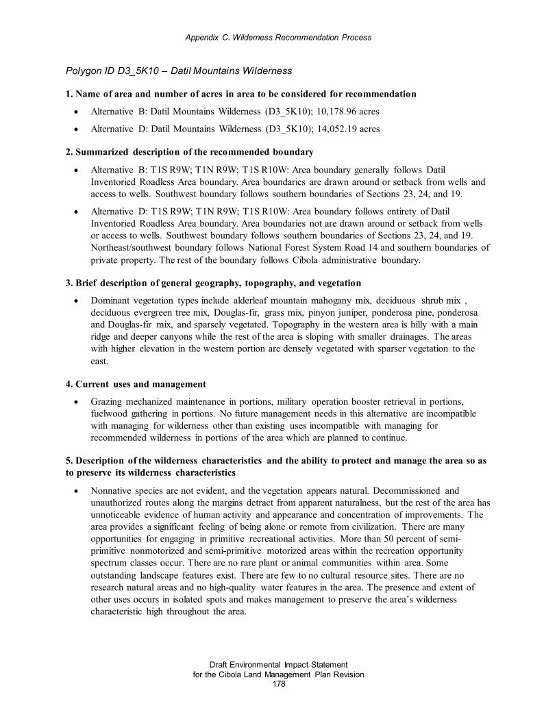
Appendix C. Wilderness Recommendation Process
Draft Environmental Impact Statement for the Cibola Land Management Plan Revision
178
Polygon ID D3_5K10 – Datil Mountains Wilderness
1. Name of area and number of acres in area to be considered for recommendation
• Alternative B: Datil Mountains Wilderness (D3_5K10); 10,178.96 acres
• Alternative D: Datil Mountains Wilderness (D3_5K10); 14,052.19 acres
2. Summarized description of the recommended boundary
• Alternative B: T1S R9W; T1N R9W; T1S R10W: Area boundary generally follows Datil Inventoried Roadless Area boundary. Area boundaries are drawn around or setback from wells and access to wells. Southwest boundary follows southern boundaries of Sections 23, 24, and 19.
• Alternative D: T1S R9W; T1N R9W; T1S R10W: Area boundary follows entirety of Datil Inventoried Roadless Area boundary. Area boundaries not are drawn around or setback from wells or access to wells. Southwest boundary follows southern boundaries of Sections 23, 24, and 19. Northeast/southwest boundary follows National Forest System Road 14 and southern boundaries of private property. The rest of the boundary follows Cibola administrative boundary.
3. Brief description of general geography, topography, and vegetation
• Dominant vegetation types include alderleaf mountain mahogany mix, deciduous shrub mix , deciduous evergreen tree mix, Douglas-fir, grass mix, pinyon juniper, ponderosa pine, ponderosa and Douglas-fir mix, and sparsely vegetated. Topography in the western area is hilly with a main ridge and deeper canyons while the rest of the area is sloping with smaller drainages. The areas with higher elevation in the western portion are densely vegetated with sparser vegetation to the east.
4. Current uses and management
• Grazing mechanized maintenance in portions, military operation booster retrieval in portions, fuelwood gathering in portions. No future management needs in this alternative are incompatible with managing for wilderness other than existing uses incompatible with managing for recommended wilderness in portions of the area which are planned to continue.
5. Description of the wilderness characteristics and the ability to protect and manage the area so as to preserve its wilderness characteristics
• Nonnative species are not evident, and the vegetation appears natural. Decommissioned and unauthorized routes along the margins detract from apparent naturalness, but the rest of the area has unnoticeable evidence of human activity and appearance and concentration of improvements. The area provides a significant feeling of being alone or remote from civilization. There are many opportunities for engaging in primitive recreational activities. More than 50 percent of semi-primitive nonmotorized and semi-primitive motorized areas within the recreation opportunity spectrum classes occur. There are no rare plant or animal communities within area. Some outstanding landscape features exist. There are few to no cultural resource sites. There are no research natural areas and no high-quality water features in the area. The presence and extent of other uses occurs in isolated spots and makes management to preserve the area’s wilderness characteristic high throughout the area.

Appendix C. Wilderness Recommendation Process
Draft Environmental Impact Statement for the Cibola Land Management Plan Revision
179
6. A brief summary of factors considered and the process used in evaluating the area and developing the alternative
• Area received a high overall, with a high in each required criteria
7. A brief summary of the ecological and social characteristics that would provide the basis for the areas suitability for including in National Wilderness Preservation System
• Alternative B: Analyze as recommended wilderness with adjusted boundary. Redraw boundaries to approximately align with Datil Inventoried Roadless Area and recommend as potential wilderness. Exclude those few features (decommissioned roads in the northern portion and southeastern corner) and incompatible existing uses.
• Alternative D: Analyze as entire area as recommended wilderness. Redraw boundaries to approximately align with Datil Inventoried Roadless Area and recommend as potential wilderness. Exclude those few features (decommissioned roads in the northern portion and southeastern corner) and incompatible existing uses.
Polygon ID D3_5K2 – Magdalena Mountains 1
1. Name of area and number of acres in area to be considered for recommendation
• Alternative B: Magdalena Mountains 1 (D3_5K2); 3,056.78 acres
• Alternative D: Magdalena Mountains 1 (D3_5K2); 4,741.86 acres
2. Summarized description of the recommended boundary
• Alternative B: T3-4S R4W: Starting northwest corner National Forest System Road 45- East to junction of National Forest System Road 45 and South Baldy Trail. National Forest System Road 45 South Baldy Trail south along South Baldy Trail to South Baldy Trailhead until National Forest System Road 235C heading south until intersecting MRO. At MRO heading southwest until Harding Spring. Continue west until intersecting Butter Cup Spring. Head northwest from Butter Cup Spring along private land until hitting Rowden north until intersecting National Forest System Road 45.
• Alternative D: T4S – R4W: Starting northwest corner National Forest System Road 45- East to junction of National Forest System Road 45 and South Baldy Trail. National Forest System Road 45 South Baldy Trail south along South Baldy Trail to South Baldy Trail head until National Forest System Road 235C heading south until intersecting MRO. MRO heading southwest until Harding Spring. Continue west until intersecting Butter Cup Spring. Head west approximately 1 mile along the power line then head northwest, going approximately 1.75 miles then intersecting private, turn back east then head along the private heading east approximately ½ mile then heading north ¾ mile then heading east along private approximately ¼ then head north ¼ mile along private land. Stay east along private until intersecting National Forest System Road 45. Head northwest from Butter Cup Spring along private land until intersecting Rowden north until intersecting National Forest System Road 45.

Appendix C. Wilderness Recommendation Process
Draft Environmental Impact Statement for the Cibola Land Management Plan Revision
180
3. Brief description of general geography, topography, and vegetation
• Dominant vegetation types include pinyon juniper, deciduous shrub mix, deciduous evergreen mix, Douglas-fir, grama and grass mix, ponderosa pine, ponderosa and Douglas-fir mix, sparsely vegetated, and alder leaf mountain mahogany mix. Topography in the area is highly mountainous and contains deep canyons where solitude is possible due to remoteness. Springs occur within the area. Road paralleling the northern boundary is heavily used by recreation users and residents on private land, but it is a rough road. Noise is evident in portions adjacent to road.
4. Current uses and management
• Range improvement maintenance and mountain biking occurs in scattered areas; none are in conflict with managing for recommended wilderness.
5. Description of the wilderness characteristics and the ability to protect and manage the area so as to preserve its wilderness characteristics
• No reported nonnative populations are present, plant and animal communities appear natural, and vegetation appears natural to the average viewer. A high concentration and evidence of human activity detract from apparent naturalness in some areas. The presence of human activity is evident in some areas such as high points and on the northern edge, but solitude is possible within interior areas and canyon bottoms. Many primitive recreation opportunities are available. Mexican spotted owl populations are present in the area. There are some outstanding landscape features. There are no research natural areas and no high-quality water features in the area. The presence and extent of other uses, such as range improvement maintenance and mountain biking, occurs in scattered areas.
• Public comment received summer 2016 stated that this parcel (D3_5K2) should be removed from further analysis as it includes TR21, TR26, and TR8. TR8 connects to other trails, including TR10 and TR25. The D3_5K2 polygon also received a low, low-moderate, or moderate score for criterion 5a, due to improper consideration of motorized or mechanized uses.
6. A brief summary of factors considered and the process used in evaluating the area and developing the alternative
• Overall high + finding, with a high in criterion 1 and 2 ad a moderate in manageability
7. A brief summary of the ecological and social characteristics that would provide the basis for the areas suitability for including in National Wilderness Preservation System
• Alternative D: Analyze entire area as recommended wilderness. Analyze impacts of managing as recommended wilderness with continued grazing improvements.
Polygon ID D3_5K16 – Panther Canyon
1. Name of area and number of acres in area to be considered for recommendation
• Alternative B: Panther Canyon (D3_5K16); 11,164.00 acres
• Alternative D: Panther Canyon (D3_5K16); 27,598.42 acres

Appendix C. Wilderness Recommendation Process
Draft Environmental Impact Statement for the Cibola Land Management Plan Revision
181
2. Summarized description of the recommended boundary
• Alternative B: T5-6S R6-7W: Starting at North Chime Trail Head, head S along eastern boundary on the National Forest System Road 138 to National Forest System Road 96 junction. Follow National Forest System Road 96 (Hudson Canyon) S, then head west through Sections 19 & 24, then southwest down Bull Canyon to Roberts Place. Head north up Tin Cup Canyon past Scrapes and up the Panther Canyon. Tie into Hughes Mill Trail 65. Then head northwest continue northeast back up Chime Canyon until tying into the starting point.
• Alternative D: T5-6S R6-7W: Starting at Monica Saddle, head S along the National Forest System Road 138 to National Forest System Road 96 junction, then head S on National Forest System Road 96, until reaching Section 10. Head northwest until intersecting National Forest System Road 549 at Sam Draw, but excluding Little Pigeon Canyon, Scrapes, and National Forest System Road 72 & 73. Head northeast on National Forest System Road 549 Bear Trap Canyon, until tying into starting location. The area includes several roads and some private property.
3. Brief description of general geography, topography, and vegetation
• Alderleaf mountain mahogany mix, deciduous shrub, deciduous trees mix, Douglas-fir, pinyon juniper, grass, ponderosa pine, ponderosa pine-Douglas fir mix, sparsely vegetated. Some cottonwood localized to drainages. General topography within the area is rugged, highly mountainous, lots of drainages and canyons. Screening is possible throughout some parts of the area.
4. Current uses and management
• Grazing improvements requiring mechanized maintenance are present in the area. For Fiscal year 2017, EQIP activities will include rebuilding set of pens, replacing drinkers, solar panel, cleanout dirt tank, new storage tank. These EQIP projects are located from Roberts Place to Scrapes in the southern portion of the polygon. Mountain biking loop opportunities occur in the southwestern portion. Outfitter and guides do use aircraft to scout wildlife during hunting season. Multiple cherry-stemmed roads creates fragmented shape of area. Mechanized grazing improvement maintenance, mountain biking, EQIP project activities, and cherry-stemmed roads to continue.
5. Description of the wilderness characteristics and the ability to protect and manage the area so as to preserve its wilderness characteristics
• Nonnative species are not evident. Vegetation appears natural. Unnoticeable evidence of human activity; appearance and concentration of improvements detract from apparent naturalness in some areas such as substantially noticeable improvements and visible roads. The feeling of being alone or remote from civilization is possible in drainages and canyons, but impacts from civilization are possible in some locations. There are some opportunities for engaging in primitive recreation. The area contains Mexican spotted owl populations. There are some outstanding landscape features, including rock formations, fall colors, and scenic views. The area has few historic and cultural resource sites. There are no research natural areas. High quality water features do not occur in this area. Other uses occur in scattered areas and make management to preserve wilderness characteristics low in most areas (improvement maintenance, fragmenting cherry-stemmed roads, mountain biking, and planned EQIP projects.

Appendix C. Wilderness Recommendation Process
Draft Environmental Impact Statement for the Cibola Land Management Plan Revision
182
6. A brief summary of factors considered and the process used in evaluating the area and developing the alternative
• Overall high finding; high in criterion 1 and criterion 2 for primitive rec, and a moderate in manageability.
7. A brief summary of the ecological and social characteristics that would provide the basis for the areas suitability for including in National Wilderness Preservation System
• Alternative B: Analyze middle portion as recommended wilderness with incompatible uses for recommended wilderness removed.
• Alternative D: Analyze entire area as recommended wilderness. Analyze effects of continuing incompatible uses within recommended wilderness.
Polygon ID D3_5K7.d – Bear Mountains 3
1. Name of area and number of acres in area to be considered for recommendation
• Alternative B: Bear Mountains 3 (D3_5K7.d); 2,323.31 acres (formerly Scott Mesa)
• Alternative D: Bear Mountains 3 (D3_5K7.d); 3,154.15 acres
2. Summarized description of the recommended boundary
• Alternative B: T1N R5W, T1N R4W: All of the area occurs within the Scott Mesa Inventoried Roadless Area. Boundary along southwestern corner within Section 26, follow ridge that runs east to west. For remainder of the boundaries, follow Scott Mesa area including portions of Section 23, 24, 19, 30, 25, 26.
• Alternative D: T1N R5W, T1N R4W: All of the area occurs within the Scott Mesa Inventoried Roadless Area. Follow Scott Mesa area including portions of Section 23, 24, 19, 30, 25, 26. Southwest area includes Cencerro Canyon with private land on the western boundary and a two track road on the south boundary.
3. Brief description of general geography, topography, and vegetation
• The vegetation in this area is majority pinyon juniper with some ponderosa mix with deciduous evergreen mix. Topography lends itself to deep canyons.
4. Current uses and management
• Unauthorized fuelwood cutting and all-terrain vehicle use occurs along and off roads coming from residential areas, and mountain bike use over fences is also a management concern; and these management issues may be amplified if area becomes a wilderness. Mechanized maintenance of grazing improvements in southern portion of area expected to continue. Majority of area is inventoried roadless area. No future management in this alternative that would conflict with managing for recommended wilderness in the north portion, but grazing mechanized maintenance of existing improvements is planned to continue in south portion.

Appendix C. Wilderness Recommendation Process
Draft Environmental Impact Statement for the Cibola Land Management Plan Revision
183
5. Description of the wilderness characteristics and the ability to protect and manage the area so as to preserve its wilderness characteristics D3_5K7.d
• The area contains some reported populations of nonnative species. Isolated spots along the road look unnatural because of fuelwood cutting, but no evidence of human activity detracts from apparent naturalness in other areas. The area provides some opportunities for solitude, but signs of civilization are also possible, particularly along the edges. Many opportunities to engage in primitive recreation exist. No rare plant or animal populations are reported. The area contains few to no outstanding features and no research natural areas. Findings were low for cultural sites. There are no high-quality watershed features. The presence and extent of other uses such as military training activities, makes management to preserve the area’s wilderness characteristics possible in most areas, but it is important to note that the presence and extent of other uses occurs in scattered locations.
6. A brief summary of factors considered and the process used in evaluating the area and developing the alternative
• Area received an overall high finding in evaluation, high in criterion 1 and 2 (high in primitive rec and solitude) and a moderate in manageability.
7. A brief summary of the ecological and social characteristics that would provide the basis for the areas suitability for including in National Wilderness Preservation System
• Alternative B: Analyze recommending northern portion of area as recommended wilderness. Future management of existing uses (mechanized maintenance of grazing improvements) is planned to continue in southern portion. No conflicts with managing for recommended wilderness in northern portion and wilderness characteristics are present.
• Alternative D: Analyze recommending entire area as recommended wilderness. Future management of existing uses (mechanized maintenance of grazing improvements) is planned to continue in southern portion. Analyze effects of continuing mechanized maintenance of grazing improvements while managing for recommended wilderness.
Polygon ID D3_ADJ7 – Withington Wilderness Expansion 6
1. Name of area and number of acres in area to be considered for recommendation
• Alternative B: Withington Wilderness Expansion 6 (D3_ADJ7); 3,567.20 acres
• Alternative D: Withington Wilderness Expansion 6 (D3_ADJ7); 10,052.45 acres
2. Summarized description of the recommended boundary
• Alternative B: T5S R5-6W: b) For southern boundary, follow range fence near Chavez Canyon from Big Rosa Tank to Big Rosa Canyon. For western boundary follow road with 300 foot setback. For northern boundary 100 foot setback until hits National Forest System Road 1071, follow National Forest System Road 1071 along northeast border until reaches national forest boundary; follows national forest boundary.

Appendix C. Wilderness Recommendation Process
Draft Environmental Impact Statement for the Cibola Land Management Plan Revision
184
• Alternative D: T5-6S R5-6W: Beginning at the trail head of Potato Trail 38, heading northeast until intersecting Big Rosa Canyon. Turn southeast until intersecting cement tank of the northeast corner of section 8. Turn south for two miles. Turn southwest for 1 ¼ mile. Turn east for 1 mile then head south for 1 mile towards White Cap. Head south for approximate 1 ¼ mile, then turn west towards the middle of Section 1, then southwest to National Forest System Road 330, then from 330 stay on road until passing Bell Spring ¼ mile, from Bell Springs head west tying into the upper portion of National Forest System Road 330. Head to the 96 and 330, head to Dry Springs trail head. Take Dry Springs trail head 36 then turn west for another 1 ¼ mile until intersecting Big Rosa Canyon National Forest System Road 56 heading north until intersecting Potato Trail Head.
3. Brief description of general geography, topography, and vegetation
• Alderleaf mountain mahogany mix, deciduous shrub, deciduous evergreen tree, Douglas-fir, grass mix, pinyon juniper, ponderosa pine, ponderosa pine/Douglas-fir mix. Has some sparser vegetation to the north but contains rolling hills with topographic screening for sound because of mountainous terrain and drainages.
4. Current uses and management
• Grazing improvements requiring mechanized maintenance are present in the area. Mechanized use associated with mineral prospecting. Personal fuelwood harvest occurs along the southern portion of near Rosedale. Mechanized mountain bike use along Big Rosa Canyon (NFSR 56), NFS Trail 36, and NFS Trail 92 and throughout the southern portion of the area. Outfitters and guides do use aircraft to scout wildlife during hunting season. Two cherry-stemmed roads occur in the middle of the area boundaries which bisect the area into two different areas. Existing Withington Wilderness along western boundary. Mechanized grazing improvements, mechanized use for mineral prospecting, and mechanized mountain bike use to continue. Cherry-stemmed roads bisecting area continue to occur.
5. Description of the wilderness characteristics and the ability to protect and manage the area so as to preserve its wilderness characteristics D3_ADJ7
• Nonnative species are not evident. The vegetation appears natural. There is little or no evidence of human activity and the appearance and concentration of improvements do not detract from apparent naturalness. Two cherry-stemmed roads are present in this location, and road use is persistent. The feeling of being alone is possible but signs of civilization are also possible. There are many opportunities to engage in primitive recreation. The area contains a preponderance (over 50 percent) of semi-primitive nonmotorized and semi-primitive motorized areas within the recreation opportunity spectrum classes. Mexican spotted owl protected activity centers are present. There are few outstanding landscape features. Cultural findings are moderate. There are no research natural areas and no high-quality water features. The presence of other uses occurs in scattered locations.
6. A brief summary of factors considered and the process used in evaluating the area and
• Overall high; high in criterion 1 and 2, with a moderate in manageability

Appendix C. Wilderness Recommendation Process
Draft Environmental Impact Statement for the Cibola Land Management Plan Revision
185
7. A brief summary of the ecological and social characteristics that would provide the basis for the areas suitability for including in National Wilderness Preservation System
• Alternative B: Analyze middle portion as recommended wilderness with incompatible uses for recommended wilderness removed.
• Alternative D: Analyze entire area as recommended wilderness. Analyze effects of continuing incompatible uses such as the density of the roads, recreational access including mountain biking, range improvement fences, cherry-stemmed roads, and mineral prospecting within recommended wilderness.
Polygon ID D4_ADJ4 – Manzano Wilderness Expansion 1
1. Name of area and number of acres in area to be considered for recommendation
• Alternative B: Manzano Wilderness Expansion 1 (D4_ADJ4); 1,224.05 acres
• Alternative D: Manzano Wilderness Expansion East (D4_ADJ4); 5,733.90 acres
2. Summarized description of the recommended boundary
• Alternative B: For the southern boundary of the area, extend to the southern edge of the eligible wild and scenic river Tajique Creek corridor with consideration of the road setback where Tajique Creek crosses the road. Follow the ridge top across the saddle on the western boundary and follow the ridge on the eastern boundary. Level 2 Roads 55, 55A, 55AA, 55H, 55H2, and 55L2 with 30 meter setbacks (which were cherry-stemmed out during Inventory Phase) are located along the majority of the eastern boundary, with exception of private property inholdings. Follow the Forest Service administrative boundary to the north as the area's northern boundary. Pueblo of Isleta is adjacent to the northern boundary. Follow the existing Forest Service Manzano Mountain Wilderness boundary to the west for the area's western boundary.
• Alternative D: The southern boundary of the area follows the northwest-southeast utility corridor that extends from FR245 near the Capilla Peak communication site to Level 2 Road 245F1. Level 2 Roads 55, 55-2, 55-3, 55A, 55A-3, 55AA, 55H, 55H2, 55K1, 55K2, 55L2, 245F, 245F2, 245G, 245H, 323A, and 323B with 30 meter setbacks (which were cherry stemmed out during inventory phase) are located along the majority of the eastern boundary, with exception of private property inholdings. Follow the Forest Service administrative boundary to the north as the area's northern boundary. Pueblo of Isleta is adjacent to the northern boundary. Follow the existing Forest Service Manzano Mountain Wilderness boundary to the west for the area's western boundary.
3. Brief description of general geography, topography, and vegetation
• Located within the northeastern Manzano Mountains. The area is all downslope from a crest in the existing wilderness. The entire western edge is adjacent to existing wilderness. Area is not steep, but more of a gentle, forested slope on eastern side as compared to the rockier, steep western side.

Appendix C. Wilderness Recommendation Process
Draft Environmental Impact Statement for the Cibola Land Management Plan Revision
186
• Geospatial data shows area is mostly dominated by Dry Mixed Conifer and Ponderosa Pine Forest mix. Perennial water source near Fourth of July Canyon, where white fir, maples, some cottonwood, and willows occur near riparian area. Maple community is very significant and unique for this area; very few of those examples occur in New Mexico. There are some populations of cheatgrass bordering the western edge of the area, but the majority is shown to be not within the boundaries of the area itself. Some of observations of isolated populations of Canada and musk thistles. The portion of this polygon south of Tajique Creek has had restoration treatments in recent history.
4. Current uses and management
• Alternative B: Area received a moderate in manageability due to presence and extent of other uses across most of the area (extent of unauthorized fuelwood cutting in northern section), fragmented shape and configuration of the area. Existing incompatible uses: Capilla Collaborative Forest Restoration Project overlapping southern area includes mechanical thinning, and adjacent Isleta Thinning Project. Fourth of July Canyon Management Area proposed focusing on maintaining forest health; firewood cutting would be allowed. Vegetation management including mechanized thinning is proposed as a focus of the Fourth of July Management Area. Gross Kelley Communal Grazing Management Area proposed in southern portion, with incompatible uses planned such as mechanized or motorized maintenance of future improvements. Eligible wild and scenic river overlaps into the area in the north portion.
• Alternative D: Area is adjacent to existing wilderness. Alternative theme focuses on conservation and primitive recreation. Future restoration needs under this alternative theme could be accomplished through methods conforming to recommended wilderness management. Eligible wild and scenic river overlaps into the area in the north portion. Entire area is adjacent to existing wilderness on western portion.
5. Description of the wilderness characteristics and the ability to protect and manage the area so as to preserve its wilderness characteristics
• Animal and plant communities do not appear substantially unnatural. Area is not substantially unnatural across the area as a whole; cheatgrass populations occur outside the boundaries, and population of noxious weeds is isolated and not substantially unnatural to area as a whole. The southern portion (below Fourth of July Canyon) has multiple historic treatments. The northern portion (above Fourth of July Canyon) vegetation appears natural. Below Fourth of July Canyon, there is obvious evidence of human disturbance; appearance and concentrations of improvements detract from apparent naturalness in most areas. Above Fourth of July Canyon, there is little or no evidence of human activity. The northern portion has seasonal variability of impacts to solitude. The southern portion has impacts to solitude along eastern edge. There is known occurrence of many opportunities for engaging in primitive recreation, and the popularity of primitive types of recreation in the area and the system trails prohibit mountain biking use. There are rare or plant and animal communities (goshawk post-fledging area). There are (1) some outstanding landscape features (Rocky Mountain maple population and scenic areas), (2) several historic and cultural resource sites and routes and possibly more in unsurveyed area, (3) no research natural areas in the area boundaries, (4) several or many high-quality water resources, and the area as a whole has extensive watershed features. Below Fourth of July Canyon, there is an inability to manage to preserve for wilderness characteristics in most areas, above Fourth of July Canyon there is unauthorized fuelwood cutting, and combined with the fragmented shape and configuration of the area, makes management to preserve wilderness characteristics difficult in some areas.

Appendix C. Wilderness Recommendation Process
Draft Environmental Impact Statement for the Cibola Land Management Plan Revision
187
6. A brief summary of factors considered and the process used in evaluating the area and developing the alternative
• Area has overall high+ wilderness characteristics, with a high in the majority of the required chapter 70 criteria. Area received a high in primitive recreation, which meets alternative theme.
7. A brief summary of the ecological and social characteristics that would provide the basis for the areas suitability for including in National Wilderness Preservation System
• Alternative B: Analyze areas north of Fourth of July Canyon Management Area as recommended wilderness. Do not analyze entire area as recommended wilderness because it does not fit with alternative theme as recommended wilderness; current management issues are present. Analyze effects of managing remaining area with forest-wide desired conditions in southern portion, and effects of managing 4th of July Canyon and Gross Kelley communal grazing area as special management areas.
• Alternative D: Include entire phase 3 inventory area as recommended wilderness. Area fits with alternative theme emphasis on backcountry; analyze effects of managing as recommended wilderness.
Alternative D Recommended Wilderness Areas Outside of the common recommended wilderness areas with alternatives b and c, alterative D includes an additional 18 recommended wilderness areas totaling 64,288 acres:
• Hogback Recommended Wilderness Area (5,564 acres in alternative D)
• Guadalupe Recommended Wilderness Area (14,988 acres in alternative D)
• Mount Taylor Recommended Wilderness Area (475 acres in alternative D)
• Little Water Canyon Recommended Wilderness Area (27,348 acres in alternative D)
• Bear Mountains 1 Recommended Wilderness Area (1,713 acres in alternative D)
• Bear Mountains 2 Recommended Wilderness Area (2,307 acres in alternative D)
• Datil Mountains 1 Recommended Wilderness Area (18,350 acres in alternative D)
• Magdalena Mountains 2 Recommended Wilderness Area (1,652 acres in alternative D)
• Withington Wilderness Expansion 1 Recommended Wilderness Area (20 acres in alternative D)
• Withington Wilderness Expansion 2 Recommended Wilderness Area (5 acres in alternative D)
• Withington Wilderness Expansion 3 Recommended Wilderness Area (55 acres in alternative D)
• Withington Wilderness Expansion 4 Recommended Wilderness Area (6 acres in alternative D)
• Withington Wilderness Expansion 5 Recommended Wilderness Area (48 acres in alternative D)
• Withington Wilderness Expansion 7 Recommended Wilderness Area (81 acres in alternative D)
• Apache Kid Wilderness Expansion 4 Recommended Wilderness Area (3,654 acres in alternative D)
• Apache Kid Wilderness Expansion 6 Recommended Wilderness Area (181 acres in alternative D)
• Spruce Park Recommended Wilderness Area (6,198 acres in alternative D)
• Gallinas Recommended Wilderness Area (2,410 acres in alternative D)
• Sandia Wilderness Expansion 2 Recommended Wilderness Area (281 acres in alternative D)

Appendix C. Wilderness Recommendation Process
Draft Environmental Impact Statement for the Cibola Land Management Plan Revision
188
This section provides the following information for each area included in alternative D for the draft environmental impact statement:
• The name of the area and the number of acres to be considered;
• The location and a summarized description of a recommended boundary for each area;
• A brief description of the general geography, topography, and vegetation of the recommended area;
• A brief description of the current uses and management of the area;
♦ This section includes the recreation opportunity spectrum classifications, inventoried roadless area, range allotment(s), cherry-stemmed roads, adjacency to existing designated wilderness or Bureau of Land Management wilderness study area, mining claim(s), and other information that pertains to the use and management in the area.
• A description of the area’s wilderness characteristics and the ability of the Forest to protect and manage the area so as to preserve its wilderness characteristics;
♦ Throughout the area descriptions, there are references to cherry-stem roads. A cherry-stem road refers to a dead-end road that appears to protrude into a polygon, but the perimeter of the polygon is drawn around the road, excluding the road from being within the actual boundary of a polygon.
• A brief summary of the factors considered and the process used in evaluating the area and developing the alternatives; and
• A brief summary of the ecological and social characteristics that would provide the basis for the area’s suitability for inclusion in the National Wilderness Preservation System.
Polygon ID D2_ 5K3– Hogback
1. Name of area and number of acres in area to be considered for recommendation
• Alternative D: Hogback (D2_5K3); 5,563.72 acres
2. Summarized description of the recommended boundary
• The Hogback ridge is 5,563 acres and runs north to south in the south eastern portion of the Zuni Mountains of the Mt. Taylor Ranger District. There is a ridge on the east of the area and a mesa on the western side of the area, creating a mesa top with upland meadow (slot canyon). A natural bluff delineates the boundary to the east. The western side is delineated by the Zuni Indian Reservation and national forest boundary. In the middle portion (section 16) is the old Ralph Bond property. The southwestern tip (section 28) is the Zuni Indian Reservation. The northern extent (sections 33 and 34) is delineated by private property and national forest boundary. The southern extent is delineated by the Zuni Indian Reservation (mentioned above-section 28), Forest boundary, and some private property surrounding the community of Ramah (sections 33, 34, 35, and parts of section 26). The eastern extent is delineated by the rock outcrop bluff which defines Hogback Ridge and national forest boundary. The entire area is a small island of the Mt. Taylor Ranger District. Other than that there are no natural features to distinguish the boundary. There are no other information provided by geospatial information, District staff and specialists, or public comment.

Appendix C. Wilderness Recommendation Process
Draft Environmental Impact Statement for the Cibola Land Management Plan Revision
189
• There is a manmade hiking trail made by the Ramah Mormon Church to the south that borders National Forest System lands. To the west, there are numerous hiking trails built by the church that are very distinguishable, there are also several roads near the hogback ridge and another adjacent (about 150 feet to the west of that road) which borders the ridge. Two cherry-stemmed roads occur at the bottom of the slot canyon. Use on cherry-stemmed road (not a system road) is heavy and recently has been bladed heavily and is often washed out in most places; in areas where it is not washed out there is use. Cherry-stemmed road is not a system road and is for permitted use only currently.
3. Brief description of general geography, topography, and vegetation
• The Hogback ridge runs north to south in the eastern portion of the area. There is a ridge on the eastern portion of the area and a mesa on the western side of the area creating a mesa top with an upland meadow (slot canyon). There is a secluded nature of the topography in the northwestern corner of the area. Vegetation is dominated by pinon juniper with some ponderosa pines on the ridgeline. Below the Hogback on the bottom of the area on the northeastern side the area is predominantly ponderosa pine.
4. Current uses and management
• All improvements within the grazing allotments are outside of the area boundaries. Motorized maintenance access to excluded fences along northern boundary currently occurs throughout the northwestern area within the area boundaries. Thirty-four percent wildland-urban interface on the eastern edge bordering development. Limited future management needs for grazing fence maintenance access in northwestern portion are incompatible with recommended wilderness management and planned to continue.
5. Description of the wilderness characteristics and the ability to protect and manage the area so as to preserve its wilderness characteristics
• Nonnative species occur in scattered locations within the area. The vegetation appears natural throughout the area. There is little human activity within the area, and improvements do not detract from the apparent naturalness. Opportunities for solitude exist in the northwestern portion of the area, but opportunities for solitude are impacted by sights and sounds along the Hogback ridge. Opportunities exist for primitive recreation activities such as hiking and camping. Non-primitive types of recreation occur in the area; for example, mountain biking is very popular. The area has some outstanding features. The Hogback is a very unique geologic feature that runs the length of the eastern boundary; the immensity of the feature should be considered. Some historic and cultural resource sites are present.
• The presence and extent of other uses across most of the area and makes management to preserve the wilderness character difficult in most areas. For example, motorized maintenance is used throughout the grazing allotment; ongoing analysis of the Zuni mountain-biking trails project continues; a cherry-stemmed route runs through a majority of the area, almost bisecting it; and there is a high percentage of wildland-urban interface within the area boundaries.
6. A brief summary of factors considered and the process used in evaluating the area and developing the alternative
• Overall high finding, high in criterions 1 and 2, moderate in criterion 5

Appendix C. Wilderness Recommendation Process
Draft Environmental Impact Statement for the Cibola Land Management Plan Revision
190
7. A brief summary of the ecological and social characteristics that would provide the basis for the areas suitability for including in National Wilderness Preservation System
• Analyze entire area as recommended wilderness. *Note: identify if a hotspot was identified for this area. High opportunities for primitive recreation, no existing or future uses that are incompatible with recommended wilderness management. Analyze effects of managing as recommended wilderness with grazing maintenance occurring and wildland-urban interface treatment using nonmechanical means.
Polygon ID D2_ ADJ3 – Guadalupe
1. Name of area and number of acres in area to be considered for recommendation
• Alternative D: Guadalupe (D2_ADJ3); 14, 988.38 acres
2. Summarized description of the recommended boundary
• The Salado Canyon/Guadalupe Management Area encompasses approximately 14,998 acres and is located in the northeast portion of the Mount Taylor Ranger District. The northern boundary is delineated by Bureau of Land Management's Chamisa Wilderness Study Area and national forest boundary. The eastern boundary is delineated by the national forest boundary, which includes a segment of the Big Bead Mesa. Other boundary markers include the Cabezon Mesa to the east on private (section 24 of T.15N. and R.4W.) and Bureau of Land Management lands; in sections 13, 35, and N 1/4 of sec 36 of T.15N. and R.4W. On the eastern end, there is also a segment of the Laguna Indian Reservation against the national forest boundary. There are also State lands on the southeast end, in sections 1, 12, and 13 of T.14N. and R.4W. There is a small sliver of land that extends inside the north 1/4 of section 2 of T.14N. and R.4W, called Juan Jose Ravine. The southern boundary is delineated by private property in sections 7, 17, 16, 21, 25, 26, 27, and 28 of T.14N. and R.4W. The western boundary is delineated by the Salado Canyon and Guadalupe Canyons rim and rocky bluffs, with steep escarpments and narrow deep canyons that flow eastward from the rim of plateau (Mesa de Chivato) toward the Rio Puerco. The bluffs are also defined by the county lines of McKinley and Sandoval Counties. T15N R4W, T14N R4W, T15N R5W
3. Brief description of general geography, topography, and vegetation
• Throughout the northeastern area there are basalt/sandstone cliffs. Geospatial data shows that there are no nonnative populations in the area boundaries. In the upper areas there are dense pinyon/juniper stands with sparse understory vegetation. In open areas, blue grama is the dominant species and in the lower areas it is ponderosa pine. There is a basalt rim that drops straight off into a canyon and the west side has rolling hills. There is a rim on the eastern portion with lower slopes and the western portion is a mesa top; the rim runs through the middle.

Appendix C. Wilderness Recommendation Process
Draft Environmental Impact Statement for the Cibola Land Management Plan Revision
191
4. Current uses and management
• Existing incompatible improvements in area have been cherry-stemmed out in previous steps of the evaluation process. Western edge is the only area accessible by driving due to steep slopes in majority of area, preventing encroachment. Improvements shown outside of area or within area are no longer being maintained. Country is rugged and densely overgrown with vegetation. Presence and extent of other uses occurs in isolated spots and management to preserve area’s wilderness characteristics is high throughout the area. Area is adjacent to existing Bureau of Land Management wilderness study area and is an inventoried roadless area. No active mining claims. Portion of Los Indios allotment is in small northwestern portion. Black Mesa project is planned to continue in the area; will be mostly hand thinning and broadcast burns and overlaps in the western portion. This type of management is consistent with conservation objectives, which meets this alternative theme.
5. Description of the wilderness characteristics and the ability to protect and manage the area so as to preserve its wilderness characteristics
• Nonnative species are in isolated spots with Barbary sheep throughout the northeast. Grazing impacts do not appear unnatural to the average visitor. There is evidence of detraction from apparent naturalness in some areas. Different geographic areas, such as the east side of the rim and the west side of rim, offer multiple opportunities for solitude. There are many outstanding opportunities for primitive recreation in the area. There are several outstanding features in the area. One rare animal species is present. The majority of the area is a traditional cultural property with significant sites. Presence and extent of other uses occurs in isolated spots and management to preserve the wilderness characteristics is high throughout the area.
6. A brief summary of factors considered and the process used in evaluating the area and developing the alternative
• Area has overall high+ wilderness characteristics, with a high in the majority of the required chapter 70 criteria. Area received a high in primitive recreation, which meets alternative theme
7. A brief summary of the ecological and social characteristics that would provide the basis for the areas suitability for including in National Wilderness Preservation System
• Analyze eastern side of rim as recommended wilderness. Analyze eastern side of rim as wilderness due to size and adjacency to Bureau of Land Management Wilderness Study Area and wilderness characteristics. Due to Black Mesa decision on forest health, entire Phase 3 Inventory boundary is not feasible as recommended wilderness, but includes areas to southeast corner property line and small southwest inclusion. Manage the area west of the rim as a conservation area for the outstanding scenic, wildlife, and cultural areas; preserve the natural features and qualities that are consistent with inventoried roadless area characteristics where inventoried roadless area exists; manage for wildlife habitat; characteristics of the traditional cultural property and traditional and cultural values.

Appendix C. Wilderness Recommendation Process
Draft Environmental Impact Statement for the Cibola Land Management Plan Revision
192
Polygon ID D2_ 5K8 – Mount Taylor
1. Name of area and number of acres in area to be considered for recommendation
• Alternative D: Mount Taylor (D2_5K8); 474.90 acres
2. Summarized description of the recommended boundary
• Mount Taylor is a composite volcano, thought to have been active several million years ago. The high points (the summits of Mount Taylor and La Mosca) are what remain of the original cone and the wilderness character area encompasses 5,705.11 acres and its boundaries are delineated by the portion of the Middle Rio San Jose and Rio Paguate watersheds that are on the Mt. Taylor Ranger District. The ridge between these peaks forms the western edge of the large caldera. Mount Taylor emerges as a prominent landmark on the Colorado Plateau. The eastern end is delineated by the national forest boundary, which includes private property on the northern end in section of T.11N and R.7W. and Sections 1, 11, 12, 14, 22, 23, 27, and 34 of T.12N and R.7W. The rest of the eastern boundary is delineated by the Laguna Pueblo Reservation in sections 3 and 10 of the T.11N and R.7W. The southwest boundary has no clear boundaries. The best way to delineated a line is to start north of De Armand Springs (the southern end of section 10) and then the boundary goes northwest to north end of Gooseberry Springs (NW 1/4 NW 1/4 of Section 36). The northwest boundary would then go from the aforementioned point to the northeast and end south of Cold Springs or where the national forest boundary makes a bend. There is one “barrier” identified in the area on geospatial data which is a natural barrier feature with a couple of gap fences in places. This area contains steep topography. There is one small decommissioned road entering the area in the southern portion. There are two closed roads in southern section. T11N R7W, T12N R8W, T12N R7W
3. Brief description of general geography, topography, and vegetation
• The high points consist of the summits of Mount Taylor and La Mosca which are the remains of the original volcanic cone. The boundaries are delineated by the portion of the Middle Rio San Jose and Rio Paguate watersheds. The ridge between these peaks form the western edge of the large caldera. Mount Taylor emerges as a prominent landmark on the Colorado Plateau. Geospatial data reports the dominant vegetation type is a mix of grass mix, evergreen mix, and spruce/fir communities in the higher region. Pine and fir mix is present as well with high concentration in some areas. Patches of aspen occur within Water Canyon.
4. Current uses and management
• Mountain biking occurs along Gooseberry Trail; motorized maintenance occurs to tank on edge of southern boundary; snowmobiling in primarily in southwest with some in north areas. Almost the entire area is an inventoried roadless area, which is managed for roadless characteristics that compliment wilderness character management. Maintenance of the inventoried roadless area continues as a future management need along with southern motorized tank maintenance.

Appendix C. Wilderness Recommendation Process
Draft Environmental Impact Statement for the Cibola Land Management Plan Revision
193
5. Description of the wilderness characteristics and the ability to protect and manage the area so as to preserve its wilderness characteristics
• Nonnative species are evident in isolated spots and scattered throughout. In one isolated spot, the vegetation does not appear natural due to clear-cutting. Unnoticeable or unobjectionable human activity detracts from apparent naturalness in some areas. The feeling of being alone is possible, but signs of civilization are also present. The area contains a preponderance of semi-primitive nonmotorized and semi-primitive motorized areas within the recreation opportunity spectrum classes. Two rare species are present. The area contains some outstanding features. Traditional cultural properties are present and add cultural importance. Some high-quality water resources are in the area. Other uses occur in scattered areas, and management to preserve area’s wilderness characteristics is possible in most areas.
• Wilderness character exists primarily in the middle central and eastern portions of the area, such as in Timber Canyon. Wilderness character is present in some areas and not in others.
6. A brief summary of factors considered and the process used in evaluating the area and developing the alternative
• Overall moderate+ finding, moderate in criterion 1, high in criterion 2, moderate in criterion 5, +4c
7. A brief summary of the ecological and social characteristics that would provide the basis for the areas suitability for including in National Wilderness Preservation System
• Analyze middle central portion as recommended wilderness. High opportunities for primitive recreation, existing inventoried roadless area is compatible with recommended wilderness management.
Polygon ID D2_ 5K6 – Little Water Canyon
1. Name of area and number of acres in area to be considered for recommendation
• Alternative D: Little Water Canyon (D2_5K6); 6,321.19 acres
2. Summarized description of the recommended boundary
• The southern section is delineated by the watershed boundaries of Little Water Canyon, Alamosa Spring, and Ojo Bonito (far southeastern corner). Private land is located adjacent to the southwestern boundary in Sections 1 and 12 of T.10N., R14W. Continuing north, its boundary is the western edge of Sections 30 and 31 of T.11N., R13W. The eastern end of the north boundary includes the private inholding and national forest boundary south of Sawyer, in Section 19 of the T.11N., R13W; then National Forest System Road 50 (as the boundary projects to the eastern end), and loops southerly around the Serna Homestead (in sections 20, 29, 32, 33 and 28 of T.11N., R13W); it utilizes National Forest System Road 50RC and cherry stems to the top of Rock Springs, near the head of Water Canyon. Continuing on to the east on the northern end, the boundary is on the southern end of National Forest System Road 50 and terminates along National Forest System Road 2028, where it follows the road boundary south on the east end. Where the road ends, the boundary goes straight south near Ojo Bonito Springs.

Appendix C. Wilderness Recommendation Process
Draft Environmental Impact Statement for the Cibola Land Management Plan Revision
194
There is a lack of legal access in the southern and northern sections of the area. Two private inholdings are located adjacent to the northern boundary of the area. Area is adjacent to private lands to the southwest, directly south, and private inholdings to the north. Directly south of the polygon is private land or subdivisions, the boundary goes east to west in Sections 7, 8, 9, and 10 of T.10N., R13W. T10N R13W, T11N R13W, T11N, R14W
3. Brief description of general geography, topography, and vegetation
• The southern section is delineated by the watershed boundaries of Little Water Canyon, Alamosa Spring, and Ojo Bonito (far southeastern corner). Vegetation is dominated by ponderosa pine mix. The upper slopes are relatively open with about 40 per cent rock outcrop, and ponderosa pine and Gambel oak dominating on lithic, skeletal soils derived from sandstone. As the canyon narrows and the canopy begins to close, Douglas-fir (Pseudotsuga menziesii) is encountered. Gambel oak (Quercus gambelii) is still prominent, but diversity increases and both Rocky Mountain juniper (Juniperus scopulorum) and aspen (Populus tremuloides) are found. Water is spotty below about 8,400 feet (2,560 meters) and most of the canyon is dry. The stream becomes perennial in the blue spruce community which starts near 8,250-feet elevation. Little Water Canyon is the type locality for the Picea pungens/Cornus stolonifera (blue spruce/red-osier dogwood) plant association, Society of American Foresters 216, a major riparian blue spruce association of the southwestern United States. Several trees in Little Water Canyon come close to record sizes for the species. The understory has an impressive diversity of shrubs and herbaceous plants; 108 taxa have been recorded on a single visit.
4. Current uses and management
• Active grazing allotment requires intermittent motorized access and all-terrain vehicle use for maintaining a fence in the middle of the area. No future management needs in this alternative would be incompatible with recommended wilderness management.
5. Description of the wilderness characteristics and the ability to protect and manage the area so as to preserve its wilderness characteristics
• Alternative D: The area contains isolated spots of invasive species such as musk thistle and bull thistle. The vegetation appears natural. Portions of the area are impacted by the appearance and concentration of improvements such as unauthorized routes and fence line. Evidence of human activities such as logging, range improvements, and a wetland restoration project detract from the apparent naturalness in the northern and southern sections of the area. It is possible to have a feeling of being alone, but signs of civilization are possible. Motorized areas are located at the edges, but the interior area provides many opportunities for engaging in primitive recreation. The topography lends itself to primitive opportunities once you go over the ridge. Mexican spotted owl protected activity centers and goshawk post-fledging areas are present. A highly biodiverse ecosystem and species are located within the area and in areas adjacent to Little Water Canyon. The area has some outstanding landscape features. There are few cultural resource sites and no research natural areas, but a research natural area was proposed in the 1980s. Several high-quality water resources are located in the area, including five springs; these are highly valued and important. This is a watershed located off of the Continental Divide with significant runoff. Treatment restoration activities, the lack of legal access across adjacent private lands, and the presence and extent of other uses and activities makes management to preserve the area’s wilderness characteristics possible in most areas.

Appendix C. Wilderness Recommendation Process
Draft Environmental Impact Statement for the Cibola Land Management Plan Revision
195
• Little Water Canyon contains isolated fragmented strands of special areas that have aspects of wilderness character, but the size and spacing of these isolated areas do not lend themselves to a large enough portion of land to consider for wilderness character.
• The remainder of the area does not have wilderness character due to requirement to preserve for restoration treatment projects, lack of legal access across adjacent private lands, and the presence and extent of other uses and activities which occurs in most of the area and makes management to preserve the area’s wilderness characteristics difficult. More evidence of human activity than wilderness character.
6. A brief summary of factors considered and the process used in evaluating the area and developing the alternative
• Overall high+ finding, moderate in criterion 1, high in criterions 2 and 5, +4a and +4e
7. A brief summary of the ecological and social characteristics that would provide the basis for the areas suitability for including in National Wilderness Preservation System
• Analyze entire area as recommended wilderness. High opportunities for primitive recreation and lack of access contributes to ability to manage for wilderness characteristics because there would not be management conflicts (unauthorized trespass/access).
Polygon ID D3_ 5K7.b – Bear Mountains 1
1. Name of area and number of acres in area to be considered for recommendation
Alternative D: Bear Mountains 1 (D3_5K7.b); 1,713.37 acres
2. Summarized description of the recommended boundary
T1-2N R5W northeast Corner: Starting at Red Rock Spring head, go west 1.5 miles then head southeast approximately 3 miles going through Carizzo Canyon, Canyon Casa de Madrea, from the southwest corner of Section 14, head to the east side of Section 14 boundary. You will intersect the boundary ¼ N, then continuing north, you will pass Grapevine Springs, head north to starting point.
3. Brief description of general geography, topography, and vegetation
The majority of the vegetation is pinyon juniper with some ponderosa mix, deciduous shrub and grama mix, mountain mahogany (elderleaf mix).
4. Current uses and management
Majority of area is within Scott Mesa Inventoried Roadless Area. Maintenance of the inventoried roadless area will continue as an existing use in the area.

Appendix C. Wilderness Recommendation Process
Draft Environmental Impact Statement for the Cibola Land Management Plan Revision
196
5. Description of the wilderness characteristics and the ability to protect and manage the area so as to preserve its wilderness characteristics D3_5K7.b
The area contains high concentrations of nonnative species. Vegetation appears natural. There is little or no evidence of human activity. Some solitude is possible, but signs of civilization are also possible. Many opportunities to engage in primitive recreation are available. No populations of rare plants or animals are reported. There are few to no outstanding features. The area received a low finding for cultural resource sites. There are no research natural areas and no high-quality watershed features. The presence and extent of other uses such as increased military activities, grazing improvements, and the percentage of wildland-urban interface, makes management to preserve the area’s wilderness characteristics moderate in most areas.
6. A brief summary of factors considered and the process used in evaluating the area and developing the alternative
Overall moderate; high in criterion 2, moderate in criterion 1, with a moderate in manageability. High in primitive recreation and solitude.
7. A brief summary of the ecological and social characteristics that would provide the basis for the areas suitability for including in National Wilderness Preservation System
Analyze recommending southeast portion of area (directly adjacent to western boundary of 5K7) as recommended wilderness. Future management of existing uses (mechanized maintenance of grazing improvements) are planned to continue. No conflicts with managing for recommended wilderness in other portion of area and wilderness characteristics are present. Consistent with Scott Mesa Inventoried Roadless Area management.
Polygon ID D3_ 5K7 – Bear Mountains 2
1. Name of area and number of acres in area to be considered for recommendation
• Alternative D: Bear Mountains 2 (D3_5K7); 2,307.13 acres
2. Summarized description of the recommended boundary
• T 1-2N R4W northeast corner: Starting at Red Rock Spring head, go east 1.5 miles, then head south approximately 3 miles through Canon del Tanque. Head west approximately 2 miles then north, following Bear Mountains back to starting point.
3. Brief description of general geography, topography, and vegetation
• The majority of the vegetation is pinyon juniper with some ponderosa mix, deciduous shrub and grama mix, mountain mahogany (elderleaf mix). The western portion is rugged and contains side canyons off of the main ridge bordering the western edge.

Appendix C. Wilderness Recommendation Process
Draft Environmental Impact Statement for the Cibola Land Management Plan Revision
197
4. Current uses and management
• This area contains active grazing allotments that require intermittent motorized and mechanized maintenance. There is one area of an active mining claim in the southeastern corner with intermittent exploration. Feral horses are an issue in D3_5K7. There is one cherry-stemmed road in northern section almost completely separating the area. This would affect manageability in this northern portion, due to creating isolated pockets around roads that would make the shape and configuration difficult to manage. One hundred percent of the area is within the Scott Mesa Inventoried Roadless Area. Intermittent grazing maintenance improvements and active mining claim in the southeastern corner of the area will continue to occur. Maintenance of the Scott Mesa Inventoried Roadless Area would continue as an existing use.
5. Description of the wilderness characteristics and the ability to protect and manage the area so as to preserve its wilderness characteristics D3_5K7
• The area contains high concentrations of nonnative species. Vegetation appears natural throughout. There is little or no evidence of human activity. Some solitude is possible but signs of civilization are also possible. The area offers many opportunities to engage in primitive recreation. No populations of rare plant or animals are reported. There are some outstanding features, including Hells Mesa, badlands, springs, and canyons. There was a low finding for cultural values. There are no research natural areas. Some high-quality watershed features, including multiple springs, are present. The presence of other uses, including increased military activities, grazing improvements, and cherry-stemmed road issues, occurs across most of the area and makes management to preserve the area’s wilderness characteristics low.
6. A brief summary of factors considered and the process used in evaluating the area and developing the alternative
• Overall moderate; high in criterion 2, moderate in criterion 1, with a low in manageability
7. A brief summary of the ecological and social characteristics that would provide the basis for the areas suitability for including in National Wilderness Preservation System
• Analyze recommending west central portion of area as recommended wilderness. Future management of existing uses (mechanized maintenance of grazing improvements and mining claim) are planned to continue. No conflicts with managing for recommended wilderness in west central portion and wilderness characteristics are present. Consistent with Scott Mesa Inventoried Roadless Area management.
Polygon ID D3_ 5K11 – Datil Mountains 1
1. Name of area and number of acres in area to be considered for recommendation
• Alternative D: Datil Mountains 1 (D3_5K11); 18,349.51 acres

Appendix C. Wilderness Recommendation Process
Draft Environmental Impact Statement for the Cibola Land Management Plan Revision
198
2. Summarized description of the recommended boundary
• T1-2N, R8-10W: The eastern boundary starts at the furthest northeast Section 7 on the Socorro/Catron County line, and follows the national forest boundary to Maverick Canyon (Section 17). The southern boundary turns west and meanders through the Datil Mountain range, setback for springs. The western boundary borders National Forest System Road 6 for approximately three miles between parcels of private property. The north boundary borders White Mesa, Cal Ship Mesa, and Blue Mesa, avoiding existing roads.
3. Brief description of general geography, topography, and vegetation
• Dominant vegetation types include alderleaf mountain mahogany mix, deciduous shrub, deciduous evergreen tree mix, Douglas-fir, grass mix, pinyon juniper, ponderosa pine, ponderosa and Douglas-fir mix, and sparsely vegetated. Topography in the central area is highly mountainous, contains Madre Mountain, and is densely vegetated. The southern and northern portions are flatter and contain numerous drainages and sparser vegetation. Blue Mesa is located in the extreme northeast area and has more vegetative and topographic screening than adjacent areas.
4. Current uses and management
• Grazing improvements requiring mechanized maintenance are present throughout the area. Ongoing EQIP projects in area consist of conversion of wells to solar and windmills, and construction of dirt tank locations. Wells occur within road prism or road buffer and are therefore outside of the area. Madre Mountain Inventoried Roadless Area encompasses approximately half of the area. Mechanized and motorized range improvement maintenance, EQIP projects, and maintenance of the inventoried roadless area would continue as existing uses in the area. Mineral specialist confirms the projected trend for the uranium price is to rise; since one of the Forest Service mission statements is the need to make mineral resources available to the public; therefore, the extent of uranium mineral resources in this area and the amount of mineral potential is in direct conflict in managing for wilderness characteristics.
5. Description of the wilderness characteristics and the ability to protect and manage the area so as to preserve its wilderness characteristics
• Nonnative species are evident in isolated spots. Vegetation does not appear natural in scattered and isolated spots. Unnoticeable evidence of human activity and appearance and concentration of improvements detracting from apparent naturalness in some areas. Human activities and presence are evident, but the feeling of being alone is possible. Noise is primarily evident in the northern and southern sections were the terrain is flatter and open without screening; signs of civilization are evident in some areas. Solitude is possible in the central area where the terrain is more mountainous. Many opportunities for engaging in primitive recreation exist. More than 50 percent of semi-primitive nonmotorized and semi-primitive motorized areas within the recreation opportunity spectrum classes occur. There are documented Zuni fleabane populations. The area contains many outstanding landscape features and several historic resource sites. There are no research natural areas. There are some high-quality water features in the area. The presence and extent of other uses (range improvements and maintenance) occurs in scattered areas and would make management to preserve the area’s wilderness characteristics possible in most areas.

Appendix C. Wilderness Recommendation Process
Draft Environmental Impact Statement for the Cibola Land Management Plan Revision
199
6. A brief summary of factors considered and the process used in evaluating the area and developing the alternative
• Area received an M+ overall, with a moderate in criterion 1, high in criterion 2, moderate in criterion 5, + in 4b and 4c
7. A brief summary of the ecological and social characteristics that would provide the basis for the areas suitability for including in National Wilderness Preservation System
• Analyze Blue Mesa to Madre Mountain in northeastern corner of area as recommended wilderness. Analyze effects of keeping remaining area outside of recommended wilderness as open for mineral development with an emphasis on reclamation of any historic mining related features and disturbance, wildlife habitat, and management direction to meet inventoried roadless area characteristics.
Polygon ID D3_ 5K3 – Magdalena Mountains 2
1. Name of area and number of acres in area to be considered for recommendation
• Alternative D: Magdalena Mountains 2 (D3_5K3); 1,651.65 acres
2. Summarized description of the recommended boundary
• T4S – R3W: Start the junction of the 235 trail and National Forest System Road 235B, head west, approximately ½ mile then head south approximately ½ mile then head west ¼ mile. Head north ½ mile, turn northwest and tie into National Forest System Road 235, then take National Forest System Road 235 ½ mile to the west; 235 and Timber Peak trail head south/southeast approximately ½ mile, then due east of Timber Peak proper, turn south for approximately 1 mile, then head east for approximately 1 ½ mile to section 14 on the west edge then head north due east of Buck Peak. Tying back into South Canyon Trail. From there, turn west for 1/8 mile, tying into the National Forest System Roads 235 and 235 B junction.
3. Brief description of general geography, topography, and vegetation
• Dominant vegetation types include pinyon juniper, deciduous shrub mix, deciduous evergreen mix, Douglas-fir, grass mix, ponderosa pine, ponderosa and Douglas-fir mix, sparsely vegetated, and alder leaf mountain mahogany mix. Topography in the area is mountainous with deep canyons, especially within the interior.

Appendix C. Wilderness Recommendation Process
Draft Environmental Impact Statement for the Cibola Land Management Plan Revision
200
4. Current uses and management
• Mechanized use occurs by mining prospectors along the western edge within an established prospecting area. Active mining claims occur in the northern and central portions of the area. Mountain biking occurs along some of the system trails. Intermittent mechanized fence maintenance occurs, and grazing improvements require same type of maintenance. The Ryan Hill Inventoried Roadless Area occurs within the majority of the area, excluding the western edge. The Langmuir special use permit occurs in the majority of the area, excluding the most southwestern lobe; this permit authorizes motorized use and structures. Western NM Telephone Company special use permit typically runs along roadways which would have been excluded. Future uses to continue in the area include the following: mechanized grazing improvement and fence maintenance, prospector mechanized use and active mining claims, mountain biking, maintenance of the Ryan Hill Inventoried Roadless Area, management of the Langmuir special use permit and the Western NM Telephone Company special use permit.
5. Description of the wilderness characteristics and the ability to protect and manage the area so as to preserve its wilderness characteristics
• There are no reported nonnative populations. Plant and animal communities appear natural in most areas, but vegetation does not appear natural in isolated or scattered spots. Concentration and evidence of human activity such as roads and mineralization detract from apparent naturalness in some areas. Evidence of human activities and human presence is evident in some areas, but solitude is possible in the southeastern and southwestern lobes. Some opportunities for engaging in primitive recreation exist. There are more than 50 percent of semi-primitive nonmotorized and semi-primitive motorized areas within the recreation opportunity spectrum classes. There are Mexican spotted owl populations in the area. Some outstanding landscape features exist, including the presence of two designated viewpoints and the Water Canyon cliff walls. Geospatial information could be shared. No research natural areas are present. There are no high-quality water features. The presence and extent of other uses, such as mining and special uses, occurs across most of the area and makes management to preserve the area’s wilderness characteristics low in most areas.
6. A brief summary of factors considered and the process used in evaluating the area and developing the alternative
• Overall moderate + with moderate in criterion 1, high overall in criterion 2, and low in criterion 5; high in criterion 4c
7. A brief summary of the ecological and social characteristics that would provide the basis for the areas suitability for including in National Wilderness Preservation System
• Analyze southwestern lobe as recommended wilderness. Analyze effects of managing as recommended wilderness with special use permit and grazing use.

Appendix C. Wilderness Recommendation Process
Draft Environmental Impact Statement for the Cibola Land Management Plan Revision
201
Polygon ID D3_ ADJ3.f – Withington Wilderness Expansion 1
1. Name of area and number of acres in area to be considered for recommendation
• Alternative D: Withington Wilderness Expansion 1 (D3_ADJ3.f); 20.44 acres
2. Summarized description of the recommended boundary
• T5S R6W: Boundary is entirety of area between the road (100 feet setback) and the existing Withington Wilderness boundary. Located adjacent to National Forest System Road 138 and ADJ3 is adjacent to National Forest System Roads 549 and 138.
3. Brief description of general geography, topography, and vegetation
• Douglas-fir, juniper, pinyon, pinyon-juniper; on side of hill and adjacent to heliport which is outside the area
4. Current uses and management
• Grazing improvements requiring mechanized maintenance are located in areas. Maintenance frequency depends on type of year, anywhere from every week to make sure fences are intact to monthly or every six months but definitely occurs throughout the year (depends on presence of cattle in that pasture and what issues may occur). Intermittent mechanized maintenance will continue to occur as an existing use in the area.
5. Description of the wilderness characteristics and the ability to protect and manage the area so as to preserve its wilderness characteristics D3_ADJ3.f
• Nonnative species are not evident. The vegetation appears natural. There is little or no evidence of human activity and appearance and concentration of improvements do not detract from apparent naturalness. The area provides little opportunity to feel alone and human activities are unavoidable. There are some opportunities to engage in primitive recreation. The area contains a preponderance of semi-primitive motorized areas within the recreation opportunity spectrum. Mexican spotted owl protected activity centers are present. There are no outstanding landscape features. There are few cultural resource sites. There are no research natural areas and no high-quality water features. The presence and extent of other uses occurs in isolated spots and makes management to preserve the area’s wilderness characteristics high throughout the areas.
6. A brief summary of factors considered and the process used in evaluating the area and developing the alternative
• Overall high finding for all areas; high in criterion 1, high in criterion 2 and high in criterion 5 for all areas
7. A brief summary of the ecological and social characteristics that would provide the basis for the areas suitability for including in National Wilderness Preservation System
• This expansion of Withington Wilderness will be a suitable inclusion in National Wilderness Preservation System.

Appendix C. Wilderness Recommendation Process
Draft Environmental Impact Statement for the Cibola Land Management Plan Revision
202
Polygon ID D3_ ADJ3.i – Withington Wilderness Expansion 2
1. Name of area and number of acres in area to be considered for recommendation
• Alternative D: Withington Wilderness Expansion 2 (D3_ADJ3.i); 4.87 acres:
2. Summarized description of the recommended boundary
• Alternative D: T5S R6W: Boundary is entirety of area between the road (100 feet setback) and the existing Withington Wilderness boundary. Located adjacent to National Forest System Road 138 and ADJ3 is adjacent to National Forest System Roads 549 and 138.
3. Brief description of general geography, topography, and vegetation
• Douglas-fir; located adjacent to an old powerline or telephone scar on side of hill.
4. Current uses and management
• Grazing improvements requiring mechanized maintenance are in areas. Maintenance frequency depends on type of year, anywhere from every week to make sure fences are intact to monthly or every six months but definitely occurs throughout the year (depends on presence of cattle in that pasture and what issues may occur). Intermittent mechanized maintenance will continue to occur as an existing use in the area.
5. Description of the wilderness characteristics and the ability to protect and manage the area so as to preserve its wilderness characteristics D3_ADJ3.i
• Nonnative species are not evident. Vegetation appears natural. There is little or no evidence of human activity and appearance and concentration of improvements do not detract from apparent naturalness.
• The area provides little opportunity for feeling alone and human activities are unavoidable. There are some opportunities to engage in primitive recreation. The area contains a preponderance of semi-primitive motorized areas within the recreation opportunity spectrum. Mexican spotted owl protected activity centers are present. There are few to no outstanding landscape features and few cultural resource sites. There are no research natural areas and no high-quality water features. The presence and extent of other uses occurs in isolated spots and makes management to preserve the area’s wilderness characteristics high throughout.
6. A brief summary of factors considered and the process used in evaluating the area and developing the alternative
• Overall high finding for all areas; high in criterion 1, high in criterion 2 and high in criterion 5 for all areas
7. A brief summary of the ecological and social characteristics that would provide the basis for the areas suitability for including in National Wilderness Preservation System
• Alternative D: Analyze these areas as recommended wilderness.

Appendix C. Wilderness Recommendation Process
Draft Environmental Impact Statement for the Cibola Land Management Plan Revision
203
Polygon ID D3_ ADJ3.d – Withington Wilderness Expansion 3
1. Name of area and number of acres in area to be considered for recommendation
• Alternative D: Withington Wilderness Expansion 3 (D3_ADJ3.d); 54.83 acres
2. Summarized description of the recommended boundary
• Alternative D: T5S R6W: Boundary is entirety of area between the road (100 feet setback) and the existing Withington Wilderness boundary. Located adjacent to National Forest System Road 138 and ADJ3 is adjacent to National Forest System Roads 549 and 138.
3. Brief description of general geography, topography, and vegetation
• Alderleaf mountain mahogany mix, deciduous-evergreen tree mix, Douglas-fir, juniper, pinyon, pinyon-juniper, ponderosa pine-Douglas-fir mix; located along a ridge and dropping down bit in elevation
4. Current uses and management
• Grazing improvements requiring mechanized maintenance are in areas. Maintenance frequency depends on type of year, anywhere from every week to make sure fences are intact to monthly or every six months, but definitely occurs throughout the year (depends on presence of cattle in that pasture and what issues may occur). Intermittent mechanized maintenance will continue as an existing use in the area.
5. Description of the wilderness characteristics and the ability to protect and manage the area so as to preserve its wilderness characteristics D3_ADJ3.d
• Nonnative species are not evident. The vegetation appears natural. There is little or no evidence of human activity and the appearance and concentration of improvements do not detract from apparent naturalness. The area provides little opportunity to feel alone and human activities are unavoidable. There are some opportunities to engage in primitive recreation. The area contains a preponderance of semi-primitive motorized areas within the recreation opportunity spectrum. Mexican spotted owl protected activity centers are present. There are few to no outstanding landscape features, and few cultural resource sites. There are no research natural areas and no high-quality water features. The presence and extent of other uses occurs in isolated spots and makes management to preserve the area’s wilderness characteristics high throughout.
6. A brief summary of factors considered and the process used in evaluating the area and developing the alternative
• Overall high finding for all areas; high in criterion 1, high in criterion 2 and high in criterion 5 for all areas
7. A brief summary of the ecological and social characteristics that would provide the basis for the areas suitability for including in National Wilderness Preservation System
• Alternative D: Analyze these areas as recommended wilderness.

Appendix C. Wilderness Recommendation Process
Draft Environmental Impact Statement for the Cibola Land Management Plan Revision
204
Polygon ID D3_ ADJ3.h – Withington Wilderness Expansion 4
1. Name of area and number of acres in area to be considered for recommendation
• Alternative D: Withington Wilderness Expansion 4 (D3_ADJ3.h); 6.28 acres
2. Summarized description of the recommended boundary
• Alternative D: T5S R6W: Boundary is entirety of area between the road (100 feet setback) and the existing Withington Wilderness boundary. Located adjacent to National Forest System Road 138 and ADJ3 is adjacent to National Forest System Roads 549 and 138.
3. Brief description of general geography, topography, and vegetation
• Deciduous-evergreen tree mix, Douglas-fir, ponderosa pine-Douglas-fir mix. Located on the backside of ridge and straddles ridge.
4. Current uses and management
• Grazing improvements requiring mechanized maintenance are in areas. Maintenance frequency depends on type of year, anywhere from every week to make sure fences are intact to monthly or every six months, but definitely occurs throughout the year (depends on presence of cattle in that pasture and what issues may occur). Intermittent mechanized maintenance will continue as an existing use in the area.
5. Description of the wilderness characteristics and the ability to protect and manage the area so as to preserve its wilderness characteristics D3_ADJ3.h
• Nonnative species are not evident. The vegetation appears natural. The area contains little or no evidence of human activity and appearance and concentration of improvements do not detract from apparent naturalness. The area provides little opportunity to feel alone and human activities are unavoidable. There are some opportunities to engage in primitive recreation. The area contains a preponderance of semi-primitive motorized areas within the recreation opportunity spectrum. Mexican spotted owl protected activity centers are present. There are few to no outstanding landscape features and few cultural resource sites. There are no research natural areas and no high-quality water features. The presence and extent of other uses occurs in isolated spots and makes management to preserve the area’s wilderness characteristics high throughout.
6. A brief summary of factors considered and the process used in evaluating the area and developing the alternative
• Overall high finding for all areas; high in criterion 1, high in criterion 2 and high in criterion 5 for all areas
7. A brief summary of the ecological and social characteristics that would provide the basis for the areas suitability for including in National Wilderness Preservation System
• Alternative D: Analyze these areas as recommended wilderness.

Appendix C. Wilderness Recommendation Process
Draft Environmental Impact Statement for the Cibola Land Management Plan Revision
205
Polygon ID D3_ ADJ3.c – Withington Wilderness Expansion 5
1. Name of area and number of acres in area to be considered for recommendation
Alternative D: Withington Wilderness Expansion 5 (D3_ADJ3.c); 48.44 acres
2. Summarized description of the recommended boundary
• Alternative D: T5S R6W: Boundary is entirety of area between the road (100 feet setback) and the existing Withington Wilderness boundary. Located adjacent to National Forest System Road 138 and ADJ3 is adjacent to National Forest System Roads 549 and 138.
3. Brief description of general geography, topography, and vegetation
• Douglas-fir; has road and trailhead on backside of area.
4. Current uses and management
• Grazing improvements requiring mechanized maintenance are in areas. Maintenance frequency depends on type of year, anywhere from every week to make sure fences are intact to monthly or every six months, but definitely occurs throughout the year (depends on presence of cattle in that pasture and what issues may occur). Intermittent mechanized maintenance will continue as an existing use in the area.
5. Description of the wilderness characteristics and the ability to protect and manage the area so as to preserve its wilderness characteristics D3_ADJ3.c
• Nonnative species are not evident. The vegetation appears natural. Little or no evidence of human activity exists and the appearance and concentration of improvements do not detract from apparent naturalness. The feeling of being alone is possible, but signs of civilization are also possible. There are some opportunities to engage in primitive recreation. The area contains a preponderance of semi-primitive motorized areas within the recreation opportunity spectrum. There are no rare plant or animal communities. There are few to no outstanding landscape features and few cultural resource sites. There are no research natural areas and no high-quality water features. The presence and extent of other uses occurs in scattered areas and makes management to preserve the area’s wilderness characteristics possible in most areas.
6. A brief summary of factors considered and the process used in evaluating the area and developing the alternative
• Overall high finding; high in criterion 1, high in criterion 2 and moderate in criterion 5
7. A brief summary of the ecological and social characteristics that would provide the basis for the areas suitability for including in National Wilderness Preservation System
• Alternative D: Analyze this area as recommended wilderness.

Appendix C. Wilderness Recommendation Process
Draft Environmental Impact Statement for the Cibola Land Management Plan Revision
206
Polygon ID D3_ ADJ3.b – Withington Wilderness Expansion 7
1. Name of area and number of acres in area to be considered for recommendation
Alternative D: Withington Wilderness Expansion 7 (D3_ADJ3.b) 80.78 acres
2. Summarized description of the recommended boundary
Alternative D: T5S R6W, T5S R7W: Boundary is entirety of area between the road (100 feet setback) and the existing Withington Wilderness boundary. Located adjacent to National Forest System Road 138 and ADJ3 is adjacent to National Forest System Roads 549 and 138.
3. Brief description of general geography, topography, and vegetation
Deciduous-evergreen tree mix, Douglas-fir, ponderosa pine-Douglas-fir mix, ponderosa pine mix; straddles a ridge and rolling hills
4. Current uses and management
Grazing improvements requiring mechanized maintenance are in areas. Maintenance frequency depends on type of year, anywhere from every week to make sure fences are intact to monthly or every six months, but definitely occurs throughout the year (depends on presence of cattle in that pasture and what issues may occur). Intermittent mechanized maintenance will continue as an existing use in the area.
5. Description of the wilderness characteristics and the ability to protect and manage the area so as to preserve its wilderness characteristics D3_ADJ3.b
Nonnative species are not evident. The vegetation appears natural. The appearance and concentration of improvements detract from apparent naturalness in some areas. The area provides little opportunity to feel alone and human activities are unavoidable. There are some opportunities to engage in primitive recreation. The area contains a preponderance of semi-primitive motorized areas within the recreation opportunity spectrum. Mexican spotted owl protected activity centers are present. There are few to no outstanding landscape features and few cultural resource sites. There are no research natural areas and no high-quality water features. The presence and extent of other uses occurs in isolated spots and makes management to preserve the area’s wilderness characteristics high throughout.
6. A brief summary of factors considered and the process used in evaluating the area and developing the alternative
Overall high finding for all areas; high in criterion 1, high in criterion 2 and high in criterion 5 for all areas
7. A brief summary of the ecological and social characteristics that would provide the basis for the areas suitability for including in National Wilderness Preservation System
Alternative D: Analyze these areas as recommended wilderness.

Appendix C. Wilderness Recommendation Process
Draft Environmental Impact Statement for the Cibola Land Management Plan Revision
207
Polygon ID D3_ ADJ8.d – Apache Kid Wilderness Expansion 4
1. Name of area and number of acres in area to be considered for recommendation
• Alternative D: Apache Kid Wilderness Expansion 4 (D3_ADJ8.d); 3,654.44 acres
2. Summarized description of the recommended boundary
• Alternative D: T9S R6W: south of Vicks Peak and Apache Kid Wilderness boundary along wilderness boundary head west until tying into Trail 50. Once intersecting Trail 50, head south to Shipman Cabin. Once intersecting Shipman’s Cabin, head southeast, Quirino Canyon in the lower southwest corner if Section 27. Head east along Sections 27 and 26 until intersecting the middle of Section 26, then head straight north through Rock Springs passing corrals, intersecting the middle of section 11, then head back to starting point.
3. Brief description of general geography, topography, and vegetation
• Dominant vegetation types include alderleaf mountain mahogany mix, deciduous shrub, deciduous shrub mix, Douglas-fir, pinyon juniper, grass, grama, ponderosa pine, ponderosa, Douglas-fir mix. Has some main canyons.
4. Current uses and management
• Incompatible uses for managing as recommended wilderness occur in isolated spots throughout the area (grazing mechanized maintenance, cherry-stemmed road).
• 5. Description of the wilderness characteristics and the ability to protect and manage the area so as to preserve its wilderness characteristics ADJ8.d
• The area contains salt cedar in four drainages. The drainages are central from the west, and northwestern area. Vegetation appears natural. Unnoticeable evidence of human activity, such as historic mines and other improvements, and appearance and concentration of improvements detract from apparent naturalness in some areas. There is little screening to alleviate noise impacts from the road on the western edge. The feeling of being alone is possible but signs of civilization are also possible. There are many opportunities for engaging in primitive recreation. The area contains a preponderance (over 50 percent) of semi-primitive nonmotorized and semi-primitive motorized areas within the recreation opportunity spectrum classes. There are no rare plant or animal communities and few outstanding landscape features. There are several resources sites. There are no research natural areas. Some high-quality watershed features exist. Other uses occur in isolated spots, such as grazing mechanized maintenance and a cherry stemmed road; management to preserve wilderness characteristics is possible in most areas.
6. A brief summary of factors considered and the process used in evaluating the area and developing the alternative
• Overall M+ with a moderate in criterion 1, high in criterion 2, moderate in criterion 5, with a + in 4c
7. A brief summary of the ecological and social characteristics that would provide the basis for the areas suitability for including in National Wilderness Preservation System
• Alternative D: Analyze north portion as recommended wilderness (portion adjacent to existing wilderness)

Appendix C. Wilderness Recommendation Process
Draft Environmental Impact Statement for the Cibola Land Management Plan Revision
208
Polygon ID D3_ADJ8.r – Apache Kid Wilderness Expansion 6
1. Name of area and number of acres in area to be considered for recommendation
• Alternative D: Apache Kid Wilderness Expansion 6 (D3_ADJ8.r); 181.24 acres
2. Summarized description of the recommended boundary
• T9S R6W, T8S R6W: Boundary is entirety of area between the road (100 feet setback) and the existing Apache Kid Wilderness boundary.
3. Brief description of general geography, topography, and vegetation
• Dominant vegetation types include alderleaf mountain mahogany mix, deciduous shrub, deciduous shrub mix, Douglas-fir, pinyon juniper, grass, grama, ponderosa pine, ponderosa, Douglas-fir mix. Topography is a side of a hill.
4. Current uses and management
• No existing incompatible uses with managing area as recommended wilderness.
5. Description of the wilderness characteristics and the ability to protect and manage the area so as to preserve its wilderness characteristics D3_ADJ8.r
• Nonnative species are not evident. Vegetation appears natural. There is little or no evidence of human activity. Human presence is unavoidable due to the linear configuration and small size of the area. Opportunities to recreate in an unconfined manner are limited due to the small size of the area and steepness of the slope leading into a road. The area contains over 50 percent of primitive recreation opportunity spectrum classes. No rare plant or animal communities exist. There are few outstanding landscape features and few cultural resources sites. There are no research natural areas and no high-quality water features. Management to preserve wilderness characteristics high throughout the area.
6. A brief summary of factors considered and the process used in evaluating the area and developing the alternative
• High overall, criterion 1 was High, Criterion 2 was Moderate, and a high in manageability
7. A brief summary of the ecological and social characteristics that would provide the basis for the areas suitability for including in National Wilderness Preservation System
• High manageability and ample opportunities for primitive recreation opportunities that would make this area suitable for including in the National Wilderness Preservation System.

Appendix C. Wilderness Recommendation Process
Draft Environmental Impact Statement for the Cibola Land Management Plan Revision
209
Polygon ID D3_ 5K19 – Spruce Park
1. Name of area and number of acres in area to be considered for recommendation
• Alternative D: Spruce Park (D3_5K19); 6,198.36 acres
2. Summarized description of the recommended boundary
• T9S R6W, T9S R5W: Starting at Casa Grande, head down the La Questa Del Trujillo, then head east across Aragon. Head northeast to include Lumber Canyon to Deer Springs, then staying northeast to National Forest System Road 936. Turn back to the northwest La Caraba, then head north until you intersect Sierra Del Los Carra, then head west approximately 1 mile where you will be in the middle of Section 9. From Section 9, head southwest to Dirt Tank Milligan, then from Milligan take the two track road head into Sections 7 and 8 and head west to starting point. This area includes portions of the San Jose Inventoried Roadless Area boundary.
3. Brief description of general geography, topography, and vegetation
• Alternative D: Dominant vegetation types include alderleaf mountain mahogany mix, deciduous shrub, deciduous evergreen tree mix, Douglas-fir, pinyon juniper, ponderosa pine, grama, grass mix. General topography within the area is rugged, highly mountainous, lots of drainages.
4. Current uses and management
• Eight active mining claims and mechanized intermittent grazing maintenance are expected to continue in the area as existing uses. In the northern portion, there are a number of closed mining claims, ranging from 23 to 160 per section, so there is high mineral potential in this area.
5. Description of the wilderness characteristics and the ability to protect and manage the area so as to preserve its wilderness characteristics
• Nonnative species are not evident. The vegetation appears natural. Evidence of human activity is unnoticeable, and appearance and concentration of improvements detract from apparent naturalness in some areas. The area provides a significant feeling of being alone or remote from civilization. There are many opportunities for engaging in primitive recreation. The semi-primitive nonmotorized and semi-primitive motorized areas within the recreation opportunity spectrum classes are over 50 percent. There are no rare plant or animal communities. There are some outstanding landscape features due to the presence of Casa Grande, unique rock formations, and scenic views. There are no reported cultural resource sites and no research natural areas. There are no high-quality water features. Other uses occur in scattered areas, including eight active mining claims and intermittent mechanized maintenance, making management to preserve wilderness characteristics possible in most areas.
6. A brief summary of factors considered and the process used in evaluating the area and developing the alternative
• Alternative D: High overall, high in criterion 1 and 2, moderate in manageability
7. A brief summary of the ecological and social characteristics that would provide the basis for the areas suitability for including in National Wilderness Preservation System
• Alternative D: Analyze entire area as recommended wilderness. Analyze effects of mining activities to continue.

Appendix C. Wilderness Recommendation Process
Draft Environmental Impact Statement for the Cibola Land Management Plan Revision
210
Polygon ID D4_ 5K2 – Gallinas
1. Name of area and number of acres in area to be considered for recommendation
• Alternative D: Gallinas (D4_5K2); 2,409.75 acres
2. Summarized description of the recommended boundary
• The upper portion of Pinatosa Canyon bounds the area to the northwest, and branches of upper South Canyon serve as the southern border. The northeastern boundary is about 1/4 mile southwest of Red Cloud Canyon.
• The southwestern boundary of the area is about 1/2 mile northeast of Lincoln County Road 161 and the northeastern boundary is about 1/3 mile southwest of Lincoln County Road 161G.
• The northernmost point on the area's northern border is about 1 mile from Red Cloud Campground at a bearing of 200 degrees.
3. Brief description of general geography, topography, and vegetation
• This area is located within the southern Gallinas Mountains. The landscape in the area consists of rugged, rolling hills which become steep towards the center of the area. Vegetation consists primarily of Dry Mixed Conifer with a few areas of Ponderosa Pine Forest mix. Lower slopes are characterized by pinyon-juniper. Geospatial data shows minimal evidence of invasives.
4. Current uses and management
• Due to majority of Gallinas Collaborative Forest Restoration Program project and mining activities within the area. Future management of Gallinas project overlaps with area; high potential for minerals (rare earth elements) exists.
5. Description of the wilderness characteristics and the ability to protect and manage the area so as to preserve its wilderness characteristics
• Plant and animals do not appear substantially unnatural throughout the area, vegetation appears natural to the average visitor, and fire is the only impact on the landscape (appears natural to average visitor). Roads have not been accessible due to tree fall, and all access has been walk-in. Decommissioned roads are limited, inaccessible, and not very visible. Most improvements that are likely visible have been removed from area boundaries already. Opportunities for solitude exist in some areas, but signs of civilization (adjacent roads and associated noise, seasonal hunting use) are possible. There are many opportunities for engaging in primitive recreation and few opportunities to engage in nonprimitive recreation (confined to seasonal use of hunters using firearms). There are: (1) no rare plant or animal communities (2) no rare ecosystems, (3) few to no outstanding landscape features, (4) some historical and cultural sites, (5) no research natural areas, and (6) no high-quality water resources in the area. Management uses and activities occur in scattered areas within the area (active mining claims and some grazing allotment improvements, and the majority of the Gallinas Collaborative Forest Restoration Program project is within the area.
6. A brief summary of factors considered and the process used in evaluating the area and developing the alternative
• Overall moderate with high in criterion 1 and 2 and a low in manageability.

Appendix C. Wilderness Recommendation Process
Draft Environmental Impact Statement for the Cibola Land Management Plan Revision
211
7. A brief summary of the ecological and social characteristics that would provide the basis for the areas suitability for including in National Wilderness Preservation System
• Analyze middle portion as recommended wilderness. Analyze effects of mining activities in relationship to managing for recommended wilderness.
Polygon ID D5_ADJ9 – Sandia Wilderness Expansion 2
1. Name of area and number of acres in area to be considered for recommendation
• Alternative D: Sandia Wilderness Expansion (D5_ADJ9); 280.60 acres
2. Summarized description of the recommended boundary
• The recommended wilderness boundary is described as T10N, R5E, N½ of Section 19 from the southeastern corner at the national forest boundary and extending north along the wilderness boundary to the northeastern corner and from the southeastern corner extending west to 200 feet of the eastern edge of the trailhead parking area currently known as Tres Pistolas/Three Gun Spring, then north to 200 feet north of the north edge of the parking area, then extending west and north to the current wilderness boundary. The recommended area is located about ½ mile north of interstate 40. It is adjacent to and north of the City of Albuquerque’s Tres Pistolas open space and the Monticello neighborhood, and bordered by the existing Sandia Mountain Wilderness to the east, west, north.
3. Brief description of general geography, topography, and vegetation
• The area is rocky and consists of pinyon, juniper, and oak brush. The area is flat and open at the base of the drainage.
4. Current uses and management
• For wildland-urban interface: 7.6 percent, mountain biking occurs informally on user-created trails and on system trails and is permitted use on adjacent City of Albuquerque open space property, USGS monitoring well (type of maintenance and access unknown). No future management needs in this alternative incompatible with recommended wilderness management.
5. Description of the wilderness characteristics and the ability to protect and manage the area so as to preserve its wilderness characteristics
• There are isolated pockets of nonnative plant populations and no apparent treatments or evident departures from apparent naturalness. There is evidence of human activity (road beds and old La Madera ski area, known as Tree Spring winter area in geospatial data) occurring in isolated spots along eastern border. It may be possible to experience solitude (pervasive noise, but also reports of experiencing solitude from public) although activity is reported in the area and other pervasive impacts to opportunities for solitude. There is some opportunity to engage in primitive recreation and a preponderance of roaded natural recreation opportunity spectrum class. There are: (1) no rare plant and animal communities, (2) no outstanding features, (3) some historic and cultural resource sites, (4) few to no important watershed features, and (5) no research natural area within the area. Imminent La Madera restoration activities are incompatible with managing for wilderness character and there is a high presence of wildland urban interface within the area.

Appendix C. Wilderness Recommendation Process
Draft Environmental Impact Statement for the Cibola Land Management Plan Revision
212
6. A brief summary of factors considered and the process used in evaluating the area and developing the alternative
• Overall moderate+ finding, moderate in criterion 1, moderate in other two required criteria, + in 4e.
7. A brief summary of the ecological and social characteristics that would provide the basis for the areas suitability for including in National Wilderness Preservation System
• Analyze as recommended wilderness with the boundary adjusted to exclude small sliver (as well as a northern buffer) west of Canon de Carnuel. This area meets the theme of the alternative of primitive recreation.
Next Steps- Possible Recommendation The draft land management plan and alternatives are analyzed in the draft environmental impact statement. The potential impacts, benefits, and effects of including areas in an alternative as recommended wilderness is part of this environmental analysis.
A draft land management plan and draft environmental impact statement was made available for preview in September 2018; the formal release of the draft plan and draft environmental impact statement with associated formal public comment period will be in August 2019. A draft record of decision and final plan and final environmental impact statement is anticipated in late 2020 with the opportunity for objections.
Once the land management plan is finalized, the final environmental impact statement is released, and a record of decision is signed, the Cibola forest supervisor may recommend suitable lands for National Wilderness Preservation System designation to the Chief of the Forest Service, if the record of decision contains suitable lands. Such recommendation may then be forwarded to the Secretary of Agriculture, and ultimately to Congress, for its consideration and possible designation. Congress has reserved the authority to make final decisions on wilderness designation.

Appendix C. Wilderness Recommendation Process
Draft Environmental Impact Statement for the Cibola Land Management Plan Revision
213
Attachment A. Substantially Noticeable Definition Matrix
Defining “Substantially Noticeable” The term “substantially noticeable” is not directly defined in Forest Service Handbook 1909.12 chapter 70, 71.22b for inventory and evaluation of lands that may be suitable for inclusion in the National Wilderness Preservation System. In November and December 2014, the Cibola interdisciplinary team developed a definition of “substantially noticeable” for the specific improvements listed in the handbook. The use of the term “improvements” in this context is taken from the Forest Service handbook and means the evidence of past human activities in the area as a whole.
An interdisciplinary team of resource specialists drafted a matrix for the definitions of “substantially noticeable.” This substantially noticeable definition matrix is based on the type of materials used to construct or develop the improvement, connected aspects associated with utilizing the improvement, and how evident the improvement and associated features are on the landscape as a whole. Principles for scenery management were considered by the interdisciplinary team to create the substantially noticeable definition matrix, as scenery management is the best available science. These principles consider the degree to which the landscape appears unaltered by human activities (deviations from the natural character may be present, but if present they repeat the form, line, color, texture, and pattern common to the surrounding landscape, so completely that they are not evident) to the average Cibola visitor. Consideration of substantially noticeable improvements is based on the existing condition of improvements on the ground at the time of inventory, and does not consider future actions or impacts that could potentially make a feature look more or less substantially noticeable.
Assumptions Developed When Applying the Substantially Noticeable Definition Matrix
Cultural Landscape Features Some structures such as log cabins, split rail (post and log) fences, or orchards are considered positive cultural elements when looking at landscape character. Windmills, made with natural appearing materials or colors, are often also considered a positive cultural element in scenery management. This complements Forest Service Handbook 1909.12, chapter 70, 71.22b, which states historic structures, dwellings, and other relics of past occupation, when they are considered part of the historic and cultural landscape of the area, may be included in the inventory of lands that may be suitable for inclusion the National Wilderness Preservation System.
Range Improvements from a Scenery Management Perspective21 Ranching is a part of our cultural heritage, and range structures have become accepted as necessary parts of characteristic landscapes. Range structures can be grouped into three categories: fences, corrals and related structures, and water developments.
21 U. S. Department of Agriculture, Forest Service. 1977. National Forest Landscape Management, Volume 2, Chapter 3 - Range (Agriculture Handbook 484)

Appendix C. Wilderness Recommendation Process
Draft Environmental Impact Statement for the Cibola Land Management Plan Revision
214
Fences Fences would be more evident if a fence line crosses vegetative openings, is located partway up a slope and viewed against a landform, silhouetted against the sky, or constructed solely of unnatural, reflective materials. Soil disturbance and clearing of vegetation for fence construction and maintenance may cause undesirable deviations in color and texture due to exposed soils. When fences are located within forested vegetation for partial or total screening from most vantage points, they are less evident.
Corrals and Related Structures This category includes all structures used to handle or work livestock. These types of structures would be more evident if they are constructed of unnatural, reflective materials with little or no vegetative screening. When structures are constructed with natural materials, painted natural colors, or located where existing landforms and vegetation provide for partial or total screening from most vantage points, they are less evident.
Water Developments This category includes reservoirs, spring or seep developments, wells, trick tanks, storage tanks, pumps, pipelines (diameter of greater than 6 inches22), and drinking troughs. These types of developments would be more evident if they are constructed of unnatural, reflective materials with little or no vegetative screening. Soil disturbance and clearing of vegetation for construction may cause undesirable deviations in color and texture due to exposed soils. When developments are constructed with natural materials, painted natural colors, or located where existing landforms and vegetation provide for partial or total screening from most vantage points, they are less evident. If as much of the structure as possible is placed at or below ground level, the structure is also less evident.
Linear Features For linear improvements, such as fences or water pipelines, the determination for whether the improvement is substantially noticeable is not based on a person walking parallel to the feature with a continuous view of the improvement. Rather, the determination is based on a person potentially seeing the feature from different vantage points while traveling cross country in the area.
Structures Structures, dwellings, and other relics of past occupation, when they are considered part of the historic and cultural landscape of the area, may be included in the inventory of lands that may be suitable for inclusion into the National Wilderness Preservation System.23
Routes All National Forest System roads maintenance level 2 through 5 were removed from consideration through the inventory roads criteria; maintenance level 1 National Forest System roads, unauthorized routes, and motorized trails were not removed. These routes are considered in this inventory phase in combination with other improvements listed in the substantially noticeable definition matrix, as well as those identified by the public (for example, stock tanks, and wells). These routes that provide access to an improvement may be excluded from the inventory area if the improvement is determined to be substantially noticeable, using the substantially noticeable definition matrix.
22 It should be noted that pipelines with diameters of greater than 6 inches are typically commercial or agricultural. 23 Forest Service Handbook 1909.12, chapter 70, 71.22b #11

Appendix C. Wilderness Recommendation Process
Draft Environmental Impact Statement for the Cibola Land Management Plan Revision
215
“Cherry stemming”24 of these routes and the improvement may be used to exclude the road and associated improvement. If a route extends beyond an identified improvement, it is no longer associated with that improvement; it would not be excluded beyond that improvement but would be further considered in the evaluation phase.
Known unauthorized routes were not mapped as part of either inventory phase. Those routes are considered in the evaluation phase as part of the apparent naturalness and degree to which the area may be managed to preserve its wilderness characteristics.
Improvements Similar to Those Found in Existing Designated Wilderness Substantially noticeable improvements occurring in existing wilderness on the Cibola (designated in 1978 or 1980) do not influence the consideration of whether the same or similar improvement is substantially noticeable or not substantially noticeable using the final directives of Forest Service Handbook 1909.12 chapter 70. The final Forest Service Handbook 1909.12 chapter 70 directives and the substantially noticeable definition matrix will be used to determine if improvements are substantially noticeable. The fact that the same type of improvement may occur in designated wilderness will not influence whether an improvement within an inventory area is substantially noticeable or not substantially noticeable.
Finalization of Forest Service Handbook Directives during Phase 2 Inventory Final Forest Service handbook directives (1909.12, chapter 70) were released on January 30, 2015. The draft directives were used by the Cibola up to that point, and then the final directives were used starting January 30. One notable difference between the draft and final directives is that the draft directives included historic mining and mining activity, but the final directives do not differentiate between the two. Mining activity is the language used in the final directives. The substantially noticeable definition matrix includes both historic mining and mining activity, and was not changed since historic mining would be considered with mining activity. Therefore, the substantially noticeable definition matrix is still consistent with the improvements listed in the final directives.
Applying the Substantially Noticeable Definition Matrix The interdisciplinary team applied the substantially noticeable definition matrix during district meetings held between January and March of 2015. The team reviewed each inventory area using the substantially noticeable definition matrix, corporate infrastructure data in Forest Service geodatabases, aerial photography, and public comments,25 including data and photos submitted by the public. For those improvements for which there is no corporate record, local knowledge was applied if available.
The following improvements types were considered:
• vegetation treatment improvements;
• timber harvest improvements;
• range improvements;
• historic mining improvements;
• mining activity improvements;
24 The term “cherry-stemmed” road refers to a road removed from the inventory using the 30-meter (98.4 feet) road buffer screening from the phase 1 inventory process. 25 Note: Information collected that was not specific to improvements was noted for consideration in later phases of this process.

Appendix C. Wilderness Recommendation Process
Draft Environmental Impact Statement for the Cibola Land Management Plan Revision
216
• watershed treatment improvements; and
• other improvements identified by the public or Forest Service personnel including, but not limited to, utility rights-of-way, recreation improvements, environmental monitoring sites, and so forth.
The interdisciplinary team reviewed the above improvements using the substantially noticeable definition matrix. The team determined whether these improvements were substantially noticeable or not substantially noticeable. The substantially noticeable definition matrix aided in determining whether areas with substantially noticeable improvements were included or excluded in the phase 2 inventory results. These determinations and rationale were documented (see attachment B, “Detailed Inventory Results”). The team also applied the matrix to any improvements within areas requested as additions to the inventory by the public during the phase 1 comment period. These results were documented in the same manner.
The following table includes the other improvements listed in Forest Service Handbook 1909.12, chapter 70 and a matrix of improvements which are substantially noticeable. The team used the following data sources when reviewing all improvement types listed in the matrix table: 2011 and 2014 NAIP (National Agricultural Imagery Program) aerial imagery, local or field based knowledge of Forest Service personnel, collaborative mapping tool public comments and written public comments, data layers and GPS information submitted with public comments, photographs submitted with public comments, and Freedom of Information Act response data.
Each improvement contains examples of features that may be considered substantially noticeable, but examples are not intended to infer that these features will always be removed or that these features will be considered substantially noticeable as stand-alone features. The examples listed must meet the definition of substantially noticeable to be removed.

Appendix C. Wilderness Recommendation Process
Draft Environmental Impact Statement for the Cibola Land Management Plan Revision
217
Table 61. Substantially noticeable definition matrix table Improvement Types FSH
1909.12 Chapter 70 71.22b – Other
Improvements Substantially Noticeable (exclude affected area) Data Protocol for Substantially Noticeable
Vegetation treatments
Treatments create deviations in form, line, color, texture, and pattern in the surrounding natural landscape. The natural landscape appears altered by vegetation treatment improvements. Changes in canopy cover and forms introduced by treatment unit shape are evident and contrast with the surrounding natural landscape. Edges of treatment units are linear or abrupt. Concentrations of treatments may create an unnatural pattern across the landscape. Examples include: • high (greater than 1 foot) stumps or
numerous stumps • high amounts of slash, slash piles • visible decks, landings, skid trails,
access roads associated with vegetation treatment improvements
• edges of treated area are evident, abrupt, not feathered or strongly defined
• change in canopy cover is evident • even spacing of trees due to vegetation
treatment is evident
Data Sources: General Technical Report 310 – Restoring Composition and Structure in Southwestern frequent-fire forests Forest Activities Tracking System (FACTS) codes and spatial data Vegetation history data layers for Mount Taylor Ranger District Firewood cutting or other subsistence activities locations Spatial data for fuels reduction if not in FACTS database Range vegetation treatments: Range plowed and seeded areas, pushes, chaining, etc. Aerial photography review and field based knowledge of the ground conditions was the determining factor, not the FACTS activity code Step 1. Coarse filter. Overlay vegetation treatment spatial data Step 2. Review aerial photography and recent photographs Step 3a. Map area affected by vegetation treatment and associated improvements Step 3b. Review public comments to inform or validate mapped improvements and build corporate knowledge Step 4. Consider distribution, frequency and context of substantially noticeable improvements Step 5: If a substantially noticeable determination cannot be made with data sources mentioned, complete field verification to make a substantially noticeable determination for that site specific improvement

Appendix C. Wilderness Recommendation Process
Draft Environmental Impact Statement for the Cibola Land Management Plan Revision
218
Improvement Types FSH
1909.12 Chapter 70 71.22b – Other
Improvements Substantially Noticeable (exclude affected area) Data Protocol for Substantially Noticeable
Timber harvest areas
Treatments create deviations in form, line, color, texture, and pattern in the surrounding natural landscape. The natural landscape appears altered by vegetation treatment improvements. Changes in canopy cover and forms introduced by treatment unit shape are evident and contrast with the surrounding natural landscape. Edges of treatment units are linear or abrupt. Concentrations of treatments may create an unnatural pattern across the landscape. Examples include: • high (greater than 1 foot) stumps or
numerous stumps • high amounts of slash, slash piles • skyline corridors • visible decks, landings, skid trails,
access roads associated with vegetation treatment improvements
• edges of treated area are evident, abrupt, not feathered or strongly defined
• change in canopy cover is evident • even spacing of trees due to timber
harvest is evident
Data Sources: General Technical Report 310 – Restoring Composition and Structure in Southwestern Frequent-Fire Forests Timber harvest records: Forest Activities Tracking System (FACTS) codes and spatial data Hard copy timber atlas available at Mount Taylor and Magdalena District Offices. No timber atlases could be found for the Mountainair and Sandia Ranger Districts Vegetation History data layers for Mount Taylor Ranger District Approved firewood cutting areas Aerial photography review and field based knowledge of the ground conditions was the determining factor, not the activity code Step 1. Coarse filter. Overlay timber harvest spatial data Step 2. Review aerial photography and recent photographs Step 3a. Map area affected by timber harvest and associated improvements Step 3b. Review public comments to inform or validate mapped improvements and build corporate knowledge Step 4. Consider distribution, frequency and context of substantially noticeable improvements Step 5: If a substantially noticeable determination cannot be made with data sources mentioned, complete field verification to make a substantially noticeable determination for that site specific improvement

Appendix C. Wilderness Recommendation Process
Draft Environmental Impact Statement for the Cibola Land Management Plan Revision
219
Improvement Types FSH
1909.12 Chapter 70 71.22b – Other
Improvements Substantially Noticeable (exclude affected area) Data Protocol for Substantially Noticeable
Range improvement areas
Structural and non-structural improvements contrast with the form, line, color, and texture of the surrounding landscape. Structural improvements begin to dominate the setting. Examples include: • Improvements which are reflective, made
from non-natural materials, or painted colors that conflict with the surrounding landscape.
• Linear improvements which are sited to run perpendicular to the natural terrain or on ridge tops
• Improvements are located where landforms or vegetation provides little or no visual screening from most vantage points
• Examples of structural improvements that may be substantially noticeable include: galvanized tanks, galvanized fences, or windmills, galvanized corrals, solar panels, wildlife drinkers.
• Ground disturbing improvements which expose soils, causing undesirable deviations in color and texture due to exposed soils.
• Mechanized or motorized structural improvements
• Water pipelines located above ground which are greater than 6 inches in diameter and a color which stands out against the landscape (white) and/or run perpendicular to the slope with little or no visual screening from most vantage points.
• Concentrations of range improvements may create an unnatural pattern across the landscape.
Whether these structural improvements are substantially noticeable will depend on slope and surrounding vegetation which can affect visibility of the feature and the concentration of features present.
Data Sources: Grazing allotments and improvements maps Constructed features spatial data (including wildlife improvements): fences, pipelines, stock tanks, drinkers, etc. Magdalena Ranger District range improvements data layers Wildlife improvements spatial data available for Magdalena Ranger District (HSP point features) Spatial data for wildlife improvements and springs: (1) Wildlife impoundments (2) Water wells or water impoundments (3) spring locations (4) Locations of pumps, water improvement infrastructure, or water line Step 1. Coarse filter. Overlay range spatial data Step 2. Review aerial photography and recent photographs Step 3a. Map area affected by range improvements Step 3b. Review public comments to inform or validate mapped improvements and build corporate knowledge Step 4. Consider distribution, frequency, and context of substantially noticeable improvements. Consider cumulative effect of many small improvements. Step 5: If a substantially noticeable determination cannot be made with data sources mentioned, complete field verification to make a substantially noticeable determination for that site specific improvement Footnotes: • Structural improvements (fences, water
troughs and so forth) • Non-structural improvements (chaining,
burning, spraying, potholing and so forth)

Appendix C. Wilderness Recommendation Process
Draft Environmental Impact Statement for the Cibola Land Management Plan Revision
220
Improvement Types FSH
1909.12 Chapter 70 71.22b – Other
Improvements Substantially Noticeable (exclude affected area) Data Protocol for Substantially Noticeable
Areas of historic mining
Areas of historic mining where improvements create deviations in form, line, color, texture, and pattern in the surrounding natural landscape and are not considered part of the historical and cultural landscape of the area. The natural landscape appears altered by historic mining impacts. Changes in canopy cover due to vegetative clearing and landforms altered by extraction are evident and contrast with the surrounding natural landscape. Edges of vegetation clearing are linear or abrupt. Ground disturbing improvements which expose and compact soils, causing undesirable deviations in color and texture due to exposed soils. Compacted soils which re-vegetate more slowly causing color deviations to persist. Concentrations of treatments may create an unnatural pattern across the landscape. Improvements are not partially or completely screened by topography or vegetation from most vantage points. Examples include: • evident ground disturbance exposing soils
at a scale larger than prospect holes, prospect pits, shafts, diggings, or adits
• Head frames made of unnatural materials and large enough to dominate the setting
• landform altering extraction which has not re-vegetated
• tailings or slump piles • plastic or metal pipes on-the-ground
structures, unless they are part of the historical or cultural landscape.
Data Sources: Spatial data: mining claim locations, both active and inactive: active and inactive mine claims available from Bureau of Land Management (www.blm.gov/lr2000) Abandoned and inventoried mines (AML-12 and AML-13 data layers), mining activity data inventory Any known sites of chemical contaminations. Most locations were not within an inventory area. Historic mining district locations Step 1. Coarse filter. Overlay spatial data Step 2. Review aerial photography and recent photographs Step 3a. Map area affected historic mining Step 3b. Review public comments to inform or validate mapped improvements and build corporate knowledge Step 4. Consider distribution, frequency and context of substantially noticeable improvements Step 5: If a substantially noticeable determination cannot be made with data sources mentioned, complete field verification to make a substantially noticeable determination for that site specific improvement Footnotes: • Abandoned mine – no active operator • Active claim – current interest, but an activity
may not be occurring • Inactive claim – not under mining claim.
Concentrations indicate mineral potential • Historic mining part of the historical and
cultural landscape of the area - Historic mining district, heritage cultural sites.

Appendix C. Wilderness Recommendation Process
Draft Environmental Impact Statement for the Cibola Land Management Plan Revision
221
Improvement Types FSH
1909.12 Chapter 70 71.22b – Other
Improvements Substantially Noticeable (exclude affected area) Data Protocol for Substantially Noticeable
Areas of mining activity
Areas of mining activity where improvements create deviations in form, line, color, texture and pattern in the surrounding natural landscape. The natural landscape appears altered by mining activity impacts. Changes in canopy cover due to vegetative clearing and landforms altered by extraction are evident and contrast with the surrounding natural landscape. Edges of vegetation clearing are linear or abrupt. Ground disturbing improvements which expose and compact soils, causing undesirable deviations in color and texture due to exposed soils. Compacted soils which re-vegetate more slowly causing color deviations to persist. Concentrations of treatments may create an unnatural pattern across the landscape. Improvements are not partially or completely screened by topography or vegetation from most vantage points. Examples include: • evident ground disturbance exposing soils
at a scale larger than prospect holes, prospect pits, shafts, diggings, or adits
• head frames made of unnatural materials and large enough to dominate the setting
• landform altering extraction which has not re-vegetated
• tailings or slump piles • borrow pits • plastic or metal pipes on the ground
Data source: Spatial data: mining claim locations, both active and inactive: active and inactive mine claims available from Bureau of Land Management (www.blm.gov/lr2000) Abandoned and inventoried mines (AML-12 and AML-13 data layers), mining activity data inventory Any known sites of chemical contaminations. Most locations were not within an inventory area. Step 1. Coarse filter. Overlay spatial data Step 2. Review aerial photography and recent photographs within 5 years Step 3a. Map area affected mining activity Step 3b. Review public comments to inform or validate mapped improvements and build corporate knowledge Step 4. Consider distribution, frequency and context of substantially noticeable improvements Step 5: If a substantially noticeable determination cannot be made with data sources mentioned, complete field verification to make a substantially noticeable determination for that site specific improvement

Appendix C. Wilderness Recommendation Process
Draft Environmental Impact Statement for the Cibola Land Management Plan Revision
222
Improvement Types FSH
1909.12 Chapter 70 71.22b – Other
Improvements Substantially Noticeable (exclude affected area) Data Protocol for Substantially Noticeable
Watershed treatment areas
Watershed treatment areas where improvements create deviations in form, line, color, texture and pattern in the surrounding natural landscape. The natural landscape appears altered by improvements. Changes in canopy cover due to vegetative clearing associated with improvements and landforms altered by improvements are evident and contrast with the surrounding natural landscape. Ground-disturbing improvements which expose and compact soils, causing undesirable deviations in color and texture due to exposed soils. Compacted soils which re-vegetate more slowly causing color deviations to persist. Examples include: • Improvements made of non-natural
materials • Terraced areas such as what is in
Bernalillo Research Natural Area. • Post-fire treatments (i.e., filter dams) to
control flooding, which are permanent and made of non-natural materials.
Consider on-the-ground appearance rather than aerial view appearance for channel structures. Although one can see improvements from an aerial view, one rarely notices the improvement on the ground unless next to it.
Data source: Spatial data: National Hydrography Dataset (NHD) water points and waterbodies Watershed improvements identified by specialists using local field knowledge Step 1. Coarse filter. Overlay spatial data Step 2. Review aerial photography and recent photographs Step 3a. Map area affected by watershed treatments Step 3b. Review public comments to inform or validate mapped improvements and build corporate knowledge Step 4. Consider distribution, frequency and context of substantially noticeable improvements Step 5: If a substantially noticeable determination cannot be made with data sources mentioned, complete field verification to make a substantially noticeable determination for that site specific improvement Footnote: Watershed treatment areas (such as contouring, diking, channeling)

Appendix C. Wilderness Recommendation Process
Draft Environmental Impact Statement for the Cibola Land Management Plan Revision
223
Improvement Types FSH
1909.12 Chapter 70 71.22b – Other
Improvements Substantially Noticeable (exclude affected area) Data Protocol for Substantially Noticeable
Other improvements
Other improvements which create deviations in form, line, color, texture and pattern in the surrounding natural landscape. The natural landscape appears altered by improvements. Changes in canopy cover due to vegetative clearing associated with improvements and landforms altered by improvements are evident and contrast with the surrounding natural landscape. Ground-disturbing improvements which expose and compact soils, causing undesirable deviations in color and texture due to exposed soils. Compacted soils which re-vegetate more slowly causing color deviations to persist.
Recreation improvements: open or decommissioned. As a general rule, developed sites should not be included. Areas with minor, easily removable recreation developments may be included in the inventory. (Forest Service Handbook 1909.12 chapter 70, 71.22b #7). The team used substantially noticeable definition for range improvements for this type of improvement. INFRA database for: National Forest System roads, decommissioned roads, bridges. Unauthorized roads or routes were not mapped as part of either inventory phase (Forest Service Handbook 1909.12 chapter 70, 71.22a and see page 8) INFRA database for designated trails: Motorized and nonmotorized trails were not excluded from either inventory phase. Constructed features: Environmental monitoring site locations for air, water, rangeland, or soil, including weather stations. The team used substantially noticeable definition for range improvements or mining activity for this type of improvement. Constructed features: communication towers Considered as directed in Forest Service Handbook 1909.12 chapter 70, 71.22b #4. Most were excluded in phase 1 due to proximity to roads. In phase 2, the team used substantially noticeable definition for range improvements or mining activity for this type of improvement. Utility rights-of-way: identified with constructed features, aerial imagery, and rights-of-way information on file. Considered as described on page 1. Any identified in phase 2 used the same considerations.

Appendix C. Wilderness Recommendation Process
Draft Environmental Impact Statement for the Cibola Land Management Plan Revision
224
Attachment B. Detailed Inventory Results The interdisciplinary team conducted a detailed review of each inventory area with the inventory criteria, public comments, and the substantially noticeable definition matrix. The improvements listed in the Forest Service Handbook 1909.12, chapter 70, 71.22b were reviewed and results documented. The team presented results to the plan revision steering committee. The tables below summarize the conclusions for each inventory area in each phase of inventory. (Note: N/A means not applicable)
Table 62. Mount Taylor Ranger District detailed inventory results
Inventory ID / Location
Phase 1
Acres Phase 2 Results
Phase 2
Acres Phase 3 Results Phase 3 Acres
D2_5K1 5,065 Exclude from inventory. Once substantially noticeable timber harvest and range improvements were excluded, the area was less than 5,000 acres and is not of sufficient size as to make practicable its preservation and use in an unimpaired condition. Reduced to 4,481 acres.
N/A N/A N/A
D2_5K2 5,494 Include in inventory. Modified. Substantially noticeable vegetation treatment, timber harvest, and range improvements were excluded. Size criteria are met (5,000 acres or more). Field verification needed: Range Improvements: Fence line across northern portion of area (North boundary fence) runs perpendicular to terrain, runs across open pinyon-juniper, not evident on aerial photography, field verify when accessible. Other Improvements: Railroad routes identified by public-Field verify to see if they are part of cultural and historical landscape or if it is part of historic logging. Identified homestead site with structure remnants and orchard remnants. Field verify to see if it is part of cultural and historical landscape.
5,378 Include in inventory. No change after field verification. Field verified range improvements were determined to not be substantially noticeable to the area as a whole. Size criteria are met (5,000 acres or more).
5,378

Appendix C. Wilderness Recommendation Process
Draft Environmental Impact Statement for the Cibola Land Management Plan Revision
225
Inventory ID / Location
Phase 1
Acres Phase 2 Results
Phase 2
Acres Phase 3 Results Phase 3 Acres
D2_5K3 6,266 Include in inventory. Modified. Substantially noticeable timber harvest and range improvements were excluded. Size criteria are met (5,000 acres or more). Field verification needed: Timber Improvements: Vegetation history data layer shows vegetation improvement near Ramah tank as a small commercial sale for saw timber dated 1981. On aerial photography, the change in forest canopy is evident and edges of harvest unit is evident on aerial photography. It may have evident stumps and should be field verified when accessible.
5,634 Include in inventory. Modified. Field verified timber harvest improvements were determined to not be substantially noticeable to the area as a whole. Field verification confirmed location and access routes of range improvements determined to be substantially noticeable in phase 2, and these range improvements were excluded. Size criteria are met (5,000 acres or more).
5,564
D2_5K4 6,446 Exclude from inventory. Once substantially noticeable timber harvest and range improvements were excluded, the area was less than 5,000 acres and is not of sufficient size as to make practicable its preservation and use in an unimpaired condition. Reduced to 4,458 acres.
N/A N/A N/A

Appendix C. Wilderness Recommendation Process
Draft Environmental Impact Statement for the Cibola Land Management Plan Revision
226
Inventory ID / Location
Phase 1
Acres Phase 2 Results
Phase 2
Acres Phase 3 Results Phase 3 Acres
D2_5K5 6,118 Include in inventory. Modified. Substantially noticeable vegetation treatment, timber harvest, range and watershed improvements were excluded. Size criteria are met (5,000 acres or more). Field verification needed: Timber Improvements: 1) Northern and eastern portion of area identified in corporate database as shelterwood removal cut 1987, unit edge is topographic break, harvest on top of mesa, two evident age classes when looking across landscape. Field verify portion along northern area boundary-Bluewater and Tusas Mesa timber sale to determine if stumps are evident across sale. 2) Along northern and western portion of area, partially within area identified in corporate database as overstory removal cut 1990, shelterwood removal cut 1987, are stumps evident across sale? Field verify portion along northern area boundary-Bluewater and Tusas Mesa timber sale to determine if stumps are evident across sale. Other improvements: Railroad routes identified by public-Field verify to see if they are part of cultural and historical landscape or if it is part of historic logging. Woodcutting area identified by public that falls within timber harvest area identified for field verification.
5,128 Excluded from inventory. Field verified timber improvements were determined to be substantially noticeable to the area as a whole. Field verification confirmed location of timber harvest improvements determined to be substantially noticeable, and these improvements were excluded. Once substantially noticeable timber harvest improvements were excluded, the area was less than 5,000 acres and is not of sufficient size as to make practicable its preservation and use in an unimpaired condition.
N/A

Appendix C. Wilderness Recommendation Process
Draft Environmental Impact Statement for the Cibola Land Management Plan Revision
227
Inventory ID / Location
Phase 1
Acres Phase 2 Results
Phase 2
Acres Phase 3 Results Phase 3 Acres
D2_5K6 12,194 Include in inventory. Modified. Substantially noticeable vegetation treatment, timber harvest, and range improvements were excluded. Size criteria are met (5,000 acres or more). Field verification needed: Vegetation Treatment Improvements: Plantation along northern edge, proposed as part of Ojo Redondo sale. Timber Improvements: 1) Northern portion of area identified as 1986 Ojo Redondo timber sale-between roads 50R and 50RC. Unit edges not evident on aerial photography. Field verify for stumps, slash, or both. 2) Timber atlas identified Heath Timber Sale 1959-1960-around section 33 and 34, between Road 50R and 2028. Assume high stumps, due to different contracting specifications, which may be still present due to climate. Locations of these effects are not specifically known. The area has regenerated, unit edges not evident on aerial photography, but slash may still be present. Field verify for stumps and/or slash. Range Improvements: Yellow spring-spring well development. Field verify to see if it has drinker, fenced enclosure around spring or holding pen. Other Improvements: Manmade structure identified by public. Location same as Yellow Spring identified with range for field verification.
6,392 Include in inventory. Modified. Field verified range improvements were determined to be substantially noticeable to the area as a whole. Field verification confirmed location and access routes of range improvements determined to be substantially noticeable, and these range improvements were excluded. Size criteria are met (5,000 acres or more).
6, 321
D2_5K7 5,131 Exclude from inventory. Once substantially noticeable timber harvest improvements were excluded, the area was less than 5,000 acres and is not of sufficient size as to make practicable its preservation and use in an unimpaired condition. Reduced to 4,742 acres.
N/A N/A N/A

Appendix C. Wilderness Recommendation Process
Draft Environmental Impact Statement for the Cibola Land Management Plan Revision
228
Inventory ID / Location
Phase 1
Acres Phase 2 Results
Phase 2
Acres Phase 3 Results Phase 3 Acres
D2_5K8 9,904 Include in inventory. Modified. Substantially noticeable timber harvest, range, and mining improvements were excluded. Size criteria are met (5,000 acres or more). Field verification needed: Timber Improvements: Product areas for Canovitas Latillas. Needs follow up and location. Mining Improvements: Section 28 and 29. Ground disturbance and exposed soils evident on aerial photography. Color difference is evident, access routes associated are evident, gas wells. Identified for field verification. T12N R7W Sec. 29.
8,116
Include in Inventory. Modified. Field verified timber improvements were determined to be outside area boundaries. Public comment received that substantially noticeable range improvements were present in area. Field verification determined range improvements to be substantially noticeable to the area as a whole. Field verification confirmed location of range improvements determined to be substantially noticeable, and these range improvements were excluded. Size criteria are met (5,000 acres or more).
5,705
D2_5K9 7,319 Exclude from inventory. Once substantially noticeable range improvements were excluded, the area was less than 5,000 acres and is not of sufficient size as to make practicable its preservation and use in an unimpaired condition. Reduced to 3,981 acres.
N/A N/A N/A
D2_ADJ2 (was D2_5K10)
20,251 Include in inventory. Modified. Substantially noticeable range improvements were excluded. Size criteria are met (5,000 acres or more or if less than 5,000 acres, contiguous to Bureau of Land Management, Ignacio Chavez Wilderness Study Area). Field verification needed: Timber Improvements: Indios Timber Sale in southern portion of area identified in corporate database as Single tree selection cut 1973. Unit edges blend with surrounding vegetation on aerial photography. All of Indios Timber sale in this area needs to be field verified to check for stumps, slash and whether the timber harvest area is substantially noticeable on the area as a whole. Range Improvements: El Dado Spring-spring well development that needs field verification. Appears to have has vegetative and topographic screening on aerial photography.
13,732
Include in inventory. Modified. Field verified range improvements were determined to be substantially noticeable to the area as a whole. Field verification confirmed location and access routes of range improvements determined to be substantially noticeable, and these range improvements were excluded. Size criteria are met (5,000 acres or more).
13,296

Appendix C. Wilderness Recommendation Process
Draft Environmental Impact Statement for the Cibola Land Management Plan Revision
229
Inventory ID / Location
Phase 1
Acres Phase 2 Results
Phase 2
Acres Phase 3 Results Phase 3 Acres
D2_5K11 9,687 Exclude from inventory. Once substantially noticeable range improvements were excluded, the area was less than 5,000 acres and is not of sufficient size as to make practicable its preservation and use in an unimpaired condition. Reduced to 2,455 acres.
N/A N/A N/A
D2_ADJ3 (was D2_5K12)
19,553 Include in inventory. Modified. Substantially noticeable range improvements were excluded. Size criteria are met (5,000 acres or more or if less than 5,000 acres, contiguous to Bureau of Land Management, Chamisa Wilderness Study Area) Field verification needed: Timber Improvements: Field verification for illegal cutting in T15N R4W Sec. 20. Range Improvements: Field verify fence in T15N R4W Sec. 28 and determine if substantially noticeable.
19,505
Include in inventory. Modified. Field verified range improvements were determined to not be substantially noticeable to the area as a whole. Public comment received that a 40 acre parcel removed in phase 2 did not have substantially noticeable features. Area was reviewed and determined to not contain any substantially noticeable features, and was added back into inventory. Size criteria are met (5,000 acres or more).
19,545
D2_ADJ1 Not added to inventory. Public comment requested the area be added to the inventory since area was adjacent to Bureau of Land Management Wilderness Study Area. After review of the area, it was determined that it is not adjacent to Bureau of Land Management, Chamisa Wilderness Study Area or Ignacio Chavez Wilderness Study Area
N/A Not added to inventory. Public comment requested the area be added to the inventory since area was adjacent to Bureau of Land Management Wilderness Study Area. After review of the area, it was determined that it is not adjacent to Bureau of Land Management, Chamisa Wilderness Study Area or Ignacio Chavez Wilderness Study Area, and did not meet the size criteria (925 acres), so did not meet inventory criteria.
N/A

Appendix C. Wilderness Recommendation Process
Draft Environmental Impact Statement for the Cibola Land Management Plan Revision
230
Table 63. Magdalena Ranger District detailed inventory results26
Inventory ID / Location
Phase 1 Acres Phase 2 Results
Phase 2
Acres Phase 3 Results
Phase 3
Acres D3_5K1 14,410 Include in inventory.
Modified. Substantially noticeable vegetation treatment, range, and mining improvements were excluded. Size criteria are met (5,000 acres or more).
14,338 Include in inventory. Modified. Final travel management decision was applied to area and acreage changed due to motorized camping corridors.
14,283
D3_5K2 5,166 Exclude from inventory. Once substantially noticeable range improvements were excluded, the area was less than 5,000 acres and is not of sufficient size as to make practicable its preservation and use in an unimpaired condition. Area is contiguous to the administrative facilities of Langmuir Research Site. Reduced to 4,742 acres.
N/A Include in inventory. Public comment received that area would be easy to manage as wilderness even though under 5,000 acres. Brought back into inventory with modified boundary to exclude substantially noticeable improvements. Size criteria are not met (5,000 acres or more) but manageability will be considered in evaluation.
4,742
D3_5K3 7,116 Include in inventory. Modified. Substantially noticeable range and mining improvements were excluded. Size criteria are met (5,000 acres or more).
7,060 Include in inventory. Modified. Public comment received that an area removed in phase 2 did not have substantially noticeable features. Area was reviewed and determined to not contain any substantially noticeable features, and was added back into inventory. Final travel management decision was applied to area and acreage changed due to motorized camping corridors. Size criteria are met (5,000 acres or more).
7,315
D3_5K4 6,414 Exclude from inventory. Once substantially noticeable vegetation treatment, range, and mining improvements were excluded, the area was less than 5,000 acres and is not of sufficient size as to make practicable its preservation and use in an unimpaired condition. Reduced to 2,017 acres.
N/A N/A N/A
26 The final travel management decision for the Magdalena Ranger District was signed on September 30, 2015. Accordingly, all of the inventoried areas on the phase 2 maps were updated to reflect the decision routes, and the inventory roads criteria was applied. For this reason, acreages differ from phase 2 to phase 3 inventory for Magdalena.

Appendix C. Wilderness Recommendation Process
Draft Environmental Impact Statement for the Cibola Land Management Plan Revision
231
Inventory ID / Location
Phase 1 Acres Phase 2 Results
Phase 2
Acres Phase 3 Results
Phase 3
Acres D3_5K5 6,630 Include in inventory.
Modified. Substantially noticeable vegetation treatment and range improvements were excluded. Size criteria were met (5,000 acres or more).
6,131 Include in inventory. Modified. Final travel management decision was applied to area and acreage changed due to motorized camping corridors. Size criteria are met (5,000 acres or more).
5,964
D3_5K6 18,703 Include in inventory. Modified. Substantially noticeable vegetation treatment and range improvements were excluded and divided area in multiple areas. Areas under 5,000 acres were not included in inventory. Size criteria for D3_5K6 were met (5,000 acres or more).
8,070 Include in inventory. Modified. Public comment received that an area removed in phase 2 did not have substantially noticeable features. Area was reviewed and determined to not contain any substantially noticeable features, and was added back into inventory. Size criteria are met (5,000 acres or more).
8,264
D3_5K6.b Included in
D3_5K6 phase 1
total acreage.
Exclude from inventory. Excluded from total D3_5K6 acreage in phase 2 due to exclusion of substantially noticeable improvements and size criteria were not met (under 5,000 acres).
N/A Include in inventory. Modified. Public comment received that an area removed in phase 2 did not have substantially noticeable features. Area was reviewed and determined to not contain any substantially noticeable features, and was added back into inventory. Size criteria are not met (5,000 acres or more) but manageability will be considered in evaluation. Area acreage identified as separate from D3_5K6 in phase 3.
3,800
D3_5K6.d Included in
D3_5K6 phase 1
total acreage.
Exclude from inventory. Excluded from total D3_5K6 acreage in phase 2 due to exclusion of substantially noticeable improvements and size criteria were not met (under 5,000 acres).
N/A Include in inventory. Modified. Public comment received that an area removed in phase 2 did not have substantially noticeable features. Area was reviewed and determined to not contain any substantially noticeable features, and was added back into inventory. Size criteria are not met (5,000 acres or more) but manageability will be considered in evaluation. Area acreage identified as separate from D3_5K6 in phase 3.
3,545

Appendix C. Wilderness Recommendation Process
Draft Environmental Impact Statement for the Cibola Land Management Plan Revision
232
Inventory ID / Location
Phase 1 Acres Phase 2 Results
Phase 2
Acres Phase 3 Results
Phase 3
Acres D3_5K6.e Included
in D3_5K6 phase 1
total acreage.
Exclude from inventory. Excluded from total D3_5K6 acreage in phase 2 due to exclusion of substantially noticeable improvements and size criteria were not met (under 5,000 acres).
N/A Include in inventory. Modified. Public comment received that an area removed in phase 2 did not have substantially noticeable features. Area was reviewed and determined to not contain any substantially noticeable features, and was added back into inventory. Size criteria are not met (5,000 acres or more) but manageability will be considered in evaluation. Area acreage identified as separate from D3_5K6 in phase 3.
1,073
D3_5K7 23,159 Include in inventory. Modified. Substantially noticeable range improvements were excluded were excluded and divided area in multiple areas. Areas under 5,000 acres were not included in inventory. Size criteria for D3_5K7 were met (5,000 acres or more).
5,945
Include in inventory. Modified. Public comment received that an area removed in phase 2 did not have substantially noticeable features. Area was reviewed and determined to not contain any substantially noticeable features, and was added back into inventory. Size criteria are met (5,000 acres or more).
6,621
D3_5K7.b Included in
D3_5K7 phase 1
total acreage.
Include in inventory. Modified. Substantially noticeable range improvements were excluded. Size criteria are met (5,000 acres or more).
5, 236 Include in inventory. Modified. Public comment received that an area removed in phase 2 did not have substantially noticeable features. Area was reviewed and determined to not contain any substantially noticeable features, and was added back into inventory. Size criteria are met (5,000 acres or more).
5,787
D3_5K7.c Included in
D3_5K7 phase 1
total acreage.
Exclude from inventory. Excluded from total D3_5K7 acreage in phase 2 due to exclusion of substantially noticeable improvements and size criteria were not met (under 5,000 acres).
N/A Include in inventory. Public comment received that an area removed in phase 2 did not have substantially noticeable features. Area was reviewed and determined to not contain any substantially noticeable features, and was added back into inventory. Size criteria are not met (5,000 acres or more) but manageability will be considered in evaluation. Area acreage identified as separate from D3_5K7 in phase 3.
4,527

Appendix C. Wilderness Recommendation Process
Draft Environmental Impact Statement for the Cibola Land Management Plan Revision
233
Inventory ID / Location
Phase 1 Acres Phase 2 Results
Phase 2
Acres Phase 3 Results
Phase 3
Acres D3_5K7.d Included
in D3_5K7 phase 1
total acreage.
Exclude from inventory. Excluded from total D3_5K7 acreage in phase 2 due to exclusion of substantially noticeable improvements and size criteria were not met (under 5,000 acres).
N/A Include in inventory. Public comment received that an area removed in phase 2 did not have substantially noticeable features. Area was reviewed and determined to not contain any substantially noticeable features, and was added back into inventory. Size criteria are not met (5,000 acres or more) but manageability will be considered in evaluation. Area acreage identified as separate from D3_5K7 in phase 3.
3,154
D3_5K7.e Included in
D3_5K7 phase 1
total acreage.
Exclude from inventory. Excluded from total D3_5K7 acreage in phase 2 due to exclusion of substantially noticeable improvements and size criteria were not met (under 5,000 acres).
N/A Include in inventory. Public comment received that an area removed in phase 2 did not have substantially noticeable features. Area was reviewed and determined to not contain any substantially noticeable features, and was added back into inventory. Size criteria are not met (5,000 acres or more) but manageability will be considered in evaluation. Area acreage identified as separate from D3_5K7 in phase 3.
3,497
D3_5K7.f Included in
D3_5K7 phase 1
total acreage.
Exclude from inventory. Excluded from total D3_5K7 acreage in phase 2 due to exclusion of substantially noticeable improvements and size criteria were not met (under 5,000 acres).
N/A Include in inventory. Public comment received that an area removed in phase 2 did not have substantially noticeable features. Area was reviewed and determined to not contain any substantially noticeable features, and was added back into inventory. Size criteria are not met (5,000 acres or more) but manageability will be considered in evaluation. Area acreage identified as separate from D3_5K7 in phase 3.
840

Appendix C. Wilderness Recommendation Process
Draft Environmental Impact Statement for the Cibola Land Management Plan Revision
234
Inventory ID / Location
Phase 1 Acres Phase 2 Results
Phase 2
Acres Phase 3 Results
Phase 3
Acres D3_5K8 7,551 Exclude from inventory.
Once substantially noticeable vegetation treatment and range improvements were excluded, the area was less than 5,000 acres and is not of sufficient size as to make practicable its preservation and use in an unimpaired condition. Reduced to 3,509 acres.
N/A N/A N/A
D3_5K9 6,743 Exclude from inventory. Once substantially noticeable vegetation treatment and range improvements were excluded, the area was less than 5,000 acres and is not of sufficient size as to make practicable its preservation and use in an unimpaired condition. Reduced to 4,214 acres.
N/A N/A N/A
D3_5K10 17,399 Include in inventory. Modified. Substantially noticeable range improvements were excluded. Size criteria are met (5,000 acres or more).
13,785 Include in inventory. Modified. Public comment received that an area removed in phase 2 did not have substantially noticeable features. Area was reviewed and determined to not contain any substantially noticeable features, and was added back into inventory. Final travel management decision was applied to area and acreage changed due to motorized camping corridors. Size criteria are met (5,000 acres or more).
14,052
D3_5K11 42,928 Include in inventory. Modified. Substantially noticeable range and watershed improvements were excluded. Additions requested by the public were included. Size criteria are met (5,000 acres or more).
35,849 Include in inventory. Modified. Public comment received that an area removed in phase 2 did not have substantially noticeable features. Area was reviewed and determined to not contain any substantially noticeable features, and was added back into inventory. Size criteria are met (5,000 acres or more). Final travel management decision was applied to area and acreage changed due to motorized camping corridors.
36,541

Appendix C. Wilderness Recommendation Process
Draft Environmental Impact Statement for the Cibola Land Management Plan Revision
235
Inventory ID / Location
Phase 1 Acres Phase 2 Results
Phase 2
Acres Phase 3 Results
Phase 3
Acres D3_5K12 10,607 Include in inventory.
Modified. Substantially noticeable vegetation treatment and range improvements were excluded. Size criteria are met (5,000 acres or more). Field verification needed: Timber Improvements: Large, high stumps from historic logging may occur in Hay Canyon, between D3_5K12 and D3_5K13. This timber sale is not in the corporate database so the extent is uncertain. Possible section 12. Should be field verified.
9,867 Include in inventory. Modified. Final travel management decision was applied to area and acreage changed due to motorized camping corridors.
9,641
D3_5K13 8,795 Include in inventory. Modified. Substantially noticeable range and mining improvements were excluded. Size criteria are met (5,000 acres or more). Field verification needed: Timber Improvements: Large, high stumps from historic logging may occur in Hay Canyon, between D3_5K12 and D3_5K13. This timber sale is not in the corporate database so the extent is uncertain. Possible section 12. Should be field verified.
8,725 Include in inventory. Modified. Final travel management decision was applied to area and acreage changed due to motorized camping corridors.
8,522
D3_5K14 5,947 Include in inventory. Modified. Substantially noticeable range improvements were excluded. Size criteria are met (5,000 acres or more).
5,824 Include in inventory. Modified. Final travel management decision was applied to area and acreage changed due to motorized camping corridors.
5,689

Appendix C. Wilderness Recommendation Process
Draft Environmental Impact Statement for the Cibola Land Management Plan Revision
236
Inventory ID / Location
Phase 1 Acres Phase 2 Results
Phase 2
Acres Phase 3 Results
Phase 3
Acres D3_5K15 13,266 Include in inventory.
Modified. Substantially noticeable range improvements were excluded. Additions requested by the public were included. Size criteria are met (5,000 acres or more).
15,393 Include in inventory. Modified. Public comment received that substantially noticeable range improvements were present in area. Features were reviewed and determined to be substantially noticeable to areas as a whole. Substantially noticeable features were removed. Final travel management decision was applied to area and acreage changed due to motorized camping corridors. Size criteria are met (5,000 acres or more).
15,040
D3_5K16 20,272 Include in inventory. Modified. Substantially noticeable timber harvest and range improvements were excluded. Additions requested by the public were included. Size criteria are met (5,000 acres or more).
21,681 Include in inventory. Modified. Public comment received that an area removed in phase 2 did not have substantially noticeable features. Area was reviewed and determined to not contain any substantially noticeable features, and was added back into inventory. Final travel management decision was applied to area and acreage changed due to motorized camping corridors. Size criteria are met (5,000 acres or more).
27,598
D3_5K17 7,654 Merged with D3_ADJ8. N/A N/A N/A D3_5K18 5,948 Exclude from inventory.
Once substantially noticeable range improvements were excluded, the area was less than 5,000 acres and is not of sufficient size as to make practicable its preservation and use in an unimpaired condition. Reduced to 2,765 acres.
N/A N/A N/A

Appendix C. Wilderness Recommendation Process
Draft Environmental Impact Statement for the Cibola Land Management Plan Revision
237
Inventory ID / Location
Phase 1 Acres Phase 2 Results
Phase 2
Acres Phase 3 Results
Phase 3
Acres D3_5K19 18,503 Include in inventory.
Modified. Substantially noticeable range and mining improvements were excluded. Size criteria are met (5,000 acres or more).
6,941 Include in inventory. Modified. Public comment received that features determined to be substantially noticeable in phase 2 were not excluded. This was an error of omission. Substantially noticeable features were removed. Additional public comment received about a substantially noticeable range improvement in area. Range improvement was reviewed and determined to be substantially noticeable to the area as a whole, and was removed. Final travel management decision was applied to area and acreage changed due to motorized camping corridors.
6,198
D3_5K20 5,982 Exclude from inventory. Once substantially noticeable range improvements were excluded, the area was less than 5,000 acres and is not of sufficient size as to make practicable its preservation and use in an unimpaired condition. Reduced to 3,732 acres.
N/A N/A N/A
8 N/A N/A N/A Include in inventory. Public comment received that area removed in phase 2 did not have substantially noticeable features. Area was reviewed and determined to not contain any substantially noticeable features, and was added back into inventory. Size criteria are not met (5,000 acres or more) but manageability will be considered in evaluation.
4,696
D3_ADJ1 1,400 Include in inventory. Modified. Substantially noticeable vegetation treatment and range improvements were excluded and divided area into multiple areas. Size criteria are met (if less than 5,000 acres, contiguous to existing wilderness).
1,236 Include in inventory. No change. Size criteria are met (if less than 5,000 acres, contiguous to existing wilderness).
1,236

Appendix C. Wilderness Recommendation Process
Draft Environmental Impact Statement for the Cibola Land Management Plan Revision
238
Inventory ID / Location
Phase 1 Acres Phase 2 Results
Phase 2
Acres Phase 3 Results
Phase 3
Acres D3_ADJ1.b Included
in D3_ADJ1 phase 1 total
acreage.
Include in inventory. Modified. Originally part of D3_ADJ1, but identified as separate area once substantially noticeable improvements were excluded from D3_ADJ1. Size criteria are met (if less than 5,000 acres, contiguous to existing wilderness).
123 Include in inventory. Modified. Public comment that area contained substantially noticeable range improvement in area. Range improvement was reviewed and determined to be substantially noticeable to the area as a whole, and was removed. Size criteria are met (if less than 5,000 acres, contiguous to existing wilderness). Area acreage identified as separate from D3_ADJ1 in phase 3.
105
D3_ADJ2 42 Include in inventory with no modifications. No substantially noticeable improvements identified. Size criteria are met (if less than 5,000 acres, contiguous to existing wilderness).
42 Include in inventory. No change. Size criteria are met (if less than 5,000 acres, contiguous to existing wilderness).
42
D3_ADJ3 394 Include in inventory. Modified. Substantially noticeable vegetation treatment improvements were excluded and divided area into multiple areas. Size criteria are met (if less than 5,000 acres, contiguous to existing wilderness).
117 Include in inventory. No change. Size criteria are met (if less than 5,000 acres, contiguous to existing wilderness).
117
D3_ADJ3.b Included in
D3_ADJ3 phase 1 total
acreage.
Include in inventory. Modified. Originally part of D3_ADJ3, but identified as separate area once substantially noticeable improvements were excluded from D3_ADJ3. Size criteria are met (if less than 5,000 acres, contiguous to existing wilderness). Area acreage identified as separate from D3_ADJ3 in phase 2.
81 Include in inventory. No change. Size criteria are met (if less than 5,000 acres, contiguous to existing wilderness).
81

Appendix C. Wilderness Recommendation Process
Draft Environmental Impact Statement for the Cibola Land Management Plan Revision
239
Inventory ID / Location
Phase 1 Acres Phase 2 Results
Phase 2
Acres Phase 3 Results
Phase 3
Acres D3_ADJ3.c Included
in D3_ADJ3 phase 1 total
acreage.
Include in inventory. Modified. Originally part of D3_ADJ3, but identified as separate area once substantially noticeable improvements were excluded from D3_ADJ3. Size criteria are met (if less than 5,000 acres, contiguous to existing wilderness). Area acreage identified as separate from D3_ADJ3 in phase 2.
57 Include in inventory. Final travel management decision was applied to area and acreage changed due to motorized camping corridors. Size criteria are met (if less than 5,000 acres, contiguous to existing wilderness).
48
D3_ADJ3.d Included in
D3_ADJ3 phase 1 total
acreage.
Include in inventory. Modified. Originally part of D3_ADJ3, but identified as separate area once substantially noticeable improvements were excluded from D3_ADJ3. Size criteria are met (if less than 5,000 acres, contiguous to existing wilderness). Area acreage identified as separate from D3_ADJ3 in phase 2.
55 Include in inventory. No change. Size criteria are met (if less than 5,000 acres, contiguous to existing wilderness).
55
D3_ADJ3.f Included in
D3_ADJ3 phase 1 total
acreage.
Include in inventory. Modified. Originally part of D3_ADJ3, but identified as separate area once substantially noticeable improvements were excluded from D3_ADJ3. Size criteria are met (if less than 5,000 acres, contiguous to existing wilderness). Area acreage identified as separate from D3_ADJ3 in phase 2.
20 Include in inventory. No change. Size criteria are met (if less than 5,000 acres, contiguous to existing wilderness).
20
D3_ADJ3.g Included in
D3_ADJ3 phase 1 total
acreage.
Include in inventory. Modified. Originally part of D3_ADJ3, but identified as separate area once substantially noticeable improvements were excluded from D3_ADJ3. Size criteria are met (if less than 5,000 acres, contiguous to existing wilderness). Area acreage identified as separate from D3_ADJ3 in phase 2.
13 Include in inventory. No change. Size criteria are met (if less than 5,000 acres, contiguous to existing wilderness).
13

Appendix C. Wilderness Recommendation Process
Draft Environmental Impact Statement for the Cibola Land Management Plan Revision
240
Inventory ID / Location
Phase 1 Acres Phase 2 Results
Phase 2
Acres Phase 3 Results
Phase 3
Acres D3_ADJ3.h Included
in D3_ADJ3 phase 1 total
acreage.
Include in inventory. Modified. Originally part of D3_ADJ3, but identified as separate area once substantially noticeable improvements were excluded from D3_ADJ3. Size criteria are met (if less than 5,000 acres, contiguous to existing wilderness). Area acreage identified as separate from D3_ADJ3 in phase 2.
6 Include in inventory. No change. Size criteria are met (if less than 5,000 acres, contiguous to existing wilderness).
6
D3_ADJ3.i Included in
D3_ADJ3 phase 1 total
acreage.
Include in inventory. Modified. Originally part of D3_ADJ3, but identified as separate area once substantially noticeable improvements were excluded from D3_ADJ3. Size criteria are met (if less than 5,000 acres, contiguous to existing wilderness). Area acreage identified as separate from D3_ADJ3 in phase 2.
5 Include in inventory. No change. Size criteria are met (if less than 5,000 acres, contiguous to existing wilderness).
5
D3_ADJ4 774 Include in inventory. Modified. Substantially noticeable range improvements were excluded and adjacent areas without improvements were added. Size criteria are met (if less than 5,000 acres, contiguous to existing wilderness).
1,138 Include in inventory. Modified. Public comment that area contained substantially noticeable range improvement in area. Range improvement was reviewed and determined to be substantially noticeable to the area as a whole, and was removed. Size criteria are met (if less than 5,000 acres, contiguous to existing wilderness).
1,125
D3_ADJ5 152 Include in inventory. Modified. Substantially noticeable range improvements were excluded. Size criteria are met (if less than 5,000 acres, contiguous to existing wilderness).
148 Include in inventory. Modified. Final travel management decision was applied to area and acreage changed due to motorized camping corridors. Size criteria are met (if less than 5,000 acres, contiguous to existing wilderness).
133
D3_ADJ6 114 Include in inventory with no modifications. No substantially noticeable improvements identified. Size criteria are met (if less than 5,000 acres, contiguous to existing wilderness).
114 Include in inventory. Modified. Final travel management decision was applied to area and acreage changed due to motorized camping corridors. Size criteria are met (if less than 5,000 acres, contiguous to existing wilderness).
36

Appendix C. Wilderness Recommendation Process
Draft Environmental Impact Statement for the Cibola Land Management Plan Revision
241
Inventory ID / Location
Phase 1 Acres Phase 2 Results
Phase 2
Acres Phase 3 Results
Phase 3
Acres D3_ADJ7 9,000 Include in inventory.
Modified. Substantially noticeable range improvements were excluded. Additions requested by the public were included. Size criteria are met (5,000 acres or more or (if less than 5,000 acres, contiguous to existing wilderness).
10,093 Include in inventory. Modified. Final travel management decision was applied to area and acreage changed due to motorized camping corridors. Size criteria are met (if less than 5,000 acres, contiguous to existing wilderness).
10,052
D3_ADJ8 84,198 Include in inventory. Modified. Substantially noticeable vegetation treatment, range, and mining improvements were excluded and divided area into multiple areas. Areas under 5,000 acres were not included in inventory. Additions requested by the public were included. Size criteria are met (5,000 acres or more or if less than 5,000 acres, contiguous to existing wilderness).
33,044 Include in inventory. Modified. Public comment received that area removed in phase 2 did not have substantially noticeable features. Area was reviewed and determined to not contain any substantially noticeable features, and was added back into inventory. Final travel management decision was applied to area and acreage changed due to motorized camping corridors. Size criteria are met (if less than 5,000 acres, contiguous to existing wilderness).
32,819
D3_ADJ8.b Included in
D3_ADJ8 phase 1 total
acreage
Include in inventory. Modified. Originally part of D3_ADJ8, but identified as separate area once substantially noticeable improvements were excluded from D3_ADJ8. Size criteria are met (if less than 5,000 acres, contiguous to existing wilderness). Area acreage identified as separate from D3_ADJ8 in phase 2.
22,480 Include in inventory. Public comment that area contained substantially noticeable range improvement in area. Range improvement was reviewed and determined to be substantially noticeable to the area as a whole, and was removed. Final travel management decision was applied to area and acreage changed due to motorized camping corridors. Size criteria are met (if less than 5,000 acres, contiguous to existing wilderness).
22,244

Appendix C. Wilderness Recommendation Process
Draft Environmental Impact Statement for the Cibola Land Management Plan Revision
242
Inventory ID / Location
Phase 1 Acres Phase 2 Results
Phase 2
Acres Phase 3 Results
Phase 3
Acres D3_ADJ8.c Included
in D3_ADJ8 phase 1 total
acreage
Include in inventory. Modified. Originally part of D3_ADJ8, but identified as separate area once substantially noticeable improvements were excluded from D3_ADJ8. Size criteria are met (if less than 5,000 acres, contiguous to existing wilderness). Area acreage identified as separate from D3_ADJ8 in phase 2.
12,725 Include in inventory. Public comment that area contained substantially noticeable range improvement in area. Range improvement was reviewed and determined to be substantially noticeable to the area as a whole, and was removed. Additional public comment received that an area removed in phase 2 did not have substantially noticeable features. Area was reviewed and determined to not contain any substantially noticeable features, and was added back into inventory. Final travel management decision was applied to area and acreage changed due to motorized camping corridors. Size criteria are met (if less than 5,000 acres, contiguous to existing wilderness).
12,878
D3_ADJ8.d Included in
D3_ADJ8 phase 1 total
acreage
Include in inventory. Modified. Originally part of D3_ADJ8, but identified as separate area once substantially noticeable improvements were excluded from D3_ADJ8. Size criteria are met (if less than 5,000 acres, contiguous to existing wilderness). Area acreage identified as separate from D3_ADJ8 in phase 2.
5,895 Include in inventory. Final travel management decision was applied to area and acreage changed due to motorized camping corridors. Size criteria are met (if less than 5,000 acres, contiguous to existing wilderness).
5,747
D3_ADJ8.e Included in
D3_ADJ8 phase 1 total
acreage
Include in inventory. Modified. Originally part of D3_ADJ8, but identified as separate area once substantially noticeable improvements were excluded from D3_ADJ8. Size criteria are met (if less than 5,000 acres, contiguous to existing wilderness). Area acreage identified as separate from D3_ADJ8 in phase 2.
3,814 Include in inventory. Final travel management decision was applied to area and acreage changed due to motorized camping corridors. Public comment received that an area removed in phase 2 did not have substantially noticeable features. Area was reviewed and determined to not contain any substantially noticeable features, and was added back into inventory. Size criteria are met (if less than 5,000 acres, contiguous to existing wilderness).
4,214

Appendix C. Wilderness Recommendation Process
Draft Environmental Impact Statement for the Cibola Land Management Plan Revision
243
Inventory ID / Location
Phase 1 Acres Phase 2 Results
Phase 2
Acres Phase 3 Results
Phase 3
Acres D3_ADJ8.r Included
in D3_ADJ8 phase 1 total
acreage
Include in inventory. Modified. Originally part of D3_ADJ8, but identified as separate area once substantially noticeable improvements were excluded from D3_ADJ8. Size criteria are met (if less than 5,000 acres, contiguous to existing wilderness). Area acreage identified as separate from D3_ADJ8 in phase 2.
181 Include in inventory. No change. Size criteria are met (if less than 5,000 acres, contiguous to existing wilderness).
181
D3_Lang N/A Add to inventory. Langmuir Research site plus areas contiguous to Langmuir Research site that meet inventory criteria. Substantially range and mining improvements were excluded.
33,685 Include in inventory. Modified. Public comment that area contained substantially noticeable range improvement in area. Range improvement was reviewed and determined to be substantially noticeable to the area as a whole, and was removed. Final travel management decision was applied to area and acreage changed due to motorized camping corridors. Size criteria are met (if less than 5,000 acres, contiguous to existing wilderness).
33,483
D3_ADJ9 N/A Add to inventory. Public comment requested the area be added to the inventory. Inventory and size criteria are met (if less than 5,000 acres, contiguous to Bureau of Land Management, Sierra Ladrones Wilderness Study Area)
898 Include in inventory. Modified. Final travel management decision was applied to area and acreage changed due to motorized camping corridors. Size criteria are met (if less than 5,000 acres, contiguous to existing wilderness).
889
D3_ADJ10 N/A Add to inventory. Public comment requested the area be added to the inventory. Inventory and size criteria are met (if less than 5,000 acres, contiguous to Bureau of Land Management, Sierra Ladrones Wilderness Study Area)
641 Include in inventory. No change. Size criteria are met (if less than 5,000 acres, contiguous to existing wilderness).
641

Appendix C. Wilderness Recommendation Process
Draft Environmental Impact Statement for the Cibola Land Management Plan Revision
244
Table 64. Mountainair Ranger District detailed inventory results Inventory ID /
Location Phase 1 Acres Phase 2 Results
Phase 2 Acres Phase 3 Results
Phase 3 Acres
D4_5K1 5,052 Exclude from inventory. Powerline right-of-way bisects inventory area. Once the right-of-way was excluded, the area was less than 5,000 acres and is not of sufficient size as to make practicable its preservation and use in an unimpaired condition. Reduced to 3,282 acres.
N/A N/A N/A
D4_5K2 10,124 Include in inventory. Modified. Substantially noticeable timber harvest, range, and mining improvements were excluded. Size criteria are met (5,000 acres or more).
7,549 Include in inventory. No change. Size criteria are met (5,000 acres or more).
7,549
D4_ADJ1 364 Include in inventory with no modifications. No substantially noticeable improvements identified. Size criteria are met (if less than 5,000 acres, contiguous to existing wilderness).
364 Include in inventory. No change. Size criteria are met (if less than 5,000 acres, contiguous to existing wilderness).
364
D4_ADJ2 354 Include in inventory. Modified. Recreation improvements missed in phase 1 inventory were excluded. Size criteria are met (if less than 5,000 acres, contiguous to existing wilderness).
354 Include in inventory. No change. Size criteria are met (if less than 5,000 acres, contiguous to existing wilderness).
354
D4_ADJ3 472 Include in inventory. Modified. Recreation improvements missed in phase 1 inventory were excluded. Size criteria are met (if less than 5,000 acres, contiguous to existing wilderness)
325 Include in inventory. No change. Size criteria are met (if less than 5,000 acres, contiguous to existing wilderness).
325
D4_ADJ4 7,388 Include in inventory. Modified. Powerline right-of-way was identified and excluded. Area no long contiguous to existing wilderness was also excluded. For remaining area, size criteria are met (5,000 acres or more or if less than 5,000 acres, contiguous to existing wilderness).
5,734 Include in inventory. No change. Size criteria are met (if less than 5,000 acres, contiguous to existing wilderness).
5,734

Appendix C. Wilderness Recommendation Process
Draft Environmental Impact Statement for the Cibola Land Management Plan Revision
245
Inventory ID / Location
Phase 1 Acres Phase 2 Results
Phase 2 Acres Phase 3 Results
Phase 3 Acres
D4_ADJ5 9,874 Include in inventory. Modified. Substantially noticeable range improvements were excluded. Recreation improvements missed in phase 1 inventory were excluded. Size criteria are met (5,000 acres or more or if less than 5,000 acres, contiguous to existing wilderness).
7,121 Include in inventory. No change. Size criteria are met (if less than 5,000 acres, contiguous to existing wilderness).
7,121
D4_ADJ6 792 Include in inventory. Modified. Substantially noticeable range improvements were excluded. Size criteria are met (if less than 5,000 acres, contiguous to existing wilderness).
567 Include in inventory. No change. Size criteria are met (if less than 5,000 acres, contiguous to existing wilderness).
567
D4_ADJ7 358 Include in inventory. Modified. Recreation improvements missed in phase 1 inventory were excluded. Size criteria are met (if less than 5,000 acres, contiguous to existing wilderness).
357 Include in inventory. No change. Size criteria are met (if less than 5,000 acres, contiguous to existing wilderness).
357
D4_ADJ8 251 Include in inventory. Modified. Substantially noticeable range improvements were excluded. Size criteria are met (if less than 5,000 acres, contiguous to existing wilderness).
251 Include in inventory. Modified. Public comment received that features determined to be substantially noticeable in phase 2 were not excluded. This was an error of omission. Substantially noticeable features were removed. Size criteria are met (if less than 5,000 acres, contiguous to existing wilderness).
246

Appendix C. Wilderness Recommendation Process
Draft Environmental Impact Statement for the Cibola Land Management Plan Revision
246
Table 65. Sandia Ranger District detailed inventory results Inventory ID /
Location Phase 1 Acres Phase2 Results
Phase 2 Acres Phase 3 Results
Phase 3 Acres
D5_ADJ1 230 Exclude D5_ADJ1 from inventory. Substantially noticeable range, mining, and watershed improvements were excluded and divided area into two separate areas, D5_ADJ1 and D5_ADJ1.b. D5_ADJ1 was excluded in phase 2 due to a complex of substantially noticeable improvements. D5_ADJ1.b was carried forward in inventory (see below). Southern end of inventory area is part Sandia Land Exchange and was excluded. Size criteria are met (if less than 5,000 acres, contiguous to existing wilderness).
N/A N/A N/A
D5_ADJ1.b Included in D5_ADJ1 phase 1 total acreage (230)
Include in inventory. Modified. Originally part of D5_ADJ1, but identified as separate area once substantially noticeable improvements were excluded from D5_ADJ1. Size criteria are met (if less than 5,000 acres, contiguous to existing wilderness).
49 Include in inventory. No change. Size criteria are met (if less than 5,000 acres, contiguous to existing wilderness).
49
D5_ADJ2 278 Include in inventory. Modified. A road, with an easement, missed in phase 1 inventory was excluded. Size criteria are met (if less than 5,000 acres, contiguous to existing wilderness).
271 Include in inventory. Modified. Public comment that area contained substantially noticeable mining improvement in area. Mining improvement was reviewed and determined to be substantially noticeable to the area as a whole, and was removed. Size criteria are met (if less than 5,000 acres, contiguous to existing wilderness).
268

Appendix C. Wilderness Recommendation Process
Draft Environmental Impact Statement for the Cibola Land Management Plan Revision
247
Inventory ID / Location
Phase 1 Acres Phase2 Results
Phase 2 Acres Phase 3 Results
Phase 3 Acres
D5_ADJ3 95 Include in inventory with no modifications. No substantially noticeable improvements identified. Size criteria are met (if less than 5,000 acres, contiguous to existing wilderness).
95 Include in inventory. No change. Size criteria are met (if less than 5,000 acres, contiguous to existing wilderness).
95
D5_ADJ4 1,693 Include in inventory. Modified. Substantially noticeable vegetation treatment improvement was excluded and divided area into multiple areas, D5_ADJ4, D5_ADJ4.b and D5_ADJ4.c. D5_ADJ4.b was excluded in phase 2 due to a complex of substantially noticeable improvements. Size criteria are met (if less than 5,000 acres, contiguous to existing wilderness).
1,664 Include in inventory. No change. Size criteria are met (if less than 5,000 acres, contiguous to existing wilderness).
1,664
D5_ADJ4.c Included in D5_ADJ4 phase 1 total acreage
Include in inventory. Modified. Originally part of D5_ADJ4, but identified as separate area once substantially noticeable improvements were excluded from D5_ADJ4. Size criteria are met (if less than 5,000 acres, contiguous to existing wilderness). Area acreage identified as separate from D5_ADJ4 in phase 2.
6 Include in inventory. No change. Size criteria are met (if less than 5,000 acres, contiguous to existing wilderness).
6
D5_ADJ5 1,231 Include in inventory. Modified. Substantially noticeable vegetation treatment improvement was excluded. Size criteria are met (if less than 5,000 acres, contiguous to existing wilderness).
1,217 Include in inventory. Modified. Public comment that area contained substantially noticeable recreation improvement in area. Recreation improvement was reviewed and determined to be substantially noticeable to the area as a whole, and was removed. Size criteria are met (if less than 5,000 acres, contiguous to existing wilderness).
1,216

Appendix C. Wilderness Recommendation Process
Draft Environmental Impact Statement for the Cibola Land Management Plan Revision
248
Inventory ID / Location
Phase 1 Acres Phase2 Results
Phase 2 Acres Phase 3 Results
Phase 3 Acres
D5_ADJ6 727 Include in inventory. Modified. Addition made to area since no right-of-way information was found for route in northern portion of area
736 Include in inventory. Modified. Public comment that area contained substantially noticeable distribution lines and right of way in area. Improvement was reviewed and determined to be substantially noticeable to the area as a whole, and was removed. Size criteria are met (if less than 5,000 acres, contiguous to existing wilderness).
627
D5_ADJ7 5 Include in inventory with no modifications. No substantially noticeable improvements identified. Size criteria are met (if less than 5,000 acres, contiguous to existing wilderness).
5 Include in inventory. No change. Size criteria are met (if less than 5,000 acres, contiguous to existing wilderness).
5
D5_ADJ8 69 Include in inventory with no modifications. No substantially noticeable improvements identified. Size criteria are met (if less than 5,000 acres, contiguous to existing wilderness).
69 Include in inventory. No change. Size criteria are met (if less than 5,000 acres, contiguous to existing wilderness).
69
D5_ADJ9 333 Include in inventory with no modifications. No substantially noticeable improvements identified. Size criteria are met (if less than 5,000 acres, contiguous to existing wilderness).
333 Include in inventory. No change. Size criteria are met (if less than 5,000 acres, contiguous to existing wilderness).
333
D5_ADJ10 80 Include in inventory with no modifications. No substantially noticeable improvements identified. Size criteria are met (if less than 5,000 acres, contiguous to existing wilderness).
80 Include in inventory. No change. Size criteria are met (if less than 5,000 acres, contiguous to existing wilderness).
80

Appendix C. Wilderness Recommendation Process
Draft Environmental Impact Statement for the Cibola Land Management Plan Revision
249
Attachment C. Inventory Phase Team and Team Members The following tables present all Cibola Service persons associated with the project. Team members may be part of several teams listed. For a complete list of landscape team members present at evaluation district interdisciplinary meetings, please see the wilderness evaluation narratives.
Table 66. Steering committee for land management plan revision, phase 1 and 2 inventory Name Affiliation and Title
Elaine Kohrman Cibola, Forest Supervisor, Responsible Official Dennis Aldridge Magdalena Ranger District, District Ranger Karen Lessard Mountainair Ranger District, District Ranger Cid Morgan Sandia Ranger District, District Ranger Robert Heiar and Tony Pacheco Mount Taylor Ranger District, Acting District Rangers Cynthia Benedict Cibola, Tribal Relations Program Manager Ian Fox Cibola, Timber Management Officer Cheryl Prewitt Cibola, Forest NEPA Coordinator Ruth Doyle Cibola, Recreation, Engineering, Archaeology, Lands and Minerals Staff
Officer
Table 67. Inventory team for land management plan revision, phase 1 and 2 inventory Name Affiliation and Title
Champe Green Cibola, Forest Planner Daniel LeVrier Cibola, Geographer (GIS, Natural Resources) Nicole Hill Forest Service Landscape Architect (Enterprise Program) Ruth Doyle Cibola, Recreation, Engineering, Archaeology, Lands and Minerals Staff Officer Rob Arlowe Cibola, Resource Information Program Manager Susan Millsap Cibola Natural Resource Planning and Budget Staff Officer (Phase 1 Team Member) Jessica Dunn Cibola, Acting Recreation, Scenery, and Designated Areas Specialist (Phase 2 Team
Member)
Table 68. District interdisciplinary teams for land management plan revision, phase 1 and 2 inventory Name Affiliation and Title
Anthony Martinez Mountainair Ranger District, Fire Management Officer Alan Warren Mountainair Ranger District, Range Staff Aaron Johnson Cibola, Forester, Tony Garcia Sandia Ranger District, Volunteer Partnerships Coordinator Zach Parsons Sandia Ranger District, Acting Forest Biologist Kerry Wood Sandia Ranger District, Wilderness/Trails Program Manager Emily Mertzweiller Magdalena Ranger District, District Forester Justin Herbert Magdalena Ranger District, Rangeland Specialist Manuel Martinez Magdalena Ranger District, District Fire Management Officer Suzanne Derosier Magdalena Ranger District, Wildlife Biologist Kenton Martin Magdalena Ranger District, Rangeland Management Specialist

Appendix C. Wilderness Recommendation Process
Draft Environmental Impact Statement for the Cibola Land Management Plan Revision
250
Name Affiliation and Title Herbert Ray Magdalena Ranger District, Recreation Technician Tina Cason Magdalena Ranger District, Range Staff Jeanne Dawson Mount Taylor Ranger District, Timber Management Assistant Arnold Wilson Mount Taylor Ranger District, Forester Consuelo Zamora Mount Taylor Ranger District, Wildlife Biologist Orlando Cortez Mount Taylor Ranger District, Rangeland Management Specialist Eddie Baca Mount Taylor Ranger District, Assistant Fire Management Officer
Table 69. Extended team for land management plan revision, phase 1 and 2 inventory Name Affiliation and Title Kyung Koh Southwestern Region Regional Office, National Resource Specialist Michelle Aldridge Southwestern Region Regional Office, Regional Planning Specialist Bjorn Fredrickson Southwestern Region Regional Office, Wilderness, Wild and Scenic Rivers, and Cave
Program Lead Donald Serrano Cibola, Range Program Manager Livia Crowley Cibola, Hydrologist Bev DeGruyter Cibola, Wildlife Program Manager Diane Tafoya Cibola and Kaibab National Forest, Zone Geologist Shawn Martin Cibola, Silviculturist Elaine Kohrman Cibola, Forest Supervisor, responsible official
Table 70. Steering committee for land management plan revision, phase 3 inventory Name Affiliation and Title Elaine Kohrman Cibola, Forest Supervisor Dennis Aldridge Magdalena Ranger District, District Ranger Suzanne DeRosier Magdalena Ranger District, Acting District Ranger George Long and Kevin Sanchez
Mountainair Ranger District, Acting District Rangers
Crystal Powell Sandia Ranger District, District Ranger Robert Heiar and Crystal Powell
Sandia Ranger District, District Rangers
Robert Heiar and Tony Pacheco
Mount Taylor Ranger District, Acting District Rangers
Cynthia Benedict Cibola, Tribal Relations Program Manager Ian Fox Cibola, Timber Management Officer Cheryl Prewitt Cibola, Forest NEPA Coordinator Ruth Doyle Cibola, Recreation, Engineering, Archaeology, Lands and Minerals Staff Officer

Appendix C. Wilderness Recommendation Process
Draft Environmental Impact Statement for the Cibola Land Management Plan Revision
251
Table 71. Inventory interdisciplinary team for land management plan revision, phase 3 inventory Name Affiliation and Title
Champe Green Cibola, Forest Planner Jessica Dunn Cibola, Recreation, Scenery, and Designated Areas Specialist Sarah Beck Cibola, Wildlife Specialist Michael Carpinelli Cibola, Vegetation Specialist Sarah Browne Cibola, Assistant Planner Daniel LeVrier Cibola, Geographer (GIS, Natural Resources) Natalie Heberling Cibola, Geographer (GIS, Natural Resources) Rob Arlowe Cibola, Resource Information Program Manager Nicole Hill Forest Service Landscape Architect (Enterprise Program) Ruth Doyle Cibola, Recreation, Engineering, Archaeology, Lands and Minerals Staff Officer Ian Fox Cibola, Acting Natural Resources Officer
Table 72. Extended team for land management plan revision, phase 3 inventory Name Affiliation and Title
Bjorn Fredrickson Region 3, Regional Office, Wilderness, Wild & Scenic Rivers, and Cave Program Lead Donald Serrano Cibola, Range Program Manager Livia Crowley Cibola, Hydrologist Zach Parsons Cibola, Wildlife Program Manager Diane Tafoya Cibola and Kaibab National Forest, Zone Geologist Shawn Martin Cibola, Silviculturist Robin Price Cibola, Special Uses Program Manager Jeremy Kulischeck Cibola, Archaeologist Michael Hart Cibola, Lands Technician Cynthia Benedict Cibola, Tribal Relations Program Manager Mount Taylor Landscape Team
Cooperating Agencies. Point of Contact: Larry Winn, McKinley Soil and Water Conservation District
Magdalena Landscape Team
Cooperating Agencies. Points of Contact: Mary Jo Fahl and Toby Boone, Sierra Soil and Water Conservation District; RuthAnn Harriet, Salado Soil and Water Conservation District
Mountainair Landscape Team
Cooperating Agencies. Point of Contact: Dierdre Tarr, Claunch-Pinto Soil and Water Conservation District
Sandia Landscape Team
Cooperating Agencies. Points of Contact: Brenda Smythe, Edgewood Soil and Water Conservation District; Rebecca Skartwed, San Antonio de Las Huertas Land Grant
Elaine Kohrman Cibola, Forest Supervisor, responsible official

Appendix C. Wilderness Recommendation Process
Draft Environmental Impact Statement for the Cibola Land Management Plan Revision
252
Attachment D. Inventory and Evaluation Phases Meeting Schedule and Timeline
Table 73. Meeting schedule and timeline for the inventory and evaluation process Task Date Completed by Responsible
Inventory team begins internal inventory of lands that may be suitable
September 2013 Not applicable
Phase 1 wilderness inventory collaborative public workshops using second draft proposed Forest Service handbook directives chapter 70
September 9-18, 2014
Not applicable
*Public comment period: comment period begins September 9, 2014, end November 21, 2014
September 9, 2014- November 21, 2014
Not applicable
Process public input on initial wilderness inventory maps and develop a phase 2 map
December 2014-June 2015
Members of inventory team, district interdisciplinary team, steering committee
Draft definition matrix November 20, 2014 Nicole Hill Developing a strategy for defining substantially noticeable meeting
November 21, 2014 Members of inventory team and extended team
November 21 meeting notes and updated draft definition matrix
November 24, 2014 Nicole Hill
Finalize meeting notes and updated draft definition matrix for ranger district use in reviewing comments
December 5, 2014 Nicole Hill and Champe Green
Meeting to conduct dry run using matrix and live GIS. Further refinements to draft definition matrix
December 17, 2014 Members of inventory team and extended team
Comments sorted by district and area and distributed to inventory team and district interdisciplinary teams
December 18, 2014 Rob Arlowe
Districts review comments January 12, 2015 District interdisciplinary team
Meeting to review inventory areas with draft definition matrix for phase 2. Mountainair and Sandia Ranger Districts
January 13-15, 2015 Members of inventory team and district interdisciplinary team
Meeting to review inventory areas with draft definition matrix for phase 2. Magdalena Ranger District
January 28-29, 2015 Members of inventory team and district interdisciplinary team
Final Forest Service handbook directives for chapter 70 released and effective.
January 30, 2015 Not applicable
Meeting to review inventory areas with draft definition matrix for phase 2. Mount Taylor Ranger District.
February 4-5, 2015 Members of inventory team and district interdisciplinary team
Meeting to review inventory areas with draft definition matrix for phase 2. Magdalena Ranger District
February 25, 2015 Members of inventory team and district interdisciplinary team
Meeting to review inventory areas with draft definition matrix for phase 2. Magdalena Ranger District
March 3, 2015 Members of inventory team and district interdisciplinary team
Meeting to review inventory areas with draft definition matrix for phase 2. Data released for Freedom of Information Act request. Mount Taylor Ranger District
March 5-6, 2015 Members of inventory team and district interdisciplinary team
Data preparation for steering committee meeting. Data released for Freedom of Information Act request reviewed for other ranger districts
April 2015 Inventory team

Appendix C. Wilderness Recommendation Process
Draft Environmental Impact Statement for the Cibola Land Management Plan Revision
253
Task Date Completed by Responsible Steering committee review of results and findings April 29-30, 2015 Members of inventory team
and steering committee Modifications to map based on steering committee review May-June 2015 Members of inventory team
and steering committee Forest Service evaluation team develops draft evaluation criteria
May-June 2015 Members of evaluation team and steering committee
Landscape team review of wilderness materials, draft evaluation criteria, and phase 2 inventory maps
June 2015 Cooperating agencies
Public meetings and collaborative workshops on phase 2 inventory maps and release of draft evaluation criteria for public comment
July-August 2015 Forest Service and cooperating agencies
* Public comment period: comment period begins July 20, 2015 and ends September 25, 2015
July 20, 2015- September 25, 2015
Not applicable
Forest Service evaluation team plans evaluation process September- October 2015
Forest Service evaluation team
Meeting to conduct evaluation dry run using criteria matrix and live GIS. Further refinements to draft matrix
September 22, 2015; October 29, 2015; November 9, 2015; November 16, 2015
Forest Service evaluation team, extended interdisciplinary specialists, steering committee
Cooperating agencies and Forest Service personnel code public comments received
October 8, 2015 Cooperating agencies and Forest Service personnel
Landscape team points of contact and Forest Service steering committee meet to discuss comments on inventory criteria in morning; steering committee makes decision on final inventory and evaluation criteria without cooperating agencies present in afternoon.
October 15, 2015 Forest Service planning team, landscape team points of contact, steering committee
Process public input on phase 2 wilderness inventory maps and develop a phase 3 map
October 2015 Forest Service evaluation team, extended interdisciplinary district specialists, steering committee
Meeting with cooperating agencies and Forest Service personnel to review comments on phase 2 wilderness inventory maps and propose potential changes to steering committee for a phase 3 map. Mountainair Ranger District
October 19, 2015 Forest Service planning team, cooperating agencies, extended district interdisciplinary specialists
Meeting with cooperating agencies and Forest Service personnel to review comments on phase 2 wilderness inventory maps and propose potential changes to steering committee for a phase 3 map. Mount Taylor Ranger District
October 20, 2015 Forest Service planning team, cooperating agencies, extended district interdisciplinary specialists
Meeting with cooperating agencies and Forest Service personnel to review comments on phase 2 wilderness inventory maps and propose potential changes to steering committee for a phase 3 map. Magdalena Ranger District
October 21, 2015; November 12-13, 2015, 2015
Forest Service planning team, cooperating agencies, extended district interdisciplinary specialists
Meeting with cooperating agencies and Forest Service personnel to review comments on phase 2 wilderness inventory maps and propose potential changes to steering committee for a phase 3 map. Sandia Ranger District
October 22, 2015 Forest Service planning team, cooperating agencies, extended district interdisciplinary specialists
Steering committee decision on phase 3 inventory maps after reviewing comments from public and recommendations from landscape team and Forest Service district meetings.
October 27, 2015 Steering committee

Appendix C. Wilderness Recommendation Process
Draft Environmental Impact Statement for the Cibola Land Management Plan Revision
254
Attachment E. Phase 1 Evaluation Data Protocol The layers used for the evaluation were the phase 3 inventory areas, from the following layers:
• InventoryPhaseIII_20160308
• InventoryPhaseIII_20160107
• InventoryPhaseII
Additionally, the Cibola used any data points provided through public comment, from the following layers:
• Public comments
• PPGIS talking points
Reference data used in the process included the following:
• Watersheds 5th code (Cibola Spatial Database Engine)
• Streams (Cibola Spatial Database Engine)
• Riparian vegetation (Cibola Spatial Database Engine)
• Aerial hazards (Cibola and Kirtland)
• Cultural surveys (Cibola Heritage)
• New Mexico Continental Divide Trail (KMenke, UNM)
• Slope (Cibola Spatial Database Engine)
The following tables lists the questions, criteria considerations, and data protocols for evaluations used for each criterion. No additional considerations were used for Criterion 3: Size.

Appendix C. Wilderness Recommendation Process
Draft Environmental Impact Statement for the Cibola Land Management Plan Revision
255
Table 74. Criteria considerations and data protocol used for evaluation for Criterion 1: Apparent Naturalness 1909.12 Chapter 70 71.22b – Criteria Cibola Criteria Considerations Data Protocol for Evaluation
Question 1a. What is the composition of plant and animal communities?
How are concentrations of nonnative plants, animals, or both distributed across the land? Other (Describe the dominant vegetation types, associations, and plant and animal communities. Include any additional information related to the question above)
• Invasive plants (Cibola SDE) • Dominance types (Cibola Midscale) • Wildlife features (Cibola SDE) • Mexican spotted owl protected activity center • Northern goshawk post fledging area
Question 1b. What is the extent to which the area appears to reflect ecological conditions that would normally be associated with the area without human intervention?
Vegetation restoration treatments (e.g. thinning) or timber harvest areas and distribution across the land (broadly dispersed vs. concentrated). This also includes associated railroad beds, skid trails, and logging decks of timber harvest areas Does the vegetation appear natural (consider elements, including but not limited to vegetation species composition and structure, wildlife, soil, air, etc.)? Other (Include any additional information related to the question above)
• Forest Activities Tracking System (FACTS) • Fire history (Cibola SDE) • Insect, disease, and abiotic (IDS) forest damage
(R3 SDE) • Habitat stamp project (HSP) features (from D3) • Cibola priority landscapes (Cibola project data) • Manzano • La Madera • Sandia • Magdalena North San Mateo • Mount Taylor
Question 1c. What is the extent to which improvements included in the area represent a departure from apparent naturalness?
Consider the extent to which the improvements cause the appearance to depart from apparent naturalness to the area as a whole. Consider the presence and concentrations of all improvements listed below: Appearance of airstrips, heliports, and/or landing zones. Include size of area and description of disturbance (soils, vegetation). Appearance and concentration of linear travelways, including maintenance level 1 roads, system nonmotorized and motorized trails, and known unauthorized routes (includes decommissioned, temporary, and user created). Consider length and spatial distribution (broadly interspersed vs. concentrated). Appearance and concentration of fences and pipelines. Include miles of fencing or pipeline per square mile. Appearance and concentrations of areas of mining activity, including exploration and prospecting, that were not eliminated in the phase 3 inventory. Include size of area and description of disturbance (soils, vegetation). Appearance of range or wildlife improvements that were not eliminated in the phase 3 inventory. Include size of
• Airports and heliports • National airports (R3 SDE) • National heliports (R3 SDE) • Geographic Names Information System (GNIS)
Airports • Mines • GNIS mines • Historic mines (Cibola Heritage) • Abandoned-inactive mines (AIMs) database • Active mining claims (Cibola) • Closed mining claims (Cibola) • Specialist recommendations (Cibola Geologist) • Constructed features • Cibola constructed features points (Cibola SDE) • Cibola constructed features lines (Cibola SDE) • Wildlife improvements (from D3) • HSP point features • HSP line features • HSP polygon features • HSP landscapes • Geographic names information system (GNIS) • Cibola GNIS • Travel routes • All known road routes (GI Product, Cibola SDE
and INFRA) • D3 travel management (Cibola produced)

Appendix C. Wilderness Recommendation Process
Draft Environmental Impact Statement for the Cibola Land Management Plan Revision
256
1909.12 Chapter 70 71.22b – Criteria Cibola Criteria Considerations Data Protocol for Evaluation
area and description of disturbance (soils, vegetation). Appearance of watershed treatment areas (such as contouring, diking, channeling) that were not eliminated in the phase 3 inventory. Include size of area and description of disturbance (soils, vegetation). Appearance and concentration of other improvements (including but not limited to water tanks, aviation crash locations, wreckage sites, locations of cemeteries or gravesites, bombing or ordinance locations, and viewshed analysis for proposed developments) Other (Include any additional information related to the question above)
• Level 1 roads and motorized trails (Cibola SDE) • Trails (Cibola SDE) • Other trails (from D5) • Known unauthorized routes (Cibola data) • Substantially noticeable features • Cibola created points (not inclusive, internal notes) • Cibola created lines (not inclusive, internal notes) • Cibola unknown powerlines (digitized from Google
Earth or special uses maps) • NM transmission lines (EV Energy Map North
America) • Utility corridors (1985 Plan) • Vertical obstruction line (R3 SDE) • Additional powerlines (1985 Plan) • D3 created features • D3 range improvements (from D3) • D3 fences and pipelines (from D3) • Special uses • Sections effected by outstanding permits (Special
uses database (SUDS))

Appendix C. Wilderness Recommendation Process
Draft Environmental Impact Statement for the Cibola Land Management Plan Revision
257
Table 75. Criteria considerations and data protocol used for evaluation for Criterion 2: Outstanding opportunities for solitude, primitive and unconfined recreation, or both
1909.12 Chapter 70 71.22b – Criteria Cibola Criteria Considerations Data Protocol for Evaluation
Question 2a. Consider impacts that are pervasive and influence a visitor’s opportunity for solitude within the evaluated area.
Describe the general topography of the area in context of sight, sound, and screening. Can a traveler see or hear evidence of civilization from within the area? Is the area quiet and free from motorized noise? Proximity to area of recreation developments and high use areas, private lands and associated infrastructure, non- Forest Service roads, and/or activities that impact opportunities for solitude. Consider effects of the area’s adjacent, cherry-stemmed roads. Other (Include any additional information related to the question above)
• D3 travel management • Sight sounds screening • Substantially noticeable features • Cibola created points (not inclusive, internal
notes) • Cibola created lines (not inclusive, internal
notes) • Cibola unknown powerlines (digitized from
Google Earth or special uses maps) • NM transmission lines (EV Energy Map
North America) • Utility corridors (1985 Plan) • Vertical obstruction line (R3 SDE) • Additional powerlines (1985 Plan) • Aerial hazards (Cibola, R3 SDE, and
Kirtland) • Travel routes (Cibola) • Level 1 roads, motorized trails, and known
unauthorized routes • Developments • Recreation sites (Cibola) • All road routes (GI Product, Cibola SDE and
INFRA) • Trails (Cibola) • Specialist recommendations (Cibola
Geologist) • Constructed features (Cibola SDE)
Question 2b. Consider the opportunity to engage in primitive-type or unconfined recreation activities that lead to a visitor’s ability to feel a part of nature.
Describe the types of primitive recreation activities in the area. Describe other types of nonprimitive recreation activities in the area. Percent of area with semi-primitive nonmotorized recreation opportunity spectrum class. Percent of area with a semi-primitive motorized recreation opportunity spectrum class. Other (Include any additional information related to the question above)
• D3 created features • D3 range improvements (from D3) • D3 fences and pipelines (from D3) • Cibola constructed features lines (Cibola
SDE) • Rec activities • Rec sites mountain districts points (Cibola
SDE) • Trails (Cibola SDE) • Other trails (from D5) • Camping corridors and motorized big game
retrieval (Mag TM) • Recreation opportunity spectrum (ROS)
(JDunn) • Specialist recommendations (Cibola
geologist)

Appendix C. Wilderness Recommendation Process
Draft Environmental Impact Statement for the Cibola Land Management Plan Revision
258
Table 76. Criteria considerations and data protocol used for evaluation for Criterion 4: Unique and outstanding qualities
1909.12 Chapter 70 71.22b – Criteria Cibola Criteria Considerations Data Protocol for Evaluation
Question 4a. Does the area contain rare plant or animal communities or rare ecosystems?
Presence of threatened, endangered, or rare species (from natural heritage database and other data sets as available). Other (include any additional information related to the question above)
• NHNM CIS data Cibola 2015 (SBeck) • Wildlife feature polygons (Cibola SDE) • TESP occurrences (National SDE)
Question 4b. Are there any outstanding landscape features such as waterfalls, mountains, viewpoints, waterbodies, or geologic features?
Description of any unique geologic features in the area. Presence of outstanding scenic features within the area or percent of area with distinctive scenic attractiveness class. Other (include any additional information related to the question above):
• Cibola GNIS • Scenic attractiveness (JDunn) • Specialist recommendations (Cibola
Geologist) • Stream route (Cibola SDE)
Question 4c. Are there historic and cultural resource sites in the area?
Presence of structures, dwellings, and other relics of past occupation when they are considered part of the historical and cultural landscape of the area. Also consider potential historical railroad beds/berms associated with timber harvest areas from criterion 1, question 1b. Other (Include any additional information related to the question above)
• Cibola GNIS • Mines • GNIS mines • Historic mines (Cibola Archaeology) • Traditional cultural properties (TCPs) • Las Huertas TCP (Cibola Heritage) • Mount Taylor TCP (Cibola Heritage)
Question 4d. Are there any research natural areas?
Percent of area that is part of a research natural area. Other (Include any additional information related to the question above)
• Little Water Canyon Research Natural Area (Cibola)
Question 4e. Are there any high-quality water resources or important watershed features?
Presence and extent of high-quality water resources in the area. Other (Include any additional information related to the question above, including whether the water resource meets state water quality standards)
• Springs (Cibola GNIS • Streams (Cibola SDE) • Water bodies (Cibola SDE)

Appendix C. Wilderness Recommendation Process
Draft Environmental Impact Statement for the Cibola Land Management Plan Revision
259
Table 77. Criteria considerations and data protocol used for evaluation for Criterion 5: Manageability 1909.12 Chapter
70 71.22b – Criteria Cibola Criteria Considerations Data Protocol for Evaluation
Question 5a. Can the area be managed to preserve its wilderness characteristics?
Presence and extent of legally established rights or uses within the area. (for example, active mining claims, grazing allotments, easements, water rights, acequias) Presence and extent of any specific Federal or State laws that may be relevant to availability of the area for wilderness or the ability to manage the area to protect wilderness characteristics (including but not limited to designated or proposed critical habitat). Presence and extent of non-Federal land and access in the area Describe management of adjacent lands. Describe presence and extent of cultural and traditional uses of the area (for example, shrines, ceremonial use, etc.) Presence and extent of wildland urban interface in the area. Include acres if possible. Describe any other management activities or restrictions within in the area (for example, upcoming management decisions). Describe existence and extent of motorized and mechanized uses within the area (trails, routes, special activities). Presence and extent of special use permits and authorizations within the area. Presence and extent of cherry-stemmed roads or other linear features. Other (Include presence of inventoried roadless areas and any additional information related to the question above.)
• Legal rights and uses • Mines • Abandoned-inactive mines (AIMs) database • Active mining claims (Cibola) • Closed mining claims (Cibola) • Specialist recommendations (Cibola
Geologist) • Cibola rights-of-way (ROW) (MHart) • Range management unit (RMU) (Cibola
SDE) • Cibola constructed features points (Cibola
SDE) • Cibola constructed features lines (Cibola
SDE) • Substantially noticeable features • Cibola created points (not inclusive, internal
notes) • Cibola created lines (not inclusive, internal
notes) • Cibola unknown powerlines (digitized from
Google Earth or special uses maps) • NM transmission lines (EV Energy Map
North America) • Utility corridors (1985 Plan) • Vertical obstruction line (R3 SDE) • Additional powerlines (1985 Plan) • D3 improvements • D3 range allotment updates (from D3) • D3 range improvements (from D3) • Habitat stamp project (HSP) Features (from
D3) • Critical habitat (Cibola SDE) • Lands • Cibola rights-of-way (MHart) • Land grants (Bureau of Land Management) • Other agency ownership (Cibola SDE) • Abq open space (D5) • Bureau of Land Management lands (BLM) • Wilderness study areas • NLCS natural conservation areas • National conservation lands • Other special management areas • Traditional cultural properties (TCPs) • Las Huertas TCP (Cibola Heritage) • Mount Taylor TCP (Cibola Heritage) • Wildland-urban interface (Cibola SDE) • Cibola priority landscapes (Cibola project
data)

Appendix C. Wilderness Recommendation Process
Draft Environmental Impact Statement for the Cibola Land Management Plan Revision
260
1909.12 Chapter 70 71.22b –
Criteria Cibola Criteria Considerations Data Protocol for Evaluation • Zuni Mountain trails alternatives (Cibola) • Travel routes • All known road routes (GI Product, Cibola
SDE and INFRA) • D3 travel management (Cibola produced) • Level 1 roads and motorized trails (Cibola
SDE) • Trails (Cibola SDE) • Other trails (from D5) • Known unauthorized routes (Cibola data) • Special uses • Sections effected by outstanding permits
(special uses database (SUDS)) • Inventoried roadless areas (Cibola SDE)

Appendix C. Wilderness Recommendation Process
Draft Environmental Impact Statement for the Cibola Land Management Plan Revision
261
Attachment F: Evaluation Criteria and Narrative Form AREA ID/NAME:
Evaluation interdisciplinary team meeting date:
Interdisciplinary evaluation team:
Cibola Plan Revision Steering Committee Meeting:
Criterion 1- Apparent naturalness: The degree to which an area generally appears to be affected primarily by the forces of nature, with the imprints of man’s work substantially unnoticeable.
Question 1a. What is the composition of plant and animal communities? The purpose of this question is to determine if plant and animal communities appear substantially unnatural.
Considerations for 1a:
• How are concentrations of nonnative plants and/or animals distributed across the land?
♦ Narrative:
• Other (Describe the dominant vegetation types, associations, and plant and animal communities. Include any additional information related to the question above)
♦ Narrative:
Question 1a Findings:
Question 1b. What is the extent to which the area appears to reflect ecological conditions that would normally be associated with the area without human intervention?
Considerations for 1b:
• Vegetation restoration treatments (for example, thinning) or timber harvest areas and distribution across the land (broadly dispersed vs. concentrated). This also includes associated railroad beds, skid trails, and logging decks of timber harvest areas
♦ Narrative:
• Does the vegetation appear natural (consider elements, including but not limited to vegetation species composition and structure,27 wildlife, soil, air, etc.)?
♦ Narrative:
• Other:
♦ Narrative:
Question 1b Findings:
27 Species composition is the number and proportion of species present. Structure refers to the size, density, and arrangement of plants.

Appendix C. Wilderness Recommendation Process
Draft Environmental Impact Statement for the Cibola Land Management Plan Revision
262
Question 1c. What is the extent to which improvements28 included in the area represent a departure from apparent naturalness?
Considerations for 1c:
• Consider the extent to which the improvements cause the appearance to depart from apparent naturalness to the area as a whole. Consider the presence and concentrations of all improvements listed below:
♦ Appearance of airstrips, heliports, and/or landing zones. Include size of area and description of disturbance (soils, vegetation).
♦ Appearance and concentration of linear travelways, including maintenance level 1 roads,29 system nonmotorized and motorized trails, and known unauthorized routes (includes decommissioned, temporary, and user created). Consider length and spatial distribution (broadly interspersed vs. concentrated).
♦ Appearance and concentration of fences and pipelines. Include miles of fencing or pipeline per square mile.
♦ Appearance and concentrations of areas of mining activity, including exploration and prospecting, that were not eliminated in the phase 3 inventory.30 Include size of area and description of disturbance (soils, vegetation).
♦ Appearance of range or wildlife improvements that were not eliminated in the phase 3 inventory. Include size of area and description of disturbance (soils, vegetation).
♦ Appearance of watershed treatment areas (such as contouring, diking, channeling) that were not eliminated in the phase 3 inventory. Include size of area and description of disturbance (soils, vegetation).
♦ Appearance and concentration of other improvements (including but not limited to water tanks, aviation crash locations, wreckage sites, locations of cemeteries or gravesites, bombing or ordinance locations, and viewshed analysis for proposed developments)
♦ Narrative:
• Other (Include any additional information related to the question above)
♦ Narrative:
Question 1c Findings:
28 The use of the term “improvements” in this context is taken from the Forest Service handbook, and means the evidence of past human activities in the area as a whole. 29 For a glossary of road terminology, please see the “Cibola Mountain Ranger Districts Assessment Report, Vol, II”, page 258. 30 See inventory process report for substantially noticeable criteria used in phase 3 inventory and results from the phase 3 inventory.

Appendix C. Wilderness Recommendation Process
Draft Environmental Impact Statement for the Cibola Land Management Plan Revision
263
Criterion 2- Outstanding opportunities for solitude or a primitive and unconfined type of recreation: the degree to which the area has outstanding opportunities for solitude or for a primitive and unconfined type of recreation.
Note: The word “or” means that an area only has to possess one or the other. The area does not have to possess outstanding opportunities for both elements, nor does it need to have outstanding opportunities on every acre.
Question 2a. Consider impacts that are pervasive and influence a visitor’s opportunity for solitude within the evaluated area.
Note: Factors to consider may include topography, presence of screening, distance from impacts, degree of permanent intrusions, and pervasive sights and sounds from outside the area.
Considerations for 2a:
• Describe the general topography of the area in context of sight, sound, and screening. Can a traveler see or hear evidence of civilization from within the area? Is the area quiet and free from motorized noise?
♦ Narrative:
• Proximity to area of recreation developments and high use areas, private lands and associated infrastructure, non- Forest Service roads, and/or activities that impact opportunities for solitude. Consider effects of the area’s adjacent, cherry-stemmed roads.31
♦ Narrative:
• Other (Include any additional information related to the question above)
♦ Narrative:
Question 2a Findings:
Question 2b. Consider the opportunity to engage in primitive-type or unconfined recreation activities that lead to a visitor’s ability to feel a part of nature.
Note: Examples of primitive-type recreation activities include observing wildlife, hiking, backpacking, horseback riding, fishing, hunting, floating, kayaking, cross-country skiing, camping, and enjoying nature. This question also relates to miles of fence information from criterion 1, question 1c, due to the potential for miles of fence to restrict unconfined recreation opportunities.
Considerations for 2b:
• Describe the types of primitive recreation activities in the area.
♦ Narrative:
• Describe other types of nonprimitive recreation activities in the area.
♦ Narrative:
31 The term “cherry stemmed” road refers to a road removed from the inventory using the 30-meter (98.4 feet) road buffer screening from the phase 1 inventory process.

Appendix C. Wilderness Recommendation Process
Draft Environmental Impact Statement for the Cibola Land Management Plan Revision
264
• Percent of area with semi-primitive nonmotorized recreation opportunity spectrum class. 32
♦ Narrative:
• Percent of area with a semi-primitive motorized recreation opportunity spectrum class.
♦ Narrative:
• Other (Include any additional information related to the question above)
♦ Narrative:
Question 2b Findings:
Criterion 3- Stand-alone area of less than 5,000 acres that is not adjacent to existing wilderness or administratively recommended wilderness: evaluate how an area less than 5,000 acres is of sufficient size to make its preservation and use in an unimpaired condition practicable.
Note: If an area on the phase 3 inventory maps is under 5,000 acres, it will be evaluated using the other criteria 1, 2, 3, and 4. Therefore, there are no separate considerations for criterion 3.
Criterion 4- Unique and outstanding qualities: the degree to which the area may contain ecological, geological, or other features of scientific, educational, scenic, or historical value.
Note: These values are not required to be present in an area for the area to be recommended for inclusion in the National Wilderness Preservation System, but their presence should be identified and evaluated where they exist.
Question 4a. Does the area contain rare plant or animal communities or rare ecosystems?
Note: Rare in this context is defined as local or regional.
Considerations for 4a:
• Presence of threatened, endangered, or rare species (from Natural Heritage database and other data sets as available).
♦ Narrative:
• Other (include any additional information related to the question above)
♦ Narrative:
32 The Forest Service’s recreation opportunity spectrum (ROS) provides a framework which allows administration to manage and users to enjoy a variety of recreation environments. Recreation opportunity spectrum is not a land classification system; it is a management objective, a way of describing and providing a variety of recreation opportunities. The recreation opportunity spectrum inventory existing condition maps have been completed for the Forest, and the existing condition of semi-primitive nonmotorized (SPNM) and semi-primitive motorized (SPM) recreation opportunity spectrum classes are being used as measures. Semi-primitive nonmotorized recreation opportunity spectrum settings are areas characterized by a predominantly natural or natural-appearing environment, low interaction between users. Primitive activities occur in this setting, and include the following: viewing scenery, hiking, walking, horseback riding, camping, hunting, nature study, mountain climbing, swimming, fishing, etc. Motorized use is not permitted in semi-primitive nonmotorized settings. Semi-primitive motorized recreation opportunity spectrum class areas provide the same experience and setting as semi-primitive nonmotorized, but motorized use occurs in addition to primitive-types of recreation. Primitive classes only exist on the Cibola in the recreation opportunity spectrum inventory existing condition within existing wilderness, so are not being used as a measure. These maps are only existing condition, and are subject to change based on desired recreation opportunity spectrum classes developed during the interdisciplinary process of land management plan revision. Please refer to the Recreation Opportunity Spectrum Handbook and Primer for more information: Recreation Opportunity Spectrum Primer and Field Guide

Appendix C. Wilderness Recommendation Process
Draft Environmental Impact Statement for the Cibola Land Management Plan Revision
265
Question 4a Findings:
Question 4b. Are there any outstanding landscape features such as waterfalls, mountains, viewpoints, waterbodies, or geologic features?
Considerations for 4b:
• Description of any unique geologic features in the area.
♦ Narrative:
• Presence of outstanding scenic features within the area or percent of area with distinctive scenic attractiveness class.33
♦ Narrative:
• Other (include any additional information related to the question above):
♦ Narrative:
Question 4b Findings:
Question 4c. Are there historic and cultural resource sites in the area?
Considerations for 4c:
• Presence of structures, dwellings, and other relics of past occupation when they are considered part of the historical and cultural landscape of the area. Also consider potential historical railroad beds and berms associated with timber harvest areas from criterion 1, question 1b.
♦ Narrative:
• Other (Include any additional information related to the question above)
♦ Narrative:
Note: Confidentiality requirements with respect to cultural resource sites must be respected (25 U.S.C 3056).
Question 4c Findings:
Question 4d. Are there any research natural areas?
Considerations for 4d:
• Percent of area that is part of a research natural area.
♦ Narrative:
33 The Forest Service’s Scenery Management System (SMS) provides the framework to effectively inventory, assess, and manage scenic resources. Scenic Attractiveness is a component of the Scenery Management System inventory, and is the primary indicator of the intrinsic scenic beauty based on commonly held perceptions of preferred scenery and landscape features. The three scenic attractiveness classes are: Class A-distinctive; Class B-typical; Class C-indistinctive. To determine these classes, the landscape elements of landform, vegetation, rocks, cultural features, and water features are mapped using general terrestrial ecosystem survey (GTES) information for the Cibola, with district personnel input on areas of the Cibola that were not picked up at the general terrestrial ecosystem survey scale. The scenic attractiveness map is based largely on existing landscape features. Refer to the Forest Service Scenery Management Handbook for more information: Landscape Aesthetics

Appendix C. Wilderness Recommendation Process
Draft Environmental Impact Statement for the Cibola Land Management Plan Revision
266
• Other (Include any additional information related to the question above)
♦ Narrative:
Question 4d Findings:
Question 4e. Are there any high-quality water resources or important watershed features?
Considerations for 4e:
• Presence and extent of high-quality water resources in the area.
♦ Narrative:
• Other (Include any additional information related to the question above, including whether the water resource meets state water quality standards)
♦ Narrative:
Question 4e Findings:
Criterion 5- Management: the degree to which the area may be managed to preserve its wilderness characteristics.
Question 5a. Can the area be managed to preserve its wilderness characteristics?
Considerations for 5a:
• Presence and extent of legally established rights or uses within the area. (for example, active mining claims, grazing allotments, easements, water rights, acequias)
♦ Narrative:
• Presence and extent of any specific Federal or State laws that may be relevant to availability of the area for wilderness or the ability to manage the area to protect wilderness characteristics (including but not limited to designated or proposed critical habitat).
♦ Narrative:
• Presence and extent of non-Federal land and access in the area34
♦ Narrative:
• Describe management of adjacent lands.
♦ Narrative:
• Describe presence and extent of cultural and traditional uses of the area (for example, shrines, ceremonial use, etc.)
♦ Narrative:
• Presence and extent of wildland-urban interface in the area. Include acres if possible.
♦ Narrative:
34 This consideration, in addition to “Describe management of adjacent lands” and “Presence and extent of ‘cherry stemmed’ roads or other linear features” informs the consideration of shape and configuration as outlined in Forest Service Handbook 1909.12, chapter 70.

Appendix C. Wilderness Recommendation Process
Draft Environmental Impact Statement for the Cibola Land Management Plan Revision
267
• Describe any other management activities or restrictions within in the area (for example, upcoming management decisions).
♦ Narrative:
• Describe existence and extent of motorized and mechanized uses within the area (trails, routes, special activities).
♦ Narrative:
• Presence and extent of special use permits and authorizations within the area.
♦ Narrative:
• Presence and extent of “cherry stemmed”35 roads or other linear features.
♦ Narrative:
• Other (Include presence of inventoried roadless areas and any additional information related to the question above.)
♦ Narrative:
Question 5a Findings:
Interdisciplinary team Findings and Preferred Proposal Discussion (How should this area be managed? Include any suggested alternatives), Date:
Finding (does area have wilderness characteristics, and if yes, where):
Preferred Proposal:
Alternatives:
Steering Committee Decision, Date:
Finding (does area have wilderness characteristics, and if yes, where):
Preferred Proposal:
Alternatives:
35 The term “cherry stemmed” road refers to a road removed from the inventory using the 30 meter (98.4 feet) road buffer screening from the phase 1 Inventory process.

Appendix C. Wilderness Recommendation Process
Draft Environmental Impact Statement for the Cibola Land Management Plan Revision
268
Wilderness Evaluation Findings and Summary Table
Area ID: IDT Findings Steering Committee Decision
Crit
erio
n Q
uest
ion*
1a 1b 1c 2a 2b 3 4a 4b 4c 4d 4e 5a
Summary Required: Supplemental:
Required: Supplemental:
Evaluation Finding Preferred Proposal Alternatives for Area
Steering Committee Notes, Date:

Appendix C. Wilderness Recommendation Process
Draft Environmental Impact Statement for the Cibola Land Management Plan Revision
269
Attachment G. Phase 1 Evaluation Criteria Threshold Definitions These thresholds were used to determine a high, moderate, or low wilderness characteristics finding for each criterion question from the wilderness characteristics evaluation criteria matrix.
Table 78. Criteria and rating for wilderness characteristic Criterion 1: Apparent naturalness Criteria Rating
Question 1a. How are concentrations of nonnative plants, animals, or both distributed across the land?
High - Nonnative species are not evident
Question 1a. How are concentrations of nonnative plants, animals, or both distributed across the land?
Moderate - Nonnative species are evident in isolated spots or scattered throughout
Question 1a. How are concentrations of nonnative plants, animals, or both distributed across the land?
Low - Nonnative species are common in the area.
Question 1b. What is the extent to which the area appears to reflect ecological conditions that would normally be associated with the area without human intervention?
High – Vegetation appears natural.
Question 1b. What is the extent to which the area appears to reflect ecological conditions that would normally be associated with the area without human intervention?
Moderate – Vegetation does not appear natural in isolated or scattered spots.
Question 1b. What is the extent to which the area appears to reflect ecological conditions that would normally be associated with the area without human intervention?
Low – Vegetation does not appear natural throughout or common to the area.
Question 1c. What is the extent to which improvements included in the area represent a departure from apparent naturalness?
High – Little or no evidence of human activity. Appearance and concentration of improvements do not detract from apparent naturalness.
Question 1c. What is the extent to which improvements included in the area represent a departure from apparent naturalness?
Moderate – Unnoticeable or unobjectionable human activity. Appearance and concentration of improvements detract from apparent naturalness in some areas.
Question 1c. What is the extent to which improvements included in the area represent a departure from apparent naturalness?
Low – Obvious evidence of human activity. Area has high level of human disturbance. Appearance and concentration of improvements detract from apparent naturalness in most areas.

Appendix C. Wilderness Recommendation Process
Draft Environmental Impact Statement for the Cibola Land Management Plan Revision
270
Table 79. Criteria and rating for wilderness characteristic Criterion 2: Solitude and primitive and unconfined recreation
Criteria Rating Question 2a. Consider impacts that are pervasive and influence a visitor’s opportunity for solitude within the evaluated area.
High – Significant feeling of being alone or remote from civilization
Question 2a. Consider impacts that are pervasive and influence a visitor’s opportunity for solitude within the evaluated area.
Moderate – Feeling of being alone is possible but signs of civilization are possible
Question 2a. Consider impacts that are pervasive and influence a visitor’s opportunity for solitude within the evaluated area.
Low – Little opportunity of feeling alone and human activities or presence is unavoidable
Question 2b. Consider the opportunity to engage in primitive-type or unconfined recreation activities that lead to a visitor’s ability to feel a part of nature.
High – There are many opportunities for engaging in primitive recreation
Question 2b. Consider the opportunity to engage in primitive-type or unconfined recreation activities that lead to a visitor’s ability to feel a part of nature.
Moderate – There are some opportunities for engaging in primitive recreation
Question 2b. Consider the opportunity to engage in primitive-type or unconfined recreation activities that lead to a visitor’s ability to feel a part of nature.
Low – There are few opportunities to engage in primitive recreation or opportunities for primitive unconfined recreation are poor to nonexistent.
Table 80. Criteria and rating for wilderness characteristic Criterion 3: Stand-alone area less than 5,000 acres Criteria Rating
Criterion 3. Stand-alone area of less than 5,000 acres that is not adjacent to existing wilderness or administratively recommended wilderness: evaluate how an area less than 5,000 acres is of sufficient size to make its preservation and use in an unimpaired condition practicable.
There are no separate considerations for criterion 3; polygons under 5,000 acres are evaluated using criteria 1, 2, 4, and 5.
Table 81. Criteria and rating for wilderness characteristic Criterion 4: Unique and outstanding qualities Criteria Rating
Question 4a. Does the area contain rare plant or animal communities or rare ecosystems?
High – Area has three or more rare plant and animal communities.
Question 4a. Does the area contain rare plant or animal communities or rare ecosystems?
Moderate – Area has one to two rare plant and animal communities.
Question 4a. Does the area contain rare plant or animal communities or rare ecosystems?
Low – Area has no rare plant and animal communities.
Question 4b. Are there any outstanding landscape features such as waterfalls, mountains, viewpoints, waterbodies, or geologic features?
High – Area has several or many outstanding landscape features.

Appendix C. Wilderness Recommendation Process
Draft Environmental Impact Statement for the Cibola Land Management Plan Revision
271
Criteria Rating Question 4b. Are there any outstanding landscape features such as waterfalls, mountains, viewpoints, waterbodies, or geologic features?
Moderate – Area has some outstanding landscape features.
Question 4b. Are there any outstanding landscape features such as waterfalls, mountains, viewpoints, waterbodies, or geologic features?
Low – Area has few to no outstanding landscape features.
Question 4c. Are there historic and cultural resource sites in the area?
High – Area has several or many historic and cultural resource sites.
Question 4c. Are there historic and cultural resource sites in the area?
Moderate – Area has some historic and cultural resource sites.
Question 4c. Are there historic and cultural resource sites in the area?
Low – Area has few to no historic and cultural resource sites.
Question 4d. Are there any research natural areas?
High – Area has several research natural areas.
Question 4d. Are there any research natural areas?
Moderate – Area has at least one research natural area.
Question 4d. Are there any research natural areas?
Low – Area has no research natural areas.
Question 4e. Are there any high-quality water resources or important watershed features?
High – Area has several or many high-quality water resources.
Question 4e. Are there any high-quality water resources or important watershed features?
Moderate – Area has some high-quality water resources.
Question 4e. Are there any high-quality water resources or important watershed features?
Low – Area has few to no high-quality water resources.
Table 82. Criteria and rating for wilderness characteristic Criterion 5: Management Criteria Rating
Question 5a. Can the area be managed to preserve its wilderness characteristics?
High – presence and extent of other uses occurs in isolated spots and makes management to preserve the area’s wilderness characteristics high throughout the area.
Question 5a. Can the area be managed to preserve its wilderness characteristics?
Moderate – presence and extent of other uses occurs in scattered areas and makes management to preserve the area’s wilderness characteristics possible in most areas.
Question 5a. Can the area be managed to preserve its wilderness characteristics?
Low – presence and extent of other uses occurs across most of the area and makes management to preserve the area’s wilderness characteristics low in most areas.

Appendix C. Wilderness Recommendation Process
Draft Environmental Impact Statement for the Cibola Land Management Plan Revision
272
Attachment H. Phase 2 Evaluation Criteria Threshold Definitions These thresholds were used to determine a high, moderate, or low wilderness characteristics finding for each criterion question from the wilderness characteristics evaluation criteria matrix.
Table 83. Criteria and ratings for wilderness characteristic Criterion 1: Apparent naturalness Criteria Rating
Question 1a. How are concentrations of nonnative plants, animals, or both distributed across the land?
High - Nonnative species are not evident (for example, are not dominant in majority of the area)
Question 1a. How are concentrations of nonnative plants, animals, or both distributed across the land?
Moderate - Nonnative species are evident in isolated spots or scattered throughout (for example, are dominant in parts of the area)
Question 1a. How are concentrations of nonnative plants, animals, or both distributed across the land?
Low - Nonnative species are common in the area (for example, are dominant in a majority of the area)
Question 1b. What is the extent to which the area appears to reflect ecological conditions that would normally be associated with the area without human intervention?
High – Vegetation appears natural.
Question 1b. What is the extent to which the area appears to reflect ecological conditions that would normally be associated with the area without human intervention?
Moderate – Vegetation does not appear natural in isolated or scattered spots.
Question 1b. What is the extent to which the area appears to reflect ecological conditions that would normally be associated with the area without human intervention?
Low – Vegetation does not appear natural throughout or common to the area.
Question 1c. What is the extent to which improvements included in the area represent a departure from apparent naturalness?
High – Little or no evidence of human activity. Appearance and concentration of improvements do not detract from apparent naturalness.
Question 1c. What is the extent to which improvements included in the area represent a departure from apparent naturalness?
Moderate – Unnoticeable or unobjectionable human activity. Appearance and concentration of improvements detract from apparent naturalness in some areas.
Question 1c. What is the extent to which improvements included in the area represent a departure from apparent naturalness?
Low – Obvious evidence of human activity. Area has high level of human disturbance. Appearance and concentration of improvements detract from apparent naturalness in most areas.

Appendix C. Wilderness Recommendation Process
Draft Environmental Impact Statement for the Cibola Land Management Plan Revision
273
Table 84. Criteria and ratings for wilderness characteristic Criterion 2: Solitude and primitive and unconfined recreation
Criteria Rating
Question 2a. Consider impacts that are pervasive and influence a visitor’s opportunity for solitude within the evaluated area.
High – Significant feeling of being alone or remote from civilization
Question 2a. Consider impacts that are pervasive and influence a visitor’s opportunity for solitude within the evaluated area.
Moderate – Feeling of being alone is possible but signs of civilization are possible
Question 2a. Consider impacts that are pervasive and influence a visitor’s opportunity for solitude within the evaluated area.
Low – Little opportunity of feeling alone and human activities or presence is unavoidable
Question 2b. Consider the opportunity to engage in primitive-type or unconfined recreation activities that lead to a visitor’s ability to feel a part of nature.
High – There are many opportunities for engaging in primitive recreation (preponderance of semi-primitive nonmotorized recreation opportunity spectrum class, semi-primitive motorized recreation opportunity spectrum class, or both –50 percent and above)
Question 2b. Consider the opportunity to engage in primitive-type or unconfined recreation activities that lead to a visitor’s ability to feel a part of nature.
Moderate – There are some opportunities for engaging in primitive recreation (preponderance of roaded natural recreation opportunity spectrum class – 50 percent and above)
Question 2b. Consider the opportunity to engage in primitive-type or unconfined recreation activities that lead to a visitor’s ability to feel a part of nature.
Low – There are few opportunities to engage in primitive recreation or opportunities for primitive unconfined recreation are poor to nonexistent. (preponderance of rural recreation opportunity spectrum class, urban recreation opportunity spectrum class, or both – 50 percent and above)
Table 85. Criteria and ratings for wilderness characteristic Criterion 3: Stand-alone area less than 5,000 acres Criteria Rating
Criterion 3. Stand-alone area of less than 5,000 acres that is not adjacent to existing wilderness or administratively recommended wilderness: evaluate how an area less than 5,000 acres is of sufficient size to make its preservation and use in an unimpaired condition practicable.
There are no separate considerations for criterion 3; polygons under 5,000 acres are evaluated using criteria 1, 2, 4, and 5.

Appendix C. Wilderness Recommendation Process
Draft Environmental Impact Statement for the Cibola Land Management Plan Revision
274
Table 86. Criteria and ratings for wilderness characteristic Criterion 4: Unique and outstanding qualities Criteria Rating
Question 4a. Does the area contain rare plant or animal communities or rare ecosystems?
High – Area has three or more rare plant and animal communities.
Question 4a. Does the area contain rare plant or animal communities or rare ecosystems?
Moderate – Area has one to two rare plant and animal communities.
Question 4a. Does the area contain rare plant or animal communities or rare ecosystems?
Low – Area has no rare plant and animal communities.
Question 4b. Are there any outstanding landscape features such as waterfalls, mountains, viewpoints, waterbodies, or geologic features?
High – Area has several or many outstanding landscape features.
Question 4b. Are there any outstanding landscape features such as waterfalls, mountains, viewpoints, waterbodies, or geologic features?
Moderate – Area has some outstanding landscape features.
Question 4b. Are there any outstanding landscape features such as waterfalls, mountains, viewpoints, waterbodies, or geologic features?
Low – Area has few to no outstanding landscape features.
Question 4c. Are there historic and cultural resource sites in the area?
High – Area has several or many historic and cultural resource sites.
Question 4c. Are there historic and cultural resource sites in the area?
Moderate – Area has some historic and cultural resource sites.
Question 4c. Are there historic and cultural resource sites in the area?
Low – Area has few to no historic and cultural resource sites.
Question 4d. Are there any research natural areas?
High – Area has several research natural areas.
Question 4d. Are there any research natural areas?
Moderate – Area has at least one research natural area.
Question 4d. Are there any research natural areas?
Low – Area has no research natural areas.
Question 4e. Are there any high-quality water resources or important watershed features?
High – Area has several or many high-quality water resources.
Question 4e. Are there any high-quality water resources or important watershed features?
Moderate – Area has some high-quality water resources.
Question 4e. Are there any high-quality water resources or important watershed features?
Low – Area has few to no high-quality water resources.

Appendix C. Wilderness Recommendation Process
Draft Environmental Impact Statement for the Cibola Land Management Plan Revision
275
Table 87. Criteria and ratings for wilderness characteristic Criterion 5: Management Criteria Rating
Question 5a. Can the area be managed to preserve its wilderness characteristics?
High – presence and extent of other uses occurs in isolated spots and makes management to preserve the area’s wilderness characteristics high throughout the area.
Question 5a. Can the area be managed to preserve its wilderness characteristics?
Moderate – presence and extent of other uses occurs in scattered areas and makes management to preserve the area’s wilderness characteristics possible in most areas.
Question 5a. Can the area be managed to preserve its wilderness characteristics?
Low – presence and extent of other uses occurs across most of the area and makes management to preserve the area’s wilderness characteristics low in most areas.

Appendix C. Wilderness Recommendation Process
Draft Environmental Impact Statement for the Cibola Land Management Plan Revision
276
Attachment I. Instructions to Determine Overall Wilderness Characteristics Finding for Phase 2 Evaluation Rationale for combination of high (H), moderate (M), and low (L) in matrix: The two combinations that equate an overall high wilderness characteristics finding are the combination of H, H, H or the combination of H, H, M. The Cibola steering committee decided this combination represents a preponderance of high wilderness characteristics in the required criteria from chapter 70 (criteria 1, 2, and 5).
The following steps were developed for determining an overall wilderness characteristics finding for phase 2 evaluation.
1. Use the following matrix to determine an overall finding for criterion 1:
1a, 1b, 1c Combinations Overall Criterion 1
Finding H H H H H H M H H M M M H H L M H M L M H L L M M M M M M M L M M L L L L L L L
2. Determine an overall finding for criterion 2 by choosing the higher finding of 2a or 2b. Criterion 2 is an “and/or” criterion, so use whichever score is higher of 2a and 2b. (For example, if 2a has a low and 2b has a moderate, use the moderate. If 2a has a high and 2b has a low, use the high.) Since the 1909.12 Planning Directives emphasis the word “or” in this criterion (for example, an area does not have to possess outstanding opportunities for both primitive recreation and solitude), the higher finding is used for the overall finding determination.
3. Locate the finding for criterion 5, 5a.

Appendix C. Wilderness Recommendation Process
Draft Environmental Impact Statement for the Cibola Land Management Plan Revision
277
4. Use the below matrix to compute an overall finding for each area, using the findings from Steps 1 through 3:
Combination of Overall Criterion 1 Finding, Highest 2a or 2b Finding, and Finding For 5a
Overall Wilderness Characteristics Finding
H H H H H H M H H M M M H H L M H M L M H L L M M M M M M M L M M L L L L L L L
5. This gives an overall wilderness characteristics finding for the area considering the required criteria (required criteria are criteria 1, 2, and 5).
6. For moderate areas with at least one criterion 4 high finding, those areas receive an overall finding of moderate + for the purposes of evaluation. Criterion 4 is not used to determine the overall high, moderate, or low finding, because it is an optional criterion per the 2012 Planning Directives.

Appendix C. Wilderness Recommendation Process
Draft Environmental Impact Statement for the Cibola Land Management Plan Revision
278
Attachment J. Phase 1 and Phase 2 Evaluation Team and Team Members The following tables present all Cibola Service persons associated with the evaluation. Individuals may be part of several teams. For a complete list of landscape team members present at evaluation district interdisciplinary meetings, please see the wilderness evaluation narratives.
Table 88. Steering committee for land management plan revision phase 1 evaluation Name Affiliation and Title
Elaine Kohrman Cibola, Forest Supervisor, Responsible Official Dennis Aldridge Magdalena Ranger District, District Ranger Suzanne DeRosier Magdalena Ranger District, Acting District Ranger George Long and Kevin Sanchez Mountainair Ranger District, Acting District Rangers Crystal Powell Sandia Ranger District, District Ranger Robert Heiar and Crystal Powell Sandia Ranger District, District Rangers Robert Heiar and Tony Pacheco Mount Taylor Ranger District, Acting District Rangers Cynthia Benedict Cibola, Tribal Relations Program Manager Ian Fox Cibola, Timber Management Officer Cheryl Prewitt Cibola, Forest NEPA Coordinator Ruth Doyle Cibola, Recreation, Engineering, Archaeology, Lands and Minerals Staff
Officer
Table 89. Evaluation interdisciplinary team for land management plan revision phase 1 evaluation Name Affiliation and Title Champe Green Cibola, Forest Planner Jessica Dunn Cibola, Recreation, Scenery, and Designated Areas Specialist Sarah Beck Cibola, Wildlife Specialist Michael Carpinelli Cibola, Vegetation Specialist Sarah Browne Cibola, Assistant Planner Daniel LeVrier Cibola, Geographer (GIS, Natural Resources) Natalie Heberling Cibola, Geographer (GIS, Natural Resources) Rob Arlowe Cibola, Resource Information Program Manager Nicole Hill Forest Service Landscape Architect (Enterprise Program) Ruth Doyle Cibola, Recreation, Engineering, Archaeology, Lands and Minerals Staff Officer Ian Fox Cibola, Acting Natural Resources Officer

Appendix C. Wilderness Recommendation Process
Draft Environmental Impact Statement for the Cibola Land Management Plan Revision
279
Table 90. Extended team for land management plan revision phase 1 evaluation Name Affiliation and Title
Bjorn Fredrickson Southwestern Region Regional Office, Wilderness, Wild and Scenic Rivers, and Cave Program Lead
Donald Serrano Cibola, Range Program Manager Livia Crowley Cibola, Hydrologist Zach Parsons Cibola, Wildlife Program Manager Diane Tafoya Cibola and Kaibab National Forest, Zone Geologist Shawn Martin Cibola, Silviculturist Robin Price Cibola, Special Uses Program Manager Jeremy Kulischeck Cibola, Archaeologist Michael Hart Cibola, Lands Technician Cynthia Benedict Cibola, Tribal Relations Program Manager Mount Taylor Landscape Team
Cooperating Agencies. Point of Contact: Larry Winn, McKinley Soil and Water Conservation District
Magdalena Landscape Team
Cooperating Agencies. Points of Contact: Mary Jo Fahl and Toby Boone, Sierra Soil and Water Conservation District; RuthAnn Harriet, Salado Soil and Water Conservation District
Mountainair Landscape Team
Cooperating Agencies. Point of Contact: Dierdre Tarr, Claunch-Pinto Soil and Water Conservation District
Sandia Landscape Team
Cooperating Agencies. Points of Contact: Brenda Smythe, Edgewood Soil and Water Conservation District; Rebecca Skartwed, San Antonio de Las Huertas Lan Grant
Table 91. Steering committee for land management plan revision, phase 2 evaluation Name Affiliation and Title Elaine Kohrman Cibola, Forest Supervisor, Responsible Official Kim Obele Magdalena Ranger District, District Ranger Jay Turner Mountainair Ranger District, District Ranger Crystal Powell Sandia Ranger District, District Ranger Alvin Whitehair Mount Taylor Ranger District, District Ranger Cynthia Benedict Cibola, Tribal Relations Program Manager Ian Fox Cibola, Natural Resources Staff Officer Donna Nemeth Cibola, Public Affairs Officer Matt Rau Cibola, Fire Staff Officer Allie Wenzl Cibola, Recreation, Engineering, Archaeology, Lands and Minerals Staff Officer

Appendix C. Wilderness Recommendation Process
Draft Environmental Impact Statement for the Cibola Land Management Plan Revision
280
Table 92. Phase 2 evaluation interdisciplinary team Name Affiliation and Title
Ruth Doyle Cibola, Recreation, Engineering, Archaeology, Lands and Minerals Staff Officer (retired) Allie Wenzl Cibola, Recreation, Engineering, Archaeology, Lands and Minerals Staff Officer Jessica Dunn Cibola, Recreation Program Manager Michael Carpinelli Cibola, Planning Vegetation Specialist Sarah Browne Cibola, Assistant Planner Daniel LeVrier Cibola, Geographer (GIS, Natural Resources) Nicole Hill Forest Service Landscape Architect (Enterprise Program) Gabe Snider Forest Service Recreation Specialist (Enterprise Program) Ian Fox Cibola, Natural Resources Staff Officer Matt Rau Cibola, Fire Staff Officer
Table 93. Extended team for land management plan revision, phase 2 evaluation Name Affiliation and Title Mount Taylor Landscape Team
Cooperating Agencies. Point of Contact: Larry Winn, McKinley Soil and Water Conservation District
Magdalena Landscape Team
Cooperating Agencies. Point of Contact: RuthAnn Harriet, Salado Soil and Water Conservation District
Mountainair Landscape Team
Cooperating Agencies. Point of Contact: Dierdre Tarr, Claunch-Pinto Soil and Water Conservation District
Sandia Landscape Team
Cooperating Agencies. Points of Contact: Brenda Smythe, Edgewood Soil and Water Conservation District

Appendix C. Wilderness Recommendation Process
Draft Environmental Impact Statement for the Cibola Land Management Plan Revision
281
Attachment K. Phase 1 and Phase 2 Evaluation Meeting Schedule and Timeline
Table 94. Meeting schedule and timeline for the phase 1 evaluation process Task Date Completed By Responsible
Meetings with landscape team, Forest Service evaluation team, and Forest Service district personnel to conduct evaluation on phase 3 inventoried areas. Sandia and Mount Taylor Ranger Districts
November 30-December 2, 2015
Forest Service planning team, cooperating agencies, extended district interdisciplinary specialists
Meetings with landscape team, Forest Service evaluation team, and Forest Service district personnel to conduct evaluation on phase 3 inventoried areas. Mountainair Ranger District
December 10-11 ,2015 Forest Service planning team, cooperating agencies, extended district interdisciplinary specialists
Meetings with landscape team, Forest Service evaluation team, and Forest Service district personnel to conduct evaluation on phase 3 inventoried areas. Mount Taylor Ranger District
December 16-17 ,2015 Forest Service planning team, cooperating agencies, extended district interdisciplinary specialists
Meetings with landscape team, Forest Service evaluation team, and Forest Service district personnel to conduct evaluation on phase 3 inventoried areas. Mountainair Ranger District
January 6, 2016 Forest Service planning team, cooperating agencies, extended district interdisciplinary specialists
Meetings with landscape team, Forest Service evaluation team, and Forest Service district personnel to conduct evaluation on phase 3 inventoried areas. Mount Taylor Ranger District
January 11, 2016 Forest Service planning team, cooperating agencies, extended district interdisciplinary specialists
Meetings with landscape team, Forest Service evaluation team, and Forest Service district personnel to conduct evaluation on phase 3 inventoried areas. Magdalena Ranger District
January 12-14, 2016; January 29, 2016; February 1-3, 2016
Forest Service planning team, cooperating agencies, extended district interdisciplinary specialists
Steering committee decision on Sandia, Mountainair, and Mount Taylor evaluation results based on recommendations from landscape team and Forest Service district meetings and review of public comment
January 20-21, 2016 Steering committee

Appendix C. Wilderness Recommendation Process
Draft Environmental Impact Statement for the Cibola Land Management Plan Revision
282
Table 95. Meeting schedule and timeline for the phase 2 evaluation process Task Date Completed By Responsible
Interdisciplinary team meetings to develop updated evaluation process
October 2016-January 2017 Forest Service planning team
Land management plan revision steering committee decision on updated wilderness evaluation process
November 4, 2016 Steering committee
Forest supervisor and regional office discussions and decisions on updated wilderness evaluation process
November 2016-February 2017 Forest supervisor and regional office
Decision by forest supervisor on updated strategy on phase 2 evaluation
February 1, 2017 Forest supervisor
Meetings with Forest Service interdisciplinary team specialists, Forest Service district personnel, and cooperating agencies to conduct phase 2 evaluation, Magdalena Ranger District
March 6-10, 2017 Forest Service planning team, cooperating agencies, extended district interdisciplinary specialists
Meeting with Forest Service interdisciplinary team specialists, Forest Service district personnel, and cooperating agencies to conduct phase 2 evaluation, Mountainair Ranger District
March 14, 2017 Forest Service planning team, cooperating agencies, extended district interdisciplinary specialists
Meeting with Forest Service interdisciplinary team specialists, Forest Service district personnel, and cooperating agencies to conduct phase 2 evaluation, Sandia Ranger District
March 16, 2017 Forest Service planning team, cooperating agencies, extended district interdisciplinary specialists
Meeting with Forest Service interdisciplinary team specialists, Forest Service District personnel, and Cooperating agencies to conduct phase 2 Evaluation, Mt. Taylor Ranger District
March 27, 2017 Forest Service planning team, cooperating agencies, extended district interdisciplinary specialists
Production of phase 2 evaluation draft results and products based on March 2017 review meetings
March-June 2017 Forest Service planning team
Land management plan revision steering committee meeting and decision on phase 2 evaluation results
June 15, 2017 Steering committee
Production of products for phase 2 evaluation results based on steering committee decision (including maps and supporting documentation)
June- July 2017 Forest Service planning team

Appendix C. Wilderness Recommendation Process
Draft Environmental Impact Statement for the Cibola Land Management Plan Revision
283
Attachment L. Analysis Phase Team The following tables present all Cibola Service persons associated with the analysis.
Table 96. Committee for land management plan revision for analysis Name Affiliation and Title
Elaine Kohrman Cibola, Forest Supervisor, Responsible Official Kim Obele Magdalena Ranger District, District Ranger Jay Turner Mountainair Ranger District, District Ranger Crystal Powell Sandia Ranger District, District Ranger Alvin Whitehair Mount Taylor Ranger District, District Ranger Cynthia Benedict Cibola, Tribal Relations Program Manager Ian Fox Cibola, Natural Resources Staff Officer Donna Nemeth Cibola, Public Affairs Officer Matt Rau Cibola, Fire Staff Officer Zack Parsons Acting Cibola, Recreation, Engineering, Archaeology, Lands and Minerals Staff Officer
Table 97. Analysis interdisciplinary team Name Affiliation and Title Zack Parsons Acting Cibola, Recreation, Engineering, Archaeology, Lands and Minerals Staff Officer Ian Fox Cibola, Natural Resources Staff Officer Matt Rau Cibola, Fire Staff Officer Sarah Browne Cibola, Assistant Planner Michael Carpinelli Cibola, Planning Vegetation Specialist Jessica Dunn Cibola, Recreation Program Manager Rob Arlowe Cibola, Geographer (GIS, Natural Resources) Kim Obele Magdalena Ranger District, District Ranger Jay Turner Mountainair Ranger District, District Ranger Crystal Powell Sandia Ranger District, District Ranger Alvin Whitehair Mount Taylor Ranger District, District Ranger Elaine Kohrman Cibola, Forest Supervisor
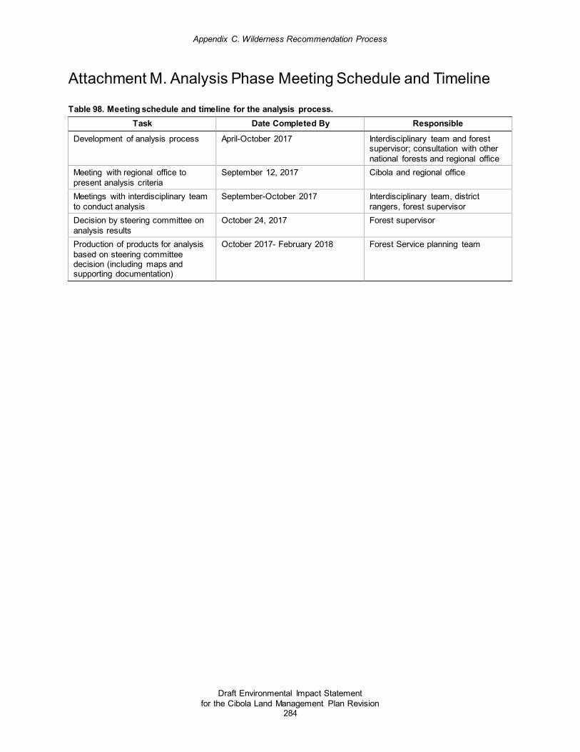
Appendix C. Wilderness Recommendation Process
Draft Environmental Impact Statement for the Cibola Land Management Plan Revision
284
Attachment M. Analysis Phase Meeting Schedule and Timeline
Table 98. Meeting schedule and timeline for the analysis process. Task Date Completed By Responsible
Development of analysis process April-October 2017 Interdisciplinary team and forest supervisor; consultation with other national forests and regional office
Meeting with regional office to present analysis criteria
September 12, 2017 Cibola and regional office
Meetings with interdisciplinary team to conduct analysis
September-October 2017 Interdisciplinary team, district rangers, forest supervisor
Decision by steering committee on analysis results
October 24, 2017 Forest supervisor
Production of products for analysis based on steering committee decision (including maps and supporting documentation)
October 2017- February 2018 Forest Service planning team

Appendix D. Wild and Scenic Rivers Evaluation Process
Draft Environmental Impact Statement for the Cibola Land Management Plan Revision
285
Appendix D: Documentation of the Wild and Scenic Rivers Eligibility Process As part of the land management plan revision process, the Forest Service is required to conduct a comprehensive inventory and evaluation to determine which rivers on the national forest are eligible for inclusion in the National Wild and Scenic Rivers System.36 Based on this direction, the Cibola National Forest employed the following process for wild and scenic river study in the current plan revision process.
Coordination with Previous Eligibility Study In the early 2000s, the Cibola National Forest completed an eligibility study of potential wild and scenic rivers (number of rivers assessed was approximately 365) and released an environmental assessment. The Cibola amended the 1985 plan in 2002 based on this information (see amendment 10 of the 1985 Cibola National Forest Land and Resource Management Plan: 10/17/2002- Identify eligible wild and scenic rivers across the Forest).
Forest Service Handbook 1909.12 directs national forests to identify the eligibility of rivers,37 “unless a systematic inventory has been previously completed and documented, and there are no changed circumstances that warrant additional review.”38 The Forest Service handbook directives state that if such an inventory has already been completed, “. . . the extent of the study process during plan development or revision can be limited to evaluation of any rivers that were not previously evaluated for eligibility and those with changed circumstances.”39
The first step in the study process for the current land management plan revision effort was to examine the documentation from the previous study and determine if the documentation was sufficient enough to address only changed circumstances in the current land management plan revision efforts. Specialists researched existing documentation for the previous study in September 2015. The following were concluded from this examination:
• The directives require that all rivers named on a standard U.S. Geological Survey (USGS) 7.5-minute quadrangle map be studied for eligibility. The previous study does not list the entirety of what was studied, so it is unknown if all of the 435 rivers named on the USGS quads for the Cibola were reviewed during the previous study.
• Sufficient documentation was found for only 88 of the rivers reviewed in the previous study. This documentation contained the criteria being used to evaluate each river, and site-specific information about how that particular river was rated using the criteria.
• The criteria from the original study differs from the criteria outlined in chapter 80 of the Forest Service handbook; therefore, it is difficult to examine the previous 88 rivers (those that contain sufficient documentation) for any changed circumstances.
36 Forest Service Handbook 1909.12, chapter 80 and 36 CFR sec. 219.7(c) (2) (vi) 37 A flowing body of water or estuary, or a section, portion, or tributary thereof, including rivers, streams, creeks, runs, kills, rills, and small lakes. The river’s corridor is the geographic area generally encompassed within one-quarter mile on either side of a river studied for eligibility or suitability that contains the river and its outstandingly remarkable values 38 Forest Service Handbook 1909.12, chapter 80, page 6 39 Forest Service Handbook 1909.12, chapter 80, page 6

Appendix D: Wild and Scenic Rivers Eligibility Process
Draft Environmental Impact Statement for the Cibola Land Management Plan Revision
286
• The region of comparison for the Cibola National Forest was not defined in found documentation for the previous study; therefore, a new region of comparison must be defined for the new eligibility study. Without a documented region of comparison, it is difficult to examine the previous 88 rivers (those which contain sufficient documentation) for any changed circumstances.
In summary, the previous eligibility study was done using a different set of criteria and different region of comparison than what is being used in the evaluation under the current land management plan revision efforts. Since there are only 88 documented evaluation records found, analyzing remaining rivers that do not have records would present skewed results.
Eligibility Study for Land Management Plan Revision Based on lacking documentation from the previous study, Cibola National Forest personnel conducted a new eligibility study based on the above findings. The new eligibility study considered all rivers named on the USGS quad, including the 88 previously evaluated if they were on the USGS named quad, and this new study is intended to replace the previous study. This process is outlined below.
Step 1: Identify Named Streams The directives require that all named rivers on standard USGS 7.5-minute quadrangle maps be studied for eligibility. Cibola National Forest personnel created maps showing all named rivers and streams for use in the eligibility analysis. These maps include a minimum of a ½-mile-wide corridor (¼-mile section on either side of the river) for analysis, as required by the directives. The number of rivers and streams to be analyzed in the land management plan revision process is 409. For maps showing all named rivers and streams studied in the eligibility analysis, refer to the Wild and Scenic Rivers Eligibility Study Maps file in the Cibola administrative record. For a map showing all eligible reaches and individual maps showing each eligible segment including locations, termini, boundaries, and proposed classifications refer to the map packet and electronic versions on the Cibola plan revision website: http://www.fs.usda.gov/goto/CibolaForestPlanRevision.
The National Hydrographic Database was used to develop an initial map of rivers on the Cibola National Forest and was cross-referenced to USGS 7.5-minute quadrangle maps to ensure consistency. A number of streams and rivers named on the 7.5-minute quadrangle maps were not in the National Hydrographic Database dataset; they were added by Cibola geographic information systems specialists.
Step 2: Establish a Core Wild and Scenic River Team An interdisciplinary team was formed consisting of specialists representing the outstandingly remarkable values from the Wild and Scenic River Act. This interdisciplinary team included a specialist for the following resources: recreation, scenery, geology, fish, wildlife, historic and cultural values, as well as land management planning specialists and a hydrologist. This core interdisciplinary team conducted a rapid assessment inventorying and evaluating named rivers in compliance with the process outlined in Forest Service Handbook 1909.12, chapter 80. This rapid assessment took place from September 2015 to February 2016.

Appendix D: Wild and Scenic Rivers Eligibility Process
Draft Environmental Impact Statement for the Cibola Land Management Plan Revision
287
Step 3: Identify Region of Comparison for Outstandingly Remarkable Values As part of the rapid assessment, the core interdisciplinary team identified the area of consideration for each outstandingly remarkable value to serve as the basis for meaningful comparative analysis, called the “region of comparison.” The region of comparison may vary for different rivers or categories of outstandingly remarkable values. Alternatively, the responsible official may conclude a single region of comparison can encompass the evaluation of outstandingly remarkable values. Once the region of comparison is identified, a river’s values can then be analyzed in comparison with other rivers in that area.
The Cibola National Forest used the state of New Mexico as the region of comparison for all the rivers and outstandingly remarkable values. This region of comparison was used because the state of New Mexico provides a broad range of elevation types and riparian conditions, with other mountain ranges similarly reflecting as well as contrasting the landscape of the Cibola National Forest, and there is enough of a balance throughout the state of diverse water systems in order to compare presence of outstandingly remarkable values, free-flowing condition, and water quality to determine eligibility. As well, the region of comparison was selected as New Mexico because it is large enough to encompass river types that provide a wide representation of river values so that rivers with outstandingly remarkable values can be identified.
Step 4: Define Criteria for Outstandingly Remarkable Values The Wild and Scenic Rivers Act established categories for outstandingly remarkable values, and Forest Service Handbook 1909.12, chapter 80, established criteria for these categories (see table 99). The core interdisciplinary team defined the evaluation criteria to identify outstandingly remarkable values in the eligibility study.
The Cibola National Forest used the criteria in Forest Service Handbook 1909.12, chapter 80, for the following categories: scenery, recreation, geology, fish, wildlife, historic and cultural values, and other similar river-related values (see table 99 for the Cibola National Forest’s definitions).
Step 5: Identify Free-flowing Named Streams The Wild and Scenic Rivers Act defines free-flowing as existing or flowing in a natural condition without impoundment, diversion, straightening, rip-rapping, or other modification of the waterway. The existence of low dams, diversion works, or other minor structures at the time any river is proposed for inclusion in the National Wild and Scenic Rivers System does not automatically disqualify it for designation, but future construction of such structures is not allowed. The directives state, “the fact that a river segment may flow between large impoundments will not necessarily preclude its designation. Such segments may qualify if conditions within the segment meet the eligibility criteria.”
Free flowing includes rivers with intermittent flows that are enough to maintain the outstandingly remarkable values. The river doesn't have to be perennial, but it has to have enough flow to maintain the outstandingly remarkable values. Additionally, the fact that a river may flow between large impoundments will not necessarily preclude its designation. In these cases, the beginning point for the segment being evaluated should be established to exclude dam-related structures and should indicate where the river is generally natural in appearance.
During the rapid assessment, the interdisciplinary team considered each river and stream to determine if it was free-flowing.

Appendix D: Wild and Scenic Rivers Eligibility Process
Draft Environmental Impact Statement for the Cibola Land Management Plan Revision
288
Table 99. Summary of outstandingly remarkable values criteria40 Value Criteria Summary
Scenery Landscape elements of landform, vegetation, water, color, and related factors result in notable or exemplary visual features or attractions. Additional factors, such as seasonal variations in vegetation, scale of cultural modifications, and the length of time negative intrusions are viewed, may be considered. Scenery and visual attractions may be highly diverse over different parts of the river or river segment. Outstandingly remarkable scenic features may occupy only a small portion of a river corridor.
Recreation Recreational opportunities are high quality and attract, or have the potential to attract, visitors from throughout or beyond the region of comparison; or the recreational opportunities are unique or rare within the region. River-related recreational opportunities include, but are not limited to, sightseeing, interpretation, wildlife observation, camping, photography, hiking, fishing, hunting, and boating. The river may provide settings for national or regional use or competitive events.
Geology The river corridor contains one or more examples of a geologic feature, process, or phenomenon that is unique, rare, or exemplary within the region of comparison. The feature(s) may be in an unusually active stage of development, represent a “textbook” example, or represent a unique, rare, or exemplary combination of geologic features (erosional, volcanic, glacial, or other geologic structures).
Fish Fish values may be judged on the relative merits of either fish populations or habitat, or a combination of these river-related conditions. a. Populations. The river is nationally or regionally an important producer of resident and/or
anadromous fish species. Of particular significance are a diversity of fish species; the presence of wild stocks; the presence of federally listed, State-listed, candidate threatened and endangered species, or species of conservation concern; or a combination of these species.
b. Habitat. The river provides uniquely diverse or high-quality habitat for fish species indigenous to the region of comparison. Of particular significance is exemplary habitat for wild stocks; federally listed, State-listed, or candidate threatened or endangered species; species of conservation concern; or exemplary habitat for a combination of these species. Consider also rare and unique habitats within the corridor.
Wildlife Wildlife values may be judged on the relative merits of either terrestrial or aquatic wildlife populations or habitat, or a combination of these conditions. a. Populations. The river, or area within the river corridor, contains nationally or regionally
important populations of indigenous wildlife species. Of particular significance are species diversity; species considered to be unique; populations of federally listed or State-listed or candidate threatened or endangered species, or species of conservation concern; or a combination of these species.
b. Habitat. The river, or area within the river corridor, provides uniquely diverse or high quality habitat for wildlife of national or regional significance, and/or may provide unique habitat or a critical link in habitat conditions for Federal or State-listed or candidate threatened or endangered species, or species of conservation concern. Contiguous habitat conditions are such that the biological needs of the species are met.
Historic and Cultural Values
The river, or area within the river corridor, contains important evidence of historic or pre-historic occupation or use by humans. Sites may have national or regional importance for interpreting history or prehistory. a. History. Sites or features are associated with a significant event, an important person, or a
cultural activity of the past that is now rare or unique in the region. A historic site or feature, in most cases, is 50 years old or older.
b. Prehistory. Sites of prehistoric human use or occupation may have unique or rare characteristics or exemplary anthropological value such as evidence of prehistoric human practices and modes of living. Areas within the river corridor may have been used for rare sacred purposes, or represent the origin or conflict of cultures.
Other Similar River-related Values
While no specific national evaluation guidelines have been developed for this category, determinations consistent with the preceding guidance and section 82.73 of this Handbook may be developed for other values that may be outstandingly remarkable, including but not limited to botanic, hydrologic, paleontologic, scientific, and heritage values.
40 From Forest Service Handbook 1909.12, chapter 80, pages 11 and 12

Appendix D: Wild and Scenic Rivers Eligibility Process
Draft Environmental Impact Statement for the Cibola Land Management Plan Revision
289
Step 6: Evaluate Named Streams and Determine if they Possess Outstandingly Remarkable Values All features considered as outstandingly remarkable should be directly river-related and should meet one of the following criteria:
• be located in the river or its corridor (generally within one-quarter mile on either side of the river)
• contribute substantially to the functioning of the river ecosystem
• owe their location or existence to the presence of the river
This evaluation considered the area within one-quarter mile on both sides of a river and other features outside this corridor, if their inclusion is essential for the protection of the river's outstandingly remarkable values (for example, tributaries outside the corridor that support rearing and spawning habitat).
The wild and scenic rivers interdisciplinary team considered each named river on the national forest for outstandingly remarkable values. The team determined if the values are unique, rare, or exemplary within the region of comparison (the state of New Mexico). The team identified the particular value and compared the value in the river being evaluated to other rivers in the region of comparison. To be outstandingly remarkable, a river-related value must be unique, rare, or contain exemplary features that are significant when compared with similar values from other rivers at the regional or national scale. These features are those that are among the best representatives of these features, within the region nation of comparison.
The determination that a river area does or does not contain one or more outstandingly remarkable value is a professional judgment on the part the responsible official as informed by an interdisciplinary team, best available scientific information, and public participation. A concise, qualitative discussion about how each value is or is not unique, rare, or exemplary (for each river) is incorporated as part of the rationale.
Outstandingly remarkable values for each stream were documented, including a description of each value for all eligible streams. This description is detailed enough to illustrate that the river has outstanding values worthy of protection.
Step 7: Review Level of Development along Eligible Streams and Determine their Classification Once a watercourse was determined eligible in the rapid assessment, the level of development was reviewed to determine its preliminary classification category: wild, scenic, or recreational41 (see table 100 for classification criteria).
Each eligible segment was reviewed using the classification matrix in Forest Service Handbook 1909.12, chapter 80. At this time, the interdisciplinary team also identified the lengths or segment termini for each river identified as eligible in the rapid assessment.
41 No criteria are prescribed by the Wild and Scenic Rivers Act regarding water quality for scenic or recreational classifications. The Federal Water Pollution Control Act Amendments of 1972 made it a national goal that all waters of the United States are made fishable and swimmable. Therefore, rivers will not be precluded from scenic or recreational classification because of poor water quality at the time of their study, provided a water quality improvement plan exists or is being developed in compliance with applicable Federal and State laws.

Appendix D: Wild and Scenic Rivers Eligibility Process
Draft Environmental Impact Statement for the Cibola Land Management Plan Revision
290
Potential classification should be based on the situation existing at the time of the study. It should not anticipate expected development or other changes along the river corridor; this is an aspect of evaluating suitability which will be deferred to another time and not a part of land management plan revision.
Table 100. Classification criteria for wild, scenic, and recreational river areas Attribute Wild Scenic Recreational
Water resource development
Free of impoundment. Free of impoundment. Some existing impoundment or diversion. The existence of low dams, diversions, or other modifications of the waterway is acceptable, provided the waterway remains generally natural and riverine in appearance.
Shoreline development
Essentially primitive. Little or no evidence of human activity. The presence of a few inconspicuous structures, particularly those of historic or cultural value, is acceptable. A limited amount of domestic livestock grazing or hay production is acceptable. Little or no evidence of past timber harvest. No ongoing timber harvest.
Largely primitive and undeveloped. No substantial evidence of human activity. The presence of small communities or dispersed dwellings or farm structures is acceptable. The presence of grazing, hay production, or row crops is acceptable. Evidence of past or ongoing timber harvest is acceptable, provided the forest appears natural from the riverbank.
Some development. Substantial evidence of human activity. The presence of extensive residential development and a few commercial structures is acceptable. Lands may have been developed for the full range of agricultural and forestry uses. May show evidence of past and ongoing timber harvest.
Accessibility Generally inaccessible except by trail. No roads, railroads, or other provision for vehicular travel within the river area. A few existing roads leading to the boundary of the area are acceptable.
Accessible in places by road. Roads may occasionally reach or bridge the river. The existence of short stretches of conspicuous or longer stretches of inconspicuous roads or railroads is acceptable.
Readily accessible by road or railroad. The existence of parallel roads or railroads on one or both banks as well as bridge crossings and other river access points is acceptable.
Water quality Meets, or exceeds criteria, or federally approved State standards for aesthetics, for propagation of fish, and wildlife normally adapted to the habitat of the river, and for primary contact recreation (swimming) except where exceeded by natural conditions.
No criteria are prescribed by the Wild and Scenic Rivers Act. The Federal Water Pollution Control Act Amendments of 1972 have made it a national goal that all waters of the United States are made fishable and swimmable. Therefore, rivers will not be precluded from scenic or recreational classification because of poor water quality at the time of their study, provided a water quality improvement plan exists, or is being developed in compliance with applicable Federal and State laws.
No criteria are prescribed by the Wild and Scenic Rivers Act. The Federal Water Pollution Control Act Amendments of 1972 have made it a national goal that all waters of the United States are made fishable and swimmable. Therefore, rivers will not be precluded from scenic or recreational classification because of poor water quality at the time of their study, provided a water quality improvement plan exists, or is being developed in compliance with applicable Federal and State laws.
1. From Forest Service Handbook 1909.12, chapter 80, pages 14 and 15

Appendix D: Wild and Scenic Rivers Eligibility Process
Draft Environmental Impact Statement for the Cibola Land Management Plan Revision
291
Step 8: Coordinate with Ranger Districts and Landscape Teams on Preliminary Findings After completion of the rapid assessment, maps were produced to show the set of rivers evaluated for eligibility on the Cibola during the rapid assessment and the initial findings for rivers determined to be eligible during the rapid assessment.
These initial results from the core interdisciplinary team rapid assessment were released to Cibola National Forest district specialists and cooperating agency partners for review and consideration during a land management plan revision retreat in March 2016. Comments and changes based on this review were incorporated into a draft set of maps and documentation for public release, review, and comment.
Step 9: Develop Draft Land Management Plan Direction for Eligible Wild and Scenic Rivers Draft land management plan direction for interim management of eligible rivers, including desired future conditions, standards and guidelines, and management area direction, was developed by Cibola National Forest specialists (refer to Cibola Draft Plan Chapter 3 Management Areas). The direction was reviewed at the land management plan revision retreat with Cibola staff and cooperating agency partners in March 2016. Plan content related to eligible wild and scenic rivers was then refined and edited to incorporate feedback from the retreat.42
Step 10: Public Participation The initial wild and scenic rivers eligibility findings were shared with the public with the preliminary draft plan release in summer 2016. At this time, the public had the opportunity to comment on the history of past wild and scenic rivers study processes on the Cibola National Forest, as well as the new evaluation study process, the region of comparison, eligibility criteria, and initial eligibility findings (for a summary of these initial findings, see table 101). No significant changes were made based on public comment as they were outside the scope of the 2012 planning rule on the wild and scenic river eligibility process. Minor adjustments were made in terms of clarifying the process conducted.
When the draft land management plan and draft environmental impact statement are released to the public, the public will have a formal public review and comment opportunity to comment on the wild and scenic rivers eligibility determination made. When a final plan is selected, the responsible official will make a decision regarding which of the rivers are eligible for inclusion in the National Wild and Scenic River System.
Another opportunity for public comment on wild and scenic rivers eligibility determinations will be possible during the formal comment period in the release of the final land management plan, final environmental impact statement, and record of decision is released. As well, the public will have the opportunity to object at that time including on wild and scenic river eligibility.
42 From Forest Service Handbook 1909.12 chapter 80. Pgs. 11-12: Wilderness Act and Wild and Scenic Rivers Act Note: Along with interim management direction, additional statutory, regulatory, or policy requirements may also apply if the study river is located within a wilderness area or other designated area. This direction is found in Forest Service Manual 2354.42e. Forest Service Handbook 1909.12 states that any portion of a component of the national wild and scenic rivers system that is within the national wilderness preservation system, as established by or pursuant to the Wilderness Act (16 U.S.C. 1131 et seq.), shall be subject to the provisions of both the Wilderness Act and this chapter, with respect to preservation of such river and its immediate environment, and in case of conflict between the provisions of the Wilderness Act and this chapter the more restrictive provisions shall apply.

Appendix D: Wild and Scenic Rivers Eligibility Process
Draft Environmental Impact Statement for the Cibola Land Management Plan Revision
292
Results of Ineligible and Eligible Wild and Scenic Rivers In summary, the Cibola interdisciplinary planning team systematically reviewed all 409 named free-flowing streams and compared them to the evaluation criteria to identify the presence of outstandingly remarkable values utilizing public comments received throughout the process. The interdisciplinary planning team applied the evaluation criteria to each stream along with the requirements from the Wild and Scenic Rivers Act (see aforementioned step 6 of eligibility process).
The interdisciplinary team considered the area within one-quarter mile of the high water marks on both sides of a river, as well as other features outside this corridor, if their inclusion is essential for the protection of the river's outstandingly remarkable values. Additional factors considered by the interdisciplinary team for each stream included:
• Determine if resource values and attributes are unique, rare, or exemplary within the region of comparison, which is the state of New Mexico.
• Determine if a river may qualify for a given resource value based upon an aggregate of important values, none of which would confer eligibility standing alone.
The determination that a river area does or does not contain one or more outstandingly remarkable values is a professional judgment on the part the responsible official as informed by an interdisciplinary team, best available scientific information, and public participation (Forest Service Handbook 1909.12 Ch. 82.17).
The systematic approach used by the interdisciplinary team included reviewing the streams identified through public input, previous studies, and professional judgement. ArcMap, a tool for working with maps and geographic information, was used to display the named streams in context with spatial data representing attributes of the resource themes associated with identification of outstandingly remarkable values (such as location of critical at-risk species habitat, special status species occurrence data, and cultural resources).
The following table consists of the summary of findings of eligible wild and scenic rivers on the Cibola including the outstandingly remarkable values, narrative description of values, and classification. All of the reaches determined to be ineligible due to the lack of outstandingly remarkable value presence are listed by district in table 102 through table 105. All maps of eligible reaches are provided with the draft environmental impact statement in the map packet and electronic versions are available at the Cibola plan revision website. Maps of the named streams and rivers studied as part of this process are available within the Cibola administrative record under the filename Wild and Scenic Rivers Eligibility Study Maps.

Appendix D. Wild and Scenic Rivers Evaluation Process
Draft Environmental Impact Statement for the Cibola Land Management Plan Revision
293
Table 101. Summary of findings of eligible wild and scenic rivers on the Cibola Ranger District
Stream Name Location Reach Description
Outstandingly Remarkable Values Narrative Description of Values Classification
Mount Taylor
Agua Remora
T 13N R16W From Forest Service boundary with Silva Ranch to the east to confluence with Tampico Springs. From to N35°19'38.127", W108°29'39.20" to N35°18' 58.504",W108° 31' 12.964"
Fish Populations Eligible because of Zuni bluehead sucker population, a Federally-endangered species for which Agua Remora is one of only 3 locations where the species can still be found in the state of New Mexico and thus represents a nationally important population of this indigenous species.
Wild and Scenic
Mount Taylor
Little Water Canyon
T10N R13W Narrative: From headwaters off Continental Divide to Cibola boundary with private land. From N35° 7'55.510", W108° 14' 9.937" to N35° 6'54.932",W108° 15' 30.631"
Other: Botanical Little Water Canyon is the type locality for the Picea pungens/Cornus stolonifera (blue spruce/red-osier dogwood) plant association, Society of American Foresters 216, a major riparian blue spruce association of the southwestern United States. Several trees in Little Water Canyon come close to record sizes for the species. The understory has an impressive diversity of shrubs and herbaceous plants; 108 taxa have been recorded on a single visit. The presence of remnant Pleistocene plant community (Colorado blue spruce overstory/fern understory) is outstandingly remarkable in the region of comparison.
Wild and Scenic

Appendix D: Wild and Scenic Rivers Eligibility Process
Draft Environmental Impact Statement for the Cibola Land Management Plan Revision
294
Ranger District
Stream Name Location Reach Description
Outstandingly Remarkable Values Narrative Description of Values Classification
Mount Taylor
Water Canyon #1
T12N R07W At private land intersection. From N35° 13'50.079", W107°34' 8.077" to N35°14'34.36", W107°36'4.859"
Geology; Scenery Water Canyon #1 flows from the east side of Mount Taylor, within a large amphitheater-shaped valley, eroded into the side of the truncated cone of the Mount Taylor volcano. The Mount Taylor stratovolcano was active between 3.3 and 1.5 million years ago. Today, Mount Taylor dominates the landscape in west central New Mexico. Therefore, the scenery at the top of Water Canyon #1 is expansive with views that extend to the Rio Grande Valley and north to Colorado. The geologic structure of the volcano can be seen from the top as well, and it is a unique experience to hike down into the interior of a stratovolcano. As the stream descends the mountain, the views are limited but the sense of being surrounded and within a volcanic feature remains. Additionally, the combination of landscape elements including landform, geologic features, vegetation, and water provides for a unique scenic setting of significance to the region of comparison.
Wild
Mount Taylor
Rinconada T 11N R08W; T11N R7W;T12N R07W
From midscale vegetation and topo show, the critical piece is within first two miles upstream starting from boundary with Acoma land (section 23 T11N R8W) up to section 12 in T11N R8W (not to extend past 501 road). From N35° 9' 59.166", W107° 39' 7.095" to N35° 11' 19.542", W107° 37' 42.147"
Wildlife Population and Habitat
Rinconada Canyon is a major avian migration corridor on Mount Taylor and may provide a critical link in habitat conditions. The alder/oak bosque within the canyon is a unique deciduous woodland and provides habitat for a unique regionally important species, the Hammond's Flycatcher, which is near the southern limit of its range here and at an elevation lower than is typical. A high diversity of bird species nest here. Rinconada is a Neotropical bird management area on the district, and is included on the Bureau of Land Management roster of significant riparian areas.
Wild and Scenic

Appendix D: Wild and Scenic Rivers Eligibility Process
Draft Environmental Impact Statement for the Cibola Land Management Plan Revision
295
Ranger District
Stream Name Location Reach Description
Outstandingly Remarkable Values Narrative Description of Values Classification
Magdalena West Red Canyon
Location not disclosed due to sensitive cultural information.
Reach description not disclosed due to sensitive cultural information.
Historic and Cultural
West Red Canyon is flanked by archeological sites that compose the West Red Canyon Mimbres community. The community is composed of the remains of a village, farmsteads, fields, and other features dating to between AD 1000 and 1150 that have been determined eligible for listing on the National Register of Historic Places. The Mimbres were an ancestral Pueblo people best known for their painted pottery. This pottery is considered among the greatest achievements of ancient Native North American art. The West Red Canyon Mimbres community is associated with rare characteristics of exemplary anthropological value, and is a unique place within the history of the state of New Mexico and the American Southwest. The community is the furthest north Mimbres community in the American Southwest, and lies on the frontier between the Mimbres and Cibola traditions of ancestral Pueblo peoples. West Red Canyon is the largest drainage on the western slope of the San Mateo Mountains. West Red Canyon was central to the material and cultural sustenance of the ancestral Pueblo Mimbres people who lived in the community by providing water and soil for farming, stone and mud for construction, and likely a variety of other natural resources.
Recreational

Appendix D: Wild and Scenic Rivers Eligibility Process
Draft Environmental Impact Statement for the Cibola Land Management Plan Revision
296
Ranger District
Stream Name Location Reach Description
Outstandingly Remarkable Values Narrative Description of Values Classification
Mountainair Tajique Canyon
T6N R5E; T7N R5E; T7N R6E; T6N R6E
Mapped Tajique and an unnamed tributary where main fall color viewing occurs. For unnamed tributary (4th of July Canyon): N 34° 47' 38.163", W106° 23' 5.133" to N34° 47' 23.685", W106° 22' 41.79". For Tajique Canyon (headwaters) N34° 46' 33.175", W106° 24' 43.772" to N34° 47' 34.583", W106° 22' 14.851"
Scenery; Recreation; Other- Botanical
Lots of maple and aspen. Many people use this corridor for fall color viewing. It is recognized nationally for the largest concentration of bigtooth maple in the Southwest. Sightseeing, photography, painting, fall color leaf collecting takes place. Recreation is related to fall colors, but there is spring to late fall use. It is a destination recreation spot. Willows attract bird watchers. Bigtooth and Rocky Mountain maple is an important regional plant community. Land grants, traditional use grazing, firewood gathering has been prevalent in the past and occurs throughout the area. Tajique Creek does flow through approximately one-mile or private inholding. During the spring runoff, the upper stretch flows continually. After spring runoff, it flows underground to Big Spring. It fluctuates throughout the year above and below ground.
Recreational

Appendix D: Wild and Scenic Rivers Eligibility Process
Draft Environmental Impact Statement for the Cibola Land Management Plan Revision
297
Ranger District
Stream Name Location Reach Description
Outstandingly Remarkable Values Narrative Description of Values Classification
Sandia Las Huertas Creek
T12N R5E; T13N R5E
Starting at private land boundary in Section 9 T12N R5E to private land boundary between sections 28 and 33 in T12N R5E; Include additional width to east corridor to include Sandia Man Cave NHL. From N35° 16' 56.905", W106° 24' 36.419" to N35° 13' 55.004", W106° 24' 44.981".
Historic and Cultural; Scenery
Las Huertas Canyon contains cultural and historic resources of regional and national significance. The canyon contains historic gathering areas for natural and botanical resources of cultural importance to several American Indian (Native American) tribes and to local Spanish-American traditional communities. Many of these resources depend on the presence of Las Huertas Creek, including riparian-ecosystem-dependent plants. While resource gathering areas like this one occur throughout the state of New Mexico, this area is considered exemplary in the historic and anthropological literature and is outstandingly remarkable in its significance to many communities of differing ethnicities. The gathering areas are complimented by the presence of multiple historic properties ancestral to and significant to these communities, including campsites, trails, acequias (irrigation ditches), caves, and the remains of homesteads and other farming and ranching features. One of these historic properties, Sandia Cave, is a listed National Historic Landmark and is a property of national significance. The cave has yielded the remains of early human occupation in the Western Hemisphere. It is important to the history of archeological science in the United States, and is a rare example of cave use and ceremonialism by the early Native American occupants of North America at the end of the last ice age (Pleistocene era). It is also a place of great historic and contemporary cultural importance to several American Indian tribes. Additionally, the combination of landscape elements including landform, geologic features, vegetation, water, and cultural landscape features provides for a unique scenic setting of significance to the region of comparison. Scenery is also an outstandingly remarkable value.
Recreational

Appendix D. Wild and Scenic Rivers Evaluation Process
Draft Environmental Impact Statement for the Cibola Land Management Plan Revision
298
Table 102. Streams deemed ineligible for wild and scenic river designation on the Mount Taylor Ranger District
Stream Name Location Agua Remora T 13N R16W Alamosa Canyon T10N R13W American Canyon T12N R07W, T13N 07W Aqua Fria Creek T10N R12W; T10N R13W Arroyo la Azabache T15N R05W Blind Canyon T12N R16W; T12N R15W Bluewater Creek T12N R12W; T11N R13W; T11N R14W Bonita Canyon T9N R11W Bread Springs Wash T 13 N R 17 W Burnt Mill Canyon T11N R15W Camp Seven Canyon T12N R14W Camp Two Canyon T12N R14W Canada las Vacas T13N R08W; T14N R08W Cañon Chamisa T15N R05W Cañon del Puente T14N R04W Cañon Salado T15N R05W; T15N R04W Cañon Seco T11N R07W Cañon Tapia T14N R04W Canyon Bonito T14N R9W Canyon del Dado T14N R06W Capulin Canyon T10N R12W Cebolla Creek T12N R15W; T11N R15W Chavez Canyon T14N R06W; T15N R06W Chees Hollow T11N R16W Colorado Canyon T12N R07W, T13N 07W Copperton Canyon T11N R13W; T 11N R12W Cottonwood Creek T13N R14W Dead Cow Canyon T10N R11W Diener Canyon T11N R12W Dry Canyon T12N R08W El Derrame Canyon T14N R08W El Rito Canyon T12N R07W; T12N R08W Fools Gold Draw T9N R11W Foster Canyon T 14 N R 15 W; T 13 N R 15 W Fourmile Canyon T 14 N R 16 W; T 14 N R 15 W Franks Canyon T10N R11W Grants Canyon T11 N R09W Grasshopper Canyon T 13 N R 17 W; T 13 N R 16 W Guadalupe Canyon #2 T14N R04W; T15N R04W Guadalupe Canyon #7 T 11N R08W

Appendix D: Wild and Scenic Rivers Eligibility Process
Draft Environmental Impact Statement for the Cibola Land Management Plan Revision
299
Stream Name Location Harris Valley T12N R15W Hausner Canyon T10N R13W Hondo Canyon T10N R11W Jaramosa Canyon T14N R04W Jose Ignacio Canyon T10N R11W; T9N R11W La Jara Canyon T10N R12W La Mosca Canyon T12N R07W; T12N R08W La Polvadera Canyon T14N R08W Lee Cabin Canyon T10N R11W; T9N R11W Lily Canyon T11N R13W; T 11N R14W Limekiln Canyon T12N R11W; T11N R11W Little Water Canyon T10N R13W Lobo Canyon T12N R07W; T12N R08W Lobo Creek T12N, R9W; T12N, R8W;T11N R09W; T11N, R08W Los Indios Canyon T15N R 05W; T14N R05W Lost Canyon T10N R11W Marquez Canyon T13N R7W Maruca Canyon T13N R7W Milk Ranch Canyon T 14 N R 16 W; T13 N R 16 W Monighan Canyon T12N R14W Muerto Canyon T11N, R14W Mullato Canyon T14N R9W Mullato Canyon East T14N R8W; T14N R9W Ojo Bonito Canyon T10N R13W Ojo Redondo T11N R13W; T 11N R12W Pasture Hollow T11N R16W Peavine Canyon T12N R15W; T12N R14W Pescado Draw T11N R16W Pine Canyon T12N R13W Pine Tree Wash T 13 N R 17 W Pole Canyon T11N R12W;T11N R11W Prop Canyon T11N R12W; T11N R11W; T12 N R11W Reynold Draw T12N R12W Rincon de la Gorda T14N R08W Rincon del Dado T14N R06W Rinconada T 11N R08W; T11N R7W;T12N R07W Rio Nutria T13N R15W Rivera Canyon T10N R12W Salazar Canyon T12N R07W, T13N 07W San Lucas Canyon T13N R7W San Mateo Canyon T12N R07W, T13N 07W San Miguel Canyon T13N R07W; T13N R06W

Appendix D: Wild and Scenic Rivers Eligibility Process
Draft Environmental Impact Statement for the Cibola Land Management Plan Revision
300
Stream Name Location Sawmill Canyon T10N R11W Sawyer Creek T12N R14W; T12N R13W Seboyeta Creek T12N R07W Seboyetita Creek T12N R07W Sixmile Canyon T 14 N R 16 W; T 14 N R 15 W Smith Canyon T 14 N R 15 W; T 13 N R 15 W Spud Patch Canyon T12N R07W, T13N 07W Tampico Canyon T 14N R16W;T 13 N R 16 W Telephone Canyon T12N R08W Timber Canyon T11NR07W Trail Canyon T10N R12W Train Canyon T 13 N R 16 W Water Canyon #1 T12N R07W Water Canyon #2 T10N R13W Whitewater Arroyo T 13 N R 17 W Whitewater Canyon T 13 N R 15 W; T 13 N R 14 W Winslow Canyon T10N R12W Wrinkle Canyon T14N R9W Zuni Canyon T11N R11W;T10N R11W

Appendix D: Wild and Scenic Rivers Eligibility Process
Draft Environmental Impact Statement for the Cibola Land Management Plan Revision
301
Table 103. Streams deemed ineligible for wild and scenic river designation on the Magdalena Ranger District Stream Name Location
Abbe Spring Canyon T1N R5W Alamocita Creek T1N R11W Alamosa Creek T6S R8W Allen Spring Canyon T6S R6W Anchor Canyon T2S R3W Aqua Frio Canyon T3S R4W Aragon Draw T10 S R5W Arroyo Montosa T2S R5W; T2S R6W Baca Canyon T2N R4W;T1N R4W Baney Canyon T5S R8W; T5S R7W; T6S R8W Baney Park Canyon T5S R8W; T5 S R7W Basin Canyon T7S R5W;T8S R5W Bear Canyon T4S R2W Bear Canyon T4S R4W; T4S R3W Bear Canyon T5S R7W; T5S R6W Bear Springs Canyon T1N R4W; T1S R4W; T1S R5W Bear Trap Canyon T5S R7W; T6S R7W Big Pigeon Canyon T6S R7W;T6S R8W Big Rosa Canyon T5SR5W; T6N R6W Bitter Canyon T6S R7W Blue Canyon T1N R10W Bobtail Canyon T8S R7W Bolander Canyon T4S R7W Box A Canyon T8S R7W Box Draw T5S R8W; T6S R8W Box Draw Canyon T6S R6W; T6S R7W; T7S R7W Buck Canyon T5S R7W; T5S R6W; T6S R6W Bull Canyon T6S R7W Bull Canyon T7S R6W Burnt Canyon T5S R7W Calvario Draw T9S R6W Canada Vivian T9S R6W Cañon Barranco Blanco T1N R5W; T1N R4W Cañon Cancerro T1N R5W; T1N R4W Cañon Casa de Madera T1N R5W Cañon de las Cabras T1N R4W Cañon de los Negros T2N R5W; T2N R4W Cañon del Alamito T2N R5W; T2N R4W Cañon del Tonque Hondo T2N R4W; T1N R4W; T1N R5W Canyon de Quiron T9S R6W Carbon Canyon T10 S R5 W; T10S R4W

Appendix D: Wild and Scenic Rivers Eligibility Process
Draft Environmental Impact Statement for the Cibola Land Management Plan Revision
302
Stream Name Location Carrizozo Canyon T2N R5W; T1N R5W Cedar Springs Canyon T1N R4W Chamisa Canyon T2N R9W Chaunte Canyon T9S R5W; T9S R4W Chavez Canyon T4S R3W; T4S R2W Chavez Canyon T5S R5W Chimney Canyon T5S R7W; T5S R6W Coffeepot Canyon T7S R6W Cold Spring Canyon T7S R5W Cooney Canyon T5S R5W; T5S R6W Copper Canyon T3S R3W Corn Canyon T8S R6W Council Rock Arroyo T1S R6W; T2S R6W; T2S R5Wyes Crawford Hollow T8S R5W; T8SR4W Crosby Canyon T2S R11W; T2S R10W Cuervo Canyon T9S R5W; T9S R4W Dark Canyon T3S R3W Davenport Canyon T1N R10W; T1N R11W Deep Canyon T7S R6W; T7S R5W Deep Canyon T9S R6W Deep Well Canyon T1S R6W Deer Springs Canyon T1N R4W; T1S R4W Deer Springs Canyon T5S R7W; T5S R6W Deer Springs Canyon T9S R5W Dodson Canyon T6S R7W Dove Springs Creek T1S R6W Drift Fence Canyon T7S R6W; T7S R5W Drill Draw Canyon T7S R7W Dry Canyon T5S R6W Dry Lake Canyon T1S R5W; T2S R5W; T2S R4W Durfee Canyon T4S R7W East Fork Sawmill Canyon T4S R3W East Red Canyon T6S R6W; T6S R5W; T7S R4W East Whitewater Canyon T6S R7W Ellis Canyon T2S R3W Estaline Canyon T4S R6W Exter Canyon T6S R6W Flying V Draw T1S R11W; T2S R11W Gallinas Canyon T1S R6W; T1S R5W Garcia Canyon T3S R3W Garcia Falls T9S R6W Gooseberry Canyon T1N R10W

Appendix D: Wild and Scenic Rivers Eligibility Process
Draft Environmental Impact Statement for the Cibola Land Management Plan Revision
303
Stream Name Location Hardy Canyon T4SR4W Hay Canyon T1N R11W Hay Ground Draw T6S R7W Hell Canyon T2S R3W Hidden Springs Canyon T7S R6W; T6S R6W Hold Up Canyon T8S R6W Hop Canyon T3S R4W; T3S R3W Horse Draw T6S R8W; T7S R8W Horse Mountain Canyon T6S R5W Hudson Canyon T6S R6W; T6S R7W; T7S R7W Hutchinson Branch T7S R7W Indian Canyon T6S R7W Indian Creek T6 R6W; T7S R6W Indian Creek T8S R5W; T8S R6W Italian Canyon T4S R3W Jaralosa Creek T1S R6W Jordan Canyon T3S R3W Kelly Canyon T7S R6W; T8S R6W; T8S R7W; T9S R7W; La Jara Canyon T2N R5W; T1N R5W La Jara Canyon T1N R5W Limestone Canyon T5S R7W; T6S R8W; T6S R7W Little Monica Canyon T4S R6W; T5S R6W Little Pigeon Canyon T6S R7W; T6S R8W; T7S R8W Little Rosa Canyon T4S R6W Los Tinajas T10 S R5W Luke Canyon T6S R7W Lumber Canyon T9S R5W; T10 S R5 W Madera Canyon T4S R3W; T4S R2W Main Canyon T1N R9W; T1S R10W Maverick Canyon T1N R9W Maverick Canyon T8S R8W; T7S R6W Mcgee Canyon T1S R6W; T1S 5W Mill Canyon T3S R4W; T3S R3W; T4S R4W Milo Canyon T8S R6W Mistletoe Canyon T3S R4W Molino Canyon T4S R3W; T4S R2W Monica Canyon T4S R6W; T5S R8W Morine Canyon T4S R8W; T4S R7W Naco Canyon T8S R6W Nester Draw T1N R11W Nogal Canyon T8S R5W; T9S R5W; T8S R6W North Canyon T6S R6W

Appendix D: Wild and Scenic Rivers Eligibility Process
Draft Environmental Impact Statement for the Cibola Land Management Plan Revision
304
Stream Name Location North Canyon T6S R4W North Fork T3S R3W Old Canyon T5S R7W; T4S R7W Owl Canyon T7S R7W Ox Spring Canyon T2N R10W Panther Canyon T5S R7W; T5S; RW Patterson Canyon T3S R4W; T3S R3W Peñasco Canyon T10 S R5 W; T10S R4W Pine Canyon T2N R10W; T1N R10W Pine Canyon T8S R7W Pinnacle Canyon T5S R7W; T6S R7W Point of Rock Canyon T4S R8W; TT4S R7W; T5S R7W Post Canyon T8S R 7W; T7S R7W Potato Canyon T5S R6W Puertecito Canyon T5S R3W; T4S R3W Ranch Supply Canyon T5S R7W; T4S R7W Rattlesnake Canyon T6S R5W;T7S R5W Red Canyon T2N R10W; T2N R9W; T1N R10W; T1N R9W Red Canyon T2N R98W Red Rock Arroyo T9S R6W Remuda Canyon T2N R10W; T2N R9W; T1N R10W Rincon Draw T1S R9W Rincon Madera T4S R3W; T4S R2W Roberts Canyon T8S R5W; T8S R6W Rock Creek T7S R5W Rock Creek Canyon T7S R5W; T7S R4W Rock Tank Canyon T12N R9W Rosedale Canyon T6S R6W Ryan Hill Canyon T4S R3W Sam Draw T6S R8W San Jose Arroyo T9S R5W; T9S R4W San Juan Canyon T8S R5W; T8SR4W San Mateo Canyon T9S R7W; T9S R6W; T8S R6W Sargent Canyon T4S R8W; T5S R8W Sawmill Canyon T4S R3W; T5S R 3W Sawmill Canyon T6S R8W Scot Spring Canyon T1N R5W Shakespeare Canyon T3S R3W Sheep Canyon T7S R5W;T8S R5W; T7S R4W; T8S R4W Shipman Canyon T9S R6W Sim Yaten Canyon T8S R7W T7S R7W T7S R6W Six Mile Canyon T4S R3W; T4S R2W

Appendix D: Wild and Scenic Rivers Eligibility Process
Draft Environmental Impact Statement for the Cibola Land Management Plan Revision
305
Stream Name Location Slaughter Canyon T1S R11W T1S R10W Smith Canyon T8S R6W South Canyon T3S R3W;T3SR2W;T4S R3W Spring Canyon T6S R7W; T6S R6W Spring Canyon T8S R7W Spring Hollow Canyon T5S R7W Springtime Canyon T8S R5W; T8S R6W Stiver Canyon T1N R9W; T1N R9W Sugarloaf Canyon T2S R11W Swingle Canyon T1S R11W; T1S R10W Taylor Canyon T5S R8W The Gorge T8S R5W; T8SR4W Thompson Canyon T1N R10W; T1S R10W Three Log Springs Canyon T1S R6W Tin Cup Canyon T6S R7W Uvas Canyon T9S R6W Wallace Trough Canyon T6S R7W Water Canyon T3S R3W Water Canyon T5S R6W Water Canyon T7S R6W West Fork T7S R6W West Red Canyon T7S R7W; T7S R6W; T6S R6W West Sawmill Canyon T4S R3W White Deer Canyon T2N R10W; T01N R11W White Mule Canyon T7S R5W Whitecap Canyon T5S R5W; T5S R6W Whitehouse Canyon T1S R10W Whitetail Canyon T8S R6W Whitewater Canyon T5S R6W; T6S R6W; T7S R7W; T6S R7W Wild Bull Canyon T8S R7W Wild Horse Canyon T8S R6W Wood Canyon T7S R5W Z Slash Draw T1N R11W; T1S R11W

Appendix D: Wild and Scenic Rivers Eligibility Process
Draft Environmental Impact Statement for the Cibola Land Management Plan Revision
306
Table 104. Streams deemed ineligible for wild and scenic river designation on the Mountainair Ranger District
Stream Name Location Arroyo del Cuerro T5N R4E Bonita Canyon T1S R12E Canada de la Perra T7N R6E Cañon Arado T3N R5E Cañon Barranco T4N R5E Cañon Bonito T6N R5E Cañon Colorado T5N R5E Cañon Cueva de Leon T6N R5E Cañon de Baca T5N R5E Cañon de Bartolo T5N R5E Cañon de Bartolo T5N R4E Cañon de Chilili T7N R6E Cañon de Jaramillo T5N R4E Cañon de la Capilla T5N R5E Cañon de la Fuera T7N R6E Cañon de la Gallina T7N R5E Cañon de la Gotera T4N R5E Cañon de la Miga T7N R6E Cañon de la Mina T5N R4E Cañon de la Mula T7N R6E Cañon de la Vereda T6N R5E Cañon de las Palas T6N R5E Cañon de los Pino Reales T5N R5E Cañon de Salas T5N R4E Cañon de Torreon T6N R5E Cañon de Trigo T5N R4E Cañon de Troncon Negro T7N R6E Cañon de Turrieta43 T5N R5E Cañon del Agua T5N R5E Cañon del Apache T6N R5E T6N R6E Cañon del Chato T5N R5E Cañon del Cuervo T6N R5E Cañon del Encierro T5N R5E Cañon del Jaral T6N R5E Cañon del Novillo T6N R5E T6N R6E Cañon del Ojo del Indio T6N R5E Cañon del Pino T7N R6E Cañon del Sepo T5N R4E Cañon del Terrero T7N R6E
43 Not shown on maps or GIS; shows on topographic map.

Appendix D: Wild and Scenic Rivers Eligibility Process
Draft Environmental Impact Statement for the Cibola Land Management Plan Revision
307
Stream Name Location Cañon del Venado T6N R5E Cañon Espinoso T4N R5E; T3N R6E Cañon Largo T7N R6E Cañon los Joyce T7N R6E; T6N R6E Cañon Monte de Abajo T4N R4E; T4N R5E Cañon Monte Largo T4N R4E; T5N R4E; T5N R5E Cañon Nuevo T5N R5E Cañon Sal Si Puedes T5N R5E Cañon Saladito T3N R5E Comanche Canyon T5N R4E Diablo Canyon T6N R5E Encino Canyon T6N R4E Garcia Canyon T6N R4E Ojito Canyon T6N R4E Ox Canyon T4N R5E Pajaro Canyon T1S R11E Pinatosa Canyon T1S R11E Priest Canyon T3N R5E; T4N R5E; Pueblo Blanco Canyon T2N R10E; Red Cloud Canyon T1SR11E; T1SR12E Sawmill Canyon T1N R11E;T1S R11E South Canyon T1S R11E T2S R11E Tajique Canyon T6N R5E; T7N R5E; T7N R6E; T6N R6E

Appendix D: Wild and Scenic Rivers Eligibility Process
Draft Environmental Impact Statement for the Cibola Land Management Plan Revision
308
Table 105. Streams deemed ineligible for wild and scenic river designation on the Sandia Ranger District Stream Name Location
Apache Canyon T12N R5E Arroyo Armijo T11N R5E Arroyo del Coyote T9N R5E; T9N R6E Arroyo del Ojo del Orno T12N R5E Arroyo Seco T12N R5E Barro Canyon T11N R5E Bear Canyon T11N R4E T11N R5E Bonito Canyon T9N R5E; T8N R5E Cañon Aqua Sarca T12N R5E Cañon de Domingo Baca T11N R4E T11N R5E Cañon del Aqua T12N R4E;T12N R5E Cañon la Cueva T11N R4E T11N R5E Cañon Madera T12N R5E Cañon Media T12N R5E Cañon Osha T12N R5E Cañon Tejon T12N R5E Cañoncito T11N R5E Capulin Canyon T12N R5E Cedro Canyon T10N R5E; T9N R5E; T9N R6E Chamisoso Canyon T10N R5E;T10N R6E Cienega Canyon T11N R5E Corral Canyon T10N R5E Cueva Canyon T12N R5E David Canyon T9N R5E; T8N R5E Embudito Canyon T10N R4E; T10N R5E; T11N R4E; T11N R5E Embudo Canyon T10N R4E; T10N R5E Gonzales Canyon T12N R5E Hondo Canyon T10N R5E Jaral Canyon T11N R4E Juan Tabo Canyon T12N R4E; T12N R5E Juan Tomas Canyon T9E R6E Las Huertas Creek T12N R5E; T13N R5E Lorenzo Canyon T10N R5E Lurance Canyon T9N R5E Madera Canyon T10N R5E T9N R5E; North Canyon T9N R5E; T98N R5E Otero Canyon T9N R5E Palo Duroso Canyon T12N R5E Periz Canyon T12N R5E Piedra Lisa Canyon T10N R4E Pino Canyon T11N R4E T11N R5E

Appendix D: Wild and Scenic Rivers Eligibility Process
Draft Environmental Impact Statement for the Cibola Land Management Plan Revision
309
Stream Name Location Primera Aqua T10N R5E;T10N R6E Sabino Canyon T9N R5E; T9N R6E Sol Se Mete Canyon T9N R5E Sulphur Canyon T11N R5E Taplazon Canyon T10N R6E Tecolote Canyon T12N R5E Tejano Canyon T12N R5E Tunnel Canyon T10N R5E T9N R5E
Documentation of Eligibility The tables (and associated maps of eligible reaches provided with the draft environmental impact statement) within this section provide a detailed description of the seven stream segments determined eligible through the Cibola’s wild and scenic rivers process. These segments, their outstandingly remarkable values, and classifications were determined through internal meetings with resource specialists and public comments at multiple stages. The following descriptions provide the basis for the eligibility determination.
Table 106. Wild and scenic river eligibility summary for Agua Remora, Mt. Taylor Ranger District Characteristic Description
Location T 13N R16W Free Flowing No known impacts to free-flowing condition. ORV Scenery No distinctive scenic attractiveness class in the river's corridor ORV Recreation No known recreation features. ORV Geology No known unique geologic features. ORV Fish Populations
Yes; Population of endangered Zuni bluehead sucker and habitat is nationally and regionally significant in the region Only place it lives in the watershed. Only three populations in the state.
ORV Fish Habitat No known unique habitats present. ORV Wildlife Populations
No known unique populations present.
ORV Wildlife Habitat
No known unique habitats present.
ORV Historic & Cultural
No known unique resources present.
ORV Other No known information. Comments Narrative description of values from amendment 10 to the 1985 plan: Free-flowing perennial
spring fed creek. Has the Zuni bluehead sucker that is a sensitive species currently under consideration for listing. It has potential habitat for the yellow-billed cuckoo and Chiricahua leopard frog. Both are federally listed threatened species. High potential for other species. Classified as “Wild”’ – Free of impoundments, little or no evidence of past timber harvest, largely primitive shoreline, no legal grazing but some unauthorized grazing has happened, there are two-track roads.
Segment Reach Description
Narrative: From Cibola boundary with Silva Ranch to the east to confluence with Tampico Springs. See geospatial data for start and end points. Latitude/Longitude: From to [N35° 19' 38.127", W108° 29' 39.205" to N35° 18' 58.504",W108° 31' 12.964"

Appendix D: Wild and Scenic Rivers Eligibility Process
Draft Environmental Impact Statement for the Cibola Land Management Plan Revision
310
Characteristic Description Narrative Description of Values
Eligible because of Zuni bluehead sucker population, a federally endangered species for which Agua Remora is one of only 3 locations where the species can still be found in the state of New Mexico and thus represents a nationally important population of this indigenous species.
Currently Eligible in 1985 Plan?
Yes
Recommend Eligibility in the Revised Plan?
Yes
Potential Classification- W, S, or R?
Wild and Scenic. Scenic from N35° 18' 58.504", W108° 31' 12.964" to N35° 19' 9.094", W108° 30' 56.130". Wild from N35° 19' 9.094", W108° 30' 56.130" to N35° 19' 36.106", W108° 30' 9.529". Scenic from N35° 19' 36.106", W108° 30' 9.529" to N35° 19' 38.126, W108° 29' 39.204
ORV = outstandingly remarkable value
Table 107. Wild and scenic river eligibility summary for Little Water Canyon, Mt. Taylor District Characteristic Description
Location T10N R13W Free Flowing No known impacts to free-flowing condition. ORV Scenery No distinctive scenic attractiveness class in the river's corridor ORV Recreation No known recreation features. ORV Geology No known unique geologic features. ORV Fish Populations
No known unique populations present.
ORV Fish Habitat No known unique habitats present. ORV Wildlife Populations
No known unique populations present.
ORV Wildlife Habitat
There is a goshawk post-fledging area, a Mexican spotted owl protected activity center, and critical habitat for Mexican spotted owl within the corridor. These habitats are not outstandingly remarkable due to the numbers of similar habitats within the region of comparison.
ORV Historic & Cultural
No known unique resources present.
ORV Other No known information. Comments A decommissioned road exists within corridor but is not currently used; even with access
granted for a permittee to access grazing the public would not be able to access road. Road essentially shadows the southern boundary so may no impact. Area is hard to get to and accessible mostly by foot. Narrative description of values from amendment 10 to 1985 plan: Intermittent and ephemeral creek that is free-flowing. Creek generally flows most of the year. In good years if flows most of the year. Drainage is part of a proposed research natural area because of the presence of a remnant Pleistocene plant community (Colorado river spruce is the dominant overstory and fern understory). A very wet community for the area. Classified as “Wild” – Drainage is only accessible by trail. Closest road is one mile away. Shorelines are undeveloped and water quality is clear and unpolluted.
Segment Reach Description
Narrative: From headwaters off Continental Divide to Cibola boundary with private land (see reach drawn in geospatial data). Latitude/longitude: From N35° 7' 55.510", W108° 14' 9.937" to N35° 6' 54.932", W108° 15' 30.631"
Narrative Description of Values
Little Water Canyon is the type locality for the Picea pungens/Cornus stolonifera (blue spruce/red-osier dogwood) plant association, Society of American Foresters 216, a major riparian blue spruce association of the southwestern United States. Several trees in Little

Appendix D: Wild and Scenic Rivers Eligibility Process
Draft Environmental Impact Statement for the Cibola Land Management Plan Revision
311
Characteristic Description Water Canyon come close to record sizes for the species. The understory has an impressive diversity of shrubs and herbaceous plants; 108 taxa have been recorded on a single visit. The presence of remnant Pleistocene plant community (Colorado blue spruce is the dominant overstory and fern understory) is outstandingly remarkable in the region of comparison.
Currently Eligible in 1985 Plan?
Yes
Recommend Eligibility in the Revised Plan?
Yes
Potential Classification- W, S, or R?
Wild and Scenic. Scenic from N35° 6'54.932", W108° 15'30.631 to N35° 6' 59.867, W108° 15' 1.578. Wild from N35° 6' 59.867, W108° 15' 1.578 to N35° 7' 55.510", W108° 14' 9.937"
ORV = outstandingly remarkable value
Table 108. Wild and scenic river eligibility summary for Water Canyon #1, Mt. Taylor District Characteristic Description
Location T12N R07W Free Flowing No known impacts to free-flowing condition. ORV Scenery Maybe. All of it is distinctive scenic attractiveness class; River originates in large geologic
crater and crater is visible in its entirety as a geologic feature from within the crater. You can see the entire crater from the river. The viewpoints from this river provides wide vistas of other mountain vistas in the state (you can look inward and outward and see many scenic features). Note: Minerals specialist requests review and coordination with district personnel (and potential field trip) to confirm that viewpoints of crater are actually visible from the river and not screened by vegetation. This will determine if there is a scenery outstandingly remarkable value. One of highest points in state and other high points are visible from portions of the stream.
ORV Recreation Water Canyon Trailhead; not exemplary for region of comparison. Similar recreation experiences occur in other parts of the state.
ORV Geology Yes. Outstandingly remarkable volcanic geology; the river originates in the crater and the crater is visible in its entirety as a geologic feature from within the crater. You can see the entire crater from the river. The river breached the rim of the crater and made the view of the crater possible. The ability to see the entire crater from this river course is exemplary in the region; in other similar geologic features within the state, it is hard to see the feature. Textbook example of a volcanic crater feature which is on an observable scale.
ORV Fish Populations
No known unique populations present.
ORV Fish Habitat No known unique habitats present. ORV Wildlife Populations
No known unique populations present.
ORV Wildlife Habitat
No known unique habitats present.
ORV Historic & Cultural
No known unique resources present.
ORV Other No known information. Comments Old road crosses stream and is visible in aerial imagery; is it still being used? Very obvious,
does it affect classification Segment Reach Description
At private land intersection N35° 13' 50.079",W107° 34' 8.077" to N35° 14'34.367", W107° 36' 4.859"

Appendix D: Wild and Scenic Rivers Eligibility Process
Draft Environmental Impact Statement for the Cibola Land Management Plan Revision
312
Characteristic Description Narrative Description of Values
The volcanic crater (caldera) which is the central source of the Mt. Taylor volcanism is located centrally at the top of the mountain. Hiking into the volcanic crater is a unique visual experience. The river breached the rim of the crater and made the unique view of the crater accessible. The river originates in the volcanic crater and as one walks along the river, the geologic crater feature is visible in its entirety. One feels enclosed in the unique landform space with its surrounding views. The ability to view the full crater from this river course is exemplary in the region. In other similar geologic features within the state, it is hard to see the full feature, or a corresponding river feature is missing from the volcanic landform.
Currently Eligible in 1985 Plan?
No
Recommend Eligibility in the Revised Plan?
Yes
Potential Classification- W, S, or R?
Wild
ORV = outstandingly remarkable value
Table 109. Wild and scenic river eligibility summary for Rinconada, Mt. Taylor District Characteristic Description
Location T 11N R08W; T11N R7W;T12N R07W Free Flowing No known impacts to free-flowing condition. ORV Scenery Most of it is distinctive scenic attractiveness class but not unique for the region of
comparison. ORV Recreation Birder destination; not exemplary for region of comparison. Similar recreation experiences
occur in other parts of the state. ORV Geology Cinder cone or volcanic vent; not unique for region of comparison. ORV Fish Populations
No known unique populations present.
ORV Fish Habitat No known unique habitats present. ORV Wildlife Populations
Yes critical habitat for Mexican spotted owl; remarkable important bird area identified by Audubon Society. There are 63 important bird areas throughout the state but this one is a major migratory habitat for Mt Taylor and meets critical corridor deciduous bosque habitat uniqueness and species uniqueness with Hammond’s flycatcher; towards southern limits in range and lower elevation for species; high diversity of species there - corridor, diversity, unique regionally important species. Bureau of Land Management and Forest Service consider as significant. Outstandingly remarkable value: populations: species diversity and unique species.
ORV Wildlife Habitat
Yes critical habitat for Mexican spotted owl; remarkable important bird area identified by the Audubon Society. There are 63 important bird areas throughout the state but this one is a major migratory habitat for Mt. Taylor and meets critical corridor deciduous bosque habitat uniqueness and species uniqueness outstandingly remarkable values with Hammond’s flycatcher; this habitat is towards the southern limits in the range and provide a lower elevation for species; there is a high diversity of species there - corridor, diversity, unique regionally important species. Bureau of Land Management and USFS consider as significant. Outstandingly remarkable value: uniquely diverse and critical link in habitat.
ORV Historic & Cultural
No known unique resources present.
ORV Other No known information.

Appendix D: Wild and Scenic Rivers Eligibility Process
Draft Environmental Impact Statement for the Cibola Land Management Plan Revision
313
Characteristic Description Comments From midscale vegetation and topo show, the critical piece is within first two miles upstream
starting from boundary with Acoma land (section 23 T11N R8W) up to section 12 in T11N R8W (not to extend past 501 road). GIS shows an unauthorized route following the canyon- actual field knowledge of road not known by interdisciplinary team. Road is called 400B2 in GIS and is classified as null. Steering Committee decision 5/9/16: Classify the river with two different classifications: wild where the unauthorized road does not exist, and scenic where unauthorized road exists.
Segment Reach Description
Narrative: From midscale vegetation and topo show, the critical piece is within first two miles upstream starting from boundary with Acoma land (section 23 T11N R8W) up to section 12 in T11N R8W (not to extend past 501 road). See reach drawn in geospatial data. Latitude/longitude: From N35° 9' 59.166", W107° 39' 7.095" to N35° 11' 19.542", W107° 37' 42.147"
Narrative Description of Values
Rinconada Canyon is a major migration corridor on Mount Taylor and may provide a critical link in habitat conditions. The alder/oak bosque within the canyon is a unique deciduous woodland and provides habitat for a unique regionally important species, the Hammond's flycatcher, which is near the southern limit of its range here and at an elevation lower than is typical. A high diversity of bird species nest here. Rinconada is included on the Bureau of Land Management's roster of significant riparian areas.
Currently Eligible in 1985 Plan?
No
Recommend Eligibility in the Revised Plan?
Yes
Potential Classification- W, S, or R?
Wild and Scenic. Scenic from N35° 9' 59.166", W107° 39' 7.095" to N35° 10' 54.074", W107° 39' 7.683". Wild from N35° 10' 54.074", W107° 39' 7.683" to N35° 11' 19.542", W107° 37' 42.147"
ORV = outstandingly remarkable value
Table 110. Wild and scenic river eligibility summary for West Red Canyon, Magdalena District Characteristic Description
Location Location not disclosed due to sensitive cultural information. Free Flowing No known impacts to free-flowing condition. ORV Scenery Distinctive scenic attractiveness along entirety. Remarkable scenery but not outstanding for
region. ORV Recreation No known recreation features. ORV Geology There are other red volcanic dikes in state, therefore not a regionally exemplary example.
Was previously eligible, perhaps because of district comparison. 2/19/16: District ranger confirmed that there are other similar features in the state within the Gila National Forest.
ORV Fish Populations
No known unique populations present.
ORV Fish Habitat No known unique habitats present. ORV Wildlife Populations
No known unique populations present.
ORV Wildlife Habitat
Mexican spotted owl critical habitat, protected activity center, and core area occur in corridor, but this habitat is not outstandingly remarkable due to the numbers of similar habitats within the region of comparison.
ORV Historic & Cultural
Yes. Locality for ancestral Pueblo Mimbres community. Community is outstanding and unique from scientific perspective. Northernmost known Mimbres community in entire Mimbres cultural area. Of extremely outstanding scientific value.
ORV Other No known information.

Appendix D: Wild and Scenic Rivers Eligibility Process
Draft Environmental Impact Statement for the Cibola Land Management Plan Revision
314
Characteristic Description Comments Narrative description of values from amendment 10 to 1985 plan (for geology): Flows
substantial part of the year. Creek follows the road when flooding occurs. Red John Box is a volcanic dike the stream has cut; it is 100 yards or less in length. If in the area, it is worth seeing. Is rare and unique on the District. Classification is “Recreational” – Drainage is readily accessible by road. Narrative description of values from amendment 10 to 1985 plan (for cultural): Road adjacent to it. Has water most of the time most of the years, but only for a 100-yard stretch. Rest of it is intermittent. Nineteen sites are located within the drainage. Five of the sites do not meet eligibility requirements for an outstandingly remarkable value. Fourteen of the sites are within ¼ mile of the drainage, are at the particular location because of proximity to the drainage, and are regionally important for interpreting prehistory. These sites represent a complex of 14 structural sites that are unique to this region. Classification is “Recreational” – Drainage is readily accessible by road.
Segment Reach Description
Segment reach description not disclosed due to sensitive cultural information.
Narrative Description of Values
West Red Canyon is flanked by archeological sites that compose the West Red Canyon Mimbres community. The community is composed of the remains of a village, farmsteads, fields, and other features dating to between AD 1000 and 1150 that have been determined eligible for listing on the National Register of Historic Places. The Mimbres were an ancestral Pueblo people best known for their painted pottery. This pottery is considered among the greatest achievements of ancient Native North American art. The West Red Canyon Mimbres community is associated with rare characteristics of exemplary anthropological value and is a unique place within the history of the state of New Mexico and the American Southwest. The community is the furthest north Mimbres community in the American Southwest, and lies on the frontier between the Mimbres and Cibola traditions of ancestral Pueblo peoples. West Red Canyon is the largest drainage on the western slope of the San Mateo Mountains. West Red Canyon was central to the material and cultural sustenance of the ancestral Pueblo Mimbres people who lived in the community by providing water and soil for farming, stone and mud for construction, and likely a variety of other natural resources.
Currently Eligible in 1985 Plan?
Yes, for geology and cultural
Recommend Eligibility in the Revised Plan?
Yes- Cultural
Potential Classification- W, S, or R?
Recreational
ORV = outstandingly remarkable value
Table 111. Wild and scenic river eligibility summary for Tajique Canyon, Mountainair District Characteristic Description
Location T6N R5E; T7N R5E; T7N R6E; T6N R6E Free Flowing No known impacts to free-flowing condition. ORV Scenery Yes. Distinctive scenic attractiveness class in portions of the corridor. Many people use this
corridor for fall color viewing. It is recognized nationally for the largest concentration of bigtooth maple in the Southwest. Sightseeing, photography, painting, fall color leaf collecting takes place. Recreation is related to fall colors, but there is spring to late fall use.
ORV Recreation Yes. Many people use this corridor for fall-color viewing. It is recognized nationally for the largest concentration of bigtooth maple in the Southwest. Sightseeing, photography, painting, fall color leaf collecting takes place. Recreation is related to fall colors, but there is spring to late fall use. It is a destination recreation spot. Willows attract bird watchers.
ORV Geology No known unique geologic features. ORV Fish Populations
No known unique populations present.

Appendix D: Wild and Scenic Rivers Eligibility Process
Draft Environmental Impact Statement for the Cibola Land Management Plan Revision
315
Characteristic Description ORV Fish Habitat No known unique habitats present. ORV Wildlife Populations
No known unique populations present.
ORV Wildlife Habitat
Mexican spotted owl potentially suitable habitat occurs in corridor, but this habitat is not outstandingly remarkable due to the numbers of similar habitats within the region of comparison. Entire area is part of Tajique riparian exclosure for southwestern willow flycatcher; not unique for region of comparison. Important bird area also occurs within the corridor but not unique for region of comparison.
ORV Historic & Cultural
Area and watershed are significant to local communities, but there are many areas similar to this throughout the state so it not rare or unique; canyon contains many significant archaeological properties but none are rare or unique for region of comparison.
ORV Other Yes; Botanical. It is recognized nationally for the largest concentration of bigtooth maple in the Southwest. Bigtooth and Rocky Mountain maple is an important regional plant community.
Comments Narrative description of values from amendment 10 to 1985 plan: Creek does flow through approximately one-mile or private inholding. During the spring runoff the upper stretch flows continually. Afterwards (after spring runoff) it flows underground to Big Spring. It fluctuates throughout the year above and below ground. Lots of maple and aspen. Many people use this corridor for fall-color viewing. Readily accessible and used travel route. It is recognized nationally for the largest concentration of bigtooth maple in the Southwest. Sightseeing, photography, painting, fall color leaf collecting takes place. Recreation is related to fall colors, but there is spring to late fall use. It is a destination recreation spot. Willows attract bird watchers. Bigtooth and Rocky Mountain maple is an important regional plant community. Land grants, traditional use grazing, firewood gathering has been prevalent in the past and occurs throughout the area. Classification is “Recreational” – Substantial evidence of human activity and readily accessible by road.
Segment Reach Description
Mapped Tajique and an unnamed tributary where main fall-color viewing occurs. For unnamed tributary (4th of July Canyon): N 34° 47' 38.163", W106° 23' 5.133" to N34° 47' 23.685", W106° 22' 41.79". For Tajique Canyon (headwaters) N34° 46' 33.175", W106° 24' 43.772" to N34° 47' 34.583", W106° 22' 14.851"
Narrative Description of Values
Creek does flow through approximately one-mile of private inholding. During the spring runoff the upper stretch flows continually. Afterwards (after spring runoff) it flows underground to Big Spring. It fluctuates throughout the year above and below ground. Lots of maple and aspen. Many people use this corridor for fall color viewing. It is recognized nationally for the largest concentration of bigtooth maple in the Southwest. Sightseeing, photography, painting, fall color leaf collecting takes place. Recreation is related to fall colors, but there is spring to late fall use. It is a destination recreation spot. Willows attract bird watchers. Bigtooth and Rocky Mountain maple is an important regional plant community. Land grants, traditional use grazing, firewood gathering has been prevalent in the past and occurs throughout the area. Classification is “Recreational” – Substantial evidence of human activity and readily accessible by road.
Currently Eligible in 1985 Plan?
Yes
Recommend Eligibility in the Revised Plan?
Yes
Potential Classification- W, S, or R?
Recreational
ORV = outstandingly remarkable value

Appendix D: Wild and Scenic Rivers Eligibility Process
Draft Environmental Impact Statement for the Cibola Land Management Plan Revision
316
Table 112. Wild and scenic river eligibility summary for Las Huertas Creek, Sandia District Characteristic Description
Location T12N R5E; T13N R5E Free Flowing Ponds on private and Forest Service land; acequia diversion with water not free flowing past
acequia (perennial above). ORV Scenery Portions of corridor contain distinctive scenic attractiveness class. There are some travertine
deposits around springs (around Picnic Area). Steering Committee decision 5/9/16: The combination of landscape elements including landform, geologic features, vegetation, water, and cultural landscape features provides for a unique scenic setting of significance to the region of comparison.
ORV Recreation Area is a popular water recreation access area. Sandia Man Cave is a popular recreation destination. Multiple developed recreation sites occur along river. Similar river corridors of similar significance occur in other areas of New Mexico, so not unique for region of comparison.
ORV Geology There are some travertine deposits around springs (around Picnic Area) but not outstandingly remarkable in region of comparison. Three similar travertine formations occur elsewhere in the state; this occurrence is not exemplary as compared to in the Fresnal Canyon on the Lincoln National Forest.
ORV Fish Populations
No known unique populations present.
ORV Fish Habitat No known unique habitats present. ORV Wildlife Populations
No known unique populations present.
ORV Wildlife Habitat
Mexican spotted owl potentially suitable habitat occurs in corridor, but this habitat is not outstandingly remarkable due to the numbers of similar habitats within the region of comparison.
ORV Historic & Cultural
Yes: Sandia Man Cave is on the National Register of Historic Places- present in the corridor. Sandia Man Cave is a nationally significant site. The cave has archaic Pleistocene mammals. It is on the National Register of Historic Places. It has had and continues to have Native American use. The use is believed to be there because of the river. Traditional cultural property for gathering of plants; this is an exemplary gathering site in that it is used by multiple tribes and local Spanish-American population and is significant to multiple communities and is outstandingly remarkable in state.
ORV Other No known information. Comments Unpaved state highway runs along bottom; pedestrian trails homes in north and south picnic
area in south end; acequia (with valid existing water rights) remains low-profile in appearance but some times of the year it diverts much of the water. Narrative description of values from amendment 10 to 1985 plan: There is a diversion for an acequia. It is a hand-dug ditch approximately 21/2 feet deep and 3 feet wide. It is free-flowing to the diversion. Road has influenced the channel of water. The river would meander much more if not for the road. The road is basically in the drainage. The creek has pond impoundments on the private land. Road is adjacent to this segment of the creek. Area is unique to the Sandias to have water that is accessible. It is a heavily used recreation area that is locally used. Again, because of accessibility. Usage is there partly because of river and partly because of road access. Sandia Man Cave is a nationally significant site. The cave has archaic Pleistocene mammals. It is on the National Register of Historic Places. It has had and continues to have Native American use. The use is believed to be there because of the river. Classification is “Recreational” – Readily accessible by road and has substantial development along creek (Las Huertas Picnic Ground and along the creek by recreational users).
Segment Reach Description
Starting at private land boundary in Section 9 T12N R5E to private land boundary between sections 28 and 33 in T12N R5E; Include additional width to east corridor to include Sandia Man Cave National Historic Landmark. From N35° 16' 56.905", W106° 24' 36.419" to N35° 13' 55.004", W106° 24' 44.981".

Appendix D: Wild and Scenic Rivers Eligibility Process
Draft Environmental Impact Statement for the Cibola Land Management Plan Revision
317
Characteristic Description Narrative Description of Values
Las Huertas Canyon contains cultural and historic resources of regional and national significance. The canyon contains historic gathering areas for natural and botanical resources of cultural importance to several American Indian (Native American) tribes and to local Spanish-American traditional communities. Many of these resources are dependent upon the presence of Las Huertas Creek, including riparian-ecosystem-dependent plants. While resource gathering areas like this one occur throughout the state of New Mexico, this area is considered exemplary in the historic and anthropological literature, and is outstandingly remarkable in its significance to many communities of differing ethnicities. The gathering areas are complimented by the presence of multiple historic properties ancestral to and significant to these communities, including campsites, trails, acequias (irrigation ditches), caves, and the remains of homesteads and other farming and ranching features. One of these historic properties, Sandia Cave is a national historic landmark and is a property of national significance. The cave has yielded the remains of early human occupation in the Western Hemisphere. It is important to the history of archeological science in the United States, and is a rare example of cave use and ceremonialism by the early Native American occupants of North America at the end of the last ice age (Pleistocene era). It is also a place of great historic and contemporary cultural importance to several American Indian tribes. Additionally, the combination of landscape elements including landform, geologic features, vegetation, water, and cultural landscape features provides for a unique scenic setting of significance to the region of comparison. Scenery is also an outstandingly remarkable value.
Currently Eligible in 1985 Plan?
Yes
Recommend Eligibility in the Revised Plan?
Yes
Potential Classification- W, S, or R?
Recreational due to level of development
ORV = outstandingly remarkable value
Management of Eligible Wild and Scenic Rivers Rivers determined to be eligible within the national system must have certain interim protection measures. These protection measures apply until a decision is made of the future use of the river and the adjacent lands through an act of Congress or a determination that the river is not suitable. Along with the interim protective measures additional statutory, regulatory, or policy requirements may apply if the study river is located within a wilderness area or other designated area. In case of conflict between the provisions of the Wilderness Act and Forest Service Handbook 1909.12 chapter 80 the more restrictive provisions shall apply.
The 2012 Planning Rule provides direction for the interim management of Forest Service identified eligible rivers/streams. This can be found in 36 CFR 219.10 (b, v).
(b) The plan must provide plan components, including standards and guidelines, to provide for:
(v) Protection of designated wild and scenic rivers as well as management of rivers found to be eligible or determined to be suitable for the National Wild and Scenic River system to protect the values that provide the basis for their suitability for inclusion in the system.
The Cibola draft land management plan provides plan components, including standards and guidelines, that provide for the protection of designated wild and scenic rivers as well as rivers found to be eligible or suitable (see chapter 3, Management Areas, Eligible Wild and Scenic Rivers).

Appendix D: Wild and Scenic Rivers Eligibility Process
Draft Environmental Impact Statement for the Cibola Land Management Plan Revision
318
Site-specific projects and activities on National Forest System lands within eligible corridors may be authorized where the project and activities are consistent with the following:
• The free-flowing character of the identified river is not adversely modified by the construction or development of stream impoundments, diversions, or other water resources projects.
• Outstandingly remarkable values of the identified river are protected.
• Classification of an eligible river/stream on National Forest System lands must be maintained as inventoried (eligible) unless a suitability study is completed that recommends management other than the preliminary classification.
Agency identified eligible river protection continues unless a river is determined not suitable for designation. Any eligible river may be studied for its suitability for inclusion in the National System at any time. A suitability study provides the basis for determining which eligible rivers or river segments should be recommended to Congress as potential additions to the National Wild and Scenic Rivers System. The timing for conducting a suitability study may vary. In the case of the Cibola, suitability will be conducted either in response to a project proposal that could affect the river’s eligibility, or if a proposed project has the potential to impact the free-flow of any eligible segment. The Cibola will not be pursuing suitability or recommendation as part of the plan revision effort.

Draft Environmental Impact Statement for the Cibola Land Management Plan Revision
319
Appendix E: Crosswalk for At-Risk Wildlife Species (Proposed Action) These crosswalks compile land management plan guidance intended to increase persistence of at-risk species. Plan components consist of coarse-filter and fine-filter approaches and demonstrate the widespread but detailed attention the land management plan provides for managing ecosystems for the persistence of each at-risk species. The crosswalk tables highlight how plan components meet species specific habitat needs grouped by the key ecological conditions or habitat elements that species share in common. There are two crosswalk tables: table 113 for at-risk terrestrial wildlife species and table 114 for at-risk fish and plant species.
The Cibola National Forest has identified 31 at-risk species, five of these species are federally listed endangered species (two are experimental populations), four of these species are federally listed threatened species, and 22 species have been identified as species of conservation concern (SCC). Through analysis of known data and scientific literature, threats have been identified as negatively impacting the persistence of at-risk species on the forest and are identified in the crosswalk tables under “Key Threats to Persistence”.
If someone is interested in what Cibola personnel are doing for any particular at-risk species, it would be difficult to find that individual species in one place in the land management plan. Rather, Cibola personnel are managing the ecological conditions that may negatively be impacting each at-risk species. This, in turn, improves conditions not just for at-risk species, but for a myriad of other species dependent upon those same ecological conditions. In addition, since wildlife can be impacted by numerous resources and activities (vegetation, water, roads, recreation, range, etc.) wildlife plan components are integrated throughout multiple resource sections within the land management plan and the full scope of plan components for any species is not evident in only the wildlife section. These crosswalks pull together all the plan components and management approaches in one location to better demonstrate how Cibola personnel will manage for the persistence of each at-risk species.
The tables do not include all plan components that provide for viability but rather focus on key threats and primary plan components that mitigate those threats. Categories are not mutually exclusive. More detailed information on individual species contained within groups can be found in the terrestrial, aquatic, and botanical species comparison of alternatives section. Wildlife species are associated with up to four dominant vegetation types; species using more than four primary ecological response units are considered multi use. An asterisk (*) denotes threatened or endangered species.

Appendix E: Crosswalk for At-Risk Wildlife Species
Draft Environmental Impact Statement for the Cibola Land Management Plan Revision
320
Table 113. Crosswalk between at-risk species, key ecological conditions, key threats, and primary plan components that provide for viability Species or
Species Groupings by
Functional Ecosystem
Key Ecosystem Characteristics or
Ecological Conditions at Risk
Key Threats to Persistence
Ecosystem and Species-Specific Plan Components that Alleviate or Eliminate Key Threats
Forested systems including fire-adapted ecosystems: PPF, MCD, MCW, SFF, MPO Arizona myotis Red-faced warbler Grace’s warbler Juniper titmouse Lewis’s woodpecker Mexican spotted owl* Northern goshawk
Tree features: Large trees, cavities, snags, leaves, bark, downed logs, leaf or forest litter Structurally mature forests with areas of interlocking canopy
Large trees are rare on the landscape as a result of past management and overstocking (for example, fire suppression and even-aged management) causing a departure from reference conditions and lack of appropriate seral state. This departure from historic conditions can lead to uncharacteristic stand-replacing wildfire and whole sale loss of habitat including loss of key structural features needed for nesting, breeding, and roosting. Smoke from fire can displace species and cause direct mortality.
Desired Conditions FW-DC-WUI 4. In forest vegetation types, the area occupied by grass, forb, or shrub interspace is at or above the range given in the vegetation community desired conditions. Trees within groups may be more widely spaced with less interlocking of crowns than what would be considered desirable outside of the wildland-urban interface. Interspaces between tree groups are of sufficient size to discourage isolated group torching from spreading as a crown fire to other groups. The tree basal area is on the lower end of the range given in the vegetation community desired conditions. In vegetation types with a mixed- or high-severity fire regime, such as spruce-fir, characteristic ecosystem function is modified to promote low-intensity surface fires. 5. In the wildland-urban interface, logs and snags are present at the lower end of the range given in the appropriate vegetation community desired conditions. The standing dead (snags) and downed wood (coarse woody material) load is 1 to 10 tons per acre, depending on vegetation type, with lower amounts in fire-adapted vegetation types, and higher amounts in infrequent-fire types or where it provides for important fine-scale habitat structure, as long as it meets the overall intent of protecting values at risk. 6. In shrublands, fuel loading is on the lower end of the range given for the vegetation community desired conditions. There is adequate cover to meet the needs of a variety of wildlife species. Desired Conditions (FW-DC-CC) 1. Vegetation is resistant and resilient to the effects of climate change Desired Conditions (FW-DC-VEG) 1. Vegetation structure is in low departure from reference conditions as described in the Cibola assessment (USDA Forest Service 2015). Desired seral state proportions are applied at the landscape scale, where contributions from all seral stages and low overall departure from reference proportions are positive indicators of integrity (see R3 Seral State Proportions Supplement). 2. Where healthy, large trees exist in forest vegetation types, they comprise the majority of the immediate foreground (up to 300 feet) of concern level 1 and 2 travelways (area with the most public concern for scenery). Some younger and mid-aged trees serve as replacement trees and as additional screening. 3. Ecosystems contain a mosaic of vegetation conditions, densities, and structures. This mosaic (as described in vegetation-type-specific desired conditions) occurs at a variety of scales across landscapes and watersheds, reflecting the disturbance regimes that naturally affect the area. Natural ecosystem functions (energy flow,

Appendix E: Crosswalk for At-Risk Wildlife Species
Draft Environmental Impact Statement for the Cibola Land Management Plan Revision
321
Species or Species
Groupings by Functional Ecosystem
Key Ecosystem Characteristics or
Ecological Conditions at Risk
Key Threats to Persistence
Ecosystem and Species-Specific Plan Components that Alleviate or Eliminate Key Threats
hydrologic and nutrient cycling) facilitate the shifting of plant communities, structure, and ages across the landscape over time. 4. According to the Terrestrial Condition Framework (Cleland et al. 2017) reporting units are in ‘good’ or ‘very’ good conditions, according to indicators of tree mortality, road density, climate exposure, air pollution, catastrophic disturbance, wildfire potential, insect and pathogen risk, vegetation departure, and ecological process departure. Objectives (FW-OBJ-VEG) 1. Mechanically treat 2,800-7,000 acres annually of highly departed areas (such as ponderosa pine and dry mixed conifer in fire-adapted ecosystems). Standards (FW-STD-VEG) 1. Regulated timber harvest activities shall occur only on those lands classified as suitable for timber production. Management activities (timber harvest, thinning, prescribed burning.) to meet other resource objectives is permitted on lands classified as suitable or unsuitable. 2. Timber harvest will occur only where soil, slope, and watershed conditions will not be irreversibly damaged. 3. Timber will be harvested only where protection is provided for streams, streambanks, shorelines, lakes, wetlands, and other bodies of water. 4. Timber harvest will be carried out consistent with the protection of soil, watershed, fish, wildlife, recreation, and aesthetic resources. Guidelines (FW-GDL-VEG) 2. In all timber harvest situations (post-high-severity fire, bug-killed areas, green stands, etc.), an adequate number of trees for snag recruitment and coarse woody material should be left to maintain long-term soil productivity and to meet wildlife needs. 5. Where current forests are lacking old growth components (large trees, snags, coarse woody debris, canopy layering), such components) should be retained or developed within the scope of meeting other desired conditions (for example, reduce impacts from insects and disease, reduce the threat of uncharacteristic wildfire) 6. To protect old-growth forest components, existing old-growth forest attributes should be protected from uncharacteristic natural disturbances. 10. Existing old-growth forests components on the landscape should be protected using a variety of methods, including thinning and prescribed fire. Landscape-Scale Desired Conditions (FW-DC-SFF)

Appendix E: Crosswalk for At-Risk Wildlife Species
Draft Environmental Impact Statement for the Cibola Land Management Plan Revision
322
Species or Species
Groupings by Functional Ecosystem
Key Ecosystem Characteristics or
Ecological Conditions at Risk
Key Threats to Persistence
Ecosystem and Species-Specific Plan Components that Alleviate or Eliminate Key Threats
1. The spruce-fir forest is a mosaic of structural and seral stages ranging from young to old trees. Patch sizes vary, but are mostly in the hundreds of acres, with rare disturbances in the thousands of acres. Tree canopies are generally more closed than in mixed conifer. Native grass, forbs, and shrubs comprise the understory. Seral-stage proportions are applied at the landscape scale. 2. Old growth generally occurs over large areas and includes old trees, standing dead trees (snags), downed wood (coarse woody material), and structural diversity. The location of old growth shifts on the landscape over time as a result of succession and disturbance (tree growth and mortality). 3. The spruce-fir community is composed predominantly of vigorous trees; older, declining trees provide snags and coarse woody material. The abundance of snags, downed logs, and coarse woody material varies by seral stage. 5. Large snags (greater than or equal to 18 inches DBH), range from 5 to 30 plus per acre, with the lower end of the range associated with early seral stages and the upper end associated with late-seral stages. Overall snag (greater than 8 inches DBH) density ranges from 13 to 30 per acre, averaging 20 per acre. Coarse woody material (dead and downed wood) ranges from 5 to 30 tons per acre for early seral stages, 30 to 40 tons per acre for mid-seral stages, and greater than 40 tons per acre for late-seral stages. An abundance of fungi (including mushrooms) is available for use by small mammals. Mid-Scale Desired Conditions (FW-DC-SFF) 4. Forest conditions in some areas contain at least 10 percent higher basal area than the general forest (for example, goshawk post-fledging family areas and north-facing slopes). Nest areas have forest conditions that are multi-aged, but are dominated by large trees with relatively denser canopies than other areas in the spruce-fir type. Fine-Scale Desired Conditions (FW-DC-SFF) 1. Mid- to old-age trees grow tightly together with interlocking crowns. Trees are generally of the same height and age in early group\patch development but may be multilayered in late development. Gaps are present as a result of disturbances. Landscape-Scale Desired Conditions (FW-DC-WMC) 1. The wet mixed conifer forest is a mosaic of structural and seral stages ranging from young trees through old with species composition varying by seral stage. Patch sizes vary, but are frequently in the hundreds of acres, with rare disturbances in the thousands of acres. Canopies are generally more closed than in dry mixed conifer. Seral-stage proportions are applied at the landscape scale.

Appendix E: Crosswalk for At-Risk Wildlife Species
Draft Environmental Impact Statement for the Cibola Land Management Plan Revision
323
Species or Species
Groupings by Functional Ecosystem
Key Ecosystem Characteristics or
Ecological Conditions at Risk
Key Threats to Persistence
Ecosystem and Species-Specific Plan Components that Alleviate or Eliminate Key Threats
2. Old growth generally occurs over large areas and includes old trees, standing dead trees (snags), downed wood (coarse woody material), and structural diversity. The location of old growth shifts on the landscape over time as a result of succession and disturbance (tree growth and mortality). 3. The wet mixed conifer forest is composed predominantly of vigorous trees; older, declining trees provide snags and coarse woody material. The abundance of snags, downed logs, and coarse woody material varies by seral stage. 5. Large snags (greater than or equal to 18 inches DBH), range from 1 to 5 per acre, with the lower end of the range associated with early seral stages and the upper end associated with late-seral stages. Overall snag (greater than 8 inches DBH) density averages 20 per acre. Coarse woody material (dead and downed wood) ranges from 5 to 20 tons per acre for early seral stages, 20 to 40 tons per acre for mid-seral stages, and greater than or equal to 35 tons per acre for late-seral stages. Mid-scale Desired Conditions (FW-DC-WMC) 4. Forest conditions in some areas contain 10 to 20 percent higher basal area in mid-aged to old tree groups than in the general forest (for example, goshawk post-fledging family areas, Mexican spotted owl nesting and roosting habitats, and north-facing slopes). Interspaces with native grass, forb, and shrub vegetation typically range from 10 to 50 percent of the area. Goshawk nest areas have forest conditions that are multi-aged, but are dominated by large trees with relatively denser canopies than other areas in the wet mixed conifer type. 5. Aspen occurs as a shifting mosaic across its range with new aspen clones establishing over time. Understory vegetation consists of shrubby or herbaceous species, providing forage and cover for wildlife and habitat for invertebrates such as pollinators. Coarse woody material is scattered across the landscape and provides habitat for a variety of wildlife species (for example, small mammals, reptiles, amphibians, and birds) while contributing to efficient nutrient cycling and satisfactory soil conditions. Fine-Scale Desired Conditions (FW-DC-WMC) 1. In mid-aged and older forests, trees are typically variably spaced with crowns interlocking (grouped and clumped trees) or nearly interlocking, occasionally with some single trees spaced apart from clumps. Trees within groups can be of similar or variable species and ages. Disturbances create small openings of varying size. 2. Organic ground cover and herbaceous vegetation provide protection for soil and moisture infiltration and contribute to plant diversity and ecosystem function. Fires usually burn either with low-intensity, smoldering combustion, or transition rapidly into the canopy (via ladder fuels) as passive or active crown fire.

Appendix E: Crosswalk for At-Risk Wildlife Species
Draft Environmental Impact Statement for the Cibola Land Management Plan Revision
324
Species or Species
Groupings by Functional Ecosystem
Key Ecosystem Characteristics or
Ecological Conditions at Risk
Key Threats to Persistence
Ecosystem and Species-Specific Plan Components that Alleviate or Eliminate Key Threats
Landscape Scale Desired Conditions (FW-DC-DMC) 1. The dry mixed conifer forest is a mosaic of forest conditions composed of structural stages ranging from young to old trees. Forest appearance is variable, but generally uneven-aged and open with occasional patches of even-aged structure. The forest arrangement is in small clumps and groups of trees interspersed within variably sized openings of grass/forb/shrub vegetation associations. 2. Old growth occurs throughout the landscape, typically in small areas as individual old-growth components or as clumps of old growth. Old-growth components include old trees, dead trees (snags), downed wood (coarse woody material), and structural diversity. The location of old growth shifts on the landscape over time as a result of succession and disturbance (tree growth and mortality). 3. The dry mixed conifer forest is composed predominantly of vigorous trees. Declining trees provide for snags, top-killed, lightning- and fire-scarred trees, and coarse woody material—all well distributed throughout the landscape. Mid-Scale Desired Conditions (FW-DC-DMC) 4. Forest conditions in some areas contain 10 to 20 percent higher basal area in mid-aged to old tree groups than in the general forest (for example, goshawk post-fledging family areas, Mexican spotted owl nesting/roosting habitats, and north-facing slopes). Interspaces with native grass, forb, and shrub vegetation typically range from 10 to 50 percent of the area. Goshawk nest areas have forest conditions that are multi-aged, but are dominated by large trees with relatively denser canopies than other areas in the dry mixed conifer forest type. 5. Snags are typically 18 inches or greater at DBH and average 3 per acre. Smaller snags, 8 inches and above at DBH, average 8 snags per acre. Downed logs (greater than 12 inch diameter at mid-point, greater than 8 feet long) average 3 per acre within forested areas. Coarse woody material, including downed logs, ranges from 5 to 15 tons per acre. Fine-Scale Desired Conditions (FW-DC-DMC) 1. Trees typically occur in irregularly shaped groups and are variably spaced with some tight clumps. Crowns of trees within the mid- to old-age groups are interlocking or nearly interlocking. Interspaces surrounding tree groups are variably shaped and composed of a grass/forb/shrub mix. Some natural openings contain individual trees or snags. Trees within groups are of similar or variable ages and one or more species. Size of tree groups typically is less than 1 acre. Groups at the mid- to old-age stages contain 2 to about 50 trees per group. Guidelines (FW-GDL-DMC)

Appendix E: Crosswalk for At-Risk Wildlife Species
Draft Environmental Impact Statement for the Cibola Land Management Plan Revision
325
Species or Species
Groupings by Functional Ecosystem
Key Ecosystem Characteristics or
Ecological Conditions at Risk
Key Threats to Persistence
Ecosystem and Species-Specific Plan Components that Alleviate or Eliminate Key Threats
1. Where Gambel oak or other native hardwoods are desirable to retain for diversity, treatments should improve vigor and growth and enhance tree-form structure of these species. 2. Where consistent with project or activity objectives, canopy cover should be retained or distributed across the landscape on the south and southwest sides of small, existing forest openings to enhance cooler and moister conditions. These small (generally 0.1 to 0.25 acre), shaded openings provide habitat conditions needed by small mammals, plants, and insects, and these openings should be maintained where they naturally occur as a result of soil type. Landscape Scale Desired Conditions (FW-DC-PPF) 1. The ponderosa pine forest is composed of trees from structural stages ranging from young to old. Forest appearance is variable, but generally uneven-aged and open; occasional areas of even-aged structure are present. The forest arrangement is in individual trees, small clumps, and groups of trees interspersed within variably sized openings of grass/forbs/shrubs vegetation associations similar to historic patterns. Seral-stage proportions are applied at the landscape scale, where low overall departure from reference proportions is a positive indicator of ecosystem condition. In the Gambel oak subtype, all sizes and ages of oak trees are present. Denser tree conditions exist in some locations such as north facing slopes and canyon bottoms. 2. Old growth occurs throughout the landscape, generally in small areas as individual old-growth components, or as clumps of old growth. Old-growth components include old trees, dead trees (snags), downed wood (coarse woody material), and structural diversity. The location of old growth shifts on the landscape over time as a result of succession and disturbance (tree growth and mortality). 3. The ponderosa pine forest is composed predominantly of vigorous trees, but declining trees are a component and provide for snags, top-killed, lightning- and fire-scarred trees, and coarse woody material (greater than 3 inches diameter), all well-distributed throughout the landscape. Mid -Scale Desired Conditions (FW-DC-PPF) 2. The mosaic of tree groups generally comprises an uneven-aged forest with all age classes present. Occasionally, patches of even-aged forest structure are present, based upon disturbance events and regeneration establishment. A small percentage of the landscape may be predisposed to larger even-aged patches, based on physical site conditions that favor mixed-severity and stand-replacement fire and other disturbances. Disturbances sustain the overall age and structural distribution. 4. Forest conditions in some areas contain 10 to 20 percent higher basal area in mid-aged to old tree groups than in the general forest (for example, goshawk post-

Appendix E: Crosswalk for At-Risk Wildlife Species
Draft Environmental Impact Statement for the Cibola Land Management Plan Revision
326
Species or Species
Groupings by Functional Ecosystem
Key Ecosystem Characteristics or
Ecological Conditions at Risk
Key Threats to Persistence
Ecosystem and Species-Specific Plan Components that Alleviate or Eliminate Key Threats
fledging family areas, Mexican spotted owl nesting and roosting habitats, drainages, and steep north-facing slopes). Goshawk nest areas have forest conditions that are multi-aged, but are dominated by large trees with relatively denser canopies than other areas in the ponderosa pine type. 5. Ponderosa pine snags are typically 18 inches or greater at diameter and average 1 to 2 snags per acre. In the Gambel oak subtype, large oak snags (greater than 10 inches diameter) persist in microsites. Downed logs (greater than 12 inches diameter at mid-point, greater than 8 feet long) average 3 logs per acre within the forested area of the landscape. Coarse woody material, including downed logs, ranges from 3 to 10 tons per acre. Fine-Scale Desired Conditions (FW-DC-PPF) 1. Trees typically occur in irregularly shaped groups and are variably spaced with some tight clumps. Crowns of trees within the mid- to old-age groups are interlocking or nearly interlocking. Interspaces surrounding tree groups are variably shaped and comprised of a grass/forb/shrub mix. Some natural openings contain individual trees. Trees within groups are of similar or variable ages and may contain species other than ponderosa pine. Size of tree groups typically is less than 1 acre, but averages 0.5 acres. Groups at the mid- to old-age stages consist of 2 to approximately 40 trees per group. 2. Where historically occurring, oak trees and thickets are present and provide forage, cover, and habitat for species that depend on them such as small mammals, foliage nesting birds, deer, and elk. Oak mast (acorns) provides food for wildlife species. Large tree-form oaks, snags, and partial snags with hollow boles or limbs are present. Guidelines (FW-GDL-PPF) 1. Where Gambel oak or other native hardwoods are desirable to retain for diversity, treatments should improve vigor and growth and enhance tree-form structure of these species. 2. Where consistent with project or activity objectives, canopy cover should be retained on the south and southwest sides of small, existing forest openings to enhance cooler and moister conditions. These small (generally 0.1 to 0.25 acre), shaded openings provide habitat conditions needed by small mammals, plants, and insects, and these openings should be maintained where they naturally occur. Landscape Scale Desired Conditions (FW-DC-MPO) 2. Seral-stage proportions are applied at the landscape scale, where low overall departure from reference proportions is a positive indicator of ecosystem condition. The woodland is relatively homogenous in structure, generally uneven-aged and

Appendix E: Crosswalk for At-Risk Wildlife Species
Draft Environmental Impact Statement for the Cibola Land Management Plan Revision
327
Species or Species
Groupings by Functional Ecosystem
Key Ecosystem Characteristics or
Ecological Conditions at Risk
Key Threats to Persistence
Ecosystem and Species-Specific Plan Components that Alleviate or Eliminate Key Threats
open, with occasional patches of even-aged structure. Declining trees are a component and provide for snags, top-killed, lightning- and fire-scarred trees, and coarse woody material, all well distributed throughout the landscape. Mid-Scale Desired Conditions (FW-DC-MPO) 1. The majority of woodland is in open condition with tree cover averaging between 10 and 40 percent depending on site productivity and past disturbance, with tree cover in canyons and drainage bottoms nearer the upper end of this range. A lesser amount is in closed canopy condition characteristic of the reference condition. Patch sizes range from under an acre to tens of acres, applicable at both mid and fine scales. Mixed-severity fire and other disturbance occasionally favor the development of even-aged patches at both the mid and fine scales. Snags 8 inches or greater at DBH average 4 per acre, while snags 18 inches or greater average 1 per acre (Weisz et al. 2011). Large oak snags (over 10 inches diameter) are a well-distributed component. Coarse woody material increases with forest succession and averages 2 to 3 tons per acre. 2. Shrubs occur in low to moderate densities which does not inhibit tree regeneration. The size, shape, and number of trees per group, and number of groups per mid-scale unit are variable. All structural stages of oak are present with old trees occurring as dominant individuals, and small groups occurring typically within openings. Denser overall tree conditions exist in some locations such as north-facing slopes and canyon bottoms. Fine-Scale Desired Conditions (FW-DC-MPO) 1. At the fine-scale, forest arrangement is in individual trees, small clumps, and groups of trees interspersed within variably sized openings of grass, forb, and shrub vegetation associations similar to historic patterns. Tree groups vary in size and number depending on climate, soil type, and past disturbance. The more biologically productive sites contain more trees per group and more groups per acre, as a result patch sizes can vary from under one acre to tens of acres. Trees typically occur in small groups in which they are variably-spaced with some tight clumps. Crowns of trees within the mid- to old-age groups are interlocking or nearly interlocking. Interspaces between tree groups are variably shaped and comprised of a grass, forb, and shrub mix. Some natural openings contain individual trees, including large, open-grown oaks. Trees within groups are of similar or variable ages and may contain species other than oak, juniper, and pinyon. The size of tree groups is typically one acre or less. Groups at the mid- to old-age stages consist of 2 to about 40 trees. Guideline (FW-GDL-MPO)

Appendix E: Crosswalk for At-Risk Wildlife Species
Draft Environmental Impact Statement for the Cibola Land Management Plan Revision
328
Species or Species
Groupings by Functional Ecosystem
Key Ecosystem Characteristics or
Ecological Conditions at Risk
Key Threats to Persistence
Ecosystem and Species-Specific Plan Components that Alleviate or Eliminate Key Threats
1. Clusters of trees, and shrubs, and snags should be maintained in treatment areas to benefit species that require these structures for breeding, feeding, shelter, and other needs. 2. In proposed treatment areas where there is uncharacteristically sparse understory, slash treatments (such as lop and scatter and mastication) should be used to improve herbaceous vegetation growth, soil and watershed condition, and soil productivity. Guidelines (FW-GDL-SOIL) 8. Vegetation, including ground cover, should be maintained or improved to conditions as indicated by the Terrestrial Ecosystem Unit Inventory as verified on the ground to support soil functions. 10. Woody material should be retained at levels sufficient to maintain nutrients during forest management activities such as thinning and prescribed fire. Large decaying woody material should be retained to support nutrient cycling. Desired Conditions (FW-DC-TRSP) 1. Native ecosystems are within reference conditions, are distributed throughout their potential range, and are sustainable across the Cibola and able to support a full complement of native species. 2. There is a natural and nearly complete assemblage of native plants and animals, including important game species, which provide recreational opportunity and socio-economic benefits to communities, distributed across the Cibola. 3. Ecological conditions (see Desired Conditions for Vegetation and Water Resources) provide habitat that contribute to the survival, recovery, and delisting of species under the Endangered Species Act; preclude the need for listing new species; improve conditions for species of conservation concern; and sustain both common and uncommon native species. Habitats and refugia for rare, endemic, and culturally important species are intact, functioning, and sufficient for species persistence and recovery. Guidelines (FW-GDL-TRSP) 1. Design features and/or mitigation measures should be incorporated into site-specific project plans to avoid or reduce negative impacts to wildlife and to provide for species habitat needs, consistent with the project or activity objectives. 2. Known active raptor nests, including those on cliff faces, should be protected from management activities and disturbance during the nesting season to maintain the persistence of or contribute to the recovery of at-risk species. Protection measures can include timing restrictions, adaptive percent utilizations, distance buffers, or

Appendix E: Crosswalk for At-Risk Wildlife Species
Draft Environmental Impact Statement for the Cibola Land Management Plan Revision
329
Species or Species
Groupings by Functional Ecosystem
Key Ecosystem Characteristics or
Ecological Conditions at Risk
Key Threats to Persistence
Ecosystem and Species-Specific Plan Components that Alleviate or Eliminate Key Threats
other means of avoiding disturbance based on best available information and site-specific factors, such as topography, available habitat, and location. Guidelines (FW-GDL-ARS) 1. Management activities and special uses occurring within federally listed species’ habitat should integrate habitat management objectives and species protection measures from the most recent approved U.S. Fish and Wildlife Service recovery plan, to maintain the persistence or contribute to the recovery of that species. Deviation from recovery plans may occur through consultation with U.S. Fish and Wildlife Service personnel. 3. Known active raptor nests, including those on cliff faces, should be protected from management activities and disturbance during the nesting season to maintain the persistence of or contribute to the recovery of at-risk species. Protection measures can include timing restrictions, adaptive percent utilizations, distance buffers, or other means of avoiding disturbance based on best available information and site-specific factors, such as topography, available habitat, and location. 4. Management actions that may affect nesting conditions for northern goshawks should incorporate the most current ecological guidelines to retain or improve habitat for this species. These guidelines include: • A minimum of 6 nest areas (known and replacement) should be located per
territory. Goshawk nest and replacement nest areas should generally be located in drainages, at the base of slopes, and on northerly (northwest to northeast) aspects. Nest areas should generally be 25 to 30 acres in size.
• Goshawk post-fledging areas of approximately 420 acres in size should be designated surrounding nest sites.
• Human presence should be minimized in occupied northern goshawk nest areas during the nesting season from March 1 through September 30.
6. Riparian areas should retain or improve the condition of standing dead trees, down woody material, and large mature cottonwood trees as habitat for at-risk species. Projects occurring in these areas should incorporate design features to ensure persistence and function of this habitat type and these specific habitat features. 7. Site-specific information should be used to determine if management activities may potentially impact species of conservation concern. Species-specific mitigation and protective measures should be incorporated into project design to ensure persistence of species (for example, retention of both abiotic and biotic features required for essential life history characteristics, such as breeding and foraging). Desired Conditions (FW-DC-FP)

Appendix E: Crosswalk for At-Risk Wildlife Species
Draft Environmental Impact Statement for the Cibola Land Management Plan Revision
330
Species or Species
Groupings by Functional Ecosystem
Key Ecosystem Characteristics or
Ecological Conditions at Risk
Key Threats to Persistence
Ecosystem and Species-Specific Plan Components that Alleviate or Eliminate Key Threats
1. Forest products (such as fuelwood, latillas, vigas, Christmas trees, herbs, medicinal plants, and pinyon nuts) are available to businesses and individuals in a sustainable manner (forest products recover between collections) where consistent with other resource needs that also effectively contributes to watershed health and the restoration and maintenance of desired vegetation conditions. 4. Private and commercial timber harvest supplements other restoration and maintenance treatments at a scale that achieves landscape-level desired conditions and contributes to watershed restoration, function, and resilience; enhances wildlife habitat; 5. Harvest of dead and dying trees for economic value is consistent with the desired conditions of wildlife habitat, soil productivity, scenic integrity objectives, and ecosystem functions. Guidelines (FW-GDL-GREC) 3. Healthy, older, and larger trees should comprise the majority of trees in developed and dispersed recreation sites to provide shade and screening around hardened sites in order to preserve the recreation setting; some younger and mid-aged trees are retained to serve as replacement trees and as additional screening. Desired Conditions (FW-DC-DREC) 3. Healthy forest vegetation (species, size, and age) in developed sites complements recreational activities, scenery, and safety. Guidelines (FW-GDL-WRF) 6. Management activities should retain trees, snags, and downed logs in and near stream channels and riparian areas to provide for stream stability, wildlife habitat, and recruitment of large woody material as appropriate to the stream type Standards (FW-STD-RECW) 2. The following activities are not allowed in recommended wilderness management areas: • Commercial timber harvest is prohibited in recommended wilderness
management areas. Uncharacteristic wildfire Desired Conditions (FW-DC-FF)
1. Wildfires burn within the range of severity and frequency of historic fire regimes for the affected vegetation communities. High-severity fires rarely occur where they were not historically part of the fire regime. 2. Wildland fires protect, maintain, and enhance resources and move ecosystems toward desired conditions on a landscape scale. Wildland fire functions in its natural ecological role on a landscape scale and across administrative boundaries, under

Appendix E: Crosswalk for At-Risk Wildlife Species
Draft Environmental Impact Statement for the Cibola Land Management Plan Revision
331
Species or Species
Groupings by Functional Ecosystem
Key Ecosystem Characteristics or
Ecological Conditions at Risk
Key Threats to Persistence
Ecosystem and Species-Specific Plan Components that Alleviate or Eliminate Key Threats
conditions where safety and values at risk can be protected. In frequent-fire systems, regular use of fire mitigates high-severity disturbances and protects social, economic, and ecological values 4. Wildland fires do not result in the loss of life, property, or cultural resources, or create irreparable harm to ecological resources. 7. Wildfires function in their natural ecological role in designated areas (such as wilderness and research natural areas). 8. Restoration and fuel treatments result in ecological resources that are adaptable to the effects of changing climate conditions. Objectives (FW-OBJ-FF) 1. Prescribe burn 4,900 to 14,000 acres annually to reduce wildfire risk and restore conditions. 2. Manage naturally ignited wildfires to move the landscape towards desired conditions on approximately 2,400 to 6,000 acres annually. Guidelines (FW-GDL-FF) 1. Naturally ignited wildfires should be allowed to perform their natural ecological role to meet multiple resource objectives and facilitate progress toward desired conditions. 3. Response to wildfires that cross jurisdictional boundaries should be coordinated and managed to meet the responsible agency’s objectives. 5. Measures should be taken to prevent the spread of invasive plant species by equipment and personnel during fire management and rehabilitation operations. 6. Ground-disturbing activities should be avoided in threatened and endangered critical habitat. 7. Post-fire restoration and recovery should be provided where critical resource concerns merit rehabilitation for controlling the spread of invasive species and, protection of areas of cultural concern, critical or endangered species habitat, or other highly valued resources such as drinking water. Guidelines (MA-GDL-REST) 4. Forest management should result in wildfires that are low to mixed-severity surface fires that limit loss of structures or ecosystem function.
Uncharacteristic large-scale outbreaks of insects or disease could cause mass die-off of trees and mortality. This could
Desired Condition (FW-DC-ID) 1. All vegetation types experience endemic infestation levels, patterns, and cycles of native insects and diseases. Guidelines (FW-GDL-VEG)

Appendix E: Crosswalk for At-Risk Wildlife Species
Draft Environmental Impact Statement for the Cibola Land Management Plan Revision
332
Species or Species
Groupings by Functional Ecosystem
Key Ecosystem Characteristics or
Ecological Conditions at Risk
Key Threats to Persistence
Ecosystem and Species-Specific Plan Components that Alleviate or Eliminate Key Threats
decrease suitable habitat and ecological conditions for wildlife.
3. Management activities that result in accumulations of green slash should be timed to minimize potential impacts from bark beetles; accumulating green slash (greater than 3 inches in diameter) before overwintering beetles emerge should be avoided (generally April to June). Landscape-Scale Desired Conditions (FW-DC-SFF) 4. Vegetative conditions (composition, structure, function) are broadly resilient to disturbances of varying frequency, extent, and severity. The forest landscape is a functioning ecosystem that contains all of its components, processes, and conditions that result from endemic levels of disturbances (insects, diseases, fire, windfall) including snags, downed logs, and old trees. Organic ground cover and herbaceous vegetation protect the soil, facilitate water infiltration, and promote plant and animal diversity and ecosystem function. Landscape-Scale Desired Conditions (FW-DC-WMC) 4. Vegetative conditions (composition, structure, function) are broadly resilient to disturbances of varying frequency, extent, and severity. The forest landscape is a functioning ecosystem that contains all of its components, processes, and conditions that result from endemic levels of disturbances (insects, diseases, fire, and windfall) including snags, downed logs, and old trees. Organic ground cover and herbaceous vegetation protect the soil, facilitate water infiltration, and promote plant and animal diversity and ecosystem function. Landscape Scale Desired Conditions (FW-DC-DMC) 5. Vegetative conditions (composition, structure, function) are broadly resilient to disturbances of varying frequency, extent, and severity. The forest landscape is a functioning ecosystem that contains all of its components, processes, and conditions that result from endemic levels of disturbances (insects, diseases, fire, and windfall) including snags, downed logs, and old trees. Landscape Scale Desired Conditions (FW-DC-PPF) 5. The composition, structure, and function of vegetative conditions are resilient to the frequency, extent, and severity of disturbances and climate variability. The landscape is a functioning ecosystem that contains all its components, processes, and conditions that result from endemic levels of disturbances (for example, insects, diseases, fire, and wind), including snags, downed logs, and old trees. Grasses, forbs, shrubs, and needle cast (fine fuels), and small trees maintain the natural fire regime. Landscape Scale Desired Conditions (FW-DC-PJO) 1. Pinyon-juniper woodland (persistent) is characterized by even-aged patches of pinyons and junipers that at the landscape level form multi-aged woodlands. The

Appendix E: Crosswalk for At-Risk Wildlife Species
Draft Environmental Impact Statement for the Cibola Land Management Plan Revision
333
Species or Species
Groupings by Functional Ecosystem
Key Ecosystem Characteristics or
Ecological Conditions at Risk
Key Threats to Persistence
Ecosystem and Species-Specific Plan Components that Alleviate or Eliminate Key Threats
composition, structure, and function of vegetative conditions are resilient to the frequency, extent and severity of disturbances (for example, insects, diseases, and fire), and climate variability. Insects and disease occur at endemic levels. Fire as a disturbance is less frequent and variable due to differences in ground cover, though some sites are capable of carrying surface fire Landscape Scale Desired Conditions (FW-DC-MPO) 1. The composition, structure, and function of vegetative conditions are resilient to the frequency, extent, and severity of disturbances and climate variability. The landscape is a functioning ecosystem that contains all its components, processes, and conditions that result from natural disturbances (such as insects, diseases, fire, and wind), including old growth. Grasses, forbs, shrubs, and needle cast (fine fuels), and small trees help to maintain the natural fire regime. Litter cover and herbaceous vegetation provide protection of soil, moisture infiltration, and contribute to plant and animal diversity and to ecosystem function. Desired Conditions (MA-DC-REST) 1. Ecosystems are resilient to drought, insects, disease, and uncharacteristic wildfires. Desired Conditions (FW-DC-RECW) 3. Natural processes (insects, disease, blowdown, fires) function within their natural ecological role or are mimicked (using prescribed fire). Standards (FW-STD-RECW) 1. Natural processes shall be maintained within recommended wilderness management areas. Insect and disease infestations shall be allowed to run their natural course except where they unacceptably threaten wilderness characteristics. Landscape-Scale Desired Conditions (FW-DC-SFF) 6. Dwarf mistletoe infestation size, degree of severity, and amount of mortality vary among infested stands. Witches’ brooms may be scattered throughout the infestations providing structural diversity in the stand and improved habitat for wildlife species such as small mammals (for example, tree squirrels) and raptors (for example, goshawks and spotted owls). Fine-Scale Desired Conditions (FW-DC-SFF) 2. Dwarf mistletoe infection severity and amount of mortality vary among infected trees. Witches’ brooms may be present with these infestations, providing habitat for wildlife. Landscape-Scale Desired Conditions (FW-DC-WMC)

Appendix E: Crosswalk for At-Risk Wildlife Species
Draft Environmental Impact Statement for the Cibola Land Management Plan Revision
334
Species or Species
Groupings by Functional Ecosystem
Key Ecosystem Characteristics or
Ecological Conditions at Risk
Key Threats to Persistence
Ecosystem and Species-Specific Plan Components that Alleviate or Eliminate Key Threats
6. Dwarf mistletoe infestation size, degree of severity, and amount of mortality vary among infested stands. Witches’ brooms may be scattered throughout the infestations providing structural diversity in the stand and improved habitat for wildlife species such as small mammals (for example, tree squirrels) and raptors (for example, goshawks and spotted owls). Fine-Scale Desired Conditions (FW-DC-WMC) 3. Dwarf mistletoe witches’ brooms may be present, providing habitat for wildlife. Fine-Scale Desired Conditions (FW-DC-DMC) 2. Dwarf mistletoe infections may be present on ponderosa pine and Douglas-fir, and rarely on other tree species, but the degree of infection severity and rate of mortality varies among infected trees. Witches’ brooms may be present with these infestations, providing habitat for wildlife. Fine-Scale Desired Conditions (FW-DC-PPF) 3. Isolated infestations of dwarf mistletoe may occur, but the degree of severity and mortality varies among the infected trees. Witches’ brooms may form on infected trees, providing habitat and food for wildlife and invertebrate species.
Forested ecosystems: PPF, MCD, Riparian Red-faced warbler
Soil features Trampling can cause mortality to individuals occupying leaf litter.
Desired Conditions (FW-DC-FP) 4. Private and commercial timber harvest supplements other restoration and maintenance treatments at a scale that achieves landscape-level desired conditions and contributes to watershed restoration, function, and resilience; enhances wildlife habitat. 5. Harvest of dead and dying trees for economic value is consistent with the desired conditions of wildlife habitat, soil productivity, scenic integrity objectives, and ecosystem functions. Standards (FW-STD-SOIL) 1. High-risk soils will be identified prior to ground-disturbing activities including burning and the appropriate best management practices will be used to protect them. This may include avoidance and timing restrictions. Guidelines (FW-GDL-ARS) 7. Site-specific information should be used to determine if management activities may potentially impact species of conservation concern. Species-specific mitigation and protective measures should be incorporated into project design to ensure persistence of species (for example, retention of both abiotic and biotic features required for essential life history characteristics, such as breeding and foraging).

Appendix E: Crosswalk for At-Risk Wildlife Species
Draft Environmental Impact Statement for the Cibola Land Management Plan Revision
335
Species or Species
Groupings by Functional Ecosystem
Key Ecosystem Characteristics or
Ecological Conditions at Risk
Key Threats to Persistence
Ecosystem and Species-Specific Plan Components that Alleviate or Eliminate Key Threats
Nonforested systems: PJG, PJO, MMS: Gray vireo Juniper titmouse
Tree features: Large trees, cavities, snags, leaves, bark, downed logs, leaf or forest litter
Fuelwood collection can remove large trees and or snags needed for roosting and nesting.
Landscape Scale Desired Conditions (FW-DC-PJ) 1. Old growth occurs throughout the landscape, generally in small areas as individual old growth components, or as clumps of old growth. Old growth components include old trees, dead trees (snags), downed wood (coarse woody material), and structural diversity. The location of old growth shifts on the landscape over time as a result of succession and disturbance (tree growth and mortality). Mid-Scale Desired Conditions (FW-DC-PJ) 2. Snags are scattered, with snags 8 inches or more in diameter at root collar averaging 5 snags per acre, while snags 18 inches and above average 1 snag per acre (Weisz et al. 2011). Coarse woody material increases with succession and averages 1 to 3 tons per acre. Fine-Scale Desired Conditions (FW-DC-PJ) 4. Pinyon-juniper grass and juniper grass are generally uneven-aged and open in appearance. Trees occur as individuals, but occasionally in smaller groups, and range from young to old. Patch sizes of woodlands range from individual trees and clumps that are less than 0.1 acre, to tree groups of about 1 acre (Muldavin et al. 2003). Landscape Scale Desired Conditions (FW-DC-PJO) 2. Old growth includes old trees, dead trees (snags), downed wood (coarse woody material) and structural diversity, and is often concentrated in mid- and fine-scale units as patches of old growth. The location of old growth shifts on the landscape over time as a result of succession and disturbance (tree growth and mortality). Very old trees (over 300 years old) are present, while snags and older trees with dead limbs or tops are scattered across the landscape. Snags 8 inches or more in diameter at root collar average 5 per acre, while snags 18 inches and above average 1 per acre (Weisz et al. 2011). Coarse woody debris increases with succession and averages 2 to 5 tons per acre. Guideline (FW-GDL-PJO) 1. Where pinyon-juniper obligate species occur (such as the gray vireo and juniper titmouse) project design should retain an average of 6 snags (diameters greater than 8 inches at base) per acre and 1 snag (greater than 18 inches diameter at base) per acre and an average of 4 tons per acre of coarse woody material (as well as partially dead or dying trees) even when this is in conflict with other activities such as fuelwood gathering. In proposed treatment areas where there is uncharacteristically sparse understory, slash treatments (such as lop and scatter and mastication) should be used to improve herbaceous vegetation growth, soil and watershed condition, and soil productivity.

Appendix E: Crosswalk for At-Risk Wildlife Species
Draft Environmental Impact Statement for the Cibola Land Management Plan Revision
336
Species or Species
Groupings by Functional Ecosystem
Key Ecosystem Characteristics or
Ecological Conditions at Risk
Key Threats to Persistence
Ecosystem and Species-Specific Plan Components that Alleviate or Eliminate Key Threats
Guidelines (FW-GDL-RHC) 1. Traditionally used products (such as fuelwood, latillas, and vigas) should be available on the national forest to rural historic communities, except in areas with resource concerns or in designated areas where such uses are not allowed, or otherwise restricted by standards or guidelines set forth in other sections of this plan. Desired Conditions (MA-DC-REST) 3. Fuelwood is readily available to communities and partners in balance with other resource constraints. Guidelines (FW-GDL-TRSP) 1. Design features and/or mitigation measures should be incorporated into site-specific project plans to avoid or reduce negative impacts to wildlife and to provide for species habitat needs, consistent with the project or activity objectives. Guidelines (FW-GDL-ARS) 7. Site-specific information should be used to determine if management activities may potentially impact species of conservation concern. Species-specific mitigation and protective measures should be incorporated into project design to ensure persistence of species (for example, retention of both abiotic and biotic features required for essential life history characteristics, such as breeding and foraging). Desired Conditions (FW-DC-FP) 1. Forest products (such as fuelwood, latillas, vigas, Christmas trees, herbs, medicinal plants, and pinyon nuts) are available to businesses and individuals in a sustainable manner (forest products recover between collections) where consistent with other resource needs that also effectively contributes to watershed health and the restoration and maintenance of desired vegetation conditions. 3. Forest products that are a by-product of management activities (such as fuelwood) are available for personal use by the public where consistent with other resource needs. 4. Private and commercial timber harvest supplements other restoration and maintenance treatments at a scale that achieves landscape-level desired conditions and contributes to watershed restoration, function, and resilience; enhances wildlife habitat 5. Harvest of dead and dying trees for economic value is consistent with the desired conditions of wildlife habitat, soil productivity, scenic integrity objectives, and ecosystem functions.

Appendix E: Crosswalk for At-Risk Wildlife Species
Draft Environmental Impact Statement for the Cibola Land Management Plan Revision
337
Species or Species
Groupings by Functional Ecosystem
Key Ecosystem Characteristics or
Ecological Conditions at Risk
Key Threats to Persistence
Ecosystem and Species-Specific Plan Components that Alleviate or Eliminate Key Threats
Forested and nonforested vegetation types American peregrine falcon Arizona myotis Mexican spotted owl* Pale Townsend’s big-eared bat
Abiotic and rocky features: canyons, cliffs, crevices, mines, caves, rocky outcrops
Recreational rock climbing, caving, mining, construction, and vandalism can disturb nesting or roosting species and cause direct damage to habitat.
Desired Conditions (FW-DC-TRSP) 9. Nonvegetative habitat features required for some species (such as cliffs, caves, and cavities) are maintained with limited disturbance. 10. Species are free from harassment and human disturbance at a scale that impacts vital functions (such as breeding, feeding, and rearing young) that could affect persistence of the species. 13. Key features (talus slopes, cliffs, canyon slopes, caves, fens, bogs, sinkholes, maars, and playas) that are necessary to support the life histories of at-risk species are well distributed and undisturbed within the capacity of the vegetation community. Guidelines (FW-GDL-ARS) 3. Known active raptor nests, including those on cliff faces, should be protected from management activities and disturbance during the nesting season to maintain the persistence of or contribute to the recovery of at-risk species. Protection measures can include timing restrictions, adaptive percent utilizations, distance buffers, or other means of avoiding disturbance based on best available information and site-specific factors, such as topography, available habitat, and location. 5. Measures to maintain at-risk bat habitat and reduce disturbance by human or management activities should be used where known bat use and concentrations of at-risk bat species occur (maternity colonies, hibernacula, seasonal roosts, or foraging habitats). In general, these habitats include caves, abandoned mines, bridges, or structures. Measures such as seasonal or permanent access restrictions should be considered, especially during critical life history periods in occupied habitat within high public use areas. When designing or maintaining bridges, project coordinators should consider incorporating design elements that allow for the use of structures by bats or improve the potential for roost habitat. Desired Conditions (FW-DC-CAVE) 1. Caves retain their cultural, historic, geologic, and biologic integrity. 5. Management of cave access for recreational purposes should be balanced with wildlife protection, cultural resources, or both Guidelines (FW-GDL-CAVE) 3. Environments in caves should not be altered except where necessary to protect associated natural resources or to protect health and safety. Desired Conditions (FW-DC-GREC) 1. The Cibola provides a range of high quality recreation settings for a variety of recreation opportunities and uses.

Appendix E: Crosswalk for At-Risk Wildlife Species
Draft Environmental Impact Statement for the Cibola Land Management Plan Revision
338
Species or Species
Groupings by Functional Ecosystem
Key Ecosystem Characteristics or
Ecological Conditions at Risk
Key Threats to Persistence
Ecosystem and Species-Specific Plan Components that Alleviate or Eliminate Key Threats
3. Sustainable recreation opportunities are adaptable to changing uses and trends, and are available commensurate with public interest, resource capacity, and other natural and cultural resources. 4. Conflicts among various recreation uses and other forest uses (such as grazing) are rare. There is minimal vandalism, theft, illegal activity, or resource damage on the national forest from recreation activities. Guidelines (FW-GDL-GREC) 2. Recreation activities (such as rock climbing, dispersed camping, and other activities) should be managed to accommodate sustainable use levels within the capacities of other resource values, including the need to protect plants, animals (such as at-risk species), and other natural and cultural resources. Standards (FW-STD-AML) 1. When closing underground mine features to public entry, pre-closure inspections shall be conducted to determine if cave-dependent species are present. Closures will be designed and implemented to address the needs of resident or historically occurring wildlife within the constraints of meeting public safety concerns. 2. Environments in abandoned mines shall not be altered except where necessary to protect associated natural resources or human health and safety. 4. Appropriately remediated abandoned mines are available for roosting bats, reducing the potential for displacement, abandonment of young, and possible mortality. Desired Conditions (FW-DC-CAVE) 2. Caves known to be important for at-risk species are intact or provide habitat for these species. 3. Significant cave aesthetic, cultural, and scientific values remain intact, and are protected from damage to provide for uses by people (traditional cultural uses), wildlife, or both. Standards (FW-STD-CAVE) 1. When closing caves to public entry, pre-closure inspections shall be conducted to determine if cave-dependent or other species are present. Closures will be designed and implemented to address the needs of resident or historically occurring wildlife within the constraints of meeting public safety needs. Guidelines (FW-GDL-CAVE) 4. Where mine closure is necessary to protect human health and safety, closures should preserve habitats for roosting bats and avoid direct impacts to bats. If bat roost sites are present, closure structures such as wildlife friendly bat gates that

Appendix E: Crosswalk for At-Risk Wildlife Species
Draft Environmental Impact Statement for the Cibola Land Management Plan Revision
339
Species or Species
Groupings by Functional Ecosystem
Key Ecosystem Characteristics or
Ecological Conditions at Risk
Key Threats to Persistence
Ecosystem and Species-Specific Plan Components that Alleviate or Eliminate Key Threats
meet the most current recommendations should allow bats to continue to use the cave. 5. Management of cave access for recreational purposes should be balanced with wildlife protection, cultural resources, or both.
Water resources features and riparian vegetation types: Seeps and springs, wetlands, streams, stock tanks/drinkers Arizona myotis Dumont’s fairy shrimp Red-faced warbler Lewis’s woodpecker Mexican spotted owl* Southwestern willow flycatcher* Western yellow-billed cuckoo* Alamosa springsnail* Chiricahua leopard frog* Northern leopard frog
Tree features: Large trees, cavities, snags, leaves, bark, downed logs, leaf or forest litter
Lack of natural flooding and lowering of water tables can lead to loss of native seedling recruitment, vegetation structure and composition, and slow radial tree growth. Activities that disrupt water flow and cause sedimentation (such as, groundwater pumping and withdrawals, surface diversions and capping; fire and vegetation management, unmanaged livestock grazing, recreation, mining, roads). Diversions and groundwater pumping can reduce the amount of water in riparian ecosystems, seeps or spring, and associated water tables, impacting habitat over the short and long term by removing water necessary to recharges surface water features. Roads and road construction can contribute sediment to the
Desired Conditions (FW-DC-CC) 1. Vegetation is resistant and resilient to the effects of climate change Desired Conditions (FW-DC-VEG) 1. Vegetation structure is in low departure from reference conditions as described in the Cibola assessment (USDA Forest Service 2015). Desired seral state proportions are applied at the landscape scale, where contributions from all seral stages and low overall departure from reference proportions are positive indicators of integrity (see R3 Seral State Proportions Supplement). 2. Where healthy, large trees exist in forest vegetation types, they comprise the majority of the immediate foreground (up to 300 feet) of concern level 1 and 2 travelways (area with the most public concern for scenery). Some younger and mid-aged trees serve as replacement trees and as additional screening. 3. Ecosystems contain a mosaic of vegetation conditions, densities, and structures. This mosaic (as described in vegetation-type-specific desired conditions) occurs at a variety of scales across landscapes and watersheds, reflecting the disturbance regimes that naturally affect the area. Natural ecosystem functions (energy flow, hydrologic and nutrient cycling) facilitate the shifting of plant communities, structure, and ages across the landscape over time. Standards (FW-STD-VEG) 2. Timber harvest will occur only where soil, slope, and watershed conditions will not be irreversibly damaged. 3. Timber will be harvested only where protection is provided for streams, streambanks, shorelines, lakes, wetlands, and other bodies of water. Desired Conditions (FW-DC-WTR) 1. Watersheds are functioning properly and all indicators are rated as good according to the Watershed Condition Framework (USDA Forest Service 2011) or similar protocol. 2. Properly functioning watersheds provide a wide range of sustainable ecosystem services and support multiple uses (such as timber, recreation, and grazing) in balance with healthy ecological conditions. Standard (FW-STD-WTR)

Appendix E: Crosswalk for At-Risk Wildlife Species
Draft Environmental Impact Statement for the Cibola Land Management Plan Revision
340
Species or Species
Groupings by Functional Ecosystem
Key Ecosystem Characteristics or
Ecological Conditions at Risk
Key Threats to Persistence
Ecosystem and Species-Specific Plan Components that Alleviate or Eliminate Key Threats
watershed, altering natural sediment and hydrologic regimes by changing streamflow patterns and amounts, sediment loading, transport, deposition, channel morphology and stability, and water quality and riparian conditions.
1. Cost-effective, reasonable, and effective best management practices will be prescribed for projects to mitigate potential effect on watershed condition, including water quality. Desired Conditions (FW-DC-WRF) 1. Riparian areas are in proper functioning condition with all indicators rated as satisfactory and support other ecological values such as wildlife habitat. 2. The riparian and aquatic ecosystems associated with water resources features have the characteristics at the landscape, mid-scale, and fine-scale levels as described in the Existing and Desired Conditions for Riparian and Aquatic Systems supplement to the Riparian and Aquatic Ecosystem Strategy or subsequent updated document. Riparian areas around all lakes, perennial and intermittent streams, springs, and open water wetlands contribute to healthy watersheds while providing for multiple uses (including but not limited to grazing, recreation, vegetation management, and traditional uses by tribal communities and acequia associations). 7. The ecological integrity of water resource features such as riparian areas is maintained or restored. Ecological integrity includes structure, function, composition, connectivity, water quality, sediment, aquatic and terrestrial habitats, and floodplain values as measured by current best available science. 8. Groundwater-dependent ecosystems are in satisfactory condition and provide benefits to dependent species. 9. Quantity and timing of flows provide for channel and floodplain maintenance, recharge of riparian aquifers, water quality, and minimal temperature fluctuations. 10. Surface water resources in the plan area are not impacted by Forest Service surface or groundwater withdrawals. 11. Channels are vertically stable, with isolated locations of aggradation or degradation which would be expected in near natural conditions. 13. Groundwater quality is within the range of natural variability. Objectives (FW-OBJ-WRF) 1. Annually improve water resource features (such as riparian areas, springs, and streams) or soils by implementation of at least 2 to 5 projects in restoration and conservation management areas. Standards (FW-STD-WRF) 1. A riparian management zone will be established for riparian areas, including all lakes, perennial and intermittent streams, springs, and open water wetlands. This

Appendix E: Crosswalk for At-Risk Wildlife Species
Draft Environmental Impact Statement for the Cibola Land Management Plan Revision
341
Species or Species
Groupings by Functional Ecosystem
Key Ecosystem Characteristics or
Ecological Conditions at Risk
Key Threats to Persistence
Ecosystem and Species-Specific Plan Components that Alleviate or Eliminate Key Threats
zone is at least 100 feet from the edges of all perennial streams and lakes unless site-specific conditions determine other effective widths. 2. Subject to valid existing rights, new infrastructure, facilities, roads, trails, or other constructed features, will be located outside of the riparian management zones, unless to provide for resource protection or where needed for unavoidable management activities and infrastructure in order to avoid the long-term adverse impacts. Guidelines (FW-GDL-WRF) 1. To protect riparian management zones, the use of motorized equipment should be avoided in riparian management zones, except when there is a designated stream crossing, when short-term uses are required to improve resource conditions and maintain infrastructure, or where valid existing rights occur. 2. Native riparian plants and associated wildlife habitat should be retained. 3. Management activities should maintain or improve the age class distribution and diversity of native riparian plant species as needed for proper functioning condition, thereby providing habitat for wildlife in wetland and riparian areas. 5. New or re-designed developed recreation sites and trails near riparian areas where water is a focus of the recreation use should be designed to provide sustainable access to water in order to prevent erosion, trampling, and inadvertent introduction of nonnative and undesirable biota and disease to protect associated values such as riparian habitat and clean water. 7. When new or existing groundwater wells that require replacement through new well drilling, these wells should be relocated far enough away from groundwater-dependent resources and riparian management zones to mitigate impacts. 8. Within riparian management zones, recreation activities, permitted uses, structural developments such as livestock water gaps, pipelines, or other infrastructure and management activities should occur at levels or scales that move toward desired conditions for water, soils, and vegetation. 9. New points of surface water diversions should be located to minimize impacts to water-dependent ecosystems, including instream flows, consistent with special use processes, existing water rights, approved permits, and declarations. 10. Subject to valid existing rights, developed surface waters should only be allowed where there is enough water to support the associated ecosystem and the proposed use. 13. The number of newly designated stream crossings should be limited to avoid impacts to stream stability, reduce fragmentation, and prevent erosion and sedimentation.

Appendix E: Crosswalk for At-Risk Wildlife Species
Draft Environmental Impact Statement for the Cibola Land Management Plan Revision
342
Species or Species
Groupings by Functional Ecosystem
Key Ecosystem Characteristics or
Ecological Conditions at Risk
Key Threats to Persistence
Ecosystem and Species-Specific Plan Components that Alleviate or Eliminate Key Threats
14. When temporary roads are necessary, designated stream crossings should be constructed to mitigate sedimentation and gradient changes and maintain bank stability. These crossings should be removed after use. Desired Conditions (FW-DC-AQSP) 1. Habitat conditions, as described in the “Watersheds” and “Water Resource Features” sections, are capable of supporting self-sustaining native aquatic species populations. 2. Ecological conditions (see Desired Conditions for Vegetation and Water Resources) provide habitat that contribute to the survival, recovery, and delisting of species under the Endangered Species Act; preclude the need for listing new species; improve conditions for species of conservation concern; and sustain both common and uncommon native species. 4. Habitat conditions and compatible multiple uses contribute to the recovery of federally listed species and the persistence of species of conservation concern. 5. Stream flows, habitat, and water quality support native aquatic and riparian-dependent species and habitat both on the Cibola and downstream. Habitats and refugia for rare, endemic, and culturally important species are intact, functioning, and sufficient for species persistence and recovery. 10. Riparian areas and wetlands are in properly functioning condition and subsequently managed to achieve an advanced ecological status, providing the widest variety of vegetation and habitat diversity for wildlife, fish, and rare plant protection. Guidelines (FW-GDL-AQSP) 6. Where adequate groundwater or surface hydrology exists, and if natural recruitment is not sufficient, managers may supplement natural recruitment with planting to reestablish native riparian vegetation to provide shading, bank cover, and streambank stability. Guidelines (FW-GDL-RE) 2. Energy corridors should be planned to avoid or limit disturbance in or near riparian zones to protect surface water, shallow groundwater, unstable areas, hydric soils or wetlands, and surface water. Desired Conditions (FW-DC-DISP) 2. Dispersed recreation occurs in mostly undeveloped, natural areas appropriate to the setting and other resources are not impacted by dispersed recreation. 3. The systems of motorized and nonmotorized trails provide a variety of opportunities and settings for visitors to explore the national forest. The trail system

Appendix E: Crosswalk for At-Risk Wildlife Species
Draft Environmental Impact Statement for the Cibola Land Management Plan Revision
343
Species or Species
Groupings by Functional Ecosystem
Key Ecosystem Characteristics or
Ecological Conditions at Risk
Key Threats to Persistence
Ecosystem and Species-Specific Plan Components that Alleviate or Eliminate Key Threats
is sustainable and enhances the recreation opportunity, while minimizing user conflict and damage to the Cibola’s natural and cultural resources. 4. The trail system accommodates sustainable use levels and public interests within the capacities of other resource values. Standards (FW-STD-DISP) 1. No new motorized routes (roads and trails) or areas shall be constructed or designated in desired primitive recreation opportunity spectrum settings. 2. No new motorized routes (roads and trails) or areas shall be constructed or designated in desired semi-primitive nonmotorized recreation opportunity spectrum settings, except for necessary administrative activities, permitted activities, and emergency access. 3. Any temporary project-level motorized routes or road construction in semi-primitive nonmotorized settings must be rehabilitated within two years of project completion. Motorized uses are prohibited in primitive recreation opportunity spectrum settings. 5. Motorized uses are prohibited in semi-primitive nonmotorized recreation opportunity spectrum settings, except for necessary administrative activities, permitted activities, and emergency access. Motorized vehicle travel shall be managed to occur as depicted on the most current motor vehicle use map. Motorized use off the designated system of roads, trails, and areas is prohibited except as authorized (for example, by law, permit, right, or order). Guidelines (FW-GDL-DISP) 1. Trails should be designed, constructed, rerouted, decommissioned, or maintained using current best practices to promote sustainable design while providing desired recreation opportunities and protecting the values of other resources. 3. Trails should not be used for management activities that may negatively impact the trail, such as for landings and as skid trails. Impacts to system trails should be avoided and mitigated upon project completion if unavoidable. 4. Existing trail segments found to adversely impact natural and cultural resources should be evaluated to address such impacts. Use alternative designs, reroutes, mitigations, or decommissioning of the trail to eliminate, minimize, or resolve adverse impacts. Objectives (FW-OBJ-RD) 1. Relocate, improve, or decommission 3 to 5 miles annually of system roads or unauthorized routes to protect ecosystems and watersheds.
Guidelines (FW-GDL-RD)

Appendix E: Crosswalk for At-Risk Wildlife Species
Draft Environmental Impact Statement for the Cibola Land Management Plan Revision
344
Species or Species
Groupings by Functional Ecosystem
Key Ecosystem Characteristics or
Ecological Conditions at Risk
Key Threats to Persistence
Ecosystem and Species-Specific Plan Components that Alleviate or Eliminate Key Threats
2. Construction of new or temporary roads should be accompanied by mitigating actions (decommissioning or closure) for other roads, unauthorized routes, or trails in the same watershed that offsets any resource damage resulting from construction. 3. Temporary roads that support ecosystem restoration activities, fuels management, or other short-term projects should be decommissioned and rehabilitated upon project completion. 4. Reconstruction and rehabilitation of existing roads should be emphasized over new road construction. 5. When a practical alternative does not exist, the footprint of new roads constructed in the riparian management zone or 100-year flood plain should be minimized and the design should include mitigations to minimize or eliminate resource damage to ecological resources. The number of designated stream crossings should be limited to avoid impacts to these features. 6. During project planning, design, and implementation, unneeded roads should be decommissioned, restoring the watershed hydrologic functions and all habitats. 7. Infrastructure design, construction, reconstruction, and maintenance should prevent or mitigate impacts to forest resources such as water quality; cultural and historic resources; terrestrial and aquatic species (for example, no reflective surfaces that would cause confusion and collusion by birds; accommodate appropriate movement for fish and other aquatic organisms), and decrease species mortality. 9. Low-water fords should be designed and maintained to mitigate effects on water quality and stream stability. Fords on perennial streams should be a priority. Standards (FW-STD-GR) 3. New and reconstructed range improvements must be designed to prevent wildlife entrapment and provide safe egress for wildlife (for example, escape ramps in water troughs and cattle guards). Guidelines (FW-GDL-GR) 2. Livestock grazing within riparian management zones should be managed to sustain proper stream channel morphology, floodplain function, and riparian vegetation desired conditions. 3. New livestock troughs, tanks, and holding facilities should be located away from riparian management zones to protect riparian ecological resources and to minimize long-term detrimental impacts, unless necessary for resource enhancement or protection. Guidelines (FW-GDL-SU)

Appendix E: Crosswalk for At-Risk Wildlife Species
Draft Environmental Impact Statement for the Cibola Land Management Plan Revision
345
Species or Species
Groupings by Functional Ecosystem
Key Ecosystem Characteristics or
Ecological Conditions at Risk
Key Threats to Persistence
Ecosystem and Species-Specific Plan Components that Alleviate or Eliminate Key Threats
5. Special use authorizations that use groundwater should ensure groundwater dependent ecosystems are not impacted. 6. New utility corridors should be located outside of riparian management zones. Any proposals to pump, transport, or use water from National Forest System lands should not impair National Forest System lands and resources. Guidelines (FW-GDL-ARS) 10. Management actions within water resource features (such as cleaning of water developments, stock tanks, etc.) that support known populations of at-risk species should consider mitigations to reduce the effects to the overall species population. Examples of these mitigations include repair and maintenance on a single feature at a time during a given year to maintain populations across water features, conducting refueling or herbicide applications to minimize contaminants within the water feature, and ensuring proper water levels or habitat is maintained or improved during activities to prevent entire population loss.
Drying and or structural barriers between habitat patches can cause loss of functional connectivity.
Desired Conditions (FW-DC-WRF) 4. Stream ecosystems, including ephemeral watercourses, are not fragmented by infrastructure or development. Streams provide connectivity important for dispersal, access to new habitats, perpetuation of genetic diversity as well as nesting and foraging for special status species. Exception may occur where protection is needed for native aquatic species. Stream alterations (such as culverts and water crossings) do not exclude aquatic species from their historic habitat or restrict seasonal and opportunistic movements. Barriers to movement may exist to protect native aquatic species from nonnative aquatic species or for agricultural benefit. 12. Water resource features are resilient or adaptive to natural or human-caused disturbances and projected warmer and drier climatic conditions. Ephemeral channels provide support to downstream subsurface flows, riparian vegetation, groundwater recharge, and do not contribute to downstream water quality degradation outside of the natural range of variation. 14. Natural processes of groundwater recharge and discharge support the long-term sustainability of aquifers throughout climate fluctuations to support groundwater dependent ecosystems such as wetlands and riparian areas. Objectives (FW-OBJ-WRF) 1. Annually improve water resource features (such as riparian areas, springs, and streams) or soils by implementation of at least 2 to 5 projects in restoration and conservation management areas.

Appendix E: Crosswalk for At-Risk Wildlife Species
Draft Environmental Impact Statement for the Cibola Land Management Plan Revision
346
Species or Species
Groupings by Functional Ecosystem
Key Ecosystem Characteristics or
Ecological Conditions at Risk
Key Threats to Persistence
Ecosystem and Species-Specific Plan Components that Alleviate or Eliminate Key Threats
Guidelines (FW-GDL-WRF) 17. Groundwater sources should be used preferentially over surface water sources for new or redesigned uses, such as livestock, recreation, and other forest uses to protect surface water sources which are at risk due to drought while providing for long-term management uses. Desired Conditions (FW-DC-AQSP) 3. Streams, springs, and wetlands with the potential to support native fish and/or other aquatic species provide habitats that are resilient or adaptive to natural or human-caused disturbances and projected warmer and drier climatic conditions. 6. Aquatic habitats are connected and free from alterations (such as temperature regime changes, lack of adequate streamflow, barriers to aquatic organism passage) to allow for species migration, connectivity of fragmented populations and genetic exchange. Barriers to movement are located where necessary to protect native fish from nonnative species. Guidelines (FW-GDL-AQSP) 4. To conserve aquatic habitat connectivity, constructed features (such as exclosures, wildlife drinkers, range improvements, fences, and culverts) should be maintained to support the purpose(s) for which they were built. Constructed features should be removed when no longer needed, to restore natural hydrologic function and maintain habitat connectivity. Guidelines (FW-GDL-RE) 2. Energy corridors should be planned to avoid or limit disturbance in or near riparian zones to protect surface water, shallow groundwater, unstable areas, hydric soils or wetlands, and surface water. Guidelines (FW-GDL-RD) 2. Construction of new or temporary roads should be accompanied by mitigating actions (decommissioning or closure) for other roads, unauthorized routes, or trails in the same watershed that offsets any resource damage resulting from construction. 3. Temporary roads that support ecosystem restoration activities, fuels management, or other short-term projects should be decommissioned and rehabilitated upon project completion. 4. Reconstruction and rehabilitation of existing roads should be emphasized over new road construction. 5. When a practical alternative does not exist, the footprint of new roads constructed in the riparian management zone or 100-year floodplain should be minimized and the design should include mitigations to minimize or eliminate resource damage to

Appendix E: Crosswalk for At-Risk Wildlife Species
Draft Environmental Impact Statement for the Cibola Land Management Plan Revision
347
Species or Species
Groupings by Functional Ecosystem
Key Ecosystem Characteristics or
Ecological Conditions at Risk
Key Threats to Persistence
Ecosystem and Species-Specific Plan Components that Alleviate or Eliminate Key Threats
ecological resources. The number of designated stream crossings should be limited to avoid impacts to these features. 6. During project planning, design, and implementation, unneeded roads should be decommissioned, restoring the watershed hydrologic functions and all habitats. 7. Infrastructure design, construction, reconstruction, and maintenance should prevent or mitigate impacts to forest resources such as water quality; cultural and historic resources; terrestrial and aquatic species (for example, no reflective surfaces that would cause confusion and collusion by birds; accommodate appropriate movement for fish and other aquatic organisms), and decrease species mortality. 9. Low water fords should be designed and maintained to mitigate effects on water quality and stream stability. Fords on perennial streams should be a priority. Desired Conditions (FW-DC-WSR) 1. The existing outstandingly remarkable values, free-flowing condition, and classifications of eligible wild and scenic river corridors are protected or enhanced until rivers are designated or released from consideration. Standards (FW-STD-WSR) 1. The free flowing condition, classification, and outstandingly remarkable values for eligible wild and scenic river corridors shall be maintained when implementing projects. 2. Activities in eligible wild and scenic river corridors shall comply with interim protective measures outlined in Forest Service Handbook 1909.12, 84.3, or the most current version. 3. When management activities are proposed that may compromise the outstandingly remarkable values, potential classification, or free-flowing character of an eligible wild and scenic river segment or corridor, a suitability study shall be completed for that eligible river segment prior to initiating activities. 5. Where eligible wild and scenic river corridors occur within other management areas, the most restrictive management direction shall apply. Guidelines (FW-GDL-WSR) 1. New roads or motorized trails should not be constructed within one-quarter mile of a wild or scenic eligible river segment.

Appendix E: Crosswalk for At-Risk Wildlife Species
Draft Environmental Impact Statement for the Cibola Land Management Plan Revision
348
Species or Species
Groupings by Functional Ecosystem
Key Ecosystem Characteristics or
Ecological Conditions at Risk
Key Threats to Persistence
Ecosystem and Species-Specific Plan Components that Alleviate or Eliminate Key Threats
Nonnative plant species and upland species encroachment can lead to loss of native species and habitat.
Desired Conditions (FW-DC-AQSP) 7. All aquatic species populations are free from or minimally impacted (i.e. populations remain self-sustaining) by nonnative plants, animals, disease, and pathogens. Desired Conditions (FW-DC-NIS) 1. Invasive species do not disrupt the structure or function of ecosystems, species life cycles, or populations, and minimize impacts to native wildlife or plant species. Standard (FW-STD-NIS) 1. Forest management activities must apply best management practices and management guidance from the most current Forest Service Southwestern Region guidance for invasive species management to minimize the introduction or spread of invasive species, including decontamination procedures on vehicles and equipment and using weed-free products. 2. Projects, authorized activities, and special uses shall be designed (for example, weed-free hay, off-highway vehicle washing, waders) to reduce the potential for introduction of new species or spread of existing invasive or undesirable aquatic or terrestrial nonnative populations. Guidelines (FW-GDL-RE) 4. Construction and maintenance of energy facilities, transmission corridors, and transmission lines should avoid the introduction and spread of nonnative invasive species. Guidelines (FW-GDL-FF 5. Measures should be taken to prevent the spread of invasive plant species by equipment and personnel during fire management and rehabilitation operations. 7. Post-fire restoration and recovery should be provided where critical resource concerns merit rehabilitation for controlling the spread of invasive species, protecting areas of cultural concern, protecting critical or endangered species habitat, or protecting other highly valued resources such as drinking water.
Uncharacteristic fire in riparian and adjacent areas leads to loss of riparian habitat, upland fires can cause downstream ash flow and sedimentation.
Desired Conditions (FW-DC-FF) 1. Wildfires burn within the range of severity and frequency of historic fire regimes for the affected vegetation communities. High-severity fires rarely occur where they were not historically part of the fire regime. 2. Wildland fires protect, maintain, and enhance resources and move ecosystems toward desired conditions on a landscape scale. Wildland fire functions in its natural ecological role on a landscape scale and across administrative boundaries, under conditions where safety and values at risk can be protected. In frequent-fire

Appendix E: Crosswalk for At-Risk Wildlife Species
Draft Environmental Impact Statement for the Cibola Land Management Plan Revision
349
Species or Species
Groupings by Functional Ecosystem
Key Ecosystem Characteristics or
Ecological Conditions at Risk
Key Threats to Persistence
Ecosystem and Species-Specific Plan Components that Alleviate or Eliminate Key Threats
systems, regular use of fire mitigates high-severity disturbances and protects social, economic, and ecological values at risk. 7. Post-fire restoration and recovery should be provided where critical resource concerns merit rehabilitation for controlling the spread of invasive species and, protection of areas of cultural concern, critical or endangered species habitat, or other highly valued resources such as drinking water.
Mining activities can negatively affect water quality and cause sedimentation which reduces water flow and proper hydrologic function.
Standards; Locatable Minerals (FW-STD-LOC) 5. Suitable interim and post-project surface water and groundwater monitoring will be implemented where needed to detect adverse changes at the earliest practicable time. Guidelines; Locatable Minerals (FW-GDL-LOC) 6. Streambed and floodplain alteration or removal of material should not prevent attainment of riparian, channel morphology, or streambank desired conditions. Desired Conditions; Mineral Materials (FW-DC-SAL) 2. Mineral material mining activities are conducted in a manner that avoids negative impacts to surface resources, including groundwater, while allowing reasonable access to minerals.
Unmanaged herbivory reducing vegetation structure and composition and disturbs soil.
Guidelines (FW-GDL-WRF) 4. In riparian management zones, livestock grazing should allow for plant development or recovery sufficient to sustain properly functioning wetland and riparian areas. Desired Conditions (FW-DC-GR) 4. Livestock grazing is compatible with ecological functions and processes (such as water infiltration, wildlife habitat, soil stability, and natural fire regimes). Livestock grazing is also compatible with the social resources of the national forest including designated areas (like wilderness). 5. Native plant communities support diverse age classes of shrubs, and vigorous, diverse, self-sustaining understories of grasses and forbs relative to site potential, while providing forage for livestock and wildlife. 6. Wetland and riparian areas consist of native obligate wetland species and a diversity of riparian plant communities consistent with site potential and relative to riparian desired conditions. Standards (FW-STD-GR) 1. Livestock management shall be compatible with capacity and address ecological concerns (such as forage, invasive plants, at-risk species, soils, riparian health, and water quality) that are departed from desired conditions.

Appendix E: Crosswalk for At-Risk Wildlife Species
Draft Environmental Impact Statement for the Cibola Land Management Plan Revision
350
Species or Species
Groupings by Functional Ecosystem
Key Ecosystem Characteristics or
Ecological Conditions at Risk
Key Threats to Persistence
Ecosystem and Species-Specific Plan Components that Alleviate or Eliminate Key Threats
Spring development for livestock or wildlife use can decrease water available for local ecosystems and trampling further degrades these areas.
Desired Conditions (FW-DC-WRF) 6. Riparian, stream, wetland, and spring ecosystems are not fragmented by infrastructure or development, consistent with valid existing water rights. Springs developments allow for flows that support the associated ecosystem consistent with valid existing water rights. Guidelines (FW-GDL-GR) 3. New livestock troughs, tanks, and holding facilities should be located away from riparian management zones to protect riparian ecological resources and to minimize long-term detrimental impacts, unless necessary for resource enhancement or protection. 4. New range infrastructure (such as troughs and tanks) should be designed to avoid long-term negative impacts to soil resources (like soil compaction and soil loss), to maintain hydrological function outside the structure’s footprint.
Predation: Invasive species can outcompete and depredate native species found only in aquatic features.
Desired Conditions (FW-DC-AQSP) 7. All aquatic species populations are free from or minimally impacted (populations remain self-sustaining) by nonnative plants, animals, disease, and pathogens. Desired Conditions (FW-DC-NIS) 1. Invasive species do not disrupt the structure or function of ecosystems, species life cycles, or populations, and minimize impacts to native wildlife or plant species.
Nonforested systems: CDS, SDG CPGB, PJG, MSG Loggerhead shrike Northern Aplomado falcon* Bendire’s thrasher
Meadows, small openings, other grassland features
Unmanaged herbivory can change local conditions and invertebrate communities by decreasing herbaceous vegetation height and structure and altering percent ground cover. Shrub encroachment may decrease suitable foraging habitat.
Desired Conditions (FW-DC-CDS) 1. Average percent cover of bare soil, litter, plant basal area, and rock is 61, 3, 6, and 30, respectively. 2. Seral-stage proportions are applied at the landscape scale. Desired Conditions (FW-DC-MSG) 1. Average percent cover of bare soil, litter, plant basal area, and rock is 16, 32, 32, and 20, respectively. 2. Seral-stage proportions are applied at the landscape scale. Desired Conditions (FW-DC-CPGB) 1. Average percent cover of bare soil, litter, plant basal area, and rock is 38, 18, 33, and 11, respectively. 2. Seral-stage proportions are applied at the landscape scale. The Colorado Plateau/Great Basin grassland vegetation type is characterized by fire regime group II, with an average fire-return interval of 0 to 35 years from stand-

Appendix E: Crosswalk for At-Risk Wildlife Species
Draft Environmental Impact Statement for the Cibola Land Management Plan Revision
351
Species or Species
Groupings by Functional Ecosystem
Key Ecosystem Characteristics or
Ecological Conditions at Risk
Key Threats to Persistence
Ecosystem and Species-Specific Plan Components that Alleviate or Eliminate Key Threats
replacing fire. Mixed-severity fire has been reported in this vegetation type to have occurred with a mean return interval of 37 years primarily top-killing herbaceous species. Stand-replacing fire occurs less frequently (about every 75 years) and consumes both shrub and herbaceous life forms. 3. The Colorado Plateau/Great Basin grassland patch sizes are similar to characteristic patch patterns represented by Terrestrial Ecological Unit Inventory site potential mapping (Triepke et al. 2016, USDA Forest Service 1986). Desired Conditions (FW-DC-GR) 4. Livestock grazing is compatible with ecological functions and processes (such as water infiltration, wildlife habitat, soil stability, and natural fire regimes). 5. Native plant communities support diverse age classes of shrubs, and vigorous, diverse, self-sustaining understories of grasses and forbs relative to site potential, while providing forage for livestock and wildlife. Guidelines (FW-GDL-GR) 1. Forage use should be based on current and desired ecological conditions and livestock use as determined during planning cycles (such as annual operating instructions and permit renewal), to sustain livestock grazing and maintain ecological function and processes.
Encroachment by woody vegetation eliminates grasses and forbs and decreases the size of openings.
Desired Conditions (FW-DC-CDS) 4. The Chihuahuan desert scrub patch sizes are similar to characteristic patch patterns represented by Terrestrial Ecological Unit Inventory site potential mapping (Triepke et al. 2016, USDA Forest Service 1986). Desired Conditions (FW-DC-MSG) 4. The montane/subalpine grassland patch sizes are similar to characteristic patch patterns represented by Terrestrial Ecological Unit Inventory site potential mapping (Triepke et al. 2016, USDA Forest Service 1986). Desired Conditions (FW-DC-CPGB) 3. The Colorado Plateau/Great Basin grassland patch sizes are similar to characteristic patch patterns represented by Terrestrial Ecological Unit Inventory site potential mapping (Triepke et al. 2016, USDA Forest Service 1986). Mid-Scale Desired Conditions (FW-DC-PJ) 3. Scattered shrubs and a dense herbaceous understory, including native grasses, forbs, and annuals, are present to support frequent surface fires. Ground cover consists primarily of perennial grasses and forbs capable of carrying surface fire, with basal vegetation values averaging between about 10 and 30 percent,

Appendix E: Crosswalk for At-Risk Wildlife Species
Draft Environmental Impact Statement for the Cibola Land Management Plan Revision
352
Species or Species
Groupings by Functional Ecosystem
Key Ecosystem Characteristics or
Ecological Conditions at Risk
Key Threats to Persistence
Ecosystem and Species-Specific Plan Components that Alleviate or Eliminate Key Threats
depending on the Terrestrial Ecological Unit Inventory map unit. Shrubs average less than 30 percent canopy cover. Fine-Scale Desired Conditions (FW-DC-PJ) 4. Pinyon-juniper grass and juniper grass are generally uneven-aged and open in appearance. Trees occur as individuals, but occasionally in smaller groups, and range from young to old. Patch sizes of woodlands range from individual trees and clumps that are less than 0.1 acre, to tree groups of about 1 acre (Muldavin et al. 2003). Occasionally patches of even-aged woodland structure are present, based upon disturbance events and regeneration establishment. A small percentage may be predisposed to larger even-aged patches, based on physical site conditions that favor mixed-severity and stand-replacement fire and other disturbances.
MCW, PJO, PPF, SFF, DMC, Riparian Mexican wolf* Mexican spotted owl*
Functional and structural connectivity
Loss of connectivity caused by habitat fragmentation and or hard barriers (for example, roads). Near-natural rates of movement are desired across the landscape for wildlife. However, the current condition is altered by departure in vegetation structural state as well as human-made features (for example, roads, fences).
Desired Conditions (FW-DC-LND) 6. Land exchanges foster an improved land landownership pattern, sound community development, and more effective management of National Forest System lands. 7. Landscapes that meet vegetation desired conditions are interconnected throughout the Cibola and across all land ownerships to provide mutually beneficial wildlife habitat, watershed health, and recreational opportunities. Guidelines (FW-GDL-LND) 1. National Forest System land ownership patterns should be consolidated through exchange, purchase, or donation, and other land ownership adjustment authorities. 2. Land exchanges should result in connecting and integrating National Forest System parcels to improve public access and resource benefits. 3. Non-Federal lands considered for exchange into Federal ownership should meet one or more of the following criteria. Such lands should: • Contain at-risk species habitat or vital wildlife habitat. • Contain wetlands, riparian areas, and other lands with water features. • Be within designated wilderness, eligible wild and scenic river corridors,
recommended wilderness, or inventoried roadless areas. Guidelines (FW-GDL-LND) 7. Rights-of-way for roads, utilities, and communications sites should maximize use of existing infrastructure and existing corridors before new uses are authorized, with the intent to minimize natural and social resource impacts. Standards (FW-STD-DISP)

Appendix E: Crosswalk for At-Risk Wildlife Species
Draft Environmental Impact Statement for the Cibola Land Management Plan Revision
353
Species or Species
Groupings by Functional Ecosystem
Key Ecosystem Characteristics or
Ecological Conditions at Risk
Key Threats to Persistence
Ecosystem and Species-Specific Plan Components that Alleviate or Eliminate Key Threats
1. No new motorized routes (roads and trails) or areas shall be constructed or designated in desired primitive recreation opportunity spectrum settings. 2. No new motorized routes (roads and trails) or areas shall be constructed or designated in desired semi-primitive nonmotorized recreation opportunity spectrum settings, except for necessary administrative activities, permitted activities, and emergency access. Desired Conditions (FW-DC-RECW) 2. Recommended wilderness management areas represent environments that are essentially unmodified and natural landscapes. Constructed features exist only when they reflect the historic and cultural landscape, when they are the minimum necessary for administration of the area as a recommended wilderness management area, or for the protection of resources. 6. Recommended wilderness management areas are valued by the public for the ecosystem services they provide, including contributing to clean air and water, enhancing wildlife habitat, providing primitive recreation and solitude opportunities, and other wilderness characteristics. Standards (FW-STD-RECW) 2. The following activities are not allowed in recommended wilderness management areas: • No new permanent or temporary roads, motorized trails, or mechanized
(mountain bike or e-bike) trails for public access shall be constructed in or designated in recommended wilderness management areas.
• Motorized travel and uses shall not be allowed with the following exceptions: unless specifically authorized for emergency use, for the limited needs required for management of a grazing allotment, and where they will not result in long-term degradation to wilderness characteristics to maximize future management flexibility.
• Mechanized recreation shall not be allowed. Desired Conditions (FW-DC-TRSP) 10. Species are free from harassment and human disturbance at a scale that impacts vital functions (such as breeding, feeding, and rearing young) that could affect persistence of the species. Habitat loss and fragmentation is reduced and permeability is enhanced though habitat linkages within and, between the national forests and other public and privately conserved lands. 11. Habitat configuration, connectivity, and availability allow wildlife populations to adjust their movements in response to major disturbances (such as effects of changing climate and uncharacteristic fire) and promote genetic flow between

Appendix E: Crosswalk for At-Risk Wildlife Species
Draft Environmental Impact Statement for the Cibola Land Management Plan Revision
354
Species or Species
Groupings by Functional Ecosystem
Key Ecosystem Characteristics or
Ecological Conditions at Risk
Key Threats to Persistence
Ecosystem and Species-Specific Plan Components that Alleviate or Eliminate Key Threats
wildlife populations. These interconnected habitats allow for seasonal migrations, breeding, dispersal, foraging, and other movement patterns to support life-history characteristics. Guidelines (FW-GDL-TRSP) 3. To conserve wildlife habitat connectivity, constructed features (such as exclosures, wildlife drinkers, range improvements, fences, roads, and culverts) should be maintained to support the purpose(s) for which they were built. Constructed features should be removed when no longer needed, to restore natural hydrologic function and maintain habitat connectivity. Standards (FW-STD-GR) 2. New or reconstructed fencing shall allow for wildlife passage, except where specifically intended to exclude wildlife (like an elk exclosure fence) or to protect human health and safety. Standards (MA-STD-CONS) 1. The construction of new roads or motorized trails within the area is prohibited to emphasize primitive recreation opportunities. Desired Conditions (DA-DC-IRA) 1. The roadless character of inventoried roadless areas is protected and conserved. 2. Inventoried roadless areas encompass large, relatively undisturbed landscapes that are important to biological diversity and the long-term survival of at-risk species. They serve as safeguards against the spread of invasive plant species and provide reference areas for study and research. 3. In inventoried roadless areas, ecosystems are intact and function to provide a full range of ecosystem services. Guidelines (DA-GDL-IRA) 1. Inventoried roadless areas should be managed for semi-primitive nonmotorized and semi-primitive motorized recreation settings as defined in the recreation opportunity spectrum (ROS). 2. Management activities shall maintain the roadless character of the inventoried roadless area.
Uncharacteristic stand-replacing wildfire
Guidelines (FW-GDL-VEG) 9. For habitat- modifying projects, design features should consider maintaining or improving connectivity between habitat patches across scales. Guidelines (FW-GDL-FF)

Appendix E: Crosswalk for At-Risk Wildlife Species
Draft Environmental Impact Statement for the Cibola Land Management Plan Revision
355
Species or Species
Groupings by Functional Ecosystem
Key Ecosystem Characteristics or
Ecological Conditions at Risk
Key Threats to Persistence
Ecosystem and Species-Specific Plan Components that Alleviate or Eliminate Key Threats
8. Higher fire severities should be acceptable at the fine scale in frequent-fire ecosystems that are moderately to highly departed from desired conditions. Multiple small patches of high severity are preferable to a single large, high-severity area. Desired Conditions (MA-DC-CONS) 3. Wildlife habitat is uninterrupted; fire plays a vital role in overall habitat improvement, allowing for and encouraging the management of planned and unplanned ignitions across the landscape. Guideline (MA-GDL-CONS) 1. Forest and vegetation management should be limited to wildlife habitat and range improvement projects with planned and unplanned fire as the primary tool where there is a demonstrated need. Guidelines (FW-GDL-FF) 1. Naturally ignited wildfires should be allowed to perform their natural ecological role to meet multiple resource objectives and facilitate progress toward desired conditions. 2. Naturally ignited wildfires should only be suppressed when not expected to achieve desired conditions or where necessary to protect life, investments, and valuable resources. 6. Ground-disturbing activities should be avoided in threatened and endangered critical habitat. 7. Post-fire restoration and recovery should be provided where critical resource concerns merit rehabilitation for controlling the spread of invasive species and, protection of areas of cultural concern, critical or endangered species habitat, or other highly valued resources such as drinking water.
Additional threats (not necessarily tied to ecological conditions) Arizona myotis American peregrine falcon Burrowing owl Mexican spotted owl* Northern goshawk Pale Townsend’s big-eared bat
Multiple Harassment or disturbance: Human presence can disrupt some species during sensitive life stages including nesting and hibernation. This can impact productivity (nesting success and survivorship of young).
Desired Conditions (FW-DC-TRSP) 10. Species are free from harassment and human disturbance at a scale that impacts vital functions (such as breeding, feeding, and rearing young) that could affect persistence of the species. Habitat loss and fragmentation is reduced and permeability is enhanced though habitat linkages within and, between the national forests and other public and privately conserved lands. Guidelines (FW-GDL-TRSP) 6. Where the need is demonstrated, seasonal road restrictions and area closures may be used to provide refuge in small and large blocks of terrestrial habitat for a wide range of species. Guidelines (FW-GDL-RD)

Appendix E: Crosswalk for At-Risk Wildlife Species
Draft Environmental Impact Statement for the Cibola Land Management Plan Revision
356
Species or Species
Groupings by Functional Ecosystem
Key Ecosystem Characteristics or
Ecological Conditions at Risk
Key Threats to Persistence
Ecosystem and Species-Specific Plan Components that Alleviate or Eliminate Key Threats
Rocky Mountain bighorn sheep
7. Bridges and other infrastructure that serve as important habitat for at-risk wildlife species should be maintained unless demolition is necessary for safety.
Chiricahua leopard frog* Dumont’s fairy shrimp Northern leopard frog Rocky Mountain bighorn sheep Pale Townsend’s big-eared bat
Multiple Disease: Direct mortality and population collapse from diseases like white-nose syndrome, chytrid fungus, and sylvatic plague.
Desired Conditions (FW-DC-AQSP) 7. All aquatic species populations are free from or minimally impacted (i.e. populations remain self-sustaining) by nonnative plants, animals, disease, and pathogens. Desired Conditions (FW-DC-NIS) 1. Invasive species do not disrupt the structure or function of ecosystems, species life cycles, or populations, and minimize impacts to native wildlife or plant species. Guidelines (FW-GDL-FF) 4. Measures should be taken to prevent entrapment of fish and aquatic organisms and the spread of parasites or disease (such as chytrid fungus, Didymo, and whirling disease), when drafting (withdrawing) water from streams or other waterbodies during fire management activities. Standards (FW-STD-GR) 4. Grazing of domestic sheep or goats shall not be authorized in areas occupied by bighorn sheep to mitigate the potential transfer of disease from domestic sheep to bighorn sheep. Desired Conditions (FW-DC-CAVE) 4. Caves provide habitat for species that require specialized conditions for roosting and overwintering, such as bats. Caves maintain moisture and temperature levels consistent with historic conditions. They do not contain bat diseases, such as white-nose syndrome. Guidelines (FW-GDL-CAVE) 2. Decontamination procedures should be followed to prevent the introduction of white-nose syndrome or other pathogens when entering caves.
PJO, PJG, Riparian: Gray vireo Southwest willow flycatcher*
Parasitism: Nest parasitism from brown-headed cowbirds that lay their eggs in the nests of other birds. Young are hatched and reared by the host species, often at the cost of their own young.
Desired Conditions (FW-DC-NIS) 1. Invasive species do not disrupt the structure or function of ecosystems, species life cycles, or populations, and minimize impacts to native wildlife or plant species.

Appendix E: Crosswalk for At-Risk Wildlife Species
Draft Environmental Impact Statement for the Cibola Land Management Plan Revision
357
Species or Species
Groupings by Functional Ecosystem
Key Ecosystem Characteristics or
Ecological Conditions at Risk
Key Threats to Persistence
Ecosystem and Species-Specific Plan Components that Alleviate or Eliminate Key Threats
American peregrine falcon Arizona myotis Burrowing owl Loggerhead shrike Pale Townsend’s big-eared bat Western yellow-billed cuckoo*
Multiple Obstruction: Collisions with wind turbines or vehicles can cause direct mortality. Utility corridors can negatively affect movement across the landscape by disturbing migration or dispersal patterns.
Desired Conditions (FW-DC-RE) 1. Energy transmission and development on the Cibola meets mandates to facilitate the transmission and development of energy resources in a manner that minimizes adverse impacts to other resources and does not detract from meeting other desired conditions applicable to the area. Guidelines (FW-GDL-RE) 6. Energy facilities and transmission corridors should avoid locations in areas identified as having a demonstrated high risk to wildlife, cultural resources, agricultural land uses, and areas of high scenic integrity (or in areas of public concern for scenery, such as travelways and recreation sites (concern level 1 are the routes identified with the most public concern for scenery ). 7. Environmental analysis of proposed energy facilities or transmission corridors should address the overall wildlife habitat of the project area. To safeguard migration of smaller mammals, amphibians, ground-nesting birds, and reptiles, facilities should be designed and constructed to avoid habitat fragmentation. Projects should avoid disturbance to rock features, which are often dens or burrows. Vegetation around rock features should be maintained for wildlife cover. Project development should minimize activities during breeding seasons. Projects should minimize mortality for wildlife, including small species. 8. When considering proposed wind energy developments, current industry technology to protect against wildlife mortality should be investigated and the best available technology should be used in any wind project implementation. 9. Proposals to develop solar energy should investigate the impacts to wildlife such as heated microclimates adjacent to solar energy arrays. Solar energy developments should use best available technology to mitigate heat-induced impacts to wildlife. 10. Solar energy projects should give priority consideration to previously disturbed sites to minimize impacts to wildlife, vegetation, traditional cultural properties, and cultural resources. Desired Conditions (FW-DC-SU) 3. Environmental, visual, and sound impacts of emerging technology, communication sites, utility corridors, and other authorized infrastructure are minimized and are in harmony with the surrounding landscape. Guidelines (FW-GDL-SU) 2. Utilities should be located to avoid potential conflicts with cultural resources, wildlife, scenery, wildfire, and long-term vegetation management.

Appendix E: Crosswalk for At-Risk Wildlife Species
Draft Environmental Impact Statement for the Cibola Land Management Plan Revision
358
Species or Species
Groupings by Functional Ecosystem
Key Ecosystem Characteristics or
Ecological Conditions at Risk
Key Threats to Persistence
Ecosystem and Species-Specific Plan Components that Alleviate or Eliminate Key Threats
8. Power pole installation or replacement under special uses authorizations should include raptor protection devices. Raptor protection devices should be installed on existing poles where raptors have been killed. 10. New utility corridors should be located outside of riparian management zones. Desired Conditions (FW-DC-RD) 6. Use of National Forest System roads does not hinder wildlife movement or interrupt critical life-cycle needs (such as calving, nesting, or breeding).
Guidelines (FW-GDL-RD) 7. Infrastructure design, construction, reconstruction, and maintenance should prevent or mitigate impacts to forest resources such as water quality; cultural and historic resources; terrestrial and aquatic species (for example, no reflective surfaces that would cause confusion and collusion by birds; accommodate appropriate movement for fish and other aquatic organisms), and decrease species mortality.
Mexican wolf* Gunnison’s prairie dog (prairie) Burrowing owl
Multiple Indiscriminate shooting Addressed through management approaches
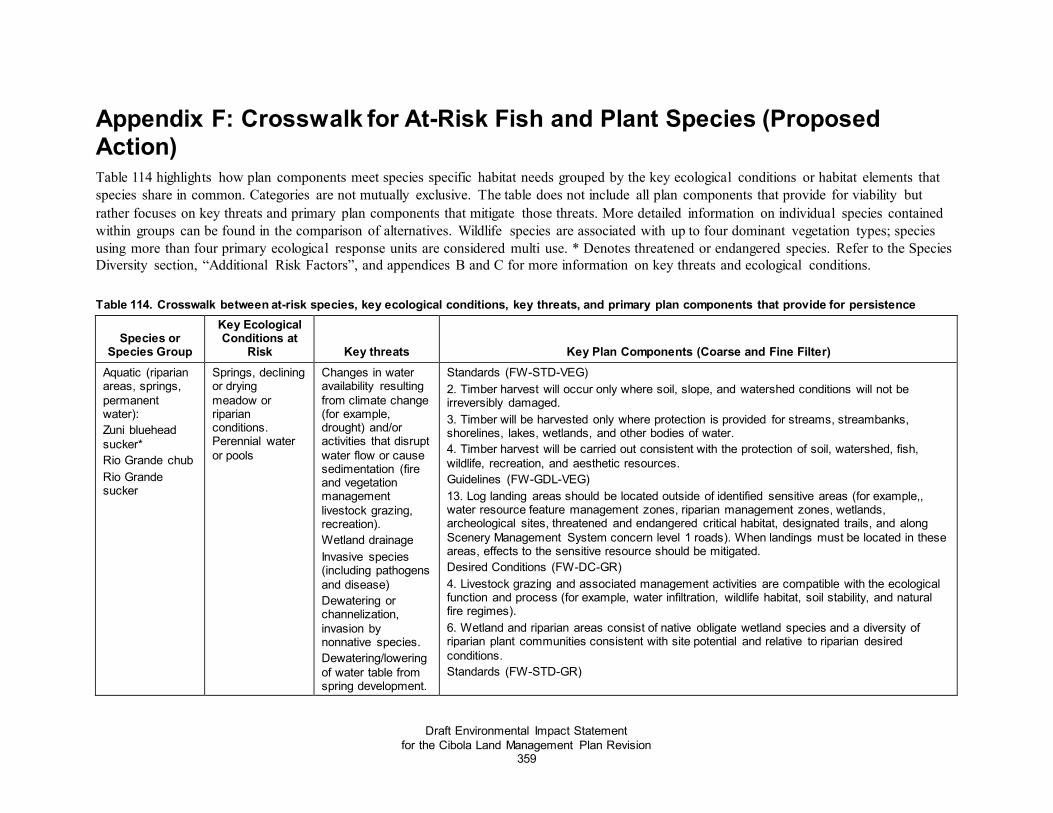
Draft Environmental Impact Statement for the Cibola Land Management Plan Revision
359
Appendix F: Crosswalk for At-Risk Fish and Plant Species (Proposed Action) Table 114 highlights how plan components meet species specific habitat needs grouped by the key ecological conditions or habitat elements that species share in common. Categories are not mutually exclusive. The table does not include all plan components that provide for viability but rather focuses on key threats and primary plan components that mitigate those threats. More detailed information on individual species contained within groups can be found in the comparison of alternatives. Wildlife species are associated with up to four dominant vegetation types; species using more than four primary ecological response units are considered multi use. * Denotes threatened or endangered species. Refer to the Species Diversity section, “Additional Risk Factors”, and appendices B and C for more information on key threats and ecological conditions.
Table 114. Crosswalk between at-risk species, key ecological conditions, key threats, and primary plan components that provide for persistence
Species or Species Group
Key Ecological Conditions at
Risk Key threats Key Plan Components (Coarse and Fine Filter) Aquatic (riparian areas, springs, permanent water): Zuni bluehead sucker* Rio Grande chub Rio Grande sucker
Springs, declining or drying meadow or riparian conditions. Perennial water or pools
Changes in water availability resulting from climate change (for example, drought) and/or activities that disrupt water flow or cause sedimentation (fire and vegetation management livestock grazing, recreation). Wetland drainage Invasive species (including pathogens and disease) Dewatering or channelization, invasion by nonnative species. Dewatering/lowering of water table from spring development.
Standards (FW-STD-VEG) 2. Timber harvest will occur only where soil, slope, and watershed conditions will not be irreversibly damaged. 3. Timber will be harvested only where protection is provided for streams, streambanks, shorelines, lakes, wetlands, and other bodies of water. 4. Timber harvest will be carried out consistent with the protection of soil, watershed, fish, wildlife, recreation, and aesthetic resources. Guidelines (FW-GDL-VEG) 13. Log landing areas should be located outside of identified sensitive areas (for example,, water resource feature management zones, riparian management zones, wetlands, archeological sites, threatened and endangered critical habitat, designated trails, and along Scenery Management System concern level 1 roads). When landings must be located in these areas, effects to the sensitive resource should be mitigated. Desired Conditions (FW-DC-GR) 4. Livestock grazing and associated management activities are compatible with the ecological function and process (for example, water infiltration, wildlife habitat, soil stability, and natural fire regimes). 6. Wetland and riparian areas consist of native obligate wetland species and a diversity of riparian plant communities consistent with site potential and relative to riparian desired conditions. Standards (FW-STD-GR)

Appendix F: Crosswalk for At-Risk Fish and Plant Species
Draft Environmental Impact Statement for the Cibola Land Management Plan Revision
360
Species or Species Group
Key Ecological Conditions at
Risk Key threats Key Plan Components (Coarse and Fine Filter) 1. Livestock management shall be compatible with capacity and address ecological concerns (for example, forage, invasive plants, at-risk species, soils, riparian health, water quality) that are departed from desired conditions. Guidelines (FW-GDL-GR) 2. Livestock grazing within riparian management zones (RMZ) should be managed to sustain proper stream channel morphology, floodplain function, and riparian vegetation desired conditions. 5. Salting or mineral supplementation should not occur on or adjacent to areas that are especially sensitive to salt and increased traffic from ungulates (for example, at-risk plant species habitat, riparian areas, wetlands, or archeological sites) to protect these sites. Guidelines; Locatable Minerals (FW-GDL-MIN) 6. Streambed and floodplain alteration or removal of material should not prevent attainment of riparian, channel morphology, or streambank desired conditions. Guidelines (FW-GDL-RD) 2. Construction of new or temporary roads should be accompanied by mitigating actions (for example, decommission or closure) for other roads, unauthorized routes, or trails in the same watershed that offsets any resource damage resulting from construction. 5. Infrastructure design, construction, reconstruction, and maintenance should prevent or mitigate impacts to terrestrial and aquatic species (for example, no reflective surfaces that would cause confusion and collusion by birds; accommodate appropriate movement for fish and other aquatic organisms) and decrease species mortality. 7. Road maintenance activities should avoid or minimize noise and habitat disturbance where at-risk species are present. 8. Low water fords should be improved to protect water quality and stream stability. Fords on perennial streams should be a priority. Desired Conditions (FW-DC-NIS) 1. Invasive species do not disrupt the structure or function of ecosystems, species life cycles, or populations, and minimize impacts to native wildlife or plant species. Standard (FW-STD-NIS) 1. All ground-disturbing projects (including vegetation, roads, and fire, etc.) shall assess the risk of noxious weed invasion and incorporate measures to minimize the potential for the spread of noxious and invasive species. 13. Avoid and remove sources of weed seed and propagules in riparian areas and waterbodies when feasible. Guidelines (FW-GDL-NIS) 1. Treatment approaches should use integrated pest management practices to treat noxious and nonnative, invasive species. These practices include mechanical/physical, cultural, biological, and chemical control.

Appendix F: Crosswalk for At-Risk Fish and Plant Species
Draft Environmental Impact Statement for the Cibola Land Management Plan Revision
361
Species or Species Group
Key Ecological Conditions at
Risk Key threats Key Plan Components (Coarse and Fine Filter) 2. New populations should be detected early, monitored, and treated as soon as possible. 3. Activities in and around waters should use the most current standardized decontamination protocol and procedures to prevent the spread of chytrid fungus and other pathogens harmful to aquatic wildlife. Management Approaches (FW-MGAP-NIS) 3. While management that provides for interconnected habitats is desirable for many native wildlife species, in some circumstances, such as springs, connectivity can also provide vectors for nonnative species to spread (for example, water and vehicles used in fire suppression). The use of best management practices can minimize and prevent the spread of nonnative invasive species. Guidelines (FW-GDL-AQSP) 1. Activities in and around waters should use decontamination procedures to prevent the spread of chytrid fungus and other pathogens that are harmful to aquatic wildlife. Guidelines (FW-GDL-ARS) 18. To avoid degradation of species, and their associated habitat, such as the Chiricahua or northern leopard frog, measures should be taken to avoid incidental or accidental introduction of diseases or nonnative species (bullfrogs and chytrid fungus.) Guidelines (FW-GDL-FF) 4. Measures should be taken to prevent entrapment of fish and aquatic organisms and the spread of parasites or disease (for example, chytrid fungus, Didymo, and whirling disease), when drafting (withdrawing) water from streams or other waterbodies during fire management activities. 5. Measures should be taken to prevent the spread of invasive plant species by equipment and personnel during fire management and rehabilitation operations. 7. Post-fire restoration and recovery should be provided where critical resource concerns merit rehabilitation for controlling the spread of invasive species, protecting areas of cultural concern, protecting critical or endangered species habitat, or protecting other highly valued resources such as drinking water. Guidelines (FW-GDL-ARS) 12. Standing dead trees and down woody material in and around riparian areas, streams, and large bodies of water should be retained to the extent possible. These are important ecosystem characteristics for species such as the Zuni bluehead sucker. 16. To the extent possible, livestock should be kept from concentrating in Southwestern willow flycatcher suitable habitat to avoid soil compaction and degradation of riparian vegetation. Nonnative species such as crayfish and green sunfish that occur within Zuni bluehead sucker habitat should be addressed to the extent possible. 17. Livestock grazing should be controlled, to the extent possible, within occupied and suitable habitat of Zuni bluehead sucker.

Appendix F: Crosswalk for At-Risk Fish and Plant Species
Draft Environmental Impact Statement for the Cibola Land Management Plan Revision
362
Species or Species Group
Key Ecological Conditions at
Risk Key threats Key Plan Components (Coarse and Fine Filter) Guidelines (FW-GDL-RE) 2. Energy corridors should be planned to avoid or limit disturbance in or near riparian zones to protect surface water, shallow groundwater, unstable areas, hydric soils or wetlands, and surface water. Guidelines (FW-GDL-SU) 5. Special use authorizations which utilize groundwater should ensure that ground water dependent ecosystems are not impacted. 10. New utility corridors should be located outside of riparian management zones. Guidelines (FW-GDL-GR) 3. New livestock troughs, tanks, and holding facilities should be located out of water resource feature management zones and riparian management zones to protect riparian ecological resources, unless necessary for resource enhancement or protection. 5. Salting or mineral supplementation should not occur on or adjacent to areas that are especially sensitive to salt and increased traffic from ungulates (for example, at-risk plant species habitat, riparian areas, wetlands, or archeological sites) to protect these sites.
Watersheds Water quality–sediment, nutrients Water quantity–increased runoff and use Aquatic habitat–loss and degradation Riparian or wetland–decline in extent and condition Soil condition–increased erosion, compaction Invasive species–increase Forest cover–loss and change of composition
Changes water availability resulting from climate change (for example, drought), activities that disrupt water flow or cause sedimentation (fire and vegetation management livestock grazing, recreation, mining), or both.
Desired Condition FW-DC-WTR 1. Watersheds are functioning properly (according to the Watershed Condition Framework or similar protocol. 2. Properly functioning watersheds provide a wide range of sustainable ecosystem services and support multiple uses (for example, timber, recreation, grazing) in balance with healthy ecological conditions. 3. Watersheds are not at risk to becoming impaired due to the fuels composition and uncharacteristic disturbance. 4. Watersheds contain rivers and streams that are primarily free of significant reservoirs, dams, or diversion facilities; unmodified lakes; and limited groundwater withdrawals to support ecological function. 5. The density and distribution of roads, trails, and impervious surfaces supports a hydrologic regime that is substantially intact. 6. Rangelands within each 6th-level hydrologic unit code subwatershed have desired plant compositions and cover at near-natural levels as defined by site potential. 7. Watershed are resilient to natural and human-caused disturbance such as fire and climate fluctuations. Guidelines (FW-GDL-WTR) 1. New or and reconstructed roads, infrastructure, recreation sites, or similar constructed facilities, should be located outside of the 100-year floodplain except where necessary for stream crossings or to provide for resource protection to avoid the long-term adverse impacts associated with the occupancy and modification of flood plains and water resource features.

Appendix F: Crosswalk for At-Risk Fish and Plant Species
Draft Environmental Impact Statement for the Cibola Land Management Plan Revision
363
Species or Species Group
Key Ecological Conditions at
Risk Key threats Key Plan Components (Coarse and Fine Filter) 2. New or reconstructed roads, infrastructure, and recreation sites, or similar constructed facilities, should not be constructed be located outside of the within water resource feature management zones, including the 100-year floodplain unless to provide for resource protection or where needed for crossings, to avoid the long-term adverse impacts associated with the occupancy and modification of water resource features. 3. New or reconstructed trails should be planned, designed, constructed, and maintained to avoid cumulative effects and to protect riparian-dependent values and proper functioning condition. 4. Structures in stream channels which are no longer necessary or functional should be rehabilitated or removed and the stream stabilized. Standard (FW-STD-WTR) 1. Cost-effective, reasonable, and effective best management practices will be prescribed for every project that has a potential effect on watershed condition, including water quality. Management Approaches (FW-MGAP-WTR) 1. Develop prescriptions and plans for improvement of priority watersheds through the watershed condition framework or other similar processes. 2. Watershed restoration action plans or similar process are completed for priority watersheds. 3. Watershed planning is used as a further means to improve watershed condition within the Cibola. 4. Best management practices are monitored using a current protocol, such as the national best management practices for water quality management on National Forest Systems lands. 5. Update watershed condition classification after large-scale disturbance events such as wildfire. 7. Work with local, State, and Tribal governments, land grant governing bodies and other stakeholders to identify watershed improvements and priorities for protection and management thereby increasing collaboration across boundaries. 8. Develop management plans and projects that consider and support watersheds capable of balancing the needs of forest and surround lands during all environmental conditions. 9. Cooperate with other agencies, groups, and individuals whose plans or proposals affect watershed condition on National Forest System lands. 10. Integrate watershed condition improvement projects with other project activities. Favor projects with high effectiveness that require minimal maintenance. 11. Vegetation, recreation, and range management projects are planned to support the natural variability of ecological characteristics to support satisfactory watershed condition while considering the effects of climate change. Desired Conditions (FW-DC-GWTR) 1. Groundwater quality is within the range of natural variability.

Appendix F: Crosswalk for At-Risk Fish and Plant Species
Draft Environmental Impact Statement for the Cibola Land Management Plan Revision
364
Species or Species Group
Key Ecological Conditions at
Risk Key threats Key Plan Components (Coarse and Fine Filter) 2. Natural processes of groundwater recharge and discharge support the long-term sustainability of aquifers throughout climate fluctuations 3. Groundwater recharge and discharge on the Cibola occur within the natural range of variability. 4. Watershed condition supports recharge of aquifers. Standard (FW-STD-GWTR) 1. New groundwater wells will be located so springs, wetlands (including riparian areas), surface flows, and groundwater-dependent ecosystems are not negatively impacted. Guidelines (FW-GDL-GWTR) 2. When existing groundwater wells that have the potential to impact groundwater-dependent resources require improvement, these wells should be relocated far enough away from these areas to prevent impacts. Groundwater-dependent resources include wetlands, riparian areas, floodplains, streams, playas, maars, and springs. 3. Activities which could impact groundwater quality should be located to prevent potential impacts to source water protection areas. In these protection areas, gravel pits, mining, septic systems, injection wells, equipment fueling or maintenance, underground storage tanks, landings, garbage storage, confined animal operations, chemical storage, pesticide use, and other potentially polluting activities should not be allowed. 7. New points of surface water diversions should be located to minimize impacts to water-dependent ecosystems, including instream flows, consistent with special use processes, existing water rights, approved permits, and approved declarations. Management Approaches (FW-MGAP-GWTR) 1. Collaborate with Federal, Tribal, State, local governments, universities, and industry partners to identify, inventory, assess, develop plans, and monitor hydrogeology and groundwater resources from activities on National Forest System lands. 2. Work with these partners to manage groundwater quality and quantity and to sustain the availability and usability of groundwater over the long term through the use of conventional and innovative approaches. 3. Aquifers are identified within the plan area, including important recharge areas. Management actions will consider these areas during project planning and implementation to protect them. 4. Manage watershed condition to support groundwater recharge processes such as snow pack management and improved soil condition. 5. Implement water conservation strategies in administrative and recreational uses to manage water sustainably. 6. Manage surface water and groundwater resources as hydraulically interconnected in all planning and evaluation activities, unless it can be demonstrated otherwise using site-specific information

Appendix F: Crosswalk for At-Risk Fish and Plant Species
Draft Environmental Impact Statement for the Cibola Land Management Plan Revision
365
Species or Species Group
Key Ecological Conditions at
Risk Key threats Key Plan Components (Coarse and Fine Filter) Threatened and endangered species with recovery plans: Zuni bluehead sucker New Mexico Department of Game and Fish recovery plan
Springs, declining or drying meadow or riparian conditions. Perennial water or pools
Altered hydrology, predation, and invasive species
Desired Conditions (FW-DC-AQSP) 1. Streams and aquatic habitats support self-sustaining populations of native fish and/or other aquatic species and provide the quantity and quality of aquatic habitat within reference conditions. 2. Streams, springs, and wetlands with the potential to support native fish, other aquatic species, or both provide habitats that are resilient or adaptive to natural or anthropogenic disturbances and projected warmer and drier climatic conditions. 3. Habitat conditions and compatible multiple uses contribute to the recovery of federally listed species and the persistence of species of conservation concern. 4. Stream flows, habitat, and water quality support native aquatic and riparian-dependent species and habitat both on the Cibola and downstream. 5. Aquatic habitats are connected and free from alterations (for example, temperature regime changes, lack of adequate streamflow, barriers to aquatic organism passage) to allow for species migration, connectivity of fragmented populations and genetic exchange. Barriers to movement are located where necessary to protect native fish from non-native species. 6. All aquatic species populations are free from or minimally impacted (populations remain self-sustaining) by nonnative plants, animals, disease, and pathogens. 7. Desirable nonnative fish species provide recreational fishing in waters where those opportunities are not in conflict with the recovery of native species. 8. Aquatic species habitat conditions provide the resiliency and redundancy necessary to maintain species biodiversity and metapopulations. 9. All natural aquatic and riparian habitats are hydrologically functioning and have sufficient emergent vegetation and macroinvertebrate populations to support resident and migratory species. Guidelines (FW-GDL-AQSP) 3. Streams, stream banks, shorelines, lakes, wetlands, seeps, springs, and other bodies of water should be protected from detrimental changes (as described in species-specific literature including recovery plans, listing and critical habitat designations, and conservation strategies) to protect water quality, aquatic species diversity and quantity, riparian and aquatic habitat quality, and riparian and aquatic habitat connectivity. 5. Project design should incorporate measures to protect and provide for rare and narrow endemic aquatic species where they are likely to occur. 6. Except where barriers are beneficial and necessary to achieve conservation goals for aquatic species, fragmentation of aquatic habitats and isolation of aquatic species should be avoided and passage for aquatic organisms should be maintained. 7. Structures (for example, instream structures, fencing) should be maintained to support the purposes for which they were built and removed when no longer needed. Management Approaches (FW-MGAP-AQSP)

Appendix F: Crosswalk for At-Risk Fish and Plant Species
Draft Environmental Impact Statement for the Cibola Land Management Plan Revision
366
Species or Species Group
Key Ecological Conditions at
Risk Key threats Key Plan Components (Coarse and Fine Filter) 1. Where adequate groundwater or surface hydrology exists, and if natural recruitment is not sufficient, managers may supplement natural recruitment with planting to reestablish native riparian vegetation to provide shading, bank cover, and streambank stability. Shading provided by vegetation contributes to improving water temperatures which are one of New Mexico’s primary water quality impairments. 2. Work collaboratively with New Mexico Department of Game and Fish personnel to resolve conflicts that may exist between the management of nonnative sport fish and the persistence of native fish. 4. Pursue partnership potential for collaborative management of aquatic resources with State, county, and local government entities. Work with partners and through collaborative efforts to increase the frequency of restoration efforts benefitting aquatic species. Desired Conditions (FW-DC-NIS) 1. Invasive species do not disrupt the structure or function of ecosystems, species life cycles, or populations, and minimize impacts to native wildlife or plant species. Standard (FW-STD-NIS) 3. Monitor susceptible waters to allow early detection of aquatic invasive species. Promptly post sites if aquatic invasive species are found and, if feasible, close facility until infestation is contained. Management Approaches (FW-MGAP-NIS) 1. To effectively manage invasive species populations, it is important to coordinate with other federal and state agencies, tribal governments, counties, local governments, grazing permittees, and adjacent landowners in efforts for prevention and control. Coordinate with other agencies to capitalize on outside funding opportunities and pursue partnership opportunities to treat invasive species on National Forest System lands, such as soil and water conservation districts which often have personnel certified for public pesticide application. 2. Strategies to prevent the spread of nonnative, invasive species include education, inventory, and control guidelines. Educational programs that increase awareness are critical to effectively manage nonnative, invasive species. Treatments focus on those species that have the potential to permanently alter historical fire regimes or pose the greatest threat to biological diversity and watershed condition. 3. While management that provides for interconnected habitats is desirable for many native wildlife species, in some circumstances, such as springs, connectivity can also provide vectors for nonnative species to spread (for example, water and vehicles used in fire suppression). The use of best management practices can minimize and prevent the spread of nonnative invasive species.
Threatened and endangered species with recovery plans:
Soil conditions, pinyon juniper vegetation.
Mining, predation or trampling, recreation (such as off road
Management Approaches (FW-MGAP-VEG) 2. Significant plant communities may be managed to maintain their unique characteristics. Guidelines (FW-GDL-VEG)

Appendix F: Crosswalk for At-Risk Fish and Plant Species
Draft Environmental Impact Statement for the Cibola Land Management Plan Revision
367
Species or Species Group
Key Ecological Conditions at
Risk Key threats Key Plan Components (Coarse and Fine Filter) Zuni fleabane (plant)
vehicle use) and invasive species
10. Natural regeneration of disturbed areas should be allowed unless: (1) endangered species habitat needs to be restored; (2) the period of recovery is deemed excessive due to the large size of deforested area, the lack of nearby seed sources, or both; (3) there is concern for loss of site capacity from soils loss or extreme competition with early-seral species; or (4) the risk of noxious weed invasion or the spread of noxious and invasive species would prevent recovery of native species. 13. Log landing areas should be located outside of identified sensitive areas (for example,, water resource feature management zones, riparian management zones, wetlands, archeological sites, threatened and endangered critical habitat, designated trails, and along Scenery Management System concern level 1 roads). When landings must be located in these areas, effects to the sensitive resource should be mitigated. Desired Conditions (FW-DC-TRSP) 1. Native ecosystems are within reference conditions, are distributed throughout their potential range, and are sustainable across the Cibola and able to support a full complement of native species. 2. There is a natural and nearly complete assemblage of native plants and animals, including important game species, which provide recreational opportunity and socio-economic benefits to communities, distributed across the Cibola. 3. Ecological conditions (see desired conditions for vegetation and water resources) provide habitat that contributes to the survival, recovery, and delisting of species under the Endangered Species Act; precludes the need for listing new species; improve conditions for species of conservation concern; and sustains both common and uncommon native species. 4. Hunting, fishing, plant gathering, and other species-based recreation and traditional use opportunities exist but do not compromise species, populations, or habitat. 10. Species are free from harassment and human disturbance at a scale that impacts vital functions (such as breeding, feeding, and rearing young) that could affect persistence of the species. 11. Habitat configuration, connectivity, and availability allow wildlife populations to adjust their movements in response to major disturbances (such as effects of changing climate and uncharacteristic fire) and promote genetic flow between wildlife populations. These interconnected habitats allow seasonal migrations, breeding, dispersal, foraging, and other movement patterns to support life-history characteristics. Habitat loss and fragmentation is reduced, and permeability is enhanced through habitat linkages within and between the national forests and other public and privately conserved lands. 12. Habitats and refugia for rare, endemic, and culturally important species are intact, functioning, and sufficient for species persistence and recovery. Guidelines (FW-GDL-TRSP)

Appendix F: Crosswalk for At-Risk Fish and Plant Species
Draft Environmental Impact Statement for the Cibola Land Management Plan Revision
368
Species or Species Group
Key Ecological Conditions at
Risk Key threats Key Plan Components (Coarse and Fine Filter) 1. Modifications, mitigations, or other measures should be incorporated to reduce negative impacts to plants, animals, and their habitats and to help provide for species needs, consistent with project or activity objectives. 7. Project activities and special uses should be designed and implemented to maintain refugia and critical life cycle needs of wildlife, particularly for species of conservation concern. 8. Project design should incorporate measures to protect and provide for rare and narrow endemic terrestrial species where they are likely to occur. Management Approaches (FW-MGAP-TRSP) 1. Strive to create and maintain natural communities and habitats in the amounts, arrangements, and conditions capable of supporting viable populations of existing native and desired nonnative plant, aquatic, and wildlife species within the planning area while contributing to broader landscape-scale initiatives where appropriate. 4. Develop partnerships with interested individuals and groups to help implement the wildlife program, including wildlife survey and habitat assessment. Desired Conditions (FW-DC-NIS) 1. Invasive species do not disrupt the structure or function of ecosystems, species life cycles, or populations, and minimize impacts to native wildlife or plant species. 2. Desirable nonnative species do not conflict with the recovery of native species or existing multiple uses, for example, stocking of non-native sport fish. Standard (FW-STD-NIS) 1. All ground-disturbing projects (including vegetation, roads, and fire, etc.) shall assess the risk of noxious weed invasion and incorporate measures to minimize the potential for the spread of noxious and invasive species. 5. Avoid staging equipment and resources in areas infested with invasive weeds and ensure that fire-fighting equipment and personal gear and clothing are free of invasive weeds before being brought into a staging area. 6. Clean hides, legs, and hooves of pack animals by brushing prior to moving them into a fire-disturbed area. Ensure the pack animals have previously cleared their digestive system of invasive weed seed over a period of 3 to 5 days while being fed weed-free forage. 7. Use certified weed-free seed in burned areas and also require use of locally chipped or shredded woody materials for mulch or, if necessary, use certified weed-free mulch. 8. Incorporate weed prevention into all new mining operation permits, plans, and reclamation projects. Mining reclamation must consider reclamation requirements established by the New Mexico Mining and Minerals Division for invasive species. 9. Encourage public land users to inspect and clean motorized and mechanized trail vehicles of weeds and their seeds before recreating on public lands. If practical, provide facilities for cleaning contaminated vehicles and equipment. Guidelines (FW-GDL-NIS)

Appendix F: Crosswalk for At-Risk Fish and Plant Species
Draft Environmental Impact Statement for the Cibola Land Management Plan Revision
369
Species or Species Group
Key Ecological Conditions at
Risk Key threats Key Plan Components (Coarse and Fine Filter) 1. Treatment approaches should use integrated pest management practices to treat noxious and nonnative, invasive species. These practices include mechanical/physical, cultural, biological, and chemical control. 2. New populations should be detected early, monitored, and treated as soon as possible. 3. Use of pesticides, herbicides, and biocontrol agents should minimize impacts (chemicals and/or agents least harmful to nontarget species should be selected) on non-target flora and fauna, including native pollinators. 4. Reclamation type projects which include a revegetation and/or reseeding component should consider including the use of native plants for pollinators. 5. Prior to seeding, a certified seed laboratory should test each seed mix lot for purity, viability, and noxious weed seed according to Association of Official Seed Analysts standards. Desired Conditions (FW-DC-ARS) 1. Threatened and endangered species have the necessary ecological conditions to contribute to their recovery and maintain or restore critical habitats. 2. Ecological conditions are present that conserve populations of proposed and candidate species and that maintain or restore habitats in the plan area to contribute to preventing them from becoming federally listed. 3. Ecological conditions necessary to maintain a viable population of each species of conservation concern in the plan area are present. Guidelines (FW-GDL-ARS) 1. Management activities and special uses occurring within federally listed species’ habitat should integrate habitat management objectives and species protection measures from the most recent approved U.S. Fish and Wildlife Service recovery plan, to maintain the persistence or contribute to the recovery of that species. Deviation from recovery plans may occur through consultation with U.S. Fish and Wildlife Service personnel. 7. Site-specific information should be used to determine if management activities may potentially impact species of conservation concern. Species-specific mitigation and protective measures should be incorporated into project design to ensure persistence of species (for example, retention of both abiotic and biotic features required for essential life history characteristics, such as breeding and foraging). 8. Known populations of at-risk plant species should be protected from management activities that may degrade habitat conditions. Standards; Locatable Minerals (FW-STD-MIN) 3. Soil disturbance will be kept to a minimum. Where removal of soil is necessary, soil will be stockpiled and stabilized for use in later reclamation. 7. Reclamation plans will be site specific and appropriate for the setting; for example, soils, vegetation, climate, and slope. Standards (FW-STD-REC)

Appendix F: Crosswalk for At-Risk Fish and Plant Species
Draft Environmental Impact Statement for the Cibola Land Management Plan Revision
370
Species or Species Group
Key Ecological Conditions at
Risk Key threats Key Plan Components (Coarse and Fine Filter) 3. No new motorized routes or areas shall be constructed or designated in desired primitive recreation opportunity spectrum settings. In or semi-primitive nonmotorized recreation opportunity spectrum settings, no new permanent motorized routes or areas shall be constructed or designated; except for necessary minimal administrative, permitted, or emergency activities. 4. Any temporary project-level motorized routes or road construction roads in in semi-primitive nonmotorized settings must be rehabilitated within 2 two years of project completion. Desired Conditions; Locatable Minerals (FW-DC-MIN) 1. Energy, mineral, and mining activities meet the legal mandates to facilitate the development of minerals in a manner that minimizes adverse impacts to surface and groundwater resources, watershed and forest ecosystem health, wildlife and wildlife habitat, scenic character, and other desired conditions applicable to the area. Guidelines (FW-GDL-REC) 1. Trails should be designed, constructed, rerouted, decommissioned or maintained utilizing current best practices to promote sustainable design while providing desired recreation opportunities and protecting the values of other resources. 2. Existing trail segments found to adversely impact natural and cultural resources should be evaluated to address such impacts. Use alternative designs, reroutes, mitigations, or decommissioning of the trail to eliminate, minimize, or resolve adverse impacts. Guidelines; Locatable Minerals (FW-GDL-MIN) 7. Only native or non-persistent seed and plant materials should be used when revegetating disturbed sites.
PJ Woodland ecological response unit Zuni milkvetch Sivinski’s fleabane Zuni fleabane
Soil conditions, rock, cliff, and cave habitats; mine
Predation or trampling, recreation (off road vehicle use) and invasive species
Guidelines (FW-GDL-VEG) 1. Management activities should be guided by the most site-specific, accurate inventory data for soil, species composition and structure, and site potential. For example, where a woodland now occupies a historic grassland site (for example, soil classification of Mollisol – a signature of grassland ecosystems), grassland desired conditions apply. In other words, the desired condition for vegetation type should be consistent with the site’s soil type with an emphasis on native annual and perennial plant communities. 13. Log landing areas should be located outside of identified sensitive areas (for example,, water resource feature management zones, riparian management zones, wetlands, archeological sites, threatened and endangered critical habitat, designated trails, and along Scenery Management System concern level 1 roads). When landings must be located in these areas, effects to the sensitive resource should be mitigated. Landscape Scale Desired Conditions (1,000 to 10,000 plus acres) (FW-DC-PJO) 1. Pinyon-Juniper Grass and Juniper Grass are generally uneven aged and open in appearance. Trees occur as individuals, but occasionally in smaller groups, and range from young to old. Scattered shrubs and a dense herbaceous understory including native grasses,

Appendix F: Crosswalk for At-Risk Fish and Plant Species
Draft Environmental Impact Statement for the Cibola Land Management Plan Revision
371
Species or Species Group
Key Ecological Conditions at
Risk Key threats Key Plan Components (Coarse and Fine Filter) forbs, and annuals are present to support frequent surface fires. Snags are scattered across the landscape. Old growth occurs throughout the landscape, generally in small areas as individual old-growth components, or as clumps of old growth. Old-growth components include old trees, dead trees (snags), downed wood (coarse woody material), and structural diversity. The location of old growth shifts on the landscape over time as a result of succession and disturbance (tree growth and mortality). The composition, structure, and function of vegetative conditions are resilient to the frequency, extent and severity of disturbances (for example, insects, diseases, and fire) and climate variability. Fires are typically frequent and low-severity (fire regime I).
Ponderosa Pine ecological response unit Villous groundcover milkvetch
Soil conditions, rock, cliff, and cave habitats; mine
Threat to ecological response unit
Guidelines (FW-GDL-VEG) 1. Management activities should be guided by the most site-specific, accurate inventory data for soil, species composition and structure, and site potential. For example, where a woodland now occupies a historic grassland site (for example, soil classification of Mollisol – a signature of grassland ecosystems), grassland desired conditions apply. In other words, the desired condition for vegetation type should be consistent with the site’s soil type with an emphasis on native annual and perennial plant communities. Landscape Scale Desired Conditions (1,000 to 10,000 plus acres) (FW-DC-PPF) 5. The composition, structure, and function of vegetative conditions are resilient to the frequency, extent, and severity of disturbances and climate variability. The landscape is a functioning ecosystem that contains all its components, processes, and conditions that result from endemic levels of disturbances (for example, insects, diseases, fire, and wind), including snags, downed logs, and old trees. Grasses, forbs, shrubs, and needle cast (fine fuels), and small trees maintain the natural fire regime. Organic ground cover and herbaceous vegetation provide protection of soil, moisture infiltration, and contribute to plant and animal diversity and to ecosystem function. Frequent, low-severity fires (fire regime I) are characteristic in this type, including throughout goshawk home ranges. Natural and human-caused disturbances are sufficient to maintain desired overall tree density, structure, species composition, coarse woody material, nutrient cycling, and satisfactory soil conditions. Guidelines (FW-GDL-PPF) 2. Where consistent with project or activity objectives, canopy cover should be retained on the south and southwest sides of small, existing forest openings to enhance cooler and moister conditions. These small (generally 0.1 to 0.25 acre), shaded openings provide habitat conditions needed by small mammals, plants, and insects, and these openings should be maintained where they naturally occur. 3. In proposed treatment areas where there is little understory, slash treatments (for example, lop and scatter, and mastication) should be used that improve herbaceous vegetation growth, soil and watershed condition, and soil productivity, consistent with scenic integrity objectives.
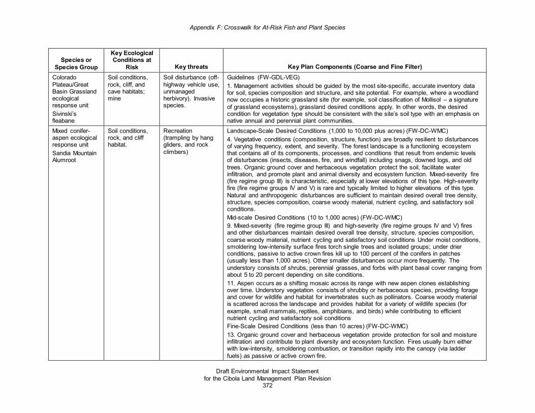
Appendix F: Crosswalk for At-Risk Fish and Plant Species
Draft Environmental Impact Statement for the Cibola Land Management Plan Revision
372
Species or Species Group
Key Ecological Conditions at
Risk Key threats Key Plan Components (Coarse and Fine Filter) Colorado Plateau/Great Basin Grassland ecological response unit Sivinski’s fleabane
Soil conditions, rock, cliff, and cave habitats; mine
Soil disturbance (off-highway vehicle use, unmanaged herbivory). Invasive species.
Guidelines (FW-GDL-VEG) 1. Management activities should be guided by the most site-specific, accurate inventory data for soil, species composition and structure, and site potential. For example, where a woodland now occupies a historic grassland site (for example, soil classification of Mollisol – a signature of grassland ecosystems), grassland desired conditions apply. In other words, the desired condition for vegetation type should be consistent with the site’s soil type with an emphasis on native annual and perennial plant communities.
Mixed conifer-aspen ecological response unit Sandia Mountain Alumroot
Soil conditions, rock, and cliff habitat.
Recreation (trampling by hang gliders, and rock climbers)
Landscape-Scale Desired Conditions (1,000 to 10,000 plus acres) (FW-DC-WMC) 4. Vegetative conditions (composition, structure, function) are broadly resilient to disturbances of varying frequency, extent, and severity. The forest landscape is a functioning ecosystem that contains all of its components, processes, and conditions that result from endemic levels of disturbances (insects, diseases, fire, and windfall) including snags, downed logs, and old trees. Organic ground cover and herbaceous vegetation protect the soil, facilitate water infiltration, and promote plant and animal diversity and ecosystem function. Mixed-severity fire (fire regime group III) is characteristic, especially at lower elevations of this type. High-severity fire (fire regime groups IV and V) is rare and typically limited to higher elevations of this type. Natural and anthropogenic disturbances are sufficient to maintain desired overall tree density, structure, species composition, coarse woody material, nutrient cycling, and satisfactory soil conditions. Mid-scale Desired Conditions (10 to 1,000 acres) (FW-DC-WMC) 9. Mixed-severity (fire regime group III) and high-severity (fire regime groups IV and V) fires and other disturbances maintain desired overall tree density, structure, species composition, coarse woody material, nutrient cycling and satisfactory soil conditions Under moist conditions, smoldering low-intensity surface fires torch single trees and isolated groups; under drier conditions, passive to active crown fires kill up to 100 percent of the conifers in patches (usually less than 1,000 acres). Other smaller disturbances occur more frequently. The understory consists of shrubs, perennial grasses, and forbs with plant basal cover ranging from about 5 to 20 percent depending on site conditions. 11. Aspen occurs as a shifting mosaic across its range with new aspen clones establishing over time. Understory vegetation consists of shrubby or herbaceous species, providing forage and cover for wildlife and habitat for invertebrates such as pollinators. Coarse woody material is scattered across the landscape and provides habitat for a variety of wildlife species (for example, small mammals, reptiles, amphibians, and birds) while contributing to efficient nutrient cycling and satisfactory soil conditions Fine-Scale Desired Conditions (less than 10 acres) (FW-DC-WMC) 13. Organic ground cover and herbaceous vegetation provide protection for soil and moisture infiltration and contribute to plant diversity and ecosystem function. Fires usually burn either with low-intensity, smoldering combustion, or transition rapidly into the canopy (via ladder fuels) as passive or active crown fire.

Appendix F: Crosswalk for At-Risk Fish and Plant Species
Draft Environmental Impact Statement for the Cibola Land Management Plan Revision
373
Species or Species Group
Key Ecological Conditions at
Risk Key threats Key Plan Components (Coarse and Fine Filter) Guidelines (FW-GDL-REC) 1. Recreation activities (for example,, rock climbing, dispersed camping, etc.) should be managed to accommodate sustainable use levels within the capacities of other resource values, including the need to protect plants, animals (such as species of conservation concern), and other natural and cultural resources. Fine Scale (FW-DC-WMC) 1. The mixed conifer with aspen forest is a mosaic of structural and seral stages ranging from young trees through old with species composition varying by seral stage. Patch sizes vary, but are frequently in the hundreds of acres, with rare disturbances in the thousands of acres. Seral-stage proportions are applied at the landscape scale. Native grass, forbs, and shrubs comprise the understory. 2. Old growth generally occurs over large areas and includes old trees, standing dead trees (snags), downed wood (coarse woody material), and structural diversity. The location of old growth shifts on the landscape over time as a result of succession and disturbance (tree growth and mortality). 3. The mixed conifer with aspen forest is composed predominantly of vigorous trees; older, declining trees provide snags and coarse woody material. The abundance of snags, downed logs, and coarse woody material varies by seral stage. 4. Vegetative conditions (composition, structure, function) are broadly resilient to disturbances of varying frequency, extent, and severity. The forest landscape is a functioning ecosystem that contains all of its components, processes, and conditions that result from endemic levels of disturbances (insects, diseases, fire, and windfall) including snags, downed logs, and old trees. Organic ground cover and herbaceous vegetation protect the soil, facilitate water infiltration, and promote plant and animal diversity and ecosystem function. Mixed-severity fire (fire regime group III) is characteristic, especially at lower elevations of this type. High-severity fire (fire regime groups IV and V) is rare and typically limited to higher elevations of this type. Natural and anthropogenic disturbances are sufficient to maintain desired overall tree density, structure, species composition, coarse woody material, nutrient cycling, and satisfactory soil conditions.
Abiotic features (rock, cliff, and cave habitats; mines) and soils: Zuni milkvetch, villous groundcover milkvetch, Sivinski’s fleabane, Sandia mountain
Soil conditions, rock, cliff, and cave habitats; mine
Mining activities, predation or trampling, recreation (such as off-road vehicle use, rock climbers, hang gliders) and invasive species
Guidelines (FW-GDL-REC) 2. Recreation activities (for example,, rock climbing, dispersed camping, etc.) should be managed to accommodate sustainable use levels within the capacities of other resource values, including the need to protect plants, animals (such as species of conservation concern), and other natural and cultural resources. Management Approaches (FW-MGAP-VEG) 2. Significant plant communities may be managed to maintain their unique characteristics. Guidelines (FW-GDL-VEG) 1. Management activities should be guided by the most site-specific, accurate inventory data for soil, species composition and structure, and site potential. For example, where a woodland

Appendix F: Crosswalk for At-Risk Fish and Plant Species
Draft Environmental Impact Statement for the Cibola Land Management Plan Revision
374
Species or Species Group
Key Ecological Conditions at
Risk Key threats Key Plan Components (Coarse and Fine Filter) alumroot, and Zuni fleabane
now occupies a historic grassland site (for example, soil classification of Mollisol – a signature of grassland ecosystems), grassland desired conditions apply. In other words, the desired condition for vegetation type should be consistent with the site’s soil type with an emphasis on native annual and perennial plant communities. Desired Conditions (FW-DC-SOIL) 1. Soil condition is satisfactory, soil functions are sustained, and soil is functioning properly as defined by current Forest Service protocols. The ability of soil to maintain resource values and sustain outputs is high. 2. Vegetation contributes to soil condition, nutrient cycling, and hydrologic regimes at natural levels. 3. Downed woody material occurs at levels (size, decay, and amount) sufficient to support soil productivity. 7. Soils have minimal evidence of pedestaling and are within the range of natural amounts of litter with little exposure of roots. Standards (FW-STD-SOIL) 1. High-risk soils will be identified prior to ground-disturbing activities and the appropriate best management practices will be used to protect them. This may include avoidance and timing restrictions. 2. Appropriate best management practices will be applied to all ground-disturbing activities in order to minimize effects to soils and maintain satisfactory soil condition. 3. Sites disturbed during management activities or actions will be stabilized and restored to satisfactory conditions. Drainage and erosion control measures will be implemented and maintained. 4. Spill prevention and containment plans will be in place when hazardous substances are used in or associated with forest management activities. This includes petroleum products, fuels, and pesticides. Guidelines (FW-GDL-SOIL) 1. Ground-disturbing activities that cause compaction, bare soils, loss of litter, or erosion resulting in a long term decrease in soil condition should be limited to 15 percent or less of a project area. 2. Poorly drained or saturated soils should not have mechanized equipment operating on them. 3. When soil condition is less than satisfactory as the result of management activities, restoration of soil condition should occur to restore soil condition to satisfactory. 5. Burn piles should not be larger than 10 feet by 10 feet to protect soil condition. Where soil under burned piles does not return to pre-burn condition within 5 years, burn scars should be restored with methods such as scarification and revegetation to restore condition. Piles should contained a mix of fuel sizes and no more than 50 percent large wood to reduce soil heating.
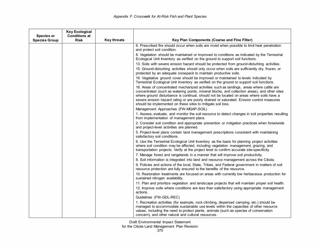
Appendix F: Crosswalk for At-Risk Fish and Plant Species
Draft Environmental Impact Statement for the Cibola Land Management Plan Revision
375
Species or Species Group
Key Ecological Conditions at
Risk Key threats Key Plan Components (Coarse and Fine Filter) 6. Prescribed fire should occur when soils are moist when possible to limit heat penetration and protect soil condition. 8. Vegetation should be maintained or improved to conditions as indicated by the Terrestrial Ecological Unit Inventory as verified on the ground to support soil functions. 13. Soils with severe erosion hazard should be protected from ground-disturbing activities. 15. Ground-disturbing activities should only occur when soils are sufficiently dry, frozen, or protected by an adequate snowpack to maintain productive soils. 16. Vegetative ground cover should be improved or maintained to levels indicated by Terrestrial Ecological Unit Inventory as verified on the ground to support soil functions. 18. Areas of concentrated mechanized activities such as landings, areas where cattle are concentrated (such as watering points, mineral blocks, and collection areas), and other sites where ground disturbance is continual, should not be located on areas where soils have a severe erosion hazard rating or are poorly drained or saturated. Erosion control measures should be implemented on these sites to mitigate soil loss. Management Approaches (FW-MGAP-SOIL) 1. Assess, evaluate, and monitor the soil resource to detect changes in soil properties resulting from implementation of management plans. 2. Consider soil condition and appropriate prevention or mitigation practices when forestwide and project-level activities are planned. 5. Project-level plans contain land management prescriptions consistent with maintaining satisfactory soil conditions. 6. Use the Terrestrial Ecological Unit Inventory as the basis for planning project activities where soil condition may be affected, including vegetation management, grazing, and transportation projects. Verify at the project level to confirm accurate site-specificity. 7. Manage forest and rangelands in a manner that will improve soil productivity. 8. Soil information is integrated into land and resource management across the Cibola. 9. Policies and actions of the local, State, Tribes, and Federal government in matters of soil resource protection are fully ensured to the benefits of the resource. 10. Restoration treatments are focused on areas with currently low herbaceous production for sustained nitrogen availability. 11. Plan and prioritize vegetation and landscape projects that will maintain proper soil health. 12. Improve soils where conditions are less than satisfactory using appropriate management actions. Guidelines (FW-GDL-REC) 1. Recreation activities (for example, rock climbing, dispersed camping, etc.) should be managed to accommodate sustainable use levels within the capacities of other resource values, including the need to protect plants, animals (such as species of conservation concern), and other natural and cultural resources.

Appendix F: Crosswalk for At-Risk Fish and Plant Species
Draft Environmental Impact Statement for the Cibola Land Management Plan Revision
376
Species or Species Group
Key Ecological Conditions at
Risk Key threats Key Plan Components (Coarse and Fine Filter) Standards (FW-STD-REC) 3. No new motorized routes or areas shall be constructed or designated in desired primitive recreation opportunity spectrum settings. In or semi-primitive nonmotorized recreation opportunity spectrum settings, no new permanent motorized routes or areas shall be constructed or designated; except for necessary minimal administrative, permitted, or emergency activities. 4. Any temporary project-level motorized routes or road construction roads in in semi-primitive nonmotorized settings must be rehabilitated within 2 two years of project completion. Desired Conditions (FW-DC-TRSP) 1. Native ecosystems are within reference conditions, are distributed throughout their potential range, and are sustainable across the Cibola and able to support a full complement of native species. 2. There is a natural and nearly complete assemblage of native plants and animals, including important game species, which provide recreational opportunity and socio-economic benefits to communities, distributed across the Cibola. 3. Habitat conditions and compatible multiple uses contribute to the recovery of federally listed species and the persistence of species of conservation concern. 4. Habitats and refugia are present for narrow endemics, rare plants, species with restricted distributions, declining populations, or both. These habitats are intact and functioning. 5. Hunting, fishing, plant gathering and other species-based recreation and traditional use opportunities exist, but do not compromise species, populations, or habitat. 11. Non-vegetative habitat features required for some species (for example, cliffs, caves, cavities) are maintained with limited disturbance. Vegetative habitat features (such as snags, grasses, forbs, and shrubs) provide forage, cover, fawning, and nesting sites for species requiring them. 12. Species are free from harassment and human disturbance at a scale that impacts vital functions (such as breeding, feeding, and rearing young) that could affect persistence of the species. Habitat loss and fragmentation is reduced and permeability is enhanced by conserving and restoring habitat linkages within and, where possible, between the national forests and other public and privately conserved lands. Guidelines (FW-GDL-TRSP) 1. Modifications, mitigations, or other measures should be incorporated to reduce negative impacts to plants, animals, and their habitats and to help provide for species needs, consistent with project or activity objectives. 3. Rare and unique features (for example, talus slopes, cliffs, canyon slopes, caves, fens, bogs, sinkholes, maars, and playas) should be protected from damage or loss in order to retain their distinctive ecological functions and maintain viability of associated species.

Appendix F: Crosswalk for At-Risk Fish and Plant Species
Draft Environmental Impact Statement for the Cibola Land Management Plan Revision
377
Species or Species Group
Key Ecological Conditions at
Risk Key threats Key Plan Components (Coarse and Fine Filter) 7. Project activities and special uses should be designed and implemented to maintain refugia and critical life cycle needs of wildlife, particularly for species of conservation concern. 8. Project design should incorporate measures to protect and provide for rare and narrow endemic terrestrial species where they are likely to occur. Management Approaches (FW-MGAP-TRSP) 1. The Cibola strives to create and maintain natural communities and habitats in the amounts, arrangements, and conditions capable of supporting viable populations of existing native and desired nonnative plant, aquatic, and wildlife species within the planning area while contributing to broader landscape-scale initiatives where appropriate. This is accomplished in an integrative fashion by working closely with range, fire, timber, and other resource areas to coordinate and maximize activities for wildlife benefit. Where appropriate, coordinate maintenance and construction of features (such as water sources) with range permittees and others. Cooperation with State and Federal wildlife management agencies also helps to minimize conflicting wildlife resource issues related to hunted, fished, and trapped species. Leverage resources by recognizing partnership potential with county and local government entities. The Cibola coordinates with Rocky Mountain Research Station and other entities to identify future areas of research that would support management decisions and enable the adaptive management process. 6. Forest managers recognize the need to acquire a greater understanding of many nongame species (such as amphibians, invertebrates, and fish), including their habitat requirements and the effects of management activities. The Forests encourage and support wildlife research and inventory. The Forests develop partnerships with interested individuals and groups to help implement the wildlife program, including wildlife survey and habitat assessment. The Forests also promote public education and valuing of the wildlife resource on the Forests. The latter is increasingly important with growing urbanization and Forest use. Desired Conditions (FW-DC-NIS) 1. Invasive species do not disrupt the structure or function of ecosystems, species life cycles, or populations, and minimize impacts to native wildlife or plant species. 2. Desirable nonnative species do not conflict with the recovery of native species or existing multiple uses, for example, stocking of non-native sport fish. Standard (FW-STD-NIS) 1. All ground-disturbing projects (including vegetation, roads, and fire, etc.) shall assess the risk of noxious weed invasion and incorporate measures to minimize the potential for the spread of noxious and invasive species. 5. Avoid staging equipment and resources in areas infested with invasive weeds and ensure that fire-fighting equipment and personal gear and clothing are free of invasive weeds before being brought into a staging area.

Appendix F: Crosswalk for At-Risk Fish and Plant Species
Draft Environmental Impact Statement for the Cibola Land Management Plan Revision
378
Species or Species Group
Key Ecological Conditions at
Risk Key threats Key Plan Components (Coarse and Fine Filter) 6. Clean hides, legs, and hooves of pack animals by brushing prior to moving them into a fire-disturbed area. Ensure that the pack animals have previously cleared their digestive system of invasive weed seed over a period of 3 to 5 days while being fed weed-free forage. 7. Use certified weed-free seed in burned areas and also require use of locally chipped or shredded woody materials for mulch or, if necessary, use certified weed-free mulch. 8. Incorporate weed prevention into all new mining operation permits, plans, and reclamation projects. Mining reclamation must consider reclamation requirements established by the New Mexico Mining and Minerals Division for invasive species. 9. Encourage public land users to inspect and clean motorized and mechanized trail vehicles of weeds and their seeds before recreating on public lands. If practical, provide facilities for cleaning contaminated vehicles and equipment. Guidelines (FW-GDL-NIS) 1. Treatment approaches should use integrated pest management practices to treat noxious and nonnative, invasive species. These practices include mechanical or physical, cultural, biological, and chemical control. 2. New populations should be detected early, monitored, and treated as soon as possible. 3. Use of pesticides, herbicides, and biocontrol agents should minimize impacts (chemicals, agents, or both least harmful to nontarget species should be selected) on nontarget flora and fauna, including native pollinators. 4. Reclamation type projects which include a revegetation component, a reseeding component, or both should consider including the use of native plants for pollinators. 5. Prior to seeding, a certified seed laboratory should test each seed mix lot for purity, viability, and noxious weed seed according to Association of Official Seed Analysts standards. Desired Conditions (FW-DC-ARS) 1. Ecological conditions are present that conserve populations of proposed and candidate species and that maintain or restore habitats in the plan area to contribute to preventing them from becoming federally listed. 2. Ecological conditions necessary to maintain a viable population of each species of conservation concern in the plan area are present. Standards (FW-STD-ARS) 19. Existing populations of plant species of conservation concern should be protected from management activities that may degrade habitat conditions. Desired Conditions (FW-DC-GR) 1. Livestock grazing and associated management activities are compatible with the ecological function and process (for example, water infiltration, wildlife habitat, soil stability, and natural fire regimes).

Appendix F: Crosswalk for At-Risk Fish and Plant Species
Draft Environmental Impact Statement for the Cibola Land Management Plan Revision
379
Species or Species Group
Key Ecological Conditions at
Risk Key threats Key Plan Components (Coarse and Fine Filter) 2. Native plant communities support diverse age classes of shrubs, and vigorous, diverse, self-sustaining understories of grasses and forbs relative to site potential, while providing forage for livestock and wildlife. Standards (FW-STD-GR) 1. Livestock management shall be compatible with capacity and address ecological concerns (for example, forage, invasive plants, at-risk species, soils, riparian health, water quality) that are departed from desired conditions. Standards (FW-STD-REC) 3. No new motorized routes or areas shall be constructed or designated in desired primitive recreation opportunity spectrum settings. In or semi-primitive nonmotorized recreation opportunity spectrum settings, no new permanent motorized routes or areas shall be constructed or designated; except for necessary minimal administrative, permitted, or emergency activities. 4. Any temporary project-level motorized routes or road construction roads in in semi-primitive nonmotorized settings must be rehabilitated within 2 years of project completion. Guidelines (FW-GDL-REC) 1. Trails should be designed, constructed, rerouted, decommissioned or maintained utilizing current best practices to promote sustainable design while providing desired recreation opportunities and protecting the values of other resources. 2. Existing trail segments found to adversely impact natural and cultural resources should be evaluated to address such impacts. Use alternative designs, reroutes, mitigations, or decommissioning of the trail to eliminate, minimize, or resolve adverse impacts. Standards (FW-STD-RE) 1. Reclamation plans for disturbed sites will be site-specific and appropriate for the soils, vegetation, and climate. Guidelines (FW-GDL-RE) 1. Construction and maintenance of energy facilities, transmission corridors, and transmission lines should avoid the introduction and spread of nonnative invasive species. 2. Energy corridors should be planned to avoid or limit disturbance in or near riparian zones to protect surface water, shallow groundwater, unstable areas, hydric soils or wetlands, and surface water. 3. Co-location and joint use of rights-of-way should be used for transmission lines or facilities to the extent possible to minimize surface disturbance and scenery impacts. 4. Environmental analysis of proposed energy facilities or transmission corridors should address the overall wildlife habitat of the project area. To safeguard migration of smaller mammals, amphibians, ground-nesting birds, and reptiles, facilities should be designed and constructed to avoid habitat fragmentation. Projects should avoid disturbance to rock features, which are often dens or burrows. Vegetation around rock features should be maintained for

Appendix F: Crosswalk for At-Risk Fish and Plant Species
Draft Environmental Impact Statement for the Cibola Land Management Plan Revision
380
Species or Species Group
Key Ecological Conditions at
Risk Key threats Key Plan Components (Coarse and Fine Filter) wildlife cover. Project development should minimize activities during breeding seasons. Projects should minimize mortality for wildlife, including small species. Guidelines (FW-GDL-DISP) 1. Trails should be designed, constructed, rerouted, decommissioned, or maintained using current best practices to promote sustainable design while providing desired recreation opportunities and protecting the values of other resources. 2. Trail markings, kiosks, and interpretive signage should communicate site-specific information, be consistent with agency and Forest Service sign guidelines, and should be designed to complement the scenic and cultural character of the surrounding landscape. 4. Existing trail segments found to adversely impact natural and cultural resources should be evaluated to address such impacts. Use alternative designs, reroutes, mitigations, or decommissioning of the trail to eliminate, minimize, or resolve adverse impacts. 5. Nonmotorized travel should be encouraged to occur on National Forest System trails rather than cross-country to prevent resource damage and conflicts among uses. 6. Dispersed sites should be closed, rehabilitated, or otherwise mitigated when: • site conditions are no longer consistent with the area’s scenic integrity objective; • there are social use conflicts; • unacceptable environmental damage is occurring (for example, large areas of denuded
vegetation, eroded streambanks, piles of campfire ash, or human waste impacting natural water features); or
• there is a combination of these things. 7. When closing or rehabilitating dispersed recreation sites due to resource conditions, recontouring practices, native vegetation and natural barriers should be used. In addition, information should be posted to redirect use and encourage public compliance in rehabilitation efforts.
Related Documents