CHAPTER 6 The Maritimes Basin of Atlantic Canada: Basin Creation and Destruction in the Collisional Zone of Pangea Martin R. Gibling, N. Culshaw, M.C. Rygel and V. Pascucci Contents 1. Introduction 212 2. Importance for History of Geology and Sedimentary Research 213 3. Basement Rocks and Basinal Overview 214 3.1. Terrane assembly 214 3.2. Stratigraphic terminology 215 3.3. Overview of basinal events 216 3.4. Gondwanan glaciation 217 4. Mid- to Late Devonian: End of the Acadian Orogeny and Development of Local Extensional Basins 218 4.1. Termination of the Acadian Orogeny 218 4.2. Basins and batholiths 219 5. Late Devonian–Mississippian: A Regional Suite of Extensional Basins 220 5.1. Horton Group 220 5.2. Fountain Lake Group 222 6. Mississippian: Tectonism and Local Basin Filling 222 7. Mississippian: Global Transgression and Thermal Subsidence 222 7.1. Windsor Group 222 7.2. Mabou Group and basin-margin facies 224 8. Mississippian–Pennsylvanian Unconformity: Onset of a Major Phase of Gondwanan Glaciation 225 9. Mid-Carboniferous: Extensional Basins and First Phase of Coal Measures 225 9.1. Lower part of the Cumberland Group 225 9.2. Stellarton Group 227 9.3. Southwestern maritimes basin 227 9.4. Salt migration 227 10. Pennsylvanian-Permian: Thermally Subsiding Basins and Second Phase of Coal Measures 228 10.1. Thermal subsidence 228 10.2. Morien and Pictou groups 229 11. Pennsylvanian to Permian Sedimentation and Tectonic Events: Late Stages of Pangean Assembly 232 11.1. Permian eolian sandstones 232 11.2. Final tectonic events 232 11.3. Climate change 232 12. Permian to Mesozoic: End of Maritimes Basin Deposition, and the Breakup of Pangea 233 13. Synopsis of Maritimes Basin History 233 13.1. Key points 233 13.2. Magmatic history 234 14. A Modern Analogue: Turkey and Eastern Mediterranean 235 Acknowledgments 237 References 237 Abstract During the final assembly of Pangea, the Maritimes Basin of Atlantic Canada was tectonically active for B120 Myr from the Mid-Devonian to the Early Permian, following terrane accretion and ocean closure in the region. The basin’s history records a prolonged period of convergence that post-dated the collision of Gondwana and Laurussia. The 12 km of basin Sedimentary Basins of the World, Volume 5 r 2008 Elsevier B.V. ISSN 1874-5997, DOI 10.1016/S1874-5997(08)00006-3 All rights reserved. 211

Welcome message from author
This document is posted to help you gain knowledge. Please leave a comment to let me know what you think about it! Share it to your friends and learn new things together.
Transcript
C H A P T E R 6
Sedimentary
ISSN 1874-
The Maritimes Basin of Atlantic Canada: Basin Creation
and Destruction in the Collisional Zone of Pangea
Martin R. Gibling, N. Culshaw, M.C. Rygel and V. Pascucci
Contents
1. Introduction
2122. Importance for History of Geology and Sedimentary Research
2133. Basement Rocks and Basinal Overview
2143.1. Terrane assembly
2143.2. Stratigraphic terminology
2153.3. Overview of basinal events
2163.4. Gondwanan glaciation
2174. Mid- to Late Devonian: End of the Acadian Orogeny and Development of Local Extensional Basins
2184.1. Termination of the Acadian Orogeny
2184.2. Basins and batholiths
2195. Late Devonian–Mississippian: A Regional Suite of Extensional Basins
2205.1. Horton Group
2205.2. Fountain Lake Group
2226. Mississippian: Tectonism and Local Basin Filling
2227. Mississippian: Global Transgression and Thermal Subsidence
2227.1. Windsor Group
2227.2. Mabou Group and basin-margin facies
2248. Mississippian–Pennsylvanian Unconformity: Onset of a Major Phase of Gondwanan Glaciation
2259. Mid-Carboniferous: Extensional Basins and First Phase of Coal Measures
2259.1. Lower part of the Cumberland Group
2259.2. Stellarton Group
2279.3. Southwestern maritimes basin
2279.4. Salt migration
2270. Pennsylvanian-Permian: Thermally Subsiding Basins and Second Phase of Coal Measures
1 22810.1. Thermal subsidence
22810.2. Morien and Pictou groups
2291. Pennsylvanian to Permian Sedimentation and Tectonic Events: Late Stages of Pangean Assembly
1 23211.1. Permian eolian sandstones
23211.2. Final tectonic events
23211.3. Climate change
2322. Permian to Mesozoic: End of Maritimes Basin Deposition, and the Breakup of Pangea
1 2333. Synopsis of Maritimes Basin History
1 23313.1. Key points
23313.2. Magmatic history
2344. A Modern Analogue: Turkey and Eastern Mediterranean
1 235cknowledgments
A 237eferences
R 237Abstract
During the final assembly of Pangea, the Maritimes Basin of Atlantic Canada was tectonically active for B120 Myr from the
Mid-Devonian to the Early Permian, following terrane accretion and ocean closure in the region. The basin’s history
records a prolonged period of convergence that post-dated the collision of Gondwana and Laurussia. The 12 km of basin
Basins of the World, Volume 5 r 2008 Elsevier B.V.
5997, DOI 10.1016/S1874-5997(08)00006-3 All rights reserved.
211
FigureCA, CMI, MZonescenterniferoSB, St(1990)
Martin R. Gibling et al.212
fill was laid down in suites of periodically connected depocenters, and parts of the region experienced a polycyclic basin
history, with repeated subsidence and inversion of fault-bounded depocenters, many associated with strike-slip faults.
During two periods in the basin history, sedimentation overstepped fault zones under a regime of thermal subsidence to
blanket much of the region. The basin fills are largely continental but include one open-marine interval with evaporite
accumulation (Mississippian), as well as restricted-marine intervals, reflecting progressive loss of oceanic connection.
Basinal architecture testifies to rapid subsidence against a backdrop of glacioeustatic influence in a paleoequatorial
setting. Volcanics and intrusions were especially prominent during Devonian to Mississippian convergence, and
halokinesis greatly influenced later basin development.
A partial analogue for the Maritimes Basin is provided by modern Turkey and environs, situated in the Arabia–Eurasia
collision zone, where strike-slip faults and basin formation record continued post-collisional convergence adjacent to the
Zagros thrust belt. Local crustal thickening, delamination of subducting crust, volcanism, extensional zones, and basin
creation along crustal-scale faults are prominent in this region.
1. Introduction
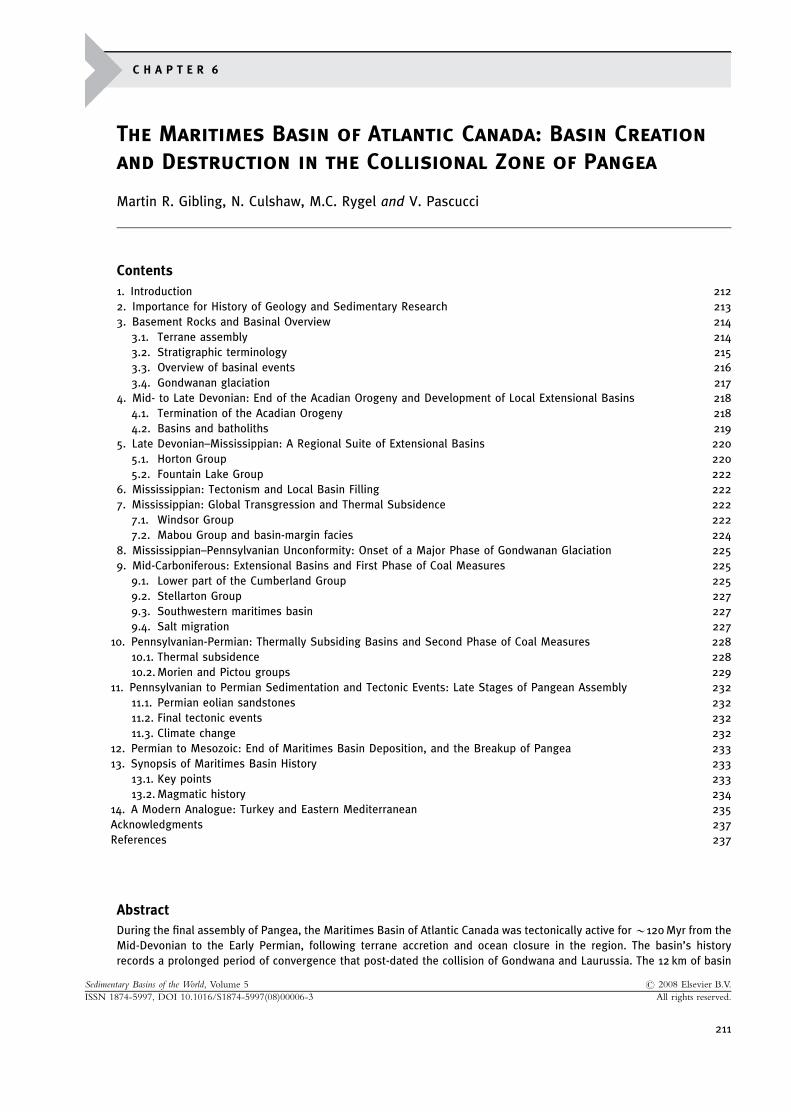
The Maritimes Basin comprises a complex suite of Upper Paleozoic strata that covers a large onshore andoffshore area of eastern Canada. As presently preserved, the basin extends about 1,700 km from southwesternNew Brunswick to the continental margin on the eastern Grand Banks, and about 1,000 km from the southernGrand Banks to offshore Labrador (Figure 1). The term ‘‘Maritimes Basin’’ has emerged as a collective term for acomplex stratal package up to 12 km thick that formed over a period of about 120 Myr within an active tectonicframework. Earlier workers recognized a series of variably connected or isolated depocenters (commonly
1 The Maritimes Basin of Atlantic Canada. Place names referred to in text: A, Antigonish; C, Cobequid Highlands;aledonia Highlands; CB, Cape Breton Island (Nova Scotia); H, Horton Blu¡; J, Joggins; LAB, Labrador; M, Miguasha;agdalen Islands (Que¤ bec); NF, Newfoundland; NB, New Brunswick; NS, mainland Nova Scotia; QUE, Que¤ bec. Fault: CCFZ, Cobequid --- Chedabucto Fault Zone; CFZ, Cabot Fault Zone; HFZ, Hollow Fault Zone. Basins (component depo-s of Maritimes Basin; circled): A, St. Anthony Basin; B, Bay St. George Basin; C, Cumberland Basin; CCP, Central Carbo-us Platform of New Brunswick; D, Deer Lake Basin; G, Gulf of St. Lawrence Basin; M, Moncton Basin; S, Sydney Basin;ellarton Basin; SM, St. Mary’s Basin; SMB, general area of South Mountain Batholith. Modi¢ed from Bell and Howie.
The Maritimes Basin of Atlantic Canada 213
considered ‘‘basins’’ in their own right: Figure 1), now fragmented or juxtaposed by contemporaneous and laterdeformation.
Positioned within the collisional zone between the landmasses of Laurussia and Gondwana, the MaritimesBasin records the closure of the Rheic Ocean in an equatorial latitude and the last stages of lithosphericconvergence that created the supercontinent of Pangea. The assembly of this part of Pangea represents the firstapplication of plate tectonics to the geological record (Wilson, 1966). Oceanic crust in the region was consumedduring the closure of the Iapetus Ocean in the Early Paleozoic, with a suture zone that runs through easternCanada, and the Maritimes Basin strata rest on continental crust of varying composition and age. Given thisdynamic tectonic setting, the complexity of the basin fill is not surprising. At least six basins of varied styledeveloped successively in various parts of the region, and the fills of several of them are superimposed locally,resulting in successive phases of basin subsidence and inversion, reactivation of tectonic lineaments, halokinesis,and erosion of earlier strata (St. Peter, 1993). This polycyclic basinal history has important consequences for thermalmaturation, diagenesis, and the migration of hydrocarbons and mineralizing fluids. The restless plates were inmotion again by the Late Permian, reactivating Upper Paleozoic lineaments as Pangea fragmented and theAtlantic Ocean began to open.
The present overview builds on comprehensive regional accounts (Bell and Howie, 1990; van de Poll et al.,1995), as well as local studies (particularly Knight, 1983; MacLean and Wade, 1992; St. Peter, 1993; Rehill, 1996;Calder, 1998; Giles and Utting, 1999; Pascucci et al., 2000). We emphasize the stratigraphy and detailed stratalarchitecture of three of the larger depocenters — the Cumberland, Gulf of St. Lawrence and Sydney basins(Figure 1) — and conclude by suggesting that Turkey and the eastern Mediterranean, situated between theconverging plates of Eurasia and Arabia, provides a partial modern analogue for the Maritimes Basin.
2. Importance for History of Geology and Sedimentary Research
Upper Paleozoic outcrops of the Maritimes Basin came to world attention in the 1840s and subsequentdecades, when Sir Charles Lyell, Sir William Logan, and Sir John Dawson described the remarkable seacliff sectionsand their fossils (Scott, 1998; Rygel and Shipley, 2005; Falcon-Lang and Calder, 2005; Calder, 2006), culminatingin Dawson’s comprehensive account of the region in Acadian Geology (1855). The hundreds of kilometers of coastalcliffs have resulted in the most complete exposures of Pennsylvanian coal measures anywhere in the world.In particular, the cliffs at Joggins with their splendid exposures of coals and standing trees were to Lyell whatthe Galapagos Islands were to Charles Darwin, as he unraveled the evolution of landscapes through time (Calder,2006). He subsequently considered Joggins to represent the world’s best exposure of Carboniferous coal measures(Lyell, 1871). Joggins was mentioned (although not named as such) by Darwin in Origin of Species, featuredprominently in the evolution debate of the late 1850s (Wilberforce, 1860), and is now a UNESCO World Heritagesite as the world’s iconic coal-measure section. Joggins was awarded UNESCO status in the summer of 2008.
Additionally, the Maritimes Basin contains the Upper Devonian UNESCO World Heritage site at Miguashain southern Quebec, which has yielded material for exhibits and teaching collections around the world. Firstfound by Abraham Gesner in 1842, the locality was rediscovered in 1879, and its remarkable fish faunas have beeninfluential in understanding the origins of tetrapods, ray-finned fishes and coelacanths, and the transition fromaquatic to terrestrial vertebrates (Schultze and Cloutier, 1996). The Maritimes Basin also contains some of theworld’s best preserved Devonian, Carboniferous, and Permian forested levels and root systems (Calder et al.,1996; Elick et al., 1998; Calder et al., 2006; Falcon-Lang, 2006), remarkable instances of sediment–vegetationinteraction (Rygel et al., 2004, 2006), and the earliest known reptile and land snail (at Joggins), entombed insidetree trunks or in seasonal waterholes (Lyell and Dawson, 1853; Falcon-Lang et al., 2004). The basin is also theonly known area where the tetrapod trackway record can be documented from the Devonian to the Permian(Hunt et al., 2004), and strata at Horton Bluff in Nova Scotia have yielded the world’s most complete assemblageof Tournaisian tetrapod material and trackways, providing key vertebrate information for the interval referred toas ‘‘Romer’s Gap’’. The basin also contains the first evidence for gregarious behavior in earth history, as groups oftetrapods moved around the only known forest of the early conifer Walchia (Van Allen et al., 2005).
The exceptional coastal exposures have allowed for detailed analysis of sequence development under theicehouse conditions of the Upper Paleozoic (e.g., Davies and Gibling, 2003; Giles and Boutilier, 2003; Giblinget al., 2004). The presence of rapidly subsiding extensional basins and regions affected by slow thermal subsidencehas permitted the investigation of tectonic, glacioeustatic, and climatic factors in high- and low-accommodationsettings, and the excellent floral record has allowed investigation of the influence of the developing lowland andupland vegetation cover and wildfire events on landscape evolution (Falcon-Lang, 2000, 2003a, 2003b, 2004;Falcon-Lang and Bashforth, 2004, 2005). A thick Mississippian evaporite succession with diapir fields, parts ofwhich are exposed in the cliffs, provides considerable insight into the effects of halokinesis on basin development
Martin R. Gibling et al.214
and sedimentation (Alsop et al., 2000; Waldron and Rygel, 2005). From an economic viewpoint, AbrahamGesner conducted the first extraction of kerosene in 1836 (Brice, 2002), major coalfields formerly supplied mostof Canada’s needs, hydrocarbons are produced locally, and the region currently produces large amounts of gypsumand rock salt.
3. Basement Rocks and Basinal Overview
3.1. Terrane assembly
Following the breakup of Rodinia in the Neoproterozoic, the southern edge of Laurentia was characterized by anirregular margin with salients and reentrants (Figure 8 in Chapter 1; Lavoie, Chapter 3, this volume), and along-strike variations in the margin’s geological history during the Paleozoic reflect this irregularity. Much of theMaritimes Basin lies within the Quebec Reentrant, between the New York and St. Lawrence promontories, andthis position may account for the roughly elliptical form of the preserved basinal strata (Figure 1).
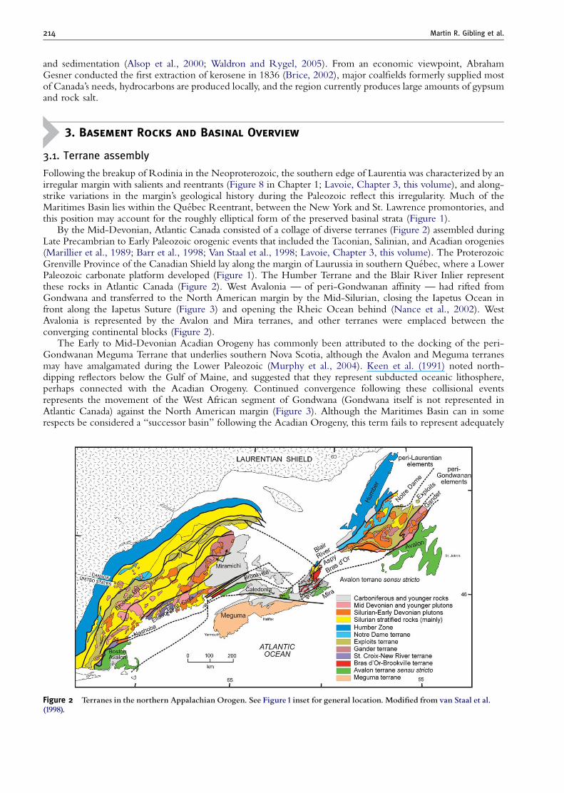
By the Mid-Devonian, Atlantic Canada consisted of a collage of diverse terranes (Figure 2) assembled duringLate Precambrian to Early Paleozoic orogenic events that included the Taconian, Salinian, and Acadian orogenies(Marillier et al., 1989; Barr et al., 1998; Van Staal et al., 1998; Lavoie, Chapter 3, this volume). The ProterozoicGrenville Province of the Canadian Shield lay along the margin of Laurussia in southern Quebec, where a LowerPaleozoic carbonate platform developed (Figure 1). The Humber Terrane and the Blair River Inlier representthese rocks in Atlantic Canada (Figure 2). West Avalonia — of peri-Gondwanan affinity — had rifted fromGondwana and transferred to the North American margin by the Mid-Silurian, closing the Iapetus Ocean infront along the Iapetus Suture (Figure 3) and opening the Rheic Ocean behind (Nance et al., 2002). WestAvalonia is represented by the Avalon and Mira terranes, and other terranes were emplaced between theconverging continental blocks (Figure 2).
The Early to Mid-Devonian Acadian Orogeny has commonly been attributed to the docking of the peri-Gondwanan Meguma Terrane that underlies southern Nova Scotia, although the Avalon and Meguma terranesmay have amalgamated during the Lower Paleozoic (Murphy et al., 2004). Keen et al. (1991) noted north-dipping reflectors below the Gulf of Maine, and suggested that they represent subducted oceanic lithosphere,perhaps connected with the Acadian Orogeny. Continued convergence following these collisional eventsrepresents the movement of the West African segment of Gondwana (Gondwana itself is not represented inAtlantic Canada) against the North American margin (Figure 3). Although the Maritimes Basin can in somerespects be considered a ‘‘successor basin’’ following the Acadian Orogeny, this term fails to represent adequately
Figure 2 Terranes in the northern Appalachian Orogen. See Figure1 inset for general location. Modi¢ed from van Staal et al.(1998).
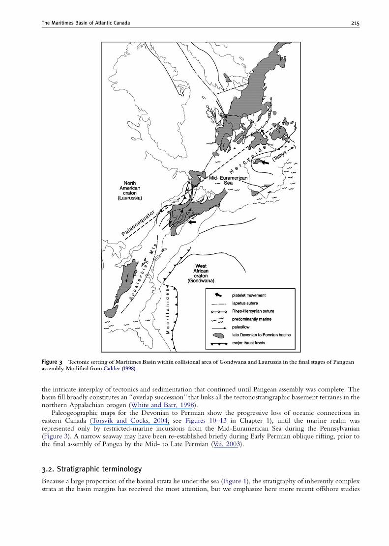
Figure 3 Tectonic setting of Maritimes Basin within collisional area of Gondwana and Laurussia in the ¢nal stages of Pangeanassembly. Modi¢ed from Calder (1998).
The Maritimes Basin of Atlantic Canada 215
the intricate interplay of tectonics and sedimentation that continued until Pangean assembly was complete. Thebasin fill broadly constitutes an ‘‘overlap succession’’ that links all the tectonostratigraphic basement terranes in thenorthern Appalachian orogen (White and Barr, 1998).
Paleogeographic maps for the Devonian to Permian show the progressive loss of oceanic connections ineastern Canada (Torsvik and Cocks, 2004; see Figures 10–13 in Chapter 1), until the marine realm wasrepresented only by restricted-marine incursions from the Mid-Euramerican Sea during the Pennsylvanian(Figure 3). A narrow seaway may have been re-established briefly during Early Permian oblique rifting, prior tothe final assembly of Pangea by the Mid- to Late Permian (Vai, 2003).
3.2. Stratigraphic terminology
Because a large proportion of the basinal strata lie under the sea (Figure 1), the stratigraphy of inherently complexstrata at the basin margins has received the most attention, but we emphasize here more recent offshore studies
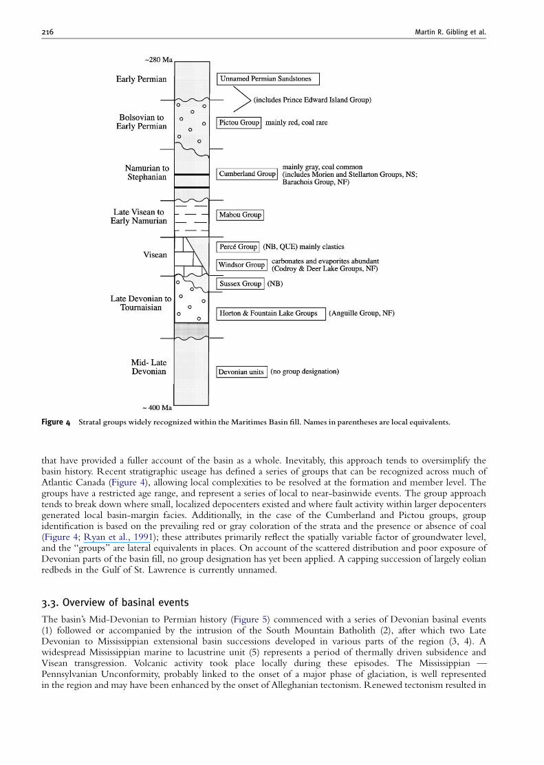
Figure 4 Stratal groups widely recognized within the Maritimes Basin ¢ll. Names in parentheses are local equivalents.
Martin R. Gibling et al.216
that have provided a fuller account of the basin as a whole. Inevitably, this approach tends to oversimplify thebasin history. Recent stratigraphic useage has defined a series of groups that can be recognized across much ofAtlantic Canada (Figure 4), allowing local complexities to be resolved at the formation and member level. Thegroups have a restricted age range, and represent a series of local to near-basinwide events. The group approachtends to break down where small, localized depocenters existed and where fault activity within larger depocentersgenerated local basin-margin facies. Additionally, in the case of the Cumberland and Pictou groups, groupidentification is based on the prevailing red or gray coloration of the strata and the presence or absence of coal(Figure 4; Ryan et al., 1991); these attributes primarily reflect the spatially variable factor of groundwater level,and the ‘‘groups’’ are lateral equivalents in places. On account of the scattered distribution and poor exposure ofDevonian parts of the basin fill, no group designation has yet been applied. A capping succession of largely eolianredbeds in the Gulf of St. Lawrence is currently unnamed.
3.3. Overview of basinal events
The basin’s Mid-Devonian to Permian history (Figure 5) commenced with a series of Devonian basinal events(1) followed or accompanied by the intrusion of the South Mountain Batholith (2), after which two LateDevonian to Mississippian extensional basin successions developed in various parts of the region (3, 4). Awidespread Mississippian marine to lacustrine unit (5) represents a period of thermally driven subsidence andVisean transgression. Volcanic activity took place locally during these episodes. The Mississippian —Pennsylvanian Unconformity, probably linked to the onset of a major phase of glaciation, is well representedin the region and may have been enhanced by the onset of Alleghanian tectonism. Renewed tectonism resulted in
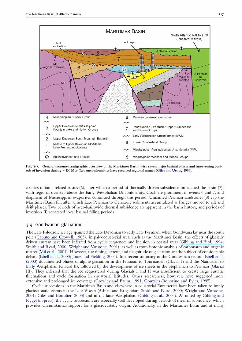
Figure 5 General tectono-stratigraphic overview of the Maritimes Basin, with seven major basinal phases and intervening peri-ods of inversion duringB130Myr.Two unconformities have received regional names (Giles and Utting,1999).
The Maritimes Basin of Atlantic Canada 217
a series of fault-related basins (6), after which a period of thermally driven subsidence broadened the basin (7),with regional overstep above the Early Westphalian Unconformity. Coals are prominent in events 6 and 7, anddiapirism of Mississippian evaporites continued through this period. Unnamed Permian sandstones (8) cap theMaritimes Basin fill, after which Late Permian to Cenozoic sediments accumulated as Pangea moved to rift anddrift phases. Two periods of near-basinwide thermal subsidence are apparent in the basin history, and periods ofinversion (I) separated local basinal filling periods.
3.4. Gondwanan glaciation
The Late Paleozoic ice age spanned the Late Devonian to early Late Permian, when Gondwana lay near the southpole (Caputo and Crowell, 1985). In paleoequatorial areas such as the Maritimes Basin, the effects of glaciallydriven eustasy have been inferred from cyclic sequences and incision in coastal areas (Gibling and Bird, 1994;Smith and Read, 2000; Wright and Vanstone, 2001), as well as from isotopic analysis of carbonates and organicmatter (Mii et al., 2001). However, the timing, extent, and magnitude of glaciation are the subject of considerabledebate (Isbell et al., 2003; Jones and Fielding, 2004). In a recent summary of the Gondwanan record, Isbell et al.(2003) documented phases of alpine glaciation in the Frasnian to Tournaisian (Glacial I) and the Namurian toEarly Westphalian (Glacial II), followed by the development of ice sheets in the Stephanian to Permian (GlacialIII). They inferred that the ice sequestered during Glacials I and II was insufficient to create large eustaticfluctuations and cycle formation in equatorial latitudes. Other researchers, however, have suggested moreextensive and prolonged ice coverage (Crowley and Baum, 1991; Gonzalez-Bonorino and Eyles, 1995).
Cyclic successions in the Maritimes Basin and elsewhere in equatorial Euramerica have been taken to implyglacioeustatic events in the Late Visean (Asbian and Brigantian: Smith and Read, 2000; Wright and Vanstone,2001; Giles and Boutilier, 2003) and in the later Westphalian (Gibling et al., 2004). As noted by Gibling andRygel (in press), the cyclic successions are especially well developed during periods of thermal subsidence, whichprovides circumstantial support for a glacioeustatic origin. Additionally, in the Maritimes Basin and at many
Martin R. Gibling et al.218
localities worldwide, an unconformity accompanied by a major biostratigraphic change lies at the Mississippian–Pennsylvanian boundary, and is widely interpreted to mark a major Gondwanan glacial period (equivalent toGlacial II but seemingly of considerable magnitude). This event was associated with profound sea-level loweringand continent-wide landscape exposure (Saunders and Ramsbottom, 1986; Beuthin, 1994), although theunconformities may be of tectonic origin in places (Ettensohn, 1994).
4. Mid- to Late Devonian: End of the Acadian Orogeny and Development of
Local Extensional Basins
4.1. Termination of the Acadian Orogeny
This period of the basin’s history has the most fragmentary record, but represents some 40 Myr (Figure 6) —about a third of the basin’s history. Small, poorly exposed, and tectonically disturbed areas of alluvial andlacustrine strata, with thick volcanic successions and some intrusions, are present in Nova Scotia and the GaspePeninsula of southern Quebec. The strata may have been laid down in small, fault-bounded basins alongreactivated tectonic lineaments, but no coherent model is available to account for their presence.
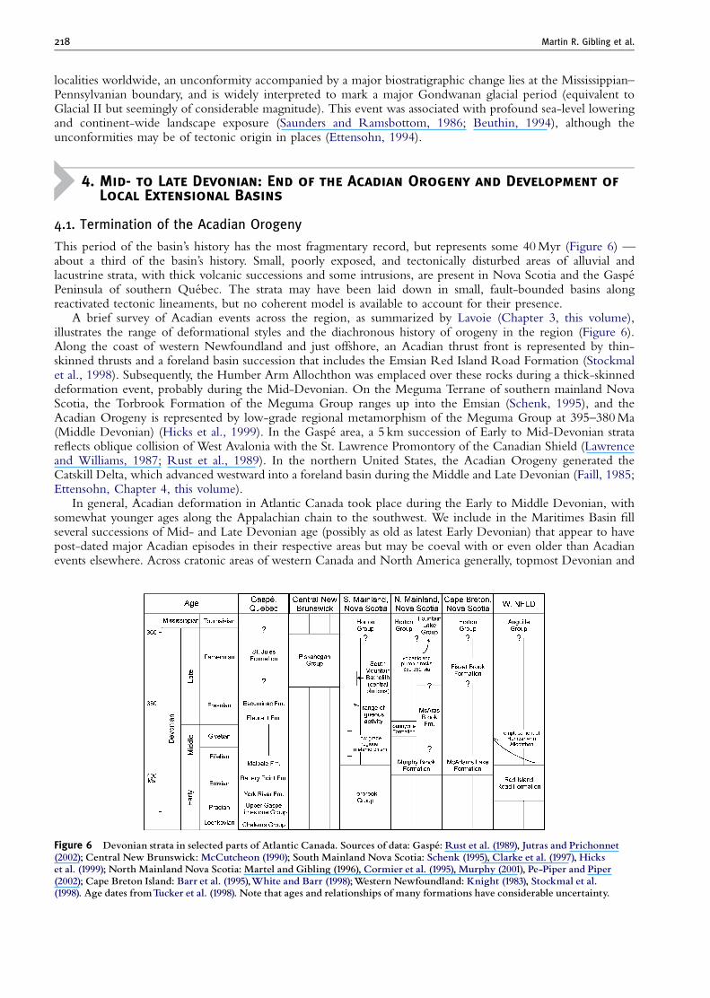
A brief survey of Acadian events across the region, as summarized by Lavoie (Chapter 3, this volume),illustrates the range of deformational styles and the diachronous history of orogeny in the region (Figure 6).Along the coast of western Newfoundland and just offshore, an Acadian thrust front is represented by thin-skinned thrusts and a foreland basin succession that includes the Emsian Red Island Road Formation (Stockmalet al., 1998). Subsequently, the Humber Arm Allochthon was emplaced over these rocks during a thick-skinneddeformation event, probably during the Mid-Devonian. On the Meguma Terrane of southern mainland NovaScotia, the Torbrook Formation of the Meguma Group ranges up into the Emsian (Schenk, 1995), and theAcadian Orogeny is represented by low-grade regional metamorphism of the Meguma Group at 395–380 Ma(Middle Devonian) (Hicks et al., 1999). In the Gaspe area, a 5 km succession of Early to Mid-Devonian stratareflects oblique collision of West Avalonia with the St. Lawrence Promontory of the Canadian Shield (Lawrenceand Williams, 1987; Rust et al., 1989). In the northern United States, the Acadian Orogeny generated theCatskill Delta, which advanced westward into a foreland basin during the Middle and Late Devonian (Faill, 1985;Ettensohn, Chapter 4, this volume).
In general, Acadian deformation in Atlantic Canada took place during the Early to Middle Devonian, withsomewhat younger ages along the Appalachian chain to the southwest. We include in the Maritimes Basin fillseveral successions of Mid- and Late Devonian age (possibly as old as latest Early Devonian) that appear to havepost-dated major Acadian episodes in their respective areas but may be coeval with or even older than Acadianevents elsewhere. Across cratonic areas of western Canada and North America generally, topmost Devonian and
Figure 6 Devonian strata in selected parts of Atlantic Canada. Sources of data: Gaspe¤ : Rust et al. (1989), Jutras and Prichonnet(2002); Central New Brunswick: McCutcheon (1990); South Mainland Nova Scotia: Schenk (1995), Clarke et al. (1997), Hickset al. (1999); North Mainland Nova Scotia: Martel and Gibling (1996), Cormier et al. (1995), Murphy (2001), Pe-Piper and Piper(2002); Cape Breton Island: Barr et al. (1995),White and Barr (1998);Western Newfoundland: Knight (1983), Stockmal et al.(1998). Age dates fromTucker et al. (1998). Note that ages and relationships of many formations have considerable uncertainty.
The Maritimes Basin of Atlantic Canada 219
Mississippian strata rest upon a major unconformity that marks the base of the Upper Kaskaskia sequence (Sloss,1963; Richards, 1989). In view of the active collisional setting of Atlantic Canada at this time, we have notattempted to reconcile events in the local stratigraphic succession with those documented from cratonic areaselsewhere.
4.2. Basins and batholiths
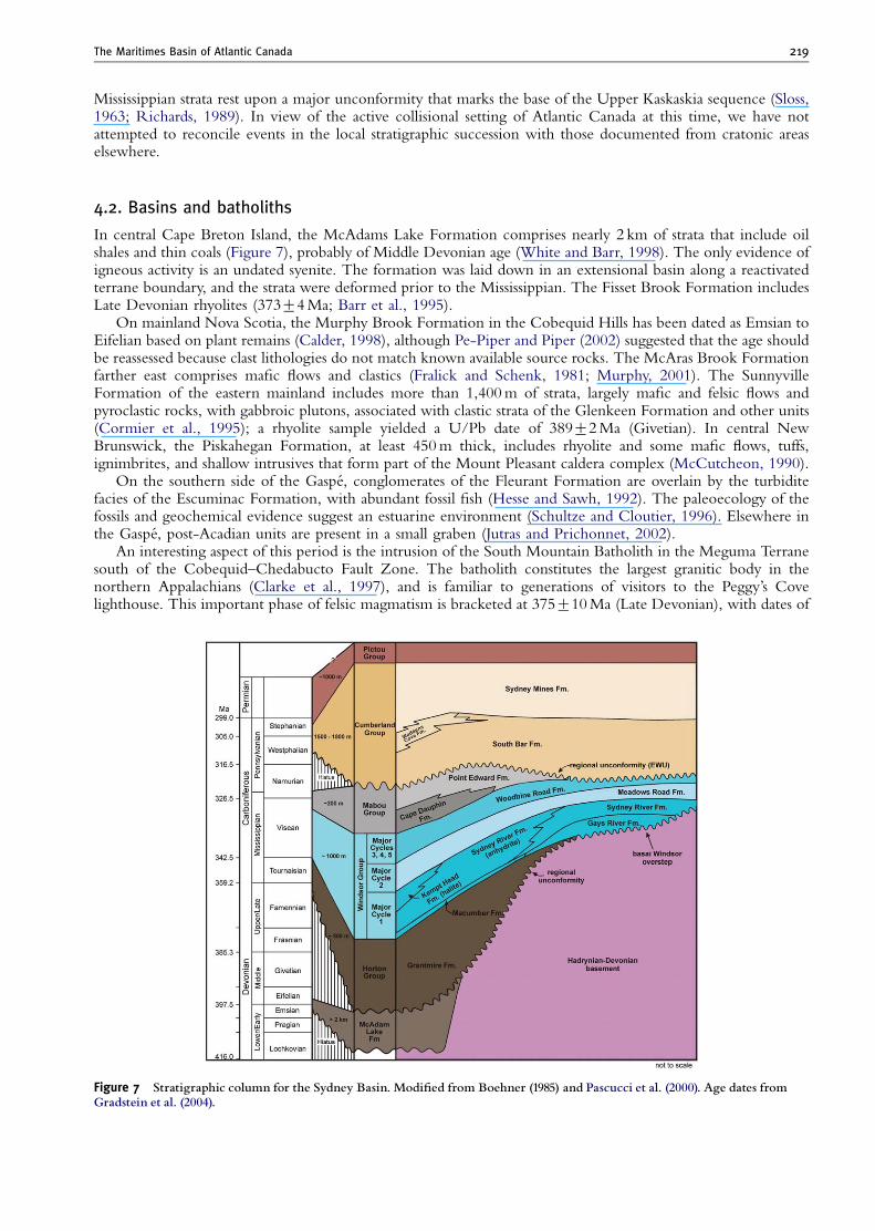
In central Cape Breton Island, the McAdams Lake Formation comprises nearly 2 km of strata that include oilshales and thin coals (Figure 7), probably of Middle Devonian age (White and Barr, 1998). The only evidence ofigneous activity is an undated syenite. The formation was laid down in an extensional basin along a reactivatedterrane boundary, and the strata were deformed prior to the Mississippian. The Fisset Brook Formation includesLate Devonian rhyolites (37374 Ma; Barr et al., 1995).
On mainland Nova Scotia, the Murphy Brook Formation in the Cobequid Hills has been dated as Emsian toEifelian based on plant remains (Calder, 1998), although Pe-Piper and Piper (2002) suggested that the age shouldbe reassessed because clast lithologies do not match known available source rocks. The McAras Brook Formationfarther east comprises mafic flows and clastics (Fralick and Schenk, 1981; Murphy, 2001). The SunnyvilleFormation of the eastern mainland includes more than 1,400 m of strata, largely mafic and felsic flows andpyroclastic rocks, with gabbroic plutons, associated with clastic strata of the Glenkeen Formation and other units(Cormier et al., 1995); a rhyolite sample yielded a U/Pb date of 38972 Ma (Givetian). In central NewBrunswick, the Piskahegan Formation, at least 450 m thick, includes rhyolite and some mafic flows, tuffs,ignimbrites, and shallow intrusives that form part of the Mount Pleasant caldera complex (McCutcheon, 1990).
On the southern side of the Gaspe, conglomerates of the Fleurant Formation are overlain by the turbiditefacies of the Escuminac Formation, with abundant fossil fish (Hesse and Sawh, 1992). The paleoecology of thefossils and geochemical evidence suggest an estuarine environment (Schultze and Cloutier, 1996). Elsewhere inthe Gaspe, post-Acadian units are present in a small graben (Jutras and Prichonnet, 2002).
An interesting aspect of this period is the intrusion of the South Mountain Batholith in the Meguma Terranesouth of the Cobequid–Chedabucto Fault Zone. The batholith constitutes the largest granitic body in thenorthern Appalachians (Clarke et al., 1997), and is familiar to generations of visitors to the Peggy’s Covelighthouse. This important phase of felsic magmatism is bracketed at 375710 Ma (Late Devonian), with dates of
Figure 7 Stratigraphic column for the Sydney Basin. Modi¢ed from Boehner (1985) and Pascucci et al. (2000). Age dates fromGradstein et al. (2004).
Martin R. Gibling et al.220
37273 (Famennian) for the main belt of plutons. Local plutons may range as late as 35771 Ma (Maclean et al.,2003), and mafic intrusions are present locally (Tate and Clarke, 1995). Although there is no direct evidence thatthe batholith had a volcanic expression, Clarke and Bogutyn (2003) suggested that oscillatory zoning in micasreflects rapid changes in pressure during eruptive phases; however, they noted that rhyolite fragments appear to beabsent from younger conglomerates that overlie the batholith. The felsic magmas were emplaced at about 12 kmdepth and were unroofed by the latest Famennian, prior to 359 Ma, implying very rapid exhumation — in theorder of 1 mm/year (Martel and Gibling, 1996; Clarke et al., 1997; Kontak et al., 2004). Despite the proximity ofthe batholith to coeval basins north of the fault, the relationship (if any) between igneous and basinal eventsremains obscure and, at the time of intrusion, the South Mountain Batholith may not have lain adjacent tonorthern Nova Scotia.
5. Late Devonian–Mississippian: A Regional Suite of Extensional Basins
5.1. Horton Group
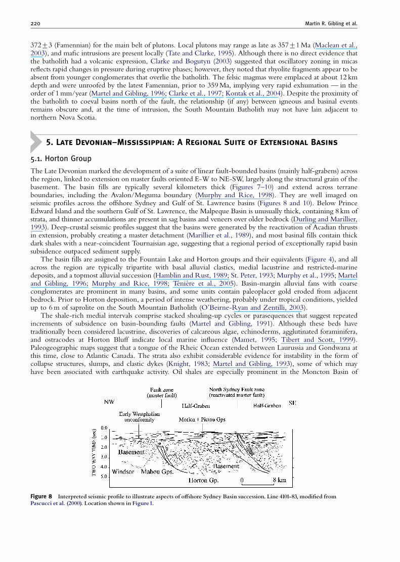
The Late Devonian marked the development of a suite of linear fault-bounded basins (mainly half-grabens) acrossthe region, linked to extension on master faults oriented E-W to NE-SW, largely along the structural grain of thebasement. The basin fills are typically several kilometers thick (Figures 7–10) and extend across terraneboundaries, including the Avalon/Meguma boundary (Murphy and Rice, 1998). They are well imaged onseismic profiles across the offshore Sydney and Gulf of St. Lawrence basins (Figures 8 and 10). Below PrinceEdward Island and the southern Gulf of St. Lawrence, the Malpeque Basin is unusually thick, containing 8 km ofstrata, and thinner accumulations are present in sag basins and veneers over older bedrock (Durling and Marillier,1993). Deep-crustal seismic profiles suggest that the basins were generated by the reactivation of Acadian thrustsin extension, probably creating a master detachment (Marillier et al., 1989), and most basinal fills contain thickdark shales with a near-coincident Tournaisian age, suggesting that a regional period of exceptionally rapid basinsubsidence outpaced sediment supply.
The basin fills are assigned to the Fountain Lake and Horton groups and their equivalents (Figure 4), and allacross the region are typically tripartite with basal alluvial clastics, medial lacustrine and restricted-marinedeposits, and a topmost alluvial succession (Hamblin and Rust, 1989; St. Peter, 1993; Murphy et al., 1995; Marteland Gibling, 1996; Murphy and Rice, 1998; Teniere et al., 2005). Basin-margin alluvial fans with coarseconglomerates are prominent in many basins, and some units contain paleoplacer gold eroded from adjacentbedrock. Prior to Horton deposition, a period of intense weathering, probably under tropical conditions, yieldedup to 6 m of saprolite on the South Mountain Batholith (O’Beirne-Ryan and Zentilli, 2003).
The shale-rich medial intervals comprise stacked shoaling-up cycles or parasequences that suggest repeatedincrements of subsidence on basin-bounding faults (Martel and Gibling, 1991). Although these beds havetraditionally been considered lacustrine, discoveries of calcareous algae, echinoderms, agglutinated foraminifera,and ostracodes at Horton Bluff indicate local marine influence (Mamet, 1995; Tibert and Scott, 1999).Paleogeographic maps suggest that a tongue of the Rheic Ocean extended between Laurussia and Gondwana atthis time, close to Atlantic Canada. The strata also exhibit considerable evidence for instability in the form ofcollapse structures, slumps, and clastic dykes (Knight, 1983; Martel and Gibling, 1993), some of which mayhave been associated with earthquake activity. Oil shales are especially prominent in the Moncton Basin of
Figure 8 Interpreted seismic pro¢le to illustrate aspects of o¡shore Sydney Basin succession. Line 4101-83, modi¢ed fromPascucci et al. (2000). Location shown in Figure1.
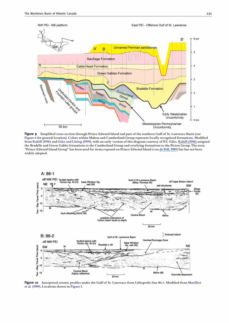
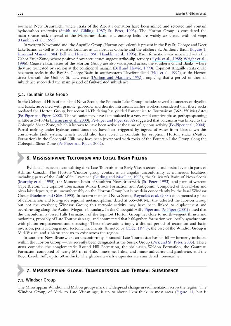
Figure 10 Interpreted seismic pro¢les under the Gulf of St. Lawrence from Lithoprobe line 86-1. Modi¢ed fromMarillieret al. (1989). Locations shown in Figure1.
Figure 9 Simpli¢ed cross-section through Prince Edward Island and part of the southern Gulf of St. Lawrence Basin (seeFigure 6 for general location). Colors within Mabou and Cumberland Group represent locally recognized formations. Modi¢edfrom Rehill (1996) and Giles and Utting (1999), with an early version of this diagram courtesy of P.S. Giles. Rehill (1996) assignedthe Bradelle and Green Gables formations to the Cumberland Group and overlying formations to the Pictou Group.The term‘‘Prince Edward Island Group’’ has been used for strata exposed on Prince Edward Island (van de Poll,1989) but has not beenwidely adopted.
The Maritimes Basin of Atlantic Canada 221
Martin R. Gibling et al.222
southern New Brunswick, where strata of the Albert Formation have been mined and retorted and containhydrocarbon reservoirs (Smith and Gibling, 1987; St. Peter, 1993). The Horton Group is considered themain source-rock interval of the Maritimes Basin, and outcrop belts are widely associated with oil seeps(Hamblin et al., 1995).
In western Newfoundland, the Anguille Group (Horton equivalent) is present in the Bay St. George and DeerLake basins, as well as at isolated localities as far north as Conche and the offshore St. Anthony Basin (Figure 1;Jansa and Mamet, 1984; Bell and Howie, 1990; Hamblin et al., 1995). Basin formation was associated with theCabot Fault Zone, where positive flower structures suggest strike-slip activity (Hyde et al., 1988; Wright et al.,1996). Coarse clastic facies of the Horton Group are also widespread across the southern Grand Banks, wherethey are truncated by erosion at the continental margin (Bell and Howie, 1990). Topmost Anguille strata onlapbasement rocks in the Bay St. George Basin in southwestern Newfoundland (Hall et al., 1992), as do Hortonstrata beneath the Gulf of St. Lawrence (Durling and Marillier, 1993), implying that a period of thermalsubsidence succeeded the main period of fault-related subsidence.
5.2. Fountain Lake Group
In the Cobequid Hills of mainland Nova Scotia, the Fountain Lake Group includes several kilometers of rhyoliteand basalt, associated with granitic, gabbroic, and dioritic intrusions. Earlier workers considered that these rockspredated the Horton Group, but recent U/Pb dating has yielded Famennian to Tournaisian (362–350 Ma) dates(Pe-Piper and Piper, 2002). The volcanics may have accumulated in a very rapid eruptive phase, perhaps spanningas little as 3–10 Ma (Dessureau et al., 2000). Pe-Piper and Piper (2002) suggested that volcanism was linked to theCobequid Shear Zone, which is known to have been active at the time of igneous activity (Pe-Piper et al., 2004).Partial melting under hydrous conditions may have been triggered by ingress of water from lakes down thiscrustal-scale fault system, which would also have acted as conduits for eruption. Horton strata (NuttbyFormation) in the Cobequid Hills may have been juxtaposed with rocks of the Fountain Lake Group along theCobequid Shear Zone (Pe-Piper and Piper, 2002).
6. Mississippian: Tectonism and Local Basin Filling
Evidence has been accumulating for a Late Tournaisian to Early Visean tectonic and basinal event in parts ofAtlantic Canada. The Horton/Windsor group contact is an angular unconformity at numerous localities,including parts of the Gulf of St. Lawrence (Durling and Marillier, 1993), the St. Mary’s Basin of Nova Scotia(Murphy et al., 1995), the Moncton Basin of southern New Brunswick (St. Peter, 1993), and parts of westernCape Breton. The topmost Tournaisian Wilkie Brook Formation near Antigonish, composed of alluvial-fan andplaya lake deposits, rests unconformably on the Horton Group but is overlain concordantly by the basal WindsorGroup (Boehner and Giles, 1993). In eastern mainland Nova Scotia, Reynolds et al. (2004) documented a phaseof deformation and low-grade regional metamorphism, dated at 335–340 Ma, that affected the Horton Groupbut not the overlying Windsor Group; this tectonic activity may have been linked to displacement andoverthrusting along the Avalon-Meguma boundary. In the Cobequid Hills, Piper and Pe-Piper (2001) noted thatthe unconformity-based Falls Formation of the topmost Horton Group lies close to north-vergent thrusts andmylonites, probably of Late Tournaisian age, and commented that half-graben formation was locally synchronouswith pluton emplacement and thrusting. These observations imply a distinct period of tectonism and basininversion, perhaps along major tectonic lineaments. As noted by Calder (1998), the base of the Windsor Group isMid-Visean, and a hiatus appears to exist across the region.
In southern New Brunswick, an unconformity-bounded, Late Tournaisian basinal fill — formerly includedwithin the Horton Group — has recently been designated as the Sussex Group (Park and St. Peter, 2005). Thesestrata comprise the conglomeratic Round Hill Formation, the shale-rich Weldon Formation, the GautreauFormation composed of nearly 500 m of shale, limestone, halite, and minor anhydrite and glauberite, and theBoyd Creek Tuff, up to 30 m thick. The glauberite-rich evaporites are considered non-marine.
7. Mississippian: Global Transgression and Thermal Subsidence
7.1. Windsor Group
The Mississippian Windsor and Mabou groups mark a widespread change in sedimentation across the region. TheWindsor Group, of Mid- to Late Visean age, is up to about 1 km thick in most areas (Figure 11, but is
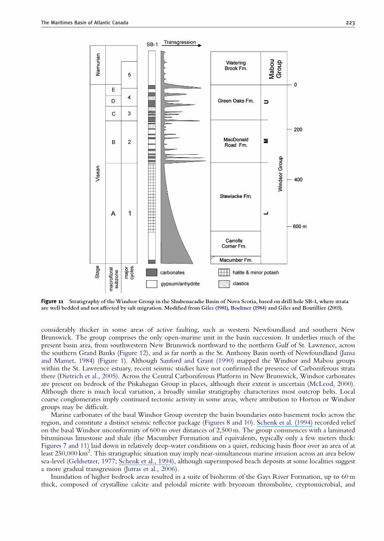
Figure 11 Stratigraphy of theWindsor Group in the Shubenacadie Basin of Nova Scotia, based on drill hole SB-1, where strataare well bedded and not a¡ected by salt migration. Modi¢ed from Giles (1981), Boehner (1984) and Giles and Boutillier (2003).
The Maritimes Basin of Atlantic Canada 223
considerably thicker in some areas of active faulting, such as western Newfoundland and southern NewBrunswick. The group comprises the only open-marine unit in the basin succession. It underlies much of thepresent basin area, from southwestern New Brunswick northward to the northern Gulf of St. Lawrence, acrossthe southern Grand Banks (Figure 12), and as far north as the St. Anthony Basin north of Newfoundland (Jansaand Mamet, 1984) (Figure 1). Although Sanford and Grant (1990) mapped the Windsor and Mabou groupswithin the St. Lawrence estuary, recent seismic studies have not confirmed the presence of Carboniferous stratathere (Dietrich et al., 2005). Across the Central Carboniferous Platform in New Brunswick, Windsor carbonatesare present on bedrock of the Piskahegan Group in places, although their extent is uncertain (McLeod, 2000).Although there is much local variation, a broadly similar stratigraphy characterizes most outcrop belts. Localcoarse conglomerates imply continued tectonic activity in some areas, where attribution to Horton or Windsorgroups may be difficult.
Marine carbonates of the basal Windsor Group overstep the basin boundaries onto basement rocks across theregion, and constitute a distinct seismic reflector package (Figures 8 and 10). Schenk et al. (1994) recorded reliefon the basal Windsor unconformity of 600 m over distances of 2,500 m. The group commences with a laminatedbituminous limestone and shale (the Macumber Formation and equivalents, typically only a few meters thick:Figures 7 and 11) laid down in relatively deep-water conditions on a quiet, reducing basin floor over an area of atleast 250,000 km2. This stratigraphic situation may imply near-simultaneous marine invasion across an area belowsea-level (Geldsetzer, 1977; Schenk et al., 1994), although superimposed beach deposits at some localities suggesta more gradual transgression (Jutras et al., 2006).
Inundation of higher bedrock areas resulted in a suite of bioherms of the Gays River Formation, up to 60 mthick, composed of crystalline calcite and peloidal micrite with bryozoan thrombolite, cryptomicrobial, and
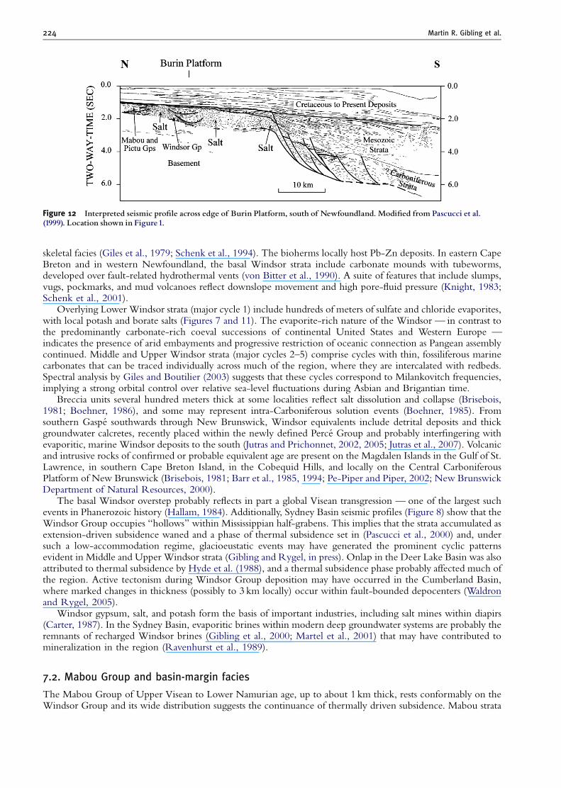
Figure 12 Interpreted seismic pro¢le across edge of Burin Platform, south of Newfoundland. Modi¢ed from Pascucci et al.(1999). Location shown in Figure1.
Martin R. Gibling et al.224
skeletal facies (Giles et al., 1979; Schenk et al., 1994). The bioherms locally host Pb-Zn deposits. In eastern CapeBreton and in western Newfoundland, the basal Windsor strata include carbonate mounds with tubeworms,developed over fault-related hydrothermal vents (von Bitter et al., 1990). A suite of features that include slumps,vugs, pockmarks, and mud volcanoes reflect downslope movement and high pore-fluid pressure (Knight, 1983;Schenk et al., 2001).
Overlying Lower Windsor strata (major cycle 1) include hundreds of meters of sulfate and chloride evaporites,with local potash and borate salts (Figures 7 and 11). The evaporite-rich nature of the Windsor — in contrast tothe predominantly carbonate-rich coeval successions of continental United States and Western Europe —indicates the presence of arid embayments and progressive restriction of oceanic connection as Pangean assemblycontinued. Middle and Upper Windsor strata (major cycles 2–5) comprise cycles with thin, fossiliferous marinecarbonates that can be traced individually across much of the region, where they are intercalated with redbeds.Spectral analysis by Giles and Boutilier (2003) suggests that these cycles correspond to Milankovitch frequencies,implying a strong orbital control over relative sea-level fluctuations during Asbian and Brigantian time.
Breccia units several hundred meters thick at some localities reflect salt dissolution and collapse (Brisebois,1981; Boehner, 1986), and some may represent intra-Carboniferous solution events (Boehner, 1985). Fromsouthern Gaspe southwards through New Brunswick, Windsor equivalents include detrital deposits and thickgroundwater calcretes, recently placed within the newly defined Perce Group and probably interfingering withevaporitic, marine Windsor deposits to the south (Jutras and Prichonnet, 2002, 2005; Jutras et al., 2007). Volcanicand intrusive rocks of confirmed or probable equivalent age are present on the Magdalen Islands in the Gulf of St.Lawrence, in southern Cape Breton Island, in the Cobequid Hills, and locally on the Central CarboniferousPlatform of New Brunswick (Brisebois, 1981; Barr et al., 1985, 1994; Pe-Piper and Piper, 2002; New BrunswickDepartment of Natural Resources, 2000).
The basal Windsor overstep probably reflects in part a global Visean transgression — one of the largest suchevents in Phanerozoic history (Hallam, 1984). Additionally, Sydney Basin seismic profiles (Figure 8) show that theWindsor Group occupies ‘‘hollows’’ within Mississippian half-grabens. This implies that the strata accumulated asextension-driven subsidence waned and a phase of thermal subsidence set in (Pascucci et al., 2000) and, undersuch a low-accommodation regime, glacioeustatic events may have generated the prominent cyclic patternsevident in Middle and Upper Windsor strata (Gibling and Rygel, in press). Onlap in the Deer Lake Basin was alsoattributed to thermal subsidence by Hyde et al. (1988), and a thermal subsidence phase probably affected much ofthe region. Active tectonism during Windsor Group deposition may have occurred in the Cumberland Basin,where marked changes in thickness (possibly to 3 km locally) occur within fault-bounded depocenters (Waldronand Rygel, 2005).
Windsor gypsum, salt, and potash form the basis of important industries, including salt mines within diapirs(Carter, 1987). In the Sydney Basin, evaporitic brines within modern deep groundwater systems are probably theremnants of recharged Windsor brines (Gibling et al., 2000; Martel et al., 2001) that may have contributed tomineralization in the region (Ravenhurst et al., 1989).
7.2. Mabou Group and basin-margin facies
The Mabou Group of Upper Visean to Lower Namurian age, up to about 1 km thick, rests conformably on theWindsor Group and its wide distribution suggests the continuance of thermally driven subsidence. Mabou strata
The Maritimes Basin of Atlantic Canada 225
cover much of the Central Carboniferous Platform in New Brunswick, resting mainly on pre-Carboniferousstrata (New Brunswick Department of Natural Resources, 2000). Hamblin (2001) considered these strata torepresent the final fill of the rift system within large distensive fault-bounded areas. A widespread transition isobserved from gray, shallow lacustrine facies (Hastings Formation) with lakes up to 200 km long and more than100 km wide, to red playa and floodplain deposits (Pomquet Formation), with calcretes and vertisols implying arelatively arid climate (Hamblin, 2001). The Pomquet Formation locally oversteps the Hastings Formation to reston Windsor and basement rocks (Boehner and Giles, 1993). Although the strata have been considered non-marine, Copeland (1957) and Calder (1998) presented faunal evidence, especially from ostracode taxa, for marineinfluence at some levels. The reduction in marine connection may reflect the onset of a major phase ofGondwanan glaciation and sea-level lowering, or could represent tectonic factors.
Although tectonic activity was generally minor, local conglomerate wedges in the Windsor Group implycontinued fault motion (Fralick and Schenk, 1981; Knight, 1983; Bradley and Bradley, 1986; Stevens et al.,1999). In the Mabou Group of southern New Brunswick, thick alluvial-fan conglomerates (Hopewell CapeFormation) and basinal equivalents, up to 2 km thick, indicate tectonic activity along the Harvey-Hopewell fault,with local onlap of Mabou strata onto older Carboniferous and basement rocks (St. Peter, 1993; C. St. Peter,personal communication). Formation of Mabou Group minibasins within the Cumberland Basin recordslocalized sediment accumulation in association with halokinesis (Waldron and Rygel, 2005), and these depositsbear striking similarity to the Mabou Group half-grabens described in Cape Breton Island (Hamblin, 2001).
8. Mississippian–Pennsylvanian Unconformity: Onset of a Major Phase of
Gondwanan Glaciation
A prominent unconformity caps the Mabou Group and cuts down into older strata at numerous localities.The unconformity is particularly well seen in the Sydney Basin (Figures 7 and 8), where seismic profiles indicate aregional erosional surface overlain by Duckmantian coal measures of the Morien Group (Pascucci et al., 2000).The surface is an angular unconformity with a few degrees of discordance, and most faults in the underlyingMississippian strata do not penetrate up into the overlying coal measures. Although the unconformity surface isbroadly planar, overlying fluvial strata fill a series of broad, linear valleys that follow the structural grain of theunderlying basement rocks.
The unconformity marks the most pronounced floral break in the Maritimes Carboniferous (Bell, 1944;Calder, 1998). Beneath Prince Edward Island and the Gulf of St. Lawrence, Rehill (1996) and Giles and Utting(1999) identified the Mississippian–Pennsylvanian Unconformity beneath the Namurian Cumberland Group(Figure 9). Elsewhere in the region, the unconformity is cryptic, but it has been identified beneath the Boss PointFormation (the basal Namurian to Langsettian unit of the Cumberland Group; Figure 13) in the Cumberland andMoncton basins (C. St. Peter, personal communication). The Boss Point Formation marks a fundamental changein the depositional system of the region, with alluvium covering progressively wider areas (Calder, 1998). Acomparable unconformity beneath Pennsylvanian coal measures is also present in the Narragansett Basin of NewEngland (Thompson and Hermes, 2003).
As noted earlier, unconformities at many localities worldwide probably represent the onset of a major glacialperiod, with regional lowering of base-level and widespread subaerial erosion (Beuthin, 1994), althoughtectonism associated with the onset of the Alleghanian Orogeny may have created unconformities at this level inthe Appalachian Basin (Ettensohn, 1994). In the Sydney Basin, the angular nature of the unconformity suggeststhat tectonic activity coincided with base-level change; the relatively young age of strata (Duckmantian–Bolsovian) that rest on the unconformity suggests that the surface represents more than one erosional period.Seismic lines from the Cumberland Basin reveal an angular unconformity between the Boss Point Formation andthe Mabou Group, although the angular relationship is not visible in outcrop; Waldron and Rygel (2005)attributed this feature to salt tectonism in the latest Mississippian to earliest Pennsylvanian.
9. Mid-Carboniferous: Extensional Basins and First Phase of Coal Measures
9.1. Lower part of the Cumberland Group
The basal strata of the Cumberland Group occupy basins along major fault zones, especially strands of the Cabot,Hollow, and Cobequid-Chedabucto Fault Zones, where subsidence and accumulation were rapid. Much of thefault motion had a strike-slip mode. Alluvial-fan deposits of the New Glasgow and Polly Brook formations(Figure 13) exceed 1 km in thickness adjacent to the Cobequid — Chedabucto Fault Zone (Calder, 1994;
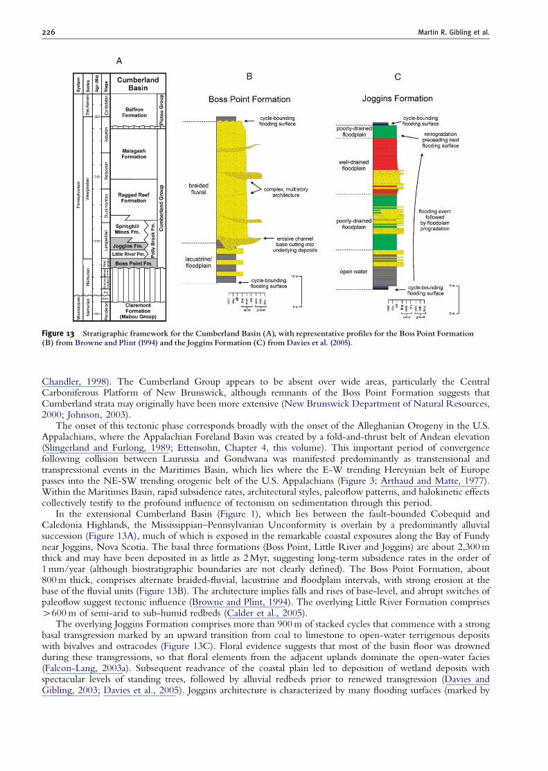
Figure 13 Stratigraphic framework for the Cumberland Basin (A), with representative pro¢les for the Boss Point Formation(B) from Browne and Plint (1994) and the Joggins Formation (C) from Davies et al. (2005).
Martin R. Gibling et al.226
Chandler, 1998). The Cumberland Group appears to be absent over wide areas, particularly the CentralCarboniferous Platform of New Brunswick, although remnants of the Boss Point Formation suggests thatCumberland strata may originally have been more extensive (New Brunswick Department of Natural Resources,2000; Johnson, 2003).
The onset of this tectonic phase corresponds broadly with the onset of the Alleghanian Orogeny in the U.S.Appalachians, where the Appalachian Foreland Basin was created by a fold-and-thrust belt of Andean elevation(Slingerland and Furlong, 1989; Ettensohn, Chapter 4, this volume). This important period of convergencefollowing collision between Laurussia and Gondwana was manifested predominantly as transtensional andtranspressional events in the Maritimes Basin, which lies where the E-W trending Hercynian belt of Europepasses into the NE-SW trending orogenic belt of the U.S. Appalachians (Figure 3; Arthaud and Matte, 1977).Within the Maritimes Basin, rapid subsidence rates, architectural styles, paleoflow patterns, and halokinetic effectscollectively testify to the profound influence of tectonism on sedimentation through this period.
In the extensional Cumberland Basin (Figure 1), which lies between the fault-bounded Cobequid andCaledonia Highlands, the Mississippian–Pennsylvanian Unconformity is overlain by a predominantly alluvialsuccession (Figure 13A), much of which is exposed in the remarkable coastal exposures along the Bay of Fundynear Joggins, Nova Scotia. The basal three formations (Boss Point, Little River and Joggins) are about 2,300 mthick and may have been deposited in as little as 2 Myr, suggesting long-term subsidence rates in the order of1 mm/year (although biostratigraphic boundaries are not clearly defined). The Boss Point Formation, about800 m thick, comprises alternate braided-fluvial, lacustrine and floodplain intervals, with strong erosion at thebase of the fluvial units (Figure 13B). The architecture implies falls and rises of base-level, and abrupt switches ofpaleoflow suggest tectonic influence (Browne and Plint, 1994). The overlying Little River Formation comprisesW600 m of semi-arid to sub-humid redbeds (Calder et al., 2005).
The overlying Joggins Formation comprises more than 900 m of stacked cycles that commence with a strongbasal transgression marked by an upward transition from coal to limestone to open-water terrigenous depositswith bivalves and ostracodes (Figure 13C). Floral evidence suggests that most of the basin floor was drownedduring these transgressions, so that floral elements from the adjacent uplands dominate the open-water facies(Falcon-Lang, 2003a). Subsequent readvance of the coastal plain led to deposition of wetland deposits withspectacular levels of standing trees, followed by alluvial redbeds prior to renewed transgression (Davies andGibling, 2003; Davies et al., 2005). Joggins architecture is characterized by many flooding surfaces (marked by
The Maritimes Basin of Atlantic Canada 227
coals, limestones and carbonaceous shales), and the open-water and wetland parts of the cycles are progradationalparasequence sets, with thin intervals of retrogradational parasequences below the base of the next cycle.Although the formation contains distributary, meandering and anastomosing fluvial deposits, there is noindication of large valley fills or mature paleosols through this thick stratal interval. This architectural stylesuggests that base-level rises were enhanced and base-level falls were suppressed as a result of rapid subsidence inthe high-accommodation setting of an active extensional basin (Davies and Gibling, 2003). Furthermore, onaccount of the rapid basinal subsidence, the fluvial channel deposits represent much of the natural geomorphicvariability of the original drainage network (Rygel and Gibling, 2006). Coeval strata of the Lancaster Formationcrop out at the Fern Ledges near St. John, New Brunswick, where fresh- and brackish-water assemblages includethe remains of arthropods, insects and arachnids (Falcon-Lang and Miller, 2007).
The overlying red alluvial deposits of the Springhill Mines Formation include thick coals, which onlap thealluvial-fan wedge of the Polly Brook Formation towards the Cobequid Highlands near Springhill (Calder, 1994).The topmost three formations are alluvial redbeds.
Fault-bounded basins with coal measures of similar age cover large areas below Prince Edward Island and theGulf of St. Lawrence and in western Cape Breton (Figure 9; Port Hood Formation: Giles et al., 1997), wherethey lie along the Hollow Fault Zone and include braided- and meandering-fluvial deposits with a richassemblage of continental trace fossils (Keighley and Pickerill, 1996, 2003). Coeval alluvial and lacustrine strataare also present in fault-bounded basins in southeastern Cape Breton (Boehner and Prime, 1993) and adjacent tothe Cabot Fault system in western Newfoundland (Barachois Group of Bay St. George Basin and Howley Beds ofthe Deer Lake Basin: Knight, 1983; Hyde et al., 1988), where several formations onlap basement rocks. ProbableBarachois equivalents nearly 1,500 m thick were mapped in the St. Anthony Basin (Bell and Howie, 1990).
9.2. Stellarton Group
A region of particular interest is the Stellarton Basin, an area of 20 km by 8 km, interpreted as a pull-apart basin ata releasing bend linking the Cobequid and Hollow Faults. Fault motion was mainly dextral along the Avalon —Meguma terrane boundary, located at the site of a right-handed stepover in the Cobequid-Chedabucto faultsystem (Yeo and Ruixiang, 1987; Naylor et al., 1989; St. Jean et al., 1993; Waldron, 2004). Within the basin area,3 km of Langsettian to Bolsovian and Asturian strata rest on highly deformed Mississippian rocks, and arelacustrine and fluvial, with coals up to 13 m thick and thick oil shales. Peat (coal precursor) accumulated especiallyin the northern part of the basin during periods of accelerated subsidence and sediment trapping in the south(Waldron, 2004). The strata show evidence for syn-sedimentary deformation in an extensional mode, andcomplex fault motions are indicated by patterns of stratal thickening at different levels. Higher members of theformation onlap basement. Thinner, coeval strata north of basin show northward paleoflow, suggesting either thatdrainage systems bypassed the basin or that the basin was later offset by fault motion.
Although the basin fill appears to lack marine fossils, tidal effects are shown by the occurrence of abundantpaired mud drapes at some levels (Costain, 2000), and restricted-marine biota are present in the Bolsovian toAsturian Malagash Formation north of Stellarton (Naylor et al., 1998). These observations suggest that tidalinfluence affected freshwater areas far inland, as in the modern Amazon Basin where tidal effects are experiencedat least 800 km inland (Archer, 2005).
9.3. Southwestern maritimes basin
In southwestern New Brunswick, Langsettian alluvial fans (Tynemouth Creek Formation) were shed as a result ofexhumation at a restraining bend of the Cobequid-Chedaducto Fault (Plint and van de Poll, 1982; Nance, 1987).Within the formation, a remarkable exhumed earthquake fault scarp testifies to syndepositional faulting (Plint,1985).
Evidence of tectonism during this period is also provided by bedrock areas in southwest Nova Scotia(Dallmeyer and Keppie, 1987, 1988; Culshaw and Liesa, 1997; Culshaw and Reynolds, 1997). In this region,a broad zone of deformation overprints the Acadian fold belt, reactivating folds and shear zones. The deformationis dated at about 320 Ma, and accommodated convergence-dominated transpression of the Meguma Zone againstan irregular Avalon boundary. Evidence for bedrock thrusting at about 329711 Ma is present near the CobequidFault (Waldron et al. 1989).
9.4. Salt migration
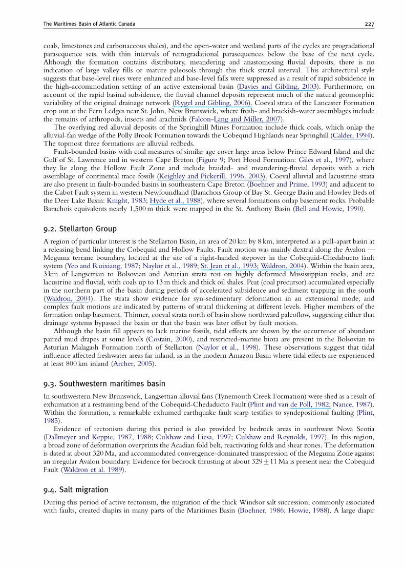
During this period of active tectonism, the migration of the thick Windsor salt succession, commonly associatedwith faults, created diapirs in many parts of the Maritimes Basin (Boehner, 1986; Howie, 1988). A large diapir
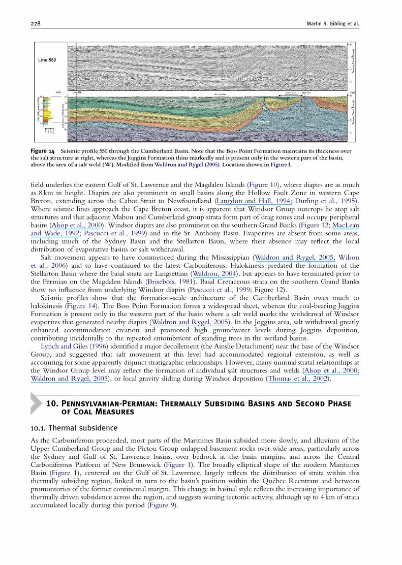
Figure 14 Seismic pro¢le 550 through the Cumberland Basin. Note that the Boss Point Formation maintains its thickness overthe salt structure at right, whereas the Joggins Formation thins markedly and is present only in the western part of the basin,above the area of a salt weld (W). Modi¢ed fromWaldron and Rygel (2005). Location shown in Figure1.
Martin R. Gibling et al.228
field underlies the eastern Gulf of St. Lawrence and the Magdalen Islands (Figure 10), where diapirs are as muchas 8 km in height. Diapirs are also prominent in small basins along the Hollow Fault Zone in western CapeBreton, extending across the Cabot Strait to Newfoundland (Langdon and Hall, 1994; Durling et al., 1995).Where seismic lines approach the Cape Breton coast, it is apparent that Windsor Group outcrops lie atop saltstructures and that adjacent Mabou and Cumberland group strata form part of drag zones and occupy peripheralbasins (Alsop et al., 2000). Windsor diapirs are also prominent on the southern Grand Banks (Figure 12; MacLeanand Wade, 1992; Pascucci et al., 1999) and in the St. Anthony Basin. Evaporites are absent from some areas,including much of the Sydney Basin and the Stellarton Basin, where their absence may reflect the localdistribution of evaporative basins or salt withdrawal.
Salt movement appears to have commenced during the Mississippian (Waldron and Rygel, 2005; Wilsonet al., 2006) and to have continued to the latest Carboniferous. Halokinesis predated the formation of theStellarton Basin where the basal strata are Langsettian (Waldron, 2004), but appears to have terminated prior tothe Permian on the Magdalen Islands (Brisebois, 1981). Basal Cretaceous strata on the southern Grand Banksshow no influence from underlying Windsor diapirs (Pascucci et al., 1999; Figure 12).
Seismic profiles show that the formation-scale architecture of the Cumberland Basin owes much tohalokinesis (Figure 14). The Boss Point Formation forms a widespread sheet, whereas the coal-bearing JogginsFormation is present only in the western part of the basin where a salt weld marks the withdrawal of Windsorevaporites that generated nearby diapirs (Waldron and Rygel, 2005). In the Joggins area, salt withdrawal greatlyenhanced accommodation creation and promoted high groundwater levels during Joggins deposition,contributing incidentally to the repeated entombment of standing trees in the wetland basins.
Lynch and Giles (1996) identified a major decollement (the Ainslie Detachment) near the base of the WindsorGroup, and suggested that salt movement at this level had accommodated regional extension, as well asaccounting for some apparently disjunct stratigraphic relationships. However, many unusual stratal relationships atthe Windsor Group level may reflect the formation of individual salt structures and welds (Alsop et al., 2000;Waldron and Rygel, 2005), or local gravity sliding during Windsor deposition (Thomas et al., 2002).
10. Pennsylvanian-Permian: Thermally Subsiding Basins and Second Phase
of Coal Measures
10.1. Thermal subsidence
As the Carboniferous proceeded, most parts of the Maritimes Basin subsided more slowly, and alluvium of theUpper Cumberland Group and the Pictou Group onlapped basement rocks over wide areas, particularly acrossthe Sydney and Gulf of St. Lawrence basins, over bedrock at the basin margins, and across the CentralCarboniferous Platform of New Brunswick (Figure 1). The broadly elliptical shape of the modern MaritimesBasin (Figure 1), centered on the Gulf of St. Lawrence, largely reflects the distribution of strata within thisthermally subsiding region, linked in turn to the basin’s position within the Quebec Reentrant and betweenpromontories of the former continental margin. This change in basinal style reflects the increasing importance ofthermally driven subsidence across the region, and suggests waning tectonic activity, although up to 4 km of strataaccumulated locally during this period (Figure 9).
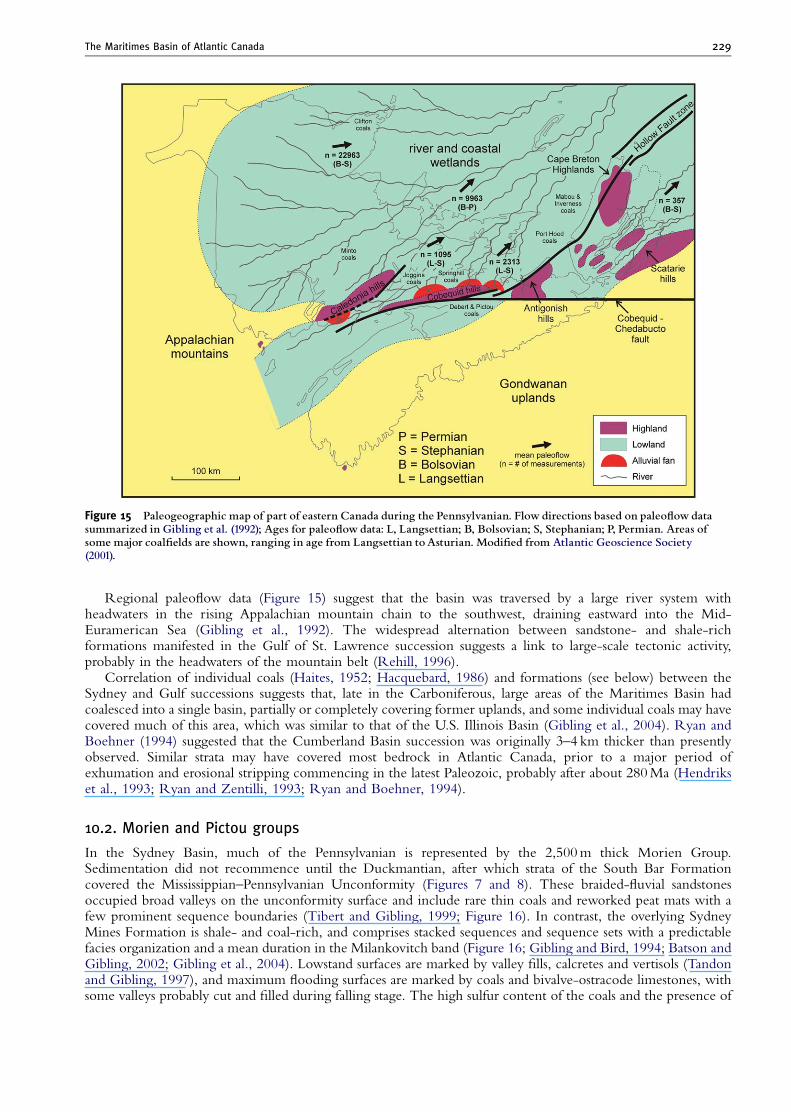
Figure 15 Paleogeographic map of part of eastern Canada during the Pennsylvanian. Flow directions based on paleo£ow datasummarized in Gibling et al. (1992); Ages for paleo£ow data: L, Langsettian; B, Bolsovian; S, Stephanian; P, Permian. Areas ofsome major coal¢elds are shown, ranging in age from Langsettian toAsturian. Modi¢ed from Atlantic Geoscience Society(2001).
The Maritimes Basin of Atlantic Canada 229
Regional paleoflow data (Figure 15) suggest that the basin was traversed by a large river system withheadwaters in the rising Appalachian mountain chain to the southwest, draining eastward into the Mid-Euramerican Sea (Gibling et al., 1992). The widespread alternation between sandstone- and shale-richformations manifested in the Gulf of St. Lawrence succession suggests a link to large-scale tectonic activity,probably in the headwaters of the mountain belt (Rehill, 1996).
Correlation of individual coals (Haites, 1952; Hacquebard, 1986) and formations (see below) between theSydney and Gulf successions suggests that, late in the Carboniferous, large areas of the Maritimes Basin hadcoalesced into a single basin, partially or completely covering former uplands, and some individual coals may havecovered much of this area, which was similar to that of the U.S. Illinois Basin (Gibling et al., 2004). Ryan andBoehner (1994) suggested that the Cumberland Basin succession was originally 3–4 km thicker than presentlyobserved. Similar strata may have covered most bedrock in Atlantic Canada, prior to a major period ofexhumation and erosional stripping commencing in the latest Paleozoic, probably after about 280 Ma (Hendrikset al., 1993; Ryan and Zentilli, 1993; Ryan and Boehner, 1994).
10.2. Morien and Pictou groups
In the Sydney Basin, much of the Pennsylvanian is represented by the 2,500 m thick Morien Group.Sedimentation did not recommence until the Duckmantian, after which strata of the South Bar Formationcovered the Mississippian–Pennsylvanian Unconformity (Figures 7 and 8). These braided-fluvial sandstonesoccupied broad valleys on the unconformity surface and include rare thin coals and reworked peat mats with afew prominent sequence boundaries (Tibert and Gibling, 1999; Figure 16). In contrast, the overlying SydneyMines Formation is shale- and coal-rich, and comprises stacked sequences and sequence sets with a predictablefacies organization and a mean duration in the Milankovitch band (Figure 16; Gibling and Bird, 1994; Batson andGibling, 2002; Gibling et al., 2004). Lowstand surfaces are marked by valley fills, calcretes and vertisols (Tandonand Gibling, 1997), and maximum flooding surfaces are marked by coals and bivalve-ostracode limestones, withsome valleys probably cut and filled during falling stage. The high sulfur content of the coals and the presence of
Figure 16 Model for the coal window in the cratonic Sydney Basin, with representative stratigraphic architecture for the SouthBar and Sydney Mines formations. Modi¢ed from concepts in Calder and Gibling (1994) and Gibling et al. (2004). SB ¼ sequenceboundary;TSTand HST ¼ transgressive and highstand systems tracts, respectively; mfs ¼ maximum £ooding surface.
Martin R. Gibling et al.230
restricted-marine, agglutinated foraminifera (Gibling and Wightman, 1994) and glaucony indicates a marineconnection for the basin. The presence of calcrete on lowstand surfaces implies relative aridity during periods oflowered sea-level, as in many regions during the Last Glacial Maximum of the Quaternary. Within Sydneysequences, Falcon-Lang (2004) documented a contrast between cordaitalean-dominated floras of valley fillsand dryland alluvial plains, which accumulated during glacial lowstand and early transgressive periods, andlycopsid-dominated floras of interglacial late transgressive and highstand periods, during which tropical rainforestsexpanded from their dry-phase refugia during the cool, dry glacial periods.
Based on available biostratigraphic information, sedimentation rates for much of the succession were less than0.2 mm/year (Gibling et al., 2004) — less than 20% of the estimated subsidence rate for the Cumberland Basinfill. Within this low-accommodation setting, glacioeustatic fluctuations generated by Late Paleozoic glaciationwould have exerted a strong influence on stratal architecture (Gibling and Rygel, in press), and peat accumulation
The Maritimes Basin of Atlantic Canada 231
largely reflects high-accommodation events generated during short periods of rapid sea-level rise (Gibling et al.,2004). Capping redbeds of the Pictou Group comprise the topmost Carboniferous and probably the Permian.The distribution of coal within the basin fill (the ‘‘coal window’’ of Calder and Gibling, 1994; Figure 16) reflectsa basin hydrology suitable for peat accumulation, high-accommodation events that promoted peat accumulationand preservation, and a progression to more arid climates that eventually precluded peat accumulation.
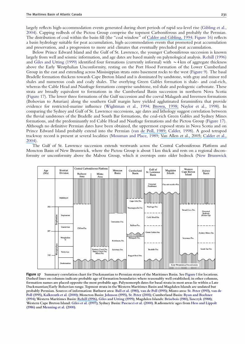
Below Prince Edward Island and the Gulf of St. Lawrence, the younger Carboniferous succession is knownlargely from well and seismic information, and age dates are based mainly on palynological analysis. Rehill (1996)and Giles and Utting (1999) identified four formations (currently informal) with B4 km of aggregate thicknessabove the Early Westphalian Unconformity, resting on the Port Hood Formation of the Lower CumberlandGroup in the east and extending across Mississippian strata onto basement rocks to the west (Figure 9). The basalBradelle formation thickens towards Cape Breton Island and is dominated by sandstone, with gray and minor redshales and numerous coals and coaly shales. The overlying Green Gables formation is shale- and coal-rich,whereas the Cable Head and Naufrage formations comprise sandstone, red shale and pedogenic carbonate. Thesestrata are broadly equivalent to formations in the Cumberland Basin succession in northern Nova Scotia(Figure 17). The lower three formations of the Gulf succession and the coeval Malagash and Inverness formations(Bolsovian to Asturian) along the southern Gulf margin have yielded agglutinated foraminifera that provideevidence for restricted-marine influence (Wightman et al., 1994; Brown, 1998; Naylor et al., 1998). Incomparing the Sydney and Gulf of St. Lawrence successions, age dates and lithology suggest correlation betweenthe fluvial sandstones of the Bradelle and South Bar formations, the coal-rich Green Gables and Sydney Minesformations, and the predominantly red Cable Head and Naufrage formations and the Pictou Group (Figure 17).Although no definitive Permian dates have been obtained, the uppermost exposed strata in Nova Scotia and onPrince Edward Island probably extend into the Permian (van de Poll, 1989; Calder, 1998). A good tetrapodtrackway record is present at several localities (Mossman and Place, 1989; Van Allen et al., 2005; Calder et al.,2004).
The Gulf of St. Lawrence succession extends westwards across the Central Carboniferous Platform andMoncton Basin of New Brunswick, where the Pictou Group is about 1 km thick and rests on a regional discon-formity or unconformity above the Mabou Group, which it oversteps onto older bedrock (New Brunswick
Figure 17 Summary correlation chart for Duckmantian to Permian strata of the Maritimes Basin. See Figure1 for locations.Dashed lines on columns indicate probable age of formation boundaries where reasonably well established; in other columns,formation names are placed opposite the most probable age. Palynomorph dates for basal strata in most areas lie within a LateDuckmantian/Early Bolsovian range.Topmost strata in theWestern Maritimes Basin and Magdalen Islands are undated butprobably Permian. Sources of information: Bathurst area: Ball et al. (1981), van de Poll (1995); Minto area: St. Peter (1993), van dePoll (1995), Kalkreuth et al. (2000); Moncton Basin: Johnson (1995), St. Peter (2001); Cumberland Basin: Ryan and Boehner(1994);Western Maritimes Basin: Rehill (1996), Giles and Utting (1999); Magdalen Islands: Brisebois (1981),Tanczyk (1988);Western Cape Breton Island: Giles et al. (1997); Sydney Basin: Pascucci et al. (2000). Radiometric ages from Hess and Lippolt(1986) and Menning et al. (2000).
Martin R. Gibling et al.232
Department of Natural Resources, 2000). Across this region, the Pictou Group is considered to include all strataabove a Late Duckmantian to Early Bolsovian unconformity (C. St.Peter, personal communication, 2005),and includes the important Minto Coal of Bolsovian age (Kalkreuth et al., 2000). Palynological analysis ofthese predominantly redbeds is difficult, but breaks may be present within the Pictou Group at some levels(C. St. Peter, personal communication, 2005). In seismic profiles, coal-measure intervals gradually lose theirdistinctive character westward from the Gulf towards New Brunswick, where they appear to pass into terrestrialstrata without coal.
In western Newfoundland, Bolsovian strata rest on basement, and alluvial-fan deposits have yieldedspectacular examples of reworked upland vegetation in the form of petrified cordaitalean logs nearly 2 m indiameter – the remains of early conifers that were almost 50 m high (Falcon-Lang and Bashforth, 2004, 2005).
11. Pennsylvanian to Permian Sedimentation and Tectonic Events: Late Stages
of Pangean Assembly
11.1. Permian eolian sandstones
Below Prince Edward Island and the eastern Gulf of St. Lawrence, 700 m of sandstone with minor red shale weretermed ‘‘Unnamed Permian Sandstones’’ by Giles and Utting (1999), and appear to overlie a profound localunconformity (Figure 9). On the nearby Magdalen Islands, the Cap-aux-Meules Formation includes nearly700 m of eolian sandstones of probable Permian age, resting on Windsor strata in outcrop and on the PictouGroup in offshore wells (Brisebois, 1981). The two rock units probably represent a distinct Permian phase ofaccumulation under arid conditions. The Gulf of St. Lawrence sandstones were penetrated in a series of wellsdrilled on or close to salt structures (Howie, 1988, Figure 10), and the Magdalen Island sandstones overlie diapirs.The locally deeply erosive base of the unit may reflect exhumation linked to salt tectonics.
11.2. Final tectonic events
Convergence associated with Pangean assembly continued in the central and southern U.S. Appalachians, as wellas in some parts of Atlantic Canada, during the latest Carboniferous and Permian. In the Sydney Basin, modestdifferential subsidence is recorded over basement structures (Gibling et al., 2002). More significantly, a phase oftranspressive deformation reactivated tectonic lineaments and affected the Morien and Pictou groups (Figure 8),probably reflecting a little-known Permian phase of deformation (the Donkin Episode: Pascucci et al., 2000;Gibling et al., 2002). The Stellarton Basin experienced late-stage shortening following extensional events,including generation of a positive flower structure, possibly in the Permian (Waldron, 2004), and Jutras et al.(2003) documented Alleghanian faulting, possibly of late stage, in Gaspe. This activity may have been linked torotation of lithospheric blocks during the final stages of Pangean assembly (Faure et al., 1996; Vai, 2003). Suchlate-stage deformation, as well as later Mesozoic structural events, may have influenced hydrocarbon trapping insome areas, for the majority of organic maturation took place much earlier, during maximum burial in thePennsylvanian and earliest Permian, and later deformation may have breached some reservoirs (Pascucci et al.,2000; Gibling et al., 2002).
Srivastava and Verhoef (1992) used geophysical data to reconstruct the final configuration of eastern Canada andwestern Europe prior to Atlantic rifting. Their maps place the Grand Banks adjacent to northwest Africa and Iberia.Although paleogeographic reconstructions for this region have been attempted (Ziegler, 1989), the correlation oftectonic lineaments, terranes and stratal groups between Atlantic Canada and adjacent areas is problematic, and nocomprehensive model currently explains the links between the two areas. Correlations are impeded because crucialareas of junction lie below the modern, offshore continental margin, and perhaps because Mesozoic to CenozoicAtlantic opening reactivated fundamental tectonic lineaments between the Grand Banks and Iberia, obscuring theirearlier history. Lefort et al. (1993) suggested that southwest-dipping features imaged in deep-crustal seismic linesacross the Grand Banks are a continuation of the Hercynian nappes of southwestern Europe.
11.3. Climate change
Calder (1998, Figure 5) presented a climate curve for the Maritimes Basin fill. As indicated by the presence ofcalcretes, vertisols and evaporites, semi-arid conditions prevailed during deposition of the Mississippian Horton,Visean and Mabou groups, continuing into the basal Namurian to Langsettian strata of the Cumberland Group.Subsequent more humid conditions are indicated by hydromorphic paleosols and coals, although climates
The Maritimes Basin of Atlantic Canada 233
probably remained strongly seasonal. Calcretes and vertisols, with eolian beds in the youngest basin fill, mark areturn to drier conditions in the Asturian through to the Permian.
The Maritimes Basin curve corresponds with a change in the U.S. Appalachian Basin from relatively aridMississippian conditions to more humid Pennsylvanian conditions with peat accumulation, to more arid topmostCarboniferous and Permian conditions (Phillips et al., 1985; Witzke, 1990). Such regional climatic changeprobably represents northward plate drift from the Late Devonian through to the Late Permian, whichprogressively shifted eastern North America from the southern hemisphere dryland zone in the Mississippian tothe equatorial zone in the Pennsylvanian, to the northern hemisphere dryland zone by the later Permian(Schutter and Heckel, 1985; Torsvik and Cocks, 2004). Additionally, monsoonal conditions would havedeveloped as Pangea assembled (Kutzbach and Gallimore, 1989).
12. Permian to Mesozoic: End of Maritimes Basin Deposition, and the
Breakup of Pangea
Pangea was not stable for long. Rift basins developed along pre-existing faults such as the Cobequid Fault,and were filled with thick Triassic and Jurassic sedimentary and volcanic successions. Although no age datesprecisely define the onset of rifting in Atlantic Canada, Olsen et al. (2000) suggested a Permian commencement,based on correlation between stratal successions in rift basins in New Brunswick and Morocco.
Rifting was accompanied by regional exhumation, as indicated by fission-track evidence for Triassic cooling(Gibling et al., 2002), and erosion of considerable thicknesses of Carboniferous to Permian strata. A morewidespread period of sedimentation began during the Cretaceous as rifting progressed to seafloor spreading, withlocal deposits laid down across Carboniferous rocks onshore and offshore in many parts of Atlantic Canada(Figure 12). In parts of mainland Nova Scotia, Cretaceous rivers flowed across a karstic terrain developed byprolonged weathering of Windsor group carbonates and evaporites (Falcon-Lang et al., 2007).
13. Synopsis of Maritimes Basin History
13.1. Key points
Maritimes Basin history shows several key features:
1. The collision of terranes and larger continental elements (Laurussia, Gondwana) was largely completed duringthe Acadian Orogeny, prior to or during the earliest part of the basin’s history. Subsidence and tectonic activitycontinued for B120 Myr thereafter.
2. Continental-scale fault zones, some with strike-slip mode, were active through much of the basin’s history, andcontrolled sedimentation locally.
3. Numerous phases of widespread or more local basin subsidence and inversion took place. Rapid alternation ofsubsidence and inversion implies a series of extensional and compressional periods, mostly affecting smallerdepocenters. Extension and compression appear to have been periodically coincident in local depocenters indifferent parts of the region, especially during the Mid-Devonian to Tournaisian. The duration of subsidencephases was a few million years to a few tens of millions of years. Such a dynamic environment would havecaused both creation and destruction of hydrocarbon reservoirs, if conditions for maturation were suitable.
4. The most active phases of basin subsidence represent extension along bounding faults, enhanced locally by saltwithdrawal. In addition, much of the region was affected by two periods of thermally driven subsidence,during which fault activity was less prominent. The two types of subsidence yielded distinctive styles ofstratigraphic architecture, and the basins filled largely with continental strata of alluvial-fan, alluvial plain,lacustrine and coastal facies.
5. Marine sediments are present at some levels, but seaways were restricted, as indicated by thick evaporites, thescarcity of open-marine biota, and the predominance of restricted-marine biota. Coastal and marine sequencesat several levels show evidence for Milankovitch control.
6. Volcanic activity (bimodal) and plutonic activity (largely granitic) were concentrated in the earlier period ofbasin history but continued episodically.
7. Long-term climatic variations were linked primarily to the region’s sustained northward drift.
At the largest scale, Atlantic Canada lay within a zone of dextral mega-shear during the terminal collision ofGondwana and Laurussia (Arthaud and Matte, 1977). Oblique convergence accounts for the strike-slip fault
Martin R. Gibling et al.234
system in the environs of the Maritimes Basin (Figures 12 and 13 in Chapter 1), passing southwestward into anextensive region of crustal thickening associated with Pennsylvanian to Permian deformation of the eastern U.S.Appalachians. The transition to this zone of crustal thickening may be encountered in the reworked zones ofsouthwest Nova Scotia, which were being ‘‘transpressed’’ in the Carboniferous at ca. 320 Ma (Culshaw andReynolds, 1997). The deformation style was ductile, and implies greater crustal thickness than in areas associatedwith basin development.
Maritimes Basin history occupied as much as B120 Myr during convergence that followed terrane accretionand ocean closure in the Acadian Orogeny, and most of the basin filling (Horton to Pictou groups, Figure 4) tookplace over 60–80 Myr, from the Late Devonian to the Early Permian. The process of closure and collision wasvariable along strike and probably strongly diachronous. Through this period, the orogen lay within acontinuously evolving dynamic boundary within a newly formed continental plate, and long-continuedconvergence must have affected both crustal and mantle lithosphere. One implication of this setting is that upper-crustal processes such as basin formation and faulting should have been linked with magmatism and thermaleffects originating in the converging lithospheric and asthenospheric mantle. We postulate that the extendedhistory of the Maritimes Basin, the style of individual basins, their relationship with strike-slip faulting, periodicinversion, and association with mafic and felsic magmatism find their origin in the dynamic environment of post-collisional convergence, in which the fate of the crust and mantle lithosphere are intimately linked. Thus, alithosphere-scale approach (Keppie and Dallmeyer, 1995) may be useful for understanding Late Paleozoic eventsin Atlantic Canada, and would account for sedimentation, magmatism, and deformation under a single umbrella.
Aspects of the late development of the Variscides of Europe have been explained in a similar way (Matte,1991). Along tectonic strike from the Maritimes Basin in the zone of convergence, they have a Carboniferous-Permian history of basin formation and similar bimodal magmatism. Henk (1999) showed that the diversesedimentary and magmatic phenomena could be explained as a result of lithospheric extension caused by acombination of gravitational forces and tectonic stresses — resulting, for example, from strike-slip faulting.Meissner (1999) interpreted reflection seismic data from the Variscides as evidence for extension in the lowercrust, implicitly supporting Henk’s hypothesis.
13.2. Magmatic history
How have igneous events in the history of the Maritimes Basin been explained, and how do they accord with thisscenario of prolonged convergence? Major igneous phases have been documented in the Mid-Devonian, LateDevonian, latest Devonian to Early Carboniferous, and Late Tournaisian to Early Visean, with minorPennsylvanian activity (Barr et al., 1985; Pe-Piper and Piper, 1998, 2002; Dessureau et al., 2000). Devonianvolcanics are present in New England (Thompson and Hermes, 2003). The mafic volcanics are predominantlycontinental tholeiite flood basalts, with a few younger alkalic volcanics. Stacked basalt flows are up to 1.5 kmthick (Dessureau et al., 2000), and the volcanic suite is bimodal, with rhyolites prominent in many volcanicsuccessions. Possible explanations adduced for these volcanic periods include mantle plumes, and rapidlithospheric thinning associated with crustal extension, during which magmas may have been emplaced alongfaults (Durling and Marillier, 1990; Dessureau et al., 2000; Pe-Piper and Piper, 2002). Marillier and Verhoef(1989) used geophysical evidence to infer that an underplated layer 10–20 km thick underlies part of theMaritimes Basin.
The South Mountain Batholith may have formed in a Late Devonian continental-margin arc to syncollisionalsetting during the docking of the Meguma Terrane (Tate and Clarke, 1995; Clarke et al., 1997) or duringsubsequent convergence (Murphy et al., 1999). The main central plutons have been taken to imply crustalthickening (Keppie and Dallmeyer, 1995), whereas the peripheral plutons with more associated mafic material(Tate and Clarke, 1995) may suggest crustal melting and hybridization, with mafic melts supplying heat (Clarkeet al., 1997). Murphy et al. (1999) suggested that Acadian and later convergence overrode a mantle plume,analogous to Laramide events in western North America.
A more comprehensive view of Maritimes Basin igneous activity draws upon analogues in orogenic belts ofvaried age. The common occurrence throughout geological time of bimodal magmatism in regions of post-collisional convergence, as well as late tectonic ‘‘granite blooms’’, seems to require a common mechanism thatfinds its origin in the ‘‘normal’’ behavior of continental lithosphere during and after collision, rather thanrequiring episodic plume activity or being restricted largely to extensional zones associated with faults. In zonesof post-collisional convergence, the lithosphere commonly experiences delamination, in which surficial crustalmaterial is separated from underlying mantle lithosphere. Sacks and Secor (1990) and Nelson (1992) inferred thatdelamination played an important role in the U.S. Appalachian Orogen, and Keppie and Dallmeyer (1995)suggested that delamination contributed to Maritimes Basin history. Delamination potentially allows largevolumes of mafic magma to be generated, with widespread heating of the overlying crust. During the Devonian
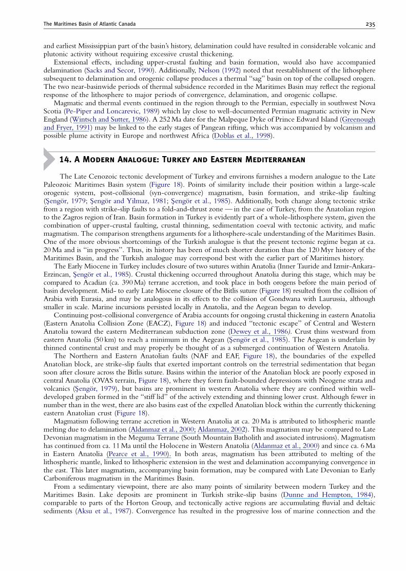
The Maritimes Basin of Atlantic Canada 235
and earliest Mississippian part of the basin’s history, delamination could have resulted in considerable volcanic andplutonic activity without requiring excessive crustal thickening.
Extensional effects, including upper-crustal faulting and basin formation, would also have accompanieddelamination (Sacks and Secor, 1990). Additionally, Nelson (1992) noted that reestablishment of the lithospheresubsequent to delamination and orogenic collapse produces a thermal ‘‘sag’’ basin on top of the collapsed orogen.The two near-basinwide periods of thermal subsidence recorded in the Maritimes Basin may reflect the regionalresponse of the lithosphere to major periods of convergence, delamination, and orogenic collapse.
Magmatic and thermal events continued in the region through to the Permian, especially in southwest NovaScotia (Pe-Piper and Loncarevic, 1989) which lay close to well-documented Permian magmatic activity in NewEngland (Wintsch and Sutter, 1986). A 252 Ma date for the Malpeque Dyke of Prince Edward Island (Greenoughand Fryer, 1991) may be linked to the early stages of Pangean rifting, which was accompanied by volcanism andpossible plume activity in Europe and northwest Africa (Doblas et al., 1998).
14. A Modern Analogue: Turkey and Eastern Mediterranean
The Late Cenozoic tectonic development of Turkey and environs furnishes a modern analogue to the LatePaleozoic Maritimes Basin system (Figure 18). Points of similarity include their position within a large-scaleorogenic system, post-collisional (syn-convergence) magmatism, basin formation, and strike-slip faulting(S-engor, 1979; S-engor and Yilmaz, 1981; S-engor et al., 1985). Additionally, both change along tectonic strikefrom a region with strike-slip faults to a fold-and-thrust zone — in the case of Turkey, from the Anatolian regionto the Zagros region of Iran. Basin formation in Turkey is evidently part of a whole-lithosphere system, given thecombination of upper-crustal faulting, crustal thinning, sedimentation coeval with tectonic activity, and maficmagmatism. The comparison strengthens arguments for a lithosphere-scale understanding of the Maritimes Basin.One of the more obvious shortcomings of the Turkish analogue is that the present tectonic regime began at ca.20 Ma and is ‘‘in progress’’. Thus, its history has been of much shorter duration than the 120 Myr history of theMaritimes Basin, and the Turkish analogue may correspond best with the earlier part of Maritimes history.
The Early Miocene in Turkey includes closure of two sutures within Anatolia (Inner Tauride and Izmir-Ankara-Erzincan, S-engor et al., 1985). Crustal thickening occurred throughout Anatolia during this stage, which may becompared to Acadian (ca. 390 Ma) terrane accretion, and took place in both orogens before the main period ofbasin development. Mid- to early Late Miocene closure of the Bitlis suture (Figure 18) resulted from the collision ofArabia with Eurasia, and may be analogous in its effects to the collision of Gondwana with Laurussia, althoughsmaller in scale. Marine incursions persisted locally in Anatolia, and the Aegean began to develop.
Continuing post-collisional convergence of Arabia accounts for ongoing crustal thickening in eastern Anatolia(Eastern Anatolia Collision Zone (EACZ), Figure 18) and induced ‘‘tectonic escape’’ of Central and WesternAnatolia toward the eastern Mediterranean subduction zone (Dewey et al., 1986). Crust thins westward fromeastern Anatolia (50 km) to reach a minimum in the Aegean (S-engor et al., 1985). The Aegean is underlain bythinned continental crust and may properly be thought of as a submerged continuation of Western Anatolia.
The Northern and Eastern Anatolian faults (NAF and EAF, Figure 18), the boundaries of the expelledAnatolian block, are strike-slip faults that exerted important controls on the terrestrial sedimentation that begansoon after closure across the Bitlis suture. Basins within the interior of the Anatolian block are poorly exposed incentral Anatolia (OVAS terrain, Figure 18), where they form fault-bounded depressions with Neogene strata andvolcanics (S-engor, 1979), but basins are prominent in western Anatolia where they are confined within well-developed graben formed in the ‘‘stiff lid’’ of the actively extending and thinning lower crust. Although fewer innumber than in the west, there are also basins east of the expelled Anatolian block within the currently thickeningeastern Anatolian crust (Figure 18).
Magmatism following terrane accretion in Western Anatolia at ca. 20 Ma is attributed to lithospheric mantlemelting due to delamination (Aldanmaz et al., 2000; Aldanmaz, 2002). This magmatism may be compared to LateDevonian magmatism in the Meguma Terrane (South Mountain Batholith and associated intrusions). Magmatismhas continued from ca. 11 Ma until the Holocene in Western Anatolia (Aldanmaz et al., 2000) and since ca. 6 Main Eastern Anatolia (Pearce et al., 1990). In both areas, magmatism has been attributed to melting of thelithospheric mantle, linked to lithospheric extension in the west and delamination accompanying convergence inthe east. This later magmatism, accompanying basin formation, may be compared with Late Devonian to EarlyCarboniferous magmatism in the Maritimes Basin.
From a sedimentary viewpoint, there are also many points of similarity between modern Turkey and theMaritimes Basin. Lake deposits are prominent in Turkish strike-slip basins (Dunne and Hempton, 1984),comparable to parts of the Horton Group, and tectonically active regions are accumulating fluvial and deltaicsediments (Aksu et al., 1987). Convergence has resulted in the progressive loss of marine connection and the
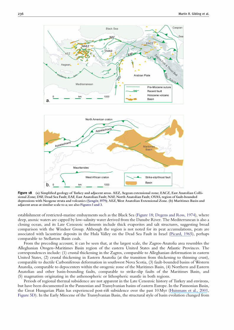
Figure 18 (a) Simpli¢ed geology of Turkey and adjacent areas. AEZ, Aegean extensional zone; EACZ, East Anatolian Colli-sional Zone; DSF, Dead Sea Fault; EAF, East Anatolian Fault; NAF, North Anatolian Fault; OVAS, region of fault-boundeddepressions with Neogene strata and volcanics (S-engoº r,1979); AEZ,West Anatolian Extensional Zone. (b) Maritimes Basin andadjacent areas at similar scale to a; see also Figures 1 and 3.
Martin R. Gibling et al.236
establishment of restricted-marine embayments such as the Black Sea (Figure 18; Degens and Ross, 1974), wheredeep, anoxic waters are capped by low-salinity water derived from the Danube River. The Mediterranean is also aclosing ocean, and its Late Cenozoic sediments include thick evaporites and salt structures, suggesting broadcomparison with the Windsor Group. Although the region is not noted for its peat accumulations, peats areassociated with lacustrine deposits in the Hula Valley on the Dead Sea Fault in Israel (Picard, 1965), perhapscomparable to Stellarton Basin coals.
From the preceding account, it can be seen that, at the largest scale, the Zagros-Anatolia area resembles theAlleghanian Orogen–Maritimes Basin region of the eastern United States and the Atlantic Provinces. Thecorrespondences include: (1) crustal thickening in the Zagros, comparable to Alleghanian deformation in easternUnited States, (2) crustal thickening in Eastern Anatolia (at the transition from thickening to thinning crust),comparable to ductile Carboniferous deformation in southwest Nova Scotia, (3) fault-bounded basins of WesternAnatolia, comparable to depocenters within the orogenic zone of the Maritimes Basin, (4) Northern and EasternAnatolian and other basin-bounding faults, comparable to strike-slip faults of the Maritimes Basin, and(5) magmatism originating in the asthenospheric or lithospheric mantle in both regions.
Periods of regional thermal subsidence are not apparent in the Late Cenozoic history of Turkey and environs,but have been documented in the Pannonian and Transylvanian basins of eastern Europe. In the Pannonian Basin,the Great Hungarian Plain has experienced post-rift subsidence over the past 10 Myr (Huismans et al., 2001,Figure 5D). In the Early Miocene of the Transylvanian Basin, the structural style of basin evolution changed from
The Maritimes Basin of Atlantic Canada 237
one of active, fault-related subsidence to a regime of strong subsidence that took place with only local activity ofmajor faults, allowing about 5 km of strata to accumulate in a 15–20 million year period (Huismans and Bertotti,2002). Although these basins lie in a back-arc setting, they may provide a partial analogue for the two regionalperiods of thermal subsidence experienced by the Maritimes Basin, each persisting through a few tens of millionsof years. Additionally, different parts of these eastern European basins have experienced simultaneous extensionand contraction.
ACKNOWLEDGMENTS
This paper has benefited enormously from comments and discussion with many colleagues over a prolonged period, especially SandraBarr, John Calder, Peter Giles, Rob Naylor, and Clint St. Peter. N. Culshaw thanks David Piper for discussions about the geology ofTurkey and environs. We are grateful to Ashton Embry and Andrew Miall for their comments on an earlier version of the manuscript, andto Andrew Miall for editorial assistance. We thank Sandra Barr for providing Figure 2, and Peter Giles for providing an early version ofFigure 9.
Funding was provided from Natural Sciences and Engineering Research Council of Canada grants to M. Gibling and N. Culshaw, andformative ideas arose during V. Pascucci’s tenure of a Killam Post-doctoral Fellowship at Dalhousie University. Recent research at Joggins,referred to in the text, was supported by grants from the American Chemical Society (Petroleum Research Fund) and Imperial Oil.
REFERENCES
Aksu, A. E., Piper, D. J. W., and Konuk, T., 1987, Quaternary growth patterns of Buyuk Menderes and Kuc- uk Menderes deltas, westernTurkey. Sedimentary Geology, v. 52, pp. 227–250.
Aldanmaz, E., 2002, Mantle source characteristics of alkali basalts and basanites in an extensional intracontinental plate setting, westernAnatolia, Turkey: implications for multi-stage melting. International Geology Reviews, v. 5, pp. 440–457.
Aldanmaz, E., Pearce, J. A., Thirlwall, M. F., and Mitchell, J. G., 2000, Petrogenetic evolution of Late Cenozoic, post-collision volcanismin western Anatolia, Turkey. Journal of Volcanology and Geothermal Research, v. 102, pp. 67–95.
Alsop, G. I., Brown, J. P., Davison, I., and Gibling, M. R., 2000, The geometry of drag zones adjacent to salt diapis. Journal of theGeological Society of London, v. 157, pp. 1019–1029.
Archer, A. W., 2005, Review of Amazonian depositional systems, in Blum, M. D., Marriott, S. B., and Leclair, S. F. eds., FluvialSedimentology VII. Blackwell Publishing, Oxford, UK, International Association of Sedimentologists (Special Publication 35),pp. 17–39.
Arthaud, F., and Matte, P., 1977, Late Palaeozoic strike-slip faulting in southern Europe and northern Africa: result of a right-lateral shearzone between the Appalachians and the Urals. Geological Society of America Bulletin, v. 88, pp. 1305–1320.
Atlantic Geoscience Society, 2001, The last billion years, Halifax, Canada, Nimbus Publishing, 212 pp.Ball, F. D., Sullivan, R. M., and Peach, A. R., 1981, Carboniferous drilling project: New Brunswick Department of Natural Resources,
Report of Investigation 18, 109 pp.Barr, S. M., Brisebois, D., and Macdonald, A. S., 1985, Carboniferous volcanic rocks of the Magdalen Islands, Gulf of St. Lawrence.
Canadian Journal of Earth Sciences, v. 22, pp. 1679–1688.Barr, S. M., Grammatikopoulos, A. L., and Dunning, G. R., 1994, Early Carboniferous gabbro and basalt in the St. Peters area, southern
Cape Breton Island, Nova Scotia. Atlantic Geology, v. 30, pp. 247–258.Barr, S. M., Raeside, R. P., Miller, B. V., and White, C. E., 1995, Terrane evolution and accretion in Cape Breton Island, Nova Scotia, in
Hibbard, J. P., van Staal, C. R., and Cawood, P. A. eds., Current perspectives in the Appalachian-Caledonian Orogen, GeologicalAssociation of Canada (Special Paper 41), pp. 391–407.
Barr, S. M., Raeside, R. P., and White, C. E., 1998, Geological correlations between Cape Breton Island and Newfoundland, northernAppalachian Orogen. Canadian Journal of Earth Sciences, v. 35, pp. 1252–1270.
Batson, P. A., and Gibling, M. R., 2002, Architecture of channel bodies and paleovalley fills in high-frequency Carboniferous sequences,Sydney Basin, Atlantic Canada. Bulletin of Canadian Petroleum Geology, v. 50, pp. 38–157.
Bell, W. A., 1944, Carboniferous rocks and fossil floras of northern Nova Scotia, Geological Survey of Canada, Memoir 238, 119 pp.Bell, J. S., and Howie, R. D., 1990, Paleozoic geology, in Keen, M. J. and Williams, G. L. eds., Geology of the continental margin of
eastern Canada, Geological Survey of Canada, Geology of Canada, pp. 141–165.Beuthin, J. D., 1994, A sub-Pennsylvanian paleovalley system in the Central Appalachian Basin and its implications for tectonic and
eustatic controls on the origin of the regional Mississippian-Pennsylvanian unconformity, in Dennison, J. M. and Ettensohn, F. R.eds., Tectonic and eustatic controls on sedimentary cycles, Society for Sedimentary Geology (SEPM), (Concepts in Sedimentologyand Paleontology 4), Tulsa, OK, pp. 107–120.
Boehner, R. C., 1984, Stratigraphy and depositional history of marine evaporites in the Windsor Group, Shubenacadie and MusquodoboitStructural Basins, Nova Scotia, Canada, in 9th International Congress of Carboniferous Stratigraphy and Geology, Compte Rendu,v. 3, pp. 163–178.
Boehner, R. C., 1985, Carboniferous basin studies, salt, potash, celestite and barite -new exploration potential in the Sydney Basin, CapeBreton Island, Nova Scotia Department of Mines and Energy, Report 85-1, pp. 153–164.
Boehner, R. C., 1986, Salt and potash resources in Nova Scotia, Nova Scotia Department of Mines and Energy, Bulletin 5, 346 pp.Boehner, R. C., and Giles, P. S., 1993, Geology of the Antigonish Basin, Antigonish County, Nova Scotia, Nova Scotia Department of
Natural Resources, Memoir 8, 109 pp.Boehner, R. C., and Prime, G., 1993, Geology of the Loch Lomond Basin and Glengarry Half Graben, Richmond and Cape Breton
Counties, Cape Breton Island, Nova Scotia, Nova Scotia Department of Natural Resources, Mines and Energy Branches, Memoir,v. 9, 68 pp.
Martin R. Gibling et al.238
Bradley, D. C., and Bradley, L. M., 1986, Tectonic significance of the Carboniferous Big Pond Basin, Cape Breton Island, Nova Scotia.Canadian Journal of Earth Sciences, v. 23, pp. 2000–2011.
Brice, W. R., 2002, Abraham Gesner (1797–1864)-A petroleum pioneer. Oil-Industry History, v. 3, pp. 72–80.Brisebois, D., 1981, Lithostratigraphie des strates Permo-carbonif eres de l’archipel des Iles de la Madeleine, Ministere de l’Energie
et des Ressources de Quebec, Report 796, 48 pp.Brown, J. P., 1998, Deformation and sedimentation adjacent to Carboniferous diapiric salt structures, Nova Scotia, Unpublished Ph.D.
thesis, Dalhousie University, Halifax, 486 pp.Browne, G. H., and Plint, A. G., 1994, Alternating braidplain and lacustrine deposition in a strike-slip setting: the Pennsylvanian Boss
Point Formation of the Cumberland Basin, Maritime Canada. Journal of Sedimentary Research, B, v. 64, pp. 40–59.Calder, J. H., 1994, The impact of climate change, tectonism and hydrology on the formation of Carboniferous tropical intermontane
mires: the Springhill coalfield, Cumberland Basin, Nova Scotia. Palaeogeography, Palaeoclimatology, Palaeoecology, v. 106,pp. 323–351.
Calder, J. H., 1998, The Carboniferous evolution of Nova Scotia, in Blundell, D. and Scott, A. C. eds., Lyell: the past is the key to thepresent, Geological Society of London (Special Publication 143), pp. 296–331.
Calder, J. H., 2006, Joggins and the lions of nineteenth century geology. Atlantic Geology, v. 42, pp. 37–51.Calder, J. H., and Gibling, M. R., 1994, The Euramerican Coal Province: controls on Late Paleozoic peat accumulation. Palaeogeography,
Palaeoclimatology, Palaeoecology, v. 106, pp. 1–21.Calder, J. H., Baird, D., and Urdang, E. B., 2004, On the discovery of tetrapod trackways from Permo-Carboniferous redbeds of Prince
Edward Island and their biostratigraphic significance. Atlantic Geology, v. 40, pp. 217–226.Calder, J. H., Gibling, M. R., Eble, C. F., Scott, A. C., and MacNeil, D. J., 1996, The Westphalian D fossil lepidodendrid forest at Table
Head, Sydney Basin, Nova Scotia: sedimentary, paleoecology and floral response to changing edaphic conditions. InternationalJournal of Coal Geology, v. 31, pp. 277–313.
Calder, J. H., Gibling, M. R., Scott, A. C., Davies, S. J., and Hebert, B. L., 2006, A fossil lycopsid forest succession in the classic Jogginssection of Nova Scotia: paleoecology of a disturbance-prone Pennsylvanian wetland, in Greb, S. F. and DiMichele, W. A. eds.,Wetlands through time, Geological Society of America (Special Paper 399), Boulder, CO, pp. 169–195.
Calder, J. H., Rygel, M. C., Ryan, R. J., Falcon-Lang, H. J., and Hebert, B. L., 2005, Stratigraphy and sedimentology of EarlyPennsylvanian red beds at Lower Cove, Nova Scotia, Canada: the Little River Formation with redefinition of the JogginsFormation. Atlantic Geology, v. 41, pp. 143–167.
Caputo, M. V., and Crowell, J. C., 1985, Migration of glacial centers across Gondwana during Paleozoic Era. Geological Society ofAmerica Bulletin, v. 96, pp. 1020–1036.
Carter, D. C., 1987, A three-dimensional view of the Pugwsh Salt Deposit, Cumberland County, Nova Scotia, pp. 133–139.Chandler, F. W., 1998, Geology of and climatic indicators in the Westphalian A New Glasgow formation, Nova Scotia, Canada:
implications for the genesis of coal and of sandstone-hosted lead deposits. Atlantic Geology, v. 34, pp. 39–56.Clarke, D. B., and Bogutyn, P. A., 2003, Oscillatory epitactic-growth zoning in biotite and muscovite from the Lake Lewis leucogranite,
South Mountain Batholith, Nova Scotia, Canada. The Canadian Mineralogist, v. 41, pp. 1027–1047.Clarke, D. B., MacDonald, M. A., and Tate, M. C., 1997, Late Devonian mafic-felsic magmatism in the Meguma Zone, Nova Scotia, in
Sinha, A. K., Whalen, J. B., and Hogan, J. P. eds., The nature of magmatism in the Appalachian Orogen, Geological Society ofAmerica, Memoir 191, Boulder, CO, pp. 107–127.
Copeland, M. J., 1957, The arthropod fauna of the Upper Carboniferous rocks of the Maritime Provinces, Geological Survey of Canada,Memoir 286, 64 pp.
Cormier, C. F. M., Barr, S. M., and Dunning, G. R., 1995, Geological setting and petrochemistry of early Middle Devonian volcanic andgabbroic rocks in the Guysborough area, Nova Scotia. Atlantic Geology, v. 31, pp. 153–166.
Costain, T., 2000, Stratigraphic analysis and possible tidal influence in the Thorburn Member and Coal Brook Member, StellartonFormation, Nova Scotia, Unpublished B.Sc. thesis, Dalhousie University, Halifax, 77 pp.
Crowley, T. J., and Baum, S. K., 1991, Estimating Carboniferous sea-level fluctuations from Gondwanan ice extent. Geology, v. 19,pp. 975–977.
Culshaw, N., and Liesa, M., 1997, Alleghanian reactivation of the Acadian fold belt, Meguma Zone, southwest Nova Scotia. CanadianJournal of Earth Sciences, v. 34, pp. 833–847.
Culshaw, N., and Reynolds, P., 1997, 40Ar/39Ar age of shear zones in the southwest Meguma Zone between Yarmouth and Meteghan,Nova Scotia. Canadian Journal of Earth Sciences, v. 34, pp. 848–853.
Dallmeyer, R. D., and Keppie, J. D., 1987, Polyphase Late Paleozoic tectonothermal evolution of the southwestern Meguma Terrane,Nova Scotia: evidence from 40Ar/39Ar mineral ages. Canadian Journal of Earth Sciences, v. 24, pp. 1242–1254.
Dallmeyer, R. D., and Keppie, J. D., 1988, Superposed Late Paleozoic thermal events in the southwestern Meguma Terrane, Nova Scotia.Maritime Sediments and Atlantic Geology, v. 24, pp. 157–169.
Davies, S. J., and Gibling, M. R., 2003, Architecture of coastal and alluvial deposits in an extensional basin: the Carboniferous JogginsFormation of eastern Canada. Sedimentology, v. 50, pp. 415–439.
Davies, S. J., Gibling, M. R., Rygel, M. C., Calder, J. H., and Skilliter, D. M., 2005, The Pennsylvanian Joggins Formationof Nova Scotia: sedimentological log and stratigraphic framework of the historic fossil cliffs. Atlantic Geology, v. 41,pp. 115–142.
Dawson, J. W., 1855, Acadian geology. 1st edn., Edinburgh, UK, Oliver and Boyd, 388 pp.Degens, E.T., and Ross, D.A., 1974, The Black Sea – geology, chemistry and biology, American Association of Petroleum Geologists,
Memoir 20, Tulsa, OK, 633 pp.Dessureau, G., Piper, D. J. W., and Pe-Piper, G., 2000, Geochemical evolution of earliest Carboniferous continental tholeiitic basalts along
a crustal-scale shear zone, southwestern Maritimes basin, eastern Canada. Lithos, v. 50, pp. 27–50.Dewey, J. F., Hempton, M. R., Kidd, W. S. F., Saroglu, F., and S-engor, A. M. C., 1986, Shortening of continental lithosphere: the
neotectonics of Eastern Anatolia – a young collision zone, in Coward, M. P. and Ries, A. C. eds., Collision tectonics, GeologicalSociety of London (Special Publication 19), pp. 3–36.
Dietrich, J. R., Grant, A. C., and Okulitch, A. V., 2005, Offshore Paleozoic bedrock geology in the St. Lawrence river estuary andnorthern Gulf of St. Lawrence, eastern Canada, Geological Association of Canada Annual Meeting, Abstracts, v. 50, p. 44.
The Maritimes Basin of Atlantic Canada 239
Doblas, M., Oyarzun, R., Lopez-Ruiz, J., Cebria, J. M., Youbi, N., Mahecha, V., Lago, M., Pocovi, A., and Cabanis, B., 1998, Permo-Carboniferous volcanism in Europe and northwest Africa: a superplume exhaust valve in the centre of Pangaea? Journal of AfricanEarth Sciences, v. 26, pp. 89–99.
Dunne, L. A., and Hempton, M. R., 1984, Deltaic sedimentation in the Lake Hazar pull-apart basin, south-eastern Turkey.Sedimentology, v. 31, pp. 401–412.
Durling, P. W., and Marillier, F. J. Y., 1990, Structural trends and basement rock subdivisions in the western Gulf of St. Lawrence, northernAppalachians. Atlantic Geology, v. 26, pp. 79–95.
Durling, P., and Marillier, F., 1993, Tectonic setting of Middle Devonian to Lower Carboniferous rocks in the Magdalen Basin. AtlanticGeology, v. 29, pp. 199–217.
Durling, P., Howells, K., and Harvey, P., 1995, The near-surface geology of St. Georges Bay, Nova Scotia: implications for the HollowFault. Canadian Journal of Earth Science, v. 32, pp. 603–613.
Elick, J. M., Driese, S. G., and Mora, C. I., 1998, Very large plant and root traces from the Early to Middle Devonian: Implications forearly terrestrial ecosystems and atmospheric p(CO2). Geology, v. 26, pp. 143–146.
Ettensohn, F. R., 1994, Tectonic control on formation and cyclicity of major Appalachian unconformities and associated stratigraphicsequences, in Dennison, J. M. and Ettensohn, F. R. eds., Tectonic and eustatic controls on sedimentary cycles, Society forSedimentary Geology (SEPM), (Concepts in Sedimentology and Paleontology 4), Tulsa, OK, pp. 217–242.
Ettensohn, F. R., this volume (Chapter 4), The Appalachian foreland basin in eastern United States, in Miall, A. D. ed., The sedimentarybasins of the United States and Canada.
Faill, R. T., 1985, The Acadian Orogeny and the Catskill Delta, in Woodrow, D. L. and Sevon, W. D. eds., The Catskill Delta, GeologicalSociety of America (Special Paper 201), pp. 15–37.
Falcon-Lang, H., 2000, Fire ecology of the Carboniferous tropical zone. Palaeogeography, Palaeoclimatology, Palaeoecology, v. 164,pp. 339–355.
Falcon-Lang, H. J., 2003a, Response of Late Carboniferous tropical vegetation to transgressive-regressive rhythms at Joggins, Nova Scotia.Journal of Geological Society of London, v. 160, pp. 643–647.
Falcon-Lang, H. J., 2003b, Late Carboniferous tropical dryland vegetation in an alluvial-plain setting, Joggins, Nova Scotia, Canada.Palaios, v. 18, pp. 197–211.
Falcon-Lang, H. J., 2004, Pennsylvanian tropical rain forests responded to glacial-interglacial rhythms. Geology, v. 32, pp. 689–692.Falcon-Lang, H. J., 2006, Latest Mid-Pennsylvanian tree-fern forests in retrograding coastal plain deposits, Sydney Mines Formation,
Nova Scotia, Canada. Journal of the Geological Society of London, v. 163, pp. 81–93.Falcon-Lang, H. J., and Bashforth, A. R., 2004, Pennsylvanian uplands were forested by giant cordaitalean trees. Geology, v. 32,
pp. 417–420.Falcon-Lang, H. J., and Bashforth, A. R., 2005, Morphology, anatomy, and upland ecology of giant cordaitalean trees from the Middle
Pennsylvanian of Newfoundland. Review of Palaeobotany and Palynology, v. 135, pp. 223–243.Falcon-Lang, H. J., and Calder, J. H., 2005, Sir William Dawson (1820–1899): a very modern palaeobotanist. Atlantic Geology, v. 41,
pp. 103–114.Falcon-Lang, H. J., and Miller, R. F., 2007, Palaeoenvironments and palaeoecology of the Early Pennsylvanian Lancaster Formation
(‘‘Fern Ledges’’) of Saint John, New Brunswick, Canada. Journal of the Geological Society of London, v. 164, pp. 1–13.Falcon-Lang, H. J., Fensome, R. A., Gibling, M. R., Malcolm, J., Fletcher, K. R., and Holleman, M., 2007, Karst-related outliers of the
Cretaceous Chaswood Formation of Maritime Canada. Canadian Journal of Earth Sciences, v. 44, pp. 619–642.Falcon-Lang, H. J., Rygel, M. C., Gibling, M. R., and Calder, J. H., 2004, An Early Pennsylvanian waterhole deposit and its fossil biota in
a dryland alluvial plain setting, Joggins, Nova Scotia. Journal of the Geological Society of London, v. 161, pp. 209–222.Faure, S., Tremblay, A., and Angelier, J., 1996, Alleghanian paleostress reconstruction in the northern Appalachians: Intraplate
deformation between Laurentia and Gondwana. Bulletin Geological Society of America, v. 108, pp. 1467–1480.Fralick, P. W., and Schenk, P. E., 1981, Molasse deposition and basin evolution in a wrench tectonic setting: the Late Paleozoic, eastern
Cumberland Basin, Maritime Canada, in Miall, A. D. ed., Sedimentation and tectonics in alluvial basins, Geological Association ofCanada (Special Paper 23), pp. 77–97.
Geldsetzer, H. H. J., 1977, The Windsor Group of Cape Breton Island, Nova Scotia, Geological Survey of Canada, Paper 77-1A,pp. 425–428.
Gibling, M. R., and Bird, D. J., 1994, Late Carboniferous cyclothems and alluvial paleovalleys in the Sydney Basin, Nova Scotia. BulletinGeological Society of America, v. 106, pp. 105–117.
Gibling, M. R., and Rygel, M. C., in press, Late Paleozoic cyclic strata of Euramerica: Recognition of Gondwanan glacial signaturesduring periods of thermal subsidence, in Fielding, C. R., Frank, T. D., and Isbell, J. L. eds., Resolving the Late PaleozoicGondwanan Ice Age in time and space, Geological Society of America (Special Paper), 441.
Gibling, M. R., and Wightman, W. G., 1994, Paleovalleys and protozoan assemblages in a Late Carboniferous cyclothem, Sydney Basin,Nova Scotia. Sedimentology, v. 41, pp. 699–719.
Gibling, M. R., Calder, J. H., Ryan, R., van de Poll, H. W., and Yeo, G. M., 1992, Late Carboniferous and Early Permian drainagepatterns in Atlantic Canada. Canadian Journal of Earth Sciences, v. 29, pp. 338–352.
Gibling, M. R., Langenberg, W., Kalkreuth, W. D., Waldron, J. W. F., Courtney, R., Paul, J., and Grist, A. M., 2002, Deformation ofUpper Carboniferous coal measures in the Sydney Basin: evidence for Late Alleghanian tectonism in Atlantic Canada. CanadianJournal of Earth Sciences, v. 39, pp. 79–93.
Gibling, M. R., Martel, A. T., Nguyen, M. H., Baechler, F., Shimeld, J., Forgeron, S., and MacKenzie, B., 2000, Fluid evolution anddiagenesis of a Carboniferous channel sandstone in the Prince Colliery, Nova Scotia, Canada. Bulletin of Canadian PetroleumGeology, v. 48, pp. 95–115.
Gibling, M. R., Saunders, K. I., Tibert, N. E., and White, J. A., 2004, Sequence sets, high-accommodation events and the coalwindow in the Carboniferous Sydney Basin, Atlantic Canada, in Pashin, J. C. and Gastaldo, R. A. eds., Sequence stratigraphy,paleoclimate, and tectonics of coal-bearing strata, American Association of Petroleum Geology (Studies in Geology 51), Tulsa, OK,pp. 169–197.
Giles, P. S., 1981, Major transgressive-regressive cycles in Middle to Late Visean rocks of Nova Scotia, Nova Scotia Department of Minesand Energy (Paper 81-2), 27 pp.
Martin R. Gibling et al.240
Giles, P. S., and Boutilier, R., 2003, Spectral analysis of degraded synthetic time series – Modelling spectra of the orbital periods from theLate Visean Windsor Group of Atlantic Canada, Geological Society of America, Northeastern Section Annual Meeting, Abstracts,v. 35, p. 11.
Giles, P. S., and Utting, J., 1999, Maritimes Basin stratigraphy – Prince Edward Island and adjacent Gulf of St. Lawrence, GeologicalSurvey of Canada, Open File 3732.
Giles, P. S., Boehner, R. C., and Ryan, R. J., 1979, Carbonate banks of the Gays River Formation in central Nova Scotia, Nova ScotiaDepartment of Mines (Paper 79–7), 57 pp.
Giles, P. S., Hein, F. J., and Allen, T. L., 1997, Bedrock geology of Port Hood-Lake Ainslie (11K04, 11K03, 11F13), Cape Breton Island,Nova Scotia (1:50 000 scale), Geological Survey of Canada, Open File 3252.
Gonzalez-Bonorino, G., and Eyles, N., 1995, Inverse relation between ice extent and the Late Paleozoic glacial record of Gondwana.Geology, v. 23, pp. 1015–1018.
Gradstein, F. M., Ogg, J. G., Smith, A. G., Bleeker, W., and Lourens, L. J., 2004, A new geologic time scale with special reference toPrecambrian and Neogene. Episodes, v. 27, pp. 83–100.
Greenough, J. D., and Fryer, B. J., 1991, Nd and Sr isotopic composition of the lamprophyric Malpeque Bay sill, Prince Edward Island.Canadian Mineralogist, v. 29, pp. 311–317.
Hacquebard, P. A., 1986, The Gulf of St. Lawrence Carboniferous Basin: the largest coalfield of Eastern Canada. Canadian Institute ofMining Bulletin, v. 79, pp. 67–78.
Haites, T. B., 1952, Some geological aspects of the Inverness County Coalfield in comparison with those of the Sydney Coalfield, in 2ndConference on the origin and constitution of coal, Crystal Cliffs, Nova Scotia, pp. 112–147.
Hall, J., Langdon, G., Roberts, B., Hawkins, D., Fagan, A., Knight, I., and Kilfoil, G., 1992, Reflection seismic imaging of theCarboniferous Bay St. George Subbasin, onshore western Newfoundland: a reappraisal of Paleozoic stratigraphic thickness. Bulletinof Canadian Petroleum Geology, v. 40, pp. 321–334.
Hallam, A., 1984, Pre-Quaternary sea-level changes. Annual Review Earth Planetary Science, v. 12, pp. 205–243.Hamblin, A. P., 2001, Stratigraphy, sedimentology, tectonics, and resource potential of the Lower Carboniferous Mabou Group, Nova
Scotia, Geological Survey of Canada, Bulletin 568, 164 pp.Hamblin, A. P., and Rust, B. R., 1989, Tectono-sedimentary analysis of alternate-polarity half-graben basin-fill successions: Late
Devonian-Early Carboniferous Horton Group, Cape Breton Island, Nova Scotia. Basin Research, v. 2, pp. 239–255.Hamblin, A. P., Fowler, M. G., Utting, J., Hawkins, D., and Riediger, C. L., 1995, Sedimentology, palynology and source rock potential
of Lower Carboniferous (Tournaisian) rocks, Conche area, Great Northern Peninsula, Newfoundland. Bulletin of CanadianPetroleum Geology, v. 43, pp. 1–19.
Hendriks, M., Jamieson, R. A., Willett, S. D., and Zentilli, M., 1993, Burial and exhumation of Long Range Inlier and its surroundings,western Newfoundland: results of an apatite fission-track study. Canadian Journal of Earth Sciences, v. 30, pp. 1594–1606.
Henk, A., 1999, Did the Variscides collapse or were they torn apart?: a quantitative evaluation of the driving forces for postconvergentextension in central Europe. Tectonics, v. 18, pp. 774–792.
Hess, J. C., and Lippolt, H. J., 1986, 40Ar/39Ar ages of tonsteins and tuff sanidines: new calibration points for the improvement of theUpper Carboniferous time scale. Chemical Geology, v. 59, pp. 143–154.
Hesse, R., and Sawh, H., 1992, Geology and sedimentology of the Upper Devonian Escuminac Formation, Quebec, and evaluation of itspaleoenvironment: lacustrine versus estuarine turbidite sequence. Atlantic Geology, v. 28, pp. 257–275.
Hicks, R. J., Jamieson, R. A., and Reynolds, P. H., 1999, Detrital and metamorphic 40Ar/39Ar ages from muscovite and whole-rocksamples, Meguma Supergroup, southern Nova Scotia. Canadian Journal of Earth Sciences, v. 36, pp. 23–32.
Howie, R. D., 1988, Upper Paleozoic evaporites of southeastern Canada, Geological Survey of Canada (Bulletin 380), 120 pp.Huismans, R. S., and Bertotti, G., 2002, The Transylvanian basin, transfer zone between coeval extending and contracting regions:
inferences on the relative importance of slab pull and rift push in arc-back arc systems. Tectonics, v. 21, pp. 1–20.Huismans, R. S., Podladchikov, Y. Y., and Cloetingh, S., 2001, Dynamic modeling of the transition from passive to active rifting,
application to the Pannonian basin. Tectonics, v. 20, pp. 1021–1039.Hunt, A. P., Lucas, S. G., Calder, J. H., van Allen, H. E. K., George, E., Gibling, M. R., Hebert, B. L., Mansky, C., and Reid, D., 2004,
Tetrapod footprints from Nova Scotia: the Rosetta Stone for Carboniferous tetrapod ichnology, Geological Society of America,Annual Meeting, Abstracts, v. 36, p. 66.
Hyde, R. S., Miller, H. G., Hiscott, R. N., and Wright, J. A., 1988, Basin architecture and thermal maturation in the strike-slip Deer LakeBasin, Carboniferous of Newfoundland. Basin Research, v. 1, pp. 85–105.
Isbell, J. L., Miller, M. F., Wolfe, K. L., and Lenaker, P. A., 2003, Timing of Late Paleozoic glaciation in Gondwana: was glaciationresponsible for the development of northern hemisphere cyclothems?, in Chan, M. A. and Archer, A. W. eds., Extreme depositionalenvironments: mega end members in geologic time, Geological Society of America (Special Publication 370), Boulder, CO,pp. 5–24.
Jansa, L. F., and Mamet, B. L., 1984, Offshore Visean of Eastern Canada: paleogeographic and plate tectonic implications: 9thInternational Congress of Carboniferous Stratigraphy and Geology, Compte Rendu, v. 3, pp. 205–214.
Johnson, S. C., 1995, A preliminary report on the stratigraphy of Late Namurian to Stephanian fluviatile strata in southeastern NewBrunswick, Geological Survey of Canada, Current Research 1995-E, pp. 313–320.
Johnson, S. C., 2003, Bedrock geology of the Marrtown area (part of 21 H/13), Kings and Queens counties, New Brunswick, NewBrunswick Department of Natural Resources, Minerals Policy and Planning Division, Plate 2003-3.
Jones, A. T., and Fielding, C. R., 2004, Sedimentological record of the Late Paleozoic glaciation in Queensland, Australia. Geology, v. 32,pp. 153–156.
Jutras, P., and Prichonnet, G., 2002, Stratigraphy, depositional setting, and diagenetic history of the Saint-Jules Formation (UpperDevonian or Mississippian), a newly identified post-Acadian red clastic unit in the southern Gaspe Peninsula, Quebec. CanadianJournal of Earth Sciences, v. 39, pp. 1541–1551.
Jutras, P., and Prichonnet, G., 2005, Record of Late Mississippian tectonics in the new Perce Group (Visean) of eastern Gaspesie, Quebec.Canadian Journal of Earth Sciences, v. 42, pp. 815–832.
Jutras, P., Prichonnet, G., and McCutcheon, S., 2003, Alleghanian faulting in the southern Gaspe Peninsula of Quebec. Atlantic Geology,v. 39, pp. 197–207.
The Maritimes Basin of Atlantic Canada 241
Jutras, P., Ryan, R. J., and Fitzgerald, R., 2006, Gradual encroachment of a rocky shoreline by an invasive sea during the Mississippian atthe southeastern margin of the Maritimes Basin, Nova Scotia, Canada. Canadian Journal of Earth Sciences, v. 43, pp. 1183–1204.
Jutras, P., Utting, J., and McLeod, J., 2007, Link between long-lasting evaporitic basins and the development of thick and massive phreaticcalcrete hardpans in the Mississippian Windsor and Perce groups of eastern Canada, Sedimentary Geology, v. 201, pp. 75–92.
Kalkreuth, W. D., Marchioni, D., and Utting, J., 2000, Petrology, palynology, coal facies, and depositional environments of anUpper Carboniferous coal seam, Minto Coalfield, New Brunswick, Canada. Canadian Journal of Earth Sciences, v. 37,pp. 1209–1228.
Keen, C. E., Kay, W. A., Keppie, D., Marillier, F., Pe-Piper, G., and Waldron, J. W. F., 1991, Deep seismic reflection data from the Bay ofFundy and Gulf of Maine: tectonic implications for the northern Appalachians. Canadian Journal of Earth Sciences, v. 28,pp. 1096–1111.
Keighley, D. G., and Pickerill, R. K., 1996, The evolution of fluvial systems in the Port Hood Formation (Upper Carboniferous), westernCape Breton Island, eastern Canada. Sedimentary Geology, v. 106, pp. 97–144.
Keighley, D. G., and Pickerill, R. K., 2003, Ichnocoenoses from the Carboniferous of eastern Canada and their implications for therecognition of ichnofacies in nonmarine strata. Atlantic Geology, v. 39, pp. 1–22.
Keppie, J. D., and Dallmeyer, R. D., 1995, Late Paleozoic collision, delamination, short-lived magmatism, and rapid denudation in theMeguma Terrane (Nova Scotia, Canada): constraints from 40Ar/39Ar isotopic data. Canadian Journal of Earth Sciences, v. 32,pp. 644–659.
Kontak, D. J., Ham, L. J., and Dunning, G., 2004, U-Pb dating of the Musquodoboit Batholith, southern Nova Scotia: evidence for aprotracted magmatic-hydrothermal event in a Devonian intrusion. Atlantic Geology, v. 40, pp. 207–216.
Knight, I., 1983, Geology of the Carboniferous Bay St. George Subbasin, western Newfoundland, Department of Mines and Energy,Mineral Development Division, Government of Newfoundland and Labrador, Memoir, v. 1, 358 pp.
Kutzbach, J. E., and Gallimore, R. G., 1989, Pangaean climates: Megamonsoons of the Megacontinent. Journal of Geophysical Research,v. 94, pp. 3341–3357.
Langdon, G. S., and Hall, J., 1994, Devonian-Carboniferous tectonic and basin deformation in the Cabot Strait area, Eastern Canada.American Association of Petroleum Geologists Bulletin, v. 78, pp. 1748–1774.
Lavoie, D., this volume (Chapter 3), Appalachian foreland basin of Canada, in Miall, A. D. ed., The sedimentary basins of the UnitedStates and Canada.
Lawrence, D. A., and Williams, B. P. J., 1987, Evolution of drainage systems in response to Acadian deformation: the Devonian BatteryPoint Formation, eastern Canada, in Ethridge, F. G., Flores, R. M., and Harvey, M. D. eds., Recent developments in fluvialsedimentology (Special Publication 39), Society of Economic Paleontologists and Mineralogists, pp. 287–300.
Lefort, J. P., Miller, H. G., and Wiseman, R., 1993, Reconstitution of east-facing Variscan nappes between the Grand Banks ofNewfoundland and Spain. Tectonophysics, v. 217, pp. 331–341.
Lyell, C., 1871, Elements of geology, New York, Harper, 640 pp.Lyell, C., and Dawson, J. W., 1853, On the remains of a reptile (Dendrerpeton acadianum Wyman and Owen), and of a land shell
discovered in the interior of an erect fossil tree in the coal measures of Nova Scotia. Quarterly Journal of the Geological Society ofLondon, v. 9, pp. 58–63.
Lynch, G., and Giles, P. S., 1996, The Ainslie Detachment: a regional flat-lying extensional fault in the Carboniferous evaporiticMaritimes Basin of Nova Scotia, Canada. Canadian Journal of Earth Science, v. 33, pp. 169–181.
MacLean, B. C., and Wade, J. A., 1992, Petroleum geology of the continental margin south of the islands of St. Pierre and Miquelon,offshore eastern Canada. Bulletin of Canadian Petroleum Geology, v. 40, pp. 222–253.
MacLean, N. J., Barr, S. M., White, C. E., and Ketchum, J. W. F., 2003, New U-Pb (zircon) age and geochemistry of the Wedgeportpluton, Meguma terrane, Nova Scotia. Atlantic Geology, v. 39, pp. 239–253.
Mamet, B., 1995, Hortonella uttingii, gen. nov., sp. nov., Udoteacees? (Algues vertes?) du Carbonifere inferieur. Canadian Journal of EarthSciences, v. 32, pp. 1267–1272.
Marillier, F., and Verhoef, J., 1989, Crustal thickness under the Gulf of St. Lawrence, northern Appalachians, from gravity and deepseismic data. Canadian Journal of Earth Sciences, v. 26, pp. 1517–1532.
Marillier, F., Keen, C. E., Stockmal, G. S., Quinlan, G., Williams, H., Colman-Sadd, S., and O’Brien, S., 1989, Crustal structure andsurface zonation of the Canadian Appalachians: implications of deep seismic reflection data. Canadian Journal of Earth Sciences,v. 26, pp. 305–321.
Martel, A. T., and Gibling, M. R., 1991, Wave-dominated lacustrine facies and tectonically controlled cyclicity in the LowerCarboniferous Horton Bluff Formation, Nova Scotia, Canada, in Anadon, P., Cabrera, L., and Kelts, K. eds., Lacustrine faciesanalysis, International Association of Sedimentologists (Special Publication 13), pp. 223–243.
Martel, A. T., and Gibling, M. R., 1993, Clastic dykes of the Devono-Carboniferous Horton Bluff Formation, Nova Scotia: storm-relatedstructures in shallow lakes. Sedimentary Geology, v. 87, pp. 103–119.
Martel, A. T., and Gibling, M. R., 1996, Stratigraphy and tectonic history of the Upper Devonian to Lower Carboniferous Horton BluffFormation, Nova Scotia. Atlantic Geology, v. 32, pp. 13–38.
Martel, A. T., Gibling, M. R., and Nguyen, M., 2001, Brines in the Carboniferous Sydney Coalfield, Atlantic Canada. AppliedGeochemistry, v. 16, pp. 35–55.
Matte, P., 1991, Accretionary history and crustal evolution of the Variscan belt in western Europe. Tectonophysics, v. 196, pp. 309–337.McCutcheon, S. R., 1990, The Late Devonian Mount Pleasant Caldera Complex: stratigraphy, mineralogy, geochemistry and geologic
setting of a Sn-W deposit in southwestern New Brunswick, Unpublished Ph.D. thesis, Dalhousie University, Halifax, 609 pp.McLeod, M. J., 2000, Geology of the Wickham area (NTS 21 G/09h), Queens and Kings counties, New Brunswick, New Brunswick
Department of Natural Resources and Energy, Minerals and Energy Division, Plate 2000–32.Meissner, R., 1999, Terrane accumulation and collapse in central Europe: seismic and rheological constraints. Tectonophysics, v. 305,
pp. 93–107.Menning, M., Weyer, D., Drozdzewski, G., Van Amerom, H. W. J., and Wendt, I., 2000, A Carboniferous time scale 2000: discussion and
use of geological parameters as time indicators from Central and Western Europe. Geologische Jahrbuch, v. A156, pp. 3–44.Mii, H.-S., Grossman, E. L., Yancey, T. E., Chuvashov, B., and Egorov, A., 2001, Isotopic records of brachiopod shells from the Russian
Platform – evidence for the onset of Mid-Carboniferous glaciation. Chemical Geology, v. 175, pp. 133–147.
Martin R. Gibling et al.242
Mossman, D. J., and Place, C. H., 1989, Early Permian fossil vertebrate footprints and their stratigraphic setting in megacyclic sequence IIred beds, Prim Point, Prince Edward Island. Canadian Journal of Earth Sciences, v. 26, pp. 591–605.
Murphy, J. B., 2001, Geochemistry, provenance, and tectonic significance of sedimentary rocks of the Middle to Late Devonian McArrasBrook and Visean Martin Road formations, Merigomish Subbasin, northern Antigonish Highlands, Nova Scotia. Atlantic Geology,v. 37, pp. 161–173.
Murphy, J. B., and Rice, R. J., 1998, Stratigraphy and depositional environment of the Horton Group in the St. Marys Basin, centralmainland Nova Scotia. Atlantic Geology, v. 34, pp. 1–25.
Murphy, J. B., Fernandez-Suarez, J., Keppie, J. D., and Jeffries, T. E., 2004, Contiguous rather than discrete Paleozoic histories for theAvalon and Meguma terranes based on detrital zircon data. Geology, v. 32, pp. 585–588.
Murphy, J. B., Rice, R. J., Stokes, T. R., and Keppie, D. F., 1995, St. Marys Basin, central mainland Nova Scotia: Late Paleozoic basinformation and deformation along the Avalon-Meguma terrane boundary, Canadian Appalachians, in Hibbard, J. P., van Staal,C. R., and Cawood, P. A. eds., Current perspectives in the Appalachian-Caledonian Orogen, Geological Association of Canada(Special Paper 41), pp. 409–420.
Murphy, J. B., van Staal, C. R., and Keppie, J. D., 1999, Middle to Late Paleozoic Acadian Orogeny in the northern Appalachians: aLaramide-style plume-modified orogeny? Geology, v. 27, pp. 653–656.
Nance, R. D., 1987, Dextral transpression and Late Carboniferous sedimentation in the Fundy Coastal Zone of southern New Brunswick,in Beaumont, C. and Tankard, A. J. eds., Sedimentary basins and basin-forming mechanisms, Canadian Society of PetroleumGeologists, Memoir 12, pp. 363–377.
Nance, R. D., Murphy, J. B., and Keppie, J. D., 2002, A Cordilleran model for the evolution of Avalonia. Tectonophysics, v. 352,pp. 11–31.
Naylor, R. D., Archer, A. W., Chandler, F. W., and Fralick, P. W., 1998, Fluvio-estuarine sedimentation in the Late CarboniferousMalagash Formation of Nova Scotia, Canada, Nova Scotia Department of Natural Resources, Report of Activities 1998, pp. 71–89.
Naylor, R. D., Kalkreuth, W., Smith, W. D., and Yeo, G. M., 1989, Stratigraphy, sedimentology, and depositional environments of thecoal-bearing Stellarton Formation, Nova Scotia, Geological Survey of Canada (Paper 89–8), pp. 2–13.
Nelson, K. D., 1992, Are crustal thickness variations in old mountain belts like the Appalachians a consequence of lithosphericdelamination? Geology, v. 20, pp. 498–502.
New Brunswick Department of Natural Resources and Energy, 2000, Bedrock geology of New Brunswick, Minerals and EnergyDivision, Map NR-1, Scale 1:500 000.
O’Beirne-Ryan, A. M., and Zentilli, M., 2003, Paleoweathered surfaces on granitoids of southern Nova Scotia: paleoenvironmentalimplications of saprolites. Canadian Journal of Earth Sciences, v. 40, pp. 805–817.
Olsen, P. E., Kent, D. V., Fowell, S. J., Schlische, R. W., Withjack, M. O., and LeTourneau, P. M., 2000, Implications of a comparison ofthe stratigraphy and depositional environments of the Argana (Morocco) and Fundy (Nova Scotia, Canada) Permian-Jurassic basins,in Oujidi, M. and Et-Touhami, M., eds., Le Permien et le Trias du Maroc, Actes de la Premiere Reunion sur Groupe Marocain duPermien et du Trias; Oudja, Hilal Impression, pp. 165–183.
Park, A. F., and St. Peter, C. J., 2005, Deformation of Lower Carboniferous rocks in the Rosevale to Saint-Joseph area, Albert andWestmorland counties, southeastern New Brunswick, in Martin, G. L. ed., Geological Investigations in New Brunswick for 2004,New Brunswick Department of Natural Resources, Minerals, Policy and Planning Division, Mineral Resource Report 2005-1,pp. 45–98.
Pascucci, V., Gibling, M. R., and Williamson, M. A., 1999, Seismic stratigraphic analysis of Carboniferous strata on the Burin Platform,offshore Eastern Canada. Bulletin of Canadian Petroleum Geology, v. 47, pp. 298–316.
Pascucci, V., Gibling, M. R., and Williamson, M. A., 2000, Late Paleozoic to Cenozoic history of the offshore Sydney Basin, AtlanticCanada. Canadian Journal of Earth Sciences, v. 37, pp. 1143–1165.
Pearce, J. A., Bender, J. F., De Long, S. E., Kidd, W. S. F., Low, P. J., Guner, Y., Saroglu, F., Yilmaz, Y., Moorbath, S., and Mitchell, J. G.,1990, Genesis of collision volcanism in Eastern Anatolia, Turkey. Journal of Volcanology and Geothermal Research, v. 44,pp. 189–229.
Pe-Piper, G., and Loncarevic, B. D., 1989, Offshore continuation of Meguma Terrane, southwestern Nova Scotia. Canadian Journal ofEarth Sciences, v. 26, pp. 176–191.
Pe-Piper, G., and Piper, D. J. W., 1998, Geochemical evolution of Devonian-Carboniferous igneous rocks of the Magdalen basin,Eastern Canada: Pb and Nd isotope evidence for mantle and lower crustal sources. Canadian Journal of Earth Sciences, v. 35,pp. 201–221.
Pe-Piper, G., and Piper, D. J. W., 2002, A synopsis of the geology of the Cobequid Highlands, Nova Scotia. Atlantic Geology, v. 38,pp. 145–160.
Pe-Piper, G., Reynolds, P. H., Nearing, J., and Piper, D. J. W., 2004, Early Carboniferous deformation and mineralization inthe Cobequid shear zone, Nova Scotia: an 40Ar/39Ar geochronology study. Canadian Journal of Earth Sciences, v. 41,pp. 1425–1436.
Phillips, T. L., Peppers, R. A., and Dimichele, W. A., 1985, Stratigraphic and interregional changes in Pennsylvanian coal-swampvegetation: environmental inferences. International Journal of Coal Geology, v. 5, pp. 43–109.
Picard, L., 1965, The geological evolution of the Quaternary in the central-northern Jordan Graben, Israel. Geological Society ofAmerica, (Special Paper 84), pp. 337–366.
Piper, D. J. W., and Pe-Piper, G., 2001, Tectonic deformation and magmatism along the southern flank of the Maritimes Basin: thenortheastern Cobequid Highlands, Nova Scotia. Canadian Journal of Earth Sciences, v. 38, pp. 1–18.
Plint, A. G., 1985, Possible earthquake-induced soft-sediment faulting and remobilization in Pennsylvanian alluvial strata, southern NewBrunswick, Canada. Canadian Journal of Earth Sciences, v. 22, pp. 907–912.
Plint, A. G., and van de Poll, H. W., 1982, Alluvial fan and piedmont sedimentation in the Tynemouth Creek Formation (LowerPennsylvanian) of southern New Brunswick. Maritime Sediments and Atlantic Geology, v. 18, pp. 104–128.
Ravenhurst, C. E., Reynolds, P. H., Zentilli, M., Krueger, H. W., and Blenkinsop, J., 1989, Formation of Carboniferous Pb-Zn and baritemineralization from basin-derived fluids, Nova Scotia, Canada. Economic Geology, v. 84, pp. 1471–1488.
Rehill, T. A., 1996, Late Carboniferous nonmarine sequence stratigraphy and petroleum geology of the Central Maritimes Basin, EasternCanada, Unpublished Ph.D. thesis, Dalhousie University, Halifax, 406 pp.
The Maritimes Basin of Atlantic Canada 243
Reynolds, P. H., Barr, S. M., White, C. E., and Teniere, P. J., 2004, 40Ar/39Ar dating in the Lochaber-Mulgrave area, northern mainlandNova Scotia: implications for timing of regional metamorphism and sediment provenance in the Late Devonian–EarlyCarboniferous Horton Group. Canadian Journal of Earth Sciences, v. 41, pp. 987–996.
Richards, B. C., 1989, Upper Kaskaskia sequence: uppermost Devonian and Lower Carboniferous, in Ricketts, B. D. ed., Western CanadaSedimentary Basin, a case history, Canadian Society of Petroleum Geologists, Calgary, Canada, pp. 165–201.
Rust, B. R., Lawrence, D. A., and Zaitlin, B. A., 1989, The sedimentology and tectonic significance of Devonian and Carboniferousterrestrial successions in Gaspe, Quebec. Atlantic Geology, v. 25, pp. 1–13.
Ryan, R. J., and Boehner, R. C., 1994, Geology of the Cumberland Basin, Cumberland, Colchester and Pictou counties, Nova Scotia,Nova Scotia Department of Mines and Energy, Memoir 10, 222 pp.
Ryan, R. J., and Zentilli, M., 1993, Allocyclic and thermochronological constraints on the evolution of the Maritimes Basin of easternCanada. Atlantic Geology, v. 29, pp. 187–197.
Ryan, R. J., Boehner, R. C., and Calder, J. H., 1991, Lithostratigraphic revisions of the Upper Carboniferous to Lower Permian strata inthe Cumberland Basin, Nova Scotia and the regional implications for the Maritimes Basin in Atlantic Canada. Bulletin of CanadianPetroleum Geology, v. 39, pp. 289–314.
Rygel, M. C., and Gibling, M. R., 2006, Natural geomorphic variability recorded in a high-accommodation setting: fluvial drainagenetworks in the Pennsylvanian Joggins Formation of Atlantic Canada. Journal of Sedimentary Research, v. 76, pp. 1230–1251.
Rygel, M. C., and Shipley, B. C., 2005, ‘‘Such a section as never was put together before’’: Logan, Dawson, Lyell, and mid-nineteenth-century measurements of the Pennsylvanian Joggins section of Nova Scotia. Atlantic Geology, v. 41, pp. 87–102.
Rygel, M. C., Calder, J. H., Gibling, M. R., Gingras, M., and Melrose, C. S. A., 2006, Forested Tournaisian swamps in the Horton Groupof Atlantic Canada, in Greb, S. F. and DiMichele, W. A. eds., Wetlands through time, Geological Society of America (Special Paper399), pp. 103–126.
Rygel, M. C., Gibling, M. R., and Calder, J. H., 2004, Vegetation-induced sedimentary structures from fossil forests in the PennsylvanianJoggins Formation, Nova Scotia. Sedimentology, v. 51, pp. 531–552.
Sacks, P. E., and Secor, D. T., Jr., 1990, Delamination in collisional orogens, Geology, v. 18, pp. 999–1002.Sanford, B. V., and Grant, A. C., 1990, Bedrock geological mapping and basin studies in the Gulf of St. Lawrence, Geological Survey of
Canada (Paper 90-1B), pp. 33–42.Saunders, W. B., and Ramsbottom, W. H. C., 1986, The Mid-Carboniferous eustatic event. Geology, v. 14, pp. 208–212.Schenk, P. E., 1995, Annapolis belt, in Williams, H. ed., Geology of the Appalachian-Caledonian Orogen in Canada and Greenland,
Geological Society of America, The Geology of North America, F-1, pp. 367–383.Schenk, P. E., Matsumoto, R., and von Bitter, P. H., 1994, Loch Macumber (Early Carboniferous) of Atlantic Canada. Journal of
Paleolimnology, v. 11, pp. 151–172.Schenk, P. E., von Bitter, P. H., and Matsumoto, R. R., 2001, Carbonate mud flows and other indicators of excess pore-fluid pressure in
the Macumber Formation (Lower Carboniferous, Visean) at Ingonish, Nova Scotia, Canada. Carbonates and Evaporites, v. 16,pp. 185–209.
Schultze, H.-P., and Cloutier, R. eds., 1996, Devonian fishes and plants of Miguasha, Quebec, Canada, Munchen, Verlag, 374 pp.Schutter, S. R., and Heckel, P. H., 1985, Missourian (early Late Pennsylvanian) climate in midcontinent North America. International
Journal of Coal Geology, v. 5, pp. 111–140.Scott, A. C., 1998, The legacy of Charles Lyell: advances in our knowledge of coal and coal-bearing strata, in Blundell, D. J. and Scott,
A. C. eds., Lyell: the past is the key to the present, Geological Society of London (Special Publication 143), pp. 243–260.S-engor, A. M. C., 1979, The North Anatolian transform fault: its age, offset and tectonic significance. Journal of Geological Society of
London, v. 136, pp. 269–282.S-engor, A. M. C., and Yilmaz, Y., 1981, Tethyan evolution of Turkey: a plate tectonic approach. Tectonophysics, v. 75, pp. 181–241.S-engor, A. M. C., Gorur, N., and Saroglu, F., 1985, Strike-slip faulting and related basin formation in zones of tectonic escape: Turkey as a
case study, in Biddle, K. T. and Christie-Blick, N. eds., Strike-slip faulting and basin formation, Society of EconomicPaleontologists and Mineralogists (Special Publication 37), Tulsa, OK, pp. 227–264.
Slingerland, R., and Furlong, K. P., 1989, Geodynamic and geomorphic evolution of the Permo-Triassic Appalachian Mountains.Geomorphology, v. 2, pp. 23–37.
Sloss, L. L., 1963, Sequences in the cratonic interior of North America. Geological Society of America Bulletin, v. 74, pp. 93–114.Smith, W. D., and Gibling, M. R., 1987, Oil shale composition related to depositional setting: a case study from the Albert Formation,
New Brunswick, Canada. Bulletin of Canadian Petroleum Geology, v. 35, pp. 469–487.Smith, L. B., Jr., and Read, J. F., 2000, Rapid onset of Late Paleozoic glaciation on Gondwana: Evidence from Upper Mississippian strata
of the Midcontinent, United States. Geology, v. 28, pp. 279–282.Srivastava, S. P., and Verhoef, J., 1992, Evolution of Mesozoic sedimentary basins around the north central Atlantic: a preliminary plate
kinematic solution, in Parnell, J. ed., Basins on the Atlantic seaboard: petroleum geology, sedimentology and basin evolution,Geological Society of London (Special Publication 62), pp. 397–420.
Stevens, J. E., Murphy, J. B., and Chandler, F. W., 1999, Geochemistry of the Namurian Lismore Formation, north mainland Nova Scotia:sedimentation and tectonic activity along the southern flank of the Maritimes Basin. Canadian Journal of Earth Sciences, v. 36,pp. 1655–1669.
Stockmal, G. S., Slingsby, A., and Waldron, J. W. F., 1998, Deformation styles at the Appalachian structural front, western Newfoundland:implications of new industry seismic reflection data. Canadian Journal of Earth Sciences, v. 35, pp. 1288–1306.
St. Jean, J. A. R., Nance, R. D., and Murphy, J. B., 1993, Tectonic significance of Late Paleozoic deformation in the Cape GeorgePeninsula, Antigonish Highlands, Nova Scotia. Atlantic Geology, v. 29, pp. 27–42.
St. Peter, C., 1993, Maritimes Basin evolution: key geologic and seismic evidence from the Moncton Subbasin of New Brunswick.Atlantic Geology, v. 29, pp. 233–270.
St. Peter, C., 2001, Carboniferous geology compilation map (1:150 000 scale) of southeastern New Brunswick comprising NTSquadrangles 21 H/10, 21 H/15, 21 I/01, 21 I/02 and 11 L/04, New Brunswick Department of Natural Resources and Energy,Minerals and Energy Division, v. Plate 2001-5.
Tanczyk, E. I., 1988, Paleomagnetic investigations on the Iles de la Madeleine, Gulf of St. Lawrence, Geological Survey of Canada, Paper88-1B, pp. 79–89.
Martin R. Gibling et al.244
Tandon, S. K., and Gibling, M. R., 1997, Calcretes at sequence boundaries in Upper Carboniferous cyclothems of the Sydney Basin,Atlantic Canada. Sedimentary Geology, v. 112, pp. 43–67.
Tate, M. C., and Clarke, D. B., 1995, Petrogenesis and regional tectonic significance of Late Devonian mafic intrusions in the MegumaZone, Nova Scotia. Canadian Journal of Earth Sciences, v. 32, pp. 1883–1898.
Teniere, P. J., Barr, S. M., and White, C. E., 2005, Stratigraphy and structure of the Horton Group, Lochaber-Mulgrave area, northernmainland Nova Scotia. Atlantic Geology, v. 41, pp. 41–52.
Thomas, D. B., Nance, R. D., and Murphy, J. B., 2002, Deformation of the Macumber Formation, Antigonish Basin, Nova Scotia:implications for the Ainslie Detachment. Atlantic Geology, v. 38, pp. 135–144.
Thompson, M. D., and Hermes, O. D., 2003, Early rifting in the Narragansett Basin, Massachusetts-Rhode Island: evidence from LateDevonian bimodal volcanic rocks. Journal of Geology, v. 111, pp. 597–604.
Tibert, N. E., and Gibling, M. R., 1999, Peat accumulation on a drowned coastal braidplain: the Mullins Coal (Upper Carboniferous),Sydney Basin, Nova Scotia. Sedimentary Geology, v. 128, pp. 23–38.
Tibert, N. E., and Scott, D. B., 1999, Ostracodes and agglutinated foraminifera as indicators of paleoenvironmental change in an EarlyCarboniferous brackish bay, Atlantic Canada. Palaios, v. 14, pp. 246–260.
Torsvik, T. H., and Cocks, L. R. M., 2004, Earth geography from 400 to 250 Ma years: a palaeomagnetic, faunal and facies review. Journalof Geological Society of London, v. 161, pp. 555–572.
Tucker, R. D., Bradley, D. C., Ver Straeten, C. A., Harris, A. G., Ebert, J. R., and McCutcheon, S. R., 1998, New U-Pb zircon ages andthe duration and division of Devonian time. Earth and Planetary Science Letters, v. 158, pp. 175–186.
Vai, G. B., 2003, Development of the palaeogeography of Pangaea from Late Carboniferous to Early Permian. Palaeogeography,Palaeoclimatology, Palaeoecology, v. 196, pp. 125–155.
Van Allen, H. E. K., Calder, J. H., and Hunt, A. P., 2005, The trackway record of a tetrapod community in a walchian conifer forest fromthe Permo-Carboniferous of Nova Scotia, in Lucas, S. J. and Zeigler, K. E. eds., The Nonmarine Permian, New Mexico Museumof Natural History and Science, Bulletin 30, pp. 322–332.
van de Poll, H. W., 1989, Lithostratigraphy of the Prince Edward Island redbeds. Atlantic Geology, v. 25, pp. 23–35.van de Poll, H. W., 1995, Upper Paleozoic rocks: New Brunswick, Prince Edward Island and Iles de la Madeleine, in Williams, H. ed.,
Geology of the Appalachian-Caledonian Orogen in Canada and Greenland, Geological Survey of Canada, Geology of Canada,No. 6, pp. 455–492.
van de Poll, H. W., Gibling, M. R., and Hyde, R. S., 1995, Introduction: Upper Paleozoic Rocks, in Williams, H. ed., Geology of theAppalachian-Caledonian Orogen in Canada and Greenland, Geological Survey of Canada, Geology of Canada, pp. 449–455,Chapter 5.
van Staal, C. R., Dewey, J. F., Mac Niocaill, C., and McKerrow, W. S., 1998, The Cambrian-Silurian tectonic evolution of the northernAppalachians and British Caledonides: history of a complex, west and southwest Pacific-type segment of Iapetus, in Blundell, D. J.and Scott, A. C. eds., Lyell: the past is the key to the present, Geological Society of London (Special Publication 143), pp. 199–242.
von Bitter, P. H., Scott, S. D., and Schenk, P. E., 1990, Early Carboniferous low-temperature hydrothermal vent communities fromNewfoundland. Nature, v. 344, pp. 145–147.
Waldron, J. W. F., 2004, Anatomy and evolution of a pull-apart basin, Stellarton, Nova Scotia. Geological Society of America Bulletin,v. 116, pp. 109–127.
Waldron, J. W. F., and Rygel, M. C., 2005, Role of evaporite withdrawal in the preservation of a unique coal-bearing succession:Pennsylvanian Joggins Formation, Nova Scotia. Geology, v. 33, pp. 337–340.
Waldron, J. W. F., Piper, D. J. W., and Pe-Piper, G., 1989, Deformation of the Cape Chignecto pluton, Cobequid Highlands, Nova Scotia:thrusting at the Meguma-Avalon boundary. Atlantic Geology, v. 25, pp. 51–62.
White, C. E., and Barr, S. M., 1998, Stratigraphy and tectonic significance of the Lower to Middle Devonian McAdams Lake Formation,Cape Breton Island, Nova Scotia. Atlantic Geology, v. 34, pp. 133–145.
Wightman, W. G., Grant, A. C., and Rehill, T. A., 1994, Paleontological evidence for marine influence during deposition of theWestphalian coal measures in the Gulf of St. Lawrence-Sydney Basin region, Atlantic Canada, Geological Survey of Canada (Paper1994 D), pp. 41–50.
Wilberforce, S., 1860, On the origin of species. Quarterly Review, pp. 225–264.Wilson, J. T., 1966, Did the Atlantic close and then reopen? Nature, v. 211, pp. 676–682.Wilson, P., White, J. C., and Roulston, B. V., 2006, Structural geology of the Penobsquis salt structure: Late Bashkirian inversion tectonics
in the Moncton Basin, New Brunswick, eastern Canada. Canadian Journal of Earth Sciences, v. 43, pp. 405–419.Wintsch, R. P., and Sutter, J. F., 1986, A tectonic model for the Late Paleozoic of southeastern New England. Journal of Geology, v. 94,
pp. 459–472.Witzke, B. J., 1990, Palaeoclimatic constraints for Palaeozoic palaeolatitudes of Laurentia and Euramerica, in McKerrow, W. S. and
Scotese, C. R. eds., Palaeozoic palaeogeography and biogeography, Geological Society of London, Memoir 12, pp. 57–73.Wright, V. P., and Vanstone, S. D., 2001, Onset of Late Palaeozoic glacio-eustasy and the evolving climates of low latitude areas: a synthesis
of current understanding. Journal of Geological Society of London, v. 158, pp. 579–582.Wright, J. A., Hoffe, B. H., Langdon, G. S., and Quinlan, G. M., 1996, The Deer Lake Basin, Newfoundland: structural constraints from
new seismic data. Bulletin of Canadian Petroleum Geology, v. 44, pp. 674–682.Yeo, G. M., and Ruixiang, G., 1987, Stellarton Graben: an Upper Carboniferous pull-apart basin in northern Nova Scotia, in
Beaumont, C. and Tankard, A. J. eds., Sedimentary basins and basin-forming mechanisms, Canadian Society of PetroleumGeologists, Memoir 12, pp. 299–309.
Ziegler, P. A., 1989, Evolution of the Arctic-North Atlantic and the western Tethys, Tulsa, OK, American Association of PetroleumGeologists, Memoir 43.
Related Documents