1 Chapter 4.0 Population and Human Health

Welcome message from author
This document is posted to help you gain knowledge. Please leave a comment to let me know what you think about it! Share it to your friends and learn new things together.
Transcript
1
Chapter 4.0
Population and Human Health
November 2019 Longview Estates Ltd EIAR Chapter 4
Chapter 4/pg.2
4.0 Introduction
This chapter of the Environmental Impact Assessment Report was prepared by Elaine Edmonds, BA Hons Environmental Science, MSc Spatial Planning and MSc Urban Development and Regeneration, Executive Planner at Cunnane Stratton Reynolds. It assesses the potential impacts of the proposed development on population and human health. The 2014 EIA Directive (2014/52/EU) has updated the list of topics to be addressed in an EIAR and has replaced ‘Human Beings’ with ‘Population and Human Health’. It is considered that the change from ‘human beings’ to ‘population and human health’ in relation to EIA is primarily for clarification and to ensure consistency with, in particular, the SEA Directive. European Commission guidance relating to the implementation of the 2014 Directive, in reference to “human health” states “Human health is a very broad factor that would be highly Project dependent. The notion of human health should be considered in the context of other factors in Article 3(1) of the EIA Directive and thus environmentally related health issues (such as health effects caused by the release of toxic substances to the environment, health risks arising from major hazards associated with the Project, effects caused by changes in disease vectors caused by the Project, changes in living conditions, effects on vulnerable groups, exposure to traffic noise or air pollutants) are obvious aspects to study1”.
In addition, the EU Commissions SEA Implementation Guidance from 2003 does give an indication of how ‘human health’ should be considered in terms of environmental assessment. It states that “the notion of human health should be considered in the context of the other issues mentioned” (in the list of factors to be identified, described and assessed) and thus environmentally related health issues such as exposure to traffic noise or air pollutants in other sections of this EIAR.
The Department of Environment, Community and Local Government set out an appropriate approach to reflect the requirements of the 2014 EIA Directive in relation to Population and Human Health in their Key Issues Consultation Paper. Firstly, the paper states that ‘it is considered that the change from “human beings” to “population and human health” in relation to EIA is primarily clarificatory and to ensure consistency with, in particular, the Strategic Environmental Assessment (SEA) Directive’. Secondly, in terms of practical implications as regards the assessment of effects the paper states that ‘it is intended that the consideration of the effects on populations and on human health should focus on health issues and environmental hazards arising from the other environmental factors, for example water contamination, air pollution, noise, accidents, disasters, and not requiring a wider consideration of human health effects which do not relate to the factors identified in the Directive’.
The Draft Guidelines on the information to be contained in environmental impact assessment reports, published by the EPA states that ‘in an EIAR, the assessment of impacts on population & human health should refer to the assessments of those factors under which human health effects might occur, as addressed elsewhere in the EIAR e.g. under the environmental factors of air, water, soil etc’. The potential impacts on human health primarily arise from many factors including traffic, noise and air quality impacts and visual impacts among others. These issues are addressed
1 Environmental Impact Assessment of Projects: Guidance on the preparation of the Environmental Impact
Assessment Report, European Commission, 2017 http://ec.europa.eu/environment/eia/eia-support.htm
November 2019 Longview Estates Ltd EIAR Chapter 4
Chapter 4/pg.3
in specific chapters within the EIAR. This chapter addresses other potential impacts on population and human health which have not been covered in other chapters.
4.1 Methodology
This chapter has been prepared having regard to the following relevant guidelines and advice notes issued in relation to Environmental Impact Assessment:
Transposition of 2014 EIA Directive (2014/52/EU) in the Land Use Planning and EPA Licencing Systems
The Environmental Protection Agency’s Draft Guidelines on the Information to be Contained in Environmental Impact Assessment Reports (August 2017)
The Environmental Protection Agency’s Advice Note for Preparing Environmental Impact Statements (September 2015)
Environmental Protection Agency Guidelines on the Information to be Contained in Environmental Impact Statements (March 2002)
Environmental Protection Agency Advice Notes on Current Practice in the preparation of Environmental Impact Statements (September 2003).
Environmental Impact Assessment of Projects: Guidance on the preparation of the Environmental Impact Assessment Report, European Commission, 2017 http://ec.europa.eu/environment/eia/eia-support.htm
Other sources of information which were used for the purpose of this chapter include:
Cork County Development Plan 2014
Cobh Municipal District Local Area Plan 2017
The Central Statistics Office Small Area Profile Statistics available from the CSO website (www.cso.ie)
This chapter deals with the potential impacts of the proposed development on population and human health. We have considered a number of factors in this regard, including the following:
Land Use Patterns
Housing
Population
Employment
Community Facilities
Human Health
As per EPA Guidelines for EIAR, the chapter will consider the Receiving Environment, a “Do Nothing” scenario, the potential significant impact of the development as outlined in Chapter 2 and any mitigation or measuring required. Significant public consultation with residents living in the area of the proposed development has also occurred and feedback from same has influenced some of the design choices. The Lahardane Resident’s Association or representatives of said association have attended 5 meetings and had periodic phone calls with representatives of Longview Estates. Concerns were raised in relation to water tables and well locations, traffic and road safety, set-backs and density. These are addressed in the design and outlined in the alternatives considered.

November 2019 Longview Estates Ltd EIAR Chapter 4
Chapter 4/pg.4
4.2 Receiving Environment
A description of the receiving environment provides a baseline from which environmental impact can be measured. In the context of Population and Human Health the baseline consists of current population demographics, land use and zoning and the available facilities within the zone of influence of the development.
The Zone of Influence (ZOI) of a development depends upon the development scale, the sensitivity of the receiving environment and the type of impact. The potential zone of influence for population and human health varies from factor to factor, for example there is a localised impact of increased population on services such as healthcare however there is wider positive impact on the city of Cork in providing residential development and reducing housing pressures. Due to this the population and demographics of this chapter will be considered at three scales - Cork City for the consideration of overall city population impacts, the North Environs in relation to land use planning, and a 1km zone of influence for the consideration of local impacts such as service provision and health impacts. Social infrastructure within a 2km buffer is considered.
4.2.1 Land Use / Settlement Patterns
The project site is undeveloped land that is located within the Ballyvolane Urban Expansion Area as designated in the Cobh Municipal District Local Area Plan and predominantly zoned for residential use. The application site is largely under the ownership of the applicant. The primary landholding is that of Longview Estates Ltd. The adjoining lands, which are part of the application are in the ownership of sister companies to Longview Estates Ltd; letters of consent have been included for other lands as necessary. The site is currently in agricultural use. There are a number of one off houses in a variety of styles along the northern boundary of the site and the Ballyhooly Road runs along the west of the lands with residential estates on the opposite side of the road. The existing settlement pattern of the area accommodates residential and agricultural use. There are existing retail uses further south of the site at Ballyvolane, including Lidl and Dunnes Stores.
The North Environs consists of a suburban area that adjoins Cork City. Previously within the Cork County administrative area, the lands formed part of the transition area subject to the boundary extension of May 2019 and are now within the City Council administrative area. The Cork Area Strategic Plan (CASP) Update 2008 seeks to prioritise those areas close to the city and located along the suburban rail corridor. It is crucial that the approach to accommodating the targeted population increase in the North Environs is cognisant of CASP proposals. The CASP update specifically identified Ballyvolane as having the most potential for future population growth, in particular private sector housing development as it is located adjacent to the strategic employment centre at Kilbarry. The objectives of the Cork County Development Plan 2014 seek to prioritise the sustainable development of the main towns and other urban areas in the County to achieve their target populations and enhance their capacity to attract new investment in employment, services and public transport for the benefit of their own populations and that of their rural hinterlands. It is an objective of the Development Plan for the Northern City Environs to play a major role in rebalancing the City in terms of future population and employment growth. It is also an objective of the County Development Plan to recognise the importance that the North Environs will play in rebalancing the city socially and economically and relieving excess development pressure on the City South Environs.
November 2019 Longview Estates Ltd EIAR Chapter 4
Chapter 4/pg.5
4.2.2 Housing The North Environs of Cork City includes areas such as Lota, Ballyvolane, Dublin Hill, Kilbarry and parts of Knocknaheeney and Hollyhill. The application site is located in the Lahardane and Ballincolly Townlands in Ballyvolane. The vision for the North Environs to 2020, as set out in the Cobh Municipal District Local Area Plan 2017, is to re-invigorate the northern suburbs of the city, within the County area, as a significant location for future residential development. In 2011, the estimated population of Cork City North Environs was 6,692 people, an increase of 29% on the levels recorded in 2006.
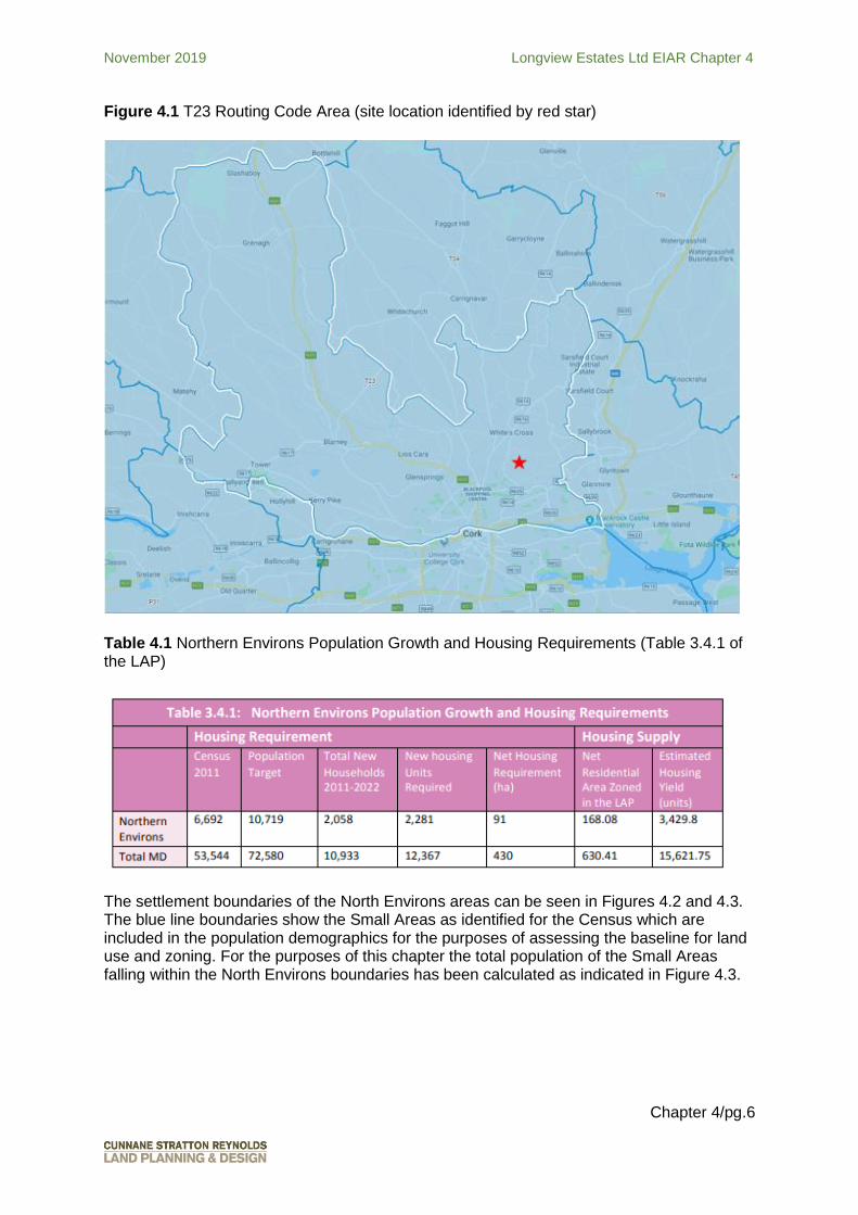
The Cork County Development Plan provides for the population of the area to grow to 10,719 persons, representing growth of 4,027 persons on the 2011 population. Table 4.1 below shows the Northern Environs population growth and housing requirements to 2022 as extracted from the Cobh Municipal District LAP (Table 3.4.1). The Municipal District LAP notes that there have been a limited number of permissions granted in the period since the 2011 Local Area Plan on zoned land within the Northern Environs. Accounting for dwellings already built since 2011, vacant units and outstanding planning permissions, the planning proposals of the LAP make provision for a further 2,057 dwellings to meet the target population for the period 2017-2023. The site at Lahardane is predominantly zoned for residential development and located with the Ballyvolane Urban Expansion Area, which has been identified as a significant growth location.
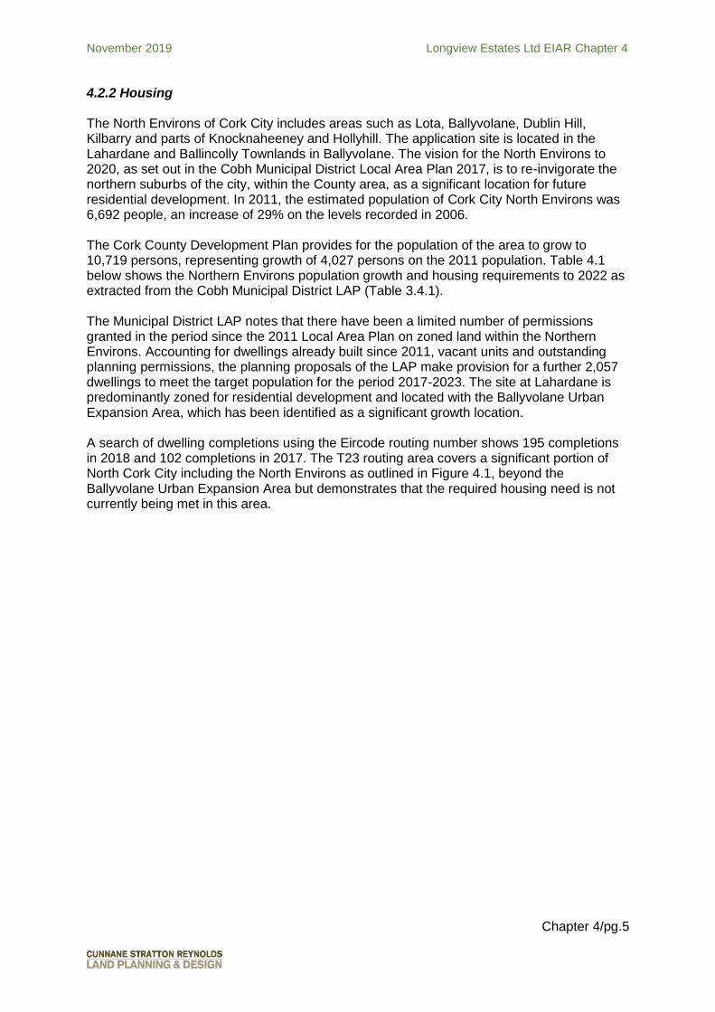
A search of dwelling completions using the Eircode routing number shows 195 completions in 2018 and 102 completions in 2017. The T23 routing area covers a significant portion of North Cork City including the North Environs as outlined in Figure 4.1, beyond the Ballyvolane Urban Expansion Area but demonstrates that the required housing need is not currently being met in this area.
November 2019 Longview Estates Ltd EIAR Chapter 4
Chapter 4/pg.6
Figure 4.1 T23 Routing Code Area (site location identified by red star)
Table 4.1 Northern Environs Population Growth and Housing Requirements (Table 3.4.1 of the LAP)
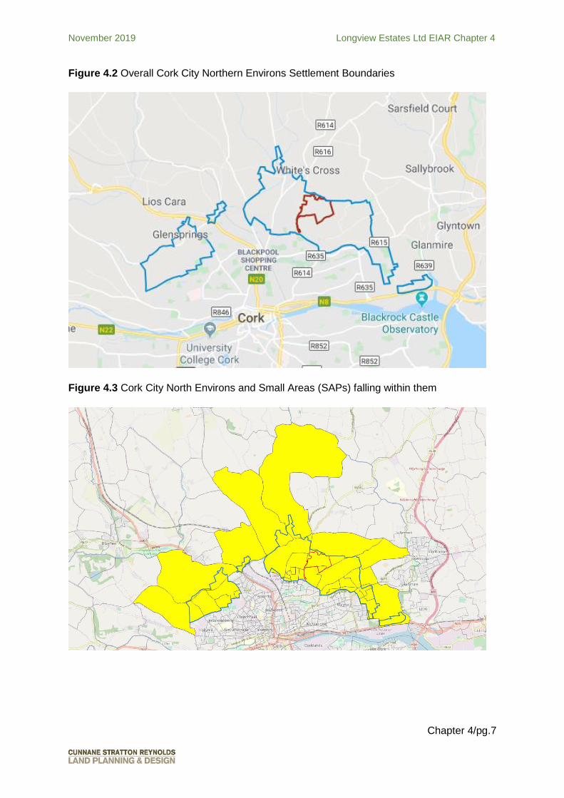
The settlement boundaries of the North Environs areas can be seen in Figures 4.2 and 4.3. The blue line boundaries show the Small Areas as identified for the Census which are included in the population demographics for the purposes of assessing the baseline for land use and zoning. For the purposes of this chapter the total population of the Small Areas falling within the North Environs boundaries has been calculated as indicated in Figure 4.3.
November 2019 Longview Estates Ltd EIAR Chapter 4
Chapter 4/pg.7
Figure 4.2 Overall Cork City Northern Environs Settlement Boundaries
Figure 4.3 Cork City North Environs and Small Areas (SAPs) falling within them

November 2019 Longview Estates Ltd EIAR Chapter 4
Chapter 4/pg.8
4.2.3 Population
The Census 2016 indicates that the population of Cork County is 417,211 persons. This represents an increase of 17,409 over the 2011 Census. The Cork County Development Plan estimates that the population of County Cork will grow to 470,622 by 2022. Table 4.2 shows that the population of the North Environs has also grown in the 2011 – 2016 period by 504 persons. Figure 4.4 Small Area within 1KM Zone of Influence of the site
Table 4.2 Population Change at State, Province, County and Local Level
2011 2016
State 4,588,252 4,761,865
Munster 1,246,088 1,280,020
Cork County 399,802 417,211
North Environs 8,8632 9,367
1KM 10,100 10,164
A comparison of age profiles relating to the State, Cork County, North Environs and 1km ZOI is given in Table 4.3. The profiles demonstrate that the characteristics of the population of the North Environs is broadly similar to those of the larger enumeration areas of Cork County and the State.
2 Please note that the total population for the North Environs is slightly higher than the figure given in the MD LAP (Table 4.1.). For the purposes of this chapter the total population of the Small Areas falling within the North Environs boundaries has been calculated as indicated in Figure 4.3.

November 2019 Longview Estates Ltd EIAR Chapter 4
Chapter 4/pg.9
Table 4.3 Census 2016 Age Profile
Area Age 0 - 4 Age 5 - 12 Age 13 – 18 Age 19+
State 331,515 (7%) 548,693 (11.5%)
371,588 (7.8%) 3,510,069 (73.7%)
Cork County
31,337 (7.5%) 52,587 (12.6%)
33,965 (8.1%) 299,322 (71.7%)
North Environs
701 (7%) 1,364 (15%) 985 (11%) 6,317 (67%)
1KM 698 (7%) 1,248 (12%) 1,050 (10%) 7,168 (71%)
Figure 4.5 Population Age Profile
However, as can be seen from Table 4.3 and Figure 4.5, the North Environs has a younger population than the State, Cork County and 1km ZOI enumerations. The 5-12 age population of the North Environs is 2.4% greater than Cork County and 3.5% greater than the State. In the North Environs, 33% of the population is under 19 years old. This is in comparison to 29% in the ZOI, 28.2% in Cork County and 26.3% in the State. The young population would mean that there is a strong demand for family accommodation in the North Environs.
A young population would also indicate a stronger need for certain social infrastructure such as schools, which will be considered in the sections on Social Infrastructure.
4.2.4 Household Size
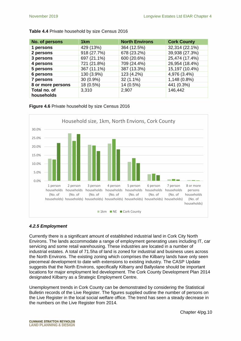
Table 4.4 compares the household size of the ZOI, the North Environs study area and Cork County. 2 person households make up the greatest population within the ZOI at almost 28%, however 4 person households make up the greatest proportion in the North Environs at approx. 24%, followed by 2 person households at 23%. This is indicative of the greater urban influence on the north city captured within the ZOI but not included in the North Environs, which are currently suburban fringe.
0%
10%
20%
30%
40%
50%
60%
70%
80%
Age 0 - 4 Age 5 - 12 Age 13 – 18 Age 19+
Age Profile, 1km, North Envions, Cork County, State 2016
State Cork County North Environs 1KM
November 2019 Longview Estates Ltd EIAR Chapter 4
Chapter 4/pg.10
Table 4.4 Private household by size Census 2016
No. of persons 1km North Environs Cork County
1 persons 429 (13%) 364 (12.5%) 32,314 (22.1%)
2 persons 918 (27.7%) 678 (23.2%) 39,938 (27.3%)
3 persons 697 (21.1%) 600 (20.6%) 25,474 (17.4%)
4 persons 721 (21.8%) 709 (24.4%) 26,954 (18.4%)
5 persons 367 (11.1%) 387 (13.3%) 15,197 (10.4%)
6 persons 130 (3.9%) 123 (4.2%) 4,976 (3.4%)
7 persons 30 (0.9%) 32 (1.1%) 1,148 (0.8%)
8 or more persons 18 (0.5%) 14 (0.5%) 441 (0.3%)
Total no. of households
3,310 2,907 146,442
Figure 4.6 Private household by size Census 2016
4.2.5 Employment
Currently there is a significant amount of established industrial land in Cork City North Environs. The lands accommodate a range of employment generating uses including IT, car servicing and some retail warehousing. These industries are located in a number of industrial estates. A total of 71.5ha of land is zoned for industrial and business uses across the North Environs. The existing zoning which comprises the Kilbarry lands have only seen piecemeal development to date with extensions to existing industry. The CASP Update suggests that the North Environs, specifically Kilbarry and Ballyolane should be important locations for major employment led development. The Cork County Development Plan 2014 designated Kilbarry as a Strategic Employment Centre.
Unemployment trends in Cork County can be demonstrated by considering the Statistical Bulletin records of the Live Register. The figures supplied outline the number of persons on the Live Register in the local social welfare office. The trend has seen a steady decrease in the numbers on the Live Register from 2014.
0.0%
5.0%
10.0%
15.0%
20.0%
25.0%
30.0%
1 personhouseholds
(No. ofhouseholds)
2 personhouseholds
(No. ofhouseholds)
3 personhouseholds
(No. ofhouseholds)
4 personhouseholds
(No. ofhouseholds)
5 personhouseholds
(No. ofhouseholds)
6 personhouseholds
(No. ofhouseholds)
7 personhouseholds
(No. ofhouseholds)
8 or morepersons
households(No. of
households)
Household size, 1km, North Envions, Cork County
1km NE Cork County
November 2019 Longview Estates Ltd EIAR Chapter 4
Chapter 4/pg.11
The Small Area Profile Statistics for the 1km ZOI were reviewed to quantify the principal status of people in the study area and the time taken to travel to work, school or college. Please refer to Tables 4.5 and 4.6.
Table 4.5 Population of aged 15 years and over by principal status
At work 3838
Looking for first regular job 62
Unemployed having lost or given up previous job
598
Student 1002
Looking after home / family 755
Retired 1008
Unable to work due to permanent sickness or disability
569
Other 12
Table 4.6 Population aged 5 years and over by journey time to work, school or college
Under 15 minutes 1976
¼ - under ½ hour 2288
½ hour – under ¾ hour 1231
¾ hour – under 1 hour 218
1 hour – under 1.5 hours 157
1.5 hours and over 57
Not stated 430
4.2.6 Social Infrastructure
The area studied for the purposes of obtaining a social infrastructure baseline is a 1 and 2 km buffer of the site. This area reflects the distance people are willing to travel, especially by sustainable and passive modes, to access services, and this represents the strongest zone of influence for the development.
The closest public bus route serving the site is the 207. The 207 route runs from Ballyvolane to Donnybrook via Cork City Centre with terminus at Glenheights Park, Glenheights Road in Ballyvolane on the north of the city and at Scairt Cross, Donnybrook on the south side. The route services Glen Rovers hurling club, Ballyvolane Business Park, Ballyvolane Shopping Centre, Cork City Centre and Douglas via the main Douglas Road in the south side. Services depart from Glenheights Park every 30 minutes from 07.10 hours to 23.00 hours Monday through to Saturday. Sunday services are every 30 minutes from 09.30 hours to 23.00 hours. The outbound route runs from Donnybrook to Ballyvolane through Patrick Street with the same frequency as the inbound route.

November 2019 Longview Estates Ltd EIAR Chapter 4
Chapter 4/pg.12
Figure 4.7 Social Infrastructure within 1km and 2km buffers
The draft Cork Metropolitan Area Transport Strategy (CMATS) includes for bus public transport enhancements on the Ballyhooly Road. Cork City Council and the National Transport Authority have instructed consultants to commence the design of such improvements as of August 2019 – the Ballyvolane Strategic Transport Corridor Project: North Ring Road to Ballincolly. The proposed development allows for the future upgrade of the Ballyhooly Road to accommodate a high frequency bus service with the set-backs that have been incorporated into the design of the proposed development as agreed with Cork City Council. This is in accordance with CMATS as it identifies the Ballyhooly Road as a priority route for the proposed Bus Connects. Enhancing the bus network is consistent with the National Development Plan 2018-202 With the provision of these facilities and other incentives that may be developed as part of the national policy, it is anticipated that a shift to public transport will occur over the construction phase of this scheme. The proposed development includes a new bus stop on the Ballyhooly Road and two bus stops are proposed internally within the scheme and a bus turning area. It is proposed to have 2m wide cycle lanes to the east of the Ballyhooly Road for cyclists travelling to and from the city and a 2m wide footpath. This is also in accordance with the Cork Cycle Network Plan which envisages a primary cycle route along the Ballyhooly Road to be extended further north to serve other areas if required. There are a number of schools within 2km of the site (Table 4.7 and Figure 4.8). St Aidan’s Community College and Scoil Oilibhéir are the closest schools to the site and are located
November 2019 Longview Estates Ltd EIAR Chapter 4
Chapter 4/pg.13
within a short walk of it. The trend in enrolment figures for the years 2013/2014 to 2018/2019 for schools within the buffer show a general decline during this period. There are a number of additional schools within a c. 3.5km buffer of the site including to the north of the city centre which are accessible from the site. Table 4.7 Closest schools to the site
School Name
Level 2013- 2014
2014-2015
2015-2016
2016-2017
2017-2018
2018-2019
Gaelscoil Ghoirt Alainn National 318 313 333 354 360 355
St Patricks Girls National School National 225 206 199 201 183 181
St Patricks Boys National School National 215 218 209 224 230 212
St Marks Boys National School National 96 107 112 106 106 98
Scoil Mhuire agus Eoin3 National 299 294 253 241 237 249
Scoil Oilibhéir National 660 639 626 599 584 558
St Aidan's Community College
Post-Primary 618 560 503 468 418 403
Mayfield Community School
Post-Primary 314 303 318 319 314 294
St Patricks College
Post-Primary 298 286 259 223 241 253
St Killian's Special School Special 67 68 69 70 74 76
Scoil Eanna Special 51 59 67 68 70 71
Saint Pauls Special School Special 97 96 95 95 97 97
Cara Junior Catholic School Special 30 46 60 60 59 66
3 With effect from 1st Sept 2017 Scoil Noamh Eoin Easpal and Scoil Mhuire Banrion amalgamated to become Scoil Mhuire agus Eoin. Enrolment prior to 2017/2018 is the cumulative enrolment for both schools.

November 2019 Longview Estates Ltd EIAR Chapter 4
Chapter 4/pg.14
Figure 4.8 Schools within 2km Buffer Zone
There are also a number of childcare facilities in the area. This assessment is not reflective of all available childcare services and does not include for example for the additional capacity provided by childminding.

November 2019 Longview Estates Ltd EIAR Chapter 4
Chapter 4/pg.15
Figure 4.9 Childcare facilities within the Buffer Zones
Table 4.8 Closest Childcare Facilities to the site
Childcare facility Address / Location
Glenfields Community Childcare Limited 1A Glenfields Park, Ballyvolane
Oak Park Pre School 30 Oak Park, Ballyhooly Road
Tír na Nóg Montessori Glen Resource and Sports Centre, Glen Avenue, The Glen
Baile Beag Community Childcare Ard Bhaile Community Centre, Old Youghal Road, Mayfield
Newbury House Early Years Childcare Newbury House,Old Youghal Road, Mayfield
Mayfield Community Preschool The Bungalow, Roseville House, Old Youghal Road
Rainbow Childcare Mayfield Community Resource Centre , 328 Old Youghal Road
Na Páistí Beaga Magnet Preschool Facility, Glen Resource and Sports Centre, The Glen
Glentrasna Community Preschool 1A Glentrasna Drive, Glentrasna Avenue, The Glen
Naíonra Naomh Sheosamh The Library, Old Youghal Road
Blackpool Community Preschool 19 Mount Farran Place, Blackpool
Tír na nÓg Montessori Delaneys GAA Club Dublin Hill
St Patricks Pre School and After School St Patricks Girls NS
November 2019 Longview Estates Ltd EIAR Chapter 4
Chapter 4/pg.16
Gardiners Hill, St Lukes
The Muin Preschool The Green Rooms Brocklesby Street Blackpool
Cushing House Community Childcare Pophams Road
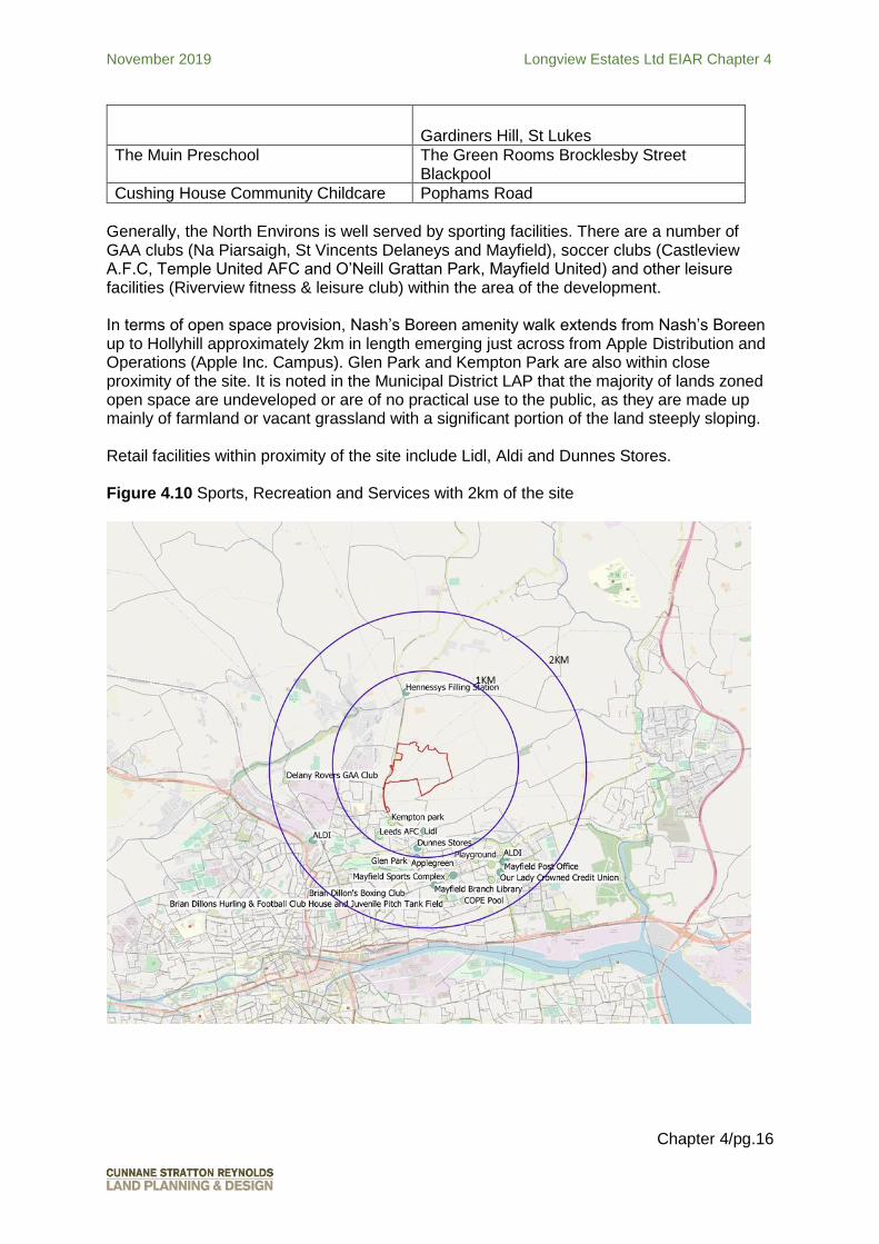
Generally, the North Environs is well served by sporting facilities. There are a number of GAA clubs (Na Piarsaigh, St Vincents Delaneys and Mayfield), soccer clubs (Castleview A.F.C, Temple United AFC and O’Neill Grattan Park, Mayfield United) and other leisure facilities (Riverview fitness & leisure club) within the area of the development. In terms of open space provision, Nash’s Boreen amenity walk extends from Nash’s Boreen up to Hollyhill approximately 2km in length emerging just across from Apple Distribution and Operations (Apple Inc. Campus). Glen Park and Kempton Park are also within close proximity of the site. It is noted in the Municipal District LAP that the majority of lands zoned open space are undeveloped or are of no practical use to the public, as they are made up mainly of farmland or vacant grassland with a significant portion of the land steeply sloping. Retail facilities within proximity of the site include Lidl, Aldi and Dunnes Stores. Figure 4.10 Sports, Recreation and Services with 2km of the site

November 2019 Longview Estates Ltd EIAR Chapter 4
Chapter 4/pg.17
4.2.7 Human Health
The site is currently in agricultural use, the potential Human Health impacts of which are mostly due to health and safety in relation to machinery and the potential health impact of chemicals etc on site.
The surrounding area has an array of social infrastructure associated with human health, including GPs and primary healthcare facilities, dentists, pharmacies and out of hours healthcare. These are shown in Figure 4.11.
Figure 4.11 Health Facilities close to the Site
4.3 Predicted Impacts
The predicted impacts of the proposed development are considered in this chapter in terms of:
Do Nothing Impacts
Construction Phase Impacts
Operational Phase Impacts
Major Accidents and Disasters For each of the above the impacts will be considered within the same categories as previously outlined:
November 2019 Longview Estates Ltd EIAR Chapter 4
Chapter 4/pg.18
Land Use pattern impacts
Housing impacts
Population impacts
Employment Impacts
Social patterns Impacts
Human Health Impacts 4.3.1 Do Nothing Impacts
In the ‘do nothing’ scenario, the proposed development will not proceed There would be no immediate impacts on the existing population. However, the site is located within a designated expansion area and zoned for residential development. As noted, the North Environs was identified as the area with the most potential for future population and employment growth in the CASP Update. If the site is not developed, the projected population for the Ballyvolane Urban Expansion Area will not be achieved. Because of the importance of the Ballyvolane Urban Expansion to the delivery of housing in the Northern Environs and the greater Metropolitan Cork area in achieving the projected growth for Cork under the National Planning Framework and because of its strategic location beside Cork City Centre, if the site is not developed, it will have a long term negative impact upon housing supply for Cork City
4.3.2 Construction Phase Land Use Pattern Impacts The construction phase will result in a change of land use from agricultural to residential area. The site has been identified and zoned for this type of development and the impact of the change of use will be positive in achieving the plan led vision for the sustainable development of Cork City through urban expansion. Housing Impacts
The construction phase will have no impact upon housing. Population Impacts
During the construction phase the development will have minor impacts but these will be temporary and negligible in nature. A series of mitigation measures will be introduced to address any negative impacts during the construction of the proposed development. Potential impacts arising from the construction phase such as impacts on noise, air quality and visual amenity are also addressed in other chapters of this EIAR.
Employment Impacts The proposed development will provide for additional construction related employment for the North Environs and surrounding areas during the construction phase. It is expected that the proposal will provide an average of 80 no. construction jobs per phase with varying numbers of employees on site during different phases of construction peaking at approximately 100 on site at any given time. In addition to direct employment, there will be substantial off site employment and economic activity as a result of the supply of construction materials and the provision of professional services associated with the project. Revenue generated during the construction phase will

November 2019 Longview Estates Ltd EIAR Chapter 4
Chapter 4/pg.19
have an associated benefit for the local area in terms of expenditure on local goods and services.
Social Patterns Impacts During the construction phase, the movement of people and in particular construction related traffic to and from the site may have some impacts on traffic in the area. However, these impacts will be short – term in nature and mitigated accordingly.
Human Health Impacts
During both the construction and operational phases of development, there is potential for impacts on human health. These include impacts that are addressed in other chapters of this EIAR report. Certain impacts are not however addressed elsewhere in this report and are instead considered in this chapter. Many of the environmental receptors that may impact on human health will be during the construction phase of the proposed development. These include impacts on noise and air quality during the construction phase. These will be mitigated by way of a Construction Environmental Management Plan (CEMP) to be introduced prior to the commencement of development. 4.3.3 Operational Phase Land Use Pattern Impacts
The site as existing is comprised of a series of large agricultural fields which are bounded by a mixture of trees, hedge banks and low stone walls. The character of the site and settlement pattern of the area will change given the transformation from agricultural to residential use. However, this change is planned and consistent with the planning policies and land use designations of the site. Visual impacts will be experienced in the local and winder landscape. The visual impact of the proposed development is addressed in Chapter 12 of this EIAR.
Housing and Population Impacts The proposed development of 753 new homes will impact positively on housing provision for Cork City through the development of a site which is located in a designated urban expansion area and predominantly zoned for residential development in close proximity to the City Centre. The proposed development makes provision for 10% social and affordable housing. The development of a high quality residential development comprised of a range of house types and sizes at this site will help to reinvigorate the northern suburbs and rebalance the city in accordance with the objectives of the County Development Plan. A number of family sized units are proposed – 431 no. three bed units and 90 no. four bed units. The 2016 Population Census identified an average household size in Cork City and Suburbs of 2.6 persons per household. When applied to the proposed development, this equates to a potential future occupancy of 1,958 no persons.
November 2019 Longview Estates Ltd EIAR Chapter 4
Chapter 4/pg.20
Employment Impacts
Operationally, the proposed development will have an ongoing positive impact on the local economy as it will help to sustain local services in the North Environs and it will provide housing for people close to the City Centre with access to jobs there and in employment zones in the north of the city. The proposed crèche, retail and doctors surgery will also provide some employment within the development. No mitigation measures are therefore required or proposed. Social Patterns Impacts
The proposed development once operational will result in an increase in the population of the North Environs.
Once operational, the additional population will create an additional demand for community facilities in the area including primary and secondary school places and crèche places. Studios and one bedroom units have been discounted for the purpose of estimating the potential number of primary school and secondary school age children in the proposed development. This leaves 706 no. units resulting in a potential future household size of 1836. The Provision of Schools and the Planning System A Code of Practice for Planning Authorities, the Department of Education and Science and the Department of the Environment, Heritage and Local Government (2008) states that in identifying the future primary school demands, it should be assumed that an average of 12% of the population are expected to present for primary school and that approximately 8.5% of the population will present for secondary education. Assuming that 12% of the proposed development will result in approximately 220 children of primary school age. It can be estimated that the proposed development will generate a demand for 156 secondary school spaces. These are conservative estimates and the demand for school spaces may be less than estimated. Notwithstanding this, we note that there is capacity in some schools closest to the site and as the proposed development is to be phased, it will take a number of years to reach peak demand for school places. It must also be noted that some children may attend schools further from the site. Part of the site is zoned for the future provision of a primary and secondary school campus. No development is proposed on this part of the site and the land is available to the Department of Education subject to agreement and when the need arises for such a school campus use and the proposed development will not interfere with the future development of a school in any way. Engagement has occurred with Mr Alan Hanlon, Site Acquisition and Property Management, for the Department of Education and Skills. The Department have confirmed that they have no current plans for the acquisition and development of the relevant zoned school site. A copy of this correspondence is enclosed with the School Demand Report prepared by Cunnane Stratton Reynolds that accompanies this planning application. The 2001 Childcare Facility Guidelines for Planning Authorities state that a standard of one childcare facility per approximately 75 dwellings may be appropriate in new housing areas. If we assume that the proposed development will have a pre-school age (0-4) population of 7.8% (current percentage of this age group in the North Environs study area), this could potentially generate a demand for 143 pre-school spaces. A crèche of 692.88sq.m to cater for approximately 103 no. children is being proposed as part of the development. As can be seen from Figure 4.9 and Table 4.8, there are a number of childcare providers within proximity of the site. It must also be noted that not all children will attend a pre-school or crèche and some will be cared for in the home by parents or childminders. It is evident from

November 2019 Longview Estates Ltd EIAR Chapter 4
Chapter 4/pg.21
the relevant Small Area Profile Statistics that a high number of people in the study area principally care for the home and/or family. The proposed development includes for excellent public amenity and recreational facilities. The active open spaces on the site include a 3 hectare park that has been designed to allow the progressive expansion over time as well as a range of green spaces within neighbourhoods throughout the site. These create a corridor of high quality green spaces and cycleways that create a network of linkages throughout the site that are available to the new community. In addition to amenity spaces and green areas, the proposed development includes a local centre with a crèche, doctor’s surgery, retail units and a community unit which will act as an important social focal area in the site. Human Health Impacts The proposed development has the potential to impact on human health in a number of ways through factors considered within particular specialities, for example noise and air quality. Many of these factors are considered in the relevant chapters of the EIAR including Chapter 7 – Air Quality and Climate and Chapter 8 – Noise and Vibration.
During both the construction and operational phases of development, there is potential for impacts on human health. These include impacts that are addressed in other chapters of this EIAR report. Certain impacts are not however addressed elsewhere in this report and are instead considered in this chapter. Many of the environmental receptors that may impact on human health will be during the construction phase of the proposed development. These include impacts on noise and air quality during the construction. These will be mitigated by way of a Construction Environmental Management Plan to be introduced prior to the commencement of development The development site is located in the North Environs of Cork City. The proposed development is for the construction of a residential development of 753 no. units. As such there are no negative human health impacts associated with the proposed development. The effect on the local population will be positive in that the development will make provision for a range of high quality residential units and the increase in population will help sustain local services and facilities.
Noise and Air Quality surveys were undertaken to assess the potential for adverse or negative impacts during the construction and operation phases of the development. Chapter 7 of the EIAR examines the potential for air pollution and the impact on human health. The report finds that are no requirements for local management of air quality during the operation phase as a result of the development. With regard to the construction phase of the development, the report finds that construction traffic will be the dominant source of emissions during construction. As is the case for developments of this type, the volume of construction traffic will be considerably less than development traffic during the operational phase of the development. The air quality assessment has determined that the impact of development traffic on the pollutants NO2, PM10 and PM2.5 will be negligible. With regard to construction dust, once dust emissions are managed through the implementation of a satisfactory dust management plan then the effect on PM10 and PM2.5 concentrations (i.e. fine particulates) will be slight.
November 2019 Longview Estates Ltd EIAR Chapter 4
Chapter 4/pg.22
The proposed design provides for the segregation of pedestrians and traffic through a dedicated of road path and cycleway and incorporates the principles of universal access and the requirements of Part M of the Building Regulations so that the development will be readily accessible to all, regardless of age, ability or disability. The proposed scheme prioritises both pedestrian and cyclists with the infrastructure proposed and thus promotes active movements for future occupants. Adequate and appropriate exposure to light is critical for health and well-being. Having regard to the Daylight Sunlight and Overshadowing report prepared by IES, and included with this planning application, it can be determined that:
Based on the results of the houses and apartments tested, 97% of the spaces tested in the proposed scheme have an Average Daylight Factors (ADF) above the recommended values in line with the BRE guidelines. It should be noted that worst-case locations were chosen to test and as such, this number across the scheme would be expected to increase further if all of the upper rooms were included in the results.
There is no overshadowing noted in March and June to existing dwellings. The overshadowing noted in December from neighbourhood two is isolated to a few properties and overshadowing is less noticeable in the winter months so the impact would be minor.
On the 21st of March, almost 100% of the amenity area provision for the apartments within neighbourhood one and six would receive at least 2 hours of sunlight exceeding the BRE recommendations.
When considering the housing amenity provisions, 91% of the properties within neighbourhoods one and two are exceeding the BRE recommendations and would receive above the recommended levels of sunlight when compared to the minimum area provision.
The remaining 9% that were below the recommendations were retested in the month of June and results showed that these spaces would receive a high amount of sunlight during the summer periods when people make most use of these areas.
Taking this into account and results from further analysis documented in this report, the development as a whole will have a negligible adverse impact on the adjacent properties exceeding the BRE guidelines. In terms of energy efficiency, the proposed development has been designed to be compliant with The Building Regulations, Technical Guidance Document Part L, Conservation of Fuel and Energy – Dwellings, 2019. All residential units are designed to meet Near Zero Energy Buildings (NZEB) standards. Preliminary Dwelling Energy Assessment Procedures (DEAP) have been carried out and the results confirm that compliance with NZEB will be comfortably achieved. To avoid misleading outputs and ensure compliance throughout, the sample unit types and configurations were selected avoiding “ideal” conditions, whether they were conditions of the external environment or interior configuration. The approach has been to prioritise the basic principles of good, energy efficient design including:
Orientation and setting on site.
Passive solar gain/ mitigating against over-heating.
An emphasis on a highly insulated thermal envelope & airtightness.
Renewable technologies to maximise efficiency and minimise Carbon Dioxide emissions.

November 2019 Longview Estates Ltd EIAR Chapter 4
Chapter 4/pg.23
Offering homeowners, the potential to further improve energy efficiency with minimal disruption. i.e. the introduction of Photo Voltaic technology to supplement primary delivered energy requirements and maximise renewable`s.
The provision of infrastructure which will allow for the provision of Electric Vehicle charging.
The assessments also set out the potential for further and future improvement in efficiencies of up to 30% with the addition of photo voltaic (PV) technologies. Houses and apartments will achieve A2 / A3 Building Energy Ratings with the potential for improvement to A1 with the addition of PV technology. Overall, the operational phase of the proposed development, in terms of human health is anticipated to have significantly positive impacts locally with a permanent duration.
4.3.4 Major Accidents and Disasters
The potential of a Major Accident or Disaster having significant impact is highly unlikely and indeterminate in nature. A Risk Assessment of the proposed development has been carried out. Please refer to Chapter 13 of this EIAR – Risk Management. The construction phase is more vulnerable to disaster due to the activities, materials and machinery on site however the health and safety mitigation measures that will be put in place will mitigate impacts where possible.
Once operational the residential development does not contain any high risk technology or development types, will not have a significant increase in vulnerability to major accidents and disasters except by increased local population. It is the policy of the Health and Safety Authority (HAS) to advise planning authorities of the consequences of worst case major accidents, so that this may be taken account of in their decision making. The approach of the HSA to Land Use Planning (LUP) is set out in ‘Policy & Approach of the Health and Safety Authority to COMAH Risk based Land-use Planning’. The proposal is not within any risk location relevant to COMAH so no impact is expected. Therefore, the potential risk posed by a major accident and or disaster have been considered based on a low vulnerability of such a risk and the overall risk is considered to be low.
4.4 Cumulative Impacts
The most likely cumulative impact of the proposed development is the demand it will place on local infrastructure and services. As is demonstrated in the preceding section, there is adequate capacity available within the identified local schools to cater for the projected impact. There are a number of planned and likely developments in the vicinity of the EIAR study area which in combination with the proposed development could have cumulative impacts. The cumulative impacts related to the following projects have been considered where relevant, in the context of the human environment:
Cork County Council planning ref. 19/5326 for the construction of 20 no. residential units and all ancillary site works at Banduff Road approved in August 2019. Construction of this development is ongoing so it is unlikely that there would be any overlap with the construction period of the proposed development.
November 2019 Longview Estates Ltd EIAR Chapter 4
Chapter 4/pg.24
Cork County Council planning ref. 17/6781 for the construction of 74 no. residential units at Dublin Pike, Ballincrokig approved in April 2018. Construction of this development is ongoing so it is unlikely that there would be any overlap with the construction period of the proposed development.
Cork County Council planning ref. 16/5477 for redevelopment of an existing Lidl Licenced Discount Foodstore approved in 2016. This redevelopment has not yet taken place. If this development proceeds there may be an overlap in the construction period with the proposed development. This would consolidate the duration of construction employment in the area which will have a moderate, positive short term impact on economic activity.
The Ballyvolane Strategic Transport Corridor Project: North Ring Road to Ballincolly. Design of the scheme is being advanced by a team of consultants instructed by Cork City Council supported by the National Transport Authority. The detailed design will be the subject of a Part 8 planning application by Cork City Council. The instructed Consulting Engineers are the same as for this project; MHL Consulting Engineers Ltd. While the Part 8 application has not yet been made for these works the proposed construction works related to same will likely overlap with the earlier phases of the proposed development. This would consolidate the duration of construction employment in the area which will have a moderate, positive short term impact on economic activity.
The development of the remainder of the Ballyvolane Urban Expansion Area. The lands have been designated for development through the Local Area Plan land use zonings. Infrastructure proposed as part of this planning application i.e. the distributor road and waste water infrastructure will help to unlock other lands within the expansion area for development. These lands will be subject to separate planning applications in the future whereby individual needs / loading implications will receive greater consideration. The proposed development is the first significant development to be proposed in the Ballyvolane Urban Expansion Area. As proposals are brought forward for other zoned lands within the expansion area it is likely that there will be an overlap in construction periods with other developments in the expansion area. As in the proposed development any other proposals would have to adhere to construction management plans which addresses potential impacts of the construction of the project on the area. There would be a slight, positive short-term impact on construction employment in the area. There would also be a moderate, positive permanent impact on population levels in the area by helping to achieve the targeted population of the Ballyvolane Urban Expansion Area.
The reports prepared for this application under separate cover, demonstrate that the proposed development of the proposed development at this location will not give rise to likely significant effects on existing infrastructure and amenities and will not have significant cumulative impacts.
4.5 Mitigation
The mitigation of impact upon population and human health is mainly considered in the detailed design of the development in order to reduce risks from potential sources of danger such as traffic or air pollution in combination with providing necessary infrastructure. The proposed development has been designed to avoid negative impacts in relation to local amenities and recreational facilities by:
Incorporating the provision of a crèche within the design proposal;

November 2019 Longview Estates Ltd EIAR Chapter 4
Chapter 4/pg.25
Providing direct access to existing schools in the study area;
Incorporating leisure and amenity facilities within the layout, including c. 3 hectares of parkland; an outdoor gym/ exercise area, various smaller open spaces and play areas and extensive provision for walking and cycling throughout the development, including an attractive greenway.
Accordingly, no further mitigation measures are required.
During construction the implementation of the construction environmental management plan and appropriate health and safety will mitigate any risks to human health.
4.6 Residual Impacts
The only residual impact upon population and human health is expected to be the increase in local population which is predicted to be long term and positive.
4.7 Monitoring
No monitoring is required.
4.8 Reinstatement
There is no reinstatement required.
4.9 Difficulties Compiling Information
There were no difficulties compiling the information required for this chapter.
4.10 References
Cork County Development Plan 2014
Cobh Municipal District Local Area Plan 2017
The Central Statistics Office Small Area Profile Statistics available from the CSO website (www.cso.ie)
Related Documents