Chapt. 7 Regions of the United States Section 1 “The Northeast Region”

Welcome message from author
This document is posted to help you gain knowledge. Please leave a comment to let me know what you think about it! Share it to your friends and learn new things together.
Transcript
Chapt. 7 Regions of Chapt. 7 Regions of
the United StatesSection 1 “The Northeast Region”
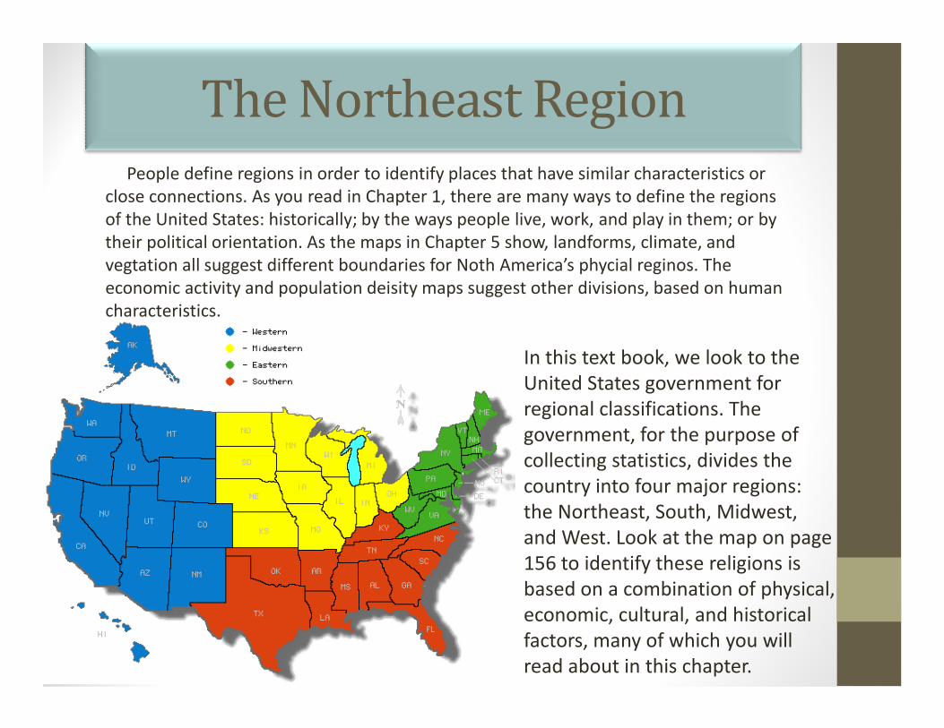
The Northeast RegionPeople define regions in order to identify places that have similar characteristics or
close connections. As you read in Chapter 1, there are many ways to define the regions
of the United States: historically; by the ways people live, work, and play in them; or by
their political orientation. As the maps in Chapter 5 show, landforms, climate, and
vegtation all suggest different boundaries for Noth America’s phycial reginos. The
economic activity and population deisity maps suggest other divisions, based on human
characteristics.
In this text book, we look to the In this text book, we look to the
United States government for
regional classifications. The
government, for the purpose of
collecting statistics, divides the
country into four major regions:
the Northeast, South, Midwest,
and West. Look at the map on page
156 to identify these religions is
based on a combination of physical,
economic, cultural, and historical
factors, many of which you will
read about in this chapter.

Physical Characteristics of the Northeast
The New England region includes six states that are located in the northeastern part of the United States. The region is known for its beautiful landscape. This brilliance is a result of the geography and climate of the region. The unique combination of precipitation, type of soil, and varieties of trees that thrive in the region give New England its breathtaking fall colors. But, the Northeast has far more to offer than magnificent forests.
Vermont
New Haven,
Connecticut
New HampshireMaine

Physical Characteristics of the
Northeast A visitor wanting a broad view of the Northeast might head for the craggy
coast of Maine, New York’s spectacular Niagara Falls, or the rolling farmlands
of Pennsylvania. Every year millions of tourists flock to the Northeast just to
explore its world famous cities. New york is considered by many to be the
cultural center of the nation, wheras Boston and Philadephia offer visitors a
view into the nation’s history.
Craggy Coasts of Maine Pennsylvania Farmlands Niagara Falls
Man Falls Off Niagara Falls (Warning Graphic Video!!!!)

Natural Resources of the Northeast
Since Colonial times, people
Compared with other regions of the United States, the Northeast ahs few
natural resources. The region’s thin, rocky soils and steep hills are a challenge to
the area’s farmers. The northern reaches of the Appalachian Mountains make
some parts of the Northeast quite rugged. Apart from the coal-rich area of
Pennsylvania, the region has few mineral resources. But the Northeast has one
major resource that has turned it into a center of trade, commerce, and
industry—its waterways such as rivers, canals and lakes.
Since Colonial times, people
of the Northeast have engaged
in commerce and fishing. The
region’s rocky and jagged
shoreline provides many
excellent harbors. Throughout
the 1700s and 1800s, these
natural harbors were used by
merchant ships sailing to and
from other regions of the
world. Plentiful fish in the
Grand Banks in the North
Atlantic supported a thriving
fishing industry.
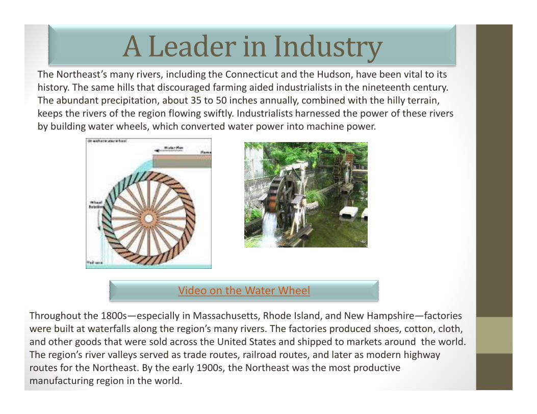
A Leader in IndustryThe Northeast’s many rivers, including the Connecticut and the Hudson, have been vital to its
history. The same hills that discouraged farming aided industrialists in the nineteenth century.
The abundant precipitation, about 35 to 50 inches annually, combined with the hilly terrain,
keeps the rivers of the region flowing swiftly. Industrialists harnessed the power of these rivers
by building water wheels, which converted water power into machine power.
Throughout the 1800s—especially in Massachusetts, Rhode Island, and New Hampshire—factories
were built at waterfalls along the region’s many rivers. The factories produced shoes, cotton, cloth,
and other goods that were sold across the United States and shipped to markets around the world.
The region’s river valleys served as trade routes, railroad routes, and later as modern highway
routes for the Northeast. By the early 1900s, the Northeast was the most productive
manufacturing region in the world.
Video on the Water Wheel

The MegalopolisCities along the Atlantic coast first grew in importance as harbors of international trade and as
centers of shipbuilding. As manufacturing grew, those cities attracted industries that needed a large
supply of workers. Decade after decade, new industries developed—and the Northeast’s cities
grew in population. Young people from the Northeastern countryside flocked to the factory towns
to take industrial jobs.
Europeans were also attracted by the job opportunities in cities of the Northeast. In 1840, about
80,000 Europeans immigrated to the United States; by 1850 the number jumped to 308,000. Many
came to escape political oppression and economic hardships. Today, many people in the Northeast
are descendants of these earlier immigrants who came by sea.
The MegalopolisOver time, coastal cities began to spread and run together. The far suburbs of one
city in some cases stretched to the suburbs of one city in some cases stretched to the
suburbs of the next. By the 1960s, the area from Boston to Washington, D.C., had
earned a new name: MEGALOPOLIS, a word based on Greek roots meaning “a very
large city.” About 40 million people now live in the megalopolis—one seventh of the
United States population. The map on page 135 shows the population density of this
crowded part of the east coast.
While the east coast megalopolis remains one of the dominant centers of American
business it faces serious problems, too. After decades of steady expansion, its
inhabitants now have serious concerns that the area might run short of water or of inhabitants now have serious concerns that the area might run short of water or of
facilities for waste disposal.
Another problem facing some cities in the Northeast is the decline in population.
Between 1970 and 2000, for example, the population of Philadelphia decreased by over
500,000, and it continues to decline. As a result, the government of Philadelphia collects
higher taxes from fewer residents and businesses. The city often has to collect money
from other sources to pay for basic services, such as street repairs and police protection.
The End
Related Documents