1 Cabbage Tree Basin Port Hacking, NSW

Welcome message from author
This document is posted to help you gain knowledge. Please leave a comment to let me know what you think about it! Share it to your friends and learn new things together.
Transcript

1
Cabbage Tree Basin Port Hacking, NSW

2
Cabbage Tree
Basin:
Natural values and options for management
Prepared by RJ & JM West for: Hacking Catchment Management Committee (New South Wales, Australia)
December 2000
3
CONTENTS EXECUTIVE SUMMARY……...………………………………………………………………4
SECTION 1: INTRODUCTION ................................................................................................. 5
SECTION 2: HISTORICAL SIGNIFICANCE ......................................................................... 8
INTRODUCTION ............................................................................................................................ 8 ABORIGINAL OCCUPATION ........................................................................................................... 8 THE FISH HATCHERY ................................................................................................................. 12
SECTION 3: ESTUARINE RESOURCES .............................................................................. 18
INTRODUCTION .......................................................................................................................... 18 ESTUARINE FLORA ..................................................................................................................... 18
Basin Algae ........................................................................................................................... 18 Basin Seagrasses................................................................................................................... 24 Basin Mangroves................................................................................................................... 30 Basin Saltmarshes................................................................................................................. 38
ESTUARINE FAUNA .................................................................................................................... 42 Estuarine Invertebrates......................................................................................................... 42 Basin Fishes .......................................................................................................................... 46
SECTION 4: CONCLUSIONS & RECOMMENDATIONS.................................................. 52
INTRODUCTION .......................................................................................................................... 52 MANAGEMENT RESPONSIBILITIES .............................................................................................. 52 HERITAGE VALUES ..................................................................................................................... 54
Aboriginal heritage ............................................................................................................... 54 Fish hatchery......................................................................................................................... 55
NATURAL VALUES ...................................................................................................................... 56 GENERAL................................................................................................................................... 57
SECTION 5: REFERENCES CITED ....................................................................................... 59
SECTION 6: ABSTRACTED LITERATURE REVIEW....................................................... 61

4
EXECUTIVE SUMMARY
This report focuses on a small part of Port Hacking (NSW) known as Cabbage Tree
Basin, in particular, the recent history of the site, an inventory of existing estuarine
resources, a review of current management issues and an outline of recommendations
for research and management.
Cabbage Tree Basin is a small body of water, located on the southern side of Port
Hacking between Bundeena and Maianbar, composed of a narrow winding creek and
deep (6 metre) basin. The area is of geomorphic interest in that it is one of the few sites
where long-term (>6,000 years) shoreline changes in a low wave environment can be
investigated. The Basin’s has considerable heritage value. The area has a long history
of aboriginal occupation, as evidenced by the remaining aboriginal artifacts scattered
throughout the catchment and around the perimeter of the water body. The Basin was
also the site of Australia’s first marine fish hatchery, which operated in the early 1900s.
The mangroves and saltmarshes of the Basin are also of considerable scientific value,
in being among the earliest described estuarine wetland areas in Australia. The
estuarine communities are rich, comparatively well studied, and include algal beds,
seagrass meadows, mangroves and saltmarshes. Major impacts on these communities
include: the threat from the invasive algae Caulerpa taxifolia; the long history of sand
movements (exacerbated by dredging and channel modifications) which has smothered
seagrasses and encouraged mangrove expansion; and, the impact of introduced deer
on the saltmarsh communities, including trampling and forming of tracks.
A number of recommendations have been presented in the report. The major
recommendation is that consideration be given to formally establishing Port Hacking as
a Marine Park. As part of that proposal, part of Cabbage Tree Basin (south of the
Bundeena-Maianbar footbridge) should be considered as a marine sanctuary area,
closed to all fishing and collecting activities, as well to all forms of motorised boating.

5
SECTION 1: INTRODUCTION
Cabbage Tree Basin is a small water body nestled wi thin the Royal National Park,
between the townships of Bundeena and Maianbar on the southern shoreline of Port
Hacking, NSW (see Figure 1-1). As such, it is part of the larger Hacking River
Catchment. As its name implies, the Basin is a relatively deep body of water (6 metres),
but is surrounded by shallow waters and sandy shoals that are exposed at low tides. A
narrow creek winds through these sand shoals, bringing clear marine waters from the
Port and allowing the passage of floodwaters after heavy rainfall.
The catchment and shoreline of Cabbage Tree Basin have a collection of interesting
aboriginal artefacts. While the gunyas, rock carvings, hand paintings, middens and tools
have only recently been documented in any detail, even early European settlers
recognised the area as an important site containing the evidence of a long indigenous
occupation.
To the casual observer or bushwalker, the clear waters of the Basin, the narrow winding
creek, the wetlands, and the abundant fish and birdlife, provide an impression of a
pristine and relatively stable environment. However, this is not the case.
Cabbage Tree Basin has undergone dramatic and perhaps irreversible change over the
past century, and particularly over the past 50 years. These changes have had a major
impact on the natural resources of the site, particularly the wetlands. These changes to
the nature of the wetlands have had flow-on effects, altering the dominant species and
the boundaries of the plant and animal communities.

6
Figure 1-1: Cabbage Tree Basin is situated on the southern shoreline of Port Hacking, New South Wales.
7
Cabbage Tree Basin also has a surprising, controversial and significant history.
Whereas marine fish culture has only recently become a significant industry in Australia,
the embryo of that industry lies here, in this small "pristine" corner of Port Hacking.
Cabbage Tree Basin was, in fact, the site of Australia's first marine fish hatchery and
contained a number of fish pens, holding both native and introduced species of fish.
This report presents information about the historical uses of Cabbage Tree Basin, its
present natural resources and management issues, and recommendations aimed to
help in the future management of the site.
In particular, this report considers:
• the recent history of the Basin and its uses,
• an inventory of the existing estuarine resources,
• a review of current management issues, and,
• an outline of recommendations for research and management.
To place this disparate information into context and make it useful as a case study, we
have taken a chronological approach to compiling this report. Sections are presented on
the past, present and future of Cabbage Tree Basin.
This is the story of a small but important corner of Port Hacking, an area that has had
an interesting past and is still subject to an uncertain future. Hopefully, the story of
Cabbage Tree Basin will be of interest to many people, including researchers, planners
and managers dealing with coastal resources.
8
SECTION 2: HISTORICAL SIGNIFICANCE
Introduction
Cabbage Tree Basin and Creek have special historical significance, particularly as an
area of interest to marine and coastal scientists. This stems from the fact that Port
Hacking was probably the first estuary in Australia to receive some status as a marine
“reserve”. As a direct result of the declaration of the Royal National Park, the waters of
Port Hacking were closed to commercial fishing in the late 19th Century. The Basin also
has special significance as the site of Australia’s first fish hatchery.
In common with much of the catchment of Port Hacking, the Basin and surrounding
lands are also rich in aboriginal artefacts.
Aboriginal occupation
The catchment and foreshores of Cabbage Tree Creek and Basin are rich with the
evidence of past Aboriginal occupation, despite a century of interference and neglect.
Cridland (1924) and Curby (1998) have described the early European contact with
Dharawal people in the Sutherland – Cronulla Region but, overall, there is little
information available about the Dharawal in this region.
It is generally thought that the Dharawal were present in the area at least up to the
1840’s and possibly up to the 1870’s. There were few permanent residents in the Shire
prior to the 1850’s, although there were many visitors. In the mid-19th century, shell grit
was in high demand as a source of lime for building in the Sydney district. As a result,
mud and rock oysters were collected in large numbers from local waterways, including
Port Hacking, and aboriginal midden sites in the region were scavenged. The shells
were returned to Sydney by barge for crushing.

9
Disease, particularly the smallpox epidemics that hit Sydney in the 19 th century,
impacted greatly on the local Dharawal peoples and there is only anecdotal information
left about the life of the local Aboriginals. However, there are hundreds, possibly
thousands, of Aboriginal artefacts left throughout the Port Hacking Catchment. The
Basin is a particularly rich site for middens, rock carvings and cave paintings.
Some of the earliest descriptions of Aboriginal rock shelters and cave paintings in the
Sydney District relate to the Cabbage Tree Creek and Basin area (Harper, 1899) and
although many have disappeared through time or have been destroyed by vandals,
some remain to this day (Figure 2.1).
Figure 2-1: Hand paintings in rock shelters in the Cabbage Tree Basin catchment.

10
While cave paintings are now relatively rare, spear-sharpening grooves (Figure 2-2) are
common along the upper sections of Cabbage Tree Creek and on some of the smaller
creeks entering the Basin (Figure 2-2). Shell middens can also be found around most of
the Basin’s perimeter (Figure 2-3).
Figure 2-2: Spear-sharpening grooves in rocks along Cabbage Tree Basin
Creek, Port Hacking.
Figure 2-3: A midden located on the shoreline of the Basin.

11
One of the characteristics of the Port Hacking area that probably favoured the
Aboriginal inhabitants is the relatively constant supply of freshwater. In many areas, the
flowing creek waters originate from ground-water held in the peat soils, which make up
the perched heath lands and swamps. In the catchment of Cabbage Tree Creek, these
peat soils act like a spongy reservoir of water from which numerous springs form and
eventually combine into small creeks. Even during relatively dry periods, these
freshwater springs remain a constant supply of clean drinking water. Of course, the
other characteristic making the Basin favourable for indigenous occupation was the food
supply. The Basin has always been a rich area for fish, crabs, oysters and other
fisheries resources, and the shallow, weedy waters of Cabbage Tree Creek would have
been a relatively easy hunting, fishing and collecting location.
From many of the high rocks in the Basin’s catchment the skyline of Sydney is now
clearly visible. One can only imagine what the Dharawhal people, living on the shores of
the Basin in the 19th Century, thought of the growing township of Sydney.
Figure 2-4: The rocks lining the upper sections of Cabbage Tree Creek have many spear-sharpening grooves.
12
The Fish Hatchery
Port Hacking is an important fisheries habitat and has always been a popular place to
fish. However, the links between fishing and Port Hacking are much deeper and
stronger than many might suspect. Not only is Port Hacking the first area in Australia to
be permanently reserved and closed to commercial fishing, but it is also the site of
Australia’s first marine fish hatchery. The history of these links begins with a Royal
Commission into fishing and fisheries held in 1880 and often involved political and
scientific controversy.
In the late 1800’s, the Colony of NSW had reached an interesting stage of development.
There was great interest in the natural sciences and a number of public societies and
scientific journals had evolved. The fish of the Colony had been described by a number
of early authors and angling was already a popular recreational activity.
The Australian public has always had a particular interest in fish and fisheries, perhaps
a result of the nature of those who emigrated from the harbours and coastal areas of
England. Initially there were few laws and controls on fishing activities, but in 1880 there
was sufficient public and government concern about the lack of control over fishing and
the poor state of the fish stocks, that a Royal Commission was held into fisheries.
The 1880 Royal Commission was held in Sydney and had the aim of investigating “the
actual state and prospects of the fisheries of the Colony” (Anon 1880). One of the major
findings of the Commission was that fishing activities needed to be controlled much
better by the government. As a result, a new fisheries act was drafted to replace earlier
legislation.
Interestingly, the objective of this proposed legislation was to stop commercial fishing in
all the waters of the Colony and to only allow a resumption of fishing in particular areas
after it had been shown to be sustainable. As you might expect, there was much

13
argument about this proposed legislation and it proved to be so unpopular with sections
of the public that it was changed dramatically before being enacted in 1881. In fact,
when enacted, the new legislation allowed fishing in all waters of the Colony, unless
fishing could be shown to be unsustainable.
The 1881 Fisheries Act also allowed the government to establish a Board of
Commissioners to assist in the management and development of fisheries. As a result,
five “Commissioners of Fisheries” were appointed in 1882. Several of these new
Commissioners were not happy with the state of the fisheries and considered that large
areas should have been reserved and closed to fishing, to ensure the survival of the fish
populations.
Some of the Commissioners were so concerned about the poor state of the fish
supplies in the Colony that they investigated other methods of enhancing the fisheries.
For example, one Commissioner, the Honorable J.H. Want, considered that the
Fisheries Commission:
“should make some efforts to save the total disappearance of the finny tribe (that is,
fish) … but as the establishment of close(d) fisheries was not only difficult and
unpopular, I thought we might try if something could be done to create an artificial
supply by fish-breeding in salt water as well as fresh” (Want, 1900).
In the early 1880’s, Want had travelled through England and America and came to the
conclusion that the best method of improving the NSW marine fisheries was to establish
an artificial supply of fish. Acclimatisation of various European animals to the Australian
conditions had become very popular, and animals such as deer, foxes and rabbits had
been introduced. The Royal National Park was one of the sites where such
introductions were often trialled (NPWS 2000). As a result, plans were well underway to
introduce European fish such as trout and salmon, and to establish fish hatcheries, as a
replacement for the depleted stocks of freshwater fishes in inland rivers and streams.

14
Since there was little detailed knowledge about the breeding of marine fish in NSW,
Want and others decided on a plan to bring some species of European marine fish to
Australia. As a first step, funding was obtained to build a fish hatchery and grow-out
ponds and Cabbage Tree Basin, which was described at the time as a “miniature
harbour”, was selected as the ideal site.
Construction of the hatchery began in early 1900 with the building of a double stonewall,
in-filled with ballast, across the mouth of Cabbage Tree Creek. In the middle of the
channel, which was dredged for better boat access, two large wire gates were
constructed. These allowed exchange of water, but restricted movement of fish into the
Basin. The gates were arranged between two large wooden posts and could be raised
and lowered with ropes and pulleys, to allow the passage of small boats. It is now
difficult to determine the exact site of the stonewall and gates, but it is apparent that the
present footbridge is not part of that structure (Figures 2-5, 2-6). Two large “marine
paddocks” were constructed on the western side of Cabbage Tree Creek in about one
metre of water. One enclosure was made of ballast stones (110 ft x 70 ft) and one of
wire mesh (80 ft x 40 ft). These paddocks were used as growing pens and, over the
years of operation, were stocked with a wide range of fish species.
By 1901, the hatchery reportedly contained snapper, black bream, garfish, whiting,
Tasmanian trumpeter, herrings, lobsters and oysters, and, produced millions of fry. One
of the major functions of the hatchery was the study of the local fish species, particularly
life history of the fish species and various characteristics, such as length, weight and
age. At about this time, 2,000 rainbow trout were also released into the freshwater
reaches of Cabbage Tree Creek.
15
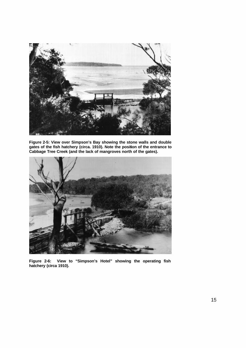
Figure 2-5: View over Simpson’s Bay showing the stone walls and double gates of the fish hatchery (circa. 1910). Note the position of the entrance to Cabbage Tree Creek (and the lack of mangroves north of the gates).
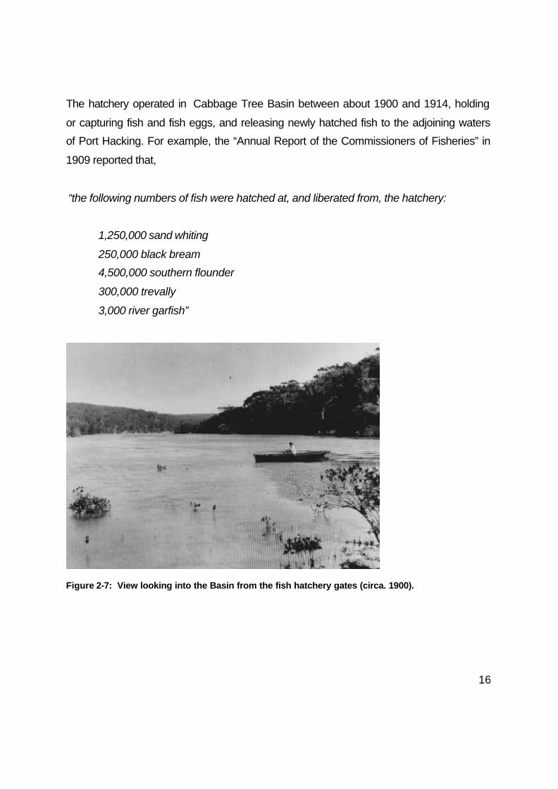
Figure 2-6: View to “Simpson’s Hotel” showing the operating fish hatchery (circa 1910).
16
The hatchery operated in Cabbage Tree Basin between about 1900 and 1914, holding
or capturing fish and fish eggs, and releasing newly hatched fish to the adjoining waters
of Port Hacking. For example, the “Annual Report of the Commissioners of Fisheries” in
1909 reported that,
“the following numbers of fish were hatched at, and liberated from, the hatchery:
1,250,000 sand whiting
250,000 black bream
4,500,000 southern flounder
300,000 trevally
3,000 river garfish”
Figure 2-7: View looking into the Basin from the fish hatchery gates (circa. 1900).

17
In 1911, the fish hatchery was expanded and a building constructed on Hungary Point
(Cronulla) to assist in the breeding of fish. The grow-out and holding pens continued to
operate in Cabbage Tree Basin until February 1914, when a catastrophe struck:
“Last week the whole of the fishes in the State hatcheries at National Park died. Not a
single one escaped. Even the hardy crayfish fell victim to the mysterious epidemic. The
Chief Inspector of Fisheries is likewise in the dark, but believes that the slaughter has
been the result of a combination of circumstances … poor tides … excessive heat …
muggy conditions …”. Sydney Morning Herald (16th February 1914).
The sudden death of all the penned fish sparked a debate about the whole operation of
the fish hatchery that eventually led to its closure. There was obviously much
disagreement between the few politicians who supported the hatchery, and the fisheries
department who thought it was a poor use of their limited resources. For example,
consider the point of view of Mr Frank Farnell:
"I never believed in the hatcheries at all. There never was any necessity for them. There
are 550 varieties of fishes on our coast, and 250 of them are edible. What is the use of
trying to provide a few more, when Nature has so lavishly endowed our waters … I may
say that the idea of introducing new species into our marine waters originated from
people not associated with the Fisheries Department. The Fisheries Board was not
asked for advice. The only consultation was in connection with paying the bill for
£1,560. The scheme was worked by political influence and it resulted as all political
canker-worm schemes deserve to end." Mr Frank Farnell, Chairman of the NSW
Fisheries Board & Trustee of the Royal National Park (20th February 1914).

18
SECTION 3: ESTUARINE RESOURCES
Introduction
Cabbage Tree Basin has special geomorphic interest, as one of the few sites that
demonstrate shoreline changes, over the past 6,000 years, in a low wave environment
(NPWS 2000). It is also of special interest for its natural resource values.
Even after a century of change, Cabbage Tree Basin still represents one of the most
significant estuarine habitats within the Port Hacking estuary. It is also an important site
within the context of the Sydney and South Coast Region. According to the mapping of
estuarine habitats in Port Hacking by NSW Fisheries (Williams and Meehan, 2000), the
Basin contains about 94% of the saltmarsh areas of Port Hacking, 37% of the mangrove
area and 1% of the seagrass area. The present estuarine flora and fauna of Cabbage
Tree Basin are described in greater detail below. These descriptions come both from
existing literature, from field work carried out during 2000, and from an examination of
the range of historical and current aerial photography.
Estuarine Flora
Cabbage Tree Basin contains many important aquatic floral communities, particularly
estuarine wetland plants. The main species discussed in this report are the estuarine
macrophytes, namely the algal communities, seagrasses, mangroves and saltmarshes.
Basin Algae
Algae are relatively simple non-flowering plants that generally do not have well
structured roots, stems and leaves. Macro-algae (or large algae) normally require a
solid substrata for attachment, such as rock, although a few species will also grow in

19
unconsolidated sand. Unfortunately there are no useful taxonomic keys or
comprehensive identification guides available for the New South Wales algae and
identification, especially to species level, is often difficult or impossible.
Figure 3-1: Rocks associated with the Maianbar-Bundeena footbridge and water supply pipe, constructed in 1958, provides the hard substrate necessary for algae communities to develop.
A number of macro-algae species are present in the Basin but species composition
varies markedly between seasons and years. A few species form more or less
permanent communities and these will be discussed in more detail.
Probably the most obvious community of macro-algae in the Cabbage Tree Basin area
is that attached to the concrete boulders and rocks that make up the foundations of the
Bundeena-Maianbar footbridge (Figure 3-1). On this relatively new structure, completed
20
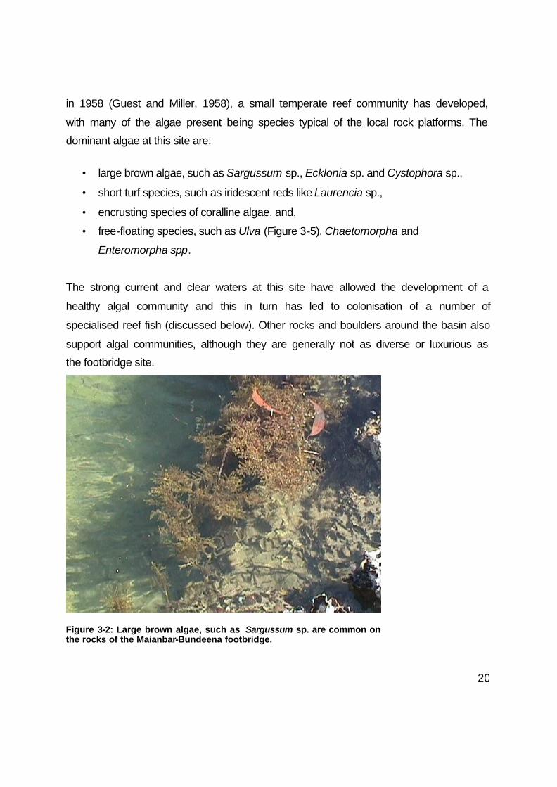
in 1958 (Guest and Miller, 1958), a small temperate reef community has developed,
with many of the algae present being species typical of the local rock platforms. The
dominant algae at this site are:
• large brown algae, such as Sargussum sp., Ecklonia sp. and Cystophora sp.,
• short turf species, such as iridescent reds like Laurencia sp.,
• encrusting species of coralline algae, and,
• free-floating species, such as Ulva (Figure 3-5), Chaetomorpha and
Enteromorpha spp.
The strong current and clear waters at this site have allowed the development of a
healthy algal community and this in turn has led to colonisation of a number of
specialised reef fish (discussed below). Other rocks and boulders around the basin also
support algal communities, although they are generally not as diverse or luxurious as
the footbridge site.
Figure 3-2: Large brown algae, such as Sargussum sp. are common on the rocks of the Maianbar-Bundeena footbridge.

21
Mangrove forests also act as a substrate on which algae can attach and this is
particularly true for areas where large numbers of pneumatophores protrude from the
sand and mud bars. Increases in some of the mangrove areas over the past 50 years
(see below), have resulted in an increase in the area available for algal colonisation.
Laursen and King (2000) have described in some detail the type of algal communities
found on mangrove pneumatophores at Woolooware Bay (Botany Bay), and similar
algal communities are associated with the Cabbage Tree Basin mangrove community.
This association consists of several species of Bostrychia and Caloglossa, the exact
composition of which changes with season and exposure. Another significant algal
community associated with the mangroves in Cabbage Tree Basin is a distinct sub-
species of Hormosira banksii (Figure 3-3), which is similar to the Hormosira found in
rock pools (commonly called Neptune's necklace), but has slightly different morphology.
This species has been described for locations around Botany Bay, but is also found at
one main site in Cabbage Tree Basin.
Figure 3-3: Hormosira banksii attached to rocks. The species is also found free floating amongst the pneumatophores of grey mangrove forests.

22
Small rocks, branches and shells found along Cabbage Tree Creek also have a number
of the algae species mentioned above, although much reduced in numbers of species
and extent of community. Large, often solitary, specimens of Codium (Figure 3-4). are
also found attached to branches and rocks in this location.
Within the past few months, the macro-algae Caulerpa taxifolia has been reported in
sections of Port Hacking, such as Fishermans Bay (Maianbar), in many cases out-
competing the local seagrass beds. This is an invasive algal species that is causing
enormous damage to seagrass beds throughout the Mediterranean.
As it is now established across a significant area of Port Hacking, Caulerpa taxifolia is
now likely to spread quickly throughout the rest of Port Hacking and possible invade
other local estuaries. This alga has probably been introduced to Port Hacking from
locals cleaning out aquariums along the water's edge. It has the potential to cause
considerable changes to the flora and fauna of Port Hacking, displacing seagrass beds
and, in turn, affecting the distribution and abundance of local fish species. The
distribution of this species needs to be monitored carefully over the next few years to
assess the need for any remedial action.
During the present surveys of Cabbage Tree Creek (September 2000), only one
specimen of Caulerpa taxifolia was found floating in the sand channel leading to the
Basin. This large clump of Caulerpa was washing in and out on the tide, near a channel
which links Cabbage Tree Creek and Fishermans Bay. It is probably only a matter of
time before Caulerpa taxifolia invades the Basin.

23
Figure 3-4: Codium fragile attached to some of the large sticks and rocks in
Cabbage Tree Basin.
Figure 3-5: Ulva sp. is one of the free floating alga sometimes
occurring in association with the seagrass beds.
24
Basin Seagrasses
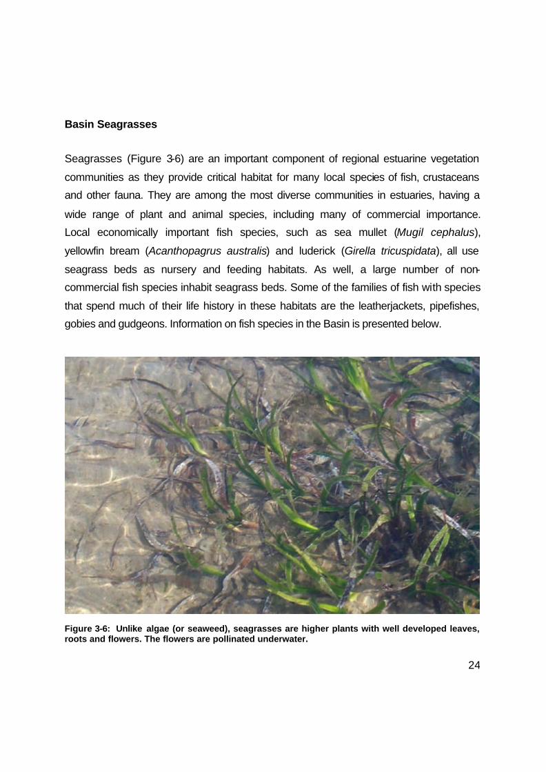
Seagrasses (Figure 3-6) are an important component of regional estuarine vegetation
communities as they provide critical habitat for many local species of fish, crustaceans
and other fauna. They are among the most diverse communities in estuaries, having a
wide range of plant and animal species, including many of commercial importance.
Local economically important fish species, such as sea mullet (Mugil cephalus),
yellowfin bream (Acanthopagrus australis) and luderick (Girella tricuspidata), all use
seagrass beds as nursery and feeding habitats. As well, a large number of non-
commercial fish species inhabit seagrass beds. Some of the families of fish with species
that spend much of their life history in these habitats are the leatherjackets, pipefishes,
gobies and gudgeons. Information on fish species in the Basin is presented below.
Figure 3-6: Unlike algae (or seaweed), seagrasses are higher plants with well developed leaves, roots and flowers. The flowers are pollinated underwater.

25
During this study, four species of seagrass have been identified from Cabbage Tree
Basin. Zostera capricorni (hereafter called Zostera) is the most common seagrass in the
area, lining the sandy entrance delta and the Basin's circumference. Zostera (Figure 3-
7) is widely distributed within most NSW estuaries and is found in a range of salinity
conditions, from seawater (35 parts per thousand, ppt) to brackish conditions (5-10 ppt).
This species spreads relatively quickly from vegetative drift material, generally
occupying suitable areas within a few years. It displays a wide variation of plant sizes,
and in Cabbage Tree Basin varies from plants with leaf dimensions about 1-2 mm wide
and 1 cm in length, up to plants with leaves 5 mm wide and 30 cm in length. Sometimes
these different forms are incorrectly labelled as separate species.
Figure 3-7: Eelgrass (Zostera capricorni) is the main seagrass now found in the Basin. It has thin leaves (<5 mm) and can range in leaf lengths from a few centimeters to 50 cm.
26
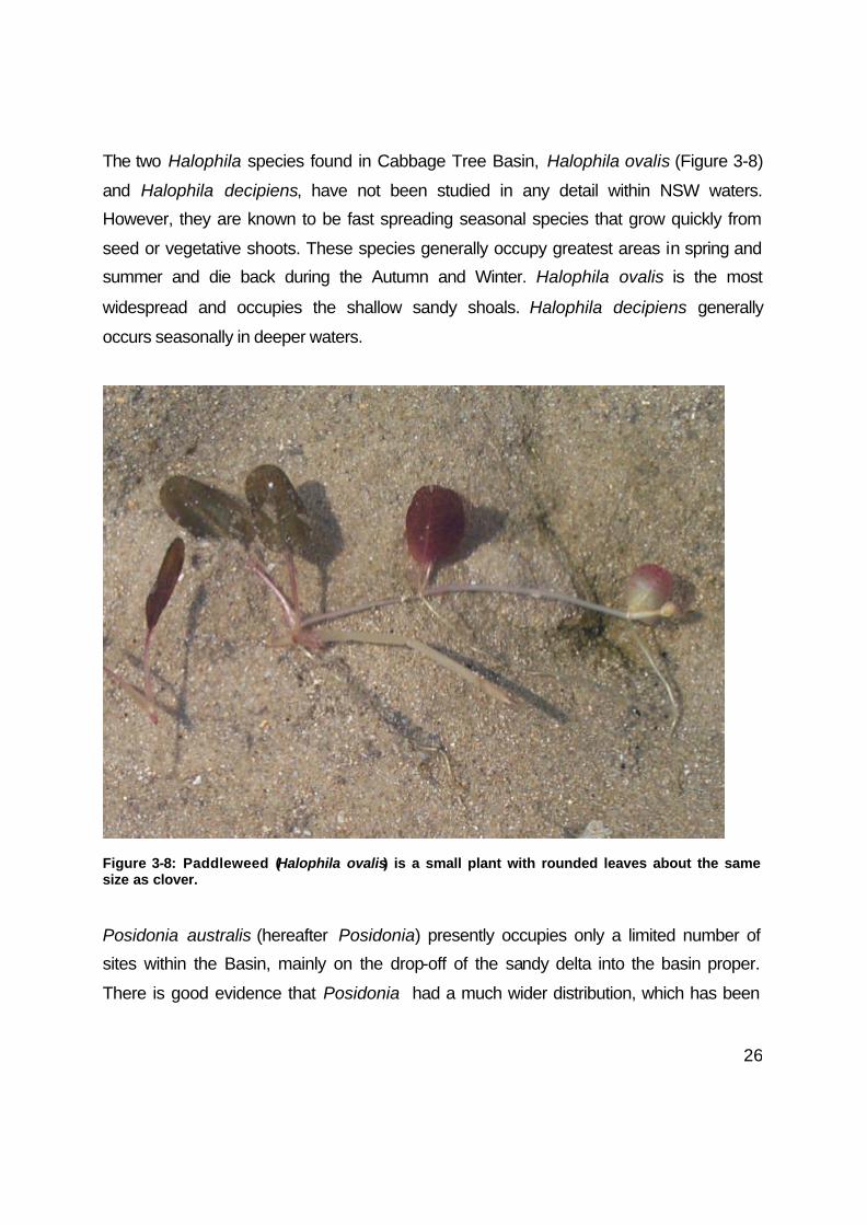
The two Halophila species found in Cabbage Tree Basin, Halophila ovalis (Figure 3-8)
and Halophila decipiens, have not been studied in any detail within NSW waters.
However, they are known to be fast spreading seasonal species that grow quickly from
seed or vegetative shoots. These species generally occupy greatest areas in spring and
summer and die back during the Autumn and Winter. Halophila ovalis is the most
widespread and occupies the shallow sandy shoals. Halophila decipiens generally
occurs seasonally in deeper waters.
Figure 3-8: Paddleweed (Halophila ovalis) is a small plant with rounded leaves about the same size as clover.
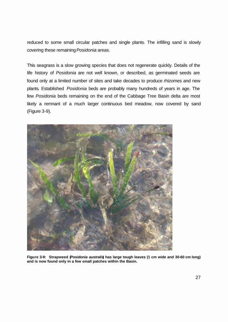
Posidonia australis (hereafter Posidonia) presently occupies only a limited number of
sites within the Basin, mainly on the drop-off of the sandy delta into the basin proper.
There is good evidence that Posidonia had a much wider distribution, which has been
27
reduced to some small circular patches and single plants. The infilling sand is slowly
covering these remaining Posidonia areas.
This seagrass is a slow growing species that does not regenerate quickly. Details of the
life history of Posidonia are not well known, or described, as germinated seeds are
found only at a limited number of sites and take decades to produce rhizomes and new
plants. Established Posidonia beds are probably many hundreds of years in age. The
few Posidonia beds remaining on the end of the Cabbage Tree Basin delta are most
likely a remnant of a much larger continuous bed meadow, now covered by sand
(Figure 3-9).
Figure 3-9: Strapweed (Posidonia australis) has large tough leaves (1 cm wide and 30-60 cm long) and is now found only in a few small patches within the Basin.

28
The area in Cabbage Tree Basin covered by seagrass has changed dramatically over
the past few decades, and this can be clearly seen in the historical aerial photographs.
In 1942 and 1951 (Figure 3-10, right), seagrasses can be seen occupying part of the
Cabbage Tree Creek channel and covering the entire sand delta, leading into the Basin.
Figure 3-10: Changes to the Basin seagrasses, as shown in a series of rectified aerial photographs from 1951, 1961 and 1999.
The majority of this seagrass appears to have been Zostera beds in 1951 (the darkest
patches in Figure 3-10, right), however there are also some lighter grey areas, generally
indicative of Posidonia beds. Most of this seagrass had disappeared by 1961 (Figure 3-
10, middle) and, apart from some small patches of Zostera present in subsequent years
(Figure 3-10, left), the sandy shoals are now too shallow to support extensive seagrass
beds.
Williams and Meehan (2000) report that the area of seagrass in the 1940's and 1950's
area was about 13-15 hectares, but that this had been reduced by over 90%, to just 1
hectare by 1999. Fieldwork during the present study has confirmed these large losses
to seagrass beds. The primary cause of this decline has been a progressive shallowing
and infilling of channels and sandy delta leading into the Basin. The available evidence
suggests that this recent infilling by sand coincided with the building of the causeway

29
and footbridge over Cabbage Tree Creek by the Sydney Water Board (Figure 3-11).
This structure was part of the Bundeena and Maianbar Water Supply Scheme, which
was started in 1956 and completed in 1958 (Guest and Miller, 1958). Available
photographs and descriptions of the building of the causeway and bridge show that, as
was usual for that time, little attempt was made to control or stabilise the sediments that
were being formed into the causeway (see photographs in Guest and Miller, 1958).
In addition, the improved tidal flushing along this section of the Creek, caused by the
constriction of the channel by the bridge, would have greatly increased the movement of
unconsolidated sand into the Basin and onto the delta region. Construction of the
causeway has also resulted in the formation of two deep pools of water on either side of
the bridge, in an area that was previously covered with Zostera seagrass beds. No
doubt the sand from these eroded holes has also ended up in the creek.
Figure 3-11: The sandy expanse that now exists in the Basin was, prior to the 1960’s,
covered by thick weed beds, probably a mixture of eelgrass and strapweed.
30
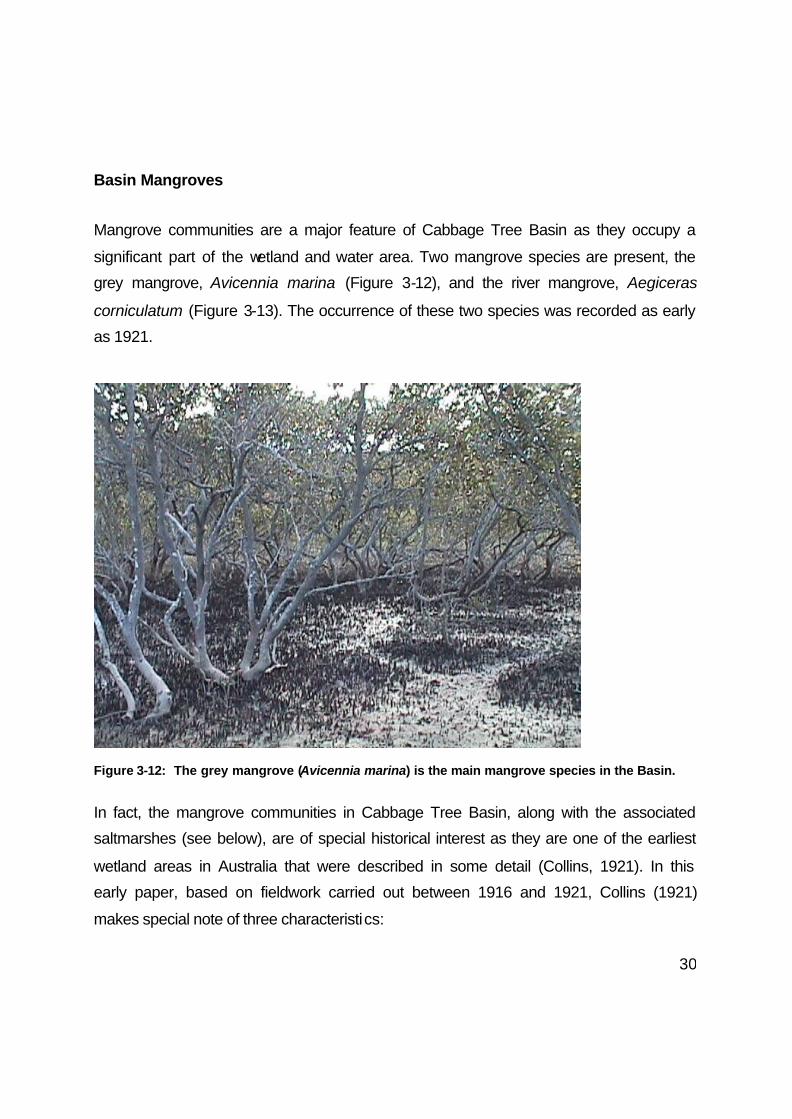
Basin Mangroves
Mangrove communities are a major feature of Cabbage Tree Basin as they occupy a
significant part of the wetland and water area. Two mangrove species are present, the
grey mangrove, Avicennia marina (Figure 3-12), and the river mangrove, Aegiceras
corniculatum (Figure 3-13). The occurrence of these two species was recorded as early
as 1921.
Figure 3-12: The grey mangrove (Avicennia marina) is the main mangrove species in the Basin.
In fact, the mangrove communities in Cabbage Tree Basin, along with the associated
saltmarshes (see below), are of special historical interest as they are one of the earliest
wetland areas in Australia that were described in some detail (Collins, 1921). In this
early paper, based on fieldwork carried out between 1916 and 1921, Collins (1921)
makes special note of three characteristics:
31
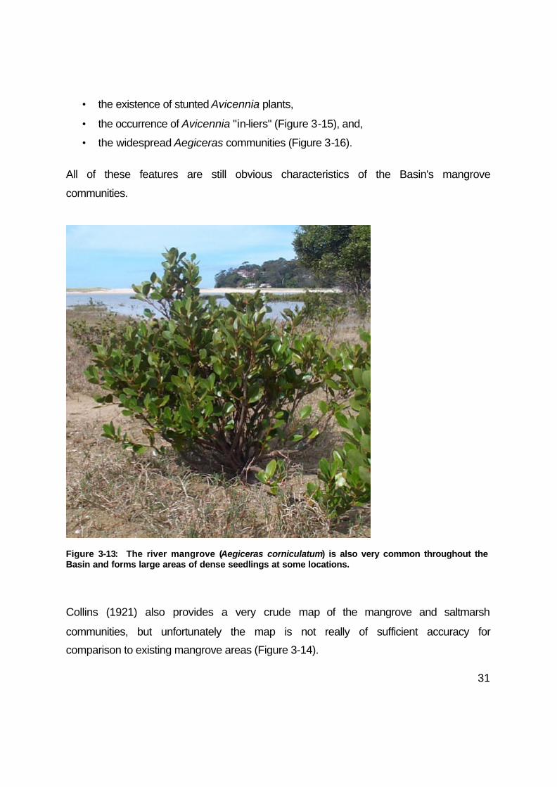
• the existence of stunted Avicennia plants,
• the occurrence of Avicennia "in-liers" (Figure 3-15), and,
• the widespread Aegiceras communities (Figure 3-16).
All of these features are still obvious characteristics of the Basin's mangrove
communities.
Figure 3-13: The river mangrove (Aegiceras corniculatum) is also very common throughout the Basin and forms large areas of dense seedlings at some locations.
Collins (1921) also provides a very crude map of the mangrove and saltmarsh
communities, but unfortunately the map is not really of sufficient accuracy for
comparison to existing mangrove areas (Figure 3-14).

32
Figure 3-14: Map of the Cabbage Tree Basin estuarine wetlands compiled in about 1916. Note that there are obvious errors in this map, although it is useful for general information it contains (from Collins, 1921).

33
The present area of mangroves in the Basin has been estimated at about 13 ha by
Williams and Meehan (2000). This figure is being revised, as some large patches of
Casuarina have been included in the estimation of the mangrove area, and some
Aegiceras included as saltmarsh. Despite best attempts, it will be extremely difficult to
produce definitive mapping of these communities as they overlap in many areas. This
mixing of wetland plant communities is an interesting feature, which was first noticed by
Collins (1921, see also Figure 3-15):
"At the present day the tidal marsh at Cabbage Tree Creek presents a complex problem
for solution. There does not appear to be any marked definition between mangrove and
saltmarsh formations, and within the saltmarsh it is difficult to define the boundaries of
the plant associations".
Figure 3-15: Large grey mangroves mixed with thick saltmarsh communities making up the tidal marshes of Cabbage Tree Basin, circa. 1916 (from Collins, 1921).
34
Williams and Meehan (2000) have also attempted to map changes to the mangrove
area over the past 50 years, using available aerial photographs. There are some
obvious difficulties in interpreting these historical photographs without the possibility of
ground truthing. One of the major difficulties at Cabbage Tree Basin is the dense areas
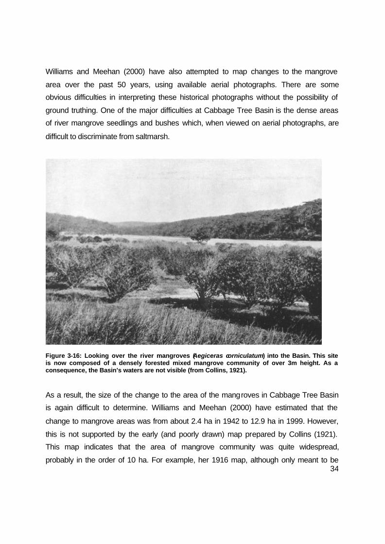
of river mangrove seedlings and bushes which, when viewed on aerial photographs, are
difficult to discriminate from saltmarsh.
Figure 3-16: Looking over the river mangroves (Aegiceras corniculatum) into the Basin. This site is now composed of a densely forested mixed mangrove community of over 3m height. As a consequence, the Basin’s waters are not visible (from Collins, 1921).
As a result, the size of the change to the area of the mangroves in Cabbage Tree Basin
is again difficult to determine. Williams and Meehan (2000) have estimated that the
change to mangrove areas was from about 2.4 ha in 1942 to 12.9 ha in 1999. However,
this is not supported by the early (and poorly drawn) map prepared by Collins (1921).
This map indicates that the area of mangrove community was quite widespread,
probably in the order of 10 ha. For example, her 1916 map, although only meant to be

35
diagrammatic, displays more mangrove area (51%) than saltmarsh area (49%) covering
Cabbage Tree Creek and Basin.
The major changes in mangrove communities over the past 50 years have been:
• expansion of mangroves, mainly Avicennia, in new areas behind Deeban Spit
and near the Bundeena - Maianbar footbridge (see Figure 3-17),
• colonisation of Avicennia to the newly deposited sand and sand-bars along the
edge of Cabbage Tree Creek, between the footbridge and delta (see Figure 3-
18), and,
• by an increase in the density and height of Avicennia and the density of
Aegiceras, throughout the entire area.
Figure 3-17: Comparison of the area of mangrove near the location of the Maianbar-Bundeena bridge, between 1951 and 1999. (Rectified aerial photographs)
These changes can also be verified from the historical photographs of Cabbage Tree
Basin, taken in the 1900's (when the fish hatchery was built) and in about 1916, during
the early study of the wetland area (Collins, 1921). Particularly interesting is the
photograph looking into the Basin, over the mangroves, which demonstrates the low
height of the mangrove stands at that time (Figure 3-16). While a few stunted plants still

36
occur throughout the site, the vast majority of mangroves in Cabbage Tree Basin are
now full grown specimens. This probably indicates a change in some of the
environmental factors controlling Avicennia growth, such as higher nutrient levels or
changed soil conditions. Densities of both Avicennia and Aegiceras have both appeared
to increase since the early surveys.
Figure 3-18: Expansion of the mangrove communities between 1951 and 1999 lining Cabbage Tree Creek, as shown by rectified aerial photographs.

37
An important observation from the early study of Collins (1921) was that, by about
1916, large volumes of sand had already been mobilised and were moving into
Cabbage Tree Basin (Figure 3-19). While Collins suggested the Kurnell sand-dunes
as a source of this sand, she appears to have been unaware of previous dredging in
the area. Extensive dredging of about 300,000 tonnes of sand was carried out
between 1901 and 1902 to provide access to the fish hatchery. This is a more likely
source of the mobile sands photographed over the mangrove areas in early 1920's.
Figure 3-19: Photograph taken in about 1916 demonstrating the mobile sands encroaching the extensive mangrove stand in the Basin (from Collins, 1921).
38
Basin Saltmarshes
The community composition of saltmarsh plants within Cabbage Tree Basin appears
to have changed little since the description by Collins (1921), who notes that the
saltmarsh is different from others in the area, in only having a limited number of
species. She records the plants as:
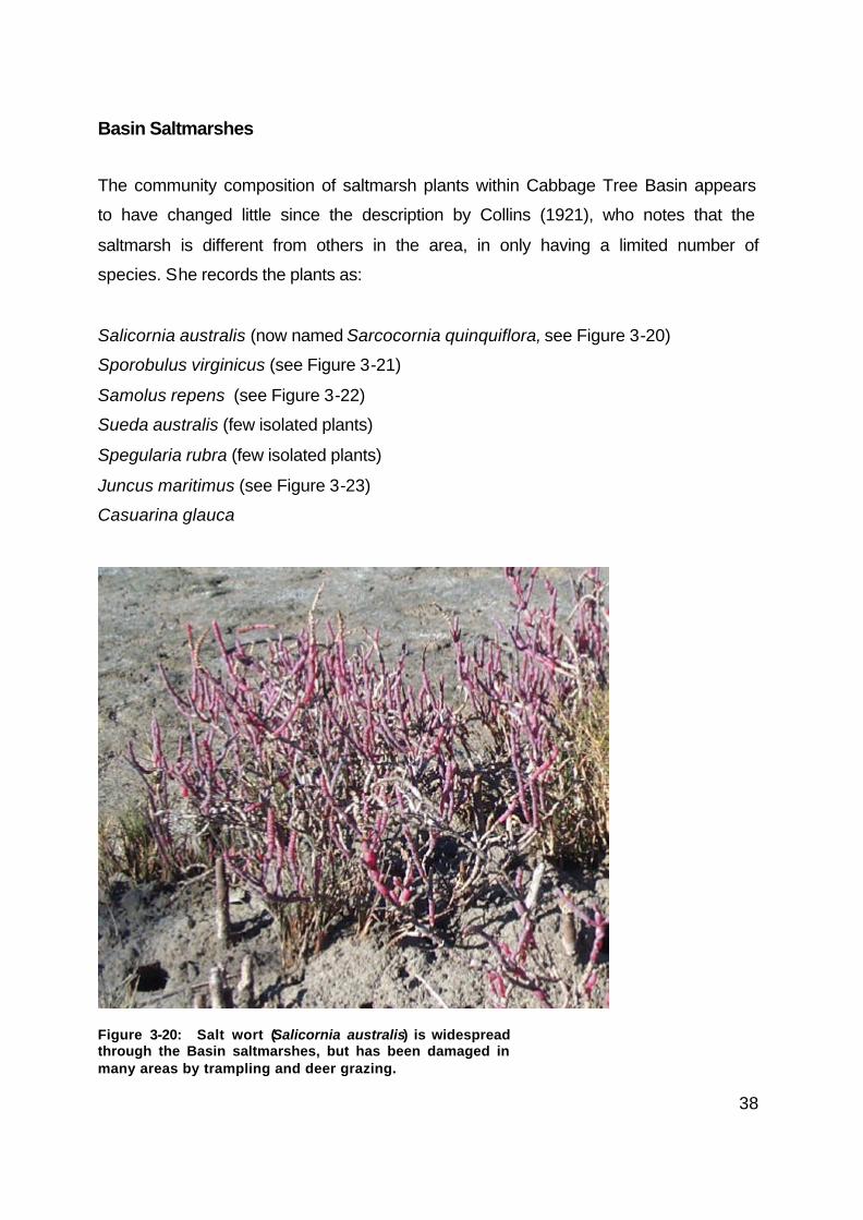
Salicornia australis (now named Sarcocornia quinquiflora, see Figure 3-20)
Sporobulus virginicus (see Figure 3-21)
Samolus repens (see Figure 3-22)
Sueda australis (few isolated plants)
Spegularia rubra (few isolated plants)
Juncus maritimus (see Figure 3-23)
Casuarina glauca
Figure 3-20: Salt wort (Salicornia australis) is widespread through the Basin saltmarshes, but has been damaged in many areas by trampling and deer grazing.

39
This is essentially the same species composition that is found in this saltmarsh
community at the present time. Apart from the changes along the fringes of the
saltmarshes, due to colonisation by mangroves (see above), the distribution of
saltmarsh plants also appears to be similar to that in 1921. Communities dominated
by Salicornia (Figure 3-20), Sporobolus (Figure 3-21) and Samolus repens (Figure 3-
22) are still widespread in the area, with Juncus communities at both the landward
fringe and at sites within the mangrove stands proper (see Figure 3-23).
Figure 3-21: The grass in this photograph is salt couch (Sporobolus virginicus).
Apart from the mapping of the area by West et al. (1985), very little detailed study
was carried out on Cabbage Tree Basin until about 1989. At that time, productivuty of
some of the saltmarsh communities in Cabbage Tree Basin were investigated by
Clarke (1994). He found that the Juncus communities had significantly lower biomass
than similar communities elsewhere, which he attributed to differences in salinity,
nutrients, or disturbance by feral deer.

40
Williams and Meehan (2000) have estimated a reduction in saltmarsh area
throughout the Cabbage Tree Creek and Basin zone of about 5 ha. Again it is difficult
to be conclusive about this change, as there are extensive areas of mixed saltmarsh
and mangrove communities (Figure 3-23). Also, as suggested previously, the large
areas of stunted Avicennia and Aegiceras present in this wetland may easily be
mistaken for saltmarsh flats when mapping from historical aerial photographs.
Figure 3-22: The pretty white flower of Samolus repens, a common species in the Basin’s saltmarsh community.
The observation by Williams and Meehan (2000) that marine circulation within
Cabbage Tree Basin is now much lower than it was at the turn of the century appears
to be quite accurate, judging from the available photographs. Since the 1940's,
Deeban Spit has been formed and rate of exchange with the waters of Port Hacking
has been much attenuated.

41
The saltmarsh communities in Cabbage Tree Basin are presently in very poor
condition and possible remedial actions will be discussed later in this report. Among
the most damaging impacts on the saltmarshes are the effects of the introduced deer.
The deer are responsible for the large number of trails throughout the marsh and
have caused considerable damage in many areas, through grazing, trampling and
digging.
Figure 3-23: Mixed saltmarsh, including Juncus rushes, adjoining mangrove trees (June, 2000). This is a similar view to Figure 3-16.

42
Estuarine Fauna
Cabbage Tree Basin is an important site for many bird species covered by
international treaties (NPWS 2000). It also has a rich aquatic fauna and is among the
most species rich sites within Port Hacking.
The diverse community of fish, particularly juvenile fish, was mentioned as one of the
reasons Cabbage Tree Basin was selected for the fish hatchery (see previous). In this
section, some of the dominant fauna species in the estuarine areas of the Basin are
discussed. Here is a brief explanation of some of the terms used to describe these
communities (see Allaby 1994, for more detail):
• benthic fauna - those animals that live attached to or on the bottom sediments
or on objects on the bottom, definitions vary, but can include:
o epifauna - animals living on the surface of the sea floor, or attached to
other benthic organisms (such as seagrass),
o infauna - animals living in the mud, such as burrowing worms
o meiofauna - microscopic animals living on or near the sediments
o macrofauna - larger animals living on or near the sediments
• littoral fauna - animals along the shoreline down to the limit of the rooted
vegetation
• pelagic - animals (& plants) that occupy the open waters or oceans
For convenience, the section is divided into a discussion of aquatic invertebrates and
fishes in the estuarine environment of the Basin.
Estuarine Invertebrates
Animals that have no backbone, such as crabs, prawns, octopus and snails, are
classified as invertebrates. Among the most obvious invertebrates in the Basin are
the bait nippers, cockles, sea snails and crabs (Figure 3-24), some of which are
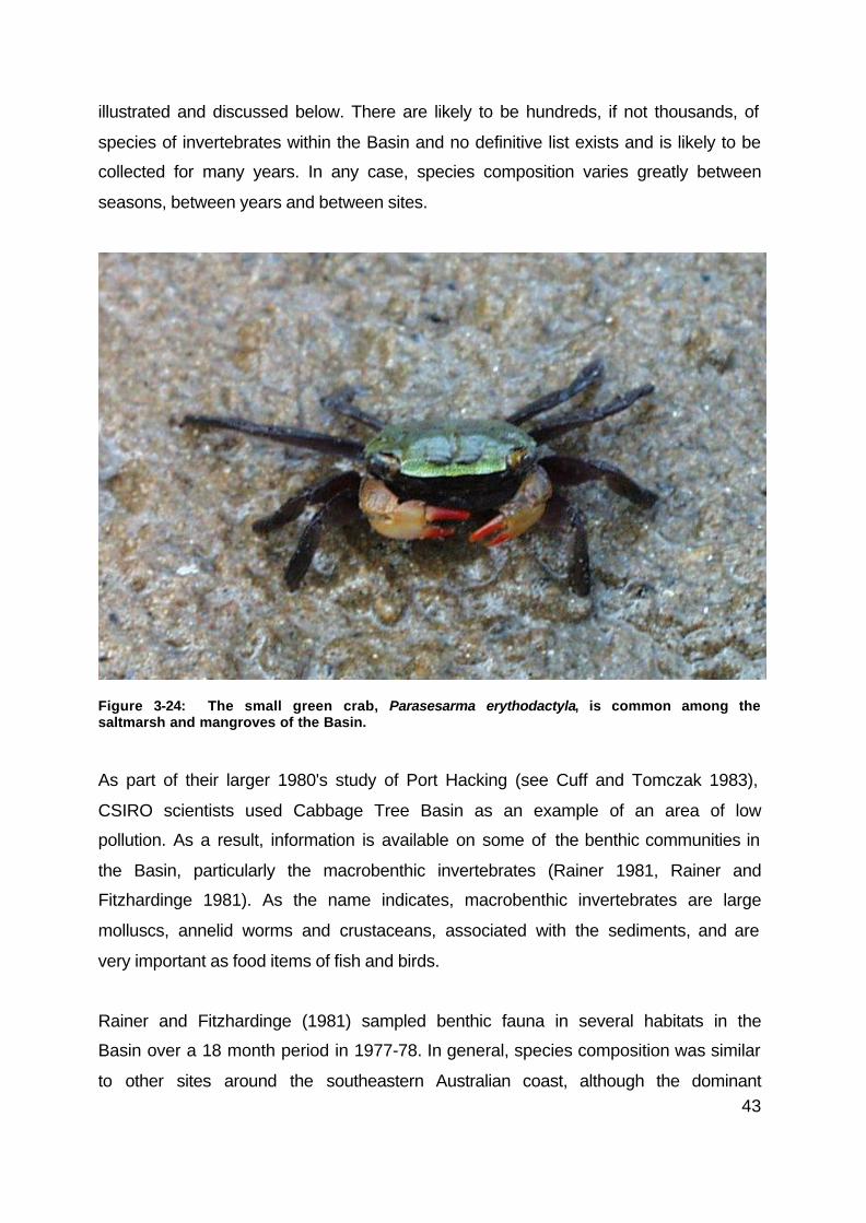
43
illustrated and discussed below. There are likely to be hundreds, if not thousands, of
species of invertebrates within the Basin and no definitive list exists and is likely to be
collected for many years. In any case, species composition varies greatly between
seasons, between years and between sites.
Figure 3-24: The small green crab, Parasesarma erythodactyla, is common among the saltmarsh and mangroves of the Basin.
As part of their larger 1980's study of Port Hacking (see Cuff and Tomczak 1983),
CSIRO scientists used Cabbage Tree Basin as an example of an area of low
pollution. As a result, information is available on some of the benthic communities in
the Basin, particularly the macrobenthic invertebrates (Rainer 1981, Rainer and
Fitzhardinge 1981). As the name indicates, macrobenthic invertebrates are large
molluscs, annelid worms and crustaceans, associated with the sediments, and are
very important as food items of fish and birds.
Rainer and Fitzhardinge (1981) sampled benthic fauna in several habitats in the
Basin over a 18 month period in 1977-78. In general, species composition was similar
to other sites around the southeastern Australian coast, although the dominant

44
species were distinct between habitat types. A total of 163 species of benthic fauna
were collected. Photographs of some the more common species of invertebrates
have been included in this report (see Figures 3-24, 3-25 and 3-26).
Rainer and Fitzhardinge (1981) and Rainer (1981) found lowest biomass and diversity
in the central deep basin sites and highest diversity and biomass in the Zostera
seagrass areas. There were 59 species of polychaetes, 47 species of molluscs, 27
species of crustaceans and 30 species from other taxonomical groups. The seagrass
sites, one in Zostera and one in Posidonia, had by far the highest number of species
and highest abundances compared to sand and mud sites. These authors considered
that the central basin sites had limited species diversity due partly to the periodic de-
oxygenation of the deeper waters.
Figure 3-25: A brightly coloured ascidian attached to a mangrove pneumatophore.

45
Figure 3-26: Bait nippers, Trypaea australiensis are harvested throughout the Basin.
Rainer and Fitzhardinge (1981) and Rainer (1981) both attempt to correlate the
species diversity of benthic fauna with the "environmental harshness" of the various
habitat types they sampled. For example, they considered that "the sandflat and
Posidonia sites should thus be least subject to environmental extremes" and, on that
basis, concluded that "there is no simple relationship between environmental
harshness and values of H' (diversity) and J' (eveness of species)" (Rainer and
Fitzhardinge 1981). Unfortunately, these authors were not aware of the large-scale
environmental changes that were obviously taking place during this period, such as
the losses to seagrass beds (see above). In retrospect, none of these sites could
really be considered to have been stable during the time that they were being
sampled.
46
However, the Rainer (1981) study does indicate that, since the seagrass beds were
by far the richest areas of benthic fauna, and large losses to seagrasses have
occurred over the past 50 years (see previous sections), there must also have been
significant losses to benthic fauna. As a result, the overall productivity of the Basin is
probably now much lower than prior to the 1960's, particularly when one considers
the important role of benthic fauna in the estuarine food chain.
Basin Fishes
A large sampling program would be required to provide detailed information on all of
fishes found in the Basin and Cabbage Tree Creek, however limited surveys and
information from nearby sites can be used to describe the fish communities of this site
in a general sense.
The Basin has been recognised for over a century as an area of great importance and
value as a fish habitat, particularly as a nursery site for estuarine and marine fishes.
The Creek, in particular, is used extensively by anglers, both local residents and
visitors. Although no specific creel surveys (angler catch surveys) have been carried
out in the Basin, the major targeted species is sand whiting (Sillago ciliata), followed
by dusky flathead (Platycephalus fuscus), yellowfin bream (Acanthopagrus australis),
luderick (Girella tricuspidata) and sea mullet (Mugil cephalus). Most of these species
are found mainly as juveniles.
Sand whiting spend much of their life either on the sandy shoals in estuaries or on the
open ocean beaches. Cabbage Tree Creek offers an ideal environment for juvenile
sand whiting of up to 2 years of age. Older fish are generally found in deeper waters
or along ocean beaches. This species feeds mainly on crustaceans found in the
moving sands, such as nippers and small prawns, although estuarine worms, such as
bloodworms, also become a major food item as the fish grow.

47
Figure 3-27: Several species of leatherjacket are common in seagrass habitats (eg. Toothbrush leatherjacket, Penicipelta vittiger).
Large mixed schools of yellowfin bream and luderick are common in Cabbage Tree
Basin and can often been seen when snorkelling in the vicinity of the Bundeena -
Maianbar footbridge. Both species spawn near the mouth of estuaries and their larvae
settle into the shallow seagrass, algae and mangrove habitats. Juveniles feed in
these areas for up to about 3-6 months in age.
At about 10-12 cm, bream (Figure 3-28) and luderick (Figure 3-29) tend to move to
deeper waters and visit the seagrass and mangrove sites mainly when feeding.
During the winter in particular, sub-adults (15-20 cm) and adults (about >20 cm) will
form large schools and prepare for a spawning migration. These schools can often be
seen in the deep waters of the Basin and about the Bundeena - Maianbar footbridge,
waiting for appropriate conditions to move out of the Creek.

48
Figure 3-28: Juvenile yellowfin bream (Acanthopagrus australis) are common in the Basin.
There are at least two species of flathead found in Cabbage Tree Basin and Creek,
dusky flathead and sand flathead. Dusky flathead is predominantly an estuarine
species which can spend its entire life history in coastal rivers and estuaries. Sand
flathead are an inshore species that is generally less common in estuaries. Both
species are present as juveniles and adults, and tend to use these sites as feeding
areas. They are ambush feeders and find camouflage in the sand and mud, between
seagrass patches and in mangrove creeks and channels.
Finally, another common fish in estuarine habitats is sea mullet, which are particularly
abundant as juveniles. This is another fish species that recruits to shallow water
habitats, such as seagrass beds and mangroves creeks. Adult sea mullet, about 5 to
7 years in age, form dense spawning aggregations, prior to moving to the ocean and
travelling north along the NSW beaches to spawn.

49
Figure 3-29: Luderick (Girella tricuspidata) are one of the main fish species found amongst the algal beds and seagrass areas.
The majority of anglers would recognise and relate to these popular fish species, and
to other marine visitors such as tailor (Pomatomus saltatrix), tarwhine (Rhabdosargus
sarba) and snapper (Chrysophrys auratus). However, few would be able to name
many of the hundred or so other species of fish occupying the Basin and creek
environments. At this stage, comprehensive surveys of fish communities have only
been carried out at nearby sites, however these give a good indication of the diversity
of fishes in the area, particularly at seagrass sites within the Basin.
The most common fish found in these types of environments are small Perchlets,
such as Ambassis jacksoniensis, and, Gobies and Gudgeons, such as the Tamar
River Goby (Favonigobius tamarensis) and flatheaded goby (Philynodon grandiceps).
Gobies and Gudgeons are a large group of fish, and at least ten species are known to
occur in the local seagrass environments and many other species in other habitats.
Pipefishes, in particular, are common inhabitants of seagrass beds. At least seven
species are known in the region and several are quite common, such as the hairy

50
pipefish (Urocampus carinirostris) and the Phillip Bay pipefish (Vanacampus phillipi).
These long slender fish are well suited to hiding in the blades of the seagrasses. Very
little is known about their life history, except that, in common with many other
Sygnathids (seahorses and pipefishes), they hold their eggs in a pouch. A small
colony of White’s seahorse (Hippocampus whitei) inhabits the algal beds around the
Bundeena-Maianbar footbridge.
Leatherjackets and toadfishes are also common inhabitant of both seagrass and
algae environments. There are at least five species of leatherjackets in Cabbage Tree
Creek and the Basin, the most common being yellowfin (Meuschenia trachylepis),
toothbrush (Penicipelta vittiger) and fan-bellied leatherjackets (Monacanthus
chinesis). The common toad (Tetractenos hamiltoni) and smooth toad (Tetractenos
glaber) are the most common of the toadfishes.
Figure 3-30: Bridled leatherjacket (Acanthaluteres spilomelanurus) are also found in the Basin.
Interestly, Rotherham (1999) has found that there are significant differences between
the fish communities in different species of seagrasses within Port Hacking. There are
also large differences between the fish communities occupying seagrass beds, and

51
those on sandy shoals, in algae habitats, in rocky reef sites and in deepwater
locations, such as the central Basin.
There is no doubt that changes to the balance of habitats over the past 50 years, as
described in the previous sections, would have had a major impact on the types of
fish communities now found in Cabbage Tree Creek and Basin. The area is now
dominated by sandy shoals and narrow creeks, favouring open water fish, such as
sand whiting and flathead. Fifty years ago, the area was dominated by shallow
seagrass beds (see previous sections) and would have been a very significant fish
nursery area, particularly for species such as yellowfin bream, luderick, sea mullet
(and other mullets), tarwhine, perchlets, gobies, pipefishes, possibly snapper and
others.
In terms of the present fishing activities, these are mainly limited to recreational
angling, and the vast majority of catches are of juveniles of the popular angling
species. This is well known from surveys throughout NSW and at least one carried
out in Port Hacking. Port Hacking has been closed to commercial fishing since 1880.
Figure 3-31: Recreational fishing is a common activity in the Basin and creek.

52
SECTION 4: CONCLUSIONS & RECOMMENDATIONS
Introduction
Information has been presented in this report on the recent history of the Basin and
an inventory of its estuarine resources. This information has been gathered to help in
the consideration of some of the possible options for the management of Cabbage
Tree Basin and the associated waterway.
Coastal and estuary management has always been a difficult issue for all
governments, as they involve the management of a large number of natural resources
and of many forms of catchment development, such as agricultural, residential and
industrial. Usually many different arms of government, often with poor co-ordination
and direction, manage each of the environmental issues separately.
The principle that resources, such as water, should be managed on a whole-of-
catchment basis was adopted by the NSW Government over the last decade, and is
known as Total Catchment Management (TCM). This has developed further in recent
years, in that it is now generally considered that the management of natural
resources, such as fisheries, water, coastal lands, and so on, should not only be on a
total catchment basis, but should also be integrated. This principle is called Integrated
Catchment Management (ICM).
Many governments, including the NSW Government, have developed systems to help
create an integrated approach. This is usually achieved through a co-ordinating body
with some overall responsibilities or, at least, an advisory function to government.
Management Responsibilities
The management of the environment of Cabbage Tree Basin and Creek is the role of
the NSW Government, acting through a number of agencies. For example, the
53
following paragraphs list several of these agencies and some of their responsibilities,
as they relate to the Basin.
NSW National Parks and Wildlife Service (NPWS). The NPWS, through the
management of the Royal National Park (RNP), has responsibility for the
management of much of the catchment the Basin and the majority of flora and fauna,
as well as the heritage and archaeological values. NPWS has responsibility for “the
management of the beds” of Cabbage Tree Basin, including “any structures attached
to them” (NPWS 2000).
NSW Fisheries (NSWF). The NSWF has responsibility for the management of the
aquatic fauna, other than mammals and birds, and the marine vegetation, including
mangroves. While NPWS owns much of the saltmarsh and mangrove areas, NSWF
has several regulations affecting their management.
NSW Waterways Authority. The Waterways Authority controls boating activities
(including boat discharges) and moorings in Port Hacking, including the Cabbage
Tree Basin and Creek.
NSW Department of Land and Water Conservation (NSW DLWC). DLWC owns
any Crown Land associated with the Basin, which probably includes some of the sea-
floor and any exposed sand bars. They also have responsibility over dredging and
reclamation activities, and any foreshore improvement works.
NSW Environmental Protection Authority (NSW EPA). The EPA have general
responsibility for water pollution issues associated with the Basin and the Creek.
Sydney Water. Sydney Water constructed the Bundeena-Maianbar footbridge and
manage the water pipes and future sewerage pipes that transverse the catchment.
Sutherland Shire Council (SSC). SSC is responsible for environmental planning and
management of some areas within the catchment of the Basin, particularly the
residential and road areas in sections of Maianbar.

54
To facilitate an integration of management responsibilities in coastal catchments, the
NSW Government has developed a NSW Coastal Policy, established the NSW
Coastal Council and set up a system of Catchment Management Committees (CMCs)
and Estuary Management Committees (EMCs). These committees were originally
set up for major catchments, and for many sub-catchments, throughout NSW.
However, this structure proved difficult to service and left many small water bodies
outside the management system. To solve these problems, a new catchment
management structure was created in December 1999, which included the
establishment of a system of Catchment Management Boards with larger areas of
responsibility.
The Basin, Cabbage Tree Creek and Port Hacking in general, are now within the
jurisdiction of the Southern Sydney Catchment Management Board.
The catchment of Cabbage Tree Basin and Creek is predominantly within the Royal
National Park and is managed within an established management plan (NPWS 2000).
This report deals with management issues that are mainly outside the scope of that
plan and that, in some cases, would require a co-operative approach of several
agencies and governments to resolve. The management issues discussed relate to
the estuarine wetlands, to the fish and fisheries, and to boating access.
Heritage values
Aboriginal heritage
As reported previously, there are a number of interesting sites containing Aboriginal
artefacts throughout the Basin catchment and some of these, particularly the artwork,
are of international significance. However, surprisingly little is known about the
Dharawal people’s occupation of this region and no systematic survey or research
into Aboriginal sites in the Royal National Park has ever been undertaken (NPWS
2000).

55
NPWS maintains an Aboriginal Sites Register and has responsibility for the protection
and preservation of sites, and manages the Aboriginal heritage in close consultation
with local Aboriginal people.
The RNP Management Plan (NPWS 2000) lists the protection, research and
promotion of Aboriginal history and culture as a high priority. Several important sites
within the Basin’s catchment require some immediate attention in terms of removing
existing rubbish, graffiti and evidence of past vandalism. Some consideration should
also be given to possible avenues to promote knowledge about this particular site,
given the high usage by visitors and relatively easy access.
It is recommended that the management of the Aboriginal heritage of the Basin
environment be given a high priority within the context of actions contained in
the RNP’s Plan of Management.
Fish hatchery
The history of the fish hatchery in the Basin precinct represents an interesting facet to
the overall heritage values of the RNP and to the history of NSW fisheries and fishing
industries. Unfortunately, at this stage, there appears to be no remains of buildings,
objects or artefacts that have survived or been preserved. The history of the hatchery
and grow out pens in the Basin, which operated between about 1900 and 1914, is not
well documented and is confused with the history of the hatchery built in Gunnamatta
Bay in 1911. Cabbage Tree Basin and Port Hacking are also of historical interest as
possibly the first area closed permanently to commercial fishing activities, such as
netting and trawling.
It is recommended:
• That the NPWS consider listing of the precinct of the Basin on the
Historic Places Register, in that it was the first marine fish hatchery and

56
marine field research station in Australia, in that the estuarine wetlands
have historical scientific values and in being part of the first area
reserved from commercial fishing.
• That further research and a review of the records and documentation
held by several agencies, such as NPWS, NSWF and DLWC be
undertaken to allow a proper assessment of the historical significance of
the Basin precinct.
Natural values
Major management issues affecting the natural values of Cabbage Tree Basin
include:
• Introduction of the invasive alga, Caulerpa taxifolia.
• Options for rehabilitation due to:
o Extensive losses to seagrass beds,
o Changes to mangrove communities,
o Damage to saltmarsh communities (particularly from the deer).
Eradication of Caulerpa taxifolia in the Basin can only be achieved as part of a larger
plan to control the species in Port Hacking as a whole. Every effort should be made to
achieve eradication, if it is possible. Once established, Caulerpa taxifolia has the
potential to completely replace the seagrass beds in Port Hacking and have flow-on
effects to the fish that rely on these habitats.
It is recommended that research and management activities aimed at
eradicating Caulerpa taxifolia from Port Hacking, and/or reducing the species’
impact, be strongly supported by all government agencies.
Rehabilitation of the Cabbage Tree Basin estuarine wetlands was suggested as a
possible action by Williams and Meehan (2000), mainly in respect to the large losses
57
to seagrass beds that have been recorded. However, these losses are now thought to
be due a large influx of sand since the late 1950’s, which has also been responsible
for the expansion of mangrove areas.
Actions to remedy the loss of seagrass and increase in mangroves may be possible
but would be extremely difficult. It remains very important to protect existing areas
and encourage natural recovery. The main damaging activity that requires some
control is the open access allowed to motorized watercraft in the Basin. The shallow
sand shoals, the remaining seagrass beds and the poor access under the existing
footbridge make the channel leading to the Basin rarely suitable for these type of
watercraft.
It is recommended:
• That remedial and management work is carried out to reduce the damage
to the Basin saltmarshes by:
o Establishing a single marked track for access across the saltmarsh
with accompanying interpretive signage
o Continuing to control and eradicate the deer, particularly the large
herd that is destroying these important wetlands
• That, in order to protect the remnant seagrass beds in Cabbage Tree
Basin and encourage recovery, access by motorised water craft be
restricted to areas north of the Bundeena-Maianbar footbridge.
General
Port Hacking has been closed to commercial fishing since the 1880’s and represents
what is essentially the first marine or estuarine area reserved in Australia. The Port
also contains the Shiprock Marine Reserve, an area of just over 300 ha, where fish
and marine vegetation have been protected. For at least the past decade, several
58
proposals for a marine park covering the shore of the RNP have been suggested
(e.g., see Schoer 1993), but have involved large unpopular fishing closures.
Unfortunately, the existing long standing commercial fishing closure is not recognised
as a marine reserve, even though it offers an equivalent degree of protection as is
offered to many established marine reserves and parks. The Basin, south of the
footbridge, is subject to relatively light recreational fishing activities, is wholly within
the RNP and has a unique blend of heritage, scientific and natural values.
It is recommended that consideration be given to formally establishing Port
Hacking as a Marine Park.
As part of that proposal, part of Cabbage Tree Basin (south of the Bundeena-
Maianbar footbridge) should be considered as a marine sanctuary area, closed
to all fishing and collecting activities, as well as to motorised forms of boating.
Port Hacking is well recognised for its beauty and natural values, and Cabbage Tree
Basin and Creek represents a special area within the Port. Careful management will
be required to assist in the protection and rehabilitation of Cabbage Tree Basin, and it
is hoped that the preparation of this Report will highlight some of the issues that might
need to be addressed by Government and community groups.

59
SECTION 5: REFERENCES CITED
Allaby, M. 1994. The concise oxford dictionary of ecology. Oxford University Press,
Oxford, Great Britain.
Clarke, P.J. and Jacoby, C.A. 1994. Biomass and above-ground productivity of salt-
marsh plants in south-eastern Australia. Australian Journal of Marine and Freshwater
Research, 45: 1521-1528.
Collins, M.I. 1921. On the mangrove and saltmarsh vegetation near Sydney, New
South Wales, with special reference to Cabbage Tree Creek, Port Hacking.
Proceedings of the Linnean Society of NSW, XX: 376-392.
Cridland, F. 1924. The story of Port Hacking, Cronulla and Sutherland Shire. Angus
and Robertson, Sydney (New Edition printed in 1959). 198 pp.
Cuff, W.R. and Tomczak Jr, M. 1983. Synthesis and modelling of intermittent
estuaries. A case study from planning to evaluation. Lecture Notes 3. Berlin, Springer
Verlag.
Harper, W.R. 1899. Results of an exploration of aboriginal rock shelters at Port
Hacking. Proceedings of the Linnean Society, XXIV, 322-332.
NPWS. 2000. Royal National Park, Heathcote National Park and Garawarr State
Recreation Area, Plan of Management. NSW National Parks and Wildlife Service,
Sydney, Australia.
PWD (1986). Port Hacking marine delta management options. PWD Report 86013,
Sydney, Australia.
Rainier, S. 1981. Temporal patterns in the structure of macrobenthic communities of
an Australian estuary. Estuarine and Coastal Shelf Science, 13: 597-620.

60
Rainer, S.F. And Fitzhardinge, R.C. 1981. Benthic communities in an estuary with
periodic deoxygenation. Australian Journal of Marine and Freshwater Research, 32:
227-243.
Schoer, G. Fighting for marine conservation, how one NPA branch is doing it.
National Parks Journal, December 1993. NSW National Parks and Wildlife Service,
Sydney.
West, R.J., Thorogood, C.A., Walford, T.R. and Williams, R.J. 1985. An estuarine
inventory of New South Wales, Australia. Fisheries Bulletin 2, Department of
Agriculture and Fisheries, NSW.
Williams, R.J. And Meehan, A.J. 2000. A history of change to the estuarine
macrophytes of Port Hacking. NSW Fisheries (Australia). NSW Fisheries Final Report
Series No. 25.

61
SECTION 6: ABSTRACTED LITERATURE REVIEW
Albani, A. D., P. C. Rickwood, et al. (1983). Geological aspects of the Port Hacking Estuary. Synthesis and Modelling of Intermittent Estuaries. A Case Study from Planning to Evaluation. W. R. Cuff and M. Tomczak, , Jr.: 17-26. The geology of Port Hacking, a small estuary on Australia's east coast, is reviewed and results of a survey based on continuous seismic profiling for the determination of the depth of bedrock are reported. This depth is between 40 and 60 m below the present bottom of the highly silted estuary. An estimate is derived for the amount of construction sand that could be dredged from Port Hacking. Allen, K. R. (1983). Introduction to the Port Hacking Estuary Project. Synthesis and Modelling of Intermittent Estuaries. A Case Study from Planning to Evaluation. W. R. Cuff and M. Tomczak, , Jr.: 1-6. Estuaries are exposed to a variety of human activities and are susceptible to stress resulting from these activities. In subtropical areas, many estuaries are affected by freshwater inflow only occasionally and often quite irregularly. The Port Hacking Estuary in south-east Australia falls into this category. It was studied by the CSIRO Division of Fisheries and Oceanography during 1973-78. Anon (1985). “Gregory's Sydney waterways guide.” Universal Press, Sydney. Provides descriptions, photographs and area maps of Sydney waterways. Outlines the hazards of boating in some waters around Sydney together with details about places of historic and scenic significance. The safety section of this book will assist readers to gain a sound understanding of the regulations prescribed by the Maritime Services Board and the NSW Water Police. The information given covers the following areas: the Hawkesbury system, Pittwater, Brisbane Waters, Broken Bay to Cowan Creek, Sydney Harbour, Lane Cove, North Harbour, Middle Harbour, Botany Bay, Cooks River, Georges River and Port Hacking. This book is intended for boating enthusiasts, aiming at encouraging them to enjoy the waterways and reducing the risks of boating accidents. Anon (1989). “Major study into stormwater pollution.” Aquarian 04(51): 7. A major study of stormwater pollution to determine its contribution to the problem of beach pollution will be conducted by the New South Wales, Water Board. It will begin with mapping of all stormwater drainage and catchment areas which discharge into the ocean between Port Hacking and Palm Beach NSW. Atkinson, G. (1984). “Erosion damage following bushfires.” Journal of soil conservation, New South Wales 40(1): 4-9. A case of study was made of the Royal National Park south of Sydney when wildfire in a bushland catchment was followed by heavy rains. Some of the consequences within 10 weeks of the fire were erosion of topsoil to 48 tonnes/ha, removal of soil nutrients released in soluble form during the fire, removal of seed released by plants in response to the fire, changes in species composition of the bush, severe erosion of fire trails and walking tracks, flooding of homes and services as a result of higher runoff rates in the catchments, blockage of urban drainage systems by ash debris and extensive sedimentation downstream in Port Hacking (A). Australian, M. (1994). “Post impact monitoring study in subtidal areas dredged for the third runway in Botany Bay: interim report.”. The recovery status of benthic infauna in areas of Botany Bay dredged for runway construction was monitored on both sandy and muddy sites. Reference sites in Port Hacking and Pittwater were also monitored. The sampling methodology is outlined. While some changes in fauna may be seasonal, impacted sites show lower abundances of organisms than the reference sites in the first samples. It is not possible to assess recovery from the data at this stage. (JD)

62
Batley, G. E. and D. Gardner (1978). “A study of copper, lead and cadmium speciation in some estuarine and coastal marine waters.”. The potential of a heavy metal speciation scheme to reflect differences in metal distributions within a water mass was evaluated in a study of soluble copper, lead and cadmium speciation in water samples from five stations in the Port Hacking Estuary (Australia) and one coastal Pacific Ocean station. The observed metal distributions were found to be consistent with the other measured physical and chemical properties of the sampled waters. In all samples, the percentages of metals associated with colloidal matter were high, amounting to 40-60% of total copper, 45-70% of total lead and 15-35% of total cadmium. The scheme was used to follow changes in metal speciation under different sample storage conditions. Storage at 4-degree-C in polythene containers was shown to prevent losses or changes in speciation of the metals studied. Battaglene, S. C. and R. B. Talbot (1994). “Hormone induction and larval rearing of mulloway, Argyrosomus hololepidotus (Pisces: Sciaenidae).” Aquaculture 126(1-2): 73-81. Pond-held mulloway (Argyrosomus hololepidotus) from Port Hacking, New South Wales, were induced to spawn by injecting human chorionic gonadotropin (hCG) at 1000 IU/kg for females and 250 IU/kg for males. Two pairs of fish were stripped, and fertilised eggs were incubated at 23.5 plus or minus 1 degree C. Fecundity was high with an estimated 900,000 and 1,042,000 eggs collected from each female. At hatch, larvae averaged 2.25 plus or minus 0.09 mm TL (mean plus or minus s.d.) with a yolk sac of 0.88 plus or minus 0.08 mm and an oil globule of 0.27 plus or minus 0.03 mm. Feeding and initial swim bladder inflation started between day 3 and 4 after hatch. Metamorphosis started when larvae reached 12 mm at 23 days of age, and was complete by day 34 when larvae were 15-26 mm. Larvae with functional swim bladders (> 70% by day 11) grew faster than those without swim bladders. Cannibalism of smaller fish, many without swim bladders (4.2 plus or minus 0.06 mm), occurred from day 18. Fish were offered live food to day 68, supplemented with finely chopped pilchards and pellets from day 38. From day 106 to day 180 fish were feeding solely on pellets. Juveniles grew to mean weight of 21.0 plus or minus 0.7 g and a mean length of 121.5 plus or minus 1.3 mm in 180 days. These results indicate that A. hololepidotus has potential for hatchery production. Beer, T. (1983). “Australian estuaries and estuarine modelling.” Search 14(5-6): 136-140. Various classifications of estuaries are discussed and then, by reference to model studies of Australian estuaries, the state of the art of estuarine modelling is evaluated. Studies discussed are the Westernport Bay and Gippsland Lakes studies in Victoria, the Blackwood River and Peel Inlet studies in Western Australia and the Port Hacking study in New South Wales. The solution of Young (1978), which involved the recursive updating of the model as new data becomes available, together with Young's revised methodology for the modelling of environmental systems, is endorsed as the solution to the problem of data collecting vs modelling. Bell, J. D., N. Quartararo, et al. (1991). “Growth of snapper, Pagrus auratus , from south-eastern Australia in captivity.” N.Z. J. Mar. Freshwat. Res. 25(2): 117-121. This study aimed to determine whether the relatively slow growth of wild Pagrus auratus in south-eastern Australia can be increased in captivity to a rate acceptable for aquaculture. Juvenile snapper from Port Hacking, New South Wales (34 degree 47'S) were reared at ambient water temperatures. The fish were fed on a dry, sinking pellet with 42% protein. At the start of the trial in April 1989, the snapper had a mean fork length (FL) of 121 plus or minus 11 mm SD, an average weight of 50 g, and an estimated age of 8 months. After 12.5 months their mean FL was 249 plus or minus 15 mm and their mean weight was 403 plus or minus 70 g. Data indicate that, like the reproductively isolated population in Japan, growth of Pagrus auratus from Australasia can be rapid enough for aquaculture, and that there is potential to increase growth rate further. Britton, G. W., B. M. Druery, et al. (1985). “Flow measurement and data acquisition, Port Hacking, NSW, Australia.” International Association for Hydraulic Research Congress, 21st. A system of high resolution, dynamic water level recorders and current meters has been deployed to study the hydrodynamic and sedimentary processes of the shallow marine delta of Port Hacking. Real time, on- site, data analysis techniques are discussed to show how data storage demands can be limited but flexibility maintained by retaining significant blocks of raw data for off site detailed analysis. Discussion of the data concentrates on nonlinear wave features and the fi t of vocoidal nonlinear wave theory (A).
63
Britton, G. W., B. M. Druery, et al. (1985). Flow measurement and data acquisition, Port Hacking, N.S.W., Australia. Preprinted Proceedings: 21st Congress, International Association for Hydraulic Research, Melbourne, 19 23 August 1985. Volume 5. Theme D: Flow Measurement and Data Acquisition.: 101-110. High resolution dynamic water level recorders and current meters have been installed to assist investigations into the hydrodynamic and sedimentary processes of Port Hacking. Real time data analysis is used to limit on-site data storage demands but maintain flexibility for off-site detail analysis. Water depths are shallow and tidal currents strong, and non-linear wave effects are a feature of the data. Non-linear wave theories fit some aspects of the data but further refinement is necessary. Britton, G. W. and J. M. Floyd (1985). “Data acquisition system at Port Hacking, NSW and interpretation of data for storms of June and July 1984.”. A system of high resolution, dynamic water level recorders and current meters has been deployed to assist in a study of the hydrodynamic and sedimentary processes of the shallow marine delta in Port Hacking, NSW. The on-site, real time, data analysis techniques are discussed to demonstrate the manner in which data storage demands have been reduced but flexibility maintained by retention of selected blocks of new data for more rigorous off-site analysis. A preliminary interpretation of the data associated with storms experienced in June and July 1984 is presented, in particular the degree of wave penetration into Port Hacking, storm surge levels and the magnitude of beach erosion. Bulleid, N. C. (1983). The nutrient cycle of an intermittently stratified estuary. Synthesis and Modelling of Intermittent Estuaries. A Case Study from Planning to Evaluation. W. R. Cuff and M. Tomczak, , Jr.: 55-75. The influence of stratification on the oxygen regime and nutrient concentrations was examined over four years in South West Arm, Port Hacking, N.S.W. affected by occasional heavy freshwater run-off. The rate of detrital input to the sediment was measured using sedimentation tubes, and oxygen flux across the sediment-water interface was estimated from the oxygen consumption of intact sediment cores. Following the onset of stratification, oxygen concentration in the bottom water decreased, and the concentrations of nitrate, phosphate, silicate and ammonium all increased. The major source of these nutrients was planktonic detritus recently settled from the water column, although over short periods terrestrial material (following torrential rain) and the sediment nutrient pool (during anoxic conditions) were also important. The rate of nitrogen remineralization at the sediment surface, on a mean annual basis, was found to be 40% of that required by phytoplankton, which demonstrates the important link between benthic recycling and the productivity of the water column. Burchmore, J. J., D. A. Pollard, et al. (1984). “Community structure and trophic relationships of the fish fauna of an estuarine Posidonia australis seagrass habitat in Port Hacking, New South Wales.” Aquatic botany 18(03043770): 71-87. The fish community present in an area of sea grass meadow dominated by Posidonia australis Hook f. was quantitatively sampled during 2 springs and 2 autumns by enclosure and poisoning with rotenone. Thirty-nine species were collected and these were classified into permanent residents (50% of total numbers), temporary residents (30%) and transients (20%). Approximately 30% of the total number of fish collected belonged to species of some economic importance. Species diversity indices were calculated and compared between seasons, but no obvious differences were found. Shannon's H1 (heterogeneity index) ranged from 2.11 to 2.56, Gleason's d (richness index) ranged from 8.08 to 5.05, and scaled H (evenness index) ranged from 0.59 to 0.74. Agglomerative polythetic classification of the average diets of all species collected indicated 7 basic feeding groups within the community. Many species preferred crustaceans as food and several species consumed sea grass. Upper water column dwellers were mainly microcrustacean feeders, canopy dwellers fed primarily on crustaceans, sea grass and algae. Benthic dwellers consumed mainly crustaceans and polychaetes (A).

64
Burchmore, J. J., D. A. Pollard, et al. (1985). “Community structure and trophic relationships of the fish fauna of an estuarine Posidonia australis seagrass habitat in Port Hacking, New South Wales.”. The fish community present in a seagrass meadow dominated by Posidonia australis was quantitatively sampled and the results detailed in this report. Thirty-nine species were collected and classified into permanent residents, temporary residents and transients. Around 30% belonged to species of economic importance. No obvious differences were found in species diversity indices between seasons. An analysis of stomach contents revealed seven basic feeding groups. Many species preferred crustaceans and several consumed seagrass. (Au, JC) Clarke, P. J. and C. A. Jacoby (1994). “Biomass and above ground productivity of saltmarsh plants in south eastern Australia.” Australian journal of marine and freshwater research 45(8): 1521-1528. The above ground biomass of three dominant salt marsh vascular plants, Juncus kraussii, Sarcocornia quinqueflora and Sporobolus virginicus, was measured to assess both spatial and temporal variation and to provide baseline data. Additionally the culm dynamics of the rush J. kraussii were measured so that above ground productivity could be estimated. No distinct seasonal patterns were detected in above ground biomass in J. kraussii and culms are replaced annually, so standing crop approximated annual above ground productivity. Above ground biomass of the decumbent perennial grass S. quinqueflora and the procumbent perennial chenopod S. virginicus showed no consistent spatial or temporal trends (A). Coleby, D. (1987). “Tracing sand movements in Port Hacking.” Nuclear spectrum 3(1): 16-17. Nearly 3 decades of Australian Atomic Energy Commission radioisotope tracing of sands in the marine environment has provided valuable information about how fast sand moves, in what directions, how far and in what quantities. The latest of these tracking studies has assisted in defining the management options for Port Hacking NSW. Port Hacking, a major recreational feature of Sutherland Shire, consists of river and marine sands and the sands have placed severe constraints on the use of the Port as well as curtailing the ferry service. Cuff, W. R. (1983). An evaluation of the Port Hacking Estuary Project from the viewpoint of applied science. Synthesis and Modelling of Intermittent Estuaries. A Case Study from Planning to Evaluation. W. R. Cuff and M. Tomczak, , Jr.: 273-292. The Port Hacking Estuary Project, a model-guided study of the flow of carbon through a small Australian estuary, is reviewed from the viewpoint of applied science. The Project did not reach its goal of constructing a predictive dynamic model of carbon flow in the South Wales Arm of Port Hacking and key ambiguities in project design and execution that inhibited progress are identified. It is suggested that the model structure chosen to be compatible with time and manpower constraints did not allow sufficient mechanistic contribution to attract the support of the experimental participants. It is suggested that more emphasis is made on the data that has been collected from the specific ecosystem: in particular, periodic syntheses of the available data set not supplemented by data of unknown reliability. Cuff, W. R. (1983). An evaluation of the dynamic information for South West Arm, Port Hacking. Synthesis and Modelling of Intermittent Estuaries. A Case Study from Planning to Evaluation. W. R. Cuff and M. Tomczak, , Jr.: 233-258. Chemical and biological studies were conducted to obtain data for incorporation into a dynamic model of the flow of carbon through South West Arm. This paper represents an attempt to synthesize that dynamic information: the functions and parameters were based on studies in South West Arm, rather than on the literature. This attempt to study an incomplete set of data of the sort required to make a dynamic model of the flow of carbon (or other chemical species) through the environment is novel, or at least such an attempt has not yet been reported in the literature. The study shows that synthesis of dynamic information can be usefully done, using a procedure analogous to that used in synthesizing an incomplete set of static information in a budget. The value of such a synthesis is that it organizes currently available information, and hence should make a useful contribution to further planning for research or ecosystem management.

65
Cuff, W. R., R. E. Sinclair, et al. (1983). A carbon budget for South West Arm, Port Hacking. Synthesis and Modelling of Intermittent Estuaries. A Case Study from Planning to Evaluation.: 193-232. A multidisciplinary study of the structure and dynamics of a small ( similar to 78 ha) Australian marine embayment (South West Arm of Port Hacking, New South Wales) was conducted during 1973-1978. Compatible data were obtained by studying processes in terms of the flow of carbon. The carbon budget developed in this paper represents an attempt at a synthesis of that information. The chemical and biological species contained in each of 10 compartments are described; as data allows, the average carbon mass within each compartment and the average flow rates between the compartments, with variances, are estimated. This information is used to piece together the distribution of carbon among the compartments and to ascertain the major flow paths of carbon into, within, and out of South West Arm. Cuff, W. R. and M. Tomczak, Jr. (1983). Synthesis and modelling of intermittent estuaries. A case study from planning to evaluation. Lect. Notes Coast. Estuar. Stud. The book reports on the findings of the Port Hacking Estuary Project Abstracts of the 17 chapters are cited individually in this issue of ASFA. Druery, B. M. and M. G. Geary (1985). “The measurement of sediment transport in NSW estuaries.”. The paper discusses methods used by the Public Works Department to assess the tidal transport of medium grained sand in the estuaries of NSW. Methods vary from qualitative to quantitative and comprise; sedimentology, coring and radiometric dating, delta front progradation, photogrammetry, bedforms and radioisotope tracing. These methods are discussed within the context of a major study of sedimentary processes in Port Hacking. The relative merits of each are examined from the viewpoint of cost, limitations and effectiveness. Dunstan, D. J. (1990). “Some early environmental problems and guidelines in New South Wales estuaries.”. In the 1960s and 70s developments in estuaries in New South Wales were largely uncontrolled, and this resulted in many conflicts and ultimately in new legislation. Estuary management needs to strike a balance between mangrove beds and other uses. This article suggests that controlled dredging may be useful in restoring tide patterns and water quality and that selective pruning of mangroves may be appropriate. (Au, JD) Ecology Lab Pty, L. and C. Federal Airports (1993). “A draft quantitative study of the impact of construction of a third runway at Mascot on Posidonia seagrasses in Botany Bay: Towra Point.”. The results of a survey of the seagrass beds off Towra Point are presented. Posidonia, Zostera and Halophila species were identified. Data were collected on the percentage cover, shoot density, leaves per shoot, leaf length, leaf width and epiphyte biomass. Two other sites at Port Hacking and Pittwater were also sampled. While generally similar to the reference sites, the Towra Point seagrass beds are more fragmented, with more Zostera. This study provides baseline data to enable the seagrass beds to be monitored following construction of the runway. (JD) Giles, M. S. (1983). Primary production of benthic micro-organisms in South West Arm, Port Hacking, New South Wales. Synthesis and Modelling of Intermittent Estuaries. A Case Study from Planning to Evaluation. W. R. Cuff and M. Tomczak, , Jr.: 147-166. Net photosynthetic incorporation of dissolved inorganic carbon into the micro-organisms of shallow benthic areas of South West Arm, Port Hacking, New South Wales was measured in situ and in the laboratory. Methods for calculating productivity from continuously recorded light readings using mathematical models based on laboratory studies were evaluated. Three sediment types were investigated and shown to have incorporation rates which varied between 130 and 310 mg of carbon per square metre per day. High levels of carbon uptake by incubations done in the dark and the concentration of dissolved inorganic carbon in sediment interstitial waters were also investigated.

66
Godfrey, J. S. (1983). Tidal flushing and vertical diffusion in South West Arm, Port Hacking. Synthesis and Modelling of Intermittent Estuaries. A Case Study from Planning to Evaluation. W. R. Cuff and M. Tomczak, , Jr.: 27-54. South West Arm (SWA), a small Australian estuary, is hydrodynamically a small fjord with highly intermittent river discharge; tidal inflow sinks into it in a thin turbulent sheet. An existing water quality model is adapted to the situation in SWA. Application to the response of SWA to a rainstorm results in energy conversion efficients of 0.025 - 0.05. Application to spring warm-up in SWA needed slightly lower conversion efficiencies - around 0.025 - to get satisfactory results; but these efficiencies are in any case uncertain to within a factor of 3, due to lack of knowledge of the kinetic energy of the inflow. Order-of-magnitude estimates for dissolved oxygen show that (a) during spring warm-up, DO concentration at the bottom of SWA is principally a balance between eddy diffusion and biological consumption; and (b) estimates of the rate of diffusion through 13 m depth, using diffusivities calculated from observed temperature structure, agree well with measured consumption rates. Oxygen response to a rainstorm is modelled reasonably well. Gray, C. A. (1991). “Temporal variability in the demography of the palaemonid prawn Macrobrachium intermedium in two seagrasses.” Mar. Ecol. Prog. Ser. 75(2-3): 227-237. Spatial and temporal variations in the demography of the palaemonid prawn Macrobrachium intermedium were investigated in Port Hacking, New South Wales, Australia. Populations in 2 adjacent seagrass meadows, Zostera capricorni and Posidonia australis , were sampled monthly over 3 yr (1976 to 1978) using a small beam trawl. For most population variables there were no consistent differences between meadows and both meadows showed similarly variable temporal changes. Neither meadow consistently supported large populations nor recruited more juveniles. In 1976 abundance was greater in Zostera than Posidonia , the opposite occurred in 1977, whilst there was no difference in 1978. Seasonal and annual changes in abundances were basically similar in both populations and repeated in all 3 yr. Abundances peaked between spring and autumn and were smallest in winter. In both meadows, abundances were greater in 1976 and 1978 than in 1977. Gray, C. A., N. M. Otway, et al. (1992). “Distribution and abundance of marine fish larvae in relation to effluent plumes from sewage outfalls and depth of water.” Mar. Biol. 113(4): 549-559. Fish larvae were sampled in and below three separate sewage plumes associated with the cliff-face (shoreline) outfalls at North Head, Bondi and Malabar, and at three control (non-plume) sites located > 8 km away from the sewage outfalls, at Long Reef, Port Hacking and Marley Beach, in nearshore waters off Sydney, south-eastern Australia. Samples were collected at the surface and at 20 m depth during three periods: December 1989, April/May 1990 and August/September 1990. In December 1989, a greater number of taxa were caught at both depths at the plume sites compared to the control sites, but this did not occur during the other two sampling periods. Similarly, in April/May 1990, greater numbers of the clupeid Hyperlophus vittatus but fewer anthiines were caught at both depths near the outfalls (plume sites). Myctophids were more numerous in surface samples, but not at 20 m, at the plume sites in both April/May and August/September 1990, whereas in April/May 1990, labrids and anguilliformes were less abundant at 20 m at the plume sites compared to the control sites. Griffiths, F. B. (1983). Zooplankton community structure and succession in South West Arm, Port Hacking. Synthesis and Modelling of Intermittent Estuaries. A Case Study from Planning to Evaluation. W. R. Cuff and M. Tomczak, , Jr.: 91-107. A one-year study of zooplankton and its community structure in South West Arm, Port Hacking was carried out between Jun. 1975 and Jul. 1976. Multivariable classification yielded two groups (marine and estuarine) consistent enough to be considered communities. The marine community had significantly smaller biomass and fewer individuals per sample but significantly higher species richness, diversity and equitability than the estuarine community. A large proportion of these differences is due to variations in the abundance of the Oithona species group (Copepoda, Cyclopodia). These differences in community structure are attributed to the effects of different environmental structure caused by salinity stratification. The marine community had a more complex structure in a simpler, unstratified environment, while the estuarine community was structurally simple in a more complex environment. Seasonal succession occurred in the marine community, and was responsible for the change in speices composition leading to the estuarine community. Seasonal succession was suppressed during the estuarine period.
67
Hair, C. A. and J. D. Bell (1992). “Effects of enhancing pontoons on abundance of fish: Initial experiments in estuaries.” Bull. Mar. Sci. 51(1): 30-36. We investigated whether it was possible to increase abundances of fish associated with pontoons by increasing the available shelter. The physical complexity of the undersides of pontoons was enhanced by adding 7 m super(2) units made up of artificial seagrass leaves. Abundances of fish from these pontoons were compared with those from normal pontoons. The total number of fish, number of species and number of recently settled fish were significantly higher on enhanced pontoons than on unenhanced pontoons during December, but not October. The number of recently settled fish on pontoons was low compared to simultaneous settlement of fish in nearby natural habitat. Possible reasons for this were the position of pontoons in the water column, their movement in relation to tides and currents, and shading. Harper, W. R. (1899). “Results of an exploration of Aboriginal rockshelters at Port Hacking.”. Three rock shelters at Port Hacking are described, two containing hand impressions and the third, human remains. Methods and pigments used in the impressions are discussed. The skeletal remains found in the third cave are identified as those of an adult male and four children. Bone implements and midden material on the floor of the cave are also described. (LT) Hawes, P. M. (1995). “Trace metals in mangrove sediments of the Sydney region.” Australian journal of ecology 20(4): 578. Bioavailable concentrations of trace metals in mangrove sediments are examined for sites in four urbanized estuaries of the Sydney NSW region: Port Hacking, Botany Bay, Port Jackson and Broken Bay. Mangrove areas provide optimum conditions for accumulation of metal contaminants and high concentrations of trace metals have been reported. This can have implications for the management of mangrove areas as they have the potential to act both as a sink and as a source for contamination. Sediments were analyzed for copper, zinc, lead, cadmium, iron, manganese, nickel and chromium. Weak, acid soluble metal content of surface sediments was found to be highly variable. Examination of correlations between metals and sediment characteristics revealed significant relationships between most metals. Principal component analysis of metals determined that two factors account for 71.5% of the variance. Percentage mud is found to be a potentially important controlling factor. Concentrations of copper, lead, zinc and chromium were shown to be indicative of persistent contamination at some sites, most notable those within Port Jackson NSW (A). Hiatt, L. R. (1966). “Mystery at Port Hacking.”. The remains of an Aboriginal woman who either died on a kitchen midden or was placed on it after death have been found at Port Hacking. This paper presents a theory on the manner of her death. Methods of disposing of corpses throughout the continent are outlined with examples from the Gidjingali of Arnhem Land, the Walbiri in central Australia and the Yerklamining of South Australia. Higgins, H. W. and D. J. Mackey (1987). “Role of Ecklonia radiata (C. Ag.) J. Agardh in determining trace metal availability in coastal waters. 1. Total trace metals.” Aust. J. Mar. Freshwat. Res. 38(3): 307-315. No seasonal variations were found in the concentrations of Zn, Cd, Cu, K, Ca, Mg and Na in the kelp E. radiata collected from the marine-dominated Port Hacking estuary on the east coast of Australia. Concentrations of Fe and Mn were about 60% higher in late summer. The relative distributions of all metals between different kelp tissues, however, showed no seasonal variation. Concentration factors (dry weight basis) for trace metals ranged from 2600 for Cu to 68,000 for Fe. With high biomasses common in macroalgal ecosystems, a large proportion of the non-sediment-bound trace metals can be associated with the macroalgae, which therefore act as substantial buffers for these elements.

68
Hirst, A. and E. T. Linacre (1978). “Associations between coastal sea-surface temperatures, onshore winds, and rainfalls in the Sydney area.”. It has been shown (Priestly 1964) that monthly fluctuations of sea surface temperature (SST) at Port Hacking near Sydney were correlated with the rainfall at Observatory Hill on Sydney Harbour. The authors consider here, firstly the degree to which the association of SST with local rainfall persists inland and, secondly, the extent to which the association is caused by the simultaneous determination of both SST and rainfall by the direction of the prevailing winds. It appears that SST and onshore winds control the rainfall separately. A high incidence of onshore winds would enhance both orographic rainfall in the coastal hills and also convective rainfall, by bringing in moist air. It is concluded that the association between coastal SST and the rainfall is less at 52 km inland than for places nearer the sea. The rainfall depends on the SST and on the prevailing wind direction, separately. Hobbs, L. (1991). “Coastal water quality monitoring: Sydney ocean outfalls 1989-1991: interim report.” New South Wales, Water Board, Sydney NSW 08(1). This report is a summary of the water quality data collected by the New South Wales Water Board and State Pollution Control Commission, as part of the environmental monitoring program for the deep ocean outfalls. Water quality studies were undertaken at 10 sites from Long Reef to Port Hacking to establish baseline data for comparison following the commissioning of the outfalls. Hurrell, G. L., B. M. Druery, et al. (1986). Public participation in waterway development. 1. Australasian Port, Harbour and Offshore Engineering Conference.: 255-262. The Public Works Department N.S.W. has completed a comprehensive investigation of the estuarine processes at Port Hacking. As part of this investigation a range of waterway management options were devised which addressed shoaling and waterway access problems and impinged upon many social and community issues. The paper discusses the methods used to determine public attitudes towards future management of the waterway and the role of the public in developing in developing an optimum solution to the problems of the waterway. The importance of using communication skills to develop effective public participation is highlighted. Hurrell, G. L., B. M. Druery, et al. (1986). “Public participation in waterway development.”. The Public Works Department NSW has completed a comprehensive investigation of the estuarine processes at Port Hacking. As part of this investigation a range of waterway management options were devised which addressed shoaling and waterway access problems and impinged upon many social and community issues. The paper discusses the methods used to determine public attitude towards future management of the waterway and the role of the public in developing an optimum solution to the problems of the waterway. The importance of using communication skills to develop effective public participation is highlighted. Hutchings, P. and A. Murray (1984). Taxonomy of polychaetes from the Hawkesbury River and the southern estuaries of New South Wales, Australia. Rec. Aust. Mus. The polychaete fauna of the Hawkesbury River and some other estuarine areas in central and southern New South Wales is described. The majority of material comes from Marimbula, Jervis Bay, Port Hacking, Botany Bay, Hawkesbury River, Port Stephens and Broughton Island; often from seagrass habitats. The material from the Hawkesbury River has been collected over several years and detailed habitat and occurrence data are available. Huzzey, L. M. (1982). “The dynamics of a bathymetrically arrested estuarine front.” Estuarine, coastal and shelf science 15(5): 537-552. The mixing and circulation associated with a bathymetrically arrested estuarine front was studied using hydrographic and current data. A quasi-steady front, exhibiting strongly convergent surface flows, is formed along the steeply sloping inner margins of the flood tide delta during each semidiurnal tide cycle. This front separates the brackish ambient water within a deep estuarine basin from the incoming oceanic tidal water. A vertically integrated horizontal momentum equation was derived for flow in the upper layer and an estimate made as to the value of the associated entrainment coefficient.

69
Huzzey, L. M. (1982). “The dynamics of a topographically arrested estuarine front: Port Hacking NSW.” MSc Thesis, University of Sydney, Sydney 86(57). The mixing and circulation associated with a density front in Port Hacking estuary NSW is studied using hydrographic and current data. It is shown that a quasi-steady front, exhibiting strongly convergent surface flows, is formed along the inner margins of the flood tide delta during each semi-diurnal tide cycle. This front separates the ambient water within the Port Hacking Basin from the incoming higher density tidal water. Beneath the surface there is an inclined frontal interface where static stability is very low and vertical mixing intense. It is found that the position of the front is dependent on the depth and the difference in density between the two masses. Investigations are also made as to the amount of associated entrainment mixing across the frontal interface (A). Inglis, G. J. and M. P. Lincoln Smith (1998). “Synchronous flowering of estuarine seagrass meadows.” Aquatic botany 60(1): 37-48. A hierarchical sampling scheme was used to describe variation in the timing and intensity of flowering of multiple meadows of two species of seagrasses, Posidonia australis and Zostera capricorni. Flowers of P. australis were found only in August 1993, when they were present in all nine of the meadows examined, coinciding with unseasonably cool autumnal water temperatures. Reproductive shoots of Z. capricorni were also recorded in each of the nine meadows surveyed, but the timing and magnitude of peak abundance varied widely among estuaries and exhibited considerable patchiness within individual meadows. The results suggest that the timing and intensity of flowering of Z. capricorni and P. australis are affected by processes that operate over at least three spatial scales. Initiation of flower production appears to be triggered by regional changes in environmental conditions, such as water temperature or photoperiod, whereas the abundance of flowers varied significantly among estuaries and may be influenced more by meso-scale processes within estuaries and by local conditions within each meadow (A). Jayewardene, I. F. W., K. D. C. Haradasa, et al. (1993). “Analysis of wave groupiness.”. Wave groupiness is an important factor in the design of coastal structures. The motion of moored structures, resonance within harbours, stability and overtopping of breakwaters and revetments are influenced by wave groups. In this paper a 'groupiness factor' was computed based on the 'smoothed instantaneous wave energy history' of a wave record. The variation in groupiness of a single storm event was analysed for a storm that was recorded from 30-31 March 1993. Although no significant change in groupiness was measured as the storm progressed along the coastline it was found that the groupiness factor increased by as much as three times at the shallow water recording station of Port Hacking when compared to Sydney deepwater measurements. It was also found that Pierson Moskowitz spectra generated in a wave flume increased in groupiness as waves travelled into shallow water. Johnson, B. D., A. D. Albani, et al. (1977). “The bedrock topography of the Botany Basin, New South Wales.”. The bedrock topography of the Botany Basin has been determined from seismic-sparker records made in Botany Bay and Bate Bay, and from seismic-refraction and gravity measurements on the Kurnell Peninsula. Supplementary information has been obtained from boreholes both on land and in the sea. The Cooks and Georges Rivers formerly constituted the main drainage of the Basin and flowed generally southeastwards (beneath the present Kurnell Peninsula) and joined the Port Hacking River east of Cronulla. The depth of the bedrock channel of the former Georges River is 75-80 m b.s.l. at Taren Point, 90-95 m beneath the Kurnell Peninsula and 110-115 m at its junction with the Port Hacking River channel. The bedrock channel of the former Cooks River is about 30 m b.s.l. at Kyeemagh, its present entrance to Botany Bay, and it joined the Georges River at a location now 90 m b.s.l. beneath the Kurnell Peninsula. A second drainage system existed in the north and east of Botany Bay and generated the present mouth beneath which the bedrock is now 110 m b.s.l. This channel followed a southeasterly course parallel to the present northern shore of Botany Bay and was separated from that of the 'Cooks and Georges Rivers' by a bedrock ridge which extended from beneath Sydney Airport to the northern extremity of the Kurnell Peninsula. Over much of its length this divide had a depth of about 30 m b.s.l. The formation of the Kurnell Peninsula tombolo led to the diversion of the 'Cooks/Georges River' through the mouth of Botany Bay and subsequently led to the development of the bay. This change in the drainage system occurred when the sea was less than 30 m below the present sea level.

70
Kennelly, P. and B. Cole (1997). “Your creek your future: a science ecology resource for teachers of students in stages 4 and 5.” Hawkesbury Nepean Catchment Management Trust, Windsor NSW, 1997?, ISBN 1875994254(40). Intended as a teachers' guide to direct educational activities and investigations of ecosystems, the package focuses on issues relating to sustainable management of the South Creek catchment in New South Wales. It details a range of practical activities which wi ll promote knowledge and understanding of the biodiversity of the region and stimulate the development of attitudes and values which will contribute to maintaining or improving the quality of ecosystems in the region (A). Kirkman, H., I. H. Cook, et al. (1982). “Biomass and Growth of Zostera capricorni Aschers. in Port Hacking, N.S.W., Australia.” Aquat. Bot. 12(1): 57-67. The biomass and net porductivity of the leaves of Z. capricorni were measured in an estuary near Sydney, New South Wales, at various times during the period 1976-1979. The mean standing crop biomass of leaves was 55 g dry wt. m super(-2), while mean relative growth rate aranged from 0.014 g g super(-1) day super(-1) in winter to 0.028 g g super(-1) day super(-1) over the summer months. Productivity was estimated by a leaf marking method, and showed a closer relationships to water temperature than to solar radiation. Data on leaf length composition indicate that new leaf production continues throughout the year. Kirkman, H. and D. D. Reid (1979). “A study of the role of the seagrass Posidonia australis- in the carbon budget of an estuary.”. The budget and fate of organic carbon from the leaves of the seagrass P. australis- were studied in a small sunken river valley in Port Hacking, New South Wales. Standing stock and leaf growth were measured over 12-month periods. Estimated average relative leaf growth was 2.3 mgC/g dry wt./day. Estimated losses totalled 2.6 mgC/g dry wt./day of which 48% was in the form of dissolved organic carbon, while grazing by herbivores (3%), leaves floating off (12%) and sinking leaves (37%) accounted for the remainder of the carbonaceous material lost from the seagrass leaves. Lawler, C. J. (1998). “The subtidal flora and fauna at Shiprock, Port Hacking, New South Wales during 1965-1970.”. Generally bays and inlets in New South Wales river estuaries have a rather restricted attached flora and fauna. However, the area at Little Turriell Point or Shiprock in Port Hacking is an exception; there the combination of a deep submarine cliff, strong currents and unpolluted water have resulted in an extremely rich growth of sedentary marine invertebrates with a resulting large population of fishes. This paper records the result of investigations of the area made over five years. A large percentage of the fishes of the area are monocathids. There are several genera represented with the most common species occurring being the Fanbellied Leatherjacket Monocanthus chinensis. (Au, AM) Lincoln Smith, M. P. and R. A. Mann (1989). “Bioaccumulation in nearshore marine organisms, I: organochlorine compounds and trace metals in rocky reef animals near the Malabar ocean outfall.” New South Wales, State Pollution Control Commission, Sydney 03(0730552888). Fish and invertebrates were collected from reefs near Malabar outfall and at 2 control sites, Port Hacking and Terrigal, in May 1987. The species sought were common inhabitants of shallow rocky reefs and are believed to reside permanently, at least as adults, over a relatively small area of the reef. Evidence of organochlorine accumulation was found at Malabar and Port Hacking only. At Malabar, heptachlor epoxide, BHC and dieldrin occurred in concentrations above NHMRC recommended limits for human consumption. Levels of most trace metals in muscle tissue at the 3 study sites were below NHMRC recommended limits.
71
Mackey, D. J. and R. Szymczak (1988). “Seasonal variations in the copper complexing capacity of Port Hacking.” Australian journal of marine and freshwater research 39(2): 125-132. The copper complexing capacity (CuCC) of waters at the entrance to Port Hacking NSW estuary was monitored daily in 1984. From May to August, CuCC values averaged 5nm, with occasional high values attributable to terrestrial runoff following heavy rainstorms. In mid October, CuCC values up to 56nm were attributable to a phytoplankton bloom that resulted from intrusion of nutrient rich slope waters onto the continental shelf. The CuCC of Port Hacking is dominated by processes originating outside the estuary. Port Hacking cannot therefore be a significant source of organic ligands to coastal waters (A). McCleod, K. and G. F. Birch (1995). “Understanding urban and industrial impact by comparing two major NSW estuaries.” Newcastle Symposium: Advances in the Study of the Sydney Basin 29th. Geochemical surveys of bottom sediments in Sydney's four major estuaries (Parramatta River/Port Jackson, Port Hacking, Georges River/ Botany Bay and Hawkesbury River), as well as the Hunter River estuary have been conducted in a program aimed to better understand the nature of urban and industrial impacts on Sydney estuaries. A heavy metals inventory was generated and is now available for compilation into a regional contaminant framework for the central New South Wales area. It can also be interrogated to provide information regarding potential sources and to possible 'fingerprint' different geochemical environments. This paper describes the sampling methods and the results of the geochemical analysis. On the basis of the results, a comparison is made between the various localities and concludes that zinc (Zn) and lead (Pb) point source contributions to the Georges River/Botany Bay and Port Hacking River estuaries are markedly different, but that for copper (Cu) differences are not so great. The data also show Prospect Creek to be characterized by relatively minimal enrichment for Cu and Pb compared to the other Georges River/Botany Bay point sources, whereas Cooks River is typified by significant enrichment in Zn and Pb compared to other point sources in the estuary. McNeill, S. E., D. G. Worthington, et al. (1992). “Consistently outstanding recruitment of five species of fish to a seagrass bed in Botany Bay, NSW.” Australian journal of ecology 17(4): 359-365. Variability in abundance of fish associated with beds of the seagrass Zostera capricorni was documented at 16 sites in four estuaries in New South Wales. One site, Pilot Harbour, a small constructed harbour in Botany Bay, had significantly greater abundances of recruits of five species of economically important fish during all three recruitment seasons. Abundances between June and March each year were up to 73 times greater than abundances at the other 15 sites. However, at other times during the year there was no significant difference between this site and the others (A). Megaw, J. V. S. (1966). “The excavation of an Aboriginal rock-shelter on Gymea Bay, Port Hacking NSW: with an analysis of the stone industry by RVS Wright.”. An account is given of the excavation of an Aboriginal rock shelter at Gymea Bay. Findings in the stratified midden deposits included human skeletons among the mollusc shells and fish bones. Few implements were found, but where they were present stone flakes or ground implements predominated. Smoke stains on the shelter roof indicate the original size of the midden. Distribution of artefacts suggests an economy relying on a seasonal, changing diet. Appended are reports on the skeletal remains and identification of molluscs and charcoals. The chronology of the stone implement industry of the region is analysed. (BW) Megaw, J. V. S. e. (1974). “The recent archaeology of the Sydney district: excavations 1964-1967.”. Descriptions are provided of excavations of rock shelters at Wattamolla Cove and Curracurrang Cove in Royal National Park and at Yowie Bay and Gymea Bay in Port Hacking. Findings in midden layers are detailed and compared, the evidence from types of bone and stone implements and faunal remains confirming ethnographic evidence of total local environmental exploitation and trade in raw materials in a diverse economy. (BW)

72
Mullins, T. L. (1984). “Selective separation and determination of dissolved chromium species in natural waters by atomic absorption spectrometry.” Analytica chimica acta 165(103). Describes a simplified procedure to assess the contribution of bound species of chromium by use of a single initial separation by coprecipitation from which both chromium (III) and chromium (VI) concentrations are determined independently. The organic contribution is then calculated by difference from a determination of the total dissolved concentration. This method was used to analyze water samples from Port Hacking, Georges River, Drummoyne Bay, Botany Bay, Cooks River and Parramatta River. The relatively high chromium concentrations found reflect in part the use of most of the waterways as industrial carriers. In most areas, chromium (IV) concentration is much higher than other species, except in Port Hacking where lower concentrations of chromium occur, reflecting the primary use of the bay as a recreational area devoted particularly to the use of power and sail boats. Nielsen, A. (1994). “Sediment transport on the Inner Continental Shelf, Sydney, Australia.”. Sediments on the seafloor can be agitated and transported under the actions of waves and currents. For projects on the Inner Continental Shelf a considerable body of field data has been collected, analytical studies have been carried out and the application of theoretical and laboratory studies to field data have enabled an informed assessment rate of sand transport. The studies indicated little nett transport but, within the 60m isobath, various sand transport mechanisms result in reworking of surficial sediments to depths of decimetres and, over time frames of millenia, reworking of the seabed surface may occur to depths of several metres. Otway, N. M., C. A. Gray, et al. (1996). “Assessing the impacts of deepwater sewage outfalls on spatially- and temporally-variable marine communities.” Mar Environ Res 41(1): 45-71. Until recently, Sydney's domestic and industrial sewage was discharged to the Tasman Sea through outfalls at the cliff-face at North Head, Bondi and Malabar, NSW, Australia. To overcome the resulting pollution of nearby beaches, three deepwater outfalls were constructed and effluent is now discharged from the seabed in 60-80 m of water some 2-4km offshore. An environmental monitoring programme was set up to assess the impacts of the new deepwater outfalls. This study describes the underlying philosophy and sampling designs of this monitoring programme. In doing so, it provides an overview of the pre-commissioning phase studies of the ichthyoplanktonic, demersal fish and soft-bottom communities. The abundances of the organisms comprising the three communities fluctuated in space and time. The sampling highlighted marked differences in the depth-distributions of larval fish. Trawling and longlining further reinforced technique-dependent selectivity and overcame problems of environmental heterogeneity which are often manifest when sampling fish populations. Power analyses using data for six families of polychaetes demonstrate the concerns over Type II errors in environmental impact assessment, and this paper suggests ways of addressing this issue. Finally, an experimental design is discussed that incorporates estimates of spatial and temporal variation, thus allowing better (unconfounded) assessments of the impacts of sewage-disposal on marine biological communities. Parker, R. R. (1983). Some ecological effects of rainfall on the protoplankton of South West Arm. Synthesis and Modelling of Intermittent Estuaries. A Case Study from Planning to Evaluation. W. R. Cuff and M. Tomczak, , Jr.: 135-146. Changes in ecological parameters affecting protoplankton in South West Arm of Port Hacking (Sydney region, Australia) were followed over a 94 day period during which several major rainstorms occurred. The precipitation pattern resulted in the formation of a double pycnocline and virtual isolation of the bottom water. A monospecific bloom of Ceratium furca developed in close association with the lower pycnocline. This population may have been utilizing the eutrophic water immediately below for a nutrient supply and the euphotic water above for energy. An unidentified green pigment accumulated in the deep basin anaerobic periods. Toward the end of the 94 day period South West Arm returned to the normal marine condition with a completely mixed water column and with about the same amount and diversity of standing stock of protoplankton as at the beginning. Parker, R. R., D. J. Rochford, et al. (1983). History and organization of the Port Hacking Estuary Project. Synthesis and Modelling of Intermittent Estuaries. A Case Study from Planning to Evaluation. W. R. Cuff and M. Tomczak, , Jr.: 7-16. The history of research into Port Hacking before the Port Hacking Estuary Project of 1973-1978 is summarized. The different steps of the organization of the Project are then described: project initiation, problem definition and refinement, staffing, facilities, field work. A list of publications resulting from the Project is appended.

73
Porter, M. F. and G. L. Hurrell (1988). “Port Hacking Tombolo: management of social and environmental issues.”. The Public Works Department is proposing to construct a tombolo (sand pit) in port Hacking to overcome chronic shoaling problems. The proposal has been developed after intensive technical investigation and wide community consultation. The strategy for community consultation adopted at the outset had to be revised during the course of the project to counter intense opposition from self interest groups who engaged in a campaign of premeditated misinformation. As a result of experience with this project, the effectiveness of lengthy consultation with the community is questioned. Rainer, S. (1981). “Temporal Patterns in the Structure of Macrobenthic Communities of an Australian Estuary.” Estuar. Coast. Shelf Sci. 13(6): 597-620. The benthic fauna of a small estuary was examined to test hypotheses about community structure and environmental stress (foreign, or natural but excessive, perturbations in the environment). Quantitative samples were collected at approximately 2-month intervals over 18 months from Cabbage Tree Basin, Port Hacking, New South Wales. The species composition of the intertidal and shallow-water sites was more stable than that of the deeper sites, due to the presence of short-lived opportunistic species at the deeper sites after periods of deoxygenation. The stable community structure and species composition at the intertidal and shallow-water sites indicated that greater environmental harshness does not necessarily imply less faunal stability. It is suggested that the ecotone point in a stressed community may be characterized by diversity values that are in agreement with neutral model predictions. The statistical properties of the measures of diversity and evenness were not important for their interpretation. Biomass-based measures indicated patterns that were often different from frequency-based measures. Rainer, S. F. (1982). “Trophic structure and production in the macrobenthos of a temperate Australian estuary.” Estuarine, coastal and shelf science 15(4): 423-441. The soft-bottom fauna of Gunnamatta Bay, Port Hacking NSW, was sampled to estimate the abundance, trophic structure, and net production of the macrobenthos. The samples were classified into groups from spatially distinct strata, the groups differing in species abundance and diversity and in the identity of the dominant species. Production estimated for carnivores was higher than could be supported by the noncarnivore populations, suggesting that some of the species considered to be carnivores have additional feeding modes. Rainer, S. F. and R. C. Fitzhardinge (1981). “Benthic Communities in an Estuary with Periodic Deoxygenation.” Aust. J. Mar. Freshwater Res. 32(2): 227-243. The relationship between spatial patterns in the physical environment and patterns in community and trophic structure in the benthic fauna was investigated in an estuary with periodic deoxygenation of the near bottom water. Six sites were sampled between intertidal mangroves and an 8 m deep basin of Port Hacking, NSW. A total of 163 species was collected, ranging from 11 to 94 at each site. Both frequency and biomass were least in the central basin and highest in a bed of the seagrass Zostera capricorni Aschers. The distribution of common species was limited by fluctuations in dissolved oxygen levels, but not obviously so by sediment differences or short-term fluctuations in water temperature or salinity. Frequency-based diversity and evenness values were similar to those from other estuarine areas. Biomass-based values were lower at most sites than frequency-based values. Patterns of diversity and evenness could not be simply interpeted as indicators of environmental harshness in the community.

74
Roubal, F. R., N. Quartararo, et al. (1996). “Spatial and temporal variation in populations and community of ectoparasites on young snapper, Pagrus auratus (Bloch & Schneider) (Sparidae), from the wild and captivity at Port Hacking, Sydney, Australia.” Mar. Freshwat. Res. 47(4): 585-593. Snapper in both the estuary (0+, 1+ age classes) and from offshore reefs (1+, 2+, 3+ age classes) at Port Hacking, NSW, were infested with the monogeneans Lamellodiscus pagrosomi, Anoplodiscus cirrusspiralis and Bivagina pagrosomi and the copepods Unicolax chrysophryenus, Pseudoeucanthus australiensis, Hatschekia pagrosomi, Clavellopsis sargi and Lernanthropus atrox; offshore snapper also had the monogenean Choricotyle australiensis and the copepods Caligus spp. and Lepeophtheirus sekii. Most species had a higher prevalence, but not intensity, on offshore fish. Season was not a significant factor for most infrapopulations. Species richness, number of parasites and diversity were greater on offshore fish and differed among estuary samples but not offshore samples. Estuary infracommunities were dominated by L. pagrosomi (mainly 1+) and B. pagrosomi (mainly 0+); C. sargi and L. atrox dominated when richness was low. Offshore infracommunities were dominated by H. pagrosomi except in winter when L. pagrosomi was dominant, possibly owing to movement of estuary fish to offshore reefs. Captivity in experimental cages in the estuary resulted in transient increases in A. cirrusspiralis, B. pagrosomi and Benedenia sekii. Lamellodiscus pagrosomi increasingly dominated all samples and infracommunities. Neither condition factor nor stocking density had a significant influence on infestation. Scanes, P. R. and A. C. Roach (1999). “Determining natural 'background' concentrations of trace metals in oysters from New South Wales, Australia.” Environmental pollution 105(3): 437-446. Using bivalves to indicate the spatial and temporal distribution of bioavailable metals is now standard practice but natural variations in metal concentrations resulting from geological factors often confound the interpretation of patterns. A method using clustering and principal component analyses to determine background concentrations of metals in the oyster (Saccostrea commercialis) sampled from twenty estuaries in New South Wales is described. It is suggested that concentrations of trace metals in oysters can be used to identify areas where increased concentrations of bioavailable metals pose potential ecological threats (A). Scott, B. D. (1978). “Nutrient cycling and primary production in Port Hacking, NSW”. The changes in the concentrations of nitrate, phosphate and silicate in a marine-dominated estuarine basin are described and related to the changes in the physical properties of the water and the primary production. The consumption of oxygen and nutrient regeneration in the lower water column were directly related to density differences in the lower water column, and to the primary production. The regeneration of nutrients was related to the consumption of oxygen, with seasonal differences in the regeneration of nitrate and silicate. Increased rates of nutrient regeneration during salinity stratification afterheavy rain were attributed to increased sedimentation rates. Scott, B. D. (1978). “Phytoplankton distribution and light attenuation in Port Hacking estuary.”. The distribution of phytoplankton in a marine dominated estuary is described in terms of in vivo chlorophyll fluorescence, phytoplankton photosynthesis rates at constant irradiance, and the attenuation of solar irradiance by the water column. The phytoplankton distribution was consistent with the physiography and water circulation in the estuary. A method is described for estimating the proportions of suspended sediments, introduced with runoff from the land, which are removed from the estuary by tidal exchange or by sinking. Estimates of the proportions of phytoplankton and detritus in the water column are derived from the relationship of chlorophyll concentration to the extinction coefficient. Scott, B. D. (1979). “Seasonal variations of phytoplankton production in an estuary in relation to coastal water movements.”. Primary production and phytoplankton biomass in Port Hacking, an estuary 24 km south of Sydney, were measured at 2-4 day intervals for 1 yr. Measurements of solar irradiance and light attenuation by the water column were also obtained. Nutrient concentrations were measured both in the estuary and in the coastal waters adjacent to Port Hacking. The short-term variations of phytoplankton biomass were found to be due to both estuarine hydrological events resulting in the release of regenerated nutrients, and to coastal hydrological events, where slope water intrusions enriched the coastal waters and were introduced into the estuarine basins by tidal exchange. The annual variation of primary production in Port Hacking was related to the annual variation of solar irradiance. A minor part of the annual variation appeared to be due to temperature, but the nature of this relationship was uncertain.

75
Scott, B. D. (1983). Phytoplankton distribution and production in Port Hacking Estuary, and an empirical model for estimating daily primary production. Synthesis and Modelling of Intermittent Estuaries. A Case Study from Planning to Evaluation. W. R. Cuff and M. Tomczak, , Jr.: 77-89. The variations of phytoplankton biomass with both time and space are described for Port Hacking, New South Wales, a marine dominated estuary. Frequent short-term increases in phytoplankton biomass and production were caused by estuarine hydrological events resulting in the release of regenerated nutrients, and by coastal hydrological events where slope-water intrusions enriched the coastal waters and were introduced into the estuary by tides. These frequent changes prevented any prediction of primary production. A simple empirical model was devised to estimate daily primary production by phytoplankton from measurements of phytoplankton biomass, total daily solar irradiance, and light attenuation by the water column. Sinclair, R. E., W. R. Cuff, et al. (1983). Ecosystem modeling of South West Arm, Port Hacking. Synthesis and Modelling of Intermittent Estuaries. A Case Study from Planning to Evaluation. W. R. Cuff and M. Tomczak, , Jr.: 259-271. A major aim of the Port Hacking Estuary Project was to produce an ecosystem model of a small marine embayment (South West Arm) in the Estuary. This paper describes the modelling efforts of the Project and puts them in perspective. St Clair, C. and W. King (1993). “Bundeena/Maianbar community consultation programme: a case study.” Australian Water and Wastewater Association, Federal Convention, 15th: 1289-1293. The importance of involving the community in decisions which may impact on their living standards and general wellbeing has become more widely recognized by public and private organizations. A range of mechanisms, selected according to the nature and scope of the project and the characteristics of the community affected, can be used. These mechanisms include community advisory committees, working parties, open houses, public meetings, presentations, newsletters and surveys. The New South Wales Water Board embarked on a community consultation program with the people of Bundeena and Maianbar to improve the wastewater management in unsewered areas with a view to improved public health and the environment. A number of community consultation mechanisms were combined in order to maximize the effectiveness of the consultation program. Stark, J. S. (1998). “Heavy metal pollution and macrobenthic assemblages in soft sediments in two Sydney estuaries, Australia.” Marine and freshwater research 49(6): 533-540. The influence of heavy metals (copper, lead and zinc) associated with urban runoff, on assemblages of macrofauna in intertidal soft sediments was studied in two estuaries in the Sydney NSW region. The patterns of distribution and abundance of fauna and assemblages was found to vary significantly at several spatial scales, within bays in an estuary and between bays from different estuaries. Significant differences were found in concentrations of heavy metals in sediments, but there was very little difference among bays in other environmental variables: grain-size characteristics and organic matter content of sediments. Bays polluted by heavy metals had significantly different assemblages to unpolluted bays, were generally less diverse and were generally characterized by greater abundance of capitellids, spionids, nereids and bivalves. Unpolluted bays had greater abundance of crustaceans and several polychaete families and were generally more diverse. There was a significant correlation between patterns of assemblages and concentrations of heavy metals, but not with other environmental variables (A).

76
Stark, J. S. (1998). “Cornish family records Fred Midgley: Sutherland Shire local history collection Heavy metal pollution and macrobenthic assemblages in soft sediments in two Sydney estuaries.”. The influence of heavy metals (copper, lead and zinc) associated with urban runoff on assemblages of macrofauna in intertidal soft sediments was studied in two estuaries in the Sydney region. The patterns of distribution and abundance of fauna and assemblages was found to vary significantly at several spatial scales, within bays in an estuary and between bays from different estuaries. Bays polluted by heavy metals had significantly different assemblages to unpolluted bays, were generally less diverse and were characterised by a greater abundance of capitellids, spionids, nereids and bivalves. Unpolluted bays had greater abundance of crustaceans and several polychaete families, including paraonids and nephtyids and were generally more diverse. (Au, AM) Suthers, I. and D. Rissik (1992). “Do large rivers influence the abundance and diversity of estuarine larval fish?” Newsl. Aust. Soc. Fish Biol. 22(2): 54-55. As the East Australian Current is low in nutrients, the main source of new nutrients along the NSW coast is either from sporadic upwelling or rivers. I hypothesised that estuaries with large rivers, and hence high nutrients would support a greater abundance of plankton and larval fish. Ichthyoplankton was compared between six estuaries that exhibited either high or low riverine inputs in the winter of 1991; Batemans Bay, Shoalhaven River, Jervis Bay, Port Hacking, Port Stephens and Wallis Lake. Each estuary was sampled at two sites on the ebb tide. An epibenthic sled sampled 80% of larval fish (total = 5,565), and slightly more taxa (total taxa = 25) than in the sub-surface ring net tow. Samples were dominated by the Clupeidae and Gobiidae. There was large within estuary variation. Significantly less larval fish occurred in estuaries of high riverine input, due in part to recent heavy rains. The effects of currents and season will be discussed. Szymczak, R. and T. D. Waite (1988). “Generation and decay of hydrogen peroxide in estuarine waters.” Australian journal of marine and freshwater research 39(3): 289-299. Aspects of the generation and decay of hydrogen peroxide in the Port Hacking River estuary NSW, were investigated. Peroxide concentrations in surface waters in the early morning are relatively uniform over the estuary and typically less than 35nm, whereas concentrations in mid- afternoon in excess of 100nm have been observed. Variation of peroxide concentration with depth in the deep basins of Port Hacking is dependent on the extent of structure within the water column, with little mixing of surface-generated peroxide into poorly illuminated bottom waters under stratified conditions. Laboratory studies confirmed that light induces hydrogen peroxide production. Filtration of samples had little effect on generation of hydrogen peroxide, but dramatically reduced rate of decay of photogenerated hydrogen peroxide (A). Tafe, D. J. and F. B. Griffiths (1983). Seasonal abundance, geographical distribution and feeding types of the copepod species dominant in Port Hacking, New South Wales. Synthesis and Modelling of Intermittent Estuaries. A Case Study from Planning to Evaluation. W. R. Cuff and M. Tomczak, , Jr.: 109-113. Zooplankton samples were collected over a one-year period by net haul and light trap at four locations in Port Hacking Estuary. Copepods accounted for approximately three quarters of the total zooplankton numbers taken on a yearly basis and 94% of this fraction was composed of 11 copepod species. The seasonal abundance and geographical distribution of these 11 species were recorded and their gut and faecal pellet contents examined. Acartia tranteri , Bestiola similis , Gladioferens pectinatus , Oithona brevicornis , O. plumifera , O. simplex , Paracalanus crassirostris , P. indicus and Temora turbinata were classified as herbivores, Acartia bispinosa and Tortanus barbatus as omnivores.
77
Tomczak, M., Jr. (1983). Some conclusions from the Port Hacking Estuary Project. Synthesis and Modelling of Intermittent Estuaries. A Case Study from Planning to Evaluation. W. R. Cuff and M. Tomczak, , Jr.: 293-302. The Port Hacking experiment, an interdisciplinary five-year study of an east Australian estuary guided by a model of carbon flow, is reviewed as an application of systems analysis to marine ecology. It is argued that the experiment was of the basic research type, irrespective of statements by participants at the start of the project. It is observed that the numerical model suffered from insufficient input data, a situation which is shown to be common with models of the basic research type. A discussion of some general characteristics features of research programs with strong mathematical input leads to a recommendation to weaken the link between numerical model and field program and let both disciplines develop along their own lines, with weak interaction through a joint project. Tranter, D. J. and G. Kennedy (1983). Size-specific respiration rate of Port Hacking zooplankton. Synthesis and Modelling of Intermittent Estuaries. A Case Study from Planning to Evaluation. W. R. Cuff and M. Tomczak, , Jr.: 167-176. The respiration rates of natural zooplankton assemblages from Port Hacking, measured 4 - 5 h after capture, at 18 - 22 degree C, are described by the equation R' = 0.857 W super(-0.306) ( mu g-atom O sub(2)/mg dry weight/h) where W is dry body weight and R' is the respiration rate per unit body weight. These weight-specific respiration rates are higher than those recorded by other workers for larger zooplankton, 24 h after capture. The difference may be due to the small size of present experimental animals (0.8 - 29 mu g) or to the fact that active, rather than basal, metabolic rates were measured. Vail, L. L. and R. E. Wass (1981). “Experimental Studies on the Settlement and Growth of Bryozoa in the Natural Environment.” Aust. J. Mar. Freshwater Res. 32(4): 639-656. A rack of six panels of roughened black Perspex was placed in Port Hacking, Sydney, for a period of 34 weeks. Some panels were screened and the rack was examined each week for accumulation of Bryozoa. Some colonies were allowed to grow for the complete study period: some panels were scraped free of all organisms each week; some were scraped free of all organisms except Bryozoa: and some panels which had been screened were returned to the environment unscreened. Sizes of colonies were noted and are presented in tabular form. There is a marked variation in the growth of Bryozoa. Environmental variables such as rainfall, salinity and temperature were monitored at stations close to the panel site and are discussed in relation to bryozoan growth. Vaudrey, D. J., F. B. Griffiths, et al. (1983). Data base for the Port Hacking Estuary Project: Parameters, monitoring procedure, and management system. Synthesis and Modelling of Intermittent Estuaries. A Case Study from Planning to Evaluation. W. R. Cuff and M. Tomczak, , Jr.: 177-192. The data base which resulted from two of the major monitoring activities of the Port Hacking Estuary Project is described and discussed: monitoring stations, variables, sampling schedules, field/laboratory analytical procedures, and management system. Vesk, M. and S. W. Jeffrey (1987). “Ultrastructure and pigments of two strains of the picoplanktonic alga Pelagococcus subviridis (Chrysophyceae).” J. Phycol. 23(2): 322-336. The organelle ultrastructure and photosynthetic pigments of a new isolate of the picoplanktonic alga Pelagococcus subviridis Norris from the East Australian Current was compared with the North Pacific Ocean type species. No differences in the ultrastructure of the two isolates were observed. Mitosis was studied in detail in the Australian strain, and showed two unusual features: the de novo appearance of centrioles prior to mitosis, and the formation of a small, extra-nuclear spindle. While the pigment composition suggests affinities with certain newly examined prymnesiophytes, organelle ultrastructure indicates Pelagococcus to be a member of the Chrysophyceae. Mitosis is, however, atypical of both Prymnesiophyceae and Chrysophyceae, and if this picoplanktonic alga is to be retained in the Chrysophyceae it must be seen as a most unusual member.

78
Wadley, V. A. (1980). “Spatial and temporal heterogeneity in the epibenthic fauna of estuarine sand and seagrass beds.” MSc Thesis, University of Sydney 99(87). The three habitats sampled were sand, and the seagrasses Zostera capricorni Aschers. and Posidonia australis Hook. f. in the Port Hacking estuary NSW. Samples were taken each month from Feb 1976 for 18 months. Temporal heterogeneity in the data, although significant, was small compared with spatial heterogeneity. Differences in the fauna with the month and season of sampling showed strong interaction with the type of habitat. Patterns in temporal heterogeneity were not related to changes in the abiotic factors of depth, salinity or rainfall but showed some correspondence with changes in temperature. Samples taken before and after floods did not differ significantly, indicating relatively stable communities, despite the unpredictable environment. Warringah Shire, C. (1986). “The role of local government in estuarine management: proceedings of the seminar (26 Sept 1986: Dee Why NSW).”. The aim of the seminar was to identify action to achieve acceptable environmental quality. The report contains papers delivered on the commonality of problems, where the responsibility lies, and opportunities for change. Specific cases dealt with were Lake Illawarra, Port Hacking and Tuggerah Lakes. The establishment of an Association of Councils on Estuaries was recommended with its aims and objectives to be circulated for discussion among participating councils. (OH) Wass, R. E. and L. L. Vail (1978). “Encrusting Bryozoa exhibit linear growth.”. This study incorporates theoretical considerations and experimental examination of growth rate in Bryozoa. Test panels were immersed in water of 4 m depth off Port Hacking and measured at weekly intervals for the growth increment of encrusting bryozoans. Data from six colonies of Valdemunitella valdemunita (a first record from Australian waters) confirm that A-SUP-O-.-5- against time is linear, where A = colony area; thus, linear growth is exhibited. Details of zooidal division will be dealt with in a subsequent paper. Wiebe, W. J. and D. F. Smith (1977). “Direct measurement of dissolved organic carbon release by phytoplankton and incorporation by microheterotrophs.”. It is now possible to divide particulate primary production into algal and heterotrophic components without physical separation. This depends on two innovations, the introduction of isotope in the form of labelled dissolved product(s) of primary production and the employment of a data analysis specifically designed for tracer kinetic incorporation experiments. The -SUP-14-C technique described by Steemann Nielsen (1952) is inapplicable in the analyses of certain classes of systems and kinetic tracer incorporation experiments must be employed instead. It is shown that measurement of PDOC production rate requires such kinetic tracer analyses. Measrements made in the laboratory on water taken from 2 m depth in South West Arm of the Port Hacking estuary showed that: (1) the steady-state rate of PDOC production was 0-.-10 to 0-.-13 mg C.m-SUP--3-.h-SUP--1-; (2) the rate of PDOC incorporation into microheterotroph particulate organic carbon was 0-.-10 to 0-.-12 mg C.m-SUP--3-.h-SUP--1-; (3) the rate at which PDOC was respired to CO-SUB-2- was 0-.-001 to 0-.-003 mg C.m-SUP--3-.h-SUP--1-. (4) the PDOC makes up only about 0-.-1% of the total dissolved organic carbon. The size class of particles associated with PDOC production differed from the size class responsible for uptake of PDOC. More than 50% of the PDOC production was associated with particles having a nominal diameter range of 20 to 63 -mu-m, while this fraction was responsible for <10% of the incorporation.

79
Worthington, D. G., S. E. McNeill, et al. (1995). “Large scale variation in abundance of five common species of decapod sampled from seagrass in New South Wales.” Australian journal of ecology 20(4): 515-525. Decapods associated with two species of seagrass (Zostera capricorni and Posidonia australis) were sampled at sites within four New South Wales estuaries over a three year period. Batemans Bay, Botany Bay and Port Hacking NSW and Jervis Bay ACT were included in the study. Two species of decapod were abundant in Z. capricorni and four species were abundant in P. australis. Abundance of these six species fluctuated greatly among sites and through time. Some seasonal patterns in abundance were evident and appeared to be caused by recruitment and subsequent mortality or migration of individuals. Similarly, there were some consistent spatial patterns in abundance of most species. In particular, some sites supported consistently more juveniles during the same period of separate years. Within Jervis Bay, P. australis was also sampled in shallow and deep water. Three species were abundant but showed no consistent differences between the two depths. Abundances of these species did fluctuate greatly among the sites within Jervis Bay and through time (A).
Related Documents


