Burleson County 1 1 Burleson County Seal: Edited from http://www.co.burleson.tx.us/image/images/Burleson%20County%20Seal.JPG 2015 STATE OF THE COMMUNITY REPORT TIFFANY COUSINS, JEFFREY ENGLISH, YI MENG TEXAS A&M UNIVERSITY | PLAN613 SPRING 2015

Welcome message from author
This document is posted to help you gain knowledge. Please leave a comment to let me know what you think about it! Share it to your friends and learn new things together.
Transcript
Burleson County
1
1 Burleson County Seal: Edited from
http://www.co.burleson.tx.us/image/images/Burleson%20County%20Seal.JPG
2015
STATE OF THE COMMUNITY REPORT
TIFFANY COUSINS, JEFFREY ENGLISH, YI MENG
TEXAS A&M UNIVERSITY | PLAN613 SPRING 2015

1
Table of Contents
1. Introduction
a. Report Objectives
b. County History
c. County Profile
2. Current Infrastructure
a. Civil Systems
i. Police/Court Buildings
ii. Fire Protective Services
iii. Healthcare Systems
iv. Educational Systems
b. Transportation Systems
i. Roads
ii. Railroads
iii. Airports
c. Public Utilities Infrastructure
i. Water
ii. Wastewater
iii. Solid Waste/Garbage
iv. Natural Gas
v. Energy
vi. Telecommunications/Media
d. Other Infrastructure
3. Population Characteristics
a. Totals by Census Tract
b. Density
c. Income Characteristics
d. Age Pyramid
e. Future Projections
4. Housing
a. Household Characteristics
b. Housing Statistics
5. Economy
a. Economic Structure
i. County Location Quotients
ii. Inflow/Outflow Analysis
2
6. Environment and Hazards
a. Terrain/Floodplains
b. Watersheds
c. Wildlife
d. Soils
e. Climate
f. Hazards
7. Land Uses
a. Existing Land uses
i. Somerville
b. Future Land Uses
i. Suggestions
8. SWOT Analysis
9. References/Works Cited
10. Appendices
a. NOAA 2014 Annual Weather Report for Burleson County, Texas

3
INTRODUCTION
Objectives
Our objective in this report is to find the current conditions/inventory of Burleson
County resources and offer suggestions to improve the quality of life for its
citizens.
History
Burleson County was founded in 1846 and was created from Milam and
Washington Counties. It is named after Edward Burleson, a General during the
Texas Revolution, the third Vice President of the Republic of Texas, and later a
State Senator for Texas (TSHA). The City of Caldwell was founded in 1830 and
incorporated in 1891, it has been the County seat since 1846. Somerville was
incorporated in 1880 as a railroad spur town. Snook was incorporated in 1972.
County Profile
According to the US Census Bureau the county is
678 square miles in size. It is surrounded by Brazos
County to the East, Washington County to the
South, Lee County to the West, and Milam County
to the North. The Brazos River creates the border to
Brazos County and the Yegua Creek/Lake
Somerville creates the border with Washington
County. The East Yegua Creek creates the border
with Lee County. The county is located 5 miles west of Bryan and College
Station, 80 miles east of Austin, 80 miles south of Waco, 100 miles northwest of
Houston, 140 miles northeast of San Antonio and 160 miles south of Dallas and
Fort Worth providing this agriculturally based county an excellent strategic site
within the population triangle, which accounts for two-thirds of Texas
population. Burleson has three incorporated cities. The County Seat is located
in Caldwell. The government format for the county is General Law with a
Council and City Manager. The current County Judge is Mike Sutherland who
has held the position since he took office in 2003. The population for the county
in 2010 was 17,187. Burleson County is part of the Brazos Valley Council of
Governments and is located within Texas State Senate District 18 and Texas
State House District 13. The county is also under the US Congressional District 17.

4
CURRENT INFRASTRUCTURE
Civil Systems
Police/Judicial System: Burleson County Sheriff’s Office along with Caldwell
Police Department and Somerville Police Department provide law enforcement
services for the county. Burleson also has a County Jail located in Caldwell. The
County Courthouse is located on Buck Street in Downtown Caldwell. Caldwell
PD owns 5 vehicles and has 9 registered policemen and 11 reserve.
Fire Protective Systems: The City of Caldwell is the only full-time fire/rescue
department in the county. Somerville, Snook, Black Jack (Rockdale), Cades
Lake, Beaver Creek (near Caldwell), Deanville, Edwards Lake, Birch Creek, and
Cooks Point fire crews are all Volunteer Departments (BVCOG). According to
the 2008 county resource guide there are 22 volunteer firefighters in the county.
Healthcare Systems: There is only one hospital in the county and it is located on
the Westside of Caldwell called the Burleson St. Joseph’s Health Center. This
hospital is a Level IV Trauma Center with 25 beds. The county also has two
Health Resource Centers that direct citizens in the right direction for certain
programs to meet their needs, these centers are located in Caldwell and
Somerville (BHRC). The County also has 1 assisted living center for elderly
residents. There are 3 pharmacies located in the county. Burleson has only 2
Dentists office (Both located in Caldwell) according to their County 2008 fact
sheet (BurlesonCoFactSheet).
Education Systems: Burleson County is
broken into three school districts:
Caldwell ISD, Somerville ISD, and Snook
ISD. Caldwell has High, Middle,
Intermediate, and Elementary Schools.
Somerville has High, Middle, and
Elementary Schools. Snook only has
Secondary and Elementary Schools in
their district but they do K-12th grade.
There are no colleges/universities
located in Burleson County. The county
has one library named for Harrie P.
Woodson located in Caldwell
(BurlesonCoFactSheet).
5
Transportation Systems
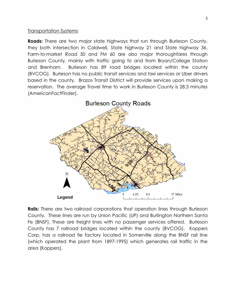
Roads: There are two major state highways that run through Burleson County,
they both intersection in Caldwell, State highway 21 and State highway 36.
Farm-to-market Road 50 and FM 60 are also major thoroughfares through
Burleson County, mainly with traffic going to and from Bryan/College Station
and Brenham. Burleson has 89 road bridges located within the county
(BVCOG). Burleson has no public transit services and taxi services or Uber drivers
based in the county. Brazos Transit District will provide services upon making a
reservation. The average Travel time to work in Burleson County is 28.3 minutes
(AmericanFactFinder).
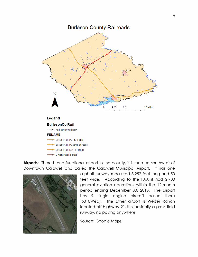
Rails: There are two railroad corporations that operation lines through Burleson
County. These lines are run by Union Pacific (UP) and Burlington Northern Santa
Fe (BNSF). These are freight lines with no passenger services offered. Burleson
County has 7 railroad bridges located within the county (BVCOG). Koppers
Corp. has a railroad tie factory located in Somerville along the BNSF rail line
(which operated the plant from 1897-1995) which generates rail traffic in the
area (Koppers).
6
Airports: There is one functional airport in the county, it is located southwest of
Downtown Caldwell and called the Caldwell Municipal Airport. It has one
asphalt runway measured 3,252 feet long and 50
feet wide. According to the FAA it had 2,700
general aviation operations within the 12-month
period ending December 30, 2013. The airport
has 9 single engine aircraft based there
(5010Web). The other airport is Weber Ranch
located off Highway 21, it is basically a grass field
runway, no paving anywhere.
Source: Google Maps

7
Public Utilities Infrastructure
Water: County residents are supplied water from the cities of Caldwell,
Somerville. There are also water supply corporations setup in the county
including Lyons Water Supply Corp, Tunis Water Supply Corp, Clay Water Supply
Corp, and Deanville Water Supply Corp to name a few. Burleson also grants
permits for private property owners to drill their own wells. Burleson County is
also supplying water to the San Antonio region from the Carrizo-Wilcox Aquifer
for the next 30 years after a recent passage of legislation approving a 142 mile
long pipeline costing around $3.4 Billion (Huddleston).
Wastewater: There are three wastewater
treatment plants in Burleson and they are
located in Southeast of Caldwell, East of
Somerville, and North of Snook. Sewage
services are provided by the City of
Caldwell, Somerville, and Snook, other than
that septic tank usage is required.
Somerville Wastewater Plant is shown right
(Google Maps).
Solid Waste: Waste management is
provided by the Cities of Caldwell and
Somerville. Citizen Collection Stations are setup in each commissioner’s precinct
and restricted to Burleson County citizens only, one car per household. There
are a total of 4 collection stations in the county. There are no standalone
recycling centers in Burleson County.
Natural Gas: Gas services for residents and businesses in Caldwell and Somerville
are provided by the Atmos Energy Company based out of Dallas. There is no
service provided in Snook and rural areas unless they have personal storage
tanks. There are numerous Natural Gas/Oil Pipelines running throughout the
county.
Energy: Electricity in the county is provided by the City of Caldwell, Entergy
(Somerville), and TXU (Snook).
Telecommunications/Media: The county Landline telephones are provided by
Verizon Southwest, and TV Cable is provided by Suddenlink and CableTime or
Satellite providers. Digital Antennas (DTV) are another method for television

8
services. All major cellular telephone providers have acceptable service
coverages in the majority of Burleson County. There are no radio/television
stations based in Burleson County, excluding the Chamber of Commerce
having a public access channel. Burleson County newspapers include The
Burleson County Tribune located in Caldwell (BurlesonCoFactSheet).
Other Infrastructure
Community Infrastructure: The City of Caldwell owns a Civic Center on State
Highway 21 or Presidential Corridor West. Caldwell also has a Fairgrounds
located southeast of downtown on State Highway 36 or South Green Street.
Parks: There are 6 parks located within the Caldwell. There are 3 parks located
along Lake Somerville; Welch Park within Somerville city limits, Big Creek Park,
and Lake Somerville State Park/Trailway. These parks include boat launches.
There is also a Country Club located in Caldwell that includes a nine-hole golf
course.
Churches: There a total of 70 churches located throughout the county. The
majority of them being of the Southern Baptist Convention denomination.
Cemeteries: There are 109 cemeteries within the county according to their
county website (BurlesonCo). With the Masonic Cemetery in Caldwell being the
largest by acreage according to Google Maps.
POPULATION CHARACTERISTICS
Population Totals by Census Tract
Burleson County is broken down into 5 census tracts. Census Tracts 9701, 9702,
9703, 9704, and 9705 reside within Burleson County. Census tract 9703 focuses
on the city of Caldwell. CT9701’s population is 1,421. CT9702’s population is
4,324. CT9703’s population is 4,279. CT9704’s population is 3,250 which contains
Snook. CT9705’s population is 3,913 which contains Somerville. All these figures
are from the 2010 Census.
Population Density
The population for Burleson County in 2010 was 17,187 and the county square
mileage is 659.03. Dividing the total population over the county square miles
gives us a population density of 26.1 people per square mile. The Map below
shows Density figures from the 2010 Census.

9
Income Characteristics
Burleson County’s Median or Average Household Income is $45,651 according
to 2013 ACS 5 Year data. 47% of Burleson County makes between $25,000 and
$50,000 a year. Using the same data source, Texas has an Average Household
Income of $51,900 to show that Burleson is below the state average. Burleson
has a Mean Household Income of $56,682 compared to Texas’s $72,474. The Per
Capita Income for the county is $21,529 while Texas stands at $26,019. Median
Non-household Income comes in at $23,203 for Burleson while $32,354 for Texas.
The average Social Security payout in Burleson is $15,990 while the Texas
Average is $16,334 a year. The number of people with Foodstamps/SNAP
Benefits in Burleson is 1,133 while Texas has 1,173,314 people.
(AmericanFactFinder)

10
Less than
$10,000$10,000 to
$14,999
$15,000 to
$24,999
$25,000 to
$34,999
$35,000 to
$49,999
$50,000 to
$74,999
$75,000 to
$99,999
$100,000 to
$149,999
$150,000 to
$199,999$200,000 or
more
Household Income according to ACS
2013 5-Year Data
11
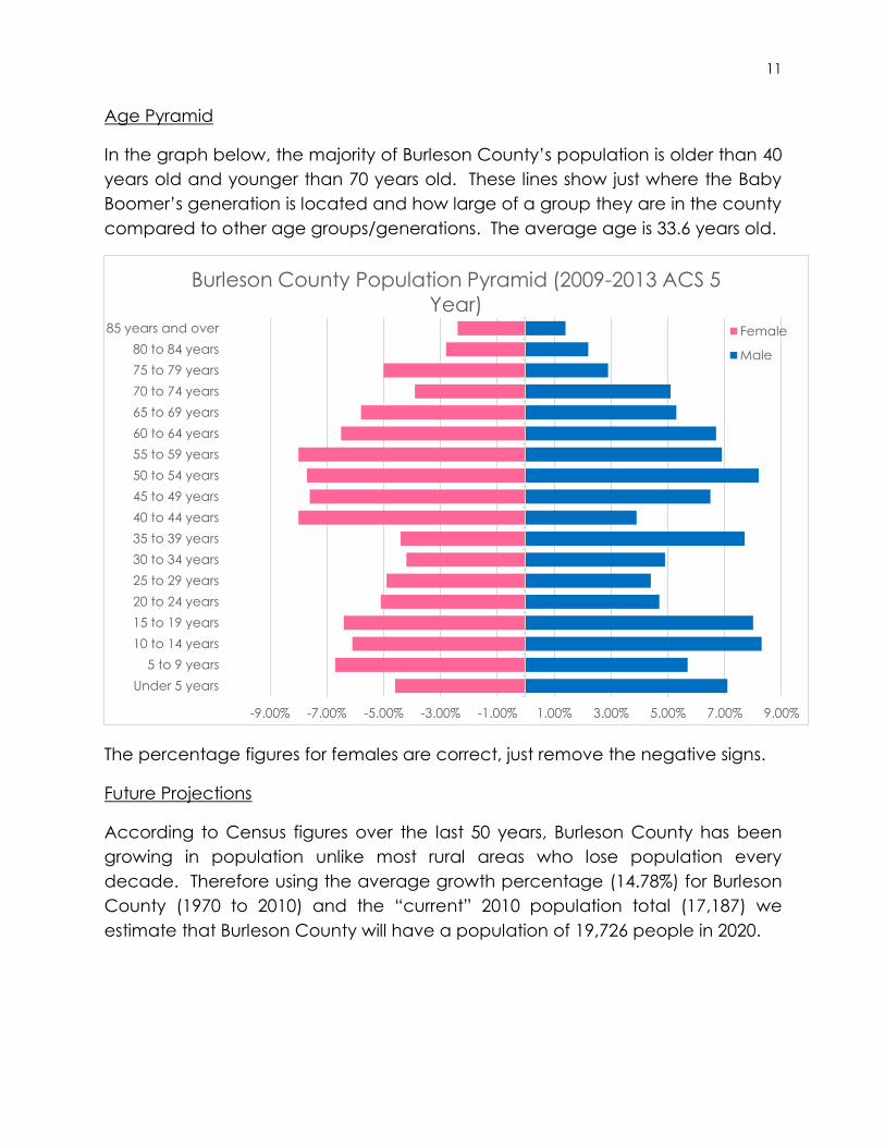
Age Pyramid
In the graph below, the majority of Burleson County’s population is older than 40
years old and younger than 70 years old. These lines show just where the Baby
Boomer’s generation is located and how large of a group they are in the county
compared to other age groups/generations. The average age is 33.6 years old.
The percentage figures for females are correct, just remove the negative signs.
Future Projections
According to Census figures over the last 50 years, Burleson County has been
growing in population unlike most rural areas who lose population every
decade. Therefore using the average growth percentage (14.78%) for Burleson
County (1970 to 2010) and the “current” 2010 population total (17,187) we
estimate that Burleson County will have a population of 19,726 people in 2020.
-9.00% -7.00% -5.00% -3.00% -1.00% 1.00% 3.00% 5.00% 7.00% 9.00%
Under 5 years
5 to 9 years
10 to 14 years
15 to 19 years
20 to 24 years
25 to 29 years
30 to 34 years
35 to 39 years
40 to 44 years
45 to 49 years
50 to 54 years
55 to 59 years
60 to 64 years
65 to 69 years
70 to 74 years
75 to 79 years
80 to 84 years
85 years and over
Burleson County Population Pyramid (2009-2013 ACS 5
Year)Female
Male

12
HOUSING
Household Characteristics
There are a total of 6,258 households in Burleson County. Educational
Attainment levels in Burleson County vary. The majority of residents according to
2013 ACS 5 Year data had earned their high school diplomas (4,482). The next
largest group was those who had Some College (2,854) and after that citizens
who had Some High School (1,630). Only 962 citizens had Bachelor Degrees.
The Average number of individuals living in a household in Burleson County is
2.71 people. The Average family size for Burleson County is 3.27 people. There
are 1,310 Veterans in the county according to ACS data, which is 10% of the
county’s population of 18 years and older. 13,798 people speak English Only in
their homes while only 2,396 speak something other than English in their house
(2,003 for Spanish). (AmericanFactFinder)
Household Statistics
Housing Tenure for Burleson County for Owner Occupied units are 4,950 (79.1%)
while Rental Occupied units are 1,308 (20.9%). The majority of housing units in
Burleson County were built between 1980 and 1989 (1,890). The majority of
housing in Burleson County has 5 rooms total (2,366) and 3 Bedrooms (4,058).
The majority of Values for Houses in Burleson County fall in the $50,000 to $99,999
category (1,622) while less than $49,999 came in at a close second (1,306). The
Median Gross Rent for Burleson County is $673 a month while the average for
Texas is $851. (AmericanFactFinder)
0
5,000
10,000
15,000
20,000
25,000
1850 1860 1870 1880 1890 1900 1910 1920 1930 1940 1950 1960 1970 1980 1990 2000 2010 2020
Burleson County Population Since 1850 US Census

13
ECONOMY
Economic Structure
The major employers for Caldwell are Allied Precision, Halliburton, Caldwell ISD,
City of Caldwell, and Wal-Mart. The major employers for Somerville are
Somerville ISD, Kopper Industries, Citizens State Bank, B&B Grocery Store, Rhodes
Building Systems, City of Somerville, and Corps of Engineers. The major
employers for Snook are Snook ISD and the Slovacek Sausage Company
(BurlesonCoFactSheet). Oil/Gas are the number one source of income in the
county with Agriculture coming in at second on gross income with an annual
income of more than $30 million annually. 27% of the county is employed in
some area of agriculture. Tourism is also a large industry with Lake Somerville
providing opportunities for hunting, fishing, boating and other forms of
recreation. Burleson has 4 Banks located in the county; Citibank, Prosperity Bank,
Citizen State Bank, and the First Bank of Snook. The unemployment rate in
Burleson County according to the US Bureau of Labor Statistics in December
2014 was 3.3%. The average for 2014 was 4.2% (USBLS).
Location Quotients for Burleson Co. compared to Texas: ACS 5 year 2010 & 2013:
Compared to Texas Benchmark LQ 2010 LQ 2013
Industries Burleson Co. Burleson Co.
Agriculture, Forestry, Fishing, and Hunting 3.14 4.13
Mining and Extraction 2.78 2.62
Utilities 3.06 1.10
Construction 1.29 1.24
Manufacturing 0.94 1.24
Wholesale Trade 0.38 0.64
Retail Trade 1.03 1.07
Transportation and Warehousing 0.79 0.83
Information 0.34 0.99
Finance and Insurance 0.61 0.47
Real Estate and Rental and Leasing 0.68 0.82
Professional, Scientific, Technical Services 0.31 0.67
Management of Companies and Enterprises 1.02 0.00
Administrative and Support and Waste Management 0.35 0.28
Educational Services 1.45 1.66
Healthcare and Social Assistance 0.80 0.82
Arts, Entertainment, and Recreation 0.71 0.08
Accommodation and Food Services 1.35 0.88
Other Services (except Public Admin) 1.01 1.56
Public Administration 0.92 0.84

14
Green rows indicate most likely Basic Employers, and white indicate non-basic
employers. LQs > 1 are basic, LQs =< 1 are non-basic employers. Agriculture
and Mining/Extraction have the largest share of employment in the county.
Inflow/Outflow Analysis
Using Data from 2011 Job Counts, Burleson County has 6,839 people living in
Burleson but working outside of the County and 2,089 employed in Burleson but
living outside of Burleson County. A total of 994 live and work in the county.
2
2 Source: http://onthemap.ces.census.gov
15
ENVIRONMENT AND HAZARDS
Terrain/Floodplain
The average elevation for Burleson County is around 350 feet above sea level
(TSHA). Floodplains are generally located on the south and east sides of the
county (where the Brazos River and major creeks are). Majority of the
floodplains in the county are under the 100 year floodplains category. The
county lies on top of the Carrizo-Wilcox Aquifer which supplies drinking water to
the region.
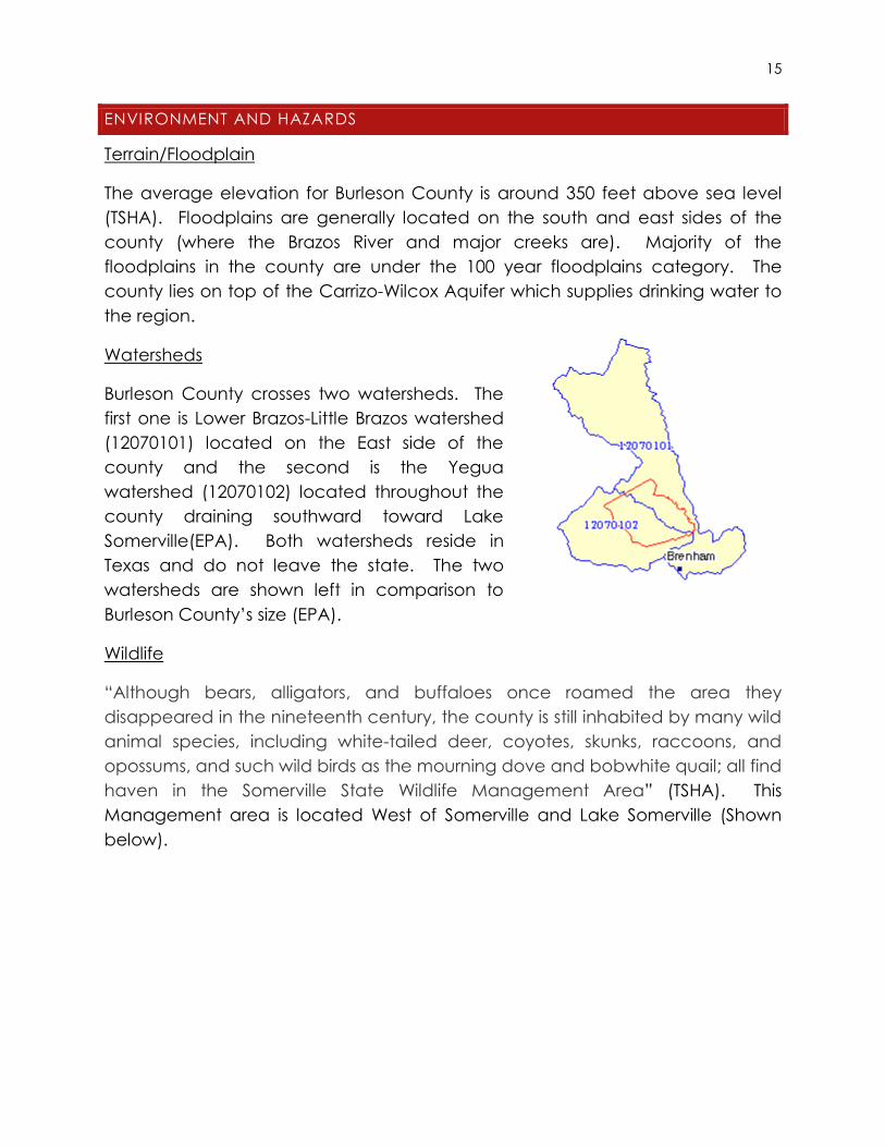
Watersheds
Burleson County crosses two watersheds. The
first one is Lower Brazos-Little Brazos watershed
(12070101) located on the East side of the
county and the second is the Yegua
watershed (12070102) located throughout the
county draining southward toward Lake
Somerville(EPA). Both watersheds reside in
Texas and do not leave the state. The two
watersheds are shown left in comparison to
Burleson County’s size (EPA).
Wildlife
“Although bears, alligators, and buffaloes once roamed the area they
disappeared in the nineteenth century, the county is still inhabited by many wild
animal species, including white-tailed deer, coyotes, skunks, raccoons, and
opossums, and such wild birds as the mourning dove and bobwhite quail; all find
haven in the Somerville State Wildlife Management Area” (TSHA). This
Management area is located West of Somerville and Lake Somerville (Shown
below).

16
3
Soils
According to the USGS, Burleson County has majority Alfisols along with
Inceptisols, Vertisols, Entisols, and Mollisols. Alfisols type soils are generally for
agriculture and forest covers. Inceptisols and Vertisols are generally found in
river/creek beds. Entisols are terrible soil types for infrastructure development
and remain underdeveloped in most of the world because of their poor
saturation rates. Mollisols are small part of the soils in Burleson County, these soils
are generally found under grasslands that have not been disturbed by
agriculture.
3 Source: http://www.bafrenz.com/birds/Somer.htm

17

18
Climate
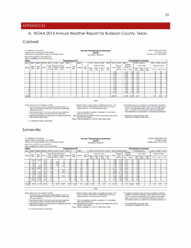
According to the National Oceanic Atmospheric Administration (NOAA)
Caldwell has no temperature readings only rainfall, so rainfall totals for Caldwell
in 2014 were 26.97 inches. Readings came from the Caldwell Municipal Airport.
Somerville has an average temperature of 68.4 F degrees for the year 2014. The
average rainfall total for 2014 was 36.48 inches. Both readings come from the
Somerville Dam site. There was 0.0 inches of snow accumulation in 2014 for both
sites. The averages come from the months of January to November, December
has not been completed yet. NOAA 2014 complete report is shown in Appendix
A.
Hazards
Natural: According to the Burleson County Hazard Mitigation Plan 2013-2018
prepared by BVCOG, Burleson County is susceptible to winter storms,
thunderstorm winds, floods, tornadoes, hailstorms, wildfires, droughts, excessive
heatwaves, and hurricanes. Burleson County has been declared a Federal
Disaster Area by the President 4 times. This plan also has contingencies for
possible dam failures. The major dam of course being located in Somerville for
Lake Somerville (BVCOG).

19
Man-made: The then Santa Fe Railroad tie factory (Now owned by Koppers)
located in Somerville has had many chemical spills and introduced pollution to
the residents of Somerville causing cancer rates to skyrocket (Spivak). Known
chemicals the plant dealt with are Arsenic, Dioxins, and Polycyclic Aromatic
Hydrocarbons (all cancer causing chemicals). Not only are these chemicals in
the air, they are also in the ground water. According to the US Dept. of Health
and Human Services, Sherman Wire and ZTT Minerals (Both of Caldwell) are also
polluters in Burleson County (TOXMAP).
LAND USES
Existing Land Uses
The county of course has no zoning ordinances but the individual incorporated
cities should. According to the Somerville Comprehensive Plan done by the
Texas Target Communities program, the land uses are broken down into several
categories. The most prominent land use in Somerville is Single-family housing
with 11.98% of the city or 183.92 acres. The second most use was Agricultural at
7.58% or 116.21 acres (SomervilleCompPlan2020). There are no land use maps
for the cities of Caldwell or Snook that we know of.
20
Suggestions for Future Land Use
One suggestion for Burleson County is to make sure the incorporated cities in the
county post their land use maps online and make access easier (If they have
zoning at all). Another could be to increase mix use zoning in their downtowns
to revitalize their communities since they are slowly sprawling along either State
Hwy 21 or State Hwy 36. Snook should consolidate their resources and create
the center of town somewhere because right now Snook is just a bunch of
buildings/homes spaced out around the local school and road intersection.
One could drive right through it and not even know it was a town.
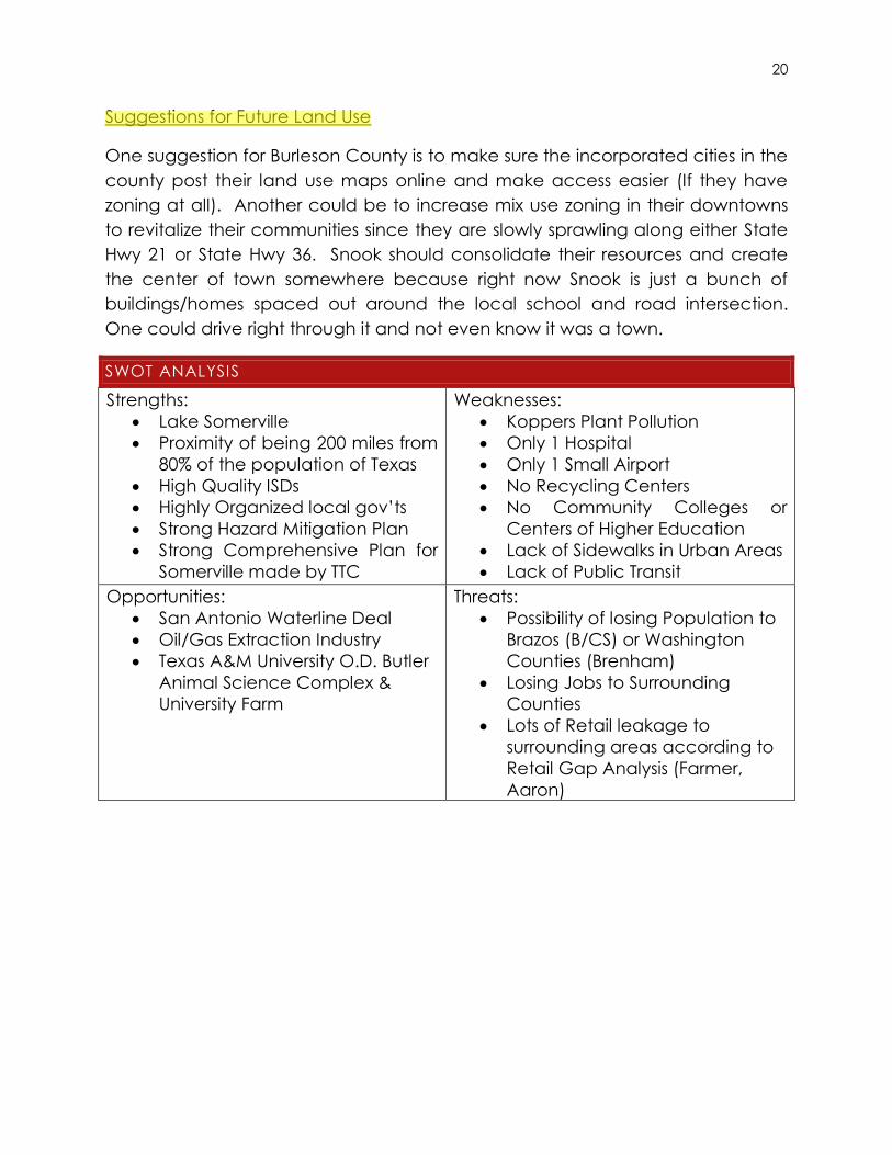
SWOT ANALYSIS
Strengths:
Lake Somerville
Proximity of being 200 miles from
80% of the population of Texas
High Quality ISDs
Highly Organized local gov’ts
Strong Hazard Mitigation Plan
Strong Comprehensive Plan for
Somerville made by TTC
Weaknesses:
Koppers Plant Pollution
Only 1 Hospital
Only 1 Small Airport
No Recycling Centers
No Community Colleges or
Centers of Higher Education
Lack of Sidewalks in Urban Areas
Lack of Public Transit
Opportunities:
San Antonio Waterline Deal
Oil/Gas Extraction Industry
Texas A&M University O.D. Butler
Animal Science Complex &
University Farm
Threats:
Possibility of losing Population to
Brazos (B/CS) or Washington
Counties (Brenham)
Losing Jobs to Surrounding
Counties
Lots of Retail leakage to
surrounding areas according to
Retail Gap Analysis (Farmer,
Aaron)
wli
Highlight
issues not clear; conclusion needed.

21
REFERENCES
AmericanFactFinder/QuickFacts. US Census Bureau.
http://quickfacts.census.gov/qfd/states/48/48051lk.html
BHRC. Burleson Health Resource Center.
http://www.behealthybrazosvalley.org/health-resource-centers/burleson-health-
resource-center/
BurlesonCo.
http://co.burleson.tx.us/
BurlesonCoFactSheet.
http://www.burlesoncountytx.com/visit/Burleson%20County%20Resource%20Gui
de%202008.pdf
BVCOG Burleson Hazard Mitigation Plan
http://www.co.burleson.tx.us/image/files/Emergency%20Management/Burleson
%20County%20Mitigation%20Plan%20APA%202013%20(3).pdf
Climate. (Also shown below in Appendix A)
NOAA Annual Climatological Summary for 2014. Published 9 April 2015.
EPA. Environmental Protection Agency.
http://cfpub.epa.gov/surf/county.cfm?fips_code=48051
Farmer, Aaron. TheRetailCoach. 2009 Nov 6.
http://www.co.burleson.tx.us/file/Caldwell_RGA_110609_cs3.pdf
Huddleston, Scott. MySanAntonio. 2014 Oct 30.
http://www.mysanantonio.com/news/local/article/San-Antonio-City-Council-
approves-pipeline-to-5858756.php
Koppers.
http://www.koppers.com/locations/somerville-plant
Somerville Comp Plan 2020. Texas Target Communities Program at TAMU. 2000.
wli
Highlight
citation needs attention

22
http://lakesomervilletexas.com/wp-content/uploads/2013/06/Somerville-State-
of-the-City-Report-2000.pdf
Spivak, Todd. Houston Press. 2007 Dec 5.
http://www.houstonpress.com/2007-12-06/news/toxic-town/full/
TOXMAP. US Department of Health and Human Services.
http://toxmap.nlm.nih.gov/toxmap/flex/
TSHA. Texas State Historical Association.
https://tshaonline.org/handbook/online/articles/hcb18
USBLS. US Bureau of Labor Statistics.
https://www.google.com/publicdata/explore?ds=z1ebjpgk2654c1_&met_y=une
mployment_rate&idim=county:CN4805100000000&fdim_y=seasonality:U&hl=en&
dl=en#!ctype=l&strail=false&bcs=d&nselm=h&met_y=unemployment_rate&fdim
_y=seasonality:U&scale_y=lin&ind_y=false&rdim=country&idim=county:CN48051
00000000&ifdim=country&tstart=1389679200000&tend=1418536800000&hl=en_US
&dl=en&ind=false
5010Web.
http://www.gcr1.com/5010web/airport.cfm?Site=RWV&AptSecNum=2
23
APPENDICES
A. NOAA 2014 Annual Weather Report for Burleson County, Texas.
Caldwell
Somerville
Related Documents