BROOKINGS KINGSBURY BULLETIN 40 Geology of Brookings and Kingsbury Counties, South Dakota LAYNE D. SCHULZ MARTIN J. JARRETT Prepared in cooperation with the U.S. Geological Survey, East Dakota Water Development District, James River Water Development District, and Brookings and Kingsbury Counties Department of Environment and Natural Resources Geological Survey Akeley-Lawrence Science Center University of South Dakota Vermillion, South Dakota 2009

Welcome message from author
This document is posted to help you gain knowledge. Please leave a comment to let me know what you think about it! Share it to your friends and learn new things together.
Transcript

BROOKINGSKINGSBURY
BULLETIN 40
Geology of Brookings and Kingsbury Counties,
South Dakota
LAYNE D. SCHULZ MARTIN J. JARRETT
Prepared in cooperation with the U.S. Geological Survey,
East Dakota Water Development District, James River Water Development District, and Brookings and Kingsbury Counties
Department of Environment and Natural Resources Geological Survey
Akeley-Lawrence Science Center University of South Dakota Vermillion, South Dakota
2009

GEOLOGICAL SURVEY PROGRAM DEPARTMENT OF ENVIRONMENT AND NATURAL RESOURCES
AKELEY-LAWRENCE SCIENCE CENTER, USD 414 EAST CLARK STREET
VERMILLION, SOUTH DAKOTA 57069-2390 (605) 677-5227
Derric L. Iles, M.S., C.P.G. State Geologist Sarah A. Chadima, M.S. Senior Geologist Timothy C. Cowman, M.S. Natural Resources Administrator Brian A. Fagnan, M.S. Senior Geologist Dragan Filipovic, M.S. Senior Hydrologist Thomas N. Haggar, B.S. Senior Geologist Ann R. Jensen, B.S. Senior Geologist Matthew T. Noonan, B.S. Hydrologist Thomas B. Rich, M.S. Senior Hydrologist Layne D. Schulz, B.S. Senior Geologist Dennis D. Iverson Civil Engineering Technician Scott W. Jensen Civil Engineering Technician Ted R. Miller, B.S. Civil Engineering Technician Colleen K. Odenbrett Word Processing Supervisor Jeffrey J. Puthoff, B.A. Natural Resources Technician Lori L. Roinstad Cartographer Priscilla E. Young, B.S. Senior Secretary
RAPID CITY REGIONAL OFFICE 2050 WEST MAIN, SUITE 1
RAPID CITY, SOUTH DAKOTA 57702-2493 (605) 394-2229
Mark D. Fahrenbach, Ph.D. Senior Geologist Kelli A. McCormick, Ph.D. Senior Geologist Joanne M. Noyes, M.S., P.E. Senior Hydrologist

STATE OF SOUTH DAKOTA M. Michael Rounds, Governor
DEPARTMENT OF ENVIRONMENT AND NATURAL RESOURCES Steven M. Pirner, Secretary
DIVISION OF FINANCIAL AND TECHNICAL ASSISTANCE David Templeton, Director
GEOLOGICAL SURVEY Derric L. Iles, State Geologist
BULLETIN 40
GEOLOGY OF BROOKINGS AND KINGSBURY COUNTIES, SOUTH DAKOTA
LAYNE D. SCHULZ
MARTIN J. JARRETT
Prepared in cooperation with the U.S. Geological Survey,
East Dakota Water Development District, James River Water Development District, and
Brookings and Kingsbury Counties
Akeley-Lawrence Science Center University of South Dakota Vermillion, South Dakota
2009

i
CONTENTS Page ABSTRACT ............................................................................................................................. 1 INTRODUCTION ................................................................................................................... 1 Location and physiography ................................................................................................. 3 Previous investigations ...................................................................................................... 5 Methods of investigation ..................................................................................................... 5 Acknowledgements ............................................................................................................. 6 BEDROCK GEOLOGY ......................................................................................................... 6 Introduction ......................................................................................................................... 6 Precambrian geology .......................................................................................................... 6 Crystalline basement rocks .......................................................................................... 6 Sioux Quartzite ............................................................................................................ 8 Paleozoic geology ............................................................................................................... 8 Mesozoic geology ............................................................................................................... 8 Cretaceous geology ..................................................................................................... 8 Undifferentiated Cretaceous rocks ....................................................................... 8 Dakota Sandstone ................................................................................................. 10 Graneros Shale ..................................................................................................... 10 Greenhorn Limestone ........................................................................................... 11 Carlile Shale ......................................................................................................... 11 Codell Sandstone Member ........................................................................... 11 Niobrara Formation .............................................................................................. 11 Pierre Shale .......................................................................................................... 12

ii
BEDROCK GEOLOGY – continued Page Bedrock surface topography ............................................................................................... 12 QUATERNARY GEOLOGY ................................................................................................ 13 Quaternary stratigraphy ...................................................................................................... 13 Stratigraphic nomenclature .......................................................................................... 13 Pre-late Wisconsin stratigraphy ................................................................................... 17 Pre-Illinoian glaciation ......................................................................................... 17 Illinoian(?) glaciation ........................................................................................... 17 Late Wisconsin stratigraphy ........................................................................................ 18 Toronto phase (late Wisconsin I) ......................................................................... 21 Bemis phase of the Des Moines lobe (late Wisconsin II) .................................... 21 Dakota phase of the James lobe (late Wisconsin II) ............................................ 23 De Smet phase of the James lobe (late Wisconsin II) .......................................... 23 Pleistocene deposits ............................................................................................................ 24 Till ............................................................................................................................... 24 Pre-Illinoian till .................................................................................................... 24 Illinoian(?) till ...................................................................................................... 25 Late Wisconsin till ............................................................................................... 25 Outwash ....................................................................................................................... 25 Lake sediments ............................................................................................................ 25 Holocene deposits ............................................................................................................... 26 Alluvium ...................................................................................................................... 26 Lacustrine .................................................................................................................... 26

iii
QUATERNARY GEOLOGY – continued Page Loess ............................................................................................................................ 26 QUATERNARY LANDFORMS ........................................................................................... 26 Glacial landforms ................................................................................................................ 26 Stream dissected till plain ............................................................................................ 27 Active ice landforms ................................................................................................... 27 End moraine ......................................................................................................... 27 Recessional moraine ............................................................................................ 27 Coteau slope moraine ........................................................................................... 27 Ground moraine ................................................................................................... 27 Inactive ice landforms ................................................................................................. 28 Stagnation moraine .............................................................................................. 28 Pre-late Wisconsin landforms ..................................................................................... 28 Brookings Till Plain ............................................................................................. 28 Late Wisconsin landforms ........................................................................................... 28 Toronto Till Plain ................................................................................................. 28 Bemis end moraine .............................................................................................. 28 Bemis stagnation moraine .................................................................................... 29 Dakota stagnation moraine .................................................................................. 29 Collapsed outwash ........................................................................................ 29 Ice-walled lake plain .................................................................................... 29 De Smet end moraine ........................................................................................... 30 De Smet coteau slope moraine ............................................................................. 30

iv
QUATERNARY LANDFORMS – continued Page De Smet ground moraine ..................................................................................... 30 De Smet recessional moraine ............................................................................... 31 Proglacial outwash landforms ..................................................................................... 31 Outwash plain ...................................................................................................... 31 Valley train outwash ............................................................................................ 32 Terrace outwash ................................................................................................... 32 Outwash undifferentiated ..................................................................................... 32 Lake plains ........................................................................................................... 33 Nonglacial landforms .......................................................................................................... 33 Recent stream channels ............................................................................................... 33 ECONOMIC GEOLOGY ...................................................................................................... 33 Water resources ................................................................................................................... 33 Sand and gravel ................................................................................................................... 33 Oil and gas .......................................................................................................................... 33 Other mineral resources ...................................................................................................... 34 SELECTED REFERENCES ................................................................................................. 34
APPENDIX A. Legal locations corresponding to map location numbers used in the text and cross sections ........................................................................................ 40
ILLUSTRATIONS PLATES 1. Bedrock map of Brookings County, South Dakota ............................................... External File

v
PLATES – continued
2. Bedrock map of Kingsbury County, South Dakota ............................................... External File
3. Index map and geologic cross sections in Brookings and Kingsbury Counties, South Dakota ....................................................................... External File
4. Geology and landforms of Brookings County, South Dakota ............................... External File
5. Geology and landforms of Kingsbury County, South Dakota .............................. External File
FIGURES Page 1. Status of countywide investigations in South Dakota .......................................................... 2 2. Map of eastern South Dakota showing physiographic divisions ......................................... 4
3. Geologic map of the Precambrian surface in Brookings and
Kingsbury Counties, South Dakota ..................................................................... Following 8
4. Map showing probable extent of the Western Interior Seaway during a portion of the late Cretaceous Period ..................................................................... 9
5. Generalized relationship of James lobe and Des Moines lobe
ice to eastern South Dakota .................................................................................................. 14 6. Approximate late Wisconsin ice marginal positions and
phases of glacial activity in northeastern South Dakota ....................................................... 20
7. Classification systems used to describe the surficial geology of northeastern South Dakota ................................................................................. 22
TABLES 1. Generalized stratigraphic column of geologic units in
Brookings and Kingsbury Counties, South Dakota .............................................................. 7
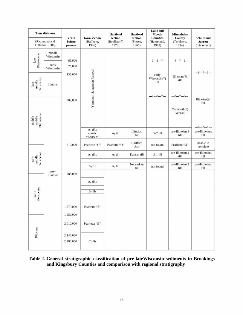
2. General stratigraphic classification of pre-late Wisconsin sediments in Brookings and Kingsbury Counties and comparison with regional stratigraphy ............................................................................................................. 15
3. Classification and correlation of Wisconsin glaciations in the
Midwest and North-Central United States ........................................................................... 16

1
ABSTRACT Brookings and Kingsbury Counties are located in eastern South Dakota and cover an area of approximately 805 and 864 square miles, respectively. The two counties are located along the divisions between in the Coteau des Prairies and James Basin of the Central Lowlands Physiographic Province. Brookings County and the approximate eastern two-thirds of Kingsbury County occur in the Coteau des Prairies Division of the Central Lowlands Physiographic Province. The approximate western one-third of Kingsbury County occurs in the James Basin Division of the Central Lowlands Physiographic Province. Pre-Pleistocene rocks in the two counties are Precambrian and Cretaceous in age. Precambrian age rocks include Archean crystalline basement rocks of the Canadian Shield and early Proterozoic Sioux Quartzite. No Paleozoic rocks have been identified in either county. Cretaceous shales, marls, and sandstones overlie Precambrian rocks in all but southeastern Brookings County where the Precambrian Sioux Quartzite lies directly beneath Quaternary glacial deposits. Cretaceous age rocks from oldest to youngest include the Dakota Sandstone, Graneros Shale, Greenhorn Limestone, Carlile Shale, Niobrara Formation, Pierre Shale, and other undifferentiated Cretaceous sediments. Pleistocene deposits of Illinoian(?), late Wisconsin, and Holocene age sediments make up the surficial deposits of the two counties including large deposits of sand and gravel which are a major source of ground water and coarse aggregate. Pre-late Wisconsin deposits underlie the majority of the surficial deposits. Interpretations of the stratigraphic relationships of Pleistocene sediments are based on topography, lithologic characteristics, geophysical logs, and a limited number of absolute dates.
INTRODUCTION This report provides a description of the geology within Brookings and Kingsbury Counties, South Dakota. It is meant to establish the basic geologic framework upon which future development and management decisions can be based. The investigation of the geology of Brookings and Kingsbury Counties is part of a series of cooperative studies conducted in eastern South Dakota through the combined efforts of the South Dakota Geological Survey (Geological Survey Program, South Dakota Department of Environment and Natural Resources) and the U.S. Geological Survey (fig. 1). The focus of these investigations is the documentation and evaluation of mineral and ground-water resources. Results of the investigation for Brookings and Kingsbury Counties are published in six parts as follows:
Sand and gravel resources in Kingsbury County, South Dakota: South Dakota Geological Survey Information Pamphlet 37, Tomhave, D.W., 1987.

HardingPerkins
Butte
Lawrence
Meade
Pennington
Custer
Fall River Shannon
Bennett
Jackson
Mellette
Todd
JonesLyman
Tripp
Gregory
StanleyHaakon
Ziebach
Dewey
Corson Campbell McPherson
Walworth Edmunds
Brown
SpinkFaulkPotter
Sully
Hughes
Hyde Hand
Beadle
Buffalo Jerauld Sanborn
Brule Aurora
Douglas
Yankton
Hutchinson Turner
ClayUnion
Lincoln
MinnehahaMcCookHansonDavison
MoodyLakeMiner
BrookingsKingsbury
DeuelHamlin
ClarkCodington
Grant
Day
Marshall Roberts
This report Investigation in progressReport completed
Figure 1. Status of countywide investigations in South Dakota.

3
Sand and gravel resources in Brookings County, South Dakota: South Dakota Geological Survey Information Pamphlet 38, Tomhave, D.W., 1988. Major aquifers in Brookings County, South Dakota: South Dakota Geological Survey Information Pamphlet 40, Hamilton, L.J., 1988. Major aquifers in Kingsbury County, South Dakota: South Dakota Geological Survey Information Pamphlet 41, Hamilton, L.J., 1988. Water resources of Brookings and Kingsbury Counties, South Dakota: U.S. Geological Survey Water-Resources Investigations Report 88-4185, Hamilton, L.J., 1989. Geology of Brookings and Kingsbury Counties, South Dakota: South Dakota Geological Survey Bulletin 40, Schulz, L.D., and Jarrett, M.J. (this report).
The first four publications summarize the coarse aggregate and aquifer data in less detailed information pamphlets. The last two reports contain more technical evaluations of the water resources and geology of Brookings and Kingsbury Counties. All of the reports and basic data used to compile these publications are available from the offices of the South Dakota Geological Survey in Vermillion, South Dakota, or the U.S. Geological Survey in Huron and Rapid City, South Dakota. The basic data and reports published by the South Dakota Geological Survey are also available online at the South Dakota Geological Survey (http://www.sdgs.usd.edu/).
Location and Physiography Brookings and Kingsbury Counties are located in eastern South Dakota (fig. 1) and cover areas of approximately 805 and 864 square miles, respectively. They are bordered by Clark, Hamlin, and Deuel Counties to the north; Beadle County to the west; Sanborn County to the southwest; Miner, Lake, and Moody Counties to the south; and Lincoln County, Minnesota, to the east. All of Brookings County and the eastern two-thirds of Kingsbury County are in the Coteau des Prairies Division of the Central Lowlands Physiographic Province (fig. 2, this report; Fenneman, 1931). The western one-third of Kingsbury County lies in the James Basin Division of the Central Lowlands Physiographic Province. The Coteau des Prairies is a broad, flat-iron shaped highland extending from Marshall County, South Dakota (at the North Dakota border) to southeastern South Dakota where it exits the state into southwestern Minnesota and northwestern Iowa. The Big Sioux River and its tributaries drain the Coteau des Prairies in Brookings County while the headwaters of the East and West Forks of the Vermillion River drain the Coteau des Prairies in south-central Kingsbury County.

4
LAKESANBORN MINERBUFFALO
HANSON
HUTCHINSON
BASIN
40
BON HOMME
0 10 20 30
CHARLES MIX
0 10 20
JERAULD
AURORABRULE
DAVISON
DOUGLAS
50 Kilometers
TURNER
CLAYHIGHLANDS
30 40 50 Miles
YANKTON
RIVER
JAMES
UNION
LINCOLN
MINNEHAHAMC COOK
MOODY
CLARK
MARSHALL
PLAI
NHYDE
MISSOURI
COTEAU
HUGHES
DUSULLY
POTTER
WALWORTH
LAK
EHAND
BEADLE
JAMES
FAULK
EDMUNDS
DAK
OTA
SPINK
BROWNCAMPBELL MC PHERSON
After Rothrock (1943) and Flint (1955)
MINNESOTAVALLEY
COTEAU
PRAIRIESBROOKINGSKINGSBURY
DESHAMLIN
DEUEL
CODINGTON
DAY
GRANT
CENTRALLOWLANDS
ROBERTS
GREATPLAINS
O
104o
97o
45o
43o
Base map modified from U.S. GeologicalSurvey 30 meter DEM
!(!(
!(!(!(!(
!(!(
!(!(!(!(
!(!(
!(!(!(
!(!(
!(!(!(!(!(!(
!(!(
!(
!(
!(!(!(
!(!( !( !(
!(!( !(
!(!(
!(!( !( !(
!(
!( !(!(
!(!(
!(!(!(
!(!(
!(!(
!(!(
!(
!(
!(!(
!(!(
!(!(
!(!(
!( !( !(!( !( !(
-
Figure 2. Map of eastern South Dakota showing physiographic divisions.

5
The James Basin is a wide lowland trending north to south in eastern South Dakota from the North Dakota border to the Missouri River and is bounded by the Coteau des Prairies on the east and the Coteau du Missouri to the west. The portion of Kingsbury County that lies within the James Basin is drained by tributaries to the James River, namely Pearl Creek, West Redstone Creek, Redstone Creek, Rock Creek, and other small unnamed streams.
Previous Investigations Geographic and geologic work relating to Brookings and Kingsbury Counties can be found in numerous statewide and regional studies published within the last century. Notable contributions to the geology of South Dakota include: Upham (1880), Chamberlin (1883), Todd (1904a, b, 1909), Darton (1905, 1909), Leverett (1932), Rothrock (1943, 1944), and Flint (1955). Publications detailing the geology of the surrounding counties and parts of Brookings and Kingsbury Counties include: Lee (1958a), Steece and Howells (1965), Hedges (1968), Beissel and Gilbertson (1987), Christensen (1987), Schroeder (1988), Hammond (1991), Patterson (1995), Patterson and others (1999), and a series of 15-minute surficial geologic maps prepared by Steece (1958a) and Lee (1958b, c, 1960a, b). Other investigations conducted primarily for water resources include reports by Hedges (1962), Barari (1968, 1971), Beissel and Barari (1976), Slugg and Barari (1976), Frykman (1986), and Hammond and Wilkie (1997).
Methods of Investigation The geologic information contained in this report was derived from the compilation of preexisting data, reports and publications, and data generated for this study during field investigations conducted from 1981 through 1988. To better understand the geology of Brookings and Kingsbury Counties, a drilling program was implemented to obtain subsurface data, refine the understanding of geologic units, explore for coarse aggregate, and to install observations wells for aquifer delineation and characterization. A total of 270 mud-rotary and 666 auger test holes were drilled by the South Dakota Geological Survey specifically for this study. Of the 270 mud-rotary holes drilled, 210 have accompanying geophysical logs. The geophysical logs are available in Adobe PDF format from the office of the South Dakota Geological Survey in Vermillion, South Dakota. Subsurface data obtained from drill holes were used to construct cross sections and the bedrock geologic maps. The surficial geology was mapped using 1:24,000-scale topographic maps with supplemental information being supplied from aerial photographs, natural and man-made exposures, and hand augering of surface sediments. This information was then compiled on base maps with a scale of 1 inch = 1 mile and transferred/drafted onto mylar maps. Subsequent to the initial mapping and drafting, Geographic Information System software became available. The original hand-drafted geologic maps were converted to digital Geographic Information System format.

6
Acknowledgements The investigation and preparation of this report were performed under the supervision of State Geologists Merlin J. Tipton, Cleo M. Christensen, and Derric L. Iles. The authors wish to thank geologists Gary D. Johnson and J.D. Lehr who performed the majority of field activities and Dennis W. Tomhave for his expertise and advice on the geology of eastern South Dakota. Also recognized is the field staff of the South Dakota Geological Survey for their assistance throughout the project. Drafting and word processing were provided by Dennis Johnson, Lori Roinstad, and Colleen Odenbrett. Financial assistance was contributed by the South Dakota Department of Environment and Natural Resources, U.S. Geological Survey, East Dakota Water Development District, James River Water Development District, and Brookings and Kingsbury Counties.
BEDROCK GEOLOGY
Introduction In this report, the term “bedrock” refers to Precambrian or Cretaceous age rocks which underlie Quaternary age sediments. Plates 1 and 2 show the configuration of the bedrock surface and indicate which bedrock units subcrop Quaternary sediments. The bedrock stratigraphy within the two counties is shown in table 1 and on the cross sections on plate 3. The legal descriptions of map location numbers used on the index map and cross sections are presented in appendix A. Stratigraphic nomenclature used in this report conforms to that accepted by the South Dakota Geological Survey (Agnew and Tychsen, 1965) and the Code of Stratigraphic Nomenclature (American Commission on Stratigraphic Nomenclature, 1983).
Precambrian Geology
Crystalline Basement Rocks Characterization of the Precambrian basement rocks in Brookings and Kingsbury Counties was beyond the scope of this study. The reader is referred to several authors who have contributed publications discussing the crystalline basement rocks of eastern South Dakota. They include: Goldich and others (1966), Hart and Davis (1969), Lidiak (1971), Van Schmus and others (1975), Van Schmus (1978), Denison and others (1984), Kane (1986), Klasner and King (1986), and Sims (1990). Information available for the Precambrian basement rocks includes gravity and magnetic data, scattered drill-hole data, and age dates. Regional maps of the Precambrian basement rocks suggest that the basement rocks in the two-county area are mainly a subsurface extension of Archean and Proterozoic rocks of the Canadian Shield. Sims (1990) mapped four Precambrian rock types in Brookings and Kingsbury Counties: Archean migmatitic and granitoid gneisses; early Proterozoic mafic to felsic volcanic and sedimentary rocks; early Proterozoic ryholite; and early Proterozoic quartzite which includes the Sioux Quartzite in South Dakota. Figure 3 shows the configuration of the Precambrian surface in Brookings and

7
Era Period Rock units Description Thickness in feet
Cretaceous Cyclothem
Cen
ozoi
c
Qua
tern
ary Hol
ocen
e
See tables 2 and 3
0 - 725
Plei
stoc
ene
Tertiary none
Mes
ozoi
c
Cre
tace
ous
Upp
er
Pierre Shale
undifferentiated
Cre
tace
ous u
ndiff
eren
tiate
d; ti
me
equi
vale
nt to
mos
t of t
he u
pper
Cre
tace
ous;
in
clud
es th
e Sp
lit R
ock
Cre
ek F
orm
atio
n
Gray to dark-gray, noncalcareous, claystone; with concretions and bentonite layers
0 - 360
Bearpaw
Sharon Springs Member
Black, highly organic noncalcareous, bentonitic claystone Claggett
Niobrara Formation Dark-gray; calcarenite, chalk, and calcareous shale; pyritic, burrowed, containing some bentonite
0 - 150 Niobrara
Carlile Shale
unnamed member Gray shale
0 – 200
Greenhorn
Codell Sandstone Member
Fine- to coarse-grained sandstone; cross-bedding; abundant sharks teeth and phosphatic nodules
Blue Hill Shale Member Dark-gray, pyritic, concretionary mudstone
Fairport Chalk Member Grayish-brown, chalky, organic-rich shale
Greenhorn Limestone Grayish-brown calcareous claystone; with thin shell rich, argillaceous limestone layers 0 - 50
Graneros Shale Dark-gray, noncalcareous, pyritic, poorly fossiliferous claystone; with abundant thin sand layers near base
0 - 200
Dakota Formation White to light-gray, fine-grained, quartz
sandstone; with some claystone layers 0 - 255
Low
er
Skull Creek Shale Dark-gray to black claystone 0 - ? Kiowa- Skull Creek Inyan Kara Group Undifferentiated sandstone and claystone 0 - ?
Jurassic none
Triassic none
Paleozoic none
Precambrian
Sioux Quartzite Pink to white, fine-grained to conglomeritic orthoquartzite with minor beds of red to purple catlinite
unknown
Crystalline basement rocks Gabbro, granite, metagabbro, and various other metamorphic rocks unknown
Period of erosion or nondeposition (unconformity)
Table 1. Generalized stratigraphic column of geologic units in Brookings and Kingsbury Counties, South Dakota

8
Kingsbury Counties. The data for the construction of figure 3 are taken from unpublished information provided by K.A. McCormick (South Dakota Geological Survey, unpub. data, 2009) and drill holes completed for this study.
Sioux Quartzite The Sioux Quartzite is part of the Sioux Ridge which extends from southwestern Minnesota and northwestern Iowa to east-central South Dakota (fig. 3). The approximate extent of the Sioux Quartzite in Brookings and Kingsbury Counties is also shown on figure 3. It locally subcrops Quaternary sediments in southeastern Brookings County at depths ranging from 580 feet to less than 100 feet below land surface (pl. 1; pl. 3, cross sections E-E’, F-F’, G-G’, and H-H’). Sioux Quartzite is a hard, massive, light-pink to red, siliceous orthoquartzite and may contain beds of red, sericitic claystone commonly referred to as catlinite or pipestone. Bergstrom and Morey (1985) have suggested that the age of the Sioux Quartzite is between 1,760 and 1,630 million years. For further discussion of the history, structure, and petrology of the Sioux Quartzite, the reader is referred to Baldwin (1951), Southwick (1984), and Southwick and others, (1986).
Paleozoic Geology There are no known rocks of Paleozoic age in Brookings or Kingsbury Counties. This may be due to nondeposition on the Sioux Ridge, which has been a positive structural area since Precambrian time. Alternatively, if Paleozoic sediments were deposited, they were eroded before Mesozoic deposition began.
Mesozoic Geology Mesozoic sediments in Brookings and Kingsbury Counties are all of Cretaceous age. Cretaceous sedimentation occurred as an epicontinental sea (fig. 4) that transgressed into the North American interior from about 135 to 67 million years ago (Obradovich and Cobban, 1975). Cretaceous rocks in Brookings and Kingsbury Counties lie unconformably onto the Precambrian basement rocks including the Sioux Quartzite. Formations present in the study area include the Dakota Sandstone, Graneros Shale, Greenhorn Limestone, Carlile Shale (including the Codell Sandstone Member), Niobrara Formation, Pierre Shale, and other Cretaceous undifferentiated rocks. The general stratigraphic relationships of these rocks are shown in table 1 and the cross sections on plate 3.
Cretaceous Geology UNDIFFERENTIATED CRETACEOUS ROCKS Ludvigson and others (1981) described a suite of embayment fill and other near-shore facies deposited along the irregular paleoshore of the Sioux Ridge in Minnehaha County, South

NORTH DAKOTA
SOUTH DAKOTA
NEBRASKA
IOWA
MINNESOTA
Sioux RidgeArea
Study Area
( ( ( ( ( ( (
( ( ( ( ( ( ( ( ( (
( ( ( ( ( ( ( ( ( ( ( ( ( ( ( ( ( ( ( ( ( ( (
( ( ( ( ( ( ( ( ( ( ( ( ( ( ( ( ( ( ( ( ( ( ( ( ( ( ( ( ( ( ( ( ( ( ( ( ( ( ( ( ( ( ( ( ( ( (
( ( ( ( ( ( ( ( ( ( ( ( ( ( ( ( ( ( ( ( ( ( ( ( ( ( ( ( ( ( ( ( ( ( ( ( ( ( ( ( ( ( ( ( ( ( ( (
( ( ( ( ( ( ( ( ( ( ( ( ( ( ( ( ( ( ( ( ( ( ( ( ( ( ( ( ( ( ( ( ( ( ( ( ( ( ( ( ( ( ( ( ( ( ( (
( ( ( ( ( ( ( ( ( ( ( ( ( ( ( ( ( ( ( ( ( ( ( ( ( ( ( ( ( ( ( ( ( ( ( ( ( ( ( ( ( ( ( ( ( ( ( (
( ( ( ( ( ( ( ( ( ( ( ( ( ( ( ( ( ( ( ( ( ( ( ( ( ( ( ( ( ( ( ( ( ( ( ( ( ( ( ( ( ( ( ( ( ( (
( ( ( ( ( ( ( ( ( ( ( ( ( ( ( ( ( ( ( ( ( ( ( ( ( ( ( ( ( ( ( ( ( ( ( ( ( ( ( ( ( ( ( ( (
( ( ( ( ( ( ( ( ( ( ( ( ( ( ( ( ( ( ( ( ( ( ( ( ( ( ( ( ( ( ( ( ( ( ( ( ( ( ( ( ( ( ( (
( ( ( ( ( ( ( ( ( ( ( ( ( ( ( ( ( ( ( ( ( ( ( ( ( ( ( ( ( ( ( ( ( ( ( ( ( ( ( ( ( (
( ( ( ( ( ( ( ( ( ( ( ( ( ( ( ( ( ( ( ( ( ( ( ( ( ( ( ( ( ( ( ( ( ( ( ( ( ( ( (
( ( ( ( ( ( ( ( ( ( ( ( ( ( ( ( ( ( ( ( ( ( ( ( ( ( ( ( ( ( ( ( ( ( ( ( ( (
( ( ( ( ( ( ( ( ( ( ( ( ( ( ( ( ( ( ( ( ( ( ( ( ( ( ( ( ( ( ( ( ( ( (
( ( ( ( ( ( ( ( ( ( ( ( (( ( ( ( ( ( ( ( ( ( ( ( ( (
( ( ( ( ( ( ( ( ( (
( ( ( ( ( ( ( (
( ( ( ( ( ( (
( ( ( ( ( (
( ( ( ( (
( ( ( ( ( ( ( ( ( ( ( ( (
( ( ( ( ( ( ( ( ( ( ( ( ( ( (
( ( ( ( ( ( ( ( ( ( ( ( ( ( ( (
( ( ( ( ( ( ( ( ( ( ( ( ( ( (
( ( ( ( ( ( ( ( ( ( ( ( ( ( (
( ( ( ( ( ( ( ( ( ( ( ( ( (
( ( ( ( ( ( ( ( ( ( ( ( (
( ( ( ( ( ( ( ( ( ( (
( ( ( ( ( ( ( ( ( ( (
( ( ( ( ( ( ( ( ( ( ( ( (
( ( ( ( ( ( ( ( ( ( ( ( ( (
( ( ( ( ( ( ( ( ((
( ( ( ( ( ( (
( ( ( ( ( (
( ( ( ( (
( ( ( ( (
( ( ( ( (
( ( ( (
( ( ( (
( ( (
( (
(
E E E
E E E
E E E
E E E E
E E E E
E E E E
E E E E
E E E E
E E E
E E E
E
E E E E E E E E E E E E E E E E E E
E E E E E E E E E E E E E E E E E E E E E E E E E E E E E E E E E E E E E E E E
E E E E E E E E E E E E E E E E E E E E E E E E E E E E E E E E E E E E
E E E E E E E EE E E E E E
E E
E
E E E E E E E
E E E E E E E E E E E E E E E
E E E E E E E E E E E E E E E E E E E E E E
E E E E E E E E E E E E E E E E E E E E E E E E E
E E E E E E E E E E E E E E E E E E E E E E E E E E E E E E
E E E E E E E E E E E E E E E E E E E E E E E E E E E E E E E E E E E
E E E E E E E E E E E E E E E E E E E E E E E E E E E E E E E E E E E E E E E E
E E E E E E E E E E E E E E E E E E E E E E E E E E E E E E E E E E E E E E E E E E E EE
E E E E E E E E E E E E E E E E E E E E E E E E E E E E E E E E E E E E E E E E E E E E E E E E E E E E E E E E E
E E E E E E E E E E E E E E E E E E E E E E E E E E E E E E E E E E E E E E E E E E E E E E E E E E E E E E E E E E E E E E E E E E E
E E E E E E E E E E E E E E E E E E E E E E E E E E E E E E E E E E E E E E E E E E E E E E E E E E E E E E E E E E E E E E E E E E E E E E
E E E E E E E E E E E E E E E E E E E E E E E E E E E E E E E E E E E E E E E E E E E E E E E E E E E E E E E E E E E E E E E E E E E E E E
E E E E E E E E E E E E E E E E E E E E E E E E E E E E E E E E E E E E E E E E E E E E E E E E E E E E E E E E E E E E E E E E E E E E E E E E
E E E E E E E E E E E E E E E E E E E E E E E E E E E E E E E E E E E E E E E E E E E E E E E E E E E E E E E E E E E E E E E
E E E E E E E E E E E E E E E E E E E E E E E E E E E E E E E E E E E E E E E E E E E E E E E E E E E E E E E E E E E E E E E E E E E
E E E E E E E E E E E E E E E E E E E E E E E E E E E E E E E E E E E E E E E E E E E E E E E E E E E E E E E E E E E E E E E E E E E E E E E E E E E E
E E E E E E E E E E E E E E E E E E E E E E E E E E E E E E E E E E E E E E E E E E E E E E E E E E E E E E E E E E E E E E E E E E E E E E E E E E E E E E E E E
E E E E E E E E E E E E E E E E E E E E E E E E E E E E E E E E E E E E E E E E E E E E E E E E E E E E E E E E E E E E E E E E E E E E E E E E E E E E E E E E E
E E E E E E E E E E E E E E E E E E E E E E E E E E E E E E E E E E E E E E E E E E E E E E E E E E E E E E E E E E E E E E E E E E E E E E E E E E E E E E E E E
E E E E E E E E E E E E E E E E E E E E E E E E E E E E E E E E E E E E E E E E E E E E E E E E E E E E E E E E E E E E E E E E E E E E E E E E E E E E E E E E E
E E E E E E E E E E E E E E E E E E E E E E E E E E E E E E E E E E E E E E E E E E E E E E E E E E E E E E E E E E E E E E E E E E E E E E E E E E E E E E E E E
E E E E E E E E E E E E E E E E E E E E E E E E E E E E E E E E E E E E E E E E E E E E E E E E E E E E E E E E E E E E E E E E E E E E E E E E E E E E E E E E E
E E E E E E E E E E E E E E E E E E E E E E E E E E E E E E E E E E E E E E E E E E E E E E E E E E E E E E E E E E E E E E E E E E E E E E E E E E E E E E E E E
E E E E E E E E E E E E E E E E E E E E E E E E E E E
500
700
500
400
300 200
100
800900
1000
1100
1200 1300 1400
300
400
400
500
KINGSBURYCOUNTY
BROOKINGSCOUNTY
400300200
100
600
600700
800900
500
400
300
200
300
1500
1600
1500
!
!
!
!!
!!
!
!
!
!
!
!
!
!!!!
!
!
!!!
!
!!
!
!
!
!
!!!
!!
!!
!!
!
! !!
!
!
!
!
!!
!!
!
!
!!
!
!
!!
!
!
!
!
!
!
!
!
!!
!
!
!
!
!
!
!!
!!
!
!
!!
!
!
!
!
!
!
!
!
!
!
!
!
376
360
559
328
507
535562
608
503
401
583700
843
992
510
12381120
1080
1240 1367 1496 1329
1195 1233
1392
1253
1268
1355
1486
1385 1525
1519 1567
1615
1595
1582
1550
1551
1513
1597
<1542
1568
1494
<313
<297
<272 <513
<487
<528
<473
<438
<509
<105
<484 <629
<513
<515
<478
<555 <515
<377
<577 <419
<950
<925
<729
<894
<937 <931
<1163
<1064
<1122
<1150 <1017
<1454
<1150
<1058 <1068
<1104
<1130
<1082 <1104 <1073
<1027 <1160
<1233
<1109
1532 <1143
<1513
1203
<1410
<1124
BE
AD
LE
CO
., SD
CLARK CO., SD
LIN
CO
LN
CO
., M
N
LAKE CO., SD MOODY CO., SD
DEUEL CO., SDHAMLIN CO., SD
MINER CO., SD
-
Modified from Sims (1990) and Southwick and Chandler (1996)
0 10 205 Kilometers
0 10 205 Miles
Control point; number is elevation of Precambrian surface infeet above mean sea level. A "less than" symbol (<) indicatesPrecambrian surface elevation is less than the number shown.
Contour on Precambrian surface. Numberis elevation above mean sea level.Contour interval = 100 feet
Maific to felsic volcanic and sedimentary rocks
E E E E
E E E EMigmatitic and granitoid gneisses
Rhyolite
( ( ( (
( ( ( (
Sioux Quartzite
<377
608!
!
400
Figure 3. Geologic map of the Precambrian surface in Brookings and Kingsbury Counties, South Dakota.

9
0
5000 1,000 Kilometers
500 1,000 Miles
CANADAM
EXICO
CANADA
ALASKA
SDUNITED
STATES
GREENLAND
Land surface above sea level.
Modified from Gill and Cobban (1973)
Figure 4. Map showing probable extent of the Western Interior Seaway during a portion of
the late Cretaceous Period.

10
Dakota. These sediments have been assigned the formal name of Split Rock Creek Formation. The Split Rock Creek Formation has since been informally expanded from its type section in Minnehaha County to include all embayment sedimentation proximal to the entire Sioux Ridge. Hammond (1991) recognized a suite of embayment sediments in southern Lake and eastern Moody Counties, South Dakota, and assigned them to the Split Rock Creek Formation. Holzheimer (1987) correlated these sediments to near-shore equivalents of the Dakota Sandstone, Graneros Shale, Greenhorn Limestone, Carlile Shale, Niobrara Formation, and Pierre Shale. Similar rocks have been identified in Brookings County including fine- to medium-grained, pink sands derived from Sioux Quartzite. These sands are locally termed “quartzite wash” (Hammond, 1991). It is not known whether all the embayment sediments along the Sioux Ridge correlate lithologically or stratigraphically. For this report, sediments described in lithologic and geophysical logs as “near shore facies equivalent” or “quartzite wash” have been grouped as undifferentiated Cretaceous rocks. Undifferentiated Cretaceous rocks in the study area include interbedded brown to pinkish-white sands; light-gray, calcareous claystone; and gray to black, sandy shales. The approximate extent of undifferentiated Cretaceous rocks is shown on plate 1 and cross sections D-D’and E-E’ on plate 3. The lateral contact between undifferentiated Cretaceous rocks and their offshore facies equivalents has been placed where the normal regional sequence of Cretaceous rocks can be identified in hand samples or geophysical logs. DAKOTA SANDSTONE The Dakota Sandstone underlies all of study area except southeastern Brookings County where the Sioux Quartzite subcrops Quaternary rocks (pl. 1). In Kingsbury County the formation-top elevations of the Dakota Sandstone range from 750 feet to 560 feet above mean sea level. Depths from land surface range from approximately 750 feet to over 1,250 feet depending on the local surface topography. In Brookings County the Dakota Sandstone is present but data from test holes that penetrate the formation are sparse. In northwestern Brookings County, test hole R2-84-83 (pl. 3, cross section C-C’, map location number 63) encountered the Dakota Sandstone at a depth of 988 feet below land surface or 720 feet above mean sea level. The Dakota Sandstone consists of alternating beds of varicolored siltstone, friable to cemented sandstone, and shale. Near the Sioux Ridge, sands derived from Sioux Quartzite (informally termed “quartzite wash”) may be included within the formation. For a more in-depth discussion of the Dakota Sandstone see Schoon (1971) and Witzke and others (1983). GRANEROS SHALE The Graneros Shale is a gray-brown, noncalcareous claystone with numerous thin beds of fine-grained sandstone toward the base. The conformable contact between the mudstones of the Upper Dakota Sandstone and the overlying Graneros Shale is difficult to identify due to gradational deposition and the similarity of the two lithologies. The contact between the Dakota Sandstone and Graneros Shale has traditionally been marked “at the first relatively continuous

11
sand below the Greenhorn Limestone” (Schoon, 1971). Where present in Brookings and Kingsbury Counties, the Graneros Shale thickness varies from about 100 to 200 feet. GREENHORN LIMESTONE The Greenhorn Limestone is a gray to brown, calcareous claystone interbedded with thin fossiliferous limestone and argillaceous limestone layers. The thickness of the Greenhorn Limestone is typically 20 to 30 feet but thicknesses greater than 50 feet have been reported. It is a key marker bed throughout the Western Interior of the Midcontinent due to its distinctive signature on geophysical logs, temporally abundant microfauna, relatively constant thickness, and widespread occurrence. The formation top varies in elevation but mainly occurs between 800 and 850 feet above mean sea level in Brookings and Kingsbury Counties. CARLILE SHALE The Carlile Shale consists of four members: the basal Fairport Chalk Member, Blue Hill Shale Member, Codell Sandstone Member, and an uppermost unnamed shale member. The Fairport Chalk Member is a dark-gray, fissile, greasy, calcareous shale containing numerous white fecal pellets and abundant finely disseminated pyrite pellets and nodules. The Blue Hill Shale Member is a greasy, dark-gray to black shale containing many concretionary zones. The Codell Sandstone Member consists of an upward coarsening succession of sandy shales and sandstones. The uppermost unnamed shale member is a relatively thin (20 to 50 feet thick) dark-gray, noncalcareous shale. The individual members are not always present across the study area. Subsequently only the Codell Sandstone Member is identified on the cross sections on plate 3. All other members have been grouped as Carlile Shale. The combined thickness of all members of the Carlile Shale in Brookings and Kingsbury Counties is approximately 200 feet. Codell Sandstone Member The Codell Sandstone Member is a nearshore marine deposit of fine- to medium-grained, friable sand or sandstone. It is varicolored including shades of green, brown, and yellow and may contain thin layers of silt and shale. It is generally located stratigraphically in the upper portion of the Carlile Shale and may be found in contact with the overlying Niobrara Formation (pl. 3, cross section F-F’) or several feet below the Niobrara Formation–Carlile Shale contact (pl. 3, cross sections B-B’ and C-C’). The Codell Sandstone Member is from 5 to greater than 50 feet in thickness across the study area and is not laterally continuous. NIOBRARA FORMATION The Niobrara Formation lies unconformably over the Carlile Shale. It consists of gray- to buff-colored chalks, marls, and chalky shales with some bentonite. The formation has been described as the “Niobrara Marl,” “Niobrara Chalk,” or by local well drillers as “chalk rock.”

12
The thickness of the Niobrara Formation in the study area ranges from about 100 to 150 feet but may be thinner in bedrock channels where the overlying Pierre Shale has been removed and the channel has been incised into the Niobrara Formation (pls. 1, 2, and 3). The Niobrara Formation has been divided into the Fort Hayes Limestone Member and Smoky Hill Chalk Member. Bolin (1952) analyzed samples of the Niobrara Formation from southeastern South Dakota in an attempt to distinguish between the two members based on lithology and microfossils. Bolin concluded that there is evidence to divide the Niobrara Formation based on a faunal break but it is “extremely difficult to recognize a lithologic subdivision of the Niobrara Formation.” Bolin also added that, “Since the main basis for subdivision is micropaleontologic rather than lithologic, it remains very difficult if not impossible to distinguish between the two members in the field without additional laboratory study.” The two members were not differentiated for this study. PIERRE SHALE The Pierre Shale underlies the majority of Brookings and Kingsbury Counties. The formation is absent only where the Niobrara Formation, undifferentiated Cretaceous sediments, and Sioux Quartzite subcrop Quaternary sediments (pls. 1, 2, and 3). The Pierre Shale is divided into eight members in the type locality along the Missouri River in central South Dakota (Crandell, 1958). The members include from top to bottom: Elk Butte Member, Mobridge Member, Virgin Creek Member, Verendrye Member, DeGrey Member, Crow Creek Member, Gregory Member, and Sharon Springs Member. Only the basal Sharon Springs Member was consistently identifiable in the subsurface across the study area. In general, the Pierre Shale consists of light-gray to black shale. Some members may contain iron and manganese concretions, marl, bentonite, or black organic shale. The total thickness of the Pierre Shale is approximately 350 feet in western Kingsbury County and thins easterly across Brookings County to less than 100 feet. Drill holes penetrating into the Sharon Springs Member of the Pierre Shale show a black, highly organic, bentonitic claystone. The Sharon Springs Member of the Pierre Shale displays a series of distinctively high gamma counts on natural-gamma logs which are used to determine the unconformable contact between the base of the Pierre Shale and the underlying Niobrara Formation. Detailed mapping of individual members of the Pierre Shale was not attempted for this study.
Bedrock Surface Topography The post-Cretaceous and pre-Pleistocene topography in the study area probably resembled what is now seen in western South Dakota with rolling hills and buttes. Since Cretaceous time, the bedrock topography in Brookings and Kingsbury Counties has been modified by pre-Pleistocene drainage development and erosion by glacial ice and meltwaters. Total relief on the bedrock surface, as shown on plates 1 and 2, is approximately 500 feet. The highest elevations above mean sea level are found on the Sioux Quartzite surface in southeastern Brookings County (pls. 1 and 3). This is probably due to the highly resistant erosional property of the Sioux

13
Quartzite. The lowest elevations occur in channels that have been incised into the relatively soft sediments of the Cretaceous surface (pls. 1, 2, and 3).
QUATERNARY GEOLOGY Pleistocene sediments completely cover the bedrock surface in Brookings and Kingsbury Counties (pls. 3, 4, and 5). The Pleistocene sediments represent multiple glaciations over approximately the last one million years. The oldest glacial deposits are found only in the subsurface and have been delineated by stratigraphic position and data collected from drill holes. The youngest glacial sediments were deposited during the last period of glaciations across eastern South Dakota when ice moving south along the Red River Lowland was split into two lobes that then moved along either side of the Coteau des Prairies. The Des Moines lobe occupied the Minnesota River Valley to the east and the James lobe occupied what is now the James River Valley to the west. Although the two lobes coalesced at the point of the Coteau des Prairies to the north, they remained separated farther south in Brookings County forming an interlobate area. Figure 5 shows the generalized relationship of the James lobe and Des Moines lobe ice in eastern South Dakota. Thicknesses of Pleistocene sediments range from nearly 725 feet on the Coteau des Prairies in Brookings County to less than 20 feet near the city of Iroquois in western Kingsbury County. Holocene sediments are present at land surface and include recent deposits of alluvium in present-day stream and river valleys, post-Pleistocene lacustrine sediments, and thin layers of loess.
Quaternary Stratigraphy
Stratigraphic Nomenclature In South Dakota, a considerable amount of data is available, but very few detailed examinations of the stratigraphy have been attempted (Gilbertson and Lehr, 1989). Given the numerous stratigraphic names derived from outside the region and relative lack of isotopic dates in South Dakota, the correlation of glacial units in South Dakota to those having assigned names has been difficult. Beissel and Gilbertson (1987) and Gilbertson and Lehr (1989) described the subsurface Quaternary stratigraphy of northeastern South Dakota in terms of “drift complexes.” Individual units are assigned letters and a number where the letters represent the abbreviated age and the number represents stratigraphic position. For surface units, formal or informal names are used where nomenclature from adjacent states described lithologically similar deposits or where surficial units have been well defined. Three pre-Illinoian, one Illinoian(?), and two periods of late Wisconsin glaciations including phases were identified in Brookings and Kingsbury Counties, although more may be present. Tables 2 and 3 show the regional classification and correlation of Quaternary glaciations.

14
50 Kilometers
20 30100
200 10 4030
50 Miles40
JAMES LOBE ICE
Dire
ctio
n of
ice f
low
Interlobate area
Study Area
DES MOINESLOBE ICE
104o
97o
45o
43o
Modified from Rothrock (1943)and Flint (1955)
Base map modified from U.S. GeologicalSurvey 30 meter DEM
-Approximate extent of late Wisconsin II ice (table 3)
Figure 5. Generalized relationship of James lobe and Des Moines lobe ice to eastern South
Dakota.
15
Time divisions Years before present
Iowa section (Hallberg,
1986)
Hartford section
(Boellstorff, 1978)
Hartford section (Steece, 1965)
Lake and Moody
Counties (Hammond,
1991)
Minnehaha County
(Tomhave, 1994)
Schulz and Jarrett
(this report) (Richmond and Fullerton, 1986)
late
Pl
eist
ocen
e middle Wisconsin
Yar
mou
th-S
anga
mon
Pal
eoso
l
65,000
79,000
---?---?---?--- ---?---?---?--- early
Wisconsin
early Wisconsin(?)
till
Illinoian(?) till
---?---?---?---
late
m
iddl
e Pl
eist
ocen
e
Illinoian
132,000
Illinoian(?) till
---?---?---?--- ---?---?---?---
mid
dle
mid
dle
Plei
stoc
ene
pre- Illinoian
302,000
Yarmouth(?) Paleosol
---?---?---?--- pre-Illinoian3
till
A1 tills classic
“Kansan” A1 till
Illinoian till pi-2 till pre-Illinoian 3
till
610,000 Pearlette “O” Pearlette “O” Hartford Ash not found Pearlette “O” unable to
correlate
early
m
iddl
e Pl
eist
ocen
e A2 tills A2 till Kansan till pi-1 till pre-Illinoian 2 till
pre-Illinoian2 till
A3 till A3 till Nebraskan
till not found pre-Illinoian 1
till pre-Illinoian1
till
788,000
early
Pl
eist
ocen
e
A4 tills
B tills
1,270,000 Pearlette “S”
1,650,000
Plio
cene
2,010,000 Pearlette “B”
2,140,000
2,480,000 C tills
Table 2. General stratigraphic classification of pre-lateWisconsin sediments in Brookings
and Kingsbury Counties and comparison with regional stratigraphy

Era
Peri
od
Epo
ch
Radio- carbon years before present (ybp) Flint
(1955)
Tipton and
Steece (1965)
Lemke and others (1965)
Ruhe (1969)
Willman and Frye
(1970)
Dreimanis and
Goldthwait (1973)
Beissel and Gilbertson
(1987)
Lehr and Gilbertson
(1988)
Schulz and Jarrett
(this report) 0
Cen
ozoi
c
Qua
tern
ary
Hol
ocen
e recent
postglacial
recent
Holocene
Holocene
Age James lobe Des Moines lobe
late Wisconsin II
Oakes phase ~11,700 ybp
Big Stone phase ~11,700 ybp
5,000 De Smet phase <12,600 ybp
Gary phase <12,600 ybp
Valderan substage
Dakota phase ~13,000 to ? ybp
Altamont phase ~13,000 ybp
Mankato interval
10,000 Bemis
equivalent not recognized
Bemis phase ~13,775 to
~14,700 ybp
late
Wis
cons
in
Plei
stoc
ene
late
Wisconsin
late Wisconsin
Temporary interruption of wasting ice
?? advance 6 Two Creekan
substage late Wisconsin II
late Wisconsin II
Cary interval
Cary
Woodfordian substage
15,000
early Wisconsin
advance 5
Tazewell late Wisconsin I
late Wisconsin I
late Wisconsin I
? ? ? ? May be present in the subsurface in the James River
Basin ? ? ? ?
Toronto phase ~20,000 to
~30,000 ybp
Tazewell interval
advance 4 advance 3
20,000
Iowan
advance 2
advance 1
Farmdalian substage
early
Wis
cons
in
25,000
middle Wisconsin
early Wisconsin(?)
pre-late Wisconsin
30,000
Altonian substage
35,000
Modified from Lemke and others (1965), Dreimanis and Goldthwait (1973), Hallberg and Kemmis (1986), and Gilbertson (1990)
Table 3. Classification and correlation of Wisconsin glaciations in the
Midwest and North-Central United States

17
Pre-Late Wisconsin Stratigraphy The pre-late Wisconsin stratigraphy of the region has been described in multiple publications. Studies include Flint (1955), Lemke and others (1965), Hallberg (1986), Hallberg and Kemmis (1986), and Matsch and Schneider (1986). What has resulted is an evolving interpretation of the stratigraphy and glacial history across the mid-continent of North America. Early correlations of glacial deposits in the region with other deposits on the Great Plains were based on stratigraphic relationships with a volcanic ash layer named the Pearlette volcanic ash (Hallberg, 1986). The inferred age of the Pearlette Ash was believed to be early Yarmouth (Frye and others, 1948) or late Kansan (Frye and Leonard, 1957; Reed and Dreeszen, 1965). More recently, the Pearlette Ash was discovered to be three distinct volcanic events separated by more than 1.3 million years (Boellstorff, 1978). The Pearlette Ash beds have been given the designations of Pearlette “O,” Pearlette “S,” and Pearlette “B” (Izett and Wilcox, 1982). The youngest of the Pearlette Ash markers, Pearlette “O,” is present in South Dakota near the town of Hartford in Minnehaha County and was determined to be 0.61 million years old (Izett, 1981). The ash is locally referred to as the Hartford Ash and its location as the Hartford section or site. Steece (1965) interpreted the Hartford Ash to separate Illinoian age deposits above the ash from the Kansan and Nebraskan age deposits below. This definition was reinterpreted by Hallberg (1986) given the 0.61 million years date for the Pearlette “O” (Hartford) Ash provided by Izett (1981). The Nebraskan, Kansan, and Illinoian units from Steece (1965) are believed to correlate more closely with the pre-Illinoian “A tills” described by Hallberg in western Iowa (table 2). PRE-ILLINOIAN GLACIATION The pre-Illinoian drift complexes are only identified in the subsurface in Brookings and Kingsbury Counties (pl. 3). They are designated from oldest to youngest, pre-Illinoian1, pre-Illinoian2, and pre-Illinoian3 (table 2). The individual units are separated on the basis of lithologic descriptions and geophysical logs from test holes drilled for this study. Although the presence of ash layers was reported, none were dated or could be correlated to the Pearlette “O” Ash. The age of these units is inferred from stratigraphic position and correlations interpreted by Tomhave (1994) in Minnehaha County, South Dakota, and Hammond (1991) in Lake and Moody Counties, South Dakota. ILLINOIAN(?) GLACIATION The Illinoian(?) drift complex was encountered in the subsurface and also is present at land surface in Brookings County (pls. 3 and 4). The surface expression of the Illinoian(?) unit was termed the “Brookings Till Plain” by Lehr and Gilbertson (1988). The Brookings Till Plain is characterized by a pronounced topographic break and a thick composite zone of oxidized sediment (Gilbertson and Lehr, 1989). The topographic features and the relatively thick oxidized zone, which can be traced under younger sediments in drill holes, separate the Brookings Till Plain from the adjacent late Wisconsin materials. Flint (1955) mapped this unit and placed its age as Iowan in his four-part Wisconsin classification. Hammond (1991) recognized a glacial unit at

18
the same stratigraphic position in Lake and Moody Counties, South Dakota, which he cautiously termed early Wisconsin(?) after Lemke and others (1965). The classification of Wisconsin glaciations by Lemke and others (1965) is shown in table 3. The early Wisconsin age seemed to be supported by a radiocarbon date of greater than 30,000 years before present for a sample of spruce wood collected from a sand and gravel (outwash) body 138 feet below land surface in Brookings County. The outwash lies within or directly over this unit (pl. 3, cross section F-F’, map location number 141) constraining the minimum age to be greater than 30,000 years before present and possibly early Wisconsin. However, subsequent reevaluations of early Wisconsin glaciations by Clark (1986) and correlations by Hallberg (1986) and Hallberg and Kemmis (1986) suggested that the presence of early Wisconsin glacial sediments in South Dakota is questionable. Farther south in Minnehaha County, South Dakota, Tomhave (1994) also mapped this unit and tentatively placed its age as Illinoian given the current understanding of the extent of early Wisconsin glaciations. The age of the Illinoian(?) drift complex in Brookings and Kingsbury Counties is inferred to be Illinoian based on the presence of stratigraphically equivalent units previously mapped in the area which share similar lithologic characteristics. Although an Illinoian age is possible for this drift complex, the maximum age is constrained only by the age of the underlying pre-Illinoian sediments.
Late Wisconsin Stratigraphy A single stratigraphic classification for the deposits of the late Wisconsin glaciations has not been formally or informally adopted in publications by the South Dakota Geological Survey. Instead, multiple classifications have been applied that reflect the current understanding of the Pleistocene stratigraphy at the time of publication. Classifications prior to radiocarbon dating include Upham (1880), Chamberlin (1883), Todd (1904a, b, 1909), Leverett (1932), Rothrock (1934), and Searight and Moxon (1945). Their work was based entirely on surficial geomorphology. Contributions made after isotopic dates became possible include Flint (1955), Lemke and others (1965), Tipton and Steece (1965), Ruhe (1969), Clayton and Moran (1982), and Hallberg and Kemmis (1986). Upham (1880), Chamberlin (1883), Todd (1904a, b, 1909), and Leverett (1932 ) were among the first to recognize multiple phases of Wisconsin glacial deposition. Upham (1880) mapped a series of terminal moraines in western and southwestern Minnesota which he traced into “Dakota Territory.” Chamberlin (1883) described the morphology of the “Minnesota Valley Glacier” (Des Moines lobe) and the “Dakota Valley Glacier” (James lobe). Chamberlin named the moraines of the Des Moines lobe, mapped by Upham, as the Altamont, Gary, and Antelope. The outer moraine in the “Dakota Valley” he termed the “Dakota Moraine.” Todd (1904a, b, 1909) in his series of geologic folios for parts of the James River Valley, South Dakota, mapped James lobe moraines. He applied the same terminology used by Chamberlin on the eastern (Des Moines lobe) side of the Coteau des Prairies. Leverett (1922a, 1932), working mainly with Des Moines lobe units, recognized the previous units mapped by Chamberlin and identified two more moraines which he named the Bemis and Big Stone. He also mentions deposits of the “James River lobe” in the James River Valley but

19
did not discuss them in detail. The boundaries and many of the moraine names used in his report are largely still used today (Gilbertson, 1990). Rothrock (1934) followed the terminology of Leverett and described the outermost moraine of the James lobe as the Altamont which he implied as correlative to the Altamont Moraine of the Des Moines lobe farther east. Searight and Moxon (1945) recognized two separate units in the James River Valley, the Arlington and De Smet, which were delineated based on morphology. Flint (1955) significantly contributed to the understanding of the Wisconsin units in eastern South Dakota. He classified the Wisconsin into Iowan, Tazewell, Cary, and Mankato after Leighton’s (1933) classification which was developed in the Lake Michigan Basin. The units were traced into South Dakota from their respective type areas which became problematic for subsequent investigations. With the advent of radiocarbon dating it became apparent that although the work by Flint was largely correct morphologically, the stratigraphic nomenclature needed revision. Lemke and others (1965) abandoned the use of names in favor of numbered Wisconsin age glacial advances. They divided the Wisconsin stage into two major time-stratigraphic divisions: early Wisconsin from 70,000 to 22,000 years before present and late Wisconsin ranging from 22,000 to 10,000 years before present. Tipton and Steece (1965) split the Wisconsin into early Wisconsin (greater than 14,000 years before present) and late Wisconsin (between 14,000 and 11,800 years before present). They also proposed that the Altamont Moraine of the Des Moines lobe correlated to the outer moraine of the James lobe, which they termed the James lobe Altamont. As additional chronological dates became available, subsequent revisions of South Dakota late Wisconsin stratigraphy were made following work by Ruhe (1969), Matsch and others (1972), Clayton and Moran (1982), Hallberg and Kemmis (1986), Lehr and Gilbertson (1988), Gilbertson and Lehr (1989), and Gilbertson (1990). Table 3 shows the classification and correlation of late Wisconsin age units used in this report. This classification was based upon stratigraphic correlations presented by Lehr and Gilbertson (1988), Gilbertson and Lehr (1989), and Gilbertson (1990) with some revisions. The units are morphostratigraphic and are based on topographic expression, ice marginal positions, and a limited number of radiocarbon dates. Figure 6 shows the approximate late Wisconsin ice margin positions in northeastern South Dakota and shows the names given to separate phases of glacial activity. Phase names are separated into those related to late Wisconsin I ice (Toronto phase) and late Wisconsin II ice (James lobe or Des Moines lobe). Phases of the Des Moines lobe glaciations include the Bemis, Altamont, Gary, and Big Stone. Phases of the James lobe glaciations are the Dakota, De Smet, and Oakes. In Brookings and Kingsbury Counties, late Wisconsin sediments comprise the surficial sediments with the exception of the area identified as the Brookings Till Plain (pls. 4 and 5). Two periods of late Wisconsin glacial activity including phases are mapped: late Wisconsin I (Toronto phase), late Wisconsin II (Bemi phase), late Wisconsin II (Dakota phase), and late

20
Big Stonephase
Gary phase
De Smetphase
Dakota phase
Dakota phase
Altamont phase
Toronto phase
Oakesphase
Brookings Till Plain
Bemis phase
De Smetphase
Study Area
GRANT
MARSHALL ROBERTS
DAY
CLARKCODINGTON
HAMLIN
DEUEL
KINGSBURY
BROOKINGS
Modified from Gilbertson and Lehr (1989)-0 10 205 Miles
0 10 205 Kilometers
Ice marginal position on land surface.Tic marks point away from the ice front.
Figure 6. Approximate late Wisconsin ice marginal positions and phases of glacial activity
in northeastern South Dakota.

21
Wisconsin II (De Smet phase) as shown on plates 4 and 5 and in table 3. Individual late Wisconsin glaciations or phases were not identifiable in the subsurface due to the similar lithologic characteristics and the lack of markers (oxidized zones) to separate them. Therefore, the late Wisconsin sediments are grouped on the cross sections on plate 3. TORONTO PHASE (LATE WISCONSIN I) Flint (1955) mapped this unit as Tazewell in his Wisconsin classification (table 3 and fig. 7, this report). Tipton and Steece (1965) combined Flint’s Iowan and Tazewell units and classified the combined unit as early Wisconsin. In Hamlin, Deuel, and northern Brookings Counties, Beissel and Gilbertson (1987) mapped the unit of Tipton and Steece (1965) as late Wisconsin based on two radiocarbon dates of 22,900±1,000 and 26,150±3,000 years before present for wood samples recovered at the base of this unit in Hamlin County. The dates correlated well with other late Wisconsin chronologies in the midcontinent area. Lehr and Gilbertson (1988) reevaluated Flint’s (1955) original geomorphic interpretation and found it to be largely correct. With minor modifications in areal extent, they reinterpreted the Tazewell mapped by Flint to be late Wisconsin and named the surficial landform the Toronto Till Plain. The dates mentioned above, lithologic differences, and topographic differences between the Brookings Till Plain and Toronto Till Plain were used to define the unit. The Toronto Till Plain in South Dakota is equivalent to the Verde Till Plain mapped by Patterson (1995) in western Lincoln County, Minnesota. Toronto phase deposits are mapped in northeastern Brookings County and extend northwest into Deuel County. Toronto phase sediments have not been identified west of the Coteau des Prairies but they may be correlative to the “late Wisconsin I” deposits described in the subsurface by Tomhave (1997) in Spink County, South Dakota. BEMIS PHASE OF THE DES MOINES LOBE (LATE WISCONSIN II) This unit was first named the Bemis Moraine by Leverett (1922b) for the outer moraine of the last major ice advance onto the east flank of the Coteau des Prairies (Beissel and Gilbertson, 1987). The unit extends from northeastern South Dakota, through southwestern Minnesota, and into central Iowa. No radiocarbon dates exist for the Bemis Moraine in South Dakota but radiocarbon dates ranging from 13,775 to 14,700 years before present were reported from this unit in Iowa (Ruhe, 1969, table 2.7). The Bemis-phase unit of the Des Moines lobe is present in extreme northeastern Brookings County. The unit is differentiated from the Toronto Till Plain by the presence of fairly recent surficial constructional features and a marked difference in topography. The Bemis-phase unit of the Des Moines lobe is characterized by a more rugged topography as compared to the Toronto Till Plain. The Bemis phase or equivalent is not recognized on the James lobe side of the Coteau des Prairies.

22
Study Area
GRANT
MARSHALLROBERTS
DAY
CLARK
CODINGTON
HAMLIN
DEUEL
KINGSBURY BROOKINGS
Modified from Beissel and Gilbertson (1987)
Study Area
GRANT
MARSHALLROBERTS
DAY
CLARK
CODINGTON
HAMLIN
DEUEL
KINGSBURY BROOKINGS
Study Area
GRANT
MARSHALLROBERTS
DAY
CLARK
CODINGTON
HAMLIN
DEUEL
KINGSBURY BROOKINGS Study Area
GRANT
MARSHALLROBERTS
DAY
CLARK
CODINGTON
HAMLIN
DEUEL
KINGSBURY BROOKINGS
Flint (1955) Tipton and Steece (1965)
Beissel and Gilbertson (1987) Lehr and Gilbertson (1988)
? ? ? ?
late Wisconsin I
late Wisconsin II
pre-late Wisconsinearly Wisconsin ?
late Wisconsin I
late Wisconsin II
early Wisconsin
late WisconsinTazewell
IowanCary
Mankato
Figure 7. Classification systems used to describe the surficial geology of northeastern South Dakota.

23
DAKOTA PHASE OF THE JAMES LOBE (LATE WISCONSIN II) Chamberlin (1883) was first to name the outer moraine in the “Dakota Valley” the “Dakota Moraine.” He also mentions an inner moraine that is “adjacent to the course of the outer range…” on the western margin of the Coteau des Prairies. Flint (1955) mapped these sediments as Cary in age but correlation with the type region in Illinois was problematic given the distance of these deposits from the type area and that the Cary (at the type locality) was found to be older than the Cary age deposits in South Dakota (Hedges, 1968). Tipton and Steece (1965) recognized the Dakota Moraine of Chamberlin but chose to use the term James lobe Altamont to demonstrate a correlation with the Altamont Moraine on the Des Moines lobe side of the Coteau des Prairies. Although the Dakota phase of the James lobe and Altamont phase of the Des Moines lobe may be viewed to be stratigraphically equivalent, the geochronologies are probably not exactly synchronous. The use of two identical names is somewhat confusing and has led to separating them into the Dakota phase deposits from James lobe ice, and Altamont phase deposits from Des Moines lobe ice. Deposits of the Dakota phase James lobe are found in approximately the western one-third of Brookings County and throughout the west-central and eastern portions of Kingsbury County (pls. 4 and 5). The easternmost ice margin of the Dakota phase is more apparent north of Brookings County where it can be traced topographically in the form of a series of linear ridges. In Brookings County the ice margin is not as sharply marked. A distinct linear ridge marking the outer margin is obscured by overlying sediments or is absent. The boundary is drawn based on topographic differences between the Brookings Till Plain to the east and the younger ice disintegration features just west of the Big Sioux River. The proximal extent of the Dakota phase James lobe unit in the study area is delineated by the De Smet Moraine shown on plate 5. DE SMET PHASE OF THE JAMES LOBE (LATE WISCONSIN II) Chamberlin (1883) identified this unit as the “inner moraine adjacent to the course of the outer range…” and correlated it with the Gary Moraine on the eastern face of the Coteau des Prairies. Todd (1904a) mapped a portion of Kingsbury County where he recognized two moraines, Gary and Antelope. His nomenclature followed that of Chamberlin (1883) and he applied the names to the James River Valley deposits. Searight and Moxon (1945) mention two separate units, De Smet and Arlington, which they divided principally on geomorphic difference. The Arlington deposits constituted material between the Dakota Moraine and De Smet Moraine (Dakota phase) shown on figure 6. De Smet phase deposits represented sediments located west of the De Smet Moraine and toward the James River (Gilbertson and Lehr, 1989). Searight and Moxon (1945) may have been the first to name the De Smet phase deposits since no other reference can be located. Flint (1955) also mapped this unit and placed these deposits as Mankato in age which he traced into South Dakota from the type area in Minnesota. Once again, Flint’s geomorphic interpretation of this unit is correct but more recent nomenclature has been adopted for this report. Chronologies by Clayton and Moran (1982) infer that the majority of the surface materials of the James lobe area including the De Smet phase were deposited after 12,600 years before present (Hallberg and Kemmis, 1986).

24
De Smet phase deposits are present in the western one-third of Kingsbury County. The eastern ice margin is delineated by a broad ridge with high local relief compared to the Dakota phase deposits to the east. This ridge extends northwest to southeast across the county and can be traced north into Clark County and south into Miner County. De Smet phase materials are mapped west of this ridge to the county lines between Kingsbury, Beadle, and Sanborn Counties (pl. 5).
Pleistocene Deposits
Till Till is the unsorted, nonstratified sediment deposited by a glacier. The composition and grain size of till are functions of the rocks or sediments over which the ice traveled. In Brookings and Kingsbury Counties, the tills are lithologically similar and are composed of a silty clay matrix, a variable proportion of sand and pebbles, and a few boulders. Each till unit typically consists of a yellow to brown, upper oxidized zone and a light-gray to dark-gray lower unoxidized zone. The upper oxidized zones for individual tills are not laterally continuous and may be absent. Stratigraphic position, oxidized zones, geophysical logs, and the presence of outwash bodies were used to separate subsurface till units. Surface tills were separated on the basis of their geomorphology and available age dates. Three pre-Illinoian till units (Qpi1t, Qpi2t, Qpi3t), one Illinoian(?) till (Qi?t), and one grouped late Wisconsin till (Qwlt) are shown on the cross sections on plate 3. PRE-ILLINOIAN TILL Pre-Illinoian1 till [pl. 3, Qpi1t (unox)] is very compact with a silt and clay-rich matrix and has variable-sized clasts of igneous, metamorphic, and sedimentary rocks. The presence of an oxidation zone was not identified for these sediments. The lack of oxidation may be due to erosion by subsequent glaciations or that the sediments have been completely reduced. Pre-Illinoian1 till was delineated by differences in geophysical signature as compared to overlying sediments, lithologic logs, and stratigraphic position. Where identified, this till lies directly over the local bedrock and partially fills incised bedrock valleys. Pre-Illinoian2 till [pl. 3, Qpi2t (ox) and Qpi2t (unox)] is present beneath most of Brookings County and portions of Kingsbury County. An upper oxidized zone was described in lithologic logs for many drill holes but was absent in others. Pre-Illinoian2 till is encountered directly over local bedrock in those areas where pre-Illinoian1 till is absent. Pre-Illinoian3 till [pl. 3, Qpi3t (ox) and Qpi3t (unox)] is the uppermost pre-Illinoian till in Brookings and Kingsbury Counties. These sediments are present across the entire study area from western Kingsbury County where they are directly over bedrock to eastern Brookings County where this till overlies pre-Illinoian2 till. The upper oxidized zone separates this till from younger sediments above but oxidized sediments are not laterally continuous.

25
ILLINOIAN(?) TILL Illinoian(?) till [pl. 3, Qi?t (ox) and Qi?t (unox)] is the oldest till exposed at land surface and is found in Brookings County in the form of the Brookings Till Plain (pl. 4, Qi?Br). The Illinoian(?) till has a relatively thick oxidized zone that can be identified in drill holes under adjacent late Wisconsin sediments. In some areas, the entire section of Illinoian(?) till is described as oxidized with no unoxidized portion present. This till is present in the subsurface across Brookings County and into Kingsbury County (pl. 3). LATE WISCONSIN TILL Late Wisconsin till [pl. 3, Qwlt (ox) and Qwlt (unox)] represents the youngest glacial deposits in Brookings and Kingsbury Counties. Two periods of late Wisconsin glaciations were identified at land surface but could not be delineated in the subsurface. All the late Wisconsin till has an upper oxidized zone from 5 to 30 feet thick and a lower unoxidized portion which may be up to 200 feet in thickness. The late Wisconsin surface deposits are discussed later in this report.
Outwash Outwash, sand and gravel with minor amounts of silt and clay, is deposited by meltwater from a glacier. All of the outwash described in drill holes in Brookings and Kingsbury Counties is similar in lithologic and geophysical characteristics. The age of the outwash bodies is constrained only by the relative age of the sediments surrounding them. Both proglacial and englacial outwash bodies were encountered in Brookings and Kingsbury Counties (pl. 3, Qpio, Qo, Qwlo). Proglacial outwash bodies were found in the subsurface at stratigraphic positions that separate younger till units above the outwash from older units below. Outwash is not always present between the different subsurface till units. Additionally, proglacial outwash is present as surficial deposits on plates 4 and 5. Englacial outwash bodies are also shown on the cross sections on plate 3. These outwash bodies lie completely within individual till units and may represent cyclical events during glaciation. Pre-Illinoian outwash bodies (pl. 3, Qpio) are those related to deposition that occurred between the bedrock and the base of Illinoian(?) till. Outwash bodies that occur between Illinoian(?) till and the base of the late Wisconsin till are designated Qo (pl. 3). The outwash that lies within or above the late Wisconsin till is labeled Qwlo (pl. 3).
Lake Sediments Lake sediments are those that have accumulated in areas of ponded meltwater. These sediments are typically gray to black, silty clays with minor amounts of fine to very fine sand. The lake sediments described in lithologic logs drilled in Brookings and Kingsbury Counties are labeled Qpil, Qi?l, and Qwll on the cross sections on plate 3. Their age of deposition is constrained by the sediments surrounding them.

26
Holocene Deposits
Alluvium Alluvial sediments consist of silt and clay with minor amounts of sand and gravel deposited by streams and rivers. Alluvium has been accumulating in Brookings and Kingsbury Counties since the last glacial retreat.
Lacustrine Holocene lacustrine sediments can be found in the numerous closed depressions across the study area. The depressions fill with water to form intermittent lakes and accumulate sediments annually. These sediments build up over time forming lake deposits. Given the hundreds of topographically low areas present in Brookings and Kingsbury Counties, only the largest areas in areal extent are shown on the surficial geologic maps.
Loess Loess is windblown dust that is composed mainly of silt-sized particles of silica. Loess was identified in Brookings and Kingsbury Counties but is discontinuous in areal extent. The loess thickness rarely exceeds 10 feet and is generally less than 5 feet thick. Due to the discontinuous nature and relatively thin deposits of loess in the study area, these sediments were not mapped.
QUATERNARY LANDFORMS
Glacial Landforms All of the Pleistocene glaciations contributed to the formation of landforms that are present in Brookings and Kingsbury Counties. Early glaciations added mass to the Coteau des Prairies which in turn affected local flow direction and extent of ice for late Wisconsin glaciations. With the exception of the Illinoian(?) age Brookings Till Plain, the surface sediments and landforms were deposited and formed during two periods of late Wisconsin glaciations including phases (table 3, fig. 6). Landforms are separated into those formed by relatively long term surface erosion (stream dissected till plains), active ice, inactive ice, and proglacial outwash deposition. Active ice landforms include end moraine, recessional moraine, and coteau slope moraine. Landforms associated with inactive, disintegrating ice are largely grouped as hundreds of linear and circular ridges, mounds, lakes, sloughs, and closed depressions including collapsed outwash, disintegration ridges, and ice-walled lake plains. The term “stagnation moraine” is used to describe this group of surface landforms on plates 4 and 5. Proglacial outwash landforms include outwash plains, valley train outwash, terrace outwash, outwash undifferentiated, and lake plains.

27
The explanations of geologic units and landforms of Brookings and Kingsbury Counties are shown on plates 4 and 5.
Stream Dissected Till Plain The surface area of till plains has been subjected to erosive action of water and wind for a relatively long period of time. The topography is comparatively subdued, dissected by many streams, and lacks the presence of easily identifiable constructional features.
Active Ice Landforms END MORAINE End moraine is defined in this report as a ridge or series of ridges built at the margin of a glacier during a still stand of active ice. End moraine occurs in both Brookings and Kingsbury Counties. RECESSIONAL MORAINE Recessional moraine is defined as a ridge that was built during a minor advance during recession of glacial ice. Recessional moraine is found in Kingsbury County but not Brookings County. COTEAU SLOPE MORAINE Coteau slope moraine consists of sediment that has been deposited on the sides of an escarpment that forms the edge of a plateau. The surface is sloped to gently rolling and has some linear and circular ridges, mounds, lakes, and sloughs, but the features are not numerous and the drainage is fairly well integrated. Coteau slope moraine is generally composed of till that was deposited beneath the glacier but some stagnation material may be present. GROUND MORAINE Ground moraine has a flat to gently rolling surface that consists mainly of lodgment till that was deposited beneath the glacier with lesser amounts of stagnation material covering the surface. The relative smoothness of the surface is due to the rapid and steady rate at which the ice sheet was receding.
28
Inactive Ice Landforms STAGNATION MORAINE Stagnation moraine is a term applied to a collection of landforms that are formed by ice disintegration. Stagnation moraine in this report refers to areas with distinct topographic expression. The surface topography is characterized by hundreds of linear and circular ridges, mounds, lakes, sloughs, and closed depressions with mainly internal drainage. Individual landforms are mapped within stagnation moraine only where the scale of the feature permits.
Pre-Late Wisconsin Landforms BROOKINGS TILL PLAIN The Brookings Till Plain (pl. 4, Qi?Br) is present in the interlobate area between the Des Moines lobe deposits to the east and James lobe deposits to the west (fig. 5). The age of the Brookings Till Plain is believed to be Illinoian(?) but it may be older as discussed previously. The surface of the till plain lacks constructional features and has well integrated drainage. The drainages divide a series of linear ridges that have a northeast-to-southwest orientation. The topographic features and the relatively thick oxidized zone (approximately 40 feet) described in drill holes differentiate the Brookings Till Plain from adjacent late Wisconsin materials.
Late Wisconsin Landforms TORONTO TILL PLAIN The Toronto Till Plain (QwlTo) covers approximately 140 square miles in northeastern Brookings County (pl. 4). The surface of the Toronto Till Plain lacks constructional features and has integrated drainage similar to the Brookings Till Plain. Linear ridges between the drainages are also present but have a northwest-to-southeast orientation. This is in contrast to the northeast-to-southwest orientation for the Brookings Till Plain. The upper oxidized zone on the Toronto Till Plain is generally less than 25 feet thick compared to about 40 feet in thickness for the Brookings Till Plain. BEMIS END MORAINE Bemis end moraine (pl. 4, QwleBe) is a broad area of rugged topography that trends northwest to southeast across northeastern Brookings County. This ridge divides the drainage between the Big Sioux River toward the west and Minnesota River to the east (Matsch and others, 1972). The crest of the moraine consists of a series of linear ridges and mounds with surface elevations reaching greater than 1,950 feet above mean sea level. The ridges are composed of a mixture of sand, gravel, and oxidized till with large cobbles and boulders strewn throughout the surface. The distal contact is generally marked by ice-marginal streams and a

29
change in topographic character between the Bemis end moraine and the Toronto Till Plain to the east. BEMIS STAGNATION MORAINE Northeast of the Bemis end moraine is a small area of stagnation moraine (pl. 4, QwlsBe). This area contains many small hills and lakes and has lower topographic relief compared to the Bemis end moraine. Although differences do occur in topography, the boundary between Bemis end moraine and stagnation moraine is somewhat arbitrary. DAKOTA STAGNATION MORAINE The majority of the study area has been mapped as Dakota stagnation moraine (QwlsDa) as shown on plates 4 and 5. This ice disintegration landform includes hundreds of linear and circular ridges, mounds, lakes, sloughs, and closed depressions. Two subtypes of sufficient scale have been mapped within this group as follows: collapsed outwash (pls. 4 and 5, Qwloc) and ice-walled lake plain (pl. 4, Qwlli). Collapsed Outwash Collapsed outwash is sediment deposited by mass wasting and by meltwater that flowed over, under, and through stagnant ice. The term, as used in this report, does not imply large deposits of highly sorted material, but rather implies some glaciofluvial action was a component in deposition and the sediments were deposited in contact with disintegrating ice. The resulting landform occurs as meltwater channels partially filled with hills and ridges composed of varying amounts of clay, silt, sand, and gravel, or as ice-block basins now occupied by lakes and surrounded by material that melted out or collapsed leaving an undulating surface composed of till and partially sorted silt, sand, and gravel. Collapsed outwash (Qwloc) is shown on plate 4 extending from Lake Poinsett southeast toward the Big Sioux River and includes a series of ice-block basins referred to locally as Oakwood Lakes. Smaller localized areas are shown on plate 5 in northeastern and south-central Kingsbury County. The distinction between collapsed outwash and stagnation moraine is arbitrary due to that collapsed outwash is inclusive of stagnation moraine by definition. Many other areas of collapsed outwash occur at much smaller scales across Brookings and Kingsbury Counties. Ice-Walled Lake Plain An ice-walled lake plain is a roughly circular, flat-topped landform elevated above the surrounding land surface. The formation of this landform starts on top of stagnant ice as meltwater or gravity transports sediment into depressions or sinks on the ice surface. The
30
material builds up over time and is left as a positive feature after the surrounding ice melts creating an inversion of the original ice surface topography. The landform may contain various sediment types including till, clay, silt, sand, and gravel. Three large ice-walled lake plains (pl. 4, Qwlli) are mapped in western and southwestern Brookings County. The largest is located approximately 5 miles northwest of the city of Volga (pl. 4). The feature is over 2 miles wide and stands over 100 feet higher than the surrounding countryside. Many other smaller ice-walled lake plains are present throughout the Dakota stagnation moraine in Brookings and Kingsbury Counties but were not mapped due to scale. DE SMET END MORAINE De Smet end moraine (QwleDe) is a band of rugged terrain about 2 miles wide trending northwest to southeast across Kingsbury County (pl. 5). The crest of the moraine consists of a series of linear ridges and mounds with surface elevations of greater than 1,850 feet above mean sea level. The moraine deposits consist of till, sand, and gravel with many cobbles and boulders found throughout the surface. DE SMET COTEAU SLOPE MORAINE West of the De Smet end moraine and east of Redstone Creek, the area has been mapped as De Smet coteau slope moraine (pl. 5, QwltcDe). These deposits lie on the western slope of the Coteau des Prairies as it transitions into the James River Valley. Areas of stagnation material are present within this unit. An example occurs southwest of Lake Thompson where the area is mapped as collapsed outwash (Qwloc). A second instance is a fairly continuous ridge composed mainly of sand and gravel that extends south from Clark County. This ridge may be defined as a recessional moraine where the material was built up along the ice front, or alternately as a disintegration ridge formed as crevasse fill between the ice surface and the Coteau des Prairies. Either interpretation could be correct, but the feature has been mapped as a disintegration ridge (pl. 5, Qwlodr) based on material type which is predominantly sand and gravel with minor amounts of till. DE SMET GROUND MORAINE The remainder of the area west of Redstone Creek in Kingsbury County has been mapped as ground moraine (pl. 5, QwltgDe). The area contains ice-marginal streams and displays numerous narrow linear and sinuous ridges that mark positions of retreating ice away from the Coteau des Prairies. Some stagnation material is present east and northeast of the city of Iroquois, south of Manchester, and in the southwest corner of the county.

31
DE SMET RECESSIONAL MORAINE A small area of recessional moraine (QwlrDe) is shown on plate 5 southwest of Lake Thompson. The portion of this moraine in Kingsbury County is approximately half a mile wide and roughly 4 miles long. The remainder of the moraine extends south into Miner County where it can be traced for approximately another 18 miles. The West Fork of the Vermillion River marks the eastern edge of the moraine from the headwaters in Kingsbury County to the south along the length of the moraine into Miner County.
Proglacial Outwash Landforms Outwash is defined as sediment that has been transported (“washed out”) by meltwater that flows away from the glacier. Outwash consists mainly of well-sorted bed-load material of sand and gravel with minor amounts of silt and clay. The majority of the silt and clay fraction has been carried away as suspended load. The term “outwash” is used here to describe both the material type and its topographic form as it occurs at land surface. Proglacial outwash landforms are differentiated on plates 4 and 5 by lithologic log descriptions, topography, and proximity to ice margins and meltwater channels. OUTWASH PLAIN An outwash plain (pl. 4, Qwlop) is a broad area of sand and gravel deposited along the ice margin of a glacier or as a series of coalescing fans deposited by meltwater streams. The landform generally has low relief and a gradient away from the ice front or associated end moraine. East of the Big Sioux River and along the contact between the Brookings Till Plain and the Toronto Till Plain is an area mapped as outwash plain (pl. 4). The outwash was initially deposited by meltwater associated with Toronto phase ice as evidenced by its ice-marginal position. A second period of deposition occurred as meltwater from Bemis phase ice carried sediment down previously incised drainage channels now occupied by the present-day streams of Deer Creek and Medary Creek and subsequently added accumulation to the outwash plains in the vicinity of the towns of Bushnell, Aurora, and Elkton. The thickness of surficial sand and gravel encountered in test drilling varies from less than 10 feet to greater than 50 feet with a reported thickness of 64 feet near the town of Aurora. West of the Big Sioux River in Brookings County, two areas have also been mapped as outwash plain. The first is located approximately 5 miles east of Lake Poinsett and extends north into Hamlin County. The second area extends from about 3 miles north of Volga to the south toward Lake Campbell. The outwash in these areas was deposited by meltwaters flowing from Dakota phase ice. The thickness of the outwash is variable but generally is 20 to 30 feet thick. In Kingsbury County a large area of outwash (Qwlopc) extends from the Clark County line to the southeast into Miner County and lies just east of the De Smet end moraine (pl. 5). The

32
landform here shares some similarity with outwash plain and to stagnation moraine. The outwash is fairly well sorted and is positioned along the margin of the De Smet phase ice but the surface topography resembles that of stagnation moraine containing numerous mounds, lakes, sloughs, closed depressions, and ice-block basins. As meltwater carried sediment away from the De Smet phase ice it was deposited on the surface of disintegrating ice to the east forming an outwash plain. As the underlying ice melted out or collapsed, it left an undulating surface composed of predominantly sand and gravel with some deposits of till. VALLEY TRAIN OUTWASH Valley train (pl. 4, Qwlov) is a long body of outwash confined within a valley. It is comprised of sand and gravel transported by meltwater into the channel in which it rests. Throughout the late Wisconsin and in the interlobate area between the Des Moines lobe and James lobe glaciers, the Big Sioux River has served as the major drainage pathway for meltwaters emanating from both the east and west. In eastern Brookings County, meltwaters from Toronto phase and Bemis phase ice cut several drainage channels into the Toronto Till Plain and Brookings Till Plain. The meltwater carried sand and gravel with it which then was deposited and accumulated over time in the valleys of Big Sioux River, Deer Creek, Sixmile Creek, North Deer Creek, and Medary Creek. TERRACE OUTWASH Terrace outwash (pl. 4, Qwlot) is a flat to gently sloping body of sand and gravel that is elevated above a stream or river channel. The landform is found along valley walls and represents remnants of earlier deposition that has been left at higher positions due to downcutting. Terrace outwash is present just north and to the northeast of the town of Bushnell in east-central Brookings County (pl. 4). OUTWASH UNDIFFERENTIATED Undifferentiated outwash (Qwlo) is defined here as deposits of sand and gravel found intermittently in ice-marginal stream valleys or stream valleys draining ice-block lake basins. Undifferentiated outwash has been mapped in western Kingsbury County along Redstone Creek and South Pearle Creek and in the area of an unnamed creek between Lake Preston and Lake Albert (pl. 5). In Brookings County undifferentiated outwash is mapped in the unnamed stream valleys west and south of the town of Volga. The deposits found in these areas are usually thin and may be discontinuous in areal extent.

33
LAKE PLAINS Lake sediments (pl. 4, Qll) are present in and around all of the major and minor lakes in Brookings and Kingsbury Counties; however, only areas of sufficient size have been mapped. In extreme northeastern Brookings County is a low and relatively flat area of clay and silt locally known as Black Slough. The lake plain formed as meltwater was ponded between stagnant glacial ice to the east and the Bemis end moraine to the west. A second area of lake plain is mapped just north of Lake Oakwood in Brookings County. The sediments here were deposited by meltwater ponded between the Brookings Till Plain to the east and stagnant ice to the west. The lacustrine sediments found here transition to the north into an outwash plain and to the south into collapsed outwash.
Nonglacial Landforms
Recent Stream Channels Recent stream channels are valleys cut and occupied by Holocene streams. Alluvium (pls. 4 and 5, Qal) typically floors these valleys. Recent stream channels may occupy Pleistocene meltwater channels or they may incise exposed till.
ECONOMIC GEOLOGY
Water Resources Water is the most important and widely used economic resource of Brookings and Kingsbury Counties. Surface water and ground water contained in aquifers provide large supplies of water for municipalities, irrigation, domestic purposes, and livestock use. The water resources of Brookings and Kingsbury Counties are discussed in detail in publications by Hamilton (1988a, b, 1989). The reader is referred to these publications for hydrologic information.
Sand and Gravel Large quantities of sand and gravel have been deposited at or very near land surface in both Brookings and Kingsbury Counties. These relatively shallow deposits of outwash are mined for use as aggregate on township roads and for aggregate used in forming concrete. A summary of the sand and gravel resources is given by Tomhave (1987, 1988).
Oil and Gas Crude oil and thermogenic natural gas have not been found in the two-county area; however, deposits of biogenic gas may be present (Shurr and others, 2006). Shallow biogenic gas has been
34
reported in water wells in other counties in eastern South Dakota but exploration efforts in Brookings and Kingsbury Counties are incomplete.
Other Mineral Resources Economic quantities of minerals have yet to be discovered but the potential for the development of manganese, uranium, and paleoplacer gold deposits does exist. The Cretaceous age sediments surrounding the Sioux Ridge may be a target for exploration of stratiform-manganese deposits as described by Cannon and Force (1983) and Hammond (1988). The Sioux Quartzite also holds potential for unconformity vein-type uranium deposits (Ansfield and Stach, 1981; Cheney, 1981), and paleoplacer gold deposits (Southwick and others, 1986).
SELECTED REFERENCES Agnew, A.F., and Tychsen, P.C., 1965, A guide to the stratigraphy of South Dakota: Vermillion,
S. Dak., South Dakota Geological Survey Bulletin 14, 195 p. American Commission on Stratigraphic Nomenclature, 1983, North American stratigraphic
code: American Association of Petroleum Geologists Bulletin, v. 67, no. 5, p. 841-875. Ansfield, V.J., and Stach, R.L., 1981, Uranium ore possibilities associated with the unconformity
beneath the Sioux Quartzite: Geological Society of America Abstracts with Programs, v. 13, no. 4, p. 189.
Baldwin, B., 1949, A preliminary report on the Sioux Quartzite: Vermillion, S. Dak., South Dakota Geological Survey Report of Investigations 63, 34 p.
_____1951, Geology of the Sioux Formation: New York, N.Y., Columbia University, Ph.D. dissertation, 161 p.
Barari, A., 1968, Ground-water investigation for the city of Brookings, South Dakota: Vermillion, S. Dak., South Dakota Geological Survey Special Report 45, 51 p.
_____1971, Ground-water investigation for the city of Volga, South Dakota: Vermillion, S. Dak., South Dakota Geological Survey Special Report 51, 33 p.
Beissel, D., and Barari, A., 1976, Ground-water study for the Brookings-Deuel Rural Water System: Vermillion, S. Dak., South Dakota Geological Survey Open-File Report 7-UR, 113 p.
Beissel, D.R., and Gilbertson, J.P., 1987, Geology and water resources of Deuel and Hamlin Counties, South Dakota; Part I: Geology: Vermillion, S. Dak., South Dakota Geological Survey Bulletin 27, 41 p.
Bergstrom, D.J., and Morey, G.B., 1985, Northern mid-continent region correlation chart, in Correlation of stratigraphic units in North America: Tulsa, Okla., American Association of Petroleum Geologists Correlation Chart Series, sheet 14.
Bickford, M.E., Van Schmus, W.R., and Zietz, I., 1986, Proterozoic history of the mid-continent region of North America: Geology, v. 14, p. 492-496.
Boellstorff, J., 1978, A need for redefinition of North American Pleistocene stages: Transactions of the Gulf Coast Association of Geological Societies, v. 19, p. 65-74.
Bolin, E.J., 1952, Microfossils of the Niobrara Formation of southeastern South Dakota: Vermillion, S. Dak., South Dakota Geological Survey Report of Investigations 70, 74 p.

35
Cannon, W.F., and Force, E.R., 1983, Potential for high-grade shallow-marine manganese deposits in North America, in Shanks, W.C., ed., Cameron volume on unconventional mineral deposits: New York, N.Y., American Institute of Mining, Metallurgical, and Petroleum Engineers, p. 175-189.
Chamberlin, T.C., 1883, Terminal moraine of the second glacial epoch: U.S. Geological Survey Third Annual Report, p. 291-402.
Cheney, E.S., 1981, The hunt for giant uranium deposits: American Scientist, v. 69, p. 37-48. Christensen, C.M., 1987, Geology and water resources of Clark County, South Dakota; Part I:
Geology: Vermillion, S. Dak., South Dakota Geological Survey Bulletin 29, 39 p. Clark, P.U., 1986, Reappraisal of early Wisconsin glaciations in North America: Geological
Society of America Abstracts with Programs, v. 18, p. 565. Clayton, L., and Moran, S.R., 1982, Chronology of late Wisconsin glaciations in middle North
America: Quaternary Science Reviews, v. 1, p. 55-82. Crandell, D.R., 1958, Geology of the Pierre area, South Dakota: U.S. Geological Survey
Professional Paper 307, 83 p. Darton, N.H., 1905, Preliminary report of the geology and underground water resources of the
central Great Plains: U.S. Geological Survey Professional Paper 32, pp. 251-252. _____1909, Geology and underground waters of South Dakota: U.S. Geological Survey Water-
Supply Paper 227, 156 p. Denison, R.E., Lidiak, E.G., Bickford, M.E., and Kisvarsanyi, E.B., 1984, Geology and
geochronology of Precambrian rocks in the central interior region of the United States: U.S. Geological Survey Professional Paper 1241-C, pp. C2-C20.
Dreimanis, A., and Goldthwait, R.P., 1973, Wisconsin glaciations in the Huron, Erie, and Ontario lobes: Geological Society of America Memoir 136, p. 71-106.
Fenneman, N.M., 1931, Physiography of western United States: New York, N.Y., McGraw Hill Book Company.
Flint, R.F., 1955, Pleistocene geology of eastern South Dakota: U.S. Geological Survey Professional Paper 262, 173 p.
Frye, J.C., and Leonard, A.B., 1957, Ecological interpretations of Pliocene and Pleistocene stratigraphy in the Great Plains region: American Journal of Science, v. 255, p. 1-11.
Frye, J.C., Swineford, A., and Leonard, A.B., 1948, Correlations of Pleistocene deposits of the central Great Plains with the glacial section: Journal of Geology, v. 56, no. 6, p. 501-525.
Frykman, L.J., 1986, Sanitary landfill investigation for the city of Brookings, South Dakota: Vermillion, S. Dak., South Dakota Geological Survey Open-File Report 42-UR, 64 p.
Gilbertson, J.P., 1990, Quaternary geology along the eastern flank of the Coteau des Prairies, Grant County, South Dakota: Minneapolis, Minn., University of Minnesota, M.S. thesis, 108 p.
Gilbertson, J.P., and Lehr, J.D., 1989, Quaternary stratigraphy of northeastern South Dakota, in Gilbertson, J.P., ed., Quaternary geology of northeastern South Dakota: Vermillion, S. Dak., South Dakota Geological Survey Guidebook 3, p. 1-13.
Gill, J.R., and Cobban, W.A., 1973, Stratigraphy and geologic history of the Montana Group and equivalent rocks, Montana, Wyoming, and North and South Dakota: U.S. Geological Survey Professional Paper 776, 37 p.
Goldich, S.S., Lidiak, E.G., Hedge, C.E., and Walthall, F.G., 1966, Geochronolgy of the Midcontinent region, United States 2, northern area: Journal of Geophysical Research, v. 71, p. 5389-5408.

36
Gries, J.P., 1954, Cretaceous rocks of Williston Basin: American Association of Petroleum Geologists Bulletin, v. 38, no. 4, p. 443-453.
Hallberg, G.R., 1986, Pre-Wisconsin stratigraphy of the Central Plains region in Iowa, Nebraska, Kansas, and Missouri: Quaternary Science Reviews, v. 5, p. 11-16.
Hallberg, G.R., and Kemmis, T.J., 1986, Stratigraphy and correlation of the glacial deposits of the Des Moines and James lobes and adjacent areas in North Dakota, South Dakota, Minnesota, and Iowa: Quaternary Science Reviews, v. 5, p. 65-68.
Hamilton, L.J., 1988a, Major aquifers in Brookings County, South Dakota: Vermillion, S. Dak., South Dakota Geological Survey Information Pamphlet 40, 12 p.
_____1988b, Major aquifers in Kingsbury County, South Dakota: Vermillion, S. Dak., South Dakota Geological Survey Information Pamphlet 41, 12 p.
_____1989, Water resources of Brookings and Kingsbury Counties, South Dakota: U.S. Geological Survey Water-Resources Investigations Report 88-4185, 82 p.
Hammond, P.D., and Wilkie, K.M., 1997, Ground water investigation of the Vermillion East Fork aquifer for the Kingbrook Rural Water System near De Smet, South Dakota: Vermillion, S. Dak., South Dakota Geological Survey Open-File Report 86-UR, 16 p.
Hammond, R.H., 1988, A preliminary evaluation of the potential for manganese deposits, Sioux Ridge area, South Dakota: Unpublished report to the U.S. Geological Survey (grant 14-08-0001-A0327), 43 p.
_____1991, Geology of Lake and Moody Counties, South Dakota: Vermillion, S. Dak., South Dakota Geological Survey Bulletin 35, 49 p.
Hart, S.R., and Davis, G.L., 1969, Zircon U-Pb and whole-rock Rb-Sr ages and early crustal development near Rainy Lake, Ontario: Geological Society of America Bulletin, v. 80, p. 595-616.
Hedges, L.S., 1962, Water supply for the city of Lake Preston, South Dakota: Vermillion, S. Dak., South Dakota Geological Survey Special Report 15, 24 p.
_____1968, Geology and water resources of Beadle County, South Dakota; Part I: Geology: Vermillion, S. Dak., South Dakota Geological Survey Bulletin 18, 66 p.
Holzheimer, J.M., 1987, Paleoenvironmental analysis of Upper Cretaceous sedimentary rocks deposited on the north flank of the Precambrian Sioux Quartzite, Lake and Moody Counties, eastern South Dakota: Rapid City, S. Dak., South Dakota School of Mines and Technology, M.S. thesis, 94 p.
Izett, G.L., 1981, Volcanic ash beds: Recorders of upper Cenozoic silicic pyroclasitic volcanism in the western United States: Journal of Geophysical Research, v. 86, p. 1200-1222.
Izett, G.L., and Wilcox, R., 1982, Map showing localities and inferred distribution of the Pearlette family ash beds of Pliocene-Pleistocene age in the western United States and southern Canada: U.S. Geological Survey Miscellaneous Investigations Map I-1325, scale 1:500,000, text.
Kane, K.J., 1986, Magnetic surveys conducted in eastern South Dakota to examine the Great Lakes tectonic zone and igneous intrusives: Milwaukee, Wis., University of Wisconsin, M.S. thesis, 101 p.
Klasner, J.S., and King, E.R., 1986, Precambrian basement geology of North and South Dakota: Canadian Journal of Earth Sciences, v. 23, p. 1083-1102.
Leap, D.I., 1988, Geology and hydrology of Day County, South Dakota: Vermillion, S. Dak., South Dakota Geological Survey Bulletin 24, 117 p.
37
Lee, K.Y., 1958a, Geology and shallow ground water resources of the Brookings area, Brookings County, South Dakota: Vermillion, S. Dak., South Dakota Geological Survey Report of Investigations 84, 62 p.
_____1958b, Geology of the Brookings quadrangle South Dakota: Vermillion, S. Dak., South Dakota Geological Survey Geologic Quadrangle Map, scale 1:62,500.
_____1958c, Geology of the White quadrangle South Dakota: Vermillion, S. Dak., South Dakota Geological Survey Geologic Quadrangle Map, scale 1:62,500.
_____1958d, Petrographic study of Cary outwash in Potter, Walworth, and Brookings Counties, South Dakota: Proceedings of the South Dakota Academy of Science XXXVII, p. 149-154.
_____1960a, Geology of the Flandreau quadrangle South Dakota: Vermillion, S. Dak., South Dakota Geological Survey Geologic Quadrangle Map, scale 1:62,500.
_____1960b, Geology of the Rutland quadrangle South Dakota: Vermillion, S. Dak., South Dakota Geological Survey Geologic Quadrangle Map, scale 1:62,500.
Lehr, J.D., and Gilbertson, J.P., 1988, Revised Pleistocene stratigraphy of the upper Big Sioux River Valley, northeastern South Dakota: American Quaternary Association Program and Abstracts, v. 10, p. 130.
Leighton, M.M., 1933, Naming of subdivisions of the Wisconsin glacial age: Science, v. 77, p. 168.
Lemke, R.W., Laird, W.M., Tipton, M.J., and Lindvall, R.M., 1965, Quaternary geology of the northern Great Plains, in Wright, H.E., Jr., and Frey, D.G., eds., The Quaternary of the United States: Princeton N.J., Princeton University Press, p. 15-27.
Leverett, F., 1922a, Glacial formations on the Coteau des Prairies [abs]: Geological Society of America Bulletin, v. 33, p. 101-102.
_____1922b, What constitutes the Altamont Moraine? [abs]: Geological Society of America Bulletin, v. 33, p. 102-103.
_____1932, Quaternary geology of Minnesota and adjacent states: U.S. Geological Survey Professional Paper 161, 149 p.
Lidiak, E.G., 1971, Buried Precambrian rocks of South Dakota: Geological Society of America Bulletin, v. 82, p. 1411-1420.
Ludvigson, G.A., McKay, R.M., Iles, D.L., and Bretz, R.F., 1981, Lithostratigraphy and sedimentary petrology of the Split Rock Creek Formation, late Cretaceous, of southeastern South Dakota, in Cretaceous stratigraphy and sedimentation in northwest Iowa, northeast Nebraska, and southeast South Dakota: Iowa City, Iowa, Iowa Geological Survey Guidebook Series 4, p. 77-104.
Matsch, C.L., Rutford, R.H., and Tipton, M.J., 1972, Quaternary geology of northeastern South Dakota and southwestern Minnesota, in Field trip guidebook for geomorphology and Quaternary stratigraphy of western Minnesota and eastern South Dakota: St. Paul, Minn., Minnesota Geological Survey Guidebook Series 7, p. 1-34.
Matsch, C.L., and Schneider, A.F., 1986, Stratigraphy and correlation of the glacial deposits of the glacial lobe complex in Minnesota and northwestern Wisconsin, in Šibrava, V., Bowen, D.Q., and Richmond, G.M., eds., Quaternary glaciations in the Northern Hemisphere: Quaternary Science Reviews, v. 5, p. 59-64.
Obradovich, J.D., and Cobban, W.A., 1975, A time scale for the late Cretaceous of the Western Interior of North America, in Caldwell, W.G.E., ed., The Cretaceous System in the Western Interior of North America: Geological Association of Canada Special Paper 13.
38
Patterson, C.J., 1995, Surficial geologic map, in Setterholm, D.R., project manager, Quaternary geology - southwestern Minnesota: St. Paul, Minn., Minnesota Geological Survey Regional Hydrogeologic Assessment 2, part A, pl. 1, scale 1:200,000.
Patterson, C.J., Knaeble, A.R., Gran, S.E., and Phippen, S.J., 1999, Surficial geology: in Patterson, C.J., project manager, Quaternary geology - upper Minnesota River Basin: St. Paul, Minn., Minnesota Geological Survey Regional Hydrogeologic Assessment 4, part A, pl. 1, scale 1:200,000.
Reed, E.C., and Dreeszen, V.H., 1965, Revision of the classification of the Pleistocene deposits of Nebraska: Lincoln, Nebr., Nebraska Geological Survey Bulletin 23, 65 p.
Richards, J.R., Baron, D.M., and Goldich, S.S., 1986, Age of the basement staurolite-biotite schist of northeastern South Dakota: U.S. Geological Survey Bulletin 1622, p. 65-75.
Richmond, G.M., and Fullerton, D.S., 1986, Introduction to Quaternary glaciations in the United States of America: Quaternary Science Reviews, v. 5, p. 3-11.
Rothrock, E.P., 1934, The geology of Grant County, South Dakota: Vermillion, S. Dak., South Dakota Geological Survey Report of Investigations 20, 48 p.
_____1943, A geology of South Dakota; Part I: The surface: Vermillion, S. Dak., South Dakota Geological Survey Bulletin 13, 88 p.
_____1944, A geology of South Dakota; Part III: Mineral resources: Vermillion, S. Dak., South Dakota Geological Survey Bulletin 15, 255 p.
Ruhe, R.V., 1969, Quaternary landscapes in Iowa: Ames, Iowa, Iowa State University Press, 255 p.
Schoon, R.A., 1971, Geology and hydrology of the Dakota Formation in South Dakota: Vermillion, S. Dak., South Dakota Geological Survey Report of Investigations 104, 55 p.
Schroeder, W., 1988, Geology and water resources of Miner County, South Dakota; Part I: Geology: Vermillion, S. Dak., South Dakota Geological Survey Bulletin 31, 38 p.
Searight, W.V., and Moxon, A.L., 1945, Selenium in glacial and associated deposits: Brookings, S. Dak., South Dakota Agricultural Experiment Station Technical Bulletin 5, 33 p.
Shurr, G.W., Schulz, L.D., and Hammond, R.H., 2006, First steps toward evaluation of ultra-shallow gas accumulations in the northern Great Plains: American Association of Petroleum Geologists 2006 Annual Convention Abstracts Volume, p. 99.
Sims, P.K., 1990, Precambrian basement map of the northern Midcontinent, U.S.A.: U.S. Geological Survey Miscellaneous Investigations Series Map I-1853-A.
Slugg, B., and Barari, A., 1976, Ground-water study for the Kingbrook Rural Water System: Vermillion, S. Dak., South Dakota Geological Survey Open-File Report 14-UR, 58 p.
Southwick, D.L., 1984, Shorter contributions of the Sioux Quartzite of southwestern Minnesota: St. Paul, Minn., Minnesota Geological Survey Report of Investigations 32, 74 p.
Southwick, D.L., and Chandler, V.W., 1996, Block and shear-zone architecture of the Minnesota River Valley subprovince: Implications for the late Archean accretionary tectonics: Canadian Journal of Earth Sciences, v. 33, p. 831-847.
Southwick, D.L., Morey, G.B., and Mossler, J.H., 1986, Fluvial origin of the lower Proterozoic Sioux Quartzite, southwestern Minnesota: Geological Society of America Bulletin, v. 97, p. 1432-1441.
Steece, F.V., 1958a, Geology of the Estelline quadrangle South Dakota: Vermillion, S. Dak., South Dakota Geological Survey Geologic Quadrangle Map, scale 1:62,500.
_____1958b, Geology of the Hayti quadrangle South Dakota: Vermillion, S. Dak., South Dakota Geological Survey Geologic Quadrangle Map, scale 1:62,500.

39
_____1959a, Geology of the Hartford quadrangle South Dakota: Vermillion, S. Dak., South Dakota Geological Survey Geologic Quadrangle Map, scale 1:62,500.
_____1959b, Pleistocene volcanic ash in southeastern South Dakota: Proceedings of the South Dakota Academy of Science, v. 38, p. 41-44.
_____1965, Illinoian age drift in southeastern South Dakota: Proceedings of the South Dakota Academy of Science, v. 44, p. 62-71.
Steece, F.V., and Howells, L.W., 1965, Geology and ground-water supplies in Sanborn County, South Dakota: Vermillion, S. Dak., South Dakota Geological Survey Bulletin 17, 182 p.
Tipton, M.J., 1958, Geology of the Henry quadrangle South Dakota: Vermillion, S. Dak., South Dakota Geological Survey Geologic Quadrangle Map, scale 1:62,500.
Tipton, M.J., and Steece, F.V., 1965, Reprint of South Dakota part of INQUA guidebook and supplemental data for field conference C, upper Mississippi Valley: Vermillion, S. Dak., South Dakota Geological Survey Guidebook 1, 28 p.
Todd, J.E., 1904a, Description of the De Smet quadrangle, South Dakota: U.S. Geological Survey Atlas Folio 114.
_____1904b, Description of the Huron quadrangle, South Dakota: U.S. Geological Survey Atlas Folio 113.
_____1909, Description of the Northville, Aberdeen, Redfield, and Byron quadrangles: U.S. Geological Survey Atlas Folio 165.
Tomhave, D.W., 1987, Sand and gravel resources in Kingsbury County, South Dakota: Vermillion, S. Dak., South Dakota Geological Survey Information Pamphlet 37, 63 p.
_____1988, Sand and gravel resources in Brookings County, South Dakota: Vermillion, S. Dak., South Dakota Geological Survey Information Pamphlet 38, 140 p.
_____1994, Geology of Minnehaha County, South Dakota: Vermillion, S. Dak., South Dakota Geological Survey Bulletin 37, 53 p.
_____1997, Geology of Spink County, South Dakota: Vermillion, S. Dak., South Dakota Geological Survey Bulletin 38, 61 p.
Upham, W., 1880, Report of progress in exploration of the glacial drift and its terminal moraines, in Winchell, N.H., The ninth annual report: Geological and Natural History Survey of Minnesota, p. 371-446.
Van Schmus, W.R., 1978, Geochronology of the southern Wisconsin rhyolites and granites, in Madison, Wis., Wisconsin Geological and Natural History Survey Geoscience Wisconsin series, v. 2, 44 p.
Van Schmus, W.R., Thurman, M.E., and Peterman, A.E., 1975, Geology and Rb-Sr chronology of middle Precambrian rocks in eastern and central Wisconsin: Geological Society of America Bulletin, v. 86, p. 1255-1265.
Willman, H.B., and Frye, J.B., 1970, Pleistocene stratigraphy of Illinois: Champaign, Ill., Illinois State Geological Survey Bulletin 94, 240 p.
Witzke, B.J., Ludvigson, G.A., Ravn, R.L., and Poppe, J.A., 1983, Cretaceous paleogeography along the eastern margin of the Western Interior Seaway, Iowa, southern Minnesota, and eastern Nebraska and South Dakota, in Reynolds, M.W., and Dolly, E.D., eds., Mesozoic paleogeography of west-central United States: Denver, Colo., Rocky Mountain paleogeography symposium 2, Rocky Mountain Section of the Society of Economic Paleontologists and Mineralogists, p. 225-252.

40
APPENDIX A Legal locations corresponding to map location numbers used in the text and cross sections
The following list contains the map location numbers and legal locations of all test-hole logs used to construct the cross sections on plate 3. These logs are available from the South Dakota Geological Survey’s online database (http://www.sddenr.net/lithdb/). The map location numbers are specific to this report. Any searches for these logs using the online database should be performed using the “Location” of the test hole.
Map location number
Legal location
Location
1 SE¼SE¼SE¼SE¼ sec. 8, T. 112 N., R. 58 W. 112N58W08DDDD
2 NW¼NW¼NW¼NW¼ sec. 13, T. 112 N., R. 58 W. 112N58W13BBBB
3 SE¼SE¼SE¼SE¼ sec. 8, T. 112 N., R. 57 W. 112N57W08DDDD
4 SE¼SE¼SE¼SE¼ sec. 11, T. 112 N., R. 57 W. 112N57W11DDDD
5 NW¼NW¼NW¼NW¼ sec. 16, T. 112 N., R. 56 W. 112N56W16BBBB
6 NE¼NE¼NE¼NE¼ sec. 14, T. 112 N., R. 56 W. 112N56W14AAAA
7 SE¼SW¼SW¼SW¼ sec. 9, T. 112 N., R. 55 W. 112N55W09CCCD
8 SW¼SW¼SW¼SW¼ sec. 12, T. 112 N., R. 55 W. 112N55W12CCCC
9 SW¼SW¼SW¼SW¼ sec. 8, T. 112 N., R. 54 W. 112N54W08CCCC
10 SW¼SW¼SW¼SW¼ sec. 12, T. 112 N., R. 54 W. 112N54W12CCCC
11 SW¼SW¼SW¼SW¼ sec. 9, T. 112 N., R. 53 W. 112N53W09CCCC
12 SW¼SW¼SW¼SW¼ sec. 12, T. 112 N., R. 53 W. 112N53W12CCCC
13 SW¼SW¼SW¼SW¼ sec. 8, T. 112 N., R. 52 W. 112N52W08CCCC
14 SE¼SE¼SE¼SE¼ sec. 9, T. 112 N., R. 52 W. 112N52W09DDDD
15 SW¼SW¼SW¼SW¼ sec. 12, T. 112 N., R. 52 W. 112N52W12CCCC
16 SE¼SE¼SE¼SE¼ sec. 8, T. 112 N., R. 51 W. 112N51W08DDDD
17 NW¼NE¼NW¼NW¼ sec. 13, T. 112 N., R. 51 W. 112N51W13BBAB
18 NE¼NE¼NE¼NE¼ sec. 17, T. 112 N., R. 50 W. 112N50W17AAAA
19 NW¼NW¼NW¼NW¼ sec. 13, T. 112 N., R. 50 W. 112N50W13BBBB
20 NE¼NE¼NE¼NE¼ sec. 17, T. 112 N., R. 49 W. 112N49W17AAAA
21 NW¼NW¼NW¼NW¼ sec. 13, T. 112 N., R. 49 W. 112N49W13BBBB
22 NE¼NE¼NE¼NE¼ sec. 17, T. 112 N., R. 48 W. 112N48W17AAAA
23 NE¼NE¼NW¼NW¼ sec. 13, T. 112 N., R. 48 W. 112N48W13BBAA
24 SE¼SE¼SE¼SE¼ sec. 8, T. 112 N., R. 47 W. 112N47W08DDDD
25 NW¼NW¼NW¼NW¼ sec. 33, T. 112 N., R. 58 W. 112N58W33BBBB
26 SE¼SE¼SE¼SE¼ sec. 26, T. 112 N., R. 58 W. 112N58W26DDDD

41
Appendix A – continued
Map location
number
Legal location
Location
27 SW¼SW¼SW¼SW¼ sec. 28, T. 112 N., R. 57 W. 112N57W28CCCC
28 SE¼SE¼SE¼SE¼ sec. 26, T. 112 N., R. 57 W. 112N57W26DDDD
29 NE¼NW¼NE¼NW¼ sec. 33, T. 112 N., R. 56 W. 112N56W33BABA
30 NE¼NE¼NE¼NE¼ sec. 35, T. 112 N., R. 56 W. 112N56W35AAAA
31 NW¼NW¼NW¼NW¼ sec. 33, T. 112 N., R. 55 W. 112N55W33BBBB
32 NE¼NE¼SE¼SE¼ sec. 26, T. 112 N., R. 55 W. 112N55W26DDAA
33 NW¼NW¼NW¼NW¼ sec. 33, T. 112 N., R. 54 W. 112N54W33BBBB
34 NE¼NE¼NE¼SE¼ sec. 26, T. 112 N., R. 54 W. 112N54W26DAAA
35 SW¼SE¼SW¼SE¼ sec. 28, T. 112 N., R. 53 W. 112N53W28DCDC
36 SE¼NE¼SE¼SE¼ sec. 27, T. 112 N., R. 53 W. 112N53W27DDAD
37 NW¼NW¼NW¼NW¼ sec. 36, T. 112 N., R. 53 W. 112N53W36BBBB
38 NW¼NW¼NW¼NW¼ sec. 33, T. 112 N., R. 52 W. 112N52W33BBBB
39 NE¼NW¼NW¼NW¼ sec. 36, T. 112 N., R. 52 W. 112N52W36BBBA
40 NW¼NE¼NE¼NW¼ sec. 31, T. 112 N., R. 51 W. 112N51W31BAAB
41 SW¼SW¼SW¼SW¼ sec. 28, T. 112 N., R. 51 W. 112N51W28CCCC
42 NW¼NW¼NW¼NW¼ sec. 36, T. 112 N., R. 51 W. 112N51W36BBBB
43 NE¼SE¼SE¼SE¼ sec. 29, T. 112 N., R. 50 W. 112N50W29DDDA
44 NE¼NE¼NE¼NE¼ sec. 35, T. 112 N., R. 50 W. 112N50W35AAAA
45 NW¼NW¼NE¼NE¼ sec. 32, T. 112 N., R. 49 W. 112N49W32AABB
46 NE¼NE¼NE¼NE¼ sec. 35, T. 112 N., R. 49 W. 112N49W35AAAA
47 NW¼NW¼NW¼NW¼ sec. 33, T. 112 N., R. 48 W. 112N48W33BBBB
48 NE¼NE¼NE¼NE¼ sec. 35, T. 112 N., R. 48 W. 112N48W35AAAA
49 SW¼SW¼SW¼SW¼ sec. 28, T. 112 N., R. 47 W. 112N47W28CCCC
50 NW¼NW¼NW¼NW¼ sec. 16, T. 111 N., R. 58 W. 111N58W16BBBB
51 NW¼NW¼NW¼NW¼ sec. 13, T. 111 N., R. 58 W. 111N58W13BBBB
52 NW¼NW¼NW¼NW¼ sec. 16, T. 111 N., R. 57 W. 111N57W16BBBB
53 NE¼SE¼NE¼NE¼ sec. 14, T. 111 N., R. 57 W. 111N57W14AADA
54 SE¼SE¼SE¼SE¼ sec. 8, T. 111 N., R. 56 W. 111N56W08DDDD
55 SE¼SE¼SE¼SE¼ sec. 11, T. 111 N., R. 56 W. 111N56W11DDDD
56 SW¼SW¼SW¼SW¼ sec. 9, T. 111 N., R. 55 W. 111N55W09CCCC
57 SW¼SW¼SW¼SW¼ sec. 12, T. 111 N., R. 55 W. 111N55W12CCCC
58 NW¼NW¼NW¼NW¼ sec. 16, T. 111 N., R. 54 W. 111N54W16BBBB
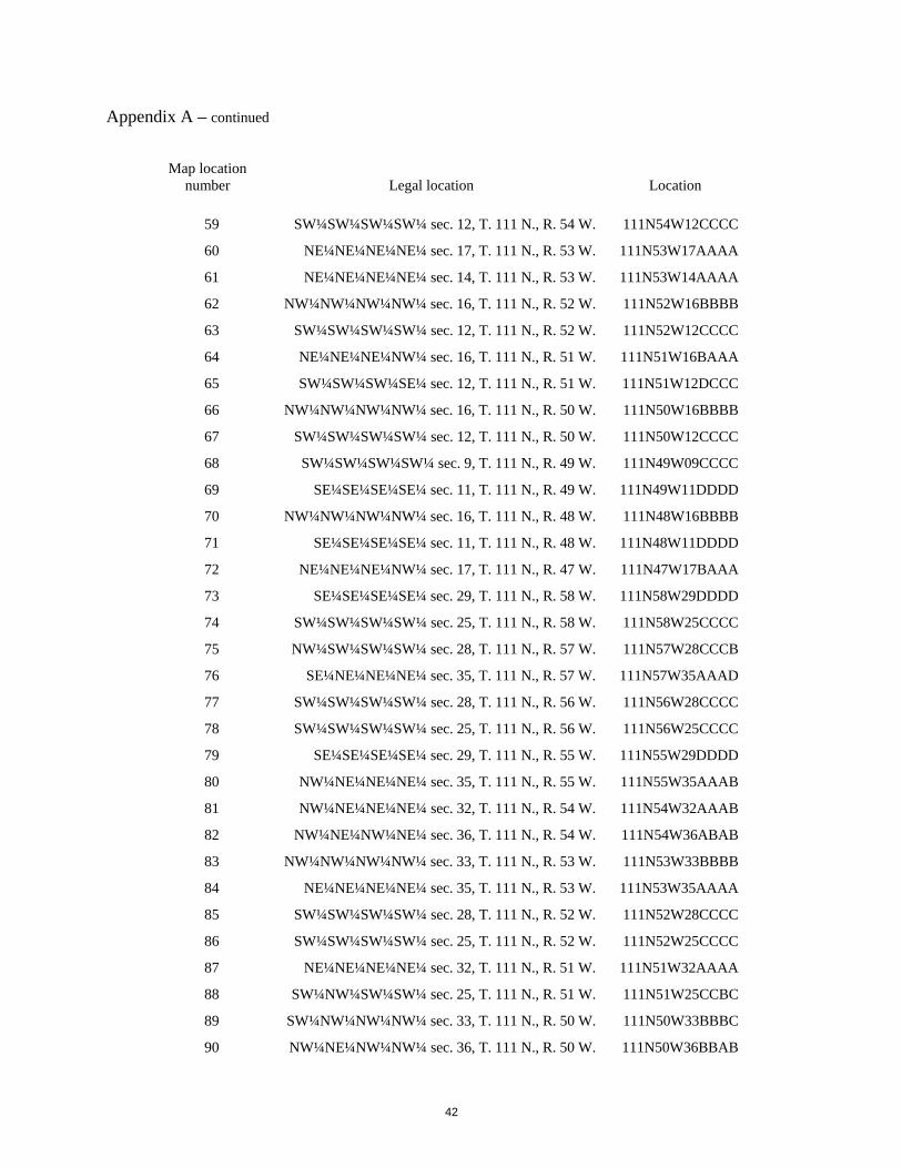
42
Appendix A – continued
Map location
number
Legal location
Location
59 SW¼SW¼SW¼SW¼ sec. 12, T. 111 N., R. 54 W. 111N54W12CCCC
60 NE¼NE¼NE¼NE¼ sec. 17, T. 111 N., R. 53 W. 111N53W17AAAA
61 NE¼NE¼NE¼NE¼ sec. 14, T. 111 N., R. 53 W. 111N53W14AAAA
62 NW¼NW¼NW¼NW¼ sec. 16, T. 111 N., R. 52 W. 111N52W16BBBB
63 SW¼SW¼SW¼SW¼ sec. 12, T. 111 N., R. 52 W. 111N52W12CCCC
64 NE¼NE¼NE¼NW¼ sec. 16, T. 111 N., R. 51 W. 111N51W16BAAA
65 SW¼SW¼SW¼SE¼ sec. 12, T. 111 N., R. 51 W. 111N51W12DCCC
66 NW¼NW¼NW¼NW¼ sec. 16, T. 111 N., R. 50 W. 111N50W16BBBB
67 SW¼SW¼SW¼SW¼ sec. 12, T. 111 N., R. 50 W. 111N50W12CCCC
68 SW¼SW¼SW¼SW¼ sec. 9, T. 111 N., R. 49 W. 111N49W09CCCC
69 SE¼SE¼SE¼SE¼ sec. 11, T. 111 N., R. 49 W. 111N49W11DDDD
70 NW¼NW¼NW¼NW¼ sec. 16, T. 111 N., R. 48 W. 111N48W16BBBB
71 SE¼SE¼SE¼SE¼ sec. 11, T. 111 N., R. 48 W. 111N48W11DDDD
72 NE¼NE¼NE¼NW¼ sec. 17, T. 111 N., R. 47 W. 111N47W17BAAA
73 SE¼SE¼SE¼SE¼ sec. 29, T. 111 N., R. 58 W. 111N58W29DDDD
74 SW¼SW¼SW¼SW¼ sec. 25, T. 111 N., R. 58 W. 111N58W25CCCC
75 NW¼SW¼SW¼SW¼ sec. 28, T. 111 N., R. 57 W. 111N57W28CCCB
76 SE¼NE¼NE¼NE¼ sec. 35, T. 111 N., R. 57 W. 111N57W35AAAD
77 SW¼SW¼SW¼SW¼ sec. 28, T. 111 N., R. 56 W. 111N56W28CCCC
78 SW¼SW¼SW¼SW¼ sec. 25, T. 111 N., R. 56 W. 111N56W25CCCC
79 SE¼SE¼SE¼SE¼ sec. 29, T. 111 N., R. 55 W. 111N55W29DDDD
80 NW¼NE¼NE¼NE¼ sec. 35, T. 111 N., R. 55 W. 111N55W35AAAB
81 NW¼NE¼NE¼NE¼ sec. 32, T. 111 N., R. 54 W. 111N54W32AAAB
82 NW¼NE¼NW¼NE¼ sec. 36, T. 111 N., R. 54 W. 111N54W36ABAB
83 NW¼NW¼NW¼NW¼ sec. 33, T. 111 N., R. 53 W. 111N53W33BBBB
84 NE¼NE¼NE¼NE¼ sec. 35, T. 111 N., R. 53 W. 111N53W35AAAA
85 SW¼SW¼SW¼SW¼ sec. 28, T. 111 N., R. 52 W. 111N52W28CCCC
86 SW¼SW¼SW¼SW¼ sec. 25, T. 111 N., R. 52 W. 111N52W25CCCC
87 NE¼NE¼NE¼NE¼ sec. 32, T. 111 N., R. 51 W. 111N51W32AAAA
88 SW¼NW¼SW¼SW¼ sec. 25, T. 111 N., R. 51 W. 111N51W25CCBC
89 SW¼NW¼NW¼NW¼ sec. 33, T. 111 N., R. 50 W. 111N50W33BBBC
90 NW¼NE¼NW¼NW¼ sec. 36, T. 111 N., R. 50 W. 111N50W36BBAB

43
Appendix A – continued
Map location
number
Legal location
Location
91 SW¼SW¼SW¼SW¼ sec. 28, T. 111 N., R. 49 W. 111N49W28CCCC
92 SW¼SW¼SW¼SW¼ sec. 25, T. 111 N., R. 49 W. 111N49W25CCCC
93 SW¼SW¼SW¼SW¼ sec. 28, T. 111 N., R. 48 W. 111N48W28CCCC
94 NE¼NW¼NW¼NW¼ sec. 36, T. 111 N., R. 48 W. 111N48W36BBBA
95 SE¼SW¼SW¼SW¼ sec. 28, T. 111 N., R. 47 W. 111N47W28CCCD
96 NE¼NE¼NE¼NE¼ sec. 17, T. 110 N., R. 58 W. 110N58W17AAAA
97 SE¼SE¼SE¼SE¼ sec. 11, T. 110 N., R. 58 W. 110N58W11DDDD
98 NE¼NE¼NE¼NE¼ sec. 17, T. 110 N., R. 57 W. 110N57W17AAAA
99 NW¼NE¼NW¼NW¼ sec. 13, T. 110 N., R. 57 W. 110N57W13BBAB
100 SE¼SE¼SE¼SE¼ sec. 8, T. 110 N., R. 56 W. 110N56W08DDDD
101 SW¼SW¼SW¼SW¼ sec. 12, T. 110 N., R. 56 W. 110N56W12CCCC
102 NE¼NE¼NE¼NE¼ sec. 17, T. 110 N., R. 55 W. 110N55W17AAAA
103 SE¼SE¼SE¼SE¼ sec. 11, T. 110 N., R. 55 W. 110N55W11DDDD
104 SW¼SW¼SW¼SW¼ sec. 9, T. 110 N., R. 54 W. 110N54W09CCCC
105 NE¼SE¼SE¼SE¼ sec. 12, T. 110 N., R. 54 W. 110N54W12DDDA
106 SW¼SW¼SW¼NW¼ sec. 9, T. 110 N., R. 53 W. 110N53W09BCCC
107 NW¼NW¼NW¼NW¼ sec. 13, T. 110 N., R. 53 W. 110N53W13BBBB
108 NE¼NW¼NW¼NW¼ sec. 18, T. 110 N., R. 52 W. 110N52W18BBBA
109 NE¼NE¼NE¼NE¼ sec. 17, T. 110 N., R. 52 W. 110N52W17AAAA
110 SW¼SW¼SW¼SW¼ sec. 12, T. 110 N., R. 52 W. 110N52W12CCCC
111 SE¼SE¼SE¼SE¼ sec. 8, T. 110 N., R. 51 W. 110N51W08DDDD
112 SW¼SW¼SE¼SW¼ sec. 11, T. 110 N., R. 51 W. 110N51W11CDCC
113 SW¼SW¼SW¼SW¼ sec. 9, T. 110 N., R. 50 W. 110N50W09CCCC
114 SW¼NW¼SW¼SW¼ sec. 12, T. 110 N., R. 50 W. 110N50W12CCBC
115 SE¼SW¼SW¼SW¼ sec. 9, T. 110 N., R. 49 W. 110N49W09CCCD
116 SE¼SW¼SE¼SE¼ sec. 11, T. 110 N., R. 49 W. 110N49W11DDCD
117 NW¼NW¼NW¼NW¼ sec. 16, T. 110 N., R. 48 W. 110N48W16BBBB
118 NW¼NW¼NW¼NW¼ sec. 13, T. 110 N., R. 48 W. 110N48W13BBBB
119 NW¼NW¼NW¼NW¼ sec. 16, T. 110 N., R. 47 W. 110N47W16BBBB
120 NE¼NE¼NE¼NE¼ sec. 32, T. 110 N., R. 58 W. 110N58W32AAAA
121 NE¼NE¼NE¼NE¼ sec. 35, T. 110 N., R. 58 W. 110N58W35AAAA
122 NE¼NE¼NE¼NE¼ sec. 32, T. 110 N., R. 57 W. 110N57W32AAAA

44
Appendix A – continued
Map location
number
Legal location
Location
123 SE¼SE¼NE¼NE¼ sec. 35, T. 110 N., R. 57 W. 110N57W35AADD
124 SE¼SE¼SE¼SE¼ sec. 29, T. 110 N., R. 56 W. 110N56W29DDDD
125 SE¼SE¼SE¼SE¼ sec. 26, T. 110 N., R. 56 W. 110N56W26DDDD
126 NE¼NE¼NE¼NE¼ sec. 33, T. 110 N., R. 55 W. 110N55W33AAAA
127 SE¼SE¼SE¼NE¼ sec. 26, T. 110 N., R. 55 W. 110N55W26ADDD
128 NE¼NE¼NE¼NW¼ sec. 32, T. 110 N., R. 54 W. 110N54W32BAAA
129 SE¼SW¼SE¼SE¼ sec. 26, T. 110 N., R. 54 W. 110N54W26DDCD
130 SW¼SW¼SW¼SW¼ sec. 28, T. 110 N., R. 53 W. 110N53W28CCCC
131 SE¼SE¼SE¼SE¼ sec. 27, T. 110 N., R. 53 W. 110N53W27DDDD
132 SE¼SE¼SE¼SE¼ sec. 29, T. 110 N., R. 52 W. 110N52W29DDDD
133 SW¼NW¼SW¼NW¼ sec. 36, T. 110 N., R. 52 W. 110N52W36BCBC
134 SE¼SE¼SW¼SE¼ sec. 29, T. 110 N., R. 51 W. 110N51W29DCDD
135 SW¼NW¼SW¼NW¼ sec. 36, T. 110 N., R. 51 W. 110N51W36BCBC
136 SE¼SE¼SW¼SE¼ sec. 28, T. 110 N., R. 50 W. 110N50W28DCDD
137 SE¼NE¼NE¼SE¼ sec. 35, T. 110 N., R. 50 W. 110N50W35DAAD
138 NE¼NW¼NW¼NE¼ sec. 33, T. 110 N., R. 49 W. 110N49W33ABBA
139 SE¼SE¼SE¼SE¼ sec. 26, T. 110 N., R. 49 W. 110N49W26DDDD
140 SW¼SW¼SW¼SW¼ sec. 28, T. 110 N., R. 48 W. 110N48W28CCCC
141 SE¼NE¼SE¼SE¼ sec. 26, T. 110 N., R. 48 W. 110N48W26DDAD
142 NW¼NE¼NE¼NE¼ sec. 32, T. 110 N., R. 47 W. 110N47W32AAAB
143 SE¼SE¼SE¼SE¼ sec. 8, T. 109 N., R. 58 W. 109N58W08DDDD
144 SW¼SW¼SW¼SW¼ sec. 12, T. 109 N., R. 58 W. 109N58W12CCCC
145 NE¼NE¼NE¼NE¼ sec. 17, T. 109 N., R. 57 W. 109N57W17AAAA
146 SW¼SW¼SW¼SW¼ sec. 12, T. 109 N., R. 57 W. 109N57W12CCCC
147 SW¼SW¼SW¼SW¼ sec. 9, T. 109 N., R. 56 W. 109N56W09CCCC
148 SW¼SW¼SW¼SW¼ sec. 12, T. 109 N., R. 56 W. 109N56W12CCCC
149 SE¼SW¼SE¼SE¼ sec. 9, T. 109 N., R. 55 W. 109N55W09DDCD
150 NW¼NE¼NE¼NE¼ sec. 14, T. 109 N., R. 55 W. 109N55W14AAAB
151 SE¼SE¼SE¼NE¼ sec. 8, T. 109 N., R. 54 W. 109N54W08ADDD
152 SE¼SE¼SE¼SE¼ sec. 11, T. 109 N., R. 54 W. 109N54W11DDDD
153 SW¼NW¼NW¼NW¼ sec. 16, T. 109 N., R. 53 W. 109N53W16BBBC
154 SE¼SE¼SE¼SE¼ sec. 11, T. 109 N., R. 53 W. 109N53W11DDDD

45
Appendix A – continued
Map location
number
Legal location
Location
155 NE¼NW¼NW¼NW¼ sec. 16, T. 109 N., R. 52 W. 109N52W16BBBA
156 SW¼SW¼SW¼SW¼ sec. 12, T. 109 N., R. 52 W. 109N52W12CCCC
157 NE¼NE¼NE¼NE¼ sec. 17, T. 109 N., R. 51 W. 109N51W17AAAA
158 SE¼SE¼SE¼SE¼ sec. 11, T. 109 N., R. 51 W. 109N51W11DDDD
159 NE¼NE¼NE¼NE¼ sec. 17, T. 109 N., R. 50 W. 109N50W17AAAA
160 NE¼NW¼NE¼NW¼ sec. 13, T. 109 N., R. 50 W. 109N50W13BABA
161 NE¼NE¼NE¼NE¼ sec. 17, T. 109 N., R. 49 W. 109N49W17AAAA
162 SW¼SW¼SW¼SW¼ sec. 12, T. 109 N., R. 49 W. 109N49W12CCCC
163 SE¼SE¼SE¼SE¼ sec. 8, T. 109 N., R. 48 W. 109N48W08DDDD
164 SW¼NW¼NW¼NW¼ sec. 13, T. 109 N., R. 48 W. 109N48W13BBBC
165 SW¼SW¼SW¼SW¼ sec. 10, T. 109 N., R. 47 W. 109N47W10CCCC
166 SW¼SW¼SW¼SW¼ sec. 28, T. 109 N., R. 58 W. 109N58W28CCCC
167 SW¼SW¼SW¼SW¼ sec. 25, T. 109 N., R. 58 W. 109N58W25CCCC
168 NW¼NW¼NW¼NE¼ sec. 32, T. 109 N., R. 57 W. 109N57W32ABBB
169 NE¼NE¼NE¼NE¼ sec. 32, T. 109 N., R. 57 W. 109N57W32AAAA
170 NW¼NW¼NW¼NW¼ sec. 36, T. 109 N., R. 57 W. 109N57W36BBBB
171 SW¼SW¼SW¼SW¼ sec. 28, T. 109 N., R. 56 W. 109N56W28CCCC
172 SW¼SW¼SE¼SE¼ sec. 26, T. 109 N., R. 56 W. 109N56W26DDCC
173 NE¼NE¼NE¼NE¼ sec. 32, T. 109 N., R. 55 W. 109N55W32AAAA
174 NW¼NW¼NW¼NW¼ sec. 36, T. 109 N., R. 55 W. 109N55W36BBBB
175 NE¼SE¼NE¼NE¼ sec. 32, T. 109 N., R. 54 W. 109N54W32AADA
176 SE¼SE¼SE¼SE¼ sec. 26, T. 109 N., R. 54 W. 109N54W26DDDD
177 NW¼NW¼NW¼NW¼ sec. 33, T. 109 N., R. 53 W. 109N53W33BBBB
178 NW¼NW¼NW¼NW¼ sec. 36, T. 109 N., R. 53 W. 109N53W36BBBB
179 SE¼SE¼NE¼NE¼ sec. 29, T. 109 N., R. 52 W. 109N52W29AADD
180 SE¼SE¼SE¼SE¼ sec. 23, T. 109 N., R. 52 W. 109N52W23DDDD
181 NE¼NE¼NE¼NE¼ sec. 29, T. 109 N., R. 51 W. 109N51W29AAAA
182 SW¼SW¼SW¼SW¼ sec. 24, T. 109 N., R. 51 W. 109N51W24CCCC
183 SW¼SW¼SW¼SW¼ sec. 21, T. 109 N., R. 50 W. 109N50W21CCCC
184 NE¼NE¼NE¼NE¼ sec. 26, T. 109 N., R. 50 W. 109N50W26AAAA
185 NW¼NE¼NE¼NE¼ sec. 29, T. 109 N., R. 49 W. 109N49W29AAAB
186 NE¼SE¼SE¼SE¼ sec. 23, T. 109 N., R. 49 W. 109N49W23DDDA

46
Appendix A – continued
Map location
number
Legal location
Location
187 NW¼NW¼NW¼NW¼ sec. 28, T. 109 N., R. 48 W. 109N48W28BBBB
188 NE¼NW¼NE¼NE¼ sec. 26, T. 109 N., R. 48 W. 109N48W26AABA
189 SE¼SE¼SE¼SE¼ sec. 20, T. 109 N., R. 47 W. 109N47W20DDDD
Related Documents