Darby Rd BROOKLYN R 30 RA 9213 9211 9212 212 213 214 Match Line Maps 86 and 87 of 134 Match Line Maps 85 and 86 of 134 W20-158 W20-159 W20-157 303 283 275 289 273 285 275 287 281 285 277 271 291 275 297 285 267 285 279 277 283 283 283 293 277 271 281 267 283 263 291 297 287 279 283 289 293 281 275 285 269 291 277 285 287 281 283 307 275 295 275 285 289 287 273 271 283 273 313 309 263 275 299 295 279 285 285 297 269 259 289 317 271 281 291 299 291 293 283 271 287 293 295 285 285 269 301 273 269 265 287 281 289 285 291 291 295 269 295 281 293 295 281 285 297 285 287 271 287 271 287 267 287 283 305 293 281 273 289 287 289 287 287 287 285 279 273 283 275 279 273 269 BR-19-VP CT RI Killingly Pomfret Ashford Mansfield Eastford Willington Plainfield Brooklyn Woodstock Hampton Windham Putnam Sterling Chaplin Canterbury Coventry Thompson Tolland Stafford Scotland Columbia Union Lebanon Ellington Andover Interstate Reliability Project Date: December 2011 0 100 200 Feet 1 inch = 100 feet Proposed Route Index Map Data Source: Optimal Geomatics 2007 Aerial Imagery; CT DEEP 2008-2011; B&McD 2007-2011; AECOM 2007-2011; FEMA Flood 2009. Existing Transmission Line (Centerline) Proposed 345-kV Line (Centerline) Connecticut Natural Diversity Data Base Area NU Property Structure Location Envelope Existing Access Road New Access Road Right-of-Way (Existing) Vernal Pool Habitat Town Line Watercourse Wetland Boundary Vegetation Removal Limits Wetland Boundary State Federal Wetland/Watercourse Buffer Existing Guy Easement Existing Tree Line Zoning Designation R80 Property Line 100-Year Flood Zone Amphibian Breeding Habitat Mapsheet 86 of 134 Existing Structure Proposed Structure Proposed Culvert Existing Culvert Existing Structure (Guyed) Proposed Structure (Guyed)

Welcome message from author
This document is posted to help you gain knowledge. Please leave a comment to let me know what you think about it! Share it to your friends and learn new things together.
Transcript

Church
St
Darby Rd
Darby Rd
Churc
h St
BROOKLYN
R 30
RA92139211
9212
212213 214
Match
Line
Map
s 86 a
nd 87
of 13
4
Match
Line
Map
s 85 a
nd 86
of 13
4
W20-158
W20-159
W20-157
303283
275
289
273
285
275
287
281
285
277
271291
275
297
285
267
285
279277
283
283
283
293
277
271
281
267
283
263
291
297
287
279
283
289 293
281
275
285
269
291
277
285
287
281
283
307
275
295
275
285
289
287
273
271283
273
313309
263
275
299
295
279
285
285
297
269259
289
317271
281
291
299
291
293
283271
287
293
295
285
285
269
301
273
269
265
287
281
289
285
291
291
295
269
295
281
293
295
281
285
297
285
287271
287
271
287
267
287
283
305
293
281
273289
287
289
287
287 287
285
279
273
283
275
279
273
269
BR-19-VP
CT RIKillingly
Pomfret
Ashford
Mansfield
EastfordWillington
Plainfield
Brooklyn
Woodstock
Hampton
Windham
Putnam
Sterling
Chaplin
Canterbury
Coventry
Thompson
Tolland
Stafford
ScotlandColumbia
Union
Lebanon
Ellington
Andover
InterstateReliability Project
Date: December 20110 100 200Feet
1 inch = 100 feet
Proposed Route
Index Map
Data Source: Optimal Geomatics 2007 Aerial Imagery; CT DEEP 2008-2011; B&McD 2007-2011; AECOM 2007-2011; FEMA Flood 2009.
Existing Transmission Line (Centerline)Proposed 345-kV Line(Centerline)
Connecticut Natural Diversity Data Base Area
NU Property
Structure Location EnvelopeExisting Access RoadNew Access Road
Right-of-Way (Existing)
Vernal Pool HabitatTown Line
Watercourse
Wetland Boundary
Vegetation Removal LimitsWetland BoundaryStateFederal
Wetland/WatercourseBuffer
Existing Guy EasementExisting Tree Line
Zoning DesignationR80Property Line100-Year Flood Zone
Amphibian BreedingHabitat
Mapsheet 86 of 134 Existing Structure
Proposed StructureProposed CulvertExisting Culvert
Existing Structure(Guyed)
Proposed Structure(Guyed)

Chur
ch St
Darby Rd Darby Rd
Chur
ch St
BROOKLYN
R 30
RA
NU Property
NU Property
FAA Notice ofPresumed Hazard FAA Notice of
Presumed Hazard
9216
9214 9215
FAA Noticeof Presumed
HazardFAA Notice
of PresumedHazard
215216
217
Match Line Maps 87 and 88 of 134
Match Line Maps 86 and 87 of 134
303
303
275
277
271
291
323
325297
305
297
329
289
325303
283
303
329
289
307
309281
313
307
279
293
287
293
327
319
285
307275
313
289
323
325
317 289
305303
313
305
309
305
321
299 315323
329
303
317
311
323
299
301
331
297
287
301
309287
323
331
287
303
309
299
305
319
295
299
301317
329
325
303
307
321
295
315
297
329
321
297
285
287
293
295
313
307
305
281
323291
311
321
327
319
319
323
319
279
273
325
305
CT RIKillingly
Pomfret
Ashford
Mansfield
EastfordWillington
Plainfield
Brooklyn
Woodstock
Hampton
Windham
Putnam
Sterling
Chaplin
Canterbury
Coventry
Thompson
Tolland
Stafford
ScotlandColumbia
Union
Lebanon
Ellington
Andover
InterstateReliability Project
Date: December 20110 100 200Feet
1 inch = 100 feet
Proposed Route
Index Map
Data Source: Optimal Geomatics 2007 Aerial Imagery; CT DEEP 2008-2011; B&McD 2007-2011; AECOM 2007-2011; FEMA Flood 2009.
Existing Transmission Line (Centerline)Proposed 345-kV Line(Centerline)
Connecticut Natural Diversity Data Base Area
NU Property
Structure Location EnvelopeExisting Access RoadNew Access Road
Right-of-Way (Existing)
Vernal Pool HabitatTown Line
Watercourse
Wetland Boundary
Vegetation Removal LimitsWetland BoundaryStateFederal
Wetland/WatercourseBuffer
Existing Guy EasementExisting Tree Line
Zoning DesignationR80Property Line100-Year Flood Zone
Amphibian BreedingHabitat
Mapsheet 87 of 134 Existing Structure
Proposed StructureProposed CulvertExisting Culvert
Existing Structure(Guyed)
Proposed Structure(Guyed)

Churc
h St
Churc
h St
To DayStreet
To Day Street
BROOKLYN
R 30
RANU Property
NU Property
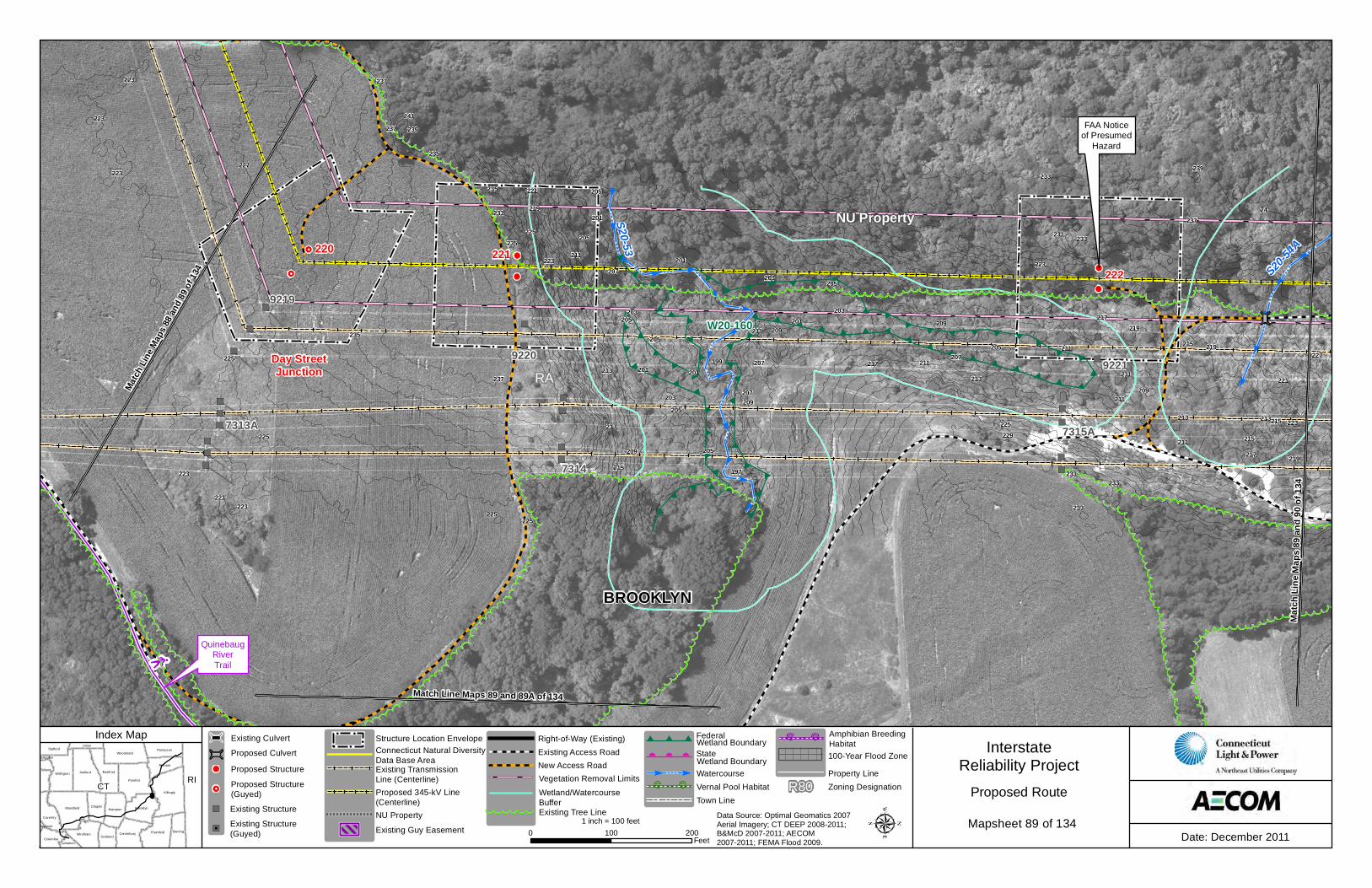
9219
7313A
9217
9218
9220 7314
218 219220
221
QuinebaugRiverTrail
Match Line Maps 88 and 88A of 134
Match Line Maps 88 and 89 of 134
Match
Line
Map
s 87 a
nd 88
of 13
4
W20-159A
W20-160B
241
223
287
251
253
233
233
285
281
235
289
227
271
271
257
249
275
277
237
289
281
249
285
253
263275
225
253
255
283
285
279231
219
245
277
289
273
251
241
227
257
239
221
261
223
251
287
237
247
279
235
235
287
235
239
287
237
235
221
245
225
261
243
257
281
269
283
229
241
233
235
281
239247
255
283
249
267
239
243
237
243237
251
223
223
275
265
259
239
223
263
233
253
241 237
277
DayStreet
Junction
CT RIKillingly
Pomfret
Ashford
Mansfield
EastfordWillington
Plainfield
Brooklyn
Woodstock
Hampton
Windham
Putnam
Sterling
Chaplin
Canterbury
Coventry
Thompson
Tolland
Stafford
ScotlandColumbia
Union
Lebanon
Ellington
Andover
InterstateReliability Project
Date: December 20110 100 200Feet
1 inch = 100 feet
Proposed Route
Index Map
Data Source: Optimal Geomatics 2007 Aerial Imagery; CT DEEP 2008-2011; B&McD 2007-2011; AECOM 2007-2011; FEMA Flood 2009.
Existing Transmission Line (Centerline)Proposed 345-kV Line(Centerline)
Connecticut Natural Diversity Data Base Area
NU Property
Structure Location EnvelopeExisting Access RoadNew Access Road
Right-of-Way (Existing)
Vernal Pool HabitatTown Line
Watercourse
Wetland Boundary
Vegetation Removal LimitsWetland BoundaryStateFederal
Wetland/WatercourseBuffer
Existing Guy EasementExisting Tree Line
Zoning DesignationR80Property Line100-Year Flood Zone
Amphibian BreedingHabitat
Mapsheet 88 of 134 Existing Structure
Proposed StructureProposed CulvertExisting Culvert
Existing Structure(Guyed)
Proposed Structure(Guyed)
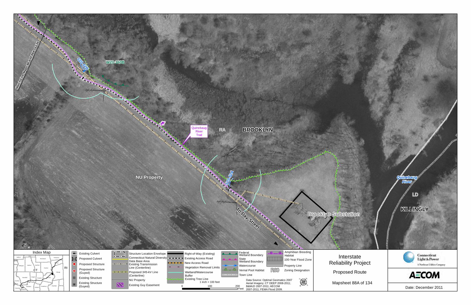
To Da
yStr
eet
To Day Street
KILLINGLY
BROOKLYN
QuinebaugRiver
RA
LD
NU Property
S20-52B
S20-5
2A
QuinebaugRiverTrail
Brooklyn Substation
Match
Line
Map
s 88 a
nd 88
A of 1
34
W20-160B
CT RIKillingly
Pomfret
Ashford
Mansfield
EastfordWillington
Plainfield
Brooklyn
Woodstock
Hampton
Windham
Putnam
Sterling
Chaplin
Canterbury
Coventry
Thompson
Tolland
Stafford
ScotlandColumbia
Union
Lebanon
Ellington
Andover
InterstateReliability Project
Date: December 20110 100 200Feet
1 inch = 100 feet
Proposed Route
Index Map
Data Source: Optimal Geomatics 2007 Aerial Imagery; CT DEEP 2008-2011; B&McD 2007-2011; AECOM 2007-2011; FEMA Flood 2009.
Existing Transmission Line (Centerline)Proposed 345-kV Line(Centerline)
Connecticut Natural Diversity Data Base Area
NU Property
Structure Location EnvelopeExisting Access RoadNew Access Road
Right-of-Way (Existing)
Vernal Pool HabitatTown Line
Watercourse
Wetland Boundary
Vegetation Removal LimitsWetland BoundaryStateFederal
Wetland/WatercourseBuffer
Existing Guy EasementExisting Tree Line
Zoning DesignationR80Property Line100-Year Flood Zone
Amphibian BreedingHabitat
Mapsheet 88A of 134 Existing Structure
Proposed StructureProposed CulvertExisting Culvert
Existing Structure(Guyed)
Proposed Structure(Guyed)
To DayStreet
BROOKLYN
RA
NU Property
S20-54A
S20-53
9219
7313A
9220 9221
7315A
7314
FAA Noticeof Presumed
Hazard
220 221222
QuinebaugRiverTrail
Match Line Maps 89 and 89A of 134
Match
Line
Map
s 88 a
nd 89
of 13
4
Match
Line
Map
s 89 a
nd 90
of 13
4
W20-160
231
205
223
241233
201
225
215
217211235
213
203
227
237
201
199
209
205
205
217
227
209
225
233
221
213
223
211
233
225
219
203
205
223
211
219
215
211
221
233
223
201
211
235
235
239
221
207 217213
239
211
225
203
197
213 215
205
209 217
209
205
233
237
205207
225
235 233
205
229223
237
201
207
219
223
223
225
211
223
207
241
215
203209
237
219
201
Day StreetJunction
CT RIKillingly
Pomfret
Ashford
Mansfield
EastfordWillington
Plainfield
Brooklyn
Woodstock
Hampton
Windham
Putnam
Sterling
Chaplin
Canterbury
Coventry
Thompson
Tolland
Stafford
ScotlandColumbia
Union
Lebanon
Ellington
Andover
InterstateReliability Project
Date: December 20110 100 200Feet
1 inch = 100 feet
Proposed Route
Index Map
Data Source: Optimal Geomatics 2007 Aerial Imagery; CT DEEP 2008-2011; B&McD 2007-2011; AECOM 2007-2011; FEMA Flood 2009.
Existing Transmission Line (Centerline)Proposed 345-kV Line(Centerline)
Connecticut Natural Diversity Data Base Area
NU Property
Structure Location EnvelopeExisting Access RoadNew Access Road
Right-of-Way (Existing)
Vernal Pool HabitatTown Line
Watercourse
Wetland Boundary
Vegetation Removal LimitsWetland BoundaryStateFederal
Wetland/WatercourseBuffer
Existing Guy EasementExisting Tree Line
Zoning DesignationR80Property Line100-Year Flood Zone
Amphibian BreedingHabitat
Mapsheet 89 of 134 Existing Structure
Proposed StructureProposed CulvertExisting Culvert
Existing Structure(Guyed)
Proposed Structure(Guyed)

To DayStreet
BROOKLYNRA
NU Property
S20-53
QuinebaugRiverTrail
Match
Line
Map
s 89 a
nd 89
A of
134
W20-160A
W20-160
BR-6-ABH
CT RIKillingly
Pomfret
Ashford
Mansfield
EastfordWillington
Plainfield
Brooklyn
Woodstock
Hampton
Windham
Putnam
Sterling
Chaplin
Canterbury
Coventry
Thompson
Tolland
Stafford
ScotlandColumbia
Union
Lebanon
Ellington
Andover
InterstateReliability Project
Date: December 20110 100 200Feet
1 inch = 100 feet
Proposed Route
Index Map
Data Source: Optimal Geomatics 2007 Aerial Imagery; CT DEEP 2008-2011; B&McD 2007-2011; AECOM 2007-2011; FEMA Flood 2009.
Existing Transmission Line (Centerline)Proposed 345-kV Line(Centerline)
Connecticut Natural Diversity Data Base Area
NU Property
Structure Location EnvelopeExisting Access RoadNew Access Road
Right-of-Way (Existing)
Vernal Pool HabitatTown Line
Watercourse
Wetland Boundary
Vegetation Removal LimitsWetland BoundaryStateFederal
Wetland/WatercourseBuffer
Existing Guy EasementExisting Tree Line
Zoning DesignationR80Property Line100-Year Flood Zone
Amphibian BreedingHabitat
Mapsheet 89A of 134 Existing Structure
Proposed StructureProposed CulvertExisting Culvert
Existing Structure(Guyed)
Proposed Structure(Guyed)

S20-54
POMFRETBROOKLYN
RRCBRA
NU Property
NU Property
S20-54A
FAA Notice ofPresumed Hazard
FAA Notice ofPresumed Hazard
FAA Noticeof Presumed
HazardFAA Notice of
Presumed Hazard
9222 9223 9224
7317A
7316
FAA Noticeof Presumed
HazardFAA Notice
of PresumedHazard
FAA Noticeof Presumed
Hazard
223 224225
Match
Line
Map
s 90 a
nd 91
of 13
4
Match
Line
Map
s 89 a
nd 90
of 13
4
269
287
327
249
249
251
315
243
281
249
325
299
233
297
285 333253
255
243
283
245
227
277
317
301
285
255
221
335
269
281
251
335
251
273
219307
263
301
267
235
275271
299
257
227
295
273
241
269
293
309
265
251
265
249
257
253
311
299
251
231253
323
247257
293
291
305
295
269
279
271
261
297
261
323
271
223
333
253
321
291
331
253
223
239
279
319
309
251
329
257
299
327
259
231
305
265 289
321
337
239
333
303
CT RIKillingly
Pomfret
Ashford
Mansfield
EastfordWillington
Plainfield
Brooklyn
Woodstock
Hampton
Windham
Putnam
Sterling
Chaplin
Canterbury
Coventry
Thompson
Tolland
Stafford
ScotlandColumbia
Union
Lebanon
Ellington
Andover
InterstateReliability Project
Date: December 20110 100 200Feet
1 inch = 100 feet
Proposed Route
Index Map
Data Source: Optimal Geomatics 2007 Aerial Imagery; CT DEEP 2008-2011; B&McD 2007-2011; AECOM 2007-2011; FEMA Flood 2009.
Existing Transmission Line (Centerline)Proposed 345-kV Line(Centerline)
Connecticut Natural Diversity Data Base Area
NU Property
Structure Location EnvelopeExisting Access RoadNew Access Road
Right-of-Way (Existing)
Vernal Pool HabitatTown Line
Watercourse
Wetland Boundary
Vegetation Removal LimitsWetland BoundaryStateFederal
Wetland/WatercourseBuffer
Existing Guy EasementExisting Tree Line
Zoning DesignationR80Property Line100-Year Flood Zone
Amphibian BreedingHabitat
Mapsheet 90 of 134 Existing Structure
Proposed StructureProposed CulvertExisting Culvert
Existing Structure(Guyed)
Proposed Structure(Guyed)
Related Documents