Bishops Epic Project Overview Teacher Planning Work Samples & Reflections Teaching Resources Assessment & Standards Learning Areas Levels Objectives Software Description Author Documents Geography Grade 10 (1) To teach learners how to create a Geography Information Systems (GIS) project and in the process learn GIS concepts. (2) To improve learners map work skills. (3) To prepare learners for the Bishops Epic outdoor educational journey. ArcView GIS educational software John Lanser; Diocesan College (Bishops); Cape Town In order to teach learners the functional elements of a GIS and the various steps that they should follow in order to create their own GIS project, learners will make use of data sets and instructional worksheets. The data sets consist of maps, aerial photographs and digital photographs of the ‘camps’ that the learners will stay at when they embark upon their Epic outdoor educational journey. By creating a GIS project, learners will acquire a great deal of information about the Epic and they will also learn GIS and map work skills and terminologies. Creating a GIS project

Welcome message from author
This document is posted to help you gain knowledge. Please leave a comment to let me know what you think about it! Share it to your friends and learn new things together.
Transcript

Bishops EpicProject Overview
Teacher Planning
Work Samples & Reflections
Teaching Resources
Assessment & Standards
Learning Areas
Levels
Objectives
Software
Description
AuthorDocuments
Geography
Grade 10
(1) To teach learners how to create a Geography Information Systems (GIS) project and in the process learn GIS concepts.
(2) To improve learners map work skills.
(3) To prepare learners for the Bishops Epic outdoor educational
journey.
ArcView GIS educational software
John Lanser; Diocesan College (Bishops); Cape Town
In order to teach learners the functional elements of a GIS and the various steps that they should follow in order to create their own GIS project, learners will make use of data sets and instructional worksheets. The data sets consist of maps, aerial photographs and digital photographs of the ‘camps’ that the learners will stay at when they embark upon their Epic outdoor educational journey. By creating a GIS project, learners will acquire a great deal of information about the Epic and they will also learn GIS and map work skills and terminologies.
Creating a GIS project
Bishops EpicProject Overview
Teacher Planning
Work Samples & Reflections
Teaching Resources
Assessment & Standards
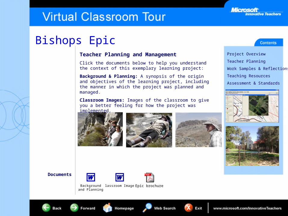
Teacher Planning and Management
Click the documents below to help you understand the context of this exemplary learning project:
Background & Planning: A synopsis of the origin and objectives of the learning project, including the manner in which the project was planned and managed.
Classroom Images: Images of the classroom to give you a better feeling for how the project was implemented.
Documents
Background and Planning
Classroom Images Epic brochure

Bishops EpicProject Overview
Teacher Planning
Work Samples & Reflections
Teaching Resources
Assessment & Standards
Work Samples, Teacher and Student Reflection
Click the documents below to see work samples and reflections from the teachers and students:
Student Work Samples: Examples of student work generated through participation in this learning project.
Teacher Reflection: Thoughts and reflective comments from the teachers involved, including advice for future implementations.
Student Perspective: Comments on how the students perceived the learning that occurred.
Teacher Reflection Student Perspective
Documents

Bishops EpicProject Overview
Teacher Planning
Work Samples & Reflections
Teaching Resources
Assessment & Standards
Teaching Resources
Click the documents below to view the teaching resources used in the teaching of this learning project:
Student Project Overview: An overview of required tasks.
Other Teaching Resources
Documents
Instructional worksheet
Steps in creating the GIS project
author
Deleted reference to Class Server resources from the template. Add back in with final production.
author
Changed <Enter other document details> to "Other Teaching" Resources. Can flesh out in final production if fuller descriptions needed.

Bishops EpicProject Overview
Teacher Planning
Work Samples & Reflections
Teaching Resources
Assessment & Standards
Assessment and Standards
Click the documents below to see the assessment rubrics and standards cover in this learning project:
Assessment Rubrics: Examples of assessment rubrics provided to students showing how the project was assessed.
Mapping the Standards: Mapping this project’s learning objectives against curriculum standards.
National Educational Technology Standards for Students (NETS): Performance indicators for technology-literate students.
Mapping the Standards
Documents
Mark scheme Epic Journal
Related Documents