3940 3940 3960 3960 3980 3980 4000 4000 4020 4020 4040 4040 4060 4060 4080 4080 4100 4100 4120 4120 3940 3940 3960 3960 3980 3980 4000 4000 4020 4020 4040 4040 4060 4060 4080 4080 4100 4100 4120 4120 3915 3915 3905 3905 3895 3895 3885 3885 3925 3925 3875 3875 3865 3865 3860 3860 3865 3865 3855 3855 3860 3860 3870 3870 3880 3880 3890 3890 3900 3900 3910 3910 3920 3920 3930 3930 Walker Lake 1882 shoreline Walker Lake 1882 shoreline Lake Lahontan shoreline Lake Lahontan shoreline Walker Lake Walker Lake Lowest altitude of lake bottom— 3,849.3 feet Schurz Schurz Walker Lake Walker Lake Hawthorne Hawthorne EXPLANATION 3875 3875 4020 4020 Lake-bottom contour—In feet. Interval is 5 feet Land-altitude contour—In feet. Interval is 20 feet Shoreline of Walker Lake, 1882—Rush (1970) Shoreline of Lake Lahontan—Reheis (1999) 2 0 2 4 6 8 MILES 2 0 2 4 6 8 KILOMETERS Base from U. S. Geological Survey digital data 1:100,000, 1978-89. Universal Transverse Mercator Projection, Zone 11, North American Datum of 1983. Color-infrared image flown June 28, 2005 by EarthData International, LLC using the ADS40 airborne digital sensor. Vertical datum is National Geodetic Vertical Datum of 1929. 118º52’30” 118º37’30” 45’ 118º52’30” 118º37’30” 45’ 38º37’30” 38º52’30” 45’ 38º37’30” 38º52’30” 45’ U.S. DEPARTMENT OF THE INTERIOR U.S. GEOLOGICAL SURVEY SCIENTIFIC INVESTIGATIONS REPORT 2007-5012 Bathymetric Map of Walker Lake, Nevada — PLATE 1 Lopes, T.J., and Smith, J.L. 2007, Bathymetry of Walker Lake, West-Central Nevada BATHYMETRIC MAP OF WALKER LAKE, NEVADA By T.J. Lopes and J. Larue Smith 2007 CONTOUR INTERVAL 20 FEET NATIONAL GEODETIC VERTICAL DATUM OF 1929 BATHYMETRIC CONTOUR INTERVAL 5 FEET THE RELATION BETWEEN THE TWO DATUMS IS VARIABLE Prepared in cooperation with the BUREAU OF RECLAMATION

Welcome message from author
This document is posted to help you gain knowledge. Please leave a comment to let me know what you think about it! Share it to your friends and learn new things together.
Transcript
39403940
39603960
39803980
40004000
40204020
40404040
4060406040804080
41004100
41204120
39403940 3960
396039803980
40004000
40204020
40404040
40604060
40804080
41004100
41204120
3915
3915
3905
3905
3895
3895
3885
3885
3925
3925
3875
3875
38653865
38603860
38653865
38553855
38603860
38703870
38803880
38903890
39003900
39103910
39203920
39303930
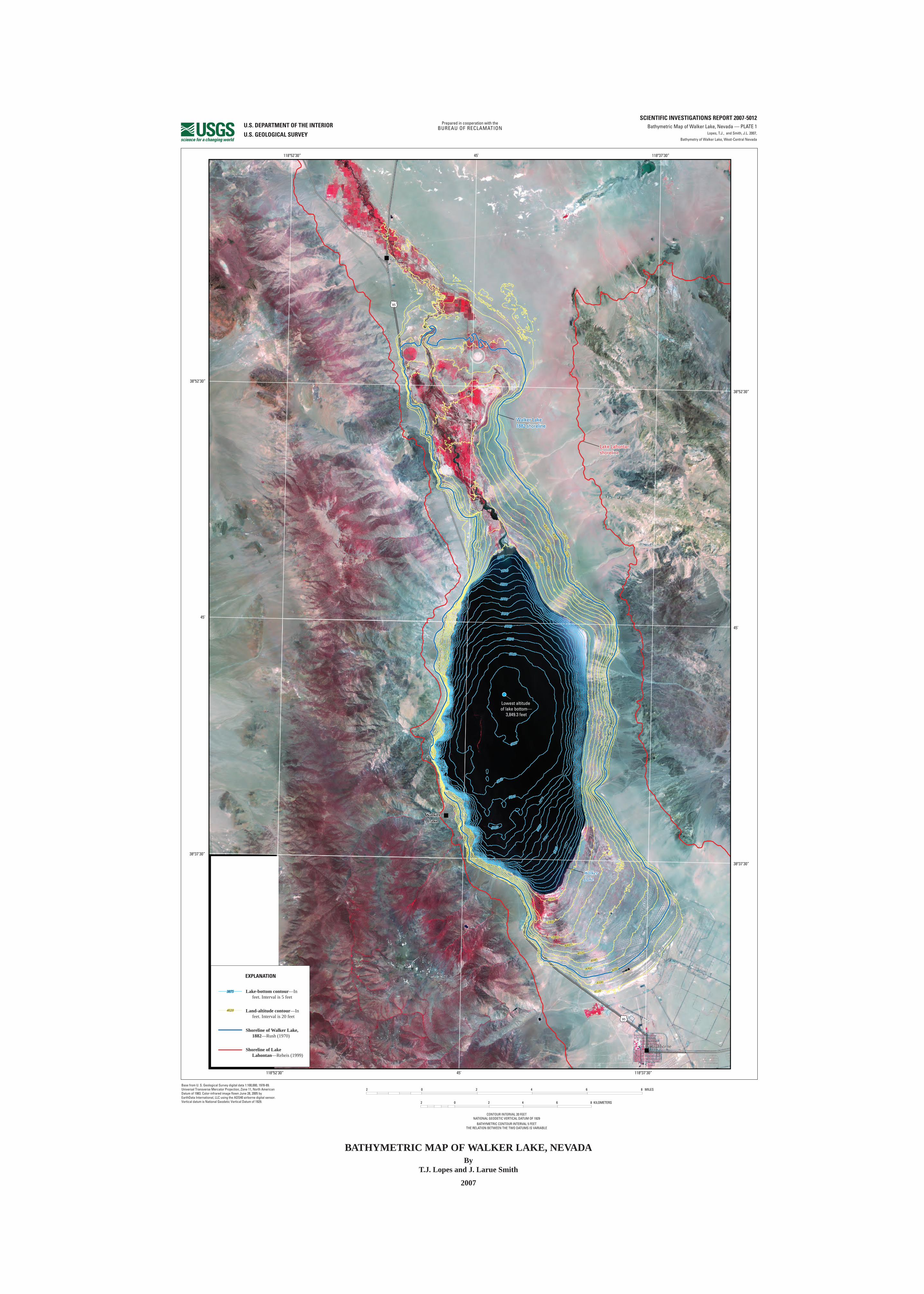
Walker Lake 1882 shorelineWalker Lake 1882 shoreline
Lake Lahontanshoreline Lake Lahontanshoreline
Walker LakeWalker Lake
Lowest altitude of lake bottom—
3,849.3 feet
SchurzSchurz
WalkerLake
WalkerLake
HawthorneHawthorne
EXPLANATION
38753875
40204020
Lake-bottom contour—In feet. Interval is 5 feet
Land-altitude contour—In feet. Interval is 20 feet
Shoreline of Walker Lake, 1882—Rush (1970)
Shoreline of Lake Lahontan—Reheis (1999)
2 0 2 4 6 8 MILES
2 0 2 4 6 8 KILOMETERS
Base from U. S. Geological Survey digital data 1:100,000, 1978-89. Universal Transverse Mercator Projection, Zone 11, North American Datum of 1983. Color-infrared image flown June 28, 2005 by EarthData International, LLC using the ADS40 airborne digital sensor. Vertical datum is National Geodetic Vertical Datum of 1929.
118º52’30” 118º37’30”45’
118º52’30” 118º37’30”45’
38º37’30”
38º52’30”
45’
38º37’30”
38º52’30”
45’
U.S. DEPARTMENT OF THE INTERIOR
U.S. GEOLOGICAL SURVEY
SCIENTIFIC INVESTIGATIONS REPORT 2007-5012Bathymetric Map of Walker Lake, Nevada — PLATE 1
Lopes, T.J., and Smith, J.L. 2007,
Bathymetry of Walker Lake, West-Central Nevada
BATHYMETRIC MAP OF WALKER LAKE, NEVADABy
T.J. Lopes and J. Larue Smith
2007
CONTOUR INTERVAL 20 FEETNATIONAL GEODETIC VERTICAL DATUM OF 1929
BATHYMETRIC CONTOUR INTERVAL 5 FEETTHE RELATION BETWEEN THE TWO DATUMS IS VARIABLE
1 MILE01/21
0 1000 2000 3000 4000 5000 6000 7000 FEET1000
1 KILOMETER.5 01
SCALE 1:25,000www.maptools.com
CONTOUR INTERVAL ____ FEET
Prepared in cooperation with theBUREAU OF RECLAMATION
Related Documents