Basin 9 White River Watershed Water Quality & Aquatic Habitat Assessment Repo Updated November 2002 Agency of Natural Resources Department of Environmental Conseation Water Quality Division

Welcome message from author
This document is posted to help you gain knowledge. Please leave a comment to let me know what you think about it! Share it to your friends and learn new things together.
Transcript

Basin 9
White River Watershed Water Quality & Aquatic Habitat
Assessment Report
Updated November 2002
Agency of Natural Resources Department of Environmental Conservation
Water Quality Division
This publication is an update of the November 1997 White River Watershed Water Quality and Aquatic Habitat Assessment Report. For more information or for a copy of the earlier version, please contact:
Water Quality Division Department of Environmental Conservation
103 South Main Street, 10 N Waterbury, VT 05671
(802) 241-3770www.vtwaterquality.org
November 2002
The Vermont Department of Environmental Conservation is an equal opportunity agency and offers all persons the benefits of participating in each of its programs and competing in all areas of employment regardless of race, color, religion, sex, national origin, age, disability, sexual preference, or other non-merit factors.
This document is available upon request in large print, braille or audio cassette.
VT Relay Service for the Hearing Impaired 1-800-253-0191 TDD>Voice - 1-800-253-0195 Voice>TDD

Contents
Introduction to the 2002 White River Water Quality Assessment Report ............ 1
General Description of Watershed ......................................... 2
Wetland Communities .................................................. 3
Significant Natural Communities and Rare, Threatened and Endangered Species .... 3
Fisheries of the White River and tributaries .................................. 4
Exceptional Uses and Values of Basin Rivers ................................ 6
Lakes with Special Significance or Features or with Water Quality Improvements .... 8
Permitted Discharges ................................................... 8
Growth in Watershed Towns ............................................. 9
Dams in the White River Watershed ....................................... 9
River Water Quality and Aquatic Habitat Impacts and Threats .................. 10
Lake Water Quality and Aquatic Habitat Impacts and Threats ................... 13
Selected Activities or Projects in the Watershed . . . . . . . . . . . . . . . . . . . . . . . . . . . . . 17
Summary ........................................................... 18
References and Resources ............................................. 19
Appendix A: Table of Major Floodplain Fores� Communities .................... 20
Appendix B: Tables of Population and Housing Data .......................... 23
Appendix C: Macroinvertebrate Sampling Sites 1993 - 2000 .................... 26
Appendix D: Dams in Basin 9 ............................................ 30
Appendix E: Buffer Analysis from Infrared Photos from 1997 Assessment Report ... 35
Appendix F: Individual River Waterbody Reports ............................. 37

Introduction to the 2002 White River Assessment Report
This copy of the White River Water Quality and Aquatic Habitat Assessment Report is an update of the report done in November 1997. The following information has been added since the 1997 report: lakes and ponds assessment data and information; significant natural communities and rare, threatened and endangered species information; a summary of the watershed's fisheries; a table of the macroinvertebrate sampling sites from 1992 to 2001; a table of the dams in the watershed; and a list of resources and references.
The numbers in this assessment report with respect to miles of threats or lack of full support for designated uses as well as miles affected by various pollutants or activities are not very different than those numbers in the 1997 assessment report. Although there has been a lot of work in the watershed over the past five years, much of that effort that has been monitoring or assessment work that has confirmed with data the problems that were identified earlier based on projections and judgement using land use information or known conditions or activities. Vermont DEC and the many other agencies and organizations working in the watershed have gained a much better understanding of the problems and possible solutions to those problems in the White River watershed over these last five years.
The activity and interest in the White River watershed is what has changed the most in the last 5 years. Since the November 1997 assessment, the White River Partnership has catalyzed formation of a number of stream teams in the watershed who in turn have gotten citizens involved in discussing, monitoring, protecting, restoring, and appreciating their local waters. Data have been gathered from numerous sites on the White River and tributaries in the 2001 and 2002 sampling season by White River Partnership volunteers. The Vermont Department of Environmental Conservation has done biological sampling at a number of sites in addition to those they regularly visit; has been involved in a number of stream and buffer projects including the large Granville stream channel stabilization project; and has worked with the Partnership to highlight the watershed issues and find solutions to specific watershed problems. Vermont DEC has also written a basin plan focused on the White River watershed. The U.S. Forest Service and U.S. Fish and Wildlife Service have been active in a number of protection and restoration projects. The Vermont Department of Fish and Wildlife has done a number of trout population surveys in watershed rivers and streams. The Department has also stocked Atlantic salmon in the White River mainstem.
There is reason to be hopeful that the continued interest and energy of the White River watershed citizens and numerous agencies and organizations on behalf of river and stream water quality and aquatic habitat will be able to counter to a certain extent the trends of population and housing growth and increased development and protect and restore the unique and special resource that is the White River watershed.
1

General Description of the Basin
The White River Basin encompasses 710 square miles or approximately 454,400 acres in Vermont draining portions of Addison, Orange, Rutland, Washington, and Windsor Counties. The White River itself is approximately 50 miles long. It originates in the town of Ripton on the slope of Battell Mountain then flows southerly and easterly before emptying into the Connecticut River at White River Junction iri the town of Hartford. Vermont Department of Environmental Conservation (DEC) has a count of 457 waterbody miles for the watershed, which includes two mainstem segments (VT09-01 and VT09-02) and five subbasins (VT09-03 through VT09-07).
The White River has five major tributaries: the First Branch with a length of 24 miles and drainage area of 103 square miles; the Second Branch with a length of 20 miles and a drainage area of 7 4 square miles; the Third Branch with a length of 19 miles and a drainage area of 136 square miles; Locust Creek with a length of 11 miles and a drainage area of 26 square miles; and the Tweed River with a length of 10 miles and a drainage area of 51 square miles.
The dominant land cover in the White River watershed according to data from the Vermont Satellite Land Cover project (1997) is forested land with 385, 189 acres or 84% of the watershed area either deciduous, coniferous or mixed forest. Agricultural land including row crops, hay, permanent pasture, and other agricultural uses occupy 32,553 acres or 7% of the watershed area. Developed land, including residential, commercial, industrial, transportation and utilities, covers about 21, 145 acres or about 5% of the watershed. Of the developed land area, 86% is transportation or utility uses. Surface water covers 13,708 acres or 3% of the basin and wetland only cover 3,205 acres or 0. 7% according to the satellite data analysis. The other two categories identified werebrush or transitional (749 acres) and barren land (201 acres).
This breakdown of land cover type is useful for comparisons between the major basins of the state as well as for comparing gross changes in each watershed's land cover over time. The numbers at least over- represent the amount of forested land in a watershed and under represent the amount of developed land because scattered individual homes in wooded areas are not identified as residential but lumped with forested. Scattered residential development is a common land use in many parts of the state and can have significant water quality consequences so additional data sources need also to be drawn upon to refine the above information.
* Some of this general description comes from the 1975 White River Basin ManagementPlan.
2

Wetlands of the White River Watershed
There are approximately 3830 acres of National Wetland Inventory mapped or Class I and II wetlands in the White River basin, which is a relatively small area of wetlands for a watershed. Based on project data kept by Vermont DEC since 1990, approximately 15 acres of wetland (either Class I, II, or Ill) have been altered or lost.
Significant Natural Communities and Rare, Threatened and Endangered
Species of the Basin
There are a total of 99 occurrences of species or natural communities in the White River watershed that are considered state significant. Of these 99 occurrences, 60 are plant species, 9 are animal species, and 30 are natural communities. A number of the significant natural communities identified in the White River watershed are communities integrally connected to the White River itself. Three of the community occurrences are Calcareous Riverside Seeps found along the stretch of river that flows through Sharon, Pomfret and West Hartford. Five pf the significant community occurrences are Sugar Maple-Ostrich Fern Riverine Floodplain Forest community. One of the community occurrences is the Riverside Sand or Gravel Shore community - a community that is the product of dynamic river systems. Spring flooding or other high water and ice scour shape these often sparsely vegetated depositional communities.
�� -�_ � �16B'/t>AvtDSoN 1919�
An inventory and study of the state's floodplain forest communities was conducted by the state Natural Heritage Program in 1997 and it was during that inventory that the White River floodplain communities were described. Approximately 514 acres of floodplain forest along the White River, the Third Branch of the White River, and the West Branch of the White River were identified as potential high quality floodplain forest. Along the Third Branch, from Gilead Brook upstream to above Randolph Village, there is a stretch containing a number of significant floodplain forest communities. This 6.5 mile length of floodplain vegetation may be an important wildlife corridor as well as buffer for the aquatic habitat. (See Appendix A for the White River watershed floodplain sites.)
3
Fisheries of the White River and Its Tributaries
The Department of Fish and Wildlife has conducted trout population surveys of the White River mainstem between 1954 and 2000, however, the following discussion is based on surveys taken between 1972 and 2000. Although non-game fish species were also documented in many of these surveys, the focus below is on naturally reproducing (wild) trout populations. In addition, Atlantic salmon fry have been stocked in some mainstem sections of the White River each spring since about 1993. These populations, usually consisting of 2 or 3 age classes (O+, 1+, and 2+) are also included, although these fish are not the result of natural reproduction. Some White River tributaries also have been stocked with Atlantic salmon since the 1980s. Like the mainstem, these populations usually consist of 2 or 3 age classes.
The mainstem of the White River supports varying population levels of trout. The upper stations, at elevations 1339 and 1200, support relatively low populations of brook trout in contrast with other Vermont streams of similar sizes and elevations. Brown trout were absent in these surveys, while low numbers of rainbow trout also were reProrted. At elevation 930 in Hancock (the station with the longest period of record), data from 1972-1995 appear to indicate trout populations in this section of the river have declined. Below the confluence of the White with the Tweed, few population surveys have been conducted due to the size of the river. While surveys that have been conducted here have documented species composition as well as size classes present, actual population data are difficult to quantify in this area. Near the town of Sharon, anecdotal evidence from creel surveys indicates anglers fish this area in pursuit of large trout. However, south of this point summer water temperatures may exceed thermal tolerances for many trout and they may be forced into coldwater refuges such as deep pools or tributaries. At this point, smallmouth bass (which rarely exceed 12 inches in total length) appear more frequently in creel surveys. Although Claussen (1978) concludes the majority of spawning occurs in tributary streams, the presence of youngof-the-year (yoy) fish indicates some degree of spawning occurs throughout the mainstem.
The Department of Fish and Wildlife and U.S. Forest Service have coordinated hundreds of fish population surveys of selected tributaries. While the mainstem supports a large population of trout, many tributaries support dense trout populations. White River tributaries generally possess high biomasses of trout, with many stream population estimates exceeding 30 lbs/acre. Other streams have maintained high levels of productivity, with some producing very stable dense populations (>25 lbs/acre) over the last 20 years. Annual recruitment of yoy rainbow trout for example, commonly exceeds 2,000 fish/mile in many streams. Many other small tributaries provide good fisheries for all species of trout, with population estimates exceeding 20 lbs/acre. Tributaries are very important to sustaining naturally reproducing trout populations and account for a considerable amount of recruitment within the White River drainage.
4

While the White River in Hancock has shown declines in trout populations, other streams in the drainage with declining populations have shown rebounds. In Alder Meadow Brook near Granville, population surveys from 1976 indicated a biomass of 22.1 lbs/acre. Populations declined until 1994, reaching a low of 2.8 lbs/acre. Brown and rainbow trout were both missing from surveys in this year. However, from 1996-2000 there have been overall increases in numbers, with brown and rainbow trout being observed. The most recent survey (2000) shows population levels at over 40 lbs/acre. Since this recovery has taken place naturally over the last six years, it is possible that population declines observed in the upper White River mainstem will rebound.
5
· Exceptional Uses and Values of Basin Rivers and Streams
The entire length of the main stem of the White River, at approximately 50 miles, is the longest free-flowing large river in the state because of the lack of flow-regulating dams. It is unique and significant for this characteristic.
Waterfalls, Cascades and Gorges
Waterfalls, cascades and gorges are abundant in the basin. One of the most well known waterfalls, Moss Glen Falls I, is located on Deer Hollow Brook in Granville Gulf Natural Area. It is actually a high-angle cascade that drops approximately 30' over a rock face 15' to 25' wide. It is a popular scenic attraction on Route 100. Another and equally wellknown waterfall is Texas Falls on the Hancock Branch in Hancock. It is a small gorge and cascade with a small falls and some nice pools. The area has been developed by the U.S. Forest Service with trails and picnic areas. Another important waterfall and cascades in the White River watershed is Web Falls and Granville Cascade Chain on Sandusky Brook in Granville.
Cascades, waterfalls, gorges and pools occur in the headwaters of many streams in the basin, including the White River in the Green Mountain National Forest in Granville, on Thatcher Brook in Granville, and on Fletcher Brook in Stockbridge.
Boating
The White River has one of the longest uninterrupted kayak runs on a major river in New England and is known nationally for this fact. From Stockbridge to Bethel, the river is considered a classic Vermont whitewater run. The first three miles from Stockbridge contains intermittent Class 11 rapids. The last three miles to Bethel are quickwater. From Bethel to the Connecticut River, the river is mostly quickwater, but there are a variety of short drops and narrows and Class II rapids.
The first portion of the First Branch below Chelsea is Class 11 with a low Class 111 segment, and is a nice whitewater run. The next segment downstream contains a mile of interesting ledges, followed by a nice touring section. The segment contains a total of 5 ledges from 2' to 4' high.
The Third Branch of the White River is boatable from Roxbury to Randolph. Whitewater boating also takes place on the Hancock Branch, from its confluence with the Robbins Branch to the White River. The Hancock Branch is hydrologically distinguished by being the smallest stream in the state known to be used as a whitewater run. It is a Class II run with some Class 111 spots, lots of rocks and current.
6
Fishing
The river and its tributaries play an important role in the Atlantic salmon restoration program, due to the presence of gravel beds and its free-flowing nature. The river is also well used and highly valued for trout fishing opportunities.
Creel surveys were performed in 1971, 1986, 1991, 1992, 1995, 1997 and 1998 along several miles of the mainstem of the White River by the Vermont Department of Fish and Wildlife. Angler effort expended on the White River is very high, ranging from 820 angler hours/mile in the upper section (from the Route 100 bridge in Stockbridge to the Route 100 bridge in Rochester), from 482 to 815 angler hours/mile in the middle section (from the Route 100 bridge in Stockbridge to the Route 107 bridge in Bethel village) to as high as 852 angler hours/mile in the lower section of the river (from the railroad trestle in Hartford upstream to the railroad trestle in Royalton). Average catch rates in the middle section of the river have been good ranging from 0.55 trout per hour in 1971 to 0.94 trout per hour in 1998. In 1994, stocking was discontinued in favor of managing this portion of the river as a wild trout fishery. Special regulations were imposed that limited the creel to one sih and restricted bait usage.
Swimming
An abundance of swimming holes are located in the White River basin. The White River mainstem contains many large holes with jumping ledges, including Big Parker Swimming Hole in Bethel, Twin Bridge Swimming Hole in Gaysville, Little Parker in Stockbridge, plus many other unnamed holes along its entire length. Tubing is also popular along the river, with at least one tube rental establishment in Gaysville. An important swimming hole is located on the Tweed River, near its mouth in Stockbridge. There are swimming holes on the Third Branch in Braintree, and on Locust Creek in Bethel. Wading takes place on the Third Branch at its mouth at the town park iri Bethel.
7
Lakes with Special Significance or Features
Vermont DEC's Lake Protection Classification System is a framework within which lakes can be evaluated for their special significance when compared to other lakes statewide. The Lake Protection Classification System identifies unique lakes based on: wilderness status; occurrence of scenic and natural features; existence of very high water quality; and/or, the presence of rare, threatened and endangered species. One White River Basin lake, North Pond in Brookfield, is notable for its Lake Protection Classification System ranking. Another waterbody, Rood Pond, is notable in that it provides for what would otherwise be relatively scarce recreational potential.
North Pond, Brookfield:
North Pond is a 24 acre warmwater wetland-pond system, which has a remote feeling despite being close to two main roads in Brookfield. Indeed, this· pond ranks eight on a scale of 1 O for its wilderness-like setting. The pond has three distinct sections, each separated by constrictions in the shoreline. The water is occupied largely by a diverse mix of native macrophytes, and the shoreline itself is undisturbed. A Vermont Association of Snow Travelers snowmobile trail crosses one arm of the pond.
Rood Pond, Williamstown:
While it is not specifically identified by the Lake Protection Classification system, Rood Pond is noteworthy from a recreational standpoint. There are few ponds with boat launches in the White River Basin. Rood Pond, with its boat ramp and handicappedaccessible fishing platform, is an important angling resource in the White River Basin.
Permitted Discharges
Four wastewater treatment facilities (Bethel, Royalton, Chelsea, Randolph) and two fish hatcheries discharge to waters of the White River watershed. There are also thirty-one permitted stormwater discharges in the watershed. Eight of the stormwater discharges go to the White River mainstem (waterbodies VT09-01, VT09-02, and VT09-07); eight go to small tributaries that flow to the lower White River (VT09-03 ); and the remaining fifteen go to either the First Branch, Second Branch, or Third Branch (VT09""04 to VT09-06). Infiltration swales or vegetated infiltration areas are the dominant treatment required for these permitted stormwater discharges.
A combined sewer overflow (CSO) separation project occurred in Randolph where pipes carrying domestic wastewater and those carrying stormwater are now separated. The water quality benefit is that the pathogens and organic matter from domestic sewage do not go directly to the river during storm events. However, stormwater from the downtown area of Randolph, the first flush of which used to go to the wastewater treatment facility, now goes directly to the Third Branch following a storm along with its attendant pollutants (oil, grease, heavy metals, organics, sand, bacteria ... ).
8

Growth in Watershed Towns
Most of the towns in the White River watershed experienced high population and housing growth rates between 1970 and 1980 as well as between 1980 and 1990. The land use changes that are a result of the growing number of houses and people are important in terms of potential and actual water and aquatic habitat impacts. Two tables showing population and housing information from the U.S. Census for the towns that wholly or primarily occur in the White River watershed are in Appendix B.
The rates of population growth in all of the watershed towns from 1970 to 1980 were very high with the lowest growth rate at 11 % and the highest in Brookfield and Pittsfield at 58.2% and 59% respectively. From 1980 to 1990, the pace of growth slowed somewhat with the low being the growth rate in Pittsfield of -1.8% and the high in Sharon at 46.2%. From 1990 to 2000, the growth rate slowed somewhat again in all but five towns in the watershed, but still the population grew significantly: only one town had a stable population; only two lost people and the remaining 16 towns grew from 1.7% to 16.5%. Overall, the population of the watershed grew approximately 28.1 % between 1970 and 1980, 12.8% between 1980 and 1990 and 7.3% between 1990 and 2000.
The approximate number of housing units in the watershed increased 24.0% from 1980 to 1990 with the greatest increase in new houses occurring in Roxbury, Hartford, and Sharon. Between 1990 and 2000, the number of houses in the watershed increased 7.6% with Washington, Sharon, and Royalton seeing the highest growth rates.
Dams in the Watershed
In the summer of 2001, the Vermont Agency of Natural Resources and Vermont Division for Historic Preservation sponsored a dam assessment in the White River and Lamoille River watersheds. A total of 104 dams were assessed in the White River watershed. Among these, 52 were intact and in good condition, 4 intact and in fair condition , and 6 intact but in poor condition. A total of 39 dams were breached: 28 fully breached (no remnants or abutments only), and 11 partially breached (approximately 75% of dam structure remains, though does not necessarily impound any water). Three dams were beaver dams, and were not fully assessed.
A large number of the dams (58) were earthfill dams creating a ponded impoundment used for recreation. Out of 62 intact dams, 38 consisted of this type of privately owned pond. The majority of these dams were constructed within the last 30 years, many within the last 5-10 years. These possess little or no cultural significance at this time. In the White Riverwatershed, 14 dams are over 50 years old, of which 11 are intact and 3 are partiallybreached. Out of a total of 38 dams breached (full and partial), at least 13 were known tobe hydropower sites. More research would most likely uncover that a much higher numberof dams were actually used for hydropower. Out of 104 dams, only 16 currentlydemonstrate some kind of cultural or historical significance.
9

River Water Quality and Aquatic Habitat Impacts and Threats
Status of Support of Designated Uses
Aquatic biota and habitat is the most affected designated use in the White River basin with approximately 104 miles threatened and 33 miles partially supported. It follows that aquatic habitat, which sustains the web of aquatic life in the White River and its tributaries, is threatened and impaired because sedimentation and temperature increases top the list of potential or actual problems. Pathogens are affecting swimming as a use for 28 miles and are a threat to this use for 41 miles. The source of the bacteria used to indicate presence of pathogens is not known in most locations. Aesthetics are only partially supported for 33 miles and are threatened on 82 miles.
Table I. Designated Use Support Status for Rivers and Streams
·.
Use , Miles fully'
Miles with. Miles partially . . supported threats supported
Overall 319.6 104.7 33.0
Aquatic biota/habitat 320.5 103.8 33.0
Swimming 388.3 41.0 28.0
Secondary contact 433.3 24.0 0 recreation
Aesthetics 342.3 82.0 33.0
Drinking water 456.7 0.6 0
Agriculture water 456.7 0.6 0 supply
Fish consumption 0 457.3 0
Miles not '
supported ·.;
0
0
0
0
0
0
0
0
Causes and Sources of Impairment or Threats to Water Quality or Aquatic Life
The greatest cause of partial or non-support of one or more of the designated uses of Vermont's waters in the White River watershed is sedimentation (siltation), which is also the most significant cause of impairment to rivers and streams statewide. As shown in the Table II below, sedimentation has an impact on at least 33 miles of Basin 9 waters and it threatens over 100 more miles. The sources of these sediments include the top sources listed in Table Ill: streambank de-stabilization (often first through loss of riparian vegetation), agriculture, and, likely, road maintenance and runoff.
10

Pathogens are the second greatest impact and third greatest threat to a designated use in the watershed - the use in this case being contact recreation or swimming.
Nutrients are the third greatest impact and threat to the White River and its tributaries and the source of the nutrients is primarily agricultural land runoff especially where there are no bufferstrips. Nutrients enter surface waters either as part of organic material that gets to surface waters, are dissolved in surface runoff or are attached to soil particles or sediment that reach streams and rivers.
Turbidity and then physical habitat alterations are next on the list of top causes of impact although these are not quite as widespread as the problems discussed above. Turbidity has been identified as a problem on 16 ;12 miles and physical habitat alterations are a problem on 16 miles and threaten another 21 identified miles.
Thermal modification or increased water temperature is the sixth greatest impact but second greatest threat, in terms of river miles affected, to aquatic biota and habitat in the watershed. An increase in water temperatures results primarily from the loss of riparian vegetation that, when intact, shades the river and streams keeping water temperatures in a range to which the fish and aquatic organisms have adapted. Warmer water can also be a consequence of stormwater runoff from paved areas or occur in portions of the river where channel instability or instream activity have resulted in wider, shallower waters and fewer pools and riffles.
Table II. Causes of Impairments or Threats to Water Quality
·.
Code···· Cause High Moderate or. '
Total tfnpgct ··1rnpa9t SHghfirnpacf ... 1 (miJes)
.. (miles) (mile$) .•·
1100. Siltation 16.0 17.0 33.0
1700 Pathogens --- 26.5 26.5
900 Nutrients --- 26.5 26.5
2500 Turbidity 1.5 15.0 16.5
1600 Physical habitat 1.0 15.0 16.0 alterations
1400 Thermal --- 9.5 9.5 modifications
2600 Exotic species --- --- ---
500 Metals --- --- ---
1000 pH --- --- ---
300 Priority organics --- --- ---
11
'
Threats· .. (miles)
.
..
.·
102.3
39.0
18.5
0
21.0
75.0
24.0
8.0
7.5
0.6
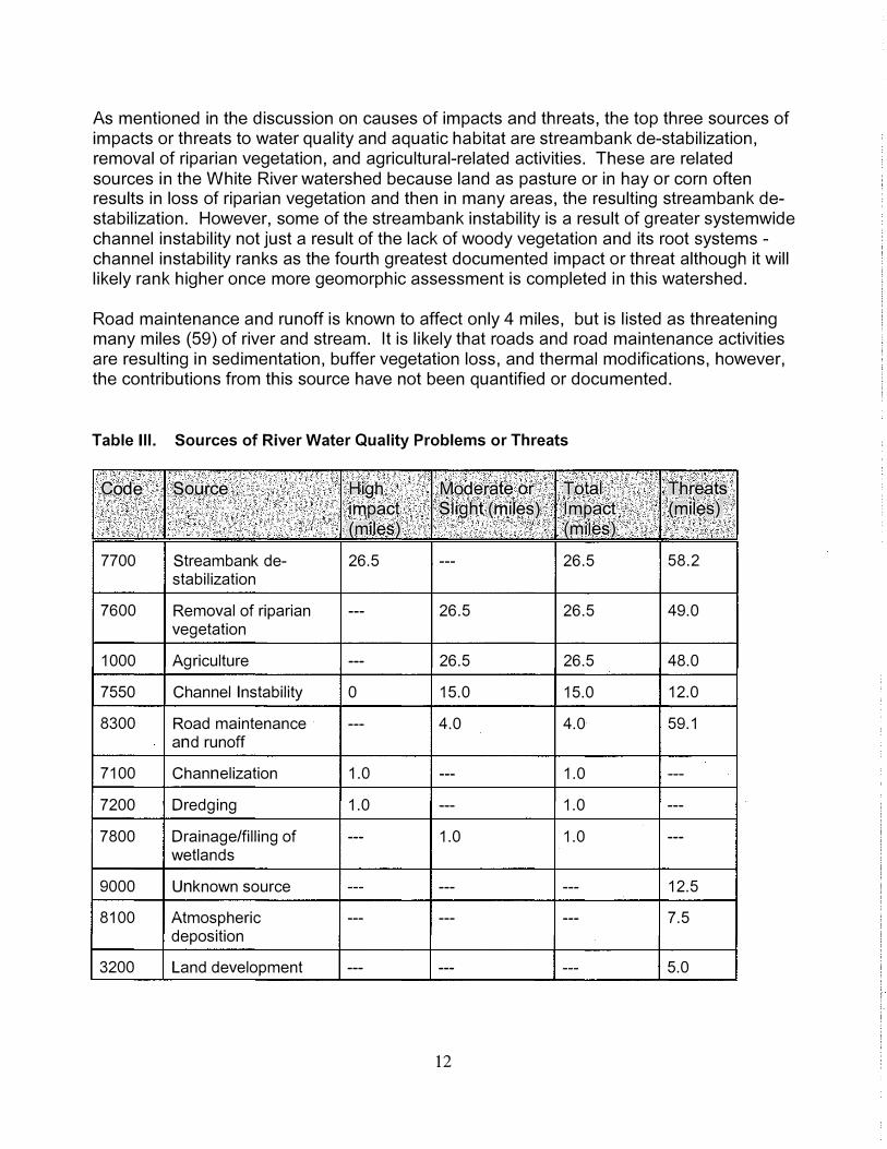
As mentioned in the discussion on causes of impacts and threats, the top three sources of impacts or threats to water quality and aquatic habitat are streambank de-stabilization, removal of riparian vegetation, and agricultural-related activities. These are related sources in the White River watershed because land as pasture or in hay or corn often results in loss of riparian vegetation and then in many areas, the resulting streambank destabilization. However, some of the streambank instability is a result of greater systemwide channel instability not just a result of the lack of woody vegetation and its root systems -channel instability ranks as the fourth greatest documented impact or threat although it will likely rank higher once more geomorphic assessment is completed in this watershed.
Road maintenance and runoff is known to affect only 4 miles, but is listed as threatening many miles (59) of river and stream. It is likely that roads and road maintenance activities are resulting in sedimentation, buffer vegetation loss, and thermal modifications, however, the contributions from this source have not been quantified or documented.
Table Ill. Sources of River Water Quality Problems or Threats
. . .
Code Source High Moderate or Total impact .· Slight (miles) l.rnpact
" (miles) (miles)
7700 Streambank de- 26.5 --- 26.5
stabilization
7600 Removal of riparian --- 26.5 26.5
vegetation
1000 Agriculture --- 26.5 26.5
7550 Channel Instability 0 15.0 15.0
8300 Road maintenance --- 4.0 4.0
and runoff
7100 Channelization 1.0 --- 1.0
7200 Dredging 1.0 --- 1.0
7800 Drainage/filling of --- 1.0 1.0
wetlands
9000 Unknown source --- --- ---
8100 Atmospheric --- --- ---
deposition
3200 Land development --- --- ---
12
·.
Ttlr-�at� (miles)·•
.• . . ..
58.2
49.0
48.0
12.0
59.1
---
---
---
12.5
7.5
5.0

Lake and Pond Water Quality and Aquatic Habitat Impacts and Threats
The White River Basin has relatively few lakes. Only four of Vermont's 17 major river basins contain fewer lake and pond acres. There are 39 lakes and ponds in the White River Basin, comprising 501 acres. Four hundred-eighteen of these acres are considered 'significant' waters and are tracked in Vermont DEC's Lake Assessment Database (though 34 of these acres remain unassessed for certain uses). Of these 418 acres, 253 are monitored, while 165 acres are evaluated.*
Designated Use Support Status
Overall, there are 89 lake acres in Basin 9 which only partially support one or more uses, and no acres on which one or more uses are precluded. There are 295 assessed lake and pond acres in Basin 9 that support all designated uses. Table IV contains the lake acres where designated uses are supported, threatened, or not fully supported.
Table IV. Designated Use Support for Lakes in the White River Basin.
,,.
. .
u
,.
.. . '
Overall Uses Aesthetics
.·
. .· .
Aquatic Life Use Support l\gricultural Water Supply Drinkinq Water Supply i='ish Consumption =iltered Water Supply ndustrial Water Supply Secondary Contact Uses Swimmina Uses
A9r�.s Fully Supporting ·. Uses
. .
167
200
167
0
0
394
0
0
202
200
· .. ·
Supporting Acre$ ,Acres with Uses ·· Partially .•.•.
Threatened · ... S"1pporting· .. · · ll��c· · . . . . ·• ·.
128 89
184 0
131 86
0 0
0 0
0 0
0 0
0 0
182 0
184 0
Ac.rf:}�N?t ·Supporting
.
Uses··. . .: .: : ..
0
0
0
0
0
0
0
0
0
0
: i .
Ac;re�t�Pt �$Se$$�<:f
..•. .. . .
34
34
34
418
52
27
418
418
34
34
The principal cause of impairment to lakes in the White River Basin is water level fluctuation, which impairs aquatic life uses on one lake as discussed below. Critically low pH of two ponds impairs 2 lake acres, and threatens an additional 30. Siltation is noted as a threat to uses for 91 acres, though some reassessment of these threatened acres is warranted. The risks associated with potential infestation by exotic species (primarily Eurasian watermilfoil, but also zebra mussels) threaten 70 lake acres. Table V provides an accounting of the causes of impacts to lakes in this basin.
*Monitored data are from in-lake sampling whereas evaluated data are from observedconditions, modelled results, or the professional opinion of a biologist or other scientist.
13
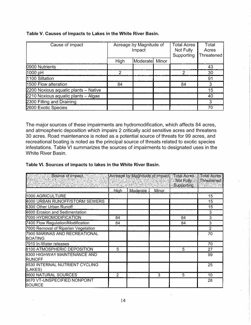
Table V. Causes of Impacts to Lakes in the White River Basin.
Cause of impact Acreage by Magnitude of Total Acres Total Impact Not Fully Acres
Supporting Threatened
High Moderate Minor
0900 Nutrients 43
1000 pH 2 2 30
1100 Siltation 91
1500 Flow alteration 84 84 3
2200 Noxious aquatic plants - Native 15
2210 Noxious aquatic plants -Algae 40
2300 Filling and Draining 3
2600 Exotic Species 70
The major sources of these impairments are hydromodification, which affects 84 acres, and atmospheric deposition which impairs 2 critically acid sensitive acres and threatens 30 acres. Road maintenance is noted as a potential source of threats for 99 acres, and recreational boating is noted as the principal source of threats related to exotic species infestations. Table VI summarizes the sources of impairments to designated uses in the White River Basin.
Table VI. Sources of impacts to lakes in the White River Basin.
. Squrce. of Impact Acreage by Magnitude. of Impact T ptal Acres, Jo��J.A�[e�. tJ<:>tFullt .· •..... • •. Threatened
; . .. .. Supporting
Hiah MnrlArate Minor 1000 AGRICULTURE 15
4000URBAN RUNOF8STORM SEWERS 15 4300 Other Urban Runoff 15 4600 Erosion and Sedimentation 3 7000 HYDROMODIFICATION 84 84 3 7 400 Flow Regulation/Modification 84 84 3 7600 Removal of Riparian Vegetation 2 7900 MARINAS AND RECREATIONAL 70
BOATING 7910 In-Water releases 70 8100 ATMOSPHERIC DEPOSITION 5 5 27 8300 HIGHWAY MAINTENANCE AND 99
RUNOFF 8530 INTERNAL NUTRIENT CYCLING 25 'LAKES) 8600NATURAL SOURCES 2 3 5 10 9070 VT-UNSPECIFIED NONPOINT 28
SOURCE
14

To provide background information on individual lakes in this basin, a summary of overall use support by individual lake is provided in Table VII. Nine lakes in the basin are considered monitored, meaning that new water quality data are available from within the past five years. The following paragraphs describe the most important impacts and threats to specific White River Basin lakes.
Table VII. Overall Use Support by Individual Lake with the White River Basin
Lake Name Lake Last Assessment Acres in Acres Acres Area (ac) Assessed Type Full Partially Not
(YYYYMM) Support Supportinq Supportinq
ANSEL 2 200009 Evaluated 2 0 0
BEAVER MEADOWS 3 200009 Evaluated 3 0 0
CHAMPAGNE 3 200009 Monitored 3 0 0
COLTON 27 200009 Monitored 27 0 0
CRESCENT 20 200009 Evaluated 20 0 0
HANCOCK MT; 14 200009 Evaluated 14 0 0
HOLD ENS 10 200009 Evaluated 10 0 0
KEYSER; 7 200009 Evaluated 7 0 0
KINGS 4 200009 Evaluated 4 0 0
LAMSON 24 200009 Evaluated 24 0 0
MCINTOSH 23 200009 Monitored 23 0 0
MITCHELL 28 200009 Monitored 28 0 0
MUD (BRAINT) 10 200009 Evaluated 10 0 0
NORTH (BRKFLD) 24 200009 Monitored 24 0 0
NORTH (CHITDN) 3 200009 Evaluated 3 0 0
PICKLES 17 200009 Evaluated 17 0 0
RANDOLPH-N; 10 200009 Evaluated 0 0 0
ROOD 23 200009 Monitored 23 0 0
ROXBURY FLAT; 13 200009 Evaluated 0 0 0
ROYALTON HILL; 11 200009 Evaluated 0 0 0
SILVER (BARNRD) 84 200009 Monitored 0 84 0
SKYLIGHT 2 200002 Evaluated 0 2 0
SOUTH (BRKFLD) 16 200009 Monitored 16 0 0
STAPLES 15 200009 Evaluated 15 0 0
SUNSET (BRKFLD) 25 200009 Monitored 25 0 0
North Pond, Chittenden:
This 3 acre pond located near the spine of the Green Mountains is threatened by acid deposition due to its low alkalinity of 3. 7 mg/I. This is largely natural, a manifestation of this pond's high elevation and geological setting. Atmospheric deposition of acidinducing pollutants such as nitrous oxide and sulfur dioxide exacerbates the acidification potential in this lake.
15

Silver Lake, Barnard:
This 84 acre lake is considered threatened by eutrophication due to nutrients and sedimentation, which are attributed to cumulative development within the Silver Lake watershed.· It is noteworthy that the Silver Lake Association, a group of citizens with a strong interest in improving the lake's water quality, has been instrumental in reducing sediment and nutrient runoff from roads in the watershed, and is active in monitoring long-term water quality indicators. Water levels on this lake are manipulated by the dam which is owned by Vermont DEC. Consistent with a 1968 Water Resources Board rule, the lake is drawn down by 1.5 feet during winter. Due to this annual drawdown, Silver Lake only partially supports aquatic life uses.
Skylight Pond, Ripton:
This tiny 2 acre pond, located near the spine of the Green Mountains only partially supports aquatic life uses due to extreme acid sensitivity. The lake's alkalinity has been measured at 0.3 mg/I. This is partially natural, a manifestation of this pond's high elevation and geological setting, but atmospheric deposition of acid-inducing pollutants such as nitrous oxides and sulfur dioxide exacerbates acidification in this lake.
Sunset Pond, Brookfield:
This 25 acre lake exhibits a water quality condition known as meromixis, whereby the lake does not fully mix, or turn over, as most Vermont lakes do every spring and fall. This condition is most often found in lakes which are quite deep relative to their surface area, meaning that they have a steep-sided, almost conical configuration. Meromixis, or the lack of mixing, means that the deeper layers of the water column remain perpetually oxygen starved. A result of this condition is that the underlying sediments often release previously accumulated nutrients. Over time, concentrations of nutrients and other dissolved compounds build to such a degree, and rise sufficiently high in the water column, that they become available to algae, which can in turn bloom. On at least two occasions in the past 5 years, blooms of the nuisance cyanobacteria (blue-green algae) Oscillatoria rubescens have been observed on Sunset Pond. The swimming use is considered threatened on this pond. Norwich University research studies have found a relatively high rate of sediment movement through Sunset pond over time. The degree to which this sediment affects the lake's meromixis is unknown.
16
Selected Activities or Projects in the White River Watershed
White River Partnership Monitoring Program The White River Partnership has coordinated and implemented a watershed monitoring program in the 2001 and 2002 sampling seasons. Temperature, E. coli, conductivity and turbidity were sampled at 23 sites along the White River mainstem as well as on the three branches and several other tributaries. Samples were taken weekly by over 30 volunteer monitors.
Watershed Geomorphic Assessments Geomorphic assessments have been done on the Third Branch, First Branch, and between Stockbridge and Bethel on the mainstem of the White River. The Third Branch was assessed by a team of professionals led by staff from the Natural Resources Conservation Service. A report summarizing their findings and results was produced in February 2001.
The Agency's Geology and Water Quality Divisions and the Partnership has expanded the fieldwork done by USDA to include fluvial geomorphological information on all of the 43 tributaries of the Third Branch. This work, which is in progress, may be used to produce the following: • a map of hazard areas including flood and erosion hazard areas; and• a specific plan for channel protection, management, and restoration along the Third
Branch.
A hazard map would identify areas of high risk for bank failure and erosion during flooding. With these maps, towns can clearly identify areas where development may be an unadvisable investment. The Vermont Geologic Survey plans to work with towns to produce a hazard map for the Third Branch of the White River Basin.
In spring 2002, citizen volunteers were trained to do Phase II geomorphic assessments. The volunteers assessed the First Branch and the mainstem between Stockbridge and Bethel in summer 2002.
River Stabilization and Buffer Re-establishment Projects There has been much river and stream channel and corridor restoration work in the watershed since the 1997 water quality and aquatic habitat assessment report was written. A large restoration project took place on the Third Branch of the White River above and below the footbridge at Randolph Recreation Park. Eroding banks were stabilized, the river was narrowed and pools created to re-establish fish habitat, and trees and shrubs were planted along the banks.
Another large project with a number of partners took place in Granville. "Natural channel design" techniques were employed on this upper section of the White River resulting in a stable section of river through the village of Granville and downstream. Buffers and access to a floodplain were re-established for this portion of river.
17
Summary
The White River and its tributaries are important waters for both aquatic life and habitat as well as for people's use and enjoyment of its fishery, swimming holes, boating runs, and aesthetic. The mainstem is a unique river in that it is the only free flowing river of its size in the state. This free-flowing characteristic should be protected. The White River is also a working river providing an opportunity for meeting agricultural water needs, assimilating wastewater, and transporting stormwater.
The major threats and impacts to the White River system include: siltation from eroding streambanks, road runoff and other adjacent land uses, which fills in portions of the stream bed affecting macroinvertebrate and fish habitat; riparian vegetation removal that results in water temperature increases, bank instability, loss of the buffer filtration function, and habitat effects (instream and riparian); and diminished physical habitat for a healthy, self-sustaining fishery and other life due to channel instability as well as to the sediment inputs mentioned above. Past instream disruptions such as gravel mining and dredging following flood events as well as watershed land use history set off the instability seen in parts of the watershed today. The White River system is in a state of adjustment and recovery from extensive gravel removal in years past but affecting that recovery are the new sources of sediment filling in riffles and pools and altering channel capacity and dynamics.
Addressing the two major causes of water quality and aquatic habitat impairment in the White River watershed is difficult because of the widespread nature of the problem, however, a low technology, relatively straightforward means of addressing both siltation, temperature, and many nutrient impacts exists in the action of protecting and restoring riparian corridor vegetation. Channel stabilization and instream habitat restoration often involves a more intensive effort in terms of financial and technical resources. Many watershed citizens along with the White River Partnership, U.S. Forest Service, U.S. Fish and Wildlife Service, Natural Resources Conservation Service and Vermont Departments of Environmental Conservation and Fish & Wildlife, however, are involved in projects addressing the need for streambank stabilization, channel stabilization and riparian vegetation re-establishment. Many watershed citizens also have a new appreciation of, and connection to, the watershed in which they live and work and it is that connection that provides the longterm protection the watershed will need in the face of change.
18

References and Resources
Calcareous Open Fens and Riverside Seeps of Vermont: Some Sites of Ecological lmporlance, March 1995. Elizabeth Thompson and Robert Popp for the Vermont Nongame and Natural Heritage Program and U.S. Environmental Protection Agency.
Connecticut River Watch Program Summary Reporls, 1990 - 1993.
Floodplain Forest of Vermont: Some Sites of Ecological Significance, July 1998. Eric Sorenson et al. for the Agency of Natural Resources, Department of Fish & Wildlife, Nongame and Natural Heritage Program.
Vermont Dam Assessment: 2001 Project Reporl, November 2001. Vermont Agency of Natural Resources and Vermont Division of Historic Preservation.
Vermont Swimming Hole Study, March 1992. Jerry Jenkins, Deborah Benjamin and Jane Dorney for the Vermont Agency of Natural Resources, Department of Environmental Conservation, Water Quality Division.
Vermont's Whitewater Rivers: Their Geology, Biology, and Recreational Use, January 1989. Jerry Jenkins and Peter Zika for the Vermont Agency of Natural Resources, Department of Environmental Conservation.
Waterfalls, Cascades and Gorges, September 1985. Jerry Jenkins and Peter Zika for the Vermont Agency of Natural Resources, Department of Environmental Conservation, Water Quality Division.
Wetland, Woodland, Wild/and: A Guide to the Natural Communities of Vermont, November 2000. Elizabeth Thompson and Eric Sorenson, The Nature Conservancy and the Vermont Department of Fish and Wildlife.
White River Basin Water Quality Management Plan, November 1975. Agency of Environmental Conservation, Department of Water Resources (now the Agency of Natural Resources, Department of Environmental Conservation, Water Quality Division).
White River Basin Plan, December 2002. Agency of Natural Resources, Department of Environmental Conservation, Water Quality Division.
White River Watershed Assessment: Third Branch Stream Classification, February 2001. Prepared for the White River Partnership by the USDA Natural Resources Conservation Service.
19
Appendix A
White River Floodplain Communities
20
V crmont Floodplain Forest Inventory Master List
Nongamc and Natural Heritage Program, 1997
Site# Town ·Quad. Site/Location
I White I larlfonl '1307263 Centerville 1:loodplain
2 While II art ford 4307264 White River Floodplain at Dimick Brook
3 White I lartford 4307264 West I lartfonl Floodplain
4 While Sharon 4307274 White River WMA Floodplain
5 White Royalton 4307275 South Royalton Floodplain
6 White Royalton 4307275 Royalton Floodplain
7 White Royalton 4307275 North Royalton Floodplain
8 White Bethel 4307276 Bethel ConOuenee Floodplain
9 White Bethel 4307276 Lower Third Branch Floodplain
\VIIITKRIVER WATERSHED
Priority
M
M-11
M
II
H
M
M
M
II
Description
'10 acres of young l1oodplai11 forest between railroad
tracks and river; some shrubby. some open water
5 acre Ooodplain forest in apparent undisturbed condition al mouth of Dimick Brook; upstream end of forest extends under 1-89; upland buffer generally intact
I 0-12 acres of lloodplain forest on point bars and mid-channel island; nice rock outcrops along shoreline
45 acres of high quality floodplain forest on both sides of river over 1.5 mile stretch; forest is dominated by silver maple and cottonwood
40 acres of floodplain forest on both banks of river and on
two islands; some adjacent ag. land; southern area is young
forest
15 acres of Ooodplain forest on point bars and islands; roads
and residential development adjacent
25 acres of floodplain forest in small, narrow bands along edge of river and on a IO acre mid-channel island; ag. fields, roads. and residential development abut the riverside remnants
Source
NWl,CIR
NWI,CIR
NWI, CIR
NWI, CIR
NWI,CIR
NWl,CIR
NWI,CIR
NWI,CIR 12 acres or noodplain forest in narrow strip on north side of river with railroad tracks adjacent, and on west side of Third Branch at base of steep slope; both area young forest of box elder
25 acres or floodplain forest on both sides of river: nice riverine N\VI. CIR complex with larger units of forest 6-8 acres
Aerial Site
Rec on. Visit 1997
y y
y y
y y
y y
y y
y y
y N
y y
y y
Note: There are extensive areas (200 + acres) of nearly continuous floodplain forest along the Third Branch \Vhite River from its confluence with Gilead Brook upstream to above Randolph village. This stretch is best considered one site although it extends for nearly 5.5 miles. Some forests appear young. As a corridor, this may be a very important site. For
convenience in reporting, it is separated into subsitcs 10 White through 15 White.
IO White Bethel 4307286 Bethel Bends Floodplain 11
11 White Bethel/ 4307286 Third Branch Townline Floodplain
Randolph
12& 13 Randolph 4307286 Golf Course Floodplain
White
II
M
20 acres or floodplain forest associated with several oxbows:
some adjacent ag. fields. one unit with intact upland buffer
NWI. CIR
35 acres or floodplain fbrest on meanders and oxbows; some NWI, CIR or meanders have rcsu lled in abandonment of adjacent ag. land: several areas with steep. forested upland buffers
55 acres of lloodplain f'oresl on meanders and oxbows: ag. N\VI. CIR
land and golf course adjacent. separating most areas from the upland buffer: largest forested unit 12 acres
y y
y y
y y

Vermont Floodplain Forest Inventory -\Vhite River Watershed - Page 2
14 While Randolph 4307286 Third Branch Floodplain al Ayers L Brook
15 White Randolph 4307286 Randolph Village Floodplain H
15.5 While Braintree 4307286 East or Campground Floodplain L
16 White Braintree 4307286 Third Branch at Rifford Urook South M
17 White Braintree 4307286 West Braintree Floodplain M
18 While Bethel 4307276 White River rish Hatchery Floodplain L 19 White Bethel 4307276 Townline Floodplain L
20 White Stockbridg 4307276 Gaysville Floodplain M
21 White Rochester 4307277 Talcville Floodplain L
22 White Rochester 4307277 West Branch White River Floodplain M
23 White Rochester 4307277 Thunder Head South Floodplain L
IO acres or shrubby floodplain forest just upstream of N\VI, CIR y N
Randolph village; some conifer component 80 acres of floodplain forest from confluence with Ayes Brook NWI, CIR y y
upstream to Braintree town line: several areas with intact forests and upland buff crs arc 20+ acres; provides a corridor through Randolph village less than 5 acres or floodplain forest; intact upland buffer or aerial reconn. y N
mature forest 15 acres of low and high terrace floodplain forest; old river NWl,CIR y y channel on north side; intact uplland buffer: much of lloodplain and terrace has been recently logged 9 acres of floodplain forest on upper portion of Third Branch; NWI. CIR y N two small units on cast side have intact upland buffers, hut all areas arc yougn forest 8-10 acres of floodplain forest in narrow band along river NWI, CIR N N
8 acres of young floodplain forest just north of Stockbridge NWl,CIR N N town line 20 acres of young floodplain forest with high water channels NWI,CIR N y
and extensive gravel bars 6 acres of young floodplain forest with disturbance from farm NWI,CIR N N road and ag. field within the floodplain 7-8 acres of young floodplain forest and more mature high NWl,CIR N y terrace forest on meander of lower West Branch; intact upland buffor, but small ag. field upstream 20 acres of shrubby floodplain forest with one acre interior NWI,CIR N N pool
This list of floodplain forest sites has been generated based on information gathered by the Vermont Nongame and Natural Heritage Program during initial reconnaissance and during detailed site surveys conducted during the summer and fall of 1997. Sites on private properly were only visilcd with specific landowner approval. More detailed information on individual sites is avaikible from the Vermont Nongame and Natural Heritage Program; contact Eric Sorenson by phone (802-241-3714) or e-mail ([email protected]). This project was funded by a U.S. E.P./\. State Wetlands Protection Grant.

Appendix B
Population and Housing Data
23

Table B.1. Population of White River Watershed Towns
Town 1970 1980 1970-80 1.990 1980-90 2000 1990�00
•·
increase increase I increase
Brookfield* 606 959 58.2% 1089 13.6% 1222 12.2%
Chelsea 983 1091 11.0% 1166 6.9% 1240 6.4%
Washington* 667 855 28.2% 937 9.6% 1047 11.7%
Roxbury* 354 452 27.7% 575 27.2% 576 0.2%
Granville* 255 288 12.9% 309 7.3% 303 -1.9%
Braintree 751 1065 41.8% 1174 10.0% 1194 1.7%
Randolph 3882 4689 20.8% 4764 1.6% 4853 1.9%
Tunbridge* 791 925 16.9% 1154 24.8% 1309 13.4%
Hancock* 283 334 18.0% 340 1.8% 382 12.4%
Rochester 884 1054 19.2% 1181 12.0% 1171 -0.8%
Bethel 1347 1715 27.3% 1866 8.8% 1968 5.5%
Royalton 1399 2100 50.1% 2389 13.8% 2603 9.0%
Sharon* 541 828 53.0% 1211 46.2% 1411 16.5%
Pittsfield 249 396 59.0% 389 -1.8% 427 9.8%
Stockbridge 389 508 30.6% 618 21.7% 674 9.1%
Barnard* 569 790 38.8% 872 10.4% 958 9.9%
Pomfret* 620 856 38.1% 874 2.1% 979 12.0%
Hartford* 6477 7963 22.9% 9404 18.1% 10385 10.4%
Chittenden* 646 927 43.5% 1102 18.9% 1182 7.3%
Watershed 21,693 27,795 28.1% 31,414 13.0% 33,884 7.3%
* towns, the majority of which are in the watershed. The other towns are completely
within the watershed.
24

Table 8.2. Housing Units of White River Watershed Towns
••.
Town 1980 ' 1990 1980-.90 2000 f990 .. 2000 .· housing units " housing units increase housing units· increase
Brookfield* 457 565 23.6% 602 6.5%
Chelsea 510 610 19.6% 657 7.7%
Washington* 384 447 16.4% 528 18.1%
Roxbury* 229 335 46.3% 362 8.1%
Granville* 201 210 4.5% 218 3.8%
Braintree 507 570 12.4% 567 -0.5%
Randolph 1669 1830 9.6% 1905 4.1%
Tunbridge* 499 655 31.3% 679 3.7%
Hancock* 198 201 1.5% 214 6.5%
Rochester 662 737 11.3% 768 4.2%
Bethel 823 888 7.9% 956 7.7%
Royalton 975 1161 19.1% 1281 10.3%
Sharon* 413 578 40.0% 663 14.7%
Pittsfield 298 401 34.6% 393 2.0%
Stockbridge 413 488 18.2% 528 8.2%
Barnard* 555 607 9.4% 629 3.6%
Pomfret* 404 490 21.3% 535 9.2%
Hartford* 3483 5026 44.3% 5502 9.5%
Chittenden* 449 538 19.8% 585 8.7%
Watershed 13,129 16,337 24.4% 17,572 7.6%
* towns, the majority of which are in the watershed. The other towns are completelywithin the watershed.
25
.

Appendix C
Macroinvertebrate Sampling Sites 1992 - 2001
26

Table C.1. Macroinvertebrate Sampling Sites on the White River 1992 - 2001
Wbid Name Town
VT09-01 White River Hartford
VT09-01 White River Sharon
VT09-01 White River Sharon
VT09-01 White River Sharon
VT09-01 White River Sharon
VT09-02 White River Bethel
VT09-02 White River Stockbridge
VT09-02 White River Stockbridge
VT09-02 White River Stockbridge
VT09-02 White River Stockbridge
VT09-02 White River Rochester
VT09-04 First Branch Tunbridge
VT09-04 First Branch Chelsea
VT09-04 First Branch Chelsea
VT09-04 First Branch Chelsea
VT09-04 First Branch Chelsea
VT09-04 Cram Brook Chelsea
VT09-04 Jenkins Brook Chelsea
VT09-05 Second Branch Royalton
VT09-05 Second Branch Randolph
VT09-05 Kingsbury Brook Randolph
VT09-05 Blaisdell Brook Randolph
VT09-05 Snows Brook Randolph
VT09-05 Snows Brook Randolph
VT09-05 Third Branch Randolph
VT09-06 Third Branch Randolph
VT09-06 Third Branch Randolph
27
I ··Mile Point . J Date j. Assessment I1.9 09/92 Excellent
14.0 10/97 Good
14.0 10/98 Fair
14.0 09/99 Good
14.0 09/01 Good
26.9 09/01 Good-Fair
32.4 10/93 Excellent
32.4 10/94 Excellent
32.4 9/95 Excellent
32.4 9/96 Excellent
43.7 09/01 VG-Good
6.6 09/01 VG-Good
15. 1 09/92 Very Good
15. 1 09/01 VG-Good
16.8 09/01 VG-Good
21.0 09/01 Excellent
0.7 09/01 VG-Good
0.3 09/01 Excellent
0. 1 09/01 Very Good
18.0 09/01 Very Good
0.5 09/01 Fair
1.6 09/01 Very Good
0.7 9/97 Good
0.7 09/01 Good
8.5 09/01 Good
9.5 8/93 Good
9.5 09/01 Good
Wbid Name Town Mile\Point Date f Assessment>J
VT09-06 Third Branch Randolph 9.9 08/93 VG-Excellent
VT09-06 Third Branch Randolph 10.2 08/93 VG-Excellent
VT09-06 Third Branch Randolph 12.7 09/97 VG-Excel lent
VT09-06 Third Branch Braintree 18.1 09/93 Excellent
VT09-06 Gilead Brook Bethel 2.0 09/01 Excellent
VT09-06 Smith Brook Randolph 0.1 09/01 Poor
VT09-06 Ayers Brook Randolph 0.3 09/97 VG-Good
VT09-06 Ayers Brook Randolph 0.3 09/01 Good
VT09-06 Ayers Brook Randolph 4.5 09/01 Fair-Good
VT09-06 Adams Brook Randolph 1.5 09/97 Fair
VT09-06 Adams Brook Randolph 1.5 09/01 Good
VT09-06 Spear Brook Randolph 0.1 09/97 Fair
VT09-06 Spear Brook Randolph 0.1 09/01 Good
VT09-06 Spear Brook Randolph 1.1 09/97 Good
VT09-06 Cold Brook Brookfield 1.1 10/01 Fair-Poor
VT09-06 Open Meadow Brook Brookfield 0.2 09/01 Excellent-VG
VT09-07 Stony Brook Stockbridge 1.9 09/01 Very Good
VT09-07 Perkins Brook Stockbridge 0.1 09/01 Excellent-VG
VT09-07 West Branch Tweed Pittsfield 1.4 10/00 Very Good
VT09-07 West Branch Tweed Pittsfield 1.4 09/01 Excellent
VT09-07 West Branch White Rochester 0.5 11/00 Excellent
VT09-07 Bingo Brook Rochester 1.3 10/99 Very Good
VT09-07 Bingo Brook Rochester 1.3 09/00 Excellent
VT09-07 Bingo Brook Rochester 1.3 09/01 Excellent-VG
VT09-07 Smith Brook Goshen 1.3 09/97 Excellent
VT09-07 Smith Brook Goshen 1.3 09/98 Excellent
VT09-07 Smith Brook Goshen 1.3 09/99 Excellent
VT09-07 Smith Brook Goshen 1.3 10/99 Excellent
28

Wbid .. Name . ·· Town ·. Mile Point Date Assessment
VT09-07 Smith Brook Goshen 1.3 09/00 Excellent
VT09-07 Smith Brook Goshen 1.3 09/01 Very Good
VT09-07 Horrid Brook Goshen 0.1 09/97 Excellent
VT09-07 Marsh Brook Rochester 0.1 09/01 Very Good
VT09-07 Howe Brook Hancock 0.3 09/99 Fair
VT09-07 Howe Brook Hancock 0.3 09/00 Good
VT09-07 Howe Brook Hancock 0.3 09/01 Excellent-VG
29
Appendix D
Dams in the White River Watershed
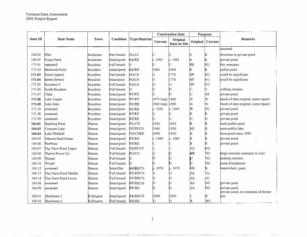
30

Vermont Dam Assessment 2001 Project Report
State ID Dam Name
11.06 unnamed 11.96 unnamed 11.97 Stone Cottage 11.98 Sayer Woods 21.01 ethel Mills 21.02 21.03
21.04 ethel-4 21.07 ellog 21.97 21.98 21.99 25.01 25.02 25.03 25.04 elaney 25.05 25.06 nnamed 25.99 Unnamed 32.02 orth Pond (upper) 32.03 orth Pond (lower)
32.04
r
etLake 32.05 oldens Pond 32.07 rookfield-7 32.08 hase
Town
ethel ethel ethel ethel ethel
rain tree Brookfield Brookfield
r
kfield rookfield rookfield rookfield
Appendix D
Dams Assessed in the White River Basin
Construction Date Purposes
Condition I Type/Material Original I Current
Remarks
� �
!foundations downstreameaver dam u u
Intact/good u
trivate pond
Intact/ good 1980 1980 rivate pond Intact/ good IRE c. 1975 u rivate pond Intact/ good 1941 c. 1780Intact/ good 1969 u
Intact/poor c.1900 u p ·n building in poor condition remainsull breach u u nothing remains at site ull breach u othing remains at site art breach c. 1940 owner interested in removal
c. 1940 nothing remains of former use u rivate pond
ull breach u u othing at site ull breach
Intact/ good IRE c. 1970 c. 1970Intact/ good IRE c. 1970 c. 1970Intact/ good IRE 1985 c. 1940Intact/ good IRE u
Intact/ good IRE c. 1970 c. 1970
fu fut
rivate pond eaver dam u eaver dam built up on man-made dam art breach u u eaver dam built up on man-made dam
uch of dam original, with some Intact/good
�ES1MS ,� 11850
�: � !repairs
Intact/ good /STMSCN 998 (rep) 1932 some remnants of former use Intact/poor Intact/ good IRE/RE le. 1980
Vermont Dam Assessment 2001 Project Report
State ID Dam Name
32.09 Sunset Brook 32.10 Unnamed 32.11 32.12 32.13 47.01 47.02 47.03 47.04 47.05 47.06 Jones Pond 47.07 unnamed 47.08 Lonely Dell 92.01 Camp Killooleet 92.02 Camp Killooleet Diversion 94.09 artford Woolen Co. 94.10 odunkBrook 157.01 reeman 157.03 cCord 157.04 157.05 157.98 162.01 arvey 162.02 Gulf Road 162.03 Lake Champagne 162.04 orth Randolph 162.05 Sargent, Osgood and Roundy 162.07 andolph-7 162.08 layground 162.09 162.99 168.01 !Rochester
Town
Chelsea Chelsea Chelsea Chelsea Chelsea Chelsea Chelsea
an cock an cock artford artford
andolph andolph andolph andolph andolph
andolph
Construction Date Purposes Condition I Type/Material Original O . . 1
I Remarks Current Dam on Site ngma Current
c. 1858 !HP 1u �eaver dam built up on man-made dam uc. 1850
rivate pond u rivate pond c. 1820 p ill building remains c. 1940
IRE 1963 1963 rivate pond u u abutments u u nothing found at site u 1788 p marker on site u u beaver dam constructed in breach u u nothing remains
Intact/ good IRE c. 1980 rivate pond Intact/ good /RETC 1980 1912 many original camp buildings remain Intact/fair 1912
ull breach u u
� I� !concrete remnant
ull breach some remnants Intact/good 1962 Intact/good 1962 Intact/ good /RECN u Intact/poor /REST u u Intact/ good u u Intact/good u u Intact/ good 1980 c. 1860
r r �othing remains of former use
Intact/good u rivate campground Part breach u
ull breach u ull breach u ull breach u
2
Vermont Dam Assessment 2001 Project Report
State ID I Dam Name
168.02 Eller 168.03 ings Pond 171.01 171.02 clntosh Pond 171.03 Eaton (upper) 171.04 171.05 oyalton-5 171.06 South Royalton 171.07 Clark 171.08 Lake Casper 171.09 Lake John 171.10 nnamed 171.98 unnamed 171.99 unnamed 184.01 Standing Pond 184.03 Crescent Lake 184.04 Lake Mitchell 184.05 ohnson Real Estate 184.06 184.07 184.08 184.09 184.10 184.12 184.13 ay Farm Pond Middle 184.14 ay Farm Pond Lower 184.98 184.99
188.01 !Sherburne- I
188.02 Sherbume-2
I Town
ochester ochester oyalton oyalton oyalton
oyalton oyalton oyalton
Royalton oyalton oyalton oyalton oyalton
Sharon Sharon Sharon Sharon Sharon Sharon Sharon Sharon Sharon Sharon Sharon Sharon Sharon Sharon
killington illincton
Construction Date Purposes I Condition I Type/Material Original I Remarks
Current Dam on Site Original Current
assumed
art breach u u diversion to private pond Intact/good IRE c. 1985 c. 1985 private pond
ull breach u u E u few remnants /RE 1964 1964 public pond
1776 u could be significant Intact/poor u 1776 p u could be significant
ull breach ull breach u othing remains
Intact/good u rivate pond Intact/good 1973 (rep) 1880 uch of dam original, some repairs Intact/good 1962 (rep) 1900 uch of dam original, some repairs Intact/poor c. 1950 c. 1950 rivate pond Intact/ good u u rivate pond Intact/ good IRE u u rivate pond Intact/ good 1930 1930 semi-public pond Intact/ good 1940 1920 semi-public lake Intact/ good G/CNRE 1890 1950 out pond since 1890 Intact/good IRE c. 1960 c. 1960 rivate pond Intact/good IRE R rivate pond
ull breach ull breach
r
N
L70 � 1970 �: F r
ge concrete remnants in river Full breach othing remains
ull breach ome foundations Intact/fair IRECN aterwheel, gears
ull breach ull breach
Intact/good �:
CN
I� lu �: �� t
rivate pond Intact/good rivate pond
private pond, no remnants of former
intact/ good
�/RECN
t90
t50
I� � !useull breach IRE
3
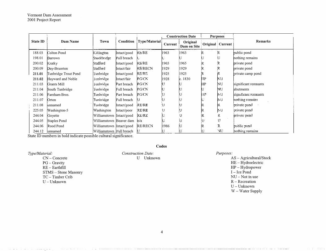
Vermont Dam Assessment 2001 Project Report
State ID I Dam Name
188.03 Colton Pond 198.01 arrows 200.02 ratky 200.09 ay-Bruorton 211.01 Tunbridge Trout Pond 211.02 Hayward and Noble 211.03 Grants Mill 211.04 South Tunbridge 211.06 Farnham Bros. 211.07 Orton 211.08 nnamed 225.05 ashington-5 244.04 Goyette 244.05 Staples Pond 244.06 ood Pond 244.12 unnamed
Town
unbridge
ashington Williamstown
illiamstown Williamstown Williamstown
Construction Date I Condition I Type/Material I Original
Current Dam on Site
Intact/ good IRE 1963 1963 ull breach u
Intact/ good IRE 1965 1965 Intact/fair IRECN 1929 1929 Intact/good 1925 1925 Intact/fair 1928 c. 1830
art breach u
Full breach u
art breach Full breach Intact/ good Intact/poor Intact/ good Beaver dam Intact/ good ruE/RECN
1i86
I� ull breach State ID numbers in bold indicate possible cultural significance.
Type/Material:
CN -Concrete PG-Gravity RE -Earthfill STMS Stone Masonry TC -Timber Crib U-Unknown
Codes
Construction Date:
U Unknown
4
Purposes
Original
R u
p HP u
I�
Remarks Current
R ublic pond u nothing remains
rivate pond rivate pond rivate camp pond
t� rignificant remnants
abutments
Purposes:
AS -Agricultural/Stock HE -Hydroelectric HP -Hydropower I-Ice PondNU -Not in useR -RecreationU-UnknownW -Water Supply
Appendix E
Infrared Photo Analysis done for
1997 White River Basin Assessment Report
35
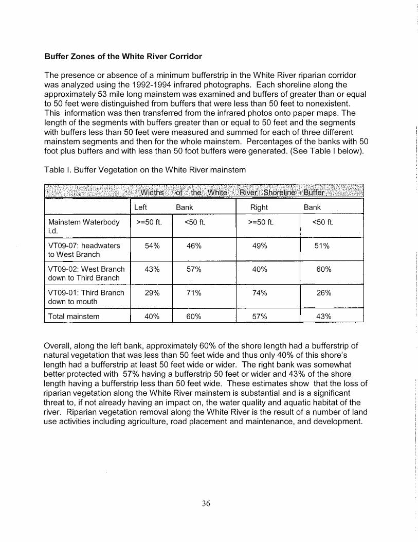
Buffer Zones of the White River Corridor
The presence or absence of a minimum bufferstrip in the White River riparian corridor was analyzed using the 1992-1994 infrared photographs. Each shoreline along the approximately 53 mile long mainstem was examined and buffers of greater than or equal to 50 feet were distinguished from buffers that were less than 50 feet to nonexistent. This information was then transferred from the infrared photos onto paper maps. The length of the segments with buffers greater than or equal to 50 feet and the segments with buffers less than 50 feet were measured and summed for each of three different mainstem segments and then for the whole mainstem. Percentages of the banks with 50 foot plus buffers and with less than 50 foot buffers were generated. (See Table I below).
Table I. Buffer Vegetation on the White River mainstem
Mainstem Waterbody i.d.
VT09-07: headwaters to West Branch
VT09-02: West Branch down to Third Branch
VT09-01: Third Branch down to mouth
Total mainstem
Widths of · the White River Shoreline · Buffer
Left Bank Right Bank
>=50 ft. <50 ft. >=50 ft. <50 ft.
54% 46% 49% 51%
43% 57% 40% 60%
29% 71% 74% 26%
40% 60% 57% 43%
Overall, along the left bank, approximately 60% of the shore length had a bufferstrip of natural vegetation that was _less than 50 feet wide and thus only 40% of this shore's length had a bufferstrip at least 50 feet wide or wider. The right bank was somewhat better protected with 57% having a bufferstrip 50 feet or wider and 43% of the shore length having a bufferstrip less than 50 feet wide. These estimates show that the loss of riparian vegetation along the White River mainstem is substantial and is a significant threat to, if not already having an impact on, the water quality and aquatic habitat of the river. Riparian vegetation removal along the White River is the result of a number of land use activities including agriculture, road placement and maintenance, and development.
36

Appendix F
Individual River Waterbody Reports
for the White River Watershed
37

November 20, 2002
Waterbody No: VT09-01
River Length (mi.): 26
Lower White River Main Stem
Assessment Report
Pagel
Assessment Year: 2002
Date Last Updated: 11/19/2002
Description: Main Stem - Mouth to Confluence with Third Branch
ANR Enforcement District:
Fish and Wildlife District:
Monitored (mi.):
Evaluated (mi.):
26.0
0.0
Water Quality Limited?
On 303( d) List? N
Monitored for Toxics? Y
Aquatic Contamination
None detected
3
4
Waste Management Zone - Miles:
Assessment Comments
THREATENED MILES
Location Identifiers
NRCS District: 10
Regional Planning Commission: TWO
Assessment Information
Assessment Types
Information from local residents
Land use information and location of sources
Occurrence of conditions judged to cause impairment
RBP Ill or equivalent benthos surveys
Bacteria water column sampling by quality-assured volunteer progr
Toxics Testing
Organics in water column
Metals in water column
Other inorganics in water column
Description: Bethel WWTF to confluence with Second Branch
White River: 21.0 - upstream from mouth to First Branch - threats to aesthetics, aquatic habitat, contact recreation, ag. water supply and drinking water supply due to sedimentation, thermal modifications, pathogens, wide and shallow channel, metals, toxic substances, some turbidity from removal of streambank vegetation, streambank and cropland erosion, tributary streams instability, highway maintenance, and closed, unlined landfill. c(500,900, 1100, 1400, 1600) s(1000,6300,7550,7600,7700,8300)
COMMENTS Macroinvertebrate sampling at rivermile 1.9 in 1992 found the community in excellent health; at rivermile
14.0, the community was in good health in 1997, in fair conditon in 1998, and in good condition in 1999 and 2000; at riverm ile 21 .8, the community was in excellent to very good condition in 1992 and in very good health in 2001. (2002)
Water samples from seven sites were taken in this waterbody stretch in 2001 and 2002 by White River Partnership volunteers to test for E. coli. None of the sites had a geometric mean of the samples that was greater than 126 colonies per 100 ml although a number of the sites had a geometric mean greater than 77. At mainstem rivermile (rm) 1.0, no single samples were above 235 (EPA maximum allowable density for a single sample for a designated beach area) in 2001 and only 1 sample was above 235 in 2002. At rm 6.4 (Dimick Brook), no single samples were above 235 in 2001 and 4 samples were above this threshold in

November 20, 2002 Page2
Lower White River Main Stem VT09-01
2002. At rm 8.4 (Mill Brook), no single samples were above 235 in 2001 and only one sample was above this in 2002. At rm 13.0 (Sharon), no single samples were above 235 in 2001 and 3 samples were above this limit in 2002. At rm 18.7 (First Branch), no single samples were above 235 in 2001 and 3 samples were above in 2002. At rm 22.8 (Royalton), there were no samples above 235 in 2001 and 2 samples above 235 in 2002. At rm 25.2 (Bethel below Tx), there was one sample above 235 in 2001 and 3 samples above 235 in 2002.
The White River Partnership also monitored temperature in 2001. Following are some highlights of their results. At rm 6.4, there were 4 days in a row when the water temperatures were at or above 77F in August. Several days on either side of those four had temperatures above 77F for 20 to 22 of the hourly readings. At rivermile 8.4, there were 2 full days in July and 7 full days in August when the temperatures (recorded each hour) were above 77F. At rivermile 13.0, there was 1 day in July and 4 days in August when the temperatures were above 77F for all 24 hours. At rm 22.8, 3 days in August had temperatures above 77F for 20 to 21 hours of the day.
The Bethel/Royalton landfill, from which groundwater flows to the White River and Second Branch, was capped in October 1993. Earlier groundwater sampling (1980 and 1981, 1990 and 1991) had shown exceedances of iron and manganese and organic compounds. Exceedances of groundwater enforcement standards of arsenic, iron, manganese, benzene and vinyl chlkorine in shallow, groundwater well. Monitoring will continue twice a year. (1997)
The Quechee Mobil site (#890310), which was on the Hazardous Waste list of sites with surface water impacts, apparently does not have surface water impacts. It is three quarters of a mile from the White River and is a low priority.
The Johnson & Dix site (#890437), which is also on the above-mentioned list, is high priority and remediation has begun. Two underground storage tanks were removed in 1989. A petroleum plume exists on the central portion of this site, which was though to be a threat to the river. Based on groundwater sampling though concerns were diminished. The consultants responsible for sampling haven't done it for a year or so now and need to be contacted again. (1997)
Observations made by two anglers, who have known the White River for over 20 years each, include the following. Since the state put an end to gravel mining, the river has started to recover - gravel bars are forming and the channel stabilizing. However, habitat is still lacking and one of the anglers felt that land use practices upstream including removal of riparian vegetation, construction, roads, some agriculture are resulting in the loss of pools and riffles (or pools and riffles inability to re-establish post-gravelling) and warmer temperatures. Fewer and fewer wild trout are being found (reproduction is down) and hatchery fish dominate.
The Royalton WWTF is in compliance with all permit requirements and has been in the recent past. Previous assessment comments mentioned nutrient enrichment (periphyton growth) below the plant but the source of the enrichment is not necessarily straightforward.
An analysis of the vegetation present along this section of the White River mainstem using the infrared photos found that on the northern or eastern river edge, approximately 29% of the shoreline had a buffer 50 feet or greater and 71 % of the shoreline had a buffer less than 50 feet. On the southern or western river edge, approximately 74% of the shoreline had a buffer 50 feet or greater and 26% of the shoreline had a buffer less than 50 feet.
INFORMATION SOURCES White River Partnership - E. coli sampling on White River and tributaries in 2001 and 2002. Vermont DEC Water Quality Division Biological and Aquatic Studies Section data - macroinvertebrate
sampling results at 3 sites from 1992 to 2001. Water Quality Division infrared photo collection Bryan Harrington and Solid Waste section reports/files, Vt DEC Waste Management Division - provided
information on the Bethel/Royalton landfill ( 1994 & 1997) Richard Spiese and Hazardous Materials section reports/files, Vt DEC Waste Management Division -
provided information on Quechee Mobil (#890310) and Johnson & Dix (#890437) sites. (1997) Peter Desmeules, Angler and Environmental Attorney - made observations on the health of the White
River especially since gravel mining has stopped (but with a 20 year perspective) (1997) Bob Scaronski, owner of a fly tackle business - discussed changes to the White River and especially the
declining wild trout population. (1997)
NOTE: Should temperatures be so high again in this segment of the river then partial support of aquatic habitat
November 20, 2002
Lower White River Main Stem should be used versus threatened status.
Use No. Use Description
01 Overall
20 Aquatic biota/habitat
21 Fish consumption
42 Contact recreation
44 Noncontact recreation
50 Drinking water supply
62 Aesthetics
72 Agriculture water supply
Impairment Cause
Priority organics
Metals
Siltation
Thermal modifications
Other habitat alterations
Pathogens
Impairment Source
Agriculture
Highway/road/bridge runoff
Landfills
Channel instability
Removal of riparian vegetation
Streambank modification/destabilization
Fully
5.0
5.0
0.0
5.0
26.0
25.5
5.0
25.5
Permit No. Point or Nonpoint Source Description
VT0100048 WWTF - Bethel
VT0020711 White River National Fish Hatchery
VT0100854 Royalton WWTF 0.07mgd
VT0101010 CSO - Hartford WRJ Bridge Street
Bethel Landfill (Unlined) - Royalton
1-0675
1-0735
1-1183
Clifford Inc - sw
White River Landing - sw
Town of Hartford - 2 sw
Threat
21.0
21.0
26.0
21.0
0.0
0.5
21.0
0.5
Partial Non Support Support
0.0 0.0
0.0 0.0
0.0 0.0
0.0 0.0
0.0 0.0
0.0 0.0
0.0 0.0
0.0 0.0
Magnitude
T
T
T
T
T
T
Magnitude
T
T
T
T
T
T
Receiving Water
White River
White River
White River
Page3
VT09-01
Not Assessed
0.0
0.0
0.0
0.0
0.0
0.0
0.0
0.0
Size (mi.)
0.50
0.50
21.00
21.00
21.00
21.00
Size (mi.)
21.00
21.00
0.50
12.00
21.00
21.00
November 20, 2002
Waterbody No: VT09-02
River Length (mi.): 24
Middle White River Main Stem
Assessment Report
Pagel
Assessment Year: 2002
Date Last Updated: 11/19/2002
Description: Main Stem - Confluence of Third Branch to West Branch
ANR Enforcement District:
Fish and Wildlife District:
Monitored (mi.):
Evaluated (mi.):
24.0
0.0
Water Quality Limited?
On 303(d) List? N
Monitored for Toxics? N
Aquatic Contamination
None detected
3
4
Waste Management Zone - Miles:
Assessment Comments
THREATENED MILES
Location Identifiers
NRCS District: 10
Regional Planning Commission: TWO
Assessment Information
Assessment Types
Land use information and location of sources
Biological Monitoring
Toxics Testing
Description:
White River mainstem: 24.0 - whole length from confluence of Third Branch to confluence of West Branch - threats to aquatic biota/habitat, secondary contact recreation (fishing), and aesthetics due to sediments, thermal modification, Japanese knotweed, from removal of riparian vegetation, road runoff and maintenance, and and possibly nutrients and toxics from a golf course on the river with little to no buffer, and agricultural land uses with little to no buffer (these causes need further assessment) . c(1100, 1400,2600) s(4500, 7600)
COMMENTS Macroinvertebrate sampling at mainstem rivermile 26.9 (above Locust Creek confluence) found the
community in good-fair condition in 2001; at rivermile 32.4 (below confluence of Tweed River), the community was in excellent condition in 1993, 1994, 1995 and 1996; and at rivermile 43.7, the community was in very good-good condition in 2001. (2002)
White River Partnership E. coli sampling from 2001 at 5 sites in this stretch of the White River found no sites with a geometric mean of the samples at 126 per 100 ml or greater. On one date at one site, the single sample was greater than 235 in 2001. In 2002, there were also no sites with geometric mean of the samples at or above 126. Sample values greater than 235 were found twice on different dates and at different sites. (2002)

November 20, 2002 Page2
Middle White River Main Stem VT09-02 White River Partnership temperature monitoring in 2001 at mainstem rivermile 27 .8 (Locust Creek
confluence) revealed 3 days in August when temperatures were at or above 77F for 14 to 16 hours and there were 5 full days when the temperatures were above 72F. Temperatures at rm 33.4 (Stockbridge School) were at or above 77F for 11 to 14 hours for 3 days in August and on these 3 days the temperatures were above 72F for the full 24 hours. At rm 44.8 (West Branch confluence), the temperatures were better with no recordings at or above 77F and no full days above 72F.
An analysis of the vegetation present along the whole White River mainstem using infrared photos found that on the northern or eastern river edge approximately 43% of the shoreline had a buffer 50 feet or greater and 57% had a buffer less than 50 feet. On the southern or western river edge, approximately 40% of the shoreline had a buffer 50 feet or greater and 60% had a buffer less than 50 feet. ( 1997)
INFORMATION SOURCES Vermont DEC Water Quality Division Biomonitoring Section - data from macroinvertebrate sampling
between 1993 and 2001 at 6 sites. White River Partnership monitoring program - data from sampling for E.coli in 2001 and 2002 and
temperature in 2001 . Jerry McArdle & Cathy Kashanski, Vt. DEC Water Quality Division - noted the lack of buffers, proximity of
roads to the river, erosion along roadsides near the river, extensive patches of Japanese knotweed on the banks, and a golf course, pasture and cropland near river without buffers during separate investigations (1997).
Water Quality Division infrared photo collection
Use No. Use Description
01 Overall
20 Aquatic biota/habitat
21 Fish consumption
42 Contact recreation
44 Noncontact recreation
50 Drinking water supply
62 Aesthetics
72 Agriculture water supply
Impairment Cause
Siltation
Thermal modifications
Exotic species
Impairment Source
Highway/road/bridge runoff
Removal of riparian vegetation
Fully
0.0
0.0
0.0
24.0
0.0
24.0
0.0
24.0
Permit No. Point or Nonpoint Source Description
3 .. 1141 White River Fish Hatchery wastewater
Threat
24.0
24.0
24.0
0.0
24.0
0.0
24.0
0.0
Partial Non Not Support Support Assessed
0.0 0.0 0.0
0.0 0.0 0.0
0.0 0.0 0.0
0.0 0.0 0.0
0.0 0.0 0.0
0.0 0.0 0.0
0.0 0.0 0.0
0.0 0.0 0.0
Magnitude Size (mi.)
T 24.00
T 24.00
T 24.00
Magnitude Size (mi.)
T 15.00
T 12.00
Receiving Water
White River
November 20, 2002 Pagel
Minor Tributaries - Lower White R. mainstem
Assessment Report
Waterbody No: VT09-03 Assessment Year: 2002
River Length (mi.): 54.5 Date Last Updated: 11/19/2002
Description: Minor tributaries on the lower White River mainstem including Jericho, Dimick, Podunk, Tigertown, Mill, Mitchell, High Pole, Quation, Fay, Whitewater, Broad and Sewall brooks.
Location Identifiers
ANR Enforcement District: NRCS District: 10
Fish and Wildlife District:
3
4 Regional Planning Commission: TWO
Monitored (mi.):
Evaluated (mi.):
0.0
54.5
Water Quality Limited?
On 303(d) List? N
Monitored for Toxics? N
Aquatic Contamination
Waste Management Zone - Miles:
Assessment Comments
THREATENED MILES
Assessment Information
Assessment Types
Surveys of fish and game biologists or other professionals
Land use information and location of sources
Toxics Testing
Description:
Jericho Brook.: 1.5 - mouth upstream for 1.5 miles along Jericho Road - threats to aquatic biota/habitat due to turbidity and siltation from slumping banks. c(1100,2500) s(7700)
Mill Brook: 12.5 - threats to aquatic biota/habitat from sedimentation. c(1100), s(9000). Broad Brook: 1.0 - threats to aquatic biota/habitat due to sedimentation from bank slumping into brook.
c(1100), s(7700)
COMMENTS Roads cross Mill Brook at least twelve times along its length and the points of crossing could be one of the
sources of sediment to the brook.
INFORMATION SOURCES John Claussen, Vt Dept of Fish & Wildlife - noted that Mill Brook is a major spawning stream threatened by
the above disturbances (1994). The culvert that had precluded passage of fish has been fixed. The wild and rainbow trout populations are diminished though and John doesn't know why (1997).
Cathy Kashanski, Vt DEC Water Quality Division - noted slumping banks on Broad Brook (1994 ). Kevin Kaija, NRCS - noted impairment on Jericho Brook (1994).
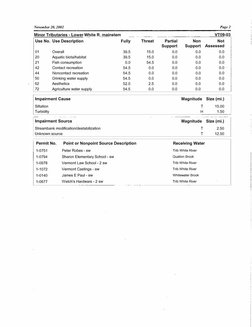
November 20, 2002
Minor Tributaries - Lower White R. mainstem
Page2
VT09-03 ---- -���� �- -�� �� �--���� � � �� �- ���� � ���
Use No. Use Description Fully
01 Overall
20 Aquatic biota/habitat
21 Fish consumption
42 Contact recreation
44 Noncontact recreation
50 Drinking water supply
62 Aesthetics
72 Agriculture water supply
Impairment Cause
Siltation
Turbidity
Impairment Source
Streambank modification/destabilization
Unknown source
39.5
39.5
0.0
54.5
54.5
54.5
52.0
54.5
Permit No. Point or Nonpoint Source Description
1-0751 Peter Robes - sw
1-0794 Sharon Elementary School - sw
1-0978 Vermont Law School - 2 sw
1-1072 Vermont Castings ;. sw
1-0140 James E Paul - sw
1-0677 Welch's Hardware - 2 sw
Threat
15.0
15.0
54.5
0.0
0.0
0.0
2.5
0.0
Partial Non
Support Support
0.0 0.0
0.0 0.0
0.0 0.0
0.0 0.0
0.0 0.0
0.0 0.0
0.0 0.0
0.0 0.0
Magnitude
T
H
Magnitude
T
T
Receiving Water
Trib White River
Quation Brook
Trib White River
Trib White River
Whitewater Brook
Trib White River
Not Assessed
0.0
0.0
0.0
0.0
0.0
0.0
0.0
0.0
Size (mi.)
15.00
1.50
Size (mi.)
2.50
12.50

November 20, 2002 Pagel
Waterbody No: VT09-04
First Branch - White River
Assessment Report
Assessment Year: 2002
River Length (mi.): 61.9 Date Last Updated: 11/19/2002
Description: The First Branch from its mouth to the headwaters and tributaries including Russell Brook, Farnham Branch, and Goodwin Hill, Dickerman, Cram, Jenkins, Jail, Hart Hollow. and Jones Pond brooks.
Location Identifiers
ANR Enforcement District: NRCS District: 10
Fish and Wildlife District:
3
4 Regional Planning Commission: TWO
Monitored (mi.): 15.5
Evaluated (mi.): 46.4
Assessment Information
Assessment Types
Surveys of fish and game biologists or other professionals
Chemical/physical monitoring
Water Quality Limited? Biological Monitoring
On 303(d) List? N
Monitored for Toxics? Y
Aquatic Contamination
Waste Management Zone - Miles:
Assessment Comments
THREATENED MILES
Toxics Testing
Organics in water column
Description:
First Branch White River: 15.5 - from mouth upstream to Chelsea Village - threats to aquatic habitat, and aesthetics from elevated water temperatures, sediments, pathogens and nutrients from loss of vegetated bufferstrips, streambank erosion, possible cropland erosion, road runoff and unknown sources at this time. c(900, 1100, 1400, 1700) s(1000,4500,7600,7700)
Cram Brook: 1.6 - from mouth upstream - threats to aquatic habitat and biota due to sediments from road maintenance practices. c(1100) s(4500)
COMMENTS There was macroinvertebrate sampling on the First Branch, Cram Brook, and Jenkins Brook in fall
2001 and the community integrity and health was: at rivermile 6.6 - very good to good; at rivermile 15.1 and 16.8 - very good to good; and at rivermile 21.0 - excellent. Cram Brook was sampled at rivermile 0.7 in 2001 and in very good to good condition and Jenkins Brook was sampled at rivermile 0.3 also in 2001 and the community was in excellent condition.
Some sources of bacteria and thus likely nutrients and pathogens get to the First Branch based on results from two summers of lay monitor sampling done by White River Partnership volunteers. Rivermile 5.9 (Cilley Bridge) in Tunbridge had 9 of 12 samples greater than 77 E. coli/100 ml with 3 of the 12 greater than 235 E. in 2001. The geometric mean of the samples was 126. In 2002, 10 of 12 samples at this site were

November 20, 2002 Pagel
First Branch - White River VT09-04 greater than 77 and 5 of 12 were greater than 235. The geometric mean was 234. Rivermile 15.2 (Recreation Park) in Chelsea had 9 of 12 samples greater than 77 and 6 of 12 greater than 235 in 2001 . The geometric mean of the samples was 184. In 2002, 8 of 9 samples were greater than 77 and 4 of 9 were greater than 235. The geometric was 214. Further field assessment needs to be done to locate potential sources and then perhaps target E. coli sampling to narrow down the location of elevated numbers.
The White River Partnership monitored temperatures in the First Branch of the White River at Chelsea Recreation Park, rm 15.2, in 2001. There were 3 days in August when the temperatures were at or above 77F for 6 to 8 hours but no full days at that temperature or full days over 72F. The maximum temperature reached above 72F on 30 days that season but dropped down again before too long.
Jones Pond Brook had been listed as not supporting fishing (SCR) due to the complete absence of fish (see 1994 info below) and was put on the 303(d) list. Since that survey that found no fish, the stream was surveyed by the Dept of Fish and Wildlife in 1996 and 1997. During both of these surveys, multiple year classes of brook trout were found as well as a low number of blacknose dace. DEC also surveyed the stream and found no obvious reason or source for the absence of fish and noted the presence of non-game fish in the brook in fall 2000. The brook is not large enough for a full fish community assessment.
Elevated water temperatures and some sediment from Chelsea downstream to the mouth on the First Branch were noted by a fishery biologist in 1994. Dickerman, Bicknell, Crams, Jenkins, Jail, and Hart Hollow Brooks were all in excellent condition after shocking the brooks. Populations were better than in 1953 when last shocked. Jones Pond Brook had NO fish, however, for unknown reasons (1995) (but see above paragraph).
INFORMATION SOURCES White River Partnership monitoring program - data on E. coli at 2 sites on the First Branch in 2001 and
2002 and temperature data in 2001 Steve Fiske, Vermont DEC Water Quality Division Biological and Aquatic Studies Section -
macroinvertebrate sampling results (2002) Cathy Kashanski, Vermont DEC Water Quality Division - noted ditching and top of bank scraping as part
of gravel road maintenance causing sediment runoff to Cram Brook (2000) John Claussen, Vermont Dept of Fish & Wildlife - information from fish population sampling in 1994 and
1996. Richard Spiese, Vt DEC Waste Management Division - noted that the VOCs that had been found in
surface water samples from the Campbell's Garage oil waste spill were no longer detected after the treatment system was installed (1997).
Use No. Use Description Fully Threat Partial Non Not Support Support Assessed
01 Overall 46.4 15.5 0.0 0.0 0.0
20 Aquatic biota/habitat 44.8 17.1 0.0 0.0 0.0
21 Fish consumption 0.0 61.9 0.0 0.0 0.0
42 Contact recreation 46.4 15.5 0.0 0.0 0.0
44 Noncontact recreation 61.9 0.0 0.0 0.0 0.0
50 Drinking water supply 61.9 0.0 0.0 0.0 0.0
62 Aesthetics 46.4 15.5 0.0 0.0 0.0
72 Agriculture water supply 61.9 0.0 0.0 0.0 0.0
Impairment Cause Magnitude Size (mi.)
Nutrients T 15.50
Siltation T 17.10
Thermal modifications T 15.50
Pathogens T 15.50
Impairment Source Magnitude Size (mi.)
Agriculture T 15.50
Highway/road/bridge runoff T 17.10
Removal of riparian vegetation T 15.50
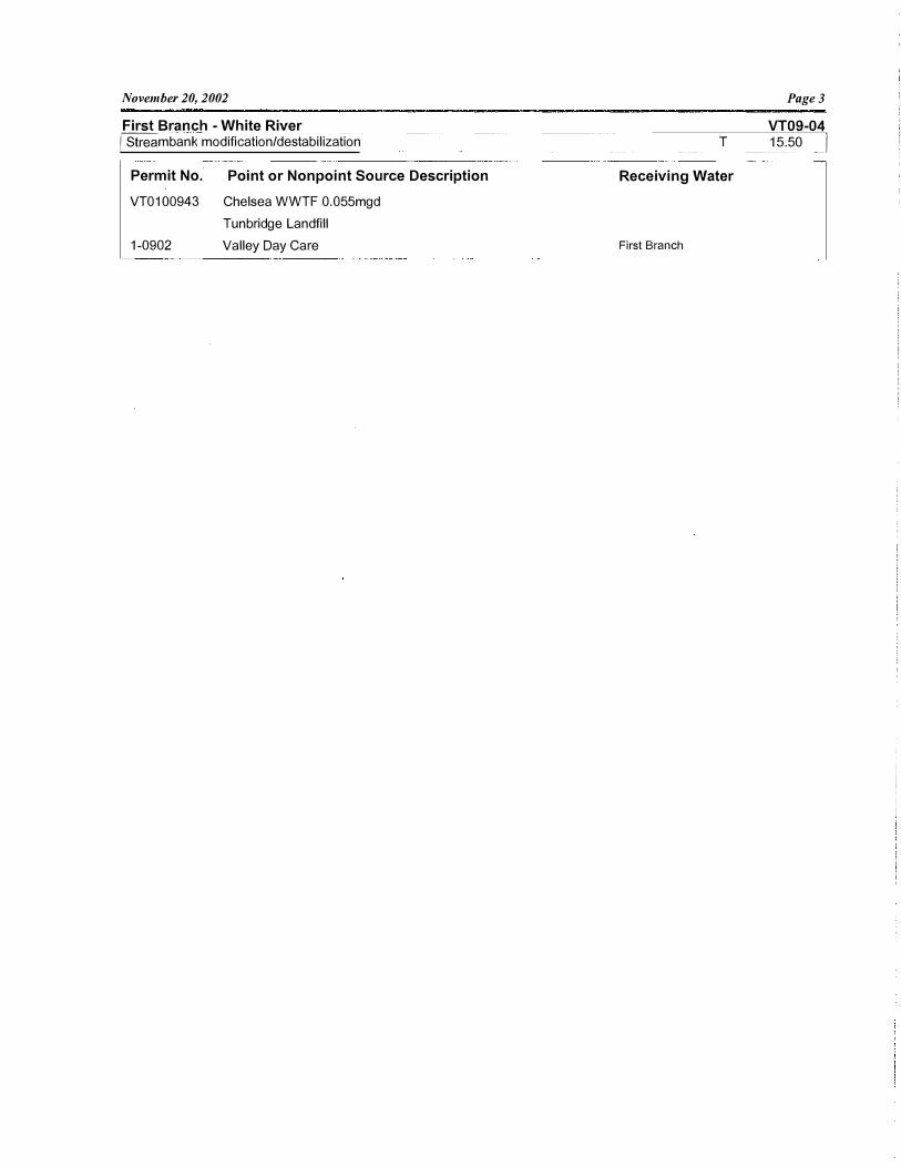
November 20, 2002
First Branch -White River �mbank modification/destabilization
Permit No. Point or Nonpoint Source Description
VT0100943 Chelsea WWTF 0.055mgd Tunbridge Landfill
1-0902 Valley Day Care
Page3
VT09-04 T 1s.5o r
Receiving Water
First Branch

November 20, 2002
Waterbody No: VT09-05
River Length (mi.): 50.5
Second Branch - White River
Assessment Report
Pagel
Assessment Year: 2002
Date Last Updated: 11/19/2002
Description: The Second Branch from its mouth to the headwaters and tributaries including Kingsbury, Peak, Penny, Osgood, Blaisdell, Halfway, Snows, and Sunset Brooks
ANR Enforcement District:
Fish and Wildlife District:
Monitored (mi.):
Evaluated (mi.):
Water Quality Limited?
On 303( d) List?
25.5
25.0
N
Monitored for Toxics? N
Aquatic Contamination
3
4
Waste Management Zone - Miles:
Assessment Comments
PARTIAL SUPPORT MILES
Location Identifiers
NRCS District: 10
Regional Planning Commission: TWO
Assessment Information
Assessment Types
Surveys of fish and game biologists or other professionals
Land use information and location of sources
RBP Ill or equivalent benthos surveys
Bacteria water column sampling by quality-assured volunteer progr
Toxics Testing
Description:
Second Branch: 17.0 - from East Brookfield downstream to 1.0 mile before junction at White River - partial support of aquatic biota and habitat, aesthetics and contact recreation due to sediments, nutrients, and pathogens from riparian buffer removal, streambank erosion, agricultural land runoff as well as scattered areas with road runoff. Source of elevated E. coli numbers not yet known. c(900, 1100, 1700), s( 1000,4500, 7600, 7700)
THREATENED MILES Snows Brook: 1.0 - from mouth upstream one mile - threats to aquatic biota/habitat due to siltation from
poor gravel road maintenance and streambank erosion. c(1100) s(7700,8300) Kingsbury Brook: 0.5 - from mouth upstream - threats to aquatic biota/habitat likely due to loss of riparian
vegetation (open above stream) and nutrients from agricultural land uses. c(900, 1400) s(7700)
COMMENTS Macroinvertebrate sampling occurred on the Second Branch, Kingsbury Brook, Blaisdell Brook, and
Snows Brook in fall 2001. At rivermile 0.1 and rivermile 18.0 on the Second Branch, the macroinvertebrate community was very good. On Kingsbury Brook at rivermile 0.5 in 2001 (functional group - 33% algae shredding Chironomids, relatively high Bl, the macroinvertebrate community was in fair condition. On
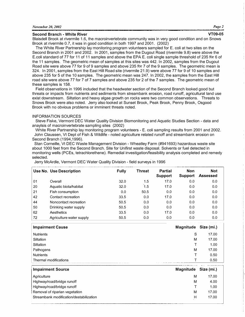
November 20, 2002 Pagel
Second Branch - White River VT09-05 Blaisdell Brook at rivermile 1.6, the macroinvertebrate community was in very good condition and on Snows Brook at rivermile 0.7, it was in good condition in both 1997 and 2001. (2002)
The White River Partnership lay monitoring program volunteers sampled for E.coli at two sites on the Second Branch in 2001 and 2002. In 2001, samples from the Dugout Road (rivermile 9.8) were above the E.coli standard of 77 for 11 of 11 samples and above the EPA E.coli single sample threshold of 235 for 6 of the 11 samples. The geometric mean of samples at this sites was 442. In 2002, samples from the Dugout Road site were above 77 for 9 of 9 samples and above 235 for 7 of the 9 samples. The geometric mean is 324. In 2001, samples from the East Hill Road site (rivermile 21.9) were above 77 for 9 of 10 samples andabove 235 for 5 of the 1 O samples. The geometric mean was 247. In 2002, the samples from the East Hillroad site were above 77 for 7 of 7 samples and above 235 for 2 of the 7 samples. The geometric mean ofthese samples is 158.
Field observations in 1996 included that the headwater section of the Second Branch looked good but threats or impacts from nutrients and sediments from streambank erosion, road runoff, agricultural land use exist downstream. Siltation and heavy algae growth on rocks were two common observations. Threats to Snows Brook were also noted. Jerry also looked at Sunset Brook, Peak Brook, Penny Brook, Osgood Brook with no obvious problems or imminent threats noted.
INFORMATION SOURCES Steve Fiske, Vermont DEC Water Quality Division Biomonitoring and Aquatic Studies Section - data and
anaylsis of macroinvertebrate sampling sites (2002) White River Partnership lay monitoring program volunteers - E. coli sampling results from 2001 and 2002.
John Claussen, Vt Dept of Fish & Wildlife - noted agriculture related runoff and streambank erosion on Second Branch (1994, 1996).
Stan Corneille, Vt DEC Waste Management Division - Wheatley Farm (#941693) hazardous waste site about 1000 feet from the Second Branch. Site for Unifirst waste disposal. Solvents or fuel detected in monitoring wells (PCEs, tetrachlorethene). Remedial investigation/feasibility analysis completed and remedy selected.
Jerry McArdle, Vermont DEC Water Quality Division - field surveys in 1996
Use No. Use Description Fully Threat Partial Non Not Support Support Assessed
01 Overall 32.0 1.5 17.0 0.0 0.0
20 Aquatic biota/habitat 32.0 ·1.5 17.0 0.0 0.0
21 Fish consumption 0.0 50.5 0.0 0.0 0.0
42 Contact recreation 33.5 0.0 17.0 0.0 0.0
44 Noncontact recreation 50.5 0.0 0.0 0.0 0.0
50 Drinking water supply 50.5 0.0 0.0 0.0 0.0
62 Aesthetics 33.5 0.0 17.0 0.0 0.0
72 Agriculture water supply 50.5 0.0 0.0 0.0 0.0
Impairment Cause Magnitude Size (mi.)
Nutrients s 17.00
Siltation M 17.00
Siltation T 1.00
Pathogens M 17.00
Nutrients T 0.50
Thermal modifications T 0.50
Impairment Source Magnitude Size (mi.)
Agriculture M 17.00
Highway/road/bridge runoff M 4.00
Highway/road/bridge runoff T 1.00
Removal of riparian vegetation M 17.00
Streambank modification/destabilization H 17.00
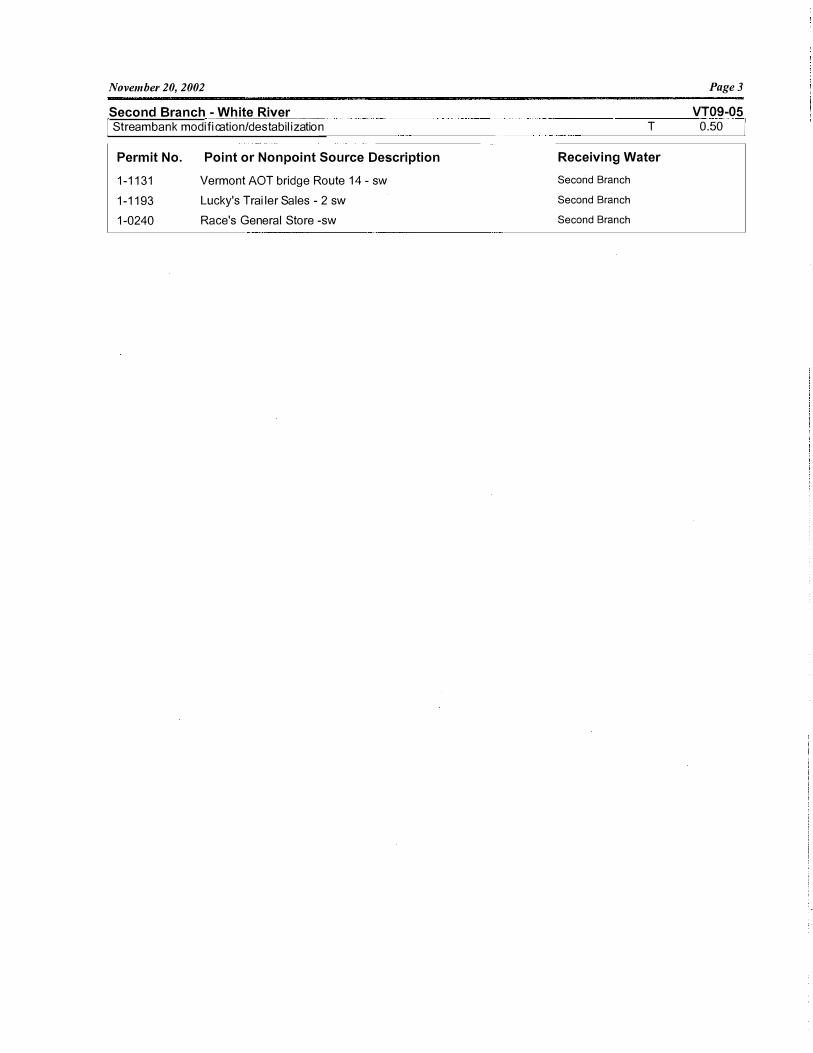
November 20, 2002
Second Branch - White River [ Strea m ba nk mod if-ic-. a- t -i o-n-/d_ e_ s-ta-b- il-iz·-a -ti _o_n
- - --
Permit No. Point or Nonpoint Source Description
1-1131 Vermont AOT bri dge Rou te 14 - sw 1-1193 Luc ky's Tra iler Sales - 2 sw 1-0240 Rac e's General Store -sw
T
Receiving Water
Second Branch
Second Branch
Second Branch
Page3
VT09-05 o.so I
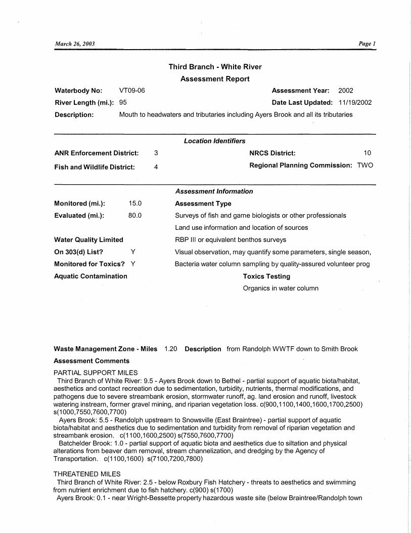
March 26, 2003 Pagel
Waterbody No: VT09-06
Third Branch - White River
Assessment Report
Assessment Year: 2002
River Length (mi.): 95 Date Last Updated: 11/19/2002
Description: Mouth to headwaters and tributaries including Ayers Brook and all its tributaries
Location Identifiers
ANR Enforcement District: NRCS District: 10
Fish and Wildlife District:
3
4 Regional Planning Commission: TWO
Monitored (mi.):
Evaluated (mi.):
Water Quality Limited
On 303(d) List?
15.0
80.0
y
Monitored for Toxics? Y
Aquatic Contamination
Assessment Information
Assessment Type
Surveys of fish and game biologists or other professionals
Land use information and location of sources
RBP Ill or equivalent benthos surveys
Visual observation, may quantify some parameters, single season,
Bacteria water column sampling by quality-assured volunteer prog
Toxics Testing
Organics in water column
Waste Management Zone - Miles 1.20 Description from Randolph WWTF down to Smith Brook
Assessment Comments
PARTIAL SUPPORT MILES Third Branch of White River: 9.5 - Ayers Brook down to Bethel - partial support of aquatic biota/habitat,
aesthetics and contact recreation due to sedimentation, turbidity, nutrients, thermal modifications, and pathogens due to severe streambank erosion, stormwater runoff, ag. land erosion and runoff, livestock watering instream, former gravel mining, and riparian vegetation loss. c(900,1100,1400,1600,1700,2500) s(1000,7550, 7600,7700)
Ayers Brook: 5.5 - Randolph upstream to Snowsville (East Braintree) - partial support of aquatic biota/habitat and aesthetics due to sedimentation and turbidity from removal of riparian vegetation and streambank erosion. c(1100, 1600,2500) s(7550,7600,7700)
Batchelder Brook: 1.0 - partial support of aquatic biota and aesthetics due to siltation and physical alterations from beaver dam removal, stream channelization, and dredging by the Agency of Transportation. c(1100, 1600) s(7100,7200,7800)
THREATENED MILES Third Branch of White River: 2.5 - below Roxbury Fish Hatchery - threats to aesthetics and swimming
from nutrient enrichment due to fish hatchery. c(900) s(1700) Ayers Brook: 0.1 - near Wright-Bessette property hazardous waste site (below Braintree/Randolph town
March 26, 2003 Page2
Third Branch - White River VT09-06
line and a subset of the length above) - threats to aquatic biota, ag water supply and drinking water supply due to improperly applied/disposed dry cleaners sludge. c(300) s(6600)
COMMENTS Between the last assessment and this current one Adams Brook was put on the impaired water list and
may soon be off. It was in fair biological condition in 1997 but good biological condition in 2001. A number of good management practices have been put into place to address the road runoff and ag land issues responsible for the impairment thus the brook was not added above.
Fish surveys were done on Flint Brook above and below the fish hatchery water withdrawal point as well as on 2 other similar and nearby streams in order to assess whether the water withdrawal was affecting the aquatic community. "Definitive impacts to wild brook trout populations from the fint Brook withdrawal could not be identified within the limited scope of this study. Brook trout population measures from 2001 in Flint Brook below the water withdrawal were similar to upstream and nearby control streams." (Quotes from a memo from Rich Kirn, district fisheries biologist on October 30, 2001)
The White River Partnership lay monitors sampled E. coli at 3 locations on the Third Branch in 2001 and 2002; 1 location on Adams Brook in 2001 and 2002; and 1 location on Ayers Brook in 2002. In 2001, the Golf Course bridge site at rivermile (rm) 9.3 had a geometric mean of 202 which is greater than the Vermont standard as well as the EPA standard (126) for swimming areas. The sites above and below this site were below the standard of 77. In 2002, again the Golf Course bridge site was above both standards, however the Stock Farm Road site (rm 4.3) also had a geometric mean above 77 but not above 126. The Adams Brook site had a geometric mean of 83 in 2001 (n=11) and of 224 in 2002 (n=9). The Ayers Brook site had a geometric mean of 158 (n=8) in 2002.
The White River Partnership also did temperature monitoring on the Third Branch in summer 2001 with continuous water temperature recording from June 13 until October 10, 2001. At the Stock Farm Road site (rm 4.3) the temperature was above 77 F for 9 hours on 8/5, 10 hours on 8/6, 11 hours on 8/7, 17 hours on 8/8, 17 hours on 8/9, 17 hours on 8/10 and 7 hours on 8/11 - a selection of results from the hottest week. At the Adams Brook site, the temperatures were above 77F for 5 hours on 8/6, 5 hours on 8/7, 8 hours on 8/8, 8 hours on 8/9.
Macroinvertebrate sampling was done by Vermont DEC at 7 sites on the Third Branch although only one site has more than one year of sampling data. The site at rivermile 9.5 which is located above the confluence with Ayers Brook but below the Randolph WWTF was fair-good in 7/89, good in 10/89, good in 8/93, good in 9/2001. (2002) Biomonitoring data on four sites sampled in 1993 (milepoints 9.5, 9.9, 10.2, 18.1) showed full support based on macroinvertebrate communities: community assessments from good to very good to excellent as one goes upstream. Site 9.5 data indicated a threat to aquatic biota due to nutrient enrichment. (1996)
A study was done by the USDA Natural Resources Conservation Service in 1997. Results of the study include a classification of both the Third Branch and Ayers Brook using 2 classification systems as well as a sediment budget for the Third Branch above and below Randolph. In the three reaches, from 66 to 80 percent of the sediment came from streambank erosion due to either removal of riparian vegetation or instability from earlier gravel mining or both. In the report's words: "Most of the sediment in the Third Branch system appears to be from streambank erosion in Ayers Brook and from streambank erosion downstream of Randolph. Most of this sediment is due to erosion of high banks or banks that are not protected with woody vegetation. The high banks occur where the stream flows through glacial lake sediments or where it has migrated across the valley floor into higher terraces or into the valley wall itself. The lack of woody vegetation typeically occurs where the valley floor is cropped .. The bank erosion in the lower reaches of the Third Branch may be due, in part, to the historic gravel mining that was stopped in 1986."
When the sewer and stormwater systems were separated in Randolph downtown (about 25 acres of paved area) directly to the Third Branch with no treatment. There is a 4 foot pipe above the Route·12 bridge and a smaller one below. Warm water, oil and grease, heavy metals in the runoff from the downtown are all discharged to the river. (1996)
INFORMATION SOURCES White River Partnership - E. coli data from 2001 and 2002, temperature data from 2001. White River Watershed Assessment: Third Branch Stream Classification, February 2001. Prepared for
the White River Partnership by the USDA Natural Resources Conservation Service Rich Kirn, Vermont Dept of Fish & Wildlife - memo re evaluation of trout populations below Flint Brook
March 26, 2003 Page3
Third Branch -White River VT09-06
water withdrawal (2001) John Claussen, Vt Dept of Fish & Wildlife - partial support of Third Branch from Bethel to Ayers Brook
due to nutrients, sediments, thermal impacts still valid (from 94 assessment). John also noted a threat to the river from the two new pipes that discharge stormwater directly to the Third Branch with no treatment. The rainbow trout population is diminished from Roxbury to Randolph. There is extensive beaver activity in this stretch. (1996).
Dan Koloski, NRCS - noted heavy sediment load in Third Branch due to severe streambank erosion (1994).
Stan Corneille, Vt. DEC Waste Management Division - noted that groundwater samples from the WrightBessette site still show significant levels of tetrachloroethylene. No surface water samples have shown problems, but groundwater flows toward Ayers Brook (1994). More groundwater monitoring wells are being put in to find out how far away from the site groundwater is contaminated. Surface water (Howard Hill Brook) was sampled in July 1997 by Johnson Company. No results as of this record update. The State will take over sampling after this year. (1997).
Dennis Borchardt, George Aiken RC&D - noted that eroding streambanks are a significant problem between Bethel and Randolph resulting in loss of fish habitat ( 1996).
Steve Fiske, Vt DEC Water Quality Division - biomonitoring data ori four sites sampled in 1993 (milepoints 9.5,9.9, 10.2, 18.1) showed full support based on macroinvertebrate communities. Site 9.5 data indicated a threat to aquatic biota due to nutrient enrichment.
Jerry McArdle; Vt DEC Water Quality Division - noted horse pasture with little or no buffer on Third Branch just upstream of Batchelder Brook: a large gravel operation just above the confluence of Riford Brook; and eroding streambanks from confluence of Ayers Brook down to Bethel. (1997).
Use No Use Description Fully Threat Partial Non Not Support Support Assessed
01 Overall 76.5 2.5 16.0 0.0 0.0
20 Aquatic biota/habitat 79.0 0.0 16.0 0.0 0.0
21 Fish consumption 0.0 95.0 0.0 0.0 0.0
42 Contact recreation 82.0 2.0 11.0 0.0 0.0
44 Noncontact recreation 95.0 0.0 0.0 0.0 0.0
50 Drinking water supply 94.9 0.1 0.0 Q.O 0.0
62 Aesthetics 76.5 2.5 16.0 0.0 0.0
72 Agriculture water supply 94.9 0.1 0.0 0.0 0.0
Impairment Cause Magnitude Size (mi.)
Priority organics T 0.10
Nutrients M 9.50
Nutrients T 2.50
Siltation H 16.00
Siltation T 5.50
Thermal modifications M 9.50
Other habitat alterations H 1.00
Other habitat alterations M 15.00
Pathogens s 9.50
Turbidity M 15.00
Impairment Sourc Magnitude Size (mi.)
Agriculture M 9.50
Aquaculture T 2.50
Hazardous waste T 0.10
Channelization H 1.00
Dredging H 1.00
Channel instability M 15.00

March 26, 2003
Third Branch - White River Removal of riparian vegetation
Streambank modification/destabilization
Streambank modification/destabilization
Drainage/filling of wetlands
Permit No.
VT0100285
3-0362
1-0495
1-0535
1-0856
1-1150
1-1369
Point or Nonpoint Source Description
Randolph WWTF 0.40mgd
Fish Hatchery - Roxbury- VT DF&W
Bethel Mills Hydropower Dam - Private
Patten Corp NE - sw
Exit 4 Development Corp - sw
Randolph Marketplace - sw
Vt Pure Springs - 3 sw
Central Vt Shopping Ctr - 4 sw
M
H
T
M
Receiving Water
Trib Bull Run
Trib Adams Brook
Smith Brook
Trib Adams Brook
Smith Brook
Page4
VT09-06 9.50
9.50
5.50
1.00

November 20, 2002 Pagel
Upper White River Watershed
Assessment Report
Waterbody No: VT09-07
River Length (mi.): 145.4
Assessment Year: 2002
Date Last Updated: 10/1/2002
Description: Mainstem from confluence of West Branch to headwaters and tributaries including Tweed River, Locust Creek, Stonly Brook, West Branch White River and West Branch Tweed River. Binao Brook. Hancock Branch.
Location Identifiers
ANR Enforcement District: NRCS District: 10
Fish and Wildlife District:
3
4 Regional Planning Commission: TWO
Monitored (mi.):
Evaluated (mi.):
10.5
134.9
Water Quality Limited?
On 303(d) List? N
Monitored for Toxics? N
Aquatic Contamination
Waste Management Zone - Miles:
Assessment Comments
THREATENED MILES
Assessment Information
Assessment Types
Surveys of fish and game biologists or other professionals
RBP Ill or equivalent benthos surveys
Toxics Testing
Description:
White River: 9.0 - from Alder Meadow Brook confluence down to West Branch confluence - threats to aquatic biota/habitat and water clarity due to sedimentation, turbidity, and thermal changes from agricultural land uses, streambank erosion, and removal or riparian vegetation. c(1100, 1400) s(1000,7700)
White River: 3.5 - from confluence with Alder Meadow Brook to headwaters and Clark Brook: 2.0 - from mouth to headwaters - both streams have threats to aquatic biota/habitat due to
acidity and metals from acid deposition. c(500, 1000) s(8100) Hancock Branch: 2.0 - from Texas Br. confluence to headwaters - threats to aquatic biota/habitat, and
water clarity due to sedimentation, turbidity, metals and acidity from atmospheric deposition, and stream bank erosion. c(500, 1000, 1100) s(7700,8100)
Tweed River: 2.5 - upstream from confluence with White River to Pittsfield Village - threats to aquatic biota, water clarity and contact recreation from sedimentation, thermal changes and potentially pathogens from land development (primarily residential), road maintenance and agricultural land uses. c(1100, 1400, 1700) s(1000,3200,4500)
Hancock Branch: 0.2 (chosen to represent scattered areas of erosion noted by White R. Citizen Monitoring Program) - threats to aquatic biota/ habitat due to sedimentation from natural and human-caused streamside erosion. c(1100), s(7700,8600)
Bingo Brook: 0.5 {chosen to represent scattered erosion areas noted by White R. Citizen Monitoring
November 20, 2002 Page2
Upper White River Watershed VT09-07 Program) - threats to aquatic biota/habitat due to sedimentation from streambank erosion. c(1100), s(7700)
Locust Creek: 2.0 - from the Royalton town line to the confluence with the Silver Lake drainage - threats to aquatic biota/habitat due to sedimentation from erosion at 5-10 sites within the two mile stretch. c(1100) s(7700)
South Branch Tweed River: 2.5 - upstream from Townsend Brook confluence - threats to aquatic biota/habitat and aesthetics from sedimentation and thermal changes due to residential development, road runoff, instream ponds on the tribs. c(1100, 1400) s(3200,4500,7350)
COMMENTS Macroinvertebrate sampling on Stony Brook, Perkins Brook, West Branch Tweed River, West Branch
White River, Bingo Brook, Smith Brook and Howe Brook in 1999, 2000, or 2001. The macroinvertebrate community was very good at rivermile 1.9 on Stony Brook in 2001; very good at rivermile 1.4 on the West Branch Tweed River in 2000 and excellent in 2001; excellent at rivermile 0.5 on the West Branch White River in 2000; very good at rivermile 1.3 on Bingo Brook in 1999, excellent in 2000 and excellent - very good in 2001; excellent at rivermile 1.3 on Smith Brook in 1997, 1998, 1999, 2000, and very good in 2001; and fair at rivermile 0.3 on Howe Brook in 1999, good in 2001, and excellent-very good in 2001.
The White River Partnership did temperature monitoring at mainstem rm 54.2 Uust above Hancock Branch confluence) and mainstem rm 61.1 (Clark Brook confluence) in 2001. At rm 54.2, there were 5 hours on 8/7, 6 hours on 8/8 and 6 hours on 8/9 when the water temperatures were at or above 77F. The maximum temperature for the day exceeded 72F on 38 days but there were no full days (24 period) when the temperatures exceeded 72F as happened on the lower parts of the White River. At rm 61.1, the temperatures stayed substantially cooler with maximum daily temperatures never surpassing ?OF.
Site investigation done in June 1989 at Weyerhauser Corporation hazardous waste site. Nothing found in surface water and no groundwater samples taken. (1994) EPA did a site investigation in 1994. Not much found in groundwater - no risk and no further remedial action planned. Site closed. (1997)
Review of the infrared photographs for the White River mainstem from the headwaters to the confluence of the West Branch found that 54% of the northern or eastern shoreline had a buffer of vegetation greater or equal to 50 feet and 46% had a buffer less than 50 feet. Of the southern or western shoreline, 49% had a buffer of vegetation 50 feet or greater and 51 % of the length had a buffer less than 50 feet.
Macroinvertebrate community data for Austin Brook and Bear Wallow Brook sampled in 1994, 1995, and 1996 showed full support for aquatic biota.
INFORMATION SOURCES White River Citizen Monitoring Program Final Report, October 31, 1989. 25 miles of streams were walked
to identify current or potential water quality problems - erosion sites noted. Vt. DEC Hazardous Materials files. John Claussen - Vt. F&W District Fisheries Manager - noted that all tribs are uniformly excellent for fishing
and provide trout spawning and juvenile Atlantic Salmon habitat. However, in several tribs, notably the Tweed River, trout populations have declined significantly and salmon fry production have declined over the past 20 years to unknown causes.
Dan Koloski - SCS - noted the erosion on Locust Creek Water Quality Division infrared photograph collection (1997) Steve Fiske, Vt DEC Water Quality Division - macroinvertebrate biomonitoring data (1997) Jim Kellogg, Vt DEC Water Quality Division - noted that the streams threatened by acid precipitation
haven't been monitored recently "but based on precipitation pH levels, there is no reason to assume any improvement." (1997)
Jerry McArdle, Vt DEC Water Quality Division - noted "fuzzy" rocks and the threats from residential development, road runoff to the South Branch Tweed River.
Bob Burt, GMNF - there is a Clark Brook Ill timber sale but it is a winter only logging sale. If there are midwinter thaws then the operations are stopped. They have regular timber sale administration on all their logging jobs - checks on the operation about once a week. Steve Roy looks at the brooks for the Environmental Assessment that is done on each timber sale and then monitors the brooks. (No reason for Clark Brook or the upper White River to be singled out for threatened status, CRK). (1997)
Use No. Use Description
01 Overall
Fully
120.2
Threat
25.2
Partial Support
0.0
Non Not Support Assessed
0.0 0.0
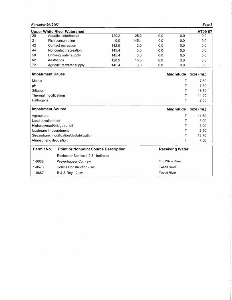
November 20, 2002
Uoper White River Watershed 20 Aquatic biota/habitat
21 Fish consumption
42 Contact recreation
44 Noncontact recreation
50 Drinking water supply
62 Aesthetics
72 Agriculture water supply
Impairment Cause
Metals
pH
Siltation
Thermal modifications
Pathogens
Impairment Source
Agriculture
Land development
Highway/road/bridge runoff
Upstream impoundment
Streambank modification/destabilization
Atmospheric deposition
120.2
0.0
142.9
145.4
145.4
128.9
145.4
Permit No.
1-0638
1-0673
1-0887
Point or Nonpoint Source Description
Rochester Septics 1,2,3 - indirects
Weyerhauser Co. - sw
Collins Construction - sw
8 & S Roy - 2 sw
Page3
VT09-07 25.2 0.0 0.0 0.0
145.4 0.0 0.0 0.0
2.5 0.0 0.0 0.0
0.0 o.o 0.0 0.0
0.0 0.0 0.0 0.0
16.5 0.0 0.0 0.0
0.0 0.0 0.0 0.0
Magnitude Size (mi.)
T 7.50
T 7.50
T 18.70
T 14.00
T 2.50
Magnitude Size (mi.)
T 11.50
T 5.00
T 5.00
T 2.50
T 13.70
T 7.50
Receiving Water
Trib White River
Tweed River
Tweed River
Related Documents