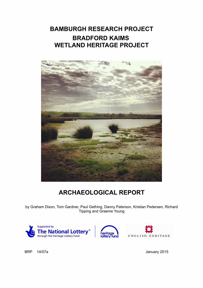
BAMBURGH RESEARCH PROJECT BRADFORD KAIMS WETLAND HERITAGE PROJECT ARCHAEOLOGICAL REPORT by Graham Dixon, Tom Gardner, Paul Gething, Danny Paterson, Kristian Pedersen, Richard Tipping and Graeme Young BRP 14/07a January 2015

Welcome message from author
This document is posted to help you gain knowledge. Please leave a comment to let me know what you think about it! Share it to your friends and learn new things together.
Transcript
BAMBURGH RESEARCH PROJECT
BRADFORD KAIMS WETLAND HERITAGE PROJECT
ARCHAEOLOGICAL REPORT
by Graham Dixon, Tom Gardner, Paul Gething, Danny Paterson, Kristian Pedersen, RichardTipping and Graeme Young
BRP 14/07a January 2015
Bradford Kaims Wetland Heritage Project – Archaeological Report
SUMMARY
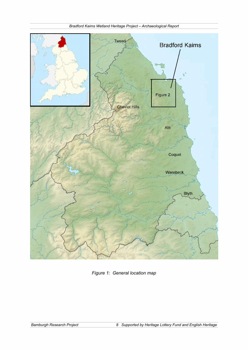
The present project was inspired by an aspiration to study the 'Budle Bay Drainage System'and examine the relationship between human settlement and the environment in a region ofNorth Northumberland defined by the rivers and streams flowing into the tidal embayment ofBudle Bay. This landscape was attractive due to its diverse character, comprising coastalsand dunes, craggy escarpments, upland moorland, riparian systems, extensive peat tractsand rolling agricultural plain, all within a relatively small area. Moreover, it is rich inarchaeological and cultural remains (Figure 1).
The present, Your Heritage, English Heritage and Bamburgh Research Project fundedinvestigation, 'The Bradford Kaims Wetland Heritage Project', is intended as a first phasestudy of a limited area within the drainage system (Figure 2). It was undertaken from late2011 to the end of 2014. The present report has been compiled as an update on projectprogress, sufficiently detailed to be of value to both academic and amateur interest. TheBradford Kaims landscape was studied using a combination of field-walking, test-pitting,excavation, topographical survey, coring and limited geophysical survey.
Initially, survey was undertaken using Google Earth in order to identify a suitable area for ourinitial fieldwork. The area chosen represented a varied landscape that incorporated fenland,now sealed by pasture, as well as higher more permanently dry ground located in an areawhere two areas of the former fenland are joined by a narrow channel, as this area wasbelieved to offer excellent opportunities for human exploitation over long time periods. Thisinitial study area has been subject to topological survey in order to produce a base map forour study.
The project has benefited from a day of geophysical survey donated to the project byGeophysical Surveys of Bradford. Initially ground penetrating radar survey (GPR) wasattempted in transects from Hoppenwood Bank down slope into the lower lying pastureareas, where a peat sequence had been identified by test-pitting and coring. The GPRproved to have insufficient resolution to identify layers within the peat sequence, but did pickup a number of point anomalies. It has been speculated that these could represent bog oakswithin the peat sequence, as the farmer, Mr James Brown, has reported that large bog oakshave been encountered during ditch excavation and clearance. In addition it was decided toattempt a magnetometry survey to test its effectiveness on the dryer areas. The survey waslocated on a narrow peninsular of higher ground, identified during the initial survey as a siteof potential interest. A substantial geophysical anomaly, identified by this survey, wassubsequently examined by trial trench excavation during June and July 2012 and found tobe a burnt mound (Mound 2).
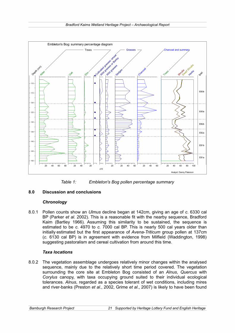
A peat core taken in the embayment to the north-east of the narrow peninsular has beenexamined by Dr Richard Tipping and Dr Danny Patterson of Stirling University (Figure 3).The core was sampled at intervals of 1cm from sections no thicker than 2mm. The EmbletonBog sequence is divided into three local pollen assemblage zones (lpaz) EB1-3, each zonewas divided into 2 sub-zones (a and b), marking major and minor changes in the pollenstratigraphy, interpreted from stratified cluster analysis implemented via CONISS (Grimm1987). Pollen counts show an Ulmus (Elm) decline began at 142cm, giving an age of c.6330 cal BP (Parker et al. 2002). This is a reasonable fit with the nearby sequenceinvestigated in the 1960s (Bartley 1966). Assuming this similarity to be sustained, thesequence is estimated to span c. 4970 to c. 7000 cal BP. This is nearly 500 cal years olderthan initially estimated but the first appearance of Avena-Triticum group pollen at 137cm (c.6130 cal BP) is in agreement with evidence from Milfield (Waddington, 1998) suggesting
Bamburgh Research Project 2 Supported by Heritage Lottery Fund and English Heritage

Bradford Kaims Wetland Heritage Project – Archaeological Report
pastoralism and cereal cultivation from around this time.
Taxa associated with disturbance of vegetation are present from the base of the sequence,but do not necessarily indicate that people were active locally (Mazier et al., 2006, Favre etal., 2007). Percentages of these taxa including P. lanceolata, Apicaee and Caryophyllacaeare low and sporadic and any anthropogenic indicated activity had a very low impact on thelocal environment. The people who were living nearby, do not seem to have been clearlyaffecting vegetation at Embleton Bog. There is a correlation between decreases in thealready low values of disturbance indicators and increases in arboreal taxa in EB1b, but asmost herb taxa are also indicators of openness this does not necessarily indicate a decreasein human activity.
Firmer evidence for anthropogenic activity begins in lpaz EB1b (137cm), with the firstappearance of pollen from the Avena-Triticum group of cultivated cereal. Charcoal valuesstart to increase in lpaz EB2a, and while charcoal cannot always be attributed to humanactivity (Edwards 1988, Tipping 1996), when accompanied by other indicators it becomesreasonable to make such a link. Nonetheless, initial human activity may not be in the localarea, with a more local presence only becomes likely in EB3a and above. Major changes tothe vegetation caused by human activity are not supported by the evidence at EmbletonBog.
A series of 65 test pits were excavated between February 2012 and July 2014 in order toexplore the margins of the wetland area (Figure 3). The test-pits were located on the north-east edge of the widest extent of Embleton Bog, at the base of Hoppenwood Bank, andwere sited to extend down slope from the dry ground and into the peat basin, in order toclearly identify the edge of the former lake/fen (Figures 3 and 5). No significantconcentrations of finds associated with domestic occupation have been identified, but asignificant number of burnt mounds have been identified, indicating an area of semi-industrial activity around at least this part of the wetland margin. In addition Test Pit 52revealed a series of features associated with flint blades and débitage approximately fifty-eight metres to the south of Burnt Mound 2. The features consisted of pits containing largequantities of organic material, such as charred remains of timber.
Three burnt mounds have so far been investigated by excavation, more substantial than testpitting. The first of these was encountered within Test Pit 6 during the initial phase of randomsampling. This was undertaken in the narrow area of low lying ground that lay between theWinlaw Burn and the base of Hoppenwood Bank (Figures 7 and 8). The mound, which wasfound to comprise a series of separate mound building events, extended for more than 14mnorth-west to south-east by 10m north-east to south-west. A series of 15 fire-affectedsandstone slabs, which covering an area of 1.2m north-west to south-east by 1.1m south-west to north-east, lay within the mound sequence in the central part of the mound. Anarchaomagnetometric date on the fired clay into which the feature was set gave a date of4230BC ± 235 years (95%) (Sam Harris, University of Bradford). The presence of a limitedpottery assemblage from the various elements of the mound suggests that the moundaccumulated for thousands of years, up to the Bronze Age. An exceptional lifespan for sucha monument. In addition a series of features have been observed, cut into the subsoil,beneath the mound during the 2014 season. These include indications of structural activityand a hollowed out tree trunk interpreted as either a trough or sump for fresh water.
Extension of the excavation trench to the south-west in order to investigate the relationshipof the mound to the adjacent peat deposits has revealed a complex stratigraphic sequencein which mound layers and peat layers interleave, indicating that mound formation and peat
Bamburgh Research Project 3 Supported by Heritage Lottery Fund and English Heritage

Bradford Kaims Wetland Heritage Project – Archaeological Report
formation was occurring contemporaneously. Fascinatingly a laid timber platform comprisedof branches pegged into the peat layers has been identified within the peat layers at thebase of the mound. This structure to is contemporary to the accumulation of the mound andcoring indicates a series of further platforms extending to a depth of 1.2m into the peatlayers (Figure 11).
The second mound, identified by geophysical survey, was investigated by trial trench in Juneand July 2012 (Figure 9). An extension to the initial trench was excavated at 90 degrees toestablish the size of the mound, which is now known to be around 6m in diameter. In thecentre of the mound a sandstone slab set on edge was located and identified as being at thehead of a trough. Such features are commonly associated with burnt mound structures. Thetrough was filled by a succession of silty soils containing a high percentage of charcoal.
A further burnt mound was investigated during the 2014 season within Trench 9. It appearsto represent a short lived period of mound formation, being only 0.15m thick. Its date is quitebroad at the present time as it sealed a modest assemblage of flints from the late Mesolithicto Mesolithic/Neolithic transition and was in turn overlain by a layer containing Bronge Agepottery.
An additional monument type has been identified within Trench 8, excavated during 2013.The feature represents an unburnt stone mound set on a brushwood timber platform abovepeat layers. It was only investigated within a limited trench, but use of a penetrometer andmodest test-pitting indicates that the mound is one of a series of such features connected bya timber trackway, extending to the south-south-west from the Winlaw Burn.
The two mounds are very similar in size and form and are almost certainly the result ofsimilar processes of activity and discard. Such mounds are commonly found in similartopographical areas, adjacent to plentiful supplies of water, and have been associated withmany processes from tanning to brewing (Topping. 2011). It is likely that both mounds werewithin a few metres of open water at the time that they were in use, and the absence of flintworking and settlement evidence would indicate that they were not associated directly withsettlement activity. The population that used them is unlikely to have lived far from the site,but remains as yet unidentified. At present, the limited dating evidence is inconclusive, withan archaeomagnetic date for the fired clay at the base of Mound 1 indicating a date in thelater part of the fourth millennium BC and a small finds assemblage from Mound 2 indicatinga late Neolithic to early Bronze Age date. This would fit the broad chronology for suchmounds and could be tentatively reconciled with the evidence thad the area remained inuse, for such activity, over a long period of time. Specialist analysis of the modest findsassemblage and Carbon-14 dating will continue to inform on this interpretation.
The discovery of the platform and the realisation that it forms only the uppermost of anumber of such structures, preserved within the peat, must rank as the most importantdiscoveries of the later part of the project. Its close relationship with the multiphase BurntMound 1, is also intriguing, suggesting as it does, that the platform and the mound formingprocess functioned side by side. At present the best interpretation sees the platform asproviding access to open water, out from the shoreline.
Bamburgh Research Project 4 Supported by Heritage Lottery Fund and English Heritage

Bradford Kaims Wetland Heritage Project – Archaeological Report
Contents:
SUMMARY
1.0 INTRODUCTION 7
2.0 LOCATION 7
3.0 LANDSCAPE GEOLOGY 11
4.0 ARCHAEOLOGICAL AND HISTORICAL BACKGROUND 11
5.0 SURVEY RESULTS 13
POLLEN ANALYSIS OF PEAT FROM EMBLETON BOG
6.0 Laboratory analyses 166.1 Storage of cores and preparation for pollen analysis 166.2 Pollen identification 166.3 Results 176.4 Description of local pollen assemblage zones 177.0 Interpretation of pollen assemblages 188.0 Discussion and conclusions 21
EXCAVATION RESULTS
9.0 TEST PIT SURVEY 2310.0 MESOLITHIC EVIDENCE 2310.1 Embleton's Bog 2310.2 Newhouses Bog 24
11.0 BURNT MOUNDS 2411.1 Mound 1 2411.1 Subsoil Variations and Potential Structures 2411.2 The burnt mound 2511.3 Excavation Strategy 2611.3 Mound 1 Sequences 2611.4 Trough/Sump Complex 2911.5 Hearths 3111.6 Platform Feature 3111.7 Mound 2 3611.8 Trench 8 the unburnt mound 3811.9 Mound 3 38
12.0 CORING 4012.1 Coring over the Embleton Bog area 4012.2 Investigation of the Sediment Stratigraphy of the Wishaw Burn in the vicinity of
Trench 6 4112.3 Interpretation 4112.4 Conclusions 44
Bamburgh Research Project 5 Supported by Heritage Lottery Fund and English Heritage
Bradford Kaims Wetland Heritage Project – Archaeological Report
PROJECT OVERVIEW
13.0 DISCUSSION 45
14.0 CONCLUSION 47
ACKNOWLEDGMENTS 48
BIBLIOGRAPHY 49
Figure 1 General location mapFigure 2 Location map showing the approximate outline of the glacial lakesFigure 3 Location of the principle excavation areas, coring transect lines and the pollen
core extracted for analysisFigure 4 The study area view from Google EarthFigure 5 Contour surveys of the investigation area, above at 1m contour interval and
below at 0.1m contour interval Figure 6: Magnetometry surveyFigure 7: Plan of Burnt Mound 1Figure 8: Sections of Burnt Mound 1Figure 9: Excavation of Burnt Mound 2Figure 10: Location of the coring lines undertaken during 2012Figure 11: Location of the cores taken during 2014
Plate 1: The area of the investigated area of the wetland, seen from Hoppenwood Bank, looking south
Plate 2: The peat basin re-flooded during 2012, Burnt Mound 2 can be seen under excavation in the foreground, facing north-west
Plate 3: Extracting the pollen core from the peatPlate 4: The basal core as extracted showing silt and marl from the former lake bedPlate 5: Examining sediment from the narrow gauge auger used to compile the
transectsPlate 6: Identifying pollen with Dr Richard Tipping during our volunteer laboratory
dayat Stirling UniversityPlate 7: Early phase of excavation of Burnt Mound 1 (Trench 6), facing south-westPlate 8: Mound 1 under excavation by students, volunteers and the Young
Archaeologist Club competition winners in July 2014Plate 9: Mound 1 is extensive and in fact composed of a number of mound forming
events, facing north-westPlate 10: The 'hearth' dated to 4230BC ± 235 years (95%)Plate 11: Extending Mound 1 Trench 6 into the wetland area, facing south-eastPlate 12: The timber platform under excavation within the Trench 6 extension, facing
southPlate 13: The wooden paddle found on the timber platform in 2013, facing eastPlate 14: Worked, perforated, timber identified as part of the platform make-up in 2014Plate 15: Excavation the timber 'trough' identified beneath Mound 1 in 2014, facing
south-eastPlate16: Burnt Mound 2 seen from ground level, facing north-eastPlate 17: Section through the unburnt stone mound within Trench 11, showing the
timber 'raft' identified beneath it, facing south-east
Bamburgh Research Project 6 Supported by Heritage Lottery Fund and English Heritage

Bradford Kaims Wetland Heritage Project – Archaeological Report
BRADFORD KAIMS WETLAND HERITAGE PROJECT ARCHAEOLOGICAL REPORT
1.0 INTRODUCTION
1.0.1 This report sets out the results of the fieldwalking, survey, excavation andpalaeoenvironmental coring programme carried out by the Bamburgh ResearchProject (BRP) in association with Stirling University, as part of a community basedarchaeological research project supported by a Your Heritage grant from the HeritageLottery Fund, together with a grant from English Heritage.
1.0.2 The Bamburgh Research Project was set up in 1996 to investigate Bamburgh Castleand its environs in order to better understand the site and region. The present workwas undertaken as part of the 'Bradford Kaims Wetland Heritage Project', whichcommenced in 2011. The project seeks to investigate an extensive series of formerlakes that formed in the post-glacial period, some 10,000 years ago. This reportrepresents the first phase of investigation in which an initial study of a representativearea within the system has been undertaken. The project aims to work fully with thecommunity, to identify and investigate important archaeological sites and map theextent the sample area of former wetland using coring and topographical survey.
1.0.3 The objectives of the project include academic research, that investigates both thearchaeological and palaeoenvironmental evidence, seeking to integrate these twoclasses of data in a study of human exploitation of a changing environment;advancement of community participation, through training opportunities andeducational programmes and the development of a framework and strategy to assistagencies and the community in decisions concerning the management of thelandscape.
2.0 LOCATION
2.0.1 The glacial lake region, formed at the end of the last Ice Age, covered an extensivearea representing some 8km south-west to north-east and some 3km east to west. Itcomprised a series of small to medium sized lakes, part of a water system, thatultimately drained into Budle Bay. Some areas, such as Embleton's Bog, to theimmediate south of the present study area, still survive as wetlands to the presentday, but in most cases, the former lakes were in-filled by peat formation and arecurrently under pasture (Figure 1).
2.0.2 The present study area is located to the immediate south of Hoppen Hall Farm andextends towards Embleton's Bog, which is a Site of Special Scientific Interest (SSSI).It lies on the northern and eastern sides of one of the larger former lakes, thatoriginally incorporated Embleton's Bog. The lake, as far as it can be mapped viaGoogle Earth, originally extended for 950m north to south and 1000m east to west.The water would have flowed south to north and into Winlaw Burn, a tributary of theWaren Burn, at the base of Hoppenwood Bank. The study area has been sited tomap the north-east corner of this lake area, to the east of the east coast rail mainline,and is centred on gridreference (NU 1602 2980) (Figure 2).
Bamburgh Research Project 7 Supported by Heritage Lottery Fund and English Heritage
Bradford Kaims Wetland Heritage Project – Archaeological Report
Figure 1: General location map
Bamburgh Research Project 8 Supported by Heritage Lottery Fund and English Heritage

Bradford Kaims Wetland Heritage Project – Archaeological Report
Figure 2: Location map showing the approximate outline of the glacial lakes
Bamburgh Research Project 9 Supported by Heritage Lottery Fund and English Heritage

Bradford Kaims Wetland Heritage Project – Archaeological Report
Figure 3: Location of the principle excavation areas, coring transect lines and the pollencore extracted for analysis
Bamburgh Research Project 10 Supported by Heritage Lottery Fund and English Heritage

Bradford Kaims Wetland Heritage Project – Archaeological Report
3.0 LANDSCAPE GEOLOGY
3.0.1 The varied landscape of the study area clearly affords opportunities for subsistenceand resource exploitation. The landscape is also transformed according to culturalpreferences and traditions, as well as by anthropogenic activities that are in turndependent on the technological capacity of the inhabitants. The study of thelandscape and its evolution cannot explain all aspects of behaviour, but it is aprerequisite for all social inferences.
3.0.2 The solid geological formations of the Budle Bay drainage catchment deriveexclusively from the Carboniferous period and are largely composed of sedimentaryrocks, although there are significant local occurrences of intrusive igneous rocksrepresented by the dolerite dykes of the Whin Sill. An understanding of the processesthat led to the formation of these rocks can only be approximated through aconsideration of the remote geological history of the region and the movement ofplates that resulted in the creation of a trough into which sediment accumulated. Theimportance of the geological formations in archaeological studies lie in the following:first, these explain the nature and distribution of the topographic features that shapedsettlement activity; second, the rocks were significant as economic resources eitherdirectly through quarrying of building material, the provision of chert and flint for theproduction of tools, or indirectly as the basis for the soils that sustained flora that inturn attracted fauna for hunting and rendered different sorts of agriculture possible.
3.0.3 The region was subject to at least five episodes of glacial advance and recession inthe Pleistocene, but so profound was the effect of the last advance that no evidencefor earlier glacial cycles survive in the local landscape.
4.0 ARCHAEOLOGICAL AND HISTORICAL BACKGROUND
4.0.1 The Budle Bay drainage catchment has never been subject to a sustained orsystematic archaeological investigation. This has resulted in both a spatial andtemporal bias in the entries recorded in the Historic Environment Register (HER) forNorthumberland as upland areas with their more easily visible archaeologicalremains will tend to predominate in the absence of systematic survey, such as thatundertaken in the Milfield Basin (Waddington 1998).
4.0.2 Evidence of Late Palaeolithic occupation in Northumberland has hitherto not beenencountered, albeit there have been suggestions that some specimens should beassigned to this period. None of these are diagnostic, so it is largely by dint of themetrical attributes of the blades or the extreme cortication of the flint that they havebeen assigned to the Late Palaeolithic. The most commonly adduced specimen isthat from Eltringham Farm in the Tyne Valley, a broad blade with some distal retouchthat has a white surface through exposure to extreme weathering (Tolan-Smith &Cousins 1995,). This is certainly a cogent inference, but it can neither be confirmednor falsified for its form is not sufficiently typical of material from any phase of theLate Palaeolithic. It may equally well be ascribed to the Early Mesolithic on the samecriteria.
4.0.3 A Neolithic axe was uncovered in the study area during normal farm work, howeverthere is no further evidence of activity from this date. It is likely that the study areawas inhabited during this time period, but that the kind of ephemeral evidence that
Bamburgh Research Project 11 Supported by Heritage Lottery Fund and English Heritage
Bradford Kaims Wetland Heritage Project – Archaeological Report
the period is characterised by, remains to be identified. Many Bronze Age landclearance and burial cairns are present on the upland areas to the south and west ofthe riparian system and occasional burials have been identified on the lower lyingareas to the north of the farm. In addition part of a mould for a Bronze Age rapier wasfound at Bradford Kaims.
4.0.4 Iron Age enclosures containing round houses have been identified as both standingmonuments and cropmarks. The nearest of these features was believed to lie to theeast of Hoppen Hall Farm on Pigdon Hill, but this identification has been challengedas the site is believed now to be natural in origin. A crop mark site on HoppenwoodBank is known only from aerial photographic evidence. A pattern of settlement of IronAge character is believed to have continued during the Romano-British Period.
4.0.5 Hoppen was part of the medieval parish of Bamburgh. It formed an independenttownship, of 93 hectares (230 acres), up until the post-medieval period. It wasrecorded as an appurtenance of the manor of Lucker in 1288, but appears to havebeen held directly by one Edmund de Hoppen at this time. The same Edmund deHoppen is almost certainly the man of that name who appears as a juror whoassessed the lay subsidy for Bamburgh ward in 1296, indicating an individual ofsome status (Fraser 1968). A later member of the family in the 15th century is knownto have a personal seal depicting a lion rampant, likely to be the coat of arms of thede Hoppen family, who survived in ownership of the estate up to the later half of the16th century. A fortified tower is noted as being present at Hoppen on a list of 1460.Though its exact location is not known, it is reasonable to assume that it laysomewhere in the area of the present farm buildings on the summit of HoppenwoodBank (Bateson 1893).
4.0.6 The Conyers family had taken over the Hoppen estate by the 17th century but onlyheld it for a short period as it passed into the hands of the Brandling family in 1667.The estate changed hands on at least six further occasions before passing in theestate of the Duke of Northumberland, where it remains to this day (ibid.).
Bamburgh Research Project 12 Supported by Heritage Lottery Fund and English Heritage

Bradford Kaims Wetland Heritage Project – Archaeological Report
5.0 SURVEY RESULTS
5.0.1 Initial study of the wetland area was undertaken using map evidence and GoogleEarth imagery in order to gain a rapid and broad understanding of the BradfordKaims wetland. This early work allowed us to focus in on an area of potential interestat the southern end of Hoppenwood Bank that offered an interesting variety oftopographical variation, close to but outside of the Newham Bog national natureReserve, which is a SSSI (Figure 4).
Figure 4: The study area view from Google Earth
5.0.2 Fieldwalking was undertaken on Hoppenwood Bank, within the ploughed fieldimmediately north-east of the main study area, where examination of satelliteimagery had suggested the presence of a possible enclosure. Only a generalbackground scatter of finds was identified, with no concentrations of artefacts thatmight suggest the presence of a settlement.
5.0.3 A random point Total Station survey has been undertaken within the vicinity of thearea subject to coring, test-pitting and trial trench excavation. The survey has beenused to generate contour surveys over the area of the wetland and its surroundings,in order to help identify the extent of the peat bog and to aid understanding of theareas subject to human exploitation. The upper of the two plans, shown below(Figure 5), is of the general survey area with contour intervals set at 1m. The locationof the major excavation areas is depicted along with the test pits and the location ofthe geophysical survey. The plan below is of the southern field with contour intervalsset at 0.1m, sufficient resolution to resolve the narrow neck of higher groundextending into the area of Embleton's Bog.
Bamburgh Research Project 13 Supported by Heritage Lottery Fund and English Heritage

Bradford Kaims Wetland Heritage Project – Archaeological Report
Figure 5: Contour surveys of the investigation area, above at 1m contour interval and belowat 0.1m contour interval
Bamburgh Research Project 14 Supported by Heritage Lottery Fund and English Heritage
Bradford Kaims Wetland Heritage Project – Archaeological Report
5.0.2 Four days of ground penetrating radar survey (GPR) and magnetometry survey wasdonated to the project by Geophysical Surveys of Bradford and undertaken on 19th
and 20th May 2012 and on the 20th and 21st July 2013. The GPR survey provedproblematic identifying only a series of random point anomalies but failed to resolvelayers within the peat horizons, known from coring to have in-filled the basin. Thesignal attenuated quickly and the technique, at least at that radar wavelength, provedto be inadequate for mapping the deeper contours of the subsoil surface.
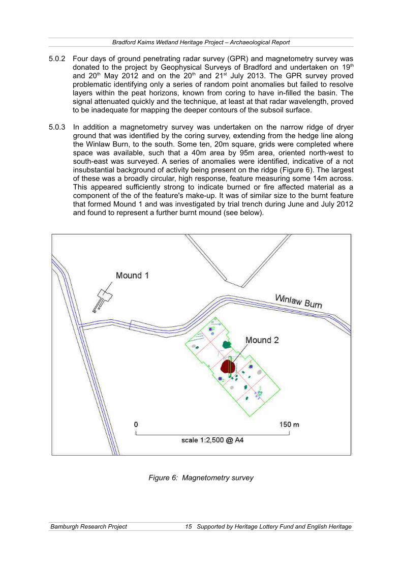
5.0.3 In addition a magnetometry survey was undertaken on the narrow ridge of dryerground that was identified by the coring survey, extending from the hedge line alongthe Winlaw Burn, to the south. Some ten, 20m square, grids were completed wherespace was available, such that a 40m area by 95m area, oriented north-west tosouth-east was surveyed. A series of anomalies were identified, indicative of a notinsubstantial background of activity being present on the ridge (Figure 6). The largestof these was a broadly circular, high response, feature measuring some 14m across.This appeared sufficiently strong to indicate burned or fire affected material as acomponent of the of the feature's make-up. It was of similar size to the burnt featurethat formed Mound 1 and was investigated by trial trench during June and July 2012and found to represent a further burnt mound (see below).
Figure 6: Magnetometry survey
Bamburgh Research Project 15 Supported by Heritage Lottery Fund and English Heritage

Bradford Kaims Wetland Heritage Project – Archaeological Report
POLLEN ANALYSIS OF PEAT FROM EMBLETON BOG
6.0 Laboratory analyses
6.1 Storage of cores and preparation for pollen analysis
6.1.1 Cores were placed in 1.0m long, 5.0cm diameter semi-circular gutters, wrapped inpolythene tubing, labelled, and sealed with duck tape in the field. They were stored inthe dark at 4oC until further analyses were carried out. Stratigraphy was recorded inthe field and enhanced by detailed sediment descriptions in the laboratory (Tippingpers. comm.). Flat surfaces of the semi-circular cores were cleaned to aidobservations; surfaces were scraped laterally to avoid contamination. Colourcompaction and texture of sediment were noted, together with visible charcoal andwood fragments (Plates 3,4,5 and 6).
6.1.2 Cores were sub-sampled using a razor and fine spatula, cleaned and rinsed withdistilled water between sub-samples. Samples of c. 1cm3 were taken from sectionsno thicker than 2.0mm. Initial sampling, at 4cm intervals between 144 and 118cm,was to establish the position of the mid-Holocene Ulmus decline (c. 6330-5360 calBP, Parker et al., 2002), expected to be around 138cm (correlated with analysis byBartley, 1966). Counts based on a pollen sum of 100 grains helped confirm theposition of the Ulmus (Elm) decline. Subsequent sub-samples were taken at 1cm(150 to 125cm) and 2cm intervals (125 to 108cm).
6.1.3 Sub-samples were prepared by acetolysis in batches of eight, following Moore et al.,(1991). Lycopodium spores were added to enable pollen concentration and influxcalculations (Stockmarr, 1977). Sub-samples were sieved at 150μm and residuesretained on 10μm nylon sieves. Pollen residues were stored in silicone oil in sealed,clear plastic airtight vials, at room temperature. Slides were prepared using additionalsilicone oil allowing movement of grains as necessary. Cover slips were sealed withnail varnish before counting; counted slides were stored flat, in slide storage boxes.
6.2 Pollen identification
6.2.1 Pollen analyses were made using an Olympus BX40 binocular microscope. Countswere made at magnification x400 with critical examinations made at magnificationx1000 under oil immersion. Pollen was identified by reference to Moore et al. (1991)and the University of Stirling pollen reference collection. Counts were based on aminimum of 500 grains total land pollen (tlp) except for one level, 129cm, where thecount was 452 grains. Pollen nomenclature follows Bennett (1984) and plantnomenclature follows Stace (1991).
6.2.2 Some pollen taxa, including Cyperaceae and Poaceae, are identified only to familylevel. Separation of Poaceae to cereal groups follows Andersen (1979). Separation ofCorylus avellana and Myrica gale remains controversial (Edwards, 1983) but withreference to Moore et al., (1991) and Blackmore et al., (2003) and Punt et al., (2002),three categories were used in this study: (a) Corylus, (b) Myrica and (c) Corylusavellana type to include grains not positively identified as either.
6.2.3 Pollen was assessed for deterioration and assigned to one of five categories: normal,crumpled or folded, split or torn, corroded, and degraded (Lowe, 1982b and Tipping,1987). Indeterminate pollen was assigned to five categories: hidden, crumpled, split,
Bamburgh Research Project 16 Supported by Heritage Lottery Fund and English Heritage

Bradford Kaims Wetland Heritage Project – Archaeological Report
corroded and degraded. Microscopic charcoal was assigned to one of five sizeclasses: 10-25μm, 25-50μm, 50-75μm, 75-100μm and greater than 100μm, (Caylessand Tipping, 2002).
6.3 Results
6.3.1 The Embleton Bog sequence is divided into three local pollen assemblage zones(lpaz) EB1-3, each zone was divided into 2 sub-zones (a and b), marking major andminor changes in the pollen stratigraphy, interpreted from stratified cluster analysisimplemented via CONISS (Grimm 1987).
6.4 Description of local pollen assemblage zones
EB1a, 150-146.5cm. Dark brown to black moderately humified herb peat withcommon vertical Cyperaceae stems.
6.4.1 Alnus (25-50% tlp) and Quercus (10-25% tlp) dominate the pollen assemblage withCyperaceae (15-20% tlp) and Poaceae (c.10% tlp). Corylus avellana, Betula, Ulmusand Salix are also present (c.5-10%, 2-5%, 3-4% and 1% tlp). Aster type, Apiaceae,Asteraceae, Caryophyllaceae, Filipendula and Plantago lanceolata type pollen andPolypodium vulgare and Polypodiaceae spores are consistently present.
Eb1b 146.5-137.5cm. Dark brown to black moderately humified herb peat withcommon vertical Cyperaceae stems.
6.4.2 Alnus (up to 80% tlp) and Quercus (10-25% tlp) pollen dominates the zone. Corylus(3-10% tlp), Betula (1-10% tlp) and Salix (c.2% tlp) pollen is continuously present.Ulmus is at c.3-5% tlp below 142cm, but following a peak, (c.15% tlp) Ulmusdisappears from concentration and percentage diagrams before re-appearing with c.1% tlp. Poaceae (5-10% tlp) and Cyperaceae percentages (c.5% tlp) andconcentrations are lower than in EB1a. Aster type, Apiaceae and Caryophyllaceaeare sporadically present, as are P. vulgare and Polypodiaceae.
EB2a, 137.5-133.5cm. Dark brown to black moderately humified herb peat withcommon vertical Cyperaceae stems.
6.4.3 Alnus percentages (25 to 15% tlp) and concentrations fall, Quercus percentages (20-40% tlp) and concentrations are rather variable but Poaceae (10-15% tlp) andCyperaceae (20-30% tlp) increase. Corylus (6-7% tlp), Betula (2-3% tlp), Salix (1-2%tlp) and Ulmus (c.1% tlp) are consistently present. Herb taxa include Asteraceae,Anthemis type and Ranunculus type, but Apiaceae and Caryophyllaceae have almostdisappeared. There are two levels with Avena-Triticum group pollen and Hordeumgroup pollen is consistently present. Charcoal is more important, almost entirely dueto increases of particles of less than 50μm.
EB2b 133.5-128.5cm. Dark brown to black moderately humified herb peat with common vertical Cyperaceae stems.
6.4.4 Alnus percentage (c.20% tlp) and concentration are stable but Quercus (30 to 15%tlp) and Corylus’ (to c.5% tlp) percentages decline; both taxa have lowconcentrations. Betula also decreases slightly (to c.1% tlp) and percentages andconcentration of Ulmus remain low. Cyperaceae increases, (c.50% tlp) but Poaceae
Bamburgh Research Project 17 Supported by Heritage Lottery Fund and English Heritage
Bradford Kaims Wetland Heritage Project – Archaeological Report
declines (5 to 3% tlp). Hordeum group pollen is sporadically present but Avena-Triticum group pollen is absent. Percentages of other herb taxa: Aster type,Asteraceae, Filipendula and Ranunculus type, have decreased and presence issporadic. Polypodiaceae, P. vulgare and Sphagnum increase slightly and Nympheae is present. Charcoal values increase, (c.10% tlp plus Charcoal) mainly of particlessmaller than 50μm.
EB3a 128.5-120.5cm. Dark brown to black moderately humified herb peat.
6.4.5 Alnus (25-30% tlp), Quercus (25-30% tlp) and Corylus (c.10% tlp) are important, butconcentrations of Quercus remain low. Ulmus values peak at 125cm (c.5% tlp); otherarboreal taxa show no change, but Ilex type (< 1% tlp) appears (125cm). Cyperaceaevalues decline; Poaceae percentages increase then decline (15 to 5% tlp) butconcentrations increase. Hordeum group values peak at 125cm and Avena-Triticumgroup is present at 127 and 125cm. Anthemis type is more common, but remainsbelow 1% tlp; P. lanceolata type re-appears and Apiaceae, Asteraceae andRanunculus type are sporadically present. P. vulgare and Polypodiaceae have smallpeaks at the base of the zone, and Sphagnum is consistently present. Charcoalshows large increases in percentage (25 to 60% tlp plus Charcoal) andconcentration.
EB3b 120.5-108cm. Dark brown to black moderately humified herb peat; common tomany vertical Cyperaceae stems to 116cm; rare wood, but one very large fragment at 108-116cm.
6.4.6 Percentages of Alnus, and Corylus (c.15-20% and 5-10% tlp) are lower than, andBetula, Quercus and Ulmus (c.2%, 25% and 1% tlp) similar to, the previous zone.Concentrations of Alnus remain stable while concentrations of Betula, Quercus,Corylus, and Pinus increase slightly. Cyperaceae percentages (c.40% tlp) andconcentrations increase, but Poaceae values remain the same as the previous zone.Anthemis type, Asteraceae, Apiaceae and Hordeum group are consistently present.Ranunculus type is present sporadically but Avena-Triticum group and P. lanceolatatype are absent. Charcoal values (10-50% tlp plus Charcoal) are high, particles largerthan 50μm remain relatively important.
7.0 Interpretation of pollen assemblages
EB1a, 150-146.5cm 7.0.1 Alnus and Quercus were locally present, forming a closed canopy woodland around
the mire, probably with Corylus. Quercus exceeds values proposed by Shaw (2006),3% tlp, and Huntley and Birks (1983) 8% tlp, to indicate local presence, and althoughAlnus is typically over-represented in the pollen record (Bunting 2003), it’s highpercentages are in agreement with local presence. Corylus exceeds valuessummarised by Lisitsyna et al., (2011), 2-10% tlp, as indicative of regional presenceand easily exceeds Huntley and Birks, (1983) estimate of 5% tlp as indicative ofsporadic local occurrence. Betula was probably not locally present. Shaw (2006)found a regression intercept of 13.5% tlp was indicative of local presence, Lisitsyna et al., (2011) suggest values between 4 and 25 % tlp indicate only regional presence.Regional presence of Ulmus is indicated by percentages of 1% tlp, (Lisitsyna et al.,2011), but Bunting et al., (2004) regard Ulmus as over-represented in the pollenrecord, making the low values for Ulmus unlikely to indicate local presence.
Bamburgh Research Project 18 Supported by Heritage Lottery Fund and English Heritage
Bradford Kaims Wetland Heritage Project – Archaeological Report
7.0.2 The open mire was dominated by Cyperaceae with P. vulgare and perhaps Poaceaeand Filipendula. Cyperaceae has low pollen productivity compared to both arborealtaxa and Poaceae (Brostrom et al., 2004, Twiddle et al., 2012) the high percentagesprobably therefore indicate local abundance. Poaceae and other herbs probably alsoformed the woodland understory. The occurrence of Aster type, Apiaceae,Caryophyllaceae and P. lanceolata is unlikely to indicate local disturbance; Mazier et al., (2006) regard these taxa as regional indicators. It is unlikely that there was localhuman activity, but there may have been some extra-local or regional activity.
EB1b, 146.5-137.5cm
7.0.3 Closed canopy woodland encroached around the mire surface. Peak Alnus values(c.80% tlp) suggest incorporation of a catkin, which in itself suggests colonisation ofthe bog surface by Alnus. Salix has low pollen productivity (Bunting, 2003, Brostromet al., 2004), even the small percentage pollen increases suggest increased localabundance. It is possible that both Alnus and Salix colonised the bog surface.Quercus may also have become abundant as the woodland encroached around themire surface. Corylus was probably still present and Betula and Ulmus remainunlikely to have been locally present. Human activity around the site is unlikely andevidence for extra-local or regional activity also declined.
EB2a, 137.5-133.5cm
7.0.4 Canopy around the mire receded or opened out as the mire surface becameincreasingly wet. Poor pollen productivity of Cyperaceae (Bunting 2003, Brostrom etal., 2004, Bunting et al., 2004) means that it’s increased percentages are still inagreement withrestriction to the mire surface around the core site. The main change,decreases in Alnus and increases in Cyperaceae suggest that woodland away fromthe mire surface remained similar. Alnus and Salix became less abundant but thelocal to extra local abundance of Quercus and Corylus probably remainedunchanged.
7.0.5 Increases in Poaceae, presence of several disturbance indicators and increases inCharcoal may be associated with human cultivation indicated by pollen of the Avena-Triticum group. Mazier et al., (2006) regard taxa including Asteraceae and Anthemistype as indicators of regional disturbance; Charcoal of less than 50mm is alsotypically indicative of more distal fire sources (Higuera et al., 2007). This combinationis in agreement with extra-local to regional rather than local human activity.
EB2b 133.5-128.5cm.
7.0.6 Mire surface conditions became wetter and the local to extra local canopy openedout slightly. Cyperaceae, Sphagnum, Polypodiaceae and Nympheae all became moreabundant; pollen and spores from these taxa reflect very local presence on the miresurface around the core site. With stable percentages and concentrations,abundance of Alnus was probably unchanged, but Quercus and Corylus probablydeclined in importance, suggesting opening of the canopy away from the mire edge.
7.0.7 Canopy gaps may be linked to the increases in Charcoal values. Particles of lessthan 50mm, are linked to more distal sources (Higuera et al., 2007), in agreementwith fire affecting extra local to regional woodland. Fire could be natural or
Bamburgh Research Project 19 Supported by Heritage Lottery Fund and English Heritage

Bradford Kaims Wetland Heritage Project – Archaeological Report
anthropogenic in origin (Edwards 1988, Tipping 1996) but as pollen evidence forhuman activity has decreased further, care should be taken before attributing theseCharcoal increases to anthropogenic activity. A decrease in local to extra localabundance of Quercus and Corylus could be due to displacement by Alnus onincreasingly wet ground around the mire. Increases in regional pollen taxa such asBetula and Ulmus, which might indicate more widespread opening of the canopy(Bunting et al. 2004, Sugita 2007, Favre et al. 2008) do not occur.
EB3a 128.5-120.5cm
7.0.8 The mire surface dried out and the canopy closed slightly. Alnus, Quercus andCorylus became more abundant with Alnus possibly encroaching back onto the miresurface as Cyperaceae prevalence declined. Overall, the canopy did not return to thedensity of EB1a and 1b. The fire regime changes in terms of location and possiblyfrequency of fire: percentages increase and larger particles become more common,fire was occurring closer to the mire (Higuera et al., 2007). Re-appearance of pollenfrom the Avena-Triticum group and of P. lanceolata type is in agreement withCharcoal increases relating to human activity. However the decline in Poaceae andlimited presence of other local indicators of clearance together with continuedevidence of a semi-open to closed local to extra local canopy, suggest such activityremained distal to the mire.
EB3b 120.5-108cm
7.0.9 Canopy opened out slightly as the mire surface became wetter. Increases inCyperaceae, P. vulgare and Polypodiaceae indicate a return to wetter mire surfaceconditions. Abundance of Alnus probably declined, which together with smallincreases in concentrations of regional taxa, Ulmus and Pinus, is in agreement withcanopy opening. Stable values of Quercus, Corylus, and Poaceae suggest thatcanopy opening was restricted to the mire edge, despite continued presence ofApiaceae and Asteraceae. Pollen from the Hordeum group is present butdisappearance of pollen from the Avena-Triticum group and P. lanceolata, togetherwith the decrease in larger charcoal particles suggests local human activity isunlikely.
Bamburgh Research Project 20 Supported by Heritage Lottery Fund and English Heritage
Bradford Kaims Wetland Heritage Project – Archaeological Report
Table 1: Embleton's Bog pollen percentage summary
8.0 Discussion and conclusions
Chronology
8.0.1 Pollen counts show an Ulmus decline began at 142cm, giving an age of c. 6330 calBP (Parker et al. 2002). This is a reasonable fit with the nearby sequence, BradfordKaim (Bartley 1966). Assuming this similarity to be sustained, the sequence isestimated to be c. 4970 to c. 7000 cal BP. This is nearly 500 cal years older thaninitially estimated but the first appearance of Avena-Triticum group pollen at 137cm(c. 6130 cal BP) is in agreement with evidence from Milfield (Waddington, 1998)suggesting pastoralism and cereal cultivation from around this time.
Taxa locations
8.0.2 The vegetation assemblage undergoes relatively minor changes within the analysedsequence, mainly due to the relatively short time period covered. The vegetationsurrounding the core site at Embleton Bog consisted of an Alnus, Quercus withCorylus canopy, with taxa occupying ground suited to their individual ecologicaltolerances. Alnus, regarded as a species tolerant of wet conditions, including miresand river-banks (Preston et al., 2002, Grime et al., 2007) is likely to have been found
Bamburgh Research Project 21 Supported by Heritage Lottery Fund and English Heritage
110
115
120
125
130
135
140
145
150
20 40 60 80 20 40 20
x10
20 20 40 60 20 40 60 20 40 60 80 100
EB3b
EB3a
EB2b
EB2a
EB1b
EB1a
Trees Grasses Charcoal and summary
Embleton's Bog: summary percentage diagram
Analyst: Danny Paterson
Bradford Kaims Wetland Heritage Project – Archaeological Report
on the edge of the bog and perhaps the bog surface. Quercus is more likely to haveoccupied drier areas (Preston et al., 2002, Grime et al., 2007) more distal from thecore site, probably the slopes and ridge of Bradford Kaim. It is likely that the kaimprovided a suitable location for Corylus and Quercus to co-exist, but unlikely that themire surface dried enough to support either taxa.
8.0.3 The northern end of the bog at Embleton is bisected by a narrow limb of drier ground,slightly higher than the surrounding mire surface, which is reasonable to regard aspre-existing the growth of the mire. It would have provided a substrate suitable for alltrees. The taxa with probable local presence, Alnus, Quercus and Corylus, may allhave been present in this area.
8.0.4 It is unlikely that Betula was locally present during the time investigated; Shaw’s(2006) regression intercept of 13.5% tlp was to within 20m, albeit in the very differentenvironment of Glen Affric. However it is possible that Betula was present on theedge of the bog beyond this limit, or in the woodland surrounding it. Ulmus may alsohave been present locally, but is more likely to have been an extra-local presence.
8.0.5 Cyperaceae, together with P. vulgare Polypodiaceae and perhaps some watertolerant herbs such as Filipendula (Preston et al., 2002), dominated vegetationaround the core site. Increases in Sphagnum and Nympheae suggest only one verywet interval (EB2a) but Alnus may have colonised the mire surface during drierepisodes (EB1b and 3a). The ground layer under the canopy was probablycomprised of herb rich grasses.
Anthropogenic influences
8.0.6 Taxa associated with disturbance of vegetation are present from the base of thesequence, but do not necessarily indicate that people were active locally (Mazier etal., 2006, Favre et al., 2007). Percentages of these taxa, including P. lanceolata,Apiaceae and Caryophyllaceae are low and sporadic and any anthropogenicindicated activity had a very low impact on the local environment. The people whowere living nearby, for example in the Milfield Basin (Waddington, 1998), do notseem to have been clearly affecting vegetation at Embleton. There is a correlationbetween decreases in the already low values of disturbance indicators and increases in arboreal taxa in EB1b, but as most herb taxa are also indicators of openness thisdoes not necessarily indicate a decrease in human activity.
8.0.7 Firmer evidence for anthropogenic activity begins in lpaz EB1b (137cm), with the firstappearance of pollen from the Avena-Triticum group of cultivated cereal. Charcoalvalues start to increase in lpaz EB2a, and while Charcoal cannot always be attributedto human activity (Edwards 1988, Tipping 1996), when accompanied by otherindicators it becomes reasonable to make such a link. Nonetheless, initial humanactivity is not in the local area, more local presence only becomes likely in EB3a andabove. Major changes to the vegetation caused by human activity are not supportedby the evidence at Embleton.
Bamburgh Research Project 22 Supported by Heritage Lottery Fund and English Heritage
Bradford Kaims Wetland Heritage Project – Archaeological Report
FIELDWORK RESULTS
9.0 TEST PIT SURVEY
9.0.1 The site at Hoppenwood Bank was selected for the initial investigation because of itsassociation with topographic features that are seen to be likely to favour settlementand process sites in the prehistoric era (Plates 1 and 2). Although a relatively basicmethodology, this technique has been employed merely to locate potential sites atthe outset of the research. As field-walking and geophysical survey has becomeavailable they have been employed to identify features within a wider surveycatchment.
9.0.2 A series of 65 test pits were excavated between February 2012 and July 2013 inorder to explore the margins of the former lake and peat bog area. The pits werelocated in the region of Burnt Mound 1, identified by a previous test-pitting sequenceundertaken as a preliminary survey, prior to the start of the current project. The testpits were sited to extend down slope from the dry ground and to extend into the peatbasin, such that the edge of the former lake was clearly identified (Figure 3). Nosignificant concentrations of finds or features, associated with settlement, wereidentified, but a general background of activity has been revealed, most particularly ithas led to the identification of at least 11 further burnt mounds.
10.0 MESOLITHIC EVIDENCE
10.1 Embleton's Bog
10.1.1 A series of features associated with flint blades and débitage was found lyingapproximately fifty-eight metres to the south of the burnt mound, within the extendedTest Pit 52. The features consisted of pits containing large quantities of organicmaterial, such as charred remains of timber. At this time, within the limitations of thepresent study, none of the features have been excavated. Some interestingcharacteristics of this site can, however, be observed without the benefit of furtherexcavation. The presence of organic material and lithic material, consisting ofblades and other débitage manufactured in flint, renders the site of high potentialsignificance for the study of this period. Although the sample of finds is notrepresentative, the absence of other raw material such as chert, quartz and agatemight suggest that the occupants of this site commonly repaired to the coast tocollect the nodules that washed up on the beach. The primary exploitation of localflint from the beaches appears to distinguish the sites on the coastal plain, mostnotably that of Howick (Waddington 2007, 78 - 79), but also the many unstratifie findscollected from the craggy escarpments encircling the southern and western shores ofBudle Bay (Buckley 1922a, 1922b, 1925). This contrasts with the patterns in rawmaterial exploitation seen further in the hinterland (Waddington 2007).
10.1.2 The promontory is formed from a sandy subsoil and it is here that the majority of thefeatures have been identified, with little evidence for features cut into the surroundingclay. This, very likely, reflects a preference for the better drained sediment. In anare athat is subject to periodic flooding this should not be seen as surprising. Featureswere identified immediately at the edge of the extant peat and likely extendunderneath this, although this requires further investigation. Such conditions affordextraordinarily good potential for the recovery of organic material and furthermore
Bamburgh Research Project 23 Supported by Heritage Lottery Fund and English Heritage
Bradford Kaims Wetland Heritage Project – Archaeological Report
provides the opportunity to correlate the human activity with the development of thewetlands. Additionally, the features extending beneath the peat will be protected fromanthropogenic disturbance such as ploughing. Few prehistoric sites in the BritishIsles offer such excellent conditions for investigation and therefore this site remainsa high priority for further study.
10.2 Newhouses Bog
10.2.1 The excavation of sondages along the edge of the peat at Newhouses Bog resultedin the discovery of lithic material. A scalene triangle microlithic armature was foundbeneath the pit on a small sandy knoll on the western margin of the bog, as well as asingle piece of primary flint débitage retaining cortex on its dorsal face (Figure 2). Thesedimentary cores taken across this bog reveals that it remained open water well intothe latter part of the Holocene, so the peat formed above the horizons of prehistoricoccupation No clear structural features have been encountered, but some stoneshave afforded strong magnetic signals, which suggests that they were exposed toheating, thus it is possible that a hearth might be in the immediate vicinity.
10.2.2 It is fortunate that the scalene triangles are well dated in this part of the British Islesthrough the extensive radiocarbon determinations from Howick, which werecorroborated by the dates provided by sites such as East Barns near Dunbar andCramond, outside of Edinburgh. The scalene triangle horizon has thus been affixedto between 8300 BC and 7600 BC (Bayliss & Waddington 2007). A preponderance ofsuch microlithic armatures in this part of Northumberland is curious; the postulationthat it represents the movement of a population displaced from the North Sea basinas sea-levels began to rise precipitously has recently been advanced, which mayaccount for the sudden and widespread distribution of this material (Waddington2012). Nevertheless, the distribution of discrete styles may also be proxy evidence ofchanging social networks.
BURNT MOUNDS
11.0 Mound 1
11.1 Subsoil Variations and Potential Structures
11.1.1 After considerable periods of rain, during the 2014 season of investigation, a numberof cuts and subsoil variations were noted appearing briefly beneath the Mound 1sequence. These are as yet unexcavated, but appear to be significant, numerous,and substantial. The cuts appear as dark-filled stake-holes, post-holes, and linearcuts, and although the area is still largely covered in burnt mound material, theyappear to cover the majority of the subsoil surface directly under the mounds. Thelack of an intermediary layer of soil development (which would be rapid in a flood-plain such as the site is situated upon) would indicate that these structures closelypre-date the burnt mound deposition in some areas, and may in fact be related to it(Figures 7 and 8).
11.1.2 The stake-hole features number in their hundreds, and are arrayed across themajority of the subsoil surface, particularly beneath burnt mound deposits 6020 and6080. Their quantity makes it difficult to group them into potential structures, but
Bamburgh Research Project 24 Supported by Heritage Lottery Fund and English Heritage

Bradford Kaims Wetland Heritage Project – Archaeological Report
regardless, they evidence several phases of construction, as many intercut others,and some of the more substantial post-holes have stake-holes sitting in repair orsupport positions directly around their circumference, indicating the potential forrepair sequences of some relatively substantial structures. These post-holes, sevenof which were exposed by the end of July 2014, do not appear to be in arecognisable order, potentially due to the small surface area currently available forobservation. Further seasons of investigation will focus upon uncovering the extent ofthese features, after a systematic excavation of the burnt mound deposits overlyingthem.
11.1.3 One wide linear cut into the subsoil (6004) beneath mound deposit 6020 contains alarge upright unburnt stone, which is currently hypothesised to by a packing stone foran upright post. This linear slot (0.4m wide x 2.1m length exposed) is currentlyunexcavated, so this hypothesis is provisional.
11.1.4 The main orientations and concentrations of the above-mentioned stake-holes, post-holes, and linear cuts, are also associated with a series of subsoil discolourations,the cause of which is not currently known. These (Figure 7) may be naturalvariations, or may be linked to the construction and use of the structures indicated bythe negative features mention above. The entire exposed subsoil surface has beensampled in a 0.5m grid and will be subjected to FTIR (Fourier Transform InfraredSpectroscopy) and XRF (x-ray fluorescence) assessment in order to assess thenature of these variations.
11.2 The burnt mound
11.2.1 The first of the twelve burnt mounds, so far identified, was encountered within Test Pit6 (which became Trench 6) during the initial phase of random sampling. This wasundertaken in the narrow area of low lying ground that lay between the Winlaw Burnand the base of Hoppenwood Bank (Figure 4). This area was targeted as a likely spotto encounter early prehistoric activity from its topography, as from surfaceappearance it appeared to represent a narrow channel between two wider lake-likeopen areas of wetland (Plates 1 and 7).
11.2.2 The initial test pit measured 1m², but was immediately extended to 2m² once anunusual burnt deposit (6020) was encountered beneath topsoil and colluvial claylayers. The extended trench, under further excavation, revealed the presence of ahearth-like stone feature (6012). Encountering such an unexpected, but intriguingfeature, prompted the further expansion of the trench into an open area excavations.This excavation now constitutes Trench 6, and at the close of the 2014 season,measured some 14m north-west/south-east x 10m north-east/south-west at its core.It also includes two extensions to the south-west of the central area, the mostnortherly of these extending 12m south-west, and the more southerly extending 6msouth/west, with the partial extension of two test-pits, 2m² and 1.5m².
11.2.3 This report on the archaeology of, and surrounding Mound 1 continues on from theprevious interim report for the Bradford Kaims (Young et al, 2012), which containsmore detail on the early periods of investigations.
11.2.4 The focal point of Trench 6 is the collection of deposits referred to as Mound 1. Thestrategy, methodology, and results of the investigation of these conjoined depositsand their associated features, are expanded upon below:
Bamburgh Research Project 25 Supported by Heritage Lottery Fund and English Heritage

Bradford Kaims Wetland Heritage Project – Archaeological Report
11.3 Excavation Strategy
11.3.1 The excavation strategy followed the concept, laid out in Gardner (2015, In Press),that burnt mound excavations should investigate not just the monument itself, but thesurrounding areas. The mound itself is the detrital by-product of a technologicalprocess and, due to its characteristic sterility in material culture, forms a peripheralsource of evidence for the overall function of the site. An investigation of surroundingareas was undertaken to shed light on the socio-industrial arena existing around theburnt mound spread. Careful excavation of burnt mound sequences allowed theexcavators to identify a minimum total of four discrete depositional sequences, (6020,6040, 6060, & 6080), each of which must contain multiple individual events.
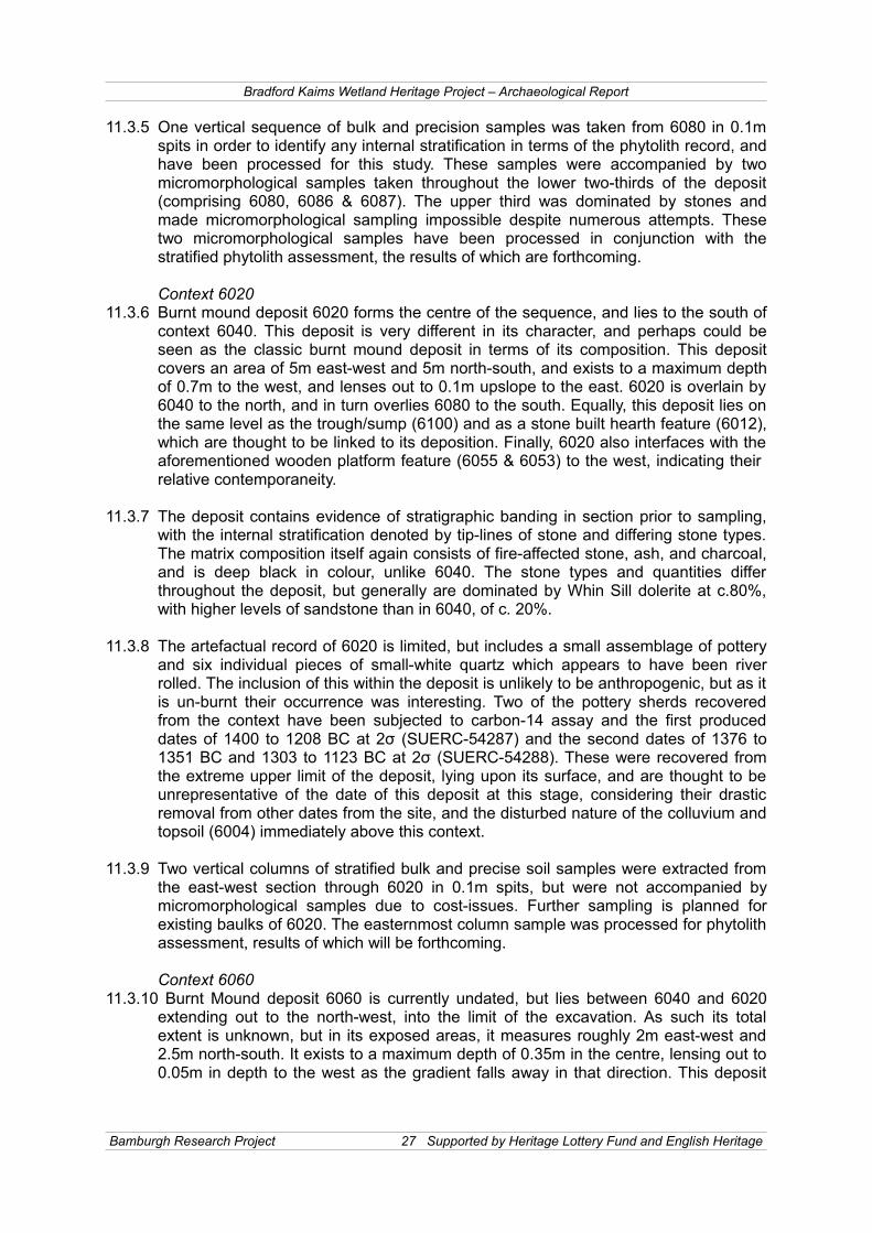
11.3 Mound 1 Sequences
11.3.1 The burnt mound deposits of Mound 1 were approached in a gridded and spittedexcavation strategy in order to assess the potential for internal stratification, bothhorizontally and vertically. These are dealt with below in roughly chronological order (Plates 8 and 9).
Context 608011.3.2 Burnt mound deposit 6080 appears to be the earliest deposit in the sequence of
Mound 1, and is overlain by 6020 to the north. This deposit covers a large area of 6meast-west and 3m north-south, and is also the deepest deposit in Mound 1, at 0.9m indepth to the west and 0.1m upslope to the east. The deposit is overlain by context6020 and interfaces directly with a section of wooden platform (6062) to the west.
11.3.3 Context 6080 itself again shows signs of internal stratification at the macro-scale within the section, with depositional banding illustrated by absence of stones in the lower two-thirds of the deposit, and a change to a silt-dominated sediment in the lowest third. The matrix constitutes a predominance of Whin Sill dolerite at c.85%, with scatters of sandstone at c.15%. In the lower regions of the deposit, the size of stone increases, perhaps indicating fewer individual firings of the stones (6086). The sediment of the top two-thirds is again deep-black, with large pieces of charcoal throughout (some have been cut prior to firing), and in the lower third the sediment becomes dominated by alluvial silt mixed with charcoal (6087). The reason for this base mixing is unknown, but it is thought to derive from the dumping and then trampling of burnt mound material upon soft alluvial silts on the margins of the water-system.
11.3.4 The artefactual record for 6080 is rich, and unique to burnt mounds in the British Isles, in a sense. It contains four sherds of cord-impressed ceramics in its lowestlevels, giving it a provisional early-Neolithic date. Interestingly it is dominated by aconcentration of cannel coal, exotic to the area, which must have been brought fromthe coast where it is washed ashore. The concentration exhibits around seventyindividual pieces of cannel coal, around twenty of which are partially burnt,introducing the possibility that this may have been used as a fuel source (it is a highlyefficient combustible). The highly localised concentration of this material within thedeposit may indicate that the cannel coal was held in a bag which has since decayed.
Bamburgh Research Project 26 Supported by Heritage Lottery Fund and English Heritage
Bradford Kaims Wetland Heritage Project – Archaeological Report
11.3.5 One vertical sequence of bulk and precision samples was taken from 6080 in 0.1mspits in order to identify any internal stratification in terms of the phytolith record, andhave been processed for this study. These samples were accompanied by twomicromorphological samples taken throughout the lower two-thirds of the deposit(comprising 6080, 6086 & 6087). The upper third was dominated by stones andmade micromorphological sampling impossible despite numerous attempts. Thesetwo micromorphological samples have been processed in conjunction with thestratified phytolith assessment, the results of which are forthcoming.
Context 602011.3.6 Burnt mound deposit 6020 forms the centre of the sequence, and lies to the south of
context 6040. This deposit is very different in its character, and perhaps could beseen as the classic burnt mound deposit in terms of its composition. This depositcovers an area of 5m east-west and 5m north-south, and exists to a maximum depthof 0.7m to the west, and lenses out to 0.1m upslope to the east. 6020 is overlain by6040 to the north, and in turn overlies 6080 to the south. Equally, this deposit lies onthe same level as the trough/sump (6100) and as a stone built hearth feature (6012),which are thought to be linked to its deposition. Finally, 6020 also interfaces with theaforementioned wooden platform feature (6055 & 6053) to the west, indicating their relative contemporaneity.
11.3.7 The deposit contains evidence of stratigraphic banding in section prior to sampling,with the internal stratification denoted by tip-lines of stone and differing stone types.The matrix composition itself again consists of fire-affected stone, ash, and charcoal,and is deep black in colour, unlike 6040. The stone types and quantities differthroughout the deposit, but generally are dominated by Whin Sill dolerite at c.80%,with higher levels of sandstone than in 6040, of c. 20%.
11.3.8 The artefactual record of 6020 is limited, but includes a small assemblage of potteryand six individual pieces of small-white quartz which appears to have been riverrolled. The inclusion of this within the deposit is unlikely to be anthropogenic, but as itis un-burnt their occurrence was interesting. Two of the pottery sherds recoveredfrom the context have been subjected to carbon-14 assay and the first produceddates of 1400 to 1208 BC at 2σ (SUERC-54287) and the second dates of 1376 to1351 BC and 1303 to 1123 BC at 2σ (SUERC-54288). These were recovered fromthe extreme upper limit of the deposit, lying upon its surface, and are thought to beunrepresentative of the date of this deposit at this stage, considering their drasticremoval from other dates from the site, and the disturbed nature of the colluvium andtopsoil (6004) immediately above this context.
11.3.9 Two vertical columns of stratified bulk and precise soil samples were extracted fromthe east-west section through 6020 in 0.1m spits, but were not accompanied bymicromorphological samples due to cost-issues. Further sampling is planned forexisting baulks of 6020. The easternmost column sample was processed for phytolithassessment, results of which will be forthcoming.
Context 606011.3.10 Burnt Mound deposit 6060 is currently undated, but lies between 6040 and 6020
extending out to the north-west, into the limit of the excavation. As such its totalextent is unknown, but in its exposed areas, it measures roughly 2m east-west and2.5m north-south. It exists to a maximum depth of 0.35m in the centre, lensing out to0.05m in depth to the west as the gradient falls away in that direction. This deposit
Bamburgh Research Project 27 Supported by Heritage Lottery Fund and English Heritage

Bradford Kaims Wetland Heritage Project – Archaeological Report
covers the trough/sump feature (6100) and is in turn covered by the western edge of6040, so both 6040 and 6060 must post-date the abandonment of the trough/sumpfeature. This would indicate that there is a later trough/sump feature on site, but asyet undiscovered, which would have contributed to the deposition of 6040 and 6060.
11.3.11 This deposit as of yet contains no evidence of internal stratification. The matrixcomposition again consists of fire-cracked stone, ash, and charcoal, and is a mid-grey in colour, unlike 6020. The sediments themselves appear, at the macro-scale, tobe mixed with large quantities of sand, which is expected to have derived from thepredominance of sandstone within this mounds (approaching 50%) with far less WhinSill dolerite (roughly 50%) identified.
11.3.12 The artefactual record of 6060 is relatively abundant, with two small pieces of flakedflint having been identified. One of these, a composite tool resembling a burin at oneend, and a scraper at the other, is preliminarily dated to the Mid-Neolithic (Pedersen,pers. comm.).
11.3.13 As this mound extends beyond the limit of excavation, it has not been sampled, asextensively and much remains in situ. However, a similar sampling strategy asapplied to the other mounds in this sequence is intended, comprising a mixture ofbulk-sampling, precise plant-microfossil sampling, and micromorphological samplingin grids and spits.
Context 604011.3.14 Burnt mound deposit 6040 is the smallest and latest of the four distinct deposits
within Mound 1. This deposit constitutes a thin spread of material, lensing from 0.1min thickness, uphill in the west, to 0.4m in thickness, further down the slope in theeast where it overlays deposit 6020. The spread covers an area of 5m east-west, andmeasuring 4m north-south as exposed, as it runs into the limit of excavation to thenorth. To the east 6040 overlies a wooden trough/sump feature, mentioned below,(6100), which in turn overlies deposit 6020. Thus, not only does 6040 evidently post-date 6020, but also cannot be the product of this trough/sump feature, as it covers itby c. 0.3m and this height of deposit could not be laid solely by erosion and slump.6040 also overlies a large rectangular cut, which although yet to be fully excavated,exhibits post-holes cut into its corners and an organic rich fill-composition, and isthought to represent a sunken-feature building. However as this feature is alsobeneath burnt mound deposit 6020, it predates the entire mound.
11.3.15 The components of the deposit are standard of burnt mound deposits, constituting amatrix dominated by fire-affected stone, ash, and charcoal. The binding sedimentwithin the deposit is of a grey-black colour, alluding to a more silt-enhancedcomposition than the other two deposits in Mound 1. The stone type utilized in thedeposition was noted in field to constitute c.90% Whin Sill dolerite, c.10% sandstone,and contained one item of limestone. This is relatively standard for the BradfordKaims mounds, with slightly lower averages of sandstone than other areas.
11.3.16 The artefactual record within 6040 was particularly rich, constituting three pieces ofworked flint only, which should exhibit the general sterility of the artefactual recordacross the Mound 1 area.
11.3.17 A gridded sequence of bulk and precise soil samples were taken from deposit 6040from an extended baulk retained for sampling purposes. Samples taken in a strip of
Bamburgh Research Project 28 Supported by Heritage Lottery Fund and English Heritage
Bradford Kaims Wetland Heritage Project – Archaeological Report
0.5m squares (A-G) were obtained, and within each 0.5m square, samples werespitted every 0.1m throughout. Because of time pressures, only square G spits 1 & 2have so far been processed for phytolith assessment. These were taken inconjunction with a micromorphological sample, also from the section of square G.Results of this sampling procedure will be forthcoming.
11.4 Trough/Sump Complex
11.4.1 A major discovery associated directly with Mound 1 is a series of features, togetherforming what is interpreted as troughs or sumps. This group includes the re-cuttingremnants of a minimum of three troughs, two of which are wood lined, and one ofwhich is clay lined. These are situated in the north-western corner of the excavations,underlying the burnt mound deposits of 6040 and 6060, but on a level with 6020,suggesting they may be contemporaneous. These features are located in the base ofpipe-trench 6049, pipe-trench 6024 and machine cut 6022, all of which are modernfeatures corresponding to the land-improvement of this marginal area implemented inseveral stages between 1920 and 1980, according to Mr. James Brown. Thesemodern features were investigated in order to prove their invasive nature, and thusthe prehistoric features shown in their bases, were identified in a series of small slots.The modern water-management implementation has resulted in a significant amountof damage upon the prehistoric features down to a penetration depth of 0.6mmaximum, and is most badly effected where they come into contact with the trough orsump features, due to the fragile nature of their materials. The troughs or sumpsconstitute a series of recut features, indicating a considerable duration of activity, andtheir advanced constructional methods indicate a large degree of investment in burntmound apparatus (Plate 15).
11.4.2 The earliest feature in this sequence constitutes a large, sub-oval cut (6105), barelyvisible on the periphery of a larger, later cut. It is cut into an alluvial subsoil clay(6004) representing the base of this area of the sequence. It is interpreted as anunlined trough purely by its position beneath two other trough features, which willneed to be revised at the point of its full excavation.
11.4.3 This early trough feature is cut by a large, sub-angular cut (6103) identified in thebase of 6049, which has a corresponding horizontal timber lining (6102) and a lightgrey, stony fill (6101). The extent or depth of this feature has not been identified, dueto its position near the base of a complex sequence of stratigraphy. However, this trough or sump appears to be the largest (in terms of area) identified as yet on site.
11.4.4 The latest trough or sump feature in this sequence is the most impressive; a circularcut (6100) into the fill of the earlier trough (6102), into which a hollowed log has beenset vertically (6099) as a lining. This is then subsequently filled with a series ofdeposits (currently grouped as 6098), constituting what appears to be both pre andpost- abandonment fills. This fill has been precision sampled for plant microfossils,micromorphology, and bulk samples. The cut (6100) measures roughly 0.6m x 0.65min width and length, and is filled entirely by the wooden lining (6099). This lining is anintact and entire length of trunk (hypothesised to be oak because of its scale andmorphology) which has been artificially hollowed, evidenced by the tool marks on itssmoothly shaped interior and rounded rim. This has been set vertically to a depth ofc.0.8m into the remnants of the previous, plank built trough (6102), and its base hasbeen packed with grey river clay (distinct from the yellow sub-soil clay). The wallthickness varies from 0.08-0.12m in width, leaving an interior volume of roughly 0.5m
Bamburgh Research Project 29 Supported by Heritage Lottery Fund and English Heritage
Bradford Kaims Wetland Heritage Project – Archaeological Report
x 0.55m x 0.8m. This feature (6099) is currently thought to be one of a kind. Thisuniqueness has led the excavators to question the traditional classification of a‘trough’, and to tentatively move towards sump as an interpretation.
11.4.5 Troughs are a characteristic component of burnt mound apparatus, appearing ataround 50% of burnt mound sites (O’Neill, 2009: 73). However, due to theuniqueness of construction, (6099) defies this classification on morphologicalgrounds. Although viable to function as a trough, the complex method of constructionwould indicate a specialised purpose. The construction of plank-built burnt moundtroughs is widely attested too, yet they are relatively simplistic in their construction. Aplank built trough measuring around 0.9-1.5m x 0.5-1.1m x 0.3-0.6m in size, couldnot take more than a day to construct (O’Neill, 2009: 74). However this vertical intacttrunk would require a great deal more care, attention, and time to build. Theexcavators do not currently know how this feature was constructed, but the hollowingand shaping of an entire 0.8m length of mature oak tree, even with the aid of naturaldecay or controlled burning, would be a monumental task compared with theconstruction of a plank built trough, such at 6102.
11.4.6 The morphology of the feature (6099) would indicate that it was not originallydesigned as a trough. At a depth of c.0.8m, it would be a difficult trough to use,considering its small radius. The feature naturally fills with clean water, the rate ofpercolation fast enough to necessitate near constant bailing, and completely fills thefeature with clean and clear water overnight. This is due to its submersion depthbelow the water table, and its porous material. The water-table’s upper limit is justbelow the rim of the feature, so that overnight it becomes neatly filled to the brim.Although the water-table has been influenced in recent history (Young et al, 2012) thegood preservation of this wooden feature indicates that it has never been consistentlylower than it is currently. Automatically filling troughs have been encountered at otherburnt mounds set in wetland conditions, but never of this type.
11.4.7 The large, unwieldy depth of this feature would make it difficult to operate within astrough, without scalding your arm, and difficult to clean out after use. Its depth doesnot lend itself well to a large volume either, due to its small radius, which gives a totalvolume of just 0.16m³, or a total of 157.26 litres, relatively small compared to someplank built troughs (eg. O’Kelly, 1954: 116). The difficulty of manual access, theuniqueness and complexity of construction, and the fact that it fills naturally withclean and potable water, points to it potentially being a sump. A sump would requiredepth to automatically fill with clean water, not necessary require easy hand accesslike a trough, and would benefit from a complete wooden lining to filter the water andensure no sediments infilled the cylinder. This interpretation is provisional at thisstage, but, if correct, would make this feature the first of its kind in Britain.
11.4.8 The potential merits of a sump full of clean potable water at a burnt mound are clear.As the process centres around the manipulation of water, potentially for consumption,clean, filtered, and readily available water is a necessity. The wetland which the siteis situated next to does not readily provide this, as any small bodies of open waterexisting with the peat-fen may have become stagnant, and would certainly require anindividual to walk across the soggy unstable ground, through a sea of sedges andgrasses, and get their feet wet. Water could be obtained by compressing an area ofpeat manually, but would instantly become flooded with muddy and unappetisingwater. The potential for a man-made sump, which this feature potentially represents,
Bamburgh Research Project 30 Supported by Heritage Lottery Fund and English Heritage

Bradford Kaims Wetland Heritage Project – Archaeological Report
would allow an individual to forgo this hassle with a small investment in the burntmound apparatus.
11.4.9 Future excavations will focus upon identifying, sampling, and preserving this feature(6099), due to its potential significance to British prehistoric archaeology. Themicromorphological, plant-microfossil, and plant macro-fossil samples of the featuresfills will be processed in order to characterise the nature of the deposits, and theirpotential for palaeo-environmental and palaeo-ecological reconstruction.
11.4.10 Once this feature is dealt with properly, excavation will continue on to the two earlierfeatures, (6105, 6102) in order to complete the biography of this area, and to interprethow its chronology and development as a complex relates to the wider site use.
11.5 Hearths
11.5.1 Two potential hearths have been encountered during the excavations surroundingMound 1. As regular components of burnt mound apparatus, and due to theirimmediate proximity to Mound 1, they have been interpreted as associated.
11.5.2 The central hearth was uncovered early in the excavation of this area, due to itscentrality to the trench, and its substantial construction. This feature (6012) was asubstantial setting of fractured stones, covering an area of 0.8m north-south by 0.6meast-west, and imbedded in a levelling dump of re-deposited subsoil clay (6012b) ontop of the undisturbed natural (6004). An archaomagnetometric date on the fired clay(6012b) gave a date of 4230BC ± 235 years (95%) (Sam Harris, University ofBradford). When this feature was removed, it appeared to overlie an area of fire-reddened subsoil clay (6012c) which is interpreted as an earlier hearth feature (Plate10).
11.5.3 This feature both overlay, and underlay detrital remnants of burnt mound sequence6020, connecting them as contemporaneous and potentially related, but alsohighlighting the fact that 6020 must contain numerous depositional events, and thatthese are not visible at the macro-scale, within the depth of the context itself. Themicromorphological sampling applied to this context should help to shed light uponthe intricacies of these depositional sequences.
11.5.4 The second potential hearth feature is a more ephemeral area of fire-reddened claymeasuring c.0.6m north-south by 0.55m east-west, located in the northern area of thetrench. This feature lies beneath the centre of burnt mound sequence 6040, and hasno ascribed date currently.
11.5.5 Both potential hearth areas have been included in a gridded soil sampling protocol ofthe subsoil areas, and will be subjected to FTIR and XRF analysis to determinewhether areas of reddened clay actually constitute areas of fired subsoil.
11.6 Platform Feature
11.6.1 Another significant feature directly associated with Mound 1 which has beenidentified and subjected to focussed low-impact investigations is an extensivewooden platform feature (comprising 6053, 6055, 6082 & 6084) identified with thetrench extensions into the peat layers to the south of the main trench (Plate 11).
Bamburgh Research Project 31 Supported by Heritage Lottery Fund and English Heritage

Bradford Kaims Wetland Heritage Project – Archaeological Report
11.6.2 Detailed excavation of small areas of, what is from coring evidence detailed below, isan extensive platform area were undertaken, with the dual intention of realising itsrelationship with the sequences of Mound 1 to the immediate north-east, and toassess any variation in its morphology, architecture, and preservation over itssignificant area. Two test-pits were opened over the central and southern areas of theplatform, which identified areas (6082, 6084) of high preservation. These small testareas were exposed, drawn and photographed, sampled, and then backfilled toprovide protection.
11.6.3 Excavation of platform sections (6053, 6055) in direct contact with Mound 1, bothstratigraphically and horizontally, were undertaken with the aim of assessing the stateof preservation, if it had deteriorated over the off-season of 2013-2014, and to furtherunderstand the structural makeup of the structure. These excavations, predominantlyon 6055, revealed the general preservation to be good, with no evident loss ofstructural integrity or organic decay over the course of the year (2013-2014).Excavation of 6055 revealed that the structure comprises a top layer of brushwood,overlying a complex matrix of organic midden material (currently classified as 6055b).This comprised a compacted layer of wood chips, charcoal, and fragments of workedwood, with some small burnt flints identified. This assemblage points towards theexistence of a wood-working tradition, potentially associated with the construction ofthe platform and other buildings on site, or maybe a subsidiary industry taking placein the environs of the burnt mound sequences. Beneath this layer of midden material(6055b) lay a more substantial layer of platform material, including several large,radially split timbers up to 1.5m in exposed length. This layer is yet to be properlyinvestigated, and has as such been classified at 6055c for the present. It is believedthat this represents the core of the platform structure, due to the large architecturalelements included within it (Plate 12).
11.6.4 A coring programme, instrumented by Mr. Tom Gardner of the Bamburgh ResearchProject and Dr. Richard Tipping of Stirling University, sought to develop a non-invasive investigative procedure for assessing the structure, extent, and position ofthe platform. A methodology of 1-inch core-probing on a 1m grid was developed,which succeeded in defining the extent of the platform as roughly 15m east-west by8m north-south, present to a depth of c.2m in places. Equally this investigationidentified several phases of platform deposition, seemingly running in concurrencewith rising water levels, and areas of severe trample beneath the platform. This isinterpreted as having derived from activity directly prior to the deposition of platformmaterial, either as part of the construction process, or as individuals crossing the fenmargin to to reach open water prior to improving access with the construction of theplatform. Two worked timber features have so far been identified on or within thesurface layers of the platform. The first of these was probable paddle identified onsouth side of the exposed platform surface, approximately 1m from the dry land inJuly 2013 (Plate 13). The second feature was an unusual length of split timberperforated by a series of holes (Plate 14) found in June 2014. Interpretation of thisfind is difficult and at present its possible that it represents part of a fish trap orstructural element.
11.6.5 Regardless of the function of this substantial structure, the investigations identified itsnumerous phases of deposition, its structural composition (timber, brushwood, andmidden layers), its extent and depth, and an artefactual record associated with it. Dueto the potential for influencing the water table, and causing damage to this fragilestructure, excavation was restricted to small area test-pitting, and a minimal-invasive
Bamburgh Research Project 32 Supported by Heritage Lottery Fund and English Heritage

Bradford Kaims Wetland Heritage Project – Archaeological Report
system of coring was instrumented to investigate the depths of the structure. Futureexcavation will continue in this cautious manner, with the aim of establishing asection conjoining Mound 1 sequences in the central trench (6020 & 6080) to theplatform, down to its total depth in a limited area.
Bamburgh Research Project 33 Supported by Heritage Lottery Fund and English Heritage

Bradford Kaims Wetland Heritage Project – Archaeological Report
Figure 7: Plan of Burnt Mound 1
Bamburgh Research Project 34 Supported by Heritage Lottery Fund and English Heritage
Bradford Kaims Wetland Heritage Project – Archaeological Report
Figure 8: Sections of Burnt Mound 1
Bamburgh Research Project 35 Supported by Heritage Lottery Fund and English Heritage

Bradford Kaims Wetland Heritage Project – Archaeological Report
11.7 Mound 2
11.7.1 Mound 2 was investigated during June and July 2012 in order to characterise thelarge geophysical anomaly identified by the survey undertaken in May. Initially asingle trench of 10m by 2m was hand dug. After removing the turf and topsoil a smallgroup of modern features were encountered. These were field drains, a hedge lineand modern tree boles (Figure 9) (Plates 2 and 16).
11.7.2 These modern features had partially disturbed a large mound of imported sandstoneand ironstone stones (4203), some of which showed signs of burning, identifying thefeature as a second burnt mound. An extension to the trench was excavated at 90degrees to establish the size of the mound, which is now known to be around 6m indiameter. The depth is currently not known as the mound was not intrusivelyexcavated at this time. In the centre of the mound a sandstone slab set on edge(4204) was located. Initially thought to be a cist, after further excavation it wasidentified as being at the head of a trough (4214). A feature often associated withburnt mound structures. The trough was filled by a succession of silty soils containinga high percentage of charcoal.
11.7.3 Further investigated of the mound will be required at a future date in order toestablish a more accurate date, depth, and in order to investigate its method ofconstruction/accumulation.
Bamburgh Research Project 36 Supported by Heritage Lottery Fund and English Heritage

Bradford Kaims Wetland Heritage Project – Archaeological Report
Figure 9: Excavation of Burnt Mound 2
Bamburgh Research Project 37 Supported by Heritage Lottery Fund and English Heritage
Bradford Kaims Wetland Heritage Project – Archaeological Report
11.8 Trench 8 the unburnt mound
11.8.1 The low water table, a consequence of the dry summer of 2013, allowed a moreextensive investigation below the dry land margin and into areas that had, until June2013, been inundated with flood water. A further series of unburned stone moundswithin the former wetland have been identified, mostly from topographicalobservation. The northernmost of them lay some 23m to the south of the east-westbranch of the Winlaw Burn, with further mounds traced in a line to the south. One ofthese has been investigated by the excavation of a trial trench (Trench 8), 2.4msouth-west to north-east and 1.6m north-west to south-east and found to comprise astone heap (8005) that extended beyond the limit of excavation in all directions(Figure 3). A sondage in the north-east corner of the trench, 1.4m north-west tosouth-east by 1m south-west to north-east, revealed that the stone heap wascomposed of irregular sandstone fragments of small to large sizes. The stone heap,within the sondage, was 0.6m thick and founded on a round-wood timber layer(8003), laid directly on the upper peat horizon (Plate 17). Limited test pit evaluation,between two of these low lying mounds, suggests that they are connected by abrushwood track-way. The extent of the mound alignment to the south has yet to beidentified, but certainly extends for some tens of metres and comprises of at least afurther 3 islands located using test pits sited as a result of penetrometry.. Noarchaeological dating evidence was recovered during excavation (Plate 17).
11.9 Mound 3
11.9.1 The 2014 season saw the opening of a new trench at the Bradford Kaims site(Trench 9). The trench was located south east of Trench 6, on the lake edge of thesame peninsular of land which contained Mound 2. It was sited on a further burntmound, located using a combination of penetrometry and test pitting. The test pittingrevealed the presence of burnt animal bone within the mound. This lead to thedecision to place a 12m x 5m trench directly across it, in the hope of investigatingboth the mound, and any potential nearby structures or features directly associatedwith it (Figure 3).
11.9.2 The original goal was to identify the full extent of the burnt mound, ascertain a datefor it, and to sample for burnt bone in the layer. At the same time, associated featureswere to be identified. The burnt mound itself (9006) has been provisionally datedfrom the flints found within it, which included a Neolithic leaf shaped arrowhead.
11.9.3 At the base of the sequence a layer of compacted yellow silty sand (9157) has beenexposed in the eastern end of the trench. This layer contained microliths, andpossible micro tools, which were preliminarily dated as either Mesolithic or theMesolithic/Neolithic transition.
11.9.4 Above this was a similar layer of greyish compacted sand (9003), which alsocontained various flint artefacts including debitage and scrapers. Cutting in into thislayer however were found several groups of stake-holes (9061) (9062) (9083) (9110)and (9140). These stake-holes do not reveal an obvious pattern or alignments, andwill be investigated more thoroughly during future seasons. It is obvious from theirstratigraphic relationships that these features predate the formation of the burntmound, as does a post-hole (9185), which cuts into a layer of brownish grey silty clay(9186). These are overlain in turn by both a layer of greyish brown silty clay (9058),and the burnt mound (9006).
Bamburgh Research Project 38 Supported by Heritage Lottery Fund and English Heritage

Bradford Kaims Wetland Heritage Project – Archaeological Report
11.9.5 The burnt mound itself (9006) measured at least 7m in diameter. Identifying its fullextent was, however, problematic as a significant portion of it extended under a fieldboundary, to the north, and its has likely been disturbed by the presence of aboundary ditch. When compared to the other burnt mounds from the Bradford Kaimssite, the Trench 9 mound seems less substantial and was likely in use for a relativelyshort amount of time. There are no obvious separate deposition phases visible in itssections, and it had a maximum depth of only c.0.15m. This may have been due tofluctuating water levels in Embleton's Bog, as the mound lies on a relatively low lyingspot. No further evidence of animal bone, burnt or otherwise, was identified. Howeverdating material was recovered in the form of a laurel shaped Neolithic arrow headfrom within the mound.
11.9.6 Above 9006, and in places overlaying it, was a layer of humic greyish brown siltyclay (9004) that produced several pieces of Bronze Age pottery. This in turn was cutby several stake holes of group (9060). the level from which the stale-holes were cutwas sealed by several accumulations of deposited material, and a deposit thatcontained pipe stems and Victorian pottery sherds,
Bamburgh Research Project 39 Supported by Heritage Lottery Fund and English Heritage

Bradford Kaims Wetland Heritage Project – Archaeological Report
12.0 CORING
12.1 Coring over the Embleton Bog area
12.1.1 Coring commenced in February 2012 and continued intermittently through to the endof July. A series of linear transects, A to H, were investigated over four fields to thesouth of Hoppenwood Bank and the first identified burnt mound (Figure 10). Theywere located to investigate the peat deposits within the former lake area known asEmbleton's Bog. Transect A investigated the narrow channel to the west of Mound 1,that is now canalised as the Winlaw Burn.
Figure 10: Location of the coring lines undertaken during 2012
Bamburgh Research Project 40 Supported by Heritage Lottery Fund and English Heritage

Bradford Kaims Wetland Heritage Project – Archaeological Report
12.2 Investigation of the Sediment Stratigraphy of the Wishaw Burn in the vicinity ofTrench 6
12.2.1 The coring programme undertaken in the summer of 2014 concentrated oninvestigation of the area of the Wishaw Burn to the south west of Trench 6. The intentwas to investigate the extent of the timber platform, identified within the trench, andto gain an understanding of the sediment sequence within the narrow channel thattoday contains the burn. A series of 31 boreholes were sunk with a Eijelkamp 2.5cmdiameter peat gouge. The location of the sequence is depicted on Figure 11, witheach borehole numbered in the sequence in which it was recorded.
Figure 11: Location of the cores taken during 2014
12.2.2 The sediment layers of the Wishaw Burn are dominated by two types of peat, anamorphous peat with no recognisable plant matter, and a herb peat, which retainsmuch recognisable plant material. In addition a substantial wood content has alsobeen noted, in the case of the present samples, this component varies betweenfragments and round-wood. In the case of the round-wood component, the originalform is maintained, often including bark.
12.3 Interpretation
12.3.1 The text below attempts to describe the sequence of events, in chronological order,as far as they can be constructed from the observed data. Some 13 phases ofactivity has so far been identified and are described below:
Bamburgh Research Project 41 Supported by Heritage Lottery Fund and English Heritage

Bradford Kaims Wetland Heritage Project – Archaeological Report
(1) The shape of the channel The cross-section of the Wishaw Burn has been defined by Transect A (marked inblue on the figure), and has been found to be asymmetric, with a steep side on thenorth-east side and a more gradual slope on the south-west side (though the bankitself has so far not been reached on this side of the burn).
(2) The base of the channelThe base at the north-east side of the channel was identified as boulder clay, butover much of the transect the basal layer was an impenetrable stone, which mayrepresent bedrock, but is more likely to represent a gravel base.
(3) Contrasts in basal sediment along Transect AA major contrast in the basal sediments between boreholes north-east of B15 andthose SW was noted. To the north-east of B15 mineral sediments with little or noorganic matter were identified. To the south-west stone is overlain by herb peatentirely free of mineral sediment. The two sediments cannot have been laid down atthe same time, and the peat layer are proposed as the later deposit.
(4) Erosion of the clay-dominated pond fillThe best explanation for the isolation of the clays on the north-east side of the burn isthat an erosion event occurred. It is possible that this was severe enough to erodethe south-west bank itself.
(5) Armouring the wider channel with course gravelIt is thought that the reason that the boreholes were stopped from penetratingdeeper, south-west of B12 on Transect A, and all boreholes south-west of thechannel edge on Transect B by stone, is because of the presence of coarse fluvialgravel that lined the channel floor, in a process called armouring. The movement ofthese gravels would require stream flow rates higher than any that have been seensince.
(6) The earliest sediment of the widened channelFollowing the erosion and armouring events a structureless silt, seen in boreholes B1an B14 on Transect A and B23 in Transect B (Marked in red on the figure), was laiddown. The silt represents flowing water, but with no significant stream power, and the absence of the silt in other boreholes could mean that the stream at this time wasquite confined. The increasingly clay rich quality of this sediment in B23 may hint atponding. The basal sediments in B1 contain amorphous organic matter (AOM), whichis significant of change in the local environment and it is assumed that this is in theform of increased plant and algal biomass in the channel. This can be an indication ofwarming of the water.
(7) Establishment of herb peat in the channelThe herb peat represents a valley mire or marsh environment. With sufficient water,such an environment will accumulate live material building up on dead material,which has not decayed. Such an accumulation could have the affect of raising thewater table as the channel became choked with marsh vegetation. With almost nogradient to the burn the water would have drifted through the channel rather thanflowed. Wood is a rare component and the few examples may represent trees thatwere growing close to, or within the channel, before the spread of herb peat forcedthem away. The presence of two hazel nuts and a fragment of charred wood hints at
Bamburgh Research Project 42 Supported by Heritage Lottery Fund and English Heritage

Bradford Kaims Wetland Heritage Project – Archaeological Report
the presence of humans in the area, but this is not the only explanation for thepresence of such material.
(8) Shell fragments and the development of an open water phaseIn this phase shell fragments are found, common to abundant, in boreholes B1, B12,B13 and B14. The shell fragments are associated with the in-washing of mineralmatter. To the south-west herb peat continued to grow unaffected by mineralsediment. As a result it is thought that perhaps a pool formed only around boreholesB12 to B1.
(9) The persistence of open water at B12Above the peat with abundant shell fragments standing water persisted, as thinlayers of pale grey to fawn clay was seen stratified with herb peat. The colourchanges in the clay are thought to signify different organic contents, and thelamination could be seasonal markers.
(10) Soil surfaces and their disturbance on the north-east bankAbove the deposits of shell fragments there is another major difference in thesediments forming north-east and south-west of B12 on Transect A. To the south-west the herb peat continued to form, with interruptions, B11, B10 and B2 havesediments that are highly disturbed, perhaps from trampling, separated by sedimentunits where trampling cannot be identified. Trampling does not necessarily need torepresent the presence of people, but in this case, given the general context, it ishighly likely. Given this it is worth considering what we know of the area at this time.There was no significant depth of water and the water surface is thought to have lainat 29.9m OD. It would have lapped the feet of people if they stood at the site of B11.Open water would have lain some 3-4m out from B11, but barely flowed most of thetime. The depth of the marshy peat, in the middle of the channel, some 4m out, wasless than 1m.
(11) Soil erosion on the north-east bank and re-deposition in the channelThough the evidence for soil disturbance by trampling is episodic, many near-shoreboreholes suggest sustained mobilisation and re-deposition of mineral sediment. Soil erosion occurred within and between mineral sediments contain common-abundantwood, which is interpreted as human in origin. It seems clear from its distribution thatthe in-washed sediment originated from the location of the timber structure that hasbeen identified by excavation.
(12) The addition of wood to sediment on the north-east bankWood was very rare to rare in earlier deposits, but during the most intense phase ofsoil erosion and re-deposition on the north-east bank, wood becomes abundant inthe 'nearshore' pond deposits and clays. The overwhelming bulk of the added woodis of tiny-small smashed fragments. Large round-wood was added only at one time.Large-very large fragments were added in the middle of the sequence and appear tohave been oriented vertically. This accumulation of wood, first in mud and then above31.2m OD, in herb peat continues to 32.3m OD, some 1.6m. It is assumed that thiswood was added to sediment at or under the contemporary water surface as itcontinued to rise. As the water rose the north-east bank would have been pushednorth-eastwards. Boreholes B21, B19, B25 and B26 contain wood in abundance andsuggest that structures similar to that in Trench 6 were constructed along a 10mlength of shoreline.
Bamburgh Research Project 43 Supported by Heritage Lottery Fund and English Heritage

Bradford Kaims Wetland Heritage Project – Archaeological Report
(13) Addition of wood to herb peat in the channelAt B10 and in the area to its north-east, on the sloping river bank, the addition ofwood on soils and in mud was probably a comparatively easy task. Further out,towards the deeper part of the channel, the task would have been more difficult aswood was being added to wet and unconsolidated marsh vegetation and peat. This isimportant as the horizontal bedding shows that there has been no significantdeformation of the timber structure, indicating that additions were in response to arising water table and not the sinking of the existing platform. It is assumed that theaddition of wood in the channel would be constrained by the water table, unless thetimber was pegged down. The vertical or near vertical timbers identified both duringthe excavation and within the boreholes are believed to have performed this role.Even so, it could be expected that laid timber would at times float away, complicatingthe interpretation of wood within the boreholes. As a result it has been decided thatintentional addition is assumed when pieces of wood are abundant and associatedwith the in-washing of eroded soil. Using this we are tentatively able to describe thespatial and temporal development of the wooden structure.
(a) The earliest additions of wood: 30.9m OD to 31.1m OD, at B14, B10 and B11.
(b) 31.1m OD to 31.5m OD: wood may have been added at B2 linking the structureto the shore as the water rose. Wood was also added at B15 and B25.
(c) 31.5m OD to 31.8m OD: wood was dropped into the peat at B8-B2 and alsointentionally added to B12 at this time. On Transect B abundant wood was added for the first time at B21, B19 and B26. This appears to represent the greatest extent ofthe timber structure.
(d) 31.8m OD to 32.3m OD: the marsh that had formed between B8 and B2 had littleor no wood added to it. Above 32.3m OD wood becomes less than abundant inboreholes where it had previously been abundant. It is more likely that aerobic decayis affecting preservation above these levels.
(e) cessation of the peat stratigraphy: sediment formed after the addition of wood isabsent except at B11. A dry gleyed soil overlies peat everywhere and the boundarybetween peat and soil is gradual, suggesting that the soil is a product of peatmineralisation.
12.4 Conclusions
12.4.1 The coring has been very successful, and has been able to characterise thesediments in the channel and has been able to define in great detail theenvironmental changes within the Wishaw Burn. In addition the coring programmehas been able to map the timber structure, not just in extent, but also to identifyphases within its construction.
Bamburgh Research Project 44 Supported by Heritage Lottery Fund and English Heritage

Bradford Kaims Wetland Heritage Project – Archaeological Report
PROJECT OVERVIEW
13.0 DISCUSSION
13.0.1 Analysis of the Embleton Bog core has produced a sequence that is divided intothreelocal pollen assemblage zones (lpaz) EB1-3, each zone was divided into 2 sub-zones (a and b), marking major and minor changes in the pollen stratigraphy
13.0.2 Zone EB1a, indicates that Alnus and Quercus were locally present, forming a closedcanopy woodland around the mire, probably with Corylus. During EB1b, closedcanopy woodland encroached around the mire surface. Peak Alnus values (c.80%tlp) suggest incorporation of a catkin, which in itself suggests colonisation of the bogsurface by Alnus. Human activity around the site was not indicated.
13.0.3 Zone EB2a indicates that the canopy around the mire receded or opened out as themire surface became increasingly wet. The main change was represented bydecreases in Alnus and increases in Cyperaceae suggest that woodland away fromthe mire surface remained similar. Increases in Poaceae, presence of severaldisturbance indicators and increases in charcoal may be associated with humancultivation indicated by pollen of the Avena-Triticum group. During EB2b the miresurface conditions became wetter and the local to extra local canopy opened outslightly Quercus and Corylus probably declined in importance, suggesting opening ofthe canopy away from the mire edge.
13.04 Zone EB3a indicates that the mire surface dried out and the canopy closed slightly atthis time. Re-appearance of pollen from the Avena-Triticum group and of P.lanceolata type is in agreement with charcoal increases relating to human activity.However the decline in Poaceae and limited presence of other local indicators ofclearance together with continued evidence of a semi-open to closed local to extralocal canopy may in part contradict this. During EB3b the mire surface would appearto have become wetter. Pollen from the Hordeum group is present but disappearanceof pollen from the Avena-Triticum group and P. lanceolata, together with the decreasein larger charcoal particles suggests local human activity is unlikely. Pollen countsshow an Ulmus decline began at 142cm, giving an age of c. 6330 cal BP (Parker etal. 2002). This is a reasonable fit with the nearby sequence, Bradford Kaim (Bartley1966). Assuming this similarity to be sustained, the sequence is estimated to be c.4970 to c. 7000 cal BP. This is nearly 500 cal years older than initially estimated butthe first appearance of Avena-Triticum group pollen at 137cm (c. 6130 cal BP) is inagreement with evidence from Milfield (Waddington, 1998) suggesting pastoralismand cereal cultivation from around this time.
13.0.5 The present investigation area, at Hoppenwood Bank, was identified from itstopography as being of potential interest within the wider study area. Test-pittingdown the slope of the bank, towards the former lake area, revealed the presence ofthe first of the two burnt mounds, so far identified. The second being identified bygeophysical survey confirmed by trial trench evaluation.
13.0.6 The test pitting process has so far failed to certainly identify prehistoric settlement inthe project area. Some indication of the presence of Mesolithic activity is howeverhinted at from the results of Test-Pit 52, in the 'peninsular' area on which BurntMound 2 lies and in the area of Newhouses Bog. Further test pitting and excavationwill be required in the future to resolve this more clearly.
Bamburgh Research Project 45 Supported by Heritage Lottery Fund and English Heritage
Bradford Kaims Wetland Heritage Project – Archaeological Report
13.0.7 The two mounds are generally similar in size and morphology and are almostcertainly the result of similar processes of function and discard. However, detailedexcavation and sampling has revealed that these consist of a series of sequentialdeposits, that do differ in nature. The more refined results of micromorphological andprecise plant micro-fossil analysis from the deposits comprising mound 1 areforthcoming, but at this stage hint at a great degree of variation within the deposits,both horizontally and vertically.
Such mounds are commonly found in similar topographical areas adjacent to plentifulsupplies of water and have been associated with many processes from tanning tobrewing (Topping, 2011). It is likely that both mounds were within a few metres ofopen water at the time they were in use and the absence of flint working andsettlement evidence, would indicate that they were not associated directly withsettlement activity. Nevertheless the population that used them is unlikely to havelived far from the site but remains as yet unidentified. At present, the limited datingevidence is inconclusive, with an archaeomagnetic date for the fired clay at the baseof Mound 1 and ceramic assemblage indicating a date in the later part of the fourthmillennium BC and a small finds assemblage from Mound 2 indicating a late Neolithicto early Bronze Age date. This would fit the broad chronology for such mounds andcould be tentatively reconciled with the evidence had the area remained in use forsuch activity over a long period of time. Further specialist analysis of the modest findsassemblage and Carbon-14 dating should inform on this interpretation.
13.0.8 The discovery of the platform and the realisation that it forms only the uppermost of anumber of such structures, preserved within the peat, must rank as the mostimportant discoveries of the later part of the project. Its close relationship with themultiphase Mound 1, is also intriguing, suggesting as it does, that the platform andthe mound forming process functioned side by side. At present the bestinterpretation sees the platform as providing access to open water, out from theshoreline.
13.0.9 The sump/trough complex found in conjunction with Mound 1 again requires furtherinvestigation in order to define its precise role in the stratigraphic biography of thesite, and to potentially assign a function to its various phases. Regardless, thediscovery of such a well-preserved sequence of troughs or sumps, with the latestbeing unique in its construction, is worthy of detailed further investigation, and someexcitement.
Bamburgh Research Project 46 Supported by Heritage Lottery Fund and English Heritage

Bradford Kaims Wetland Heritage Project – Archaeological Report
14.0 CONCLUSIONS
14.0.1 Taxa associated with disturbance of vegetation are present from the base of thepollen sequence, but do not necessarily indicate that people were active locally(Mazier et al., 2006, Favre et al., 2007). Any anthropogenic activity had a very lowimpact on the local environment. Firmer evidence for anthropogenic activity begins inlpaz EB1b (137cm), with the first appearance of pollen from the Avena-Triticum groupof cultivated cereal. Initial human activity does not appear to be within the immediatearea. A more local presence only becomes likely in EB3a and above. Even thenmajor changes to the vegetation caused by human activity are not supported by theevidence at Embleton within the centuries covered by the current pollen core.
14.0.2 Archaeological trenching has revealed that an industrial style process wasundertaken on the wetland margin in at least two locations in the Hoppenwood Bankarea, and likely many others. The presence of at least one area where a mound islinked to the wetland by a substantial timber platform appears to be unique to thepresent site. This activity can be tentatively dated to the early Neolithic to Bronze Ageperiods, and will be subject to Carbon-14 assay to further narrow the chronology ofthe site. The contemporary settlements associated with this activity have yet to beclearly identified, though given the scale of the activity, and the long period duringwhich mound formation continued, it is quite likely that those undertaking the activitywere drawn from a more regional than immediately local context. The presence oflimited amounts of Mesolithic material in the principal survey area and at theNewhouse Bog would indicate prolonged exploitation of this varied landscape.
Bamburgh Research Project 47 Supported by Heritage Lottery Fund and English Heritage

Bradford Kaims Wetland Heritage Project – Archaeological Report
ACKNOWLEDGMENTS
The Project is greatly indebted to Mr James Brown and Miss R Barber as well as The Dukeof Northumberland's Estate for their support and assistance with access to the site. Theexpertise and financial support of the Heritage Lottery Fund and English Heritage is alsogreatly appreciated.
We are also grateful for the support and assistance of numerous volunteers, students andschool parties, for their commitment and assistance to the project, in often indifferentweather. We very much hope that they will be able to continue to work with us in the future.We would like to pay particular tribute to Matthew Ross for his efforts in taking on theresponsibility for the coring programme between Dr Tipping's visits.
Bamburgh Research Project 48 Supported by Heritage Lottery Fund and English Heritage

Bradford Kaims Wetland Heritage Project – Archaeological Report
BIBLIOGRAPHY
Al Hashimi, Wissam S. 1977. Recent Carbonate Sedimentation from Seawater in SomeWeathered Dolostones, Northumberland, England. Journal of Sedimentary Petrology 47 (3):1375 - 1391
Al Hashimi, Wissam S. & J.E. Hemingway. 1973. Recent Dedolomitization and the Origin of theRusty Crusts of Northumberland. Journal of Sedimentary Petrology 43 (1): 82 – 91
Alcock, Leslie. 2003. Kings and Warriors, Craftsmen and Priests in Northern Britain AD 550 – 850.(Society of Antiquaries of Scotland Monograph Series). Edinburgh: Society of Antiquaries ofScotland.
Anderton, R., P.H. Bridges, M.R. Leeder & B.W. Sellwood. 1979. A Dynamic Stratigraphy of theBritish Isles: A Study in Crustal Evolution. London: Chapman & Hall.
Anderson, S.T. (1979). Identification of wild grass and cereal pollen. DanmarksGeologiske Unders.Arbog, 1978, 69-92.
Austin, Linda, Stuart Egan, Stuart Clarke, Gary Kirby & Dave Millward. 2009. The Geology andGeodynamics of the Northumberland Trough Region: Insights from Mathematical Modelling.Keele: Research Institute for the Environment, Physical Sciences & Applied Mathematics,Keele University.
Barnosky, Anthony D. 1986. 'Big Game' Extinction Caused by Late Pleistocene Climatic Change:Irish Elk (Megaloceros giganteus) in Ireland. Quaternary Research 25 (1): 128 - 135
C. J. Bates, ‘The border holds of Northumberland’, Archaeol. Aeliana, XIV (1891), fig. between 262and 263.
Bartley, D.D. 1966. Pollen Analysis of Some Lake Deposits Near Bamburgh in Northumberland.New Phytologist 65 (2): 141 – 156
Barton, Nicholas & Alison J. Roberts & Derek A. Roe (editor). 1991. The Late Glacial in North-West Europe: Human Adaptation and Environmental Change at the End of the Pleistocene .(Council for British Archaeology Report No. 77). London: Council for British Archaeology.
Bateson, Edward. 1893. A History of Northumberland, Volume I: The Parish of Bamburgh With theChapelry of Belford. Newcastle-upon-Tyne: Andrew Reid, Sons & Company.
Bayliss, Alex, Ian Boomer, Christopher Bronk Ramsey, Derek Hamilton & Clive Waddington. 2007.Absolute Dating. In (editor) Clive Waddington. Mesolithic Settlement in the North Sea Basin: ACase Study from Howick, North-East England. Oxford: Oxbow Books. pp. 65 - 74
Bede. 1969 Ecclesiastical History of the English People (H.E.) (eds. B. Colgrave and R. A. B.Mynors). London.
Bennett, K.D. (1984). Post glacial history of Pinus sylvestris in the British Isles. Quaternary Science Reviews, 3, 133-155.
Bjarke Ballin, Torben & Alan Saville. 2003. An Ahrensburgian-Type Tanged Point from Shieldaig,Wester Ross, Scotland and Its Implications. Oxford Journal of Archaeology 22 (2): 115 – 131
Blackmore, S., Steinmann, J.A.J., Hoen, P.P. and Punt, W. (2003). The northwest European pollenflora, 65: Betulaceae and Corylaceae. Review of Palaeobotany and Palynology, (The NorthwestEuropean Pollen Flora, VIII,), 123, 71-98.
Blood, Keith. 1995. Ros Castle Iron Age Hillfort, Chillingham. Northern Archaeology 12: 35 - 37Boomer, Ian. 2007. Preliminary Report on Coring at Bradford Kaims, May 2007. Unpublished
report submitted to the University of Birmingham.Boomer, Ian, Clive Waddington, Tony Stevenson & Derek Hamilton. 2007. Holocene Coastal
Change and Geoarchaeology at Howick, Northumberland, UK. The Holocene 17 (1): 89 - 104Bradley, Richard & Mark Edmonds. 1993. Interpreting the Axe Trade: Production and Exchange in
Neolithic Britain. (New Studies in Archaeology). Cambridge: Cambridge University Press.British Geological Survey. 2010. The British Geological Survey Lexicon of Named Rock Units.
Online resource at: http://www.bgs.ac.uk/lexiconBroström, A., Sugita, S. and Gaillard, M.J. (2004). Pollen productivity estimates for
the reconstruction of past vegetation cover in the cultural landscape of southernSweden. The Holocene, 14, 368-381.
Buckley, Francis. 1922a. Early Tardenois Remains at Bamburgh, etc. Proceedings of the Societyof Antiquaries of Newcastle-upon-Tyne (3rd Series) 10: 319 – 323
Bamburgh Research Project 49 Supported by Heritage Lottery Fund and English Heritage
Bradford Kaims Wetland Heritage Project – Archaeological Report
Buckley, Francis. 1922b. Pygmy Industry of the Northumberland Coast. Antiquaries Journal 2: 376- 377
Buckley, Francis. 1925. The Microlithic Industries of Northumberland. Archaeologia Aeliana (4th
Series) 1: 42 – 47Bunting, M.J. (2003). Detecting woodland remnants in cultural landscapes: Modern
pollen deposition around small woodlands in northwest Scotland. The Holocene, 12,291-301.
Bunting, M.J., Gaillard, M.J., Sugita, S., Middleton, R. and Bostrom, A. (2004).Vegetation structure and pollen source area. The Holocene, 14, 651-660.
Burdukiewicz, Jan Michał. 1986. The Late Pleistocene Shouldered Point Assemblages in WesternEurope. Leiden: E.J. Brill.
Cayless, S. and Tipping, R. (2002). Data on mid-Holocene climatic, vegetation and anthropogenic interactions at Stanshiel Rig, southern Scotland. Vegetation History and Archaeobotany. 11, 201-210.
Chadwick, R.A. & D.W. Holliday. 1991. Deep Crustal Structure and Carboniferous BasinDevelopment Within the Iapetus Convergence Zone, Northern England. Journal of theGeological Society 148 (1): 41 – 53
Clark, John Grahame Douglas. 1971. Excavations at Star Carr: An Early Mesolithic Site at SeamerNear Scarborough, Yorkshire. Cambridge: Cambridge University Press.
Coles, Bryony. 1995. Wetland Management: A Survey for English Heritage. (WetlandArchaeological Research Project Occasional Paper No. 9). Exeter: Department of History andArchaeology, University of Exeter.
Coles, John & Bryony Coles. 1996. Enlarging the Past: The Contribution of Wetland Archaeology.The Rhind Lectures for 1994-5. (Society of Antiquaries of Scotland Monograph Series Number11; Wetland Archaeology Research Project Occasional Paper Number 10). Edinburgh: Societyof Antiquaries of Scotland.
Conneller, Chantal. 2007. Inhabiting New Landscapes: Settlement and Mobility in Britain After theLast Glacial Maximum. Oxford Journal of Archaeology 26 (3): 215 - 237
Cowell, Ron W. & Jim B. Innes (editors). 1994. The Wetlands of Merseyside. (North WestWetlands Survey 1). Lancaster: University of Lancaster.
Davies, G. & Judith Turner. 1979. Pollen Diagrams from Northumberland. New Phytologist 82 (3):783 – 804
Davies, John. 1983. The Mesolithic Sites of Northumberland. Northern Archaeology 4 (ii): 18 – 25Dodds, Madeleine Hope (editor). 1935. A History of Northumberland, Volume 14: The Parishes of
Alnham, Chatton, Chillingham, Eglingham, Ilderton, Ingram, Whittingham, the Chapelries ofLowick & Doddington. Newcastle-upon-Tyne: Andrew Reid, Sons & Company.
Donahue, Randolph E. & William A. Lovis. 2006. Regional Settlement Systems in MesolithicNorthern England: Scalar Issues in Mobility and Territoriality. Journal of AnthropologicalArchaeology 25 (2): 248 - 258
Edwards, K.J. (1983). Quaternary Palynology multiple profile studies and pollen variability. Progress in Physical Geography, 7, 587-609.
Edwards, K.J. (1988). The hunter-gatherer / agricultural transition and the pollen record in the British Isles. The Cultural Landscape past present and future. (eds. Birks H.H., English
Heritage. 2006. Management of Research Projects in the Historic Environment: The MoRPHE Project Managers' Guide. Swindon: English Heritage.
English Heritage. 2008a. SHAPE 2008: A Strategic Framework for Historic Environment Activitiesand Programmes in English Heritage. Guidance for External Applicants. Swindon: EnglishHeritage.
English Heritage. 2008b. English Heritage Strategy for Wetlands. Swindon: English Heritage.Falcon-Lang, Howard. 1999. The Early Carboniferous (Asbian-Brigantian) Seasonal Tropical
Climate of Northern Britain. Palaios 14 (2): 116 – 126Favre, E., Escarguel, G., Suc, J., Thévenod, G. and Thévenod, L. (2008). A contribution to
deciphering the meaning of AP/NAP with respect to vegetation cover. Review of Palaeobotany and Palynology, 148, 13-35.
Field, Dave. 1999. Barrows, Cairns and Harmony in the Prehistoric Landscape of Northumberland.Northern Archaeology 17-18: 35 - 39
Bamburgh Research Project 50 Supported by Heritage Lottery Fund and English Heritage

Bradford Kaims Wetland Heritage Project – Archaeological Report
Frank, M.C. & R.V. Tyson. 1995. Parasequence-Scale Organic Facies Variations through an EarlyCarboniferous Yoredale Cyclothem, Middle Limestone Group, Scremerston, Northumberland.Journal of the Geological Society, London 152 (1): 41 - 50
Fraser, Constance M (editor). 1968. The Northumberland Lay Subsidy Roll of 1296. Newcastle-upon-Tyne: The Society of Antiquaries of Newcastle-upon-Tyne.
Gardner, T., 2015, ‘The Burnt Mound Misconception: Excavation Strategy and the Missing Record’In Press.
Gonzalez, Silvia, Andrew C. Kitchener & Adrian M. Lister. 2000. Survival of the Irish Elk into theHolocene. Nature 405: 753 - 754
Grieg, D.C. 1971. British Regional Geology: The South of Scotland. (Third Edition). Nottingham:British Geological Survey.
Grime, J.P., Hodgson, J.G. and Hunt, R. (2007). Comparative plant ecology. Castlepoint Press, Dalbeatie.
Grimm, E.C. (1987). CONISS: A FORTRAN 77 programme for stratigraphicallyconstrained cluster analysis by incremental sum of squares. Computer Geosciences,13, 13-35.
Grimm, E.C. (2002). Tilia and TiliaGraph. Illinois State University, Illinois, USA.Gunn, W. 1900. The Geology of Belford, Holy Island, and the Farne Islands, Northumberland.
(Memoirs of the Geological Survey of England and Wales. No. 4 New Series, 110 S.E. OldSeries). London: Her Majesty's Stationery Office.
Hall, David, Colin Wells & Elizabeth Huckerby (editors). 1995. The Wetlands of GreaterManchester. (North West Wetlands Survey 2). Lancaster: University of Lancaster.
Higuera, P.E., Peters, M.E., Brubaker, L.B. and Gavin, D.G. (2007). Understandingthe origin and analysis of sediment-charcoal records with a simulation model. Quaternary Science Reviews, 26, 1790-1809.
Hodgkinson, David, Elizabeth Huckerby, Robert Middleton & Charles Wells (editors). 2001. TheLowland Wetlands of Cumbria. (North West Wetlands Survey 6). Lancaster: University ofLancaster.
Huddard, David & Neil F. Glasser (editors). 2002. Quaternary of Northern England. (GeologicalConservation Review Series Volume 25). Peterborough: Joint Nature Conservation Committee.
Hughes, D.B., B.G. Clarke & M.S. Money. 1998. The Glacial Succession in Lowland NorthernEngland. Quarterly Journal of Engineering Geology 31 (3): 211 – 234
Jeffries, Michael J. 1998. Pond Macrophyte Assemblages, Biodisparity and Spatial Distribution ofPonds in the Northumberland Coastal Plain, UK. Aquatic Conservation: Marine and FreshwaterEcosystems 8 (5): 657 – 667
Jobey, George. 1965. Hill Forts and Settlements in Northumberland. Archaeologia Aeliana (4th
Series) 43: 21 - 64Jobey, George. 1968. Excavations of Cairns at Chatton Sandyford, Northumberland. Archaeologia
Aeliana (4th Series) 46: 5 - 50Johnson, G.A.L. (editor). 1995. Robson's Geology of North East England. [Second Edition].
(Transactions of the Natural History Society of Northumbria, Volume 56, Part 5). Newcastle-upon-Tyne: The Natural History Society of Northumbria.
Johnson, G.L. 1984. Subsidence and Sedimentation in the Northumberland Trough. Proceedingsof the Yorkshire Geological Society 45 (1): 71 - 83
Jones, R.L. & D.H. Keen. 1993. Pleistocene Environments in the British Isles. London: Chapman &Hall.
Kimbell, J.S., R.A. Chadwick, D.W. Holliday & O.C. Werngren. 1989. The Structure and Evolutionof the Northumberland Trough from New Seismic Reflection Data and Its Bearing on Modes ofContinental Extension. Journal of the Geological Society, London 146 (5): 775 – 787
Large, A.R.G., W.M. Mayes, M.D. Newson & G. Parkin. 2007. Using Long-Term Monitoring of FenHydrology and Vegetation to Underpin Wetland Restoration Strategies. Applied VegetationScience 10 (3): 417 - 428
Lawrence, D.J.D., S.L.B. Arkley, J.D. Everest, S.M. Clarke, D. Millward, E.K. Hyslop, G.L.Thompson & B. Young. 2007. Northumberland National Park Geodiversity and Audit Plan.Hexham: Northumberland National Park & The British Geological Survey.
Leah, Mark, Colin Wells, Catrina Appleby & Elizabeth Huckerby (editors). 1997. The Wetlands ofCheshire (North West Wetlands Survey 4). Lancaster: University of Lancaster.
Bamburgh Research Project 51 Supported by Heritage Lottery Fund and English Heritage

Bradford Kaims Wetland Heritage Project – Archaeological Report
Leah, Mark, Colin Wells, Paul Stamper, Elizabeth Huckerby & Christopher Welch (editors). 1998.The Wetlands of Staffordshire and Shropshire. (North West Wetlands Survey 5). Lancaster:University of Lancaster.
Lee, M.K. 1982. Regional Geophysics of the Cheviot Area. (Institute of Geological Sciences,Natural Environment Research Council Report No. ENPU 82-2). Harwell: Institute of GeologicalSciences.
Lisityana, O.V., Giesecke, T. and Hicks, S. (2011) Exploring pollen percentage threshold values as an indication for the regional presence of major European trees. Review of Palaeobotany and Palynology, 166, 311–324.
Lowe, J.J. (1982b). Three Flandrian pollen profiles from the Teith valley, Perthshire,Scotland. II. Analysis of deteriorated pollen. New Phytologist, 90, 371-385.
Lunn, A.G. 1995. Quaternary. In (editor) G.A.L. Johnson. pp. 297 - 311Mawer, Allen. 1920, The Place-Names of Northumberland and Durham. Cambridge: Cambridge
University Press.Mazier, F., Galop, D., Brun, C. and Buttler, A. (2006). Modern pollen assemblages
from grazed vegetation in the western Pyrenees, France: A numerical tool for moreprecise reconstruction of past cultural landscapes. The Holocene, 16, 91-103.
McCabe, A.M., P.U. Clark, D.E. Smith & P. Dunlop. 2007. A Revised Model for the LastDeglaciation of Scotland. Journal of the Geological Society, London 164 (2): 313 - 316
McCord, Norman & Richard Thomson. 1998. The Northern Counties from AD 1000. LongmanLimited.
McKerrow, W.S., C Mac Niocaill & J.F. Dewey. 2000. The Caledonian Orogeny Redefined. Journalof the Geological Society, London 157 (6): 1149 – 1154
Mellars, Paul. 1998. Postscript: Major Issues in the Interpretation of Star Carr. In (editors) PaulMellars & Petra Dark. pp. 215 - 241
Mellars, Paul & Petra Dark (editors). 1998. Star Carr in Context: New Archaeological andPalaeoecological Investigations at the Early Mesolithic Site of Star Carr, North Yorkshire.(McDonald Institute Monographs). Cambridge: McDonald Institute for Archaeological Research,University of Cambridge.
Middleton, Robert, Michael Tooley & Colin Wells (editors). 2001. The Wetlands of South WestLancashire. (North West Wetlands Survey 7). Lancaster: University of Lancaster.
Middleton, Robert, Colin Wells & Elizabeth Huckerby (editors). 1995. The Wetlands of NorthLancashire. (North West Wetlands Survey 3). Lancashire: University of Lancaster.
Miket, Roger. 1986. The Excavation of a Circular Enclosure at Horsedean Plantation, NearChatton, Northumberland: Interim Report. Northern Archaeology 7 (ii): 39 - 42
Moore, P.D., Webb, J.A. and Collinson, M.E. (1991). Pollen analysis. BlackwellScientific Publishing, London.
Muholland, Helen. 1970. The Microlithic Industries of the Tweed Valley. Transactions of theDumfriesshire and Galloway Natural History and Antiquarian Society (3rd Series) 47: 81 - 110
Noort, Robert Van de. 2004. The Humber Wetlands: The Archaeology of a Dynamic Landscape.Macclesfield: Windgather Press.
Noort, Robert Van de & Stephen Ellis (editors). 1997. Wetland Heritage of the HumberheadLevels: An Archaeological Survey. Kingston-upon-Hull: Humber Wetland Project.
Noort, Robert Van de & Stephen Ellis (editors). 1998. Wetland Heritage of the Ancholme andLower Trent Valleys: An Archaeological Survey. Kingston-upon-Hull: Humber Wetland Project.
Noort, Robert Van de, William Fletcher, Gavin Thomas, Ian Carstairs & David Patrick. 2002.Monuments at Risk in England's Wetlands. Exeter: University of Exeter.
Northumberland Coast Area of Outstanding Natural Beauty. 2009. Northumberland Coast AONBand Berwickshire and North Northumberland EMS Management Plan 2009-2014. Alnwick:Northumberland Coast Area of Outstanding Natural Beauty.
O’Kelly, J., 1954, ‘Excavations and Experiments in Ancient Irish Cooking-Places,’ Journal of the Royal Society of Antiquaries of Ireland, Vol. 84, pp. 105-155.
O’Neill, J. 2009, ‘Burnt Mounds in Northern and Western Europe,’ VDM Verlag Dr. Muller, Saarbrucken.
Parker, A.G., Goudie, A.S., Anderson, D.E., Robinson, M.A. and Bonsall, C. (2002).A review of the mid-Holocene elm decline in the British Isles. Progress in Physical Geography, 26, 1-45.
Bamburgh Research Project 52 Supported by Heritage Lottery Fund and English Heritage

Bradford Kaims Wetland Heritage Project – Archaeological Report
Passmore, David G. & Clive Waddington. 2009. Managing Archaeological Landscapes inNorthumberland: Till Tweed Studies Volume 1. Oxford: Oxbow Books.
Passmore, David G. & Tim van der Schriek. 2009. Past and Present Landscape in the Till-TweedRegion. In David G. Passmore & Clive Waddington. pp. 10 - 74
Paterson, D., Tipping, R., Young, G., Ross, M., Gething, P. and Pedersen, K. 2014. Environmentalchanges at the Mesolithic-Neolithic transition from Embleton's Bog, near Lucker,Northumberland. Archaeologia Aeliana 43, 1-18.
Pedersen, Kristian L.R. 2008. A Description and Analysis of the Lithic Material from theCoquetdale Community Archaeology's Group Fieldwalking Campaign, 2005-2007. Unpublishedreport submitted to the Coquetdale Community Archaeology Group.
Petts, David & Christopher Gerrard. 2006. Shared Visions: The North-East Regional ResearchFramework for the Historic Environment. Durham: Durham County Council.
Preston, C.D., Pearman, D.A. and Dines, T.D. (2002). New atlas of the British andIrish flora. Oxford University Press, Oxford.
Punt, W., Marks, A. and Hoen, P.P. (2002). The northwest European pollen flora, 66,Myricaceae. Review of Palaeobotany and Palynology (The Northwest EuropeanPollen Flora, VIII,), 123, 99-105.
Rippon, Stephen. 2004. Historic Landscape Analysis: Deciphering the Landscape. (PracticalHandbooks in Archaeology No. 16). York: Council for British Archaeology.
Robson, D.A. 1965. Guide to the Geology of Northumberland and the Borders. (Transactions ofthe Natural History Society of Northumberland, Durham and Newcastle Upon Tyne). Newcastle-upon-Tyne: Natural History Society of Northumberland, Durham and Newcastle Upon Tyne.
Saville, Alan, Torben Bjarke Ballin & Tam Ward. 2007. Howburn, Near Biggar, South Lanarkshire:Preliminary Notice of a Scottish Inland Early Holocene Lithic Assemblage. Lithics 28: 41 - 49
Shaw, H. (2006). A palaeoecological investigation of long term stand scale ecologicaldynamics in semi-open native pine woods: Contributing to conservation managementin east Glen Affric. Unpublished PhD thesis, University of Stirling.
Shennan, Ian, Ben Horton, Jim Innes, Roland Gehrels, Jerry Lloyd, Jenny MacArthur & MaireadRutherford. 2000. Late Quaternary Sea-Level Changes, Crustal Movement and CoastalEvolution in Northumberland, UK. Journal of Quaternary Science 15 (3): 215 – 237
Stallibrass, Sue & Jacqueline P. Huntley. 1996. Slim Evidence: A Review of the Faunal andBotanical Data from the Neolithic of Northern England. Northern Archaeology 13-14: 35 – 42
Soepboer, W. and Lotter, A.F. (2009). Estimating past vegetation openness using pollen vegetation relationships: A modelling approach. Review of Palaeobotany and
Palynology, 153, 102-107.Stace, C. (1997). New flora of the British Isles. Cambridge University Press, Cambridge. Stockmarr, J. (1977). Tablets with spores used in absolute pollen analysis. Pollen et
Spores, 13, 615-621.Sugita, S. (2007). Theory of quantitative reconstruction of vegetation. I. Pollen from large sites
reveals regional vegetation. The Holocene, 17, 229-241.Tait, John. 1965. Beakers from Northumberland. Newcastle-upon-Tyne: Oriel Academic
Publications.Tait, John. 1968. Museum Notes: Neolithic Pottery from Northumberland. Archaeologia Aeliana (4th
Series) 46: 275 - 281Taylor, B.J., I.C. Burgess, D.H. Land, D.A.C. Mills, D.B. Smith & P.T. Warren. 1971. British
Regional Geology: Northern England. (Fourth Edition). London: Her Majesty's Stationery Office.Tipping, R. (1987). The origins of corroded pollen grains at five early postglacial
pollen sites in western Scotland. Review of Palaeobotany and Palynology, 53, 151-161.
Tipping, Richard. 1998. The Chronology of Late Quaternary Fluvial Activity in Part of the MilfieldBasin, Northeast England. Earth Surface Processes and Landforms 23 (9): 845 – 856
Tipping, Richard. 2010. Bowmont: An Environmental History of the Bowmont Valley and theNorthern Cheviot Hills, 10 000 BC – AD 2000. Edinburgh: Society of Antiquaries of Scotland.
Tolan-Smith, Christopher & S. Cousins. 1995. Museum Notes 1995: An Upper Palaeolithic FlintTool from the Tyne Valley, Northumberland. Archaeologia Aeliana (5th Series) 23: 307 - 309
Topping, P. Burnt Mounds. English Heritage, 2011
Bamburgh Research Project 53 Supported by Heritage Lottery Fund and English Heritage
Bradford Kaims Wetland Heritage Project – Archaeological Report
Torsvik, T.H., M.A. Smethurst, J.G. Meert, R. Van der Voo, W.S. McKerrow, M.D. Brasier, B.A. Sturt& H.J. Walderhaug. 1996. Continental Break-Up and Collision in the Neoproterozoic andPalaeozoic – A Tale of Baltica and Laurentia. Earth Science Reviews 40 (2): 229-258
Turner, Brian & Mary Munro. 1987. Channel Formation and Migration by Mass-Flow Processes inthe Lower Carboniferous Fluviatile Fell Sandstone Group, Northeast England. Sedimentology34 (6): 1107 - 1122
Turner B. R., P.L, Younger & C.E. Fordham. 1993. Fell Sandstone Group Lithostratigraphy South-West of Berwick-upon-Tweed: Implications for the Regional Development of the FellSandstone. Proceedings of the Yorkshire Geological Society 49 (4): 269 – 281
Twiddle, C.L., Jones, R.T., Caseldine, C.J., Sugita, S. (2012). Pollen productivity estimates for a pine woodland in eastern Scotland: The influence of sampling design and vegetation patterning. Review of Palaeobotany and Palynology, 174, 6778.
Waddington, Clive. 1996. Putting Rock Art to Use: A Model of Early Neolithic Transhumance inNorth Northumberland. Northern Archaeology 13-14: 147 - 177
Waddington, C. (1998) A landscape archaeological study of the Mesolithic Neolithic in the Milfield basin, Northumberland, Durham theses, Durham University. Available at Durham E-Theses
Online: http://etheses.dur.ac.uk/5004/Waddington, Clive. 1999. Recent Lithic Finds from Bowden Doors, Northumberland. Archaeologia
Aeliana (5th Series) 27: 173 - 174Waddington, Clive. 2004. The Joy of Flint: An Introduction to Stone Tools and Guide to the
Museum of Antiquities Collections. Newcastle-upon-Tyne: Museum of Antiquities, Newcastle-upon-Tyne.
Waddington, Clive. 2009. The Stone Age Landscape: Fieldwalking and Test Pits. In David G.Passmore & Clive Waddington. pp. 75 – 124
Waters, C.N., M.A.E. Browne, M.T. Dean & J.H. Powell. 2007. Lithostraphical Framework forCarboniferous Successions of Great Britain (Onshore). (British Geological Survey ResearchReport RR/07/01). Keyworth, Nottingham: British Geological Survey.
Bamburgh Research Project 54 Supported by Heritage Lottery Fund and English Heritage

Bradford Kaims Wetland Heritage Project – Archaeological Report
Plate 1: The area of the investigated area of the wetland, seen from HoppenwoodBank, looking south
Plate 2: The peat basin re-flooded during 2012, Burnt Mound 2 can be seen underexcavation in the foreground, facing north-west
Bamburgh Research Project 55 Supported by Heritage Lottery Fund and English Heritage

Bradford Kaims Wetland Heritage Project – Archaeological Report
Plate 3: Extracting the pollen core from the peat
Plate 4: The basal core as extracted showing silt and marl from the former lake bed
Bamburgh Research Project 56 Supported by Heritage Lottery Fund and English Heritage
Bradford Kaims Wetland Heritage Project – Archaeological Report
Plate 5: Examining sediment from the narrow gauge auger used to compile thetransects
Plate 6: Identifying pollen with Dr Richard Tipping during our volunteer laboratory dayat Stirling University
Bamburgh Research Project 57 Supported by Heritage Lottery Fund and English Heritage

Bradford Kaims Wetland Heritage Project – Archaeological Report
Plate 7: Early phase of excavation of Burnt Mound 1 (Trench 6), facing south-west
Plate 8: Mound 1 under excavation by students, volunteers and the YoungArchaeologist Club competition winners in July 2014
Bamburgh Research Project 58 Supported by Heritage Lottery Fund and English Heritage
Bradford Kaims Wetland Heritage Project – Archaeological Report
Plate 9: Mound 1 is extensive and in fact composed of a number of mound formingevents, facing north-west
Plate 10: The 'hearth' dated to 4230BC ± 235 years (95%)
Bamburgh Research Project 59 Supported by Heritage Lottery Fund and English Heritage

Bradford Kaims Wetland Heritage Project – Archaeological Report
Plate 11: Extending Mound 1 Trench 6 into the wetland area, facing south-east
Plate 12: The timber platform under excavation within the Trench 6 extension, facingsouth
Bamburgh Research Project 60 Supported by Heritage Lottery Fund and English Heritage
Bradford Kaims Wetland Heritage Project – Archaeological Report
Plate 13: The wooden paddle found on the timber platform in 2013, facing east
Plate 14: Worked, perforated, timber identified as part of the platform make-up in 2014
Bamburgh Research Project 61 Supported by Heritage Lottery Fund and English Heritage
Bradford Kaims Wetland Heritage Project – Archaeological Report
Plate 15: Excavation the timber 'trough' identified beneath Mound 1 in 2014, facingsouth-east
Plate16: Burnt Mound 2 seen from ground level, facing north-east
Bamburgh Research Project 62 Supported by Heritage Lottery Fund and English Heritage

Bradford Kaims Wetland Heritage Project – Archaeological Report
Plate 17: Section through the unburnt stone mound within Trench 11, showing thetimber 'raft' identified beneath it, facing south-east
Bamburgh Research Project 63 Supported by Heritage Lottery Fund and English Heritage
Related Documents