AUSTRALIAN NATIONAL FACILITY FOR OCEAN GLIDERS (ANFOG) Data Management USER’s MANUAL Version 3.0 April 12 th 2010

Welcome message from author
This document is posted to help you gain knowledge. Please leave a comment to let me know what you think about it! Share it to your friends and learn new things together.
Transcript

AUSTRALIAN NATIONAL FACILITY FOR
OCEAN GLIDERS (ANFOG)
Data Management
USER’s MANUAL Version 3.0
April 12th 2010
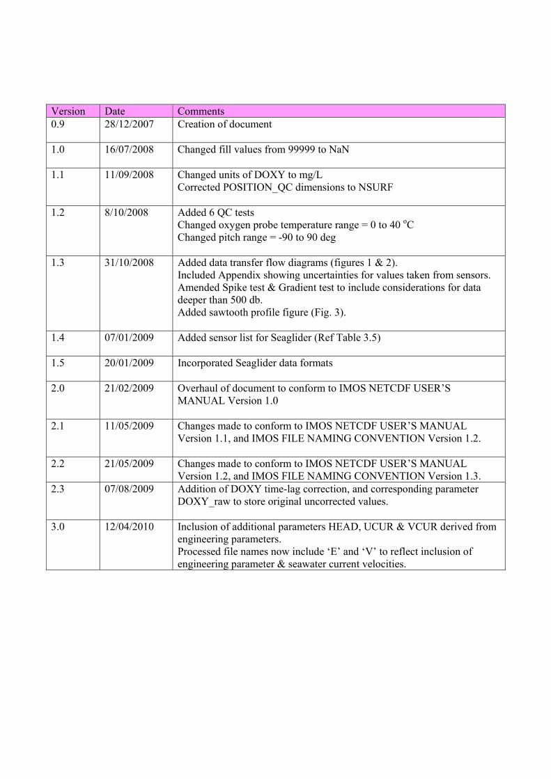
Version Date Comments 0.9 28/12/2007 Creation of document
1.0 16/07/2008 Changed fill values from 99999 to NaN
1.1 11/09/2008 Changed units of DOXY to mg/L
Corrected POSITION_QC dimensions to NSURF
1.2 8/10/2008 Added 6 QC tests Changed oxygen probe temperature range = 0 to 40 oC Changed pitch range = -90 to 90 deg
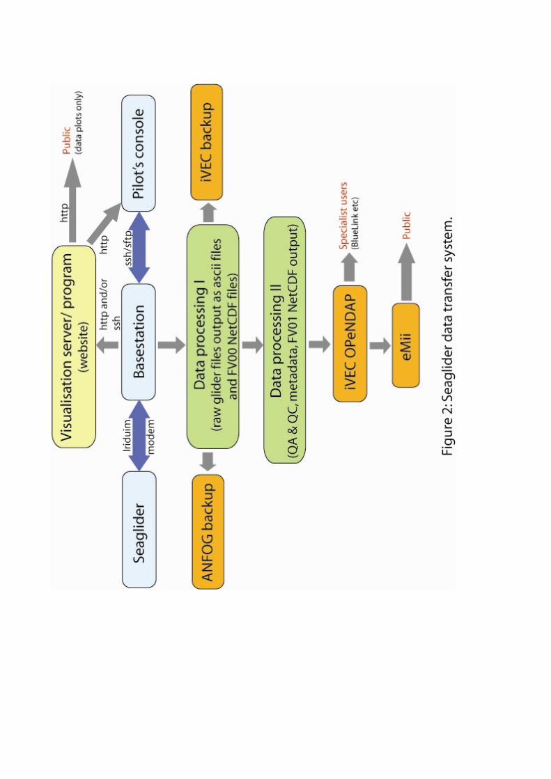
1.3 31/10/2008 Added data transfer flow diagrams (figures 1 & 2). Included Appendix showing uncertainties for values taken from sensors. Amended Spike test & Gradient test to include considerations for data deeper than 500 db. Added sawtooth profile figure (Fig. 3).
1.4 07/01/2009 Added sensor list for Seaglider (Ref Table 3.5)
1.5 20/01/2009 Incorporated Seaglider data formats
2.0 21/02/2009 Overhaul of document to conform to IMOS NETCDF USER’S MANUAL Version 1.0
2.1 11/05/2009 Changes made to conform to IMOS NETCDF USER’S MANUAL Version 1.1, and IMOS FILE NAMING CONVENTION Version 1.2.
2.2 21/05/2009 Changes made to conform to IMOS NETCDF USER’S MANUAL Version 1.2, and IMOS FILE NAMING CONVENTION Version 1.3.
2.3 07/08/2009 Addition of DOXY time-lag correction, and corresponding parameter DOXY_raw to store original uncorrected values.
3.0 12/04/2010 Inclusion of additional parameters HEAD, UCUR & VCUR derived from engineering parameters. Processed file names now include ‘E’ and ‘V’ to reflect inclusion of engineering parameter & seawater current velocities.
1. Introduction This document is the ANFOG data user’s manual. It contains the description of the formats and files produced by Australian National Facility for Ocean Gliders (ANFOG).
1.1 ANFOG program The underwater ocean glider represents a technological revolution for oceanography. Autonomous ocean gliders can be built relatively cheaply, are controlled remotely and are reusable allowing them to make repeated subsurface ocean observations at a fraction of the cost of conventional methods. ANFOG, with IMOS/NCRIS funding, currently deploys a fleet of eight gliders around Australia. The data retrieved from the glider fleet will contribute to the study of the major boundary current systems surrounding Australia and their links to coastal ecosystem processes. The ANFOG glider fleet consists of two types; Slocum gliders and Seagliders. Slocum gliders (named for Joshua Slocum the first solo global circumnavigator), manufactured by Webb Research Corp are optimised for shallow coastal waters (< 200m) where high manoeuvrability is needed. ANFOG currently has three Slocum gliders for deployment on the continental shelf. Seagliders, built at the University of Washington, are designed to operate most efficiently in the open ocean up to 1000m water depth. ANFOG uses their five Seagliders to monitor the boundary currents surrounding Australia. The Seagliders can be used to conduct repeated glider surveys across the boundary currents and continental shelves, which is valuable for gathering long-term environmental records of physical, chemical and biological data not widely measured to date. Whilst the Slocum gliders, due to their low cost and operational flexibility, will be of great use in intensive coastal monitoring, both types of gliders weigh only 52kg, enabling them to be launched from small boats. They have a suite of sensors able to record temperature, salinity, dissolved oxygen, turbidity, dissolved organic matter and chlorophyll against position and depth. Currently, all SLOCUM gliders are instrumented with a Seabird-CTD, WETLabs BBFL2SLO 3 parameter optical sensor (measuring Chlorophyll-a, CDOM & 660nm Backscatter) and an Aanderaa Oxygen optode. The SEAGLIDERS are equipped with a Seabird-CTD, WETLabs BBFL2VMT 3 parameter optical sensor (measuring Chlorophyll-a, CDOM & 660nm Backscatter) and a Seabird Oxygen sensor. The ANFOG data formats are based on NetCDF because :
• It is a widely accepted data format by the user community, • It is a self-describing format for which tools are widely available, • It is a reliable and efficient format for data exchange.
Data from each kind of glider is transferred in the systems shown in Figures 1 and 2. Information pertaining to the uncertainty inherent in the data values is listed in the Appendix of this document.
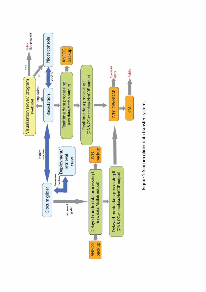
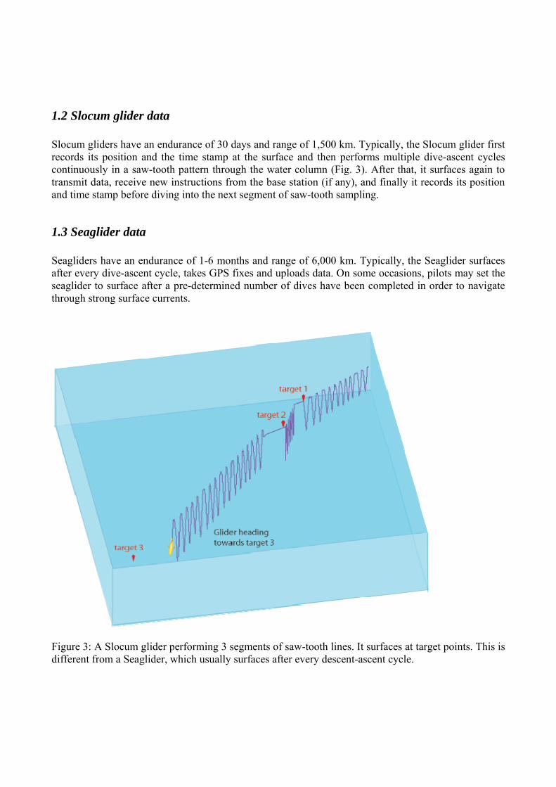
1.2 Slocum glider data Slocum gliders have an endurance of 30 days and range of 1,500 km. Typically, the Slocum glider first records its position and the time stamp at the surface and then performs multiple dive-ascent cycles continuously in a saw-tooth pattern through the water column (Fig. 3). After that, it surfaces again to transmit data, receive new instructions from the base station (if any), and finally it records its position and time stamp before diving into the next segment of saw-tooth sampling.
1.3 Seaglider data Seagliders have an endurance of 1-6 months and range of 6,000 km. Typically, the Seaglider surfaces after every dive-ascent cycle, takes GPS fixes and uploads data. On some occasions, pilots may set the seaglider to surface after a pre-determined number of dives have been completed in order to navigate through strong surface currents.
Figure 3: A Slocum glider performing 3 segments of saw-tooth lines. It surfaces at target points. This is different from a Seaglider, which usually surfaces after every descent-ascent cycle.
2. Glider data and meta-data format Glider format files contain meta-data and data for one deployment of one glider. The observation data is stored as a data timeseries in NetCDF format. Data are transmitted from the gliders, passed through processing and quality control procedures immediately after the glider begins reporting at the surface. For Slocum gliders, while the glider is in the water, a subset of the dataset is transmitted, while the full dataset will only be available for processing upon vehicle retrieval.
2.1 Dimension and definition ANFOG Glider data are collected as time-series, where three-dimensional coordinates of latitude, longitude and depth coordinates are recorded, along with various measured parameters. Measured parameters thus share the same dimension. The length of the time-series data varies according to the duration spent underwater and frequency of sampling, with deeper dives typically producing longer data time-series. Name Value Definition TIME TIME = unlimited Number of time steps over which data was sampled.
2.2 Global attributes This section contains general information about the file itself. Name Example Definition project
char('Integrated Marine Observing System');
The scientific project that produced the data
conventions
char('IMOS version 1.2'); Format convention used by the dataset
title
char(['Seaglider data from Hobart20090213']);
Short description of the dataset indicating whether data has come from a Seaglider or Slocum, and the corresponding name of the mission.
institution
char('ANFOG');
Name of the institute or facility where the original data was produced.
date_created char(‘2008-12-10T09:35:36Z’);
Date and time at which the data was created. Format: yyyy-mm-ddTHH:MM:SSZ'
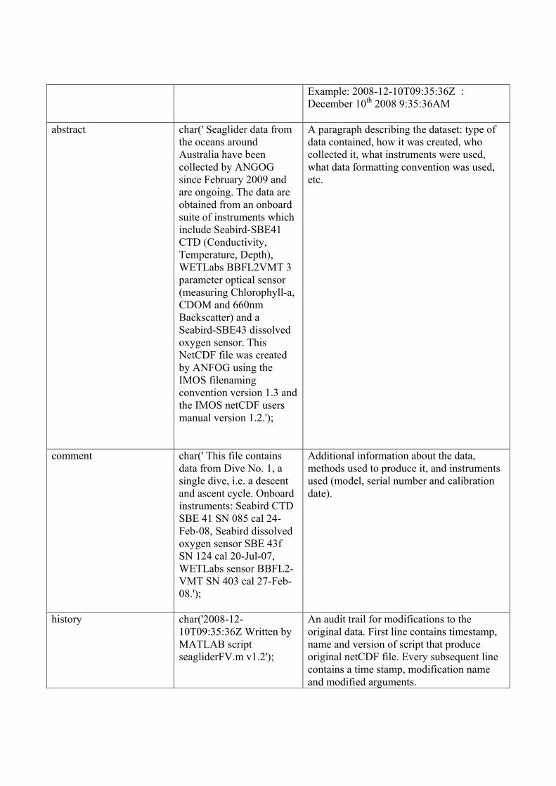
Example: 2008-12-10T09:35:36Z : December 10th 2008 9:35:36AM
abstract
char(' Seaglider data from the oceans around Australia have been collected by ANGOG since February 2009 and are ongoing. The data are obtained from an onboard suite of instruments which include Seabird-SBE41 CTD (Conductivity, Temperature, Depth), WETLabs BBFL2VMT 3 parameter optical sensor (measuring Chlorophyll-a, CDOM and 660nm Backscatter) and a Seabird-SBE43 dissolved oxygen sensor. This NetCDF file was created by ANFOG using the IMOS filenaming convention version 1.3 and the IMOS netCDF users manual version 1.2.');
A paragraph describing the dataset: type of data contained, how it was created, who collected it, what instruments were used, what data formatting convention was used, etc.
comment
char(' This file contains data from Dive No. 1, a single dive, i.e. a descent and ascent cycle. Onboard instruments: Seabird CTD SBE 41 SN 085 cal 24-Feb-08, Seabird dissolved oxygen sensor SBE 43f SN 124 cal 20-Jul-07, WETLabs sensor BBFL2-VMT SN 403 cal 27-Feb-08.');
Additional information about the data, methods used to produce it, and instruments used (model, serial number and calibration date).
history
char('2008-12-10T09:35:36Z Written by MATLAB script seagliderFV.m v1.2');
An audit trail for modifications to the original data. First line contains timestamp, name and version of script that produce original netCDF file. Every subsequent line contains a time stamp, modification name and modified arguments.
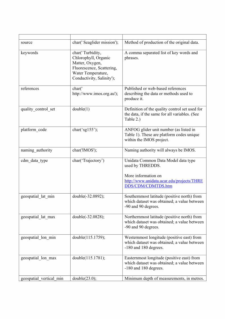
source
char(' Seaglider mission');
Method of production of the original data.
keywords
char(' Turbidity, Chlorophyll, Organic Matter, Oxygen, Fluorescence, Scattering, Water Temperature, Conductivity, Salinity');
A comma separated list of key words and phrases.
references
char(' http://www.imos.org.au');
Published or web-based references describing the data or methods used to produce it.
quality_control_set double(1) Definition of the quality control set used for the data, if the same for all variables. (See Table 2.)
platform_code
char(‘sg155’); ANFOG glider unit number (as listed in Table 1). These are platform codes unique within the IMOS project.
naming_authority
char('IMOS'); Naming authority will always be IMOS.
cdm_data_type char(‘Trajectory’) Unidata Common Data Model data type used by THREDDS. More information on http://www.unidata.ucar.edu/projects/THREDDS/CDM/CDMTDS.htm
geospatial_lat_min
double(-32.0892); Southernmost latitude (positive north) from which dataset was obtained; a value between -90 and 90 degrees.
geospatial_lat_max
double(-32.0828); Northernmost latitude (positive north) from which dataset was obtained; a value between -90 and 90 degrees.
geospatial_lon_min
double(115.1759);
Westernmost longitude (positive east) from which dataset was obtained; a value between -180 and 180 degrees.
geospatial_lon_max
double(115.1781); Easternmost longitude (positive east) from which dataset was obtained; a value between -180 and 180 degrees.
geospatial_vertical_min double(23.0); Minimum depth of measurements, in metres.
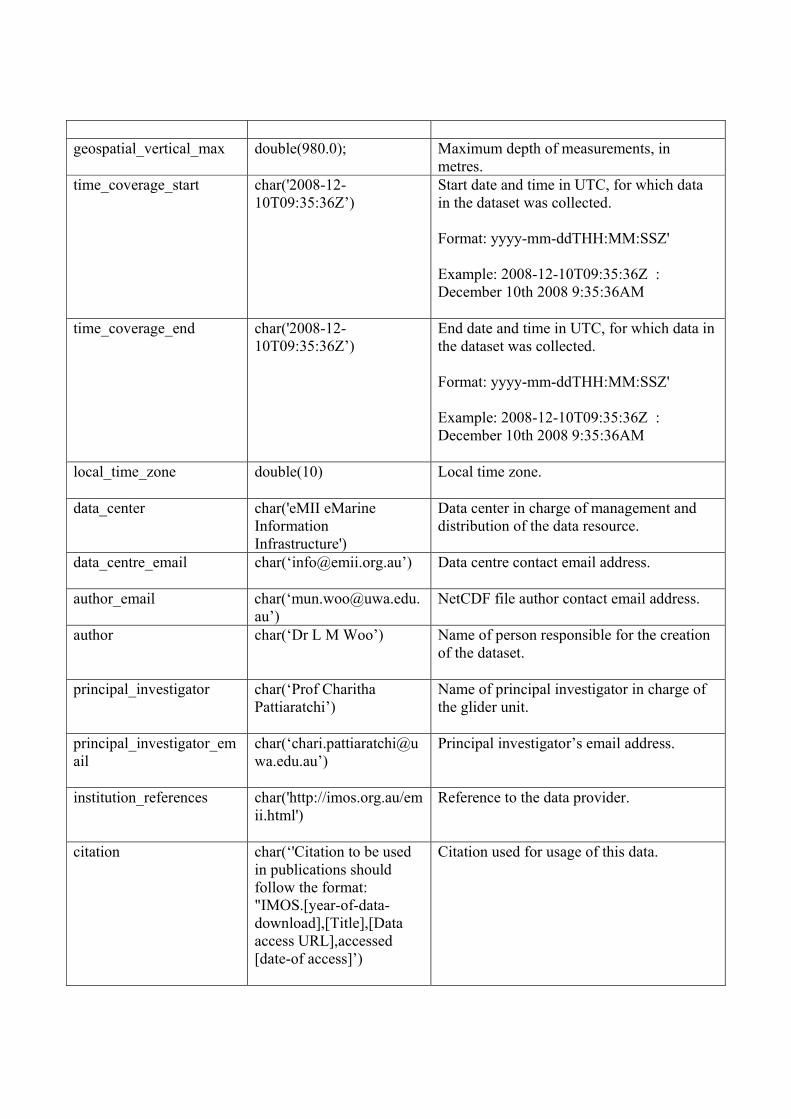
geospatial_vertical_max
double(980.0); Maximum depth of measurements, in metres.
time_coverage_start
char('2008-12-10T09:35:36Z’)
Start date and time in UTC, for which data in the dataset was collected. Format: yyyy-mm-ddTHH:MM:SSZ' Example: 2008-12-10T09:35:36Z : December 10th 2008 9:35:36AM
time_coverage_end
char('2008-12-10T09:35:36Z’)
End date and time in UTC, for which data in the dataset was collected. Format: yyyy-mm-ddTHH:MM:SSZ' Example: 2008-12-10T09:35:36Z : December 10th 2008 9:35:36AM
local_time_zone
double(10) Local time zone.
data_center
char('eMII eMarine Information Infrastructure')
Data center in charge of management and distribution of the data resource.
data_centre_email char(‘[email protected]’) Data centre contact email address.
author_email char(‘[email protected]’)
NetCDF file author contact email address.
author
char(‘Dr L M Woo’) Name of person responsible for the creation of the dataset.
principal_investigator char(‘Prof Charitha Pattiaratchi’)
Name of principal investigator in charge of the glider unit.
principal_investigator_email
char(‘[email protected]’)
Principal investigator’s email address.
institution_references
char('http://imos.org.au/emii.html')
Reference to the data provider.
citation char(‘'Citation to be used in publications should follow the format: "IMOS.[year-of-data-download],[Title],[Data access URL],accessed [date-of access]’)
Citation used for usage of this data.
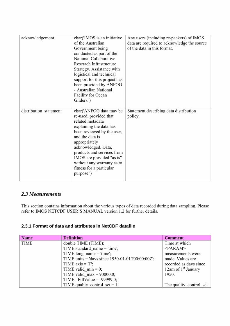
acknowledgement
char('IMOS is an initiative of the Australian Government being conducted as part of the National Collaborative Reserach Infrastructure Strategy. Assistance with logistical and technical support for this project has been provided by ANFOG - Australian National Facility for Ocean Gliders.')
Any users (including re-packers) of IMOS data are required to acknowledge the source of the data in this format.
distribution_statement
char('ANFOG data may be re-used, provided that related metadata explaining the data has been reviewed by the user, and the data is appropriately acknowledged. Data, products and services from IMOS are provided "as is" without any warranty as to fitness for a particular purpose.')
Statement describing data distribution policy.
2.3 Measurements This section contains information about the various types of data recorded during data sampling. Please refer to IMOS NETCDF USER’S MANUAL version 1.2 for further details.
2.3.1 Format of data and attributes in NetCDF datafile Name Definition Comment TIME double TIME (TIME);
TIME.standard_name = 'time'; TIME.long_name = 'time'; TIME.units = 'days since 1950-01-01T00:00:00Z'; TIME.axis = 'T'; TIME.valid_min = 0; TIME.valid_max = 90000.0; TIME._FillValue = -99999.0; TIME.quality_control_set = 1;
Time at which <PARAM> measurements were made. Values are recorded as days since 12am of 1st January 1950. The quality_control_set
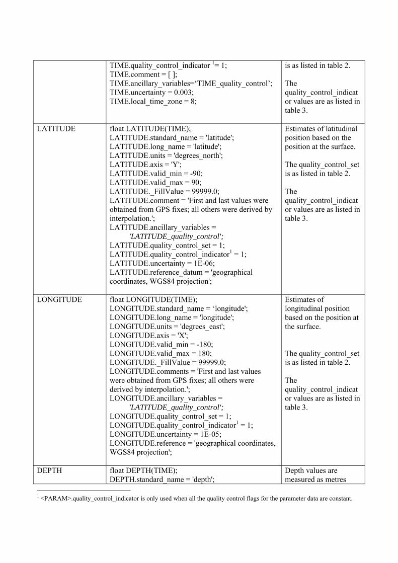
TIME.quality_control_indicator 1= 1; TIME.comment = [ ]; TIME.ancillary_variables=‘TIME_quality_control’; TIME.uncertainty = 0.003; TIME.local_time_zone = 8;
is as listed in table 2. The quality_control_indicator values are as listed in table 3.
LATITUDE float LATITUDE(TIME); LATITUDE.standard_name = 'latitude'; LATITUDE.long_name = 'latitude'; LATITUDE.units = 'degrees_north'; LATITUDE.axis = 'Y'; LATITUDE.valid_min = -90; LATITUDE.valid_max = 90; LATITUDE._FillValue = 99999.0; LATITUDE.comment = 'First and last values were obtained from GPS fixes; all others were derived by interpolation.'; LATITUDE.ancillary_variables = 'LATITUDE_quality_control'; LATITUDE.quality_control_set = 1; LATITUDE.quality_control_indicator1 = 1; LATITUDE.uncertainty = 1E-06; LATITUDE.reference_datum = 'geographical coordinates, WGS84 projection';
Estimates of latitudinal position based on the position at the surface. The quality_control_set is as listed in table 2. The quality_control_indicator values are as listed in table 3.
LONGITUDE float LONGITUDE(TIME); LONGITUDE.standard_name = ‘longitude'; LONGITUDE.long_name = 'longitude'; LONGITUDE.units = 'degrees_east'; LONGITUDE.axis = 'X'; LONGITUDE.valid_min = -180; LONGITUDE.valid_max = 180; LONGITUDE._FillValue = 99999.0; LONGITUDE.comments = 'First and last values were obtained from GPS fixes; all others were derived by interpolation.'; LONGITUDE.ancillary_variables = 'LATITUDE_quality_control'; LONGITUDE.quality_control_set = 1; LONGITUDE.quality_control_indicator1 = 1; LONGITUDE.uncertainty = 1E-05; LONGITUDE.reference = 'geographical coordinates, WGS84 projection';
Estimates of longitudinal position based on the position at the surface. The quality_control_set is as listed in table 2. The quality_control_indicator values are as listed in table 3.
DEPTH float DEPTH(TIME); DEPTH.standard_name = 'depth';
Depth values are measured as metres
1 <PARAM>.quality_control_indicator is only used when all the quality control flags for the parameter data are constant.
DEPTH.long_name = 'depth below sea-surface'; DEPTH.units = 'metres'; DEPTH.axis = 'Z'; DEPTH.positive = 'down'; DEPTH.valid_min = 0; DEPTH.valid_max = 1200; DEPTH._FillValue = 99999.0; DEPTH.QC_set = 1; DEPTH.QC_indicator1 = 1; DEPTH.uncertainty = 0.01; DEPTH.reference = 'sea-surface';
downward from the sea surface. The quality_control_set is as listed in table 2. The quality_control_indicator values are as listed in table 3.
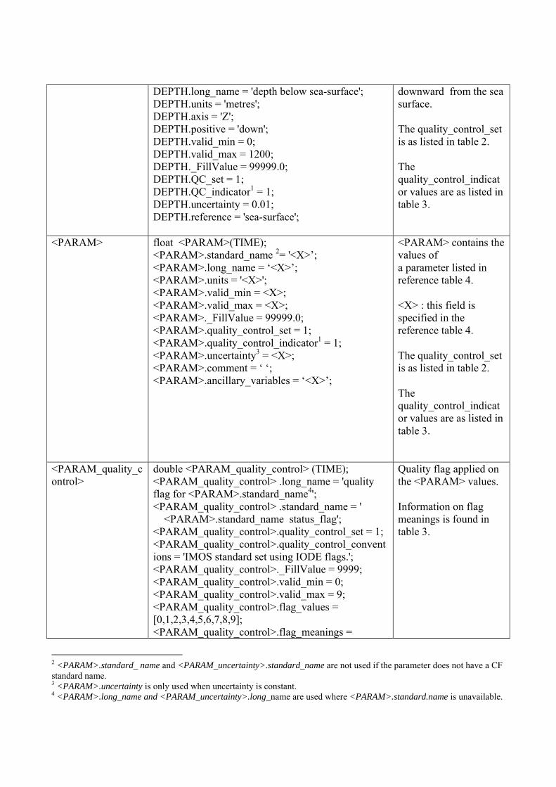
<PARAM> float <PARAM>(TIME); <PARAM>.standard_name 2= '<X>’; <PARAM>.long_name = ‘<X>’; <PARAM>.units = '<X>'; <PARAM>.valid_min = <X>; <PARAM>.valid_max = <X>; <PARAM>._FillValue = 99999.0; <PARAM>.quality_control_set = 1; <PARAM>.quality_control_indicator1 = 1; <PARAM>.uncertainty3 = <X>; <PARAM>.comment = ‘ ‘; <PARAM>.ancillary_variables = ‘<X>’;
<PARAM> contains the values of a parameter listed in reference table 4. <X> : this field is specified in the reference table 4. The quality_control_set is as listed in table 2. The quality_control_indicator values are as listed in table 3.
<PARAM_quality_control>
double <PARAM_quality_control> (TIME); <PARAM_quality_control> .long_name = 'quality flag for <PARAM>.standard_name4'; <PARAM_quality_control> .standard_name = ' <PARAM>.standard_name status_flag'; <PARAM_quality_control>.quality_control_set = 1; <PARAM_quality_control>.quality_control_conventions = 'IMOS standard set using IODE flags.'; <PARAM_quality_control>._FillValue = 9999; <PARAM_quality_control>.valid_min = 0; <PARAM_quality_control>.valid_max = 9; <PARAM_quality_control>.flag_values = [0,1,2,3,4,5,6,7,8,9]; <PARAM_quality_control>.flag_meanings =
Quality flag applied on the <PARAM> values. Information on flag meanings is found in table 3.
2 <PARAM>.standard_ name and <PARAM_uncertainty>.standard_name are not used if the parameter does not have a CF standard name. 3 <PARAM>.uncertainty is only used when uncertainty is constant. 4 <PARAM>.long_name and <PARAM_uncertainty>.long_name are used where <PARAM>.standard.name is unavailable.
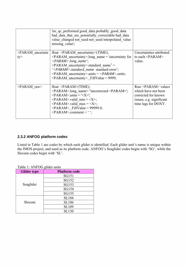
'no_qc_performed good_data probably_good_data bad_data_that_are_potentially_correctable bad_data value_changed not_used not_used interpolated_value missing_value';
<PARAM_uncertainty>
float <PARAM_uncertainty>(TIME); <PARAM_uncertainty>.long_name = 'uncertainty for <PARAM>.long_name’; <PARAM_uncertainty>.standard_name1 = ‘<PARAM>.standard_name standard error’; <PARAM_uncertainty>.units = <PARAM>.units; <PARAM_uncertainty>._FillValue = 9999;
Uncertainties attributed to each <PARAM> value.
<PARAM_raw> float <PARAM>(TIME); <PARAM>.long_name= ''uncorrected <PARAM>'; <PARAM>.units = '<X>'; <PARAM>.valid_min = <X>; <PARAM>.valid_max = <X>; <PARAM>._FillValue = 99999.0; <PARAM>.comment = ‘ ‘;
Raw <PARAM> values which have not been corrected for known issues, e.g. significant time lags for DOXY.
2.3.2 ANFOG platform codes
Listed in Table 1 are codes by which each glider is identified. Each glider unit’s name is unique within the IMOS project, and used as its platform code. ANFOG’s Seaglider codes begin with ‘SG’, while the Slocum codes begin with ‘SL’.
Table 1: ANFOG glider units
Glider type Platform code
Seaglider
SG151 SG152 SG153 SG154 SG155
Slocum
SL104 SL106 SL109 SL130
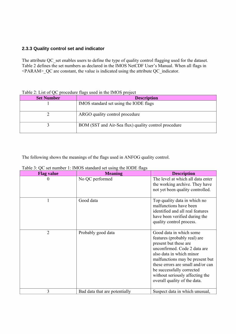
2.3.3 Quality control set and indicator The attribute QC_set enables users to define the type of quality control flagging used for the dataset. Table 2 defines the set numbers as declared in the IMOS NetCDF User’s Manual. When all flags in <PARAM>_QC are constant, the value is indicated using the attribute QC_indicator. Table 2: List of QC procedure flags used in the IMOS project
Set Number Description 1 IMOS standard set using the IODE flags
2 ARGO quality control procedure
3 BOM (SST and Air-Sea flux) quality control procedure
The following shows the meanings of the flags used in ANFOG quality control. Table 3: QC set number 1: IMOS standard set using the IODE flags
Flag value Meaning Description 0 No QC performed The level at which all data enter
the working archive. They have not yet been quality controlled.
1 Good data Top quality data in which no malfunctions have been identified and all real features have been verified during the quality control process.
2 Probably good data Good data in which some features (probably real) are present but these are unconfirmed. Code 2 data are also data in which minor malfunctions may be present but these errors are small and/or can be successfully corrected without seriously affecting the overall quality of the data.
3 Bad data that are potentially Suspect data in which unusual,
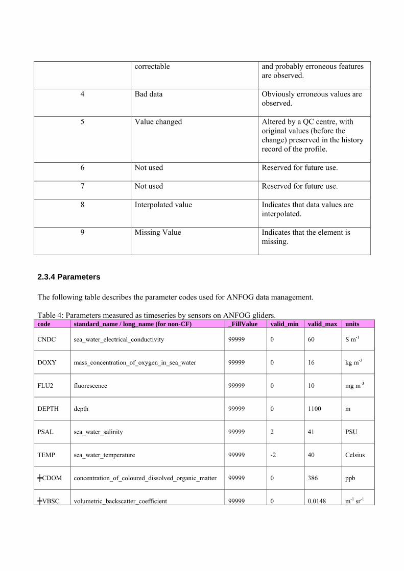
correctable and probably erroneous features are observed.
4 Bad data Obviously erroneous values are observed.
5 Value changed Altered by a QC centre, with original values (before the change) preserved in the history record of the profile.
6 Not used Reserved for future use.
7 Not used Reserved for future use.
8 Interpolated value Indicates that data values are interpolated.
9 Missing Value Indicates that the element is missing.
2.3.4 Parameters The following table describes the parameter codes used for ANFOG data management. Table 4: Parameters measured as timeseries by sensors on ANFOG gliders. code standard_name / long_name (for non-CF) _FillValue valid_min valid_max units CNDC
sea_water_electrical_conductivity
99999
0
60
S m-1
DOXY
mass_concentration_of_oxygen_in_sea_water
99999
0
16
kg m-3
FLU2
fluorescence
99999
0
10
mg m-3
DEPTH
depth
99999
0
1100
m
PSAL
sea_water_salinity
99999
2
41
PSU
TEMP
sea_water_temperature
99999
-2
40
Celsius
╪CDOM
concentration_of_coloured_dissolved_organic_matter
99999
0
386
ppb
╪VBSC
volumetric_backscatter_coefficient
99999
0
0.0148
m-1 sr-1
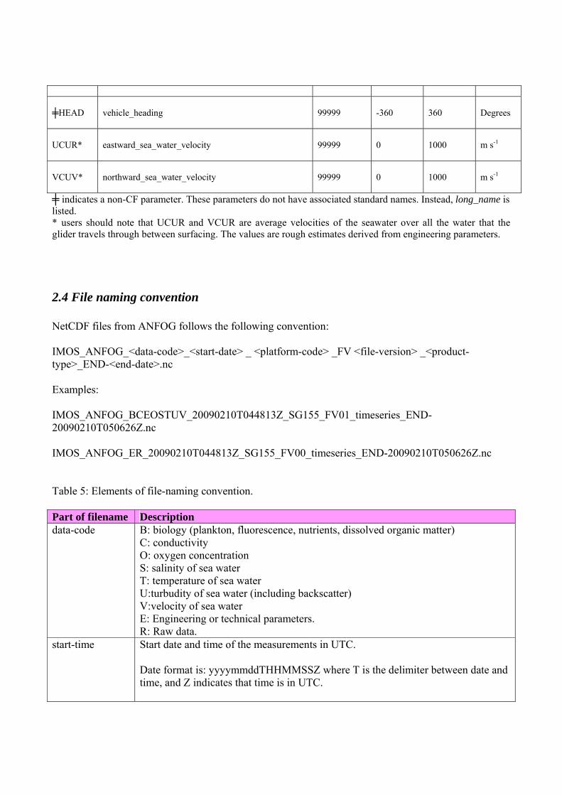
╪HEAD
vehicle_heading
99999
-360
360
Degrees
UCUR*
eastward_sea_water_velocity
99999
0
1000
m s-1
VCUV*
northward_sea_water_velocity
99999
0
1000
m s-1
╪ indicates a non-CF parameter. These parameters do not have associated standard names. Instead, long_name is listed. * users should note that UCUR and VCUR are average velocities of the seawater over all the water that the glider travels through between surfacing. The values are rough estimates derived from engineering parameters.
2.4 File naming convention NetCDF files from ANFOG follows the following convention: IMOS_ANFOG_<data-code>_<start-date> _ <platform-code> _FV <file-version> _<product-type>_END-<end-date>.nc Examples: IMOS_ANFOG_BCEOSTUV_20090210T044813Z_SG155_FV01_timeseries_END-20090210T050626Z.nc IMOS_ANFOG_ER_20090210T044813Z_SG155_FV00_timeseries_END-20090210T050626Z.nc Table 5: Elements of file-naming convention. Part of filename Description data-code B: biology (plankton, fluorescence, nutrients, dissolved organic matter)
C: conductivity O: oxygen concentration S: salinity of sea water T: temperature of sea water U:turbudity of sea water (including backscatter) V:velocity of sea water E: Engineering or technical parameters. R: Raw data.
start-time Start date and time of the measurements in UTC. Date format is: yyyymmddTHHMMSSZ where T is the delimiter between date and time, and Z indicates that time is in UTC.
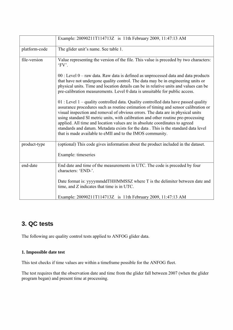
Example: 20090211T114713Z is 11th February 2009, 11:47:13 AM
platform-code The glider unit’s name. See table 1.
file-version Value representing the version of the file. This value is preceded by two characters: ‘FV’. 00 : Level 0 – raw data. Raw data is defined as unprocessed data and data products that have not undergone quality control. The data may be in engineering units or physical units. Time and location details can be in relative units and values can be pre-calibration measurements. Level 0 data is unsuitable for public access. 01 : Level 1 – quality controlled data. Quality controlled data have passed quality assurance procedures such as routine estimation of timing and sensor calibration or visual inspection and removal of obvious errors. The data are in physical units using standard SI metric units, with calibration and other routine pre-processing applied. All time and location values are in absolute coordinates to agreed standards and datum. Metadata exists for the data . This is the standard data level that is made available to eMII and to the IMOS community.
product-type (optional) This code gives information about the product included in the dataset. Example: timeseries
end-date End date and time of the measurements in UTC. The code is preceded by four characters: ‘END-’. Date format is: yyyymmddTHHMMSSZ where T is the delimiter between date and time, and Z indicates that time is in UTC. Example: 20090211T114713Z is 11th February 2009, 11:47:13 AM
Code Description
3. QC tests The following are quality control tests applied to ANFOG glider data. 1. Impossible date test This test checks if time values are within a timeframe possible for the ANFOG fleet. The test requires that the observation date and time from the glider fall between 2007 (when the glider program began) and present time at processing.
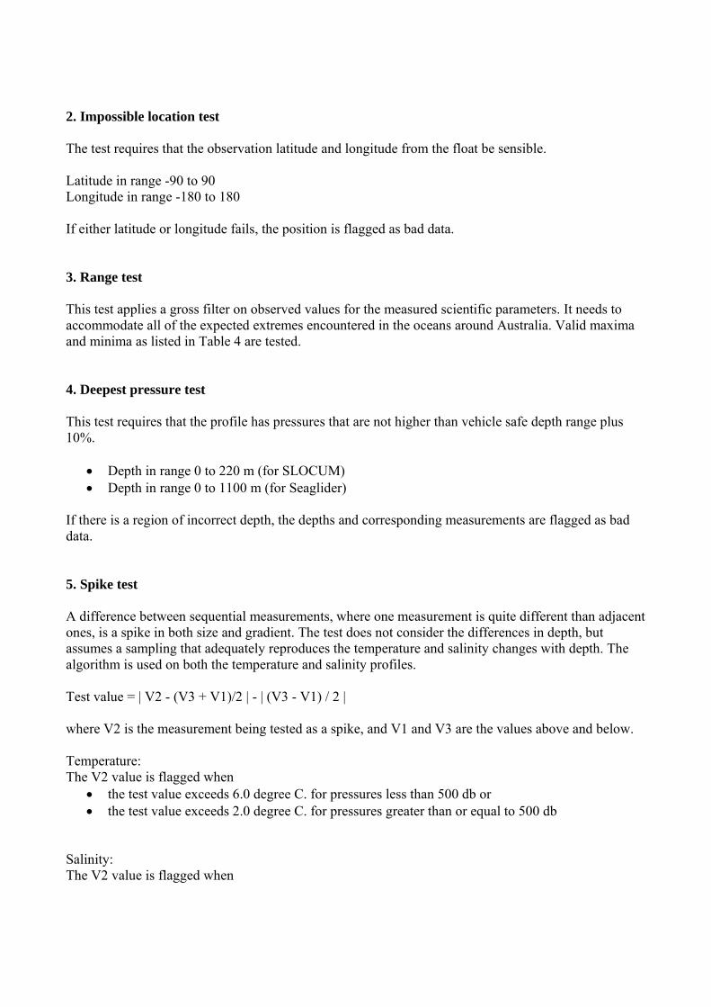
2. Impossible location test The test requires that the observation latitude and longitude from the float be sensible. Latitude in range -90 to 90 Longitude in range -180 to 180 If either latitude or longitude fails, the position is flagged as bad data. 3. Range test This test applies a gross filter on observed values for the measured scientific parameters. It needs to accommodate all of the expected extremes encountered in the oceans around Australia. Valid maxima and minima as listed in Table 4 are tested. 4. Deepest pressure test This test requires that the profile has pressures that are not higher than vehicle safe depth range plus 10%.
• Depth in range 0 to 220 m (for SLOCUM) • Depth in range 0 to 1100 m (for Seaglider)
If there is a region of incorrect depth, the depths and corresponding measurements are flagged as bad data. 5. Spike test A difference between sequential measurements, where one measurement is quite different than adjacent ones, is a spike in both size and gradient. The test does not consider the differences in depth, but assumes a sampling that adequately reproduces the temperature and salinity changes with depth. The algorithm is used on both the temperature and salinity profiles. Test value = | V2 - (V3 + V1)/2 | - | (V3 - V1) / 2 | where V2 is the measurement being tested as a spike, and V1 and V3 are the values above and below. Temperature: The V2 value is flagged when
• the test value exceeds 6.0 degree C. for pressures less than 500 db or • the test value exceeds 2.0 degree C. for pressures greater than or equal to 500 db
Salinity: The V2 value is flagged when
• the test value exceeds 0.9 PSU for pressures less than 500 db or • the test value exceeds 0.3 PSU for pressures greater than or equal to 500 db
Dissolved Oxygen**: The V2 value is flagged when
• the test value exceeds 4 kg m-3 Fluorescence**: The V2 value is flagged when
• the test value exceeds 1.1 mg m-3 Coloured dissolved organic matter**: The V2 value is flagged when
• the test value exceeds 1 ppb Volumetric backscatter coefficient**:
• the test value exceeds 2e-3 m-1 sr-1 ** These test limits may be adjusted to better suit the sampling frequency for a particular mission. 6. Gradient test This test is failed when the difference between vertically adjacent measurements is too steep. The test does not consider the differences in depth, but assumes a sampling that adequately reproduces the temperature and salinity changes with depth. The algorithm is used on both the temperature and salinity profiles. Test value = | V2 - (V3 + V1)/2 | where V2 is the measurement being tested as a spike, and V1 and V3 are the values above and below. Temperature: The V2 value is flagged when
• the test value exceeds 9.0 degree C for pressures less than 500 db or • the test value exceeds 3.0 degree C. for pressures greater than or equal to 500 db
Salinity: The V2 value is flagged when
• the test value exceeds 1.5 PSU for pressures less than 500 db or • the test value exceeds 0.5 PSU for pressures greater than or equal to 500 db
7. Visual QC Subjective visual inspection of data values by an operator. To avoid delays, this test is not mandatory before real-time distribution. Examples of conditions where additional QC is applied:
• glider out of the water • glider sitting in the seabed • noise experienced due to bio-fouling or other reasons
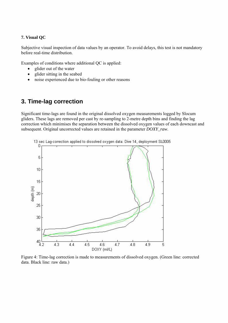
3. Time-lag correction Significant time-lags are found in the original dissolved oxygen measurements logged by Slocum gliders. These lags are removed per cast by re-sampling to 2-metre depth bins and finding the lag correction which minimises the separation between the dissolved oxygen values of each downcast and subsequent. Original uncorrected values are retained in the parameter DOXY_raw.
Figure 4: Time-lag correction is made to measurements of dissolved oxygen. (Green line: corrected data. Black line: raw data.)
Appendix: Uncertainty Values The CTD data is derived in both cases from a Seabird Inc. CTD. The CTD will be calibrated on an annual schedule. Seaglider (SBE41 + SBE43 dissolved oxygen sensor + BBFL2-VMT optical) Temperature: ± 0.002 + 0.002°C (95% c.i.) Pressure: ± 1 dBar (0.1% 0f 1000m range = 1 dBar) Conductivity: ± 0.0003 S/m + 0.004 S/m per annum (95% c.i.) Dissolved Ox ± 2% + 2% per 1000 hours Fluorescence: ± 1.5% over the first year CDOM: ± 1.5% over the first year Turbidity: ± 1.5% over the first year Surface Location: Uc < 10m radius (95%) (GPS) Slocum (SBE41 + Aanderaa optode dissolved oxygen sensor + BBFL2-SLO optical) Temperature: ± 0.002 °C + 0.002 °C (95% c.i.) Pressure: ± 0.5 dBar (0.1% 0f 350m range = 0.4 dBar) Conductivity: ± 0.0003 S/m + 0.004 S/m per annum (95% c.i.) Dissolved Ox ± 8uM/kg or 5% whichever greater Fluorescence: ± 1.5% over the first year CDOM: ± 1.5% over the first year Turbidity: ± 1.5% over the first year Surface Location: Uc < 10m radius (95%) (GPS) The sensors on the gliders will be calibrated on an annual cycle. The Seaglider sensors will be serviced and recalibrated during the mandated re-batterying process at the manufacturer’s premises. Recalibration of the Slocum sensors will be carried out either at Seabird or at an independent facility.
Related Documents