01-06-2015 FIG Working Week 2015 1 MANAGING FLOOD DISASTERS IN NIGERIAN CITIES: ISSUES MANAGING FLOOD DISASTERS IN NIGERIAN CITIES: ISSUES MANAGING FLOOD DISASTERS IN NIGERIAN CITIES: ISSUES MANAGING FLOOD DISASTERS IN NIGERIAN CITIES: ISSUES AND STRATEGIES TOWARDS MEETING THE CHALLENGES IN AND STRATEGIES TOWARDS MEETING THE CHALLENGES IN AND STRATEGIES TOWARDS MEETING THE CHALLENGES IN AND STRATEGIES TOWARDS MEETING THE CHALLENGES IN THE MODERN WORLD. THE MODERN WORLD. THE MODERN WORLD. THE MODERN WORLD. (A CASE STUDY OF OWERRI METROPOLIS IMO STATE (A CASE STUDY OF OWERRI METROPOLIS IMO STATE (A CASE STUDY OF OWERRI METROPOLIS IMO STATE (A CASE STUDY OF OWERRI METROPOLIS IMO STATE NIGERIA) NIGERIA) NIGERIA) NIGERIA) Augustine Chukwuma EMERIBEOLE, Nigeria Augustine Chukwuma EMERIBEOLE, Nigeria Augustine Chukwuma EMERIBEOLE, Nigeria Augustine Chukwuma EMERIBEOLE, Nigeria SUMMARY Floods are among the most devastating natural disasters in the world, claiming more lives and causing more property damage than anyone would imagine. In Nigeria, though not leading in terms of claiming lives, flood affects and displaces more people than any other disaster; it also causes more damage to properties. At least 20 per cent of the population is at risk from one form of flooding or another. More often, sovereign states and national governments adopt remedial reaction, that is, a post-disaster reaction where relief materials are supplied to the affected victims. The paper emphasizes on prevention/mitigation than post-disaster measure. Causes of flooding in Nigeria and by extension Owerri the capital city of Imo State, Nigeria are discussed. The approach in this study also attempt to describe the application of remote sensing and GIS in an environmental issue such as flooding in a developing country. A database was created using both cartographic and attributes data collected from these and other sources. Spatial analyses were carried out using ArcGIS Desktop 10.1 and its Arc Hydro extension. In Nigeria, flood disaster has Contd.

Welcome message from author
This document is posted to help you gain knowledge. Please leave a comment to let me know what you think about it! Share it to your friends and learn new things together.
Transcript

01-06-2015
FIG Working Week 2015 1
MANAGING FLOOD DISASTERS IN NIGERIAN CITIES: ISSUES MANAGING FLOOD DISASTERS IN NIGERIAN CITIES: ISSUES MANAGING FLOOD DISASTERS IN NIGERIAN CITIES: ISSUES MANAGING FLOOD DISASTERS IN NIGERIAN CITIES: ISSUES AND STRATEGIES TOWARDS MEETING THE CHALLENGES IN AND STRATEGIES TOWARDS MEETING THE CHALLENGES IN AND STRATEGIES TOWARDS MEETING THE CHALLENGES IN AND STRATEGIES TOWARDS MEETING THE CHALLENGES IN THE MODERN WORLD.THE MODERN WORLD.THE MODERN WORLD.THE MODERN WORLD.(A CASE STUDY OF OWERRI METROPOLIS IMO STATE (A CASE STUDY OF OWERRI METROPOLIS IMO STATE (A CASE STUDY OF OWERRI METROPOLIS IMO STATE (A CASE STUDY OF OWERRI METROPOLIS IMO STATE NIGERIA)NIGERIA)NIGERIA)NIGERIA)
Augustine Chukwuma EMERIBEOLE, NigeriaAugustine Chukwuma EMERIBEOLE, NigeriaAugustine Chukwuma EMERIBEOLE, NigeriaAugustine Chukwuma EMERIBEOLE, Nigeria
SUMMARY
Floods are among the most devastating natural disasters in the world, claiming more lives andcausing more property damage than anyone would imagine. In Nigeria, though not leading in termsof claiming lives, flood affects and displaces more people than any other disaster; it also causesmore damage to properties. At least 20 per cent of the population is at risk from one form offlooding or another. More often, sovereign states and national governments adopt remedialreaction, that is, a post-disaster reaction where relief materials are supplied to the affected victims.The paper emphasizes on prevention/mitigation than post-disaster measure. Causes of flooding inNigeria and by extension Owerri the capital city of Imo State, Nigeria are discussed. The approachin this study also attempt to describe the application of remote sensing and GIS in anenvironmental issue such as flooding in a developing country. A database was created using bothcartographic and attributes data collected from these and other sources. Spatial analyses werecarried out using ArcGIS Desktop 10.1 and its Arc Hydro extension. In Nigeria, flood disaster has
Contd.

01-06-2015
FIG Working Week 2015 2
been perilous to people, communities and institutions. Between July and October 2012, flooding inNigeria pushed rivers over their banks and submerged hundreds of thousands of acres of farmlands.By mid-October, the floods had forced 1.3 million people from their homes and claimed 431 lives,according to Nigeria’s National Emergency Management Agency (NEMA) Oguta LGA andOhaji/Ebgema LGA in Imo State were among the areas that were affected by the said floods. Itshattered both the built-environment and the undeveloped areas. One prominent feature about floodis that it does not discriminate, but marginalizes whosoever refuses to prepare for its occurrence. Theresults obtained in this study implicated that dumpsites within the river channel as well as structuraldevelopment within the floodplain and high amount of rainfall are the major causes of inundation inthe city, especially, in the wet season. The study concludedthat the use of geoinformationtechnology, if well implemented, would provide adequate decision support information to plannersand decision makers. Recommendations are made toward flooddisaster management in Owerrimetropolis.
Keywords: Flood disaster, mitigation, awareness, GIS, Owerri Metropolis
1. INTRODUCTION
There is no doubt that the world is under serious threat from the environment: From China to Mexico,Indonesia, United States of America, United Kingdom and Nigeria, analysts have argued that theenvironment was only responding to the abuses heaped on it byman’s activities (Christopherson, 1997p.423). The concern is that the world may be getting close to extinction through natural disasters unlessimmediate actions are taken; and the signs are just too apparent to be ignored (Christopherson, 1997 andOyegbile, 2008). Specifically, in May 2008, floods triggered by torrential rains killed dozens of peopleacross China, while thousands of others were victims of landslides caused by the downpours. China isnot alone. In the United States of America, the Mississippi River caused damages put at several millionsof dollars when it over flew its banks, flooding some cities,towns, farmlands and major industrialinstallations over a distance of about 250km and ravaging Iowa before it heaped downstream. Apart fromthe Mississippi-Missouri River Systems of 1993, and that of1995, world records of flood have it thatrecently severe floods were experienced in Norway, China, Bangladesh, Ghana, The Netherlands andSouth Florida, (Christopherson, 1997). In February 2000, acyclone swept across Mozambique which leftsome 950,000 people homeless as floods devastated huge areas of low-laying lands. Roads, homes,bridges and crops were destroyed. Journalist, Greg Barrow,as quoted by Kerski and Ross 2000, flewover the striking area and filed this report for BBC, London,United Kingdom. It is over 14 million
Contd.

01-06-2015
FIG Working Week 2015 3
Indians that were victims to the flood of August 2007 in Sathya Sai Baba, a major human settlement, ofthat region. The nation’s government could not organize anyemergency relief immediately. Rather, it spentover $1.6 billion on Hawk Jets. Hunger and diseases stalked the India children and the poor in the region.In a similar writing, Wright (2011) reports the devastatingflood of Lahore, Pakistan in July 2011 wheretransportation systems were halted and businesses were closed down for days.With increase in constructions along rivers and concentration of population around submergible areas, theflood-induced damages are increasing. The complete flood protection with installation of great floodcontrol structures like flood dams are not justified due to its high cost. It is not environmentally, sociallyand economically an optimum idea either. For this reason, the flood forecasting system can have aconsiderable role in flood management through logical utilization of weir gates and dam reservoirs. In thisdirection, different systems have been innovated in different countries around the world (Williams, 1994;Xiaoliu, 2000).Preventing river floods is important to prevent probable loss of life and to reduce damage to sites of higheconomic importance. Floods occur when soil becomes saturated and its infiltration capacity is zero;runoffs cannot be contained in stream channels, natural ponds and constructed reservoirs, and the landsurface becomes submerged, sweeping away all its content. Periodic floods, resulting during heavy rains,occur naturally on many rivers, forming an area known as the flood plain. The river floods often cause therivers to overflow
Contd.
their banks, sometimes with a velocity and enormously destructive surge. History has also recorded thatflood disaster is not recent, and its destruction are sometimes enormous. For instance, the Johnston flood ofMay 31, 1889 in Johnston, Pennsylvania, USA left about two third of Johnstown submerged under water,its rail and telegraph lines washed out.In Nigeria, apart from the Ogunpa Stream in Ibadan that killed several people and completely groundedsocio-economic activities in 1980. In August 2008, the residents of Makurdi were thrown out of theirresidences and their farmlands left impoverished after twodays of heavy down pour of rainfall. It wasdescribed as very disastrous, (Taiwo, 2008).Occurrences of floods in the cities and towns of Nigeria in recent times have been a great concern andchallenge to the people, Governments and researchers, (Akintola, 1982, Aderogba, 2012 and Aderogba etal., 2012). There have been journalistic and non-quantitative reports of flood for several parts of Nigeria.But they are superficial and lack directions for professionals and policy makers (Aderogba, 2011). Theworks of Adeaga (2008), Oyegbile (2008) and Oyebande (1990 and 2005) are paraphrasing, disjointed orsectional. The flood events in most southern cities in Nigeria are so prominent that some inhabitants inmany of these settlements have often described it as ‘an act of God’.
Contd.

01-06-2015
FIG Working Week 2015 4
However, flood events in many capital cities in Nigeria, aremostly due to the poor consciousness of theinhabitants on environmental information, inadequate (orsometimes absolute lack) of spatial informationon the flood prone areas, waste dump and construction of buildings (both commercial and residential,even public offices) on river channel without adequate measure for water flow.On the other hand, floods are natural returning hydrological phenomena that affect human lives. Hazardsof flash floods, chiefly in urban regions, are vital from both human settlement and economicalperspectives. Recently, the estimation of flood hazardousimpacts and the development of GIS-basedflood inundation maps have been considered a crucial demand. (Khalid A. AL-GHAMDI et al.,2012)
Fig. 1. The causes of floods and flood-intensifying conditionsSources: Pickering and Owen (1995) in M.O. Ibitoye (2006)
01-06-2015
FIG Working Week 2015 5
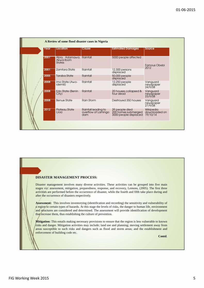
Year Location Cause Estimated Damages Source
2001 Abia, Adamawa,Akwa-IbomStates
Rainfall 5000 people affected
Famous Obebi 2012
2001 Zamfara State Rainfall 12,300 persons displaced
2005 Taraba State Rainfall 50,000 people displaced
2008 Imo State (Awo-idemili)
Rainfall 12,250 people displaced
Vanguardnewspaper 24/9/08
2008 Edo State (Benin City)
Rainfall 20 houses collapsed & four dead
Vanguard newspaper 23/9/08
2008 Benue State Rain Storm Destroyed 350 houses Vanguard newspaper 27/9/08
2012 Plateau State (Jos)
Rainfall leading to overflow of Lamingodam
39 people died 200 homes submerged 3000 people displaced
Wikipedia downloaded on 19/10/14
A Review of some flood disaster cases in Nigeria
DISASTER MANAGEMENT PROCESS:
Disaster management involves many diverse activities. These activities can be grouped into five mainstages viz: assessment, mitigation, preparedness, response, and recovery, Lemons, (2005). The first threeactivities are performed before the occurrence of disaster, while the fourth and fifth take place during andafter the occurrence of disasters respectively.
Assessment: This involves inventorying (identification and recording) the sensitivity and vulnerability ofa region to certain types of hazards. At this stage the levelsof risks, the danger to human life, environmentand structures are considered and determined. The assessment will provide identification of developmentthat increase them, thus establishing the culture of prevention.
Mitigation: This entails making necessary provisions to ensure that theregion is less vulnerable to knownrisks and danger. Mitigation activities may include; land use and planning; moving settlement away fromareas susceptible to such risks and dangers such as flood andstorm areas; and the establishment andenforcement of building code etc.
Contd.

01-06-2015
FIG Working Week 2015 6
Preparedness: This involves planning of emergency aid, development of scenarios and monitoringsystems, and establishment of early warning system, publicinformation and awareness of likelyhazards, community involvement in disaster management programmes, establishment of disastermanagement and reduction at local, state and national levels and establishment of propercommunication channels.
Response: This happens after the occurrence of the disaster which would have caused untold humansuffering and damages to the environment. At this stage rescue teams will attempt to save lives, injuredpeople will be cured and nursed and relief will be supplied totraumatized survivors. This is the mostsensational stage of disaster reduction and management system.
Recovery: This stage involves assessment of damages, rehabilitation, cleaning of the environment andsocial and economic reconstruction. It also entails the first three stages of disaster management processviz; assessment, mitigation and preparedness, all of whichare central to strategic development aimed atpreventing or minimizing the effect of future disasters.
2.0 STUDY AREA
This study area is Owerri Municipal, the capital of Imo State. It is located in the South-Easterngeopolitical zone of Nigeria. The native language is Igbo itlies between Latitudes 5024’N and 5033’Nand Longitudes 6058’E and 7006’E. Owerri municipal is found in the tropical rainforest region ofNigeria. It is according to (NEST 1991) the natural rainforest (Riparian forest and Low land forest). Thecity is drained mainly by River Nwaorie and River Otamiri andtheir tributary streams. Like most townsin Nigeria, it experiences two distinct climatic seasons; namely dry (October to March) and wet (April toSeptember) seasons. A period of cold, dry, dusty winds knownas “Harmattan” occurs from December toFebruary annually. Owerri has a mean temperature range between 240C to 340C with a relative humidityof 70% in dry months and 90% in wet months. With a projected 2010 population of 610,211 people(NPC, 2007) unevenly distributed over a total land area of 57.966783km2. A well-developed network ofmajor roads, access roads and streets also exist in the town.This assemblage of infrastructure makesOwerri the hub of economic and industrial activities generating different types of solid wastes. With theupsurge in the number of institutions, volume of activities, and in fact, the increasing trend in migrationfrom surrounding rural communities towards Owerri.

01-06-2015
FIG Working Week 2015 7
Fig. 2 Study AreaSource: Boundaries of State and L.G.A’s clipped from the Admin Map of Nigeria obtained fromThe Office of the Surveyor General of the Federation (OSGOF)Nigeria.
Fig. 3 Elevations of Owerri MunicipalSOURCE: 20m SPOT5 DEM covering the study area

01-06-2015
FIG Working Week 2015 8
Fig. 4 Annual Rainfall in Owerri Municipal from 2000 to 2008Source: Nigerian Meteorological Agency (NIMET) 2008
3.0 DATA AND METHODOLOGY
A SPOT 5 (2.5m resolution) satellite imagery covering the study area was digitized in the ArcGISDesktop 10.1 environment to extract the road networks, built-up areas, water courses and water bodiesin the area. In addition, geographic coordinates (X, Y, Z) ofsome sites, including road junctions,drainages, culverts and sites of indiscriminate waste disposal along the river channel were collectedusing a handheld GPS. The grid coordinates acquired were converted from geographic grid to UTMstandard coordinates, using GEOCALC software, for universality. Additionally, a 20-meter resolutionDigital Elevation Model (DEM) for the study area was obtained from The Office of the SurveyorGeneral of The federation (OSGOF). The Arc GIS Desktop 10.1,along with the Arc Hydro extension,has been used in this present study to combine all obtainabledata in a unique environment, and todelineate the flow accumulation and subsequently watershed in the study area. The processing phaseincludes: enhancing the satellite imagery, digitizing, unifying the spatial reference frames for alldatasets, performing statistical and spatial analysis; and flood estimation. Analysis and queries werethen permitted on both databases at the same time. In creating the tables however, a relational databasestructure was adopted. Relational database structure is adequately explained by Dale (1995).

01-06-2015
FIG Working Week 2015 9
Fig. 5 Map of Owerri Municipal showing the watershed and risklocationSource: Digitized from the SPOT5 satellite image covering the study area
Fig 6: Diagram representing the data structure format for the studySource: Adopted from A. O. Eludoyin et al.,(2007).Combating Flood Crisis With Geographical information System: An Example From Akure, Southwestern Nigeria 12-14 September 2007, UNESCO Paris

01-06-2015
FIG Working Week 2015 10
4.0 RESULTS AND DISCUSSION
Analysis involved in this study includes map calculation, buffering, and to a lesser extent, processmodelling. Database querying and simple map overlay was also performed. All these were targeted atdisplaying some application of the technology in land planning, especially for decision supportprogrammes. Different scenarios were created using a customised cartographic model for productsgeneration. The essence of the study was to identify the causes of flood, the areas that are at risk aswell as suggesting to the planners and policy makers what must be done to solve the problem createdby the menace of flood in the area study. Simonovic (1993) expressed that flooding of River Red inWinnipeg City, Canada was related to population and structural growth, which obstructed the naturalflow of water runoff in the area. Thus, such flooding could becombated if policy could be enacted todisallow dumping of refuse into the river channels and the invasion of the floodplains withdevelopment structure. The use of a GIS technology will allow areas liable to flood to be demarcated,monitored and protected from misuse. Protection of this area will curb incessant flooding in this area.Further, zones of risk could be identified (Fig. 4) using a GIS technology, and protected by enactmentand enforcement of planning rules other areas of application of the technology in similar experiments
Contd.
and regional applications are many. For example, Kienzle (1993) viewed the application from thedisaster relief issue. An environmental manager well guided with a GIS will have a good knowledge ofthe villages and routes, including other properties and relationships of properties within the disasterzone. Farrisier and Givone (1993) expressed the use of the technology to determine flood risk areas suchas obtained in this study.
It is also necessary to observe that a GIS visualisation capability improves comparison of the spatial andtemporal information useful in flood management. Similarly, Eludoyin (1999) attempted an applicationof GIS in early warning system for impending flood disaster in River Osun floodplain in SouthernOshogbo, Nigeria.
In general, GIS and its complimentary technologies including Remote Sensing and Photogrammetry,Digital Surveying aid researchers, environmental planners and decision makers to collect, store,analyse, manipulate and present informed scenarios of events for informed decisions involving effective,non-structural and environmental friendly ways to make optimal choice of environmental hazardsprevention alternatives.

01-06-2015
FIG Working Week 2015 11
NEED FOR FLOOD DISASTER MANAGEMENT
In view of the frequency and devastating nature of flood disaster worldwide, emphasis is nowbeing shifted from post disaster reaction or response to pre-disaster reaction. This means thatNational Governments are shifting focus from relief (moneyand materials) distribution to flooddisaster victims to prevention and/or mitigations.
This is in response to the United Nations (UN) DECLARATION in1989 which designed 1989 to2000 as international Decade for Natural Disaster Reduction (IDNDR) [Verstapen, 1991, Adeniran,2001]. The intention of the UN is that member countries within the space of ten years should haveput in place:
Assessment of risk posed by environmental hazards (such as flooding) Long term preparedness and prevention plans and Warning systems
The recent decisions of the Federal ministry of Water Resources under the auspices of theHydrological Services Agency (NIHSA) to organize a colloquium in 2012 on flood disaster inNigeria amongst stakeholders on environmental issues is a welcomed development.
Contd.
However, there are tools needed to mitigate flood disaster in Owerri. These are:
Topographical Maps for the terrain configuration Land Use Map for land use pattern and Meteorological map for climate factors such as rainfall, temperature etc.
Topographical MapsTopographical maps on a scales of 1:10,000, 1:5,000 or less are very necessary for a meaningful andresult oriented flood disaster management.If possible to use terrain information from satellite imageries with high resolution. Igbokwe (2005) inthe study of Onitsha used the Nigerian Sat 1 with ground resolution of 32m to update the existingtopographical map.
Land Use MapsMaps that will show land use pattern are very essential toolsfor flood disaster management. This couldbe in either analog or digital form. However, the latter is more preferable.

01-06-2015
FIG Working Week 2015 12
Meteorological DataFloods occur either as a result of high rainfall intensity within a few hours or low rainfallintensity for a longer period (Ward 1978). Other factors such as surface characteristics and themobility of the ground surface to absorb precipitation as rapidly as the rate of rainfall contributeto the degree of flood occurrence.(Ward 1978) says that real time weather information can be readily provided frommeteorological satellites (SMS) a proto-type of the Geostational Environmental Satellites(GOES). Isoyet maps also produce rainfall data (quantity).
6.0 RECOMMENDATIONS
This paper seeks to recommend certain planning and management measures which can be employedto mitigate flooding in Owerri.
Governments should continuously monitor on annual basis offlood areas through satellitemapping of the potential floodplains in order to enable the identification of long term historicalrecord of flood prone areas for prediction and development planning purposes.
Imo State Government in collaboration with the Ministry of Lands, Survey and Urban Planning,Ministry of Agriculture should ensure an up-to-date large scale topographical maps in analog anddigital form.
Governments should establish appropriate number of rainfall stations within each hydrologicalbasin in order to enable the quantification of , not only the effective rainfall intensity and durationwithin the drainage area, but also the spatial and temporal distribution within the catchment area.
Contd.

01-06-2015
FIG Working Week 2015 13
Development of extensive public awareness programmes by the Ministry of Information andOrientation to inform the public about flood hazards. Measures such as:
a) Proper disposal of solid waste and not building structures to the block run-off should be maintained.b) Avoid known flood plains or green belt such as that of Nwaorie and Otamiri rivers for housing projects. Establishment of restrictive development regulations to ensure that any development meets stipulated
standards that take flood hazards into consideration. Timely evacuation of materials scooped from the gutters will help instead of allowing the refuse stay
unattended to which results in pushing back into the gutter when it rains
THANK YOU FOR LISTENING!!!
Related Documents