Arkansas-Red Basin River Forecast Center Operations NWS Wichita Hydrology Seminar Wichita, KS November 9, 2011 James Paul Service Coordination Hydrologist - ABRFC

Welcome message from author
This document is posted to help you gain knowledge. Please leave a comment to let me know what you think about it! Share it to your friends and learn new things together.
Transcript

Arkansas-Red BasinRiver Forecast Center
Operations
NWS Wichita Hydrology SeminarWichita, KS
November 9, 2011James Paul
Service Coordination Hydrologist - ABRFC

National Weather ServiceRiver Forecast Centers
Who We Are
• Department of Commerce• National Oceanic and Atmospheric Administration• National Weather Service
• Arkansas-Red Basin RFC – Tulsa OK• Missouri Basin RFC – Pleasant Hill MO

National Weather ServiceRiver Forecast Centers
Our Mission
• Provide hydrologic services for the protection of life and property• Enhance the national economy• The Official source for river forecasts

NWS River Forecast Centers

NWSWeather Forecast Offices
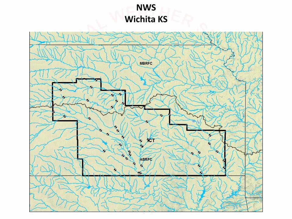
NWSWichita KS

NWSWichita KS

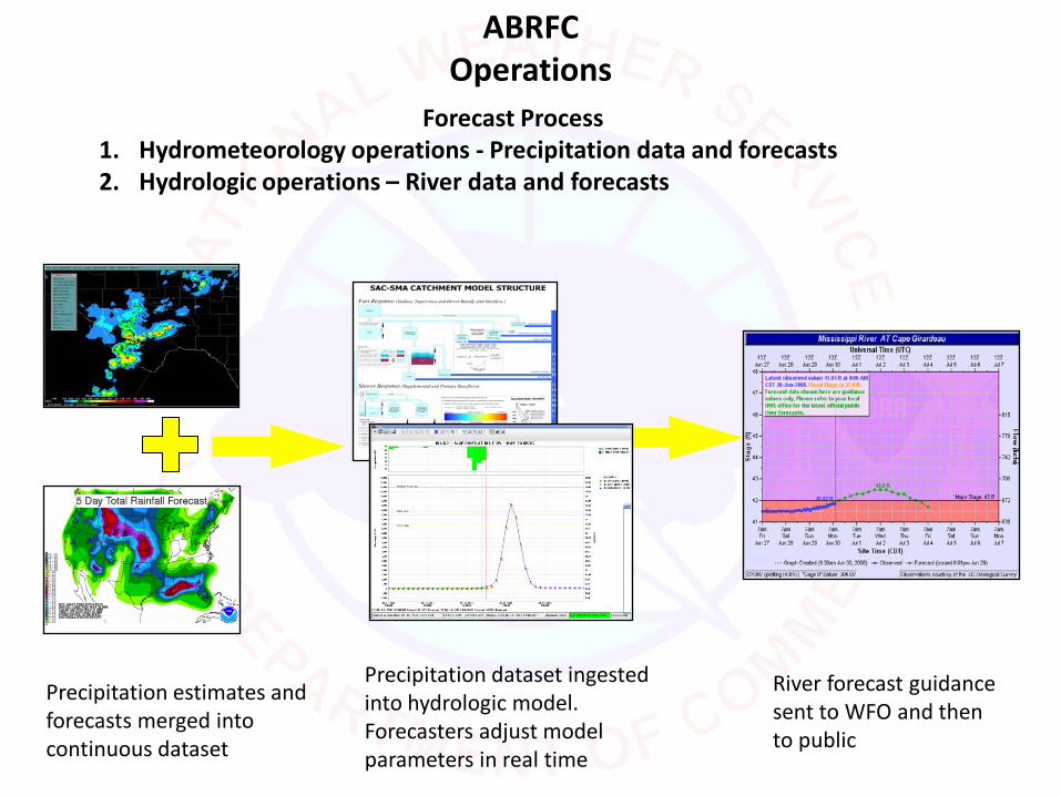
ABRFCOperations
Staffing and Operations• Routinely open from 6AM – 10PM 7 days a week• Open 24 hours during flooding• Typically employ 14-18 hydrologists and hydro-
meteorologists
ABRFCOperations
Forecast Process1. Hydrometeorology operations - Precipitation data and forecasts2. Hydrologic operations – River data and forecasts
Precipitation estimates and forecasts merged into continuous dataset
Precipitation dataset ingested into hydrologic model. Forecasters adjust model parameters in real time
River forecast guidance sent to WFO and then to public

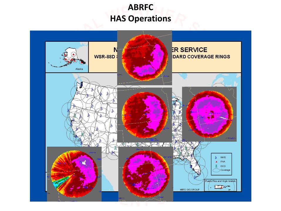
ABRFC HAS Operations
Hydrometeorology OperationsHAS Unit
(Hydro-meteorological Analysis and Support)
• HAS Unit – 3 forecasters• Create meteorological forcing fields for input into
hydrologic model (T, QPE, QPF)• Best estimates of past precipitation• Forecast precipitation
• Data QC• Text and graphical products (HMD)• Weather briefings and discussions – in house and
with NWS WFOs and public partners

ABRFCHAS Operations
Multi-SensorQuantitative Precipitation Estimates
(QPE)
• Hourly• 4km x 4km grid• QC of inputs

ABRFCHAS Operations
ABRFCHAS Operations

ABRFCHAS Operations
Quantitative Precipitation Estimates(QPE)
Hourly:http://www.srh.noaa.gov/ridge2/RFC_Precip/
Daily:http://water.weather.gov/precip/


ABRFCHAS Operations
Hydrometeorology OperationsQuantitative Precipitation Forecast
(QPF)• 4km x 4km grid• 6 hourly (00, 06, 12, 18 UTC)• Up to 120 hours (routinely 48-72)• Each RFC inputs different number of periods
operationally
Guidance forecast issued by Hydrologic Prediction Center
Forecaster at RFC makes adjustments based on local expertise

ABRFCHAS Operations
5 Day Flood Outlook Potential
• Available on left-hand menu• Once per day (morning)• http://www.srh.noaa.gov/abrfc

ABRFCHydrologic Operations
• 8 to 10 forecasters at each River Forecast Center
• Create River Forecasts• Apply local expertise to adjust model output
• Daily forecasts vs. flood forecasts
• Issue Flash Flood Guidance
• Development work• Calibrate hydrologic model
• Model new basins and forecast points
• Develop new operational techniques and procedures

River and Flood Forecasts
ABRFCHydrologic Operations

Ensemble Forecastshttp://www.srh.noaa.gov/abrfc/Hydrographs/RawModel/index.php
ABRFCHydrologic Operations

Flash Flood Guidance
Gridded County
ABRFCHydrologic Operations

Illinois River Recreational ForecastPartnered with Oklahoma Scenic Rivers Commission
ABRFCHydrologic Operations

Forecast and Warning Process
• RFCs issue river forecast guidance• WFOs issue river flood watches and warnings
• RFCs issue flash flood guidance• WFOs issue flash flood warnings
• WFOs (Service Hydrologist) are local experts on the hydrology in their area
• Issue areal flood warnings, urban and small stream flood advisories
ABRFCHydrologic Operations

AHPS Products
Up to 90 day probabilistic forecasts for snowmelt situations and water supply users
Inundation mapping
ABRFCHydrologic Operations
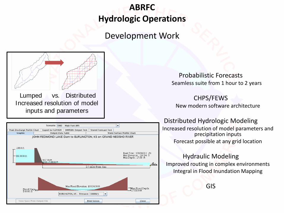
Development Work
Probabilistic Forecasts Seamless suite from 1 hour to 2 years
CHPS/FEWSNew modern software architecture
Distributed Hydrologic ModelingIncreased resolution of model parameters and
precipitation inputsForecast possible at any grid location
Hydraulic ModelingImproved routing in complex environments
Integral in Flood Inundation Mapping
GIS
Lumped vs. Distributed Increased resolution of model
inputs and parameters
ABRFCHydrologic Operations

ABRFCOutreach and Preparedness
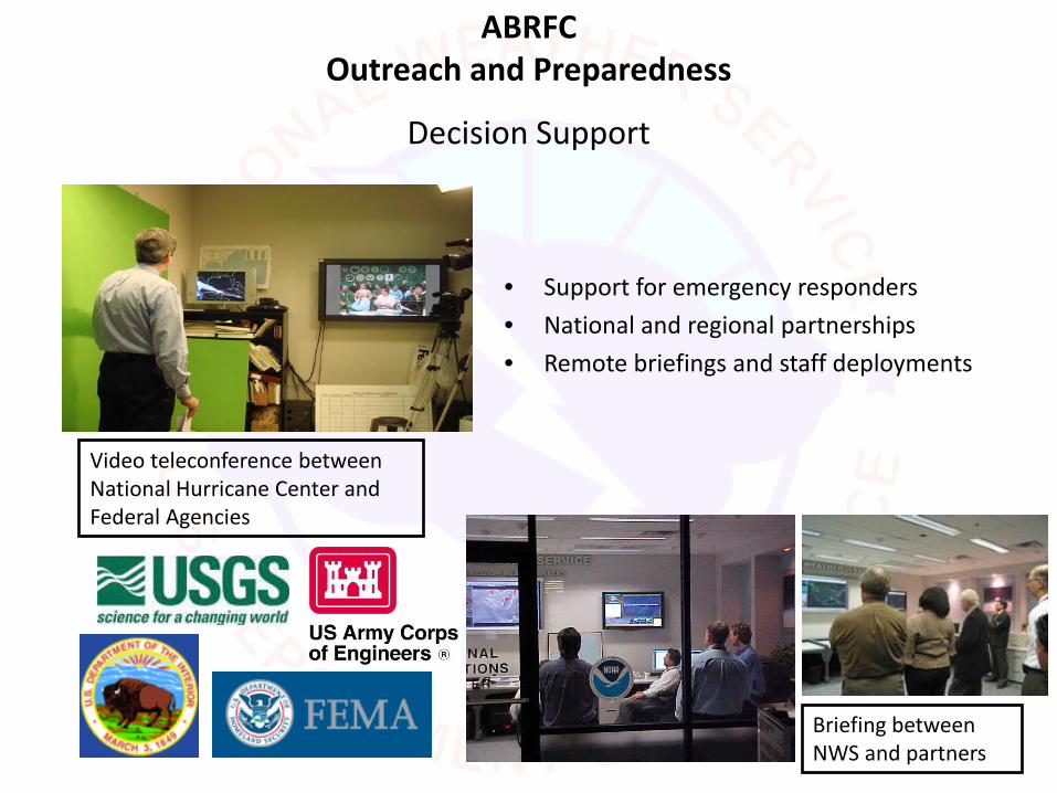
Decision Support
Video teleconference between National Hurricane Center and Federal Agencies
Briefing between NWS and partners
• Support for emergency responders
• National and regional partnerships
• Remote briefings and staff deployments
ABRFCOutreach and Preparedness

ABRFCOperations
Questions?
• Service Coordination Hydrologist: James Paul [email protected]• Hydrologist-in-Charge: Bill Lawrence [email protected]• 918 832 4109• http://www.srh.noaa.gov/abrfc• http://www.facebook.com/US.NationalWeatherService.ABRFC.gov

NWS AHPS Flood Inundation Mapping ProgramNWS is partnering with other federal, state, and local agencies
to provide web based inundation maps at Forecast Points.
http://water.weather.gov/ahps2/inundation/inundation.php?gage=bact2

NWS,Partners
NWS,Partners,
NWS, Partners, and/or Contractor
NWS,Partners, and/orContractor
AHPSContractor
NWS &Partners
AHPSContractor
NWS, Partners, and/orContractor
PLANNING (1) ENGINEERING & ANALYSIS (2)
IMPLEMENT-ATION (3)
NWS &Partners
OPERATION & MAINT. (4)
NWS QANWS QC
NWS AHPS Flood Inundation Mapping Program
NWS AHPS 4 Phase Flood Mapping Process
Site Selection & Evaluation,
Data Inventory,Resources
Obtain Maps and Models, Hydraulic
model runs, GIS products, QC
Convert GIS and Map
Deliverables into AHPS Web
Products
QC24/7 Webserver,
Hydraulic Changes, Web Evolution

NWS AHPS Flood Inundation Mapping Program
Partner with Detailed Flood Insurance Studies
•FEMA approved Hydraulic Models (1D, 2D, Steady vs Unsteady)
•10M DEM for scoping
•Lidar 1.2 ft vertical accuracy (2 ft contour equiv)
•Hydroconditioning of Lidar Derived DEM
•Resource funds - Additional $5-10K to complete one inundation map library as part of the FIS. Cost doubles to $10-20K if map library is created after FIS is completed.
Partner without Detailed Flood Insurance Studies•Find mapping, modeling, and more funds(Detailed FIS studies >$25k per stream mile)
Sponsoring Partner Provides Models, Maps, Engineering and Financial Support
FLOOD INUNDATION MAP
DEVELOPMENT STEPSDigital Elevation
Model
Accurate Elevation Data
Survey Structures
Hydraulic Modeling
FLOOD MAPPING

NWS AHPS Flood Inundation Mapping Program
Opportunities for Collaboration on Flood Mapping
• 61 Flood Map Libraries as of Sept. 2011 • Partners include FEMA, USGS , USACE,
Lower Colorado River and San Antonio River Authorities, Susquehanna River and Delaware River Basin Commissions, Iowa, Kansas and Wisconsin (State and Academia)
• More than 4800 River Forecast Siteswithout Flood Map Libraries
• NWS Seeking Interested Partners
Related Documents