Application for an Environmental Authorisation for the proposed construction of the new Rietkuil Private Railway Siding, Haul Road, Pollution Control Dam, and Associated Infrastructure, Exxaro Coal Mpumalanga (Pty) Ltd, Mpumalanga Province Report Prepared for Exxaro Coal Mpumalanga (Pty) Ltd Report Number 467209 MDARDLEA Reference Number: 17/2/3N-340 Report Prepared by October 2014

Welcome message from author
This document is posted to help you gain knowledge. Please leave a comment to let me know what you think about it! Share it to your friends and learn new things together.
Transcript

Application for an Environmental Authorisation for the proposed construction of the new Rietkuil Private Railway Siding, Haul Road, Pollution Control Dam, and Associated Infrastructure, Exxaro Coal Mpumalanga (Pty) Ltd, Mpumalanga Province
DRAFT ENVIRONMENTAL IMPACT ASSESSMENT REPORT
Report Prepared for
Exxaro Coal Mpumalanga (Pty) Ltd
Report Number 467209
MDARDLEA Reference Number: 17/2/3N-340
Report Prepared by
October 2014

SRK Consulting: Project No: 467209_Exxaro Rietkuil Private Railway Siding Draft EIAr Page i
VDMW/HINM 467209_20141007_DRAFT EIAr Rietkuil railway siding_Final for client submission.docx October 2014
Application for an Environmental Authorisation for the proposed construction of the new Rietkuil Private Railway Siding, Haul Road, Pollution Control Dam, and Associated Infrastructure, Exxaro Coal (Pty) Ltd, Mpumalanga Province
DRAFT ENVIRONMENTAL IMPACT ASSESSMENT REPORT
Exxaro Coal Mpumalanga (Pty) Ltd
SRK Consulting (South Africa) (Pty) Ltd. Block A, Menlyn Woods Office Park
291 Sprite Avenue
Faerie Glen
Pretoria 0081
South Africa e-mail: [email protected] website: www.srk.co.za
Tel: +27 (0) 12 361 9821 Fax:+27 (0) 12 361 9912
SRK Project Number: 467209
October 2014
Compiled by: Peer Reviewed by:
Toinette vd Merwe, Manda Hinsch Environmental Scientists
Darryl Kilian Partner
Email: [email protected]
Authors:
Toinette vd Merwe; Manda Hinsch; Darryl Kilian

SRK Consulting: Project No: 467209_Exxaro Rietkuil Private Railway Siding Draft EIAr Page ii
VDMW/HINM 467209_20141007_DRAFT EIAr Rietkuil railway siding_Final for client submission.docx October 2014
Executive Summary Exxaro Coal Mpumalanga (Pty) (Ltd) a subsidiary of Exxaro Coal (Pty) Ltd and owned by Exxaro
Resources Limited undertook a number of studies to determine the viability and nature of the
transport system and infrastructure required for the railage of coal mined at their proposed Belfast
Coal Mine. Exxaro intends exporting a percentage of the coal mined at the proposed Belfast Coal
Mine and requires a suitable siding accessible to the existing coal line to Richards Bay Coal
Terminal. Exxaro is proposing to construct a private railway siding with associated infrastructure
south-west of the proposed Belfast Coal Mine. The proposed private railway siding will be located
parallel and north-west of the existing Transnet Freight Rail Rietkuil Station within the existing
Exxaro Arnot Coal Mine’s Mining Right area. This private railway siding with associated
infrastructure will cover a footprint of approximately 45 hectares.
The proposed development triggers activities under the National Environmental Management Act
(Act No. 107 of 1998) as listed in terms of GN R544 and GN R545 of 18 June 2010 and written
Environmental Authorisation in terms of GN R543 of 18 June 2010 must be obtained prior to Exxaro
being able to commence with any construction activities. The formerly Mpumalanga Department of
Economic Development, Environment and Tourism, now the Mpumalanga Department of
Agriculture, Rural Development, Land and Environmental Affairs is the competent authority who
would be considering the application for Environmental Authorisation in terms of the National
Environmental Management Act (Act No. 107 of 1998). An application in terms of the National
Water Act (Act No. 36 of 1998) for water uses identified in terms of Section 21 of the Act will also be
submitted to the Department of Water and Sanitation for consideration.
Ms Manda Hinsch of SRK Consulting (SA) (Pty) Ltd has been appointed as the independent
Environmental Assessment Practitioner by Exxaro Coal Mpumalanga (Pty) (Ltd) to undertake the
Environmental Authorisation application process in terms Section 24 of the National Environmental
Management Act (Act 107 of 1998) and the Integrated Water Use License Application in terms of
Section 21 of the National Water Act (Act No. 36 of 1998).
The Draft Scoping Report including the Plan of Study for Environmental Impact Assessment, dated
March 2014, was made available for public comment between 14 March 2014 and 22 April 2014.
The Final Scoping Report including the Plan of Study for Environmental Impact Assessment, dated
May 2014, was made available for public comment between 16 May 2014 and 05 June 2014, and
was accepted by the Mpumalanga Department of Economic Development and Tourism on 23 July
2014. This report, the Draft Environmental Impact Assessment Report, documents the findings of
the Environmental Impact Assessment Phase and has been compiled in accordance with Regulation
31 of GN R543 of 18 June 2010.
The Draft EIAr will be made available to Interested and Affected Parties (I&APs) for a period of 40
days, from 21 October 2014 until 01 December 2014. During this time I&APs may submit written
comments to the EAP in order for their comments and concerns to be addressed in the Final EIAr.
The Final EIAr will then be submitted to the Mpumalanga Department of Agriculture, Rural
Development, Land and Environmental Affairs, for decision making purposes.
The proposed construction of the proposed Rietkuil Private Railway Siding and associated
infrastructure will enable Exxaro to increase their coal exports via the Richards Bay Coal Terminal. It
could potentially generate export earnings for South Africa and contribute towards reducing South
Africa’s negative trade balance and current account deficit, whislt being a source of foreign revenue.

SRK Consulting: Project No: 467209_Exxaro Rietkuil Private Railway Siding Draft EIAr Page iii
VDMW/HINM 467209_20141007_DRAFT EIAr Rietkuil railway siding_Final for client submission.docx October 2014
The findings of the studies undertaken within this Environmental Impact Assessment to assess both
the benefits and potential negative impacts anticipated from the proposed project conclude that:
That there are no environmental fatal flaws that should prevent the construction and operation of
the proposed new Rietkuil Private Railway Siding and associated infrastructure from proceeding;
That the proposed new Rietkuil Private Railway Siding and associated infrastructure will remain
within existing disturbed areas/footprints within a disturbed and transformed area characterised
by mining and agricultural activities;
That the findings contained in the specialist studies concluded that the proposed construction of
the proposed new Rietkuil Private Railway Siding and associated infrastructure it is evident that
no significant negative environmental are anticipated to take place and it is that the impacts
which were identified can be adequately mitigated;
That the mitigation measures contained in the specialist studies are included in the
Environmental Management Programme to ensure that the mitigation measures are
implemented and auditable;
The cumulative significance of all the negative potential impacts on the environment is
considered low due to the limited nature and scale of the proposed development.
Based on the nature and extent of the proposed project, the local level of disturbance predicted as a
result of the construction and operation of the private railway siding and associated infrastructure,
the findings of the Environmental Impact Assessment, and the understanding of potential
environmental impacts. It is evident that the application for Environmental Authorisation for the
proposed construction of the private railway siding and associated infrastructure can be mitigated to
an acceptable level. The preferred railway siding alternative is considered to be the only reasonable
and feasible alternative from an environmental perspective. It is recommended that authorisation be
granted for the construction of a linear railway siding comprising a loading and run around railway
line parallel to the existing rail network. Notwithstanding the fact that the proposed activity occurs in
a disturbed and transformed area with no environmental sensitivities, mitigation measures
recommended by specialist are incorporated in the Environmental Management Programme.
The anticipated impacts associated with the construction, operation and decommissioning of the
Rietkuil private railway siding and associated infrastructure includes the following:
Construction related Impacts
Specialist Study Impacts Identified
Significance
Rating Before
Mitigation
Significance
Rating After
Mitigation
Biodiversity
Impacts on Habitat for Floral Species Medium-High Low
Impacts on Flora Diversity Low-Medium Low
Impacts on Flora Species of Conservation Concern Low Low
Impacts on Faunal Habitat Medium-High Low-Medium
Impacts on Faunal Diversity Medium-Hig Low-Medium
Impact on RDL and Protected Fauna Species Low Low
Wetlands
Impacts on Loss of Wetland Habitat and Ecological Structure
Medium-High Low-Medium
Changes to Wetland Ecological and Sociocultural Service Provision
Medium-High Low-Medium
Impacts on Wetland Hydrological Function Medium-High Low
Soil, Land Use and
Soil Compaction Related Impacts High Medium-High
Soil Erosion Related Impacts High Low-Medium

SRK Consulting: Project No: 467209_Exxaro Rietkuil Private Railway Siding Draft EIAr Page iv
VDMW/HINM 467209_20141007_DRAFT EIAr Rietkuil railway siding_Final for client submission.docx October 2014
Specialist Study Impacts Identified
Significance
Rating Before
Mitigation
Significance
Rating After
Mitigation
Land Capability Impacts Associated With the Sterilization of Topsoil Layer High High
Impacts Associated With Chemical Soil Pollution High Low
Impacts on the Loss of Current Land Capability High Low-Medium
Surface and Ground
water
Impact on groundwater quality Medium-High Low-Medium
Impact on Bosmanspruit Medium-High Low-Medium
Change in catchment runoff Low-Medium Low
Erosion Low Very-Low
Heritage
Road Construction - Damage to farmhouse Low Very-Low
Road Construction - Damage to the buildings Low Very-Low
Road Construction - Damage to kraals Low Very-Low
Road Construction - Damage to graves Low Very-Low
Road Construction - Damage to Houses Low Very-Low
Traffic
Gravel access roads of approximately 9km; D1110 & D1770
Very High Low-Medium
D1110 / D1770 Intersection Very High Low-Medium
N4 Road / D1110 Road Intersection (safety) Very High Low-Medium
New access road between Rietkuil Station and D1550 Road
Low-Medium Low-Medium
Noise
Removal and hauling of top soil from the site Low Very-Low
Earthmoving equipment at the foot print area Low Very-Low
Hauling of material to and from the specific area Low Very-Low
Construction of the pollution control dam and/or structures Low Very-Low
Upgrade of the existing gravel roads between the railway siding and the Belfast
Low Very-Low
Diesel emergency generators Low Very-Low
Socio-economic Creation of Temporary Employment Opportunities Low Medium-High
Creation of permanent Employment Opportunities Low Medium-High
Operation Phase Impacts
Specialist Study Impacts Identified
Significance
Rating Before
Mitigation
Significance
Rating After
Mitigation
Surface and Ground
water
Impact on groundwater quality (Leachate seeping from coal loading bay to underlying aquifers)
Low-Medium Low
Impact on groundwater quality (Leachate seeping from pollution control dam to underlying aquifers)
Low-Medium Low
Impact on groundwater quality (Leakage of hydrocarbon fuels into underlying aquifers)
Medium-High Low-Medium
Impact on Bosmanspruit (Seepage of contaminated groundwater into the river)
Medium-High Low
Impact on Bosmanspruit (Contaminated runoff flowing into the river)
Medium-High Low-Medium
Change in catchment runoff Low-Medium Low

SRK Consulting: Project No: 467209_Exxaro Rietkuil Private Railway Siding Draft EIAr Page v
VDMW/HINM 467209_20141007_DRAFT EIAr Rietkuil railway siding_Final for client submission.docx October 2014
Specialist Study Impacts Identified
Significance
Rating Before
Mitigation
Significance
Rating After
Mitigation
Erosion Low Very-Low
Traffic
Gravel access roads of approximately 9km; D1110 & D1770
Very-High Low-Medium
D1110 / D1770 Intersection Very-High Low-Medium
N4 Road / D1110 Road Intersection (safety) Very-High Low-Medium
New access road between Rietkuil Station and D1550 Road
Low-Medium Low-Medium
Noise
Removal and hauling of top soil from the site Low-Medium Very-Low
Earthmoving equipment at the foot print area Low-Medium Very-Low
Hauling of material to and from the specific area Low-Medium Very-Low
Construction of the pollution control dam and/or structures Low-Medium Very-Low
Construction of the pollution control dam and/or structures Low-Medium Very-Low
Diesel emergency generators Low-Medium Very-Low
Stockpile management Low-Medium Very-Low
Air Quality
Impacts Associated with PM10 Low-Medium Low
Impacts Associated with Dust Fallout Low-Medium Low
Impacts Associated with PM2.5 Low-Medium Low
Decommissioning
Specialist Study Impacts Identified
Significance
Rating Before
Mitigation
Significance
Rating After
Mitigation
Soils, Land Use and Land Capability
Impacts associated with Soil Compaction High Medium-High
Surface and Ground Water
Impact on groundwater quality (Leachate seeping from coal loading bay to underlying aquifers)
Low-Medium Low
Impact on groundwater quality Low-Medium Low
Impact on Bosmanspruit (Seepage of contaminated groundwater into the river)
Low Low
Impact on Bosmanspruit (Contaminated runoff flowing into the river)
Low Very-Low
Noise
Rehabilitation of railway siding Low-Medium Low
Demolition of plant and infra-structure Low-Medium Low
Diesel emergency generators Low-Medium Low
The Draft Environmental Impact Assessment Report will be made available to registered Interested
and Affected Parties for a 40 day commenting period, from 21 October 2014 until 01 December
2014. During this time I&APs may submit written comments to the Environmental Assessment
Practitioner in order for the comments and concerns to be addressed in the Final Environmental
Impact Assessment Report. Once these comments/responses/amendments are made it will be
released to the registered Interested and Affected Parties for perusal. The Final Environmental
Impact Assessment Report will also be submitted to the Mpumalanga Department of Agriculture,
Rural Development, Land and Environmental Affairs, as competent authority, for decision making
purposes.

SRK Consulting: Project No: 467209_Exxaro Rietkuil Private Railway Siding Draft EIAr Page vi
VDMW/HINM 467209_20141007_DRAFT EIAr Rietkuil railway siding_Final for client submission.docx October 2014
Table of Contents
Executive Summary ..................................................................................................................................... ii
Disclaimer ................................................................................................................................................... xiii
List of Abbreviations .................................................................................................................................. xiv
1 Introduction .................................................................................................................. 1
1.1 Details of the Applicant ....................................................................................................................... 2
1.2 Details of the EAP ............................................................................................................................... 2
1.2.1 Statement of independence .................................................................................................... 4
1.3 Specialists ........................................................................................................................................... 4
1.4 Authorities ........................................................................................................................................... 4
1.5 Applicable Legislation ......................................................................................................................... 5
1.5.1 The Constitution of the Republic of South Africa (Act No. 108 of 1996) ................................. 5
1.5.2 National Environmental Management Act (Act No. 107 of 1998) ........................................... 5
1.5.3 EIA Regulations GN R 543 of 18 June 2010........................................................................... 6
1.5.4 NEMA Listing Notices 1 and 2 of 18 June 2010 ..................................................................... 6
1.5.5 National Environmental Management: Biodiversity Act (Act No. 10 of 2004) ......................... 9
1.5.6 National Environmental Management: Air Quality Act (Act No. 39 of 2004) ........................... 9
1.5.7 National Water Act (Act No. 36 of 1998) ............................................................................... 10
1.5.8 National Heritage Resources Act (Act No. 25 of 1998) ......................................................... 11
1.5.9 Conservation of Agricultural Resources Act (Act No. 43 1983) ............................................ 11
1.5.10 Mpumalanga Conservation Act (Act No. 10 of 1998) ............................................................ 12
1.5.11 Guidelines ............................................................................................................................. 12
1.6 Legislative requirements ................................................................................................................... 13
2 Background ................................................................................................................ 14
2.1 Background of the project ................................................................................................................. 14
2.1.1 Existing infrastructure ............................................................................................................ 14
2.1.2 Existing approvals/authorisations .......................................................................................... 15
2.1.3 Project Area Description........................................................................................................ 15
3 Project Description ..................................................................................................... 20
3.1 Need and Desirability ........................................................................................................................ 20
3.2 Detailed Project Description .............................................................................................................. 20
3.2.1 Coal Stockpile and Siding ..................................................................................................... 21
3.2.2 Pollution Control Dam ........................................................................................................... 21
3.2.3 Storm Water Management Infrastructure .............................................................................. 21
3.2.4 Access Road and Road Upgrades ........................................................................................ 21
3.2.5 Wetland Crossings ................................................................................................................ 22
3.2.6 Operational phase ................................................................................................................. 22
3.2.7 Decommissioning and closure phase ................................................................................... 22
3.3 Alternatives ....................................................................................................................................... 22

SRK Consulting: Project No: 467209_Exxaro Rietkuil Private Railway Siding Draft EIAr Page vii
VDMW/HINM 467209_20141007_DRAFT EIAr Rietkuil railway siding_Final for client submission.docx October 2014
3.3.1 Location Alternatives ............................................................................................................. 22
3.3.2 Technology Alternatives ........................................................................................................ 23
3.3.3 ‘No-Go’ Alternative ................................................................................................................ 23
4 Description of Baseline Environment ....................................................................... 24
4.1 Climate .............................................................................................................................................. 24
4.1.1 Regional climate .................................................................................................................... 24
4.1.2 Rainfall and Evaporation ....................................................................................................... 24
4.2 Topography ....................................................................................................................................... 26
4.3 Geology ............................................................................................................................................. 26
4.4 Geochemical ..................................................................................................................................... 28
4.5 Soils and Land use............................................................................................................................ 28
4.5.1 Soils ....................................................................................................................................... 28
4.5.2 Land Capability of the area ................................................................................................... 29
4.5.3 Land Use ............................................................................................................................... 36
4.6 Biodiversity ........................................................................................................................................ 36
4.6.1 Vegetation ............................................................................................................................. 36
4.6.2 Faunal habitat ........................................................................................................................ 38
4.6.3 Avifaunal ................................................................................................................................ 38
4.6.4 Reptiles.................................................................................................................................. 38
4.6.5 Amphibians ............................................................................................................................ 39
4.6.6 Invertebrates ......................................................................................................................... 39
Spiders and scorpions ...................................................................................................................... 39
4.7 Surface Water ................................................................................................................................... 40
4.7.1 Catchment 1 .......................................................................................................................... 40
4.7.2 Catchment 2 .......................................................................................................................... 40
4.7.3 Catchment 3 .......................................................................................................................... 40
4.7.4 Catchment 4 .......................................................................................................................... 40
4.7.5 Catchment 5 .......................................................................................................................... 40
4.7.6 Catchment 6 .......................................................................................................................... 41
4.7.7 Catchment 7 .......................................................................................................................... 41
4.7.8 Catchment 8 .......................................................................................................................... 41
4.7.9 Catchment 9 .......................................................................................................................... 41
4.7.10 Catchment 10 ........................................................................................................................ 41
4.7.11 Catchment 11 ........................................................................................................................ 41
4.7.12 Catchment 12 ........................................................................................................................ 42
4.7.13 Catchment 13 ........................................................................................................................ 42
4.7.14 Catchment 14 ........................................................................................................................ 42
4.7.15 Catchment 15 ........................................................................................................................ 42
4.7.16 Catchment 16 ........................................................................................................................ 42
4.7.17 Surface Water Hydrology ...................................................................................................... 44
4.7.18 Mean Annual Runoff .............................................................................................................. 44

SRK Consulting: Project No: 467209_Exxaro Rietkuil Private Railway Siding Draft EIAr Page viii
VDMW/HINM 467209_20141007_DRAFT EIAr Rietkuil railway siding_Final for client submission.docx October 2014
4.7.19 Floodlines .............................................................................................................................. 46
4.7.20 Wetlands................................................................................................................................ 48
4.8 Groundwater ..................................................................................................................................... 52
4.9 Air quality .......................................................................................................................................... 54
4.9.1 Mining activities in the region ................................................................................................ 54
4.9.2 Road network ........................................................................................................................ 54
4.9.3 Windblown dust ..................................................................................................................... 55
4.9.4 Vehicle tailpipe emissions ..................................................................................................... 55
4.10 Noise 55
4.10.1 Existing Road Network .......................................................................................................... 61
4.10.2 Existing Rail Network ............................................................................................................ 62
4.10.3 Area of Influence ................................................................................................................. 62
4.10.4 Status quo traffic volumes ..................................................................................................... 63
4.11 Socio-economic ................................................................................................................................. 63
4.11.1 Demographic and key economic indicators of Steve Tshwete Local Municipality ................ 64
4.11.2 Demographic and key economic indicators of Emakhazeni Local Municipality .................... 65
4.12 Heritage ............................................................................................................................................. 66
5 Environmental Impact Assessment .......................................................................... 74
5.1 Specialist investigations .................................................................................................................... 74
5.2 Methodology of the Impact Assessment ........................................................................................... 82
5.3 Impact significance............................................................................................................................ 84
5.3.1 Pre-construction phase ......................................................................................................... 85
5.3.2 Construction phase ............................................................................................................... 85
5.3.3 Operational phase ............................................................................................................... 101
5.3.4 Decommissioning / Rehabilitation phase ............................................................................ 109
5.4 Uncertainties, assumptions and gaps in knowledge ....................................................................... 111
5.4.1 Uncertainties ....................................................................................................................... 111
5.4.2 Assumptions ........................................................................................................................ 111
5.4.3 Gaps in knowledge .............................................................................................................. 113
5.4.4 Risks .................................................................................................................................... 113
6 Environmental Management Programme ............................................................... 113
6.1 Background ..................................................................................................................................... 113
6.2 Objectives of the EMPr ................................................................................................................... 113
6.3 Approach to the EMPr ..................................................................................................................... 114
6.4 Implementation of the EMPr ........................................................................................................... 114
6.5 Rehabilitation and Closure .............................................................................................................. 114
7 Public Participation .................................................................................................. 115
7.1 Methodology .................................................................................................................................... 116
7.1.1 Identification of I&APs ......................................................................................................... 116
7.1.2 Announcement Phase ......................................................................................................... 117
7.1.3 Scoping Phase .................................................................................................................... 118

SRK Consulting: Project No: 467209_Exxaro Rietkuil Private Railway Siding Draft EIAr Page ix
VDMW/HINM 467209_20141007_DRAFT EIAr Rietkuil railway siding_Final for client submission.docx October 2014
7.1.4 Impact Assessment Phase .................................................................................................. 119
7.1.5 Comments and Responses ................................................................................................. 120
7.2 Actions taken during the Public Participation Process .................................................................... 121
8 Conclusions and Recommendations ...................................................................... 126
8.1 Summary of Key Findings ............................................................................................................... 126
8.2 Environmental Impact Statement .................................................................................................... 126
10 Bibliography ............................................................................................................. 129
Appendices .................................................................................................................... 131
Appendix A: Site Plans ............................................................................................... 132
Appendix B: Site Photographs ................................................................................... 133
Appendix C: Specialist Studies and declarations of independence ....................... 134
Appendix D: Public Participation ............................................................................... 135
Appendix E: EMPr ....................................................................................................... 136
Appendix F: Project Team CV’s ................................................................................. 137
Appendix G: Project Experience ................................................................................ 138
Appendix H: Application Form with EAP Declaration of Independence ................. 139
Appendix I: Authority Correspondence .................................................................... 140

SRK Consulting: Project No: 467209_Exxaro Rietkuil Private Railway Siding Draft EIAr Page x
VDMW/HINM 467209_20141007_DRAFT EIAr Rietkuil railway siding_Final for client submission.docx October 2014
List of Tables Table 1-1: Applicant Contact Details ............................................................................................................. 2
Table 1-2: Details of the Environmental Impact Assessment Project Team ................................................. 3
Table 1-3: Specialist Team ............................................................................................................................ 4
Table 1-4: Competent Authority Details ........................................................................................................ 4
Table 1-5: Local and District Municipality Details .......................................................................................... 5
Table 1-6: Listed NEMA Activities ................................................................................................................. 7
Table 1-7: Anticipated Water Uses to be applied for................................................................................... 10
Table 1-8: Regulatory Requirements .......................................................................................................... 13
Table 2-1: Nearest Towns to the Proposed Development .......................................................................... 15
Table 2-2: List of Affected Farms and Farm Portions Illustrating the Relevant Activities ........................... 15
Table 4-1: Rainfall Station Details ............................................................................................................... 24
Table 4-2: Average Rainfall in mm from the Combined Record ................................................................. 25
Table 4-3: Average Monthly Evaporation at Symons Pan .......................................................................... 25
Table 4-4: Pre-Mining Land Capability Requirements ................................................................................ 29
Table 4-5: Summary of Catchment Hydrology for the Project Area ............................................................ 45
Table 4-6: Summary of Peak Flows (m3/s) for the Project Area ................................................................. 45
Table 4-7: Tweefontein boreholes sampled ................................................................................................ 52
Table 4-8: Groundwater chemistry laboratory results ................................................................................. 53
Table 4-9: SANS 10103 of 2008 Sound Pressure Levels for Specific Districts .......................................... 56
Table 4-10: Distance in meters between proposed Siding, Haul Road and the Noise Sensitive Areas ....... 58
Table 4-11: Overview of the Existing Road Network and Jurisdiction .......................................................... 61
Table 4-12: Nearest Towns to the Proposed Development .......................................................................... 63
Table 4-13: Level of Education of Household Heads .................................................................................... 64
Table 4-14: Employment Status of Household Heads (HH) ......................................................................... 65
Table 5-1: Specialist Terms of Reference ................................................................................................... 75
Table 5-2: Criteria for Assessing Significance of Impacts ........................................................................... 83
Table 5-3: Significance Rating Matrix.......................................................................................................... 84
Table 5-4: Positive/Negative Mitigation Ratings .......................................................................................... 84
Table 5-5: Impacts on Habitat for Floral Species during the Construction Phase of the Project ................ 85
Table 5-6: Impacts on Flora Diversity.......................................................................................................... 86
Table 5-7: Impacts on Flora Species of Conservation concern during the Construction Phase of the Project ........................................................................................................................................ 87
Table 5-8: Impacts on Faunal Habitat during the Construction Phase of the Project ................................. 87
Table 5-9: Impacts on Faunal Diversity During the Construction Phase of the Project .............................. 88
Table 5-10: Impact on RDL and Protected Fauna Species During the Construction Phase of the Project .. 88
Table 5-11: Impacts on Loss of Wetland Habitat and Ecological Structure during the Construction Phase of the Project .................................................................................................................................. 89
Table 5-12: Changes to Wetland Ecological and Sociocultural Service provision ........................................ 90
Table 5-13: Impacts on Wetland Hydrological Function during the Construction Phase of the Project ....... 91
Table 5-14: Impacts Relating to Soil Compaction during the Construction Phase of the Project ................. 92

SRK Consulting: Project No: 467209_Exxaro Rietkuil Private Railway Siding Draft EIAr Page xi
VDMW/HINM 467209_20141007_DRAFT EIAr Rietkuil railway siding_Final for client submission.docx October 2014
Table 5-15: Impacts Relating to Soil Erosion During the Construction Phase of the Project ....................... 92
Table 5-16: Impacts Associated With the Sterilization of Topsoil Layer During the Construction Phase of the Project .................................................................................................................................. 93
Table 5-17: Impacts associated with Chemical Soil Pollution ....................................................................... 93
Table 5-18: Impacts on the loss of current Land Capability during the Construction Phase of the Project .. 94
Table 5-19: Surface and Groundwater Impacts during the Construction Phase of the Project .................... 94
Table 5-20: Heritage related Impacts during the Construction Phase of the Project .................................... 96
Table 5-21: Traffic Related Impacts during the Construction Phase of the Project ...................................... 97
Table 5-22: Noise Related Impacts during the Construction Phase of the Project ....................................... 99
Table 5-23: Creation of Temporary Employment Opportunities during the Construction Phase of the Project ...................................................................................................................................... 100
Table 5-24: Creation of permanent Employment Opportunities During the Construction Phase of the Project ...................................................................................................................................... 101
Table 5-25: Surface and Groundwater during the Operational Phase of the Project ................................. 101
Table 5-26: Traffic Impacts during the Operational Phase Of The Project ................................................. 103
Table 5-27: Noise related Impacts during the Operational Phase of the Project ........................................ 104
Table 5-28: Impacts associated with PM10 during the Operational Phase of the Project ........................... 107
Table 5-29: Impacts Associated with Dust Fallout during the Operational Phase of the Project ................ 107
Table 5-30: Impacts Associated with PM2.5 during the Operational Phase of the Project .......................... 107
Table 5-31: Impacts associated with Soil Compaction during the Decommission Phase of the Project .... 109
Table 5-32: Surface and Groundwater Related Impacts during the Decommission Phase of the Project . 109
Table 5-33: Noise Impacts during the Decommission Phase of the Project ............................................... 110
Table 6-1: Approach to Impact Management ............................................................................................ 114
Table 7-1: List and Location of the Site Notices placed for the proposed Project .................................... 117
Table 7-2: Actions Taken during Public Participation Process ................................................................. 121

SRK Consulting: Project No: 467209_Exxaro Rietkuil Private Railway Siding Draft EIAr Page xii
VDMW/HINM 467209_20141007_DRAFT EIAr Rietkuil railway siding_Final for client submission.docx October 2014
List of Figures Figure 2-1: Overall Layout Map of the proposed Transport Route ............................................................... 17
Figure 2-2: Layout Map of the proposed Road Upgrades ............................................................................ 18
Figure 2-3: Layout Map of the proposed Private Railway Siding And Associated Infrastructure. ................ 19
Figure 4-1: Percentiles of Monthly Rainfall and Annual Rainfall (Inset) for the Klippan-Nooitgedacht Dam-Leeuwpan Combined Record .................................................................................................... 25
Figure 4-2: Average Monthly Rainfall for the Klippan-Nooitgedacht Dam-Leeupan Combined Record (1904 – 2012) and Symons Pan Evaporation from WR2005 ............................................................... 26
Figure 4-3: Geological Map .......................................................................................................................... 27
Figure 4-4: Land Capability of the Proposed New Access Road to the proposed new Rietkuil Private Railway Siding ............................................................................................................................ 31
Figure 4-5: Land Capability of the proposed new Rietkuil Private Railway Siding Road Upgrade (Map 1) . 32
Figure 4-6: Land Capability of the proposed new Rietkuil Private Railway Siding Road Upgrade (Map 2) . 33
Figure 4-7: Land Capability of the proposed new Rietkuil Private Railway Siding Road Upgrade (Map 3) . 34
Figure 4-8: Land capability map of the proposed new Rietkuil Private Railway Siding Pollution Control Dam and Coal Loading Facility development footprint area ...................................................... 35
Figure 4-9: Surrounding land use map of the proposed new Rietkuil Private Railway Siding ..................... 36
Figure 4-10: Catchment map of the proposed new Rietkuil Private Railway Siding and associated infrastructure study area ............................................................................................................ 43
Figure 4-11: Seepage from Shallow Groundwater ........................................................................................ 44
Figure 4-12: Floodline extent for the proposed new Rietkuil Private Railway Siding and associated infrastructure .............................................................................................................................. 47
Figure 4-13: Illustration of the wetlands in and around the proposed new Rietkuil Private Railway Siding and associated infrastructure project area ................................................................................. 49
Figure 4-14: Wetland types associated with the proposed new Rietkuil Private Railway Siding and associated infrastructure ............................................................................................................ 50
Figure 4-15: Wetland Types Associated with the upgrading of the D1770 ................................................... 51
Figure 4-15: Noise sources in the vicinity of the proposed new Rietkuil Private Railway Siding and associated infrastructure site ..................................................................................................... 57
Figure 4-16: Noise sensitive areas in the vicinity of the proposed new Rietkuil Private Railway Siding and associated infrastructure. ........................................................................................................... 60
Figure 4-17: Site layout plan depicting locations of heritage sites ................................................................. 67
Figure 4-18: Location of the Recorded Sites at the Rietkuil Private Railway Site .......................................... 68
Figure 4-19: Location of the Recorded Sites Along the Provincial Roads ..................................................... 68
Figure 4-19: Photographic Reference for Site 1 ............................................................................................. 69
Figure 4-20: Photographic Reference for Site 2 ............................................................................................. 70
Figure 4-21: Photographic Reference for Site 4 ............................................................................................. 70
Figure 4-22: Physical Location of Site 5 ......................................................................................................... 71
Figure 4-23: Photographic Reference for Site 6 ............................................................................................. 71
Figure 4-24: Photographic Reference for Site 7 ............................................................................................. 72
Figure 4-25: Photographic Reference for Site 8 ............................................................................................. 73
Figure 4-26: Photographic Reference for Site 9 ............................................................................................. 73
Figure 7-1: Environmental Authorisation and Associated Stakeholder Engagement Process. ................. 116

SRK Consulting: Project No: 467209_Exxaro Rietkuil Private Railway Siding Draft EIAr Page xiii
VDMW/HINM 467209_20141007_DRAFT EIAr Rietkuil railway siding_Final for client submission.docx October 2014
Disclaimer The opinions expressed in this Report have been based on the information supplied to SRK
Consulting South Africa (Pty) Ltd (SRK) by Exxaro Coal Mpumalanga (Pty) (Ltd) (Exxaro). The
opinions in this Report are provided in response to a specific request from Exxaro to do so. SRK
has exercised all due care in reviewing the supplied information. Whilst SRK has compared key
supplied data with expected values, the accuracy of the results and conclusions from the review are
entirely reliant on the accuracy and completeness of the supplied data. SRK does not accept
responsibility for any errors or omissions in the supplied information and does not accept any
consequential liability arising from commercial decisions or actions resulting from them. Opinions
presented in this report apply to the site conditions and features as they existed at the time of SRK’s
investigations, and those reasonably foreseeable. These opinions do not necessarily apply to
conditions and features that may arise after the date of this Report, about which SRK had no prior
knowledge nor had the opportunity to evaluate.

SRK Consulting: Project No: 467209_Exxaro Rietkuil Private Railway Siding Draft EIAr Page xiv
VDMW/HINM 467209_20141007_DRAFT EIAr Rietkuil railway siding_Final for client submission.docx October 2014
List of Abbreviations
ADT Average daily traffic
ADTT Average daily truck traffic
BID Background Information Document
CARA Conservation of Agricultural Resources Act (Act No. 43 of 1983)
CRR Comments and Response Report
DEA Department of Environmental Affairs
DEAT Department of Environmental Affairs and Tourism
DWS Department of Water and Sanitation
DWAF Department of Water Affairs and Forestry
EA Environmental Authorisation
EAP Environmental Assessment Practitioner
EIA Environmental Impact Assessment
EIAr Environmental Impact Assessment Report
EIS Ecological Importance and Sensitivity
EMPr Environmental Management Programme
Exxaro Exxaro Coal Mpumalanga (Pty) (Ltd)
GCL Geo synthetic clay liner
HDPE High Density Polyethylene
HIA Heritage Impact Assessment
I&APs Interested and Affected Parties
IUCMA Inkomati Usuthu Catchment Management Agency
ICP Coupled Plasma
IDP Integrated Development Plan
IWULA Integrated Water Use License Application
JSE Limited Johannesburg Stock Exchange Limited
MAP Mean Annual Precipitation
MDARDLEA Mpumalanga Department of Agriculture, Rural Development, Land and Environmental Affairs
MDEDET Mpumalanga Department of Economic Development, Environment and Tourism
MDRT Mpumalanga Department of Roads and Transport
MHSA Mines Health and Safety Act (Act No. 50 of 1991)
NBC North Block Complex
NEM: AQA National Environmental Management: Air Quality Act (Act No. 39 of 2004)
NEM: BA Biodiversity Act (Act No. 10 of 2004)
NEM: WA National Environmental Management: Waste Act (Act No. 59 of 2008)
NEMA National Environmental Management Act (Act No. 107 of 1998)
NFEPA National Freshwater Ecosystem Priority Areas
NHRA National Heritage Resources Act (Act No. 25 of 1999)
NPAES National Protected Area Expansion Strategy
NWA National Water Act (Act No. 36 of 1998)

SRK Consulting: Project No: 467209_Exxaro Rietkuil Private Railway Siding Draft EIAr Page xv
VDMW/HINM 467209_20141007_DRAFT EIAr Rietkuil railway siding_Final for client submission.docx October 2014
PCD Pollution Control Dam
PES Present State of a Wetland
PPP Public Participation Process
RBCT Richards Bay Coal Terminal
RDL Red Data List
REC Recommended Ecological Class
SAHRA South African Heritage Resources Agency
SANBI South African National Biodiversity Institute
SANS South African National Standards
SAR Sodium Absorption Ratio
SAS Scientific Aquatic Services
SAWS South African Weather Services
SDF Spatial Development Framework
SRK SRK Consulting (SA) (Pty) Ltd
Sub-WMAs sub-Water Management Area
TFR Transnet Freight Rail

SRK Consulting: Project No: 467209_Exxaro Rietkuil Private Railway Siding Draft EIAr Page 1
VDMW/HINM 467209_20141007_DRAFT EIAr Rietkuil railway siding_Final for client submission.docx October 2014
1 Introduction Exxaro Coal Mpumalanga (Pty) (Ltd) (Exxaro) is a subsidiary of Exxaro Coal (Pty) Ltd and owned
by Exxaro Resources Limited. Exxaro undertook a number of studies to determine the viability
and nature of the transport system and infrastructure required for transporting of coal mined at
their proposed Belfast Coal Mine via rail. Exxaro intends exporting a percentage of the coal
mined at the proposed Belfast Coal Mine and requires a suitable siding accessible to the existing
coal line to Richards Bay Coal Terminal (RBCT).
Exxaro therefore proposes to construct a new private railway siding with associated infrastructure
(referred to as the “proposed new Rietkuil Private Railway Siding and associated infrastructure”)
south-west of the proposed Belfast Coal Mine. The proposed Rietkuil Private Railway Siding and
associated infrastructure will be located parallel and north-west of the existing Transnet Freight
Rail (TFR) Rietkuil Station within the existing Exxaro Arnot Coal Mine’s Mining Right area. This
proposed new Rietkuil Private Railway Siding and associated infrastructure will cover a footprint
of approximately 45 hectares. The construction activities will include the following:
The construction of a private railway siding of approximately 3.5 km in length, this includes
the loading and run around lines;
The establishment of a coal stockpile of approximately 54 000 tons, with associated
operational facilities;
The construction of a storm water management system for the management of clean and
dirty water around the coal stockpile. The coal loading platform slopes away from the railway
track work with a slope of 2% (1:50). Surface run-off from the loading facility and adjacent
access road is collected in a concrete lined drain on the northern edge of the coal loading
platform. The contaminated run-off flows under gravity and passes through a silt trap into the
PCD on the South Western boundary of the site. Clean surface run-off water is diverted from
the dirty water catchment area by means of cut-off channels and berms;
Construction of a pollution control dam (PCD) with a capacity of approximately 51 230 cubic
metres;
The upgrade and widening of existing provincial roads (D 1770 and D 1110);
The upgrade of a new private access road. This new access will intersect with the existing D
1555 provincial road;
The construction of culverts associated with the provincial road D 1770 and the new private
access road;
The construction of other associated infrastructure including, but not limited to, construction
camps, weighbridge, and offices.
However, authorisation must be obtained in terms of the following legislation prior to Exxaro
being able to commence with any construction activities:
National Environmental Management Act (Act No. 107 of 1998) (NEMA) Environmental
Impact Assessment (EIA) Regulations contained in GN R543 of 18 June 2010, with
reference to the Listing Notices contained in GN R544 and GN R545 of 18 June 2010;
National Water Act (Act No. 36 of 1998) (NWA) for water uses identified in terms of Section
21 of the NWA.
The proposed development triggers activities listed in terms of GN R544 and GN R545 of 18
June 2010. Therefore, the application for Environmental Authorisation (EA) entails undertaking a
Scoping and EIA Phase, which is regulated by the EIA Regulations GN R543 of 18 June 2010
and promulgated under the NEMA.
Ms Manda Hinsch of SRK Consulting (SA) (Pty) Ltd (SRK) has been appointed as the
independent Environmental Assessment Practitioner (EAP) by Exxaro to undertake the EA

SRK Consulting: Project No: 467209_Exxaro Rietkuil Private Railway Siding Draft EIAr Page 2
VDMW/HINM 467209_20141007_DRAFT EIAr Rietkuil railway siding_Final for client submission.docx October 2014
application process in terms Section 24 of the NEMA and the Integrated Water Use License
Application (IWULA) in terms of Section 21 of the NWA.
The application for EA was lodged with the competent authority the Mpumalanga Department of
Agriculture, Rural Development, Land and Environmental Affairs (MDARDLEA), formerly
Mpumalanga Department of Economic Development, Environment and Tourism (MDEDET).
The Draft Scoping Report including the Plan of Study for Environmental Impact Assessment
(EIA), dated March 2014, was made available for public comment between 14 March 2014 and
22 April 2014. The Final Scoping Report including the Plan of Study for EIA, dated May 2014,
was made available for public comment between 16 May 2014 and 05 June 2014, and was
accepted by the Mpumalanga Department of Economic Development and Tourism on 23 July
2014. This report, the Draft Environmental Impact Assessment Report (EIAr), documents the
findings of the Environmental Impact Assessment Phase and has been compiled in accordance
with Regulation 31 of GN R543 of 18 June 2010.
The Draft EIAr will be made available to Interested and Affected Parties (I&APs) for a period of
40 days, from 21 October 2014 until 01 December 2014. During this time I&APs may submit
written comments to the EAP in order for their comments and concerns to be addressed in the
Final EIAr. The Final EIAr will then be submitted to the MDARDLEA, as competent authority, for
decision making purposes.
1.1 Details of the Applicant
Exxaro operates a coal mining complex in the Mpumalanga Province which is situated between
the towns of Glisa and Strathrae Coal Mines as well as the proposed Eerstelingsfontein and
proposed Belfast Coal Mines. Exxaro is a South African based mining group, listed on the
Johannesburg Stock Exchange Limited (JSE) Limited, a constituent of the JSE’s top 40 index
and one of the best-performing constituents of the JSE Socially Responsible Investment index.
Exxaro has a diverse and world-class commodity portfolio in coal, mineral sands, base metals
and ferroalloys, and growing exposure to iron ore. The details of the applicant can be found in
Table 1-1.
Table 1-1: Applicant Contact Details
Name Simon Mkhonza (on behalf of Exxaro Resources Pty Ltd)
Designation Business Unit Manager: North Block Complex
Telephone (013) 253 7300
Fax (013) 253 7360
E Mail [email protected]
Postal Address 1 P.O Box 321
Town Belfast
Postal Code 1100
Postal Address 2 P.O Box 9229
Town Pretoria
Postal Code 0001
1.2 Details of the EAP
Ms Manda Hinsch from SRK was appointed as the independent EAP to facilitate the EA
application process for the construction of the proposed new Rietkuil Private Railway Siding and

SRK Consulting: Project No: 467209_Exxaro Rietkuil Private Railway Siding Draft EIAr Page 3
VDMW/HINM 467209_20141007_DRAFT EIAr Rietkuil railway siding_Final for client submission.docx October 2014
associates infrastructure. SRK has 40 years’ experience in environmental consulting and has
appointed a lead EAP and associated project team to undertake the necessary EA.
SRK commenced its practises in 1974 as has since been involved in a large variety of
environmental studies. SRK is a South African founded international organisation of
professionals providing a comprehensive range of consulting services to natural resource
industries and organisations. SRK’s Johannesburg and Pretoria offices are staffed with over 300
professional consultants operating in a range of disciplines, mainly related to the environment,
water, social and mining sectors. Back-up and peripheral expertise is available within these
offices for all environmental projects. SRK has a demonstrated track record of undertaking
independent assessments of resources and reserves, project evaluations and audits, listing
reports and independent feasibility studies to bankable standards on behalf of exploration
companies, mining companies and financial institutions worldwide. The SRK project team
consists of the following members as listed in Table 1-2.
Table 1-2: Details of the Environmental Impact Assessment Project Team
SRK Project Team
Designation
Project Partner and Reviewer
Project Manager
Report preparation
Report preparation
Public participation Coordinator
Team Member
Darryll Kilian
Manda Hinsch Toinette van der Merwe
Andrew Caddick
Annerine Prinsloo
Donne du Toit
The project reviewer is Mr Darryll Kilian who is a Partner at SRK with over 21 years’ experience
in environmental management. Mr Darryll Kilian is appropriately qualified and registered as a
Certified Environmental Assessment Practitioner.
The project manager, Ms Manda Hinsch is an Associate Partner at SRK, with 32 years’
experience in the environmental field. Mrs Manda Hinsch is appropriately qualified and
registered with the relevant professional bodies as a Professional Natural Scientists (Pr.Sci.Nat.
400164/09) with the South African Council of Natural Scientific Professions and has extensive
experience in compilation, implementation, amendment and assessing environmental
compliance of a diverse set of EIA’s and Environmental Management Programmes (EMPr’s) in
terms of the NEMA.
Ms Toinette van der Merwe holds a BSc (Honours) in Environmental Science. She is a senior
environmental scientist at SRK with 11 years’ experience in the environmental field. Her
experience lies in the field of environmental management and has extensive regulatory,
compliance and enforcement experience at Local, Provincial and National Government level.
She has experience in compilation, amendment and assessing environmental compliance for a
diverse set of EIAs and EMPr’s in terms of the NEMA.
Mr Andrew Caddick holds a BSc (Honours) in Geography and Environmental Science. He is an
environmental scientist at SRK with 5 years’ experience in the environmental field. His
experience lies in the management of EIA and EMPr processes, coordination, and execution of
Public Participation Process (PPP), and management of multi-disciplinary project teams, mainly
for mining related projects. He is also involved in conducting EMPr audits and site assessments.
The CV’s of the key SRK staff members for this project can be found in Appendix F and the
project experience is provided in Appendix G.

SRK Consulting: Project No: 467209_Exxaro Rietkuil Private Railway Siding Draft EIAr Page 4
VDMW/HINM 467209_20141007_DRAFT EIAr Rietkuil railway siding_Final for client submission.docx October 2014
1.2.1 Statement of independence
The EAP, Ms Manda Hinsch hereby declares her independence of Exxaro and any affiliates of
the Exxaro as per the requirements of Regulation 17(a) of GN R543 of 18 June 2010. She
further declares that the SRK project team has the expertise to conduct EIAs, including
knowledge of the relevant Acts, Regulations and any guidelines that have relevance to the
proposed activity as required by Regulation 17(b) of GN R543 of 18 June 2010.
Neither SRK nor any of the authors of this report, its specialist / sub consultants and / or
associates have any material present or contingent interest in the outcome of this report, nor do
they have any pecuniary or other interest that could be reasonably regarded as being capable of
affecting their independence or that of SRK.
SRK, nor any sub- consultants and specialists, have any correlation or interest in the proposed
project or future/present developments influenced by this project in any way.
1.3 Specialists
The following specialist team conducted the specialist studies identified in Section 5.1 of this
Draft EIAr which is in accordance with the Plan of Study for EIA approved as part of the Final
Scoping Report by the MDARDLEA:
Table 1-3: Specialist Team
Specialist Field Company Contact Person
Air Quality SRK Consulting V Reddy
Biodiversity Scientific Aquatic Services (SAS) S van Staden
Geochemistry SRK Consulting J Lake
Groundwater SRK Consulting P Shepherd
Heritage Department of Anthropology and Archaeology, UNISA
F Coetzee
Noise DB Acoustics B van der Merwe
Soils, land use and land capability
Terra-Africa M Pienaar
Surface SRK Consulting P Shepherd
Traffic ITS J Stolp
Wetlands SAS S van Staden
Rehabilitation and Closure SRK Consulting J Lake
1.4 Authorities
The MDARDLEA is the competent authority in terms of the EA application and the Department of
Water and Sanitation (DWS) is the competent authority for the IWULA. Details of the competent
authorities are given in Table 1-4.
Table 1-4: Competent Authority Details
Department Contact Person Contact Details
MDARDLEA O Fakude Tel: 013 693 5806
Email: [email protected]
DWS F Guma Tel: 013 759 7331
Email: [email protected]
IUCMA M Golden Tel: 083 929 1354

SRK Consulting: Project No: 467209_Exxaro Rietkuil Private Railway Siding Draft EIAr Page 5
VDMW/HINM 467209_20141007_DRAFT EIAr Rietkuil railway siding_Final for client submission.docx October 2014
Department Contact Person Contact Details
Email: [email protected]
The proposed development is located within the jurisdiction of the Steve Tshwete and
Emakhazeni Local Municipalities of the Nkangala District Municipality, Mpumalanga Province.
Details of the relevant Local and District Municipalities’ are given in
Table 1-5.
Table 1-5: Local and District Municipality Details
Municipality Contact Person Contact Details
Steve Tshwete Local Municipality
Mr WD Fouché Tel: 013 249 7000
Emakhazeni Local Municipality
Mrs T Shoba Tel: 013 253 7600
Nkangala District Municipality
Mr A Zimbwa (Acting) Tel: 013 249 2000
1.5 Applicable Legislation
1.5.1 The Constitution of the Republic of South Africa (Act No. 108 of 1996)
In terms of Section 24 of the Constitution of the Republic of South Africa (Act No.108 of 1996),
everyone has the right to an environment that is not harmful to their health or well-being and to
have the environment protected, for the benefit of present and future generations, through
reasonable legislation and other measures that prevent pollution and ecological degradation,
promote conservation and secure ecologically sustainable development and use of natural
resources while prompting justifiable economic and social development. The needs of the
environment, as well as affected parties, should thus be integrated into overall project
management in order to fulfil the requirements of Section 24 of the Constitution.
1.5.2 National Environmental Management Act (Act No. 107 of 1998)
The NEMA, as amended, contains a set of principles in Chapter 2 that govern environmental
management. These principles must be adhered to and taken into consideration during the EA
Application as well as all the life cycle phases of the proposed project.
The term ‘environment’ is defined in terms of NEMA as:
“Environment“ means the surroundings within which humans exist and that are made up
of –
(i) the land, water and atmosphere of the earth;
(ii) micro-organisms, plant and animal life;
(iii) any part or combination of (i) or (ii) and the interrelationship among and between
them;
(iv) The physical, chemical, aesthetic and cultural, properties and conditions of the
foregoing that influence human health and wellbeing.
Section 24(1) of the NEMA states:
“In order to give effect to the general objectives of integrated environmental management
laid down in this Chapter [Chapter 5], the potential consequences for or impacts on the
environment of listed activities or specified activities must be considered, investigated,
assessed and reported on to the competent authority or the Minister of Minerals and

SRK Consulting: Project No: 467209_Exxaro Rietkuil Private Railway Siding Draft EIAr Page 6
VDMW/HINM 467209_20141007_DRAFT EIAr Rietkuil railway siding_Final for client submission.docx October 2014
Energy, as the case may be, except in respect of those activities that may commence
without having to obtain an environmental authorisation in terms of this Act.”
Based on the aforesaid, the proposed new Rietkuil Private Railway Siding and associated
infrastructure constitute activities listed contained in GN R544 and GN R545 of 18 June 2010
which requires that EA, from the Competent Authority (MDARDLEA), in terms of GN R543 of 18
June 2010 must be obtained prior to the commencement of construction activities.
Further, Section 28 of the NEMA places a Duty of Care on all persons to prevent, limit or
remediate any pollution or degradation of the environment. This duty of care should be adhered
to at all times during construction, operation and decommissioning of the proposed project.
Section 28 applies to all activities taking place, and not solely focused on the listed activities
being applied for.
1.5.3 EIA Regulations GN R543 of 18 June 2010
The EIA Regulations (GN R543 of 18 June 2010) were promulgated in terms of Section 24 of the
NEMA, to manage the process, methodologies and requirements for the undertaking of an
application for an EA as stipulated in Section 24 of NEMA. GN R543 of 18 June 2010 stipulates
that the applicant must appoint an independent EAP to manage the application process for EA
where a development constitutes activity/ies listed in terms of GN R544, GN R545 and/or GN
R546 of 18 June 2010.
GN R543 of 18 June 2010 defines two categories for undertaking an application for EA, namely
the basic assessment process and the ‘full’ EIA process.
The basic assessment process is generally intended for smaller scale projects, or activities
whose impacts are well understood and can be easily managed or where permission is granted
to undertake the basic assessment process instead of the ‘full’ EIA process. The basic
assessment process requirements are contained in Regulations 21 to 25 of GN R543 of 18 June
2010.
The full EIA process must be followed where the development constitutes activity/is listed in
terms of GN R545 of 18 June 2010 or where permission is granted to undertake the full EIA
process instead of the basic assessment process.
The proposed construction of the proposed new Rietkuil Private Railway Siding and associated
infrastructure constitute listed activities listed in GN R544 and GN R545 of 18 June 2010 and
based on the regulatory requirements, requires that a ‘full’ EIA process be undertaken in order to
meet the requirements of both processes as contained in GN R543 (22)(2)(c) of 18 June 2010.
1.5.4 NEMA Listing Notices 1 and 2 of 18 June 2010
The listed activities triggered under GN R544 and GN R545 of 18 June 2010, are listed in Table
1-6 as well as the project activities that trigger the listed activities.

SRK Consulting: Project No: 467209_Exxaro Rietkuil Private Railway Siding Draft EIAr Page 7
VDMW/HINM 467209_20141007_DRAFT EIAr Rietkuil railway siding_Final for client submission.docx October 2014
Table 1-6: Listed NEMA Activities
Number and date of relevant notice
Activity No(s)
(in terms of the relevant notice)
Description of each listed activity as per the government notice and the detailed project description
Description of the proposed activities in relation to the listed activities being applied for
GN R544 9 The construction of facilities or infrastructure exceeding 1000 metres in length for the bulk transportation of storm water with a peak throughput of 120 litres per second or more.
The construction of storm water management systems for the management of clean and dirty water around the coal stockpile. These systems will be sized to accommodate the 1:50 year flood and may thus exceed the 120 l/s peak flow.
11 The construction of channels and bridges where such construction occurs within a watercourse or within 32 metres of a watercourse, measured from the edge of a watercourse.
The construction of culverts, channels at river/stream crossings associated with the upgrade of the D 1770 and the new access road.
12 The construction of facilities or infrastructure for the off-stream storage of water, including dams and reservoirs, with a combined capacity of 50000 cubic metres or more, unless such storage falls within the ambit of activity 19 of Notice 545 of 2010;
Construction of a PCD with a capacity of approximately 51 230 cubic metres with a vertical wall height not exceeding 3 metres.
18 The infilling or depositing of any material of more than 5 cubic metres into, or the dredging, excavation, removal or moving of soil, sand, shells, shell grit, pebbles or rock of more than 5 cubic metres from a watercourse.
The construction of culverts, channels at river/stream crossings associated with the upgrade of the D 1770 and the new access road. This will result in the dredging or moving of 5 cubic meters of soil or more from two unnamed tributaries
22 The construction of a road, outside urban areas, with a reserve wider than 13,5 meters.
The construction of an access road with servitude ranging between 23 m and 150 m. The access road will be approximately 6.5 km long and intersecting with the existing D 1555 Road. The access road will accommodate both bi-directional and single directional traffic flow. The width of the access road will vary between an approximate 4 m and 8 m respectively. Further to the above the access road will be designed with a 1 m gravel shoulder on either side of the road.
47 The widening of a road by more than 6 metres, or the lengthening of a road by more than 1 kilometre where the existing reserve is wider than 13,5 meters.
The widening and upgrade the existing D 1770 Road by more than 6 metres to accommodate increased traffic load.
GN R545 5 The construction of facilities or infrastructure for any process or activity which requires a permit or license in terms of national or provincial legislation governing the generation or release of emissions,
The construction of a PCD requiring a water use license in terms of Section 21 of the NWA.

SRK Consulting: Project No: 467209_Exxaro Rietkuil Private Railway Siding Draft EIAr Page 8
VDMW/HINM 467209_20141007_DRAFT EIAr Rietkuil railway siding_Final for client submission.docx October 2014
Number and date of relevant notice
Activity No(s)
(in terms of the relevant notice)
Description of each listed activity as per the government notice and the detailed project description
Description of the proposed activities in relation to the listed activities being applied for
pollution or effluent and which is not identified in Notice No. 544 of 2010 or included in the list of waste management activities published in terms of Section 19 of the National Environmental Management: Waste Act, 2008 (Act No. 59 of 2008) (NEM: WA) in which case that Act will apply.
11 The construction of a railway lines, stations or shunting yards. The construction of a private railway siding of approximately 3.5 km in length. This distance includes the loading and run around lines.
19 Physical alteration of undeveloped, vacant or derelict land for residential, retail, commercial, recreational, industrial or institutional use where the total area to be transformed is 20 hectares or more.
The construction of:
A new Rietkuil Private Railway Siding of approximately 3.5 km in length;
A coal stockpile of approximately 54 000 tons;
A PCD with a capacity of approximately 51 230 cubic metres;
Other associated infrastructure including construction camps; and
The cumulative area is anticipated to exceed 20 hectares.

SRK Consulting: Project No: 467209_Exxaro Rietkuil Private Railway Siding Draft EIAr Page 9
VDMW/HINM 467209_20141007_DRAFT EIAr Rietkuil railway siding_Final for client submission.docx October 2014
1.5.5 National Environmental Management: Biodiversity Act (Act No. 10 of 2004)
In line with the Convention on Biological Diversity, the National Environmental Management:
Biodiversity Act (Act No. 10 of 2004) (NEM: BA) aims to legally provide for biodiversity
conservation, sustainable use and equitable access and benefit sharing. NEM: BA creates a
basic legal framework for the formation of a national biodiversity strategy and action plan and the
identification of biodiversity hotspots and bio-regions which will then be given legal recognition. It
imposes obligations on landowners (state or private) governing alien invasive species as well as
regulates the introduction of genetically modified organisms.
The NEM: BA ensures that provision is made by the site developer to remove any aliens which
have been introduced to the site or are present on the site.
The NEM: BA also provides for listing of threatened or protected ecosystems, in one of four
categories: critically endangered, endangered, vulnerable or protected. Threatened ecosystems
are listed in order to reduce the rate of ecosystem and species extinction by preventing further
degradation and loss of structure, function and composition of threatened ecosystems. The
purpose of listing protected ecosystems is primarily to conserve sites of exceptionally high
conservation value.
According to the National List of Threatened Terrestrial Ecosystems (2011) the proposed
portion of the remaining extent of the Eastern Highveld Grassland Ecosystem, listed as a
‘Vulnerable’ ecosystem is present in most sections of the study area.
1.5.6 National Environmental Management: Air Quality Act (Act No. 39 of 2004)
The National Environmental Management: Air Quality Act (Act No. 39 of 2004) (NEM: AQA) was
implemented on 24 February 2005 and reforms the law regulating air quality in order to protect
the environment by providing reasonable measures for the prevention of pollution and ecological
degradation and for securing ecologically sustainable development while promoting justifiable
economic and social development; to provide for national norms and standards regulating air
quality monitoring, management and control by all spheres of government; for specific air quality
measures; and for matters incidental thereto.
On 22 November 2013 the list of activities which result in atmospheric emissions which have or
may have a significant detrimental effect on the environment, including health, social conditions,
economic conditions, ecological conditions or cultural heritage was published under GN 893 of 22
November 2013. Part 3, Category 5, subcategory 5.1 of GN 893 of 22 November 2013 which
stipulates that storage and handling of ore or coal not situated on the premises of a mine or
works as defined in the Mines Health and Safety Act (Act No. 50 of 1991) (MHSA) at locations
designed to hold more than 100 000 tons requires an Air Emission Licence is applicable to the
proposed project. The proposed coal stockpile area will have an approximate capacity of 54
000 tons and will thus not trigger the minimum emissions standards as stipulated under
subcategory 5.1 of GN 893 of 22 November 2013.
On 1 November 2013 the National Dust Control Regulations were published under GN R827.
The dust fall rate for non-residential areas should less than 1200 mg/m2/day measured over 30
days.
For the purpose of the proposed development a continuous dust fall monitoring
programme will be implemented to ensure compliance with the Dust Control Regulations.

SRK Consulting: Project No: 467209_Exxaro Rietkuil Private Railway Siding Draft EIAr Page 10
VDMW/HINM 467209_20141007_DRAFT EIAr Rietkuil railway siding_Final for client submission.docx October 2014
1.5.7 National Water Act (Act No. 36 of 1998)
The National Water Act (Act No. 36 of 1998) (NWA) is the primary regulatory legislation,
controlling and managing the use of water resources as well as the pollution thereof. The NWA
provides for fundamental reformation of legislation relating to water resource use. The preamble
to the NWA recognises that the ultimate aim of water resource management is to achieve
sustainable use of water for the benefit of all users and that the protection of the quality of water
resources is necessary to ensure sustainability of the nation’s water resources in the interests of
all water users. The purpose of the NWA is stated in Section 2 and enforced by the DWS.
Section 2 of the NWA relates to the following:
Promoting the efficient, sustainable and beneficial use of water in the public interest;
Facilitating social and economic development;
Protecting aquatic and associated ecosystems and their biological diversity;
Reducing and preventing pollution and degradation of water resources;
Meeting international obligations.
The NWA presents strategies to facilitate sound management of water resources, provides for
the protection of water resources, and regulates use of water by means of Catchment
Management Agencies, Water User Associations, Advisory Committees and International Water
Management. As the NWA is founded on the principle the government has overall responsibility
for and authority over water resource management, including the equitable allocation and
beneficial use of water in the public interest, an industry (including mines) can only be entitled to
use water if the use is permissible under the NWA. The anticipated water uses in terms of
Section 21 of the NWA for the proposed project are included in Table 1-7.
Table 1-7: Anticipated Water Uses to be applied for
Section 21
of the
NWA
Description of each listed activity as per the government notice and the detailed
project description
21 (a) Taking water from a water resource
Abstraction of water from a borehole located at the proposed new Rietkuil Private
Railway Siding for day to day activities at the siding. This activity will take place on Portion
24 of the Farm Driefontein, Farm No 297 JS. Approximately 2.5 cubic metres will be
abstracted daily.
21 (c) Impeding or diverting the flow of water in a watercourse
Upgrading approximately 3 km of the provincial road D 1770, on Portions 9 and 10 of the
Farm Blyvooruitzicht, Farm No 383 JT, which will include the construction of a new culvert.
Constructing a new private access road of approximately 6.5 km, with culverts approximately
every 200m through the wetland area on the Portion 4 of the Farm Tweefontein, Farm No
458 JS, Portions 6 and 16 of the Farm Grootlaagte, Farm No 449 JS. This new access will
intersect with the existing D 1555 Road.
These construction activities will take place within 500m of a wetland or watercourse will be
licensed under Section 21 (c).
21 (g) Disposing of waste in a manner which may detrimentally impact on a water resource
Storage of waste water originating from the proposed new Rietkuil Private Railway

SRK Consulting: Project No: 467209_Exxaro Rietkuil Private Railway Siding Draft EIAr Page 11
VDMW/HINM 467209_20141007_DRAFT EIAr Rietkuil railway siding_Final for client submission.docx October 2014
Section 21
of the
NWA
Description of each listed activity as per the government notice and the detailed
project description
Siding and surface water runoff from the coal stockpile in the pollution control dam; and
using the waste water from the pollution control dam as dust suppression measure. These
activities will take place on the Portion 4 of the Farm Tweefontein, Farm No 458 JS.
21 (i) Altering the bed, banks, course or characteristics of a watercourse
Upgrading approximately 3 km of the provincial road D 1770, on Portions 9 and 10 of the
Farm Blyvooruitzicht, Farm No 383 JT, which will include the construction of a new culvert.
Constructing a new private access road of approximately 6.5 km, with culverts approximately
every 200m through the wetland area on the Portion 4 of the Farm Tweefontein, Farm No
458 JS, Portions 6 and 16 of the Farm Grootlaagte, Farm No 449 JS. This new access will
intersect with the existing D 1555 Road.
All activities taking place within 500m of a wetland or watercourse will be licensed under
Section 21 (j).
1.5.8 National Heritage Resources Act (Act No. 25 of 1998)
The protection and management of South Africa’s heritage resources are controlled by the
National Heritage Resources Act (Act No. 25 of 1999) (NHRA). The enforcing authority for this
act is the South African Heritage Resources Agency (SAHRA). In terms of the NHRA, historically
important features such as graves, trees, archaeology and fossil beds are protected. Similarly,
culturally significant symbols, spaces and landscapes are also afforded protection. In terms of
Section 38 of the NHRA, SAHRA can call for a Heritage Impact Assessment (HIA) where certain
categories of development are proposed. The Act also makes provision for the assessment of
heritage impacts as part of an EIA process and indicates that if such an assessment is deemed
adequate, a separate HIA is not required. Should a permit be required for the damage or
removal of specific heritage resources, Exxaro will submit a separate application for these
activities to the SAHRA for approval, should these resources be potentially damaged or removed.
The activities identified in the NHRA requiring notification to SAHRA include:
Section 38 states:
“(1) (a): The construction of a road, wall, power line, pipeline, canal or other similar form of linear development or barrier exceeding 300 m in length;
(c): Any development or other activity which will change the character of a site
i. exceeding 5 000 m² in extent ; or ii. involving three or more existing erven or subdivisions thereof ; or iii. involving three or more erven or divisions thereof which have been
consolidated within the past 5 years; or iv. the costs of which will exceed a sum in terms of regulations by
SAHRA or a provincial heritage resource authority.”
A HIA will be conducted as part of this project. The terms of reference for the HIA can be
found in Section 4.12.
1.5.9 Conservation of Agricultural Resources Act (Act No. 43 1983)
The Conservation of Agricultural Resources Act (Act No. 43 of 1983) (CARA) aims to provide for
control over the utilisation of natural agricultural resources in order to promote the conservation of

SRK Consulting: Project No: 467209_Exxaro Rietkuil Private Railway Siding Draft EIAr Page 12
VDMW/HINM 467209_20141007_DRAFT EIAr Rietkuil railway siding_Final for client submission.docx October 2014
soil, water resources and vegetation and to combat weeds and invader plants. The CARA makes
provision for control measures to be applied in order to achieve the objectives of the CARA, these
measures relate to inter alia:
Cultivation of virgin soil;
Utilisation / protection of wetlands, marshes, water sponges, water courses / sources;
The regulating of the flow pattern of run-off water;
The utilisation and protection of vegetation;
The grazing capacity of veld and the number and type of animals;
The control of weeds and invader Plants;
The restoration or reclamation of eroded land or land which is disturbed or denuded.
The surface area of the proposed project is mainly utilised for mining, grazing and crop
production. Exxaro should pay cognisance to the requirements of this Act where
applicable.
1.5.10 Mpumalanga Conservation Act (Act No. 10 of 1998)
The Mpumalanga Conservation Act (Act No. 10 of 1998) aims to consolidate and amend the laws
relating to nature conservation within the Province and to provide for matters connected thereof.
Chapter 2 (hunting of wild animals), Chapter 6 (picking of indigenous plants) and Chapter 7
(removal of endangered of rare species from the Province) of this act could be applicable if these
activities take place by employees, contractors or sub-contractors employed by Exxaro during the
construction, operational and decommissioning phase of the proposed new Rietkuil Private
Railway Siding and associated infrastructure.
1.5.11 Guidelines
In addition to the above mentioned Acts and their associated Regulations, the following
Guidelines and reports will be taken cognisance of during the EIA/EMPr phase of the proposed
project:
Mpumalanga Biodiversity Conservation Plan, 2007;
Nkangala Integrated Development Plan (IDP);
Nkangala Spatial Development Framework (SDF);
Steve Tshwete SDF;
Emakhazeni SDF;
Mpumalanga Environmental Implementation Plan, 2001;
Mpumalanga State of the Environment Report. 2003;
Department of Environmental Affairs and Tourism (DEAT). 2002. Integrated Environmental
Management, Information series 2: Scoping. Department of Environmental Affairs and
Tourism (DEAT. 2002);
Department of Environmental Affairs (DEA). 2012. Companion to the EIA Regulations 2010,
Integrated Environmental Management Guideline Series 5, Companion to the NEMA EIA
Regulations of 2010, Department of Environmental Affairs;
DEA 2012. Companion to the EIA Regulations 2010, Integrated Environmental Management
Guideline Series 7, Public Participation, Department of Environmental Affairs; and
DEAT. 2002. Integrated Environmental Management, Information Series 12: Environmental
Management Programmes. Department of Environmental Affairs and Tourism (DEAT. 2002);
DEA. 2012. Draft guideline on need and desirability in terms of the environmental impact
assessment (EIA) regulations, 2010.

SRK Consulting: Project No: 467209_Exxaro Rietkuil Private Railway Siding Draft EIAr Page 13
VDMW/HINM 467209_20141007_DRAFT EIAr Rietkuil railway siding_Final for client submission.docx October 2014
1.6 Legislative requirements
The content of this Draft EIAr complies with the requirements of Regulation 31 of GN R543 of 18
June 2010. The regulatory requirements can be found in the sections of the report indicated in
Table 1-8.
Table 1-8: Regulatory Requirements
Regulation Content Section of Report
GN R543
31(2)(a) Details of—
(i) the EAP who prepared the report; and
(ii) the expertise of the EAP to carry out scoping procedures.
Section 1.2
31(2)(b) A description of the proposed activity. Section 3
31(2)(c) A description of the property on which the activity is to be undertaken and the location of the activity on the property, or if it is—
(i) a linear activity, a description of the route of the activity; or
(ii) an ocean-based activity, the coordinates where the activity is to be undertaken;
Section 2.1.3
31(2)(d) Description of the environment that may be affected by the activity and the manner in which the physical, biological, social, economic and cultural aspects of the environment may be affected by the proposed activity
Section 4
31(2)(e) Details of the public participation process conducted in terms of sub-regulation (1), including—
Section 0
31(2)(e)(i) Steps undertaken in accordance with the plan of study Section 7.2
31(2)(e)(ii) A list of persons, organizations and organs of state that were
Registered as interested and affected parties;
Appendix D
31(2)(e)(iii) A summary of comments received from, and a summary of
Issues raised by registered interested and affected parties, the date of receipt of these comments and the response of the EAP to those comments; and
Appendix D
31(2)(e)(iv) Copies of any representations and comments received from registered interested and affected parties;
Appendix D
31(2)(f) A description of the need and desirability of the proposed activity
Section 3.1
31(2)(g) A description of identified potential alternatives to the proposed activity, including advantages and disadvantages that the proposed activity or alternatives may have on the environment and the community that may be affected by the activity;
Section 3.3
31(2)(h) An indication of the methodology used in determining the significance of potential environmental impacts
Section 5.2
31(2)(i) A description and comparative assessment of all alternatives identified during the environmental impact assessment process
Section 3.3
31(2)(j) A summary of the findings and recommendations of any specialist report or report on a specialized process
Section 5.3
31(2)(k) A description of all environmental issues that were identified during the environmental impact assessment process, an assessment of the significance of each issue and an indication of the extent to which the issue could be addressed by the adoption of mitigation measures;
Section 4
31(2)(l) An assessment of each identified potentially significant Section 5.3

SRK Consulting: Project No: 467209_Exxaro Rietkuil Private Railway Siding Draft EIAr Page 14
VDMW/HINM 467209_20141007_DRAFT EIAr Rietkuil railway siding_Final for client submission.docx October 2014
Regulation Content Section of Report
impact, including—
(i) cumulative impacts;
(ii) the nature of the impact;
(iii) the extent and duration of the impact;
(iv) the probability of the impact occurring;
(v) the degree to which the impact can be reversed;
(vi) the degree to which the impact may cause irreplaceable loss of resources; and
(vii) the degree to which the impact can be mitigated
31(2)(m) A description of any assumptions, uncertainties and gaps in knowledge
Section 5.1
31(2)(n) A reasoned opinion as to whether the activity should or should not be authorized, and if the opinion is that it should be authorized, any conditions that should be made in respect of that authorisation
Section 8
31(2)(o) An environmental impact statement which contains—
(i) a summary of the key findings of the environmental impact assessment; and
(ii) a comparative assessment of the positive and negative implications of the proposed activity and identified alternatives;
Section 8.2
31(2)(p) A draft environmental management programme containing the aspects contemplated in regulation 33;
Appendix E
31(2)(q) Copies of any specialist reports and reports on specialized processes complying with regulation 32
Appendix C
31(2)(r) Any specific information that may be required by the competent authority; and
N/A
31(2)(s) Any other matters required in terms of sections 24(4)(a) and (b) of the act.
N/A
2 Background Exxaro intends exporting a percentage of the coal mined at the proposed Belfast Coal Mine and
requires a suitable siding accessible to the existing coal line to RBCT. Therefore, Exxaro
undertook a number of studies to determine the viability and nature of the transport system and
infrastructure required for the railage of coal mined at their proposed Belfast Coal Mine.
Subsequently to these viability and feasibility studies Exxaro identified the need for them to
construct the proposed development south-west of the proposed Belfast Coal Mine.
The proposed development will be located parallel and north-west of the existing TFR Rietkuil
Station and situated within the existing Exxaro Arnot Coal Mine’s, Mining Right area. This
proposed development with associated infrastructure will cover a footprint of at approximately 45
hectares. It is proposed to construct a proposed development, a coal stockpile area, a storm
water management system, a PCD, the construction, upgrade and widening of access roads, the
construction, expansion and rectification of the culverts, and the construction of other associated
infrastructure.
2.1 Background of the project
2.1.1 Existing infrastructure
The only existing infrastructure associated with the activities proposed to take place is the
existing road network and railway infrastructure. No other infrastructure exists on the site where

SRK Consulting: Project No: 467209_Exxaro Rietkuil Private Railway Siding Draft EIAr Page 15
VDMW/HINM 467209_20141007_DRAFT EIAr Rietkuil railway siding_Final for client submission.docx October 2014
the proposed private railway siding, the coal stockpile area, the storm water management system
and the PCD are proposed to be constructed. Further, existing road infrastructure will be
upgraded from unpaved to paved roads. The sections where the road upgrades are proposed
will be widened and culverts will be installed.
2.1.2 Existing approvals/authorisations
There are no active EAs associates with the site where the activities are proposed to take place.
2.1.3 Project Area Description
In terms of the administrative boundaries, the proposed project is located within the Mpumalanga
Province. The project is located within the Steve Tshwete and Emakhazeni Local Municipalities
of the Nkangala District Municipality. The proposed new Rietkuil Private Railway Siding and
associated infrastructure will be located within Ward 7 of the Steve Tshwete Local Municipality
with the upgrade of the D 1110 and the upgrade and widening of the D 1770 road located within
Wards 1 and 8 of the Emakhazeni Local Municipality. The towns, cities, and residential areas
close to the proposed project area are given in Table 2-1 with line-of-sight distances.
Table 2-1: Nearest Towns to the Proposed Development
Town Distance (km) Direction
Rietkuil 3.8 km South of the coal stockpile and private railway siding
Belfast 17 km North-east of the D 1770 and D 1110 road upgrades
Pullenshope 20 km West of the coal stockpile and private railway siding
Carolina 29 km South-east of the D 1770 and D 1110 road upgrades
Bankfontein 30 km North-west of the coal stockpile and private railway siding
Machadodorp 34 km North-east of the D 1770 and D 1110 road upgrades
Middleburg 34 km North-west of the coal stockpile and private railway siding
Emalahleni 52 km West of the coal stockpile and private railway siding
The proposed new Rietkuil Private Railway Siding and associated infrastructure will be located on
the farm portions listed in Table 2-2 and the table also provides a description of the activities
proposed to take place on each farm portion.
Table 2-2: List of Affected Farms and Farm Portions Illustrating the Relevant Activities
Farm Portions Proposed Activities
Arnot East 984 JS Farm is not subdivided
PCD and Access Road
Blesbokspruit 455 JS Portion 3 and 4 Upgrade of the D 1110 provincial road
Blyvooruitzicht 383 JT Portion 9 and 10 Upgrade of the D 1770 provincial road
Grootlaagte 449 JS Portions 6, and 16 Siding Access Road (and construction of culverts)
Kaalplaats 453 JS Portion 1, 4 and 5 Upgrade and widening of the D 1770 (and construction of culverts) provincial road and upgrade of the D 1110 provincial road
Leeuwbank 427 JS Portion 3 and 16 Upgrade of the D 1110 provincial road
Tweefontein 458 JS Portion 4 and the Remainder
Coal stockpile area, PCD, private railway siding and new access road (and construction of culverts)
Wonderfontein 428 JS Portion 19 Upgrade of the D 1110 provincial road
The proposed new Rietkuil Private Railway Siding and associated infrastructure is located
approximately 38 km southwest of the town of Belfast, approximately 38 km southeast of the

SRK Consulting: Project No: 467209_Exxaro Rietkuil Private Railway Siding Draft EIAr Page 16
VDMW/HINM 467209_20141007_DRAFT EIAr Rietkuil railway siding_Final for client submission.docx October 2014
town of Middelburg, and approximately 180 km east of Johannesburg. Figure 2-1 contains the
locality map and provides an overview of the proposed transport route from the proposed Belfast
Coal Mine to the proposed new Rietkuil Private Railway Siding and associated infrastructure.
Figure 2-2 provides a close up view of the proposed road upgrades. Figure 2-3 provides a close
up view of the proposed new Rietkuil Private Railway Siding and access road.

SRK Consulting: Project No: 467209_Exxaro Rietkuil Private Railway Siding Draft EIAr Page 17
VDMW/HINM 467209_20141007_DRAFT EIAr Rietkuil railway siding_Final for client submission.docx October 2014
RIETKUIL PRIVATERAILWAY SIDING AND ASSOCIATED INFRASTRUCTURE Project No.
467209
Figure 2-1: Overall Layout Map of the proposed Transport Route from the Belfast Coal Mine to the Rietkuil private railway siding

SRK Consulting: Project No: 467209_Exxaro Rietkuil Private Railway Siding Draft EIAr Page 18
VDMW/HINM 467209_20141007_DRAFT EIAr Rietkuil railway siding_Final for client submission.docx October 2014
RIETKUIL PRIVATERAILWAY SIDING AND ASSOCIATED INFRASTRUCTURE
Project No. 467209
Figure 2-2: Layout Map of the proposed Road Upgrades

SRK Consulting: Project No: 467209_Exxaro Rietkuil Private Railway Siding Draft EIAr Page 19
VDMW/HINM 467209_20141007_DRAFT EIAr Rietkuil railway siding_Final for client submission.docx October 2014
RIETKUIL PRIVATERAILWAY SIDING AND ASSOCIATED INFRASTRUCTURE
Project No. 467209
Figure 2-3: Layout Map of the proposed Private Railway Siding and Associated Infrastructure.

SRK Consulting: Project No: 467209_Exxaro Rietkuil Private Railway Siding Draft EIAr Page 20
VDMW/HINM 467209_20141007_DRAFT EIAr Rietkuil railway siding_Final for client submission.docx October 2014
3 Project Description
3.1 Need and Desirability
In addition to the local sales of thermal coal to Eskom the proposed Belfast project aims to support
the strategic vision of Exxaro by increasing Exxaro Coal’s steam coal exports and thereby its share
of the South African coal market as well as extend the life of mine of the Exxaro North Block
Complex (NBC).
A percentage of coal mined by the proposed Belfast Coal Mine will be exported via the RBCT.
South Africa has substantial coal reserves and there is scope for expanding its coal exports, which
may in turn generate much needed export earnings which may reduce South Africa’s negative trade
balance and current account deficit (Eberhard, 2011). Coal exports remain a source of foreign
revenue for South Africa.
The upgrade of the D 1110 and the upgrade and widening of the D 1770 provincial road will be
required in order to allow a safe hauling route from the proposed Belfast Coal Mine to the proposed
private siding. The upgrade of these roads will further be required to minimise safety risks and
generation of noise and dust during construction and operational activities of the proposed
development.
3.2 Detailed Project Description
The proposed new Rietkuil Private Railway Siding and associated infrastructureis planned to be
located parallel and northwest of the existing TFR Rietkuil station within the existing Exxaro Arnot
Coal Mine’s Mining Right area. The proposed development will cover a footprint of approximately 45
hectares, on the farm portions listed in Section 2.1.3. A site layout plan is contained in Appendix A.
The proposed construction activities will include the following:
The construction of a private railway siding of approximately 3.5 km in length, this includes the loading and run around lines;
The establishment of a coal stockpile of approximately 54 000 tons, with associated operational facilities;
Construction of a PCD with a capacity of approximately 51 230 cubic metres (described in Section 3.2.2);
The construction of a storm water management system for the management of clean and dirty water around the coal stockpile. The coal loading platform slopes away from the railway track work with a slope of 2% (1:50). Surface run-off from the loading facility and adjacent access road is collected in a concrete lined drain on the northern edge of the coal loading platform. The contaminated run-off flows under gravity and passes through a silt trap into the PCD on the South Western boundary of the site. Clean surface run-off water is diverted from the dirty water catchment area by means of cut-off channels and berms (described in Section 3.2.3);
Upgrading of the provincial D 1110 and D 1770 roads and the construction of a new private access road (described in Section 3.2.4);
The construction, expansion and rectification of the culverts associated with the new private access road and the provincial road D 1770 at wetland/river/stream crossings (described in Section 3.2.5);
The construction of other associated infrastructure (below the legal thresholds/triggers) including, but not limited to, construction camps, a weighbridge, offices, an approximately 26 500 litre capacity self-bonded diesel storage tank, complete with a hydrocarbon separator, and an 11kV 3 phase power route with a 200 kVA 3 phase transformer to provide electricity to the site.

SRK Consulting: Project No: 467209_Exxaro Rietkuil Private Railway Siding Draft EIAr Page 21
VDMW/HINM 467209_20141007_DRAFT EIAr Rietkuil railway siding_Final for client submission.docx October 2014
3.2.1 Coal Stockpile and Siding
The proposed private siding will be equipped with a single signalled connection to the existing
Geluksplaas – Wonderfontein TFR mainline. The proposed new Rietkuil Private Railway Siding and
associated infrastructure will comprise of a rail way line adjacent to the coal loading platform. The
accumulative length of railway line will be approximately 3.5 km and include both loading and run
around lines. The stockpile area should be able to accommodate approximately 54 000 tons of
product with a height of 2.5 – 3 m. To prevent any contamination of ground water and pollution of
the soils, liners will be installed across the complete stockpile area.
3.2.2 Pollution Control Dam
The PCD has side slopes of 1:3 and is lined with a 2 mm thick high-density polyethylene (HDPE)
liner underlain by a geosynthetic clay liner (GCL). It is sized not to spill more than once in 50 years
and have an allowance for operational storage volume. The PCD has a freeboard of 800 mm, and is
equipped with reinforced concrete inlets and outlets. The PCD is provided with a 2 m wide concrete
hard standing to allow for access with a small Bobcat type loader for cleaning purposes. In the sizing
of the PCD allowance is made for water usage for dust suppression on the coal loading platform
(1.5l/m2/day average for the year but application rate will be about 2l/m
2/day). The proposed
capacity of the PCD is 51,230 m3 with a minimum surface area of 15,630 m
2.
3.2.3 Storm Water Management Infrastructure
A stormwater management plan was designed in order to prevent polluted water from entering a
water resource and separate the clean water system from any dirty area. The coal loading platform
slopes away from the railway track work with a slope of 2% (1:50). Surface run-off from the loading
facility and adjacent access road is collected in a concrete lined drain on the northern edge of the
coal loading platform. The contaminated run-off flows under gravity and passes through a silt trap
into the PCD on the South Western boundary of the site. Clean surface run-off water is diverted
from the dirty water catchment area by means of cut-off channels and berms.
3.2.4 Access Road and Road Upgrades
It is proposed to upgrade the D 1110 and D 1770 provincial roads and to construct a new private
access road. The upgrade of the D 1110, D 1770 and the construction of the new private access
road will include the construction of new culverts (where applicable) and will include amongst other:
Upgrade/expansion/surfacing of the existing provincial roads (provincial roads D 1110 and D
1770):
Approximately 9 km of the D 1110 will be upgraded to a paved road;
Approximately 3 km of the D 1770 will be widened by more than 6 metres;
The remaining portion of the D 1770 to the intersection with the D 1110 road will be upgraded to
a paved road.
Construction of a new private access road:
A new private access road of approximately 6.5 km long and servitude of between 23 m and 150
m will be constructed. This new access will intersect with the existing D 1555 provincial road.
The new private access road will accommodate bi-directional traffic and will have a paved area
of approximately 8 m in width and gravel shoulders of 1 m width. However, the area adjacent to
the siding and stockpile will comprise of a single lane traffic direction with an approximate paved
area (4 m wide) and shoulders (1 m wide) on either side of the road. The private access road to

SRK Consulting: Project No: 467209_Exxaro Rietkuil Private Railway Siding Draft EIAr Page 22
VDMW/HINM 467209_20141007_DRAFT EIAr Rietkuil railway siding_Final for client submission.docx October 2014
the proposed siding is to enable haulage trucks to enter the siding and off-load product at the
planned coal stockpile area, north of the existing TFR railway line.
3.2.5 Wetland Crossings
Drainage channels and culverts associated with the wetland crossings will be constructed for the D
1770 provincial road and the new private access road. These 900 mm diameter pre-cast concrete
pipe culverts Class100D with ogee-type interlocking joints will be installed along sections of the
access roads to ensure that will allow surface water runoff to drain from the road surface into the
receiving environment.
3.2.6 Operational phase
During the operational phase Exxaro will be hauling coal from the proposed Belfast Coal Mine
operation via the abovementioned access roads to the coal stockpile area adjacent to the proposed
new Rietkuil Private Railway Siding and associated infrastructure. The coal will then be loaded onto
the locomotives and transported via rail to the RBCT for export purposes. All the stormwater runoff
from the coal stockpile area will be diverted to the PCD. The water accumulated in the PCD will be
used for dust suppression at the coal stockpile and the proposed new Rietkuil Private Railway
Siding.
3.2.7 Decommissioning and closure phase
All the infrastructure, i.e. the private railway siding, the PCD, the coal stockpile area and other
associated infrastructure will be decommissioned and removed and the site will be rehabilitated to
allow an approved land use to take place.
3.3 Alternatives
In terms of Regulation 31(g) of GN R543 18 June 2010, reasonable land use or development
alternatives to the proposed operation, alternative means of carrying out the proposed operation and
the consequence of not proceeding with the proposed operation must be identified and described.
The Draft EIAr provides a description of these alternatives to the proposed activity, including the
advantages and disadvantages that the activity or alternative may have on the environment as well
as how the community may be affected by the activity.
3.3.1 Location Alternatives
During the operational phase Exxaro will be hauling coal from the proposed Belfast Coal Mine
operation via the abovementioned access roads to the coal stockpile area adjacent to the proposed
new Rietkuil Private Railway Siding and associated infrastructure. The coal will then be loaded onto
the locomotives and transported via rail to the RBCT for export purposes. All the stormwater runoff
from the coal stockpile area will be diverted to the PCD. The water accumulated in the PCD will be
used for dust suppression at the coal stockpile and the proposed new Rietkuil Private Railway Siding
Screening of the Location Alternatives:
A number of alternatives were assessed as part of the feasibility study conducted for the proposed
new Rietkuil Private Railway Siding. Three alternative locations for the new Rietkuil Private Railway
Siding have been assessed with the Rietkuil location being the preferred site location for the
proposed activities. A feasibility study was undertaken and the following sites were investigated and
considered:
Proposed new Rietkuil Private Railway Siding and associated infrastructure (Preferred
Location Alternative):

SRK Consulting: Project No: 467209_Exxaro Rietkuil Private Railway Siding Draft EIAr Page 23
VDMW/HINM 467209_20141007_DRAFT EIAr Rietkuil railway siding_Final for client submission.docx October 2014
Following the feasibility studies conducted for the proposed project, the location of the new Rietkuil Private Railway Siding at Rietkuil was deemed most preferable as the facilities will be in close proximity to the existing RBCT line and adjacent to an existing private railway siding.
Exxaro Glisa Siding at Belfast;
The Glisa site was eliminated at basic feasibility stage due to site congestion and the operational complexity of serving the site (shunting and train movements).
Transfer Freight Rail at Wonderfontein;
The TFR Wonderfontein site was eliminated on the basis of environmental and access constraints surfaced during previous attempts to activate this facility.
No location alternatives for the coal stockpile was assessed as the coal stockpile must be located in
close proximity to the private railway siding.
No alternatives for the road upgrades of the D 1110 and D 1770 to accommodate the hauling to and
from the proposed Belfast Coal Mine have been assessed. The existing gravel roads will be
upgraded to paved roads which will reduce the generation of dust and increase the safety of road
users.
No alternatives were considered for the construction of the new private access road from the
proposed new Rietkuil Private Railway Siding to the intersection of the D 1550 as all environmental
sensitivities were considered during the feasibility study and specialist studies conducted for this
project.
3.3.2 Technology Alternatives
Linear Railway Siding and Coal Stockpile Area (Preferred Technology Alternative)
The linear railway siding will consist of a loading and run around railway line parallel to the existing
rail network in a disturbed and transformed area with no environmental sensitivities. The
construction of a linear railway siding will result in a reduced footprint thereby minimising the
anticipated biophysical, social and cultural impacts in the immediate vicinity. Loading of coal onto
empty waggons will be done through the use of front end loaders. Loading by means of front end
loaders will prolong the loading time compared to the use of a balloon siding where conveyors are
utilised for the loading of coal onto the empty waggons. However, the use of front end loaders will
increase the employment opportunities during the operation phase of proposed facility.
Balloon Railway Siding (Technology Alternative 1)
The balloon railway siding will result in a railway loop being constructed to the north of the coal
stockpile area. The balloon siding will utilise conveyors for the loading of coal onto the empty
waggons from storage silos. A balloon type siding will reduce the loading time of empty waggons.
However, this would entail larger disturbance footprint to accommodate the silos, the conveyors and
railway line. It was concluded by the specialist studies that the area where the proposed
balloon railway siding could be accommodated comprise of environmental sensitivities,
wetlands and the spoor of the Parahyaena brunnea (Brown Hyaena) that was found in the
area. This proposed alternative is not regarded as viable or feasible to the applicant and the
impacts will not be further assessed in this report.
3.3.3 ‘No-Go’ Alternative
It is envisaged that the proposed Belfast Coal Mine will mine approximately 2.2 million tons coal per
annum. Exxaro intends to increase its coal exports and a percentage of the coal mined by the
proposed Belfast Coal Mine will be exported via the proposed new Rietkuil Private Railway Siding to
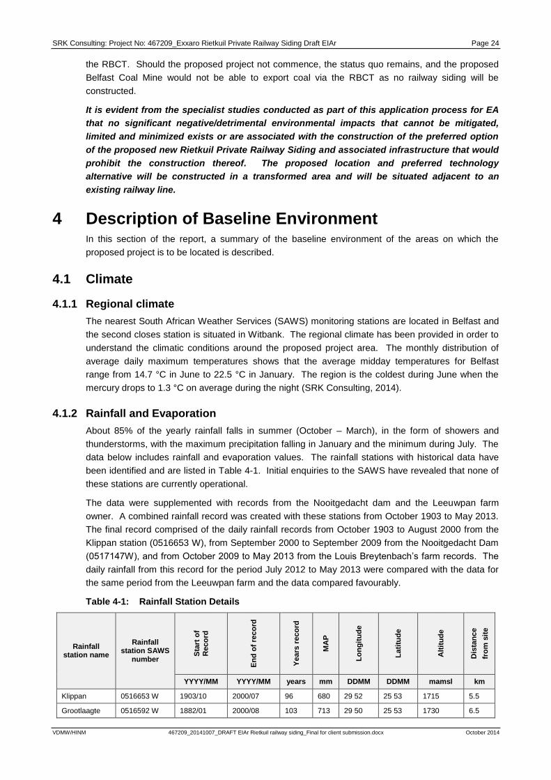
SRK Consulting: Project No: 467209_Exxaro Rietkuil Private Railway Siding Draft EIAr Page 24
VDMW/HINM 467209_20141007_DRAFT EIAr Rietkuil railway siding_Final for client submission.docx October 2014
the RBCT. Should the proposed project not commence, the status quo remains, and the proposed
Belfast Coal Mine would not be able to export coal via the RBCT as no railway siding will be
constructed.
It is evident from the specialist studies conducted as part of this application process for EA
that no significant negative/detrimental environmental impacts that cannot be mitigated,
limited and minimized exists or are associated with the construction of the preferred option
of the proposed new Rietkuil Private Railway Siding and associated infrastructure that would
prohibit the construction thereof. The proposed location and preferred technology
alternative will be constructed in a transformed area and will be situated adjacent to an
existing railway line.
4 Description of Baseline Environment In this section of the report, a summary of the baseline environment of the areas on which the
proposed project is to be located is described.
4.1 Climate
4.1.1 Regional climate
The nearest South African Weather Services (SAWS) monitoring stations are located in Belfast and
the second closes station is situated in Witbank. The regional climate has been provided in order to
understand the climatic conditions around the proposed project area. The monthly distribution of
average daily maximum temperatures shows that the average midday temperatures for Belfast
range from 14.7 °C in June to 22.5 °C in January. The region is the coldest during June when the
mercury drops to 1.3 °C on average during the night (SRK Consulting, 2014).
4.1.2 Rainfall and Evaporation
About 85% of the yearly rainfall falls in summer (October – March), in the form of showers and
thunderstorms, with the maximum precipitation falling in January and the minimum during July. The
data below includes rainfall and evaporation values. The rainfall stations with historical data have
been identified and are listed in Table 4-1. Initial enquiries to the SAWS have revealed that none of
these stations are currently operational.
The data were supplemented with records from the Nooitgedacht dam and the Leeuwpan farm
owner. A combined rainfall record was created with these stations from October 1903 to May 2013.
The final record comprised of the daily rainfall records from October 1903 to August 2000 from the
Klippan station (0516653 W), from September 2000 to September 2009 from the Nooitgedacht Dam
(0517147W), and from October 2009 to May 2013 from the Louis Breytenbach’s farm records. The
daily rainfall from this record for the period July 2012 to May 2013 were compared with the data for
the same period from the Leeuwpan farm and the data compared favourably.
Table 4-1: Rainfall Station Details
Rainfall station name
Rainfall station SAWS
number
Sta
rt o
f R
eco
rd
En
d o
f re
co
rd
Years
reco
rd
MA
P
Lo
ng
itu
de
La
titu
de
Alt
itu
de
Dis
tan
ce
fro
m s
ite
YYYY/MM YYYY/MM years mm DDMM DDMM mamsl km
Klippan 0516653 W 1903/10 2000/07 96 680 29 52 25 53 1715 5.5
Grootlaagte 0516592 W 1882/01 2000/08 103 713 29 50 25 53 1730 6.5

SRK Consulting: Project No: 467209_Exxaro Rietkuil Private Railway Siding Draft EIAr Page 25
VDMW/HINM 467209_20141007_DRAFT EIAr Rietkuil railway siding_Final for client submission.docx October 2014
Rainfall station name
Rainfall station SAWS
number Sta
rt o
f R
eco
rd
En
d o
f re
co
rd
Years
reco
rd
MA
P
Lo
ng
itu
de
La
titu
de
Alt
itu
de
Dis
tan
ce
fro
m s
ite
Fairview 0516777 W 1903/10 2000/07 95 710 29 56 25 57 1701 6.9
Farmhouse 2009/10 2013/05 5 727 29 86 25 93 1734 0.35
Bosmanspruit 0516414 1882/01 2000/08 103 626 29 45 25 54 1661 2.5
The annual and monthly statistics were derived from the combined rainfall data. The annual rainfall
varies from a minimum of 389mm (1935) to a maximum of 1083mm (1987) as indicated in Figure
4-1. The annual rainfall is less than 600 mm for 25% of the time.
RIETKUIL PRIVATE RAILWAY SIDING AND
ASSOCIATED INFRASTRUCTURE
Project No.
467209
Figure 4-1: Percentiles of Monthly Rainfall and Annual Rainfall (Inset) for the Klippan-Nooitgedacht Dam-Leeuwpan Combined Record
Long-term monthly averages for rainfall (combined rainfall record) and evaporation Symons pan
derived from the quaternary records in WR2005, (Middleton & Bailey, 2011), are shown in Table 4-2
and Table 4-3.
Table 4-2: Average Rainfall in mm from the Combined Record
Rain Jan Feb Mar Apr May Jun Jul Aug Sep Oct Nov Dec Total
(mm) 123 89 90 42 13 6 5 8 23 73 111 116 685
Table 4-3: Average Monthly Evaporation at Symons Pan
Evaporation Oct Nov Dec Jan Feb Mar Apr May Jun Jul Aug Sep Total
S-Pan Evap. (mm)
137.8 137.5 156.2 163.6 140.2 137.6 104.4 91.1 74.8 80.8 102.2 124.0 1450
Lake Evap Factor
0.8 0.8 0.8 0.8 0.8 0.8 0.8 0.8 0.8 0.8 0.8 0.8
Lake Evap (mm)
111.6 112.7 129.6 137.4 123.4 121.1 91.9 79.2 63.6 67.0 82.8 100.1 1220

SRK Consulting: Project No: 467209_Exxaro Rietkuil Private Railway Siding Draft EIAr Page 26
VDMW/HINM 467209_20141007_DRAFT EIAr Rietkuil railway siding_Final for client submission.docx October 2014
RIETKUIL PRIVATE RAILWAY SIDING AND
ASSOCIATED INFRASTRUCTURE
Project No.
467209
Figure 4-2: Average Monthly Rainfall for the Klippan-Nooitgedacht Dam-Leeuwpan Combined Record (1904 – 2012) and Symons Pan Evaporation from WR2005
4.2 Topography
The general topography of the area consists of undulating plains. The terrain morphology forms part
of Division E, namely closed hills and mountains with a moderate and high relief, and sub-division
27, namely low mountains. The slopes consist of concave, convex and straight slopes with a relief
of between 450 – 900 m. Less than 20% of the area consists of areas with a slope of less than 5%
(Marsh (Pty) Ltd, 2010). Two drainage systems are present where the proposed coal stockpiling
area will be located, falling from the east to the west over the northern section of the proposed coal
stockpile area draining towards the Bosmanspruit. The Bosmanspruit is approximately 1.2 km away
from the proposed railway siding, PCD and coal stockpile area. Based on the site contours the
Bosmanspruit will not be impacted upon by the construction of the proposed new Rietkuil Private
Railway Siding and associated infrastructure. The coal stockpile area will be appropriately lined and
in terms of the storm water management system the storm water run-off from the stockpile area will
drain towards the lined PCD.
4.3 Geology
The geology of the study area is comprised of Vryheid and Dwyka sediments of the Ecca Group,
within the Karoo Supergroup. The basement is made up of pre-Karoo, gabbro, diabase and felsite
(Rooiberg Formation). The sedimentary succession of sandstones, thinly laminated siltstones,
subordinated shales and coal seams is generally horizontal. A map of the geology of the study area
is included as Figure 4-3.

SRK Consulting: Project No: 467209_Exxaro Rietkuil Private Railway Siding Draft EIAr Page 27
VDMW/HINM 467209_20141007_DRAFT EIAr Rietkuil railway siding_Final for client submission.docx October 2014
RIETKUIL PRIVATE RAILWAY SIDING AND ASSOCIATED INFRASTRUCTURE Project No.
467209
Figure 4-3: Geological Map

SRK Consulting: Project No: 467209_Exxaro Rietkuil Private Railway Siding Draft EIAr Page 28
VDMW/HINM 467209_20141007_DRAFT EIAr Rietkuil railway siding_Final for client submission.docx October 2014
4.4 Geochemical
Information on the geology and geochemistry of coal generated from the Witbank Coal Fields was
sourced from literature and it was important to interpret the analyses of the samples from the
analogue collieries that are located in close proximity to Belfast area, with these collieries used as
indicative of the geochemical characteristics of the material to be stockpiled at the siding.
Mineralogical analysis studies carried out by Pinetown, K. & Boer, R. (2004) as part of a regional
acid base accounting study of the Highveld/Witbank coalfields indicated that the coal contains the
acid generating sulfide mineral, pyrite. Fast acid neutralising carbonate minerals, calcite and
dolomite, are also present in the coal discard and coal fines (Vermeulen, D., Cruywagen, L. M., &
Steyl, G., 2011).
Three coal samples from Coal Seam No. 2 were collected by Exarro as analogues that Exxaro
believes to be representative of the material to be stockpiled at the siding and these were delivered
to SRK for analyses. A large diameter core was drilled from the Belfast coal deposit to obtain the
samples. Based on geological data, the deposit was divided into different areas (1, 2 & 3) on the
basis of the areas where coal was expected to have similar characteristics. The laboratory results,
data analysis and interpretation for the geochemical characterisation of the coal samples concluded
that the coal to be stockpiled at the proposed new Rietkuil Private Railway Siding are potentially non
–acid forming as it is presently neutral and is predicted to stay neutral in the future.
4.5 Soils and Land use
4.5.1 Soils
The dominant soil forms identified in the project affected area (sidings and roads) belong to the
Bloemdal, Glencoe, Hutton, Longlands and Pindene soil forms. Brief characteristics of the dominant
soils forms pertinent to rehabilitation are presented below.
Bloemdal form (Bd) (12.4 ha or 17.7 % of the baseline study area)
Soil depths of the Bloemdal profiles surveyed on site ranged between 400mm and 700mm with
restrictive layers of rock or unspecified material with signs of wetness. Bloemdal soils with no
restrictions shallower than 500mm are generally good for crop production. All Bloemdal profiles are
structure less or have very weakly developed structure. The high quality orthic A and red apedal B-
horizons make it a suitable soil form for annual crop production.
Glencoe form (Gc) (15.2 ha or 21.7 % of the baseline study area)
This soil form characteristically has a moderately high degree of weathering, depletion of bases and
no significant acidity. The texture is a sandy loam and the morphology indicates a fluctuating water
table. Available Phosphate is usually very low although bases and micronutrients are in moderate
supply. The acidification risk is high with large Nitrogen fertiliser applications because of the sandy
structure. The soil can be used for dry land crop production but is more suitable for grazing.
Hutton form (Hu) (14.08 ha or 20.09% of the total study area)
Soil depths of the Hutton profiles surveyed on site ranged between 400mm and 700mm with
restrictive layers of rock or unspecified material without signs of wetness. Hutton soils with no
restrictions shallower than 500mm are generally good for crop production. All Hutton profiles are
structure less or have very weakly developed structure. The high quality orthic A and red apedal B-
horizons make it a suitable soil form for annual crop production (good rooting medium) and use as

SRK Consulting: Project No: 467209_Exxaro Rietkuil Private Railway Siding Draft EIAr Page 29
VDMW/HINM 467209_20141007_DRAFT EIAr Rietkuil railway siding_Final for client submission.docx October 2014
‘topsoil’, having favourable structure (weak 1blocky to 2apedal) and consistence (slightly firm to
friable). However, its suitability for crop production is limited by the climate where it is found but
rainfall in the study area is sufficient for successful dryland crop production.
Longlands form (Lo) (10.3 ha or 20% of the baseline study area)
The Longlands soil form has a moderately high degree of weathering, depletion of bases and
moderate acidity and a sandy loam texture. The soil needs lime and broad-spectrum fertilising for
crop production but low buffer capacity will lead to rapid acidification if nitrogen is applied to
generously. Groundwater vulnerability would be high in the case of pollution. Lateral discharge
through the E and B horizons would result in the toe slope reception area being affected by a plume
of polluted water.
Pinedene form (Pn) (21.4 ha or 30.5 % of the baseline study area)
The Pinedene soil form consists of an orthic A horizon overlying a yellow-brown apedal B horizon
that is underlain by unspecified material with signs of wetness. The Pinedene soil form has a
moderately high degree of weathering, depletion of bases and moderate acidity and a sandy loam
texture. Dolomitic lime would be needed to achieve good crop yields. The soil is suited to dryland
crop production, subject to appropriate chemical amelioration.
4.5.2 Land Capability of the area
Land capability classes were determined using the guidelines outlined in Section 7 of The Chamber
of Mines Handbook of Guidelines for Environmental Protection (Volume 3, 1981). The Chamber of
Mines pre-mining land capability system was utilised, given that this is the dominant capability class
classification system utilized in the mining and industrial fields.
Table 1 indicates the set of criteria as stipulated by the Chamber of Mines (1981) to group soil forms
into different land capability classes.
Table 4-4: Pre-Mining Land Capability Requirements
Criteria Description
Criteria for Wetland Land with organic soils; or
A horizon that is gleyed throughout more than 50 % of its volume and is significantly thick, occurring within 750mm of the surface.
Criteria for Arable
Land
Land, which does not qualify as a wetland;
The soil is readily permeable to the roots of common cultivated plants to a depth of 750mm;
The soil has a pH value of between 4,0 and 8.4’
The soil has a low salinity and SAR;
The soil has a permeability of at least 1,5-mm per hour in the upper 500-mm of soil;
The soil has less than 10 % (by volume) rocks or pedocrete fragments larger than 100-mm in diameter in the upper 750-mm;
Has a slope (in %) and erodibility factor (K) such that their product is <2.0;
Occurs under a climatic regime, which facilitates crop yields that are at
1 BLOCKY STRUCTURE: A cube shaped ped
2 APEDAL: These soils are either single grained (incoherent) or massive (coherent). Peds are not apparent when the soil is moderately
moist.

SRK Consulting: Project No: 467209_Exxaro Rietkuil Private Railway Siding Draft EIAr Page 30
VDMW/HINM 467209_20141007_DRAFT EIAr Rietkuil railway siding_Final for client submission.docx October 2014
least equal to the current national average for these crops, or is currently being irrigated successfully.
Criteria for Grazing
Land
Land, which does not qualify as wetland or arable land;
Has soil, or soil-like material, permeable to roots of native plants, that is more than 250-mm thick and contains less than 50 % by volume of rocks or pedocrete fragments larger than 100-mm;
Supports, or is capable of supporting, a stand of native or introduced grass species, or other forage plants, utilizable by domesticated livestock or game animals on a commercial basis.
Criteria for
Wilderness Land
Land, which does not qualify as wetland, arable land or grazing land.
Based on this system, the soil and land types identified in the study area could all be classified into
three different land capability classes. Deeper soils of the Hutton, Pinedene, and Bloemdal forms
have arable land capabilities which are suitable for dryland crop production. The Glencoe soil form
has grazing land capability. The Katspruit, Kroondal, Longlands and Willowbrook soil forms (6.72 ha
or 9.59% of the study site) have wetland land capability. Figure 4-4, Figure 4-5, Figure 4-6, Figure
4-7 and Figure 4-8 depicts the land use capability of the area.

SRK Consulting: Project No: 467209_Exxaro Rietkuil Private Railway Siding Draft EIAr Page 31
VDMW/HINM 467209_20141007_DRAFT EIAr Rietkuil railway siding_Final for client submission.docx October 2014
RIETKUIL PRIVATE RAILWAY SIDING AND ASSOCIATED
INFRASTRUCTURE Project No.
467209
Figure 4-4: Land Capability of the Proposed New Access Road to the proposed new Rietkuil Private Railway Siding

SRK Consulting: Project No: 467209_Exxaro Rietkuil Private Railway Siding Draft EIAr Page 32
VDMW/HINM 467209_20141007_DRAFT EIAr Rietkuil railway siding_Final for client submission.docx October 2014
RIETKUIL PRIVATE RAILWAY SIDING AND ASSOCIATED
INFRASTRUCTURE
Project No. 467209
Figure 4-5: Land Capability of the proposed new Rietkuil Private Railway Siding Road Upgrade (Map 1)

SRK Consulting: Project No: 467209_Exxaro Rietkuil Private Railway Siding Draft EIAr Page 33
VDMW/HINM 467209_20141007_DRAFT EIAr Rietkuil railway siding_Final for client submission.docx October 2014
RIETKUIL PRIVATE RAILWAY SIDING AND ASSOCIATED
INFRASTRUCTURE Project No.
467209
Figure 4-6: Land Capability of the proposed new Rietkuil Private Railway Siding Road Upgrade (Map 2)

SRK Consulting: Project No: 467209_Exxaro Rietkuil Private Railway Siding Draft EIAr Page 34
VDMW/HINM 467209_20141007_DRAFT EIAr Rietkuil railway siding_Final for client submission.docx October 2014
RIETKUIL PRIVATE RAILWAY SIDING AND ASSOCIATED
INFRASTRUCTURE Project No.
467209
Figure 4-7: Land Capability of the proposed new Rietkuil Private Railway Siding Road Upgrade (Map 3)

SRK Consulting: Project No: 467209_Exxaro Rietkuil Private Railway Siding Draft EIAr Page 35
VDMW/HINM 467209_20141007_DRAFT EIAr Rietkuil railway siding_Final for client submission.docx October 2014
RIETKUIL PRIVATE RAILWAY SIDING AND ASSOCIATED
INFRASTRUCTURE Project No.
467209
Figure 4-8: Land capability map of the proposed new Rietkuil Private Railway Siding Pollution Control Dam and Coal Loading Facility development footprint area

SRK Consulting: Project No: 467209_Exxaro Rietkuil Private Railway Siding Draft EIAr Page 36
VDMW/HINM 467209_20141007_DRAFT EIAr Rietkuil railway siding_Final for client submission.docx October 2014
4.5.3 Land Use
The entire siding and its immediate surrounds can be broadly defined as agricultural land with crop
and grazing fields on commercial farms. Crops like maize, potatoes, soya beans and sunflowers are
produced and grazing fields are mainly used for cattle farming. Other surrounding land uses include
coal mines with their associated infrastructure and an Eskom power station and substation also with
associated infrastructure. There are also commercial activities like a fuel station. Figure 4-9 depicts
the surrounding land uses.
RIETKUIL PRIVATE RAILWAY SIDING AND
ASSOCIATED INFRASTRUCTURE Project No.
467209
Figure 4-9: Surrounding land use map of the proposed new Rietkuil Private Railway Siding
4.6 Biodiversity
4.6.1 Vegetation
The study area falls within the Eastern Highveld Grassland vegetation type which occurs in the
plains between Belfast in the east and the eastern side of Johannesburg in the west and extends
southwards to Bethal, Ermelo and west of Piet Retief (Mucina & Rutherford, 2006).
The Eastern Highveld Grassland is considered endangered (Mucina & Rutherford, 2006) with only a
very small fraction conserved in statutory reserves (Nooitgedacht Dam and Jericho Dam Nature
Reserves) and in private reserves (Holkranse, Kransbank, Morgenstond). Approximately 44% is
transformed primarily by cultivation, plantations, mines, and urbanisation and by building of dams.
Cultivation may have had a more extensive impact, indicated by land-cover data. No serious alien

SRK Consulting: Project No: 467209_Exxaro Rietkuil Private Railway Siding Draft EIAr Page 37
VDMW/HINM 467209_20141007_DRAFT EIAr Rietkuil railway siding_Final for client submission.docx October 2014
invasions are reported, but Acacia mearnsii can become dominant in disturbed areas. Erosion is
very low (Mucina & Rutherford, 2006).
However, in terms of the National List of Threatened Terrestrial Ecosystems (2011) published in
terms of NEM: BA the proposed portion of the remaining extent of the Eastern Highveld Grassland
Ecosystem, listed as a ‘Vulnerable’ ecosystem, presents most sections of the study area.
Further, in terms of National Protected Area Expansion Strategy (NPAES) the study area is not
affected by areas earmarked as part of the NPAES, nor is it situated close to any formally or
informally protected areas.
Three habitats are present in the study area and it comprises of:
Transformed Habitat Unit:
Commercial crop cultivation is the dominant land-use associated with the region where the study
area is situated, with Zea mays (maize) being the dominant crop. Furthermore, several stands
of alien tree bushclumps (mainly Acacia mearnsii) are present in the study area. All areas
associated with past or present crop cultivation, existing roads and all other disturbed areas fall
within the transformed habitat unit. All of these land-use activities have led to the alteration of
the floral community structure and habitat integrity of the transformed habitat unit to an
irreversible degree in most instances. Therefore, the transformed habitat unit is considered to
be of low conservation importance.
Secondary grasslands:
Sections associated with the study area which are not characterised as wetlands or transformed
areas are classified as secondary grassland. The majority of the grassland areas have been
transformed by grazing related impacts and edge effects associated with existing infrastructure
and commercial agriculture which has resulted in alteration of the floral community structure,
resulting in woody encroachment of species such as Seriphium plumosum, erosion and
trampling. As a result, ecological function was found to be moderate to low in most areas,
especially nearer to crop fields and existing railway infrastructure. The dominant grasses at the
time of the assessment were Eragrostis curvula and E. chloromelas; grass species associated
with transformation, which proliferates in disturbed places such as old cultivated lands and along
roadsides. Invasion of alien and invasive species such as Verbena bonariensis, Verbena
tenuisecta and Seriphium plumosum was also encountered within the more disturbed grassland
areas. The project is not deemed a threat to grassland habitat conservation in the area.
Wetland areas:
Several wetland features (see more detail in wetland section) were identified in the study area.
All of these wetlands have been affected to varying degrees by road construction, agriculture,
trampling by livestock and general anthropogenic activities, which have negatively affected the
habitat integrity of these systems. The wetlands are considered to be in a moderately modified
state and a moderate change in ecosystem processes and loss of natural habitats has taken
place but the natural habitat remains predominantly intact. Therefore, although some wetland
areas are more transformed than others, the wetland habitat unit as a whole is considered to be
of increased conservational importance from a floral perspective in relation to the surrounding
terrestrial areas.

SRK Consulting: Project No: 467209_Exxaro Rietkuil Private Railway Siding Draft EIAr Page 38
VDMW/HINM 467209_20141007_DRAFT EIAr Rietkuil railway siding_Final for client submission.docx October 2014
4.6.2 Faunal habitat
Various faunal habitat units were identified within the proposed new Rietkuil Private Railway Siding
study area. The major habitat units included transformed grassland habitat which comprised the
majority of the study area, transformed habitat (roads, railways and crop fields) as well as wetland
habitat.
No mammals were directly observed during the field assessment of the study area. Scattered
burrows, most likely those of the Ichneumia albicauda (white-tailed mongoose), provided proof of
mammal presence on the site. Further, the following species Canis mesomelas (Black backed
Jackal), Hystrix africaeaustralis (South African Porcupine), Raphicerus campestris (Steenbok),
Cephalophus natalensis (Red duiker), Leptailurus serval (serval) and Parahyaena brunnea (Brown
Hyaena) were identified by scat and spoor found within the proposed Rietkuil Private Railway Siding
study area. All of the aforementioned species, except for the Parahyaena brunnea (Brown Hyaena),
are considered to be of Least Concern. The Brown Hyaena is considered to be Near Threatened in
terms of the (IUCN, 2013).
Livestock such as goats and cattle were also noted within the proposed new Rietkuil Private Railway
Siding and associated infrastructure study area. Several other mammal species may also reside or
forage within the study area or utilise it as a migratory or movement corridor.
The Brown Hyaena is known to be highly adaptable and often inhabits areas with high levels of
anthropogenic activity. The likelihood of any other threatened mammal species crossing the
proposed new Rietkuil Private Railway Siding and associated infrastructure study area is considered
to be low due to the high levels of anthropogenic activity such as agricultural activity, historic and
current mining activities in the study area.
4.6.3 Avifaunal
Avifauna surveys were conducted across the entire Proposed Rietkuil Private Railway Siding and
associated infrastructure study area and all avifauna species seen or heard during the time of the
field assessment were recorded.
Common species known to utilise the grassland and wetland habitat in the region for either foraging
or breeding and may therefore be either permanently or occasionally present within the study area.
No threatened Red Data List (RDL) avifauna species were identified within the study area during the
site survey. However, the likelihood that some of these RDL avifauna species utilising the study
area for foraging purposes or as a migratory corridor, with specific reference to raptor species, is
considered high. Threatened species with a greater than 60% probability of occurrence of utilising
the proposed Rietkuil Private Railway Siding study area, predominantly for foraging purposes, are
Tyto capensis (African Grass Owl) and Falco peregrinus (Peregrine Falcon). Furthermore,
according to the National Freshwater Ecosystem Priority Areas (NFEPA) database, a depression
(pan) in close proximity to the D 1110 provincial road, is located within a sub-quaternary catchment
that has sightings or breeding areas for threatened Bugeranus carunculatus (Wattled Crane),
Balearica regulorum (Grey Crowned Crane) or Anthropoides paradiseus (Blue Crane).
4.6.4 Reptiles
No reptiles were observed during the Proposed Rietkuil Private Railway Siding and associated
infrastructure field assessment. No RDL reptile species were identified during the field assessment
and due to the high levels of historical and current anthropogenic activities within the study area and
surrounding region, the probability of such species occurring will be very low.

SRK Consulting: Project No: 467209_Exxaro Rietkuil Private Railway Siding Draft EIAr Page 39
VDMW/HINM 467209_20141007_DRAFT EIAr Rietkuil railway siding_Final for client submission.docx October 2014
4.6.5 Amphibians
No amphibian species were encountered during the field assessment, partially due to the largely
nocturnal habits of amphibians and due to high levels of habitat transformation within and around the
Proposed Rietkuil Private Railway Siding and associated infrastructure study area. The only
amphibian species listed as being of conservational concern is the Pyxicephalus adspersus (Giant
Bullfrog) in terms of the Mpumalanga State of the Environment Report (2003).
However, no Giant Bullfrogs were identified within or in the vicinity of the study area, although the
study area falls within the distribution range of this species. The Pyxicephalus adspersus is known
to occur within and nearby riparian and wetland zones.
They breed in shallow waters and can occupy temporary floodplains and rapidly drying pool areas.
Giant bullfrogs are also known to travel vast distances and may utilise wetlands as migratory
corridors in favourable conditions. The lack of extensive areas with shallow seasonal pans within the
proposed Rietkuil Private Railway Siding surface area will limit the ability for this species to
successfully breed in the study area, however it is likely to utilise the wetlands in and around the
proposed Rietkuil Private Railway Siding project footprint area as migratory corridors and in search
of food. However, with the implementation of the mitigation measures as set out in this report, it is
considered highly likely that any impact on the migratory corridors or areas with adequate food
availability can be reduced. In terms of conservation important species, there is a low possibility of
encountering RDL and / or threatened amphibian species within the study area.
4.6.6 Invertebrates
The invertebrate assessment conducted was a general assessment with the purpose of identifying
common species and taxa in the study area. The proposed new Rietkuil Private Railway Siding and
associated infrastructure footprint falls within the distribution range noted for Metisella meninx,
however, no populations of this species were identified during the site assessment. M. meninx,
commonly known as the Marsh Sylph, is an invertebrate noted as Vulnerable by the Mpumalanga
State of the Environment Report (Mpumalanga Department of Agriculture, 2003) although it is not
yet listed on the (IUCN, 2013). Its preferred habitat comprises of wetlands where Leersia hexandra
(Marsh grass) is dominant. Despite the fact that L. hexandra was identified within proposed
development footprint of the private railway siding, during the survey, no M. meninx were recorded.
The likelihood of M. meninx occurring is also considered to be low as the wetland areas have been
significantly transformed.
Spiders and scorpions
No threatened spider or scorpion species are listed in the Mpumalanga State of the Environment
Report (2003). Therefore, a record of threatened spiders and scorpions was acquired from the most
recent RDL spider and scorpion data available for South Africa using the South African National
Biodiversity Institute (SANBI) threatened species database (http://www.speciesstatus.sanbi.org).
Various arachnid species, which includes amongst other Trapdoor and Baboon spiders, are
protected or listed as threatened throughout South Africa in terms of the NEM: BA. I
However, no evidence was encountered of endangered or threatened Mygalomorphae arachnids
(Baboon and Trapdoor spiders) and RDL scorpions within the study area. It should, however, be
noted that these species are notoriously difficult to detect and is considered highly unlikely that these
species will occur within the study area due to habitat transformation. No spider or scorpion species
were encountered during the field assessment, and it is unlikely that a diverse arachnid and scorpion
community is present within the proposed development footprint area and surroundings due to the
lack of suitable habitat such as rocky areas. Thus, due to the already highly transformed habitat

SRK Consulting: Project No: 467209_Exxaro Rietkuil Private Railway Siding Draft EIAr Page 40
VDMW/HINM 467209_20141007_DRAFT EIAr Rietkuil railway siding_Final for client submission.docx October 2014
within the study area, the proposed development is unlikely to pose a threat to arachnid and
scorpion conservation in the region, provided that the mitigation measures as set out in this report
are adhered to.
4.7 Surface Water
This site bisects the four quaternary catchments X11C, X11D, B12B and B12C. These quaternary
catchments fall within the Olifants and Inkomati Water Management Areas. Each WMA is divided
into several sub-Water Management Areas (subWMAs). The subWMAs for the study area is the
Upper Olifants subWMA and the Komati West subWMA. The total catchment area of the study area
is 86.87 km2. The area is divided into a number of southward running streams. There are also a
number of pans and dams within the catchment. The quaternary catchments are divided into sub
catchments and described below.
4.7.1 Catchment 1
This catchment forms part of quaternary catchment X11C. The catchment was delineated and the
size of the catchment is 29.04 km2. The catchment consists of a few tributaries that drain into the
Blesbokspruit which is a tributary of the Witkloofspruit. There are a number of small dams within the
catchment. The natural vegetation within the catchment is covered by grasslands and cultivated
land and the land use within the catchment is mainly farming. The catchment is characterised with a
maximum catchment elevation in the north flowing and the lowest elevation in the catchment in the
south.
4.7.2 Catchment 2
This catchment forms part of quaternary catchment X11C. The catchment was delineated and the
size of the catchment is 3.08 km2. There is only one tributary within the catchment that drains to the
Blesbokspruit. Any runoff within the catchment will drain towards the Blebokspruit. There is one pan
(Pan 1) within the catchment. The pan has a surface area of 5000 m2 and a gross storage capacity
of 2500 m3. The natural vegetation within the catchment is covered by grasslands and cultivated
land and the land use within the catchment is mainly farming.
4.7.3 Catchment 3
This catchment forms part of quaternary catchment X11C. The catchment was delineated and the
size of the catchment is 3.89 km2. There is one river within the catchment namely the tributary of the
Blesbokspruit. There is one dam within the catchment with a surface are of 60 000 m2. The natural
vegetation within the catchment is covered by grasslands and cultivated land and the land use within
the catchment is mainly farming.
4.7.4 Catchment 4
This catchment forms part of quaternary catchment X11C. The catchment was delineated and the
size of the catchment is 2.80 km2. The catchment consist of 1 pan (Pan 1) with a surface area of 5
500 m2 and a gross storage capacity of 3000 m
3. There are no major rivers within the catchment.
The catchment seems to be fairly flat. The natural vegetation within the catchment is covered by
grasslands and cultivated land and the land use within the catchment is mainly farming. The
catchment is characterised with a maximum height being experienced in the north.
4.7.5 Catchment 5
This catchment forms part of quaternary catchment X11C. The catchment was delineated and the
size of the catchment is 3.63 km2. There are no major rivers within the catchment. The natural

SRK Consulting: Project No: 467209_Exxaro Rietkuil Private Railway Siding Draft EIAr Page 41
VDMW/HINM 467209_20141007_DRAFT EIAr Rietkuil railway siding_Final for client submission.docx October 2014
vegetation within the catchment is covered by grasslands and cultivated land and the land use within
the catchment is mainly farming.
4.7.6 Catchment 6
This catchment forms part of quaternary catchment X11C. The catchment was delineated and the
size of the catchment is 3.56 km2. There are no pan and major rivers in this catchment. All pans
have being mined through. The land use in the catchment is mainly for mining. The catchment is
characterised with a maximum height being experienced in the North West flowing towards the south
east.
4.7.7 Catchment 7
This catchment forms part of quaternary catchment X11C. The catchment was delineated and the
size of the catchment is 2.78 km2. There is one minor tributary within the catchment which flows into
catchment 13 and then into the Klippan. There is only one dam (Dam 5) within the catchment with a
vertical wall height of 13 m; crest length of 100 m and a gross storage capacity of 100 000 m3. The
natural vegetation within the catchment is covered by grasslands and cultivated land and the land
use within the catchment is mainly farming.
4.7.8 Catchment 8
This catchment forms part of quaternary catchment B12C. The catchment was delineated and the
size of the catchment is 1.30 km2. There is one river that’s contributing to the catchment namely the
tributary of the Klippan. There is one dam (Dam 6) within the catchment with a vertical wall height of
2.5 m; crest length of 350 m and a gross storage capacity of 20 000 m3. The natural vegetation
within the catchment is covered by grasslands and cultivated land and the land use within the
catchment is mainly farming.
4.7.9 Catchment 9
This catchment forms part of quaternary catchment B12C. The catchment was delineated and the
size of the catchment is 1.33 km2. There is an unknown tributary that’s contributing to the
catchment. There are no dams and pans within the catchment. The natural vegetation within the
catchment is covered by grasslands and cultivated land and the land use within the catchment is
mainly farming.
4.7.10 Catchment 10
This catchment forms part of quaternary catchments B12B and B12C. This catchment forms part of
quaternary catchment B12C. The catchment was delineated and the size of the catchment is
1.13 km2. There are no major rivers and also no dams and pans within the catchment. The slope of
the catchment seems to be fairly flat. The natural vegetation within the catchment is covered by
grasslands and cultivated land and the land use within the catchment is mainly farming.
4.7.11 Catchment 11
This catchment forms part of quaternary catchments B12B and B12C. The catchment was
delineated and the size of the catchment is 9.56 km2. Runoff within the catchment flows to the
Bosmanspruit, which is a tributary of the Klein Olifants River. There are no dams and pans within
the catchment. The natural vegetation within the catchment is covered by grasslands at some
places and the land use within the catchment is farming and mining. Run-off within the catchment
flows away from the rail siding towards the Bosmanspruit located to the north west of the catchment.

SRK Consulting: Project No: 467209_Exxaro Rietkuil Private Railway Siding Draft EIAr Page 42
VDMW/HINM 467209_20141007_DRAFT EIAr Rietkuil railway siding_Final for client submission.docx October 2014
4.7.12 Catchment 12
This catchment forms part of quaternary catchment B12C. The catchment was delineated and the
size of the catchment is 0.99 km2. There are no major rivers within the catchment. There is one
dam (Dam 7) within the catchment with a vertical wall height of 4.5 m and a gross storage capacity
of 65 000 m3. The land use within the catchment is mainly mining. The topography of the catchment
is fairly flat. Most of the run-off in the catchment flows towards the pan.
4.7.13 Catchment 13
This catchment forms part of quaternary catchment X11C. The catchment was delineated and the
size of the catchment is 20.50 km2. There is one river that’s contributing to the catchment namely
the tributary of the Klippan. There is one pan on the upstream of catchment with a surface area of
100 000 m2. The natural vegetation within the catchment is covered by grasslands and cultivated
land and the land use within the catchment is mainly farming. Elevations vary between 1,760
mamsl, in the north of the catchments and 1,720 mamsl in the south of the catchments. Most of the
run-off in the catchment flows towards the Klippan.
4.7.14 Catchment 14
This catchment forms part of quaternary catchment B12B. The catchment was delineated and the
size of the catchment is 2.84 km2. There are no major rivers and pans within the catchment. The
catchment is characterised with a maximum level experienced in the north east and drains towards
catchment 12. The natural vegetation within the catchment is covered by grasslands at some places
and the land use within the catchment is mainly mining.
4.7.15 Catchment 15
This catchment forms part of quaternary catchments X11C and B41A. The catchment was
delineated and the size of the catchment is 0.44 km2. There are no major rivers and pans within the
catchment. The catchment is characterised with a maximum level experienced in the north and
drains towards the south. The natural vegetation within the catchment is covered by grasslands and
cultivated land and the land use within the catchment is mainly farming.
4.7.16 Catchment 16
This catchment forms part of quaternary catchments B12C. The catchment was delineated and the
size of the catchment is 8.49 km2. Runoff within the catchment flows to a Tributary of the
Bosmanspruit, which is a tributary of the Klein Olifantsriver. There are no dams or pans within the
catchment which contains a portion of the railway loop. The natural vegetation within the catchment
is covered by grasslands at some places and the land use within the catchment is farming and
mining. Run-off within the catchment flows away from the rail siding towards the Bosmanspruit
located to the north west of the catchment.

SRK Consulting: Project No: 467209_Exxaro Rietkuil Private Railway Siding Draft EIAr Page 43
VDMW/HINM 467209_20141007_DRAFT EIAr Rietkuil railway siding_Final for client submission.docx October 2014
RIETKUIL PRIVATE RAILWAY SIDING AND ASSOCIATED
INFRASTRUCTURE Project No.
467209
Figure 4-10: Catchment map of the proposed new Rietkuil Private Railway Siding and associated infrastructure study area

SRK Consulting: Project No: 467209_Exxaro Rietkuil Private Railway Siding Draft EIAr Page 44
VDMW/HINM 467209_20141007_DRAFT EIAr Rietkuil railway siding_Final for client submission.docx October 2014
4.7.17 Surface Water Hydrology
The groundwater flow has been described as mimicking the topography and flowing towards
surface drainage features, with a hydraulic gradient of approximately 0.02 (a 20m fall for every
1000m) (Golder Associates, 2012). The regional flow patterns are likely to have been disturbed by
mine pits surrounding the study area. A site reconnaissance visit to the study area shows
groundwater seepages from the margins of the rolling hills (Figure 4-11). The seepage decants to
shallow natural surface depressions or “pans” that are underlain by clays.
RIETKUIL PRIVATE RAILWAY SIDING AND
ASSOCIATED INFRASTRUCTURE
Project No.
467209
Figure 4-11: Seepage from Shallow Groundwater
4.7.18 Mean Annual Runoff
Catchments areas were delineated for various points of interest and peak flows at their respective
outlets were calculated. The catchments 1 to 10 and 13 to 15 were used as part of the description
of the haul road where streams cross the road. Catchment 11 describes the catchment where the
railway siding will be situated. Catchment 12 describes the catchment where the PCD will be
situated. From the catchment layout shown in Figure 4-10, the catchments were delineated to
calculate the peak flows. The tables below, Table 4-5 and Table 4-6, provide a summary of the
catchment hydrology and peak flows for the catchments of the project area.

SRK Consulting: Project No: 467209_Exxaro Rietkuil Private Railway Siding Draft EIAr Page 45
VDMW/HINM 467209_20141007_DRAFT EIAr Rietkuil railway siding_Final for client submission.docx October 2014
Table 4-5: Summary of Catchment Hydrology for the Project Area
Catchment Name Net area (km
2)
Hydraulic Length (m) Elevation (m) Slope
(m/m) 10 per cent 85 per cent
Catchment 1 29.04 11989.65 1742.75 1820.00 0.006
Catchment 2 3.08 4788.38 1710.00 1776.71 0.014
Catchment 3 3.89 5013.16 1755.92 1802.30 0.009
Catchment 4 2.80 3243.24 1745.00 1795.29 0.016
Catchment 5 3.63 2982.54 1754.98 1774.10 0.006
Catchment 6 3.56 4040.55 1759.50 1765.36 0.001
Catchment 7 2.78 2399.99 1705.42 1755.00 0.021
Catchment 8 1.30 2379.86 1715.00 1733.08 0.008
Catchment 9 1.33 2295.68 1705.89 1720.00 0.006
Catchment 10 1.13 2134.51 1710.00 1720.43 0.005
Catchment 11 9.56 5381.01 1637.64 1699.37 0.011
Catchment 12 0.99 1361.70 1680.00 1687.83 0.006
Catchment 13 20.50 2747.16 1683.88 1728.16 0.016
Catchment 14 2.84 3727.27 1681.42 1710.00 0.008
Catchment 15 0.44 961.98 1793.84 1795.00 0.001
Catchment 16 8.49 4003.66 1682.26 1700.27 0.004
Table 4-6: Summary of Peak Flows (m3/s) for the Project Area
Catchment Name Area (km2)
Peak discharge (m3/s) for different recurrence intervals
2 5 10 20 50 100 200
Catchment 1 29.04 7.64 11.09 14.30 18.42 26.88 36.35 48.39
Catchment 2 3.08 1.83 2.66 3.43 4.42 6.46 8.73 11.62
Catchment 3 3.89 1.98 2.88 3.71 4.78 6.98 9.44 12.57
Catchment 4 2.8 2.04 2.96 3.82 4.92 7.18 9.71 12.92
Catchment 5 2.24 3.26 4.20 5.41 7.89 10.67 14.21 40.79
Catchment 6 3.56 1.23 1.78 2.30 2.96 4.32 5.84 7.77
Catchment 7 2.78 2.52 3.66 4.72 6.08 8.87 12.00 15.98
Catchment 8 1.3 0.94 1.37 1.77 2.28 3.32 4.50 5.98
Catchment 9 1.33 0.94 1.36 1.75 2.26 3.29 4.45 5.93
Catchment 10 1.13 0.78 1.14 1.46 1.89 2.75 3.72 4.95
Catchment 11 9.56 4.82 6.99 9.02 11.62 16.95 22.93 30.52
Catchment 12 0.99 0.89 1.29 1.66 2.14 3.12 4.22 5.62
Catchment 13 20.5 14.73 21.39 27.57 35.53 51.84 70.11 93.33
Catchment 14 2.84 1.65 2.39 3.08 3.97 5.80 7.84 10.43
Catchment 15 0.44 0.32 0.46 0.60 0.77 1.12 1.52 2.02
Catchment 16 8.49 3.90 5.67 7.31 9.42 13.74 18.58 24.74

SRK Consulting: Project No: 467209_Exxaro Rietkuil Private Railway Siding Draft EIAr Page 46
VDMW/HINM 467209_20141007_DRAFT EIAr Rietkuil railway siding_Final for client submission.docx October 2014
4.7.19 Floodlines
A floodline assessment was undertaken after delineating the catchment in which the proposed new
Rietkuil Private Railway Siding and associated infrastructure will be situated. The proposed railway
siding will be situated in Catchment 11. As indicated in Section 4.7 the catchment was delineated
and the size of the catchment is 9.56 km2 with run-off flowing towards the Bosmanspruit which is
situated approximately 1.2 km north-west of the proposed railway siding and PCD.
The catchment delineation was done by following 5 m contours in order to determine what impact
the 1:50 and 1:100 year floodlines would have on the proposed new Rietkuil Private Railway
Siding, the coal loading/stockpile area and PCD. The maximum height of Catchment 11 is
experienced along the southern section of the delineated catchment. The railway siding is situated
along the sourthern section of the delineated catchment. From The simulation shows that the
proposed private railway siding will be located outside of the 1:50 and 1:100 year floodlines.
The closest point to the floodlines is approximately 1.2 km away from the proposed new
Rietkuil Private Railway Siding and associated infrastructure. Therefore it is evident that
the 1:50 and 1:100 year flood will have no impact on the proposed private railway siding.

SRK Consulting: Project No: 467209_Exxaro Rietkuil Private Railway Siding Draft EIAr Page 47
VDMW/HINM 467209_20141007_DRAFT EIAr Rietkuil railway siding_Final for client submission.docx October 2014
RIETKUIL PRIVATE RAILWAY SIDING AND ASSOCIATED INFRASTRUCTURE
Project No. 467209
Figure 4-12: Floodline extent for the proposed new Rietkuil Private Railway Siding and associated infrastructure

SRK Consulting: Project No: 467209_Exxaro Rietkuil Private Railway Siding Draft EIAr Page 48
VDMW/HINM 467209_20141007_DRAFT EIAr Rietkuil railway siding_Final for client submission.docx October 2014
4.7.20 Wetlands
The Mpumalanga Biobase (which is also contained forming part of SANBI’s BGIS database) layer
was consulted to ascertain the location of wetlands and pans mapped by the Mpumalanga Parks
Board. It was established that a number of wetlands have been identified in and around the
proposed development and Figure 4-13 provides an illustration of possible wetlands in and around
the proposed development footprint. Figure 4-14 and Figure 4-15 provides an illustration of the
possible wetlands located in and around the proposed private railway siding and D1770. According
to the Classification System compiled by (Ollis, 2013), the wetland systems associated with the
study area comprise four wetland types, namely hillslope seep, channelled valley bottom,
unchannelled valley bottom and depression. The wetland functions and service provision of the
wetland features was assessed utilising the WET-Ecoservices (Kotze, et al., 2008) method and
concluded that the wetlands provide moderate level of eco-services and functionality.
In terms of the Present State of a Wetland (PES) scores it was determined that all the wetlands can
be considered Category C wetlands (moderately modified; a moderate change in ecosystem
processes and loss of natural habitats has taken place but the natural habitat remains predominantly
intact). The PES categories/scores for wetlands features are obtained by using the formula3 as
provided by the Wet-Health methodology.
The method used for the Ecological Importance and Sensitivity (EIS) determination was adapted
from the method as provided by DWAF (1999) for floodplains. The method takes into consideration
PES scores obtained for WET-Health as well as function and service provision to enable the
assessor to determine the most representative EIS category for the wetland feature or group being
assessed. The EIS method was applied to all four wetlands in order to ascertain their sensitivity to
flow and habitat modifications. After consideration of the wetland function and WET-Health
assessments, as well as the outcome of the EIS assessment, the Recommended Ecological Class
(REC) for the wetlands is considered to be a Category B for wetlands A, B, D, E and F and Category
C for the remainder of the wetlands.
3 ((Hydrology score) x 3 + (geomorphology score) x2 + (vegetation score) x 2))/ 7 = PES

SRK Consulting: Project No: 467209_Exxaro Rietkuil Private Railway Siding Draft EIAr Page 49
VDMW/HINM 467209_20141007_DRAFT EIAr Rietkuil railway siding_Final for client submission.docx October 2014
RIETKUIL PRIVATE RAILWAY SIDING AND ASSOCIATED INFRASTRUCTURE Project No. 467209
Figure 4-13: Illustration of the wetlands in and around the proposed new Rietkuil Private Railway Siding and associated infrastructure project area

SRK Consulting: Project No: 467209_Exxaro Rietkuil Private Railway Siding Draft EIAr Page 50
VDMW/HINM 467209_20141007_DRAFT EIAr Rietkuil railway siding_Final for client submission.docx October 2014
RIETKUIL PRIVATE RAILWAY SIDING AND ASSOCIATED INFRASTRUCTURE Project No. 467209
Figure 4-14: Wetland types associated with the proposed new Rietkuil Private Railway Siding and associated infrastructure

SRK Consulting: Project No: 467209_Exxaro Rietkuil Private Railway Siding Draft EIAr Page 51
VDMW/HINM 467209_20141007_DRAFT EIAr Rietkuil railway siding_Final for client submission.docx October 2014
RIETKUIL PRIVATE RAILWAY SIDING AND ASSOCIATED INFRASTRUCTURE Project No. 467209
Figure 4-15: Wetland Types Associated with the upgrading of the D1770

SRK Consulting: Project No: 467209_Exxaro Rietkuil Private Railway Siding Draft EIAr Page 52
VDMW/HINM 467209_20141007_DRAFT EIAr Rietkuil railway siding_Final for client submission.docx October 2014
4.8 Groundwater
Previous studies identified four water bearing units that may or may not be connected: upper
shallow, fractured, aquifers associated with coal seams and aquifers associated with dolerite
intrusions. The weathered Karoo aquifer is described as consisting of in situ weathered or
transported material, extending down to depths of 5m to 15m below surface. The fractured
aquifers, coal seam aquifers and those associated with dolerite intrusions consist of deeper
Karoo strata, with water strikes associated with bedding plane fractures, faults and contact
zones with dolerite dykes and sills (Golder Associates, 2012).
The measured groundwater levels vary between 4m and 8m below ground level (Wates,
1996) and (Ferret Mining and Environmental Services, 2004). Twelve boreholes drilled by
Golder in 2012 showed groundwater levels ranging from 3.81mbgl to 46.6mbgl. No major
water strikes were encountered.
Groundwater is mainly abstracted by means of boreholes and springs for domestic supplies
and livestock watering. The yields of the local aquifers are incapable of supporting intensive
irrigation. According to the Department of Water Affairs classification system (1998) the
aquifers around the proposed new Rietkuil Private Railway Siding project area can be
classified as Minor Aquifer systems.
Groundwater recharge is estimated at 1% - 3% of the Mean Annual Precipitation (MAP =
685mm/yr), translating to 7mm - 21mm per year. Groundwater contribution to surface water
flows is reduced by evapotranspiration and abstraction from the shallow weathered aquifers.
Only two functioning boreholes were identified during a limited hydrocensus around the
project area. The two boreholes, Twee BH1 and Twee BH2 are used for domestic purposes
and for limited livestock waterin and situated north of the site.
Table 4-7: Tweefontein boreholes sampled
Hole ID Locality pH EC (mS/m)
Twee BH1 Tweefontein 7.2 46.8
Twee BH2 Tweefontein 7.4 66.0
The results returned show groundwater electrical conductivities of 57.2 and 77.9mS/m for
BH1 and BH2, respectively. The groundwater is alkaline with pH measured at 8.1 and 8.4,
respectively. The laboratory results were compared against South African Drinking Water
Quality Standards for Chronic health (South African National Standards (SANS) 241:2011).
Major cation, anion and metal concentrations in the groundwater fall within acceptable
drinking water quality standards.
The laboratory results were compared against South African Drinking Water Quality
Standards for Chronic health (SANS 241:2011). Major cation, anion and metal
concentrations in the groundwater fall within acceptable drinking water quality standards
Table 4-8.
.

SRK Consulting: Project No: 467209_Exxaro Rietkuil Private Railway Siding Draft EIAr Page 53
VDMW/HINM 467209_20141007_DRAFT EIAr Rietkuil railway siding_Final for client submission.docx October 2014
Table 4-8: Groundwater chemistry laboratory results
Sample ID pH EC
(mS/m) TDS
(mg/l) Ca
(mg/l) Mg
(mg/l) Na
(mg/l) K
(mg/l)
Total Alkalinity as CaCO3
Ammonia as N
(mg/l)
Cl (mg/l)
SO4 (mg/l)
NO3-N (mg/l)
F (mg/l)
Co (mg/l)
Cr (mg/l)
Cu (mg/l)
Fe (mg/l)
Mn (mg/l)
Ni (mg/l)
V (mg/l)
Zn (mg/l)
As (mg/l)
Pb (mg/l)
Twee BH1 8.1 57.2 360 6.1 3.7 100 20 245 <0.10 25 19.5 0.1 0.8 0.001 0.005 0.02 0.16 0.01 0.003 0.01 0.01 0.005 <0.001
Twee BH2 8.4 77.9 424 19.7 10.4 125 22 299 <0.10 37 8.4 0.5 1.3 0.001 0.005 0.03 0.09 0.03 <0.003 0.02 0.008 0.004 0.01
Limits (Chronic Health)
5.0-9.7 <170 <1200 <150 <70 <200 <50
<1.5 <300 <500 <11 <1.5 <0.5 <0.05 <2 <2 <0.5 <0.07 <0.2 <5 <0.01 <0.01

SRK Consulting: Project No: 467209_Exxaro Rietkuil Private Railway Siding Draft EIAr Page 54
VDMW/HINM 467209_20141007_DRAFT EIAr Rietkuil railway siding_Final for client submission.docx October 2014
Groundwater quality may be impacted by the oxidation of sulphides in the coal and may
result in acid leachate percolating through the topsoil and into the underlying aquifers.
The acid drainage resulting from the oxidation of sulphides in the coal may infiltrate
downwards into the shallow groundwater system, subsequently seeping out and flowing
into surface water courses and water bodies (tributaries and pans). The use of haulage
trucks and machinery powered by hydrocarbon fuels presents the risk of leaks of fuels
and oils finding their way into the shallow groundwater system. .
4.9 Air quality
Dust fallout results were obtained from the neighbouring Arnot Coal Mine monitoring network.
Since the railway siding will be centrally located from the Arnot Coal Mine’s activities it was
deemed necessary to understand a baseline representation (before Exxaro activities) of dust
fallout in the area. The dust fallout results were generally below the South African dust fallout
standards. Dust fallout results are higher at the centre of Arnot Coal Mine’s operations, which
is 1.6 km south-southeast from the proposed new Rietkuil Private Railway Siding and
associated infrastructure operations. The residential area standard of 600 mg/m2/day and the
non-residential standard of 1,200 mg/m2/day are exceeded at these four locations which
suggest dust generation is higher in this central area (i.e. plant area) when compared to the
other monitoring points south and north of the facility.
The project area and surrounding land can be described as being rural and mainly used for
mining operations and farming land. The town of Rietkuil is located 4.5 km to the south-
southwest of the project site. The following sources of air emissions have been identified in
the area:
Mining activities in the region;
Road network;
Windblown dust (windblown dust especially during the dry season);
Vehicle tailpipe emissions.
4.9.1 Mining activities in the region
There is one mine in close proximity to proposed new Rietkuil Private Railway Siding and
associated infrastructure, namely Arnot Coal Mine. Activities such as crushing, hauling,
activities at the plant and materials handling all contribute to pollutants in the atmosphere.
The main pollutant of concern is particulate matter in the form of inhalable and nuisance dust
as a result of dust fallout.
4.9.2 Road network
Particulate emissions from roadways depend on the type (paved or unpaved) of road and the
number of vehicles using the road. Windblown dust resulting from the erosion of bare ground
depends on the velocity of the wind, the size of the exposed area and moisture and silt
content of such areas. Areas that receive high amounts of rainfall will experience lower levels
of fugitive dust being released into the air than areas that experience low amounts of rainfall
because the rainfall acts as a natural dust suppressant due to the higher moisture content of
the road surface.
The majority of the road network in the surrounding area consists of paved roads. The
access road leading to the proposed operations is currently unpaved. Entrainment of dust by
vehicles may increase dust levels in the atmosphere. However, it is proposed to upgrade the
unpaved road to a paved road leading to the operations, which will result in a reduction of the

SRK Consulting: Project No: 467209_Exxaro Rietkuil Private Railway Siding Draft EIAr Page 55
VDMW/HINM 467209_20141007_DRAFT EIAr Rietkuil railway siding_Final for client submission.docx October 2014
current dust levels in the atmosphere. It will be used as an access road to the private railway
siding and for access to the nearby farms.
Fugitive dust emissions are expected to be low as the rainy season is from October to March
and the wind speeds are generally low during the year. Fugitive dust from the unpaved road
network in the area is expected to be low over 24 hours, as the road is seldom used.
Management measures such as wet suppression will also be implemented to manage dust
levels.
4.9.3 Windblown dust
There are a few sources of windblown dust in the area, such as Arnot Coal Mine’s storage
stockpiles, farming activities and bare ground. The coal material deposited at the storage
area, will erode away the initial layer of dust on the coal that is erodible and as coal is
dumped this will prevent the erosion from the layers below. The particle sizes of the coal are
too large to be transported by wind. Stacking and reclaiming of the coal stockpiles implies
that contributions to the dust load during these activities vary with the size of the affected area
and the activities that occur during stacking and reclaiming operations. The coal at the
storage facility will also have high moisture contents in the range from 2.8-12%. These high
moisture contents will have a major role in managing fugitive dust emissions.
4.9.4 Vehicle tailpipe emissions
Vehicle tailpipe emissions depend on the number of vehicles and depending on the age and
efficiency of the vehicle, the tailpipe emissions can contribute heavily or minimally to air
pollution. Vehicle emissions can be classified into two groups, namely, primary and secondary
pollutants. Pollutants such as carbon monoxide (CO), carbon dioxide (CO2), sulphur dioxide
(SO2), oxides of nitrogen (NOx), and particulates are generally released into the atmosphere
depending on the type of fuel that is used. These pollutants are termed primary pollutants.
Secondary pollutants exist only because of the chemical reactions that take place in the
atmosphere. Pollutants formed during this process include nitrogen dioxide (NO2), sulphates
and nitrates. Vehicle tailpipe emissions are expected to be relatively low in the area over a 24
hour period; however it may be elevated during specific times of the day, i.e. during the
morning and evening peak vehicle travel periods.
4.10 Noise
The purpose of the environmental noise study was to determine the prevailing ambient levels
in the vicinity of proposed new Rietkuil Private Railway Siding and associated infrastructure
along the existing railway line and along the haul road from the proposed Belfast Coal Mine to
the proposed siding. The proposed new Rietkuil Private Railway Siding and associated
infrastructure will be situated south of the Arnot Coal Mine’s mining area and the main east
west railway line. There is an existing coal loading facility (railway loop with a silo and a coal
holding area where coal is loaded with front-end loaders) in the vicinity of the proposed new
Rietkuil Private Railway Siding and associated infrastructure. There are gravel roads from the
proposed Belfast Coal Mine to the main feeder roads which will be upgraded to transport the
coal to the holding facility. This gravel road is currently used by farmers and heavy-duty
vehicles. The loading of the train will take place when there is a train available and coal will
be transported along the existing infrastructure.
The topography of the study area is slightly undulated ground with agricultural land covered
with patches of grass and shrubs and scattered trees. The study area can be classified as
medium to hard ground conditions. Noise sources exist in the vicinity of the proposed new

SRK Consulting: Project No: 467209_Exxaro Rietkuil Private Railway Siding Draft EIAr Page 56
VDMW/HINM 467209_20141007_DRAFT EIAr Rietkuil railway siding_Final for client submission.docx October 2014
Rietkuil Private Railway Siding study area which are point sources which have an influence
on the prevailing ambient noise levels. The line sources such as the conveyor, railway line
and road network add to the prevailing ambient noise level on a continuous to a finite basis.
The prevailing ambient noise level is made up out of seasonal farming activities, traffic,
distant traffic noise, plant noise, wind, birds, animals and insects.
The levels of noise emissions are a function of:
The distance the receptors are from the noise sources;
The intervening topography and structures that may shield the noise from the receiver;
Meteorological conditions such as wind speed, temperature and the season.
The difference between the actual noise and the ambient noise level and the time of the day
and the duration of the activity, will determine how people will respond to sound and what the
noise impact will be. In order to evaluate such, there must be uniform guidelines to evaluate
each scenario. The SANS 10103 of 2008 has laid down sound pressure levels for specific
districts and has provided the following continuous noise levels per district as illustrated in
Table 4-9.
Table 4-9: SANS 10103 of 2008 Sound Pressure Levels for Specific Districts
Type of district Recommended noise levels for different districts. Type
of district
Equivalent continuous rating level LReq.T for ambient noise - dBA
Outdoors Indoors, with open windows
Day-night
Daytime
Night-time
Day-night
Daytime
Night-time
a) Rural districts 45 45 35 35 35 25
b) Suburban districts with
little road traffic 50 50 40 40 40 30
c) Urban districts 55 55 45 45 45 35
d) Urban districts with some
workshops, with business
premises and with main
roads
60 60 50 50 50 40
e) Central business district 65 65 55 55 55 45
f) Industrial districts 70 70 60 60 60 50
The reference time intervals can be specified to cover typical human activities and variations
in the operation of noise sources and are for daytime between 6h00 to 22h00 and for night
time between 22h00 and 6h00. These noise sources are illustrated in Figure 4-16.

SRK Consulting: Project No: 467209_Exxaro Rietkuil Private Railway Siding Draft EIAr Page 57
VDMW/HINM 467209_20141007_DRAFT EIAr Rietkuil railway siding_Final for client submission.docx October 2014
RIETKUIL PRIVATE RAILWAY SIDING AND ASSOCIATED INFRASTRUCTURE Project No.
467209
Figure 4-16: Noise sources in the vicinity of the proposed new Rietkuil Private Railway Siding and associated infrastructure site

SRK Consulting: Project No: 467209_Exxaro Rietkuil Private Railway Siding Draft EIAr Page 58
VDMW/HINM 467209_20141007_DRAFT EIAr Rietkuil railway siding_Final for client submission.docx October 2014
The Noise Control Regulations (NCR) GN154 as promulgated in Government Gazette No.
13717 dated 10 January 1992 say that “No person shall make, produce or cause a disturbing
noise, allow it to be made, produced or caused by any person, animal, device or apparatus or
any combination thereof.” A disturbing noise means a noise level that exceeds the prevailing
ambient noise level measured continuously at the same measuring point by 7.0dBA or more.
The noise sensitive areas A to M contained in the table below are in the vicinity of the haul
route and there are no noise sensitive areas (NSAs) in a radius of 1 300m from the siding.
These NSAs are illustrated in Figure 4-17.
Table 4-10: Distance in meters between proposed Siding, Haul Road and the Noise Sensitive Areas
Noise sensitive area
Distance to the siding -
m
Other noise
sources in the vicinity of the NSA
Distance to the haul road - m
Other noise sources in
the vicinity of the noise sensitive
area
Distance between the NSAs and the
pollution control
dam – m
Distance between the NSAs and the
proposed train loop
- m
A 1 385 Mine, railway line, existing railway loop and loading facilities.
1 357 Railway line, existing loading activities.
1 385 4 169
B 3 790 Power station, existing road, railway line.
3 166 Railway line, existing road.
3 790 4 980
C 5 105 Railway line, existing road, power station.
1 440 Railway line, existing road.
5 105 3 729
D 5 900 Conveyor, mine ventilation shaft, railway line.
650 Railway line, existing road.
5 900 3 167
E 1 810 Mine, existing railway loop, railway line, conveyor.
1 841 Railway line, mine. .
1 810 2 124
F 7 350 Existing road, ventilation shaft, conveyor
3 920 Railway line, existing road.
7 350 4 513
G N/A 490 Railway line, existing road.
N/A N/A
H N/A 545 Railway line, existing road.
N/A N/A
I N/A 177 Railway line, existing N4 Road.
N/A N/A
J N/A 410 Existing gravel road, Genet mine.
N/A N/A

SRK Consulting: Project No: 467209_Exxaro Rietkuil Private Railway Siding Draft EIAr Page 59
VDMW/HINM 467209_20141007_DRAFT EIAr Rietkuil railway siding_Final for client submission.docx October 2014
Noise sensitive area
Distance to the siding -
m
Other noise
sources in the vicinity of the NSA
Distance to the haul road - m
Other noise sources in
the vicinity of the noise sensitive
area
Distance between the NSAs and the
pollution control
dam – m
Distance between the NSAs and the
proposed train loop
- m
K N/A 56 Existing gravel road, Genet mine.
N/A N/A
L N/A 754 Existing gravel road, Genet mine.
N/A N/A
M N/A 1 400 Existing gravel road.
N/A N/A
*N/A – Distance between source and receptor too far to have a noise impact.

SRK Consulting: Project No: 467209_Exxaro Rietkuil Private Railway Siding Draft EIAr Page 60
VDMW/HINM 467209_20141007_DRAFT EIAr Rietkuil railway siding_Final for client submission.docx October 2014
RIETKUIL PRIVATE RAILWAY SIDING AND ASSOCIATED
INFRASTRUCTURE
Project No.
467209
Figure 4-17: Noise sensitive areas in the vicinity of the proposed new Rietkuil Private Railway Siding and associated infrastructure.

SRK Consulting: Project No: 467209_Exxaro Rietkuil Private Railway Siding Draft EIAr Page 61
VDMW/HINM 467209_20141007_DRAFT EIAr Rietkuil railway siding_Final for client submission.docx October 2014
The prevailing ambient noise levels in the different areas within the study area demonstrated
that there is already a disturbance from non-residential activities such as existing train
activities, ventilation shaft noise, conveyor activities, hauling activities and traffic to which the
people living in the vicinity of these point and line sources are exposed to. There is at times
an increase of the prevailing ambient noise levels due to traffic which make use of the gravel
road and along the railway line. During seasonal agricultural activities there will be an
increase in the prevailing ambient noise level in and around the noise sensitive areas near
crops. Table 4-10 illustrates the distance in meters between proposed siding, haul road and
the noise sensitive areas. The noise level along a section of the N4 road is normal for this
type of road with a constant flow of traffic during the day and night periods. The existing
feeder roads are existing gravel roads which will be upgraded and tarred whereas the other
feeder roads are already tarred surfaces. There will be an increase in the traffic volume along
these roads which will create a finite type increase after which the prevailing ambient noise
level will be maintained.
The noise at the proposed new Rietkuil Private Railway Siding and associated infrastructure
can however be controlled by means of approved acoustic screening measures, state of the
art equipment, proper noise management principles and compliance to the Local Noise
Control Regulations, and the International Finance Corporation’s Environmental Health and
Safety Guidelines.
4.10.1 Existing Road Network
The existing external road that might be directly affected by new traffic generated is listed in
Table 4-11 below.
Table 4-11: Overview of the Existing Road Network and Jurisdiction
Road Link
Jurisdiction Class
of road
Function of the Road
Road Surfacing Cross Section
(Typical Width of the road)
N4 SANRAL C1 The road is an east-west, Provincial Class 1 national road. The N4 Road connects Komatipoort border post with Lobatsi border post.
The road is paved and the surface condition is good*.
Dual carriageway (4 lanes: two lanes per direction) with median and turning lanes at intersections.
D1110 Mpumalanga Department of Roads and Transport (MDRT)
R2 The road is a north-south, Provincial Class 2 rural road with a collector-distributor function. The D1110 Road connects the N4 Road with the D1770 Road.
The road is a gravel road and the surface condition is fairly adequate**.
Single carriageway (2 lanes: one lane per direction)
D1770 MDRT R2 The road is an east-west, Provincial Class 2 rural road with a collector-distributor function. The D1770 Road connects the D1110 Road with the N4 Road.
The road is a gravel road and the surface condition is fairly adequate**.
Single carriageway (2 lanes: one lane per direction)

SRK Consulting: Project No: 467209_Exxaro Rietkuil Private Railway Siding Draft EIAr Page 62
VDMW/HINM 467209_20141007_DRAFT EIAr Rietkuil railway siding_Final for client submission.docx October 2014
Road Link
Jurisdiction Class
of road
Function of the Road
Road Surfacing Cross Section
(Typical Width of the road)
D1555 MDRT R2 The road is an east-west, Provincial Class 2 rural road with a collector-distributor function. The D1555 Road connects the R104 Road with the D383 Road.
The road is a paved road and the surface condition is good*.
Single carriageway (2 lanes: one lane per direction), with gravel shoulders
D383 MDRT R2 The road is a north-south, Provincial Class 2 rural road with a collector-distributor function. The D383 Road connects the P15-1 Road with the N4 Road.
The road is a paved road and the surface condition is good*.
Single carriageway (2 lanes: one lane per direction), with gravel shoulders
P15-1 MDRT R2
The road is a north-south, Provincial Class 2 rural road with a collector-distributor function. The P15-1 Road connects the N4 Road with the D383 Road.
The road is a paved road and the surface condition is good*.
Single carriageway (2 lanes: one lane per direction), with gravel shoulders
“Good” = road maintenance standard, include surface of road, sight distance, road signs, road markings, driver experience, etc.
“Fairly adequate” = require road maintenance, improvement of road markings, road signs, surfacing, driver experience less than freeway, etc.
4.10.2 Existing Rail Network
Transnet has a major rail line located north of the N4 Road. This railway line is part of the
national major rail network between Komatipoort and Gauteng. The main focus of this
existing railway line is on transporting main commodities like coal, iron and passengers. The
railway line feeds large volumes of bulk traffic into and through Mpumalanga area. The
nearest railway station to the proposed Belfast Coal Mine is Wonderfontein and Rietkuil
Stations.
4.10.3 Area of Influence
As mentioned in Section 4.10.1 above, the following external link roads might be directly
affected by new traffic generated by the proposed Belfast Coal Mine development:
N4 Road;
D1110 Road;
D1770 Road;
P15-1 Road;
D383 Road;
D1555.
The area of influence area for this study was determined by the locality of the site and based
on the proposed Belfast Coal Mine transport needs (origins and destination).
The following intersections have been investigated as part of the Traffic Impact Assessment:

SRK Consulting: Project No: 467209_Exxaro Rietkuil Private Railway Siding Draft EIAr Page 63
VDMW/HINM 467209_20141007_DRAFT EIAr Rietkuil railway siding_Final for client submission.docx October 2014
Intersection 1: N4 Road / D1110 Road;
Intersection 2: D1110 Road / D1770 Road;
Intersection 3: N4 Road / P15-1 Road;
Intersection 4: D383 Road / P15-1 Road;
Intersection 5: D383 Road / D1555 Road.
4.10.4 Status quo traffic volumes
As part of the traffic impact assessment a traffic survey comprising traffic counts was carried
out. The traffic counts were carried out between 06:00 in the morning and 18:00 in the
afternoon. Classified counts at the above intersections included light vehicles, heavy vehicles
(2-4 axels) and very heavy vehicles (more than 5 axels). The AM and PM peak hour was
determine based on the highest traffic volumes registered during the morning and afternoon
periods respectively.
The influence area for this study was determined by the locality of the proposed new Rietkuil
Private Railway Siding and associated infrastructure and based on the proposed Belfast Coal
Mine transport needs (origins and destination).
The AM peak hour on the D1110 Road was found to be from 07:15 to 08:15 and the PM peak
hour was recorded at 15:15 to 16:15 with a total of 32 vph both directions (light + heavy) with
28 vph both directions respectively. Approximately 48% of the counted AM and PM peak
hour traffic volumes are heavy vehicles.
Comprehensive Traffic Observations (CTO) Data from SANRAL from counting stations “1125
Wonderfontein R33 (MS18)”, “1126 Wonderfontein East (MS19)” and “1828 R33 Belfast”
were used to determine traffic volumes on the R33, (R33) Carolina Road and D383 Road.
The following data were obtained from station “1125 Wonderfontein R33 (MS18)”:
Total number of vehicles = 226 831 (112 816 to Wonderfontein, 114 015 to Carolina)
Average daily traffic (ADT) = 2 652;
Average daily truck traffic (ADTT) = 447;
Percentage trucks = 16.9% (16% night traffic).
The following data were obtained from station “1126 Wonderfontein East (MS19)”:
Total number of vehicles = 318 177 (163 8482 to Wonderfontein, 154 695 to Hendrina);
ADT = 888;
ADTT = 370;
Percentage trucks = 41.7% (17.6% night traffic).
4.11 Socio-economic
The Nkangala District Municipality is one of the three District Municipalities in Mpumalanga
Province. The headquarters of Nkangala District Municipality are in Middelburg. The District is
composed of six Local Municipalities: namely; Victor Khanye Local Municipality, Emalahleni
Local Municipality, Steve Tshwete Local Municipality, Emakhazeni Local Municipality,
Thembisile Hani Local Municipality, and Dr J S Moroka Local Municipality. The area of the
District covers a total area of approximately 16 892 km2 (Nkangala District Municipality,
2011). The two affected Local Municipalities are Steve Tshwete and Emakhazeni.
Table 4-12: Nearest Towns to the Proposed Development
Town Distance Direction

SRK Consulting: Project No: 467209_Exxaro Rietkuil Private Railway Siding Draft EIAr Page 64
VDMW/HINM 467209_20141007_DRAFT EIAr Rietkuil railway siding_Final for client submission.docx October 2014
(km)
Rietkuil 3.8 km South of the coal stockpile and private railway siding
Belfast 17 km North-east of the D 1770 and D 1110 road upgrades
Pullenshope 20 km West of the coal stockpile and private railway siding
Carolina 29 km South-east of the D 1770 and D 1110 road upgrades
Bankfontein 30 km North-west of the coal stockpile and private railway siding
Machadodorp 34 km North-east of the D 1770 and D 1110 road upgrades
Middleburg 34 km North-west of the coal stockpile and private railway siding
Emalahleni 52 km West of the coal stockpile and private railway siding
4.11.1 Demographic and key economic indicators of Steve Tshwete Local Municipality
The Steve Tshwete Municipality is a category B municipality situated in the Nkangala District
of the Mpumalanga Province. It is positioned some 150 km east of Pretoria on the way to
Mbombela, and covers a geographic area of 3993 km². The N4 runs east/west through the
municipal space, whilst the N11 traverses the area in a north/south direction. Some six other
provincial roads link Middelburg to other towns in Mpumalanga (Steve Tshwete Local
Muicipality, 2012).
There are two nodal points or note: Middelburg/Mhluzi that is the main commercial and
administrative centre, and the much smaller Hendrina/Kwazamokuhle near the south/east
boundary (Steve Tshwete Local Municipality, 2008).
The IDP of Steve Tshwete Local Municipality indicates a growth of 27.8% over the last 6 year
period with an average growth of 4.63% per year. The total population size is approximately
182 507 people according to the community survey done in 2007. About 64.3% of the
population is below 35 years of age (Steve Tshwete Local Muicipality, 2012).
Education
The level of education for the population in the Steve Tshwete Local Municipality is reflected
in Table 4-13 (Steve Tshwete Local Muicipality, 2012).
Table 4-13: Level of Education of Household Heads
Level of Education Number Percentage
No Schooling 5 542 11 %
Grade 0 352 1 %
Grade 1-2 1530 3 %
Grade 3-7 11 313 23 %
Grade 8-11 15 586 31 %
Grade 12 7 607 15 %
Diploma/ Certificate without Grade 12 3 386 7 %
Diploma/ Certificate with Grade 12 2 840 6 %
Post Graduate Diploma / BTech / Bachelor's Degree And Higher 1 986 4 %
Only 10 % of the total Steve Tshwete Local Municipality population has a tertiary education,
while 11 % have attended no schooling at all.
Employment

SRK Consulting: Project No: 467209_Exxaro Rietkuil Private Railway Siding Draft EIAr Page 65
VDMW/HINM 467209_20141007_DRAFT EIAr Rietkuil railway siding_Final for client submission.docx October 2014
Table 4-14 illustrates the employment status of households in the Steve Tshwete Local
Municipality in Mpumalanga (Steve Tshwete Local Muicipality, 2012).
Table 4-14: Employment Status of Household Heads (HH)
Employment Status No. HH Heads Percentage
Employed 37 777 75 %
Unemployed 5 639 11 %
Not Economically Active 7 033 14 %
A large percentage of the Steve Tshwete Local Municipality is currently employed, with 75 %
of the total household heads economically active. About 25 % of the household heads are
currently not employed or economically active.
Energy
In a study conducted on rural areas an indication is given that on average only 27% of the
households in the rural areas of the Steve Tshwete Local Municipality have access to
electricity. This leaves a massive 73% of the households having to rely on other sources of
energy such as wood, coal, gas or paraffin thereby contributing significantly to air pollution in
Mpumalanga (Steve Tshwete Local Muicipality, 2012).
4.11.2 Demographic and key economic indicators of Emakhazeni Local Municipality
The Emakhazeni Local Municipality is situated between the two major towns in Mpumalanga
Province, namely Middelburg and Nelspruit and is connected to both these centres via the N4
Freeway. The N4 and Road P81-1 provide links from Gauteng to the major tourism centres in
Mpumalanga, specifically the Kruger National Park to the east and Pilgrim’s Rest, Graskop,
Lydenburg and Hoedspruit to the northeast (Emakhazeni Local Municipality , 2012).
According to the municipal IDP the population of Emakhazeni Local Municipality from the
census count of 2001 was 43,007 persons, and it declined to 32,840 persons based on the
estimates from the 2007 community survey. This implies an annual growth rate of -4.5%
between the 6 year period (Emakhazeni Local Municipality , 2012).
The population of Emakhazeni Local Municipality was mostly Black based on the estimate
from the 2007 Community Survey. Approximately 87 % of the population is Black, 12 % White
and consists of less than 10 % of Asians and Coloureds.
Education
About 15% of males and 27% of females in 2007 has no schooling in the Emakhazeni Local
Municipality, which indicate favourable improvements in educational attainment over a period
of 6 years.
Employment
The overall unemployment rate in Emakhazeni Local Municipality is 30 % in 2007. About 65
% of males and 37 % females were employed in 2007 (Emakhazeni Local Municipality ,
2012).
Energy
During 2007, electricity use for heating and cooking was observed in 58% households.
Electricity use among households was not uniform, meaning even households with electricity
do not choose to use it for all their energy needs. Although electricity is the most dominant

SRK Consulting: Project No: 467209_Exxaro Rietkuil Private Railway Siding Draft EIAr Page 66
VDMW/HINM 467209_20141007_DRAFT EIAr Rietkuil railway siding_Final for client submission.docx October 2014
source of energy, it is preferred more for cooking and less for heating. The other sources of
cooking and heating energy are paraffin and coal, the use of which was high in 2007
(Emakhazeni Local Municipality , 2012).
The proposed activities will take place in the Steve Tshwete and eMakhazeni Local
Municipalities, situated in the Nkangala District Municipality of the Mpumalanga Province.
The District covers a total area of approximately 16,892 square kilometres (Nkangala District
Municipality, 2011).
The Steve Tshwete Municipality is a category B municipality situated in the Nkangala District
of the Mpumalanga Province. It is positioned some 150km east of Pretoria on the way to
Mbombela, and covers a geographic area of 3993km². The N4 runs east/west through the
municipal space, whilst the N11 traverses the area in a north/south direction. Six provincial
roads link Middelburg to other towns in Mpumalanga (Steve Tshwete Local Muicipality, 2012).
The IDP of Steve Tshwete Local Municipality indicates a growth of 27.8% over the last 6 year
period with an average growth of 4.63% per year. The total population size is approximately
182 507 people according to the community survey done in 2007. About 64.3% of the
population is below 35 years of age (Steve Tshwete Local Muicipality, 2012).
The Emakhazeni Local Municipality is situated between the two major towns in Mpumalanga
Province, namely Middelburg and Nelspruit and is connected to both these centres via the N4
Freeway. The N4 and Road P81-1 provide links from Gauteng to the major tourism centres in
Mpumalanga, specifically the Kruger National Park to the east and Pilgrim’s Rest, Graskop,
Lydenburg and Hoedspruit to the north-east (Emakhazeni Local Municipality , 2012).
According to the municipal IDP the population of Emakhazeni Local Municipality from the
census count of 2001 was 43,007 persons, and it declined to 32,840 persons based on the
estimates from the 2007 community survey. This implies an annual growth rate of -4.5%
between the 6 year period (Emakhazeni Local Municipality , 2012).
4.12 Heritage
A heritage survey has been conducted for the proposed Belfast Coal Mine (see De Jong
2009), which covered portions of the farms Leeuwbank 427 JS, Blyvooruitzicht 383 JT and
Zoekop 426 JS.
A total of 6 historical farmhouse sites and other structures (Sites 1, 2, 4, 5, 6, & 9) as well as
two graveyards (Sites 7 & 8) were recorded. Most of the historical structures that are older
than 60 years have a low rating of significance. The two graveyards recorded (Sites 7 & 8),
each contains approximately 11 and 12 graves respectively. Most of the graves are not
inscribed with a date and as such most of the graves are, by default, regarded as older as 60
years in terms of the NHRA. No Stone Age or Iron Age settlements, structures, features, or
artefacts were recorded during the survey. The location of the recorded sites for the
proposed development can be found in Figure 4-18, Figure 4-19 and Figure 4-20.

SRK Consulting: Project No: 467209_Exxaro Rietkuil Private Railway Siding Draft EIAr Page 67
VDMW/HINM 467209_20141007_DRAFT EIAr Rietkuil railway siding_Final for client submission.docx October 2014
RIETKUIL PRIVATERAILWAY SIDING AND ASSOCIATED INFRASTRUCTURE
Project No. 467209
Figure 4-18: Site layout plan depicting locations of heritage sites
Figure 4-18
Figure 4-19

SRK Consulting: Project No: 467209_Exxaro Rietkuil Private Railway Siding Draft EIAr Page 68
VDMW/HINM 467209_20141007_DRAFT EIAr Rietkuil railway siding_Final for client submission.docx October 2014
RIETKUIL PRIVATE RAILWAY SIDING AND
ASSOCIATED INFRASTRUCTURE Project No.
467209
Figure 4-19: Location of the Recorded Sites at the Rietkuil Private Railway Site
RIETKUIL PRIVATE RAILWAY SIDING AND
ASSOCIATED INFRASTRUCTURE Project No.
467209
Figure 4-20: Location of the Recorded Sites Along the Provincial Roads

SRK Consulting: Project No: 467209_Exxaro Rietkuil Private Railway Siding Draft EIAr Page 69
VDMW/HINM 467209_20141007_DRAFT EIAr Rietkuil railway siding_Final for client submission.docx October 2014
Site 1: Cement Reservoir
The site comprises a cement reservoir that was probably used to water cattle that were
grazing in the area. The reservoir is roughly 4 metres in diameter with an outer trough. It is
currently not being used. The reservoir is not older than 60 years and therefore not
considered for protection. Photographic reference for this site can be found in Figure 4-22.
RIETKUIL PRIVATE RAILWAY SIDING AND ASSOCIATED INFRASTRUCTURE
Project No. 467209
Figure 4-21: Photographic Reference for Site 1
Site 2: Historical farmhouse
The site comprises a farm homestead which consists of a main farm house and several other
outbuildings and structures. The main house was probably been built in the late 19th century,
but it has been substantially altered and renovated recently. Several of the other outbuildings
are constructed with dressed sandstone blocks. All the buildings have corrugated iron roofs.
Additions and changes have also been done to the outbuildings.
The buildings are located on the farm Wonderfontein 428 JS which was first settled by JMS
Scheepers, with a title deed to the property, in August 1868. The farm was only surveyed in
January 1890. These buildings are probably older than 60 years and are therefore protected
by the NHRA. Although their significance value is rated lower due to the recent alterations.
Photographic reference for this site can be found in Figure 4-22.

SRK Consulting: Project No: 467209_Exxaro Rietkuil Private Railway Siding Draft EIAr Page 70
VDMW/HINM 467209_20141007_DRAFT EIAr Rietkuil railway siding_Final for client submission.docx October 2014
RIETKUIL PRIVATE RAILWAY SIDING
AND ASSOCIATED INFRASTRUCTURE Project No.
467209
Figure 4-22: Photographic Reference for Site 2
Site 4: Historical farmhouse
The site comprises a dilapidated brick farm house and shed that is currently being used to
keep cattle. No middens were recorded. The structures identified at this site are assumed to
be not older than 60 years. Photographic reference for this site can be found in Figure 4-23.
RIETKUIL PRIVATE RAILWAY SIDING
AND ASSOCIATED INFRASTRUCTURE Project No.
467209
Figure 4-23: Photographic Reference for Site 4

SRK Consulting: Project No: 467209_Exxaro Rietkuil Private Railway Siding Draft EIAr Page 71
VDMW/HINM 467209_20141007_DRAFT EIAr Rietkuil railway siding_Final for client submission.docx October 2014
Site 5: Historical farmhouse
The site comprises a homestead that is currently dilapidated. No historical remains or
middens were recorded. The site is approximately 400 metres from the road and will not be
affected. Figure 4-24 illustrates the location of Site 5 in relation to the D 1110 road which is
proposed to be upgraded from gravel to surface.
RIETKUIL PRIVATE RAILWAY SIDING AND
ASSOCIATED INFRASTRUCTURE Project No.
467209
Figure 4-24: Physical Location of Site 5
Site 6: Historical farmhouse
The site comprises two square stone foundations that measures approximately 4x4 and 5x5
metres, respectively. They were probably used as livestock enclosures and the stones have
been removed. No deposits were found in association with the structures. Photographic
reference for Site 6 can be found in Figure 4-25.
RIETKUIL PRIVATE RAILWAY SIDING AND ASSOCIATED INFRASTRUCTURE
Project No. 467209
Figure 4-25: Photographic Reference for Site 6

SRK Consulting: Project No: 467209_Exxaro Rietkuil Private Railway Siding Draft EIAr Page 72
VDMW/HINM 467209_20141007_DRAFT EIAr Rietkuil railway siding_Final for client submission.docx October 2014
Site 7: Graves’s location
The site comprises a graveyard which contains approximately 12 graves. They are all
arranged in an east-west orientation with the headstone on the western side. Most of the
graves are demarcated with stone bases. One headstone with an inscription was recorded:
Maseko (Died: 1978/02/04)
Unmarked graves are regarded as older than 60 years and are therefore protected by the
NHRA. Figure 4-26 provides a photographic reference for graves found at Site 7.
RIETKUIL PRIVATE RAILWAY SIDING AND ASSOCIATED INFRASTRUCTURE
Project No. 467209
Figure 4-26: Photographic Reference for Site 7
Site 8: Graves’s location
The site comprises a graveyard which contains approximately 11 graves. They are all
arranged in an east-west orientation with the headstone on the western side. Most of the
graves are demarcated with stones, but there are also granite and cement headstones and
bases. The following inscriptions were recorded:
Maria Maredi (no dates);
Nomvula Sabina Shoba (Born: 1975/04/02; Died: 2012/11/08);
Jan Mashila (Born: 1922/07/01; Died: 2005/08/08);
Maria Malika Shoba (Born: 1932/05/13; Died: 2003/04/03);
Jan Mfana Shoba (Born: 1951/06/01; Died: 2005/08/16).
Unmarked graves are regarded as older than 60 years and are therefore protected by the
NHRA. Figure 4-27 provides a photographic reference for the graves found at Site 8.

SRK Consulting: Project No: 467209_Exxaro Rietkuil Private Railway Siding Draft EIAr Page 73
VDMW/HINM 467209_20141007_DRAFT EIAr Rietkuil railway siding_Final for client submission.docx October 2014
RIETKUIL PRIVATE RAILWAY SIDING AND ASSOCIATED INFRASTRUCTURE
Project No. 467209
Figure 4-27: Photographic Reference for Site 8
Site 9: Historical farmhouse
The site comprises a historical farmhouse and two possibly older stone houses and two
modern outbuildings. The main farmhouse probably dates to the late 19th century and is built
from brick with a corrugated iron roof. The iron windows (with burglar proof decorations) are
also later additions. The two dilapidated stone houses might even predate the farmhouse.
No middens were recorded. Photographic reference for this site can be found in Figure 4-28.
RIETKUIL PRIVATE RAILWAY SIDING AND ASSOCIATED INFRASTRUCTURE
Project No. 467209
Figure 4-28: Photographic Reference for Site 9

SRK Consulting: Project No: 467209_Exxaro Rietkuil Private Railway Siding Draft EIAr Page 74
VDMW/HINM 467209_20141007_DRAFT EIAr Rietkuil railway siding_Final for client submission.docx October 2014
5 Environmental Impact Assessment The impact assessment was undertaken for the construction, operational and
decommissioning phases. Impacts to each environmental element documented in the
baseline are described under initial assessment, additional impact, cumulative impact,
mitigation measures and residual impact. The initial assessment outlines the existing level of
impact by current activities. The additional impact assesses the potential impact of the
development on a criterion. Mitigation measures for the additional impact are then prescribed
and a residual impact is calculated. The Impact Assessment will highlight and describe the
impacts to the environment following the above mentioned methodology and will assess the
following components:
Geochemical;
Biodiversity;
Wetlands;
Surface and Groundwater;
Groundwater;
Soils, land use and land capability;
Heritage;
Traffic;
Geochemical;
Noise;
Air quality;
Socio-economic.
5.1 Specialist investigations
The following specialist studies were conducted during the EIA phase of the EA application
process:
Air Quality Impact Assessment;
Biodiversity Impact Assessment;
Geochemistry Impact Assessment;
Heritage Impact Assessment;
Surface and Groundwater Impact Assessment;
Soil, Land Use and Land Capability Impact Assessment;
Noise Impact Assessment;
Traffic Impact Assessment;
Wetland Specialist Assessment;
Rehabilitation and Closure Study.
The Terms of Reference presented to the specialists in preparation for the compilation of the
specialist studies is contained in Table 5-1 below. These studies were conducted by suitably
qualified and experienced specialists and the findings of the studies were used to inform the
compilation of the Draft EIAr.

SRK Consulting: Project No: 467209_Exxaro Rietkuil Private Railway Siding Draft EIAr Page 75
VDMW/HINM 467209_20141007_DRAFT EIAr Rietkuil railway siding_Final for client submission.docx October 2014
Table 5-1: Specialist Terms of Reference
Specialist Study
Scope
Air Quality The air quality assessment will include the following scope:
Literature review with respect to air quality and climate for the study area
(a radius of 5 km from the project area);
The assessment of the air quality impacts associated with construction and
operational phases of the proposed new infrastructure;
Identification of all sources of atmospheric emissions that are associated with
the proposed new infrastructure;
Set up and run an air dispersion model for dust (PM10 and dustfall, suspended
particulate matter) for construction and operational conditions for all locations
where possible; and
Develop an emissions inventory for the construction and operational activities.
Biodiversity The scope of work includes a full ecological investigation, including a terrestrial
fauna and flora assessment. The assessment will fulfil the ecological assessment
requirements of the EIA as required in terms of the Mineral and Petroleum
Resources Development Act (Act 28 of 2002) and NEMA and the associated
regulations as well as other legal requirements applicable on both a national and
provincial level including the requirements of the NWA and associated guidelines
and regulations. The assessment will also be conducted to best meet all relevant
stakeholders’ requirements for ecological assessments.
Desktop information will be gathered to obtain background information on the
project. Field assessments will be undertaken and assessment methods will be
applied to characterise the environment and to identify ecosystems and biological
assemblages at risk. Once site specific issues have been identified the impact
assessment stage investigations will be initiated. At this stage, specific aspects
requiring further investigation will be addressed within the final project area
including studies of more sensitive areas, and specific studies of threatened faunal
and floral assemblages.
Floral assessments
The proposed methodology includes both a desktop review and a field work
component. A desktop review of distribution lists (including Red Data /
Conservation Important Species) and available literature will be conducted to guide
the field work component. Included in the desktop study will be an evaluation of the
floral lists already compiled as part of previous studies. The vegetation type of the
area will be defined according to sources such as Low & Rebelo, (1996), Acocks
(1988) and Mucina and Rutheford (2006). Extensive consideration will also be
given to determining the EIS of the subject property according to relevant spatial
information databases. The SANBI and National Herbarium Pretoria Computerised
Information System databases (PRECIS List) for the quarter degree square will
also be consulted and will serve as the reference data to which field surveys will be
compared to:
Various habitat types; and
A description of each habitat type based on conservation importance and
present ecological state.
Floral species associated with each habitat component will be assessed by
applying the following:
Focus on sensitive habitat types and impacts associated to them in order to
fulfil the requirements of the study;
Focus on establishing the presence of red data species and other sensitive
species identified as well as suitable habitats for any of these species;

SRK Consulting: Project No: 467209_Exxaro Rietkuil Private Railway Siding Draft EIAr Page 76
VDMW/HINM 467209_20141007_DRAFT EIAr Rietkuil railway siding_Final for client submission.docx October 2014
Specialist Study
Scope
Specific focus will also be given to identifying areas of severe weed
encroachment which will be mapped;
Medicinal plant species will also be identified and the location of special
medicinal species will be presented on maps;
Veld condition will be quantitatively assessed according to a pre-defined veld
condition index and will also be quantitatively compared to the typical
vegetation for the vegetation type of the area according to (Mucina &
Rutherford, 2006);
Species lists for each habitat unit will be developed;
Stands of alien vegetation will be mapped;
Sensitive areas will be mapped where detail will be given of the ecological
aspect of concern in each sensitivity zone;
An assessment of cumulative impacts on floral assemblages in the region will
also be made;
The reports produced will include sensitive habitat types and impacts from
habitat disturbance, floral assemblages at risk. Based on the findings a
detailed impact assessment on all identified significant risks will take place;
Recommendations on management and mitigation measures (including
opportunities and constraints) with regards to the construction and operation of
the proposed development in order to manage and mitigate impacts on the
ecology of the area;
Rehabilitation and closure requirements will be considered.
Faunal Assessment
Faunal assemblage will be determined using the following methods:
Extensive consideration will be given to determining the EIS of the proposed
new Rietkuil Private Railway Siding surface area according to relevant
spatial information and conservation databases. The SANBI and National
Herbarium Pretoria Computerised Information System (PRECIS)
databases for the quarter degree square will also be consulted and will serve
as the reference data to which field survey data will be compared to;
Visual observations of actually occurring species;
Identification of evidence of occurrence, e.g. call spoor, droppings etc.;
Capture of fauna by various methods including netting, trapping and dragging.
In this regard special mention is made of the use of pitfall traps and sweep
netting for invertebrates as well as the use of Sherman traps to determine the
composition of the small mammal community on the site. Rope dragging
methods may also be used to flush birds from areas where red data list
avifaunal species are deemed likely to occur;
Nocturnal studies to identify nocturnal animals in the area may take place if it is
deemed necessary.
The reports produced will include sensitive habitat types and impacts from habitat
disturbance, faunal assemblages at risk and an assessment of impacts on
migratory routes. An assessment of cumulative impacts on faunal assemblages in
the region will also be made. The Red Data Sensitivity Index Score (RDSIS) index
will also be considered in order to quantify the importance of the proposed new
Rietkuil Private Railway Siding in terms of RDL faunal conservation. Based on
the findings a detailed impact assessment on all identified significant risks will take
place:
Recommendations on management and mitigation measures (including

SRK Consulting: Project No: 467209_Exxaro Rietkuil Private Railway Siding Draft EIAr Page 77
VDMW/HINM 467209_20141007_DRAFT EIAr Rietkuil railway siding_Final for client submission.docx October 2014
Specialist Study
Scope
opportunities and constraints) with regards to the construction and operation of
the proposed development in order to manage and mitigate impacts on the
faunal assemblage of the area.
The following field assessment methodologies will be followed as deemed
necessary:
Invertebrates:
Sweep netting;
Pitfall trapping;
Direct visual observations.
Amphibians:
Identification through call identification and direct observation;
Habitat and potential biodiversity list;
Pitfall trapping;
Habitat evaluation for RDL species.
Reptiles:
Searching of target areas including rocky outcrops and through direct
observation;
Potential biodiversity list;
Pitfall trapping;
Habitat evaluation for RDL species.
Birds:
Identification through call and direct observation;
Potential biodiversity list;
Habitat evaluation for RDL species.
Mammals:
Direct observation
Identification through call, spoor or dung;
Trapping using Sherman traps;
Potential biodiversity list;
Habitat evaluation for RDL species.
The effects of the development on migratory corridors and connectivity will be
addressed and a sensitivity map will be developed for the proposed development
site. Mitigation measures will be recommended on completion of the study.
Geochemistry The scope of the geochemistry analysis will include a representative sample of the
material in the stockpiles, and undertake a suite of geochemical laboratory
analyses that will provide an indication of potential impacts. It is likely that Static
Geochemical tests will provide sufficient data on which to develop management
measures. The tests that SRK will therefore facilitate will include:
Acid Base Accounting using the modified Sobek Method;
Acid regia digest followed by an Inductively Coupled Plasma (ICP) scan to
understand total metal content;
Contact water leach followed by an ICP scan to determine mobile metal and
salt concentrations;
Synthetic Precipitation Leach Potential followed by an ICP scan to understand
metal mobility in a mildly acid medium.

SRK Consulting: Project No: 467209_Exxaro Rietkuil Private Railway Siding Draft EIAr Page 78
VDMW/HINM 467209_20141007_DRAFT EIAr Rietkuil railway siding_Final for client submission.docx October 2014
Specialist Study
Scope
Heritage The purpose of the heritage survey is to ascertain if any archaeological or historical
remains occur in the survey area and if they are of aesthetic, architectural,
historical, scientific, social, spiritual, linguistic or technological value. Attention will
also be given to both tangible and intangible heritage remains. A site visit will be
conducted to investigate and evaluate the survey area. Baseline information will be
sources and reviewed to compile a heritage framework for the survey area.
Recommendations will then be made to conserve, preserve and mitigate any
recorded heritage remains.
Heritage surveys usually involve the following aspects:
Archival and desktop survey of existing archaeological and heritage
information of the survey area (baseline assessment);
Liaise with SAHRA and search SAHR Information Systems for existing reports
and information of the survey area;
Compile detailed maps of the survey area indicating all cultural heritage
resources (Stone Age, Iron Age and Historical Period);
Utilise GIS systems and Google Earth (also topographic maps and aerial
photographs);
Conduct pedestrian and intuitive survey techniques during field work;
Random consultation with local people to ascertain aspects of intangible
heritage;
Recording and documenting of all sites using standard archaeological field
work techniques.
The phase 1 heritage impact report will include the following:
Detailed description of all archaeological and historical artefacts, structures
(including graves) and settlements documented in the area (including
photographs) will be included in the phase 1 heritage report;
Establish the level of sensitivity/importance of the archaeological and historical
(both tangible and intangible) remains in the area;
Cultural traditions related by the local communities will be a high priority when
establishing the significance of archaeological and historical remains as well as
graves in formal cemeteries and informal burials;
Propose practical mitigation measures for predicted impacts (management
measures);
Indicate limitations and assumptions;
Provide the relevant authorities with appropriate documents for their review
and decision-making. In particular, copies of the Heritage Report must be sent
to SAHRA and the relevant Provincial Heritage Resource Agency.
Noise The study to determine the noise impact such a development will have during the
construction and operational phases on the environment will be based on:
SANS 10328 – Methods for environmental noise impact assessments;
SANS 10103:2008 – The measurement and rating of environmental noise with
respect to annoyance and to speech communication;
Guidelines for community noise impact assessments;
Relevant Noise Control Regulations.
The noise study and subsequent assessment will be applicable on the abutting
noise sensitive areas. This noise survey from an environmental noise point of view
will have to be done during the daytime period and the night time period in order to

SRK Consulting: Project No: 467209_Exxaro Rietkuil Private Railway Siding Draft EIAr Page 79
VDMW/HINM 467209_20141007_DRAFT EIAr Rietkuil railway siding_Final for client submission.docx October 2014
Specialist Study
Scope
evaluate the recommended residual noise levels laid down by SANS 10103:2008
and to get a representative residual noise level for the areas where the proposed
activities will or takes place.
The construction, operational and closure phases will be addressed in the report
and the baseline information existing and newly acquired data will be used to
determine the potential impact and management measures.
There will be two types of noise sources of which the one is a point source at the
overload facility and the line source which will be the haul routes. These two
categories of noise sources will determine how mitigation and the management
thereof will be addressed.
The proposed noise survey will comprise the following:
Preliminary survey and identification of measuring points;
All measurements will be done on the boundary of the property;
Sound pressure readings and vibration levels will also be done at the closest
residential area – if applicable;
Noise survey at the identified measuring sites – Ambient noise measurements;
Calculation of noise propagation;
Analysing of results;
Results of the survey, report and recommendations and mapping of noise
contours for the sites.
The report will be in line with SANS ISO 14001:2004 and will provide the following
information:
Executive summary;
Introduction;
Environmental, Industrial and Community noise guidelines;
Types of noise;
Method of evaluation;
Comments;
Results;
Discussion of the results;
Recommendations;
Conclusion.
Soils, Land Capability and Land Use
The soil study will include the following components:
Preliminary assessment
Outline of the study approach and identification of the assumptions and
sources of information to be used.
A desktop study of existing maps, broad soil classes, etc. to establish broad
baseline conditions and areas of environmental sensitivity.
Soil survey
A detailed soil survey (150 m x 150 m) will be conducted where the proposed
development project will be. The maps generated during the desktop study phase
will be used to determine a grid and these areas will be traversed on the pre-
determined transects and auger samples will be studied. In areas of great soil form
variety, more samples points will be evaluated as well as to establish soil form
boundaries.
Observations will be made regarding soil texture, depth of soil, soil structure,

SRK Consulting: Project No: 467209_Exxaro Rietkuil Private Railway Siding Draft EIAr Page 80
VDMW/HINM 467209_20141007_DRAFT EIAr Rietkuil railway siding_Final for client submission.docx October 2014
Specialist Study
Scope
organic matter content and slope of the area. The soil characteristics of each
sample point will be noted and logged with a global positioning system. The
location of these auger points will be indicated in a Survey Points Map to be
included in the final specialist report. Soil samples for chemical analysis will be
taken at 3 sampling points and at each point both topsoil (0-300 mm) and subsoil
(300-600 mm) will be sampled.
The soils will be described using the S.A. Soil Classification Taxonomic System
(Soil Classification Working Group, 1991) published as memoirs on the Agricultural
Natural Resources of South Africa No. 15. Soils will be grouped into classes with
relatively similar soil properties and paedogenesis. A cold 10% hydrochloric acid
solution will be used on site to test for the presence of carbonates in the soil.
Chemical analyses
The 16 representative soil samples (8 topsoil and 8 subsoil samples) will be stored
in perforated soil sampling plastic bags on site and sent by courier to Geolab for
chemical soil analysis. Samples will be analysed for pH, phosphorus content, cat
ions (calcium, magnesium, potassium and sodium) and electrical conductivity.
Reporting
The results of the soil survey will be mapped and zones of similar soil forms
indicated. Once soil form groups have been outlined, soil potential and land
capability will be determined using the guidelines developed by the Agricultural
Research Council unless otherwise specified by the client.
The possible impacts of the proposed project on soil, agricultural potential and land
capability will then be evaluated using the method as prescribed by Scientific
Aquatic Services.
The results of the study will be provided in a comprehensive electronic document
and will include geo-referenced maps, photos, diagrams, as well as the following:
Details and expertise of specialist;
Declaration of independence;
Scope and purpose of the report;
Description of methodology;
Identification of gaps and assumptions;
Results of impact assessment;
Findings and conclusions.
Surface and Groundwater
The scope of work associated with the Hydrological and Hydrogeological study will
include the establishment of baseline conditions for the area to be disturbed. This
is to include:
An examination of the overall surface water management strategy in terms of
the relevant legislation and regulations. This will include the discharge of storm
water, permissible proximity of development to water bodies and the potential
reuse and recycling of water;
The provision of 1:50 and 1: 100 year floodlines for the relevant drainage
features on or adjoining the sites;
In collaboration with the ecological specialist, a description of the presence and
extent of water bodies that may be affected by the development;
Liaison with the ecological team to determine ecological impacts in terms of
any change to the surface water flow in terms of stream diversion and quantity;
A review of baseline information on rainfall and evaporation, as well as a
delineation of the affected catchment area;

SRK Consulting: Project No: 467209_Exxaro Rietkuil Private Railway Siding Draft EIAr Page 81
VDMW/HINM 467209_20141007_DRAFT EIAr Rietkuil railway siding_Final for client submission.docx October 2014
Specialist Study
Scope
An identification of potential surface water contamination sources on the site;
An identification of surface and groundwater uses in the area;
A determination of the current surface water quality of water bodies that may
be affected by the proposed development;
Preparation of a storm water management plan for the site. Describe the
procedure for dealing with excess run off during the construction and
operational phases of the project;
An estimation of the required storage volumes of the ponds proposed for storm
water and process water management on the basis of a water balance;
An identification of groundwater resources in the area and the quality of these;
Identify potential sources of groundwater pollution in the area;
Identify potential receptors for groundwater impacts;
The impacts in terms of surface and groundwater resources as a result of the
proposed development needs to be assessed;
Management recommendations need to be provided for the mitigation of the
water impacts. This will need to include a surface and groundwater monitoring
programme.
Traffic The proposed project is likely to result in an increase in traffic volumes within the
region, during the construction and operational phases of the project. Road
upgrades may therefore be required to the existing road network. It is therefore
recommended that a traffic assessment be undertaken to determine the possible
impact of the proposed private siding on the local road networks and general traffic
during construction and operation.
Undertake an initial site visit with the EIA team in order to obtain an overview of
the site;
Collection of background information and undertake traffic counts at each of
the sites to establish a baseline and peaks of traffic in the area;
Determine existing traffic flows on adjacent road network in order to quantify
the regional traffic assessment;
Trip generation;
Investigation regarding any required road upgrading in the area;
Determine public transport and pedestrian activities;
Reporting.
Wetland The assessment will be undertaken to best meet the requirements of the DWS in
order to supply specialist information in support of the mandatory supplementary
information required for Section 21 (c) & (i) licenses.
The assessment will be undertaken to best meet the requirements of the
DWAS in order to supply specialist information in support of the mandatory
supplementary information required for Section 21 (c) & (i) licenses.
Delineation of the wetland zones will take place according to “DWAF, 2005: A
practical Guideline Procedure for the Identification and Delineation of Wetlands
and Riparian Zones”. Aspects such as soil morphological characteristics,
vegetation types and wetness will be used to delineate the various zones of the
wetland (permanent and temporary) according to the guidelines.
All wetlands encountered will be classified according to the National Wetland
Classification System for South Africa.
The wetland services provided by the resources on the subject property will be
assessed according to the Method of Kotze et. al. (2009) in which services to
the ecology of the site will be defined and services to the people of the area will

SRK Consulting: Project No: 467209_Exxaro Rietkuil Private Railway Siding Draft EIAr Page 82
VDMW/HINM 467209_20141007_DRAFT EIAr Rietkuil railway siding_Final for client submission.docx October 2014
Specialist Study
Scope
be defined.
The wetlands will also be assessed according to the DWAF (2007) Manual for
the assessment of a Wetland Index of Habitat Integrity (IHI) for South African
floodplain and channelled valley bottom wetland types or according to the
Wetland Health according or to the resource directed measures guideline as
advocated by Macfarlane et al., (2011) depending on which approach is most
applicable.
The wetland and riparian areas will be mapped according to the ecological
sensitivity of each wetland area.
The wetland EIS will be determined making use of the DWA 1999 method. Any
applicable mitigation measures to minimise potential impacts on the wetland
resources within the subject property will be highlighted.
SASS 5 assessments on macro invertebrates and fauna will be conducted.
Rehabilitation and Closure
This will be done for the proposed private siding and associated infrastructure
using baseline information collected during the compilation of the EIA, with this
used to identify possible opportunities and constraints at closure. This information
will also be utilised to identify potential post closure land uses. A short closure and
rehabilitation plan for the site will be developed to mitigate the potential risks
associated with the site at closure.
The approach to calculating the closure liability as described in the Department of
Mineral Resources “Guideline document for the evaluation of the quantum of
closure related financial provisions provided by a mine” will be used to calculate
the expected closure liability for the operation, with this being the figure used to
raise a provision for closure for the project.
The rehabilitation plan will include the following:
A detailed list of the various steps that need to be undertaken to return an
activity and its sub-units to its post mining land use;
Determine the various actions required to demolish the infrastructure.
5.2 Methodology of the Impact Assessment
The assessment of the anticipated impacts relating to the proposed new Rietkuil Private
Railway Siding and associated infrastructure was done according to the SRK’s standard
methodology for impact assessment.
The first stage of impact assessment is the identification of environmental activities, aspects
and anticipated impacts. This is supported by the identification of receptors and resources,
which allows for an understanding of the impact pathway and an assessment of the sensitivity
to change. The above terms, used in relation to significance, are defined in Table 5-2.
The cut-off points have been defined in relation to characteristics of exploration, but those for
Probability, Severity/Intensity and Significance are subjective, based on experience.
The significance of the impact is then assessed by rating each variable numerically according
to defined criteria as outlined in Table 5-2. The purpose of the rating is to develop a clear
understanding of influences and processes associated with each impact. The severity, spatial
scope and duration of the impact together comprise the consequence of the impact and when
summed can obtain a maximum value of 15. The frequency of the activity and the frequency
of the impact together comprise the likelihood of the impact occurring and can obtain a
maximum value of 10. The values for likelihood and consequence of the impact are then read
off a significance rating matrix as shown in Table 5-3 and Table 5-4.

SRK Consulting: Project No: 467209_Exxaro Rietkuil Private Railway Siding Draft EIAr Page 83
VDMW/HINM 467209_20141007_DRAFT EIAr Rietkuil railway siding_Final for client submission.docx October 2014
The assessment of significance should be undertaken twice. Initial significance should be
based on only natural and existing mitigation measures (including built-in engineering
designs). The subsequent assessment should take into account the recommended
management measures required to mitigate the impacts.
Table 5-2: Criteria for Assessing Significance of Impacts
SEVERITY OF IMPACT RATING
Insignificant / non-harmful 1
Small / potentially harmful 2
Significant / slightly harmful 3
Great / harmful 4
Disastrous / extremely harmful 5
SPATIAL SCOPE OF IMPACT RATING
Activity specific 1
Project specific (within the project boundary) 2
Local area (within 5 km of the activity boundary) 3
Regional 4
National 5
DURATION OF IMPACT RATING
One day to one month 1
One month to one year 2
One year to ten years 3
Life of operation 4
Post closure / permanent 5
FREQUENCY OF ACTIVITY / DURATION OF ASPECT
RATING
Annually or less / low 1
6 monthly / temporary 2
Monthly / infrequent 3
Weekly / life of operation / regularly / likely 4
Daily / permanent / high 5
FREQUENCY OF IMPACT RATING
Almost never / almost impossible 1
Very seldom / highly unlikely 2
Infrequent / unlikely / seldom 3
Often / regularly / likely / possible 4
Daily / highly likely / definitely 5
CONSEQUENCE
LIKELIHOOD

SRK Consulting: Project No: 467209_Exxaro Rietkuil Private Railway Siding Draft EIAr Page 84
VDMW/HINM 467209_20141007_DRAFT EIAr Rietkuil railway siding_Final for client submission.docx October 2014
Table 5-3: Significance Rating Matrix
Table 5-4: Positive/Negative Mitigation Ratings
Color Code
Significance Rating
Value Negative Impact Management Recommendation
Positive Impact Management Recommendation
Very high 126-150
Improve current management Appropriate mitigation strategy to be implemented
High 101-125
Improve current management Appropriate mitigation strategy to be implemented as soon as possible
Medium-high 76-100 Improve current management Appropriate mitigation strategy to be implemented
Low-medium 51-75 Maintain current management
Monitor Risk, no further mitigation required
Low 26-50 Maintain current management
Monitor Risk, no further mitigation required
Very low 1-25 Maintain current management
Monitor Risk, no further mitigation required
5.3 Impact significance
This section provides a detailed description of the potential impacts that may occur as a result
of the implementation of this proposed project. These potential impacts have been subjected
to detailed assessment by credible independent specialists and include the biophysical, social
and economic impacts which may arise during the construction phase (i.e. short term), the
operational phase (i.e. long term impacts) as well as the decommissioning phase (i.e.
rehabilitation and closure) of the proposed development, and takes into consideration
cumulative impacts. Furthermore impacts are assessed prior to mitigation and with mitigation
measures implemented.
It is a requirement of the NEMA EIA Regulations that the impact assessment takes
cognisance of cumulative impacts. In fulfilment of this requirement the impact assessment
will take include the assessment of any existing impact sustained by the operations, any
mitigation measures already in place, any additional impact to environment through continued
and proposed future activities, and the residual impact after mitigation measures.
It is important to note that cumulative impacts at the national or provincial level will not be
considered in this assessment, as the total quantification of external companies / projects on
resources is not possible at the project level due to the lack of information and research
documenting the effects of existing activities. Such cumulative impacts that may occur across
CONSEQUENCE (Severity + Spatial Scope + Duration)
1 2 3 4 5 6 7 8 9 10 11 12 13 14 15
2 4 6 8 10 12 14 16 18 20 22 24 26 28 30
3 6 9 12 15 18 21 24 27 30 33 36 39 42 45
4 8 12 16 20 24 28 32 36 40 44 48 52 56 60
5 10 15 20 25 30 35 40 45 50 55 60 65 70 75
6 12 18 24 30 36 42 48 54 60 66 72 78 84 90
7 14 21 28 35 42 49 56 63 70 77 84 91 98 105
8 16 24 32 40 48 56 64 72 80 88 96 104 112 120
9 18 27 36 45 54 63 72 81 90 99 108 117 126 135 LIK
EL
IHO
OD
(F
requen
cy o
f ac
tivit
y
+ F
requen
cy o
f im
pac
t)
10 20 30 40 50 60 70 80 90 100 110 120 130 140 150

SRK Consulting: Project No: 467209_Exxaro Rietkuil Private Railway Siding Draft EIAr Page 85
VDMW/HINM 467209_20141007_DRAFT EIAr Rietkuil railway siding_Final for client submission.docx October 2014
industry boundaries can also only be effectively addressed at Provincial and National
Government levels.
The environmental impact assessment section of the report outlined the potential impacts
identified by the respective specialists. These impacts were given a significance rating before
and after implementation of the mitigation measures. The impact after mitigation measures
(residual impacts) were combined with the impact before mitigation measures (initial impacts)
to describe the cumulative impact to the environment.
5.3.1 Pre-construction phase
No impacts are anticipated to take place during the pre-construction phase of the project.
5.3.2 Construction phase
The following impacts are anticipated to occur during the construction phase of the Rietkuil
private railway siding project:
Biodiversity (Fauna & Flora)
It is anticipated that construction of the proposed new Rietkuil Private Railway Siding and
associated infrastructure will have a ‘Low’ to ‘Low-Medium’ impact on the ecological receiving
environment post implementation of the recommended mitigation measures. A complete list
of the floral species, South African threatened RDL species (including Invertebrates,
Amphibians, Reptile, Avifaunal, Mammalian) and the potentially occurring faunal species are
included in Appendix E as part of the EMPr. Adequate recommendations were included in
the specialist study to mitigate impacts on the receiving environment. These
recommendations and mitigation measures form part of the EMPr.
Table 5-5: Impacts on Habitat for Floral Species
Impact
Consequence Likelihood Significance
Rating Mitigation
Rating Severity Spatial Duration Frequency of Activity
Frequency of Impact
Impact before management
3 2 5 5 3 80 Medium-
High
Key management measures:
The boundaries of the development footprint areas are to be clearly defined and it should be ensured that all activities remain within defined footprint areas and that no vegetation is cleared outside the development footprint area.
Edge effects of all construction and operational activities, such as erosion and alien plant species proliferation, which may affect flora habitat, need to be strictly managed.
Vehicles should be restricted to travelling only on designated roadways to limit the ecological footprint of the proposed Rietkuil Private Railway Siding development activities.
It must be ensured that construction related waste or spillage and effluent do not affect the immediate and surrounding habitat boundaries.
Proliferation of alien and invasive species is expected within any disturbed areas. These species should be eradicated and controlled to prevent their spread beyond the development footprint areas. Alien plant seed dispersal within the top layers of the soil within footprint areas, has to be controlled.
Recommended mitigation measures:
All soils compacted as a result of construction activities falling outside of development footprint areas should be ripped and profiled. Special attention should be paid to alien and invasive control within these areas. Alien and invasive vegetation control should take place throughout all development phases including rehabilitation phases to prevent loss of floral habitat in surrounding areas.
Impact after 2 1 5 4 2 48 Low

SRK Consulting: Project No: 467209_Exxaro Rietkuil Private Railway Siding Draft EIAr Page 86
VDMW/HINM 467209_20141007_DRAFT EIAr Rietkuil railway siding_Final for client submission.docx October 2014
Impact
Consequence Likelihood Significance
Rating Mitigation
Rating Severity Spatial Duration Frequency of Activity
Frequency of Impact
management
Status (+/-) Low (-)
Cumulative impact
If the abovementioned mitigation measures are implemented successfully the cumulative impacts of the construction of the Rietkuil private railway project should not result in an impact larger than was assessed initially.
Table 5-6: Impacts on Flora Diversity
Impact
Consequence Likelihood Significance
Rating Mitigation
Rating Severity Spatial Duration
Frequency of Activity
Frequency of Impact
Impact before management
3 2 5 4 2 60 Low-
Medium
Key management measures:
All development footprint areas and areas affected by the proposed Rietkuil Private Railway Siding development should remain as small as possible and should not encroach onto surrounding areas. It must be ensured that these areas are off-limits to construction vehicles and personnel to prevent impacts on vegetation.
Removal of the alien and weed species encountered on the property must take place in order to comply with existing legislation (amendments to the regulations under the Conservation of Agricultural Resources Act, 1983 and Section 28 of the National Environmental Management Act, 1998, and the National Environmental Management: Biodiversity Act, 2004). Removal of species should take place throughout the construction, operational and rehabilitation/ maintenance phases.
Species specific and area specific eradication recommendations:
o Care should be taken with the choice of herbicide to ensure that no additional impact and
loss of indigenous plant species occurs due to the herbicide used.
o Footprint areas should be kept as small as possible when removing alien plant species.
Informal fires in the vicinity of development area should be prohibited during all development phases.
Recommended mitigation measures:
It must be ensured that all roads and construction areas are regularly sprayed with water in order to curb dust generation. This is particularly necessary during the dry season when increased levels of dust generation can be expected. These areas should not be over-sprayed causing water run-off and subsequent sediment loss in the vicinity of the study area.
Impact after management
2 1 3 3 2 30 Low
Status (+/-) Low (-)
Cumulative impact
If the abovementioned mitigation measures are implemented successfully the cumulative impacts of the construction of the Rietkuil private railway project should not result in an impact larger than was assessed initially.

SRK Consulting: Project No: 467209_Exxaro Rietkuil Private Railway Siding Draft EIAr Page 87
VDMW/HINM 467209_20141007_DRAFT EIAr Rietkuil railway siding_Final for client submission.docx October 2014
Table 5-7: Impacts on Flora Species of Conservation concern
Impact
Consequence Likelihood Significance
Rating Mitigation
Rating Severity Spatial Duration Frequency of Activity
Frequency of Impact
Impact before management
3 3 5 2 2 44 Low
Key management measures:
All proposed Rietkuil Private Railway Siding development footprint areas and areas affected by the proposed development should remain as small as possible and should not encroach onto surrounding areas. It must be ensured that these areas are off-limits to construction vehicles and personnel.
Recommended mitigation measures:
Should any RDL or protected flora species, be encountered within study area, the following should be ensured:
If any threatened species, or nationally or provincially protected flora will be disturbed, ensure effective relocation of individuals to suitable similar habitat. Arrangement with the relevant authorities needs to take place to rescue and relocate the species.expected. These areas should not be over-sprayed causing water run-off and subsequent sediment loss in the vicinity of the study area.
Impact after management
2 2 5 2 2 36 Low
Status (+/-) Low (-)
Cumulative impact
The cumulative impact of the current activities and the future activities will not increase the impact rating from a Low Impact as rated in the initial impact assessment
Based on the above assessment it is evident that there are three possible impacts on the
floral ecology within the study area. In the consideration of mitigation it is assumed that a
high level of mitigation takes place but which does not lead to prohibitive costs. From the
abovementioned tables it is evident that prior to management measures being put in place,
one Medium-High, one Medium-Low and one Low significance impact is likely. If effective
management takes place, all impacts could be reduced to low significance impacts.
Table 5-8: Impacts on Faunal Habitat
Impact
Consequence Likelihood Significance
Rating Mitigation
Rating Severity Spatial Duration Frequency of Activity
Frequency of Impact
Impact before management
4 3 5 5 3 96 Medium-
High
Key management measures:
All development footprint areas should remain as small as possible and should not encroach onto surrounding undisturbed and natural areas. It must be ensured that these areas are off-limits to construction vehicles and personnel.
If it is absolutely unavoidable that wetlands will be impacted, especially during bridge construction, disturbance to any wetland crossings must be minimised and suitably rehabilitated.
It must be ensured that any wetland crossings allow fauna species to continue to migrate through the wetlands which act as migratory corridors.
In the event of a breakdown, maintenance of vehicles must take place with care and the recollection of spillage should be practiced near the surface area to prevent ingress of hydrocarbons into topsoil.
Vehicles should be restricted to travelling only on designated roadways to limit encroachment in the study area and onto adjacent habitats.
Recommended mitigation measures:
Demarcation of construction footprints should be considered.

SRK Consulting: Project No: 467209_Exxaro Rietkuil Private Railway Siding Draft EIAr Page 88
VDMW/HINM 467209_20141007_DRAFT EIAr Rietkuil railway siding_Final for client submission.docx October 2014
Impact
Consequence Likelihood Significance
Rating Mitigation
Rating Severity Spatial Duration Frequency of Activity
Frequency of Impact
Rehabilitate all fauna habitat areas to ensure that the faunal ecology is re-instated.
Impact after management
2 2 5 4 3 56 Low-
Medium
Status (+/-) Low-Medium (-)
Cumulative impact:
If the abovementioned mitigation measures are implemented successfully the cumulative impacts of the construction of the Rietkuil private railway project should not result in an impact larger than was assessed initially.
Table 5-9: Impacts on Faunal Diversity
Impact
Consequence Likelihood Significance
Rating Mitigation
Rating Severity Spatial Duration Frequency of Activity
Frequency of Impact
Impact before management
4 3 5 4 3 84 Medium-
High
Key management measures:
No trapping or hunting of fauna is to take place.
All development footprint areas should remain as small as possible and should not encroach onto surrounding sensitive wetland areas. It must be ensured that these areas are off-limits to construction vehicles and personnel.
It must be ensured that any wetland crossings allow fauna species to continue to migrate through the wetlands which act as migratory corridors.
Vehicles should be restricted to travelling only on designated roadways to limit the ecological footprint of the proposed Rietkuil Private Railway Siding development activities
Impact after management
3 2 3 3 3 48 Low-
Medium
Status (+/-) Low-Medium (-)
Cumulative impact
If the abovementioned mitigation measures are implemented successfully the cumulative impacts of the construction of the Rietkuil private railway project should not result in an impact larger than was assessed initially.
Table 5-10: Impact on RDL and Protected Fauna Species
Impact
Consequence Likelihood Significance
Rating Mitigation
Rating Severity Spatial Duration Frequency of Activity
Frequency of Impact
Impact before management
3 3 3 2 2 45 Low
Key management measures:
Erect roadside signs warning motorists of potential RDL bird species, especially at wetland crossings.
All development footprint areas should remain as small as possible and should not encroach onto surrounding sensitive wetland areas. It must be ensured that these areas are off-limits to construction vehicles and personnel.
If it is absolutely unavoidable that wetlands will be affected, disturbance to any wetland crossings must be minimised and suitably rehabilitated.
It must be ensured that any wetland crossings allow fauna species to continue to migrate through the wetlands which act as migratory corridors.
Vehicles should be restricted to travelling only on designated roadways to limit the ecological footprint of the proposed construction activities.
No trapping or hunting of fauna is to take place. Access control into more sensitive habitat areas

SRK Consulting: Project No: 467209_Exxaro Rietkuil Private Railway Siding Draft EIAr Page 89
VDMW/HINM 467209_20141007_DRAFT EIAr Rietkuil railway siding_Final for client submission.docx October 2014
Impact
Consequence Likelihood Significance
Rating Mitigation
Rating Severity Spatial Duration Frequency of Activity
Frequency of Impact
must be implemented to ensure that no illegal trapping or poaching takes place.
Should any RDL species be encountered within the study area, these species should be monitored and if required, relocation of these species to similar habitat within or in the vicinity of the study area with the assistance of a suitably qualified specialist must be considered.
Recommended mitigation measures
Rehabilitate all fauna habitat areas to ensure that faunal ecology is re-instated during all phases.
Impact after management
3 3 3 2 2 36 Low
Status (+/-) Low (-)
Cumulative impact
The cumulative impact of the current activities and the future activities will not increase the impact rating from a Low Impact as rated in the initial impact assessment
Based on the above assessment it is evident that there are three possible impacts on the
faunal ecology within the study area. From the tables above it is evident that if effective
management takes place, all potential faunal impacts may be reduced.
Wetlands
It is anticipated that construction of the proposed new Rietkuil Private Railway Siding and
associated infrastructure will have a ‘Low’ to ‘Low-Medium’ impact on the wetlands post
implementation of the recommended mitigation measures. This will ensure that the wetland
ecology of the proposed construction areas as well as surrounding areas are being protected
or adequately rehabilitated in order to minimize impacts on the wetlands. Adequate
recommendations were included in the specialist study to mitigate impacts on the wetlands.
These recommendations and mitigation measures form part of the EMPr.
Table 5-11: Impacts on Loss of Wetland Habitat and Ecological Structure
Impact
Consequence Likelihood Significance
Rating Mitigation
Rating Severity Spatial Duration Frequency of Activity
Frequency of Impact
Impact before management
3 4 5 5 3 96 Medium-
High
Essential mitigation measures:
All development footprint areas should remain as small as possible and should, ideally, not encroach onto wetland areas.
If it is absolutely unavoidable that wetlands will be affected, especially during bridge or culvert construction, disturbance to any wetland crossings must be minimised and suitably rehabilitated. The design of such culverts / bridges should allow for wetland soil conditions to be maintained both upstream and downstream of the crossing to such a degree that wetland vegetation community structures upstream and downstream of the crossing are maintained. In this regard, special mention is made of:
o The design of such culverts and/or bridges should ensure that the permanent wetland
zone should have inundated soil conditions throughout the year extending to the soil
surface.
o The design of such culverts and/or bridges should ensure that the seasonal wetland zone
should have water-logged soils within 300mm of the soil surface at all times.
o Temporary wetland zone areas should have waterlogged soil conditions occurring to
within 300m of the land surface during the summer season.
Ensure that no incision and canalisation of the wetland system takes place as a result of the

SRK Consulting: Project No: 467209_Exxaro Rietkuil Private Railway Siding Draft EIAr Page 90
VDMW/HINM 467209_20141007_DRAFT EIAr Rietkuil railway siding_Final for client submission.docx October 2014
Impact
Consequence Likelihood Significance
Rating Mitigation
Rating Severity Spatial Duration Frequency of Activity
Frequency of Impact
construction of the culverts.
It must be ensured that flow connectivity along the wetland features is maintained.
Re-profiling of the banks of disturbed wetland areas.
Reinforce banks and drainage features where necessary with gabions, reno mattresses and geotextiles.
It must be ensured that all hazardous storage containers and storage areas comply with the relevant SABS standards to prevent leakage. All vehicles must be regularly inspected for leaks. Re-fuelling must take place on a sealed surface area to prevent ingress of hydrocarbons into topsoil.
All spills should be immediately cleaned up and treated accordingly.
Appropriate sanitary facilities must be provided and all waste removed to an appropriate waste facility.
Implement alien vegetation control program within wetland areas.
Monitor all systems for erosion and incision.
Recommended mitigation measures
Restrict construction to the drier winter months if possible to avoid sedimentation of wetland features in the vicinity of the proposed mine development areas.
Re-vegetate all disturbed areas with indigenous wetland species
Impact after management
3 3 2 2 5 54 Low-
Medium
Status (+/-) Low-Medium (-)
Cumulative impact
If the abovementioned mitigation measures are implemented successfully the cumulative impacts of the construction of the Rietkuil private railway project should not result in an impact larger than was assessed initially.
Table 5-12: Changes to Wetland Ecological and Sociocultural Service provision
Impact
Consequence Likelihood Significance
Rating Mitigation
Rating Severity Spatial Duration Frequency of Activity
Frequency of Impact
Impact before management
4 4 5 4 3 91 Medium-
High
Essential mitigation measures:
If it is absolutely unavoidable that wetlands will be affected, especially during bridge construction, disturbance to any wetland crossings must be minimised and suitably rehabilitated.
It must be ensured that flow connectivity along the wetland features is maintained.
Re-profiling of the banks of disturbed wetland areas.
Reinforce banks and drainage features where necessary with gabions, reno mattresses and geotextiles.
Monitor all systems for erosion and incision.
Edge effects of activities including erosion and alien / weed control need to be strictly managed in the wetland areas.
As much vegetation growth as possible should be promoted within the wetland areas in order to protect soils. In this regard, special mention is made of the need to use indigenous vegetation species where hydroseeding, wetland and rehabilitation planting (where applicable) are to be implemented.
Implement alien vegetation control program within wetland areas associated with the proposed development.
Recommended mitigation measures:
Restrict construction to the drier winter months if possible to avoid sedimentation of wetland features in the vicinity of the proposed development areas.
Re-vegetate all disturbed areas with indigenous wetland species.

SRK Consulting: Project No: 467209_Exxaro Rietkuil Private Railway Siding Draft EIAr Page 91
VDMW/HINM 467209_20141007_DRAFT EIAr Rietkuil railway siding_Final for client submission.docx October 2014
Impact
Consequence Likelihood Significance
Rating Mitigation
Rating Severity Spatial Duration Frequency of Activity
Frequency of Impact
Impact after management
2 3 5 3 3 60 Low-
Medium
Status (+/-) Low-Medium (-)
Cumulative impact
If the abovementioned mitigation measures are implemented successfully the cumulative impacts of the construction of the Rietkuil private railway project should not result in an impact larger than was assessed initially.
Table 5-13: Impacts on Wetland Hydrological Function
Impact
Consequence Likelihood Significance
Rating Mitigation
Rating Severity Spatial Duration Frequency of Activity
Frequency of Impact
Impact before management
4 4 5 4 3 91 Medium-
High
Essential mitigation measures:
The boundaries of development footprint areas are to be clearly defined and it should be ensured that all activities remain within these defined areas.
If it is absolutely unavoidable that wetlands will be affected, especially during construction, disturbance to any wetland crossings must be minimised and suitably rehabilitated.
It must be ensured that flow connectivity along the wetland features is maintained.
Re-profiling of the banks of disturbed wetland areas.
Reinforce banks and drainage features where necessary with gabions, reno mattresses and geotextiles.
All vehicles should remain on designated roads with no indiscriminate driving through area.
Rehabilitate the wetland zone to ensure that the watercourse functions are re-instated.
Implement alien vegetation control program within wetland areas.
Recommended mitigation measures:
Revegetate all disturbed areas with indigenous wetland species.
Impact after management
2 2 5 2 3 45 Low
Status (+/-) Low (-)
Cumulative impact
If the abovementioned mitigation measures are implemented successfully the cumulative impacts of the construction of the Rietkuil private railway project should not result in an impact larger than was assessed initially.
Based on the above assessment it is evident that there are three possible impacts that may
affect the wetland ecology of the study area. In the consideration of mitigation it is assumed
that a high level of mitigation takes place but which does not lead to prohibitive costs. From
the tables above it is evident that prior to mitigation all of the impacts are medium-high level
impacts. If mitigation and effective management takes all impacts will be reduced to a low
level.
Soils, Land Use and Land Capability
Land use after decommissioning should aim to re-establish the cattle farming and crop
production potential of the land. No serious soil chemical issues such as soil salinity or
sodicity occur on site.
It is anticipated that proposed construction of the proposed new Rietkuil Private Railway
Siding and associated infrastructure will have a ‘Low’ to ‘High’ impact on the soils, land use

SRK Consulting: Project No: 467209_Exxaro Rietkuil Private Railway Siding Draft EIAr Page 92
VDMW/HINM 467209_20141007_DRAFT EIAr Rietkuil railway siding_Final for client submission.docx October 2014
and land capability post implementation of the recommended mitigation measures. Adequate
recommendations were included in the specialist study to mitigate impacts on the receiving
environment. These recommendations and mitigation measures form part of the EMPr.
Table 5-14: Impacts Relating to Soil Compaction
Impact
Consequence Likelihood Significance
Rating Mitigation
Rating Severity Spatial Duration Frequency of Activity
Frequency of Impact
Impact before management
5 4 4 3 5 108 High
Mitigation measures:
When stripping machinery is used for stripping, stockpiling and ‘topsoiling’ operations, it should operate when the soil moisture content is below approximately 8 % (during the dry winter months) in order to limit soil compaction and machinery getting stuck.
For use on site, tracked vehicles are more desirable than wheeled vehicles due to their lower point loading and slip, while vehicle speed should be maintained in order to reduce the duration of applied pressure, thereby minimizing compaction.
The width of the levelled or disturbed area for haul roads must be minimized as much as possible. Unnecessary dirt tracks (outside of the area to be disturbed) should be avoided during the construction of the haul road.
Impact beyond the site boundary can be reduced by using existing roads and reducing new roads to a minimum.
Impact after management
2 3 5 4 4 80 Medium-
High
Status (+/-) Medium-High (-)
Cumulative impact
If the abovementioned mitigation measures are implemented successfully the cumulative impacts of the construction of the Rietkuil private railway project should not result in an impact larger than was assessed initially.
Table 5-15: Impacts Relating to Soil Erosion
Impact
Consequence Likelihood Significance
Rating Mitigation
Rating Severity Spatial Duration Frequency of Activity
Frequency of Impact
Impact before management
4 3 5 5 4 108 High
Mitigation measures:
Stripping of topsoil should not be conducted earlier than required (maintain grass cover for as long as possible) in order to prevent the erosion (wind and water) of organic matter, clay and silt.
Stripped soils should be stockpiled as a berm upslope (majority) and surrounding the disturbed area.
Soil stockpiles must be sampled, ameliorated (fertilized) and re-vegetated as soon after construction as possible. This is in order to limit raindrop and wind energy, as well as to slow and trap runoff, thereby reducing soil erosion. Grassland and shrub species indigenous to the area are preferred, given both their hardy nature as well as their lower maintenance requirements.
The soils stripped for levelling purposes must be stockpiled as a berm along the entire length of haul roads (upslope).
Erosion control measures such as intercept drains and toe berms must be constructed where necessary.
Gravel roads must be well drained in order to limit soil erosion.
The vegetative (grass) cover on the soil stockpiles (berms) must be continually monitored in order to maintain a high basal cover. Such maintenance will limit soil erosion by both the mediums of water (runoff) and wind (dust).
The layered haul road drainage system and surface must be well maintained in order to limit soil erosion

SRK Consulting: Project No: 467209_Exxaro Rietkuil Private Railway Siding Draft EIAr Page 93
VDMW/HINM 467209_20141007_DRAFT EIAr Rietkuil railway siding_Final for client submission.docx October 2014
Impact
Consequence Likelihood Significance
Rating Mitigation
Rating Severity Spatial Duration Frequency of Activity
Frequency of Impact
Impact after management
2 3 4 4 4 72 Low-
Medium
Status (+/-) Low-Medium (-)
Cumulative impact
If the abovementioned mitigation measures are implemented successfully the cumulative impacts of the construction of the Rietkuil private railway project should not result in an impact larger than was assessed initially.
Table 5-16: Impacts Associated With the Sterilization of Topsoil Layer
Impact
Consequence Likelihood Significance
Rating Mitigation
Rating Severity Spatial Duration Frequency of Activity
Frequency of Impact
Impact before management
4 3 4 5 5 110 High
Mitigation measures:
The measurable effect of the construction and operational phase on this resource and the likeliness of preventing or reducing the effect by utilizing mitigation measures are negligible
Impact after management
4 3 4 5 5 110 High
Status (+/-) High (-)
Cumulative impact
Even with the implementation measurable effect of the construction and operational phase on this resource and the likeliness of preventing or reducing the effect by utilizing mitigation measures are negligible. The cumulative effect of the construction of the Rietkuil private railway project should not result in an impact larger than was assessed initially as the area is transformed and already impacted upon.
Table 5-17: Impacts associated with Chemical Soil Pollution
Impact
Consequence Likelihood Significance
Rating Mitigation
Rating Severity Spatial Duration Frequency of Activity
Frequency of Impact
Impact before management
4 3 4 5 5 110 High
Mitigation measures:
An intercept drain should be constructed upslope of construction and operational areas, in order to re-direct clean water away to avoid soil chemical pollution to clean groundwater resources.
An intercept drain should possibly be constructed downslope of polluted areas, in order to drain potentially polluted water into a pollution control dam.
Drains and intercept drains should be maintained to ensure that it continue to redirect clean water away from the polluted areas.
Conduct proper chemical waste management to avoid spillage of chemicals during all the phases of the project cycle.
Impact after management
3 1 3 2 3 35 Low
Status (+/-) Low (-)
Cumulative impact
If the abovementioned mitigation measures are implemented successfully the cumulative impacts of the construction of the Rietkuil private railway project should not result in an impact larger than was assessed initially.

SRK Consulting: Project No: 467209_Exxaro Rietkuil Private Railway Siding Draft EIAr Page 94
VDMW/HINM 467209_20141007_DRAFT EIAr Rietkuil railway siding_Final for client submission.docx October 2014
Table 5-18: Impacts on the loss of current Land Capability
Impact
Consequence Likelihood Significance
Rating Mitigation
Rating Severity Spatial Duration Frequency of Activity
Frequency of Impact
Impact before management
2 3 5 5 5 100 High
Mitigation measures:
Although the stockpiles will be re-vegetated, it is not anticipated that areas where arable land capability was lost will be remediated to such an extent that the land capability will return. At most, the site will be rehabilitated to grazing land capability. However, it is still recommended that the natural vegetation be re-established once the coal loading operations have ceased and that the grazing capacity is restored as good as possible. Should the land capability be re-established, the impact after mitigation is considered to be medium-low
Impact after management
2 3 4 4 4 72 Low-
Medium
Status (+/-) Low-Medium (-)
Cumulative impact
If the abovementioned mitigation measures are implemented successfully the cumulative impacts of the construction of the Rietkuil private railway project should not result in an impact larger than was assessed initially.
Surface and Groundwater
The surface water impact of the construction of the proposed new Rietkuil Private Railway
Siding and associated infrastructure will be limited as the area impacted represents a loss off
catchment of less than 1%, therefore the loss of runoff from this catchment is not likely to
significantly impact flows in the Bosmanspruit. The proposed construction of the proposed
new Rietkuil Private Railway Siding and associated infrastructurewill not impact negatively on
the surface and groundwater quality of the receiving environment. Adequate
recommendations were included in the specialist study to mitigate impacts on the receiving
environment. These recommendations and mitigation measures form part of the EMPr. It is
anticipated that proposed construction of the proposed new Rietkuil Private Railway Siding
and associated infrastructure will have a ‘Very Low’ to ‘Low-Medium’ impact on the surface
and groundwater post implementation of the recommended mitigation measures. Adequate
recommendations were included in the specialist study to mitigate impacts on the receiving
environment. These recommendations and mitigation measures form part of the EMPr.
Table 5-19: Surface and Groundwater Related Impacts
Impact
Consequence Likelihood Significance
Rating Mitigation
Rating Severity Spatial Duration Frequency of Activity
Frequency of Impact
Impact on groundwater quality
Impact before management
4 3 4 5 4 99 Medium-
High
Mitigation measures:
Best practice and good housekeeping
Impact after management
4 2 3 4 4 72 Low-
Medium
Impact on Bosmanspruit

SRK Consulting: Project No: 467209_Exxaro Rietkuil Private Railway Siding Draft EIAr Page 95
VDMW/HINM 467209_20141007_DRAFT EIAr Rietkuil railway siding_Final for client submission.docx October 2014
Impact
Consequence Likelihood Significance
Rating Mitigation
Rating Severity Spatial Duration Frequency of Activity
Frequency of Impact
Impact before management
4 3 4 5 4 99 Medium-
High
Mitigation measures:
Remove seepage with drains, channels, toe paddocks to pollution control dam, contain dirty water and reduce infiltration with stormwater control. Re-use dirty water
Impact after management
2 2 4 5 4 72 Low-
Medium
Change in catchment runoff
Impact before management
2 3 4 4 3 63 Low-
Medium
Mitigation measures:
Separate clean water from dirty water. Divert clean water to natural water courses.
Impact after management
1 2 4 4 3 49 Low
Erosion
Impact before management
2 2 2 4 4 48 Low
Mitigation measures:
Construct gabions to prevent erosion
Impact after management
1 1 2 3 3 24 Very Low
Status (+/-) Low-Medium to Very-Low (-)
Cumulative impact
If the abovementioned mitigation measures are implemented successfully the cumulative impacts of the construction of the Rietkuil private railway project should not result in an impact larger than was assessed initially.
Heritage
The construction of the proposed new Rietkuil Private Railway Siding and associated
infrastructure will not impact negatively on the cultural, heritage and archaeological nature of
the receiving environment. Adequate recommendations were included in the specialist study
to mitigate impacts on the receiving environment. It is anticipated that construction of the
proposed new Rietkuil Private Railway Siding and associated infrastructure will have a ‘Very
Low’ impact on heritage resources post implementation of the recommended mitigation
measures. Adequate recommendations were included in the specialist study to mitigate
impacts on the receiving environment. These recommendations and mitigation measures
form part of the EMPr.

SRK Consulting: Project No: 467209_Exxaro Rietkuil Private Railway Siding Draft EIAr Page 96
VDMW/HINM 467209_20141007_DRAFT EIAr Rietkuil railway siding_Final for client submission.docx October 2014
Table 5-20: Heritage Related Impacts
Impact
Consequence Likelihood Significance
Rating Mitigation
Rating Severity Spatial Duration Frequency of Activity
Frequency of Impact
Road Construction - Damage to farmhouse
Impact before management
5 2 2 2 3 45 Low
Mitigation measures:
Site 2: Farm homestead and outbuildings
If impact cannot be avoided, mitigation will entail documentation of the structure.
Total figure after mitigation: All direct impact on the structure is avoided
The site is located peripheral
Impact after management
1 2 2 2 1 15 Very Low
Road Construction - Damage to the buildings
Impact before management
5 4 2 2 3 55 Low
Mitigation measures:
Site 4 &5: Farm homestead with dilapidated buildings
The site is located peripheral
Impact after management
1 4 2 2 1 21 Very Low
Road Construction - Damage to kraals
Impact before management
5 3 2 2 3 50 Low
Mitigation measures:
Site 6: Stone
Kraal foundations
The site is located peripheral
Impact after management
1 3 2 2 1 18 Very Low
Road Construction - Damage to graves
Impact before management
5 3 2 2 3 50 Low
Mitigation measures:
Site 7 & 8: Graveyard
Mitigation will entail social consultation, exhumation and reburial
The site is located peripheral
Impact after management
1 3 2 2 1 18 Very Low
Road Construction - Damage to Houses
Impact before management
5 2 2 2 3 45 Low
Mitigation measures:
Site 9: Historical farmstead with outbuildings
If impact cannot be avoided, mitigation will entail documentation of the structure.
Total figure after mitigation: All direct impact on the structure is avoided

SRK Consulting: Project No: 467209_Exxaro Rietkuil Private Railway Siding Draft EIAr Page 97
VDMW/HINM 467209_20141007_DRAFT EIAr Rietkuil railway siding_Final for client submission.docx October 2014
Impact
Consequence Likelihood Significance
Rating Mitigation
Rating Severity Spatial Duration Frequency of Activity
Frequency of Impact
The site is located peripheral
Impact after management
1 2 2 2 1 15 Very Low
Status (+/-) Very-Low (-)
Cumulative impact
The cumulative impact of the current activities and the future activities will not increase the impact rating from a Low Impact as rated in the initial impact assessment
Traffic
Based on the findings of the Traffic Impact Assessment conducted for proposed new Rietkuil
Private Railway Siding and associated infrastructure it is evident that the traffic volumes
generated by the proposed Belfast Coal Mine development will not have a significant impact
on the external road network. However, the interaction (turning movements) between public
transport and privates vehicles might impose some safety hazardous to the vehicles drivers.
It is anticipated that the proposed construction of the proposed new Rietkuil Private Railway
Siding and associated infrastructure will have a ‘Low-Medium’ impact on traffic post
implementation of the recommended mitigation measures. Adequate recommendations were
included in the specialist study to mitigate traffic related impacts. These recommendations
and mitigation measures form part of the EMPr.
Table 5-21: Traffic Related Impacts
Impact
Consequence Likelihood Significance
Rating Mitigation
Rating Severity Spatial Duration Frequency of Activity
Frequency of Impact
Gravel access roads of approximately 9km; D1110 & D1770
Impact before management
4 4 5 5 5 130 Very High
Mitigation measures:
Surfacing of D1110 Road and D1770 Road between the N4 Road / D1110 Road intersection and the access to the Belfast mine approximately 13km.
Ensure that the existing lighting at the intersections of the N4 Road / D1110 Road and N4 Road / P15-1 are at sufficient standards to improve safety.
No on-street pick up/drop off’s at the intersections of the D1110 and D1770 Roads and the access to the mine should be allowed (drop-offs / pickup should be done on site).
Impact after management
2 3 4 1 5 54 Low-
Medium
D1110 / D1770 Intersection
Impact before management
4 4 5 5 5 130 Very High
Mitigation measures:
Surfacing of D1110 Road and D1770 Road between the N4 Road / D1110 Road intersection and the access to the Belfast mine approximately 13km.
Ensure that the existing lighting at the intersections of the N4 Road / D1110 Road and N4 Road / P15-1 are at sufficient standards to improve safety.
No on-street pick up/drop off’s at the intersections of the D1110 and D1770 Roads and the access to the mine should be allowed (drop-offs / pickup should be done on site).

SRK Consulting: Project No: 467209_Exxaro Rietkuil Private Railway Siding Draft EIAr Page 98
VDMW/HINM 467209_20141007_DRAFT EIAr Rietkuil railway siding_Final for client submission.docx October 2014
Impact
Consequence Likelihood Significance
Rating Mitigation
Rating Severity Spatial Duration Frequency of Activity
Frequency of Impact
Impact after management
2 3 4 1 5 54 Low-
Medium
N4 Road / D1110 Road Intersection (safety)
Impact before management
4 4 5 5 5 130 Very High
Mitigation measures:
Surfacing of D1110 Road and D1770 Road between the N4 Road / D1110 Road intersection and the access to the Belfast mine approximately 13km.
Ensure that the existing lighting at the intersections of the N4 Road / D1110 Road and N4 Road / P15-1 are at sufficient standards to improve safety.
No on-street pick up/drop off’s at the intersections of the D1110 and D1770 Roads and the access to the mine should be allowed (drop-offs / pickup should be done on site).
Impact after management
2 3 4 1 5 54 Low-
Medium
New access road between Rietkuil Station and D1550 Road
Impact before management
2 3 4 1 5 54 Low-
Medium
Mitigation measures:
Surfacing of D1110 Road and D1770 Road between the N4 Road / D1110 Road intersection and the access to the Belfast mine approximately 13km.
Ensure that the existing lighting at the intersections of the N4 Road / D1110 Road and N4 Road / P15-1 are at sufficient standards to improve safety.
No on-street pick up/drop off’s at the intersections of the D1110 and D1770 Roads and the access to the mine should be allowed (drop-offs / pickup should be done on site).
Impact after management
2 3 4 1 5 54 Low-
Medium
Status (+/-) Low-Medium (-)
Cumulative impact
If the abovementioned mitigation measures are implemented successfully the cumulative impacts of the construction of the Rietkuil private railway project should not result in an impact larger than was assessed initially.
Noise
The construction of the proposed new Rietkuil Private Railway Siding and associated
infrastructure will not impact negatively on the noise quality of the receiving environment. It is
anticipated that proposed construction of the proposed new Rietkuil Private Railway Siding
and associated infrastructure will have a ‘Very-Low’ to ‘Low’ noise impact post implementation
of the recommended mitigation measures. Adequate recommendations were included in the
specialist study to mitigate impacts on the receiving environment. These recommendations
and mitigation measures form part of the EMPr.

SRK Consulting: Project No: 467209_Exxaro Rietkuil Private Railway Siding Draft EIAr Page 99
VDMW/HINM 467209_20141007_DRAFT EIAr Rietkuil railway siding_Final for client submission.docx October 2014
Table 5-22: Noise Related Impacts
Impact
Consequence Likelihood Significance
Rating Mitigation
Rating Severity Spatial Duration Frequency of Activity
Frequency of Impact
Removal and hauling of top soil from the site
Impact before management
2 3 2 4 2 48 Low
Mitigation measures:
Machinery with low noise levels to be used;
Vehicles with low noise levels to be used;
Construction activities to take place during daytime period only;
Generators must be placed in such a manner that it is away from noise sensitive areas or acoustically screened off;
Baseline noise monitoring (EMPr).
Impact after management
1 2 3 3 1 24 Very-Low
Earthmoving equipment at the foot print area
Impact before management
2 3 2 4 2 48 Low
Mitigation measures:
Machinery with low noise levels to be used;
Vehicles with low noise levels to be used;
Construction activities to take place during daytime period only;
Generators must be placed in such a manner that it is away from noise sensitive areas or acoustically screened off;
Baseline noise monitoring (EMPr).
Impact after management
1 2 3 3 1 24 Very-Low
Hauling of material to and from the specific area
Impact before management
2 3 2 4 2 48 Low
Mitigation measures:
Machinery with low noise levels to be used;
Vehicles with low noise levels to be used;
Construction activities to take place during daytime period only;
Generators must be placed in such a manner that it is away from noise sensitive areas or acoustically screened off;
Baseline noise monitoring (EMPr).
Impact after management
1 2 3 3 1 24 Very-Low
Construction of the pollution control dam and/or structures
Impact before management
2 3 2 4 2 48 Low
Mitigation measures:
Machinery with low noise levels to be used;
Vehicles with low noise levels to be used;
Construction activities to take place during daytime period only;
Generators must be placed in such a manner that it is away from noise sensitive areas or

SRK Consulting: Project No: 467209_Exxaro Rietkuil Private Railway Siding Draft EIAr Page 100
VDMW/HINM 467209_20141007_DRAFT EIAr Rietkuil railway siding_Final for client submission.docx October 2014
Impact
Consequence Likelihood Significance
Rating Mitigation
Rating Severity Spatial Duration Frequency of Activity
Frequency of Impact
acoustically screened off;
Baseline noise monitoring (EMPr).
Impact after management
1 2 3 3 1 24 Very-Low
Upgrade of the existing gravel roads between the railway siding and the Belfast
Impact before management
2 3 2 4 2 48 Low
Mitigation measures:
Machinery with low noise levels to be used;
Vehicles with low noise levels to be used;
Construction activities to take place during daytime period only;
Generators must be placed in such a manner that it is away from noise sensitive areas or acoustically screened off;
Baseline noise monitoring (EMPr).
Impact after management
1 2 3 3 1 24 Very-Low
Diesel emergency generators.
Impact before management
2 3 2 4 2 48 Low
Mitigation measures:
Machinery with low noise levels to be used;
Vehicles with low noise levels to be used
Construction activities to take place during daytime period only; and
Generators must be placed in such a manner that it is away from noise sensitive areas or acoustically screened off.
Baseline noise monitoring (EMPr)
Impact after management
1 2 3 3 1 24 Very-Low
Status (+/-) Very-Low (-)
Cumulative impact
The cumulative impact of the current activities and the future activities will not increase the impact rating from a Low Impact as rated in the initial impact assessment
Socio-economic
It is anticipated that the proposed development will contribute to the local employment market
through the creation of various temporary and permanent employment opportunities. The
proposed development could also contribute to the potential generation of export earnings for
South Africa and contribute towards reducing South Africa’s negative trade balance and
current account deficit, whilst being a source of foreign revenue.
Table 5-23: Creation of Temporary Employment Opportunities
Impact
Consequence Likelihood Significance
Rating Mitigation
Rating Severity Spatial Duration Frequency of Activity
Frequency of Impact
Impact before management
2 3 2 1 5 42 Low

SRK Consulting: Project No: 467209_Exxaro Rietkuil Private Railway Siding Draft EIAr Page 101
VDMW/HINM 467209_20141007_DRAFT EIAr Rietkuil railway siding_Final for client submission.docx October 2014
Impact
Consequence Likelihood Significance
Rating Mitigation
Rating Severity Spatial Duration Frequency of Activity
Frequency of Impact
No mitigation measures are recommended.
Impact after management
2 1 1 4 1 80 Medium-
High
Status (+/-) Medium-High (+)
Cumulative impact
The cumulative impacts of the construction of the Rietkuil private railway project will result in indirect impacts such as local economic contribution/expenditure and it as a result the impact will be a larger positive impact on the environment that was assessed initially.
Table 5-24: Creation of permanent Employment Opportunities
Impact
Consequence Likelihood Significance
Rating Mitigation
Rating Severity Spatial Duration Frequency of Activity
Frequency of Impact
Impact before management
2 3 2 1 5 42 Low
No mitigation measures are recommended.
Impact after management
2 1 1 4 1 80 Medium-
High
Status (+/-) Medium-High (+)
Cumulative impact
The cumulative impacts of the construction of the Rietkuil private railway project will result in indirect impacts such as local economic contribution/expenditure and it as a result the impact will be a larger positive impact on the environment that was assessed initially.
5.3.3 Operational phase
In addition to the abovementioned impacts the following additional impacts are anticipated to
occur during the operational phase of the Rietkuil private railway siding project:
Surface and Groundwater
Table 5-25: Surface and Groundwater
Impact
Consequence Likelihood Significance
Rating Mitigation
Rating Severity Spatial Duration Frequency of Activity
Frequency of Impact
Impact on groundwater quality (Leachate seeping from coal loading bay to underlying aquifers)
Impact before management
2 3 4 4 4 72 Low-
Medium
Mitigation measures:
Compact base, clay lining, remove seepage with drains to pollution control dam, contain dirty water with stormwater control.
Impact after management
1 2 4 4 3 49 Low
Impact on groundwater quality (Leachate seeping from pollution control dam to underlying aquifers)

SRK Consulting: Project No: 467209_Exxaro Rietkuil Private Railway Siding Draft EIAr Page 102
VDMW/HINM 467209_20141007_DRAFT EIAr Rietkuil railway siding_Final for client submission.docx October 2014
Impact
Consequence Likelihood Significance
Rating Mitigation
Rating Severity Spatial Duration Frequency of Activity
Frequency of Impact
Impact before management
2 3 4 4 4 72 Low-
Medium
Mitigation measures:
Line dam with clay/HDPE material. Re-use water in pollution control dam, remove silt to maintain capacity. Groundwater monitoring
Impact after management
1 2 4 4 3 47 Low
Impact on groundwater quality (Leakage of hydrocarbon fuels into underlying aquifers)
Impact before management
4 3 4 5 4 99 Medium-
High
Mitigation measures:
Best practice and good housekeeping
Impact after management
4 2 3 4 4 72 Low-
Medium
Impact on Bosmanspruit (Seepage of contaminated groundwater into the river)
Impact before management
4 3 4 5 4 99 Medium-
High
Mitigation measures:
Remove seepage with drains to pollution control dam, contain dirty water and reduce infiltration with stormwater control. Re-use dirty water
Impact after management
4 3 3 1 1 20 Low
Impact on Bosmanspruit (Contaminated runoff flowing into the river)
Impact before management
4 3 4 5 4 99 Medium-
High
Mitigation measures:
Remove seepage with drains to pollution control dam, contain dirty water and reduce infiltration with stormwater control. Re-use dirty water
Impact after management
2 2 4 5 4 72 Low-
Medium
Change in catchment runoff
Impact before management
2 3 4 4 3 63 Low-
Medium
Mitigation measures:
Separate clean water from dirty water. Divert clean water to natural water courses.
Impact after management
1 2 4 4 3 49 Low
Erosion

SRK Consulting: Project No: 467209_Exxaro Rietkuil Private Railway Siding Draft EIAr Page 103
VDMW/HINM 467209_20141007_DRAFT EIAr Rietkuil railway siding_Final for client submission.docx October 2014
Impact
Consequence Likelihood Significance
Rating Mitigation
Rating Severity Spatial Duration Frequency of Activity
Frequency of Impact
Impact before management
2 2 2 4 4 48 Low
Mitigation measures:
Construct gabions to prevent erosion.
Impact after management
1 1 2 3 3 24 Very Low
Status (+/-) Very-Low (-)
Cumulative impact
The cumulative impact of the current activities and the future activities will not increase the impact rating from a Low Impact as rated in the initial impact assessment
Traffic
Table 5-26: Traffic Related Impacts
Impact
Consequence Likelihood Significance
Rating Mitigation
Rating Severity Spatial Duration Frequency of Activity
Frequency of Impact
Gravel access roads of approximately 9km; D1110 & D1770
Impact before management
2 3 4 1 5 54
Very High
Mitigation measures:
Surfacing of D1110 Road and D1770 Road between the N4 Road / D1110 Road intersection and the access to the Belfast mine approximately 13km.
Ensure that the existing lighting at the intersections of the N4 Road / D1110 Road and N4 Road / P15-1 are at sufficient standards to improve safety.
No on-street pick up/drop off’s at the intersections of the D1110 and D1770 Roads and the access to the mine should be allowed (drop-offs / pickup should be done on site).
Impact after management
2 3 4 1 5 54 Low-
Medium
D1110 / D1770 Intersection
Impact before management
2 3 4 1 5 54 Very High
Mitigation measures:
Surfacing of D1110 Road and D1770 Road between the N4 Road / D1110 Road intersection and the access to the Belfast mine approximately 13km.
Ensure that the existing lighting at the intersections of the N4 Road / D1110 Road and N4 Road / P15-1 are at sufficient standards to improve safety.
No on-street pick up/drop off’s at the intersections of the D1110 and D1770 Roads and the access to the mine should be allowed (drop-offs / pickup should be done on site).
Impact after management
2 3 4 1 5 54 Low-
Medium
N4 Road / D1110 Road Intersection (safety)
Impact before management
2 3 4 1 5 54 Very High
Mitigation measures:
Surfacing of D1110 Road and D1770 Road between the N4 Road / D1110 Road intersection and the access to the Belfast mine approximately 13km.
Ensure that the existing lighting at the intersections of the N4 Road / D1110 Road and N4 Road /

SRK Consulting: Project No: 467209_Exxaro Rietkuil Private Railway Siding Draft EIAr Page 104
VDMW/HINM 467209_20141007_DRAFT EIAr Rietkuil railway siding_Final for client submission.docx October 2014
Impact
Consequence Likelihood Significance
Rating Mitigation
Rating Severity Spatial Duration Frequency of Activity
Frequency of Impact
P15-1 are at sufficient standards to improve safety.
No on-street pick up/drop off’s at the intersections of the D1110 and D1770 Roads and the access to the mine should be allowed (drop-offs / pickup should be done on site).
Impact after management
2 3 4 1 5 54 Low-
Medium
New access road between Rietkuil Station and D1550 Road
Impact before management
2 3 4 1 5 54 Low-
Medium
Mitigation measures:
Surfacing of D1110 Road and D1770 Road between the N4 Road / D1110 Road intersection and the access to the Belfast mine approximately 13km.
Ensure that the existing lighting at the intersections of the N4 Road / D1110 Road and N4 Road / P15-1 are at sufficient standards to improve safety.
No on-street pick up/drop off’s at the intersections of the D1110 and D1770 Roads and the access to the mine should be allowed (drop-offs / pickup should be done on site).
Impact after management
2 3 4 1 5 54 Low-
Medium
Status (+/-) Low-Medium (-)
Cumulative impact
If the abovementioned mitigation measures are implemented successfully the cumulative impacts of the construction of the Rietkuil private railway project should not result in an impact larger than was assessed initially.
Noise
Table 5-27: Noise Related Impacts
Impact
Consequence Likelihood Significance
Rating Mitigation
Rating Severity Spatial Duration Frequency of Activity
Frequency of Impact
Removal and hauling of top soil from the site
Impact before management
2 2 4 4 3 56 Low-
Medium
Mitigation measures:
Vehicles to comply with the standards as provided in the IFC’s Environmental Health & Safety Regulations.
Earthmoving and hauling vehicles with low noise levels to be used.
Generators must be placed in such a manner that it is away from noise sensitive areas
Conveyor to be screened off.
Maintenance plan in place for regular maintenance of conveyor and electric motors.
Baseline noise monitoring on an annual basis
Impact after management
1 2 3 3 1 24 Very-Low
Earthmoving equipment at the foot print area
Impact before management
2 2 4 4 3 56 Low-
Medium
Mitigation measures:
Vehicles to comply with the standards as provided in the IFC’s Environmental Health & Safety

SRK Consulting: Project No: 467209_Exxaro Rietkuil Private Railway Siding Draft EIAr Page 105
VDMW/HINM 467209_20141007_DRAFT EIAr Rietkuil railway siding_Final for client submission.docx October 2014
Impact
Consequence Likelihood Significance
Rating Mitigation
Rating Severity Spatial Duration Frequency of Activity
Frequency of Impact
Regulations.
Earthmoving and hauling vehicles with low noise levels to be used.
Generators must be placed in such a manner that it is away from noise sensitive areas
Conveyor to be screened off.
Maintenance plan in place for regular maintenance of conveyor and electric motors.
Baseline noise monitoring on an annual basis
Impact after management
1 2 3 3 1 24 Very-Low
Hauling of material to and from the specific area
Impact before management
2 2 4 4 3 56 Low-
Medium
Mitigation measures:
Vehicles to comply with the standards as provided in the IFC’s Environmental Health & Safety Regulations.
Earthmoving and hauling vehicles with low noise levels to be used.
Generators must be placed in such a manner that it is away from noise sensitive areas
Conveyor to be screened off.
Maintenance plan in place for regular maintenance of conveyor and electric motors.
Baseline noise monitoring on an annual basis
Impact after management
1 2 3 3 1 24 Very-Low
Construction of the pollution control dam and/or structures
Impact before management
2 2 4 4 3 56 Low-
Medium
Mitigation measures:
Vehicles to comply with the standards as provided in the IFC’s Environmental Health & Safety Regulations.
Earthmoving and hauling vehicles with low noise levels to be used.
Generators must be placed in such a manner that it is away from noise sensitive areas
Conveyor to be screened off.
Maintenance plan in place for regular maintenance of conveyor and electric motors.
Baseline noise monitoring on an annual basis

SRK Consulting: Project No: 467209_Exxaro Rietkuil Private Railway Siding Draft EIAr Page 106
VDMW/HINM 467209_20141007_DRAFT EIAr Rietkuil railway siding_Final for client submission.docx October 2014
Impact
Consequence Likelihood Significance
Rating Mitigation
Rating Severity Spatial Duration Frequency of Activity
Frequency of Impact
Impact after management
1 2 3 3 1 24 Very-Low
Diesel emergency generators
Impact before management
2 2 4 4 3 56 Low-
Medium
Mitigation measures:
Vehicles to comply with the standards as provided in the IFC’s Environmental Health & Safety Regulations.
Earthmoving and hauling vehicles with low noise levels to be used.
Generators must be placed in such a manner that it is away from noise sensitive areas
Conveyor to be screened off.
Maintenance plan in place for regular maintenance of conveyor and electric motors.
Baseline noise monitoring on an annual basis
Impact after management
1 2 3 3 1 24 Very-Low
Stockpile management
Impact before management
2 2 4 4 3 56 Low-
Medium
Mitigation measures:
Vehicles to comply with the standards as provided in the IFC’s Environmental Health & Safety Regulations.
Earthmoving and hauling vehicles with low noise levels to be used.
Generators must be placed in such a manner that it is away from noise sensitive areas
Conveyor to be screened off.
Maintenance plan in place for regular maintenance of conveyor and electric motors.
Baseline noise monitoring on an annual basis
Impact after management
1 2 3 3 1 24 Very-Low
Status (+/-) Very Low (-)
Cumulative impact
If the abovementioned mitigation measures are implemented successfully the cumulative impacts of the construction of the Rietkuil private railway project should not result in an impact larger than was assessed initially.
Air Quality
The construction of proposed new Rietkuil Private Railway Siding and associated
infrastructure will not impact negatively on the air quality of the receiving environment and will
be compliant against the standards and will have a low impact on the closest receptors and
surrounding environment. It is anticipated that construction of the proposed new Rietkuil
Private Railway Siding and associated infrastructure will have a ‘Low’ air quality post
implementation of the recommended mitigation measures. Adequate recommendations were
included in the specialist study to mitigate impacts on the receiving environment. These
recommendations and mitigation measures form part of the EMPr.

SRK Consulting: Project No: 467209_Exxaro Rietkuil Private Railway Siding Draft EIAr Page 107
VDMW/HINM 467209_20141007_DRAFT EIAr Rietkuil railway siding_Final for client submission.docx October 2014
Table 5-28: Impacts associated with PM10
Impact
Consequence Likelihood Significance
Rating Mitigation
Rating Severity Spatial Duration Frequency of Activity
Frequency of Impact
Impact before management
2 1 2 4 2 30 Low-
Medium
Mitigation measures:
In places of high vehicular traffic, dust suppression measures on the roads may be implemented to reduce dust levels from the entrainment of dust. These measures will range from watering of roads, application of a chemical dust suppressant and/or paving of roads.
Reduce vehicle speeds on roads to less than 40 km/hr within the project area.
If possible a chemical dust suppressant should be used to suppress dust emissions on the coal stockpiles if 12% moisture content cannot be maintained over a long period of time to lower dust emissions.
Impact after management
1 1 1 4 1 15 Low
Status (+/-) Low (-)
Cumulative impact
If the abovementioned mitigation measures are implemented successfully the cumulative impacts of the construction of the Rietkuil private railway project should not result in an impact larger than was assessed initially.
Table 5-29: Impacts Associated with Dust Fallout
Impact
Consequence Likelihood Significance
Rating Mitigation
Rating Severity Spatial Duration Frequency of Activity
Frequency of Impact
Impact before management
2 1 2 4 2 30 Low-
Medium
Mitigation measures:
In places of high vehicular traffic, dust suppression measures on the roads may be implemented to reduce dust levels from the entrainment of dust. These measures will range from watering of roads, application of a chemical dust suppressant and/or paving of roads.
Reduce vehicle speeds on roads to less than 40 km/hr within the project area.
If possible a chemical dust suppressant should be used to suppress dust emissions on the coal stockpiles if 12% moisture content cannot be maintained over a long period of time to lower dust emissions from the handling processes.
Impact after management
1 1 1 4 1 15 Low
Status (+/-) Low (-)
Cumulative impact
If the abovementioned mitigation measures are implemented successfully the cumulative impacts of the construction of the Rietkuil private railway project should not result in an impact larger than was assessed initially.
Table 5-30: Impacts Associated with PM2.5
Impact
Consequence Likelihood Significance
Rating Mitigation
Rating Severity Spatial Duration Frequency of Activity
Frequency of Impact
Impact before management
2 1 2 4 2 30 Low-
Medium
Mitigation measures:
In places of high vehicular traffic, dust suppression measures on the roads may be implemented to

SRK Consulting: Project No: 467209_Exxaro Rietkuil Private Railway Siding Draft EIAr Page 108
VDMW/HINM 467209_20141007_DRAFT EIAr Rietkuil railway siding_Final for client submission.docx October 2014
Impact
Consequence Likelihood Significance
Rating Mitigation
Rating Severity Spatial Duration Frequency of Activity
Frequency of Impact
reduce dust levels from the entrainment of dust. These measures will range from watering of roads, application of a chemical dust suppressant and/or paving of roads.
Reduce vehicle speeds on roads to less than 40 km/hr within the project area.
If possible a chemical dust suppressant should be used to suppress dust emissions on the coal stockpiles if 12% moisture content cannot be maintained over a long period of time to lower dust emissions.
Impact after management
1 1 1 4 1 15 Low
Status (+/-) Low (-)
Cumulative impact
If the abovementioned mitigation measures are implemented successfully the cumulative impacts of the construction of the Rietkuil private railway project should not result in an impact larger than was assessed initially.
Geochemical
The geochemical study concluded that the proposed coal stockpile will not generate acidic
drainage but rather a neutral drainage. This is because the coal has excess neutralisation
potential in the form of calcite and dolomite that buffers the pH at neutral conditions of 6.7.
However, there is still an expectation that secondary minerals that may have formed as a
result of the oxidation of pyrite and subsequent neutralisation of the acidity may be mobilised
to form a neutral but saline runoff or seepage, depending on the period in which the coal is
retained in the stockpile.
It is anticipated that the proposed new Rietkuil Private Railway Siding and associated
infrastructure will not impact negatively on the geochemical composition of the receiving
environment. In order to mitigate any impacts arising from secondary minerals,
recommendations are included the specialist study contained in Appendix C. These
recommendations and mitigation measures form part of the EMPr. These recommendations
include the following:
Appropriate stockpile management should be enforced at the siding, where the residence
time of the material in stockpile is minimised. Furthermore, stockpile management should
include mechanisms to ensure that the entire volume of material is removed periodically,
rather than retaining a layer at the base of the stockpile which does not get removed. This
will minimise the time period in which pyrite oxidation can occur which in turn should limit
the salinity of runoff and seepage from the stockpiles.
The liners below the stockpile and the PCD should be engineered in a manner to ensure
that the potential permeability through the liners is minimised with runoff and seepage
flow into the PCD maximised.
The stockpiles and PCD should be operated in a manner to ensure that the integrity of
the liners included in the design is maintained and regular monitoring of the integrity of
the liners is undertaken.
The level in the PCD should be maintained to ensure that there is adequate flood buffer
zone in the facility to store the design flood event without overtopping as the quality of
water in the PCD is likely to be saline.
If the PCD water is used for dust suppression as intended, then spraying should only
occur on areas lined to minimise the potential of the salinization of the soils not covered
by liners.
The concentrations of the constituents of concern, Ca, Cl, TDS and Zn, should be
monitored as a minimum analytical suite.

SRK Consulting: Project No: 467209_Exxaro Rietkuil Private Railway Siding Draft EIAr Page 109
VDMW/HINM 467209_20141007_DRAFT EIAr Rietkuil railway siding_Final for client submission.docx October 2014
5.3.4 Decommissioning / Rehabilitation phase
In addition to the abovementioned impacts the following additional impacts are anticipated to
occur during the decommissioning/rehabilitation phase of the Rietkuil private railway siding
project:
Soils, Land Use and Land Capability
Table 5-31: Impacts associated with Soil Compaction
Impact
Consequence Likelihood Significance
Rating Mitigation
Rating Severity Spatial Duration Frequency of Activity
Frequency of Impact
Impact before management
5 4 4 3 5 108 High
Mitigation measures:
When stripping machinery is used for stripping, stockpiling and ‘topsoiling’ operations, it should operate when the soil moisture content is below approximately 8 % (during the dry winter months) in order to limit soil compaction and machinery getting stuck.
For use on site, tracked vehicles are more desirable than wheeled vehicles due to their lower point loading and slip, while vehicle speed should be maintained in order to reduce the duration of applied pressure, thereby minimizing compaction.
The width of the levelled or disturbed area for haul roads must be minimized as much as possible. Unnecessary dirt tracks (outside of the area to be disturbed) should be avoided during the construction of the haul road.
Impact beyond the site boundary can be reduced by using existing roads and reducing new roads to a minimum.
Impact after management
2 3 5 4 4 80 Medium-
High
Status (+/-) Medium-High (-)
Cumulative impact
If the abovementioned mitigation measures are implemented successfully the cumulative impacts of the construction of the Rietkuil private railway project should not result in an impact larger than was assessed initially.
Surface and Groundwater
Table 5-32: Surface and Groundwater Related Impacts
Impact
Consequence Likelihood Significance
Rating Mitigation
Rating Severity Spatial Duration
Frequency of Activity
Frequency of Impact
Impact on groundwater quality (Leachate seeping from coal loading bay to underlying aquifers)
Impact before management
2 3 4 4 3 2 Low-
Medium
Mitigation measures:
Ensure that all coal removed from site prior to removal of liner. Liner to be removed in a manner where efflorescence that may have formed on the liners is not released to the environment
Impact after management
3 2 2 1 3 28 Low
Impact on groundwater quality
Impact before management
3 4 3 2 4 3 Low-
Medium
Mitigation measures:
Evaporate surplus water in the dam, prior to decommissioning. Once dry, remove accumulated

SRK Consulting: Project No: 467209_Exxaro Rietkuil Private Railway Siding Draft EIAr Page 110
VDMW/HINM 467209_20141007_DRAFT EIAr Rietkuil railway siding_Final for client submission.docx October 2014
Impact
Consequence Likelihood Significance
Rating Mitigation
Rating Severity Spatial Duration
Frequency of Activity
Frequency of Impact
sediments prior to liner removal.
Impact after management
2 2 3 2 3 35 Low
Impact on Bosmanspruit (Seepage of contaminated groundwater into the river)
Impact before management
3 2 2 2 3 3 Low
Mitigation measures:
Phase closure to ensure that contact water can be separated from non-contact water and contact water contained during all phases.
Impact after management
2 2 2 2 3 30 Low
Impact on Bosmanspruit (Contaminated runoff flowing into the river)
Impact before management
3 3 1 1 3 3 Low
Mitigation measures:
Phase closure to ensure that contact water can be separated from non-contact water and contact water contained during all phases.
Impact after management
2 1 1 1 3 16 Very Low
Change in catchment runoff
Impact before management
1 3 4 1 3 1 Low
Mitigation measures:
Rehabilitation of site
Impact after management
1 1 1 1 2 9 Very Low
Status (+/-) Very Low - Low (-)
Cumulative impact
The cumulative impact of the current activities and the future activities will not increase the impact rating from a Low Impact as rated in the initial impact assessment
Noise
Table 5-33: Noise Related Impacts
Impact
Consequence Likelihood Significance
Rating Mitigation
Rating Severity Spatial Duration
Frequency of Activity
Frequency of Impact
Rehabilitation of railway siding
Impact before management
2 2 4 4 3 56 Low-
Medium
Mitigation measures:
Vehicles to comply with the standards as provided in the IFC’s Environmental Health & Safety Regulations.

SRK Consulting: Project No: 467209_Exxaro Rietkuil Private Railway Siding Draft EIAr Page 111
VDMW/HINM 467209_20141007_DRAFT EIAr Rietkuil railway siding_Final for client submission.docx October 2014
Impact
Consequence Likelihood Significance
Rating Mitigation
Rating Severity Spatial Duration
Frequency of Activity
Frequency of Impact
Impact after management
1 2 4 4 2 42 Low
Demolition of plant and infra-structure
Impact before management
2 2 4 4 3 56 Low-
Medium
Mitigation measures:
Vehicles to comply with the standards as provided in the IFC’s Environmental Health & Safety Regulations.
Impact after management
1 2 4 4 2 42 Low
Diesel emergency generators
Impact before management
2 2 4 4 3 56 Low-
Medium
Mitigation measures:
Vehicles to comply with the standards as provided in the IFC’s Environmental Health & Safety Regulations.
Impact after management
1 2 4 4 2 42 Low
Status (+/-) Low (-)
Cumulative impact
If the abovementioned mitigation measures are implemented successfully the cumulative impacts of the construction of the Rietkuil private railway project should not result in an impact larger than was assessed initially.
5.4 Uncertainties, assumptions and gaps in knowledge
This section provides a description of the assumptions, risks, and gaps in knowledge
associate with the proposed project. Assumptions made by the specialist during their
assessments are detailed in the section.
5.4.1 Uncertainties
No uncertainties were encountered on this project.
5.4.2 Assumptions
Various assumptions were made when compiling this report including:
The scope of work, methodologies and databases provided in the original Terms of
Reference (ToR) were updated and revised to be applicable to site specific conditions
and methodologies were employed according to best record the fauna and flora
assemblages, habitat integrity and wetlands on-site. However, all ecological parameters
on-site are considered to have been accurately recorded and sufficient ecological
baseline data was gathered to inform the impact assessment.
With conservation databases being regularly updated, other databases than those
indicated in the ToR may have been utilised during the study in order to ensure that the
most recent data informed the assessment.

SRK Consulting: Project No: 467209_Exxaro Rietkuil Private Railway Siding Draft EIAr Page 112
VDMW/HINM 467209_20141007_DRAFT EIAr Rietkuil railway siding_Final for client submission.docx October 2014
The ecological assessment is confined to the study area and does not include the
neighbouring and adjacent properties; these were however considered as part of the
desktop assessment;
Due to the nature and habits of most faunal taxa it is unlikely that all species would have
been observed during a site assessment of limited duration. Therefore, site observations
are compared with literature studies where necessary;
With ecology being dynamic and complex, some aspects (some of which may be
important) may have been overlooked. It is, however, expected that most faunal and floral
communities have been accurately assessed and considered;
Sampling by its nature, means that not all individuals are assessed and identified. Some
species and taxa on the study area may therefore been missed during the assessment;
The wetland assessment is confined to the study area, as well as areas of relevance
immediately adjacent to the study area and does not include the neighbouring and
adjacent properties. The general surroundings were however considered in the desktop
assessment of the study area;
The wetland delineation as presented in this report is regarded as a best estimate of the
wetland boundary based on the site condition present at the time of the assessment and
limitations in the accuracy of the delineation due to disturbances created by grazing,
existing development and anthropogenic disturbances are deemed possible; and
Wetland and terrestrial areas form transitional areas where an ecotone is formed as
vegetation species change from terrestrial species to facultative and obligate wetland
species. Within the transition zone some variation of opinion on the wetland boundary
may occur, however if the Department of Water and Sanitation (DWS), 2005 method is
followed, all assessors should get largely similar results.
All the technical data and information provided by the proponent to the EAP and
specialists are accurate and up-to-date. The EAP and specialists have identified all
possible impacts based on the information provided and these have been assessed and
rated accordingly.
The public involvement process has been sufficiently effective in identifying the critical
issues that needed to be addressed through specialist investigations and/or by the EAP.
Specialist input has thus been appropriately scoped to investigate the critical issues.
The public involvement process has sought to involve key stakeholders and individual
landowners. It is assumed that where participation has been sought from the
organizational representative/s, that these parties have the authority to comment on
behalf of their organisation.
The stakeholder engagement process provided ample opportunity for stakeholders to
express any issues and concerns. It has thus been effective in identifying critical issues
that the specialist investigations and/or EAP needed to address.
All comments received from the authorities are informed and considered.
Exxaro and its contractors will implement the measures contained in the EMPr.
A monitoring and evaluation system, including auditing, will be established to track the
implementation of the EMPr to ensure that management measures are effective to avoid,
minimize and mitigate impacts; and that corrective action is being undertaken to address
shortcomings and/or non-performances.
Exxaro will adopt a process of continual improvement when managing and/or mitigating
negative environmental impacts arising from the project. The EMPr will be used as the
basis of environmental management and will be improved and refined regularly.

SRK Consulting: Project No: 467209_Exxaro Rietkuil Private Railway Siding Draft EIAr Page 113
VDMW/HINM 467209_20141007_DRAFT EIAr Rietkuil railway siding_Final for client submission.docx October 2014
The monitoring required of the project will determine the validity and accuracy of the
predictions made. Any exceedance of parameters or complaints from stakeholders will
be investigated and remedied by the Exxaro when required to do so.
5.4.3 Gaps in knowledge
A number of the specialist studies undertaken make use of various predictive methods to
determine the extent and likely area of influence of their particular impacts. These studies
were undertaken by specialists in their fields using the best available technology. The
specialist’s opinions and the data provided in the current report are based on professional
opinion with the most conservative approach been taken. Thus the predictions and ratings of
impacts are unlikely to change or their impact increase.
5.4.4 Risks
While the development has been designed to significantly minimize risk through
implementation of the latest international technology using best practice industry standards,
the possibility of incidents resulting in fire, explosions and contamination of soil, surface and
groundwater cannot be ruled out.
6 Environmental Management Programme
6.1 Background
The purpose of the EMPr is to ensure that social and environmental impacts, risks and
liabilities identified during the EIA process are effectively managed during the construction,
operations and closure of the proposed new Rietkuil Private Railway Siding and associated
infrastructure. The EMPr specifies the mitigation and management measures to which
Exxaro is committed to and shows how the project will mobilise organizational capacity and
resources to implement these measures. It also shows how management measures aimed at
mitigation and enhancement will be scheduled.
In order to comply with the requirements of Regulation 31(2) (p) of GN R543 of 18 June 2010
an EMPr has been compiled as part of the EIAr. The content of the EMPr is structured in
such a way as to comply with the requirements of Regulation 33 of GN R543 of 18 June
2010.
6.2 Objectives of the EMPr
The key objectives of the EMPr are to:
Formalize and disclose the programme for environmental and social management;
Ensure that appropriate management and mitigation measures and requirements are
implemented from the start of the project;
Ensure compliance to environmental legislation;
Manage identified impacts;
Ensure precautions against damage and claims arising from damage are taken timeously;
Provide a framework for the implementation of environmental and social management
initiatives.
Best practice principles require that every reasonable effort be made to reduce and preferably
to prevent negative impacts, while enhancing positive benefits, especially within the

SRK Consulting: Project No: 467209_Exxaro Rietkuil Private Railway Siding Draft EIAr Page 114
VDMW/HINM 467209_20141007_DRAFT EIAr Rietkuil railway siding_Final for client submission.docx October 2014
communities most directly affected by the proposed project. These principles have guided
the EIA process and the compilation of the EMPr.
The EMPr covers information on the management and mitigation measures that will be
implemented to address impacts in respect of:
Planning;
Construction;
Operation;
Rehabilitation;
Decommissioning;
Impact statement.
6.3 Approach to the EMPr
The responsibility of the EMPr implementation will ultimately reside with Exxaro. Table 6-1
illustrates the range of approaches used in the compilation of the EMPr in order to manage
potential impacts associated with the project activities.
Table 6-1: Approach to Impact Management
Avoidance Avoiding activities that could result in adverse impacts and/or resources or areas considered sensitive
Prevention Preventing the occurrence of negative environmental impacts and/or preventing such an occurrence having negative impacts
Preservation Preventing any future actions that might adversely affect an environmental resource
Minimization Limiting or reducing the degree, extent, magnitude or duration of adverse impacts through scaling down, relocating, redesigning and/or realigning elements of the project
Mitigation Measures taken to minimize adverse impacts on the environment
Enhancement Magnifying and/or improving the positive effects or benefits of a project
Rehabilitation Repairing affected resources, such as natural habitats or water resources
Restoration Restoring affected resources to an earlier (possibly more stable and productive) state, typically ‘background’ or ‘pristine’ condition
Compensation Compensating for lost resources, and where possible, the creation, enhancement or protection of the same type of resource at another suitable and acceptable location
6.4 Implementation of the EMPr
The full EMPr is presented in Appendix E. This document includes the roles and
responsibilities of all the role players during the different phases of the proposed new Rietkuil
Private Railway Siding and associated infrastructure.
Role players in the implementation of the EMPr management and mitigation measures
include:
Exxaro project management team;
Project implementers;
Contractors;
Environmental Control Officer (for construction phase).
6.5 Rehabilitation and Closure
The purpose of the rehabilitation plan is that it describes the activities associated with the
rehabilitation of the siding footprint and give guidelines on how rehabilitation must be

SRK Consulting: Project No: 467209_Exxaro Rietkuil Private Railway Siding Draft EIAr Page 115
VDMW/HINM 467209_20141007_DRAFT EIAr Rietkuil railway siding_Final for client submission.docx October 2014
implemented to achieve the rehabilitation objectives, including infrastructure demolition, once
the siding is no longer required to support the proposed Belfast Coal Mine. This document
presents the rehabilitation plan for the site during the decommissioning of the siding.
Adequate recommendations were included in the specialist study to mitigate impacts on the
receiving environment. The ‘Rehabilitation and Closure Plan’ forms part of the EMPr for this
project and contained in Appendix E.
7 Public Participation Stakeholder engagement is the involvement of all parties who potentially have an interest in a
development or project, or may be directly or indirectly affected by the proposed
development. It is a process leading to a joint effort by stakeholders, technical specialists, the
authorities and the proponent/developer who work together to produce better decisions than if
they had acted independently.
The approach followed during PPP is focused on:
Obtaining most issues, including those from stakeholders early on in the process, with the
latter half of the process designed to provide environmental and technical evaluation of
these issues;
Personal contact with directly affected I&APs;
Raising a diversity of perspectives and opinions rather than forcing consensus among
I&APs. This approach also minimises project risks by building trust with I&APs;
Building capacity of I&APs to participate;
Clarifying I&APs roles and responsibilities at the start of the process, sanctioned by the
authorities, in terms of where and when a decision will be made and by whom.
The stakeholder engagement process is primarily aimed at affording I&APs the opportunity to
gain an understanding of the proposed project and the EIA process required for the EA
application. In addition, the purpose of consultation with the I&APs is to provide them with the
necessary information about the proposed project, in order for them to be able to make
informed decisions, as to whether the project could potentially affect them, and if so, to which
extent it could potentially affect them.
The objectives of the stakeholder engagement process include the following:
Obtaining issues, including those from stakeholders, early on in the process, with the
latter half of the process designed to provide environmental and technical evaluation of
these issues;
Commenting on the findings of the environmental assessment and proposed mitigation
measures;
Building capacity of I&APs in order for them to participate meaningfully;
Clarifying I&APs’ roles and responsibilities at the start of the process, sanctioned by the
authorities, in terms of where and when decisions will be made and by whom;
Verifying that stakeholder issues have been recorded, understood and interpreted
correctly;
Contributing relevant local and traditional knowledge towards the environmental
assessment.
The key steps and broad timeframes of the stakeholder engagement activities in each phase
of the environmental authorisation application process is outlined in Figure 7-1.

SRK Consulting: Project No: 467209_Exxaro Rietkuil Private Railway Siding Draft EIAr Page 116
VDMW/HINM 467209_20141007_DRAFT EIAr Rietkuil railway siding_Final for client submission.docx October 2014
BRPM PROPOSED TAILINGS STORAGE FACILITY AND ASSOCIATED INFRASTRUCTURE
EA and Associated Stakeholder Engagement Process
Project No.
470328
Figure 7-1: Environmental Authorisation and Associated Stakeholder Engagement Process.
7.1 Methodology
7.1.1 Identification of I&APs
The NEMA Regulations, GN R543 of 18 June 2010, require the identification of and
consultation with communities and I&APs.
In terms of Section 24 O(2) of NEMA specific organs of state (state departments) were
identified and recognised as commenting authorities on aspects of this application for EA.
Representatives from these organs of state are included in the stakeholder database.
The SRK stakeholder engagement office started the PPP by utilising an existing database
linked to existing Exxaro stakeholder engagement processes. These existing stakeholder
details were verified and incorporated into the I&AP database developed for the proposed
project. This I&AP database contains a broad spectrum of sectors of society in and around
the proposed project area of the Mpumalanga Province. Representatives of groups were
informed on the proposed project and invited to participate in the PPP.
Directly affected and adjacent land-owners were identified by means of title deeds and
Geographic Information Systems search on the properties adjacent to and within the
proposed project. Contact details of existing contacts were further telephonically verified and
personally invited to attend the introductory public meeting.
These I&APs include, but not limited to:
The owners and occupiers of land within 100 metres of the boundary of the proposed site;

SRK Consulting: Project No: 467209_Exxaro Rietkuil Private Railway Siding Draft EIAr Page 117
VDMW/HINM 467209_20141007_DRAFT EIAr Rietkuil railway siding_Final for client submission.docx October 2014
Adjacent land owners and occupiers;
Government organisations;
Municipal departments;
Local and district municipalities:
Non-governmental organizations, research and conservation groups;
Stakeholders;
Relevant national and provincial governmental officials;
Ward councillors.
Further, the NEMA Regulations, GN R543 of 18 June 2010 distinguishes between I&APs and
registered I&APs. For those purposes a I&AP register was opened, maintained and updated
as new I&AP register requests are received. This I&AP register contains names of all I&APs
that requested to be registered as I&AP for this project, including the details of the organs of
state Appendix D.
7.1.2 Announcement Phase
The opportunity to participate in the proposed new Rietkuil Private Railway Siding and
associated infrastructure and to register as an I&AP was announced on 31 January 2014.
This section presents the methods used to notify the I&AP and to solicit I&AP participation
and comment.
Site notices
Notice boards were fixed at places conspicuous to the public as listed in Table 7-1. A copy
and proof of placement of the site notices can be found in Appendix D.
Table 7-1: List and Location of the Site Notices placed for the proposed Project
Site Notice
Location Coordinates
Latitude Longitude
On-site site notices
1 Western edge of the siding and PCD 25.922161 S 27.766262 E
2 Coal loading facility 25.919747 S 29.772073 E
3 Beginning of alternative balloon 25.915798 S 29.781229 E
4 Rietkuil Public Library 25.945942 S 29.805630 E
5 Intersection of the N 4 and D 1110 25.812220 S 29.907949 E
6 Along the D 1110 25.955300 S 29.955297 E
7 Intersection of the D 1110 and D 1770 25.855623 S 29.962928 E
8 Along the D 1770 25.840091 S 29.974465 E
Public places where site notices were placed
9 Belfast Public Library 25.692582 S 30.034623 E
10 Middleburg Public Library 25.773431 S 29.455778 E
11 Emakhazeni Local Municipality 25.692994 S 30. 034911 E
12 Steve Tshwete Local Municipality 25.833300 S 29. 583300 E
13 Nkangala District Municipality 25.783588 S 29.441795 E
Advertising
An advertisement was placed in the Mpumalanga News and Lowvelder on 30 and 31 January
2014 respectively to inform I&APs of the proposed development and to solicit I&AP
participation and comment. A copy of the newspaper advert can be found in Appendix D.

SRK Consulting: Project No: 467209_Exxaro Rietkuil Private Railway Siding Draft EIAr Page 118
VDMW/HINM 467209_20141007_DRAFT EIAr Rietkuil railway siding_Final for client submission.docx October 2014
Background Information Document, letter of invitation to register as a I&AP
Potentially affected landowners were notified of the proposed project prior to the submission
of the application form to the MDARDLEA. A cover letter, Background Information Document
(BID) as well as a response form was circulated to I&APs identified at the start of the project.
The BID aimed to inform the public of the proposed project and also provided I&APs with an
opportunity to raise issues of concern, for which a response sheet was included. BIDs were
further placed at the Middleburg, Rietkuil and Belfast public libraries. A copy of the BID can
be found in Appendix D.
Public Meeting / Public Open day
An introductory public meeting was held at the Belfast Golf club at 14H00 on Wednesday, 26
February 2014. I&APs were notified of the time, date and location of the public meeting in the
BID, newspaper adverts, site notices and invitation letters sent during the announcement
phase of the project. Draft minutes of the public meeting are included in this report for review
to ensure their comments were captured and then final minutes will be distributed to
attendees for review, if requested, to ensure their comments were captured. A copy of the
minutes of this meeting can be found in Appendix D.
Authorities’ Meeting
An authorities meeting with MDARDLEA was held on 14 May 2014 at the Exxaro Belfast
office. A presentation was presented to all the participants to illustrate the propose project
and the way forward regard Appendix D. The recommendations made during this meeting
were implemented during the impact assessment phase of this project.
7.1.3 Scoping Phase
Notification and consultation with I&APs
This section presents the methods used to notify the I&AP of the availability of the Draft and
Final Scoping Report/s and to solicit I&AP participation and comment on these reports and a
copy of this notification letter is contained Appendix D.
A notification letter was sent to all registered I&APs, offering them the opportunity to
review and comment on the Scoping Report/s. This notification letter also stated that
copies of the report/s was available on request and it listed the public places (same
places used during announcement phase of the project) where the Scoping Report/s was
available for perusal and comment;
The notification letter was sent to registered I&APs by means of their preferred way of
correspondence (sms, post, e-mail or fax);
The Scoping Report/s was placed d and the notification letter will be made available on
the SRK website (www.srk.co.za).

SRK Consulting: Project No: 467209_Exxaro Rietkuil Private Railway Siding Draft EIAr Page 119
VDMW/HINM 467209_20141007_DRAFT EIAr Rietkuil railway siding_Final for client submission.docx October 2014
Review of documents
A 40 day commenting period was allowed for public review of the Draft Scoping Report (14
March 2014 to 25 April 2014) and a 21 day commenting period was allowed for public review
of the Final Scoping Report (16 May 2014 to 5 June 2014). Comment/s on the Final Scoping
Report was done by means of:
Written comment, including e-mail or by completing a comment sheet accompanying the
report and mailing, e-mailing or faxing it to the stakeholder engagement office; and
Verbal comment received during the public meeting that was held in the project area.
Copies of all correspondence with I&APs can be found in Appendix D.
7.1.4 Impact Assessment Phase
Notification and consultation with I&APs
This section presents the methods that will be used to notify I&AP of the availability of the
Draft EIAr and to solicit I&AP participation and comment this report and a copy of this
notification letter is contained Appendix D. The availability of the Draft EIAr will be announced
by means of:
A notification letter sent to all registered I&APs, offering them the opportunity to review
and comment on the Draft EIAr. This notification letter will state that copies of the
report/s are available on request and it will list the public places (same places used during
announcement phase of the project) where the Draft EIAr are available for perusal and
comment;
The notification letter will be sent to registered I&APs by means of their preferred way of
correspondence (sms, post, e-mail or fax);
The notification letter and the Draft EIAr will be made available on the SRK website
(www.srk.co.za).
As part of the notification letter I&APs will be of the public meeting scheduled to take place to
discuss the findings of the specialist studies conducted.
Public Meeting
A public meeting took place at the Belfast Golf club at 14:00 on 30 September 2014. All
registered I&APs were informed of this public meeting via e-mail notices. No members of the
public attended the public meeting. A copy of the presentation prepared for this meeting are
appended to the Draft EIAr and will were circulated to all registered I&APs.
Review of documents
A 40 day commenting period will be allowed for public review of the Draft EIAr. The public
comment period is from 21 October 2014 until 01 December 2014. Comment/s on the Draft
EIAr can be done by means of the following:
Written comment, including e-mail or by completing a comment sheet accompanying the
report and mailing, e-mailing or faxing it to the stakeholder engagement office; and
Verbal comment during the public meeting to be held in the project area.
Copies of all correspondence with I&APs can be found in Appendix D.
Once the commenting period on the draft EIAr concluded all comments/responses received
will be included in the Final EIAr and the Final EIAr will be made available to the I&APs again
for their perusal.

SRK Consulting: Project No: 467209_Exxaro Rietkuil Private Railway Siding Draft EIAr Page 120
VDMW/HINM 467209_20141007_DRAFT EIAr Rietkuil railway siding_Final for client submission.docx October 2014
7.1.5 Comments and Responses
As stated above, copies of all correspondence with I&APs can be found in Appendix D. The
main issues raised during the public participation process relates to:
Requests to be kept up to date on the progress at the railway siding permitting;
Commenting on documents;
Timeframes for the NEMA EIA application process;
Ensuring that the Catchment Management Agencies are involved in the environmental
authorisation process;
The applicability of the NWA requirements;
Water uses associated with the PCD;
Data collection from weather stations;
Air pollution and traffic issues;
That the proposed haul road extends from the siding through the Celia Private Nature
Reserve on the farm Wonderfontein and then to Blyvooruitzight next to Zoekop that lies in
the proposed Steenkampsberg Wet Grassland Protected Environment;
Blockages and safety issues concerning the N 4;
The affected farm portions where the proposed Belfast Coal Mine operations would be
situated and whether any authorisations were granted for it to take place;
The fact that an appeal was lodged against the decision to grant authorisation for the
proposed construction of the proposed Belfast Coal Mine;
A request that a copy of the mining rights granted;
For which mine is this application.
Further, all comments received and issues raised to date are captured in the Comments and
Response Report (CRR). A copy of the CRR can be found in Appendix D.

SRK Consulting: Project No: 467209_Exxaro Rietkuil Private Railway Siding Draft EIAr Page 121
VDMW/HINM 467209_20141007_DRAFT EIAr Rietkuil railway siding_Final for client submission.docx October 2014
7.2 Actions taken during the Public Participation Process
Table 7-2: Actions Taken during Public Participation Process
GN R. 543 Action required Action taken Dates
54(2)(a) Fixing a notice board at a place conspicuous to the public at the boundary or on the fence of—
The site where the activity to which the application relates is or is to be undertaken; and
Any alternative site mentioned in the application;
Announcement Phase:
Thirteen (13) site notices site notices, announcing the application for EA were placed at the following locations:
Western edge of the siding and PCD
Coal loading facility;
Beginning of alternative balloon;
Rietkuil Public Library;
Intersection of the N 4 and D 1110;
Along the D 1110;
Intersection of the D 1110 and D 1770;
Along the D 1770;
Belfast Public Library;
Middleburg Public Library;
Emakhazeni Local Municipality;
Steve Tshwete Local Municipality;
Nkangala District Municipality.
Appended to this report as Appendix D
2014/01/31
54(2)(b) Giving written notice to -
54(2)(b)(i) The owner or person in control of that land if the applicant is not the owner or person in control of the land;
The applicant 2014/01/31
54(2)(b)(ii) The occupiers of the site where the activity is or is to be undertaken or to any alternative site where the activity is to be undertaken;
The occupiers of land within 100 metres of the boundary of the proposed site
2014/01/31
54(2)(b)(iii) Owners and occupiers of land adjacent to the site where the activity is or is to be undertaken or to any alternative site where the activity is to be undertaken;
The owners of land and occupiers within 100 metres of the boundary of the proposed site
2014/01/31

SRK Consulting: Project No: 467209_Exxaro Rietkuil Private Railway Siding Draft EIAr Page 122
VDMW/HINM 467209_20141007_DRAFT EIAr Rietkuil railway siding_Final for client submission.docx October 2014
GN R. 543 Action required Action taken Dates
54(2)(b)(iv) The municipal councillor of the ward in which the site or alternative site is situated and any organisation of ratepayers that represent the community in the area;
Municipal departments
Local and district municipalities;
Ward councillors
2014/01/31
54(2)(b)(v) The municipality which has jurisdiction in the area Municipal departments;
District and Local Municipalities;
Ward councillors.
2014/01/31
54(2)(b)(vi) Any organ of state having jurisdiction in respect of any aspect of the activity; and
Government organisations;
Non-governmental organizations, research and conservation groups;
Relevant national and provincial governmental officials.
2014/01/31
54(2)(b)(vii) Any other party as required by the competent authority Non-governmental organizations, research and conservation groups
2014/01/31
54(2)(c) Placing an advertisement in—
(i) one local newspaper; or
(ii) any official gazette that is published specifically for the purpose of providing public notice of applications or other submissions made in terms of these regulations
Lowvelder
Appended to this report as Appendix D
2014/01/31
54(2)(d) Placing an advertisement in at least one provincial newspaper or national newspaper, if the activity has or may have an impact that extends beyond the boundaries of the metropolitan or local municipality in which it is or will be undertaken: Provided that this paragraph need not be complied with if an advertisement has been placed in an official Gazette referred to in [sub-regulation (c)(ii)] paragraph (c)(ii); and
Mpumalanga News
Appended to this report as Appendix D
2014/01/30
54(2)(e) Using reasonable alternative methods, as agreed to by the competent authority, in those instances where a person is desiring of but unable to participate in the process due to—
(i) illiteracy;
(ii) disability; or
(iii) any other disadvantage.
N/A
54(3) A notice, notice board or advertisement referred to in sub regulation (2) must—
Notice boards, complying with these requirements, were placed, a copy of the notice boards can be found in
2014/01/31

SRK Consulting: Project No: 467209_Exxaro Rietkuil Private Railway Siding Draft EIAr Page 123
VDMW/HINM 467209_20141007_DRAFT EIAr Rietkuil railway siding_Final for client submission.docx October 2014
GN R. 543 Action required Action taken Dates
(a) give details of the application which is subjected to public participation; and
(b) state—
(i) that the application has been submitted to the competent authority in terms of these Regulations[, as the case may be];
(ii) whether basic assessment or scoping procedures are being applied to the application, in the case of an application for environmental authorisation;
(iii) the nature and location of the activity to which the application relates;
(iv) where further information on the application or activity can be obtained; and
(vi) The manner in which and the person to whom representations in respect of the application may be made.
Appendix D.
54(4) A notice board referred to in sub-regulation (2) must—
(a) be of a size at least 60cm by 42cm; and
(b) display the required information in lettering and in a format as may be determined by the competent authority
Notice boards, complying with these requirements, were placed, a copy of the notice boards can be found in Appendix D.
2014/01/31
54(5) Where deviation from sub-regulation (2) may be appropriate, the person conducting the public participation process may deviate from the requirements of that sub-regulation to the extent and in the manner as may be agreed to by the competent authority.
N/A
54(6) Where a basic assessment report, scoping report or environmental impact assessment report as contemplated in regulations 22, 28 and 31 respectively is amended because it has been rejected or because of a request for additional information by the competent authority, and such amended report contains new information, the amended basic assessment report, scoping report or environmental impact assessment report must be subjected to the processes contemplated in regulations 21, 27 and 31, as the case may be, on the understanding that the application form need not be resubmitted
N/A.
No reports were rejected to date as the reports submitted to the Competent Authority complied with the minimum legal requirements.
54(7) When complying with this regulation, the person conducting All information are being available to potential interested and affected parties and are encouraged to take part in
2014/03/14 (Draft

SRK Consulting: Project No: 467209_Exxaro Rietkuil Private Railway Siding Draft EIAr Page 124
VDMW/HINM 467209_20141007_DRAFT EIAr Rietkuil railway siding_Final for client submission.docx October 2014
GN R. 543 Action required Action taken Dates
the public participation process must ensure that—
(a) information containing all relevant facts in respect of the application is made available to potential interested and affected parties; and
(b) Participation by potential interested and affected parties is facilitated in such a manner that all potential interested and affected parties are provided with a reasonable opportunity to comment on the application.
the PPP
Appended to this report as Appendix D
Scoping Report)
2014/05/16 (Final Scoping Report)
2014/10/20 (Draft EIAr)
54(8) Unless justified by exceptional circumstances, as agreed to by the competent authority, the applicant and EAP managing the environmental assessment process must refrain from conducting any public participation process during the period of 15 December to 2 January.
N/A
55(1) An EAP managing an application must open and maintain a register which contains the names, contact details and addresses of—
(a) all persons who, as a consequence of the public participation process conducted in respect of that application in terms of regulation 54, have submitted written comments or attended meetings with the applicant or EAP;
(b) all persons who, after completion of the public participation process referred to in paragraph (a), have requested the applicant or the EAP managing the application, in writing, for their names to be placed on the register; and
(c) All organs of state which have jurisdiction in respect of the activity to which the application relates.
An I&AP register was opened and is updated as new requests for I&AP registrations are received.
Appended to this report as Appendix D
Ongoing
56(1) A registered interested and affected party is entitled to comment, in writing, on all written submissions, including draft reports made to the competent authority by the applicant or the EAP managing an application, and to bring to the attention of the competent authority any issues which that party believes may be of significance to the consideration of the application, provided that—
(a) comments are submitted within—
(i) the timeframes that have been approved or set by the competent authority; or
The I&APs were notified of the availability of the Draft Scoping Report for comment;
The I&APs were notified of the availability of the Final Scoping Report for comment;
The I&APs will be notified of the availability of the Draft EIAr for comment.
Appended to this report as Appendix D
2014/03/14
2014/05/16
2014/10/20 (Draft EIAr)

SRK Consulting: Project No: 467209_Exxaro Rietkuil Private Railway Siding Draft EIAr Page 125
VDMW/HINM 467209_20141007_DRAFT EIAr Rietkuil railway siding_Final for client submission.docx October 2014
GN R. 543 Action required Action taken Dates
(ii) any extension of a timeframe agreed to by the applicant or EAP;
(b) a copy of comments submitted directly to the competent authority is served on the EAP; and
(c) the interested and affected party discloses any direct business, financial, personal or other interest which that party may have in the approval or refusal of the application
56(2) Before the EAP managing an application for environmental authorisation submits a final report compiled in terms of these Regulations to the competent authority, the EAP must give registered interested and affected parties access to, and an opportunity to comment on the report in writing.
The Draft Scoping Report was made available for a 40 day commenting period;
The Final Scoping Report was made available for a 21 day commenting period.
Appended to this report as Appendix D
2014/03/14
2014/05/16
56(3) and (4)
The draft versions of reports referred to in sub regulation (3) must be submitted to the competent authority prior to awarding registered interested and affected parties an opportunity to comment
The Draft Scoping Report was made available for a 40 day commenting period;
The Draft EIAr will be made available for a 40 day commenting period
Appended to this report as Appendix D
2014/03/14
2014/10/20 (Draft EIAr)
56(5) Registered interested and affected parties must submit comments on draft reports contemplated in sub regulation (4) to the EAP, who should record it in accordance with regulations 21, 28 or 31
Appended to this report as Appendix D
57(1)(6) The EAP managing an application for environmental authorisation must ensure that the comments of interested and affected parties are recorded in reports and that such written comments, including records of meetings, are attached to the report, submitted to the competent authority in terms of these Regulations
Appended to this report as Appendix D

SRK Consulting: Project No: 467209_Exxaro Rietkuil Private Railway Siding Draft EIAr Page 126
VDMW/HINM 467209_20141007_DRAFT EIAr Rietkuil railway siding_Final for client submission.docx October 2014
8 Conclusions and Recommendations
8.1 Summary of Key Findings
The construction and operation of the proposed new Rietkuil Private Railway Siding would enable
Exxaro to increase their coal exports via the RBCT. It could potentially generate export earnings for
South Africa and contribute towards reducing South Africa’s negative trade balance and current
account deficit, whilst being a source of foreign revenue.
Based on site observations, specialist studies and the impact assessment, the EAP was able to
conclude the following:
There are no environmental fatal flaws that should prevent the construction and operation of the
proposed new Rietkuil Private Railway Siding and associated infrastructure from proceeding;
The proposed new Rietkuil Private Railway Siding and associated infrastructure will remain
within existing disturbed areas/footprints within a disturbed and transformed area characterised
by mining and agricultural activities;
There will be no significant negative environmental impacts arising from proposed project
activities
All identified impacts can be adequately mitigated and managed (Appendix E);
Mitigation measures contained in the EMPr contained in Appendix E are implemented and
auditable;
Additional impacts sustained during the construction phase will not result in a more significant
cumulative impact to the environment if mitigation measures suggested in this Draft EIAr are
implemented
8.2 Environmental Impact Statement
Based on the nature and extent of the proposed project, the local level of disturbance predicted as a
result of the construction and operation of the private railway siding and associated infrastructure,
the findings of the Environmental Impact Assessment, and the understanding of potential
environmental impacts. It is evident that the application for Environmental Authorisation for the
proposed construction of the private railway siding and associated infrastructure can be mitigated to
an acceptable level.
The preferred railway siding alternative is considered to be the only reasonable and feasible
alternative from an environmental perspective. It is recommended that authorisation be granted for
the construction of a linear railway siding as it will comprise of a loading and run around railway line
parallel to the existing rail network in a disturbed and transformed area with no environmental
sensitivities.
The following conditions should be included within an authorisation issued for the project:
The Draft EMPr as contained within Appendix E of this report must be included to form part of
the Conditions of Authorisation should the EA be granted;
The Draft EMPr as contained within Appendix E of this report should form part of all contract with
the Contractors appointed to construct the proposed new Rietkuil Private Railway Siding and
associated infrastructure;
The Draft EMPr as contained within Appendix E of this report must be used to ensure
compliance with environmental specifications and management measures;

SRK Consulting: Project No: 467209_Exxaro Rietkuil Private Railway Siding Draft EIAr Page 127
VDMW/HINM 467209_20141007_DRAFT EIAr Rietkuil railway siding_Final for client submission.docx October 2014
The Draft EMPr as contained within Appendix E of this report must be regarded as a living
document and must be amended and submitted to the competent authority as the need arises
prior to any amendments being reflected;
An independent Environmental Control Officer (ECO) must be appointed to ensure that the
mitigation measures contained in the EMPr are implemented and adhered to;
Applications for all other relevant and required permits/licences/agreements must be finalised
and the necessary approvals/authorisations be obtained from the relevant regulating authorities
prior to the commencement of any construction activities;
The construction area must be ground-truthed prior to the commencement of any construction
activities to ensure that the construction site/s are demarcated and that any unnecessary
disturbance to habitats must be kept to a minimum;
All ‘no-go’ areas identified by the independent ECO must be demarcated with temporary
permeable fencing to ensure that no activities extend into the ‘no-go’ areas;
No activities are allowed to take place in the ‘no-go’ areas, this includes the erection of
temporary site camps;
All camp sites must be demarcated and no open fires are permitted on site;
All areas designated for cooking purposes during the construction phase of the proposed
development must be approved by the independent ECO;
All batching must take place on non-permeable sheeting to avoid leaching into the receiving
environment;
No batching are permitted to take place within 32m of a stream, wetland or watercourse;
All upgrades associated with the haul roads and access roads must not extend beyond the road
reserves;
All areas disturbed during the construction phase must be rehabilitated as per the rehabilitation
and closure plan that forms part of the EMPr and an on-going monitoring programme should be
established to detect and quantify any alien species.
Prepared by
Toinette van der Merwe/Manda Hinsch
Environmental Scientists

SRK Consulting: Project No: 467209_Exxaro Rietkuil Private Railway Siding Draft EIAr Page 128
VDMW/HINM 467209_20141007_DRAFT EIAr Rietkuil railway siding_Final for client submission.docx October 2014
Reviewed by
Manda Hinsch Pr. Sci Nat
Associate Partner/ Principal Scientist
Darryll Killian
Partner
All data used as source material plus the text, tables, figures, and attachments of this document
have been reviewed and prepared in accordance with generally accepted professional engineering
and environmental practices.

SRK Consulting: Project No: 467209_Exxaro Rietkuil Private Railway Siding Draft EIAr Page 129
VDMW/HINM 467209_20141007_DRAFT EIAr Rietkuil railway siding_Final for client submission.docx October 2014
10 Bibliography
Acocks, J. P. H., 1988 . Veld Types of South Africa. Memoirs of the Botanical Survey of South Africa
No. 57, Botanical Research Institute, RSA. Third Edition ed. s.l.:s.n.
Eberhard, A., 2011. The Future of South African Coal: Market, Investment and Policy Challenges,
Cape Town: Freeman Spogli Institute For International Studies.
Emakhazeni Local Municipality , 2012. Integrated Development Plan, s.l.: Emakhazeni Local
Municipality .
Ferret Mining and Environmental Services, 2004. Arnot Colliery Environmental Management
Program Report - Leeuwpan 494 JS: Addendum to Mining License No. 1/2001 Report No. 06/09/04,
September 2004, s.l.: s.n.
Golder Associates, 2012. Hydrogeological Specialist Study to Support Consolidated EMP. Report
Number 10613233-11481-2, s.l.: s.n.
IUCN, 2013. The IUCN Red List of Threatened Species, s.l.: IUCN.
Kotze, D. et al., 2008. WET-EcoServices: A technique for rapidly assessing ecosystem services
supplied by wetlands. WRC Report No. TT 339/09, Pretoria: Water Research Commission.
Low & Rebelo , 1998. Vegetation of South Africa, Lesotho and Swaziland. Department of
Environmental Affairs & Tourism, Pretoria. s.l.:s.n.
Marsh (Pty) Ltd, 2010. Exxaro Coal Mpumalanga (Pty) Ltd – Revised Environmental Management
Programme Report (EMPR) Submitted in Support of a Mining Right Application in terms of the
Minerals and Petroleum Resources Development Act, Act 28 of 2002, Johannesburg: Marsh (Pty)
Ltd.
Middleton, B. & Bailey, A., 2011. Water resources of South Africa, 2005 STUDY (WR2005) - 2011
Update:, Pretoria: South African Watr.
Mpumalanga Department of Agriculture, C. a. E., 2003. Mpumalanga State of the Environment
Report, s.l.: s.n.
Mucina, L. & Rutherford, M., 2006. The Vegetation of Souoth Africa, Lesotho and Swaziland..
Pretoria: South African National Biodiveristy Institute.
Nkangala District Municipality, 2011. Integrated Development Plan, Middleburg: Nkangala District
Municipality.
Ollis, D. J. S. C. D. J. N. M. &. M. N., 2013. Classification System for Wetlands and other Aquatic
Ecosystems in SOuth Africa. User Manual: Inland Systems. Pretoria: SANBI Biodiversity Series 22.,
s.l.: South African Biodiversity Institute.
Pinetown, K. & Boer, R., 2004. A Quantitative Evaluation of the Modal Distribution of Minerals in
Coal Deposits in the Highveld Area and the Associated Impact on the Geneartion of Acid and
Neutral Mine Drainage. Project No. 1264:, s.l.: s.n.

SRK Consulting: Project No: 467209_Exxaro Rietkuil Private Railway Siding Draft EIAr Page 130
VDMW/HINM 467209_20141007_DRAFT EIAr Rietkuil railway siding_Final for client submission.docx October 2014
SRK Consulting, 2014. Final Scoping Report, s.l.: s.n.
Steve Tshwete Local Muicipality, 2012. Integrated Development Plan 2012/2017, Middleburg:
Integrated Development Plan.
Vermeulen, D., Cruywagen, L. M., & Steyl, G., 2011. ABA and Kinetic Cells Report for Middelburg
Mine. University of the Free State, Institute for Groundwater Studies. Bloomfontein: Report No.
2011/12/PDV., s.l.: s.n.
Wates, M. a. B. (., 1996. Number 08 Shaft: Arnot Colliery Surface Water and Geohydrological
Aspects of the EMP for the Proposed High Extraction Mining Project, Report Number 3224/1187/1/E,
s.l.: s.n.

SRK Consulting: Project No: 467209_Exxaro Rietkuil Private Railway Siding Draft EIAr Page 131
VDMW/HINM 467209_20141007_DRAFT EIAr Rietkuil railway siding_Final for client submission.docx October 2014
Appendices

SRK Consulting: Project No: 467209_Exxaro Rietkuil Private Railway Siding Draft EIAr Page 132
VDMW/HINM 467209_20141007_DRAFT EIAr Rietkuil railway siding_Final for client submission.docx October 2014
Appendix A: Site Plans

SRK Consulting: Project No: 467209_Exxaro Rietkuil Private Railway Siding Draft EIAr Page 133
VDMW/HINM 467209_20141007_DRAFT EIAr Rietkuil railway siding_Final for client submission.docx October 2014
Appendix B: Site Photographs

SRK Consulting: Project No: 467209_Exxaro Rietkuil Private Railway Siding Draft EIAr Page 134
VDMW/HINM 467209_20141007_DRAFT EIAr Rietkuil railway siding_Final for client submission.docx October 2014
Appendix C: Specialist Studies and declarations of independence

SRK Consulting: Project No: 467209_Exxaro Rietkuil Private Railway Siding Draft EIAr Page 135
VDMW/HINM 467209_20141007_DRAFT EIAr Rietkuil railway siding_Final for client submission.docx October 2014
Appendix D: Public Participation
I&AP Register
Site Notice
Advertisement
Background Information Document
Notification of Availability of Reports
Public Meeting/Open Day
Authorities’ Meeting
Comments and Response Report

SRK Consulting: Project No: 467209_Exxaro Rietkuil Private Railway Siding Draft EIAr Page 136
VDMW/HINM 467209_20141007_DRAFT EIAr Rietkuil railway siding_Final for client submission.docx October 2014
Appendix E: EMPr

SRK Consulting: Project No: 467209_Exxaro Rietkuil Private Railway Siding Draft EIAr Page 137
VDMW/HINM 467209_20141007_DRAFT EIAr Rietkuil railway siding_Final for client submission.docx October 2014
Appendix F: Project Team CV’s

SRK Consulting: Project No: 467209_Exxaro Rietkuil Private Railway Siding Draft EIAr Page 138
VDMW/HINM 467209_20141007_DRAFT EIAr Rietkuil railway siding_Final for client submission.docx October 2014
Appendix G: Project Experience

SRK Consulting: Project No: 467209_Exxaro Rietkuil Private Railway Siding Draft EIAr Page 139
VDMW/HINM 467209_20141007_DRAFT EIAr Rietkuil railway siding_Final for client submission.docx October 2014
Appendix H: Application Form with EAP Declaration of Independence

SRK Consulting: Project No: 467209_Exxaro Rietkuil Private Railway Siding Draft EIAr Page 140
VDMW/HINM 467209_20141007_DRAFT EIAr Rietkuil railway siding_Final for client submission.docx October 2014
Appendix I: Authority Correspondence

SRK Consulting: Project No: 467209_Exxaro Rietkuil Private Railway Siding Draft EIAr Page 141
VDMW/HINM 467209_20141007_DRAFT EIAr Rietkuil railway siding_Final for client submission.docx October 2014
SRK Report Distribution Record
Complete this form and include it as the final page for each copy of the report produced.
Report No. 467209/Draft EIAr
Copy No.
Name/Title Company Copy Date Authorised by
Mrs. Okwethu Fakude MDARDLEA
1-2 (HC) 3-4 (.pdf)
October 2014 M. Hinsch
Mrs M.M Skosana Nkangala District Municipality
5 October 2014 M. Hinsch
Ms D. Mahlangu Mpumalanga Department of Public Works, Roads and Transport
6 October 2014 M. Hinsch
Mr. F Guma Mpumalanga Department Water Affairs (DWA)
7 October 2014 M. Hinsch
Mr. Golden Mthembi Inkomati Catchment Management Agency - DWA
8 October 2014 M. Hinsch
Malapane Marcia Olifants Catchment Management Agency - DWA
9 October 2014 M. Hinsch
Mr. W.D. Fouché Steve Tshwete Local Municipality
10 October 2014 M. Hinsch
Mrs. T. Shoba Emakhazeni Local Municipality
11 October 2014 M. Hinsch
Ms R. Mahlangu Rietkuil Public Library
12 October 2014 M. Hinsch
Mr. S. Hlatshwayo
Belfast Public Library 13 October 2014 M. Hinsch
Mrs. T Dale Exxaro Coal Mpumalanga (Pty) Ltd
14 October 2014 M. Hinsch
SRK Library SRK
15 October 2014 M. Hinsch
SRK File SRK
16 October 2014 M. Hinsch
Approval Signature:
This report is protected by copyright vested in SRK (SA) Pty Ltd. It may not be reproduced or
transmitted in any form or by any means whatsoever to any person without the written permission of
the copyright holder, SRK.
Related Documents


