Welcome message from author
This document is posted to help you gain knowledge. Please leave a comment to let me know what you think about it! Share it to your friends and learn new things together.
Transcript


ii
Taung Skull Fossil Site
Visual Impact Assessment Report
Improvement of Visitor Facilities, Site Infrastructure and
Heritage Conservation Measures at the Taung Skull Fossil
Site
December 2015

iii
Vision for the Taung Skull Fossil Site1
To ensure that the World Heritage and other multiple natural and cultural values of the Taung Skull
Fossil Site are understood, conserved, protected, respected and shared by all.
1 From: The Integrated Management Plan (IMP) for the Taung Skull Fossil Site 2010 - 2015.

iv
Project Name
Improvement of Visitor Facilities, Site Infrastructure and Heritage Conservation Measures at the
Taung Skull Fossil Site
World Heritage Property Name
Taung Skull Fossil Site
Taung, North West Province, South Africa
Management Authority
Department of Rural, Environment and Agricultural Development (READ)
North West Provincial Government of South Africa
Project Proponent and Report Prepared For
Department of Rural, Environment and Agricultural Development (READ)
North West Provincial Government of South Africa
Report Prepared By
EcoAfrica Environmental Consultants (Pty) Ltd.
35 Theiler Street, Irene, Tshwane, 0157
E-mail: [email protected]
Report Date
December 2015
Citation
EcoAfrica, 2015. ‘Visual Impact Assessment for Improvement of Visitor Facilities, Site Infrastructure
and Heritage Conservation Measures at the Taung Skull Fossil Site.’ Report compiled by EcoAfrica
Environmental Consultants (Pty) Ltd for the Department of Rural, Environment and Agricultural
Development (READ) of the North West Provincial Government of South Africa. Tshwane, 2015.

v
Table of Contents Acronyms .........................................................................................................................................vii
Non-technical Summary .................................................................................................................. viii
Content .............................................................................................................................................ix
PART ONE: BACKGROUND ................................................................................................................. 1
1. Introduction .............................................................................................................................. 1
2. Impact Assessment Methodology and Approach ........................................................................ 2
3. Assumptions .............................................................................................................................. 3
4. Limitations ................................................................................................................................. 4
5. The Stakeholder Participation Process ....................................................................................... 4
6. Project Need and Desirability ..................................................................................................... 4
7. Consideration of Alternatives ..................................................................................................... 4
PART TWO: RECEIVING SITE CONTEXT ............................................................................................... 6
8. Site Locality ............................................................................................................................... 6
9. Outstanding Universal Value of Taung Skull Fossil Site ............................................................... 6
10. Site Description ...................................................................................................................... 8
11. The Cultural Landscape ........................................................................................................ 14
12. Status Quo on Heritage Resources and Attributes ................................................................ 15
PART THREE: PROPOSED DEVELOPMENT ......................................................................................... 16
13. Status of Planning at Taung Skull Fossil Site .......................................................................... 16
14. Project Description .............................................................................................................. 19
PART FOUR: BASELINE ..................................................................................................................... 21
15. Topography, Geology and Geomorphology .......................................................................... 23
16. Climatic Conditions .............................................................................................................. 24
17. Nightscape Considerations ................................................................................................... 24
18. Existing Land Use ................................................................................................................. 24
19. Natural Habitat .................................................................................................................... 24
20. Sense of Place ...................................................................................................................... 25
21. Heritage Resources and Attributes ....................................................................................... 25
22. Critical View Points, View Lines and View Sheds ................................................................... 25
PART FIVE: IMPACT ASSESSMENT .................................................................................................... 37
23. High Visual Sensitivity Area .................................................................................................. 37
24. Evaluation of Visual Impacts ................................................................................................ 38
25. Visual Impact Statement ...................................................................................................... 44

vi
26. Cumulative Impacts ............................................................................................................. 44
27. Mitigation and Enhancement Measures ............................................................................... 45
PART SIX: CONCLUSIONS AND RECOMMENDATIONS ....................................................................... 49
References ...................................................................................................................................... 50
Glossary .......................................................................................................................................... 51
APPENDICES .................................................................................................................................... 54
List of Figures Figure 1: Overview Map Taung Skull Fpssil Site, showing Core Area and Buffer Zone with Villages and Taung .... 9
Figure 2: North view of Dart’s Pinnacle (left) and Hrdlička’s Pinnacle (right) .................................................... 11
Figure 3: Site Boundary................................................................................................................................... 12
Figure 4: Buffer Zone ...................................................................................................................................... 13
Figure 5: Conceptual Site Development Plan ................................................................................................... 17
Figure 6: Site Zoning Plan................................................................................................................................ 18
Figure 7: Site Map of the Core Area, showing the various Project Components (PC) ........................................ 21
Figure 8: Site Map of Thomeng, showing the location of the Ablution Facility and Road Upgrade .................... 22
Figure 9: High Sensitivity Area with Closely Located Activities Plotted ............................................................. 37
List of Tables Table 1: Taung Skull Fossil Site Properties ......................................................................................................... 1
Table 2: Impact Assessment Rating ................................................................................................................... 3
Table 3: Heritage Layers comprising an Interpretation of the Cultural Landscape ............................................ 14
Table 4: Status of Planning on Various Project Components ............................................................................ 16
Table 5: Project Components and Physical Attributes ...................................................................................... 19
Table 6: Comparative Evaluation of Visual Impacts across Project Components (No mitigation) ...................... 39
Table 7: Comparative Evaluation of Visual Impacts across Project Components (With mitigation) ................... 39
Table 8: Project Components and further Impact Evaluation .......................................................................... 40
Table 9: Potential visual impacts for the restoration of the Mine Workers Compound. ................................... 41
Table 10: Potential visual impacts for the restoration of the Mine Manager’s House. ..................................... 41
Table 11: Potential visual impacts for the restoration of the Power House Complex. ...................................... 42
Table 12: Potential visual impacts of the proposed parking. ........................................................................... 42
Table 13: Potential visual impacts in the Memorial area. ................................................................................ 43
Table 14: Potential visual impacts of the proposed new museum and amphitheatre. ..................................... 43
Table 15: Mitigation Measures Specific to Project Components ...................................................................... 45

vii
Acronyms
CHRS Cultural Heritage Resources Survey
CMP Conservation Management Plan
FHSSA The Fossil Hominid-bearing Sites of South Africa
HIA Heritage Impact Assessment
HMP Heritage Management Plan
KPA Key Performance Area
IMP Integrated Management Plan
LED Local Economic Development
NHRA National Heritage Resource Act
OUV Outstanding Universal Value
PC Project Component
READ Rural, Environment and Agricultural Development of the North West
Province of South Africa
SAHRA South African Heritage Resource Agency
TSFS Taung Skull Fossil Site
UNESCO United Nations Educational, Scientific and Cultural Organisation
VIA Visual Impact Assessment
WHL World Heritage List
WHP World Heritage Property
WHS World Heritage Site

viii
Non-technical Summary
The upgrading of visitor facilities, site infrastructure and heritage conservation measures at the
selected sites is required as a next step towards the site becoming operational. The project
components are at various stages in the project pipeline, and detailed designs are not available for
all the proposed activities. Visual impact assessment has however been conducted on available
information, and the consideration of alternatives and implementation of mitigation measures will
most certainly reduce negative visual impacts on the site.
A detailed impact assessment across all the proposed project components, using available plans and
information, highlights negative visual impact drivers that need to be mitigated accordingly. The
following mitigation measures are proposed:
1. Visual impacts can be significantly negative and degrade the visual landscape, and care should
be taken in the detailed design of the area within a highly visual landscape, where receptivity
towards additional infrastructure is low. Placement of the parking area into the Core Area and
north of the existing road, together with making use of the existing trees in this area, will
significantly reduce negative visual impacts.
2. The threat of negative visual impacts around the Memorial Site pavilion can be avoided through
the consideration of a low-impact platform for viewing.
Visual impacts all round considered acceptable is designed to blend in with the existing landscape
and with the reuse of existing buildings, and are thus mostly positive as expected in the revival and
future reuse of the Taung Skull Fossil Site (TSFS) as a place of reflection and experience into the
common origins of humanity. The TSFS is a fascinating place to visit and the experience can be
enhanced once all visitor facilities become operational. It is further recommended that:
1. Plans for the new museum proposed for the lime kiln area should be subjected to detailed visual
impact assessment, once comparative plans of alternatives, including alternative locations, have
been developed and comparatively assessed.
2. Detailed plans should be compiled for conservation measures at the heritage sites, as a top
priority and be implemented before visitors are allowed access to the sites.
3. A consolidated site development plan should be compiled to assist with the further planning and
development of the site.
4. The visual mitigation factors taken into account when planning within the high visual sensitivity
areas undergo detailed scrutiny.
5. The nightscape should be protected through the design of all lighting on the TSFS as low-level,
down-facing dim lighting, as far as is possible and without compromising safety.

ix
6. Mitigation and enhancement measures are necessary and can be included into a Heritage
Management Plan that can deal with pre-construction, construction, rehabilitation, operational
and maintenance phases of the project. Mitigation measures must be implemented.
7. Where details are lacking, impact assessment can be conducted in the future and especially for
projects that occur in visually sensitive areas and that would potentially have a highly negative
visual impact.
8. Specific onsite management of impacts of approved projects can be managed with the Heritage
Management Plan and through consulting with a qualified advisor, as necessary.
Where details are lacking, impact assessment can be conducted in the future, specific onsite
management of impacts of approved projects can be managed with the Heritage Management Plan
and through consulting with a qualified advisor, if necessary.
Content
This Visual Impact Assessment (VIA) Report details the likely visual impacts related to the
improvement of visitor facilities, site infrastructure and heritage conservation measures at the Taung
Skull Fossil Site (TSFS). The background to the TSFS is presented, together with detailed
geographical, heritage and historical descriptions of the site.
The current visual landscape is detailed and the project components described. The impacts related
to the project are assessed and mitigation measures proposed that will enhance positive impacts
and reduce negative impacts. A high visual sensitivity area around the proposed new entrance area
is identified.
A Heritage Management Plan is then described, which includes all the necessary mitigation
measures identified, as well as provides a general guideline for all activities on the site that may
have a detrimental impact on the heritage resources, both tangible and intangible.

1
PART ONE: BACKGROUND
1. Introduction
The Taung Skull Fossil Site was designated as a National Heritage Site in 2002. It is also inscribed on
the World Heritage List (WHL) forming part of serial World Heritage Site (WHS), together with
Sterkfontein, Swartkrans, Kromdraai and Environs, and Makapan Valley fossil hominid sites in South
Africa, together named the Fossil Hominid-bearing Sites of South Africa (FHSSA). The Taung Skull
Fossil Site (TSFS) was added to the serial nomination, together with Makapan Valley and inscribed on
United Nations Educational, Scientific and Cultural Organisation (UNESCO) WHL under criterion iii)
and vi) in 2005, showing the site:
iii. to bear a unique or at least exceptional testimony to a cultural tradition or to a
civilization which is living or which has disappeared; and
vi. to be directly or tangibly associated with events or living traditions, with ideas, or with
beliefs, with artistic and literary works of outstanding universal significance.
As the Management Authority for the Taung Skull Fossil Site (TSFS), the Department of Rural,
Environment and Agricultural Development (READ) is the promoter of improving visitor facilities at
the site, so that it can be experienced and enjoyed by more and more South Africans and
international visitors alike. The project under assessment involves improvements to existing visitor
facilities, site infrastructure and heritage site conservation measures. These proposals come from a
process of project and development planning for the TSFS over many years, and all projects under
application fall in line with previous conceptual level site planning and land use zoning, as detailed in
the Integrated Management Plan 2010 - 2015.
The Taung Skull Fossil Site referred to as the ‘site’ in this report, falls on the property ‘Remainder of
Taung 894 HN’ and has the following WHS property characteristics, as detailed in Table 1.
Table 1: Taung Skull Fossil Site Properties
Name
Location
Criteria Coordinates Area Date
Inscribed
Taung Skull Fossil Site
Taung, North West Province, South
Africa
(iii)
(vi)
27 37’ 10” S
24 37’ 59” E
Property: 58.742905 Ha
Buffer Zone: 3387 Ha
2005
Visitor management and the development of visitor facilities at any WHS is no easy task, and local
stakeholder and community support will need to form the basis of all attempts at stimulating the
local economy. Creating realistic expectations amongst the local community of the risks, scale and
likely economic impacts is also important. Much planning has however occurred and the local
community want to now see improved project implementation.
In terms of the national Heritage Resources Act, as well the World Heritage Site Act, approval from
both the South African Heritage Resource Agency (SAHRA) and UNESCO is required and considers

2
the findings of the Visual Impact Assessment (VIA) Report. At the local level the area is governed by
the Greater Taung Local Municipality, as well as the BaPhuduhucwana Traditional Authority, who are
also supportive of further implementation on the site.
2. Impact Assessment Methodology and Approach
This visual impact assessment has been conducted in accordance with international norms and
standards and abides by the principles of heritage management that conforms to UNESCO
requirements. The steps followed in this impact assessment, include the following:
Status quo review;
Consolidation of baseline data;
Defining the project description;
Inclusion of other specialist studies;
Participatory impact assessment conducted with involved stakeholders;
Monitoring, evaluation, learning and intervention orientated heritage management
planning; and
Strategic evaluation determining detailed planning, intervention and implementation.
The following visual assessment method was used to define the evaluation of impacts and inform
further planning:
1. Onsite survey and desktop mapping using current aerial photography allows the definition of
critical viewpoints and critical viewsheds from each of the viewpoints identified.
2. Visual exposure is assessed based on line of sight over distance with 0km (very high), 1-2km
(high), 2-4km (moderate), 4-5km (low), >5km (insignificant) levels of exposure and rating.
3. An extensive photographic record of the entire site has been taken and studied, to ascertain
the positions, directions and distances of critical viewpoints and critical view sheds that
value the protection of the visual landscape.
4. Potential visual impacts were identified using standard criteria such as geographical location,
viewshed and visual exposure. Other criteria such as the importance of surrounding land use
and compatibility with the existing landscape are also considered.
5. High sensitivity visual landscape areas have been located and potential mitigation measures
have been identified.
The impacts of existing and/or proposed activities on the visual landscape are assessed using two
visual impact assessment techniques. Firstly visual landscape indicators are assessed across all the
project components, considering critical viewsheds, visual exposure, visual sensitivity, landscape
integrity, and visual absorption capacity. The rating system in Table 2 allows for the location of ‘red
flag’ indicators within the impact matrix format.

3
Table 2: Impact Assessment Rating
Score Description
3+ High significance of positive change
2+ Good positive change
1+ Minor positive change
0 Neutral, being no change
1- Minor negative change
2- Significant negative change
3- High significance of negative change
The second comparative assessment technique conducted considered the assessment of the nature
of the impact, as well as the extent, duration, intensity, probability, confidence, severity, significance
and timing of the impact. These criteria are used to assess and score the impact across all criteria,
for each proposed activity including the construction and operational phases of the project. The
results are included in Appendix 1, and also highlight impacts resulting from the overall project
proposal.
The two-tier assessment approach makes use of the above valuation scale, to comparatively assess
impacts, as well as assess what intervention would be recommended, both how and where, to best
manage the proposed changes in the landscape. The impact assessment also highlights areas of
comparatively higher and lower impact.
3. Assumptions
The following assumptions have been made:
1. The study area was defined as the area including the Core Area and Buffer Zone as the visual
landscape of the TSFS that requires active management, with the baseline set in 2015.
2. Consideration of alternatives applied to certain of the proposed activities, yet these are bound
to the TSFS itself. Location and various proposed land use activities within the site itself have
been well planned and mapped through different use zones, for tourism and research, showing
in itself that many alternatives have been considered in the past planning process.
3. It is assumed that the No-Go option, which is to leave the situation as is, is not a feasible and
reasonable alternative. Further work is thus certainly required to fully operationalise the Taung
Skull Fossil Site.

4
4. Limitations
Visual perception is by nature a subjective experience. The assessment of visual impacts is thus a
means of qualifying and quantifying how any project will change the visual landscape, and character
of the landscape as a whole. The rating of visual impacts is thus conducted within a team
environment, to moderate and check perceptions, assessments and signification ratings. The
assessment is also distributed to stakeholders, to further test the integrity of the assessment.
5. The Stakeholder Participation Process
Consultation with stakeholders is crucial to the assessment of the project. Consultation has occurred
with all statutory bodies and community groups that form part of the project Steering Committee.
Public notices have also been placed in the media and at strategic points on the site and in Taung.
Further detail on the public participation process, the placement of notices and meetings are
included in Appendix 8. A Response to Comment Report is also included in Appendix 9.
6. Project Need and Desirability
The need and desirability of the project has arisen from many years of planning. Now is the time that
previous plans are implemented further. The desirability is thus not a focal question, in that it has
long been established to proceed with the improvement of the Taung Skull Fossil Site to increase
visitor usage and income generation. The consideration of alternatives is however of importance,
and this is dealt with in the following section.
The very planning and development of the site has arisen through interaction with the local
community, with needs and desires of the various parties having being heard and considered.
Implementation and operationalising the Taung Skull Fossil Site remains a top priority for Buxton to
stimulate local economic development (LED). It is clear that the proposed project aligns closely with
the facility, infrastructural and safety upgrades required on the site. The proposed improvements
furthermore fall in line with the tasks identified in the Implementation plan in the Taung Skull Fossil
Site Integrated Management Plan 2010 - 2015.
7. Consideration of Alternatives
Various alternatives have been considered over the many years and stages in planning, with the
current site development plan, being the master plan upon which the site is being improved and
operationalised. More specific impacts related to alternatives can be done upon gaining access to
alternative developments plans, information, etc.
Alternatives considered in the course of this impact assessment include the following:

5
7.1 The use of wood and steel in the design and construction process is largely eliminated
due to issues related to the theft of these materials;
7.2 An alternative to the proposed viewing pavilion designed at the Memorial needs to be
considered;
7.3 Parking areas for visitors provide two alternative locations, both south and north of the
entrance road to Buxton; and
7.4 Development proposals for the kiln area, including the proposed development of silo-
replica museum, provide for some consideration of alternatives. Alternative
development styles and models need to be considered for the use of the kiln area,
including leaving it as is, as well as alternative locations and maximizing the use of
existing buildings for a museum and interpretation centre.

6
PART TWO: RECEIVING SITE CONTEXT
The site context is drawn from field investigations and the management documents for the Taung
Skull Fossil Site. The leading management document is the Integrated Management Plan 2010-2015.
This document itself draws from the Cultural Heritage Survey 2003 and the Conservation
Management Plan 2004, showing that the site is well researched, with further research and
discovery opportunity in the future.
8. Site Locality
The Taung Skull Fossil Site is located in the south-western part of the North West Province in Ward
12 of the Greater Taung Local Municipality. Situated within the Dr Ruth Segomotsi Mompati District
Municipality, the site lies approximately 10 km north of the provincial boundary of North West
Province and Northern Cape Province, approximately 15 km south-west of Taung, and approximately
12 km from the N18 National Road (refer to Figure 1).
The TSFS lies to the eastern side of the village of Buxton and contains a section of the Thabasikwa
River valley that drops off the escarpment of the Ghaap Plateau. The closest town is Taung, which is
approximately 25 km from the site via the N18, R372 and a rural road. The closest airport to the site
is Kimberley, which is approximately 150 km from the site. The provincial capital is Mafikeng which is
approximately 240 km from the site.
The TSFS is in fair proximity to the N18, which links the Northern Cape with Vryburg and Mafikeng in
the North West Province, but is not regarded as a national road that is used by many tourists. This
emphasises the fact that the TSFS is ‘off the beaten track’. As such the rural location of the site can
also be used as an advantage to escape the rapid pace of modern living and reflect on the origins of
humankind.
9. Outstanding Universal Value of Taung Skull Fossil Site
The Outstanding Universal Value (OUV) 2 of any WHS shows how the site is of unique and of
universal importance. The Fossil Hominid Sites of Sterkfontein, Swartkrans, Kromdraai and Environs
include the serial listing of the Makapan Valley and Taung Skull Fossil Site. Collectively these sites
have produced abundant scientific information on the evolution of modern humans over the past
3.5 million years. They constitute a vast reserve of scientific information, with enormous potential.
These hominid sites contain within their deposits all of the key interrelated and interdependent
elements in their palaeontological relationships. Alongside and predating the hominid period of
occupation is a sequence of mammals, micro-mammals, invertebrates reptile and identified avian
components (Kuhn et al, 2015), which provide a window onto faunal evolution, palaeobiology and
2 The description of the Outstanding Universal Value is sourced from the Integrated Management Plan (IMP) for the Taung
Skull Fossil Site 2010 - 2015.

7
palaeoecology stretching back into the Pliocene. This record has come to play a crucial role in
furthering our understanding of human evolution and the appearance of modern human behaviour.
The fossil evidence contained within these sites proves conclusively that the African continent is the
undisputed Cradle of Humankind.
UNESCO Criteria iii) and vi)
The Fossil Hominid Sites of Sterkfontein, Swartkrans, Kromdraai and Environs were inscribed on the
World Heritage List in 1999 under Cultural criteria (iii) and (vi). In justifying these criteria, the World
Heritage Committee noted that the Sterkfontein, Taung and Makapan Valley areas contains an
exceptionally large and scientifically significant group of fossil sites that are especially rich in hominid
fossils that throw light on the development of the earliest ancestors of humankind. They constitute a
vast and concentrated reserve of palaeo-archaeological fossils of outstanding scientific significance
that provide a comprehensive record of human evolution.
Integrity/Authenticity
The Fossil Hominid Sites of Sterkfontein, Swartkrans, Kromdraai and Environs, Makapan Valley and
Taung Fossil Site comprise of separate components that are situated in different provinces and each
has a buffer zone. Collectively these components contain the necessary evidence of sites where
abundant scientific information on the evolution of modern humans over the past 3.5 million years
was uncovered. Furthermore, the nominated serial site covers an area big enough to constitute a
vast reserve of scientific information, with enormous potential. Management of each site is guided
by the World Heritage Convention Act (Act No 49 of 1999); the National Environmental Protected
Areas Act (Act No 57 of 2003); the National Environmental Management Act (No 107 of 1998), and
the National Environmental Management Biodiversity Act (Act No 10 of 2004). There are also site
management plans for each of the sites as well as monitoring and evaluation programmes for each.
As regards authenticity, the sites contain within their deposits all of the key interrelated and
interdependent elements in their natural palaeontological relationships. Thus, the breccia contains
the fossilised remains of hominids, their lithicultural remains, fossils of other animals, plants and
pollen, as well as geochemical and sedimentological evidence of the conditions under which each
member of the deposits was laid down. They represent a succession of palaeo-ecosystems.
It is clear that the value of the Taung Skull cultural landscape is rich and holds opportunity for
research and discovery, as well as local economic development and education. The universal value of
the Taung Skull Fossil Site should be well understood by all stakeholders involved in the planning and
improvement of visitor facilities and infrastructure on the site.

8
10. Site Description
From the heritage point of view, the geographically described TSFS is best defined through
archaeological and palaeontological description, of sites bearing witness to millions of years of
common human history, and witness to Africa undoubtedly being the Cradle of Humankind.
Current Site Description
The Integrated Management Plan (IMP) for the Taung Skull Fossil Site 2010 - 2015, is the leading
heritage management document for the site, in which the site is described generally and in more
specific detail.
General Site Description3
The Taung Skull Fossil Site is situated within a vast abandoned limestone quarry (the Buxton Lime
Works), excavated into a series of ancient tufa deposits, which have formed along the flank of the
Ghaap Escarpment, just west of the Harts River, 17 km south-west of the town of Taung in the North
West Province of South Africa. The famous Taung Child Skull, named as a new species at the time,
Australopithecus africanus, was blasted out by Lime Workers from a pink stony breccia fissure filling
in the Thabaseek Tufa, in 1924.
The Core Area boundary of TSFS includes the entire Buxton Lime Works Area (refer to Existing Site
Plan), because there remain numerous other fossiliferous deposits, some of them as yet unexplored,
within the fenced area defining the quarry. The diagram of the Proclamation Area and the 41
beacons, defining its outline, are presented on the Site Boundary map. The size of the Core Area is
58.7429 hectares (ha), and includes the full extent of the former lime works, together with the
associated lime-burning kilns, industrial buildings and mine compound. The entire Core Area falls
within the Remainder of the property Taung 894 HN, and is on state-owned land, which falls under
the sphere of influence of the Greater Taung Municipality and the BaPhuduhucwana Traditional
Authority.
The Buffer Zone surrounding the Core Area is 3,383 ha in extent, and includes other archaeological
sites which fall outside the boundary of the Core Area (refer to Buffer Zone Map). The Buffer Zone
partly includes the settlements of New Town, Norlim, Draaihoek, Mokassa, Lokammona, Tamasikwa,
as well as other villages in closely proximity, being Takaneng and Thomeng. This Buffer Zone
preserves the rural ambience and setting of the Taung Skull Fossil Site by preventing undesirable
land use, which may impact on the Integrity and Authenticity of the site, as described through its
Outstanding Universal Value. The Buffer Zone is state-owned land which falls under the sphere of
influence of the Greater Taung Municipality and the BaPhuduhucwana Traditional Authority.
3 The General Site Description is sourced from the Integrated Management Plan 2010 - 2015.

9
Figure 1: Overview Map of Taung Skull Fossil Site, showing Core Area and Buffer Zone with Villages and Taung

10
Detailed Site Descriptions
The sites4 of palaeontological and archaeological importance have detailed descriptions, while other
sites of heritage significance within the Core Area remain to be further described.
Sites of Palaeontological Importance5
The Taung Skull Fossil Site at the Buxton Lime Works is best known for the 1924 discovery of the
type specimen of Australopithecus africanus. The remains of the facial skeleton and endocranial cast
of this early hominid child were the first fossils to confirm Darwin’s assertions in 1859 that human
ancestry probably could be traced to Africa. The discovery inspired 80 years of exploration and
excavation in Africa, yielding hundreds of fossils from southern, eastern, and central Africa that trace
the evolution of humans and their ancestors for as much as 6 million years.
The tufa accretions of the Buxton Lime Works are riddled with fossil sites sampling the Pliocene and
Pleistocene fauna, dating back several million and hundreds of thousands of years. Most of these
sites have not been excavated, and thus have potential for future research to investigate long term
ecological changes in an area at the edge of the Ghaap Escarpment.
The Taung Skull discovery site comprises two localities near the monument cairn, each of which has
multiple deposits. The Hrdlička deposits have yielded primarily cercopithecid fossils, along with a
sampling of numerous other species and the age of these deposits are currently under review6. The
Dart deposits have been postulated to be the location from which the Australopithecus fossil came.
The main palaeontological sites are Hrdlička Deposits, Dart Deposits, Tobias Pinnacle Deposit, Berger
Cave Complex, Lucky Moon Cave, LSN Cave, Innominate Cave, Quinney Cave, Cut-Through Alley,
Black Earth Cave, Peabody’s Equus Site, Equus Cave, Blom Cave, Satan Cave, Alcove Cave, Oxland
Large Mammal Site and Acacia Cave7.
Sites of Archaeological Importance8
Intermittent fieldwork over the past six decades at the TSFS has shown that it was occupied by Stone
Age peoples for a fair portion of the past hundred or more millennia, with arguably the four most
important of the dozen known localities there, being as follows:
Witkrans Cave has yielded Middle Stone Age artefacts and associated large mammal bones
including two to three undescribed modern human molars, all dated to the last 89 000 years
ago. This site falls outside the Core Area of the TSFS. It is however included in the Buffer Zone.
4 It is noted that Equus Cave, Black Earth Cave and the Drat and Hrdlička Pinnacles have all had some excavation
since 2010. 5 The description of ‘Sites of Palaeontological Importance’ is sourced from the Integrated Management Plan 2010 - 2015.
6 Pers. Comm. Dr Brian Kuhn. 31 August 2015. Academic paper in review.
7 The Cultural Heritage Resource Survey of 2004 provides a comprehensive list of currently documented and widely known and specific sites within Taung Skull Fossil Site that are currently being research by a variety of institutions, including the University of Witwatersrand, whom were involved in the initial identification and naming of Australopithecus africanus, the African Ape of Southern Africa. 8 The description of ‘Sites of Archaeological Importance’ is sourced from the Integrated Management Plan 2010 - 2015.

11
Black Earth Cave, where one of the three strata yielded a large fossil mammal fauna including
two modern human fragments that may be as old as or even earlier than those of the Witkrans.
Equus Cave where the deposits produced a vast 30 000 large mammal samples. Identification
representing 48 species, including modern human pieces, reflects its use for over 30 millenia as a
brown hyena maternity den.
Power House Cave, where Later Stone Age artefacts and associated large mammal bones relate
to an occupation between 3 700 and 2 000 years ago. Schematic rock paintings here and at other
sites in the area may be more recent.
Sites of Mining, Historical or Other Cultural Heritage Importance9
The Norlim Quarry at Buxton preserves a number of significant mining cultural imprints, in the form
of a mining village ghost town, relics of lime-burning kilns and other mining infrastructure. These all
add to site ambience and can be used to demonstrate the significance of mining activities in the
history of liberating the fossil story from its entombment in the limestone tufas.
The value of the story of Buxton and the discovery of the Taung Child, which was a radical shift in
thinking into the origins of humans at the time, can now in terms of UNESCO Criteria vi), bring
attention to the living cultural heritage amongst the people of the area, which presents a particular
authenticity related to rural living over the ages. Other heritage layers and attributes now need
further description, and through further research the history of sacred sites and oral traditions, for
instance, can be further described and incorporated into the site history. The improvement of visitor
facilities and conservation measures is of critical importance to the success of TSFS as a unique
visitor experience, which also ensures that the OUV of the site is protected.
9 The description of ‘Sites of Mining Historical or Other Cultural Heritage Importance’ is sourced from the Integrated
Management Plan 2010 - 2015.
Figure 2: North view of Dart’s Pinnacle (left) and Hrdlička’s Pinnacle (right)

12
Figure 3: Site Boundary

13
Figure 4: Buffer Zone

14
11. The Cultural Landscape
A cultural landscape10 is a landscape designed, improved or at least affected by human activity,
whether deliberately or not. In other words, a cultural landscape refers to tangible human
modifications of a natural environment and the intangible meanings associated with that modified
landscape, like memories, traditions and stories.
The Application for Inclusion on the World Heritage List describes the Taung Skull Fossil Site as a
cultural landscape that encapsulates not only remains from proto-human Australopithecine times
over 3 million years ago, but from various segments of the Earlier, Middle and Late Stone Ages to the
present. Cultural landscapes typically tend to be layered, reflecting a range of activities over time
and the connection of ‘past, present and future are seamlessly connected’ (O'Hare 1997:47). The
TSFS is no exception and provides rich layered tapestries of people, objects, events and times that
provide the site a specific texture and weave.
Examination and appreciation of the different heritage layers and their interrelationships ultimately
brings a deeper understanding and appreciation of the universal significance of the Taung Skull Fossil
Site. The palaeontology and archaeology of the site has tremendous value and also provides a
profound context for the practice of local belief systems, rituals and traditions, by local villagers. The
TSFS can be represented through a framework of various interconnected tangible and intangible
heritage layers, as listed in Table 3 below, with a variety of interpretive themes related to each.
Table 3: Heritage Layers comprising an Interpretation of the Cultural Landscape
Heritage Layers Interpretative Theme
1. Palaeontology and Palaeo-anthropology
The Southern African Ape and Cradle of Humankind.
2. Archaeology and African Origins
The common genetic root all people have with the aboriginal Khoisan people of Southern Africa.
3. Geology and Geomorphology Interesting geological formations related to tufa limestone deposits and natural freshwater rivers.
4. Natural Habitat The value of the natural environment and the need to use natural resources sustainably and rehabilitate natural habitat.
5. Mining History How miners came to and lived in Buxton for the commercial mining of limestone for the gold mining industry in the Witwatersrand.
6. Architectural Setting Varying living patterns in the landscape from organic rural settlement patterns and building methods of Norlim, Draaihoek, Mokassa, Lokammona, Thomeng, Tamasikwa and Takaneng, to colonial and industrial mining buildings that have been built in Buxton and New Town.
7. Visual Landscape Spectacular wide open viewscapes at Dart’s Pinnacle and the Hrdlička’s Pinnacle, as well as other views in or bordering the Core Area and Buffer Zone.
8. Scared Sites, Local Legends, Rituals and Traditional Practices
The use of sacred sites in living local traditions and practises, in which for instance, local people regularly gather sacred healing water from Blue Pools.
10
A cultural landscape, as defined by the World Heritage Committee, is the ‘cultural properties [that] represent the combined works of nature and of man.’

15
The current narrative related to the TSFS, is the story of the Taung Child and the fossilised skull
found here in 1924. The palaeontological and archaeological aspects of the site are well documented
and researched. There is however much more to explore in the TSFS and many more discoveries to
be made. The interesting and rich geology of the site provides a specific point of interest amongst all
people interested in rocks and fossils, and these resources must be carefully guarded and protected.
The link to the mining history of the town has been documented, yet requires more attention, and
includes focus on the intricate linkages to urban design, architecture and visual landscape. Further
research related to the site can be done through creating local opportunities for local people to be
trained in conducting research and documenting heritage.
Tangible heritage like the pinnacles at the fossil discovery site, the caves and sites with old fossils,
the natural setting and river, the rocks and buildings constructed, and many more, are all linked to
the stories that provide meaning to this physical heritage symbol of global importance. Through
understanding the story or narrative of the site, so it gathers meaning for and value to any visitor. All
the heritage layers have been well identified in the IMP 2010 - 2015, and now require further
research, management, development and interpretation.
12. Status Quo on Heritage Resources and Attributes
The various tangible and intangible heritage layers contain a multitude of heritage resources and
attributes, all intricately linked, and providing an interpretation of the history and value of the TSFS.
These are catalogued in the Status Quo Report. The heritage resources and attributes are grouped
according to the proposed heritage layers, which can inform the mapping of the cultural landscape
by stakeholders. These layers can be mapped individually or in a multi-layered manner, to deepen
understanding and interpretation of the TSFS.

16
PART THREE: PROPOSED DEVELOPMENT
13. Status of Planning at Taung Skull Fossil Site
Much planning has been done on the Taung Skull Fossil Site over the years (Refer to Appendix 7 for a
summary of TSFS management documents), and culminated in the Conceptual Site Development
Plan dated 2003, as compiled by bck (Refer to Figure 5). The use zones shown in the Site Zoning Plan
of 2003 (Refer to Figure 5) indicate areas for tourism use and areas for research. The safety risks
associated with the use of the TSFS certainly needs to be considered and built into any more detailed
planning and use of the site. An immediate response plan is also required to put in place an
emergency response mechanism.
The improvements underway, as well as those proposed, have both positive and negative heritage
impacts, as assessed in the HIA Report. The HIA Report also details the associated impacts and best-
practise management measures required to best manage heritage impacts in this WHS. The various
project components related to the Improvement on Visitor Facilities, Site Infrastructure and Heritage
Conservation Measures at the Taung Skull Fossil Site, and status of planning on each, are described
in Table 4 below.
Table 4: Status of Planning on Various Project Components
No. Project Component Name Level of Planning Project Status
1 Protection of the core area/fence Detailed Site handed over
2 The ablution block- picnic site Detailed Site handed over
3 The ablution block-Thomeng Waterfalls Detailed Site handed over
4 The road to Thomeng (roads infrastructure) Detailed Site handed over
5 The miners compound (restoration) Detailed Tender drawings
6 The mine manager’s office (restoration) Detailed Tender drawings
7 The Power House Complex (restoration) Detailed Tender drawings
8 Parking and entrance area Layout plans Conceptual 9 Protection of sensitive and dangerous sites:
Safety on the site, as well as conservation of Hrdlička’s Fossil Site, Equus Cave, Black Earth Cave, and Oxland Large Mammal Site.
Concept Conceptual
10 Trails and signage Layout Design stage
11 Memorial site Layout Tender drawings
12 Boom Gate and Security Shelter at Thomeng Concept Design guidelines
13 Historical Buildings in the Buffer Zone Concept Design guidelines
14 Museum and Amphitheatre Concept Design guidelines
15 Restaurant Detailed Tender drawings
16 Auditorium No plans available Design guidelines
17 Revamping of the Kiln area No plans available Design guidelines
All of the projects components described above fall within the development framework for the site,
and contribute towards achieving the Strategic Objectives of the IMP, all aimed at ensuring the
effective use and enjoyment of the site by all visitors, leaving not only a positive experience, but also
a lasting learning experience.

17
Figure 5: Conceptual Site Development Plan

18
Figure 6: Site Zoning Plan

19
14. Project Description
Improvement on Visitor Facilities, Site Infrastructure and Heritage Conservation Measures at the Taung Skull Fossil Site includes various project components
(PC) amongst others, upgrades to roads, fences, and the construction of ablution facilities, as well as the restoration of buildings as part of the creation of a
new entrance for the site at the Mine Manager’s Office. All components, including parking areas, facilities and security at Thomeng are described in the
Table 5 below and illustrated in Figure 7.
Table 5: Project Components and Physical Attributes
PC No.
Project Component (PC) Name
Component Description Related Infrastructure Footprint/Scale
1. Protection of the core area/fence
Fence to be constructed around the core area to replace the existing fence in parts.
New fence replaces previous and existing fence, in part along the boundary of the core area. The previous fence did not exist for the entire extent of the core boundary line.
Approximately 2,600m2 (6.39 km, with trench width of 400mm on average).
2. The ablution block - picnic site
The ablution facility at the picnic site is under upgrade. Septic tank system and water supply lines. Electricity line also within close proximity.
Approximately 30m2
(5m x 6m building)
3. The ablution block - Thomeng Waterfalls
The ablution facility at Thomeng Waterfall is to be constructed. Concrete floor slab has been cast.
Septic tank system and water supply lines. Approximately 50m2
(5m x 10m building)
4. The road to Thomeng (roads infrastructure)
The road to Thomeng is being upgraded. Stormwater protection measures across the road. Solid waste management during and after construction.
Approximately 66,000m2 (7.611 km x 8m road works and parking in Thomeng)
5. The miners compound (restoration)
Restoration works on the building and surrounding built environment.
Water, solid waste, sewerage, electricity, telephone. Approximately 1,200m2 (200m x 60m wide)
6. The mine manager’s office (restoration)
Restoration works on the building and surrounding built environment.
Water, solid waste, sewerage, electricity, telephone. Approximately 2,800m2 (35m x 80m wide)
7. The Power House Complex (restoration)
Restoration works on the building and surrounding built environment.
Water, solid waste, sewerage, electricity, telephone, roads, stormwater and parking.
Approximately 1,400m2 (35m x 40m wide)
8. Parking and entrance area New entrance area to be created at the Mine Manager’s Office and surrounds, making allowance for a parking area.
Roads, solid waste, stormwater, traffic impact, pedestrian safety and most screened location for parking.
Approximately 3,000m2 (60m x 50m wide)
9. Protection of sensitive and dangerous sites: Hrdlička’s Fossil Site, Equus Cave, Black Earth Cave, and Oxland Large Mammal Site.
Safety protection measures as recommended under separate consultation. Heritage site protection measures including the construction of paths, information panels, stairs, railing and other signage.
Interpretation signage, benches, paths, fencing and stone barricade walls. Protection measures in heritage sites as per specialist recommendation. Solid waste management.
Approximately 240m2 (6 sites x 40m2 each)

20
PC No.
Project Component (PC) Name
Description Related Infrastructure Footprint/Scale
10. Trails and signage Trails have been laid out and mapped, with signage being placed along each. Signs have been put in place on steal pegs and trees. The signage can be reviewed and replaced.
Toilet facilities, waste management, safety infrastructure to prevent hikers entering unstable quarry site.
Approximately 5km of trails with no trail building.
11. Memorial site The Memorial Site is proposed for an upgrade to include wheel-chair access, a lookout point over Buxton, and access to Hrdlička’s Fossil Site through walkway, signage and railing to assist with visitor management.
Paths, solid waste management, parking layout, signage and information boards.
Approximately 3,000m2
(65m x 45m wide)
12. Boom Gate and Security Shelter at Thomeng
The placement of a boom gate and shelter to control and monitor access at the Thomeng Waterfalls.
Roads, yet on existing. Solid waste management. Approximately 20m2
(4m x 5m building with boom gate)
13. Historical Buildings in the Buffer Zone
The restoration of historical building in the Buffer Zone. No additional infrastructure to what is already in place.
Existing development footprint.
14. Museum and Amphitheatre The construction of a new museum in the lime kiln area.
Water, solid waste, sewerage, electricity, telephone, roads, stormwater and parking.
Existing development footprint.
15. Restaurant The establishment of a restaurant in the shed alongside the Mine Manager’s House.
Water, solid waste, sewerage, electricity, telephone, roads, stormwater and parking.
Approximately 200m2
16. Auditorium No plans available. - -
17. Revamping of the Kiln area No plans available. - -

21
Figure 7: Site Map of the Core Area, showing the various Project Components (PC)

22
Figure 8: Site Map of Thomeng, showing the location of the Ablution Facility and Road Upgrade
23
PART FOUR: BASELINE
15. Topography, Geology and Geomorphology
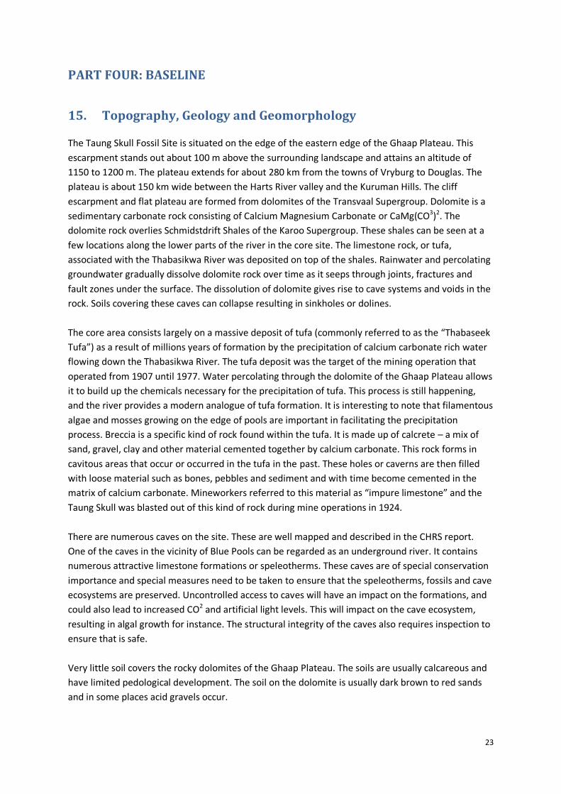
The Taung Skull Fossil Site is situated on the edge of the eastern edge of the Ghaap Plateau. This
escarpment stands out about 100 m above the surrounding landscape and attains an altitude of
1150 to 1200 m. The plateau extends for about 280 km from the towns of Vryburg to Douglas. The
plateau is about 150 km wide between the Harts River valley and the Kuruman Hills. The cliff
escarpment and flat plateau are formed from dolomites of the Transvaal Supergroup. Dolomite is a
sedimentary carbonate rock consisting of Calcium Magnesium Carbonate or CaMg(CO3)2. The
dolomite rock overlies Schmidstdrift Shales of the Karoo Supergroup. These shales can be seen at a
few locations along the lower parts of the river in the core site. The limestone rock, or tufa,
associated with the Thabasikwa River was deposited on top of the shales. Rainwater and percolating
groundwater gradually dissolve dolomite rock over time as it seeps through joints, fractures and
fault zones under the surface. The dissolution of dolomite gives rise to cave systems and voids in the
rock. Soils covering these caves can collapse resulting in sinkholes or dolines.
The core area consists largely on a massive deposit of tufa (commonly referred to as the “Thabaseek
Tufa”) as a result of millions years of formation by the precipitation of calcium carbonate rich water
flowing down the Thabasikwa River. The tufa deposit was the target of the mining operation that
operated from 1907 until 1977. Water percolating through the dolomite of the Ghaap Plateau allows
it to build up the chemicals necessary for the precipitation of tufa. This process is still happening,
and the river provides a modern analogue of tufa formation. It is interesting to note that filamentous
algae and mosses growing on the edge of pools are important in facilitating the precipitation
process. Breccia is a specific kind of rock found within the tufa. It is made up of calcrete – a mix of
sand, gravel, clay and other material cemented together by calcium carbonate. This rock forms in
cavitous areas that occur or occurred in the tufa in the past. These holes or caverns are then filled
with loose material such as bones, pebbles and sediment and with time become cemented in the
matrix of calcium carbonate. Mineworkers referred to this material as “impure limestone” and the
Taung Skull was blasted out of this kind of rock during mine operations in 1924.
There are numerous caves on the site. These are well mapped and described in the CHRS report.
One of the caves in the vicinity of Blue Pools can be regarded as an underground river. It contains
numerous attractive limestone formations or speleotherms. These caves are of special conservation
importance and special measures need to be taken to ensure that the speleotherms, fossils and cave
ecosystems are preserved. Uncontrolled access to caves will have an impact on the formations, and
could also lead to increased CO2 and artificial light levels. This will impact on the cave ecosystem,
resulting in algal growth for instance. The structural integrity of the caves also requires inspection to
ensure that is safe.
Very little soil covers the rocky dolomites of the Ghaap Plateau. The soils are usually calcareous and
have limited pedological development. The soil on the dolomite is usually dark brown to red sands
and in some places acid gravels occur.

24
16. Climatic Conditions
The site experiences a typical Savannah climate with late summer rains and cold, dry winters.
Savannah systems do not typically experience frost. However, the Ghaap Plateau shows the longest
period of the year (> 120 days) in South African savannas when frosts can occur, a feature that
certainly makes the climate here rather distinct from other places where savannah occurs. Mean
annual precipitation is about 418 mm, with peaks of rainfall in summer and autumn. Winters are
very dry and cold. Annual rainfall is typically variable (usually between about 250 and 500 mm per
annum) but tends to have a few years of below average rainfall followed by a single year of above
average rainfall. For example, Taung experienced devastating floods in 2006 when about 1380 mm
of rain fell between January and June.
17. Nightscape Considerations
The Buxton nightscape also makes this site unique. To visit a WHS and view the open, quiet and dark
nights that occur at the TSFS is an experience that is becoming rare. The dark tranquil nightscape
must also be preserved.
18. Existing Land Use
Existing land use around the TSFS consists of rural urban dwelling with marginal agricultural efforts.
These tribal lands fall under BaPhuduhucwana Traditional Authority, currently under the leadership
of the Paramount Chief Tsepo Mankuroane and local Chief Lekwene in Buxton. All land use in such
tribal lands requires the consent of tribal leaders, over and above municipal planning and building
requirements. Area of use within the Core Zone of the TSFS have been zoned and mapped through
the site planning process to date. All the proposed activities fall well within the parameters of
planned land use.
19. Natural Habitat
The natural habitat in the Core Area and Buffer Zone has been reported in the Biodiversity Report,
forming part of the IMP 2010 - 2015. It is well recognised that the Core Area and Buffer Zone of the
TSFS hold good natural habitat and as such, it too, as natural heritage, should also be protected and
managed by the Management Authority. Various tasks have been identified in terms of
environmental management issues, and need to be implemented.

25
20. Sense of Place
TSFS and Buxton Village has a unique sense of place that can only be described through being there,
slowing down, and experiencing this unique setting. As a rural village, Buxton and the surrounding
settlements have maintained a level of community integrity, required when having to face living
circumstances with limited opportunity. Buxton however offers a place of tranquillity, open clear
skies, and genuine rural setting and experience.
21. Heritage Resources and Attributes
The various tangible and intangible heritage layers contain a multitude of heritage resources and
attributes, all intricately linked, and providing an interpretation of the history and value of the TSFS.
These are further catalogued in Table 3. The heritage resources and attributes are grouped
according to the proposed heritage layers, which can inform the mapping of the cultural landscape
by stakeholders. These layers can be mapped individually or in a multi-layered manner, over time, to
deepen understanding and interpretation of the TSFS. Table 3 presents the various heritage layers,
together with a list of tangible and intangible heritage resources and attributes, understanding that
all are ultimately intricately linked.
The successful operation of the TSFS is dependent on the improvement of visitor facilities, yet the
protection of heritage resources and attributes remains of paramount importance. The nature of the
site demands that projects be planned and implemented in a sensitive manner so as to enhance
heritage values. The project under assessment is certainly required as facilities on the site are not
yet adequately developed. Heritage conservation measures must however be put in place, to avoid
the further degradation of sensitive heritage sites. Intangible heritage11 related to the TSFS is of
great value, its documentation and preservation must be strengthened and no activities on the site,
now or in the future, should interfere with it.
22. Critical View Points, View Lines and View Sheds
The site of the Old Lime Works in Buxton Quarry is the primary visual receptor on the
site. Various Critical View Points, View Sheds and View Lines provide a direct sight of this location
in Buxton Quarry. These primary views, together with others to and from the site, provide a
collection of visual images that make the formation of cognitive understanding of the symbolic
meaning inherent in the Taung Skull Fossil Site. The 11 Critical View Points and View Sheds that have
been identified form the visual landscape baseline for the TSFS. No specific view lines have been
identified and can be explored in time. Critical view points, view lines and view sheds may be added
to this visual landscape catalogue, as understanding of the visual landscape and local values change
amongst stakeholders over time.
11 Intangible heritage needs to be fully explored in the revision of the IMP for the TSFS, due in 2015/16.

26
Critical View Point 1: Buxton Quarry and the TSFS from New Town
GPS Coordinate: 27° 37.188'S; 24° 38.477'E
Map of View Point Location and View Shed Orientation
Visual Quality Widening view of Buxton Quarry in the medium distance opens as the first proper view of
the TSFS, on approach through New Town.
Potential Threats
Medium to high threat, with skyline intrusion clearly detracting from the view.
Level of Protection
High level of protection required, falling in Buffer Zone and the entry view onto the TSFS.
Further Action The pylons and overhead electrical cables can be shifted and/or buried, when time and resources allow, improving the visual quality at this viewpoint. Develop visual guidelines for the Buffer Zone.
N

27
Critical View Point 2: Buxton Quarry and Thabasikwa River from the Old Powerhouse
GPS Coordinate: 27° 37.221'S; 24° 38.311'E
Map of View Point Location and View Shed Orientation
Visual Quality Old buildings, the Thabasikwa River and valley trees, with the Buxton Quarry in the
short-medium distance ahead.
Potential Threats Medium to high threats depending on the type of development permitted in the visual area.
Level of Protection High level of protection required, being on the primary approach to the TSFS and within the Buffer Zone.
Further Action Restoration and expansion guidelines to be put in place for Buxton village in the Buffer Zone. Renovation of old buildings and development of entrance node to under specific visual impact assessment.
N
28
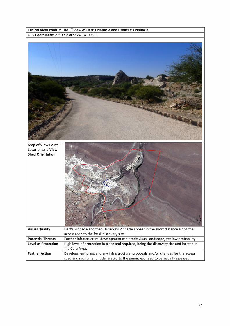
Critical View Point 3: The 1st view of Dart’s Pinnacle and Hrdlička’s Pinnacle
GPS Coordinate: 27° 37.238'S; 24° 37.996'E
Map of View Point Location and View Shed Orientation
Visual Quality Dart’s Pinnacle and then Hrdlička’s Pinnacle appear in the short distance along the
access road to the fossil discovery site.
Potential Threats Further infrastructural development can erode visual landscape, yet low probability.
Level of Protection High level of protection in place and required, being the discovery site and located in the Core Area.
Further Action Development plans and any infrastructural proposals and/or changes for the access road and monument node related to the pinnacles, need to be visually assessed.
N

29
Critical View Point 4: Taung Child Skull discovery site between Dart’s (left) and Hrdlička’s (right) Pinnacles
GPS Coordinate: 27° 37.180'S; 24° 38.011'E
Map of View Point Location and View Shed Orientation
Visual Quality In front of the pinnacles that mark the discovery site of the Taung Child skull fossil and
form the centre stage of the TSFS.
Potential Threats Infrastructural development and monument upgrades could threaten this view.
Level of Protection High level of protection in place and required, being the key feature and the centre of the TSFS.
Further Action High level of protection and very careful planning on the visual impacts of visitor infrastructure and proposed upgrades of the monument node.
N
30
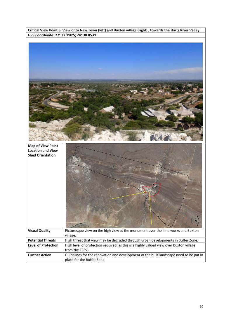
Critical View Point 5: View onto New Town (left) and Buxton village (right) , towards the Harts River Valley
GPS Coordinate: 27° 37.190'S; 24° 38.053'E
Map of View Point Location and View Shed Orientation
Visual Quality Picturesque view on the high view at the monument over the lime works and Buxton
village.
Potential Threats High threat that view may be degraded through urban developments in Buffer Zone.
Level of Protection High level of protection required, as this is a highly valued view over Buxton village from the TSFS.
Further Action Guidelines for the renovation and development of the built landscape need to be put in place for the Buffer Zone.
N
31
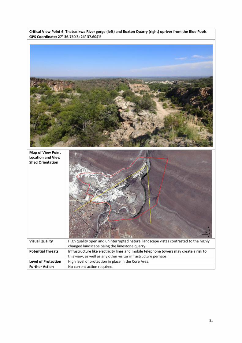
Critical View Point 6: Thabasikwa River gorge (left) and Buxton Quarry (right) upriver from the Blue Pools
GPS Coordinate: 27° 36.750'S; 24° 37.604'E
Map of View Point Location and View Shed Orientation
Visual Quality High quality open and uninterrupted natural landscape vistas contrasted to the highly
changed landscape being the limestone quarry.
Potential Threats Infrastructure like electricity lines and mobile telephone towers may create a risk to this view, as well as any other visitor infrastructure perhaps.
Level of Protection High level of protection in place in the Core Area.
Further Action No current action required.
N

32
Critical View Point 7: Thabasikwa River and Buxton Quarry from edge of Buxton village
GPS Coordinate: 27° 37.413'S; 24° 38.305'E
Map of View Point Location and View Shed Orientation
Visual Quality Open river valley landscape with old buildings set well back on higher ground.
Potential Threats State of old buildings in Buxton are under threat due to maintenance issues or lack of visual guidelines for the Buffer Zone. The Acacia in the river valley is being impacted upon and sustainable use levels do need to be determined.
Level of Protection High level of protection on the Buxton Quarry and stockpiles in the Core Area.
Further Action Provide a guideline on the restoration of old buildings in Buxton and other Buffer Zone settlements.
N
33
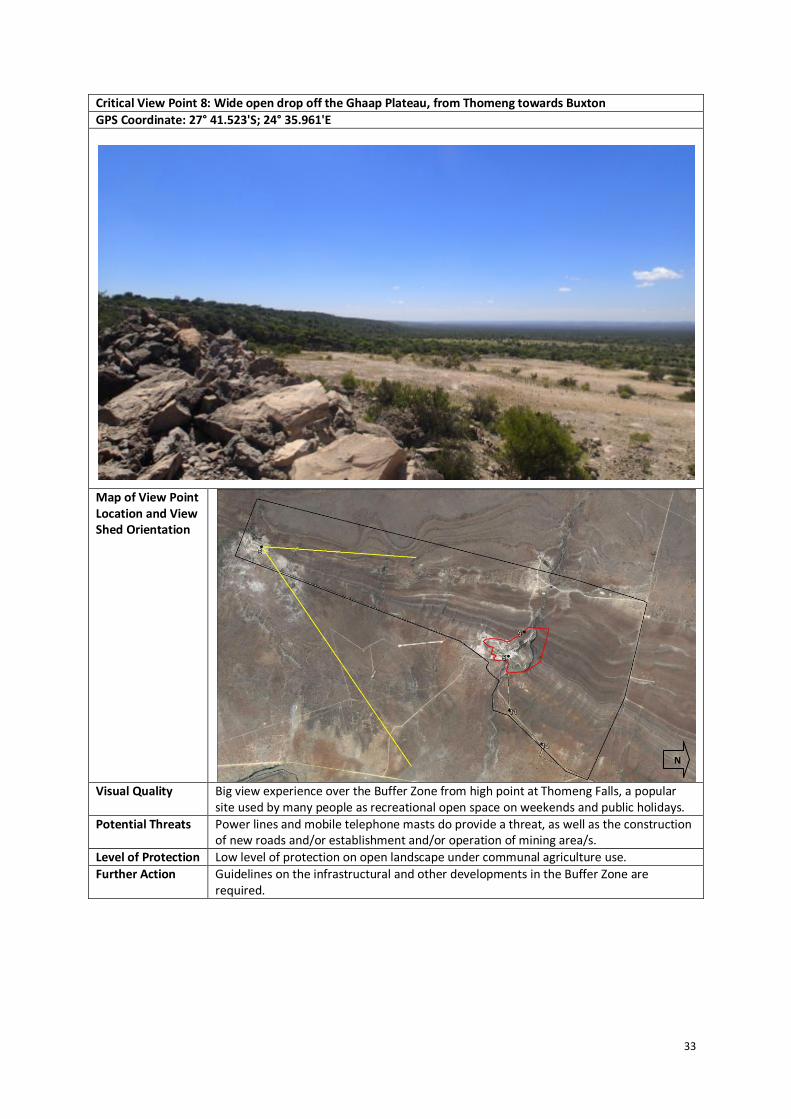
Critical View Point 8: Wide open drop off the Ghaap Plateau, from Thomeng towards Buxton
GPS Coordinate: 27° 41.523'S; 24° 35.961'E
Map of View Point Location and View Shed Orientation
Visual Quality Big view experience over the Buffer Zone from high point at Thomeng Falls, a popular
site used by many people as recreational open space on weekends and public holidays.
Potential Threats Power lines and mobile telephone masts do provide a threat, as well as the construction of new roads and/or establishment and/or operation of mining area/s.
Level of Protection Low level of protection on open landscape under communal agriculture use.
Further Action Guidelines on the infrastructural and other developments in the Buffer Zone are required.
N

34
Critical View Point 9: Wide open views over the hidden gorge from the Buffer Zone edge on Tamasikwa Road
GPS Coordinate: 27° 36.921'S; 24° 37.573'E
Map of View Point Location and View Shed Orientation
Visual Quality Large and wide natural landscape views from on top of the Ghaap Plateau provide an
open vista.
Potential Threats Power lines and mobile telephone masts do provide a threat, as well as the construction of new roads and/or mining area/s.
Level of Protection High level of protection in place on a wilderness type of experience in the Core Area.
Further Action Development guidelines are to be put in place for activities in the Buffer Zone and surrounds.
N

35
Critical View Point 10: Wide open spaces across the Buffer Zone from Mokassa towards Buxton
GPS Coordinate: 27° 36.593'S; 24° 39.777'E
Map of View Point Location and View Shed Orientation
Visual Quality Wide open veld in the Buffer Zone on the approach from Mokassa, the entrance to the
TSFS.
Potential Threats High threat of visual degradation by power lines, mast and towers, already evident. Other land use changes also pose risk to visual landscape.
Level of Protection Higher level of protection of this approach to the TSFS is required.
Further Action Put in place guidelines for development in the Buffer Zone, and relocation of the power lines, if and when resources allow. Housing development in the Buffer Zone needs specific attention.
N

36
Critical View Point 11: Draaihoek in the Buffer Zone provides a unique rural landscape
GPS Coordinate: 27° 37.160'S; 24° 39.121'E
Map of View Point Location and View Shed Orientation
Visual Quality Unique rural village setting is retained Buffer Zone settlement like Draaihoek.
Potential Threats Modernisation and densification of urban areas are a real threat.
Level of Protection Higher level of protection on these more traditional components of the visual landscape is required.
Further Action Guidelines for renovations and upgrades to dwellings need to be put in place.
N

37
PART FIVE: IMPACT ASSESSMENT
23. High Visual Sensitivity Area
An area of particularly high sensitivity, visually, is the area around the Mine Manager’s House and
valley below, including the Power House, these landmarks being within various viewsheds and with
high visual sensitivity from various prominent viewpoints in and around the Core Area. This high
sensitivity area is also planned for higher utilisation. This high sensitivity area is illustrated in Figure
7.
Figure 9: High Sensitivity Area with Closely Located Activities Plotted
The area of high visual sensitivity also has safety issues and measures which need to be
implemented, to ensure safe usage of the site.
Viewpoints and viewsheds identified as critical have been selected, locating prominent positions in
and around the site, with viewshed and visual exposure for each determining sensitive areas. The
selected viewpoints and viewsheds are used as a basis for determining potential visual ability and
visual impacts of the proposed activity. Eleven viewpoints and viewsheds have been identified for
the TSFS, as described thus far in this report. Comparative assessment of visual impact related to
each of the project components, is now detailed.
N

38
24. Evaluation of Visual Impacts
The evaluation of visual impacts makes use of the following assessment criteria, with the impact
being relative to the specific visual landscape in which the activity is placed:
1. Visual Exposure
Visual exposure is based on the distance from the project activity to selected view points, within
highly visual viewsheds and along prominent view corridors, like access roads. Visual exposure or
visual impact tends to diminish exponentially with distance. The visibility or visual exposure of
any structure or activity is the point of departure for the visual impact assessment. It stands to
reason that if the proposed activities were not visible, then no impact assessment would be
required.
2. Visual Sensitivity
Visual sensitivity can be determined by a number of factors, or in combination, amongst them
prominent topographic or other scenic features and points, like:
High points, ridge lines, spurs offering wide open and distant views with horizon effects
and axial vistas;
On steep slopes and along skylines, especially skyline intrusions; and
In close proximity to sacred sites and important recreational areas of high usage.
3. Landscape Integrity
Landscape integrity is a weave of landscape qualities, represented visually, that enhance the
visual and aesthetic experience of the area:
Intact natural landscape;
Cultural landscape showing integrity;
Ability to manage visual intrusion through screening, or relocation, in the WHS
landscape; and
A cultural landscape showing authenticity and integrity.
4. Visual Absorption Capacity
The capacity of the receiving visual landscape to absorb the potential visual impact of the
proposed activity, and showing feasible, viable and achievable mitigation measures to avoid
and/or reduce the impact.
39
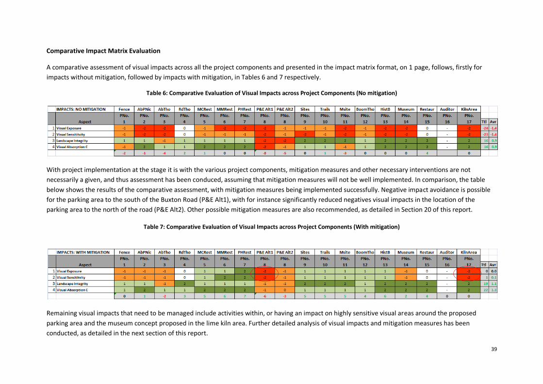
Comparative Impact Matrix Evaluation
A comparative assessment of visual impacts across all the project components and presented in the impact matrix format, on 1 page, follows, firstly for
impacts without mitigation, followed by impacts with mitigation, in Tables 6 and 7 respectively.
Table 6: Comparative Evaluation of Visual Impacts across Project Components (No mitigation)
With project implementation at the stage it is with the various project components, mitigation measures and other necessary interventions are not
necessarily a given, and thus assessment has been conduced, assuming that mitigation measures will not be well implemented. In comparison, the table
below shows the results of the comparative assessment, with mitigation measures being implemented successfully. Negative impact avoidance is possible
for the parking area to the south of the Buxton Road (P&E Alt1), with for instance significantly reduced negatives visual impacts in the location of the
parking area to the north of the road (P&E Alt2). Other possible mitigation measures are also recommended, as detailed in Section 20 of this report.
Table 7: Comparative Evaluation of Visual Impacts across Project Components (With mitigation)
Remaining visual impacts that need to be managed include activities within, or having an impact on highly sensitive visual areas around the proposed
parking area and the museum concept proposed in the lime kiln area. Further detailed analysis of visual impacts and mitigation measures has been
conducted, as detailed in the next section of this report.
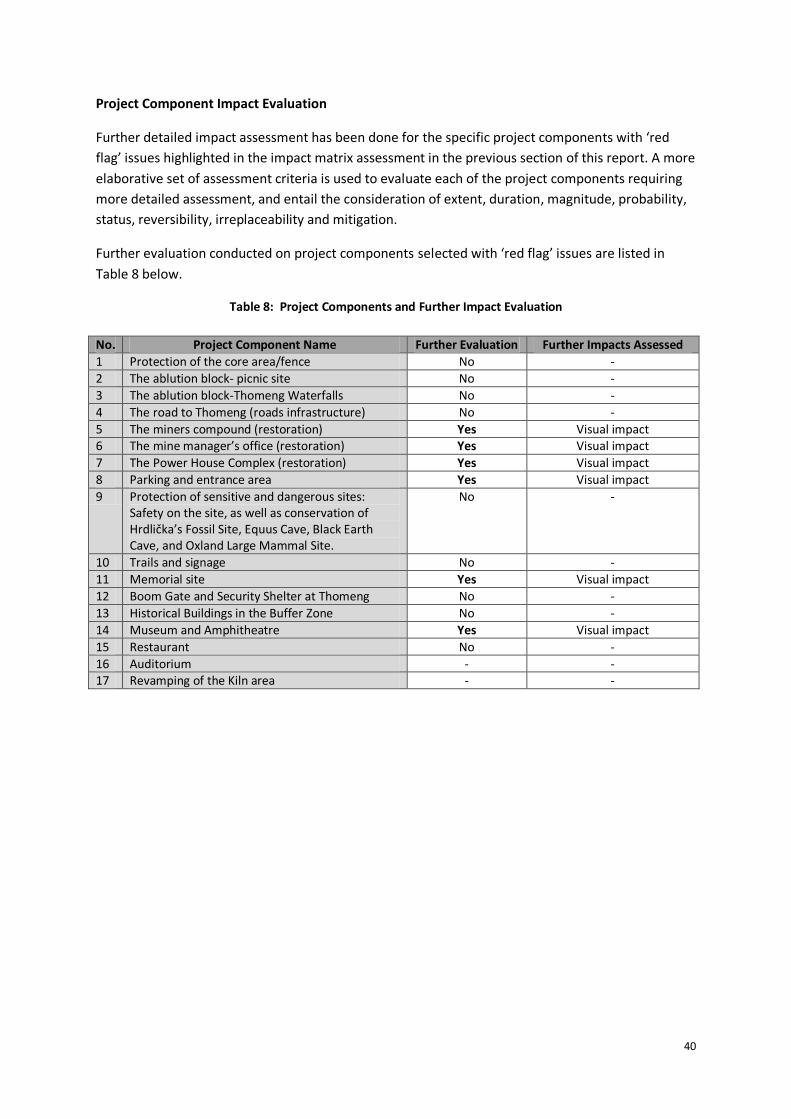
40
Project Component Impact Evaluation
Further detailed impact assessment has been done for the specific project components with ‘red
flag’ issues highlighted in the impact matrix assessment in the previous section of this report. A more
elaborative set of assessment criteria is used to evaluate each of the project components requiring
more detailed assessment, and entail the consideration of extent, duration, magnitude, probability,
status, reversibility, irreplaceability and mitigation.
Further evaluation conducted on project components selected with ‘red flag’ issues are listed in
Table 8 below.
Table 8: Project Components and Further Impact Evaluation
No. Project Component Name Further Evaluation Further Impacts Assessed
1 Protection of the core area/fence No -
2 The ablution block- picnic site No -
3 The ablution block-Thomeng Waterfalls No -
4 The road to Thomeng (roads infrastructure) No -
5 The miners compound (restoration) Yes Visual impact 6 The mine manager’s office (restoration) Yes Visual impact
7 The Power House Complex (restoration) Yes Visual impact
8 Parking and entrance area Yes Visual impact
9 Protection of sensitive and dangerous sites: Safety on the site, as well as conservation of Hrdlička’s Fossil Site, Equus Cave, Black Earth Cave, and Oxland Large Mammal Site.
No -
10 Trails and signage No -
11 Memorial site Yes Visual impact
12 Boom Gate and Security Shelter at Thomeng No -
13 Historical Buildings in the Buffer Zone No -
14 Museum and Amphitheatre Yes Visual impact
15 Restaurant No -
16 Auditorium - - 17 Revamping of the Kiln area - -

41
Table 9: Potential visual impacts for the restoration of the Mine Workers Compound.
Visual intrusions will most noticed upon entering the area close to the compound.
Nature of Impact Potential visual impacts for the proposed restoration of the Mine Worker’s Compound.
No Mitigation With Mitigation No Go
Proposed
Proposed
Proposed
Extent (E) -3 (local) 1 (local) -2 (local) 2 (local)
Duration (D) -3 (long-term) 3 (long-term) -3 (long-term) 3 (long-term)
Magnitude (M) -2 (medium scale) 2 (medium scale) -2 (medium scale) 2 (medium scale)
Probability (P) 3 (high) 3 (high) 3 (high) 3 (high)
Significance Rating (E+D+M)*P
-24 18 -21 21
Status (+, -, 0) Negative
Reversibility Yes
Irreplaceable loss of resources No
Can impacts be mitigated? Yes
Mitigation a. Make use of existing infrastructure and landscape so as to blend all proposed infrastructure into the visual and physical landscape.
b. Renovate all buildings and infrastructure to retain the historic architectural fabric and narrative.
c. All signage for the TSFS should be designed, and be placed in a low key manner, so as to avoid any negative impacts on the visual landscape.
d. Architectural design for the restoration of the built landscape should incorporate detailed inputs and supervision from a heritage architect during the design and renovation phase of the project.
Table 10: Potential visual impacts for the restoration of the Mine Manager’s House.
Visual intrusions will most noticed upon entering the area through the new entrance to the site.
Nature of Impact Potential visual impacts for the proposed restoration of the Mine Manager’s House.
No Mitigation With Mitigation
No Go
Proposed
Proposed
Proposed
Extent (E) -3 (local) 1 (local) -2 (local) 2 (local)
Duration (D) -3 (long-term) 3 (long-term) -3 (long-term) 3 (long-term)
Magnitude (M) -2 (medium scale) 2 (medium scale) -2 (medium scale) 2 (medium scale)
Probability (P) 3 (high) 3 (high) 3 (high) 3 (high)
Significance Rating (E+D+M)*P
-24 18 -21 21
Status (+, -, 0) Negative
Reversibility Yes
Irreplaceable loss of resources No
Can impacts be mitigated? Yes
Mitigation 1. Make use of existing infrastructure and landscape so as to blend all proposed infrastructure into the visual and physical landscape.
2. Renovate all buildings and infrastructure to retain the historic architectural fabric and narrative.
3. All signage for the TSFS should be designed, and be placed in a low key manner, so as to avoid any negative impacts on the visual landscape.
4. Architectural design for the restoration of the built landscape should incorporate detailed inputs and supervision from a heritage architect during the design and renovation phase of the project.
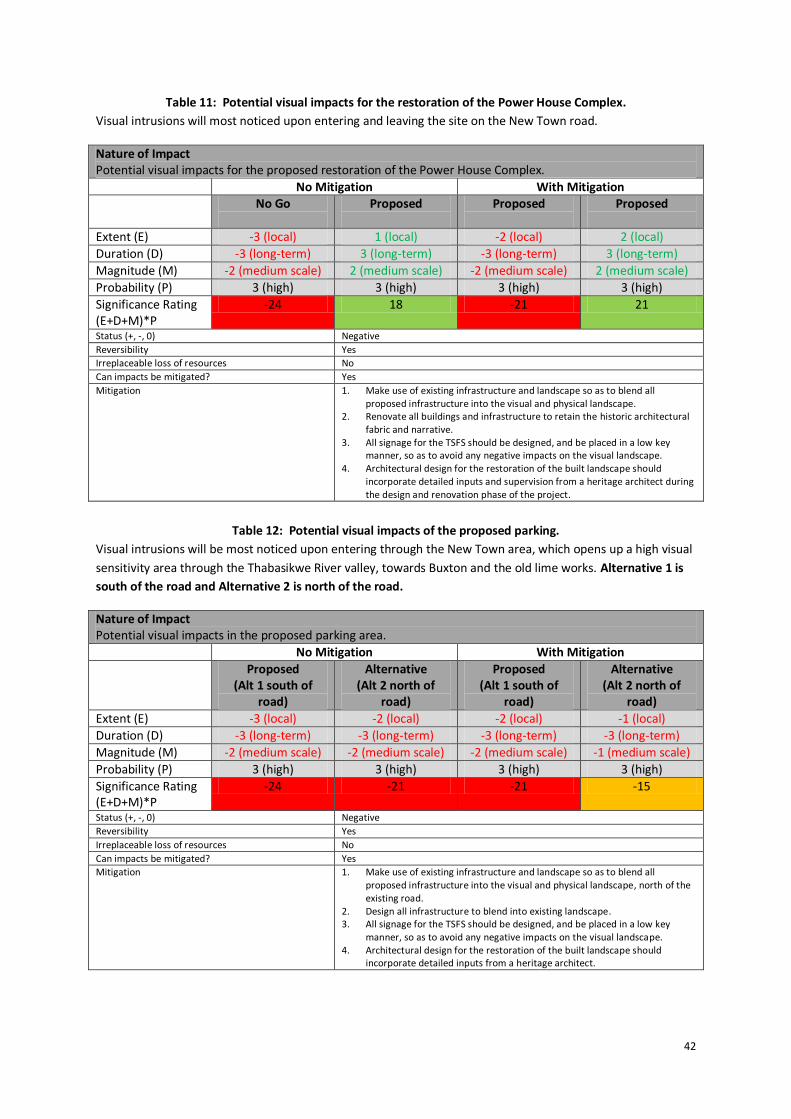
42
Table 11: Potential visual impacts for the restoration of the Power House Complex.
Visual intrusions will most noticed upon entering and leaving the site on the New Town road.
Nature of Impact Potential visual impacts for the proposed restoration of the Power House Complex.
No Mitigation With Mitigation No Go
Proposed
Proposed
Proposed
Extent (E) -3 (local) 1 (local) -2 (local) 2 (local)
Duration (D) -3 (long-term) 3 (long-term) -3 (long-term) 3 (long-term)
Magnitude (M) -2 (medium scale) 2 (medium scale) -2 (medium scale) 2 (medium scale)
Probability (P) 3 (high) 3 (high) 3 (high) 3 (high)
Significance Rating (E+D+M)*P
-24 18 -21 21
Status (+, -, 0) Negative
Reversibility Yes
Irreplaceable loss of resources No
Can impacts be mitigated? Yes
Mitigation 1. Make use of existing infrastructure and landscape so as to blend all proposed infrastructure into the visual and physical landscape.
2. Renovate all buildings and infrastructure to retain the historic architectural fabric and narrative.
3. All signage for the TSFS should be designed, and be placed in a low key manner, so as to avoid any negative impacts on the visual landscape.
4. Architectural design for the restoration of the built landscape should incorporate detailed inputs and supervision from a heritage architect during the design and renovation phase of the project.
Table 12: Potential visual impacts of the proposed parking.
Visual intrusions will be most noticed upon entering through the New Town area, which opens up a high visual
sensitivity area through the Thabasikwe River valley, towards Buxton and the old lime works. Alternative 1 is
south of the road and Alternative 2 is north of the road.
Nature of Impact Potential visual impacts in the proposed parking area.
No Mitigation With Mitigation
Proposed (Alt 1 south of
road)
Alternative (Alt 2 north of
road)
Proposed (Alt 1 south of
road)
Alternative (Alt 2 north of
road)
Extent (E) -3 (local) -2 (local) -2 (local) -1 (local)
Duration (D) -3 (long-term) -3 (long-term) -3 (long-term) -3 (long-term)
Magnitude (M) -2 (medium scale) -2 (medium scale) -2 (medium scale) -1 (medium scale)
Probability (P) 3 (high) 3 (high) 3 (high) 3 (high)
Significance Rating (E+D+M)*P
-24 -21 -21 -15
Status (+, -, 0) Negative
Reversibility Yes
Irreplaceable loss of resources No
Can impacts be mitigated? Yes
Mitigation 1. Make use of existing infrastructure and landscape so as to blend all proposed infrastructure into the visual and physical landscape, north of the existing road.
2. Design all infrastructure to blend into existing landscape. 3. All signage for the TSFS should be designed, and be placed in a low key
manner, so as to avoid any negative impacts on the visual landscape. 4. Architectural design for the restoration of the built landscape should
incorporate detailed inputs from a heritage architect.
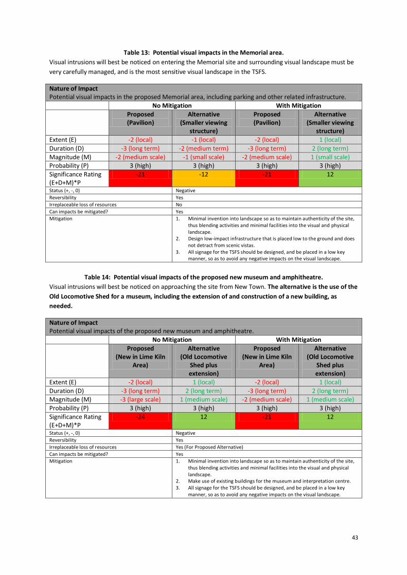
43
Table 13: Potential visual impacts in the Memorial area.
Visual intrusions will best be noticed on entering the Memorial site and surrounding visual landscape must be
very carefully managed, and is the most sensitive visual landscape in the TSFS.
Nature of Impact Potential visual impacts in the proposed Memorial area, including parking and other related infrastructure.
No Mitigation With Mitigation
Proposed (Pavilion)
Alternative (Smaller viewing
structure)
Proposed (Pavilion)
Alternative (Smaller viewing
structure)
Extent (E) -2 (local) -1 (local) -2 (local) 1 (local)
Duration (D) -3 (long term) -2 (medium term) -3 (long term) 2 (long term)
Magnitude (M) -2 (medium scale) -1 (small scale) -2 (medium scale) 1 (small scale) Probability (P) 3 (high) 3 (high) 3 (high) 3 (high)
Significance Rating (E+D+M)*P
-21 -12 -21 12
Status (+, -, 0) Negative
Reversibility Yes
Irreplaceable loss of resources No
Can impacts be mitigated? Yes
Mitigation 1. Minimal invention into landscape so as to maintain authenticity of the site, thus blending activities and minimal facilities into the visual and physical landscape.
2. Design low-impact infrastructure that is placed low to the ground and does not detract from scenic vistas.
3. All signage for the TSFS should be designed, and be placed in a low key manner, so as to avoid any negative impacts on the visual landscape.
Table 14: Potential visual impacts of the proposed new museum and amphitheatre.
Visual intrusions will best be noticed on approaching the site from New Town. The alternative is the use of the
Old Locomotive Shed for a museum, including the extension of and construction of a new building, as
needed.
Nature of Impact Potential visual impacts of the proposed new museum and amphitheatre.
No Mitigation With Mitigation
Proposed (New in Lime Kiln
Area)
Alternative (Old Locomotive
Shed plus extension)
Proposed (New in Lime Kiln
Area)
Alternative (Old Locomotive
Shed plus extension)
Extent (E) -2 (local) 1 (local) -2 (local) 1 (local)
Duration (D) -3 (long term) 2 (long term) -3 (long term) 2 (long term) Magnitude (M) -3 (large scale) 1 (medium scale) -2 (medium scale) 1 (medium scale)
Probability (P) 3 (high) 3 (high) 3 (high) 3 (high)
Significance Rating (E+D+M)*P
-24 12 -21 12
Status (+, -, 0) Negative
Reversibility Yes
Irreplaceable loss of resources Yes (For Proposed Alternative)
Can impacts be mitigated? Yes
Mitigation 1. Minimal invention into landscape so as to maintain authenticity of the site, thus blending activities and minimal facilities into the visual and physical landscape.
2. Make use of existing buildings for the museum and interpretation centre. 3. All signage for the TSFS should be designed, and be placed in a low key
manner, so as to avoid any negative impacts on the visual landscape.

44
25. Visual Impact Statement
The potentially higher visual impacts in the high visual sensitivity node at the new entrance can be
designed and mitigated to provide a minimum negative impact, and in fact enhance the visual
landscape. The upgrading of visitor facilities and site infrastructure, as well as the implementation of
conservation measures at selected sites, is by far the best next step towards preparing the site to
become operational.
An impact assessment across all the proposed project components, using available plans and
information, highlights negative visual impact drivers that need to identified and mitigated
accordingly. The following mitigation measures are proposed:
1. Visual impacts of the new fence can be further screening and access issues related to the fence
can be monitored locally.
2. Visual impacts can be significantly negative and degrade the visual landscape, and care should
be taken in the detailed design of the parking area. This area falls within a highly visual
landscape and receptivity towards additional infrastructure is low. Placement of the parking area
into the Core Area and north of the existing road, together with making use of the existing trees
in this area, will significantly reduce negative visual impacts.
3. The threat of negative visual impacts around the Memorial Site pavilion can be avoided through
the consideration of a low-impact platform for viewing.
4. Visual impacts all round are considered acceptable if designed to blend in with the existing
landscape and with the reuse of existing buildings, and are thus mostly positive as expected in
the revival and future reuse of the TSFS and place of reflection and experience into the common
origins of humanity. The site is a fascinating place to visit and the experience can be enhanced
once all visitor facilities become operational.
26. Cumulative Impacts
The very purpose of improving visitor facilities and infrastructure at the site is to improve the
cumulative impacts of a deteriorating site and thus the visual landscape. Cultural and heritage
resources need to be better protected. Ongoing management is going to be required at the site to
ensure that visual impacts are continuously managed. No significant cumulative impacts, over and
above those already considered in the impact assessment, are foreseen at this stage of the
assessment process, as long as visitor management on the site is improved. Alternatively cumulative
impacts can be significant through increased usage, if visitors are not well managed.

45
27. Mitigation and Enhancement Measures
The various mitigation measures proposed for the improvements to conservation measures and
visitor facilities at the site are noted below. These provisions are further included and detailed in the
Heritage Management Plan (HMP).
It is recommended that all works on the site (pre-construction, construction, rehabilitation,
operational and maintenance phases) be monitored by the Site Archaeologist on a weekly basis, or
as needed basis, and as per the requirements of the Heritage Management Plan. Outcomes are to
be systematically recorded, with assistance being requested by specialists and others, when needed.
Mitigation measures specific to each of the project components are listed in Table 15 below.
Table 15: Mitigation Measures Specific to Project Components
No. Project Component Name
Status Proposed Mitigation Measures
1 Protection of the core area/fence
Construction in progress.
a. The removal of the old fence foundation with plastic enclosed, as well as other builder’s rubble, to an appropriate waste disposal site that meets high standards for water management.
b. The planting of trees for visual screening of the new fence where needed, appropriate and when funds are available.
2 The ablution block- picnic site
Construction in progress.
a. Proper security and effective waste management during operation. b. Recognition must be given to the fact the ablution facility is in close
proximity to the sacred Blue Pools site, and effective pollution management is thus of critical importance.
c. Decommissioning of previous ablution facility to be further considered from a visual perspective, and only if the building cannot be used effectively.
3 The ablution block-Thomeng Waterfalls
Construction in progress.
a. Proper security and effective waste management during operation. b. Specific attention of capacity and overflow capacity calculations for
the septic tank system, as constructed within a broader sensitive ecological and wetland area.
c. Adequate cleaning and maintenance required to reduce pollution risks.
d. The proposed water tower must be placed to reduce visual intrusion and avoid skyline intrusion.
e. Solid waste storage facilities to be constructed in well placed positions, to blend into landscape and be ‘baboon-proof’.
4 The road to Thomeng (roads infrastructure)
Construction in progress.
a. Finishing of stormwater management structures in stone and concrete, in keeping with the architectural theme of the TSFS.
b. Tidying up of road works bulk soils in a visually pleasing manner and including rehabilitation.
5 The miners compound (restoration)
Detailed designs.
a. Make use of existing infrastructure and landscape so as to blend all proposed infrastructure into the visual and physical landscape.
b. Renovate all buildings and infrastructure to retain the historic architectural fabric and narrative.
c. All signage for the TSFS should be designed, and be placed in a low key manner, so as to avoid any negative impacts on the visual landscape.
d. Architectural design for the restoration of the built landscape should incorporate detailed inputs and supervision from a heritage architect during the design and renovation phase of the project.

46
No. Project Component Name
Status Proposed Mitigation Measures
6 The mine manager’s office (restoration)
Detailed designs.
a. Make use of existing infrastructure and landscape so as to blend all proposed infrastructure into the visual and physical landscape.
b. Renovate all buildings and infrastructure to retain the historic architectural fabric and narrative.
c. All signage for the TSFS should be designed, and be placed in a low key manner, so as to avoid any negative impacts on the visual landscape.
d. Architectural design for the restoration of the built landscape should incorporate detailed inputs and supervision from a heritage architect during the design and renovation phase of the project.
7 The Power House Complex (restoration)
Detailed designs.
a. Make use of existing infrastructure and landscape so as to blend all proposed infrastructure into the visual and physical landscape.
b. Renovate all buildings and infrastructure to retain the historic architectural fabric and narrative.
c. All signage for the TSFS should be designed, and be placed in a low key manner, so as to avoid any negative impacts on the visual landscape.
d. Architectural design for the restoration of the built landscape should incorporate detailed inputs and supervision from a heritage architect during the design and renovation phase of the project.
8 Parking and entrance area
Conceptual planning.
a. Make use of existing infrastructure and landscape so as to blend all proposed infrastructure into the visual and physical landscape, north of the existing road.
b. Design all infrastructure to blend into existing landscape. c. All signage for the TSFS should be designed, and be placed in a low
key manner, so as to avoid any negative impacts on the visual landscape.
d. Architectural design for the restoration of the built landscape should incorporate detailed inputs from a heritage architect.
9. Protection of sensitive and dangerous sites: Safety on the site.
General a. The specialist study on safety and security on the site will be making important recommendations on how to improve safety on the site, and should be attended as a top priority.
b. Make use of existing infrastructure and landscape so as to blend all proposed infrastructure into the visual and physical landscape.
c. All signage for the TSFS should be designed, and be placed in a low key manner, so as to avoid any negative impacts on the visual landscape.
d. Local guides to be sourced and trained.

47
No. Project Component Name
Status Proposed Mitigation Measures
9a. Conservation of Hrdlička’s Fossil Site.
Concept. a. Detailed plans be drawn up and circulated for comment and approval.
b. Hrdlička’s Fossil Site can also be a site that visitors can experience. c. The construction of a simple stone demarcated path and rim
platform at the fossil site would work well. d. A ‘Stay on the Boardwalk’ sign should be included onto the
boardwalk up to the site, as connected to the pathways and signage in the larger memorial site.
e. A narrow boardwalk can be constructed into the excavation site, for 2 or 3 people to enter at a time, with interpretation signage placed on the structure and restricting reach to any fossils. This platform can be placed on adjustable feet and can be removable, to allow future excavation.
f. A barrier can be placed all along the edge of the platform to avoid visitor from reaching to the fossils and an interpretation sign can also be constructed at the fossils.
g. The sign for this site should be changed to ‘Palaeontological Site’.
9b. Conservation of Equus Cave.
Concept. a. Detailed plans be drawn up and circulated for comment and approval.
b. Equus Cave is fragile and vulnerable site and should be carefully managed.
c. The current fence and gate should be retained, with the gate kept locked at all times.
d. Access should only be provided with a well trained and TSFS accredited guide.
e. Information signs and stone benches can be considered at entrance, outside the fenced area, with the fence being retained in the current position.
f. Access to the site can be done in small groups of 3 or 4 people at a time.
g. Entrance to the site can be preceded by a 30min interpretation session preparing one to enter the sensitive and fenced area.
h. Access can be better managed through the construction of wooden steps and a small platform along the edge and rim of the cave. Such structures provide manageable access that can be anchored with adjustable leg supports, and provide a position at which small groups can view the site.
i. Interpretation signage can be placed at the edge of the platform, as well as strategic points like the entrance, to further allow the visitor to understand the site fully.
j. This site can be named the ‘Equus Cave’ and a ‘No touching and taking’ policy should be implemented.
9c. Conservation of Black Earth Cave.
Concept. a. Detailed plans be drawn up and circulated for comment and approval.
b. Black Earth Cave needs to have access restricted, through the construction of a rock barricade to prevent visitors from entering the site.
c. A safety warning sign should be placed, clearly stating that no access is permitted.
d. The experience of the cave however needs not be lost due to a lack of access. Information boards can provide an even better understanding of the site, enriching the experience of the site, this going a long way to making the shaded areas under the Acacia trees more inviting.
e. Stone bench seating can easily be placed here and this low impact suggestion will go well in a relatively harsh and exposed quarry landscape.

48
No. Project Component Name
Status Proposed Mitigation Measures
9d. Conservation of Oxland Large Mammal Site.
Concept. a. Detailed plans be drawn up and circulated for comment and approval.
b. The Oxland Large Mammal Fossil Site is far more robust and accepting of visitation, yet certainly again not without a recognised local heritage guide.
c. Again only small groups of 3 or 4 should be allowed access to the site at a time, accompanied by the guide.
d. This site can be named the ‘Oxland Large Mammal Fossil Site’. e. A ‘No touching and taking’ policy should be implemented. f. Stone benches can easily be placed at the entrance in the shade of
the Pepper tree, allowing for an interpretation discussion of the site to prepare one for entering the site.
g. Appropriate interpretation signage should also most certainly be provided at the base of the site in the shaded area.
10 Trails and signage Maintenance requirement.
a. Trail pamphlet and code of conduct for hiking in TSFS. e. All signage for the TSFS should be designed, and be placed in a low
key manner, so as to avoid any negative impacts on the visual landscape.
11 Memorial site Detailed and layout planning.
a. Minimal invention into landscape so as to maintain authenticity of the site, thus blending activities and minimal facilities into the visual and physical landscape.
b. Design low-impact infrastructure that is placed low to the ground and does not detract from scenic vistas.
c. All signage for the TSFS should be designed, and be placed in a low key manner, so as to avoid any negative impacts on the visual landscape.Construction of a platform view point and path.
d. Wheelchair access to the Memorial at Dart’s and Hrdlička’s Pinnacles.
e. Effective information and waste management required.
12 Boom Gate and Security Shelter at Thomeng
Concept. a. Architectural design, materials use and colours to align with existing design themes in the TSFS.
b. Minor infrastructure to be located in manner that is naturally screened and of low visual impact.
c. Site Archaeologist to provide input on archaeological and paleontological impacts while locating the position.
13 Historical Buildings in the Buffer Zone
Concept. a. Guideline on maintenance and renovation of existing buildings in the Buffer Zone required.
b. Requirement for and purpose of a Built Environment Management Plan to be established.
14 Museum and Amphitheatre
Concept. a. Alternative location of the new museum making use of existing buildings, like the Locomotive Maintenance Shed.
b. Design guideline inputs on visual impacts, safety and reuse of existing buildings and infrastructure.
c. Minimal invention into landscape so as to maintain authenticity of the site, thus blending activities and minimal facilities into the visual and physical landscape.
d. Make use of existing buildings for the museum and interpretation centre.
e. All signage for the TSFS should be designed, and be placed in a low key manner, so as to avoid any negative impacts on the visual landscape.
15 Restaurant Detailed designs.
a. Detailed design according to specific architectural fabric of shed alongside Mine Managers House.
b. Good waste management must be implemented.
16 Auditorium No plans. a. Inputs into design and operational matters can be provided.
17 Revamping of the Kiln area
No plans. b. Inputs into design and operational matters can be provided. c. This area could also be left as is, providing interpretation signage
and a path through the area, for guided tours.
49
PART SIX: CONCLUSIONS AND RECOMMENDATIONS
It is concluded that attention is required to reduce visual impacts. The identified mitigation
measures, and consideration of alternatives can be implemented to address impacts. This requires
the continued support and effort by the Management Authority. It is recommended that:
1. Plans for the new museum proposed for the lime kiln area should be subjected to detailed visual
impact assessment, once comparative plans of alternatives, including alternative locations, have
been developed and comparatively assessed.
2. Detailed plans should be compiled for conservation measures at the heritage sites, as a top
priority and be implemented before visitors are allowed access to the sites.
3. A consolidated site development plan should be compiled to assist with the further planning and
development of the site.
4. The visual mitigation factors taken into account when planning within the high visual sensitivity
areas undergo detailed scrutiny.
5. The nightscape should be protected through the design of all lighting on the TSFS as low-level,
down-facing dim lighting, as far as is possible and without compromising safety.
6. Mitigation and enhancement measures are necessary and can be included into a Heritage
Management Plan that can deal with pre-construction, construction, rehabilitation, operational
and maintenance phases of the project. Mitigation measures must be implemented.
7. Where details are lacking, impact assessment can be conducted in the future and especially for
projects that occur in visually sensitive areas and that would potentially have a highly negative
visual impact.
8. Specific onsite management of impacts of approved projects can be managed with the Heritage
Management Plan and through consulting with a qualified advisor, as necessary.

50
References
DACERD, 2003. Cultural Heritage Resources Survey of the Taung Skull National Heritage Site. Document submitted to SAHRHA by Bapela Cave Klapweijk on behalf of DACERD. DACERD, 2004. Conservation Management Plan for the Taung Skull National Heritage Site. Document submitted to SAHRHA by Bapela Cave Klapweijk on behalf of DACERD. DACERD, 2004. Nomination Dossier for the Taung Skull Fossil Site. Document submitted to UNESCO. DACERD, 2008. Business Plan for the Taung Skull Fossil Site. Department of Agriculture, Conservation and Environment of the North West Province. DACERD, 2010. Integrated Management Plan for the Taung Skull Fossil Site 2010 - 2015. Document compiled by Reza Williams Business Consulting on behalf of DEACERD and submitted to UNESCO. DACERD, 2010. Biodiversity Report for the Taung Skull Fossil Site. Document compiled by D Euston-Brown on behalf of Reza Williams Business Consulting on behalf of DEACERD and submitted to UNESCO. DACERD, 2010. Socio-Economic Impact Assessment for the Taung Skull Fossil Site. Document compiled by Nassar Ahmed Omar on behalf of Reza Williams Business Consulting on behalf of DEACERD and submitted to UNESCO. DACERD, 2010. Tourism Marketing Plan for the Taung Skull Fossil Site. Document compiled by Reza Williams Business Consulting on behalf of DEACERD and submitted to UNESCO. DACERD, 2010. Water Management Plan for the Taung Skull Fossil Site. Document compiled by Reza Williams Business Consulting on behalf of DEACERD and submitted to UNESCO. KUHN, B.F., CARLSON, K.J., HOPLEY, P.J., ZIPFEL, B. & BERGER, L.R., 2015. Identification of fossilized eggshells from the Taung hominin locality, Taung, Northwest Province, South Africa. Palaeontologia Electronica 18(11A), 1-16. O'Hare, D. 1997. Tourism and Small Coastal Settlements: a cultural landscape approach for urban design. Unpublished PhD thesis. Oxford Brookes University. UNESCO Johannesburg Declaration 2002. ‘World Heritage in Africa and Sustainable Development’. Declaration from the UNESCO and ICOMOS conference in Johannesburg, 2002.

51
Glossary
Authenticity and Integrity Authenticity and Integrity are aspects of related to the quality of heritage that
may be protected within a World Heritage Site or other heritage site. Such
heritage may date from a specific period of time relevant to the significance of
the site. Integrity refers to the degree by which a heritage attribute is still
intact, undamaged or uneroded by outside impacts and influences. If it is still in
‘good shape’ then integrity would tend to be high. A site may not be intact, but
it could still be authentic. A ruin with most of its fabric missing, for example,
may be authentic because it has not been overlaid or distorted by subsequent
layers; in other words it’s still the ‘real thing’. Memory and documentation can
also be authentic (although not necessarily accurate), because it derives from
the period under study or from someone who had direct experience of an
event. For conservation purposes, neither authenticity nor integrity may be
adversely affected.
Australopithecus africanus The African Ape of Southern Africa, a new name given to the discovery by Dr
Raymond Dart in 1924, as a result of the discovery of the Taung Child Skull
Fossil at the subsequently named Dart Pinnacle, in Buxton Quarry.
Breccia A specific kind of rock found within tufa. It is made up of calcrete – a mix of
sand, gravel, clay, bones and other material cemented together by calcium
carbonate. This rock forms in cavitous areas that occur or occurred in tufa in
the past. These holes or caverns are then filled with loose material such as
bones, pebbles and sediment and with time become cemented in the same
matrix of calcium carbonate. Mineworkers referred to this material as ‘impure
limestone’ and the Taung Skull was blasted out of this kind of rock during mine
operations in 1924.
Bioturbation The burrowing by small mammals, insects and termites that disturb
archaeological deposits.
Cercopithecus fossils A fossil grouping related to old world primate fossils linking to the origins of
humankind and Apes from Africa.
Chert A rock type that is a fine-grained silica-rich sedimentary rock that may contain
small fossils. It varies greatly in colour, from white to black, but most often
manifests as gray, brown, greyish brown and light green to rusty red. Its colour
is an expression of trace elements present in the rock, and both red and green
are most often related to traces of iron in its oxidised and reduced forms
respectively.
Dolines The dissolution of dolomite gives rise to cave systems and voids in the rock.
Soils covering these caves can collapse resulting in sinkholes or dolines.
Hyracium Rock rabbit dung deposits that contain valuable information of the past.
Koekepanne Small rail trolleys used in the mine for the transport of limestone.
Palynology The study of the fossil pollens.
Paranthropus A genus of extinct hominids that was bipedal and probably descended from the Australopithecus hominids millions of years ago. Members of this genus are characterised by robust craniodental anatomy, including gorilla-like sagittal

52
cranial crests, which suggest strong muscles of mastication, and broad, grinding herbivorous teeth. However, Paranthropus skulls lack the transverse cranial crests that are also present in modern gorillas.
Pedological development In soils this is the process by which soils undergo various changes over time.
Phragmites beds A common reed that grows in river beds and proliferates when water has been
nutrient enriched. Also an effective reed when used in the bio-purification of
freshwater systems.
Phytoliths A rigid, microscopic structure made of silica, found in some plant tissues and persisting after the decay of the plant. These plants take up silica from the soil, whereupon it is deposited within different intracellular and extracellular structures of the plant. Phytoliths come in varying shapes and sizes and it commonly refers to siliceous plant remains.
Outstanding Universal Value Outstanding universal value means cultural and/or natural significance, which
is as exceptional as to transcend national boundaries and to be of common
importance for present and future generations of all humanity. As such, the
permanent protection of this heritage is of the highest importance to the
international community as a whole.
Sangomas Traditional healers that practice traditional African medicine and also known as
Ngaka (SeTswana) locally. They fulfil different social and political roles in the
community, including divination, healing physical, emotional and spiritual
illnesses, directing birth or death rituals, finding lost cattle, protecting warriors,
counteracting witches, and narrating the history, cosmology, and myths of
their tradition. These healers are highly revered and respected in a society in
which tradition lives and in which illness is believed to be caused by witchcraft,
pollution (contact with impure objects or occurrences, recognised in the form
of taboos) or through neglect of one’s ancestors.
Speleothems Cave deposits or formations that are a secondary form of mineral deposit
formation in a cave. Speleothems are formed in limestone caves and consist of
stalagmites and stalactites, as well as flowstone, for instance.
Stromatolites Or stromatoliths, a mattress strata or rock, are layered bio-chemical
accretionary structures formed in shallow water by the trapping, binding and
cementation of sedimentary grains by biofilms (microbial mats) of
microorganisms, especially cyanobacteria. Stromatolites provide ancient
records of life on Earth within the fossil remains of which might date from
more than 3.5 billion years ago.
Toponyms The study of the history and root associations of place names. Many place
names provide insight into the history of a certain place or object, as well as a
certain link in time back to a specific event, cultural ritual and/or group of
people, for example.
Tufa Massive deposits formed over millions of years by the precipitation of calcium
carbonate rich water flows. Water percolating through the dolomite of the
Ghaap Plateau allows it to build up the chemicals necessary for the
precipitation of tufa. This process is still happening, and the river provides a
modern analogue of tufa formation. It is interesting to note that filamentous

53
algae and mosses growing on the edge of pools are important in facilitating the
precipitation process.

54
APPENDICES
Appendix 1: Acknowledgements and Authorship
Appendix 2: Site Plans and Other Illustrations
Appendix 3: Photographs

55
Related Documents