KY 90 SCOPING STUDY BARREN COUNTY KYTC ITEM NO. 3-8819.00 APPENDIX G – MEETING SUMMARIES

Welcome message from author
This document is posted to help you gain knowledge. Please leave a comment to let me know what you think about it! Share it to your friends and learn new things together.
Transcript

KY 90 SCOPING STUDY BARREN COUNTY KYTC ITEM NO. 3-8819.00
APPENDIX G – MEETING SUMMARIES

-- 1 --
Meeting Minutes
TO: Shane McKenzie Deneatra Henderson
Co-Project Manager Co-Project Manager KYTC Central Office KYTC District Office #3 200 Mero Street 900 Morgantown Road Frankfort, KY 40622 Bowling Green, KY 42101
FROM: Len Harper Project Manager Stantec Consulting Services Inc. DATE: February 19, 2016 SUBJECT: KY 90 Scoping Study Item Number 3-8819.00
Barren County – From Sanders Street to US 68 (Veterans Outer Loop) Project Team Kick-Off Meeting
A project team kick-off meeting for the subject project was held at the Kentucky Transportation Cabinet District 3 Office in Bowling Green, Kentucky on February 2, 2016 at 10:30 a.m. CST. The following individuals were in attendance:
Brittany Fisher Barren River Area Development District Kevin Gearlds KYTC – District 3 Justin Harrod KYTC - Central Office Planning Troy Hearn KYTC - Central Office Planning Deneatra Henderson KYTC – District 3 Shane McKenzie KYTC – Central Office Planning Greg Meredith KYTC – District 3 Jeff Moore KYTC – District 3 Mikael Pelfrey KYTC – Central Office Planning Joe Plunk KYTC – District 3 Mike Russell KYTC – District 3 Renee Slaughter KYTC – District 3 Wendy Southworth KYTC - Central Office Design Wes Watt KYTC – District 3 Brian Aldridge Stantec Consulting Services Inc. Tom Creasey Stantec Consulting Services Inc. Len Harper Stantec Consulting Services Inc.
Heather Lawler Stantec Consulting Services Inc.
Deneatra Henderson welcomed everyone and said the purpose of the meeting was to discuss the progress to date on the KY 90 Scoping Study. Handouts included an agenda and a set of

-- 2 --
maps showing the study area, number of lanes and lane widths, average daily traffic volumes, crash locations and high crash spots within the study area. Len Harper delivered a presentation. The following enumerated items were discussed.
1. The purpose of the meeting is to present the results of the existing conditions
analysis and to get feedback from the project team before developing improvement alternatives.
2. The KY 90 study area includes the existing KY 90 corridor in Barren County from the Sanders Street intersection in Cave City to the US 68 (Veterans Outer Loop) intersection in Glasgow. The study area includes a 500 foot wide corridor centered on KY 90 to cover widening improvement alternatives that may be developed as part of the project. Off alignment improvement alternatives are not anticipated.
3. State Representative Johnny Bell and State Senator David Givens pushed for the project which became a legislative insert in the 2014 Highway Plan. The project is listed in the 2014 Six Year Highway Plan as Item No. 03-8819.00. The project is currently programmed through the utility phase with Federal Surface Transportation Program Funds (STP) and the construction phase is programmed with State Construction High Priority Project (SPP) Funds. There are no other projects in the study area listed in the 2014 Highway Plan.
• Design (2016): $2,500,000 • Right-of-Way (2017): $6,000,000 • Utility (2017): $3,500,000 • Construction (2018): $27,500,000
4. Kentucky’s Recommended 2016 Highway Plan adjusted the design funds to account
for this study and moved the fiscal year for the design phase to 2017. All other phases remain outside the two-year biennium. There are no other projects in the study area listed in the Recommended 2016 Highway Plan.
• Design (2017): $2,200,000 • Right-of-Way (2019): $6,000,000 • Utility (2020): $3,500,000 • Construction (2022): $27,500,000
5. Outside of the Six Year Plan Projects, there is one project on KYTC’s Unscheduled
Needs List (UNL) that has an active Project Identification Form (PIF) and two projects that have been labeled inactive within the study limits:
• PIF 03 005 D0090 1685.0 – Major Widening from Sanders Street in Cave City to US 68 in Glasgow.
• PIF 03 005 D0090 3.00 (Inactive) – Major Widening to 4 Lanes from Sanders Street in Cave City to Glasgow Bypass. On 5-2-14 the BRADD

-- 3 --
Regional Transportation Council (RTC) voted this project to be marked as inactive.
• PIF 03 005 D0090 3.80 (Inactive) – Reconstruct intersections at Flint Knob Road and Dripping Springs Road for turn lanes and improved sight distance. On 5-2-14 the BRADD RTC voted this project to be marked as inactive.
The project team discussed there may be an additional PIF at Pace Quarry Road. After the meeting, it was confirmed that this project is not on the UNL.
6. Len introduced the draft Purpose and Need Statement. The project team discussed adding Cave City to the draft Purpose and Need Statement but ultimately decided to leave it as is.
• The purpose of the KY 90 Improvement Project is to enhance regional
mobility and to provide a safer, more efficient connection between Glasgow and I-65.
7. Some highlights from the existing conditions inventory were discussed. Within the
study corridor, KY 90 is functionally classified as a Rural Minor Arterial from Sanders Street in Cave City to Beaver Trail in Glasgow and an Urban Minor Arterial in Glasgow from Beaver Trail to US 68. The posted speed limit of 45 to 55 miles per hour (mph). KY 90 is the most direct connection between Glasgow and vehicles heading northbound on I-65. Signs on I-65 direct southbound vehicles to use KY 90 to access Glasgow. KY 90 also provides a link between the Barren River Lake State Park and the Mammoth Cave National Park. There are no bike lanes or sidewalks along the study area. KY 90 is a Federal Designated Truck Route.
8. The existing typical section includes two 12-foot driving lanes and ten-foot paved
shoulders. There are three southbound passing lanes and two northbound passing lanes. Where there are passing lanes the adjacent shoulder is narrowed to two-feet. In total the passing lanes are 2.4 miles long which makes up 35 percent of KY 90 between Cave City and Glasgow.
9. There are two bridges along KY 90, one of which (bridge over CSX Railroad in Cave
City) has a sufficiency rating of 76.9 percent and is considered functionally obsolete because of its narrow shoulder widths. The second bridge over Beaver Creek has a sufficiency rating of 94.0 percent and has two 12-foot driving lanes and 10-foot shoulders. No culverts are listed in the KYTC Bridge Data Miner along the study area.
10. KY 90 has a 2015 Average Daily Traffic (ADT) volume between 8,200 and 9,100 vehicles per day (vpd) with 16 to 17 percent trucks. Based on the KYTC Traffic Forecast Report, the 2040 ADT volumes are expected to grow to 12,000 vpd with 19 percent trucks. After performing a capacity analysis of the existing and future traffic, all roadway segments have a volume to capacity (V/C) ratio of 0.60 or less, as shown in the table below. The target V/C ratio is 0.9 for rural areas. A V/C lower than this

-- 4 --
indicates KY 90 is operating within its design capacity. Level of service (LOS) is a qualitative measure describing operational conditions within a traffic stream. For two-lane highways, levels of service are determined based on two parameters – average travel speed and percent time spent following in a platoon. In rural areas, LOS C or better is desirable. Looking at the existing traffic volumes there are two segments in or near Cave City with a LOS E, as shown in the table below. This portion of KY 90 has a signal and no passing opportunities, which decreases the average travel speed and increases the percent time following in a platoon. South of Cave City, passing lanes are introduced along KY 90 which increases the average travel speed and decreases the percent time following. This portion of KY 90 operates at an acceptable LOS. By 2040 traffic is expected to increase to 12,000 vpd with 19 percent trucks. Under these conditions KY 90 between KY 685 and US 68 has a LOS D.
11. A review of the as-built plans found all the horizontal curves and all the vertical
curves along KY 90 satisfy the 45 design speed north of US 31W in Cave City and the 55 mph design speed south of US 31W. The steepest grade along the study area is five percent.
12. The five year crash history for the project corridor was discussed in detail. There were 199 crashes reported for the project area between January 2011 and December 2015. The project team asked Stantec to review the November and December 2015 crash records in March to verify all crashes are accounted for.
13. Of the 199 reported crashes, 3 (1.5 percent) resulted in a fatality, 45 (22.6 percent) resulted in injuries, and 151 (75.9 percent) were property damage only collisions. The percentage of fatal and injury collisions are about average compared to similar roads in Kentucky. Injury crashes along rural minor arterials generally comprise 22.5 percent of total crashes, and fatal crashes generally comprise 1 percent of total crashes.
14. The crash data were analyzed by crash type to help determine locations for potential
crash countermeasure treatments. Rear end crashes were the most commonly
ADT%
Trucks LOS V/C ADT%
Trucks LOS V/C
Sanders St to Baker Hale St 0.160 0.676 9,000 17% E 0.49 12,000 19% E 0.60
Baker Hale St to US 31W 0.676 0.819 8,200 17% E 0.49 12,000 19% E 0.60
US 31W to KY 685 0.819 3.186 9,000 17% C 0.47 12,000 19% C 0.60
KY 685 to US 68 3.186 8.574 9,100 16% C 0.47 12,000 19% D 0.60
DescriptionBegin
MilepointEnd
Milepoint
Existing (2015) No Build (2040)

-- 5 --
reported crash type (35 percent) and are concentrated at intersections and entrances along the study area. Single vehicle crashes were the second most commonly reported crash type (26 percent) and are predominately run-off the road collisions south of Cave City.
15. A map was shown highlighting the 10 spots with Critical Crash Rate Factors (CRF) greater than 1.0, suggesting that crashes are not occurring randomly within these areas. The crash “spots” were defined by analyzing 3/10 mile sections where crashes were concentrated.
16. Len discussed a number of design elements that will be considered during the alternative development process and noted the improvement concepts presented in the presentation were for discussion purposes only. The alternative development phase of this project has not begun. The group had an open discussion about these items as follows:
a. This study will examine five improvement concepts:
i. Spot Improvements ii. Four-Lane Widening with Depressed Median
iii. Four-Lane Widening with No Median iv. 2+1 Widening v. Three or Five-Lane Urban Typical Section in Cave City and Glasgow
b. Bicycle and pedestrian facilities should be considered for all alternatives. Consider adding a berm to the alternatives between Cave City and Glasgow so a shared-use path could be added in the future.
c. The four-lane widening with depressed median alternative will assume a 40-foot wide median.
d. The four-lane widening with depressed median alternative will remove direct access to driveways which could be considered unfavorable to the adjacent property owners.
e. Stantec will create a 2+1 rendering to help explain this alternative to the local officials and public. A 2+1 widening for US 31W south of Bowling Green is in the design phase.
f. A signal is proposed at the Sanders Street intersection. g. The project team decided to wait until after the alternatives were developed
to hold a local officials meeting. Local officials in Glasgow will be notified that the study is on-going during the local officials meeting for the Glasgow SUA Study on February 24th. Deneatra Henderson will notify the local officials in Cave City at the BRADD Meeting on February 24th.
17. Brittany Fisher discussed the preliminary results from the Socioeconomic Study. KY
90 connects the cities of Glasgow and Cave City. The area includes Block Groups 3 of Census Tract 9501; Block Group 2, Census Tract 9502; Block Groups 1 and 2, Census Tract 9503 and Block Groups 1 and 3, Census Tract 9505 all within Barren County. There are Block Groups that have populations above the state and county averages for population age 65 and older, disabled persons, minorities, persons with

-- 6 --
limited English proficiency and persons below the poverty level. But no localized environmental justice concern areas were identified directly adjacent to the study area.
18. The next step will be for Stantec to complete the environmental overview and develop preliminary alternatives for the project team, local officials, and the public to comment on and prioritize.
19. Len discussed the project schedule. The next project team meeting will be in April.
At that time Stantec will present preliminary alternatives for the project team to review. After that, refined alternatives will be presented to the local officials and public to solicit feedback and suggested prioritization.
The meeting ended at approximately 12:00 p.m. CST.

-- 1 --
Meeting Minutes
TO: Shane McKenzie Deneatra Henderson
Co-Project Manager Co-Project Manager KYTC Central Office KYTC District Office #3 200 Mero Street 900 Morgantown Road Frankfort, KY 40622 Bowling Green, KY 42101
FROM: Len Harper Project Manager Stantec Consulting Services Inc. DATE: May 11, 2016 SUBJECT: KY 90 Scoping Study Item Number 3-8819.00
Barren County – From Sanders Street to US 68 (Veterans Outer Loop) Project Team Meeting #2
A project team meeting for the subject project was held at the Kentucky Transportation Cabinet District 3 Office in Bowling Green, Kentucky on April 28, 2016 at 9:00 a.m. CDT. The following individuals were in attendance:
Brittany Fisher Barren River Area Development District Justin Harrod KYTC - Central Office Planning Troy Hearn KYTC - Central Office Planning Deneatra Henderson KYTC – District 3 Shane McKenzie KYTC – Central Office Planning Greg Meredith KYTC – District 3 Jeff Moore KYTC – District 3 Joe Plunk KYTC – District 3 Steve Ross KYTC – Central Office Planning Renée Slaughter KYTC – District 3 Wendy Southworth KYTC - Central Office Design Andy Stewart KYTC – District 3 Wes Watt KYTC – District 3 Brian Aldridge Stantec Consulting Services Inc. Tom Creasey Stantec Consulting Services Inc. Len Harper Stantec Consulting Services Inc.
Heather Lawler Stantec Consulting Services Inc.
Deneatra Henderson welcomed everyone and said the purpose of the meeting was to discuss the progress to date on the KY 90 Scoping Study. Handouts included a map of the corridor wide improvement concepts and an evaluation matrix summarizing the impacts and cost

-- 2 --
estimates. Len Harper delivered a presentation. The following enumerated items were discussed.
1. The purpose of the meeting is to discuss the preliminary improvement alternatives
and get feedback from the project team before presenting the alternatives to the local officials in May.
2. State Representative Johnny Bell and State Senator David Givens pushed for the project which became a legislative insert in the 2014 Highway Plan. The 2016 Highway Plan includes $2.2 million for design in 2016, $6.0 million for right-of-way in 2017, and $3.5 million for utility relocation in 2017. The construction phase is outside the two-year biennium. There are no other projects in the study area listed in the 2016 Highway Plan.
• Design (2016): $2,200,000 • Right-of-Way (2017): $6,000,000 • Utilities (2017): $3,500,000 • Construction (2019): $27,500,000
3. The draft Purpose and Need Statement for the project is as follows:
The purpose of the KY 90 Improvement Project is to enhance regional mobility and to provide a safer, more efficient connection between Glasgow and I-65. KY 90 is the most direct connection between Glasgow and vehicles heading northbound on I-65. Signs on I-65 direct southbound vehicles to use KY 90 to access Glasgow. KY 90 also provides a link between the Barren River Lake State Park and the Mammoth Cave National Park. KY 90 is part of the National Truck Network.
4. Some highlights from the existing conditions inventory were reviewed from the first
project team meeting on February 2, 2016. The KY 90 study area is approximately 8.4 miles in length between the Sanders Street intersection in Cave City and the US 68 (Veterans Outer Loop) intersection in Glasgow. Within the study corridor, KY 90 is functionally classified as a Rural Minor Arterial from Sanders Street in Cave City to Beaver Trail in Glasgow and an Urban Minor Arterial in Glasgow from Beaver Trail to US 68. The posted speed limit is 45 to 55 miles per hour (mph). The existing typical section includes two 12-foot driving lanes and ten-foot paved shoulders. There are three southbound passing lanes and two northbound passing lanes. Where there are passing lanes the adjacent shoulder is narrowed to two-feet. There are no bike lanes or sidewalks along the study area.
5. A review of the as-built plans found all the horizontal curves and all the vertical
curves along KY 90 satisfy the 45 design speed north of US 31W in Cave City and the 55 mph design speed south of US 31W. The steepest grade along the study area is five percent.

-- 3 --
6. Five additional crash records from the Barren County Sheriff Department were added to the Kentucky State Police database since January (listed below). Three were property damage only (PDO) collisions and two were injury collisions. The crash analysis was updated accordingly. One of the additional crashes, an angle collision at Dripping Springs Road, took place in High Crash Spot #8. None of the other four crashes created additional High Crash Spots.
• April 2013 – Injury, Rear End collision at KY 90 milepoint 3.169 • March 2015 – PDO, Sideswipe collision at KY 90 milepoint 3.871 • May 2015 – Injury, Rear End collision at KY 90 milepoint 4.198 • June 2015 – PDO, Single Vehicle collision at KY 90 milepoint 5.648 • November 2015 – PDO, Angle collision at KY 90 milepoint 7.287
7. Of the 204 reported crashes in the study area between January 2011 and December
2015, three resulted in a fatality (listed below). Detailed crash reports were pulled for each crash.
• September 2013 – Angle collision at Veterans Outer Loop intersection. A SUV traveling westbound on KY 90 ran a red light. A motorcycle traveling northbound on Veterans Outer Loop hit the SUV and was killed.
• January 2014 – Sideswipe-Opposite Direction collision at night at KY 90 milepoint 5.009. A drunken driver going westbound on KY 90 traveled into the eastbound lane and hit an opposing vehicle killing the occupant.
• April 2014 – Driver ran-off the road at KY 90 milepoint 6.667. The driver had a medical emergency that caused him to lose consciousness and drive off the road.
8. KY 90 has a 2015 Average Daily Traffic (ADT) volume between 8,200 and 9,100
vehicles per day (vpd) with 16 to 17 percent trucks. The 2040 ADT volumes are expected to grow to 12,000 vpd with 19 percent trucks. A volume to capacity (V/C) analysis indicates all roadway segments currently operate at less than full capacity with a V/C ratio less than 0.49, and the V/C ratio increases to 0.60 by 2040. This means a two-lane road can accommodate the existing and future traffic demand.
9. Level of service (LOS) is a qualitative measure describing operational conditions within a traffic stream. For two-lane highways, LOS is determined based on two parameters – average travel speed and percent time spent following in a platoon. In rural areas, LOS C or better is desirable. Currently, there are two segments in or near Cave City with a LOS E as a Class I highway. As a Class III highway these segments are a LOS D. This portion of KY 90 has a signalized intersection at US 31W and no passing opportunities, which decreases the average travel speed and increases the percent time following in a platoon. South of Cave City, passing lanes are introduced along KY 90 which increases the average travel speed and decreases the percent time following. This portion of KY 90 operates at an acceptable LOS C. By 2040, KY 90 between KY 685 and US 68 is expected to operate at LOS D.

-- 4 --
10. Stantec developed five corridor wide alternatives, shown in Figure 1. Before the
meeting Stantec submitted KMZ files for each alternative to the project team. The group had an open discussion about these alternatives as follows:
• The corridor wide improvement was divided into two sections - Section 1 is
an urban area that travels through Cave City and Section 2 is a rural area between Cave City and Glasgow.
• Section 1 has one preliminary alternative: a five-lane curb-and-gutter typical section with sidewalks and bike lanes. It matches the existing typical section north of Sanders Street. This alternative will replace the bridge over CSX Railroad which has a sufficiency rating of 76.9 percent and is considered functionally obsolete. No home or business relocations are anticipated with this alternative.
• Section 2 has four preliminary alternatives (listed below). All four alternatives in Section 2 reuse the existing road. The widening occurs on one side of the road so traffic can be maintained during construction and so the existing pavement can be reused. The widening shifts from east to west to minimize right-of-way impacts and reduce earthwork. After the widening is complete a final pavement surface layer will be placed over the entire road.
i. Alternative 2a - 2 + 1 Typical Section: Even though the direction of the passing lane changes on a 2 + 1 road, the total pavement width stays constant. All that changes is the striping. Where lanes are dropped the total taper length is 1,420 feet. These are meant to be long to minimize the likelihood of head on collisions. Signs and lane drop arrows are also used to alert vehicles in the passing lane that the lane is ending. Where lanes are added, shorter tapers are required (400 feet). The passing lane itself is typically 0.8 miles to 1.5 miles in length. Where necessary and appropriate, left turn lanes are placed between tapers in the flush median after traffic has been transitioned out of the passing lanes.
ii. Alternative 2b – Four-Lane Typical Section: The project team removed this alternative from further consideration due to safety concerns.
iii. Alternative 2c – Four-Lane Depressed Median Typical Section: The recommended minimum median opening spacing is 2,400 feet. This will remove direct access to driveways which could be considered unfavorable to the adjacent property owners.

-- 5 --
Figure 1 – Corridor Wide Alternatives

-- 6 --
iv. Alternative 2d – Four-Lane Depressed Median Typical Section with a Shared-Use Path: A 10-foot shared-use path will likely require 23 feet of additional widening. Barren County, City of Glasgow, and/or City of Cave City would be required to maintain the shared-use path. The shared-use path was placed on the east side of KY 90 to align with Beaver Trail Park in Glasgow and Brian Doyle Park in Cave City. This also avoids impacts to the runway safety area and aircraft approach to Runway 26 at the Glasgow Airport which sits just west of KY 90.
• The addition of a shared-use path reduces design flexibility. Shifting the roadway alignment from east to west, as was assumed with the other alternatives, reduces earthwork costs and right-of-way impacts. Most of the homes and businesses along KY 90 are adjacent to the existing road. Widening to the west and constructing the shared-use path to the east would take the properties on both sides of the road. Thus, where the shared-use path is included, all the widening is done to the east, which increases earthwork and right-of-way impacts.
• The Cave Region Trails Initiative (CRTI) is not interested in a shared-use path along KY 90. They want to pursue a shared-use path along the CSX Railroad as a way to connect the City of Glasgow and the Mammoth Cave National Park.
• The project team was provided a handout of the evaluation matrix, shown in Table 1. The addition of the shared-use path to the four-lane depressed median typical section requires six additional home relocations, one additional business relocation, and an additional $6.8 million in construction cost.
• An alternative to the shared-use path is a shoulder bikeway. The project team agreed to add this to Alternative 2a and Alternative 2c. The project team also requested an additional alternative be developed, a 2 + 1 typical section with a shared-use path.
• Question: Why were bicycle and pedestrian facilities not considered for all the alternatives in Glasgow? Answer: There are no existing or proposed bicycle and pedestrian facilities to connect to.
• As shown in the evaluation matrix, all the build alternatives have acceptable volume-to-capacity ratios and levels of service. The construction cost for the Five-Lane Alternative in Section 1 is $7.9 million. The construction cost in Section 2 ranges from $12.6 million to $39.8 million. Combining Section 1 and Section 2, the total construction cost for the entire corridor ranges from $20.5 million to $47.7 million. The total design cost ranges from $2.0 million to $4.8 million.
12. Stantec identified six spot improvements, shown in Figure 2. These spots were identified based on the crash analysis and all are located in High Crash Spots. Five of the spot improvements recommend adding turn lanes. However, turning movement

-- 7 --
BMP
EMP
V/C
¹LO
S ²
Hom
esM
obile
Ho
mes
Busin
esse
sBa
rns
Desig
nRi
ght-
of-W
ayU
tility
Cons
truc
tion
No
Build
Do N
othi
ng0.
60E
No
00
00
$0.0
TBD
TBD
$0.0
15-
Lane
C&
G Ty
pica
l Sec
tion
with
Sid
ewal
ks a
nd B
ike
Lane
s0.
29B
Yes
00
00
$0.8
TBD
TBD
$7.9
No
Build
Do N
othi
ng0.
60D
No
00
00
$0.0
TBD
TBD
$0.0
2a2+
1 Ty
pica
l Sec
tion
0.60
CN
o4
00
0$1
.3TB
DTB
D$1
2.6
2b4-
Lane
Typ
ical
Sec
tion
0.27
BN
o9
13
1$2
.2TB
DTB
D$2
2.0
2c4-
Lane
Dep
ress
ed M
edia
n Ty
pica
l Sec
tion
0.25
BN
o13
23
6$3
.3TB
DTB
D$3
3.0
2d4-
Lane
Dep
ress
ed M
edia
n Ty
pica
l Sec
tion
with
Sha
red-
Use
Pat
h0.
25B
Yes
190
45
$4.0
TBD
TBD
$39.
8
¹ The
targ
et v
olum
e to
cap
acity
(V/C
) rat
io is
0.9
for r
ural
are
as a
nd 1
.0 fo
r urb
an a
reas
. A V
/C lo
wer
than
this
indi
cate
s KY
90 is
ope
ratin
g w
ithin
its d
esig
n ca
paci
ty.
² In
rura
l are
as a
leve
l of s
ervi
ce (L
OS)
C o
r bet
ter i
s des
irabl
e. In
urb
an a
reas
a L
OS
D or
bet
ter i
s des
irabl
e.
Section 1: Sanders Street to
Estes Road
0.16
01.
369
Section 2: Estes Road to US 68 (Glasgow Outer Loop)
1.36
98.
574
KY 9
0 Sc
opin
g St
udy
Eval
uatio
n M
atrix
and
Cos
t Est
imat
es
Sect
ion
Alte
rnat
ive
Desc
riptio
n
Proj
ect L
imits
2040
Tra
ffic
Ana
lyse
sBi
cycl
e an
d Pe
dest
rian
Faci
litie
s
Righ
t-of
-Way
Impa
cts
2016
Cos
t Est
imat
es (m
illio
ns)
Tab
le 1
– E
valu
atio
n M
atrix

-- 8 --
Figure 2 – Spot Improvements

-- 9 --
counts were not collected as part of this study and the recommendations are based solely on engineering judgment and the crash history. Counts may be needed in future project phases to verify turn lane warrants are met.
13. The project team decided to present the following alternatives to the local officials: • No Build • Spot Improvements • Corridor Wide Improvements
i. Section 1 (Cave City): 1. Five-Lane C&G Typical Section with Sidewalks and Bike
Lanes ii. Section 2 (South of Cave City):
1. 2+1 Typical Section with Shoulder Bikeway 2. 2+1 Typical Section with Shared-Use Path 3. Four-Lane Depressed Median Typical Section with Shoulder
Bikeway 4. Four-Lane Depressed Median Typical Section with Shared-
Use Path 14. The next step will be for Stantec to refine the preliminary alternatives based on
project team input and prepare draft meeting materials for the local officials meeting on May 26, 2016.
15. Len discussed the project schedule. Refined alternatives will be presented to the local officials in May and the general public in June to solicit feedback and suggested prioritization. The final project team meeting will be in August.
The meeting ended at approximately 10:30 a.m. CDT.

-- 1 --
Meeting Minutes
TO: Shane McKenzie Deneatra Henderson
Co-Project Manager Co-Project Manager KYTC Central Office KYTC District Office #3 200 Mero Street 900 Morgantown Road Frankfort, KY 40622 Bowling Green, KY 42101
FROM: Len Harper Project Manager Stantec Consulting Services Inc. DATE: June 7, 2016 SUBJECT: KY 90 Scoping Study Item Number 3-8819.00
Barren County – From Sanders Street to US 68 (Veterans Outer Loop) Local Officials/Stakeholders Meeting
A local officials/stakeholders meeting for the subject project was held at the Glasgow City Hall Council Chambers in Glasgow, Kentucky on May 26, 2016 at 1:00 p.m. CDT. The following individuals were in attendance:
Tony Atwood Glasgow Fire Department Dick Doty Mayor of Glasgow Tommy Elliot Glasgow Independent Schools Brittany Fisher Barren River Area Development District Kurt Frey Glasgow Public Works Dwayne Hatcher Mayor of Cave City Troy Hearn KYTC - Central Office Planning Deneatra Henderson KYTC – District 3 Guy Howie Glasgow Police Department Kevin Jandt Cave City Fire Department Stewart Lich KYTC- District 3 Shane McKenzie KYTC – Central Office Planning Kevin Myatt Joint City-County Planning Commission Ann Phelps Barren County Sheriff’s Office Joe Plunk KYTC – District 3 Tracy Shirley Glasgow-Barren County Emergency Medical Wendy Southworth KYTC - Central Office Design Wes Watt KYTC – District 3 Nathan Wyatt Caverna Independent Schools Brian Aldridge Stantec Consulting Services Inc.
Heather Lawler Stantec Consulting Services Inc. Ashley Williamson Stantec Consulting Services Inc.

-- 2 --
Graham Winchester Stantec Consulting Services Inc. Deneatra Henderson welcomed everyone and said the purpose of the meeting was to discuss the progress to date on the KY 90 Scoping Study. Handouts included a meeting agenda, an explanation of the operational effects of a 2 + 1 roadway, an evaluation matrix summarizing the impacts and cost estimates of the alternatives, and a survey. Brian Aldridge delivered a presentation. The following enumerated items were discussed.
1. The purpose of the meeting is to present the results of the existing conditions
analysis and to get feedback on the improvement alternatives before the public meeting in June.
2. The 2016 Highway Plan includes $2.2 million for design in 2016, $6.0 million for right-of-way in 2017, and $3.5 million for utility relocation in 2017. The construction phase is outside the two-year biennium, $27.5 million for 2019. There are no other projects in the study area listed in the 2016 Highway Plan.
3. A draft purpose and need statement was prepared for the scoping study that is
unique to the goals and issues to be addressed by the project:
The purpose of the KY 90 Improvement Project is to enhance regional mobility and to provide a safer, more efficient connection between Glasgow and I-65. KY 90 is the most direct connection between Glasgow and vehicles heading northbound on I-65. Signs on I-65 direct southbound vehicles to use KY 90 to access Glasgow. KY 90 also provides a link between the Barren River Lake State Park and the Mammoth Cave National Park. KY 90 is part of the National Truck Network.
4. The KY 90 study area is approximately 8.4 miles in length between the Sanders
Street intersection in Cave City and the US 68 (Veterans Outer Loop) intersection in Glasgow. Within the study corridor, KY 90 is functionally classified as a Rural Minor Arterial from Sanders Street in Cave City to Beaver Trail in Glasgow and an Urban Minor Arterial in Glasgow from Beaver Trail to US 68. The posted speed limit is 45 to 55 miles per hour (mph). The existing typical section includes two 12-foot driving lanes and ten-foot paved shoulders. There are three southbound passing lanes and two northbound passing lanes. Where there are passing lanes the adjacent shoulder is narrowed to two-feet. There are no bike lanes or sidewalks along the study area.
5. A review of the as-built plans found all 11 horizontal curves and all 28 vertical curves
along KY 90 satisfy the 45 design speed north of US 31W in Cave City and the 55 mph design speed south of US 31W. The steepest grade along the study area is five percent.
6. Of the 204 reported crashes in the study area between January 2011 and December 2015, 3 resulted in a fatality and 47 resulted in an injury. Of these crashes, 35 percent were classified as rear end and 26 percent were single vehicle crashes. Critical Rate Factor (CRF) is a measure of the safety of a road in comparison to similar roads. If

-- 3 --
the CRF is 1.00 or greater, it is assumed that crashes likely cannot be attributed to random occurrence. Ten high crash spots were located on KY 90 with CRF’s greater than 1.00.
7. KY 90 has a 2015 Average Daily Traffic (ADT) volume between 8,200 and 9,100
vehicles per day (vpd) with 16 to 17 percent trucks. The 2040 ADT volumes are expected to grow to 12,000 vpd with 19 percent trucks. A volume to capacity (V/C) analysis indicates all roadway segments currently operate at less than full capacity with a V/C ratio less than 0.49, and the V/C ratio increases to 0.60 by 2040. This means a two-lane road can accommodate the existing and future traffic demand.
8. Level of service (LOS) is a qualitative measure describing operational conditions within a traffic stream. For two-lane highways, LOS is determined based on two parameters – average travel speed and percent time spent following in a platoon. In rural areas, LOS C or better is desirable. The first segment operates at LOS D. This portion of KY 90 has a signalized intersection at US 31W and no passing opportunities, which decreases the average travel speed and increases the percent time following in a platoon. South of Cave City, passing lanes are introduced along KY 90 which increases the average travel speed and decreases the percent time following. This portion of KY 90 operates at an acceptable LOS C. By 2040, KY 90 between KY 685 and US 68 is expected to operate at LOS D.
9. Stantec developed two corridor wide alternatives, shown in Figure 1. The corridor
wide improvement was divided into two sections - Section 1 is an urban area that travels through Cave City and Section 2 is a rural area between Cave City and Glasgow.
• Section 1 has one preliminary alternative: a five-lane curb-and-gutter typical section with sidewalks and bike lanes. It matches the existing typical section north of Sanders Street. This alternative will replace the bridge over CSX Railroad which has a sufficiency rating of 76.9 percent and is considered functionally obsolete. No home or business relocations are anticipated with this alternative.
• Section 2 has two preliminary alternatives (listed below) both with and without a shared-use path. All alternatives in Section 2 reuse the existing road. The widening occurs on one side of the road so traffic can be maintained during construction and so the existing pavement can be reused. The widening shifts from east to west to minimize right-of-way impacts and reduce earthwork. After the widening is complete a final pavement surface layer will be placed over the entire road.
i. Alternative 1 - 2 + 1 Typical Section: Even though the direction of the passing lane changes on a 2 + 1 road, the total pavement width stays constant. All that changes is the striping. Where lanes are dropped the total taper length is 1,420 feet. These are meant to be long to minimize the likelihood of head on collisions.

-- 4 --
Figure 1: Corridor Wide Alternatives

-- 5 --
Signs and lane drop arrows are also used to alert vehicles in the passing lane that the lane is ending. Where lanes are added, shorter tapers are required (400 feet). The passing lane itself is typically 0.8 miles to 1.5 miles in length. Where necessary and appropriate, left turn lanes are placed between tapers in the flush median after traffic has been transitioned out of the passing lanes.
iv. Alternative 1b- 2 + 1 Typical Section with Shared-Use Path: A 14-foot shared-use path will likely require 23 feet of additional widening for a total typical section width of 97 feet. Barren County, City of Glasgow, and/or City of Cave City would be required to maintain the shared-use path. The shared-use path was placed on the east side of KY 90 to align with Beaver Trail Park in Glasgow and Brian Doyle Park in Cave City. This also avoids impacts to the runway safety area and aircraft approach to Runway 26 at the Glasgow Airport which sits just west of KY 90.
ii. Alternative 2 – Four-Lane Depressed Median Typical Section: The recommended minimum median opening spacing is 2,400 feet. This will remove direct access to driveways which could be considered unfavorable to the adjacent property owners.
v. Alternative 2b- Four-Lane Depressed Median with Shared-Use Path: A 14-foot shared-use path will likely require 23 feet of additional widening for a total typical section width of 149 feet.
• The addition of a shared-use path reduces design flexibility. Shifting the roadway alignment from east to west, as was assumed with the other alternatives, reduces earthwork costs and right-of-way impacts. Many of the homes and businesses along KY 90 are adjacent to the existing road. Widening to the west and constructing the shared-use path to the east would take properties on both sides of the road. Thus, where the shared-use path is included, all the widening is done to the east, which increases earthwork and right-of-way impacts.
• Stakeholders were provided a handout of the evaluation matrix, shown in Table 1. The addition of the shared-use path to the 2 + 1 typical section requires three additional home relocations, one additional business relocation and an additional $5.1 million in construction cost. The addition of the shared-use path to the four-lane depressed median typical section requires six additional home relocations, one additional business relocation, and an additional $6.8 million in construction cost.
• An alternative to the shared-use path is a shoulder bikeway. However, shoulder bikeways require frequent cleaning to provide a safe and debris-free area for the cyclists to operate. If a shoulder bikeway is to be installed, the KYTC would require a maintenance agreement with the appropriate governmental agency.
• The Cave Region Trails Initiative (CRTI), a regional effort to connect communities in the Mammoth Cave area, is not interested in a shared-use path along KY 90. They want to pursue a shared-use path along the CSX

-- 6 --
BMP
EMP
Hom
esM
obile
Ho
mes
Busin
esse
sBa
rns
Desig
nRi
ght-
of-W
ayU
tility
Cons
truc
tion
15-
Lane
Urb
an T
ypic
al S
ectio
n in
Cav
e Ci
ty a
nd 2
+1 T
ypic
al
Sect
ion
Sout
h of
Cav
e Ci
ty8.
365
40
00
$2.0
TBD
TBD
$20.
5
1b
5-La
ne U
rban
Typ
ical
Sec
tion
in C
ave
City
and
2+1
Typ
ical
Se
ctio
n w
ith S
hare
d-U
se P
ath
Sout
h of
Cav
e Ci
ty
70
10
$2.6
TBD
TBD
$25.
6
2
5-La
ne U
rban
Typ
ical
Sec
tion
in C
ave
City
and
4-L
ane
Depr
esse
d M
edia
n Ty
pica
l Se
ctio
n So
uth
of C
ave
City
132
36
$4.1
TBD
TBD
$40.
9
2b
5-La
ne U
rban
Typ
ical
Sec
tion
in C
ave
City
and
4-L
ane
Depr
esse
d M
edia
n Ty
pica
l Se
ctio
n w
ith S
hare
d-U
se P
ath
Sout
h of
Cav
e Ci
ty
190
45
$4.8
TBD
TBD
$47.
7
0.16
0
8.57
4
2016
Cos
t Est
imat
es (m
illio
ns)
KY 9
0 Sc
opin
g St
udy
Com
paris
on o
f Cor
ridor
Wid
e Al
tern
ativ
es w
ith S
hare
d-U
se P
ath
Alte
rnat
ive
Desc
riptio
n
Proj
ect L
imits
Righ
t-of
-Way
Impa
cts
Tab
le 1
: Eva
luat
ion
Mat
rix

-- 7 --
Railroad as a way to connect the City of Glasgow and the Mammoth Cave National Park.
• There are no existing or proposed bicycle and pedestrian facilities to connect to in Glasgow.
• As shown in the evaluation matrix, all the corridor wide alternatives have acceptable V/C ratios and LOS values. The construction cost for Alternative 1 is $20.5 million and the construction cost for Alternative 2 is $40.9 million.
10. Question: What is the crash comparison for 2 + 1 roadways versus conventional
two-lane highways? Answer: Comprehensive safety evaluation of 2+1 designs have not been completed within the United States. However, NCHRP Project 20-7 evaluated the performance of 2+1 roadways in Europe and found the following results:
• In Germany, 2+1 roads have been found to operate with accident rates 36 percent lower than conventional two-lane highways.
• Finland has estimated that 2+1 roads operate with accident rates 22–46 percent lower than conventional two-lane highways.
• Sweden observed a 55 percent reduction in fatal and injury accidents with the implementation of 2+1 roads using the cable barrier median design (which is not recommended in the US).
11. Stantec identified five spot improvements, shown in Figure 2. These spots were
identified based on the crash analysis and all are located in High Crash Spots. Four of the spot improvements recommend adding turn lanes. However, turning movement counts were not collected as part of this study and the recommendations are based solely on engineering judgment and the crash history. Counts and a traffic analysis may be needed in future project phases to verify turn lane warrants are met.

-- 8 --
Figure 2: Spot Improvements

-- 9 --
12. Surveys were distributed to the local officials and stakeholders. Completed surveys were submitted by eight attendees. The results of the survey are summarized as follows:
a. The first question asked how frequently the attendees drove through the study area. Four respondents (50 percent) said they drive through the study area 2-3 times per month, three respondents (37 percent) replied that they drive it 2-3 times per week and 1 respondent (13 percent) drives the study area daily.
b. Question 2 asked if the attendees own or rent/lease property within the
study area. All eight respondents (100 percent) indicated they neither own nor rent/lease property within the study area.
Neither 8
100%
Question 2: Do you own or rent/lease property in the Study Area?
8 Responses
2-3 times/month
4 50%
2-3 times/week
3 37%
Daily 1
13%
Question 1: How often do you drive the Study Area portion of KY 90?
8 Responses

-- 10 --
c. Attendees were asked whether several transportation issues along KY 90 should be considered as a part of the project. Of the12 options provided, few passing opportunities received the most responses. Safety and large trucks received the second most responses.
d. Question 4 asked if there were any sensitive resources within the study area.
Two people (33 percent) indicated they were aware of sensitive resources. The sensitive areas mentioned were a karst area and a wetlands area near the Harry King Road intersection.
No 4
67%
Yes 2
33%
6 Responses
Question 4: Are you aware of any sensitive resources within the study area?
4 4
1
7
0
3
0
1
0 0
3
1
0
1
2
3
4
5
6
7
8
Safe
ty
Larg
e Tr
ucks
Exce
ssiv
e Sp
eeds
Not
Eno
ugh
Pass
ing
Lane
s
Too
Muc
h Tr
affic
Slow
Mov
ing
Vehi
cles
Stee
p Gr
ades
Shar
p Cu
rves
Nar
row
Lan
es
Nar
row
Shou
lder
s
No
Bicy
cle
Acco
mm
odat
ions
No
Side
wal
ks
Question 3: What issues exist along KY 90 that you feel should be addressed?
Resp
onse
s
-- 11 --
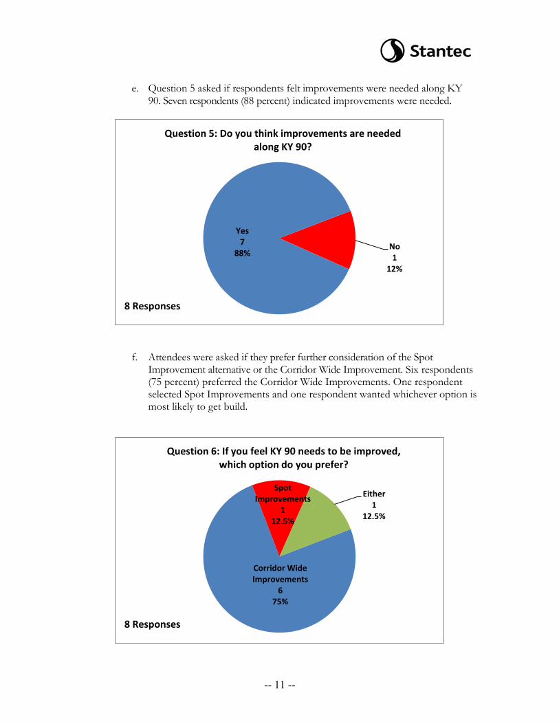
e. Question 5 asked if respondents felt improvements were needed along KY 90. Seven respondents (88 percent) indicated improvements were needed.
f. Attendees were asked if they prefer further consideration of the Spot Improvement alternative or the Corridor Wide Improvement. Six respondents (75 percent) preferred the Corridor Wide Improvements. One respondent selected Spot Improvements and one respondent wanted whichever option is most likely to get build.
No 1
12%
Yes 7
88%
Question 5: Do you think improvements are needed along KY 90?
8 Responses
Corridor Wide Improvements
6 75%
Spot Improvements
1 12.5%
Either 1
12.5%
Question 6: If you feel KY 90 needs to be improved, which option do you prefer?
8 Responses

-- 12 --
g. Question 7 asked attendees which Corridor Wide Improvement they prefer.
All eight respondents preferred Alternative 1 (2+1 Typical Section South of Cave City).
h. Attendees were asked if a shared-use path should be constructed along KY 90 between Cave City and Glasgow. Four respondents said yes and four respondents said no.
8
0 0 0
1
2
3
4
5
6
7
8
9
Alternative 1 Alternative 2 Other
Resp
onse
s
Question 7: Of the corridor wide improvements, which alternative do you prefer?
Yes 4
50%
No 4
50%
Question 8: Do you think a shared-use path should be constructed along KY 90 between Cave City and Glasgow?
8 Responses

-- 13 --
i. Question 9 asked if there were suggestions for additional Spot Improvements
along KY 90. One response suggested constructing additional passing lanes.
j. The final question asked if the attendees felt the appropriate type of
information was provided at the meeting. All respondents indicated the right kind of information was shared.
Yes 1
12%
No 7
88%
Question 9: Do you have any suggestions for additional Spot Improvements along KY 90?
8 Responses
Yes 8
100%
Question 10: Did this meeting provide the right kind of information about the KY 90 Scoping Study?
8 Responses

-- 14 --
13. Brian discussed the project schedule. A public meeting will be held on June 28, 2016. Comments and survey information collected today and at the public meeting will be used to help determine the final recommendations. The final report will be completed in November 2016.
The meeting ended at approximately 2:00 p.m. CDT.

Meeting Summary TO: Shane McKenzie Deneatra Henderson
Co-Project Manager Co-Project Manager KYTC Central Office KYTC District Office #3 200 Mero Street 900 Morgantown Road Frankfort, KY 40622 Bowling Green, KY 42101
FROM: Len Harper Project Manager
Stantec Consulting Services Inc.
DATE: July 29, 2016
SUBJECT: KY 90 Scoping Study Item Number 3-8819.00 Barren County – From Sanders Street to US 68 (Veterans Outer Loop) Public Meeting
A Public Information Meeting for the KY 90 Scoping Study was held on June 28, 2016 at 4:00 p.m. CDT at the Cave City Convention Center in Cave City, KY. The purpose of the meeting was to provide information about the study and the projects under consideration, discuss conceptual alternatives, and solicit input from the public. The following individuals from the Kentucky Transportation Cabinet (KYTC) and the consultant staff were in attendance:
Beverly England KYTC – District 3 Justin Harrod KYTC - Central Office Planning Deneatra Henderson KYTC – District 3 Niki Jones KYTC – District 3 Heather Lashley KYTC – District 3 Shane McKenzie KYTC – Central Office Planning Mikael Pelfrey KYTC – Central Office Planning Joe Plunk KYTC – District 3 Collin Ray KYTC – District 3 Mike Russell KYTC – District 3 Amy Scott Barren River Area Development District Wendy Southworth KYTC - Central Office Design Andy Stewart KYTC – District 3 Wes Watt KYTC – District 3 Misti Wilson KYTC – District 3 Brian Aldridge Stantec Consulting Services Inc. Glenn Hardin Stantec Consulting Services Inc. Len Harper Stantec Consulting Services Inc. Heather Lawler Stantec Consulting Services Inc. Graham Winchester Stantec Consulting Services Inc.

The meeting was held in an open house format, with a formal presentation at 4:30 p.m. to explain the project. Postcards were mailed to property owners in the study area inviting them to the public meeting. Two variable message boards were used to inform people of the public meeting – one facing southbound on KY 90 in Cave City and the other facing northbound on KY 90 in Glasgow. A newspaper advertisement was also placed in the Glasgow Daily Times on June 25, 2016 to invite people to the public meeting. Upon arrival, attendees were asked to sign in and were provided handouts that included a questionnaire, a project overview, and a Kentucky Transportation Center Brief on 2+1 Roadways. All information was made available on the project website at http://transportation.ky.gov/District-3/Pages/KY-90-in-Barren-County.aspx. KYTC and consultant staff were available to answer questions and discuss issues. Based on the sign-in sheets, 98 members of the public attended the meeting. The following project exhibits were on display:
- How the KYTC Builds Roads - Environmental Footprint - Crash History, Traffic, and Roadway Characteristics - Improvement Concepts and Evaluation Matrix
A video rendering for the 2+1 roadway was also on display. Public meeting attendees were given the option to either fill out their questionnaire at the meeting or return it by mail after the meeting. 36 questionnaires were returned at the meeting. An additional 12 questionnaires were returned after the meeting through July 29, 2016. The results of the questionnaire are summarized as follows: a. The first question asked how frequently the attendees drove through the study area. 36
respondents (77 percent) said they drive through the study area every day, nine respondents (19 percent) replied that they drive it 2-3 times per week, one respondent (two percent) drove the study area 2-3 times per month, and one respondent (two percent) said they rarely dive through the study area.

b. Question 2 asked if the attendees own or rent/lease property within the study area. 32 respondents (68 percent) said the own property in the study area, 13 respondents (28 percent) indicated they neither own nor rent/lease property within the study area, and two respondents (four percent) said they rent property in the study area.
c. Attendees were asked whether several transportation issues along KY 90 should be considered as a part of the project. Of the12 options provided, safety and few passing opportunities received the most responses. Too much traffic, excessive speeds, and large trucks also received a high number of responses.

d. Question 4 asked if there were any sensitive resources within the study area. Three people (eight percent) indicated they were aware of sensitive resources. The sensitive areas mentioned were homes adjacent to KY 90 that would lose frontage property and be forced closer to the road and the traffic noise, unidentified caves and trees, and the Onyx Cave & Rock Shop billboard at 425 Prewitt's Knob Road in Cave City.
e. Question 5 asked if respondents felt improvements were needed along KY 90. 42 respondents (89 percent) indicated improvements were needed.

f. Attendees were asked if they prefer further consideration of the Spot Improvement alternative or the Corridor Wide Improvement. 26 respondents (63 percent) preferred the Corridor Wide Improvements and 15 respondents (37 percent) preferred Spot Improvements.
g. Question 7 asked attendees which Corridor Wide Improvement they prefer. 26 respondents
(58 percent) preferred Alternative 1 (2+1 Typical Section South of Cave City), 15 respondents (33 percent) preferred Alternative 2 (Four-Lane Depressed Median Typical Section South of Cave City), and four respondents (nine percent) wanted a different alternative. The other alternatives mentioned were additional turn lanes at major intersections, four-lane section with no median, and a five-lane section with no median.
One respondent asked if the speed limit will be raised to align with how fast drivers go or will measures be put in place to enforce the current speed limit. Deneatra Henderson contacted this person and responded to their question. Another respondent asked if the expenditure of the project was sensible since the roadway is adequate for present and future traffic. The same respondent wrote that if a depressed median section is built many homeowners and businesses as well as the school systems will be greatly and unnecessarily inconvenienced.

h. Attendees were asked if a shared-use path should be constructed along KY 90 between Cave City and Glasgow. 26 respondents (59 percent) said no and 18 respondents (41 percent) said yes.
i. Question 9 asked if there were suggestions for additional Spot Improvements along KY 90. Nine respondents (19 percent) had additional recommendations. Those suggestions included safer turning into the property at the top of the hill below Buena Vista Estates, a turning lane on KY 90 between Airport Road and Perkins Road, extend the existing passing lane on KY 90 south past the Caveland Road intersection, widen entrances of adjacent roads, and construct additional passing lanes.

j. The final question asked if the attendees felt the appropriate type of information was provided at the meeting. Three respondents (eight percent) answered no. One respondent wanted to know if their house was one of the potential relocations mentioned in the presentation. Deneatra Henderson contacted this person and responded to their question. A second respondent requested that future meetings be held at night or on weekends so they would have more availability to attend. The third respondent did not list what additional information they wished to see.
The meeting ended at approximately 6:00 p.m. CDT.

-- 1 --
Meeting Minutes
TO: Shane McKenzie Deneatra Henderson
Co-Project Manager Co-Project Manager KYTC Central Office KYTC District Office #3 200 Mero Street 900 Morgantown Road Frankfort, KY 40622 Bowling Green, KY 42101
FROM: Len Harper Project Manager Stantec Consulting Services Inc. DATE: August 29, 2016 SUBJECT: KY 90 Scoping Study Item Number 3-8819.00
Barren County – From Sanders Street to US 68 (Veterans Outer Loop) Project Team Meeting #3
A project team meeting for the subject project was held at the Kentucky Transportation Cabinet District 3 Office in Bowling Green, Kentucky on August 25, 2016 at 9:00 a.m. CDT. The following individuals were in attendance:
Kevin Gearlds KYTC – District 3 Justin Harrod KYTC - Central Office Planning Deneatra Henderson KYTC – District 3 Shane McKenzie KYTC – Central Office Planning Mikael Pelfrey KYTC – Central Office Planning Joe Plunk KYTC – District 3 J.C. Puryear, Jr. KYTC – District 3 Mike Russell KYTC – District 3 Renée Slaughter KYTC – District 3 Wendy Southworth KYTC - Central Office Design Andy Stewart KYTC – District 3 Brian Aldridge Stantec Consulting Services Inc. Len Harper Stantec Consulting Services Inc.
Heather Lawler Stantec Consulting Services Inc.
Len Harper welcomed everyone and said the purpose of the meeting was to discuss the survey results from the local officials/stakeholders meeting held in May and the public meeting held in June and determine the project team recommendations for the study. Handouts included a summary from the public meeting and an evaluation matrix summarizing the impacts and cost estimates of the improvement alternatives. Len Harper delivered a presentation. The following enumerated items were discussed.

-- 2 --
1. The purpose of the KY 90 improvement project is to enhance regional mobility and
to provide a safer, more efficient connection between Glasgow and I-65. KY 90 is the most direct connection between Glasgow and vehicles heading northbound on I-65. Signs on I-65 direct southbound vehicles to use KY 90 to access Glasgow. KY 90 also provides a link between the Barren River Lake State Park and the Mammoth Cave National Park. KY 90 is part of the National Truck Network.
2. The KY 90 study area is approximately 8.4 miles in length between the Sanders Street intersection in Cave City and the US 68 (Veterans Outer Loop) intersection in Glasgow. Within the study corridor, KY 90 is functionally classified as a Rural Minor Arterial from Sanders Street in Cave City to Beaver Trail in Glasgow and an Urban Minor Arterial in Glasgow from Beaver Trail to US 68. The posted speed limit is 45 to 55 miles per hour (mph). The existing typical section includes two 12-foot driving lanes and ten-foot paved shoulders. There are three southbound passing lanes and two northbound passing lanes. Where there are passing lanes the adjacent shoulder is narrowed to two-feet. There are no bike lanes or sidewalks along the study area.
3. A review of the as-built plans found all 11 horizontal curves and all 28 vertical curves
along KY 90 satisfy the 45 design speed north of US 31W in Cave City and the 55 mph design speed south of US 31W. The steepest grade along the study area is five percent.
4. Of the 204 reported crashes in the study area between January 2011 and December 2015, 3 resulted in a fatality and 47 resulted in an injury. Of these crashes, 35 percent were classified as rear end and 26 percent were single vehicle crashes. Critical Rate Factor (CRF) is a measure of the safety of a road in comparison to similar roads. If the CRF is 1.00 or greater it indicates that crashes may be occurring more often than can be attributed to random occurrence. Ten high crash spots were located on KY 90 with CRF’s greater than 1.00.
5. KY 90 has a 2015 Average Daily Traffic (ADT) volume between 8,200 and 9,100 vehicles per day (vpd) with 16 to 17 percent trucks. The 2040 ADT volumes are expected to grow to 12,000 vpd with 19 percent trucks. A volume to capacity (V/C) analysis indicates all roadway segments currently operate at less than full capacity with a V/C ratio less than 0.49, and the V/C ratio increases to 0.60 by 2040. This means a two-lane road can accommodate the existing and future traffic demand.
6. Level of service (LOS) is a qualitative measure describing operational conditions
within a traffic stream. For two-lane highways, LOS is determined based on two parameters – average travel speed and percent time spent following in a platoon. In rural areas LOS C or better is desirable and in urban areas LOS D or better is desirable. KY 90 in Cave City operates at LOS D. This portion of KY 90 has a signalized intersection at US 31W and no passing opportunities, which decreases the average travel speed and increases the percent time following in a platoon. South of Cave City, passing lanes are introduced along KY 90 which increases the average

-- 3 --
travel speed and decreases the percent time following. This portion of KY 90 operates at LOS C. By 2040, KY 90 is expected to operate at LOS E in Cave City and a LOS D south of Cave City.
7. Len reviewed the results from the eight completed surveys from the local officials/stakeholders meeting held on May 26, 2016 and the 48 completed surveys from the public meeting held on June 28, 2016.
• The first question asked how frequently the attendees drove through the
study area.
• Question 2 asked if the attendees own or rent/lease property within the study area.

-- 4 --
• Attendees were asked whether several transportation issues along KY 90 should be addressed as part of the project. Of the 11 options provided, safety and not enough passing lanes were selected most. Other issues that were mentioned include not enough turn lanes, slow trucks and slow farming equipment, congestion and the many access points near Cave City, and drivers passing where there is a double yellow line.
• Question 4 asked if respondents were aware of any sensitive resources within the study area. Five respondents indicated they were aware of sensitive resources. The sensitive areas mentioned were karst and wetlands near the Harry King Road intersection, homes adjacent to KY 90 that would lose frontage property and be forced closer to the road and the traffic noise, unidentified caves and trees, and the Onyx Cave & Rock Shop billboard at 425 Prewitt's Knob Road in Cave City.

-- 5 --
• Question 5 asked if respondents felt improvements were needed along KY 90. Eighty nine percent of respondents indicated improvements were needed.
• Attendees were asked if they prefer further consideration of the Spot Improvement alternative or the Corridor Wide Improvement. Sixty seven percent of respondents preferred the corridor wide improvement.

-- 6 --
• Question 7 asked attendees which Corridor Wide Improvement they prefer. 34 respondents (64 percent) preferred Alternative 1 (2+1 Typical Section South of Cave City), 15 respondents (28 percent) preferred Alternative 2 (Four-Lane Depressed Median Typical Section South of Cave City), and four respondents (nine percent) wanted a different alternative. The other alternatives mentioned were additional turn lanes at major intersections, four-lane section with no median, five-lane section with no median, and a No-Build with better enforcement of the speed limit.
• Question 8 asked attendees if a shared-use path should be constructed along KY 90 between Cave City and Glasgow. 30 respondents (58 percent) said no and 22 respondents (42 percent) said yes.

-- 7 --
• Question 9 asked if there were suggestions for additional Spot Improvements along KY 90. Ten respondents had additional recommendations. Those suggestions included safer turning into the property at the top of the hill below Buena Vista Estates, a center turning lane on KY 90 between Airport Road and Perkins Road, extend the existing passing lane on KY 90 south past the Caveland Road intersection, widen entrances of adjacent roads, Flint Knob Road, extend existing passing lanes, and construct additional passing lanes.
• The final question asked if the attendees felt the appropriate type of information was provided at the meeting. Three respondents answered no. One respondent wanted to know if their house was one of the potential relocations mentioned in the presentation. A second respondent requested that future meetings be held at night or on weekends so they would have more availability to attend. The third respondent did not list what additional information they wished to see.

-- 8 --
8. The project team was provided a handout of the evaluation matrix and cost
estimates, shown in Table 1. The table summarizes the alternatives ability to meet the purpose and need, 2040 traffic analyses, right-of-way impacts, and cost estimates. The group had an open discussion about these concepts as follows:
• Stantec developed four corridor wide alternatives. The corridor wide improvement was divided into two sections - Section 1 is an urban area that travels through Cave City and Section 2 is a rural area between Cave City and Glasgow.
i. Section 1 has one preliminary alternative: a five-lane curb-and-gutter
typical section with sidewalks and bike lanes. It matches the existing typical section north of Sanders Street. This alternative will replace the bridge over CSX Railroad which has a sufficiency rating of 76.9 percent and is considered functionally obsolete.
ii. Section 2 has four preliminary alternatives (listed below). All four alternatives in Section 2 reuse the existing road. The widening occurs on one side of the road so traffic can be maintained during construction and the majority of existing pavement can be reused. The widening shifts from east to west to minimize right-of-way impacts and reduce earthwork. After the widening is complete a final pavement surface layer will be placed over the entire roadway.
• Alternative 1a - 2 + 1 Typical Section: Even though the direction of the passing lane changes on a 2 + 1 road, the total pavement width stays constant. All that changes is the striping. The passing lane itself is typically 0.8 miles to 1.5 miles in length. Where necessary and appropriate, left turn lanes are placed between tapers in the flush median after traffic has been transitioned out of the passing lanes.
• Alternative 1b- 2 + 1 Typical Section with Shared-Use Path: A 14-foot shared-use path will likely require 23 feet of additional widening for a total typical section width of 97 feet. The shared-use path was placed on the east side of KY 90 to align with Beaver Trail Park in Glasgow and Brian Doyle Park in Cave City. This also avoids impacts to the runway safety area and aircraft approach to Runway 26 at the Glasgow Airport which sits just west of KY 90.
• Alternative 2 – Four-Lane Depressed Median Typical Section: The recommended minimum median opening spacing is 2,400 feet. This will remove direct access to approximately 124 driveways which was considered unfavorable by many attendants at the public meeting.

-- 9 --
Tab
le 1
– E
valu
atio
n M
atrix

-- 10 --
• Alternative 2b- Four-Lane Depressed Median with Shared-Use Path: A 14-foot shared-use path will likely require 23 feet of additional widening for a total typical section width of 149 feet.
• The 2016 Highway Plan includes $2.2 million for design in 2016, $6.0 million
for right-of-way in 2017, and $3.5 million for utility relocation in 2017. The construction phase is outside the two-year biennium, $27.5 million for 2019. Funding for all phases of this project totals $39.2 million. The 2016 cost estimates (all phases) for the improvement alternatives are:
i. Spot Improvements - $16.0 million ii. Alternative 1 - $35.0 million iii. Alternative 1b - $44.0 million iv. Alternative 2 - $68.3 million v. Alternative 2b - $78.8 million
• The project team recommended Alternative 1 (5-Lane Urban Typical Section
in Cave City and 2+1 Typical Section South of Cave City) move forward to Phase 1 design.
i. Satisfies the purpose and need of the project; ii. Addresses the top two transportation issues from survey respondents
(safety and not enough passing lanes); iii. Provides acceptable LOS through year 2040. iv. Preferred alternative from survey respondents; v. Selected as the preferred alternative from all the local
officials/stakeholders survey respondents; vi. Provides corridor wide improvement which meets the intent of the
project description in 2016 Highway Plan; and vii. Provides the most design flexibility which reduces right-of-way
impacts and earthwork costs.
• The project team recommended reduced shoulder widths and lane widths be considered in Phase 1 design. This will increase safety by reducing travel speeds and will reduce right-of-way impacts and earthwork costs.
• The project team recommended a shared-use path be considered further in Phase 1 design. The local officials in Glasgow, Cave City and/or Barren County will need to agree to pay to maintain the shared-use path before it moves any further in design.
i. The addition of a shared-use path reduces design flexibility. Shifting the roadway alignment from east to west, as was assumed with Alternative 1, reduces earthwork costs and right-of-way impacts. Most of the homes and businesses along KY 90 are adjacent to the existing road. Widening to the west and constructing the shared-use path to the east would take the properties on both sides of the road.

-- 11 --
Thus, where the shared-use path is included, all the widening is done to the east, which increases earthwork and right-of-way impacts. The increased right-of-way impacts will increase the project timeline considerably.
ii. The Cave Region Trails Initiative (CRTI) is not interested in a shared-use path along KY 90. They are pursuing a shared-use path along the CSX Railroad as a way to connect the city of Glasgow and the Mammoth Cave National Park.
iii. The addition of the shared-use path to the 2 + 1 typical section is estimated to require three additional home relocations, one additional business relocation and an additional $5.1 million in construction cost.
iv. There are no existing or proposed bicycle/pedestrian facilities to connect with in Glasgow.
• An alternative to the shared-use path is a shoulder bikeway. This should be
considered further in Phase 1 design.
9. Len discussed the project schedule. The draft report will be submitted September 30, 2016 and the final report in November.
The meeting ended at approximately 10:30 a.m. CDT.
Related Documents