2008 IDAHO AIRPORT SYSTEM PLAN C-1 APPENDIX C: AIRPORT LAND USE GUIDELINES SECTION ONE: PURPOSE OF THE AIRPORT LAND USE GUIDELINES INTRODUCTION This report touches upon the issues and methods of land use compatibility planning surrounding airports in Idaho. Written as part of the Idaho Airport System Plan Update, the document has also been assembled as a future aid to local planning and zoning officials throughout Idaho. Airport land use compatibility planning is seen as an inherent aspect of growth management and sound economic development and should become a requisite part of land use plans and programs across the state. Incompatible land uses are one of the largest threats to airports today, causing conflicts between airports and their associated communities. As Idaho continues to grow, development can encroach upon airports, limiting their service capabilities and the opportunity for expansion in the absence of appropriate land use planning and zoning. Airports are valuable assets to Idaho’s communities and to its economy. When airport operations are inhibited by the liabilities of poor land planning decisions and uncontrolled development, communities are unable to successfully utilize and expand their airport services. As shown by the 2010 Idaho Airport System Plan’s Economic Impact Study, Idaho airports contributed approximately $2 billion in economic impacts and generated an estimated $87 million in taxes annually in the state of Idaho. If more services are brought to an airport, community benefits such as an increased tax base, enhanced accessibility for local businesses and residents, and investments that will expand down to the local economy can occur. Through this process, tangible economic and lifestyle improvements can be supported in local communities with nearby airports. Successful planning and implementation of compatible land uses can provide both the residents of Idaho and national and international visitors with significant long-term benefits. Although Idaho is still a rural state by most standards, the population is increasing. Land surrounding many commercial service and general aviation airports is being converted from agricultural or low density uses to more dense uses. This development is encroaching on areas that surround the airports which are better suited to different, less intensive land uses. If sustainable and economically balanced land uses can be encouraged around airports, issues such as airport safety and aviation noise impacts can be avoided. If these impacts are not prevented, public discontent can result. When incompatible land uses encroach upon airports, Federal Aviation Administration (FAA) requirements for airspace and land use protection also become a key concern. If FAA and State requirements are not met by an airport, they can lose access to significant grant-in-aid funds, impacting local economies and airport services. If we can protect airports before incompatible land uses engulf them, we can secure the economic vitality of our communities and the safe and successful operations of our

Welcome message from author
This document is posted to help you gain knowledge. Please leave a comment to let me know what you think about it! Share it to your friends and learn new things together.
Transcript

2008 IDAHO AIRPORT SYSTEM PLAN
C-1
APPENDIX C: AIRPORT LAND USE GUIDELINES
SECTION ONE: PURPOSE OF THE AIRPORT LAND USE GUIDELINES INTRODUCTION This report touches upon the issues and methods of land use compatibility planning surrounding airports in Idaho. Written as part of the Idaho Airport System Plan Update, the document has also been assembled as a future aid to local planning and zoning officials throughout Idaho. Airport land use compatibility planning is seen as an inherent aspect of growth management and sound economic development and should become a requisite part of land use plans and programs across the state. Incompatible land uses are one of the largest threats to airports today, causing conflicts between airports and their associated communities. As Idaho continues to grow, development can encroach upon airports, limiting their service capabilities and the opportunity for expansion in the absence of appropriate land use planning and zoning. Airports are valuable assets to Idaho’s communities and to its economy. When airport operations are inhibited by the liabilities of poor land planning decisions and uncontrolled development, communities are unable to successfully utilize and expand their airport services. As shown by the 2010 Idaho Airport System Plan’s Economic Impact Study, Idaho airports contributed approximately $2 billion in economic impacts and generated an estimated $87 million in taxes annually in the state of Idaho. If more services are brought to an airport, community benefits such as an increased tax base, enhanced accessibility for local businesses and residents, and investments that will expand down to the local economy can occur. Through this process, tangible economic and lifestyle improvements can be supported in local communities with nearby airports. Successful planning and implementation of compatible land uses can provide both the residents of Idaho and national and international visitors with significant long-term benefits. Although Idaho is still a rural state by most standards, the population is increasing. Land surrounding many commercial service and general aviation airports is being converted from agricultural or low density uses to more dense uses. This development is encroaching on areas that surround the airports which are better suited to different, less intensive land uses. If sustainable and economically balanced land uses can be encouraged around airports, issues such as airport safety and aviation noise impacts can be avoided. If these impacts are not prevented, public discontent can result. When incompatible land uses encroach upon airports, Federal Aviation Administration (FAA) requirements for airspace and land use protection also become a key concern. If FAA and State requirements are not met by an airport, they can lose access to significant grant-in-aid funds, impacting local economies and airport services. If we can protect airports before incompatible land uses engulf them, we can secure the economic vitality of our communities and the safe and successful operations of our
2008 IDAHO AIRPORT SYSTEM PLAN
C-2
airports as well as preserve the quality of life and safety of nearby residents that can be impacted by encroachment. The most successful methods of regulating land use incompatibilities surrounding airports are through local planning efforts including Comprehensive Plans, zoning ordinances, and airport master planning. Cities, counties, and airport operators need to work together to formulate these plans to consider airport and community issues. Thus, coordination between local governments is crucial in achieving regional acceptance and agreement on airport land use decisions. Coordinated decisions can ensure encompassing protection of airports and local citizens. Moreover, by protecting Idaho’s airports, the requirements for federal and state airspace protection can be upheld to ensure access to potential funding opportunities. The primary responsibility for integrating airport considerations into the local land use planning process rests with local land use planning agencies and local governments. Coordination across jurisdictions to achieve airport land use compatibility will be imperative for its success. By protecting Idaho’s airports through airport and land use compatibility planning, local governments and policymakers can strengthen the economic vitality of communities and the airports that operate within them as well as preserve the quality of life of nearby residents that can be impacted by airport operations and activities. These Idaho Airport Land Use Guidelines provide local planning and/or zoning boards with direction in adopting plans and ordinances for aviation facilities. These guidelines expand upon the topics listed in the Transportation subsection of the ‘Planning Duties’ Idaho Code, Section 67-6508 (i) that mandates the preparation of comprehensive planning. Although the last sentence states, “The component may also include port, harbor, aviation, and other related transportation facilities,” it is the policy of the Idaho Transportation Board to have local planning and/or zoning boards plan for, enact, and enforce zoning to protect local airports because they are valuable public facilities as well as an economic centers for the local and state economy. These guidelines will identify the minimum and ‘best practices’ requirements needed to protect airport operations and businesses and citizens living and working near airports. County plans and land use ordinances regulate local government activities, except in part for transportation systems of statewide importance. The ‘Zoning Ordinances’ section of Chapter 12 of the County Elected Officials Handbook, page 12-8, states “A good example of what occurs when there are state requirements that are more restrictive than local land use regulations involves The Airport Zoning Act, (Idaho Code, Section 21-501 et seq). Under this Act, the State, through the Idaho Transportation Department (ITD) is given power to promulgate regulations for the zoning of airports and airport hazard areas (as defined by State statute). These regulations specify uses allowed, specify the height for both structures and trees, and can require a landowner to obtain a permit from the director of ITD before constructing any structure in the zoned area. In the event that a county has adopted a zoning ordinance covering an airport or airport hazard areas, the airport zoning regulations can be incorporated into the zoning ordinance and be administered and enforced in connection with the zoning ordinance. However, if there is a conflict between any airport zoning regulations and any other regulations applicable to the same area, the more stringent regulations govern. County officials should confirm with ITD whether such regulations are in place in connection with any airport located within the county.”
2008 IDAHO AIRPORT SYSTEM PLAN
C-3
These guidelines will provide the local boards with the knowledge of, reasons for, and examples needed to enact airport specific Comprehensive Plans and zoning ordinances that meet or exceed the state requirements found in The Airport Zoning Act. As a matter of policy, the State of Idaho, Idaho Transportation Board through their Division of Aeronautics, prefers that the local airport owners, and neighboring jurisdictions affected by an airport, through the ‘Joint City-County and Regional Planning Commissions’ authority (Idaho Code, Section 67-6505), enact and enforce local plans and ordinances as an alternative to the state enacting and enforcing airport plans and ordinances. These guidelines are intended to provide the information needed to maintain local control while meeting or exceeding state expectations. This document is provided as a supplement to assistance available from the staff of the Division of Aeronautics. Common Terms Used in the Airport Land Use Guidelines The following are some of the commonly used terms throughout these guidelines:
Compatible Land Use – Airport compatible land uses are those uses that can coexist with a nearby airport without either constraining the safe and efficient operation of the airport or exposing people living or working nearby to unacceptable levels of noise or hazards. Compatibility of land use is attained when the use of adjacent property neither adversely affects flight operations from the airport nor is itself adversely affected by such flight operations. Incompatible Land Uses – The use of land which is normally incompatible with the aircraft and airport operations (such as, but not limited to, homes, schools, nursing homes, hospitals, and libraries). The following definitions come from an FAA publication entitled LAND USE COMPATIBILITY AND AIRPORTS, A GUIDE FOR EFFECTIVE LAND USE PLANNING. It is available at: http://www.faa.gov/about/office_org/headquarters_offices/aep/planning_toolkit/media/III.B.pdf Federal Grant Assurance – The terms and conditions of accepting Airport Improvement Program (AIP) grants from the Federal Aviation Administration for carrying out the provisions of Title 49, United States Code. The terms and conditions become applicable when the airport sponsor accepts a grant offer from the FAA. Land Use Compatibility –The coexistence of land uses surrounding the airport with airport-related activities. Land Use Controls – Measures established by state or local government that are designed to carry out land use planning. The controls include, among other measures: zoning, subdivision regulations, planned acquisition, easements, covenants or conditions in building codes and capital improvement programs, such as establishment of sewer, water, utilities or their service facilities.
2008 IDAHO AIRPORT SYSTEM PLAN
C-4
Land Use Management Measures – Land use management techniques that consist of both remedial and preventive measures. Remedial or corrective measures typically include sound insulation or land acquisition. Preventive measures typically involve land use controls that amend or update the local zoning ordinance, Comprehensive Plan, subdivision regulations and building code. Zoning – The partitioning of land parcels in a community by ordinance into zones and the establishment of regulations in the ordinance to govern the land use and the location, height, use and land coverage’s of buildings within each zone. The zoning ordinance usually consists of text and zoning map. Zoning Ordinance – Primarily a legal document that allows a local government effective and legal regulation of uses of property while protecting and promoting the public interest.
Organization of the Airport Land Use Guidelines Additionally, a few comments on the organization and use of these guidelines may assist the reader. These guidelines incorporate both an educational and a procedural component in order to meet the differing needs and backgrounds of the aviation community on one hand and the municipal; zoning authorities on the other hand. This will bring together two divergent groups so they can mutually understand each others interests and cooperatively establish compatible land uses around Idaho's public use airports. Sections 2 and 3 as well as the Appendices of these guidelines, constitute the primary aviation education parts that place the airport and its activities in context with the broader community as a whole. This will provide a basic grounding regarding the legal basis for airports and the need for zoning around them. Sections 4 through 8 explain the five 'Step' process used to establish, enact, and enforce airport zoning regulations. These sections provide both an educational background for the airport community and an explanation of the procedures used to establish proper zoning regulations. Specifically, sections 4 through 6 detail the background and procedures for planning and zoning, while sections 7 and 8 provide specific ordinance language and examples of agreements that enhance the protections afforded by the ordinance. Finally, sections 9 and 10 discuss ordinance implementation and operation and some future considerations.
2008 IDAHO AIRPORT SYSTEM PLAN
C-5
SECTION TWO: AUTHORITY FOR AIRPORT ZONING There are many entities involved in actions to improve land use compatibility around airports. These entities can include the local government, Federal Aviation Administration (FAA), state governments, airport system users, and the community. Although many of these entities have some influence in the process, there are key authorities that are crucial in helping to implement land use compatibility near airports. These authorities are:
ñ Local Government (cities, counties, land use agencies, airports) ñ Federal Aviation Administration (FAA) ñ State of Idaho
Each of these entities provides an integral role in airport and land use compatibility planning. Policymakers and planners should consider the value that each of these authorities can bring to the table in terms of policy planning and execution. In addition, significant research and information is available to help in executing this process. This information can be used to guide each of these authorities towards appropriate goals and objectives in airport and land use compatibility planning. LOCAL ENTITIES As identified previously, the primary responsibility for incorporating airport considerations into the local land use planning process rests with local governments, local land use agencies, and airport administrators. Land use regulation near airports is achieved through municipal codes, ordinances and plans that include airport districts, zones, or planning areas which enforce land uses adjacent to airports. Crucial tools that should be used for ensuring land use compatibility near airports are: Comprehensive Plans, zoning codes, development regulations, airport master plans, airport layout plans, airport property maps, and airport zoning maps. The primary, though not the only, statutes that provide authority for local municipalities include; Local Land Use Planning (Idaho Code § 67-65), the Open Meeting Law (Idaho Code § 67-2341 through 2346), and Ordinance – City code – Records (Idaho Code § 50-9). Land use coordination should be an integral part of local airport land use planning efforts. Coordination of land use planning goals is essential to airport planning efforts because airport facilities are often surrounded by a multitude of individual governmental jurisdictions as well as private property. In many cases, each local jurisdiction has their own set of plans and ordinances and their own policy process. Airport administrators may also have separate strategies for expansion of an airport. Thus, early and ongoing coordination between adjacent land use agencies, governments, and airport administrators can help to achieve sustainable and economically balanced land uses around airports. The valuable insight that each entity can bring to the table will help in forming plans or programs that are regionally accepted. Successful coordination and agreement in formulating land use decision near airports is crucial in protecting the needs of local governments, airports, and Idaho’s communities. As part of this process, it is imperative that units of local government work to establish a Joint

2008 IDAHO AIRPORT SYSTEM PLAN
C-6
Powers Planning and Zoning Commission that provides a forum to protect the airport and the surrounding community. Forming a joint commission will also help to collaborate among agencies and stakeholders as well as make educated policy decisions on airport land use issues. Appendix A contains a table listing the jurisdictions that should coordinate planning efforts near Idaho’s airports.
FEDERAL AVIATION ADMINISTRATION The principal focus of the FAA is on the safe operation of aircraft, the protection of Airspace, as well as the proper design and safe operation of airports. The FAA does not have authority to enforce off-airport land use issues. Yet, the FAA does have a stake in the land use patterns that occur around airports to protect the investment of federal tax dollars. They are concerned in the surrounding land uses that affect the airport operations which they fund through airport improvement grants. The FAA has conducted substantial research on land use compatibility and safety near airports. Thus, it can be valuable to use their research as a resource in the planning process. This will help to better understand the occurrence of aviation accidents and the actions for improved safety of airport-related land use planning. The following is a brief overview of federal statutes and rules that affect an airport owner. The FAA has specific definitions, regulations, and assurances that enforce airspace protection, aircraft safety, airport design, and airport management and operations. Moreover, federal grant assurances require compliance with specific airport performance measures set out by grant sponsors. These assurances are required to be submitted as part of project applications that request federal funds. The specific assurances that pertain to land use compatibility are grant assurances # 20 Hazard Removal and Mitigation, and # 21, Compatible Land Use. These assurances set grant requirements for protecting terminal airspace and measures to uphold land use compatibility as part of the airport planning process. The key regulations and assurances that the FAA administers to airports include: Title 49 United States Code (USC) § 47102 (2) (A) and (B), Definitions
Airport means (i) an area of land or water used or intended to be used for the landing and taking off of aircraft; (ii) an appurtenant area used or intended to be used for airport buildings or other airport facilities or rights of way; and (iii) airport buildings and facilities located in any of those areas; and includes a heliport.
Title 49 United States Code (USC) § 47102 (4), Definitions
Airport Hazard means a structure or object of natural growth located on or near a public-use airport, or a use of land near the airport, that obstructs or otherwise is hazardous to the landing or taking off of aircraft at or from the airport.
Airspace
ñ 14 CFR Part 77, Objects Affecting Navigable Airspace § 77.25 Civil Airport Imaginary Surfaces
ñ Title 49 United States Code (USC) § 47107 (a) (9)

2008 IDAHO AIRPORT SYSTEM PLAN
C-7
Sec. 47107 Project grant application approval conditioned on assurances about airport operations
(a) General Written Assurances. The Secretary of Transportation may approve a project grant application under this subchapter for an airport development project only if the Secretary receives written assurances, satisfactory to the Secretary, that-- (9) appropriate action will be taken to ensure that terminal airspace required to protect instrument and visual operations to the airport (including operations at established minimum flight altitudes) will be cleared and protected by mitigating existing, and preventing future, airport hazards;
ñ Grant Assurance #6, Consistency with Local Plans
The project is reasonably consistent with plans (existing at the time of submission of this application) of public agencies that are authorized by the State in which the project is located to plan for the development of the area surrounding the airport.
ñ Grant Assurance #20, Hazard Removal and Mitigation It will take appropriate action to assure that such terminal airspace as is required to protect instrument and visual operations to the airport (including established minimum flight altitudes) will be adequately cleared and protected by removing, lowering, relocating, marking, or lighting or otherwise mitigating existing airport hazards and by preventing the establishment or creation of future airport hazards.
Land Use
ñ 14 CFR Part 150, Airport Noise Compatibility Planning Table 1, Land Use Compatibility with Yearly Day-Night Average Sound Levels
ñ Title 49 United States Code (USC) § 47107 (a) (10) Sec. 47107. Project grant application approval conditioned on assurances about airport operations
(a) General Written Assurances. The Secretary of Transportation may approve a project grant application under this subchapter for an airport development project only if the Secretary receives written assurances, satisfactory to the Secretary, that--(10) appropriate action, including the adoption of zoning laws, has been or will be taken to the extent reasonable to restrict the use of land next to or near the airport to uses that are compatible with normal airport operations;
ñ Grant Assurance #6, Consistency with Local Plans
The project is reasonably consistent with plans (existing at the time of submission of this application) of public agencies that are authorized by the State in which the project is located to plan for the development of the area surrounding the airport.
ñ Grant Assurance #21, Compatible Land Use It will take appropriate action, to the extent reasonable, including the adoption of zoning laws, to restrict the use of land adjacent to or in the immediate vicinity of the airport to activities and purposes compatible with normal airport operations,

2008 IDAHO AIRPORT SYSTEM PLAN
C-8
including landing and takeoff of aircraft. In addition, if the project is for noise compatibility program implementation, it will not cause or permit any change in land use, within its jurisdiction, that will reduce its compatibility, with respect to the airport, of the noise compatibility program measures upon which Federal funds have been expended.
FAA Order 5190.6B - FAA Airport Compliance Manual, Chapter 20 – Compatible Land Use and Airspace Protection Authority – Page 20-1 Ensuring compatible land use near federally obligated airports is an important responsibility and an issue of federal interest. In effect since 1964, Grant Assurance 21, Compatible Land Use, implementing Title 49 United States Code (U.S.C.) § 47107 (a) (10), requires, in part, that the sponsor:
“…take appropriate action, to the extent reasonable, including the adoption of zoning laws, to restrict the use of land adjacent to or in the immediate vicinity of the airport to activities and purposes compatible with normal airport operations, including landing and takeoff of aircraft. In addition, if the project is for noise compatibility program implementation, it will not cause or permit any change in land use, within its jurisdiction, that will reduce its compatibility, with respect to the airport, of the noise compatibility program measures upon which federal funds have been expended.”
Description of Zoning and Land Use Planning – Page 20-2 and 20-3 Zoning is an effective method of meeting the federal obligation to ensure compatible land use and to protect airport approaches. Generally, zoning is a matter within the authority of state and local governments. Where the sponsor does have authority to zone or control land use, FAA expects the sponsor to zone and use other measures to restrict the use of land in the vicinity of the airport to activities and purposes compatible with normal aircraft operations. Restricting residential development near the airport is essential in order to avoid noise-related problems. Sponsors and local communities should consider adopting adequate guidelines and zoning laws that consider noise impacts in land use planning and development. Similarly, any airport sponsor that has the authority to adopt ordinances restricting incompatible land development and limiting the height of structures in airport approaches according to the standards prescribed in 14 Code of Federal Regulations (CFR) Part 77, Objects Affecting Navigable Airspace, is generally expected to use that authority. Definition of Compatible Land Use – Page 20-5 Compatibility of land use is attained when the use of adjacent property neither adversely affects flight operations from the airport nor is itself adversely affected by such flight operations. In most cases, the adverse affect of flight operations on adjacent land results from exposure of noise sensitive development, such as residential areas, to aircraft noise and vibration. Land use that adversely affects flight operations is that which creates or contributes to a flight hazard. For example, any land use that might allow tall structures, block the line of sight from the control tower to all parts of the airfield, inhibit pilot visibility (such as glaring

2008 IDAHO AIRPORT SYSTEM PLAN
C-9
lights, smoke, etc.), produce electronic aberrations in navigational guidance systems, or that would tend to attract birds would be considered an incompatible land use. For instance, under certain circumstances, an exposed landfill may attract birds. If open incineration is regularly permitted, it can also create a smoke hazard. Definition of Concurrent Land Use – Page 20-5 In some cases, concurrent land use can be an appropriate compatible land use. Concurrent land use means that the land can be used for more than one purpose at the same time. For example, portions of land needed for clear zone purposes could also be used for agriculture purposes at the same time, which would be consistent with Grant Assurance 21, Compatible Land Use. FAA Order 5190.6B - FAA Airport Compliance Manual, Chapter 13 – Airport Noise and Access Restrictions Introduction and Responsibilities – Page 13-1 This chapter contains guidance on the sponsor’s responsibility with regard to restrictions on airport noise and access. Background – Page 13-1 a. The legal framework with respect to abatement of aviation noise may be summarized as follows: (3). State and local governments may protect their citizens through land use controls and other police power measures not affecting airspace management or aircraft operations. In addition, to the extent they are airport proprietors, they have the powers described in paragraph (b)(2) below: b. The authorities and responsibilities of the parties may be summarized as follows: (2). Airport sponsors are primarily responsible for planning and implementing action designed to reduce the effect of noise on residents of the surrounding area. Such actions include optimal site location, improvements in airport design, noise abatement ground procedures, land acquisition, and restrictions on airport use that do not unjustly discriminate against any user, impede the federal interest in safety and management of the air navigation system, or unreasonably interfere with interstate or foreign commerce. (3). State and local governments and planning agencies should provide for land use planning and development, zoning, and housing regulations that are compatible with airport operations. Residential Development – Page 13-12 FAA must consider whether the sponsor has fulfilled its responsibilities regarding compatible land use under Grant Assurance 21, Compatible Land Use. Airport sponsors are obligated to take appropriate action, including the adoption of zoning laws, to the extent reasonable to restrict the use of land next to or near the airport to uses that are compatible with normal airport operations. Local land use planning, as a method of determining appropriate (and inappropriate) use of properties around airports, should be an integral part of the land use policy and regulatory tools used by state and local land use planning agencies. Very often, such land use planning coordination is hampered by the fact that an airport can be surrounded by multiple individual local governmental jurisdictions, each with its own planning

2008 IDAHO AIRPORT SYSTEM PLAN
C-10
process. Some airport authorities have the authority to control land use, but many do not. If the airport sponsor does not have authority to control local land use, FAA will not hold the actions of independent land use authorities against the airport sponsor. However, FAA expects the airport sponsor to take reasonable actions to encourage independent land use authorities to make land use decisions that are compatible with aircraft operations. The airport sponsor should be proactive in opposing planning and proposals by independent authorities to permit development of new noncompatible land uses around the airport. 14 CFR Part 77, Objects Affecting Navigable Airspace, is a key regulation for achieving federally mandated airport and airspace clearance requirements. This regulation establishes a method of identifying geometric surfaces that should be free from obstructions in order to maintain aircraft and airspace safety at an airport. All airports need to follow the airspace protection guidelines and height restrictions identified by this federal regulation. Federal law, Title 14 Code of Federal Regulations (CFR), Federal Aviation Regulations (FAR), Part 77, “Objects Affecting Navigable Airspace”, requires that prior notification must be given to the Federal Aviation Administration (FAA) regarding any construction or alteration of structures that meet specific criteria. In summary, the FAA is primarily concerned with height restrictions, obstructions, and controlled development near airports. STATE OF IDAHO Idaho State Law, Idaho Code, TITLE 21, AERONAUTICS, Chapter 5 – Airport Zoning Act identifies existing state policies and authorizes establishment of regulations and guidelines for land use zoning near airports. This statute also provides clear limits on object heights which mirror FAR Part 77 regulations, as well as enforcement authority through IDAPA 39.04.02, Rules Governing Marking of Hazards to Air Flight, not present in FAR Part 77. In addition to these height restrictions, Idaho Statute authorizes the Idaho Transportation Board, through the Division of Aeronautics, to enact and enforce zoning around Idaho airports. As stated earlier, it is the policy of the Idaho Transportation Board to have local planning and/or zoning boards plan for, enact, and enforce zoning to protect local airports because they are a valuable public facility as well as an economic center for the local and state economy. These statutes and their associated regulations should be used as a reference point that can be strengthened by more detailed regulations and plans at the local level. In addition to statute and rule the Idaho Airport Aid Program (IAAP) grant program has requirements that must be met in order to qualify for funding and grant assurances that affect operations after the grant is accepted. Administrative Rules Relating to Federal Regulations IDAPA 39.04.01. RULES GOVERNING FEDERAL AVIATION REGULATIONS 001. TITLE AND SCOPE Where feasible, all rules and regulations regarding navigation of aircraft within the airspace about the state of Idaho will be kept in conformance with the current Federal Aviation Regulations. The state of Idaho does hereby incorporate by reference the Federal Aviation Regulations, 14 CFR Parts 1-191, where they are not inconsistent with existing rules or regulations that may be adopted by the Idaho Transportation Board. (11-28-90)

2008 IDAHO AIRPORT SYSTEM PLAN
C-11
Statutes Relating to Aviation Hazards IDAHO CODE - TITLE 21, AERONAUTICS, CHAPTER 5, AIRPORT ZONING ACT
ñ 21-501. DEFINITIONS. ñ 21-502. AVIATION HAZARDS CONTRARY TO PUBLIC INTEREST. ñ 21-513. DECLARATION OF POLICY. ñ 21-515. MARKING OF HAZARDS TO AIR FLIGHT. ñ 21-516. DETERMINATION OF HAZARDS. ñ 21-520. VIOLATION OF ACT, PENALTIES, INJUNCTION.
21-501. DEFINITIONS. Definitions as used in this chapter, unless the context otherwise requires: (1) "Airport" means any area of land or water which is used, or intended for use, for the landing and takeoff of aircraft, and any appurtenant areas which are used, or intended for use, for airport buildings or other airport facilities or rights-of-way, together with all airport buildings and facilities located thereon. The term "airport" shall include such other common terms as aviation field, airfield, intermediate landing field, landing field, landing area, airstrip, and landing strip. For the purposes of this chapter, the term "airport" refers to a publicly owned and managed facility that is open for public use without operational restrictions on its use. (2) "Aviation hazard" means any new or existing structure, object of natural growth, use of land, or modification thereto, which endangers the lives and property of users of an airport, or of occupants of land in its vicinity, and that reduces the size of the area available for landing, taking off and maneuvering of aircraft, or extends up into the airspace between airports to cause disastrous and needless loss of life and property. (3) "Aviation hazard area" means any area of land or water upon which an aviation hazard might be established if not prevented as provided in this chapter. 21-502. AVIATION HAZARDS CONTRARY TO PUBLIC INTEREST. It is hereby found that an aviation hazard endangers the lives and property of users of the airport and of occupants of land in its vicinity, and also, if of the obstruction type, in effect reduces the size of the area available for the landing, taking off and maneuvering of aircraft thus tending to destroy or impair the utility of the airport and the public investment therein. Accordingly, it is hereby declared:
(a) That the creation or establishment of an aviation hazard is a public nuisance and an injury to the community served by the airport in question; (b) That it is therefore necessary in the interest of the public health, public safety, and general welfare that the creation or establishment of aviation hazards be prevented; (c) That this should be accomplished, to the extent legally possible, by exercise of the police power, without compensation.

2008 IDAHO AIRPORT SYSTEM PLAN
C-12
It is further declared that both the prevention of the creation or establishment of aviation hazards and the elimination, removal, alteration, mitigation, or marking and lighting of existing aviation hazards are public purposes for which political subdivisions may raise and expend public funds and acquire land and property interests therein.
21-513. DECLARATION OF POLICY. As a guide to the interpretation and application of this act, the public policy of this state is declared to be that any hazard to the safety of air flight may cause disastrous and needless loss of life and property, that safety in air flight is of paramount importance for the protection and well-being of the people, that the use of the air space is constantly increasing and is vital to the continued growth, development and enjoyment of the great natural resources and economy of this state and that the general welfare of the citizens of this state requires, under the police powers of the state, that maximum safety precautions to air commerce be enacted and maintained. 21-515. MARKING OF HAZARDS TO AIR FLIGHT. Any structure when determined by the director of the Idaho transportation department to be a hazard or potential hazard to the safe flight of aircraft shall be plainly marked, illuminated, painted, lighted or designated in a manner to be approved by the director, so that the same will be clearly visible to airmen. 21-516. DETERMINATION OF HAZARDS. In determining the structures which are or may be a hazard to air flight the director shall consider the terrain, character of the neighborhood, uses to which the structure and surrounding property may be adaptable, and the character of the flying operations expected to be conducted in the area. 21-520. VIOLATION OF ACT, PENALTIES, INJUNCTION. Whenever any person refuses or neglects to illuminate, mark, paint, designate or light, as required by this act, a structure owned or operated by him after the same has been designated by the director to be an obstruction to air flight, he shall be guilty of a misdemeanor, and upon conviction thereof, shall be fined not less than $100, nor more than $300, for each offense, or the director may maintain an action in the name of the state of Idaho to compel compliance by mandatory injunction. That after the first conviction and fine, every subsequent period of 30 days during which such person neglects to comply with the provisions of this section, shall constitute a separate offense and be punishable as provided herein. Administrative Rules Relating to Hazard Marking IDAPA 39-04-02. Rules Governing the Marking of Hazards to Air Flight 100. Requirements
ñ 04. CONSTRUCTION ñ 05. NOTICE SUBMITTAL

2008 IDAHO AIRPORT SYSTEM PLAN
C-13
ñ 06. NOTICE OF PROPOSED CONSTRUCTION 04. CONSTRUCTION Any construction sponsor is required to submit a notice to the Aeronautics Division Administrator if his construction exceeds one (1) or more of the following conditions: (1-2-93))
1) Greater than two hundred (200) feet in height. If the proposed object would be more than two hundred (200) feet above ground level at its location. (4-11-06)
2) Near an established airport or seaplane base. If the proposed object would be within twenty thousand (20,000) feet of an airport (*) or seaplane base with more than three thousand two hundred (3,200) feet in length; and would exceed one (1) foot in height for each one hundred (100) feet (100:1) horizontally from the nearest point of the nearest runway. * To qualify, an airport as defined in Section 21-101(c), Idaho Code, must be listed in the Idaho Airport Facilities Directory, or in the Airport /Facility Directory published by the US-DOT, National Charting Office or operated by a public entity. (4-11-06)
3) If the proposed object would be within ten thousand (10,000) feet of an airport having no runway more than three thousand two hundred (3,200) feet in length; and would exceed one (1) foot in height for each fifty (50) feet (50:1) horizontally from the nearest runway. (11-28-90)
4) Near a Heliport. If the proposed object would be within five thousand (5,000) feet of a heliport listed in the “Airport Facilities Directory” or operated by a public entity; and would exceed one (1) foot in height for each twenty-five (25) feet (25:1), horizontally from the nearest landing and take-off area of that heliport. (4-11-06)
5) Highways and Railroads. If the proposed object is a traverse way which would exceed at least one (1) of the standards listed in Subsections 100.04.a. through 100.04.c. above, after its height is adjusted upward seventeen (17) feet for an Interstate Highway, fifteen (15) feet for any other public roadway, ten (10) feet (or the height of the highest mobile objects that would normally traverse the road) for a private road, twenty-three (23) feet for a railroad, or an amount equal to the height of the highest mobile objects that would traverse a waterway or any other thoroughfare not previously mentioned. (11-28-90)
05. NOTICE SUBMITTAL The notice required under Subsection 100.04 of this rule must be submitted: (1-2-93))
1) At least thirty (30) days before the construction or alteration is to begin; or the application for construction permit is to be filed. (11-28-90)
2) Immediately by telephone or other expeditious means, with written notification submitted within five (5) days thereafter, if immediate construction or alteration is required as in cases involving public services, health, or safety. (1-2-93))
2008 IDAHO AIRPORT SYSTEM PLAN
C-14
06. NOTICE OF PROPOSED CONSTRUCTION A notice of proposed construction or alteration is required so that the State Transportation Board may: (11-28-90)
1) Depict obstructions on aeronautical charts. (11-28-90)
2) Recommend appropriate markings as required by Section 21-515, Idaho Code. (11-28-90)
3) Be made aware of potential aeronautical hazards in order to minimize their danger to the flying public. (11-28-90)
Statutes Relating to Airport Zoning IDAHO CODE - TITLE 21, AERONAUTICS, CHAPTER 5, AIRPORT ZONING ACT
ñ 21-503. AIRPORT ZONING REGULATIONS ñ 21-505. AIRPORT ZONING REQUIREMENTS ñ 21-505A. PERMITS AND VARIANCES – MARKING AND LIGHTING ñ 21-505B. RELATION TO COMPREHENSIVE ZONING REGULATIONS ñ 21-508. ACQUISITION OF AIR RIGHTS
21-503. AIRPORT ZONING REGULATIONS.
1) Power to Adopt Regulations. In order to prevent the creation or establishment of aviation hazard, the state of Idaho, by and through the Idaho transportation department, may adopt, administer, and enforce, under the police power and in the manner and upon the conditions hereinafter prescribed, airport zoning regulations for aviation hazard areas within the state, which regulations may divide such area into zones, and, within such zones, specify the land uses permitted and regulate and restrict the height to which structures and trees may be erected or allowed to grow.
2) Method of Adopting Zoning Regulations. The department shall promulgate and adopt in the manner and in conformance with the procedure set forth in this chapter such reasonable regulations for the zoning of airports, aviation hazard areas and aviation hazards within the state as may be reasonably necessary to accomplish the highest degree of safety for airflight operations.
21-505. AIRPORT ZONING REQUIREMENTS. All airport zoning regulations and rules promulgated under this chapter shall be reasonable and none shall impose any requirement or restriction which is not reasonably necessary to effectuate the purpose of this chapter. In determining what regulations shall be adopted, the department shall consider, among other things, the character of the flying operations expected to be conducted at the airport, the nature of the terrain the aviation hazard area, the character of the neighborhood, and the uses to which the property to be zoned is put and adaptable.
2008 IDAHO AIRPORT SYSTEM PLAN
C-15
21-505A. PERMITS AND VARIANCES -- MARKING AND LIGHTING. Any airport zoning regulations adopted under this chapter may require that a permit be obtained from the director before any new structure or use may be constructed or established within the zoned area. Any person desiring to erect any structure, or increase the height of any structure, or permit the growth of any tree, or otherwise use his property in violation of airport zoning regulations adopted under this chapter may apply to the director of the Idaho transportation department for a special permit authorizing such action. 21-505B. RELATION TO COMPREHENSIVE ZONING REGULATIONS. In the event that a political subdivision of this state has adopted or hereafter adopts, a comprehensive zoning ordinance or regulation covering the same area or portions thereof that may be covered by any regulations adopted under this act, then the airport zoning regulations applicable to the area may be incorporated in and made a part of such comprehensive zoning regulations and be administered and enforced in connection therewith. In the event of conflict between any airport zoning regulations adopted under this act and any other regulations applicable to the same area the more stringent limitations or requirement shall govern and prevail. 21-508. ACQUISITION OF AIR RIGHTS. In any case in which: (1) it is desired to remove, lower, or otherwise terminate a nonconforming structure or use; or (2) the approach protection necessary cannot, because of constitutional limitations, be provided by airport zoning regulations under this act; or (3) it appears advisable that the necessary approach protection be provided by acquisition of property rights rather than by airport zoning regulations, the political subdivision within which the property or nonconforming use is located or the political subdivision owning the airport or served by it may acquire, by purchase, grant, or condemnation in the manner provided by the law under which the state is authorized to acquire real property for public purposes, such air right, navigation easement, or other estate or interest in the property or nonconforming structure or use in question as may be necessary to effectuate the purposes of this act. Administrative Rules Relating to Airport Grants IDAPA 39-04-04 Rules Governing Idaho Airport Aid Program 300. Program Criteria and Limitations
ñ 04. Public Funds Protection 04. Public Funds Protection. In order to protect the investment of public funds, the Idaho Transportation Board may require proof of ownership or lease of all land upon which any project is proposed, and that the airport be zoned to prevent the creation or establishment of structures or objects of natural growth which would constitute hazards or obstructions to aircraft operating to, from, or in the vicinity of the subject airport. (5-8-09)

2008 IDAHO AIRPORT SYSTEM PLAN
C-16
Airport Grant Assurances IDAHO AIRPORT AID PROGRAM Grant Application, Grant Agreement, and Grant Resolution The SPONSOR agrees to hold said airport open to the flying public for the useful life of the facilities developed under this project. The SPONSOR shall grant no exclusive use or operating agreements, to any person, company, or corporation; that failure to abide by such agreement shall automatically obligate the immediate and full return of all State of Idaho money expended in behalf of the project to the State of Idaho. Such allocation agreement shall become effective upon the SPONSOR acceptance of this offer and shall remain in full force and effect throughout the useful life of the facilities developed under the project but in any event not to exceed twenty (20) years from the date of acceptance. SPONSOR cannot allow any activity or action on the airport that would interfere with its use for airport purposes SPONSOR should have the airport be zoned to prevent the creation or establishment of structures or objects of natural growth which would constitute hazards or obstructions to aircraft operating to, from, or in the vicinity of the subject airport. SPONSOR should have proof of ownership or lease of all land upon which any project is proposed in order to protect the investment of public funds. Although the existing Idaho Code does provide some foundation for basic land use requirements at airports throughout Idaho, localized policies should be used to ensure compatibility to local conditions and existing policy plans in those jurisdictions. This will ensure additional detail that integrates local ordinances and plans with the specific airports needs. As Idaho’s airport and land use needs progress and change, this code should be updated to include more detailed policy that reflects conditions across the state. The State of Idaho and particularly the Idaho Transportation Department Division of Aeronautics, is available to respond to inquiries regarding state law, compatibility criteria, review procedures, and other matters involving airport land uses. The Department recognizes that land use issues are best served at the local level where specific knowledge of the needs and requirements of the community exist. NATIONWIDE RESEARCH AND INFORMATION Significant research and information is available to help local authorities in executing their plans and programs. This information can be used to guide them towards appropriate goals and objectives in airport and land use compatibility planning. Particularly, a significant volume of legislation, plans, and policies exist nationally that represent forward-looking airport land use compatibility planning. Furthermore, legislative policies exist in other states which
2008 IDAHO AIRPORT SYSTEM PLAN
C-17
exemplify successful, operational policy options. Idaho state policymakers and regional planners are encouraged to utilize the existing research and information available nationally to shape Idaho’s airport land use needs. Idaho Code and local plans and programs should be created and revised to reflect the current airport land use policy research that is available at the national level. Web based resources from the Federal Aviation Administration include: Aircraft Noise http://www.faa.gov/airports/environmental/airport_noise/ Compatible Land Use http://www.faa.gov/airports/environmental/land_use/

2008 IDAHO AIRPORT SYSTEM PLAN
C-18
SECTION THREE: INTERRELATIONSHIPS BETWEEN AIRPORTS AND CITIZENS INTRODUCTION Airports are important economic generators for a state. Airports and aviation have a significant economic impact, both direct and indirect, for the cities and counties in which they are located and the state as a whole. Aviation industries generate jobs, both on and off airport sites, as well as provide products and services for sale. The indirect economic benefits of airports are not as obvious but are often much more significant than the direct impacts. Many national and international corporations see the availability of a jet-class airport as a major factor in determining where to locate corporate centers and major facilities. Likewise, transport-oriented general aviation airports in the region are important gateways to the world marketplace. Currently, approximately, 7,500 business airplane operators own and operate over 15,000 business airplanes in the United States. Of the Fortune 500 companies, 375 operate business aircraft. These aircraft have access to approximately 5,500 airports in the United States, compared to approximately 550 airports served by scheduled air carriers. Smaller, less congested airports located closer to the business traveler’s final destination are a vital part of the utility and flexibility that general aviation offers the business community. Idaho provides excellent examples of the economic impact of general aviation airports. In the southwestern part of the state, the Caldwell Industrial airport is poised for major aviation industrial expansion while the Nampa Municipal airport, with the fourth highest number of annual aircraft operations, is a major center for personal and relief agency flight training in the Intermountain region. In north Idaho, the Coeur d’Alene airport serves a broad range of users and aircraft and is home to an airline maintenance facility; the Sandpoint Airport is home to Quest Aircraft, a major aircraft manufacturer. Additionally, Idaho’s mountainous areas support major portal airports to the states ‘backcountry’ in McCall, Salmon, and Gooding as well as access to the Grand Tetons via the City of Driggs. Idaho airports serve other purposes as well. They are transportation assets for those who use aviation in their business or other pursuits. Airports serve an important role in providing health care services to remote areas and they can become critical transportation links to the rest of the world. They are also a source of recreation for those who enjoy general aviation as a hobby. Despite their obvious benefits, airports are under increasing pressure to modify operations, relocate or even close due to perceived noise and safety related impacts in adjacent communities. This situation is often aggravated by rapid development in adjacent communities. Idaho’s airport system represents substantial public investment, and available funding for replacing or relocating existing airports is becoming increasingly scarce while the cost of capital projects is steadily rising. Consequently, what is lost will not likely be replaced.

2008 IDAHO AIRPORT SYSTEM PLAN
C-19
Most airports were originally developed well away from built-up urban and suburban areas. But, as Idaho continues to grow, regional airports are increasingly the subject of complaints from adjacent residents regarding perceived noise and safety impacts. This is true despite efforts by airports and the aviation industry to reduce the noise impact of aircraft operations. To mitigate or prevent these impacts, there is a growing need for a cooperative effort among local governments, developers, and airport operators. Local governments can help by planning and developing compatible land uses around airports. Identifying the most compatible land uses that characterize an area can improve perceptions of an airport. Commercial, industrial and agricultural land uses, to name a few, tend to be far less sensitive to airport activity than residential uses. Airport operators can help by taking steps to mitigate airport-related impacts such as developing noise abatement approach and departure procedures in cooperation with the Federal Aviation Administration (FAA), changing traffic patterns to avoid the most populated areas, and acquiring property or property rights in the most critical areas around the airport. Many measures can be implemented by planning jurisdictions and airports to improve the compatibility between an airport and its neighbors. To address the problem, changes in land use planning policy on the part of political jurisdictions with zoning authority may be necessary. New operational measures to be implemented at airports may also be included, as well as property or easement acquisition in critical areas near airports. The answer for most airports and communities probably lies in a combination of these measures. This section draws significantly from the Denver Regional Council of Governments (DRCOG) publication entitled “Airport Compatible Land Use Design Handbook” that provided guidance to local jurisdictions regarding compatible land use planning around the region’s airports. It also suggests options that may be available to airport operators to help mitigate the impact of airport operations on surrounding communities. Aviation and its related industries serve a vital role in the state’s economic growth. Consequently, it is imperative that airports and surrounding uses be planned to protect the state’s citizens from undue negative impacts while allowing airports to continue serving their vital purpose. Compatible land use planning around airports requires special consideration in several areas. These include areas where the height of objects must be restricted, areas with the greatest potential for aircraft accidents, areas where airport-related noise should be mitigated, and areas of regular or frequent overflight (such as the areas under airport approaches and traffic patterns).
AIRSPACE REQUIREMENTS FOR AIRPORT OPERATORS The Federal Aviation Administration (FAA) has prescribed standards for the height of objects near airports in the Code of Federal Regulations (CFR), Title 14, Part 77, “Objects Affecting Navigable Airspace.” This regulation defines a system of imaginary surfaces around an airport, through which no fixed object or structure should penetrate. The imaginary surfaces are designed to protect the critical airspace around an airport and allow for the safe operation of aircraft to and from the airport.
2008 IDAHO AIRPORT SYSTEM PLAN
C-20
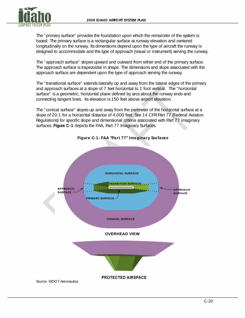
The “primary surface” provides the foundation upon which the remainder of the system is based. The primary surface is a rectangular surface at runway elevation and centered longitudinally on the runway. Its dimensions depend upon the type of aircraft the runway is designed to accommodate and the type of approach (visual or instrument) serving the runway. The “approach surface” slopes upward and outward from either end of the primary surface. The approach surface is trapezoidal in shape. The dimensions and slope associated with the approach surface are dependent upon the type of approach serving the runway. The ”transitional surface” extends laterally up and away from the lateral edges of the primary and approach surfaces at a slope of 7 feet horizontal to 1 foot vertical. The “horizontal surface” is a geometric, horizontal plane defined by arcs about the runway ends and connecting tangent lines. Its elevation is 150 feet above airport elevation. The “conical surface” slopes up and away from the perimeter of the horizontal surface at a slope of 20:1 for a horizontal distance of 4,000 feet. See 14 CFR Part 77 (Federal Aviation Regulations) for specific slope and dimensional criteria associated with Part 77 imaginary surfaces. Figure C-1 depicts the FAA, Part 77 Imaginary Surfaces.
Figure C-1: FAA "Part 77" Imaginary Surfaces
Source: WDOT Aeronautics

2008 IDAHO AIRPORT SYSTEM PLAN
C-21
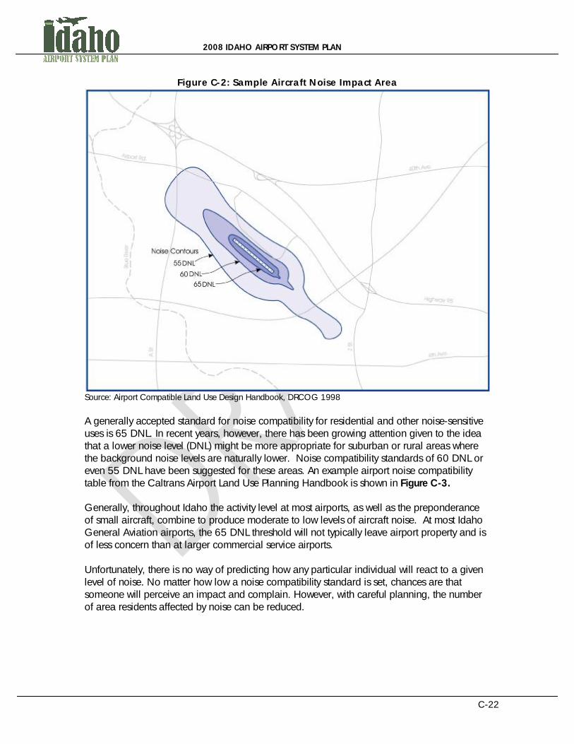
Part 77 also requires that proposed structures that will penetrate a 100:1 surface (which is a slope of 100 feet horizontal to 1 foot vertical) for 20,000 lateral feet from the nearest point on the nearest runway of any airport with a runway more than 3,200 feet in length is referred to the FAA for an aeronautical evaluation. If the longest runway on the airport is not more than 3,200 feet in length, any proposed object that will penetrate a 50:1 slope for a lateral distance of 10,000 feet from the nearest point on the nearest runway must be reported to the FAA for aeronautical evaluation. Additionally, any proposed structure over 200 feet in height must be referred to the FAA for an aeronautical evaluation. Proposed structures can be referred to the FAA by the project sponsor on FAA Form 7460-1, Notice of Proposed Construction or Alteration, available from the nearest FAA Airports District Office or on the Web at http://www.faa.gov/airports/resources/forms/. When the FAA is notified of a proposed structure, the proposal is evaluated to determine its effect on existing airspace uses. If the FAA determines that a proposed structure will adversely affect existing airspace uses in the area, a recommendation against the proposal can be made to the local planning jurisdiction. The FAA may also recommend measures such as appropriate marking and lighting of the obstruction to enhance its visibility to mitigate the adverse impact on airspace uses. If the political jurisdiction considering a proposed structure also happens to be the airport sponsor, failure to protect the airspace around the airport can compromise the airport’s eligibility for federal funding assistance. AIRCRAFT NOISE IMPACTS AROUND AIRPORTS Aircraft noise is the single largest generator of airport-related complaints. For compatibility planning purposes, noise levels are expressed in DNL (day/night noise level). DNL is an expression of noise impact derived from various factors such as airport traffic patterns, arrival and departure routes, traffic mix (types and numbers of aircraft), airport operation counts (an operation is a takeoff or landing), terrain characteristics (elevation of surrounding areas relative to airport elevation), etc. The noise level is averaged over a period of at least 24 hours. Noise modeling software such as the FAA’s Integrated Noise Model will generate noise contours (lines of equal averaged noise value) around an airport which can then be used for compatible land use planning purposes. Noise modeling often assumes a sound exposure level (SEL) for a given type of aircraft on a given operational profile. Night operations are penalized with a weighted noise value based on the assumption that background noise levels are lower at night resulting in a greater perceived noise impact by a given aircraft operation. Once noise contours are generated, they can be superimposed on a map of the airport environs to aid in land use decision-making. A sample aircraft noise impact area is shown in Figure C-2.
2008 IDAHO AIRPORT SYSTEM PLAN
C-22
Figure C-2: Sample Aircraft Noise Impact Area
Source: Airport Compatible Land Use Design Handbook, DRCOG 1998 A generally accepted standard for noise compatibility for residential and other noise-sensitive uses is 65 DNL. In recent years, however, there has been growing attention given to the idea that a lower noise level (DNL) might be more appropriate for suburban or rural areas where the background noise levels are naturally lower. Noise compatibility standards of 60 DNL or even 55 DNL have been suggested for these areas. An example airport noise compatibility table from the Caltrans Airport Land Use Planning Handbook is shown in Figure C-3. Generally, throughout Idaho the activity level at most airports, as well as the preponderance of small aircraft, combine to produce moderate to low levels of aircraft noise. At most Idaho General Aviation airports, the 65 DNL threshold will not typically leave airport property and is of less concern than at larger commercial service airports. Unfortunately, there is no way of predicting how any particular individual will react to a given level of noise. No matter how low a noise compatibility standard is set, chances are that someone will perceive an impact and complain. However, with careful planning, the number of area residents affected by noise can be reduced.

2008 IDAHO AIRPORT SYSTEM PLAN
C-23
Figure C-3: Airport Noise Compatibility Table

2008 IDAHO AIRPORT SYSTEM PLAN
C-24
SAFETY AREAS AROUND AIRPORTS The probability of an aircraft accident happening in any particular location is extremely unlikely. However, if an aircraft accident occurs at or near a residence, school, daycare center or other sensitive use, it could have a profound impact on life or property. This concept has long been recognized in Air Installation Compatible Use Zone (AICUZ) studies prepared for military airfields, but it is only recently that it has begun to receive attention in land use planning efforts around public airports. The Institute of Transportation Studies at the University of California at Berkeley developed a database of the locations of general aviation aircraft accidents in the vicinity of airports as part of the preparation of the California Airport Land Use Planning Handbook (Cooper & Gillen, 1993). This study examined National Transportation Safety Board (NTSB) accident data on 396 accidents and plots were generated showing the locations relative to runway ends. Subsequent research (See Cooper & Chira-Chavala, 1998) expanded the database to include accidents across the US and included 873 total accidents. A typical plot from that data is shown in Figure C-4. Consideration should be given to limiting the types of land uses and the density of structures in the areas that have traditionally experienced the greatest concentration of accidents.
Figure C-4: Aircraft Accident Areas
Source: Airport Compatible Land Use Design Handbook, DRCOG 1998

2008 IDAHO AIRPORT SYSTEM PLAN
C-25
The most critical safety zone associated with most airports is the runway protection zone (RPZ). The RPZ is a trapezoidal area longitudinally centered on the extended runway centerline that underlies the innermost portion of the Part 77 approach surface (discussed earlier). RPZ dimensions are defined in FAA Advisory Circular 150/5300-13, “Airport Design.” The purpose of the RPZ is to protect people and property on the ground. As a result, the standard defined by the FAA for the RPZ prohibits structures of any kind. It is best for an airport to own its runway protection zones, but if this is not possible, it is imperative that avigation easements be obtained over the area. As a last resort, zoning may also be used to protect an RPZ from incompatible uses. Beyond and to the sides of the RPZ are additional areas along the extended runway centerline which are also exposed to an increased risk of aircraft accidents. These are called the Inner and Outer Critical Zones. The type and density of land uses should be limited in these areas as far as 8,000 to 10,000 feet from the runway end along the extended centerline. Critical Zones have been shown to contain the greatest density of accident potential per acre of land. Figure C-5 depicts an example airport safety area with the aforementioned zones.
Figure C-5: Airport Safety Area
Source: Airport Compatible Land Use Design Handbook, DRCOG 1998

2008 IDAHO AIRPORT SYSTEM PLAN
C-26
AIRCRAFT OVERFLIGHT AREAS AROUND AIRPORTS There are areas around airports that are outside the 65 DNL, or even the 55 DNL, where the frequent overflight by aircraft operating to and from the airport will be perceived by residents as a nuisance. The discontent this situation creates between the airport and its neighbors can result in organized opposition to the airport and its tenants. Opposition can include lawsuits over perceived damages. Interestingly, noise complaints don’t often take into consideration the fact that airports can exist long before the incompatible uses that surround them. The costs of dealing with the public complaints and lawsuits associated with these issues, which are incurred by airports and planning jurisdictions, can be considerable over time. This is why it makes good sense to plan land uses that tend to be less sensitive to noise in these areas. Beneath the areas of frequent airport traffic patterns and overflight are the areas commonly used as approach and departure routes for an airport. Common approach and departure routes include extended runway centerlines and procedural approach and departure routes prescribed by the FAA for use in instrument weather conditions and to facilitate heavy traffic loads. The local airport administrator or the FAA Air Traffic Division can provide information regarding common flight tracks and traffic pattern areas for specific airports. An example aircraft overflight area for an airport is shown in Figure C-6.
Figure C-6: Aircraft Overflight Areas
Source: Airport Compatible Land Use Design Handbook, DRCOG 1998
2008 IDAHO AIRPORT SYSTEM PLAN
C-27
Land uses to be avoided in aircraft overflight areas include residences, schools, churches, hospitals, day care centers, nursing homes and other similar uses, as well as uses resulting in large open-air assemblies of people, such as amphitheaters and stadiums. Compatible uses include commercial, industrial, agricultural, golf courses, parks and other similar uses.
AIRPORT INFLUENCE AREA PLANNING BOUNDARY In order to implement effective land use planning and control measures around airports, it is necessary to identify specific planning boundaries. These boundaries will define the airport environs for land use planning purposes. There are several factors to be considered in defining the boundary of an airport influence area that include:
ñ Noise contours ñ Airport traffic patterns ñ Departure and arrival corridors ñ Safety zones ñ Height restriction areas
A Comprehensive Plan for airport compatible land uses should include an area large enough to consider all these factors. A few options exist to accomplish this goal.
1) Define a geometric area around the airport large enough to encompass all compatibility considerations
2) Create a plan-form view of the perimeter of the Federal Aviation Regulations (FAR) Part 77 conical surface area for the airport
3) The recommended option is to use natural and man-made linear features (i.e., highways, roads, riverbeds, canals, etc.) to define an area large enough to accommodate all the land use compatibility considerations
Once the areas are identified, zones and zoning policies should be used as crucial methods of enforcing land use compatibility controls within the Airport Influence Area. These policies can enforce and sustain the public investment of airports. Zoning policies can be created in which land uses are permitted or excluded based on their proximity to the airport. Some of the compatible and incompatible land uses surrounding airports include: Compatible Uses:
ñ Agricultural ñ Recreational (Non-wildlife attracting) ñ Open Space ñ Industrial ñ Some commercial
Incompatible Uses
ñ Residential ñ Most customer intensive commercial

2008 IDAHO AIRPORT SYSTEM PLAN
C-28
ñ Public assembly uses including churches, schools, etc. The areas nearest to airport landing strips are often identified as critical zones or runway protection zones due to the safety issues that characterize them. The extent of these zones depends on the type of landing approach available at the airport as well as the type of aircraft used at the airport. In short, critical zones are best served by maintaining considerable open space as the zoning designation. Open space areas near these critical zones are most likely to encourage minimal human sensitivity to safety and noise-related risks. Figure C-7 depicts an example airport influence area and safety area. Figure C-8 outlines land use compatibility with specific airport zoning areas. These standards can help to mitigate safety concerns near airports. Another method not covered in this table is to impose limitations on population and/or structure densities in the Instrument Approach Zones and Accident Potential Zones.
Figure C-7: Airport Influence Area and Safety Area
Many noise-sensitive land uses should be avoided within the Airport Influence Area once it is identified. Noise-sensitive land uses include residential, commercial, or public-assembly related uses. Examples of public assembly-related land uses include churches or schools. These land uses are usually considered highly sensitive to noise safety impacts. It should be noted that some noise sensitive land uses can be compatible with nearby airports if appropriate agreements or Memorandum of Agreement (MOA) are made between the land owner and the airport operator or land use agency.

2008 IDAHO AIRPORT SYSTEM PLAN
C-29
Compatible land uses that are less sensitive to noise and may be appropriate within airport overlay zones include agriculture, recreational, open space, industrial, and some commercial applications. In open space or recreational uses, avian or other wildlife attracting applications should be avoided. Significant wildlife attractions like ponds for bird habitat can obstruct the critical airport influence zone. More information and mitigation recommendations are available in FAA Advisory Circulars 150/5200-33B, Hazardous Wildlife Attractants On or Near Airports, 150/5200-32A, Reporting Wildlife Aircraft Strikes, 150/5200-36, Qualifications for Wildlife Biologist Conducting Wildlife Hazard Assessments and Training Curriculums for Airport Personnel Involved in Controlling Wildlife Hazards on Airports, and 150/5200-34A, Construction or Establishment of Landfills near Public Airports. When all the elements discussed so far are identified as part of the comprehensive planning process, it could result in the examples provided in this section. Details on the comprehensive planning process are identified in the next section of this document. Identifying appropriate airport zoning areas and extents will help to reduce the probability of accident-related impact zoning. It should be noted that FAR Part 77 areas are probably best accomplished as separate overlay zones.

2008 IDAHO AIRPORT SYSTEM PLAN
C-30
Figure C-8: Land Use Compatibility Table
Source: Airport Compatible Land Use Design Handbook, DRCOG 1998

2008 IDAHO AIRPORT SYSTEM PLAN
C-31
This page left blank intentionally

2008 IDAHO AIRPORT SYSTEM PLAN
C-32
SECTION FOUR: AIRPORTS AND THE COMPREHENSIVE PLAN – STEP 1 INTRODUCTION City and County Comprehensive Plans are required by Idaho law and should be executed by local Planning and Zoning Commissions. Idaho Code, Title 67 outlines the requirements for comprehensive planning in Idaho. These plans are considered an important and accepted function of local government. Generally, Comprehensive Plans describe the conditions that characterize a jurisdiction and their goals for a desirable future. Fourteen components of a Comprehensive Plan are required by Idaho law, which outline fundamental community goals. A Comprehensive Plan is not a regulatory statute; instead it is a vision for enriching a locality’s future. City or County Comprehensive Plans should consist of and include land use planning, transportation planning, and community planning elements. Part of a community’s transportation infrastructure is the local airport. Therefore, the long-term goals of the airport should be recognized in the Comprehensive Plan. Zoning regulations, which are covered in section 6, are more effective if the Comprehensive Plan has been implemented first. The Comprehensive Plan should incorporate the needs of the airport zoning authority, airport users, airport sponsors and the surrounding community. The local planning process is an opportunity for a locality and its citizens to prepare a vision, a blueprint, or a set of goals and strategies for the future. The process involves assessing current resources, making assumptions, and preparing goals and policies regarding future development (Rosebrock & Freemuth, 1991, Local Planning in Idaho, as used in Idaho Association of Counties, 2006, County Elected Officials Handbook). Rosebrock and Freemuth identify three basic characteristics of the planning process. First, the scope of the planning process is long-range in nature. It is not unusual for a plan to project five to twenty years into the future, a time span that typically coincides with the life span of public projects such as roads, sewers, and water lines. Second, the planning process is comprehensive in that it covers an entire geographical area (such as a town, city, county, or region) and the plan, using maps, charts, and reports, must consider previous and existing conditions, trends, desirable goals and objectives, or desirable future situations for fourteen different planning components. Finally, the plan can be described as a policy document. Not only is it the official document used to make land use decisions, but it also forms the legal basis for the zoning ordinance, the subdivision ordinance and other land use regulations (Rosebrock & Freemuth, 1991, Local Planning in Idaho, as used in Idaho Association of Counties, 2006, County Elected Officials Handbook). In addition to creating a solid legal foundation, there are several added advantages to the planning process noted by Rosebrock and Freemuth. Environmental benefits are one such advantage. Well-designed streets and housing, clean air and water come as a direct result of quality planning. Such a well-planned city or county will be more attractive to potential new

2008 IDAHO AIRPORT SYSTEM PLAN
C-33
industry and business (and their employees), which, once established in the community, strengthens the economic base of the locality. Further, private benefits are gained from land use controls that protect and enhance the value of private property. Finally, the planning process can help a locality cope with change; something that has become increasingly important for many Idaho areas that are confronted with rapidly expanding or contracting economic and population bases. Along with a Comprehensive Plan, many local governments also develop a capital improvements plan or program (sometimes referred to as a “CIP”) to help identify how funds can be raised, and when and on what those funds can be spent (Rosebrock & Freemuth, 1991, Local Planning in Idaho, as used in Idaho Association of Counties, 2006, County Elected Officials Handbook). In discussing planning, it is worth repeating that zoning, annexation, subdivision and design review ordinances are specific land use regulations that are incorporated into local codes and must be based on an adopted Comprehensive Plan. The primary purpose of zoning is to divide the community into districts or zones and impose different land use controls or regulations on each district. As will be discussed briefly below, although the regulations are likely to be very different between different zones, the regulations must be uniformly applied within each district (Rosebrock & Freemuth, 1991, Local Planning in Idaho, as used in Idaho Association of Counties, 2006, County Elected Officials Handbook). Specifying the allowed and conditionally-allowed uses of land and buildings, the intensity or density of such uses, and the bulk of buildings on the land are some of the specific tasks that constitute the act of zoning. It is the zoning ordinance, along with the capital improvements program, that are the most common methods used in implementing land use goals stated in the Comprehensive Plan. The zoning ordinance is often considered the best mechanism to assure that the community’s planning vision becomes a reality (Rosebrock & Freemuth, 1991, Local Planning in Idaho, as used in Idaho Association of Counties, 2006, County Elected Officials Handbook). Comprehensive planning also provides landowners, developers, and real estate companies clear guidance towards the appropriate uses of land before expensive plans are made which are later determined as incompatible.
2008 IDAHO AIRPORT SYSTEM PLAN
C-34
AIRPORT COMPREHENSIVE PLANNING COMPONENTS The first step in including the airport in local planning efforts is to expand the current Transportation section of the Comprehensive Plan to include each airport within the jurisdiction. All governmental entities that are affected by the airport should conduct this step for their Comprehensive Plan. The Comprehensive Plan should identify and analyze:
ñ Aviation facility types and location(s) ñ The character and volume of air traffic ñ The value and impact of aviation to the community ñ Current compatible and non-compatible land uses and easements on and near
the airport ñ Local and regional economic impacts of the airport(s)
The Plan should also analyze:
ñ Operational safety for pilots using the airport ñ Safety issues for persons living near the airport ñ Effect of aircraft noise on and around the airport
The Plan should also establish a Future Acquisitions Map (IC§ 67-6517) designating land proposed for future acquisition for airports. The plan shall analyze airport hazards and airport hazard areas in order to determine the location and extent of airport hazard areas within its jurisdiction and adjoining jurisdictions. The plan needs to indicate how to prevent the creation or establishment of airport hazards by specifying compatible and permitted land uses in zones around airports and by regulating and restricting the height of structures and objects of natural growth around airports. The plan shall establish guidance for the financing, protection, maintenance, operation, and long term growth and development of the airport. The eight (8) steps for ‘Developing a Comprehensive Plan’ is an excellent guide to the preparation of a Comprehensive Plan (see Idaho Commerce and Labor and Association of Idaho Cities, 2009, Smart Towns, A Guide to Growth Management for Idaho City and County Officials, pages 28 to 36). COMPREHENSIVE PLAN MAINTENANCE Amending the Comprehensive Plan through Public Participation As with any planning document, the Comprehensive Plan should be updated on a regular basis to reflect changing community values, revise statistical information and to implement changes in public policy. The public notice and hearing requirements for amending the plan are the same as for adoption of the plan

2008 IDAHO AIRPORT SYSTEM PLAN
C-35
When updating the Comprehensive Plan, local officials have to decide between doing the plan in its entirety or incrementally updating sections of the plan each year. The advantage of doing it incrementally is that you can gear up your resources for a very focused outcome that is more economical and time efficient. The disadvantage is that it can often result in a fragmented planning process that is disconnected and lacks continuity. Public involvement is critical to the long-term success and legitimacy of the Comprehensive Plan. Because the plan represents the community’s vision for future growth and development it is imperative for citizens to be involved in the process. When examining methods for citizen participation it is useful to keep three criteria in mind:
ñ Are citizens given the information necessary to effectively participate? ñ Are citizens that participate representative of the community as a whole? ñ Are citizens given a real opportunity to influence the policymaking process?
Planning and land use issues require specialized knowledge, which is why many communities hire consultants to assist in developing the Comprehensive Plan. The advantage of consultants is that they are professionals with a detailed understanding of planning issues and they are able to objectively analyze the needs of a particular community (Excerpted from Idaho Commerce and Labor and Association of Idaho Cities, 2009, Smart Towns, A Guide to Growth Management for Idaho City and County Officials, pages 36 – 41). Occasionally, the special expertise needed relative to airport related planning can be already engaged by the airport advisory Committee and the airport manager. Future Acquisitions Map As part of the comprehensive planning process, a land use jurisdiction may adopt, amend, or repeal a future land acquisitions map (Idaho Code 67-6517). The map can designate or suggest land proposed for acquisition within multiple jurisdictions and may include land for airports that comprise a greater airport planning area. The future acquisitions map is adopted by the governing board in compliance with the public notice and hearing requirements of Idaho Code 67-6509. AIRPORT PLANS AND DRAWINGS Since the primary responsibility for airport land use planning rests with local governments, local land use agencies, and airport administrators, the policies that they adopt are important for ensuring action and implementation. Land use and facility plans and ordinances that are administered by local agencies and airports are crucial in the airport land use planning process. City and County Comprehensive Plans are a key force in regulating land use compatibility near airports in Idaho. Comprehensive planning helps to ensure that community interests are reflected in future growth and public services are developed in a cost-effective way. Planning for land uses around airports can equate to enhancements in quality of life, economic benefits, safety, effective land use planning, and transportation-related goals; all integral objectives of the Comprehensive Plan.
2008 IDAHO AIRPORT SYSTEM PLAN
C-36
The airport should prepare basic airport planning documents (master plan, narrative report, environmental report), the basic drawings (Airport Layout Plan, Airspace, Property, Approach, Inner Approach, Runway Protection Zone, Terminal area, Land Use), and the basic operational manuals (Minimum Standards for Aeronautical Activity, Rules and Regulations, Rates and Charges, Airport Advisory Board Bylaws) in order to be able to accurately describe and define what is in need of protecting through Comprehensive Airport Land Use Control. This is best accomplished by an Airport Advisory Board (AAB) consisting of pilots, airport businesses, local government representatives, local business and economic development representatives, citizen representatives, and airport management. As part of the basic airport planning process, the AAB needs to determine the Airport Influence Area (AIA) as discussed in the previous section. This is the maximum extent and logical boundaries of an area around the airport that its activities and operations could influence citizens and businesses. The AIA is also based upon the maximum extent of the noise contours, aircraft crash data, Part 77, TERPS, traffic pattern airspace and approach and departure flight tracks. Airport Master Plans, their associated Airport Layout Plan Sets, and Airport Property Maps are produced by local airport administrators. These items detail the long-term development goals of an airport, including airport strategies to meet projected community, environmental, and economic needs. An Airport Master Plan can also help to ensure that aviation planning among federal, state, regional, and local agencies is coordinated. Airport master plans can be a crucial part of the government planning process. Local airports must have existing airport master plans and drawing sets including Airport Property Maps that should be incorporated into the comprehensive planning process. This plan can include the following elements:
ñ Land areas that the airport owns ñ Land areas the airport should purchase ñ Land areas over which avigation easements might be required ñ Land areas over which noise complaints occur ñ Airspace layouts showing known obstructions to aircraft ñ Airspace layouts showing areas where future obstructions should be restricted, as
per FAR Part 77 Surfaces definitions or Idaho Airport Zoning Act recommendations ñ Focus should be given to the runway approach and departure zones ñ Land areas where potential aircraft safety considerations could occur
The Federal Aviation Administration and the Idaho Division of Aeronautics, as well as the airport, should be consulted on implementation of the components of the airport plan to ensure agreement and acceptance. Information on coordination of airport and land use planning is provided in the following section.

2008 IDAHO AIRPORT SYSTEM PLAN
C-37
SECTION FIVE: JOINT MULTI-JURISDICTION AIRPORT LAND USE PLANNING AND ZONING COMMISSION - STEP 2 ESTABLISHMENT Local coordination is a crucial component of airport and land use compatibility, especially within the comprehensive planning process. All jurisdictions impacted by an airport must coordinate to ensure compliance among local Comprehensive Plans. Coordination within and among land use entities as part of the comprehensive planning process will ensure shared visions for growth surrounding Idaho’s airports as well as shared requirements and authority. Moreover, coordination of local governments with the airport will help to achieve combined economic strategies and effective local management. Forming a Joint Powers Planning and Zoning Commissions is one key method of ensuring successful coordination and decision-making regarding airport and land use issues. It is important that affected municipalities empanel a group of citizens to prepare the airport related section of the Comprehensive Plan, the Zoning Ordinance, the Public Involvement Process, and implementation. This group must have proportional representation from all municipalities affected by the airport and include a broad cross section of citizens representing aviation, business, government, economic development, and residents. Idaho law allows the creation of separate planning and zoning commissions, as well as inter-jurisdictional joint commissions (Idaho Code § 67-6504; 67-6505). Separate planning and zoning commissions may be useful as a way to divide the workload, ensuring that adequate attention is given to both planning and the day-to-day work of reviewing applications. In the case both of separate and joint commissions, the same statutory requirements apply for membership, qualifications, etc. as outlined above. Joint commissions may be formed by:
ñ Two or more adjoining counties and any number of cities within the counties, ñ A county and any number of cities within the county, or ñ By two or more adjoining cities
The number of commissioners, method of appointment and allocation of costs must be agreed upon by the governing boards involved in the joint commission. Joint commissions are an important option because many of the issues of planning and zoning cross jurisdictional boundaries, such as groundwater protection, area of city impact, etc. Local governments may benefit from the enhanced cooperation and communication that is developed through partnership in a joint commission (from “Smart Towns”, Nov. 2009, page 7). Combinations of several city and county boards may form a joint planning, joint zoning or joint planning and zoning commission (Idaho Code § 67-6505). Minidoka County, as one example, has a joint city/county planning commission and a county zoning commission.

2008 IDAHO AIRPORT SYSTEM PLAN
C-38
Idaho Code empowers the county boards of two or more adjoining counties, alone or together with any one or more city within the counties, or one county board and the council of one or more cities within the county, or the councils of two or more adjoining cities, to cooperate in the establishment of a joint commission. The number of members of a joint commission, the method of appointment, and the allocation of costs for activities must be agreed upon by the county boards and city councils involved. Joint city-county and regional planning commissions are important in providing a guide for orderly development of entire regions and in relating the needs and resources of these regions to both urban and rural factors (from “County Elected Officials Handbook”, April 2006, page 12-6). COORDINATION The Joint Multi-Jurisdiction Airport Land Use Planning And Zoning Commission as a legal entity of the local municipal governments is responsible for airport comprehensive planning, ordinance preparation and adoption, enforcement and ongoing updating and maintenance. These duties can only be successfully accomplished with regular collaboration with individuals, groups, and agencies that understand airport operations and requirements. The Joint Multi-Jurisdiction Airport Land Use Planning and Zoning Commission should consider and integrate comments and information from the airport manager, airport advisory committee, airport users and businesses, State Aeronautics, the Federal Aviation Administration, and affected airport neighbors.
PUBLIC INVOLVEMENT The Committee needs to evaluate current ordinances/resolutions covering public involvement and make any needed modifications to these procedures to facilitate the comprehensive planning and Ordinance creation and implementation process. The public hearing process is an important step in a good citizen involvement program, and is perhaps the oldest means of involving the public in governmental decision making. The Idaho Legislature established policy for citizen involvement through the Open Meeting Act found in Idaho Code § Title 67, Chapter 23. It states:
The people of the State of Idaho in creating the instruments of government that serve them, do not yield their sovereignty to the agencies so created. Therefore, the legislature finds and declares that it is policy of this State that the formation of public policy is public business and shall not be conducted in secret (Idaho Code § 67-2340).
This Chapter of Idaho Code further delineates policies and requirements for the execution of a public involvement process. Important elements in developing a good citizen participation program are an awareness of what is to be accomplished, concrete goals and objectives, and an understanding of the basic assumptions and values upon which the participation program rests. The following are steps which can be used in developing a successful public involvement program:

2008 IDAHO AIRPORT SYSTEM PLAN
C-39
1) Identify all interested individuals or groups who will or should be involved in the
participation program (contact prominent citizens, service clubs, etc.).
2) Include these participating groups in the initial stage of the planning process.
3) List the goals and objectives of the particular program.
4) Identify the roles and responsibilities that each individual or group has in the process.
5) Identify participation methods and techniques that could be used to achieve the
goals and objectives of the program, i.e., informal meetings, panel discussions, interviews, questionnaires, telephone calls, mail outs, public hearings, etc.
6) Analyze the resources necessary for any given technique --- people, money, facilities.
7) Select the alternative method of public involvement that could best achieve the goals and objectives of the program.
8) Implement the chosen citizen involvement alternative at the appropriate times in the planning and decision-making process of the program. The public hearing is then the culmination of all previous public involvement, rather than the first time the public is invited to comment.
9) Evaluate the effectiveness of the implemented methods to determine if they were instrumental in the accomplishment of the stated goals and objectives (from Idaho Commerce and Labor and Association of Idaho Cities, 2009, Smart Towns, A Guide to Growth Management for Idaho City and County Officials,, page 19-2 and 19-3).
2008 IDAHO AIRPORT SYSTEM PLAN
C-40
SECTION SIX: AIRPORT ZONING ORDINANCE - STEP 3 EVALUATION The general premise of zoning is a method of separating land uses and enforcing uniform dimensional standards. It is a regulatory method of ensuring growth management. By legally dictating what uses are permitted for each parcel of land within areas of control of the local government, airport and land use compatibility can be attained. These ordinances can help to put specific growth measures to work that are envisioned through the Comprehensive Plan. Zoning authority is delegated to cities and counties by the Local Land Use Planning Act, Idaho Code §67-65. This Idaho statute clearly outlines the terminology as well as the process for establishing zoning ordinances in the state. Local zoning ordinances are regulatory statutes that separate or divide a city or county into districts for the purpose of regulating the use of private property and the spacing, size, and placement of buildings. Since the Comprehensive Plan is not an authoritative document, zoning ordinances are enacted by local governments to implement the visions, goals, and objectives outlined in them. Some additional steps may be crucial for establishing a successful and functioning airport zoning ordinance. Particularly, the policies relating to the enforcement of the ordinance will likely influence its success. The regulations and restrictions that guide pre-existing local zoning ordinances will be part of this enforcement. Some of these regulatory details include the zoning appeals process, non-conforming uses, penalties, judicial review, severability, special uses or variances, conflicting regulations, and effective date. Each of these specific components of a zoning regulation should be outlined in existing local zoning ordinances as required by Idaho State Code. In cases where a current zoning ordinance does not exist, the regulatory premise for many of these components is outlined in Idaho Code §67-65 available online at: http://www.legislature.idaho.gov/idstat/Title67/T67CH65.htm. Additional airport zoning attachments that can also help to reinforce the zoning ordinance are outlined in section 8.
EXISTING ORDINANCE STRUCTURE AND ELEMENTS The Joint Multi-Jurisdiction Airport Land Use Planning and Zoning Commission needs to evaluate the current ordinances and make recommendations for changes that will meet the needs for a Comprehensive Airport Land Use Ordinance. Manuals and procedures for creating and updating ordinances are available in the Idaho Association of Counties, Handbook, Chapter 12, and in the “Ordinance Manual” from the Association of Idaho Cities. The following text is an example of an Idaho airport zoning ordinance that provides the standard components of an ordinance as used for airport protection. The ordinance is written for use by a county government; however it can be easily modified to meet the needs of a City.
2008 IDAHO AIRPORT SYSTEM PLAN
C-41
Sample Airport Zoning Ordinance Language PURPOSE It is the purpose of the ____________ County Airport Zoning Ordinance (herein referenced in this chapter as “this Ordinance”) to restrict the height of structures and objects of natural growth, and otherwise regulate the use of property, in the vicinity of the ____________ County Airport (the Airports) by: creating the appropriate zones and establishing the boundaries thereof; providing for changes in the restrictions and boundaries of such zones; define certain terms used herein; reference the Airports’ FAR Part 77 Airspace Drawing and Airport Land Use Zone Map, which are incorporated in and made a part of this Ordinance; provide for enforcement; establish a board of adjustment; and impose penalties. It is hereby found that an aviation hazard endangers the lives and the property of users of the Airports, as well as the property and the occupants of land in the vicinity of the Airports. An aviation hazard reduces the size of the area available for landing, takeoff and maneuvering of aircraft, and thus diminishes or impairs the utility of the Airports and the public investment therein. Accordingly, it is declared that:
4) The Airports fulfill an essential community purpose; and
5) The creation or establishment of an aviation hazard is a public nuisance and will injure the region served by the Airports; and.
6) The encroachment of noise sensitive or otherwise incompatible land uses within certain areas as set forth herein endangers the health, safety, and welfare of the owners, occupants, or users of the land; and
7) It is necessary in the interest of the public health, safety, and general welfare that the creation of aviation hazards be prevented; and
8) Joint cooperation between all governing boards having jurisdiction within or
adjoining the airports’ hazard areas is encouraged as a mechanism to prevent aviation hazards; and
9) The prevention of these aviation hazards should be accomplished, to the extent
legally possible, by the exercise of the police power without compensation.
AUTHORITY The Board adopts this Ordinance pursuant to the provisions and authority conferred by Article 12, Section 2, of the Idaho State Constitution, and Title 21, Chapter 5, Airport Zoning Act, and Title 67, Chapter 65, Local Land Use Planning, of the Idaho Code. APPLICABILITY
2008 IDAHO AIRPORT SYSTEM PLAN
C-42
The provisions of this chapter shall apply to all lands, buildings, structures, natural features or uses located within those areas that are defined by the AP-O Airport Overlay Zone designated on the ____________ County Airport Airspace Drawing and Airport Land Use Zone Map that are located within ____________ County, Idaho, whether now or in the future. SHORT TITLE This Chapter shall be known as the “____________ County – Airport Overlay Zoning Ordinance.” NON-CONFORMING USE REGULATIONS NOT RETROACTIVE The regulations prescribed by this Ordinance shall not require the removal or alteration of any structure or tree not conforming to this Ordinance on its effective date. The regulations of this Ordinance shall not interfere with the continuance of such nonconforming use. Nothing contained herein shall require a change in the construction, alteration, or intended use of any structure whose construction or alteration commenced prior to the effective date of this Ordinance and whose construction is being diligently pursued. MARKING AND LIGHTING Notwithstanding the provisions of (this Section) , the owner of a non-conforming structure or growth is hereby required to permit the installation, operation, and maintenance of such markers and lights as the Commission deems appropriate as indicators of aviation hazards or obstructions to the operators of aircraft. Such markers and lights shall be installed, operated, and maintained at the expense of ____________ County. NON-CONFORMING USES ABANDONED OR DESTROYED A permit will be required to replace a non-conforming structure destroyed by accidental fire, Acts of God, or other such destructive force so long as the originally intended use of the structure is maintained and the new structure does not become a greater hazard to air navigation than it was prior to the effective date of this Ordinance. Non-conforming use procedures are set forth in Chapter # (Nonconforming Uses) of the ____________ County Zoning Ordinance. SPECIAL USE AND VARIANCES PERMITS FUTURE USES Except as specifically provided in “1” and “2” hereunder, no material change shall be made in the use of land, no structure shall be erected or established, in any zone hereby created without a properly authorized special use and/or variance permit. Each application for a special use and/or variance permit shall indicate the action to be permitted and shall provide enough detail, including a map or drawing showing the heights and location of the permitted action in relation to the Height and Land Use Zones, to allow a determination of whether the resulting use, structure, or tree will conform to the regulations prescribed herein. An FAA Form 7460-1, Notice of Proposed Construction or Alteration, shall accompany each application for variance. Receipt of an FAA and Idaho Division of Aeronautics Determination of No Hazard is required before issuing a variance. No special use and/or variance permit for a use

2008 IDAHO AIRPORT SYSTEM PLAN
C-43
inconsistent with the provisions of this Ordinance shall be granted unless a special use and/or variance permit has been approved in accordance with (this) Section.
1) No variance shall be required by this Ordinance for any tree or structure less than 200 feet above ground level that is located in the area lying within the limits of the approach, transitional, horizontal, and conical zones, and which is lower than an imaginary surface extending outward and upward at a slope of 100 feet horizontal for each 1 foot vertical within 20,000 feet (3.8 statute miles) beginning at the closest point of the closest runway.
2) Nothing contained in any of the foregoing exceptions shall be construed as permitting or intending to permit any construction, or alteration of any structure, or growth of any tree in excess of any of the height limits established by this Ordinance.
EASEMENTS AND DISCLOSURE Where specified in the Airport Compatible Land Use Table, the property owner shall dedicate, in advance of receiving a building permit, an avigation easement to the County. In addition, a Fair Disclosure Statement will be provided to prospective buyers. The avigation easement shall establish a height restriction on the use of the property and hold ____________ County harmless from any damages caused by noise, vibration, fumes, dust, fuel, fuel particles, or other effects that may be caused by the operation of aircraft taking off, landing, or operating on or near the Airports. The avigation easement shall be signed and recorded in the deed records of the County. The Fair Disclosure Statements will serve to notify prospective buyers of property near airports that they may be exposed to potentially impactive levels of aircraft overflight. SPECIAL USE PERMIT A person desiring to use property in a manner which is not in accordance with the regulations prescribed in this Ordinance, shall apply to the Commission for a special use permit from the affecting regulations as outlined in chapter # (Special Uses-Conditional Use) of the ____________ County Zoning Ordinance. In addition to the chapter # (Special Uses-Conditional Use) requirements, an application for a special use permit shall also be accompanied by a determination by the ____________ County Airport Advisory Board, the Federal Aviation Administration and the Idaho Division of Aeronautics concerning the affect of the proposal on the operation of air navigation facilities, the safe, efficient use of the navigable airspace, and the safety of airport users as well as the safety and quality of life of surrounding residents. Such special use shall be permitted if it is determined that: a literal application or enforcement of the regulations would result in unnecessary hardship which could be relieved by the special use, and if it is determined that the special use will not be contrary to the public interest, will not create an aviation hazard, will do no substantial injustice, and will be in accordance with the spirit of this Ordinance. A special use permit requested pursuant to this section shall only be considered by the Commission after the airport manager, or designated representative, has been given an opportunity to review the application for safety and aeronautical affects and has submitted written comments to the Commission. If the airport manager's opinion has not been submitted within fifteen (15) days after receipt of the application, the Commission shall act upon the application without such advice.

2008 IDAHO AIRPORT SYSTEM PLAN
C-44
VARIANCE A person desiring to erect or increase the height of any structure, or permit the growth of a tree, in a manner which is not in accordance with the regulations prescribed in this Ordinance, shall apply to the Commission for a variance from the affecting regulations as outlined in chapter # (Appeals - Variance) of the ____________ County Zoning Ordinance. In addition to the chapter # (Appeals - Variance) requirements, an application for a variance shall also be accompanied by a determination by the ____________ County Airport Advisory Board, the Federal Aviation Administration and the Idaho Division of Aeronautics concerning the affect of the proposal on the operation of air navigation facilities and on the safe, efficient use of the navigable airspace. Such variance shall be viewed favorably if it is determined that: a literal application or enforcement of the regulations would result in unnecessary hardship which could be relieved by the variance, and if it is determined that the variance will not be contrary to the public interest, will not create an aviation hazard, will do no substantial injustice, and will be in accordance with the spirit of this Ordinance. A variance requested pursuant to this section shall only be considered by the Commission after the airport manager, or designated representative, has been given an opportunity to review the application for its aeronautical affects and has submitted written comments to the Commission. If the airport manager's opinion has not been submitted within fifteen (15) days after receipt of the application, the Commission shall act upon the application without such advice. EXISTING USES A variance shall not be granted if it would allow the establishment or creation of an obstruction or would allow a non-conforming use, structure, or tree to become a greater hazard to air navigation than it was prior to the effective date of this Ordinance, the effective date of any amendment to this Ordinance, or the application date of a permit. OBSTRUCTION MARKING AND LIGHTING In granting a variance permit, the Commission may, if such action is deemed advisable to fulfill the purpose of this Ordinance, place conditions upon the variance which require the owner of the structure or tree in question to install, operate, and maintain at the owner's expense such markings and lights as are considered to be necessary. If deemed proper by the Board of Adjustment, this condition may be modified to require the owner to allow ____________ County, at the county's expense, to install, operate, and maintain the necessary markings and lights. ENFORCEMENT It shall be the duty of the Commission to administer and enforce the regulations prescribed herein through the office of the Administrator. Applications for permits and variances shall be made to the Administrator upon a form published for that purpose. Applications required by this Ordinance shall be promptly considered by the Commission. Each application shall be either: a. Granted without conditions. b. Granted with added conditions, or c. Denied. APPEALS Any affected person as defined by Idaho Code Section 67-6521, as it may be amended from time to time, may appeal a requirement or decision of the Commission made in the administration of this Ordinance to the Board of Adjustment.

2008 IDAHO AIRPORT SYSTEM PLAN
C-45
All appeals hereunder must be filed with the Administrator’s Office within twenty-eight (28) days from the date of the requirement or decision appealed from. All issues being appealed must be specifically stated in the appeal. When an appeal is filed, the Administrator shall gather the record of the matter appealed and shall submit it to the Board of Adjustment. The Board of Adjustment may stay all proceedings in furtherance of the action appealed if it deems such a stay to be necessary. Any such stay that is imposed shall automatically be lifted upon the Board of Adjustment issuing a written decision on the matter being appealed, unless otherwise stated by the Board. The Board of Adjustment shall follow the notice procedures as outlined in Chapter # (Appeals - Variance) and hearing procedures outlined in Chapter # (Meetings - Hearings), ____________ County Zoning Ordinance. In conformity with the provisions of this Ordinance, the Board of Adjustment may reverse or affirm, in whole or in part, or modify the requirement(s) or decision appealed from, and/or may make such requirement(s), decision, or other determinations as may be appropriate under the circumstances. JUDICIAL REVIEW Any affected person as defined by section (appeals) , may appeal any final decision to the district court as provided by the Local Land Use Planning Act, Title 67, chapter 65 Idaho Code. PENALTIES Violation of this Ordinance, or of any regulation, order, or ruling promulgated hereunder, shall be subject to the penalties and actions prescribe under chapter # (Enforcement). CONFLICTING REGULATIONS Where there exists a conflict between this Ordinance and other regulations applicable to the same area, whether the conflict be with respect to the height of structures or trees, the use of the land, or any other matter, the more stringent limitation or requirement shall govern and prevail. SEVERABILITY If a provision of this Ordinance or the application thereof to any person or circumstance is held invalid, such invalidity shall not affect other provisions or applications of this Ordinance, which can be given effect without the invalid provision(s) or application(s); to this end, the provisions of this Ordinance are declared to be severable. EFFECTIVE DATE Whereas the immediate operation of the provisions of this Ordinance is necessary for the preservation of the public health, safety, and general welfare, this Ordinance shall be in force
2008 IDAHO AIRPORT SYSTEM PLAN
C-46
and effect as of the date and time this Ordinance is passed by the Board of County Commissioners of ____________ County, Idaho and published as required by law. Coordination between City and County Ordinances At times the structure and/or style of a City and a County ordinance may vary. It is the duty of the Joint Multi-Jurisdiction Airport Land Use Planning and Zoning Commission to assure that the intent of the ordinance is clear and consistent between the City and County versions.
2008 IDAHO AIRPORT SYSTEM PLAN
C-47
SECTION SEVEN: SPECIFIC AIRPORT ZONING ORDINANCE ELEMENTS - STEP 4 OVERVIEW The Joint Multi-Jurisdiction Airport Land Use Planning and Zoning Commission needs to evaluate the current ordinances and make recommendations for changes that will meet the needs for a Comprehensive Airport Land Use Ordinance. Manuals and procedures for creating and updating ordinances are available in the Idaho Association of Counties, Handbook, Chapter 12, and in the “Ordinance Manual” from the Association of Idaho Cities. It is important to use an Idaho Ordinance as the recommended boiler plate and to clearly delineate the airport specific topics. This section presents the airport specific topics that are needed in an ordinance to regulate and establish compatible land used and conditions on and around airports. The primary topics covered include definition of terms, height of objects, land uses, the disclosure statement, and establishment of a Board of Adjustment. The following text is an example of an Idaho airport zoning ordinance including the standard components of an ordinance as used for airport protection. The ordinance is written for use by a county government; however it can be easily modified to meet the needs of a City. AIRPORT ZONING DEFINITIONS Definitions are needed to identify conditions requiring control and they need to be clear and concise enough to allow enforcement. DEFINITIONS To be amended into Chapter # (Definitions), ____________ County Zoning Ordinance per revised Chapter # (Airport Zoning), ____________ County Airport Zoning Ordinance.
Airport – Any runway, any area, or other facility designed or used either publicly or privately for the landing and taking-off of aircraft, including all accessory taxiways, aircraft storage and tie down areas, hangars, and other necessary buildings. For purposes of this Ordinance, Airport includes the ____________ County Airport. Airport Elevation – The highest point of an airport's usable landing area measured in feet from mean sea level. Airport Influence Area – An area which establishes boundaries used to define the airport environs for land use planning purposes. Factors to be considered in defining the boundary of the Airport Influence Area include airport noise contours (when applicable), airport traffic patterns, departure, arrival and instrument approach corridors, safety zones and height restriction areas. Approach Surface – A surface longitudinally centered on the extended runway centerline, extending outward and upward from the end of the primary surface and at

2008 IDAHO AIRPORT SYSTEM PLAN
C-48
the same slope as the approach zone height limitation slope set forth in Section (land use limitations) of this Ordinance. The outer width of an approach/departure surface will be that width prescribed in this subsection for the most precise approach existing or planned for that runway end as identified on the airport’s approved Airport Layout Plan. Approach, Transitional, Horizontal, and Conical Zones – These zones are set forth in Section (height limitations) of this Ordinance. Aviation Hazard – An obstruction or hazard to air navigation that includes any new or existing structure, object of natural growth, use of land, or modification thereto, which endangers the lives and property of users of an airport, or of occupants of land in its vicinity, and that reduces the size of the area available for landing, taking off and maneuvering of aircraft, or penetrates an imaginary surface, and has an adverse effect on the safe and efficient utilization of the navigable airspace. Avigation Easement – A non-possessing property interest in airspace over a land parcel or portion of land. It is a legally developed document obtained by the owner of an airport to permit activities including the right of flight and the right to remove obstructions, but not necessarily to the extent of prohibiting the use of the land within the limits of the rights obtained. Board – Board of County Commissioners of ____________ County, Idaho. Board of Adjustment – For purposes of this Ordinance, the Board of Adjustment shall be the Board of County Commissioners of ____________ County, Idaho. Buffer Zone – An area in the proposed City Impact Area where aircraft are commonly operating for the purposes of landing and take-off. The Buffer Zone(s) establishes land use restrictions to enhance the protection of people and property on the ground while considering influences of the City Impact Area. Compatible Land Use – Compatibility of land use is attained when the use of property adjacent to an airport neither adversely affects flight operations from the airport nor is itself adversely affected by such flight operations. In most cases, the adverse effect of flight operations on adjacent land results from exposure of noise sensitive development, such as residential areas, to aircraft noise and vibration. Land use that adversely affects flight operations is that which creates or contributes to a flight hazard. For example, any land use that might allow tall structures, block the line of sight from the control tower to all parts of the airfield, inhibit pilot visibility (such as glaring lights, smoke, etc.), produce electronic aberrations in navigational guidance systems, or that would tend to attract birds would be considered an incompatible land use. For instance, under certain circumstances, an exposed landfill may attract birds. If open incineration is regularly permitted, it can also create a smoke hazard. In some cases, concurrent land use can be an appropriate compatible land use. Concurrent land use means that the land can be used for more than one purpose at the same time. For example, portions of land needed for clear zone purposes could also be used for agriculture purposes at the same time.

2008 IDAHO AIRPORT SYSTEM PLAN
C-49
Incompatible Land Uses – Incompatible land use at or near airports may result in the creation of hazards to air navigation and reductions in airport utility resulting from obstructions to flight paths or noise-related incompatible land use resulting from residential construction too close to the airport. Incompatible land uses include obstructions or residential construction built on airport property or in violation of conditions of released land or residential development within grant funded aircraft noise compatibility land. Introducing a wildlife attractant or failure to take adequate steps to mitigate hazardous wildlife at the airport can also result in an incompatible land use. Incompatible land uses can include wastewater ponds, municipal flood control channels and drainage basins, sanitary landfills, solid waste transfer stations, electrical power substations, water storage tanks, golf courses, and other bird attractants. Other incompatible uses would be towers or buildings that penetrate Part 77 surfaces or are located within a runway protection zone (RPZ), runway object free area (ROFA), object free zone (OFZ), clearway or stopway. Commercial Uses – Commercial uses include community retail, wholesale, service, office and limited manufacturing businesses. For purposes of this Ordinance, High Intensity commercial uses such as large retail box stores (i.e. Wal-Mart, Home Depot, Costco, etc.) are not acceptable commercial uses in all airport land use zones. Refer to the Airport Land Use Overlay Zone Map. Conical Surface – A surface extending outward and upward from the periphery of the horizontal surface at a slope of 20 to 1 for a horizontal distance of 4,000 feet. Critical Zones – An extended area off the runway end used to enhance the protection of people and property on the ground. Light Industrial Uses – Light industrial uses include a wide range of manufacturing and related establishments, research, supplies and sales businesses. For purposes of this Ordinance, light industrial uses shall be free of hazardous or objectionable elements such as obstructions, dust, smoke or glare that result in an Aviation Hazard. Inner Critical Zone – Rectangular in shape and centered about the extended runway centerline. The width of the Inner Critical Zone is 2000 feet and extends a horizontal distance of 5000 feet from each end of the primary surface. Outer Critical Zone – Rectangular in shape and centered about the extended runway centerline. The width of the Outer Critical Zone is 1000 feet and extends a horizontal distance of up to 5000 feet, but no less than 3000 feet, from each end of the Inner Critical Zone. FAA – The Federal Aviation Administration. 14 CFR PART 77 – Code of Federal Regulations referred to as Federal Aviation Regulation (FAR) Part 77. 14 CFR Part 77 defines the regulations applicable to objects which may affect navigable airspace.
2008 IDAHO AIRPORT SYSTEM PLAN
C-50
Fair Disclosure Statement – A notification to prospective buyers of property near airports that they may be exposed to potentially impactive levels of aircraft overflight. These statements in no way abrogate an individual’s right to take later action against the airport, but rather give buyers a fair warning. Height – For the purpose of determining the height limits in all zones set forth in this Ordinance and shown on the zoning map, the datum shall be mean sea level elevation unless otherwise specified. Horizontal Surface – A horizontal plane 150 feet above the established airport elevation, the perimeter of which in plan coincides with the perimeter of the Horizontal Zone. Larger Than Utility Runway – A runway that is constructed for and intended to be used by propeller driven aircraft of greater than 12,500 pounds maximum gross weight and jet powered aircraft. Lateral Safety Zone – An area extending 1000 feet either side of runway centerline and including the area between the ends of the primary surface(s) used to enhance the protection of people and property on the ground. NAVD 88 – North American Vertical Datum 1988. All elevations in this Ordinance are referenced to the 1988 North American Vertical Datum. Navigable Airspace – Any airspace where heavier-than-air craft can operate. Specifically per Federal Aviation Regulations (FAR), navigable airspace includes airspace at and above the minimum safe flight level, including airspace needed for safe takeoff and landing. Nonconforming Use – A use of premise which does not conform to the regulations of this Ordinance, but which was in existence at the time of the effective date of this Ordinance. Nonprecision Instrument Runway – A runway having an existing instrument approach procedure utilizing air navigation facilities with only horizontal guidance, or area type navigation equipment, for which a straight-in nonprecision instrument approach procedure has been approved or planned. It also means a runway for which a nonprecision approach system is planned and is so indicated on an approved Airport Layout Plan. Obstruction – Any structure, growth, or other object, including a mobile object, which exceeds a limiting height set forth in Section . (land use limitations) . of this Ordinance. Person – An individual, corporation, joint venture, limited partnership, partnership, firm, syndicate, association, trustee, or other similar entity or organization

2008 IDAHO AIRPORT SYSTEM PLAN
C-51
Precision Instrument Runway – A runway having an existing instrument approach procedure utilizing an Instrument Landing System (ILS), a Precision Approach Radar (PAR) or a Global Positioning System (GPS). It also means a runway for which a precision approach system is planned and is so indicated on an approved Airport Layout Plan. Primary Surface – A surface longitudinally centered on a runway. When the runway has a specially prepared hard surface, the primary surface extends 200 feet beyond each end of that runway; for military runways or when the runway has no specially prepared hard surface, or planned hard surface, the primary surface ends at each end of that runway. The width of the primary surface is set forth in Section (height limitations) of this Ordinance. The elevation of any point on the primary surface is the same as the elevation of the nearest point on the runway centerline. Runway – A defined area on an airport prepared for landing and takeoff of aircraft along its length Runway Protection Zone (RPZ) – An area off the runway end used to enhance the protection of people and property on the ground. The RPZ is trapezoidal in shape and centered about the extended runway centerline. The inner width of the RPZ is the same as the width of the primary surface. The outer width of the RPZ is a function of the type of aircraft and specified approach visibility minimum associated with the runway end. The applicable RPZ dimensions are depicted on the Airport Layout Plan. Structure – Anything constructed or erected and which is attached, directly or indirectly, to a fixed location on the ground. Structures include, but are not limited to, buildings, modular homes, mobile homes, walls, fences, signs and billboards. For purposes of this Ordinance, the term “structure” shall be expanded to include, in addition to the foregoing, overhead electrical transmission lines or power poles, and their appurtenances, towers, cranes and smokestacks. Transitional Surfaces – These surfaces extend outward at 90-degree angles to the runway centerline and the runway centerline extended at a slope of seven (7) feet horizontally for each foot vertically from the sides of the primary and approach surfaces as defined in FAR Part 77 to a point where they intersect the horizontal and conical surfaces. Transitional surfaces for those portions of the precision approach surfaces, which project through and beyond the limits of the conical surface, extend a distance of 5,000 feet measured horizontally from the edge of the approach surface and at 90-degree angles to the extended runway centerline. Traffic Pattern Area – An area comprised of a rectangle based on a determined distance from the runway centerline and end. The Traffic Pattern Area represents an area where aircraft are commonly operating for the purposes of landing and take-off as depicted in the Airport Land Use Overlay Zone Map. A Traffic Pattern Area is commonly based on the predominant usage of the category of aircraft forecast to use the airport and the specific traffic patterns established at the airport.
2008 IDAHO AIRPORT SYSTEM PLAN
C-52
Tree – A perennial woody plant having at least one main trunk and produces a more or less distinct and less elevated crown with many branches. Utility Runway – A runway that is constructed for and intended to be used by propeller driven aircraft of 12,500 pounds maximum gross weight and less. Visual Runway – A runway intended solely for the operation of aircraft using visual approach procedures.
AIRPORT HEIGHT RESTRICTION ZONES Airport Height Restriction Zones directly relate to the airspace requirements discussed in section 3 and are defined by 16 CFR Part 77 and the Airport Zoning Act (IC§ 21-5). These regulations have established a method of identification and review of the location of surfaces that should be free from obstructions near airports. Objects that will be controlled in these areas include man-made or natural growth objects that occur above the ground surface which obstruct the airspace on or near an airport relative to aircraft flight in the vicinity of an airport. Airports that have published approaches also have greater height restrictions as a result of the Terminal Instrument Procedures (TERPS) requirements. These increased restrictions must become a part of the Airport Height Restriction Zones. More specific zone terminology that can fall within the Airport Height Restriction Zones can include critical area zones or runway protection zones. Each of these specific zones identifies the explicit extents of the controlled areas surrounding the airport runway. Airport Height Restriction Zones include:
ñ Primary Zones ñ Runway Approach Zones ñ Transitional Zones ñ Horizontal Zones ñ Conical Zones
Within the Airport Height Restriction Zones identified above, specific zones can be delineated that serve a particular purpose for the airport. It is important to understand the general purpose and the approximate location and size of the specific airport zones that can be established. A brief description of each zone is provided to direct decision-makers through the intricacy of airport zoning. The height restrictions that are recommended for each of these zones are shown on the Airport Airspace Drawing shown in Figure C-9. An Airport Overlay Zone is a regulatory airport zoning district that is placed over the top of existing base zoning regulations, which identifies special provisions in addition to those in the underlying base zone. The overlay zone can share common boundaries with the existing zoning regulation or it can cut across base zone boundaries. The airport overlay zone would encompass all the zones or areas that fall within the airport zoning regulation. Sample Ordinance Language: Airport Height Restriction Zones (Height Zones).

2008 IDAHO AIRPORT SYSTEM PLAN
C-53
In order to carry out the provisions of this Ordinance, there are hereby created and established certain zones which include all of the land lying beneath the approach surfaces, transitional surfaces, horizontal surfaces, and conical surfaces as they apply to the Airports. Such zones are shown on the Airports’ Federal Aviation Regulation (FAR) Part 77 Airspace Drawings. Three (3) original, official, and identical copies of the FAR Part 77 Airspace Drawings reflecting the boundaries of the airport Height Zones of ____________ County, Idaho are hereby adopted, and the Board is hereby authorized to sign and attest each map as the official ____________ County Airport FAR Part 77 Airspace Drawings of ____________ County, Idaho, and such maps adopted as reference shall be filed and maintained as follows: One (1) copy each shall be filed in the office of the Administrator and shall be designated as Exhibit 1. The Administrator shall maintain this copy by posting thereon all subsequent changes and amendments. One (1) copy each shall be filed in the office of the County Clerk and Recorder and shall be designated as Exhibit 2. The Administrator shall maintain this copy by posting thereon all subsequent changes and amendments. One (1) copy each shall be filed in the office of the Airport Manager and shall be designated as Exhibit 3. The Administrator shall maintain this copy by posting thereon all subsequent changes and amendments. Each portion of an area located in more than one (1) of the following zones shall be evaluated independently according to the zone in which it is located. The various zones are hereby established and defined below. Not all Approach Zones may apply. Refer to the Federal Aviation Administration (FAA) Part 77 Airspace Drawing to determine the applicable Approach Zone(s).
1) PRECISION INSTRUMENT RUNWAY APPROACH ZONE (LARGER THAN UTILITY RUNWAY). The inner edge of this approach zone coincides with the width of the primary surface and is 1,000 feet wide. The approach zone expands outward uniformly to a width of 16,000 feet at a horizontal distance of 50,000 feet. Its centerline is the continuation of the centerline of the runway.
2) NONPRECISION INSTRUMENT RUNWAY APPROACH ZONE (LARGER THAN UTILITY RUNWAY). The inner edge of this approach zone coincides with the width of the primary surface and is 500 feet wide. The approach zone expands outward uniformly to a width of 3,500 feet at a horizontal distance 10,000 feet from the primary surface. Its centerline is the continuation of the centerline of the runway.
3) NONPRECISION INSTRUMENT RUNWAY APPROACH ZONE (UTILITY AIRCRAFT). The inner edge of this approach zone coincides with the width of the primary surface and is 500 feet wide. The approach zone expands outward uniformly to a width of 2,000 feet at a horizontal distance 5,000 feet from the primary surface. Its centerline is the continuation of the centerline of the runway.
4) VISUAL RUNWAY APPROACH ZONE (LARGER THAN UTILITY RUNWAY). The inner edge of this approach zone coincides with the width of the primary surface and is

2008 IDAHO AIRPORT SYSTEM PLAN
C-54
500 feet wide. The approach surface expands uniformly to a width of 1,500 feet at a horizontal distance 5,000 feet from the primary surface. Its centerline is the continuation of the centerline of the runway.
5) VISUAL RUNWAY APPROACH ZONE (UTILITY AIRCRAFT). The inner edge of this approach zone coincides with the width of the primary surface and is 250 feet wide. The approach surface expands uniformly to a width of 1,250 feet at a horizontal distance of 5,000 feet from the primary surface. The centerline of the approach zone is a continuation of the centerline of the runway.
6) TRANSITIONAL ZONE. The transitional zones are the areas beneath the transitional surfaces.
7) HORIZONTAL ZONE. The horizontal zone is established by swinging arcs of 5,000 or 10,000 feet radii from the center of each end of the primary surface of the primary runway and connecting the adjacent arcs by drawing lines tangent to those arcs. The horizontal zone does not include the approach and transitional zones. The horizontal zone was constructed with 10,000 feet radii.
8) CONICAL ZONE. The conical zone is established as the area that commences at the periphery of the horizontal zone and extends outward there from a horizontal distance of 4,000 feet.
AIRPORT HEIGHT ZONE LIMITATIONS
Pursuant to (this) Section and except as otherwise provided in this Ordinance, no structure shall be erected, altered, or maintained, and no tree shall be allowed to grow in any Height Zone created by this Ordinance to a height in excess of the applicable height limit herein established for such zone. Such applicable height limitations are hereby established for each of the Height Zones in question as follows:
1) PRECISION INSTRUMENT RUNWAY APPROACH ZONE. Slopes fifty (50) feet
outward for each foot upward beginning at the end of and at the same elevation as the primary surface and extending to a horizontal distance of 10,000 feet along the extended runway centerline. Then slopes forty (40) feet outward for each foot upward beginning at the end of and at the same elevation as the first 10,000 feet and extending to a horizontal distance of 40,000 feet along the extended runway centerline.
2) NONPRECISION INSTRUMENT RUNWAY APPROACH ZONE (LARGER THAN UTILITY RUNWAY). Slopes thirty-four (34) feet outward for each foot upward beginning at the end of and at the same elevation as the primary surface and extending to a horizontal distance of 10,000 feet along the extended runway centerline.
3) NONPRECISION INSTRUMENT RUNWAY APPROACH ZONE (UTILITY AIRCRAFT). Slopes twenty (20) feet outward for each foot upward beginning at the end of and
2008 IDAHO AIRPORT SYSTEM PLAN
C-55
at the same elevation as the primary surface and extending to a horizontal distance of 5,000 feet along the extended runway centerline.
4) VISUAL RUNWAY APPROACH ZONE. Slopes twenty (20) feet outward for each foot upward beginning at the end of and at the same elevation as the primary surface and extending to a horizontal distance of 5,000 feet along the extended runway centerline.
5) TRANSITIONAL ZONE. Slopes seven (7) feet outward for each foot upward beginning at the sides of and at the same elevation as the primary surface and the approach surface, and extending to a height of 150 feet above the airport elevation. In addition to the foregoing, there are established height limits sloping seven (7) feet outward for each foot upward beginning at the sides of and at the same elevation as the approach surface, and extending to where they intersect the conical surface. Where the precision instrument runway approach zone projects beyond the conical zone, there are established height limits sloping seven (7) feet outward for each foot upward beginning at the sides of and at the same elevation as the approach surface, and extending a horizontal distance of 5,000 feet measured at 90-degree angles to the extended runway centerline.
6) HORIZONTAL ZONE. Established at 150 feet above the airport elevation.
7) CONICAL ZONE. Slopes twenty (20) feet outward for each foot upward beginning at the periphery of the horizontal zone and at 150 feet above the airport elevation and extending to a height of 350 feet above the airport elevation.
EXCEPTED HEIGHT LIMITATIONS
1) EXCEPTED HEIGHT LIMITATIONS In the area lying within the limits of the Horizontal and Conical Zones, nothing in this Ordinance shall be construed as prohibiting the construction, maintenance, or growth of anything to a height that is less than fifty (50) feet above the surface of the land, except when, because of terrain, land contour or topographic features, such structure or growth would extend above the height limits prescribed herein.
Creation, Adoption & Maintenance of Height Restriction and other Airspace Maps In order to enforce the extents of specific airport zones and impact areas, the boundaries of airport impacts should be identified through geographic information systems (GIS) mapping. After the airport airspace area is defined by the local jurisdiction, supporting maps and graphs should be produced which provide visual representations of the regulation areas. Depending on the methodology and data used to identify the airport airspace area and supporting zones, various maps can be created which identify different impacts, aspects, or areas of control surrounding the airport. In many circumstances, airport mapping data has already been gathered by the airport owner or operator. The Height Restriction Zones are identified on the Airport Airspace Map based upon 14 CFR Part 77 “imaginary surfaces.” If no such mapping is available then

2008 IDAHO AIRPORT SYSTEM PLAN
C-56
coordination with the airport and the FAA will be crucial to determine these factors. Government and agencies should use the most comprehensive data possible to define the extents of airport impacts. Identifying the primary control areas will help to shape the specific zones that fall within them. Different zones may be identified and mapped for specific airports and the regions that surround them. Figure C-9 depicts a sample Airport Airspace Drawing. In order to accomplish and illustrate more fully the objectives and purpose of this chapter, the height zones identified above shall be shown and identified on the Airport’s Federal Aviation Regulation (FAR) Part 77 Airspace Drawing:
ñ One (1) original, official copy of the FAR Part 77 Airspace Drawing reflecting the boundaries of the Airport Height Zones of ____________ County, Idaho, is hereby adopted, and the County is hereby authorized to sign and attest the map as the official ____________ County Airport FAR Part 77 Airspace Drawings of ____________ County, Idaho. The map will be kept on file with the building and planning department.
ñ The map shall be as much a part of this ordinance and chapter as if fully described herein.
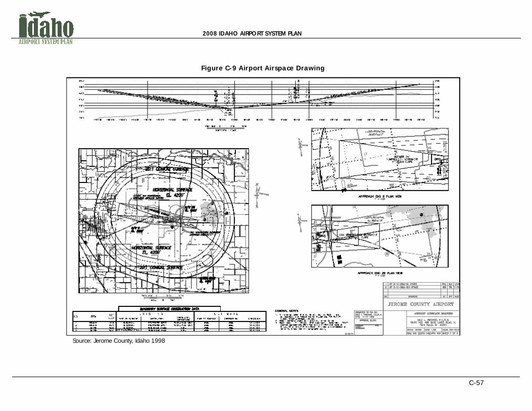
2008 IDAHO AIRPORT SYSTEM PLAN
C-57
Figure C-9 Airport Airspace Drawing
Source: Jerome County, Idaho 1998

2008 IDAHO AIRPORT SYSTEM PLAN
C-58
AIRPORT COMPATIBLE LAND USE ZONES Airport land use zones, as outlined below, relate directly to the aircraft noise impacts, the safety areas, the overflight areas, and the total planning boundary or airport influence area as discussed earlier in section 3. Compatible Land Use Control Areas Include:
ñ Runway Protection Zone (RPZ) ñ Lateral Safety Zone (LSZ) ñ Inner Critical Zone (ICZ) ñ Outer Critical Zone (OCZ) ñ Traffic Pattern Area (TPA) ñ Buffer Zone (BZ) ñ Airport Influence Area (AIA)
In the case of aircraft noise, the extents of the area will be defined by the noise contours that influence the area surrounding the airplane flight patterns. Federal Aviation Regulation (FAR) Part 150 is the primary regulation that guides and controls aviation noise surrounding airports. This regulation has established procedures, standards and methodologies for the preparation of noise exposure maps. These maps define the noise impact extents and noise contours that surround an airport. Aircraft noise relates directly to the size of the airplane and the type and power of the engines that use the airport. Idaho has only two airports with formal Noise Compatibility Programs (Part 150) that help to control the effects of aircraft noise on ‘close-in’ neighbors. There are a very few airports that have informal procedures that may mitigate aircraft noise. The fact is that in Idaho almost all of the aircraft noise that exceeds acceptable limits, never leaves the airport property and is therefore not significant enough to warrant regulation at this time. Perhaps the most critical factor in determining which areas around an airport should be protected is to know where aircraft accidents occur. The safety areas are defined by the statistical pattern of aircraft accident locations as well as the areas where public perceptions of aircraft operations may endanger, or disturb their normal everyday activities. The FAA documents and maintains a database of aircraft accident and incident data throughout the nation. Aircraft accident data for the state of Idaho can be obtained through the FAA on their website at: http://www.faa.gov/data_research/accident_incident/. During standard approach and departure maneuvers, aircraft tend to overfly substantially more ground area than needed for takeoff and landing. As discussed earlier in section 3, such overflight can be perceived by persons on the ground as a nuisance. The complaints generated by this activity can become costly when aircraft continually overfly high density residential neighborhoods, churches, or schools. Moderate control of land uses can significantly mitigate these complaints as well as Avigation Easements or Hold Harmless agreements. The maximum extent of the impact of airport operations upon neighbors is a judgment call of the land use administrator. It needs to encompass all of the height restriction zones, noise

2008 IDAHO AIRPORT SYSTEM PLAN
C-59
zones, safety zones, and overflight zones without extending controls beyond what is logically needed. Often, if the Airport Influence Area boundaries follow natural and man-made features, it will be both identifiable and logical to follow those boundaries. It should be noted that different land use zones can be somewhat similar in size or extent and will oftentimes overlap one another. This layering of impacts around an airport can help to characterize the complex nature of airport zoning regulations. In many circumstances, identifying similar extents for each of these control areas can simplify enforcement and permitting of the zoning regulation. Within the Compatible Land Use Control Areas identified above, specific zones can be delineated that serve a particular purpose for the airport. It is important to understand the general purpose and the approximate location and size of the specific airport zones that can be established. A more detailed, yet brief description of each zone is provided below to help decision-makers understand the intricacy and purpose of airport zoning. The land uses that are recommended for each of these zones are provided in the Airport and Land Use Compatibility Table presented later in this section. Example zoning maps that represent specific airport zoning areas are also provided later in this section.
Runway Protection Zones – A trapezoidal area near the end of the runway that helps to protect the people and property on the ground in the event that an aircraft lands or crashes beyond the end of the runway. This zone can begin up to 200 feet beyond the end of the runway or area usable for takeoff or landing. The actual boundaries and land use provisions for this zone are determined by the local jurisdiction. The RPZ dimensions are functions of the design aircraft, type of operation and visibility minimums that characterize the airport. A sample Runway Protection Zone is depicted in Figure C-10.

2008 IDAHO AIRPORT SYSTEM PLAN
C-60
Figure C-10 Runway Protection Zone
Lateral Safety Zones – Defined surface areas that surround the runway to provide suitable space in the event of an aircraft excursion from the runway. These areas provide access to fire fighters and rescue equipment. The safety zone can consist of a portion of the airport approach surface as defined in FAR Part 77. Thus, these areas should be free from potentially hazardous surface variations. The actual boundaries and land use provisions for these zones are determined by the local jurisdiction. The size of the specific safety zones will be dependent upon the runway design category and approach type. Different dimensions and locations for airport safety zones can exist and will vary by airport. Examples safety zones can include inner and outer safety zones, or lateral or sideline safety zones. Inner and Outer Critical Zones – A defined surface area, usually a rectangular shape, that begin just beyond the end of the pavement that are more apt to have accidents due to the take-off and landing patterns of the airport. This area can also refer to a designated area of an airport that all aircraft must remain clear of when another aircraft is inbound on an Instrument Landing System approach. These areas are used to protect against signal interference that may lead to navigational errors, or worse. Traffic Pattern Zones – A defined surface area that represents the outline of the standard path that air traffic is coordinated to fly around an airport. This is generally a relatively large area that can be impacted by noise and potential safety impacts. A typical airport traffic pattern is rectangular in shape as depicted in the figure below. The absolute shape of the traffic pattern area will depend on the runway length, the type and number of aircraft using the airport, and individual flying techniques. Figure C-11 shows the typical airport traffic patterns that occur around airports.

2008 IDAHO AIRPORT SYSTEM PLAN
C-61
Figure C-11 Typical Airport Traffic Patterns
Airport Buffer Zones – The areas between compatible and incompatible land uses near airports. These areas can provide additional “cushion” area for planning the appropriate distance between compatible land uses, appropriate sound insulation, and applying specific regulations for property rights. The term may also be used more broadly to describe any zone that separates two unlike zones, such as a transitional multiple family or professional business zone between the central business district and a single family zone. Airport Influence Area – The defined space surrounding an airport that can be affected by airport operations. The airport influence area may be the same extent that defines the airport overlay zone. Thus, the Airport Influence Area and the Airport Overlay Zone are comparable and can often represent the same area, extent or district. In fact, the designation of these areas can be combined and referred to as an Airport Influence Area Overlay Zone if deemed appropriate. Figure C-12 depicts a methodology for calculating airport traffic pattern dimensions.
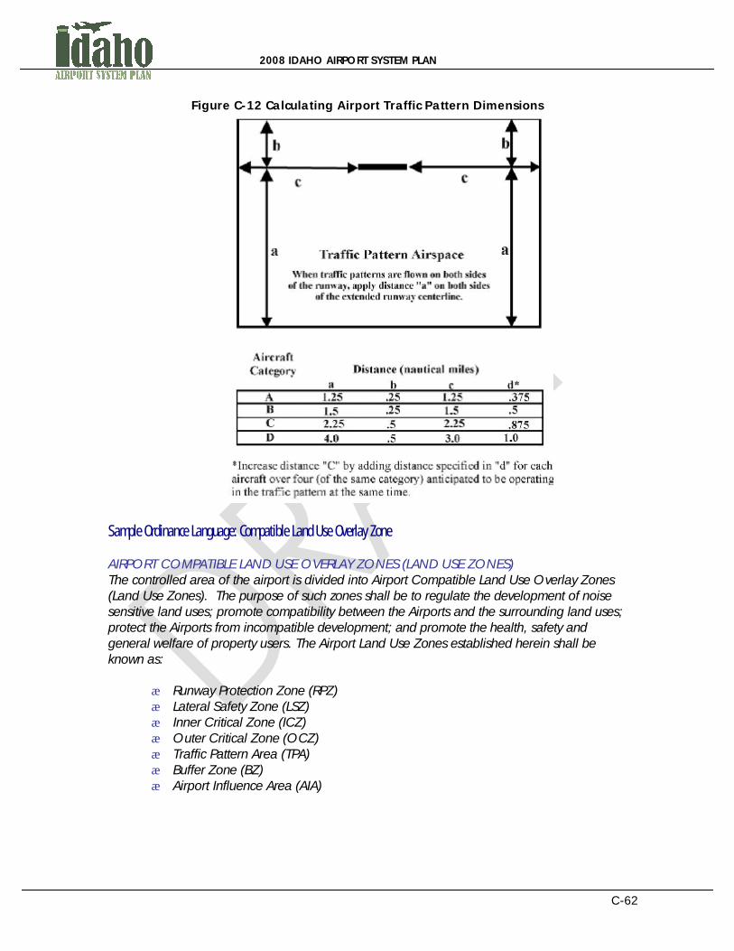
2008 IDAHO AIRPORT SYSTEM PLAN
C-62
Figure C-12 Calculating Airport Traffic Pattern Dimensions
Sample Ordinance Language: Compatible Land Use Overlay Zone AIRPORT COMPATIBLE LAND USE OVERLAY ZONES (LAND USE ZONES) The controlled area of the airport is divided into Airport Compatible Land Use Overlay Zones (Land Use Zones). The purpose of such zones shall be to regulate the development of noise sensitive land uses; promote compatibility between the Airports and the surrounding land uses; protect the Airports from incompatible development; and promote the health, safety and general welfare of property users. The Airport Land Use Zones established herein shall be known as:
ñ Runway Protection Zone (RPZ) ñ Lateral Safety Zone (LSZ) ñ Inner Critical Zone (ICZ) ñ Outer Critical Zone (OCZ) ñ Traffic Pattern Area (TPA) ñ Buffer Zone (BZ) ñ Airport Influence Area (AIA)

2008 IDAHO AIRPORT SYSTEM PLAN
C-63
AIRPORT COMPATIBLE LAND USE OVERLAY ZONE BOUNDARIES The Airport Land Use Zone boundary lines shown on the official Airport Land Use Zone Map shall be located and delineated along contour lines established for the Airports. Where uncertainty exists as to the boundaries of the Airport Land Use Zones as shown on the official Map, the following rules shall apply:
1) Boundaries shall be scaled from the nearest runway end shown on the map.
2) Boundaries shall be scaled from the nearest physical feature shown on the map.
3) Distances not specifically indicated on the original Airport Land Use Zone Map shall be determined by a scaled measurement on the map.
Where physical features on the ground differ from the information shown on the official Airport Land Use Zone Map or when there arises a question as to how or where a parcel of property is zoned and such questions cannot be resolved by the application of Section (land use limitations), the property shall be considered to be classified as the most restrictive Airport Land Use Zone. Where a parcel of land lies within more than one (1) Airport Land Use Zone, the zone within which each portion of the property is located shall apply individually to each portion of the development. Creation, Adoption, and Maintenance of the Airport Land Use Zone Map In order to enforce the extents of the specific airport zones and impact areas, the boundaries of airport impacts should be identified through geographic information systems (GIS) mapping. After the airport land use area is defined by the local jurisdiction, supporting maps and graphs should be produced which provide visual representations of the regulation areas. Depending on the methodology and data used to identify the airport land use area and supporting zones, various maps can be created which identify different impacts, aspects, or areas of control surrounding the airport. In many circumstances, the mapping data has already been determined by the airport owner or operator. The Compatible Land Use Zones should be based upon the Airport Land Use Map taken from an existing land use map or other base map to determine the maximum extents of airport impacts. If no such mapping is available then coordination with the airport and the FAA will be crucial to determine these factors. Government and agencies should use the most comprehensive data possible to define the extents of airport impacts. Identifying the primary control areas will help to shape the specific zones that fall within them. Different zones may be identified and mapped for the specific airport under consideration. Example ordinance language for the airport land use zone map follows. AIRPORT LAND USE ZONE MAP The boundaries of the Airport Land Use Zones set out herein shall be delineated upon the Airports’ Airport Land Use Zone Maps, with said maps being adopted by reference and made a part of this Ordinance as fully as if the same were set forth herein in detail.

2008 IDAHO AIRPORT SYSTEM PLAN
C-64
Three (3) original, official, and identical copies of the Airport Land Use Zone Maps that reflect the boundaries of the Airport Land Use Zones are hereby adopted, and the Board is hereby authorized to sign and attest each map as the official Airport Land Use Zone Maps of ____________ County, Idaho, and such maps shall be filed and maintained as follows:
1) One (1) copy shall be filed in the office of the Administrator and shall be designated as Exhibit 1. The Administrator shall maintain this copy by posting thereon all subsequent changes and amendments.
2) One (1) copy shall be filed in the office of the County Clerk and Recorder and shall be designated as Exhibit 2. The Administrator shall maintain this copy by posting thereon all subsequent changes and amendments.
3) One (1) copy shall be filed in the office of the Airport Manager and shall be designated as Exhibit 3. The Administrator shall maintain this copy by posting thereon all subsequent changes and amendments.
USE OF LAND AND BUILDINGS Within the Airport Land Use Zones as defined herein, no land shall hereafter be used and no structure or other object shall hereafter be erected, altered, converted, or modified other than for those compatible land uses permitted by the underlying comprehensive zoning districts, as specified in the ____________ County Zoning Ordinance. Additional land uses are prohibited in the Airport Land Use Zones, regardless of underlying zoning, as set forth in the Airport Compatible Land Use Table shown in Figure C-14 (see section 8 of these guidelines for this example). Where any use of prohibited land and buildings set forth in Section (land use limitations) conflicts with any use of land and buildings set forth in the ____________ County Zoning Ordinance and/or Zoning Map, this chapter shall apply. Section (land use limitations) does not apply to property within the official boundaries of the Airport Zone as defined in Chapter # (purpose of zoning), ____________ County Zoning Ordinance. Figure C-13 depicts an example Idaho Airport Land Use Zone Map.
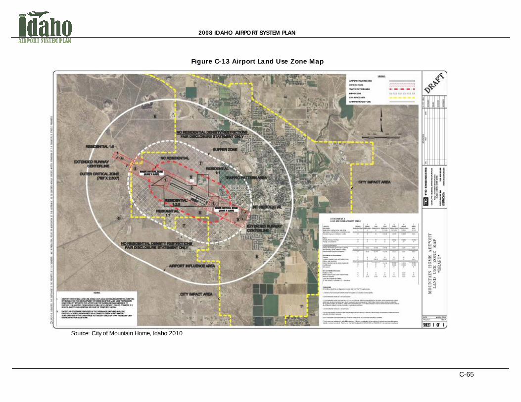
2008 IDAHO AIRPORT SYSTEM PLAN
C-65
Figure C-13 Airport Land Use Zone Map
Source: City of Mountain Home, Idaho 2010
2008 IDAHO AIRPORT SYSTEM PLAN
C-66
Additional and Excepted Airport Compatible Land Use Regulations Sample ordinance language for additional and excepted airport compatible land use regulations are as follows: ADDITIONAL LAND USE REGULATIONS Except as provided in Section (land use limitations) and Section (enforcement) of this Ordinance, all development within the jurisdiction of ____________ County, Idaho and within the Airport Influence Area as depicted on the Airport Land Use Zone Map, shall have a minimum land division size of 40 acres as defined in Land Division A-1 of the ____________ County Zoning Ordinance. On property within the Airport Land Use Zone Map jurisdiction, but outside the jurisdictional limits of ____________ County, Idaho, Section (land use limitations) shall be used to formulate land use recommendations or responses to land use comment requests from other jurisdictions. In the event of conflict between this section and any aviation hazard restriction, the most restrictive provision shall apply. Notwithstanding any other provisions of this Ordinance or sections of the ____________ County Zoning Ordinance, no use may be made of land, water, or structures within any zone established by this Ordinance in such a manner as to create electrical interference with navigational signals or radio communication between the Airports and aircraft; make it difficult for pilots to distinguish between airport lights and others, or result in glare in the eyes of pilots using the Airports; impair visibility in the vicinity of the Airports; create bird strike hazards; or otherwise in any way endanger or interfere with the landing, taking off, or flight operations of aircraft utilizing the Airports. DISCLOSURE STATEMENT Fair Disclosure Statement shall be provided to any applicant for a permit within an airport zone, or any prospective buyers of any structure or property within in such zones. Further, the Fair Disclosure Statement shall serve to notify prospective buyers of property near airports that subject property is subject to the provisions of this Ordinance and lies within the Airport Influence Area and under the Airport’s FAR Part 77 Airspace. As such, it may be necessary to clear and keep clear the Airspace of any portions of buildings, structures, or improvements of any and all kinds, and of trees, vegetation, or other objects. This includes reserving the right of the City to; remove or demolish those portions of such buildings, structures, improvements, trees or any other objects which extend into the Airspace; cut to the ground level and remove any trees which extend into the Airspace; the right to mark and light, or cause or require to be marked or lighted, as obstructions to air navigation, any and all buildings, structures, or other improvements, and trees or other objects now upon, or that in the future may be upon, said Parcel, and which extend into the Airspace. The Fair Disclosure Statement shall also notify applicant for permit or prospective buyers that they may be exposed to potentially impactive levels of aircraft overflight, including but not limited to noise, vibration, fumes, dust, fuel or fuel particles, and other effects that may be caused by normal aircraft operations in around an airports.

2008 IDAHO AIRPORT SYSTEM PLAN
C-67
Before a permit shall issue, the applicant shall sign the Fair Disclosure Statement and the Fair Disclosure Statement will be recorded in the deed records of the County. Upon the applicant’s refusal, City shall acknowledge that the applicant was made aware of the above-described impacts. Such statement shall be recorded in the deed records of the County. Nothing stated herein is meant to provide pilots, crews, owners of aircraft, or any other person protection from liability for negligence committed on their part. BOARD OF ADJUSTMENT There is hereby created a Board of Adjustment to have and to exercise the following powers: To hear and to decide appeals from any requirement or decision made by the Planning and Zoning Commission in its enforcement of this Ordinance. Appeal and notice procedures are set forth in Chapter # (Appeals) and hearing procedures for such appeals shall be as set forth in Chapter # (Meetings-Hearings) of the ____________ County Zoning Ordinance. To hear and to consider whether any requirement which this Ordinance imposes upon a specific applicant should be modified or set aside in its entirety or in part. To request and consider expert testimony from professionals conversant with various standards, such as but not limited to the FAA and Idaho Division of Aeronautics staff. To consider recommendations and/or make final decisions relating to any application that by Ordinance or Idaho Code requires such to be made by the Board of Adjustment. The Board of Adjustment shall maintain its governance in harmony with the provisions of this Ordinance. Meetings of the Board of Adjustment shall be held at the call of the Chairman and at such other times as the Board of Adjustment may determine. All hearings of the Board of Adjustment shall be public. The Board of Adjustment shall keep minutes of its proceedings showing the vote of each member of the Board upon each question. If a member of the Board is absent or has failed to vote, the minutes shall indicate such. The minutes shall keep records of the Board's examinations and other official actions, and the minutes shall be filed immediately in the office of the County Clerk, where they shall be shown upon appropriate request. The Board of Adjustment shall make a decision in accordance with Chapter # (Meetings-Hearings) or when required by Idaho Code. The concurring vote of a majority of the members of the Board of Adjustment shall be sufficient to override any requirement or decision by the Commission; to set aside any requirement that this Ordinance imposes upon an applicant; and to effect a variation from this Ordinance. OTHER AIRPORT SPECIFIC TOPICS The following topic areas have the potential to become additional sections in an airport zoning ordinance. The decision to utilize these additional resources will be dependent upon the specific character of the airport and its operations, the character and intensity of the development around the airport, and the willingness of the airport neighbors and the larger

2008 IDAHO AIRPORT SYSTEM PLAN
C-68
community to voluntarily limit development near the airport to airport compatible land uses. If the recommended zoning controls are insufficient to afford the necessary compliance with the intent of creating compatible land uses around the airport, then these more stringent measures are advisable for the protection and longevity of the airport. Noise Zones, Map, Regulations, Exceptions If local complaints become common regarding aircraft noise, it may be time to develop a Noise Compatibility Program based upon 14 CFR Part 150, Airport Noise Compatibility Planning. This is a detailed, time consuming, and expensive process, but it is eligible for Airport Improvement Program grant funding through the Federal Aviation Administration. This will provide the airport with a current and future noise map from which to develop aircraft noise control zones. This would add a third zoning map and zones that the airport authority could use to assist in protection of the airport. Avigation and Hazard Easements There may be instances where simply stated land use zone regulations are insufficient to afford the airport the protection needed to operate without interruption and inconvenience. The use of Avigation and/or Hazard Easements is a formal process that draws the attention of local land owners to the land use zoning requirements on their land. These documents are usually recorded with the locality and then become a condition on a parcels deed. See section 8 for an example. Hold Harmless Agreements This is simply an agreement by an airport neighbor that limits the liability of the airport owner for the minor inconveniences caused by living near an airport. It is effectively little more than a notice that the airport exists and the neighbors need to be aware of the airport’s impacts. Through-the-Fence Agreements Through-the-Fence operations permit aircraft to taxi from private property across the airport property boundary on to the public airport. These operations generally involve businesses that desire access to the airport from outside airport property, and utilize airport property to conduct a business, often without paying for business space at the airport. This results in operations that do not provide financial support to the airport, and may decrease the airports long-term viability. This is a particularly problematic concern of the FAA and must be approached with caution.

2008 IDAHO AIRPORT SYSTEM PLAN
C-69
SECTION EIGHT: ATTACHMENTS TO THE AIRPORT ZONING ORDINANCE - STEP 5 There are a series of specific zoning ordinance attachments, maps, disclosures, notifications, or agreements that airport administrators and local community leaders can employ to better enforce airport and land use compatibility. These attachments can also support or delineate awareness of safety-related and other impacts associated with an airport. Some of these documents help to ensure acknowledgment of airport impacts to surrounding property. These agreements can also help to not only protect the airport, but also the local agency that must enforce airport land use regulations. Specific rules and regulations as well as example documents are provided below that can help to enforce these attachments. LAND USE COMPATIBILITY ZONING TABLE The following airport and land use compatibility zoning table provides guidance on the specific land uses that may be allowed or disallowed within the specific airport zones identified previously. The recommendations in this table should comply with the specific zones and zoning decisions that characterize the airport under consideration. If the airport and land use compatibility table is used, it should be modified to fit the particular needs of the airport and local land use regulations under consideration. This table is meant to provide guidance on the identification process of specific land uses that can be allowed or prohibited within airport zoning areas. Before viewing the land use compatibility table, it is important to understand the general land use categories that should be discouraged as part if the airport zoning ordinance. According to the AOPA, airport zoning ordinances should strive to prevent the following incompatible uses within the influence areas around an airport (AOPA, 1999):
ñ Residential and other noise-sensitive uses ñ Congregations of people in approach and departure areas to protect people and
property on the ground ñ Man-made and natural structures that can interfere with flight ñ Uses that may generate light emissions that interfere with airport-related activities ñ Uses of land on the airport that interfere with areas needed for aviation-related
activities ñ Wildlife attractants such as landfills, water and certain types of agricultural uses ñ The airport and land use compatibility table is provided on the following page
Figure C-14 provides an example Idaho land use compatibility zoning table or matrix that can be used for airport protection. The table was written for use by a county government; however it can be easily modified to meet the needs of a City.
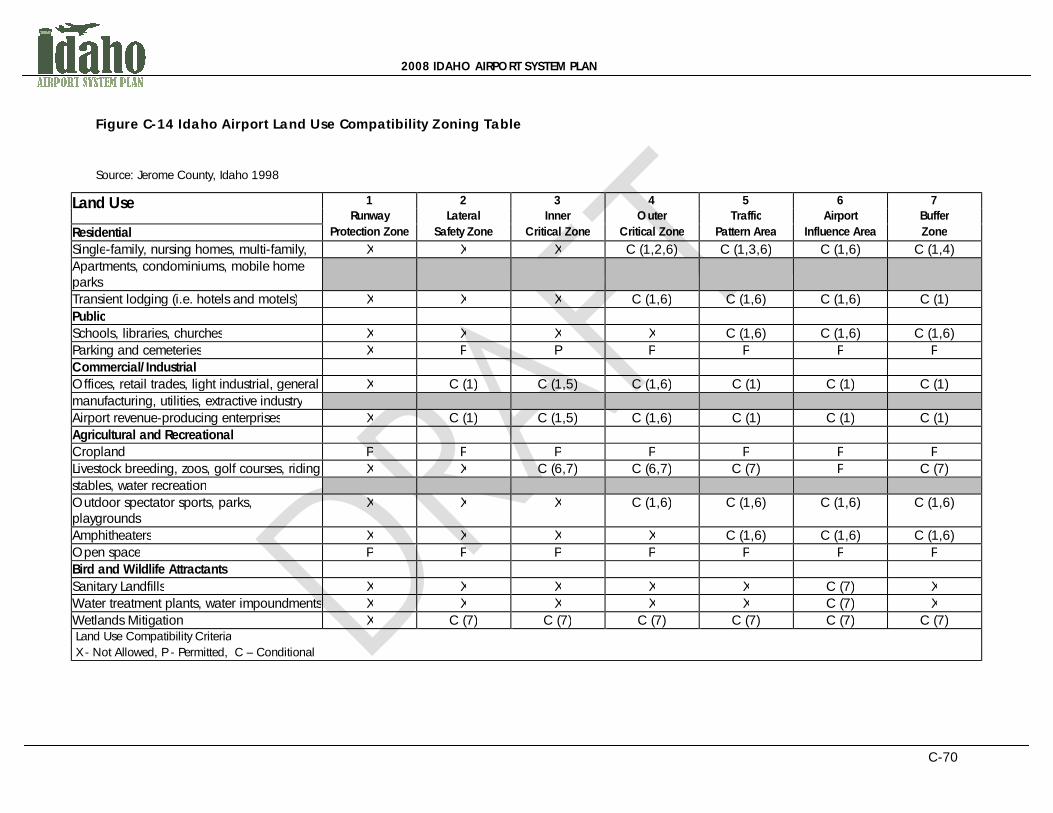
2008 IDAHO AIRPORT SYSTEM PLAN
C-70
Figure C-14 Idaho Airport Land Use Compatibility Zoning Table
Source: Jerome County, Idaho 1998
Land Use 1 2 3 4 5 6 7 Runway Lateral Inner Outer Traffic Airport Buffer
Residential Protection Zone Safety Zone Critical Zone Critical Zone Pattern Area Influence Area Zone
Single-family, nursing homes, multi-family, X X X C (1,2,6) C (1,3,6) C (1,6) C (1,4) Apartments, condominiums, mobile home parks
Transient lodging (i.e. hotels and motels) X X X C (1,6) C (1,6) C (1,6) C (1) Public Schools, libraries, churches X X X X C (1,6) C (1,6) C (1,6) Parking and cemeteries X P P P P P P Commercial/Industrial Offices, retail trades, light industrial, general X C (1) C (1,5) C (1,6) C (1) C (1) C (1) manufacturing, utilities, extractive industry Airport revenue-producing enterprises X C (1) C (1,5) C (1,6) C (1) C (1) C (1) Agricultural and Recreational Cropland P P P P P P P Livestock breeding, zoos, golf courses, riding X X C (6,7) C (6,7) C (7) P C (7) stables, water recreation Outdoor spectator sports, parks, playgrounds
X X X C (1,6) C (1,6) C (1,6) C (1,6)
Amphitheaters X X X X C (1,6) C (1,6) C (1,6) Open space P P P P P P P Bird and Wildlife Attractants Sanitary Landfills X X X X X C (7) X Water treatment plants, water impoundments X X X X X C (7) X Wetlands Mitigation X C (7) C (7) C (7) C (7) C (7) C (7) Land Use Compatibility Criteria X - Not Allowed, P - Permitted, C – Conditional

2008 IDAHO AIRPORT SYSTEM PLAN
C-71
Figure C-14 Conditions All facilities should be configured to comply with FAR Part 77 requirements.
1) If allowed, avigation easements and disclosure must be required as a condition of development.
2) Limit residential density to 1 unit per 10 acres.
3) Limit residential density to a maximum of 1 unit per 5 acres. It is recommended that the minimum land division size of 40 acres (County Zoning Ordinance – Land Division A-1) remain intact in the Traffic Pattern Area where reasonable and necessary to protect the Airport and surrounding uses from urbanization as determined by the Commission. Refer to the ___________County Zoning Ordinance (Land Division A-1) and Sections (land use limitations) and (board of adjustment) .of Chapter # (airport zoning) , ___________County Airport Ordinance, as amended.
4) Limit residential density to 1 unit per 1 acre.
5) Avoid High Intensity commercial uses such as large retail box stores (i.e. Walmart, Home Depot). Use should be located as far from extended centerline as possible.
6) If no reasonable alternative exists, use should be located as far from extended centerline as possible.
7) Such uses may present a bird and wildlife attractant. If allowed, consideration of the proximity of the airport and potential negative impacts should be considered. Refer to FAA Advisory Circulars (AC) 150/5200-33B and 150/5200-34A, as amended, for guidance.
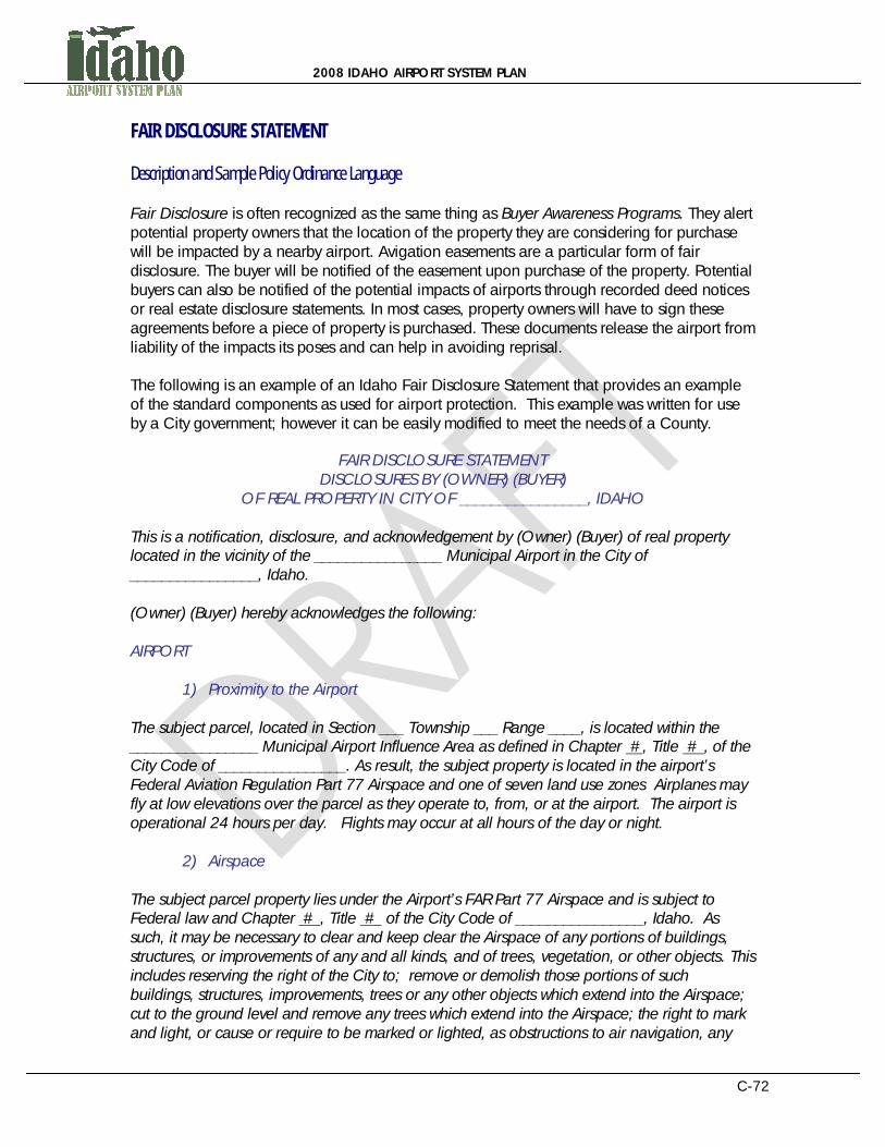
2008 IDAHO AIRPORT SYSTEM PLAN
C-72
FAIR DISCLOSURE STATEMENT Description and Sample Policy Ordinance Language Fair Disclosure is often recognized as the same thing as Buyer Awareness Programs. They alert potential property owners that the location of the property they are considering for purchase will be impacted by a nearby airport. Avigation easements are a particular form of fair disclosure. The buyer will be notified of the easement upon purchase of the property. Potential buyers can also be notified of the potential impacts of airports through recorded deed notices or real estate disclosure statements. In most cases, property owners will have to sign these agreements before a piece of property is purchased. These documents release the airport from liability of the impacts its poses and can help in avoiding reprisal. The following is an example of an Idaho Fair Disclosure Statement that provides an example of the standard components as used for airport protection. This example was written for use by a City government; however it can be easily modified to meet the needs of a County.
FAIR DISCLOSURE STATEMENT DISCLOSURES BY (OWNER) (BUYER)
OF REAL PROPERTY IN CITY OF ________________, IDAHO This is a notification, disclosure, and acknowledgement by (Owner) (Buyer) of real property located in the vicinity of the ________________ Municipal Airport in the City of ________________, Idaho. (Owner) (Buyer) hereby acknowledges the following: AIRPORT
1) Proximity to the Airport The subject parcel, located in Section ___ Township ___ Range ____, is located within the ________________ Municipal Airport Influence Area as defined in Chapter #, Title # , of the City Code of ________________. As result, the subject property is located in the airport’s Federal Aviation Regulation Part 77 Airspace and one of seven land use zones Airplanes may fly at low elevations over the parcel as they operate to, from, or at the airport. The airport is operational 24 hours per day. Flights may occur at all hours of the day or night.
2) Airspace The subject parcel property lies under the Airport’s FAR Part 77 Airspace and is subject to Federal law and Chapter # , Title # of the City Code of ________________, Idaho. As such, it may be necessary to clear and keep clear the Airspace of any portions of buildings, structures, or improvements of any and all kinds, and of trees, vegetation, or other objects. This includes reserving the right of the City to; remove or demolish those portions of such buildings, structures, improvements, trees or any other objects which extend into the Airspace; cut to the ground level and remove any trees which extend into the Airspace; the right to mark and light, or cause or require to be marked or lighted, as obstructions to air navigation, any
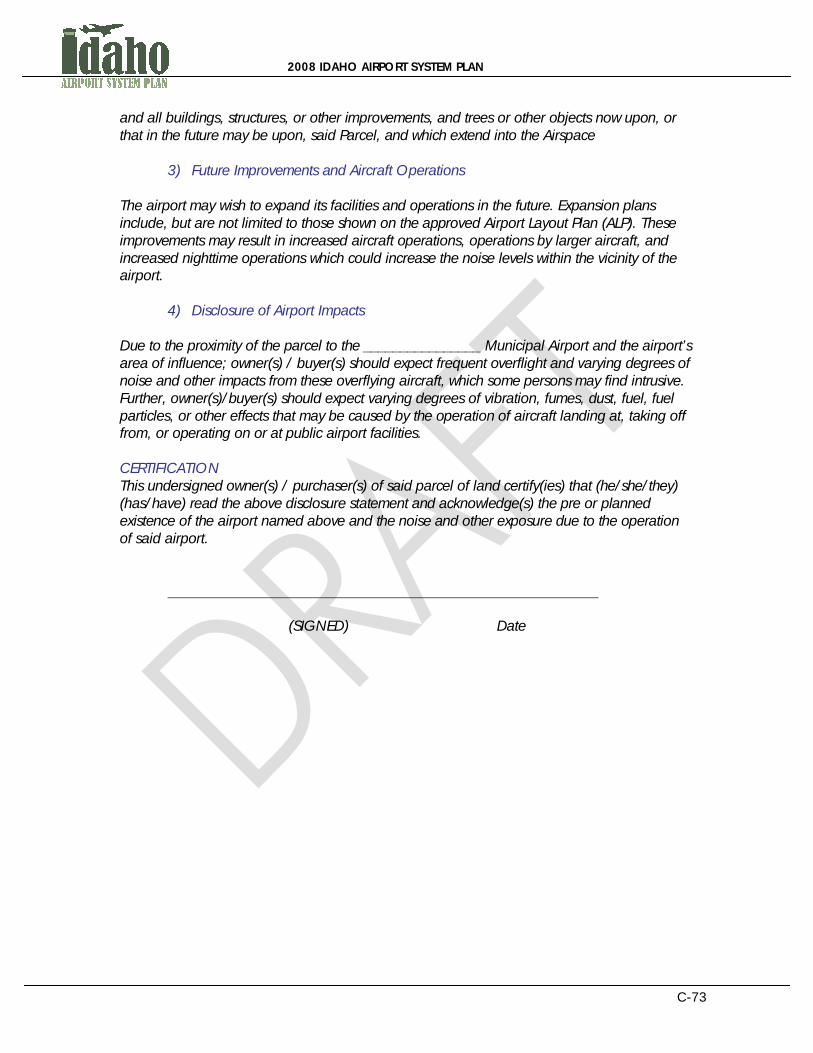
2008 IDAHO AIRPORT SYSTEM PLAN
C-73
and all buildings, structures, or other improvements, and trees or other objects now upon, or that in the future may be upon, said Parcel, and which extend into the Airspace
3) Future Improvements and Aircraft Operations The airport may wish to expand its facilities and operations in the future. Expansion plans include, but are not limited to those shown on the approved Airport Layout Plan (ALP). These improvements may result in increased aircraft operations, operations by larger aircraft, and increased nighttime operations which could increase the noise levels within the vicinity of the airport.
4) Disclosure of Airport Impacts Due to the proximity of the parcel to the ________________ Municipal Airport and the airport’s area of influence; owner(s) / buyer(s) should expect frequent overflight and varying degrees of noise and other impacts from these overflying aircraft, which some persons may find intrusive. Further, owner(s)/buyer(s) should expect varying degrees of vibration, fumes, dust, fuel, fuel particles, or other effects that may be caused by the operation of aircraft landing at, taking off from, or operating on or at public airport facilities. CERTIFICATION This undersigned owner(s) / purchaser(s) of said parcel of land certify(ies) that (he/she/they) (has/have) read the above disclosure statement and acknowledge(s) the pre or planned existence of the airport named above and the noise and other exposure due to the operation of said airport.
(SIGNED) Date
2008 IDAHO AIRPORT SYSTEM PLAN
C-74
AVIGATION AND HAZARD EASEMENT Description and Sample Policy Ordinance Language An Avigation Easement is a property right that grants aircraft the right to fly over, land, or take off in airspace above a parcel of property. Avigation easements are acquired from a land owner and grant the right of airplanes to cause noise or to inflict other impacts that occur near airports. These easements can also prohibit the property owner from installing structures that exceed a specified height. They provide the opportunity to set conditions on certain land uses or property near airports that will mitigate the potential for repercussions. In general, avigation easements grant permission to the airport to continue to operate within their current capacity. Avigation easements should be defined to maintain rights as the underlying property is bought and sold. They can be purchased by the easement holder or can be negotiated for donation with the property owner prior to approval of the development. Requirements for avigation easements can be set based on compatibility zones around an airport or based on metrics such as noise level contour thresholds. Local entities should strive to negotiate the donation of all aviation-related easements on undeveloped property, but should be prepared to compensate property owners for the application of easements on already-developed land. All forms of easements provided below should be negotiated in the same manner. An Approach Protection Easement provides more protection than a general avigation easement. This type of easement combines standard avigation easement provisions (e.g. height or noise restrictions) with the acquisition of specific development rights to the property, such as dwelling density. The following is an example of an Idaho Grant of Avigation Easement with the standard components as used for airport protection. This example was written for use by a County government; however it can be easily modified to meet the needs of a City.

2008 IDAHO AIRPORT SYSTEM PLAN
C-75
GRANT OF AVIGATION EASEMENT The landowner_____________________________________ ["Grantor"], hereby grants and conveys to the ____________ County Airport, a municipal corporation of the County of ____________ of the State of Idaho ("Grantee"), the following avigation easement:
1) The Grantor for good and valuable consideration, does hereby grant to the Grantee, its successors and assigns, a perpetual and assignable easement in and over that certain parcel of real property (the "Parcel") more particularly identified and described in Attachment "A" to and made a part of this instrument, and a right-of-way for the free and unrestricted passage and flight of aircraft in, through, across and about the airspace above an imaginary plane, as such plane is defined by Part 77 of the Federal Aviation Regulations, over said Parcel, as described below (the "Airspace"). As used herein, the term “aircraft” shall mean any and all types of aircraft, whether now in existence or hereafter manufactured and developed, to include, but not limited to, jet aircraft, propeller driven aircraft, civil aircraft, military aircraft, commercial aircraft, helicopters and all types of aircraft or vehicles now in existence or hereafter developed, regardless of existing or future noise levels, for the purpose of transporting persons or property through the air, by whomsoever owned or operated.
2) The Airspace for avigation easement purposes above said Parcel consists of all of
the air space above the imaginary plane that is described by Part 77 of the Federal Aviation Regulations.
3) The easement and right-of-way described in Paragraphs 1 and 2 includes but is not
limited to:
a. For the use and benefit of the Grantee, the public, and their assigns, guests and invitees or any and all firms, or corporations operating Aircraft to or from the Airport the easement and continuing right to fly, or cause or permit the flight by any and all persons or aircraft; and
b. The easement and right to cause or create, or permit or allow to be caused
or created within the Airspace, such noise, dust, turbulence, vibration, illumination, air currents, fumes, exhaust, smoke and all other effects as may be inherent in the proper operation of aircraft, now known or hereafter used for navigation of or flight in air; and
c. The continuing and perpetual right to clear and keep clear the Airspace of any portions of buildings, structures, or improvements of any and all kinds, and of trees, vegetation, or other objects, including the right to remove or demolish those portions of such buildings, structures, improvements, trees or any other objects which extend into said Airspace and the right to cut to the ground level and remove any trees which extend into the Airspace; and
d. The right to mark and light, or cause or require to be marked or lighted, as obstructions to air navigation, any and all buildings, structures, or other

2008 IDAHO AIRPORT SYSTEM PLAN
C-76
improvements, and trees or other objects now upon, or that in the future may be upon, said Parcel, and which extend into the Airspace; and
e. The right of ingress to, passage within, and egress from said Parcel, solely for the above stated purposes.
4) Grantor, on behalf of itself, its successors and assigns hereby covenants with the
Grantee, ____________ County Airport, its successors and assigns as follows:
a. Grantors, for themselves, their heirs, administrators, executors, successors, and assigns, do hereby agree that for and during the life of said easement and right of way, they will not hereafter erect, permit the erection or growth of, or permit or suffer to remain upon Grantors’ Property any building, structure, tree or other object extending into the Airspace.
b. Grantor, its successors and assigns, shall not hereafter use or permit or suffer the use of Grantors’ Property in such a manner as to create electrical interference with radio communication between any installation upon said airport and aircraft, or as to make it difficult for flyers to distinguish between airport lights and others, or to permit any use of the Grantors’ land that causes a discharge of fumes, dust or smoke which would impair visibility in the vicinity of the airport or as otherwise to endanger the landing, taking off or maneuvering of aircraft.
5) The easement and right-of-way herein granted shall be deemed both appurtenant
to and for the direct benefit of that real property which now or hereinafter constitutes the ____________ County Airport, and shall further be deemed in gross, being conveyed to the Grantee for the benefit of the Grantee, and any and all members of the general public who may use said easement or right-of- way, taking off from, landing upon, or operating such aircraft in or about the ____________ County Airport, or in otherwise flying through said Airspace.
6) This grant of avigation easement shall not operate to deprive the Grantor, its successors or assigns, of any rights that it may otherwise have from time to time against any individual or private operator for negligent or unlawful operation of aircraft.
7) It is understood and agreed that these covenants and agreements run with the land and shall be binding upon the heirs, representatives, administrators, executives, successors, and assigns of the Grantor, and that for the purposes of this instrument, the Parcel shall be the servient easement and the ____________ County Airport shall be the dominant tenement.
8) The avigation easement, covenants and agreements described herein shall continue in effect until the last to occur of: (1) the ____________ County Airport shall be abandoned or (2) all of the property currently used as the ____________ County Airport shall cease to be used for public airport purpose, at which time it shall terminate.

2008 IDAHO AIRPORT SYSTEM PLAN
C-77
_____________________________ Grantor
STATE OF IDAHO }ss. } COUNTY OF ____________ The foregoing instrument was acknowledged before me this ___ day of _____, 200_ by __________________________.
Witness my hand and official seal. ____________________________ My commission expires:
____________________________ Notary Public ACCEPTANCE The ____________ County Airport, a body corporate and politic of the State of Idaho, by and through the ____________ County, hereby accepts the above grant of avigation easement Dated this______ day of __________________, 200____.

2008 IDAHO AIRPORT SYSTEM PLAN
C-78
NOISE EASEMENTS Description and Sample Policy Ordinance Language A Noise Easement is a specific kind of avigation easement that grants the airport the right to cause noise from aircraft. They set conditions or simply grant permission to the airport to continue operating at the noise levels that currently exist. The following is an example of a Noise Easement with the standard components as used for airport protection. This example was written for use by a County government; however it can be easily modified to meet the needs of a City.
NOISE EASEMENT This indenture made this _____ day of ____________________, 20____, by ____________________ and between __________________________, hereinafter referred to as Grantor, and ________________ County, a municipal corporation organized and existing under the laws of the State of Idaho, hereinafter referred to as Grantee, witnesseth: WHEREAS the Grantor is the owner in fee of a certain parcel of land in the County of _________________, State of Idaho; and WHEREAS said parcel of land is near ________________________________ Airport, and is within an Airport Noise Overlay Zone as defined by the Zoning Ordinance of the County of _________________, and is subject to existing or forecast aircraft noise levels in excess of 65 DNL; and WHEREAS the Grantee is the owner and operator of the ____________________________Airport; and WHEREAS the Grantor proposes to make a use of said land and to develop thereon the following: _____________________________________________________________ _____________________________________________________________ which use and development require approval by Municipal and County authorities subject to the applicable provisions of law; and WHEREAS the Grantor has been advised that the subject property is located in a noise-impacted area; that these present and future noise impacts might be annoying to users of the land for its stated purpose and might interfere with the unrestricted use and enjoyment of the property in its intended use; that these noise impacts might change over time by virtue of

2008 IDAHO AIRPORT SYSTEM PLAN
C-79
greater numbers of aircraft, louder aircraft, seasonal variations, and time-of-day variations; that changes in airport, air traffic control operating procedures or in airport layout could result in increased noise impact; and that the Grantor’s and users’ own personal perceptions of the noise exposure could change and that his or her sensitivity to aircraft noise could increase; NOW, THEREFORE, for and in consideration of the mutual covenants, agreements and conditions contained herein, the parties hereto agree as follows: Grantor does hereby grant a permanent noise easement to Grantee overall of the following described real estate: Provided, however, that the airspace in which the said easement and right-of-way is herein granted shall be that airspace which lies at or above ___________ feet above mean sea level (MSL) which is __________ feet above the present surface level of the land, which land is __________ feet above MSL. Determination of non-conforming obstructions shall be based on the height of the obstruction above mean sea level (MSL). By virtue of this agreement, the Grantor, for and on behalf of himself and all successors in interest to any and all of the real property above described, waives as to Grantee or any successor agency legally authorized to operate said airport, any and all claims for damage of any kind whatsoever incurred as a result of aircraft using the “easement” granted herein regardless of any future changes in volume or character of aircraft overflights, or changes in airport design and operating policies, or changes in air traffic control procedures. The Noise Easement shall run with the land of the Grantor, as hereinabove described, for the benefit of the Grantee, and its successors and assigns in the ownership, use and operation of the aforesaid airport. Grantee, its successors and assigns, shall have and hold said easement and all rights appertaining thereto until said airport shall be abandoned and shall cease to be used for airport purposes. IN WITNESS WHEREOF, the Grantor has hereunto set its hand and seal the day and year first above written. ____________________________________ (SEAL) ____________________________________ (SEAL) NOTARY ACKNOWLEDGEMENT STATE OF IDAHO COUNTY OF ________________________

2008 IDAHO AIRPORT SYSTEM PLAN
C-80
Personally, came before me, this _________ day of _____________, 20____. _______________________ and _______________________________ of the above named Corporation, to me known to be the person who executed for foregoing instrument and to me known to be such __________________________ and ______________________________ of said Corporation, and acknowledged that they executed the foregoing instrument such officers as the deed of said Corporation, by its authority. __________________________________________ Notary Public, State of Idaho My Commission Expires ______________________
2008 IDAHO AIRPORT SYSTEM PLAN
C-81
HOLD HARMLESS AGREEMENT Description and Sample Policy Ordinance Language The following is an example of a Hold Harmless Agreement with the standard components as used for airport protection. This example was written for use by either a City or County government.
HOLD HARMLESS AGREEMENT KNOW ALL MEN BY THESE PRESENTS, that the undersigned, hereinafter referred to as Grantees (whether singular or plural), hereby covenant and agree that they shall not, by reason of their ownership or occupation of the following described real property, protest or bring suit or action against the ________________Airport or the City (County) of ______________ for aviation related noise, property damage or personal injuries resulting from activities at or connected with the _______________Airport when such activities conform to the then existing rules and regulations of said airport and the applicable federal air regulations and no negligence on the part of said airport is involved. The real property of Grantees subject to this covenant and agreement is situated in the County of _________________, State of Idaho, and described as follows:
(Insert legal description and appropriate map) This covenant and agreement is made and executed by the Grantees in consideration of the City (County) of _________________ granting a conditional use permit for Grantees use and development of the above described real property, which real property is located in the airport approach zone of the ____________________ Airport. The execution of this covenant and agreement by Grantees is required by the City (County) of _____________ as a prerequisite to the granting of the above said conditional use permit to Grantees. This agreement is executed for the protection and benefit of the ________________ Airport and the City (County) of _______________________ interest in said airport and to prevent development in adjacent lands to said airport which will interfere with the continued operation existent and development of said airport. This covenant and agreement is intended to be binding upon the Grantees, their heirs, assigns, and successors and inure to the benefit of the City (County) of _______________ and the Airport, their successors and assigns. DATED this ___________ day of _____________________, 20____. STATE OF IDAHO ) GRANTEES: ) ss.____________________ City/County of ) ______________________
2008 IDAHO AIRPORT SYSTEM PLAN
C-82
THROUGH-THE-FENCE AGREEMENT Description and Sample Policy Ordinance Language Through-the-Fence operations at airports permit aircraft to taxi across the airport property boundary. This operation may involve rural, general aviation airports with small commercial and residential land uses immediately adjacent to the airport property. These operations generally involve businesses or individual residents that have access to the airport from outside airport property, or which utilize airport property to conduct a business, but do not rent business space at the airport. This results in operations that do not provide financial support to the airport, which decreases the airports long-term viability. Creating through-the-fence agreements that benefit regional airports can be important to the longevity of airport operations. If through-the-fence operations must occur, collecting fees or leasing property is highly encouraged to enhance the economic vitality of regional airports and to share economic privileges among operators. Inequitable through-the-fence airport operations may also cause violations of federal grant assurances. If federal grant opportunities are jeopardized by through-the-fence operations, local airports will be further hindered economically. It is important to understand that by threatening financial opportunities for airports, local economies can be impacted as a result. The following is an example of an Idaho Through-the-Fence Agreement providing an example of the standard components as used for airport protection. This particular agreement is from the City of McCall, Idaho and is provided through the kind consideration of John Anderson, Airport Manager. This example was written for use by a City government; however it can be easily modified to meet the needs of a County.
THROUGH THE FENCE AIRPORT ACCESS AGREEMENT
This AGREEMENT is entered into as of ______________ ____, 20___ (“Effective Date”) by and between The City of __________, an Idaho Municipal Corporation of the State of Idaho (“City”) and ____________________ (referred to as “TTF Licensee”). RECITALS
1) The City is the legal owner of certain real property known as __________ Municipal Airport (“Airport”), as depicted in Exhibit “A”.
2) TTF Licensee is the owner of private land adjacent to the Airport, as more particularly described in Exhibit “B” attached hereto and made a part hereof by this reference (the “Private Land”).
3) TTF Licensee desires to access the Airport from the Private Land in private aircraft and commercial aircraft.
NOW, THEREFORE, in consideration of the mutual promises and upon the terms and subject to the conditions set forth herein, the parties agree as follows:
2008 IDAHO AIRPORT SYSTEM PLAN
C-83
AGREEMENT
1) Rules and Regulations. The Minimum Standards for Commercial Operations and Private Users of the __________ Municipal Airport, dated ______________ ____, 20___ (“Minimum Standards”) and Chapter 61 of the City Code, Title 3, Zoning Ordinance, and any other regulations and ordinances now legally in effect, or as they may be hereafter reasonably and legally amended or adopted in the future, that are applicable to __________ Airport tenants and transients, whether civil or government, shall apply to the TTF Licensee.
2) Grant Assurances. The TTF Licensee, per this Agreement, is subject to all present and future grant assurances and federal property conveyance obligations made between the City and the Federal Aviation Administration (FAA). This includes, but is not limited to, safe operation and equitable compensation for use of the airport.
3) Access to Airport. The City of __________ hereby grants to the TTF Licensee non-exclusive access to the Airport for private and commercial aircraft at the location designated in Exhibits “A” and “B” attached hereto and made a part hereof by this reference. Any costs associated with construction and maintenance of said access point shall be paid for by the TTF Licensee. Any construction on the Private Land shall be completed in accordance with the Minimum Standards and the applicable City Codes. Access shall not be allowed from any portion of the Private Land which is not, at that time, annexed into the City and zoned for airport or aviation use, and which does not, at that time, have approval for the development of the Private Land (see the City Code, Title 3). Access to the airport from any residential use is expressly prohibited. Access to the airport for any use which would require FAA Part 139 certification is expressly prohibited. Access is granted to the TTF Licensee for the use and development as is generally depicted in the Project Site Plan, Exhibit “C”, attached hereto and made a part of this Agreement. Note that the Exhibit is an example of a typical layout for this type of facility; the actual configuration and design may be different from what is currently shown and must be approved by the City before any building permit may be issued.
4) Expiration Date. The Expiration Time (fixed contract period) for this Agreement shall be for a period of twenty (20) years from the “Effective Date”, provided, however, that the TTF Licensee is not in default of this Agreement.
5) Renewal Option. As long as the TTF Licensee is not then in default of this Agreement, this Agreement may be extended by the TTF Licensee for four (4) additional terms of five (5) years each. Each extension shall be upon the same terms and conditions as are set forth in this agreement except that the Access Fee in section 8 below may be adjusted by City Resolution which takes into account
1 Chapter 6 of Title 3 defines the City zone for the airport (AP), including development requirements and restrictions.

2008 IDAHO AIRPORT SYSTEM PLAN
C-84
any changes in the Project Site Plan, adjacent properties, or unforeseen financial conditions. The TFF Licensee shall provide written notice to the City of its request to extend at least ninety (90) days prior to the expiration of the then existing term.
6) Security and Gates. The TTF Licensee shall be responsible for the costs of
installing and maintaining all security measures and means of access at the access point(s) shown on Exhibits A and C, including, but not limited to, fences, gates and taxiways, in accordance with FAA and Transportation Security Agency (TSA) requirements, as they may be amended from time to time, and to prevent inadvertent access to the Airport property at any time.
7) Conditions and Restrictions. The TTF Licensee’s rights hereunder to access the Airport shall be subject to the following conditions:
a. TTF Licensee shall comply with all applicable present and future:
i. rules, regulations, and other requirements of the FAA and TSA or any successor agencies; and
ii. laws of the State of Idaho and of the United States of America, including without limitation, statutes, rules, regulations, ordinances and codes; and
iii. County and City laws, rules, regulations, ordinances, and
codes.
b. All plans, designs and specifications for security measures and means of access, shall be subject to TSA prior review and approval, as may be required by the TSA from time to time;
c. The TTF Licensee shall be responsible for assuring that traffic and activities relating to access and security construction do not interfere with the normal day-to-day operations of the Airport, do not create a safety hazard, and do not result in unreasonable “wear and tear” on improved areas of the Airport, as defined in the Minimum Standards.
d. All of the Private Land must be located within the City limits and must be zoned as Airport (AP); see City Code, Title 3, Chapter 6.
e. All of the Private Land which may be required for the proposed relocation
of the parallel taxiway and/or future expansion of the runway or taxiways as defined in the 2007 __________ Municipal Airport Master Plan Update must be reserved and dedicated for this use. As land for this purpose may be purchased by the City, the Access Fee defined below will be adjusted accordingly.

2008 IDAHO AIRPORT SYSTEM PLAN
C-85
f. The access points as shown on Exhibit C to the taxiway may be required to be changed in the future; any cost for doing so will be at the expense of the TTF Licensee.
g. The City may at any time inspect the TTF property and improvements as
may be required to assure compliance with this Agreement.
h. No residential uses are allowed including sleeping accommodations and kitchens.
8) Access Fee. Upon execution of this agreement, TTF Licensee shall pay to City the
sum of $5,000 as and for the first year access fee. The access fee for the second year will be $15,000. Thereafter, the fee will be calculated by applying the following rates: Land: $0.02/sq. ft. x 1,029,395 sq. ft. $ 20,588 Buildings: $0.15/ sq. ft. x 154,000 sq. ft. $ 23,100 said fee to be adjusted by inflation (as set forth below) each October 1st beginning October 1, 20___. The $0.15 per square foot (building footprint) charge for buildings shall be applicable upon the issuance of a City Building Permit for each building. Said fees shall be payable on an annual basis in advance on October 1st. Each year the annual access fee will be adjusted by the change in the CPI-West Urban (base year 1982-84). Note that the square footage amounts shown were derived from the TTF Project Site Plan, Exhibit C, data. The amounts will be adjusted to actual values as the project is completed in various phases over time; for example, the actual net Private Land area may be greater than shown as the need for additional land for a new taxiway may be less than the 200 additional feet shown on the Project Site Plan Exhibit C. Note: “Year” in this context means the fiscal year of the City, beginning October 1 and ending September 30. Note 2: The rates should have been state at or equal to existing on airport rates which were at the time this was written $0.145 per square foot per annum for bare land plus $0.279 for the area occupied by the hangar. And, all new leases are to be at $0.35 per square foot per annum for all land.
9) Additional Fee Collection. The TTF Licensee shall also collect and remit to City, by
the fifteenth (15th) of each month, all applicable landing fees, fuel flowage fees, aircraft parking fees, and other concession fees as may be applicable by regulation, rule, or ordinance, including but not limited to car rent fees, catering fees, ground vehicle parking fees, and other percentage of gross sales fees paid by on-airport operators in the previous month. Any FBO granted access by this agreement shall meet all the requirements required of on-airport FBO’s. All such additional Fees shall be at parity with any existing on-airport FBO; in addition, any TTF FBO, in order to come onto the Airport to service on-airport tenants, must meet all of the requirements the on-airport FBO is required to meet.
2008 IDAHO AIRPORT SYSTEM PLAN
C-86
10) Late Charges. Any Access Fee not paid within 30 days of the due date shall be deemed late and, in addition to the Access Fee due, TTF Licensee agrees to pay (i) a late charge equal to 18% of the Access Fee then due, and (ii) interest on the Access Fee at the rate of 18% per annum, and accrued monthly until paid in full. Any fee, which is due and unpaid at the expiration, termination, or cancellation of this Agreement, shall continue to be an obligation of TTF Licensee notwithstanding such termination or cancellation.
11) Commercial Activities. All commercial activities within the Private Land will conform to City of __________ and FAA Minimum Standards, Rules and Regulations, and ordinances now in effect, or as they may be reasonably and legally amended or adopted in the future. Any commercial activity on the Private Land, or accessing the Airport from the Private Land, shall be subject to all normal and applicable City approval, permits, or license requirements for such activity. Commercial activity in this case excludes commercial passenger service which requires FAA Part 139 certification. Note: Using present FAA guidance commercial activates should likely be prohibited unless there is not enough land on the airport, there are no duplicate commercial activities on the airport, or the activity is needed.
12) Insurance. At all times during the term of this Agreement, including any extensions thereof, TTF Licensee shall procure and maintain insurance against the hazards and liability in the amounts hereinafter set forth and shall provide the City with a certificate of such insurance naming the City as an additional insured:
a. All Risk Insurance in Connection with Construction. Before commencement of any construction or demolition on or related to the access granted hereunder the TTF Licensee shall procure and shall maintain in force until the completion of the work “All Risk” insurance in a form reasonably satisfactory to City, covering all risks of physical loss or damage to any property in an amount of not less than $1,000,000.
b. Public Liability Insurance. Comprehensive broad form general public liability and aviation liability insurance covering loss or damage resulting from accidents or occurrences on or about or in connection with the access granted hereunder or the TTF Licensee’s use of the Airport, with personal injury, death and property damage combined single limit liability of not less than $5,000,000 for each accident or occurrence for commercial operators, should commercial operations permit be allowed, and $1,000,000 for private hangar owners.
13) General Indemnification. The TTF Licensee hereby indemnifies and holds the City,
its elected officials, and employees harmless from and against all liability for injuries to persons or damage to property caused wholly or in part by use of the access granted hereunder.
14) Assignment. This Agreement shall, except as otherwise provided herein, be binding upon and inure to the benefit of the successors and assigns of the parties hereto. Neither this Agreement nor any right granted hereunder shall be

2008 IDAHO AIRPORT SYSTEM PLAN
C-87
assignable or otherwise transferable in whole or in part without the prior written consent of the City, which consent shall not be unreasonably withheld, conditioned or delayed, in which case a new Agreement must be negotiated and approved by the City and the FAA.
15) Non-responsibility of City for Airport Closures. The City shall not be responsible for airport closures or the inability to operate specific aircraft at any time.
16) Default. In the event the TTF Licensee, its successors, assigns or subsequent owners of the Private Land or any other person acquiring an interest in the Private Land, fails to faithfully and materially comply with all of the terms and conditions included in this agreement, such failure to comply will be deemed a default hereunder. In that event, City shall have the following options:
a. This agreement and the commitments contained herein may be terminated
if the City provides written notice of the TTF Licensee’s default and the TTF Licensee fails to cure such default within thirty (30) days, subject to extension as provided below, after mailing or delivery of said notice.
b. Enforcement of this agreement may be sought in an action at law or in equity in the __________ County, Idaho, District Court.
c. A waiver by the City of any default by the TTF Licensee of any one or more
of the covenants or conditions hereof shall apply solely to the breach waived and shall not bar any other rights or remedies of the City or apply to any subsequent breach of any covenants or conditions.
d. Notwithstanding anything to the contrary herein, in the event of a material
default of the agreement, the parties agree that the City and/or the TTF Licensee shall have thirty (30) days after delivery of notice of such default to correct the same prior to the non-defaulting party’s seeking of any remedy provided for herein; provided, however, that in the case of any such default which cannot with diligence be cured within such thirty (30) day period, if the defaulting party shall commence curing the same within the thirty (30) day period and prosecute the curing of same with diligence and continuity, then the time within which such default may be cured shall be extended for such period as may be necessary to complete the curing of the same, but in any event not to exceed (6) months; and provided further, however, no default by a subsequent owner of a portion of the property shall constitute a default by the TTF Licensee for the portion of the property still owned by the TTF Licensee.
e. In the event the performance of any obligation to be performed hereunder
by any party hereto is delayed for causes that are beyond the reasonable control of the party responsible for such performance, which shall include, with limitation, acts of civil disobedience, strikes or similar causes, the time for such performance shall be extended by the amount of time of such delay.

2008 IDAHO AIRPORT SYSTEM PLAN
C-88
f. Should the TTF Licensee fail to abide with the provisions of this Agreement,
then this Agreement shall be held in default and subject to termination, and access to the City Airport shall be denied, and all current TTF fees shall become a lien on the real property of the TTF land and improvements under this Agreement.
g. In the event the City or any of its successors, assigns or subsequent owners
of the Airport or any other person acquiring an interest in the Airport, fails to faithfully and materially comply with all of the terms and conditions included in this agreement, such failure to comply will be deemed a default hereunder. In the event of such default, if not cured within thirty (30) days of written notice of default, the TTF Licensee may terminate this agreement or pursue all other rights and remedies available at law or in equity.
h. The City shall have the express right to amend or terminate the Access
Agreement to ensure continued compliance with all grant assurances and federal property conveyance obligations.
17) General Provisions. The parties hereto agree to the following general provisions:
a. Further Documentation. The parties hereto agree to execute any and all
documents advisable and/or necessary to effectuate the terms and intent of this Agreement.
b. Binding. This Agreement shall be binding upon and inure to the benefit of the parties and their successors and assigns.
c. Invalidity of Provisions. If any provision of this Agreement as applied to
either party or to any circumstance shall be adjudged by a court to be void and unenforceable, the same shall in no way affect any other provision of this Agreement, the application of such provision in any other circumstances, or the validity or enforceability of the Agreement as a whole.
d. Modification. This Agreement shall not be modified by either party by oral
representation made before or after the execution of this Agreement. All modifications must be in writing and signed by the parties.
e. Counterparts. This Agreement may be executed in multiple counterparts,
each of which shall be deemed an original Agreement, and all of which shall constitute one Agreement as of the Effective Date
f. Time of Essence. Time is of the essence for the performance of each and
every covenant and the satisfaction contained in this Agreement.
g. Attorney’s Fees. In the event any action is brought to enforce or interpret any of the terms and provisions of this Agreement, the “prevailing party” in

2008 IDAHO AIRPORT SYSTEM PLAN
C-89
such action shall be entitled to recover, as an element of costs of suit and not as damages, reasonable costs and expenses, including but not limited to taxable costs and a reasonable attorney’s fee. The “prevailing party” shall be the party entitled to recover his costs of the suit, regardless of whether such suit proceeds to final judgment. A party not entitled to recover his costs shall not be entitled to recover attorney’s fees. No sum for attorneys’ fees shall be counted in calculating the amount of a judgment for the purposes of determining if a party is entitled to recover costs or attorneys’ fees.
h. Construction. This Agreement shall not be construed against the party
preparing it, but shall be construed as if all parties prepared this Agreement, and in accordance with the laws of the State of Idaho. Jurisdiction shall be __________ County, Idaho.
i. Miscellaneous. All negotiations are merged into this Agreement. This
Agreement constitutes the entire understanding of the parties concerning the subject of this Agreement. This Agreement shall constitute a binding obligation between the parties and shall be applicable beyond the term of this Agreement.
j. Costs and Expenses. Each of the parties shall pay all cost and expenses
incurred or to be incurred by it in negotiating and preparing this Agreement and in closing and carrying out the transactions contemplated by this Agreement.
k. Headings. The headings of the paragraphs and subparagraphs of this
Agreement are included for purposes of convenience only, and shall not affect the construction or interpretation of any of its provisions.
l. Gender. Any reference to he, she, or it shall not be binding as to gender,
but shall be construed and interpreted to mean he, she, or it as appropriate in connection with the correct gender.
m. Incorporation of Recitals. The Recitals are hereby incorporated in this
Agreement by this reference.
n. Authority to Execute. The individuals executing this Agreement on behalf of a corporation, partnership, trust, or other entity, hereby represent and warrant that they are duly authorized to do so on behalf of such entity, and that all corporate, partnership, trust or other entity requirements have been fully complied with including such resolutions, voting, or agreements as may be required to enter into this Agreement and to make this Agreement a binding obligation of such entity.
o. Facsimile Copies. Facsimile executed copies of this Agreement shall be
deemed an original copy. Any party may rely upon the facsimile copy of the original executed Agreement, which may be executed in counterparts.

2008 IDAHO AIRPORT SYSTEM PLAN
C-90
The parties agree to exchange fully executed original copies by mail within five (5) days after signing, provided that said exchange or the failure to exchange originals shall in no way be construed as voiding or negating use of the facsimile copies as originals.
p. Notices. All notices permitted or required under this Agreement shall be
deemed given upon (i) personal delivery (ii) actual receipt of notice by the party to whom such notice was directed, or (iii) forty eight (48) hours after having been deposited in the United States mail, certified, postage prepaid, with a second copy sent by regular first class mail and addressed to the appropriate party, at the address provided below or such other address as may hereafter be given by one party to the other party.
In Witness Whereof, the Parties have executed this Agreement as of date first above written. CITY: The City of __________, __________ County, Idaho
By: _____________________________ Mailing Address: City of __________
Date: ____________________________ __________ Street
__________, ID 83_____ TTF LICENSEE: ________________________
By: _____________________________ Name Mailing Address: ____________________________________, Idaho, 83_____
Address
Date: ____________________________
2008 IDAHO AIRPORT SYSTEM PLAN
C-91
SECTION NINE: ADOPTION AND MAINTENANCE OF THE ORDINANCE - STEP 6 Public Notification The Joint Multi-Jurisdiction Airport Land Use Planning and Zoning Commission needs to get approval of the revised Ordinance through the public involvement process. The zoning ordinance must be adopted in compliance with the public notice and hearing requirements of Idaho Code 67-6509 as well as the laws set forth in Idaho Code Section 50-901. The procedural requirements for adoption of the zoning ordinance are the same as for adoption of the Comprehensive Plan. For cities and counties with planning and zoning commissions, an initial hearing is required before the commission and a second hearing may be held before the governing board if required by local ordinance. For cities and counties that do not have planning and zoning commissions, only a single hearing is required before the governing board. Public notice must be given before each hearing, and the minimum notice requirements include:
ñ Notice of the hearing must be published in the official newspaper at least 15 days prior to the hearing, specifying the date, time and place of the hearing and a summary of the matter.
ñ Notice must be sent to all political subdivisions providing services within the jurisdiction (including school districts) at least 15 days prior to the hearing.
ñ Additional notice must be made available to other newspapers, radio and television stations serving the jurisdiction for use as a public service announcement. (From Idaho Commerce and Labor and Association of Idaho Cities, 2009, Smart Towns, A Guide to Growth Management for Idaho City and County Officials,, page 46)
Since zoning is a legal process, it is also a dynamic process. The community that has established an airport ordinance must be cognizant that it is enforced in order for it to provide the needed protection for the airport without negatively affecting the airports neighbors. This involves the maintenances and revision of the Airport and Comprehensive Plans and the Airport Zoning Ordinance by addressing any Legal Challenges to the Ordinance and issues relating to rezone requests and takings. The zoning ordinance may be amended because of changes in the development or land use in a particular area to reflect shifts in public opinion or to implement changes to the Comprehensive Plan. Amendments are most frequently requested by property owners, but may also be proposed by staff, the planning and zoning commission or the governing board. The zoning ordinance may be amended in the following ways:
2008 IDAHO AIRPORT SYSTEM PLAN
C-92
ñ The governing board may change the zoning of a particular property to allow a new use. For instance, the governing board may rezone a property from agricultural to single-family residential so that it can be subdivided and developed.
ñ The governing board may change the list of permitted or conditionally permitted uses for a particular zone. An example would be a request to change day care facilities from a prohibited use to a conditional use in a residential zoning district.
ñ Finally, amendments may be made to change the bulk and placement standards or revise the criteria for evaluating applications for variances or conditional use permits.
The public notice and hearing requirements for zoning ordinance amendments are the same as for adoption of the zoning ordinance—however, there are additional procedural requirements for rezones. Amendments to the zoning ordinance must be approved by the governing board. The Local Land Use Planning Act requires that zoning ordinance amendments must be:
ñ In accordance with the Comprehensive Plan, and
ñ Must not have demonstrable adverse impacts upon the delivery of services by any political subdivision, including school districts. (Idaho Commerce and Labor and Association of Idaho Cities, 2009, Smart Towns, A Guide to Growth Management for Idaho City and County Officials, page 46-47)
Coordinating the Zoning Ordinance and Comprehensive Plan “It is important to note that the zoning ordinance and any amendments must be in accordance with the Comprehensive Plan,” notes City Attorney and Planner Jerry Mason. “However, this does not mean that the projected land use designations in the Comprehensive Plan must exactly match the current land use designations in the zoning ordinance.” “The Idaho Supreme Court has held that the Comprehensive Plan and zoning ordinance serve different purposes, and that what has been projected as a pattern of land use is not necessarily what a property owner is entitled to have zoned today. For example, a parcel may be zoned low density residential, but the projected land use designation in the Comprehensive Plan is commercial. The governing board is not compelled to rezone the parcel until the conditions appropriate for that designation have been reached. This does not give local governments carte blanche to ignore their Comprehensive Plan when considering rezones. The governing board must determine whether the requested rezone is appropriate in terms of the objectives of the plan and in light of actual circumstances.” (Idaho Commerce and Labor and Association of Idaho Cities, 2009, Smart Towns, A Guide to Growth Management for Idaho City and County Officials, page 48) The Airport Advisory Board needs to manage the operations, financing, and growth of the airport facility. The Joint Comprehensive Airport Land Use Committee needs to enforce the zoning ordinance and monitor that the ordinance is accomplishing its intended purpose
2008 IDAHO AIRPORT SYSTEM PLAN
C-93
without undo restrictions or expense to the airports neighbors. Both of these entities are crucial to the coordination of airport land use compatibility planning and zoning. Implementation Successful implementation of these actions may seem like a daunting task, yet, if approached step-by-step, the process can unfold relatively easily. Step-by-step implementation will help to execute a systematic process that can ensure airport protection from the threats of encroachment. Some supporting methods of airport and land use compatibility can further enforce the implementation process. These methods are outlined below. As a first step in implementation, the entities that can support the process should be identified and involved from the onset. These entities can include the Federal Aviation Administration (FAA), state and local governments, airport system users, and the community. The key authorities identified for enforcement of plans and regulations should be the crucial players in effectuating these actions. It is up to the airport operators, local land use planning agencies, and local governments to work together to protect the well-being of the public surrounding the airport and to promote an environment of cooperation between the community and the airport. A guide for initiating participation in the airport planning process is available from The Aircraft Owners and Pilots Association (AOPA). The 2008, Guide for Airport Advocates: Participating in the Planning Process is a valuable document for achieving coordination in the planning process. On the whole, involvement and buy-in from multiple parties will help to encourage wide acceptance of the overall airport planning approach.
2008 IDAHO AIRPORT SYSTEM PLAN
C-94
SECTION TEN: AFTERWORD On a Statewide basis these Idaho Airport Land Use Guidelines should eventually be incorporated into the guidance and training materials available in the Idaho Association of Counties, 2006, County Elected Officials Handbook, Chapter 12, the Idaho Commerce and Labor and Association of Idaho Cities, 2009, Smart Towns, A Guide to Growth Management for Idaho City and County Officials, and the Association of Idaho Cities, 2009, Ordinance Manual. In order to facilitate effective and uniform implementation and to clarify and strengthen a municipality’s ability to protect their airport, there are a number of sections in Idaho Code that should be modified. Consideration needs to be given to changes in The Airport Zoning Act (IC§ Title 21, Chapter 5) and Local Land Use Planning Act, (IC§ Title 67, Chapter 65). Fourteen components of a Comprehensive Plan are required by Idaho state law. Ensuring safety, land use regulation, public service, transportation, and economic efficiencies are key elements required by Comprehensive Plans. Many of these goals are fundamentally linked to airport and land use compatibility issues. As a result, airport land use issues should become a key component of Idaho’s growth management goals. In order to ensure identification of airport and land use issues in Idaho, the guiding components of a Comprehensive Plan as identified by the Idaho Code, Title 67, Chapter 65 should be updated to include Airport and Land Use Compatibility. To best confirm the significance of airport and land use compatibility, it should be considered for adoption as the 15th component of a Comprehensive Plan in Idaho State Code. These changes could represent Idaho state policymaker support for enforcement of airport land use compatibility issues in strengthening the economic vitality and safety of local communities. It would also reinforce policymaker support for the importance of travel and tourism throughout the state. This is one crucial step in advocating airport and land use incompatibility issues in the state of Idaho. The recommended components of the airport portion of the Comprehensive Plan are provided in section 4 of these Guidelines.

2008 IDAHO AIRPORT SYSTEM PLAN
Sub-Appendix
SUB-APPENDIX
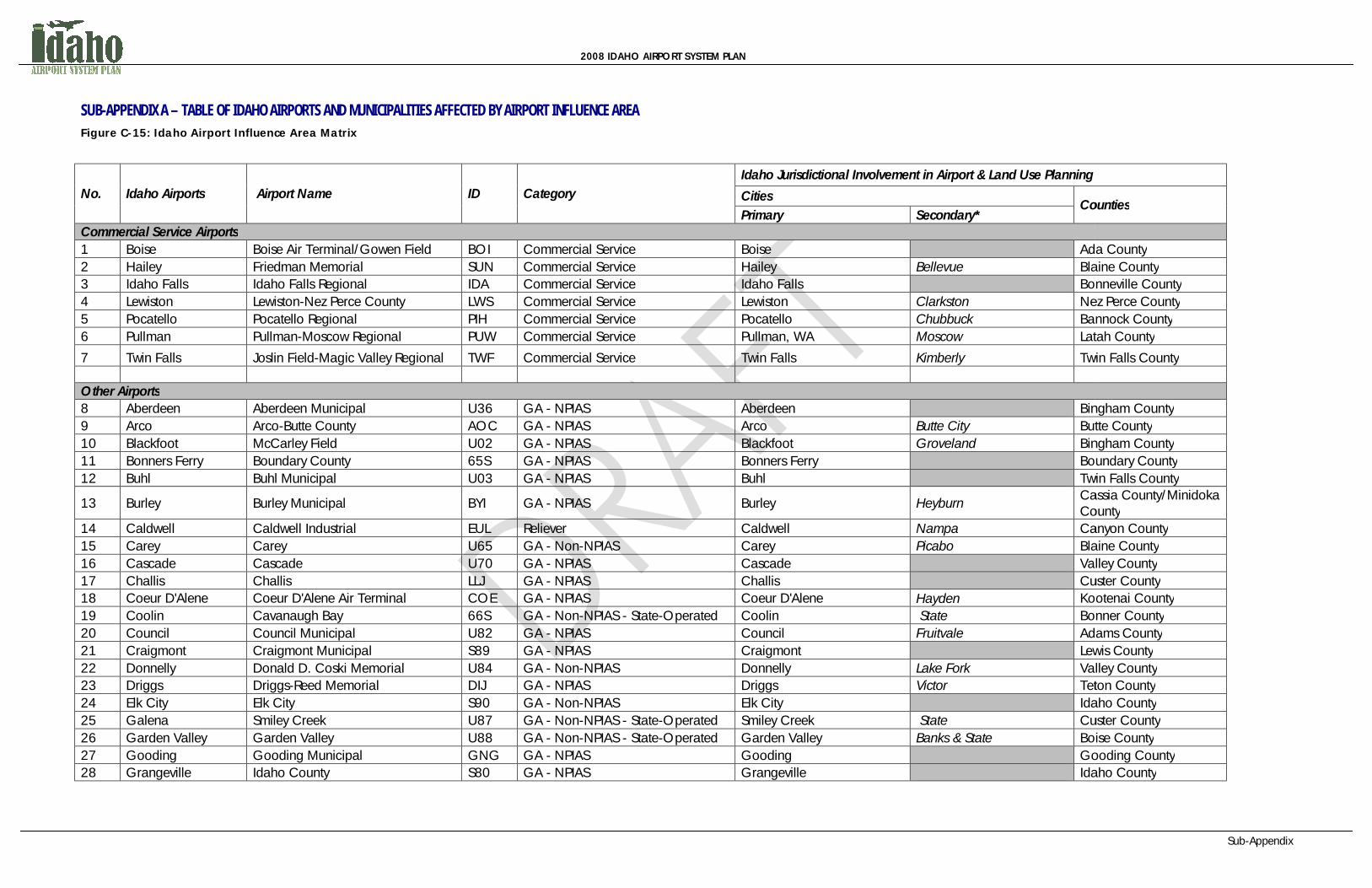
2008 IDAHO AIRPORT SYSTEM PLAN
SUB-APPENDIX A – TABLE OF IDAHO AIRPORTS AND MUNICIPALITIES AFFECTED BY AIRPORT INFLUENCE AREA Figure C-15: Idaho Airport Influence Area Matrix
No. Idaho Airports Airport Name ID Category Idaho Jurisdictional Involvement in Airport & Land Use Planning
Cities Counties
Primary Secondary* Commercial Service Airports 1 Boise Boise Air Terminal/Gowen Field BOI Commercial Service Boise Ada County2 Hailey Friedman Memorial SUN Commercial Service Hailey Bellevue Blaine County3 Idaho Falls Idaho Falls Regional IDA Commercial Service Idaho Falls Bonneville County4 Lewiston Lewiston-Nez Perce County LWS Commercial Service Lewiston Clarkston Nez Perce County5 Pocatello Pocatello Regional PIH Commercial Service Pocatello Chubbuck Bannock County6 Pullman Pullman-Moscow Regional PUW Commercial Service Pullman, WA Moscow Latah County
7 Twin Falls Joslin Field-Magic Valley Regional TWF Commercial Service Twin Falls Kimberly Twin Falls County Other Airports 8 Aberdeen Aberdeen Municipal U36 GA - NPIAS Aberdeen Bingham County9 Arco Arco-Butte County AOC GA - NPIAS Arco Butte City Butte County10 Blackfoot McCarley Field U02 GA - NPIAS Blackfoot Groveland Bingham County11 Bonners Ferry Boundary County 65S GA - NPIAS Bonners Ferry Boundary County12 Buhl Buhl Municipal U03 GA - NPIAS Buhl Twin Falls County
13 Burley Burley Municipal BYI GA - NPIAS Burley Heyburn Cassia County/Minidoka County
14 Caldwell Caldwell Industrial EUL Reliever Caldwell Nampa Canyon County15 Carey Carey U65 GA - Non-NPIAS Carey Picabo Blaine County16 Cascade Cascade U70 GA - NPIAS Cascade Valley County17 Challis Challis LLJ GA - NPIAS Challis Custer County18 Coeur D'Alene Coeur D'Alene Air Terminal COE GA - NPIAS Coeur D'Alene Hayden Kootenai County19 Coolin Cavanaugh Bay 66S GA - Non-NPIAS - State-Operated Coolin State Bonner County20 Council Council Municipal U82 GA - NPIAS Council Fruitvale Adams County21 Craigmont Craigmont Municipal S89 GA - NPIAS Craigmont Lewis County22 Donnelly Donald D. Coski Memorial U84 GA - Non-NPIAS Donnelly Lake Fork Valley County23 Driggs Driggs-Reed Memorial DIJ GA - NPIAS Driggs Victor Teton County24 Elk City Elk City S90 GA - Non-NPIAS Elk City Idaho County25 Galena Smiley Creek U87 GA - Non-NPIAS - State-Operated Smiley Creek State Custer County26 Garden Valley Garden Valley U88 GA - Non-NPIAS - State-Operated Garden Valley Banks & State Boise County27 Gooding Gooding Municipal GNG GA - NPIAS Gooding Gooding County28 Grangeville Idaho County S80 GA - NPIAS Grangeville Idaho County
Sub-Appendix
Counties
Ada County Blaine County Bonneville County Nez Perce County Bannock County Latah County
Twin Falls County
Bingham County Butte County Bingham County Boundary County Twin Falls County Cassia County/Minidoka County Canyon County Blaine County Valley County Custer County Kootenai County Bonner County Adams County Lewis County Valley County Teton County Idaho County Custer County Boise County Gooding County Idaho County

2008 IDAHO AIRPORT SYSTEM PLAN
29 Homedale Homedale Municipal S66 GA - NPIAS Homedale Wilder Owyhee County30 Howe Howe U97 GA - Non-NPIAS Howe Butte County31 Jerome Jerome County JER GA - NPIAS Jerome Wendell Jerome County32 Kamiah Kamiah Municipal S73 GA - NPIAS Kamiah Lewis County33 Kellogg Shoshone County S83 GA - NPIAS Kellogg/Smelterville Pinehurst Shoshone County34 Kooskia Kooskia Municipal S82 GA - Non-NPIAS Kooskia Stites Idaho County35 McCall McCall Municipal MYL GA - NPIAS McCall Lake Fork Valley County36 Mountain Home Mountain Home Municipal U76 GA - NPIAS Mountain Home Elmore County37 Nampa Nampa Municipal S67 GA - NPIAS Nampa Caldwell Canyon County38 New Meadows New Meadows 1U4 GA - Non-NPIAS - State-Operated New Meadows State Adams County39 Orofino Orofino Municipal S68 GA - NPIAS Orofino Ahsahka Clearwater County40 Paris Bear Lake County 1U7 GA - NPIAS Paris Montpelier Bear Lake county41 Porthill Eckhart International 1S1 GA - Non-NPIAS - State-Operated Porthill State Boundary County42 Preston Preston U10 GA - NPIAS Preston Franklin County43 Priest River Priest River Municipal 1S6 GA - NPIAS Priest River Newport, WA Bonner County44 Rexburg Rexburg-Madison County RXE GA - NPIAS Rexburg Sugar City Madison County45 Salmon Lemhi County SMN GA - NPIAS Salmon Carmen Lemhi County46 Sandpoint Sandpoint SZT GA - NPIAS Sandpoint Ponderay/Kootenai Bonner County47 St Maries St Maries Municipal S72 GA - NPIAS St Maries Benewah County48 Stanley Stanley 2U7 GA - Non-NPIAS - State-Operated Stanley State Custer County49 Weiser Weiser Municipal S87 GA - NPIAS Weiser Washington County50 Yellow Pine Johnson Creek 3U2 GA - Non-NPIAS - State-Operated Yellow Pine State Valley County
Sub-Appendix
Owyhee County Butte County Jerome County Lewis County Shoshone County Idaho County Valley County Elmore County Canyon County Adams County Clearwater County Bear Lake county Boundary County Franklin County Bonner County Madison County Lemhi County Bonner County Benewah County Custer County Washington County Valley County

2008 IDAHO AIRPORT SYSTEM PLAN
Bibliography
BIBLIOGRAPHY (AIC, 2009) Association of Idaho Cities. November, 2009. Ordinance Manual. (AOPA, 2008) Airplane Owners and Pilots Association. (2008). AOPA’s Guide for
Airport Advocates: Participating in the Planning Process. (AOPA, 1999) Airplane Owners and Pilots Association. (1999). AOPA’s Guide to
Airport Noise and Compatible Land Use. http://www.aopa.org/asn/land_use/. Accessed July 26, 2010.
(Burbank, 1999) City of Burbank, California. Airport Information. Easement Deed and
Agreement (Aviation Rights). http://www.ci.burbank.ca.us/airport/current/aveas.html. Accessed July 26, 2009.
(Caltrans, 2002) State of California, Department of Transportation – Division of
Aeronautics. 2002 (January). California Airport Land Use Planning Handbook.
(FAA, 1983) Department of Transportation. Federal Aviation Administration. 1983
(August). Noise Control and Compatibility Planning for Airports. Advisory Circular 150/5020-1.
(FAA, 1987) Department of Transportation. Federal Aviation Administration. 1987
(December). A Model Zoning Ordinance to Limit Height of Objects Around Airports. Advisory Circular 150/5190-4A.
(FAA, 1989) Department of Transportation. Federal Aviation Administration. 1989
Advisory Circular 150/5300-13, Airport Design. (FAA, 2000) Department of Transportation. Federal Aviation Administration. 2000
(August). Construction or Establishment of Landfills Near Public Airports. Advisory Circular 150/5200-34.
(FAA, 2002) Department of Transportation: Federal Aviation Administration. 2002
(April). Estimated Airplane Noise Levels in A-Weighted Decibels. Advisory Circular 36-3H.
(FAA, 2007) Department of Transportation. Federal Aviation Administration. 2007
(August). Hazardous Wildlife Attractants On Or Near Airports. Advisory Circular 150/5200-33B.

2008 IDAHO AIRPORT SYSTEM PLAN
Bibliography
(FAA, Date Unknown) Department of Transportation. Federal Aviation Administration. Date Unknown. Land Use Compatibility and Airports: A Guide for Effective Land Use Planning. Available at: http://www.faa.gov/about/office_org/headquarters_offices/aep/planning_toolkit/media/III.B.pdf. Accessed July 26, 2010.
(FDOT, 1994) Florida Department of Transportation. 1994. Airport Compatible Land
Use Guidance for Florida Communities. (Great Falls) City of Great Falls. Official Code of the City of Great Falls, Montana.
Title 17 Land Development Code. Appendix D – Sample Hold Harmless Agreement. http://www.greatfallsmt.net/city_codes/title-17-appD.pdf. Accessed July 26, 2010.
(IAC, 2006) Idaho Association of Counties. April 2006. County Elected Officials
Handbook, Chapter 12: Zoning Ordinances: 12-8; 12-6. (ICL & AIC, 2009) Idaho Commerce and Labor and Association of Idaho Cities.
November, 2009. Smart Towns: A Guide to Growth Management for Idaho City and County Officials, pages 28-36; 36-4.1
(Idaho Statutes) State of Idaho Legislature. Idaho Statutes, Title 21, Aeronautics. (Idaho Statutes) State of Idaho Legislature. Idaho Statutes, Title 67, Local Land Use
Planning Act. (IDAPA, 2010) Idaho Department of Administration. Idaho Administrative Code:
Idaho Administrative Procedure Act. 39.04.01: Rules Governing Federal Aviation Regulations.
(IDAPA, 2010) Idaho Department of Administration. Idaho Administrative Code:
Idaho Administrative Procedure Act. 39.04.02: Rules Governing Marking of Hazards to Air Flight.
(IDAPA, 2010) Idaho Department of Administration. Idaho Administrative Code:
Idaho Administrative Procedure Act. 39.04.04: Rules Governing Idaho Airport Aid Program.
(IDOT, 2001) Illinois Department of Transportation. Revised July 2001.
Miscellaneous Aeronautics’ Forms and Samples. Sample Through the Fence License Agreement. http://www.dot.state.il.us/aero/miscaeroforms.html. Accessed July 26, 2010.
2008 IDAHO AIRPORT SYSTEM PLAN
Bibliography
(IOWADOT, 2008) Iowa Department of Transportation. Iowa Airport Land Use Guidebook, Appendix F: Noise Easement. January 2008. http://www.iawings.com/airports/2008LandUseGuidebook/PDF%20Color/Appendix%20F%20Noise%20Easement.pdf. Accessed July 26, 2010.
(IRC, 1993) Airport Zoning Ordinance. Indian River County Land Development
Regulation, Chapter 911.17. Prepared by Indian River County, 1993. (Jerome County, 2009) Jerome County, Idaho. April, 2009. DRAFT Jerome County Airport
Zoning Ordinance. Pages 1-16. (MDOT, 2006) Michigan Department of Transportation. Aeronautics and Aviation.
Avigation Easement and Runway Protection Zone Resources. Avigation Easement – Inside RPZ. Updated October 2006. http://www.michigan.gov/aero/0,1607,7-145-6772_30342-143177--,00.html. Accessed July 26, 2010.
(MDOT, 2000-2009) Minnesota Department of Transportation. Aeronautics and Aviation.
2000-2009. Airport Land Use Compatibility Manual. http://www.dot.state.mn.us/aero/avoffice/planning/airportcompmanual.html. Accessed July 26, 2010.
(Mnt Home, 2010) City of Mountain Home, Idaho. 2010. DRAFT Land Use Zone Map. (ODOT, 1994) Oregon Department of Transportation. 1994 (November). Airport
Land Use Compatibility Guidelines. Prepared by The Airport Technology and Planning Group, Inc.
(Rosebrock & Freemuth, 1991) Rosebrock, Dale and Freemuth, Sheri. 1991. Local Planning in Idaho.
Publisher Unknown. Page 3. (TRB, 2008) Transportation Research Board. (2008) Understanding Airspace,
Objects, and Their Effects on Airports. ACRP 03-13 (WSDOT, 2009) Aviation Planning. (2009) Aviation Land Use Compatibility Program -
Example Scope of Work. http://www.wsdot.wa.gov/aviation/Planning/ScopeOfWork.htm. Accessed July 26, 2010.
Related Documents