1 Appendix A-1. Connecticut 305b Assessment Results for Rivers and Streams

Welcome message from author
This document is posted to help you gain knowledge. Please leave a comment to let me know what you think about it! Share it to your friends and learn new things together.
Transcript

1
Appendix A-1. Connecticut 305b Assessment Results for Rivers and Streams

Connecticut 2018 305b Assessment Results RIVERS Appendix A-1
2
Waterbody Segment ID Waterbody Name Location Miles Aquatic Life Recreation
CT1000-00_01
Pawcatuck River (Stonington/North
Stonington)-01
Head of tide Route 1 crossing at CT/RI border, Stonington/Pawcatuck-Westerly RI, US along CT/RI
border to point where river leaves CT in North Stonington and enters RI. 5.38
FULLY SUPPORTING
NOT SUPPORTING
CT1000-00_trib_01 Unnamed tributary Pawcatuck River 1000-00 (Stonington)-01
Confluence Pawcatuck River (Little Narragansett Bay portion) just DS of Route 49 crossing, US to HW at unnamed pond outlet just US of Route 49 crossing, very close to Town border, Stonington. Statewide
bacteria TMDL 0.18 UNASSESSED NOT
SUPPORTING
CT1000-01_01
Unnamed tributary to Pawcatuck River 1000-01
(North Stonington)-01
Mouth at confluence Pawcatuck River, US to Lewis Pond OUTLET, just US of Boom Bridge Road crossing,
North Stonington. Statewide bacteria TMDL 0.14 UNASSESSED NOT
SUPPORTING
CT1000-03_01 Unnamed tributary Pawcatuck River 1000-03 (Stonington)-01
Confluence Pawcatuck River, just DS Route 2/78 crossing, US to HW at unnamed pond OUTLET just US
of Elm Ridge Road crossing, Stonington. 0.88 UNASSESSED NOT
SUPPORTING
CT1000-04_01 Unnamed tributary Pawcatuck River 1000-04 (Stonington)-01
Confluence Pawcatuck River, US to HW, US Route 2/78 crossing and above Kelly Street and North Road access points, Stonington. Statewide bacteria TMDL 0.72 UNASSESSED
NOT SUPPORTING
CT1000-05_01 Unnamed tributary Pawcatuck River 1000-05 (Stonington)-01
Confluence Pawcatuck River, US to HW at unnamed pond OUTLET just US Arch Street crossing, Stonington.
Statewide bacteria TMDL 0.55 UNASSESSED NOT
SUPPORTING
CT1001-00_01 Wyassup Brook (North
Stonington)-01
Confluence Green Fall River (North side and parallel to Route 216 (Clarks Falls Road)), US to Wyassup Lake
OUTLET (just US Wyassup Road crossing), North Stonington. 5.27
FULLY SUPPORTING UNASSESSED
CT1001-02_01 Pendleton Hill Brook (North
Stonington)-01
Spalding Pond portion Wyassup brook, just DS Route 49 crossing, US to HW, adjacent Route 49 at Wyassup
Road intersection, North Stonington. 5.13 FULLY
SUPPORTING FULLY
SUPPORTING
CT1002-00_01 Green Fall River (North
Stonington)-01
Rhode Island border (close to confluence Ashaway River, RI), US to confluence Wyassup Brook (just US
Clarks Falls Road crossing), North Stonington. 1.47 FULLY
SUPPORTING UNASSESSED

Connecticut 2018 305b Assessment Results RIVERS Appendix A-1
3
Waterbody Segment ID Waterbody Name Location Miles Aquatic Life Recreation
CT1002-00_02 Green Fall River (North
Stonington/Voluntown)-02
Confluence Wyassup Brook (just US Clarks Falls Road crossing), North Stonington, US to Green Fall Pond
(Reservoir) OUTLET dam, Voluntown. 5.18 FULLY
SUPPORTING FULLY
SUPPORTING
CT1004-00_01 Shunock River (North
Stonington)-01
Confluence Pawcatuck River, US to Ripley Parks Pond OUTLET at Side Pond dam (just south of Babcock
Road), North Stonington Center. 4.37 FULLY
SUPPORTING NOT
SUPPORTING
CT1004-02_01 Yawbucs Brook (North
Stonington)-01
Mouth at Confluence Shunock River just DS of Ryder Rd crossing (near Route 2), US to HW just DS of
Legend Wood Rd (near Billings Lake), North Stonington. 3.56
FULLY SUPPORTING UNASSESSED
CT2000-30_01 Fenger Brook (Waterford)-01
Head of tide, Alewife Cove (just DS Niles Hill Road (Route 213) crossing), US to HW (southeast Clark Lane
and Chester Street intersection), Waterford. 3.47 NOT
SUPPORTING NOT
SUPPORTING
CT2102-00_01 Copps Brook (Stonington)-01
Quiambog Cove (parallel Cove Road), US to Palmer (Mystic) Reservoir dam OUTLET (just US Jerry Brown
Road crossing), Stonington. 0.77 NOT
SUPPORTING UNASSESSED
CT2102-00_02
Copps Brook (Stonington/North
Stonington)-02
Palmer (Deans/Mystic) Reservoir INLET (just DS Pequot Trail (Route 234) road crossing), Stonington, US to HW (just US Mystic Road (Route 201) crossing,
North Stonington. 4.32 NOT
SUPPORTING UNASSESSED
CT2102-00-trib_01 Unnamed tributary Copps
Brook (Stonington)-01
Confluence Copps Brook just US Quiambog Cove (parallel Cove Road), US to HW near Jerry Brown
Road, Stonington (intermittent). 0.66 NOT
SUPPORTING UNASSESSED
CT2103-00_03 Seth Williams Brook-03
Highlands POTW (DS Town Farm Road crossing, parallel Shewville Road), US to HW (US Shewville
Road crossing, south Route 214 intersection), Ledyard. 2.1
NOT SUPPORTING UNASSESSED
CT2104-00_01 Whitford Brook
(Ledyard/Stonongton)-01
Head of Mystic River Estuary (confluence Haleys Brook, above Mystic River, DS Route 27 crossing), Stonington/Groton town line, US to area east of
Shewville Road and Gallup Hill Road intersection, river is Ledyard/Stonington town line. 1.63
FULLY SUPPORTING UNASSESSED

Connecticut 2018 305b Assessment Results RIVERS Appendix A-1
4
Waterbody Segment ID Waterbody Name Location Miles Aquatic Life Recreation
CT2104-00_02a Whitford Brook
(Ledyard/Stonington)-02a
Area east of Shewville Road and Gallup Hill Road intersection, river is Ledyard/Stonington town line, US to entrance "Lantern Hill" wellfield (west Lantern Hill
Road, in marsh parallel Stony Pond), river is Ledyard/Stonington town line. 0.74
NOT SUPPORTING UNASSESSED
CT2105-00_01 Haleys Brook
(Groton/Ledyard)-01
Confluence Whitford Brook above Mystic River just DS River Road crossing, parallel to Main Street (Route 27), Groton, US to HW parallel Fox Hollow off Sable
Drive (off Route 117), Ledyard. 5.86 FULLY
SUPPORTING UNASSESSED
CT2107-05_01 Hempstead Brook (Groton)-01
Buddington Pond INLET (above Groton Reservoir), just DS Route 184 (Gold Star highway) crossing, US to HW
at YMCA Pond OUTLET (just US Gungywamp Rd crossing), Groton. 1.8
FULLY SUPPORTING UNASSESSED
CT2201-00_01 Jordan Brook (Waterford)-01
Saltwater limit Jordan Cove at Jordan Mill Pond Dam .18 miles DS Route 156 (Rope Ferry Road) crossing, US to US side Waterford Parkway (just US I95 crossing),
Waterford. 2.52 FULLY
SUPPORTING UNASSESSED
CT2201-00_02 Jordan Brook (Waterford)-02
US side Waterford Parkway (just US I95 crossing), US to HW 1.23 miles US (north) I395 crossing (parallel
with Vauxhall Street), Waterford. 3.7 FULLY
SUPPORTING UNASSESSED
CT2201-02_01 Unnamed tributary to Jordan
Brook (Waterford)-01
Mouth at Confluence Jordan Brook just DS of Ellen Ward Rd crossing (near Route 1), US parallel with
Route 1 to HW just US of Stoneheights Dr crossing, New London. 1.07
FULLY SUPPORTING UNASSESSED
CT2202-00_01 Latimer Brook (East Lyme)-01
Confluence Niantic River (head of tide at Banning Cove inlet, just DS Route 1 crossing, south side I95, east exit 75), US to confluence Cranberry Meadow
Brook (parallel Route 161), East Lyme. 4.23 NOT
SUPPORTING NOT
SUPPORTING
CT2202-00_02 Latimer Brook (East Lyme/Montville)-02
Confluence Cranberry Meadow Brook (parallel Route 161), East Lyme, US to Beckwith Pond dam OUTLET (boundary drinking water watershed, just US Route
85 crossing), Montville. 3.43 NOT
SUPPORTING UNASSESSED

Connecticut 2018 305b Assessment Results RIVERS Appendix A-1
5
Waterbody Segment ID Waterbody Name Location Miles Aquatic Life Recreation
CT2202-08_01 Cranberry Meadow Brook
(East Lyme)-01
Confluence Latimer Brook, parallel Chesterfield Road (Route 161) at Ponderosa Park, US to confluence unnamed tributary just US Nehantic State Forest
property boundary and parallel Walnut Hill Road, and 1 mile DS Grassy Hill Road, East Lyme. 2.05
FULLY SUPPORTING UNASSESSED
CT2203-00_01 Oil Mill Brook (East
Lyme/Waterford)-01
Confluence Niantic River, parallel Oil Mill Road, river is Waterford/East Lyme town line, US to I95 north
bound crossing, Waterford. 0.26 FULLY
SUPPORTING FULLY
SUPPORTING
CT2203-00_02 Oil Mill Brook (Waterford)-02
I95 north bound crossing (includes under I95 both lanes), US to confluence Lakes Pond Brook, above
I395 crossing, just US Way Hill Road crossing, Waterford. 1.73
FULLY SUPPORTING UNASSESSED
CT2203-02_01 Willys Meadow Brook
(Waterford)-01 Confluence Oil Mill Brook just DS I395 crossing, US to
HW unnamed pond, Waterford. 1.29 FULLY
SUPPORTING UNASSESSED
CT2204-03_01 Stony Brook (Waterford)-01
Confluence Niantic River (saltwater limit Keeny Cove), DS Oswegatchie Road crossing, US to ponded section
on US side Route 1 crossing, Waterford. 0.23 UNASSESSED NOT
SUPPORTING
CT2204-03_02 Stony Brook (Waterford)-02
US side Route 1 crossing (including ponded section) US to US side I95 (includes section under I95 both
lanes) and just DS Waterford Parkway crossing, Waterford. 0.84
FULLY SUPPORTING UNASSESSED
CT2204-03_03 Stony Brook (Waterford)-03
US side I95 (above section under I95 both lanes) and just DS Waterford Parkway crossing, US to HW just US power line access cut and parallel Route 85 (north of
Cross Road area, in undeveloped land behind businesses), Waterford. 1.39
FULLY SUPPORTING UNASSESSED
CT2205-00_01 Pattagansett River (East
Lyme)-01
Head of tide, just DS Route 156 crossing, US to Gorton Pond dam OUTLET (just US Roxbury Road crossing,
west Route 161 intersection), East Lyme. 1.2 NOT
SUPPORTING UNASSESSED
CT2205-00_02 Pattagansett River (East
Lyme)-02
Gorton Pond INLET (northern side in marsh, DS I95 crossing), US to Pattagansett Lake dam OUTLET (US
Route 1 crossing), East Lyme. 1.9 NOT
SUPPORTING UNASSESSED

Connecticut 2018 305b Assessment Results RIVERS Appendix A-1
6
Waterbody Segment ID Waterbody Name Location Miles Aquatic Life Recreation
CT2206-00_01 Bride Brook (East Lyme)-01
Salt water limit, DS Route 156 crossing (near Rocky Neck State Park enterance), US to Bride Lake dam OUTLET (US North Bride Brook Road), East Lyme. 0.7
NOT SUPPORTING
NOT SUPPORTING
CT2206-00_02 Bride Brook (East Lyme)-02
Bride Lake INLET (northwest portion, DS North Bride Brook Road crossing), US to HW (marsh area on south
side Route 1), East Lyme. 2.13 FULLY
SUPPORTING NOT
SUPPORTING
CT2206-03_01 Unnamed tributary Bride
Brook (East Lyme)-01
Confluence Bride Brook (west side of river accross from York Corretional Institution), US (under I95 near
exit 72 ramp, Rocky Neck Connector) to HW near Spring Rock Road and south of Plants Dam Road, East
Lyme. 1.71 UNASSESSED NOT
SUPPORTING
CT2207-00_01 Fourmile River (Old Lyme/East
Lyme)-01
Saltwater limit at US side Route 156 (Shore Road) crossing, US to US side I95 crossing (includes section
under both lanes I95 and Exit 71 North ramp, but Exit 71 South ramp in segment-02), Old Lyme/East Lyme
town line. 0.99 FULLY
SUPPORTING UNASSESSED
CT3000-02_01 Billings Avery Brook
(Ledyard)-01
Mouth at Thames River DS Route 12 crossing, US to AA water boundary US Daniels Lane crossing at outlet
Billings Avery Diversion Dam, Ledyard. 1.78 NOT
SUPPORTING UNASSESSED
CT3000-08_01 Flat Brook (Ledyard)-01
Mouth confluence Thames River (inlet Long Cove, North of Navy Base), Gales Ferry/Ledyard, US to HW
at unnamed pond, Groton (Brook runs North). 1.09 UNASSESSED NOT
SUPPORTING
CT3001-00_01 Trading Cove Brook-01
Head of tide confluence Thames River (inlet Trading Cove, just DS from Route 32 crossing),
Norwich/Montville town line, US to HW (in marsh just US Bozrah Road (Route 163) crossing), Montville. 7.24
FULLY SUPPORTING UNASSESSED
CT3003-01_01 Poquetanuck and Hewitt
Brooks (Preston)-01
Mouth of Poquetanuck Brook at confluence with Thames River, inlet to Poquetanuck Cove, just DS of
Poquetanuck Road (Route 2A) crossing, US to confluence with Hewitt Brook, then CONTINUES US in
Hewitt Brook to Hallville Pond outlet dam, Preston. 1.69 FULLY
SUPPORTING UNASSESSED

Connecticut 2018 305b Assessment Results RIVERS Appendix A-1
7
Waterbody Segment ID Waterbody Name Location Miles Aquatic Life Recreation
CT3003-05_01 Joe Clark Brook
(Preston/Ledyard)-01
Mouth at Poquetanuck Cove portion of Thames River, DS of Cider Mill Road crossing on Preston/Ledyard
border, US to HW just US of Silas Deane Road crossing, Ledyard. 3.4
FULLY SUPPORTING UNASSESSED
CT3004-00_01 Oxoboxo Brook-01
From mouth at head of tide (inlet to Gay Cemetery Pond, Horton Cove, Thames River), US to Wheeler
Pond outlet dam, Montville. (Segment includes Rockland Pond) 2.62
NOT SUPPORTING
NOT SUPPORTING
CT3004-00_02 Oxoboxo Brook-02
From inlet to Wheeler Pond (northwestern portion, DS of Meeting House Lane road crossing), US to
Oxoboxo Lake outlet dam. (Includes Scholfield Pond) 2.95 FULLY
SUPPORTING UNASSESSED
CT3005-01_01 Stony Brook (Montville)-01
Mouth on Horton Cove portion of Thames River, just DS of Route 32 crossing, US to confluence with
unnamed tributary (3005-02), DS of Fitch Hill Road crossing, parallel to Gallivan Lane, Montville. 2.97
FULLY SUPPORTING UNASSESSED
CT3005-01_02 Stony Brook (Montville)-02
Confluence with unnamed tributary (3005-02), DS of Fitch Hill Road crossing, parallel to Gallivan Lane, US
to Stony Brook reseervoir outlet, parallel to Noble Hill Road, Montville. 1.56
FULLY SUPPORTING UNASSESSED
CT3006-00_01 Hunts Brook (Waterford)-01
Saltwater limit DS side Old Norwich Road crossing, just south Quaker Hill Elementary school, US to Miller Pond OUTLET (near power line cut crossing) parallel
Old Colchester Road, Waterford. 1.38 NOT
SUPPORTING UNASSESSED
CT3006-00_03 Hunts Brook (Montville)-03
Confluence with unnamed tributary at AA water quality boundary, .4 miles US of Unger Road crossing and parallel to Fire Street, US to HW US of Fire Street
crossing north of Fire Street and Lake Road intersection, Montville. 1.9
FULLY SUPPORTING UNASSESSED
CT3100-00_01 Willimantic River-01
From mouth at concluence with Shetucket River, Windham, US to confuence with the Tenmile River (at
Columbia/Lebanon/Windham borders, just DS of Route 66 crossing). Entire segment parallels Route
66. 2.69 UNASSESSED FULLY
SUPPORTING

Connecticut 2018 305b Assessment Results RIVERS Appendix A-1
8
Waterbody Segment ID Waterbody Name Location Miles Aquatic Life Recreation
CT3100-00_02 Willimantic River-02
From confluence with Tenmile River (at Columbia/Lebanon/Windham borders, just DS of
Route 66 crossing), US to Eagleville Pond dam outlet (just US of Stonehouse Road crossing). 6.59
FULLY SUPPORTING
FULLY SUPPORTING
CT3100-00_03 Willimantic River
(Willington/Tolland)-03
Inlet to Eagleville Pond (west of Route 32 and RailRoad tracks near Ravine Road intersection),
Mansfield, US to I84 crossing (includes under highway crossing area), Willington/Tolland. 9.59
FULLY SUPPORTING
NOT SUPPORTING
CT3100-00_04 Willimantic River-04
From I84 crossing (includes under highway crossing area), Willington/Tolland, US to confluence with
Bonemill Brook, Tolland. 3.11 FULLY
SUPPORTING FULLY
SUPPORTING
CT3100-00_05
Willimantic River (Tolland/Willington/Ellington/
Stafford)-05
From confluence with Bonemill Brook (just DS of Route 32 crossing), Willington/Tolland, US to Stafford
POTW (east of Route 32 (River Road)), Stafford. 1.65 NOT
SUPPORTING FULLY
SUPPORTING
CT3100-00_06 Willimantic River-06
From Stafford POTW (east of Route 32 (River Road)), US to headwaters at confluence of Middle River and
Furnace Brook. 0.4 FULLY
SUPPORTING NOT
SUPPORTING
CT3100-03_01 Bonemill Brook (Tolland)-01
Confluence Willimantic River, US (under RR crossing) to Sweetheart Lake dam OUTLET, US Plains Road
crossing, Tolland. 0.19 UNASSESSED FULLY
SUPPORTING
CT3100-03_02 Bonemill Brook
(Tolland/Ellington)-02 Sweetheart Lake INLET, Tolland, US to HW (US Tolland
Turnpike crossing), Ellington. 1.93 FULLY
SUPPORTING UNASSESSED
CT3100-17_01 Cedar Swamp Brook
(Mansfield)-01
From confluence with Willimantic River (segment03, in Eagleville Pond portion of river) just DS of Route 32
(Stafford Road) and RailRoad crossings, US to confluence with Nelson Brook, Mansfield. 1.54 UNASSESSED
FULLY SUPPORTING
CT3100-17_02 Cedar Swamp Brook
(Mansfield)-02 From confluence with Nelson Brook, US to Hunting
Lodge Road crossing, Mansfield. 0.59 FULLY
SUPPORTING UNASSESSED
CT3100-17_03 Cedar Swamp Brook
(Mansfield)-03
From Hunting Lodge Road crossing, US to Swamp Brook Pond outlet dam (just US of Route 44 crossing),
Mansfield. 0.61 FULLY
SUPPORTING NOT
SUPPORTING

Connecticut 2018 305b Assessment Results RIVERS Appendix A-1
9
Waterbody Segment ID Waterbody Name Location Miles Aquatic Life Recreation
CT3100-19_01 Eagleville Brook (Mansfield)-
01
Mouth at Eagleville Pond enterence (lower eastern corner), US to confluence with Kings Brook (east side
of North Eagleville Road), Mansfield. 0.68 FULLY
SUPPORTING FULLY
SUPPORTING
CT3100-19_02 Eagleville Brook (Mansfield)-
02
Confluence Kings Brook (east side of North Eagleville Road), US to HW near UConn campus (just crossing
Stadium Road), Mansfield. 1.67 NOT
SUPPORTING NOT
SUPPORTING
CT3101-00_01 Edison Brook (Stafford)-01
Mouth at confluence with Middle River, East side of Swift Airport property (west of Route 190), US to confluence with Hopyard Brook (short outlet area
from pond or wetland), US of Copper Lane crossing, parallel to dirt road, Stafford. 0.86 UNASSESSED
FULLY SUPPORTING
CT3101-03_01 Crystal Lake Brook (Stafford)-
01
From mouth at confluence with Ellis Brook, HW of Edson Brook (DS of West Stafford Road (Route 190) crossing), US to Crystal Lake outlet dam (just US of
Conklin Road crossing), Stafford. 2.18 FULLY
SUPPORTING FULLY
SUPPORTING
CT3101-05_01 Ellis Brook (Stratford)-01
Mouth confluence Crystal Lake Brook above Edson Brook US of Route 190 and Route 30 intersection
(parallel Old Spring Road), US to HW at Bruie Pond outlet just US of Hampden Road crossing, Stafford. 2.99
FULLY SUPPORTING UNASSESSED
CT3101-07_01 Diamond Ledge Brook
(Stafford)-01
Mouth at Edson Brook just DS and parallel with Route 190 crossing, US to HW US of Lake Mark (segment
includes Lake Mark), Stafford. 3.25 FULLY
SUPPORTING UNASSESSED
CT3102-00_01 Middle River (Stafford)-01
From mouth at confluence with Furnace Brook (above Willimantic River), US to 800Ft US of Route 32
crossing, Stafford Springs center. 0.23 FULLY
SUPPORTING NOT
SUPPORTING
CT3102-00_02 Middle River (Stafford)-02
800 feet US Route 32 crossing, Stafford Springs center, US to Orcutts Pond dam OUTLET (US Orcuttville Road
(Route319) crossing), Stafford. 3.92 FULLY
SUPPORTING NOT
SUPPORTING
CT3102-00_03 Middle River (Stafford)-03
From Orcutts Pond inlet, US to State Line Pond outlet (on southern end, just US of Route 32 crossing),
Stafford. 2.78 UNASSESSED FULLY
SUPPORTING

Connecticut 2018 305b Assessment Results RIVERS Appendix A-1
10
Waterbody Segment ID Waterbody Name Location Miles Aquatic Life Recreation
CT3103-00_01 Furnace Brook (Stafford)-01
From mouth at confluence with Middle River, US through concrete channel, stopping at US end of
conrete channel (passes under RailRoad tracks and Route 14), Stafford. 0.18
NOT SUPPORTING
NOT SUPPORTING
CT3103-00_02 Furnace Brook(Stafford)-02
From US end of conrete channel (just US of Route 14 crossing), US to Staffordville Reservoir oulet dam (just
US of Upper Road crossing), Stafford. 4.93 NOT
SUPPORTING NOT
SUPPORTING
CT3103-01_01 Delphi Brook (Stafford)-01
Mouth at inlet to Staffordville Reservoir, between Delphi Road and Route 19, US to
Connecticut/Massachusetts state line, parallel to Route 19, Staffoed. 1.46
FULLY SUPPORTING UNASSESSED
CT3103-04_01 Potash Brook (Stafford)-01
Mouth at inlet to Staffordville Reservoir DS of Delphi Road crossing, US to HW just above CT/MA boarder,
Stafford. 1.3 FULLY
SUPPORTING UNASSESSED
CT3104-00_01 Roaring Brook (Willington)-01
From mouth at confluence with Willimantic River (just DS from Route 32 crossing), US to Stafford Springs
Reservoir No2 outlet (Willington, Stafford). 7.3 FULLY
SUPPORTING FULLY
SUPPORTING
CT3104-00_02 Roaring Brook
(Stafford/Union)-02
From Stafford Springs Reservoir No2 inlet (just DS from South Road crossing), US to headwaters at
Moore Pond outlet dam (Stafford Springs Reservoir No4). 3.42 UNASSESSED
FULLY SUPPORTING
CT3104-00-2-L8_outlet_01 Ruby Lake outlet stream-01
From mouth at Roaring Brook, Wilington, US to wetland adjacent to truck stop, SouthWest of Exit 71
off I84. 0.12 NOT
SUPPORTING UNASSESSED
CT3104-01_01 Stickney Hill Brook-01
From mouth at confluence with Roaring Brook (just DS of Old Brown Road crossing), US to headwaters at
small unnamed pond (just US of Stickney Hill Road crossing), Union. 2.32
FULLY SUPPORTING
FULLY SUPPORTING

Connecticut 2018 305b Assessment Results RIVERS Appendix A-1
11
Waterbody Segment ID Waterbody Name Location Miles Aquatic Life Recreation
CT3105-00_01 Mill Brook (Coventry)-01
Mouth at confluence with Willimantic River, DS of Depot Road crossing (Coventry/Mansfield town line),
US to exit of underground connector from Wangumbaug Lake, just US of Monument Hill Road
crossing, parallel to Route 31, Coventry. 2.49 UNASSESSED FULLY
SUPPORTING
CT3106-00_01a
Skungamaug River (Andover/Coventry/Tolland)-
01a
Mouth at confluence with Hop River, Andover (between Hendee Road and Times Farm Road), US to
INLET to Summer Lake (includes lake) above Anderson Road, Tolland. 10.39
FULLY SUPPORTING
FULLY SUPPORTING
CT3106-00_01b Skungamaug River-01b
From INLET to Summer Lake (lake in seg-01) above Anderson Road, US to headwaters (US of Old Tolland
Road crossing), Tolland. 6.29 FULLY
SUPPORTING NOT
SUPPORTING
CT3106-07_01 Spice Brook (Tolland)-01
From mouth at confluence with Chapins Meadow Brook, HW of Metcalf Brook (US of Grant Hill Road crossing), US to HW (just US of Route 31 crossing),
Tolland. 2.32 FULLY
SUPPORTING UNASSESSED
CT3107-00_01 Burnap Brook (Andover)-01
Mouth at confluence with Hop River, .6 miles DS for Route 6 crossing, US to confluence with unnamed
tributary .5 miles US of Route 6 crossing, parallel to Burnap Brook Road (unnamed tributary crosses
Burnap Brook Roak perpendicular), Andover. 1.1 FULLY
SUPPORTING FULLY
SUPPORTING
CT3108-00_01a
Hop River (Columbia/Coventry/Andover)
-01a
Mouth at confluence with Willimantic River (between Route 6 connector and Route 66, just DS of Flanders Road crossing), Columbia/Coventry town line, US to
Confluence with Skungamaug River, just US of Hendee Road crossing (east of Route 6), Andover. 11.82
FULLY SUPPORTING
FULLY SUPPORTING
CT3108-00_01b
Hop River (Andover/Coventry/Bolton)-
01b
Confluence with Skungamaug River, just US of Hendee Road crossing (east of Route 6), Andover, US to HW
behind Munsons Choclate Company (crosses Route 6 several times, last time is near Stony Hill Road
intersection), Bolton. 3.22 FULLY
SUPPORTING NOT
SUPPORTING

Connecticut 2018 305b Assessment Results RIVERS Appendix A-1
12
Waterbody Segment ID Waterbody Name Location Miles Aquatic Life Recreation
CT3108-07_02 Straddle Brook (Andover)-02
Cider Mill Pond inlet, just US of Route 316 crossing, US to confluence with Massinger Brook, US of
Townsend Road crossing, Andover. 1.2 FULLY
SUPPORTING UNASSESSED
CT3110-00_01 Tenmile River (Willimantic)-01
From mouth at confluence with Willimantic River (south of Route 66), Willimantic, US to Stiles Pond
outlet dam, Lebanon. 8.67 FULLY
SUPPORTING NOT
SUPPORTING
CT3200-00_01 Natchaug River
(Windham/Mansfield)-01
From mouth at confluence with Willimantic River, above Shetucket River (DS of Brick Top Road (Route 14) crossing), Windham, US to Willimantic Reservoir
outlet dam (Natchaug River Dam), southwest of Windam Airport, Windham/Mansfield town border. 3.38
FULLY SUPPORTING
FULLY SUPPORTING
CT3200-00_02 Natchaug River (Eastford)-02
Mansfield Hollow Reservoir inlet at Basset Bridge Road crossing (name changes to Station Road between North Windham Road and Route 6),
Windham, US to HW (confluence Bigalow Brook and Still River), Eastford. 11.03
FULLY SUPPORTING
NOT SUPPORTING
CT3200-09_01 Buttonball Brook (Chaplin)-01
Mouth at Confluence Natchaug River just DS of Route 198 crossing, US and under Route 6, parallel along south side of Route 6 then to HW just US of second
Route 6 crossing (near farm fields), Chaplin. 2.86 FULLY
SUPPORTING UNASSESSED
CT3201-00_01 Bungee Brook (Woodstock)-01
Mouth confluence Still River, Eastford, US to Bungee Lake (Witches Woods Lake) outlet dam (just US Route
198 crossing), Woodstock. 5.56 FULLY
SUPPORTING UNASSESSED
CT3201-07_01 Indian Hut Brook
(Eastford/Pomfret)-01
Mouth at confluence with Bungee Brook, just DS of Bungee Brook Road crossing (Old Colony Road), Eastford, US to HW at marsh OUTLET, just US of
Route 244 crossing, Pomfret. 1.53 UNASSESSED FULLY
SUPPORTING
CT3202-00_01 Still River (Eastford)-01
Mouth at confluence with Bigelow Brook, above Natchaug River (on east side of Route 198 (Chaplin
Road), US to confluence with Bungee Brook (just US of Brayman Hollow Road (Route 244) crossing), Eastford. 2.57
FULLY SUPPORTING UNASSESSED

Connecticut 2018 305b Assessment Results RIVERS Appendix A-1
13
Waterbody Segment ID Waterbody Name Location Miles Aquatic Life Recreation
CT3202-00_02 Still River
(Eastford/Woodstock)-02
From confluence with Bungee Brook, Eastford, US to Dickenson Pond outlet dam (just US of Route 171
crossing). Woodstock. 4.01 FULLY
SUPPORTING UNASSESSED
CT3203-00_01 Bigelow Brook
(Eastford/Ashford)-01
Mouth at confluence Still River, above Natchaug River, Eastford, US to Eastford/Westford Road
crossing, Ashford/Eastford town line (US confluence Branch Brook). 5.27
FULLY SUPPORTING UNASSESSED
CT3203-06_01 Lead Mine Brook (Ashford)-01
Mouth confluence Bigelow Brook (DS Barlow Mill Rd crossing), US to HW at Sustek Pond outlet dam,
Ashford. 1.29 FULLY
SUPPORTING UNASSESSED
CT3203-10_01 Branch Brook (Eastford)-01
Confluence with Bigelow Brook, just DS of Westford Road crossing, US to confluence with unnamed
Tributary, parallel to Kozy Corner Road, Eastford. 0.76 FULLY
SUPPORTING UNASSESSED
CT3204-00_01 Stonehouse Brook (Chaplin)-
01
Mouth on Natchaug River, DS of Bedlam Road crossing, US to confluence with East Branch
Stonehouse Brook, just over 1 mile US of Tower Hill Road crossing, Chaplin. 3.87
FULLY SUPPORTING UNASSESSED
CT3205-00_01 Squaw Hollow Brook-01
From mouth at confluence with Mount Hope River, US to confluence with Knowlton Brook (north side of
Varga Road), Ashford. 0.91 FULLY
SUPPORTING UNASSESSED
CT3205-01_02 Knowlton Brook-02
From mouth at confluence with Squaw Hollow Brook, US to confluence with Moritz Brook (oulet river for
Moritz Pond), Ashford. 1.47 FULLY
SUPPORTING UNASSESSED
CT3206-00_01 Mount Hope River
(Mansfield/Ashford)-01
Mouth at Mansfield Hollow Reservoir inlet, (DS of Atwoodville Road), Mansfield, US to first Route 89 (Mansfield Road) crossing, near southern Ashford
border, Ashford. 5.66 FULLY
SUPPORTING UNASSESSED
CT3206-00_02 Mount Hope River
(Ashford/Union)-02
From first Route 89 (Mansfield Road) crossing, Ashford, US to headwaters at Morey Pond outlet
dam, on Union/Ashford border. 9.99 FULLY
SUPPORTING NOT
SUPPORTING

Connecticut 2018 305b Assessment Results RIVERS Appendix A-1
14
Waterbody Segment ID Waterbody Name Location Miles Aquatic Life Recreation
CT3206-03_01 East Branch Mount Hope River
(Ashford)-01
Mouth at confluence Mount Hope River just DS James Rd crossing, US to HW US Boston Hollow Rd crossing
and parallell to Nagy Rd, Ashford. 4.43 FULLY
SUPPORTING UNASSESSED
CT3206-09_01 Gardner Brook (Ashford)-01 Mouth at Mount Hope River, just DS from Route 89 crossing, US to HW, just US of Fitts Road, Ashford. 2.74
FULLY SUPPORTING UNASSESSED
CT3206-10_01 Bebbington Brook (Ashford)-
01
From mouth at confluence with Mount Hope River (DS of Mansfield Road (Route 89) crossing), US to marsh enterance (adjacent to Bebbington Road at
Slade Road intersection), Ashford. 1.86 FULLY
SUPPORTING UNASSESSED
CT3207-00_01a Fenton River-01a
From mouth at Mansfield Hollow Reservoir (Route 89/Warnerville Road crossing), US to Gurleyville Road
Crossing, Mansfield. 3.82 FULLY
SUPPORTING UNASSESSED
CT3207-00_01b Fenton River (Mansfield)-01b
Gurleyville Road crossing, US to confluence with unnamed tributary (1 mile US of Gurleyville road crossing), perpendicular to Hoursebarn Hill Road,
Mansfield. 1.24 FULLY
SUPPORTING UNASSESSED
CT3207-00_01c Fenton River-01c
From confluence with unnamed tributary (~1 mile US of Gurleyville Road crossing), perpendicular to Hoursebarn Hill Road, US to Route 44 crossing,
Mansfield. 0.95 FULLY
SUPPORTING UNASSESSED
CT3207-00_02 Fenton River-02 From Route 44 crossing, Mansfield, US to headwaters
(just US of Buchner Road crossing), Willington. 10.75 FULLY
SUPPORTING UNASSESSED
CT3207-07_01 Eldredge Brook (Willington)-
01
Mouth on Fenton River just DS of Daleville Road crossing, US to OUTLET of Eldridge Pond just US of
Clint Eldridge Road crossing, Willington. 1.12 UNASSESSED FULLY
SUPPORTING
CT3207-12_01 Roberts Brook (Mansfield)-01
Mouth at confluence with Fenton River DS Gurleyville Road crossing, US to HW US of Route 195 crossing at
UCONN Mirror Lake outlet. 1.7 NOT
SUPPORTING UNASSESSED

Connecticut 2018 305b Assessment Results RIVERS Appendix A-1
15
Waterbody Segment ID Waterbody Name Location Miles Aquatic Life Recreation
CT3207-15_01 Conant Brook (Mansfield)-01
Mouth at Confluence Fenton River just US of Lions Club Memorial Park soccer fields (Olsen drive through
woods to North), US to HW US of Woodland Rd crossing, Mansfield. 3.81
FULLY SUPPORTING UNASSESSED
CT3208-00_01 Sawmill Brook (Mansfield)-01
From mouth at confluence with Natchaug River (DS of Route 6 and Route 195 intersection crossing),
Windham, US to Conantville Road crossing, Mansfield. 1.11 UNASSESSED NOT
SUPPORTING
CT3208-00_02 Sawmill Brook (Mansfield)-02 From Conantville Road crossing, US to headwaters (US
of Spring Hill Road crossing), Mansfield. 3.92 FULLY
SUPPORTING UNASSESSED
CT3208-02_01 Conantville Brook (Mansfield)-
01
Mouth at confluence Sawmill Brook, just DS of Conantville Road crossing (parallel to Frontage Road
on north side), US to HW at outlet small unnamed pond along south side of Stearns Road (on farm, pond
looks enriched), Mansfield. 3.2 UNASSESSED NOT
SUPPORTING
CT3300-00_01 French River (Thompson)-01
Mouth confluence Quinebaug River (just DS West Thompson Flood Control dam), US to North
Grosvenordale Pond outlet dam (just US Buckley Hill Road crossing), Thompson. 4.61
FULLY SUPPORTING
FULLY SUPPORTING
CT3300-00_02 French River (Thompson)-02
Inlet North Grosvenordale Pond (east of Route 12, just DS of Langers Pond), US to Massachusetts State
line. Segment includes Langers Pond, Thompson. 1.08 FULLY
SUPPORTING FULLY
SUPPORTING
CT3300-02_01 Long Branch Brook
(Thompson)-01
Mouth at INLET to Langers Pond (part of French River segment 2) parallel to Wilsonville Road, US to
confluence with Knowlton Brook, US of Labby Road crossing, Thompson. 0.96 UNASSESSED
FULLY SUPPORTING
CT3300-02_02 Long Branch Brook
(Thompson)-02 Knowlton Brook confluence US Labby Rd crossing, US
to CT/MA state boarder, Thompson. 0.76 UNASSESSED FULLY
SUPPORTING
CT3300-04_01 Knowlton Brook (Thompson)-
01
Mouth Long Branch Brook, east of Labby Rd (US of LBB crossing) US to HW US Wilsonville Rd crossing,
Thompson. 0.86 UNASSESSED FULLY
SUPPORTING
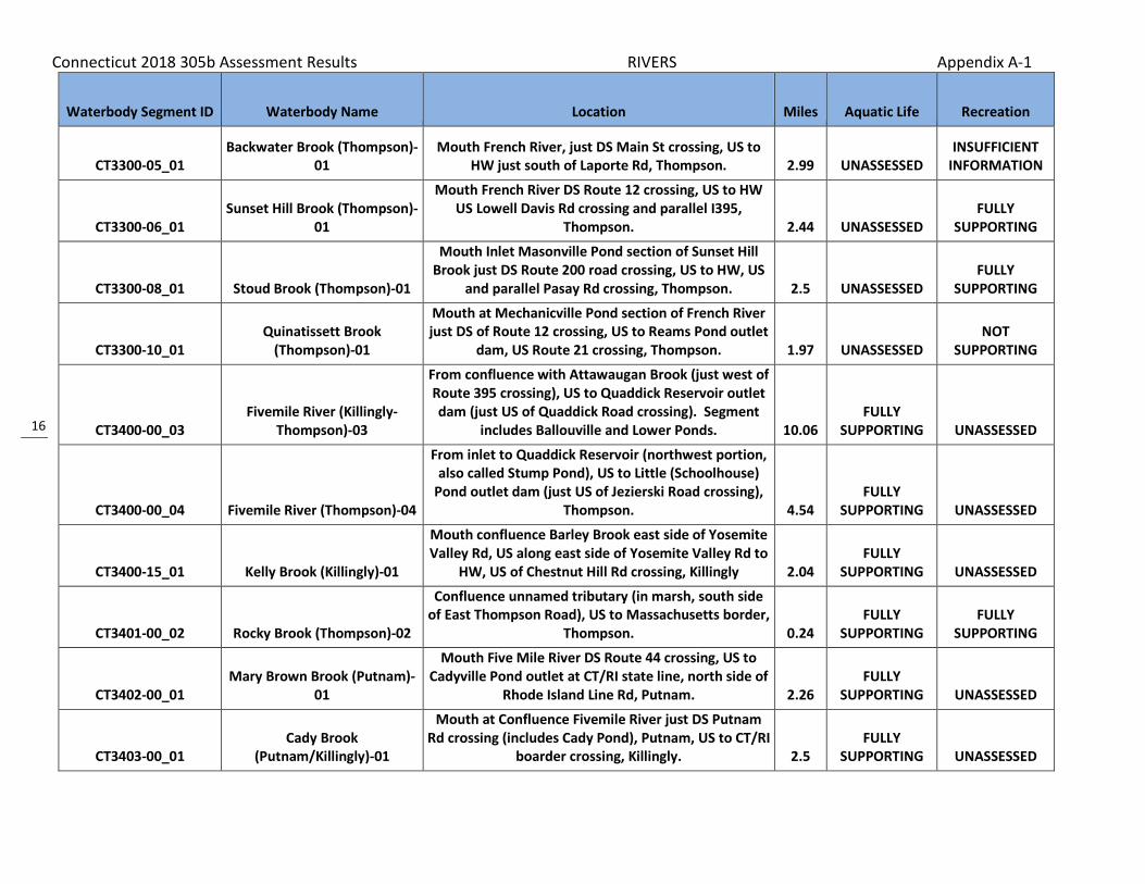
Connecticut 2018 305b Assessment Results RIVERS Appendix A-1
16
Waterbody Segment ID Waterbody Name Location Miles Aquatic Life Recreation
CT3300-05_01 Backwater Brook (Thompson)-
01 Mouth French River, just DS Main St crossing, US to
HW just south of Laporte Rd, Thompson. 2.99 UNASSESSED INSUFFICIENT
INFORMATION
CT3300-06_01 Sunset Hill Brook (Thompson)-
01
Mouth French River DS Route 12 crossing, US to HW US Lowell Davis Rd crossing and parallel I395,
Thompson. 2.44 UNASSESSED FULLY
SUPPORTING
CT3300-08_01 Stoud Brook (Thompson)-01
Mouth Inlet Masonville Pond section of Sunset Hill Brook just DS Route 200 road crossing, US to HW, US
and parallel Pasay Rd crossing, Thompson. 2.5 UNASSESSED FULLY
SUPPORTING
CT3300-10_01 Quinatissett Brook
(Thompson)-01
Mouth at Mechanicville Pond section of French River just DS of Route 12 crossing, US to Reams Pond outlet
dam, US Route 21 crossing, Thompson. 1.97 UNASSESSED NOT
SUPPORTING
CT3400-00_03 Fivemile River (Killingly-
Thompson)-03
From confluence with Attawaugan Brook (just west of Route 395 crossing), US to Quaddick Reservoir outlet dam (just US of Quaddick Road crossing). Segment
includes Ballouville and Lower Ponds. 10.06 FULLY
SUPPORTING UNASSESSED
CT3400-00_04 Fivemile River (Thompson)-04
From inlet to Quaddick Reservoir (northwest portion, also called Stump Pond), US to Little (Schoolhouse)
Pond outlet dam (just US of Jezierski Road crossing), Thompson. 4.54
FULLY SUPPORTING UNASSESSED
CT3400-15_01 Kelly Brook (Killingly)-01
Mouth confluence Barley Brook east side of Yosemite Valley Rd, US along east side of Yosemite Valley Rd to
HW, US of Chestnut Hill Rd crossing, Killingly 2.04 FULLY
SUPPORTING UNASSESSED
CT3401-00_02 Rocky Brook (Thompson)-02
Confluence unnamed tributary (in marsh, south side of East Thompson Road), US to Massachusetts border,
Thompson. 0.24 FULLY
SUPPORTING FULLY
SUPPORTING
CT3402-00_01 Mary Brown Brook (Putnam)-
01
Mouth Five Mile River DS Route 44 crossing, US to Cadyville Pond outlet at CT/RI state line, north side of
Rhode Island Line Rd, Putnam. 2.26 FULLY
SUPPORTING UNASSESSED
CT3403-00_01 Cady Brook
(Putnam/Killingly)-01
Mouth at Confluence Fivemile River just DS Putnam Rd crossing (includes Cady Pond), Putnam, US to CT/RI
boarder crossing, Killingly. 2.5 FULLY
SUPPORTING UNASSESSED

Connecticut 2018 305b Assessment Results RIVERS Appendix A-1
17
Waterbody Segment ID Waterbody Name Location Miles Aquatic Life Recreation
CT3403-05_01 Shady Oak Schoolhouse Brook
(Putnam/Killingly)-01
Mouth at confluence with Cady Brook US of Cady Brookk crossing Chase Road, Putnam, US to HW 0.75
miles US of Tucker District Road crossing, Killingly. 1.73 FULLY
SUPPORTING UNASSESSED
CT3404-00_01 Whetstone Brook-01 From mouth at confluence with Fivemile River, US to
Bog Meadow Reservoir outlet dam, Killingly. 4.64 FULLY
SUPPORTING UNASSESSED
CT3404-06_01 Slater Brook (Killingly)-01
Mouth at Mashentuck Brook, just DS of Burlingame Road crossing, US to HW , US of Bailey Hill Road
Crossing, Killingly. 2.6 FULLY
SUPPORTING UNASSESSED
CT3500-00_02 Moosup River-02
From POTW outfall (just DS from Black Hill Road crossing), Central Village, US to Brunswick Mill Dam #1(first impoundment in Almyville, parallel to Route
14), Plainfield. 4.01 FULLY
SUPPORTING UNASSESSED
CT3500-00_03 Moosup River-03
From Brunswick Mill Dam #1 (first impoundment in Almyville, parallel to Route 14), Plainfield, US to
Rhode Island border. 7.36 FULLY
SUPPORTING NOT
SUPPORTING
CT3501-00_01 Quanduck Brook-01
From mouth at confluence with Moosup River, US to Rhode Island border (parallel with Snake Meadow Hill
Road). 4.05 FULLY
SUPPORTING UNASSESSED
CT3502-00_01 Snake Meadow Brook (Plainfield/Killingly)-01
Mouth at Sterling Rd crossing (inlet to Rogers Lake), Plainfield, US to Tetreault Pond outlet, US Halls Hill Rd
crossing, Killingly. 5.08 FULLY
SUPPORTING UNASSESSED
CT3502-06_01 Wood Brook
(Plainfield/Sterling)-01 Mouth Snake Meadow Brook at Demers Rd crossing,
Plainfield, US to HW near Barber Rd, Sterling. 1.7 FULLY
SUPPORTING UNASSESSED
CT3503-00_01 Ekonk Brook-01
From mouth at confluence with Moosup River (DS of River Street crossing), US to headwaters at Lockes
Meadow Pond outlet dam, Plainfield. 4.5 FULLY
SUPPORTING NOT
SUPPORTING
CT3600-00-trib_01 Partridge Brook (Griswold)-01
Mouth at Hopeville Pond just DS Route 201 crossing, US to HW at unnamed pond on farm property,
Griswold. Enters Hopeville Pond in cove just US of state park beach. May locally be called Palmer Brook. 0.8
FULLY SUPPORTING UNASSESSED

Connecticut 2018 305b Assessment Results RIVERS Appendix A-1
18
Waterbody Segment ID Waterbody Name Location Miles Aquatic Life Recreation
CT3602-01_01 Lowden Brook (Voluntown)-
01
Mouth at confluence with Misery Brook DS of Trail 1 Road crossing near Stone Hill Road intersection (and
parallel to Trail 2 Rd), US to HW near Plainfield border, parallel to Route 49, on south side of Hell
Hollow Road, Voluntown. 3.4 FULLY
SUPPORTING UNASSESSED
CT3603-00_01 Denison Brook (Voluntown)-
01
Mouth on Beachdale Pond at US side of Route 165/138/49 crossing, US to HW (this brook runs
north) parallel to Route 49 near Gallup Farm Airport, Voluntown. 3.57
FULLY SUPPORTING UNASSESSED
CT3604-00_01
Myron Kinney Brook Voluntown/North
Stonington)-01
Mouth Glasgo Pond inlet (southeast side) at Voluntown/Griswold line, US to HW, parallel
Pendleton Hill Road (Route 49), North Stonington. 4.33 FULLY
SUPPORTING UNASSESSED
CT3604-01_01
Koistenen Brook (Voluntown/North
stonington)-01
Mouth confluence Myron Kinney Brook (0.6 miles DS Route 49 crossing), Voluntown, US to HW 1 mile US
Sand Hill Road crossing, North Stonington. 2 FULLY
SUPPORTING UNASSESSED
CT3700-00_01 Quinebaug River
(Lisbon/Griswold)-01
Mouth confluence Shetucket River, Lisbon/Norwich town border, US to Aspinook Pond outlet dam (US of
River Road (Route 12) crossing), Lisbon/Griswold border. 7.46
NOT SUPPORTING
FULLY SUPPORTING
CT3700-00_02 Quinebaug River (Canterbury)-02
Aspinook Pond INLET (at Butts Bridge Road crossing), US to confuence Mill Brook, Canterbury. 2.98 UNASSESSED
FULLY SUPPORTING
CT3700-00_03 Quinebaug River
(Canterbury/Plainfield)-03
Confluence Mill Brook, near Yaworski Landfill, US to confluence Moosup River (river forms town boundary
for Canterbury and Plainfield). 6.3 UNASSESSED FULLY
SUPPORTING
CT3700-00_04 Quinebaug River (Putnam)-04
Confluence Moosup River (river forms town boundary for Canterbury and Plainfield), US to Putnum POTW
(parallel to Kennedy Drive near I-395), Putnam. 17.61 NOT
SUPPORTING FULLY
SUPPORTING
CT3700-00_05 Quinebaug River
(Putnam/Thompson)-05
Just US of Putnam POTW (just DS of Railroad crossing), Putnam, US to confluence French River,
Thompson. 3.32 NOT
SUPPORTING NOT
SUPPORTING

Connecticut 2018 305b Assessment Results RIVERS Appendix A-1
19
Waterbody Segment ID Waterbody Name Location Miles Aquatic Life Recreation
CT3700-00_07 Quinebaug River (Thompson)-
07
INLET West Thompson Lake (Reservoir) just DS of Blain Road crossing, US to Massachusetts border (US
of Route 197 crossing), Thompson. 6.4 FULLY
SUPPORTING FULLY
SUPPORTING
CT3700-14_01 Culver Brook (Putnam)-01
Mouth at confluence Quinebaug River, just DS of I395 crossing, US to HW just US Pitkin Road crossing,
Putnam. 2.9 FULLY
SUPPORTING UNASSESSED
CT3700-17_01 Durkee Brook (Pomfret)-01
Mouth at confluence with Quinebaug River DS of River Road crossing, US to confluence with Bark
Meadow Brook, just US of Holmes Road crossing, Pomfret 1.72 UNASSESSED
NOT SUPPORTING
CT3700-31_01 Sugar Brook (Plainfield)-01
Mouth at Confluence Quinebaug River DS Sugar Brook Rd crossing, US to HW at unnamed pond US of Route
14 crossing, Plainfield. 2.09 FULLY
SUPPORTING UNASSESSED
CT3701-02_01 Browns Brook (MA/Union)-01
Mouth at Hamilton Reservoir in Massachusetts along Maybrook Road, US (flowing south into CT) to west of I84, through Sessions Meadow Marsh Dam to HW .8
mile above Bear Den Road crossing, Union, CT. 3.6 FULLY
SUPPORTING UNASSESSED
CT3701-03_01 May Brook (MA/Union)-01
Mouth at confluence with Browns Brook near Hamilton Reservoir in Massachusetts, US (flowing
south into CT) to west of I84, through unnamed pond near Pain Hill Road at CT border, to HW at unnamed
pond 1 mile US of Massey Drive road crossing, Union, CT. 2.2
FULLY SUPPORTING UNASSESSED
CT3705-00_01 Lebanon Brook (Woodstock)-
01
State border (MA) DS of Pole Bridge Rd crossing (Laurel Ridge on east side) US (moving south) to HW
at Griggs Pond outlet dam, just US of Route 198 crossing, Woodstock. 3.9
FULLY SUPPORTING UNASSESSED
CT3706-00_01 English Neighborhood Brook
(Woodstock)-01
Mouth at confluence Muddy Brook parallel along south side of Route 197, US to HW 2 miles US of
northern most English Neighborhood Road crossing, Woodstock. 4
FULLY SUPPORTING UNASSESSED
Connecticut 2018 305b Assessment Results RIVERS Appendix A-1
20
Waterbody Segment ID Waterbody Name Location Miles Aquatic Life Recreation
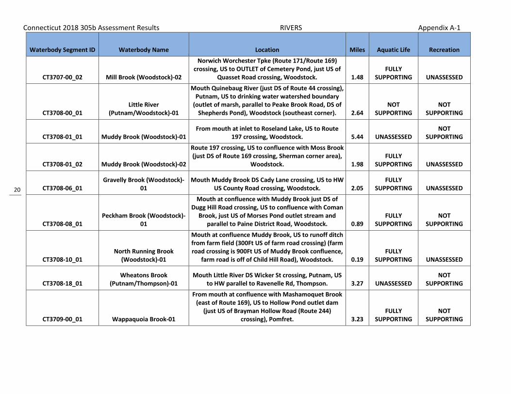
CT3707-00_02 Mill Brook (Woodstock)-02
Norwich Worchester Tpke (Route 171/Route 169) crossing, US to OUTLET of Cemetery Pond, just US of
Quasset Road crossing, Woodstock. 1.48 FULLY
SUPPORTING UNASSESSED
CT3708-00_01 Little River
(Putnam/Woodstock)-01
Mouth Quinebaug River (just DS of Route 44 crossing), Putnam, US to drinking water watershed boundary
(outlet of marsh, parallel to Peake Brook Road, DS of Shepherds Pond), Woodstock (southeast corner). 2.64
NOT SUPPORTING
NOT SUPPORTING
CT3708-01_01 Muddy Brook (Woodstock)-01 From mouth at inlet to Roseland Lake, US to Route
197 crossing, Woodstock. 5.44 UNASSESSED NOT
SUPPORTING
CT3708-01_02 Muddy Brook (Woodstock)-02
Route 197 crossing, US to confluence with Moss Brook (just DS of Route 169 crossing, Sherman corner area),
Woodstock. 1.98 FULLY
SUPPORTING UNASSESSED
CT3708-06_01 Gravelly Brook (Woodstock)-
01 Mouth Muddy Brook DS Cady Lane crossing, US to HW
US County Road crossing, Woodstock. 2.05 FULLY
SUPPORTING UNASSESSED
CT3708-08_01 Peckham Brook (Woodstock)-
01
Mouth at confluence with Muddy Brook just DS of Dugg Hill Road crossing, US to confluence with Coman
Brook, just US of Morses Pond outlet stream and parallel to Paine District Road, Woodstock. 0.89
FULLY SUPPORTING
NOT SUPPORTING
CT3708-10_01 North Running Brook
(Woodstock)-01
Mouth at confluence Muddy Brook, US to runoff ditch from farm field (300Ft US of farm road crossing) (farm road crossing is 900Ft US of Muddy Brook confluence,
farm road is off of Child Hill Road), Woodstock. 0.19 FULLY
SUPPORTING UNASSESSED
CT3708-18_01 Wheatons Brook
(Putnam/Thompson)-01 Mouth Little River DS Wicker St crossing, Putnam, US
to HW parallel to Ravenelle Rd, Thompson. 3.27 UNASSESSED NOT
SUPPORTING
CT3709-00_01 Wappaquoia Brook-01
From mouth at confluence with Mashamoquet Brook (east of Route 169), US to Hollow Pond outlet dam
(just US of Brayman Hollow Road (Route 244) crossing), Pomfret. 3.23
FULLY SUPPORTING
NOT SUPPORTING

Connecticut 2018 305b Assessment Results RIVERS Appendix A-1
21
Waterbody Segment ID Waterbody Name Location Miles Aquatic Life Recreation
CT3709-02_01 Day Brook (Pomfret)-01
Mouth at confluence with Mashamoquet Brook, east side of Route 169 (accross field to wooded area)
about .23 miles south of Day Road intersection, US to confluence with unnamed tributary (near power line cut through), just south of Grosvenor Road, Pomfret. 1.57 UNASSESSED
NOT SUPPORTING
CT3710-00_01 Mashamoquet Brook-01
From mouth at confluence with Quinebaug River (parallel to Route 101 on north side), US to confluence
with Wolf Den Brook (US of Route 101 crossing), Pomfret. 3.06
FULLY SUPPORTING
NOT SUPPORTING
CT3710-00_02 Mashamoquet Brook
(Pomfret)-02
Confluence Wolf Den Brook (just US Route 101 crossing), US to Taft Pond outlet dam (US Taft Pond
Road crossing), Pomfret. Includes diversion to swimming pond in Mashamoquet State Park. 4.36
FULLY SUPPORTING
NOT SUPPORTING
CT3710-01_01 Cemetery Brook (Pomfret)-01
Mouth confluence Nightingale Brook (near Taft Pond Road crossing), US to HW in marsh (US Chase Hill
Road crossing), Pomfret. 1.14 UNASSESSED FULLY
SUPPORTING
CT3710-02_01 Angel Brook
(Pomfret/Woodstock)-01
Mouth INLET to Nightingale Pond .7 mile DS Johnson Road crossing, Pomfret, US to HW, US Tyott Road
crossing, Woodstock. 1.44 UNASSESSED FULLY
SUPPORTING
CT3710-05_01 Nightingale Brook (Pomfret)-
01
Mouth confluence Cemetery Brook, above Mashamoquet Brook, just US Taft Pond Road
crossing, US to Nightingale Pond OUTLET, just US Route 244 crossing, Pomfret. 1.48 UNASSESSED
FULLY SUPPORTING
CT3710-07_01 Lyon Brook (Promfret)-01
Mouth confluence Mashamoquet Brook (above Taft Pond) US to OUTLET Eddies Pond No 2, entire
segment parallel to Taft Pond Road on south side (Cemetery Brook on north side), Pomfret. 0.36 UNASSESSED
FULLY SUPPORTING
CT3710-08_01
unnamed Tributary to Mashamoquet Brook
(Pomfret)-01
Mouth at confluence with Mashamoquet Brook, on west side and parallel to North Road (aka. Holbrook
Road) just north of intersection with Route 97 (another unnamed trib enters from east), US to
OUTLET of Abbotts Dam, Pomfret. 0.71 UNASSESSED FULLY
SUPPORTING

Connecticut 2018 305b Assessment Results RIVERS Appendix A-1
22
Waterbody Segment ID Waterbody Name Location Miles Aquatic Life Recreation
CT3710-11_01 Abington Brook (Pomfret)-01
Mouth at confluence with Mashamoquet Brook, between Route 97 and Mashamoquet Brook crossing
of Covell Road, US to confluence with unnamed tributary, just US of 2nd Route 44 crossing (DS of
Abington Pond), Pomfret. 1.75 UNASSESSED NOT
SUPPORTING
CT3710-13_01 Sap Tree Run (Pomfret)-01
Mouth at confluence with Mashamoquet Brook, just US of Wolf Den Road crossing, US past Route 44
crossing to HW in wooded area east of Blossom Drive, Pomfret. 1.09 UNASSESSED
NOT SUPPORTING
CT3710-18_01 White Brook
(Pomfret/Brooklyn)-01
Mouth at confluence with Mashamoquet Brook just DS of Route 101 crossing (close to confluence with Quinebaug River), Pomfret, US to confluence with unnamed tributary just US of Darby Road crossing,
Brooklyn. 3.07 UNASSESSED NOT
SUPPORTING
CT3711-00_01 Blackwell Brook-01
From mouth at confluence with Quinebaug River in northeast corner of Canterbury, US to headwaters at
small pond just US of Fay Road crossing, Pomfret. 13.82 FULLY
SUPPORTING UNASSESSED
CT3712-00_02 Fry Brook (Plainfield)-02
Just US side of I395 crossing, US to HW US Route 14a crossing, then US confluence Kennedy Brook (continues parallel to east along Route 14a),
Plainfield. 1.15 FULLY
SUPPORTING UNASSESSED
CT3713-00_01 Mill Brook (Plainfield)-01
From mouth at confluence with Quinebaug River (DS of Weston Road crossing), Canterbury, US to RailRoad
crossing, Plainfield. 1.99 FULLY
SUPPORTING UNASSESSED
CT3713-00_02 Mill Brook (Plainfield)-02
From RailRoad crossing (DS of Route 12 crossing), Plainfield, US to headwaters in large wetland area,
north of Rhode Road (east of I395), Griswold. 3.1 FULLY
SUPPORTING UNASSESSED
CT3713-03_01 Lathrop Brook (Plainfield)-01
Mouth Mill Brook just DS I395 crossing, US to HW, US Colbridge Road crossing and parallel to Davis Road,
Plainfield. 3.44 FULLY
SUPPORTING UNASSESSED

Connecticut 2018 305b Assessment Results RIVERS Appendix A-1
23
Waterbody Segment ID Waterbody Name Location Miles Aquatic Life Recreation
CT3715-00_01 Cory Brook (Canterbury)-01
Mouth Aspinook Pond portion Quinebaug River DS RR crossing and near Depot Rd, US (includes Burr Smith
Pond and Potter Pond) to HW US Water Street crossing, Canterbury. 6.2
FULLY SUPPORTING UNASSESSED
CT3716-00_01 Broad Brook (Preston)-01
Mouth at confluence Quinnebaug River (DS of Old Jewett City Road crossing), at the
Preston/Lisbon/Griswold borders, US to Lewis Pond outlet dam (north side of Route 165, near intersection
with Lewis Road), Preston. 4.73 FULLY
SUPPORTING NOT
SUPPORTING
CT3716-00_02 Miller Brook (Preston/North
Stonington)-02
Mouth above Broad Brook Lewis Pond OUTLET (includes Lewis Pond), north side of Route 165,
Preston, US to HW, US Miller Rd crossing (includes Shaws Pond), North Stonington. NOTE: Seg1=Broad
Brook 5.22 FULLY
SUPPORTING UNASSESSED
CT3800-00_01 Shetucket River (Norwich)-01 Route 2 crossing, US to Greenville dam, Norwich (tidal
affected waters). 1.56 UNASSESSED NOT
SUPPORTING
CT3800-00_02 Shetucket River-02
From Greenville Dam, Norwich, US through Greenville Dam impoundment, Taftville Pond, and Occum Pond
to Sprague (Baltic) WPCF, Sprague. 6.09 UNASSESSED FULLY
SUPPORTING
CT3800-00_03 Shetucket River-03
From Sprague WPCF (near head of Occum Pond), US to confluence with Merrick Brook at
Sprague/Scotland town line (DS of Scotland Dam). 4.7 FULLY
SUPPORTING FULLY
SUPPORTING
CT3800-00_05 Shetucket River (Windham)-
05
Confluence Cold Brook (DS Franklin Mushroom Farm STP from unnamed tributary), US to HW confluence
Natchaug River and Willimantic River, Windham. 4.99 FULLY
SUPPORTING FULLY
SUPPORTING
CT3800-02_01 Obwebetuck Brook
(Windham)-01
Mouth at confluence with Shetucket River just DS of Route 32 and RailRoad crossing, US to confluence
with Jordan Brook, US of Windham Road crossing and parallel to Bush Hill Road, Windham. 0.55 UNASSESSED
NOT SUPPORTING
CT3800-10_01 Waldo Brook
(Sprague/Scotland)-01 Mouth confluence Shetucket River in Mohegan State
Forest, Sprague, US to HW parallel Route 97, Scotland. 1.86 FULLY
SUPPORTING UNASSESSED

Connecticut 2018 305b Assessment Results RIVERS Appendix A-1
24
Waterbody Segment ID Waterbody Name Location Miles Aquatic Life Recreation
CT3801-01_01 Ballymahack Brook
(Windham)-01
mouth at INLET to Marie Lake on Joshuas Trust property (near dirt road off Back Rd just south of Sundale Drive intersection), US to HW just US of
Beaver Hill Road crossing (near Nutmeg Lane intersection), Windham. 1.92
FULLY SUPPORTING UNASSESSED
CT3802-00_01 Beaver Brook (Scotland)-01
From mouth at confluence with Merrick Brook (just DS of Bass Road), US to Route 14 (Huntington Road)
crossing, Scotland. 1.38 FULLY
SUPPORTING UNASSESSED
CT3802-01_01 Unnamed Tributary to Beaver
Brook (Scotland)-01 Mouth on Beaver Brook, just US of Route 14, US to
WH parallel to Ziegler Road, Scotland. 3.93 FULLY
SUPPORTING UNASSESSED
CT3803-00_01
Merrick Brook (Scotland/Hampton/Chaplin)-
01
Mouth at confluence Shetucket River just DS of Station Road and RR crossing, Scotland, US through
Hampton to HW just US of Goshen Road crossing and parallel to Cedar Swamp Rd, Chaplin. 12
FULLY SUPPORTING UNASSESSED
CT3805-00_02 Little River (Sprague)-02 Inlet Versailles Pond (northwest corner of pond), US
to Papermill Pond outlet dam, Sprague. 0.89 NOT
SUPPORTING FULLY
SUPPORTING
CT3805-00_03 Little River (Sprague)-03
Inlet to Paper Mill Pond, Sprague, US to HW at Hampton Reservoir outlet dam (just US of Kenyon
Road crossong), Hampton. 1.79 FULLY
SUPPORTING UNASSESSED
CT3805-00_04
Little River (Canterbury/Scotland/Hampt
on)-04
From Hanover Reservoir inlet, Canterbury, US to headwaters at Hampton Reservoir outlet dam (just US
of Kenyon Road crossong), Hampton. 16.02 FULLY
SUPPORTING UNASSESSED
CT3805-04_02 Murphy Brook (Hampton)-02
From inlet to small pool (just DS of Robbins Street crossing), US to confluence with unnamed perennial
tributary (just DS of Sarah Pearl Road crossing), Hampton. 0.46
FULLY SUPPORTING UNASSESSED
CT3805-06_01 Cedar Swamp Brook
(Hampton)-01
Mouth at Confluence Little River DS Bigelow Rd crossing, US to HW at Pine Acres Lake Outlet, US of
Route 6 crossing, Hampton. 2.37 FULLY
SUPPORTING UNASSESSED
Connecticut 2018 305b Assessment Results RIVERS Appendix A-1
25
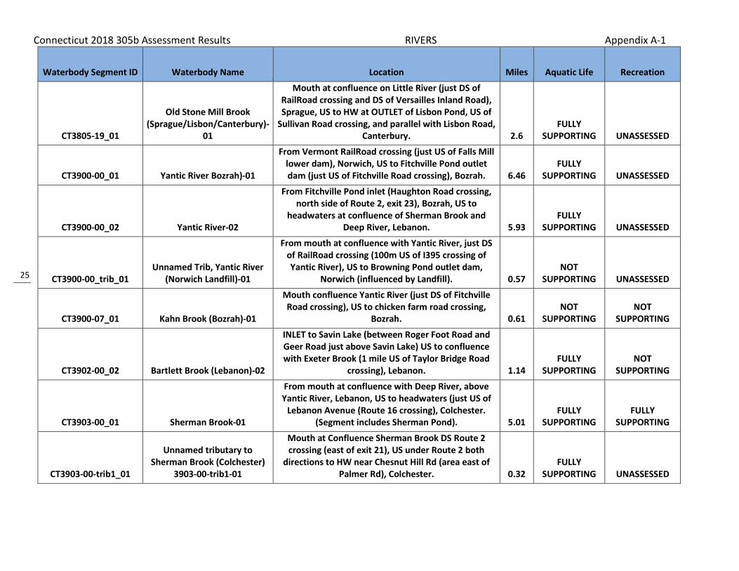
Waterbody Segment ID Waterbody Name Location Miles Aquatic Life Recreation
CT3805-19_01
Old Stone Mill Brook (Sprague/Lisbon/Canterbury)-
01
Mouth at confluence on Little River (just DS of RailRoad crossing and DS of Versailles Inland Road), Sprague, US to HW at OUTLET of Lisbon Pond, US of
Sullivan Road crossing, and parallel with Lisbon Road, Canterbury. 2.6
FULLY SUPPORTING UNASSESSED
CT3900-00_01 Yantic River Bozrah)-01
From Vermont RailRoad crossing (just US of Falls Mill lower dam), Norwich, US to Fitchville Pond outlet dam (just US of Fitchville Road crossing), Bozrah. 6.46
FULLY SUPPORTING UNASSESSED
CT3900-00_02 Yantic River-02
From Fitchville Pond inlet (Haughton Road crossing, north side of Route 2, exit 23), Bozrah, US to
headwaters at confluence of Sherman Brook and Deep River, Lebanon. 5.93
FULLY SUPPORTING UNASSESSED
CT3900-00_trib_01 Unnamed Trib, Yantic River
(Norwich Landfill)-01
From mouth at confluence with Yantic River, just DS of RailRoad crossing (100m US of I395 crossing of Yantic River), US to Browning Pond outlet dam,
Norwich (influenced by Landfill). 0.57 NOT
SUPPORTING UNASSESSED
CT3900-07_01 Kahn Brook (Bozrah)-01
Mouth confluence Yantic River (just DS of Fitchville Road crossing), US to chicken farm road crossing,
Bozrah. 0.61 NOT
SUPPORTING NOT
SUPPORTING
CT3902-00_02 Bartlett Brook (Lebanon)-02
INLET to Savin Lake (between Roger Foot Road and Geer Road just above Savin Lake) US to confluence with Exeter Brook (1 mile US of Taylor Bridge Road
crossing), Lebanon. 1.14 FULLY
SUPPORTING NOT
SUPPORTING
CT3903-00_01 Sherman Brook-01
From mouth at confluence with Deep River, above Yantic River, Lebanon, US to headwaters (just US of
Lebanon Avenue (Route 16 crossing), Colchester. (Segment includes Sherman Pond). 5.01
FULLY SUPPORTING
FULLY SUPPORTING
CT3903-00-trib1_01
Unnamed tributary to Sherman Brook (Colchester)
3903-00-trib1-01
Mouth at Confluence Sherman Brook DS Route 2 crossing (east of exit 21), US under Route 2 both
directions to HW near Chesnut Hill Rd (area east of Palmer Rd), Colchester. 0.32
FULLY SUPPORTING UNASSESSED

Connecticut 2018 305b Assessment Results RIVERS Appendix A-1
26
Waterbody Segment ID Waterbody Name Location Miles Aquatic Life Recreation
CT3903-00-trib2_01
Unnamed tributary to Sherman Brook (Colchester)
3903-00-trib2-01
Mouth at Confluence Sherman Brook DS Route 2 crossing (runs under both Exit 21 ramps from Norwich Ave crossing) at top of Sherman Pond inlet, US under Route 2 both directions to HW near Chesnut Hill Rd (area east of Route 2 exit 21 from Chesnut Hill Rd), 0.89
FULLY SUPPORTING UNASSESSED
CT3903-03_01
Unnamed tributary to Sherman Brook (Colchester)
3903-03-01
Mouth at Confluence Sherman Brook DS Route 2 crossing (east of exit 21), US under Route 2 both directions to HW above Chesnut Hill Rd and US
Kramer Rd crossing (near Route 354), Colchester. 1.37 FULLY
SUPPORTING UNASSESSED
CT3905-00_01a
Pease Brook (Bozrah/Franklin/Lebanon)-
01a
From mouth at confluence with Yantic River, Bozrah, US to the US side of Goshen Hill Road crossing (near
Smith Road intersection), Lebanon 4.4 FULLY
SUPPORTING NOT
SUPPORTING
CT3905-00_01b Pease Brook (Lebanon)-01b
From the US side of Goshen Hill Road crossing (near Smith Road intersection), Lebanon US to headwaters
(just US of Burnham Road crossing, Lebanon 5.23 FULLY
SUPPORTING UNASSESSED
CT3906-00_01 Gardner Brook-01
From mouth at confluence with Yantic River (inlet to Fitchville Pond, southeast side parallell to Route 163), US to Gardner Lake outlet dam (just US of Lake Road
crossing), Bozrah. 4.84 FULLY
SUPPORTING UNASSESSED
CT3907-00_01 Susquetonscut Brook-01
From mouth at confluence with Yantic River, bozrah/Norwich town border (just DS of RailRoad
crossing), US to headwaters (just US of Bender Road crossing, along south side of Beaumont Highway and
Rafferty Road intersection, Lebanon. 13.55 FULLY
SUPPORTING NOT
SUPPORTING
CT4000-00_01 Connecticut River-01
From head of estuary at Chapman Pond outlet, East Haddam, US to northern most boundary of Hurd State
Park, East Hampton. 10.27 UNASSESSED NOT
SUPPORTING
CT4000-00_02 Connecticut River-02
From northern most boundary of Hurd State Park, East Hampton, US to confluence with Reservoir Brook
(adjacent to Gildersleeve Island), Portland. 10.49 UNASSESSED NOT
SUPPORTING
CT4000-00_03 Connecticut River
(Portland/Suffield)-03 Reservoir Brook confluence (adjacent to Gildersleeve
Island), Portland, US to Suffield, MA border. 35.26 UNASSESSED NOT
SUPPORTING
Connecticut 2018 305b Assessment Results RIVERS Appendix A-1
27
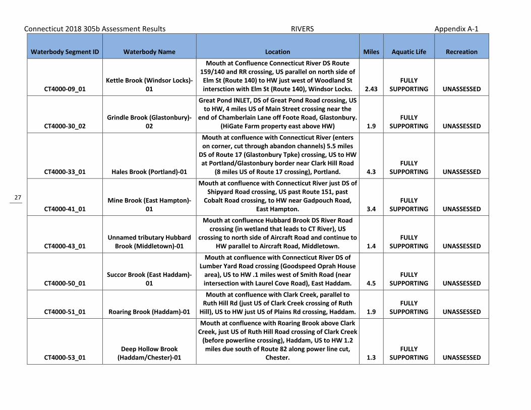
Waterbody Segment ID Waterbody Name Location Miles Aquatic Life Recreation
CT4000-09_01 Kettle Brook (Windsor Locks)-
01
Mouth at Confluence Connecticut River DS Route 159/140 and RR crossing, US parallel on north side of Elm St (Route 140) to HW just west of Woodland St intersction with Elm St (Route 140), Windsor Locks. 2.43
FULLY SUPPORTING UNASSESSED
CT4000-30_02 Grindle Brook (Glastonbury)-
02
Great Pond INLET, DS of Great Pond Road crossing, US to HW, 4 miles US of Main Street crossing near the
end of Chamberlain Lane off Foote Road, Glastonbury. (HiGate Farm property east above HW) 1.9
FULLY SUPPORTING UNASSESSED
CT4000-33_01 Hales Brook (Portland)-01
Mouth at confluence with Connecticut River (enters on corner, cut through abandon channels) 5.5 miles
DS of Route 17 (Glastonbury Tpke) crossing, US to HW at Portland/Glastonbury border near Clark Hill Road
(8 miles US of Route 17 crossing), Portland. 4.3 FULLY
SUPPORTING UNASSESSED
CT4000-41_01 Mine Brook (East Hampton)-
01
Mouth at confluence with Connecticut River just DS of Shipyard Road crossing, US past Route 151, past
Cobalt Road crossing, to HW near Gadpouch Road, East Hampton. 3.4
FULLY SUPPORTING UNASSESSED
CT4000-43_01 Unnamed tributary Hubbard
Brook (Middletown)-01
Mouth at confluence Hubbard Brook DS River Road crossing (in wetland that leads to CT River), US
crossing to north side of Aircraft Road and continue to HW parallel to Aircraft Road, Middletown. 1.4
FULLY SUPPORTING UNASSESSED
CT4000-50_01 Succor Brook (East Haddam)-
01
Mouth at confluence with Connecticut River DS of Lumber Yard Road crossing (Goodspeed Oprah House
area), US to HW .1 miles west of Smith Road (near intersection with Laurel Cove Road), East Haddam. 4.5
FULLY SUPPORTING UNASSESSED
CT4000-51_01 Roaring Brook (Haddam)-01
Mouth at confluence with Clark Creek, parallel to Ruth Hill Rd (just US of Clark Creek crossing of Ruth
Hill), US to HW just US of Plains Rd crossing, Haddam. 1.9 FULLY
SUPPORTING UNASSESSED
CT4000-53_01 Deep Hollow Brook
(Haddam/Chester)-01
Mouth at confluence with Roaring Brook above Clark Creek, just US of Ruth Hill Road crossing of Clark Creek
(before powerline crossing), Haddam, US to HW 1.2 miles due south of Route 82 along power line cut,
Chester. 1.3 FULLY
SUPPORTING UNASSESSED

Connecticut 2018 305b Assessment Results RIVERS Appendix A-1
28
Waterbody Segment ID Waterbody Name Location Miles Aquatic Life Recreation
CT4000-54_02 Clark Creek (Haddam)-02
From falls near Route 154 crossing, US to headwaters at confluence of Roaring and Deep Hollow Brooks,
Haddam 0.46 FULLY
SUPPORTING UNASSESSED
CT4004-02_01 Farm Brook (South Windsor)-
01
Mouth at Confluence Plum Gulley Brook DS Winterberry Ln crossing and Petersen Pond (also
below unnamed tributary confluence) running parallel to Route 30, US under Route 30 to HW above Krawski Pond near Tallwood Dr (segment includes both small
ponds), Sou 1.61 NOT
SUPPORTING UNASSESSED
CT4006-00_01 Salmon Brook-01
(Glastonbury)
From mouth on Keeney Cove (Connecticut River, near Naubuc Avenue), Glastonbury, US to Addison Pond
outlet, Glastonbury. 3.07 FULLY
SUPPORTING UNASSESSED
CT4006-00_02 Salmon Brook-02
(Glastonbury)
From Addison Pond outlet, US to headwaters at Manchester Country Club Pond Dam, Glastonbury
(includes Addison Pond). 4.33 FULLY
SUPPORTING UNASSESSED
CT4008-03_01 Mott Hill Brook (Glastonbury)-
01
Mouth at confluence with Dark Hollow Brook, above Cold Brook, US to first Mott Hill Road crossing,
Glastonbury. 0.56 FULLY
SUPPORTING UNASSESSED
CT4009-00_01 Roaring Brook (Glastonbury)-
01 From mouth at Connecticut River US to Angus Park
Pond dam at outlet (Angus Park Pond NOT included). 6.73 FULLY
SUPPORTING FULLY
SUPPORTING
CT4009-00_02 Roaring Brook (Glastonbury)-
02
Angus Park Pond inlet, East Glastonbury, US to Buckingham Reservoir outlet Dam US of Route 49
crossing (Buckingham Reservoir NOT included), Glastonbury. 2.79
FULLY SUPPORTING UNASSESSED
CT4009-05_01 Wintergreen Brook
(Glastonbury)-01
Mouth at confluence Roaring Brook US of Roaring Brook Route 83 crossing and between Forest Lane and Staples Lane, US to HW 2.2 miles US of Roaring River confluence in Meshomasic State Forest, Glastonbury. 2.4
FULLY SUPPORTING UNASSESSED
CT4011-00_01 Reservoir Brook (Portland)-01
Mouth on Connecticut River, DS Route 17 crossing, US to Portland Reservoir outlet, parallel to Old
Marlborough Turnpike, Portland. 2.81 FULLY
SUPPORTING UNASSESSED
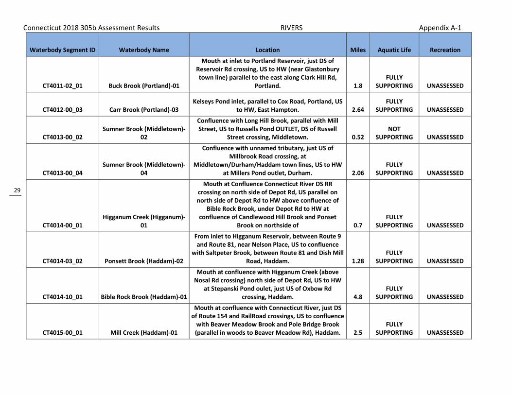
Connecticut 2018 305b Assessment Results RIVERS Appendix A-1
29
Waterbody Segment ID Waterbody Name Location Miles Aquatic Life Recreation
CT4011-02_01 Buck Brook (Portland)-01
Mouth at inlet to Portland Reservoir, just DS of Reservoir Rd crossing, US to HW (near Glastonbury town line) parallel to the east along Clark Hill Rd,
Portland. 1.8 FULLY
SUPPORTING UNASSESSED
CT4012-00_03 Carr Brook (Portland)-03 Kelseys Pond inlet, parallel to Cox Road, Portland, US
to HW, East Hampton. 2.64 FULLY
SUPPORTING UNASSESSED
CT4013-00_02 Sumner Brook (Middletown)-
02
Confluence with Long Hill Brook, parallel with Mill Street, US to Russells Pond OUTLET, DS of Russell
Street crossing, Middletown. 0.52 NOT
SUPPORTING UNASSESSED
CT4013-00_04 Sumner Brook (Middletown)-
04
Confluence with unnamed tributary, just US of Millbrook Road crossing, at
Middletown/Durham/Haddam town lines, US to HW at Millers Pond outlet, Durham. 2.06
FULLY SUPPORTING UNASSESSED
CT4014-00_01 Higganum Creek (Higganum)-
01
Mouth at Confluence Connecticut River DS RR crossing on north side of Depot Rd, US parallel on north side of Depot Rd to HW above confluence of
Bible Rock Brook, under Depot Rd to HW at confluence of Candlewood Hill Brook and Ponset
Brook on northside of 0.7 FULLY
SUPPORTING UNASSESSED
CT4014-03_02 Ponsett Brook (Haddam)-02
From inlet to Higganum Reservoir, between Route 9 and Route 81, near Nelson Place, US to confluence
with Saltpeter Brook, between Route 81 and Dish Mill Road, Haddam. 1.28
FULLY SUPPORTING UNASSESSED
CT4014-10_01 Bible Rock Brook (Haddam)-01
Mouth at confluence with Higganum Creek (above Nosal Rd crossing) north side of Depot Rd, US to HW
at Stepanski Pond oulet, just US of Oxbow Rd crossing, Haddam. 4.8
FULLY SUPPORTING UNASSESSED
CT4015-00_01 Mill Creek (Haddam)-01
Mouth at confluence with Connecticut River, just DS of Route 154 and RailRoad crossings, US to confluence
with Beaver Meadow Brook and Pole Bridge Brook (parallel in woods to Beaver Meadow Rd), Haddam. 2.5
FULLY SUPPORTING UNASSESSED
Connecticut 2018 305b Assessment Results RIVERS Appendix A-1
30
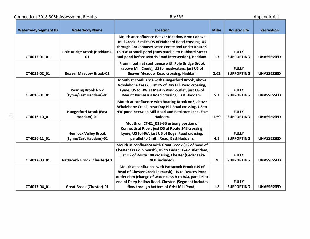
Waterbody Segment ID Waterbody Name Location Miles Aquatic Life Recreation
CT4015-01_01 Pole Bridge Brook (Haddam)-
01
Mouth at confluence Beaver Meadow Brook above Mill Creek .3 miles DS of Hubbard Road crossing, US
through Cockaponset State Forest and under Route 9 to HW at small pond (runs parallel to Hubbard Street and pond before Morris Road intersection), Haddam. 1.3
FULLY SUPPORTING UNASSESSED
CT4015-02_01 Beaver Meadow Brook-01
From mouth at confluence with Pole Bridge Brook (above Mill Creek), US to headwaters, just US of
Beaver Meadow Road crossing, Haddam 2.62 FULLY
SUPPORTING UNASSESSED
CT4016-01_01 Roaring Brook No 2
(Lyme/East Haddam)-01
Mouth at confluence with Hungerford Brook, above Whalebone Creek, just DS of Day Hill Road crossing,
Lyme, US to HW at Martin Pond outlet, just US of Mount Parnassus Road crossing, East Haddam. 5.2
FULLY SUPPORTING UNASSESSED
CT4016-10_01 Hungerford Brook (East
Haddam)-01
Mouth at confluence with Roaring Brook no2, above Whalebone Creek, near Day Hill Road crossing, US to HW pond between Mill Road and Petticoat Lane, East
Haddam. 1.59 FULLY
SUPPORTING UNASSESSED
CT4016-11_01 Hemlock Valley Brook
(Lyme/East Haddam)-01
Mouth on CT-E1_031-SB estuary portion of Connecticut River, just DS of Route 148 crossing, Lyme, US to HW, just US of Bogel Road crossing,
parallel to Smith Road, East Haddam. 4.9 FULLY
SUPPORTING UNASSESSED
CT4017-03_01 Pattaconk Brook (Chester)-01
Mouth at confluence with Great Brook (US of head of Chester Creek in marsh), US to Cedar Lake outlet dam,
just US of Route 148 crossing, Chester (Cedar Lake NOT included). 4
FULLY SUPPORTING UNASSESSED
CT4017-04_01 Great Brook (Chester)-01
Mouth at confluence with Pattaconk Brook (US of head of Chester Creek in marsh), US to Deuces Pond
outlet dam (change of water class A to AA), parallel at end of Deep Hollow Road, Chester. (Segment includes
flow through bottom of Grist Mill Pond). 1.8 FULLY
SUPPORTING UNASSESSED

Connecticut 2018 305b Assessment Results RIVERS Appendix A-1
31
Waterbody Segment ID Waterbody Name Location Miles Aquatic Life Recreation
CT4019-00_01 Falls River-01
From Falls River Pond oulet dam (separation of Connecticut River saltwater influence), Essex, US to
dam at Tower Hill Lake outlet, Deep River (NOTincluding Messerschmidts or Wrights Ponds,
both treated as separate waterbodies). 8.12 FULLY
SUPPORTING UNASSESSED
CT4100-00_01 Stony Brook (Suffield)-01
Mouth at OUTLET on canal parallel to Connecticut River, US to confluence with Muddy Brook at railroad
crossing, Suffield. 3.47 NOT
SUPPORTING UNASSESSED
CT4100-00_03 Stony Brook (Suffield)-03
From confluence with DeGrayes Brook (just northwest of airport), US to headwaters (the confluence of
Rocky Gutter Brook and Rattlesnake Brook), Suffield. 4.27 NOT
SUPPORTING UNASSESSED
CT4101-00_01 Muddy Brook (Suffield)-01 From mouth at Stony Brook, Suffield, US to
confluence with Philo Brook. 2.23 NOT
SUPPORTING NOT
SUPPORTING
CT4101-00_02 Muddy Brook (Suffield)-02 From confluence with Philo Brook US to headwaters
(confluence of Still Brook and Spears Brook). 7.45 FULLY
SUPPORTING UNASSESSED
CT4200-00_01 Scantic River-01 From mouth at Connecticut River, US to confluence
with Broad Brook, East Windsor. 9.38 NOT
SUPPORTING NOT
SUPPORTING
CT4200-00_02 Scantic River-02
From confluence with Broad Brook, East Windsor, US to Somersville Pond outlet, Somers (passes Somers
WPCF at upper end below lake). 13.56 FULLY
SUPPORTING NOT
SUPPORTING
CT4200-00_03 Scantic River-03 From Somersville Pond inlet, Somers, US to MA
border. 6.05 UNASSESSED NOT
SUPPORTING
CT4200-15_01 Thrasher Brook (Somers)-01
Mouth at confluence with Scantic River .25 miles DS of unnamed road crossing that extends from end of Northwest Drive, US to confluence with unnamed
tributary .28 miles US of Route 83 crossing, Somers. 1.52 UNASSESSED NOT
SUPPORTING
CT4200-28_01 Dry Brook (South
Windsor/East Windsor)-01
Mouth at confluence with Scantic River .76 miles DS of Rye Street crossing (near intersection with Troy
Road), South Windsor, US to HW US of Griffin Road crossing near Vintage Road, South Windsor. 4.7 UNASSESSED
NOT SUPPORTING

Connecticut 2018 305b Assessment Results RIVERS Appendix A-1
32
Waterbody Segment ID Waterbody Name Location Miles Aquatic Life Recreation
CT4201-00_01 Watchaug Brook (Somers)-01
From mouth at confluence with Scantic River (DS of Watchaug Road crossing), US to CT/MA state border,
Somers. 2.1 UNASSESSED FULLY
SUPPORTING
CT4202-00_01 Gillettes Brook (Somers)-01
Mouth at confluence with Scantic River .2 miles DS of Durkee Road crossing, US to confluence with
unnamed tributary just US of Route 83 crossing, Somers. 0.41 UNASSESSED
NOT SUPPORTING
CT4202-00_02 Gillettes Brook (Somers)-02
Confluence with unnamed tributary just US of Route 83 crossing, US to confluence with unnamed stream
that outlets Worthington Pond, along Mountain Road, just DE from intersection with Broadway Road,
Somers. 3.69 UNASSESSED FULLY
SUPPORTING
CT4203-00_01 Gulf Stream (Somers)-01 Mouth at Scantic River, US to Shady Lake outlet, just
US of Route 83 crossing, Somers. 1.88 UNASSESSED NOT
SUPPORTING
CT4203-00_02 Gulf Stream (Somers)-02
Shady Lake outlet, just US of Route 83 crossing, US to confluence with Lievre Brook, just US of Gulf Road
crossing, Somers. 1.3 FULLY
SUPPORTING FULLY
SUPPORTING
CT4204-00_01 Abbey Brook (Somers)-01
Mouth at INLET to Somersville Pond 1 mile DS of Billings Road crossing, near Harness Road, US to
confluence with unnamed tributary .5 miles US of Billings Road crossing, Somers. 1.63 UNASSESSED
NOT SUPPORTING
CT4205-00_01 Buckhorn Brook (Enfield)-01
From mouth at confluence with Scantic River, US to marsh (US of Town Farm Road crossing) near inlet
from Tobacco Pond No 2, Enfield. 2.02 UNASSESSED NOT
SUPPORTING
CT4206-00_01 Broad Brook (East Windsor)-
01
Mouth Scantic River, US to Broad Brook Mill Pond outlet dam just US Main Street (Route 191) crossing,
East Windsor. 1.01 NOT
SUPPORTING FULLY
SUPPORTING
CT4206-00_02 Broad Brook (East Windsor-
Ellington)-02
From Broad Brook Mill Pond inlet, East Windsor, US to headwaters, Ellington, just US of Snipsic Forest Road
crossing. 9.01 NOT
SUPPORTING NOT
SUPPORTING

Connecticut 2018 305b Assessment Results RIVERS Appendix A-1
33
Waterbody Segment ID Waterbody Name Location Miles Aquatic Life Recreation
CT4206-01_01 Hydes Brook (Ellington)-01
Mouth at confluence Broad Brook just DS of Bridge Street crossing, US to HW at unnamed pond at Porter Road crossing, (DS side of Porter Road stream flows
through Shenipsit State Forest), Ellington. 1.9 FULLY
SUPPORTING UNASSESSED
CT4206-05_01 Muddy Brook (Ellington)-01
Mouth at confluence with Broad Brook DS of Muddy Brook Road crossing, US to HW (parallel to west of
Jobs Hill Road and north as far as Wysocki Field Airport), Ellington. 2.3
FULLY SUPPORTING UNASSESSED
CT4206-08_01 Creamery Brook (Ellington)-01
Mouth at confluence Broad Brook DS Route 104 crossing, US to HW near Reeves Road and weat of Greene Road among farm fields (heavy agriculture
watershed), Ellington. 2.1 FULLY
SUPPORTING UNASSESSED
CT4207-00_01 Ketch Brook (East Windsor)-01
Mouth at confluence with Scantic River .5 miles DS of Rye Street crossing, US to OUTLET of Windsorville Pond at Wapping Road crossing, near intersection
with Windsorville Road, East Windsor. 2.93 UNASSESSED FULLY
SUPPORTING
CT4300-00_01 Farmington River (Windsor)-
01 Mouth Connecticut River (DS Route 159 crossing), US
to outlet Rainbow Reservoir dam, Windsor. 8.59 NOT
SUPPORTING NOT
SUPPORTING
CT4300-00_02 Farmington River
(Bloomfield/Farmington)-02
INLET to Rainbow Reservoir (at Route 187 crossing), Bloomfield, US (south) to confluence Pequabuck River
(US Route 4 crossing), Farmington. 19.38 FULLY
SUPPORTING NOT
SUPPORTING
CT4300-00_03 Farmington River
(Farmington/Burlington)-03
Confluence Pequabuck River, Farminton, US to lower Collinsville dam (Collins Company Lower Dam, along
route 179), Burlington. 8.46 FULLY
SUPPORTING FULLY
SUPPORTING
CT4300-00_04 Farmington River-04
From lower Collinsvile dam (Collins Company Lower Dam near Route 179), Burlington, US to confluence
with Still River, Barkhamsted. 15.01 FULLY
SUPPORTING FULLY
SUPPORTING
CT4300-00_05 Farmington River-05
From confluence with Still River, Barkhamsted, US to West Branch Reservoir outlet (Hogback Dam, just US
of Durst Road crossing), Hartland. 2.41 FULLY
SUPPORTING FULLY
SUPPORTING
Connecticut 2018 305b Assessment Results RIVERS Appendix A-1
34
Waterbody Segment ID Waterbody Name Location Miles Aquatic Life Recreation
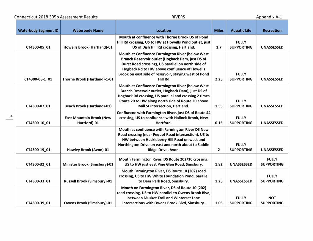
CT4300-05_01 Howells Brook (Hartland)-01
Mouth at confluence with Thorne Brook DS of Pond Hill Rd crossing, US to HW at Howells Pond outlet, just
US of Dish Hill Rd crossing, Hartland. 1.7 FULLY
SUPPORTING UNASSESSED
CT4300-05-1_01 Thorne Brook (Hartland)-1-01
Mouth at Confluence Farmington River (below West Branch Reservoir outlet (Hogback Dam, just DS of Durst Road crossing), US parallel on north side of Hogback Rd to HW above confluence of Howells
Brook on east side of reservoir, staying west of Pond Hill Rd 2.25
FULLY SUPPORTING UNASSESSED
CT4300-07_01 Beach Brook (Hartland)-01)
Mouth at Confluence Farmington River (below West Branch Reservoir outlet, Hogback Dam), just DS of
Hogback Rd crossing, US parallel and crossing 2 times Route 20 to HW along north side of Route 20 above
Mill St intersection, Hartland. 1.55 FULLY
SUPPORTING UNASSESSED
CT4300-10_01 East Mountain Brook (New
Hartford)-01
Confluecne with Farmington River, just DS of Route 44 crossing, US to confluence with Hallock Brook, New
Hartford. 0.15 FULLY
SUPPORTING UNASSESSED
CT4300-19_01 Hawley Brook (Avon)-01
Mouth at confluence with Farmington River DS New Road crossing (near Pequot Road intersection), US to
HW between Huckleberry Hill Road on west and Northington Drive on east and north about to Saddle
Ridge Drive, Avon. 2 FULLY
SUPPORTING UNASSESSED
CT4300-32_01 Minister Brook (Simsbury)-01 Mouth Farmington River, DS Route 202/10 crossing,
US to HW just east Pine Glen Road, Simsbury. 1.82 UNASSESSED FULLY
SUPPORTING
CT4300-33_01 Russell Brook (Simsbury)-01
Mouth Farmington River, DS Route 10 (202) road crossing, US to HW White Foundation Pond, parallel
to Deer Park Road, Simsbury. 1.25 UNASSESSED FULLY
SUPPORTING
CT4300-39_01 Owens Brook (Simsbury)-01
Mouth on Farmington River, DS of Route 10 (202) road crossing, US to HW parallel to Owens Brook Blvd,
between Musket Trail and Winterset Lane intersections with Owens Brook Blvd, Simsbury. 1.05
FULLY SUPPORTING
NOT SUPPORTING

Connecticut 2018 305b Assessment Results RIVERS Appendix A-1
35
Waterbody Segment ID Waterbody Name Location Miles Aquatic Life Recreation
CT4300-44_01 Munnisunk Brook (Simsbury)-
01
Mouth confluence Farmington River, US to Lake Basile outlet dam (US Wolcott Road and RailRoad crossings),
Simsbury. 0.89 UNASSESSED FULLY
SUPPORTING
CT4300-49_01 West Brook (Windsor/East
Granby)-01
Mouth at outlet into Rainbow Reservoir just west of Cot Rd, Windsor, US under Miller Rd to HW just US of
Sweetbriar Rd crossing, East Granby. 1.49 FULLY
SUPPORTING UNASSESSED
CT4300-50_01 Rainbow Brook-01
From mouth at Farmington River (just DS of Island below Rainbow Reservoir Dam), Windsor, US to
headwaters, southwest portion of Bradley International Airport, Windsor Locks. 1.74
NOT SUPPORTING UNASSESSED
CT4300-51_01 Seymour Hollow Brook-01
From mouth at Farmington River, Windsor (formerly tributary to Rainbow Brook, now channelized to
Farmington, Gazetteer # based upon Rainbow Brook), US to headwaters, southest portion of Bradley
International Airport, Windsor Locks. 1.36 NOT
SUPPORTING UNASSESSED
CT4300-54_01 Phelps Brook (Windsor)-01 Mouth Farmington River, near Apple Tree Lane, US to
Route 75 crossing, windsor. 0.39 UNASSESSED NOT
SUPPORTING
CT4300-54_02 Phelps Brook (Windsor)-02
US side of Route 75 crossing, US to HW parallel at end of Marble Faun Lane (subdivision, expecting control
changes in hydro), Windsor. 2.22 FULLY
SUPPORTING UNASSESSED
CT4302-00_01 Mad River (Winchester)-01 Mouth at Still River, US to Mad River Dam outlet,
Winchester. 2.24 FULLY
SUPPORTING NOT
SUPPORTING
CT4302-00_02a Mad River (Winchester)-02a From Mad River Dam outlet, Wincheter, US to outlet
from Rugg Brook Reservoir. 1.77 UNASSESSED NOT
SUPPORTING
CT4302-00_02b Mad River (Winchester)-02b From confluence with Rugg Brook Reservoir outlet, US to diversion entrance for Rugg Brook Reservoir. 0.63
NOT SUPPORTING UNASSESSED
CT4302-00_03 Mad River (Winchester)-03
From diversion entrance for Rugg Brook Reservoir (boundary of drinking water watershed), US to
headwaters at Spaulding Pond outlet dam, Norfolk. 5.17 NOT
SUPPORTING NOT
SUPPORTING

Connecticut 2018 305b Assessment Results RIVERS Appendix A-1
36
Waterbody Segment ID Waterbody Name Location Miles Aquatic Life Recreation
CT4302-04_01 Rugg Brook (Winchester)-01
Mouth at inlet to Rugg Brook Reservoir, just DS from Old Waterbury Turnpike crossing, US to HW, US of
Route 263 crossing, Winchester. 3.29 FULLY
SUPPORTING UNASSESSED
CT4302-05_01 Mill brook
(Winchester/Norfolk)-01
Mouth at Mad River, just DS of Route 44 crossing, Winchester, US to HW, just US of Green Road
crossing, Norfolk. 5.31 FULLY
SUPPORTING UNASSESSED
CT4302-09_01 Indian Meadow Brook-01
From mouth at Mad River (just DS from Route 44/183 crossing), US to confluence with Colebrook Brook,
Winchester 0.46 FULLY
SUPPORTING UNASSESSED
CT4302-10_01 Colebrook Brook
(Winchester/Colebrook)-01 Confluence with Indian Meadow Brook, just DS of
Route 183 crossing, Winchester, US to HW, Colebrook. 3.58 FULLY
SUPPORTING UNASSESSED
CT4302-13_01 Taylor Brook (Winchester)-01
Mouth on Highland Lake, just DS of Wakefield Boulevard crossing, US to HW, US of Hollow Hill Road
crossing, Winchester. 2.12 FULLY
SUPPORTING UNASSESSED
CT4303-00_02 Still River (Colebrook)-02
From confluence with Sandy Brook, Colebrook, US to Winchester (Winsted) POTW (east side of Route 8),
Winsted. 2.67 FULLY
SUPPORTING NOT
SUPPORTING
CT4303-00_03 Still River (Winsted)-03 From Winchester (Winsted) POTW, US to confuence with Mad River (just US of Route 44/183 crossing). 1.67
NOT SUPPORTING
NOT SUPPORTING
CT4303-00_04 Still River
(Winsted/Torrington)-04
From confuence with Mad River (just US of Route 44/183 crossing), US to headwaters (on west side of Route 8, paralell with Exit 45 offramp), Torrington. 7.56 UNASSESSED
NOT SUPPORTING
CT4304-00_01 Sandy Brook (Colebrook)-01
From mouth at confluence with Still River (just DS of Old Forge Road crossing), Colebrook (Southeast), US
to Massachusetts border, Norfolk (Northeast corner). 8.63 FULLY
SUPPORTING FULLY
SUPPORTING
CT4304-00_01a Sandy Brook
(Barkhamsted/Colebrook)-01a
Mouth confluence Farmington River, Barkhamsted, US to confluence Still River, Colebrook. NOTE
Formerly called Still River-01 (CT4303-00_01), see comments. 1.35
FULLY SUPPORTING
NOT SUPPORTING

Connecticut 2018 305b Assessment Results RIVERS Appendix A-1
37
Waterbody Segment ID Waterbody Name Location Miles Aquatic Life Recreation
CT4304-08_01 Center Brook-01 From mouth at Sandy Brook, US to Route 183
(Colebrook Rd) crossing, Colebrook. 1.28 FULLY
SUPPORTING UNASSESSED
CT4305-00_01 Morgan Brook-01
From mouth at West Branch Farmington River, US to confluence with tributary 4305-04 (first confluence)
on east side of Route 44, Barkhamsted. 0.69 FULLY
SUPPORTING NOT
SUPPORTING
CT4305-00_02 Morgan Brook-02
From confluence with tributary 4305-04 (end of seg-01) east side of Route 44, US to East West Hill Road crossing area (50 meters US of East West Hill Road
crossing, entrance of 9/12/05 home heating fuel spill), Barkhamsted. 1.41
FULLY SUPPORTING
NOT SUPPORTING
CT4305-00_04 Morgan Brook-04 From confluence with Mallory Brook, US to West Hill
Pond outlet dam, Barkhamsted. 1.52 FULLY
SUPPORTING NOT
SUPPORTING
CT4305-02_01 Mallory Brook-01
From confluence with Morgan Brook, US to Tennessee Gas pipeline crossing (near Barkhamsted and
Winchester town line, south of Route 44), Barkhamsted. 1.54
FULLY SUPPORTING UNASSESSED
CT4305-02_02 Mallory Brook-02
From Tennessee Gas Pipeline Crossing (end of segment-01, near Barkhamsted and Winchester town
line, south of Route 44), US to headwaters, Winchester. 0.7
FULLY SUPPORTING UNASSESSED
CT4306-00_01 Valley Brook-01
From mouth at northwestern most portion of Barkhamsted Reservoir, Hartland, US (towards
northeast) to CT/MA state line. 0.73 FULLY
SUPPORTING UNASSESSED
CT4307-00_01 Hubbard Brook-01
From mouth at northwestern most portion of Barkhamsted Reservoir, Hartland, US (towards
northwest) to CT/MA state line. 0.57 FULLY
SUPPORTING UNASSESSED
CT4308-00_01 Farmington River, East
Branch-01 From mouth at Farmington River mainstem, New
Hartford, US to Lake McDonough outlet dam. 1.11 NOT
SUPPORTING NOT
SUPPORTING

Connecticut 2018 305b Assessment Results RIVERS Appendix A-1
38
Waterbody Segment ID Waterbody Name Location Miles Aquatic Life Recreation
CT4308-01_01 Hurricane Brook (Hartland)-01
Mouth on Barkhamsted Reservoir, just DS of Route 20 crossing, US to HW at Emmons Pond, just US of
Hurricane Brook Road crossing, Hartland. 2.24 FULLY
SUPPORTING UNASSESSED
CT4308-02_01 Falls Brook (Hartland)-01
Mouth at confluence East Branch Farmington River in Barkhamsted Reservoir section from west side near Route 20, US to HW in Tunxis State Forest, Hartland. 2.1
FULLY SUPPORTING UNASSESSED
CT4308-11_01 Roaring Brook (Barkhamsted)-
01
Mouth at inlet to Barkhamsted Reservoir, parallel to Kettle Brook, US to HW near Pine Mountain road,
Barkhamsted. 2.4 FULLY
SUPPORTING UNASSESSED
CT4308-13_01 Kettle Brook (Barkhamsted)-
01
Mouth at inlet to Barkhamsted Reservoir, just DS of Ratlum Road crossing, US to HW just US of Route 219
crossing, Barkhamsted. 1.95 FULLY
SUPPORTING UNASSESSED
CT4308-14_01 Storehouse Brook (Barkhamsted)-01
Mouth at confluence with East Branch Farmington River in Barkhamsted Reservoir section DS of Route 219 crossing, along east side of beach near Saville
Dam Road, US to HW US of Hillcrest Drive crossing, near intersection with Route 219, Barkhamsted. 1.9
FULLY SUPPORTING UNASSESSED
CT4308-15_01 Beaver Brook (Barkhamsted)-
01
From mouth at northwestern corner of Lake McDonough (Compensating Reservoir), Barkhamsted, US to headwaters in Peoples State Forest, Hartland. 5.51
FULLY SUPPORTING UNASSESSED
CT4308-15-trib_01 Unnamed Tributary, Beaver
Brook (Barkhamsted)-01
Mouth on Beaver Brook, just DS of Beaver Brook Road crossing, US to HW, US of Beaver Brook Road crossing,
Barkhamsted. 0.38 FULLY
SUPPORTING UNASSESSED
CT4308-18_01 Ratlum Brook (New Hartford)-
01
From mouth at confluence with East Branch Farmington River (just DS of Farmington River
Turnpike crossing), US to Sholom Pond outlet dam (parallel to Ratlum Road), New Hartford. 0.28
FULLY SUPPORTING UNASSESSED
CT4308-18_02 Ratlum Brook (New
Hartford/Canton)-02
Sholom Pond OUTLET dam parallel to Ratlum Road, (segment includes pond), New Hartford, US to HW in forested area US of Ratlum Mountain Road crossing,
Canton. 2.7 FULLY
SUPPORTING UNASSESSED

Connecticut 2018 305b Assessment Results RIVERS Appendix A-1
39
Waterbody Segment ID Waterbody Name Location Miles Aquatic Life Recreation
CT4309-00_01 Cherry Brook (Canton)-01
Mouth confluence Farmington River (just DS Albany Turnpike (Route 44) crossing), US to Barbourtown
Road crossing, Canton. 2.05 FULLY
SUPPORTING NOT
SUPPORTING
CT4309-00_02 Cherry Brook (Canton)-02
From Barbourtown road crossing (segment-01), US to confluence with unnamed tributary (outlet stream for
Linsey Pond), just US of Meadow Road crossing, Canton. 0.66 UNASSESSED
NOT SUPPORTING
CT4309-00_03 Cherry Brook
(Canton/Barkhamsted)-03
Confluence with unnamed tributary, just US of Meadow Road crossing and parallel to Route 179, Canton, US to HW, just US of Route 219 crossing,
Barkhamsted. 6.64 FULLY
SUPPORTING UNASSESSED
CT4309-02_01 Unnamed Tributary to Cherry
Brook (Canton)-01
Mouth on Cherry Brook, just DS from Route 179 crossing, US to outlet of Tiltons Pond, just US of Route
179 crossing, Canton. 0.38 FULLY
SUPPORTING UNASSESSED
CT4310-00_01 Nepaug River-01
From mouth at confluence with Farmington River (southwest of Route 202 crossing), US to Nepaug
Reservoir outlet dam. 0.9 NOT
SUPPORTING NOT
SUPPORTING
CT4310-00_02 Nepaug River-02
From inlet to Nepaug Reservoir (far wetern portion), US to headwaters (just above confluence with Cedar
Swamp Brook, parallel with Niles Road), New Hartford. 7.73
FULLY SUPPORTING UNASSESSED
CT4310-01_01 Bakerville Brook-01
From mouth at Nepaug River, US to confluence with Torringford Brook (west of Cedar Lane crossing, along
north side of Route 202), New Hartford. 1.01 FULLY
SUPPORTING UNASSESSED
CT4310-01_02 Bakerville Brook (New
Hartford)-02
Confluence with Torrington Brook, parallel with Route 202, US to HW near Pearl Rd (above Rt 202 crossing),
New Hartford. 3.2 FULLY
SUPPORTING UNASSESSED
CT4310-05_01 North Brook (New Hartford)-
01
Mouth on North Nepaug Brook, between Route 219 and Maple Hollow Road, US to HW, between West Hill
Road and Stub Hollow Road, New Hartford. 2.51 FULLY
SUPPORTING UNASSESSED

Connecticut 2018 305b Assessment Results RIVERS Appendix A-1
40
Waterbody Segment ID Waterbody Name Location Miles Aquatic Life Recreation
CT4311-00_01 Burlington Brook (Burlington)-
01
Mouth Farmington River, US to HW at confluence North and South Branches Bunnell Brook, Burlington.
Segment includes Burlington Brook name upto confluence with Bradley brook, then name changes to
Bunnell Brook, but number stays constant. 4.78 FULLY
SUPPORTING NOT
SUPPORTING
CT4311-06_01 Punch Brook (Burlington)-01 Mouth on Burlington Brook at Route 4 crossing, US to
Punch Brook Pond outlet, Burlington. 0.65 FULLY
SUPPORTING UNASSESSED
CT4312-00_01 Roaring Brook (Farmington)-
01
Mouth confluence Farmington River (just DS Farmington Avenue (Route 4) crossing), Farmington, US to Paparrazzo Dam outlet (just US Mallard Drive
crossing), Avon. 1.17 FULLY
SUPPORTING NOT
SUPPORTING
CT4312-01_01 Jim Brook (Canton)-01
Mouth on Roaring Brook between Washburn Road and Lawton Road, US to HW parallel to Sextons
Hollow Road, Canton. 2.23 FULLY
SUPPORTING UNASSESSED
CT4313-00_01 Poland River-01
From mouth at confluence with Pequabuck River, US to confluence with Marsh Brook (seg 2 begins),
Plymouth. 0.42 UNASSESSED NOT
SUPPORTING
CT4313-00_02 Poland River-02
From confluence with Marsh Brook, US to confluence with unnamed brook 4313-03-1, US of Judd Road crossing (paralell with Route 72), Plymouth, CT. 0.71
FULLY SUPPORTING
NOT SUPPORTING
CT4313-00_03 Poland River
(Plymouth/Harwinton)-03
Confluence with unnamed brook 4313-03-1 near unnamed street intersection with Route 72,
Plymouth, US parallel to Route 72 (crossing 3 times) to HW at Bristol Reservoir No 4 outlet, US of Poland
Brook Ln crossing, Harwinton. 4.31 FULLY
SUPPORTING UNASSESSED
CT4314-00_01 Coppermine Brook (Bristol)-01
Mouth Pequabuck River, US to New Britain drinking water watershed boundary and water diversion (just
US confluence with Polkville Brook), Bristol. 2.43 NOT
SUPPORTING NOT
SUPPORTING
CT4314-00_02 Coppermine Brook (Bristol)-02
From drinking water watershed boundary and water diversion (just US of confluence with Polkville Brook), US to headwaters (confluence of Whigville & Wildcat
Brooks). 2.66 FULLY
SUPPORTING UNASSESSED

Connecticut 2018 305b Assessment Results RIVERS Appendix A-1
41
Waterbody Segment ID Waterbody Name Location Miles Aquatic Life Recreation
CT4314-01_01 Whigville Brook (Burlington)-
01
Mouth at confluence Wildcat Brook above Coppermine Brook, DS of Prospect Street crossing, US to HW between Route 69 on west and Savarese Lane
on east, Burlington. 4.8 FULLY
SUPPORTING UNASSESSED
CT4314-04_01 Wildcat Brook (Burlington)-01
Mouth at confluence Whigville Brook above Coppermine Brook, DS of Prospect Street crossing, US to HW (flows along eastern boundary of Nassahegon
State Forest) US of George Washington Turnpike crossing (just East of Cedar Ridge intersection),
Burlington. 2.6 FULLY
SUPPORTING UNASSESSED
CT4314-06_02 Negro Hill Brook (Burlington)-
02
Confluence with unnamed tributary at Bristol/Burlington town line, near Intervale Road, US
to HW just US of Gilbert Road crossing, Burlington. 4.08 FULLY
SUPPORTING FULLY
SUPPORTING
CT4314-08_01 Polkville Avenue Brook
(Bristol)-01
Mouth Coppermine Brook US Farmington Avenue crossing (DS Mix Street crossing and below aqueduct),
US to HW at P&B Dam just US Hart Street crossing, Bristol. 3.19
NOT SUPPORTING UNASSESSED
CT4315-00_01 Pequabuck River (Plainville)-
01 Mouth Farmington River, US to RailRoad crossing (US
(south) Route 72 crossing), Plainville. 5.37 NOT
SUPPORTING NOT
SUPPORTING
CT4315-00_02 Pequabuck River-02
From RailRoad crossing (US (south) of Route 72 crossing), Plainville, US to Bristol POTW outfall (DS of
route 229 crossing), Bristol. 3.37 NOT
SUPPORTING NOT
SUPPORTING
CT4315-00_03 Pequabuck River-03 From Bristol POTW outfall (DS of route 229 crossing),
US to exit of box culvert, downtown Bristol. 1.23 NOT
SUPPORTING NOT
SUPPORTING
CT4315-00_04 Pequabuck River-04 From exit of box culvert, US to entrance of box culvert
(entire segment in culvert), center of Bristol. 0.33 NOT
SUPPORTING NOT
SUPPORTING
CT4315-00_05 Pequabuck River-05
From entrance to box culvert, center Bristol, US to Plymouth POTW (just DS of Canal Street (Route 72)
crossing), Plymouth. 2.7 NOT
SUPPORTING NOT
SUPPORTING

Connecticut 2018 305b Assessment Results RIVERS Appendix A-1
42
Waterbody Segment ID Waterbody Name Location Miles Aquatic Life Recreation
CT4315-00_06 Pequabuck River-06
From Plymouth POTW (just DS of Canal Street (Route72) crossing), US to headwaters, South of Rocky
Road, Harwinton. 5.46 NOT
SUPPORTING NOT
SUPPORTING
CT4315-08_02 South Mountain Brook
(Bristol)-02
Clayton Manufacturing Dam inlet, parallel to Union Street, US to confluence with unnamed tributary,
behind South Side School, near Tuttle Road, Bristol. 0.51 FULLY
SUPPORTING UNASSESSED
CT4316-00_01 Thompson Brook (Avon)-01
Mouth Farmington River (DS Old Farms Road crossing), US to INLET Beaverdam Pond (DS old
RailRoad crossing, now bike path), Avon. 1.91 FULLY
SUPPORTING FULLY
SUPPORTING
CT4316-00_02 Thompson Brook (Avon)-02
From INLET to Beaverdam Pond (DS of old RailRoad crossing which is now a bike path), US to HW at
confluence of Big Brook and Chidsey Brook (just US of Thompson Road crossing), Avon. 1.24
FULLY SUPPORTING
NOT SUPPORTING
CT4316-01_01 Chidsey Brook (Avon)-01
Fom mouth at confluence with Big Brook, forming HW of Thompson Brook (DS of Scoville Road crossing), US to Lamonica Pond outlet (just US of West Avon Road
crossing), Avon 1.34 NOT
SUPPORTING UNASSESSED
CT4317-00_01 Nod Brook (Avon/Simsbury)-
01
Mouth at Farmington River (includes dredge holes, Twin Lakes North and South and outlet to Farmington
River in wildlife management area), Avon, US to headwaters (just US of Rocklyn Road crossing),
Simsbury. 6.95 FULLY
SUPPORTING FULLY
SUPPORTING
CT4318-00_01 Hop Brook (Simsbury)-01 Mouth Farmington River, US to HW at outlet Tuller
Reservoir, Simsbury. 6.74 FULLY
SUPPORTING NOT
SUPPORTING
CT4318-03_01 Stratton Brook-01
From mouth at confluence with Hop Brook (just DS of Farms Village Road (Route 309) crossing), US to headwaters (near Bushy Hill Road (Route 167),
Simsbury. 3.89 FULLY
SUPPORTING UNASSESSED

Connecticut 2018 305b Assessment Results RIVERS Appendix A-1
43
Waterbody Segment ID Waterbody Name Location Miles Aquatic Life Recreation
CT4319-00_01a Salmon Brook, West Branch
(Granby)-01a
Mouth at confluence with East Branch Salmon Brook (part of Salmon Brook mainstem), DS of Route 10/202
crossing, just to West of Route 189, Granby, US to Bissell Brook (just US of Route 10/202 crossing),
Granby. 1.4 FULLY
SUPPORTING NOT
SUPPORTING
CT4319-00_01b Salmon Brook, West Branch
(Granby/Hartland)-01b
Confluence Bissell Brook US of Route 10/202 crossing, US to HW just US Route 179 (South Road) crossing,
Hartland. 11.29 FULLY
SUPPORTING FULLY
SUPPORTING
CT4319-03_01 Enders Brook
(Granby/Barkhamsted)-01
Confluence with West Branch Salmon River, adjacent to Route 219, Graby, US to HW, just US of Hayes Road
crossing, Barkhamsted. 3.75 FULLY
SUPPORTING UNASSESSED
CT4319-09_01 Unnamed Tributary to Salmon
Brook (Granby)-01
Mouth on West Branch Salmon Brook, just DS of Simsbury Road crossing, US to HW, west of Weed Hill
Road, Granby. 2.23 FULLY
SUPPORTING UNASSESSED
CT4320-00_01 Salmon Brook (East Granby/Granby)-01
Mouth Farmington River DS Floydville Road crossing, East Granby, US to Massachusetts border (includes
Salmon Brook and East Branch Salmon Brook sections), Granby. 13.55
FULLY SUPPORTING
NOT SUPPORTING
CT4320-01_01
Unnamed Tributary to East Branch Salmon Brook
(Granby)-01
Mouth on East Branch Salmon River, just DS of Route 189 crossing, Granby, US to Connecticut State Border with Massachusetts, parallel with Peck Orchard Road,
Hartland. 0.87 FULLY
SUPPORTING UNASSESSED
CT4320-02_01 Fox Brook (Hartland)-01
From mouth at confluence with East Branch Salmon Brook (just DS of Granville Road (Route 189) crossing),
Granby, US to HW (just East of Pell Road, along the CT/MA border), Hartland. 2.55
FULLY SUPPORTING UNASSESSED
CT4320-03_01 Unnamed tributary to Salmon
Brook (Granby)-01
Mouth at Confluence Salmon Brook (East Branch) DS Doherty Rd crossing and parallel Silver St, US to
CT/MA state line, just US of Silver Brook Ln crossing, Granby. 2.29
FULLY SUPPORTING UNASSESSED
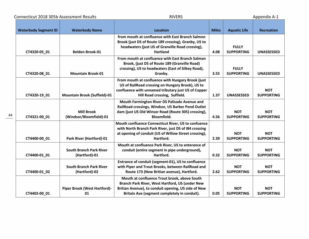
Connecticut 2018 305b Assessment Results RIVERS Appendix A-1
44
Waterbody Segment ID Waterbody Name Location Miles Aquatic Life Recreation
CT4320-05_01 Belden Brook-01
from mouth at confluence with East Branch Salmon Brook (just DS of Route 189 crossing), Granby, US to
headwaters (just US of Granville Road crossing), Hartland 4.08
FULLY SUPPORTING UNASSESSED
CT4320-08_01 Mountain Brook-01
From mouth at confluence with East Branch Salmon Brook, (just DS of Route 189 (Granville Road)
crossing), US to headwaters (East of Silkey Road), Granby. 3.55
FULLY SUPPORTING UNASSESSED
CT4320-19_01 Mountain Brook (Suffield)-01
From mouth at confluence with Hungary Brook (just US of RailRoad crossing on Hungary Brook), US to
confluence with unnamed tributary just US of Copper Hill Road crossing, Suffield. 1.37 UNASSESSED
NOT SUPPORTING
CT4321-00_01 Mill Brook
(Windsor/Bloomfield)-01
Mouth Farmington River DS Palisado Avenue and RailRoad crossings, Windsor, US Barber Pond Outlet dam (just US Old Winsor Road (Route 305) crossing),
Bloomfield. 4.56 NOT
SUPPORTING NOT
SUPPORTING
CT4400-00_01 Park River (Hartford)-01
Mouth confluence Connecticut River, US to confuence with North Branch Park River, just DS of I84 crossing at opening of conduit (US of Willow Street crossing),
Hartford. 2.39 NOT
SUPPORTING NOT
SUPPORTING
CT4400-01_01 South Branch Park River
(Hartford)-01
Mouth at confluence Park River, US to enterance of conduit (entire segment in pipe underground),
Hartford. 0.32 NOT
SUPPORTING NOT
SUPPORTING
CT4400-01_02 South Branch Park River
(Hartford)-02
Entrance of conduit (segment-01), US to confluence with Piper and Trout Brooks, between RailRoad and
Route 173 (New Britian avenue), Hartford. 2.62 NOT
SUPPORTING NOT
SUPPORTING
CT4402-00_01 Piper Brook (West Hartford)-
01
Mouth at confluence Trout brook, above South Branch Park River, West Hartford, US (under New
Britian Avenue), to conduit opening, US side of New Britain Ave (segment completely in conduit). 0.05
NOT SUPPORTING
NOT SUPPORTING

Connecticut 2018 305b Assessment Results RIVERS Appendix A-1
45
Waterbody Segment ID Waterbody Name Location Miles Aquatic Life Recreation
CT4402-00_02 Piper Brook-02
From conduit entrance (segment-01) US side of New Britain Avenue, West Hartford, US into St. Marys
Cemetary (just US of railroad crossing and parallel with Route 9) where pipe emerges from ground, New
Britain. 5.81 NOT
SUPPORTING NOT
SUPPORTING
CT4403-00_01 Trout Brook-01
From mouth at confluence with Piper Brook, above South Branch Park River (just DS of railroad crossing, near New Britian Avenue), West Hartford, US under
Route 84 exit 42 (Trout Brook Drive) ramp. 1.07 NOT
SUPPORTING NOT
SUPPORTING
CT4403-00_02 Trout Brook-02
From US side of Route 84 Exit 42 (Trout Brook) ramp, West Hartford, US to Park Road crossing (Entire
segment flows through concrete channel). 0.88 NOT
SUPPORTING NOT
SUPPORTING
CT4403-00_03 Trout Brook-03
From Park Road crossing (just DS of Boulevard road crossing), US to Woodbridge Lake outlet dam, West
Hartford. 5.95 NOT
SUPPORTING NOT
SUPPORTING
CT4404-00_01 North Branch Park River
(Hartford)-01
Mouth at confluence with Park River just DS of I84 crossing, US to entrance of conduit (entire segment in
pipe) near Farmingotn Avenue, Hartford. 0.51 NOT
SUPPORTING NOT
SUPPORTING
CT4404-00_02 North Branch Park River-02
From DS side of Farmington Avenue (at entrance of conduit), US to confluence with Wash Brook (just DS of confluence of Wash Brook and Beamans Brook),
Bloomfield. 5.39 NOT
SUPPORTING NOT
SUPPORTING
CT4500-00_01 Hockanum River-01
From mouth at Connecticut River, East Hartford, US to Cellu Company Dam, the first dam at Scotland Impoundment (two dams just DS of this dam),
includes impounded water behind East Hartford town hall. 4.26
NOT SUPPORTING UNASSESSED
CT4500-00_02 Hockanum River (East
Hartford/Manchester)-02
Cellu Company dam (first dam at Scotland Rd Impoundment), East Hartford, US to confluence with
South Fork Hockanum (AKA Hop) River, just US of "Laurel Lake", Manchester. 3.6
NOT SUPPORTING
NOT SUPPORTING
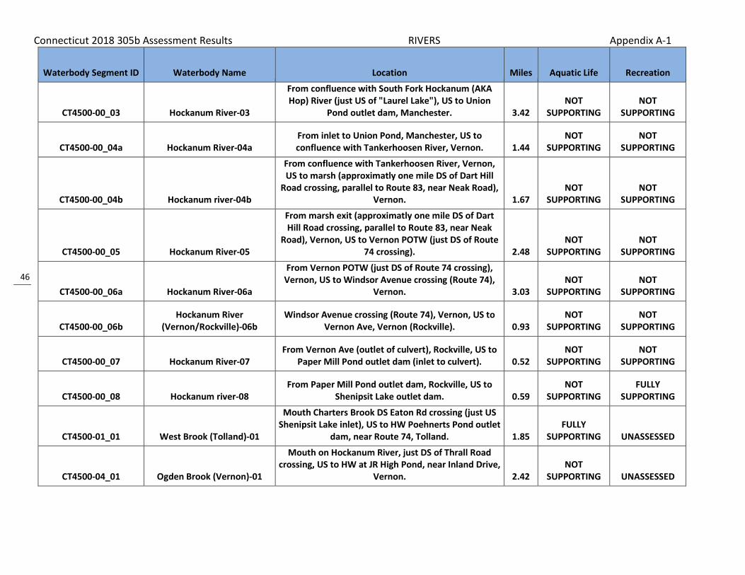
Connecticut 2018 305b Assessment Results RIVERS Appendix A-1
46
Waterbody Segment ID Waterbody Name Location Miles Aquatic Life Recreation
CT4500-00_03 Hockanum River-03
From confluence with South Fork Hockanum (AKA Hop) River (just US of "Laurel Lake"), US to Union
Pond outlet dam, Manchester. 3.42 NOT
SUPPORTING NOT
SUPPORTING
CT4500-00_04a Hockanum River-04a From inlet to Union Pond, Manchester, US to confluence with Tankerhoosen River, Vernon. 1.44
NOT SUPPORTING
NOT SUPPORTING
CT4500-00_04b Hockanum river-04b
From confluence with Tankerhoosen River, Vernon, US to marsh (approximatly one mile DS of Dart Hill
Road crossing, parallel to Route 83, near Neak Road), Vernon. 1.67
NOT SUPPORTING
NOT SUPPORTING
CT4500-00_05 Hockanum River-05
From marsh exit (approximatly one mile DS of Dart Hill Road crossing, parallel to Route 83, near Neak
Road), Vernon, US to Vernon POTW (just DS of Route 74 crossing). 2.48
NOT SUPPORTING
NOT SUPPORTING
CT4500-00_06a Hockanum River-06a
From Vernon POTW (just DS of Route 74 crossing), Vernon, US to Windsor Avenue crossing (Route 74),
Vernon. 3.03 NOT
SUPPORTING NOT
SUPPORTING
CT4500-00_06b Hockanum River
(Vernon/Rockville)-06b Windsor Avenue crossing (Route 74), Vernon, US to
Vernon Ave, Vernon (Rockville). 0.93 NOT
SUPPORTING NOT
SUPPORTING
CT4500-00_07 Hockanum River-07 From Vernon Ave (outlet of culvert), Rockville, US to
Paper Mill Pond outlet dam (inlet to culvert). 0.52 NOT
SUPPORTING NOT
SUPPORTING
CT4500-00_08 Hockanum river-08 From Paper Mill Pond outlet dam, Rockville, US to
Shenipsit Lake outlet dam. 0.59 NOT
SUPPORTING FULLY
SUPPORTING
CT4500-01_01 West Brook (Tolland)-01
Mouth Charters Brook DS Eaton Rd crossing (just US Shenipsit Lake inlet), US to HW Poehnerts Pond outlet
dam, near Route 74, Tolland. 1.85 FULLY
SUPPORTING UNASSESSED
CT4500-04_01 Ogden Brook (Vernon)-01
Mouth on Hockanum River, just DS of Thrall Road crossing, US to HW at JR High Pond, near Inland Drive,
Vernon. 2.42 NOT
SUPPORTING UNASSESSED

Connecticut 2018 305b Assessment Results RIVERS Appendix A-1
47
Waterbody Segment ID Waterbody Name Location Miles Aquatic Life Recreation
CT4500-12_02 Lydall Brook (Manchester)-02
Route 83 crossing (end of underground conduit), US to outlet of Salters Pond, parallel to Lydall Street at
Coleman Road intersection, Manchester. 1.05 NOT
SUPPORTING UNASSESSED
CT4500-12_03 Lydall Brook (Manchester)-03
Inlet Salters Pond, parallel to Lydall Street at Ambassador Drive intersection, US to outlet of Lydall
Street Reservoir No1, parallel to Lydall Street, Manchester. 1.01
NOT SUPPORTING UNASSESSED
CT4500-14_01 Bigelow Brook (Manchester)-
01
Confluence with Hockanum River, just DS of Hillard Street crossing, US to Adams Street crossing,
Manchester. 0.27 FULLY
SUPPORTING UNASSESSED
CT4501-00_01 Charters Brook-01 From mouth at Shenipsit Lake Tolland US to
headwaters near Webster Rd Ellington 6.22 FULLY
SUPPORTING FULLY
SUPPORTING
CT4503-00_01 Tankerhoosen River-01
From mouth at Hockanum River, Vernon (DS of Route 83/30 crossing near Manchester border ), US to
Tankerhoosen Lake outlet dam, Vernon. 1.51 NOT
SUPPORTING UNASSESSED
CT4503-00_02 Tankerhoosen River-02
From Tankerhoosen Lake outlet dam (includes lake), Vernon, US to Walker Reservoir East outlet
(headwater). 4.07 FULLY
SUPPORTING UNASSESSED
CT4503-00-trib_01 Barrows Brook
(Vernon/Tolland)-01
Mouth at confluence Tankerhoosen River east of Reservoir Rd and Baker Rd intersection, Vernon, US to
HW just over town line, Tolland. 0.92 FULLY
SUPPORTING UNASSESSED
CT4503-04_01 Railroad Brook
(Vernon/Bolton)-01
Mouth at confluence Tankerhoosen River DS Milk and Bread Road crossing (US flows through Valley Falls
Pond), Vernon, US to HW at Bolton Notch Pond OUTLET, Bolton. (adjacent to airline trail and I384) 2.8
FULLY SUPPORTING UNASSESSED
CT4504-00_01 South Fork Hockanum River
(Manchester)-01
Mouth at confluence Hockanum River just DS of Thrall Road crossing, US to HW at confluence of Hop Brook
and Folly Brook US Hartford Road crossing and at I384 crossing (Folly Brook goes under I384), Manchester. 1.2
NOT SUPPORTING UNASSESSED

Connecticut 2018 305b Assessment Results RIVERS Appendix A-1
48
Waterbody Segment ID Waterbody Name Location Miles Aquatic Life Recreation
CT4504-00_02 Hop Brook (Manchester)-01
Mouth at confluence South Fork Hockanum River DS side of I384, US parallel along north side of I384 to
HW at confluence of Porter Brook and Birch Mountain Brook just US of Route 83 crossing, Manchester.
NOTE: name of segment changes with river name. 2.24 NOT
SUPPORTING UNASSESSED
CT4504-01_01 Porter Brook (Manchester)-01
Mouth at confluence Birch Mountain Brook above Hop Brook DS of Charter Oak Street crossing (adjacent
to I384 near baseball field), US to Howard Reservoir OUTLET adjacent to I384 (water class changes A to
AA), Manchester. 2.2 NOT
SUPPORTING UNASSESSED
CT4504-03_01 Birch Mountain Brook
(Manchester)-01
Mouth at confluence Porter Brook above Hop Brook (near baseball field) DS of Gardner Street crossing
(brook runs adjacent on north side of I384), US to HW just US of Birch Mountain Road crossing at
Manchester/Bolton border. 3.6 NOT
SUPPORTING UNASSESSED
CT4600-00_01 Mattabesset River
(Cromwell/Middletown)-01
Mouth Connecticut River under Route 9, Cromwell, US to Route 3 crossing (south Route 372 intersection),
Cromwell/Middletown line. 3.31 UNASSESSED NOT
SUPPORTING
CT4600-00_02 Mattabesset River
(Cromwell/East Berlin)-02
From Route 3 crossing, Cromwell and Middletown Townline, US to High Pond Dam (just US of Berlin
Street crossing), East Berlin. 3.65 NOT
SUPPORTING NOT
SUPPORTING
CT4600-00_03 Mattabesset River-03 From High Pond Dam just US of Berlin Street crossing,
East Berlin, US to confluence with Willow Brook. 3.6 NOT
SUPPORTING NOT
SUPPORTING
CT4600-00_04 Mattabesset River-04
From confluence with Willow Brook, US to Kensington Dam at outlet of Railroad Pond (just US of Kensington
Road crossing), Berlin. 2.83 NOT
SUPPORTING NOT
SUPPORTING
CT4600-00_05 Mattabesset River-05
From Kensington Dam at outlet of Railroad Pond (just US of Kensington Road crossing), Berlin, US to inlet of
Paper Goods Pond (segment includes both ponds). 1.01 NOT
SUPPORTING UNASSESSED
CT4600-00_06 Mattabesset River-06
From inlet to Paper Goods Pond, US to Lower Hart Pond outlet dam (Both Lower and Upper Hart Ponds
are not in segment). 1.32 NOT
SUPPORTING NOT
SUPPORTING

Connecticut 2018 305b Assessment Results RIVERS Appendix A-1
49
Waterbody Segment ID Waterbody Name Location Miles Aquatic Life Recreation
CT4600-00-trib_01
Unnamed tributary Connecticut River (Cromwell)-
01
Inlet to conduit at Route 372 crossing, US (through nursery) to HW near Iron Gate Lane, Cromwell. NOTE:
lower hydrology manipulated, flow to CT river, but basin consistent with Mattabesset River. 1.06
NOT SUPPORTING UNASSESSED
CT4600-01_01 Stocking Brook-01
From mouth at confluence with Mattabesset River (just DS of Lower Hart Pond inlet), US to confluence
with John Hall Brook (DS of Southington Road crossing), Berlin. 1.3
FULLY SUPPORTING UNASSESSED
CT4600-05_01 John Hall Brook-01
From mouth at confluence with Stocking Brook (DS of Southington Road crossing), US to Kenmere Reservoir
OUTLET, Berlin. 1.02 FULLY
SUPPORTING NOT
SUPPORTING
CT4600-05_02 John Hall Brook-02 From Kenmere Reservoir INLET, US to Hallmere
Reservoir outlet dam, Berlin. 1 UNASSESSED NOT
SUPPORTING
CT4600-07_01 Little Brook (Rocky Hill)-01 From mouth at Mattabasset River US to source near
Trinity Rd, Rocky Hill. 1.92 FULLY
SUPPORTING NOT
SUPPORTING
CT4600-13_01 Spruce Brook (Berlin)-01
From mouth at Mattabasset River US to headwaters at confluence of East/West Spruce Brooks, above Lamentation Brook (Lamentation Mountain area). 4.17 UNASSESSED
NOT SUPPORTING
CT4600-22_01 Coles Brook-01 From mouth at Mattabasset River, US to headwaters above Shunpike Road (Route 3) crossing, Cromwell. 3.1 UNASSESSED
NOT SUPPORTING
CT4600-26_01 Miner Brook-01
From mouth at confluence with Mattabasset River, Cromwell/Middletown border, US to headwaters (in marsh just US (south) of Westfield Street crossing,
parallel with Route 217), Middletown. 2.92 UNASSESSED NOT
SUPPORTING
CT4600-27_01 Willow Brook (Cromwell)-01
From mouth at confluence with Mattabasset River (DS of Berlin Road (Route 372) crossing, US to
headwaters, just US of Coles Road crossing (near junctin of Coles Road and Willow Brook Road),
Cromwell. 1.38 FULLY
SUPPORTING NOT
SUPPORTING

Connecticut 2018 305b Assessment Results RIVERS Appendix A-1
50
Waterbody Segment ID Waterbody Name Location Miles Aquatic Life Recreation
CT4600-27_trib_01 East Branch Willow Brook-01
From mouth at confluence with Willow brook (DS of Evergreen Road crossing), US to headwaters (in marsh
US of Route 9 crossing, along west side of Shunpike Road (Route 3) area), Cromwell. 0.76 UNASSESSED
NOT SUPPORTING
CT4601-00_01 Belcher Brook-01 From mouth at Mattabasset River US to source at
Silver Lake, Berlin. 3.74 NOT
SUPPORTING NOT
SUPPORTING
CT4601-01_01 Crooked Brook (Berlin)-01 From mouth at Belcher Brook (near Norton Road), US
to Swede Pond outlet, Berlin. 1.15 FULLY
SUPPORTING UNASSESSED
CT4601-01_02 Crooked Brook (Berlin)-02 From Swede Pond INLET, US to Elton Rd crossing,
Berlin. 0.34 NOT
SUPPORTING UNASSESSED
CT4601-02_01 Hatchery Brook-01
From mouth at confluence with Belcher Brook, US to area adjacent to Lions Club Pool (just US of Norton
Road crossing), Berlin. 1.88 NOT
SUPPORTING UNASSESSED
CT4602-00_01 Willow Brook (New Britain)-01
From mouth at Mattabasset River, US to outlet of conduit under Buell Street, near intersection with
Route 71A (Kensington Ave, east of Hart Park), New Britain. 3.43
NOT SUPPORTING
NOT SUPPORTING
CT4603-00_01 Webster Brook-01
From mouth at Mattabasset River, US to headwaters between Railroad track and Stamm Road, just US of
Route 174 crossing, Newington. 3.42 NOT
SUPPORTING NOT
SUPPORTING
CT4604-00_01 Sawmill Brook (Middletown)-
01
From mouth at Mattabasset River, US to headwater above Atkin Street Pond (Highland Pond)
Middletown. 4.18 FULLY
SUPPORTING NOT
SUPPORTING
CT4605-01_01 Hersig Brook (Durham)-01
Mouth at INLET of Allyn Millpond at confluence of Fowler Brook in Allyn Brook Park, US to HW US
Johson Lane crossing, Durham. (local brook names here may cause confusion, followed basin number
4605-01) 2.7 FULLY
SUPPORTING UNASSESSED

Connecticut 2018 305b Assessment Results RIVERS Appendix A-1
51
Waterbody Segment ID Waterbody Name Location Miles Aquatic Life Recreation
CT4607-00_01 Coginchaug River-01
From mouth at Mattebessett River (at Cromwell border), US to downstream side of Route 3 crossing,
Middletown. 1.87 NOT
SUPPORTING UNASSESSED
CT4607-00_02 Coginchaug River-02
From downstream side of Route 3 crossing, US to downstream side of Route 66 crossing (just US of
Veterans Memorial Park), Middletown. 0.75 FULLY
SUPPORTING NOT
SUPPORTING
CT4607-00_03 Coginchaug River-03
From downstream side of Route 66 crossing (just US of Veterans Memorial Park), US to Starr Mill Pond
dam, Middletown. 0.6 FULLY
SUPPORTING NOT
SUPPORTING
CT4607-00_04 Coginchaug River
(Middletown/Middlefield)-04
Starr Mill Pond Inlet, Middletown, US (past Wadsworth Falls) to Strictland Road crossing,
Middlefield. (Includes diversion for swimming area) 4.19 FULLY
SUPPORTING NOT
SUPPORTING
CT4607-00_05 Coginchaug River
(Middlefield/Durham)-05 From Strictland Road crossing, Middlefield, US to
Meeting House Hill Road crossing, Durham. 4.95 UNASSESSED NOT
SUPPORTING
CT4607-00_06 Coginchaug River-06
From Meeting House Hill Road crossing, Durham, US to headwaters (US of Route 72 crossing, between
Bluff Head and Broomstick Ledges), North Guilford. 3.59 FULLY
SUPPORTING NOT
SUPPORTING
CT4607-05_01 Parmalee Brook (Durham)-01
Mouth on Coginchaug River, DS of Parmelee Hill Road crossing, US to confluence with unnamed tributary,
just US of Saw Mill Road crossing (water class changes from A to AA), Durham. 1.94
FULLY SUPPORTING UNASSESSED
CT4607-05_02 Parmalee Brook
(Durham/North Branford)-02
Confluence unnamed tributary, just US of Saw Mill Road crossing (water class changes from A in segment 1 to AA in this segment 2), Durham, US along Route 5 to HW just east of Blue Jay Drive and Skylark Drive,
North Branford. 3.64 FULLY
SUPPORTING UNASSESSED
CT4607-06_01 Cream Pot Brook (Durham)-01
Mouth at confluence Coginchaug River, US of Coginchaug River crossing Route 68 (in Durham
MEadows Wildlife Area), US to HW at unnamed pond just US of Dead Hill Road crossing (runs parallel to
Route 79 in upper part of segment), Durham. 3.3 FULLY
SUPPORTING UNASSESSED

Connecticut 2018 305b Assessment Results RIVERS Appendix A-1
52
Waterbody Segment ID Waterbody Name Location Miles Aquatic Life Recreation
CT4607-08_01 Lyman Meadow Brook
(Middlefield)-01
Mouth on Coginchaug River, US of Coginchaug River crossing of Miller Road, US to outlet of South Street
Pond, US of RailRoad crossinf, Middlefield. 1.43 UNASSESSED NOT
SUPPORTING
CT4607-11_01 Hans Brook (Middlefield)-01
Mouth at confluence Coginchaug River just DS of Route 157 crossing (behind Cahill Construction) US to
HW at Jeep Trail Pond (west side of Jackson Hill Road), Middlefield. 1.1
FULLY SUPPORTING UNASSESSED
CT4607-13_01 Laurel Brook (Middletown)-01
Mouth on Coginchaug River, in Wadsworth Falls State Park, parallel to swimming area, near Route 157, US
to unnamed pond outlet, just US of Red Road crossing, Middletown. 1.17 UNASSESSED
NOT SUPPORTING
CT4700-00_01 Salmon River (East
Haddam/Colchester)-01
Mouth at Connecticut River, East Haddam, US to headwaters at confluence of Blackledge and Jeremy
Rivers, Colchester. 10.41 FULLY
SUPPORTING FULLY
SUPPORTING
CT4700-02_01 Day Pond Brook (Colchester)-
01 Confluence with Salmon River, US to Day Pond outlet,
Colchester. 1.11 FULLY
SUPPORTING UNASSESSED
CT4700-03_01 Flat Brook (East Hampton)-01 Mouth at Salmon River, DS of Route 16 crossing, US to
HW, US of Daly Road crossing, East Hampton. 3.2 FULLY
SUPPORTING UNASSESSED
CT4700-07_01 Safstrom Brook (East
Hampton)-01
Mouth at confluence Salmon River DS of Wopowog Street crossing in Wopowog Wildlife area (trout management area in Salmon River), US HW at
unnamed pond (near Edgerton Street) US of Route 16 crossing, East Hampton. 4.1
FULLY SUPPORTING UNASSESSED
CT4700-09_01 Elbow Brook (East Hampton)-
01 Confluence with Salmon River, US to HW (runs
parallel to Route 196), East Hampton. 2.28 FULLY
SUPPORTING UNASSESSED
CT4701-00_01 Raymond Brook (Hebron)-01
Mouth on Jeremy River, along Airline Trail, DS of Grayville Road crossing, US to Route 85 crossing,
Hebron. 2.81 FULLY
SUPPORTING UNASSESSED
CT4701-00_02 Raymond Brook (Hebron)-02 Route 85 crossing, Hebron, US to HW, near Basket
Shop Road at Hebron/Columbia town line. 4.15 FULLY
SUPPORTING UNASSESSED
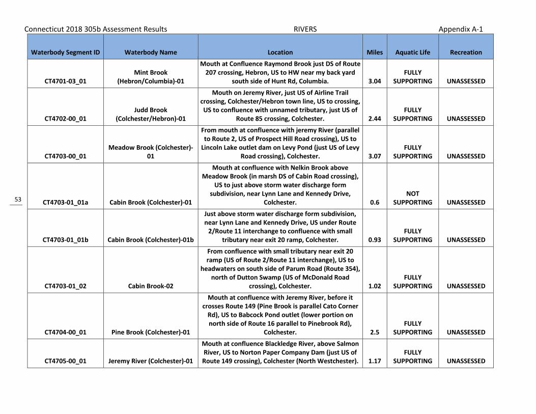
Connecticut 2018 305b Assessment Results RIVERS Appendix A-1
53
Waterbody Segment ID Waterbody Name Location Miles Aquatic Life Recreation
CT4701-03_01 Mint Brook
(Hebron/Columbia)-01
Mouth at Confluence Raymond Brook just DS of Route 207 crossing, Hebron, US to HW near my back yard
south side of Hunt Rd, Columbia. 3.04 FULLY
SUPPORTING UNASSESSED
CT4702-00_01 Judd Brook
(Colchester/Hebron)-01
Mouth on Jeremy River, just US of Airline Trail crossing, Colchester/Hebron town line, US to crossing, US to confluence with unnamed tributary, just US of
Route 85 crossing, Colchester. 2.44 FULLY
SUPPORTING UNASSESSED
CT4703-00_01 Meadow Brook (Colchester)-
01
From mouth at confluence with jeremy River (parallel to Route 2, US of Prospect Hill Road crossing), US to
Lincoln Lake outlet dam on Levy Pond (just US of Levy Road crossing), Colchester. 3.07
FULLY SUPPORTING UNASSESSED
CT4703-01_01a Cabin Brook (Colchester)-01
Mouth at confluence with Nelkin Brook above Meadow Brook (in marsh DS of Cabin Road crossing),
US to just above storm water discharge form subdivision, near Lynn Lane and Kennedy Drive,
Colchester. 0.6 NOT
SUPPORTING UNASSESSED
CT4703-01_01b Cabin Brook (Colchester)-01b
Just above storm water discharge form subdivision, near Lynn Lane and Kennedy Drive, US under Route
2/Route 11 interchange to confluence with small tributary near exit 20 ramp, Colchester. 0.93
FULLY SUPPORTING UNASSESSED
CT4703-01_02 Cabin Brook-02
From confluence with small tributary near exit 20 ramp (US of Route 2/Route 11 interchange), US to
headwaters on south side of Parum Road (Route 354), north of Dutton Swamp (US of McDonald Road
crossing), Colchester. 1.02 FULLY
SUPPORTING UNASSESSED
CT4704-00_01 Pine Brook (Colchester)-01
Mouth at confluence with Jeremy River, before it crosses Route 149 (Pine Brook is parallel Cato Corner
Rd), US to Babcock Pond outlet (lower portion on north side of Route 16 parallel to Pinebrook Rd),
Colchester. 2.5 FULLY
SUPPORTING UNASSESSED
CT4705-00_01 Jeremy River (Colchester)-01
Mouth at confluence Blackledge River, above Salmon River, US to Norton Paper Company Dam (just US of
Route 149 crossing), Colchester (North Westchester). 1.17 FULLY
SUPPORTING UNASSESSED

Connecticut 2018 305b Assessment Results RIVERS Appendix A-1
54
Waterbody Segment ID Waterbody Name Location Miles Aquatic Life Recreation
CT4705-00_02 Jeremy River
(Colchester/Hebron)-02
Norton Paper Company Dam INLET (just US of Route 149 crossing), Colchester (North Westchester), US to
HW at Holbrook Pond outlet dam, just US of Route 85 crossing and in Salmon River State Forest, Hebron. 9.6
FULLY SUPPORTING UNASSESSED
CT4705-01_01 Hope Valley Brook (Hebron)-
01
Mouth at confluence Jeremy River parallel to Hope Valley Road (west of intersection with Reidy Hill
Road), US to HW at Holman Pond outlet dam, just US of Route 66 crossing, Hebron. (includes unnamed
pond on Burrows Hill Road) 1.9 FULLY
SUPPORTING UNASSESSED
CT4706-00_01 Fawn Brook (Marlborough)-01
Mouth on Blackledge River, just DS of Main Street crossing, Marlborough, US to confluence with West Branch Fawn Brook, parallel to Paper Mill Road, at
Marlborough/Hebron town line. 2.05 FULLY
SUPPORTING UNASSESSED
CT4706-00_02 Fawn Brook
(Marlborough/Hebron)-02
Confluence with West Branch Fawn Brook on Marlborough/Hebron town line, just DS of Paper Mill Road crossing, US to HW at Merrow Swamp OUTLET,
just US of East Road crossing, Hebron. 6.88 FULLY
SUPPORTING FULLY
SUPPORTING
CT4707-00_01 Blackledge River
(Colchester/Bolton)-01
Mouth confluence Jeremy River above Salmon River (near River Road), Colchester, US to HW (near
Converse Road, just off Birch Mountain Road), Bolton. Segment includes river below and above Gay City
Pond. 16.35 FULLY
SUPPORTING UNASSESSED
CT4707-02_01 French Brook (Bolton)-01
From mouth at confluence with Blackledge River (segment-01) DS of French Road crossing, US to Tinker
Pond outlet Dam (US of Tinker Pond Road crossing), Bolton. 1
FULLY SUPPORTING UNASSESSED
CT4707-06_01 Flat Brook (Marlborough)-01
From mouth at Blackledge River (DS of Standish Drive crossing), Marlborough, US to headwaters at Diamond
Lake, Glastonbury. 2.04 FULLY
SUPPORTING UNASSESSED
CT4707-12_01 Lyman Brook (Marlborough)-
01
Mouth Blackledge River (just US of Blackledge River crossing South Main Street) parallel and DS Route 2 at exit 15 offramp, US to HW parallel to Jones Hollow Rd
and near Avalon Lane, Marlborough. 3.82 NOT
SUPPORTING UNASSESSED

Connecticut 2018 305b Assessment Results RIVERS Appendix A-1
55
Waterbody Segment ID Waterbody Name Location Miles Aquatic Life Recreation
CT4708-00_01 Dickinson Creek
(Colchester/Marlborough)-01
Mouth on Salmon River, just DS of Comstock Bridge crossing, Colchester, US to confluence with Fawn Hill Brook, just US of Flood Road crossing, Marlborough. 4.82
FULLY SUPPORTING UNASSESSED
CT4708-01_01
Unnamed tributary to Dickinson Creek
(Marlborough/glastonbury)-01
Mouth at Confluence Dickinson Creek DS West Rd crossing, Marlborough, US parallel along route 2
(crosses 2 times) to HW on east side of Route 2 at end of Toll Gate Rd, Glastonbury. 1.56
FULLY SUPPORTING UNASSESSED
CT4709-00_01 Pine Brook (Haddam/East
Hampton)-01
Mouth at confluence Salmon River DS Route 151 crossing, Haddam, US to confluence Pocotopaug Creek US Upper Pine Brook Road crossing, East
Hampton. 3.18 FULLY
SUPPORTING UNASSESSED
CT4709-00_02 Pine Brook (East Hampton)-02
Confluence Pocotopaug Creek DS Whippoorwill Hollow Road crossing, US past Route 66 crossing to
HW just US of Clark Hill Road crossing, East Hampton. 4.51 FULLY
SUPPORTING UNASSESSED
CT4709-04_01 Pocotopaug Creek (East
Hampton)-01
Mouth at confluence Pine Brook (just US of Pine Brook crossing Upper Pine Brook Road AND east of
Pine Brook Road), US to Old Chestnut Hill Road crossing, East Hampton. 1.74
FULLY SUPPORTING UNASSESSED
CT4709-04_02 Pocotopaug Creek (East
Hampton)-02
Old Chestnut Hill Road crossing, US to Pocotopaug Lake outlet dam (just US of Route 66 crossing), East
Hampton. 2.66 NOT
SUPPORTING UNASSESSED
CT4709-05_01 Muddy Gutter Brook (East
Hampton)-01
Mouth at confluence Pocotopaug Creek just DS of Route 16 crossing, US to HW near Saffron Lane (west
side) and Christopher Road (further away to east), East Hampton. 2.2
FULLY SUPPORTING UNASSESSED
CT4710-00_01 Moodus River (East Haddam)-
01
Mouth Salmon River DS Johnsonville Rd crossing and parallel to Cove Rd, US to Moodus Reservoir outlet
dam just US of Falls Bashan Rd crossingn near Route 149 intersection, East Haddam. (See notes) 4.13
FULLY SUPPORTING UNASSESSED
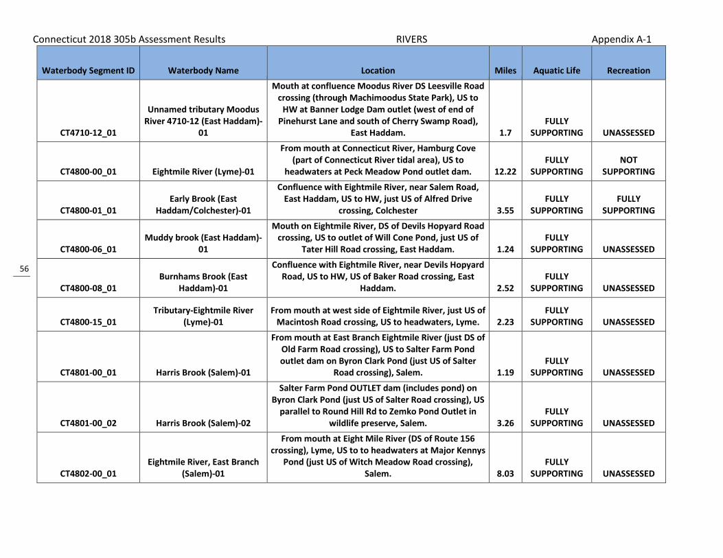
Connecticut 2018 305b Assessment Results RIVERS Appendix A-1
56
Waterbody Segment ID Waterbody Name Location Miles Aquatic Life Recreation
CT4710-12_01
Unnamed tributary Moodus River 4710-12 (East Haddam)-
01
Mouth at confluence Moodus River DS Leesville Road crossing (through Machimoodus State Park), US to
HW at Banner Lodge Dam outlet (west of end of Pinehurst Lane and south of Cherry Swamp Road),
East Haddam. 1.7 FULLY
SUPPORTING UNASSESSED
CT4800-00_01 Eightmile River (Lyme)-01
From mouth at Connecticut River, Hamburg Cove (part of Connecticut River tidal area), US to
headwaters at Peck Meadow Pond outlet dam. 12.22 FULLY
SUPPORTING NOT
SUPPORTING
CT4800-01_01 Early Brook (East
Haddam/Colchester)-01
Confluence with Eightmile River, near Salem Road, East Haddam, US to HW, just US of Alfred Drive
crossing, Colchester 3.55 FULLY
SUPPORTING FULLY
SUPPORTING
CT4800-06_01 Muddy brook (East Haddam)-
01
Mouth on Eightmile River, DS of Devils Hopyard Road crossing, US to outlet of Will Cone Pond, just US of
Tater Hill Road crossing, East Haddam. 1.24 FULLY
SUPPORTING UNASSESSED
CT4800-08_01 Burnhams Brook (East
Haddam)-01
Confluence with Eightmile River, near Devils Hopyard Road, US to HW, US of Baker Road crossing, East
Haddam. 2.52 FULLY
SUPPORTING UNASSESSED
CT4800-15_01 Tributary-Eightmile River
(Lyme)-01 From mouth at west side of Eightmile River, just US of
Macintosh Road crossing, US to headwaters, Lyme. 2.23 FULLY
SUPPORTING UNASSESSED
CT4801-00_01 Harris Brook (Salem)-01
From mouth at East Branch Eightmile River (just DS of Old Farm Road crossing), US to Salter Farm Pond outlet dam on Byron Clark Pond (just US of Salter
Road crossing), Salem. 1.19 FULLY
SUPPORTING UNASSESSED
CT4801-00_02 Harris Brook (Salem)-02
Salter Farm Pond OUTLET dam (includes pond) on Byron Clark Pond (just US of Salter Road crossing), US
parallel to Round Hill Rd to Zemko Pond Outlet in wildlife preserve, Salem. 3.26
FULLY SUPPORTING UNASSESSED
CT4802-00_01 Eightmile River, East Branch
(Salem)-01
From mouth at Eight Mile River (DS of Route 156 crossing), Lyme, US to to headwaters at Major Kennys
Pond (just US of Witch Meadow Road crossing), Salem. 8.03
FULLY SUPPORTING UNASSESSED

Connecticut 2018 305b Assessment Results RIVERS Appendix A-1
57
Waterbody Segment ID Waterbody Name Location Miles Aquatic Life Recreation
CT4802-01_01 Big Brook (Salem)-01
Mouth at Outlet into Major Kennys Pond just DS of Route 85 crossing, US running parallel along east side of Route 85 to HW just south of Marvin Rd and Route
85 intersection, Salem. 1.81 FULLY
SUPPORTING UNASSESSED
CT4803-00_01 Beaver Brook (Lyme)-01
From mouth at Eightmile River, along west side of Route 156, US to confluence with Cedar Pond Brook,
Lyme. 1.86 FULLY
SUPPORTING UNASSESSED
CT4803-01_01 Cedar Pond Brook (Lyme)-01
Mouth on Beaver Brook, DS of Beaver Brook Road crossing, US to Cedar Lake outlet, US of Beaver Brook
Road crossing, Lyme. 1.74 FULLY
SUPPORTING UNASSESSED
CT5000-55_01 Unnamed trib to Oyster River
(Milford)-01
From Merwin Avenue crossing, US to RailRoad (Amtrak) crossing (just US of Quirkes Pond (included
in segment)), Milford. 1.47 NOT
SUPPORTING UNASSESSED
CT5000-55_02 Unnamed trib to Oyster River
(Milford)-02
From RailRoad (Amtrak) crossing (just US of Quirks Pond), US to headwaters (inlet to unnamed swamp),
just US of Cascade Boulevard (entrance to Light Sources Inc.), Milford. 0.43
NOT SUPPORTING UNASSESSED
CT5102-02_02 Spring Lot Brook (Westbrook)-
02
Unnamed dirt access road crossing (off Dewolfe (McVeagh) Road) behind Westbrook High, US to OUTLET of Vincent Pond (1/2 US of Fishing Brook
Road crossing) Westbrook. 0.92 NOT
SUPPORTING UNASSESSED
CT5103-00_01 Menunketesuck River
(Westbrook/Clinton)-01
Inlet to Chapman Pond (just DS Pleasant Valley Road crossing), Westbrook, US to Lockwood Lake outlet
dam on Bushy Pond (just US of Woods Lane crossing), Clinton. 2.03
FULLY SUPPORTING UNASSESSED
CT5103-00_02 Menunketesuck River
(Clinton)-02
Bushy Pond inlet (just DS Kelseytown Road crossing), Clinton, US to Kelseytown Reservoir outlet dam (just
US Kelseytown Bridge Road crossing), Clinton. 1.78 NOT
SUPPORTING UNASSESSED
CT5103-00_03 Menunketesuck River
(Killingworth)-03
Kelseytown Reservoir inlet (northeast corner), Clinton-Killingworth border, US to North Roast Meat
Hill Road crossing (just US Route 148 crossing), Killingworth. 5.17
FULLY SUPPORTING UNASSESSED

Connecticut 2018 305b Assessment Results RIVERS Appendix A-1
58
Waterbody Segment ID Waterbody Name Location Miles Aquatic Life Recreation
CT5103-01_01 Heft Brook
(Killingworth/Haddam)-01
Mouth at confluence with Menunketesuck River, just DS of Menunketesuck River Roast Meat Hill Road
crossing (near Cockaponset State Forest) Killingworth, US to HW parallel to Perker Hill Road, just over the
Haddam town line, Haddam. 4.09 FULLY
SUPPORTING UNASSESSED
CT5105-00_01 Chatfield Hollow Brook
(Killingworth)-01
Mouth at confluence Hammonasset River (DS of River Road crossing), US to Deer Lake outlet Dam,
Killingworth. 1.03 FULLY
SUPPORTING NOT
SUPPORTING
CT5105-00_04 Chatfield Hollow Brook
(Killingworth)-04
Schreeder Pond inlet, parallel to Buck Road, US to confluence with Pond Meadow Brook (just DS of Old
Mill Pond), Killingworth. 0.53 NOT
SUPPORTING UNASSESSED
CT5105-01_01 Pond Meadow Brook-01
Mouth at confluence Chatfield Hollow Brook (just DS of Old Mill Pond outlet dam on Chatfield Hollow
Brook, in Chatfield Hollow State Park), US to Kroupa Pond outlet dam (just US of Route 148 crossing),
Killingworth. 0.7 FULLY
SUPPORTING UNASSESSED
CT5106-00_01 Hammonasset River-01
From saltwater limit at DS most portion of I95 crossing, Madison/Clinton town border, US to
Hammonassett Reservoir outlet dam (just US of Route 80 crossing), Killingworth/Madison town border. 8.07
FULLY SUPPORTING UNASSESSED
CT5107-00_01 Neck River-01
From head of tide (marsh exit, parallel to Neck Road, DS of Route 1 crossing), US to headwaters (just
northeast of Roure 80 and Route 79 rotary intersection, and south of aqueduct), Madison. 9.49 UNASSESSED
NOT SUPPORTING
CT5108-00_01 East River (Guilford)-01
From Platner Dam (just US of Foot Bridge Road crossing, head of tide), US to 2nd unnamed tributary
(below lakes), Guilford. 0.67 UNASSESSED NOT
SUPPORTING
CT5108-05_01 Dowd Hollow Brook
(Madison)-01 Confluence with Iron Stream, DS of Route 80 crossing,
US to Race Hill Road crossing, Madison. 1.13 FULLY
SUPPORTING UNASSESSED
CT5108-05_02 Dowd Hollow Brook
(Madison)-02 Race Hill Road crossing, US to water company
diversion pipe, Madison. 1.59 FULLY
SUPPORTING UNASSESSED

Connecticut 2018 305b Assessment Results RIVERS Appendix A-1
59
Waterbody Segment ID Waterbody Name Location Miles Aquatic Life Recreation
CT5110-00_02 West River (Guilford)-02
From confluence with unnamed tributary from Thirsty Lake outlet (just DS of Flat Meadow Road crossing), US to confuence with Branch Brook (just US of Race
Hill Road crossing, parallel with Route 77), DS of lake Quonnipaug outlet dam, Guilford. 5.41
FULLY SUPPORTING UNASSESSED
CT5110-01_02 Branch Brook (Guilford)-02
Inlet to Lake Menunatuck DS Great Hill Road crossing, US to HW US Beaver Head Rd crossing and west of unnamed subdivision Rd (includes Bartlett Pond),
Guilford. 2.31 FULLY
SUPPORTING UNASSESSED
CT5111-00_02 Branford River-02
From confluence with Notch Hill Brook (US of School Ground Road crossing), Branford, US to Lake Gaillard
outlet dam (southeast portion of lake), North Branford. 3.07
NOT SUPPORTING UNASSESSED
CT5112-00_01 Farm River (East Haven)-01
Saltwater limit at marsh, just DS of Main Street Anx. crossing, southwest of Lake Saltonstall outflow, East
Haven, US parallel to lake around west side to confluence Burrs Brook parallel along Route 80 and
DS of crossing), North Branford. 6.14 NOT
SUPPORTING NOT
SUPPORTING
CT5112-00_02 Farm River (North Branford)-
02
Confluence Burrs Brook just DSRoute 80 crossing, US to Pages Mill Pond outlet dam, US side Mill Road
crossing, North Branford. 1.24 NOT
SUPPORTING NOT
SUPPORTING
CT5112-00_03b Farm River (North Branford)-
03b
Gulf Brook to HW just US of Hyla Lane crossing, and parallel to Route 17 (Middletown Avenue), North
Branford. (Site15018) 4.87 NOT
SUPPORTING UNASSESSED
CT5112-05_01 Gulf Brook (North Branford)-
01
Mouth at confluence with Farm River, along Route 22 just south of the intersection of Route 22 and Route
17, US to HW just south of Reeds Gap Road (near Guilford town line, and Lanes Pond area), North
Branford. 3.42 NOT
SUPPORTING UNASSESSED

Connecticut 2018 305b Assessment Results RIVERS Appendix A-1
60
Waterbody Segment ID Waterbody Name Location Miles Aquatic Life Recreation
CT5112-10_01 Burrs Brook-01
From mouth at confluence with Farm River (just DS of Totoket Road crossing), US to Vic's Pond (on Tomasso
property) outlet (part of hyro missing from NHD). Brook contributes to drinking water supply, Lake
Saltonstall. 1.35 NOT
SUPPORTING UNASSESSED
CT5200-00_01 Quinnipiac River (North Haven/Wallingford)-01
Sackett Point Road crossing (west of I91, and east of Route 15), North Haven, US to Toelles Road crossing
(head of tide), Wallingford/North Haven town border. 5.05 NOT
SUPPORTING NOT
SUPPORTING
CT5200-00_02 Quinnipiac River (North
Haven/Meriden)-02
Toelles Road crossing (head of tide, just east Route 15), Wallingford/North Haven town border, US to
Hanover Pond outlet dam, Meriden. (Segment includes Community Lake portion) 8.5
NOT SUPPORTING
NOT SUPPORTING
CT5200-00_03 Quinnipiac River-03
Hanover Pond inlet (at Oregon Road crossing, DS end of Quinnipiac Gorge), Meriden, US (through Gorge) to
Waterworks (breached dam), just DS Cheshire/Meriden town border (parallel to River Road
(Route 70)). 1.29 NOT
SUPPORTING NOT
SUPPORTING
CT5200-00_04 Quinnipiac River-04
From Waterworks (breached dam), just DS of Cheshire/Meriden town border (parallel to River Road (Route 70)), US to confluence with Tenmile River (US of Route 322 crossing, and US of Southington WPCF). 4.78
NOT SUPPORTING
NOT SUPPORTING
CT5200-00_05 Quinnipiac River-05
From confluence with Tenmile River (US of Route 322 crossing, and US of Southington WPCF), US to Queen Street (Route 10) crossing (US of RailRoad crossing,
North of I-84 crossing), Southington. 8.32 NOT
SUPPORTING UNASSESSED
CT5200-00_06 Quinnipiac River-06
From Queen Street (Route 10) crossing (US of RailRoad crossing, North of I-84 crossing),
Southington, US to Hamlin Pond outlet dam (US of Pine Street crossing), Plainville. 3
NOT SUPPORTING
NOT SUPPORTING

Connecticut 2018 305b Assessment Results RIVERS Appendix A-1
61
Waterbody Segment ID Waterbody Name Location Miles Aquatic Life Recreation
CT5200-00_07 Quinnipiac River-07
From Hamlin Pond inlet (northeast corner, just south of Route 72 and I84 connection and RailRoad),
Plainville, US to headwaters at Dead Wood Swamp (west side of I84, near exit 37, just south of Route 6),
Farmington. 3.5 NOT
SUPPORTING NOT
SUPPORTING
CT5200-02_01 Patton Brook-01
From mouth at confluence with Quinnipiac River (just DS of River Road crossing), US to headwaters at unnamed pond (US of confluence with Mill Pond
tributary, just US of Malcein Drive crossing), Southington. 2.84
NOT SUPPORTING UNASSESSED
CT5200-07_01 Honeypot Brook-01
Mouth at confluence with Quinnipiac River, (US of Blacks Road crossing), US to headwaters, US of Wiese
Road crossing (near Route 70), Cheshire. 4.95 FULLY
SUPPORTING UNASSESSED
CT5200-10_01 Meetinghouse Brook
(Wallingford)-01
Mouth on Quinnipiac River, at Route 68 crossing, US to confluence with Spruce Glen Brook, parallel to
Route 15, Wallingford. 1.15 NOT
SUPPORTING UNASSESSED
CT5200-23_01 Hemingway Creek-01
From saltwater limit (200m DS of Quinipiac Avenue crossing, just DS of RailRoad crossing), New Haven, US
to Golf Pond outlet dam, East Haven. 0.74 NOT
SUPPORTING UNASSESSED
CT5201-00_01 Eightmile River (Southington)-
01
From mouth at confluence with Quinnipiac River (DS of West Main Street crossing and just DS of RailRoad crossing), US to Grannis Pond outlet dam (just US of
Churchhill Street crossing), Southington. 3.39 FULLY
SUPPORTING UNASSESSED
CT5202-00_01 Tenmile River
(Southington/Cheshire)-01
From mouth at confluence with Quinnipiac River (DS of Old Turnpike Road crossing), Southington, US to
Lake Percivel outlet dam on Moss Farms Pond (just US of Jarvis Street crossing), Cheshire. 4.1
NOT SUPPORTING UNASSESSED
CT5202-00_02 Tenmile River (Cheshire)-02
From inlet to Moss Farms Pond (on southwest end), US to headwaters at Mixville Pond outlet dam (just US
of Notch Road crossing), Cheshire. 1.42 FULLY
SUPPORTING UNASSESSED

Connecticut 2018 305b Assessment Results RIVERS Appendix A-1
62
Waterbody Segment ID Waterbody Name Location Miles Aquatic Life Recreation
CT5203-00_01 Misery Brook (Southington)-
01
Mouth Quinnipiac River (just DS Meriden Waterbury Turnpike (Route 322) crossing), Cheshire/Southington
border, US to Slopers Pond outlet dam (just US East Street crossing), Southington. 4.23
NOT SUPPORTING
NOT SUPPORTING
CT5205-00_01 Sodom Brook-01
From mouth at confluence with Quinnipiac River (flows into north side of Hanover Pond portion of river), US to headwaters (just US of second Hicks Avenue crossing, due to river changing direction),
Meriden. 4.16 NOT
SUPPORTING NOT
SUPPORTING
CT5206-00_01 Harbor Brook (Meriden)-01
From mouth at confluence with Quinnipiac River (flows into north side of Hanover Pond portion of river, DS of Bradley Avenue crossing), US to exit of
box culvert (just DS of RailRoad and Main Street (Route 71) crossings), Meriden. 2.02
NOT SUPPORTING
NOT SUPPORTING
CT5206-00_02 Harbor Brook (Meriden)-02
From exit of box culvert (just DS of RailRoad and Main Street (Route 71) crossings), US to culvert entrance
(just US of Fire Station, and US of Mill Street crossing), Meriden. 0.4
NOT SUPPORTING
NOT SUPPORTING
CT5206-00_03 Harbor Brook (Meriden)-03
From culvert entrance (just US of Fire Station, and US of Mill Street crossing), US to Baldwins Pond outlet dam (just US of Westfield Road crossing), Meriden. 1.48
NOT SUPPORTING UNASSESSED
CT5206-01_01 Spoon Shop Brook (Meriden)-
01
Mouth at concluence with Harbor Brook near Orchid Road and Meadow Brook Road, to east of Route 15,
US under I91 and I691 to confluence with North Branch Spoon Shop Brook, US of Tumblebrook Road
crossing, near exit 12 off I691, Meriden. 1.49 NOT
SUPPORTING NOT
SUPPORTING
CT5206-02_01 Willow Brook (Meriden)-01
Mouth on Spoon Shop Brook between Route 15 (Wilbur Cross) and Orchid Road, US to HW at OUTLET
of Bishops Pond just US of Research Pkwy crossing and parallel to I91, Meriden. 2.87
NOT SUPPORTING UNASSESSED
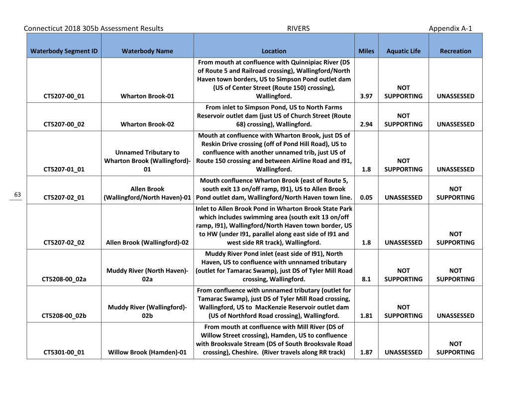
Connecticut 2018 305b Assessment Results RIVERS Appendix A-1
63
Waterbody Segment ID Waterbody Name Location Miles Aquatic Life Recreation
CT5207-00_01 Wharton Brook-01
From mouth at confluence with Quinnipiac River (DS of Route 5 and Railroad crossing), Wallingford/North Haven town borders, US to Simpson Pond outlet dam
(US of Center Street (Route 150) crossing), Wallingford. 3.97
NOT SUPPORTING UNASSESSED
CT5207-00_02 Wharton Brook-02
From inlet to Simpson Pond, US to North Farms Reservoir outlet dam (just US of Church Street (Route
68) crossing), Wallingford. 2.94 NOT
SUPPORTING UNASSESSED
CT5207-01_01
Unnamed Tributary to Wharton Brook (Wallingford)-
01
Mouth at confluence with Wharton Brook, just DS of Reskin Drive crossing (off of Pond Hill Road), US to confluence with another unnamed trib, just US of
Route 150 crossing and between Airline Road and I91, Wallingford. 1.8
NOT SUPPORTING UNASSESSED
CT5207-02_01 Allen Brook
(Wallingford/North Haven)-01
Mouth confluence Wharton Brook (east of Route 5, south exit 13 on/off ramp, I91), US to Allen Brook
Pond outlet dam, Wallingford/North Haven town line. 0.05 UNASSESSED NOT
SUPPORTING
CT5207-02_02 Allen Brook (Wallingford)-02
Inlet to Allen Brook Pond in Wharton Brook State Park which includes swimming area (south exit 13 on/off
ramp, I91), Wallingford/North Haven town border, US to HW (under I91, parallel along east side of I91 and
west side RR track), Wallingford. 1.8 UNASSESSED NOT
SUPPORTING
CT5208-00_02a Muddy River (North Haven)-
02a
Muddy River Pond inlet (east side of I91), North Haven, US to confluence with unnnamed tributary
(outlet for Tamarac Swamp), just DS of Tyler Mill Road crossing, Wallingford. 8.1
NOT SUPPORTING
NOT SUPPORTING
CT5208-00_02b Muddy River (Wallingford)-
02b
From confluence with unnnamed tributary (outlet for Tamarac Swamp), just DS of Tyler Mill Road crossing, Wallingford, US to MacKenzie Reservoir outlet dam
(US of Northford Road crossing), Wallingford. 1.81 NOT
SUPPORTING UNASSESSED
CT5301-00_01 Willow Brook (Hamden)-01
From mouth at confluence with Mill River (DS of Willow Street crossing), Hamden, US to confluence
with Brooksvale Stream (DS of South Brooksvale Road crossing), Cheshire. (River travels along RR track) 1.87 UNASSESSED
NOT SUPPORTING

Connecticut 2018 305b Assessment Results RIVERS Appendix A-1
64
Waterbody Segment ID Waterbody Name Location Miles Aquatic Life Recreation
CT5301-02_01 Sanford Brook (Cheshire)-01
From mouth at confluence with Willow Brook (DS of South Brooksvale Road crossing), Cheshire, US to HW
(just US of Candee Road crossing), Prospect. 2.68 FULLY
SUPPORTING FULLY
SUPPORTING
CT5302-00_01 Mill River (Hamden)-01
From Footbridge off of Park Road (US extent of saltwater influence), US to Lake Whitney outlet dam,
Hamden. (Segment is tidally affected, but not saltwater). 0.41
FULLY SUPPORTING
FULLY SUPPORTING
CT5302-00_02 Mill River (Hamden/Cheshire)-
02
INLET Lake Whitney (east side Route 15, just DS Connolly Parkway crossing), Hamden, US to Cook Hill
Road crossing, Cheshire. 9.06 NOT
SUPPORTING NOT
SUPPORTING
CT5302-00_03 Mill River (Cheshire)-03
Cook Hill Road crossing, US to HW just US Williamsburg Drive crossing, Cheshire (AA
drinkingwater watershed). 3.09 NOT
SUPPORTING UNASSESSED
CT5302-06_01 Shepard Brook (Hamden)-01
Mouth at confluence with Mill River just DS of Route 15 crossing, US (includes Turners Pond) to confluence
with unnamed tributary behind business park off Sherman Avenue on west and Town Walk Drive on
East (above ponded area at Sherman Lane), Hamden. 1.78 UNASSESSED NOT
SUPPORTING
CT5303-00_01 Sargent River-01
From mouth at confluence with West River (DS of Route 69 crossing) at inlet to Lake Dawson,
Woodbridge, US to headwaters at Munson Road Pond outlet dam, Bethany (EXCLUDING Lake Glen and Lake
Chamberlain). 3.96 FULLY
SUPPORTING UNASSESSED
CT5304-00_01 Wintergreen Brook (New
Haven)-01
Mouth on West River, DS of Blake Street crossing, US to confluence with Wilmot Brook, US of Wilmot Road
crossing, New Haven. 1.42 UNASSESSED NOT
SUPPORTING
CT5304-00_03 Wintergreen Brook (New
Haven)-03
Confluence with Belden Brook, US of Brookside Avenue crossing, New Haven, US to Lake Wintergreen
outlet, US of Wintergreen Avenue crossing (near Route 15), Hamden. 1.22
FULLY SUPPORTING UNASSESSED
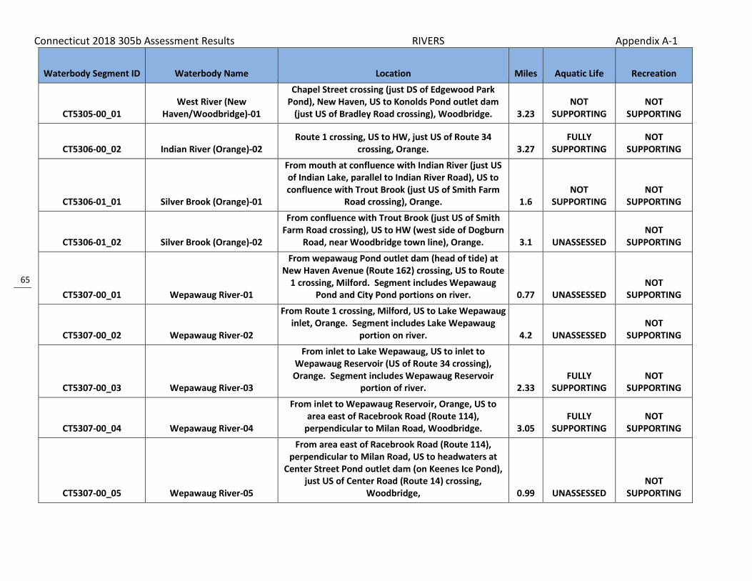
Connecticut 2018 305b Assessment Results RIVERS Appendix A-1
65
Waterbody Segment ID Waterbody Name Location Miles Aquatic Life Recreation
CT5305-00_01 West River (New
Haven/Woodbridge)-01
Chapel Street crossing (just DS of Edgewood Park Pond), New Haven, US to Konolds Pond outlet dam
(just US of Bradley Road crossing), Woodbridge. 3.23 NOT
SUPPORTING NOT
SUPPORTING
CT5306-00_02 Indian River (Orange)-02 Route 1 crossing, US to HW, just US of Route 34
crossing, Orange. 3.27 FULLY
SUPPORTING NOT
SUPPORTING
CT5306-01_01 Silver Brook (Orange)-01
From mouth at confluence with Indian River (just US of Indian Lake, parallel to Indian River Road), US to confluence with Trout Brook (just US of Smith Farm
Road crossing), Orange. 1.6 NOT
SUPPORTING NOT
SUPPORTING
CT5306-01_02 Silver Brook (Orange)-02
From confluence with Trout Brook (just US of Smith Farm Road crossing), US to HW (west side of Dogburn
Road, near Woodbridge town line), Orange. 3.1 UNASSESSED NOT
SUPPORTING
CT5307-00_01 Wepawaug River-01
From wepawaug Pond outlet dam (head of tide) at New Haven Avenue (Route 162) crossing, US to Route
1 crossing, Milford. Segment includes Wepawaug Pond and City Pond portions on river. 0.77 UNASSESSED
NOT SUPPORTING
CT5307-00_02 Wepawaug River-02
From Route 1 crossing, Milford, US to Lake Wepawaug inlet, Orange. Segment includes Lake Wepawaug
portion on river. 4.2 UNASSESSED NOT
SUPPORTING
CT5307-00_03 Wepawaug River-03
From inlet to Lake Wepawaug, US to inlet to Wepawaug Reservoir (US of Route 34 crossing), Orange. Segment includes Wepawaug Reservoir
portion of river. 2.33 FULLY
SUPPORTING NOT
SUPPORTING
CT5307-00_04 Wepawaug River-04
From inlet to Wepawaug Reservoir, Orange, US to area east of Racebrook Road (Route 114),
perpendicular to Milan Road, Woodbridge. 3.05 FULLY
SUPPORTING NOT
SUPPORTING
CT5307-00_05 Wepawaug River-05
From area east of Racebrook Road (Route 114), perpendicular to Milan Road, US to headwaters at
Center Street Pond outlet dam (on Keenes Ice Pond), just US of Center Road (Route 14) crossing,
Woodbridge, 0.99 UNASSESSED NOT
SUPPORTING
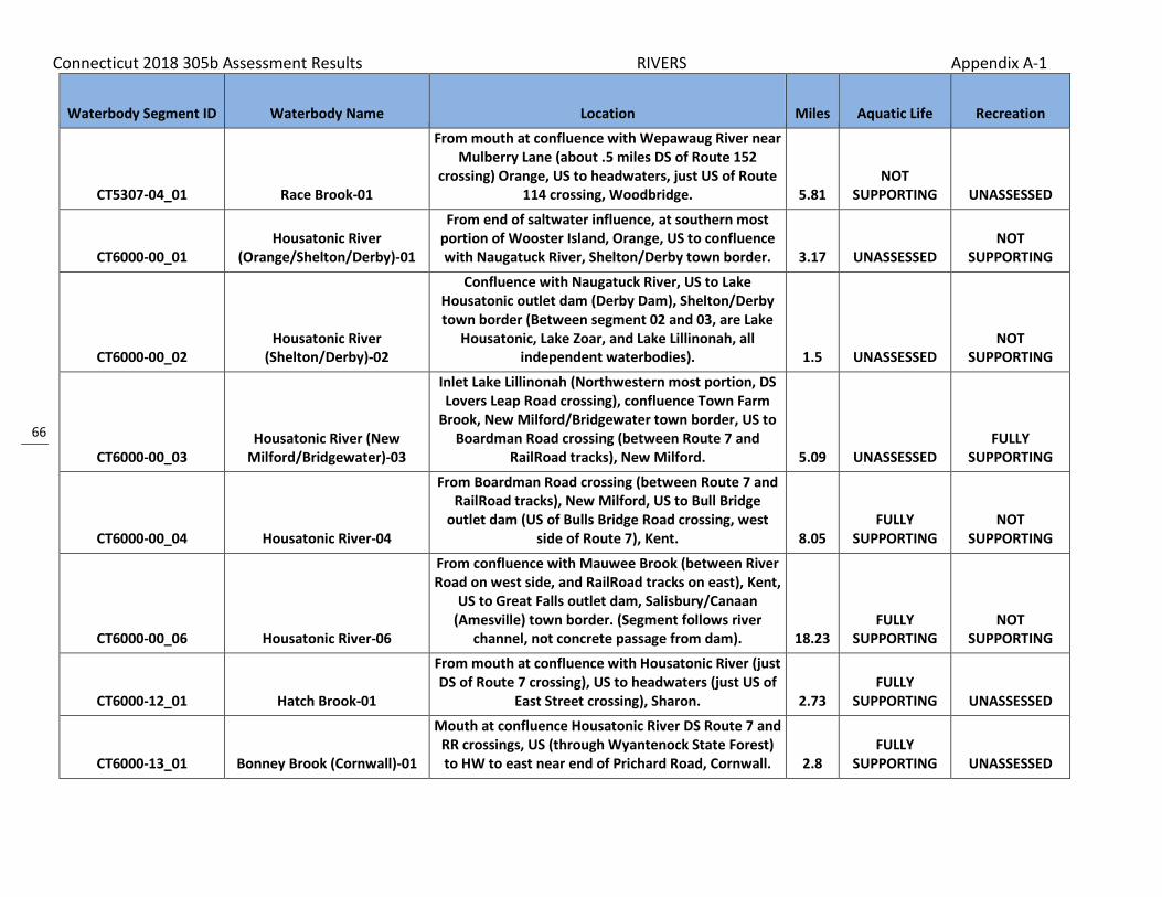
Connecticut 2018 305b Assessment Results RIVERS Appendix A-1
66
Waterbody Segment ID Waterbody Name Location Miles Aquatic Life Recreation
CT5307-04_01 Race Brook-01
From mouth at confluence with Wepawaug River near Mulberry Lane (about .5 miles DS of Route 152
crossing) Orange, US to headwaters, just US of Route 114 crossing, Woodbridge. 5.81
NOT SUPPORTING UNASSESSED
CT6000-00_01 Housatonic River
(Orange/Shelton/Derby)-01
From end of saltwater influence, at southern most portion of Wooster Island, Orange, US to confluence with Naugatuck River, Shelton/Derby town border. 3.17 UNASSESSED
NOT SUPPORTING
CT6000-00_02 Housatonic River
(Shelton/Derby)-02
Confluence with Naugatuck River, US to Lake Housatonic outlet dam (Derby Dam), Shelton/Derby town border (Between segment 02 and 03, are Lake
Housatonic, Lake Zoar, and Lake Lillinonah, all independent waterbodies). 1.5 UNASSESSED
NOT SUPPORTING
CT6000-00_03 Housatonic River (New
Milford/Bridgewater)-03
Inlet Lake Lillinonah (Northwestern most portion, DS Lovers Leap Road crossing), confluence Town Farm
Brook, New Milford/Bridgewater town border, US to Boardman Road crossing (between Route 7 and
RailRoad tracks), New Milford. 5.09 UNASSESSED FULLY
SUPPORTING
CT6000-00_04 Housatonic River-04
From Boardman Road crossing (between Route 7 and RailRoad tracks), New Milford, US to Bull Bridge
outlet dam (US of Bulls Bridge Road crossing, west side of Route 7), Kent. 8.05
FULLY SUPPORTING
NOT SUPPORTING
CT6000-00_06 Housatonic River-06
From confluence with Mauwee Brook (between River Road on west side, and RailRoad tracks on east), Kent,
US to Great Falls outlet dam, Salisbury/Canaan (Amesville) town border. (Segment follows river
channel, not concrete passage from dam). 18.23 FULLY
SUPPORTING NOT
SUPPORTING
CT6000-12_01 Hatch Brook-01
From mouth at confluence with Housatonic River (just DS of Route 7 crossing), US to headwaters (just US of
East Street crossing), Sharon. 2.73 FULLY
SUPPORTING UNASSESSED
CT6000-13_01 Bonney Brook (Cornwall)-01
Mouth at confluence Housatonic River DS Route 7 and RR crossings, US (through Wyantenock State Forest) to HW to east near end of Prichard Road, Cornwall. 2.8
FULLY SUPPORTING UNASSESSED

Connecticut 2018 305b Assessment Results RIVERS Appendix A-1
67
Waterbody Segment ID Waterbody Name Location Miles Aquatic Life Recreation
CT6000-14_01 Gunn Brook (Cornwall)-01
Mouth at confluence Housatonic River (DS of RR crossing on north side of Swifts Bridge Road),
Sharon/Cornwall town border, US to headwaters (marsh US of Prichard Road crossing, above Spruce
dam), Cornwall. 3.58 FULLY
SUPPORTING UNASSESSED
CT6000-16-trib_01 Unnamed tributary to Deep
Brook (Kent)-01 Mouth confluence Deep Brook DS Dungan Rd
crossing, US to HW US Dugan Rd crossing, Kent. 0.64 FULLY
SUPPORTING UNASSESSED
CT6000-17_01 Stony Brook (Kent)-01 Mouth on Housatonic River, Kent, US to HW just US of
Modley Road crossing, Sharon. 2.57 FULLY
SUPPORTING UNASSESSED
CT6000-35_01 Cross Brook (New Milford)-01
Mouth at confluence with Great Brook, just DS of Crossbrook Road crossing near Weatinock Drive, US (includes New Milford Res#3) to HW near Heritage
Drive and Round Table Road, New Milford. 2.36 FULLY
SUPPORTING FULLY
SUPPORTING
CT6000-37_01 Town Farm Brook (New
Milford)-01
From mouth at confluence with Housatonic River (Lake Lillinonah, segment CT6000-00+L1_01) just DS of
Lake Lillinonah Road crossing, US to HW above New Milford Reservoir Number 4, New Milford. 4.57
FULLY SUPPORTING UNASSESSED
CT6000-38_01 Clapboard Oak Brook
(Bridgewater)-01
Mouth at confluence with Lake Lillinonah (Housatonic River) just DS of Lake Lillinonah Rd crossing, US to HW
at marsh outlet just US of Route 133 (Main St) crossing, Bridgewater. 2.3
FULLY SUPPORTING UNASSESSED
CT6000-41_01 Hitchcock Mill Brook
(bridgewater)-01
Mouth at confluence with Lake Lillinonah portion of Housatonic River near end of Benson Road, US
through Sunny Valley Foundation land to HW at Shurick Dam outlet, US of Christian Street crossing (in
South Cemetery), Bridgewater. 1.5 FULLY
SUPPORTING UNASSESSED
CT6000-42_01 Hop Brook (Brookfield)-01
From mouth at confluence with Housatonic River (Lake Lillinonah), US to Long Meadow Hill Road
crossing, Brookfield. 1.49 FULLY
SUPPORTING UNASSESSED

Connecticut 2018 305b Assessment Results RIVERS Appendix A-1
68
Waterbody Segment ID Waterbody Name Location Miles Aquatic Life Recreation
CT6000-45_01 Wewaka Brook (Bridgewater)-
01
Mouth at confluence with Housatonic River (Lake Lillinonah) just DS of Route 133 crossing, US along
Route 133 to outlet of Cider Millpond (dam washed out), Bridgewater. 0.64
FULLY SUPPORTING UNASSESSED
CT6000-45_02 Wewaka Brook (Bridgewater)-
02
Along Route 133 where outlet of Cider Millpond was (dam washed out), US to HW between Millvoe Drive
and Canfield Drive (runs parallel to Hut Hill Road), Bridgewater. 3.14
FULLY SUPPORTING UNASSESSED
CT6000-48_01 Purchase Brook (Southbury)-
01
Mouth at INLET to Lake Lillinonah portion of Housatonic River, DS of Purchase Brook Road crossing
and parallel to Little York Road, US (includes Housatonic Farm Pond) to confluence with first
unnamed tributary at Flat Road crossing, Southbury. 0.85 FULLY
SUPPORTING FULLY
SUPPORTING
CT6000-56_01 Lee Brook-01
From mouth at confluence with Housatonic River (Lake Zoar portion, near Lee Farm Drive), US to headwaters (US of Georges Hill Road crossing),
Southbury. 1.91 FULLY
SUPPORTING UNASSESSED
CT6000-62_01a Fivemile Brook (Oxford)-01a
From mouth at confluence with Housatonic River (Lake Housatonic portion, DS of Route 34 crossing), US to confluence with unnamed tributary (parallel to Old Country Road and DS of Route 188 crossing), Oxford. 1.43
FULLY SUPPORTING UNASSESSED
CT6000-64_01 Fourmile River (Seymour)-01
From mouth at Housatonic River (Lake Housatonic) DS of Route 34 crossing, US to Great Hill Reservoir outlet
dam (parallel with Route 188), Seymour. 1 FULLY
SUPPORTING UNASSESSED
CT6000-73_01 Curtiss Brook (Shelton)-01
Mouth at confluence with Housatonic River, DS Route 110 and RailRoad crossings, US to OUTLET of Shelton
Res#2, parallel to Route 108, Shelton. 0.8 UNASSESSED NOT
SUPPORTING
CT6000-77_01 Twomile Brook
(Derby/Orange)-01
Mouth on Housatonic River, DS of Derby Milford Road crossing, Derby/Orange town line, US to HW near
Osborne Lane, Ansonia. 5.67 NOT
SUPPORTING UNASSESSED
CT6001-00_01 Sages Ravine Brook
(Salisbury)-01 Mouth confluence Schenob Brook, US to Under Mountain Road (Route 41) crossing, Salisbury. 0.66
FULLY SUPPORTING UNASSESSED

Connecticut 2018 305b Assessment Results RIVERS Appendix A-1
69
Waterbody Segment ID Waterbody Name Location Miles Aquatic Life Recreation
CT6001-00_02 Sages Ravine Brook
(Salisbury)-02 Under Mountain Road (Route 41) crossing, Salisbury,
US to Massachusetts state border, Salisbury. 0.68 FULLY
SUPPORTING UNASSESSED
CT6005-00_01 Factory Brook-01
From mouth at confluence with Spruce Swamp Creek (headwaters of Salmon Creek), US to Salsbury WPCF discharge (just DS of confluence with Burton Brook),
Salisbury. 1.7 NOT
SUPPORTING UNASSESSED
CT6005-00_02 Factory Brook-02
From Salisbury WPCF discharge (just DS of confluence with Burton Brook), US to headwaters at
Wonoskopomuc Lake outlet dam (just US of Ethan Allen Street crossing, US of Factory Pond, included in
segment), Salisbury. 1.1 FULLY
SUPPORTING UNASSESSED
CT6005-01_01 Burton Brook (Salisbury)-01
Mouth at confluence with Factory Brook, .3 miles DS of Walton Street crossing, US to confluence with
McDuffee Brook, US of Covered Bridge Road in wood area between Moore Road and Upland Meadow
Road, Salisbury. 2.09 NOT
SUPPORTING FULLY
SUPPORTING
CT6005-04_01 Wachocastinook Creek
(Salisbury)-01
Mouth at confluence Factory Brook DS Route 41 crossing, US to HW South Pond outlet dam, just US Mount Rd crossing (runs parallel along Mount Riga
Rd), Salisbury. 4.5 FULLY
SUPPORTING UNASSESSED
CT6005-05_01
Unnamed tributary to Wachocastinook Brook 6005-
05 (Salisbury)-01
Mouth at Confluence Wachocastinook Creek near Factory St and Selleck Hill Rd intersection, US to HW
running along Selleck Hill Rd and crossing dirt rd after "Y" intersection of Selleck Hill Rd, Salisbury. 1.16
FULLY SUPPORTING UNASSESSED
CT6006-00_01 Spruce Swamp Creek-01
From mouth at confluence with Factory Brook (headwaters of Salmon Creek), US to headwaters at
confluence of Garnett Brook and Moore Brook (US of Route 44 crossing, parallel with RailRoad tracks),
Salisbury. 1.93 FULLY
SUPPORTING UNASSESSED

Connecticut 2018 305b Assessment Results RIVERS Appendix A-1
70
Waterbody Segment ID Waterbody Name Location Miles Aquatic Life Recreation
CT6006-03_02 Ball Brook basin 6006-03
(Salisbury)-02
Confluence Bingham Pond Brook (approximately .5 Miles US from Under Mountain Rd crossing), US to
HW on Gridley Mountain approximately .5 miles east of Mount Washington Rd (check maps, no direct
access), Salisbury. NOTE the -01 segment is in another basin 2.09
FULLY SUPPORTING UNASSESSED
CT6006-05-trib_01 Unnamed tributary to Ball
Brook (Salisbury)-01
Mouth at Confluence Ball Brook .1 Miles DS Under Mountain Rd crossing (both rivers cross road very close to each other), US to HW US of Scoville Ore
Mine Rd crossing, Salisbury. 0.9 FULLY
SUPPORTING UNASSESSED
CT6007-00_01 Salmon Creek (Salisbury)-01
From mouth at confluence with Housatonic River (DS of Lime Rock Road (Route 112) crossing),
Canaan/Salisbury town border, US to headwaters, at the confluence of Factory Brook and Spruce Swamp
Creek, Salisbury. 6.95 FULLY
SUPPORTING UNASSESSED
CT6008-00_01 Mill Brook (Cornwall)-01
From mouth at confluence with Housatonic River (just DS of Lower River Road crossing), Sharon/Cornwall town border, US to confluence with Heffers Brook
(just US of Sharon Goshen Turnpike (Route 128) crossing), Cornwall. 1.63
FULLY SUPPORTING UNASSESSED
CT6008-00_02a Mill Brook (Cornwall)-02a
Mouth at Confluence Heffers Brook (just US of Sharon Goshen Turnpike (Route 128) crossing), US to
Rattlesnake Road crossing, Cornwall. 1.21 FULLY
SUPPORTING UNASSESSED
CT6008-00_02b Mill Brook (Cornwall)-02b
From Rattlesnake Road crossing, US to Headwaters at Cream Hill Lake outlet dam (US of Town Street
crossing), Cornwall. 1.01 NOT
SUPPORTING UNASSESSED
CT6009-00_01 Carse Brook (Sharon)-01
From mouth at confuence with Housatonic River (DS Route 7 crossing), US to headwaters (US of West
Cornwall Road crossing), Sharon. 4.67 FULLY
SUPPORTING UNASSESSED

Connecticut 2018 305b Assessment Results RIVERS Appendix A-1
71
Waterbody Segment ID Waterbody Name Location Miles Aquatic Life Recreation
CT6010-00_01 Furnace Brook (Cornwall)-01
From mouth at confluence with Housatonic River (just DS of Popple Swamp Road crossing) Sharon/Cornwall
town border, US to headwaters at confluence of Valley Brook and Birdseye Brook (parallel to Valley
Road), Cornwall. 3.98 FULLY
SUPPORTING UNASSESSED
CT6011-00_01 Guinea Brook (Sharon)-01
Mouth at confluence Housatonic River (DS of River Road crossing), Cornwall/Sharon town border, US to
headwaters (US of Westwood 2 Road crossing), Sharon. 5.04
FULLY SUPPORTING UNASSESSED
CT6011-00-trib_01 Unnamed tributary Guinea
Brook (Sharon)-01
Mouth at confluence Guinea Brook DS crossing West Woods Road 2, US to HW US West Woods Road 2
(brook past pond inflow), Sharon. 0.9 FULLY
SUPPORTING UNASSESSED
CT6012-00_01 Kent Falls Brook (Kent)-01 Mouth at confluence Housatonic River (just DS of
Route 7 crossing), US to Carter Road crossing, Kent. 1.16 FULLY
SUPPORTING UNASSESSED
CT6013-00_01 Cobble Brook-01
From mouth at confluence with Housatonic River (east bank, just DS of RailRoad crossing), US to
headwaters (US of Segar Mountain Road (Route 341) crossing), Kent. 3.71
FULLY SUPPORTING UNASSESSED
CT6014-00_01 Bog Hollow Brook (Kent)-01
Mouth at confluence with Macedonia Brook just DS of Route 341 crossing, US to confluence with first
unnamed tributary .13 miles US of Route 341 crossing, Kent. 0.27
FULLY SUPPORTING
NOT SUPPORTING
CT6015-00_02 Macedonia Brook-02
From Macedonia Road (Route 341) crossing, US to confluence with Pond Mountain Brook (US of Fuller
Mountain Road crossing, along east side of Macedonia Brook Road), Kent. 2.31
FULLY SUPPORTING UNASSESSED
CT6015-00_03 Macedonia Brook-03
From confluence with Pond Mountain Brook (US of Fuller Mountain Road crossing, along east side of Macedonia Brook Road), US to confluence with
unnamed tributary, outlet stream for Hilltop Pond (near Appalachian Trail), Kent. 2.62
FULLY SUPPORTING UNASSESSED

Connecticut 2018 305b Assessment Results RIVERS Appendix A-1
72
Waterbody Segment ID Waterbody Name Location Miles Aquatic Life Recreation
CT6015-00_04 Macedonia Brook-04
From confluence with unnamed tributary, outlet stream for Hilltop Pond (near Appalachian Trail), Kent, US to headwaters in marsh, (US of Westwood 2 Road
crossing), Sharon. 3.49 FULLY
SUPPORTING UNASSESSED
CT6015-01_01 Pond Mountain Brook (Kent)-
01
Mouth confluence Macedonia Brook DS Fuller Mountain Rd crossing, US to HW US Skiff Mountain Rd
crossing (west of Marvelwood School), Kent. 4.04 FULLY
SUPPORTING UNASSESSED
CT6016-00_03 Womenshenuck Brook (Kent)-
03
Lenard Pond inlet just DS Lenard Pond Rd crossing, US to HW at Kent Reservoir outlet dam (east side Route
341), Kent. 1.13 FULLY
SUPPORTING UNASSESSED
CT6016-03_02 Bull Mountain Brook (New
Milford/Kent)-02
Mud Pond inlet (northeastern portion, DS of Camps Flat Road crossing), New Milford, US to HW at Geer Mountain Pond outlet dam (just US Richard Road
crossing, segment includes Irving Pond), Kent. 2.97 FULLY
SUPPORTING UNASSESSED
CT6017-00_02 Morrissey Brook (New
Milford)-02 Gaylord Road crossing, New Milford, US to Route 39
crossing, sherman. 3.03 FULLY
SUPPORTING UNASSESSED
CT6018-00_01 Pond Brook (Newtown)-01
From mouth at confluence with Lake Lillononah (just DS of Pond Brook Road crossing), US to confluence
with Dingle Brook, Newtown. 0.17 FULLY
SUPPORTING UNASSESSED
CT6018-00_02 Pond Brook (Newtown)-02
Confluence with Dingle Brook (near Lake Lillinonah and parallel to Pond Brook Road), US to HW at
OUTLET of Taunton Lake, just US of Taunton Lake Road crossing, Newtown. 6.13
FULLY SUPPORTING UNASSESSED
CT6019-00_01 Deep Brook (Newtown)-01
Mouth at confluence Pootatuck River (south side of I84, near exit 10), US to HW at Deep Brook Pond outlet dam (parallel to Head of Meadow Road),
Newtown. 5.25 FULLY
SUPPORTING NOT
SUPPORTING
CT6019-00-trib_01 Unnamed tributary Deep
Brook (Newtown)-01
Mouth Deep brook US to HW near Old Farm Rd, Newtown. Locally called Oil Creek, between Town salt
storage lot and old mill. 0.07 NOT
SUPPORTING UNASSESSED

Connecticut 2018 305b Assessment Results RIVERS Appendix A-1
73
Waterbody Segment ID Waterbody Name Location Miles Aquatic Life Recreation
CT6019-02_01 Unnamed tributary Deep
Brook 6019-02 (Newtown)-01
Mouth at confluence Deep Brook DS (north) Head Of Meadow Road crossing, US (south) to HW past Head
Of Meadow School, parallel to east along Shepard Hill Road (north of Sugar Hill Road intersection),
Newtown. 1.6 FULLY
SUPPORTING UNASSESSED
CT6020-00_01 Pootatuck River-01
From mouth at confluence with Housatonic River (west bank, DS of Walnut Tree Hill Road crossing), US to confluence with Newtown WPCF outflow (just DS of confluence with Deep Brook, US of I84 cossing),
Newtown. 2.44 FULLY
SUPPORTING FULLY
SUPPORTING
CT6020-00_02 Pootatuck River-02
From confluence with Newtown WPCF outflow (just DS of confluence with Deep Brook, US of I84 cossing),
Newtown, US to headwaters at unnamed pond (parallel to Judd Road), Easton. 8.39
FULLY SUPPORTING
FULLY SUPPORTING
CT6021-00_01 Kettletown Brook
(Southbury)-01
From mouth at confluence with Housatonic River (Lake Zoar), US to confluence with unnammed
tributary (just US of Kettletown State Park beach access road), Southbury. 0.39
FULLY SUPPORTING UNASSESSED
CT6022-00_01 Halfway River
(Newtown/Monroe)-01
Mouth on Lake Zoar portion of Housatonic River, just DS of Route 34 crossing, Newtown/Monroe town line, US to confluence with Copper Mill Brook, parallel to
RR track and Hammertown Road, along Newtown/Monroe town line. 2.9
FULLY SUPPORTING UNASSESSED
CT6023-00_01 Eightmile Brook (Oxford-
Middlebury)-01
From mouth at confluence with Housatonic River (Lake Housatonic portion, just DS of Roosevelt Road
(Route 34) crossing), Oxford, US to headwaters at Lake Quassapaug outlet dam (US of Route 64
crossing), Middlebury. 11.78 FULLY
SUPPORTING UNASSESSED
CT6024-00_02 Means Brook (Shelton)-02
From inlet to Means Brook Reservoir (just DS of Saw Mill City Road crossing), US to East Village Road
crossing (NOTE: Aqueduct connects HW to Hurds Brook), Shelton. 3.2
FULLY SUPPORTING UNASSESSED

Connecticut 2018 305b Assessment Results RIVERS Appendix A-1
74
Waterbody Segment ID Waterbody Name Location Miles Aquatic Life Recreation
CT6025-00_02 Farmill River-02
From River Road (Route 110) crossing (Wilson Gardens Dog Pond outlet dam), Shelton/Stratford
town border, US to confluence with Means Brook (US of Sycamore Drive crossing), Shelton. 3.99
FULLY SUPPORTING
NOT SUPPORTING
CT6025-00_03 Farmill River-03
From confluence with Means Brook (just DS of Huntington Street crossing), US to Far Mill (Isinglass)
Reservoir outlet dam, just US of Farmill Street crossing (beginning of drinking water watershed),
Shelton. 3.33 NOT
SUPPORTING FULLY
SUPPORTING
CT6025-00_04 Farmill River-04
From Far Mill (Isinglass) Reservoir inlet (in drinking water watershed), Shelton, US to headwaters (just US of Elm Street crossing, Monroe Turnpike (Route 111)
area), Monroe. 3.05 UNASSESSED NOT
SUPPORTING
CT6026-03_01 Cemetery Pond Brook (Stratford/Shelton)-01
Mouth at confluence with Pumpkin Ground Brook at Circle Drive crossing, Stratford, US to HW at OUTLET
of Cranberry Pond, just US of James Farm Road crossing, Shelton. 2.15 UNASSESSED
NOT SUPPORTING
CT6100-00_01 Blackberry River (North
Canaan)-01
From mouth at confluence with Housatonic River (at loop in river around island), US to confluence with
North Canaan WPCF (near old RailRoad grade, currently trail), North Canaan. 0.78
FULLY SUPPORTING UNASSESSED
CT6100-00_02a Blackberry River (North
Canaan)-02a
From confluence with North Canaan WPCF (near old RailRoad grade, currently trail, DS of Route 44
crossing), US to drainage ditch at southwest boundary of Lime Quarry (parallel to Lower Road), North
Canaan. 2.75 FULLY
SUPPORTING NOT
SUPPORTING
CT6100-00_02b Blackberry River (North
Canaan)-02b
From drainage ditch at southwest boundary of Lime Quarry (parallel to Lower Road), US to Blast Furnace (Historical Park) at Lower Pond dam outlet on Iron Furnace Pond (perpendicular to Furnace Hill Road),
North Canaan. 1.18 FULLY
SUPPORTING UNASSESSED

Connecticut 2018 305b Assessment Results RIVERS Appendix A-1
75
Waterbody Segment ID Waterbody Name Location Miles Aquatic Life Recreation
CT6100-00_03 Blackberry River (Norfolk)-03
From Blast Furnace (Historical Park) at Lower Pond dam outlet on Iron Furnace Pond (perpendicular to Furnace Hill Road), North Canaan, US to confluence
with North Brook (DS of Norfolk WPCF, south side of Route 44 at Ashpohtag Road intersection), Norfolk. 4.19
FULLY SUPPORTING UNASSESSED
CT6100-00_04 Blackberry River (Norfolk)-04
From confluence with North Brook (DS of Norfolk WPCF, south side of Route 44 at Ashpohtag Road
intersection), US to Norfolk WPCF outfall (US end of site), Norfolk. 0.46
FULLY SUPPORTING UNASSESSED
CT6100-00_05 Blackberry River-05
From Norfolk WPCF outfall (DS end of site), US to headwaters at confluence of Wood Creek and
Spaulding Brook (US of Blackberry Street crossing, parallel to Route 44), Norfolk. 1.03
FULLY SUPPORTING UNASSESSED
CT6100-03_01 Norfolk Brook (Norfolk)-01
Mouth at confluence with Spaulding brook DS of Mountain Road crossing (near intersection with Route
272), US to HW at OUTLET Pond Hill Pond just US of Route 44 crossing, Norfolk. 2.23
FULLY SUPPORTING UNASSESSED
CT6100-06_01 North Brook (Norfolk)-01
Mouth at confluence Blackberry River DS of Route 44 crossing, US through Haystack Mountain State Park to HW US Buckley Pond (included) to north west parallel
to Bald Mountain Road, Norfolk. 2 FULLY
SUPPORTING UNASSESSED
CT6100-07_01 Roaring Brook (North
Canaan/Norfolk/Canaan)-01
Mouth at Confluence Blackberry River on south side of Route 44 (across from Route 44 intersection with
Locust Hill Rd), North Canaan, US through Norfolk and including Case Pond to HW at Seldom Seen Pond
outlet, US of Wangum Rd (not far from town line, sam 3.29 FULLY
SUPPORTING UNASSESSED
CT6100-07-trib_01 Unnamed tributary to Roaring
Brook (Norfolk)-01
Mouth at Confluence Roaring Brook just US of Case Pond INLET, Norfolk, US to HW on north side for Mountain Rd near intersection of Old Woods Rd,
Norfolk. NOTE: Brook runs North. 0.76 FULLY
SUPPORTING UNASSESSED
CT6101-00_01 Whiting River-01
From mouth at confluence with Blackberry River (just DS of Canaan Road (Route 44) crossing), US to College
Hill Road crossing, North Canaan. 1.66 FULLY
SUPPORTING UNASSESSED

Connecticut 2018 305b Assessment Results RIVERS Appendix A-1
76
Waterbody Segment ID Waterbody Name Location Miles Aquatic Life Recreation
CT6101-00_02 Whiting River (North Canaan)-
02
From College Hill Road crossing, US to Whiting River Dam outlet, near CT state border with MA, US of Toby
Hill Road crossing, North Canaan. 1.38 FULLY
SUPPORTING UNASSESSED
CT6200-00_01 Hollenbeck River-01
From mouth at confluence with Housatonic River (DS of Point of Rock Road (Route 126) crossing), Canaan,
US to headwaters (US of Cornwall Hollow Road (Route 43) crossing), Cornwall. 18.32
FULLY SUPPORTING
NOT SUPPORTING
CT6200-02_01 Ocain Brook
(Cornwall/Goshen)-01
Mouth at confluence Hollenbeck River DS Route 63 crossing (farm area, low gradient), Cornwall, US to HW at Ocain Pond outlet dam (pond is DS Wildcat
Pond on south west side of Goshen Road), Goshen. 2.8 FULLY
SUPPORTING UNASSESSED
CT6200-05_01 Flat Brook (Canaan)-01 Mouth at Hollenbeck River, DS of Route 126 crossing,
US to Music Mountain Road crossing, Canaan. 2.18 FULLY
SUPPORTING UNASSESSED
CT6200-06_01 Whiting Brook (Canaan)-01
Mouth on Hollenbeck River, DS of Route 7 crossing, US to HW, US of Under Mountain Road crossing,
Canaan. 3.62 FULLY
SUPPORTING UNASSESSED
CT6201-00_01 Brown Brook (Canaan)-01
Confluence with Hollenbeck River, just DS of Route 63 crossing, US to confluence with North Branch Brown
Brook, Canaan. 0.77 FULLY
SUPPORTING UNASSESSED
CT6300-00_01 Tenmile River (Sherman)-01
From mouth at confluence with Housatonic River, US to New York state border, Sherman/Kent town
borders. 0.62 FULLY
SUPPORTING UNASSESSED
CT6302-00_02 Mill Brook (Sharon)-02
Confluence Beebe Brook (just DS Woods 1 road crossing), US to Hatch Pond outlet dam (just US
Mitchelltown Road crossing and confluence with Bog Meadow Brook), Sharon. 1.66
FULLY SUPPORTING
NOT SUPPORTING
CT6302-01_01 Bog Meadow Brook (Sharon)-
01
From mouth at confluence with Mill Brook (at Mitchell Town Road crossing), US to Ford Pond outlet
dam (parallel to Route 4), Sharon. 1.13 FULLY
SUPPORTING UNASSESSED

Connecticut 2018 305b Assessment Results RIVERS Appendix A-1
77
Waterbody Segment ID Waterbody Name Location Miles Aquatic Life Recreation
CT6302-03_01 Beebe Brook (Sharon)-01
Mouth at confluence with Mill Brook amoung farm fields between Route 41 and Woods Road, US parallel
with Woods Road to HW at OUTLET Eastmen Pond, Sharon. 1.09
FULLY SUPPORTING UNASSESSED
CT6303-00_01 Webatuck Creek (Sharon)-01
NY border near Sharon Valley Road to NY border US Sharon Station Rd crossing (river runs into CT from NY, then back into NY), Sharon. All this river in CT
borders in this segment. 1.52 FULLY
SUPPORTING UNASSESSED
CT6400-02_01 Glen Brook (Sherman)-01
Mouth at INLET to Squantz Pond parallel along east side of Wagon Wheel Rd, US to HW above and including Jennings Pond, US of Chapel Hill Road
crossing, Sherman. 2.58 FULLY
SUPPORTING UNASSESSED
CT6401-00_01 Sawmill Brook (Sherman)-01
Mouth at inlet Candlewood Lake (northwest portion of lake, DS Sawmill Road crossing), US to New York
state border, Sherman. 2.38 FULLY
SUPPORTING UNASSESSED
CT6402-00_01 Ball Pond Brook (New
Fairfield)-01
Mouth at Lake Candlewood .2 miles DS of Bear Mountain Road crossing, US to confluence with Deep
Hollow Brook, .2 miles US of Bear Hollow Road crossing, New Fairfield. 0.39
NOT SUPPORTING
NOT SUPPORTING
CT6500-00_01 Aspetuck River (New Milford)-
01
From mouth at confluence with Housatonic River (DS of Housatonic Avenue crossing), New Milford, US to headwaters at North Spectacle Pond outlet (US of Segar Mountain Road (Route 341) crossing), Kent. (Includes West Branch portion above East Branch) 15.04
FULLY SUPPORTING UNASSESSED
CT6501-00_01 Merryall Brook (New
Milford/Kent)-01
Mouth at confluence Aspetuck River DS Chinmoy Lane crossing, New Milford, US to HW US Ore Hill Road
crossing and close to Treasure Hill Road, Kent. 7.2 FULLY
SUPPORTING UNASSESSED
CT6502-00_02 East Aspetuck River-02
From Wellsville Avenue crossing, US to Wheaton Road Crossing (near Route 202, parallel to Old Mill Road),
New Milford. 5.07 FULLY
SUPPORTING UNASSESSED

Connecticut 2018 305b Assessment Results RIVERS Appendix A-1
78
Waterbody Segment ID Waterbody Name Location Miles Aquatic Life Recreation
CT6502-01_01 Lake Waramaug Brook
(Warren)-01
Mouth at Lake Waramaug (northeast porotion, DS of Hopkins Road crossing), US to HW at Eel Pond outlet dam (US of of Route 45 crossing and parallel to Kent
Road), Warren. 5.17 FULLY
SUPPORTING UNASSESSED
CT6600-00_01 Still River (New
Milford/Brookfield)-01
From mouth at confluence with Housatonic River (DS of RailRoad crossing), New Milford, US to Silvermine Road crossing (USGS station), Brookfield (just DS of Route 7 crossing, and DS of confluence with Charles
Pickneys Brook), Brookfield. 8.48 NOT
SUPPORTING NOT
SUPPORTING
CT6600-00_02 Still River
(Brookfield/Danbury)-02
Silvermine Road crossing (USGS station), Brookfield (just DS Route 7 crossing, DS confluence Charles
Pickneys Brook), US to confluence Limekiln Brook (just US I84 crossing), Danbury. 6.21
NOT SUPPORTING
FULLY SUPPORTING
CT6600-00_03 Still River (Danbury)-03
From confuence with Limekiln Brook (just US of I84 crossing), US to confluence with Sympaug Brook (just
US of Cross Street crossing), Danbury. 2.19 NOT
SUPPORTING NOT
SUPPORTING
CT6600-00_04 Still River (Danbury)-04
From confluence with Sympaug Brook (just US of Cross Street crossing), US to confluence with
Padanaram Brook (just US of White Street crossing, river runs between RailRoad tracks), Danbury. 1.56
NOT SUPPORTING UNASSESSED
CT6600-00_05 Still River (Danbury)-05
From confluence with Padanaram Brook (just US of White Street crossing, river runs between RailRoad
tracks), US to Lake Kenosia outlet (just US of Kenosia Avenue crossing), Danbury. 3.87
NOT SUPPORTING
NOT SUPPORTING
CT6600-07_01 West Brook
(Brookfield/Danbury)-01
Mouth at confluence Still River DS Federal Road crossing (and west side of White Turkey Road),
Brookfield, US to HW at unnamed waterbody near end of Lily Drive, Danbury. (US end passes south of a
mobil home park to get to HW) 1.4 FULLY
SUPPORTING UNASSESSED
CT6601-00_01 Miry Brook (Danbury)-01
From mouth at confluence with Still River (just DS of Backus Avenue crossing), Danbury, US to HW at North Ridgebury Pond outlet dam (just US of Aarons Court
crossing), Ridgefield. 3.42 UNASSESSED NOT
SUPPORTING

Connecticut 2018 305b Assessment Results RIVERS Appendix A-1
79
Waterbody Segment ID Waterbody Name Location Miles Aquatic Life Recreation
CT6602-00_01 Kohanza Brook (Danbury)-01
From mouth at confluence with Padanaram Brook (DS of North Street crossing), US to Ridgewood Country Culb Pond outlet dam (adjacent to Franklin Street),
Danbury. 1.14 UNASSESSED NOT
SUPPORTING
CT6603-00_01 Padanaram Brook-01
From mouth at confluence with Still River (just DS of Crosby Street crossing), US to headwaters at Padanaram Reservoir outlet dam (parallel to
Padanaram Road), Danbury. 3.71 NOT
SUPPORTING NOT
SUPPORTING
CT6604-00_01 Sympaug Brook-01
From mouth at confluence with Still River (DS of Shelter Rock Road crossing, parallel to Cross Street), US to Greatpasture Road (Wooster Street) crossing,
Danbury. 0.6 NOT
SUPPORTING NOT
SUPPORTING
CT6605-00_01 East Swamp Brook (Bethel)-01
From mouth at confluence with Limekiln Brook (DS of Shelter Rock Road crossing), US to confluence with Wolf Pit Brook (DS of Taylor Road crossing), Bethel. 2.34
FULLY SUPPORTING
NOT SUPPORTING
CT6606-00_01 Limekiln Brook-01
From mouth at confluence with Still River (just US of I84 crossing), US to confluence with Danbury WPCF
outfall channel (US of Newtown Road (Route 6) crossing, behind shopping plaza at pump station),
Danbury. 0.45 NOT
SUPPORTING NOT
SUPPORTING
CT6606-00_03 Limekiln Brook-03
From Shelter Rock Road crossing (first road crossing, above landfill), Bethel, US to headwaters (just US of
Poverty Hollow Road crossing), Newtown. 6.04 UNASSESSED NOT
SUPPORTING
CT6606-03_01 Dibbles Brook (Bethel)-01
Mouth at confluence with Limekiln Brook, just DS of Rockwell Road crossing (parallel to Plumtrees Road and near intersection), US to HW at unnamed pond,
just US of Stony Hill Road (Route 6) crossing (runs through and above 4H center property), Bethel. 2.13
FULLY SUPPORTING UNASSESSED
CT6606-04_01 Stony Hill Brook
(Danbury/Bethel)-01
Mouth at confluence Limekiln Brook .4 Mile DS of Old Sherman Turnpike crossing (south side of business area), Danbury, US under I84 Exit 8 ramp area to
unnamed pond behind business off Berkshire Industrial Park Blvd, Bethel. 0.9
FULLY SUPPORTING UNASSESSED

Connecticut 2018 305b Assessment Results RIVERS Appendix A-1
80
Waterbody Segment ID Waterbody Name Location Miles Aquatic Life Recreation
CT6700-00_01 Shepaug River
(Roxbury/Washington)-01
Mouth Housatonic River (northeast branch of Lake Lillinonah portion, just DS of Minor Bridge Road
crossing), Roxbury, US to confluence Bantam River (parallel to Whittlesey Road), Washington. 17.67
FULLY SUPPORTING
FULLY SUPPORTING
CT6700-00_02
Shepaug River (Washington/Litchfield/Warre
n)-02
Confluence Bantam River (just DS of Whittlesey Road crossing), Washington, US to Shepaug Reservoir outlet
dam (US of Valley Road crossing), along Litchfield/Warren town border. 3.51
FULLY SUPPORTING
FULLY SUPPORTING
CT6700-00-trib1_01
Unnamed tributary to Shepaug River (Washington)-
trib1-01
Mouth at Confluence Shepaug River on north side in the Steep Rock area, Tunnel Rd runs along south side of Shepaug River (no other access), US to HW US of Lower Church Hill Rd crossing (manmade ponds on property above this road crossing could affect flow) 1.23
FULLY SUPPORTING UNASSESSED
CT6700-00-trib2_01
Unnamed tributary to Shepaug River (Washington)-
trib2-01
Mouth at Confluence Shepaug River on west side of Tunnel Rd crossing and near intersection where
Tunnel Rd becomes Lower Church Hill Rd and River Rd meets, US along Lower Church Hill Rd, crossing Lower Church Hill Rd at intersection with West Church Hill 0.61
FULLY SUPPORTING UNASSESSED
CT6700-01_01
East Branch Shepaug River (Litchfield/Goshen/Cornwall)-
01
Mouth at inlet to Shepaug Reservoir (open space) 2 Miles west of intersection Headquarters Road and
Dugway Road (Dugway Road is dirt road along river), Litchfield, US through Mowhawk State Forest,
Goshen, US to HW near Route 4 in MSF, Cornwall. 10.4 FULLY
SUPPORTING UNASSESSED
CT6700-02_01
Unnamed tributary to East Branch Shepaug River (Goshen/Cornwall)-01
Mouth at Confluence East Brach Shepaug River .3 miles west of end of Turkey Hollow Ln (past mining site), Goshen, US to HW US Wadhams Rd crossing in
State Forest, Cornwall. 1.75 FULLY
SUPPORTING UNASSESSED
CT6700-03_01 Mohawk Brook
(Goshen/Cornwall)-01
Mouth at Confluence East Brach Shepaug River .25 miles DS of Eli Bunker (Sate Forest) Rd crossing, near Wadhams Rd intersection, Goshen, US crossing Camp Rd to HW in area east of Clark Rd (Sothwest Mohawk
Mountain area), Cornwall. 1.85 FULLY
SUPPORTING UNASSESSED

Connecticut 2018 305b Assessment Results RIVERS Appendix A-1
81
Waterbody Segment ID Waterbody Name Location Miles Aquatic Life Recreation
CT6700-11_01 Bee Brook (Washington)-01
From mouth at confluence with Shepaug River (near Bee Brook Road (Route 47) crossing of Shepaug River),
US to Litchfield Turnpike (Route 202) crossing (near intersection of Route 47 and Route 202), Washington. 2.21
FULLY SUPPORTING UNASSESSED
CT6700-13_01
Unnamed tributary Shepaug River 6700-13 (Washington)-
01
Mouth at confluence Shepaug River (west, along Route 109 Route 47 area), US to HW at small
unnamed pond (near farm road to fields) on US side of Calhoun Street crossing, Washington. 2.13
FULLY SUPPORTING UNASSESSED
CT6700-14_01 Mallory Brook (Washington)-
01
Mouth at concluence with Shepaug River just DS of Wyant Rd crossing (near Route 109 and Route 47 intersection), US along Route 109 to HW at Rainer
Pond outlet, just US of Nettleton Hollow Rd crossing, Washington. 3.4
FULLY SUPPORTING UNASSESSED
CT6700-15_01
Unnamed tributary Shepaug River 6700-15 (Washington)-
01
Mouth at confluence Shepaug River just DS of River Road crossing, US to HW in farm fields along east side
of Popple Swamp Road, Washington. 2.18 FULLY
SUPPORTING UNASSESSED
CT6700-17_01 Kirby Brook (Washington)-01
Mouth at confluence with Shepaug River, just DS of Tunnel Rd crossing, US to HW at outlet of Miller Pond,
US of Route 47 crossing, Washington. 1.6 FULLY
SUPPORTING UNASSESSED
CT6700-19_01
Unnamed tributary to Shepaug River (Washington)-
19-01
Mouth at Confluence Shepaug River on north side at beginning of large oxbow away from, Tunnel Rd
southwest part of Steep Rock area (No other access), US crossing Shinar Mountain Rd and South Fenn Rd then parallel to South Fenn Rd on east side to HW,
Washi 1.25 FULLY
SUPPORTING UNASSESSED
CT6700-20_01 Walker Brook
(Roxbury/Washington)-01
Mouth at confluence with Shepaug River .4 miles DS from intersection of Hartwell Road, Shinar Mountain
Road and Walker Brook Road crossing, US to confluence with first unnamed tributary (from west
side) along and parallel to Walker Brook Road, Washington. 0.64
FULLY SUPPORTING
NOT SUPPORTING

Connecticut 2018 305b Assessment Results RIVERS Appendix A-1
82
Waterbody Segment ID Waterbody Name Location Miles Aquatic Life Recreation
CT6700-20_02 Walker Brook
(Washington/New Milford)-02
Confluence with first unnamed tributary (from west side) along and parallel to lower portion Walker
Brook Road, Washington, US to HW along and parallel to Walker Brook Road, US of Route 109 crossing, New
Milford. 2.98 FULLY
SUPPORTING UNASSESSED
CT6700-25_01 Battle Swamp Brook
Roxbury/Washington)-01
mouth confluence Shepaug River DS Judds Bridge Rd crossing, Roxbury, US to HW US Nichols Hill Rd
crossing, Washington. 3.96 FULLY
SUPPORTING UNASSESSED
CT6700-26_01 Moosehorn Brook (Roxbury)-
01
Mouth at Confluence Shepaug River DS Sentry Hill Rd crossing (near intersection of Tamarack Rd), US to HW US Moosehorn Rd crossing and north west of Painter
Hill Rd and west of Painter Ridge Rd, Roxbury. 2.81 FULLY
SUPPORTING UNASSESSED
CT6700-27_01 Fenn Brook (Roxbury)-01
From mouth at confluence with Shepaug River (just DS of Route 67 crossing), US to HW (parallel to Painter
Hill Road), Roxbury. 2.6 FULLY
SUPPORTING UNASSESSED
CT6700-30_01
Second Hill Brook (Bridgewater/New Milford)-
01
Mouth at Confluence Hop Brook US side of Route 67 along west side of Old Turnpike Rd, Bridgewater, US
to HW at Mine Pond Outlet, west side of Mine Hill Rd and south of Old Ridge Rd intersection, New Milford. 2.19
FULLY SUPPORTING UNASSESSED
CT6701-00_01 Marshepaug River (Litchfield)-
01
Mouth on East Branch Shepaug River, parallel to Blue Swamp Road, Litchfield, US to outlet of Woodbridge
Lake, US of Milton Road crossing, Goshen. 3.19 FULLY
SUPPORTING UNASSESSED
CT6703-00_01 West Branch Bantam River
(Litchfield/Goshen)-01
Mouth at confluence with Bantam River on west side of Route 202 (north of baseball/soccer fields),
Litchfield, US to outlet of Dog Pond, just US of Town Hill Rd crossing, Goshen. 6.4
FULLY SUPPORTING UNASSESSED
CT6705-00_01 Bantam River-01
From mouth at confluence with Shepaug River (parallel with Whittlesey Road), Washington, US to
confluence with Bizell Brook (just US of West Morris Road crossing), Morris. 4.53
FULLY SUPPORTING
NOT SUPPORTING

Connecticut 2018 305b Assessment Results RIVERS Appendix A-1
83
Waterbody Segment ID Waterbody Name Location Miles Aquatic Life Recreation
CT6705-00_02 Bantam River-02
From confluence with Bizell Brook (just US of West Morris Road crossing), Morris, US to hydropower dam
outlet at Bantam Lake Road (Route 209) crossing, Litchfield. 2.01
FULLY SUPPORTING UNASSESSED
CT6705-00_04 Bantam River
(Litchfield/Goshen)-04
From inlet to Bantam Lake (northeast portion, in marsh, DS of Whitehall Road crossing), Litchfield, US
to headwaters (marsh US of Litchfield Reservoir, south side of Pie Hill Road, east of Route 63
intersection), Goshen. 12.02 FULLY
SUPPORTING UNASSESSED
CT6705-01_01 Ivy Mountain Brook (Goshen)-
01
Mouth at confluence with Bantam River at intersection of Resrvoir Road and East Street, US to
HW at marsh outlet US side of Hageman Shean Road crossing, Goshen. 6.35 UNASSESSED
FULLY SUPPORTING
CT6705-11_01 Still Brook (Litchfield)-01 Mouth at Confluence Bantam River DS Route 202
crossing, US to HW US Cathole Rd crossing, Litchfield. 2.47 FULLY
SUPPORTING UNASSESSED
CT6706-00_01 Jacks Brook (Roxbury)-01
Mouth at confluence with Shepaug River, DS of River Rd crossing, US to HW just US of Booth Rd crossing,
Roxbury. 6 FULLY
SUPPORTING UNASSESSED
CT6800-00_01 Pomperaug River-01
From mouth at confluence with Housatonic River (DS of River Road crossing, near west side of I84, exit 13), US to confluence withTransylvania Brook (south side
of East Flat Hill Road), Southbury. 2.74 FULLY
SUPPORTING NOT
SUPPORTING
CT6800-00_02 Pomperaug River-02
From confluence withTransylvania Brook (south side of East Flat Hill Road), US to Flood Bridge Road
crossing, Southbury. 1.97 FULLY
SUPPORTING UNASSESSED
CT6800-00_03 Pomperaug River-03
From Flood Bridge Road crossing, US to confluence with Bullet Hill Brook (just DS of Heritage Road
crossing), Southbury. (Segment includes Heritage Village POTW discharge) 1.31
FULLY SUPPORTING
NOT SUPPORTING

Connecticut 2018 305b Assessment Results RIVERS Appendix A-1
84
Waterbody Segment ID Waterbody Name Location Miles Aquatic Life Recreation
CT6800-00_04 Pomperaug River-04
From confluence with Bullet Hill Brook (just DS of Heritage Road crossing), Southbury, US to headwaters at confluence of Nonewaug River and Weekeepeemee
River (just DS of Washington Road (Route 47) crossing), Woodbury. 7.38
FULLY SUPPORTING UNASSESSED
CT6800-02_01 South Brook (Woodbury)-01 Confluence with Pomperaug River, US to Main Street
(Route 6) crossing, Woodbury. 0.37 FULLY
SUPPORTING UNASSESSED
CT6800-03_01 Stiles Brook-01
From mouth at confluence with Pomperaug River, US to Anna Stiles Pond outlet Dam (just US of Route 6
crossing), Southbury. 0.25 NOT
SUPPORTING UNASSESSED
CT6800-05_01 Bullet Hill Brook (Southbury)-
01
Mouth at Pomperaug River, just DS of Old Field Road crossing, US (along and under I84) to HW in Hidden
Pond Park, US of Bucks Hill Road crossing, Southbury. 3.56 FULLY
SUPPORTING UNASSESSED
CT6800-08_01
Unnamed tributary Pomperaug River 6800-08
(Southbury)-01
Mouth at confluence Pomperaug River DS Main Street crossing (near Flood Bridge Road intersection), US
under I84 to HW between Eagle View Drive on west and near Gray Rock Road to east, Southbury. 1
FULLY SUPPORTING UNASSESSED
CT6801-00_01 East Spring Brook
(Woodbury/Bethlehem)-01
Mouth at Nonnewaug River (DS Nonnewaug Road crossing), Woodbury, US to HW at Watertown
Reservoir outlet (start of AA water just US of Route 132 crossing), Bethlehem. 3.4
FULLY SUPPORTING UNASSESSED
CT6802-00_01 Nonewaug River-01
From mouth at confluence with Weekeepeemee River, above Pomperaug River (just DS of Washington
Road (Route 47) crossing), US to confluence with Harvey Brook (parallel with Oldtown Farm Road),
Woodbury. 4.45 FULLY
SUPPORTING UNASSESSED
CT6802-00_02 Nonewaug River-02
From confluence with Harvey Brook (parallel with Oldtown Farm Road), Woodbury, US to Big Meadow Pond (Judd Pond) Reservoir outlet dam (just US of
Guernseytown Road crossing), Watertown. 4.3 FULLY
SUPPORTING UNASSESSED

Connecticut 2018 305b Assessment Results RIVERS Appendix A-1
85
Waterbody Segment ID Waterbody Name Location Miles Aquatic Life Recreation
CT6803-00_01 Sprain Brook
(Woodbury/Washington)-01
Mouth at confluence with Weekeepeemee River just DS of Washington Road (Route 47) crossing (south of
Papermill Road and north of Westwood Road) Woodbury, US to HW at OUTLET of Washington Game
Pond, just US of Wykeham Road crossing, Washington. 6.77
FULLY SUPPORTING UNASSESSED
CT6803-02_01 Unamed tributary Sprain Brook (Washington)-01
Mouth at Confluence Spring Brook just below SA Hessel Pond, north of West Mountain Rd, US to HW
US Route 47 crossing, Washington. 1.41 FULLY
SUPPORTING UNASSESSED
CT6803-03_01
Unnamed tributary Sprain Brook (Woodbury/Roxbury)-
01
Mouth at confluence Sprain Brook .5 mile DS Route 47 crossing, Woodbury, US through Roxbury and parallel to Route 47 to HW at wetland on south side of Nichols
Hill Road, Washington. 2 FULLY
SUPPORTING UNASSESSED
CT6804-00_01 Weekeepeemee River-01
From mouth at confluence with Nonewaug River, above Pomeraug River (DS of Jacks Bridge Road
crossing), Woodbury, US to headwaters in marsh (just US of Bergman Hill Road crossing, east of intersection
with Todd Hill Road), Morris. 9.61 FULLY
SUPPORTING NOT
SUPPORTING
CT6804-04_01 Wood Creek (Bethlehem)-01
From mouth at confluence with Weekeepeemee River (just DS of Guilds Hollow Road (Route132) crossing),
US to headwaters at Zieglers Pond outlet dam (just US of Carmel Hill Road crossing), Bethlehem. 3.27
FULLY SUPPORTING UNASSESSED
CT6805-02_01 Good Hill Brook (Woodbury)-
01
Mouth at outlet into Hesseky Meadow Pond (Hesseky Brook) DS Old Grassy Hill Rd crossing, US to HW US
Route 317 crossing and parallel Tophet Rd, Woodbury. 2.98
FULLY SUPPORTING UNASSESSED
CT6806-00_01 Transylvania Brook
(Southbury)-01
From mouth at confluence with Pomperaug River (just DS of East Flat Hill Road crossing), US to confluence
with Spruce Brook (just US side of Southbury Training School STP), Southbury. 1.6
NOT SUPPORTING
NOT SUPPORTING

Connecticut 2018 305b Assessment Results RIVERS Appendix A-1
86
Waterbody Segment ID Waterbody Name Location Miles Aquatic Life Recreation
CT6806-00_02 Transylvania Brook
(Southbury)-02
Confluence Spruce Brook (just US side of Southbury Training School STP), US to Gravel Pit Pond outlet dam
(US of South Britian Road (Route 172) crossing), Southbury. 0.32 UNASSESSED
FULLY SUPPORTING
CT6806-00_03
Transylvania Brook (Southbury/Woodbury/Roxbu
ry)-03
From inlet to Gravel Pit Pond (northern side), Southbury, US to headwaters, Roxbury (near
Woodbury town border). 3.81 FULLY
SUPPORTING FULLY
SUPPORTING
CT6806-01_01
Unnamed tributary to Transylvania Brook
(Southbury/Woodbury/Roxbury)-01-01
Mouth at Confluence Transylvania Brook north side of Route 172 near intersection with Route 67,
Southbury, US through Woodbury, parallel along Route 67 to HW south of High Meadows Ln
intersection with Route 67, Roxbury. 1.34 FULLY
SUPPORTING UNASSESSED
CT6806-04_01
Unnamed tributary to Transylvania Brook
(Southbury/Roxbury)-04-01
Mouth at Confluence Transylvania Brook at INLET to Gravel Pit Pond, DS of Route 172 crossing, Southbury,
US parallel to Flag Swamp Rd along west into Roxbury, then turning south back into Southbury to
HW at OUTLET of Cassidys Pond, Southbury. 2.51 FULLY
SUPPORTING UNASSESSED
CT6900-00_01 Naugatuck River
(Derby/Seymour)-01
Mouth Housatonic River (DS RailRoad crossing), Derby, US Rimmon (Tingue) outlet dam (US Broad
Street crossing, and just DS Route 8 crossing), Seymour. 6.15
NOT SUPPORTING
FULLY SUPPORTING
CT6900-00_02 Naugatuck River
(Seymour/Waterbury)-02
From Rimmon (Tingue) outlet dam (just DS of Route 8 crossing), Seymour, US to confluence with Hopeville Pond Brook, just US of Waterbury WPCF. (Segment
includes Wtby, Naug & Beacon Falls WPCFs, & dredge holes in river between Rts 42 & 67 in Beacon Falls) 11.26
NOT SUPPORTING
NOT SUPPORTING
CT6900-00_03 Naugatuck River-03
From confluence with Hopeville Pond Brook, just US of Waterbury WPCF, US to confluence with Steele
Brook (west side of Route 8, at Route 73 connection), Waterbury. 3.52
NOT SUPPORTING
NOT SUPPORTING

Connecticut 2018 305b Assessment Results RIVERS Appendix A-1
87
Waterbody Segment ID Waterbody Name Location Miles Aquatic Life Recreation
CT6900-00_04 Naugatuck River-04
From confluence with Steele Brook (west side of Route 8, at Route 73 connection), Waterbury, US to sewage leak from pipe under river (near old bridge
abutment) along Chase River Road, Watertown/Waterbury town border. 1.65
NOT SUPPORTING
NOT SUPPORTING
CT6900-00_05 Naugatuck River
(Waterbury/Thomaston)-05
US side sewage leak from pipe under river (near old bridge abutment) along Chase River Road, Watertown/Waterbury town border, US to
confluence Thomaston WPCF outfall (just US confuence Branch Brook), Thomaston. 4.46
NOT SUPPORTING
FULLY SUPPORTING
CT6900-00_06 Naugatuck River-06
From confluence with Thomaston WPCF outfall (just US of confuence with Branch Brook), Thomaston, US to confluence with Spruce Brook (west side of Route
8), Litchfield/Harwinton town border. 9 NOT
SUPPORTING NOT
SUPPORTING
CT6900-00_07 Naugatuck River-07
From confluence with Spruce Brook (west side of Route 8), Litchfield/Harwinton town border, US to confluence with Torrington WPCF (just US of bend
north of plant), Harwinton/Torrington town border. 2.71 NOT
SUPPORTING UNASSESSED
CT6900-00_08 Naugatuck River-08
From confluence with Torrington WPCF (just US of bend, north of plant), Harwinton/Torrington town
border, US to headwaters at confluence of East and West Branches of Naugatuck River (just US of East
Albert Street crossing), Torrington. 1.36 NOT
SUPPORTING UNASSESSED
CT6900-01_01 Gulf Stream
(Torrington/Litchfield)-01
Mouth at confluence Naugatuck River DS Park Avenue crossing, Torrington, US along Route 202 through Litchfield to HW at unnamed pond US Highland
Avenue crossing, Torrington. 5.1 FULLY
SUPPORTING UNASSESSED
CT6900-18_02 Jericho Brook-02
From US-side of Route 8 Crossing (end of segment-01), US to headwaters at Jericho Brook Pond outlet
dam (parallel to Nova Scotia Road), Watertown. 1.44 FULLY
SUPPORTING UNASSESSED

Connecticut 2018 305b Assessment Results RIVERS Appendix A-1
88
Waterbody Segment ID Waterbody Name Location Miles Aquatic Life Recreation
CT6900-22_01 Great Brook (Waterbury)-01
From mouth at confluence with Naugatuck River (east bank, DS of West Liberty Street crossing), US to Great
Brook Reservoir at Belleview Lake outlet dam (Reservoir in 2 sections, split bt Lakewood Drive), Waterbury. Most of segment in culvert under city. 1.98
NOT SUPPORTING
NOT SUPPORTING
CT6900-27_01 Spruce Brook (Beacon Falls)-
01
From mouth at confluence with Naugatuck River (DS of Cold Springs Road crossing), Naugatuck/Beacon
Falls town border, US to headwaters (south of Andrew Mountain Road), Naugatuck. 2.82
FULLY SUPPORTING UNASSESSED
CT6900-28_01 Hockanum Brook (Beacon
Falls)-01
From mouth at confluence with Naugatuck River (just DS of Main Street (Route 42) crossing), Beacon Falls,
US to headwaters at Simpson Lake outlet dam (parallel to Beacon Road (Route 42)), Bethany. 3.17
FULLY SUPPORTING
NOT SUPPORTING
CT6900-31_01 Hemp Swamp Brook (Beacon
Falls/Oxford)-01
Mouth at confluence Naugatuck River DS Lopus Road and RR crossings parallel to Route 42 bridge crossing,
Beacon Falls, US through Matthies Park to HW at unnamed pond southeast of Route 42 at Chestnut
Tree Hill Road intersection, Oxford. 1.8 FULLY
SUPPORTING UNASSESSED
CT6900-40_01 Beaver Brook (Ansonia)-01
Confluence with Naugatuck River, just DS of Route 115 crossing, US to Quillinian Reservoir outlet,
Ansonia. 1.23 FULLY
SUPPORTING UNASSESSED
CT6900-40_02 Beaver Brook (Ansonia)-02
Inlet of Quillinian Reservoir, Ansonia, US to Middle Reservoir outlet, just US of Route 313 crossing,
Seymour. 1.1 NOT
SUPPORTING UNASSESSED
CT6901-00_02 Hall Meadow Brook
(Torrington)-02
Hall Meadow Brook Reservoir inlet (parallel to Route 272), Torrington, US to Goshen/Norfolk town line
(parallel to Route 272). 3.16 FULLY
SUPPORTING UNASSESSED
CT6901-00_03 Hall Meadow Brook (Norfolk)-
03 Goshen/Norfolk town line (parallel to Route 272), US
to HW, US of Meekertown Road crossing, Norfolk. 3.65 FULLY
SUPPORTING FULLY
SUPPORTING

Connecticut 2018 305b Assessment Results RIVERS Appendix A-1
89
Waterbody Segment ID Waterbody Name Location Miles Aquatic Life Recreation
CT6901-03_01
Unnamed tributary Hall meadow Brook
(Goshen/Norfolk)-01
Mouth at confluence Hall Meadow Brook DS Route 272 crossing through farm fields ditch, Goshen, US to
HW in forested area US of Bruey Road crossing, Norfolk. 2.8
FULLY SUPPORTING UNASSESSED
CT6902-00_01 Hart Brook-01
From mouth at confluence with Hall Meadow Brook, above West Branch Naugatuck River (just US of
Norfolk Road (Route 272) crossing), US to Reuben Hart Reservoir outlet dam, Torrington. 0.64
NOT SUPPORTING UNASSESSED
CT6902-00_02 Hart Brook (Goshen)-02
Mouth at INLET to Reuben Hart Reservoir, US crossing East St and including Gilette Reservoir to HW at North
Pond OUTLET, Goshen. 3.14 FULLY
SUPPORTING UNASSESSED
CT6902-02_01 Jakes Brook (Torrington)-01 Mouth on Hart Brook, just DS of Route 272 crossing,
US to HW near East Street, Goshen. 3.05 FULLY
SUPPORTING UNASSESSED
CT6903-00_01 Nickelmine Brook
(Torrington)-01
From mouth at confluence with West Branch Naugatuck River-03 (just DS of Norfolk Road crossing,
US to Allen Dam Reservoir INLET (US of University Drive crossing), Torrington. 1.13
FULLY SUPPORTING UNASSESSED
CT6903-00_02 Nickelmine Brook
(Torrington)-02
From Allen Dam Reservoir INLET (end of segment-01), Torrington, US to Hatchaluchi Reservoir INLET
(beginning of segment-03), Goshen. 2.61 FULLY
SUPPORTING UNASSESSED
CT6904-00_01 West Branch Naugatuck River-
01
From mouth at confluence with East Branch Naugatuck River, above Naugatuck River (US of East
Albert Street crossing), US to Old Brass Mill Pond outlet dam (1st impoundment on river), just US of
Church Street crossing, Torrington. 0.97 NOT
SUPPORTING UNASSESSED
CT6904-00_03 West Branch Naugatuck River-
03
From inlet to impoundment at Wolcott Avenue crossing (head of Old Brass Mill Pond), US to
Stillwater Pond outlet dam (just US of Brass Mill Dam Road crossing), Torrington. 2.1
FULLY SUPPORTING UNASSESSED

Connecticut 2018 305b Assessment Results RIVERS Appendix A-1
90
Waterbody Segment ID Waterbody Name Location Miles Aquatic Life Recreation
CT6904-00_04 West Branch Naugatuck River-
04
From inlet to Stillwater Pond (DS of Norfolk Road (Route 272) crossing, pond is on east side of road), US
to headwaters at confulence of Hart Brook and Hall Meadow Brook (US of Norfolk Road (Route 272)
crossing), Torrington. 1.15 FULLY
SUPPORTING UNASSESSED
CT6905-00_01 East Branch Naugatuck River-
01
From mouth at confluence with West Branch Naugatuck River, above Naugatuck River (just DS of
Franklin Drive crossing), US to North Elm Street Road (Route 4) crossing, Torrington. 1.33
NOT SUPPORTING UNASSESSED
CT6905-00_02 East Branch Naugatuck River-
02
From North Elm Street Road (Route 4) crossing, Torrington, US to headwaters at Lake Winchester
outlet dam (just US of West Road crossing), Winchester. 7.67
FULLY SUPPORTING UNASSESSED
CT6906-00_01 Spruce Brook-01
From mouth at confluence with Naugatuck River (DS from RailRoad crossing, on west bank), US to
confluence with Jefferson Hill Brook, Litchfield. 0.27 FULLY
SUPPORTING UNASSESSED
CT6906-00_02 Spruce Brook-02 From confluence with Jefferson Hill Brook, US to East
Litchfield Road crosssing, Litchfield. 1.31 FULLY
SUPPORTING UNASSESSED
CT6907-00_01 Rock Brook (Harwinton)-01
Mouth on Leadmine Brook, just DS from Hollow Road crossing, Harwinton, US to HW, near Cotton Hill Road,
New Hartford. 6.29 FULLY
SUPPORTING UNASSESSED
CT6908-00_01 Leadmine Brook-01
Mouth at Naugatuck River (US from railroad crossing of Naugatuck River), Thomaston, US to confluence
Rock Brook (just US from South Road crossing), Harwinton. 2.76
FULLY SUPPORTING UNASSESSED
CT6908-00_02 Leadmine Brook (Harwinton)-
02
Confluence Rock Brook near South Rd (Hollow Rd) crossing, US to HW at confluence of East/West
Branches of Leadmine Brooks between Route 4 and Oakwood Dr, Harwinton. 4.38
FULLY SUPPORTING UNASSESSED

Connecticut 2018 305b Assessment Results RIVERS Appendix A-1
91
Waterbody Segment ID Waterbody Name Location Miles Aquatic Life Recreation
CT6909-00_01 Northfield Brook (Thomaston)-01
Mouth at confluence Naugatuck River DS Main Street crossing, US along Route 254 to outlet of Northfield
Brook Lake (flood control ACOE) below dam between Route 254 on west and Litchfield Street on east (just
above confluence with NNT), Thomaston. 1.5 FULLY
SUPPORTING UNASSESSED
CT6909-03_01 Humaston Brook (Litchfield)-
01
Mouth at Confluence Turner Brook making HW of Northfield Brook, US of Knife Shop Rd crossing, Us to
Northfield Pond OUTLET, Litchfield. (NOTE: CT Hydrology layer continues name Northfield Brook up
to Northfield Pond, this portion is Humaston with basin nu 0.35
FULLY SUPPORTING UNASSESSED
CT6910-00_01 Branch Brook-01
From mouth at confluence with Naugatuck River (DS of Route 8 crossing), US to Black Rock Dam outlet
(along south side of Route 109), Watertown-Thomaston. 2.06
NOT SUPPORTING UNASSESSED
CT6910-00_02 Branch Brook-02
From Black Rock Dam outlet (along south side of Route 109), US to Wigwam Reservoir outlet dam,
Watertown-Thomaston. 1.91 NOT
SUPPORTING UNASSESSED
CT6910-01_01 Wigmam Brook (Litchfield)-01
Mouth at INLET to Morris Reservoir on northest portion, Us north parallel along Route 254, unitl
crossing then continuing to HW at unnamed pond US of Route 118 crossing, Litchfield. (NOTE: a pipline
connects this stream to Pitch Reservoir above inlet to M 4.03
FULLY SUPPORTING UNASSESSED
CT6910-03_01 Pitch Brook
(Morris/Litchfield)-01
Mouth at INLET to Pitch Reservoir just DS of Chestnut Hill Road crossing, Morris, US to HW between
Chestnut Hill and East Chestnut Hill Roads, above Highmark Road intersection, Litchfield. 1.92
FULLY SUPPORTING
FULLY SUPPORTING
CT6911-00_01 Hancock Brook (Waterbury)-
01
From mouth at confluence with Naugatuck River (segment-04) DS of Huntingdon Avenue and RailRoad crossings, US to Hancock Pond outlet dam (between
Sheffield Street and RailRoad), Waterbury. 1.06 NOT
SUPPORTING UNASSESSED

Connecticut 2018 305b Assessment Results RIVERS Appendix A-1
92
Waterbody Segment ID Waterbody Name Location Miles Aquatic Life Recreation
CT6911-05_01 Todd Hollow Brook
(Plymouth)-01
Mouth at Confluence Hancock Brook, US of Hancock Brook Lake and west of end of Todd Hollow Rd, Us to HW at unnamed pond US of Harwinton Ave crossing
(east of Thomaston Reservoir), Plymouth. 4.03 NOT
SUPPORTING UNASSESSED
CT6912-00_01 Steele Brook-01
From mouth at confluence with Naugatuck River (just DS of Route 8 crossing), US to Sherwood Medical
(American Home Products) area (site is behind Municipal Stadium parking lot on northend of
stadium property), Waterbury. 1.18 NOT
SUPPORTING NOT
SUPPORTING
CT6912-00_02 Steele Brook-02
From Sherwood Medical (American Home Products) area (site is behind Municipal Stadium parking lot on
northend of stadium property), Waterbury, US to INLET of Heminway Pond (DS of Route 6 crossing,
pond included in segment), Watertown. 3.78 NOT
SUPPORTING NOT
SUPPORTING
CT6912-00_03 Steele Brook-03
From INLET of Heminway Pond (DS of Route 6 crossing), Watertown, US to headwaters (in marsh US
of Killorin Road and Litchfield Road (Route 63) crossing area). 3.59
FULLY SUPPORTING UNASSESSED
CT6914-00_01 Mad River (Waterbury)-01
From mouth at confluence with Naugatuck River (behind Roller Magic, off of Harvester Road), US to
Route 69 crossing (US of I84 crossing, exit 22 area, and just US of Brass City Mall), Waterbury. 1.77
NOT SUPPORTING
NOT SUPPORTING
CT6914-00_02 Mad River (Waterbury)-02
From Route 69 crossing (US of I84 crossing, exit 22 area, and just US of Brass City Mall), US to confluence
with Beaver Pond Brook, just US of I84 crossing (Scovill Pond no longer exists), Waterbury. 1.01
NOT SUPPORTING
NOT SUPPORTING
CT6914-00_03a Mad River (Waterbury)-03a
From confluence with Beaver Pond Brook, (just US of I84 crossing and DS of Plank Road crossing, in former Scovill Ponds section), Waterbury, US to confluence
with Lily Brook (CT6914-06 Gazetteer, and called Finch Brook in NHD), Wolcott. 3.46
NOT SUPPORTING
NOT SUPPORTING

Connecticut 2018 305b Assessment Results RIVERS Appendix A-1
93
Waterbody Segment ID Waterbody Name Location Miles Aquatic Life Recreation
CT6914-00_04 Mad River (Waterbury)-04
From inlet to Scoville Reservoir (just US of Munson Road crossing), US to headwaters at Cedar Swamp Pond outlet dam, (just US of North Street crossing),
northern Wolcott. 3.98 FULLY
SUPPORTING UNASSESSED
CT6914-06_01 Lily Brook (Wolcott)-01
Mouth at confluence with Mad River DS of Woodtick Road crossing, US to confluence with unnamed
tributary US of Todd Road crossing, parallel to Frisbie Circle, Wolcott. 0.74 UNASSESSED
NOT SUPPORTING
CT6915-00_01 Fulling Mill Brook
(Naugatuck)-01
From mouth at confluence with Naugatuck River (segment-02) DS of Route 8 crossing, US to Maple Hill
Road crossing, Naugatuck. 1.51 FULLY
SUPPORTING UNASSESSED
CT6916-00_01 Hop Brook (Naugatuck)-01
Mouth at confluence Naugatuck River (DS of Bridge Street (Route 68) crossing and RailRoad crossing),
Naugatuck, US to Hop Brook Lake outlet dam (flood control area along eastern side of Curch Street (Route
63)), Naugatuck/Waterbury town line. 1.44 NOT
SUPPORTING NOT
SUPPORTING
CT6916-00_02
Hop Brook (Waterbury/Middlebury/Wat
ertown)-02
INLET to Hop Brook Lake (ACOE flood control area, enterance on Route 63), Waterbury, US to west under
Route 63 and under I84 continuing to HW US of Old Watertown Road crossing, Middlebury. 7.97
FULLY SUPPORTING UNASSESSED
CT6916-05_01 Goat Brook (Middlebury)-01
Mouth at confluence Hop Brook DS Tucker Hill Road crossing near intersection Chase Road, US along Route
64 then Charcoal Avenue to HW at wetland on southwest side of Charcoal Avenue at Breakneck Hill
Road intersection, Middlebury. 1.8 FULLY
SUPPORTING UNASSESSED
CT6917-00_01 Long Meadow Pond Brook-01
From mouth at confluence with Naugatuck River (DS of Elm Street crossing and RailRoad crossing), US to
outlet of Naugatuck Ice Company Pond Dam (just US of Rubber Avenue crossing), Naugatuck. 0.94
NOT SUPPORTING
NOT SUPPORTING
CT6918-00_01 Beacon Hill Brook
(Naugatuck)-01
From mouth at confluence with Naugatuck River, just DS of Route 8 crossing, US to confluence with Marks
Brook, parallel with Margaret Circle, Naugatuck. 2.45 FULLY
SUPPORTING UNASSESSED

Connecticut 2018 305b Assessment Results RIVERS Appendix A-1
94
Waterbody Segment ID Waterbody Name Location Miles Aquatic Life Recreation
CT6919-00_01 Bladens River (Seymour)-01
Mouth Naugatuck River (just DS New Haven Avenue (Route 8) and Derby Avenue (Route 67) crossings), US to North Street crossing (upper end industrial area),
Seymour. 0.68 NOT
SUPPORTING NOT
SUPPORTING
CT6919-00_02 Bladens River-02
From North Street crossing, DS of Paper Mill Pond (upper end of industrial area), Seymour, US to
headwaters at Round Hill Pond outlet dam (US of Round Hill Road crossing), Bethany. 3.85
FULLY SUPPORTING UNASSESSED
CT6919-03_01 Hopp Brook (Bethany)-01
Mouth at Confluence Bladens River near Bear Hill Rd and Route 67 intersection, US north of Hopp Brook Ln
crossing to Bristols Pond OUTLET, Bethany. (NOTE: Bristols Pond water class changes to AA) 1.75
FULLY SUPPORTING UNASSESSED
CT6920-03_02 Jacks Brook (Oxford)-02
Confluence with Riggs Street Brook, parallel to Riggs Street at Cedar Lane intersection, US to Little Valley
Road crossing, Oxford. 1.56 FULLY
SUPPORTING UNASSESSED
CT7000-16_01 Muddy Brook (Westport)-01
Mouth Mill Creek (LIS Estuary segment) on DS side I95 Exit 18 ramp, US to HW (just US Route 15 crossing),
Westport. 4.17 NOT
SUPPORTING NOT
SUPPORTING
CT7000-16-trib_01 Unnamed tributary, Muddy
Brook (Westport)-01
Mouth Muddy Brook near Center Street, US to HW at small unnamed pond east side Colony Road,
Westport. (Includes underground portion industrial area) 1.32 UNASSESSED
NOT SUPPORTING
CT7000-17_01 Unnamed trib, Muddy Brook
(Westport)-01
Mouth Muddy Brook DS Route 1 crossing, US to HW US North Ave crossing near Staples High School,
Westport. 1.13 UNASSESSED NOT
SUPPORTING
CT7000-18_01 Unnamed trib, Sherwood
Millpond LIS (Westport)-01
Mouth Sherwood Millpond (LIS) near Grove Point and along I95 and RR crossings, US to HW US Route 1 and
Cresent Road crossings, Westport. 2.33 UNASSESSED NOT
SUPPORTING
CT7000-22_01 Indian River (Westport)-01
Mouth Saugatuck River (head Burritt Cove, Saugatuck River Estuary, just DS Saugatuck Avenue (Route 136)
crossing), US to I95 crossing, Westport. 0.53 UNASSESSED NOT
SUPPORTING

Connecticut 2018 305b Assessment Results RIVERS Appendix A-1
95
Waterbody Segment ID Waterbody Name Location Miles Aquatic Life Recreation
CT7000-22_02 Indian River (Westport)-02
I95 crossing, Westport, US to HW (river portions in concrete channels and pipes), Norwalk. (Segment
made from site map, actual hydro must be mapped to confirm underground portions). 0.94 UNASSESSED
NOT SUPPORTING
CT7000-29_01 Unnamed trib to Farm Creek
LIS (Norwalk)-01
Mouth Farm River (LIS) DS Route 136 crossing, US to HW at unnamed pond US Roton Middle School and RR
crossing, Norwalk. 1.07 UNASSESSED NOT
SUPPORTING
CT7102-00_01 Bruce Brook
(Bridgeport/Stratford)-01
Mouth on Bridgeport Harbor at Route 113 crossing, US to Bruce Pond outlet, just US of Stratford Avenue
and RR crossings, Bridgeport/Stratford town line. 0.87 UNASSESSED NOT
SUPPORTING
CT7102-00_02 Bruce Brook
(Bridgeport/Stratford)-02
OUTLET to Bruce Pond (includes pond) just US of RR crossing, Bridgeport, US to Class B watershed
boundary just US of State Highway 108 (Nichols Avenue) crossing, Stratford. 2.2
NOT SUPPORTING
NOT SUPPORTING
CT7102-00_03 Bruce Brook (Stratford)-03
Class B watershed boundary just US of State Highway 108 (Nichols Avenue) crossing, US through Wooster
Park (including Wooster Park Pond) to HW above small private impoundment (in yard) directly south of
football field at Bunnell High School, Stratford. Th 1.1 UNASSESSED NOT
SUPPORTING
CT7105-00_02 Pequonnock River
(Bridgeport/Trumbull)-02
INLET Bunnells (Beardsley Park) Pond (east side Route 8, exit 6 area), Bridgeport, US to Daniels Farm Road
crossing (US Route 25 crossing), Trumbull. 2.92 NOT
SUPPORTING NOT
SUPPORTING
CT7105-00_03 Pequonnock River (Trumbull)-
03
Daniels Farm Road crossing (US Route 25 crossing), US to Monroe Turnpike (Route 111) crossing (near
intersection Route 25), Trumbull. 4.19 NOT
SUPPORTING NOT
SUPPORTING
CT7105-00_04 Pequonnock River
(Trumbull/Monroe)-04
Monroe Turnpike (Route 111) crossing (near intersection Route 25), Trumbull, US to outlet
unnamed impoundment (US Purdy Hill Road crossing, and US Harsh Pond) Monroe. 1.83 UNASSESSED
FULLY SUPPORTING
CT7105-00_05 Pequonnock River (Monroe)-
05
INLET unnamed impoundment (northeastern portion of pond), US to HW Stepney Pond outlet dam (just US
West Maiden Lane crossing), Monroe. 2.35 FULLY
SUPPORTING FULLY
SUPPORTING

Connecticut 2018 305b Assessment Results RIVERS Appendix A-1
96
Waterbody Segment ID Waterbody Name Location Miles Aquatic Life Recreation
CT7105-00-trib_01
Unnamed trib, PequonnockRiver (Monroe)-
01 Mouth Great Hollow Lake (part of Pequonnock River system), US to HW near Great Oak Farm Rd, Monroe. 0.67 UNASSESSED
FULLY SUPPORTING
CT7105-01_01 West Branch Pequonnock
River (Monroe)-01
Mouth Pequonnock River, DS Maple Drive crossing, on Jewish Community Center property, US to outlet West Pequonnock Reservoir, parallel to Route 25,
Monroe. 1.51 UNASSESSED FULLY
SUPPORTING
CT7105-01_02 West Branch Pequonnock
River (Monroe)-02
OUTLET dam West Pequonnock Reservoir parallel near Route 25, US to HW at unnamed pond US Pastors
Walk crossing (all AA watershed), Monroe. 4.01 UNASSESSED FULLY
SUPPORTING
CT7105-02_01
Unnamed trib, West Branch Pequonnock River (Monroe)-
01 Mouth West Branch Pequonnock River DS Pepper St
crossing, US to HW (AA watershed), Monroe 1.25 UNASSESSED FULLY
SUPPORTING
CT7105-04_01 North Farrars Brook
(Trumbull)-01
Mouth Pequonnock River DS Route 25 crossing (parallel to Spring Hill Rd), US to HW US Red Barn Rd
crossing, Trumbull. 1.15 UNASSESSED FULLY
SUPPORTING
CT7105-06_01 Kaatz Ice Pond Brook
(Trumbull)-01
Mouth Pequonnock River DS Indian Ledge Park Rd, US to Kaatz Pond outlet (US Route 25 and Whitney Ave
crossings), Trumbull. 0.29 UNASSESSED FULLY
SUPPORTING
CT7106-00_01 Rooster River (Fairfield)-01
Mouth at confluence with Ash Creek (US of I95 crossing, in area near end of Fairchild Avenue),
Fairfield/Bridgeport town border, US to headwaters at confluence of Londons Brook and Horse Tavern
Brook (US of Cornell Road crossing), Fairfield. 2.69 FULLY
SUPPORTING NOT
SUPPORTING
CT7107-00_01 Cricker Brook (Fairfield)-01
From mouth at confluence with Swamp Mortar Reservoir (Mill River) parallel to Route 58 (Black Rock
Turnpike), US to Hemlock Reservoir outlet dam, Fairfield. 1.69
FULLY SUPPORTING
NOT SUPPORTING
CT7108-00_01 Mill River (Fairfield)-01
From Sturges Road crossing (US of I95 crossing, end of estuary portion), US (through Perrys Millpond) to Samp Mortar Reservoir outlet dam (US of Samp
Mortar Drive crossing), Fairfield. 2.84 UNASSESSED FULLY
SUPPORTING

Connecticut 2018 305b Assessment Results RIVERS Appendix A-1
97
Waterbody Segment ID Waterbody Name Location Miles Aquatic Life Recreation
CT7108-00_02a Mill River (Fairfield/Easton)-
02a
From INLET to Samp Mortar Reservoir, Fairfield, US to confluence with unnamed tributary (US of South Park
Avenue crossing, DS of Easton Reservoir and Canoe Brook confluence), Easton. (Segment does NOT
include Lake Mohegan). 3.57 UNASSESSED FULLY
SUPPORTING
CT7108-00_02b Mill River (Fairfield/Easton)-
02b
From confluence with unnamed tributary (US of South Park Avenue crossing, DS of Easton Reservoir and Canoe Brook confluence), US to Easton Reservoir
outlet dam (Lakeview Drive crossing on dam), Easton. 0.54 FULLY
SUPPORTING NOT
SUPPORTING
CT7108-00_03 Mill River (Easton/Monroe)-03
From INLET to Easton Reservoir, Easton/Trumbull town border, US to headwaters at marsh (just US of
Hattertown Road crossing), Monroe. 3.43 FULLY
SUPPORTING FULLY
SUPPORTING
CT7108-05_02 Unnamed tributary, Easton Reservoir (Snow Farm)-02
From confluence with unnamed tributary to Easton Reservoir (east of Sport Hill Road (Route 59)), US to
outlet of pond on Phil Snow's farm, Easton. (Unnamed tributary flows into Easton Reservoir from western
side) 0.3 NOT
SUPPORTING UNASSESSED
CT7109-00_01 Sasco Brook
(Westport/Fairfield)-01
Bulkely Pond OUTLET dam (US Post Road East (Route 1) crossing), Westport/Fairfield town border, US to
Hulls Farm Road crossing (just DS Great Brook confluence), Westport/Fairfield town border.
(Segment includes Buckley Pond). 1.42 NOT
SUPPORTING FULLY
SUPPORTING
CT7109-00_02 Sasco Brook
(Westport/Fairfield)-02
Hulls Farm Road crossing (just DS of Great Brook confluence), Westport/Fairfield town border, US to headwaters at marsh (US of Burr Street crossing),
Fairfield. 5.2 UNASSESSED FULLY
SUPPORTING
CT7109-00-trib_01 Unnamed tributary, Sasco
Brook (Westport)-01
Mouth Sasco Brook (US Old Road crossing), Westport/Fairfield town border, US to HW (US
Bulkley Avenue crossing), Westport. 0.34 UNASSESSED NOT
SUPPORTING
CT7109-02_01 Unnamed Tributary, Sasco
Brook (Fairfield)-01
Confluence with Sasco Brook (DS Route 15 crossing), US to confluence with unnamed tributary, just DS of
Merwins Lane crossing, Fairfield. 0.61 FULLY
SUPPORTING FULLY
SUPPORTING

Connecticut 2018 305b Assessment Results RIVERS Appendix A-1
98
Waterbody Segment ID Waterbody Name Location Miles Aquatic Life Recreation
CT7109-06_01 Great Brook (Fairfield)-01
Mouth at confluence with Sasco Brook (just US of Hulls Farm Road crossing of Sasco Brook, east bank),
US to first confluence with unnamed brook (just US of Morehouse Lane crossing, DS of marsh), Fairfield. 0.72 UNASSESSED
NOT SUPPORTING
CT7109-06_02 Great Brook (Fairfield)-02
First confluence with unnamed brook (just US of Morehouse Lane crossing, DS of marsh), US to
headwaters at marsh (US of Congress Street crossing, southwest of Cross highway and Hillside road
intersection), Fairfield. 2.2 UNASSESSED NOT
SUPPORTING
CT7200-00_01 Saugatuck River-01
From Hydraulic Pond OUTLET dam (head of estuary, saltwater limit), US (through Hydraulic Pond and lower end of Lee Pond) to confluence with West
Branch Saugatuck River (parallel with Ford Road), Westport. 1.74
FULLY SUPPORTING
FULLY SUPPORTING
CT7200-00_02 Saugatuck River-02
From confluence with West Branch Saugatuck River (parallel with Ford Road), Westport, US (through upper end of Lee Pond) to Samuel Senior dam at
Saugatuck Reservoir outlet, Weston. 6.46 FULLY
SUPPORTING FULLY
SUPPORTING
CT7200-00_03 Saugatuck River (Redding)-03
INLET Saugatuck Reservoir, Newtown Turnpike (Route 53) crossing, US to confluence Bogus Mountain Brook
(US Redding Road (Route 53) crossing, and parallel Station Road), Redding. 4.36
FULLY SUPPORTING
FULLY SUPPORTING
CT7200-00_04 Saugatuck River-04
From confluence with Bogus Mountain Brook (US of Redding Road (Route 53) crossing, and parallel to
Station Road), Redding, US to headwaters, at Wataba Lake outlet dam (just US of Mountain Road crossing),
Ridgefield. 5.53 FULLY
SUPPORTING UNASSESSED
CT7200-03_01 Umpawaug Pond Brook
(Redding)-01
Mouth on Saugatuck River, DS of Simpaug Turnpike crossing, US to HW above Steichens Ponds, just US of
Old Redding Road crossing, Redding. 2.98 FULLY
SUPPORTING UNASSESSED

Connecticut 2018 305b Assessment Results RIVERS Appendix A-1
99
Waterbody Segment ID Waterbody Name Location Miles Aquatic Life Recreation
CT7200-19_01 Hawleys Brook
(Weston/Easton)-01
Mouth at confluence Saugatuck River in Devils Glen Park DS Valley Forge Road crossing, Weston, US into
Trout Brook Valley (DEEP property) Trout management area to HW (no roads or access points), Easton. (Between Saugatuck Reservoir and Route 58) 2.1
FULLY SUPPORTING UNASSESSED
CT7200-20_01 Unnamed tributary Hawleys Brook 7200-20 (Easton)-01
Mouth at confluence Hawleys Brook in Trout Brook Valley (DEEP property) Trout management area, US out of property and accross Connecticut Golg Club
property to HW (no roads or access points), Easton. (Between Saugatuck Reservoir and Route 58) 1.5
FULLY SUPPORTING UNASSESSED
CT7200-20-trib_02
Unnamed tributary Hawleys Brook 7200-20-trib (Easton)-
02
Confluence with main unnamed tributay 7200-20 to Hawleys Brook, US into private property (Golf course),
Easton. (Entire segement is west of Blackrock Turnpike (Route 58), AND southwest out of golf
course property) 0.56 NOT
SUPPORTING UNASSESSED
CT7200-21_01 Jennings Brook (Weston)-01
From mouth at confluence with Saugatuck River (DS Davis Hill Road crossing), US to 1st confluence with
unnamed tributary adjacent to Treadwell Lane, Weston. 0.73 UNASSESSED
FULLY SUPPORTING
CT7200-22_01 Beaver Brook (Weston)-01
From mouth at confluence with Saugatuck River (DS Slumber Lane crossing), US to confluence with
Davidge Brook (adjacent to Glenwood Road), Weston. 1.02 UNASSESSED NOT
SUPPORTING
CT7200-24_01 Kettle Creek (Weston)-01
From mouth at confluence with Saugatuck River (DS of Good Hill Road crossing), US to confluence with
unnamed tributary (DS of Kettle Creek Road crossing), Weston. 0.62 UNASSESSED
NOT SUPPORTING
CT7200-26_01 Poplar Plains Brook
(Westport)-01
From mouth at confluence with Saugatuck River (Lee Pond section, just DS of Route 15 crossing), US to
confluence with unnamed tributary US of Route 33 (Wilton Road) crossing (outlet for Keenes Pond),
Westport. 0.5 UNASSESSED FULLY
SUPPORTING

Connecticut 2018 305b Assessment Results RIVERS Appendix A-1
100
Waterbody Segment ID Waterbody Name Location Miles Aquatic Life Recreation
CT7201-00_01 Little River (Redding)-01
Mouth at inlet to Saugatuck Reservoir, parallel to Newtown Turnpike, US to outlet of Lower Park Pond,
parallel to Route 58, Redding. 4.43 FULLY
SUPPORTING NOT
SUPPORTING
CT7202-00_01 Aspetuck River (Westport-
Easton)-01
From confluence with Saugatuck River (DS of Weston Road (ROUTE 57) crossing), Wetport, US to Aspetuck
Reservoir outlet dam (US of Black Rock Turnpike (Route 58) crossing), Easton. (Segment passes through
Pfeiffer Pond, Weston/Easton town border) 5.93 FULLY
SUPPORTING FULLY
SUPPORTING
CT7202-00_02 Aspetuck River (Easton-
Newtown)-02
From INLET to Aspetuck Reservoir (northwestern side, parallel with Black Rock Turnpike (Route 58)), Easton,
US to headwaters at unnamed pond (US of Poverty Hollow Road crossing), Newtown. 9.54
FULLY SUPPORTING UNASSESSED
CT7203-00_01 West Branch Saugatuck River-
01
From mouth at confluence with Saugatuck River (DS of Pan Handle Lane crossing), Westport, US to
Godfrey Road West crossing (just east of Old Orchard Drive intersection), Weston. 6.12
FULLY SUPPORTING
FULLY SUPPORTING
CT7203-00_02 West Branch Saugatuck River-
02
From Godfrey Road West crossing (just east of Old Orchard Drive intersection), Weston, US to
headwaters at unnamed pond between Gilbert Hill on west and Goodsell Hill (encircled by Farview Farm
Road) on east, Redding. 3.14 UNASSESSED FULLY
SUPPORTING
CT7203-04_01 Cobbs Mill Brook (Weston)-01
Mouth at confluence with West Branch Saugatuck River just DS of Cobb Mill Road crossing, US to
confluence with unnamed tributary parallel to Route 57 (on west side behind houses) at Hillside Road
intersection, Weston. 0.89 UNASSESSED NOT
SUPPORTING
CT7300-00_01 Norwalk River
(Norwalk/Wilton)-01
Wall Street (Commerce Street) crossing (head of estuary/saltwater limit), Norwalk, US to confluence
Bryant Brook (DS Wolfpit Road crossing), Wilton. (Segment includes Winnipauk Mill Pond, Deering
Pond) 5.63 NOT
SUPPORTING NOT
SUPPORTING
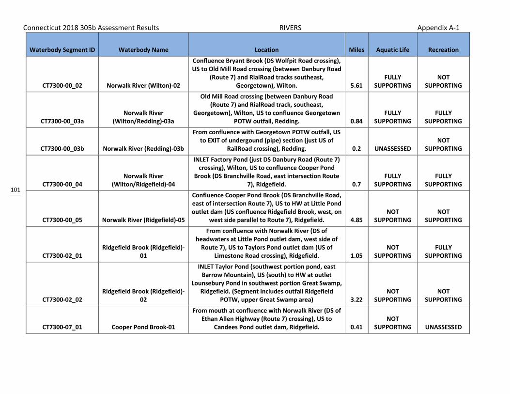
Connecticut 2018 305b Assessment Results RIVERS Appendix A-1
101
Waterbody Segment ID Waterbody Name Location Miles Aquatic Life Recreation
CT7300-00_02 Norwalk River (Wilton)-02
Confluence Bryant Brook (DS Wolfpit Road crossing), US to Old Mill Road crossing (between Danbury Road
(Route 7) and RialRoad tracks southeast, Georgetown), Wilton. 5.61
FULLY SUPPORTING
NOT SUPPORTING
CT7300-00_03a Norwalk River
(Wilton/Redding)-03a
Old Mill Road crossing (between Danbury Road (Route 7) and RialRoad track, southeast,
Georgetown), Wilton, US to confluence Georgetown POTW outfall, Redding. 0.84
FULLY SUPPORTING
FULLY SUPPORTING
CT7300-00_03b Norwalk River (Redding)-03b
From confluence with Georgetown POTW outfall, US to EXIT of undergound (pipe) section (just US of
RailRoad crossing), Redding. 0.2 UNASSESSED NOT
SUPPORTING
CT7300-00_04 Norwalk River
(Wilton/Ridgefield)-04
INLET Factory Pond (just DS Danbury Road (Route 7) crossing), Wilton, US to confluence Cooper Pond
Brook (DS Branchville Road, east intersection Route 7), Ridgefield. 0.7
FULLY SUPPORTING
FULLY SUPPORTING
CT7300-00_05 Norwalk River (Ridgefield)-05
Confluence Cooper Pond Brook (DS Branchville Road, east of intersection Route 7), US to HW at Little Pond outlet dam (US confluence Ridgefield Brook, west, on
west side parallel to Route 7), Ridgefield. 4.85 NOT
SUPPORTING NOT
SUPPORTING
CT7300-02_01 Ridgefield Brook (Ridgefield)-
01
From confluence with Norwalk River (DS of headwaters at Little Pond outlet dam, west side of
Route 7), US to Taylors Pond outlet dam (US of Limestone Road crossing), Ridgefield. 1.05
NOT SUPPORTING
FULLY SUPPORTING
CT7300-02_02 Ridgefield Brook (Ridgefield)-
02
INLET Taylor Pond (southwest portion pond, east Barrow Mountain), US (south) to HW at outlet
Lounsebury Pond in southwest portion Great Swamp, Ridgefield. (Segment includes outfall Ridgefield
POTW, upper Great Swamp area) 3.22 NOT
SUPPORTING NOT
SUPPORTING
CT7300-07_01 Cooper Pond Brook-01
From mouth at confluence with Norwalk River (DS of Ethan Allen Highway (Route 7) crossing), US to
Candees Pond outlet dam, Ridgefield. 0.41 NOT
SUPPORTING UNASSESSED

Connecticut 2018 305b Assessment Results RIVERS Appendix A-1
102
Waterbody Segment ID Waterbody Name Location Miles Aquatic Life Recreation
CT7300-07_02 Cooper Pond Brook-02
From INLET to Candees Pond, US to headwaters at unnamed pond (on south side of Florida Hill Road, at intersection with Ivy Hill Road), Ridgefield. (Segment
includes Grimes Pond and Johns Pond) 1.89 NOT
SUPPORTING UNASSESSED
CT7301-00_01 Comstock Brook (Wilton)-01
From mouth at confluence with Norwalk River (segment-02, just DS of Lovers Lane crossing), US to
confluence with Barretts Brook (outlet for Popes Pond, parallel to Route 33, at intersection with Signal
Hill Road), Wilton. 2.02 NOT
SUPPORTING NOT
SUPPORTING
CT7301-00_02 Comstock Brook (Wilton)-02
From confluence with Barretts Brook (outlet for Popes Pond, parallel to Route 33, at intersection with Signal Hill Road), US to HW (just west and parallel with Grey
Rocks Road), Wilton. 2.29 FULLY
SUPPORTING UNASSESSED
CT7302-00_01 Silvermine River (Norwalk)-01
Mouth Norwalk River (northwest INLET Deering Pond portion of river), US to Merritt Parkway (Route 15) crossing, Norwalk. (Segment includes Davis Pond). 0.98 UNASSESSED
FULLY SUPPORTING
CT7302-00_02 Silvermine River
(Norwalk/New Canaan)-02
From Merritt Parkway (Route 15) crossing), Norwalk, US to Grupes Reservoir outlet dam (US of Valley Road
crossing), New Canaan. 5.49 UNASSESSED FULLY
SUPPORTING
CT7302-13_01 Belden Hill Brook (Wilton)-01
Mouth Perry Pond section of Silvermine River, Wilton/Norwalk town line, US to OUTLET City Lake
(South Norwalk Res) US of Route 106 crossing, Wilton. 1.47 UNASSESSED NOT
SUPPORTING
CT7302-13_trib_01 Unnamed tributary Belden Hill
Brook-01
From mouth at confluence with Beldon Hill Brook (DS of Belden Hill Brook crossing of New Canaan Road (Route 106), DS of South Norwalk Reservoir), US to
discharge source at Sisters of Notre Dame (discharge of private STPl), Wilton. 0.4
NOT SUPPORTING UNASSESSED
CT7401-00_01 Fivemile River (New Canaan)-
01
INLET Jacob Pond (DS Amtrack crossing and Carolyn Court crossing), Norwalk/Darien town border, US to Old Norwalk Road crossing (0.2 Mi DS POTW), New
Canaan. 5.62 NOT
SUPPORTING NOT
SUPPORTING

Connecticut 2018 305b Assessment Results RIVERS Appendix A-1
103
Waterbody Segment ID Waterbody Name Location Miles Aquatic Life Recreation
CT7401-00_02 Fivemile River (New Canaan)-
02 Old Norwalk Road crossing (0.2 Mi DS POTW), US to confluence New Canaan POTW outfall, New Canaan. 0.23
NOT SUPPORTING
NOT SUPPORTING
CT7401-00_03 Fivemile River (New Canaan)-
03
From confluence with New Canaan POTW outfall, US to confluence with unnamed tributary (US of New
Norwalk Road (Route 123) crossing, on northeastern side of Parade Hill Road, near Cemetary), New
Canaan. 1.82 NOT
SUPPORTING NOT
SUPPORTING
CT7401-00_04 Fivemile River (New Canaan)-
04
Confluence unnamed tributary (US New Norwalk Road (Route 123) crossing, on northeastern side
Parade Hill Road, near Cemetary), US to HW at New Canaan Reservoir dam outlet (US Counrty Club Raod
crossing), New Canaan. 1.69 NOT
SUPPORTING FULLY
SUPPORTING
CT7401-01_01 Unnamed Trib, Fivemile River
(New Canaan)-01
Mouth Fivemile River, just DS Indian Rock Road crossing (near Fivemile River Country Club Road
crossing), US to HW just US Smith Ridge Road (Route 123) crossing, New Canaan. Segment goes through
golf course. 1.47 UNASSESSED FULLY
SUPPORTING
CT7401-02_01
Unnamed tributary to Fivemile River (New Canaan)-
01
Mouth at confluence with Five Mile river, DS of Glen Drive crossing, US to OUTLET of Taeger Pond, just US of Route 123 crossing, New Canaan. (includes Field
Club Pond) 0.2 UNASSESSED NOT
SUPPORTING
CT7401-05_01 Holy Ghost Fathers Brook
(Norwalk)-01
Mouth Fivemile River (Cedar Pond section) DS Bonnybrook Road crossing, US to confluence
unnamed tributary DS Fillow Street crossing, Norwalk. (Includes Land and Bethmarlea Ponds) 0.61 UNASSESSED
FULLY SUPPORTING
CT7401-06_01 Keelers Brook (Norwalk)-01
Mouth Fivemile River Darien/Norwalk town line, just DS Rowayton Avenue crossing (Woodchuck Lane
intersection) US to unnamed tributary, .3 miles US Flax Hill Road crossing and just DS I95, Norwalk. 1.08 UNASSESSED
NOT SUPPORTING
CT7401-07_01 Unnamed trib, Keelers Brook
(Norwalk)-01
Mouth Keelers Brook .3 miles US Flax Hill Road crossing and just DS I95, US to OUTLET Scribner Pond
just US Gillys Lane crossing, Norwalk. 1.03 UNASSESSED NOT
SUPPORTING

Connecticut 2018 305b Assessment Results RIVERS Appendix A-1
104
Waterbody Segment ID Waterbody Name Location Miles Aquatic Life Recreation
CT7403-00_01 Noroton River-01
From Post Road (Route 1) crossing (saltwater limit at head of Holly Pond), US to southwestern corner of St.
John's Cemetary (river bend to west), Stamford/Darien town border. 2.3
NOT SUPPORTING
NOT SUPPORTING
CT7403-00_02 Noroton River-02
From southwestern corner of St. John's Cemetary (river bend to west), Stamford/Darien town border,
US to Merritt Parkway (Route 15) crossing (US of Raymonds Pond), New Canaan. 2.61
NOT SUPPORTING
NOT SUPPORTING
CT7403-00_03 Noroton River-03
From Merritt Parkway (Route 15) crossing (US of Raymonds Pond), US to headwaters (US of West Road
crossing), New Canaan. 4.44 UNASSESSED NOT
SUPPORTING
CT7404-00_02 Mill River (New
Canaan/Stamford)-02
INLET Laurel Reservoir just DS of Trinity Pass Rd crossing, US to CT/NY state boundary (majority of water comes from outside CT in NY jurisdiction).
Segment -01 and -02 are separated by Laurel Reservoir. 0.23
FULLY SUPPORTING UNASSESSED
CT7405-00_01 Rippowam River-01
From Rippowam River West Branch dam (head of tide, US of Route 1 and Main Street crossings), US to
Merritt Parkway (Route 15) crossing (mid-way between exit 34 and exit 35), Stamford. 5.22
NOT SUPPORTING
NOT SUPPORTING
CT7405-00_02 Rippowam River-02
From Merritt Parkway (Route 15) crossing (mid-way between exit 34 and exit 35), US to North Stamford
Reservoir dam outlet (US of Interlaken Road crossing), Stamford. 2.09
NOT SUPPORTING UNASSESSED
CT7407-00_01 Mianus River-01
From Mianus Pond OUTLET dam (US side of Route 1 crossing, separation from upper portion of Cos Cob
Harbor), US to Mianus Filter Plant dam outlet, Greenwich. (Mianus Pond included in segment) 1.95 UNASSESSED
FULLY SUPPORTING
CT7407-00_02 Mianus River-02
From Mianus Filtration Plant dam outlet (impoundment at filtration plant), Greenwich, US to
Sam Bargh Reservoir (Mianus Reservoir on topo) dam outlet (US of Farms Road crossing, near New York
border), Stamford. 6.1 NOT
SUPPORTING FULLY
SUPPORTING

Connecticut 2018 305b Assessment Results RIVERS Appendix A-1
105
Waterbody Segment ID Waterbody Name Location Miles Aquatic Life Recreation
CT7409-00_01 Horseneck Brook-01
From mouth at Greenwich Harbor (just DS of I95 crossing, at exit 3 offramp), US to Putnam Lake Reservoir outlet dam (just US of Dewart Road
crossing), Greenwich. 5.78 NOT
SUPPORTING INNSUFFICIENT INFORMATION
CT7410-00_01 East Branch Byram River-01
From confuence with Byram River (northeast portion of Toll Gate Pond section of river, between Route 15
and Riversville Road), US to Old Pond outlet dam (just US of Old Mill Road crossing, first impoundment DS of
John Street site), Greenwich. 2.79 FULLY
SUPPORTING NOT
SUPPORTING
CT7410-00_02 East Branch Byram River-02
From Old Pond INLET (first impoundment DS of John Street site), US to New York state border (US of
Chitwick Pond Road crossing), Greenwich. (Segment includes Lake Mead 2.61
FULLY SUPPORTING
FULLY SUPPORTING
CT7411-00_01 Byram River-01
From head of tide (US of Route 1 crossing, at INLET to ponded portion of river, just DS of Upland Street East
area), US to Pemberwick outlet dam (US of Comly Avenue crossing, and US of confluence with
Pemberwick Brook, Greenwich. 0.49 NOT
SUPPORTING NOT
SUPPORTING
CT7411-00_02 Byram River-02
From Pemberwick outlet dam (US of Comly Avenue crossing, and US of confluence with Pemberwick Brook, US to New York border (on eastern side of
I684, in marsh), Greenwich. (Segment includes several ponds with dams) 6.95 UNASSESSED
FULLY SUPPORTING
CT7411-00-trib_01 Unnamed tributary to Byram
River (Greenwich)-trib-01
Mouth at Confluence Byram River west of Heronvue Rd and East of Griffith E. Harris Golf Course, US to HW
east of Audubon Ln, Greenwich. 0.45 FULLY
SUPPORTING UNASSESSED
CT7411-09_01 Pemberwick Brook
(Greenwich)-01
Mouth at confluence with Byram River (segment-01) just DS of Pemberwick Road crossing, US to Indian
Spring Pond outlet dam (US of Glenville Road crossing), Greenwich. 0.97
INSUFFICIENT INFORMATION
INSUFFICIENT INFORMATION

Connecticut 2018 305b Assessment Results RIVERS Appendix A-1
106
Waterbody Segment ID Waterbody Name Location Miles Aquatic Life Recreation
CT8101-00_01 Quaker Brook-01
From New York state border (DS of Merritts Pond, parallel to Route 37, north of intersection with
Haviland Hollow Road), New Fairfield, US to New York state border (along south side of Chapel Hill Road),
Sherman. (Segment includes 6 ponds/lakes) 4.78 FULLY
SUPPORTING UNASSESSED
CT8103-01_01 Gerow Brook (New Fairfield)-
01
Mouth at confluence Quaker Brook above Haviland Hollow Brook in NY at CT state line, .5 mile DS Quaker Road crossing (on Wesleyan University property), US
to HW at unnamed pond US of Cloverleaf Drive crossing, New Fairfield. 2.5
FULLY SUPPORTING UNASSESSED
CT8104-00_01 Titicus River-01
From New York state border (in large marsh along north side of North Salem Road (Route 116)), US to
headwaters (at unnamed marsh, US of Old West Mountain Road crossing), Ridgefield. (Segment
includes several ponds and marshes) 6.34 FULLY
SUPPORTING NOT
SUPPORTING

107
Related Documents