APPENDIX 9: HERITAGE IMPACT ASSESSMENT

Welcome message from author
This document is posted to help you gain knowledge. Please leave a comment to let me know what you think about it! Share it to your friends and learn new things together.
Transcript

APPENDIX 9: HERITAGE IMPACT ASSESSMENT

Erf 61
Active Heritage cc for Terratest i
CULTURAL HERITAGE IMPACT ASSESSMENT
OF ERF 61, LINCOLN MEADE, UMSUNDUZI
MUNICIPALITY.
ACTIVE HERITAGE cc. For: Terratest
Frans Prins MA (Archaeology)
P.O. Box 947
Howick
3290
Fax: 0867636380
July 2018

Erf 61
Active Heritage cc for Terratest ii
TABLE OF CONTENTS
1 BACKGROUND INFORMATION ON THE PROJECT ........................................... 1
1.1. Details of the area surveyed: ........................................................................ 1
2 BACKGROUND TO HERITAGE RESOURCES OF THE AREA ........................... 2
3 BACKGROUND INFORMATION OF THE SURVEY ............................................. 8
3.1 Methodology ................................................................................................. 8
3.2 Restrictions encountered during the survey .................................................. 8
3.2.1 Visibility ..................................................................................................... 8
3.2.2 Disturbance ............................................................................................... 8
3.3 Details of equipment used in the survey ........................................................ 8
4 DESCRIPTION OF SITES AND MATERIAL OBSERVED ..................................... 9
4.1 Locational data ............................................................................................. 9
4.2 Overview of potential heritage resources in the project area ......................... 9
4.3 Ground Survey Results ................................................................................. 9
5 HERITAGE SITE DESCRIPTION AND STATEMENT OF SIGNIFICANCE
(HERITAGE VALUE) ................................................................................................. 11
5.1 Field Rating................................................................................................. 11
6 PALEONTOLOGY DESKTOP EVALUATION ..................................................... 11
7 RECOMMENDATIONS ....................................................................................... 12
8 MAPS AND FIGURES ......................................................................................... 13
8 REFERENCES…………………………………………...……………………..……… 19
LIST OF TABLES
Table 1. Background information……………………………………………………………1
Table 2. Evaluation of heritage sites ………………………………………………………11
Table 3. Field rating and recommendation grading of sites……………………….…..…12

Erf 61
Active Heritage cc for Terratest iii
LIST OF ABBREVIATIONS AND ACRONYMS
EIA Early Iron Age
ESA Early Stone Age
HISTORIC PERIOD Since the arrival of the white settlers - c. AD 1820 in this part of the
country
IRON AGE
Early Iron Age AD 200 - AD 1000
Late Iron Age AD 1000 - AD 1830
LIA Late Iron Age
LSA Late Stone Age
MSA Middle Stone Age
NEMA National Environmental Management Act, 1998 (Act No. 107 of 1998
and associated regulations (2006).
NHRA National Heritage Resources Act, 1999 (Act No. 25 of 1999) and
associated regulations (2000)
SAHRA South African Heritage Resources Agency
STONE AGE
Early Stone Age 2 000 000 - 250 000 BP
Middle Stone Age 250 000 - 25 000 BP
Late Stone Age 30 000 - until c. AD 200
Erf 61
Active Heritage cc for Terratest iv
Details and experience of independent Heritage Impact Assessment Consultant
Consultant: Frans Prins (Active Heritage cc)
Contact person: Frans Prins
Physical address: 33 Buchanan Street, Howick, 3290
Postal address: P O Box 947, Howick, 3290
Telephone: +27 033 3307729
Mobile: +27 0834739657
Fax: 0867636380
Email: [email protected]
PhD candidate (Anthropology) University of KwaZulu-Natal
MA (Archaeology) University of Stellenbosch 1991
Hons (Archaeology) University of Stellenbosch 1989
University of KwaZulu-Natal, Honorary Lecturer (School of Anthropology, Gender and
Historical Studies).
Association of Southern African Professional Archaeologists member
Frans received his MA (Archaeology) from the University of Stellenbosch and is
presently a PhD candidate on social anthropology at UKZN. His PhD research topic
deals with indigenous San perceptions and interactions with the rock art heritage of the
Drakensberg.
Frans was employed as a junior research associate at the then University of Transkei,
Botany Department in 1988-1990. Although attached to a Botany Department he
conducted a palaeoecological study on the Iron Age of northern Transkei - this study
formed the basis for his MA thesis in Archaeology. Frans left the University of Transkei
to accept a junior lecturing position at the University of Stellenbosch in 1990. He taught
mostly undergraduate courses on World Archaeology and research methodology during
this period.
From 1991 – 2001 Frans was appointed as the head of the department of Historical
Anthropology at the Natal Museum, Pietermaritzburg. His tasks included academic
research and publication, display conceptualization, and curating the African ethnology
collections of the Museum. He developed various displays at the Natal Museum on
topics ranging from Zulu material culture, traditional healing, and indigenous
classificatory systems. During this period Frans also developed a close association
with the Departments of Fine Art, Psychology, and Cultural and Media Studies at the
then University of Natal. He assisted many post-graduate students with projects relating
to the cultural heritage of South Africa. He also taught post-graduate courses on
qualitative research methodology to honours students at the Psychology Department,

Erf 61
Active Heritage cc for Terratest v
University of Natal. During this period he served on the editorial boards of the South
African Journal of Field Archaeology and Natalia.
Frans left the Natal Museum in 2001 when approached by a Swiss funding agency to
assist an international NGO (Working Group for Indigenous Minorities) with the
conceptualization of a San or Bushman museum near Cape Town. During this period
he consulted extensively with various San groupings in South Africa, Namibia and
Botswana. He also made major research and conceptual contributions to the Kamberg
and Didima Rock Art Centres in the Ukhahlamba Drakensberg World Heritage Site.
Between 2003 and 2007 Frans was employed as the Cultural Resource Specialist for
the Maloti Drakensberg Transfrontier Project – a bilateral conservation project funded
through the World Bank. This project involved the facilitation with various stakeholders
in order to produce a cultural heritage conservation and development strategy for the
adjacent parts of Lesotho and South Africa. Frans was the facilitator for numerous
heritage surveys and assessments during this project. This vast area included more than
2000 heritage sites. Many of these sites had to be assessed and heritage management
plans designed for them. He had a major input in the drafting of the new Cultural
Resource Management Plan for the Ukhahlamba Drakensberg World Heritage site in
2007/2008. A highpoint of his career was the inclusion of Drakensberg San indigenous
knowledge systems, with San collaboration, into the management plans of various rock
art sites in this world heritage site. He also liaised with the tourism specialist with the
drafting of a tourism business plan for the area.
During April 2008 Frans accepted employment at the environmental agency called
Strategic Environmental Focus (SEF). His main task was to set-up and run the cultural
heritage unit of this national company. During this period he also became an accredited
heritage impact assessor and he is rated by both Amafa and the South African Heritage
Resources Agency (SAHRA). He completed almost 50 heritage impact assessment
reports nation-wide during an 18th month period.
Frans left SEF and started his own heritage consultancy called “Active Heritage cc” in July 2009. Although mostly active along the eastern seaboard his clients also include
international companies such as Royal Dutch Shell through Golder Associates, and
UNESCO. He has now completed almost 600 heritage conservation and management
reports for various clients since the inception of “Active Heritage cc”. Amongst these was a heritage study of the controversial fracking gas exploration of the Karoo Basin
and various proposed mining developments in South Africa and proposed developments
adjacent to various World Heritage sites. Apart from heritage impact assessments
(HIA’s) Frans also assist the National Heritage Council (NHC) through Haley Sharpe Southern Africa’, with heritage site data capturing and analysis for the proposed National Liberation Route World Heritage Site and the national intangible heritage audit. In
addition, he is has done background research and conceptualization of the proposed
Dinosaur Interpretative Centre at Golden Gate National Park and the proposed Khoi and
San Interpretive Centre at Camdeboo, Eastern Cape Province. During 2009 he also

Erf 61
Active Heritage cc for Terratest vi
produced the first draft dossier for the nomination of the Sehlabathebe National Park,
Lesotho as a UNESCO inscribed world heritage site.
Frans was appointed as temporary lecturer in the department of Heritage and Tourism,
UKZN in 2011. He is also a research affiliate at the School of Cultural and Media Studies
in the same institution.
Frans’s research interests include African Iron Age, paleoecology, rock art research,
San ethnography, traditional healers in South Africa, and heritage conservation. Frans
has produced more than fourty publications on these topics in both popular and
academic publications. He is frequently approached by local and international video
and film productions in order to assist with research and conceptualization for
programmes on African heritage and culture. He has also acted as presenter and
specialist for local and international film productions on the rock art of southern Africa.
Frans has a wide experience in the fields of museum and interpretive centre display
and made a significant contribution to the conceptual planning of displays at the Natal
Museum, Golden Horse Casino, Didima Rock Art Centre and !Khwa tu San Heritage
Centre. Frans is also the co-founder and active member of “African Antiqua” a small tour company who conducts archaeological and cultural tours world-wide. He is a
Thetha accredited cultural tour guide and he has conducted more than 50 tours to
heritage sites since 1992.
Declaration of Consultants independence
Frans Prins is an independent consultant to Terratest and has no business, financial,
personal or other interest in the activity, application or appeal in respect of which he was
appointed other than fair remuneration for work performed in connection with the activity,
application or appeal. There are no circumstances whatsoever that compromise the
objectivity of this specialist performing such work.
Frans Prins

Erf 61
Active Heritage cc for Terratest 1
EXECUTIVE SUMMARY
A first phase cultural heritage survey of the proposed residential development at Erf 61,
Lincoln Meade, Umsunduzi Municipality of identified no heritage sites on the footprint.
The area is also not part of any known cultural landscape. The phase one
paleontological desktop assessment, however, indicates that the area is moderately
significant in terms of fossil sensitivity. According to SAHRA policy a desktop
paleontological assessment by a qualified palaeontologist will be required. However, it
is the opinion of this consultant that further paleontological studies will not be required
due to the severe anthropogenic disturbance on the footprint. Attention is drawn to the
South African Heritage Resources Act, 1999 (Act No. 25 of 1999) and the KwaZulu-
Natal Heritage Act (Act no 4 of 2008) which, requires that operations that expose
archaeological or historical remains as well as fossils should cease immediately,
pending evaluation by the provincial heritage agency.
1 BACKGROUND INFORMATION ON THE PROJECT
Table 1. Background information
Consultant: Frans Prins (Active Heritage cc) for Terratest
Type of development: Residentail Development
Rezoning or subdivision: n.a
Terms of reference To carry out a Heritage Impact Assessment
Legislative requirements: The Heritage Impact Assessment was carried out in terms of the
National Environmental Management Act, 1998 (Act No. 107 of
1998) (NEMA) and following the requirements of the National
Heritage Resources Act, 1999 (Act No. 25 of 1999) (NHRA) and
the KwaZulu-Natal Heritage Act, 1997 (Act No. 4 of 2008)
1.1. Details of the area surveyed:
The proposed residential development is situated in the residential area of Lincoln
Meade, Pietermaritzburg. The footprint is roughly located between Grimthorpe and
Spilsby Avenues and covers an area of approximately 118m x 118m (Figs 1 & 2). The
greater area is surrounded by residential dwellings. The proposed development plot is
covered by a mixture of indigenous and alien vegetation (Figs 4 – 6). A small stream
flows through the northern section of the plot (Fig 7). There has been anthropogenic
disturbance in the recent past due to building activity and the dumping of builder’s rubble
on the proposed development plot. The plot is bordered onto by recent residential

Erf 61
Active Heritage cc for Terratest 2
developments (Fig 2). The GPS coordinates of the centre of the proposed development
plot are:
S 29° 37’ 08.09” E 30° 26’ 03.72”
2 BACKGROUND TO HERITAGE RESOURCES OF THE AREA
The greater Pietermaritzburg is relatively well covered by archaeological surveys
conducted by members of the KwaZulu-Natal Museum. The available evidence, as
captured in the KwaZulu-Natal Museum heritage site inventories, indicates that the
greater Pietermaritzburg area contains mostly Early, Middle, and Later Stone Age
material. Most of these sites are situated close to water, such as the Msunduze River,
Slangspruit, Foxhill Spruit, and Mkhondeni, as well as in open air context or adjacent
to exposed dongas or road cuttings. These tools were most probably made by early
hominins such as Homo erectus or Homo ergaster. Based on typological criteria they
most probably date back to between 300 000 and 1.7 million years ago. The presence
of the first anatomically modern people (i.e. Homo sapiens sapiens) in the area is
indicated by the presence of a few Middle Stone Age blades and flakes. These most
probably dates back to between 40 000 and 200 000 years ago. The later Stone Age
flakes identified in the area are associated with the San (Bushmen) and their direct
ancestors. These most probably dates back to between 200 and 20 000 years ago.
Most of the Early and Middle Stone Age sites were identified by the late Dr Olivier
Davies in the 1950’s and 1960’s. The majority of Later Stone Age sites were located
by Dr Farden in the 1960s and 1970’s although some has also been identified by Dr Aron Mazel in the 1980’s.
The San were the owners of the land for almost 30 000 years but the local
demography started to change soon after 2000 years ago when the first Bantu-
speaking farmers crossed the Limpopo River and arrived in South Africa. By 1500
years ago these early Bantu-speaking farmers also settled adjacent to the Umngeni
River in the greater Camperdown area. Due to the fact that these first farmers
introduced metal technology to southern Africa they are designated as the Early Iron
Age in archaeological literature. Their distinct ceramic pottery is classified to styles
known as “Msuluzi” (AD 500-700), Ndondondwane (AD 700-800) and Ntshekane (AD
800-900). Most of the Early Iron Age sites in the greater Pietermaritzburg area belong
to these traditions (Maggs 1989:31; Huffman 2007:325-462). These sites
characteristically occur on alluvial or colluvial soil adjacent to large rivers below the
1000m contour. The Early Iron Age farmers originally came from western Africa and
brought with them an elaborate initiation complex and a value system centred on the
central significance of cattle.
Early as well as Later Iron Age sites have been located by Dr Tim Maggs in the 1970’s and 1980’s and more recent discoveries have been made Mr Gavin Whitelaw, Gavin

Erf 61
Active Heritage cc for Terratest 3
Anderson, and Len van Schalkwyk. The Early Iron Age sites typically occur on the
alluvial and colluvial soils in the large river valleys below 700m above sea level. Some
have been located along the Msunduzi River as well as in the Ashburton area. Later
Iron Age sites occur in similar contexts as well as on ridges or plato’s in the existing grassland. Some impressive Later Iron Age sites occur in the Umngeni River Valley
close to Howick as well as in the Ottos Bluff area near Albert Falls Dam.
These sites occupied by Bantu-speaking agropastoralists who arrived in southern
Africa after 1000 year ago via East Africa. Later Iron Age communities in KwaZulu-
Natal were the direct ancestors of the Zulu people (Huffman 2007). The larger
Umngeni Valley area was inhabited by various Nguni-speaking groups such as the
Dlanyawo, Nyavu and Njilo, in the beginning of the 19th century (Bryant 1965; Wright
1988). With the exception of the Nyavu who remained fiercely independent most of
these communities were incorporated into the Zulu Kingdom of Shaka in the 1820’s. After the Anglo-Zulu war of 1879 and the Bambatha Rebellion of 1911 almost all the
African people in the study area adopted a Zulu ethnic identity.
.
Apart from the prehistoric archaeology Pietermaritzburg is also well known for its
colonial heritage. The original Voortrekker route, later to become the transport route
into the interior, passes through Worlds View – presently a suburb in western
Pietermaritzburg. The route was originally cut by the Voortrekker leader Piet Retief
and his party in 1838. The wagon marks can still be seen etched in the soft
sandstone along the path. The site at Worldsview is a well-known provincial landmark
that is protected by heritage legislation (Oberholser 1972). Apart from significant
places on the landscape the colonial heritage of Pietermaritzburg also include various
buildings associated with the first Dutch settlers (Voortrekkers) after 1837 as well as
the latter Victorian and Edwardian heritage of the area associated more closely with
the British occupancy of Natal after 1845 (Laband & Hasswell 1988; Derwent 2006).
In fact, Pietermaritzburg has been described as the greatest Victorian city in the
southern hemisphere although this statement has not been qualified. The greatest
majority of the heritage resources located within the greater Pietermaritzburg consists
of built structures, mostly buildings, which are of great architectural (and also
historical) significance. The City of Pietermaritzburg has arguably one of the finest
remaining urban environments in South Africa, and each of the City’s four main cultural groups has contributed to its architecture, namely Afrikaner, British, Indian
and African (Laband & Haswell 1988; Oberholser 1972; Derwent 2006). A number of
the buildings located within the Pietermaritzburg Central Business District (CBD) are
constructed out of red-clay bricks, such as the Pietermaritzburg City Hall, giving the
city a recognisably unique architectural style. Similar buildings also occur elsewhere
in the uMgungundlovu Municipal area. Most of the architectural resources are
concentrated within the Pietermaritzburg CBD and adjacent areas such as
Georgetown in Edendale. These resources largely consist of buildings constructed in
Voortrekker, British-Colonial, Indian and traditional African styles. Many of these
buildings date back to the late 1800s and early 1900s, while examples of architecture
from as early as the 1840s still exist within the Pietermaritzburg CBD and, more rarely,

Erf 61
Active Heritage cc for Terratest 4
in its surrounds (e.g. Hollingwood and further afield at Fort Nottingham). Other
buildings consisting of later, more modern architectural styles have also been
identified as architectural resources, particularly in the suburbs surrounding the CBD
of Pietermaritzburg, where fine examples of post-World War 2 architecture can be
found. The Georgetown area in Edendale contains a number of unique buildings
consisting of a mixture of traditional African styles of architecture with British- Colonial
and Indian influences. Some of the earliest buildings in Georgetown date back to the
1850s and consist of rectangular houses of unfired mud brick, and brick and shale
houses covered by lime plaster. Georgetown also provides rare examples of wood
and iron buildings, while this building style was common in the 1900s, few examples
still exist today. However, interesting individual examples of this building style also
occur further afield at Merrivale Station.
Places of worship constructed by religious communities form significant cultural
resources. Christian denominations have built a large number of churches, chapels
and mission stations throughout the Municipal area. Several of these structures are
Provincial and Heritage Landmarks (e.g. the Christian Science Church and Old St
Mary’s Anglican Church in Pietermaritzburg) and are architecturally significant as well as being cultural and historical resources. There are also a number of Mosques and
Hindu Temples located within the greater Pietermaritzburg, these buildings hold value
in terms of both their architectural style and cultural significance. These include the
Soorti Sunni Mosque in Church Street and the Stri Siva Soobramoniar and Marriamen
Temples in Longmarket (Langalibalele) Street in Pietermaritzburg, amongst others.
There are a number of cemeteries that have considerable cultural and historical
significance. These include the Jewish and Muslim cemetery off Roberts Road in the
Clarendon area, the Old Commercial Road Cemetery and the Fort Napier Military
Cemetery in the Signal Hill area. Graves from the Anglo-Boer War, including those of
concentration camp victims, are located within the Commercial Road Cemetery.
Graves from both the First and Second World Wars are located in the Commercial
Road Cemetery and the Fort Napier Military Cemetery. The Commercial Road
Cemetery also contains the graves of individuals spanning the early history of
Pietermaritzburg including original Voortrekkers, Germans interned during the First
World War, members of the Natal Mounted Police, prominent colonial figures and
early Indian Christian converts. Examples of other sites of historical and cultural
significance located within the greater Pietermaritzburg include:
• Alexandra Park, and in particular, the Percy Taylor Rockeries in Scottsville which forms both an important natural feature as well as a significant historical resource;
and
• The Pietermaritzburg Railway Station located off Church Street at the edge of the
Pietermaritzburg CBD which is both an architectural resource as well as an important
historical and cultural resource as it was here, in 1893 that the incident that sparked
Mahatma Gandhi’s strategy of passive resistance, occurred (KwaZulu-Natal
Museum).
Erf 61
Active Heritage cc for Terratest 5
More recently the Pietermaritzburg Tourism Authority identified and developed
Struggle era sites in the Municipal area. These have now been developed for tourism
purposes and a pilgrimage route has been identified. Sites and places of significance
include the Old Prison in Pietermaritzburg, the Gandhi statue opposite the Colonial
Building, various houses and places of significance within the Sobantu township as
well as the Edendale/Mbali sub-route. Of special interest in this region is the Mandela
Capture site, near Howick, and the Alan Paton Centre and struggle archives at the
University of KwaZulu-Natal at Pietermaritzburg. The Centre houses the famed author
of 'Cry, the Beloved Country', and founder of the Liberal Party, Alan Paton’s literary works, and documents relating to other institutions.
The Edendale and Imbali Heritage and Freedom Tour Route has specifically been
designed to highlight the heritage sites of the struggle-period. The sites include the
following:
• Plessislaer Arya Samaj Manaye Hall
“Mandela Memorial” outside the Plessislaer Arya Samai Manaye Hall in FJ Sithole Road, Imbali Township in Pietermaritzburg, celebrates Mandela’s last speech at the All In Africa Conference on March 25, 1961. Amongst the organizers of this
conference was Johnny Makhathini whose body later exhumed from Zambia and
reburied at the Heroes Acre in Pietermaritzburg. The Plessislaer Arya Samai Hall is
located in the Zibukezulu High School yard. The monument in front of the hall
commemorating the landmark speech was unveiled on May 29, 2008.
Mandela made a surprise appearance at the Plessislaer Arya Samai Manaye Hall
where he made his last public speech before being arrested just outside Howick in
1962. The initial venue for the conference, the Local Health Commission Hall in
Edendale was changed at an eleventh hour after it was alleged that the Special
Branch had wired the hall in order to listen to the proceedings and that the
conference proceedings were likely to be taped as well.
The 1400 delegates who attended the function came from different social and political
organizations. During this last public speech, Mandela stressed that “one man, one vote” was the only solution towards a liberated South Africa. He also called for economic sanctions to be imposed on the apartheid state. He also warned on the
impending disaster against the regime should the government remain headstrong on
the demands of the ANC. Mandela also requested all South Africans to unite and fight
the apartheid regime jointly.
It was also at the conference that the participants demanded a convention no later
than May 31, 1961, the day in which the apartheid regime planned to declare South
Africa as a republic. This convention, it was thought could make a decision on a new
and non-racial constitutions for South Africans. The conference resolved that should
their demand not be met, the regime should expect a countrywide demonstration on
the eve of the proclamation of the South African republic. The new republic, thought

Erf 61
Active Heritage cc for Terratest 6
Mandela, would bring about the intensification of the racial laws. Mandela returned to
the hall on April 25, 1997, when the Freedom of Pietermaritzburg was awarded to
Mandela and the late Mahatma Gandhi. Though the yard where the Hall stands is
unkept if not neglected, the hall itself remains in its original form.1
• The Heroes Acre- Slangspruit, Pietermaritzburg
The Heroes Acre, Slangspruit, just outside Pietermaritzburg and adjacent to Imbali
Township, is an initiative of the KZN Provincial Government aimed at honouring
liberation struggle heroes. The creation of the Heroes Acre in Pietermaritzburg should
be viewed as the revitalization of the struggle against apartheid. It thus becomes
important for such history to be etched in the minds of many and for generations to
come. Moses Mabhida, who died of a heart attack in Maputo on March 8 1986, was
the first to be laid to rest at the Heroes’ Acre. His reburial at the site on December 2, 2006 which was graced by the presence of President Thabo Mbeki marked a new era
for the people and liberation heroes of South Africa.
Mabhida was a revered ANC and Communist Party cadre. In 1956, he became a
member of National Executive Committee of the Communist Party and was also
instrumental in the formation of the South African Congress of Trade Unions (Sactu)
and elected its vice-president in 1955 and became its chairman in 1960. In 1960 he
went into exile and was asked by Oliver Tambo to devote himself to developing the
military wing of the ANC, Mkhonto we Sizwe (MK). Mabhida underwent military
training, and rose in the ranks of the MK to become its commissar and Chief Political
Instructor of new recruits. He became Secretary General of the SACP in 1978. In the
1980s, he operated in Lesotho, Mozambique and Swaziland.
The Heroes Acre is also the final resting place of Johnny Makhathini who died on
December 3, 1988 was buried in Lusaka. On February 27, 2010, President Zuma
attended the reburial of Johnny Makhathini, a struggle icon whose remains were
exhumed in Lusaka and repatriated to South Africa for reburial at the Heroes Acre.
Zuma declared a provincial official funeral for the reburial of Makhathini's remains.
Amongst other things, since this was a provincial project, the ceremonial elements as
well as the half-masting of the national flag throughout the province on the day of the
funeral. Makhathini was, himself, a long standing member of the ANC. He was at one
time, a member of the ANC National Executive Committee. In 1966, he was appointed
ANC Chief Representative in Algeria. In 1977, he was appointed head of the ANC
Mission to the United Nations and later head of the ANC's Department of International
Affairs.
• The Peace Monument in Imbali Stage 2
The area of Imbali was initially occupied by the Indian community who were evicted
in favour of re-settling black people. In 1964 the Department of Bantu Affairs in
partnership with Pietermaritzburg Co-operation took over the control of the area.
Blacks that were affected by the group areas act were the first residents of what came

Erf 61
Active Heritage cc for Terratest 7
to be known as Imbali Township. With time, the township community became divided
into two political groupings, the ANC and the I.F.P. The tension between the two
resulted in political violence which gripped Imbali Township especially in the early
1999s.
The “Seven Days War” which led to the brutal killings of many in Pietermaritzburg also affected Imbali Township. The story goes that at one time, I.F.P. members were
returning from a rally in Durban and on very high spirit. However, this was short-lived
as the ANC supporters hurled stones at the buses loaded with I.F.P. supporters. The
mood turned soar and the next day the I.F.P. attacks ANC strongholds in
Pietermaritzburg’s. That was the beginning of the seven days which left scores of people dead. During thus turbulent violence, leaders and followers alike were killed.
The implication was that if one was known to be living in an I.F.P. area, visiting an
ANC stronghold simply meant death.
This memorial, made of granite and about 4 meters high, was sponsored by Umngeni
Water and Hulets Aluminium. It is strategically located at Imbali Township; stage 2
section in a central area that separates the ANC area from that of the I.F.P. in the
area initially, the top of the Memorial had two hands with palms facing each other.
However, due to desecration, the pair of hands no longer forms part of the memorial.
This prompted the municipality to put a fence around the memorial. It was unveiled
by the state President Nelson Mandela and Chief Mangosuthu Buthelezi on
November 15, 1998. The names of ANC and I.F.P. supporters who died in the violent
killings are etched on the memorial.
• Willowfontein Farm
Willowfontein Farm, a historic village is where the DCO Matiwane Memorial Park site
is located. It is about 15 km to the west of Pietermaritzburg. The name Willowfontein
originated from a beautiful scenery of willow trees that lined the river banks for the
entire length of the valley. The name Willowfontein has survived even long after all
the willow trees have been destroyed. The serene and scenic beauty of the
Willowfontein area could attract city dwellers and out of town tourists that wish to see
rural Zulu culture or seeking peace and tranquillity. Originally, Willowfontein was a
farmland, “Afrikaans Wilgerfontein” with few families who resided as farm tenants in the mid and late 60s. Most farmers left the area, leaving tenants under the Bantu
Administration Department, as the land was administered as trust land. Later the area
was administered by the Department of Development Aid. The settlement grew from
a population of few hundred to several thousand as a result of influx of families evicted
from different parts of Natal Midlands. There were families who moved in the early
70s from Baynesfield as a result of farm evictions by white farmers. Soon thereafter,
another contingent of families in the late 70s settled at Willowfontein as a result of
faction fights in Bulwer. But since the 80s people streamed because of political
violence in Vulindlela, Maqonqo, Mpendle, Bulwer, Highflats and Richmond. In the
late 80s and early 90s people moved from surrounding Pietermaritzburg areas such
as Machibisa and Dambuza to Willowfontein. Currently, the population is estimated
at 30 000. The community administration consists of locally elected community
Erf 61
Active Heritage cc for Terratest 8
leaders organised under Willowfontein Development Committee and several other
sectorial committees. It has now been incorporated to be part of the Msunduzi-
Pietermaritzburg TLC.
3 BACKGROUND INFORMATION OF THE SURVEY
3.1 Methodology
A desktop study was conducted of the archaeological databases housed in the KwaZulu-
Natal Museum and relevant aerial photographs. The SAHRIS website was consulted for
data relating to the distribution and significance of heritage sites in the greater project
area. In addition, the available heritage literature covering the study area was also
consulted.
A ground survey, following standard and accepted archaeological procedures, was
conducted on 11 July 2018. The consultant also spoke to local residents encountered
in Grimthorpe Avenue but none of them were aware of any heritage sites on the footprint.
Actually it was also pointed out that access to the proposed development plot was
hindered by residential developments and dense vegetation.
3.2 Restrictions encountered during the survey
3.2.1 Visibility
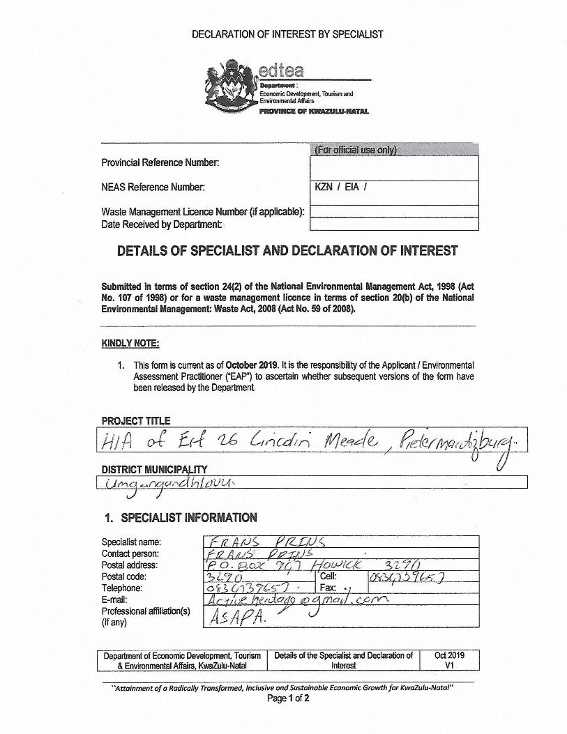
Visibility was good but compromised in areas by dense vegetation.
3.2.2 Disturbance
The development plot has been disturbed by past anthropogenic actions. Builder’s rubble has been dumped in places and it also appears that past land-use may have
encouraged the spread of alien vegetation. However, no disturbance of any potential
heritage features was noted.
3.3 Details of equipment used in the survey
GPS: Garmin Etrek
Digital cameras: Canon Powershot A460
All readings were taken using the GPS. Accuracy was to a level of 5 m.

Erf 61
Active Heritage cc for Terratest 9
4 DESCRIPTION OF SITES AND MATERIAL OBSERVED
4.1 Locational data
Province: KwaZulu-Natal
Towns: Pietermaritzburg
Municipality: Umsunduzi Municipality
4.2 Overview of potential heritage resources in the project area
Given setting and altitude of approximately 650m above sea level it can be expected
that Early Iron Age sites may occur in or near the project area as these sites are typically
associated with altitudes below 800m above sea level. Early Iron Age sites have been
located at Ashburton approximately 3km to the south east of the project area (Fig 1).
Later Stone Age Sites do occur in the KZN Midlands but they are relatively scarce and
the absence of any shelter or sandstone outcrops in the area would mitigate for their
probable absence in the area. Nevertheless, open air Later Stone Age sites do occur at
Hayfields and Bellevue to the immediate south of the project area (Fig 1). Middle and
Early Stone Age open air sites do occur in similar environments and there is a possibility
that these archaeological sites may occur in the project area. The area was also
occupied by Later Iron Age communities during the historical period - if not before.
Unfortunately Later Iron Age communities in this part of KwaZulu-Natal used less
durable materials to build their settlements and the remains of such is not always visible.
During the period of the Natal Colonial administration (mid 1800’s) the authorities settled
Zulu-speaking communities in the eastern parts of the greater Pietermaritzburg and it is
probable that the remains of their settlements and associated graves may occur in the
area.
4.3 Ground Survey Results
The desktop study do not indicate any archaeological or historical sites within 1km from
the proposed development plot (Fig 1). No known sites associated with the recent
‘Struggle Era’ occur in close proximity of the footprint. The area is also not part of any
known cultural landscape.

Erf 61
Active Heritage cc for Terratest 10
Table 3. Evaluation of heritage sites (excluding paleontology)
Significance criteria in terms of Section 3(3) of the NHRA
Significance Rating
1. Historic and political significance - The importance of the cultural
heritage in the community or pattern of South Africa’s history.
None
2. Scientific significance – Possession of uncommon, rare or
endangered aspects of South Africa’s cultural heritage.
None.
3. Research/scientific significance – Potential to yield information that
will contribute to an understanding of South Africa’s natural or cultural heritage.
None.
4. Scientific significance – Importance in demonstrating the principal
characteristics of a particular class of South Africa’s cultural places/objects.
None.
5. Aesthetic significance – Importance in exhibiting particular aesthetic
characteristics valued by a community or cultural group.
None.
6. Scientific significance – Importance in demonstrating a high degree
of creative or technical achievement at a particular period.
None.
7. Social significance – Strong or special association with a particular
community or cultural group for social, cultu-ral or spiritual reasons.
None
8. Historic significance – Strong or special association with the life and
work of a person, group or organization of importance in the history of
South Africa.
None.
9. The significance of the site relating to the history of slavery in South
Africa.
None.
Erf 61
Active Heritage cc for Terratest 11
5 HERITAGE SITE DESCRIPTION AND STATEMENT OF SIGNIFICANCE
(HERITAGE VALUE)
5.1 Field Rating
The field rating system as developed by SAHRA (Table 4) does not apply as no heritage
sites occur on or near the footprint.
Table 4. Field rating and recommended grading of sites (SAHRA 2005)
Level Details Action
National (Grade I) The site is considered to be of
National Significance
Nominated to be declared by
SAHRA
Provincial (Grade II) This site is considered to be of
Provincial significance
Nominated to be declared by
Provincial Heritage Authority
Local Grade IIIA This site is considered to be of HIGH
significance locally
The site should be retained as a
heritage site
Local Grade IIIB This site is considered to be of HIGH
significance locally
The site should be mitigated, and
part retained as a heritage site
Generally Protected A High to medium significance Mitigation necessary before
destruction
Generally Protected B Medium significance The site needs to be recorded before
destruction
Generally Protected C Low significance No further recording is required
before destruction
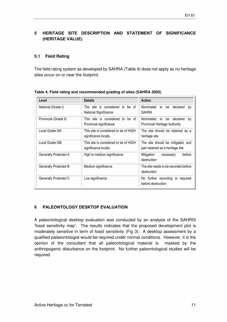
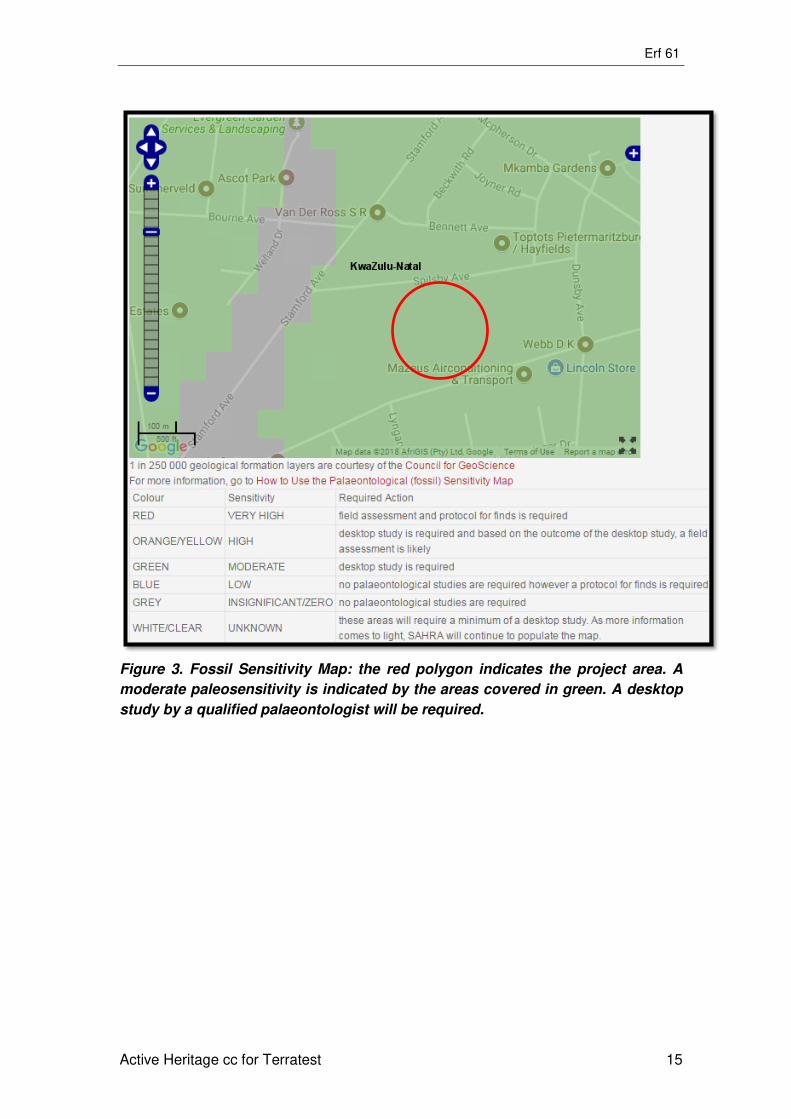
6 PALEONTOLOGY DESKTOP EVALUATION
A paleontological desktop evaluation was conducted by an analysis of the SAHRIS
‘fossil sensitivity map’. The results indicates that the proposed development plot is
moderately sensitive in term of fossil sensitivity (Fig 3). A desktop assessment by a
qualified palaeontologist would be required under normal conditions. However, it is the
opinion of the consultant that all paleontological material is masked by the
anthropogenic disturbance on the footprint. No further paleontological studies will be
required.
Erf 61
Active Heritage cc for Terratest 12
7 RECOMMENDATIONS
The proposed development may proceed from a general heritage perspective as no
heritage sites or features occur on or near the footprint. However, it is important to note
that the KwaZulu-Natal Heritage Act requires that all operations exposing graves as well
as archaeological and historical residues as well as fossils should cease immediately
pending an evaluation by the heritage authorities.

Erf 61
Active Heritage cc for Terratest 13
8 MAPS AND FIGURES
Figure 1. Google Aerial map showing the location of the project area. The purple
markers indicate known archaeological sites in the area. The yellow markers
indicate known historical sites in the area. None of these occur closer than 50m
to the proposed development.

Erf 61
Active Heritage cc for Terratest 14
Figure 2. Map of Erf 61, Lincoln Meade (Source: Terratest).
Erf 61
Active Heritage cc for Terratest 15
Figure 3. Fossil Sensitivity Map: the red polygon indicates the project area. A
moderate paleosensitivity is indicated by the areas covered in green. A desktop
study by a qualified palaeontologist will be required.
Erf 61
Active Heritage cc for Terratest 16
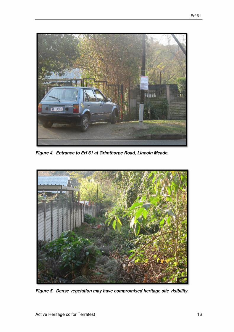
Figure 4. Entrance to Erf 61 at Grimthorpe Road, Lincoln Meade.
Figure 5. Dense vegetation may have compromised heritage site visibility.

Erf 61
Active Heritage cc for Terratest 17
Figure 6. The proposed development plot is covered by a mixture of indigenous
and alien vegetation.
Figure 7. A small stream flows through the northern section of Erf 61, Lincoln
Meade.

Erf 61
Active Heritage cc for Terratest 18
8 REFERENCES
Bryant, A. T. 1965. Olden times in Zululand and Natal. Cape Town: C. Struik.
Derwent, S. 2006. KwaZulu-Natal Heritage Sites: A Guide to Some Great Places. David
Philip: Pietermaritzburg.
Huffman, T. N. 2007. Handbook to the Iron Age: The Archaeology of Pre-colonial
Farming Societies in Southern Africa. University of KwaZulu-Natal Press.
Pietermaritzburg.
Laband, J & Haswell, R. (Eds). 1988. Pietermaritzburg, 1838-1988: A New Portrait of
an African City. University of Natal Press: Shuter & Shooter
Maggs, T. 1988. Pietermaritzburg: the first 2 000 000 years. In Laband, J and Hasswell,
R. (eds). Pietermaritzburg 1838 – 1988: A New Portrait of an African City. pg 14-17.
University of Natal Press: Pietermaritzburg
Maggs, T. The Iron Age farming communities. In Duminy, A. and Guest, B. 1989. Natal
and Zululand: from Earliest Times to 1910. A New History. Pg. 28-46. University of Natal
Press. Pietermaritzburg.
Martin, B. 1988. The coming of the railway to Pietermaritzburg. In . In Laband, J &
Haswell, R. (Eds). Pietermaritzburg, 1838-1988: A New Portrait of an African City.
University of Natal Press: Shuter & Shooter.
Oberholster, J. J. 1972. The Historical Monuments of South Africa. The Rembrandt Van
Rijn Foundation for Culture. Cape Town.
Prins, F. E. 2016. Cultural Heritage Impact Assessment of the Proposed Vulindlela Bulk
Water Supply Scheme, Umgeni And Msunduzi Municipalities. Unpublished Report for
Kerry Seppings Environmental Consultants.
SAHRA, 2005. Minimum Standards for the Archaeological and the Palaeontological
Components of Impact Assessment Reports, Draft version 1.4.
Wright, J. 1988. Before Mgungundlovu: the upper Mngeni and upper Mkhomazi region
in the early nineteenth century. In Laband, J & Haswell, R. (Eds). Pietermaritzburg,
1838-1988: A New Portrait of an African City. University of Natal Press: Shuter & Shooter
Related Documents