Newcomen Bridge Cycle Project North Strand Road – Dublin APPENDIX B Archaeology, Architecture and Industrial Heritage Assessment M. Phillips Chartered Engineer City Engineer & Director of Traffic March 2013 Client: Dublin City Council Civic Offices Wood Quay Fishamble Street Dublin 8 Consulting Engineer: Roughan & O'Donovan Arena House Arena Road Sandyford Dublin 18

Welcome message from author
This document is posted to help you gain knowledge. Please leave a comment to let me know what you think about it! Share it to your friends and learn new things together.
Transcript
Newcomen Bridge Cycle Project
North Strand Road – Dublin
APPENDIX B
Archaeology, Architecture and Industrial Heritage Assessment
M. Phillips Chartered Engineer City Engineer & Director of Traffic
March 2013
Client: Dublin City Council Civic Offices Wood Quay Fishamble Street Dublin 8
Consulting Engineer: Roughan & O'Donovan Arena House Arena Road Sandyford Dublin 18

Roughan & O’Donovan Dublin City Council Consulting Engineers Newcomen Bridge Cycle Project
12.220.24 March 2013 Page i AAIHA Report
Newcomen Bridge Cycle Project
North Strand Road – Dublin
APPENDIX B
Archaeology, Architecture and Industrial Heritage Assessment
Table of Contents
EXECUTIVE SUMMARY ...................................................................................................... 1
1. INTRODUCTION ....................................................................................................... 2 1.1. Development Characteristics and Location .................................................... 2
2. METHODOLOGY ...................................................................................................... 2 2.1 Introduction .................................................................................................... 2 2.2 Recorded Archaeological Sites and Monuments ............................................ 2 2.3 Dublin City Development Plan 2011 - 2017 .................................................... 3 2.4 Finds .............................................................................................................. 5 2.5 Cartographic Sources ..................................................................................... 5 2.6 Previous Excavations ..................................................................................... 5 2.7 Historical Research ........................................................................................ 5 2.8 Site Assessment ............................................................................................ 5
3. ARCHAEOLOGICAL, ARCHITECTURAL AND INDUSTRIAL BACKGROUND....... 6
4. SITE SURVEY – ARCHAEOLOGICAL HERITAGE .................................................. 8
5. SITE SURVEY – ARCHITECTURAL HERITAGE...................................................... 8
6. SITE SURVEY – INDUSTRIAL HERITAGE ............................................................ 11
7. PREDICTED IMPACTS ........................................................................................... 13 7.1 Archaeological Heritage ............................................................................... 13 7.2 Architectural Heritage ................................................................................... 13 7.3 Industrial Heritage ........................................................................................ 14
8. RECOMMENDED AVOIDANCE, REMEDIAL OR REDUCTIVE MEASURES ......... 14 8.1 Archaeological Heritage ............................................................................... 14 8.2 Architectural Heritage ................................................................................... 14 8.3 Industrial Heritage ........................................................................................ 14
9. REFERENCES ........................................................................................................ 15 Appendix 1 Dublin City Industrial Heritage Record
Appendix 2 Record of Protected Structures
Appendix 3 Drawings
Roughan & O’Donovan Dublin City Council Consulting Engineers Newcomen Bridge Cycle Project
12.220.24 March 2013 Page 1 AAIHA Report
Executive Summary The proposed project will provide improved facilities for cycling and walking along the North Strand Road by providing a bridge that is architecturally sympathetic with the surroundings and capable of being fabricated and constructed safely within an eight month time frame. The proposal is to widen Newcomen Bridge by means of an additional bridge structure to be added on the south-eastern side of the existing bridges. There are two bridges at this location. Newcomen Bridge carries North Strand Road over the Royal Canal, while a concrete bridge adjacent to it carries the road over a railway. The proposed bridge must also allow for future electrification of the Docklands and Connolly railway lines and be structurally independent of the existing bridges. While the proposed pedestrian and cycle bridge will not impact directly on any sites included in the Record of Monuments and Places, it is possible that unrecorded archaeological material may exist at the site associated with the reclamation of the site from the former foreshore or the subsequent industrial development of the area. In order to mitigate the potential impact of the proposed development, archaeological monitoring by a suitably qualified archaeologist will be required during geotechnical investigations in advance of the proposed development. Should any potential archaeological features or material be uncovered during the course of archaeological monitoring further mitigation measures may be required. No mitigation is required at the site of the proposed bridge with regards to architectural heritage or industrial heritage.

Roughan & O’Donovan Dublin City Council Consulting Engineers Newcomen Bridge Cycle Project
12.220.24 March 2013 Page 2 AAIHA Report
1. INTRODUCTION
The archaeological, architectural and industrial heritage assessment was undertaken by CRDS Ltd for Roughan & O’Donovan on behalf of Dublin City Council. The archaeological and industrial heritage component of the assessment was undertaken by Aislinn Collins MA PGDip MIAI of CRDS Ltd. The architectural heritage component of the assessment was undertaken by historic building consultant Rob Goodbody BA(mod) DipEnvPlanning DipABRC, MA MUBC MRTPI MIPI.
1.1. Development Characteristics and Location
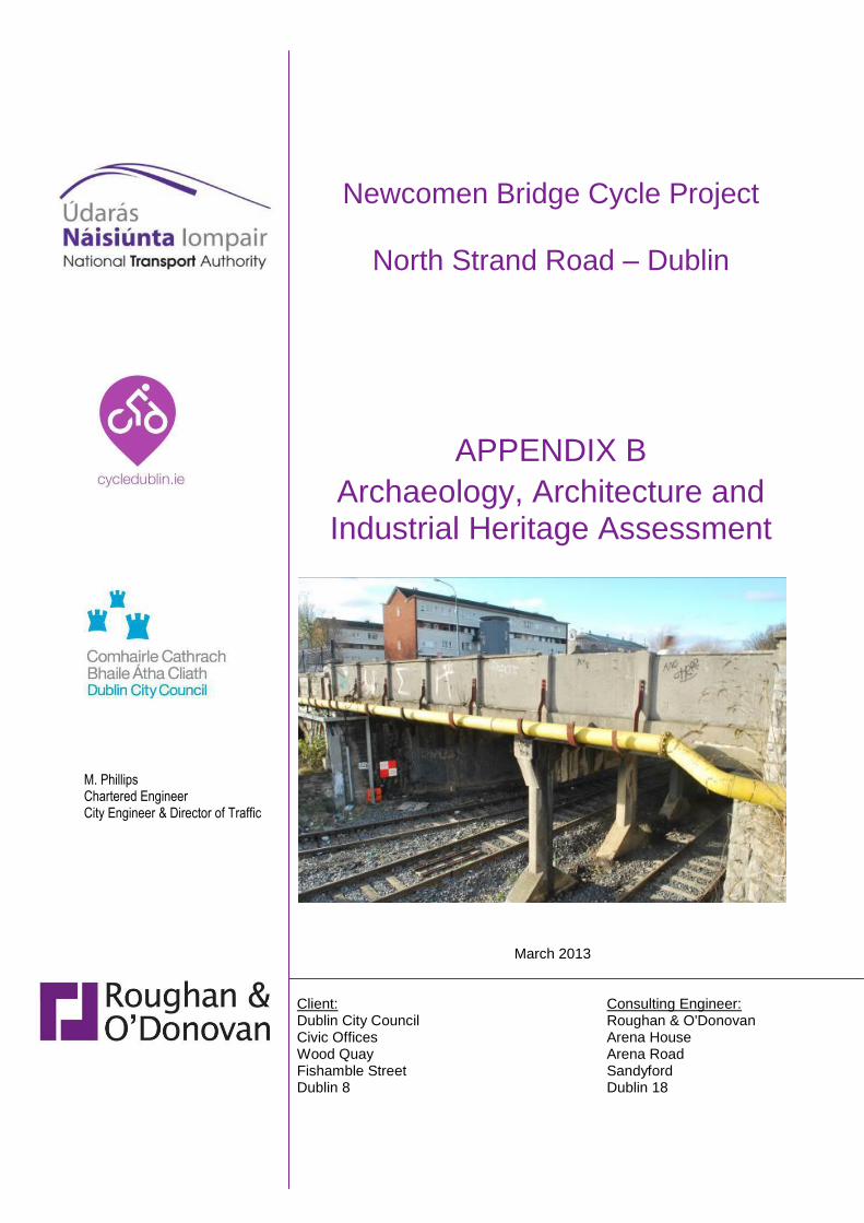
The proposed project will provide improved facilities for cycling and walking along the North Strand Road by providing a bridge that is architecturally sympathetic with the surroundings and capable of being fabricated and constructed safely within an eight month time frame. The proposal is to widen Newcomen Bridge by means of an additional bridge structure to be added on the south-eastern side of the existing bridges. The location is presented in Appendix 3. There are two bridges at this location. Newcomen Bridge carries North Strand Road over the Royal Canal, while a concrete bridge adjacent to it carries the road over a railway. The proposed bridge must also allow for future electrification of the Docklands and Connolly railway lines and be structurally independent of the existing bridges.
2. METHODOLOGY
2.1 Introduction
The methodology used during the assessment is based on the following standards and guidelines – Advice notes on Current Practice in the preparation of Environmental Impact Statements (Environmental Protection Agency 2003), Guidelines on the information to be contain in Environmental Impact Statement (Environmental Protection Agency 2002), the Framework and Principles for the Protection of the Archaeological Heritage (Department of the Arts, Heritage, Gaeltacht and the Islands 1999).
2.2 Recorded Archaeological Sites and Monuments
The Record of Monuments and Places (RMP)
The RMP, comprising the results of the Archaeological Survey of Ireland, is a statutory list of all recorded archaeological monuments known to the National Monuments Service. The relevant files for these sites contain details of documentary sources and aerial photographs, early maps, OS memoirs, the field notes of the Archaeological Survey of Ireland and other relevant publications. Sites recorded on the Record of Monuments and Places all receive statutory protection under the National Monuments Act 1994. The information contained within the RMP is derived from the earlier non-statutory Sites and Monuments Record (SMR); some entries, however, were not transferred to the statutory record as they refer to features that on inspection by the Archaeological Survey were found not to merit inclusion in that record or could not be located with sufficient accuracy to be included. Such sites however remain part of the SMR. The record is a dynamic one and is updated so as to take account of on-going research. The Record of Monuments and Places was consulted in the Archives of the Department of Arts, Heritage and the Gaeltacht.
Roughan & O’Donovan Dublin City Council Consulting Engineers Newcomen Bridge Cycle Project
12.220.24 March 2013 Page 3 AAIHA Report
There are no Recorded Monuments and Places within 200m of the proposed development.
2.3 Dublin City Development Plan 2011 - 2017
The Dublin City Development Plan 2011-2017 was also consulted. Chapter 7 of the Dublin City Development Plan 2011-2017 includes relevant policies for the protection of the cities archaeological, architectural and industrial heritage by means of Zones of Archaeological Interest, Industrial Heritage, Record of Protected Structures, Conservation Areas (see below). Zones of Archaeological Interest:
The proposed development is located outside the Zone of Archaeological Interest for the historic city of Dublin (RMP designation DU018-020) and there are no recorded monuments and sites located within 200m of the proposed development. It is the policy of Dublin City Council: 1. To promote awareness of, and access to, the city’s archaeological inheritance
(Policy FC63)
2. To promote the in-situ preservation of archaeology as the preferred option where development would have an impact on buried artefacts, except where other alternatives are acceptable or exceptional circumstances are determined by the relevant statutory agencies. Where preservation in situ is not feasible, sites of archaeological interest shall be subject to archaeological investigations and recording according to best practice, in advance of redevelopment (Policy FC64)
3. To preserve known burial grounds and disused graveyards. Where appropriate to ensure that human remains are re-interred, except where otherwise agreed with the National Museum of Ireland (Policy FC65)
4. To promote the awareness of the international significance of Viking and Medieval Dublin and to investigate key medieval sites and to conserve their character, setting and amenity through Irish Strategic Archaeological Research (INSTAR) Medieval Research Agenda and other initiatives. (Policy FC66)
5. To recognise the importance of underwater/intertidal archaeology (Policy FC67)
Industrial Heritage:
Industrial heritage is a relatively new area that refers to industrial activities of the past and associated infrastructure, such as the Poolbeg Power Station, and includes a range of buildings, artefacts, features and ancillary features such as the Guinness Storehouse and the Jameson Centre. These examples of the brewing and distillery's industrial heritage are being shared with many visitors every year. Regard for industrial heritage is an important issue for future planning and development. The Dublin City Industrial Heritage Record survey makes recommendations for sites to be added to the list of Protected Structures in the life of the plan and, once published, it should be consulted prior to the lodgement of any planning application. There are four industrial heritage sites within 100m of the proposed development (refer Appendix 1 and Figure 3 in Appendix 3). It is the policy of Dublin City Council:

Roughan & O’Donovan Dublin City Council Consulting Engineers Newcomen Bridge Cycle Project
12.220.24 March 2013 Page 4 AAIHA Report
To implement the relevant recommendations of the Dublin City Industrial Heritage Record (DCIHR) (Policy FC68)
Record of Protected Structures:
There are two structures included in the Record of Protected Structures in the Dublin City Development Plan within c. 100m of the proposed development (refer Appendix 2 and Figure 2 in Appendix 3). It is the policy of Dublin City Council:
To include those structures considered to be of special architectural, historical, archaeological, artistic, cultural, scientific, social or technical interest in the Record of Protected Structures. To protect these structures, their curtilage and the setting from any works that would cause loss or damage to their special character (Policy FC30);
To maintain and enhance the potential of protected structures and other buildings of architectural/historic merit to contribute to the cultural character and identity of the place, including identifying appropriate viable contemporary uses (Policy FC31);
To encourage the protection of the existing or last use of premises listed on the Record of Protected Structures where that use is considered to be an intrinsic aspect of the special, social, cultural and/or artistic interest of those premises. In considering applications for planning permission in respect of a change of use of any such premises to take into account as material consideration the contribution of the existing or last use of that structure to special, social, cultural and/or artistic interest of those premises and/or whether the new use would be inimical to the special interest identified (Policy FC32).
Conservation Areas:
There is one designated conservation area within the study area namely the Royal Canal Corridor. Conservation areas are designated in recognition of their unique contribution and importance to the heritage of the city. Dublin City Council seeks to ensure that proposals for developments within conservation areas complement the character of the area, including the setting of protected structures, and comply with development standards. It is the policy of Dublin City Council:
To protect the special character of the city’s conservation areas through the application of the policies, standards and guiding principles on building heights (Policy FC40);
To protect and conserve the special interest and character of Architectural Conservation Areas and Conservation Areas in the development management process heights (Policy FC41);
To protect the special interest and character of protected structures and Architectural Conservation Areas while striving to meet the requirements for access for all in as far as practicable in accordance with Section 29 of the Disability Act 2009 (Policy FC42);
To continue to prioritise the assessment and consideration of appropriate historic streets and squares for designation as Architectural Conservation Areas and include policies to protect and enhance their architectural characteristics (Policy FC43);
To assess and, where appropriate, re-designate existing non-statutory Conservation Areas as Architectural Conservation Areas (Policy FC44).

Roughan & O’Donovan Dublin City Council Consulting Engineers Newcomen Bridge Cycle Project
12.220.24 March 2013 Page 5 AAIHA Report
2.4 Finds
The National Museum of Ireland’s topographical files are a national archive of all known archaeological finds from Ireland. They relate primarily to artefacts but also include references to monuments and contain a unique archive of records of previous excavations. The topographical files were consulted to determine if any archaeological artefacts had been recorded from the area. Other published catalogues of prehistoric material were also studied: Raftery (1983 - Iron Age antiquities), Eogan (1965; 1993; 1994 - bronze swords, Bronze Age hoards and goldwork), Harbison (1968; 1969a; 1969b - bronze axes, halberds and daggers). All streets in the vicinity of the proposed development were assessed. There are no archaeological finds recorded from the study area.
2.5 Cartographic Sources
Cartographic sources were used to identify additional potential heritage constraints. Primary cartographic sources consulted consisted of the Ordnance Survey 6" and 25” maps, first and subsequent editions and the first edition 5 foot the mile map, published in 1847. Pre-Ordnance Survey cartographic sources consulted included Speed’s map of Dublin from 1610, de Gomme’s map of 1673, Brooking’s 1728 map and Rocque’s map of Dublin 1756. Secondary cartographic sources included Irish Historic Towns Atlas No. 11 Dublin, Part I to 1610 (Clarke 2002) and Irish Historic Towns Atlas No. 19 Dublin, Part II 1610 to 1756 (Lennon 2008).
2.6 Previous Excavations
The excavation bulletin website (www.excavations.ie) was consulted to identify previous excavations that have been carried out within the study area. This database contains summary accounts of excavations carried out in Ireland from 1970 to 2009. The following streets in Dublin City were assessed - Aldborough Place, Bayview Avenue, Bessborough Avenue, Charlemont Parade, Charleville Avenue, Charleville Mall, Clinch’s Court, Clonmore Road, Clonmore Terrace, Dunne Street, Gaelic Street, Guilford Place, Hibernian Avenue, Hyacinth Street, Newcomen Avenue, Newcomen Bridge, North Great Clarence Street, North Strand Road, North William Street, Ossory Road, Shamrock Cottages, Shamrock Place and Shamrock Terrace. No licenced excavations have been undertaken within the study area.
2.7 Historical Research
Historical sources consulted included The Buildings of Ireland: Dublin (Casey 2005), The Liffey in Dublin (De Courcy 1996), the Irish Historic Towns Atlas No. 11 Dublin, Part I to 1610 (Clarke 2002), the Irish Historic Towns Atlas No. 19 Dublin Part II 1610-1756 (Lennon 2008), The Heart of Dublin: Resurgence of an Historic City (Pearson 2000) and the Dublin Docklands Architectural Survey (University College Dublin School of Architecture, 1996) (see Bibliography for full list of references).
2.8 Site Assessment
Site assessments were carried out in January 2013. The site assessments involved the examination of archaeological, architectural and industrial heritage constraints identified during the desk top assessment.

Roughan & O’Donovan Dublin City Council Consulting Engineers Newcomen Bridge Cycle Project
12.220.24 March 2013 Page 6 AAIHA Report
3. ARCHAEOLOGICAL, ARCHITECTURAL AND INDUSTRIAL BACKGROUND
Prior to 18th century reclamation projects much of the eastern portion of the city formed part of the estuary of the River Liffey. While this would have made permanent occupation problematic during the prehistoric and medieval periods, the area may have been used on a temporary basis for the exploitation of local resources including fish and wild fowl. Archaeological material associated with this form of exploitation includes fish traps, other fishing structures and dug out boats (O’Sullivan 2001, 131). Recent archaeological monitoring at North Wall Quay, to the south of Newcomen Bridge, has uncovered archaeological material associated with the use of the estuary during the prehistoric period (McQuade 2005, 6). The monitoring revealed a primary shoreline associated with the Liffey which descended into silt deposits which had accumulated to a depth of approximately 3m. The remains of at least two fish-traps, constructed of hazel, were revealed between 1.2m and 12m from that shoreline (McQuade 2005, 6). Radiocarbon dating has returned dates between 6100 and 5720 cal. BC placing them in the Mesolithic period (McQuade 2005, 6). In the late 17th century the Tolka is depicted as a meandering stream flowing between mud or sandbanks. It discharged into Dublin Bay at Clontarf to the east of Annesly Bridge. At this time the only crossing point on the river was at Ballybough Bridge. The adjacent Ballybough Weir is reputedly the location of the Battle of Clontarf which took place in 1014. The earliest record of a bridge at Ballybough dates to the early 14th century (Ball 1920, 158). The bridge was destroyed by a flood but was rebuilt and is recorded again in the late 15th century. In 1797 Annesly Bridge was completed downstream of Ballybough Bridge and the North Strand Road became the favoured route to Howth In 1682 the City Assembly conducted a survey on land at the north-eastern end of the River Liffey and divided the area into 152 lotts. These lotts were awarded to members of the Assembly and other selected officials. In 1686 development was abandoned as the area, which was still subject to inundation at high tide, had not been fully protected from flooding (De Courcy 1996, 268). Efforts to reclaim the northern side of the estuary recommenced with containment works undertaken by the Ballast Office in 1710 (De Courcy 1996, 268-9). In 1717 a committee reported to the City Assembly with a number of proposals including the rerouting and canalisation of the River Tolka, the making of a new grid of streets and the construction of a grand quay (University College Dublin School of Architecture 1996, 171). The earlier high-water shoreline from the Tolka to the city was now far removed from the tide; and it was at this time that the development of the streets now known as North Strand Road and Amiens Street began. The newly made ground behind the wall was surveyed and a number of new streets including were laid out (Clerkin 2001, 132). In 1717 the city designated the new land between the Liffey and the Tolka as the North Lotts. The construction of a stone river wall, to replace the earlier embankment, began soon after. Brooking’s map of 1728 depicts the new wall running east to a point opposite the Donneybrook River at Ringsend before turning north. Newly made ground to the north of this is ‘Walled in but as yet overflow’d by ye tide’. Brooking’s map is augmented by ‘A Prospect of the City of Dublin from the North’ which clearly shows the area behind the river wall inundated with water. The only structures depicted in the area are located at the junction of the North Wall and East Wall and on the south side of the street at the junction of Abbey Street (now Lower Abbey Street) and the Strand (now Amiens Street). The area had been fully reclaimed by
Roughan & O’Donovan Dublin City Council Consulting Engineers Newcomen Bridge Cycle Project
12.220.24 March 2013 Page 7 AAIHA Report
the mid-18th century and Rocque’s map of 1756 depicts the completed road and plot pattern. The ground immediately west of the lotts, labelled the ‘Armory Ground’, would later become the site of the Custom House. The area between Commons Street and the Strand, which would later become the site of the docks, was laid out in a series of narrow plots running between North Wall and Mayor Street with wider plots running between Mayor Street and Sheriff Street. The proposal to connect Dublin with the Shannon by canal was discussed in the mid-eighteenth century, with two alternative alignments being proposed. The route selected was to run westwards and somewhat to the south, permitting a link to the Barrow navigation and this route became known as the Grand Canal. It appears that one of the directors of the Grand Canal resigned from the company and set out to establish his own route, running more to the north. The Royal Canal Company was established by act of parliament in 1789 and work began at Phibsborough in 1790, with construction moving in both directions. The original terminus of the canal was to have been at Bolton Street, but due to the excessive cost of land acquisition it was changed to Broadstone, adjacent to the Phibsborough Road. By this time work had begun on the Grand Canal’s circular route to link with the Liffey to the east of the city, where the canal could connect with ships using the port of Dublin. A similar scheme was devised for the Royal Canal and the canal ran around the northern fringe of the city in a mirror image of the Grand Canal, to connect with the Liffey at Guild Street, just to the east of the Custom House. At that location the canal had offices and a sea lock. A proposal for a canal dock running to the west of the canal towards the Custom House docks did not come to fruition, probably on grounds of cost, as the canal ran through financial difficulties before it was even completed and was never profitable. In the 1840s the Midland Great Western Railway Company was established with a view to opening a rail link between Dublin and Galway. The company acquired the ailing Royal Canal with a view to filling in the canal and building the railway on the site. Permission to do this was refused and the company was obliged to maintain the canal in working order. The railway was constructed alongside the canal, initially to the canal’s Broadstone terminus. In 1864 a link from this railway line to the North Wall was constructed alongside the canal, with a new bridge erected adjacent to Newcomen Bridge on its northern side. A new railway junction was formed adjacent to the bridges in 1892, connecting the line to Connolly Station. In 1921 the original railway bridge was replaced with a mass concrete bridge. The Royal Canal was taken into public ownership in the mid-twentieth century and was closed in 1961. After a few years the users of waterways began to campaign for the canal to be brought back into use and into usable condition. Through a concerted programme of work over the ensuing years much of the canal is now in use, including the section through Newcomen Bridge. The railway branch to Connolly Station crossed the canal at grade and the canal use is facilitated by means of a lifting bridge carrying the railway, immediately to the east of Newcomen Bridge. The original bridges on the canal varied in detail, but the general pattern was to have a hump-backed masonry bridge with a three-centered or elliptical arch of limestone. Newcomen Bridge is different to the general pattern, with granite ashlar, and with two gothic side-arches, as seen in the survey below. The probable reason for the difference is that this is not the original bridge. The first bridge collapsed before the arch was closed, killing a number of workers. An account at the time recorded that “in one part of the work the whole ponderous weight of the arch rested on an ashler, the scantling of which measured something less than three-quarters of an inch; by which

Roughan & O’Donovan Dublin City Council Consulting Engineers Newcomen Bridge Cycle Project
12.220.24 March 2013 Page 8 AAIHA Report
shameful work the bridge probably fell down and the lives of so many persons have been sacrificed”. The present Newcomen Bridge appears to have been built to a high specification and hence to a high loadbearing capacity. During the Second World War several bombs were dropped on the North Strand area causing extensive damage and loss of lives. Buildings to the south of the bridge were destroyed and the lock-keeper’s cottage adjacent to the bridge was damaged. Newcomen Bridge was not damaged during the bombing.
4. SITE SURVEY – ARCHAEOLOGICAL HERITAGE
The proposed development consists of a pedestrian and cycle bridge to the immediate southeast of Newcomen Bridge (see below). There are no recorded archaeological monuments in the vicinity of the proposed development and no previously unrecorded archaeological features were identified during the site survey.
5. SITE SURVEY – ARCHITECTURAL HERITAGE
Plate 1: Western side of Newcomen Bridge Newcomen Bridge is a single-arch canal bridge carrying North Strand Road over the Royal Canal (RPS ref. no. 911 and DCIHR ref. no. 18 08 085). The principal arch spans the canal while two flanking arches are blocked up, but would originally have served as access arches for pedestrians and, possibly, horses. The spandrels and parapets are of granite ashlar and there is a limestone plaque inset into the middle of each parapet, facing the canal, recording that the bridge was constructed in 1795. The parapets are capped with granite copings. The canal arch is segmental and has a classical archivolt with a vermiculated keystone, all of which are of granite. The flanking arches have gothic arches with classical architraves, the apex of which is of limestone. On the western side the bridge is close to a canal lock and hence is low, with only the heads of the flanking arches visible.

Roughan & O’Donovan Dublin City Council Consulting Engineers Newcomen Bridge Cycle Project
12.220.24 March 2013 Page 9 AAIHA Report
Plate 2: Eastern side of Newcomen Bridge On the eastern side of the bridge the design is similar to the west, though more of it is visible due to the lower ground level on this side. The flanking arches are blocked up, with a pipe projecting through the blocking masonry on the northern arch. On this side of the bridge a great deal of the masonry is obscured by services attached to the parapet and spandrels. This includes a substantial pipe held on a series of metal brackets fastened to the parapet and rising up the full height of the parapet to the coping. Beneath this is an area of steel sheeting crosses over the central arch, shielding a collection of cables fixed to the masonry of the bridge. Beneath that again are two substantial runs of steel trunking that cross the bridge just above the archivolt of the central arch and across the front of the apex of the flanking arches. A steel fence is fixed to the parapet, rising up from the copings.
Plate 3: Return of bridge parapet on southern side On the southern side of the bridge the parapet curves towards the east. The footway is broad as it approaches the bridge and narrows at the bridge parapet.

Roughan & O’Donovan Dublin City Council Consulting Engineers Newcomen Bridge Cycle Project
12.220.24 March 2013 Page 10 AAIHA Report
Plate 4: Bridge parapet at footway On the bridge deck the granite ashlar of the parapet is visible, with its granite coping stones. At the northern end of the parapet there is a fragment of the original stone railway bridge dating from 1864.
Plate 5: Concrete railway bridge adjacent to Newcomen Bridge The railway bridge is a beam bridge spanning between abutments adjacent to Newcomen Bridge and North Strand Road, with a supporting concrete trestle. While some of the railway bridges adjacent to the Royal Canal are of heritage significance, this bridge is not considered to be.
Roughan & O’Donovan Dublin City Council Consulting Engineers Newcomen Bridge Cycle Project
12.220.24 March 2013 Page 11 AAIHA Report
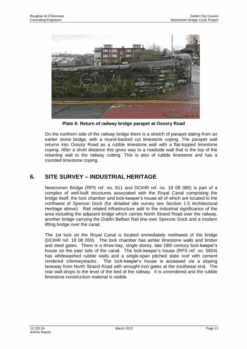
Plate 6: Return of railway bridge parapet at Ossory Road On the northern side of the railway bridge there is a stretch of parapet dating from an earlier stone bridge, with a round-backed cut limestone coping. The parapet wall returns into Ossory Road as a rubble limestone wall with a flat-topped limestone coping. After a short distance this gives way to a roadside wall that is the top of the retaining wall to the railway cutting. This is also of rubble limestone and has a rounded limestone coping.
6. SITE SURVEY – INDUSTRIAL HERITAGE
Newcomen Bridge (RPS ref. no. 911 and DCIHR ref. no. 18 08 085) is part of a complex of well-built structures associated with the Royal Canal comprising the bridge itself, the lock chamber and lock-keeper’s house all of which are located to the northwest of Spencer Dock (for detailed site survey see Section 1.5 Architectural Heritage above). Rail related infrastructure add to the industrial significance of the area including the adjacent bridge which carries North Strand Road over the railway, another bridge carrying the Dublin Belfast Rail line over Spencer Dock and a modern lifting bridge over the canal. The 1st lock on the Royal Canal is located immediately northwest of the bridge (DCIHR ref. 18 08 059). The lock chamber has ashlar limestone walls and timber and steel gates. There is a three-bay, single storey, late 18th century lock-keeper’s house on the east side of the canal. The lock-keeper’s house (RPS ref. no. 5824) has whitewashed rubble walls and a single-span pitched slate roof with cement rendered chimneystacks. The lock-keeper’s house is accessed via a sloping laneway from North Strand Road with wrought-iron gates at the southeast end. The rear wall drops to the level of the bed of the railway. It is unrendered and the rubble limestone construction material is visible.

Roughan & O’Donovan Dublin City Council Consulting Engineers Newcomen Bridge Cycle Project
12.220.24 March 2013 Page 12 AAIHA Report
Plate 7: Lock-keeper’s house, 1st Lock Royal Canal A second bridge (DCIHR ref. 18 08 035), carrying North Strand Road over the railway, is located to the northeast of Newcomen Bridge. Originally constructed c. 1864 the bridge now consists of a late 20th century beam bridge spanning between abutments, with a supporting concrete trestle. The proposed development will be located to the northwest of Spencer Dock. The dock, which consisted of an expanded section of the Royal Canal, was constructed in the late 19th century to facilitate the coal trade. The dock is stone-lined at this point. A branch railway line runs along the west side of the dock. A single railway line is carried across the north end of Spencer dock on a modern lifting bridge (DCIHR ref. 18 08 055).
Plate 8: North end of Spencer Dock, showing lifting bridge in foreground

Roughan & O’Donovan Dublin City Council Consulting Engineers Newcomen Bridge Cycle Project
12.220.24 March 2013 Page 13 AAIHA Report
A railway bridge carrying the Dublin Belfast rail line crosses Spencer dock further to the south. It dates to the mid-19th century and consists of a five-span masonry and cast-iron structure. The outer spans of the bridge consist of single elliptical arches with dressed limestone voussoirs and rusticated and dressed limestone soffits. The central section consists of a cast-iron deck supported on rusticated limestone piers. The bridge has been extended to the south in recent years. The extension comprises a mass concrete beam deck on mass concrete piers. A second bridge was constructed immediately to the north in the late 19th century to carry a branch line of the railway and consists of a cast-iron deck supported on cast-iron pillars and rusticated limestone piers.
7. PREDICTED IMPACTS
7.1 Archaeological Heritage
While the proposed pedestrian and cycle bridge will not impact directly on any sites included in the Record of Monuments and Places, it is possible that unrecorded archaeological material may exist at the site associated with the reclamation of the site from the former foreshore or the subsequent industrial development of the area.
7.2 Architectural Heritage
The proposed structure that would provide the bridge extension would run along the eastern side of Newcomen Bridge and the railway bridge to connect the footways on either side of the canal and railway. There would be three predicted impacts on built heritage: 1. Possible impact on a section of the curved canal parapet wall on the southern
side of the bridge. 2. Erection of the new structure across the eastern face of Newcomen Bridge. 3. Removal of a section of the surviving parapet from the earlier railway bridge on
the northern side of the bridge. It seems probable that the curved parapet wall on the southern side of Newcomen Bridge is not an original part of the parapet. While it is of granite ashlar, there is a vertical joint between the main parapet and this curved section, and the nature of the stonework is different, with the coursing not continuing through the joint. The implication is that while the parapet of the bridge could be slightly impacted, the original fabric of Newcomen Bridge would not be affected by this element of the works. The point at which the new ope would be formed in the wall would be well back from Newcomen Bridge and it would appear that is would avoid the curved section of granite ashlar to run through the adjacent limestone wall. In summary, it is not considered that there would be any significant impact on this part of the parapet wall. The proposed bridge would run parallel to the existing canal and railway bridges and would not be attached to them. The potential impact would thus be visual rather than direct physical impact. The height of the proposed bridge would be such that the soffit would be above the apexes of the two flanking arches of Newcomen Bridge and well above the central arch. The visual impact would predominantly affect the upper section of the bridge, concealing it from view from the east. This is the portion of the bridge that is to a large extent obscured at present through the presence of the pipe with its brackets, the cables and the trunking. The impact of the proposal would be to

Roughan & O’Donovan Dublin City Council Consulting Engineers Newcomen Bridge Cycle Project
12.220.24 March 2013 Page 14 AAIHA Report
obscure part of Newcomen Bridge from view, though this part is already largely obscured and hence the additional impact would be small. The stone wall at the northern side of the bridge is not part of the protected structure at Newcomen Bridge and is not considered to be of such heritage significance that to form a breach in it would warrant any mitigation.
7.3 Industrial Heritage
The proposed development will introduce a new piece of transport related infrastructure to the southeast of Newcomen Bridge. The proposed development will not be attached directly to the parapet wall of the bridge. This face of the bridge has previously been impacted by the attachment of service pipes and steel trunking.
8. RECOMMENDED AVOIDANCE, REMEDIAL OR REDUCTIVE MEASURES
8.1 Archaeological Heritage
While the proposed development does not impact any recorded archaeological monuments or places there is a possibility that unrecorded archaeological material may exist at the site associated with the reclamation of the site from the former foreshore of the Liffey Estuary or the areas subsequent industrial development including the construction of the Royal Canal and the development of the local railway network. In order to mitigate the potential impact of the proposed development, archaeological monitoring by a suitably qualified archaeologist will be undertaken during geotechnical investigations in advance of the proposed development. Should any potential archaeological features or material be uncovered during the course of archaeological monitoring further mitigation measures may be required.
8.2 Architectural Heritage
No further mitigation is required at the site of the proposed bridge.
8.3 Industrial Heritage
No further mitigation is required at the site of the proposed bridge.

Roughan & O’Donovan Dublin City Council Consulting Engineers Newcomen Bridge Cycle Project
12.220.24 March 2013 Page 15 AAIHA Report
9. REFERENCES
Aalen, F.H.A. 1978. Man and the landscape in Ireland. London
Aalen, F.H.A., Whelan, K. and Stout, M. (eds.) Atlas of the Rural Irish Landscape. Cork University Press: Cork.
Bradley, J. King, H.A. Unpublished. The Urban Archaeological Survey: Dublin City. Unpublished report commissioned by the Office of Public Works.
Clarke. H. B., 2002. Irish Historic Towns Atlas Part I to 1610. Royal Irish Academy: Dublin.
Cooney, G. 2000. Landscapes of Neolithic Ireland. London & New York: Routledge.
Cooney, G. and Grogan, E. 1994. Irish Prehistory – A Social Perspective. Dublin: Wordwell.
De Courcy, J.W. 1996. The Liffey in Dublin. Dublin: Gill & Macmillan.
Delany, R. and Bath, I. 2010, Ireland’s Royal Canal, 1789-2009, Dublin, Lilliput.
Department of the Arts, Heritage, Gaeltacht and the Islands, 1999. Framework and Principles for the Protection of the Archaeological Heritage.
Dublin City Council, 2008. Dublin City Industrial Heritage Record Phase 5 North City, 3 Volumes.
Edwards, N. 2005. The Archaeology of Early Medieval Ireland, c.400-1169: Settlement and Economy.
Environmental Protection Agency, 2002. Guidelines on the information to the contained in Environmental Impact Statements.
Environmental Protection Agency, 2003. Advice notes on Current Practice (in the preparation of Environmental Impact Statements).
Eogan, G., 1965. A catalogue of Irish Bronze swords. Dublin.
Eogan, G., 1983. Hoards of the Irish Later Bronze Age. Dublin.
Eogan, G., 1994. The Accomplished Art, Gold and Gold working in Britain and Ireland during the Bronze Age. Dublin.
Gwynn, A. & Hadcock, R.N. 1970. Medieval religious houses: Ireland. London: Longmans
Harbison, P., 1968. Catalogue of Irish Early Bronze Age associated finds containing copper or bronze. Proceedings of the Royal Irish Academy 67C, 35-91.
Harbison, P., 1969a. The daggers and the halberds of the Early Bronze Age in Ireland. Prähitorische Bronzefunde, Abteilung VI, Band 1. C.H. Beck, Munich.
Harbison, P., 1969b. The axes of the Early Bronze Age in Ireland. Prähitorische Bronzefunde, Abteilung Ix, Band 1. C.H. Beck, Munich.
Hayes, J. 1965. Manuscript Sources for the History of Irish Civilisation Vol. 8. Hall & Co.: Boston.
Hayes, J. 1970. Sources for the History of Irish Civilisation. Articles in Irish Periodicals Vol. 9. Hall & Co.: Boston.
Lennon, C.., 2008. Irish Historic Towns Atlas Part II 1610 to 1756. Royal Irish Academy: Dublin.
Lewis, S. 1837. A Topographical Dictionary of Ireland, 2 Vols. London.
MacDonnell, R., 2002. The Lost Houses of Ireland. London: Weidenfield and Nicholson.
McQuade, M., 2005. North Wall Quay. Archaeology Ireland, Vol. 19 (2) Issue No. 72
National Roads Authority, 2005. Environmental Impact Assessment of National Road Schemes – A Practical Guide.
Roughan & O’Donovan Dublin City Council Consulting Engineers Newcomen Bridge Cycle Project
12.220.24 March 2013 Page 16 AAIHA Report
O’Sullivan, A., 2001. Foragers, Farmers and Fishers in a Coastal Landscape: An intertidal archaeological survey of the Shannon estuary. Royal Irish Academy: Dublin.
Raftery, B., 1983. A catalogue of Irish Iron Age antiquities. Marburg.
Shepherd, W. E., 1994. The Midland Great Western Railway of Ireland, Leicester, Midland Publishing.
Taylor, G. & Skinner, A. 1777 (reprinted 1969). Maps of the roads of Ireland. Shannon.
University College Dublin (School of Architecture), 1996. The Dublin Docklands Architectural Survey. Dublin: School of Architecture, UCD.
Woodman, P.C. 1978. The Mesolithic in Ireland. Oxford: British Archaeological Reports, British Series, 58.
Sites and Monuments Record. National Monuments Division: The National Monuments Section of the Department of Environment, Heritage and Local Government.
Record of Monuments and Places. National Monuments Division: The National Monuments Section of the Department of Environment, Heritage and Local Government. www.excavations.ie

Roughan & O’Donovan Dublin City Council Consulting Engineers Newcomen Bridge Cycle Project
12.220.24 March 2013 App 1 AAIHA Report
Appendix 1
Dublin City Industrial Heritage Record The Dublin City Industrial Heritage Record identifies a number of industrial archaeological structures within c. 100m of the proposed development (refer Figure 3):
DCIHR Ref. No.
Location Site Type Description
18 08 035 North Strand Road
Bridge Double span limestone bridge built c. 1864 carrying the North Strand Road over the Midland Great Western Railway line north wall extension. Now with modern deck and section of parapet wall c. 1970. Square and snecked rock-face limestone to piers with surviving section of square and snecked rock-face limestone parapet and wing walls to the north and south having convex cap stones. Replacement deck, central support pier and section of parapet wall c. 1970.
18 08 055 North Strand Road
Lift bridge Lift bridge built c. 1970 to replace earlier bridge c. 1900 and carrying section of the former Midland Great Western extension to Amien Street Station over the Royal Canal. Cast-iron deck with tower to each corner having counterweights to assist lifting deck. Bridge carries single railway line.
18 08 058 North Strand Road
Bridge Single-span canal bridge, built c. 1790 at 1st lock carrying the North Strand Road over the Royal Canal with former pedestrian archways flanking spanning arch. Ashlar granite construction with moulded archivolt to spanning arch having vermiculated keystone. Pointed-arched former pedestrian archways flanking spanning arch with moulded archivolt. Ashlar granite parapet wall with segmental headed coping and oval limestone plaque to east and west elevations. Modern security railings to east parapet wall.
18 08 059 North Strand Road
Lock Double chamber canal lock built 1790 as 1st lock along the Royal Canal. Running beneath Newcomen Bridge at the eastern end and having former lock house to north. Ashlar limestone walls to chambers with pairs of timber half gates to west end between chambers. Gates to eastern end removed, but gate recesses visible. Mooring posts to banks of chamber. Three-bay, single storey former lock house having pitched slate roof, rendered walls and replacement windows and door c. 1995. Access to house from North Strand Road via laneway bounded by random rubble wall with segmental coping and having wrought-iron gates at north end. Cobbled surface between canal chamber and lock house.

Roughan & O’Donovan Dublin City Council Consulting Engineers Newcomen Bridge Cycle Project
12.220.24 March 2013 App 2 AAIHA Report
Appendix 2
Record of Protected Structures
Protected Structures within c. 100m of the proposed development (refer Figure 2) (source Dublin City Development Plan 2011-2017).
RPS Ref. No. Address Site type
911 Newcomen Bridge, Royal Canal, North Strand Road, Dublin 3
Newcomen Bridge, North Strand Road
5824 Newcomen Bridge, North Strand Road, Dublin 3
Lock-keepers cottage at 1st Lock, Royal Canal

Roughan & O’Donovan Dublin City Council Consulting Engineers Newcomen Bridge Cycle Project
12.220.24 March 2013 App 3 AAIHA Report
Appendix 3
Drawings

Job No:
Date:Status:
Drawing No: Rev:
Approved:
Drawn:
Project Title
DateStage
RevisionNo.
PRELIMINARY
CONSTRUCTION
APPROVAL
DateChk'dBy
App'dApp'd
Drawing Title
Arena House, Arena Road,Sandyford, Dublin 18.Tel : +353 1 294 0800
Fax : +353 1 294 0820e-mail : [email protected]
www.roughanodonovan.comConsulting Engineers
Roughan &
Scale:Checked:Designed:
O'DonovanTENDER
Drawing Location: J:\2012\12220\Dwg\Sketches\12.220-SK-001.dwg Nov 28, 2012 - 3:24pm DO NOT SCALE USE FIGURED DIMENSIONS ONLY
GRAND CANAL & S2S DOCKLANDSPREMIUM CYCLE ROUTE - STRUCTURES
Copyright © Ordnance Survey Ireland. Licence number 2010/22/CCMA/ Dublin City Council
STRUCTURE 08 - NEWCOMEN BRIDGE WIDENINGSITE LOCATION PLAN
EP 12.220
AS SHOWN NOV '11JL RMJ RMJ PRELIMINARY 12.220-SK-001 -
WORK IN PROGRESS

Figure 2: Protected Structures within c. 100m of the proposed development (source Dublin City Council).
Unit 4a,Dundrum Business Park,Dublin 14.Tel: +353 1 2968190Fax: +353 1 2968195
Date: January 2013
Client: ROD/DCC
Drawn by: AnC
x I
x I
x I Protected Structure
911
5824

Figure 3: Features of industiral heritage interest within c. 100m of the proposed development (source DCIHR).
Unit 4a,Dundrum Business Park,Dublin 14.Tel: +353 1 2968190Fax: +353 1 2968195
Date: January 2013
Client: ROD/DCC
Drawn by: AnC
DCIHR
18 08 059
18 08 058
18 08 035
18 08 055
18 08 055

Figure 4: Extract from Ordnance Survey map 1847, showing site of proposed development (not to original scale, source DCC).
Unit 4a,Dundrum Business Park,Dublin 14.Tel: +353 1 2968190Fax: +353 1 2968195
Date: January 2013
Client: ROD/DCC
Drawn by: AnC
Related Documents