Appendix 3-2 Isiolo River Basin Integrated Flood Management Plan

Welcome message from author
This document is posted to help you gain knowledge. Please leave a comment to let me know what you think about it! Share it to your friends and learn new things together.
Transcript

Appendix 3-2
Isiolo River Basin Integrated Flood Management Plan
As of 3 August 2013
REPUBLIC OF KENYA PROJECT ON CAPACITY DEVELOPMENT
FOR EFFECTIVE FLOOD MANAGEMENT IN FLOOD PRONE AREA
ISIOLO RIVER BASIN INTEGRATED FLOOD MANAGEMENT PLAN
- DRAFT -
August 2013
Project on Capacity Development for Isiolo River Basin Effective Flood Management in Flood Prone Area Integrated Flood Management Plan-Draft-
- i -
Republic of Kenya Project on Capacity Development for Effective Flood Management in Flood Prone Area
Isiolo River Basin Integrated Flood Management Plan
- Final Draft -
Table of Contents
1. POLICY OF RIVER BASIN FLOOD MANAGEMENT PLAN (DRAFT) ........... 1
1.1 Policy of Flood Management in the Relevant River Basin (Draft) .................................. 1
1.2 The Role and Responsibility of WRMA ............................................................................ 1
1.3 River Basin Committee .................................................................................................... 2
1.4 Environmental and Social Considerations ...................................................................... 3
2. OUTLINE OF ISIOLO RIVER BASIN .............................................................. 4
2.1 Natural Conditions .......................................................................................................... 5
2.1.1 Topography and Soil ...................................................................................................... 5
2.1.2 Vegetation and Land Use .............................................................................................. 8
2.1.3 Hydrology and Meteorology ........................................................................................ 11
2.2 Socio Economic Conditions ............................................................................................. 25
2.2.1 Administration ............................................................................................................ 25
2.2.2 Population .................................................................................................................... 30
2.2.3 Industry ........................................................................................................................ 31
2.3 Development Plan .......................................................................................................... 31
2.3.1 Vision 2030 ................................................................................................................... 31
2.3.2 Isiolo District Development Plan (2008-2012) ........................................................... 32
2.3.3 Imenti North District Development Plan (2008-2012) ............................................. 33
2.3.4 Ewaso Ngi’ro North Catchment Area Catchment Management Strategy (June
2009) 33
3. ANALYSIS OF FLOOD CHARACTERISTICS AND COUNTERMEASURES34
3.1 Overall Condition on Floods in the Isiolo River Basin ................................................... 34
3.1.1 Records of Flood Damages .......................................................................................... 34
3.1.2 Flood Condition Inquiring From Relevant Communities ......................................... 35
Isiolo River Basin Project on Capacity Development for Integrated Flood Management Plan-Draft- Effective Flood Management in Flood Prone Area
- ii -
3.2 Flood Characteristics and Situation of Damages in the Isiolo River Basin................... 37
3.2.1 Concept of Flood Characteristics and SituationI of Damages in the Isiolo River
Basin 37
3.2.2 Inundation in Urban Area of Isiolo Town (A)............................................................. 38
3.2.3 Inundation which is caused by overflow and dyke break in the middle river basin
(B) 44
3.2.4 Debris flow in the Upstream (C) ................................................................................. 46
3.2.5 Bank Erosion in the Entire Basin (D) ........................................................................ 47
3.3 Analysis on Flood Damage and Countermeasure .......................................................... 49
3.3.1 Analysis on Flood Damage and Countermeasure in the Urban Area of Isiolo ........ 49
3.3.2 Analysis on Flood Damage and Countermeasure in the Outskirt excluding the
Urban Area (Mainly in the upstream of urban area of Isiolo) ................................................. 54
3.3.3 Longlist/candidates of Countermeasures to the Flood .............................................. 58
3.4 Selection of Flood Damage to be Managed Preferentially ............................................. 59
3.4.1 The Result of Workshop for Flood Damage Analysis by Community ....................... 59
3.4.2 Selection of the Prioritized Flood Damage to be Managed ....................................... 59
4. EVALUATION OF COUNTERMEASURES TO THE FLOOD ........................ 62
4.1 View Point of Evaluation ............................................................................................... 62
4.2 Evaluation Result for Each Countermeasure ................................................................ 63
4.2.1 Result of the Evaluation on 5 Criteria ....................................................................... 82
5. PROJECT IMPLEMENTATION PLAN OF FLOOD COUNTERMEAURES ... 83
5.1 Flood Countermeasres in the Flood Management Plan ................................................. 83
5.2 Draft Implementetion Schedule of Flood Countermesureas.......................................... 83
6. RECOMMENDATION .................................................................................... 86
Project on Capacity Development for Isiolo River Basin Effective Flood Management in Flood Prone Area Integrated Flood Management Plan-Draft-
- 1 -
1. POLICY OF RIVER BASIN FLOOD MANAGEMENT PLAN (DRAFT)
1.1 POLICY OF FLOOD MANAGEMENT IN THE RELEVANT RIVER BASIN (DRAFT)
The Isiolo river basin is located on the foot of Mt. Kenya and then the topographic slope is
steep generally. Therefore reading time of flooding from rainfall starting is short and it has the
feature that flooding peak discharge is high.
The Isiolo city area is a centre of socio economic activity in the region and is an important
rural city. It has development plans as a strategic important place of transportation or a centre
of sightseeing base, since the national highway is running from Nairobi to northern Kenya
through Isiolo.
The Isiolo river basin is belongings to the jurisdiction of WRMA Middle Ewaso Ng’iro Sub
Regional Office (SRO) concerning the general water resource management flood management
inclusive flood management. Then, Isiolo WRUA is established in the Isiolo river basin, and
implements grass-roots water management in collarroboration with WRMA.
The principal flood damages are, socio economic stagnation and human damage by both
inundations inside and outside the levee in Isiolo city area, lost of farmlands and sediment
related disasters by local inundation or bank erosion in various points of river basin and
destruction of roads or bridges.
Therefore the important point of the flood management policy in relevant river basin shall be
mitigation of damage in Isiolo city area and mitigation of local inundation or river bank
erosion damage in socio economically important points.
In the course of drawing up the flood management plan, the appropriate combination of
structural and non-structural measures or the view point of “Self-help”, “Mutual support” and
“Public assistance” should be considered. And also consensus building among the stakeholders
through the participation of WRUA or communities should be implemented
WRUA and communities implement the distribution, evolution, maintenance of structural
measures and non-structural measures with initiative.
WRUA and communities shall work together from the period of project planning so that
incubate their ownership
The scoping period of this plan is 5 years from 2013 to 2018, the contents of plan will be
revised properly in necessity.
1.2 THE ROLE AND RESPONSIBILITY OF WRMA
Main constituent of this plan is WRMA. WRMA should assist WRUA to make it possible for it
to build realizable tasks in to the Sub-Catchment Management Plan (SCMP) by itself. In
addition, WRMA provide the technical assistance to implement the countermeasures against

Isiolo River Basin Project on Capacity Development for Integrated Flood Management Plan-Draft- Effective Flood Management in Flood Prone Area
- 2 -
flooding matters.
Concerning the tasks that WRUA has no initiative, WRMA shall precede the implementation
of tasks while coordinating it with relevant stakeholders.
1.3 RIVER BASIN COMMITTEE
Flood management cannot achieve the objectives without the cooperation of various
stakeholders in the river basin.
Some river basins are divided by plural sub catchment such as upper stream, lower stream, left
bank and right bank.
According to this condition, WRMA shall establish “Integrated Flood Management River
Basin Committee” in order to share the information concerning flood management and
coordinate in river basin unit.
The stakeholders in the relevant river basin preferable to participate in the committee are listed
below.
Table 1.3.1 The Stakeholders in Isiolo River Basin
No Institution/Organization Remarks
1 Isiolo WRUA One representative from each of the six Zones
2 Provincial Administration County Commissioner
3 Ministry of State for Special Programmes
Active in providing humanitarian assistance to
disaster victims in Isiolo area
4 Kenya National Highways Authority/Kenya Rural Roads
Authority - Representative One representative each from KenHA and KeRRA
5 Ministry of Water and Irrigation Irrigation Department representative
6 Ministry of Lands District Physical planner
7 Ministry of Agriculture District Agricultural Officer
8 Ministry of Livestock District Livestock Officer
9 Ministry Of Education District Education Officer
10 Ministry of Development of Northern Kenya and Other
Arid Lands
Active in providing humanitarian assistance to
disaster victims in Isiolo area
11 Kenya Meteorological Department Contact Person at National Level
12 Ewaso Ng’iro North Development Authority (ENNDA) Representative from Regional Office
13 National Environmental Management Authority District Officer
14 County Government of Isiolo One representative
15 County Government of Meru One representative
16 Kenya Red Cross Society Representative from Regional Office
17 World Vision Representative from Regional Office
18 Food for Hungry (fhi) Representative from Regional Office
19 Lewa Conservancy CAAC member
20 Pastoralists One representative
21 Farmers One representative
22 CAAC Chairman
23 Environment/Natural Resources Management CBOs Environment representative
20 Kenya Wildlife Service One representative from Isiolo area
21 Religious Group One each from Christian and Muslim
22 Northern Water Service Board (NWSB) One representative
24 Kenya Forest Service CAAC member
26 Department of Social Services Registers WRUAs and other social welfare groups
29 Kenya National Chamber of Commerce and Industry Isiolo chapter
30 Catholic Diocese of Isiolo One representative
31 Kenya Airpot Authority
32 WRMA HQ, RO, SRO

Project on Capacity Development for Isiolo River Basin Effective Flood Management in Flood Prone Area Integrated Flood Management Plan-Draft-
- 3 -
In the committee, exchanging of opinions between the relevant stakeholders, approval of flood
management plan, consensus building, discussion of role sharing and activity evaluation etc.
shall be done
Committee members shall be discussing about the following themes once in every some
months for the time being.
Tabel 1.3.2 The Schedule of Integrated Flood Management Committee Meeting(Draft)
Discussion Themes Remarks
1st
Meeting
Information sharing on current situation and problems in flooding
Discussion on conceivable flood measures
Already done in
Jan. 23rd , 2013
2nd
Meeting
Suggestion of flood management plan(draft)
Discussion on flood management plan(draft)
Consensus building on pilot project(This project only)
3rd
Meeting
Discussion on flood management plan(draft)
Progress reporting of pilot project(This project only)
4th
Meeting Evaluation of pilot project(This project only)
1.4 ENVIRONMENTAL AND SOCIAL CONSIDERATIONS
On planning the flood measures project, the appropriate environmental and social
consideration shall be done based on Kenyan regal code “Environmental Management and
Coordination Act (EMCA) 1999”.

Isiolo River Basin Project on Capacity Development for Integrated Flood Management Plan-Draft- Effective Flood Management in Flood Prone Area
- 4 -
2. OUTLINE OF ISIOLO RIVER BASIN
Isiolo River Basin is located at the northern part of the piedmont of Mt. Kenya in the central part of the
Republic of Kenya.
Location of Isiolo River Basin
Downstream
Upstream
Project on Capacity Development for Isiolo River Basin Effective Flood Management in Flood Prone Area Integrated Flood Management Plan-Draft-
- 5 -
2.1 NATURAL CONDITIONS
2.1.1 Topography and Soil
(1) Topography
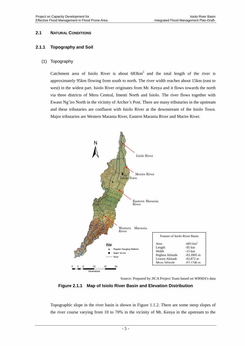
Catchment area of Isiolo River is about 683km2 and the total length of the river is
approximately 95km flowing from south to north. The river width reaches about 15km (east to
west) in the widest part. Isiolo River originates from Mr. Kenya and it flows towards the north
via three districts of Meru Central, Imenti North and Isiolo. The river flows together with
Ewaso Ng’iro North in the vicinity of Archer’s Post. There are many tributaries in the upstream
and these tributaries are confluent with Isiolo River at the downstream of the Isiolo Town.
Major tributaries are Western Marania River, Eastern Marania River and Marire River.
Source: Prepared by JICA Project Team based on WRMA’s data
Figure 2.1.1 Map of Isiolo River Basin and Elevation Distribution
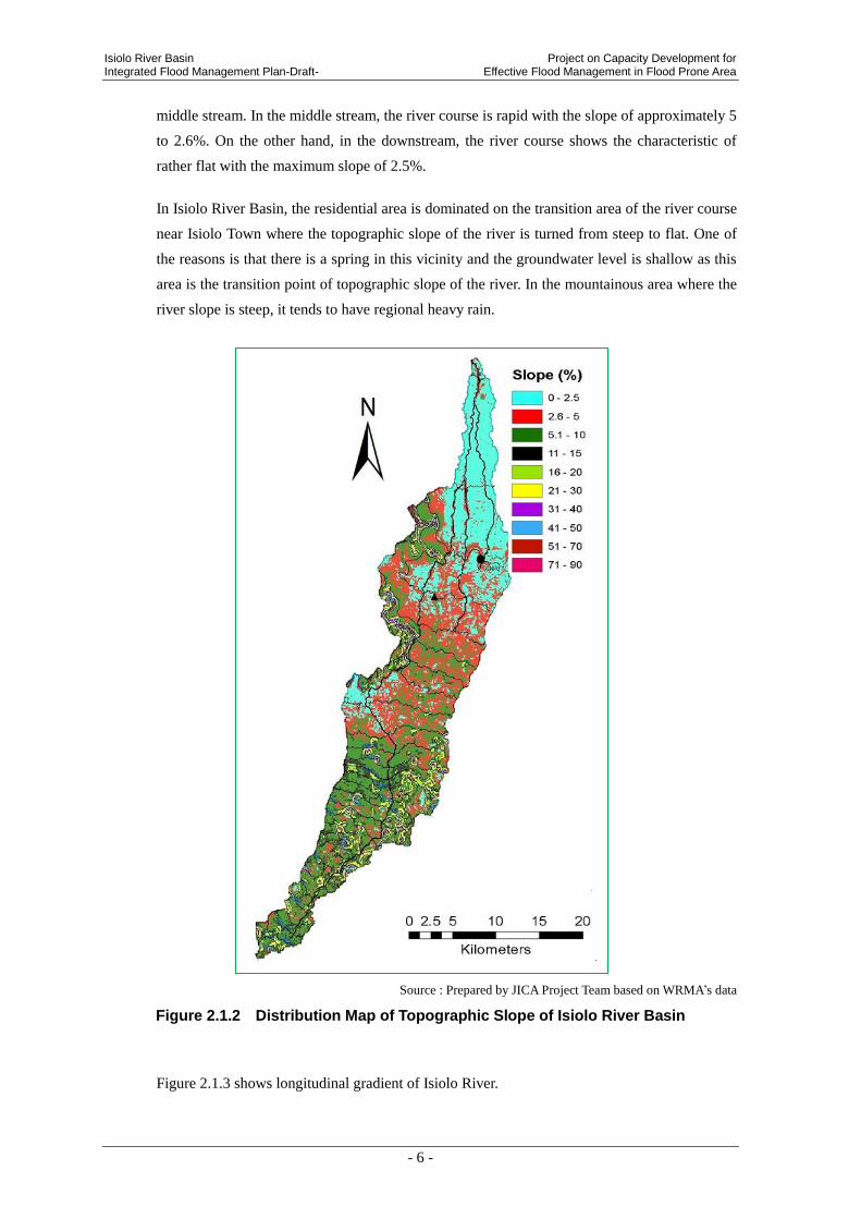
Topographic slope in the river basin is shown in Figure 1.1.2. There are some steep slopes of
the river course varying from 10 to 70% in the vicinity of Mt. Kenya in the upstream to the
Feature of Isiolo River Basin
Area -683 km2 Length -95 km
Width -15 km
Highest Altitude -EL3905 m Lowest Altitude -EL872 m
Mean Altitude -EL1746 m
Eastern Marania River
Merire River
Isiolo River
Isiolo Town
Western Marania River
Isiolo River Basin Project on Capacity Development for Integrated Flood Management Plan-Draft- Effective Flood Management in Flood Prone Area
- 6 -
middle stream. In the middle stream, the river course is rapid with the slope of approximately 5
to 2.6%. On the other hand, in the downstream, the river course shows the characteristic of
rather flat with the maximum slope of 2.5%.
In Isiolo River Basin, the residential area is dominated on the transition area of the river course
near Isiolo Town where the topographic slope of the river is turned from steep to flat. One of
the reasons is that there is a spring in this vicinity and the groundwater level is shallow as this
area is the transition point of topographic slope of the river. In the mountainous area where the
river slope is steep, it tends to have regional heavy rain.
Source : Prepared by JICA Project Team based on WRMA’s data
Figure 2.1.2 Distribution Map of Topographic Slope of Isiolo River Basin
Figure 2.1.3 shows longitudinal gradient of Isiolo River.

Project on Capacity Development for Isiolo River Basin Effective Flood Management in Flood Prone Area Integrated Flood Management Plan-Draft-
- 7 -
Source : Prepared by JICA Project Team based on 1/50,000Topo Map
Figure 2.1.3 Longitudinal Profile of Isiolo River
(2) Soil
Soil Distribution Map of Isiolo River Basin is as per Figure 1.1.4. Clayey soil covers all
through the river basin, and sandy soil is distributed at the left bank of the river, from a part of
the middle river basin and the middle stream to the downstream. High clayey content soil is
deposited in the right bank of the downstream and the loam layer composed of silt and clay
with the proportion of 25 to 40% is distributed. Isiolo Town is located on the strong clayey soil
land.
0
500
1,000
1,500
2,000
2,500
3,000
3,500
4,000
4,500
0 20,000 40,000 60,000 80,000 100,000
Elev
atio
n(E
L.m
)
Distance (m)
Easter Marania River
Wester Marania RiverLongitudinal Profile of Isiolo River
Isiolo Town Ndunyu Mutuny Town Mt. KenyaEwaso Ng’iro North
Gradient 1/200 – 1/100 Gradient 1/50 – 1/30 Gradient 1/20 – 1/10

Isiolo River Basin Project on Capacity Development for Integrated Flood Management Plan-Draft- Effective Flood Management in Flood Prone Area
- 8 -
Source: Prepared by JICA Project Team based on Kenya Soil Survey (KSS) in 1982 and revised in 1997.
Figure 2.1.4 Soil Distribution Map (Soil texture)
2.1.2 Vegetation and Land Use
(1) Land Use
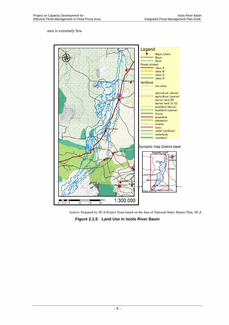
Land use characteristics of Isiolo River Basin are shown on Figure 2.1.5 and Figure 2.1.6. As
seen in land use map, the mountainous area in the upstream river basin is a barren land, and
from Google Earth Image Data it is known that the mountain is bare. In the middle river basin
the plantation is extended. From the middle to downstream river basin the scrubland is
extended, and there exists agricultural lands along the Western Marania River and Eastern
Marania River of the middle river basin and in the suburb of downtown of Isiolo Town. In
addition, as this river basin belongs to dry region and the xerophile vegetation is limited, forest
Clayey
Loamy
Sandy
Very clayey
Project on Capacity Development for Isiolo River Basin Effective Flood Management in Flood Prone Area Integrated Flood Management Plan-Draft-
- 9 -
area is extremely few.
Source: Prepared by JICA Project Team based on the data of National Water Master Plan, JICA
Figure 2.1.5 Land Use in Isiolo River Basin

Isiolo River Basin Project on Capacity Development for Integrated Flood Management Plan-Draft- Effective Flood Management in Flood Prone Area
- 10 -
Source : Prepared by JICA Project Team based on Satellite Image of December 10, 2012
Figure 2.1.6 Satellite Image of Isiolo River Basin
According to the survey of NRM3 and CETRAD, 29.1km2 of forest area in 1995 in Isiolo
River Basin is decreased to 14.1km2 in 2002. It is reported that 15km
2 of forest has been lost
between 1995 to 2002. 2.1km2 of forest loss has occurred in average every year. If the forest
loss is continued at this rate, the forest in the river basin will totally be disappeared by 2018.

Project on Capacity Development for Isiolo River Basin Effective Flood Management in Flood Prone Area Integrated Flood Management Plan-Draft-
- 11 -
2.1.3 Hydrology and Meteorology
(1) Feature of Rainfall and Water Level Gauging Station
(a) Gauging Stations
Figure 2.1.7 shows locations of KMD rainfall and water level gauging stations. Rainfall
gauging stations are indicated in triangle shape (▲), while the water level gauging
stations are shown in box-shape (■). Rainfall gauging stations where the daily rainfall
data have already been obtained by JICA project team are colored in red. The numbers
given in the map mean the gauging station number.
Timau Marania Rainfall Gauging Station (No. 8937002) is located in the mountainous
area of the upstream river basin, while Isiolo District Agric Office (hereinafter referred to
DAO) is located in the suburb of downtown of Isiolo.
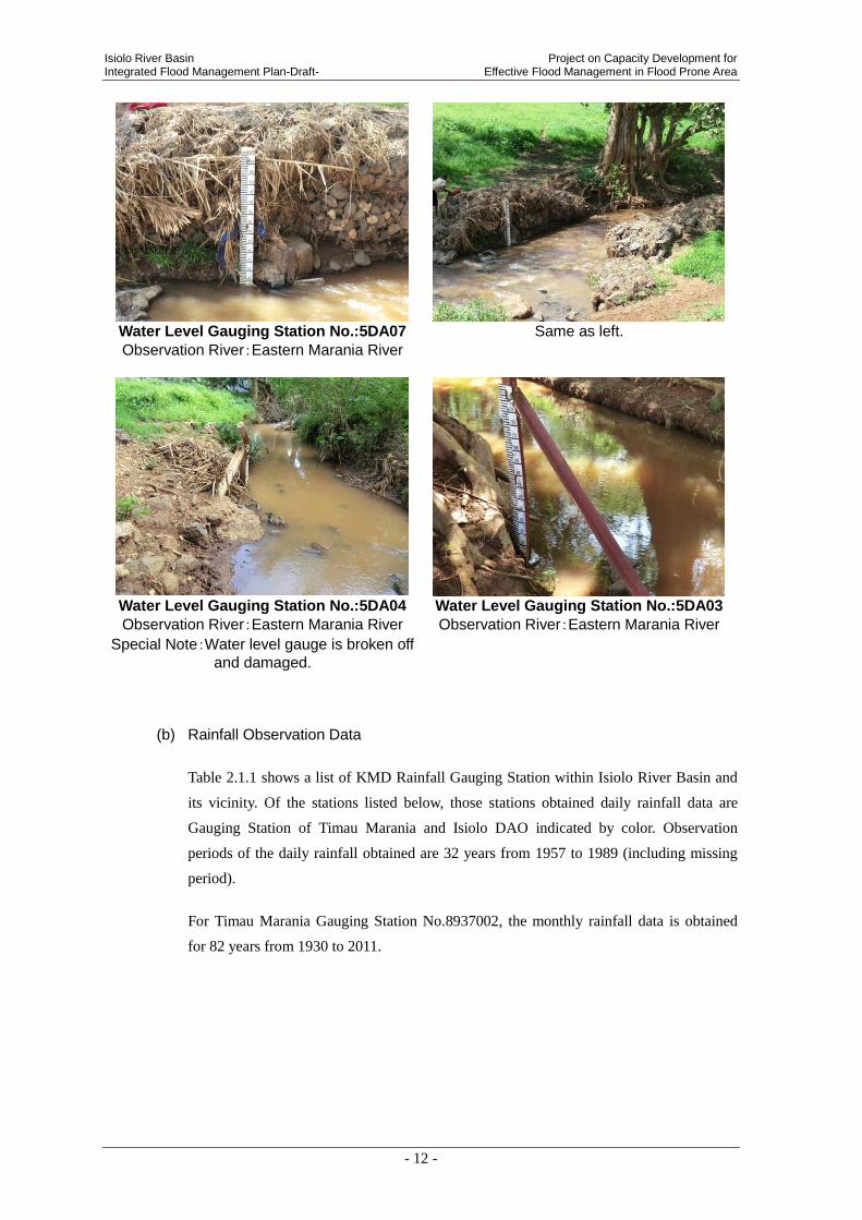
Kithima Water Level Gauging Station (No.5DA03) is located in the middle river basin,
while Isiolo Gauging Station (No.5DA07) is located in the suburb of downtown of Isiolo.
Figure 2.1.7 Location Map of Rainfall and Water Level Gauging Stations
Timau MaraniaRainfall
Gauging Station
Isiolo D.A.O
Rainfall Gauging Station
Isiolo River Basin Project on Capacity Development for Integrated Flood Management Plan-Draft- Effective Flood Management in Flood Prone Area
- 12 -
Water Level Gauging Station No.:5DA07
Observation River:Eastern Marania River
Same as left.
Water Level Gauging Station No.:5DA04
Observation River:Eastern Marania River
Special Note:Water level gauge is broken off
and damaged.
Water Level Gauging Station No.:5DA03
Observation River:Eastern Marania River
(b) Rainfall Observation Data
Table 2.1.1 shows a list of KMD Rainfall Gauging Station within Isiolo River Basin and
its vicinity. Of the stations listed below, those stations obtained daily rainfall data are
Gauging Station of Timau Marania and Isiolo DAO indicated by color. Observation
periods of the daily rainfall obtained are 32 years from 1957 to 1989 (including missing
period).
For Timau Marania Gauging Station No.8937002, the monthly rainfall data is obtained
for 82 years from 1930 to 2011.

Project on Capacity Development for Isiolo River Basin Effective Flood Management in Flood Prone Area Integrated Flood Management Plan-Draft-
- 13 -
Table 2.1.1 List of KMD Rainfall Gauging Station within Isiolo River Basin and its Vicinity
Source :KMD
(c) Water Level and River Discharge Observation Data
List of water gauging stations in Isiolo River Basin is shown on Table 2.1.2 of the stations
listed below, those stations obtained water level observation data is only Gauging Station
Nos. 5DA07 indicated by color. Automatic measurement is not done at each water level
gauging stations, but the visual observation is carried out two times in a day, i.e. in the
morning and in the evening. Therefore, the river discharge at the time of flood is said to
be inaccurate.
Table 2.1.2 List of Water Level Gauging Station in Isiolo River Basin
Source : WRMA
(2) Feature of Annual Rainfall
(a) Long-Term Variability of Annual Rainfall
Figure 2.1.8 shows the variability of annual rainfall at Timau Marania Station in a period
of 1930 to 2011. Out of the observation record from 1930 to 2011, the maximum annual
rainfall, 1,883mm/year was recorded in 1998. The average annual rainfall during the same
observation period is 959mm/year. The average annual rainfall tends to be increasing.
No. ID Name River Name
Manual/
Auto/
Both
National/
MU/IMU/
Special
Daily/
Hourly/
Both
Operati
onal
Start
Year
End
Year
SRO in
charge
1 5DA07 Isiolo Isiolo Manual MU Daily Yes 1976/1/1 N/A MEN
2 5DA03 Kithima Kithima Manual Intra-MU Daily Yes 2010/9/1 N/A MEN
3 5DA04 Rugusu Rugusu Manual Intra-MU Daily Yes 2010/10/1 N/A MEN
STATION_NUMBER stationname Y X Year_Opened Year_Closed Obtain
8937002 TIMAU_MARANIA 0.083 37.450 1925 _ obtain
8937003 ISIOLO_DISTRICT_AGRIC_OFFICE 0.350 37.583 1930 _ obtain
8937004 NGARE_UNGA_FARM 0.167 37.383 1930 1941
8937046 MARANIA_FOREST__NANYUKI 0.083 37.483 1951 1953
8937047 BIRDS_HILL_RANCH_ISIOLO 0.250 37.517 1951 1963
8937078 MUCHENE_FOREST_STATION 0.100 37.533 1973 _
8937083 NTUMBURI_PRIMARY_SCHOOL 0.133 37.517 1974 _
8937100 MARURU_PRIMARY_SCHOOL 0.150 37.517 1979 _
8937101 ISIOLO_L_M_D_HEADQUARTERS 0.367 37.550 1980 _
9037155 SIRIMON_GATE__MT_KENYA_PARK -0.033 37.283 1970 _

Isiolo River Basin Project on Capacity Development for Integrated Flood Management Plan-Draft- Effective Flood Management in Flood Prone Area
- 14 -
Source: Prepared by JICA Project Team based on WRMA’s rainfall data of KMD gauging stations in the period between
1930 and 2011
Figure 2.1.8 Variability of Annual Rainfall at Timau Marania Station
(b) Distribution of Annual Rainfall
Monthly average temperatures vary from 7.6C in highland to 32C in low-lying area,
and the low-lying area belongs to pindan.1 Annual rainfall in the vicinity of Mt. Kenya,
the headwaters of the river, goes beyond 1,200mm/year, and the average annual rainfall in
the downtown of Isiolo which is the largest city in Isiolo River Basin, is approximately
600mm/year. Distribution of annual rainfall in Isiolo River Basin is shown below. From
this distribution map, it is known that rainfall distribution is different between upstream
and middle/downstream river basins. The annual rainfall in the upstream of EL.2,500m to
EL.3,900m varies from 800 to 1,200mm/year, while those in the middle to downstream
which occupies approximately 60% of the catchment area varies from 400 to
600mm/year.
1 Isiolo WRUA and WRMA, SCMP (March 2009)
0
200
400
600
800
1,000
1,200
1,400
1,600
1,800
2,000
192
5
193
0
193
5
194
0
194
5
195
0
195
5
196
0
196
5
197
0
197
5
198
0
198
5
199
0
199
5
200
0
200
5
201
0
201
5
202
0
An
nu
al R
ain
fall
[mm
/yr]
year
Timau Marania[No.893702]Interannual Variability Rainfall

Project on Capacity Development for Isiolo River Basin Effective Flood Management in Flood Prone Area Integrated Flood Management Plan-Draft-
- 15 -
Source: Prepared by JICA Project Team based on National Water Master Plan, JICA
Figure 2.1.9 Distribution Map of Annual Rainfall of Isiolo River Basin
(c) Monthly Rainfall
There are two times of rainy seasons in Isiolo River Basin, i.e. March to May and October
to December. Much rainfall is recorded during such a rainy season. Monthly rainfall at
Timau Marania Rainfall Gauging Station in the upstream of Isiolo River Basin is shown
on Figure 2.1.7. As shown in the following figure, it is understood that the maximum
rainfall through the year can be observed in April and November. The heaviest monthly
rainfall recorded in November is 200mm/month.
Besides, in recent years, it tends to have heavy rain in a short time. On the other hand,
river flow is dried up during dry season of February, March, August and September.2
2 Isiolo SCMP

Isiolo River Basin Project on Capacity Development for Integrated Flood Management Plan-Draft- Effective Flood Management in Flood Prone Area
- 16 -
Source: Prepared by JICA Project Team based on WRMA’s rainfall data of KMD gauging stations in the period between
1930 and 2011
Figure 2.1.10 Monthly Rainfall at Timau Marania Station
(d) Daily Rainfall
Timau Marania Station
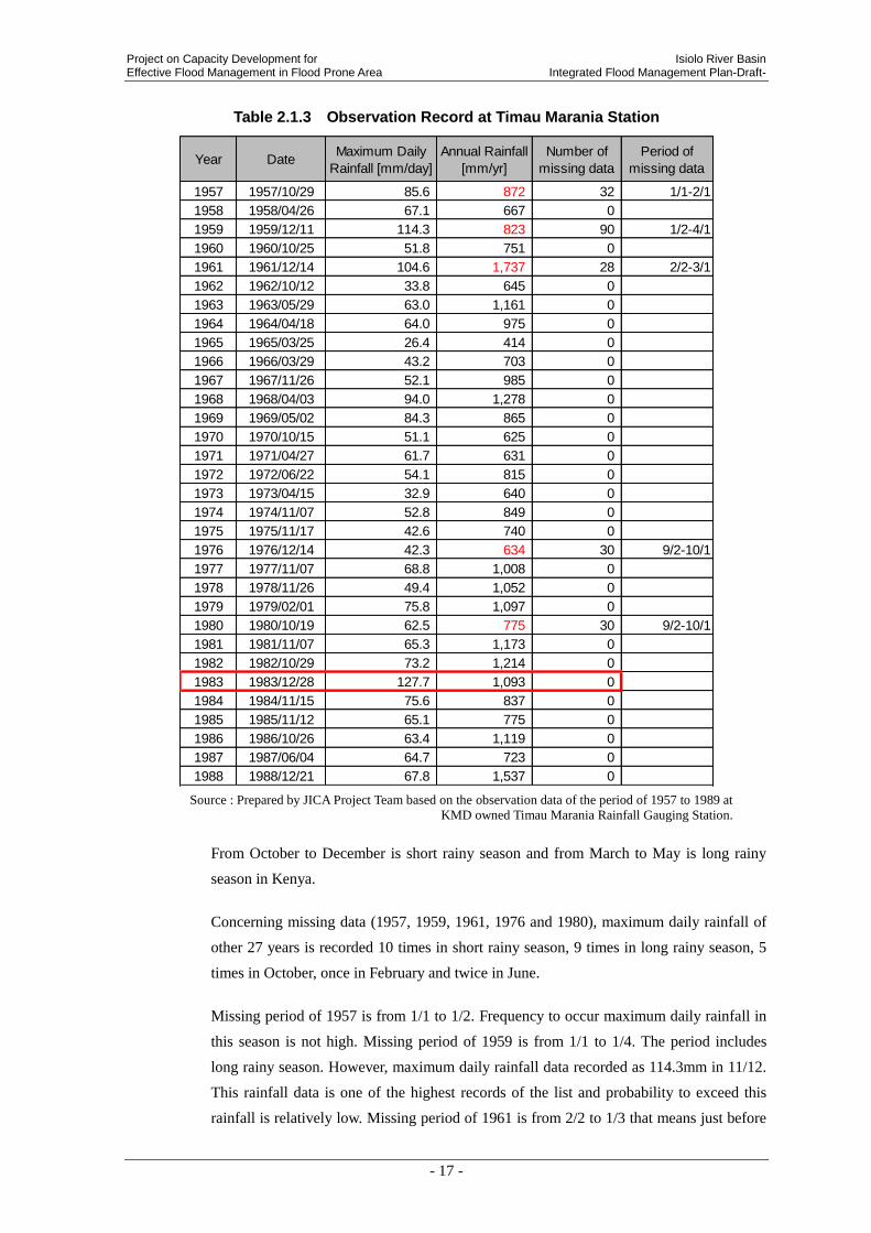
Table 2.1.3 shows maximum daily rainfall, annual rainfall, number of missing data and
period of missing data by the respective years from 1957 to 1989 at Timau Marania
Station. Red numerical value indicates that there are missing data in the same year. And it
means annual rain fall data of the year can be incorrect. The maximum daily rainfall
recorded in the same period is 127.7mm/day observed in December 28, 1983. Those of
the maximum annual rainfall are 1,737mm/year recorded in 1961. (Data set is different
from data described above.)
0
50
100
150
200
250
Jan Feb Mar Apr May Jun Jul Aug Sep Oct Nov Dec
Timau Marania [No.8937002]Monthly Rainfall
Average Ranfall (mm/month)
Project on Capacity Development for Isiolo River Basin Effective Flood Management in Flood Prone Area Integrated Flood Management Plan-Draft-
- 17 -
Table 2.1.3 Observation Record at Timau Marania Station
Year DateMaximum Daily
Rainfall [mm/day]
Annual Rainfall
[mm/yr]
Number of
missing data
Period of
missing data
1957 1957/10/29 85.6 872 32 1/1-2/1
1958 1958/04/26 67.1 667 0
1959 1959/12/11 114.3 823 90 1/2-4/1
1960 1960/10/25 51.8 751 0
1961 1961/12/14 104.6 1,737 28 2/2-3/1
1962 1962/10/12 33.8 645 0
1963 1963/05/29 63.0 1,161 0
1964 1964/04/18 64.0 975 0
1965 1965/03/25 26.4 414 0
1966 1966/03/29 43.2 703 0
1967 1967/11/26 52.1 985 0
1968 1968/04/03 94.0 1,278 0
1969 1969/05/02 84.3 865 0
1970 1970/10/15 51.1 625 0
1971 1971/04/27 61.7 631 0
1972 1972/06/22 54.1 815 0
1973 1973/04/15 32.9 640 0
1974 1974/11/07 52.8 849 0
1975 1975/11/17 42.6 740 0
1976 1976/12/14 42.3 634 30 9/2-10/1
1977 1977/11/07 68.8 1,008 0
1978 1978/11/26 49.4 1,052 0
1979 1979/02/01 75.8 1,097 0
1980 1980/10/19 62.5 775 30 9/2-10/1
1981 1981/11/07 65.3 1,173 0
1982 1982/10/29 73.2 1,214 0
1983 1983/12/28 127.7 1,093 0
1984 1984/11/15 75.6 837 0
1985 1985/11/12 65.1 775 0
1986 1986/10/26 63.4 1,119 0
1987 1987/06/04 64.7 723 0
1988 1988/12/21 67.8 1,537 0
Source : Prepared by JICA Project Team based on the observation data of the period of 1957 to 1989 at
KMD owned Timau Marania Rainfall Gauging Station.
From October to December is short rainy season and from March to May is long rainy
season in Kenya.
Concerning missing data (1957, 1959, 1961, 1976 and 1980), maximum daily rainfall of
other 27 years is recorded 10 times in short rainy season, 9 times in long rainy season, 5
times in October, once in February and twice in June.
Missing period of 1957 is from 1/1 to 1/2. Frequency to occur maximum daily rainfall in
this season is not high. Missing period of 1959 is from 1/1 to 1/4. The period includes
long rainy season. However, maximum daily rainfall data recorded as 114.3mm in 11/12.
This rainfall data is one of the highest records of the list and probability to exceed this
rainfall is relatively low. Missing period of 1961 is from 2/2 to 1/3 that means just before
Isiolo River Basin Project on Capacity Development for Integrated Flood Management Plan-Draft- Effective Flood Management in Flood Prone Area
- 18 -
long rainy season. From same reason, the data 104.6mm of 14/12 is concluded as
maximum rainfall of the year. Missing period of 1976 is from 2/9 to 1/10. There is no
maximum daily rainfall recorded on the same season of other years. Possibility to record
maximum rainfall is low. And also, missing period of 1980 is from 2/9 to 1/10. From
same reason, the data is concluded as correct.
Therefore, probability to record maximum daily rainfall data in missing period is
relatively low. JICA project team applies the data to analysis.
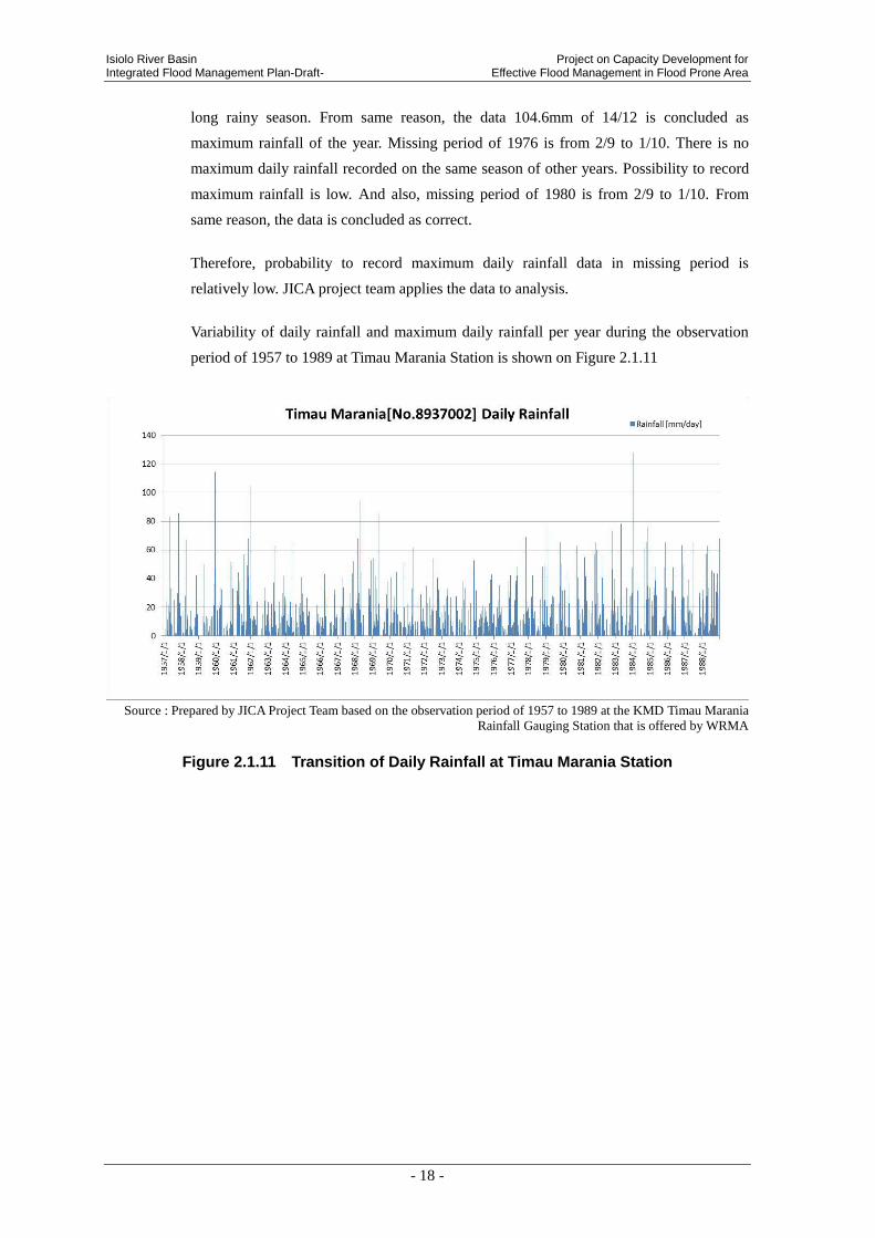
Variability of daily rainfall and maximum daily rainfall per year during the observation
period of 1957 to 1989 at Timau Marania Station is shown on Figure 2.1.11
Source : Prepared by JICA Project Team based on the observation period of 1957 to 1989 at the KMD Timau Marania
Rainfall Gauging Station that is offered by WRMA
Figure 2.1.11 Transition of Daily Rainfall at Timau Marania Station

Project on Capacity Development for Isiolo River Basin Effective Flood Management in Flood Prone Area Integrated Flood Management Plan-Draft-
- 19 -
Source : Prepared by JICA Project Team based on the observation data of the period of 1957 to 1989 at the KMD Timau
Marania Rainfall Gauging Station that is offered by WRMA.
Figure 2.1.12 Maximum Daily Rainfall in a Year at Timau Marania Station
Probability statistics analysis by each probable years (1/50, 1/30, 1/20, 1/10 and 1/5) was
carried out based on the maximum daily rainfall in a year during the observation period
for 30 years (There are some missing periods.) at Timau Marania Rainfall Gauging
Station within the river basin.
Table 2.1.4 shows the result of hydrological statistics calculation and the planned daily
rainfall.
Applied Provability Distribution Model “Gumbel distribution” is selected based on
“guideline of high water planning” by Japan Institute of Country-ology and Engineering.
Table 2.1.4 Result of Rainfall Calculation by Provable Years at Timau Marania Station
Name of Rainfall Gauging Station : Timau Marania
Observation Period : 1957 to 1989
Applied Provability Distribution Model : Gumbel distribution
Provable year Jack Knife Estimate
Daily Rainfall (mm/day)
Planned Daily Rainfall
(mm/day)
1/5 81.6 82
1/10 95.1 96
1/20 108 108
1/30 115.4 116
1/50 124.7 125
0.0
20.0
40.0
60.0
80.0
100.0
120.0
140.0
19
57
19
58
19
59
19
60
19
61
19
62
19
63
19
64
19
65
19
66
19
67
19
68
19
69
19
70
19
71
19
72
19
73
19
74
19
75
19
76
19
77
19
78
19
79
19
80
19
81
19
82
19
83
19
84
19
85
19
86
19
87
19
88
Timau Marania [No.8937002]MaximumDailyRainfall
MaximumDailyRainfall[mm/day]

Isiolo River Basin Project on Capacity Development for Integrated Flood Management Plan-Draft- Effective Flood Management in Flood Prone Area
- 20 -
Isiolo DAO Station
Maximum daily rainfall and annual rainfall, number of missing data and period of
missing data by each year in the observation period of 1957 to 1989 are shown on
Table 2.1.5 below. The maximum daily rainfall in the observation period is 97mm/day
recorded on March 10, 1982, and the maximum annual rainfall is 1,261mm/year recorded
in 1961.
Table 2.1.5 Observation Record of Rainfall at Isiolo DAO Station
Year Date
MaximumDailyRainfall
[mm/day]
AnnualRainfall
[mm/yr]
Number of
missing data
Period of
missing data
1957 1957/05/28 65.3 737 0
1958 1958/11/06 35.6 455 0
1959 1959/11/24 60.5 550 59 1/2-3/2
1960 1960/11/17 38.4 593 0
1961 1961/11/25 61.0 1261 28 2/2-3/1
1962 1962/04/22 43.7 689 62 1/2-2/1, 10/2-11/1
1963 1963/11/15 79.7 859 0
1964 1964/05/02 27.0 209 243 1/2-3/1, 6/2-9/1, 10/2-12/31
1965 1965/09/21 52.0 309 94 1/1-2/1, 5/2-6/1, 7/2-8/1
1966 1966/04/13 64.1 682 30 9/2-10/1
1967 - 0.0 0.0 183 3/2-6/1, 10/2-12/31
1968 1968/11/27 80.8 1243 1 1/1
1969 1969/05/03 70.0 906 0
1970 1970/05/28 53.1 296 213 6/2-12/31
1971 - 0.0 - - No data
1972 - 0.0 - - No data
1973 1973/03/28 38.6 475 1 1/1
1974 1974/11/08 36.7 498 0
1975 1975/04/18 85.2 475 0
1976 1976/02/26 49.2 624 0
1977 1977/03/23 42.1 646 0
1978 1978/10/13 44.8 807 30 6/2-7/1
1979 1979/04/10 62.3 726 0
1980 1980/11/10 47.7 528 0
1981 1981/05/03 30.3 467 0
1982 1982/03/10 97.0 763 0
1983 1983/04/27 84.1 555 0
1984 1984/11/08 65.4 535 0
1985 1985/11/05 48.0 581 0
1986 1986/10/10 38.8 694 0
1987 1987/04/23 82.9 638 0
1988 1988/03/25 55.2 717 0 Source : Prepared by JICA Project Team based on the observation data for the period of 1957 to 1989 at KMD owned
Isiolo DAO Rainfall Gauging Station
Variability of daily rainfall and maximum daily rainfall per year during the observation
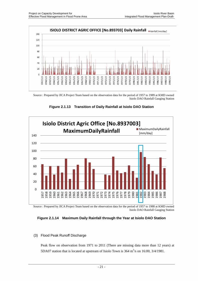
period of 1957 to 1989 at Isiolo DAO Station is shown on Figure 2.1.13
Project on Capacity Development for Isiolo River Basin Effective Flood Management in Flood Prone Area Integrated Flood Management Plan-Draft-
- 21 -
Source : Prepared by JICA Project Team based on the observation data for the period of 1957 to 1989 at KMD owned
Isiolo DAO Rainfall Gauging Station
Figure 2.1.13 Transition of Daily Rainfall at Isiolo DAO Station
Source : Prepared by JICA Project Team based on the observation data for the period of 1957 to 1988 at KMD owned
Isiolo DAO Rainfall Gauging Station
Figure 2.1.14 Maximum Daily Rainfall through the Year at Isiolo DAO Station
(3) Flood Peak Runoff Discharge
Peak flow on observation from 1971 to 2011 (There are missing data more than 12 years) at
5DA07 station that is located at upstream of Isiolo Town is 364 m3/s on 16:00, 3/4/1981.
0
20
40
60
80
100
120
140
19
57
19
58
19
59
19
60
19
61
19
62
19
63
19
64
19
65
19
66
19
67
19
68
19
69
19
70
19
71
19
72
19
73
19
74
19
75
19
76
19
77
19
78
19
79
19
80
19
81
19
82
19
83
19
84
19
85
19
86
19
87
19
88
Isiolo District Agric Office [No.8937003]MaximumDailyRainfall MaximumDailyRainfall
[mm/day]

Isiolo River Basin Project on Capacity Development for Integrated Flood Management Plan-Draft- Effective Flood Management in Flood Prone Area
- 22 -
However, observation system works twice a day, 9:00 and 16:00. There is a possibility not to
record correct flood peak runoff data. This data is offered by WRMA as converted data. Water
level data is not offered.
Source : WRMA
Figure 2.1.15 Peak Flow of 5DA07station
Analysis from the view point of hydrology and hydraulics is studied. Specifically, daily rainfall
data of each scale is calculated by stochastic method. In addition, rainfall intensity is estimated
from the daily rainfall data. Flood peak runoff of each stochastic scale at main tributary stream
and upstream of Isiolo Town is computed by rational formula. Generally, rational formula
applies to basin area that is less than 100km2. However, rainfall and discharge measurement is
not observed in this area and past flood flow data does not exist. There is no other choice.
Dividing map of Isiolo River Basin is below.
0
50
100
150
200
250
300
350
400
25
Mar
ch 1
98
1
26
Mar
ch 1
98
1
27
Mar
ch 1
98
1
28
Mar
ch 1
98
1
29
Mar
ch 1
98
1
30
Mar
ch 1
98
1
31
Mar
ch 1
98
1
01
Ap
ril 1
98
1
02
Ap
ril 1
98
1
03
Ap
ril 1
98
1
04
Ap
ril 1
98
1
05
Ap
ril 1
98
1
06
Ap
ril 1
98
1
07
Ap
ril 1
98
1
08
Ap
ril 1
98
1
09
Ap
ril 1
98
1
10
Ap
ril 1
98
1
Flood Discharge at 5DA07
Discharge [m^3/s]m3/s

Project on Capacity Development for Isiolo River Basin Effective Flood Management in Flood Prone Area Integrated Flood Management Plan-Draft-
- 23 -
Figure 2.1.16 Dividing map of Isiolo River Basin (Sample spots are marked)
●d
●H
●g ●h
k● ●l
●c b●
●a
●f ●e
i● ●j
●n2
n
2

Isiolo River Basin Project on Capacity Development for Integrated Flood Management Plan-Draft- Effective Flood Management in Flood Prone Area
- 24 -
Rational formula
Rational formula and setting condition are below.
Q = 1/3.6 * f * r *A -----------------------------------------------------Rational formula
Q : flow discharge (m3/s)
f : coefficient of discharge
r : average of rainfall intensity within arrival time of flood (mm/h)
A : dimension of river basin (km2)
* Rational formula is a calculating formula to estimate flood peak runoff when rain water flows intensively
from the most distant spots to sample spots. Considering canning condition of the surface, amount of flow
is calculated by function as rainfall intensity and dimension of river basin.
[ Condition of flood peak runoff calculation by rational formula ]
Calculating formula of arrival time of flood tc:Kraven-Rziha
Planning daily rainfall of each scale:1/50 r24 =125 mm/d、1/30 r24 =116 mm/d、1/20 r24
=108 mm/d、1/10 r24 =96 mm/d、1/5 r24 =82 mm/d
Formula of average rainfall intensity within arrival time of flood r:Monobe formula
Coefficient of dischargef = 0.6(only n2 spot is applied f=0.45)
Dimension of river basin:total dimension of river basin 474km2
Table 2.1.6 shows the result of calculation of flood peak runoff by rational formula. The most
inferior point of Isiolo River Basin to join in Ewaso Ng’iro North River is approximately
650m3/s on 1/10. G and h spots of upstream of Isiolo Town (upstream of Eastern Marania
River and Merire River) is 280 m3/s、85 m
3/s on 1/10.
Table 2.1.6 Result of Calculation of Flood Peak Runoff by Rational Formula
(Left to right : 1/50, 1/30, 1/20, 1/10, 1/5)
1/50 :
r24 =
125mm/day
1/30 :
r24 =
116mm/day
1/20 :
r24 =
108mm/day
1/10 :
r24 =
96mm/day
1/5 :
r24 =
82mm/day
Peak
discharge
Qp(m3/s)
Peak
discharge
Qp(m3/s)
Peak
discharge
Qp(m3/s)
Peak
discharge
Qp(m3/s)
Peak
discharge
Qp(m3/s)
i 96 45.0 238 221 206 183 156 -
j 218 64.1 196 182 169 151 129 Western.M.R
k 275 90.1 236 219 204 181 155 Eastern.M.R
l 131 46.3 199 184 172 153 130 -
e 71 40.4 260 242 225 200 171 -
f 333 150.6 347 322 300 267 228 Western.M.R
g 297 145.6 362 336 313 278 237 Eastern.M.R Isiolo townの直上流地点
h 76 17.6 109 101 94 83 71 Merire.R Isiolo townの直上流地点
b 76 11.4 70 65 61 54 46 -
c 400 229.6 468 435 405 360 307 Western.M.R
d 368 184.3 397 369 343 305 260 Eastern.M.R Western.M.Rとの合流地点
H 104 27.1 136 126 117 104 89 Merire.R Eastern.M.Rとの合流地点
a 489 473.6 844 783 729 648 554 Isiolo.R Ewaso Ng’iro North river合流点
n2 31 2.4 21 19 18 16 13 - 隣接流域からの流路変更地点
PointArrival time of
flood
tc (min)
Riverbasin area
A(km2)Name of the poitRiver
Estimate arrival time can be utilized as lead time of early warning system.
Name of the Point

Project on Capacity Development for Isiolo River Basin Effective Flood Management in Flood Prone Area Integrated Flood Management Plan-Draft-
- 25 -
2.2 SOCIO ECONOMIC CONDITIONS
2.2.1 Administration
(1) Local Administration
Administration division of the Republic of Kenya as of March 2013 is shown below.
Table 2.2.1 Administration Division in Republic of Kenya
Administration Unit Ruler
Province Province commissioner
District District commissioner
Division Chief
Location Chief
Sub location Assistant Chief
Community Unit Leader
Village Elder
In the administration system in Kenya, local governments (Province – District – Division –
Location – Sub-location) are organized under President’s office. The smallest administrative
unit is Sub-location. Besides, although it is not an administrative organization, there is a village
as a unit of rural community. Chieftains of the respective organizations are called “Province
Commissioner” for Province, “District Commissioner” for District, “Chief” for Division and
Location, “Assistant Chief” for Sub Location and “Elder” for Village.
Isiolo River Basin is mainly included in the three major districts of Meru Central, Imenti North
and Isiolo. Locations of Isiolo River Basin and District and the administrative organizations
included in Isiolo River Basin are shown in the following figure.

Isiolo River Basin Project on Capacity Development for Integrated Flood Management Plan-Draft- Effective Flood Management in Flood Prone Area
- 26 -
Source: International Livestock Research Institute GIS unit
Prepared by JICA Project Team based on the classified data in 1998 Figure 2.2.1 Locations of Isiolo River Basin and District
The detail of division of Division、Location, Sublocation in Isiolo River Basin is shown as below.
Isiolo District
Imeti North District
Meru Central District

Project on Capacity Development for Isiolo River Basin Effective Flood Management in Flood Prone Area Integrated Flood Management Plan-Draft-
- 27 -
Table 2.2.2 Administrative division at Isiolo River Basin (June, 2004)
Districts Divisions Locations Sublocations
Isiolo Central
Central Bulla Pesa
Kampi Odha
Isiolo East Kiwanjani
Wabera
Isiolo West Burat
Isiolo West
Ngare Mara Ngare Mara
Meru Central
Abothuguchi West
Kiamiogo Kiamiogo
Kibirichia Kimbo
Ntugi Mboroga
Ntumburi Kamarete
Thiira
Buuri
Kiirua Kithima
Nkando
Kisima Ntirimiti
Rwarera Kirwiro
Mugae
Timau Kisima
Buuri
Mutonyi
Ngusishi Mutarakwa
Mt Kenya Forest Mt Kenya Forest Mt Kenya Forest
National Park National Park National park
Meru North
Akithi Akithi Thinyaine
Tigania North Buuri Nturingwi
Tigania West Mituntu Mumui
Source : Center for Training and Integrated Research in ASAL Development February 2005 , Upper Ewaso Ngiro River
Basin Sub Catchments Directory
Boundary of Isiolo District and Division、Location and Sub location in the district is shown as
below. Red circle is the location of Isiolo River Basin.

Isiolo River Basin Project on Capacity Development for Integrated Flood Management Plan-Draft- Effective Flood Management in Flood Prone Area
- 28 -
Soruce : Isiolo District Development Plan (2008 - 2012)
Figure 2.2.2 Location of Isiolo District
(2) Jurisdictional area of WRMA
Relation between the controlled area of WRMA (Water Resource Management Authority)
responsible for the administration relating to the water resource and Isiolo River Basin is
explained below.
WRMA divides the country in 6 catchment areas and Isiolo River Basin is included in the
catchment called “Ewaso Ng’iro North Catchment Area (ENNCA)”.
Nanyuk Region Office in ENNCA have jurisdiction over the whole ENNCA. Besides, the
catchment is divided into 5, i.e. Upper Ewaso Ng’iro, Middle Ewaso Ng’iro, Middle Ewaso
Ng’iro, Engare-Narok Melphis, Morth Ewaso Laggas and Ewaso-Daua. There are
Sub-Regional Offices in the respective regions. Isiolo River Basin is in Middle Ewaso Ng’iro
indicated in blue color and belongs to Middle Ewaso Ng’iro Sub-Regional Office.

Project on Capacity Development for Isiolo River Basin Effective Flood Management in Flood Prone Area Integrated Flood Management Plan-Draft-
- 29 -
Source : Ewaso Ngi’ro North Catchment Area Catchment Management Strategy (June 2009)
Figure 2.2.3 Regional Division within the ENNCA Catchment and Location of Isiolo River Basin
Photo 2.2.1 WRMA Middle Ewaso Ng'iro (Isiolo) Sub-Regional Office
Table 2.2.3 Demarcation of Isiolo River Basin Regional Office Level Sub regional Office Level Sub Catchment Level
Area Ewaso Ng’iro North
Catchment Area(ENNCA) Middle Ewaso Ng'iro Sub-Region Isiolo Sub Catchment
WRMA / WRUA WRMA ENNCA WRMA Middle Ewaso Ng'iro
(Isiolo) Sub-Regional Office Isiolo WRUA
Isiolo river basin
Synoptic map

Isiolo River Basin Project on Capacity Development for Integrated Flood Management Plan-Draft- Effective Flood Management in Flood Prone Area
- 30 -
2.2.2 Population
Population census data of 2009 in Isiolo District which includes Isiolo River Basin is presented
in Table 2.2.4. The Central Division area including Isiolo Town is densely populated and the
population reaches 40,000 persons occupying 40% of the total population of the whole district.
No. of households is also concentrated in this area and occupies 45% of the whole district.
Especially in Bulla Pesa and Odha of Central area, the population density is high, i.e. about
3,000 persons/km2 and about 1,000 persons/km2, respectively.
Table 2.2.4 Population Census Data in Isiolo District (2009)
Source : Kenya National Bureau of Statistic, Census 2009
According to Isiolo Sub Catchment Management
Plan, the population in Isiolo River Basin is
approximately 98,000 persons. The breakdown by
locations within the river basin is as per Figure
2.2.4, and the population by sub-catchment is
about 18,000 persons in upstream, about 20,000
persons in middle/downstream and 60,000 persons
in the downtown of Isiolo Town. This shows a
trend of people to gather in the middle river basin
where the water resource is abundant, and it also
shows Isiolo, the largest town in the river basin is
District Division Location Sublocation Male Female Total Households Area in Sq.Km.
PopulationDensity
BULLA PESA 11,148 11,574 22,722 6,190 7.66 2,965.93ODHA 2,860 3,062 5,922 1,236 5.67 1,044.57BURAT 4,580 4,010 8,590 1,640 345.51 24.86ISIOLO WEST 2,162 2,100 4,262 1,004 396.86 10.74BULTO BONSA 351 402 753 173 299.13 2.52KORBESA 871 939 1,810 361 247.40 7.32MATA ARBA 237 266 503 108 121.97 4.12
MALKAGALLA MALKAGALLA 1,105 1,071 2,176 443 2,812.81 0.77DUMA 236 121 357 80 1,652.59 0.22URURA 587 470 1,057 243 1,621.58 0.65YAMICHA 807 764 1,571 307 1,552.10 1.01KIWANJANI 1,459 1,537 2,996 651 4.41 680.03WABERA 7,305 7,130 14,435 3,045 8.57 1,683.76GOTU 1,040 887 1,927 491 778.93 2.47NGARE MARA 2,071 1,522 3,593 759 184.96 19.43BISAN BILIQU 663 686 1,349 285 636.46 2.12KOM 276 252 528 127 2,567.21 0.21BULESA 851 888 1,739 384 316.65 5.49GODA 628 537 1,165 233 240.92 4.84MERTI NORTH 2,375 2,448 4,823 998 312.92 15.41MERTI SOUTH 1,221 1,289 2,510 552 241.66 10.39KIPSING 1,666 1,741 3,407 745 204.62 16.65LENGURUMA 1,031 1,122 2,153 473 335.74 6.41LONKOPITO 1,406 1,450 2,856 587 365.81 7.81OLDONYIRO 3,444 3,528 6,972 1,348 255.06 27.34
MERTI
KIPSING
OLDONYIRO
EAST
NGARE MARA
BISAN BILIQU
BULESA
CENTRAL
WEST
KORBESA
YAMICHA
ISIOLO
CENTRAL
CHERAB
EAST
MERTI
OLDONYIRO
Source : Prepared by JICA Project Team based on the population data of Isiolo SCMP
Figure 2.2.4 Population of
Isiolo River Basin
18,000 people(18%)
20,000 people (21%)
60,000 people(61%)
Population of the Isiolo sub cacthment
the Upper
the Middle and lower
Isiolo town
Source:Isiolo SCMP(2009)
Project on Capacity Development for Isiolo River Basin Effective Flood Management in Flood Prone Area Integrated Flood Management Plan-Draft-
- 31 -
the center of economy.
2.2.3 Industry
Agriculture is the most active industry in Isiolo River Basin. Production of honey and nursery
tree is also done. Livestock farming for beef cattle and fur is carried out in the upstream basin.
In addition, production of charcoal and running of hotel business are also done. The most
popular agricultural crops are onion, potato, cabbage, banana, etc. Spring in the middle stream
is utilized as irrigation water for agriculture.
2.3 DEVELOPMENT PLAN
2.3.1 Vision 2030
Downtown of isiolo is at present developed economically as the center of development in the
northern part of Kenya. According to “Vision 2030” which is the development program of
Kenyan government for 22 years from 2008 to 2030, major development programs are as
follows.
(1) Development of Logistics Corridor
In Kenya, logistics corridor is planned to be developed connecting with South Sudan and
Ethiopia via Isiolo. This project is passing through Garissa, Isiolo, Maralal, Lodwar and
Lokichoggio from Lamu Port, and reaching to Ethiopia and South Sudan. Isiolo is scheduled to
be developed as a strategic stop of transportation. This corridor will be composed of new road
network, railway network, oil pipeline, Lamu Airport, port and harbor at Lamu, and it will
connect the coastal area with the resort town to be developed in Isiolo.

Isiolo River Basin Project on Capacity Development for Integrated Flood Management Plan-Draft- Effective Flood Management in Flood Prone Area
- 32 -
Figure 2.3.1 Main Spot of Development Plan of Logistics Corridor
(2) Development of Resort Town
Isiolo is planned to be developed as resort town for a tourists to Mt. Kenya and Meru National
Park. Further, Isiolo is expected to be a foothold of economical activitiesy in the northern part
of the country.
(3) National water supply and sanitation
Mzima pipeline is planned to be expanded for the purpose of meeting to supply water demand
in the proposed development sites of resort in the coastal town, Isiolo, etc.
2.3.2 Isiolo District Development Plan (2008-2012)
According to “Isiolo District Development Plan” which is the development plan of Isiolo
District, there are the following programs.
(1) Water Harvesting
The project is to improve an access to the water for community. Community will present the
site to be developed, and the community itself will construct the reservoir using the fund raised
after appraisal.
Project on Capacity Development for Isiolo River Basin Effective Flood Management in Flood Prone Area Integrated Flood Management Plan-Draft-
- 33 -
(2) Opening of Northern Tourlist Circuit
Garbatua Road will be connected with Kuramawe district through development of the road,
and the access to Iisiolo will be strengthened.
2.3.3 Imenti North District Development Plan (2008-2012)
According to “Imenti North District Development Plan” covering in detail the development
plan of Imenti North District and Meru Central District in the upstream/middle stream of the
Isiolo River Basin, there are the following programs.
(1) Mt. Kenya east pilot project
To improve mainly vegetation along the river, forestation project of nursery tree is planned.
100,000 pieces of nursery tree are planted in rainy season every year.
(2) Sirmon water project
7km of waterway pipe is planned to be constructed for supply of clean water to 2,000
households.
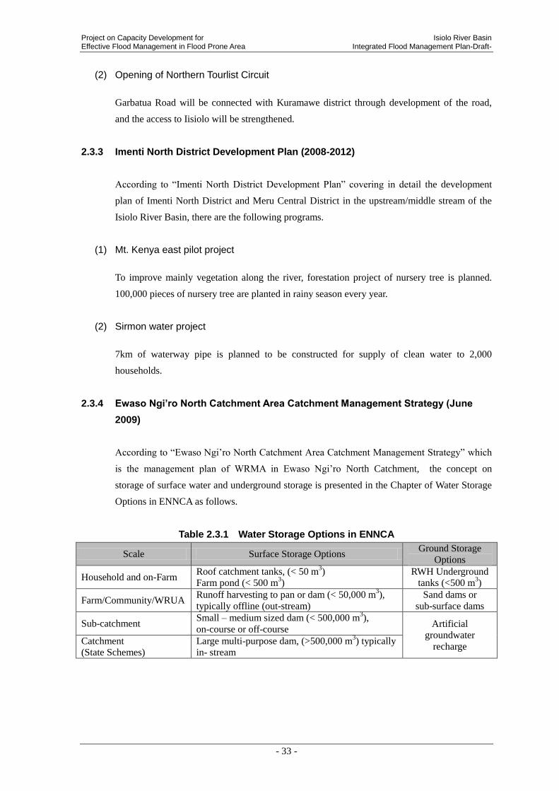
2.3.4 Ewaso Ngi’ro North Catchment Area Catchment Management Strategy (June
2009)
According to “Ewaso Ngi’ro North Catchment Area Catchment Management Strategy” which
is the management plan of WRMA in Ewaso Ngi’ro North Catchment, the concept on
storage of surface water and underground storage is presented in the Chapter of Water Storage
Options in ENNCA as follows.
Table 2.3.1 Water Storage Options in ENNCA
Scale Surface Storage Options Ground Storage
Options
Household and on-Farm Roof catchment tanks, (< 50 m
3)
Farm pond (< 500 m3)
RWH Underground
tanks (<500 m3)
Farm/Community/WRUA Runoff harvesting to pan or dam (< 50,000 m
3),
typically offline (out-stream)
Sand dams or
sub-surface dams
Sub-catchment Small – medium sized dam (< 500,000 m
3),
on-course or off-course Artificial
groundwater
recharge Catchment
(State Schemes)
Large multi-purpose dam, (>500,000 m3) typically
in- stream
Isiolo River Basin Project on Capacity Development for Integrated Flood Management Plan-Draft- Effective Flood Management in Flood Prone Area
- 34 -
3. ANALYSIS OF FLOOD CHARACTERISTICS AND COUNTERMEASURES
3.1 OVERALL CONDITION ON FLOODS IN THE ISIOLO RIVER BASIN
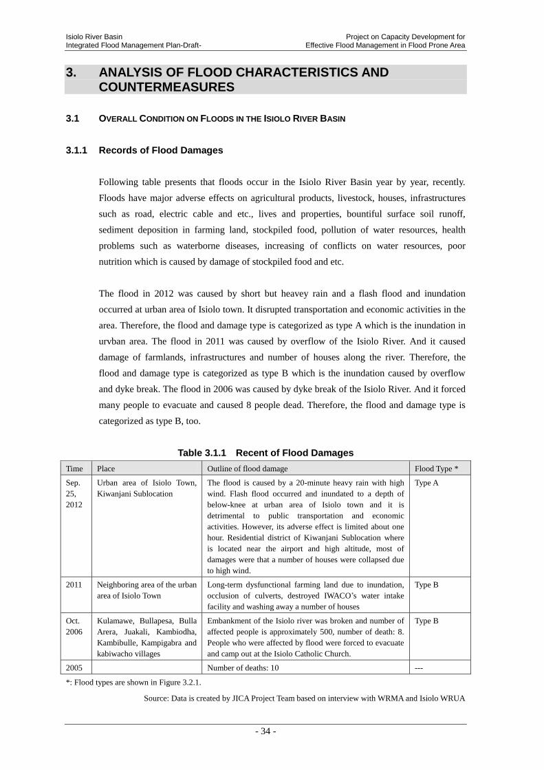
3.1.1 Records of Flood Damages
Following table presents that floods occur in the Isiolo River Basin year by year, recently.
Floods have major adverse effects on agricultural products, livestock, houses, infrastructures
such as road, electric cable and etc., lives and properties, bountiful surface soil runoff,
sediment deposition in farming land, stockpiled food, pollution of water resources, health
problems such as waterborne diseases, increasing of conflicts on water resources, poor
nutrition which is caused by damage of stockpiled food and etc.
The flood in 2012 was caused by short but heavey rain and a flash flood and inundation
occurred at urban area of Isiolo town. It disrupted transportation and economic activities in the
area. Therefore, the flood and damage type is categorized as type A which is the inundation in
urvban area. The flood in 2011 was caused by overflow of the Isiolo River. And it caused
damage of farmlands, infrastructures and number of houses along the river. Therefore, the
flood and damage type is categorized as type B which is the inundation caused by overflow
and dyke break. The flood in 2006 was caused by dyke break of the Isiolo River. And it forced
many people to evacuate and caused 8 people dead. Therefore, the flood and damage type is
categorized as type B, too.
Table 3.1.1 Recent of Flood Damages
Time Place Outline of flood damage Flood Type *
Sep.
25,
2012
Urban area of Isiolo Town,
Kiwanjani Sublocation
The flood is caused by a 20-minute heavy rain with high
wind. Flash flood occurred and inundated to a depth of
below-knee at urban area of Isiolo town and it is
detrimental to public transportation and economic
activities. However, its adverse effect is limited about one
hour. Residential district of Kiwanjani Sublocation where
is located near the airport and high altitude, most of
damages were that a number of houses were collapsed due
to high wind.
Type A
2011 Neighboring area of the urban
area of Isiolo Town
Long-term dysfunctional farming land due to inundation,
occlusion of culverts, destroyed IWACO’s water intake
facility and washing away a number of houses
Type B
Oct.
2006
Kulamawe, Bullapesa, Bulla
Arera, Juakali, Kambiodha,
Kambibulle, Kampigabra and
kabiwacho villages
Embankment of the Isiolo river was broken and number of
affected people is approximately 500, number of death: 8.
People who were affected by flood were forced to evacuate
and camp out at the Isiolo Catholic Church.
Type B
2005 Number of deaths: 10 ---
*: Flood types are shown in Figure 3.2.1.
Source: Data is created by JICA Project Team based on interview with WRMA and Isiolo WRUA
Project on Capacity Development for Isiolo River Basin Effective Flood Management in Flood Prone Area Integrated Flood Management Plan-Draft-
- 35 -
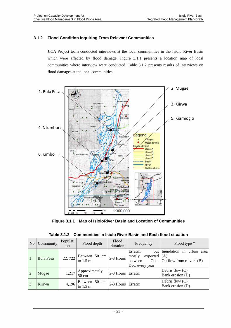
3.1.2 Flood Condition Inquiring From Relevant Communities
JICA Project team conducted interviews at the local communities in the Isiolo River Basin
which were affected by flood damage. Figure 3.1.1 presents a location map of local
communities where interview were conducted. Table 3.1.2 presents results of interviews on
flood damages at the local communities.
Figure 3.1.1 Map of IsioloRiver Basin and Location of Communities
Table 3.1.2 Communities in Isiolo River Basin and Each flood situation
No Community Populati
on Flood depth
Flood
duration Frequency Flood type *
1 Bula Pesa 22, 722 Between 50 cm
to 1.5 m 2-3 Hours
Erratic, but
mostly expected
between Oct.-
Dec. every year
Inundation in urban area
(A)
Outflow from reivers (B)
2 Mugae 1,217 Approximately
50 cm 2-3 Hours Erratic
Debris flow (C)
Bank erosion (D)
3 Kiirwa 4,196 Between 50 cm
to 1.5 m 2-3 Hours Erratic
Debris flow (C)
Bank erosion (D)
2. Mugae
3. Kiirwa
1. Bula Pesa
4. Ntumburi
5. Kiamiogio
6. Kimbo

Isiolo River Basin Project on Capacity Development for Integrated Flood Management Plan-Draft- Effective Flood Management in Flood Prone Area
- 36 -
4 Ntumburi 2,847 Between 50 cm
to 1.5 m 2-3 Hours Erratic
Bank erosion (D)
Outflow from reivers (B)
5 Kiamiogio 3,181 Approximately
50 cm 2-3 Hours Erratic
Debris flow (C)
Outflow from reivers (B)
6 Kimbo 4,149 Approximately
50 cm 2-3 Hours Erratic
Bank erosion (D)
Debris flow (C)
*: Flood types are shown in Figure 3.2.1.
The detailed damage situations and flood type in each community by project team’s inquiring
survey on the communities are shown below.
(1) Bula Pesa
- Human settlements are affected when Merire river over flows ........ (Inundation in urban area)
- Houses are knocked down by the debris carried by the flooding river .... (Outflow from rivers)
- Roads are badly eroded making access to social amenities like schools and hospitals
inaccessible ....................................................................................... (Inundation in urban area)
- In some cases there is loss of human life as a result of flooding of Merire river
.......................................................................................................... (Inundation in urban area)
(2) Mugae
- Debris flow damaging river structures like water intakes, and bridges .................(Debris flow)
-There is erosion carrying away arable top soil leaving the farmlands infertile hence decreased
agricultural production ..................................................................................... (Bank erosion)
(3) Kiirwa
-Sediments overflow into farm lands burying crops ................................................(Debris flow)
-Access roads are eroded by flood water making accessibility to market for agricultural
products difficult ................................................................................................ (Bank erosion)
(4) Ntumburi
- River bank erosion reducing the size of farmlands, hence less agricultural produce
............................................................................................................................ (Bank erosion)
- Crops are washed away by flood waters ................................................. (Outflow from rivers)
- Makeshift bridges are washed away when the river overflows making accessibility to social
amenities difficult. ................................................................................... (Outflow from rivers)
(5) Kiamiogio
- Sediments are deposited on farmlands submerging the crops ...............................(Debris flow)
- Makeshift bridges are washed away makinh accessibility to the market for farm products
difficult .................................................................................................... (Outflow from rivers)
(6) Kimbo
- Erosion on farmlands carry away top fertile soil leaving farmlands infertile ..... (Bank erosion)
- Debris flow blocks access roads to market for farm products ...............................(Debris flow)

Project on Capacity Development for Isiolo River Basin Effective Flood Management in Flood Prone Area Integrated Flood Management Plan-Draft-
- 37 -
3.2 FLOOD CHARACTERISTICS AND SITUATION OF DAMAGES IN THE ISIOLO RIVER BASIN
3.2.1 Concept of Flood Characteristics and SituationI of Damages in the Isiolo River Basin
There are four types of flood characteristics in the Isiolo River Basin as described below;
Mark Flood Type Area A Inundation in urban area Isiolo Town B Inundation which is caused by overflow and dyke break Midstream and tributary stream C Debris flow Upstream D Bank erosion Entire basin
Figure 3.2.1 Flood Types and Areas in Lumi River Basin
A
B
C
D
Isiolo River
Merire River
Eastern Marania River
Western Marania River

Isiolo River Basin Project on Capacity Development for Integrated Flood Management Plan-Draft- Effective Flood Management in Flood Prone Area
- 38 -
Flood damage has a close relationship with between natural condition and social and economic
condition in a local area. Natural condition defines types of Hazards in a river basin and social
and economic condition defines vulnerabilities and exposures. Moreover, it could be said that
disaster (flood) damage is defined from both aspects. Characteristics of flood damage are
analyzed using information of last chaper (Natural condition and Socio-economic condition)
about each flood characteristics of A), B), C) and D) as above-mentioned.
Source: Revised by JICA Project Team, based on material of “Community and Development assistant of Disaster
Prevention, Mr. Mikio Ishiwatari (1997)
Figure 3.2.2 Mechanism of Flood Damage
3.2.2 Inundation in Urban Area of Isiolo Town (A)
Inundation near the Isiolo town area (Flood Characteristics (A)) is described in detail from the
aspects of conditions on natural and socio-economic.
(1) Flood Characteristics from Natural Conditions
Natural Conditions in the Isiolo River Basin
that are described in the last chapter and
Hazards in this area are shown as Table
3.2.1.
Table 3.2.1 Natural Conditions and Hazards in urban area of Isiolo town Natural Conditions Hazards
Social and Economic
Natural Condition
Vulnerability/ Exposure
- Population growth - Urbanization - Environmental degradation
- Poverty, etc.
- Dangerous building
- Unsafe area - Precarious livelihood
- Low income - Inadequate health service
- gradient of river - width, elevation of river bed
- geology - precipitation, etc
Hazards
- High-velocity flow
- Overflow stream, dyke break
- Inundation - Sediment discharge
- Bank erosion, etc
Disaster Damage
R. Eastern Marania
R. Merire
Project on Capacity Development for Isiolo River Basin Effective Flood Management in Flood Prone Area Integrated Flood Management Plan-Draft-
- 39 -
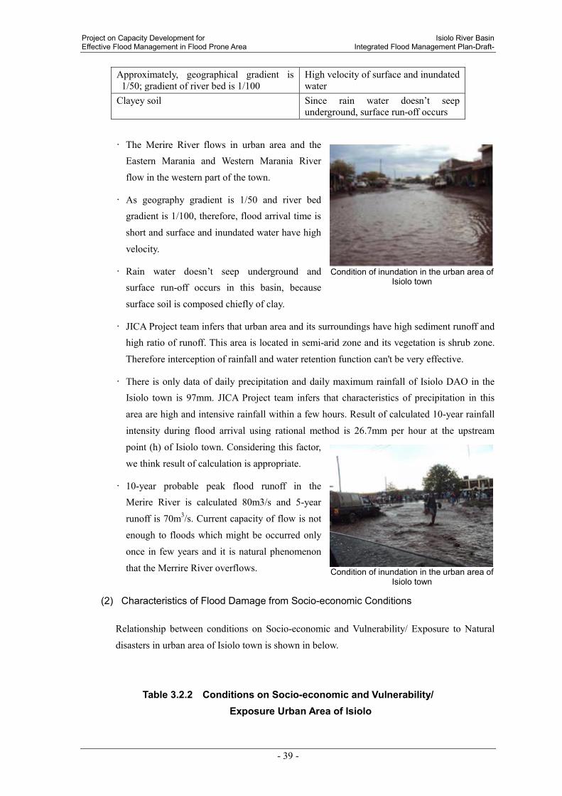
Approximately, geographical gradient is 1/50; gradient of river bed is 1/100
High velocity of surface and inundated water
Clayey soil Since rain water doesn’t seep
underground, surface run-off occurs
• The Merire River flows in urban area and the Eastern Marania and Western Marania River
flow in the western part of the town.
• As geography gradient is 1/50 and river bed gradient is 1/100, therefore, flood arrival time is
short and surface and inundated water have high
velocity.
• Rain water doesn’t seep underground and
surface run-off occurs in this basin, because
surface soil is composed chiefly of clay.
• JICA Project team infers that urban area and its surroundings have high sediment runoff and high ratio of runoff. This area is located in semi-arid zone and its vegetation is shrub zone.
Therefore interception of rainfall and water retention function can't be very effective.
• There is only data of daily precipitation and daily maximum rainfall of Isiolo DAO in the Isiolo town is 97mm. JICA Project team infers that characteristics of precipitation in this
area are high and intensive rainfall within a few hours. Result of calculated 10-year rainfall
intensity during flood arrival using rational method is 26.7mm per hour at the upstream
point (h) of Isiolo town. Considering this factor,
we think result of calculation is appropriate.
• 10-year probable peak flood runoff in the Merire River is calculated 80m3/s and 5-year
runoff is 70m3/s. Current capacity of flow is not
enough to floods which might be occurred only
once in few years and it is natural phenomenon
that the Merrire River overflows.
(2) Characteristics of Flood Damage from Socio-economic Conditions
Relationship between conditions on Socio-economic and Vulnerability/ Exposure to Natural
disasters in urban area of Isiolo town is shown in below.
Table 3.2.2 Conditions on Socio-economic and Vulnerability/ Exposure Urban Area of Isiolo
Condition of inundation in the urban area of
Isiolo town
Condition of inundation in the urban area of
Isiolo town
Isiolo River Basin Project on Capacity Development for Integrated Flood Management Plan-Draft- Effective Flood Management in Flood Prone Area
- 40 -
Socio-economic conditions Vulnerability/ Exposure
Highly-populated residential area, (60% of
population in the river basin, population density;
3,000 per square kilometer)
A large number of refugees who might be
affected by flood
There are 45% of houses which stand all in this
river basin
A large number of houses that might to be
affected by flood
Commercial capital in the region A temporary halt in economic activities due to
inundation
Key junction of transportation network A temporary halt and/or stagnation in logistics
due to inundation
Resort area and facilities for tourists are placed Stoppage and halt of service for tourists, due to
inundation
Expansion of the airport An increased risk of flood damage
• Population in the Isiolo town area is approximately 60,000. Even urban area inundates in a
short time, flood damage gives a great impact to socio-economic in this region.
• Now infrastructure development projects such as expansion of the airport and construction
of roads are in progress according to the higher regional master plan. In conjunction with
these developments, housing land development is also promoting. However, impacts to
flood management and municipal effluent are unconsidered in these development plans.
(3) Flood Damage Mechanism
Regarding to inundation in the urban area, three contributing factors are identified as described
below;
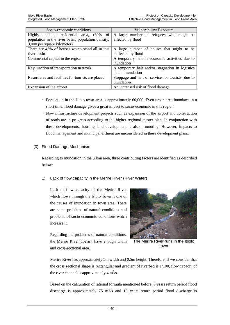
1) Lack of flow capacity in the Merire River (River Water)
Lack of flow capacity of the Merire River
which flows through the Isiolo Town is one of
the causes of inundation in town area. There
are some problems of natural conditions and
problems of socio-economic conditions which
increase it.
Regarding the problems of natural conditions,
the Merire River doesn’t have enough width
and cross-sectional area.
Merire River has approximately 5m width and 0.5m height. Therefore, if we consider that
the cross sectional shape is rectangular and gradient of riverbed is 1/100, flow capaciy of
the river channel is approximately 4 m3/s.
Based on the calcuration of rational formula mentioned before, 5 years return period flood
discharge is approximately 75 m3/s and 10 years return period flood discharge is
The Merire River runs in the Isiolo
town
Project on Capacity Development for Isiolo River Basin Effective Flood Management in Flood Prone Area Integrated Flood Management Plan-Draft-
- 41 -
Culvert along the Merire River in Isiolo town
A box culvert bridge at the downstream end of the town of the MerireRiver (Downstream
view)
approximately 85 m3/s. Not all the amount of flood discharge will run through into the
town area. Even though, the flow capacity of the Merire River is obviously not sufficient.
Main riverbed material is sand. Height of river channel is approximately 0.5~1m.
Sediment accumulates in the culvert.
Sediment and disposed garbage are some
of causes of culvert clogging.
Regarding the socio-economic problems,
mainly in the downstream of the Merire
River, houses are built in the riprian land
illegally. Consequently, it is very difficult
to widen the river channel. This issue
should be encountered, too.
R
i
v
e
r
b
a
Sediment runoff occurs in the upstream of
the Merire River and accumulates in the
downstream. Not only the accumulation of
sediment, but also the clogging of culberts
by the illegally disposed garbage is one of
the causes of reduction of flow capacity. A
box-culvert located at the downstream end
of the town area was clogged, and the upper
side water of it was dammed up and water
level became very high. For that reason, the
inundated water depth became 2 to 3 meters.
10 persons were dead in 2005, and 8 persons were dead in 2006. It is said that these
persons were drowned by the highly dammed up flooded water or swept away by the
flooded water.
Many houses are built near the Merire
River and the walls are encroaching river channel (upstream view)
Downstream of Merire River (upstream view) squatter’s houses are on the left
bank of the river channel

Isiolo River Basin Project on Capacity Development for Integrated Flood Management Plan-Draft- Effective Flood Management in Flood Prone Area
- 42 -
2) Poor storm drainage system in whole Isiolo town (Inland Water)
Drainage system such as drainage channels, culverts, side ditches of road and etc. have
not been developed to function as a network in Isiolo town. Therefore, drainage
capacity in downtown is reduced and when rain in torrents in the urban area, inundation is
occurred to stay on the surface of the road without being drained away. The depth is up
to 50cm like around under knee deep of adult and there is the place that is around 2.5% or
1/40 of maximum inclines geographically and flood has a rapid current in the small alley
of the urban area and it is dangerous for the vulnerable people to disaster such as children,
women and the aged and the report that someone comes a gutzer is heard. In addition,
by the short rain like 2-3 hours, commercial district of the city central is flooded
depending on time of the flood outbreak, and it is said that influence on this local
economy is extremely damaged to be suspended all economic activity.
Situation of inundation in the town
center where shops stand side by side Situation of inundated house
Summarizing the above, it is found that the flood in Isiolo city exist both inland and
outside water damage. Inland flood with poor drainage of similar local city is to be
heard well in Kenya, in discussion with MWI and WRMA, it is found that the need of the
correspondence is recognized.
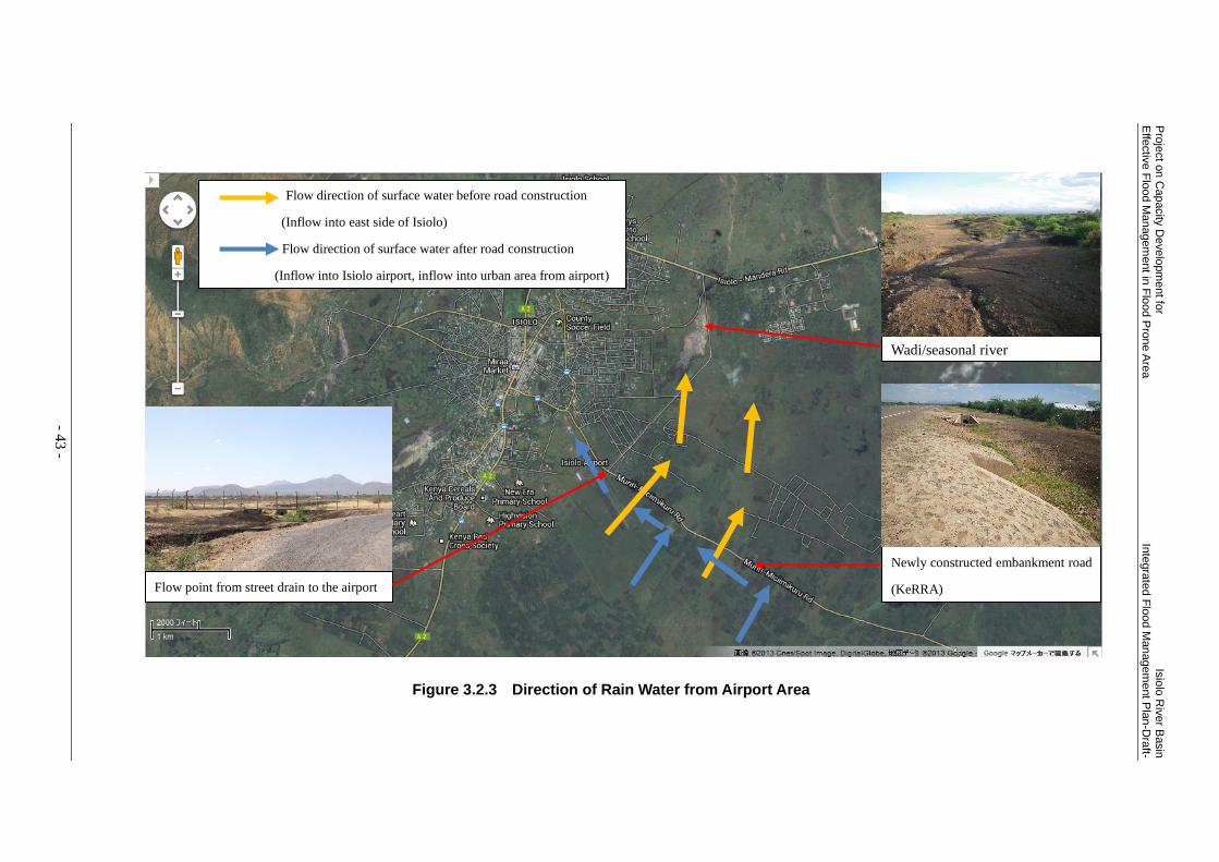
3) Changing water course due to construction of airport and roads
Recent years, due to construction of airport and road in the mountainside of Isiolo town,
water course changed by influences of these new facilities.
In the past rain water ran from southern part of urban area didn’t flow in a direction to the
town area,it traveled down to the north in the eastern slope of the town. After the
construction of those facilities, rain water from the south is blocked by embankment for
the airport and roads and it is leading to the town area.
Pro
ject o
n C
apacity
De
velo
pm
ent fo
r Is
iolo
Riv
er B
asin
E
ffectiv
e F
lood M
anagem
ent in
Flo
od P
rone A
rea
Inte
gra
ted F
lood M
anagem
ent P
lan
-Dra
ft-
- 43 -
Newly constructed embankment road
(KeRRA)
Wadi/seasonal river
Flow direction of surface water before road construction
(Inflow into east side of Isiolo)
Flow direction of surface water after road construction
(Inflow into Isiolo airport, inflow into urban area from airport)
Flow point from street drain to the airport
Figure 3.2.3 Direction of Rain Water from Airport Area
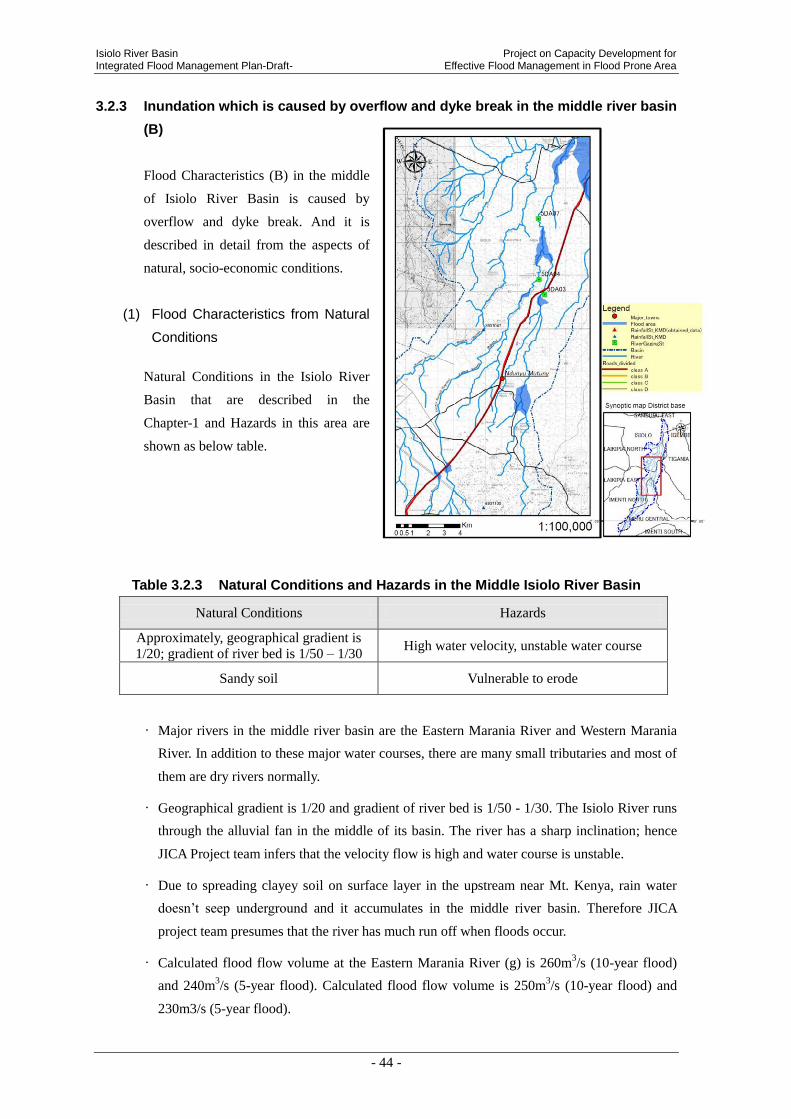
Isiolo River Basin Project on Capacity Development for Integrated Flood Management Plan-Draft- Effective Flood Management in Flood Prone Area
- 44 -
3.2.3 Inundation which is caused by overflow and dyke break in the middle river basin
(B)
Flood Characteristics (B) in the middle
of Isiolo River Basin is caused by
overflow and dyke break. And it is
described in detail from the aspects of
natural, socio-economic conditions.
(1) Flood Characteristics from Natural
Conditions
Natural Conditions in the Isiolo River
Basin that are described in the
Chapter-1 and Hazards in this area are
shown as below table.
Table 3.2.3 Natural Conditions and Hazards in the Middle Isiolo River Basin
Natural Conditions Hazards
Approximately, geographical gradient is
1/20; gradient of river bed is 1/50 – 1/30 High water velocity, unstable water course
Sandy soil Vulnerable to erode
• Major rivers in the middle river basin are the Eastern Marania River and Western Marania
River. In addition to these major water courses, there are many small tributaries and most of
them are dry rivers normally.
• Geographical gradient is 1/20 and gradient of river bed is 1/50 - 1/30. The Isiolo River runs
through the alluvial fan in the middle of its basin. The river has a sharp inclination; hence
JICA Project team infers that the velocity flow is high and water course is unstable.
• Due to spreading clayey soil on surface layer in the upstream near Mt. Kenya, rain water
doesn’t seep underground and it accumulates in the middle river basin. Therefore JICA
project team presumes that the river has much run off when floods occur.
• Calculated flood flow volume at the Eastern Marania River (g) is 260m3/s (10-year flood)
and 240m3/s (5-year flood). Calculated flood flow volume is 250m
3/s (10-year flood) and
230m3/s (5-year flood).
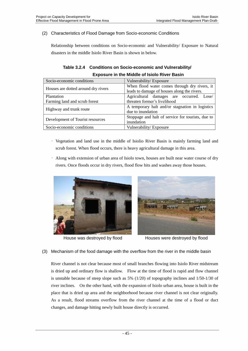
Project on Capacity Development for Isiolo River Basin Effective Flood Management in Flood Prone Area Integrated Flood Management Plan-Draft-
- 45 -
(2) Characteristics of Flood Damage from Socio-economic Conditions
Relationship between conditions on Socio-economic and Vulnerability/ Exposure to Natural
disasters in the middle Isiolo River Basin is shown in below.
Table 3.2.4 Conditions on Socio-economic and Vulnerability/
Exposure in the Middle of Isiolo River Basin
Socio-economic conditions Vulnerability/ Exposure
Houses are dotted around dry rivers When flood water comes through dry rivers, it
leads to damage of houses along the rivers.
Plantation
Farming land and scrub forest
Agricultural damages are occurred. Lose/
threaten former’s livelihood
Highway and trunk route A temporary halt and/or stagnation in logistics
due to inundation
Development of Tourist resources Stoppage and halt of service for tourists, due to
inundation
Socio-economic conditions Vulnerability/ Exposure
• Vegetation and land use in the middle of Isiolio River Basin is mainly farming land and
scrub forest. When flood occurs, there is heavy agricultural damage in this area.
• Along with extension of urban area of Isiolo town, houses are built near water course of dry
rivers. Once floods occur in dry rivers, flood flow hits and washes away those houses.
House was destroyed by flood Houses were destroyed by flood
(3) Mechanism of the food damage with the overflow from the river in the middle basin
River channel is not clear because most of small branches flowing into Isiolo River midstream
is dried up and ordinary flow is shallow. Flow at the time of flood is rapid and flow channel
is unstable because of steep slope such as 5% (1/20) of topography inclines and 1/50-1/30 of
river inclines. On the other hand, with the expansion of Isiolo urban area, house is built in the
place that is dried up area and the neighborhood because river channel is not clear originally.
As a result, flood streams overflow from the river channel at the time of a flood or duct
changes, and damage hitting newly built house directly is occurred.
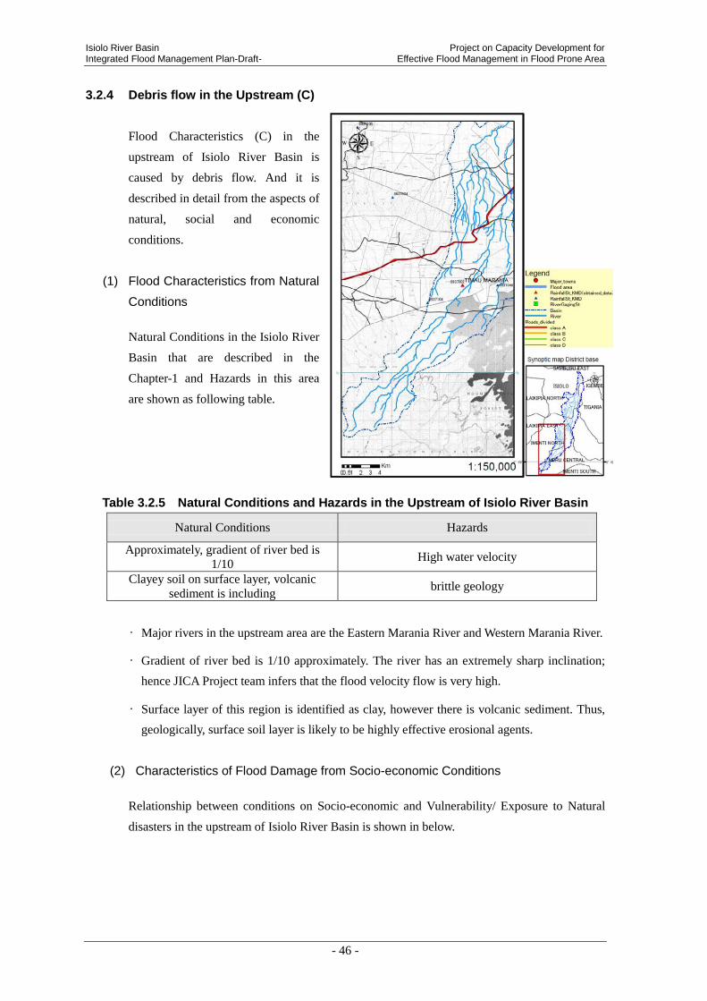
Isiolo River Basin Project on Capacity Development for Integrated Flood Management Plan-Draft- Effective Flood Management in Flood Prone Area
- 46 -
3.2.4 Debris flow in the Upstream (C)
Flood Characteristics (C) in the
upstream of Isiolo River Basin is
caused by debris flow. And it is
described in detail from the aspects of
natural, social and economic
conditions.
(1) Flood Characteristics from Natural
Conditions
Natural Conditions in the Isiolo River
Basin that are described in the
Chapter-1 and Hazards in this area
are shown as following table.
Table 3.2.5 Natural Conditions and Hazards in the Upstream of Isiolo River Basin
Natural Conditions Hazards
Approximately, gradient of river bed is
1/10 High water velocity
Clayey soil on surface layer, volcanic
sediment is including brittle geology
• Major rivers in the upstream area are the Eastern Marania River and Western Marania River.
• Gradient of river bed is 1/10 approximately. The river has an extremely sharp inclination;
hence JICA Project team infers that the flood velocity flow is very high.
• Surface layer of this region is identified as clay, however there is volcanic sediment. Thus,
geologically, surface soil layer is likely to be highly effective erosional agents.
(2) Characteristics of Flood Damage from Socio-economic Conditions
Relationship between conditions on Socio-economic and Vulnerability/ Exposure to Natural
disasters in the upstream of Isiolo River Basin is shown in below.
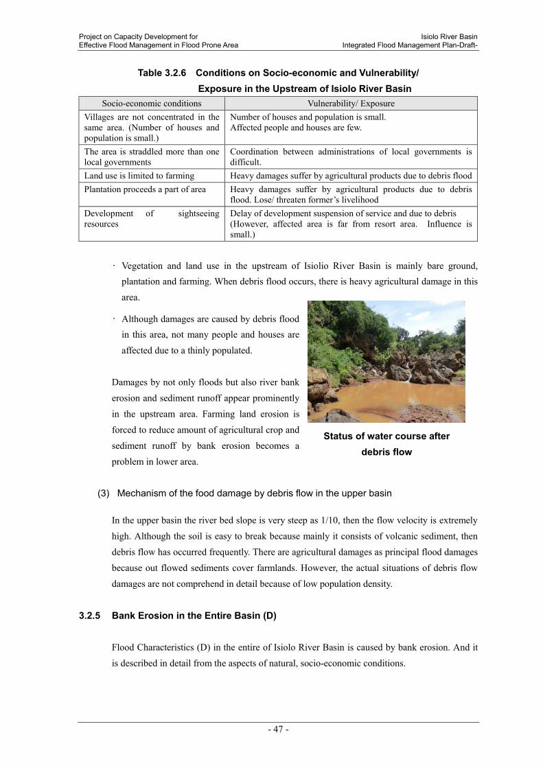
Project on Capacity Development for Isiolo River Basin Effective Flood Management in Flood Prone Area Integrated Flood Management Plan-Draft-
- 47 -
Status of water course after debris flow
Table 3.2.6 Conditions on Socio-economic and Vulnerability/ Exposure in the Upstream of Isiolo River Basin
Socio-economic conditions Vulnerability/ Exposure Villages are not concentrated in the same area. (Number of houses and population is small.)
Number of houses and population is small. Affected people and houses are few.
The area is straddled more than one local governments
Coordination between administrations of local governments is difficult.
Land use is limited to farming Heavy damages suffer by agricultural products due to debris flood Plantation proceeds a part of area Heavy damages suffer by agricultural products due to debris
flood. Lose/ threaten former’s livelihood Development of sightseeing resources
Delay of development suspension of service and due to debris (However, affected area is far from resort area. Influence is small.)
• Vegetation and land use in the upstream of Isiolio River Basin is mainly bare ground, plantation and farming. When debris flood occurs, there is heavy agricultural damage in this
area.
• Although damages are caused by debris flood in this area, not many people and houses are
affected due to a thinly populated.
Damages by not only floods but also river bank
erosion and sediment runoff appear prominently
in the upstream area. Farming land erosion is
forced to reduce amount of agricultural crop and
sediment runoff by bank erosion becomes a
problem in lower area.
(3) Mechanism of the food damage by debris flow in the upper basin
In the upper basin the river bed slope is very steep as 1/10, then the flow velocity is extremely
high. Although the soil is easy to break because mainly it consists of volcanic sediment, then
debris flow has occurred frequently. There are agricultural damages as principal flood damages
because out flowed sediments cover farmlands. However, the actual situations of debris flow
damages are not comprehend in detail because of low population density.
3.2.5 Bank Erosion in the Entire Basin (D)
Flood Characteristics (D) in the entire of Isiolo River Basin is caused by bank erosion. And it
is described in detail from the aspects of natural, socio-economic conditions.
Isiolo River Basin Project on Capacity Development for Integrated Flood Management Plan-Draft- Effective Flood Management in Flood Prone Area
- 48 -
(1) Flood Characteristics from Natural Conditions
Natural Conditions in the Isiolo River Basin that are described in the Chapter-1 and Hazards in
the entire river area are shown as following.
Table 3.2.7 Natural Conditions and Hazards in the entire Isiolo River Basin
Natural Conditions Hazards
Most of basin is arid zone and streamflow is small
normally, sometimes heavy rain occurs in a local area
Aggradation of river bed by runoff
soil, short river width
Loss of forest Soil erosion, Soil runoff
• Water courses in the entire river basin have a steep slope; there are many bank erosions at
curved reach of the river.
(2) Characteristics of Flood Damage from Socio-economic Conditions
Relationship between conditions on Socio-economic and Vulnerability/ Exposure to Natural
disasters in the entire Isiolo River Basin is shown in below.
Table 3.2.8 Conditions on Socio-economic and Vulnerability/
Exposure in the Entire Isiolo River Basin
Socio-economic conditions Vulnerability/ Exposure
Villages are not concentrated in the same area,
besides a part. (Number of houses and population
is small.)
Number of houses and population is small.
Affected people and houses are few.
The region has been prosperous in agriculture Agricultural damages are occurred. Lose/ threaten
former’s livelihood
Highway and trunk road are developed A temporary halt and/or stagnation in logistics due to
inundation
Development of sightseeing resources Delay of development suspension of service and due
to debris (A part of the area includes resort area.
Assumed damage is medium scale.)
• River banks are eroded in the upper and middle river basin, however population density is
not high and houses are not concentrated. Therefore, mainly farming land and transportation
infrastructure such as roads and bridges suffer damage from bank erosion.
• It is likely pointed out that residential area near Isiolo town in the lower river basin suffers
damage from bank erosion. Though, landowners who have estate along the river have
problems.
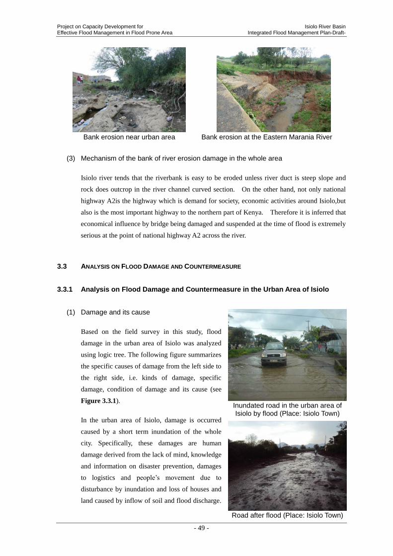
Project on Capacity Development for Isiolo River Basin Effective Flood Management in Flood Prone Area Integrated Flood Management Plan-Draft-
- 49 -
Bank erosion near urban area Bank erosion at the Eastern Marania River
(3) Mechanism of the bank of river erosion damage in the whole area
Isiolo river tends that the riverbank is easy to be eroded unless river duct is steep slope and
rock does outcrop in the river channel curved section. On the other hand, not only national
highway A2is the highway which is demand for society, economic activities around Isiolo,but
also is the most important highway to the northern part of Kenya. Therefore it is inferred that
economical influence by bridge being damaged and suspended at the time of flood is extremely
serious at the point of national highway A2 across the river.
3.3 ANALYSIS ON FLOOD DAMAGE AND COUNTERMEASURE
3.3.1 Analysis on Flood Damage and Countermeasure in the Urban Area of Isiolo
(1) Damage and its cause
Based on the field survey in this study, flood
damage in the urban area of Isiolo was analyzed
using logic tree. The following figure summarizes
the specific causes of damage from the left side to
the right side, i.e. kinds of damage, specific
damage, condition of damage and its cause (see
Figure 3.3.1).
In the urban area of Isiolo, damage is occurred
caused by a short term inundation of the whole
city. Specifically, these damages are human
damage derived from the lack of mind, knowledge
and information on disaster prevention, damages
to logistics and people’s movement due to
disturbance by inundation and loss of houses and
land caused by inflow of soil and flood discharge.
Road after flood (Place: Isiolo Town)
Inundated road in the urban area of Isiolo by flood (Place: Isiolo Town)

Isiolo River Basin Project on Capacity Development for Integrated Flood Management Plan-Draft- Effective Flood Management in Flood Prone Area
- 50 -
In addition to the lack of mind, knowledge and information on disaster prevention, the
following three major causes are considered for the occurrence of large scale inundation as
physical factors.
- Lack of discharge capacity of Merire River crossing the urban area
- Flow of rainfall has been changed by the airport and road newly constructed in the east side
of the urban area and the flood hits the urban area directly, and
- Insufficient drainage system in the urban area of Isiolo.
(2) Countermeasures
To derive the countermeasures, the objective tree
analysis was carried out. Issues to be solved are
placed on the left side and the measures are
specifically presented therefrom(see Figure 3.3.2).
In Isiolo River Basin, even if there is a heavy rain in
the upstream by the effect of Mt. Kenya, there is a
case having no rain in the middle and downstream.
In such case, effective measure can be taken such as
evacuation and activity to prevent flood by obtaining
information on rainfall and water level in the
upstream in advance. For this purpose, introduction
of early flood warning system is effective. In the
community too, rainfall in the upstream can be
measured by simple hyetometer and the information
transmitted to the downstream.
As the mind on disaster prevention of the residents is
very low, dangerous situations are happened such as
the people suffered from injury by crossing the road
overflown with the flooded discharge and/or washed
away by crossing the bridge submerged under water.
To avoid such a situation, it is considered effective to
educate the residents on disaster prevention about
how much the floods are dangerous.
Insufficient drainage system in the urban area is one
of the reasons why the flood damage spreads. Since
the drainage infrastructure is not properly functioned or not well developed, inundation is
occurred in the urban area with a little rainfall. Or the road is cut into pieces and the
Simple Rain Gauge (Place: Nkando
Primary School)
Flooded urban area due to vulnerable drainage system (Place: Isiolo Town)
Shop taking measure by sand bag
(Place: Isiolo Town)
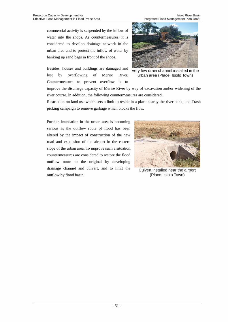
Project on Capacity Development for Isiolo River Basin Effective Flood Management in Flood Prone Area Integrated Flood Management Plan-Draft-
- 51 -
commercial activity is suspended by the inflow of
water into the shops. As countermeasures, it is
considered to develop drainage network in the
urban area and to protect the inflow of water by
banking up sand bags in front of the shops.
Besides, houses and buildings are damaged and
lost by overflowing of Merire River.
Countermeasure to prevent overflow is to
improve the discharge capacity of Merire River by way of excavation and/or widening of the
river course. In addition, the following countermeasures are considered.
Restriction on land use which sets a limit to reside in a place nearby the river bank, and Trash
picking campaign to remove garbage which blocks the flow.
Further, inundation in the urban area is becoming
serious as the outflow route of flood has been
altered by the impact of construction of the new
road and expansion of the airport in the eastern
slope of the urban area. To improve such a situation,
countermeasures are considered to restore the flood
outflow route to the original by developing
drainage channel and culvert, and to limit the
outflow by flood basin.
Culvert installed near the airport
(Place: Isiolo Town)
Very few drain channel installed in the
urban area (Place: Isiolo Town)
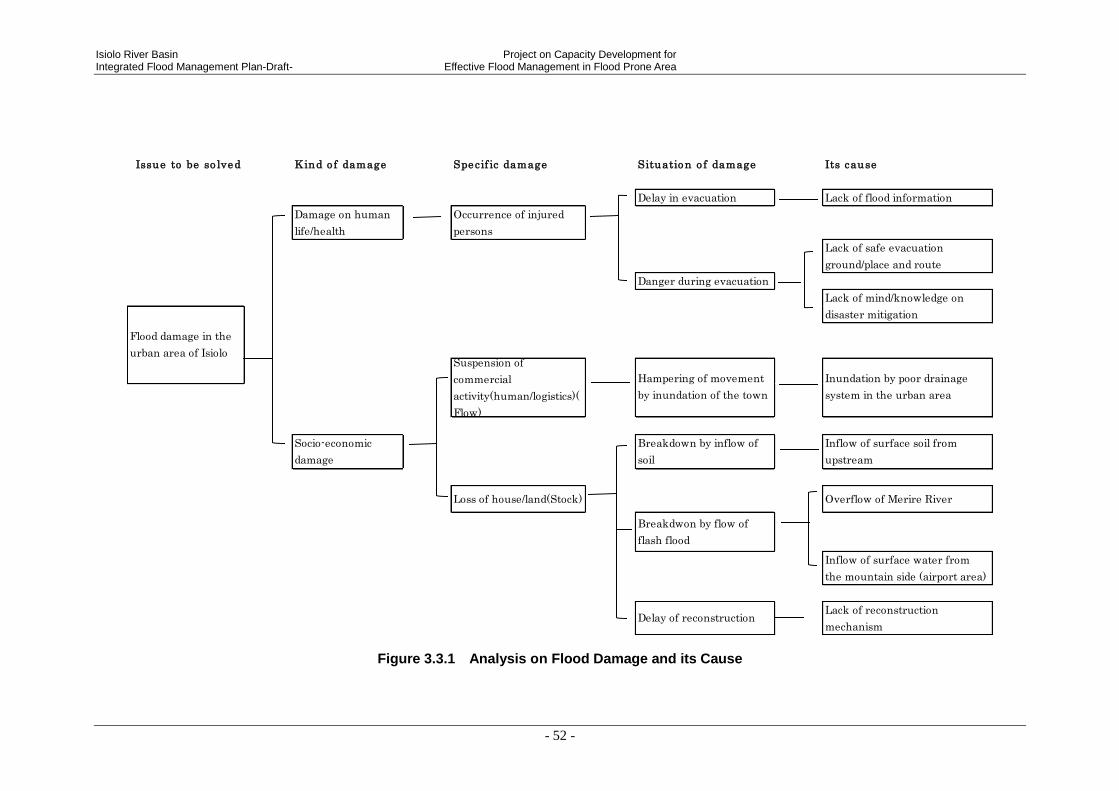
Isiolo River Basin Project on Capacity Development for Integrated Flood Management Plan-Draft- Effective Flood Management in Flood Prone Area
- 52 -
Figure 3.3.1 Analysis on Flood Damage and its Cause
Issue to be so lved Kind o f damage Specif ic damage Situation o f damage Its cause
Delay in evacuation Lack of flood information
Damage on human
life/health
Occurrence of injured
persons
Lack of safe evacuation
ground/place and route
Danger during evacuation
Socio-economic
damage
Breakdown by inflow of
soil
Inflow of surface soil from
upstream
Loss of house/land(Stock) Overflow of Merire River
Breakdwon by flow of
flash flood
Delay of reconstructionLack of reconstruction
mechanism
Flood damage in the
urban area of IsioloSuspension of
commercial
activity(human/logistics)(
Flow)
Inflow of surface water from
the mountain side (airport area)
Hampering of movement
by inundation of the town
Lack of mind/knowledge on
disaster mitigation
Inundation by poor drainage
system in the urban area

Project on Capacity Development for Isiolo River Basin Effective Flood Management in Flood Prone Area Integrated Flood Management Plan-Draft-
- 53 -
Figure 3.3.2 Analysis on Countermeasures
Point to cope with f loods Measure to be taken Action to be taken
Early flood warning system
Lack of flood information Let people know flood information Flood hazard map
Communication and Collaboration
between up/down stream
Lack of safe evacuation
ground/place and route
Preparation of safe evacuation place and
route
Evacuation Programme, place and
route
Education on disaster management
Improve drainage system of the city Development of drainage network
Inundation by bad drainage in
the urban area
Prevent flood into indoor Sand bag
Flood damage
mitigation of the
urban area of Isiolo
Inflow of surface soil from
upstream
Control of outflow of rain water in the
upstreamForestation in the upstream
Excavation of riverbed of Merire River
Widening of Merie River
Increasing discharge capacity of Merire
RiverRestriction on land use
Overflow of Merire River Trash pick campaign
Control of flood discharge in the upstream Dams/ Check Dams
Culvert under road
Flood water flow training
Inflow of surface water from the
mountain side (airport area)
Control of flow from the upstream side
(airport area)Drainage channel
Flood water storage Retarding basin/pond
Contingency Plan
Lack of reconstruction
mechanism
Preparation of contingency measures and
reconstruction and recovery mechanism
Reconstruction and recovery including
funds
Resident obtains knowledge on disaster
prevention
Lack of mind/knowledge on
disaster prevention

Isiolo River Basin Project on Capacity Development for Integrated Flood Management Plan-Draft- Effective Flood Management in Flood Prone Area
- 54 -
Considering the above, countermeasure method to be considered is summarized below.
Table 3.3.1 Countermeasure Method to be considered in the urban area of Isiolo
Countermeasure
Method to be
considered
Remarks Target Area
Flood Early Warning
Collect and analyze information on flood such as rainfall
and water level in the upstream of Isiolo River and transmit
it to the urban area of Isiolo.
Isiolo Town
Flood Hazard Map Flood hazard map is a tool for communicating the impact of
a specific flood event in a particular community. Isiolo Town
Communication and
collaboration
between up/down
stream
Information sharing such as rainfall, water level, focal
community members in both the upstream and downstream
areas in the river basin allows for damage mitigation,
evacuation, response and rescue operation
Isiolo Town
Flood evacuation
programme
Establish evacuation programme including evacuation plan,
safe evacuation places, route and evacuation drill Isiolo Town
Education on
disaster management
Educate the residents on how to reduce by themselves the
present flood damage Isiolo Town
Drainage network Development in the whole urban area of Isiolo Isiolo Town
Sand bag Guidance on sand bag production and provision of materials Isiolo Town
Forestation activity Activity to promote plantation and forestation Isiolo Town
Excavation of
Merire River Excavation of river bed of Merire River Isiolo Town
Widening of Merire
River Widening of river width Isiolo Town
Restriction on land
use Legislation on land use restriction Isiolo Town
Trash picker
campaign Carrying out of trash picker campaign near Merire River Isiolo Town
Dams/ Check Dams Construction of dams and check dams in the upstream Isiolo Town
Drainage canal Development of drainage canal in the airport area Isiolo Town
Culvert Development of culvert in the airport area Isiolo Town
Retarding
basin/pond Development of retarding basin/pond in the airport area Isiolo Town
Contingency Plan
Contingency planning aims to prepare an organization to
respond well to an emergency and its potential humanitarian
impact.
Isiolo Town
Reconstruction and
recovery including
funds
A process of long-term reconstruction and economic
recovery should begin while post-emergency actions aimed
at restoring normality for the displaced populations
returning home or settling in new places are being
undertaken.
Isiolo Town
3.3.2 Analysis on Flood Damage and Countermeasure in the Outskirt excluding the
Urban Area (Mainly in the upstream of urban area of Isiolo)
(1) Damage and its cause
Based on the result of field survey by this time, analysis was carried out, as the same as the
urban area of Isiolo, on the damage at the outskirt area excluding the urban area, mainly in the

Project on Capacity Development for Isiolo River Basin Effective Flood Management in Flood Prone Area Integrated Flood Management Plan-Draft-
- 55 -
upstream of the urban area using logic tree (see Figure 3.3.3).
Damages in the outskirt area excluding the urban area are mainly caused by, as mentioned in
last chapter, displacement of river course in the middle stream, occurrence of debris flow,
erosions of river bank and soil. There are a lot of agricultural lands in the outskirt of Isiolo,
therefore, the damage to agriculture is remarkable and destruction of agricultural land by
debris flow and washout of land by river bank erosion are occurred. In addition, infrastructures
such as houses and bridges are also damaged by inundation, and it gives a great impact to the
living of the residents.
Flood water went up to the elbow of the man (Place: Middle of the Isiolo River)
River bank erosion along Eastern Marania
River (Place: Upstream of Isiolo River)
Bridge in the outside of Isiolo Town (Place:
Upstream of Isiolo River)
(2) Countermeasures
To derive the countermeasures, the objective tree analysis was carried out. Issues to be solved
are placed on the left side and the measures are specifically presented therefrom(see Figure
3.3.4).
Production of agricultural crops is affected by the destruction of agricultural land by debris
flow in this area. To prevent the outflow of debris flow, construction of check dam is
considered effective. In addition, as a measure for river bank erosion, bank protection works
are also effective to prevent washout of land.

Isiolo River Basin Project on Capacity Development for Integrated Flood Management Plan-Draft- Effective Flood Management in Flood Prone Area
- 56 -
Regarding the damage giving an impact to the living of residents by destruction of houses and
infrastructures, there is a measure to prevent overflow by improvement of river course. If
possible, upgrade or improvement of bridge is another option.
Example of check dam in Nzoia River
Example of river bank protection in Nzoia
River
Countermeasures to be considered are summarized below.
Table 3.3.2 Countermeasures to be considered in the Outskirt Area excluding
the Rrban Area (mainly in the upstream of the urban area of Isiolo)
Countermeasure Method to be
considered Remarks Target Area
Check Dam Construction of sabo dam at Isiolo
River Upstream
Bank protection and spur dike Construction at Isiolo River Entire basin
Improvement of river course Improvement of river course of
Isiolo River
Midstream and tributary
stream
Improvement of bridge Improvement of bridge of Isiolo
River
Midstream and tributary
stream

Project on Capacity Development for Isiolo River Basin Effective Flood Management in Flood Prone Area Integrated Flood Management Plan-Draft-
- 57 -
Figure 3.3.3 Analysis on Flood Damage and its Couse
Figure 3.3.4 Analysis on the Countermeasures
Issue to be so lved Kind o f damage Specif ic damage Situation o f damage Its cause
Breakdwon of farm land by debris
flow
Damage on production
(mainly agriculture))
Reduction of production of
agricultural products
Reduction of agricultural
land
Washout of land by river bank
erosion
Damage in the upstream of
the urban area of Isiolo
Difficulty of life in the
housesInundation of houses Flood water from Isiolo River
Difficulty in movementImpossible to use traffic
infrastrcuture
Weak traffic infrastructure
(Especially bridge)
Damage on life
Po int to cope with Measure to be taken Action
Breakdown of agricultural land
by debris flowPrevent discharg of debris flow Check dam
Washout of land by river bank
erosionProtection of water colliding front
Bank protection/
spur dike
Flood damage mitigation in the
upstream of the Isiolo Town
Inflow of flash flood from Isiolo
River
Upgrade of discharge capacity of Isiolo
River
Improvement of
river course
Weak traffic infrastructure
(Especially bridge)
Strengthening of traffic infrastructure
(Especially bridge)
Improvement of
bridge
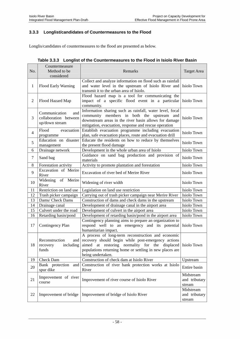
Isiolo River Basin Project on Capacity Development for Integrated Flood Management Plan-Draft- Effective Flood Management in Flood Prone Area
- 58 -
3.3.3 Longlist/candidates of Countermeasures to the Flood
Longlis/candidates of countermeasures to the flood are presented as below.
Table 3.3.3 Longlist of the Countermeasures to the Flood in Isiolo River Basin
No.
Countermeasure
Method to be
considered
Remarks Target Area
1 Flood Early Warning
Collect and analyze information on flood such as rainfall
and water level in the upstream of Isiolo River and
transmit it to the urban area of Isiolo.
Isiolo Town
2 Flood Hazard Map
Flood hazard map is a tool for communicating the
impact of a specific flood event in a particular
community.
Isiolo Town
3
Communication and
collaboration between
up/down stream
Information sharing such as rainfall, water level, focal
community members in both the upstream and
downstream areas in the river basin allows for damage
mitigation, evacuation, response and rescue operation
Isiolo Town
4 Flood evacuation
programme
Establish evacuation programme including evacuation
plan, safe evacuation places, route and evacuation drill Isiolo Town
5 Education on disaster
management
Educate the residents on how to reduce by themselves
the present flood damage Isiolo Town
6 Drainage network Development in the whole urban area of Isiolo Isiolo Town
7 Sand bag Guidance on sand bag production and provision of
materials Isiolo Town
8 Forestation activity Activity to promote plantation and forestation Isiolo Town
9 Excavation of Merire
River Excavation of river bed of Merire River Isiolo Town
10 Widening of Merire
River Widening of river width Isiolo Town
11 Restriction on land use Legislation on land use restriction Isiolo Town
12 Trash picker campaign Carrying out of trash picker campaign near Merire River Isiolo Town
13 Dams/ Check Dams Construction of dams and check dams in the upstream Isiolo Town
14 Drainage canal Development of drainage canal in the airport area Isiolo Town
15 Culvert under the road Development of culvert in the airport area Isiolo Town
16 Retarding basin/pond Development of retarding basin/pond in the airport area Isiolo Town
17 Contingency Plan
Contingency planning aims to prepare an organization to
respond well to an emergency and its potential
humanitarian impact.
Isiolo Town
18
Reconstruction and
recovery including
funds
A process of long-term reconstruction and economic
recovery should begin while post-emergency actions
aimed at restoring normality for the displaced
populations returning home or settling in new places are
being undertaken.
Isiolo Town
19 Check Dam Construction of check dam at Isiolo River Upstream
20 Bank protection and
spur dike
Construction of river bank protection works at Isiolo
River Entire basin
21 Improvement of river
course Improvement of river course of Isiolo River
Midstream
and tributary
stream
22 Improvement of bridge Improvement of bridge of Isiolo River
Midstream
and tributary
stream

Project on Capacity Development for Isiolo River Basin Effective Flood Management in Flood Prone Area Integrated Flood Management Plan-Draft-
- 59 -
3.4 SELECTION OF FLOOD DAMAGE TO BE MANAGED PREFERENTIALLY
3.4.1 The Result of Workshop for Flood Damage Analysis by Community
In Isiolo river basin, the workshop was held to analyze the problems in Isiolo sub catchment
with WRUA members, WRMA-SRO staff and JICA project team members on Nov. 7th, 2012
As a result of analysis, the causes of flood are pointed out as bellow.
Table 3.4.1 Analysis for the Causes of Flood by Interviewing to WRUA Members
Theme Causes Principal Influence from Flooding
Floods
Rainfall around the Mt. Kenya slope Flash flood from immediate rising
in “wadi” Sediment flow around upstream
Lack of capacity for drainage City area inundation caused by poor
drainage Developed condition of poundage in the airport
Concerning flood damages, following analysis was done and was indicated the priority order
lead by WRUA members.
Table 3.4.2 Damage Analysis and Priority Order Determined by WRUA Members
Priority order
determined by
WRUA
members
Item Primary Damage Secondary Damage
① Sediment erosion
-Soil outflow from farmland
-Loss of agricultural products
-Sediment outflow
-Lack of farmlands
-Inefficiency of harvest
-Lack of lands
-Obstruction of culverts
② Damage of
infrastructures
-Transmission wire
-Roads
-Bridges
-Water intakes
-Culverts
-Black out
-Beyond reach of goods to markets
-Unable to go to hospital or school
-Insufficient water, conflicts over
water, drought
-Water spilling
③ Water pollution -An epidemic of diseases
-Growing worse of sanitation
-Epidemic of Cholera, Dysentery and
Typhoid fever
④ Damage in daily
life or livelihood
-Trash scattering
-Overflowing from toilet
-Destruction of houses
-Obstruction of culverts, water
leaking
-Sanitary conditions
-Moving enforcement
⑤ Human life -Lost of Human life by sweeping away
-Drowned livestock
3.4.2 Selection of the Prioritized Flood Damage to be Managed
As a description in previous chapter, the flood damages along Isiolo river is principally
classified 4 types such as A) Inundation in urban area of Isiolo town , B) Inundation which is

Isiolo River Basin Project on Capacity Development for Integrated Flood Management Plan-Draft- Effective Flood Management in Flood Prone Area
- 60 -
caused by overflow and dyke break, C) Debris flow in the upstream and D) Bank erosion in the
entire basin .
Based on the evaluation of flood damages by communities previously described, each impact
from flood damages are evaluated from the viewpoints of social impacts as “Number of
affected people and houses” or economic impacts as “Losses of merchandise, agriculture,
transportation and sightseeing industry”, and are shown in the following table.
Table 3.4.3 Selection of The Flood Damages should be Corresponding Preferentially
Flood type
Social impacts Economic impact
Priority order Number of
affected people
Number of
affected houses
Merchandise Agriculture Transportation
Sight
seeing industry
A. Inundation in urban
area of Isiolo town High High High Low High Mid Extremely High
B. Inundation which is
caused by overflow
and dyke break
Low Low Low Mid Low Low Slightly low
C. Debris flow in the
upstream Low Low Low Mid Low Mid Slightly low
D. Bank erosion in the
entire basin Low Low Low Mid High Mid
Partially high in
transportation
In the 4 types of flood damages, it shows that the damage by “Inundation in urban area of
Isiolo town” has strongest impacts socio-economically, and the impact of damage in the point
concerned to transportation by dyke brake.
According to these review, in Isiolo river basin, “Inundation in urban area of Isiolo town” is
selected as the damage should be corresponding extreme preferentially, and subsequently the
dyke break in the point concerned to transportation.
Therefore, selected longlist is shown in the next page.

Project on Capacity Development for Isiolo River Basin Effective Flood Management in Flood Prone Area Integrated Flood Management Plan-Draft-
- 61 -
Table 3.4.4 Selected Long List of the Countermeasures to the Flood in Isiolo River
Basin
No. Countermeasure Method to
be considered Remarks Target Area
1 Flood Early Warning
Collect and analyze information on flood such as
rainfall and water level in the upstream of Isiolo
River and transmit it to the urban area of Isiolo.
Isiolo Town
2 Flood Hazard Map
Flood hazard map is a tool for communicating the
impact of a specific flood event in a particular
community.
Isiolo Town
3
Communication and
collaboration between
up/down stream
Information sharing such as rainfall, water level,
focal community members in both the upstream
and downstream areas in the river basin allows for
damage mitigation, evacuation, response and
rescue operation
Isiolo Town
4 Flood evacuation
programme
Establish evacuation programme including
evacuation plan, safe evacuation places, route and
evacuation drill
Isiolo Town
5 Education on disaster
management
Educate the residents on how to reduce by
themselves the present flood damage Isiolo Town
6 Drainage network Development in the whole urban area of Isiolo Isiolo Town
7 Sand bag Guidance on sand bag production and provision of
materials Isiolo Town
8 Forestation activity Activity to promote plantation and forestation Isiolo Town
9 Excavation of Merire River Excavation of river bed of Merire River Isiolo Town
10 Widening of Merire River Widening of river width Isiolo Town
11 Restriction on land use Legislation on land use restriction Isiolo Town
12 Trash picker campaign Carrying out of trash picker campaign near Merire
River Isiolo Town
13 Dams/ Check Dams Construction of dams and check dams in the
upstream Isiolo Town
14 Drainage canal Development of drainage canal in the airport area Isiolo Town
15 Culvert under the road Development of culvert in the airport area Isiolo Town
16 Retarding basin/pond Development of retarding basin/pond in the airport
area Isiolo Town
17 Contingency Plan
Contingency planning aims to prepare an
organization to respond well to an emergency and
its potential humanitarian impact.
Isiolo Town
18 Reconstruction and
recovery including funds
A process of long-term reconstruction and
economic recovery should begin while
post-emergency actions aimed at restoring
normality for the displaced populations returning
home or settling in new places are being
undertaken.
Isiolo Town
19 Bank protection and spur
dike
Construction of river bank protection works at
Isiolo River Entire basin

Isiolo River Basin Project on Capacity Development for Integrated Flood Management Plan-Draft- Effective Flood Management in Flood Prone Area
- 62 -
4. EVALUATION OF COUNTERMEASURES TO THE FLOOD
4.1 VIEW POINT OF EVALUATION
Candidate countermeasures that are extracted in last chapter are studied in detail. On the basis
of the result of last chapter, 5 criteria; relevance, effectiveness, efficiency, impact and
sustainability is considered.
The project team defined 5 criteria as the description on following table, and then evaluated the
countermeasures by marking “A”, “B” and “C” according to these 5 Items.
Table 4.1.1 Definition of 5 Items for Project Evaluation
1 Relevance Requirements from the stakeholders, Needs of target area Dimension of economic damage and human suffering.
2 Effectiveness Degree of damage mitigation (Number of beneficiary, Reduction of submergence period, area and number of affected people)
3 Efficiency Cost effectiveness (It is evaluated by estimated qualitative dimension and degree of damage mitigation)
4 Impact Spreading effect within a same basin or to other areas Indirect effects
5 Sustainability Sustainability of maintenance and project effects (On the assumption of pilot project completion according to the design.)
*The project team defined these 5 items for the purpose of this study according to “DAC’s evaluation 5 items”
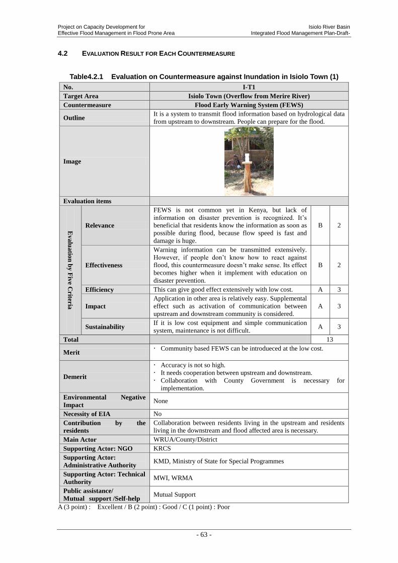
Project on Capacity Development for Isiolo River Basin Effective Flood Management in Flood Prone Area Integrated Flood Management Plan-Draft-
- 63 -
4.2 EVALUATION RESULT FOR EACH COUNTERMEASURE
Table4.2.1 Evaluation on Countermeasure against Inundation in Isiolo Town (1)
No. I-T1
Target Area Isiolo Town (Overflow from Merire River)
Countermeasure Flood Early Warning System (FEWS)
Outline It is a system to transmit flood information based on hydrological data
from upstream to downstream. People can prepare for the flood.
Image
Evaluation items
Ev
alu
atio
n b
y F
ive C
riteria
Relevance
FEWS is not common yet in Kenya, but lack of
information on disaster prevention is recognized. It’s
beneficial that residents know the information as soon as
possible during flood, because flow speed is fast and
damage is huge.
B 2
Effectiveness
Warning information can be transmitted extensively.
However, if people don’t know how to react against
flood, this countermeasure doesn’t make sense. Its effect
becomes higher when it implement with education on
disaster prevention.
B 2
Efficiency This can give good effect extensively with low cost. A 3
Impact
Application in other area is relatively easy. Supplemental
effect such as activation of communication between
upstream and downstream community is considered.
A 3
Sustainability If it is low cost equipment and simple communication
system, maintenance is not difficult. A 3
Total 13
Merit Community based FEWS can be introdueced at the low cost.
Demerit
Accuracy is not so high.
It needs cooperation between upstream and downstream.
Collaboration with County Government is necessary for
implementation.
Environmental Negative
Impact None
Necessity of EIA No
Contribution by the
residents
Collaboration between residents living in the upstream and residents
living in the downstream and flood affected area is necessary.
Main Actor WRUA/County/District
Supporting Actor: NGO KRCS
Supporting Actor:
Administrative Authority KMD, Ministry of State for Special Programmes
Supporting Actor: Technical
Authority MWI, WRMA
Public assistance/
Mutual support /Self-help Mutual Support
A (3 point) : Excellent / B (2 point) : Good / C (1 point) : Poor
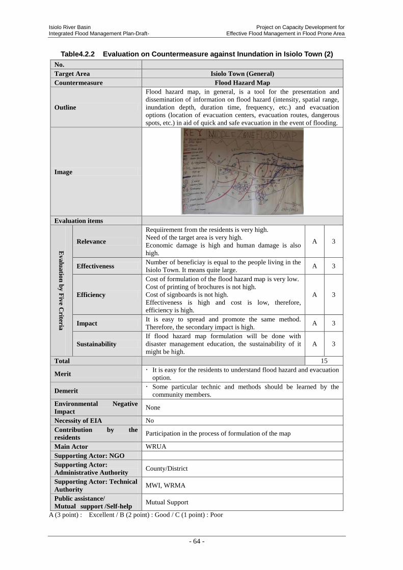
Isiolo River Basin Project on Capacity Development for Integrated Flood Management Plan-Draft- Effective Flood Management in Flood Prone Area
- 64 -
Table4.2.2 Evaluation on Countermeasure against Inundation in Isiolo Town (2)
No.
Target Area Isiolo Town (General)
Countermeasure Flood Hazard Map
Outline
Flood hazard map, in general, is a tool for the presentation and
dissemination of information on flood hazard (intensity, spatial range,
inundation depth, duration time, frequency, etc.) and evacuation
options (location of evacuation centers, evacuation routes, dangerous
spots, etc.) in aid of quick and safe evacuation in the event of flooding.
Image
Evaluation items
Ev
alu
atio
n b
y F
ive C
riteria
Relevance
Requiirement from the residents is very high.
Need of the target area is very high.
Economic damage is high and human damage is also
high.
A 3
Effectiveness Number of beneficiay is equal to the people living in the
Isiolo Town. It means quite large. A 3
Efficiency
Cost of formulation of the flood hazard map is very low.
Cost of printing of brochures is not high.
Cost of signboards is not high.
Effectiveness is high and cost is low, therefore,
efficiency is high.
A 3
Impact It is easy to spread and promote the same method.
Therefore, the secondary impact is high. A 3
Sustainability
If flood hazard map formulation will be done with
disaster management education, the sustainability of it
might be high.
A 3
Total 15
Merit It is easy for the residents to understand flood hazard and evacuation
option.
Demerit Some particular technic and methods should be learned by the
community members.
Environmental Negative
Impact None
Necessity of EIA No
Contribution by the
residents Participation in the process of formulation of the map
Main Actor WRUA
Supporting Actor: NGO
Supporting Actor:
Administrative Authority County/District
Supporting Actor: Technical
Authority MWI, WRMA
Public assistance/
Mutual support /Self-help Mutual Support
A (3 point) : Excellent / B (2 point) : Good / C (1 point) : Poor

Project on Capacity Development for Isiolo River Basin Effective Flood Management in Flood Prone Area Integrated Flood Management Plan-Draft-
- 65 -
Table4.2.3 Evaluation on Countermeasure against Inundation in Isiolo Town (3)
No.
Target Area Isiolo Town (General)
Countermeasure Communication and collaboration between up/down stream
Outline
Information sharing such as rainfall, water level, focal community
members in both the upstream and downstream areas in the river basin
allows for damage mitigation, evacuation, response and rescue
operation.
Image
Evaluation items
Ev
alu
atio
n b
y F
ive C
riteria
Relevance Requirement from the communities in the upstream and
the downstream is high. A 3
Effectiveness
Number of beneficiary is large. It is almost equal to the
number of Isiolo Town residents. Therefore,
effectiveness is high.
A 3
Efficiency Cost of communication and collaboration is low.
Therefore, efficiency is is high. A 3
Impact It is easy to spread and promote the same method.
Therefore, the secondary impact is high. A 3
Sustainability If both upstream and downstream residents get merit,
collaboration might be sustainable. B 2
Total 14
Merit
If there is good communication and collaboration between upstream
and downstream, flood management in the entire river basin might be
effective in the cost and the quality.
Demerit Usually main beneficiary might be the downstream residents only.
Environmental Negative
Impact None
Necessity of EIA No
Contribution by the
residents Participation to the actural communication and collaboration
Main Actor WRUA
Supporting Actor: NGO
Supporting Actor:
Administrative Authority MWI, WRMA
Supporting Actor: Technical
Authority MWI, WRMA
Public assistance/
Mutual support /Self-help Mutual Support
A (3 point) : Excellent / B (2 point) : Good / C (1 point) : Poor

Isiolo River Basin Project on Capacity Development for Integrated Flood Management Plan-Draft- Effective Flood Management in Flood Prone Area
- 66 -
Table4.2.4 Evaluation on Countermeasure against Inundation in Isiolo Town (4)
No.
Target Area Isiolo Town (General)
Countermeasure Flood Evacuation Programme
Outline
Evacuation plan should be developed and evacuation drills and mock
experience and evacuation centre management should be prepared and
implemented.
Image
Evaluation items
Ev
alu
atio
n b
y F
ive C
riteria
Relevance
Requirement from the residents especially from
school pupils is high because they might suffer
from the flood water on the way to and back from
the school.
Not only school pupils, but also women and elder
people migh suffer from the flood water.
A 3
Effectiveness
Number of beneficiary is large. It is almost equal to the
number of Isiolo Town residents. Therefore,
effectiveness is high.
A 3
Efficiency Cost of preparing evacuation plan is low.
Therefore, efficiency is is high. A 3
Impact It is easy to spread and promote the same method.
Therefore, the secondary impact is high. A 3
Sustainability
If flood evacuation programme will be done with
disaster management education, the sustainability of it
might be high.
B 2
Total 14
Merit
Structural measures are not perfectly to be able to prevent flood
holistically, therefore non-structural measures are also applied as
important part of the flood management.
Evacuation is an important part of saving lives and minimizes
property damage from the flood.
Evacuation drill helps communities envisage the different stages
of flood disaster cycle, preparation, mitigation plan, early
warning, and evacuation plan of flood through activities.
Demerit Evacuation drill should be done repeatedly.
Environmental Negative
Impact None
Necessity of EIA No
Contribution by the
residents Participation
Main Actor WRUA
Supporting Actor: NGO
Supporting Actor:
Administrative Authority County/District
Supporting Actor: Technical
Authority MWI, WRMA
Public assistance/
Mutual support /Self-help Mutual Support/ Self-help
A (3 point) : Excellent / B (2 point) : Good / C (1 point) : Poor

Project on Capacity Development for Isiolo River Basin Effective Flood Management in Flood Prone Area Integrated Flood Management Plan-Draft-
- 67 -
Table4.2.5 Evaluation on Countermeasure against Inundation in Isiolo Town(5)
No. I-T2
Target Area Isiolo Town (General)
Countermeasure Education on Disaster Management
Outline It is educational activity to give information to reduce damage from flood
and raise awareness of disaster management.
Image
Evaluation items
Ev
alu
atio
n b
y F
ive C
riteria
Relevance
WRMA has a high request of enforcement of community.
In addition, some damage can prevent if people have
knowledge on flood management. So it importance is
high.
A 3
Effectiveness
It is expected certain effect against number of educated
people. Their knowledge on disaster prevention can
implement wherever and whenever they need. Its effect
can be spread.
B 2
Efficiency
It can give knowledge on disaster prevention to a large
number of people at the same time. Cost is low.
Effectiveness is high when the knowledge is rooted.
A 3
Impact Knowledge can hand down from beneficiary to their
family and friends. It can expand widely. A 3
Sustainability
Local people such as school teacher and community leader
can be a lecturer. So educational activity sustain. In
addition, integration into curriculum is important.
A 3
Total 14
Merit
Cost is low.
Knowledge learned in childhood will last long until the child will
become adult.
Knowledge learned by the school pupils will be disseminated to the
parents and other related adults.
Demerit Cooperation and coordination with education sector is necessary.
It is need to train school teachers at the first.
Environmental Negative
Impact
None
Necessity of EIA No
Contribution by the
residents
Support of school teachers
Main Actor School (Teachers)/ WRUA
Supporting Actor: NGO KRCS/ PTA (Pareents Teachers Association)
Supporting Actor:
Administrative Authority Ministry of Education/ County/ District
Supporting Actor:
Technical Authority MWI, WRMA
Public assistance/
Mutual support
/Self-help
Public Assistance/ Mutual support
A (3 point) : Excellent / B (2 point) : Good / C (1 point) : Poor
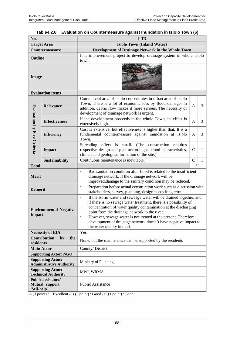
Isiolo River Basin Project on Capacity Development for Integrated Flood Management Plan-Draft- Effective Flood Management in Flood Prone Area
- 68 -
Table4.2.6 Evaluation on Countermeasure against Inundation in Isiolo Town (6)
No. I-T3
Target Area Isiolo Town (Inland Water)
Countermeasure Development of Drainage Network in the Whole Town
Outline It is improvement project to develop drainage system in whole Isiolo
town.
Image
Evaluation items
Ev
alu
atio
n b
y F
ive C
riteria
Relevance
Commercial area of Isiolo concentrates in urban area of Isiolo
Town. There is a lot of economic loss by flood damage. In
addition, debris flow makes it more serious. The necessity of
development of drainage network is urgent.
A 3
Effectiveness If the development proceeds in the whole Town, its effect is
extensively high. A 3
Efficiency
Cost is extensive, but effectiveness is higher than that. It is a
fundamental countermeasure against inundation at Isiolo
Town.
A 3
Impact
Spreading effect is small. (The construction requires
respective design and plan according to flood characteristics,
climate and geological formation of the site.)
C 1
Sustainability Continuous maintenance is inevitable. C 1
Total 11
Merit
Bad sanitation condition after flood is related to the insufficient
drainage network. If the drainage network will be
improved,damage to the sanitary condition may be reduced.
Demerit Preparation before actual construction work such as discussion with
stakeholders, survey, planning, design needs long term.
Environmental Negative
Impact
If the storm water and seweage water will be drained together, and
if there is no sewage water treatment, there is a possibility of
concentration of water quality contamination at the discharging
point from the drainage network to the river.
However, sewage water is not treated at the present. Therefore,
development of drainage network doesn’t have negative impact to
the water quality in total.
Necessity of EIA Yes
Contribution by the
residents None, but the maintenance can be supported by the residents
Main Actor County/ District
Supporting Actor: NGO
Supporting Actor:
Administrative Authority Ministry of Planning
Supporting Actor:
Technical Authority MWI, WRMA
Public assistance/
Mutual support
/Self-help Public Assistance
A (3 point) : Excellent / B (2 point) : Good / C (1 point) : Poor
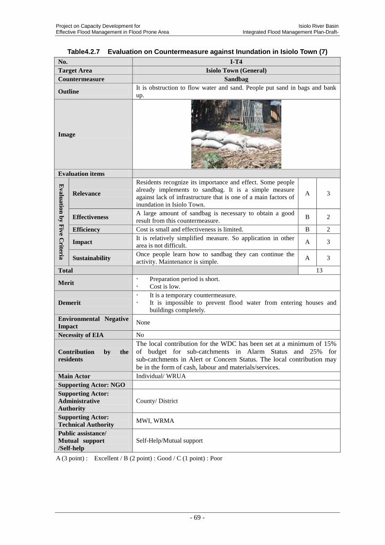
Project on Capacity Development for Isiolo River Basin Effective Flood Management in Flood Prone Area Integrated Flood Management Plan-Draft-
- 69 -
Table4.2.7 Evaluation on Countermeasure against Inundation in Isiolo Town (7)
No. I-T4
Target Area Isiolo Town (General)
Countermeasure Sandbag
Outline It is obstruction to flow water and sand. People put sand in bags and bank
up.
Image
Evaluation items
Ev
alu
atio
n b
y F
ive C
riteria
Relevance
Residents recognize its importance and effect. Some people
already implements to sandbag. It is a simple measure
against lack of infrastructure that is one of a main factors of
inundation in Isiolo Town.
A 3
Effectiveness A large amount of sandbag is necessary to obtain a good
result from this countermeasure. B 2
Efficiency Cost is small and effectiveness is limited. B 2
Impact It is relatively simplified measure. So application in other
area is not difficult. A 3
Sustainability Once people learn how to sandbag they can continue the
activity. Maintenance is simple. A 3
Total 13
Merit Preparation period is short.
Cost is low.
Demerit
It is a temporary countermeasure.
It is impossible to prevent flood water from entering houses and
buildings completely.
Environmental Negative
Impact None
Necessity of EIA No
Contribution by the
residents
The local contribution for the WDC has been set at a minimum of 15%
of budget for sub-catchments in Alarm Status and 25% for
sub-catchments in Alert or Concern Status. The local contribution may
be in the form of cash, labour and materials/services.
Main Actor Individual/ WRUA
Supporting Actor: NGO
Supporting Actor:
Administrative
Authority
County/ District
Supporting Actor:
Technical Authority MWI, WRMA
Public assistance/
Mutual support
/Self-help
Self-Help/Mutual support
A (3 point) : Excellent / B (2 point) : Good / C (1 point) : Poor

Isiolo River Basin Project on Capacity Development for Integrated Flood Management Plan-Draft- Effective Flood Management in Flood Prone Area
- 70 -
Table4.2.8 Evaluation on Countermeasure against Inundation in Isiolo Town (8)
No. I-T5
Target Area Upstream of Isiolo River
Countermeasure Forestation Activity
Outline It is to protect and recover vegetation in the upstream of the mountain. Its
storage effect will rise.
Image
Evaluation items
Ev
alu
atio
n b
y F
ive
Criter
ia
Relevance
Residents are affected by soil erosion. Also, in “Imenti North
District Development Plan” shows forestation at same area. It
corresponds with higher plan.
A 3
Effectiveness If this countermeasure implement at appropriate scale,
sedimentation from upstream would reduce. B 2
Efficiency Large scale forestation is required to obtain certain effectiveness. B 2
Impact Application in other area is not difficult. In addition, it contributes
environmental conservation. B 2
Sustainability Once main actor is aware the importance, activity can continue.
Maintenance is complicate. It takes time to grow up. B 2
Total 11
Merit
Preparation period is short.
Cost is low.
There are many environmental positive impacts.
It contributes to reduce global warming.
Demerit It takes long term to show the effect.
Climate in Isiolo require some certain kinds of trees for forestation.
Environmental
Negative Impact
None
Necessity of EIA No
Contribution by the
residents
The local contribution for the WDC has been set at a minimum of 15% of
budget for sub-catchments in Alarm Status and 25% for sub-catchments in
Alert or Concern Status. The local contribution may be in the form of cash,
labour and materials/services.
Main Actor WRUA
Supporting Actor:
NGO KRCS
Supporting Actor:
Administrative
Authority
Kenya Forest Service
Supporting Actor:
Technical Authority MWI, WRMA
Public assistance/
Mutual support
/Self-help
Mutual Support
A (3 point) : Excellent / B (2 point) : Good / C (1 point) : Poor

Project on Capacity Development for Isiolo River Basin Effective Flood Management in Flood Prone Area Integrated Flood Management Plan-Draft-
- 71 -
Table4.2.9 Evaluation on Countermeasure against Inundation in Isiolo Town (9)
No. I-T6
Target Area Isiolo Town (Overflow from Merire River)
Countermeasure Excavation of River bed of Merire River
Outline It is a countermeasure to excavate river bed and increase flow capacity
Image
Evaluation items
Ev
alu
atio
n b
y F
ive C
riteria
Relevance
Inundation by Merire River is reported frequently. Lack of
cross section of river channel is a main cause, so demand is
high.
A 3
Effectiveness Overflow from Merire River reduces drastically. Damage
reduction of overflow from Merire River can be expected. A 3
Efficiency Both cost and effectiveness are extensive. B 2
Impact
Spreading effect is small. (The construction requires
respective design and plan according to flood
characteristics, climate and geological formation of the
site.)
C 1
Sustainability Continuous excavation is necessary. Additional cost is
high. C 1
Total 10
Merit It is certain that the excavation of riverbed improves flow
capacity of Merire River.
Demerit
Preparation before actual construction work such as discussion
with stakeholders, survey, planning, design needs long term. Excavation might be implemented continuously, because sediment
from upstream might come and deposite in the river channel.
Environmental Negative
Impact
There might be no natural environmental negative impact. because
the current status of Merire River is like a sewage channel. There is
no ecological environment.
Involuntary resettlement might be occurred.
Necessity of EIA Yes
Contribution by the
residents None, but the maintenance can be supported by the residents.
Main Actor NWCPC (National Water Conservation and Pipeline Cooperation)
Supporting Actor: NGO
Supporting Actor:
Administrative Authority County/ District
Supporting Actor:
Technical Authority MWI, WRMA
Public assistance/
Mutual support
/Self-help
Public Assistance
A (3 point) : Excellent / B (2 point) : Good / C (1 point) : Poor

Isiolo River Basin Project on Capacity Development for Integrated Flood Management Plan-Draft- Effective Flood Management in Flood Prone Area
- 72 -
Table4.2.10 Evaluation on Countermeasure against Inundation in Isiolo Town (10)
No. I-T7
Target Area Isiolo Town (Overflow from Merire River)
Countermeasure Widening of Merire River
Outline It is a countermeasure to widen river width and increase flow section.
Image
Evaluation items
Ev
alu
atio
n b
y F
ive C
riteria
Relevance
WRMA has expectation. The importance of high, because
lack of cross section of river channel is the cause of overflow
from Merire river. However, there are some illegal
constructions around river edge. Resettlement can be
occurred.
B 2
Effectiveness Expected damage reduction is high. Overflow from Merire
River can become less drastically. A 3
Efficiency Both cost and effectiveness are extensive. B 2
Impact
Spreading effect is small. (The construction requires
respective design and plan according to flood characteristics,
climate and geological formation of the site.)
C 1
Sustainability The cost can be lower than excavation. However, continuous
maintenance is necessary. C 1
Total 9
Merit It is certain that the widening of river channel improves flow
capacity of Merire River.
Demerit
Preparation before actual construction work such as discussion
with stakeholders, survey, planning, design needs long term. There are some houses around the river bank. Resettlement can occur.
Coordination with stakeholder is difficult.
Environmental Negative
Impact
There might be no natural environmental negative impact. because the
current status of Merire River is like a sewage channel. There is no
ecological environment.
Involuntary resettlement might be occurred.
Necessity of EIA Yes
Contribution by the
residents None, but the maintenance can be supported by the residents.
Main Actor NWCPC (National Water Conservation and Pipeline Cooperation)
Supporting Actor: NGO
Supporting Actor:
Administrative
Authority
County/ District
Supporting Actor:
Technical Authority MWI, WRMA
Public assistance/
Mutual support
/Self-help
Public Assistance
A (3 point) : Excellent / B (2 point) : Good / C (1 point) : Poor

Project on Capacity Development for Isiolo River Basin Effective Flood Management in Flood Prone Area Integrated Flood Management Plan-Draft-
- 73 -
Table4.2.11 Evaluation on Countermeasure against Inundation in Isiolo Town (11)
No. I-T8
Target Area Whole Country (Overflow from Merire River)
Countermeasure Restriction on land use
Outline It is to establish a law to prohibit people from illegal construction and
illegal occupation of lands near the river.
Image
-
Evaluation items
Ev
alu
atio
n b
y F
ive C
riteria
Relevance
Its importance is recognized by stakeholders. Illegal
constructions are existed around river edge. So,
government can’t implement widening of the river. And
also, people who live in illegal houses can affect directly
by overflow water.
B 2
Effectiveness This is not a direct measure against flood. Crackdown and
educational activity is required at the same time. C 1
Efficiency Legislation is almost no cost to implement. However,
direct effectiveness for disaster reduction is small. B 2
Impact Legislation itself is nationwide. A 1
Sustainability
Once the law is established, validity can continue.
However, certain regulation and educational activity
should be implemented the same time.
B 2
Total 8
Merit Illegal occupation of riparian land can be reduced.
Cost is low.
Demerit
Involuntary resettlement can occur.
Regulation and educational activity should be implemented.
It is government level and takes long time to establish a law.
Environmental
Negative Impact None
Necessity of EIA No
Contribution by the
residents None
Main Actor WRMA / Ministry of Lands
Supporting Actor:
NGO
Supporting Actor:
Administrative
Authority
Ministry of Lands
Supporting Actor:
Technical Authority MWI, WRMA
Public assistance/
Mutual support
/Self-help
Public Assistance
A (3 point) : Excellent / B (2 point) : Good / C (1 point) : Poor
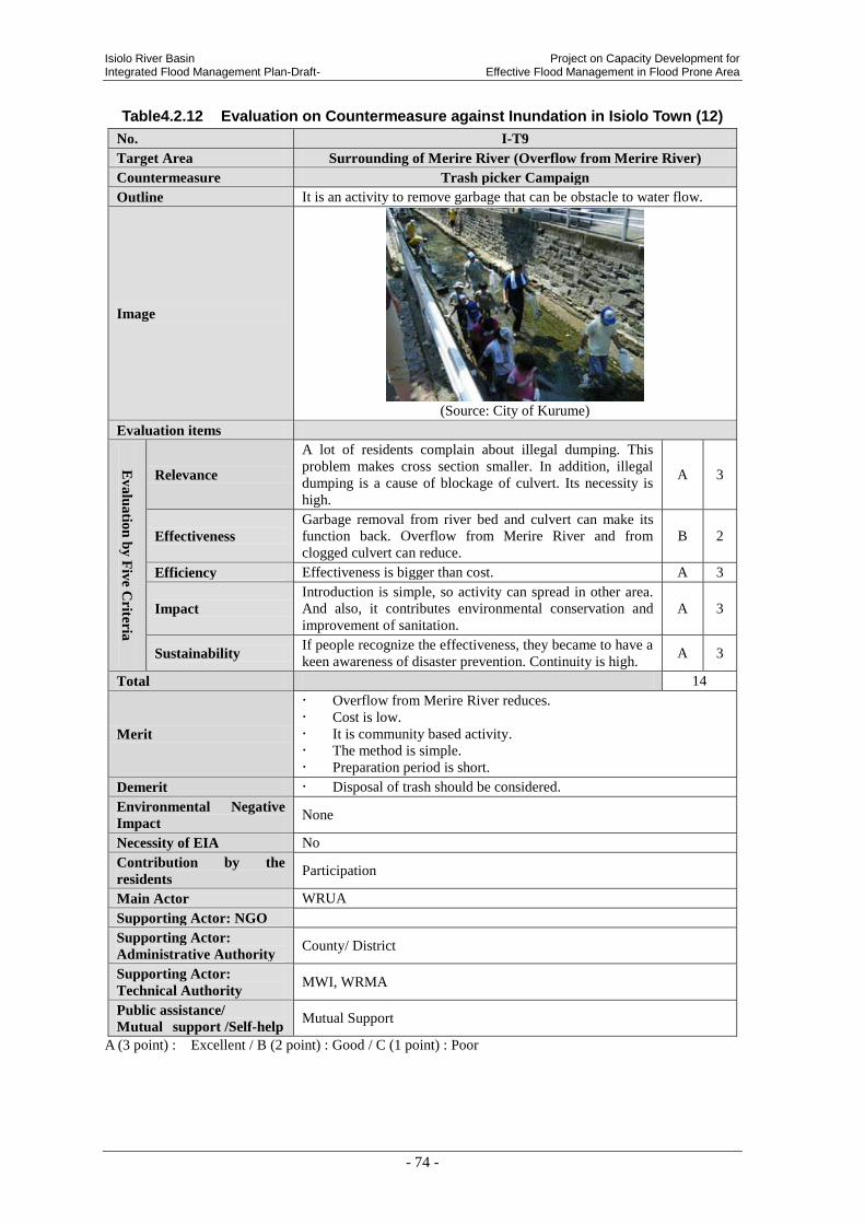
Isiolo River Basin Project on Capacity Development for Integrated Flood Management Plan-Draft- Effective Flood Management in Flood Prone Area
- 74 -
Table4.2.12 Evaluation on Countermeasure against Inundation in Isiolo Town (12)
No. I-T9
Target Area Surrounding of Merire River (Overflow from Merire River)
Countermeasure Trash picker Campaign
Outline It is an activity to remove garbage that can be obstacle to water flow.
Image
(Source: City of Kurume)
Evaluation items
Ev
alu
atio
n b
y F
ive C
riteria
Relevance
A lot of residents complain about illegal dumping. This
problem makes cross section smaller. In addition, illegal
dumping is a cause of blockage of culvert. Its necessity is
high.
A 3
Effectiveness
Garbage removal from river bed and culvert can make its
function back. Overflow from Merire River and from
clogged culvert can reduce.
B 2
Efficiency Effectiveness is bigger than cost. A 3
Impact
Introduction is simple, so activity can spread in other area.
And also, it contributes environmental conservation and
improvement of sanitation.
A 3
Sustainability If people recognize the effectiveness, they became to have a
keen awareness of disaster prevention. Continuity is high. A 3
Total 14
Merit
Overflow from Merire River reduces.
Cost is low.
It is community based activity.
The method is simple.
Preparation period is short.
Demerit Disposal of trash should be considered.
Environmental Negative
Impact None
Necessity of EIA No
Contribution by the
residents Participation
Main Actor WRUA
Supporting Actor: NGO
Supporting Actor:
Administrative Authority County/ District
Supporting Actor:
Technical Authority MWI, WRMA
Public assistance/
Mutual support /Self-help Mutual Support
A (3 point) : Excellent / B (2 point) : Good / C (1 point) : Poor
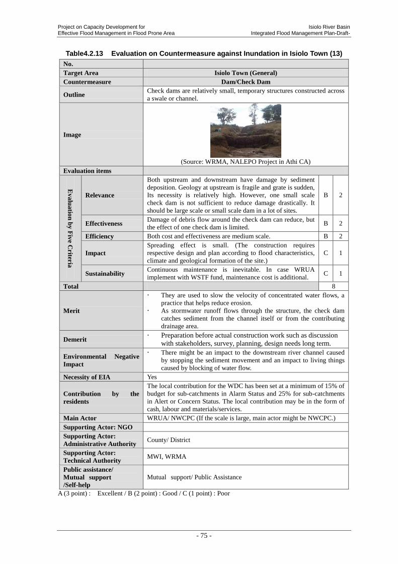
Project on Capacity Development for Isiolo River Basin Effective Flood Management in Flood Prone Area Integrated Flood Management Plan-Draft-
- 75 -
Table4.2.13 Evaluation on Countermeasure against Inundation in Isiolo Town (13)
No.
Target Area Isiolo Town (General)
Countermeasure Dam/Check Dam
Outline Check dams are relatively small, temporary structures constructed across
a swale or channel.
Image
(Source: WRMA, NALEPO Project in Athi CA)
Evaluation items
Ev
alu
atio
n b
y F
ive C
riteria
Relevance
Both upstream and downstream have damage by sediment
deposition. Geology at upstream is fragile and grate is sudden,
Its necessity is relatively high. However, one small scale
check dam is not sufficient to reduce damage drastically. It
should be large scale or small scale dam in a lot of sites.
B 2
Effectiveness Damage of debris flow around the check dam can reduce, but
the effect of one check dam is limited. B 2
Efficiency Both cost and effectiveness are medium scale. B 2
Impact
Spreading effect is small. (The construction requires
respective design and plan according to flood characteristics,
climate and geological formation of the site.)
C 1
Sustainability Continuous maintenance is inevitable. In case WRUA
implement with WSTF fund, maintenance cost is additional. C 1
Total 8
Merit
They are used to slow the velocity of concentrated water flows, a
practice that helps reduce erosion.
As stormwater runoff flows through the structure, the check dam
catches sediment from the channel itself or from the contributing
drainage area.
Demerit Preparation before actual construction work such as discussion
with stakeholders, survey, planning, design needs long term.
Environmental Negative
Impact
There might be an impact to the downstream river channel caused
by stopping the sediment movement and an impact to living things
caused by blocking of water flow.
Necessity of EIA Yes
Contribution by the
residents
The local contribution for the WDC has been set at a minimum of 15% of
budget for sub-catchments in Alarm Status and 25% for sub-catchments
in Alert or Concern Status. The local contribution may be in the form of
cash, labour and materials/services.
Main Actor WRUA/ NWCPC (If the scale is large, main actor might be NWCPC.)
Supporting Actor: NGO
Supporting Actor:
Administrative Authority County/ District
Supporting Actor:
Technical Authority MWI, WRMA
Public assistance/
Mutual support
/Self-help
Mutual support/ Public Assistance
A (3 point) : Excellent / B (2 point) : Good / C (1 point) : Poor

Isiolo River Basin Project on Capacity Development for Integrated Flood Management Plan-Draft- Effective Flood Management in Flood Prone Area
- 76 -
Table4.2.14 Evaluation on Countermeasure against Inundation in Isiolo Town (14)
No. I-T10
Target Area Mountainside/Airport area (Inland Water)
Countermeasure Drainage channel
Outline It is a structure to gather rain water and flow toward adequate and secure
direction.
Image
Evaluation items
Ev
alu
atio
n b
y F
ive C
riteria
Relevance
Flood damage in Isiolo Town is extensive. Local government
has a strong request. This is a countermeasure for inland water
from airport area that is one of 3 biggest factors of flood
damage in Isiolo Town. Necessity is high.
A 3
Effectiveness When the problem of rain water flow from airport area is
resolved, inundation in Isiolo Town reduces. A 3
Efficiency Cost is medium scale, but drastic improvement is expected. A 3
Impact
Spreading effect is small. (The construction requires respective
design and plan according to flood characteristics, climate and
geological formation of the site.)
C 1
Sustainability Maintenance cost is not so expensive. Maintenance system
should be established. B 2
Total 12
Merit Flow volume from airport area is drastically reduced.
Demerit Cost is high.
Planning, design and construction take long time.
Environmental
Negative Impact
Excavation of land is necessary.
Heavy machinery is required for construction.
Necessity of EIA Yes
Contribution by the
residents
The local contribution for the WDC has been set at a minimum of 15% of
budget for sub-catchments in Alarm Status and 25% for sub-catchments in
Alert or Concern Status. The local contribution may be in the form of cash,
labour and materials/services.
Main Actor WRUA/ County/ District
Supporting Actor:
NGO
Supporting Actor:
Administrative
Authority
KeRRA
Supporting Actor:
Technical Authority MWI, WRMA
Public assistance/
Mutual support
/Self-help
Mutural Support/ Public Assistance
A (3 point) : Excellent / B (2 point) : Good / C (1 point) : Poor

Project on Capacity Development for Isiolo River Basin Effective Flood Management in Flood Prone Area Integrated Flood Management Plan-Draft-
- 77 -
Table4.2.15 Evaluation on Countermeasure against Inundation in Isiolo Town (15)
No. I-T11
Target Area Mountainside/Airport area (Inland Water)
Countermeasure Culvert under the road
Outline It is a structure to flow rain water safely.
Image
Evaluation items
Ev
alu
atio
n b
y F
ive C
riteria
Relevance
Flood damage in Isiolo Town is extensive. Local government
has a strong request. This is a countermeasure for inland water
from airport area that is one of 3 biggest factors of flood
damage in Isiolo Town. Necessity is high.
A 3
Effectiveness When the problem of rain water flow from airport area is
resolved, inundation in Isiolo Town reduces. A 3
Efficiency Both cost and effectiveness are medium scale. B 2
Impact
Spreading effect is small. (The construction requires
respective design and plan according to flood characteristics,
climate and geological formation of the site.)
C 1
Sustainability Maintenance cost is not so expensive. Maintenance system
should be established. B 2
Total 11
Merit Flow volume from airport area is drastically reduced.
Demerit
Cost is high.
Planning, design and construction take long time.
Coordination with stakeholders could be difficult.
Environmental Negative
Impact
The candidate site is boundary between Isiolo town and Meru town.
Coordination with them can take long time.
Excavation of land is necessary.
Heavy machinery is required for construction.
Necessity of EIA Yes (It depends on the scale of the construction work.)
Contribution by the
residents
None. But, the maintenance can be supported by the residents.
Main Actor KeRRA (Kenya Rural Road Authority)
Supporting Actor: NGO
Supporting Actor:
Administrative
Authority
County/ District
Supporting Actor:
Technical Authority MWI, WRMA
Public assistance/
Mutual support
/Self-help
Public Assistance
A (3 point) : Excellent / B (2 point) : Good / C (1 point) : Poor
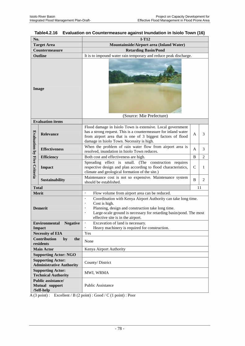
Isiolo River Basin Project on Capacity Development for Integrated Flood Management Plan-Draft- Effective Flood Management in Flood Prone Area
- 78 -
Table4.2.16 Evaluation on Countermeasure against Inundation in Isiolo Town (16)
No. I-T12
Target Area Mountainside/Airport area (Inland Water)
Countermeasure Retarding Basin/Pond
Outline It is to impound water rain temporary and reduce peak discharge.
Image
(Source: Mie Prefecture)
Evaluation items
Ev
alu
atio
n b
y F
ive C
riteria
Relevance
Flood damage in Isiolo Town is extensive. Local government
has a strong request. This is a countermeasure for inland water
from airport area that is one of 3 biggest factors of flood
damage in Isiolo Town. Necessity is high.
A 3
Effectiveness When the problem of rain water flow from airport area is
resolved, inundation in Isiolo Town reduces. A 3
Efficiency Both cost and effectiveness are high. B 2
Impact
Spreading effect is small. (The construction requires
respective design and plan according to flood characteristics,
climate and geological formation of the site.)
C 1
Sustainability Maintenance cost is not so expensive. Maintenance system
should be established. B 2
Total 11
Merit Flow volume from airport area can be reduced.
Demerit
Coordination with Kenya Airport Authority can take long time.
Cost is high.
Planning, design and construction take long time.
Large-scale ground is necessary for retarding basin/pond. The most
effective site is in the airport.
Environmental Negative
Impact
Excavation of land is necessary.
Heavy machinery is required for construction.
Necessity of EIA Yes
Contribution by the
residents None
Main Actor Kenya Airport Authority
Supporting Actor: NGO
Supporting Actor:
Administrative Authority County/ District
Supporting Actor:
Technical Authority MWI, WRMA
Public assistance/
Mutual support
/Self-help
Public Assistance
A (3 point) : Excellent / B (2 point) : Good / C (1 point) : Poor

Project on Capacity Development for Isiolo River Basin Effective Flood Management in Flood Prone Area Integrated Flood Management Plan-Draft-
- 79 -
Table4.2.17 Evaluation on Countermeasure against Inundation in Isiolo Town (17)
No.
Target Area Isiolo Town (General)
Countermeasure Contingency Plan
Outline
Contingency planning aims to prepare an organization to respond well
to an emergency and its potential humanitarian impact. Developing a
contingency plan involves making decisions in advance about the
management of human and financial resources, coordination and
communications procedures, and being aware of a range of technical
and logistical responses.(Source: Contingency Planning Guide 2012, International Federation of Red Cross and Red Crescent Societies,
2012)
Image
Evaluation items
Ev
alu
atio
n b
y F
ive C
riteria
Relevance
Currently, preparadness to mitigate the flood disaster
damage is is not sufficient. Therefore, post flood disaster
management including contingency plan is required by
the County Government and residents.
A 3
Effectiveness
Effective contingency planning should lead to timely and
effective disaster-relief operations. Therefore, degree of
damage mitigation shall be high.
A 3
Efficiency Cost of contingency planning is low. Therefore,
efficiency is high. A 3
Impact It is easy to spread and promote the same method.
Therefore, the secondary impact is high. A 3
Sustainability County Government has the responsibilty of formulation
of contingency plan. Therefore, sustainability is high. A 3
Total 15
Merit
Contingency planning is a management tool, involving all
sectors, which can help ensure timely and effective provision of
humanitarian aid to those most in need when a disaster occurs.
Demerit It needs certain period to develop the contingency plan.
Environmental Negative
Impact None
Necessity of EIA No
Contribution by the
residents Provision of information to the County Government
Responsible
Institution/Agency County Government
Main Actor County/ District
Supporting Actor: NGO KRCS/ World Vision
Supporting Actor:
Administrative Authority Ministry of State for Special Programmes
Supporting Actor: Technical
Authority MWI, WRMA
Public assistance/
Mutual support /Self-help Publich assistance
A (3 point) : Excellent / B (2 point) : Good / C (1 point) : Poor

Isiolo River Basin Project on Capacity Development for Integrated Flood Management Plan-Draft- Effective Flood Management in Flood Prone Area
- 80 -
Table4.2.18 Evaluation on Countermeasure against Inundation in Isiolo Town (18)
No.
Target Area Isiolo Town (General)
Countermeasure Reconstruction and Recovery including Funds
Outline
A process of long-term reconstruction and economic recovery should
begin while post-emergency actions aimed at restoring normality for
the displaced populations returning home or settling in new places are
being undertaken.
Image
Evaluation items
Ev
alu
atio
n b
y F
ive C
riteria
Relevance People affected by floods require the assistance of
reconstruction and recovery process. A 3
Effectiveness Number of beneficiary depends on the amount of the
fund. B 2
Efficiency If fund will be large, the cost also becomes large.
Therefore, efficiency is medium. B 2
Impact
Spreading the fund depends on the amount of the budget
of County Government or National Government.
Therefore, impact is medium.
B 2
Sustainability
Sustainability depends on the continuous budget of
County Government or National Government. Therefore,
sustainability is medium.
B 2
Total 11
Merit Recovery and reconstruction from flood disaster damage might be
enhanced.
Demerit There is a need of county governmental or national governmental
budget for the fund.
Environmental Negative
Impact None
Necessity of EIA No
Contribution by the
residents None.
Main Actor County/ District
Supporting Actor: NGO KRCS
Supporting Actor:
Administrative Authority Ministry of State for Special Programmes
Supporting Actor: Technical
Authority MWI, WRMA
Public assistance/
Mutual support /Self-help Public Assistance
A (3 point) : Excellent / B (2 point) : Good / C (1 point) : Poor
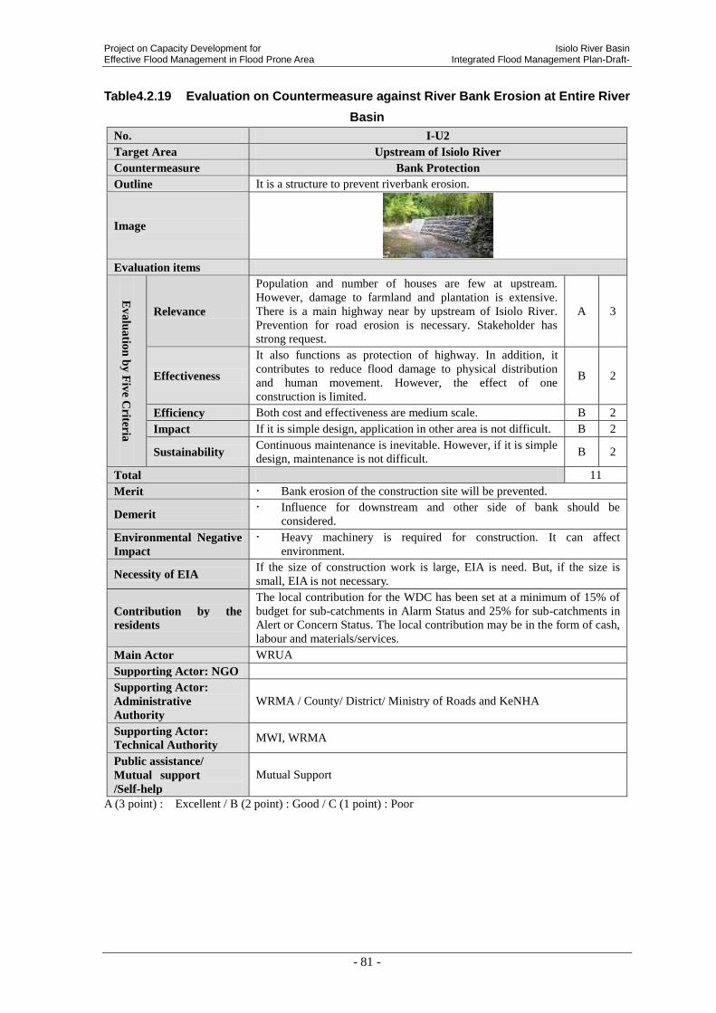
Project on Capacity Development for Isiolo River Basin Effective Flood Management in Flood Prone Area Integrated Flood Management Plan-Draft-
- 81 -
Table4.2.19 Evaluation on Countermeasure against River Bank Erosion at Entire River
Basin
No. I-U2
Target Area Upstream of Isiolo River
Countermeasure Bank Protection
Outline It is a structure to prevent riverbank erosion.
Image
Evaluation items
Ev
alu
atio
n b
y F
ive C
riteria
Relevance
Population and number of houses are few at upstream.
However, damage to farmland and plantation is extensive.
There is a main highway near by upstream of Isiolo River.
Prevention for road erosion is necessary. Stakeholder has
strong request.
A 3
Effectiveness
It also functions as protection of highway. In addition, it
contributes to reduce flood damage to physical distribution
and human movement. However, the effect of one
construction is limited.
B 2
Efficiency Both cost and effectiveness are medium scale. B 2
Impact If it is simple design, application in other area is not difficult. B 2
Sustainability Continuous maintenance is inevitable. However, if it is simple
design, maintenance is not difficult. B 2
Total 11
Merit Bank erosion of the construction site will be prevented.
Demerit Influence for downstream and other side of bank should be
considered.
Environmental Negative
Impact
Heavy machinery is required for construction. It can affect
environment.
Necessity of EIA If the size of construction work is large, EIA is need. But, if the size is
small, EIA is not necessary.
Contribution by the
residents
The local contribution for the WDC has been set at a minimum of 15% of
budget for sub-catchments in Alarm Status and 25% for sub-catchments in
Alert or Concern Status. The local contribution may be in the form of cash,
labour and materials/services.
Main Actor WRUA
Supporting Actor: NGO
Supporting Actor:
Administrative
Authority
WRMA / County/ District/ Ministry of Roads and KeNHA
Supporting Actor:
Technical Authority MWI, WRMA
Public assistance/
Mutual support
/Self-help
Mutual Support
A (3 point) : Excellent / B (2 point) : Good / C (1 point) : Poor
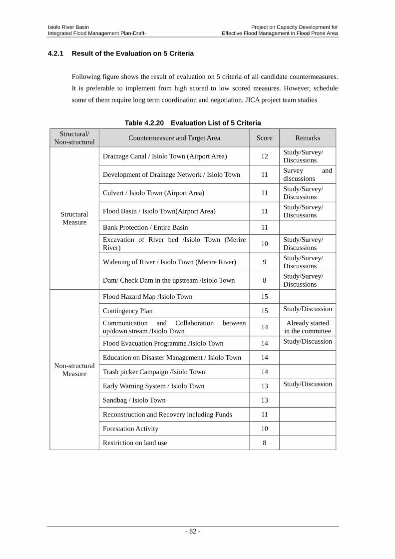
Isiolo River Basin Project on Capacity Development for Integrated Flood Management Plan-Draft- Effective Flood Management in Flood Prone Area
- 82 -
4.2.1 Result of the Evaluation on 5 Criteria
Following figure shows the result of evaluation on 5 criteria of all candidate countermeasures.
It is preferable to implement from high scored to low scored measures. However, schedule
some of them require long term coordination and negotiation. JICA project team studies
Table 4.2.20 Evaluation List of 5 Criteria
Structural/
Non-structural Countermeasure and Target Area Score Remarks
Structural
Measure
Drainage Canal / Isiolo Town (Airport Area) 12 Study/Survey/
Discussions
Development of Drainage Network / Isiolo Town 11 Survey and
discussions
Culvert / Isiolo Town (Airport Area) 11 Study/Survey/
Discussions
Flood Basin / Isiolo Town(Airport Area) 11 Study/Survey/
Discussions
Bank Protection / Entire Basin 11
Excavation of River bed /Isiolo Town (Merire
River) 10
Study/Survey/
Discussions
Widening of River / Isiolo Town (Merire River) 9 Study/Survey/
Discussions
Dam/ Check Dam in the upstream /Isiolo Town 8 Study/Survey/
Discussions
Non-structural
Measure
Flood Hazard Map /Isiolo Town 15
Contingency Plan 15 Study/Discussion
Communication and Collaboration between
up/down stream /Isiolo Town 14
Already started
in the committee
Flood Evacuation Programme /Isiolo Town 14 Study/Discussion
Education on Disaster Management / Isiolo Town 14
Trash picker Campaign /Isiolo Town 14
Early Warning System / Isiolo Town 13 Study/Discussion
Sandbag / Isiolo Town 13
Reconstruction and Recovery including Funds 11
Forestation Activity 10
Restriction on land use 8

Project on Capacity Development for Isiolo River Basin Effective Flood Management in Flood Prone Area Integrated Flood Management Plan-Draft-
- 83 -
5. PROJECT IMPLEMENTATION PLAN OF FLOOD COUNTERMEAURES
5.1 FLOOD COUNTERMEASRES IN THE FLOOD MANAGEMENT PLAN
The Flood Management Plan defines the most prioritized flood event as inundation in urban
area of Isiolo Town and the second as bank erosion at places where affects traffic facilities.
Among those countermeasures, WRUA scale project should be incorporated in the SCMP.
(1) Structural Countermeasures
Structural countermeasures should be implemented as following order.
Study, survey and discussion on drainage network in urban area of Isiolo Town
Study, survey and discussion on countermeasures against water inflow from airport area
(drainage channel, culvert, flood basin and etc.)
Bank protection at the transportation and farmland affetected area
Study, survey and discussion on improvement of Merire River (excavation of river bed and
widening of river)
Study, survey and discussion on dam/check dam in the upstream of Merire River
(2) Non-structural Countermeasures
Non-structural countermeasures should be implemented as following order.
Flood hazard map
Contingency Plan
Communication and collaboration between up/down stream
Education on disaster management
Trash picker Campaign at Merire River
Early warning system
Sandbag
Reconstruction and Recovery including Funds
Forestation activity
Restriction on land use
5.2 DRAFT IMPLEMENTETION SCHEDULE OF FLOOD COUNTERMESUREAS
JICA project team proposes draft implementation schedule of flood countermeasures as the
following page.
In this schedule, actors are defined as follows:

Isiolo River Basin Project on Capacity Development for Integrated Flood Management Plan-Draft- Effective Flood Management in Flood Prone Area
- 84 -
Main actor: A group or organization to implement the measures in practice. However, there
may be multiple choices depending on the size of the measures.
Supporting Actor
NGO: NGO to support the main actor to implement the measures
Administrative Authority: A government agency to support or to provide an approval for
implementation of the measures
Technical Authority: A government agency to support for implementation of the measures
technically

Project on C
apacity Developm
ent for Isiolo R
iver Basin
Effective Flood M
anagement in Flood P
rone Area
Integrated Flood Managem
ent Plan-D
raft-
- 85 -
River (widening, etc)

Isiolo River Basin Project on Capacity Development for Integrated Flood Management Plan-Draft- Effective Flood Management in Flood Prone Area
- 86 -
6. RECOMMENDATION
Observation data of rainfall and flow discharge that is utilized for detail design of works is lacking.
WRMA should observe rainfall and flow discharge data steadily. In addition, they should improve
the accuracy and accelerate accumulation.
Countermeasures against inundation of whole urban area of Isiolo Town (inland water) and flood
from Merire River (river water) should be considered from long term perspective.
Appendix 3-3
Lumi River Basin Integrated Flood Management Plan
As of 4 August 2013
REPUBLIC OF KENYA PROJECT ON CAPACITY DEVELOPMENT
FOR EFFECTIVE FLOOD MANAGEMENT IN FLOOD PRONE AREA
LUMI RIVER BASIN INTEGRATED FLOOD MANAGEMENT PLAN
- DRAFT -
August 2013
Project on Capacity Development for Lumi River Basin Effective Flood Management in Flood Prone Area Integrated Flood Management Plan-Draft-
- i -
Republic of Kenya Project on Capacity Development for Effective Flood Management in Flood Prone Area
Lumi River Basin Integrated Flood Management Plan
- Draft -
Table of Contents
1. Polycy of River Basin Flood Mmanagement Plan (Draft) .............................................. 1
1.1 Policy of Flood Management in the Relevant River Basin (Draft) ........................................1
1.2 The Role and Responsibility of WRMA ................................................................................2
1.3 River Basin Committee ..........................................................................................................2
1.4 Environmental and Social Considerations..............................................................................3
2. Outline of Lumi River Basin ............................................................................................. 5
2.1 Natural Conditions .................................................................................................................6 2.1.1 Topography and Soil .................................................................................................6 2.1.2 Vegetation and Land Use ..........................................................................................9 2.1.3 Hydrology and Meteorology ...................................................................................10
2.2 Socio-economic Conditions .................................................................................................17 2.2.1 Administration ........................................................................................................17 2.2.2 Population ...............................................................................................................20 2.2.3 Industry ...................................................................................................................21
2.3 Development Plan ................................................................................................................23 2.3.1 Vision 2030 .............................................................................................................23 2.3.2 Taveta District Development Plan (2008-2012) .....................................................23 2.3.3 Athi Water Catchment Area Catchment Management Strategy (2009) ..................24
3. Analysis of Flood Characteristics ................................................................................. 25
3.1 Overall Condition on Floods in the Lumi River Basin .........................................................25 3.1.1 Records of Flood Damages .....................................................................................25 3.1.2 Flood Condition Inquiring From Relevant Communities .......................................27 3.1.3 Existing Structures along the River ........................................................................31
3.2 Flood Characteristics and Situation of Damages in the Lumi River Basin ..........................34 3.2.1 Concept of Flood Characteristics and Situation of Damages in the Lumi River
Basin .......................................................................................................................34 3.2.2 Soil and sediment run off in upstream and middle stream (A) ...............................36 3.2.3 Flood Characteristics of Low-lying Area in the Lower Lumi River Basin (B) ......38 3.2.4 Flashflood in Tributary stream of downstream area(C) ..........................................40
3.3 Analysis on Flood Damage and Countermeasure ................................................................43 3.3.1 Analysis on Flood Damage and Countermeasure for Earth and Soil Flown Out
Area in the Upstream of Lumi River Basin ............................................................43 3.3.2 Analysis on Flood Damage and Countermeasure in the Long-term Inundated Area
of the Downstream of Lumi River ..........................................................................46 3.3.3 Tributary Area in the Downstream of Lumi River ..................................................49 3.3.4 Longlist/candidates of Countermeasures to the Flood ............................................55
3.4 Selection of Flood Damage to be Prevent Preferentially .....................................................55
Lumi River Basin Project on Capacity Development for Integrated Flood Management Plan -Draft- Effective Flood Management in Flood Prone Area
- ii -
3.4.1 The Result of Workshop for Flood Damage Analysis by Community ................... 55 3.4.2 Selection of Flood Damage to be prioritized ......................................................... 56
4. EVALUATION OF COUNTERMEASURES TO THE FLOOD .......................................... 59
4.1 View Point of Evaluation ..................................................................................................... 59
4.2 Evaluation RESULT FOR EACH COUNTERMEASURE ................................................. 60 4.2.1 Result of the Evaluation on 5 Criteria .................................................................... 80
5. Project Implementation Plan of Flood Countermaures ............................................... 81
5.1 Flood Countermeasures in the Flood Management Plan ..................................................... 81 5.1.1 Structural Countermeasures ................................................................................... 81 5.1.2 Non-structural Countermeasures ............................................................................ 81
5.2 Draft Implementation Schedule of Flood Countermeasures ................................................ 81
6. Recommendation ............................................................................................................ 83
Project on Capacity Development for Lumi River Basin Effective Flood Management in Flood Prone Area Integrated Flood Management Plan -Draft-
- 1 -
1. POLYCY OF RIVER BASIN FLOOD MMANAGEMENT PLAN (DRAFT)
1.1 POLICY OF FLOOD MANAGEMENT IN THE RELEVANT RIVER BASIN (DRAFT)
The source of Lumi River is the eastern slope of Mt. Kilimanjaro, and 1/4 of river basin size
belongs to Tanzania territory. The Lumi River flows down toward south east and Kenyan
territory, then flows down to south and flows into Lake Jipe. Thus the Lumi river is an
international river.
Around uppermost stream area in this basin, the slope is steep. On the other hand, around most
downstream area, the topographic slope is pretty gentle, and then low level ground spreads out
as flood plain.
The biggest town in this river basin is “Taveta”. In this river basin, the main industries are
agricultural producing such as Maize, Rice and fruits like Bananas, plantation of sisal hemp,
livestock farming, fishery at lakes such as Jipe and tourism around Tsavo West national park.
The Lumi river basin is belonging to the jurisdiction of WRMA Nolturesh-Lumi Sub Regional
Office (SRO) concerning the general water resource management inclusive flood management.
In addition, 2 WRUAs such as “Upper Lumi WRUA” and “Lower Lumi WRUA” are
established in the Lumi river basin, and both WRUAs implement grass-roots water
management in corroboration with WRMA.
Principal flood damages are destruction of houses, enforcement of long term evacuation,
agricultural product including livestock loss, contamination of water resource by polluted
water diffusion, growing worse sanitary conditions and muddy road condition etc.
The reason why the floods occurred are long term inundation depending on overflow from the
Lumi river downstream or dyke break by reaching storm water from the heavy rain in Mt.
Kilimanjaro mountainside of upstream area.
On the other hand, destruction of roads or bridges and loss of livestock have been occurred by
the effect of flash flood in the tributaries or small channel of the Lumi river. The measures
against floods will be important because the number of affected people by long term
inundation for 2 months was large more than 2,000 every year.
However it is difficult to start training of the Lumi river in this period under the circumstance
of undeveloped various supporting data.
Therefore the important point of the flood management policy in relevant river basin shall be
mitigation of influence to resident daily life by long term inundation and distribution and
enlightenment schemes to make it faster in life recovery from flood damage.
In the course of drawing up the flood management plan, the appropriate combination of
structural and non-structural measures or the view point of “Self-help”, “Mutual support” and
“Public assistance” should be considered. And also consensus building among the stakeholders

Lumi River Basin Project on Capacity Development for Integrated Flood Management Plan -Draft- Effective Flood Management in Flood Prone Area
- 2 -
through the participation of WRUA or communities should be implemented.
WRUA and communities implement the distribution, evolution, maintenance of structural
measures and non-structural measures with initiative.
WRUA and communities shall work together from the period of project planning so that
incubate their ownership
The scoping period of this plan is 5 years from 2013 to 2018, the contents of plan will be
revised properly in necessity.
1.2 THE ROLE AND RESPONSIBILITY OF WRMA
Main actor of this plan is WRMA. WRMA should assist WRUA to make it can build realizable
tasks in to the Sub-Catchment Management Plan (SCMP) by itself. In addition, WRMA
provide the technical assistance to implement the countermeasures against flooding matters.
Concerning the tasks that WRUA has no initiative, WRMA shall precede the implementation
of tasks while coordinating it with relevant stakeholders.
1.3 RIVER BASIN COMMITTEE
Flood management cannot achieve the objectives without the cooperation with various
stakeholders in the river basin.
Some river basins are divided by plural sub catchment such as upper stream, lower stream, left
bank and right bank.
According to this condition, WRMA shall establish “Integrated Flood Management River
Basin Committee” in order to share the information concerning flood management and
coordinate in river basin unit.
The stakeholders in the relevant river basin preferable to be participated in the committee are
listed below.

Project on Capacity Development for Lumi River Basin Effective Flood Management in Flood Prone Area Integrated Flood Management Plan -Draft-
- 3 -
Table 1.3.1 The Stakeholders in Lumi River Basin (as of February 2013)
No Organization Remarks
1 Lower Lumi WRUA
2 Upper Lumi WRUA
3 Provincial Administration Taveta District Commissioner
4 Ministry of Devolution/ State for Special Programmes Active in providing humanitarian assistance to
disaster victims
5 Kenya National Highways Authority/Kenya Rural Roads
Authority – Representative One representative
6 Ministry of Water and Irrigation Irrigation Department representative
7 Ministry of Lands District Physical planner
8 Ministry of Agriculture District Agricultural Officer
9 Ministry of Livestock District Livestock Officer
10 Ministry Of Education District Education Officer
11 Kenya Meteorological Department Contact Person at National Level
12 National Environmental Management Authority (NEMA) District Officer
13 Taita Taveta County Government One representative
14 Kenya Red Cross Society Representative from Regional Office
15 World Vision Representative from Regional Office
16 Religious Group One each from Christian and Muslim
17 Kenya Forest Service
18 Department of Social Services Registers WRUAs and other social welfare groups
19 Kenya National Chamber of Commerce and Industry
20 National Water Conservation and Pipeline Corporation
(NWCPC)
21 WRMA HQ, RO, SRO
In the committee, exchanging of opinions between the relevant stakeholders, approval of flood
management plan, consensus building, discussion of role sharing and activity evaluation etc.
shall be done.Committee members shall be discussing about the following themes once in
every some months for the time being.
Table 1.3.2 The Schedule of Integrated Flood Management Committee Meeting (Draft)
Discussion Themes Remarks
1st
Meeting
Information sharing on current situation and problems in flooding
Discussion on conceivable flood measures
Already done in
Feb. 22nd
, 2013
2nd
Meeting
Suggestion of flood management plan(draft)
Discussion on flood management plan(draft)
Consensus building on pilot project(This project only)
3rd
Meeting
Discussion on flood management plan(draft)
Progress reporting of pilot project(This project only)
4th
Meeting
Evaluation of pilot project(This project only)
1.4 ENVIRONMENTAL AND SOCIAL CONSIDERATIONS
On planning the flood measures project, the appropriate environmental and social
consideration shall be done based on Kenyan regal code “Environmental Management and

Lumi River Basin Project on Capacity Development for Integrated Flood Management Plan -Draft- Effective Flood Management in Flood Prone Area
- 4 -
Coordination Act (EMCA) 1999”.
Project on Capacity Development for Lumi River Basin Effective Flood Management in Flood Prone Area Integrated Flood Management Plan -Draft-
- 5 -
2. OUTLINE OF LUMI RIVER BASIN
Lumi River Basin is within the border of Kenya and Tanzania in the southern part of the Republic of
Kenya and it is located in the south-east part of Mt. Kilimanjaro.
Location of Lumi River Basin
Upstream
Downstream

Lumi River Basin Project on Capacity Development for Integrated Flood Management Plan -Draft- Effective Flood Management in Flood Prone Area
- 6 -
2.1 NATURAL CONDITIONS
2.1.1 Topography and Soil
(1) Topography
Catchment area of Lumi River is about 590km2 (of which 75% of the area is in Kenya), and
the total length of the river is approximately 71km flowing from north to south. The width of
the river is about 20km (east to west) in the widest place. Lumi River originates from Mt.
Kilimanjaro and it flows towards south direction via Taveta District in the easten part of Kenya.
Then, Lumi River flows into Lake Jipe and again flows into Luvu River within the territory of
Tanzania. There are many springs within the river basin and the water flows into Lumi River
from those springs. Major springs are Kiboboto spring, Madala spring, Njoro spring and
Sambekispring1.
Source:WRMA, Action Plan on The Development and Implementation of a Flood Management Plan for Lumi River
Figure 2.1.1 Elevation Distribution of Lumi River Basin
1 NWCPC, Study on Causes and Effects of Floods in Nyanza and Western provinces Tana basin and Taita Taveta
District, Draft study Report (May 2006)

Project on Capacity Development for Lumi River Basin Effective Flood Management in Flood Prone Area Integrated Flood Management Plan -Draft-
- 7 -
In the Lumi River Basin, the elevation of the upstream area within the border in Tanzania
varies approximately from 4,500m to 1,000m, especially in the area colored in green to
greenish yellow, the river stream shows a steep slope topography. After flowing into the
Kenyan territory, the elevation of middle stream varies from 1,000m to 750m. In the
downstream, the river flows into Lake Jipe at the elevation of 750m. It is known from the
spread of the river basin that the topography of these areas seems to be generally flat.
Prepared by JICA Project Team based on 1/50,000 Topo Map
Figure 2.1.2 Cross Section of River Stream
Photo 2.1.1 Mt. Kilimanjaro
Photo 2.1.2 Lake Challa Photo 2.1.3 Lake Jipe
0500
1,0001,5002,0002,5003,0003,5004,0004,5005,000
0 20,000 40,000 60,000 80,000 100,000
Ele
vati
on
(EL.
m)
Distance(m)
Longitudinal Profile of the Lumi River Lumi river
BorderTaveta Lake ChalaLake Jipe Mt. Kilimanjaro
1/150 - 1/70 1/30 - 1/201/400 - 1/2001/1000 - 1/500
Lumi River Basin Project on Capacity Development for Integrated Flood Management Plan -Draft- Effective Flood Management in Flood Prone Area
- 8 -
(2) Soil
Soil Distribution Map of the Lumi River Basin is as per Figure 2.1.3 soil covers all through the
river basin, and sandy soil is distributed around the inflow areas of Lake Jipe and Luvu River.
Source: Prepared by JICA Project Team based on Kenya Soil Survey (KSS) in 1982 and revised in 1997.
Figure 2.1.3 Soil Distribution Map(Soil texture)
Besides, according to the NWCPC report, description of the situation is different, The flood of
Lumi River Basin is reported to be caused by the clayey sediment and silt deposited in the
course of transportation of earth and sand by flowing water. Mountainous and hilly areas are
covered with moderately thick and breakable clayey loam and the land is fertile and well
drained. Therefore, the area is suitable for agriculture. In the inclined or low land, soil is
composed of sandy and clayey soil. However, these areas are also suitable for agriculture.
Floodplain is wetland of clayey soil containing sodium and natrium.
Clayey
Sandy

Project on Capacity Development for Lumi River Basin Effective Flood Management in Flood Prone Area Integrated Flood Management Plan -Draft-
- 9 -
2.1.2 Vegetation and Land Use
Land use characteristic in Lumi River Basin is shown in Figure 2.1.4. As shown in Figure 2.1.4,
the river basin is generally utilized as agricultural land and cattle camp. In the vicinity of left
bank of middle stream of Lumi River and at the east-south side of Taveta Town, sisal is grown.
Low land nearby Lake Jipe is a wetland.
Judging from Figure 2.1.5 satellite Image, there is few vegetation area confirmed in the middle
stream and west side, and it is understood that these areas are clayey soil exposed land.
Therefore, it is inferred that the flowing out of earth and sand are caused by rainfall.
Source:WRMA
Figure 2.1.4 Land Use in Lumi River Basin
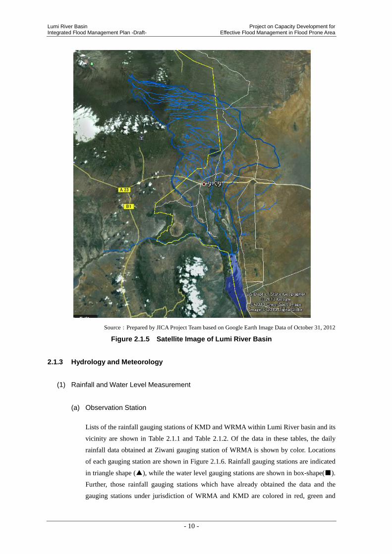
Lumi River Basin Project on Capacity Development for Integrated Flood Management Plan -Draft- Effective Flood Management in Flood Prone Area
- 10 -
Source:Prepared by JICA Project Team based on Google Earth Image Data of October 31, 2012
Figure 2.1.5 Satellite Image of Lumi River Basin
2.1.3 Hydrology and Meteorology
(1) Rainfall and Water Level Measurement
(a) Observation Station
Lists of the rainfall gauging stations of KMD and WRMA within Lumi River basin and its
vicinity are shown in Table 2.1.1 and Table 2.1.2. Of the data in these tables, the daily
rainfall data obtained at Ziwani gauging station of WRMA is shown by color. Locations
of each gauging station are shown in Figure 2.1.6. Rainfall gauging stations are indicated
in triangle shape (▲), while the water level gauging stations are shown in box-shape(■).
Further, those rainfall gauging stations which have already obtained the data and the
gauging stations under jurisdiction of WRMA and KMD are colored in red, green and
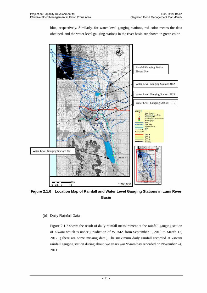
Project on Capacity Development for Lumi River Basin Effective Flood Management in Flood Prone Area Integrated Flood Management Plan -Draft-
- 11 -
blue, respectively. Similarly, for water level gauging stations, red color means the data
obtained, and the water level gauging stations in the river basin are shown in green color.
Figure 2.1.6 Location Map of Rainfall and Water Level Gauging Stations in Lumi River
Basin
(b) Daily Rainfall Data
Figure 2.1.7 shows the result of daily rainfall measurement at the rainfall gauging station
of Ziwani which is under jurisdiction of WRMA from September 1, 2010 to March 12,
2012. (There are some missing data.) The maximum daily rainfall recorded at Ziwani
rainfall gauging station during about two years was 95mm/day recorded on November 24,
2011.
Water Level Gauging Station: 3J12
Water Level Gauging Station: 3J15
Water Level Gauging Station: 3J2
Water Level Gauging Station: 3J16
Rainfall Gauging Station
Ziwani Site

Lumi River Basin Project on Capacity Development for Integrated Flood Management Plan -Draft- Effective Flood Management in Flood Prone Area
- 12 -
Table 2.1.1 List of KMD Rainfall Gauging Station within Lumi River Basin and its Vicinity
Table 2.1.2 List of WRMA Rainfall Gauging Station within Lumi River Basin and its Vicinity
Source:Prepared by JICA Project Team based on the record of daily rainfall from September 1, 2010 to March 12, 2012
(There are some missing data.)
Figure 2.1.7 Daily Rainfall at Ziwani Site
Station Number Station Name Year_Opened Year_Closed
9337000 TAVETA_DISTRICT_OFFICE 1905 1971
9337001 TAVETA_HOMER_BROS_LTD 1926 1945
9337025 TAVETA_SISAL_ESTATE_LTD_ 1938 1963
9337052 AGRICULTURAL_SECTION_TAVETA 1946 1949
9337080 TAVETA_NJORO_KUBWA 1954 1969
9337081 TAVETA_ZIWANI_SISAL_ESTATE 1941 _
9337109 TSAVO_NAT__PARK_MBUYUNI_GATE 1971 _
9337110 TAVETA_WATER_DEVELOPMENT_STATION 1968 _
9337111 TAVETA__LAKE_CHALA 1970 _
9337114 JIPE_SISAL_ESTATE 1971 _
9337137 ZIWANI_GAME_POST 1975 _
9337138 LAKE_JIPE_GAME_S_CAMP 1975 _
9337139 KIMALA_NGUI_S_FARM 1980 _
9337140 KIWALWA_MALARIA_FIELD_STATION 1980 _
9337141 KITOBO_IRRIGATION_SCHEME 1980 _
9337142 CHALA_FARMER_S_CO_OP__SOCIETY 1980 _
9337143 CHUMUINI_CHOKAA_PRI__SCHOOL 1980 _
9337144 NJUKINI_FARMER_S_CO_OP__SOCIETY 1980 _
9337145 TIMBILA_PRIMARY_SCHOOL 1981 _
0
20
40
60
80
100
120
140
Jul-
10
Aug
-10
Sep-
10
Oct-
10
Nov-
10
Dec-
10
Jan
-11
Feb-
11
Mar
-11
Apr
-11
May
-11
Jun-1
1
Jul-
11
Aug
-11
Sep-
11
Oct-
11
Nov-
11
Dec-
11
Jan
-12
Feb-
12
Mar
-12
Apr
-12
Ziwani Daily Rainfall Rainfall [mm/d]
Station Number Station Name Y X AltitudeMeter FullMet_Auto_Manual Daily/Hourly/Both Operational Start_Year End_Year SROinCharge CatchmentArea RiverBasinSubCatchment
KWS_Office -3.398 37.677 Manual Daily Yes__ N_A NL_Loitokitok_ ACA Lumi_Taveta
Zoweni_pri -3.389 37.672 794 Manual Daily Yes__ 2011 N_A NL_Loitokitok_ ACA Lumi_Taveta
Mata_Chiefs_camp -3.474 37.755 748 Manual Daily Yes__ 2008 N_A NL_Loitokitok_ ACA Lumi_Taveta
Challa_chief's_camp -3.296 37.733 911 Manual Daily Yes__ 2008 N_A NL_Loitokitok_ ACA Lumi_Taveta
Kedong_pri -3.351 37.754 851 Manual Daily Yes__ 2009 N_A NL_Loitokitok_ ACA Lumi_Taveta
Njukini_chief's_camp -3.187 37.724 1014 Manual Daily Yes__ 2008 N_A NL_Loitokitok_ ACA Lumi_Taveta
L._Jipe_KWS_Office -3.629 37.776 728 Manual Daily Yes__ 2008 N_A NL_Loitokitok_ ACA Lumi_Taveta
Kitobo -3.437 37.639 739 Manual Daily Yes__ 2008 N_A NL_Loitokitok_ ACA Lumi_Taveta
Kimirigo_chiefs_camp -3.472 37.699 736 Manual Daily Yes__ 2008 N_A NL_Loitokitok_ ACA Lumi_Taveta
Ziwani -3.267 37.762 Manual Daily Yes__ 2010 N_A NL_Loitokitok_ ACA Lumi_Taveta

Project on Capacity Development for Lumi River Basin Effective Flood Management in Flood Prone Area Integrated Flood Management Plan -Draft-
- 13 -
(c) Water Level Observation Data
There are four water level gauging stations within the river basin as shown in the
following table. Water level gauging stations 3J15 and 3J16 are located in the downstream
of Lumi River, and 3J15 is located at the northern part of Taveta Town, while 3J16 is
located at the southern part. The remaining two stations are located at Lake Challa and
Lake Jipe. (Refer to Figure 2.1.6.)
Table 2.1.3 Water Level Gauging Stations in Lumi River Basin
Water Level Gauging Station No.:3J15
Measure water level of Lumi River.
Water Level Gauging Station No.:3J16 Measure water level of Lumi River. Install
device under the pier.
Water Level Gauging Station No.:3J2 Water level gauging station inside Safari
Camp for measurement of water level of Lake Jipe
Water Level Gauging Station No.:3J12
Measure water level of Lake Challa.
ID NameCatchment
Area
River Basin/
Sub CatchmentRiver Name
Manual/
Auto/
Both
National/
MU/IMU/
Special
Daily/
Hourly/
Both
Start
Year
End
Year
SRO in
charge
3J15 Lumi ACA Lumi Taveta Lumi Manual MU Daily 2009 N/A NL(Loitokitok)
3J16 Lumi ACA Lumi Taveta Lumi Manual IMU Daily 2007 N/A NL(Loitokitok)
3J12 Lake Chala ACA Lumi Taveta L. Challa Manual National Daily 2008 N/A NL(Loitokitok)
3J2 Lake Jipe ACA Lumi Taveta L. Jipe Manual National Daily 2007 N/A NL(Loitokitok)

Lumi River Basin Project on Capacity Development for Integrated Flood Management Plan -Draft- Effective Flood Management in Flood Prone Area
- 14 -
Automatic measurement is not done at each water level gauging station, but the visual
observation is carried out twice a day, i.e. in the morning and in the evening. Therefore, the
river discharge at the time of flood is said to be inaccurate although the conversion is done
from water level data to river discharge data.
(2) Feature of Rainfall
(a) Annual Rainfall
Figure 2.1.8 shows the distribution map of the annual rainfall in Lumi River Basin. The
annual rainfall ranges from 400 to 600mm in approximately 70% of the catchment area
within the territory of Kenya. As the rainfall in Tanzanian side is hard to be known from
this rainfall distribution map, the annual rainfall in the upstream near the headstream can’t
be confirmed. However, it is understood that the annual rainfall in the upstream side along
the border is rather high, i.e. 600 to 800mm.
According to the NWCPC report (2006), the average annual rainfall in Lumi River Basin
is reported to be about 800mm/year, while the average annual evaporation volume is
1,930mm/year.

Project on Capacity Development for Lumi River Basin Effective Flood Management in Flood Prone Area Integrated Flood Management Plan -Draft-
- 15 -
Source: Prepared by JICA Project Team based on the data of National Water Master Plan, JICA
Figure 2.1.8 Distribution Map of Annual Rainfall in Lumi River Basin
(b) Monthly Rainfall
There are two rainy seasons in Lumi River Basin, i.e. the heavy rainy season from March
to May and the light rainy season from November to December. As shown in Figure 2.1.9.
Average Monthly Rainfall, Taveta within the river basin records the highest rainfall in
April and November through the year. In the Month of April rainfall is recorded to be the
highest, it is 143mm/month.

Lumi River Basin Project on Capacity Development for Integrated Flood Management Plan -Draft- Effective Flood Management in Flood Prone Area
- 16 -
Source : WRMA, Action Plan on The Development and Implementation of a Flood Management Plan for Lumi River
Figure 2.1.9 Average Monthly Rainfall (Taveta)
(3) Correlation between Rainfall and River Flow
The daily rainfall at Zawani station and the water level observed at 3J15 and 3J16 stations are
presented in Figure 2.1.7. There are observation records for about 3 years at 3J15 and for about
4 years at 3J16, however, there are many missing periods. Verification of correlation between
observed water level and daily rainfall is rather difficult as the observation records are so
limited. However, as it is shown in the following figure, it seems that there is a correlation
between observed water level and rainfall. As the water level shows not a high value against
the maximum rainfall of 95mm/day indicated in blue circle, there seems to be a problem on the
observation accuracy.
In addition, according to the NWCPC report2, the discharge in dry season of Lumi River is
0.3m3/s.
2 NWCPC, Study on Causes and Effects on Floods in Nyanza and Western provinces Tana basin and Taita Taveta
District, Draft study Report (May 2006)
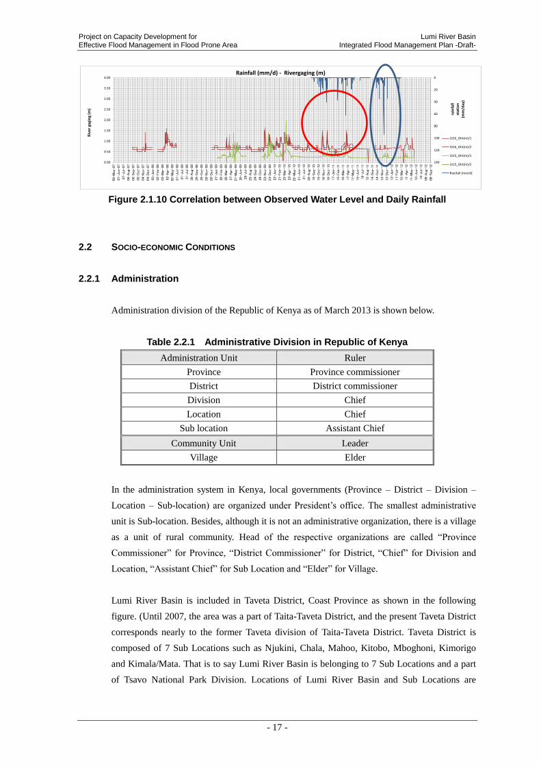
Project on Capacity Development for Lumi River Basin Effective Flood Management in Flood Prone Area Integrated Flood Management Plan -Draft-
- 17 -
Figure 2.1.10 Correlation between Observed Water Level and Daily Rainfall
2.2 SOCIO-ECONOMIC CONDITIONS
2.2.1 Administration
Administration division of the Republic of Kenya as of March 2013 is shown below.
Table 2.2.1 Administrative Division in Republic of Kenya
Administration Unit Ruler
Province Province commissioner
District District commissioner
Division Chief
Location Chief
Sub location Assistant Chief
Community Unit Leader
Village Elder
In the administration system in Kenya, local governments (Province – District – Division –
Location – Sub-location) are organized under President’s office. The smallest administrative
unit is Sub-location. Besides, although it is not an administrative organization, there is a village
as a unit of rural community. Head of the respective organizations are called “Province
Commissioner” for Province, “District Commissioner” for District, “Chief” for Division and
Location, “Assistant Chief” for Sub Location and “Elder” for Village.
Lumi River Basin is included in Taveta District, Coast Province as shown in the following
figure. (Until 2007, the area was a part of Taita-Taveta District, and the present Taveta District
corresponds nearly to the former Taveta division of Taita-Taveta District. Taveta District is
composed of 7 Sub Locations such as Njukini, Chala, Mahoo, Kitobo, Mboghoni, Kimorigo
and Kimala/Mata. That is to say Lumi River Basin is belonging to 7 Sub Locations and a part
of Tsavo National Park Division. Locations of Lumi River Basin and Sub Locations are
0
20
40
60
80
100
120
1400.00
0.50
1.00
1.50
2.00
2.50
3.00
3.50
4.00
08-
May
-07
07-
Jun-0
7
07-
Jul-
07
06-
Aug
-07
05-
Sep-
07
05-
Oct-
07
04-
Nov-
07
04-
Dec-
07
03-
Jan
-08
02-
Feb-
08
03-
Mar
-08
02-
Apr
-08
02-
May
-08
01-
Jun-0
8
01-
Jul-
08
31-
Jul-
08
30-
Aug
-08
29-
Sep-
08
29-
Oct-
08
28-
Nov-
08
28-
Dec-
08
27-
Jan
-09
26-
Feb-
09
28-
Mar
-09
27-
Apr
-09
27-
May
-09
26-
Jun-0
9
26-
Jul-
09
25-
Aug
-09
24-
Sep-
09
24-
Oct-
09
23-
Nov-
09
23-
Dec-
09
22-
Jan
-10
21-
Feb-
10
23-
Mar
-10
22-
Apr
-10
22-
May
-10
21-
Jun-1
0
21-
Jul-
10
20-
Aug
-10
19-
Sep-
10
19-
Oct-
10
18-
Nov-
10
18-
Dec-
10
17-
Jan
-11
16-
Feb-
11
18-
Mar
-11
17-
Apr
-11
17-
May
-11
16-
Jun-1
1
16-
Jul-
11
15-
Aug
-11
14-
Sep-
11
14-
Oct-
11
13-
Nov-
11
13-
Dec-
11
12-
Jan
-12
11-
Feb-
12
12-
Mar
-12
11-
Apr
-12
11-
May
-12
10-
Jun-1
2
10-
Jul-
12
09-
Aug
-12
08-
Sep-
12
Riv
er
gagi
ng
(m)
rain
fall
stat
ion
(m
m/d
ay)
Rainfall (mm/d) - Rivergaging (m)
3J16_Ght(m)/1
3J16_Ght(m)/2
3J15_Ght(m)/1
3J15_Ght(m)/2
Rainfall [mm/d]

Lumi River Basin Project on Capacity Development for Integrated Flood Management Plan -Draft- Effective Flood Management in Flood Prone Area
- 18 -
referred to the following figure.
Source:Prepared by JICA Project Team based on ILRI and GIS data.(District
division after 2007)
Figure 2.2.1 Relation of Locations of Taveta District and Lumi River Basin

Project on Capacity Development for Lumi River Basin Effective Flood Management in Flood Prone Area Integrated Flood Management Plan -Draft-
- 19 -
Source: Prepared by JICA Project Team based on National Water Master Plan, JICA
Figure 2.2.2 Locations of Lumi River Basin and nearby Sub Locations
Relation between the controlled area by WRMA (Water Resource Management Authority) in
charge of water resource related administration and Lumi River Basin is shown below.
As set forth in the present Water Act (2002), WRMA divides the country in 6 catchment areas
and the regional offices are established at each area. Catchment called “Athi Catchment Area”
includes Lumi River Basin. Athi Catchment Area is composed of five sub-regional offices,
such as “Upper Athi”, “Nairobi”, “Middle Athi”, “Nolturesh-Lumi” and “Coastal Athi”.
Lumi River Basin belongs to the control area of “Nolturesh-Lumi Sub-Regional Office”.

Lumi River Basin Project on Capacity Development for Integrated Flood Management Plan -Draft- Effective Flood Management in Flood Prone Area
- 20 -
Source: Athi Water Catchment Area Catchment Management Strategy (June, 2009)
Figure 2.2.3 Athi Catchment
Photo 2.2.1 WRMA Loitokitok Sub-regional Office
2.2.2 Population
Table 2.2.2 shows the population census data of 2009 which includes the data of densely
populated Taveta District within Lumi River Basin. According to this data, the population
density in Bomani Location in Taveta District is 400 persons or little less per km2 to 600
persons or little less per km2. Number of households records high in this area. In Mjimi Sub
location, the population density per km2 is quite high, i.e. approximately 3,000. However, this
location is outside of Lumi River Basin.
Lumi river basin

Project on Capacity Development for Lumi River Basin Effective Flood Management in Flood Prone Area Integrated Flood Management Plan -Draft-
- 21 -
Table 2.2.2 Population Census Data of 2009 in Taveta District
Source: Kenya National Bureau of Statistic, Census 2009
2.2.3 Industry
According to Taveta District Development Plan (2008-2012), the most active industry in Lumi
River Basin is the agriculture. The following table shows the production of crops in Taveta
District. The production weight is shown by the number of 90kg bags and the amount (Sh) is
shown calculated by multiplying the unit price per kg to the total production weight.
Table 2.2.3 Status of Harvest of Crops in Taveta District
(Weight, Amount: Year 2008)
Source: WRMA (Total amount is calculated by JICA Project Team)
About 14 kinds of crops are produced in Taveta District such as Maize, Rice, Beans, Potatoes,
Cotton, etc. Out of these crops, the most productive one is the principal food, Maize in terms
Province District Division Location Sublocation Male Female Total Households Area in Sq. Km.Population DensityMAHOO 1578 1618 3196 813 7.28 438.75MALUKILORITI 753 785 1538 358 12.3 125.03MBOGHONI 4241 4141 8382 2384 14.25 588.36NJORO 1254 1146 2400 609 6.62 362.79ELDORO 2212 2111 4323 967 26.46 163.36KIMORIGO 1055 884 1939 418 37.41 51.83KITOBO 1994 1807 3801 839 33.81 112.42MRABANI 1234 969 2203 510 57.27 38.46LESESIA 591 564 1155 217 9.31 124.01MJINI 4613 4369 8982 2544 2.89 3108.5CHALLA 2661 2345 5006 1243 106.9 46.83MAHANDAKINI 1550 1416 2966 567 28.35 104.64NAKRUTO 628 633 1261 263 14.51 86.89CHUMVINI 1483 1397 2880 543 11.92 241.66LUMI 1260 1183 2443 510 26.25 93.06NJUKINI 2477 2293 4770 989 33.94 140.52KIMALA 1855 1753 3608 911 12.61 286.16MATA 2413 2136 4549 1088 166.81 27.27MSENGONI 555 594 1149 288 8.04 142.83NDILINDAU 498 456 954 213 9.19 103.78
NATIONAL PARK NATIONAL PARK TSAVO WEST 114 46 160 84 2875.74 0.06
NJUKINI
JIPE
TIMBILA
BOMANI
KIMORIGO
KITOBO
NGARASHI
CHALLACOAST TAVETA
BOMENI
CHALLA
JIPE
Maize 27,297 20 545,940Rice 1,184 70 82,880Sorghum 1,135 40 45,400Millet 599 70 41,895Beans 3,384 70 236,880Cowpeas 1,185 70 82,964Pegion Peas 329 70 23,016Green Grams 870 70 60,900Cassava 376 40 15,024Sweet Potatoes 318 50 15,883Arrow Roots 178 50 8,880Cotton 1,026 26 26,676Sunflower 738 18 13,284Ground nuts 217 80 17,344
Total AchievedProduction 90 Kg
BagsSh
Farmgateprice Sh/
KgCrop
Lumi River Basin Project on Capacity Development for Integrated Flood Management Plan -Draft- Effective Flood Management in Flood Prone Area
- 22 -
of weight and amount. Following Maize, Beans、Cowpeas、Rice、Sorghum、Cotton are actively
produced.
Major stock farm products are milking cow, cow for meet, woolly, goat and poultry. Apiary
business is run at the dry region. Besides, fishery is active at Lake Jipe and Lake Challa from
the view point of food security and job creation. Annual fish catch reaches approximately 9
tons, and tilapia and fresh-water catfish are the major fish kinds.
Taveta District is also an area of production of sisal. However, there are no treatment facility of
material and the factory processing the sisal into craft products.
Lumi River Basin is a supply area of fruits like banana, etc. and vegetables, too. Therefore, as
there is a potential for processing agricultural products, the economic growth in future is
expected.
Within the river basin, there is Tsavo West National Park and it is located at the gateway of
Serengeti National Park. Therefore, there are tourist facilities such as lodge around Lake Jipe.
Photo 2.2.2 Rice Field in the Downstream Area of Lumi River
Photo 2.2.3 Fisherman nearby Lake Jipe

Project on Capacity Development for Lumi River Basin Effective Flood Management in Flood Prone Area Integrated Flood Management Plan -Draft-
- 23 -
2.3 DEVELOPMENT PLAN
2.3.1 Vision 2030
According to “Vision 2030”, there is the following development plan.
“Strengthening of Irrigation Facility”:
Currently, there is an irrigation strengthening project in Tana Delta as the flagship project. This
project is proposed to be disseminated to the other regions including Taita-Taveta.
2.3.2 Taveta District Development Plan (2008-2012)
According to the Taveta District Development Plan which is the development plan in Taveta
District, there is the following development plan.
(1) Improvement of Weak Road and Logistics Infrastructure
Under the present circumstances, appropriate budget is not secured. Accordingly, maintenance
is not properly done. Damages caused by flood are also problematic. For the meantime,
accessibility is planned to be improved up to 65%. Especially the accessibility of
A23-Mwatate-Taveta Road shown in the following figure shall be strengthened, the flood
damage of Taveta District shall be reduced, and the airport shall be rehabilitated.
Source:Ministry of Roads, Road Sector Investment Programme 2010 – 2024 (May 2011)
Figure 2.3.1 Road Plan Map
Lumi River Basin Project on Capacity Development for Integrated Flood Management Plan -Draft- Effective Flood Management in Flood Prone Area
- 24 -
2.3.3 Athi Water Catchment Area Catchment Management Strategy (2009)
According to the “Athi Water catchment Area Catchment Management Strategy” which is the
management plan prepared by WRMA for Athi Water Catchment, there is the following river
basin management strategy.
(1) Surface Water/Flood Mitigation
To achieve the objective, the conservation of surface water is promoted in conjunction of micro
(household level) with macro (province level).
- Construct a large reservoir type dam to store water for the household use, irrigation,
livestock farming, industry and power generation,
- Secure water resource for water supply and small scale irrigation in the rural area by
rehabilitating middle to small scale dams and ponds having sedimentation and/or damage,
- Promote detailed investigation and economic analysis for the site suitable for constructing
dam which would contribute largely to the water supply and the reduction of flood,
- Promote rain water harvesting by storage tank of rain water and pond in the rural area, and
- Make effort for flood management in the river basins of Sabaki, Lumi and Voi.
(2) Enhancing Capacity to Regulate Storage Infrastructure Development
WRMA will not construct reservoir dam by itself, however, WRMA is partly responsible for
design and construction. Training of the regional office staff is required for capacity building
on design and construction management of reservoir facility including reduction of disaster
and rescue.

Project on Capacity Development for Lumi River Basin Effective Flood Management in Flood Prone Area Integrated Flood Management Plan -Draft-
- 25 -
3. ANALYSIS OF FLOOD CHARACTERISTICS AND COUNTERMEASURES
3.1 OVERALL CONDITION ON FLOODS IN THE LUMI RIVER BASIN
3.1.1 Records of Flood Damages
Records of flood damages in the Lumi River Basin are shown in Figure 3.1.1. Especially,
near river mouth area such as Kimorigo sub-location, KImala Mata sub-location and Kitobo
sub-location suffered heavy damages from flood from the Lumi River. The longitudinal slope
of the Lumi River is steep in the mountainous area of Mt. Kilimanjaro within the border of the
United Republic of Tanzania. When the river flows into the territory of the Republic of Kenya,
the stream has gentle gradient. (Figure 3.1.1). The section from the Lake Jipe to Taveta Town
is about 1/1000 to 1/500 and the velocity in the section is low so that flood water is extended
for a long period of time at the lower basin.
Figure 3.1.1 Records of Flood Damage in the Lumi River Basin
Lumi River Basin Project on Capacity Development for Integrated Flood Management Plan -Draft- Effective Flood Management in Flood Prone Area
- 26 -
In the lower Lumi River Basin suffers damage from flood frequently and it has major adverse
effects on agricultural products, infrastructures, houses, lives and properties, land use, local
economy and etc. Moreover it is caused a delay of development. Since flood damage is
extremely important problem for people who live in the lower Lumi River Basin, they put
priority on issues of flood management in the Sub-Catchment Management Plan.
According to information that is provided by WRMA, numeric character data of floods which
was occurred in an ordinary year and 2009 in the lower Lumi River Basin is shown in the
Table 3.1.1. It indicates that approximately 80km2 was inundated in 2009 that was four times
larger area and the number of victims and duration of the evacuation was two times larger and
longer than an ordinary year.
Table 3.1.1 Overview of Flood in the Lower Lumi River Basin
(Ordinary year and 2009)
The flooding situation
in an ordinary year
The flooding situation
In an extreme year (2009)
Flood area 22.5 km2 79.8 km
2
Depth of water 0.3 m 0.9 m
No of evacuee 700 1600
Evacuation duration 1 month 2 month
No of floods in a year 1 2
Source : The table is created by JICA Project Team based on information provided by WRMA
Overview of recent flood damages in the lower Lumi River Basin is shown in Table 3.1.2. As
described above, estimated flood damage in 2009 is approximately 30,000,000 Ksh and it is
larger than an ordinary year. On the other hand, number of people who were affected by flood
in 2009 is shown to be lower than an ordinary year. Thus there is a possibility that WRMA
could not collect and understand actual data and information of flood damage in the basin.
Table 3.1.2 Overview of Annual Flood Damage in the Lumi River Basin
Year No of People
affected No of People dead
Estimated Damages cost
(Kshs)
2012 464 0 5,530,000
2011 105 1 1,350,000
2010 110 0 1,700,000
2009 29 4 30,300,000
TOTAL 708 5 38,880,000 Source: ACTION PLAN ON THE DEVELOPMENT AND IMPLEMENTATION OF A FLOOD
MANAGEMENT PLAN FOR LUMI RIVER Training Program: Capacity Development for Flood
Risk Management with IFAS (A)July 9th to August 8th 2012
Table 3.1.3 presents estimated flood damage cost and inundated area of agriculture sector in
the Lumi River Basin from the year of 2001 to 2011. Irrigation facilities of Kitobo suffered a

Project on Capacity Development for Lumi River Basin Effective Flood Management in Flood Prone Area Integrated Flood Management Plan -Draft-
- 27 -
great deal of damage on cost and area of farming land
Table 3.1.3 Agricultural Estimated Damage in the Lumi River Basin (2001-2011)
Name of Irrigation scheme Area (HA) Damage Cost
1 Kasokoni 5.3 430,000
2 Block C 12 235,000
3 Ngutini 4.9 780,000
4 Marondo 1.8 3,000,000
5 Msengoni 6.2 230,000
6 Kamleza 6.1 1,200,000
7 Kitobo 21 13,900,000
8 Rekeke/Lumi (Grogan canal) 8.9 2,100,000
9 Kimondia 8.1 730,000
10 Kimala 3.5 650,000
Total 23,255,000
Source: District Irrigation Office - Taveta
3.1.2 Flood Condition Inquiring From Relevant Communities
The principal points having flood damages in the Lumi river basin are Kimorigo, Kiwalwa,
Eldoro, Riata Marabani, Rekeke, Kimala, Ndilidau, Njoro, Bahati, Mata-Jipe and Kitobo etc.
The results of inquiring survey on the communities concerning the flooding situations in these
points are shown in the following table.
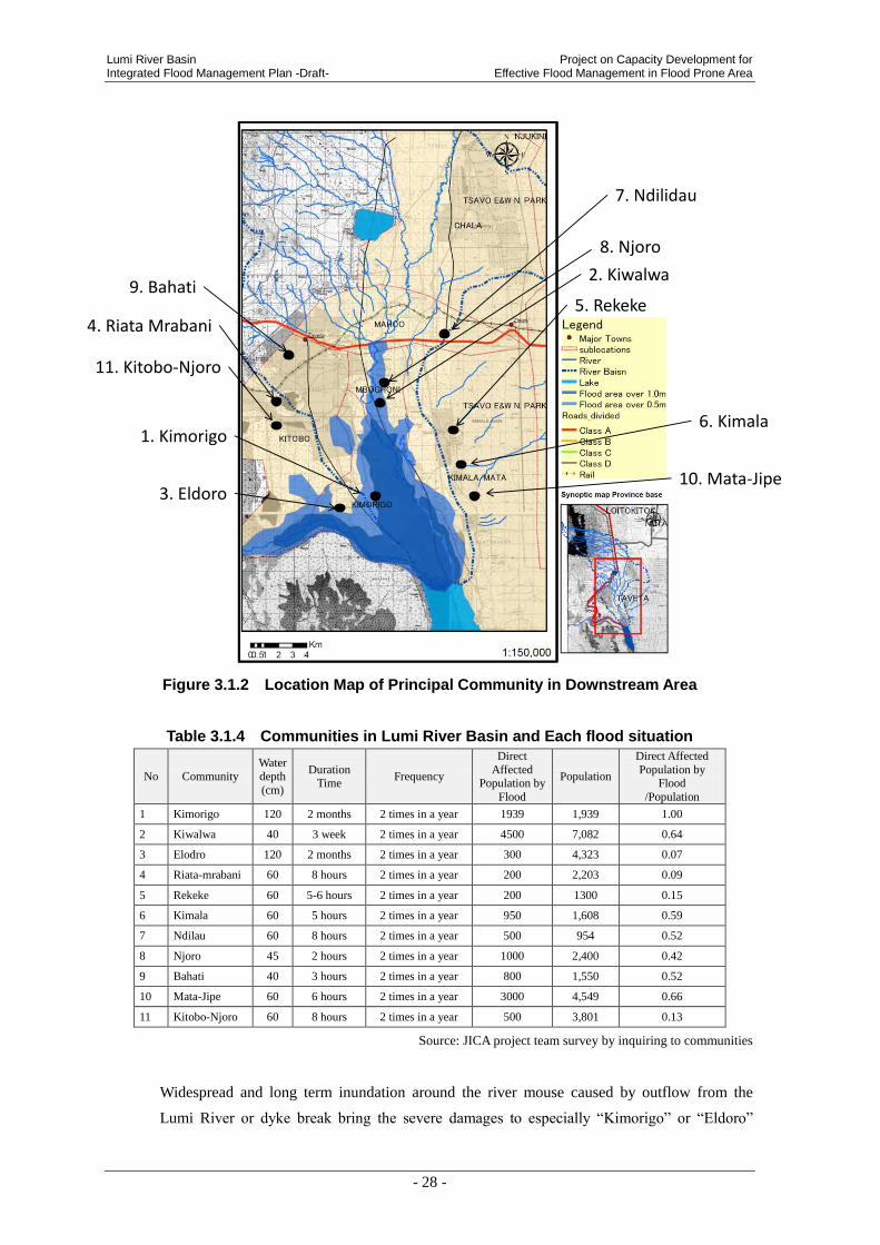
Lumi River Basin Project on Capacity Development for Integrated Flood Management Plan -Draft- Effective Flood Management in Flood Prone Area
- 28 -
Figure 3.1.2 Location Map of Principal Community in Downstream Area
Table 3.1.4 Communities in Lumi River Basin and Each flood situation
No Community
Water
depth
(cm)
Duration Time
Frequency
Direct
Affected Population by
Flood
Population
Direct Affected
Population by Flood
/Population
1 Kimorigo 120 2 months 2 times in a year 1939 1,939 1.00
2 Kiwalwa 40 3 week 2 times in a year 4500 7,082 0.64
3 Elodro 120 2 months 2 times in a year 300 4,323 0.07
4 Riata-mrabani 60 8 hours 2 times in a year 200 2,203 0.09
5 Rekeke 60 5-6 hours 2 times in a year 200 1300 0.15
6 Kimala 60 5 hours 2 times in a year 950 1,608 0.59
7 Ndilau 60 8 hours 2 times in a year 500 954 0.52
8 Njoro 45 2 hours 2 times in a year 1000 2,400 0.42
9 Bahati 40 3 hours 2 times in a year 800 1,550 0.52
10 Mata-Jipe 60 6 hours 2 times in a year 3000 4,549 0.66
11 Kitobo-Njoro 60 8 hours 2 times in a year 500 3,801 0.13
Source: JICA project team survey by inquiring to communities
Widespread and long term inundation around the river mouse caused by outflow from the
Lumi River or dyke break bring the severe damages to especially “Kimorigo” or “Eldoro”
5. Rekeke
7. Ndilidau
6. Kimala
4. Riata Mrabani
3. Eldoro
2. Kiwalwa
1. Kimorigo
11. Kitobo-Njoro
10. Mata-Jipe
9. Bahati
8. Njoro

Project on Capacity Development for Lumi River Basin Effective Flood Management in Flood Prone Area Integrated Flood Management Plan -Draft-
- 29 -
communities located in inundation area western side of the Lumi River, and there occurred the
inundation with 120cm depth and 2 months duration.
According to the figure described above, “Rekeke” or “Kimala” communities are located
around the downstream tributaries and small streams towards Lake Jipe directly and they are
absolutely different with the phenomenon of flooding around the Lumi River.
It can be speculated that the flow velocity is high because the duration of inundation is
comparatively short as around several hours.
In addition, although the depth is 60cm around, the dangerousness of inundation caused by
erosion or corrosion is high because of high energy of flow led by high velocity. And then, the
evacuation will be difficult even the water depth is shallow.
Also, following features can be pointed out by inundation points.
• Although the population of Kimorigo community is smaller than Kiwala or Eldoro, the
number of affected people ratio in community population is very high.
• The number of affected people of Kiwala or Mata-Jipe is numerous because their population
is large.
According to this, the damage situations and flood type in each community by project team’s
inquiring survey on the communities are shown below.
(1) Kimorigo
- Water depth is 120cm, duration is 2 month when floods occurs.
.................................... (Inundation caused by overflow and dyke break from the Lumi River)
- Flow from river water and from upstream even when there is no rainfall in Kimorigo area
.................................. (Inundation caused by overflow and dyke break from the Lumi River)
- Waters and sediments flow into the houses
.................................... (Inundation caused by overflow and dyke break from the Lumi River)
- Small livestock such as goats, sheep, chicken and rabbits swept away
.................................... (Inundation caused by overflow and dyke break from the Lumi River)
- The murram roads are inundated with flood water cutting off the villages from travelling.
.................................... (Inundation caused by overflow and dyke break from the Lumi River)
- The farms are flooded sweeping away the food crops
.................................... (Inundation caused by overflow and dyke break from the Lumi River)
- During very heavy flows Abori Primary School is closed
.................................... (Inundation caused by overflow and dyke break from the Lumi River)
- Some mud houses are swept away
.................................... (Inundation caused by overflow and dyke break from the Lumi River)
- Some of the farmlands have been turned into permanent swamps
.................................... (Inundation caused by overflow and dyke break from the Lumi River)

Lumi River Basin Project on Capacity Development for Integrated Flood Management Plan -Draft- Effective Flood Management in Flood Prone Area
- 30 -
(2) Kiwalwa
- Flood waters flows into the farmlands and sweeps the crops away
..................................... (Inundation caused by overflow and dyke break from the Lumi River)
- Sediment flows into the houses and deposited inside
..................................... (Inundation caused by overflow and dyke break from the Lumi River)
- Access roads are affected by the flood water interfering with transportation of produce to the
market .......................... (Inundation caused by overflow and dyke break from the Lumi River)
- Pollution of spring water
..................................... (Inundation caused by overflow and dyke break from the Lumi River)
(3) Elodro
- Some of the farmlands have been turned into permanent swamps
..................................... (Inundation caused by overflow and dyke break from the Lumi River)
- During periods of very heavy flooding school work is interfered with at Eldoro Primary
School .......................... (Inundation caused by overflow and dyke break from the Lumi River)
- The flood waters sweep away the food crops
..................................... (Inundation caused by overflow and dyke break from the Lumi River)
(4) Riata-mrabani
- Flooding from the slopes of Mt. Kilimanjaro ....................................................... (Flash flood)
- Destruction of infrastructure like roads and the railway....................................... (Flash flood)
- Flood water gets into the houses with sediments .................................................. (Flash flood)
- Very serious gulley erosion leading to loss of farmlands ..................................... (Flash flood)
(5) Rekeke
- Flood waters from Tsavo West ............................................................................. (Flash flood)
- Destruction of infrastructure such as the bridge on the road ................................ (Flash flood)
- Death of one villager in 2009 ............................................................................... (Flash flood)
- Destruction of houses in Rekeke ............................................................................(Flash flood)
- Sediment flow inside the houses ............................................................................(Flash flood)
- Small livestock such as goats, sheep, chicken and rabbits swept away (Flash flood)
- Very serious erosion that increases the sizes of the gulleys and reduces the size of the
residents farmlands at the same time .................................................................... (Flash flood)
(6) Kimala
- Flood waters mainly from the Tsavo West National Park..................................... (Flash flood)
- Leads to destruction of infrastructure like bridges ............................................... (Flash flood)
- Houses are inundated with flood water. ................................................................ (Flash flood)
- Loss of lands by gully erosion. ............................................................................. (Flash flood)
Project on Capacity Development for Lumi River Basin Effective Flood Management in Flood Prone Area Integrated Flood Management Plan -Draft-
- 31 -
(7) Ndilau
- Flash flooding from the side of Tsavo West National Parks ................................ (Flash flood)
- Heavy soil erosion has led to the formation of very big gulleys hence loss of farmlands
......................................................................................................... (Soil and sediment run off)
- It has caused the destruction of the road to Voi and Lake Jipe ......... (Soil and sediment run off)
- The flood flows also cause the destruction of houses ............................................ (Flash flood)
- Destruction of farmland and the sweeping away of crops ..................................... (Flash flood)
- 1 person was killed while trying to cross the big gulleys during the flood ............ (Flash flood)
(8) Njoro
- Flood waters cause the pollution of the springs
.................................... (Inundation caused by overflow and dyke break from the Lumi River)
- Sweeping away the crops in the farmlands
.................................... (Inundation caused by overflow and dyke break from the Lumi River)
- Destruction of the house
.................................... (Inundation caused by overflow and dyke break from the Lumi River)
(9) Bahati
- Flash flooding from the side of Tsavo National Park ............................................. (Flash flood)
- Destruction of the houses ....................................................................................... (Flash flood)
- Sweeping away of the livestock ........................................................................... (Flash flood)
(10) Mata-jipe
- Flash flooding from the side of Tsavo West National Park .................................... (Flash flood)
- Destruction of houses ............................................................................................. (Flash flood)
- Sweeping away of Livestock and other domestic animals ..................................... (Flash flood)
- Sweeping away of the crops in the farms ............................................................... (Flash flood)
- Serious gulley erosion leading to the loss of farmland .......................................... (Flash flood)
(11) Kitobo-Njoro
- Flash flooding from the mountain on the upper side but then the flood water settle near the
Kitobo spring ......................................................................................................... (Flash flood)
- Leads to the pollution of the spring waters ............................................................ (Flash flood)
- Land surrounding the Kitobo springs made unsuitable for agriculture .................. (Flash flood)
- Serious gulley erosion leading to the loss of farmlands ......................................... (Flash flood)
3.1.3 Existing Structures along the River
There are flood control and water use facilities in the Lumi River Basin such as Canal-A,
Canal-B, Canal-C and Grogan-canal.

Lumi River Basin Project on Capacity Development for Integrated Flood Management Plan -Draft- Effective Flood Management in Flood Prone Area
- 32 -
As shown in following figures, Canal-A (approx. 12km), Canal-B and Canal-C (approx. 17km)
flow parallel on the western side of the Lower Lumi River and these three canal merge into one
at the north side of the Lake Jipe and then the canal connects the Ruvu River which flow from
the Lake Jipe. These canals were constructed in 1930’s during the colonial period and they
have functions of drainage and irrigation.
According to the report of NWCPC, embankments (Height: 1.5m, Length: 10km) along the
Canal-C were built in 1973. In conjunction with construction of embankments, two irrigation
canals were dredged. However, due to sediment discharge and inappropriate maintenance of
the channels, capacity of flow has been reduced and part of embankment got collapsed when
flood had occurred. Since then canals doesn’t fulfill a function. Especially flood in 1987 and
1997, farmers destroyed dykes in order to intake agricultural water for farmland between the
Lumi River and dyke and currently part of embankment is dysfunctional.
Part of embankment of Canal-C (approx. 700m) is broken at this moment, flooding water in
the Lower Lumi River can’t run through the Canal-C and spread across area of the Canal-B
and the Canal-A. We infer that these canals which can’t fulfill a function may have caused
frequent flood damage in the western low-lying area of the Lower Lumi River Basin.
On the other hand, part of the Grogan Canal was renovated at the initiative of WRMA in 2012,
it is function effectively on irrigation purpose and WRUA is maintaining the canal and its
facilities properly. Hence, MWI, WRMA, DC, WRUA and etc. become their primary focus on
projects of renovation on the Canal-A, Canal-B and Canal-C and mitigation of flood damages,

Project on Capacity Development for Lumi River Basin Effective Flood Management in Flood Prone Area Integrated Flood Management Plan -Draft-
- 33 -
Figure 3.1.3 Location of Canals
Figure 3.1.4 Cross-section Diagram of the Lumi River and Canals
Flooding Perspective at Lower Area- Reservoir type and long period flood -
Canal A
Lumi river
Canal B
Canal C
Grogan Canal
Lake Jipe
Luvu river
Lum
i Riv
.
Lake Jipe
Can
al-C
Can
al-B
Can
al-A
Damaged Dyke
Breached Dyke (L=700m)
Lumi Riv.Canal-C
Canal-B
Canal-A
Km
ori
goV
illag
e
A A
Cross Section of A-A
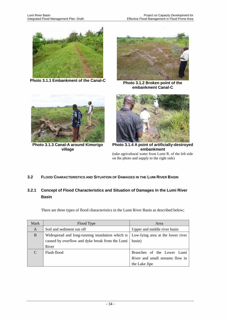
Lumi River Basin Project on Capacity Development for Integrated Flood Management Plan -Draft- Effective Flood Management in Flood Prone Area
- 34 -
Photo 3.1.1 Embankment of the Canal-C
Photo 3.1.2 Broken point of the embankment Canal-C
Photo 3.1.3 Canal-A around Kimorigo
village
Photo 3.1.4 A point of artificially-destroyed
embankment (take agricultural water from Lumi R. of the left side
on the photo and supply to the right side)
3.2 FLOOD CHARACTERISTICS AND SITUATION OF DAMAGES IN THE LUMI RIVER BASIN
3.2.1 Concept of Flood Characteristics and Situation of Damages in the Lumi River
Basin
There are three types of flood characteristics in the Lumi River Basin as described below;
Mark Flood Type Area
A Soil and sediment run off Upper and middle river basin
B Widespread and long-running inundation which is
caused by overflow and dyke break from the Lumi
River
Low-lying area at the lower river
basin)
C Flash flood Branches of the Lower Lumi
River and small streams flow in
the Lake Jipe
Project on Capacity Development for Lumi River Basin Effective Flood Management in Flood Prone Area Integrated Flood Management Plan -Draft-
- 35 -
Figure 3.2.1 Records of Flood Damage and Classification of Flood Characteristics in the Lumi River Basi
Flood damage has a close relationship with natural condition and Socio-economic condition in
a local area. Natural condition defines types of Hazards in a river basin and Socio-economic
condition defines vulnerabilities and exposures. Moreover, it could be said that disaster (flood)
damage is defined from both aspects. Characteristics of flood damage are analyzed using
information of last chapter (Natural condition and Socio-economic condition) about each flood
characteristics of A), B) and C) as above-mentioned.
A
B
C
Upstream
Downstream
Lumi River
Lumi River Basin Project on Capacity Development for Integrated Flood Management Plan -Draft- Effective Flood Management in Flood Prone Area
- 36 -
Source: Revised by JICA Project Team, based on material of “Community and Development assistant of Disaster
Prevention, Mr. Mikio Ishiwatari(1997)
Figure 3.2.2 Mechanism of Flood Damage
3.2.2 Soil and sediment run off in upstream and middle stream (A)
Flood characteristics in the upstream and middle stream which are analyzed from the aspects
of natural, Socio-economic conditions are shown below.
(1) Flood Characteristics from Natural Conditions
There is heavy rainfall around the mountain-side of Mt. Kilimanjaro and those areas have a
sharp inclination of 1/30 – 1/20. Because of high flow velocity and most of area doesn’t cover
with forest and vegetation, it is more likely to erode clay soil and a large amount of soil is
supplied to the downstream.
- Sediment discharge is causing aggradation of river bed levels in the downstream that is
gentle slope and low flow velocity.
- In addition, flash floods occur at the Lumi River’s Tributaries.
- Most of upper and middle of the Lumi River Basin is located in the territory of the United
Republic of Tanzania and mountain area of Kilimanjaro and the area has a high precipitation.
Natural Conditions that are described in the last chapter and Hazards in this area are shown as
Table 3.2.1.
Table 3.2.1 Natural Conditions and Hazards in Upstream and Middle Stream
Natural Conditions Hazards
Heavy rains in the mountain area
Geography: A sharp inclination (1/30 -1/20)
Soil Erosion
High velocity and tractive force
High peak discharge
Large area of bare lands Soil erosion
Sediment run-off
Social and
Economic
Vulnerability/ Exposure
Natural
Condition
-Population growth
-Urbanization
-Environmental
degradation
-Poverty, etc
-Dangerous
building -Unsafe area -Precarious
livelihood
-Low income -Inadequate health
service
-gradient of river
-width, elevation of
river bed
-geology
-precipitation, etc
Hazards
-High-velocity
flow
-Overflow stream,
dyke break
-Inundation
-Sediment
discharge
-Bank erosion, etc
Disaster
Damage
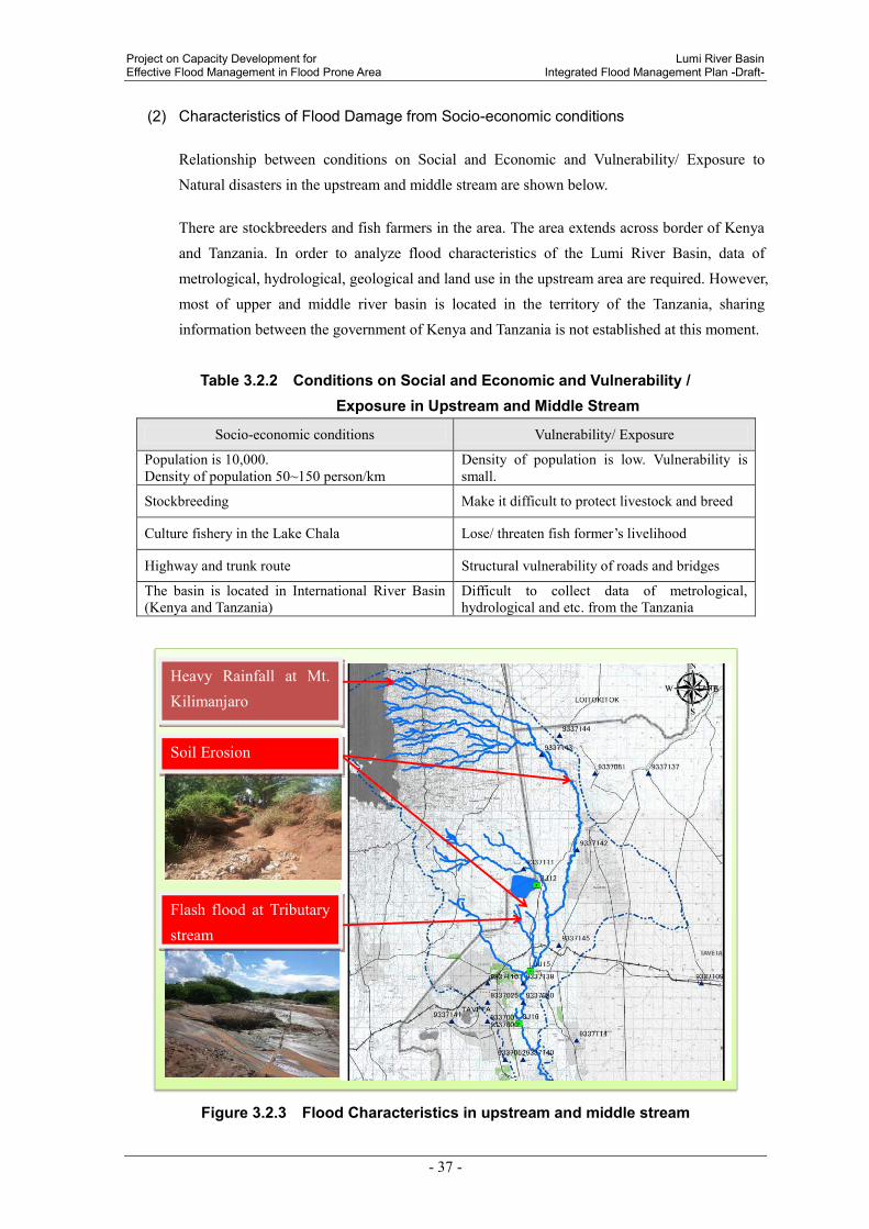
Project on Capacity Development for Lumi River Basin Effective Flood Management in Flood Prone Area Integrated Flood Management Plan -Draft-
- 37 -
(2) Characteristics of Flood Damage from Socio-economic conditions
Relationship between conditions on Social and Economic and Vulnerability/ Exposure to
Natural disasters in the upstream and middle stream are shown below.
There are stockbreeders and fish farmers in the area. The area extends across border of Kenya
and Tanzania. In order to analyze flood characteristics of the Lumi River Basin, data of
metrological, hydrological, geological and land use in the upstream area are required. However,
most of upper and middle river basin is located in the territory of the Tanzania, sharing
information between the government of Kenya and Tanzania is not established at this moment.
Table 3.2.2 Conditions on Social and Economic and Vulnerability / Exposure in Upstream and Middle Stream
Socio-economic conditions Vulnerability/ Exposure
Population is 10,000. Density of population 50~150 person/km
Density of population is low. Vulnerability is small.
Stockbreeding Make it difficult to protect livestock and breed
Culture fishery in the Lake Chala Lose/ threaten fish former’s livelihood
Highway and trunk route Structural vulnerability of roads and bridges
The basin is located in International River Basin (Kenya and Tanzania)
Difficult to collect data of metrological, hydrological and etc. from the Tanzania
Figure 3.2.3 Flood Characteristics in upstream and middle stream
キリマンジャロ山麓での激しい降雨
土壌侵食が多い
支川でのフラッシュフラッド支川でのフラッシュフラッド
Flash flood at Tributary stream
土壌侵食が多いSoil Erosion
キリマンジャロ山麓での激しい降雨Heavy Rainfall at Mt. Kilimanjaro
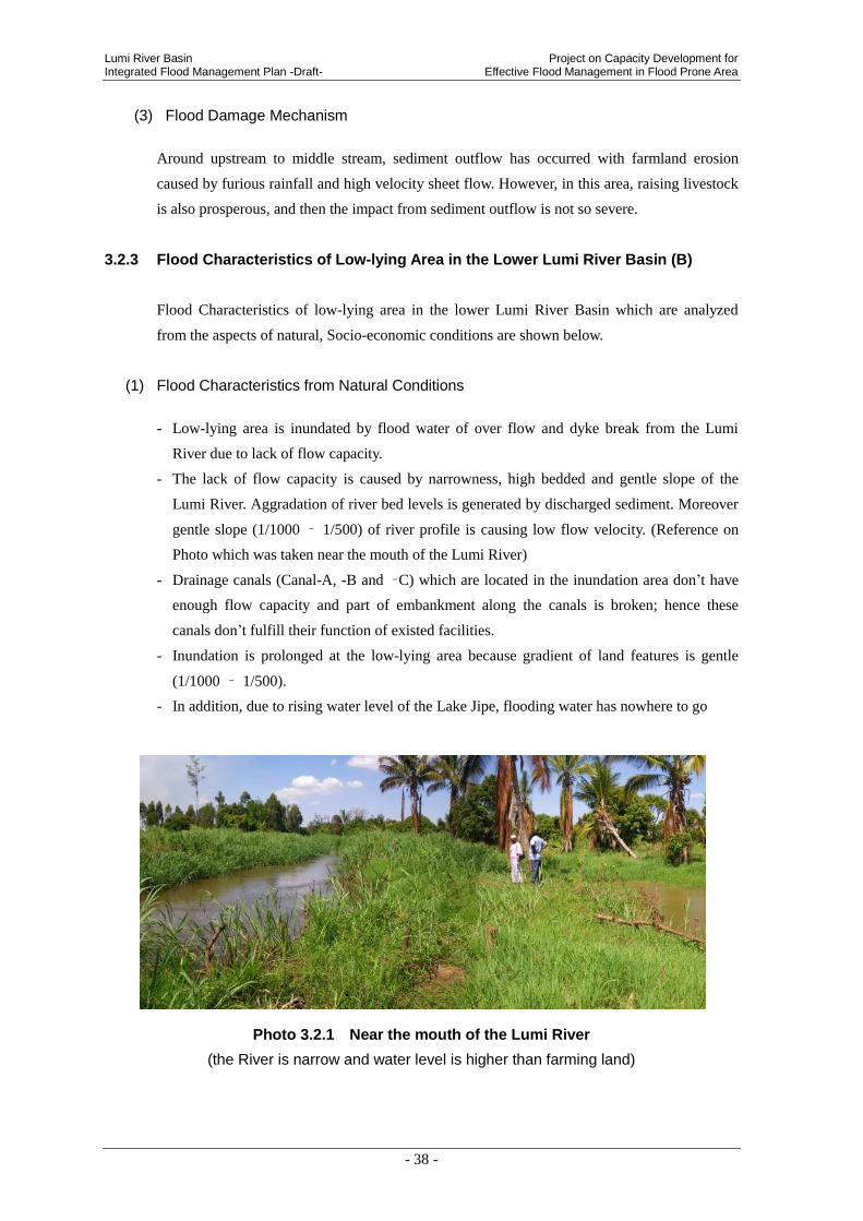
Lumi River Basin Project on Capacity Development for Integrated Flood Management Plan -Draft- Effective Flood Management in Flood Prone Area
- 38 -
(3) Flood Damage Mechanism
Around upstream to middle stream, sediment outflow has occurred with farmland erosion
caused by furious rainfall and high velocity sheet flow. However, in this area, raising livestock
is also prosperous, and then the impact from sediment outflow is not so severe.
3.2.3 Flood Characteristics of Low-lying Area in the Lower Lumi River Basin (B)
Flood Characteristics of low-lying area in the lower Lumi River Basin which are analyzed
from the aspects of natural, Socio-economic conditions are shown below.
(1) Flood Characteristics from Natural Conditions
- Low-lying area is inundated by flood water of over flow and dyke break from the Lumi
River due to lack of flow capacity.
- The lack of flow capacity is caused by narrowness, high bedded and gentle slope of the
Lumi River. Aggradation of river bed levels is generated by discharged sediment. Moreover
gentle slope (1/1000 – 1/500) of river profile is causing low flow velocity. (Reference on
Photo which was taken near the mouth of the Lumi River)
- Drainage canals (Canal-A, -B and –C) which are located in the inundation area don’t have
enough flow capacity and part of embankment along the canals is broken; hence these
canals don’t fulfill their function of existed facilities.
- Inundation is prolonged at the low-lying area because gradient of land features is gentle
(1/1000 – 1/500).
- In addition, due to rising water level of the Lake Jipe, flooding water has nowhere to go
Photo 3.2.1 Near the mouth of the Lumi River
(the River is narrow and water level is higher than farming land)

Project on Capacity Development for Lumi River Basin Effective Flood Management in Flood Prone Area Integrated Flood Management Plan -Draft-
- 39 -
Natural Conditions that are described in the Chapter-1 and Natural Risks (Hazards) in this area
are shown in Table 3.2.3.
Table 3.2.3 Natural Conditions and Hazards in the Lower Lumi River Basin
Natural Conditions Hazards
Gentle river bed slope and flat landscape Interrupt the flow of water through the
downstream
Discharge large amounts of sediment
Narrow river
Aggradation of river bed, there is the threat of
levee breach.
Small capacity of river flow
(2) Characteristics of Flood Damage from Socio-economic conditions
Due to long term inundation, highly-populated area has impacts of flooding including damages
to properties and farmlands, destruction of crops, no-access of springs water (muddy after
flooding), non-functioning of infrastructures facilities (severed road, physically impossible to
commute to school, flooding in hospitals and etc.) and loss of livestock.
- Part of bank along the canals is broken by local farmers in order to take agricultural water.
- 20,000 households were inundated and 60,000 residents were evacuated in Kimorigho
location at the floods of year 2007 -2008 .
- Refugees who are evacuated from floods are forced to displace for two months.
Relationship between “Socio-economic conditions” and “vulnerability/ exposure” in this area
are shown in Table 3.2.4.
Table 3.2.4 Conditions on Social and Economic and Vulnerability/
Exposure in the Lower Lumi River Basin
Socio-economic conditions Vulnerability/ Exposure
Highly-populated residential area (population
density of 600 people per square kilometer)
A number of refugees who might be affected by
flood
Agriculture and stockbreeding have been
prosperous in this area
Agricultural production stoppage, Protection of
livestock, difficulty of breeding, affect the
residents' livelihood
Part of bank is broken by local farmers in order
to take agricultural water.
Creation an adverse impact on surrounding area
Unpaved community road Roads are severed by floods
Tourist facilities locate near the Lake Jipe Due to inundation and severed roads, stoppage
of a service for tourists
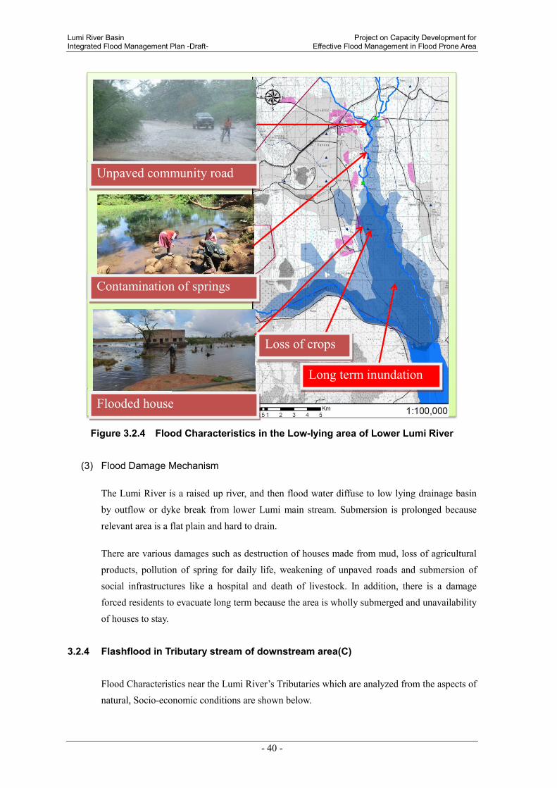
Lumi River Basin Project on Capacity Development for Integrated Flood Management Plan -Draft- Effective Flood Management in Flood Prone Area
- 40 -
Figure 3.2.4 Flood Characteristics in the Low-lying area of Lower Lumi River
(3) Flood Damage Mechanism
The Lumi River is a raised up river, and then flood water diffuse to low lying drainage basin
by outflow or dyke break from lower Lumi main stream. Submersion is prolonged because
relevant area is a flat plain and hard to drain.
There are various damages such as destruction of houses made from mud, loss of agricultural
products, pollution of spring for daily life, weakening of unpaved roads and submersion of
social infrastructures like a hospital and death of livestock. In addition, there is a damage
forced residents to evacuate long term because the area is wholly submerged and unavailability
of houses to stay.
3.2.4 Flashflood in Tributary stream of downstream area(C)
Flood Characteristics near the Lumi River’s Tributaries which are analyzed from the aspects of
natural, Socio-economic conditions are shown below.
家屋の浸水
主要国道の寸断
生活用水用の泉の汚染
農作物の損失
長期にわたる浸水
主要国道の寸断Unpaved community road
生活用水用の泉の汚染Contamination of springs
家屋の浸水Flooded house
農作物の損失Loss of crops
長期にわたる浸水Long term inundation

Project on Capacity Development for Lumi River Basin Effective Flood Management in Flood Prone Area Integrated Flood Management Plan -Draft-
- 41 -
(1) Flood Characteristics from Natural Conditions
Due to short-term torrential rainfall, flash floods sometimes occur near Lumi River’s
Tributaries including the area of Tsavo West National Park and hilly district. In addition, Due
to clay soil, rain water doesn’t seep underground and surface run-off occurs
Natural Conditions that are described in the Chapter-1 and Natural Risks (Hazards) in this area
are shown in Table 3.2.5
Table 3.2.5 Natural Conditions and Hazards near the Lumi River’s Tributaries
Natural Conditions Hazards
Short-term torrential rainfall at hilly
district
Arrival time of flood is short.
High peak discharge
Steam erosion occurs
(2) Characteristics of Flood Damage from Socio-economic Conditions
Infrastructures such as roads and bridges, houses, household goods and livestock suffer
damage from flash flood that hit rural communities in flat area. Additionally, flash floods lead
to damage that irrigation channels are severed.
“Socio-economic conditions” and “vulnerability and exposure” in this area are shown in Table
3.2.6.
Table 3.2.6 Conditions on Social and Economic and Vulnerability/
Exposure near the Lumi River’s Tributaries
Socio-economic conditions Vulnerability/ Exposure
Village is on flat land
Population is approximately 18,000
- Flash food from hill attack villages
- Affected people by flash flood is
approximately 7,000. (Rekeke 200, Kimala
950, Mata-Jipe 3,000)
- Long term inundation does not occur
Irrigated agriculture has been prosperous in
this area
Damage on irrigation channel has an
influence on farmers’ livelihood
The highway between Taveta and Mwatate
serve an important function of logistics.
A temporary halt and/or stagnation in logistics
due to inundation
Tourist facilities locate near the Lake Jipe Stoppage and halt of service for tourists, due
to inundation and severed road network
There is a gully erosion in front of the health
clinic
Emergency rescue is not able to be provided
during flooding
Unpaved road Vulnerable by soil erosion and precipitation

Lumi River Basin Project on Capacity Development for Integrated Flood Management Plan -Draft- Effective Flood Management in Flood Prone Area
- 42 -
Figure 3.2.5 Flood Characteristics near the Lumi River’s Tributaries
(3) Flood Damage Mechanism
Flash flood around downstream, upper to middle stream and tributary is caused by
concentrated rainfall and occurrence of flood with large peak flow in short term in a small river
course of seasonal stream.
In the course of down flow, flood water flow down with bank erosion. There are some cases
that flood water makes a new river course by overflowing from current river course, and then
some roads or bridges crossing the river are broken, and also houses or farmlands have
damages.
主要な地方道の寸断(橋梁の破壊)
河岸侵食による家屋の損壊
フラッシュフラッド
灌漑水路の寸断
Channel
フラッシュフラッドフラッシュフラッドFlash Flood
灌漑水路の寸断Severed irrigation channel
河岸侵食による家屋の損壊Damaged house
主要な地方道の寸断(橋梁の破壊)
Severed Main Road (and bridge)
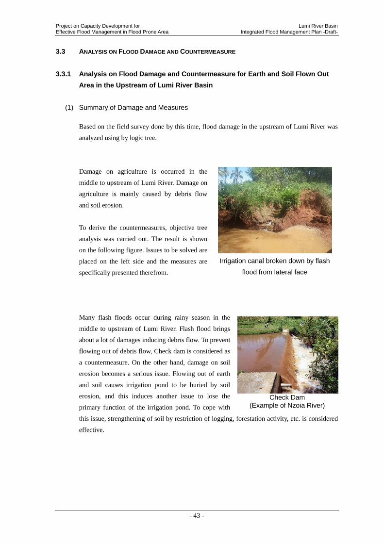
Project on Capacity Development for Lumi River Basin Effective Flood Management in Flood Prone Area Integrated Flood Management Plan -Draft-
- 43 -
3.3 ANALYSIS ON FLOOD DAMAGE AND COUNTERMEASURE
3.3.1 Analysis on Flood Damage and Countermeasure for Earth and Soil Flown Out
Area in the Upstream of Lumi River Basin
(1) Summary of Damage and Measures
Based on the field survey done by this time, flood damage in the upstream of Lumi River was
analyzed using by logic tree.
Damage on agriculture is occurred in the
middle to upstream of Lumi River. Damage on
agriculture is mainly caused by debris flow
and soil erosion.
To derive the countermeasures, objective tree
analysis was carried out. The result is shown
on the following figure. Issues to be solved are
placed on the left side and the measures are
specifically presented therefrom.
Many flash floods occur during rainy season in the
middle to upstream of Lumi River. Flash flood brings
about a lot of damages inducing debris flow. To prevent
flowing out of debris flow, Check dam is considered as
a countermeasure. On the other hand, damage on soil
erosion becomes a serious issue. Flowing out of earth
and soil causes irrigation pond to be buried by soil
erosion, and this induces another issue to lose the
primary function of the irrigation pond. To cope with
this issue, strengthening of soil by restriction of logging, forestation activity, etc. is considered
effective.
Irrigation canal broken down by flash
flood from lateral face
Check Dam
(Example of Nzoia River)

Lum
i Riv
er B
asin
P
roje
ct o
n C
apacity
Develo
pm
ent fo
r In
tegra
ted F
lood M
anagem
ent P
lan
-Dra
ft- E
ffectiv
e F
lood M
anagem
ent in
Flo
od P
rone A
rea
- 44 -
Fig
ure
3.3
.1 A
na
lys
is o
n P
rob
lem
Tre
e
Fig
ure
3.3
.2 A
na
lys
is o
n O
bje
ctiv
e T
ree
Issue to be solved Kind of damage Specific damage Situation of damage Its cause
Erosion of soil
Breakdown of agricultural landby debris flow
Flood damage in the middleto upstream of Lumi River
Damage on asgricultureReduction of productionof agricultural crops
Reduction ofagricultural land
Point to cope with Mesure to be taken Action
Prevent outflow of debris Check dam
Restriction on
logging
Erosion of soil Strengthening of soil
Breakdown of agricultural land
by debris flow
Forestation
activity
Protection of
vegetation
Mitigation of flood
damage in the middle
to upstream of Lumi
River

Project on Capacity Development for Lumi River Basin Effective Flood Management in Flood Prone Area Integrated Flood Management Plan -Draft-
- 45 -
Countermeasure method to be considered for this area is summarized below.
Table 3.3.1 Countermeasure Method to be considered in the Earth and Soil Flown Out
Area in the Upstream of Lumi River Basin
Serial
No.
Countermeasure Method to
be considered Remarks
L-U1 Check dam Preventing the outflow of debris
L-U2 Restriction on logging Preventing the excess tree cutting.
L-U3 Forestation activities Raising nursery trees and planting on slope.

Lumi River Basin Project on Capacity Development for Integrated Flood Management Plan -Draft- Effective Flood Management in Flood Prone Area
- 46 -
3.3.2 Analysis on Flood Damage and Countermeasure in the Long-term Inundated
Area of the Downstream of Lumi River
(1) Summary of Damage and Measures
Based on the result of field survey by this time, analysis was carried out on the area where
damage occurred by the long-term inundation of the downstream of Lumi River using by logic
tree.
Figure 3.3.3 Analysis on Problem Tree
Issu
e t
o b
e s
olv
ed
Kin
d o
f d
am
ag
eS
pe
cifi
c d
am
ag
eS
itu
ati
on
of
da
ma
ge
Its
cau
se
Lon
g-te
rm in
un
dati
on
Dam
age
on p
rodu
ctio
n
Los
s of
live
stoc
kD
row
nin
g of
live
stoc
kL
ack
of
kn
owle
dge/
info
rmat
ion
to
mit
igat
e da
mag
e
Impo
ssib
le t
o re
side
Was
hou
t/su
bmer
gen
ce o
f h
ouse
Hou
se lo
cate
d on
low
lan
d
Poor
drai
nag
e
Dam
age
on li
vin
gIm
poss
ible
to
tran
spor
tIm
poss
ible
to
deliv
er a
gric
ult
ura
l
crop
s to
mar
ket
Su
bmer
gen
ce o
f ro
ad
or im
poss
ible
to
evac
uat
e
Ou
tflo
w o
f se
wag
e w
ater
fro
m t
oile
t
Hea
lth
Haz
ard
Hyg
ien
ic p
robl
em
Spr
ing
pollu
tion
Red
uct
ion
of
agri
cult
ura
l cro
psL
oss
of a
gric
ult
ura
l lan
d fu
nct
ion
Lon
g-te
rm in
un
dati
on
area
of
the
dow
nst
ream
of L
um
i Riv
er
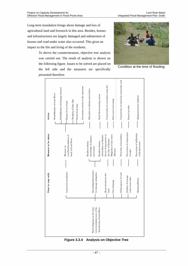
Project on Capacity Development for Lumi River Basin Effective Flood Management in Flood Prone Area Integrated Flood Management Plan -Draft-
- 47 -
Long-term inundation brings about damage and loss of
agricultural land and livestock in this area. Besides, houses
and infrastructures are largely damaged and submersion of
houses and road under water also occurred. This gives an
impact to the life and living of the residents.
To derive the countermeasure, objective tree analysis
was carried out. The result of analysis is shown on
the following figure. Issues to be solved are placed on
the left side and the measures are specifically
presented therefore.
Figure 3.3.4 Analysis on Objective Tree
Condition at the time of flooding
Po
int
to c
op
e w
ith
Me
asu
re
to
be
ta
ke
nA
cti
on
Reh
abilit
ati
on
of
Lu
mi R
iver
Reh
abilit
ati
on
of
dra
inage c
han
nel
Lon
g-t
erm
in
un
dati
on
Repair
of
river
ban
k
Dre
dgin
g o
f L
ak
e J
ipe
Sm
all c
heck
dam
Fore
stati
on
act
ivit
y in
th
e u
pst
ream
Edu
cati
on
on
dis
ast
er
pre
ven
tion
Kn
ow
ledge/in
form
ati
on
for
dam
age m
itig
ati
on
Earl
y f
lood w
arn
ing s
yst
em
Hou
se loca
ted o
n low
lan
d
Secu
re liv
ing q
uart
er
at
the t
ime o
f dis
ast
er
Con
strc
uti
on
of
evacu
ati
on
cam
p s
ite
Poor
dra
inage
Mit
igati
on
of
rain
wate
r
dif
fusi
on
Rain
wate
r h
arv
est
ing
Su
bm
erg
en
ce o
f ro
ad
Pro
tect
ion
of
inu
ndati
on
Con
stru
ctio
n o
f ra
ised u
p c
om
mu
nit
y r
oad
Ou
tflo
w o
f se
wage
wate
r fr
om
toilet
Pre
ven
tion
of
subm
ers
ion
of
toilet
Rais
ed u
p t
oilet
Spri
ng p
ollu
tion
Pre
ven
tion
of
infi
ltra
tion
of
flooded w
ate
rS
pri
ng p
rote
ctio
n (
gabio
n)
Flo
od m
itig
ati
on
in
th
e lon
g-
term
in
un
dati
on
are
a o
f th
e
dow
nst
ream
of
Lu
mi R
iver
Measu
re o
n
overf
low
/bre
ak
dow
n o
f
ban
k o
f L
um
i R
iver
Resi
den
t obta
ins
info
rmati
on
on
dis
ast
er
Resi
den
t obta
ins
kn
ow
ledge o
n d
isast
er
pre
ven
tion
.

Lumi River Basin Project on Capacity Development for Integrated Flood Management Plan -Draft- Effective Flood Management in Flood Prone Area
- 48 -
Inundation in this area has various impacts such as pollution of drinking water by interfusion
of flooded water to the spring, damage to houses and living of the residents. For instance,
severed road by inundation will make students go to school and agricultural products to deliver
to the market impossible. In addition, as the access to the hospital becomes impossible, another
issue will occur where by the resident cannot have medical service. Furthermore, as the
residents have little knowledge and information to reduce damages, the damages becomes
larger such as to drown livestock. To reduce the
flood damage, it is considered an effective mean
that the residents acquire knowledge and
information on disaster prevention and devise
countermeasure by themselves. As
countermeasures, education on disaster
prevention at school, early flood warning system,
etc. are considered. Further, to force an end of
inundation from Lumi River, the
countermeasures such as widening of and
improvement by dredging, etc. of Lumi River,
improvement of the existing drainage canal in low-lying area and dredging of Lake Jipe to
improve the storage capacity are considered. There are three major existing drainage canals of
Canal A, Canal B and Canal C. It is considered
to reduce the flood damages largely by heighten
the flow capacity of these Canal A, Canal B and
Canal C by way of dredging and improvement.
Especially, though the bank of Canal C is partly
broken down at present, it is one of the options
to rehabilitate the bank.
Besides, there are many residents forced to
evacuate in the long-term inundation area of the
downstream of Lumi River because the
inundation is prolonged, the houses are
Road Bridge rushed out
Place : Rengesa
Damp ground where the bank of Canal-C has been washed out
Land elevation after inundation of house
Place : Rengesa
Evacuation camp site
Place : Kimorigo
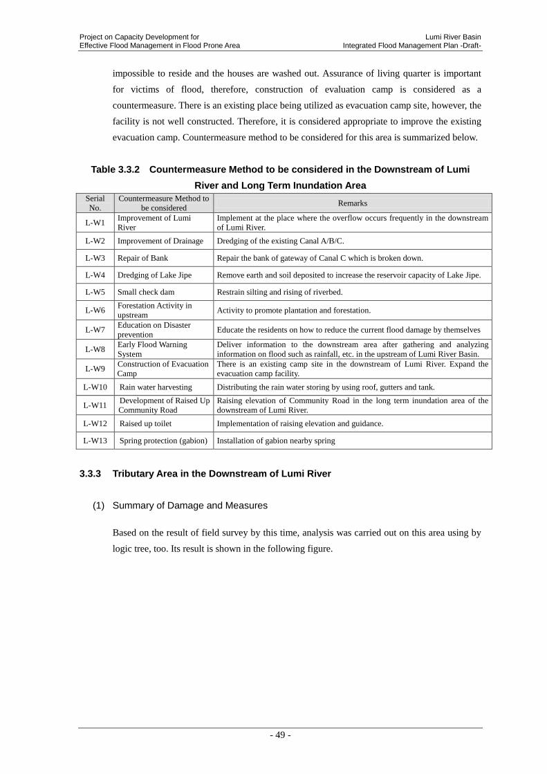
Project on Capacity Development for Lumi River Basin Effective Flood Management in Flood Prone Area Integrated Flood Management Plan -Draft-
- 49 -
impossible to reside and the houses are washed out. Assurance of living quarter is important
for victims of flood, therefore, construction of evaluation camp is considered as a
countermeasure. There is an existing place being utilized as evacuation camp site, however, the
facility is not well constructed. Therefore, it is considered appropriate to improve the existing
evacuation camp. Countermeasure method to be considered for this area is summarized below.
Table 3.3.2 Countermeasure Method to be considered in the Downstream of Lumi
River and Long Term Inundation Area
Serial
No.
Countermeasure Method to
be considered Remarks
L-W1 Improvement of Lumi
River
Implement at the place where the overflow occurs frequently in the downstream
of Lumi River.
L-W2 Improvement of Drainage Dredging of the existing Canal A/B/C.
L-W3 Repair of Bank Repair the bank of gateway of Canal C which is broken down.
L-W4 Dredging of Lake Jipe Remove earth and soil deposited to increase the reservoir capacity of Lake Jipe.
L-W5 Small check dam Restrain silting and rising of riverbed.
L-W6 Forestation Activity in
upstream Activity to promote plantation and forestation.
L-W7 Education on Disaster
prevention Educate the residents on how to reduce the current flood damage by themselves
L-W8 Early Flood Warning
System
Deliver information to the downstream area after gathering and analyzing
information on flood such as rainfall, etc. in the upstream of Lumi River Basin.
L-W9 Construction of Evacuation
Camp
There is an existing camp site in the downstream of Lumi River. Expand the
evacuation camp facility.
L-W10 Rain water harvesting Distributing the rain water storing by using roof, gutters and tank.
L-W11 Development of Raised Up
Community Road
Raising elevation of Community Road in the long term inundation area of the
downstream of Lumi River.
L-W12 Raised up toilet Implementation of raising elevation and guidance.
L-W13 Spring protection (gabion) Installation of gabion nearby spring
3.3.3 Tributary Area in the Downstream of Lumi River
(1) Summary of Damage and Measures
Based on the result of field survey by this time, analysis was carried out on this area using by
logic tree, too. Its result is shown in the following figure.
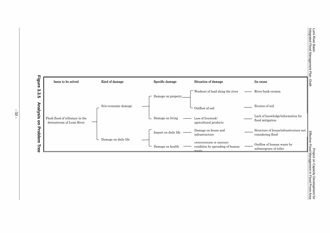
Lum
i Riv
er B
asin
P
roje
ct o
n C
apacity
Develo
pm
ent fo
r In
tegra
ted F
lood M
anagem
ent P
lan
-Dra
ft- E
ffectiv
e F
lood M
anagem
ent in
Flo
od P
rone A
rea
- 50 -
Fig
ure
3.3
.5 A
na
lys
is o
n P
rob
lem
Tre
e
Issue to be solved Kind of damage Specific damage Situation of damage Its cause
Washout of land along the river River bank erosion
Damage on property
Scio-economic damage Erosion of soil
Damage on livingLack of knowledge/information for
flood mitigation
Impact on daily lifeDamage on house and
infrastructure
Structure of house/infrastrcuture not
considering flood
Damage on daily life
Outflow of human waste by
submergence of toilet
Loss of livestock/
agricultural products
Outflow of soil
Flash flood of tributary in the
downstream of Lumi River
Damage on health
Deterioration of sanitary
condition by spreading of human
waste

Project on Capacity Development for Lumi River Basin Effective Flood Management in Flood Prone Area Integrated Flood Management Plan -Draft-
- 51 -
In the tributary of downstream of Lumi River,
flood damages occur such as washout of land
along the river, flowing out of soil, loss of
livestock and agricultural products, damages
on houses and infrastructures, deterioration of
sanitary environment by spreading of human
waste, etc. Major reasons of those are
considered to be erosions of river bank and
soil, lack of knowledge and information to
reduce flood damages, structure of houses and
infrastructure not considering floods,
submersion of toilet, etc.
In the tributaries of the downstream of Lumi
River and the small rivers directly flowing
into Lake Jipe, the river bank is eroded by
flash flood, and damages on agricultural land
and housing lot are occurred by washout of
land. It is supposed to be that the rainfall in
the upstream swells the dry up river (seasonal
river), where normally there is no water in the
narrow river course, into flash flood with
erosion of river bank. Besides, the area was
covered by trees once. However, as the trees
were logged as fuel wood materials, there are
only scattered trees in the area at present.
Therefore, if there is a heavy rain, the rainfall
directly hits the surface soil, and it results in
washout of soil.
Damage to living is also large, for example,
cribs such as chicken house, etc. are hit and
submerged by flash flood, and livestock is
drowned. Agricultural products are also lost by
inundation. Breakage of houses and infrastructures, especially, transportation infrastructure
such as roads and bridges by flood is remarkable in this area. This is largely because, in
planning, design, construction, operation and maintenance of houses and infrastructures, floods
are not considered and the people do not know the proper material and method.
Wash out of land by bank erosion of
seasonal river Place: Rekeke
Agricultural land of which the surface soil
has been washed out by flood Place : Kimala Irrigation Scheme
Toilet left as being buried by
sedimentation by flood Place: Rekeke
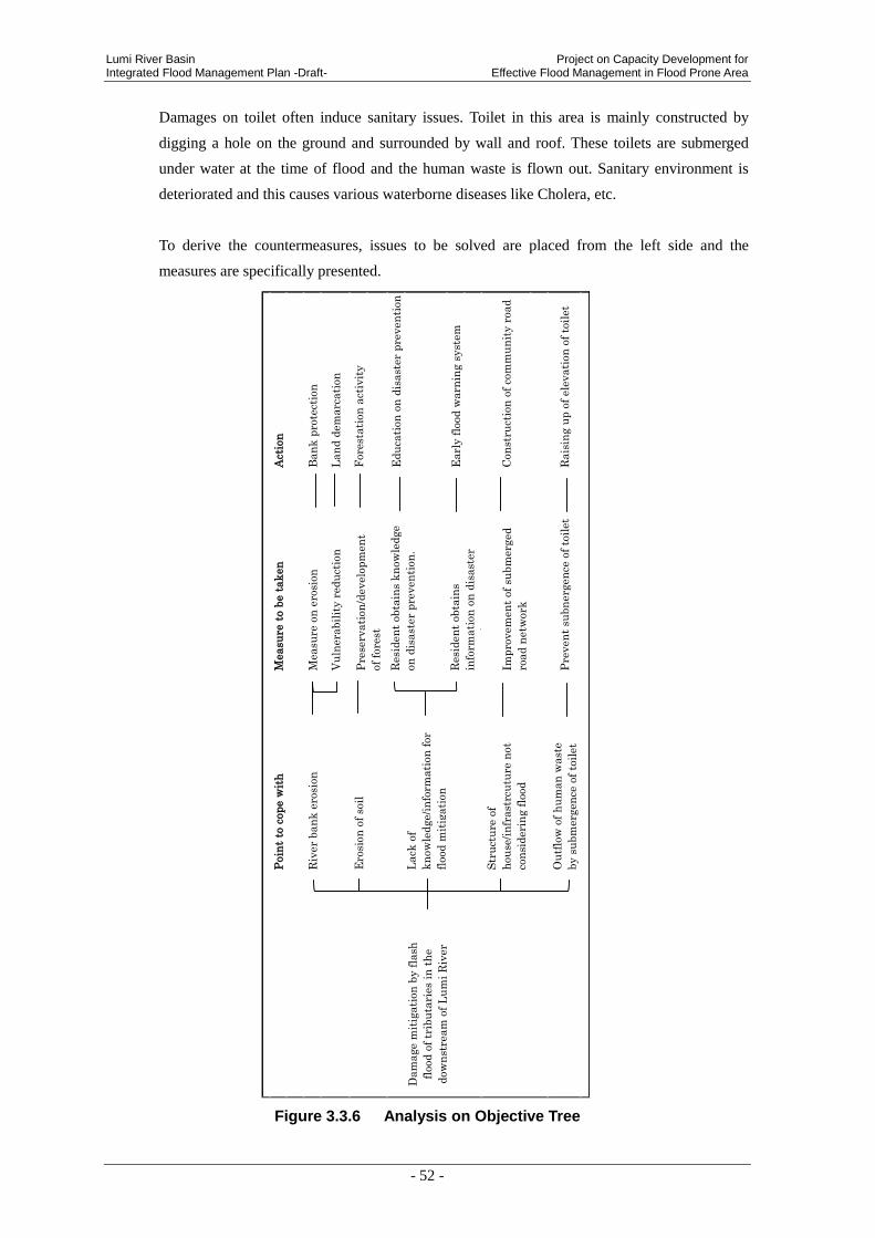
Lumi River Basin Project on Capacity Development for Integrated Flood Management Plan -Draft- Effective Flood Management in Flood Prone Area
- 52 -
Damages on toilet often induce sanitary issues. Toilet in this area is mainly constructed by
digging a hole on the ground and surrounded by wall and roof. These toilets are submerged
under water at the time of flood and the human waste is flown out. Sanitary environment is
deteriorated and this causes various waterborne diseases like Cholera, etc.
To derive the countermeasures, issues to be solved are placed from the left side and the
measures are specifically presented.
Figure 3.3.6 Analysis on Objective Tree
Poin
t to
cop
e w
ith
Mea
su
re t
o b
e t
ak
en
Act
ion
Riv
er
ban
k e
rosi
on
Measu
re o
n e
rosi
on
Ban
k p
rote
ctio
n
Vu
lnera
bil
ity r
ed
uct
ion
Lan
d d
em
arc
ati
on
Ero
sion
of
soil
Fore
stati
on
act
ivit
y
Ed
uca
tion
on
dis
ast
er
pre
ven
tion
Lack
of
kn
ow
led
ge/i
nfo
rmati
on
for
flood
mit
igati
on
Earl
y f
lood
warn
ing s
yst
em
Str
uct
ure
of
hou
se/i
nfr
ast
rcu
ture
not
con
sid
eri
ng f
lood
Con
stru
ctio
n o
f co
mm
un
ity r
oad
Ou
tflo
w o
f h
um
an
wast
e
by s
ubm
erg
en
ce o
f to
ilet
Pre
ven
t su
bn
erg
en
ce o
f to
ilet
Rais
ing u
p o
f ele
vati
on
of
toil
et
Imp
rovem
en
t of
subm
erg
ed
road
netw
ork
Pre
serv
ati
on
/develo
pm
en
t
of
fore
st
Dam
age m
itig
ati
on
by f
lash
flood
of
trib
uta
ries
in t
he
dow
nst
ream
of
Lu
mi
Riv
er
Resi
den
t obta
ins
kn
ow
led
ge
on
dis
ast
er
pre
ven
tion
.
Resi
den
t obta
ins
info
rmati
on
on
dis
ast
er
pre
ven
tion
.
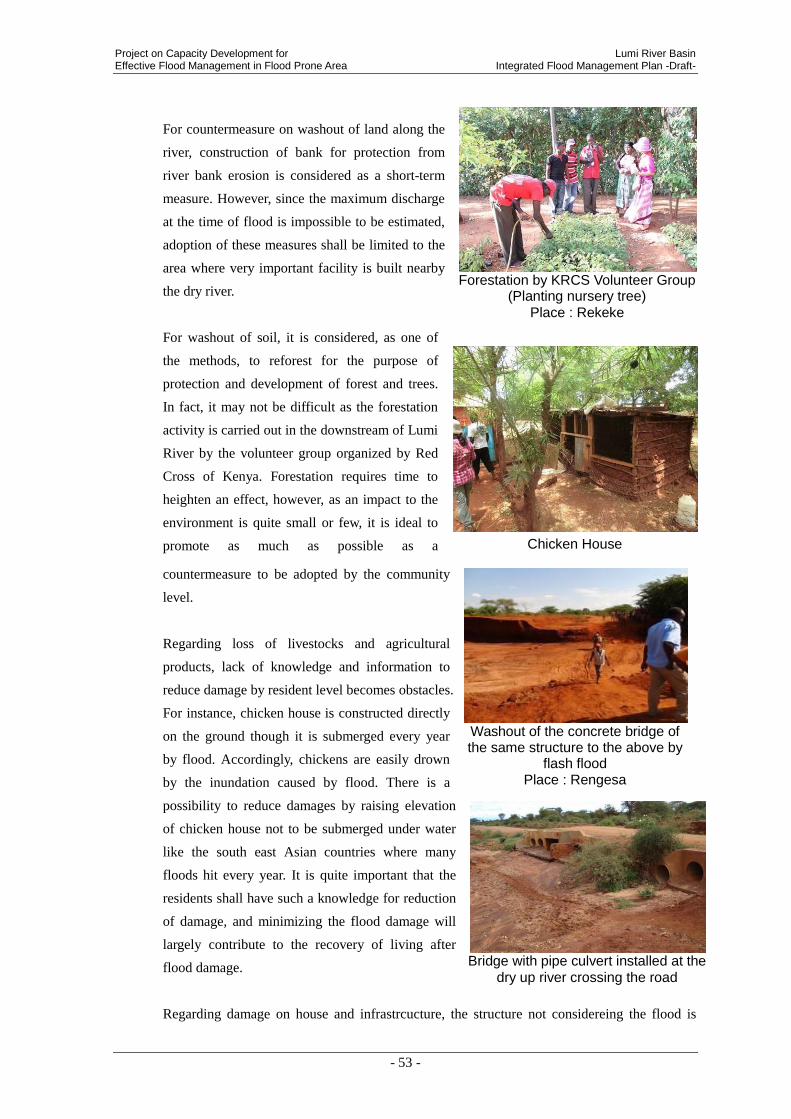
Project on Capacity Development for Lumi River Basin Effective Flood Management in Flood Prone Area Integrated Flood Management Plan -Draft-
- 53 -
For countermeasure on washout of land along the
river, construction of bank for protection from
river bank erosion is considered as a short-term
measure. However, since the maximum discharge
at the time of flood is impossible to be estimated,
adoption of these measures shall be limited to the
area where very important facility is built nearby
the dry river.
For washout of soil, it is considered, as one of
the methods, to reforest for the purpose of
protection and development of forest and trees.
In fact, it may not be difficult as the forestation
activity is carried out in the downstream of Lumi
River by the volunteer group organized by Red
Cross of Kenya. Forestation requires time to
heighten an effect, however, as an impact to the
environment is quite small or few, it is ideal to
promote as much as possible as a
countermeasure to be adopted by the community
level.
Regarding loss of livestocks and agricultural
products, lack of knowledge and information to
reduce damage by resident level becomes obstacles.
For instance, chicken house is constructed directly
on the ground though it is submerged every year
by flood. Accordingly, chickens are easily drown
by the inundation caused by flood. There is a
possibility to reduce damages by raising elevation
of chicken house not to be submerged under water
like the south east Asian countries where many
floods hit every year. It is quite important that the
residents shall have such a knowledge for reduction
of damage, and minimizing the flood damage will
largely contribute to the recovery of living after
flood damage.
Regarding damage on house and infrastrcucture, the structure not considereing the flood is
Chicken House
Bridge with pipe culvert installed at the
dry up river crossing the road
Washout of the concrete bridge of the same structure to the above by
flash flood Place : Rengesa
Forestation by KRCS Volunteer Group
(Planting nursery tree) Place : Rekeke
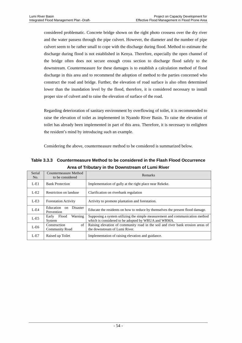
Lumi River Basin Project on Capacity Development for Integrated Flood Management Plan -Draft- Effective Flood Management in Flood Prone Area
- 54 -
considered problematic. Concrete bridge shown on the right photo crossess over the dry river
and the water passess through the pipe culvert. However, the diameter and the number of pipe
culvert seem to be rather small to cope with the discharge during flood. Method to estimate the
discharge during flood is not established in Kenya. Therefore, especially the open channel of
the bridge often does not secure enough cross section to discharge flood safely to the
downstream. Countermeasure for these damages is to establish a calculation method of flood
discharge in this area and to recommend the adoption of method to the parties concerned who
construct the road and bridge. Further, the elevation of road surface is also often determined
lower than the inundation level by the flood, therefore, it is considered necessary to install
proper size of culvert and to raise the elevation of surface of the road.
Regarding deterioration of sanitary environment by overflowing of toilet, it is recommended to
raise the elevation of toilet as implemented in Nyando River Basin. To raise the elevation of
toilet has already been implemented in part of this area. Therefore, it is necessary to enlighten
the resident’s mind by introducing such an example.
Considering the above, countermeasure method to be considered is summarized below.
Table 3.3.3 Countermeasure Method to be considered in the Flash Flood Occurrence
Area of Tributary in the Downstream of Lumi River
Serial
No.
Countermeasure Method
to be considered Remarks
L-E1 Bank Protection Implementation of gully at the right place near Rekeke.
L-E2 Restriction on landuse Clarification on riverbank regulation
L-E3 Forestation Activity Activity to promote plantation and forestation.
L-E4 Education on Disaster
Prevention Educate the residents on how to reduce by themselves the present flood damage.
L-E5 Early Flood Warning
System
Supposing a system utilizing the simple measurement and communication method
which is considered to be adopted by WRUA and WRMA.
L-E6 Construction of
Community Road
Raising elevation of community road in the soil and river bank erosion areas of
the downstream of Lumi River.
L-E7 Raised up Toilet Implementation of raising elevation and guidance.
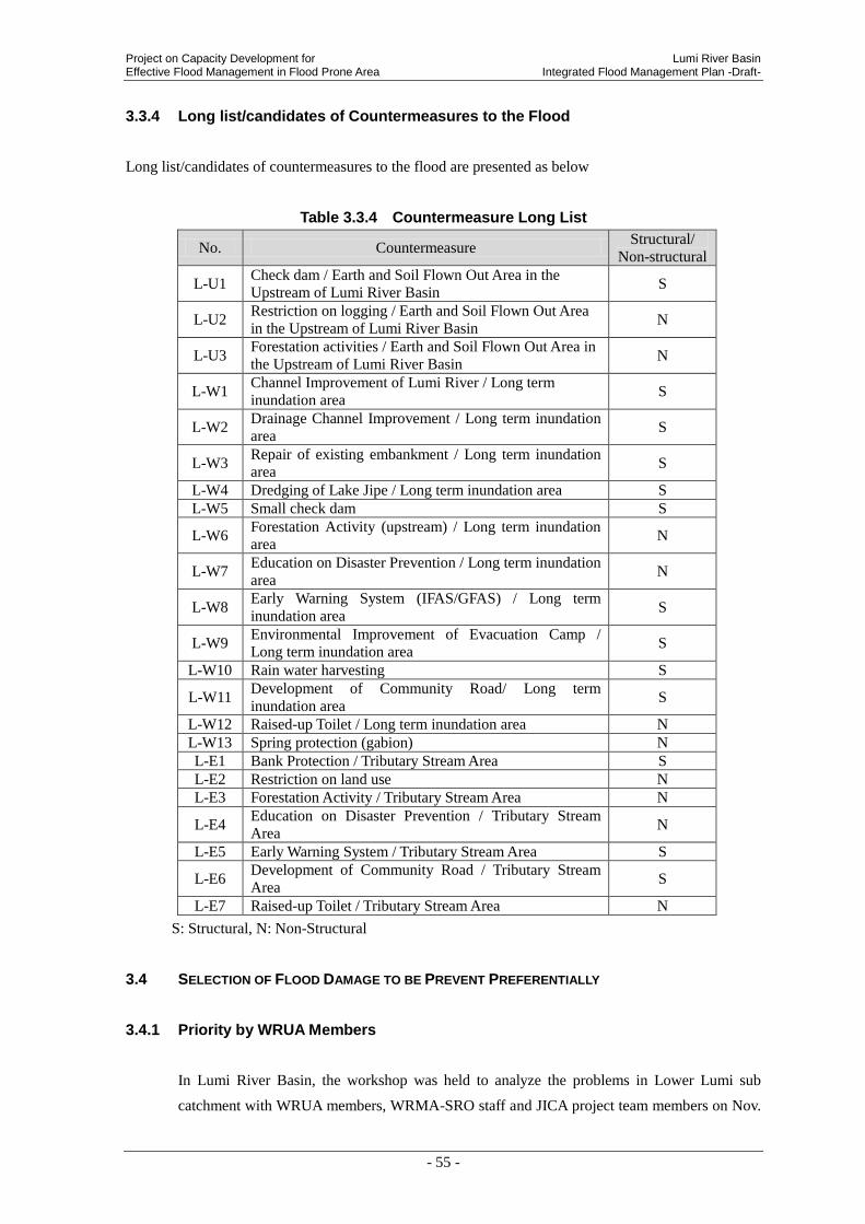
Project on Capacity Development for Lumi River Basin Effective Flood Management in Flood Prone Area Integrated Flood Management Plan -Draft-
- 55 -
3.3.4 Long list/candidates of Countermeasures to the Flood
Long list/candidates of countermeasures to the flood are presented as below
Table 3.3.4 Countermeasure Long List
No. Countermeasure Structural/
Non-structural
L-U1 Check dam / Earth and Soil Flown Out Area in the
Upstream of Lumi River Basin S
L-U2 Restriction on logging / Earth and Soil Flown Out Area
in the Upstream of Lumi River Basin N
L-U3 Forestation activities / Earth and Soil Flown Out Area in
the Upstream of Lumi River Basin N
L-W1 Channel Improvement of Lumi River / Long term
inundation area S
L-W2 Drainage Channel Improvement / Long term inundation
area S
L-W3 Repair of existing embankment / Long term inundation
area S
L-W4 Dredging of Lake Jipe / Long term inundation area S
L-W5 Small check dam S
L-W6 Forestation Activity (upstream) / Long term inundation
area N
L-W7 Education on Disaster Prevention / Long term inundation
area N
L-W8 Early Warning System (IFAS/GFAS) / Long term
inundation area S
L-W9 Environmental Improvement of Evacuation Camp /
Long term inundation area S
L-W10 Rain water harvesting S
L-W11 Development of Community Road/ Long term
inundation area S
L-W12 Raised-up Toilet / Long term inundation area N
L-W13 Spring protection (gabion) N
L-E1 Bank Protection / Tributary Stream Area S
L-E2 Restriction on land use N
L-E3 Forestation Activity / Tributary Stream Area N
L-E4 Education on Disaster Prevention / Tributary Stream
Area N
L-E5 Early Warning System / Tributary Stream Area S
L-E6 Development of Community Road / Tributary Stream
Area S
L-E7 Raised-up Toilet / Tributary Stream Area N
S: Structural, N: Non-Structural
3.4 SELECTION OF FLOOD DAMAGE TO BE PREVENT PREFERENTIALLY
3.4.1 Priority by WRUA Members
In Lumi River Basin, the workshop was held to analyze the problems in Lower Lumi sub
catchment with WRUA members, WRMA-SRO staff and JICA project team members on Nov.

Lumi River Basin Project on Capacity Development for Integrated Flood Management Plan -Draft- Effective Flood Management in Flood Prone Area
- 56 -
2nd, 2012
As a result of analysis, the causes of flood are pointed out as bellow.
Table 3.4.1 Analysis for the causes of flood by interviewing to WRUA Members
Theme Causes Principal Influence from
Flooding
Floods
(Upstream)
Rainfall around the Mt. Kilimanjaro slope Flash Floods
Sediment flow from Mountain slope
Floods
(Downstream)
Rise of east side Wadi river apart from the
Lumi river Flash Floods around tributary
Sediment flow around upstream
→Raised bed river
Flooding by long term
inundation
Bank erosion
→Newly generation of river course River course diversion
Concerning flood damages, following analysis was done and was indicated the priority order
lead by WRUA members
Table 3.4.2 Damage Analysis and Priority by WRUA Members
Priority by WRUA
members Type of Damage Primary Damage Secondary Damage
①
Soil erosion
(Middle stream)
- Sediment outflow to downstream - Raised up the river bed (Lumi
river,Lane Jipe)
Soil erosion
(Downstream)
- Destruction of farmland
② Submersion - Submersion and destruction of houses
- Farmland damage
- Evacuation
- Suspending educational
activities
- Income decreasing
- Food shortage
③ Polluted water
resource - Pollution of springs
- Water shortage
- Drought
④ Damage of
infrastructures
- Cutting roads between (Eldoro and Taveta /
Taveta and Kitobo / Taveta and Jipe )
- School
- Unable to get commodities
- Unable to transport
⑤ Lives - Livestock
- Human (Rare case)
3.4.2 Selection of Flood Damage to be prioritized
The flood damages in Lumi river basin is principally classified 3 types such as A) Soil and
sediment run off (Upper and middle river basin), B) Widespread and long-running inundation
which is caused by overflow and dyke break from the Lumi River (Low-lying area at the lower
river basin) and C) Flash flood (Branches of the Lower Lumi River and small streams flow in
the Lake Jipe).
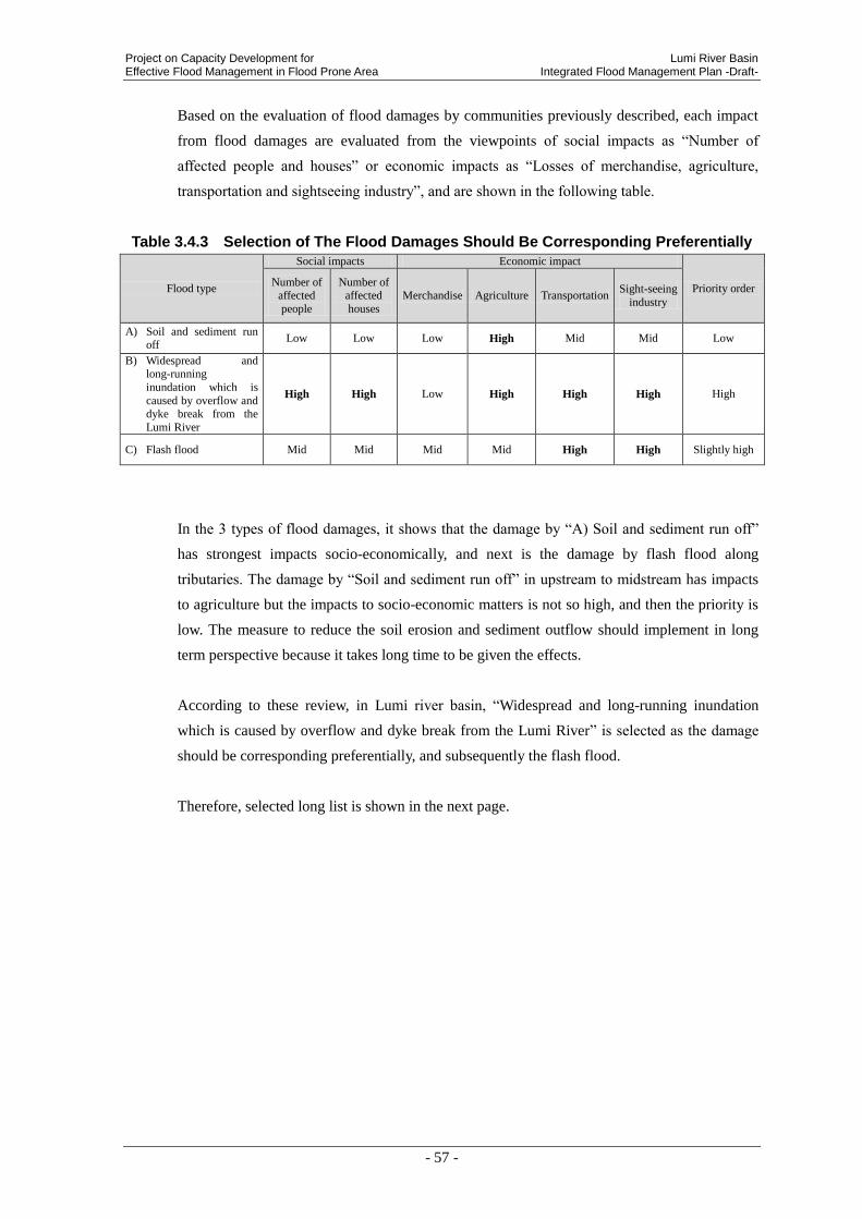
Project on Capacity Development for Lumi River Basin Effective Flood Management in Flood Prone Area Integrated Flood Management Plan -Draft-
- 57 -
Based on the evaluation of flood damages by communities previously described, each impact
from flood damages are evaluated from the viewpoints of social impacts as “Number of
affected people and houses” or economic impacts as “Losses of merchandise, agriculture,
transportation and sightseeing industry”, and are shown in the following table.
Table 3.4.3 Selection of The Flood Damages Should Be Corresponding Preferentially
Flood type
Social impacts Economic impact
Priority order Number of
affected
people
Number of affected
houses
Merchandise Agriculture Transportation Sight-seeing
industry
A) Soil and sediment run off
Low Low Low High Mid Mid Low
B) Widespread and long-running
inundation which is
caused by overflow and dyke break from the
Lumi River
High High Low High High High High
C) Flash flood Mid Mid Mid Mid High High Slightly high
In the 3 types of flood damages, it shows that the damage by “A) Soil and sediment run off”
has strongest impacts socio-economically, and next is the damage by flash flood along
tributaries. The damage by “Soil and sediment run off” in upstream to midstream has impacts
to agriculture but the impacts to socio-economic matters is not so high, and then the priority is
low. The measure to reduce the soil erosion and sediment outflow should implement in long
term perspective because it takes long time to be given the effects.
According to these review, in Lumi river basin, “Widespread and long-running inundation
which is caused by overflow and dyke break from the Lumi River” is selected as the damage
should be corresponding preferentially, and subsequently the flash flood.
Therefore, selected long list is shown in the next page.
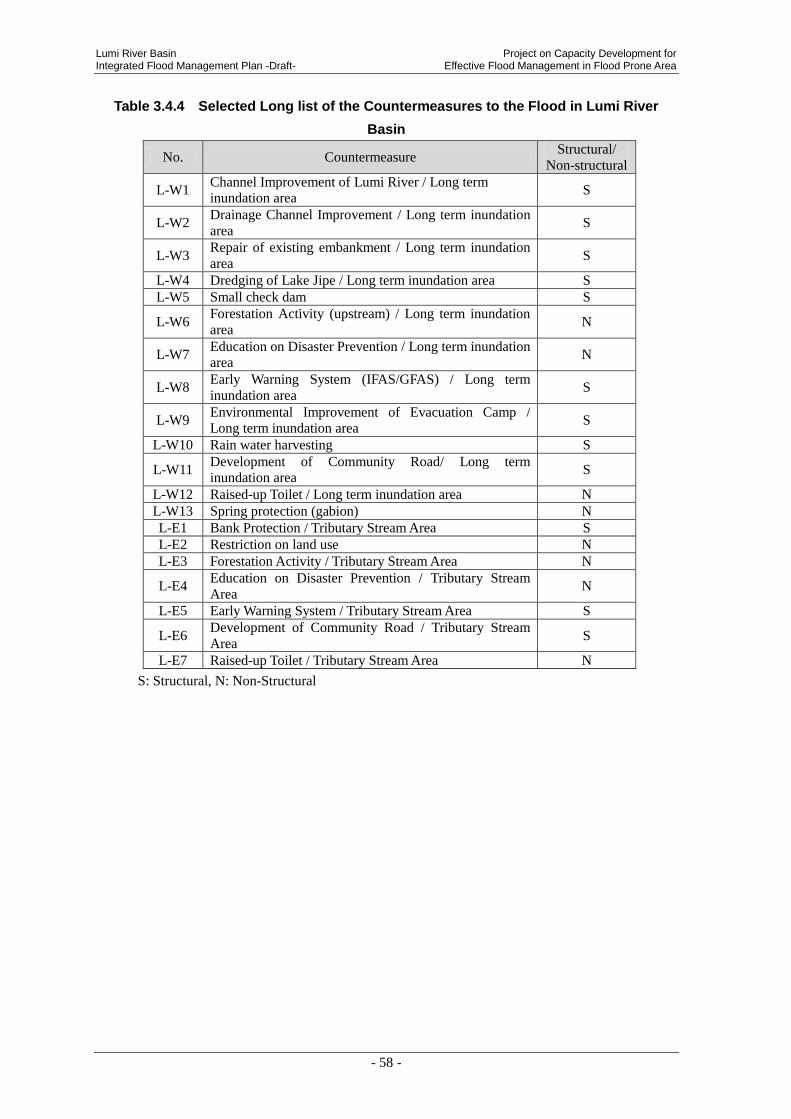
Lumi River Basin Project on Capacity Development for Integrated Flood Management Plan -Draft- Effective Flood Management in Flood Prone Area
- 58 -
Table 3.4.4 Selected Long list of the Countermeasures to the Flood in Lumi River
Basin
No. Countermeasure Structural/
Non-structural
L-W1 Channel Improvement of Lumi River / Long term
inundation area S
L-W2 Drainage Channel Improvement / Long term inundation
area S
L-W3 Repair of existing embankment / Long term inundation
area S
L-W4 Dredging of Lake Jipe / Long term inundation area S
L-W5 Small check dam S
L-W6 Forestation Activity (upstream) / Long term inundation
area N
L-W7 Education on Disaster Prevention / Long term inundation
area N
L-W8 Early Warning System (IFAS/GFAS) / Long term
inundation area S
L-W9 Environmental Improvement of Evacuation Camp /
Long term inundation area S
L-W10 Rain water harvesting S
L-W11 Development of Community Road/ Long term
inundation area S
L-W12 Raised-up Toilet / Long term inundation area N
L-W13 Spring protection (gabion) N
L-E1 Bank Protection / Tributary Stream Area S
L-E2 Restriction on land use N
L-E3 Forestation Activity / Tributary Stream Area N
L-E4 Education on Disaster Prevention / Tributary Stream
Area N
L-E5 Early Warning System / Tributary Stream Area S
L-E6 Development of Community Road / Tributary Stream
Area S
L-E7 Raised-up Toilet / Tributary Stream Area N
S: Structural, N: Non-Structural

Project on Capacity Development for Lumi River Basin Effective Flood Management in Flood Prone Area Integrated Flood Management Plan -Draft-
- 59 -
4. EVALUATION OF COUNTERMEASURES TO THE FLOOD
4.1 VIEW POINT OF EVALUATION
Candidate countermeasures that are extracted in last chapter are studied in detail. On the basis
of the result of last chapter, 5 criteria; relevance, effectiveness, efficiency, impact and
sustainability is considered.
The project team defined 5 criteria as the description on following table, and then evaluated the
countermeasures by marking “A”, “B” and “C” according to these 5 Items.
Table 4.1.1 Definition of 5 Items for Pilot Project Selection
1 Relevance Requirements from the stakeholders, Needs of target area Dimension of economic damage and human suffering.
2 Effectiveness Degree of damage mitigation (Number of beneficiary, Reduction of submergence period, area and number of affected people)
3 Efficiency Cost effectiveness (It is evaluated by estimated qualitative dimension and degree of damage mitigation)
4 Impact Spreading effect within a same basin or to other areas Indirect effects
5 Sustainability Sustainability of maintenance and project effects (On the assumption of pilot project completion according to the design.)
*The project team defined these 5 items for the purpose of this study according to “DAC’s evaluation 5 items”

Lumi River Basin Project on Capacity Development for Integrated Flood Management Plan -Draft- Effective Flood Management in Flood Prone Area
- 60 -
4.2 EVALUATION RESULT FOR EACH COUNTERMEASURE
Table 4.2.1 Evaluation Study on countermeasure against long term inundation from
Lumi River / downstream area(1)
No. L-W1
Target Area Downstream of Lumi River
Countermeasure Channel Improvement of Lumi River
Outline It is a work to widen of the river and to dredge raised river bed.
Image
Evaluation items
Ev
alu
atio
n b
y F
ive C
riteria
Relevance
Flood damage is huge in this area. Residents and
stakeholder highly request to improve the actual
situation. Lack of flow capacity of Lumi river is the
main factor. Excavation and widening of the river
channel is effective and necessary.
A 3
Effectiveness It contributes considerably to reduction of long term
inundation from Lumi River. A 3
Efficiency Both cost and effectiveness are medium scale. B 2
Impact
Spreading effect is small. (The construction requires
respective design and plan according to flood
characteristics, climate and geological formation of the
site.)
C 1
Sustainability
Continuous maintenance is necessary. If WRUA
implements this project with WSTF fund, additional
maintenance cost should be considered.
C 1
Total 10
Merit Easy appearance of effects
Demerit
Relevance with PCDEFM project is low.
Each stage such as planning, design, and construction need long term.
Continuous maintenance, High costs.
Environmental
Negative Impact Silting at downstream, Bio diversity
Necessity of EIA Necessary
Contribution by the
residents Soil carriage
Responsible
Institution/Agency WRMA
Main Actor Taveta County/MWI/NWCPC
Public
assistance/Mutual
support /Self-help
Public Assistance
A (3 point): Excellent / B (2 point) : Good / C (1 point) : Poor
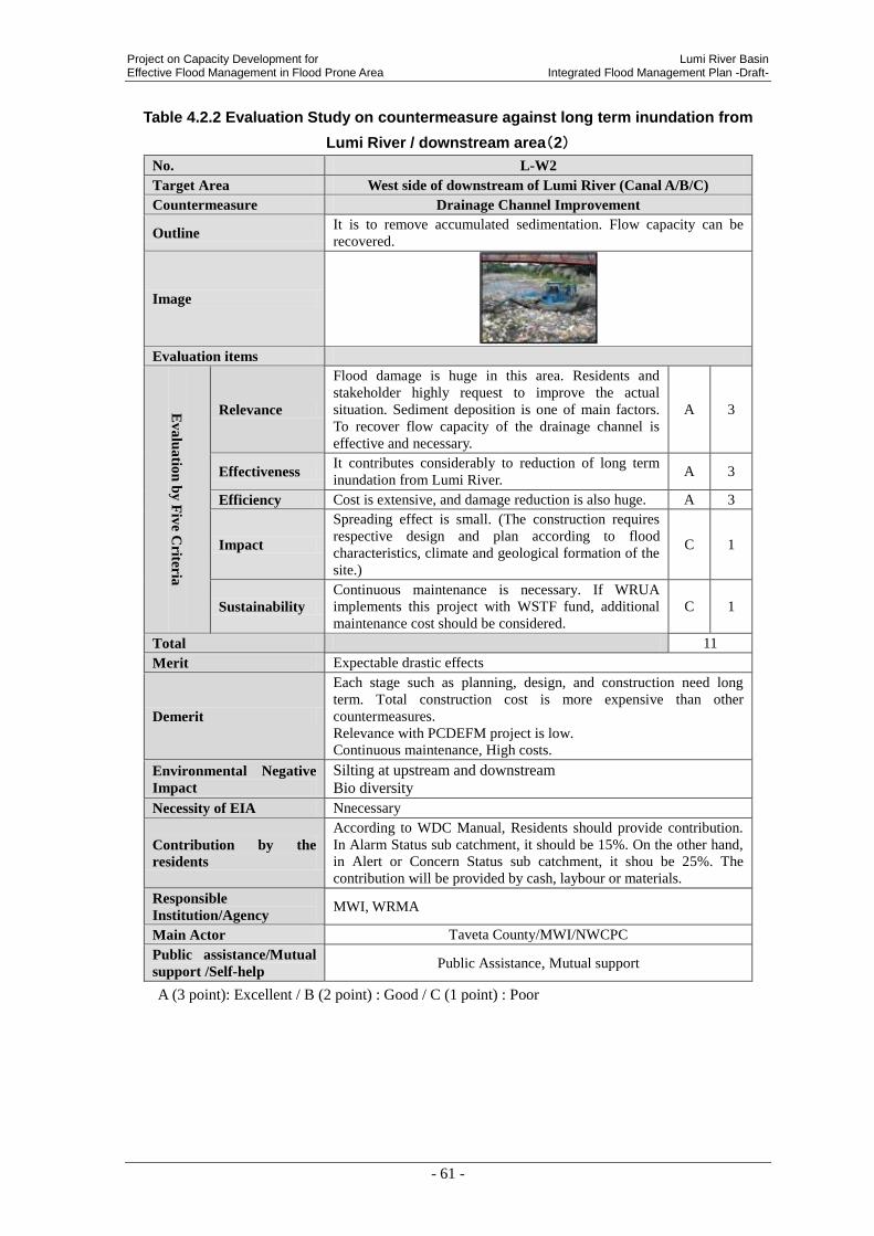
Project on Capacity Development for Lumi River Basin Effective Flood Management in Flood Prone Area Integrated Flood Management Plan -Draft-
- 61 -
Table 4.2.2 Evaluation Study on countermeasure against long term inundation from
Lumi River / downstream area(2)
No. L-W2
Target Area West side of downstream of Lumi River (Canal A/B/C)
Countermeasure Drainage Channel Improvement
Outline It is to remove accumulated sedimentation. Flow capacity can be
recovered.
Image
Evaluation items
Ev
alu
atio
n b
y F
ive C
riteria
Relevance
Flood damage is huge in this area. Residents and
stakeholder highly request to improve the actual
situation. Sediment deposition is one of main factors.
To recover flow capacity of the drainage channel is
effective and necessary.
A 3
Effectiveness It contributes considerably to reduction of long term
inundation from Lumi River. A 3
Efficiency Cost is extensive, and damage reduction is also huge. A 3
Impact
Spreading effect is small. (The construction requires
respective design and plan according to flood
characteristics, climate and geological formation of the
site.)
C 1
Sustainability
Continuous maintenance is necessary. If WRUA
implements this project with WSTF fund, additional
maintenance cost should be considered.
C 1
Total 11
Merit Expectable drastic effects
Demerit
Each stage such as planning, design, and construction need long
term. Total construction cost is more expensive than other
countermeasures.
Relevance with PCDEFM project is low.
Continuous maintenance, High costs.
Environmental Negative
Impact
Silting at upstream and downstream
Bio diversity
Necessity of EIA Nnecessary
Contribution by the
residents
According to WDC Manual, Residents should provide contribution.
In Alarm Status sub catchment, it should be 15%. On the other hand,
in Alert or Concern Status sub catchment, it shou be 25%. The
contribution will be provided by cash, laybour or materials.
Responsible
Institution/Agency MWI, WRMA
Main Actor Taveta County/MWI/NWCPC
Public assistance/Mutual
support /Self-help Public Assistance, Mutual support
A (3 point): Excellent / B (2 point) : Good / C (1 point) : Poor

Lumi River Basin Project on Capacity Development for Integrated Flood Management Plan -Draft- Effective Flood Management in Flood Prone Area
- 62 -
Table 4.2.3 Evaluation Study on countermeasure against long term inundation from
Lumi River / downstream area(3)
No. L-W3
Target Area West side of downstream of Lumi River (Canal C)
Countermeasure Repair of existing embankment
Outline It is repair work of existing embankment (canal C).
Overflow stream from Lumi River can be minimized.
Image
Evaluation items
Ev
alu
atio
n b
y F
ive C
riteria
Relevance
Flood damage is huge in this area. Residents and
stakeholder highly request to improve the actual situation.
To bank up overflow from Lumi river and to lead to Canal
C is effective and necessary.
A 3
Effectiveness It contributes considerably to reduction of long term
inundation from Lumi River. A 3
Efficiency Both cost and effectiveness are medium scale. B 2
Impact
It is difficult to spread structural works itself. However,
maintenance system that is already operated by WRUA in
this community can be spread.
B 2
Sustainability
Continuous maintenance is necessary. Fortunately, WRUA
members at this community already operate maintenance
system of irrigation facilities voluntary. Sustainability is
highly expected.
B 2
Total 12
Merit Repair of broken part of Canal C is relatively simple and short term.
Easy appearance of effects.
Demerit Securing stabilities, High costs
Environmental
Negative Impact Nil
Necessity of EIA Unnecessary
Contribution by the
residents
According to WDC Manual, Residents should provide contribution. In
Alarm Status sub catchment, it should be 15%. On the other hand, in
Alert or Concern Status sub catchment, it shou be 25%. The
contribution will be provided by cash, laybour or materials.
Responsible
Institution/Agency MWI, WRMA
Main Actor Taveta County/MWI/NWCPC
Public
assistance/Mutual
support /Self-help
Public Assistance, Mutual support
A (3 point): Excellent / B (2 point) : Good / C (1 point) : Poor
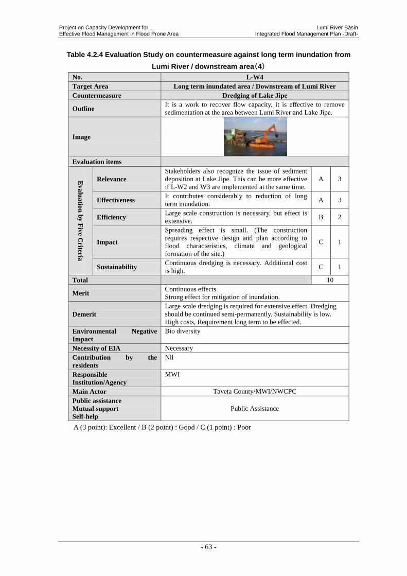
Project on Capacity Development for Lumi River Basin Effective Flood Management in Flood Prone Area Integrated Flood Management Plan -Draft-
- 63 -
Table 4.2.4 Evaluation Study on countermeasure against long term inundation from
Lumi River / downstream area(4)
No. L-W4
Target Area Long term inundated area / Downstream of Lumi River
Countermeasure Dredging of Lake Jipe
Outline It is a work to recover flow capacity. It is effective to remove
sedimentation at the area between Lumi River and Lake Jipe.
Image
Evaluation items
Ev
alu
atio
n b
y F
ive C
riteria
Relevance
Stakeholders also recognize the issue of sediment
deposition at Lake Jipe. This can be more effective
if L-W2 and W3 are implemented at the same time.
A 3
Effectiveness It contributes considerably to reduction of long
term inundation. A 3
Efficiency Large scale construction is necessary, but effect is
extensive. B 2
Impact
Spreading effect is small. (The construction
requires respective design and plan according to
flood characteristics, climate and geological
formation of the site.)
C 1
Sustainability Continuous dredging is necessary. Additional cost
is high. C 1
Total 10
Merit Continuous effects
Strong effect for mitigation of inundation.
Demerit
Large scale dredging is required for extensive effect. Dredging
should be continued semi-permanently. Sustainability is low.
High costs, Requirement long term to be effected.
Environmental Negative
Impact
Bio diversity
Necessity of EIA Necessary
Contribution by the
residents
Nil
Responsible
Institution/Agency
MWI
Main Actor Taveta County/MWI/NWCPC
Public assistance
Mutual support
Self-help
Public Assistance
A (3 point): Excellent / B (2 point) : Good / C (1 point) : Poor

Lumi River Basin Project on Capacity Development for Integrated Flood Management Plan -Draft- Effective Flood Management in Flood Prone Area
- 64 -
Table 4.2.5 Evaluation Study on countermeasure against long term inundation from
Lumi River / downstream area(5)
No. L-W5
Target Area Long term inundated area / Downstream of Lumi River
Countermeasure Small check dam
Outline Restrain silting and rising of riverbed
Image
Evaluation items
Ev
alu
atio
n b
y F
ive
Criter
ia
Relevance Stakeholders require small check dams strongly to
restrain silting at lower Lumi. A 3
Effectiveness It contributes considerably to reduction of silting partly. B 2
Efficiency Large scale construction is not necessary, but effect is
limited in local point. B 2
Impact Spreading effect is small. C 1
Sustainability
Continuous dredging is necessary.
Effects fade out with time passing. Cost is not low.
C 1
Total 9
Merit Easy to distribute
Demerit
Each process such as planning, design, and construction need long
term. Large scale dredging is required for extensive effect. Dredging
should be continued semi-permanently. Sustainability is low.
Environmental
Negative Impact
Bio diversity.
Necessity of EIA Nnecessary
Contribution by the
residents
According to WDC Manual, Residents should provide contribution. In
Alarm Status sub catchment, it should be 15%. On the other hand, in
Alert or Concern Status sub catchment, it shou be 25%. The
contribution will be provided by cash, laybour or materials.
Responsible
Institution/Agency
MWI, WRMA
Main Actor Taveta County/MWI/NWCPC
Public assistance
Mutual support
Self-help
Public Assistance, Mutual support
A (3 point): Excellent / B (2 point) : Good / C (1 point) : Poor

Project on Capacity Development for Lumi River Basin Effective Flood Management in Flood Prone Area Integrated Flood Management Plan -Draft-
- 65 -
Table 4.2.6 Evaluation Study on countermeasure against long term inundation from
Lumi River / downstream area(6)
No. L-W6
Target Area Long term inundated area / Downstream of Lumi River
Countermeasure Forestation Activity at Upstream
Outline It is to protect and recover vegetation in the upstream of the mountain.
Its storage effect will rise.
Image
Evaluation items
Ev
alu
atio
n b
y F
ive C
riteria
Relevance Volunteer groups already practice forestation activity at
downstream. Collaboration with them is expected. A 3
Effectiveness
If this countermeasure implement at appropriate scale,
sedimentation from upstream would reduce. Effects of determinate erosion restraint will be
expected
B 2
Efficiency Both cost and effectiveness are medium scale. B 2
Impact
Application in other area is not difficult. In addition, it
contributes environmental conservation.
There is a limitation for appropriate places to be
implemented.
B 2
Sustainability
Once main actor is aware the importance, activity can
continue. Maintenance is complicate. It takes time to
grow up.
B 2
Total 11
Merit
Evaluation is high on all items. It contributes to reduce global
warming.
Easy to start, Low costs, Easy to distribute.
Demerit Requirement long term to be effected
Environmental
Negative Impact Bio diversity
Necessity of EIA Necessary
Contribution by the
residents
According to WDC Manual, Residents should provide contribution. In
Alarm Status sub catchment, it should be 15%. On the other hand, in
Alert or Concern Status sub catchment, it shou be 25%. The
contribution will be provided by cash, laybour or materials.(Planting
assistance, Raising nursery trees)
Responsible
Institution/Agency WRUA, KRCS
Main Actor WRUA etc.
Public assistance
Mutual support
Self-help
Mutual Support
A (3 point): Excellent / B (2 point) : Good / C (1 point) : Poor

Lumi River Basin Project on Capacity Development for Integrated Flood Management Plan -Draft- Effective Flood Management in Flood Prone Area
- 66 -
Table 4.2.7 Evaluation Study on countermeasure against long term inundation from
Lumi River / downstream area(7)
No. L-W7
Target Area Long term inundated area / Downstream of Lumi River
Countermeasure Education on Disaster prevention
Outline It is educational activity to give information to reduce damage from flood
and raise awareness of disaster prevention.
Image
Evaluation items
Ev
alu
atio
n b
y F
ive C
riteria
Relevance
WRMA has a high request of enforcement of community. In
addition, some damage can prevent if people have knowledge
on flood management. So it importance is high.
A 3
Effectiveness
It is expected certain effect against number of educated
people. Their knowledge on disaster prevention can
implement wherever and whenever they need. Its effect can be
spread.
B 2
Efficiency
It can give knowledge on disaster prevention to a large
number of people at the same time. Cost is low. Effectiveness
is high when the knowledge is rooted.
A 3
Impact Knowledge can hand down from beneficiary to their family
and friends. It can expand widely. A 3
Sustainability
Local people such as school teacher and community leader
can be a lecturer. So educational activity sustain. In addition,
integration into curriculum is important.
A 3
Total 14
Merit
Preparation can be short term. Community based activity relates with
concept of PCDEFM project.
Easy to distribute, Low costs.
Demerit Requirement long term to be effective
Environmental
Negative Impact Nil
Necessity of EIA Unnecessary
Contribution by the
residents Preparing the relevant materials
Responsible
Institution/Agency WRUA, KRCS
Main Actor Ministry of Education/ Taveta County Educational Officer/ Teachers /
WRUA
Public assistance
Mutual support
Self-help
Mutual Support・Public Assistance
A (3 point): Excellent / B (2 point) : Good / C (1 point) : Poor
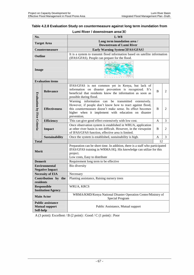
Project on Capacity Development for Lumi River Basin Effective Flood Management in Flood Prone Area Integrated Flood Management Plan -Draft-
- 67 -
Table 4.2.8 Evaluation Study on countermeasure against long term inundation from
Lumi River / downstream area(8)
No. L-W8
Target Area Long term inundation area /
Downstream of Lumi River
Countermeasure Early Warning System(IFAS/GFAS)
Outline It is a system to transmit flood information based on satellite information
(IFAS/GFAS). People can prepare for the flood.
Image
Evaluation items
Ev
alu
atio
n b
y F
ive C
riteria
Relevance
IFAS/GFAS is not common yet in Kenya, but lack of
information on disaster prevention is recognized. It’s
beneficial that residents know the information as soon as
possible during flood.
B 2
Effectiveness
Warning information can be transmitted extensively.
However, if people don’t know how to react against flood,
this countermeasure doesn’t make sense. Its effect becomes
higher when it implement with education on disaster
prevention.
B 2
Efficiency This can give good effect extensively with low cost. A 3
Impact
Once observation system is established in WRUA, application
at other river basin is not difficult. However, in the viewpoint
of IFAS/GFAS function, effective area is limited.
B 2
Sustainability Once the system is established, sustainability is high. A 3
Total 12
Merit
Preparation can be short time. In addition, there is a staff who participated
IFAS/GFAS training in WRMA HQ. His knowledge can utilize for this
project.
Low costs, Easy to distribute
Demerit Requirement long term to be effective
Environmental
Negative Impact
Bio diversity
Necessity of EIA Necessary
Contribution by the
residents
Planting assistance, Raising nursery trees
Responsible
Institution/Agency
WRUA, KRCS
Main Actor WRMA/KMD/Kenya National Disaster Operation Center/Ministry of
Special Program
Public assistance
Mutual support
Self-help
Public Assistance, Mutual support
A (3 point): Excellent / B (2 point) : Good / C (1 point) : Poor

Lumi River Basin Project on Capacity Development for Integrated Flood Management Plan -Draft- Effective Flood Management in Flood Prone Area
- 68 -
Table 4.2.9 Evaluation Study on countermeasure against long term inundation from
Lumi River / downstream area(9)
No. L-W9
Target Area Long term inundation area /
Downstream of Lumi River
Countermeasure Environmental Improvement of Evacuation Camp
Outline It is to enhance and improve existing evacuation Camp during flood.
Image
Evaluation items
Ev
alu
atio
n b
y F
ive C
riteria
Relevance Flood damage is huge in this area. Residents and
stakeholder highly request to improve the actual situation. A 3
Effectiveness There are existing evacuation centers in this area.
Application is effective and in demand. A 3
Efficiency Both cost and effectiveness are medium scale if this
attempt will be for numerous number of evacuees. B 2
Impact
The construction requires respective design and plan
according to flood characteristics, climate and geological
formation of the site.
B 2
Sustainability Maintenance cost is not so expensive. However,
maintenance system should be established. B 2
Total 12
Merit Since this matter is an improvement of existing evacuation camp, It will be easy to implement.
Demerit Continuous maintenance
Necessary for land acquisition.
Environmental
Negative Impact Nil
Necessity of EIA Unnecessary
Contribution by the
residents
According to WDC Manual, Residents should provide contribution. In
Alarm Status sub catchment, it should be 15%. On the other hand, in Alert
or Concern Status sub catchment, it shou be 25%. The contribution will be
provided by cash, laybour or materials.
Responsible
Institution/Agency WRUA
Main Actor Taveta County/ Kenya National Disaster Operation Center/Ministry of
Special Program
Public assistance
Mutual support
Self-help
Mutual support,
A (3 point): Excellent / B (2 point) : Good / C (1 point) : Poor
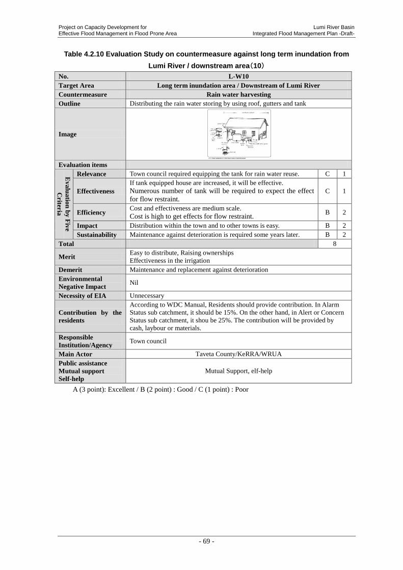
Project on Capacity Development for Lumi River Basin Effective Flood Management in Flood Prone Area Integrated Flood Management Plan -Draft-
- 69 -
Table 4.2.10 Evaluation Study on countermeasure against long term inundation from
Lumi River / downstream area(10)
No. L-W10
Target Area Long term inundation area / Downstream of Lumi River
Countermeasure Rain water harvesting
Outline Distributing the rain water storing by using roof, gutters and tank
Image
Evaluation items
Ev
alu
atio
n b
y F
ive
Criter
ia
Relevance Town council required equipping the tank for rain water reuse. C 1
Effectiveness
If tank equipped house are increased, it will be effective.
Numerous number of tank will be required to expect the effect
for flow restraint.
C 1
Efficiency Cost and effectiveness are medium scale.
Cost is high to get effects for flow restraint. B 2
Impact Distribution within the town and to other towns is easy. B 2
Sustainability Maintenance against deterioration is required some years later. B 2
Total 8
Merit Easy to distribute, Raising ownerships
Effectiveness in the irrigation
Demerit Maintenance and replacement against deterioration
Environmental
Negative Impact Nil
Necessity of EIA Unnecessary
Contribution by the
residents
According to WDC Manual, Residents should provide contribution. In Alarm
Status sub catchment, it should be 15%. On the other hand, in Alert or Concern
Status sub catchment, it shou be 25%. The contribution will be provided by
cash, laybour or materials.
Responsible
Institution/Agency Town council
Main Actor Taveta County/KeRRA/WRUA
Public assistance
Mutual support
Self-help
Mutual Support, elf-help
A (3 point): Excellent / B (2 point) : Good / C (1 point) : Poor

Lumi River Basin Project on Capacity Development for Integrated Flood Management Plan -Draft- Effective Flood Management in Flood Prone Area
- 70 -
Table 4.2.11 Evaluation Study on countermeasure against long term inundation from Lumi River / downstream area(11)
No. L-W11 Target Area Long term inundation area / Downstream of Lumi River Countermeasure Development of Community Road
Outline It means to construct a culvert or rise up community road in order to prevent its incapability by flood.
Image
Evaluation items
Evaluation by Five C
riteria
Relevance Community road is inundated during flood. It disturbs evacuation, communication in the community and communing to school. Residents request highly, Raised up road is required.
A 3
Effectiveness Flood damage in this community is surely reduced. Restraint of evacuation root. B 2
Efficiency Both cost and effectiveness are medium scale. High costs will be required to get effects in wide areas. B 2
Impact Almost all community have small scale road. Construction of such kind of road is not difficult. Application at other area is expected. B 2
Sustainability Maintenance cost is not so expensive. However, maintenance system should be established. B 2
Total 11 Merit Short term to be effective
Demerit Continuous maintenance, Each process of planning, design and construction could take long time.
Environmental Negative Impact Nil
Necessity of EIA Unnecessary
Contribution by the residents
According to WDC Manual, Residents should provide contribution. In Alarm Status sub catchment, it should be 15%. On the other hand, in Alert or Concern Status sub catchment, it shou be 25%. The contribution will be provided by cash, laybour or materials.
Responsible Institution/Agency KeRRA, WRUA
Main Actor Taveta County/KeRRA/WRUA Public assistance Mutual support Self-help
Public assistance, Mutual Support
A (3 point): Excellent / B (2 point) : Good / C (1 point) : Poor
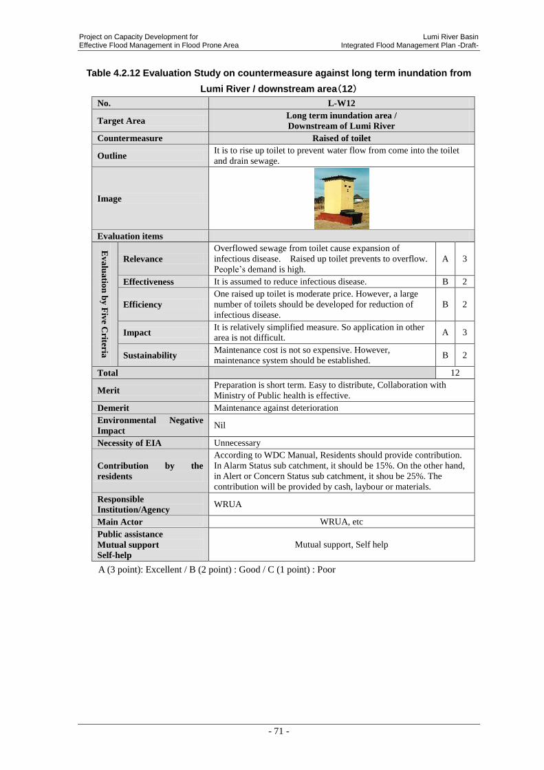
Project on Capacity Development for Lumi River Basin Effective Flood Management in Flood Prone Area Integrated Flood Management Plan -Draft-
- 71 -
Table 4.2.12 Evaluation Study on countermeasure against long term inundation from
Lumi River / downstream area(12)
No. L-W12
Target Area Long term inundation area /
Downstream of Lumi River
Countermeasure Raised of toilet
Outline It is to rise up toilet to prevent water flow from come into the toilet
and drain sewage.
Image
Evaluation items
Ev
alu
atio
n b
y F
ive C
riteria
Relevance
Overflowed sewage from toilet cause expansion of
infectious disease. Raised up toilet prevents to overflow.
People’s demand is high.
A 3
Effectiveness It is assumed to reduce infectious disease. B 2
Efficiency
One raised up toilet is moderate price. However, a large
number of toilets should be developed for reduction of
infectious disease.
B 2
Impact It is relatively simplified measure. So application in other
area is not difficult. A 3
Sustainability Maintenance cost is not so expensive. However,
maintenance system should be established. B 2
Total 12
Merit Preparation is short term. Easy to distribute, Collaboration with
Ministry of Public health is effective.
Demerit Maintenance against deterioration
Environmental Negative
Impact Nil
Necessity of EIA Unnecessary
Contribution by the
residents
According to WDC Manual, Residents should provide contribution.
In Alarm Status sub catchment, it should be 15%. On the other hand,
in Alert or Concern Status sub catchment, it shou be 25%. The
contribution will be provided by cash, laybour or materials.
Responsible
Institution/Agency WRUA
Main Actor WRUA, etc
Public assistance
Mutual support
Self-help
Mutual support, Self help
A (3 point): Excellent / B (2 point) : Good / C (1 point) : Poor
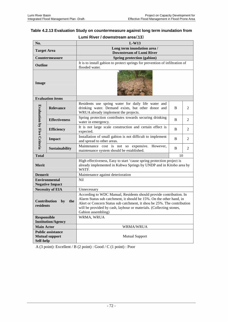
Lumi River Basin Project on Capacity Development for Integrated Flood Management Plan -Draft- Effective Flood Management in Flood Prone Area
- 72 -
Table 4.2.13 Evaluation Study on countermeasure against long term inundation from
Lumi River / downstream area(13)
No. L-W13
Target Area Long term inundation area /
Downstream of Lumi River
Countermeasure Spring protection (gabion)
Outline It is to install gabion to protect springs for prevention of infiltration of
flooded water.
Image
Evaluation items
Ev
alu
atio
n b
y F
ive C
riteria
Relevance
Residents use spring water for daily life water and
drinking water. Demand exists, but other donor and
WRUA already implement the projects.
B 2
Effectiveness Spring protection contributes towards securing drinking
water in emergency. B 2
Efficiency It is not large scale construction and certain effect is
expected. B 2
Impact Installation of small gabion is not difficult to implement
and spread to other areas. B 2
Sustainability Maintenance cost is not so expensive. However,
maintenance system should be established. B 2
Total 10
Merit
High effectiveness, Easy to start ‘cause spring protection project is
already implemented in Kubwa Springs by UNDP and in Kitobo area by
WSTF.
Demerit Maintenance against deterioration
Environmental
Negative Impact
Nil
Necessity of EIA Unnecessary
Contribution by the
residents
According to WDC Manual, Residents should provide contribution. In
Alarm Status sub catchment, it should be 15%. On the other hand, in
Alert or Concern Status sub catchment, it shou be 25%. The contribution
will be provided by cash, laybour or materials. (Collecting stones,
Gabion assembling)
Responsible
Institution/Agency
WRMA, WRUA
Main Actor WRMA/WRUA
Public assistance
Mutual support
Self-help
Mutual Support
A (3 point): Excellent / B (2 point) : Good / C (1 point) : Poor

Project on Capacity Development for Lumi River Basin Effective Flood Management in Flood Prone Area Integrated Flood Management Plan -Draft-
- 73 -
Table 4.2.14 Evaluation Study on countermeasure against Flash Flood from Tributary
River / downstream area(14)
No. L-E1
Target Area Tributary Stream Area / Downstream of Lumi River
Countermeasure Bank Protection
Outline It is a structure to prevent riverbank erosion.
Image
Evaluation items
Ev
alu
atio
n b
y F
ive C
riteria
Relevance
There are tributary and seasonal river in this area. Bank
erosion is remarkable during rainy season, Any
countermeasure is implemented. Stakeholders highly request
provision. Bank protection works as bridge and road
protection. It is effective and necessary..
A 3
Effectiveness There are a lot of tributary and seasonal river in this area. The
effect of one bank protection is limited. B 2
Efficiency
Construction cost is not expensive, but effectiveness is low.
(Existing bank protection in this area is broken.)
Cost performance is mid level.
B 1
Impact
The construction requires respective design and plan
according to flood characteristics, climate and geological
formation of the site.
C 1
Sustainability Maintenance cost is not so expensive. However, maintenance
system should be established. B 2
Total 9
Merit Short term to be effective, Easy to repair
Demerit
Determinate term will be required to implement in each process such
as “Planning”, “design” and “construction”
Improvement of existing construction method will be required.
General construction of bank protection is not suitable to characteristics
of Lumi river. , Continuous maintenance, Easy to breach (Bank
protection that is constructed by KeRRA is already broken.)
Environmental
Negative Impact Depending on scale.
Necessity of EIA Depending on scale.
Contribution by the
residents
According to WDC Manual, Residents should provide contribution. In
Alarm Status sub catchment, it should be 15%. On the other hand, in
Alert or Concern Status sub catchment, it shou be 25%. The contribution
will be provided by cash, laybour or materials. (Collecting stones,
Gabion assembling)
Responsible
Institution/Agency MWI
Main Actor Taveta County/MWI
Public assistance
Mutual support
Self-help
Public Assistance Mutual support
A (3 point): Excellent / B (2 point) : Good / C (1 point) : Poor

Lumi River Basin Project on Capacity Development for Integrated Flood Management Plan -Draft- Effective Flood Management in Flood Prone Area
- 74 -
Table 4.2.15 Evaluation Study on countermeasure against Flash Flood from Tributary
River / downstream area(15)
No. L-E2
Target Area Tributary Stream Area / Downstream of Lumi River
Countermeasure Restriction on land use
Outline It is to establish a low to prohibit people from illegal construction
and illegal occupation of lands near the river
Image -
Evaluation items
Ev
alu
atio
n b
y F
ive C
riteria
Relevance
Its importance is recognized by stakeholders. Illegal
construction are existed around river edge. So,
government can’t implement widening of the river.
And also, people who live in illegal houses can affect
directly by flood.
A 3
Effectiveness This is not a direct measure against flood. Crackdown
and education activity is required at the same time. B 2
Efficiency Legislation is almost no cost to implement. However,
direct effectiveness for disaster reduction is small. B 2
Impact Legislation itself is nationwide. B 2
Sustainability
Once the law is established, validity can continue.
However, certain regulation and educational activity
should be implemented the same time.
B 2
Total 11
Merit Illegal occupation of riparian land can be reduced.
Cost is low.
Demerit
Requirement long term to be effective.
Involuntary resettlement can occur.
Regulation and educational activity should be implemented.
It is government level and takes long time to establish a law.
Environmental
Negative Impact Nil
Necessity of EIA Unnecessary
Contribution by the
residents NIl
Responsible
Institution/Agency WRUA, KRCS, KFS
Main Actor WRUA/KRCS etc.
Public assistance
Mutual support
Self-help
Public assistance
A (3 point): Excellent / B (2 point) : Good / C (1 point) : Poor

Project on Capacity Development for Lumi River Basin Effective Flood Management in Flood Prone Area Integrated Flood Management Plan -Draft-
- 75 -
Table 4.2.16 Evaluation Study on countermeasure against Flash Flood from Tributary
River / downstream area(16)
No. L-E3
Target Area Tributary Stream Area / Downstream of Lumi River
Countermeasure Forestation Activity at Upstream of Tributary River
Outline It is to protect and recover vegetation in the upstream of the
mountain. Its storage effect will rise.
Image
Evaluation items
Ev
alu
atio
n b
y F
ive C
riteria
Relevance Volunteer groups already practice forestation activity at
downstream. Collaboration with them is expected. A 3
Effectiveness
If this countermeasure implement at appropriate scale,
sedimentation from upstream would be reduced.
Effects of determinate erosion restraint will be expected
B 2
Efficiency Both cost and effectiveness are medium scale. B 2
Impact Application in other area is not difficult. In addition, it
contributes environmental conservation. B 2
Sustainability
Once main actor is aware the importance, activity can
continue. Maintenance is complicate. It takes time to
grow up.
B 2
Total 11
Merit
Easy to start, Easy to distribution, Raising ownerships (Volunteer
group in this area is already practiced this activity. Community
participation is not difficult in this case. Sustainability is expected.)
Demerit Requirement long term to be effective
Environmental
Negative Impact Nil
Necessity of EIA Unnecessary
Contribution by the
residents
According to WDC Manual, Residents should provide contribution.
In Alarm Status sub catchment, it should be 15%. On the other hand,
in Alert or Concern Status sub catchment, it shou be 25%. The
contribution will be provided by cash, laybour or materials. (Planting
assistance, Raising nursery trees)
Responsible
Institution/Agency WRUA, KRCS, KFS
Main Actor WRUA/KRCS etc.
Public assistance
Mutual support
Self-help
Mutual Support
A (3 point): Excellent / B (2 point) : Good / C (1 point) : Poor

Lumi River Basin Project on Capacity Development for Integrated Flood Management Plan -Draft- Effective Flood Management in Flood Prone Area
- 76 -
Table 4.2.17 Evaluation Study on countermeasure against Flash Flood from Tributary
River / downstream area(17)
No. L-E4
Target Area Tributary Stream Area / Downstream of Lumi River
Countermeasure Education on Disaster prevention
Outline
It is educational training to mitigate the impact of flood and to
improve livelihood. It can reduce damage from flood and raise
awareness of disaster prevention.
Image
Evaluation items
Ev
alu
atio
n b
y F
ive C
riteria
Relevance
WRMA has a high request of enforcement of
community. In addition, some damage can prevent if
people have knowledge on flood management. So it
importance is high.
A 3
Effectiveness
It is expected certain effect against number of educated
people. Their knowledge on disaster prevention can
implement wherever and whenever they need. Its effect
can be spread.
B 2
Efficiency
It can give knowledge on disaster prevention to a large
number of people at the same time. Cost is low.
Effectiveness is high when the knowledge is rooted.
A 3
Impact Knowledge can hand down from beneficiary to their
family and friends. It can expand widely. A 3
Sustainability
Local people such as school teacher and community
leader can be a lecturer. So educational activity sustain.
In addition, integration into curriculum is important.
A 3
Total 14
Merit
Preparation takes short time. Community’s resilience can be
improved. KRCS volunteers already practiced training on
livelihood improvement. Collaboration with them is effective.
Easy to distribute, Low costs.
Demerit Requirement definite term to be effective
Environmental
Negative Impact Nil
Necessity of EIA Unnecessary
Contribution by the
residents Preparation of relevant materials
Responsible
Institution/Agency WRUA, KRCS
Main Actor Ministry of Education/Taveta County Educational Officer/
Teachers/WRUA
Public assistance
Mutual support
Self-help
Mutual Support・Public Assistance
A (3 point): Excellent / B (2 point) : Good / C (1 point) : Poor

Project on Capacity Development for Lumi River Basin Effective Flood Management in Flood Prone Area Integrated Flood Management Plan -Draft-
- 77 -
Table 4.2.18 Evaluation Study on countermeasure against Flash Flood from Tributary River / downstream area(18)
No. L-E5 Target Area Tributary Stream Area / Downstream of Lumi River Countermeasure Early Warning System
Outline It is a system to transmit flood information based on hydrological data from upstream to downstream. People can prepare for the flood.
Image
Evaluation items
Evaluation by Five C
riteria
Relevance
EWS is not common yet in Kenya, but lack of information on disaster prevention is recognized. It’s beneficial that residents
know the information as soon as possible during flood, because flow speed is fast and damage is huge.
B 2
Effectiveness
Warning information can be transmitted extensively. However, if people don’t know how to react against flood,
this countermeasure doesn’t make sense. Its effect becomes
higher when it implement with education on disaster prevention.
B 2
Efficiency This can give good effect extensively with low cost. A 3
Impact Application in other area is relatively easy. Supplemental effect such as activation of communication between upstream and downstream community is considered.
A 3
Sustainability If it is low cost equipment and simple communication system, maintenance is not difficult. A 3
Total 13
Merit
Raising ownerships by being expected from system operation and maintenance. Public awareness for evacuation activities. Observation by simple equipment is effective in this area. Sustainability is high because of easy to repair.
Demerit Continuous maintenance, Difficulty in operational taking over to next generation
Environmental Negative Impact
Nil
Necessity of EIA Unnecessary Contribution by the residents
Distribution of information
Responsible Institution/Agency
WRUA
Main Actor WRUA etc. Public assistance Mutual support Self-help
Mutual Support
A (3 point): Excellent / B (2 point) : Good / C (1 point) : Poor

Lumi River Basin Project on Capacity Development for Integrated Flood Management Plan -Draft- Effective Flood Management in Flood Prone Area
- 78 -
Table 4.2.19 Evaluation Study on countermeasure against Flash Flood from Tributary River / downstream area(19)
No. L-E6 Target Area Tributary Stream Area / Downstream of Lumi River Countermeasure Development of Community Road
Outline It means to construct a culvert or rise up community road in order to prevent its incapability by flood.
Image
Evaluation items
Evaluation by Five C
riteria
Relevance
Community road is inundated during flood. It disturbs evacuation, communication in the community and communing to school. Residents request highly, Raised up road is required.
A 3
Effectiveness Ensure of evacuation root B 2 Efficiency Both cost and effectiveness are medium scale. B 2
Impact Almost all community have small scale road. Construction of such kind of road is not difficult. Application at other area is expected.
B 2
Sustainability Maintenance cost is not so expensive. However, maintenance system should be established. B 2
Total 11 Merit Short term to be effective
Demerit Continuous maintenance Each stage such as planning, design, and construction need long term. Relevance with PCDEFM project is low.
Environmental Negative Impact Nil
Necessity of EIA Unnecessary
Contribution by the residents
According to WDC Manual, Residents should provide contribution. In Alarm Status sub catchment, it should be 15%. On the other hand, in Alert or Concern Status sub catchment, it shou be 25%. The contribution will be provided by cash, laybour or materials.
Responsible Institution/Agency KeRRA, WRUA
Main Actor WRUA/ Taveta County etc. Public assistance Mutual support Self-help
Public Assistance, Mutual support
A (3 point): Excellent / B (2 point) : Good / C (1 point) : Poor

Project on Capacity Development for Lumi River Basin Effective Flood Management in Flood Prone Area Integrated Flood Management Plan -Draft-
- 79 -
Table 4.2.20 Evaluation Study on countermeasure against Flash Flood from Tributary
River / downstream area(20)
No. L-E7
Target Area Tributary Stream Area / Downstream of Lumi River
Countermeasure Rised-up Toilet
Outline It is to rise up toilet to prevent water flow from come into the toilet and
drain sewage.
Image
Evaluation items
Ev
alu
atio
n b
y F
ive C
riteria
Relevance
Overflowed sewage from toilet cause expansion of
infectious disease. Raised up toilet prevents to overflow.
People’s demand is high.
A 3
Effectiveness It is assumed to reduce infectious disease. B 2
Efficiency
One raised up toilet is moderate price. However, a large
number of toilets should be developed for reduction of
infectious disease.
B 2
Impact It is relatively simplified measure. So application in other
area is not difficult. A 3
Sustainability Maintenance cost is not so expensive. However,
maintenance system should be established. B 2
Total 12
Merit
Preparation is short term.
Collaboration with Ministry of Public health is effective.
Easy to distribute
Demerit Maintenance against deterioration
Environmental
Negative Impact Nil
Necessity of EIA Unnecessary
Contribution by the
residents
According to WDC Manual, Residents should provide contribution. In
Alarm Status sub catchment, it should be 15%. On the other hand, in
Alert or Concern Status sub catchment, it shou be 25%. The contribution
will be provided by cash, laybour or materials.
Responsible
Institution/Agency WRUA
Main Actor WRUA etc.
Public assistance
Mutual support
Self-help
Mutual support, Self-Help
A (3 point): Excellent / B (2 point) : Good / C (1 point) : Poor

Lumi River Basin Project on Capacity Development for Integrated Flood Management Plan -Draft- Effective Flood Management in Flood Prone Area
- 80 -
4.2.1 Result of the Evaluation on 5 Criteria
Following figure shows evaluation on 5 criteria of all candidate measures. It is
preferable to implement from high scored to low scored measures. However, schedule
some of them require long term coordination and negotiation. JICA project team studies.
Table 4.2.21 Evaluation List of 5 criteria
Structural/
Non-structural No. Countermeasure Score
Structural
Measure
L-W3 Repair of existing embankment / Long term inundation area 12
L-W12 Raised-up Toilet / Long term inundation area 12
L-E7 Raised-up Toilet / Tributary Stream Area 12
L-W9 Environmental Improvement of Evacuation Camp / Long term
inundation area 12
L-W11 Development of Community Road / Long term inundation area 11
L-W2 Drainage Channel Improvement / Long term inundation area 11
L-E6 Development of Community Road / Tributary Stream Area 11
L-W13 Spring protection (Gabion) / Long term inundation area 10
L-W4 Dredging of Lake Jipe / Long term inundation area 10
L-W1 Channel Improvement of Lumi River / Long term inundation area 10
L-E1 Bank Protection / Tributary Stream Area 9
L-W5 Small check dam / Long term inundation area 9
L-W10 Rain water harvesting / Long term inundation area 8
Non-structural
Measure
L-W7 Education on Disaster Prevention / Long term inundation area 14
L-E4 Education on Disaster Prevention / Tributary Stream Area 14
L-E5 Early Warning System / Tributary Stream Area 13
L-W8 Early Warning System / Long term inundation area 13
L-W6 Forestation Activity (upstream) / Long term inundation area 11
L-E3 Forestation Activity / Tributary Stream Area 11
L-E2 Restriction on land use / Tributary Stream Area 11
Project on Capacity Development for Lumi River Basin Effective Flood Management in Flood Prone Area Integrated Flood Management Plan -Draft-
- 81 -
5. PROJECT IMPLEMENTATION PLAN OF FLOOD COUNTERMAURES
5.1 FLOOD COUNTERMEASURES IN THE FLOOD MANAGEMENT PLAN
The Flood Management Plan defines the most prioritized flood event as long term inundation
from Lumi River (downstream area) and the second as Flash Flood from Tributary River
(downstream area)
Countermeasures against those events should be mentioned in CMS. In addition, planning of
WRUA scale project should be incorporated in the Lower Lumi WRUA SCMP.
5.1.1 Structural Countermeasures
Structural countermeasures should be implemented in the following order.
• Environmental improvement of evacuation camp
• Raised-up toilet
• Study on repair of existing embankment
• Study on development of community road
• Study on spring protection (Gabion)
• Study on channel improvement of Lumi River
• Study on dredging of Lake Jipe
• Study on building small check dam
• Study on bank protection at Tributary Stream Area
• Study on rain water harvesting
5.1.2 Non-structural Countermeasures
Non-structural countermeasures should be implemented in the following order.
• Education on disaster prevention
• Early warning system
• Forestation activity
• Restriction on landuse
5.2 DRAFT IMPLEMENTATION SCHEDULE OF FLOOD COUNTERMEASURES
JICA project team proposes draft implementation schedule of flood countermeasures as
following.

Lum
i Riv
er B
asin
P
roje
ct o
n C
apacity
Develo
pm
ent fo
r In
tegra
ted F
lood M
anagem
ent P
lan
-Dra
ft- E
ffectiv
e F
lood M
anagem
ent in
Flo
od P
rone A
rea
- 82 -
NGOAdministrativeAuthority
TechinicalAuthority
EnvironmentalImprovement ofEvacuation Camp
WRUA KRCSCounty/District/Ministry ofEducation
MWI, WRMAtechinicaladvice
planning/construction/operation/maintenance
Raised-up ToiletWRUA/Community/Individual
County/District/Ministry ofPublic Health
MWI, WRMAtechinicaladvice
planning/construction/enlightenment activity
Repair of existingembankment
Study/Survey/Discussion
NWCPC orCounty
County/District
MWI, WRMAcoordinationwith relatedministries
planning/maintenance
Development ofCommunity Road
Study/Survey/Discussion
WRUACounty/District/Ministry ofRoad/KeRRA
KeRRA, MWI,WRMA
techinicaladvice
planning/construction/maintenance
Spring protection (Gabion)Study/Survey/Discussion
WRUACounty/District、MWI,WRMA
WRMAtechinicaladvice
planning/construction/maintenance
Channel Improvement ofLumi River
Study/Survey/Discussion
NWCPC orCounty
County/District
MWI, WRMAcoordinationwith relatedministries
planning/maintenance
Dredging of Lake JipeStudy/Survey/Discussion
NWCPC orCounty
County/District
MWI, WRMAcoordinationwith relatedministries
planning/maintenance
Building small check damStudy/Survey/Discussion
NWCPC,MWI orCounty
County/District、MWI,WRMA
MWI, WRMAtechinicaladvice
planning/construction/maintenance
Bank ProtectionStudy/Survey/Discussion
WRUACounty/District、MWI,WRMA
MWI, WRMAtechinicaladvice
planning/construction/maintenance
Rain water harvestingStudy/Survey/Discussion
Towncouncil,/WRUA
Town council MWI, WRMAtechinicaladvice
planning/construction/maintenance
Education on DisasterPrevention
Schools, WRUA KRCSMinistry ofEducation/County/District
MWI, WRMAcoordinationwith relatedministries
cooperation/participation/enlightenment activity
Community based EarlyWarning System againstFlash Flood
WRUA KRCSKMD/Ministryof SpecialPrograms
MWI, WRMAtechinicaladvice
planning/establishment/operation/mainenance
Early Warning System fordownstream (IFAS/GFAS)
WRUA/Community
KRCSKMD/Ministryof SpecialPrograms
MWI, WRMAcoordinationwith relatedministries
cooperation/participation/enlightenment activity
Forestation ActivityYouthgroup/Residents
KRCSKenya ForestService
MWI, WRMAcoordinationwith relatedministries
cooperation/participation/enlightenment activity
Restriction on landuse KFSKenya ForestService
MWI, WRMAcoordinationwith relatedministries
cooperation/participation/enlightenment activity
6th yearor later
StructuralMeasure
Non-structuralMeasure
Draft Implementation Schedule of Flood Countermeasures in Lumi River Basin
WRUA's role 1st year 2nd year 3rd year 4th year 5th yearSupport Actor
WRMA's roleCountermeasures Required Preparation Main Actor
Study/Survey/Discussion
Study/Survey/Discussion
Study/Survey/Discussion
Study/Survey/Discussion
Formulation
Consideration
Study/Survey/Discussion
Study/Survey/Discussion
Study/Survey/Discussion
Study/Survey/Discussion
Consideration
Project on Capacity Development for Lumi River Basin Effective Flood Management in Flood Prone Area Integrated Flood Management Plan -Draft-
- 83 -
6. RECOMMENDATION
Fundamental countermeasure against long term inundation from downstream of Lumi River on a long
term basis should be considered.
Collaboration with existing organization such as District Disaster Management Committee (DDMC)
is necessary to implement a project that can enforce resilience of community against flood.
Related Documents