This page is intentionally left blank. AMITY, OREGON TRANSPORTATION SYSTEM PLAN April 2015

Welcome message from author
This document is posted to help you gain knowledge. Please leave a comment to let me know what you think about it! Share it to your friends and learn new things together.
Transcript
This page is intentionally left blank.
AMITY, OREGON TRANSPORTATION SYSTEM PLAN
AMITY, OAMITY, OREGON
TRANSPORTATION SYSTEM
PLANREGON
AMITY,
April 2015

This page is intentionally left blank
AMITY, OREGON TRANSPORTATION SYSTEM PLAN
AMITY, OREGON TRANSPORTATION SYSTEM PLAN
AMITY, OREGON TRANSPORTATION SYSTEM PLAN
AMITY, OREGON TRANSPORTATION SYSTEM PLAN
PREPARED FOR
City of Amity
WITH SUPPORT FROM
Oregon Department of Transportation
PREPARED BY:
PREPARED FOR
City of Amity
WITH SUPPORT FROM
Oregon Department of Transportation
PREPARED BY:

This page is intentionally left blank
Danielle Ludwig, Amity Elementary School
Dave Lund, Amity Middle School
Eve Silverman, Amity Planning Commission /
Amity Downtown Improvement Group
Rudy van Soolen, Amity City Council
Bruce Hubbard, Amity Fire District
Ryan Jones, Amity Planning Commission /
Amity School Board
Charles Eaton, PE, City of Amity
Jennifer Elkins, City of Amity
Jackie Loos, City of Amity
Larry Layton, City of Amity
Karin Johnson, Amity Planning Commission
Michael Morales, ODOT Region 2 Senior
Environmental PM
Lori Lewis, First Student
Jean Palmateer, ODOT Regional Transit
Coordinator
Steve Ruyle, Amity Planning Commission
Dorothy Upton, ODOT Region 2 Traffic
Engineer
Christopher Cummings, ODOT Freight
Planning Program Manager
Dan Fricke, ODOT Senior Region 2 Planner
Bill Gille, Yamhill County Engineer
Rodger Gutierrez, ODOT Pedestrian/Bicycle
Facility Specialist
Michael “Swede” Hays, ODOT Railroad
Compliance Specialist
Eliseo Lemus Magana, PE, ODOT Region 2
Designer
Christina McDaniel-Wilson, PE, ODOT Senior
Transport Analyst
Angela Lazarean, Willamette Valley Regional
Representative
Charles Eaton, PE, City of Amity
Matt Johnson, City of Amity Public Works
Jackie Loos, City of Amity
Charles Eaton, PE, City Engineer, City of Amity
Naomi Zwerdling, Oregon Department of
Transportation (ODOT)
Sumi Malik, AICP, CH2MHILL
Ryan Farncomb, CH2MHILL
Terra Lingley, AICP, CH2MHILL
Eduardo Montejo, CH2MHILL

This page is intentionally left blank
This project is partially funded by a grant from the Transportation and Growth Management (TGM)
Program, a joint program of the Oregon Department of Transportation (ODOT) and the Oregon
Department of Land Conservation and Development (DLCD). This TGM grant is financed, in part, by
the federal Moving Ahead for Progress in the 21st Century Act (MAP-21), local government, and
State of Oregon funds.
The contents of this document do not necessarily reflect views or policies of the State of Oregon.

This page is intentionally left blank
IV
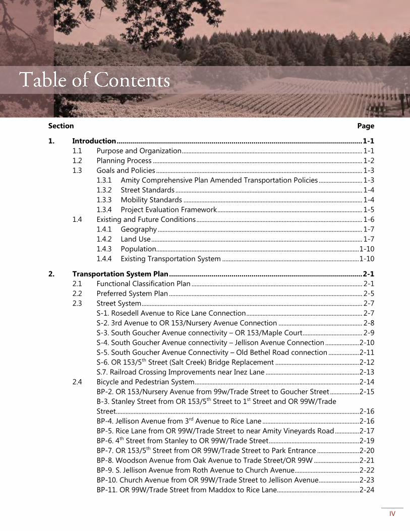
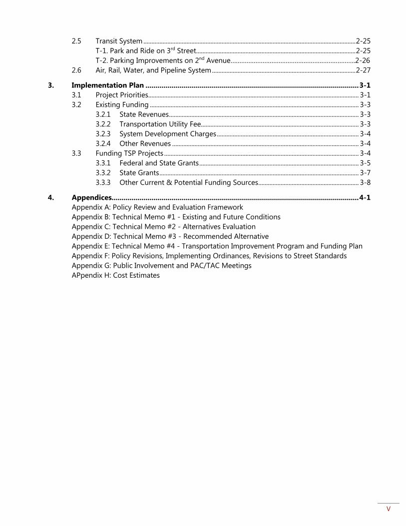
Section Page
1. Introduction .......................................................................................................................... 1-1
1.1 Purpose and Organization ................................................................................................................ 1-1
1.2 Planning Process .................................................................................................................................. 1-2
1.3 Goals and Policies ................................................................................................................................ 1-3
1.3.1 Amity Comprehensive Plan Amended Transportation Policies ........................... 1-3
1.3.2 Street Standards .................................................................................................................... 1-4
1.3.3 Mobility Standards ............................................................................................................... 1-4
1.3.4 Project Evaluation Framework .......................................................................................... 1-5
1.4 Existing and Future Conditions ....................................................................................................... 1-6
1.4.1 Geography ............................................................................................................................... 1-7
1.4.2 Land Use ................................................................................................................................... 1-7
1.4.3 Population .............................................................................................................................. 1-10
1.4.4 Existing Transportation System ..................................................................................... 1-10
2. Transportation System Plan ................................................................................................ 2-1
2.1 Functional Classification Plan .......................................................................................................... 2-1
2.2 Preferred System Plan ........................................................................................................................ 2-5
2.3 Street System ......................................................................................................................................... 2-7
S-1. Rosedell Avenue to Rice Lane Connection ........................................................................ 2-7
S-2. 3rd Avenue to OR 153/Nursery Avenue Connection .................................................... 2-8
S-3. South Goucher Avenue connectivity – OR 153/Maple Court ..................................... 2-9
S-4. South Goucher Avenue connectivity – Jellison Avenue Connection ..................... 2-10
S-5. South Goucher Avenue Connectivity – Old Bethel Road connection ................... 2-11
S-6. OR 153/5th Street (Salt Creek) Bridge Replacement .................................................... 2-12
S.7. Railroad Crossing Improvements near Inez Lane .......................................................... 2-13
2.4 Bicycle and Pedestrian System ...................................................................................................... 2-14
BP-2. OR 153/Nursery Avenue from 99w/Trade Street to Goucher Street .................. 2-15
B-3. Stanley Street from OR 153/5th Street to 1st Street and OR 99W/Trade
Street ....................................................................................................................................................... 2-16
BP-4. Jellison Avenue from 3rd Avenue to Rice Lane ............................................................ 2-16
BP-5. Rice Lane from OR 99W/Trade Street to near Amity Vineyards Road ............... 2-17
BP-6. 4th Street from Stanley to OR 99W/Trade Street ........................................................ 2-19
BP-7. OR 153/5th Street from OR 99W/Trade Street to Park Entrance .......................... 2-20
BP-8. Woodson Avenue from Oak Avenue to Trade Street/OR 99W ............................ 2-21
BP-9. S. Jellison Avenue from Roth Avenue to Church Avenue........................................ 2-22
BP-10. Church Avenue from OR 99W/Trade Street to Jellison Avenue ......................... 2-23
BP-11. OR 99W/Trade Street from Maddox to Rice Lane ................................................... 2-24
V
2.5 Transit System ..................................................................................................................................... 2-25
T-1. Park and Ride on 3rd Street.................................................................................................... 2-25
T-2. Parking Improvements on 2nd Avenue…………………………………………………………….2-26
2.6 Air, Rail, Water, and Pipeline System .......................................................................................... 2-27
3. Implementation Plan ........................................................................................................... 3-1
3.1 Project Priorities .................................................................................................................................... 3-1
3.2 Existing Funding ................................................................................................................................... 3-3
3.2.1 State Revenues ....................................................................................................................... 3-3
3.2.2 Transportation Utility Fee................................................................................................... 3-3
3.2.3 System Development Charges ......................................................................................... 3-4
3.2.4 Other Revenues ..................................................................................................................... 3-4
3.3 Funding TSP Projects .......................................................................................................................... 3-4
3.3.1 Federal and State Grants .................................................................................................... 3-5
3.3.2 State Grants ............................................................................................................................. 3-7
3.3.3 Other Current & Potential Funding Sources ............................................................... 3-8
4. Appendices............................................................................................................................ 4-1
Appendix A: Policy Review and Evaluation Framework
Appendix B: Technical Memo #1 - Existing and Future Conditions
Appendix C: Technical Memo #2 - Alternatives Evaluation
Appendix D: Technical Memo #3 - Recommended Alternative
Appendix E: Technical Memo #4 - Transportation Improvement Program and Funding Plan
Appendix F: Policy Revisions, Implementing Ordinances, Revisions to Street Standards
Appendix G: Public Involvement and PAC/TAC Meetings
APpendix H: Cost Estimates
AMITY TRANSPORTATION SYSTEM PLAN
ES-1
Executive Summary
The City of Amity Transportation System Plan (TSP) is a long-range (25-year) plan that seeks to
improve the transportation system and support planned land uses and economic development for
the residents of Amity. The Amity TSP provides context for transportation planning in Amity,
establishes new policies to guide system improvements, and provides a 25-year list of projects
intended to improve the multi-modal system for all current and future residents and businesses
anticipated for Amity’s newly expanded Urban Growth Boundary (UGB).
Process The Amity TSP process began in the summer of 2013 and finished in spring 2015. The process
started with convening a project management team (PMT) consisting of key staff from the City, the
Oregon Department of Transportation (ODOT), and the consultant. The PMT guided the process
throughout the project. A Project Advisory Committee (PAC) and Technical Advisory Committee
(TAC), consisting of City Council members, citizen stakeholders, state and local government staff,
and City staff met several times to review and provide input on different aspects of the plan
throughout the process. Community meetings, surveys, the project website and public hearings
provided opportunities for Amity’s residents to get involved in the process as well. Appendix G
provides meeting summaries and sample public outreach materials used during the project.
The TSP was reviewed by the Planning Commission and City Council during winter 2014, and was
adopted in March 2015.
Goals and Policies As part of the TSP development process, the project team developed and vetted new transportation
policies. The City’s transportation element of its Comprehensive Plan had last been updated in 1979,
and the policies needed revisions and additions in order to accurately reflect the City’s goals for its
transportation system and comply with state plans and regulations. These are reviewed in section
1.3 in the following section and in further detail in Appendix F.
Transportation System Plan The City’s preferred system plan includes a functional classification plan and 25 year list of projects
intended to meet the City’s current and future transportation needs. The functional classification
plan describes the intended function of city streets. For example, streets designated as “local” are
primarily intended for accessing homes, and are low-speed and have low traffic volumes. The
projects in the transportation system plan include street extensions to improve street connectivity;
sidewalks, bicycle lanes, and paths to improve the bicycling and walking environment (which is one
of the top goals for the City), and other improvements to the transit system. Replacement of the Salt
AMITY TRANSPORTATION SYSTEM PLAN
ES-2
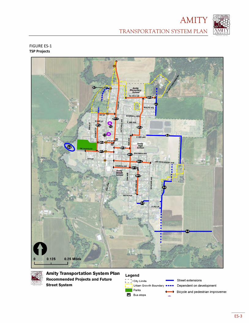
Creek Bridge is one of the top projects for the City, and represents more than half of the total cost
of all projects in the TSP.
Figure ES-1 below shows all projects in the preferred system plan. They are color-coded by the
transportation mode primarily targeted by the project. Though projects may emphasize one mode,
most projects include improvements for several transportation modes. Table ES-1 includes the
project name, priority level, and estimated cost.
AMITY TRANSPORTATION SYSTEM PLAN
ES-3
FIGURE ES-1 TSP Projects
AMITY TRANSPORTATION SYSTEM PLAN
ES-4
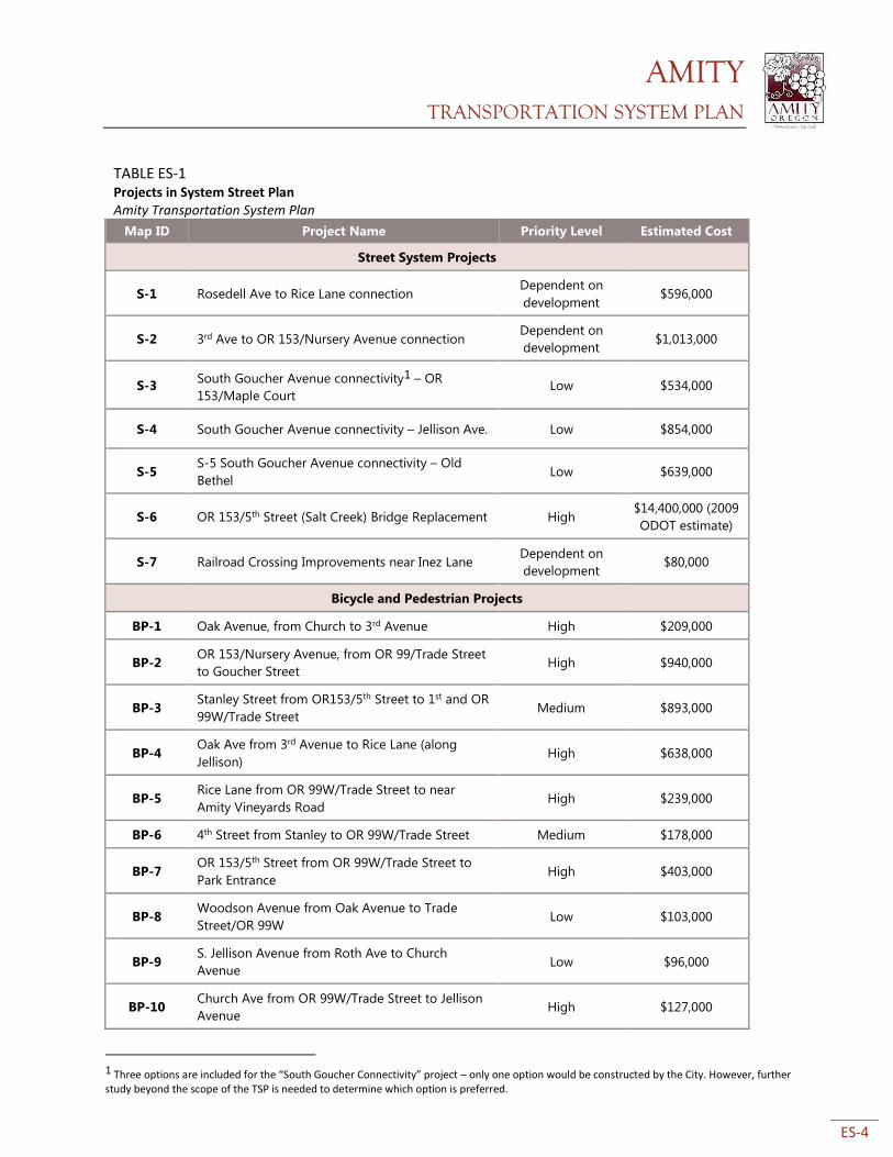
TABLE ES-1 Projects in System Street Plan Amity Transportation System Plan
Map ID Project Name Priority Level Estimated Cost
Street System Projects
S-1 Rosedell Ave to Rice Lane connection Dependent on
development $596,000
S-2 3rd Ave to OR 153/Nursery Avenue connection Dependent on
development $1,013,000
S-3 South Goucher Avenue connectivity1 – OR
153/Maple Court Low $534,000
S-4 South Goucher Avenue connectivity – Jellison Ave. Low $854,000
S-5 S-5 South Goucher Avenue connectivity – Old
Bethel Low $639,000
S-6 OR 153/5th Street (Salt Creek) Bridge Replacement High $14,400,000 (2009
ODOT estimate)
S-7 Railroad Crossing Improvements near Inez Lane Dependent on
development $80,000
Bicycle and Pedestrian Projects
BP-1 Oak Avenue, from Church to 3rd Avenue High $209,000
BP-2 OR 153/Nursery Avenue, from OR 99/Trade Street
to Goucher Street High $940,000
BP-3 Stanley Street from OR153/5th Street to 1st and OR
99W/Trade Street Medium $893,000
BP-4 Oak Ave from 3rd Avenue to Rice Lane (along
Jellison) High $638,000
BP-5 Rice Lane from OR 99W/Trade Street to near
Amity Vineyards Road High $239,000
BP-6 4th Street from Stanley to OR 99W/Trade Street Medium $178,000
BP-7 OR 153/5th Street from OR 99W/Trade Street to
Park Entrance High $403,000
BP-8 Woodson Avenue from Oak Avenue to Trade
Street/OR 99W Low $103,000
BP-9 S. Jellison Avenue from Roth Ave to Church
Avenue Low $96,000
BP-10 Church Ave from OR 99W/Trade Street to Jellison
Avenue High $127,000
1 Three options are included for the “South Goucher Connectivity” project – only one option would be constructed by the City. However, further study beyond the scope of the TSP is needed to determine which option is preferred.
AMITY TRANSPORTATION SYSTEM PLAN
ES-5
TABLE ES-1 Projects in System Street Plan Amity Transportation System Plan
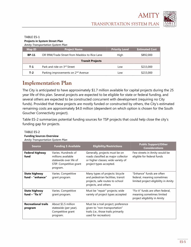
Map ID Project Name Priority Level Estimated Cost
BP-11 OR 99W/Trade Street from Maddox to Rice Lane High $892,000
Transit Projects
T-1 Park and ride on 3rd Street Low $215,000
T-2 Parking improvements on 2nd Avenue Low $215,000
Implementation Plan The City is anticipated to have approximately $1.7 million available for capital projects during the 25
year life of this plan. Several projects are expected to be eligible for state or federal funding, and
several others are expected to be constructed concurrent with development (requiring no City
funds). Provided that these projects are mostly funded or constructed by others, the City’s estimated
remaining costs are approximately $4.0 million (dependent on which option is chosen for the South
Goucher Connectivity project).
Table ES-2 summarizes potential funding sources for TSP projects that could help close the city’s
funding gap for projects.
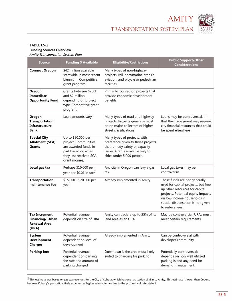
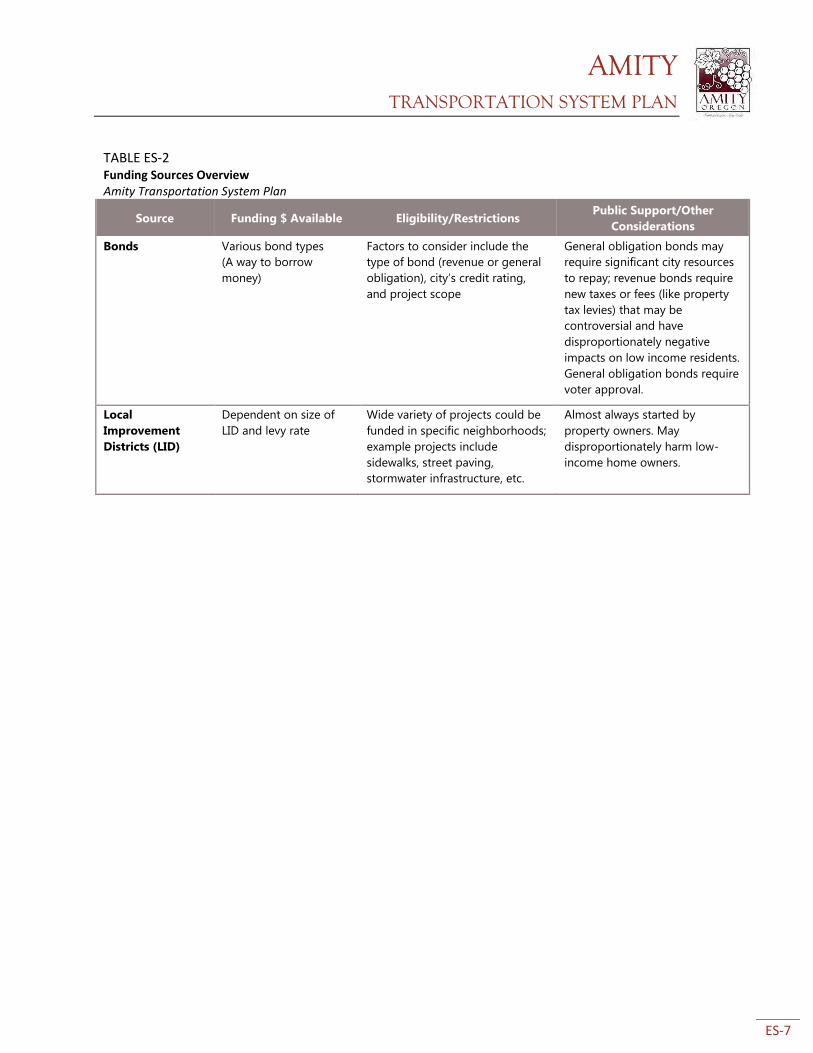
TABLE ES-2 Funding Sources Overview Amity Transportation System Plan
Source Funding $ Available Eligibility/Restrictions Public Support/Other
Considerations
Federal highway
fund
Varies. Hundreds of
millions available
statewide over life of
STIP. Competitive grant
program.
Generally, projects must be on
roads classified as major collector
or higher classes; wide variety of
project types accepted.
Few streets in Amity would be
eligible for federal funds
State highway
fund - “enhance”
Varies. Competitive
grant program.
Many types of projects: bicycle
and pedestrian facilities, transit
projects, safe routes to school
projects, and others
“Enhance” funds are often
federal, meaning sometimes
limited project eligibility in Amity
State highway
fund – “fix it”
Varies. Competitive
grant program.
Must be “repair” projects; wide
variety of project types accepted
“Fix-it” funds are often federal,
meaning sometimes limited
project eligibility in Amity
Recreational trails
program
About $1.5 million
statewide (per year).
Competitive grant
program.
Must be a trail project; preference
given to “non-transportation”
trails (i.e., those trails primarily
used for recreation)
AMITY TRANSPORTATION SYSTEM PLAN
ES-6
TABLE ES-2 Funding Sources Overview Amity Transportation System Plan
Source Funding $ Available Eligibility/Restrictions Public Support/Other
Considerations
Connect Oregon $42 million available
statewide in most recent
biennium. Competitive
grant program.
Many types of non-highway
projects: rail, port/marine, transit,
aviation, and bicycle or pedestrian
facilities
Oregon
Immediate
Opportunity Fund
Grants between $250k
and $2 million,
depending on project
type. Competitive grant
program.
Primarily focused on projects that
provide economic development
benefits
Oregon
Transportation
Infrastructure
Bank
Loan amounts vary Many types of road and highway
projects. Projects generally must
be on major collectors or higher
street classifications
Loans may be controversial, in
that their repayment may require
city financial resources that could
be spent elsewhere
Special City
Allotment (SCA)
Grants
Up to $50,000 per
project. Communities
are awarded funds in
part based on when
they last received SCA
grant monies.
Many types of projects, with
preference given to those projects
that remedy safety or capacity
issues. Grants available only to
cities under 5,000 people.
Local gas tax Perhaps $10,000 per
year per $0.01 in tax2
Any city in Oregon can levy a gas
tax
Local gas taxes may be
controversial
Transportation
maintenance fee
$15,000 - $20,000 per
year
Already implemented in Amity These funds are not generally
used for capital projects, but free
up other resources for capital
projects. Potential equity impacts
on low-income households if
special dispensation is not given
to reduce fees.
Tax Increment
Financing/ Urban
Renewal Area
(URA)
Potential revenue
depends on size of URA
Amity can declare up to 25% of its
land area as an URA
May be controversial; URAs must
meet certain requirements
System
Development
Charges
Potential revenue
dependent on level of
development
Already implemented in Amity Can be controversial with
developer community.
Parking fees Potential revenue
dependent on parking
fee rate and amount of
parking charged
Downtown is the area most likely
suited to charging for parking
Potentially controversial;
depends on how well utilized
parking is and any need for
demand management.
2 This estimate was based on gas tax revenues for the City of Coburg, which has one gas station similar to Amity. This estimate is lower than Coburg, because Coburg’s gas station likely experiences higher sales volumes due to the proximity of Interstate 5.
AMITY TRANSPORTATION SYSTEM PLAN
ES-7
TABLE ES-2 Funding Sources Overview Amity Transportation System Plan
Source Funding $ Available Eligibility/Restrictions Public Support/Other
Considerations
Bonds Various bond types
(A way to borrow
money)
Factors to consider include the
type of bond (revenue or general
obligation), city’s credit rating,
and project scope
General obligation bonds may
require significant city resources
to repay; revenue bonds require
new taxes or fees (like property
tax levies) that may be
controversial and have
disproportionately negative
impacts on low income residents.
General obligation bonds require
voter approval.
Local
Improvement
Districts (LID)
Dependent on size of
LID and levy rate
Wide variety of projects could be
funded in specific neighborhoods;
example projects include
sidewalks, street paving,
stormwater infrastructure, etc.
Almost always started by
property owners. May
disproportionately harm low-
income home owners.
AMITY TRANSPORTATION SYSTEM PLAN
1-1
1. Introduction
The City of Amity Transportation System Plan (TSP) is a long-range (25-year) plan that seeks to
improve the transportation system and support planned land uses and economic development for
the residents of Amity. The Amity TSP provides context for transportation planning in Amity,
establishes new policies to guide system improvements, and provides a 25-year list of projects
intended to improve the multi-modal system for all current and future residents, including future
residents anticipated for Amity’s Urban Growth Boundary (UGB).
The TSP establishes a system of transportation facilities and services to meet local transportation
needs, while also providing a rationale for making transportation improvements. The TSP will be
used to develop the City’s Capital Improvement Program and to inform system investments over the
next 25 years.
TSPs are developed per Oregon’s Transportation Planning Rule (OAR 660-012) and must be
consistent with existing state, regional, and local plans including the Oregon Highway Plan, the
Oregon Transportation Plan, and the City of Amity Comprehensive Plan.
1.1 Purpose and Organization This purpose of the TSP is to provide a blueprint for a transportation system that meets the existing
and future needs of the residents of Amity. The TSP achieves this by examining both short and long-
term transportation needs for all transportation modes, like driving, biking, walking, or taking
transit. The plan identifies current and future deficiencies and provides solutions to those problems.
The TSP reflects existing land use plans, policies, and regulations that affect the transportation
system. The plan includes policies, a 25-year list of improvement projects, and an implementation
plan for how (and when) to finance future projects. Plan elements will be implemented by the City,
private developers, and regional or state agencies.
The plan is organized into the following sections:
Section 2: Transportation System Plan
This section contains the preferred transportation system for Amity. Subsections detail specific
capital improvement projects for Amity’s transportation system. Descriptions of the projects,
details on the need for the project, feasibility, and estimated cost are included. Projects are
described narratively and through the use of maps, figures, and tables.
Section 3: Implementation Plan
AMITY TRANSPORTATION SYSTEM PLAN
1-2
This section reviews implementation priorities, projects costs (including right-of-way acquisition
costs), and potential funding sources for projects. This section also discusses existing local
funding sources and forecasts, as well as state and federal finance sources.
Section 4: Appendices
The appendices contain technical information and documentation supporting the TSP and are
organized mainly by technical memoranda produced as part of the TSP process.
1.2 Planning Process The Amity TSP process began in the summer of 2013 and finished in spring 2015. The process
started with convening a project management team (PMT) consisting of key City, ODOT, and
consultant staff. The PMT guided the process throughout the project. A Project Advisory Committee
(PAC) and Technical Advisory Committee (TAC) were also convened, meeting five times during the
process to discuss and advise on different aspects of the plan, including transportation issues,
policy, recommended projects, and project funding. The PAC and TAC provided key input during
different stages of the process and made recommendations to City staff and the consultant team.
PAC membership included City Councilors, Planning Commission members, and other citizen
stakeholders. The TAC included staff from various local and state agencies, including ODOT, Yamhill
County, the Yamhill County Transit Authority, the Department of Land Conservation and
Development, and local school districts.
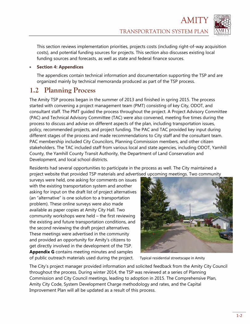
Residents had several opportunities to participate in the process as well. The City maintained a
project website that provided TSP materials and advertised upcoming meetings. Two community
surveys were held, one asking for comments on issues
with the existing transportation system and another
asking for input on the draft list of project alternatives
(an “alternative” is one solution to a transportation
problem). These online surveys were also made
available as paper copies at Amity City Hall. Two
community workshops were held – the first reviewing
the existing and future transportation conditions, and
the second reviewing the draft project alternatives.
These meetings were advertised in the community
and provided an opportunity for Amity’s citizens to
get directly involved in the development of the TSP.
Appendix G contains meeting minutes and samples
of public outreach materials used during the project.
The City’s project manager provided information and solicited feedback from the Amity City Council
throughout the process. During winter 2014, the TSP was reviewed at a series of Planning
Commission and City Council meetings, leading to adoption in 2015. The Comprehensive Plan,
Amity City Code, System Development Charge methodology and rates, and the Capital
Improvement Plan will all be updated as a result of this process.
Typical residential streetscape in Amity
AMITY TRANSPORTATION SYSTEM PLAN
1-3
1.3 Goals and Policies As part of TSP development, the City reviewed transportation policies in the Amity Comprehensive
Plan that were last updated in 1979. These policies are derived from the City’s goal statement for its
transportation system:
“To provide a safe, convenient, aesthetic, and economic transportation system
through a variety of transportation means.”
The following policies provide a basis for guiding the development of the City’s transportation
system. These policies help fulfill the goal statement above, and also ensure that Amity complies
with state plans, policies, and regulations. Appendix A contains a full list of plans, laws, and
regulations that were reviewed during the TSP process. Appendix F contains these policies, as well
as City code revisions.
1.3.1 Amity Comprehensive Plan Amended Transportation Policies
The City shall coordinate with Yamhill County and the Oregon Department of Transportation
with regard to City actions and needs which may affect traffic on County and State roads within
the Urban Growth Boundary.
Transportation improvements shall be used to guide urban development and be designed to
serve anticipated future needs.
Transportation facility design shall be done in a manner consistent with city design standards
and the Transportation System Plan (TSP), and which will minimize adverse effects on the
existing land uses and natural features.
The City shall adopt a street functional classification system consisting of arterials, collectors,
and local streets to assist in prioritizing street development and maintenance.
All possible sources of funding for street improvements shall be investigated and the City shall
make transportation improvements as funds become available.
The special needs of low-income, disabled, and senior citizens shall be considered when making
improvements to the transportation system.
The City shall coordinate with the Union Pacific Railroad and Portland and Western Railroad to
ensure maximum safety at all street and railway intersections.
The City shall support and encourage use of public transit and coordinate with Yamhill County
Transit Area (YCTA) on service changes or bus route modifications.
The city shall coordinate with Yamhill County in the development of a countywide bicycle plan.
The City shall investigate funding sources for projects which would promote bicycle and
pedestrian transportation in the Urban Growth Boundary.
The City shall promote a multi-modal transportation system that adequately considers the needs
of drivers, pedestrian cyclists, and public transit riders.
The City shall take advantage of opportunities to improve the public transit system as they arise.
AMITY TRANSPORTATION SYSTEM PLAN
1-4
The City shall coordinate with the Oregon Department of Transportation on improvements to
state highways within the City to ensure the needs of freight are adequately considered.
The City shall strive to create a transportation system that is safe for all users. Addressing
existing or newly discovered safety issues is a top priority for the City.
New public streets shall be located based on the proposed alignments in the Transportation
System Plan. New public streets shall be designed according to relevant municipal code and
adopted street standards.
When upgrading or reconstructing existing City streets, the relevant planned project, if any, in
the Transportation System Plan or Capital Improvement Program shall be considered in the
design of the project.
1.3.2 Street Standards
The City has adopted street standards, which specify engineering requirements for the development
or redevelopment of City streets. These were last updated in 2004. Appendix F includes proposed
revisions to the street standards; these will be adopted separately and are not part of the TSP.
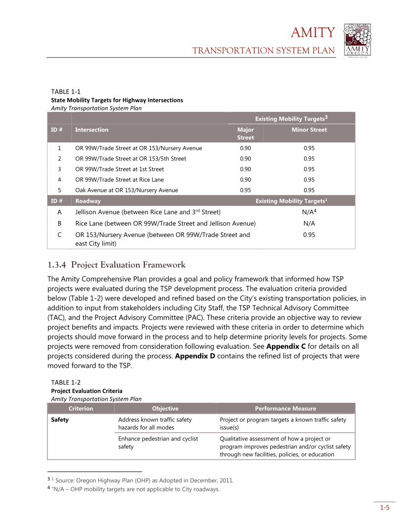
1.3.3 Mobility Targets
The City does not have adopted mobility standards or targets for City streets. Mobility standards are
generally expressed as “volume to capacity (V/C)” ratios. For example, a V/C ratio of 0.9 means the
street is nearly at capacity. The Oregon Department of Transportation (ODOT) has adopted mobility
targets for the two state highways that run through Amity, OR 153 and OR 99W. Because traffic
volumes on city-owned streets are, and will continue to be, relatively low, no specific mobility
standards or targets are proposed for city-owned streets. Table 1-1 describes state mobility targets
for highway intersections in Amity. Existing and future conditions analysis showed that all mobility
targets for these intersections are met currently and will be in the future (2038).
The City similarly does not have level of service (LOS) standards. LOS helps describe the amount of
delay experienced by drivers. It describes operating conditions in six letter-grade categories, which
correspond to ranges of average vehicle delay times and differ for stop-controlled and signalized
intersections. LOS A typically represents conditions with little or no delay, while LOS F indicates poor
operations with high delay or extreme congestion. Future conditions analysis revealed that the
minor leg (6th street) of the intersection of OR 99W/Trade Street and OR 153/Nursery Ave will
perform at LOS F in the future. However, no project is included to alleviate this issue. This is because
of the anticipated extremely low volume of cars using this leg of the intersection, and lack of a
viable project that would improve turning movements without seriously compromising through
traffic movement on OR 99W and OR 153. All other intersections would perform at LOS E or better
in the future.
AMITY TRANSPORTATION SYSTEM PLAN
1-5
TABLE 1-1 State Mobility Targets for Highway Intersections Amity Transportation System Plan
Existing Mobility Targets3
ID # Intersection Major
Street
Minor Street
1 OR 99W/Trade Street at OR 153/Nursery Avenue 0.90 0.95
2 OR 99W/Trade Street at OR 153/5th Street 0.90 0.95
3 OR 99W/Trade Street at 1st Street 0.90 0.95
4 OR 99W/Trade Street at Rice Lane 0.90 0.95
5 Oak Avenue at OR 153/Nursery Avenue 0.95 0.95
ID # Roadway Existing Mobility Targets1
A Jellison Avenue (between Rice Lane and 3rd Street) N/A4
B Rice Lane (between OR 99W/Trade Street and Jellison Avenue) N/A
C OR 153/Nursery Avenue (between OR 99W/Trade Street and
east City limit)
0.95
1.3.4 Project Evaluation Framework
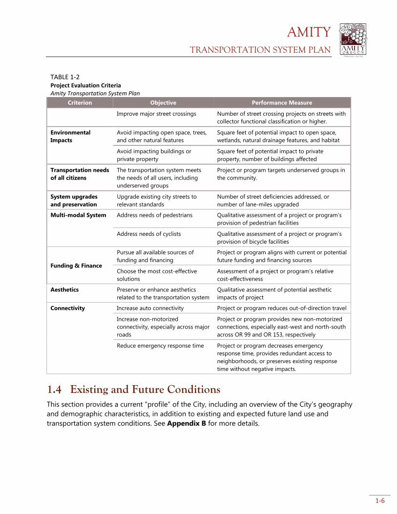
The Amity Comprehensive Plan provides a goal and policy framework that informed how TSP
projects were evaluated during the TSP development process. The evaluation criteria provided
below (Table 1-2) were developed and refined based on the City’s existing transportation policies, in
addition to input from stakeholders including City Staff, the TSP Technical Advisory Committee
(TAC), and the Project Advisory Committee (PAC). These criteria provide an objective way to review
project benefits and impacts. Projects were reviewed with these criteria in order to determine which
projects should move forward in the process and to help determine priority levels for projects. Some
projects were removed from consideration following evaluation. See Appendix C for details on all
projects considered during the process. Appendix D contains the refined list of projects that were
moved forward to the TSP.
TABLE 1-2 Project Evaluation Criteria Amity Transportation System Plan
Criterion Objective Performance Measure
Safety
Address known traffic safety
hazards for all modes
Project or program targets a known traffic safety
issue(s)
Enhance pedestrian and cyclist
safety
Qualitative assessment of how a project or
program improves pedestrian and/or cyclist safety
through new facilities, policies, or education
3 1 Source: Oregon Highway Plan (OHP) as Adopted in December, 2011. 4 “N/A – OHP mobility targets are not applicable to City roadways.
AMITY TRANSPORTATION SYSTEM PLAN
1-6
TABLE 1-2 Project Evaluation Criteria Amity Transportation System Plan
Criterion Objective Performance Measure
Improve major street crossings Number of street crossing projects on streets with
collector functional classification or higher.
Environmental
Impacts
Avoid impacting open space, trees,
and other natural features
Square feet of potential impact to open space,
wetlands, natural drainage features, and habitat
Avoid impacting buildings or
private property
Square feet of potential impact to private
property, number of buildings affected
Transportation needs
of all citizens
The transportation system meets
the needs of all users, including
underserved groups
Project or program targets underserved groups in
the community.
System upgrades
and preservation
Upgrade existing city streets to
relevant standards
Number of street deficiencies addressed, or
number of lane-miles upgraded
Multi-modal System Address needs of pedestrians Qualitative assessment of a project or program’s
provision of pedestrian facilities
Address needs of cyclists Qualitative assessment of a project or program’s
provision of bicycle facilities
Funding & Finance
Pursue all available sources of
funding and financing
Project or program aligns with current or potential
future funding and financing sources
Choose the most cost-effective
solutions
Assessment of a project or program’s relative
cost-effectiveness
Aesthetics Preserve or enhance aesthetics
related to the transportation system
Qualitative assessment of potential aesthetic
impacts of project
Connectivity Increase auto connectivity Project or program reduces out-of-direction travel
Increase non-motorized
connectivity, especially across major
roads
Project or program provides new non-motorized
connections, especially east-west and north-south
across OR 99 and OR 153, respectively
Reduce emergency response time Project or program decreases emergency
response time, provides redundant access to
neighborhoods, or preserves existing response
time without negative impacts.
1.4 Existing and Future Conditions This section provides a current “profile” of the City, including an overview of the City’s geography
and demographic characteristics, in addition to existing and expected future land use and
transportation system conditions. See Appendix B for more details.
AMITY TRANSPORTATION SYSTEM PLAN
1-7
1.4.1 Geography
The City of Amity is located in southern Yamhill
County. It is roughly seven miles south of
McMinnville, the county seat, and 20 miles
northwest of Salem. The City’s transportation
network includes State, County, and City
roadways, and a Union-Pacific rail line operated
by Portland and Western Railroad.
The city has mostly flat topography, with some
steep slopes to the south and west near Ash
Swale and Salt Creek, and within the Urban
Growth Boundary (UGB) northeast of Amity
Elementary School. Salt Creek and Ash Swale are
the two primary natural water features within
city limits.
1.4.2 Land Use
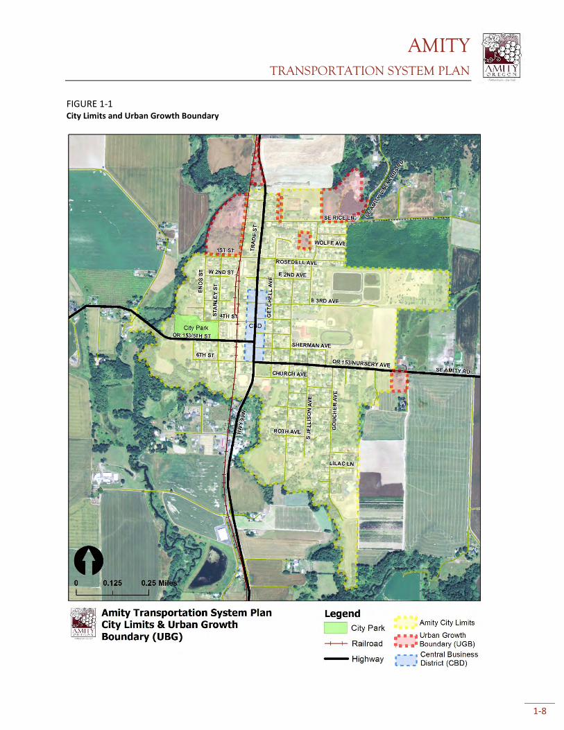
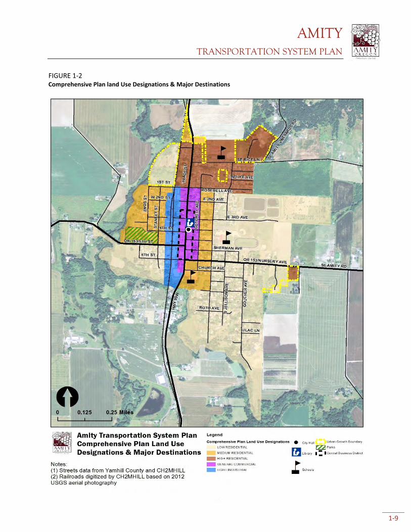
The oldest parts of the City, dating to the late 1800’s, surround the blocks of the central business
district (Fig. 1-1). Most property abutting the Portland & Western Railroad, just west of OR
99W/Trade Street is zoned light industrial with a winery, storage facilities, and warehouses abutting
the rail line. Commercial and industrial land attracts trips from employees and customers
throughout the day. Amity’s city park is located just west of the railroad, along 5th Street/OR 153.
Most of the land surrounding Amity is zoned Exclusive Farm Use (EFU) or rural residential, and is
primarily agricultural in nature. The majority of Amity’s 390 acres are zoned residential (Figure 1-12,
served by two-lane local roads. Much of the City north of Rosedell Avenue is zoned for high-density
residential, with largely medium and low-density residential zoning to the south.
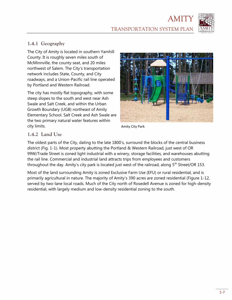
Amity City Park
AMITY TRANSPORTATION SYSTEM PLAN
1-8
FIGURE 1-1 City Limits and Urban Growth Boundary
AMITY TRANSPORTATION SYSTEM PLAN
1-9
FIGURE 1-2 Comprehensive Plan land Use Designations & Major Destinations

AMITY TRANSPORTATION SYSTEM PLAN
1-10
1.4.3 Population
As of the 2010 census, Amity had a population of 1,614 people, an increase of 136 people over the
2000 census. The City recently completed a 44 acre UGB expansion to meet its housing and public
facility needs through 2030. In 2012, Yamhill County approved a coordinated population forecast for
the County and its junior jurisdictions, including Amity. Amity is forecast to have a 2030 population
of 1,984, and for the purposes of the TSP and traffic analysis, the 2038 population is expected to be
2,161 persons.
1.4.4 Existing Transportation System Streets
Amity’s street network is primarily local streets that serve single and multi-family residences. Most
local streets connect to one of the two state highways – OR 99W/Trade Street or OR 153/Nursery
Avenue – that run north-south and east-west, respectively, through the City. These state highways
carry the majority of Amity’s through-traffic and are the primary routes for vehicles heading to
destinations outside Amity (including freight trucks). Amity also has two bridges: the Ash Swale
Bridge and the timber bridge that serves as a crossing for OR 153 across Salt Creek. The latter
bridge has been deemed structurally deficient by the 2012 ODOT Bridge Condition Report.
The two state highways bisect the city east-west and north-south, making the highways a major
crossing barrier for pedestrians and bicyclists, and to a lesser extent, cars. Geography also constrains
connectivity, especially in the southeast part of town. The project team looked at expected future
traffic conditions, and found that OR 99W/Trade Street will likely see increased traffic, but major
traffic issues are not expected. In some locations, there are no redundant street connections, which
could be dangerous if streets become blocked and emergency services cannot get through to some
homes.
Bicycle Facilities
There are few bicycle lanes or other bicycle infrastructure in Amity. The City and ODOT recently
improved OR99W/Trade Street which now has bicycle lanes in the downtown section of OR
99W/Trade Street. Outside of downtown, paved shoulders serve as the bicycle facility. There are no
other dedicated bicycle facilities in the City. Amity’s local street network has low traffic volumes and
low speeds, and is suitable for cycling. However, crossing OR 99W/Trade Street and OR 153/Nursery
Avenue is intimidating for cyclists because of high traffic volumes, higher traffic speeds, and a lack
of signalized intersections.
Pedestrian System
There are sidewalks on many, but not all of the local streets within Amity. Completing the sidewalk
network has been one of the top priorities for the City. Many sidewalks in older neighborhoods
have sunken below their original grade, private property owners have encroached into the sidewalk
area, or sidewalks have nearly disappeared due to vegetation encroachment and are in need of
reconstruction. Due to recent efforts by the City and ODOT, sidewalks are present adjacent to most
key community destinations in downtown, but, in general, are lacking on many city-owned streets.
Continuous sidewalks are almost entirely absent in places where people often walk such as Amity
Elementary School, Amity City Park, and along the bridge crossing Ash Swale on OR 153/5th Street.
AMITY TRANSPORTATION SYSTEM PLAN
1-11
In addition, the majority of other sidewalks do not have Americans with Disabilities Act (ADA)-
compliant sidewalk ramps, although minimum ADA width and maximum slope standards are being
met.
Transit & Ridesharing
Yamhill County Transit Area (YCTA) provides routed and dial-a-ride bus service to urban and rural
areas of Yamhill County. Amity is served by the McMinnville-West Salem route, with 5 roundtrips
weekdays. There is no weekend routed transit service in Amity. There are two bus stops in Amity.
According to available census information, no workers used transit to commute to work in Amity
(2010 Census). Approximately 5% of workers carpooled to work.
Air, Rail, Water, and Pipeline
The nearest airports to Amity are McMinnville Municipal Airport to the north and Salem Municipal
Airport to the southeast. The closest passenger air service is Portland International Airport
(approximately 1.5 hours from Amity). A Union Pacific-owned railroad runs north-south through the
west side of Amity. Only freight service is provided, with no stops in Amity. In addition to freight,
passenger rail service is available in Salem. One natural gas pipeline, owned by Cascade Natural Gas,
runs north-south through Amity. The pipeline roughly follows OR 99W/Trade Street at the north
end of town, then Stanley Street, and back along OR 99W/Trade Street at the south end of town.
There are no navigable waterways within or near Amity.
AMITY TRANSPORTATION SYSTEM PLAN
2-1
2. Transportation System Plan
This section contains the City of Amity recommended transportation system plan (TSP), including
specific capital improvement projects. Subsections detail proposed projects to address system
deficiencies – either present or anticipated future deficiencies. Included are maps showing the
location of each project, written descriptions, discussion of the potential impacts (positive and
negative), and planning-level cost estimates. These cost estimates generally include “full build” for
each project, which may include pavement widening, sidewalks, repair, etc. The City is likely to phase
construction of many of these projects depending on funding availability, grant requirements, and
other factors. Project prioritization details are available in Appendix E and cost estimates are
available in Appendix H.
The project team initially developed project “alternatives” (different options for addressing
transportation issues) based on the existing and anticipated future needs identified by the City,
community, and the project team. The list was refined throughout the process based on input from
the City, Project Advisory Committee (PAC) and Technical Advisory Committee (TAC), ODOT, and the
project team. The public also provided input on TSP projects during open comment periods and a
community workshop. Through stakeholder input, the list of projects was refined to best reflect the
needs of Amity’s residents.
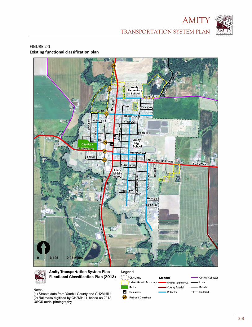
2.1 Functional Classification Plan The city’s “functional classification” system describes the intended function of city streets. Streets
designated as “local” serve low speed, low volume traffic and are mainly for accessing homes.
“Collectors” serve higher speed and higher volume traffic and usually provide access to arterials or
other streets that are intended for high speed, high volume traffic. Amity’s street system is
comprised mostly of local and collector streets. The two state highways in town – OR 99W/Trade
Street and OR 153/Nursery Ave/5th Street – are state roads and serve as the major north-south and
east-west arterials.
Two changes to existing street functional classifications are proposed as part of the TSP:
Rice Lane, from Jellison Avenue east to SE Amity Vineyards Road is proposed to change from
“Local” to “Collector.” This change is intended to reflect the increased traffic that is expected
on this segment of road when anticipated development occurs in the UGB area along Rice
Lane.
Sherman Avenue, from OR 99W/Trade Street to Goucher Avenue is proposed to change
from “Collector” to “Local.” This change reflects the current and future anticipated function
AMITY TRANSPORTATION SYSTEM PLAN
2-2
of the street; Sherman Avenue presently experiences low traffic volumes and is not
anticipated to experience significant increases in traffic during the planning horizon.
No other functional class changes to existing streets are proposed – existing and future traffic
conditions analysis did not reveal any need to modify any other existing street classifications.
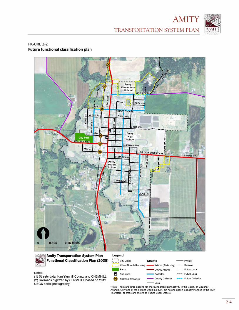
Figure 2-1 below shows the existing functional classification system and Figure 2-2 shows the
proposed future functional classification system. The future system includes several street
extensions (classified variously as local and collector streets) that are proposed as part of the
transportation system plan.
AMITY TRANSPORTATION SYSTEM PLAN
2-3
FIGURE 2-1 Existing functional classification plan
AMITY TRANSPORTATION SYSTEM PLAN
2-4
FIGURE 2-2 Future functional classification plan
AMITY TRANSPORTATION SYSTEM PLAN
2-5
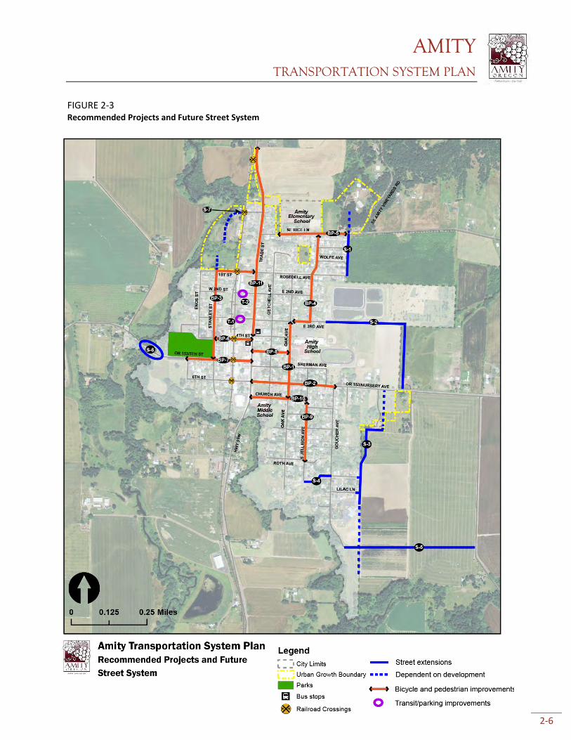
2.2 Preferred System Plan The rest of this section reviews the preferred system plan for the City. Projects are organized by the
primary transportation mode targeted for each improvement project. In many cases, full
implementation of projects would improve conditions for all modes. For example, many of the
bicycle and pedestrian projects include street widening to City standards, which would improve
traffic flow and pavement conditions. Many projects may be constructed in phases, depending on
the amount and type of funding available, the relative difficulty of implementing projects, and based
on the priorities of the City as they change in the future. It is important to note that all projects
proposed on state highways (OR 99W/Trade Street, OR 153/Nursery Ave, and OR 153/5th Street) will
be designed per the state’s Highway Design Manual.
The cost estimates provided for each of the projects are “order of magnitude” estimates and include
any needed right-of-way. These are planning-level estimates – more precise estimates would be
generated during project engineering.
Figure 2-3 below shows the locations of all proposed projects in the City. They are color-coded by
the primary transportation mode targeted for that project (e.g., orange represent bicycle and/or
pedestrian projects).
In the following section, there are three options for meeting an identified transportation need in the
vicinity of Goucher Street. Due to a lack of redundant connections to Goucher Street south of
Barney Alley, and in consideration of the numerous households and church located along Goucher
Street, the City identified a need for a redundant connection to ensure emergency access in the
event Goucher Street is impassable. Three options are presented in the TSP for potentially meeting
the identified need for a redundant connection (Projects S-3, S-4, and S-5). The City will evaluate
which of these options best meets the needs of the City at a later date. Any facilities located outside
of the Urban Growth Boundary are not planned facilities or improvements. Eventual designation of
any of these projects outside of the Urban Growth Boundary as planned facilities or improvements
may require an amendment to the Yamhill County TSP (which may require an exception to the
statewide planning goals), as the county is the local government with jurisdiction.
AMITY TRANSPORTATION SYSTEM PLAN
2-6
FIGURE 2-3 Recommended Projects and Future Street System
AMITY TRANSPORTATION SYSTEM PLAN
2-7
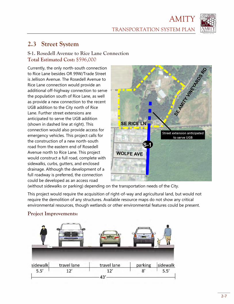
2.3 Street System S-1. Rosedell Avenue to Rice Lane Connection Total Estimated Cost: $596,000
Currently, the only north-south connection
to Rice Lane besides OR 99W/Trade Street
is Jellison Avenue. The Rosedell Avenue to
Rice Lane connection would provide an
additional off-highway connection to serve
the population south of Rice Lane, as well
as provide a new connection to the recent
UGB addition to the City north of Rice
Lane. Further street extensions are
anticipated to serve the UGB addition
(shown in dashed line at right). This
connection would also provide access for
emergency vehicles. This project calls for
the construction of a new north-south
road from the eastern end of Rosedell
Avenue north to Rice Lane. This project
would construct a full road, complete with
sidewalks, curbs, gutters, and enclosed
drainage. Although the development of a
full roadway is preferred, the connection
could be developed as an access road
(without sidewalks or parking) depending on the transportation needs of the City.
This project would require the acquisition of right-of-way and agricultural land, but would not
require the demolition of any structures. Available resource maps do not show any critical
environmental resources, though wetlands or other environmental features could be present.
Project Improvements:
AMITY TRANSPORTATION SYSTEM PLAN
2-8
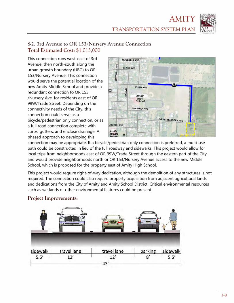
S-2. 3rd Avenue to OR 153/Nursery Avenue Connection Total Estimated Cost: $1,013,000
This connection runs west-east of 3rd
Avenue, then north-south along the
urban growth boundary (UBG) to OR
153/Nursery Avenue. This connection
would serve the potential location of the
new Amity Middle School and provide a
redundant connection to OR 153
/Nursery Ave. for residents east of OR
99W/Trade Street. Depending on the
connectivity needs of the City, this
connection could serve as a
bicycle/pedestrian only connection, or as
a full road connection complete with
curbs, gutters, and enclose drainage. A
phased approach to developing this
connection may be appropriate. If a bicycle/pedestrian only connection is preferred, a multi-use
path could be constructed in lieu of the full roadway and sidewalks. This project would allow for
local trips from neighborhoods east of OR 99W/Trade Street through the eastern part of the City,
and would provide neighborhoods north or OR 153/Nursery Avenue access to the new Middle
School, which is proposed for the property east of Amity High School.
This project would require right-of-way dedication, although the demolition of any structures is not
required. The connection could also require property acquisition from adjacent agricultural lands
and dedications from the City of Amity and Amity School District. Critical environmental resources
such as wetlands or other environmental features could be present.
Project Improvements:
AMITY TRANSPORTATION SYSTEM PLAN
2-9
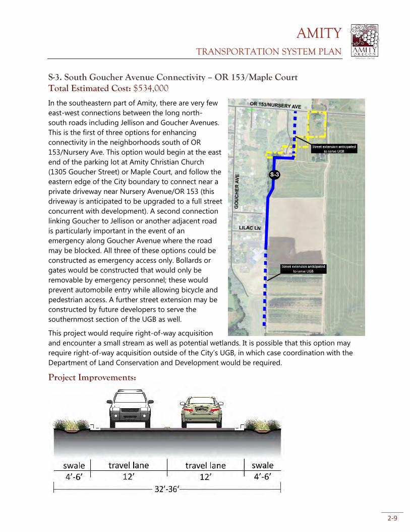
S-3. South Goucher Avenue Connectivity – OR 153/Maple Court Total Estimated Cost: $534,000
In the southeastern part of Amity, there are very few
east-west connections between the long north-
south roads including Jellison and Goucher Avenues.
This is the first of three options for enhancing
connectivity in the neighborhoods south of OR
153/Nursery Ave. This option would begin at the east
end of the parking lot at Amity Christian Church
(1305 Goucher Street) or Maple Court, and follow the
eastern edge of the City boundary to connect near a
private driveway near Nursery Avenue/OR 153 (this
driveway is anticipated to be upgraded to a full street
concurrent with development). A second connection
linking Goucher to Jellison or another adjacent road
is particularly important in the event of an
emergency along Goucher Avenue where the road
may be blocked. All three of these options could be
constructed as emergency access only. Bollards or
gates would be constructed that would only be
removable by emergency personnel; these would
prevent automobile entry while allowing bicycle and
pedestrian access. A further street extension may be
constructed by future developers to serve the
southernmost section of the UGB as well.
This project would require right-of-way acquisition
and encounter a small stream as well as potential wetlands. It is possible that this option may
require right-of-way acquisition outside of the City’s UGB, in which case coordination with the
Department of Land Conservation and Development would be required.
Project Improvements:
AMITY TRANSPORTATION SYSTEM PLAN
2-10
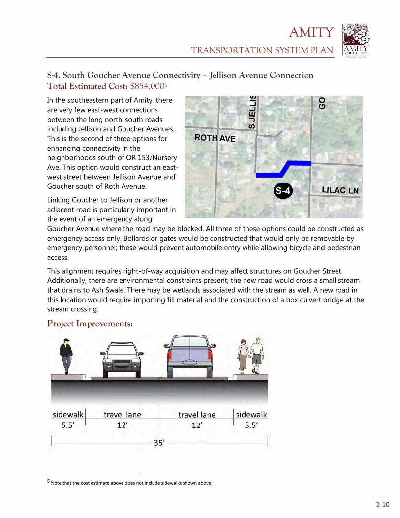
S-4. South Goucher Avenue Connectivity – Jellison Avenue Connection Total Estimated Cost: $854,0005
In the southeastern part of Amity, there
are very few east-west connections
between the long north-south roads
including Jellison and Goucher Avenues.
This is the second of three options for
enhancing connectivity in the
neighborhoods south of OR 153/Nursery
Ave. This option would construct an east-
west street between Jellison Avenue and
Goucher south of Roth Avenue.
Linking Goucher to Jellison or another
adjacent road is particularly important in
the event of an emergency along
Goucher Avenue where the road may be blocked. All three of these options could be constructed as
emergency access only. Bollards or gates would be constructed that would only be removable by
emergency personnel; these would prevent automobile entry while allowing bicycle and pedestrian
access.
This alignment requires right-of-way acquisition and may affect structures on Goucher Street.
Additionally, there are environmental constraints present; the new road would cross a small stream
that drains to Ash Swale. There may be wetlands associated with the stream as well. A new road in
this location would require importing fill material and the construction of a box culvert bridge at the
stream crossing.
Project Improvements:
5 Note that the cost estimate above does not include sidewalks shown above.
AMITY TRANSPORTATION SYSTEM PLAN
2-11
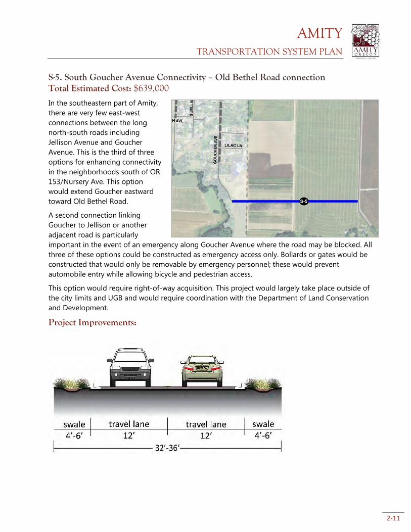
S-5. South Goucher Avenue Connectivity – Old Bethel Road connection Total Estimated Cost: $639,000
In the southeastern part of Amity,
there are very few east-west
connections between the long
north-south roads including
Jellison Avenue and Goucher
Avenue. This is the third of three
options for enhancing connectivity
in the neighborhoods south of OR
153/Nursery Ave. This option
would extend Goucher eastward
toward Old Bethel Road.
A second connection linking
Goucher to Jellison or another
adjacent road is particularly
important in the event of an emergency along Goucher Avenue where the road may be blocked. All
three of these options could be constructed as emergency access only. Bollards or gates would be
constructed that would only be removable by emergency personnel; these would prevent
automobile entry while allowing bicycle and pedestrian access.
This option would require right-of-way acquisition. This project would largely take place outside of
the city limits and UGB and would require coordination with the Department of Land Conservation
and Development.
Project Improvements:
Figure 2-11
AMITY TRANSPORTATION SYSTEM PLAN
2-12
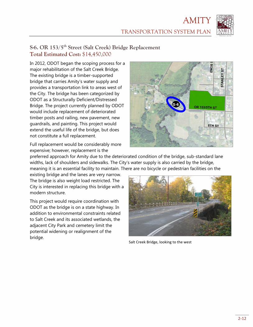
S-6. OR 153/5th Street (Salt Creek) Bridge Replacement Total Estimated Cost: $14,450,000
In 2012, ODOT began the scoping process for a
major rehabilitation of the Salt Creek Bridge.
The existing bridge is a timber-supported
bridge that carries Amity’s water supply and
provides a transportation link to areas west of
the City. The bridge has been categorized by
ODOT as a Structurally Deficient/Distressed
Bridge. The project currently planned by ODOT
would include replacement of deteriorated
timber posts and railing, new pavement, new
guardrails, and painting. This project would
extend the useful life of the bridge, but does
not constitute a full replacement.
Full replacement would be considerably more
expensive; however, replacement is the
preferred approach for Amity due to the deteriorated condition of the bridge, sub-standard lane
widths, lack of shoulders and sidewalks. The City’s water supply is also carried by the bridge,
meaning it is an essential facility to maintain. There are no bicycle or pedestrian facilities on the
existing bridge and the lanes are very narrow.
The bridge is also weight load restricted. The
City is interested in replacing this bridge with a
modern structure.
This project would require coordination with
ODOT as the bridge is on a state highway. In
addition to environmental constraints related
to Salt Creek and its associated wetlands, the
adjacent City Park and cemetery limit the
potential widening or realignment of the
bridge.
Salt Creek Bridge, looking to the west
AMITY TRANSPORTATION SYSTEM PLAN
2-13
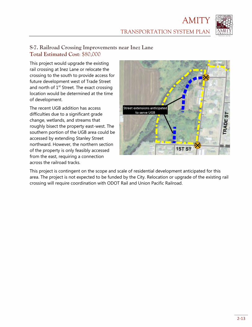
S-7. Railroad Crossing Improvements near Inez Lane Total Estimated Cost: $80,000
This project would upgrade the existing
rail crossing at Inez Lane or relocate the
crossing to the south to provide access for
future development west of Trade Street
and north of 1st Street. The exact crossing
location would be determined at the time
of development.
The recent UGB addition has access
difficulties due to a significant grade
change, wetlands, and streams that
roughly bisect the property east-west. The
southern portion of the UGB area could be
accessed by extending Stanley Street
northward. However, the northern section
of the property is only feasibly accessed
from the east, requiring a connection
across the railroad tracks.
This project is contingent on the scope and scale of residential development anticipated for this
area. The project is not expected to be funded by the City. Relocation or upgrade of the existing rail
crossing will require coordination with ODOT Rail and Union Pacific Railroad.
AMITY TRANSPORTATION SYSTEM PLAN
2-14
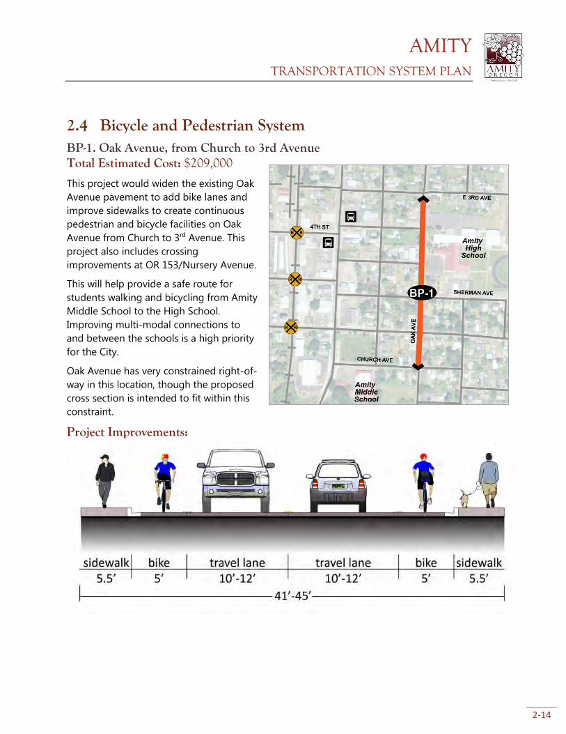
2.4 Bicycle and Pedestrian System BP-1. Oak Avenue, from Church to 3rd Avenue Total Estimated Cost: $209,000
This project would widen the existing Oak
Avenue pavement to add bike lanes and
improve sidewalks to create continuous
pedestrian and bicycle facilities on Oak
Avenue from Church to 3rd Avenue. This
project also includes crossing
improvements at OR 153/Nursery Avenue.
This will help provide a safe route for
students walking and bicycling from Amity
Middle School to the High School.
Improving multi-modal connections to
and between the schools is a high priority
for the City.
Oak Avenue has very constrained right-of-
way in this location, though the proposed
cross section is intended to fit within this
constraint.
Project Improvements:
AMITY TRANSPORTATION SYSTEM PLAN
2-15
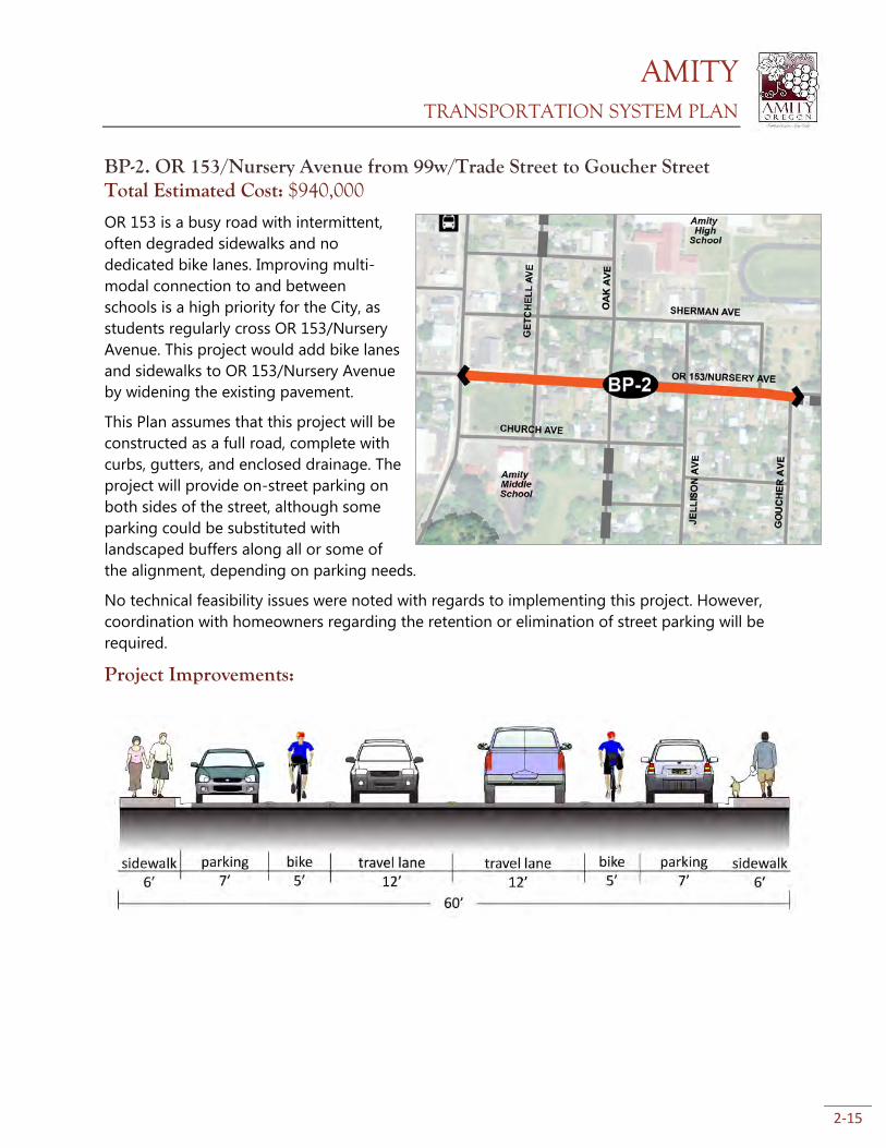
BP-2. OR 153/Nursery Avenue from 99w/Trade Street to Goucher Street Total Estimated Cost: $940,000
OR 153 is a busy road with intermittent,
often degraded sidewalks and no
dedicated bike lanes. Improving multi-
modal connection to and between
schools is a high priority for the City, as
students regularly cross OR 153/Nursery
Avenue. This project would add bike lanes
and sidewalks to OR 153/Nursery Avenue
by widening the existing pavement.
This Plan assumes that this project will be
constructed as a full road, complete with
curbs, gutters, and enclosed drainage. The
project will provide on-street parking on
both sides of the street, although some
parking could be substituted with
landscaped buffers along all or some of
the alignment, depending on parking needs.
No technical feasibility issues were noted with regards to implementing this project. However,
coordination with homeowners regarding the retention or elimination of street parking will be
required.
Project Improvements:
AMITY TRANSPORTATION SYSTEM PLAN
2-16
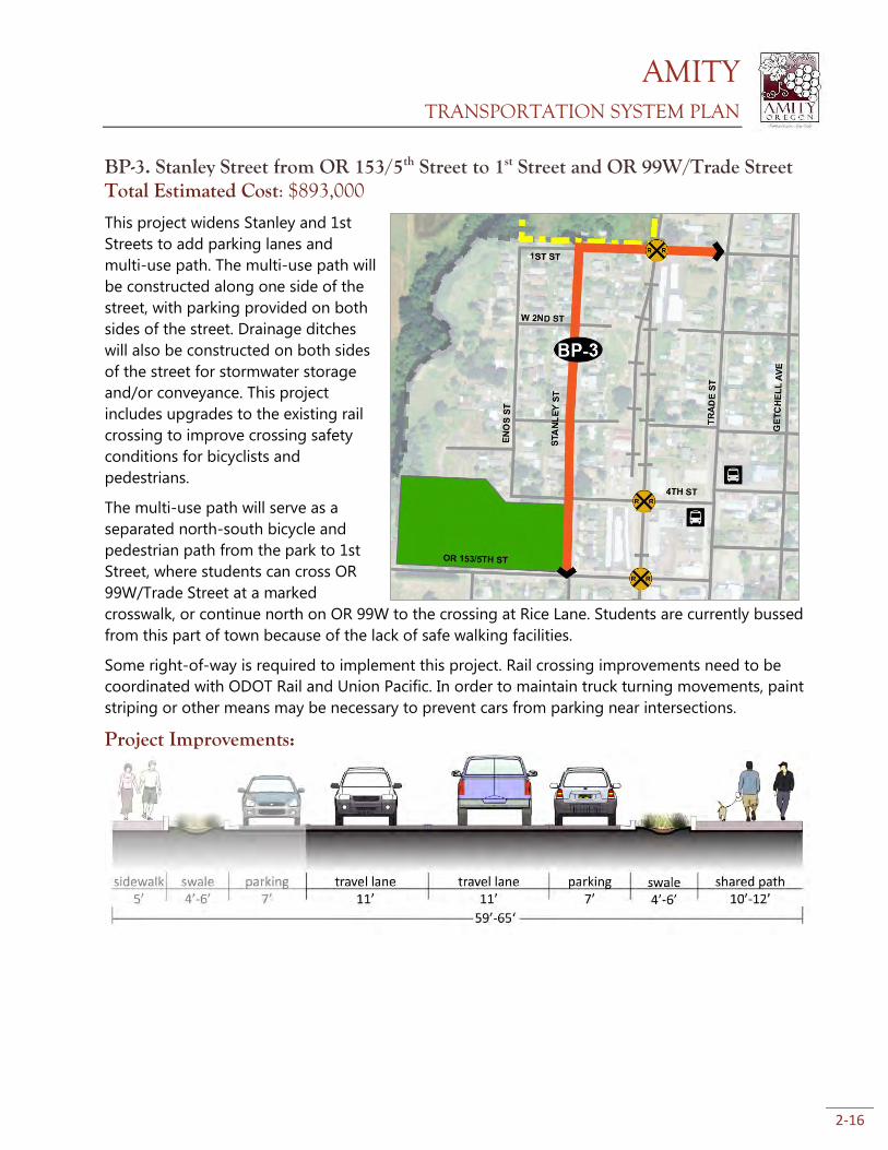
BP-3. Stanley Street from OR 153/5th Street to 1st Street and OR 99W/Trade Street Total Estimated Cost: $893,000
This project widens Stanley and 1st
Streets to add parking lanes and
multi-use path. The multi-use path will
be constructed along one side of the
street, with parking provided on both
sides of the street. Drainage ditches
will also be constructed on both sides
of the street for stormwater storage
and/or conveyance. This project
includes upgrades to the existing rail
crossing to improve crossing safety
conditions for bicyclists and
pedestrians.
The multi-use path will serve as a
separated north-south bicycle and
pedestrian path from the park to 1st
Street, where students can cross OR
99W/Trade Street at a marked
crosswalk, or continue north on OR 99W to the crossing at Rice Lane. Students are currently bussed
from this part of town because of the lack of safe walking facilities.
Some right-of-way is required to implement this project. Rail crossing improvements need to be
coordinated with ODOT Rail and Union Pacific. In order to maintain truck turning movements, paint
striping or other means may be necessary to prevent cars from parking near intersections.
Project Improvements:
AMITY TRANSPORTATION SYSTEM PLAN
2-17
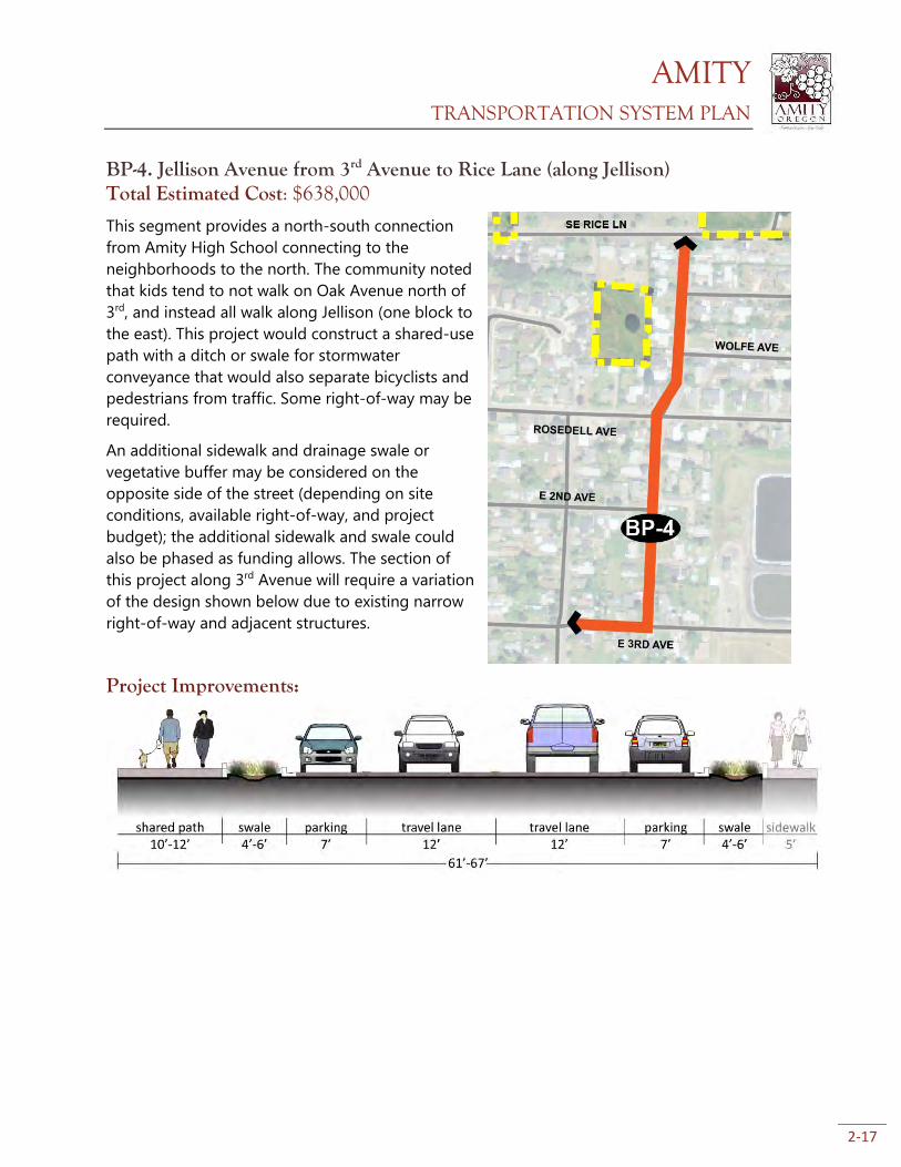
BP-4. Jellison Avenue from 3rd Avenue to Rice Lane (along Jellison) Total Estimated Cost: $638,000
This segment provides a north-south connection
from Amity High School connecting to the
neighborhoods to the north. The community noted
that kids tend to not walk on Oak Avenue north of
3rd, and instead all walk along Jellison (one block to
the east). This project would construct a shared-use
path with a ditch or swale for stormwater
conveyance that would also separate bicyclists and
pedestrians from traffic. Some right-of-way may be
required.
An additional sidewalk and drainage swale or
vegetative buffer may be considered on the
opposite side of the street (depending on site
conditions, available right-of-way, and project
budget); the additional sidewalk and swale could
also be phased as funding allows. The section of
this project along 3rd Avenue will require a variation
of the design shown below due to existing narrow
right-of-way and adjacent structures.
Project Improvements:
AMITY TRANSPORTATION SYSTEM PLAN
2-18
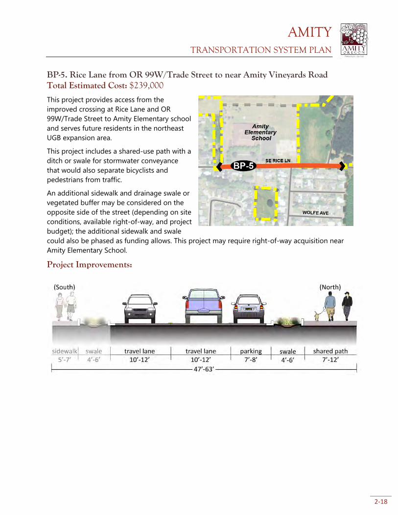
BP-5. Rice Lane from OR 99W/Trade Street to near Amity Vineyards Road Total Estimated Cost: $239,000
This project provides access from the
improved crossing at Rice Lane and OR
99W/Trade Street to Amity Elementary school
and serves future residents in the northeast
UGB expansion area.
This project includes a shared-use path with a
ditch or swale for stormwater conveyance
that would also separate bicyclists and
pedestrians from traffic.
An additional sidewalk and drainage swale or
vegetated buffer may be considered on the
opposite side of the street (depending on site
conditions, available right-of-way, and project
budget); the additional sidewalk and swale
could also be phased as funding allows. This project may require right-of-way acquisition near
Amity Elementary School.
Project Improvements:
AMITY TRANSPORTATION SYSTEM PLAN
2-19
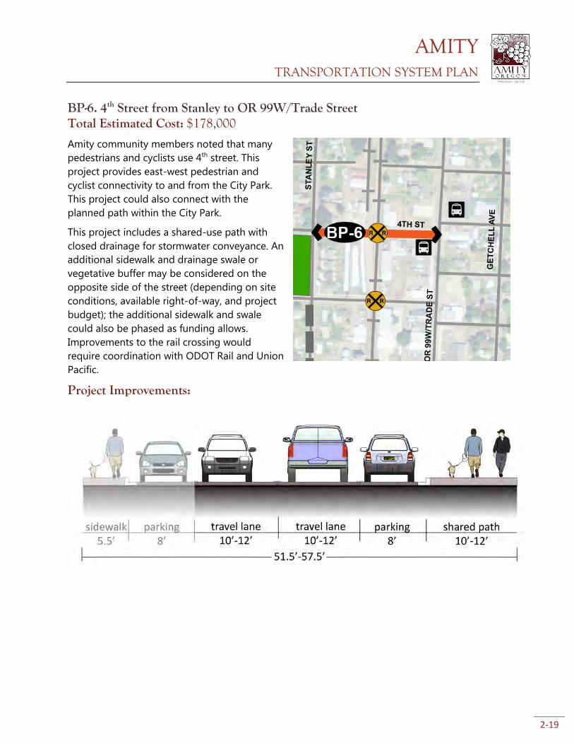
BP-6. 4th Street from Stanley to OR 99W/Trade Street Total Estimated Cost: $178,000
Amity community members noted that many
pedestrians and cyclists use 4th street. This
project provides east-west pedestrian and
cyclist connectivity to and from the City Park.
This project could also connect with the
planned path within the City Park.
This project includes a shared-use path with
closed drainage for stormwater conveyance. An
additional sidewalk and drainage swale or
vegetative buffer may be considered on the
opposite side of the street (depending on site
conditions, available right-of-way, and project
budget); the additional sidewalk and swale
could also be phased as funding allows.
Improvements to the rail crossing would
require coordination with ODOT Rail and Union
Pacific.
Project Improvements:
AMITY TRANSPORTATION SYSTEM PLAN
2-20
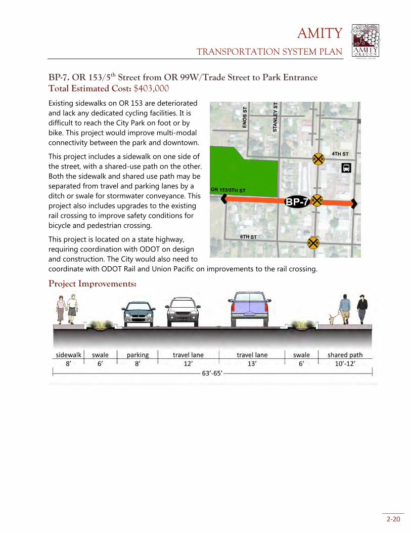
BP-7. OR 153/5th Street from OR 99W/Trade Street to Park Entrance Total Estimated Cost: $403,000
Existing sidewalks on OR 153 are deteriorated
and lack any dedicated cycling facilities. It is
difficult to reach the City Park on foot or by
bike. This project would improve multi-modal
connectivity between the park and downtown.
This project includes a sidewalk on one side of
the street, with a shared-use path on the other.
Both the sidewalk and shared use path may be
separated from travel and parking lanes by a
ditch or swale for stormwater conveyance. This
project also includes upgrades to the existing
rail crossing to improve safety conditions for
bicycle and pedestrian crossing.
This project is located on a state highway,
requiring coordination with ODOT on design
and construction. The City would also need to
coordinate with ODOT Rail and Union Pacific on improvements to the rail crossing.
Project Improvements:
AMITY TRANSPORTATION SYSTEM PLAN
2-21
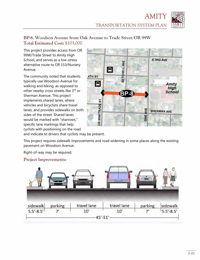
BP-8. Woodson Avenue from Oak Avenue to Trade Street/OR 99W Total Estimated Cost: $103,000
This project provides access from OR
99W/Trade Street to Amity High
School, and serves as a low-stress
alternative route to OR 153/Nursery
Avenue.
The community noted that students
typically use Woodson Avenue for
walking and biking, as opposed to
other nearby cross streets like 3rd or
Sherman Avenue. This project
implements shared lanes, where
vehicles and bicyclists share travel
lanes, and provides sidewalks on both
sides of the street. Shared lanes
would be marked with “sharrows,”
specific lane markings that help
cyclists with positioning on the road
and indicate to drivers that cyclists may be present.
This project requires sidewalk improvements and road widening in some places along the existing
pavement on Woodson Avenue.
Right-of-way may be required.
Project Improvements:
AMITY TRANSPORTATION SYSTEM PLAN
2-22
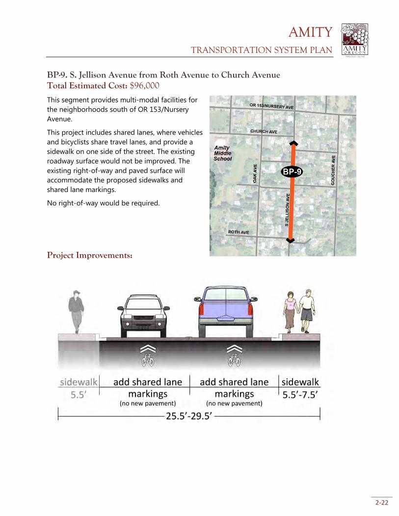
BP-9. S. Jellison Avenue from Roth Avenue to Church Avenue Total Estimated Cost: $96,000
This segment provides multi-modal facilities for
the neighborhoods south of OR 153/Nursery
Avenue.
This project includes shared lanes, where vehicles
and bicyclists share travel lanes, and provide a
sidewalk on one side of the street. The existing
roadway surface would not be improved. The
existing right-of-way and paved surface will
accommodate the proposed sidewalks and
shared lane markings.
No right-of-way would be required.
Project Improvements:
AMITY TRANSPORTATION SYSTEM PLAN
2-23
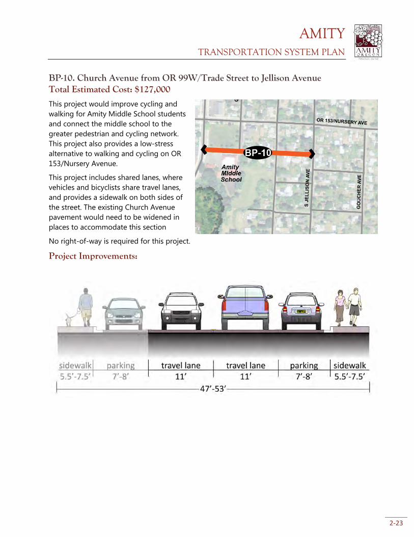
BP-10. Church Avenue from OR 99W/Trade Street to Jellison Avenue Total Estimated Cost: $127,000
This project would improve cycling and
walking for Amity Middle School students
and connect the middle school to the
greater pedestrian and cycling network.
This project also provides a low-stress
alternative to walking and cycling on OR
153/Nursery Avenue.
This project includes shared lanes, where
vehicles and bicyclists share travel lanes,
and provides a sidewalk on both sides of
the street. The existing Church Avenue
pavement would need to be widened in
places to accommodate this section
No right-of-way is required for this project.
Project Improvements:
AMITY TRANSPORTATION SYSTEM PLAN
2-24
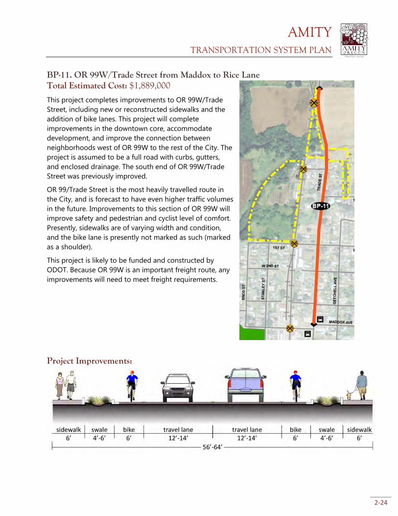
BP-11. OR 99W/Trade Street from Maddox to Rice Lane Total Estimated Cost: $1,889,000
This project completes improvements to OR 99W/Trade
Street, including new or reconstructed sidewalks and the
addition of bike lanes. This project will complete
improvements in the downtown core, accommodate
development, and improve the connection between
neighborhoods west of OR 99W to the rest of the City. The
project is assumed to be a full road with curbs, gutters,
and enclosed drainage. The south end of OR 99W/Trade
Street was previously improved.
OR 99/Trade Street is the most heavily travelled route in
the City, and is forecast to have even higher traffic volumes
in the future. Improvements to this section of OR 99W will
improve safety and pedestrian and cyclist level of comfort.
Presently, sidewalks are of varying width and condition,
and the bike lane is presently not marked as such (marked
as a shoulder).
This project is likely to be funded and constructed by
ODOT. Because OR 99W is an important freight route, any
improvements will need to meet freight requirements.
Project Improvements:
AMITY TRANSPORTATION SYSTEM PLAN
2-25
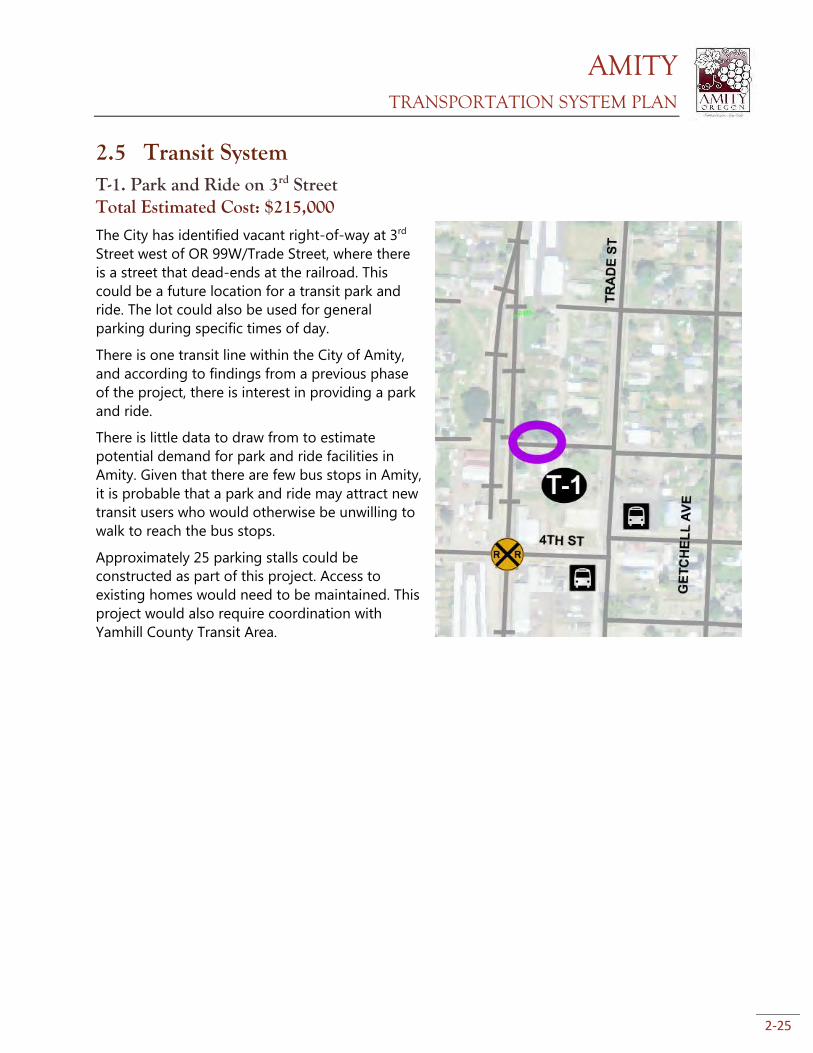
2.5 Transit System T-1. Park and Ride on 3rd Street Total Estimated Cost: $215,000
The City has identified vacant right-of-way at 3rd
Street west of OR 99W/Trade Street, where there
is a street that dead-ends at the railroad. This
could be a future location for a transit park and
ride. The lot could also be used for general
parking during specific times of day.
There is one transit line within the City of Amity,
and according to findings from a previous phase
of the project, there is interest in providing a park
and ride.
There is little data to draw from to estimate
potential demand for park and ride facilities in
Amity. Given that there are few bus stops in Amity,
it is probable that a park and ride may attract new
transit users who would otherwise be unwilling to
walk to reach the bus stops.
Approximately 25 parking stalls could be
constructed as part of this project. Access to
existing homes would need to be maintained. This
project would also require coordination with
Yamhill County Transit Area.
AMITY TRANSPORTATION SYSTEM PLAN
2-26
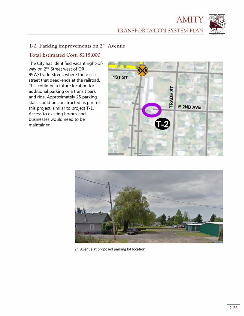
T-2. Parking improvements on 2nd Avenue
Total Estimated Cost: $215,000
The City has identified vacant right-of-
way on 2nd Street west of OR
99W/Trade Street, where there is a
street that dead-ends at the railroad.
This could be a future location for
additional parking or a transit park
and ride. Approximately 25 parking
stalls could be constructed as part of
this project, similar to project T-1.
Access to existing homes and
businesses would need to be
maintained.
2nd Avenue at proposed parking lot location
AMITY TRANSPORTATION SYSTEM PLAN
2-27
2.6 Air, Rail, Water, and Pipeline System The nearest airports to Amity are McMinnville Municipal Airport to the north and Salem
Municipal Airport to the southeast. Both are general aviation airports, with no commercial service.
Salem’s airport had commercial service until 2008, but no carriers currently provide passenger
service. Portland International Airport (53 miles by car) is the closest commercial airport to Amity,
providing frequent domestic and international air service.
A Union Pacific-owned railroad runs north-south through the west side of Amity. Portland and
Western Railroad (PNWR) leases the line, running one train each direction daily. Only freight service
is provided, with no stops in Amity. In addition to freight, passenger rail service is available in Salem.
The Amtrak Cascades route runs several times daily between Eugene and Vancouver, B.C. and the
Coast Starlight provides daily service to southern Oregon and California. There are no plans to
implement passenger train service in Amity.
One natural gas pipeline, owned by Cascade Natural Gas, runs north-south through Amity. The
pipeline roughly follows OR 99W/Trade Street at the north end of town, then Stanley Street, and
back along OR 99W/Trade Street at the south end of town. There are no plans to expand pipeline
capacity in the City.
There are no navigable waterways within or near Amity.
AMITY TRANSPORTATION SYSTEM PLAN
3-1
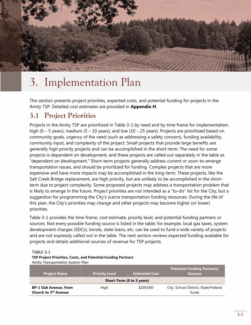
3. Implementation Plan
This section presents project priorities, expected costs, and potential funding for projects in the
Amity TSP. Detailed cost estimates are provided in Appendix H.
3.1 Project Priorities Projects in the Amity TSP are prioritized in Table 3-1 by need and by time frame for implementation:
high (0 – 5 years), medium (5 – 10 years), and low (10 – 25 years). Projects are prioritized based on
community goals, urgency of the need (such as addressing a safety concern), funding availability,
community input, and complexity of the project. Small projects that provide large benefits are
generally high priority projects and can be accomplished in the short-term. The need for some
projects is dependent on development, and these projects are called out separately in the table as
“dependent on development.” Short-term projects generally address current or soon-to-emerge
transportation issues, and should be prioritized for funding. Complex projects that are more
expensive and have more impacts may be accomplished in the long-term. These projects, like the
Salt Creek Bridge replacement, are high priority, but are unlikely to be accomplished in the short-
term due to project complexity. Some proposed projects may address a transportation problem that
is likely to emerge in the future. Project priorities are not intended as a “to-do” list for the City, but a
suggestion for programming the City’s scarce transportation funding resources. During the life of
this plan, the City’s priorities may change and other projects may become higher (or lower)
priorities.
Table 3-1 provides the time frame, cost estimate, priority level, and potential funding partners or
sources. Not every possible funding source is listed in the table; for example, local gas taxes, system
development charges (SDCs), bonds, state loans, etc. can be used to fund a wide variety of projects
and are not expressly called out in the table. The next section reviews expected funding available for
projects and details additional sources of revenue for TSP projects.
TABLE 3-1 TSP Project Priorities, Costs, and Potential Funding Partners Amity Transportation System Plan
Project Name Priority Level Estimated Cost
Potential Funding Partners/
Sources
Short-Term (0 to 5 years)
BP-1 Oak Avenue, from
Church to 3rd Avenue
High $209,000 City, School District, State/Federal
funds
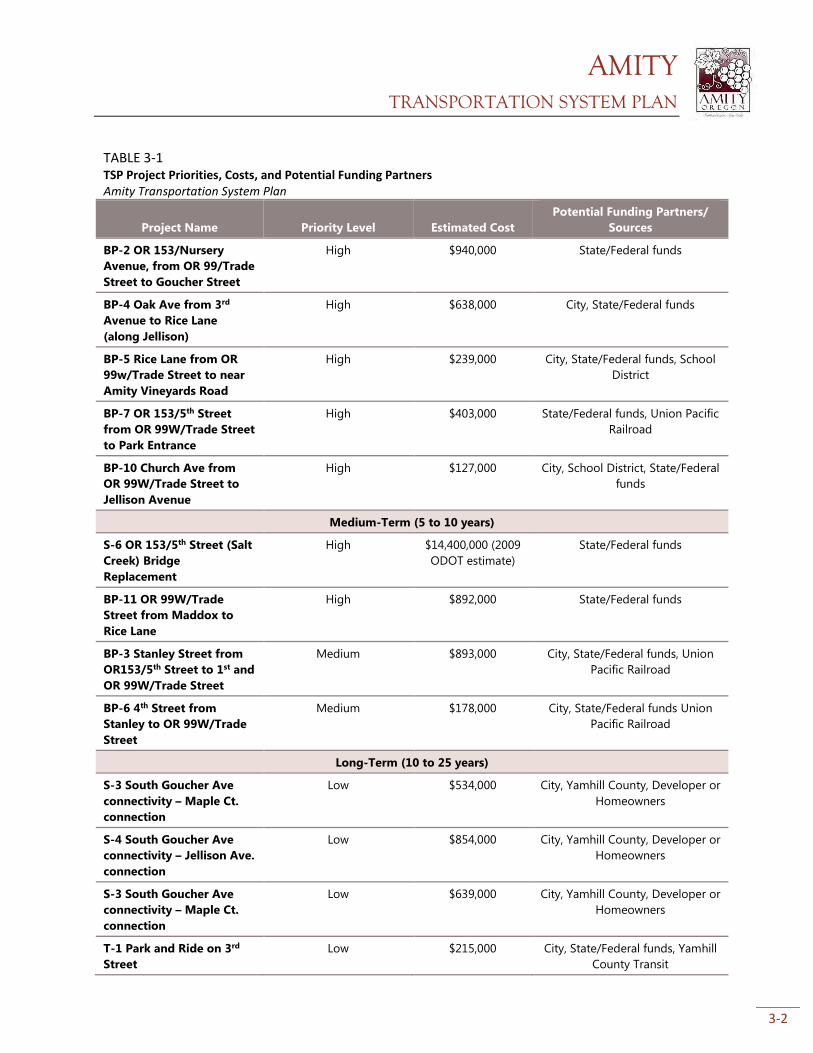
AMITY TRANSPORTATION SYSTEM PLAN
3-2
TABLE 3-1 TSP Project Priorities, Costs, and Potential Funding Partners Amity Transportation System Plan
Project Name Priority Level Estimated Cost
Potential Funding Partners/
Sources
BP-2 OR 153/Nursery
Avenue, from OR 99/Trade
Street to Goucher Street
High $940,000 State/Federal funds
BP-4 Oak Ave from 3rd
Avenue to Rice Lane
(along Jellison)
High $638,000 City, State/Federal funds
BP-5 Rice Lane from OR
99w/Trade Street to near
Amity Vineyards Road
High $239,000 City, State/Federal funds, School
District
BP-7 OR 153/5th Street
from OR 99W/Trade Street
to Park Entrance
High $403,000 State/Federal funds, Union Pacific
Railroad
BP-10 Church Ave from
OR 99W/Trade Street to
Jellison Avenue
High $127,000 City, School District, State/Federal
funds
Medium-Term (5 to 10 years)
S-6 OR 153/5th Street (Salt
Creek) Bridge
Replacement
High $14,400,000 (2009
ODOT estimate)
State/Federal funds
BP-11 OR 99W/Trade
Street from Maddox to
Rice Lane
High $892,000 State/Federal funds
BP-3 Stanley Street from
OR153/5th Street to 1st and
OR 99W/Trade Street
Medium $893,000 City, State/Federal funds, Union
Pacific Railroad
BP-6 4th Street from
Stanley to OR 99W/Trade
Street
Medium $178,000 City, State/Federal funds Union
Pacific Railroad
Long-Term (10 to 25 years)
S-3 South Goucher Ave
connectivity – Maple Ct.
connection
Low $534,000 City, Yamhill County, Developer or
Homeowners
S-4 South Goucher Ave
connectivity – Jellison Ave.
connection
Low $854,000 City, Yamhill County, Developer or
Homeowners
S-3 South Goucher Ave
connectivity – Maple Ct.
connection
Low $639,000 City, Yamhill County, Developer or
Homeowners
T-1 Park and Ride on 3rd
Street
Low $215,000 City, State/Federal funds, Yamhill
County Transit
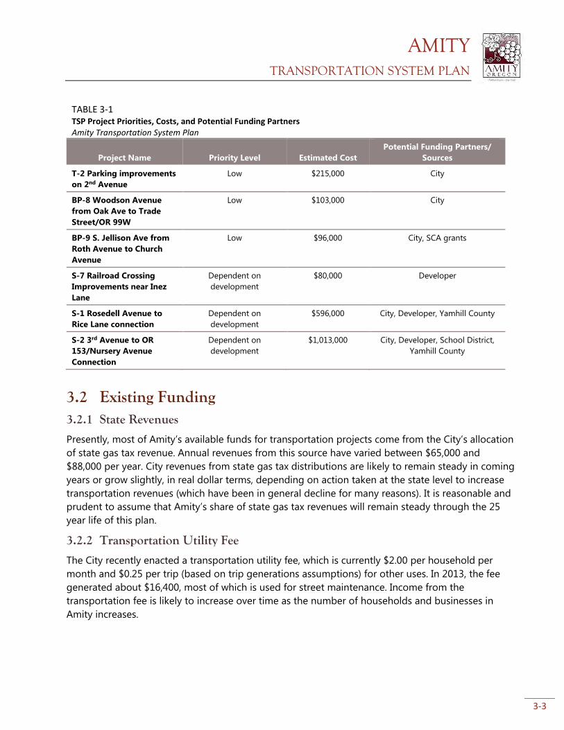
AMITY TRANSPORTATION SYSTEM PLAN
3-3
TABLE 3-1 TSP Project Priorities, Costs, and Potential Funding Partners Amity Transportation System Plan
Project Name Priority Level Estimated Cost
Potential Funding Partners/
Sources
T-2 Parking improvements
on 2nd Avenue
Low $215,000 City
BP-8 Woodson Avenue
from Oak Ave to Trade
Street/OR 99W
Low $103,000 City
BP-9 S. Jellison Ave from
Roth Avenue to Church
Avenue
Low $96,000 City, SCA grants
S-7 Railroad Crossing
Improvements near Inez
Lane
Dependent on
development
$80,000 Developer
S-1 Rosedell Avenue to
Rice Lane connection
Dependent on
development
$596,000 City, Developer, Yamhill County
S-2 3rd Avenue to OR
153/Nursery Avenue
Connection
Dependent on
development
$1,013,000 City, Developer, School District,
Yamhill County
3.2 Existing Funding 3.2.1 State Revenues
Presently, most of Amity’s available funds for transportation projects come from the City’s allocation
of state gas tax revenue. Annual revenues from this source have varied between $65,000 and
$88,000 per year. City revenues from state gas tax distributions are likely to remain steady in coming
years or grow slightly, in real dollar terms, depending on action taken at the state level to increase
transportation revenues (which have been in general decline for many reasons). It is reasonable and
prudent to assume that Amity’s share of state gas tax revenues will remain steady through the 25
year life of this plan.
3.2.2 Transportation Utility Fee
The City recently enacted a transportation utility fee, which is currently $2.00 per household per
month and $0.25 per trip (based on trip generations assumptions) for other uses. In 2013, the fee
generated about $16,400, most of which is used for street maintenance. Income from the
transportation fee is likely to increase over time as the number of households and businesses in
Amity increases.
AMITY TRANSPORTATION SYSTEM PLAN
3-4
3.2.3 System Development Charges
The City assesses System Development Charges (SDCs) for transportation and other utilities. Future
income from system development charges is difficult to predict, and highly dependent on the
economy and the scope and scale of future development in Amity.
3.2.4 Other Revenues
The City has also received grant revenues ($25,000 approximately every 4 years) from the state’s
Special City Allotment (SCA) grant program, which provides grants of up to $50,000 to small
communities for transportation improvement projects. The City has successfully utilized the SCA
grant program in the past, and this could continue to be a reliable source of additional
transportation funds for certain projects in the future. It is reasonable to assume that the City will
continue to be successful in its applications for funds from this source.
3.3 Funding TSP Projects The Amity TSP includes an estimated $24.8 million in projects over the next 25 years, of which $14.4
million (about 60%) is for the Salt Creek (OR 153/5th St.) Bridge Replacement and $1.7 million
expected to be constructed as part of private development. Four projects, including the bridge
replacement, are located on either of the two state highways in Amity:
S-6 OR 153/5th Street Bridge Replacement
BP-2 OR 153/Nursery Avenue (from OR 99W to Goucher Ave.)
BP-7 OR 153/Nursery Avenue (from OR 99W to park entrance)
BP-11 OR 99W/Trade Street from Maddox to Rice Lane
These projects are eligible to receive state or federal monies for construction; the Oregon
Department of Transportation (ODOT) is the likely lead on the Salt Creek Bridge replacement
project. There is no guarantee of funding. However, for planning purposes, it is assumed that these
four projects will be almost entirely funded through state or federal sources.
Three other projects are anticipated to be built concurrent with development. The City is not
expected to construct these projects with City transportation dollars, but they will instead be
constructed by developers at the time of development. These projects are therefore not included in
the City’s estimated financial burden.
S-1 Rosedell Avenue to Rice Lane Connection
S-2 3rd Avenue to OR 153/Nursery Avenue Connection
S-7 Railroad Crossing Improvements near Inez Lane
Based on these assumptions, the City’s estimated financial burden to accomplish the remaining
projects is $3,883,000 to $4,203,000, depending on which of the three options for South Goucher
Connectivity (Project S-3, S-4, or S-5) is chosen.
Table 3-2 details the estimated revenue the City is likely to have available for capital projects in the
next 25 years without considering new sources of funding. This table assesses funds that the City is
reasonably expected to continue to take in. There are other potential dedicated and one-time
revenue sources, discussed in the next section that could be pursued to close the funding gap.
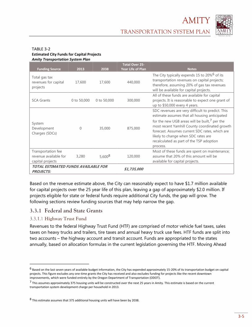
AMITY TRANSPORTATION SYSTEM PLAN
3-5
TABLE 3-2 Estimated City Funds for Capital Projects Amity Transportation System Plan
Funding Source 2013 2038 Total Over 25-
Year Life of Plan Notes
Total gas tax
revenues for capital
projects
17,600 17,600 440,000
The City typically expends 15 to 20%6 of its
transportation revenues on capital projects;
therefore, assuming 20% of gas tax revenues
will be available for capital projects.
SCA Grants 0 to 50,000 0 to 50,000 300,000
All of these funds are available for capital
projects. It is reasonable to expect one grant of
up to $50,000 every 4 years.
System
Development
Charges (SDCs)
0 35,000 875,000
SDC revenues are very difficult to predict. This
estimate assumes that all housing anticipated
for the new UGB areas will be built,7 per the
most recent Yamhill County coordinated growth
forecast. Assumes current SDC rates, which are
likely to change when SDC rates are
recalculated as part of the TSP adoption
process.
Transportation fee
revenue available for
capital projects
3,280 5,6008 120,000
Most of these funds are spent on maintenance;
assume that 20% of this amount will be
available for capital projects.
TOTAL ESTIMATED FUNDS AVAILABLE FOR
PROJECTS: $1,735,000
Based on the revenue estimate above, the City can reasonably expect to have $1.7 million available
for capital projects over the 25 year life of this plan, leaving a gap of approximately $2.0 million. If
projects eligible for state or federal funds require additional City funds, the gap will grow. The
following sections review funding sources that may help narrow the gap.
3.3.1 Federal and State Grants Highway Trust Fund
Revenues to the federal Highway Trust Fund (HTF) are comprised of motor vehicle fuel taxes, sales
taxes on heavy trucks and trailers, tire taxes and annual heavy truck use fees. HTF funds are split into
two accounts – the highway account and transit account. Funds are appropriated to the states
annually, based on allocation formulas in the current legislation governing the HTF. Moving Ahead
6 Based on the last seven years of available budget information, the City has expended approximately 15-20% of its transportation budget on capital projects. This figure excludes any one-time grants the City has received and also excludes funding for projects like the recent downtown improvements, which were funded entirely by the Oregon Department of Transportation (ODOT). 7 This assumes approximately 375 housing units will be constructed over the next 25 years in Amity. This estimate is based on the current transportation system development charge per household in 2013.
8 This estimate assumes that 375 additional housing units will have been by 2038.
AMITY TRANSPORTATION SYSTEM PLAN
3-6
for Progress in the 21st Century (MAP-21) is the current federal transportation program legislation,
which became effective October 1st, 2012.
MAP-21 kept federal funding for transportation at the same rate as the prior legislation (the Safe,
Accountable, Flexible and Efficient Transportation Equity Act – A Legacy for Users, known as
SAFETEA-LU). MAP-21 consolidated the 90 different programs in SAFETEA-LU into 30, eliminated
transportation earmarks, and reduced funding for transportation enhancements (pedestrian, bicycle
and similar projects) by one third. Despite these changes and modest reduction in transportation
enhancement (now transportation alternatives) funds, MAP-21 largely continues federal
transportation funding and policy enacted under SAFETEA-LU. Matching funds are generally
required; the current matching ratio is 10.27% for projects in Oregon.
Most federal grant monies are distributed by the Oregon Department of Transportation (ODOT)
through the Statewide Transportation Improvement program (STIP). The application process for
federal funds is described below in the Statewide Transportation Improvement Program section.
Funds are limited and the grants process is competitive.
State Highway Fund
State funds are distributed by the Oregon Transportation Commission (OTC). Revenues to the fund
are comprised of fuel taxes, vehicle registration and title fees, driver’s license fees and the truck
weight-mile tax. State funds may be used for construction and maintenance of state and local
highways, bridges and roadside rest areas. State law requires that a minimum of 1% of all highway
funds be used for pedestrian and bicycle projects in any given fiscal year. However, cities and
counties receiving state funds may “bank” their pedestrian and bicycle allotment for larger projects.
Funds are limited and the grants process is competitive.
Statewide Transportation Improvement Program
The STIP is the 4-year capital improvement program for the state of Oregon. It provides a schedule
and identifies funding for projects throughout the state. Projects included in the STIP are generally
“regionally significant” and are prioritized by Metropolitan Planning Organizations and Area
Commissions on Transportation (ACTs). ACTs are regional advisory bodies, and the relevant ACT for
Amity is the Mid-Willamette Valley ACT. All regionally significant state and local projects, as well as
all federally-funded projects and programs, must be included in the STIP.
About 80 percent of STIP projects use federal funds, most of which originate from MAP-21
programs. This includes the STP, TAP, and National Highway Performance Program funding for
preservation and improvement of the National Highway System. In addition, Regional Flexible Funds
competitive grants awarded every two years towards bicycle, pedestrian, transit and Transportation
Demand Management (TDM) projects are now included in the STIP. The STIP is the major
transportation funding program for most state and federal transportation funds.
Previous STIPs had six program categories: modernization, safety, preservation, bridge, operations,
and special programs. Starting with the 2015-2018 STIP, ODOT divides the funding pools into two
broad categories: “Fix it” and “Enhance.” “Fix it” projects are those that preserve and maintain the
current transportation system; “Enhance” projects are those that enhance, expand or improve the
transportation system. The main purpose behind this reorganization is to allow maximum flexibility
AMITY TRANSPORTATION SYSTEM PLAN
3-7
to fund projects that reflect community and state values and needs, rather than those that fit best
into prescriptive program definitions. More information on the Statewide Transportation
Improvement Program can be found at http://www.oregon.gov/ODOT/TD/STIP/Pages/default.aspx .
Applicable “Fix-it” activities include: Applicable “Enhance” activities include:
• Bridges (state owned) • Bicycle and/or Pedestrian facilities on or off the
highway right-of-way
• High Risk Rural Roads • Most projects previously eligible for Transportation
Enhancement funds
• Illumination, signs and signals • Bike/Ped, Transit, TDM projects eligible for Flexible
Funds (using federal STP and CMAQ funds)
• Safety • Safe Routes to School (infrastructure projects)
• Transportation Alternatives (new with MAP-21)
The application process for projects on the 2015-2018 STIP is complete as of this writing, but future
STIPs will continue to use this new funding arrangement. There is now one application for “Enhance”
projects – ODOT will determine which funding mechanism is most appropriate for individual
projects. “Fix it” projects will be selected through a collaborative process between ODOT and ACTs.
It should be noted that this reorganization of funding programs does not represent a fundamental
change in the types of projects that will be funded through the STIP.
Eligibility
Only certain streets are eligible to receive federal funds – generally those streets with federal
functional classification as “major collector” and higher order streets. Only OR 99/Trade Street, OR
153/5th Street, and OR 153/Nursery Avenue meet this criteria. However, STIP projects are also
funded by other sources, meaning many streets in Amity are likely eligible under either the “Fix it” or
“Enhance” categories described above. To ensure that Amity is involved in the STIP decision-making
process and to advocate for STIP projects important to the community, the City should actively
participate in the Mid-Willamette Valley ACT.
An additional step the City or local school district could take to improve the likelihood of funding
through the “Enhance” side of the STIP is to complete a Safe Routes to School Action Plan. These
plans detail specific programmatic actions as well as capital improvements that improve the walking
and cycling environment around and between schools. Completing an Action Plan will help those
projects near or adjacent to schools receive “Enhance” funding. More information about the Safe
Routes to School program and Action Plans can be found at http://oregonsaferoutes.org/.
3.3.2 State Grants Recreational Trails Program (RTP)
This program is administered by the Oregon Parks and Recreation Department. RTP funding is
intended for recreational trail projects, and can be used for acquiring land and easement and
building new trails. Grant funds pay up to 80 percent of project costs while project sponsors must
AMITY TRANSPORTATION SYSTEM PLAN
3-8
match project costs by at least 20 percent. Funding varies greatly from year to year, with about $1.3
million awarded state-wide in 2011 and $2.1 million in 2010. Approximately $1.5 million in state-
wide funds are available in 2014. Funds are limited and the grants process is competitive. More
information can be found at http://www.oregon.gov/oprd/grants/Pages/trails.aspx.
ConnectOregon Program
ConnectOregon provides grants and loans for non-highway transportation projects, backed by
bonds on state lottery proceeds. $42 million in bonds were authorized for the most recent
biennium. The program funds rail, port/marine, aviation, and transit projects. In addition, the
Legislature made bicycle and pedestrian projects that are not eligible for State Highway Funds
eligible to compete for ConnectOregon funding. If the state legislature makes further
authorizations, a number of Amity’s transportation projects may be eligible based on funding
criteria. Funds are limited and the grants process is competitive. More information on this program
can be found at http://www.oregon.gov/ODOT/TD/TP/pages/connector.aspx.
Oregon Immediate Opportunity Fund
The Oregon immediate opportunity fund supports economic development in Oregon through
construction and improvements of streets and roads. Funds are discretionary and may only be used
when other sources of financial support are unavailable or insufficient. The objectives of the
Opportunity Fund are providing street or road improvements to influence the location, relocation,
or retention of a firm in Oregon, providing procedures and funds for the OTC to respond quickly to
economic development opportunities, and providing criteria and procedures for the Oregon
Economic and Community Development Department (OECDD), other agencies, local government
and the private sector to work with ODOT in providing road improvements needed to ensure
specific job development opportunities for Oregon, or to revitalize business or industrial centers.
More information can be found at http://www.oregon.gov/ODOT/TD/TP/Plans/IOF.pdf.
Oregon Transportation Infrastructure Bank (OTIB)
OTIB is a statewide revolving loan fund available for highway projects on major collectors or higher
classifications and bicycle or pedestrian access projects on highway right-of-way. Applications are
accepted at any time. More information can be found at
http://www.oregon.gov/ODOT/cs/fs/Pages/otib.aspx.
Special City Allotment Grants
Special City Allotment (SCA) Grants are distributed among cities with population of less than 5,000
to help repair or reconstruct City-maintained streets that are inadequate for the capacity they serve
or are deemed unsafe. The City has received two SCA grants in the last several years, and is likely to
continue to be successful with this program. More information can be found at
http://www.oregon.gov/ODOT/HWY/REGION2/docs/resources/SpecialCityAllotmentGrantProgram.p
df.
3.3.3 Other Current & Potential Funding Sources
Most of the sources below would provide additional transportation revenue to the City that could
be spent on a wide variety of projects.
AMITY TRANSPORTATION SYSTEM PLAN
3-9
Local Gas Tax
Not every city in Oregon levies a local gas tax; of those that do, the local tax rate ranges from $0.01
to $0.04 per gallon. Based on gasoline sales and current revenues, a $0.01 local gas tax could yield
approximately $10,000 - $20,000 in additional annual transportation revenue (depending on volume
of gasoline sales within the City). Amity does not currently charge a local gas tax. Many cities in
Oregon charge a local diesel fuel tax in addition to gasoline taxes. Of those cities that levy a diesel
fuel tax, the local tax rate ranges from $0.01 - $0.05 per gallon of diesel fuel. Local fuel tax revenues
offer a potential funding source for Amity TSP projects.
Transportation Maintenance/Utility Fee
The City recently enacted a transportation utility fee, which is currently $2.00 per household per
month and $0.25 per trip (based on trip generations assumptions) for other uses. A number of
Oregon jurisdictions also levy such a fee to pay for maintenance and operations of city streets.
These fees are typically assessed on a monthly basis to residents, businesses and other non-
residential uses. Non-residential fees are typically assessed by type of use, square footage of the
building, and/or number of parking stalls that would be required under city code for a given use.
The fee currently generates about $16,000 a year in revenue. The fee, if left unchanged, is
anticipated to generate in excess of $20,000 per year by 2038 because of anticipated population
and household growth in Amity. Every additional dollar charged per household per month would
generate an additional $6,000 per year with the current number of households, and up to $10,000
per year in 2038 based on additional growth in households. Note that this estimate does not
include additional fee revenue from non-residential land uses.
Fees vary significantly from city to city; the City of Hillsboro currently charges each single family
home $3.10 per month, Stayton charges $1.00 - $2.00 per month per home and Oregon City
charges $4.50 per single family residence. Non-residential fees also vary, with fees ranging from less
than $0.15 to as much as $20.00 per square foot, depending on the type and intensity of use. The
City of Tigard charges $1.12 per month per parking stall required for non-residential uses. Though
the City already charges such a fee, it could consider raising the fee to fund a greater share of
maintenance costs, thereby freeing resources for capital projects.
Tax Increment Financing (Urban Renewal Areas)
Amity does not currently have an Urban Renewal Area (URA) within the city. Oregon law allows
small cities to designate up to 25% of the land area within the city as URAs; Amity could potentially
designate a URA, the funds from which could be used to finance transportation projects. However,
URAs can only be designated in “blighted” areas; “blight” refers to a variety of conditions, including
lack of infrastructure, under-utilization of property, physical condition of buildings, etc.
System Development Charges (SDCs)
SDCs are fees imposed on new development. Amity currently has SDCs for transportation. These
fees can be used for a wide variety of transportation improvements. SDC revenue is highly
dependent on the type and amount of development occurring in Amity. These fees must be
regularly adjusted based on the infrastructure needs of the City.
AMITY TRANSPORTATION SYSTEM PLAN
3-10
Bonds
Revenue or general obligation bonds can help finance construction of capital improvement projects
by borrowing money and paying it back over time in smaller installments. Bonds are typically
backed by new revenue, like an additional property tax levy.
Local Improvement Districts (LIDs)
Local Improvement Districts can be created by property owners within a district to raise revenues for
infrastructure improvements within district boundaries. Typically, property owners work together to
form an LID. An LID could potentially fund specific improvements in certain neighborhoods; they are
often formed to make sidewalk improvements. LIDs can be difficult to establish and rely on the
cooperation of property owners.
AMITY TRANSPORTATION SYSTEM PLAN
4-1
4. Appendices
Appendix A: Policy Review and Evaluation Framework: This appendix
provides the policy and plan context for the Amity TSP. By reviewing existing policies and
plans, this section helps identify potential conflicts, changed conditions, data gaps, and
needed Comprehensive Plan revisions as the TSP is developed. This appendix also
contains an evaluation framework that will be used to help select transportation system
alternatives that best meet Amity’s transportation goals and needs.
Appendix B: Technical Memo #1 - Existing and Future Conditions: This
appendix describes the existing (2013) and future (2038) traffic conditions in the City of
Amity, including current and expected future deficiencies. There is an evaluation of
streets, public transportation, air, rail, water, and pipeline facilities, bicycle and pedestrian
facilities, past and existing sources of funding for transportation projects, land use and
population trends in the City.
Appendix C: Technical Memo #2 - Alternatives Evaluation: This appendix
reviews project alternatives that address Amity’s transportation system deficiencies in
Amity. System alternatives are addressed by transportation mode, including street,
pedestrian, bicycle, and transit. There are no alternatives for waterways, pipelines, rail, or
freight, as there were either no facilities or needs identified with these modes. System
alternatives are also based on existing and anticipated needs identified by the City,
community, and the PMT. System alternatives and potential projects are delivered within
this appendix through narrative descriptions, maps, tables, and figures.
Appendix D: Technical Memo #3 - Recommended Alternative: This appendix
reviews projects recommended for inclusion in the Amity TSP. These projects address
street, bicycle, pedestrian, and transit needs within the City. Based on project alternatives
developed through an evaluation of existing and anticipated needs, this appendix
reviews the project alternatives from Technical Memo #2: Alternatives Evaluation that are
recommended for inclusion in the final Amity TSP.
Appendix E: Technical Memo #4 - Transportation Improvement Program and Funding Plan: This appendix reviews the planning-level costs, implementation
priority, and potential funding sources for projects in the Amity TSP in greater detail.
Detailed cost estimates for the projects are included. Planning-level costs are compared
to the current level of funding available from existing transportation funding sources.
AMITY TRANSPORTATION SYSTEM PLAN
4-2
Projects are prioritized based on local transportation goals, level of need, and
community input. Subsections include existing funding, funding and finance, state and
federal finance mechanisms, other current and potential funding sources, and project
priorities.
Appendix F: Policy Revisions, Implementing Ordinances, and Revisions to Street Standards: This appendix includes all policy and code revisions necessary to
implement the TSP and comply with state planning laws. This appendix will also include
recommended revisions to the street standards.
Appendix G: Public Involvement and PAC/TAC Meetings: This appendix
include summaries of PAC and TAC meetings, community meetings, surveys, and select
advertising materials for public involvement activities.
Appendix H: Cost Estimates: This appendix includes order-of-magnitude cost
estimates for projects in the TSP.

Appendix A
Policy Review and Evaluation Framework

This page intentionally left blank
AMITY TRANSPORTATION SYSTEM PLAN
1
Amity TSP: Audit, Plan, Policy Review and Evaluation Framework
November 4, 2013 Prepared for: Chuck Eaton, PE, City of Amity Copy to: Naomi Zwerdling, ODOT Prepared by: Ryan Farncomb, CH2M HILL
Terra Lingley, CH2M HILL
Introduction This memorandum provides policy and plan context for the City of Amity’s Transportation System Plan (TSP). Reviewing existing policies and plans helps the City identify potential conflicts, changed conditions, data gaps, and needed Comprehensive Plan revisions as the TSP is developed. The second section of this memo contains an evaluation framework that will be used to help select transportation system alternatives that best meet Amity’s transportation goals and needs.
Plan and Policy Review This memorandum reviews the following plans: Local Plans, Policies, and Other Documents
Amity Comprehensive Plan (1979)
Amity Urban Growth Boundary Expansion (2011) and Coordinated Population Forecast (2012)
Amity Capital Improvement Plan and Street Design Standards
County Plans and Policies
Yamhill County Transportation Plan (2006)
Yamhill County Transit Plan
State Plans, Policies and Statutes
Transportation Planning Rule
Oregon Highway Plan (2011)
Oregon Administrative Rule 734-051, Access Management
Oregon Revised Statutes 366.215, Freight Mobility
State Highway Design Manual (2012)
Transportation Safety Action Plan, 2011
Oregon Bicycle and Pedestrian Plan (1995) & Design Guide (2011)
Other Plans and Guides
National Association of City Transportation Official (NACTO) Urban Bikeway Design Guide
Audit, Plan, Policy Review and Evaluation Framework
2
Local plans, policies and other documents
Amity Comprehensive Plan, 1979
Overview The City’s Comprehensive Plan (“Comp Plan”) was adopted in 1979 and has not been fully updated since. The Comp Plan contains findings, policies, and goals related to air, land, water resources, transportation, and other community needs. The Comp Plan was formally acknowledged by the Land Conservation and Development Commission (LCDC) at the time of adoption, but was updated in the early 1980s to reflect several state planning policy changes. The Comp Plan was adopted and updated before the state planning statute was revised to include a transportation goal and corresponding transportation planning regulations. The Plan’s goal statement for the transportation system is to “provide a safe, convenient, aesthetic, and economic transportation system through a variety of transportation means.” The Comp Plan does not describe specific transportation projects, which are currently programmed through the City’s annual Capital Improvement Plan (CIP). The Comp Plan lists several policies that support the transportation system, including:
- Encourage alternative forms of transportation to reduce automobile emission pollution;
- Support alternative modes when possible and coordinate with Yamhill County on a county-wide
bicycle plan;
- Upgrade City streets to standards as funds become available;
- Transportation improvements should be used to guide future urban development;
- The City shall preserve open space wherever possible;
- Hazardous traffic conditions should be improved systematically through programming in the capital
improvement plan;
- The City shall encourage the protection of existing trees within the city;
- Transportation improvements which address the special needs of the low-income, handicapped, and
senior citizens shall be promoted.
The Comp Plan provides general goals and policy direction for the City of Amity, but has few specific goals, policies, and objectives to inform detailed transportation planning in the City.
Recommendation As the Comp Plan transportation goals and policies have not been substantially updated since plan adoption in 1979, these goals and policies should be reviewed and expanded upon during TSP development. Transportation conditions and needs have changed significantly since those that informed development of the 1979 Comp Plan. Oregon LCDC Goal 12, Transportation, and the Transportation Planning Rule (Oregon Revised Statute 660-012) discussed in this memorandum will help inform TSP goals and policies.
Amity Urban Growth Boundary Expansion, 2011 and Coordinated Population Forecast, 2012
Overview The City recently completed an Urban Growth Boundary (UGB) expansion process by 44 gross acres to meet its housing and public facility needs for the year 2030. The City’s coordinated population forecast for 2030 is 2,481 persons, or about 800 additional residents as compared to 2010. Despite allowing for higher residential densities in some areas, the City found that it needed to expand the UGB in order to accommodate this projected population growth. The expansion request was recently approved, and Amity’s UGB has been formally expanded in several areas. The UGB expansion is not anticipated to adversely affect the existing transportation system as the future zoning is currently identified as residential. The City added a total of 44 acres in several separate sections to the UGB; however, there is no plan that specifies the location of future transportation facilities.
Audit, Plan, Policy Review and Evaluation Framework
3
In 2012, Yamhill County approved a coordinated population forecast for the County and its junior jurisdictions. Amity is forecast to have a 2030 population of 1,984, and for the purposes of the TSP and future traffic analysis, the 2038 population is 2,161 persons. The Amity TSP will use the county’s approved coordinated population forecast.
Recommendation Approximately 480 additional persons are expected to be living in Amity in 2038 (the future year for TSP traffic analysis) within the current city limits and the recently expanded UGB. The transportation needs of these newly developed areas of the city will be considered in development of the TSP. The TSP should include a proposed street network for newly-added areas of the UGB, establish functional classifications for proposed streets, and consider other modal connections (bicycle and pedestrian) to these areas.
Amity Capital Improvement Plan & Street Design Standards
Overview The transportation section of Amity’s CIP specifies transportation capital projects, potential funding sources, and a construction timeline for street projects. Most projects are reconstruction projects, pavement rehabilitation, or sidewalk construction/reconstruction projects. The CIP includes a total of 12 projects, several of which have already been fully or partially funded (priority sidewalk improvements, Rosedell Ave., downtown improvements, and impending improvements to Rice Lane). The CIP notes that the City lacks a major permanent source of funding for road projects. Page 86 details the Transportation Master Plan, which describes the functional classification of City streets and proposed street extensions. Portions of the proposed street extensions extend beyond the City’s UGB. Amity’s design standards specify engineering details for streets constructed within the City. The Transportation Master Plan describes minimum rights-of-way, roadway widths, and other requirements (curb radii, sidewalks, etc.) for each roadway functional classification.
Recommendation A transportation funding plan, currently lacking in the CIP, will be developed as part of the TSP. The list of projects included in the CIP will be updated and incorporated into the TSP. The Transportation Master Plan should be reviewed and revised to account for the recent UGB expansion along with future functional classifications. The TSP will refer to existing design standards already adopted by the City.
County plans and policies
Yamhill County Transportation System Plan, 2006
Overview Yamhill County’s TSP is the principal transportation planning document for Yamhill County. It contains goals, objectives, policies, and a 20-year list of improvement projects for county transportation facilities. The TSP is currently being updated, with adoption expected in late 2013 or early 2014. The current TSP (2006) includes no policies or projects applicable to Amity. There is only one segment of Rice Lane owned by the county on the eastern side of Amity’s city limits, though Rice Lane and Amity Vineyards Road, both county facilities, connect to the city-owned road network. The TSP update, currently underway, has not reached the project evaluation stage as of October 2013, and little information is consequently available on new policies and projects that would affect Amity. Future conditions analysis recently completed for the TSP update projects that future traffic volumes are not expected to reduce level of service on any segment or intersection of highways OR 99 and OR 153 outside of town, though the Yamhill TSP update did not analyze future segment or intersection conditions on these highways within Amity’s city limits.
Audit, Plan, Policy Review and Evaluation Framework
4
Recommendation The 2006 TSP contains no specific policies or projects pertaining to transportation facilities within the City. As of this writing, future policies and projects developed as part of the TSP update are not available. Amity’s TSP should be coordinated with the plans, policies, and projects generated during the Yamhill County TSP update. The County TSP will include projects and policies that pertain to the state and county road system that serves traffic to and from Amity, and will therefore likely have an effect on OR 99/Trade St and OR 153/Nursery Street. The County TSP update process should be monitored as the Amity TSP progresses to look for opportunities to coordinate policies and projects.
Yamhill County Transit Plan
Overview Yamhill County Transit Area (YCTA) operates routed bus service in Amity. YCTA Route #22 operates Monday through Friday with 8 departures daily. YCTA also provides dial-a-ride service on weekdays. YCTA’s Transit Plan includes a number of strategies and policies that guide development of the system, including enhanced marketing strategies, improved coordination between regional transit agencies, and greater utilization of new transit technologies. The Plan also includes short and long term service improvement recommendations. The following recommendations are applicable to transit service in Amity:
- Short term: add Saturday service to West Valley routes, between McMinnville, Amity, Sheridan, Willamina, and Grand Ronde to accommodate demonstrated need for weekend service.
- Long term: add Sunday service to select routes depending on need.
- Long term: improve transit service into downtown Portland and other regional transit centers.
YCTA’s Plan notes that transit funding has decreased in recent years, jeopardizing the implementation of Plan recommendations.
Recommendation YCTA’s Plan does not include major service improvements to Amity. Transit service needs will be assessed during development of the TSP, and recommendations for service improvements or modifications will be coordinated with YCTA.
State plans, policies, and statutes
Transportation Planning Rule (ORS 660-012)
Overview Transportation system planning in Oregon is required by state law pursuant to Goal 12, Transportation, one of the 19 statewide planning goals. Oregon Revised Statute (ORS) 660-012, the Transportation Planning Rule (TPR) defines how to implement Goal 12. The TPR requires that the state prepare a TSP (the Oregon Transportation Plan or “OTP”), that metropolitan planning organizations prepare regional transportation plans, and that cities prepare a TSP that is consistent with both. Amity is not required to create a transportation system plan, based on its population. However, the City intends to develop a TSP that meets TPR requirements. Those requirements relevant to the Amity TSP are listed in the following table:
TPR Section Finding
660-012-0015 Preparation and Coordination of Transportation System Plans
3(a) Local TSPs shall establish a system of transportation facilities and services adequate to meet identified local transportation needs and shall be consistent with regional TSPs and adopted elements of the state TSP;
The TSP will include a local transportation system to meet local needs and will be consistent with the state TSP.
(4) Cities and counties shall adopt regional and local TSPs required by this division as part of their comprehensive plans. Transportation financing
The City intends for the TSP to be adopted as a component of the Comprehensive Plan. Amity is not
Audit, Plan, Policy Review and Evaluation Framework
5
TPR Section Finding
programs required by OAR 660-012-0040 may be adopted as a supporting document to the comprehensive plan.
within an MPO and therefore is not required to adopt a regional TSP.
660-012-0020 Elements of Transportation System Plans
2(a) A determination of transportation needs as provided in OAR 660-012-0030
Will be included in TSP.
(b) A road plan for a system of arterials and collectors and standards for the layout of local streets and other important non-collector street connections…
Will be included in TSP.
(c) A public transportation plan Will be included in TSP.
(d) A bicycle and pedestrian plan for a network of bicycle and pedestrian
routes throughout the planning area. Will be included in TSP.
(e) An air, rail, water and pipeline transportation plan… Will be included in TSP.
(g) A parking plan in MPO areas as provided in OAR 660-012-0045(5)(c); No parking plan is required. However, parking in downtown will be evaluated as part of the TSP.
(h) Policies and land use regulations for implementing the TSP Implementing code will be developed.
(i) For areas within an urban growth boundary containing a population greater than 2500 persons, a transportation financing program
A financing plan will be developed, though is not required by the TPR.
(3) Each element identified in subsections (2)(b)-(d) of this rule shall contain:
(a) An inventory and general assessment of existing and committed transportation facilities and services by function, type, capacity and condition
Will be included in TSP.
(B) For state and regional facilities, the transportation capacity analysis shall be consistent with standards of facility performance considered acceptable by the affected state or regional transportation agency
Will be included in TSP.
(3)(b) A system of planned transportation facilities, services and major improvements.
Will be included in TSP.
660-012-0035 Evaluation and Selection Transportation System Alternatives
(1) The TSP shall be based upon evaluation of potential impacts of system alternatives that can reasonably be expected to meet the identified transportation needs in a safe manner and at a reasonable cost with available technology. The following shall be evaluated as components of system alternatives:
(a) Improvements to existing facilities or services; Will be included in TSP.
(b) New facilities and services, including different modes or combinations of modes that could reasonably meet identified transportation needs;
Will be included in TSP.
660-012-0045 Implementation of the Transportation System Plan
(1) Each local government shall amend its land use regulations to implement the TSP.
(c) In the event that a transportation facility, service or improvement is determined to have a significant impact on land use or to concern the application of a comprehensive plan or land use regulation and to be subject to standards that require interpretation or the exercise of factual, policy or legal judgment, the local government shall provide a review and approval process that is consistent with 660-012-0050.
The City currently has review standards for such projects, but should be updated during the TSP process.
(2) Local governments shall adopt land use or subdivision ordinance regulations, consistent with applicable federal and state requirements, to protect transportation facilities, corridors and sites for their identified functions. Such regulations shall include:
Audit, Plan, Policy Review and Evaluation Framework
6
TPR Section Finding
(a) Access control measures; Will be included in TSP.
(b) Standards to protect future operation of roads, transitways and major transit corridors;
Will be included in TSP.
(d) A process for coordinated review of future land use decisions affecting transportation facilities, corridors or sites;
The City has a land use review process, but it should be reviewed during the TSP update process.
(e) A process to apply conditions to development proposals in order to minimize impacts and protect transportation facilities, corridors or sites;
The City’s subdivision ordinance (Chapter 2.208) contains provisions for the protection of transportation facilities.
(3) Local governments shall adopt land use or subdivision regulations for urban areas and rural communities as set forth below.
(a) Bicycle parking facilities as part of new multi-family residential developments of four units or more, new retail, office and institutional developments, and all transit transfer stations and park-and-ride lots;
Bicycle parking is not currently required by code.
(b) On-site facilities shall be provided which accommodate safe and convenient pedestrian and bicycle access from within new subdivisions, multi-family developments, planned developments, shopping centers, and commercial districts to adjacent residential areas and transit stops, and to neighborhood activity centers within one-half mile of the development. Single-family residential developments shall generally include streets and accessways. Pedestrian circulation through parking lots should generally be provided in the form of accessways.
The City’s development code requires provision of pedestrian facilities, but bicycle facilities are not expressly required by code.
(B) Bikeways shall be required along arterials and major collectors. This will be addressed during update of design standards.
(c) Where off-site road improvements are otherwise required as a condition of development approval, they shall include facilities accommodating convenient pedestrian and bicycle travel, including bicycle ways along arterials and major collectors;
City design standards require sidewalks, but do not require bicycle facilities, except at the direction of the City Engineer.
660-012-0035 Evaluation and Selection of Transportation System Alternatives
(c) Transportation system management measures; TDM and TSM measures will be considered during TSP development.
(d) Demand management measures; and TDM and TSM measures will be considered during TSP development. Amity is not required to develop a TDM plan as its population is less than 25,000 people.
(e) A no-build system alternative required by the National Environmental Policy Act of 1969 or other laws.
A no-build alternative will be considered.
Oregon Highway Plan, 2011
Overview The Oregon Highway Plan (OHP) is a functional element of the Oregon Transportation Plan. The OHP identifies OR 99 as a Regional Highway within Amity. OR 153 is a District Highway, a lower functional classification than OR 99. The OHP states that regional highways are intended for high-speed travel in rural areas and moderate to high-speed travel in urban areas. District highways largely serve local traffic within counties, with moderate to high-speed travel in rural areas and moderate to low-speed travel in urban areas. The OHP establishes policies and investment strategies for Oregon’s state highway system over a 20-year period and refines the goals and policies found in the Oregon Transportation Plan. Policies in the OHP
Audit, Plan, Policy Review and Evaluation Framework
7
emphasize the efficient management of the highway system to increase safety and to extend highway capacity, partnerships with other agencies and local governments, and the use of new techniques to improve road safety and capacity. Policies relevant to the Amity TSP include: Policy 1A: State Highway Classification System – as discussed above, Amity has two state highways within city limits. OR 99 is a Regional Highway and OR 153 is a District Highway. Policy 1B: Land Use and Transportation – this policy recognizes that that both the State and local government must coordinate in land use and transportation planning. Policy 1C: State Highway Freight System – OR 99 is a designated Freight Route. This policy calls for balancing the needs of freight with other uses. Policy 1F: Highway Mobility Standards - the performance and mobility standards in the OHP vary by location and adjacent land use type, with a higher level of service expectation in the more rural areas and a lower level of service in urbanized areas. Policy 2D: Public Involvement – this policy requires that affected jurisdictions and the general public be involved in decision-making that affects the state highway system. Policy 2G: Rail and Highway Compatibility – this policy addresses safety at rail crossings; specific actions include eliminating at-grade crossings wherever possible. Policy 3A: Classification and Spacing Standards – access management on state highways is addressed by this policy. In general, accesses to state highways OR 99 and OR153 are intended to be as few as possible. Policy 4B: Alternative Passenger Modes – this policy expresses the State’s support for alternative travel modes where feasible.
Recommendation Policies in the OHP must be considered in any improvements, modifications, or policies that would affect highways OR 99 and OR 153 in Amity. State highways carry the majority of through traffic in Amity, and significant local traffic as well. OHP policies will be important in developing recommended improvements that would impact the accessibility, mobility, or function of each highway.
Oregon Administrative Rule 734-051, Access Management
Overview Oregon Administrative Rule 734-051 defines the State’s role in managing access to highway facilities in order to maintain functional use and safety and to preserve public investment. The provisions in the OAR apply to the roadways under state jurisdiction within Amity, namely OR 99 and OR 153. The access management rules include spacing standards for varying types of state roadways. It also lists criteria for granting right of access and approach locations onto state highway facilities.
Recommendation State highway OR 99 and OR 153 are located on right-of-way that is owned by the state in places and by the City of Amity. Though Amity owns the right-of-way in some locations, access management standards for state highways OR 99 and OR 153 apply to the entirety of these highways within Amity and must be considered if new road connections or driveway approaches are proposed.
Audit, Plan, Policy Review and Evaluation Framework
8
Oregon Revised Statutes 366.215, Freight Mobility
Overview This statute mandates that roadway capacity not be reduced on designated freight routes in Oregon. ODOT recently updated guidance on this statute in 2011 and 2012. A reduction in capacity is determined by first assessing whether there is a reduction in the “hole-in-the-air,” that is, a reduction in the height, width, and length that a truck would occupy along a road segment. Such a reduction can occur though physical obstructions, or lane striping changes. A reduction in the “hole-in-the-air” does not necessarily mean that a reduction in vehicle capacity has occurred. However, projects on designated routes must demonstrate through a process that no reduction in vehicle capacity has occurred. This statute applies to OR 99 within Amity and OR153 west of OR 99 (there is no such designation for OR 153 east of OR 99).
Recommendation Proposed improvements to OR 99 and OR 153 west of OR 99 will need to be evaluated to determine if a reduction in the “hole-in-the-air” may result. Such a reduction does not mean that the improvement cannot be implemented, but that further review may be needed to determine if the proposed project would need to go through the review process developed by ODOT.
State Highway Design Manual, 2012
Overview The 2012 Highway Design manual specifies engineering standards for all state highways. The construction and reconstruction of state highways must adhere to the relevant standards contained in the manual.
Recommendation Any improvements or modifications proposed to highways OR 99 and OR 153 must meet relevant design standards, or apply for an exception through the process provided in Chapter 14 of the Design Manual.
Transportation Safety Action Plan, 2011
Overview The 2011 Transportation Safety Action Plan (TSAP) is the adopted safety element of the Oregon Transportation Plan. It contains a comprehensive list of strategies and 112 corresponding actions that support safety improvements to Oregon’s transportation system. Strategies include enhancing communication and education, supporting timely medical assistance to transportation-related incidents, reducing DUI and other impaired driving, and ensure that laws and regulations support multimodal safety goals.
Recommendation TSAP actions are primarily implemented by state agencies and agency partners. TSAP actions will affect Amity, and should be considered during development of the TSP.
Oregon Bicycle and Pedestrian Plan (1995) & Design Guide (2011)
Overview The Oregon Bicycle and Pedestrian Plan (OBPP) is a modal element of the OTP and provides guidance for planning, design, and operation of facilities for bicycle and pedestrian travel. The plan contains standards and designs used on state highway projects for bicycle and pedestrian facilities. The plan states that bikeway and walkway systems will be established on urban highways, as follows:
As part of modernization projects (bike lanes and sidewalks will be included);
As part of preservation projects, where minor upgrades can be made;
By restriping roads with bike lanes;
With improvement betterment projects, such as completing short missing segments of sidewalks;
Audit, Plan, Policy Review and Evaluation Framework
9
As bikeway or walkway modernization projects;
By developers as part of permit conditions, where warranted. The second section of the OBPP is the technical element of the plan that guides the design and management of bicycle and pedestrian facilities on state-owned facilities. It underwent updates in 2011. Many new pedestrian and bicycle treatments have been developed and included in the update of the Oregon Bicycle and Pedestrian Design Guide.
Recommendation The OBPP will be considered when proposing pedestrian and bicycle projects on state facilities within Amity.
Other Plans and Guides
National Association of City Transportation Official (NACTO) Urban Bikeway Design Guide
Overview NACTO’s Urban Bikeway Guide provides design guidelines for urban bicycle facilities based on data and research on best practices from many of the top cycling cities in the world. The NACTO Guide includes standards for bicycle facilities, like protected cycle tracks, which are not currently described in AASHTO’s Guide for the Development of Bicycle Facilities. NACTO’s Guide provides a suite of bicycle facility treatments that can be constructed depending on the type of road and cyclist. Not all design features are currently approved for use in the 2009 Manual on Uniform Traffic Control Devices (MUTCD), but the Federal Highway Administration intends to include NACTO’s design features in the next version of the MUTCD.
Recommendation NACTO’s Guide is not necessarily appropriate for the design of bicycle facilities on state highways, or for the design of projects that intend to use federal funds. However, NACTO’s Guide can be used in the development of bicycle improvement projects on Amity’s city-owned street network.
Evaluation Framework The Amity Comprehensive Plan provides a goal and policy framework that informs how the project team will evaluate transportation projects and policies during the Amity TSP process. This framework is based on goals and policies of the Amity Comprehensive Plan. The evaluation framework below will be refined based on stakeholder and Public Advisory Committee (PAC) input.
Criterion Objective Performance measure
Safety
Address known traffic safety hazards for all modes
Project or program targets a known traffic safety issue(s)
Enhance pedestrian and cyclist safety
Qualitative assessment of how a project or program improves pedestrian and/or cyclist safety through new facilities, policies, or education
Improve major street crossings Number of street crossing projects on streets with collector functional classification or higher.
Environmental Impacts
Avoid impacting open space, trees, and other natural features
Square feet of potential impact to open space, wetlands, natural drainage features, and habitat
Avoid impacting buildings or private property
Square feet of potential impact to private property, number of buildings affected
Audit, Plan, Policy Review and Evaluation Framework
10
Transportation needs of all citizens
The transportation system meets the needs of all users, including underserved groups
Project or program targets underserved groups in the community.
System upgrades and preservation
Upgrade existing city streets to relevant standards
Number of street deficiencies addressed, or number of lane-miles upgraded
Preserve existing infrastructure Number of lane-miles (or sidewalk-miles) preserved through construction or reconstruction
Multi-modal system
Address needs of pedestrians Qualitative assessment of a project or program’s provision of pedestrian facilities
Address needs of cyclists Qualitative assessment of a project or program’s provision of bicycle facilities
Funding & Finance
Pursue all available sources of funding and financing
Project or program aligns with current or potential future funding and financing sources
Choose the most cost-effective solutions
Assessment of a project or program’s relative cost-effectiveness
Aesthetics Preserve or enhance aesthetics related to the transportation system
Qualitative assessment of potential aesthetics impacts of project
Connectivity
Increase auto connectivity Project or program reduces out-of-direction travel
Increase non-motorized connectivity, especially across major roads
Project or program provides new non-motorized connections, especially east-west and north-south across OR 99 and OR 153, respectively
Reduce emergency response time Project or program decreases emergency response time, provides redundant access to neighborhoods, or preserves existing response time without negative impacts.
Next Steps The plan and policy review helps set the context in which the TSP will be developed, and calls out relevant plans, policies, and regulations that will be considered during plan development. The plan and policy review will also assist in developing any needed amendments to City planning documents or municipal code. The evaluation framework will be used as a decision tool as the public and project team develop transportation system alternatives during the TSP process. The City and PAC has reviewed and provided comments on this plan and policy review, and the evaluation framework.
Appendix B
Technical Memo #1: Existing and Future Conditions

This page intentionally left blank
AMITY TRANSPORTATION SYSTEM PLAN
1
Existing and Future Conditions
This memorandum describes existing (2013) and future (2038) traffic conditions in the City of
Amity, including current and expected future deficiencies. This analysis evaluates streets, public
transportation, air, rail, water, and pipeline facilities, bicycle and pedestrian facilities, past and
existing sources of funding for transportation projects, and land use and population trends in
the City. Existing and expected future deficiencies will inform development of the Transportation
System Plan.
The Project Team gathered information on the existing system and identified deficiencies
through various methods including a site visit in August 2013; traffic counts collected by the
Oregon Department of Transportation (ODOT) in September 2013; Geographic Information
System (GIS) map data analysis; review of existing local and regional plans; input from the
Project Advisory Committee (PAC); and safety data collected from ODOT.
The information in this memo serves as the starting point for a community discussion about the
current state of the transportation system in Amity. This information will be used to help inform
project ideas and alternatives to be developed, reviewed, and included in Amity’s Transportation
System Plan (TSP).
Introduction
Purpose of Transportation System Plan The Amity TSP is a long-range (20 year) plan that identifies ways to improve connectivity and
mobility for all travel modes, support planned land uses and economic development, and
reduce reliance on the automobile. The TSP serves as the transportation element of the City's
Comprehensive Plan. The TSP will establish a system of transportation facilities and services to
meet state, regional, and local needs, while also providing a rationale for making transportation
investments and land use decisions. The plan is required by Oregon’s Transportation Planning
Rule and must be consistent with existing local and state policies, plans, and rules.
Study Area The City of Amity is located in southern Yamhill County. It is roughly seven miles south of
McMinnville, the county seat, and 20 miles northwest of Salem. The City’s transportation
network includes State, County, and City roadways, and a Union-Pacific rail line operated by
Portland and Western Railroad
The Amity TSP study area is based on the Amity Urban Growth Boundary (UGB). The northern
UGB limit is just north of Rice Lane, extending east past Goucher Avenue, and south along Ash
Swale. The western boundary is west of Enos Street, roughly along Salt Creek.
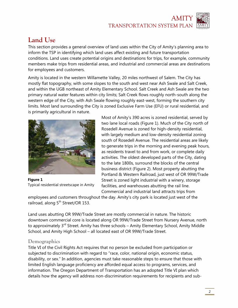
AMITY TRANSPORTATION SYSTEM PLAN
2
Land Use This section provides a general overview of land uses within the City of Amity’s planning area to
inform the TSP in identifying which land uses affect existing and future transportation
conditions. Land uses create potential origins and destinations for trips, for example, community
members make trips from residential areas, and industrial and commercial areas are destinations
for employees and customers.
Amity is located in the western Willamette Valley, 20 miles northwest of Salem. The City has
mostly flat topography, with some slopes to the south and west near Ash Swale and Salt Creek,
and within the UGB northeast of Amity Elementary School. Salt Creek and Ash Swale are the two
primary natural water features within city limits; Salt Creek flows roughly north-south along the
western edge of the City, with Ash Swale flowing roughly east-west, forming the southern city
limits. Most land surrounding the City is zoned Exclusive Farm Use (EFU) or rural residential, and
is primarily agricultural in nature.
Most of Amity’s 390 acres is zoned residential, served by
two lane local roads (Figure 1). Much of the City north of
Rosedell Avenue is zoned for high-density residential,
with largely medium and low-density residential zoning
south of Rosedell Avenue. The residential areas are likely
to generate trips in the morning and evening peak hours,
as residents travel to and from work, or complete daily
activities. The oldest developed parts of the City, dating
to the late 1800s, surround the blocks of the central
business district (Figure 2). Most property abutting the
Portland & Western Railroad, just west of OR 99W/Trade
Street is zoned light industrial with a winery, storage
facilities, and warehouses abutting the rail line.
Commercial and industrial land attracts trips from
employees and customers throughout the day. Amity’s city park is located just west of the
railroad, along 5th Street/OR 153.
Land uses abutting OR 99W/Trade Street are mostly commercial in nature. The historic
downtown commercial core is located along OR 99W/Trade Street from Nursery Avenue, north
to approximately 3rd Street. Amity has three schools – Amity Elementary School, Amity Middle
School, and Amity High School – all located east of OR 99W/Trade Street.
Demographics Title VI of the Civil Rights Act requires that no person be excluded from participation or
subjected to discrimination with regard to “race, color, national origin, economic status,
disability, or sex.” In addition, agencies must take reasonable steps to ensure that those with
limited English language proficiency are afforded equal access to programs, services, and
information. The Oregon Department of Transportation has an adopted Title VI plan which
details how the agency will address non-discrimination requirements for recipients and sub-
Figure 1
Typical residential streetscape in Amity
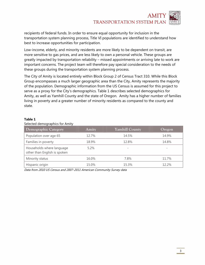
AMITY TRANSPORTATION SYSTEM PLAN
3
recipients of federal funds. In order to ensure equal opportunity for inclusion in the
transportation system planning process, Title VI populations are identified to understand how
best to increase opportunities for participation.
Low-income, elderly, and minority residents are more likely to be dependent on transit, are
more sensitive to gas prices, and are less likely to own a personal vehicle. These groups are
greatly impacted by transportation reliability – missed appointments or arriving late to work are
important concerns. The project team will therefore pay special consideration to the needs of
these groups during the transportation system planning process.
The City of Amity is located entirely within Block Group 2 of Census Tract 310. While this Block
Group encompasses a much larger geographic area than the City, Amity represents the majority
of the population. Demographic information from the US Census is assumed for this project to
serve as a proxy for the City’s demographics. Table 1 describes selected demographics for
Amity, as well as Yamhill County and the state of Oregon. Amity has a higher number of families
living in poverty and a greater number of minority residents as compared to the county and
state.
Table 1
Selected demographics for Amity
Demographic Category Amity Yamhill County Oregon
Population over age 65 12.7% 14.5% 14.9%
Families in poverty 18.9% 12.8% 14.8%
Households where language
other than English is spoken
5.2% - -
Minority status 16.0% 7.8% 11.7%
Hispanic origin 15.0% 15.3% 12.2%
Data from 2010 US Census and 2007-2011 American Community Survey data
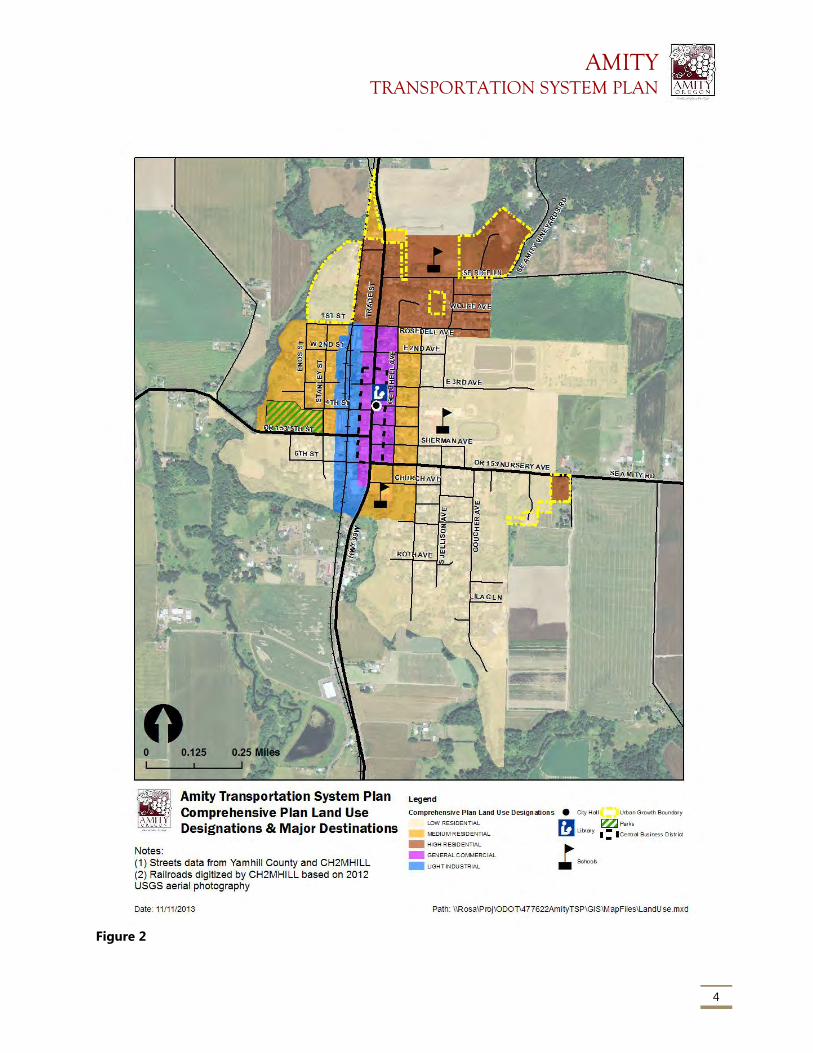
AMITY TRANSPORTATION SYSTEM PLAN
4
Figure 2
AMITY TRANSPORTATION SYSTEM PLAN
5
Population As of the 2010 census, Amity had a population of 1,614 people, an increase of 136 people over
the 2000 census. The City recently completed a 44 acre Urban Growth Boundary (UGB)
expansion to meet its housing and public facility needs through 2030. In 2012, Yamhill County
approved a coordinated population forecast for the County and its junior jurisdictions, including
Amity. Amity is forecast to have a 2030 population of 1,984, and for the purposes of the TSP and
future traffic analysis, the 2038 population is expected to be 2,161 persons.
Existing Transportation System
Streets Amity’s street system is comprised entirely of city-owned facilities (Figure 4). The two state
highways – OR 99W/Trade Street and OR 153/Nursery Avenue – are state facilities located on
City-owned right-of-way. This is a somewhat unique condition, in which the state department of
transportation has maintenance jurisdiction over the road surface, but all other responsibilities
lie with the City.
OR 99W/Trade Street within Amity is designated by ODOT as a Regional Highway. OR 153
through Amity is a District Highway, a lower functional classification than OR 99W/Trade Street.
The Oregon Highway Plan states that regional highways are intended for high-speed travel in
rural areas and moderate to high-speed travel in urban areas. District highways largely serve
local traffic within counties, with moderate to high-speed travel in rural areas and moderate to
low-speed travel in urban areas.
The street network is primarily local streets that serve single and multi-family residences. Most
local streets connect to one of the two state highways – OR 99W/Trade Street, OR 153/Nursery
Avenue, and OR 153/5th Street – that run north-south and east-west, respectively, through town.
OR 99W/Trade Street, OR 153/Nursery Avenue, and OR
153/5th Street carry the majority of through traffic within
the City and are the primary routes for residents headed
to destinations outside Amity. OR 99W/Trade Street also
experiences a considerable amount of local traffic, due
to the restaurants, businesses, shops and residents that
abut the state highway and few alternate local routes off
of the highway. OR 99W/Trade Street and OR
153/Nursery Ave and OR 153/5th Street are also the two
primary routes used by freight trucks within Amity; OR
99W/Trade Street and OR 153/5th Street west of OR
99W/Trade Street are both designated freight routes.
The City and ODOT recently improved OR 99W/Trade
Figure 3
Recent improvements on Trade
Street/OR 99W include new sidewalks,
bike lanes, and street trees.
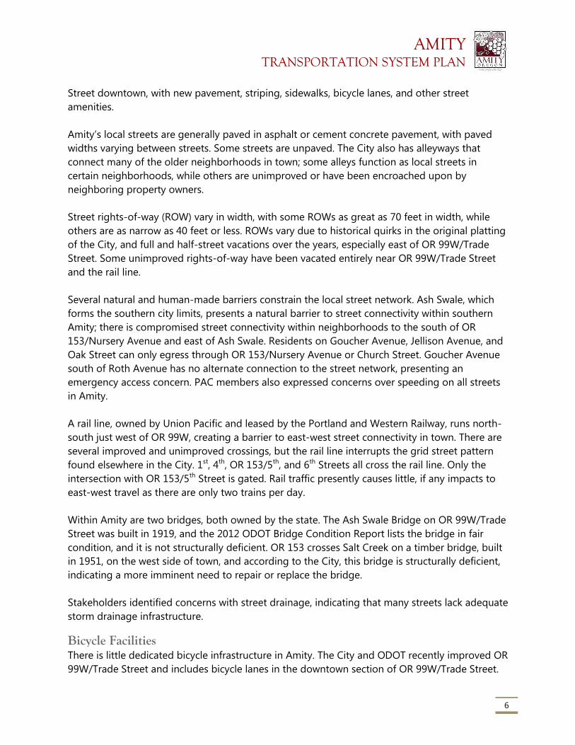
AMITY TRANSPORTATION SYSTEM PLAN
6
Street downtown, with new pavement, striping, sidewalks, bicycle lanes, and other street
amenities.
Amity’s local streets are generally paved in asphalt or cement concrete pavement, with paved
widths varying between streets. Some streets are unpaved. The City also has alleyways that
connect many of the older neighborhoods in town; some alleys function as local streets in
certain neighborhoods, while others are unimproved or have been encroached upon by
neighboring property owners.
Street rights-of-way (ROW) vary in width, with some ROWs as great as 70 feet in width, while
others are as narrow as 40 feet or less. ROWs vary due to historical quirks in the original platting
of the City, and full and half-street vacations over the years, especially east of OR 99W/Trade
Street. Some unimproved rights-of-way have been vacated entirely near OR 99W/Trade Street
and the rail line.
Several natural and human-made barriers constrain the local street network. Ash Swale, which
forms the southern city limits, presents a natural barrier to street connectivity within southern
Amity; there is compromised street connectivity within neighborhoods to the south of OR
153/Nursery Avenue and east of Ash Swale. Residents on Goucher Avenue, Jellison Avenue, and
Oak Street can only egress through OR 153/Nursery Avenue or Church Street. Goucher Avenue
south of Roth Avenue has no alternate connection to the street network, presenting an
emergency access concern. PAC members also expressed concerns over speeding on all streets
in Amity.
A rail line, owned by Union Pacific and leased by the Portland and Western Railway, runs north-
south just west of OR 99W, creating a barrier to east-west street connectivity in town. There are
several improved and unimproved crossings, but the rail line interrupts the grid street pattern
found elsewhere in the City. 1st, 4th, OR 153/5th, and 6th Streets all cross the rail line. Only the
intersection with OR 153/5th Street is gated. Rail traffic presently causes little, if any impacts to
east-west travel as there are only two trains per day.
Within Amity are two bridges, both owned by the state. The Ash Swale Bridge on OR 99W/Trade
Street was built in 1919, and the 2012 ODOT Bridge Condition Report lists the bridge in fair
condition, and it is not structurally deficient. OR 153 crosses Salt Creek on a timber bridge, built
in 1951, on the west side of town, and according to the City, this bridge is structurally deficient,
indicating a more imminent need to repair or replace the bridge.
Stakeholders identified concerns with street drainage, indicating that many streets lack adequate
storm drainage infrastructure.
Bicycle Facilities There is little dedicated bicycle infrastructure in Amity. The City and ODOT recently improved OR
99W/Trade Street and includes bicycle lanes in the downtown section of OR 99W/Trade Street.
AMITY TRANSPORTATION SYSTEM PLAN
7
Outside of downtown, paved shoulders serve as the bicycle facility. There are no other dedicated
bicycle facilities in the City. Amity’s local street network generally has low traffic volumes and
low speeds, and is suitable for cycling. However, crossing OR 99W/Trade Street and OR
153/Nursery Avenue is intimidating for cyclists because of high traffic volumes, higher traffic
speeds, and a lack of signalized intersections.
Bicycle Level of Stress Assessment As TSPs become more focused on alternate transportation modes to the single occupant
vehicle, it is important to be able to qualitatively assess facilities for non-auto modes, including
bicycles. Bicycling is a viable alternative for simple, short trips generally under five miles. The
project team assesses the quality of the bicycling facilities to identify any gaps or deficiencies to
then consider when developing projects to address these identified issues.
The Amity TSP is one of the first plans to utilize a new methodology for evaluating the quality
and perceived comfort of bicycling facilities, called the “bicycle level of stress.” Bicycle level of
stress (BLOS) refers to the comfort or discomfort different kinds of cyclists (the general cycling
“types” are: No Way, No How, Interested but Concerned, Enthused and Confident, and Strong
and Fearless) may feel on any particular street and street crossing. The team used BLOS
methodology developed by the Mineta Transportation Institute, which specifies BLOS for road
segments and crossings based on a number of factors, including the number of through lanes,
prevailing traffic speed, presence of street parking, and others. With this methodology, a bicycle
route is only as good as its most stressful segment or crossing; that is, street segments are
assigned a BLOS rating from 1 (least stressful for cyclists) to 4 (most stressful), and a route’s
overall stress level is based on the highest-stress segment on that route. Routes rated at BLOS 1
are generally suitable for the most inexperienced or vulnerable riders, including children and
those who do not typically cycle on-street. Routes rated BLOS 4 are only suitable for the most
“strong and fearless” cyclists, who are generally interested in fast bicycle travel and are less
concerned about traffic conditions. Bicycle routes to schools should consistently be BLOS 1.
Applying BLOS methodology to Amity’s street system reveals that most local streets are
characterized as BLOS 1, the lowest stress level (Figure 6). Collector streets are all rated BLOS 2,
due to the larger traffic volumes on these streets. All of OR 153 that runs through Amity is rated
at BLOS 3 due to the lack of dedicated bicycle facilities and 30 MPH speed limit. OR 99W/Trade
Street has dedicated bicycle facilities for much of its length, except for the northern and
southernmost sections of the road. No streets in Amity are rated BLOS 4, the highest-stress
streets.
There are few continuous low stress (BLOS 1) routes between Amity’s three schools. Additionally,
OR 153 and OR 99W/Trade Street may present barriers to crossing for children who would bike
to school; none of the crossings on OR 99W/Trade Street or OR 153/Nursery Ave/5th Street are
rated above a BLOS 1 according to the BLOS methodology, though they are likely barriers for
many due to higher traffic volumes and speeds on both these state highways, though the
striped pedestrian crossings do provide specific crossings for bicyclists who are willing to
dismount and cross OR 99W/Trade Street as pedestrians while walking their bikes. Amity
AMITY TRANSPORTATION SYSTEM PLAN
8
Elementary in particular, which attracts the most vulnerable bicyclists in the community, lacks
low-stress cycling routes in its vicinity.
The central business district, which includes City Hall and the public library along OR 99W/Trade
Street (from OR 153/Nursery Avenue north to about 3rd Avenue) is relatively accessible by
bicycle from the surrounding neighborhoods. The City Park is less accessible, as it is primarily
accessed by OR 153/5th Street and Stanley Street, a collector street with higher traffic volumes
than surrounding residential streets.
Overall, most of Amity’s street system allows for relatively low-stress cycling, except for the state
highways that cross town. This assessment is important to consider when developing projects
for the TSP; the project team will work with the community to address the deficiencies identified
in the City’s bicycling network.
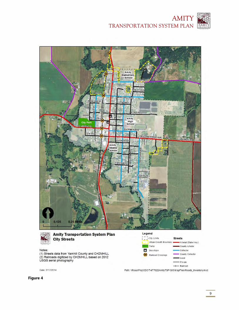
AMITY TRANSPORTATION SYSTEM PLAN
9
Figure 4
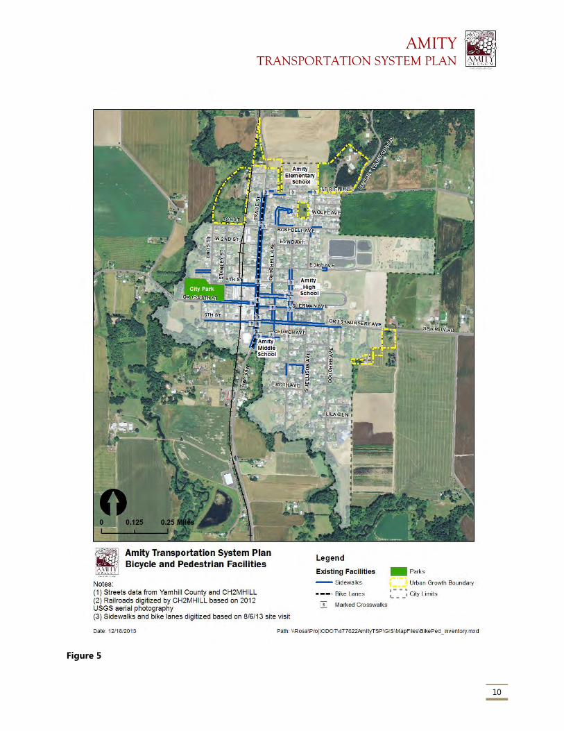
AMITY TRANSPORTATION SYSTEM PLAN
10
Figure 5
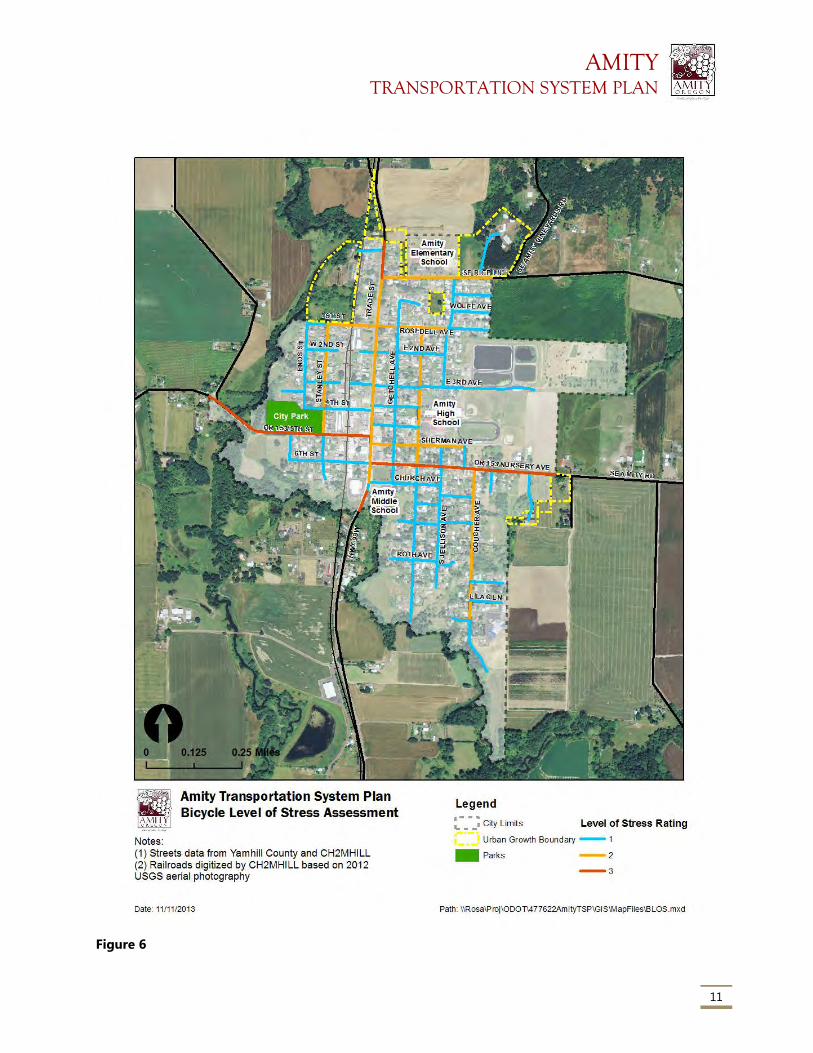
AMITY TRANSPORTATION SYSTEM PLAN
11
Figure 6
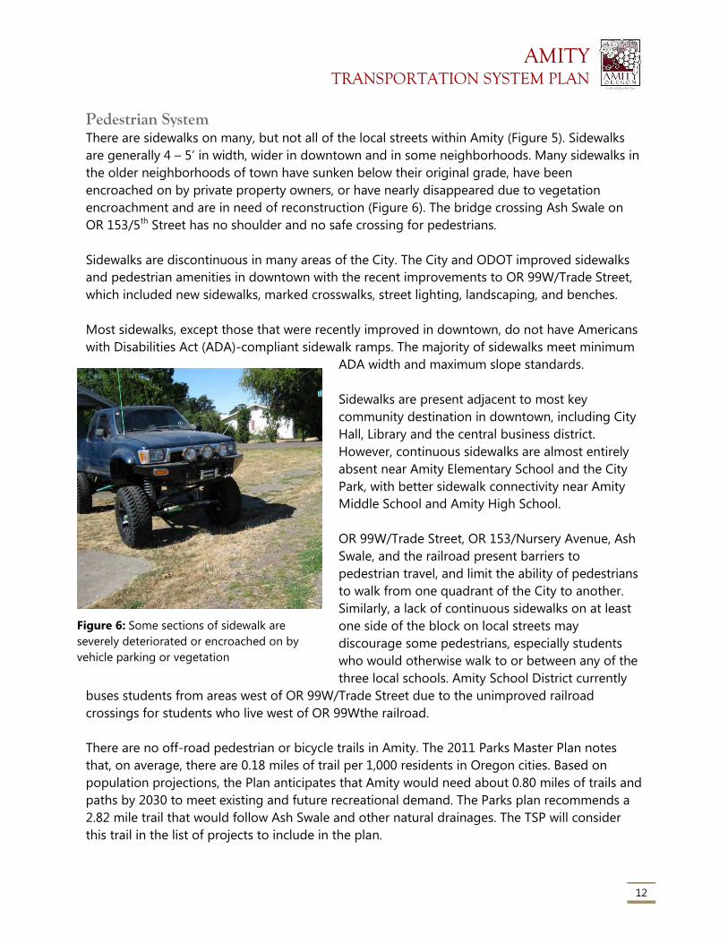
AMITY TRANSPORTATION SYSTEM PLAN
12
Pedestrian System There are sidewalks on many, but not all of the local streets within Amity (Figure 5). Sidewalks
are generally 4 – 5’ in width, wider in downtown and in some neighborhoods. Many sidewalks in
the older neighborhoods of town have sunken below their original grade, have been
encroached on by private property owners, or have nearly disappeared due to vegetation
encroachment and are in need of reconstruction (Figure 6). The bridge crossing Ash Swale on
OR 153/5th Street has no shoulder and no safe crossing for pedestrians.
Sidewalks are discontinuous in many areas of the City. The City and ODOT improved sidewalks
and pedestrian amenities in downtown with the recent improvements to OR 99W/Trade Street,
which included new sidewalks, marked crosswalks, street lighting, landscaping, and benches.
Most sidewalks, except those that were recently improved in downtown, do not have Americans
with Disabilities Act (ADA)-compliant sidewalk ramps. The majority of sidewalks meet minimum
ADA width and maximum slope standards.
Sidewalks are present adjacent to most key
community destination in downtown, including City
Hall, Library and the central business district.
However, continuous sidewalks are almost entirely
absent near Amity Elementary School and the City
Park, with better sidewalk connectivity near Amity
Middle School and Amity High School.
OR 99W/Trade Street, OR 153/Nursery Avenue, Ash
Swale, and the railroad present barriers to
pedestrian travel, and limit the ability of pedestrians
to walk from one quadrant of the City to another.
Similarly, a lack of continuous sidewalks on at least
one side of the block on local streets may
discourage some pedestrians, especially students
who would otherwise walk to or between any of the
three local schools. Amity School District currently
buses students from areas west of OR 99W/Trade Street due to the unimproved railroad
crossings for students who live west of OR 99Wthe railroad.
There are no off-road pedestrian or bicycle trails in Amity. The 2011 Parks Master Plan notes
that, on average, there are 0.18 miles of trail per 1,000 residents in Oregon cities. Based on
population projections, the Plan anticipates that Amity would need about 0.80 miles of trails and
paths by 2030 to meet existing and future recreational demand. The Parks plan recommends a
2.82 mile trail that would follow Ash Swale and other natural drainages. The TSP will consider
this trail in the list of projects to include in the plan.
Figure 6: Some sections of sidewalk are
severely deteriorated or encroached on by
vehicle parking or vegetation
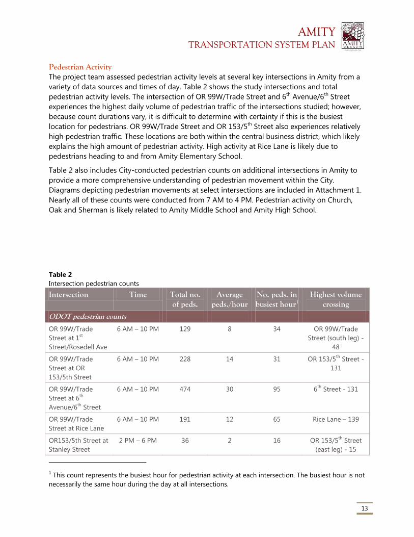
AMITY TRANSPORTATION SYSTEM PLAN
13
Pedestrian Activity The project team assessed pedestrian activity levels at several key intersections in Amity from a
variety of data sources and times of day. Table 2 shows the study intersections and total
pedestrian activity levels. The intersection of OR 99W/Trade Street and 6th Avenue/6th Street
experiences the highest daily volume of pedestrian traffic of the intersections studied; however,
because count durations vary, it is difficult to determine with certainty if this is the busiest
location for pedestrians. OR 99W/Trade Street and OR 153/5th Street also experiences relatively
high pedestrian traffic. These locations are both within the central business district, which likely
explains the high amount of pedestrian activity. High activity at Rice Lane is likely due to
pedestrians heading to and from Amity Elementary School.
Table 2 also includes City-conducted pedestrian counts on additional intersections in Amity to
provide a more comprehensive understanding of pedestrian movement within the City.
Diagrams depicting pedestrian movements at select intersections are included in Attachment 1.
Nearly all of these counts were conducted from 7 AM to 4 PM. Pedestrian activity on Church,
Oak and Sherman is likely related to Amity Middle School and Amity High School.
Table 2
Intersection pedestrian counts
Intersection Time Total no. of peds.
Average peds./hour
No. peds. in busiest hour1
Highest volume crossing
ODOT pedestrian counts
OR 99W/Trade
Street at 1st
Street/Rosedell Ave
6 AM – 10 PM 129 8 34 OR 99W/Trade
Street (south leg) -
48
OR 99W/Trade
Street at OR
153/5th Street
6 AM – 10 PM 228 14 31 OR 153/5th
Street -
131
OR 99W/Trade
Street at 6th
Avenue/6th
Street
6 AM – 10 PM 474 30 95 6th
Street - 131
OR 99W/Trade
Street at Rice Lane
6 AM – 10 PM 191 12 65 Rice Lane – 139
OR153/5th Street at
Stanley Street
2 PM – 6 PM 36 2 16 OR 153/5th
Street
(east leg) - 15
1 This count represents the busiest hour for pedestrian activity at each intersection. The busiest hour is not
necessarily the same hour during the day at all intersections.
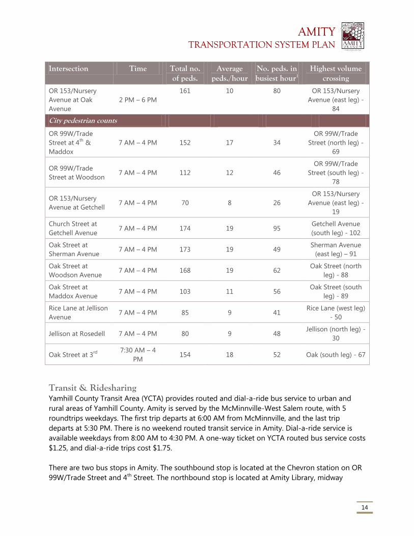
AMITY TRANSPORTATION SYSTEM PLAN
14
Intersection Time Total no. of peds.
Average peds./hour
No. peds. in busiest hour1
Highest volume crossing
OR 153/Nursery
Avenue at Oak
Avenue
2 PM – 6 PM
161 10 80 OR 153/Nursery
Avenue (east leg) -
84
City pedestrian counts
OR 99W/Trade
Street at 4th
&
Maddox
7 AM – 4 PM 152 17 34
OR 99W/Trade
Street (north leg) -
69
OR 99W/Trade
Street at Woodson 7 AM – 4 PM 112 12 46
OR 99W/Trade
Street (south leg) -
78
OR 153/Nursery
Avenue at Getchell 7 AM – 4 PM 70 8 26
OR 153/Nursery
Avenue (east leg) -
19
Church Street at
Getchell Avenue 7 AM – 4 PM 174 19 95
Getchell Avenue
(south leg) - 102
Oak Street at
Sherman Avenue 7 AM – 4 PM 173 19 49
Sherman Avenue
(east leg) – 91
Oak Street at
Woodson Avenue 7 AM – 4 PM 168 19 62
Oak Street (north
leg) - 88
Oak Street at
Maddox Avenue 7 AM – 4 PM 103 11 56
Oak Street (south
leg) - 89
Rice Lane at Jellison
Avenue 7 AM – 4 PM 85 9 41
Rice Lane (west leg)
- 50
Jellison at Rosedell 7 AM – 4 PM 80 9 48 Jellison (north leg) -
30
Oak Street at 3rd
7:30 AM – 4
PM 154 18 52 Oak (south leg) - 67
Transit & Ridesharing Yamhill County Transit Area (YCTA) provides routed and dial-a-ride bus service to urban and
rural areas of Yamhill County. Amity is served by the McMinnville-West Salem route, with 5
roundtrips weekdays. The first trip departs at 6:00 AM from McMinnville, and the last trip
departs at 5:30 PM. There is no weekend routed transit service in Amity. Dial-a-ride service is
available weekdays from 8:00 AM to 4:30 PM. A one-way ticket on YCTA routed bus service costs
$1.25, and dial-a-ride trips cost $1.75.
There are two bus stops in Amity. The southbound stop is located at the Chevron station on OR
99W/Trade Street and 4th Street. The northbound stop is located at Amity Library, midway
AMITY TRANSPORTATION SYSTEM PLAN
15
between 3rd and 4th Avenue. The Amity Library stop has a bench and shelter, but the Chevron
stop has no amenities and no sign indicating the stop. There is no specific pull-out area
designated for buses at either stop.
According to available census information,2 no workers used transit to commute to work in
Amity. Approximately 5% of workers carpooled to work.
Air, Rail, Water and Pipeline The nearest airports to Amity are McMinnville Municipal Airport to the north and Salem
Municipal Airport to the southeast. Both are general aviation airports, with no commercial
service. Salem’s airport had commercial service until 2008, but no carriers currently provide
passenger service. Portland International Airport (53 miles by car) is the closest commercial
airport to Amity, providing frequent domestic and international air service.
A Union Pacific-owned railroad runs north-south through the west side of Amity. Portland and
Western Railroad (PNWR) leases the line, running one train each direction daily. Only freight
service is provided, with no stops in Amity. In addition to freight, passenger rail service is
available in Salem. The Amtrak Cascades route runs several times daily between Eugene and
Vancouver, B.C. and the Coast Starlight provides daily service to southern Oregon and California.
One natural gas pipeline, owned by Cascade Natural Gas, runs north-south through Amity. The
pipeline roughly follows OR 99W/Trade Street at the north end of town, then Stanley Street, and
back along OR 99W/Trade Street at the south end of town.
There are no navigable waterways within or near Amity.
Transportation Finance Transportation revenues for Amity primarily come from Amity’s share of the state gas tax.
Annual revenues over the last several years have generally varied between approximately
$65,000 and $88,000. The City also recently enacted a transportation utility fee, which is
currently $2.00 per household per month and $0.25 per trip (based on trip generations
assumptions) for other uses. The City has also received grant revenues ($25,000 in several years)
from the state’s Special City Allotment (SCA) grant program, which provides grants of up to
$50,000 to small communities for transportation improvement projects. Most of the City’s
transportation revenues, except for the SCA grant monies, are spent on street maintenance and
preservation.
2 American Community Survey 2012 5-year estimates. Data is available for Census Tract 310, which
includes Amity and the surrounding community.
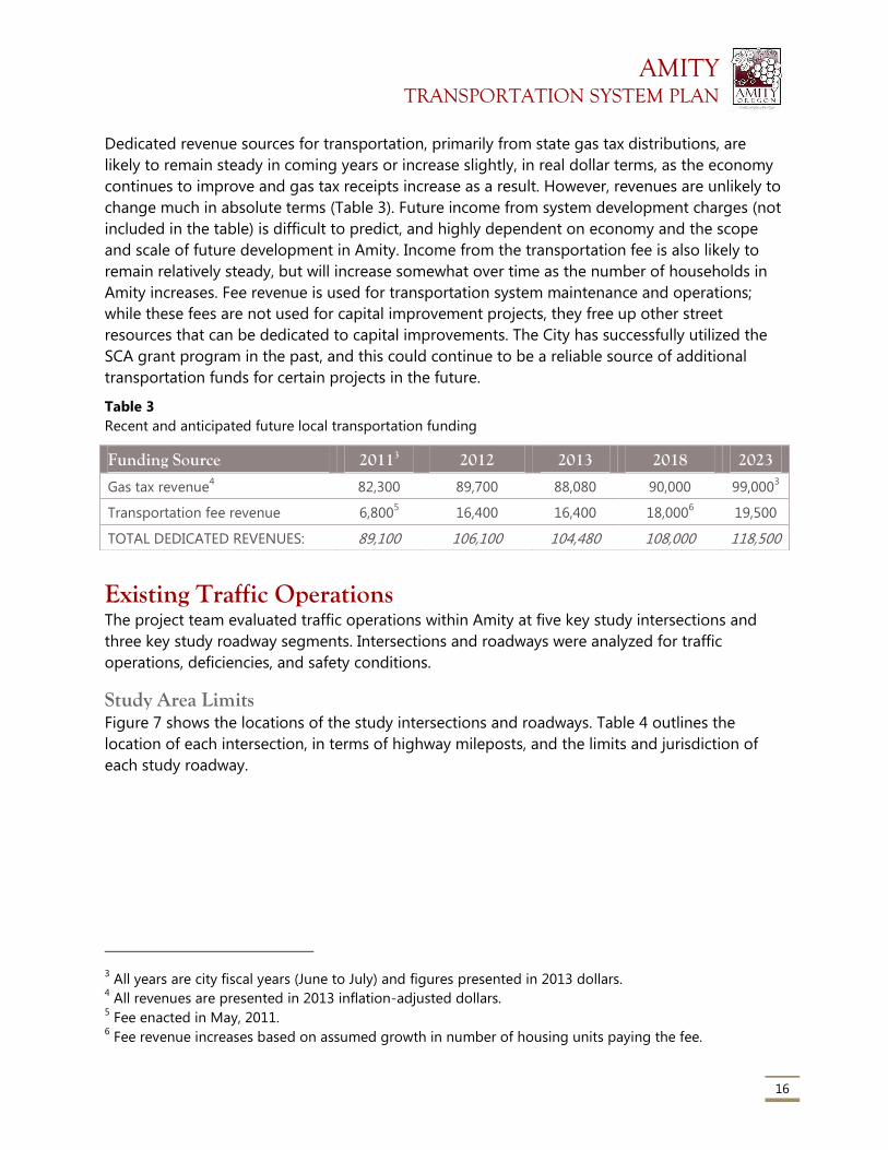
AMITY TRANSPORTATION SYSTEM PLAN
16
Dedicated revenue sources for transportation, primarily from state gas tax distributions, are
likely to remain steady in coming years or increase slightly, in real dollar terms, as the economy
continues to improve and gas tax receipts increase as a result. However, revenues are unlikely to
change much in absolute terms (Table 3). Future income from system development charges (not
included in the table) is difficult to predict, and highly dependent on economy and the scope
and scale of future development in Amity. Income from the transportation fee is also likely to
remain relatively steady, but will increase somewhat over time as the number of households in
Amity increases. Fee revenue is used for transportation system maintenance and operations;
while these fees are not used for capital improvement projects, they free up other street
resources that can be dedicated to capital improvements. The City has successfully utilized the
SCA grant program in the past, and this could continue to be a reliable source of additional
transportation funds for certain projects in the future.
Table 3
Recent and anticipated future local transportation funding
Existing Traffic Operations The project team evaluated traffic operations within Amity at five key study intersections and
three key study roadway segments. Intersections and roadways were analyzed for traffic
operations, deficiencies, and safety conditions.
Study Area Limits Figure 7 shows the locations of the study intersections and roadways. Table 4 outlines the
location of each intersection, in terms of highway mileposts, and the limits and jurisdiction of
each study roadway.
3 All years are city fiscal years (June to July) and figures presented in 2013 dollars.
4 All revenues are presented in 2013 inflation-adjusted dollars.
5 Fee enacted in May, 2011.
6 Fee revenue increases based on assumed growth in number of housing units paying the fee.
Funding Source 20113 2012 2013 2018 2023
Gas tax revenue4 82,300 89,700 88,080 90,000 99,000
3
Transportation fee revenue 6,8005 16,400 16,400 18,000
6 19,500
TOTAL DEDICATED REVENUES: 89,100 106,100 104,480 108,000 118,500
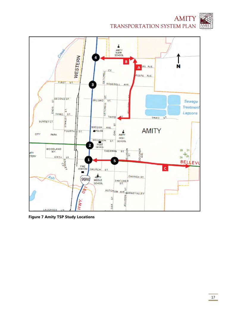
AMITY TRANSPORTATION SYSTEM PLAN
17
Figure 7 Amity TSP Study Locations
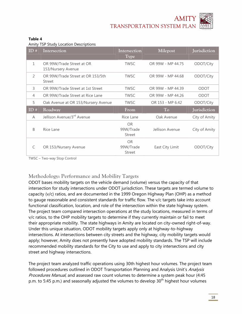
AMITY TRANSPORTATION SYSTEM PLAN
18
Table 4
Amity TSP Study Location Descriptions
ID # Intersection Intersection Type
Milepost Jurisdiction
1 OR 99W/Trade Street at OR
153/Nursery Avenue
TWSC OR 99W - MP 44.75 ODOT/City
2 OR 99W/Trade Street at OR 153/5th
Street
TWSC OR 99W - MP 44.68 ODOT/City
3 OR 99W/Trade Street at 1st Street TWSC OR 99W - MP 44.39 ODOT
4 OR 99W/Trade Street at Rice Lane TWSC OR 99W - MP 44.26 ODOT
5 Oak Avenue at OR 153/Nursery Avenue TWSC OR 153 - MP 6.42 ODOT/City
ID # Roadway From To Jurisdiction
A Jellison Avenue/3rd
Avenue Rice Lane Oak Avenue City of Amity
B Rice Lane
OR
99W/Trade
Street
Jellison Avenue City of Amity
C OR 153/Nursery Avenue
OR
99W/Trade
Street
East City Limit ODOT/City
TWSC – Two-way Stop Control
Methodology: Performance and Mobility Targets ODOT bases mobility targets on the vehicle demand (volume) versus the capacity of that
intersection for study intersections under ODOT jurisdiction. These targets are termed volume to
capacity (v/c) ratios, and are documented in the 1999 Oregon Highway Plan (OHP) as a method
to gauge reasonable and consistent standards for traffic flow. The v/c targets take into account
functional classification, location, and role of the intersection within the state highway system.
The project team compared intersection operations at the study locations, measured in terms of
v/c ratios, to the OHP mobility targets to determine if they currently maintain or fail to meet
their appropriate mobility. The state highways in Amity are located on city-owned right-of-way.
Under this unique situation, ODOT mobility targets apply only at highway-to-highway
intersections. At intersections between city streets and the highway, city mobility targets would
apply; however, Amity does not presently have adopted mobility standards. The TSP will include
recommended mobility standards for the City to use and apply to city intersections and city
street and highway intersections.
The project team analyzed traffic operations using 30th highest hour volumes. The project team
followed procedures outlined in ODOT Transportation Planning and Analysis Unit’s Analysis
Procedures Manual, and assessed raw count volumes to determine a system peak hour (4:45
p.m. to 5:45 p.m.) and seasonally adjusted the volumes to develop 30th highest hour volumes
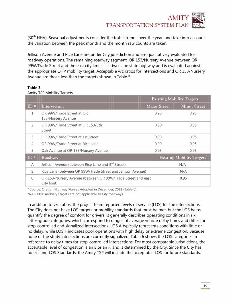
AMITY TRANSPORTATION SYSTEM PLAN
19
(30th HHV). Seasonal adjustments consider the traffic trends over the year, and take into account
the variation between the peak month and the month raw counts are taken.
Jellison Avenue and Rice Lane are under City jurisdiction and are qualitatively evaluated for
roadway operations. The remaining roadway segment, OR 153/Nursery Avenue between OR
99W/Trade Street and the east city limits, is a two-lane state highway and is evaluated against
the appropriate OHP mobility target. Acceptable v/c ratios for intersections and OR 153/Nursery
Avenue are those less than the targets shown in Table 5.
Table 5
Amity TSP Mobility Targets
Existing Mobility Targets1
ID # Intersection Major Street Minor Street
1 OR 99W/Trade Street at OR
153/Nursery Avenue
0.90 0.95
2 OR 99W/Trade Street at OR 153/5th
Street
0.90 0.95
3 OR 99W/Trade Street at 1st Street 0.90 0.95
4 OR 99W/Trade Street at Rice Lane 0.90 0.95
5 Oak Avenue at OR 153/Nursery Avenue 0.95 0.95
ID # Roadway Existing Mobility Targets1
A Jellison Avenue (between Rice Lane and 3rd
Street) N/A
B Rice Lane (between OR 99W/Trade Street and Jellison Avenue) N/A
C OR 153/Nursery Avenue (between OR 99W/Trade Street and east
City limit)
0.95
1 Source: Oregon Highway Plan as Adopted in December, 2011 (Table 6).
N/A – OHP mobility targets are not applicable to City roadways.
In addition to v/c ratios, the project team reported levels of service (LOS) for the intersections.
The City does not have LOS targets or mobility standards that must be met, but the LOS helps
quantify the degree of comfort for drivers. It generally describes operating conditions in six
letter-grade categories, which correspond to ranges of average vehicle delay times and differ for
stop-controlled and signalized intersections. LOS A typically represents conditions with little or
no delay, while LOS F indicates poor operations with high delay or extreme congestion. Because
none of the study intersections are currently signalized, Table 6 shows the LOS categories in
reference to delay times for stop-controlled intersections. For most comparable jurisdictions, the
acceptable level of congestion is an E or an F, and is determined by the City. Since the City has
no existing LOS Standards, the Amity TSP will include the acceptable LOS for future standards.
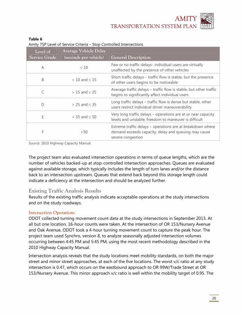
AMITY TRANSPORTATION SYSTEM PLAN
20
Table 6
Amity TSP Level of Service Criteria – Stop Controlled Intersections
Level of Service Grade
Average Vehicle Delay (seconds per vehicle) General Description
A 10 Few or no traffic delays- individual users are virtually
unaffected by the presence of other vehicles
B > 10 and 15 Short traffic delays – traffic flow is stable, but the presence
of other users begins to be noticeable
C > 15 and 25 Average traffic delays – traffic flow is stable, but other traffic
begins to significantly affect individual users
D > 25 and 35 Long traffic delays – traffic flow is dense but stable, other
users restrict individual driver maneuverability
E > 35 and 50 Very long traffic delays – operations are at or near capacity
levels and unstable, freedom to maneuver is difficult
F >50
Extreme traffic delays – operations are at breakdown where
demand exceeds capacity, delay and queuing may cause
severe congestion
Source: 2010 Highway Capacity Manual.
The project team also evaluated intersection operations in terms of queue lengths, which are the
number of vehicles backed-up at stop-controlled intersection approaches. Queues are evaluated
against available storage, which typically includes the length of turn lanes and/or the distance
back to an intersection upstream. Queues that extend back beyond this storage length could
indicate a deficiency at the intersection and should be analyzed further.
Existing Traffic Analysis Results Results of the existing traffic analysis indicate acceptable operations at the study intersections
and on the study roadways.
Intersection Operations ODOT collected turning movement count data at the study intersections in September 2013. At
all but one location, 16-hour counts were taken. At the intersection of OR 153/Nursery Avenue
and Oak Avenue, ODOT took a 4-hour turning movement count to capture the peak hour. The
project team used Synchro, version 8, to analyze seasonally adjusted intersection volumes
occurring between 4:45 PM and 5:45 PM, using the most recent methodology described in the
2010 Highway Capacity Manual.
Intersection analysis reveals that the study locations meet mobility standards, on both the major
street and minor street approaches, at each of the five locations. The worst v/c ratio at any study
intersection is 0.47, which occurs on the eastbound approach to OR 99W/Trade Street at OR
153/Nursery Avenue. This minor approach v/c ratio is well within the mobility target of 0.95. The
AMITY TRANSPORTATION SYSTEM PLAN
21
major street approaches on northbound and southbound OR 99W/Trade Street operate at v/c
ratios of 0.12 or better, which indicates the intersection operates with adequate capacity.
Although the v/c ratios meet their targets, the average delay time on the eastbound approach to
OR 99W/Trade Street at OR 153/Nursery Avenue is approximately 40 seconds per vehicle during
the peak. Vehicles arriving at this intersection must stop and wait for a gap in traffic on
OR99W/Trade Street before making their movement. This results in LOS E for the eastbound
approach.
Each of the remaining study intersections meet their target v/c ratios, therefore the existing
conditions results suggest that traffic is operating acceptably and the team did not identify
existing operational needs or deficiencies. However, stakeholders noted that the intersection of
Rice Lane and OR 99W/Trade Street is congested during weekday mornings between
approximately 7:30 and 8:00 AM due to school bus traffic turning left onto OR 99W/Trade
Street.
Table 7 shows the results of the existing conditions intersection operational analysis. Figure 8
provides the 30th highest hour volumes, channelization, and analysis results for each location.
Attachment 2 provides information on existing volume development, and Attachment 3 includes
the individual intersection Synchro HCM reports.
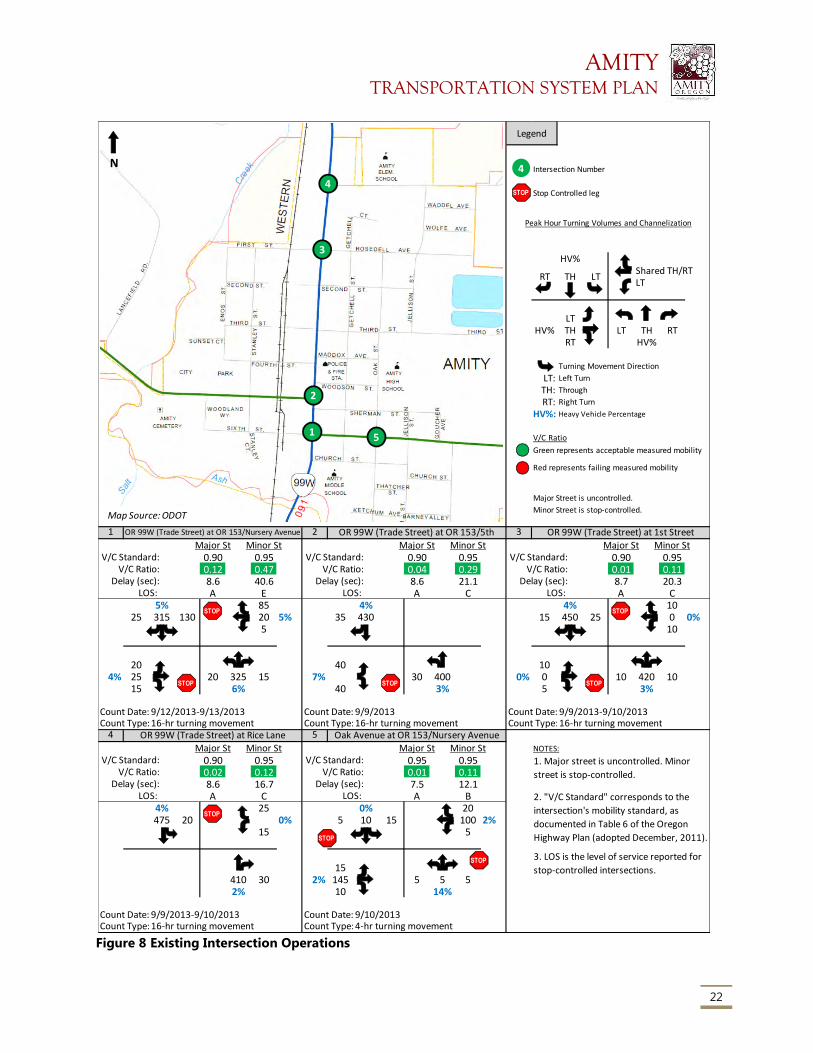
AMITY TRANSPORTATION SYSTEM PLAN
22
Figure 8 Existing Intersection Operations
HV%Shared TH/RTLT
LTHV% TH LT TH RT
RT HV%
Turning Movement Direction
LT: Left Turn
TH: Through
RT: Right Turn
HV%: Heavy Vehicle Percentage
V/C Ratio
Green represents acceptable measured mobility
Major Street is uncontrolled.
Minor Street is stop-controlled.
1 2 3
Major St Minor St Major St Minor St Major St Minor StV/C Standard: 0.90 0.95 V/C Standard: 0.90 0.95 V/C Standard: 0.90 0.95
V/C Ratio: 0.12 0.47 V/C Ratio: 0.04 0.29 V/C Ratio: 0.01 0.11Delay (sec): 8.6 40.6 Delay (sec): 8.6 21.1 Delay (sec): 8.7 20.3
LOS: A E LOS: A C LOS: A C5% 85 4% 4% 10
25 315 130 20 5% 35 430 15 450 25 0 0%5 10
20 40 104% 25 20 325 15 7% 30 400 0% 0 10 420 10
15 6% 40 3% 5 3%
Count Date: 9/12/2013-9/13/2013 Count Date: 9/9/2013 Count Date: 9/9/2013-9/10/2013Count Type:16-hr turning movement Count Type:16-hr turning movement Count Type:16-hr turning movement
4 5
Major St Minor St Major St Minor St NOTES:
V/C Standard: 0.90 0.95 V/C Standard: 0.95 0.95V/C Ratio: 0.02 0.12 V/C Ratio: 0.01 0.11
Delay (sec): 8.6 16.7 Delay (sec): 7.5 12.1LOS: A C LOS: A B
4% 25 0% 20475 20 0% 5 10 15 100 2%
15 5
15410 30 2% 145 5 5 52% 10 14%
Count Date: 9/9/2013-9/10/2013 Count Date: 9/10/2013Count Type:16-hr turning movement Count Type:4-hr turning movement
Legend
Intersection Number
Stop Controlled leg
1. Major street is uncontrolled. Minor
street is stop-controlled.
2. "V/C Standard" corresponds to the
intersection's mobility standard, as
documented in Table 6 of the Oregon
Highway Plan (adopted December, 2011).
Peak Hour Turning Volumes and Channelization
RT TH LT
Red represents failing measured mobility
OR 99W (Trade Street) at 1st Street
3. LOS is the level of service reported for
stop-controlled intersections.
OR 99W (Trade Street) at Rice Lane Oak Avenue at OR 153/Nursery Avenue
OR 99W (Trade Street) at OR 153/Nursery Avenue OR 99W (Trade Street) at OR 153/5th
4
STOP
1
2
3
4
5
Map Source: ODOT
N
STOP
STOP STOP
STOP
STOP
STOP
STOP
STOP
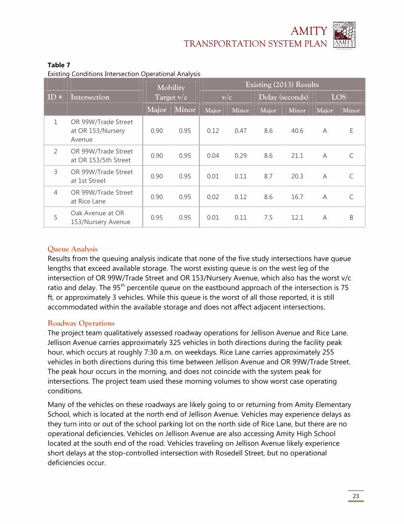
AMITY TRANSPORTATION SYSTEM PLAN
23
Table 7
Existing Conditions Intersection Operational Analysis
Mobility Target v/c
Existing (2013) Results
ID # Intersection v/c Delay (seconds) LOS
Major Minor Major Minor Major Minor Major Minor
1 OR 99W/Trade Street
at OR 153/Nursery
Avenue
0.90 0.95 0.12 0.47 8.6 40.6 A E
2 OR 99W/Trade Street
at OR 153/5th Street 0.90 0.95 0.04 0.29 8.6 21.1 A C
3 OR 99W/Trade Street
at 1st Street 0.90 0.95 0.01 0.11 8.7 20.3 A C
4 OR 99W/Trade Street
at Rice Lane 0.90 0.95 0.02 0.12 8.6 16.7 A C
5 Oak Avenue at OR
153/Nursery Avenue 0.95 0.95 0.01 0.11 7.5 12.1 A B
Queue Analysis Results from the queuing analysis indicate that none of the five study intersections have queue
lengths that exceed available storage. The worst existing queue is on the west leg of the
intersection of OR 99W/Trade Street and OR 153/Nursery Avenue, which also has the worst v/c
ratio and delay. The 95th percentile queue on the eastbound approach of the intersection is 75
ft, or approximately 3 vehicles. While this queue is the worst of all those reported, it is still
accommodated within the available storage and does not affect adjacent intersections.
Roadway Operations The project team qualitatively assessed roadway operations for Jellison Avenue and Rice Lane.
Jellison Avenue carries approximately 325 vehicles in both directions during the facility peak
hour, which occurs at roughly 7:30 a.m. on weekdays. Rice Lane carries approximately 255
vehicles in both directions during this time between Jellison Avenue and OR 99W/Trade Street.
The peak hour occurs in the morning, and does not coincide with the system peak for
intersections. The project team used these morning volumes to show worst case operating
conditions.
Many of the vehicles on these roadways are likely going to or returning from Amity Elementary
School, which is located at the north end of Jellison Avenue. Vehicles may experience delays as
they turn into or out of the school parking lot on the north side of Rice Lane, but there are no
operational deficiencies. Vehicles on Jellison Avenue are also accessing Amity High School
located at the south end of the road. Vehicles traveling on Jellison Avenue likely experience
short delays at the stop-controlled intersection with Rosedell Street, but no operational
deficiencies occur.
AMITY TRANSPORTATION SYSTEM PLAN
24
Peak hour volumes on OR 153/Nursery Avenue near Goucher Avenue are in the range of 265
vehicles in both direction. Vehicle travel peaks at around 7:30 a.m. on a weekday, which aligns
with a typical morning commute and coincides with peak travel on Jellison Avenue and Rice
Lane. OR 153/Nursery Avenue has an existing v/c ratio of 0.08, and is well within its operational
mobility target. No operational deficiencies are identified in the existing condition.
Safety Conditions The project team analyzed crash data from the ODOT Crash Analysis and Reporting Unit for the
most recent five year period (January 1, 2007 through December 31, 2011). The safety
assessment reveals that there are no apparent safety deficiencies at the five study intersections
and three roadway segments analyzed in this plan. Detailed crash statistics are included in
Attachment 4. This section describes crashes that occurred both in terms of the type of crash
and the severity.
Figure 9 shows crash data locations below. From 2007 to 2011, ODOT recorded a total of eight
reported collisions at the study intersections and one crash along OR 153/Nursery Avenue
between OR 99W/Trade Street and the east city limit. There were eight injury collisions (one
involving a pedestrian) and one collision resulting in property damage only. There were no
reported fatalities city-wide, and no recorded crashes at the intersection of OR 99W/Trade Street
and Rice Lane, and no recorded crashes on Jellison Avenue or Rice Lane.
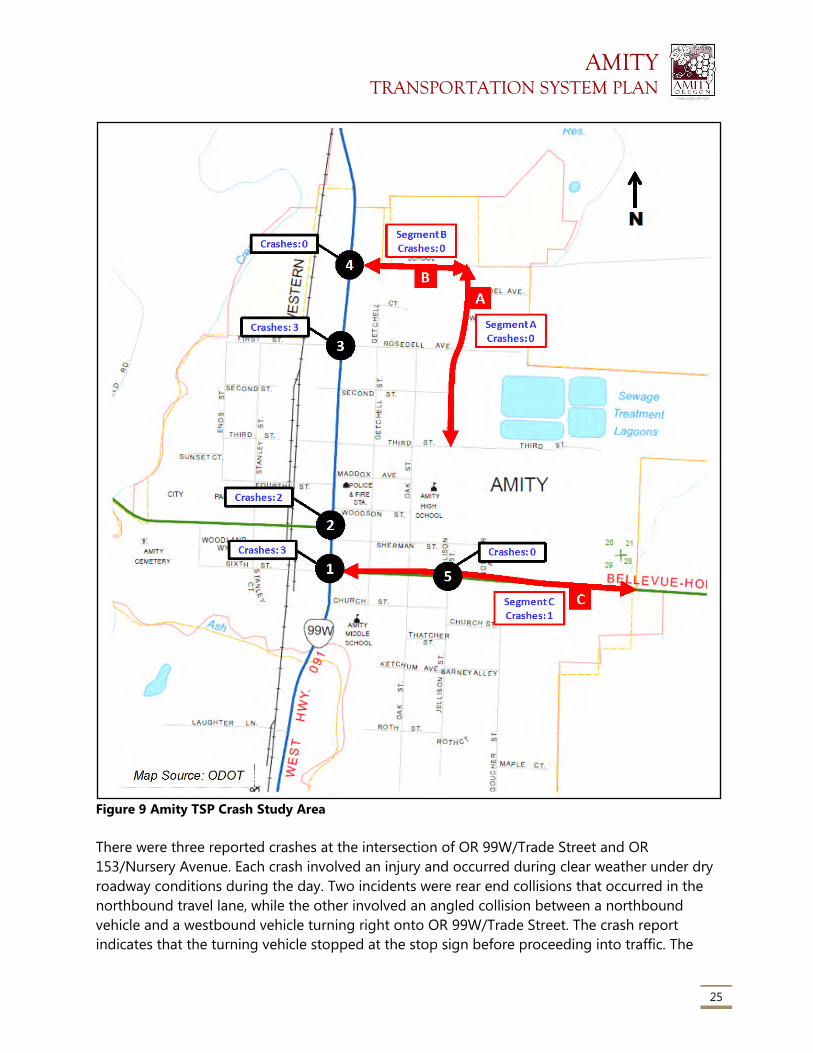
AMITY TRANSPORTATION SYSTEM PLAN
25
Figure 9 Amity TSP Crash Study Area
There were three reported crashes at the intersection of OR 99W/Trade Street and OR
153/Nursery Avenue. Each crash involved an injury and occurred during clear weather under dry
roadway conditions during the day. Two incidents were rear end collisions that occurred in the
northbound travel lane, while the other involved an angled collision between a northbound
vehicle and a westbound vehicle turning right onto OR 99W/Trade Street. The crash report
indicates that the turning vehicle stopped at the stop sign before proceeding into traffic. The
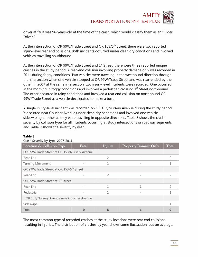
AMITY TRANSPORTATION SYSTEM PLAN
26
driver at fault was 96-years-old at the time of the crash, which would classify them as an “Older
Driver.”
At the intersection of OR 99W/Trade Street and OR 153/5th Street, there were two reported
injury-level rear end collisions. Both incidents occurred under clear, dry conditions and involved
vehicles travelling southbound.
At the intersection of OR 99W/Trade Street and 1st Street, there were three reported unique
crashes in the study period. A rear-end collision involving property damage only was recorded in
2011 during foggy conditions. Two vehicles were traveling in the westbound direction through
the intersection when one vehicle stopped at OR 99W/Trade Street and was rear-ended by the
other. In 2007 at the same intersection, two injury-level incidents were recorded. One occurred
in the morning in foggy conditions and involved a pedestrian crossing 1st Street northbound.
The other occurred in rainy conditions and involved a rear end collision on northbound OR
99W/Trade Street as a vehicle decelerated to make a turn.
A single injury-level incident was recorded on OR 153/Nursery Avenue during the study period.
It occurred near Goucher Avenue under clear, dry conditions and involved one vehicle
sideswiping another as they were traveling in opposite directions. Table 8 shows the crash
severity by collision type for all incidents occurring at study intersections or roadway segments,
and Table 9 shows the severity by year.
Table 8
Crash Severity by Type, 2007-2011
Location & Collision Type Fatal Injury Property Damage Only Total
OR 99W/Trade Street at OR 153/Nursery Avenue
Rear-End - 2 - 2
Turning Movement - 1 - 1
OR 99W/Trade Street at OR 153/5th
Street
Rear-End - 2 - 2
OR 99W/Trade Street at 1st Street
Rear-End - 1 1 2
Pedestrian - 1 - 1
OR 153/Nursery Avenue near Goucher Avenue
Sideswipe - 1 - 1
Total 0 8 1 9
The most common type of recorded crashes at the study locations were rear end collisions
resulting in injuries. The distribution of crashes by year shows some fluctuation, but on average,
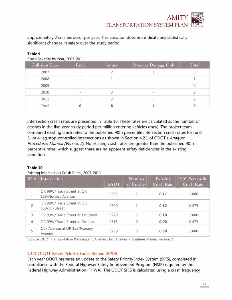
AMITY TRANSPORTATION SYSTEM PLAN
27
approximately 2 crashes occur per year. This variation does not indicate any statistically
significant changes in safety over the study period.
Table 9
Crash Severity by Year, 2007-2011
Collision Type Fatal Injury Property Damage Only Total
2007 - 2 1 3
2008 - 1 - 1
2009 - - - 0
2010 - 3 - 2
2011 - 2 - 2
Total 0 8 1 9
Intersection crash rates are presented in Table 10. These rates are calculated as the number of
crashes in the five-year study period per million entering vehicles (mev). The project team
compared existing crash rates to the published 90th percentile intersection crash rates for rural
3- or 4-leg stop-controlled intersections as shown in Section 4.2.1 of ODOT’s Analysis
Procedures Manual (Version 2). No existing crash rates are greater than the published 90th
percentile rates, which suggest there are no apparent safety deficiencies in the existing
condition.
Table 10
Existing Intersection Crash Rates, 2007-2011
ID # Intersection AADT
Number of Crashes
Existing Crash Rate
90th Percentile Crash Rate1
1 OR 99W/Trade Street at OR
153/Nursery Avenue 9555 3 0.17 1.080
2 OR 99W/Trade Street at OR
153/5th Street 9320 2 0.12 0.475
3 OR 99W/Trade Street at 1st Street 9220 3 0.18 1.080
4 OR 99W/Trade Street at Rice Lane 9315 0 0.00 0.475
5 Oak Avenue at OR 153/Nursery
Avenue 3250 0 0.00 1.080
1Source: ODOT Transportation Planning and Analysis Unit, Analysis Procedures Manual, version 2.
2012 ODOT Safety Priority Index System (SPIS) Each year ODOT prepares an update to the Safety Priority Index System (SPIS), completed in
compliance with the Federal Highway Safety Improvement Program (HSIP) required by the
Federal Highway Administration (FHWA). The ODOT SPIS is calculated using a crash frequency
AMITY TRANSPORTATION SYSTEM PLAN
28
indicator (25 percent of the SPIS score), crash rate indicator (25 percent of the SPIS score), and
crash severity indicator (50 percent of the SPIS score).
As part of this plan, the project team reviewed the 2012 ODOT top 10 percent SPIS for Region 2.
No SPIS locations are on OR 99W/Trade Street or OR 153/Nursery Avenue/5th Street within the
study area. The 2012 SPIS is included in Attachment 4.
Freight Operations OR 99W/Trade Street through the City is a state designated freight route and a federally
designated truck route. OR 153 is not designated as a freight route nor truck route within Amity
city limits. Figure 10 shows the percentage of total vehicles that are trucks and the number of
trucks traveling along these roads in the truck peak hour.
The truck peak hour is when the volume of trucks on the roadways is highest during the day.
Based on count data, the truck peak hour occurs at approximately 3:00 p.m. to 4:00 p.m., which
is earlier than the vehicular peak hour. Trucks often travel outside the vehicular peak hour to
avoid delays associated with typical commuter traffic and related congestion. During the
vehicular peak, truck volumes and percentages are lower than shown in Figure 10.
The majority of freight vehicles observed in the City remain on the state highways and travel
through without turning onto local streets The few freight vehicles that access the local streets
likely serve the existing industrial land use along the rail line west of and parallel to OR
99W/Trade Street. Operational effects of truck traffic accessing this area could include conflicts
with pedestrians and vehicles, as well as short delays for those following freight trucks as they
slow down to make turns from or to OR 99W/Trade Street. Agricultural freight, in addition to
other freight vehicles, on OR 153 affect queuing at the intersections of OR 153 and OR 99/Trade
Street. Operational delays due to freight traffic queuing may also increase conflicts with
pedestrians and cyclists on OR 153.
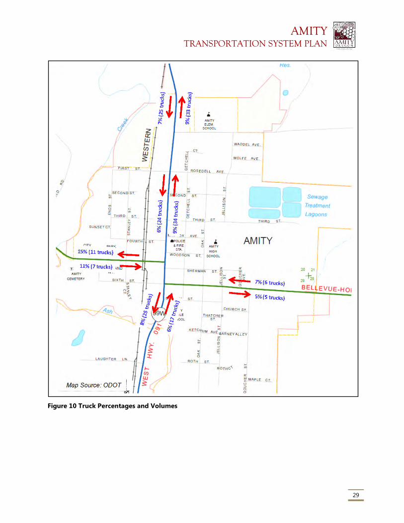
AMITY TRANSPORTATION SYSTEM PLAN
29
Figure 10 Truck Percentages and Volumes
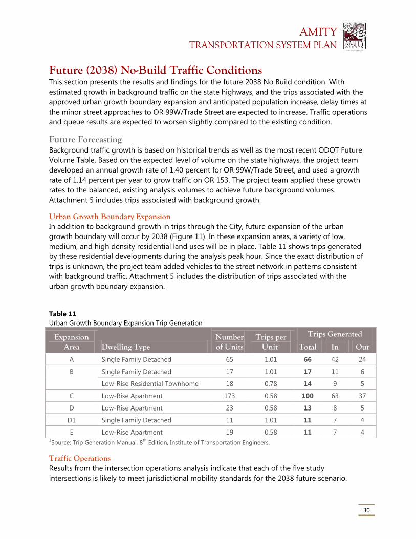
AMITY TRANSPORTATION SYSTEM PLAN
30
Future (2038) No-Build Traffic Conditions This section presents the results and findings for the future 2038 No Build condition. With
estimated growth in background traffic on the state highways, and the trips associated with the
approved urban growth boundary expansion and anticipated population increase, delay times at
the minor street approaches to OR 99W/Trade Street are expected to increase. Traffic operations
and queue results are expected to worsen slightly compared to the existing condition.
Future Forecasting Background traffic growth is based on historical trends as well as the most recent ODOT Future
Volume Table. Based on the expected level of volume on the state highways, the project team
developed an annual growth rate of 1.40 percent for OR 99W/Trade Street, and used a growth
rate of 1.14 percent per year to grow traffic on OR 153. The project team applied these growth
rates to the balanced, existing analysis volumes to achieve future background volumes.
Attachment 5 includes trips associated with background growth.
Urban Growth Boundary Expansion In addition to background growth in trips through the City, future expansion of the urban
growth boundary will occur by 2038 (Figure 11). In these expansion areas, a variety of low,
medium, and high density residential land uses will be in place. Table 11 shows trips generated
by these residential developments during the analysis peak hour. Since the exact distribution of
trips is unknown, the project team added vehicles to the street network in patterns consistent
with background traffic. Attachment 5 includes the distribution of trips associated with the
urban growth boundary expansion.
Table 11
Urban Growth Boundary Expansion Trip Generation
Expansion Area Dwelling Type
Number of Units
Trips per Unit1
Trips Generated
Total In Out
A Single Family Detached 65 1.01 66 42 24
B Single Family Detached 17 1.01 17 11 6
Low-Rise Residential Townhome 18 0.78 14 9 5
C Low-Rise Apartment 173 0.58 100 63 37
D Low-Rise Apartment 23 0.58 13 8 5
D1 Single Family Detached 11 1.01 11 7 4
E Low-Rise Apartment 19 0.58 11 7 4 1Source: Trip Generation Manual, 8
th Edition, Institute of Transportation Engineers.
Traffic Operations Results from the intersection operations analysis indicate that each of the five study
intersections is likely to meet jurisdictional mobility standards for the 2038 future scenario.
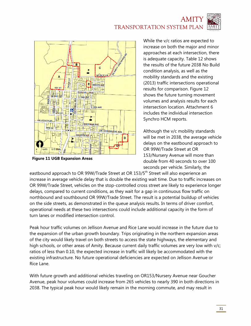
AMITY TRANSPORTATION SYSTEM PLAN
31
While the v/c ratios are expected to
increase on both the major and minor
approaches at each intersection, there
is adequate capacity. Table 12 shows
the results of the future 2038 No Build
condition analysis, as well as the
mobility standards and the existing
(2013) traffic intersections operational
results for comparison. Figure 12
shows the future turning movement
volumes and analysis results for each
intersection location. Attachment 6
includes the individual intersection
Synchro HCM reports.
Although the v/c mobility standards
will be met in 2038, the average vehicle
delays on the eastbound approach to
OR 99W/Trade Street at OR
153/Nursery Avenue will more than
double from 40 seconds to over 100
seconds per vehicle. Similarly, the
eastbound approach to OR 99W/Trade Street at OR 153/5th Street will also experience an
increase in average vehicle delay that is double the existing wait time. Due to traffic increases on
OR 99W/Trade Street, vehicles on the stop-controlled cross street are likely to experience longer
delays, compared to current conditions, as they wait for a gap in continuous flow traffic on
northbound and southbound OR 99W/Trade Street. The result is a potential buildup of vehicles
on the side streets, as demonstrated in the queue analysis results. In terms of driver comfort,
operational needs at these two intersections could include additional capacity in the form of
turn lanes or modified intersection control.
Peak hour traffic volumes on Jellison Avenue and Rice Lane would increase in the future due to
the expansion of the urban growth boundary. Trips originating in the northern expansion areas
of the city would likely travel on both streets to access the state highways, the elementary and
high schools, or other areas of Amity. Because current daily traffic volumes are very low with v/c;
ratios of less than 0.10, the expected increase in traffic will likely be accommodated with the
existing infrastructure. No future operational deficiencies are expected on Jellison Avenue or
Rice Lane.
With future growth and additional vehicles traveling on OR153/Nursery Avenue near Goucher
Avenue, peak hour volumes could increase from 265 vehicles to nearly 390 in both directions in
2038. The typical peak hour would likely remain in the morning commute, and may result in
Figure 11 UGB Expansion Areas
AMITY TRANSPORTATION SYSTEM PLAN
32
slightly longer delays for vehicles trying to turn onto or off of the highway. Traffic operations on
OR 153/Nursery Avenue would be acceptable with an expected v/c ratio of 0.12, which is within
the mobility standard for this roadway function.
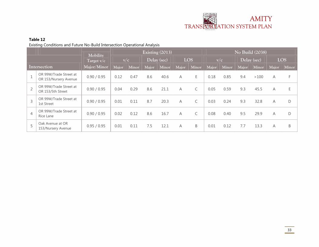
AMITY TRANSPORTATION SYSTEM PLAN
33
Table 12
Existing Conditions and Future No-Build Intersection Operational Analysis
Mobility
Target v/c Major/Minor
Existing (2013) No Build (2038)
Intersection v/c Delay (sec) LOS v/c Delay (sec) LOS
Major Minor Major Minor Major Minor Major Minor Major Minor Major Minor
1 OR 99W/Trade Street at
OR 153/Nursery Avenue 0.90 / 0.95 0.12 0.47 8.6 40.6 A E 0.18 0.85 9.4 >100 A F
2 OR 99W/Trade Street at
OR 153/5th Street 0.90 / 0.95 0.04 0.29 8.6 21.1 A C 0.05 0.59 9.3 45.5 A E
3 OR 99W/Trade Street at
1st Street 0.90 / 0.95 0.01 0.11 8.7 20.3 A C 0.03 0.24 9.3 32.8 A D
4 OR 99W/Trade Street at
Rice Lane 0.90 / 0.95 0.02 0.12 8.6 16.7 A C 0.08 0.40 9.5 29.9 A D
5 Oak Avenue at OR
153/Nursery Avenue 0.95 / 0.95 0.01 0.11 7.5 12.1 A B 0.01 0.12 7.7 13.3 A B
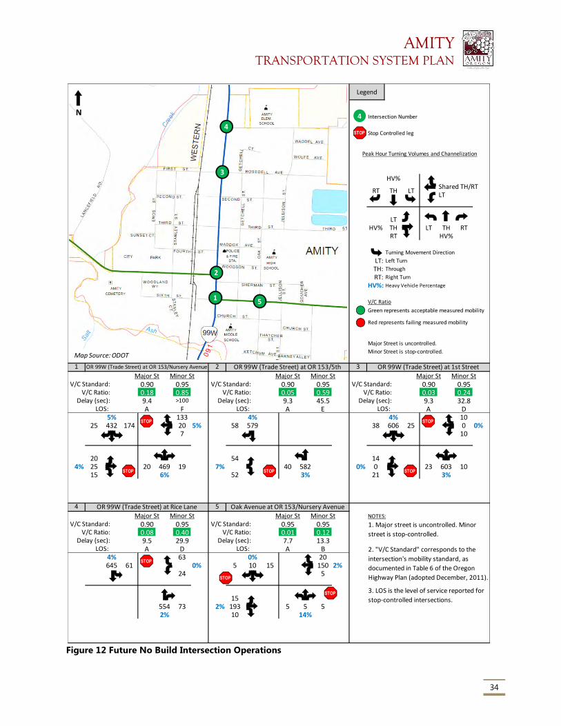
AMITY TRANSPORTATION SYSTEM PLAN
34
Figure 12 Future No Build Intersection Operations
HV%Shared TH/RTLT
LTHV% TH LT TH RT
RT HV%
Turning Movement Direction
LT: Left Turn
TH: Through
RT: Right Turn
HV%: Heavy Vehicle Percentage
V/C Ratio
Green represents acceptable measured mobility
Major Street is uncontrolled.
Minor Street is stop-controlled.
1 2 3
Major St Minor St Major St Minor St Major St Minor StV/C Standard: 0.90 0.95 V/C Standard: 0.90 0.95 V/C Standard: 0.90 0.95
V/C Ratio: 0.18 0.85 V/C Ratio: 0.05 0.59 V/C Ratio: 0.03 0.24Delay (sec): 9.4 >100 Delay (sec): 9.3 45.5 Delay (sec): 9.3 32.8
LOS: A F LOS: A E LOS: A D5% 133 4% 4% 10
25 432 174 20 5% 58 579 38 606 25 0 0%7 10
20 54 144% 25 20 469 19 7% 40 582 0% 0 23 603 10
15 6% 52 3% 21 3%
4 5
Major St Minor St Major St Minor St NOTES:
V/C Standard: 0.90 0.95 V/C Standard: 0.95 0.95V/C Ratio: 0.08 0.40 V/C Ratio: 0.01 0.12
Delay (sec): 9.5 29.9 Delay (sec): 7.7 13.3LOS: A D LOS: A B
4% 63 0% 20645 61 0% 5 10 15 150 2%
24 5
15554 73 2% 193 5 5 52% 10 14%
2. "V/C Standard" corresponds to the
intersection's mobility standard, as
documented in Table 6 of the Oregon
Highway Plan (adopted December, 2011).
3. LOS is the level of service reported for
stop-controlled intersections.
OR 99W (Trade Street) at OR 153/Nursery Avenue OR 99W (Trade Street) at OR 153/5th OR 99W (Trade Street) at 1st Street
OR 99W (Trade Street) at Rice Lane Oak Avenue at OR 153/Nursery Avenue
1. Major street is uncontrolled. Minor
street is stop-controlled.
Legend
Intersection Number
Stop Controlled leg
Peak Hour Turning Volumes and Channelization
RT TH LT
Red represents failing measured mobility
4
STOP
1
2
3
4
5
Map Source: ODOT
N
STOP
STOP STOP
STOP
STOP
STOP
STOP
STOP
AMITY TRANSPORTATION SYSTEM PLAN
35
Queue Analysis Queue lengths are expected to worsen slightly as a result of increased traffic, but are not
expected to affect operations at intersections. By 2038, the eastbound approach to OR
99W/Trade Street at OR 153/Nursery Avenue is expected to have the worst queuing of all the
study intersections. The 95th percentile eastbound queue would be up to five vehicles, but is not
likely to affect upstream driveways. The westbound queue on OR 153/Nursery Avenue could be
up to four vehicles. On both of these approaches, vehicles wanting to make a turn onto OR
99W/Trade Street may not be able to find sufficient gaps in the traffic to safely make their
movement. This results in delays at the stop sign and causes vehicles to backup behind them.
The results indicate that queues on the eastbound OR 153/5th Street approach to OR 99W/Trade
Street would be longer in the future. Vehicles wanting to turn left or right must wait for a
sufficient gap in traffic on OR 99W/Trade Street. A railroad crossing is located on OR 153/5th
Street approximately 250 feet from the intersection. While the expected 95th percentile queue is
four vehicles, and is not likely to affect the rail line, this is a location that may become an issue in
the future.
While queuing from Rice Lane onto OR 99W/Trade Street shows one vehicle in the peak hour,
stakeholders within the City have indicated that there are times currently where there are a
number of vehicles queued up and waiting to turn at that location. The project team will solicit
additional feedback on all existing transportation conditions to ensure that the community’s
day-to-day experiences are addressed, even when the traffic analysis and model do not indicate
an issue. The TAC and general public will be asked to add more information on observed traffic
queuing and congestion areas not captured in the technical analyses.
Table 13 shows the projected queue lengths in 2038 as compared to the 2013 existing
condition, along with the estimated storage length. On the stop-controlled approaches, the
storage length is measured from the stop sign to the next upstream intersection.
Safety Conditions Future crash rates cannot be calculated at the study intersections or roadway segments. The
future number of crashes, types of crashes, or severity of incidents cannot be directly forecast in
relation to traffic volume increases. As a qualitative assessment, no significant changes to traffic
patterns or infrastructure are expected by 2038; therefore no significant changes to the
calculated crash rates are expected.
Freight Operations Freight traffic patterns are likely to remain similar to existing conditions. The majority of trucks
would travel on the state highways through the City, while a few would be destined to or
originate in the light industrial land use along the railroad line.
By 2038, the number of trucks traveling on OR 99W/Trade Street and OR 153/Nursery Avenue
would likely increase as a result of background growth. This growth is not expected to affect
AMITY TRANSPORTATION SYSTEM PLAN
36
traffic operations during the peak hour because adequate capacity is available on the state
highways, and ample queue storage is available on the stop-controlled cross streets as shown in
the results above. Trucks would also be likely to travel outside the vehicular peak hour to avoid
typical commuter traffic.
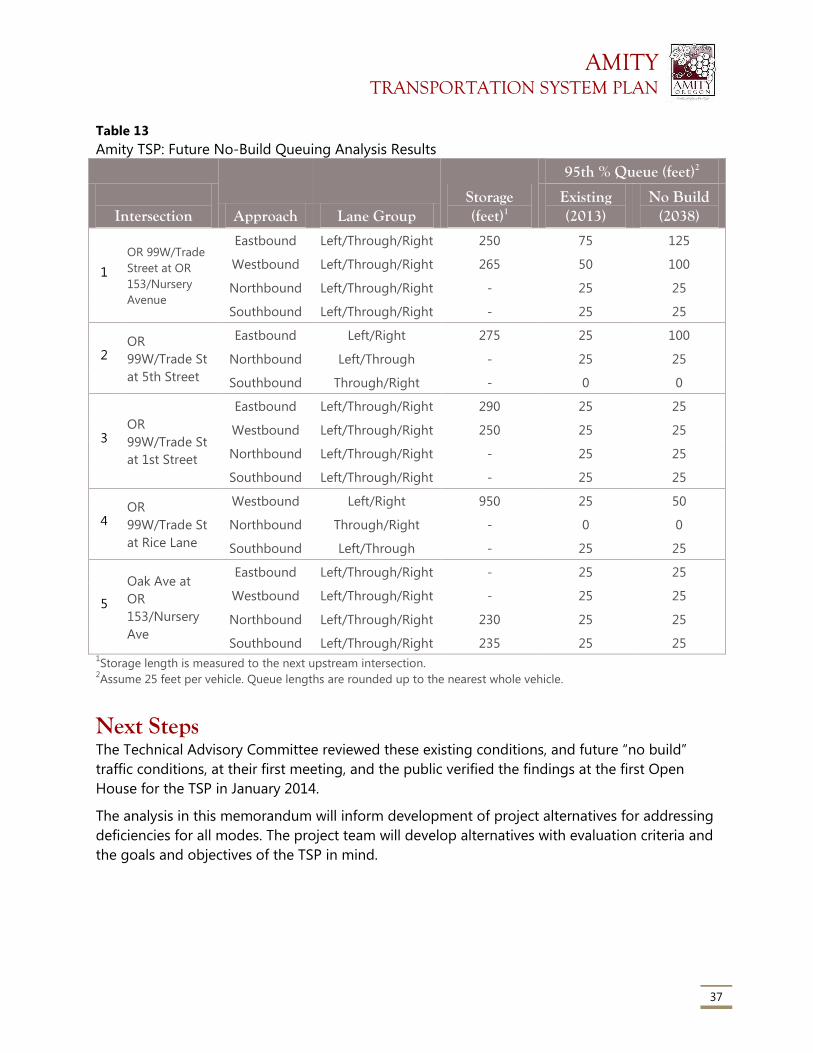
AMITY TRANSPORTATION SYSTEM PLAN
37
Table 13
Amity TSP: Future No-Build Queuing Analysis Results
Intersection Approach Lane Group Storage (feet)1
95th % Queue (feet)2
Existing (2013)
No Build (2038)
1
OR 99W/Trade
Street at OR
153/Nursery
Avenue
Eastbound Left/Through/Right 250 75 125
Westbound Left/Through/Right 265 50 100
Northbound Left/Through/Right - 25 25
Southbound Left/Through/Right - 25 25
2 OR
99W/Trade St
at 5th Street
Eastbound Left/Right 275 25 100
Northbound Left/Through - 25 25
Southbound Through/Right - 0 0
3 OR
99W/Trade St
at 1st Street
Eastbound Left/Through/Right 290 25 25
Westbound Left/Through/Right 250 25 25
Northbound Left/Through/Right - 25 25
Southbound Left/Through/Right - 25 25
4 OR
99W/Trade St
at Rice Lane
Westbound Left/Right 950 25 50
Northbound Through/Right - 0 0
Southbound Left/Through - 25 25
5
Oak Ave at
OR
153/Nursery
Ave
Eastbound Left/Through/Right - 25 25
Westbound Left/Through/Right - 25 25
Northbound Left/Through/Right 230 25 25
Southbound Left/Through/Right 235 25 25 1Storage length is measured to the next upstream intersection.
2Assume 25 feet per vehicle. Queue lengths are rounded up to the nearest whole vehicle.
Next Steps The Technical Advisory Committee reviewed these existing conditions, and future “no build”
traffic conditions, at their first meeting, and the public verified the findings at the first Open
House for the TSP in January 2014.
The analysis in this memorandum will inform development of project alternatives for addressing
deficiencies for all modes. The project team will develop alternatives with evaluation criteria and
the goals and objectives of the TSP in mind.
AMITY TRANSPORTATION SYSTEM PLAN
Attachment 1
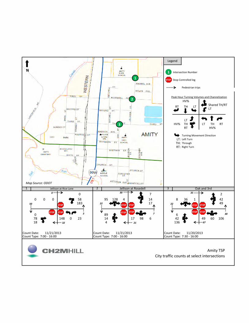
HV%Shared TH/RTLT
LTHV% TH LT TH RT
RT HV%
Turning Movement Direction
LT: Left Turn
TH: Through
RT: Right Turn
1 2 3
0 7 2
0 0 0 58 95 128 4 14 8 36 1 42183 17 49
0 89 678 148 0 23 14 17 98 6 42 49 60 10618 4 136
Count Date: Count Date: Count Date:Count Type: 7:00 - 16:00 Count Type: 7:00 - 16:00 Count Type: 7:30 - 16:00
Oak and 3rd
Amity TSP
City traffic counts at select intersections
Jellison at Rice Lane Jellison at Rosedell
11/21/2013 11/21/2013 11/20/2013
Legend
Intersection Number
Stop Controlled leg
Peak Hour Turning Volumes and Channelization
RT TH LT
Pedestrian trips
1
STOP 1
2
3
Map Source: ODOT
N
STOP
STOP
STOP
STOP STOP STOP
STOP
STOP
STOP STOP
STOP
50
0
3
32
30
7
21
22
35
30
67
22

AMITY TRANSPORTATION SYSTEM PLAN
Attachment 2
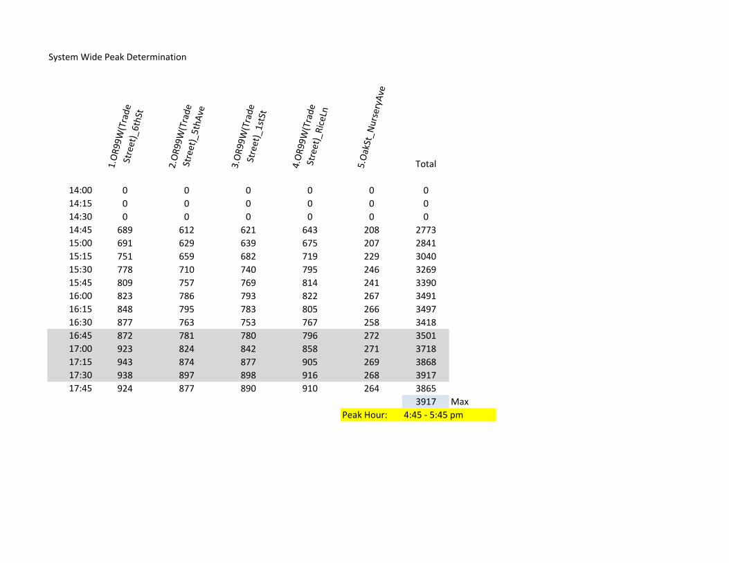
System Wide Peak Determination
1.OR99W
(Trade
Street)_6thSt
2.OR99W
(Trade
Street)_5thA
ve
3.OR99W
(Trade
Street)_1stSt
4.OR99W
(Trade
Street)_RiceLn
5.OakSt_N
urseryAve
Total
14:00 0 0 0 0 0 014:15 0 0 0 0 0 014:30 0 0 0 0 0 014:45 689 612 621 643 208 277315:00 691 629 639 675 207 284115:15 751 659 682 719 229 304015:30 778 710 740 795 246 326915:45 809 757 769 814 241 339016:00 823 786 793 822 267 349116:15 848 795 783 805 266 349716:30 877 763 753 767 258 341816:45 872 781 780 796 272 350117:00 923 824 842 858 271 371817:15 943 874 877 905 269 386817:30 938 897 898 916 268 391717:45 924 877 890 910 264 3865
3917 MaxPeak Hour: 4:45 ‐ 5:45 pm
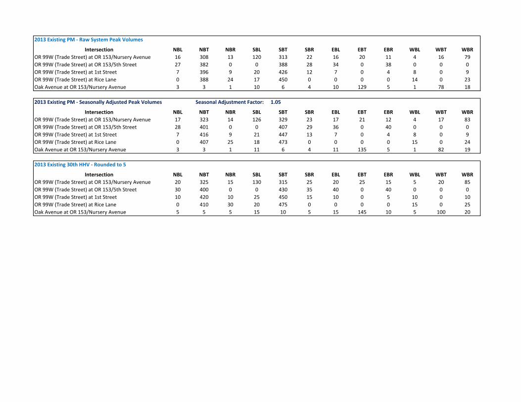
2013 Existing PM ‐ Raw System Peak Volumes
Intersection NBL NBT NBR SBL SBT SBR EBL EBT EBR WBL WBT WBROR 99W (Trade Street) at OR 153/Nursery Avenue 16 308 13 120 313 22 16 20 11 4 16 79OR 99W (Trade Street) at OR 153/5th Street 27 382 0 0 388 28 34 0 38 0 0 0OR 99W (Trade Street) at 1st Street 7 396 9 20 426 12 7 0 4 8 0 9OR 99W (Trade Street) at Rice Lane 0 388 24 17 450 0 0 0 0 14 0 23Oak Avenue at OR 153/Nursery Avenue 3 3 1 10 6 4 10 129 5 1 78 18
2013 Existing PM ‐ Seasonally Adjusted Peak Volumes Seasonal Adjustment Factor: 1.05
Intersection NBL NBT NBR SBL SBT SBR EBL EBT EBR WBL WBT WBROR 99W (Trade Street) at OR 153/Nursery Avenue 17 323 14 126 329 23 17 21 12 4 17 83OR 99W (Trade Street) at OR 153/5th Street 28 401 0 0 407 29 36 0 40 0 0 0OR 99W (Trade Street) at 1st Street 7 416 9 21 447 13 7 0 4 8 0 9OR 99W (Trade Street) at Rice Lane 0 407 25 18 473 0 0 0 0 15 0 24Oak Avenue at OR 153/Nursery Avenue 3 3 1 11 6 4 11 135 5 1 82 19
2013 Existing 30th HHV ‐ Rounded to 5
Intersection NBL NBT NBR SBL SBT SBR EBL EBT EBR WBL WBT WBROR 99W (Trade Street) at OR 153/Nursery Avenue 20 325 15 130 315 25 20 25 15 5 20 85OR 99W (Trade Street) at OR 153/5th Street 30 400 0 0 430 35 40 0 40 0 0 0OR 99W (Trade Street) at 1st Street 10 420 10 25 450 15 10 0 5 10 0 10OR 99W (Trade Street) at Rice Lane 0 410 30 20 475 0 0 0 0 15 0 25Oak Avenue at OR 153/Nursery Avenue 5 5 5 15 10 5 15 145 10 5 100 20

Time of Day N-E N-S N-W E-N E-S E-W S-N S-E S-W W-N W-E W-S TOTAL North East South West
0:00 0 0 0 0 0 0 0 0 0 0 0 0 0 0 0 0 0
0:15 0 0 0 0 0 0 0 0 0 0 0 0 0 0 0 0 0
0:30 0 0 0 0 0 0 0 0 0 0 0 0 0 0 0 0 0
0:45 0 0 0 0 0 0 0 0 0 0 0 0 0 0 0 0 0
1:00 0 0 0 0 0 0 0 0 0 0 0 0 0 0 0 0 0
1:15 0 0 0 0 0 0 0 0 0 0 0 0 0 0 0 0 0
1:30 0 0 0 0 0 0 0 0 0 0 0 0 0 0 0 0 0
1:45 0 0 0 0 0 0 0 0 0 0 0 0 0 0 0 0 0
2:00 0 0 0 0 0 0 0 0 0 0 0 0 0 0 0 0 0
2:15 0 0 0 0 0 0 0 0 0 0 0 0 0 0 0 0 0
2:30 0 0 0 0 0 0 0 0 0 0 0 0 0 0 0 0 0
2:45 0 0 0 0 0 0 0 0 0 0 0 0 0 0 0 0 0
3:00 0 0 0 0 0 0 0 0 0 0 0 0 0 0 0 0 0
3:15 0 0 0 0 0 0 0 0 0 0 0 0 0 0 0 0 0
3:30 0 0 0 0 0 0 0 0 0 0 0 0 0 0 0 0 0
3:45 0 0 0 0 0 0 0 0 0 0 0 0 0 0 0 0 0
4:00 0 0 0 0 0 0 0 0 0 0 0 0 0 0 0 0 0
4:15 0 0 0 0 0 0 0 0 0 0 0 0 0 0 0 0 0
4:30 0 0 0 0 0 0 0 0 0 0 0 0 0 0 0 0 0
4:45 0 0 0 0 0 0 0 0 0 0 0 0 0 0 0 0 0
5:00 0 0 0 0 0 0 0 0 0 0 0 0 0 0 0 0 0
5:15 0 0 0 0 0 0 0 0 0 0 0 0 0 0 0 0 0
5:30 0 0 0 0 0 0 0 0 0 0 0 0 0 0 0 0 0
5:45 0 0 0 0 0 0 0 0 0 0 0 0 0 0 0 0 0
6:00 24 173 4 51 7 4 158 5 2 1 3 2 434 201 62 165 6
6:15 0 0 0 0 0 0 0 0 0 0 0 0 0 0 0 0 0
6:30 0 0 0 0 0 0 0 0 0 0 0 0 0 0 0 0 0
6:45 0 0 0 0 0 0 0 0 0 0 0 0 0 0 0 0 0
7:00 32 239 10 75 15 1 216 5 7 10 4 3 617 281 91 228 17
7:15 0 0 0 0 0 0 0 0 0 0 0 0 0 0 0 0 0
7:30 0 0 0 0 0 0 0 0 0 0 0 0 0 0 0 0 0
7:45 0 0 0 0 0 0 0 0 0 0 0 0 0 0 0 0 0
8:00 44 155 10 53 10 4 223 7 3 7 9 3 528 209 67 233 19
8:15 0 0 0 0 0 0 0 0 0 0 0 0 0 0 0 0 0
8:30 0 0 0 0 0 0 0 0 0 0 0 0 0 0 0 0 0
8:45 0 0 0 0 0 0 0 0 0 0 0 0 0 0 0 0 0
9:00 51 135 11 58 7 1 163 4 4 7 3 3 447 197 66 171 13
9:15 0 0 0 0 0 0 0 0 0 0 0 0 0 0 0 0 0
9:30 0 0 0 0 0 0 0 0 0 0 0 0 0 0 0 0 0
9:45 0 0 0 0 0 0 0 0 0 0 0 0 0 0 0 0 0
10:00 61 179 14 57 6 9 182 5 7 5 8 6 539 254 72 194 19
10:15 0 0 0 0 0 0 0 0 0 0 0 0 0 0 0 0 0
10:30 0 0 0 0 0 0 0 0 0 0 0 0 0 0 0 0 0
10:45 0 0 0 0 0 0 0 0 0 0 0 0 0 0 0 0 0
11:00 58 203 13 57 10 6 166 7 5 8 5 9 547 274 73 178 22
11:15 0 0 0 0 0 0 0 0 0 0 0 0 0 0 0 0 0
11:30 0 0 0 0 0 0 0 0 0 0 0 0 0 0 0 0 0
11:45 0 0 0 0 0 0 0 0 0 0 0 0 0 0 0 0 0
12:00 59 207 21 61 5 11 200 9 8 19 12 5 617 287 77 217 36
12:15 0 0 0 0 0 0 0 0 0 0 0 0 0 0 0 0 0
12:30 0 0 0 0 0 0 0 0 0 0 0 0 0 0 0 0 0
12:45 0 0 0 0 0 0 0 0 0 0 0 0 0 0 0 0 0
13:00 58 207 28 60 9 7 198 8 6 15 11 9 616 293 76 212 35
13:15 0 0 0 0 0 0 0 0 0 0 0 0 0 0 0 0 0
13:30 0 0 0 0 0 0 0 0 0 0 0 0 0 0 0 0 0
13:45 0 0 0 0 0 0 0 0 0 0 0 0 0 0 0 0 0
14:00 23 49 6 21 5 3 63 4 3 2 2 2 183 78 29 70 6
14:15 13 54 7 16 0 2 40 1 1 8 3 0 145 74 18 42 11
14:30 15 64 6 12 1 2 66 4 0 2 2 1 175 85 15 70 5
14:45 20 50 5 17 2 3 70 2 4 5 5 3 186 75 22 76 13
15:00 27 61 5 17 0 3 56 1 1 7 4 3 185 93 20 58 14
15:15 36 69 4 19 7 1 57 1 2 2 2 5 205 109 27 60 9
15:30 18 70 6 24 5 3 66 3 1 1 4 1 202 94 32 70 6
15:45 21 78 7 20 0 0 73 3 1 8 3 3 217 106 20 77 14
16:00 24 76 5 13 5 0 68 4 2 2 0 0 199 105 18 74 2
16:15 26 88 7 18 2 2 74 3 2 2 2 4 230 121 22 79 8
16:30 27 76 4 19 3 2 86 1 0 2 7 4 231 107 24 87 13
City: Amity Highway #: 091
Summary By Movements Entering Volumes
Milepoint: 44.75 Location: OR99W (Trade Street) @ 6th StreetCount Number: 1.00 Weather: Cloudy
Summary of Traffic CountTransportation Development Division
Site: 53002 Date: 9/12/2013-9/13/2013
County: Yamhill Hours: PM
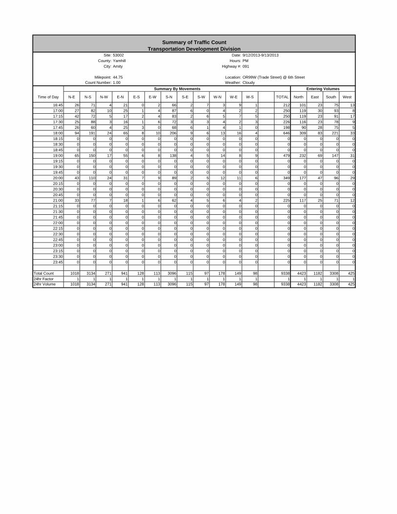
Time of Day N-E N-S N-W E-N E-S E-W S-N S-E S-W W-N W-E W-S TOTAL North East South West
City: Amity Highway #: 091
Summary By Movements Entering Volumes
Milepoint: 44.75 Location: OR99W (Trade Street) @ 6th StreetCount Number: 1.00 Weather: Cloudy
Summary of Traffic CountTransportation Development Division
Site: 53002 Date: 9/12/2013-9/13/2013
County: Yamhill Hours: PM
16:45 26 71 4 21 0 2 66 2 7 3 9 1 212 101 23 75 13
17:00 27 82 10 25 1 4 87 6 0 4 2 2 250 119 30 93 8
17:15 42 72 5 17 2 4 83 2 6 5 7 5 250 119 23 91 17
17:30 25 88 3 16 1 6 72 3 3 4 2 3 226 116 23 78 9
17:45 26 60 4 25 3 0 68 6 1 4 1 0 198 90 28 75 5
18:00 94 191 24 65 8 10 206 9 6 13 16 4 646 309 83 221 33
18:15 0 0 0 0 0 0 0 0 0 0 0 0 0 0 0 0 0
18:30 0 0 0 0 0 0 0 0 0 0 0 0 0 0 0 0 0
18:45 0 0 0 0 0 0 0 0 0 0 0 0 0 0 0 0 0
19:00 65 150 17 55 6 8 138 4 5 14 8 9 479 232 69 147 31
19:15 0 0 0 0 0 0 0 0 0 0 0 0 0 0 0 0 0
19:30 0 0 0 0 0 0 0 0 0 0 0 0 0 0 0 0 0
19:45 0 0 0 0 0 0 0 0 0 0 0 0 0 0 0 0 0
20:00 43 110 24 31 7 9 89 2 5 12 11 6 349 177 47 96 29
20:15 0 0 0 0 0 0 0 0 0 0 0 0 0 0 0 0 0
20:30 0 0 0 0 0 0 0 0 0 0 0 0 0 0 0 0 0
20:45 0 0 0 0 0 0 0 0 0 0 0 0 0 0 0 0 0
21:00 33 77 7 18 1 6 62 4 5 6 4 2 225 117 25 71 12
21:15 0 0 0 0 0 0 0 0 0 0 0 0 0 0 0 0 0
21:30 0 0 0 0 0 0 0 0 0 0 0 0 0 0 0 0 0
21:45 0 0 0 0 0 0 0 0 0 0 0 0 0 0 0 0 0
22:00 0 0 0 0 0 0 0 0 0 0 0 0 0 0 0 0 0
22:15 0 0 0 0 0 0 0 0 0 0 0 0 0 0 0 0 0
22:30 0 0 0 0 0 0 0 0 0 0 0 0 0 0 0 0 0
22:45 0 0 0 0 0 0 0 0 0 0 0 0 0 0 0 0 0
23:00 0 0 0 0 0 0 0 0 0 0 0 0 0 0 0 0 0
23:15 0 0 0 0 0 0 0 0 0 0 0 0 0 0 0 0 0
23:30 0 0 0 0 0 0 0 0 0 0 0 0 0 0 0 0 0
23:45 0 0 0 0 0 0 0 0 0 0 0 0 0 0 0 0 0
Total Count 1018 3134 271 941 128 113 3096 115 97 178 149 98 9338 4423 1182 3308 425
24hr Factor 1 1 1 1 1 1 1 1 1 1 1 1 1 1 1 1 124hr Volume 1018 3134 271 941 128 113 3096 115 97 178 149 98 9338 4423 1182 3308 425
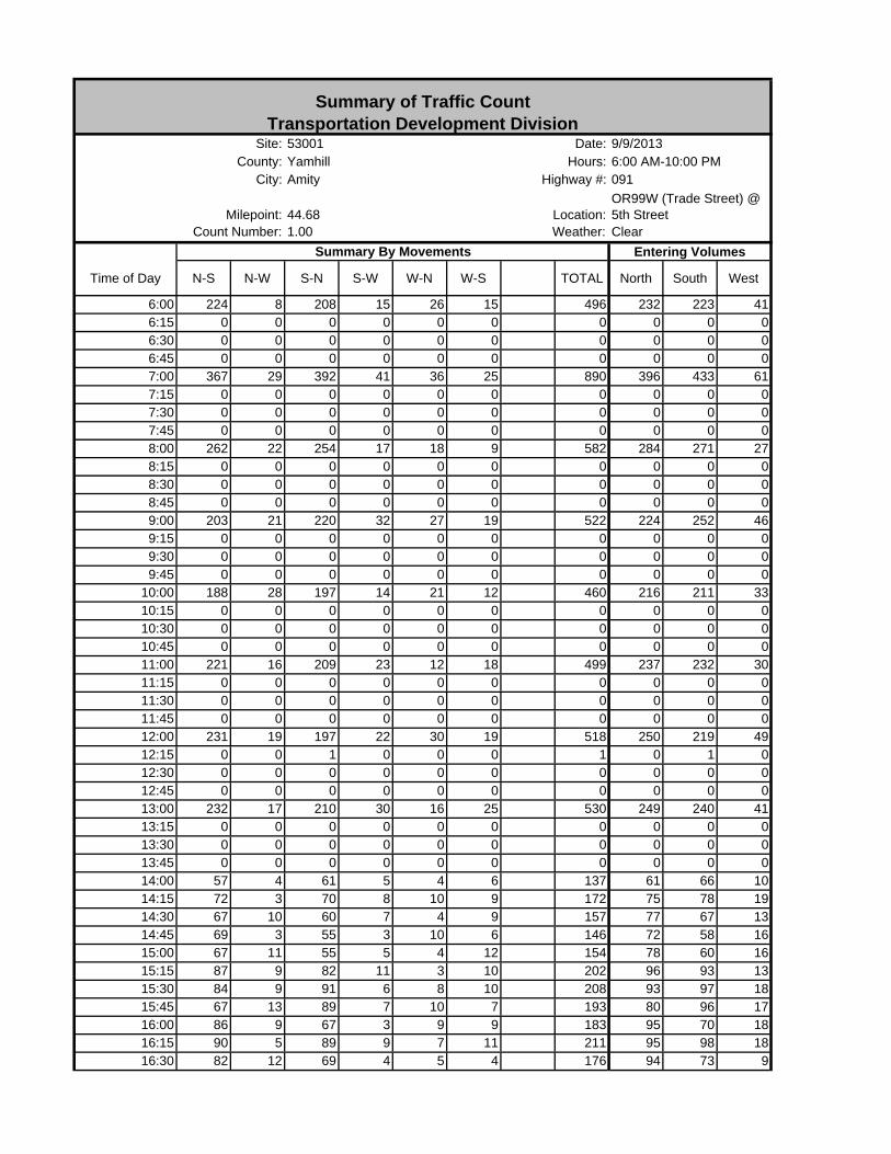
Time of Day N-S N-W S-N S-W W-N W-S TOTAL North South West
6:00 224 8 208 15 26 15 496 232 223 416:15 0 0 0 0 0 0 0 0 0 06:30 0 0 0 0 0 0 0 0 0 06:45 0 0 0 0 0 0 0 0 0 07:00 367 29 392 41 36 25 890 396 433 617:15 0 0 0 0 0 0 0 0 0 07:30 0 0 0 0 0 0 0 0 0 07:45 0 0 0 0 0 0 0 0 0 08:00 262 22 254 17 18 9 582 284 271 278:15 0 0 0 0 0 0 0 0 0 08:30 0 0 0 0 0 0 0 0 0 08:45 0 0 0 0 0 0 0 0 0 09:00 203 21 220 32 27 19 522 224 252 469:15 0 0 0 0 0 0 0 0 0 09:30 0 0 0 0 0 0 0 0 0 09:45 0 0 0 0 0 0 0 0 0 0
10:00 188 28 197 14 21 12 460 216 211 3310:15 0 0 0 0 0 0 0 0 0 010:30 0 0 0 0 0 0 0 0 0 010:45 0 0 0 0 0 0 0 0 0 011:00 221 16 209 23 12 18 499 237 232 3011:15 0 0 0 0 0 0 0 0 0 011:30 0 0 0 0 0 0 0 0 0 011:45 0 0 0 0 0 0 0 0 0 012:00 231 19 197 22 30 19 518 250 219 4912:15 0 0 1 0 0 0 1 0 1 012:30 0 0 0 0 0 0 0 0 0 012:45 0 0 0 0 0 0 0 0 0 013:00 232 17 210 30 16 25 530 249 240 4113:15 0 0 0 0 0 0 0 0 0 013:30 0 0 0 0 0 0 0 0 0 013:45 0 0 0 0 0 0 0 0 0 014:00 57 4 61 5 4 6 137 61 66 1014:15 72 3 70 8 10 9 172 75 78 1914:30 67 10 60 7 4 9 157 77 67 1314:45 69 3 55 3 10 6 146 72 58 1615:00 67 11 55 5 4 12 154 78 60 1615:15 87 9 82 11 3 10 202 96 93 1315:30 84 9 91 6 8 10 208 93 97 1815:45 67 13 89 7 10 7 193 80 96 1716:00 86 9 67 3 9 9 183 95 70 1816:15 90 5 89 9 7 11 211 95 98 1816:30 82 12 69 4 5 4 176 94 73 9
City: Amity Highway #: 091
Summary By Movements
Summary of Traffic CountTransportation Development Division
Site: 53001 Date: 9/9/2013
Count Number: 1.00 Weather: Clear
County: Yamhill Hours: 6:00 AM-10:00 PM
Entering Volumes
Milepoint: 44.68 Location:OR99W (Trade Street) @ 5th Street
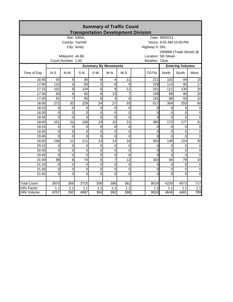
Time of Day N-S N-W S-N S-W W-N W-S TOTAL North South West
City: Amity Highway #: 091
Summary By Movements
Summary of Traffic CountTransportation Development Division
Site: 53001 Date: 9/9/2013
Count Number: 1.00 Weather: Clear
County: Yamhill Hours: 6:00 AM-10:00 PM
Entering Volumes
Milepoint: 44.68 Location:OR99W (Trade Street) @ 5th Street
16:45 93 9 86 8 4 11 211 102 94 1517:00 110 4 90 5 8 9 226 114 95 1717:15 102 9 124 6 9 11 261 111 130 2017:30 83 6 82 8 13 7 199 89 90 2017:45 81 7 85 8 4 6 191 88 93 1018:00 272 32 229 24 27 33 617 304 253 6018:15 0 0 0 0 0 0 0 0 0 018:30 0 0 0 0 0 0 0 0 0 018:45 0 0 0 0 0 0 0 0 0 019:00 151 21 158 19 10 21 380 172 177 3119:15 0 0 0 0 0 0 0 0 0 019:30 0 0 0 0 0 0 0 0 0 019:45 0 0 0 0 0 0 0 0 0 020:00 136 12 111 13 14 16 302 148 124 3020:15 0 0 0 0 0 0 0 0 0 020:30 0 0 0 0 0 0 0 0 0 020:45 0 0 0 0 0 0 0 0 0 021:00 86 8 74 5 7 12 192 94 79 1921:15 0 0 0 0 0 0 0 0 0 021:30 0 0 0 0 0 0 0 0 0 021:45 0 0 0 0 0 0 0 0 0 0
Total Count 3870 356 3715 358 356 361 9016 4226 4073 71724hr Factor 1.1 1.1 1.1 1.1 1.1 1.1 1.1 1.1 1.1 1.124hr Volume 4257 392 4087 394 392 398 9918 4649 4481 789
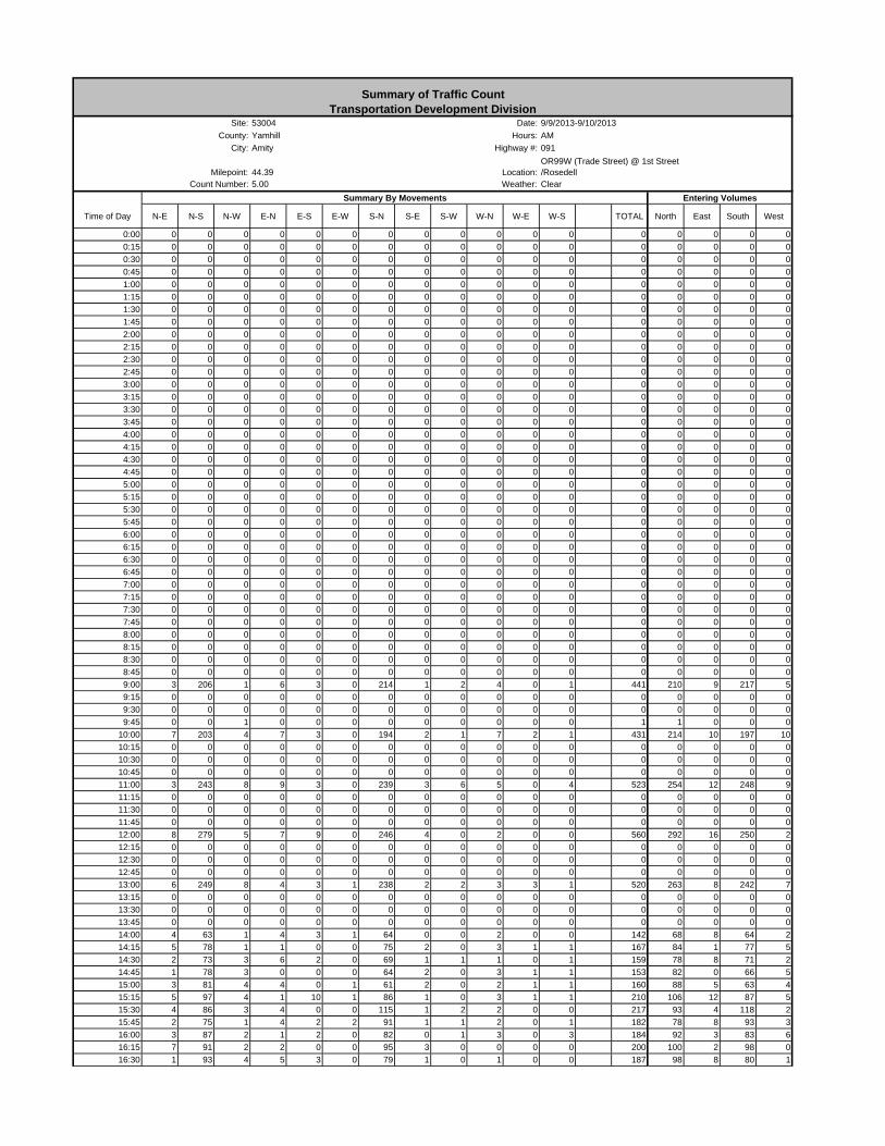
Time of Day N-E N-S N-W E-N E-S E-W S-N S-E S-W W-N W-E W-S TOTAL North East South West
0:00 0 0 0 0 0 0 0 0 0 0 0 0 0 0 0 0 0
0:15 0 0 0 0 0 0 0 0 0 0 0 0 0 0 0 0 0
0:30 0 0 0 0 0 0 0 0 0 0 0 0 0 0 0 0 0
0:45 0 0 0 0 0 0 0 0 0 0 0 0 0 0 0 0 0
1:00 0 0 0 0 0 0 0 0 0 0 0 0 0 0 0 0 0
1:15 0 0 0 0 0 0 0 0 0 0 0 0 0 0 0 0 0
1:30 0 0 0 0 0 0 0 0 0 0 0 0 0 0 0 0 0
1:45 0 0 0 0 0 0 0 0 0 0 0 0 0 0 0 0 0
2:00 0 0 0 0 0 0 0 0 0 0 0 0 0 0 0 0 0
2:15 0 0 0 0 0 0 0 0 0 0 0 0 0 0 0 0 0
2:30 0 0 0 0 0 0 0 0 0 0 0 0 0 0 0 0 0
2:45 0 0 0 0 0 0 0 0 0 0 0 0 0 0 0 0 0
3:00 0 0 0 0 0 0 0 0 0 0 0 0 0 0 0 0 0
3:15 0 0 0 0 0 0 0 0 0 0 0 0 0 0 0 0 0
3:30 0 0 0 0 0 0 0 0 0 0 0 0 0 0 0 0 0
3:45 0 0 0 0 0 0 0 0 0 0 0 0 0 0 0 0 0
4:00 0 0 0 0 0 0 0 0 0 0 0 0 0 0 0 0 0
4:15 0 0 0 0 0 0 0 0 0 0 0 0 0 0 0 0 0
4:30 0 0 0 0 0 0 0 0 0 0 0 0 0 0 0 0 0
4:45 0 0 0 0 0 0 0 0 0 0 0 0 0 0 0 0 0
5:00 0 0 0 0 0 0 0 0 0 0 0 0 0 0 0 0 0
5:15 0 0 0 0 0 0 0 0 0 0 0 0 0 0 0 0 0
5:30 0 0 0 0 0 0 0 0 0 0 0 0 0 0 0 0 0
5:45 0 0 0 0 0 0 0 0 0 0 0 0 0 0 0 0 0
6:00 0 0 0 0 0 0 0 0 0 0 0 0 0 0 0 0 0
6:15 0 0 0 0 0 0 0 0 0 0 0 0 0 0 0 0 0
6:30 0 0 0 0 0 0 0 0 0 0 0 0 0 0 0 0 0
6:45 0 0 0 0 0 0 0 0 0 0 0 0 0 0 0 0 0
7:00 0 0 0 0 0 0 0 0 0 0 0 0 0 0 0 0 0
7:15 0 0 0 0 0 0 0 0 0 0 0 0 0 0 0 0 0
7:30 0 0 0 0 0 0 0 0 0 0 0 0 0 0 0 0 0
7:45 0 0 0 0 0 0 0 0 0 0 0 0 0 0 0 0 0
8:00 0 0 0 0 0 0 0 0 0 0 0 0 0 0 0 0 0
8:15 0 0 0 0 0 0 0 0 0 0 0 0 0 0 0 0 0
8:30 0 0 0 0 0 0 0 0 0 0 0 0 0 0 0 0 0
8:45 0 0 0 0 0 0 0 0 0 0 0 0 0 0 0 0 0
9:00 3 206 1 6 3 0 214 1 2 4 0 1 441 210 9 217 5
9:15 0 0 0 0 0 0 0 0 0 0 0 0 0 0 0 0 0
9:30 0 0 0 0 0 0 0 0 0 0 0 0 0 0 0 0 0
9:45 0 0 1 0 0 0 0 0 0 0 0 0 1 1 0 0 0
10:00 7 203 4 7 3 0 194 2 1 7 2 1 431 214 10 197 10
10:15 0 0 0 0 0 0 0 0 0 0 0 0 0 0 0 0 0
10:30 0 0 0 0 0 0 0 0 0 0 0 0 0 0 0 0 0
10:45 0 0 0 0 0 0 0 0 0 0 0 0 0 0 0 0 0
11:00 3 243 8 9 3 0 239 3 6 5 0 4 523 254 12 248 9
11:15 0 0 0 0 0 0 0 0 0 0 0 0 0 0 0 0 0
11:30 0 0 0 0 0 0 0 0 0 0 0 0 0 0 0 0 0
11:45 0 0 0 0 0 0 0 0 0 0 0 0 0 0 0 0 0
12:00 8 279 5 7 9 0 246 4 0 2 0 0 560 292 16 250 2
12:15 0 0 0 0 0 0 0 0 0 0 0 0 0 0 0 0 0
12:30 0 0 0 0 0 0 0 0 0 0 0 0 0 0 0 0 0
12:45 0 0 0 0 0 0 0 0 0 0 0 0 0 0 0 0 0
13:00 6 249 8 4 3 1 238 2 2 3 3 1 520 263 8 242 7
13:15 0 0 0 0 0 0 0 0 0 0 0 0 0 0 0 0 0
13:30 0 0 0 0 0 0 0 0 0 0 0 0 0 0 0 0 0
13:45 0 0 0 0 0 0 0 0 0 0 0 0 0 0 0 0 0
14:00 4 63 1 4 3 1 64 0 0 2 0 0 142 68 8 64 2
14:15 5 78 1 1 0 0 75 2 0 3 1 1 167 84 1 77 5
14:30 2 73 3 6 2 0 69 1 1 1 0 1 159 78 8 71 2
14:45 1 78 3 0 0 0 64 2 0 3 1 1 153 82 0 66 5
15:00 3 81 4 4 0 1 61 2 0 2 1 1 160 88 5 63 4
15:15 5 97 4 1 10 1 86 1 0 3 1 1 210 106 12 87 5
15:30 4 86 3 4 0 0 115 1 2 2 0 0 217 93 4 118 2
15:45 2 75 1 4 2 2 91 1 1 2 0 1 182 78 8 93 3
16:00 3 87 2 1 2 0 82 0 1 3 0 3 184 92 3 83 6
16:15 7 91 2 2 0 0 95 3 0 0 0 0 200 100 2 98 0
16:30 1 93 4 5 3 0 79 1 0 1 0 0 187 98 8 80 1
Summary of Traffic CountTransportation Development Division
Site: 53004 Date: 9/9/2013-9/10/2013
County: Yamhill Hours: AM
Summary By Movements Entering Volumes
Milepoint: 44.39 Location:OR99W (Trade Street) @ 1st Street /Rosedell
Count Number: 5.00 Weather: Clear
City: Amity Highway #: 091

Time of Day N-E N-S N-W E-N E-S E-W S-N S-E S-W W-N W-E W-S TOTAL North East South West
Summary of Traffic CountTransportation Development Division
Site: 53004 Date: 9/9/2013-9/10/2013
County: Yamhill Hours: AM
Summary By Movements Entering Volumes
Milepoint: 44.39 Location:OR99W (Trade Street) @ 1st Street /Rosedell
Count Number: 5.00 Weather: Clear
City: Amity Highway #: 091
16:45 3 104 2 3 3 0 88 1 3 1 0 1 209 109 6 92 2
17:00 5 125 7 0 1 0 99 4 2 2 0 1 246 137 1 105 3
17:15 7 104 1 4 2 0 112 3 0 2 0 0 235 112 6 115 2
17:30 5 93 2 2 2 0 97 1 2 2 0 2 208 100 4 100 4
17:45 7 100 4 0 2 0 84 0 3 1 0 0 201 111 2 87 1
18:00 22 289 9 8 8 2 260 6 5 10 1 8 628 320 18 271 19
18:15 0 0 0 0 0 0 0 0 0 0 0 0 0 0 0 0 0
18:30 0 0 0 0 0 0 0 0 0 0 0 0 0 0 0 0 0
18:45 0 0 0 0 0 0 0 0 0 0 0 0 0 0 0 0 0
19:00 11 172 4 11 5 0 153 11 3 4 1 0 375 187 16 167 5
19:15 0 0 0 0 0 0 0 0 0 0 0 0 0 0 0 0 0
19:30 0 0 0 0 0 0 0 0 0 0 0 0 0 0 0 0 0
19:45 0 0 0 0 0 0 0 0 0 0 0 0 0 0 0 0 0
20:00 11 153 7 5 5 0 121 4 3 8 0 3 320 171 10 128 11
20:15 0 0 0 0 0 0 0 0 0 0 0 0 0 0 0 0 0
20:30 0 0 0 0 0 0 0 0 0 0 0 0 0 0 0 0 0
20:45 0 0 0 0 0 0 0 0 0 0 0 0 0 0 0 0 0
21:00 6 87 8 0 4 0 80 4 0 2 0 1 192 101 4 84 3
21:15 0 0 0 0 0 0 0 0 0 0 0 0 0 0 0 0 0
21:30 0 0 0 0 0 0 0 0 0 0 0 0 0 0 0 0 0
21:45 0 0 0 0 0 0 0 0 0 0 0 0 0 0 0 0 0
22:00 0 0 0 0 0 0 0 0 0 0 0 0 0 0 0 0 0
22:15 0 0 0 0 0 0 0 0 0 0 0 0 0 0 0 0 0
22:30 0 0 0 0 0 0 0 0 0 0 0 0 0 0 0 0 0
22:45 0 0 0 0 0 0 0 0 0 0 0 0 0 0 0 0 0
23:00 0 0 0 0 0 0 0 0 0 0 0 0 0 0 0 0 0
23:15 0 0 0 0 0 0 0 0 0 0 0 0 0 0 0 0 0
23:30 0 0 0 0 0 0 0 0 0 0 0 0 0 0 0 0 0
23:45 0 0 0 0 0 0 0 0 0 0 0 0 0 0 0 0 0
Total Count 141 3309 99 98 75 8 3106 60 37 75 11 32 7051 3549 181 3203 118
24hr Factor 1 1 1 1 1 1 1 1 1 1 1 1 1 1 1 1 124hr Volume 141 3309 99 98 75 8 3106 60 37 75 11 32 7051 3549 181 3203 118
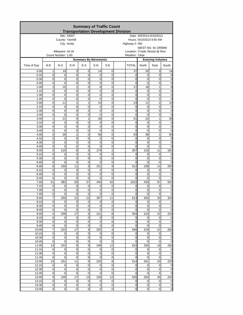
Time of Day N-E N-S E-N E-S S-N S-E TOTAL North East South
0:00 1 19 3 0 14 0 37 20 3 140:15 0 0 0 0 0 0 0 0 0 00:30 0 0 0 0 0 0 0 0 0 00:45 0 0 0 0 0 0 0 0 0 01:00 3 15 1 0 8 0 27 18 1 81:15 0 0 0 0 0 0 0 0 0 01:30 0 0 0 0 0 0 0 0 0 01:45 0 0 0 0 0 0 0 0 0 02:00 0 11 1 1 10 0 23 11 2 102:15 0 0 0 0 0 0 0 0 0 02:30 0 0 0 0 0 0 0 0 0 02:45 0 0 0 0 0 0 0 0 0 03:00 1 21 0 1 28 0 51 22 1 283:15 0 0 0 0 0 0 0 0 0 03:30 0 0 0 0 0 0 0 0 0 03:45 0 0 0 0 0 0 0 0 0 04:00 0 36 1 0 56 0 93 36 1 564:15 0 0 0 0 0 0 0 0 0 04:30 0 0 0 0 0 0 0 0 0 04:45 0 0 0 0 0 0 0 0 0 05:00 0 115 8 3 179 2 307 115 11 1815:15 0 0 0 0 0 0 0 0 0 05:30 0 0 0 0 0 0 0 0 0 05:45 0 0 0 0 0 0 0 0 0 06:00 8 230 11 3 251 9 512 238 14 2606:15 0 0 0 0 0 0 0 0 0 06:30 0 0 0 0 0 0 0 0 0 06:45 0 0 0 0 0 0 0 0 0 07:00 51 382 50 37 440 62 1022 433 87 5027:15 0 0 0 0 0 0 0 0 0 07:30 0 0 0 0 0 0 0 0 0 07:45 0 0 0 0 0 0 0 0 0 08:00 7 255 21 12 307 11 613 262 33 3188:15 0 0 0 0 0 0 0 0 0 08:30 0 0 0 0 0 0 0 0 0 08:45 0 0 0 0 0 0 0 0 0 09:00 4 209 17 5 211 8 454 213 22 2199:15 0 0 0 0 0 0 0 0 0 09:30 0 0 0 0 0 0 0 0 0 09:45 0 0 0 0 0 0 0 0 0 0
10:00 7 212 17 4 202 4 446 219 21 20610:15 0 0 0 0 0 0 0 0 0 010:30 0 0 0 0 0 0 0 0 0 010:45 0 0 0 0 0 0 0 0 0 011:00 13 242 9 9 248 12 533 255 18 26011:15 0 0 0 0 0 0 0 0 0 011:30 0 0 0 0 0 0 0 0 0 011:45 0 0 0 0 0 0 0 0 0 012:00 10 251 11 9 225 8 514 261 20 23312:15 0 0 0 0 0 0 0 0 0 012:30 0 0 0 0 0 0 0 0 0 012:45 0 0 0 0 0 0 0 0 0 013:00 9 245 17 13 230 12 526 254 30 24213:15 0 0 0 0 0 0 0 0 0 013:30 0 0 0 0 0 0 0 0 0 013:45 0 0 0 0 0 0 0 0 0 0
Summary of Traffic CountTransportation Development Division
Site: 53007 Date: 9/9/2013-9/10/2013County: Yamhill Hours: 9/10/2013 9:00 AM
Summary By Movements Entering Volumes
Milepoint: 44.26 Location:WEST NO. 91 OR99W (Trade Street) @ Rice
Count Number: 1.00 Weather: Clear
City: Amity Highway #: 091
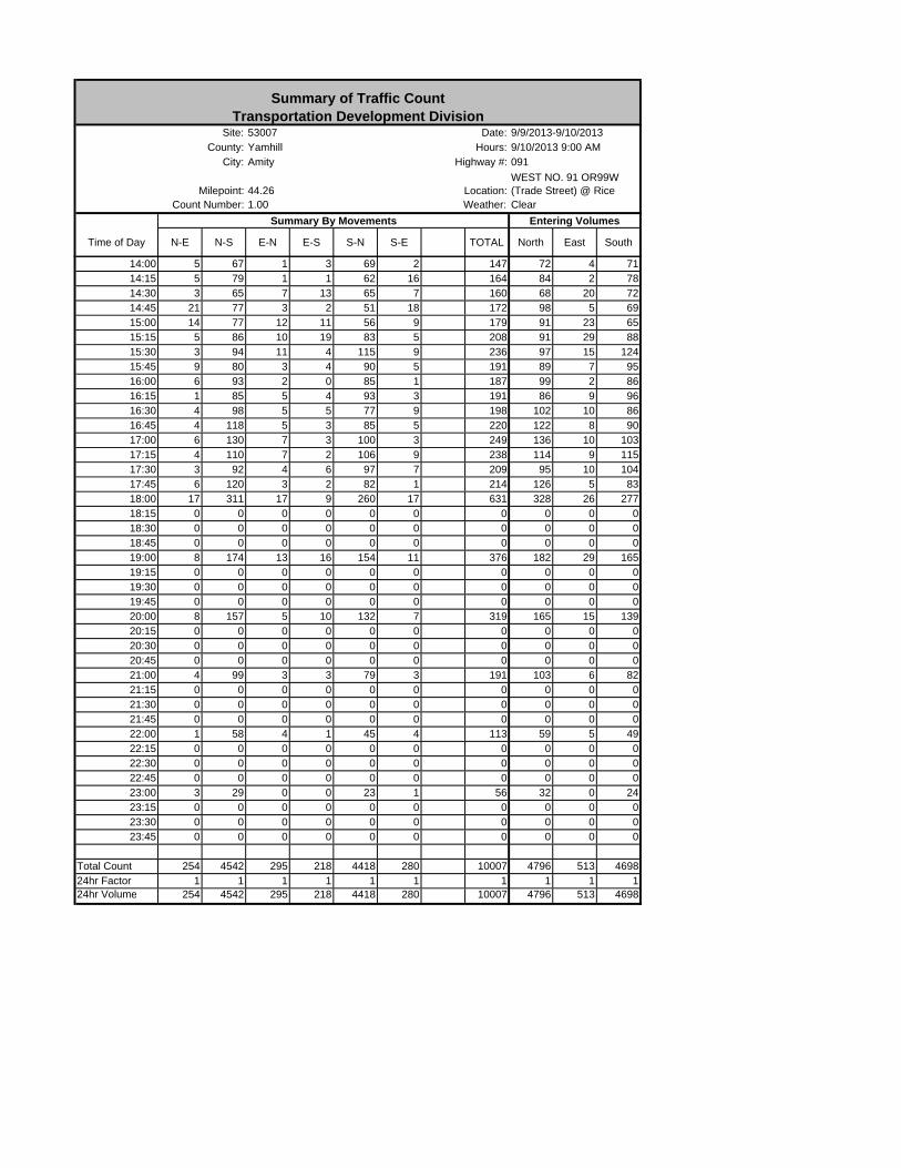
Time of Day N-E N-S E-N E-S S-N S-E TOTAL North East South
Summary of Traffic CountTransportation Development Division
Site: 53007 Date: 9/9/2013-9/10/2013County: Yamhill Hours: 9/10/2013 9:00 AM
Summary By Movements Entering Volumes
Milepoint: 44.26 Location:WEST NO. 91 OR99W (Trade Street) @ Rice
Count Number: 1.00 Weather: Clear
City: Amity Highway #: 091
14:00 5 67 1 3 69 2 147 72 4 7114:15 5 79 1 1 62 16 164 84 2 7814:30 3 65 7 13 65 7 160 68 20 7214:45 21 77 3 2 51 18 172 98 5 6915:00 14 77 12 11 56 9 179 91 23 6515:15 5 86 10 19 83 5 208 91 29 8815:30 3 94 11 4 115 9 236 97 15 12415:45 9 80 3 4 90 5 191 89 7 9516:00 6 93 2 0 85 1 187 99 2 8616:15 1 85 5 4 93 3 191 86 9 9616:30 4 98 5 5 77 9 198 102 10 8616:45 4 118 5 3 85 5 220 122 8 9017:00 6 130 7 3 100 3 249 136 10 10317:15 4 110 7 2 106 9 238 114 9 11517:30 3 92 4 6 97 7 209 95 10 10417:45 6 120 3 2 82 1 214 126 5 8318:00 17 311 17 9 260 17 631 328 26 27718:15 0 0 0 0 0 0 0 0 0 018:30 0 0 0 0 0 0 0 0 0 018:45 0 0 0 0 0 0 0 0 0 019:00 8 174 13 16 154 11 376 182 29 16519:15 0 0 0 0 0 0 0 0 0 019:30 0 0 0 0 0 0 0 0 0 019:45 0 0 0 0 0 0 0 0 0 020:00 8 157 5 10 132 7 319 165 15 13920:15 0 0 0 0 0 0 0 0 0 020:30 0 0 0 0 0 0 0 0 0 020:45 0 0 0 0 0 0 0 0 0 021:00 4 99 3 3 79 3 191 103 6 8221:15 0 0 0 0 0 0 0 0 0 021:30 0 0 0 0 0 0 0 0 0 021:45 0 0 0 0 0 0 0 0 0 022:00 1 58 4 1 45 4 113 59 5 4922:15 0 0 0 0 0 0 0 0 0 022:30 0 0 0 0 0 0 0 0 0 022:45 0 0 0 0 0 0 0 0 0 023:00 3 29 0 0 23 1 56 32 0 2423:15 0 0 0 0 0 0 0 0 0 023:30 0 0 0 0 0 0 0 0 0 023:45 0 0 0 0 0 0 0 0 0 0
Total Count 254 4542 295 218 4418 280 10007 4796 513 469824hr Factor 1 1 1 1 1 1 1 1 1 124hr Volume 254 4542 295 218 4418 280 10007 4796 513 4698
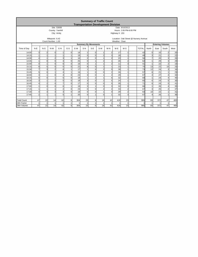
Time of Day N-E N-S N-W E-N E-S E-W S-N S-E S-W W-N W-E W-S TOTAL North East South West
14:00 3 2 0 1 0 14 1 0 1 2 17 1 42 5 15 2 20
14:15 1 1 1 1 1 19 0 0 2 3 18 1 48 3 21 2 22
14:30 4 1 2 3 1 16 2 0 1 2 23 1 56 7 20 3 26
14:45 1 0 0 4 0 25 0 1 2 1 26 2 62 1 29 3 29
15:00 0 1 0 6 0 16 0 1 1 2 11 3 41 1 22 2 16
15:15 8 5 0 0 0 22 8 0 2 1 23 1 70 13 22 10 25
15:30 7 3 2 6 1 17 1 0 2 5 28 1 73 12 24 3 34
15:45 5 0 1 4 1 16 1 0 0 2 26 1 57 6 21 1 29
16:00 3 1 0 4 0 23 3 0 1 2 29 1 67 4 27 4 32
16:15 0 0 1 5 0 19 1 2 1 6 32 2 69 1 24 4 40
16:30 3 1 2 5 0 19 3 0 2 5 24 1 65 6 24 5 30
16:45 4 2 0 7 0 17 0 0 0 5 35 1 71 6 24 0 41
17:00 1 0 0 6 1 19 3 1 0 3 32 0 66 1 26 4 35
17:15 1 1 1 2 0 23 0 0 2 2 33 2 67 3 25 2 37
17:30 4 3 3 3 0 19 0 0 1 0 29 2 64 10 22 1 31
17:45 2 1 1 5 1 20 0 1 0 1 32 3 67 4 26 1 36
Total Count 47 22 14 62 6 304 23 6 18 42 418 23 985 83 372 47 483
24hr Factor 1 1 1 1 1 1 1 1 1 1 1 1 1 1 1 1 124hr Volume 47 22 14 62 6 304 23 6 18 42 418 23 985 83 372 47 483
Summary of Traffic CountTransportation Development Division
Site: 53008 Date: 9/10/2013
County: Yamhill Hours: 2:00 PM-6:00 PM
Summary By Movements Entering Volumes
Milepoint: 6.42 Location: Oak Street @ Nursery AvenueCount Number: 1.00 Weather: Clear
City: Amity Highway #: 153

AMITY TRANSPORTATION SYSTEM PLAN
Attachment 3

HCM 2010 TWSC1: Trade St & Nursery St 11/12/2013
5:00 pm 11/12/2013 Existing (2013) Synchro 8 ReportPage 1
IntersectionIntersection Delay, s/veh 6.7
Movement EBL EBT EBR WBL WBT WBR NBL NBT NBR SBL SBT SBRVol, veh/h 20 25 15 5 20 85 20 325 15 130 315 25Conflicting Peds, #/hr 10 0 10 10 0 10 10 0 10 10 0 10Sign Control Stop Stop Stop Stop Stop Stop Free Free Free Free Free FreeRT Channelized - - None - - None - - None - - NoneStorage Length - - - - - - - - - - - -Veh in Median Storage, # - 0 - - 0 - - 0 - - 0 -Grade, % - 0 - - 0 - - 0 - - 0 -Peak Hour Factor 69 69 69 83 83 83 91 91 91 96 96 96Heavy Vehicles, % 4 4 4 5 5 5 6 6 6 5 5 5Mvmt Flow 29 36 22 6 24 102 22 357 16 135 328 26
Major/Minor Minor2 Minor1 Major1 Major2Conflicting Flow All 1105 1050 361 1070 1054 385 364 0 0 384 0 0 Stage 1 622 622 - 419 419 - - - - - - - Stage 2 483 428 - 651 635 - - - - - - -Follow-up Headway 3.536 4.036 3.336 3.545 4.045 3.345 2.254 - - 2.245 - -Pot Capacity-1 Maneuver 186 225 679 196 223 656 1173 - - 1158 - - Stage 1 471 476 - 606 585 - - - - - - - Stage 2 561 581 - 452 468 - - - - - - -Time blocked-Platoon, % - - - -Mov Capacity-1 Maneuver 121 184 669 138 182 645 1164 - - 1149 - -Mov Capacity-2 Maneuver 121 184 - 138 182 - - - - - - - Stage 1 456 403 - 586 565 - - - - - - - Stage 2 438 562 - 337 396 - - - - - - -
Approach EB WB NB SBHCM Control Delay, s 40.6 18.6 0.5 2.4HCM LOS E C
Minor Lane / Major Mvmt NBL NBT NBR EBLn1 WBLn1 SBL SBT SBRCapacity (veh/h) 1164 - - 185 396 1149 - -HCM Lane V/C Ratio 0.019 - - 0.47 0.335 0.118 - -HCM Control Delay (s) 8.152 0 - 40.6 18.6 8.551 0 -HCM Lane LOS A A E C A AHCM 95th %tile Q(veh) 0.058 - - 2.248 1.446 0.4 - -
Notes~ : Volume Exceeds Capacity; $ : Delay Exceeds 300 Seconds; Error : Computation Not Defined

HCM 2010 TWSC2: Trade St & 5th St 11/12/2013
5:00 pm 11/12/2013 Existing (2013) Synchro 8 ReportPage 2
IntersectionIntersection Delay, s/veh 1.9
Movement EBL EBR NBL NBT SBT SBRVol, veh/h 40 40 30 400 430 35Conflicting Peds, #/hr 10 10 10 0 0 10Sign Control Stop Stop Free Free Free FreeRT Channelized - None - None - NoneStorage Length 0 - - - - -Veh in Median Storage, # 0 - - 0 0 -Grade, % 0 - - 0 0 -Peak Hour Factor 90 90 79 79 91 91Heavy Vehicles, % 7 7 3 3 4 4Mvmt Flow 44 44 38 506 473 38
Major/Minor Minor2 Major1 Major2Conflicting Flow All 1084 512 521 0 - 0 Stage 1 502 - - - - - Stage 2 582 - - - - -Follow-up Headway 3.563 3.363 2.227 - - -Pot Capacity-1 Maneuver 235 552 1040 - - - Stage 1 598 - - - - - Stage 2 549 - - - - -Time blocked-Platoon, % - - -Mov Capacity-1 Maneuver 218 542 1032 - - -Mov Capacity-2 Maneuver 218 - - - - - Stage 1 591 - - - - - Stage 2 515 - - - - -
Approach EB NB SBHCM Control Delay, s 21.1 0.6 0HCM LOS C
Minor Lane / Major Mvmt NBL NBT EBLn1 SBT SBRCapacity (veh/h) 1032 - 311 - -HCM Lane V/C Ratio 0.037 - 0.286 - -HCM Control Delay (s) 8.622 0 21.1 - -HCM Lane LOS A A CHCM 95th %tile Q(veh) 0.115 - 1.153 - -
Notes~ : Volume Exceeds Capacity; $ : Delay Exceeds 300 Seconds; Error : Computation Not Defined
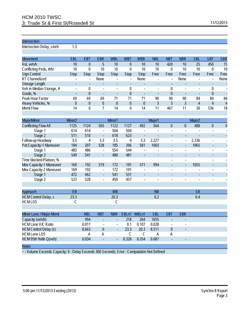
HCM 2010 TWSC3: Trade St & First St/Rosedell St 11/12/2013
5:00 pm 11/12/2013 Existing (2013) Synchro 8 ReportPage 3
IntersectionIntersection Delay, s/veh 1.3
Movement EBL EBT EBR WBL WBT WBR NBL NBT NBR SBL SBT SBRVol, veh/h 10 0 5 10 0 10 10 420 10 25 450 15Conflicting Peds, #/hr 10 0 10 10 0 10 10 0 10 10 0 10Sign Control Stop Stop Stop Stop Stop Stop Free Free Free Free Free FreeRT Channelized - - None - - None - - None - - NoneStorage Length - - - - - - - - - - - -Veh in Median Storage, # - 0 - - 0 - - 0 - - 0 -Grade, % - 0 - - 0 - - 0 - - 0 -Peak Hour Factor 69 69 69 71 71 71 90 90 90 84 84 84Heavy Vehicles, % 0 0 0 0 0 0 3 3 3 4 4 4Mvmt Flow 14 0 7 14 0 14 11 467 11 30 536 18
Major/Minor Minor2 Minor1 Major1 Major2Conflicting Flow All 1125 1124 565 1122 1127 492 564 0 0 488 0 0 Stage 1 614 614 - 504 504 - - - - - - - Stage 2 511 510 - 618 623 - - - - - - -Follow-up Headway 3.5 4 3.3 3.5 4 3.3 2.227 - - 2.236 - -Pot Capacity-1 Maneuver 184 207 528 185 206 581 1003 - - 1065 - - Stage 1 483 486 - 554 544 - - - - - - - Stage 2 549 541 - 480 481 - - - - - - -Time blocked-Platoon, % - - - -Mov Capacity-1 Maneuver 169 192 519 172 191 571 994 - - 1055 - -Mov Capacity-2 Maneuver 169 192 - 172 191 - - - - - - - Stage 1 472 462 - 541 531 - - - - - - - Stage 2 523 528 - 450 457 - - - - - - -
Approach EB WB NB SBHCM Control Delay, s 23.3 20.3 0.2 0.4HCM LOS C C
Minor Lane / Major Mvmt NBL NBT NBR EBLn1 WBLn1 SBL SBT SBRCapacity (veh/h) 994 - - 218 264 1055 - -HCM Lane V/C Ratio 0.011 - - 0.1 0.107 0.028 - -HCM Control Delay (s) 8.663 0 - 23.3 20.3 8.511 0 -HCM Lane LOS A A C C A AHCM 95th %tile Q(veh) 0.034 - - 0.328 0.354 0.087 - -
Notes~ : Volume Exceeds Capacity; $ : Delay Exceeds 300 Seconds; Error : Computation Not Defined
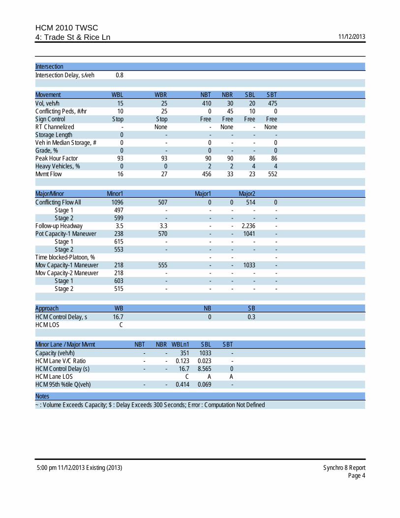
HCM 2010 TWSC4: Trade St & Rice Ln 11/12/2013
5:00 pm 11/12/2013 Existing (2013) Synchro 8 ReportPage 4
IntersectionIntersection Delay, s/veh 0.8
Movement WBL WBR NBT NBR SBL SBTVol, veh/h 15 25 410 30 20 475Conflicting Peds, #/hr 10 25 0 45 10 0Sign Control Stop Stop Free Free Free FreeRT Channelized - None - None - NoneStorage Length 0 - - - - -Veh in Median Storage, # 0 - 0 - - 0Grade, % 0 - 0 - - 0Peak Hour Factor 93 93 90 90 86 86Heavy Vehicles, % 0 0 2 2 4 4Mvmt Flow 16 27 456 33 23 552
Major/Minor Minor1 Major1 Major2Conflicting Flow All 1096 507 0 0 514 0 Stage 1 497 - - - - - Stage 2 599 - - - - -Follow-up Headway 3.5 3.3 - - 2.236 -Pot Capacity-1 Maneuver 238 570 - - 1041 - Stage 1 615 - - - - - Stage 2 553 - - - - -Time blocked-Platoon, % - - -Mov Capacity-1 Maneuver 218 555 - - 1033 -Mov Capacity-2 Maneuver 218 - - - - - Stage 1 603 - - - - - Stage 2 515 - - - - -
Approach WB NB SBHCM Control Delay, s 16.7 0 0.3HCM LOS C
Minor Lane / Major Mvmt NBT NBR WBLn1 SBL SBTCapacity (veh/h) - - 351 1033 -HCM Lane V/C Ratio - - 0.123 0.023 -HCM Control Delay (s) - - 16.7 8.565 0HCM Lane LOS C A AHCM 95th %tile Q(veh) - - 0.414 0.069 -
Notes~ : Volume Exceeds Capacity; $ : Delay Exceeds 300 Seconds; Error : Computation Not Defined

HCM 2010 TWSC5: Oak St & Nursery St 11/12/2013
5:00 pm 11/12/2013 Existing (2013) Synchro 8 ReportPage 5
IntersectionIntersection Delay, s/veh 3.1
Movement EBL EBT EBR WBL WBT WBR NBL NBT NBR SBL SBT SBRVol, veh/h 15 145 10 5 100 20 5 5 5 15 10 5Conflicting Peds, #/hr 10 0 10 10 0 10 10 0 40 10 0 10Sign Control Free Free Free Free Free Free Stop Stop Stop Stop Stop StopRT Channelized - - None - - None - - None - - NoneStorage Length - - - - - - - - - - - -Veh in Median Storage, # - 0 - - 0 - - 0 - - 0 -Grade, % - 0 - - 0 - - 0 - - 0 -Peak Hour Factor 88 88 88 93 93 93 44 44 44 50 50 50Heavy Vehicles, % 2 2 2 2 2 2 14 14 14 0 0 0Mvmt Flow 17 165 11 5 108 22 11 11 11 30 20 10
Major/Minor Major1 Major2 Minor1 Minor2Conflicting Flow All 139 0 0 216 0 0 399 395 220 395 389 138 Stage 1 - - - - - - 245 245 - 139 139 - Stage 2 - - - - - - 154 150 - 256 250 -Follow-up Headway 2.218 - - 2.218 - - 3.626 4.126 3.426 3.5 4 3.3Pot Capacity-1 Maneuver 1445 - - 1354 - - 540 524 791 568 549 916 Stage 1 - - - - - - 733 682 - 869 785 - Stage 2 - - - - - - 821 751 - 753 704 -Time blocked-Platoon, % - - - -Mov Capacity-1 Maneuver 1434 - - 1344 - - 492 496 761 534 519 902Mov Capacity-2 Maneuver - - - - - - 492 496 - 534 519 - Stage 1 - - - - - - 701 653 - 851 776 - Stage 2 - - - - - - 782 742 - 714 674 -
Approach EB WB NB SBHCM Control Delay, s 0.7 0.3 11.9 12.1HCM LOS B B
Minor Lane / Major Mvmt NBLn1 EBL EBT EBR WBL WBT WBR SBLn1Capacity (veh/h) 559 1434 - - 1344 - - 567HCM Lane V/C Ratio 0.061 0.012 - - 0.004 - - 0.106HCM Control Delay (s) 11.9 7.541 0 - 7.689 0 - 12.1HCM Lane LOS B A A A A BHCM 95th %tile Q(veh) 0.194 0.036 - - 0.012 - - 0.353
Notes~ : Volume Exceeds Capacity; $ : Delay Exceeds 300 Seconds; Error : Computation Not Defined

HCM 2010 TWSC6: Stanley St & 5th St 11/12/2013
5:00 pm 11/12/2013 Existing (2013) Synchro 8 ReportPage 6
IntersectionIntersection Delay, s/veh 0
Movement EBL EBT EBR WBL WBT WBR NBL NBT NBR SBL SBT SBRVol, veh/h 0 80 0 0 65 0 0 0 0 0 0 0Conflicting Peds, #/hr 10 0 10 10 0 10 10 0 10 10 0 10Sign Control Free Free Free Free Free Free Stop Stop Stop Stop Stop StopRT Channelized - - None - - None - - None - - NoneStorage Length - - - - - - - - - - - -Veh in Median Storage, # - 0 - - 0 - - 0 - - 0 -Grade, % - 0 - - 0 - - 0 - - 0 -Peak Hour Factor 92 92 92 92 92 92 92 92 92 92 92 92Heavy Vehicles, % 2 2 2 2 2 2 2 2 2 2 2 2Mvmt Flow 0 87 0 0 71 0 0 0 0 0 0 0
Major/Minor Major1 Major2 Minor1 Minor2Conflicting Flow All 81 0 0 97 0 0 178 178 107 178 178 91 Stage 1 - - - - - - 97 97 - 81 81 - Stage 2 - - - - - - 81 81 - 97 97 -Follow-up Headway 2.218 - - 2.218 - - 3.518 4.018 3.318 3.518 4.018 3.318Pot Capacity-1 Maneuver 1517 - - 1496 - - 784 716 947 784 716 967 Stage 1 - - - - - - 910 815 - 927 828 - Stage 2 - - - - - - 927 828 - 910 815 -Time blocked-Platoon, % - - - -Mov Capacity-1 Maneuver 1505 - - 1485 - - 772 705 933 772 705 952Mov Capacity-2 Maneuver - - - - - - 772 705 - 772 705 - Stage 1 - - - - - - 903 809 - 920 822 - Stage 2 - - - - - - 920 822 - 903 809 -
Approach EB WB NB SBHCM Control Delay, s 0 0 0 0HCM LOS A A
Minor Lane / Major Mvmt NBLn1 EBL EBT EBR WBL WBT WBR SBLn1Capacity (veh/h) 0 1505 - - 1485 - - 0HCM Lane V/C Ratio + - - - - - - +HCM Control Delay (s) 0 0 - - 0 - - 0HCM Lane LOS A A A AHCM 95th %tile Q(veh) + 0 - - 0 - - +
Notes~ : Volume Exceeds Capacity; $ : Delay Exceeds 300 Seconds; Error : Computation Not Defined

AMITY TRANSPORTATION SYSTEM PLAN
Attachment 4
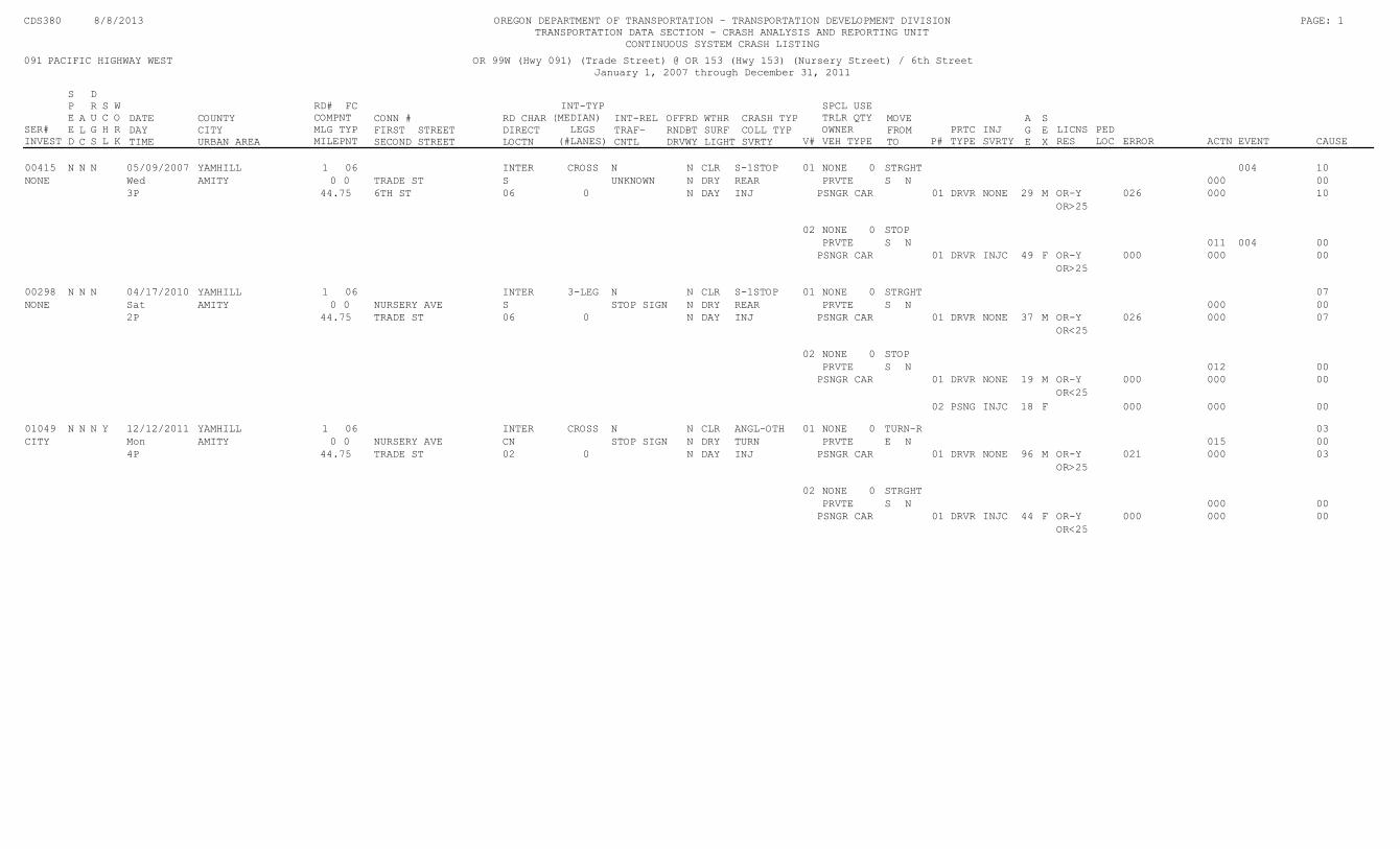
SER#INVEST
SPEED
ALC
DRUGS
SCHL
WORK
DATEDAYTIME
COUNTYCITYURBAN AREA
RD# FCCOMPNTMLG TYPMILEPNT
CONN #FIRST STREETSECOND STREET
RD CHARDIRECTLOCTN
INT-TYP(MEDIAN)
LEGS(#LANES)
INT-RELTRAF-CNTL
OFFRDRNDBTDRVWY
WTHRSURFLIGHT
CRASH TYPCOLL TYPSVRTY V#
SPCL USETRLR QTYOWNERVEH TYPE
MOVEFROMTO P#
PRTCTYPE
INJ SVRTY
LICNSRES
PEDLOC ERROR ACTN EVENT CAUSE
091 PACIFIC HIGHWAY WEST
CDS380 8/8/2013 OREGON DEPARTMENT OF TRANSPORTATION - TRANSPORTATION DEVELOPMENT DIVISION TRANSPORTATION DATA SECTION - CRASH ANALYSIS AND REPORTING UNIT
CONTINUOUS SYSTEM CRASH LISTING
OR 99W (Hwy 091) (Trade Street) @ OR 153 (Hwy 153) (Nursery Street) / 6th StreetJanuary 1, 2007 through December 31, 2011
PAGE: 1
AGE
SEX
0600415 N N INTER CROSS N S-1STOPN 05/09/2007 10CLRN NONE 004YAMHILL STRGHT01 01NONE REAR NWed 00DRYNUNKNOWN PRVTE 000STRADE ST SAMITY 00
INJ 44.753P DAYN 0 PSNGR CAR 29DRVR OR-Y 026 10000066TH ST NONE01 M
OR>25
NONE STOP02 0N 004 00PRVTE 011S
PSNGR CAR 49DRVR OR-Y 000 00000INJC01 F
OR>25
0600298 N N INTER 3-LEG N S-1STOPN 04/17/2010 07CLRN NONEYAMHILL STRGHT01 01NONE REAR NSat 00DRYNSTOP SIGN PRVTE 000SNURSERY AVE SAMITY 00
INJ 44.752P DAYN 0 PSNGR CAR 37DRVR OR-Y 026 0700006TRADE ST NONE01 M
OR<25
NONE STOP02 0N 00PRVTE 012S
PSNGR CAR 19DRVR OR-Y 000 00000NONE01 M
OR<25
18PSNG 000 00000INJC02 F
0601049 N N INTER CROSS N ANGL-OTHN 12/12/2011 03CLRN NONEYAMHILLY TURN-R01 01CITY TURN NMon 00DRYNSTOP SIGN PRVTE 015ENURSERY AVE CNAMITY 00
INJ 44.754P DAYN 0 PSNGR CAR 96DRVR OR-Y 021 0300002TRADE ST NONE01 M
OR>25
NONE STRGHT02 0N 00PRVTE 000S
PSNGR CAR 44DRVR OR-Y 000 00000INJC01 F
OR<25
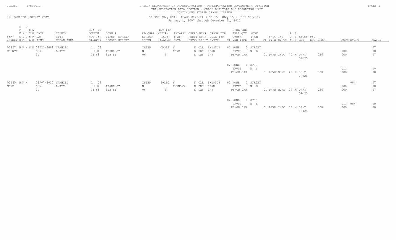
SER#INVEST
SPEED
ALC
DRUGS
SCHL
WORK
DATEDAYTIME
COUNTYCITYURBAN AREA
RD# FCCOMPNTMLG TYPMILEPNT
CONN #FIRST STREETSECOND STREET
RD CHARDIRECTLOCTN
INT-TYP(MEDIAN)
LEGS(#LANES)
INT-RELTRAF-CNTL
OFFRDRNDBTDRVWY
WTHRSURFLIGHT
CRASH TYPCOLL TYPSVRTY V#
SPCL USETRLR QTYOWNERVEH TYPE
MOVEFROMTO P#
PRTCTYPE
INJ SVRTY
LICNSRES
PEDLOC ERROR ACTN EVENT CAUSE
091 PACIFIC HIGHWAY WEST
CDS380 8/8/2013 OREGON DEPARTMENT OF TRANSPORTATION - TRANSPORTATION DEVELOPMENT DIVISION TRANSPORTATION DATA SECTION - CRASH ANALYSIS AND REPORTING UNIT
CONTINUOUS SYSTEM CRASH LISTING
OR 99W (Hwy 091) (Trade Street) @ OR 153 (Hwy 153) (5th Street)January 1, 2007 through December 31, 2011
PAGE: 1
AGE
SEX
0600857 N N INTER CROSS N S-1STOPN 09/21/2008 07CLRN NONEYAMHILLN N STRGHT01 01COUNTY REAR SSun 00DRYNNONE PRVTE 000NTRADE ST NAMITY 00
INJ 44.683P DAYN 0 PSNGR CAR 70DRVR OR-Y 026 07000065TH ST INJC01 M
OR<25
NONE STOP02 0S 00PRVTE 011N
PSNGR CAR 42DRVR OR-Y 000 00000NONE01 F
OR<25
0600145 N N INTER 3-LEG N S-1STOPN 02/07/2010 07CLRN NONE 004YAMHILL STRGHT01 01NONE REAR SSun 00DRYNUNKNOWN PRVTE 000NTRADE ST NAMITY 00
INJ 44.683P DAYN 0 PSNGR CAR 27DRVR OR-Y 026 07000065TH ST NONE01 M
OR<25
NONE STOP02 0S 004 00PRVTE 011N
PSNGR CAR 38DRVR OR-Y 000 00000INJC01 M
OR<25
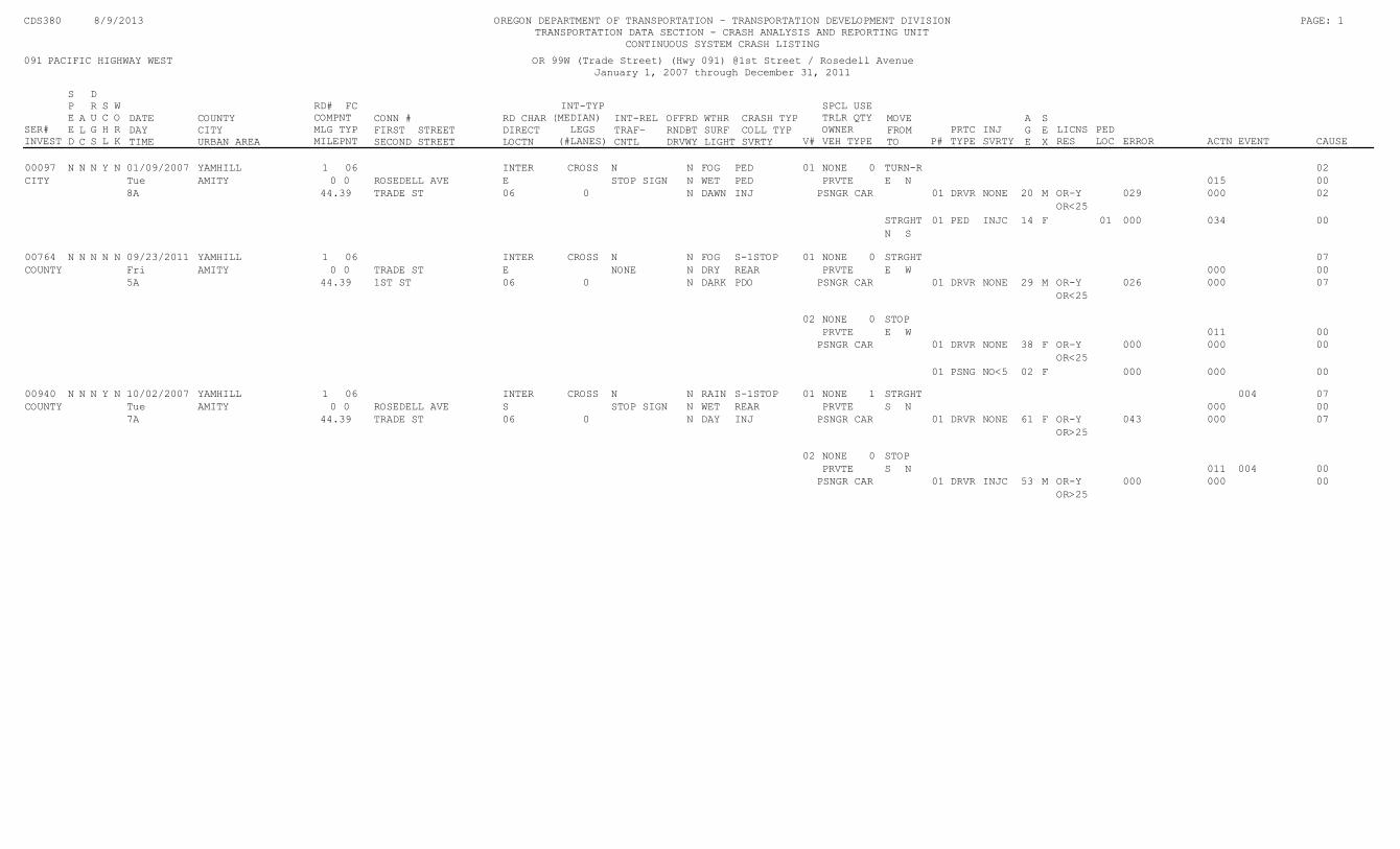
SER#INVEST
SPEED
ALC
DRUGS
SCHL
WORK
DATEDAYTIME
COUNTYCITYURBAN AREA
RD# FCCOMPNTMLG TYPMILEPNT
CONN #FIRST STREETSECOND STREET
RD CHARDIRECTLOCTN
INT-TYP(MEDIAN)
LEGS(#LANES)
INT-RELTRAF-CNTL
OFFRDRNDBTDRVWY
WTHRSURFLIGHT
CRASH TYPCOLL TYPSVRTY V#
SPCL USETRLR QTYOWNERVEH TYPE
MOVEFROMTO P#
PRTCTYPE
INJ SVRTY
LICNSRES
PEDLOC ERROR ACTN EVENT CAUSE
091 PACIFIC HIGHWAY WEST
CDS380 8/9/2013 OREGON DEPARTMENT OF TRANSPORTATION - TRANSPORTATION DEVELOPMENT DIVISION TRANSPORTATION DATA SECTION - CRASH ANALYSIS AND REPORTING UNIT
CONTINUOUS SYSTEM CRASH LISTING
OR 99W (Trade Street) (Hwy 091) @1st Street / Rosedell AvenueJanuary 1, 2007 through December 31, 2011
PAGE: 1
AGE
SEX
0600097 N N INTER CROSS N PEDN 01/09/2007 02FOGN NONEYAMHILLY N TURN-R01 01CITY PED NTue 00WETNSTOP SIGN PRVTE 015EROSEDELL AVE EAMITY 00
INJ 44.398A DAWNN 0 PSNGR CAR 20DRVR OR-Y 029 0200006TRADE ST NONE01 M
OR<25
14PED 000 00034STRGHT INJC01 F 01
SN
0600764 N N INTER CROSS N S-1STOPN 09/23/2011 07FOGN NONEYAMHILLN N STRGHT01 01COUNTY REAR WFri 00DRYNNONE PRVTE 000ETRADE ST EAMITY 00
PDO 44.395A DARKN 0 PSNGR CAR 29DRVR OR-Y 026 07000061ST ST NONE01 M
OR<25
NONE STOP02 0W 00PRVTE 011E
PSNGR CAR 38DRVR OR-Y 000 00000NONE01 F
OR<25
02PSNG 000 00000NO<501 F
0600940 N N INTER CROSS N S-1STOPN 10/02/2007 07RAINN NONE 004YAMHILLY N STRGHT01 11COUNTY REAR NTue 00WETNSTOP SIGN PRVTE 000SROSEDELL AVE SAMITY 00
INJ 44.397A DAYN 0 PSNGR CAR 61DRVR OR-Y 043 0700006TRADE ST NONE01 F
OR>25
NONE STOP02 0N 004 00PRVTE 011S
PSNGR CAR 53DRVR OR-Y 000 00000INJC01 M
OR>25

OREGON DEPARTMENT OF TRANSPORTATION - TRANSPORTATION DEVELOPMENT DIVISION
TRANSPORTATION DATA SECTION - CRASH ANALYSIS AND REPORTING UNIT
CRASH SUMMARIES BY YEAR BY COLLISION TYPE
PAGE: 1
OR 99W (Trade Street) (Hwy 091) @ Rice Lane/ Avenue
January 1, 2007 through December 31, 2011
COLLISION TYPE
FATAL
CRASHES
NON-
FATAL
CRASHES
PROPERTY
DAMAGE
ONLY
TOTAL
CRASHES
PEOPLE
KILLED
PEOPLE
INJURED
DRY
SURF
WET
SURF DAY DARK
INTER-
SECTION
INTER-
SECTION
RELATED
OFF-
ROADTRUCKS
CDS150 08/09/2013
YEAR:
TOTAL
FINAL TOTAL
Disclaimer: A higher number of crashes are reported for the 2011 data file compared to previous years. This does not reflect an increase in annual crashes. The higher numbers
result from a change to an internal departmental process that allows the Crash Analysis and Reporting Unit to add previously unavailable, non-fatal crash reports to the annual
data file. Please be aware of this change when comparing pre-2011 crash statistics.
OREGON DEPARTMENT OF TRANSPORTATION - TRANSPORTATION DEVELOPMENT DIVISION
TRANSPORTATION DATA SECTION - CRASH ANALYSIS AND REPORTING UNIT
CRASH SUMMARIES BY YEAR BY COLLISION TYPE
PAGE: 1
OR 153 (Nursery Street) (Hwy 153) @ Oak Avenue
January 1, 2007 through December 31, 2011
COLLISION TYPE
FATAL
CRASHES
NON-
FATAL
CRASHES
PROPERTY
DAMAGE
ONLY
TOTAL
CRASHES
PEOPLE
KILLED
PEOPLE
INJURED
DRY
SURF
WET
SURF DAY DARK
INTER-
SECTION
INTER-
SECTION
RELATED
OFF-
ROADTRUCKS
CDS150 08/09/2013
YEAR:
TOTAL
FINAL TOTAL
Disclaimer: A higher number of crashes are reported for the 2011 data file compared to previous years. This does not reflect an increase in annual crashes. The higher numbers
result from a change to an internal departmental process that allows the Crash Analysis and Reporting Unit to add previously unavailable, non-fatal crash reports to the annual
data file. Please be aware of this change when comparing pre-2011 crash statistics.

SER#INVEST
SPEED
ALC
DRUGS
SCHL
WORK
DATEDAYTIME
COUNTYCITYURBAN AREA
RD# FCCOMPNTMLG TYPMILEPNT
CONN #FIRST STREETSECOND STREET
RD CHARDIRECTLOCTN
INT-TYP(MEDIAN)
LEGS(#LANES)
INT-RELTRAF-CNTL
OFFRDRNDBTDRVWY
WTHRSURFLIGHT
CRASH TYPCOLL TYPSVRTY V#
SPCL USETRLR QTYOWNERVEH TYPE
MOVEFROMTO P#
PRTCTYPE
INJ SVRTY
LICNSRES
PEDLOC ERROR ACTN EVENT CAUSE
091 PACIFIC HIGHWAY WEST
CDS380 8/13/2013 OREGON DEPARTMENT OF TRANSPORTATION - TRANSPORTATION DEVELOPMENT DIVISION TRANSPORTATION DATA SECTION - CRASH ANALYSIS AND REPORTING UNIT
CONTINUOUS SYSTEM CRASH LISTING
OR 153 (Nursery Street) (Hwy 153) from OR 99W (Trade Street) (Hwy 091) to east city limitJanuary 1, 2007 through December 31, 2011
PAGE: 1
AGE
SEX
0600415 N N INTER CROSS N S-1STOPN 05/09/2007 10CLRN NONE 004YAMHILL STRGHT01 01NONE REAR NWed 00DRYNUNKNOWN PRVTE 000STRADE ST SAMITY 00
INJ 44.753P DAYN 0 PSNGR CAR 29DRVR OR-Y 026 10000066TH ST NONE01 M
OR>25
NONE STOP02 0N 004 00PRVTE 011S
PSNGR CAR 49DRVR OR-Y 000 00000INJC01 F
OR>25
0600298 N N INTER 3-LEG N S-1STOPN 04/17/2010 07CLRN NONEYAMHILL STRGHT01 01NONE REAR NSat 00DRYNSTOP SIGN PRVTE 000SNURSERY AVE SAMITY 00
INJ 44.752P DAYN 0 PSNGR CAR 37DRVR OR-Y 026 0700006TRADE ST NONE01 M
OR<25
NONE STOP02 0N 00PRVTE 012S
PSNGR CAR 19DRVR OR-Y 000 00000NONE01 M
OR<25
18PSNG 000 00000INJC02 F
0601049 N N INTER CROSS N ANGL-OTHN 12/12/2011 03CLRN NONEYAMHILLY TURN-R01 01CITY TURN NMon 00DRYNSTOP SIGN PRVTE 015ENURSERY AVE CNAMITY 00
INJ 44.754P DAYN 0 PSNGR CAR 96DRVR OR-Y 021 0300002TRADE ST NONE01 M
OR>25
NONE STRGHT02 0N 00PRVTE 000S
PSNGR CAR 44DRVR OR-Y 000 00000INJC01 F
OR<25
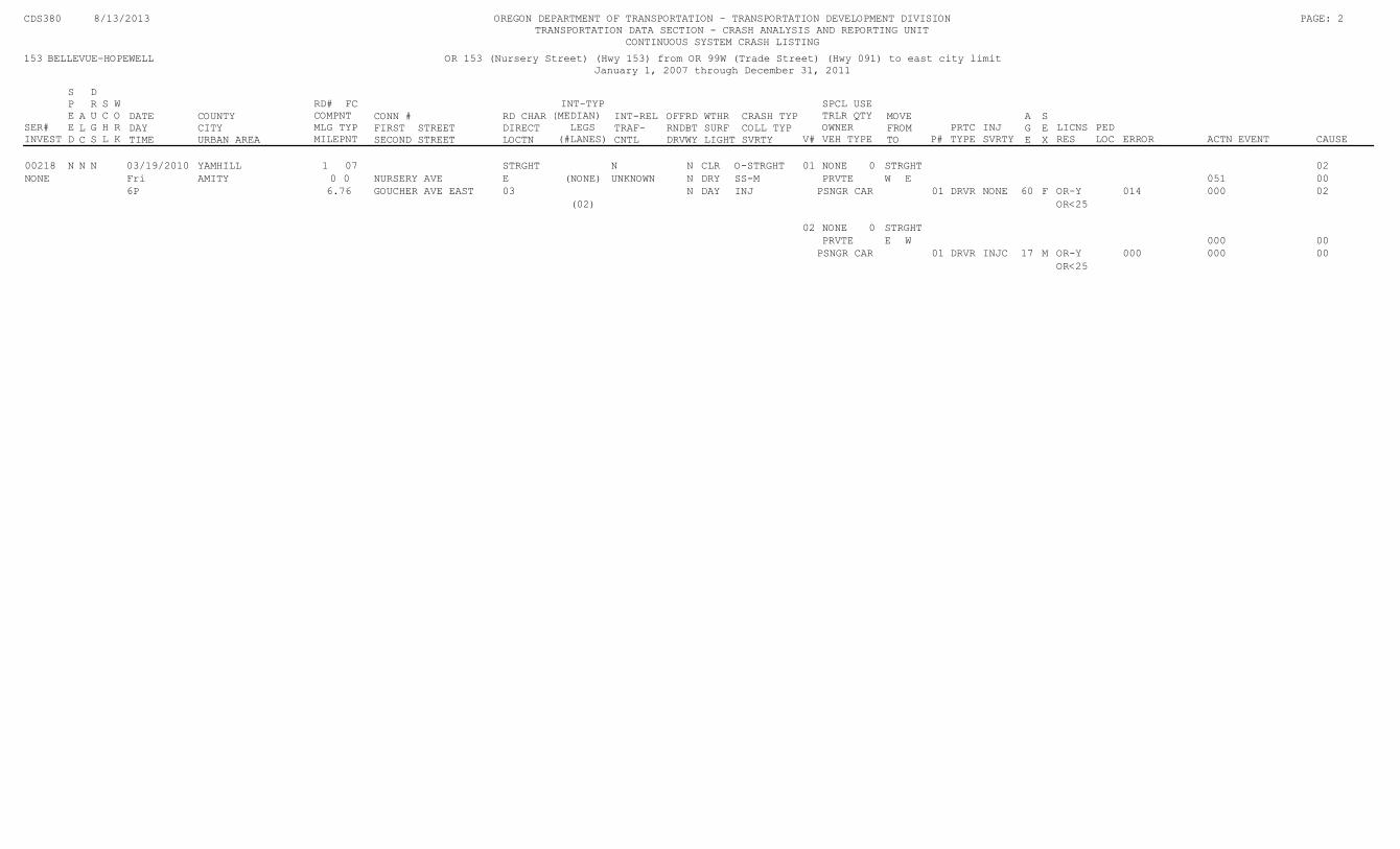
SER#INVEST
SPEED
ALC
DRUGS
SCHL
WORK
DATEDAYTIME
COUNTYCITYURBAN AREA
RD# FCCOMPNTMLG TYPMILEPNT
CONN #FIRST STREETSECOND STREET
RD CHARDIRECTLOCTN
INT-TYP(MEDIAN)
LEGS(#LANES)
INT-RELTRAF-CNTL
OFFRDRNDBTDRVWY
WTHRSURFLIGHT
CRASH TYPCOLL TYPSVRTY V#
SPCL USETRLR QTYOWNERVEH TYPE
MOVEFROMTO P#
PRTCTYPE
INJ SVRTY
LICNSRES
PEDLOC ERROR ACTN EVENT CAUSE
153 BELLEVUE-HOPEWELL
CDS380 8/13/2013 OREGON DEPARTMENT OF TRANSPORTATION - TRANSPORTATION DEVELOPMENT DIVISION TRANSPORTATION DATA SECTION - CRASH ANALYSIS AND REPORTING UNIT
CONTINUOUS SYSTEM CRASH LISTING
OR 153 (Nursery Street) (Hwy 153) from OR 99W (Trade Street) (Hwy 091) to east city limitJanuary 1, 2007 through December 31, 2011
PAGE: 2
AGE
SEX
0700218 N N STRGHT N O-STRGHTN 03/19/2010 02CLRN NONEYAMHILL STRGHT01 01NONE SS-M EFri 00DRYNUNKNOWN(NONE) PRVTE 051WNURSERY AVE EAMITY 00
INJ 6.766P DAYN PSNGR CAR 60DRVR OR-Y 014 0200003GOUCHER AVE EAST NONE01 F
(02) OR<25
NONE STRGHT02 0W 00PRVTE 000E
PSNGR CAR 17DRVR OR-Y 000 00000INJC01 M
OR<25
OREGON DEPARTMENT OF TRANSPORTATION - TRANSPORTATION DEVELOPMENT DIVISION
TRANSPORTATION DATA SECTION - CRASH ANALYSIS AND REPORTING UNIT
CRASH SUMMARIES BY YEAR BY COLLISION TYPE
PAGE: 1
Rice Lane/Avenue from OR 99W (Trade St) (Hwy 091) to Jellison Street
January 1, 2007 through December 31, 2011
COLLISION TYPE
FATAL
CRASHES
NON-
FATAL
CRASHES
PROPERTY
DAMAGE
ONLY
TOTAL
CRASHES
PEOPLE
KILLED
PEOPLE
INJURED
DRY
SURF
WET
SURF DAY DARK
INTER-
SECTION
INTER-
SECTION
RELATED
OFF-
ROADTRUCKS
CDS150 08/13/2013
YEAR:
TOTAL
FINAL TOTAL
Disclaimer: A higher number of crashes are reported for the 2011 data file compared to previous years. This does not reflect an increase in annual crashes. The higher numbers
result from a change to an internal departmental process that allows the Crash Analysis and Reporting Unit to add previously unavailable, non-fatal crash reports to the annual
data file. Please be aware of this change when comparing pre-2011 crash statistics.
OREGON DEPARTMENT OF TRANSPORTATION - TRANSPORTATION DEVELOPMENT DIVISION
TRANSPORTATION DATA SECTION - CRASH ANALYSIS AND REPORTING UNIT
CRASH SUMMARIES BY YEAR BY COLLISION TYPE
PAGE: 1
Jellison Street from Rice Avenue to 3rd Street
January 1, 2007 through December 31, 2011
COLLISION TYPE
FATAL
CRASHES
NON-
FATAL
CRASHES
PROPERTY
DAMAGE
ONLY
TOTAL
CRASHES
PEOPLE
KILLED
PEOPLE
INJURED
DRY
SURF
WET
SURF DAY DARK
INTER-
SECTION
INTER-
SECTION
RELATED
OFF-
ROADTRUCKS
CDS150 08/09/2013
YEAR:
TOTAL
FINAL TOTAL
Disclaimer: A higher number of crashes are reported for the 2011 data file compared to previous years. This does not reflect an increase in annual crashes. The higher numbers
result from a change to an internal departmental process that allows the Crash Analysis and Reporting Unit to add previously unavailable, non-fatal crash reports to the annual
data file. Please be aware of this change when comparing pre-2011 crash statistics.
Oregon Department of Transportation
Region2012 - Top 10% SPIS Groups - By Hwy, MP
PercentileConnection in GroupCountyCityFatalCrshADTLgthEMPBMPRte. SPIS
Statewide
B C PDOARdwy
PACIFIC HIGHWAY WEST091 30,700 MULTNOMAH 90 52.19 27 5 11 111 2.25 2.38 0.13
20,700 MULTNOMAH 90 43.89 12 1 2 3 61 5.35 5.48 0.13
15,600 MULTNOMAH 95 83.98 43 1 3 13 251 1 6.12 6.30 0.18
19,900 MULTNOMAH 091AI CONN. M.P. 1C7.56 95 81.03 40 1 9 15 151 7.47 7.71 0.24
19,900 MULTNOMAH SW 64TH AVE. 95 81.03 40 1 9 15 151 7.47 7.71 0.24
OR-99W 45,000 WASHINGTON 71ST AVE. 95 74.58 36 2 5 17 121 7.71 8.11 0.40
OR-99W 45,000 WASHINGTON VILLA RIDGE RD. 95 74.58 36 2 5 17 121 7.71 8.11 0.40
OR-99W 50,200 WASHINGTON 95 61.87 44 3 16 251 8.34 8.59 0.25
OR-99W 50,200 WASHINGTON 144BL CONN. M.P. 2C6.48 90 51.24 40 2 11 271 8.52 8.65 0.13
OR-99W 49,100 WASHINGTON 95 79.86 62 1 31 301 8.58 9.03 0.45
OR-99W 33,100 WASHINGTON 90 48.98 15 1 3 5 61 9.37 9.54 0.17
OR-99W 40,700 WASHINGTON SW MCKENZIE ST. 95 62.79 27 1 4 9 131 9.56 9.73 0.17
OR-99W 40,600 WASHINGTON SW GARRETT ST. 90 45.68 23 6 8 91 9.82 9.92 0.10
OR-99W 38,800 WASHINGTON 95 80.46 57 1 4 25 271 10.26 10.46 0.20
OR-99W 38,800 WASHINGTON 90 52.53 30 4 12 141 10.86 11.04 0.18
OR-99W 37,700 WASHINGTON 90 47.62 26 4 10 121 11.84 11.96 0.12
OR-99W 37,700 WASHINGTON 95 54.15 19 1 3 7 81 12.57 12.75 0.18
OR-99W 30,700 WASHINGTON 95 72.29 34 1 1 15 171 14.91 15.09 0.18
OR-99W 38,300 WASHINGTON 90 43.31 12 1 1 5 51 15.92 16.01 0.09
OR-99W 38,300 WASHINGTON 95 56.57 32 5 13 141 16.58 16.75 0.17
OR-99W 34,900 YAMHILL 90 45.45 6 2 41 19.91 20.09 0.18
OR-99W 33,400 YAMHILL 95 55.48 18 1 2 9 61 21.71 21.89 0.18
OR-99W 33,400 YAMHILL 95 74.80 44 1 4 11 281 21.96 22.14 0.18
OR-99W 38,500 YAMHILL 90 47.07 28 3 10 151 22.38 22.54 0.16
OR-99W 38,800 YAMHILL N EVEREST ST. 95 63.03 30 1 3 9 171 22.80 22.89 0.09
OR-99W 38,800 YAMHILL 90 42.99 26 2 9 151 22.86 22.95 0.09
OR-99W 28,600 YAMHILL 90 46.49 13 1 3 4 51 25.44 25.62 0.18
OR-99W 28,600 YAMHILL SW 4TH ST. 90 50.88 24 5 11 81 25.74 25.85 0.11
OR-99W 28,600 YAMHILL 90 43.07 21 3 9 91 25.79 25.91 0.12
OR-99W 25,800 YAMHILL 90 50.21 22 1 1 4 161 26.06 26.20 0.14
OR-99W 10,300 YAMHILL 90 47.04 13 1 1 3 81 32.25 32.38 0.13
OR-99W 18,900 YAMHILL 90 50.68 16 1 1 6 81 35.39 35.49 0.10
OR-99W 22,100 YAMHILL 90 49.32 24 2 12 101 36.27 36.45 0.18
OR-99W 22,100 YAMHILL 95 76.80 30 3 5 13 91 36.62 36.80 0.18
OR-99W 12,300 YAMHILL THIRD ST. 95 72.06 14 3 2 3 62 37.66 37.84 0.18
OR-99W 12,900 YAMHILL NE 3RD ST. 90 51.95 27 12 151 37.67 37.82 0.15
OR-99W 18,900 YAMHILL 95 59.83 11 2 1 4 41 38.67 38.84 0.17
OR-99W 10,100 YAMHILL 90 51.93 7 1 1 41 1 39.91 40.02 0.11
OR-99W 7,800 YAMHILL 90 45.53 3 2 11 41.86 42.04 0.18
OR-99W 4,300 POLK 95 54.31 10 1 6 1 21 49.63 49.81 0.18
OR-99W 11,700 POLK 95 66.66 11 2 3 5 11 59.94 62.40 2.46
OR-99W 16,000 BENTON 95 56.56 25 3 14 81 81.68 81.86 0.18
OR-99W 12,300 BENTON 95 80.30 31 1 7 11 122 83.26 83.44 0.18
OR-99 11,000 LANE 90 46.78 22 3 7 121 109.16 109.26 0.10
OR-99 14,100 LANE 90 45.64 23 3 7 131 109.19 109.34 0.15
OR-99 19,500 LANE RICHARD AVE. 95 68.51 16 1 3 5 61 1 120.52 120.70 0.18
OR-99 22,300 LANE 95 77.39 37 1 5 12 191 121.05 121.23 0.18
OR-99 18,100 LANE 7TH PL. 95 82.42 42 2 2 12 261 122.17 122.35 0.18
OR-99 24,200 LANE GRANT ST. 95 80.45 43 3 7 8 251 122.30 122.57 0.27
OR-99 21,100 LANE GRANT ST. 95 60.28 35 5 12 182 122.31 122.49 0.18
July 25, 2012 Page 14 of 19SPIS Report 2012 (2009-2011 Data)
**The crash data shown in the SPIS group report reflects the highest SPIS site in that group used in calculating the SPIS score.
Oregon Department of Transportation
Region2012 - Top 10% SPIS Groups - By Hwy, MP
PercentileConnection in GroupCountyCityFatalCrshADTLgthEMPBMPRte. SPIS
Statewide
B C PDOARdwy
HILLSBORO-SILVERTON140OR-219 8,800 WASHINGTON BURKHALTER RD. 95 66.87 11 2 4 3 21 3.75 3.93 0.18
OR-219 8,800 WASHINGTON SIMPSON RD. 95 66.87 11 2 4 3 21 3.75 3.93 0.18
OR-219 8,400 WASHINGTON FARMINGTON RD. 90 43.67 9 1 1 3 41 5.45 5.54 0.09
OR-219 3,700 WASHINGTON 95 55.42 5 2 2 11 6.19 6.34 0.15
OR-219 3,100 WASHINGTON 95 74.96 12 2 1 5 41 9.60 9.79 0.19
OR-219 2,700 WASHINGTON 90 48.83 3 2 11 10.91 11.07 0.16
OR-219 10,900 YAMHILL 90 48.35 22 3 8 111 21.11 21.29 0.18
OR-214 24,900 MARION 90 52.61 37 6 6 251 36.93 37.06 0.13
OR-214 19,200 MARION 90 43.56 23 4 6 131 37.06 37.15 0.09
OR-214 5,200 MARION 90 43.35 6 3 21 1 43.70 43.87 0.17
BEAVERTON-TUALATIN141OR-141 25,100 WASHINGTON 95 56.97 40 3 11 261 2.75 2.93 0.18
OR-141 11,800 WASHINGTON 90 47.11 11 1 3 3 41 4.60 4.75 0.15
OR-141 9,500 WASHINGTON 95 55.31 26 2 11 131 4.88 5.04 0.16
OR-141 12,900 WASHINGTON SW AVON ST. 95 58.35 19 1 2 7 91 6.99 7.78 0.79
FARMINGTON142OR-10 12,600 WASHINGTON 90 44.17 10 1 5 41 6.00 6.14 0.14
OR-10 12,600 WASHINGTON 90 43.01 9 1 5 31 6.08 6.17 0.09
SCHOLLS143OR-210 40,300 WASHINGTON 95 83.68 76 4 8 30 341 9.03 9.15 0.12
OR-210 16,900 WASHINGTON 95 89.21 66 8 20 381 9.35 9.60 0.25
BEAVERTON-TIGARD144OR-217 114,600 WASHINGTON 95 57.69 30 1 2 9 181 1.07 1.25 0.18
OR-217 118,700 WASHINGTON 90 47.21 17 1 8 81 2.91 3.07 0.16
OR-217 105,800 WASHINGTON 95 55.88 22 1 1 11 91 4.43 4.57 0.14
SALEM-DAYTON150OR-221 28,500 POLK 95 67.59 27 1 4 11 111 20.30 20.52 0.22
OR-221 38,100 POLK 95 55.09 32 5 12 151 20.48 20.67 0.19
YAMHILL-NEWBERG151OR-240 6,600 YAMHILL 90 48.49 4 2 1 11 8.63 8.79 0.16
LAFAYETTE154OR-154 4,000 YAMHILL 95 56.42 5 2 31 4.86 5.03 0.17
AMITY-DAYTON155OR-233 1,100 YAMHILL 90 46.71 11 4 1 61 5.00 5.16 0.16
July 25, 2012 Page 16 of 19SPIS Report 2012 (2009-2011 Data)
**The crash data shown in the SPIS group report reflects the highest SPIS site in that group used in calculating the SPIS score.
######
#
####
#######
##########
##########
####
##########
##########
######
##
#
##
##
##
#
##
#
##
#
## #
##
##
#### # #
#
#
#
#
##
#
#
#
# #
##
#
####
#
##
#
#
##
##
##
#
#
######
###
#
###
##
#
#
#
#
######
##
##
####
##
#
#
#
##
#
#
#
#
#####
#
#
#
#####
###
##
#
#
#
#
#
#
####
#
###
#
###
##
##
###
#
##
##
#
##
#### #
#
#
#
### ##
##
#
##
#
#
#
#
#
#
#
#
#
#####
##
##
##
##
#
#
#
#
#
#####
##
##
###
# ##
##
##
##
#
####
#
##
#
##
#
###
# #
#
#
#
##
#
#
# ##
##
##
#
# #
##
##
#
##
#### ##
#
#
#
##
# #
##
#
#
##
#
##
#
##
#
#
##
#
# #
#
##
#
##
#
#
##
#
#
##
##
##
#
###
#
#
# #
# ##
#
#
##
#
#
#
#
## #
##
#
#
##
#
#
####
#
#
##
#
##
##
####
##
##
##
##
#
##
#
#
#
#
#####
#
#
##
#
##
###
#
##
#
#
##
##
##
##
###
##
##
#
#
#### ###
#
##
#
##
#
####
#
##
#
#
#
#
#
#
#
##
##
#
#
#
#
#
#
##
##
#
#
# #
##
#
#
## # # #
#
##
#
#
#
# #
#
#
##
##
####
##
#
###
##
#
##
#
#
#
#
### ### #
#
##
#
#
#
### ###
#
##
##
##
##
#
#
#
##
#
#
##
##
#
###
#
##
#
#
##
#
#
##
#
#
#
###
##
###
##
# ##
#
##
#
##
#
#
#
### ##
##
####
#
#
##
##
##
#
#
#
##
#
#
#
### ###
#
##
#
#
#
##
##
###
##
##
#
##
#
##
#
##
#
##
#
##
#
##
#
##
# #
##
# #
#
##
#
#
#
#
# # #
#
#
##
##
#
#
# #
##
#
#
##
####
#
#
##
#
#
# #
##
#
#
###
##
##
#
##
###
##
#
#
#
#
#
#
###
#
###### ###
##
##
#
#### #
##
##
#
#
##
##
##
##
#
#
##
###
##
##
###
#
#
##
#
#
#
##
##
#
# #
##
#
##
#
#
## # # #
#
#
#
##
#
#
##
#
#
## #####
###
###
# #
##
#
##
#
#
#
#
#
#
#
#
##
###
##
####
#
#
#
##
#
##
##
#
##
##
#
###
#
##
### #
#
#
##
#
#
#
#
##
#
#
#
#
#
#
#
#
#
##
##
##
##
##
###
##
##
##
#
#
#
##
# ##
#
##
#
#
##
#
##
#
###
#
##
#
#
##
#
###
#
#
##
#
#
#
#
#
##
#
#
##
#
####
#
#
##
#
#
#
#
#
#
#
#
##
##
#
#
#
##
##
##
#
#
#
##
#
#
#
##
#
###
#
##
#
#
#
#
#
# #
###
#
#
###
##
##
###
#
#
#
#
##
#
#
#
#####
##
#
#
#
#
##
#
#
####
##
##
##
#
#
#
####
##
#
##
# #
##
#
#
### #
#
#
##
##
#
####
##
##
#
#
##
#
#
#
##
#
### ##
##
#
#
#
#
#
# #
#
##
#
#
#
#
##
##
# #
#
###
##
#
##
#
##
#
###
##
#
##
### ##
##
##
#
#
#
##
#
## #
##
#
#####
#
#
#
#
#
###
#
##
#
#
#####
####
#
###
##
#
#
#
##
#
######
#
#
#
##
##
##
###
#
#
#
#
#
#
#
# ##
#
##
#
#
## #
#
##
#
#
#
## ##
#
##
#
##
###
#
#
#
#
#
#
##
##
#####
#
##
#
#
##
#
#
##
#
# #
###
##
##
##
# # # #
#
##
#
#
#
#
#
#
## ##
#
#
#
####
## #
####
#
#
##
#
##
#
#####
##
##
##
#
# #
#
##
#
#
#
###
#
##
##
##
###
##
#
#
#
##
#
#
##
#
##
##
##
#
##
#
#
#
##
#
#
## ###
###
##
#
##
#
#
##
#
##
#
##
#
#
#
#
#
#
##
#
###
#
#
###
##
#
# # #
#
#
#
##
##
#
### ##
##
#####
#
#
##
##
#
#
#
##
#
##
#
#
###
##
#
##
## #
#
#
#
#
##
#
#
#
#
#
## #
###
######
##
##
#
##
##
#
##
#
#####
###
##
##
###
#
##
#
##
##
#
## ## #
#
#
#
#
#
#
## #
##
#
#
###
#
##
###
#
#
#
#
#
#
#
#
#####
##
##
#
#
##
#
#
#
####
##
##
##
##
####
##
#
#
#
###
#
# ###### ##
##
##
#
#
###
##
###
#
#
#
#
##
##
##
##
##
#
##
#
# #
##
##
##
### #
#
#
#
##
#
#
#
# #
#
#
#
#
#
#
####
##
##
#
##
##
##
#
#
#
######
##
##
#
# ##
#
#
#
####
##
##
##
###
#
#
#
##
#
##
##
#
##
#
#
#
#
#
##
## ##
##
##
#
#
#
#
#
#
#
###
###
##
#
####
#
#
##
#
###
###
##
##
#
##
#
###
#
#####
#
#
#
#
##
#
#
#
###
# #
##
#
##
##
#
#
#
#
##
##
##
#
#
#
##
#
#
#
## ##
#
#
#
#
#
#
##
##
#
###
##
#
#
#
##
#
# #
#
##
#
##
#
#
##
#
#
##
#
#
#
##
##
#
#
# ##
#
##
#
##
#
#
# #
##
#
#
##
#
##
#
#
#####
#
#
#
#
#
##
#
##
####
##
#
#
##
## #
##
#
#
#
###
#
#
##
#
##
###
#
#
#
#
#
#
#
#
#
##
###
#
#
##
#
#
### ###
#
##
#
##
## #
##
## #
#
#
##
##
##
##
#
#
#
#
#
#
#
#
##
#
##
#
##
#
#
#
#### ## #
#
#
##
#
#
# #
###
##
##
#
#
#
#
###
##
#
##
#
#
##
######
##
##
##
#
#
#
#
####
#
#
##
##
##
###
##
##
#
#
##
#
## #
#
### ###
##
#
##
#
##
#
#
#
###
#
#
#
##
##
# #
#
###
##
##
#
#
#
###
#
##
#
#
#
##
#
##
#
###
##
#
#
#
#
#
# ##
#
##
#
# #
##
##
#
#
### ##
#
#
#
##
###
##
####
#
##
#
#
##
####
##
##
#
##
##
#
##
##
#
##
#
###
#
#
##
##
# # #
#
#
#
##
#
#
#
#
## ##
##
#
###
# #
####
#
#
##
##
##
####
##
##
######
############
#
##
###
########
#
#### ##### ##
##
#
#
#
#
#
### #
#
##
#
#
#
#
#
##
##
#######
###################
#
##
##
#
#
##
##
#
#
#
#
##
##
#
#
##
##
##
# ##
##
##
#
##
###
##
##
##
##
#
##
##
#
##
#
##
##
##
#
## ##
# #
##
#
#
#
#
#
#
#
###
#
#
##
##
##
##
#
##
#
#
#
##
##
##
##
##
##
##
#
#
#
##
#
### ####
#
#
##
#
##
#
##
#
#
##
##
##
##
##
#
#
##
#
##
#
#
###
##
# ### ##
###
################
#
#
##############
#
###
#
#
#
#
#
##
##
##
#
#
#
##
#
##
##
#
##
#
##
##
####
#
################
#
##
#
##
#
##
###
#
#
#
##
#
##
#
#
#
##
#
#
#
################
##
#####
##
#####
##
#########
###
#
############
#######
##
#
##
##
#
#
#
#
##
#
#
#
#
#
###
#
#
#
#
##
#
##
#
#
#
#
##
####
#
#
#
#
#
#
##
##
###
##
#
###
##
#
#
#
#
##
#
#
#
#
##
# #
####
#
#
#
##
##
#
#
#
#
##
##
#
#
#
#
####
#
#
#
#
##
# #
#
##
#
##
#
#
#
#
#
##
#
#
##
##
#
#
# #####
#
# ##
#
#
##
#
#
#
###
#
#
#
#
#
##
####
##
#
#
#
#
###
####
#
#
#
#
#
##
#
##
#
#
##
#
#
#
#
#
##
##
#
##
#
#
##
#
#
##
#
#
#
# ##
##
#
#
#
#
##
# ##
##
#
##
##
#
##
#
#
#
#
##
#
#
#
#
#
# #
#### ##
##
#
##
##
#
##
##
#
##
##
#
##
##
##
##
#
#
##
#
#
#
#
#
#
##
#
#
##
#
#
#
#
#
##
#
##
#
##
#
#
#
#
#
#####
##
#
#
##
##
#
#
#
#
#
#
#
#
#
##
#
#
#
#
##
##
#
#
##
###
##
#
##
##
##
#
##
#
#
#####
##
#
## #
##
#
##
##
#
#
#
#
#
#
##
###
#
#
##
####
#
#
#
#
#
#
#
#
##
#
####
#
#
##
#
#
##
#
##
##
##
#
######
#
#
#
##
#
#
##
###
#
#
##
#
##
#
##
##
#
####
#
#
#
####
##
#
#
##
###
##
#
#
#
#
#
#
##
##
##
#
##
#
#
#
#
#
#
##
#
#
# #
###
#
# #
##
##
#
#
######
#
#
#
#
#
#
#
#
#
#
#
#
#
#
###
#
#
#
#
##
#
#
#
#
#
#
#
#
##
##
#
##
#
#
#
#
#
#
##
#
#
##
##
#
###
#
##
#
#
#
#
##
##
#
##
#
#
##
##
#
#
#
##
#
##
#
#
#
##
#
##
##
## ##
##
##
#
##
#
####
##
##
##
##
##
##
#
##
##
#
####
#
##
#
#
#
####
#
#
##
#
##
#
##
#
#
#
#
##
##
##
#
#
##
##
###
#
#
#
##
#
#
#
#
##
##
##
##
##
#
##
#
#
####
#
#
#
#
##
# ##
##
##
#
#
#
#
##
#
#
##
##
#
##
##
#
#
#
#
##
#
##
#
#
##
#
#
#
#
##
#
#
##
#
#
#
##
##
#
#
# #
####
#
#
# ##
#
##
#
##
# ##
##
#
#
##
####
#
#
##
##
###
##
#
####
##
#
##
##
#
#
##
##
##
#
#
#
##
#
##
#
#
###
##
#
####
###
#
#
#
##
#
#
#
##
#
#
#
#
#
#
##
##
#
##
#
##
#
#
##
#
##
##
##
##
##
#
#
#
##
##
##
##
#
###
##
##
##
##
##
#
##
###
#
#
##
#
# #
#
###
#
# ##
#
#
#
##
#
##
###
#
##
##
#
##
#
##
#
#
##
#
#
#
##
#
#
#
#
#
#
#
#
#
#
#
#
###
#
#
#
#
#
#
#
##
##
#
##
##
####
#
#
##
#
####
##
#
#
##
###
##
#
#
#
#
#
###
##
#
##
#
##
#
#
#
#
#
##
##
#
#
# #
#
##
#
#
##
##
##
##
#
#
##
#
#
#
#
##
##
#
###
###
##
#
#
#
#
#
###
#######
#
###
##
#
##
#
##
##
#
#
##
#
###
#
#
##
##
#
##
#
#
###
#
#
#
###
#
####
#
#
#
#
#
#
#
####
###
#
#
#
#
#
#
#
#
#
#
#
#
#
# #
#
#
##
##
#
#
######
#
##
##
#
##
#
#
#
#
#
#
#
##
#
##
##
#
#
#
#
#
#
#
#
#
#
#
##
#
#
#
##
#
#
#
#
##
#
#
##
##
#
#
##
#
#
#
#
##
###
##
#
##
##
#
#
##
##
#
##
##
#
##
#
#
##
#
#
##
##
##
#
###
## #
##
##
###
##
#
#
##
##
#
##
##
#
#
##
###
#
#
####
#
##
#
##
####
##
#
#
#
##
#
#
##
#
##
#
#
#
#
#
#
##
##
#
#
#
#
###
##
#
#
#
#
##
#
##
##
#
################################################################################################################################
#
###################################################################################################
#
##########################
#
#
#
##
#
#
#
##
#
#
#
#
#
#
#
##
#
#
#
#
##
##
#
#
##
#
#
#
#
##
#
#
#
#
##
#
##
#
#
##
##
#
#
#
#
#
##
#
##
#
#
#
#
#
#
#
#
#
#
#
#
#
#
##
#
#
#
#
##
##
#
#
##
#
#
##
#
##
##
##
#
#
##
#
##
#
#
#
##
#
#
#
##
#
#
#
#
#
#
###
#
#
##
#
#
#
##
#
####
#
##
#
#
#
#
#
#
#
# ##
#
#
#
#
#
#
#
#
#
#
#
#
#
##
##
#
#
#
##
#
#
#
#
##
#
#
##
#
#
#####
#
#
#
#
#
#
#
#
##
#
#
#
#
#
#
#
#
#
#
#
#
#
#
#
#
#
#
#
#
#
#
#
#
##
#
#
#
#
###
#
#
#
#
#
#
###
#
#
#
##
#
#
#
#
#
##
#
#
#
#
##
##
##
##
##
#
##
#
#
##
#
#
##
#
#
#
#
#
#
# ###
#
##
#
#
##
#
#
#
#
#
####
#
##
#
####
##
##
##
#
#
#
#
#
#
#
##
#
#
#
#
#
#
##
###
#
#
#
##
#
#
#
##
#
##
#
#
#
#
#
#
#
#
#
##
##
##
##
##
#
#
#
##
#
#
##
#
#
##
#
##
#
#
#
#
##
#
#
#
#
##
#
#
#
#
#
#
#
#
# ###
#
#
#
#
#
#
#
##
#
#
#
##
#
#
#
#
#
#
#
##
#
#
#
#
#
#
#
##
#
#
#
#
#
#
#
#
#
#
#
#
#
#
##
#
#
##
#
#
##
#
#
#
#
#
#
##
#
#
#
#
#
#
#
##
##
#
#
#
#
#
##
##
##
#
#
##
#
##
#
#
#
#
#
##
##
##
#
#
#
##
#
#
#
#
#
#
#
#
#
#
#
#
##
#
#
#
##
#
#
#
##
#
#
#
##
#
#
#
#
###
#
#
##
#
#
#
#
#
#
#
#
#
#
#
#
#
#
#
#
#
#
#
#
#
#
##
#
#
#
#
##
#
#
#
#
#
#
#
#
#
#
##
#
#
#
#
#
#
#
#
#
#
#
#
##
#
#
#
##
##
#
#
#
#
##
#
#
#
#
# ##
#
#
##
#
#
#
#
#
#
#
#
#
##
#
#
#
#
#
#
#
#
##
##
#
#
#
#
#
#
#
#
##
#
#
#
#
#
#
#
##
##
#
##
##
#
#
#
#
#
#
#
#
#
#
#
#
#
#
#
##
#
#
#
#
#
#
#
#
##
##
##
##
#
#
#
##
#
#
##
#
##
#
#
#
##
#
#
##
#
#
#
#
#
#
###
#
#
#
#
#
#
#
#
#
##
#
#
#
#
#
##
#
#
##
##
#
##
##
##
#
##
#
##
#
#
##
#
#
#
##
##
##
##
#
#
#
#
#
#
##
##
#
##
#
#
#
#
##
#
#
#
#
##
#
#
#
#
#
#
#
#
#
##
#
#
#
#
#
#
#
#
#
#
#
#
#
#
#
#
#
#
#
#
#
#
#
#
#
#
#
#
#
#
#
#
##
#
#
#
#
#
#
#
###
#
##
#
#
#
#
##
#
#
#
#
#
#
##
#
##
#
#
##
#
#
#
#
#
##
##
##
#
#
##
# ###
#
##
#
#
##
##
#
####
#
#
#
#
####
##
#
#
##
#
#
#
#
##
#
##
#
##
##
#
#
#
#
#
##
#
#
#
#
#
##
#
#
#
#
#
#
#
#
#
#
#
##
##
#
#
##
#
#
##
##
#
#
#
#
#
##
#
##
#
##
#
#
##
#
#
##
#
#
##
#
#
###
#
#
##
#
# #
#
#
#
##
#
#
##
#
##
#
#
#
#
#
#
#
#
#
#
#
##
#
#
#
#
#
#
#
#
#
#
#
##
#
#
##
#
#
#
#
#
#
#
#
#
##
#
#
#
#
##
#
#
##
#
#
#
#
#
##
#
#
#
##
#
#
#
#
#
#
#
#
#
#
#
#
##
##
#
#
##
#
##
##
##
#
#
##
##
####
##
##
###
#
#
#
#
#
#
#
#
#
#
#
#
#
##
#
#
#
# ##
#
#
#
#
#
#
#
#
#
###
#
#
#
#
#
##
#
#
#
#
#
####
##
#
#
#
#
#
#
#
#
#
#
#
#
#
#
#
#
#
#
#
#
#
#
#
#
#
#
#
#
##
#
#
#
#
#
#
#
#
#
# ##
#
#
#
#
#
#
#
#
#
#
#
#
#
#
#
##
#
#
#
#
###
#
#
#
#
#
##
#
#
#
#
#
#
#
#
#
#
#
#
##
#
#
##
#
#
#
#
#
#
#
#
#
##
#
#
#
#
#
#
#
#
#
#
#
##
#
#
#
#
#
#
#
##
#
#
#
#
# ##
#
#
#
#
#
#
#
#
#
#
#
##
# #
#
#
#
#
#
#
#
##
##
##
###
#
#
##
#
##
###
#
#
##
#
#
##
#
##
##
#
#
#
#
#
#
#
##
##
##
#
##
#
#
#
#
#
#
#
#
#
##
#
#
#
#
#
#
#
##
#
#
##
#
#
#
##
##
#
#
##
#
#
##
#
#
#
#
#
##
##
#
#
#
##
#
#
#
#
#
#
#
#
#
#
##
##
#
##
######################################
######
#########################
###
###########
###
#########################################
##########################
###
##
##
##
#####
#
#
###
####
#
###
#
##
###
##
#
#
####
#
##
#
(
(
(
(
(
(
(
(
(
(
(
(
(
(
(
(
(
(
(
(
(
(
(
(
(
(
(
(
(
(
(
(
(
(
(
(
(
(
(
(
(
(
(
(
(
(
(
(
(
(
(
(
(
(
(
(
(
(
(
(
(
(
(
(
(
(
(
(
(
(
(
(
(
(
(
(
(
(
(
(
(
(
(
(
(
(
(
(
(
(
(
(
(
(
(
(
(
(
(
(
(
(
(
(
(
(
(
(
(
(
(
(
(
(
(
(
(
(
(
(
(
(
(
(
(
(
(
(
(
(
(
(
(
(
(
(
(
(
(
(
(
(
(
(
(
(
(
(
( (
(
(
(
(
(
(
(
(
(
(
(
((
(
(
(
(
(
(
(
(
(
(
(
(
(
(
(
(
(
(
(
(
(
(
(
Vida
Noti
Otis
Hebo
Scio
Olney
Elsie
Dolph
Alsea
Salem
GatesLyons
Amity
Jewell
Elmira
Mehama
Brooks
Goshen
Donald Aurora
Veneta
Turner
Toledo
Siletz
Keizer
Monroe
Idanha
Halsey
Gaston
Eugene
Dundee
Dayton
Dallas
Coburg
Albany
Hammond
Marquam
Netarts
Goldson
Svensen
Yachats
Hubbard
Westfir
Seaside
Tangent
Stayton
Newport
WheelerNehalem
Lebanon
Gervais
Detroit
YamhillCarlton
Astoria
Neskowin
Westport
Blodgett
Mapleton
Deadwood
Crabtree
Cascadia
Woodburn
WaterlooWaldport
Sheridan
Oakridge
Monmouth
Gearhart
Bay City
Florence
Creswell
Seal Rock
Rickreall
Oceanside
Kernville
Greenleaf
Eddyville
Sodaville
Warrenton
SublimityAumsville
Silverton
Willamina
Manzanita
MillCity
Garibaldi
Depoe Bay
Lafayette
Philomath
JeffersonOtter Rock
BlueRiver
SweetHome
St.Paul
Harrisburg
Dunes City
FallsCity
Mt. Angel
McMinnville
Springfield
Brownsville
Millersburg
Cannon Beach
Independence
Lincoln City
CrescentLake
AdairVillage
Junction City
Cottage Grove
Rockaway Beach
McKenzieBridge
ValleyJct.
Silver Cr. Falls
Santiam Jct.
Necanicum Jct.
Newberg
Swisshome
Tillamook
Corvallis
ScottsMills
MistGoble
Banks
Mayger
BuxtonManning
Rainier
Vernonia
Prescott
Pittsburg
Scappoose
Clatskanie
St. HelensColumbia City
Lowell
200
037
027
229
162
191
160
047
058
211
009
029
039
032
15
0
21
5
212
062
09
1
001
046
081
161
180
153
163
151
226
033
031
155130
210
201
15
4
131
193
051
103
16
4
181
069
105
22
2
227
043
10
4
001
210
00
1
102
00
9092
00
9
194
06200
9
018
015
016
§̈¦5
£¤101
£¤30
£¤101
£¤26
£¤101
£¤20
£¤20
ÄÆ
22
ÄÆ
36ÄÆ
6
ÄÆ
126
ÄÆ
242
ÄÆ
200
ÄÆ
223
ÄÆ
99E
ÄÆ
202
ÄÆ
211
ÄÆ
18
ÄÆ
99W
ÄÆ
228
ÄÆ
34
ÄÆ
226
ÄÆ
221
ÄÆ
219
ÄÆ214
ÄÆ
569
ÄÆ
501
ÄÆ
164
ÄÆ
18B
ÄÆ
18
ÄÆ
22
ÄÆ
200
ÄÆ
126
ÄÆ
213
§̈¦5
ÄÆ
58
£¤20
ÄÆ
99E
ÄÆ
22
£¤101
£¤30
£¤26
ÄÆ
47
ÄÆ
47
POLK
MARION
LINCOLN
CLATSOP
TILLAMOOK
BENTON
WASHINGTON
YAMHILL
LANE
LINN
KLAMATH
DESCHUTES
JEFFERSON
CLACKAMAS
COLUMBIA
\\s6000e\giswork\GIS23_57_SIP_SPIS_maps\SPIS_09_11\SPIS_09_11_Regions
É
PROJECT SAFETY MANAGEMENT SYSTEMREGION 2
2012 (using 2009 - 2011 crashes)
SAFETY PRIORITY INDEX SYSTEM (SPIS)SPIS SITE PERCENTILES
SAFETY INVESTMENT PROGRAM (SIP)SEGMENT RATINGS
NUMBER OF FATAL AND SERIOUS INJURY CRASHES PER 5 MILE SEGMENT OR EQUIVALENT
0 Crashes (Cat. 1)1-2 Crashes (Cat. 2)3-5 Crashes (Cat. 3)6-9 Crashes (Cat. 4)10+ Crashes (Cat. 5)
£¤
ÄÆ
§̈¦
É
County Boundary
District OfficeState Hwy. Number049
Interstate RoutesU.S. RoutesOregon Routes
City or Locale(
NN
DISCLAIMER:This product is for informational purposes only and may not have beenprepared for or be suitable for legal, engineering or surveying purposes. Users of this information should review or consult the primary data and information sources to ascertain the usability of the information.
0 20 40Miles
85% - 89.99%90% - 94.99%95% - 100%
#
#
#
PRODUCED BY ODOT - GIS UNIT (503) 986-3154 - OCTOBER 2012
GIS No. 23-57

AMITY TRANSPORTATION SYSTEM PLAN
Attachment 5
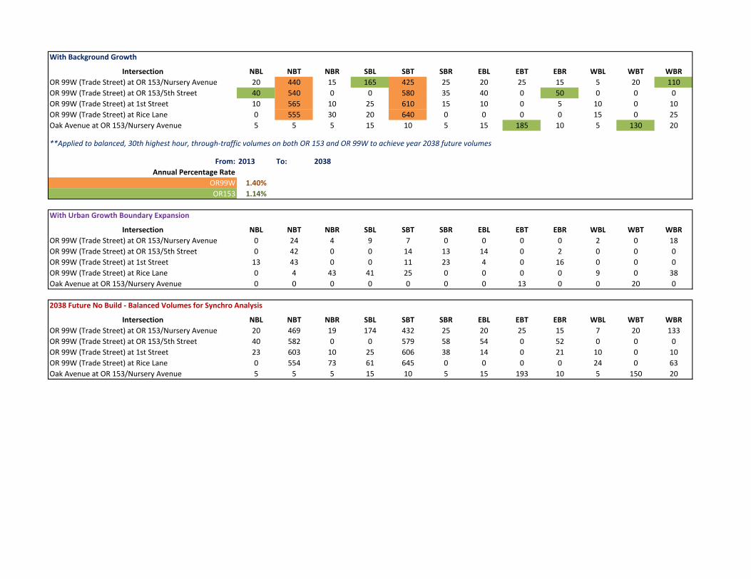
With Background Growth
Intersection NBL NBT NBR SBL SBT SBR EBL EBT EBR WBL WBT WBROR 99W (Trade Street) at OR 153/Nursery Avenue 20 440 15 165 425 25 20 25 15 5 20 110OR 99W (Trade Street) at OR 153/5th Street 40 540 0 0 580 35 40 0 50 0 0 0OR 99W (Trade Street) at 1st Street 10 565 10 25 610 15 10 0 5 10 0 10OR 99W (Trade Street) at Rice Lane 0 555 30 20 640 0 0 0 0 15 0 25Oak Avenue at OR 153/Nursery Avenue 5 5 5 15 10 5 15 185 10 5 130 20
**Applied to balanced, 30th highest hour, through‐traffic volumes on both OR 153 and OR 99W to achieve year 2038 future volumes
From: 2013 To: 2038Annual Percentage Rate
OR99W 1.40%OR153 1.14%
With Urban Growth Boundary Expansion
Intersection NBL NBT NBR SBL SBT SBR EBL EBT EBR WBL WBT WBROR 99W (Trade Street) at OR 153/Nursery Avenue 0 24 4 9 7 0 0 0 0 2 0 18OR 99W (Trade Street) at OR 153/5th Street 0 42 0 0 14 13 14 0 2 0 0 0OR 99W (Trade Street) at 1st Street 13 43 0 0 11 23 4 0 16 0 0 0OR 99W (Trade Street) at Rice Lane 0 4 43 41 25 0 0 0 0 9 0 38Oak Avenue at OR 153/Nursery Avenue 0 0 0 0 0 0 0 13 0 0 20 0
2038 Future No Build ‐ Balanced Volumes for Synchro Analysis
Intersection NBL NBT NBR SBL SBT SBR EBL EBT EBR WBL WBT WBROR 99W (Trade Street) at OR 153/Nursery Avenue 20 469 19 174 432 25 20 25 15 7 20 133OR 99W (Trade Street) at OR 153/5th Street 40 582 0 0 579 58 54 0 52 0 0 0OR 99W (Trade Street) at 1st Street 23 603 10 25 606 38 14 0 21 10 0 10OR 99W (Trade Street) at Rice Lane 0 554 73 61 645 0 0 0 0 24 0 63Oak Avenue at OR 153/Nursery Avenue 5 5 5 15 10 5 15 193 10 5 150 20
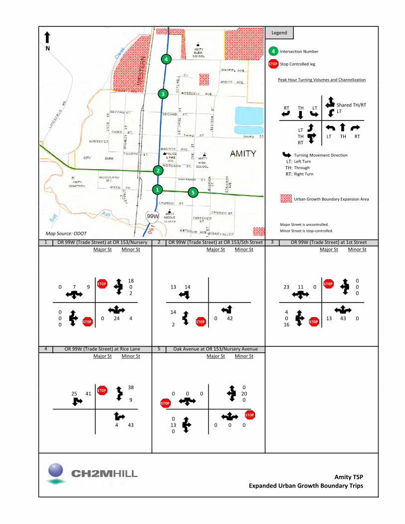
Legend
Intersection Number
Stop Controlled leg
Peak Hour Turning Volumes and Channelization
4
STOP4
N
Shared TH/RTLT
LTTH LT TH RTRT
RT TH LT
3
Turning Movement DirectionLT: Left TurnTH: ThroughRT: Right Turn
Urban Growth Boundary Expansion Area
1
2
5
Major Street is uncontrolled.Minor Street is stop‐controlled.
1 2 3Major St Minor St Major St Minor St Major St Minor St
Growth Rate: Growth Rate: Growth Rate:
OR 99W (Trade Street) at OR 153/Nursery OR 99W (Trade Street) at OR 153/5th Street OR 99W (Trade Street) at 1st Street
1.40% 1.14% 1.40% n/a 1.40% n/a
Map Source: ODOT
18 00 7 9 0 13 14 23 11 0 0
2 0
0 14 40 0 24 4 0 42 0 13 43 00 2 16
STOP
STOP STOP
STOP
STOP
4 5Major St Minor St Major St Minor St
Growth Rate: Growth Rate:
38 0
OR 99W (Trade Street) at Rice Lane Oak Avenue at OR 153/Nursery Avenue
1.40% n/a 1.14% n/a
STOP25 41 0 0 0 20
9 0
04 43 13 0 0 0
0
STOP
STOP
STOP
Amity TSPExpanded Urban Growth Boundary Trips

AMITY TRANSPORTATION SYSTEM PLAN
Attachment 6
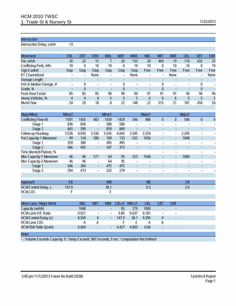
HCM 2010 TWSC1: Trade St & Nursery St 11/22/2013
5:00 pm 11/12/2013 Future No Build (2038) Synchro 8 ReportPage 1
IntersectionIntersection Delay, s/veh 13
Movement EBL EBT EBR WBL WBT WBR NBL NBT NBR SBL SBT SBRVol, veh/h 20 25 15 7 20 133 20 469 19 174 432 25Conflicting Peds, #/hr 10 0 10 10 0 10 10 0 10 10 0 10Sign Control Stop Stop Stop Stop Stop Stop Free Free Free Free Free FreeRT Channelized - - None - - None - - None - - NoneStorage Length - - - - - - - - - - - -Veh in Median Storage, # - 0 - - 0 - - 0 - - 0 -Grade, % - 0 - - 0 - - 0 - - 0 -Peak Hour Factor 85 85 85 90 90 90 91 91 91 96 96 96Heavy Vehicles, % 4 4 4 5 5 5 6 6 6 5 5 5Mvmt Flow 24 29 18 8 22 148 22 515 21 181 450 26
Major/Minor Minor2 Minor1 Major1 Major2Conflicting Flow All 1501 1426 483 1439 1429 546 486 0 0 546 0 0 Stage 1 836 836 - 580 580 - - - - - - - Stage 2 665 590 - 859 849 - - - - - - -Follow-up Headway 3.536 4.036 3.336 3.545 4.045 3.345 2.254 - - 2.245 - -Pot Capacity-1 Maneuver 99 134 580 109 133 532 1056 - - 1008 - - Stage 1 359 380 - 495 495 - - - - - - - Stage 2 446 492 - 347 373 - - - - - - -Time blocked-Platoon, % - - - -Mov Capacity-1 Maneuver 46 96 571 64 95 523 1048 - - 1000 - -Mov Capacity-2 Maneuver 46 96 - 64 95 - - - - - - - Stage 1 346 284 - 475 475 - - - - - - - Stage 2 294 473 - 225 279 - - - - - - -
Approach EB WB NB SBHCM Control Delay, s 147.9 38.1 0.3 2.6HCM LOS F E
Minor Lane / Major Mvmt NBL NBT NBR EBLn1 WBLn1 SBL SBT SBRCapacity (veh/h) 1048 - - 83 279 1000 - -HCM Lane V/C Ratio 0.021 - - 0.85 0.637 0.181 - -HCM Control Delay (s) 8.509 0 - 147.9 38.1 9.395 0 -HCM Lane LOS A A F E A AHCM 95th %tile Q(veh) 0.064 - - 4.427 4.003 0.66 - -
Notes~ : Volume Exceeds Capacity; $ : Delay Exceeds 300 Seconds; Error : Computation Not Defined
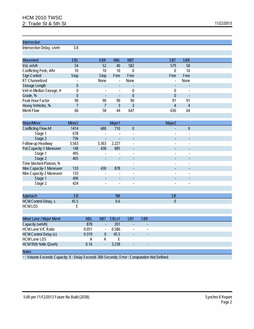
HCM 2010 TWSC2: Trade St & 5th St 11/22/2013
5:00 pm 11/12/2013 Future No Build (2038) Synchro 8 ReportPage 2
IntersectionIntersection Delay, s/veh 3.8
Movement EBL EBR NBL NBT SBT SBRVol, veh/h 54 52 40 582 579 58Conflicting Peds, #/hr 10 10 10 0 0 10Sign Control Stop Stop Free Free Free FreeRT Channelized - None - None - NoneStorage Length 0 - - - - -Veh in Median Storage, # 0 - - 0 0 -Grade, % 0 - - 0 0 -Peak Hour Factor 90 90 90 90 91 91Heavy Vehicles, % 7 7 3 3 4 4Mvmt Flow 60 58 44 647 636 64
Major/Minor Minor2 Major1 Major2Conflicting Flow All 1414 688 710 0 - 0 Stage 1 678 - - - - - Stage 2 736 - - - - -Follow-up Headway 3.563 3.363 2.227 - - -Pot Capacity-1 Maneuver 148 438 885 - - - Stage 1 495 - - - - - Stage 2 465 - - - - -Time blocked-Platoon, % - - -Mov Capacity-1 Maneuver 133 430 878 - - -Mov Capacity-2 Maneuver 133 - - - - - Stage 1 490 - - - - - Stage 2 424 - - - - -
Approach EB NB SBHCM Control Delay, s 45.5 0.6 0HCM LOS E
Minor Lane / Major Mvmt NBL NBT EBLn1 SBT SBRCapacity (veh/h) 878 - 201 - -HCM Lane V/C Ratio 0.051 - 0.586 - -HCM Control Delay (s) 9.319 0 45.5 - -HCM Lane LOS A A EHCM 95th %tile Q(veh) 0.16 - 3.238 - -
Notes~ : Volume Exceeds Capacity; $ : Delay Exceeds 300 Seconds; Error : Computation Not Defined
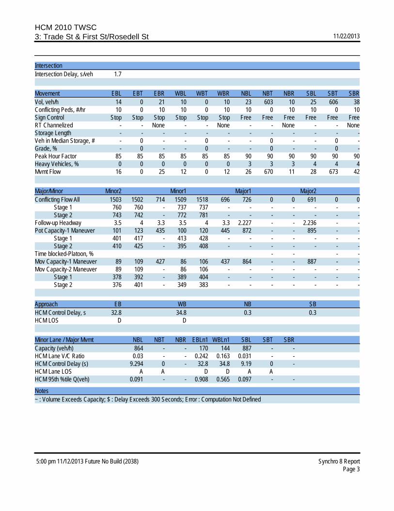
HCM 2010 TWSC3: Trade St & First St/Rosedell St 11/22/2013
5:00 pm 11/12/2013 Future No Build (2038) Synchro 8 ReportPage 3
IntersectionIntersection Delay, s/veh 1.7
Movement EBL EBT EBR WBL WBT WBR NBL NBT NBR SBL SBT SBRVol, veh/h 14 0 21 10 0 10 23 603 10 25 606 38Conflicting Peds, #/hr 10 0 10 10 0 10 10 0 10 10 0 10Sign Control Stop Stop Stop Stop Stop Stop Free Free Free Free Free FreeRT Channelized - - None - - None - - None - - NoneStorage Length - - - - - - - - - - - -Veh in Median Storage, # - 0 - - 0 - - 0 - - 0 -Grade, % - 0 - - 0 - - 0 - - 0 -Peak Hour Factor 85 85 85 85 85 85 90 90 90 90 90 90Heavy Vehicles, % 0 0 0 0 0 0 3 3 3 4 4 4Mvmt Flow 16 0 25 12 0 12 26 670 11 28 673 42
Major/Minor Minor2 Minor1 Major1 Major2Conflicting Flow All 1503 1502 714 1509 1518 696 726 0 0 691 0 0 Stage 1 760 760 - 737 737 - - - - - - - Stage 2 743 742 - 772 781 - - - - - - -Follow-up Headway 3.5 4 3.3 3.5 4 3.3 2.227 - - 2.236 - -Pot Capacity-1 Maneuver 101 123 435 100 120 445 872 - - 895 - - Stage 1 401 417 - 413 428 - - - - - - - Stage 2 410 425 - 395 408 - - - - - - -Time blocked-Platoon, % - - - -Mov Capacity-1 Maneuver 89 109 427 86 106 437 864 - - 887 - -Mov Capacity-2 Maneuver 89 109 - 86 106 - - - - - - - Stage 1 378 392 - 389 404 - - - - - - - Stage 2 376 401 - 349 383 - - - - - - -
Approach EB WB NB SBHCM Control Delay, s 32.8 34.8 0.3 0.3HCM LOS D D
Minor Lane / Major Mvmt NBL NBT NBR EBLn1 WBLn1 SBL SBT SBRCapacity (veh/h) 864 - - 170 144 887 - -HCM Lane V/C Ratio 0.03 - - 0.242 0.163 0.031 - -HCM Control Delay (s) 9.294 0 - 32.8 34.8 9.19 0 -HCM Lane LOS A A D D A AHCM 95th %tile Q(veh) 0.091 - - 0.908 0.565 0.097 - -
Notes~ : Volume Exceeds Capacity; $ : Delay Exceeds 300 Seconds; Error : Computation Not Defined

HCM 2010 TWSC4: Trade St & Rice Ln 11/22/2013
5:00 pm 11/12/2013 Future No Build (2038) Synchro 8 ReportPage 4
IntersectionIntersection Delay, s/veh 2.2
Movement WBL WBR NBT NBR SBL SBTVol, veh/h 24 63 554 73 61 645Conflicting Peds, #/hr 10 25 0 45 10 0Sign Control Stop Stop Free Free Free FreeRT Channelized - None - None - NoneStorage Length 0 - - - - -Veh in Median Storage, # 0 - 0 - - 0Grade, % 0 - 0 - - 0Peak Hour Factor 93 93 90 90 90 90Heavy Vehicles, % 0 0 2 2 4 4Mvmt Flow 26 68 616 81 68 717
Major/Minor Minor1 Major1 Major2Conflicting Flow All 1533 691 0 0 722 0 Stage 1 681 - - - - - Stage 2 852 - - - - -Follow-up Headway 3.5 3.3 - - 2.236 -Pot Capacity-1 Maneuver 130 448 - - 871 - Stage 1 506 - - - - - Stage 2 421 - - - - -Time blocked-Platoon, % - - -Mov Capacity-1 Maneuver 107 436 - - 864 -Mov Capacity-2 Maneuver 107 - - - - - Stage 1 496 - - - - - Stage 2 352 - - - - -
Approach WB NB SBHCM Control Delay, s 29.9 0 0.8HCM LOS D
Minor Lane / Major Mvmt NBT NBR WBLn1 SBL SBTCapacity (veh/h) - - 236 864 -HCM Lane V/C Ratio - - 0.396 0.078 -HCM Control Delay (s) - - 29.9 9.521 0HCM Lane LOS D A AHCM 95th %tile Q(veh) - - 1.79 0.255 -
Notes~ : Volume Exceeds Capacity; $ : Delay Exceeds 300 Seconds; Error : Computation Not Defined
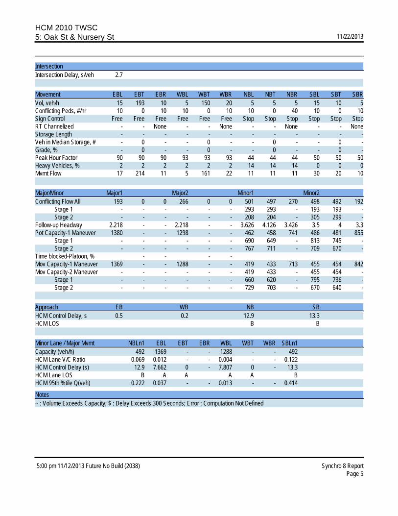
HCM 2010 TWSC5: Oak St & Nursery St 11/22/2013
5:00 pm 11/12/2013 Future No Build (2038) Synchro 8 ReportPage 5
IntersectionIntersection Delay, s/veh 2.7
Movement EBL EBT EBR WBL WBT WBR NBL NBT NBR SBL SBT SBRVol, veh/h 15 193 10 5 150 20 5 5 5 15 10 5Conflicting Peds, #/hr 10 0 10 10 0 10 10 0 40 10 0 10Sign Control Free Free Free Free Free Free Stop Stop Stop Stop Stop StopRT Channelized - - None - - None - - None - - NoneStorage Length - - - - - - - - - - - -Veh in Median Storage, # - 0 - - 0 - - 0 - - 0 -Grade, % - 0 - - 0 - - 0 - - 0 -Peak Hour Factor 90 90 90 93 93 93 44 44 44 50 50 50Heavy Vehicles, % 2 2 2 2 2 2 14 14 14 0 0 0Mvmt Flow 17 214 11 5 161 22 11 11 11 30 20 10
Major/Minor Major1 Major2 Minor1 Minor2Conflicting Flow All 193 0 0 266 0 0 501 497 270 498 492 192 Stage 1 - - - - - - 293 293 - 193 193 - Stage 2 - - - - - - 208 204 - 305 299 -Follow-up Headway 2.218 - - 2.218 - - 3.626 4.126 3.426 3.5 4 3.3Pot Capacity-1 Maneuver 1380 - - 1298 - - 462 458 741 486 481 855 Stage 1 - - - - - - 690 649 - 813 745 - Stage 2 - - - - - - 767 711 - 709 670 -Time blocked-Platoon, % - - - -Mov Capacity-1 Maneuver 1369 - - 1288 - - 419 433 713 455 454 842Mov Capacity-2 Maneuver - - - - - - 419 433 - 455 454 - Stage 1 - - - - - - 660 620 - 795 736 - Stage 2 - - - - - - 729 703 - 670 640 -
Approach EB WB NB SBHCM Control Delay, s 0.5 0.2 12.9 13.3HCM LOS B B
Minor Lane / Major Mvmt NBLn1 EBL EBT EBR WBL WBT WBR SBLn1Capacity (veh/h) 492 1369 - - 1288 - - 492HCM Lane V/C Ratio 0.069 0.012 - - 0.004 - - 0.122HCM Control Delay (s) 12.9 7.662 0 - 7.807 0 - 13.3HCM Lane LOS B A A A A BHCM 95th %tile Q(veh) 0.222 0.037 - - 0.013 - - 0.414
Notes~ : Volume Exceeds Capacity; $ : Delay Exceeds 300 Seconds; Error : Computation Not Defined
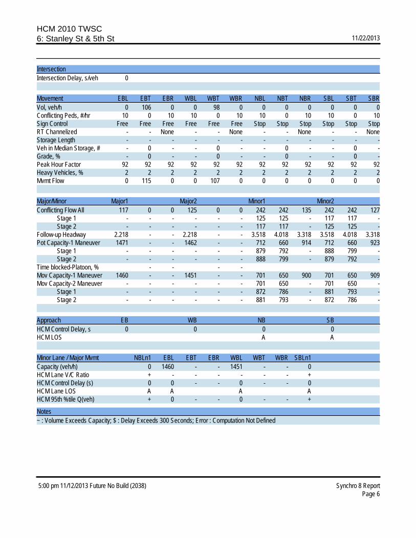
HCM 2010 TWSC6: Stanley St & 5th St 11/22/2013
5:00 pm 11/12/2013 Future No Build (2038) Synchro 8 ReportPage 6
IntersectionIntersection Delay, s/veh 0
Movement EBL EBT EBR WBL WBT WBR NBL NBT NBR SBL SBT SBRVol, veh/h 0 106 0 0 98 0 0 0 0 0 0 0Conflicting Peds, #/hr 10 0 10 10 0 10 10 0 10 10 0 10Sign Control Free Free Free Free Free Free Stop Stop Stop Stop Stop StopRT Channelized - - None - - None - - None - - NoneStorage Length - - - - - - - - - - - -Veh in Median Storage, # - 0 - - 0 - - 0 - - 0 -Grade, % - 0 - - 0 - - 0 - - 0 -Peak Hour Factor 92 92 92 92 92 92 92 92 92 92 92 92Heavy Vehicles, % 2 2 2 2 2 2 2 2 2 2 2 2Mvmt Flow 0 115 0 0 107 0 0 0 0 0 0 0
Major/Minor Major1 Major2 Minor1 Minor2Conflicting Flow All 117 0 0 125 0 0 242 242 135 242 242 127 Stage 1 - - - - - - 125 125 - 117 117 - Stage 2 - - - - - - 117 117 - 125 125 -Follow-up Headway 2.218 - - 2.218 - - 3.518 4.018 3.318 3.518 4.018 3.318Pot Capacity-1 Maneuver 1471 - - 1462 - - 712 660 914 712 660 923 Stage 1 - - - - - - 879 792 - 888 799 - Stage 2 - - - - - - 888 799 - 879 792 -Time blocked-Platoon, % - - - -Mov Capacity-1 Maneuver 1460 - - 1451 - - 701 650 900 701 650 909Mov Capacity-2 Maneuver - - - - - - 701 650 - 701 650 - Stage 1 - - - - - - 872 786 - 881 793 - Stage 2 - - - - - - 881 793 - 872 786 -
Approach EB WB NB SBHCM Control Delay, s 0 0 0 0HCM LOS A A
Minor Lane / Major Mvmt NBLn1 EBL EBT EBR WBL WBT WBR SBLn1Capacity (veh/h) 0 1460 - - 1451 - - 0HCM Lane V/C Ratio + - - - - - - +HCM Control Delay (s) 0 0 - - 0 - - 0HCM Lane LOS A A A AHCM 95th %tile Q(veh) + 0 - - 0 - - +
Notes~ : Volume Exceeds Capacity; $ : Delay Exceeds 300 Seconds; Error : Computation Not Defined

Appendix C
Technical Memo #2 - Alternatives Evaluation

This page intentionally left blank
AMITY TRANSPORTATION SYSTEM PLAN
1
Technical Memo #2: Alternatives Evaluation April 28, 2014 Prepared for: Chuck Eaton, PE, City of Amity Copy to: Naomi Zwerdling, ODOT Prepared by: Terra Lingley, CH2M HILL Ryan Farncomb, CH2M HILL Cory Clauson, CH2M HILL
Introduction This technical memo reviews project alternatives that address transportation system deficiencies in Amity. These alternatives address street, bicycle, pedestrian, and transit needs within the City. The project team developed alternatives based on the existing and anticipated future needs identified by the City, community, and the project team in Technical Memo #1: Existing and Future Conditions. A project “alternative” is one approach to addressing an identified deficiency or need – some alternatives may be eliminated, revised, or added based on the evaluation included in this memo, as well as City and community feedback. The next phase of the project will include recommending specific alternatives for inclusion in the final Transportation System Plan (TSP).
This memo provides a written description of each alternative, discusses potential impacts (positive and negative), and provides planning level cost estimates to aid in understanding each project’s potential effects on the transportation system in Amity. Appendix A contains full cost estimates.
System Alternatives This memo addresses system alternatives by transportation mode, including street, pedestrian and bicycle, and transit. There are no alternatives for waterways, pipelines, rail, or freight, as there were either no facilities or needs identified with these modes. These alternatives address both existing and future needs as Amity continues to grow and develop. Street project descriptions include potential future traffic impacts, where appropriate, to address congestion or delay issues. Impacts to historic resources are not called out specifically below; there are no listed properties on the National Historic Register within the City. However, there are properties eligible for listing, mostly located within downtown.1 Because many of the structures in Amity are of historic vintage, any project that requires additional right-of-way will necessitate review of potential impacts to historic structures.
1 Review based on data from the Oregon Parks and Recreation Department: Oregon Heritage database. Available from http://heritagedata.prd.state.or.us/historic/.
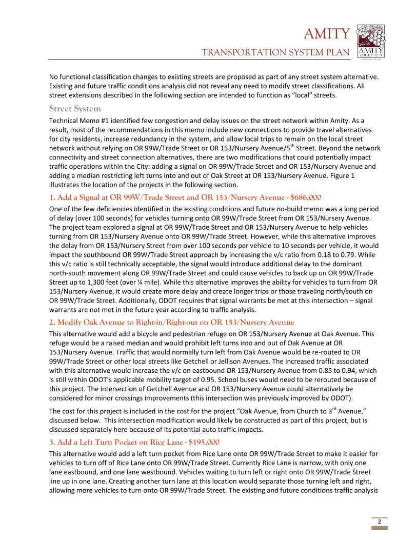
AMITY TRANSPORTATION SYSTEM PLAN
2
No functional classification changes to existing streets are proposed as part of any street system alternative. Existing and future traffic conditions analysis did not reveal any need to modify street classifications. All street extensions described in the following section are intended to function as “local” streets.
Street System Technical Memo #1 identified few congestion and delay issues on the street network within Amity. As a result, most of the recommendations in this memo include new connections to provide travel alternatives for city residents, increase redundancy in the system, and allow local trips to remain on the local street network without relying on OR 99W/Trade Street or OR 153/Nursery Avenue/5th Street. Beyond the network connectivity and street connection alternatives, there are two modifications that could potentially impact traffic operations within the City: adding a signal on OR 99W/Trade Street and OR 153/Nursery Avenue and adding a median restricting left turns into and out of Oak Street at OR 153/Nursery Avenue. Figure 1 illustrates the location of the projects in the following section.
1. Add a Signal at OR 99W/Trade Street and OR 153/Nursery Avenue - $686,000 One of the few deficiencies identified in the existing conditions and future no-build memo was a long period of delay (over 100 seconds) for vehicles turning onto OR 99W/Trade Street from OR 153/Nursery Avenue. The project team explored a signal at OR 99W/Trade Street and OR 153/Nursery Avenue to help vehicles turning from OR 153/Nursery Avenue onto OR 99W/Trade Street. However, while this alternative improves the delay from OR 153/Nursery Street from over 100 seconds per vehicle to 10 seconds per vehicle, it would impact the southbound OR 99W/Trade Street approach by increasing the v/c ratio from 0.18 to 0.79. While this v/c ratio is still technically acceptable, the signal would introduce additional delay to the dominant north-south movement along OR 99W/Trade Street and could cause vehicles to back up on OR 99W/Trade Street up to 1,300 feet (over ¼ mile). While this alternative improves the ability for vehicles to turn from OR 153/Nursery Avenue, it would create more delay and create longer trips or those traveling north/south on OR 99W/Trade Street. Additionally, ODOT requires that signal warrants be met at this intersection – signal warrants are not met in the future year according to traffic analysis.
2. Modify Oak Avenue to Right-in/Right-out on OR 153/Nursery Avenue This alternative would add a bicycle and pedestrian refuge on OR 153/Nursery Avenue at Oak Avenue. This refuge would be a raised median and would prohibit left turns into and out of Oak Avenue at OR 153/Nursery Avenue. Traffic that would normally turn left from Oak Avenue would be re-routed to OR 99W/Trade Street or other local streets like Getchell or Jellison Avenues. The increased traffic associated with this alternative would increase the v/c on eastbound OR 153/Nursery Avenue from 0.85 to 0.94, which is still within ODOT’s applicable mobility target of 0.95. School buses would need to be rerouted because of this project. The intersection of Getchell Avenue and OR 153/Nursery Avenue could alternatively be considered for minor crossings improvements (this intersection was previously improved by ODOT).
The cost for this project is included in the cost for the project “Oak Avenue, from Church to 3rd Avenue,” discussed below. This intersection modification would likely be constructed as part of this project, but is discussed separately here because of its potential auto traffic impacts.
3. Add a Left Turn Pocket on Rice Lane - $195,000 This alternative would add a left turn pocket from Rice Lane onto OR 99W/Trade Street to make it easier for vehicles to turn off of Rice Lane onto OR 99W/Trade Street. Currently Rice Lane is narrow, with only one lane eastbound, and one lane westbound. Vehicles waiting to turn left or right onto OR 99W/Trade Street line up in one lane. Creating another turn lane at this location would separate those turning left and right, allowing more vehicles to turn onto OR 99W/Trade Street. The existing and future conditions traffic analysis
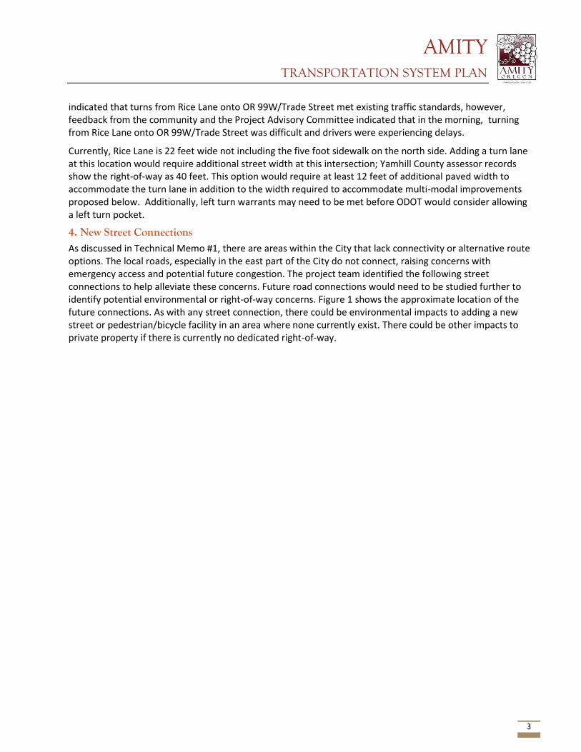
AMITY TRANSPORTATION SYSTEM PLAN
3
indicated that turns from Rice Lane onto OR 99W/Trade Street met existing traffic standards, however, feedback from the community and the Project Advisory Committee indicated that in the morning, turning from Rice Lane onto OR 99W/Trade Street was difficult and drivers were experiencing delays.
Currently, Rice Lane is 22 feet wide not including the five foot sidewalk on the north side. Adding a turn lane at this location would require additional street width at this intersection; Yamhill County assessor records show the right-of-way as 40 feet. This option would require at least 12 feet of additional paved width to accommodate the turn lane in addition to the width required to accommodate multi-modal improvements proposed below. Additionally, left turn warrants may need to be met before ODOT would consider allowing a left turn pocket.
4. New Street Connections As discussed in Technical Memo #1, there are areas within the City that lack connectivity or alternative route options. The local roads, especially in the east part of the City do not connect, raising concerns with emergency access and potential future congestion. The project team identified the following street connections to help alleviate these concerns. Future road connections would need to be studied further to identify potential environmental or right-of-way concerns. Figure 1 shows the approximate location of the future connections. As with any street connection, there could be environmental impacts to adding a new street or pedestrian/bicycle facility in an area where none currently exist. There could be other impacts to private property if there is currently no dedicated right-of-way.
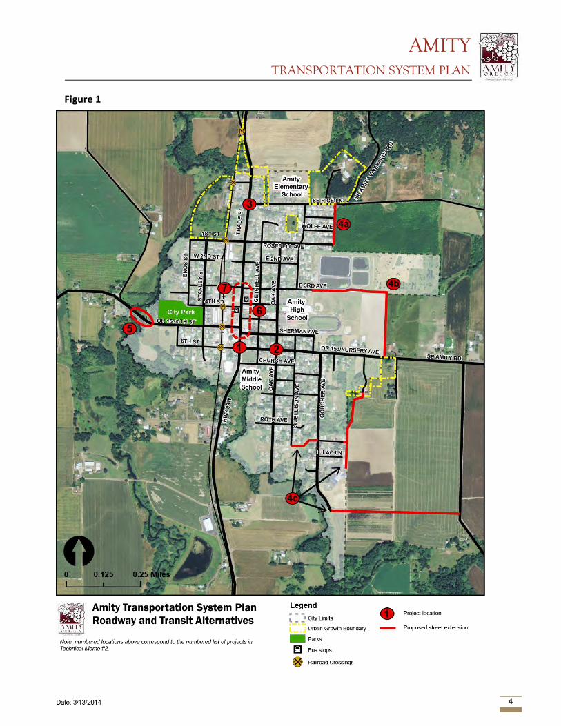
AMITY TRANSPORTATION SYSTEM PLAN
4
Figure 1
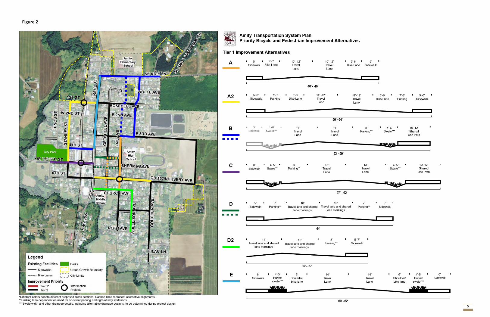
AMITY TRANSPORTATION SYSTEM PLAN
5
Figure 2
AMITY TRANSPORTATION SYSTEM PLAN
6
4a. Rosedell Avenue to Rice Lane Connection – $470,000
Currently the only connection north-south to Rice Lane besides OR 99W/Trade Street is Jellison Avenue. This connection would provide an additional off-highway connection to serve the population south of Rice Lane to access Amity Elementary School. This connection could be a pedestrian/bicycle only facility, though for the purposes of cost estimation, the project team assumed that this would be a full road. If the preferred alternative becomes the bicycle/pedestrian only connection, the cost estimate is likely to be less.
This project would require right-of-way acquisition, though the proposed alignment would not require the demolition of any structures. The proposed alignment would require acquisition of agricultural land. Available resource maps do not show any critical environmental resources, though wetlands are other environmental features could be present.
4b. 3rd Avenue to OR 153/Nursery Avenue Connection - $811,000
This connection could be either a street connection or a bicycle/pedestrian only connection. For purposes of cost estimates, the project team assumes that this connection will be a full road, though if a bicycle/pedestrian only connection is the preferred alternative, the cost estimate is likely to be less. This connection runs east of 3rd Avenue around the potential future location of the Amity Middle School east of the existing Amity High School, and south along the urban growth boundary (UGB) to OR 153/Nursery Avenue. This would provide a connection off of OR 153/Nursery Avenue, allowing for local trips from neighborhoods east of OR 99W/Trade Street through the eastern part of the City.
This project would require right-of-way acquisition, though the proposed alignment would not require the demolition of any structures. The proposed alignment would require property acquisition form the Amity School District and adjacent agricultural lands. Additionally, ODOT design and access management standards may need to be considered for the new connection at OR 153/Nursery Avenue. Available resource maps do not show any critical environmental resources, though wetlands or other environmental features could be present.
4c. Additional Goucher Connection
In the southeastern part of Amity, there are very few east-west connections between the long north-south roads including Jellison Avenue and Goucher Avenue. A second connection linking Goucher to Jellison or another adjacent road is particularly important in the event of an emergency along Goucher Avenue where the road may be blocked. All three of these options would be constructed as emergency access only (approximately 20’ paved width). Bollards or gates would be constructed that would only be removable by emergency personnel; these would prevent through auto traffic while allowing bicycle and pedestrian access.
Option 1 – Jellison Avenue to Goucher Connection - $590,000
This option would construct an east-west street between Jellison Avenue and Goucher south of Roth Avenue. This alignment requires right-of-way acquisition, and may affect structures on Goucher Street. Additionally, there are environmental constraints present; the new road would cross a small stream that drains to Ash Swale. There may be wetlands associated with the stream as well. The topography at this location is such that the new road may require significant import of fill or a bridge/box culvert. Given topographic, environmental, and property constraints, there are very limited opportunities to provide a redundant connection to Goucher Avenue from Jellison Avenue.
Option 2 – Goucher Avenue to Old Bethel Road - $418,000
AMITY TRANSPORTATION SYSTEM PLAN
7
This option would extend Goucher eastward toward Old Bethel Road. This option would require right-of-way acquisition and may encounter environmental barriers. This project would largely take place outside of the City or UGB and may require a statewide planning “goal exception” from the Department of Land Conservation and Development (goal exceptions for these types of projects are rarely granted).
Option 3 – Amity Christian Church to Nursery Avenue/OR 153 - $351,000
This option would begin at the east end of the parking lot at Amity Christian Church (1305 Goucher Street), follow the eastern edge of the City boundary to connect with a private driveway near Nursery Avenue/OR 153. This project would require right-of-way acquisition and encounter a small stream as well as potential wetlands.
5. OR 153/5th Street Bridge Retrofit/Replacement - $1,200,000 The existing bridge over Salt Creek west of the park along OR 153/5th Street is categorized by ODOT as a Structurally Deficient/Distressed Bridge and is a timber-supported bridge that carries Amity’s water supply, along with providing a transportation link to areas west of the City. There are no bicycle or pedestrian facilities on the existing bridge and the lanes are very narrow. The bridge is also weight load restricted. The City is interested in replacing this bridge with a modern structure. This project would require coordination with ODOT as the bridge is on a state highway. Additionally, there are other constraints such as the adjacent City Park and a cemetery that limits potential widening or realignment of this bridge.
In 2012, ODOT began the scoping process for a major rehabilitation of the bridge. The project would include replacement of deteriorated timber posts and railing, new pavement, new guardrails, and painting. This project would extend the useful life of the bridge, but does not constitute a full replacement. As of 2013, the total rehabilitation project was anticipated to cost $1.2 million with construction expected in 2017. Based on scoping documents from ODOT (dated February, 2013), it is not clear whether the rehabilitation would result in removal of load restrictions on the bridge or completely remedy structural deficiencies.
6. Consider Realigning Offset Intersections on OR 99W/Trade Street – policy alternative Many street connections to OR 99W/Trade Street in downtown Amity are offset, meaning that they do not create four-legged intersections where the east-west streets are aligned. This policy alternative would look for opportunities to create traditional four-legged intersections as properties along OR 99W/Trade Street develop or redevelop to reduce concerns about safety issues as vehicles turn onto the highway from offset side streets.
Transit 7. Potential park and ride There is one transit line within the City of Amity, and according to findings from them the previous phase of the project, there is interest in providing a park and ride. The City has identified vacant right-of-way at 3rd Street west of OR 99W/Trade Street, where there is a street that dead-ends at the railroad. This could be a future location for a transit park and ride. There is little data to draw from to estimate potential demand for park and ride facilities in Amity. Given that there are few stops in Amity, it is probable that a park and ride may attract new transit users who would otherwise be unwilling to walk to reach the bus stops.
No cost estimate is provided for this project; the cost of a potential park and ride lot is dependent on the number of parking stalls needed and proposed location. Access to existing homes would need to be maintained at this location. This project would also require coordination with Yamhill County Transit Area.
AMITY TRANSPORTATION SYSTEM PLAN
8
Pedestrian and Bicycle System Technical Memo #1 identified areas with no sidewalks and bicycle lanes, along with intersections that have high pedestrian and bicycle traffic. These pedestrian and bicycle system alternatives address these identified deficiencies and needs, with a focus on moving school children and those with disabilities throughout the City and to various important destinations including the schools, public services such as City Hall, the Library, Park, and Post Office. The purpose of designating cross section alternatives and identifying streets where they will be implemented is to ensure that there is a complete network off of both OR 99W/Trade Street and OR 153/Nursery Avenue/5th Street for bicyclists and pedestrians to travel through the City. Figure 2 shows the project alternative locations and alternative cross sections for the bicycle and pedestrian system. The projects below are the “Tier 1” projects shown in the Figure 2. No specific improvements are proposed for the “Tier 2” corridors identified; improvements on these corridors are likely beyond the planning horizon of this TSP. Tier 2 corridors add redundancy to the bike and pedestrian system and in some cases would provide new connections on the periphery of the city.
Appendix B contains “before” and “after” maps showing bicycle level of stress (BLOS) on city streets. The “before” map was developed for Tech Memo #1 Existing and Future Conditions; the BLOS was assessed for all city streets to determine which streets are the most unpleasant or stressful to bike on. The project team performed a BLOS assessment on the same streets as if all bicycle and pedestrian alternatives were implemented to see how BLOS would change. Several streets, including OR 153/5th Avenue, Rice Lane, portions of Oak Street and OR 153/Nursery Avenue would experience decreases in BLOS according to this methodology.
Cross Section A – Bike Lanes and Sidewalks Oak Avenue, from Church to 3rd Avenue - $284,000
This project would add bike lanes and fill sidewalk gaps to create pedestrian and bicycle-specific facilities on Oak Avenue from Church to 3rd Avenue. This will help provide a safe route for students walking and bicycling from Amity Middle School to the High School. This alternative would be implemented with street network project #2: Modify Oak Avenue to right-in and right-out at OR 153/Nursery Avenue. Oak Avenue has very constrained right-of-way in this location, though the proposed cross section is intended to fit within this constraint.
Alternative: Getchell/Oak Avenue from Church to 3rd - $95,000
This alternative would utilize the recently improved crossing on Nursery Ave/OR 153. City staff indicates that the ODOT prefers this crossing location, though school staff and other community members note that more students use the unimproved Oak Avenue crossing.
Cross Section A2 – Bike Lanes, Sidewalks, On-Street Parking OR 153/Nursery Avenue from 99w/Trade Street to Goucher Street - $940,000
This project would similarly add bike lanes and sidewalks to OR 153/Nursery Avenue, which lacks dedicated bicycle facilities and has degraded sidewalks in places. The proposed cross section includes on-street parking on both sides of the street, but vegetated swales could be included instead of parking along all or some of the alignment, depending on parking needs.
Stanley Street from OR 153/5th Street to 1st Street and 99W/Trade Street - $1,540,000
This provides a north-south connection from the park to 1st Street, where students can cross OR 99W/Trade Street at a marked crosswalk. This project would also include upgrades to the existing rail crossing.
AMITY TRANSPORTATION SYSTEM PLAN
9
Cross Section B Shared Use Path This cross section would use a shared-use path with a ditch for stormwater to separate bicyclists and pedestrians from the vehicle lanes. Where applicable, this alternative would retrofit existing sidewalks to a wider shared-use bicycle and pedestrian path. An additional sidewalk and drainage swale or vegetative buffer may be considered on the opposite side of the street as well (dependent on site conditions, available right-of-way, and project budget); the additional sidewalk and swale could also be phased as funding allows. This cross section would apply to a number of streets. The costs provided below do not include the additional sidewalk on the opposite side of the street (Figure 2).
Oak Avenue from 3rd Avenue to Rice Lane (along Jellison) - $516,000
This segment provides a north-south connection from Amity High School connecting to the neighborhoods to the north. The community noted that kids tend to not walk on Oak Avenue north of 3rd, and instead all walk along Jellison (one block to the east).
There is sufficient right-of-way on these streets to accommodate Cross Section B.
Alternative: Oak Avenue from 3rd Avenue to Rice Lane via Oak and undeveloped property east of Getchell Court - $291,000
This alternative route would continue following Oak Avenue and head north via a shared use path behind homes east of Getchell Court and adjacent to vacant property west of Jellison. This alternative would require right-of-way acquisition.
Rice Lane from OR 99W/Trade Street to near Amity Vineyards Road - $337,000
This segment provides access from the soon-to-be-improved crossing at Rice Lane and OR 99W/Trade Street to Amity Elementary school and would serve future resident in the northeast UGB expansion area. This project may require right-of-way acquisition on the segment west of Amity Elementary School, as existing right-of-way is 40 feet. The right-of-way constraint is most pronounced at the intersection of OR 99W/Trade Street and Rice Lane – a minimum width of 46 feet would be required to accommodate a shared path and the turn lane project described above (additional width would be required to accommodate drainage, lighting, etc.). This intersection is constrained due to homes located very close to the existing street.
4th Street from Stanley to Trade Street/OR 99W -$178,000
This project would provide redundant east-west connectivity for pedestrian and cyclists to and from the City Park. The Amity community noted that many pedestrians and cyclists use 4th street. This project could also connect with the path that is planned for construction within the City Park.
Cross Section C Shared Use Path and Sidewalk OR 153/5th Street from OR 99W/Trade Street to Park Entrance - $403,000
This project would reconstruct a sidewalk on one side of the street, with a shared-use path on the other. Both the sidewalk and shared use path would be separated from the travel and parking lane by a ditch or swale for stormwater. This concept would also include upgrading the railroad crossing west of OR 99W/Trade Street.
Cross Section D Shared lanes and Sidewalk on Both Sides This cross section would implement shared lanes, where vehicles and bicyclists share travel lanes, and provide a sidewalk on both sides of the street. Shared lanes would be marked with “sharrows,” specific lane markings that help cyclists with positioning on the road and indicate to drivers that cyclists may be present. This proposed cross section is a cost-effective means of implementing cycling and pedestrian improvements,
AMITY TRANSPORTATION SYSTEM PLAN
10
and requires minimal right-of-way. This cross section is appropriate on a few streets that have low traffic volumes:
Woodson Avenue from Oak Avenue to Trade Street/OR 99W - $103,000
This segment would provide access from OR 99W/Trade Street to Amity High School and provide a low-stress alternative route to OR 153/Nursery Avenue. The community noted that students typically use Woodson Avenue for walking and biking, as opposed to other nearby cross streets like 3rd or Sherman Avenue. The proposed cross-section for this street would require right-of-way acquisition along the entire length of the street.
Alternative: Sherman Avenue from OR 99W/Trade Street to Oak Avenue - $102,000
This segment would also provide access from OR 99W/Trade Street to Amity High School and provides a low-stress alternative route to OR 153/Nursery Avenue. This alternative would also connect to the City Park via the path proposed along OR 153/5th Street. The proposed cross-section for this street would require right-of-way acquisition along the entire length of Sherman Avenue.
Cross Section D2 Shared lanes and Sidewalk on One Side This cross section would implement shared lanes, where vehicles and bicyclists share travel lanes, and provide a sidewalk on both sides of the street. This cross-section accommodates narrow rights-of-way on the streets listed below.
S Jellison Avenue from Roth Avenue to Church Avenue - $167,000
This segment would provide access from neighborhoods south of OR 153/Nursery Avenue. The proposed cross section may necessitate right-of-way acquisition.
Church Avenue from OR 99W/Trade Street to Jellison Avenue - $127,000
This segment would improve cycling and walking for students at Amity Middle School and connect the middle school to the greater pedestrian and biking network.
Cross Section E Sidewalks and Bike Lanes OR 99W/Trade Street from 3rd Street to Rice Lane - $869,000
This project would complete improvements to OR 99W/Trade Street, including new or reconstructed sidewalks, bike lanes, and vegetation buffers or drainage swales. The south end of OR 99W/Trade Street was previously improved.
Evaluation The project team evaluated the above project alternatives based on the criteria developed at the beginning of the process. The project team evaluated alternatives using a “consumer reports” style scale with low, medium, and high ratings (Table 1). Table 2 shows all alternatives and their evaluation across all categories. The evaluation approach and criteria are described in detail in the Audit, Plan, Policy Review and Evaluation Framework memo.
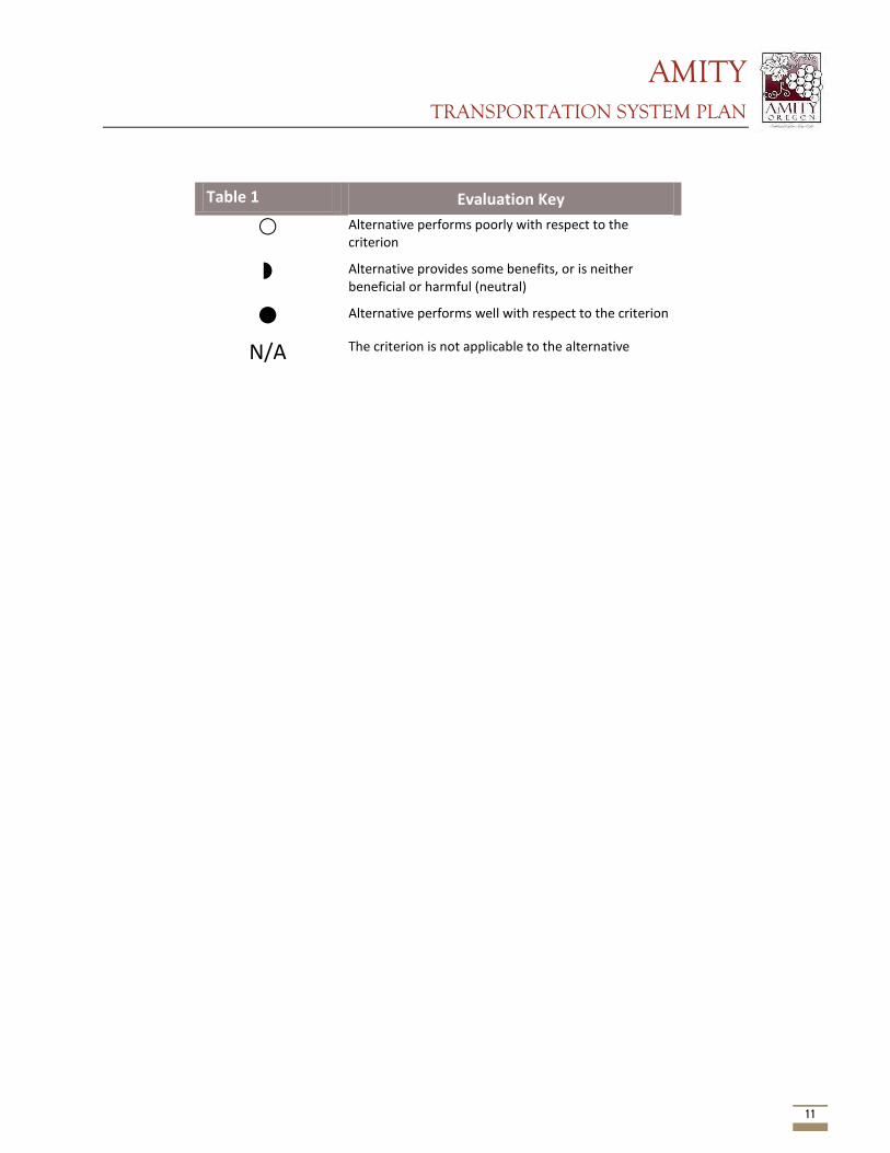
AMITY TRANSPORTATION SYSTEM PLAN
11
Evaluation Key
Alternative performs poorly with respect to the criterion
Alternative provides some benefits, or is neither beneficial or harmful (neutral)
Alternative performs well with respect to the criterion
N/A The criterion is not applicable to the alternative
Table 1
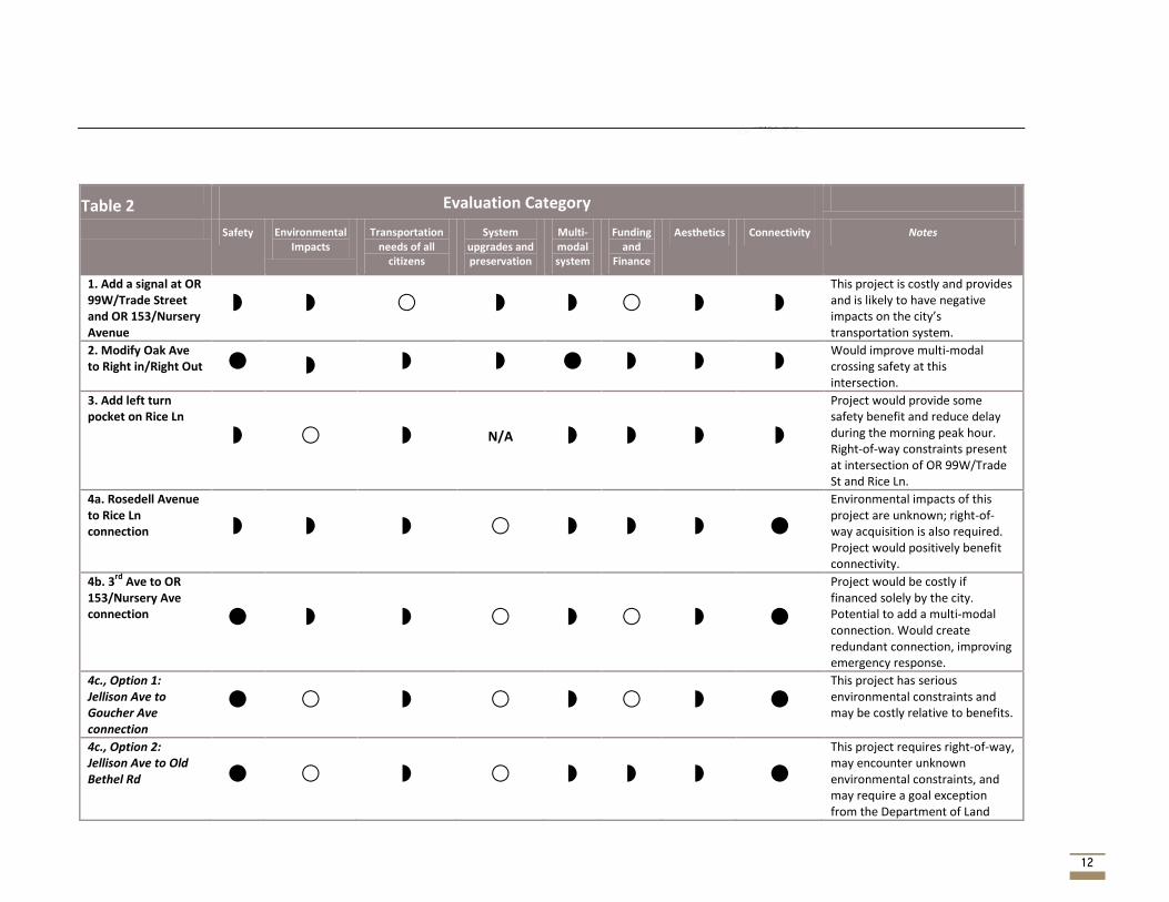
AMITY TRANSPORTATION SYSTEM PLAN
12
Evaluation Category
Safety Environmental Impacts
Transportation needs of all
citizens
System upgrades and preservation
Multi-modal system
Funding and
Finance
Aesthetics Connectivity Notes
1. Add a signal at OR 99W/Trade Street and OR 153/Nursery Avenue
This project is costly and provides and is likely to have negative impacts on the city’s transportation system.
2. Modify Oak Ave to Right in/Right Out
Would improve multi-modal crossing safety at this intersection.
3. Add left turn pocket on Rice Ln
N/A
Project would provide some safety benefit and reduce delay during the morning peak hour. Right-of-way constraints present at intersection of OR 99W/Trade St and Rice Ln.
4a. Rosedell Avenue to Rice Ln connection
Environmental impacts of this project are unknown; right-of-way acquisition is also required. Project would positively benefit connectivity.
4b. 3rd
Ave to OR 153/Nursery Ave connection
Project would be costly if financed solely by the city. Potential to add a multi-modal connection. Would create redundant connection, improving emergency response.
4c., Option 1: Jellison Ave to Goucher Ave connection
This project has serious environmental constraints and may be costly relative to benefits.
4c., Option 2: Jellison Ave to Old Bethel Rd
This project requires right-of-way, may encounter unknown environmental constraints, and may require a goal exception from the Department of Land
Table 2
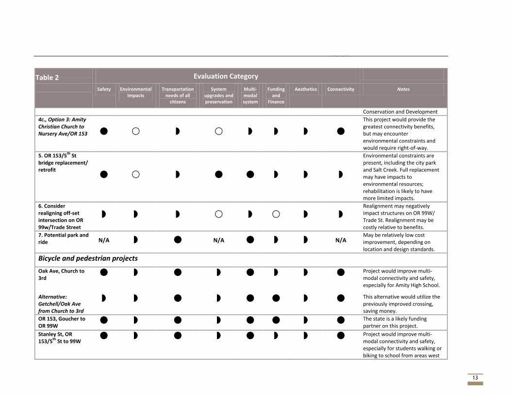
AMITY TRANSPORTATION SYSTEM PLAN
13
Evaluation Category
Safety Environmental Impacts
Transportation needs of all
citizens
System upgrades and preservation
Multi-modal system
Funding and
Finance
Aesthetics Connectivity Notes
Conservation and Development
4c., Option 3: Amity Christian Church to Nursery Ave/OR 153
This project would provide the greatest connectivity benefits, but may encounter environmental constraints and would require right-of-way.
5. OR 153/5th
St bridge replacement/ retrofit
Environmental constraints are present, including the city park and Salt Creek. Full replacement may have impacts to environmental resources; rehabilitation is likely to have more limited impacts.
6. Consider realigning off-set intersection on OR 99w/Trade Street
Realignment may negatively impact structures on OR 99W/ Trade St. Realignment may be costly relative to benefits.
7. Potential park and ride N/A N/A N/A
May be relatively low cost improvement, depending on location and design standards.
Bicycle and pedestrian projects
Oak Ave, Church to 3rd
Project would improve multi-modal connectivity and safety, especially for Amity High School.
Alternative: Getchell/Oak Ave from Church to 3rd
This alternative would utilize the previously improved crossing, saving money.
OR 153, Goucher to OR 99W
The state is a likely funding partner on this project.
Stanley St, OR 153/5
th St to 99W
Project would improve multi-modal connectivity and safety, especially for students walking or biking to school from areas west
Table 2
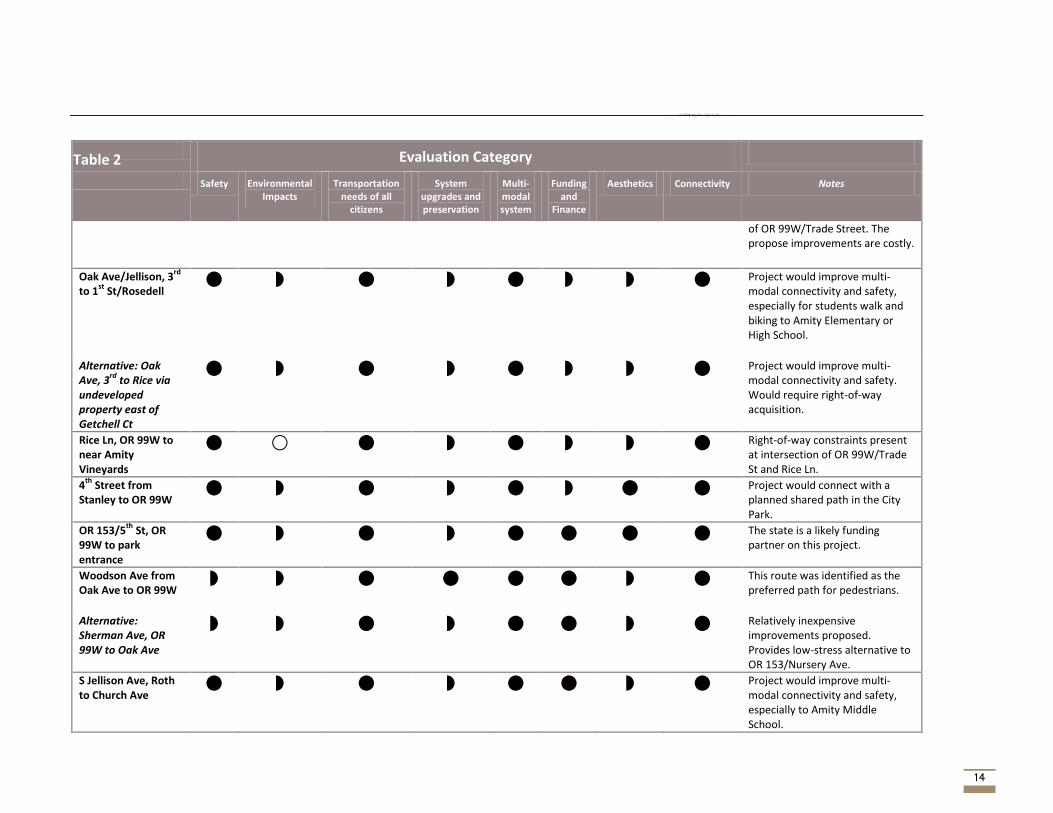
AMITY TRANSPORTATION SYSTEM PLAN
14
Evaluation Category
Safety Environmental Impacts
Transportation needs of all
citizens
System upgrades and preservation
Multi-modal system
Funding and
Finance
Aesthetics Connectivity Notes
of OR 99W/Trade Street. The propose improvements are costly.
Oak Ave/Jellison, 3rd
to 1
st St/Rosedell
Project would improve multi-modal connectivity and safety, especially for students walk and biking to Amity Elementary or High School.
Alternative: Oak Ave, 3
rd to Rice via
undeveloped property east of Getchell Ct
Project would improve multi-modal connectivity and safety. Would require right-of-way acquisition.
Rice Ln, OR 99W to near Amity Vineyards
Right-of-way constraints present at intersection of OR 99W/Trade St and Rice Ln.
4th
Street from Stanley to OR 99W
Project would connect with a planned shared path in the City Park.
OR 153/5th
St, OR 99W to park entrance
The state is a likely funding partner on this project.
Woodson Ave from Oak Ave to OR 99W
This route was identified as the preferred path for pedestrians.
Alternative: Sherman Ave, OR 99W to Oak Ave
Relatively inexpensive improvements proposed. Provides low-stress alternative to OR 153/Nursery Ave.
S Jellison Ave, Roth to Church Ave
Project would improve multi-modal connectivity and safety, especially to Amity Middle School.
Table 2
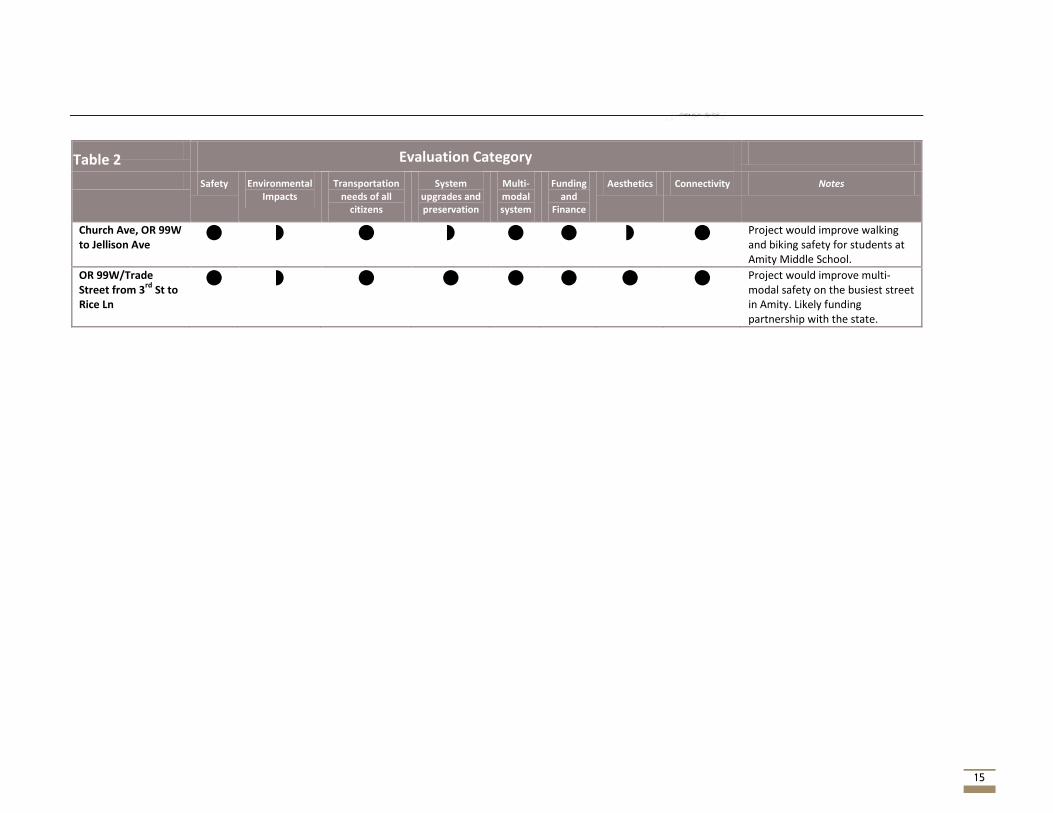
AMITY TRANSPORTATION SYSTEM PLAN
15
Evaluation Category
Safety Environmental Impacts
Transportation needs of all
citizens
System upgrades and preservation
Multi-modal system
Funding and
Finance
Aesthetics Connectivity Notes
Church Ave, OR 99W to Jellison Ave
Project would improve walking and biking safety for students at Amity Middle School.
OR 99W/Trade Street from 3
rd St to
Rice Ln
Project would improve multi-modal safety on the busiest street in Amity. Likely funding partnership with the state.
Table 2
AMITY TRANSPORTATION SYSTEM PLAN
16
Next Steps Projects that scored poorly in the evaluation may be removed from consideration or otherwise revised. Once the list of alternatives has been reviewed by all, the project team will create a list of recommended alternatives – a refinement of the list above. Project refinement may include adjustments to the cross sections or other changes, as well as refined cost estimates. The recommended alternatives will be reviewed by the PAC, TAC, and public prior to inclusion in the draft TSP. The project team will develop a funding plan that will accompany the recommended alternatives.

AMITY TRANSPORTATION SYSTEM PLAN
Appendix A – Full cost estimates
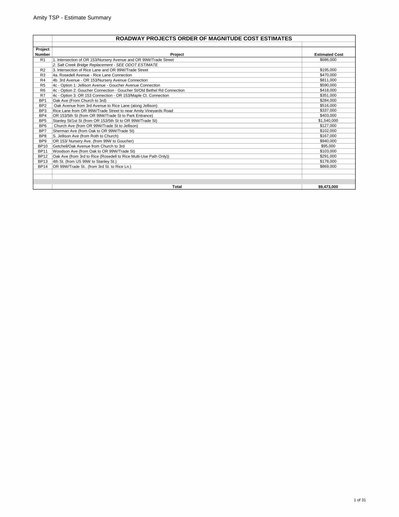
Amity TSP - Estimate Summary
Project
Number Project Estimated Cost
R1 1. Intersection of OR 153/Nursery Avenue and OR 99W/Trade Street $686,000
2. Salt Creek Bridge Replacement - SEE ODOT ESTIMATE
R2 3. Intersection of Rice Lane and OR 99W/Trade Street $195,000
R3 4a. Rosedell Avenue - Rice Lane Connection $470,000
R4 4b. 3rd Avenue - OR 153/Nursery Avenue Connection $811,000
R5 4c - Option 1: Jellison Avenue - Goucher Avenue Connection $590,000
R6 4c - Option 2: Goucher Connection - Goucher St/Old Bethel Rd Connection $418,000
R7 4c - Option 3: OR 153 Connection - OR 153/Maple Ct. Connection $351,000
BP1 Oak Ave (From Church to 3rd) $284,000
BP2 Oak Avenue from 3rd Avenue to Rice Lane (along Jellison) $516,000
BP3 Rice Lane from OR 99W/Trade Street to near Amity Vineyards Road $337,000
BP4 OR 153/5th St (from OR 99W/Trade St to Park Entrance) $403,000
BP5 Stanley St/1st St (from OR 153/5th St to OR 99W/Trade St) $1,540,000
BP6 Church Ave (from OR 99W/Trade St to Jellison) $127,000
BP7 Sherman Ave (from Oak to OR 99W/Trade St) $102,000
BP8 S. Jellison Ave (from Roth to Church) $167,000
BP9 OR 153/ Nursery Ave. (from 99W to Goucher) $940,000
BP10 Getchell/Oak Avenue from Church to 3rd $95,000
BP11 Woodson Ave (from Oak to OR 99W/Trade St) $103,000
BP12 Oak Ave (from 3rd to Rice (Rosedell to Rice Multi-Use Path Only)) $291,000
BP13 4th St. (from US 99W to Stanley St.) $178,000
BP14 OR 99W/Trade St.. (from 3rd St. to Rice Ln.) $869,000
Total $9,473,000
ROADWAY PROJECTS ORDER OF MAGNITUDE COST ESTIMATES
1 of 31
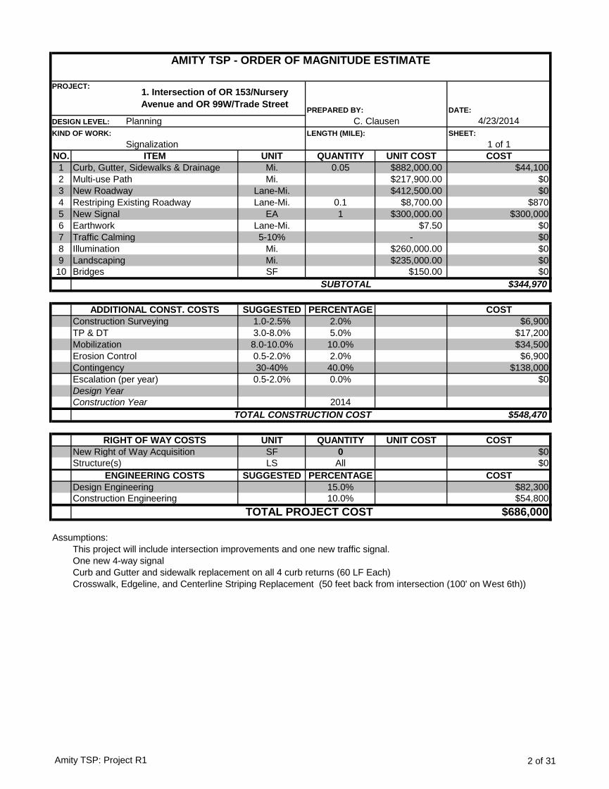
DATE:
4/23/2014
SHEET:
1 of 1
NO. UNIT QUANTITY UNIT COST COST
1 Mi. 0.05 $882,000.00 $44,100
2 Mi. $217,900.00 $0
3 Lane-Mi. $412,500.00 $0
4 Lane-Mi. 0.1 $8,700.00 $870
5 EA 1 $300,000.00 $300,000
6 Lane-Mi. $7.50 $0
7 5-10% - $0
8 Mi. $260,000.00 $0
9 Mi. $235,000.00 $0
10 SF $150.00 $0
$344,970
SUGGESTED PERCENTAGE COST
1.0-2.5% 2.0% $6,900
3.0-8.0% 5.0% $17,200
8.0-10.0% 10.0% $34,500
0.5-2.0% 2.0% $6,900
30-40% 40.0% $138,000
0.5-2.0% 0.0% $0
2014
$548,470
UNIT QUANTITY UNIT COST COST
SF 0 $0
LS All $0
SUGGESTED PERCENTAGE COST
15.0% $82,300
10.0% $54,800
$686,000
Assumptions:
This project will include intersection improvements and one new traffic signal.
One new 4-way signal
Curb and Gutter and sidewalk replacement on all 4 curb returns (60 LF Each)
Crosswalk, Edgeline, and Centerline Striping Replacement (50 feet back from intersection (100' on West 6th))
Design Engineering
Construction Engineering
TOTAL PROJECT COST
Construction Year
TOTAL CONSTRUCTION COST
RIGHT OF WAY COSTS
New Right of Way Acquisition
Structure(s)
ENGINEERING COSTS
Design Year
Landscaping
Bridges
SUBTOTAL
ADDITIONAL CONST. COSTS
Construction Surveying
TP & DT
Mobilization
Erosion Control
Contingency
Escalation (per year)
Illumination
Curb, Gutter, Sidewalks & Drainage
Multi-use Path
New Roadway
Restriping Existing Roadway
New Signal
Earthwork
Traffic Calming
ITEM
AMITY TSP - ORDER OF MAGNITUDE ESTIMATE
PROJECT:1. Intersection of OR 153/Nursery
Avenue and OR 99W/Trade StreetPREPARED BY:
DESIGN LEVEL: Planning C. Clausen
KIND OF WORK:
Signalization
LENGTH (MILE):
Amity TSP: Project R1 2 of 31
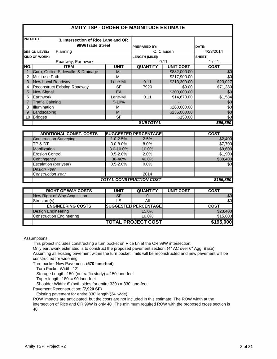
DATE:
4/23/2014
SHEET:
1 of 1
NO. UNIT QUANTITY UNIT COST COST
1 Mi. $882,000.00 $0
2 Mi. $217,900.00 $0
3 Lane-Mi. 0.11 $213,300.00 $23,027
4 SF 7920 $9.00 $71,280
5 EA $300,000.00 $0
6 Lane-Mi. 0.11 $14,670.00 $1,584
7 5-10% - $0
8 Mi. $260,000.00 $0
9 Mi. $235,000.00 $0
10 SF $150.00 $0
$95,890
SUGGESTED PERCENTAGE COST
1.0-2.5% 2.5% $2,400
3.0-8.0% 8.0% $7,700
8.0-10.0% 10.0% $9,600
0.5-2.0% 2.0% $1,900
30-40% 40.0% $38,400
0.5-2.0% 0.0% $0
2014
$155,890
UNIT QUANTITY UNIT COST COST
SF 0 $0
LS All $0
SUGGESTED PERCENTAGE COST
15.0% $23,400
10.0% $15,600
$195,000
Assumptions:
This project includes constructing a turn pocket on Rice Ln at the OR 99W intersection.
Only earthwork estimated is to construct the proposed pavement section. (4" AC over 6" Agg. Base)
Turn pocket New Pavement: (570 lane-feet)
Turn Pocket Width: 12'
Storage Length: 150' (no traffic study) = 150 lane-feet
Taper length: 180' = 90 lane-feet
Shoulder Width: 6' (both sides for entire 330') = 330 lane-feet
Pavement Reconstruction: (7,920 SF)
Existing pavement for entire 330' length (24' wide)
ITEM
AMITY TSP - ORDER OF MAGNITUDE ESTIMATE
PROJECT: 3. Intersection of Rice Lane and OR
99W/Trade Street PREPARED BY:
DESIGN LEVEL: Planning C. Clausen
KIND OF WORK:
Roadway, Earthwork
LENGTH (MILE):
0.11
New Signal
Earthwork
Curb, Gutter, Sidewalks & Drainage
Multi-use Path
New Local Roadway
Reconstruct Existing Roadway
Traffic Calming
Design Year
Landscaping
Bridges
SUBTOTAL
ADDITIONAL CONST. COSTS
Construction Surveying
TP & DT
Mobilization
Erosion Control
Contingency
Escalation (per year)
Illumination
ROW impacts are anticipated, but the costs are not included in this estimate. The ROW width at the
intersection of Rice and OR 99W is only 40'. The minimum required ROW with the proposed cross section is
48'.
Assuming all existing pavement within the turn pocket limits will be reconstructed and new pavement will be
constructed for widening
TOTAL PROJECT COST
Construction Year
TOTAL CONSTRUCTION COST
RIGHT OF WAY COSTS
New Right of Way Acquisition
Structure(s)
ENGINEERING COSTS
Design Engineering
Construction Engineering
Amity TSP: Project R2 3 of 31
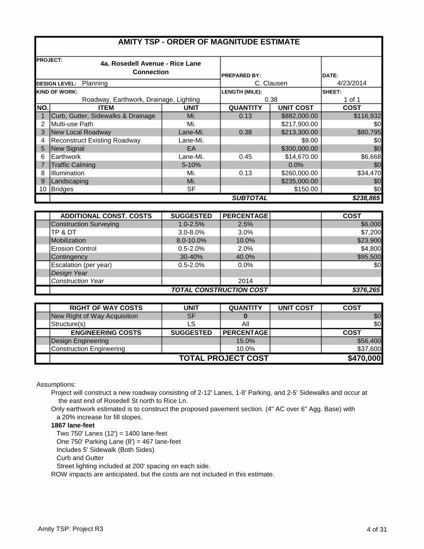
DATE:
4/23/2014
SHEET:
1 of 1
NO. UNIT QUANTITY UNIT COST COST
1 Mi. 0.13 $882,000.00 $116,932
2 Mi. $217,900.00 $0
3 Lane-Mi. 0.38 $213,300.00 $80,795
4 Lane-Mi. $9.00 $0
5 EA $300,000.00 $0
6 Lane-Mi. 0.45 $14,670.00 $6,668
7 5-10% 0.0% $0
8 Mi. 0.13 $260,000.00 $34,470
9 Mi. $235,000.00 $0
10 SF $150.00 $0
$238,865
SUGGESTED PERCENTAGE COST
1.0-2.5% 2.5% $6,000
3.0-8.0% 3.0% $7,200
8.0-10.0% 10.0% $23,900
0.5-2.0% 2.0% $4,800
30-40% 40.0% $95,500
0.5-2.0% 0.0% $0
2014
$376,265
UNIT QUANTITY UNIT COST COST
SF 0 $0
LS All $0
SUGGESTED PERCENTAGE COST
15.0% $56,400
10.0% $37,600
$470,000
Assumptions:
Project will construct a new roadway consisting of 2-12' Lanes, 1-8' Parking, and 2-5' Sidewalks and occur at
the east end of Rosedell St north to Rice Ln.
Only earthwork estimated is to construct the proposed pavement section. (4" AC over 6" Agg. Base) with
a 20% increase for fill slopes.
1867 lane-feet
Two 750' Lanes (12') = 1400 lane-feet
One 750' Parking Lane (8') = 467 lane-feet
Includes 5' Sidewalk (Both Sides)
Curb and Gutter
Street lighting included at 200' spacing on each side.
ROW impacts are anticipated, but the costs are not included in this estimate.
Design Engineering
Construction Engineering
TOTAL PROJECT COST
Construction Year
TOTAL CONSTRUCTION COST
RIGHT OF WAY COSTS
New Right of Way Acquisition
Structure(s)
ENGINEERING COSTS
Design Year
Landscaping
Bridges
SUBTOTAL
ADDITIONAL CONST. COSTS
Construction Surveying
TP & DT
Mobilization
Erosion Control
Contingency
Escalation (per year)
Illumination
Curb, Gutter, Sidewalks & Drainage
Multi-use Path
New Local Roadway
Reconstruct Existing Roadway
New Signal
Earthwork
Traffic Calming
ITEM
AMITY TSP - ORDER OF MAGNITUDE ESTIMATE
PROJECT:4a. Rosedell Avenue - Rice Lane
Connection PREPARED BY:
DESIGN LEVEL: Planning C. Clausen
KIND OF WORK:
Roadway, Earthwork, Drainage, Lighting
LENGTH (MILE):
0.38
Amity TSP: Project R3 4 of 31
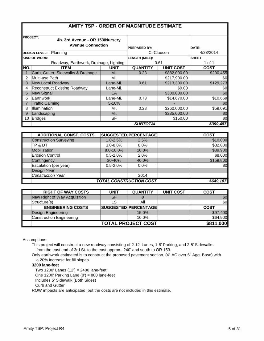
DATE:
4/23/2014
SHEET:
1 of 1
NO. UNIT QUANTITY UNIT COST COST
1 Mi. 0.23 $882,000.00 $200,455
2 Mi. $217,900.00 $0
3 Lane-Mi. 0.61 $213,300.00 $129,273
4 Lane-Mi. $9.00 $0
5 EA $300,000.00 $0
6 Lane-Mi. 0.73 $14,670.00 $10,669
7 5-10% - $0
8 Mi. 0.23 $260,000.00 $59,091
9 Mi. $235,000.00 $0
10 SF $150.00 $0
$399,487
SUGGESTED PERCENTAGE COST
1.0-2.5% 2.5% $10,000
3.0-8.0% 8.0% $32,000
8.0-10.0% 10.0% $39,900
0.5-2.0% 2.0% $8,000
30-40% 40.0% $159,800
0.5-2.0% 0.0% $0
2014
$649,187
UNIT QUANTITY UNIT COST COST
SF 0 $0
LS All $0
SUGGESTED PERCENTAGE COST
15.0% $97,400
10.0% $64,900
$811,000
Assumptions:
This project will construct a new roadway consisting of 2-12' Lanes, 1-8' Parking, and 2-5' Sidewalks
from the east end of 3rd St. to the east approx.. 240' and south to OR 153.
Only earthwork estimated is to construct the proposed pavement section. (4" AC over 6" Agg. Base) with
a 20% increase for fill slopes.
3200 lane-feet
Two 1200' Lanes (12') = 2400 lane-feet
One 1200' Parking Lane (8') = 800 lane-feet
Includes 5' Sidewalk (Both Sides)
Curb and Gutter
ROW impacts are anticipated, but the costs are not included in this estimate.
ITEM
AMITY TSP - ORDER OF MAGNITUDE ESTIMATE
PROJECT:4b. 3rd Avenue - OR 153/Nursery
Avenue ConnectionPREPARED BY:
DESIGN LEVEL: Planning C. Clausen
KIND OF WORK:
Roadway, Earthwork, Drainage, Lighting
LENGTH (MILE):
0.61
Illumination
New Signal
Earthwork
Curb, Gutter, Sidewalks & Drainage
Multi-use Path
New Local Roadway
Reconstruct Existing Roadway
Traffic Calming
Design Year
Landscaping
Bridges
SUBTOTAL
ADDITIONAL CONST. COSTS
Construction Surveying
TP & DT
Mobilization
Erosion Control
Contingency
Escalation (per year)
Design Engineering
Construction Engineering
TOTAL PROJECT COST
Construction Year
TOTAL CONSTRUCTION COST
RIGHT OF WAY COSTS
New Right of Way Acquisition
Structure(s)
ENGINEERING COSTS
Amity TSP: Project R4 5 of 31

DATE:
4/23/2014
SHEET:
1 of 1
NO. UNIT QUANTITY UNIT COST COST
1 Mi. $882,000.00 $0
2 Lane-Mi. 0.2 $203,300.00 $42,354
3 Lane-Mi. $213,300.00 $0
4 Lane-Mi. $9.00 $0
5 EA 8 $2,000.00 $16,000
6 CY 1,700 $7.50 $12,750
7 5-10% - $0
8 Mi. $260,000.00 $0
9 Mi. $235,000.00 $0
10 SF 900 $250.00 $225,000
$296,104
SUGGESTED PERCENTAGE COST
1.0-2.5% 2.5% $7,400
3.0-8.0% 5.0% $14,800
8.0-10.0% 10.0% $29,600
0.5-2.0% 2.0% $5,900
30-40% 40.0% $118,400
0.5-2.0% 0.0% $0
2014
$472,204
UNIT QUANTITY UNIT COST COST
SF 0 $0
LS All $0
SUGGESTED PERCENTAGE COST
15.0% $70,800
10.0% $47,200
$590,000
Assumptions:
Connection from the south end of Jellison St. to Goucher St. just north of SW Maple St.
This project will construct a new rural roadway section consisting of 2-10' Lanes, 2-2' shoulders and ditches. No
curb, gutter, sidewalk or enclosed drainage.
Anticipated Bridge Structure for ditch crossing (approx. 30' wide by 30' long = 900 SF)
1100 lane-feet
Two 550' Lanes (10') = 1100 lane-feet
There will be 4 removable bollards at each end of road to prevent access
ROW impacts are anticipated, but the costs are not included in this estimate.
ITEM
AMITY TSP - ORDER OF MAGNITUDE ESTIMATE
PROJECT: 4c - Option 1: Jellison Avenue - Goucher Avenue
Connection PREPARED BY:
DESIGN LEVEL: Planning C. Clausen
KIND OF WORK:
Roadway, Earthwork, Structures
LENGTH (MILE):
0.10
Illumination
Bollard
Earthwork
Curb, Gutter, Sidewalks & Drainage
Access Road
New Local Roadway
Reconstruct Existing Roadway
Traffic Calming
Design Year
Landscaping
Bridges
SUBTOTAL
ADDITIONAL CONST. COSTS
Construction Surveying
TP & DT
Mobilization
Erosion Control
Contingency
Escalation (per year)
Earthwork estimated to construct the proposed pavement section: fill required to minimize street grade over ditch crossing
(assuming average fill depth of 9' over 175' foot span) with a 20% increase for fill slopes
Design Engineering
Construction Engineering
TOTAL PROJECT COST
Construction Year
TOTAL CONSTRUCTION COST
RIGHT OF WAY COSTS
New Right of Way Acquisition
Structure(s)
ENGINEERING COSTS
Amity TSP: Project R5 6 of 31
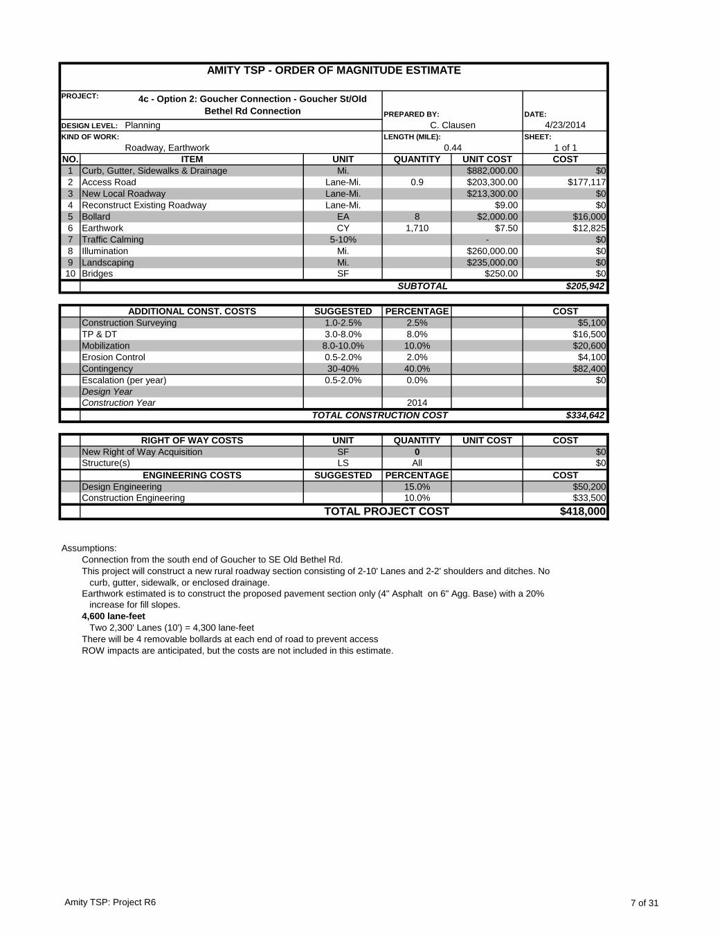
DATE:
4/23/2014
SHEET:
1 of 1
NO. UNIT QUANTITY UNIT COST COST
1 Mi. $882,000.00 $0
2 Lane-Mi. 0.9 $203,300.00 $177,117
3 Lane-Mi. $213,300.00 $0
4 Lane-Mi. $9.00 $0
5 EA 8 $2,000.00 $16,000
6 CY 1,710 $7.50 $12,825
7 5-10% - $0
8 Mi. $260,000.00 $0
9 Mi. $235,000.00 $0
10 SF $250.00 $0
$205,942
SUGGESTED PERCENTAGE COST
1.0-2.5% 2.5% $5,100
3.0-8.0% 8.0% $16,500
8.0-10.0% 10.0% $20,600
0.5-2.0% 2.0% $4,100
30-40% 40.0% $82,400
0.5-2.0% 0.0% $0
2014
$334,642
UNIT QUANTITY UNIT COST COST
SF 0 $0
LS All $0
SUGGESTED PERCENTAGE COST
15.0% $50,200
10.0% $33,500
$418,000
Assumptions:
Connection from the south end of Goucher to SE Old Bethel Rd.
This project will construct a new rural roadway section consisting of 2-10' Lanes and 2-2' shoulders and ditches. No
curb, gutter, sidewalk, or enclosed drainage.
Earthwork estimated is to construct the proposed pavement section only (4" Asphalt on 6" Agg. Base) with a 20%
increase for fill slopes.
4,600 lane-feet
Two 2,300' Lanes (10') = 4,300 lane-feet
There will be 4 removable bollards at each end of road to prevent access
Structure(s)
ENGINEERING COSTS
Design Engineering
Construction Engineering
TOTAL PROJECT COST
Design Year
Construction Year
TOTAL CONSTRUCTION COST
RIGHT OF WAY COSTS
New Right of Way Acquisition
Escalation (per year)
Traffic Calming
Illumination
Landscaping
Bridges
SUBTOTAL
ADDITIONAL CONST. COSTS
Construction Surveying
TP & DT
Mobilization
Erosion Control
Contingency
Curb, Gutter, Sidewalks & Drainage
Access Road
New Local Roadway
Reconstruct Existing Roadway
Bollard
DESIGN LEVEL: Planning C. Clausen
ROW impacts are anticipated, but the costs are not included in this estimate.
AMITY TSP - ORDER OF MAGNITUDE ESTIMATE
PROJECT: 4c - Option 2: Goucher Connection - Goucher St/Old
Bethel Rd Connection PREPARED BY:
Earthwork
KIND OF WORK:
Roadway, Earthwork
LENGTH (MILE):
0.44
ITEM
Amity TSP: Project R6 7 of 31
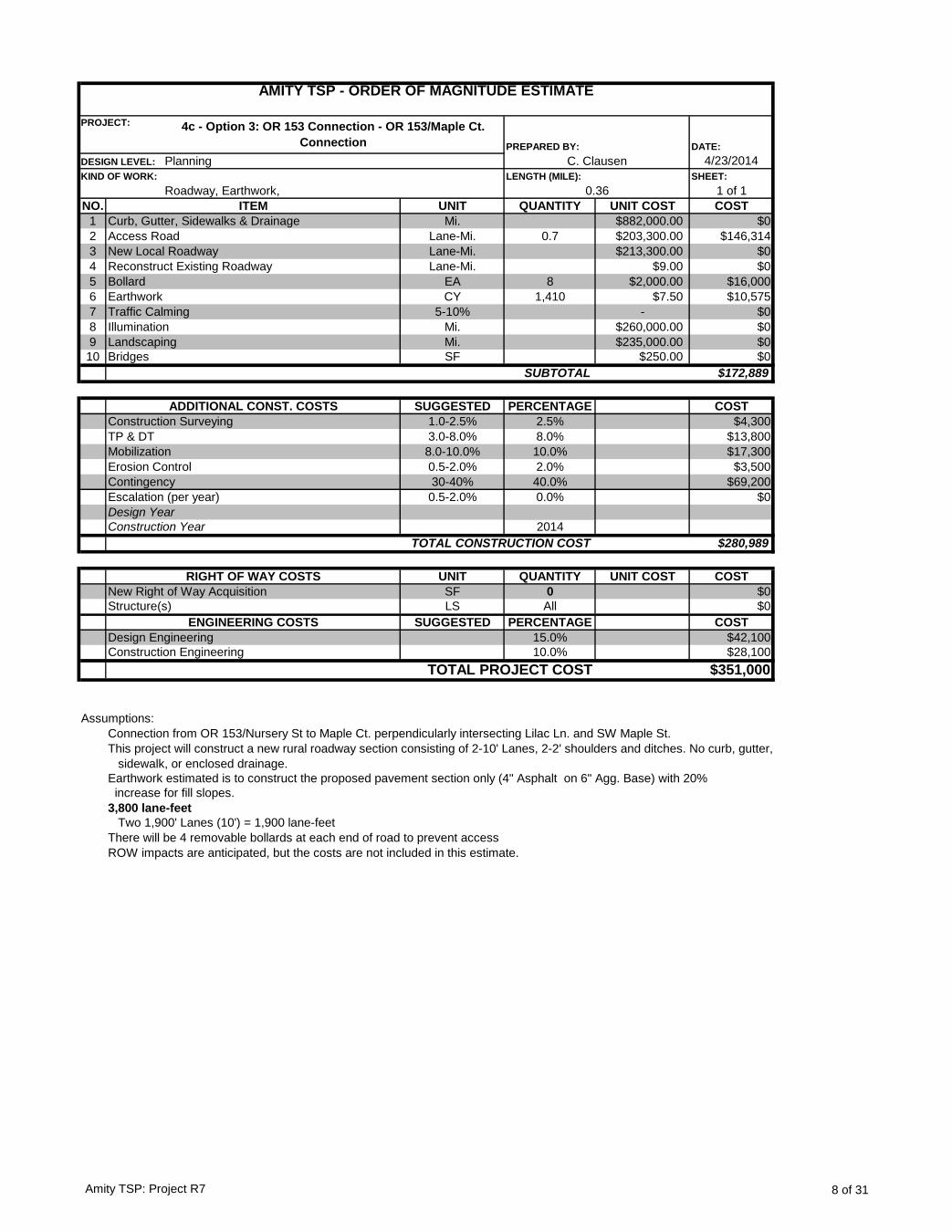
DATE:
4/23/2014
SHEET:
1 of 1
NO. UNIT QUANTITY UNIT COST COST
1 Mi. $882,000.00 $0
2 Lane-Mi. 0.7 $203,300.00 $146,314
3 Lane-Mi. $213,300.00 $0
4 Lane-Mi. $9.00 $0
5 EA 8 $2,000.00 $16,000
6 CY 1,410 $7.50 $10,575
7 5-10% - $0
8 Mi. $260,000.00 $0
9 Mi. $235,000.00 $0
10 SF $250.00 $0
$172,889
SUGGESTED PERCENTAGE COST
1.0-2.5% 2.5% $4,300
3.0-8.0% 8.0% $13,800
8.0-10.0% 10.0% $17,300
0.5-2.0% 2.0% $3,500
30-40% 40.0% $69,200
0.5-2.0% 0.0% $0
2014
$280,989
UNIT QUANTITY UNIT COST COST
SF 0 $0
LS All $0
SUGGESTED PERCENTAGE COST
15.0% $42,100
10.0% $28,100
$351,000
Assumptions:
Connection from OR 153/Nursery St to Maple Ct. perpendicularly intersecting Lilac Ln. and SW Maple St.
This project will construct a new rural roadway section consisting of 2-10' Lanes, 2-2' shoulders and ditches. No curb, gutter,
sidewalk, or enclosed drainage.
Earthwork estimated is to construct the proposed pavement section only (4" Asphalt on 6" Agg. Base) with 20%
increase for fill slopes.
3,800 lane-feet
Two 1,900' Lanes (10') = 1,900 lane-feet
There will be 4 removable bollards at each end of road to prevent access
Structure(s)
ROW impacts are anticipated, but the costs are not included in this estimate.
ENGINEERING COSTS
Design Engineering
Construction Engineering
TOTAL PROJECT COST
Design Year
Construction Year
TOTAL CONSTRUCTION COST
RIGHT OF WAY COSTS
New Right of Way Acquisition
Escalation (per year)
Traffic Calming
Illumination
Landscaping
Bridges
SUBTOTAL
ADDITIONAL CONST. COSTS
Construction Surveying
TP & DT
Mobilization
Erosion Control
Contingency
Earthwork
KIND OF WORK:
Roadway, Earthwork,
LENGTH (MILE):
0.36
ITEM
Curb, Gutter, Sidewalks & Drainage
Access Road
New Local Roadway
Reconstruct Existing Roadway
Bollard
DESIGN LEVEL: Planning C. Clausen
AMITY TSP - ORDER OF MAGNITUDE ESTIMATE
PROJECT: 4c - Option 3: OR 153 Connection - OR 153/Maple Ct.
Connection PREPARED BY:
Amity TSP: Project R7 8 of 31
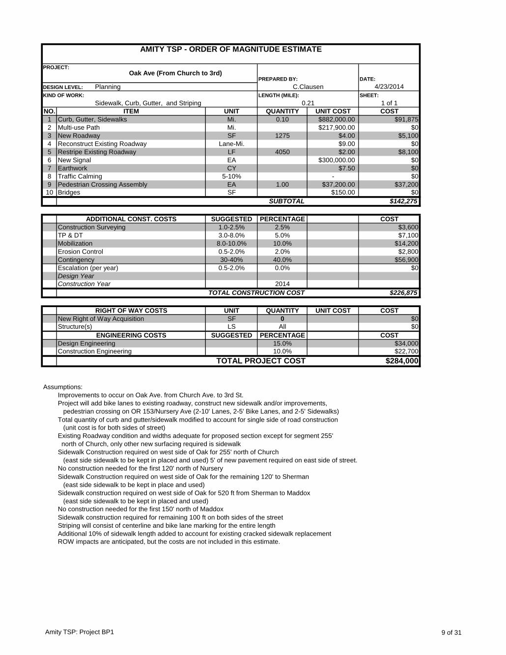
DATE:
4/23/2014
SHEET:
1 of 1
NO. UNIT QUANTITY UNIT COST COST
1 Mi. 0.10 $882,000.00 $91,875
2 Mi. $217,900.00 $0
3 SF 1275 $4.00 $5,100
4 Lane-Mi. $9.00 $0
5 LF 4050 $2.00 $8,100
6 EA $300,000.00 $0
7 CY $7.50 $0
8 5-10% - $0
9 EA 1.00 $37,200.00 $37,200
10 SF $150.00 $0
$142,275
SUGGESTED PERCENTAGE COST
1.0-2.5% 2.5% $3,600
3.0-8.0% 5.0% $7,100
8.0-10.0% 10.0% $14,200
0.5-2.0% 2.0% $2,800
30-40% 40.0% $56,900
0.5-2.0% 0.0% $0
2014
$226,875
UNIT QUANTITY UNIT COST COST
SF 0 $0
LS All $0
SUGGESTED PERCENTAGE COST
15.0% $34,000
10.0% $22,700
$284,000
Assumptions:
Improvements to occur on Oak Ave. from Church Ave. to 3rd St.
Project will add bike lanes to existing roadway, construct new sidewalk and/or improvements,
pedestrian crossing on OR 153/Nursery Ave (2-10' Lanes, 2-5' Bike Lanes, and 2-5' Sidewalks)
Total quantity of curb and gutter/sidewalk modified to account for single side of road construction
(unit cost is for both sides of street)
Existing Roadway condition and widths adequate for proposed section except for segment 255'
north of Church, only other new surfacing required is sidewalk
Sidewalk Construction required on west side of Oak for 255' north of Church
(east side sidewalk to be kept in placed and used) 5' of new pavement required on east side of street.
No construction needed for the first 120' north of Nursery
Sidewalk Construction required on west side of Oak for the remaining 120' to Sherman
(east side sidewalk to be kept in place and used)
Sidewalk construction required on west side of Oak for 520 ft from Sherman to Maddox
(east side sidewalk to be kept in placed and used)
No construction needed for the first 150' north of Maddox
Sidewalk construction required for remaining 100 ft on both sides of the street
Striping will consist of centerline and bike lane marking for the entire length
Additional 10% of sidewalk length added to account for existing cracked sidewalk replacement
ROW impacts are anticipated, but the costs are not included in this estimate.
Design Engineering
Construction Engineering
TOTAL PROJECT COST
Mobilization
Erosion Control
Contingency
ENGINEERING COSTS
Escalation (per year)
New Right of Way Acquisition
Structure(s)
Construction Year
TOTAL CONSTRUCTION COST
RIGHT OF WAY COSTS
Design Year
Bridges
SUBTOTAL
ADDITIONAL CONST. COSTS
Construction Surveying
TP & DT
Pedestrian Crossing Assembly
Curb, Gutter, Sidewalks
Multi-use Path
New Roadway
Reconstruct Existing Roadway
Restripe Existing Roadway
New Signal
Earthwork
Traffic Calming
ITEM
AMITY TSP - ORDER OF MAGNITUDE ESTIMATE
PROJECT:Oak Ave (From Church to 3rd)
PREPARED BY:
DESIGN LEVEL: Planning C.Clausen
KIND OF WORK:
Sidewalk, Curb, Gutter, and Striping
LENGTH (MILE):
0.21
Amity TSP: Project BP1 9 of 31
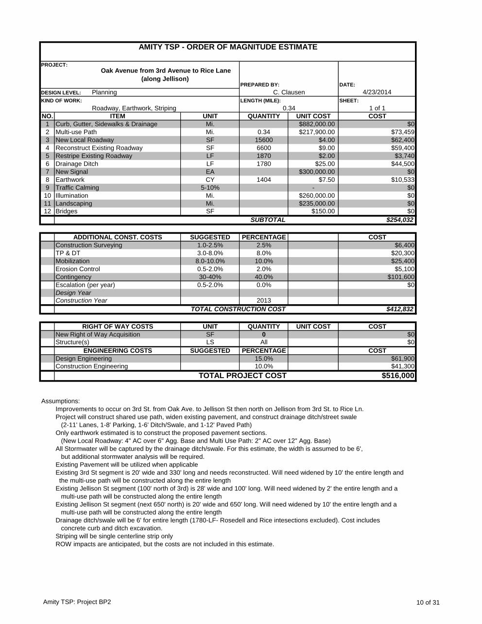
DATE:
4/23/2014
SHEET:
1 of 1
NO. UNIT QUANTITY UNIT COST COST
1 Mi. $882,000.00 $0
2 Mi. 0.34 $217,900.00 $73,459
3 SF 15600 $4.00 $62,400
4 SF 6600 $9.00 $59,400
5 LF 1870 $2.00 $3,740
6 LF 1780 $25.00 $44,500
7 EA $300,000.00 $0
8 CY 1404 $7.50 $10,533
9 5-10% - $0
10 Mi. $260,000.00 $0
11 Mi. $235,000.00 $0
12 SF $150.00 $0
$254,032
SUGGESTED PERCENTAGE COST
1.0-2.5% 2.5% $6,400
3.0-8.0% 8.0% $20,300
8.0-10.0% 10.0% $25,400
0.5-2.0% 2.0% $5,100
30-40% 40.0% $101,600
0.5-2.0% 0.0% $0
2013
$412,832
UNIT QUANTITY UNIT COST COST
SF 0 $0
LS All $0
SUGGESTED PERCENTAGE COST
15.0% $61,900
10.0% $41,300
$516,000
Assumptions:
Improvements to occur on 3rd St. from Oak Ave. to Jellison St then north on Jellison from 3rd St. to Rice Ln.
Project will construct shared use path, widen existing pavement, and construct drainage ditch/street swale
(2-11' Lanes, 1-8' Parking, 1-6' Ditch/Swale, and 1-12' Paved Path)
Only earthwork estimated is to construct the proposed pavement sections.
(New Local Roadway: 4" AC over 6" Agg. Base and Multi Use Path: 2" AC over 12" Agg. Base)
All Stormwater will be captured by the drainage ditch/swale. For this estimate, the width is assumed to be 6',
but additional stormwater analysis will be required.
Existing Pavement will be utilized when applicable
Existing 3rd St segment is 20' wide and 330' long and needs reconstructed. Will need widened by 10' the entire length and
the multi-use path will be constructed along the entire length
Existing Jellison St segment (100' north of 3rd) is 28' wide and 100' long. Will need widened by 2' the entire length and a
multi-use path will be constructed along the entire length
Existing Jellison St segment (next 650' north) is 20' wide and 650' long. Will need widened by 10' the entire length and a
multi-use path will be constructed along the entire length
Drainage ditch/swale will be 6' for entire length (1780-LF- Rosedell and Rice intesections excluded). Cost includes
concrete curb and ditch excavation.
Striping will be single centerline strip only
ROW impacts are anticipated, but the costs are not included in this estimate.
ITEM
AMITY TSP - ORDER OF MAGNITUDE ESTIMATE
PROJECT:
Oak Avenue from 3rd Avenue to Rice Lane
(along Jellison) PREPARED BY:
DESIGN LEVEL: Planning C. Clausen
KIND OF WORK:
Roadway, Earthwork, Striping
LENGTH (MILE):
0.34
Illumination
Curb, Gutter, Sidewalks & Drainage
Multi-use Path
New Local Roadway
Reconstruct Existing Roadway
Restripe Existing Roadway
Drainage Ditch
New Signal
Earthwork
Traffic Calming
Design Year
Landscaping
Bridges
SUBTOTAL
ADDITIONAL CONST. COSTS
Construction Surveying
TP & DT
Mobilization
Erosion Control
Contingency
Escalation (per year)
TOTAL PROJECT COST
Construction Year
TOTAL CONSTRUCTION COST
RIGHT OF WAY COSTS
New Right of Way Acquisition
Structure(s)
ENGINEERING COSTS
Design Engineering
Construction Engineering
Amity TSP: Project BP2 10 of 31
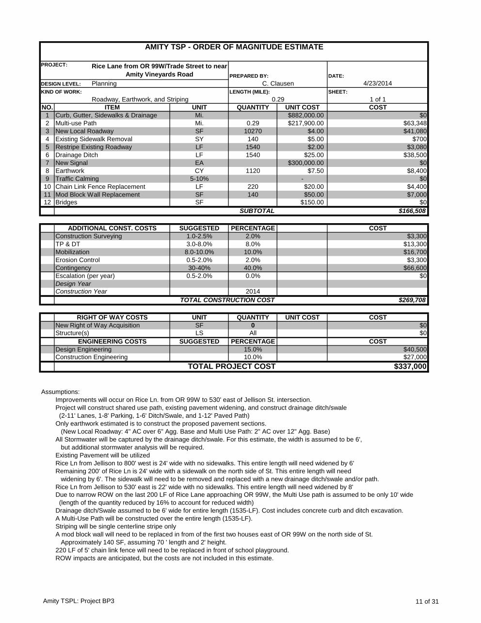
DATE:
4/23/2014
SHEET:
1 of 1
NO. UNIT QUANTITY UNIT COST COST
1 Mi. $882,000.00 $0
2 Mi. 0.29 $217,900.00 $63,348
3 SF 10270 $4.00 $41,080
4 SY 140 $5.00 $700
5 LF 1540 $2.00 $3,080
6 LF 1540 $25.00 $38,500
7 EA $300,000.00 $0
8 CY 1120 $7.50 $8,400
9 5-10% - $0
10 LF 220 $20.00 $4,400
11 SF 140 $50.00 $7,000
12 SF $150.00 $0
$166,508
SUGGESTED PERCENTAGE COST
1.0-2.5% 2.0% $3,300
3.0-8.0% 8.0% $13,300
8.0-10.0% 10.0% $16,700
0.5-2.0% 2.0% $3,300
30-40% 40.0% $66,600
0.5-2.0% 0.0% $0
2014
$269,708
UNIT QUANTITY UNIT COST COST
SF 0 $0
LS All $0
SUGGESTED PERCENTAGE COST
15.0% $40,500
10.0% $27,000
$337,000
Assumptions:
Improvements will occur on Rice Ln. from OR 99W to 530' east of Jellison St. intersection.
Project will construct shared use path, existing pavement widening, and construct drainage ditch/swale
(2-11' Lanes, 1-8' Parking, 1-6' Ditch/Swale, and 1-12' Paved Path)
Only earthwork estimated is to construct the proposed pavement sections.
(New Local Roadway: 4" AC over 6" Agg. Base and Multi Use Path: 2" AC over 12" Agg. Base)
All Stormwater will be captured by the drainage ditch/swale. For this estimate, the width is assumed to be 6',
but additional stormwater analysis will be required.
Existing Pavement will be utilized
Rice Ln from Jellison to 800' west is 24' wide with no sidewalks. This entire length will need widened by 6'
Remaining 200' of Rice Ln is 24' wide with a sidewalk on the north side of St. This entire length will need
widening by 6'. The sidewalk will need to be removed and replaced with a new drainage ditch/swale and/or path.
Rice Ln from Jellison to 530' east is 22' wide with no sidewalks. This entire length will need widened by 8'
Due to narrow ROW on the last 200 LF of Rice Lane approaching OR 99W, the Multi Use path is assumed to be only 10' wide
(length of the quantity reduced by 16% to account for reduced width)
Drainage ditch/Swale assumed to be 6' wide for entire length (1535-LF). Cost includes concrete curb and ditch excavation.
A Multi-Use Path will be constructed over the entire length (1535-LF).
Striping will be single centerline stripe only
A mod block wall will need to be replaced in from of the first two houses east of OR 99W on the north side of St.
Approximately 140 SF, assuming 70 ' length and 2' height.
220 LF of 5' chain link fence will need to be replaced in front of school playground.
ROW impacts are anticipated, but the costs are not included in this estimate.
Mod Block Wall Replacement
Construction Year
Bridges
ITEM
Chain Link Fence Replacement
Curb, Gutter, Sidewalks & Drainage
Multi-use Path
New Local Roadway
Existing Sidewalk Removal
Restripe Existing Roadway
Drainage Ditch
New Signal
Earthwork
Traffic Calming
SUBTOTAL
ADDITIONAL CONST. COSTS
AMITY TSP - ORDER OF MAGNITUDE ESTIMATE
PROJECT: Rice Lane from OR 99W/Trade Street to near
Amity Vineyards Road PREPARED BY:
DESIGN LEVEL: Planning C. Clausen
KIND OF WORK:
Roadway, Earthwork, and Striping
LENGTH (MILE):
0.29
Construction Surveying
TP & DT
RIGHT OF WAY COSTS
Design Year
Mobilization
Erosion Control
Contingency
Escalation (per year)
TOTAL CONSTRUCTION COST
New Right of Way Acquisition
Structure(s)
Design Engineering
Construction Engineering
TOTAL PROJECT COST
ENGINEERING COSTS
Amity TSPL: Project BP3 11 of 31
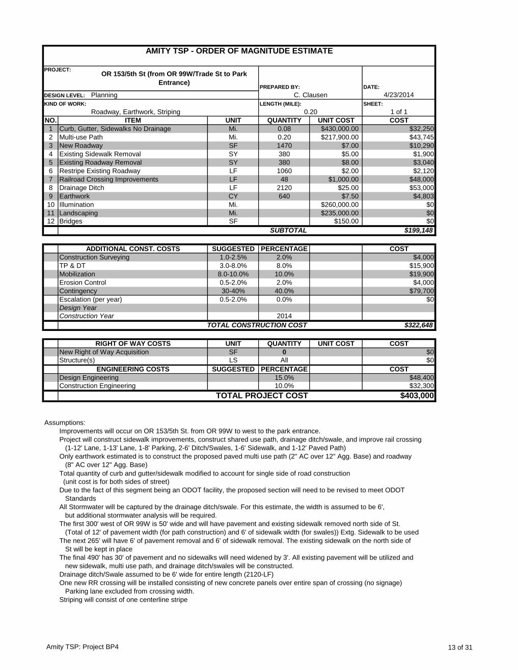
DATE:
4/23/2014
SHEET:
1 of 1
NO. UNIT QUANTITY UNIT COST COST
1 Mi. 0.08 $430,000.00 $32,250
2 Mi. 0.20 $217,900.00 $43,745
3 SF 1470 $7.00 $10,290
4 SY 380 $5.00 $1,900
5 SY 380 $8.00 $3,040
6 LF 1060 $2.00 $2,120
7 LF 48 $1,000.00 $48,000
8 LF 2120 $25.00 $53,000
9 CY 640 $7.50 $4,803
10 Mi. $260,000.00 $0
11 Mi. $235,000.00 $0
12 SF $150.00 $0
$199,148
SUGGESTED PERCENTAGE COST
1.0-2.5% 2.0% $4,000
3.0-8.0% 8.0% $15,900
8.0-10.0% 10.0% $19,900
0.5-2.0% 2.0% $4,000
30-40% 40.0% $79,700
0.5-2.0% 0.0% $0
2014
$322,648
UNIT QUANTITY UNIT COST COST
SF 0 $0
LS All $0
SUGGESTED PERCENTAGE COST
15.0% $48,400
10.0% $32,300
$403,000
Assumptions:
Improvements will occur on OR 153/5th St. from OR 99W to west to the park entrance.
Project will construct sidewalk improvements, construct shared use path, drainage ditch/swale, and improve rail crossing
(1-12' Lane, 1-13' Lane, 1-8' Parking, 2-6' Ditch/Swales, 1-6' Sidewalk, and 1-12' Paved Path)
Only earthwork estimated is to construct the proposed paved multi use path (2" AC over 12" Agg. Base) and roadway
(8" AC over 12" Agg. Base)
Total quantity of curb and gutter/sidewalk modified to account for single side of road construction
(unit cost is for both sides of street)
Due to the fact of this segment being an ODOT facility, the proposed section will need to be revised to meet ODOT
Standards
All Stormwater will be captured by the drainage ditch/swale. For this estimate, the width is assumed to be 6',
but additional stormwater analysis will be required.
The first 300' west of OR 99W is 50' wide and will have pavement and existing sidewalk removed north side of St.
(Total of 12' of pavement width (for path construction) and 6' of sidewalk width (for swales)) Extg. Sidewalk to be used
The next 265' will have 6' of pavement removal and 6' of sidewalk removal. The existing sidewalk on the north side of
St will be kept in place
The final 490' has 30' of pavement and no sidewalks will need widened by 3'. All existing pavement will be utilized and
new sidewalk, multi use path, and drainage ditch/swales will be constructed.
Drainage ditch/Swale assumed to be 6' wide for entire length (2120-LF)
One new RR crossing will be installed consisting of new concrete panels over entire span of crossing (no signage)
Parking lane excluded from crossing width.
Striping will consist of one centerline stripe
SUBTOTAL
ITEM
AMITY TSP - ORDER OF MAGNITUDE ESTIMATE
PROJECT:OR 153/5th St (from OR 99W/Trade St to Park
Entrance) PREPARED BY:
DESIGN LEVEL: Planning C. Clausen
KIND OF WORK:
Roadway, Earthwork, Striping
LENGTH (MILE):
ADDITIONAL CONST. COSTS
Construction Surveying
TP & DT
0.20
Illumination
Curb, Gutter, Sidewalks No Drainage
Multi-use Path
New Roadway
Existing Sidewalk Removal
Existing Roadway Removal
Restripe Existing Roadway
Railroad Crossing Improvements
Drainage Ditch
Earthwork
Bridges
Landscaping
Mobilization
Erosion Control
Contingency
Escalation (per year)
New Right of Way Acquisition
TOTAL CONSTRUCTION COST
RIGHT OF WAY COSTS
Design Year
Construction Year
Structure(s)
Design Engineering
Construction Engineering
TOTAL PROJECT COST
ENGINEERING COSTS
Amity TSP: Project BP4 13 of 31

DATE:
4/23/2014
SHEET:
1 of 1
NO. UNIT QUANTITY UNIT COST COST
1 Mi. 0.39 $882,000.00 $347,455
2 Mi. $217,900.00 $0
3 SF 59460 $4.00 $237,840
4 SY 480 $5.00 $2,400
5 SY $8.00 $0
6 LF 4320 $2.00 $8,640
7 LF 48 $1,000.00 $48,000
8 LF $25.00 $0
9 CY 1835 $7.50 $13,764
10 5-10% - $0
11 Mi. 0 $260,000.00 $102,424
12 SF $150.00 $0
$760,523
SUGGESTED PERCENTAGE COST
1.0-2.5% 2.0% $15,200
3.0-8.0% 8.0% $60,800
8.0-10.0% 10.0% $76,100
0.5-2.0% 2.0% $15,200
30-40% 40.0% $304,200
0.5-2.0% 0.0% $0
2014
$1,232,023
UNIT QUANTITY UNIT COST COST
SF 0 $0
LS All $0
SUGGESTED PERCENTAGE COST
15.0% $184,800
10.0% $123,200
$1,540,000
Assumptions:
Improvements will occur on Stanley St. from OR 153 to the north to 1st St. and continue on 1st St. east to OR 99W
Project will construct sidewalks, drainage ditches/swales, improve the rail crossing on 1st St, and add bike lanes
(2-12' Lanes, 2-6' Bike Lanes, 2-8' Parking, and 2-5' Sidewalks)
Only earthwork estimated is to construct the proposed pavement sections. (New Local Roadway: 4" AC over
6" Agg. Base)
First 80' north of 5th St. is 25' wide, will need widened by 27' over the entire length. (Extg. Sidewalk to be removed)
Next 620' north is 25' wide and needs widened 27' over entire length. New sidewalks to be constructed on both sides
Next 1100' is 22' wide and needs widened by 30' over the entire length. New sidewalks to be constructed on both sides
Remaining 280' is 25' wide and will need widened by 27' over the entire length. New sidewalks to be constructed.
There will be a sidewalks, curb and gutter, with enclosed drainage constructed on both sides over the entire length
of segment (2080-LF)
RR crossing improvements will consist of concrete panels across the width of the crossing (no signage or gates),
however, ODOT Rail may require the installation of an automatic gate. Crossing width excludes parking lanes parking lanes
Striping will be a centerline stripe and two edge/bike lane stripes.
ITEM
AMITY TSP - ORDER OF MAGNITUDE ESTIMATE
PROJECT: Stanley St/1st St (from OR 153/5th St to OR
99W/Trade St) PREPARED BY:
DESIGN LEVEL: Planning C. Clausen
KIND OF WORK:
Roadway, Earthwork, Striping
LENGTH (MILE):
0.39
Restripe Existing Roadway
Railroad Crossing Improvements
Drainage Ditch
Earthwork
Curb, Gutter, Sidewalks & Enclosed Drainage
Multi-use Path
New Local Roadway
Existing Sidewalk Removal
Existing Roadway Removal
Traffic Calming
Design Year
Bridges
SUBTOTAL
ADDITIONAL CONST. COSTS
Construction Surveying
TP & DT
Mobilization
Erosion Control
Contingency
Escalation (per year)
Illumination
ROW impacts are anticipated, but the costs are not included in this estimate.
Construction Year
TOTAL CONSTRUCTION COST
RIGHT OF WAY COSTS
New Right of Way Acquisition
Structure(s)
ENGINEERING COSTS
Design Engineering
Construction Engineering
TOTAL PROJECT COST
Amity TSP: Project BP5 14 of 31
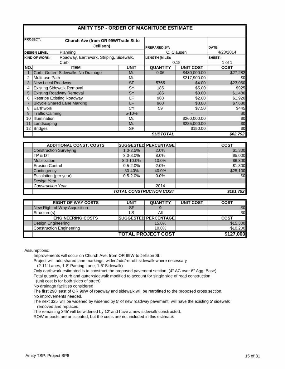
DATE:
4/23/2014
SHEET:
1 of 1
NO. UNIT QUANTITY UNIT COST COST
1 Mi. 0.06 $430,000.00 $27,282
2 Mi. $217,900.00 $0
3 SF 5765 $4.00 $23,060
4 SY 185 $5.00 $925
5 SY 185 $8.00 $1,480
6 LF 960 $2.00 $1,920
7 LF 960 $8.00 $7,680
8 CY 59 $7.50 $445
9 5-10% - $0
10 Mi. $260,000.00 $0
11 Mi. $235,000.00 $0
12 SF $150.00 $0
$62,792
SUGGESTED PERCENTAGE COST
1.0-2.5% 2.0% $1,300
3.0-8.0% 8.0% $5,000
8.0-10.0% 10.0% $6,300
0.5-2.0% 2.0% $1,300
30-40% 40.0% $25,100
0.5-2.0% 0.0% $0
2014
$101,792
UNIT QUANTITY UNIT COST COST
SF 0 $0
LS All $0
SUGGESTED PERCENTAGE COST
15.0% $15,300
10.0% $10,200
$127,000
Assumptions:
Improvements will occur on Church Ave. from OR 99W to Jellison St.
Project will add shared lane markings, widen/add/retrofit sidewalk where necessary
(2-11' Lanes, 1-8' Parking Lane, 1-5' Sidewalk)
Only earthwork estimated is to construct the proposed pavement section. (4" AC over 6" Agg. Base)
Total quantity of curb and gutter/sidewalk modified to account for single side of road construction
(unit cost is for both sides of street)
No drainage facilities considered
The first 290' east of OR 99W of roadway and sidewalk will be retrofitted to the proposed cross section.
No improvements needed.
The next 325' will be widened by widened by 5' of new roadway pavement, will have the existing 5' sidewalk
removed and replaced.
The remaining 345' will be widened by 12' and have a new sidewalk constructed.
ROW impacts are anticipated, but the costs are not included in this estimate.
DESIGN LEVEL: Planning C. Clausen
AMITY TSP - ORDER OF MAGNITUDE ESTIMATE
PROJECT: Church Ave (from OR 99W/Trade St to
Jellison) PREPARED BY:
Restripe Existing Roadway
KIND OF WORK: Roadway, Earthwork, Striping, Sidewalk,
Curb
LENGTH (MILE):
0.18
ITEM
Curb, Gutter, Sidewalks No Drainage
Multi-use Path
New Local Roadway
Existing Sidewalk Removal
Existing Roadway Removal
Construction Surveying
Bicycle Shared Lane Marking
Earthwork
Traffic Calming
Illumination
Landscaping
Bridges
SUBTOTAL
ADDITIONAL CONST. COSTS
Design Engineering
Construction Engineering
TOTAL PROJECT COST
ENGINEERING COSTS
TP & DT
Mobilization
Erosion Control
Contingency
Escalation (per year)
Design Year
Construction Year
TOTAL CONSTRUCTION COST
RIGHT OF WAY COSTS
New Right of Way Acquisition
Structure(s)
Amity TSP: Project BP6 15 of 31
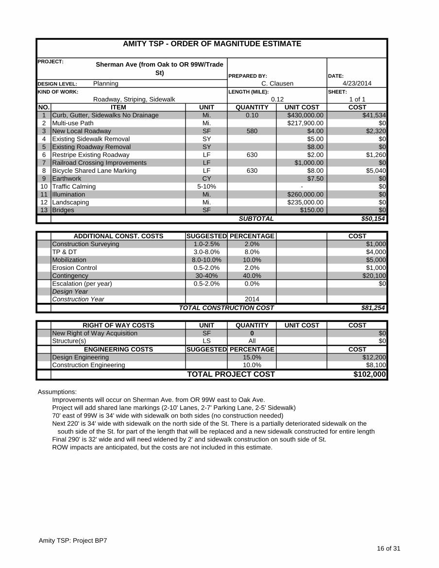
DATE:
4/23/2014
SHEET:
1 of 1
NO. UNIT QUANTITY UNIT COST COST
1 Mi. 0.10 $430,000.00 $41,534
2 Mi. $217,900.00 $0
3 SF 580 $4.00 $2,320
4 SY $5.00 $0
5 SY $8.00 $0
6 LF 630 $2.00 $1,260
7 LF $1,000.00 $0
8 LF 630 $8.00 $5,040
9 CY $7.50 $0
10 5-10% - $0
11 Mi. $260,000.00 $0
12 Mi. $235,000.00 $0
13 SF $150.00 $0
$50,154
SUGGESTED PERCENTAGE COST
1.0-2.5% 2.0% $1,000
3.0-8.0% 8.0% $4,000
8.0-10.0% 10.0% $5,000
0.5-2.0% 2.0% $1,000
30-40% 40.0% $20,100
0.5-2.0% 0.0% $0
2014
$81,254
UNIT QUANTITY UNIT COST COST
SF 0 $0
LS All $0
SUGGESTED PERCENTAGE COST
15.0% $12,200
10.0% $8,100
$102,000
Assumptions:
Improvements will occur on Sherman Ave. from OR 99W east to Oak Ave.
Project will add shared lane markings (2-10' Lanes, 2-7' Parking Lane, 2-5' Sidewalk)
70' east of 99W is 34' wide with sidewalk on both sides (no construction needed)
Next 220' is 34' wide with sidewalk on the north side of the St. There is a partially deteriorated sidewalk on the
south side of the St. for part of the length that will be replaced and a new sidewalk constructed for entire length
Final 290' is 32' wide and will need widened by 2' and sidewalk construction on south side of St.
ITEM
AMITY TSP - ORDER OF MAGNITUDE ESTIMATE
PROJECT:Sherman Ave (from Oak to OR 99W/Trade
St) PREPARED BY:
DESIGN LEVEL: Planning C. Clausen
KIND OF WORK:
Roadway, Striping, Sidewalk
LENGTH (MILE):
0.12
Illumination
Curb, Gutter, Sidewalks No Drainage
Multi-use Path
New Local Roadway
Existing Sidewalk Removal
Existing Roadway Removal
Restripe Existing Roadway
Railroad Crossing Improvements
Bicycle Shared Lane Marking
Earthwork
Traffic Calming
Design Year
Landscaping
Bridges
SUBTOTAL
ADDITIONAL CONST. COSTS
Construction Surveying
TP & DT
Mobilization
Erosion Control
Contingency
Escalation (per year)
ROW impacts are anticipated, but the costs are not included in this estimate.
Design Engineering
Construction Engineering
TOTAL PROJECT COST
Construction Year
TOTAL CONSTRUCTION COST
RIGHT OF WAY COSTS
New Right of Way Acquisition
Structure(s)
ENGINEERING COSTS
Amity TSP: Project BP7
16 of 31
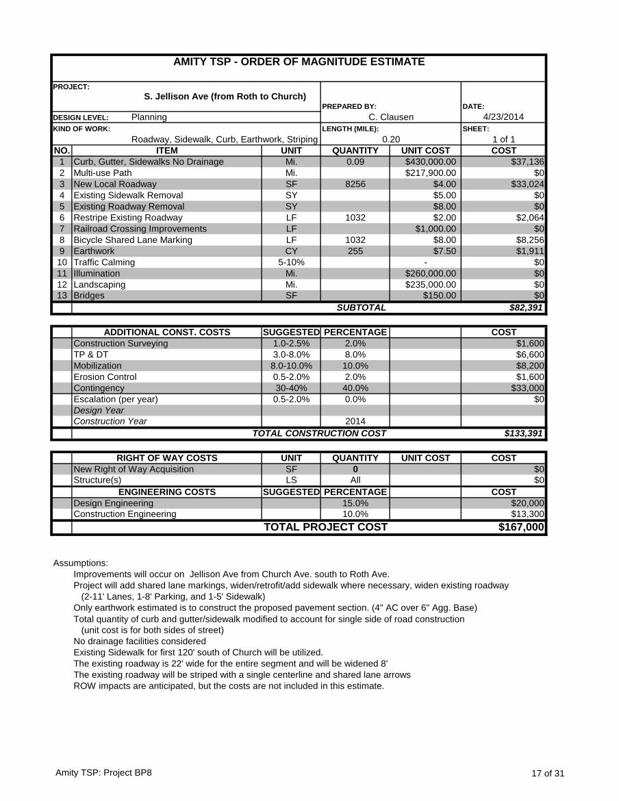
DATE:
4/23/2014
SHEET:
1 of 1
NO. UNIT QUANTITY UNIT COST COST
1 Mi. 0.09 $430,000.00 $37,136
2 Mi. $217,900.00 $0
3 SF 8256 $4.00 $33,024
4 SY $5.00 $0
5 SY $8.00 $0
6 LF 1032 $2.00 $2,064
7 LF $1,000.00 $0
8 LF 1032 $8.00 $8,256
9 CY 255 $7.50 $1,911
10 5-10% - $0
11 Mi. $260,000.00 $0
12 Mi. $235,000.00 $0
13 SF $150.00 $0
$82,391
SUGGESTED PERCENTAGE COST
1.0-2.5% 2.0% $1,600
3.0-8.0% 8.0% $6,600
8.0-10.0% 10.0% $8,200
0.5-2.0% 2.0% $1,600
30-40% 40.0% $33,000
0.5-2.0% 0.0% $0
2014
$133,391
UNIT QUANTITY UNIT COST COST
SF 0 $0
LS All $0
SUGGESTED PERCENTAGE COST
15.0% $20,000
10.0% $13,300
$167,000
Assumptions:
Improvements will occur on Jellison Ave from Church Ave. south to Roth Ave.
Project will add shared lane markings, widen/retrofit/add sidewalk where necessary, widen existing roadway
(2-11' Lanes, 1-8' Parking, and 1-5' Sidewalk)
Only earthwork estimated is to construct the proposed pavement section. (4" AC over 6" Agg. Base)
Total quantity of curb and gutter/sidewalk modified to account for single side of road construction
(unit cost is for both sides of street)
No drainage facilities considered
Existing Sidewalk for first 120' south of Church will be utilized.
The existing roadway is 22' wide for the entire segment and will be widened 8'
The existing roadway will be striped with a single centerline and shared lane arrows
ROW impacts are anticipated, but the costs are not included in this estimate.
ITEM
AMITY TSP - ORDER OF MAGNITUDE ESTIMATE
PROJECT:
S. Jellison Ave (from Roth to Church) PREPARED BY:
DESIGN LEVEL: Planning C. Clausen
KIND OF WORK:
Roadway, Sidewalk, Curb, Earthwork, Striping
LENGTH (MILE):
0.20
Illumination
Curb, Gutter, Sidewalks No Drainage
Multi-use Path
New Local Roadway
Existing Sidewalk Removal
Existing Roadway Removal
Restripe Existing Roadway
Railroad Crossing Improvements
Bicycle Shared Lane Marking
Earthwork
Traffic Calming
Design Year
Landscaping
Bridges
SUBTOTAL
ADDITIONAL CONST. COSTS
Construction Surveying
TP & DT
Mobilization
Erosion Control
Contingency
Escalation (per year)
Design Engineering
Construction Engineering
TOTAL PROJECT COST
Construction Year
TOTAL CONSTRUCTION COST
RIGHT OF WAY COSTS
New Right of Way Acquisition
Structure(s)
ENGINEERING COSTS
Amity TSP: Project BP8 17 of 31
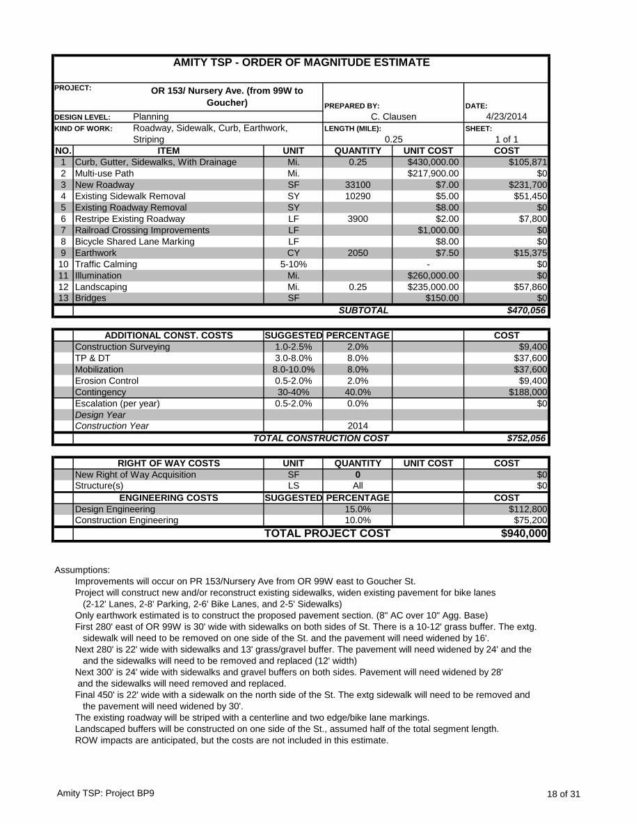
DATE:
4/23/2014
SHEET:
1 of 1
NO. UNIT QUANTITY UNIT COST COST
1 Mi. 0.25 $430,000.00 $105,871
2 Mi. $217,900.00 $0
3 SF 33100 $7.00 $231,700
4 SY 10290 $5.00 $51,450
5 SY $8.00 $0
6 LF 3900 $2.00 $7,800
7 LF $1,000.00 $0
8 LF $8.00 $0
9 CY 2050 $7.50 $15,375
10 5-10% - $0
11 Mi. $260,000.00 $0
12 Mi. 0.25 $235,000.00 $57,860
13 SF $150.00 $0
$470,056
SUGGESTED PERCENTAGE COST
1.0-2.5% 2.0% $9,400
3.0-8.0% 8.0% $37,600
8.0-10.0% 8.0% $37,600
0.5-2.0% 2.0% $9,400
30-40% 40.0% $188,000
0.5-2.0% 0.0% $0
2014
$752,056
UNIT QUANTITY UNIT COST COST
SF 0 $0
LS All $0
SUGGESTED PERCENTAGE COST
15.0% $112,800
10.0% $75,200
$940,000
Assumptions:
Improvements will occur on PR 153/Nursery Ave from OR 99W east to Goucher St.
Project will construct new and/or reconstruct existing sidewalks, widen existing pavement for bike lanes
(2-12' Lanes, 2-8' Parking, 2-6' Bike Lanes, and 2-5' Sidewalks)
Only earthwork estimated is to construct the proposed pavement section. (8" AC over 10" Agg. Base)
First 280' east of OR 99W is 30' wide with sidewalks on both sides of St. There is a 10-12' grass buffer. The extg.
sidewalk will need to be removed on one side of the St. and the pavement will need widened by 16'.
Next 280' is 22' wide with sidewalks and 13' grass/gravel buffer. The pavement will need widened by 24' and the
and the sidewalks will need to be removed and replaced (12' width)
Next 300' is 24' wide with sidewalks and gravel buffers on both sides. Pavement will need widened by 28'
and the sidewalks will need removed and replaced.
Final 450' is 22' wide with a sidewalk on the north side of the St. The extg sidewalk will need to be removed and
the pavement will need widened by 30'.
The existing roadway will be striped with a centerline and two edge/bike lane markings.
Landscaped buffers will be constructed on one side of the St., assumed half of the total segment length.
ITEM
AMITY TSP - ORDER OF MAGNITUDE ESTIMATE
PROJECT: OR 153/ Nursery Ave. (from 99W to
Goucher) PREPARED BY:
DESIGN LEVEL: Planning C. Clausen
KIND OF WORK: Roadway, Sidewalk, Curb, Earthwork,
Striping
LENGTH (MILE):
0.25
Landscaping
Curb, Gutter, Sidewalks, With Drainage
Multi-use Path
New Roadway
Existing Sidewalk Removal
Existing Roadway Removal
Restripe Existing Roadway
Railroad Crossing Improvements
Bicycle Shared Lane Marking
Earthwork
Traffic Calming
Illumination
TOTAL CONSTRUCTION COST
Bridges
SUBTOTAL
ADDITIONAL CONST. COSTS
Construction Surveying
TP & DT
Mobilization
Erosion Control
Contingency
Escalation (per year)
Design Year
Construction Year
TOTAL PROJECT COST
ROW impacts are anticipated, but the costs are not included in this estimate.
RIGHT OF WAY COSTS
New Right of Way Acquisition
Structure(s)
ENGINEERING COSTS
Design Engineering
Construction Engineering
Amity TSP: Project BP9 18 of 31
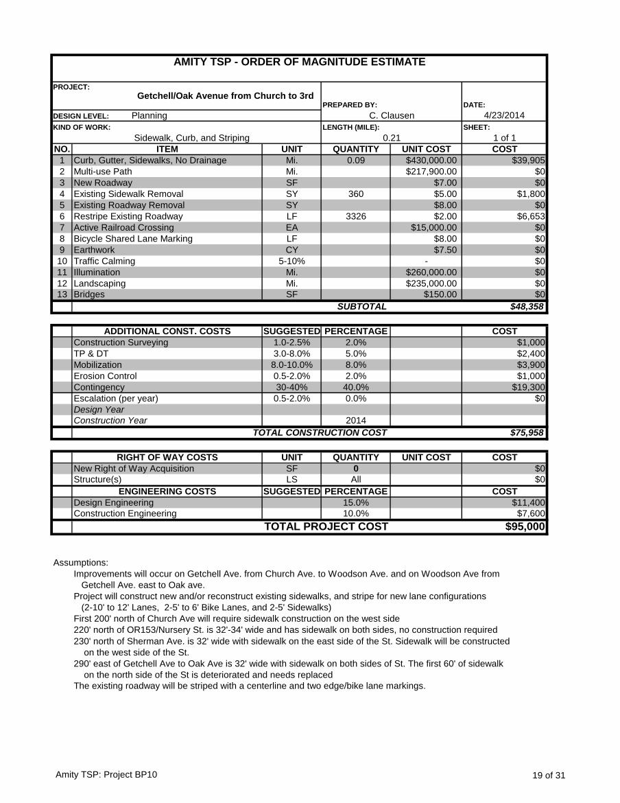
DATE:
4/23/2014
SHEET:
1 of 1
NO. UNIT QUANTITY UNIT COST COST
1 Mi. 0.09 $430,000.00 $39,905
2 Mi. $217,900.00 $0
3 SF $7.00 $0
4 SY 360 $5.00 $1,800
5 SY $8.00 $0
6 LF 3326 $2.00 $6,653
7 EA $15,000.00 $0
8 LF $8.00 $0
9 CY $7.50 $0
10 5-10% - $0
11 Mi. $260,000.00 $0
12 Mi. $235,000.00 $0
13 SF $150.00 $0
$48,358
SUGGESTED PERCENTAGE COST
1.0-2.5% 2.0% $1,000
3.0-8.0% 5.0% $2,400
8.0-10.0% 8.0% $3,900
0.5-2.0% 2.0% $1,000
30-40% 40.0% $19,300
0.5-2.0% 0.0% $0
2014
$75,958
UNIT QUANTITY UNIT COST COST
SF 0 $0
LS All $0
SUGGESTED PERCENTAGE COST
15.0% $11,400
10.0% $7,600
$95,000
Assumptions:
Improvements will occur on Getchell Ave. from Church Ave. to Woodson Ave. and on Woodson Ave from
Getchell Ave. east to Oak ave.
Project will construct new and/or reconstruct existing sidewalks, and stripe for new lane configurations
(2-10' to 12' Lanes, 2-5' to 6' Bike Lanes, and 2-5' Sidewalks)
First 200' north of Church Ave will require sidewalk construction on the west side
220' north of OR153/Nursery St. is 32'-34' wide and has sidewalk on both sides, no construction required
230' north of Sherman Ave. is 32' wide with sidewalk on the east side of the St. Sidewalk will be constructed
on the west side of the St.
290' east of Getchell Ave to Oak Ave is 32' wide with sidewalk on both sides of St. The first 60' of sidewalk
on the north side of the St is deteriorated and needs replaced
The existing roadway will be striped with a centerline and two edge/bike lane markings.
TOTAL PROJECT COST
RIGHT OF WAY COSTS
New Right of Way Acquisition
Structure(s)
ENGINEERING COSTS
Design Engineering
Construction Engineering
TOTAL CONSTRUCTION COST
Bridges
SUBTOTAL
ADDITIONAL CONST. COSTS
Construction Surveying
TP & DT
Mobilization
Erosion Control
Contingency
Escalation (per year)
Design Year
Construction Year
Landscaping
Curb, Gutter, Sidewalks, No Drainage
Multi-use Path
New Roadway
Existing Sidewalk Removal
Existing Roadway Removal
Restripe Existing Roadway
Active Railroad Crossing
Bicycle Shared Lane Marking
Earthwork
Traffic Calming
Illumination
ITEM
AMITY TSP - ORDER OF MAGNITUDE ESTIMATE
PROJECT:
Getchell/Oak Avenue from Church to 3rdPREPARED BY:
DESIGN LEVEL: Planning C. Clausen
KIND OF WORK:
Sidewalk, Curb, and Striping
LENGTH (MILE):
0.21
Amity TSP: Project BP10 19 of 31

DATE:
4/23/2014
SHEET:
1 of 1
NO. UNIT QUANTITY UNIT COST COST
1 Mi. 0.08 $430,000.00 $33,797
2 Mi. $217,900.00 $0
3 SF 580 $4.00 $2,320
4 SY 1740 $5.00 $8,700
5 SY $8.00 $0
6 LF 620 $2.00 $1,240
7 EA $15,000.00 $0
8 LF 620 $8.00 $4,960
9 CY $7.50 $0
10 5-10% - $0
11 Mi. $260,000.00 $0
12 Mi. $235,000.00 $0
13 SF $150.00 $0
$51,017
SUGGESTED PERCENTAGE COST
1.0-2.5% 2.0% $1,000
3.0-8.0% 8.0% $4,100
8.0-10.0% 10.0% $5,100
0.5-2.0% 2.0% $1,000
30-40% 40.0% $20,400
0.5-2.0% 0.0% $0
2014
$82,617
UNIT QUANTITY UNIT COST COST
SF 0 $0
LS All $0
SUGGESTED PERCENTAGE COST
15.0% $12,400
10.0% $8,300
$103,000
Assumptions:
Improvements will occur on Woodson Ave. from OR 99W to Oak Ave.
Project will add shared lane markings (2-10' Lanes, 2-7' Parking Lane, 2-5' Sidewalk)
Existing 125' east of 99W is 34' wide with sidewalk on north side. Sidewalk construction required on south side
Existing 160' is 34' wide with sidewalk on both sides(no construction needed)
Existing 290' is 32' wide with sidewalk on both sides. The sidewalk will need removed on one side of the St and
will need widened by 2' over the entire length and new sidewalk construction
ITEM
AMITY TSP - ORDER OF MAGNITUDE ESTIMATE
PROJECT:Woodson Ave (from Oak to OR 99W/Trade
St) PREPARED BY:
DESIGN LEVEL: Planning C. Clausen
KIND OF WORK:
Roadway, Sidewalk, Striping
LENGTH (MILE):
0.12
Landscaping
Curb, Gutter, Sidewalks No Drainage
Multi-use Path
New Local Roadway
Existing Sidewalk Removal
Existing Roadway Removal
Restripe Existing Roadway
Active Railroad Crossing
Bicycle Shared Lane Marking
Earthwork
Traffic Calming
Illumination
TOTAL CONSTRUCTION COST
Bridges
SUBTOTAL
ADDITIONAL CONST. COSTS
Construction Surveying
TP & DT
Mobilization
Erosion Control
Contingency
Escalation (per year)
Design Year
Construction Year
TOTAL PROJECT COST
ROW impacts are anticipated, but the costs are not included in this estimate.
RIGHT OF WAY COSTS
New Right of Way Acquisition
Structure(s)
ENGINEERING COSTS
Design Engineering
Construction Engineering
Amity TSP: Project BP11
20 of 31
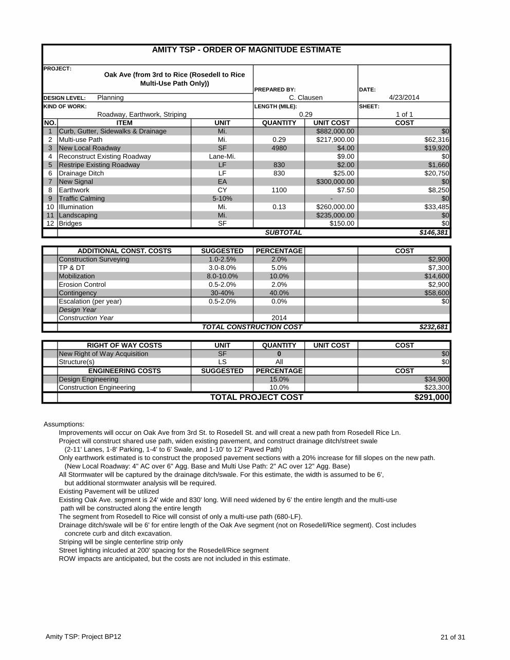
DATE:
4/23/2014
SHEET:
1 of 1
NO. UNIT QUANTITY UNIT COST COST
1 Mi. $882,000.00 $0
2 Mi. 0.29 $217,900.00 $62,316
3 SF 4980 $4.00 $19,920
4 Lane-Mi. $9.00 $0
5 LF 830 $2.00 $1,660
6 LF 830 $25.00 $20,750
7 EA $300,000.00 $0
8 CY 1100 $7.50 $8,250
9 5-10% - $0
10 Mi. 0.13 $260,000.00 $33,485
11 Mi. $235,000.00 $0
12 SF $150.00 $0
$146,381
SUGGESTED PERCENTAGE COST
1.0-2.5% 2.0% $2,900
3.0-8.0% 5.0% $7,300
8.0-10.0% 10.0% $14,600
0.5-2.0% 2.0% $2,900
30-40% 40.0% $58,600
0.5-2.0% 0.0% $0
2014
$232,681
UNIT QUANTITY UNIT COST COST
SF 0 $0
LS All $0
SUGGESTED PERCENTAGE COST
15.0% $34,900
10.0% $23,300
$291,000
Assumptions:
Improvements will occur on Oak Ave from 3rd St. to Rosedell St. and will creat a new path from Rosedell Rice Ln.
Project will construct shared use path, widen existing pavement, and construct drainage ditch/street swale
(2-11' Lanes, 1-8' Parking, 1-4' to 6' Swale, and 1-10' to 12' Paved Path)
Only earthwork estimated is to construct the proposed pavement sections with a 20% increase for fill slopes on the new path.
(New Local Roadway: 4" AC over 6" Agg. Base and Multi Use Path: 2" AC over 12" Agg. Base)
All Stormwater will be captured by the drainage ditch/swale. For this estimate, the width is assumed to be 6',
but additional stormwater analysis will be required.
Existing Pavement will be utilized
Existing Oak Ave. segment is 24' wide and 830' long. Will need widened by 6' the entire length and the multi-use
path will be constructed along the entire length
The segment from Rosedell to Rice will consist of only a multi-use path (680-LF).
Drainage ditch/swale will be 6' for entire length of the Oak Ave segment (not on Rosedell/Rice segment). Cost includes
concrete curb and ditch excavation.
Striping will be single centerline strip only
Street lighting inlcuded at 200' spacing for the Rosedell/Rice segment
ROW impacts are anticipated, but the costs are not included in this estimate.
DESIGN LEVEL: Planning C. Clausen
AMITY TSP - ORDER OF MAGNITUDE ESTIMATE
PROJECT:
Oak Ave (from 3rd to Rice (Rosedell to Rice
Multi-Use Path Only))PREPARED BY:
Drainage Ditch
KIND OF WORK:
Roadway, Earthwork, Striping
LENGTH (MILE):
0.29
ITEM
Curb, Gutter, Sidewalks & Drainage
Multi-use Path
New Local Roadway
Reconstruct Existing Roadway
Restripe Existing Roadway
Erosion Control
New Signal
Earthwork
Traffic Calming
Illumination
Landscaping
Bridges
SUBTOTAL
ADDITIONAL CONST. COSTS
Construction Surveying
TP & DT
Mobilization
TOTAL PROJECT COST
Contingency
Escalation (per year)
Design Year
Construction Year
TOTAL CONSTRUCTION COST
RIGHT OF WAY COSTS
New Right of Way Acquisition
Structure(s)
ENGINEERING COSTS
Design Engineering
Construction Engineering
Amity TSP: Project BP12 21 of 31
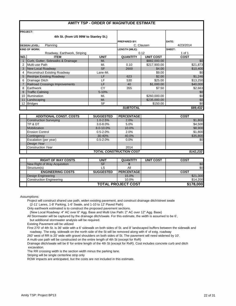
DATE:
4/23/2014
SHEET:
1 of 1
NO. UNIT QUANTITY UNIT COST COST
1 Mi. $882,000.00 $0
2 Mi. 0.10 $217,900.00 $21,873
3 SF 2600 $4.00 $10,400
4 Lane-Mi. $9.00 $0
5 LF 623 $2.00 $1,246
6 LF 530 $25.00 $13,250
7 LF 40 $1,000.00 $40,000
8 CY 355 $7.50 $2,663
9 5-10% - $0
10 Mi. $260,000.00 $0
11 Mi. $235,000.00 $0
12 SF $150.00 $0
$89,432
SUGGESTED PERCENTAGE COST
1.0-2.5% 2.0% $1,800
3.0-8.0% 5.0% $4,500
8.0-10.0% 10.0% $8,900
0.5-2.0% 2.0% $1,800
30-40% 40.0% $35,800
0.5-2.0% 0.0% $0
2014
$142,232
UNIT QUANTITY UNIT COST COST
SF 0 $0
LS All $0
SUGGESTED PERCENTAGE COST
15.0% $21,300
10.0% $14,200
$178,000
Assumptions:
Project will construct shared use path, widen existing pavement, and construct drainage ditch/street swale
(2-11' Lanes, 1-8' Parking, 1-6' Swale, and 1-10 to 12' Paved Path)
Only earthwork estimated is to construct the proposed pavement sections.
(New Local Roadway: 4" AC over 6" Agg. Base and Multi Use Path: 2" AC over 12" Agg. Base)
All Stormwater will be captured by the drainage ditch/swale. For this estimate, the width is assumed to be 6',
but additional stormwater analysis will be required.
Existing Pavement will be utilized
First 270' of 4th St. is 36' wide with a 6' sidewalk on both sides of St. and 8' landscaped buffers between the sidewalk and
roadway. The extg. sidewalk on the north side of the St will be removed along with 4' of extg. roadway
260' west of RR is 20' wide with gravel shoulders on both sides of St. The pavement will need widened by 10'.
A multi-use path will be constructed on the entire length of 4th St (except for RxR)
Drainage ditch/swale will be 6' for entire length of the 4th St (except for RxR). Cost includes concrete curb and ditch
excavation.
The RR crossing width is the section width minus the parking lane.
Striping will be single centerline strip only
ROW impacts are anticipated, but the costs are not included in this estimate.
DESIGN LEVEL: Planning C. Clausen
AMITY TSP - ORDER OF MAGNITUDE ESTIMATE
PROJECT:
4th St. (from US 99W to Stanley St.)
PREPARED BY:
Drainage Ditch
KIND OF WORK:
Roadway, Earthwork, Striping
LENGTH (MILE):
0.12
ITEM
Curb, Gutter, Sidewalks & Drainage
Multi-use Path
New Local Roadway
Reconstruct Existing Roadway
Restripe Existing Roadway
Erosion Control
Railroad Crossings Improvements
Earthwork
Traffic Calming
Illumination
Landscaping
Bridges
SUBTOTAL
ADDITIONAL CONST. COSTS
Construction Surveying
TP & DT
Mobilization
TOTAL PROJECT COST
Contingency
Escalation (per year)
Design Year
Construction Year
TOTAL CONSTRUCTION COST
RIGHT OF WAY COSTS
New Right of Way Acquisition
Structure(s)
ENGINEERING COSTS
Design Engineering
Construction Engineering
Amity TSP: Project BP13 22 of 31
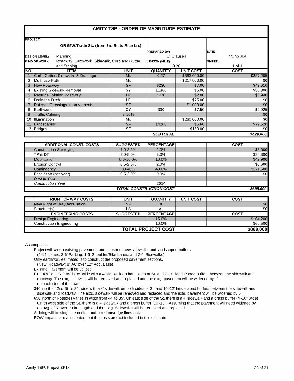
DATE:
4/17/2014
SHEET:
1 of 1
NO. UNIT QUANTITY UNIT COST COST
1 Mi. 0.27 $882,000.00 $237,205
2 Mi. $217,900.00 $0
3 SF 6230 $7.00 $43,610
4 SY 11360 $5.00 $56,800
5 LF 4470 $2.00 $8,940
6 LF $25.00 $0
7 SF $1,000.00 $0
8 CY 390 $7.50 $2,925
9 5-10% - $0
10 Mi. $260,000.00 $0
11 SF 14200 $5.60 $79,520
12 SF $150.00 $0
$429,000
SUGGESTED PERCENTAGE COST
1.0-2.5% 2.0% $8,600
3.0-8.0% 8.0% $34,300
8.0-10.0% 10.0% $42,900
0.5-2.0% 2.0% $8,600
30-40% 40.0% $171,600
0.5-2.0% 0.0% $0
2014
$695,000
UNIT QUANTITY UNIT COST COST
SF 0 $0
LS All $0
SUGGESTED PERCENTAGE COST
15.0% $104,200
10.0% $69,500
$869,000
Assumptions:
Project will widen existing pavement, and construct new sidewalks and landscaped buffers
(2-14' Lanes, 2-6' Parking, 1-6' Shoulder/Bike Lanes, and 2-6' Sidewalks)
Only earthwork estimated is to construct the proposed pavement sections.
(New Roadway: 8" AC over 12" Agg. Base)
Existing Pavement will be utilized
First 430' of OR 99W is 38' wide with a 4' sidewalk on both sides of St. and 7'-10' landscaped buffers between the sidewalk and
roadway. The extg. sidewalk will be removed and replaced and the extg. pavement will be widened by 1'
on each side of the road.
340' north of 2nd St. is 35' wide with a 4' sidewalk on both sides of St. and 10'-12' landscaped buffers between the sidewalk and
sidewalk and roadway. The extg. sidewalk will be removed and replaced and the extg. pavement will be widened by 5'
650' north of Rosedell varies in width from 44' to 35'. On east side of the St. there is a 4' sidewalk and a grass buffer (4'-10'' wide)
On th west side of the St. there is a 4' sidewalk and a grass buffer (10'-13'). Assuming that the pavement will need widened by
an avg. of 3' over entire length and the extg. Sidewalks will be removed and replaced.
Striping will be single centerline and bike lane/edge lines only
ROW impacts are anticipated, but the costs are not included in this estimate.
TOTAL PROJECT COST
Contingency
Escalation (per year)
Design Year
Construction Year
TOTAL CONSTRUCTION COST
RIGHT OF WAY COSTS
New Right of Way Acquisition
Structure(s)
ENGINEERING COSTS
Design Engineering
Construction Engineering
Erosion Control
Railroad Crossings Improvements
Earthwork
Traffic Calming
Illumination
Landscaping
Bridges
SUBTOTAL
ADDITIONAL CONST. COSTS
Construction Surveying
TP & DT
Mobilization
Drainage Ditch
KIND OF WORK: Roadway, Earthwork, Sidewalk, Curb and Gutter,
and Striping
LENGTH (MILE):
0.28
ITEM
Curb, Gutter, Sidewalks & Drainage
Multi-use Path
New Roadway
Existing Sidewalk Removal
Restripe Existing Roadway
DESIGN LEVEL: Planning C. Clausen
AMITY TSP - ORDER OF MAGNITUDE ESTIMATE
PROJECT:
OR 99W/Trade St.. (from 3rd St. to Rice Ln.)
PREPARED BY:
Amity TSP: Project BP14 23 of 31
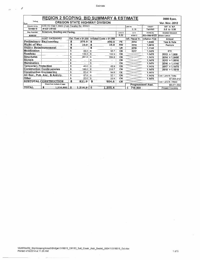
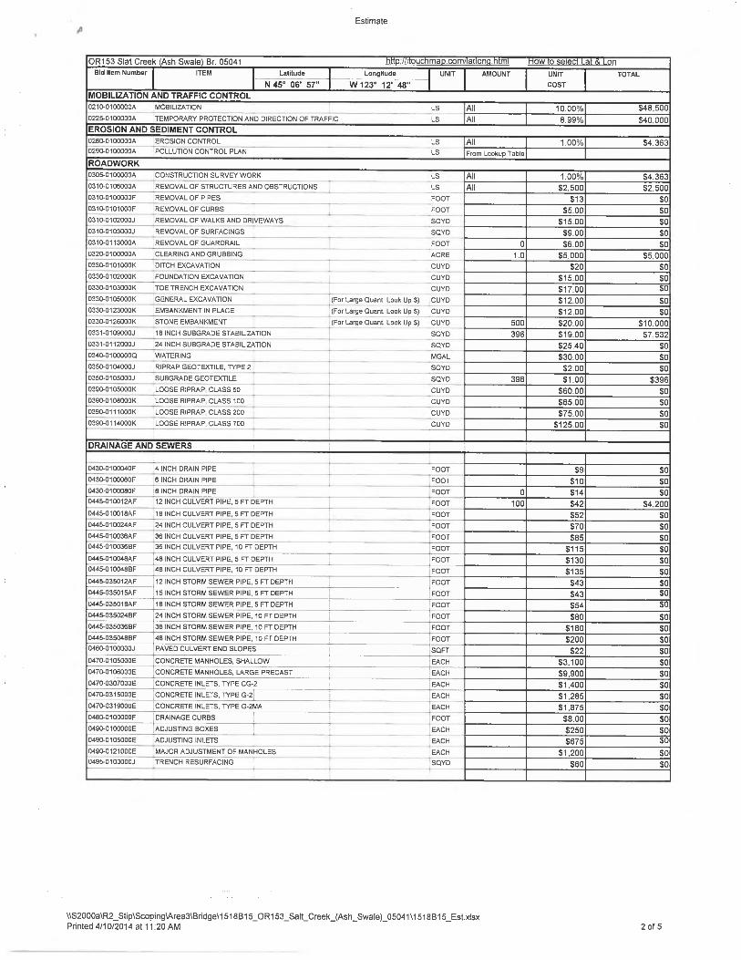
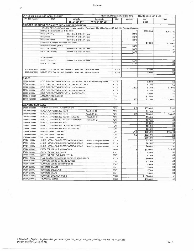
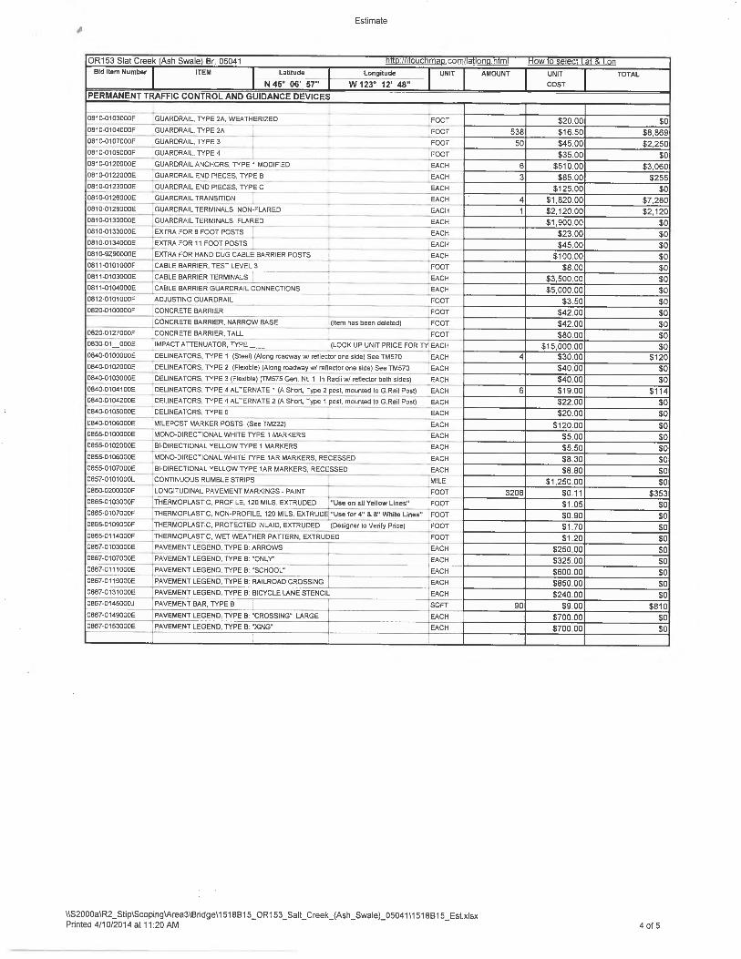
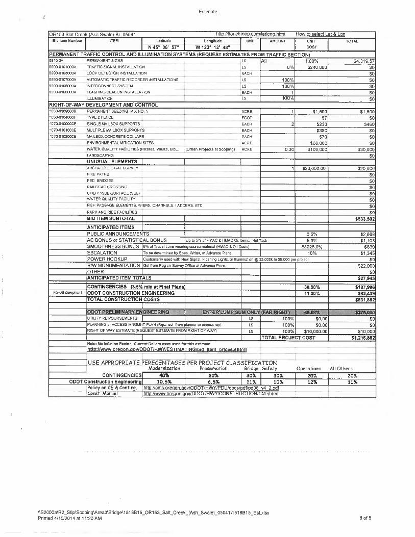
AMITY TRANSPORTATION SYSTEM PLAN
Appendix B – Bicycle level of stress (BLOS) assessments, “before” and “after.” About BLOS As TSPs become more focused on alternate transportation modes to the single occupant vehicle, it is important to be able to qualitatively assess facilities for non-auto modes, including bicycles. Bicycling is a viable alternative for simple, short trips generally under five miles. The project team assesses the quality of the bicycling facilities to identify any gaps or deficiencies to then consider when developing projects to address these identified issues. The Amity TSP is one of the first plans to utilize a new methodology for evaluating the quality and perceived comfort of bicycling facilities, called the “bicycle level of stress.” Bicycle level of stress (BLOS) refers to the comfort or discomfort different kinds of cyclists (the general cycling “types” are: No Way, No How, Interested but Concerned, Enthused and Confident, and Strong and Fearless) may feel on any particular street and street crossing. The team used BLOS methodology developed by the Mineta Transportation Institute, which specifies BLOS for road segments and crossings based on a number of factors, including the number of through lanes, prevailing traffic speed, presence of street parking, and others. With this methodology, a bicycle route is only as good as its most stressful segment or crossing; that is, street segments are assigned a BLOS rating from 1 (least stressful for cyclists) to 4 (most stressful), and a route’s overall stress level is based on the highest-stress segment on that route. Routes rated at BLOS 1 are generally suitable for the most inexperienced or vulnerable riders, including children and those who do not typically cycle on-street. Routes rated BLOS 4 are only suitable for the most “strong and fearless” cyclists, who are generally interested in fast bicycle travel and are less concerned about traffic conditions. Bicycle routes to schools should consistently be BLOS 1.
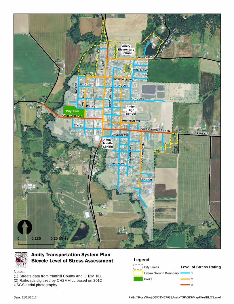
HWY 9
9W
E 3RD AVE
OR 153/5TH ST
GOUC
HER
AVE
SE AMITY RDOR 153/NURSERY AVE
6TH ST
STAN
LEY S
T
SE RICE LN
1ST ST
GETC
HELL
AVE
4TH ST
ENOS
ST
SE AMITY
VINEY
ARDS
RD
E 2ND AVE
TRAD
E ST
ROSEDELL AVE
SHERMAN AVE
ROTH AVE
S JEL
LISON
AVE
LILAC LN
W 2ND ST
WOLFE AVE
CHURCH AVE
HWY 9
9W
Amity Transportation System PlanBicycle Level of Stress Assessment
[0 0.250.125 Miles
Date: 11/11/2013 Path: \\Rosa\Proj\ODOT\477622AmityTSP\GIS\MapFiles\BLOS.mxd
LegendCity Limits
Urban Growth Boundary
Parks
Level of Stress Rating1
2
3
Notes:(1) Streets data from Yamhill County and CH2MHILL(2) Railroads digitized by CH2MHILL based on 2012 USGS aerial photography
Amity Elementary
School
Amity High
School
Amity MiddleSchool
City Park

HWY 9
9W
E 3RD AVE
OR 153/5TH ST
GOUC
HER
AVE
SE AMITY RDOR 153/NURSERY AVE
6TH ST
STAN
LEY S
T
SE RICE LN
1ST ST
GETC
HELL
AVE
4TH ST
ENOS
ST
SE AM
ITY VI
NEYA
RDS R
D
E 2ND AVE
TRAD
E ST
ROSEDELL AVE
SHERMAN AVE
ROTH AVE
S JEL
LISON
AVE
LILAC LN
W 2ND ST
WOLFE AVE
CHURCH AVE
HWY 9
9W
Amity Transportation System PlanBicycle Level of Stress Assessment - 2038
[0 0.250.125 Miles
Date: 4/24/2014 Path: \\Rosa\Proj\ODOT\477622AmityTSP\GIS\MapFiles\BLOS_after.mxd
LegendCity Limits
Urban Growth Boundary
Parks
Level of Stress Rating1
2
3Note: This Stress Assessment includes implementation of all proposed Tier 1 alternatives.
Amity Elementary
School
Amity High
School
Amity MiddleSchool
City Park

Appendix D
Technical Memo #3 - Recommended Alternative

This page intentionally left blank
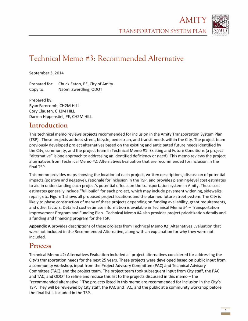
AMITY TRANSPORTATION SYSTEM PLAN
1
Technical Memo #3: Recommended Alternative September 3, 2014 Prepared for: Chuck Eaton, PE, City of Amity Copy to: Naomi Zwerdling, ODOT Prepared by: Ryan Farncomb, CH2M HILL Cory Clausen, CH2M HILL Darren Hippenstiel, PE, CH2M HILL
Introduction This technical memo reviews projects recommended for inclusion in the Amity Transportation System Plan (TSP). These projects address street, bicycle, pedestrian, and transit needs within the City. The project team previously developed project alternatives based on the existing and anticipated future needs identified by the City, community, and the project team in Technical Memo #1: Existing and Future Conditions (a project “alternative” is one approach to addressing an identified deficiency or need). This memo reviews the project alternatives from Technical Memo #2: Alternatives Evaluation that are recommended for inclusion in the final TSP.
This memo provides maps showing the location of each project, written descriptions, discussion of potential impacts (positive and negative), rationale for inclusion in the TSP, and provides planning-level cost estimates to aid in understanding each project’s potential effects on the transportation system in Amity. These cost estimates generally include “full build” for each project, which may include pavement widening, sidewalks, repair, etc. Figure 1 shows all proposed project locations and the planned future street system. The City is likely to phase construction of many of these projects depending on funding availability, grant requirements, and other factors. Detailed cost estimate information is available in Technical Memo #4 – Transportation Improvement Program and Funding Plan. Technical Memo #4 also provides project prioritization details and a funding and financing program for the TSP.
Appendix A provides descriptions of those projects from Technical Memo #2: Alternatives Evaluation that were not included in the Recommended Alternative, along with an explanation for why they were not included.
Process Technical Memo #2: Alternatives Evaluation included all project alternatives considered for addressing the City’s transportation needs for the next 25 years. These projects were developed based on public input from a community workshop, input from the Project Advisory Committee (PAC) and Technical Advisory Committee (TAC), and the project team. The project team took subsequent input from City staff, the PAC and TAC, and ODOT to refine and reduce this list to the projects discussed in this memo – the “recommended alternative.” The projects listed in this memo are recommended for inclusion in the City’s TSP. They will be reviewed by City staff, the PAC and TAC, and the public at a community workshop before the final list is included in the TSP.
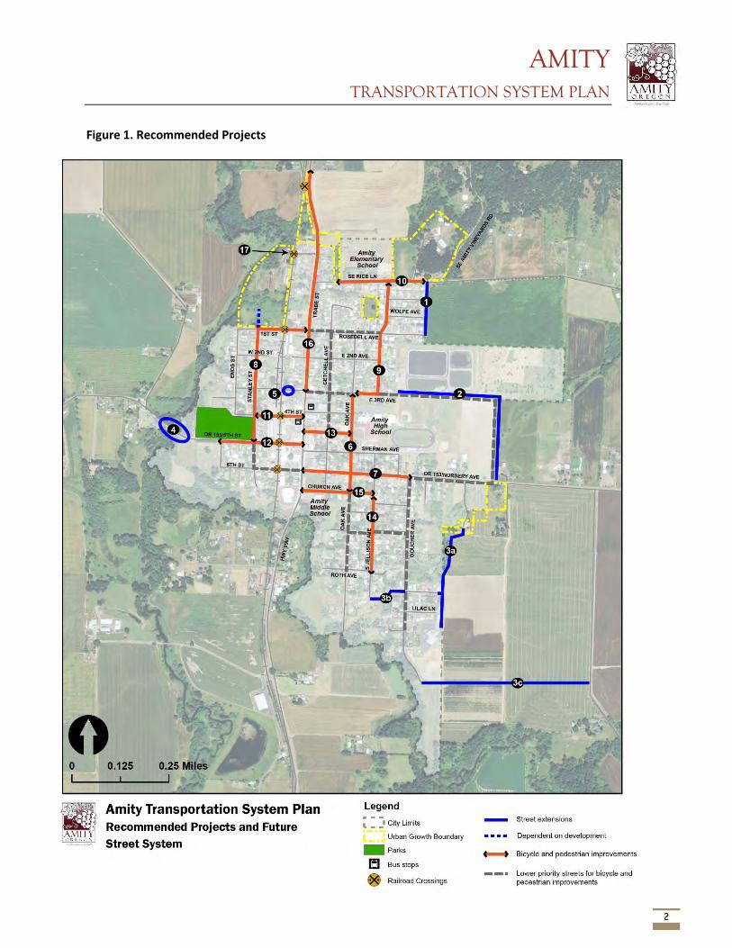
AMITY TRANSPORTATION SYSTEM PLAN
2
Figure 1. Recommended Projects
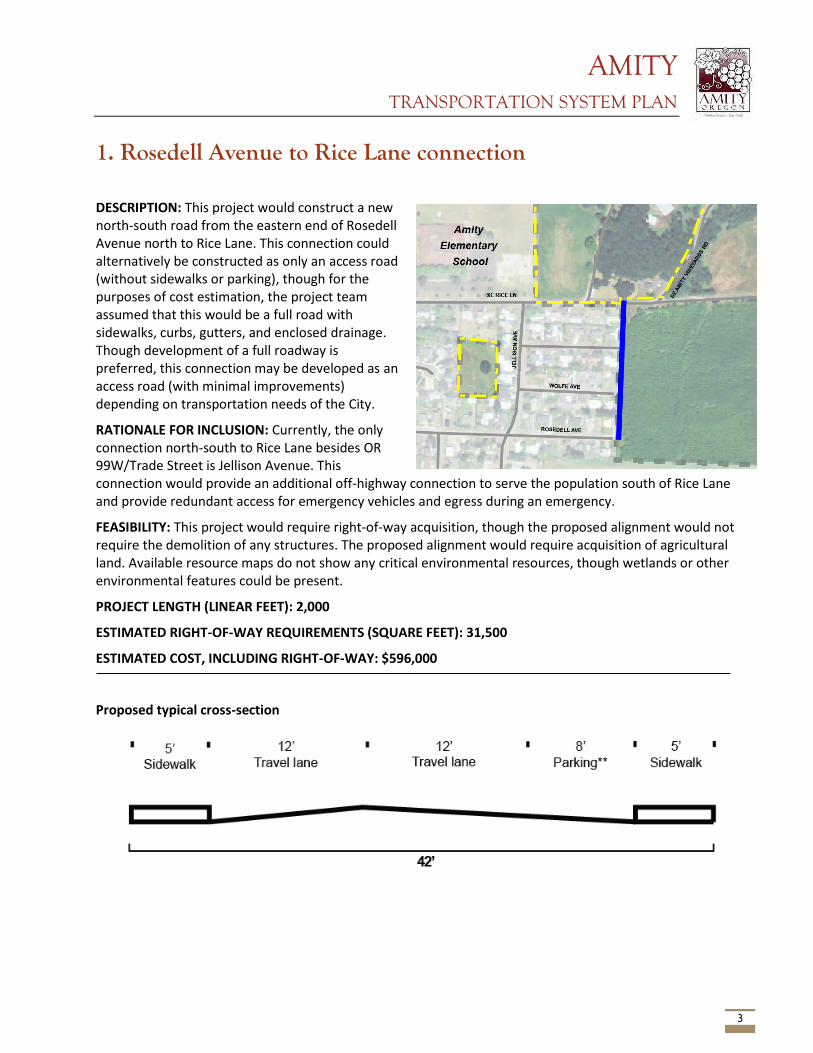
AMITY TRANSPORTATION SYSTEM PLAN
3
1. Rosedell Avenue to Rice Lane connection
DESCRIPTION: This project would construct a new north-south road from the eastern end of Rosedell Avenue north to Rice Lane. This connection could alternatively be constructed as only an access road (without sidewalks or parking), though for the purposes of cost estimation, the project team assumed that this would be a full road with sidewalks, curbs, gutters, and enclosed drainage. Though development of a full roadway is preferred, this connection may be developed as an access road (with minimal improvements) depending on transportation needs of the City.
RATIONALE FOR INCLUSION: Currently, the only connection north-south to Rice Lane besides OR 99W/Trade Street is Jellison Avenue. This connection would provide an additional off-highway connection to serve the population south of Rice Lane and provide redundant access for emergency vehicles and egress during an emergency.
FEASIBILITY: This project would require right-of-way acquisition, though the proposed alignment would not require the demolition of any structures. The proposed alignment would require acquisition of agricultural land. Available resource maps do not show any critical environmental resources, though wetlands or other environmental features could be present.
PROJECT LENGTH (LINEAR FEET): 2,000
ESTIMATED RIGHT-OF-WAY REQUIREMENTS (SQUARE FEET): 31,500
ESTIMATED COST, INCLUDING RIGHT-OF-WAY: $596,000
Proposed typical cross-section
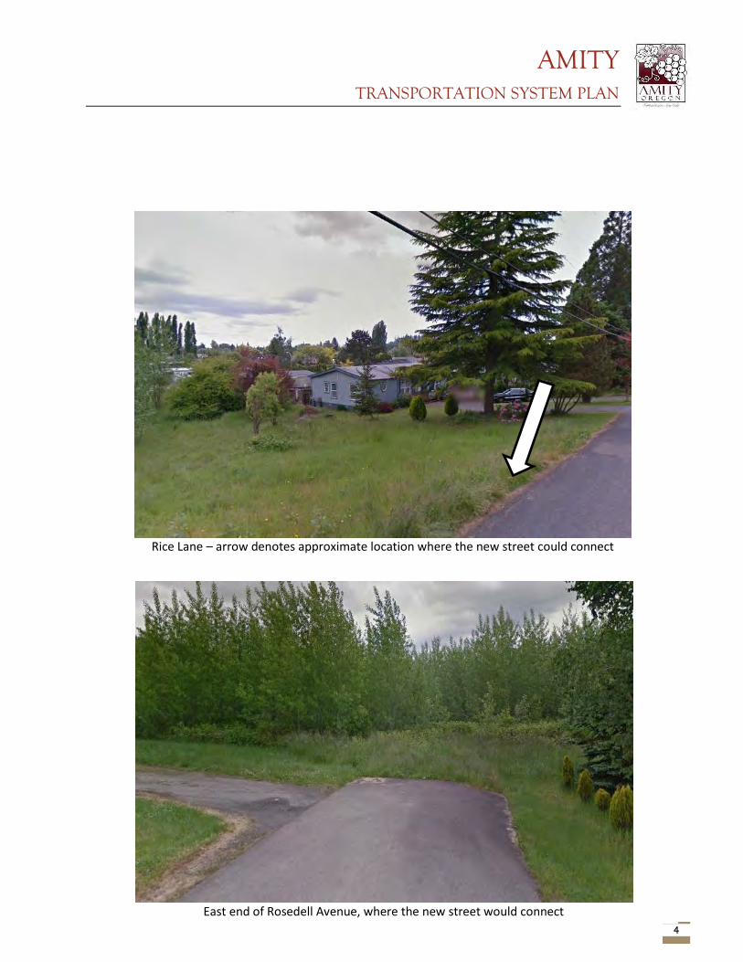
AMITY TRANSPORTATION SYSTEM PLAN
4
East end of Rosedell Avenue, where the new street would connect
Rice Lane – arrow denotes approximate location where the new street could connect
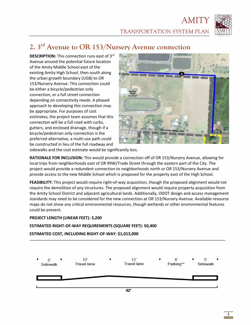
AMITY TRANSPORTATION SYSTEM PLAN
5
2. 3rd Avenue to OR 153/Nursery Avenue connection DESCRIPTION: This connection runs east of 3rd Avenue around the potential future location of the Amity Middle School east of the existing Amity High School, then south along the urban growth boundary (UGB) to OR 153/Nursery Avenue. This connection could be either a bicycle/pedestrian only connection, or a full street connection depending on connectivity needs. A phased approach to developing this connection may be appropriate. For purposes of cost estimates, the project team assumes that this connection will be a full road with curbs, gutters, and enclosed drainage, though if a bicycle/pedestrian only connection is the preferred alternative, a multi-use path could be constructed in lieu of the full roadway and sidewalks and the cost estimate would be significantly less.
RATIONALE FOR INCLUSION: This would provide a connection off of OR 153/Nursery Avenue, allowing for local trips from neighborhoods east of OR 99W/Trade Street through the eastern part of the City. The project would provide a redundant connection to neighborhoods north or OR 153/Nursery Avenue and provide access to the new Middle School which is proposed for the property east of the High School.
FEASIBILITY: This project would require right-of-way acquisition, though the proposed alignment would not require the demolition of any structures. The proposed alignment would require property acquisition from the Amity School District and adjacent agricultural lands. Additionally, ODOT design and access management standards may need to be considered for the new connection at OR 153/Nursery Avenue. Available resource maps do not show any critical environmental resources, though wetlands or other environmental features could be present.
PROJECT LENGTH (LINEAR FEET): 3,200
ESTIMATED RIGHT-OF-WAY REQUIREMENTS (SQUARE FEET): 50,400
ESTIMATED COST, INCLUDING RIGHT-OF-WAY: $1,013,000
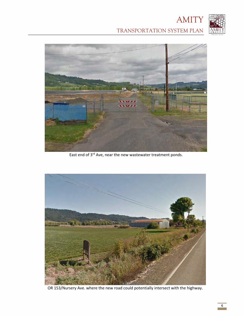
AMITY TRANSPORTATION SYSTEM PLAN
6
East end of 3rd Ave, near the new wastewater treatment ponds.
OR 153/Nursery Ave. where the new road could potentially intersect with the highway.
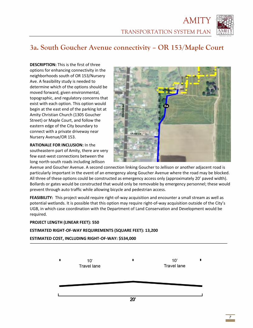
AMITY TRANSPORTATION SYSTEM PLAN
7
3a. South Goucher Avenue connectivity – OR 153/Maple Court
DESCRIPTION: This is the first of three options for enhancing connectivity in the neighborhoods south of OR 153/Nursery Ave. A feasibility study is needed to determine which of the options should be moved forward, given environmental, topographic, and regulatory concerns that exist with each option. This option would begin at the east end of the parking lot at Amity Christian Church (1305 Goucher Street) or Maple Court, and follow the eastern edge of the City boundary to connect with a private driveway near Nursery Avenue/OR 153.
RATIONALE FOR INCLUSION: In the southeastern part of Amity, there are very few east-west connections between the long north-south roads including Jellison Avenue and Goucher Avenue. A second connection linking Goucher to Jellison or another adjacent road is particularly important in the event of an emergency along Goucher Avenue where the road may be blocked. All three of these options could be constructed as emergency access only (approximately 20’ paved width). Bollards or gates would be constructed that would only be removable by emergency personnel; these would prevent through auto traffic while allowing bicycle and pedestrian access.
FEASIBILITY: This project would require right-of-way acquisition and encounter a small stream as well as potential wetlands. It is possible that this option may require right-of-way acquisition outside of the City’s UGB, in which case coordination with the Department of Land Conservation and Development would be required.
PROJECT LENGTH (LINEAR FEET): 550
ESTIMATED RIGHT-OF-WAY REQUIREMENTS (SQUARE FEET): 13,200
ESTIMATED COST, INCLUDING RIGHT-OF-WAY: $534,000
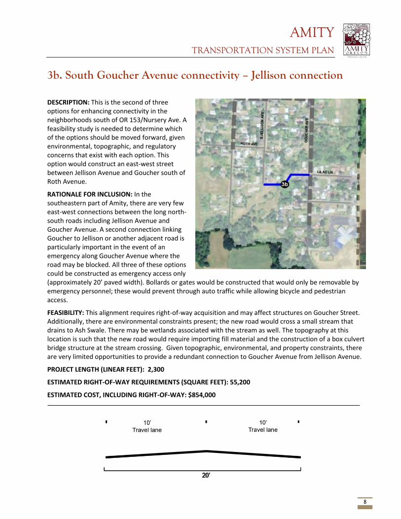
AMITY TRANSPORTATION SYSTEM PLAN
8
3b. South Goucher Avenue connectivity – Jellison connection
DESCRIPTION: This is the second of three options for enhancing connectivity in the neighborhoods south of OR 153/Nursery Ave. A feasibility study is needed to determine which of the options should be moved forward, given environmental, topographic, and regulatory concerns that exist with each option. This option would construct an east-west street between Jellison Avenue and Goucher south of Roth Avenue.
RATIONALE FOR INCLUSION: In the southeastern part of Amity, there are very few east-west connections between the long north-south roads including Jellison Avenue and Goucher Avenue. A second connection linking Goucher to Jellison or another adjacent road is particularly important in the event of an emergency along Goucher Avenue where the road may be blocked. All three of these options could be constructed as emergency access only (approximately 20’ paved width). Bollards or gates would be constructed that would only be removable by emergency personnel; these would prevent through auto traffic while allowing bicycle and pedestrian access.
FEASIBILITY: This alignment requires right-of-way acquisition and may affect structures on Goucher Street. Additionally, there are environmental constraints present; the new road would cross a small stream that drains to Ash Swale. There may be wetlands associated with the stream as well. The topography at this location is such that the new road would require importing fill material and the construction of a box culvert bridge structure at the stream crossing. Given topographic, environmental, and property constraints, there are very limited opportunities to provide a redundant connection to Goucher Avenue from Jellison Avenue.
PROJECT LENGTH (LINEAR FEET): 2,300
ESTIMATED RIGHT-OF-WAY REQUIREMENTS (SQUARE FEET): 55,200
ESTIMATED COST, INCLUDING RIGHT-OF-WAY: $854,000
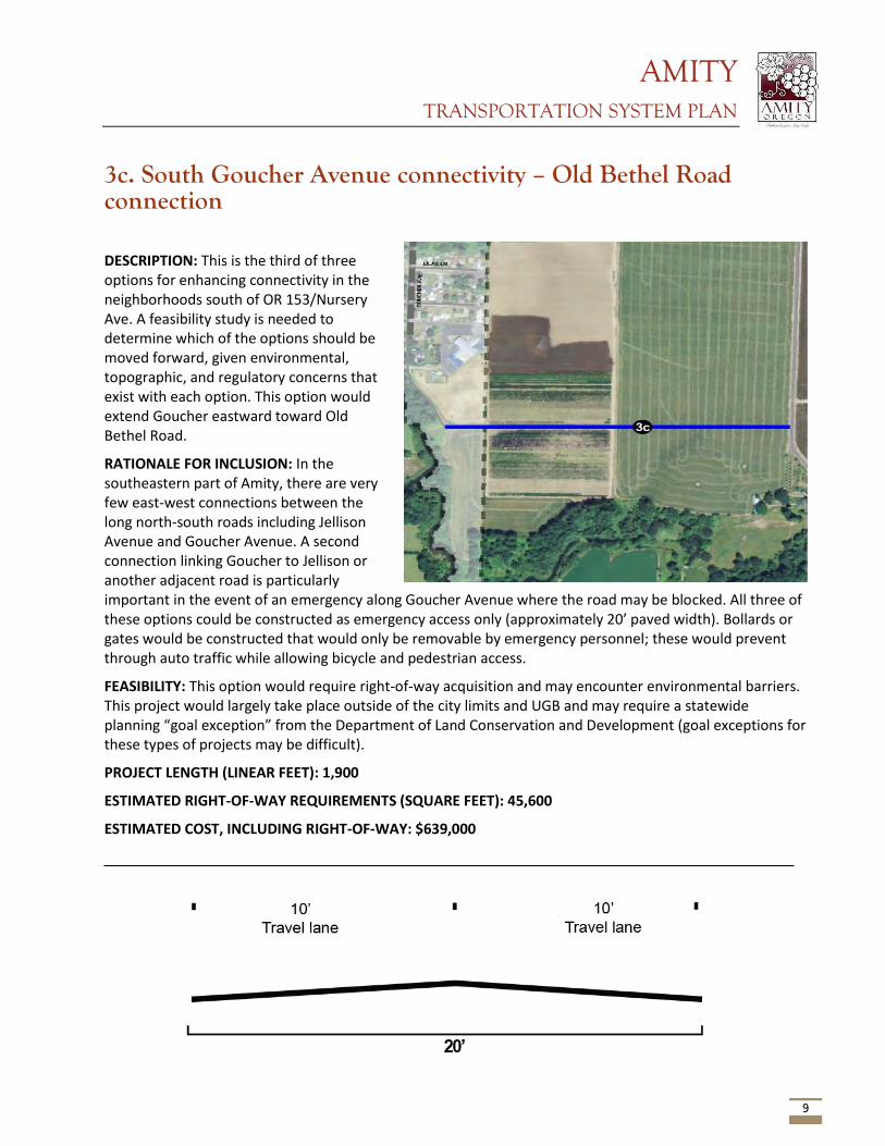
AMITY TRANSPORTATION SYSTEM PLAN
9
3c. South Goucher Avenue connectivity – Old Bethel Road connection
DESCRIPTION: This is the third of three options for enhancing connectivity in the neighborhoods south of OR 153/Nursery Ave. A feasibility study is needed to determine which of the options should be moved forward, given environmental, topographic, and regulatory concerns that exist with each option. This option would extend Goucher eastward toward Old Bethel Road.
RATIONALE FOR INCLUSION: In the southeastern part of Amity, there are very few east-west connections between the long north-south roads including Jellison Avenue and Goucher Avenue. A second connection linking Goucher to Jellison or another adjacent road is particularly important in the event of an emergency along Goucher Avenue where the road may be blocked. All three of these options could be constructed as emergency access only (approximately 20’ paved width). Bollards or gates would be constructed that would only be removable by emergency personnel; these would prevent through auto traffic while allowing bicycle and pedestrian access.
FEASIBILITY: This option would require right-of-way acquisition and may encounter environmental barriers. This project would largely take place outside of the city limits and UGB and may require a statewide planning “goal exception” from the Department of Land Conservation and Development (goal exceptions for these types of projects may be difficult).
PROJECT LENGTH (LINEAR FEET): 1,900
ESTIMATED RIGHT-OF-WAY REQUIREMENTS (SQUARE FEET): 45,600
ESTIMATED COST, INCLUDING RIGHT-OF-WAY: $639,000
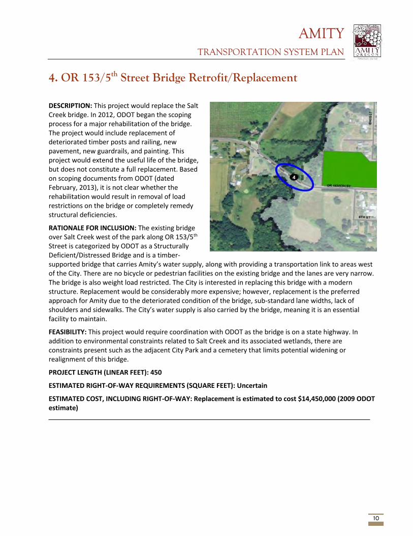
AMITY TRANSPORTATION SYSTEM PLAN
10
4. OR 153/5th Street Bridge Retrofit/Replacement
DESCRIPTION: This project would replace the Salt Creek bridge. In 2012, ODOT began the scoping process for a major rehabilitation of the bridge. The project would include replacement of deteriorated timber posts and railing, new pavement, new guardrails, and painting. This project would extend the useful life of the bridge, but does not constitute a full replacement. Based on scoping documents from ODOT (dated February, 2013), it is not clear whether the rehabilitation would result in removal of load restrictions on the bridge or completely remedy structural deficiencies.
RATIONALE FOR INCLUSION: The existing bridge over Salt Creek west of the park along OR 153/5th Street is categorized by ODOT as a Structurally Deficient/Distressed Bridge and is a timber-supported bridge that carries Amity’s water supply, along with providing a transportation link to areas west of the City. There are no bicycle or pedestrian facilities on the existing bridge and the lanes are very narrow. The bridge is also weight load restricted. The City is interested in replacing this bridge with a modern structure. Replacement would be considerably more expensive; however, replacement is the preferred approach for Amity due to the deteriorated condition of the bridge, sub-standard lane widths, lack of shoulders and sidewalks. The City’s water supply is also carried by the bridge, meaning it is an essential facility to maintain.
FEASIBILITY: This project would require coordination with ODOT as the bridge is on a state highway. In addition to environmental constraints related to Salt Creek and its associated wetlands, there are constraints present such as the adjacent City Park and a cemetery that limits potential widening or realignment of this bridge.
PROJECT LENGTH (LINEAR FEET): 450
ESTIMATED RIGHT-OF-WAY REQUIREMENTS (SQUARE FEET): Uncertain
ESTIMATED COST, INCLUDING RIGHT-OF-WAY: Replacement is estimated to cost $14,450,000 (2009 ODOT estimate)
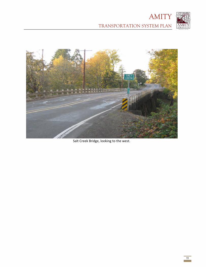
AMITY TRANSPORTATION SYSTEM PLAN
11
Salt Creek Bridge, looking to the west.
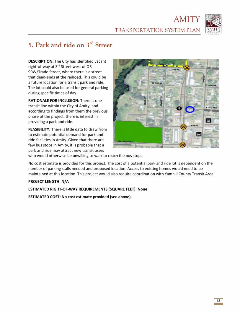
AMITY TRANSPORTATION SYSTEM PLAN
12
5. Park and ride on 3rd Street
DESCRIPTION: The City has identified vacant right-of-way at 3rd Street west of OR 99W/Trade Street, where there is a street that dead-ends at the railroad. This could be a future location for a transit park and ride. The lot could also be used for general parking during specific times of day.
RATIONALE FOR INCLUSION: There is one transit line within the City of Amity, and according to findings from them the previous phase of the project, there is interest in providing a park and ride.
FEASIBILITY: There is little data to draw from to estimate potential demand for park and ride facilities in Amity. Given that there are few bus stops in Amity, it is probable that a park and ride may attract new transit users who would otherwise be unwilling to walk to reach the bus stops.
No cost estimate is provided for this project. The cost of a potential park and ride lot is dependent on the number of parking stalls needed and proposed location. Access to existing homes would need to be maintained at this location. This project would also require coordination with Yamhill County Transit Area.
PROJECT LENGTH: N/A
ESTIMATED RIGHT-OF-WAY REQUIREMENTS (SQUARE FEET): None
ESTIMATED COST: No cost estimate provided (see above).
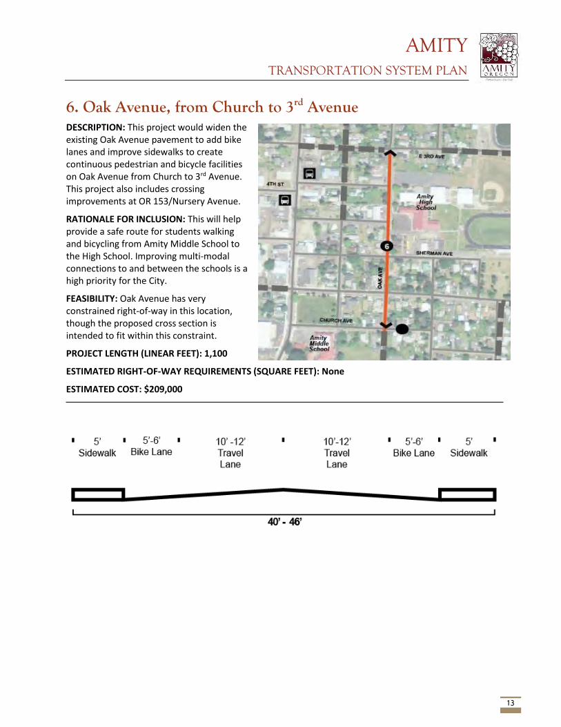
AMITY TRANSPORTATION SYSTEM PLAN
13
6. Oak Avenue, from Church to 3rd Avenue DESCRIPTION: This project would widen the existing Oak Avenue pavement to add bike lanes and improve sidewalks to create continuous pedestrian and bicycle facilities on Oak Avenue from Church to 3rd Avenue. This project also includes crossing improvements at OR 153/Nursery Avenue.
RATIONALE FOR INCLUSION: This will help provide a safe route for students walking and bicycling from Amity Middle School to the High School. Improving multi-modal connections to and between the schools is a high priority for the City.
FEASIBILITY: Oak Avenue has very constrained right-of-way in this location, though the proposed cross section is intended to fit within this constraint.
PROJECT LENGTH (LINEAR FEET): 1,100
ESTIMATED RIGHT-OF-WAY REQUIREMENTS (SQUARE FEET): None
ESTIMATED COST: $209,000
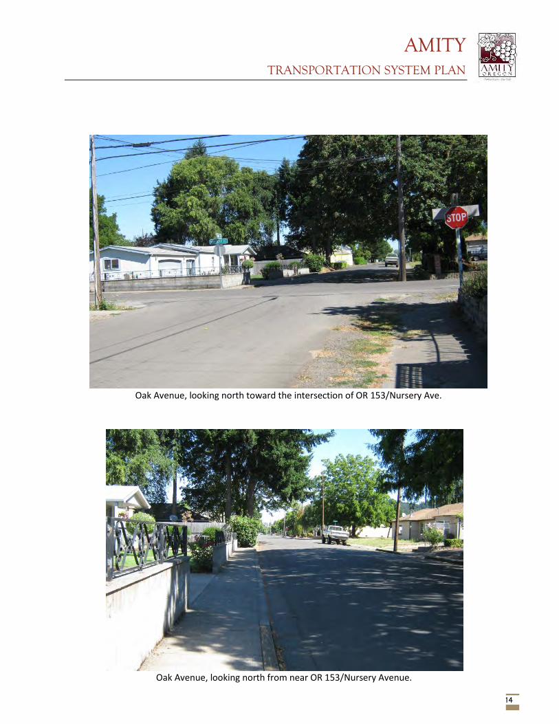
AMITY TRANSPORTATION SYSTEM PLAN
14
Oak Avenue, looking north toward the intersection of OR 153/Nursery Ave.
Oak Avenue, looking north from near OR 153/Nursery Avenue.
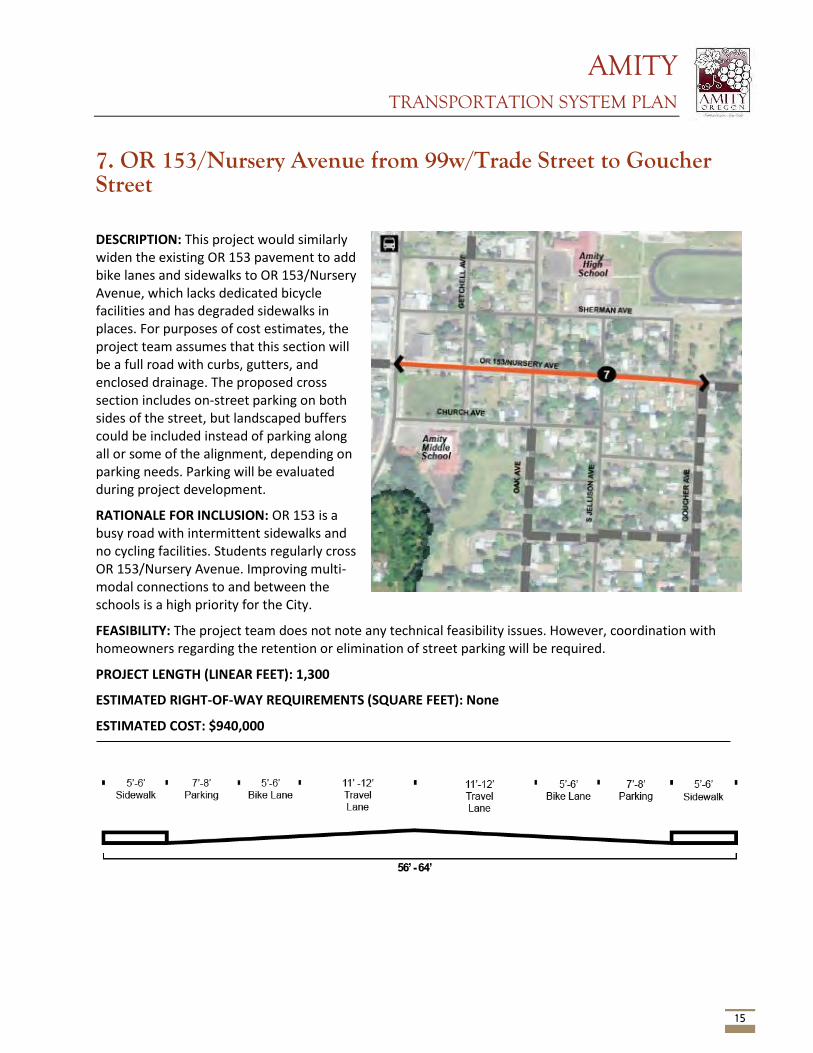
AMITY TRANSPORTATION SYSTEM PLAN
15
7. OR 153/Nursery Avenue from 99w/Trade Street to Goucher Street
DESCRIPTION: This project would similarly widen the existing OR 153 pavement to add bike lanes and sidewalks to OR 153/Nursery Avenue, which lacks dedicated bicycle facilities and has degraded sidewalks in places. For purposes of cost estimates, the project team assumes that this section will be a full road with curbs, gutters, and enclosed drainage. The proposed cross section includes on-street parking on both sides of the street, but landscaped buffers could be included instead of parking along all or some of the alignment, depending on parking needs. Parking will be evaluated during project development.
RATIONALE FOR INCLUSION: OR 153 is a busy road with intermittent sidewalks and no cycling facilities. Students regularly cross OR 153/Nursery Avenue. Improving multi-modal connections to and between the schools is a high priority for the City.
FEASIBILITY: The project team does not note any technical feasibility issues. However, coordination with homeowners regarding the retention or elimination of street parking will be required.
PROJECT LENGTH (LINEAR FEET): 1,300
ESTIMATED RIGHT-OF-WAY REQUIREMENTS (SQUARE FEET): None
ESTIMATED COST: $940,000
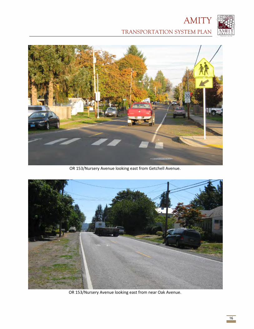
AMITY TRANSPORTATION SYSTEM PLAN
16
OR 153/Nursery Avenue looking east from near Oak Avenue.
OR 153/Nursery Avenue looking east from Getchell Avenue.
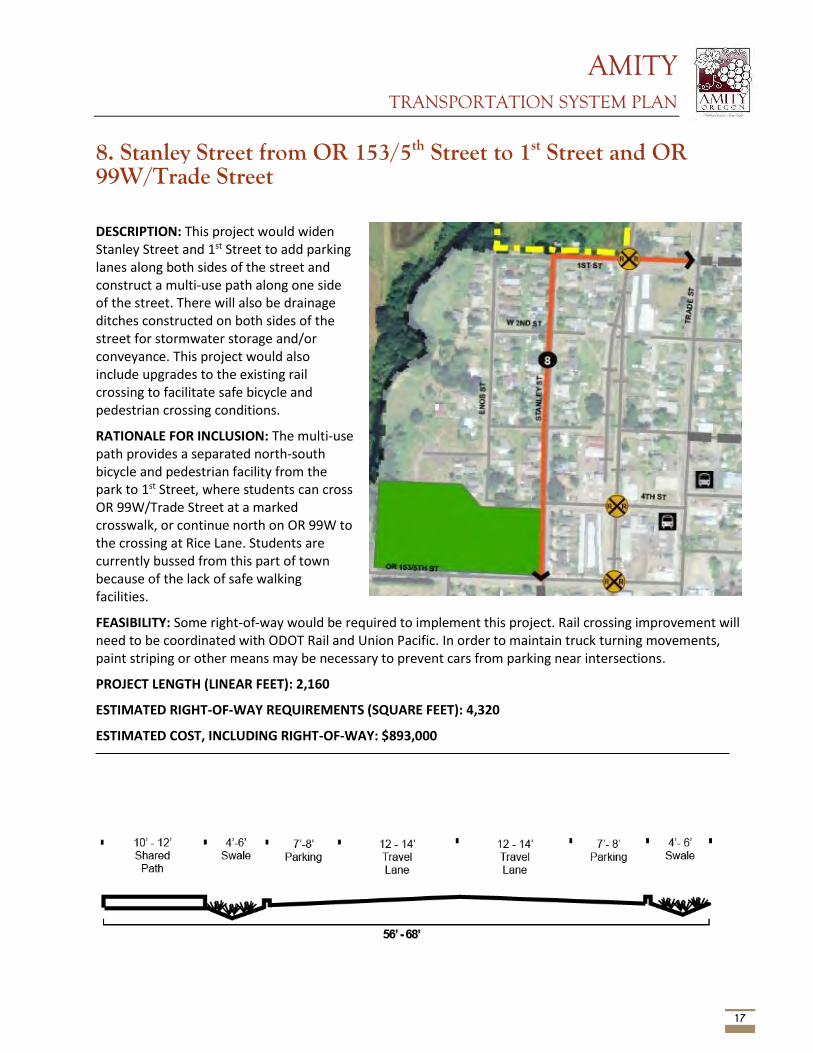
AMITY TRANSPORTATION SYSTEM PLAN
17
8. Stanley Street from OR 153/5th Street to 1st Street and OR 99W/Trade Street
DESCRIPTION: This project would widen Stanley Street and 1st Street to add parking lanes along both sides of the street and construct a multi-use path along one side of the street. There will also be drainage ditches constructed on both sides of the street for stormwater storage and/or conveyance. This project would also include upgrades to the existing rail crossing to facilitate safe bicycle and pedestrian crossing conditions.
RATIONALE FOR INCLUSION: The multi-use path provides a separated north-south bicycle and pedestrian facility from the park to 1st Street, where students can cross OR 99W/Trade Street at a marked crosswalk, or continue north on OR 99W to the crossing at Rice Lane. Students are currently bussed from this part of town because of the lack of safe walking facilities.
FEASIBILITY: Some right-of-way would be required to implement this project. Rail crossing improvement will need to be coordinated with ODOT Rail and Union Pacific. In order to maintain truck turning movements, paint striping or other means may be necessary to prevent cars from parking near intersections.
PROJECT LENGTH (LINEAR FEET): 2,160
ESTIMATED RIGHT-OF-WAY REQUIREMENTS (SQUARE FEET): 4,320
ESTIMATED COST, INCLUDING RIGHT-OF-WAY: $893,000
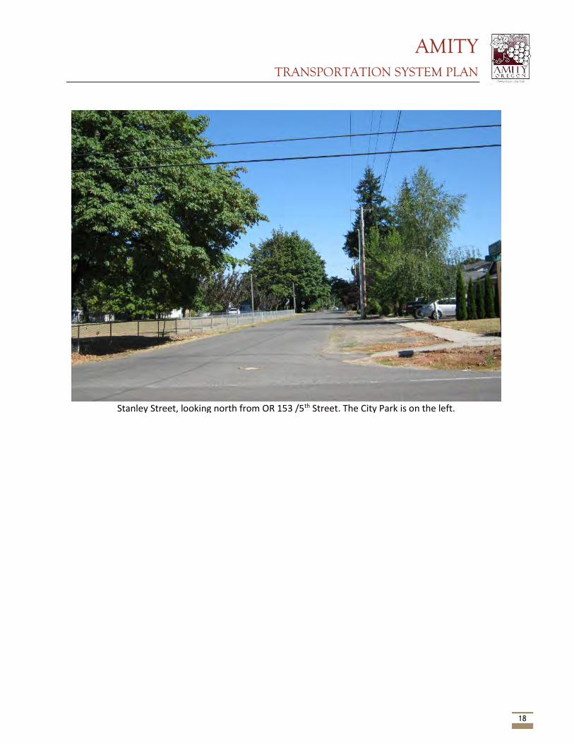
AMITY TRANSPORTATION SYSTEM PLAN
18
Stanley Street, looking north from OR 153 /5th Street. The City Park is on the left.
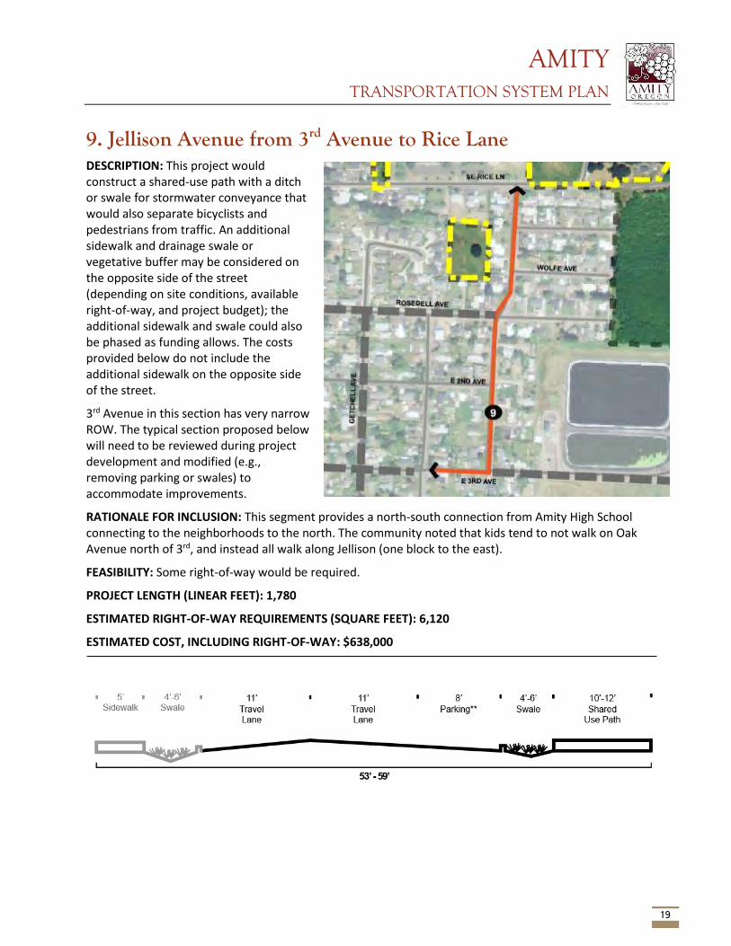
AMITY TRANSPORTATION SYSTEM PLAN
19
9. Jellison Avenue from 3rd Avenue to Rice Lane DESCRIPTION: This project would construct a shared-use path with a ditch or swale for stormwater conveyance that would also separate bicyclists and pedestrians from traffic. An additional sidewalk and drainage swale or vegetative buffer may be considered on the opposite side of the street (depending on site conditions, available right-of-way, and project budget); the additional sidewalk and swale could also be phased as funding allows. The costs provided below do not include the additional sidewalk on the opposite side of the street.
3rd Avenue in this section has very narrow ROW. The typical section proposed below will need to be reviewed during project development and modified (e.g., removing parking or swales) to accommodate improvements.
RATIONALE FOR INCLUSION: This segment provides a north-south connection from Amity High School connecting to the neighborhoods to the north. The community noted that kids tend to not walk on Oak Avenue north of 3rd, and instead all walk along Jellison (one block to the east).
FEASIBILITY: Some right-of-way would be required.
PROJECT LENGTH (LINEAR FEET): 1,780
ESTIMATED RIGHT-OF-WAY REQUIREMENTS (SQUARE FEET): 6,120
ESTIMATED COST, INCLUDING RIGHT-OF-WAY: $638,000
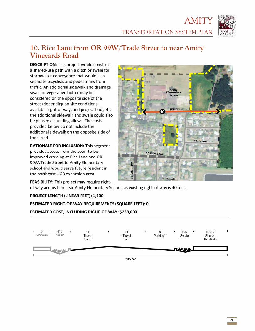
AMITY TRANSPORTATION SYSTEM PLAN
20
10. Rice Lane from OR 99W/Trade Street to near Amity Vineyards Road DESCRIPTION: This project would construct a shared-use path with a ditch or swale for stormwater conveyance that would also separate bicyclists and pedestrians from traffic. An additional sidewalk and drainage swale or vegetative buffer may be considered on the opposite side of the street (depending on site conditions, available right-of-way, and project budget); the additional sidewalk and swale could also be phased as funding allows. The costs provided below do not include the additional sidewalk on the opposite side of the street.
RATIONALE FOR INCLUSION: This segment provides access from the soon-to-be-improved crossing at Rice Lane and OR 99W/Trade Street to Amity Elementary school and would serve future resident in the northeast UGB expansion area.
FEASIBILITY: This project may require right-of-way acquisition near Amity Elementary School, as existing right-of-way is 40 feet.
PROJECT LENGTH (LINEAR FEET): 1,100
ESTIMATED RIGHT-OF-WAY REQUIREMENTS (SQUARE FEET): 0
ESTIMATED COST, INCLUDING RIGHT-OF-WAY: $239,000
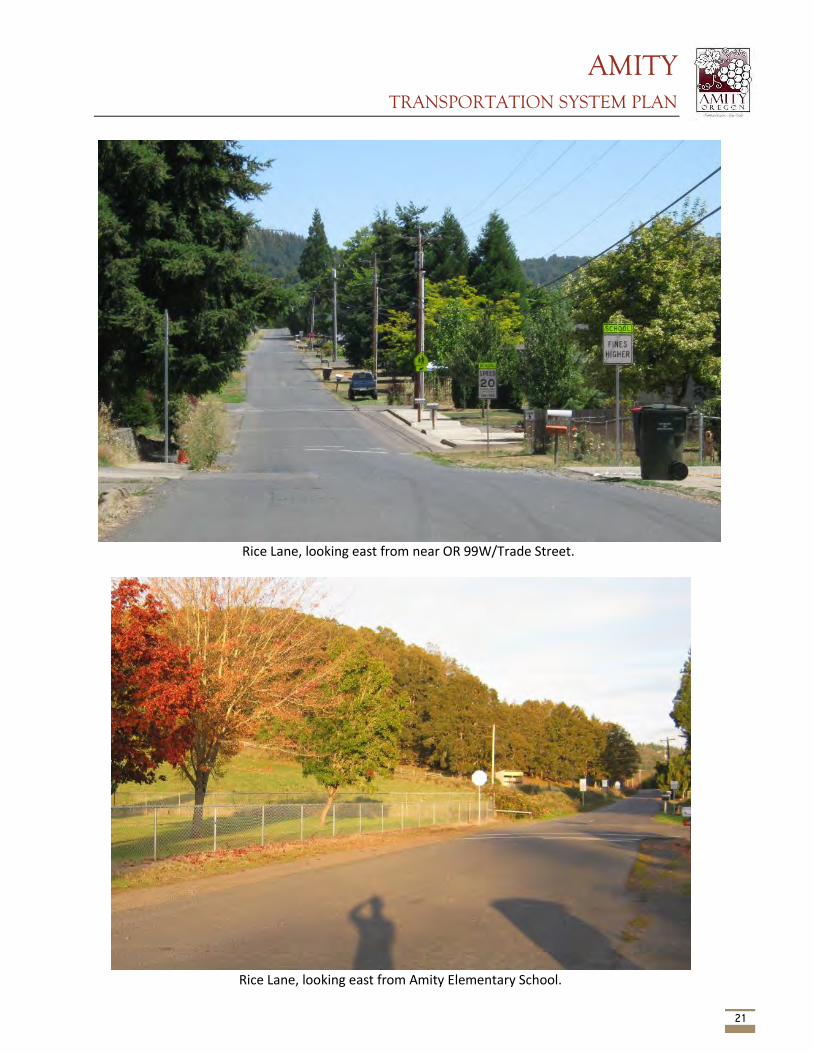
AMITY TRANSPORTATION SYSTEM PLAN
21
Rice Lane, looking east from near OR 99W/Trade Street.
Rice Lane, looking east from Amity Elementary School.
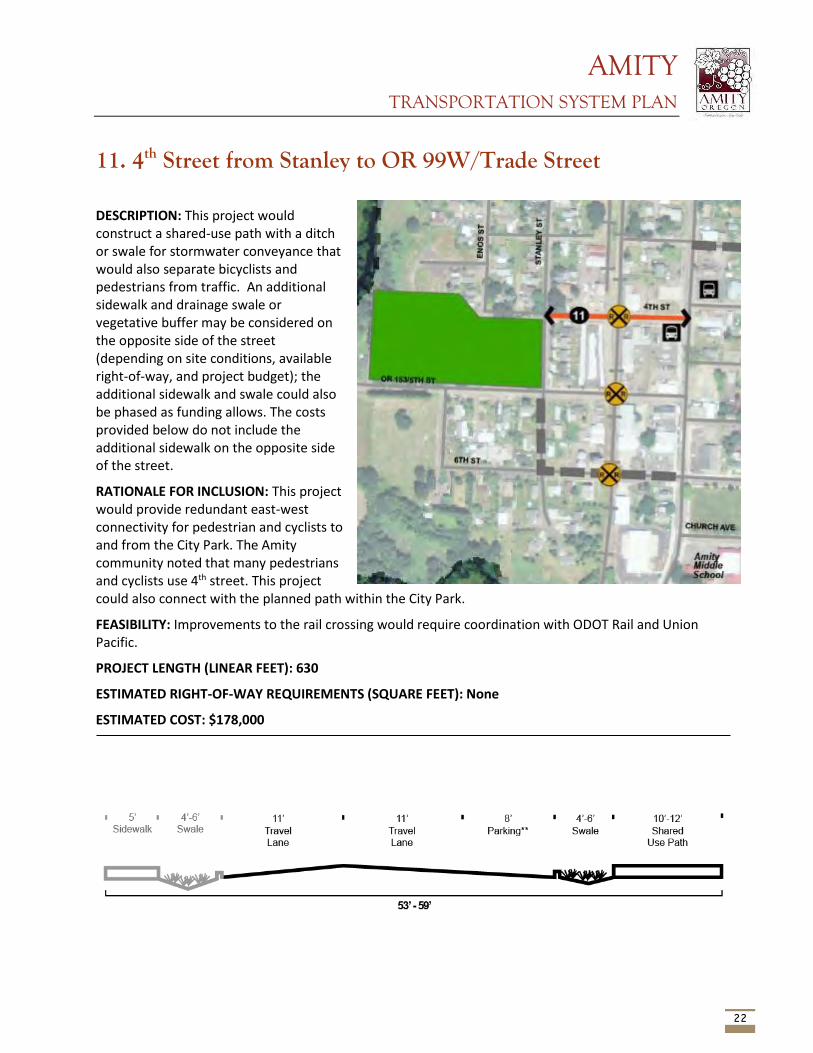
AMITY TRANSPORTATION SYSTEM PLAN
22
11. 4th Street from Stanley to OR 99W/Trade Street
DESCRIPTION: This project would construct a shared-use path with a ditch or swale for stormwater conveyance that would also separate bicyclists and pedestrians from traffic. An additional sidewalk and drainage swale or vegetative buffer may be considered on the opposite side of the street (depending on site conditions, available right-of-way, and project budget); the additional sidewalk and swale could also be phased as funding allows. The costs provided below do not include the additional sidewalk on the opposite side of the street.
RATIONALE FOR INCLUSION: This project would provide redundant east-west connectivity for pedestrian and cyclists to and from the City Park. The Amity community noted that many pedestrians and cyclists use 4th street. This project could also connect with the planned path within the City Park.
FEASIBILITY: Improvements to the rail crossing would require coordination with ODOT Rail and Union Pacific.
PROJECT LENGTH (LINEAR FEET): 630
ESTIMATED RIGHT-OF-WAY REQUIREMENTS (SQUARE FEET): None
ESTIMATED COST: $178,000
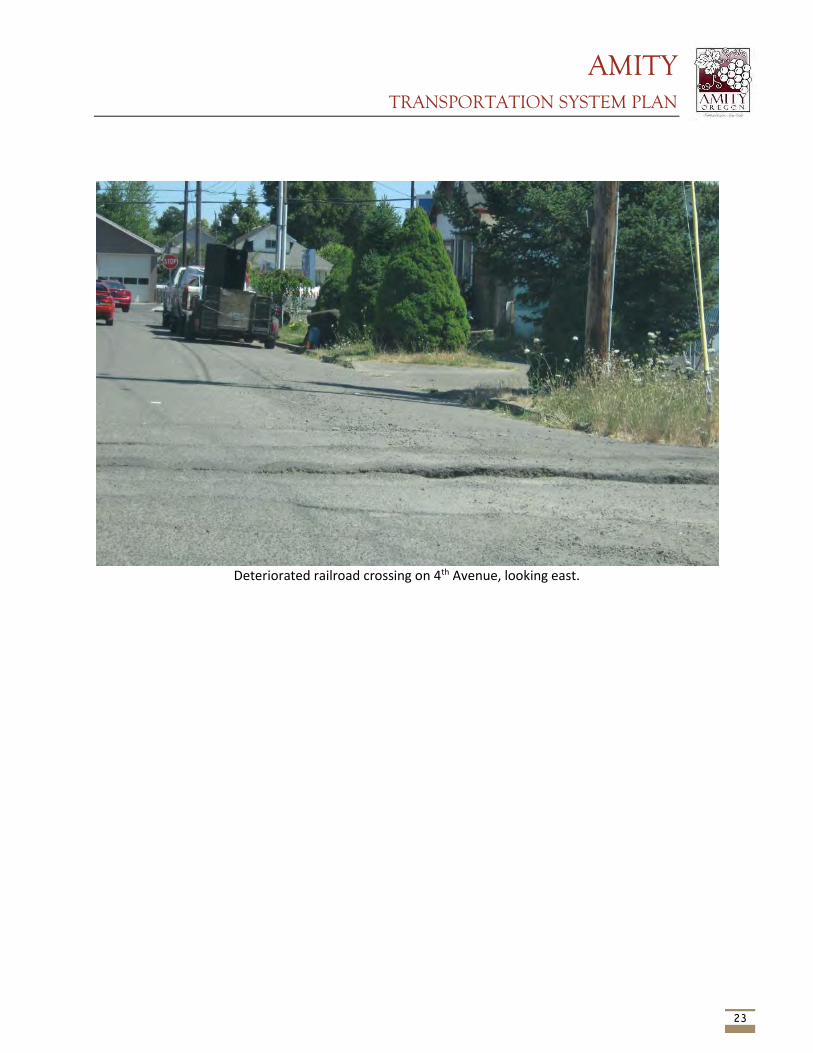
AMITY TRANSPORTATION SYSTEM PLAN
23
Deteriorated railroad crossing on 4th Avenue, looking east.
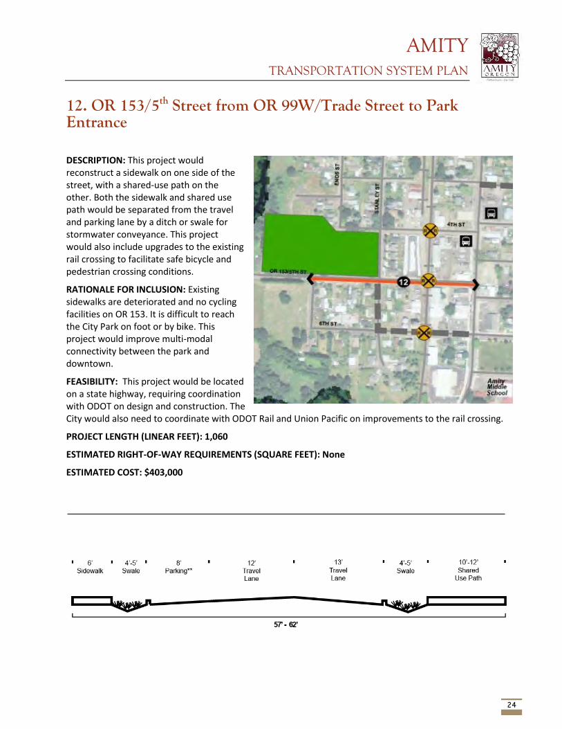
AMITY TRANSPORTATION SYSTEM PLAN
24
12. OR 153/5th Street from OR 99W/Trade Street to Park Entrance
DESCRIPTION: This project would reconstruct a sidewalk on one side of the street, with a shared-use path on the other. Both the sidewalk and shared use path would be separated from the travel and parking lane by a ditch or swale for stormwater conveyance. This project would also include upgrades to the existing rail crossing to facilitate safe bicycle and pedestrian crossing conditions.
RATIONALE FOR INCLUSION: Existing sidewalks are deteriorated and no cycling facilities on OR 153. It is difficult to reach the City Park on foot or by bike. This project would improve multi-modal connectivity between the park and downtown.
FEASIBILITY: This project would be located on a state highway, requiring coordination with ODOT on design and construction. The City would also need to coordinate with ODOT Rail and Union Pacific on improvements to the rail crossing.
PROJECT LENGTH (LINEAR FEET): 1,060
ESTIMATED RIGHT-OF-WAY REQUIREMENTS (SQUARE FEET): None
ESTIMATED COST: $403,000
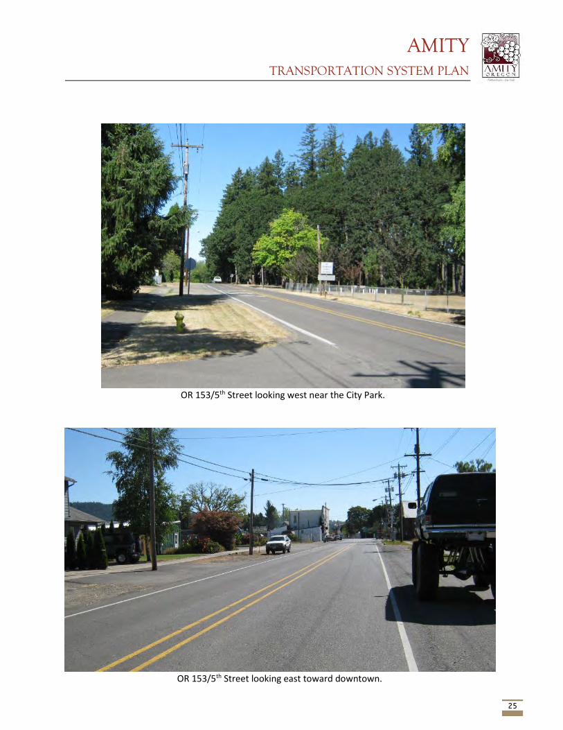
AMITY TRANSPORTATION SYSTEM PLAN
25
OR 153/5th Street looking west near the City Park.
OR 153/5th Street looking east toward downtown.
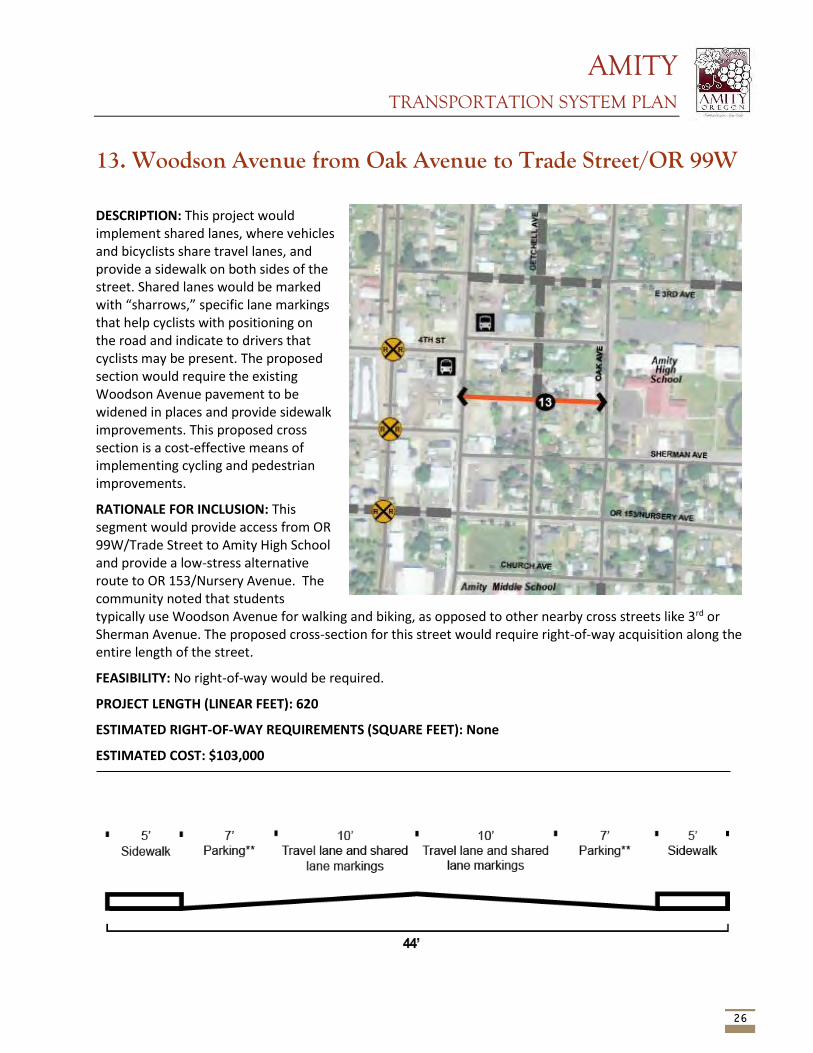
AMITY TRANSPORTATION SYSTEM PLAN
26
13. Woodson Avenue from Oak Avenue to Trade Street/OR 99W
DESCRIPTION: This project would implement shared lanes, where vehicles and bicyclists share travel lanes, and provide a sidewalk on both sides of the street. Shared lanes would be marked with “sharrows,” specific lane markings that help cyclists with positioning on the road and indicate to drivers that cyclists may be present. The proposed section would require the existing Woodson Avenue pavement to be widened in places and provide sidewalk improvements. This proposed cross section is a cost-effective means of implementing cycling and pedestrian improvements.
RATIONALE FOR INCLUSION: This segment would provide access from OR 99W/Trade Street to Amity High School and provide a low-stress alternative route to OR 153/Nursery Avenue. The community noted that students typically use Woodson Avenue for walking and biking, as opposed to other nearby cross streets like 3rd or Sherman Avenue. The proposed cross-section for this street would require right-of-way acquisition along the entire length of the street.
FEASIBILITY: No right-of-way would be required.
PROJECT LENGTH (LINEAR FEET): 620
ESTIMATED RIGHT-OF-WAY REQUIREMENTS (SQUARE FEET): None
ESTIMATED COST: $103,000
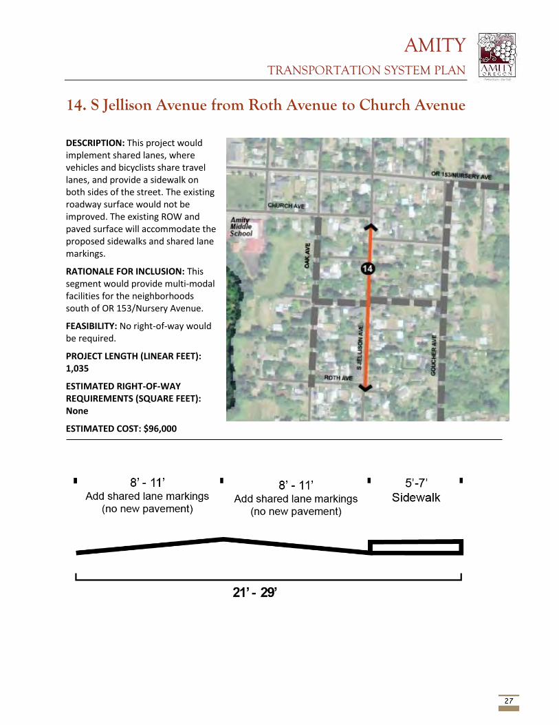
AMITY TRANSPORTATION SYSTEM PLAN
27
14. S Jellison Avenue from Roth Avenue to Church Avenue
DESCRIPTION: This project would implement shared lanes, where vehicles and bicyclists share travel lanes, and provide a sidewalk on both sides of the street. The existing roadway surface would not be improved. The existing ROW and paved surface will accommodate the proposed sidewalks and shared lane markings.
RATIONALE FOR INCLUSION: This segment would provide multi-modal facilities for the neighborhoods south of OR 153/Nursery Avenue.
FEASIBILITY: No right-of-way would be required.
PROJECT LENGTH (LINEAR FEET): 1,035
ESTIMATED RIGHT-OF-WAY REQUIREMENTS (SQUARE FEET): None
ESTIMATED COST: $96,000
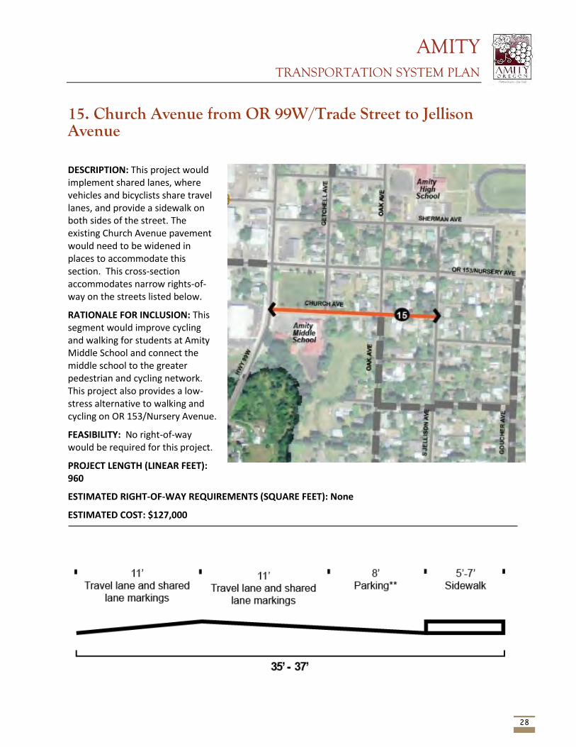
AMITY TRANSPORTATION SYSTEM PLAN
28
15. Church Avenue from OR 99W/Trade Street to Jellison Avenue
DESCRIPTION: This project would implement shared lanes, where vehicles and bicyclists share travel lanes, and provide a sidewalk on both sides of the street. The existing Church Avenue pavement would need to be widened in places to accommodate this section. This cross-section accommodates narrow rights-of-way on the streets listed below.
RATIONALE FOR INCLUSION: This segment would improve cycling and walking for students at Amity Middle School and connect the middle school to the greater pedestrian and cycling network. This project also provides a low-stress alternative to walking and cycling on OR 153/Nursery Avenue.
FEASIBILITY: No right-of-way would be required for this project.
PROJECT LENGTH (LINEAR FEET): 960
ESTIMATED RIGHT-OF-WAY REQUIREMENTS (SQUARE FEET): None
ESTIMATED COST: $127,000
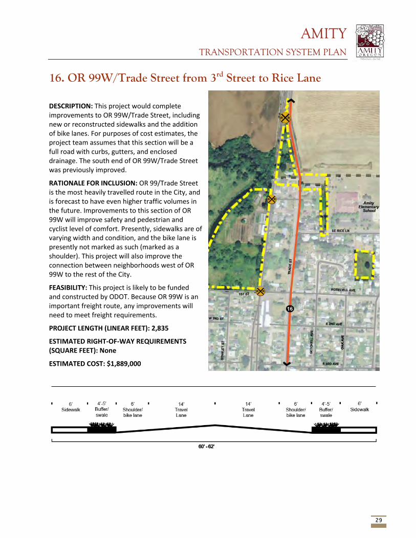
AMITY TRANSPORTATION SYSTEM PLAN
29
16. OR 99W/Trade Street from 3rd Street to Rice Lane
DESCRIPTION: This project would complete improvements to OR 99W/Trade Street, including new or reconstructed sidewalks and the addition of bike lanes. For purposes of cost estimates, the project team assumes that this section will be a full road with curbs, gutters, and enclosed drainage. The south end of OR 99W/Trade Street was previously improved.
RATIONALE FOR INCLUSION: OR 99/Trade Street is the most heavily travelled route in the City, and is forecast to have even higher traffic volumes in the future. Improvements to this section of OR 99W will improve safety and pedestrian and cyclist level of comfort. Presently, sidewalks are of varying width and condition, and the bike lane is presently not marked as such (marked as a shoulder). This project will also improve the connection between neighborhoods west of OR 99W to the rest of the City.
FEASIBILITY: This project is likely to be funded and constructed by ODOT. Because OR 99W is an important freight route, any improvements will need to meet freight requirements.
PROJECT LENGTH (LINEAR FEET): 2,835
ESTIMATED RIGHT-OF-WAY REQUIREMENTS (SQUARE FEET): None
ESTIMATED COST: $1,889,000
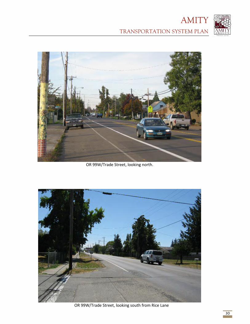
AMITY TRANSPORTATION SYSTEM PLAN
30
OR 99W/Trade Street, looking north.
OR 99W/Trade Street, looking south from Rice Lane
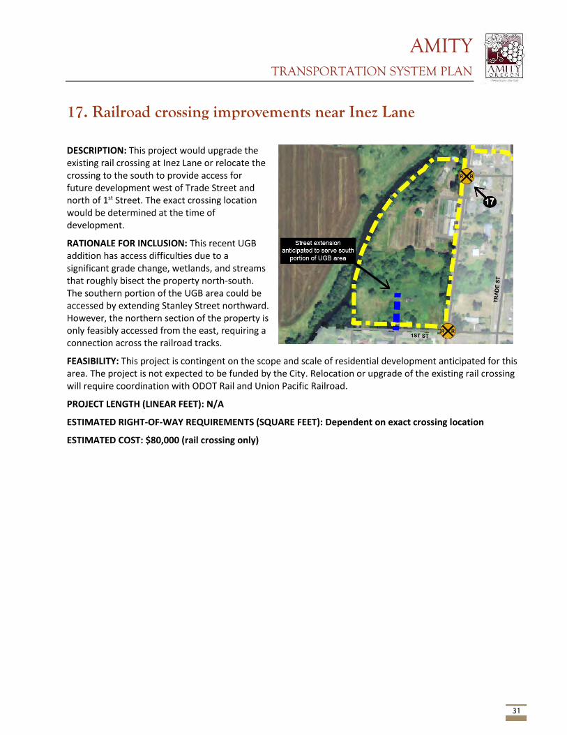
AMITY TRANSPORTATION SYSTEM PLAN
31
17. Railroad crossing improvements near Inez Lane
DESCRIPTION: This project would upgrade the existing rail crossing at Inez Lane or relocate the crossing to the south to provide access for future development west of Trade Street and north of 1st Street. The exact crossing location would be determined at the time of development.
RATIONALE FOR INCLUSION: This recent UGB addition has access difficulties due to a significant grade change, wetlands, and streams that roughly bisect the property north-south. The southern portion of the UGB area could be accessed by extending Stanley Street northward. However, the northern section of the property is only feasibly accessed from the east, requiring a connection across the railroad tracks.
FEASIBILITY: This project is contingent on the scope and scale of residential development anticipated for this area. The project is not expected to be funded by the City. Relocation or upgrade of the existing rail crossing will require coordination with ODOT Rail and Union Pacific Railroad.
PROJECT LENGTH (LINEAR FEET): N/A
ESTIMATED RIGHT-OF-WAY REQUIREMENTS (SQUARE FEET): Dependent on exact crossing location
ESTIMATED COST: $80,000 (rail crossing only)
AMITY TRANSPORTATION SYSTEM PLAN
32
Next Steps The projects identified above will be reviewed by the project advisory committee (PAC), technical advisory committee (TAC), and by the public at a community workshop. Once the list of projects has been reviewed by all, the project team will revise the projects accordingly. Project refinement may include adjustments to the cross sections or other changes, as well as refined cost estimates. The final list of projects will be included in the TSP.
AMITY TRANSPORTATION SYSTEM PLAN
Appendix A – Other projects considered, but not recommended for inclusion in the TSP
AMITY TRANSPORTATION SYSTEM PLAN
Add a Signal at OR 99W/Trade Street and OR 153/Nursery Avenue One of the few deficiencies identified in the existing conditions and future no-build memo was a long period of delay (over 100 seconds) for vehicles turning onto OR 99W/Trade Street from OR 153/Nursery Avenue. The project team explored a signal at OR 99W/Trade Street and OR 153/Nursery Avenue to help vehicles turning from OR 153/Nursery Avenue onto OR 99W/Trade Street. However, while this alternative improves the delay from OR 153/Nursery Street from over 100 seconds per vehicle to 10 seconds per vehicle, it would impact the southbound OR 99W/Trade Street approach by increasing the v/c ratio from 0.18 to 0.79. While this v/c ratio is still technically acceptable, the signal would introduce additional delay to the dominant north-south movement along OR 99W/Trade Street and could cause vehicles to back up on OR 99W/Trade Street up to 1,300 feet (over ¼ mile). While this alternative improves the ability for vehicles to turn from OR 153/Nursery Avenue, it would create more delay and create longer trips or those traveling north/south on OR 99W/Trade Street. Additionally, ODOT requires that signal warrants be met at this intersection – signal warrants are not met in the future year according to traffic analysis.
Modify Oak Avenue to Right-in/Right-out on OR 153/Nursery Avenue This alternative would add a bicycle and pedestrian refuge on OR 153/Nursery Avenue at Oak Avenue. This refuge would be a raised median and would prohibit left turns into and out of Oak Avenue at OR 153/Nursery Avenue. Traffic that would normally turn left from Oak Avenue would be re-routed to OR 99W/Trade Street or other local streets like Getchell or Jellison Avenues. The increased traffic associated with this alternative would increase the v/c on eastbound OR 153/Nursery Avenue from 0.85 to 0.94, which is still within ODOT’s applicable mobility target of 0.95. School buses would need to be rerouted because of this project. Because of the negative traffic impacts and desire to preserve the through traffic movement at this intersection, this alternative was not carried forward.
Add a Left Turn Pocket on Rice Lane This alternative would add a left turn pocket from Rice Lane onto OR 99W/Trade Street to make it easier for vehicles to turn off of Rice Lane onto OR 99W/Trade Street. Currently Rice Lane is narrow, with only one lane eastbound, and one lane westbound. Vehicles waiting to turn left or right onto OR 99W/Trade Street line up in one lane. Creating another turn lane at this location would separate those turning left and right, allowing more vehicles to turn onto OR 99W/Trade Street. The existing and future conditions traffic analysis indicated that turns from Rice Lane onto OR 99W/Trade Street met existing traffic standards, however, feedback from the community and the PAC indicated that in the morning, turning from Rice Lane onto OR 99W/Trade Street was difficult and drivers were experiencing delays.
The PAC and TAC noted that the need for this project is likely low. Serious right-of-way constraints at the intersection also complicate widening. Additionally, left turn warrants may need to be met before ODOT would consider allowing a left turn pocket.
Stanley Street from OR 153/5th Street to 1st Street and OR 99W/Trade Street - sidewalks and bike lanes alternative This project is retained in the Recommended Alternative, but has a shared use path instead of sidewalks and bike lanes. The project team found that the sidewalks and bike lanes alternative would cost approximately $250,000 more than the shared path option. In the interest of reducing costs, this alternative was not carried forward.
AMITY TRANSPORTATION SYSTEM PLAN
Consider Realigning Offset Intersections on OR 99W/Trade Street – policy alternative Many street connections to OR 99W/Trade Street in downtown Amity are offset, meaning that they do not create four-legged intersections where the east-west streets are aligned. This policy alternative would look for opportunities to create traditional four-legged intersections as properties along OR 99W/Trade Street develop or redevelop to reduce concerns about safety issues as vehicles turn onto the highway from offset side streets. The PAC and TAC agreed that the need to address this issue is low, and that the cost and feasibility of remedying the offset intersections is very high relative to community benefits.
Oak, church to 3rd Alternative: Alternative: Getchell/Oak Avenue from Church to 3rd This alternative would utilize the recently improved crossing on Nursery Ave/OR 153. City staff indicates that the ODOT prefers this crossing location, though school staff and other community members note that more students use the unimproved Oak Avenue crossing. The preferred crossing location carried forward to the Recommended Alternative is at Oak Avenue, as the community noted that this intersection is used more frequently by students.
Alternative to Church, from OR 153 to Nursery Alternative: Oak Avenue from 3rd Avenue to Rice Lane via Oak and undeveloped property east of Getchell Court This alternative route would continue following Oak Avenue and head north via a shared use path behind homes east of Getchell Court and adjacent to vacant property west of Jellison. This alternative would require right-of-way acquisition. The PAC and TAC noted that pedestrian traffic uses Jellison, as opposed to Oak, at this location. This alternative was not carried forward, in favor of a path on Jellison where pedestrian demand currently exists.
Alternative to Woodson Improvements: Sherman Avenue from OR 99W/Trade Street to Oak Avenue This segment would also provide access from OR 99W/Trade Street to Amity High School and provide a low-stress alternative route to OR 153/Nursery Avenue. This alternative would also connect to the City Park via the path proposed along OR 153/5th Street. The proposed cross-section for this street would require right-of-way acquisition along the entire length of Sherman Avenue. The community noted that Woodson is most heavily used by pedestrians and that Sherman is not well-utilized. The project team therefore chose not to carry the Sherman Avenue alternative forward.
Appendix E
Technical Memo #4 - Transportation Improvement Program and Funding Plan

This page intentionally left blank
AMITY TRANSPORTATION SYSTEM PLAN
1
Technical Memo 4: Transportation Improvement Program and Funding Plan September 3, 2014 Prepared for: Chuck Eaton, PE, City of Amity Copy to: Naomi Zwerdling, ODOT Prepared by: Ryan Farncomb, CH2M HILL Paul Hicks, CH2M HILL
Introduction This memorandum reviews the planning-level costs, implementation priority, and potential funding sources for projects in the Amity Transportation System Plan (TSP). These projects are discussed in Technical Memo #3: Recommended Alternative. They were developed with input from stakeholders and community members and are intended to address deficiencies and needs identified in Technical Memo #1: Existing and Future Conditions. For some projects, it is not possible to generate a conceptual cost estimate, due to unknown variables in the scale or scope of the project. Right-of-way costs are included as appropriate.1 Appendix A includes detailed costs estimates for the projects.
The project team developed planning-level costs and compared these costs to the current level of funding available from existing transportation funding sources. The estimated project costs exceed the anticipated level of funding available to the City over the next 25 years; grants and other funding sources are suggested that can help provide the additional funds needed to complete the full project list. The project team also prioritized the projects based on local transportation goals, level of need, and community input. The Technical Advisory Committee (TAC), the Project Advisory Committee (PAC), and the general public will review the alternatives before they are included in the Amity TSP.
Existing funding Share of state gas tax Presently, most of Amity’s funds dedicated to transportation come from the City’s allocation of state gas tax revenue. Annual transportation revenue over the last several years have generally varied between approximately $65,000 and $88,000. City revenues from state gas tax distributions are likely to remain steady in coming years or grow slightly, in real dollar terms, depending on action taken at the state level to increase transportation revenues (which have been in general decline for many reasons). In the last decade, the City has experienced only minor growth in its share of gas tax revenue. It is therefore reasonable to assume that Amity’s share of state gas tax revenues will remain steady in coming years.
1 Right of way costs per square foot were determined through a survey of estimates used in other plans in the Willamette Valley. Right-of-way costs are dependent on many factors unique to each project location, and are therefore inherently difficult to estimate.
AMITY TRANSPORTATION SYSTEM PLAN
2
Transportation utility fee The City recently enacted a transportation utility fee, which is currently $2.00 per household per month and $0.25 per trip (based on trip generations assumptions) for other uses. In 2013, the fee generated about $16,400, most of which is used for street maintenance. Income from the transportation fee is likely to increase over time as the number of households and businesses in Amity increases.
System Development Charges The City assesses System Development Charges (SDCs) for transportation and other utilities. Future income from system development charges is difficult to predict, and highly dependent on the economy and the scope and scale of future development in Amity.
Other revenues The City has also received grant revenues ($25,000 approximately every 4 years) from the state’s Special City Allotment (SCA) grant program, which provides grants of up to $50,000 to small communities for transportation improvement projects. The City has successfully utilized the SCA grant program in the past, and this could continue to be a reliable source of additional transportation funds for certain projects in the future. It is reasonable to assume that the City will continue to be successful in its applications for funds from this source.
Future revenue forecast Table 1 details the estimated revenue the City is likely to have available for capital projects in the next 25 years. This table assesses funds that the City is reasonably expected to continue to take in. There are other potential dedicated and one-time revenue sources the City could pursue to augment its funds for capital improvement projects.
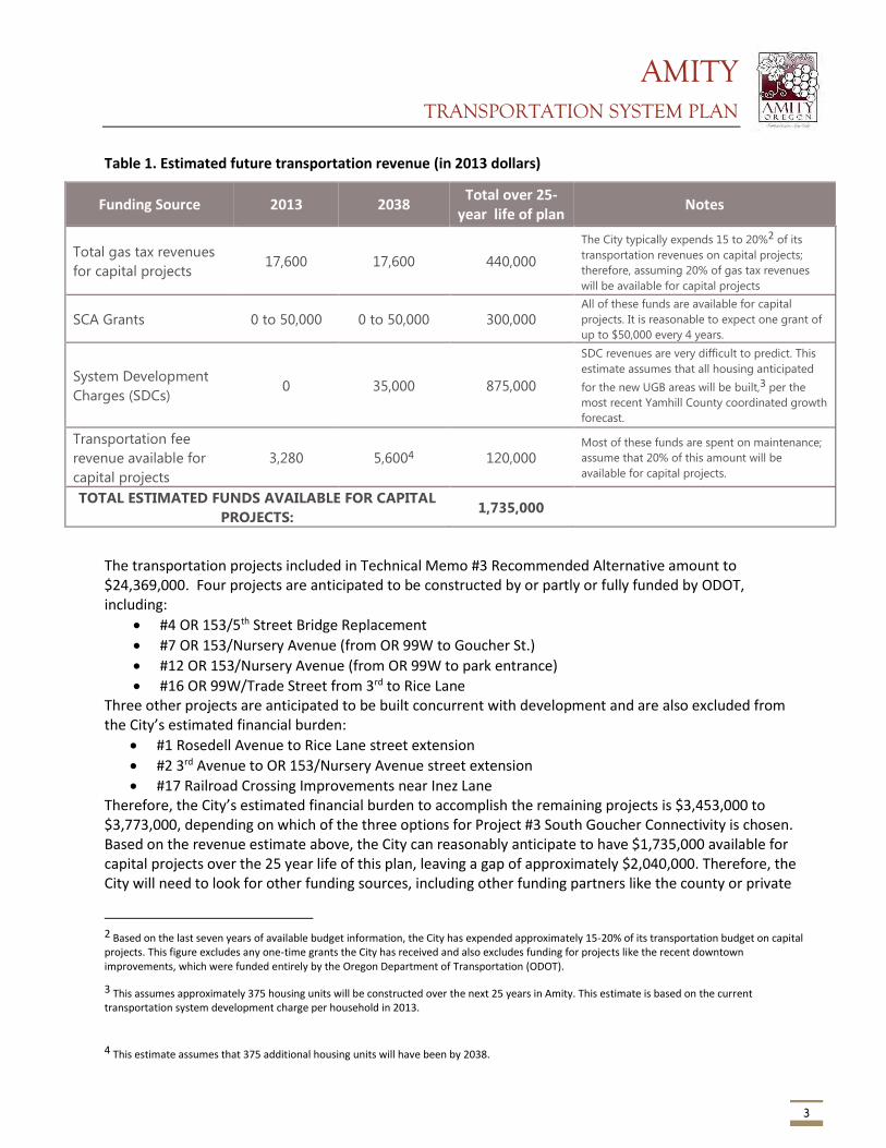
AMITY TRANSPORTATION SYSTEM PLAN
3
Table 1. Estimated future transportation revenue (in 2013 dollars)
Funding Source 2013 2038 Total over 25-
year life of plan Notes
Total gas tax revenues
for capital projects 17,600 17,600 440,000
The City typically expends 15 to 20%2 of its
transportation revenues on capital projects;
therefore, assuming 20% of gas tax revenues
will be available for capital projects
SCA Grants 0 to 50,000 0 to 50,000 300,000 All of these funds are available for capital
projects. It is reasonable to expect one grant of
up to $50,000 every 4 years.
System Development
Charges (SDCs) 0 35,000 875,000
SDC revenues are very difficult to predict. This
estimate assumes that all housing anticipated
for the new UGB areas will be built,3 per the
most recent Yamhill County coordinated growth
forecast.
Transportation fee
revenue available for
capital projects
3,280 5,6004 120,000 Most of these funds are spent on maintenance;
assume that 20% of this amount will be
available for capital projects.
TOTAL ESTIMATED FUNDS AVAILABLE FOR CAPITAL
PROJECTS: 1,735,000
The transportation projects included in Technical Memo #3 Recommended Alternative amount to $24,369,000. Four projects are anticipated to be constructed by or partly or fully funded by ODOT, including:
#4 OR 153/5th Street Bridge Replacement
#7 OR 153/Nursery Avenue (from OR 99W to Goucher St.)
#12 OR 153/Nursery Avenue (from OR 99W to park entrance)
#16 OR 99W/Trade Street from 3rd to Rice Lane Three other projects are anticipated to be built concurrent with development and are also excluded from the City’s estimated financial burden:
#1 Rosedell Avenue to Rice Lane street extension
#2 3rd Avenue to OR 153/Nursery Avenue street extension
#17 Railroad Crossing Improvements near Inez Lane Therefore, the City’s estimated financial burden to accomplish the remaining projects is $3,453,000 to $3,773,000, depending on which of the three options for Project #3 South Goucher Connectivity is chosen. Based on the revenue estimate above, the City can reasonably anticipate to have $1,735,000 available for capital projects over the 25 year life of this plan, leaving a gap of approximately $2,040,000. Therefore, the City will need to look for other funding sources, including other funding partners like the county or private
2 Based on the last seven years of available budget information, the City has expended approximately 15-20% of its transportation budget on capital projects. This figure excludes any one-time grants the City has received and also excludes funding for projects like the recent downtown improvements, which were funded entirely by the Oregon Department of Transportation (ODOT).
3 This assumes approximately 375 housing units will be constructed over the next 25 years in Amity. This estimate is based on the current transportation system development charge per household in 2013.
4 This estimate assumes that 375 additional housing units will have been by 2038.
AMITY TRANSPORTATION SYSTEM PLAN
4
developers, grants, bonds, and other sources. The following sections review funding sources that may help narrow the gap.
Funding and Finance A variety of established funding sources from federal, state and local sources are available to fund future transportation projects in the City of Amity. Table 2 provides an overview of each funding source, eligible projects, funding dollar amount, funding restrictions, and other considerations.
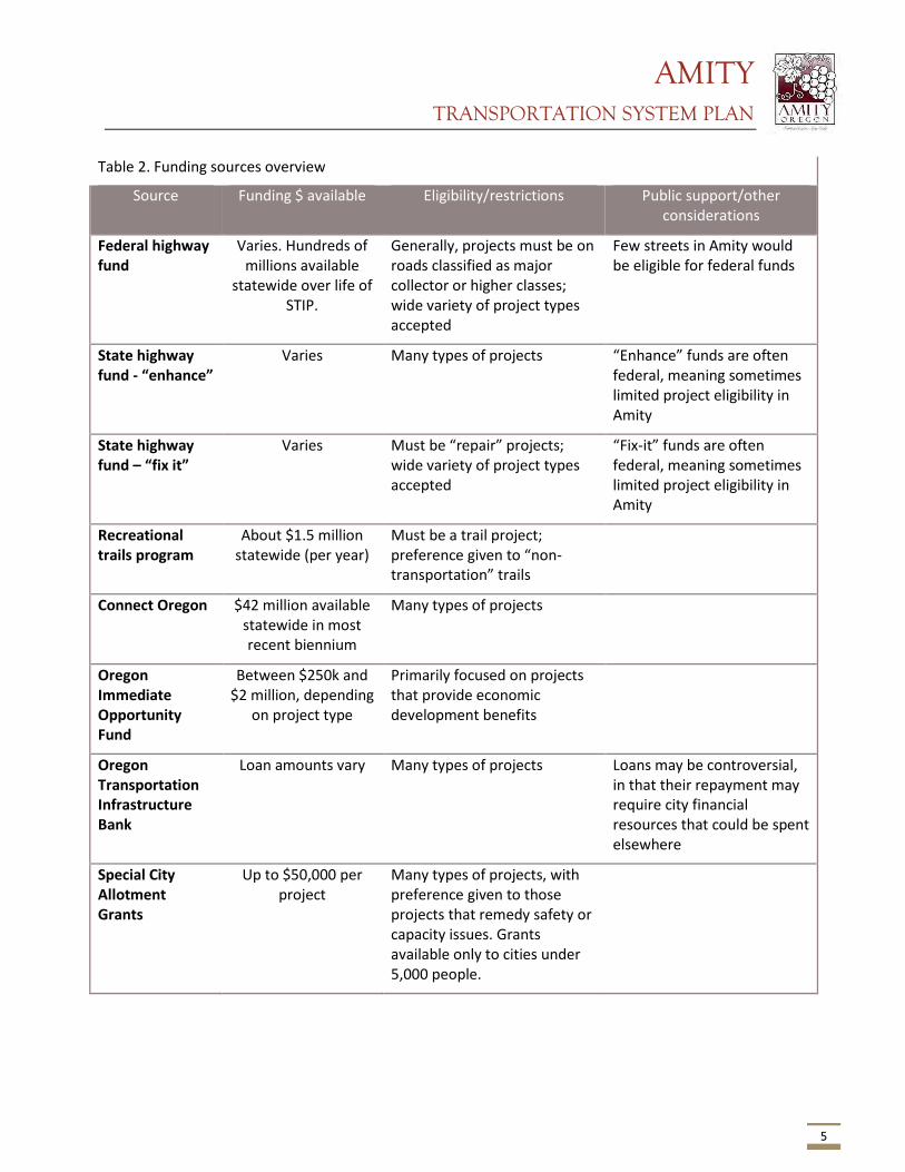
AMITY TRANSPORTATION SYSTEM PLAN
5
Table 2. Funding sources overview
Source Funding $ available Eligibility/restrictions Public support/other considerations
Federal highway fund
Varies. Hundreds of millions available
statewide over life of STIP.
Generally, projects must be on roads classified as major collector or higher classes; wide variety of project types accepted
Few streets in Amity would be eligible for federal funds
State highway fund - “enhance”
Varies Many types of projects “Enhance” funds are often federal, meaning sometimes limited project eligibility in Amity
State highway fund – “fix it”
Varies Must be “repair” projects; wide variety of project types accepted
“Fix-it” funds are often federal, meaning sometimes limited project eligibility in Amity
Recreational trails program
About $1.5 million statewide (per year)
Must be a trail project; preference given to “non-transportation” trails
Connect Oregon $42 million available statewide in most recent biennium
Many types of projects
Oregon Immediate Opportunity Fund
Between $250k and $2 million, depending
on project type
Primarily focused on projects that provide economic development benefits
Oregon Transportation Infrastructure Bank
Loan amounts vary Many types of projects Loans may be controversial, in that their repayment may require city financial resources that could be spent elsewhere
Special City Allotment Grants
Up to $50,000 per project
Many types of projects, with preference given to those projects that remedy safety or capacity issues. Grants available only to cities under 5,000 people.
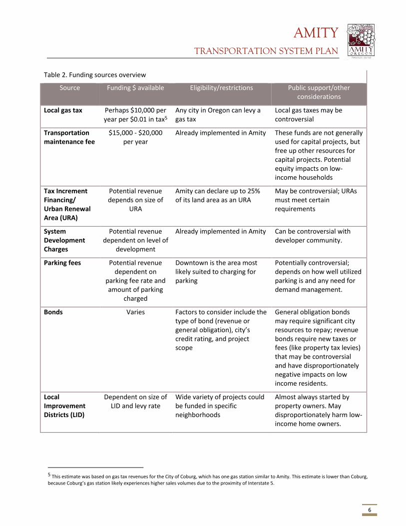
AMITY TRANSPORTATION SYSTEM PLAN
6
Table 2. Funding sources overview
Source Funding $ available Eligibility/restrictions Public support/other considerations
Local gas tax Perhaps $10,000 per year per $0.01 in tax5
Any city in Oregon can levy a gas tax
Local gas taxes may be controversial
Transportation maintenance fee
$15,000 - $20,000 per year
Already implemented in Amity These funds are not generally used for capital projects, but free up other resources for capital projects. Potential equity impacts on low-income households
Tax Increment Financing/ Urban Renewal Area (URA)
Potential revenue depends on size of
URA
Amity can declare up to 25% of its land area as an URA
May be controversial; URAs must meet certain requirements
System Development Charges
Potential revenue dependent on level of
development
Already implemented in Amity Can be controversial with developer community.
Parking fees Potential revenue dependent on
parking fee rate and amount of parking
charged
Downtown is the area most likely suited to charging for parking
Potentially controversial; depends on how well utilized parking is and any need for demand management.
Bonds Varies Factors to consider include the type of bond (revenue or general obligation), city’s credit rating, and project scope
General obligation bonds may require significant city resources to repay; revenue bonds require new taxes or fees (like property tax levies) that may be controversial and have disproportionately negative impacts on low income residents.
Local Improvement Districts (LID)
Dependent on size of LID and levy rate
Wide variety of projects could be funded in specific neighborhoods
Almost always started by property owners. May disproportionately harm low-income home owners.
5 This estimate was based on gas tax revenues for the City of Coburg, which has one gas station similar to Amity. This estimate is lower than Coburg, because Coburg’s gas station likely experiences higher sales volumes due to the proximity of Interstate 5.
AMITY TRANSPORTATION SYSTEM PLAN
7
Federal Grants Highway Trust Fund Revenues to the federal Highway Trust Fund (HTF) are comprised of motor vehicle fuel taxes, sales taxes on heavy trucks and trailers, tire taxes and annual heavy truck use fees. HTF funds are split into two accounts – the highway account and transit account. Funds are appropriated to the states annually, based on allocation formulas in the current legislation governing the HTF. Moving Ahead for Progress in the 21st Century (MAP-21) is the current federal transportation program legislation, which became effective October 1st, 2012.
MAP-21 kept federal funding for transportation at the same rate as the prior legislation (the Safe, Accountable, Flexible and Efficient Transportation Equity Act – A Legacy for Users, known as SAFETEA-LU). MAP-21 consolidated the 90 different programs in SAFETEA-LU into 30, eliminated transportation earmarks, and reduced funding for transportation enhancements (pedestrian, bicycle and similar projects) by one third. Despite these changes and modest reduction in transportation enhancement (now transportation alternatives) funds, MAP-21 largely continues federal transportation funding and policy enacted under SAFETEA-LU. Matching funds are generally required; the current matching ratio is 10.27% for projects in Oregon.
Most federal grant monies are distributed by the Oregon Department of Transportation (ODOT) through the Statewide Transportation Improvement program (STIP). The application process for federal funds is described below in the Statewide Transportation Improvement Program section.
State Grants State Highway Fund State funds are distributed by the Oregon Transportation Commission (OTC). Revenues to the fund are comprised of fuel taxes, vehicle registration and title fees, driver’s license fees and the truck weight-mile tax. State funds may be used for construction and maintenance of state and local highways, bridges and roadside rest areas. State law requires that a minimum of 1% of all highway funds be used for pedestrian and bicycle projects in any given fiscal year. However, cities and counties receiving state funds may “bank” their pedestrian and bicycle allotment for larger projects.
Statewide Transportation Improvement Program The STIP is the 4-year capital improvement program for the state of Oregon. It provides a schedule and identifies funding for projects throughout the state. Projects included in the STIP are generally “regionally significant” and are prioritized by Metropolitan Planning Organizations and Area Commissions on Transportation (ACTs). ACTs are regional advisory bodies, and the relevant ACT for Amity is the Mid-Willamette Valley ACT. All regionally significant state and local projects, as well as all federally-funded projects and programs, must be included in the STIP.
About 80 percent of STIP projects use federal funds, most of which originate from MAP-21 programs. This includes the STP, TAP, and National Highway Performance Program funding for preservation and improvement of the National Highway System. In addition, Regional Flexible Funds competitive grants awarded every two years towards bicycle, pedestrian, transit and Transportation Demand Management (TDM) projects are now included in the STIP. The STIP is the major transportation funding program for most state and federal transportation funds.
Planning for the 2015-2018 STIP is underway. Previous STIPs had six program categories: modernization, safety, preservation, bridge, operations, and special programs. Starting with the 2015-2018 STIP, ODOT will divide the funding pools into two broad categories: “Fix it” and “Enhance.” “Fix it” projects are those that
AMITY TRANSPORTATION SYSTEM PLAN
8
preserve and maintain the current transportation system; “Enhance” projects are those that enhance, expand or improve the transportation system. The main purpose behind this reorganization is to allow maximum flexibility to fund projects that reflect community and state values and needs, rather than those that fit best into prescriptive program definitions. More information on the Statewide Transportation Improvement Program can be found at http://www.oregon.gov/ODOT/TD/STIP/Pages/default.aspx .
Applicable “Fix-it” activities will include: Applicable “Enhance” activities will include:
• Bridges (state owned) • Bicycle and/or Pedestrian facilities on or off the highway right-of-way
• High Risk Rural Roads • Most projects previously eligible for Transportation Enhancement funds
• Illumination, signs and signals • Bike/Ped, Transit, TDM projects eligible for Flexible Funds (using federal STP and CMAQ funds)
• Safety • Safe Routes to School (infrastructure projects)
• Transportation Alternatives (new with MAP-21)
The application process for projects on the 2015-2018 STIP is complete as of this writing, but future STIPs will continue to use this new funding arrangement. There is now one application for “Enhance” projects – ODOT will determine which funding mechanism is most appropriate for individual projects. “Fix it” projects will be selected through a collaborative process between ODOT and ACTs. It should be noted that this reorganization of funding programs does not represent a fundamental change in the types of projects that will be funded through the STIP. Eligibility
Only certain streets are eligible to receive federal funds – generally those streets with federal functional classification as “major collector” and higher order streets. Only OR 99/Trade Street, OR 153/5th Street, and OR 153/Nursery Avenue meet this criteria. However, STIP projects are also funded by other sources, meaning most streets in Amity are likely eligible under either the “Fix it” or “Enhance” categories described above. To ensure that Amity is involved in the STIP decision-making process and to advocate for STIP projects important to the community, the City should actively participate in the Mid-Willamette Valley ACT.
An additional step the City or local school district could take to improve the likelihood of funding through the “Enhance” side of the STIP is to complete a Safe Routes to School Action Plan. These plans detail specific programmatic actions as well as capital improvements that improve the walking and cycling environment around and between schools. Completing an Action Plan will help those projects near or adjacent to schools receive “Enhance” funding. More information about the Safe Routes program and Action Plans can be found at http://oregonsaferoutes.org/.
State Grants Recreational Trails Program (RTP) This program is administered by the Oregon Parks and Recreation Department. RTP funding is intended for recreational trail projects, and can be used for acquiring land and easement and building new trails. Grant funds pay up to 80 percent of project costs while project sponsors must match project costs by at least 20 percent. Funding varies greatly from year to year, with about $1.3 million awarded state-wide in 2011 and
AMITY TRANSPORTATION SYSTEM PLAN
9
$2.1 million in 2010. Approximately $1.5 million in state-wide funds are available in 2014. More information can be found at http://www.oregon.gov/oprd/grants/Pages/trails.aspx.
ConnectOregon Program ConnectOregon provides grants and loans for non-highway transportation projects, backed by bonds on state lottery proceeds. $42 million in bonds were authorized for the most recent biennium. The program funds rail, port/marine, aviation, and transit projects. In addition, the Legislature made bicycle and pedestrian projects that are not eligible for State Highway Funds eligible to compete for ConnectOregon funding. If the state legislature makes further authorizations, a number of Amity’s transportation projects may be eligible based on funding criteria. More information on this program can be found at http://www.oregon.gov/ODOT/TD/TP/pages/connector.aspx.
Oregon Immediate Opportunity Fund The Oregon immediate opportunity fund supports economic development in Oregon through construction and improvements of streets and roads. Funds are discretionary and may only be used when other sources of financial support are unavailable or insufficient. The objectives of the Opportunity Fund are providing street or road improvements to influence the location, relocation, or retention of a firm in Oregon, providing procedures and funds for the OTC to respond quickly to economic development opportunities, and providing criteria and procedures for the Oregon Economic and Community Development Department (OECDD), other agencies, local government and the private sector to work with ODOT in providing road improvements needed to ensure specific job development opportunities for Oregon, or to revitalize business or industrial centers. More information can be found at http://www.oregon.gov/ODOT/TD/TP/Plans/IOF.pdf.
Oregon Transportation Infrastructure Bank (OTIB) OTIB is a statewide revolving loan fund available for highway projects on major collectors or higher classifications and bicycle or pedestrian access projects on highway right-of-way. Applications are accepted at any time. More information can be found at http://www.oregon.gov/ODOT/cs/fs/Pages/otib.aspx.
Special City Allotment Grants Special City Allotment (SCA) Grants are distributed among cities with population of less than 5,000 to help repair or reconstruct City-maintained streets that are inadequate for the capacity they serve or are deemed unsafe. The City has received two SCA grants in the last several years, and is likely to continue to be successful with this program. More information can be found at http://www.oregon.gov/ODOT/HWY/REGION2/docs/resources/SpecialCityAllotmentGrantProgram.pdf.
Other Current & Potential Funding Sources Local Most of the sources below would provide additional transportation revenue to the City that could be spent on a wide variety of projects.
Local Gas Tax Not every city in Oregon levies a local gas tax; of those that do, the local tax rate ranges from $0.01 to $0.04 per gallon. Based on gasoline sales and current revenues, a $0.01 local gas tax could yield approximately $10,000 - $20,000 in additional annual transportation revenue (depending on volume of gasoline sales within the City). Amity does not currently charge a local gas tax. Many cities in Oregon charge a local diesel fuel tax in addition to gasoline taxes. Of those cities that levy a diesel fuel tax, the local tax rate ranges from

AMITY TRANSPORTATION SYSTEM PLAN
10
$0.01 - $0.05 per gallon of diesel fuel. Local fuel tax revenues offer a potential funding source to Amity TSP projects.
Transportation Maintenance/Utility Fee The City recently enacted a transportation utility fee, which is currently $2.00 per household per month and $0.25 per trip (based on trip generations assumptions) for other uses. A number of Oregon jurisdictions also levy such a fee to pay for maintenance and operations of city streets. These fees are typically assessed on a monthly basis to residents, businesses and other non-residential uses. Non-residential fees are typically assessed by type of use, square footage of the building, and/or number of parking stalls that would be required under city code for a given use.
The fee currently generates about $16,000 a year in revenue. The fee, if left unchanged, is anticipated to generate in excess of $20,000 per year by 2038 because of anticipated population and household growth in Amity. Every additional dollar charged per household per month would generate an additional $6,000 per year with the current number of households, and up to $10,000 per year in 2038 based on additional growth in households. Note that this estimated does not include additional fee revenue from non-residential land uses.
Fees vary significantly from city to city; the City of Hillsboro currently charges each single family home $3.10 per month, Stayton charges $1.00 - $2.00 per month per home and Oregon City charges $4.50 per single family residence. Non-residential fees also vary, with fees ranging from less than $0.15 to as much as $20.00 per square foot, depending on the type and intensity of use. The City of Tigard charges $1.12 per month per parking stall required for non-residential uses. Though the City already charges such a fee, it could consider raising the fee to fund a greater share of maintenance costs, thereby freeing resources for capital projects.
Tax Increment Financing (Urban Renewal Areas) Amity does not currently have an Urban Renewal Area (URA) within the city. Oregon law allows small cities to designate up to 25% of the land area within the city as URAs; Amity could potentially designate a URA, the funds from which could be used to finance transportation projects. However, URAs can only be designated in “blighted” areas; “blight” refers to a variety of conditions, including lack of infrastructure, under-utilization of property, physical condition of buildings, etc.
System Development Charges (SDCs) SDCs are fees imposed on new development. Amity currently has SDCs for transportation. These fees can be used for a wide variety of transportation improvements. SDC revenue is highly dependent on the type and amount of development occurring in Amity. These fees must be regularly adjusted based on the infrastructure needs of the City.
Parking Fees The City does not currently charge for parking. Income generated by charging parking fees could be used to implement a variety of transportation projects. The collection system would require purchase of parking meter infrastructure, careful study of where to install meters, and analysis of the appropriate fee amount to charge drivers. However, relatively low demand and abundant free parking availability on nearby neighborhood streets may mean that charging for parking is infeasible.
Bonds Revenue or general obligation bonds can help finance construction of capital improvement projects by borrowing money and paying it back over time in smaller installments. Bonds are typically backed by new revenue, like an additional property tax levy.
AMITY TRANSPORTATION SYSTEM PLAN
11
Local Improvement Districts (LIDs) Local Improvement Districts can be created by property owners within a district to raise revenues for infrastructure improvements within district boundaries. Typically, property owners work together to form an LID. An LID could potentially fund specific improvements in certain neighborhoods; they are often formed to make sidewalk improvements. LIDs can be difficult to establish and rely on the cooperation of property owners.
Project Priorities Projects in the Amity TSP are prioritized in Table 3 by need and by time frame for implementation: high (0 – 5 years), medium (5 – 10 years), and low (10 – 25 years). Projects are prioritized based on community goals, urgency of the need, funding availability, community input, and complexity of the project. Small, cost-effective improvements are likely to be high priorities because they can be accomplished in the short-term. The need for some projects is dependent on development, and these projects are called out separately in the table. Short-term projects generally address current or soon-to-emerge transportation issues, and should be prioritized for funding. Complex projects that are more expensive and have more impacts may be accomplished in the long-term. Some proposed projects may address a transportation problem that is likely to emerge in the future. Project priorities are not intended as a “to-do” list for the City, but a suggestion for programming the City’s scarce transportation funding resources.
Table 3 provides the cost estimates, priority, and potential funding partners or sources. Not every possible funding source is listed in the table; for example, local gas taxes, system development charges (SDCs), bonds, state loans, etc. can be used to fund a wide variety of projects and are not expressly called out in the table.
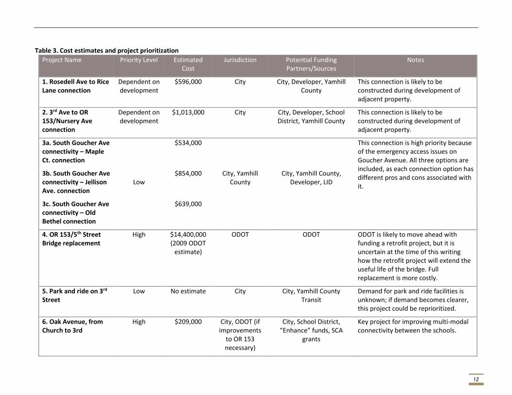
12
Table 3. Cost estimates and project prioritization
Project Name Priority Level Estimated Cost
Jurisdiction Potential Funding Partners/Sources
Notes
1. Rosedell Ave to Rice Lane connection
Dependent on development
$596,000 City City, Developer, Yamhill County
This connection is likely to be constructed during development of adjacent property.
2. 3rd Ave to OR 153/Nursery Ave connection
Dependent on development
$1,013,000 City City, Developer, School District, Yamhill County
This connection is likely to be constructed during development of adjacent property.
3a. South Goucher Ave connectivity – Maple Ct. connection
Low
$534,000 This connection is high priority because of the emergency access issues on Goucher Avenue. All three options are included, as each connection option has different pros and cons associated with it.
3b. South Goucher Ave connectivity – Jellison Ave. connection
$854,000 City, Yamhill County
City, Yamhill County, Developer, LID
3c. South Goucher Ave connectivity – Old Bethel connection
$639,000
4. OR 153/5th Street Bridge replacement
High $14,400,000 (2009 ODOT
estimate)
ODOT ODOT ODOT is likely to move ahead with funding a retrofit project, but it is uncertain at the time of this writing how the retrofit project will extend the useful life of the bridge. Full replacement is more costly.
5. Park and ride on 3rd Street
Low No estimate City City, Yamhill County Transit
Demand for park and ride facilities is unknown; if demand becomes clearer, this project could be reprioritized.
6. Oak Avenue, from Church to 3rd
High $209,000 City, ODOT (if improvements
to OR 153 necessary)
City, School District, “Enhance” funds, SCA
grants
Key project for improving multi-modal connectivity between the schools.
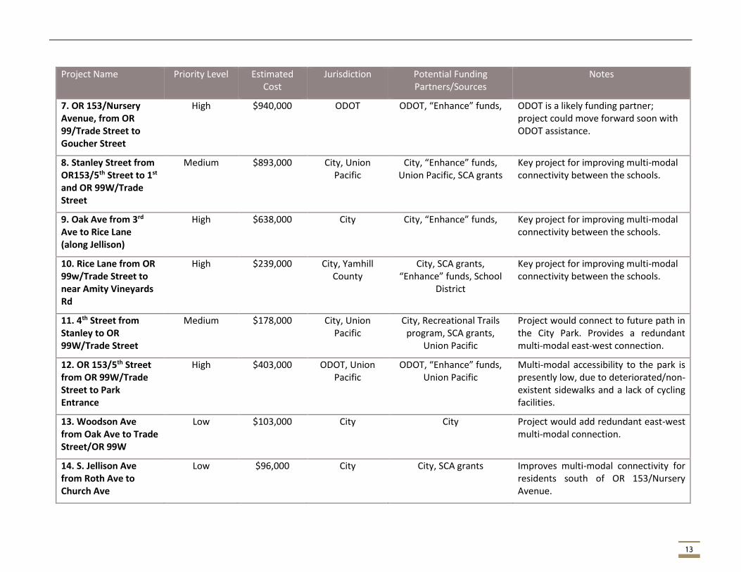
13
Project Name Priority Level Estimated Cost
Jurisdiction Potential Funding Partners/Sources
Notes
7. OR 153/Nursery Avenue, from OR 99/Trade Street to Goucher Street
High $940,000 ODOT ODOT, “Enhance” funds, ODOT is a likely funding partner; project could move forward soon with ODOT assistance.
8. Stanley Street from OR153/5th Street to 1st and OR 99W/Trade Street
Medium $893,000 City, Union Pacific
City, “Enhance” funds, Union Pacific, SCA grants
Key project for improving multi-modal connectivity between the schools.
9. Oak Ave from 3rd Ave to Rice Lane (along Jellison)
High $638,000 City City, “Enhance” funds, Key project for improving multi-modal connectivity between the schools.
10. Rice Lane from OR 99w/Trade Street to near Amity Vineyards Rd
High $239,000 City, Yamhill County
City, SCA grants, “Enhance” funds, School
District
Key project for improving multi-modal connectivity between the schools.
11. 4th Street from Stanley to OR 99W/Trade Street
Medium $178,000 City, Union Pacific
City, Recreational Trails program, SCA grants,
Union Pacific
Project would connect to future path in the City Park. Provides a redundant multi-modal east-west connection.
12. OR 153/5th Street from OR 99W/Trade Street to Park Entrance
High $403,000 ODOT, Union Pacific
ODOT, “Enhance” funds, Union Pacific
Multi-modal accessibility to the park is presently low, due to deteriorated/non-existent sidewalks and a lack of cycling facilities.
13. Woodson Ave from Oak Ave to Trade Street/OR 99W
Low $103,000 City City Project would add redundant east-west multi-modal connection.
14. S. Jellison Ave from Roth Ave to Church Ave
Low $96,000 City City, SCA grants Improves multi-modal connectivity for residents south of OR 153/Nursery Avenue.
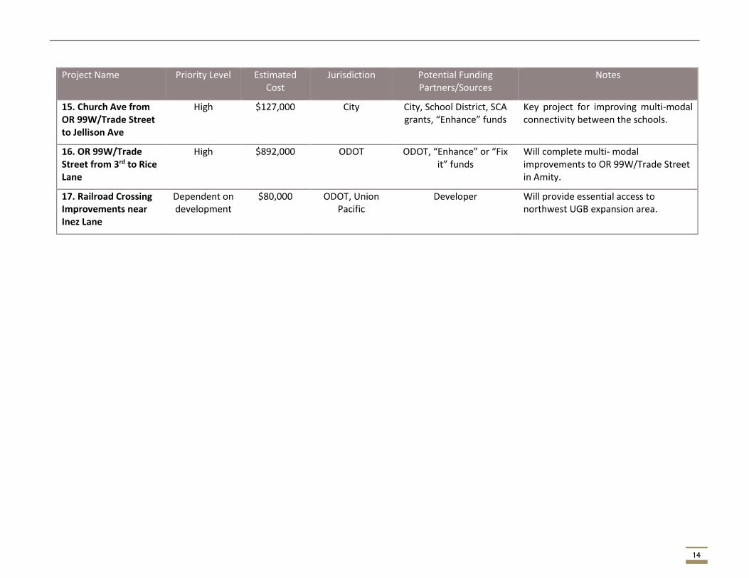
14
Project Name Priority Level Estimated Cost
Jurisdiction Potential Funding Partners/Sources
Notes
15. Church Ave from OR 99W/Trade Street to Jellison Ave
High $127,000 City City, School District, SCA grants, “Enhance” funds
Key project for improving multi-modal connectivity between the schools.
16. OR 99W/Trade Street from 3rd to Rice Lane
High $892,000 ODOT ODOT, “Enhance” or “Fix it” funds
Will complete multi- modal improvements to OR 99W/Trade Street in Amity.
17. Railroad Crossing Improvements near Inez Lane
Dependent on development
$80,000 ODOT, Union Pacific
Developer Will provide essential access to northwest UGB expansion area.

15
Next Steps The PMT, PAC, and community will review these projects and priorities concurrently with Tech Memo #3: Recommended Alternative. The project team will make any necessary changes, and then the alternatives supported by City stakeholders will be included as recommendations in the Amity TSP.
AMITY TRANSPORTATION SYSTEM PLAN
Appendix A – Full cost estimates
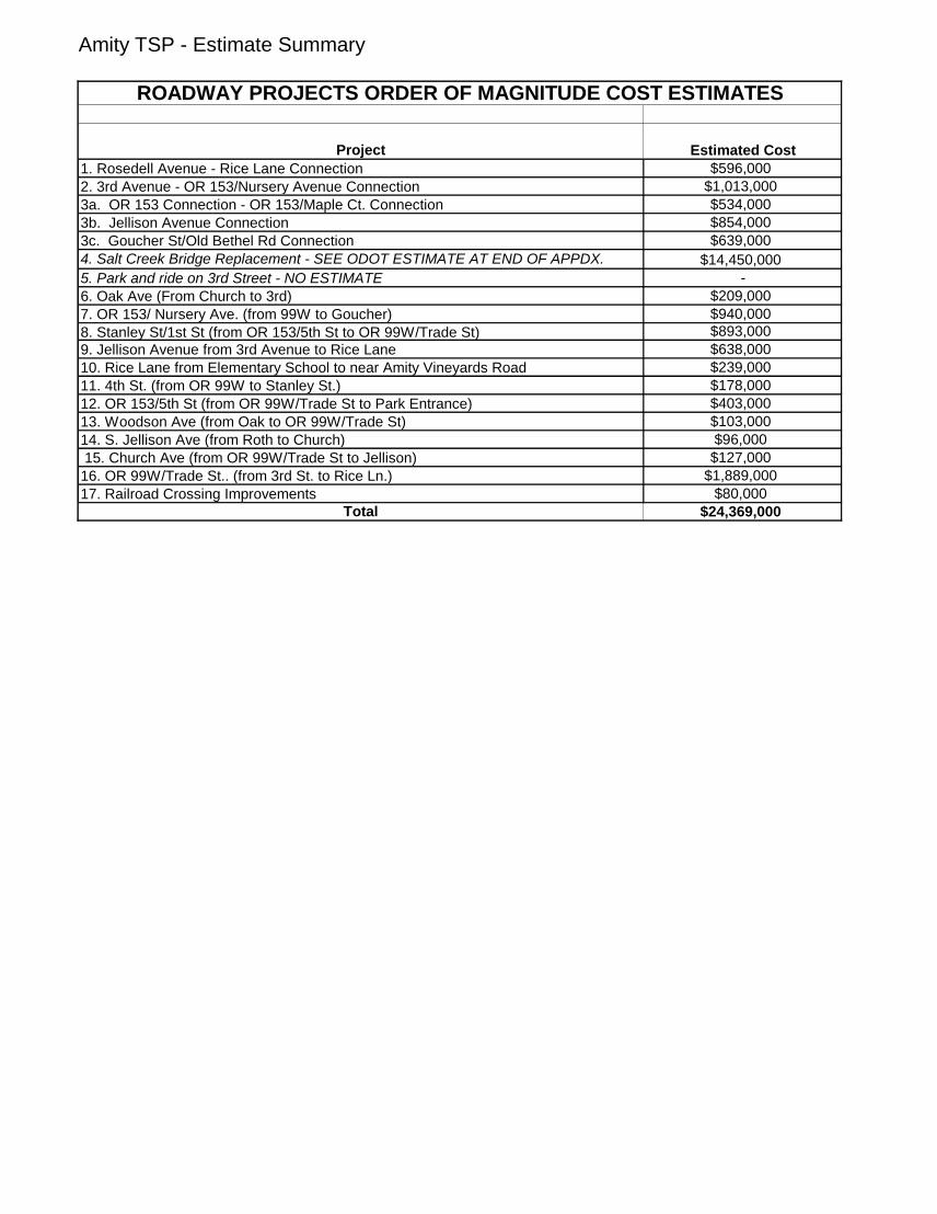
Amity TSP - Estimate Summary
Project Estimated Cost
1. Rosedell Avenue - Rice Lane Connection $596,000
2. 3rd Avenue - OR 153/Nursery Avenue Connection $1,013,000
3a. OR 153 Connection - OR 153/Maple Ct. Connection $534,000
3b. Jellison Avenue Connection $854,000
3c. Goucher St/Old Bethel Rd Connection $639,000
4. Salt Creek Bridge Replacement - SEE ODOT ESTIMATE AT END OF APPDX. $14,450,000
5. Park and ride on 3rd Street - NO ESTIMATE -
6. Oak Ave (From Church to 3rd) $209,000
7. OR 153/ Nursery Ave. (from 99W to Goucher) $940,000
8. Stanley St/1st St (from OR 153/5th St to OR 99W/Trade St) $893,000
9. Jellison Avenue from 3rd Avenue to Rice Lane $638,000
10. Rice Lane from Elementary School to near Amity Vineyards Road $239,000
11. 4th St. (from OR 99W to Stanley St.) $178,000
12. OR 153/5th St (from OR 99W/Trade St to Park Entrance) $403,000
13. Woodson Ave (from Oak to OR 99W/Trade St) $103,000
14. S. Jellison Ave (from Roth to Church) $96,000
15. Church Ave (from OR 99W/Trade St to Jellison) $127,000
16. OR 99W/Trade St.. (from 3rd St. to Rice Ln.) $1,889,000
17. Railroad Crossing Improvements $80,000
Total $24,369,000
ROADWAY PROJECTS ORDER OF MAGNITUDE COST ESTIMATES
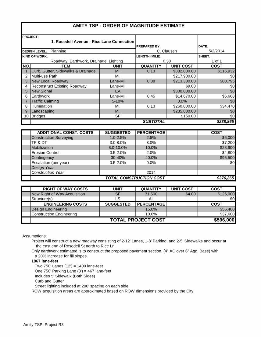
DATE:
5/2/2014
SHEET:
1 of 1
NO. UNIT QUANTITY UNIT COST COST
1 Mi. 0.13 $882,000.00 $116,932
2 Mi. $217,900.00 $0
3 Lane-Mi. 0.38 $213,300.00 $80,795
4 Lane-Mi. $9.00 $0
5 EA $300,000.00 $0
6 Lane-Mi. 0.45 $14,670.00 $6,668
7 5-10% 0.0% $0
8 Mi. 0.13 $260,000.00 $34,470
9 Mi. $235,000.00 $0
10 SF $150.00 $0
$238,865
SUGGESTED PERCENTAGE COST
1.0-2.5% 2.5% $6,000
3.0-8.0% 3.0% $7,200
8.0-10.0% 10.0% $23,900
0.5-2.0% 2.0% $4,800
30-40% 40.0% $95,500
0.5-2.0% 0.0% $0
2014
$376,265
UNIT QUANTITY UNIT COST COST
SF 31,500 $4.00 $126,000
LS All $0
SUGGESTED PERCENTAGE COST
15.0% $56,400
10.0% $37,600
$596,000
Assumptions:
Project will construct a new roadway consisting of 2-12' Lanes, 1-8' Parking, and 2-5' Sidewalks and occur at
the east end of Rosedell St north to Rice Ln.
Only earthwork estimated is to construct the proposed pavement section. (4" AC over 6" Agg. Base) with
a 20% increase for fill slopes.
1867 lane-feet
Two 750' Lanes (12') = 1400 lane-feet
One 750' Parking Lane (8') = 467 lane-feet
Includes 5' Sidewalk (Both Sides)
Curb and Gutter
Street lighting included at 200' spacing on each side.
ITEM
AMITY TSP - ORDER OF MAGNITUDE ESTIMATE
PROJECT:
1. Rosedell Avenue - Rice Lane Connection PREPARED BY:
DESIGN LEVEL: Planning C. Clausen
KIND OF WORK:
Roadway, Earthwork, Drainage, Lighting
LENGTH (MILE):
0.38
Illumination
Curb, Gutter, Sidewalks & Drainage
Multi-use Path
New Local Roadway
Reconstruct Existing Roadway
New Signal
Earthwork
Traffic Calming
Design Year
Landscaping
Bridges
SUBTOTAL
ADDITIONAL CONST. COSTS
Construction Surveying
TP & DT
Mobilization
Erosion Control
Contingency
Escalation (per year)
ROW acquisition areas are approximated based on ROW dimensions provided by the City.
Design Engineering
Construction Engineering
TOTAL PROJECT COST
Construction Year
TOTAL CONSTRUCTION COST
RIGHT OF WAY COSTS
New Right of Way Acquisition
Structure(s)
ENGINEERING COSTS
Amity TSP: Project R3
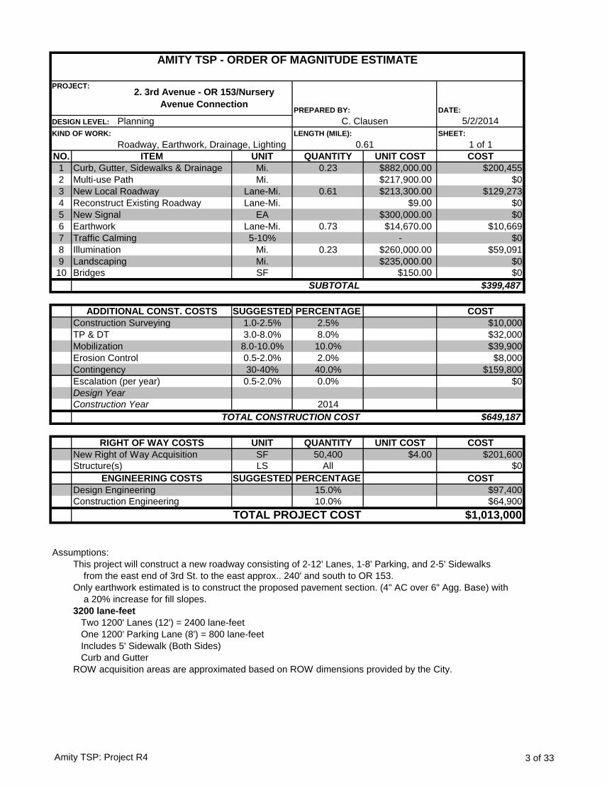
DATE:
5/2/2014
SHEET:
1 of 1
NO. UNIT QUANTITY UNIT COST COST
1 Mi. 0.23 $882,000.00 $200,455
2 Mi. $217,900.00 $0
3 Lane-Mi. 0.61 $213,300.00 $129,273
4 Lane-Mi. $9.00 $0
5 EA $300,000.00 $0
6 Lane-Mi. 0.73 $14,670.00 $10,669
7 5-10% - $0
8 Mi. 0.23 $260,000.00 $59,091
9 Mi. $235,000.00 $0
10 SF $150.00 $0
$399,487
SUGGESTED PERCENTAGE COST
1.0-2.5% 2.5% $10,000
3.0-8.0% 8.0% $32,000
8.0-10.0% 10.0% $39,900
0.5-2.0% 2.0% $8,000
30-40% 40.0% $159,800
0.5-2.0% 0.0% $0
2014
$649,187
UNIT QUANTITY UNIT COST COST
SF 50,400 $4.00 $201,600
LS All $0
SUGGESTED PERCENTAGE COST
15.0% $97,400
10.0% $64,900
$1,013,000
Assumptions:
This project will construct a new roadway consisting of 2-12' Lanes, 1-8' Parking, and 2-5' Sidewalks
from the east end of 3rd St. to the east approx.. 240' and south to OR 153.
Only earthwork estimated is to construct the proposed pavement section. (4" AC over 6" Agg. Base) with
a 20% increase for fill slopes.
3200 lane-feet
Two 1200' Lanes (12') = 2400 lane-feet
One 1200' Parking Lane (8') = 800 lane-feet
Includes 5' Sidewalk (Both Sides)
Curb and Gutter
Design Engineering
Construction Engineering
TOTAL PROJECT COST
Construction Year
TOTAL CONSTRUCTION COST
RIGHT OF WAY COSTS
New Right of Way Acquisition
Structure(s)
ENGINEERING COSTS
Traffic Calming
Design Year
Landscaping
Bridges
SUBTOTAL
ADDITIONAL CONST. COSTS
Construction Surveying
TP & DT
Mobilization
Erosion Control
Contingency
Escalation (per year)
New Signal
Earthwork
Curb, Gutter, Sidewalks & Drainage
Multi-use Path
New Local Roadway
Reconstruct Existing Roadway
ROW acquisition areas are approximated based on ROW dimensions provided by the City.
ITEM
AMITY TSP - ORDER OF MAGNITUDE ESTIMATE
PROJECT:2. 3rd Avenue - OR 153/Nursery
Avenue ConnectionPREPARED BY:
DESIGN LEVEL: Planning C. Clausen
KIND OF WORK:
Roadway, Earthwork, Drainage, Lighting
LENGTH (MILE):
0.61
Illumination
Amity TSP: Project R4 3 of 33
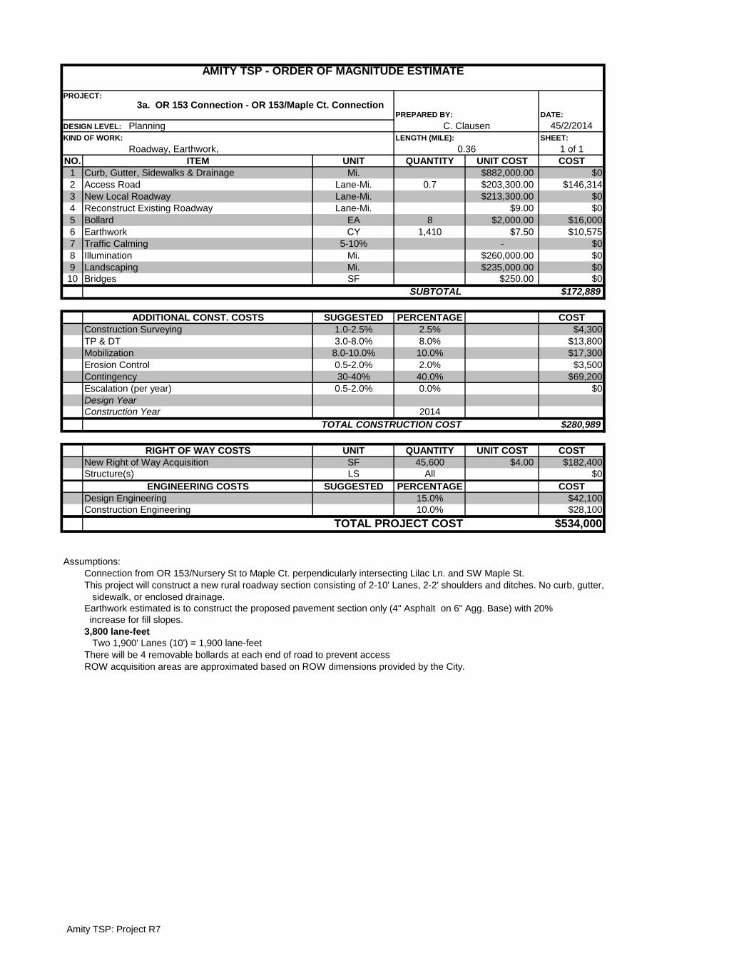
DATE:
45/2/2014
SHEET:
1 of 1
NO. UNIT QUANTITY UNIT COST COST
1 Mi. $882,000.00 $0
2 Lane-Mi. 0.7 $203,300.00 $146,314
3 Lane-Mi. $213,300.00 $0
4 Lane-Mi. $9.00 $0
5 EA 8 $2,000.00 $16,000
6 CY 1,410 $7.50 $10,575
7 5-10% - $0
8 Mi. $260,000.00 $0
9 Mi. $235,000.00 $0
10 SF $250.00 $0
$172,889
SUGGESTED PERCENTAGE COST
1.0-2.5% 2.5% $4,300
3.0-8.0% 8.0% $13,800
8.0-10.0% 10.0% $17,300
0.5-2.0% 2.0% $3,500
30-40% 40.0% $69,200
0.5-2.0% 0.0% $0
2014
$280,989
UNIT QUANTITY UNIT COST COST
SF 45,600 $4.00 $182,400
LS All $0
SUGGESTED PERCENTAGE COST
15.0% $42,100
10.0% $28,100
$534,000
Assumptions:
Connection from OR 153/Nursery St to Maple Ct. perpendicularly intersecting Lilac Ln. and SW Maple St.
This project will construct a new rural roadway section consisting of 2-10' Lanes, 2-2' shoulders and ditches. No curb, gutter,
sidewalk, or enclosed drainage.
Earthwork estimated is to construct the proposed pavement section only (4" Asphalt on 6" Agg. Base) with 20%
increase for fill slopes.
3,800 lane-feet
Two 1,900' Lanes (10') = 1,900 lane-feet
There will be 4 removable bollards at each end of road to prevent access
DESIGN LEVEL: Planning C. Clausen
AMITY TSP - ORDER OF MAGNITUDE ESTIMATE
PROJECT:
3a. OR 153 Connection - OR 153/Maple Ct. ConnectionPREPARED BY:
Earthwork
KIND OF WORK:
Roadway, Earthwork,
LENGTH (MILE):
0.36
ITEM
Curb, Gutter, Sidewalks & Drainage
Access Road
New Local Roadway
Reconstruct Existing Roadway
Bollard
Escalation (per year)
Traffic Calming
Illumination
Landscaping
Bridges
SUBTOTAL
ADDITIONAL CONST. COSTS
Construction Surveying
TP & DT
Mobilization
Erosion Control
Contingency
Design Year
Construction Year
TOTAL CONSTRUCTION COST
RIGHT OF WAY COSTS
New Right of Way Acquisition
Structure(s)
ROW acquisition areas are approximated based on ROW dimensions provided by the City.
ENGINEERING COSTS
Design Engineering
Construction Engineering
TOTAL PROJECT COST
Amity TSP: Project R7
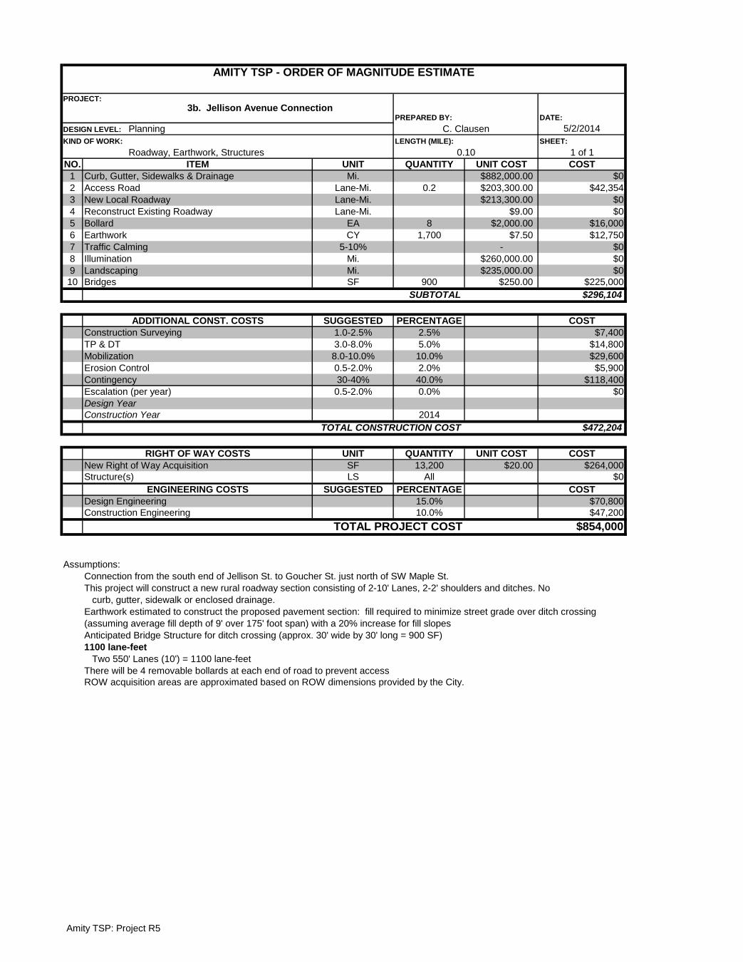
DATE:
5/2/2014
SHEET:
1 of 1
NO. UNIT QUANTITY UNIT COST COST
1 Mi. $882,000.00 $0
2 Lane-Mi. 0.2 $203,300.00 $42,354
3 Lane-Mi. $213,300.00 $0
4 Lane-Mi. $9.00 $0
5 EA 8 $2,000.00 $16,000
6 CY 1,700 $7.50 $12,750
7 5-10% - $0
8 Mi. $260,000.00 $0
9 Mi. $235,000.00 $0
10 SF 900 $250.00 $225,000
$296,104
SUGGESTED PERCENTAGE COST
1.0-2.5% 2.5% $7,400
3.0-8.0% 5.0% $14,800
8.0-10.0% 10.0% $29,600
0.5-2.0% 2.0% $5,900
30-40% 40.0% $118,400
0.5-2.0% 0.0% $0
2014
$472,204
UNIT QUANTITY UNIT COST COST
SF 13,200 $20.00 $264,000
LS All $0
SUGGESTED PERCENTAGE COST
15.0% $70,800
10.0% $47,200
$854,000
Assumptions:
Connection from the south end of Jellison St. to Goucher St. just north of SW Maple St.
This project will construct a new rural roadway section consisting of 2-10' Lanes, 2-2' shoulders and ditches. No
curb, gutter, sidewalk or enclosed drainage.
Anticipated Bridge Structure for ditch crossing (approx. 30' wide by 30' long = 900 SF)
1100 lane-feet
Two 550' Lanes (10') = 1100 lane-feet
There will be 4 removable bollards at each end of road to prevent access
Earthwork estimated to construct the proposed pavement section: fill required to minimize street grade over ditch crossing
(assuming average fill depth of 9' over 175' foot span) with a 20% increase for fill slopes
Design Engineering
Construction Engineering
TOTAL PROJECT COST
Construction Year
TOTAL CONSTRUCTION COST
RIGHT OF WAY COSTS
New Right of Way Acquisition
Structure(s)
ENGINEERING COSTS
Traffic Calming
Design Year
Landscaping
Bridges
SUBTOTAL
ADDITIONAL CONST. COSTS
Construction Surveying
TP & DT
Mobilization
Erosion Control
Contingency
Escalation (per year)
Bollard
Earthwork
Curb, Gutter, Sidewalks & Drainage
Access Road
New Local Roadway
Reconstruct Existing Roadway
ROW acquisition areas are approximated based on ROW dimensions provided by the City.
ITEM
AMITY TSP - ORDER OF MAGNITUDE ESTIMATE
PROJECT:
3b. Jellison Avenue ConnectionPREPARED BY:
DESIGN LEVEL: Planning C. Clausen
KIND OF WORK:
Roadway, Earthwork, Structures
LENGTH (MILE):
0.10
Illumination
Amity TSP: Project R5
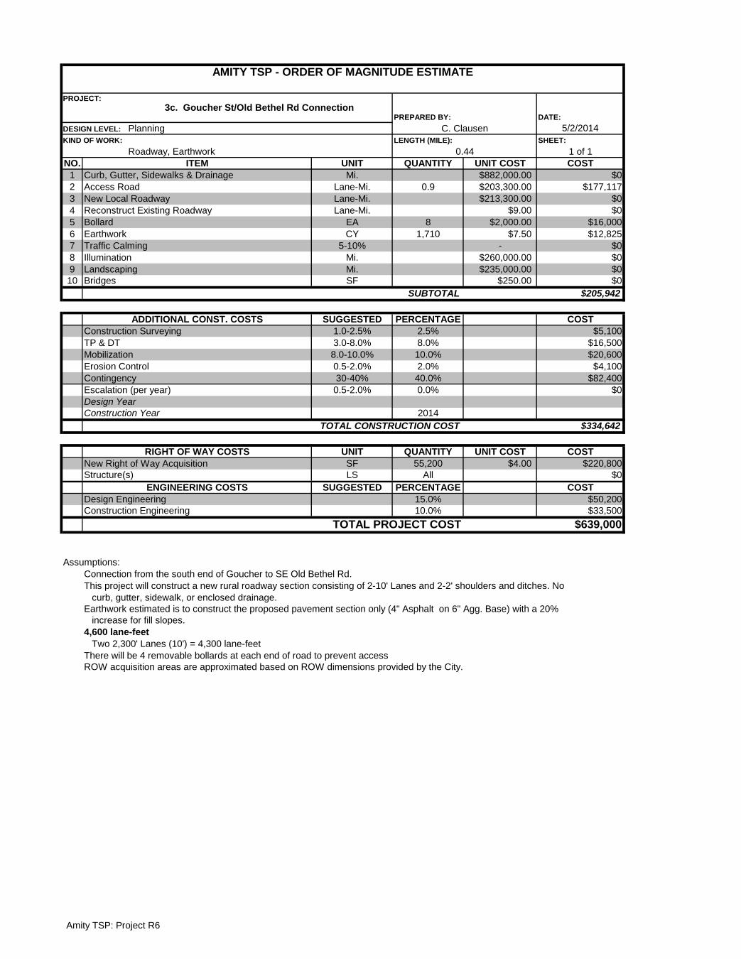
DATE:
5/2/2014
SHEET:
1 of 1
NO. UNIT QUANTITY UNIT COST COST
1 Mi. $882,000.00 $0
2 Lane-Mi. 0.9 $203,300.00 $177,117
3 Lane-Mi. $213,300.00 $0
4 Lane-Mi. $9.00 $0
5 EA 8 $2,000.00 $16,000
6 CY 1,710 $7.50 $12,825
7 5-10% - $0
8 Mi. $260,000.00 $0
9 Mi. $235,000.00 $0
10 SF $250.00 $0
$205,942
SUGGESTED PERCENTAGE COST
1.0-2.5% 2.5% $5,100
3.0-8.0% 8.0% $16,500
8.0-10.0% 10.0% $20,600
0.5-2.0% 2.0% $4,100
30-40% 40.0% $82,400
0.5-2.0% 0.0% $0
2014
$334,642
UNIT QUANTITY UNIT COST COST
SF 55,200 $4.00 $220,800
LS All $0
SUGGESTED PERCENTAGE COST
15.0% $50,200
10.0% $33,500
$639,000
Assumptions:
Connection from the south end of Goucher to SE Old Bethel Rd.
This project will construct a new rural roadway section consisting of 2-10' Lanes and 2-2' shoulders and ditches. No
curb, gutter, sidewalk, or enclosed drainage.
Earthwork estimated is to construct the proposed pavement section only (4" Asphalt on 6" Agg. Base) with a 20%
increase for fill slopes.
4,600 lane-feet
Two 2,300' Lanes (10') = 4,300 lane-feet
There will be 4 removable bollards at each end of road to prevent access
DESIGN LEVEL: Planning C. Clausen
ROW acquisition areas are approximated based on ROW dimensions provided by the City.
AMITY TSP - ORDER OF MAGNITUDE ESTIMATE
PROJECT:
3c. Goucher St/Old Bethel Rd ConnectionPREPARED BY:
Earthwork
KIND OF WORK:
Roadway, Earthwork
LENGTH (MILE):
0.44
ITEM
Curb, Gutter, Sidewalks & Drainage
Access Road
New Local Roadway
Reconstruct Existing Roadway
Bollard
Escalation (per year)
Traffic Calming
Illumination
Landscaping
Bridges
SUBTOTAL
ADDITIONAL CONST. COSTS
Construction Surveying
TP & DT
Mobilization
Erosion Control
Contingency
Design Year
Construction Year
TOTAL CONSTRUCTION COST
RIGHT OF WAY COSTS
New Right of Way Acquisition
Structure(s)
ENGINEERING COSTS
Design Engineering
Construction Engineering
TOTAL PROJECT COST
Amity TSP: Project R6
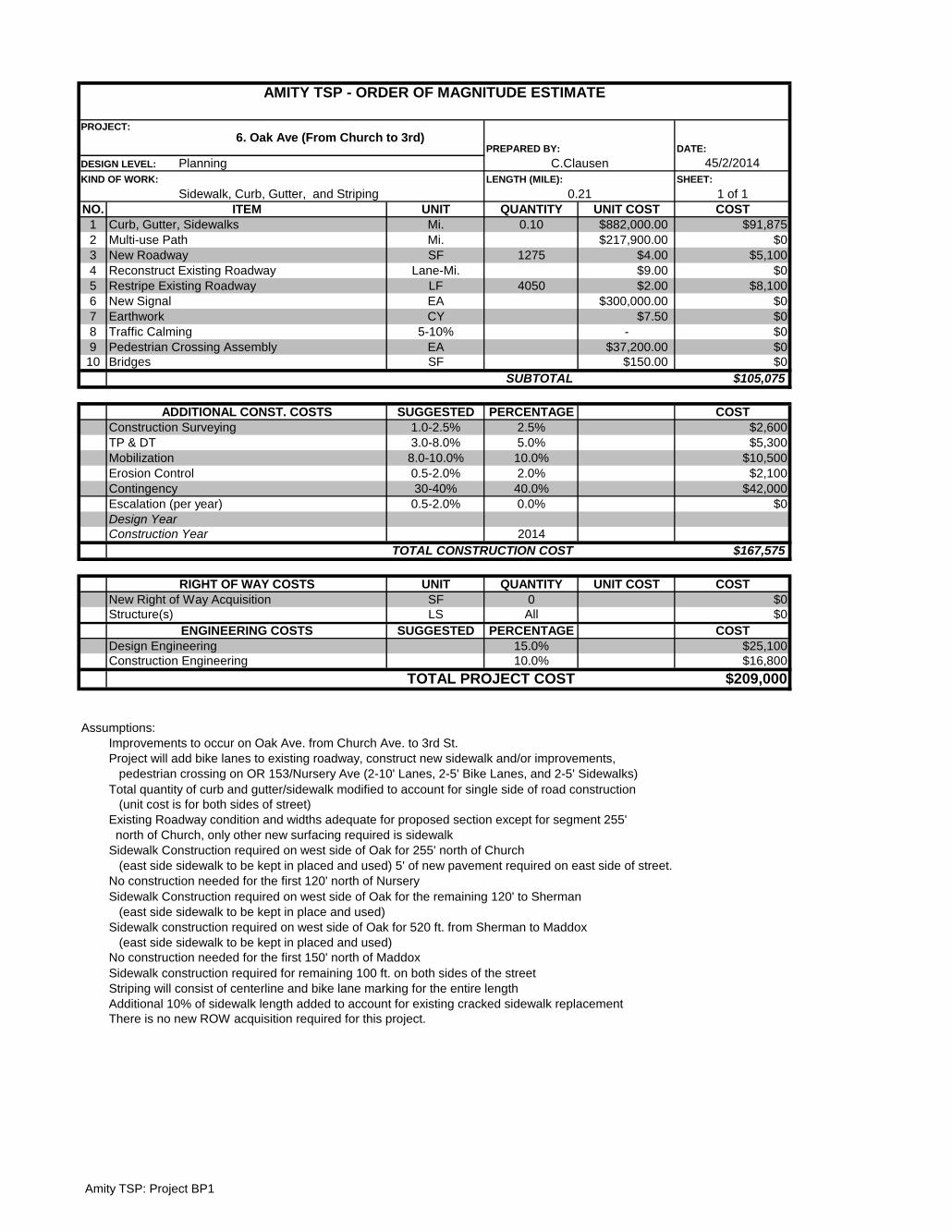
DATE:
45/2/2014
SHEET:
1 of 1
NO. UNIT QUANTITY UNIT COST COST
1 Mi. 0.10 $882,000.00 $91,875
2 Mi. $217,900.00 $0
3 SF 1275 $4.00 $5,100
4 Lane-Mi. $9.00 $0
5 LF 4050 $2.00 $8,100
6 EA $300,000.00 $0
7 CY $7.50 $0
8 5-10% - $0
9 EA $37,200.00 $0
10 SF $150.00 $0
$105,075
SUGGESTED PERCENTAGE COST
1.0-2.5% 2.5% $2,600
3.0-8.0% 5.0% $5,300
8.0-10.0% 10.0% $10,500
0.5-2.0% 2.0% $2,100
30-40% 40.0% $42,000
0.5-2.0% 0.0% $0
2014
$167,575
UNIT QUANTITY UNIT COST COST
SF 0 $0
LS All $0
SUGGESTED PERCENTAGE COST
15.0% $25,100
10.0% $16,800
$209,000
Assumptions:
Improvements to occur on Oak Ave. from Church Ave. to 3rd St.
Project will add bike lanes to existing roadway, construct new sidewalk and/or improvements,
pedestrian crossing on OR 153/Nursery Ave (2-10' Lanes, 2-5' Bike Lanes, and 2-5' Sidewalks)
Total quantity of curb and gutter/sidewalk modified to account for single side of road construction
(unit cost is for both sides of street)
Existing Roadway condition and widths adequate for proposed section except for segment 255'
north of Church, only other new surfacing required is sidewalk
Sidewalk Construction required on west side of Oak for 255' north of Church
(east side sidewalk to be kept in placed and used) 5' of new pavement required on east side of street.
No construction needed for the first 120' north of Nursery
Sidewalk Construction required on west side of Oak for the remaining 120' to Sherman
(east side sidewalk to be kept in place and used)
Sidewalk construction required on west side of Oak for 520 ft. from Sherman to Maddox
(east side sidewalk to be kept in placed and used)
No construction needed for the first 150' north of Maddox
Sidewalk construction required for remaining 100 ft. on both sides of the street
Striping will consist of centerline and bike lane marking for the entire length
Additional 10% of sidewalk length added to account for existing cracked sidewalk replacement
There is no new ROW acquisition required for this project.
ITEM
AMITY TSP - ORDER OF MAGNITUDE ESTIMATE
PROJECT:6. Oak Ave (From Church to 3rd)
PREPARED BY:
DESIGN LEVEL: Planning C.Clausen
KIND OF WORK:
Sidewalk, Curb, Gutter, and Striping
LENGTH (MILE):
0.21
Pedestrian Crossing Assembly
Curb, Gutter, Sidewalks
Multi-use Path
New Roadway
Reconstruct Existing Roadway
Restripe Existing Roadway
New Signal
Earthwork
Traffic Calming
Bridges
SUBTOTAL
ADDITIONAL CONST. COSTS
Construction Surveying
TP & DT
Design Engineering
Construction Engineering
TOTAL PROJECT COST
Mobilization
Erosion Control
Contingency
ENGINEERING COSTS
Escalation (per year)
New Right of Way Acquisition
Structure(s)
Construction Year
TOTAL CONSTRUCTION COST
RIGHT OF WAY COSTS
Design Year
Amity TSP: Project BP1
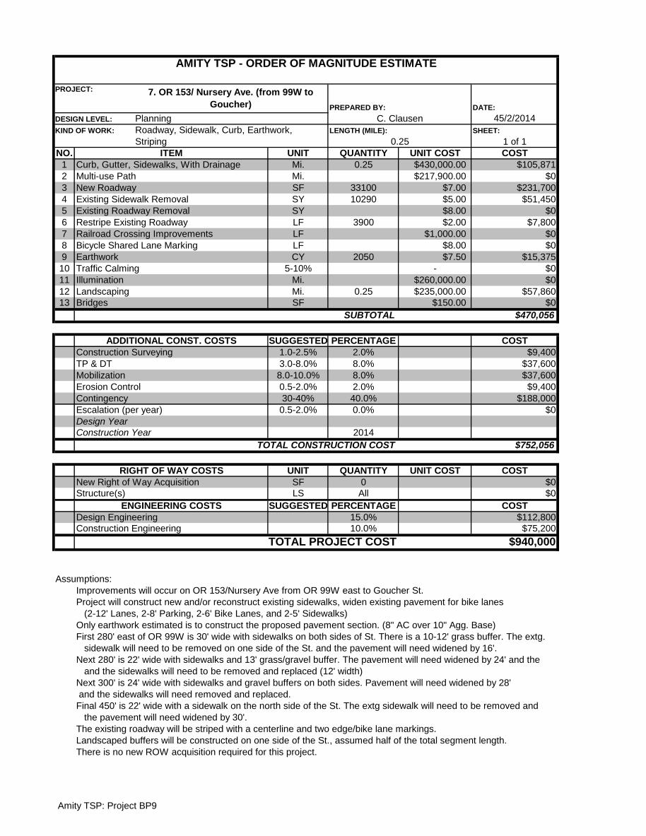
DATE:
45/2/2014
SHEET:
1 of 1
NO. UNIT QUANTITY UNIT COST COST
1 Mi. 0.25 $430,000.00 $105,871
2 Mi. $217,900.00 $0
3 SF 33100 $7.00 $231,700
4 SY 10290 $5.00 $51,450
5 SY $8.00 $0
6 LF 3900 $2.00 $7,800
7 LF $1,000.00 $0
8 LF $8.00 $0
9 CY 2050 $7.50 $15,375
10 5-10% - $0
11 Mi. $260,000.00 $0
12 Mi. 0.25 $235,000.00 $57,860
13 SF $150.00 $0
$470,056
SUGGESTED PERCENTAGE COST
1.0-2.5% 2.0% $9,400
3.0-8.0% 8.0% $37,600
8.0-10.0% 8.0% $37,600
0.5-2.0% 2.0% $9,400
30-40% 40.0% $188,000
0.5-2.0% 0.0% $0
2014
$752,056
UNIT QUANTITY UNIT COST COST
SF 0 $0
LS All $0
SUGGESTED PERCENTAGE COST
15.0% $112,800
10.0% $75,200
$940,000
Assumptions:
Improvements will occur on OR 153/Nursery Ave from OR 99W east to Goucher St.
Project will construct new and/or reconstruct existing sidewalks, widen existing pavement for bike lanes
(2-12' Lanes, 2-8' Parking, 2-6' Bike Lanes, and 2-5' Sidewalks)
Only earthwork estimated is to construct the proposed pavement section. (8" AC over 10" Agg. Base)
First 280' east of OR 99W is 30' wide with sidewalks on both sides of St. There is a 10-12' grass buffer. The extg.
sidewalk will need to be removed on one side of the St. and the pavement will need widened by 16'.
Next 280' is 22' wide with sidewalks and 13' grass/gravel buffer. The pavement will need widened by 24' and the
and the sidewalks will need to be removed and replaced (12' width)
Next 300' is 24' wide with sidewalks and gravel buffers on both sides. Pavement will need widened by 28'
and the sidewalks will need removed and replaced.
Final 450' is 22' wide with a sidewalk on the north side of the St. The extg sidewalk will need to be removed and
the pavement will need widened by 30'.
The existing roadway will be striped with a centerline and two edge/bike lane markings.
Landscaped buffers will be constructed on one side of the St., assumed half of the total segment length.
TOTAL PROJECT COST
There is no new ROW acquisition required for this project.
RIGHT OF WAY COSTS
New Right of Way Acquisition
Structure(s)
ENGINEERING COSTS
Design Engineering
Construction Engineering
TOTAL CONSTRUCTION COST
Bridges
SUBTOTAL
ADDITIONAL CONST. COSTS
Construction Surveying
TP & DT
Mobilization
Erosion Control
Contingency
Escalation (per year)
Design Year
Construction Year
Landscaping
Curb, Gutter, Sidewalks, With Drainage
Multi-use Path
New Roadway
Existing Sidewalk Removal
Existing Roadway Removal
Restripe Existing Roadway
Railroad Crossing Improvements
Bicycle Shared Lane Marking
Earthwork
Traffic Calming
Illumination
ITEM
AMITY TSP - ORDER OF MAGNITUDE ESTIMATE
PROJECT: 7. OR 153/ Nursery Ave. (from 99W to
Goucher) PREPARED BY:
DESIGN LEVEL: Planning C. Clausen
KIND OF WORK: Roadway, Sidewalk, Curb, Earthwork,
Striping
LENGTH (MILE):
0.25
Amity TSP: Project BP9

DATE:
5/2/2014
SHEET:
1 of 1
NO. UNIT QUANTITY UNIT COST COST
1 Mi. $882,000.00 $0
2 Mi. 0.4 $217,900.00 $89,141
3 SF 34500 $4.00 $138,000
4 SY 480 $5.00 $2,400
5 SY $8.00 $0
6 LF 4320 $2.00 $8,640
7 LF 48 $1,000.00 $48,000
8 LF 4160 $25.00 $104,000
9 CY 1065 $7.50 $7,986
10 5-10% - $0
11 Mi. $260,000.00 $0
12 SF $150.00 $0
$398,167
SUGGESTED PERCENTAGE COST
1.0-2.5% 2.0% $8,000
3.0-8.0% 8.0% $31,900
8.0-10.0% 10.0% $39,800
0.5-2.0% 2.0% $8,000
30-40% 40.0% $159,300
0.5-2.0% 0.0% $0
2014
$645,167
UNIT QUANTITY UNIT COST COST
SF 4,320 $20.00 $86,400
LS All $0
SUGGESTED PERCENTAGE COST
15.0% $96,800
10.0% $64,500
$893,000
Assumptions:
Improvements will occur on Stanley St. from OR 153 to the north to 1st St. and continue on 1st St. east to OR 99W
Project will construct sidewalks, drainage ditches/swales, improve the rail crossing on 1st St, and add bike lanes
(2-12' Lanes, 2-8' Parking, 2-6' Ditch/Swales, and 1-10' Multi-Use Path)
Only earthwork estimated is to construct the proposed pavement sections. (New Local Roadway: 4" AC over
6" Agg. Base)
First 80' north of 5th St. is 25' wide, will need widened by 15' over the entire length. (Extg. Sidewalk to be removed)
Next 620' north is 25' wide and needs widened 15' over entire length. Drainage Ditch to be constructed on both sides
Next 1100' is 22' wide and needs widened by 18' over the entire length. Drainage Ditch to be constructed on both sides
Remaining 280' is 25' wide and will need widened by 15' over the entire length. New sidewalks to be constructed.
There will be a 10' multi-use path constructed on one side of the street over the entire length
of segment (2080-LF)
RR crossing improvements will consist of concrete panels across the width of the crossing (no signage or gates),
however, ODOT Rail may require the installation of an automatic gate. Crossing width excludes parking lanes parking lanes
Striping will be a centerline stripe and two edge stripes.
ROW acquisition areas are approximated based on ROW dimensions provided by the City.
Construction Year
TOTAL CONSTRUCTION COST
RIGHT OF WAY COSTS
New Right of Way Acquisition
Structure(s)
ENGINEERING COSTS
Design Engineering
Construction Engineering
TOTAL PROJECT COST
Traffic Calming
Design Year
Bridges
SUBTOTAL
ADDITIONAL CONST. COSTS
Construction Surveying
TP & DT
Mobilization
Erosion Control
Contingency
Escalation (per year)
Illumination
Restripe Existing Roadway
Railroad Crossing Improvements
Drainage Ditch
Earthwork
Curb, Gutter, Sidewalks & Enclosed Drainage
Multi-use Path
New Local Roadway
Existing Sidewalk Removal
Existing Roadway Removal
ITEM
AMITY TSP - ORDER OF MAGNITUDE ESTIMATE
PROJECT: 8. Stanley St/1st St (from OR 153/5th St to OR
99W/Trade St) PREPARED BY:
DESIGN LEVEL: Planning C. Clausen
KIND OF WORK:
Roadway, Earthwork, Striping
LENGTH (MILE):
0.41
Amity TSP: Project BP5

DATE:
5/23/2014
SHEET:
1 of 1
NO. UNIT QUANTITY UNIT COST COST
1 Mi. $882,000.00 $0
2 Mi. 0.34 $217,900.00 $73,459
3 SF 15600 $4.00 $62,400
4 SF 6600 $9.00 $59,400
5 LF 1870 $2.00 $3,740
6 LF 1780 $25.00 $44,500
7 EA $300,000.00 $0
8 CY 1404 $7.50 $10,533
9 5-10% - $0
10 Mi. $260,000.00 $0
11 Mi. $235,000.00 $0
12 SF $150.00 $0
$254,032
SUGGESTED PERCENTAGE COST
1.0-2.5% 2.5% $6,400
3.0-8.0% 8.0% $20,300
8.0-10.0% 10.0% $25,400
0.5-2.0% 2.0% $5,100
30-40% 40.0% $101,600
0.5-2.0% 0.0% $0
2013
$412,832
UNIT QUANTITY UNIT COST COST
SF 6,120 $20.00 $122,400
LS All $0
SUGGESTED PERCENTAGE COST
15.0% $61,900
10.0% $41,300
$638,000
Assumptions:
Improvements to occur on 3rd St. from Oak Ave. to Jellison St then north on Jellison from 3rd St. to Rice Ln.
Project will construct shared use path, widen existing pavement, and construct drainage ditch/street swale
(2-11' Lanes, 1-8' Parking, 1-6' Ditch/Swale, and 1-12' Paved Path)
Only earthwork estimated is to construct the proposed pavement sections.
(New Local Roadway: 4" AC over 6" Agg. Base and Multi Use Path: 2" AC over 12" Agg. Base)
All Stormwater will be captured by the drainage ditch/swale. For this estimate, the width is assumed to be 6',
but additional stormwater analysis will be required.
Existing Pavement will be utilized when applicable
Existing 3rd St segment is 20' wide and 330' long and needs reconstructed. Will need widened by 10' the entire length and
the multi-use path will be constructed along the entire length
Existing Jellison St segment (100' north of 3rd) is 28' wide and 100' long. Will need widened by 2' the entire length and a
multi-use path will be constructed along the entire length
Existing Jellison St segment (next 650' north) is 20' wide and 650' long. Will need widened by 10' the entire length and a
multi-use path will be constructed along the entire length
Drainage ditch/swale will be 6' for entire length (1780-LF- Rosedell and Rice intersections excluded). Cost includes
concrete curb and ditch excavation.
Striping will be single centerline strip only
ROW acquisition areas are approximated based on ROW dimensions provided by the City.
TOTAL PROJECT COST
Construction Year
TOTAL CONSTRUCTION COST
RIGHT OF WAY COSTS
New Right of Way Acquisition
Structure(s)
ENGINEERING COSTS
Design Engineering
Construction Engineering
Design Year
Landscaping
Bridges
SUBTOTAL
ADDITIONAL CONST. COSTS
Construction Surveying
TP & DT
Mobilization
Erosion Control
Contingency
Escalation (per year)
Illumination
Curb, Gutter, Sidewalks & Drainage
Multi-use Path
New Local Roadway
Reconstruct Existing Roadway
Restripe Existing Roadway
Drainage Ditch
New Signal
Earthwork
Traffic Calming
ITEM
AMITY TSP - ORDER OF MAGNITUDE ESTIMATE
PROJECT:
9. Jellison Avenue from 3rd Avenue to Rice
Lane PREPARED BY:
DESIGN LEVEL: Planning C. Clausen
KIND OF WORK:
Roadway, Earthwork, Striping
LENGTH (MILE):
0.34
Amity TSP: Project BP2
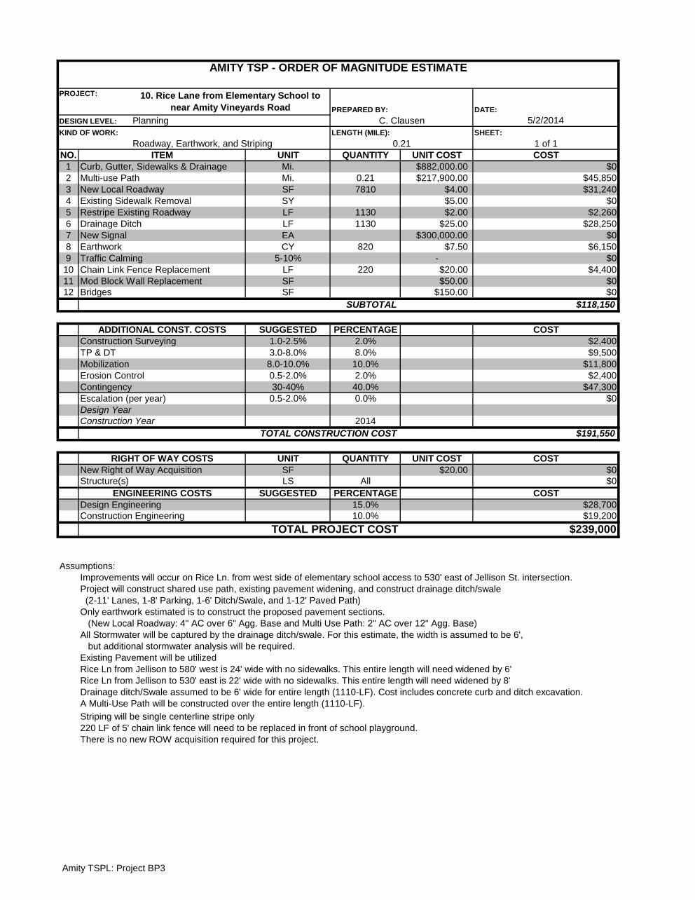
DATE:
5/2/2014
SHEET:
1 of 1
NO. UNIT QUANTITY UNIT COST COST
1 Mi. $882,000.00 $0
2 Mi. 0.21 $217,900.00 $45,850
3 SF 7810 $4.00 $31,240
4 SY $5.00 $0
5 LF 1130 $2.00 $2,260
6 LF 1130 $25.00 $28,250
7 EA $300,000.00 $0
8 CY 820 $7.50 $6,150
9 5-10% - $0
10 LF 220 $20.00 $4,400
11 SF $50.00 $0
12 SF $150.00 $0
$118,150
SUGGESTED PERCENTAGE COST
1.0-2.5% 2.0% $2,400
3.0-8.0% 8.0% $9,500
8.0-10.0% 10.0% $11,800
0.5-2.0% 2.0% $2,400
30-40% 40.0% $47,300
0.5-2.0% 0.0% $0
2014
$191,550
UNIT QUANTITY UNIT COST COST
SF $20.00 $0
LS All $0
SUGGESTED PERCENTAGE COST
15.0% $28,700
10.0% $19,200
$239,000
Assumptions:
Improvements will occur on Rice Ln. from west side of elementary school access to 530' east of Jellison St. intersection.
Project will construct shared use path, existing pavement widening, and construct drainage ditch/swale
(2-11' Lanes, 1-8' Parking, 1-6' Ditch/Swale, and 1-12' Paved Path)
Only earthwork estimated is to construct the proposed pavement sections.
(New Local Roadway: 4" AC over 6" Agg. Base and Multi Use Path: 2" AC over 12" Agg. Base)
All Stormwater will be captured by the drainage ditch/swale. For this estimate, the width is assumed to be 6',
but additional stormwater analysis will be required.
Existing Pavement will be utilized
Rice Ln from Jellison to 580' west is 24' wide with no sidewalks. This entire length will need widened by 6'
Rice Ln from Jellison to 530' east is 22' wide with no sidewalks. This entire length will need widened by 8'
Drainage ditch/Swale assumed to be 6' wide for entire length (1110-LF). Cost includes concrete curb and ditch excavation.
A Multi-Use Path will be constructed over the entire length (1110-LF).
Striping will be single centerline stripe only
220 LF of 5' chain link fence will need to be replaced in front of school playground.
There is no new ROW acquisition required for this project.
New Right of Way Acquisition
Structure(s)
Design Engineering
Construction Engineering
TOTAL PROJECT COST
ENGINEERING COSTS
Construction Surveying
TP & DT
RIGHT OF WAY COSTS
Design Year
Mobilization
Erosion Control
Contingency
Escalation (per year)
TOTAL CONSTRUCTION COST
DESIGN LEVEL: Planning C. Clausen
KIND OF WORK:
Roadway, Earthwork, and Striping
LENGTH (MILE):
0.21
AMITY TSP - ORDER OF MAGNITUDE ESTIMATE
PROJECT: 10. Rice Lane from Elementary School to
near Amity Vineyards Road PREPARED BY:
Mod Block Wall Replacement
Construction Year
Bridges
ITEM
Chain Link Fence Replacement
Curb, Gutter, Sidewalks & Drainage
Multi-use Path
New Local Roadway
Existing Sidewalk Removal
Restripe Existing Roadway
Drainage Ditch
New Signal
Earthwork
Traffic Calming
SUBTOTAL
ADDITIONAL CONST. COSTS
Amity TSPL: Project BP3

DATE:
5/2/2014
SHEET:
1 of 1
NO. UNIT QUANTITY UNIT COST COST
1 Mi. $882,000.00 $0
2 Mi. 0.10 $217,900.00 $21,873
3 SF 2600 $4.00 $10,400
4 Lane-Mi. $9.00 $0
5 LF 623 $2.00 $1,246
6 LF 530 $25.00 $13,250
7 LF 40 $1,000.00 $40,000
8 CY 355 $7.50 $2,663
9 5-10% - $0
10 Mi. $260,000.00 $0
11 Mi. $235,000.00 $0
12 SF $150.00 $0
$89,432
SUGGESTED PERCENTAGE COST
1.0-2.5% 2.0% $1,800
3.0-8.0% 5.0% $4,500
8.0-10.0% 10.0% $8,900
0.5-2.0% 2.0% $1,800
30-40% 40.0% $35,800
0.5-2.0% 0.0% $0
2014
$142,232
UNIT QUANTITY UNIT COST COST
SF 0 $0
LS All $0
SUGGESTED PERCENTAGE COST
15.0% $21,300
10.0% $14,200
$178,000
Assumptions:
Project will construct shared use path, widen existing pavement, and construct drainage ditch/street swale
(2-11' Lanes, 1-8' Parking, 1-6' Swale, and 1-10 to 12' Paved Path)
Only earthwork estimated is to construct the proposed pavement sections.
(New Local Roadway: 4" AC over 6" Agg. Base and Multi Use Path: 2" AC over 12" Agg. Base)
All Stormwater will be captured by the drainage ditch/swale. For this estimate, the width is assumed to be 6',
but additional stormwater analysis will be required.
Existing Pavement will be utilized
First 270' of 4th St. is 36' wide with a 6' sidewalk on both sides of St. and 8' landscaped buffers between the sidewalk and
roadway. The extg. sidewalk on the north side of the St will be removed along with 4' of extg. roadway
260' west of RR is 20' wide with gravel shoulders on both sides of St. The pavement will need widened by 10'.
A multi-use path will be constructed on the entire length of 4th St (except for RxR)
Drainage ditch/swale will be 6' for entire length of the 4th St (except for RxR). Cost includes concrete curb and ditch
excavation.
The RR crossing width is the section width minus the parking lane.
Striping will be single centerline strip only
TOTAL PROJECT COST
Contingency
Escalation (per year)
Design Year
Construction Year
TOTAL CONSTRUCTION COST
RIGHT OF WAY COSTS
New Right of Way Acquisition
Structure(s)
ENGINEERING COSTS
Design Engineering
Construction Engineering
Erosion Control
Railroad Crossings Improvements
Earthwork
Traffic Calming
Illumination
Landscaping
Bridges
SUBTOTAL
ADDITIONAL CONST. COSTS
Construction Surveying
TP & DT
Mobilization
Curb, Gutter, Sidewalks & Drainage
Multi-use Path
New Local Roadway
Reconstruct Existing Roadway
Restripe Existing Roadway
There is no new ROW acquisition required for this project.
DESIGN LEVEL: Planning C. Clausen
AMITY TSP - ORDER OF MAGNITUDE ESTIMATE
PROJECT:
11. 4th St. (from OR 99W to Stanley St.)
PREPARED BY:
Drainage Ditch
KIND OF WORK:
Roadway, Earthwork, Striping
LENGTH (MILE):
0.12
ITEM
Amity TSP: Project BP13
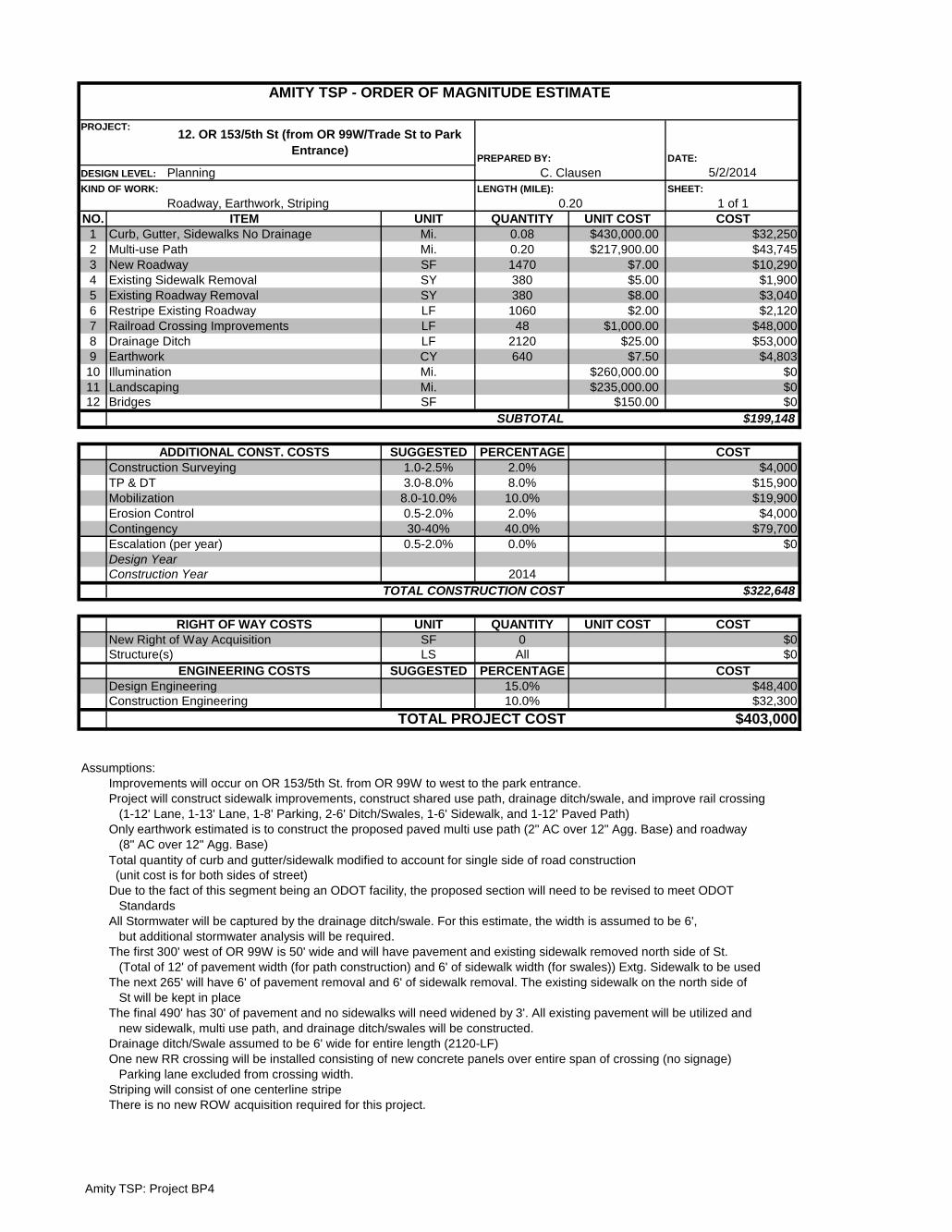
DATE:
5/2/2014
SHEET:
1 of 1
NO. UNIT QUANTITY UNIT COST COST
1 Mi. 0.08 $430,000.00 $32,250
2 Mi. 0.20 $217,900.00 $43,745
3 SF 1470 $7.00 $10,290
4 SY 380 $5.00 $1,900
5 SY 380 $8.00 $3,040
6 LF 1060 $2.00 $2,120
7 LF 48 $1,000.00 $48,000
8 LF 2120 $25.00 $53,000
9 CY 640 $7.50 $4,803
10 Mi. $260,000.00 $0
11 Mi. $235,000.00 $0
12 SF $150.00 $0
$199,148
SUGGESTED PERCENTAGE COST
1.0-2.5% 2.0% $4,000
3.0-8.0% 8.0% $15,900
8.0-10.0% 10.0% $19,900
0.5-2.0% 2.0% $4,000
30-40% 40.0% $79,700
0.5-2.0% 0.0% $0
2014
$322,648
UNIT QUANTITY UNIT COST COST
SF 0 $0
LS All $0
SUGGESTED PERCENTAGE COST
15.0% $48,400
10.0% $32,300
$403,000
Assumptions:
Improvements will occur on OR 153/5th St. from OR 99W to west to the park entrance.
Project will construct sidewalk improvements, construct shared use path, drainage ditch/swale, and improve rail crossing
(1-12' Lane, 1-13' Lane, 1-8' Parking, 2-6' Ditch/Swales, 1-6' Sidewalk, and 1-12' Paved Path)
Only earthwork estimated is to construct the proposed paved multi use path (2" AC over 12" Agg. Base) and roadway
(8" AC over 12" Agg. Base)
Total quantity of curb and gutter/sidewalk modified to account for single side of road construction
(unit cost is for both sides of street)
Due to the fact of this segment being an ODOT facility, the proposed section will need to be revised to meet ODOT
Standards
All Stormwater will be captured by the drainage ditch/swale. For this estimate, the width is assumed to be 6',
but additional stormwater analysis will be required.
The first 300' west of OR 99W is 50' wide and will have pavement and existing sidewalk removed north side of St.
(Total of 12' of pavement width (for path construction) and 6' of sidewalk width (for swales)) Extg. Sidewalk to be used
The next 265' will have 6' of pavement removal and 6' of sidewalk removal. The existing sidewalk on the north side of
St will be kept in place
The final 490' has 30' of pavement and no sidewalks will need widened by 3'. All existing pavement will be utilized and
new sidewalk, multi use path, and drainage ditch/swales will be constructed.
Drainage ditch/Swale assumed to be 6' wide for entire length (2120-LF)
One new RR crossing will be installed consisting of new concrete panels over entire span of crossing (no signage)
Parking lane excluded from crossing width.
Striping will consist of one centerline stripe
There is no new ROW acquisition required for this project.
Structure(s)
Design Engineering
Construction Engineering
TOTAL PROJECT COST
ENGINEERING COSTS
Mobilization
Erosion Control
Contingency
Escalation (per year)
New Right of Way Acquisition
TOTAL CONSTRUCTION COST
RIGHT OF WAY COSTS
Design Year
Construction Year
ADDITIONAL CONST. COSTS
Construction Surveying
TP & DT
0.20
Illumination
Curb, Gutter, Sidewalks No Drainage
Multi-use Path
New Roadway
Existing Sidewalk Removal
Existing Roadway Removal
Restripe Existing Roadway
Railroad Crossing Improvements
Drainage Ditch
Earthwork
Bridges
Landscaping
SUBTOTAL
ITEM
AMITY TSP - ORDER OF MAGNITUDE ESTIMATE
PROJECT:12. OR 153/5th St (from OR 99W/Trade St to Park
Entrance) PREPARED BY:
DESIGN LEVEL: Planning C. Clausen
KIND OF WORK:
Roadway, Earthwork, Striping
LENGTH (MILE):
Amity TSP: Project BP4

DATE:
5/2/2014
SHEET:
1 of 1
NO. UNIT QUANTITY UNIT COST COST
1 Mi. 0.08 $430,000.00 $33,797
2 Mi. $217,900.00 $0
3 SF 580 $4.00 $2,320
4 SY 1740 $5.00 $8,700
5 SY $8.00 $0
6 LF 620 $2.00 $1,240
7 EA $15,000.00 $0
8 LF 620 $8.00 $4,960
9 CY $7.50 $0
10 5-10% - $0
11 Mi. $260,000.00 $0
12 Mi. $235,000.00 $0
13 SF $150.00 $0
$51,017
SUGGESTED PERCENTAGE COST
1.0-2.5% 2.0% $1,000
3.0-8.0% 8.0% $4,100
8.0-10.0% 10.0% $5,100
0.5-2.0% 2.0% $1,000
30-40% 40.0% $20,400
0.5-2.0% 0.0% $0
2014
$82,617
UNIT QUANTITY UNIT COST COST
SF 0 $0
LS All $0
SUGGESTED PERCENTAGE COST
15.0% $12,400
10.0% $8,300
$103,000
Assumptions:
Improvements will occur on Woodson Ave. from OR 99W to Oak Ave.
Project will add shared lane markings (2-10' Lanes, 2-7' Parking Lane, 2-5' Sidewalk)
Existing 125' east of 99W is 34' wide with sidewalk on north side. Sidewalk construction required on south side
Existing 160' is 34' wide with sidewalk on both sides(no construction needed)
Existing 290' is 32' wide with sidewalk on both sides. The sidewalk will need removed on one side of the St and
will need widened by 2' over the entire length and new sidewalk construction
TOTAL PROJECT COST
There is no new ROW acquisition required for this project.
RIGHT OF WAY COSTS
New Right of Way Acquisition
Structure(s)
ENGINEERING COSTS
Design Engineering
Construction Engineering
TOTAL CONSTRUCTION COST
Bridges
SUBTOTAL
ADDITIONAL CONST. COSTS
Construction Surveying
TP & DT
Mobilization
Erosion Control
Contingency
Escalation (per year)
Design Year
Construction Year
Landscaping
Curb, Gutter, Sidewalks No Drainage
Multi-use Path
New Local Roadway
Existing Sidewalk Removal
Existing Roadway Removal
Restripe Existing Roadway
Active Railroad Crossing
Bicycle Shared Lane Marking
Earthwork
Traffic Calming
Illumination
ITEM
AMITY TSP - ORDER OF MAGNITUDE ESTIMATE
PROJECT:13. Woodson Ave (from Oak to OR
99W/Trade St) PREPARED BY:
DESIGN LEVEL: Planning C. Clausen
KIND OF WORK:
Roadway, Sidewalk, Striping
LENGTH (MILE):
0.12
Amity TSP: Project BP11
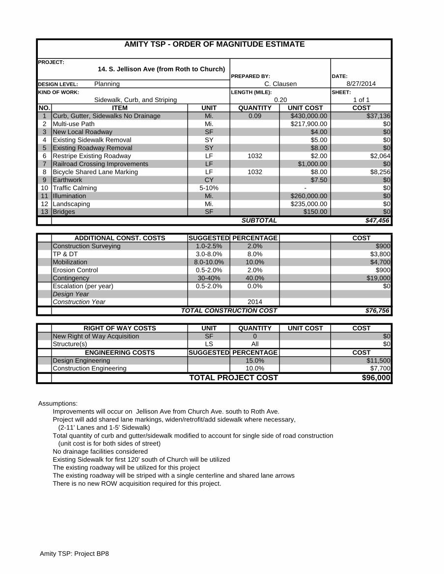
DATE:
8/27/2014
SHEET:
1 of 1
NO. UNIT QUANTITY UNIT COST COST
1 Mi. 0.09 $430,000.00 $37,136
2 Mi. $217,900.00 $0
3 SF $4.00 $0
4 SY $5.00 $0
5 SY $8.00 $0
6 LF 1032 $2.00 $2,064
7 LF $1,000.00 $0
8 LF 1032 $8.00 $8,256
9 CY $7.50 $0
10 5-10% - $0
11 Mi. $260,000.00 $0
12 Mi. $235,000.00 $0
13 SF $150.00 $0
$47,456
SUGGESTED PERCENTAGE COST
1.0-2.5% 2.0% $900
3.0-8.0% 8.0% $3,800
8.0-10.0% 10.0% $4,700
0.5-2.0% 2.0% $900
30-40% 40.0% $19,000
0.5-2.0% 0.0% $0
2014
$76,756
UNIT QUANTITY UNIT COST COST
SF 0 $0
LS All $0
SUGGESTED PERCENTAGE COST
15.0% $11,500
10.0% $7,700
$96,000
Assumptions:
Improvements will occur on Jellison Ave from Church Ave. south to Roth Ave.
Project will add shared lane markings, widen/retrofit/add sidewalk where necessary,
(2-11' Lanes and 1-5' Sidewalk)
Total quantity of curb and gutter/sidewalk modified to account for single side of road construction
(unit cost is for both sides of street)
No drainage facilities considered
Existing Sidewalk for first 120' south of Church will be utilized
The existing roadway will be utilized for this project
The existing roadway will be striped with a single centerline and shared lane arrows
Design Engineering
Construction Engineering
TOTAL PROJECT COST
Construction Year
TOTAL CONSTRUCTION COST
RIGHT OF WAY COSTS
New Right of Way Acquisition
Structure(s)
ENGINEERING COSTS
Design Year
Landscaping
Bridges
SUBTOTAL
ADDITIONAL CONST. COSTS
Construction Surveying
TP & DT
Mobilization
Erosion Control
Contingency
Escalation (per year)
Restripe Existing Roadway
Railroad Crossing Improvements
Bicycle Shared Lane Marking
Earthwork
Traffic Calming
Curb, Gutter, Sidewalks No Drainage
Multi-use Path
New Local Roadway
Existing Sidewalk Removal
Existing Roadway Removal
There is no new ROW acquisition required for this project.
ITEM
AMITY TSP - ORDER OF MAGNITUDE ESTIMATE
PROJECT:
14. S. Jellison Ave (from Roth to Church) PREPARED BY:
DESIGN LEVEL: Planning C. Clausen
KIND OF WORK:
Sidewalk, Curb, and Striping
LENGTH (MILE):
0.20
Illumination
Amity TSP: Project BP8
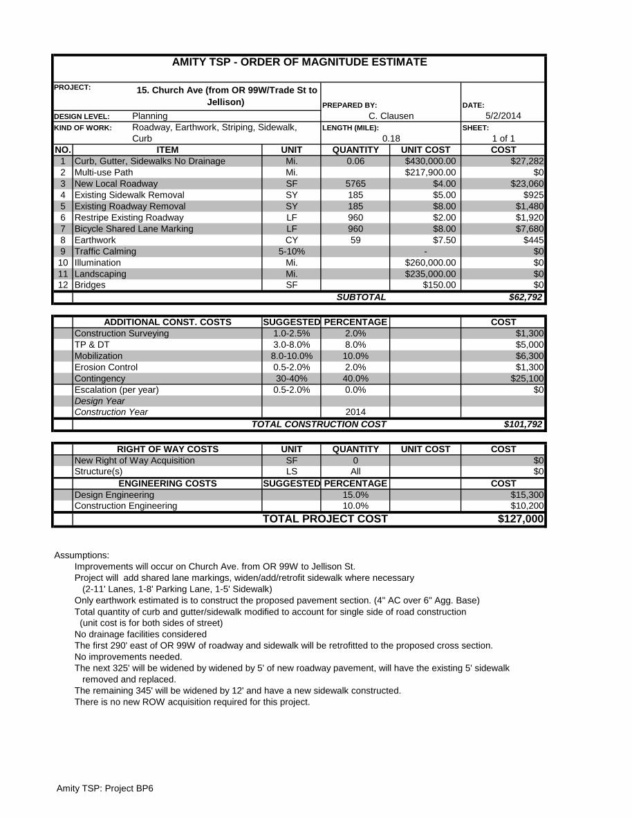
DATE:
5/2/2014
SHEET:
1 of 1
NO. UNIT QUANTITY UNIT COST COST
1 Mi. 0.06 $430,000.00 $27,282
2 Mi. $217,900.00 $0
3 SF 5765 $4.00 $23,060
4 SY 185 $5.00 $925
5 SY 185 $8.00 $1,480
6 LF 960 $2.00 $1,920
7 LF 960 $8.00 $7,680
8 CY 59 $7.50 $445
9 5-10% - $0
10 Mi. $260,000.00 $0
11 Mi. $235,000.00 $0
12 SF $150.00 $0
$62,792
SUGGESTED PERCENTAGE COST
1.0-2.5% 2.0% $1,300
3.0-8.0% 8.0% $5,000
8.0-10.0% 10.0% $6,300
0.5-2.0% 2.0% $1,300
30-40% 40.0% $25,100
0.5-2.0% 0.0% $0
2014
$101,792
UNIT QUANTITY UNIT COST COST
SF 0 $0
LS All $0
SUGGESTED PERCENTAGE COST
15.0% $15,300
10.0% $10,200
$127,000
Assumptions:
Improvements will occur on Church Ave. from OR 99W to Jellison St.
Project will add shared lane markings, widen/add/retrofit sidewalk where necessary
(2-11' Lanes, 1-8' Parking Lane, 1-5' Sidewalk)
Only earthwork estimated is to construct the proposed pavement section. (4" AC over 6" Agg. Base)
Total quantity of curb and gutter/sidewalk modified to account for single side of road construction
(unit cost is for both sides of street)
No drainage facilities considered
The first 290' east of OR 99W of roadway and sidewalk will be retrofitted to the proposed cross section.
No improvements needed.
The next 325' will be widened by widened by 5' of new roadway pavement, will have the existing 5' sidewalk
removed and replaced.
The remaining 345' will be widened by 12' and have a new sidewalk constructed.
Escalation (per year)
TP & DT
Construction Surveying
There is no new ROW acquisition required for this project.
Design Engineering
Construction Engineering
TOTAL PROJECT COST
ENGINEERING COSTS
Structure(s)
Design Year
Construction Year
TOTAL CONSTRUCTION COST
RIGHT OF WAY COSTS
New Right of Way Acquisition
SUBTOTAL
ADDITIONAL CONST. COSTS
Mobilization
Erosion Control
Contingency
Traffic Calming
Illumination
Landscaping
Bridges
Bicycle Shared Lane Marking
Earthwork
DESIGN LEVEL: Planning C. Clausen
Restripe Existing Roadway
KIND OF WORK: Roadway, Earthwork, Striping, Sidewalk,
Curb
LENGTH (MILE):
0.18
ITEM
Curb, Gutter, Sidewalks No Drainage
Multi-use Path
New Local Roadway
Existing Sidewalk Removal
Existing Roadway Removal
AMITY TSP - ORDER OF MAGNITUDE ESTIMATE
PROJECT: 15. Church Ave (from OR 99W/Trade St to
Jellison) PREPARED BY:
Amity TSP: Project BP6
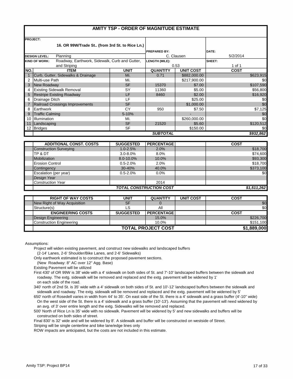
DATE:
5/2/2014
SHEET:
1 of 1
NO. UNIT QUANTITY UNIT COST COST
1 Mi. 0.71 $882,000.00 $623,915
2 Mi. $217,900.00 $0
3 SF 15370 $7.00 $107,590
4 SY 11360 $5.00 $56,800
5 LF 8460 $2.00 $16,920
6 LF $25.00 $0
7 SF $1,000.00 $0
8 CY 950 $7.50 $7,125
9 5-10% - $0
10 Mi. $260,000.00 $0
11 SF 21520 $5.60 $120,512
12 SF $150.00 $0
$932,862
SUGGESTED PERCENTAGE COST
1.0-2.5% 2.0% $18,700
3.0-8.0% 8.0% $74,600
8.0-10.0% 10.0% $93,300
0.5-2.0% 2.0% $18,700
30-40% 40.0% $373,100
0.5-2.0% 0.0% $0
2014
$1,511,262
UNIT QUANTITY UNIT COST COST
SF 0 $0
LS All $0
SUGGESTED PERCENTAGE COST
15.0% $226,700
10.0% $151,100
$1,889,000
Assumptions:
Project will widen existing pavement, and construct new sidewalks and landscaped buffers
(2-14' Lanes, 2-6' Shoulder/Bike Lanes, and 2-6' Sidewalks)
Only earthwork estimated is to construct the proposed pavement sections.
(New Roadway: 8" AC over 12" Agg. Base)
Existing Pavement will be utilized
First 430' of OR 99W is 38' wide with a 4' sidewalk on both sides of St. and 7'-10' landscaped buffers between the sidewalk and
roadway. The extg. sidewalk will be removed and replaced and the extg. pavement will be widened by 1'
on each side of the road.
340' north of 2nd St. is 35' wide with a 4' sidewalk on both sides of St. and 10'-12' landscaped buffers between the sidewalk and
sidewalk and roadway. The extg. sidewalk will be removed and replaced and the extg. pavement will be widened by 5'
650' north of Rosedell varies in width from 44' to 35'. On east side of the St. there is a 4' sidewalk and a grass buffer (4'-10'' wide)
On the west side of the St. there is a 4' sidewalk and a grass buffer (10'-13'). Assuming that the pavement will need widened by
an avg. of 3' over entire length and the extg. Sidewalks will be removed and replaced.
500' North of Rice Ln is 35' wide with no sidewalk. Pavement will be widened by 5' and new sidewalks and buffers will be
constructed on both sides of street.
Final 830' is 32' wide and will be widened by 8'. A sidewalk and buffer will be constructed on westside of Street.
Striping will be single centerline and bike lane/edge lines only
ROW impacts are anticipated, but the costs are not included in this estimate.
DESIGN LEVEL: Planning C. Clausen
AMITY TSP - ORDER OF MAGNITUDE ESTIMATE
PROJECT:
16. OR 99W/Trade St.. (from 3rd St. to Rice Ln.)
PREPARED BY:
Drainage Ditch
KIND OF WORK: Roadway, Earthwork, Sidewalk, Curb and Gutter,
and Striping
LENGTH (MILE):
0.53
ITEM
Curb, Gutter, Sidewalks & Drainage
Multi-use Path
New Roadway
Existing Sidewalk Removal
Restripe Existing Roadway
Erosion Control
Railroad Crossings Improvements
Earthwork
Traffic Calming
Illumination
Landscaping
Bridges
SUBTOTAL
ADDITIONAL CONST. COSTS
Construction Surveying
TP & DT
Mobilization
TOTAL PROJECT COST
Contingency
Escalation (per year)
Design Year
Construction Year
TOTAL CONSTRUCTION COST
RIGHT OF WAY COSTS
New Right of Way Acquisition
Structure(s)
ENGINEERING COSTS
Design Engineering
Construction Engineering
Amity TSP: Project BP14 17 of 33
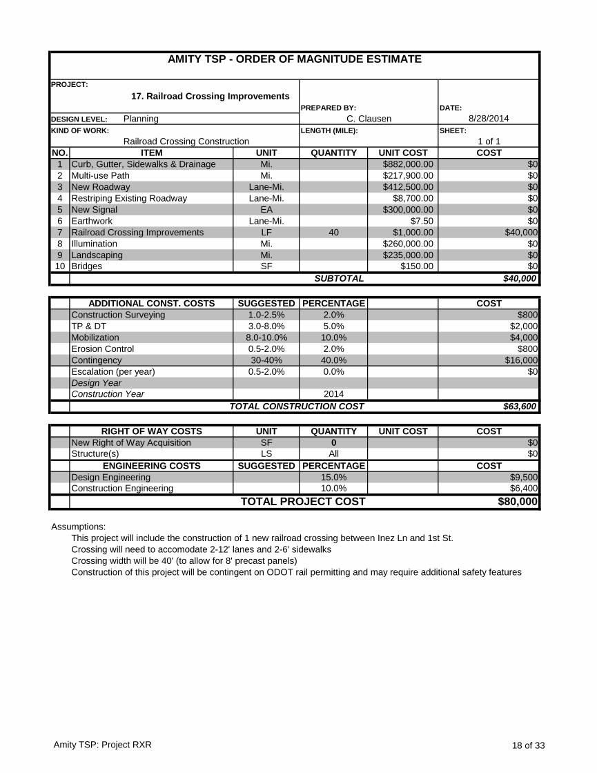
DATE:
8/28/2014
SHEET:
1 of 1
NO. UNIT QUANTITY UNIT COST COST
1 Mi. $882,000.00 $0
2 Mi. $217,900.00 $0
3 Lane-Mi. $412,500.00 $0
4 Lane-Mi. $8,700.00 $0
5 EA $300,000.00 $0
6 Lane-Mi. $7.50 $0
7 LF 40 $1,000.00 $40,000
8 Mi. $260,000.00 $0
9 Mi. $235,000.00 $0
10 SF $150.00 $0
$40,000
SUGGESTED PERCENTAGE COST
1.0-2.5% 2.0% $800
3.0-8.0% 5.0% $2,000
8.0-10.0% 10.0% $4,000
0.5-2.0% 2.0% $800
30-40% 40.0% $16,000
0.5-2.0% 0.0% $0
2014
$63,600
UNIT QUANTITY UNIT COST COST
SF 0 $0
LS All $0
SUGGESTED PERCENTAGE COST
15.0% $9,500
10.0% $6,400
$80,000
Assumptions:
This project will include the construction of 1 new railroad crossing between Inez Ln and 1st St.
Crossing will need to accomodate 2-12' lanes and 2-6' sidewalks
Crossing width will be 40' (to allow for 8' precast panels)
Construction of this project will be contingent on ODOT rail permitting and may require additional safety features
ENGINEERING COSTS
Design Engineering
Construction Engineering
TOTAL PROJECT COST
Structure(s)
Construction Surveying
TP & DT
Mobilization
Erosion Control
Contingency
Escalation (per year)
Design Year
Construction Year
TOTAL CONSTRUCTION COST
RIGHT OF WAY COSTS
New Right of Way Acquisition
ADDITIONAL CONST. COSTS
Curb, Gutter, Sidewalks & Drainage
Multi-use Path
New Roadway
Restriping Existing Roadway
New Signal
Earthwork
Railroad Crossing Improvements
Illumination
Landscaping
Bridges
SUBTOTAL
ITEM
AMITY TSP - ORDER OF MAGNITUDE ESTIMATE
PROJECT:
17. Railroad Crossing Improvements
PREPARED BY:
DESIGN LEVEL: Planning C. Clausen
KIND OF WORK:
Railroad Crossing Construction
LENGTH (MILE):
Amity TSP: Project RXR 18 of 33
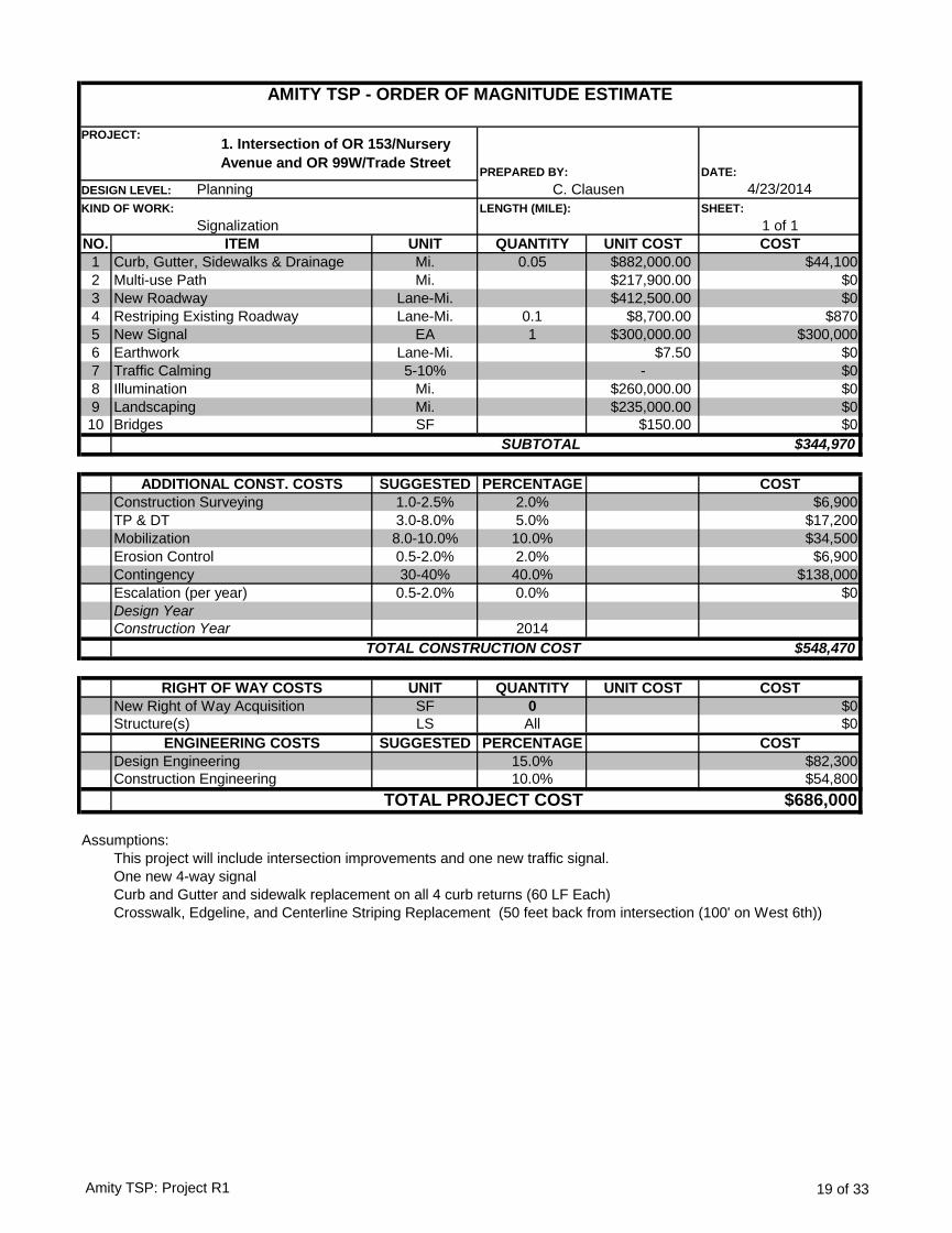
DATE:
4/23/2014
SHEET:
1 of 1
NO. UNIT QUANTITY UNIT COST COST
1 Mi. 0.05 $882,000.00 $44,100
2 Mi. $217,900.00 $0
3 Lane-Mi. $412,500.00 $0
4 Lane-Mi. 0.1 $8,700.00 $870
5 EA 1 $300,000.00 $300,000
6 Lane-Mi. $7.50 $0
7 5-10% - $0
8 Mi. $260,000.00 $0
9 Mi. $235,000.00 $0
10 SF $150.00 $0
$344,970
SUGGESTED PERCENTAGE COST
1.0-2.5% 2.0% $6,900
3.0-8.0% 5.0% $17,200
8.0-10.0% 10.0% $34,500
0.5-2.0% 2.0% $6,900
30-40% 40.0% $138,000
0.5-2.0% 0.0% $0
2014
$548,470
UNIT QUANTITY UNIT COST COST
SF 0 $0
LS All $0
SUGGESTED PERCENTAGE COST
15.0% $82,300
10.0% $54,800
$686,000
Assumptions:
This project will include intersection improvements and one new traffic signal.
One new 4-way signal
Curb and Gutter and sidewalk replacement on all 4 curb returns (60 LF Each)
Crosswalk, Edgeline, and Centerline Striping Replacement (50 feet back from intersection (100' on West 6th))
ITEM
AMITY TSP - ORDER OF MAGNITUDE ESTIMATE
PROJECT:1. Intersection of OR 153/Nursery
Avenue and OR 99W/Trade StreetPREPARED BY:
DESIGN LEVEL: Planning C. Clausen
KIND OF WORK:
Signalization
LENGTH (MILE):
Illumination
Curb, Gutter, Sidewalks & Drainage
Multi-use Path
New Roadway
Restriping Existing Roadway
New Signal
Earthwork
Traffic Calming
Design Year
Landscaping
Bridges
SUBTOTAL
ADDITIONAL CONST. COSTS
Construction Surveying
TP & DT
Mobilization
Erosion Control
Contingency
Escalation (per year)
Design Engineering
Construction Engineering
TOTAL PROJECT COST
Construction Year
TOTAL CONSTRUCTION COST
RIGHT OF WAY COSTS
New Right of Way Acquisition
Structure(s)
ENGINEERING COSTS
Amity TSP: Project R1 19 of 33

DATE:
4/23/2014
SHEET:
1 of 1
NO. UNIT QUANTITY UNIT COST COST
1 Mi. $882,000.00 $0
2 Mi. $217,900.00 $0
3 Lane-Mi. 0.11 $213,300.00 $23,027
4 SF 7920 $9.00 $71,280
5 EA $300,000.00 $0
6 Lane-Mi. 0.11 $14,670.00 $1,584
7 5-10% - $0
8 Mi. $260,000.00 $0
9 Mi. $235,000.00 $0
10 SF $150.00 $0
$95,890
SUGGESTED PERCENTAGE COST
1.0-2.5% 2.5% $2,400
3.0-8.0% 8.0% $7,700
8.0-10.0% 10.0% $9,600
0.5-2.0% 2.0% $1,900
30-40% 40.0% $38,400
0.5-2.0% 0.0% $0
2014
$155,890
UNIT QUANTITY UNIT COST COST
SF 0 $0
LS All $0
SUGGESTED PERCENTAGE COST
15.0% $23,400
10.0% $15,600
$195,000
Assumptions:
This project includes constructing a turn pocket on Rice Ln at the OR 99W intersection.
Only earthwork estimated is to construct the proposed pavement section. (4" AC over 6" Agg. Base)
Turn pocket New Pavement: (570 lane-feet)
Turn Pocket Width: 12'
Storage Length: 150' (no traffic study) = 150 lane-feet
Taper length: 180' = 90 lane-feet
Shoulder Width: 6' (both sides for entire 330') = 330 lane-feet
Pavement Reconstruction: (7,920 SF)
Existing pavement for entire 330' length (24' wide)
ROW impacts are anticipated, but the costs are not included in this estimate. The ROW width at the
intersection of Rice and OR 99W is only 40'. The minimum required ROW with the proposed cross section is
48'.
Assuming all existing pavement within the turn pocket limits will be reconstructed and new pavement will be
constructed for widening
TOTAL PROJECT COST
Construction Year
TOTAL CONSTRUCTION COST
RIGHT OF WAY COSTS
New Right of Way Acquisition
Structure(s)
ENGINEERING COSTS
Design Engineering
Construction Engineering
Traffic Calming
Design Year
Landscaping
Bridges
SUBTOTAL
ADDITIONAL CONST. COSTS
Construction Surveying
TP & DT
Mobilization
Erosion Control
Contingency
Escalation (per year)
Illumination
New Signal
Earthwork
Curb, Gutter, Sidewalks & Drainage
Multi-use Path
New Local Roadway
Reconstruct Existing Roadway
ITEM
AMITY TSP - ORDER OF MAGNITUDE ESTIMATE
PROJECT: 3. Intersection of Rice Lane and OR
99W/Trade Street PREPARED BY:
DESIGN LEVEL: Planning C. Clausen
KIND OF WORK:
Roadway, Earthwork
LENGTH (MILE):
0.11
Amity TSP: Project R2 20 of 33
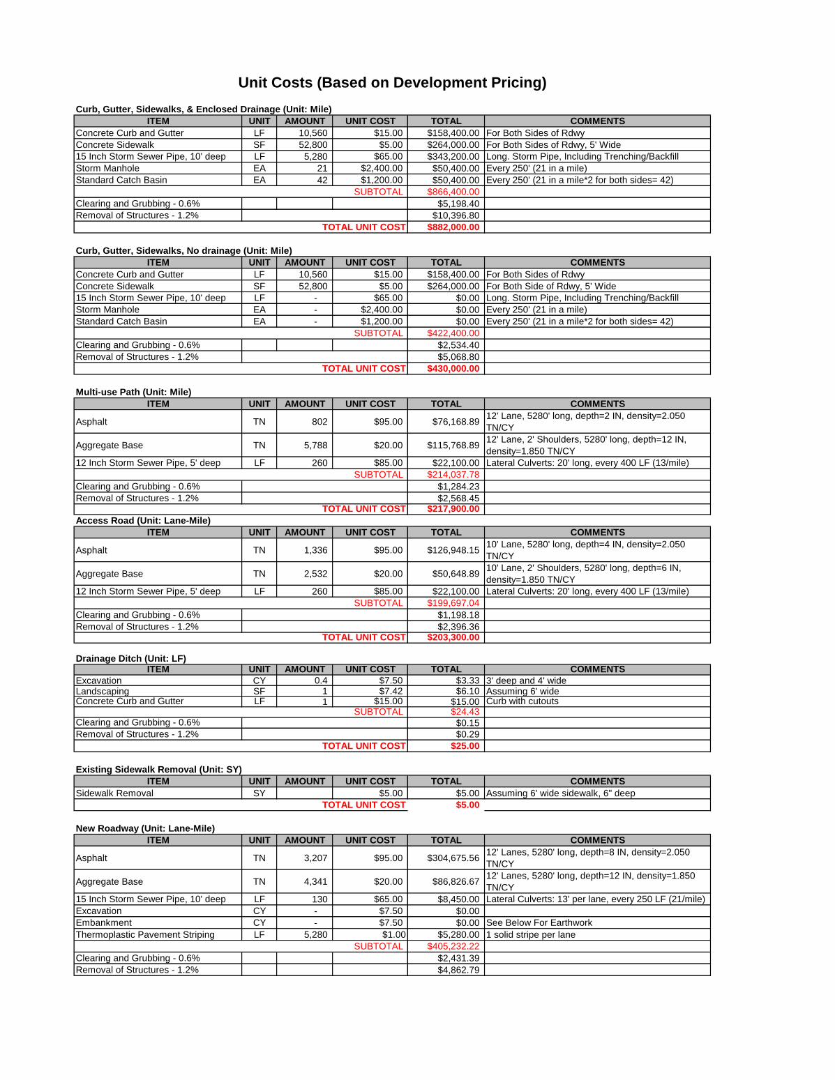
Curb, Gutter, Sidewalks, & Enclosed Drainage (Unit: Mile)
ITEM UNIT AMOUNT UNIT COST TOTAL COMMENTS
Concrete Curb and Gutter LF 10,560 $15.00 $158,400.00 For Both Sides of Rdwy
Concrete Sidewalk SF 52,800 $5.00 $264,000.00 For Both Sides of Rdwy, 5' Wide
15 Inch Storm Sewer Pipe, 10' deep LF 5,280 $65.00 $343,200.00 Long. Storm Pipe, Including Trenching/Backfill
Storm Manhole EA 21 $2,400.00 $50,400.00 Every 250' (21 in a mile)
Standard Catch Basin EA 42 $1,200.00 $50,400.00 Every 250' (21 in a mile*2 for both sides= 42)
SUBTOTAL $866,400.00
Clearing and Grubbing - 0.6% $5,198.40
Removal of Structures - 1.2% $10,396.80
TOTAL UNIT COST $882,000.00
Curb, Gutter, Sidewalks, No drainage (Unit: Mile)
ITEM UNIT AMOUNT UNIT COST TOTAL COMMENTS
Concrete Curb and Gutter LF 10,560 $15.00 $158,400.00 For Both Sides of Rdwy
Concrete Sidewalk SF 52,800 $5.00 $264,000.00 For Both Side of Rdwy, 5' Wide
15 Inch Storm Sewer Pipe, 10' deep LF - $65.00 $0.00 Long. Storm Pipe, Including Trenching/Backfill
Storm Manhole EA - $2,400.00 $0.00 Every 250' (21 in a mile)
Standard Catch Basin EA - $1,200.00 $0.00 Every 250' (21 in a mile*2 for both sides= 42)
SUBTOTAL $422,400.00
Clearing and Grubbing - 0.6% $2,534.40
Removal of Structures - 1.2% $5,068.80
TOTAL UNIT COST $430,000.00
Multi-use Path (Unit: Mile)
ITEM UNIT AMOUNT UNIT COST TOTAL COMMENTS
Asphalt TN 802 $95.00 $76,168.8912' Lane, 5280' long, depth=2 IN, density=2.050
TN/CY
Aggregate Base TN 5,788 $20.00 $115,768.8912' Lane, 2' Shoulders, 5280' long, depth=12 IN,
density=1.850 TN/CY
12 Inch Storm Sewer Pipe, 5' deep LF 260 $85.00 $22,100.00 Lateral Culverts: 20' long, every 400 LF (13/mile)
SUBTOTAL $214,037.78
Clearing and Grubbing - 0.6% $1,284.23
Removal of Structures - 1.2% $2,568.45TOTAL UNIT COST $217,900.00
Access Road (Unit: Lane-Mile)
ITEM UNIT AMOUNT UNIT COST TOTAL COMMENTS
Asphalt TN 1,336 $95.00 $126,948.1510' Lane, 5280' long, depth=4 IN, density=2.050
TN/CY
Aggregate Base TN 2,532 $20.00 $50,648.8910' Lane, 2' Shoulders, 5280' long, depth=6 IN,
density=1.850 TN/CY
12 Inch Storm Sewer Pipe, 5' deep LF 260 $85.00 $22,100.00 Lateral Culverts: 20' long, every 400 LF (13/mile)
SUBTOTAL $199,697.04
Clearing and Grubbing - 0.6% $1,198.18
Removal of Structures - 1.2% $2,396.36TOTAL UNIT COST $203,300.00
Drainage Ditch (Unit: LF)ITEM UNIT AMOUNT UNIT COST TOTAL COMMENTS
Excavation CY 0.4 $7.50 $3.33 3' deep and 4' wideLandscaping SF 1 $7.42 $6.10 Assuming 6' wideConcrete Curb and Gutter LF 1 $15.00 $15.00 Curb with cutouts
SUBTOTAL $24.43Clearing and Grubbing - 0.6% $0.15
Removal of Structures - 1.2% $0.29
TOTAL UNIT COST $25.00
Existing Sidewalk Removal (Unit: SY)
ITEM UNIT AMOUNT UNIT COST TOTAL COMMENTS
Sidewalk Removal SY $5.00 $5.00 Assuming 6' wide sidewalk, 6" deep
TOTAL UNIT COST $5.00
New Roadway (Unit: Lane-Mile)
ITEM UNIT AMOUNT UNIT COST TOTAL COMMENTS
Asphalt TN 3,207 $95.00 $304,675.5612' Lanes, 5280' long, depth=8 IN, density=2.050
TN/CY
Aggregate Base TN 4,341 $20.00 $86,826.6712' Lanes, 5280' long, depth=12 IN, density=1.850
TN/CY
15 Inch Storm Sewer Pipe, 10' deep LF 130 $65.00 $8,450.00 Lateral Culverts: 13' per lane, every 250 LF (21/mile)
Excavation CY - $7.50 $0.00
Embankment CY - $7.50 $0.00 See Below For Earthwork
Thermoplastic Pavement Striping LF 5,280 $1.00 $5,280.00 1 solid stripe per lane
SUBTOTAL $405,232.22
Clearing and Grubbing - 0.6% $2,431.39
Removal of Structures - 1.2% $4,862.79
Unit Costs (Based on Development Pricing)
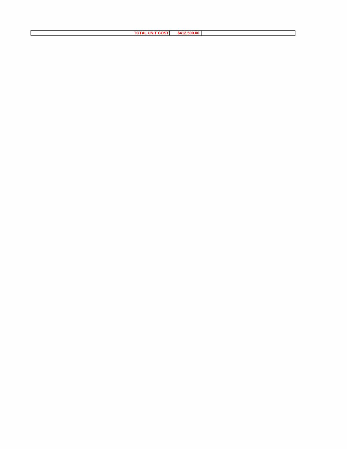
TOTAL UNIT COST $412,500.00

New Local Roadway (Unit: Lane-Mile)
ITEM UNIT AMOUNT UNIT COST TOTAL COMMENTS
Asphalt TN 1,604 $95.00 $152,337.7812' Lanes, 5280' long, depth=4 IN, density=2.050
TN/CY
Aggregate Base TN 2,171 $20.00 $43,413.3312' Lanes, 5280' long, depth=6 IN, density=1.850
TN/CY
15 Inch Storm Sewer Pipe, 10' deep LF 130 $65.00 $8,450.00 Lateral Culverts: 13' per lane, every 250 LF (21/mile)
Excavation CY - $7.50 $0.00
Embankment CY - $7.50 $0.00 See Below For Earthwork
Thermoplastic Pavement Striping LF 5,280 $1.00 $5,280.00 1 solid stripe per lane
SUBTOTAL $209,481.11
Clearing and Grubbing - 0.6% $1,256.89
Removal of Structures - 1.2% $2,513.77
TOTAL UNIT COST $213,300.00
New Roadway No Drainage (Unit: Lane-Mile)
ITEM UNIT AMOUNT UNIT COST TOTAL COMMENTS
Asphalt TN 3,207 $95.00 $304,675.5612' Lanes, 5280' long, depth=8 IN, density=2.050
TN/CY
Aggregate Base TN 4,341 $20.00 $86,826.6712' Lanes, 5280' long, depth=12 IN, density=1.850
TN/CY
15 Inch Storm Sewer Pipe, 10' deep LF $65.00 $0.00 Lateral Culverts: 13' per lane, every 250 LF (21/mile)
Excavation CY - $7.50 $0.00
Embankment CY - $7.50 $0.00 See Below For Earthwork
Thermoplastic Pavement Striping LF $1.00 $0.00 1 solid stripe per lane
SUBTOTAL $391,502.22
Clearing and Grubbing - 0.6% $2,349.01
Removal of Structures - 1.2% $4,698.03
TOTAL UNIT COST $398,500.00
New Local Roadway No Drainage (Unit: Lane-Mile)
ITEM UNIT AMOUNT UNIT COST TOTAL COMMENTS
Asphalt TN 1,604 $95.00 $152,337.7812' Lanes, 5280' long, depth=4 IN, density=2.050
TN/CY
Aggregate Base TN 2,171 $20.00 $43,413.3312' Lanes, 5280' long, depth=6 IN, density=1.850
TN/CY
15 Inch Storm Sewer Pipe, 10' deep LF $65.00 $0.00 Lateral Culverts: 13' per lane, every 250 LF (21/mile)
Excavation CY - $7.50 $0.00
Embankment CY - $7.50 $0.00 See Below For Earthwork
Thermoplastic Pavement Striping LF $1.00 $0.00 1 solid stripe per lane
SUBTOTAL $195,751.11
Clearing and Grubbing - 0.6% $1,174.51
Removal of Structures - 1.2% $2,349.01
TOTAL UNIT COST $199,300.00
New Roadway (Unit: SF)
ITEM UNIT AMOUNT UNIT COST TOTAL COMMENTS
New Roadway/SF per Lane Mile SF 1 $6.51 $6.51 See New Roadway (Unit: Lane-Mile) for Breakdown
TOTAL UNIT COST $7.00
New Local Roadway (Unit: SF)

ITEM UNIT AMOUNT UNIT COST TOTAL COMMENTS
New Roadway/SF per Lane Mile SF 1 $3.37 $3.37See New Local Roadway (Unit: Lane-Mile) for
Breakdown
TOTAL UNIT COST $4.00
New Roadway, No Drainage (Unit: SF)
ITEM UNIT AMOUNT UNIT COST TOTAL COMMENTS
New Roadway/SF per Lane Mile SF 1 $6.29 $6.29See New Roadway No Drainage (Unit: Lane-Mile) for
Breakdown
TOTAL UNIT COST $7.00
New Local Roadway, No Drainage (Unit: SF)
ITEM UNIT AMOUNT UNIT COST TOTAL COMMENTS
New Roadway/SF per Lane Mile SF 1 $3.15 $3.15See New Local Roadway No Drainage (Unit: Lane-
Mile) for Breakdown
TOTAL UNIT COST $4.00
Reconstruct Existing Roadway (Unit: SF)
ITEM UNIT AMOUNT UNIT COST TOTAL COMMENTS
Excavation CY 1 $7.50 $4.44 Removal of 4in. AC and 12in Aggregate Base
New Roadway - - - $4.00 See 'New Roadway' Sheet for Cost Breakdown
TOTAL UNIT COST $9.00
Existing Roadway Removal (Unit: SY)
ITEM UNIT AMOUNT UNIT COST TOTAL COMMENTS
Excavation SY $7.50 $7.50 Removal of 8in. AC and 10in Aggregate Base
TOTAL UNIT COST $8.00
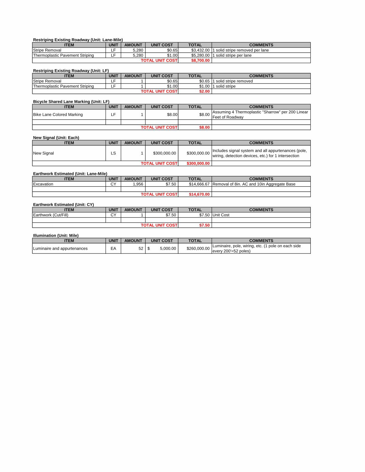
Restriping Existing Roadway (Unit: Lane-Mile)
ITEM UNIT AMOUNT UNIT COST TOTAL COMMENTS
Stripe Removal LF 5,280 $0.65 $3,432.00 1 solid stripe removed per lane
Thermoplastic Pavement Striping LF 5,280 $1.00 $5,280.00 1 solid stripe per lane
TOTAL UNIT COST $8,700.00
Restriping Existing Roadway (Unit: LF)
ITEM UNIT AMOUNT UNIT COST TOTAL COMMENTS
Stripe Removal LF 1 $0.65 $0.65 1 solid stripe removed
Thermoplastic Pavement Striping LF 1 $1.00 $1.00 1 solid stripe
TOTAL UNIT COST $2.00
Bicycle Shared Lane Marking (Unit: LF)
ITEM UNIT AMOUNT UNIT COST TOTAL COMMENTS
Bike Lane Colored Marking LF 1 $8.00 $8.00Assuming 4 Thermoplastic "Sharrow" per 200 Linear
Feet of Roadway
TOTAL UNIT COST $8.00
New Signal (Unit: Each)
ITEM UNIT AMOUNT UNIT COST TOTAL COMMENTS
New Signal LS 1 $300,000.00 $300,000.00Includes signal system and all appurtenances (pole,
wiring, detection devices, etc.) for 1 intersection
TOTAL UNIT COST $300,000.00
Earthwork Estimated (Unit: Lane-Mile)
ITEM UNIT AMOUNT UNIT COST TOTAL COMMENTS
Excavation CY 1,956 $7.50 $14,666.67 Removal of 8in. AC and 10in Aggregate Base
TOTAL UNIT COST $14,670.00
Earthwork Estimated (Unit: CY)
ITEM UNIT AMOUNT UNIT COST TOTAL COMMENTS
Earthwork (Cut/Fill) CY 1 $7.50 $7.50 Unit Cost
TOTAL UNIT COST $7.50
Illumination (Unit: Mile)
ITEM UNIT AMOUNT UNIT COST TOTAL COMMENTS
Luminaire and appurtenances EA 52 5,000.00$ $260,000.00Luminaire, pole, wiring, etc. (1 pole on each side
every 200'=52 poles)
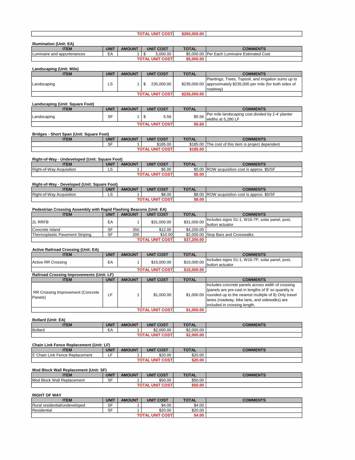
TOTAL UNIT COST $260,000.00
Illumination (Unit: EA)
ITEM UNIT AMOUNT UNIT COST TOTAL COMMENTS
Luminaire and appurtenances EA 1 5,000.00$ $5,000.00 Per Each Luminaire Estimated Cost
TOTAL UNIT COST $5,000.00
Landscaping (Unit: Mile)
ITEM UNIT AMOUNT UNIT COST TOTAL COMMENTS
Landscaping LS 1 235,000.00$ $235,000.00
Plantings, Trees, Topsoil, and Irrigation sums up to
approximately $235,000 per mile (for both sides of
roadway)
TOTAL UNIT COST $235,000.00
Landscaping (Unit: Square Foot)
ITEM UNIT AMOUNT UNIT COST TOTAL COMMENTS
Landscaping SF 1 5.56$ $5.56Per mile landscaping cost divided by 2-4' planter
widths at 5,280 LF
TOTAL UNIT COST $5.60
Bridges - Short Span (Unit: Square Foot)
ITEM UNIT AMOUNT UNIT COST TOTAL COMMENTS
SF 1 $185.00 $185.00 The cost of this item is project dependent
TOTAL UNIT COST $185.00
Right-of-Way - Undeveloped (Unit: Square Foot)
ITEM UNIT AMOUNT UNIT COST TOTAL COMMENTS
Right-of-Way Acquisition LS 1 $5.00 $5.00 ROW acquisition cost is approx. $5/SF
TOTAL UNIT COST $5.00
Right-of-Way - Developed (Unit: Square Foot)
ITEM UNIT AMOUNT UNIT COST TOTAL COMMENTS
Right-of-Way Acquisition LS 1 $8.00 $8.00 ROW acquisition cost is approx. $5/SF
TOTAL UNIT COST $8.00
Pedestrian Crossing Assembly with Rapid Flashing Beacons (Unit: EA)
ITEM UNIT AMOUNT UNIT COST TOTAL COMMENTS
2L RRFB EA 1 $31,000.00 $31,000.00Includes signs S1-1, W16-7P, solar panel, post,
button actuator
Concrete Island SF 350 $12.00 $4,200.00
Thermoplastic Pavement Striping SF 200 $10.00 $2,000.00 Stop Bars and Crosswalks
TOTAL UNIT COST $37,200.00
Active Railroad Crossing (Unit: EA)
ITEM UNIT AMOUNT UNIT COST TOTAL COMMENTS
Active RR Crossing EA 1 $15,000.00 $15,000.00Includes signs S1-1, W16-7P, solar panel, post,
button actuator
TOTAL UNIT COST $15,000.00
Railroad Crossing Improvements (Unit: LF)
ITEM UNIT AMOUNT UNIT COST TOTAL COMMENTS
RR Crossing Improvement (Concrete
Panels)LF 1 $1,000.00 $1,000.00
Includes concrete panels across width of crossing
(panels are pre-cast in lengths of 8' so quantity is
rounded up to the nearest multiple of 8) Only travel
lanes (roadway, bike lane, and sidewalks) are
included in crossing length.
TOTAL UNIT COST $1,000.00
Bollard (Unit: EA)
ITEM UNIT AMOUNT UNIT COST TOTAL COMMENTS
Bollard EA 1 $2,000.00 $2,000.00
TOTAL UNIT COST $2,000.00
Chain Link Fence Replacement (Unit: LF)
ITEM UNIT AMOUNT UNIT COST TOTAL COMMENTS
5' Chain Link Fence Replacement LF 1 $20.00 $20.00
TOTAL UNIT COST $20.00
Mod Block Wall Replacement (Unit: SF)
ITEM UNIT AMOUNT UNIT COST TOTAL COMMENTS
Mod Block Wall Replacement SF 1 $50.00 $50.00
TOTAL UNIT COST $50.00
RIGHT OF WAY
ITEM UNIT AMOUNT UNIT COST TOTAL COMMENTS
Rural residential/undeveloped SF 1 $4.00 $4.00
Residential SF 1 $20.00 $20.00
TOTAL UNIT COST $4.00

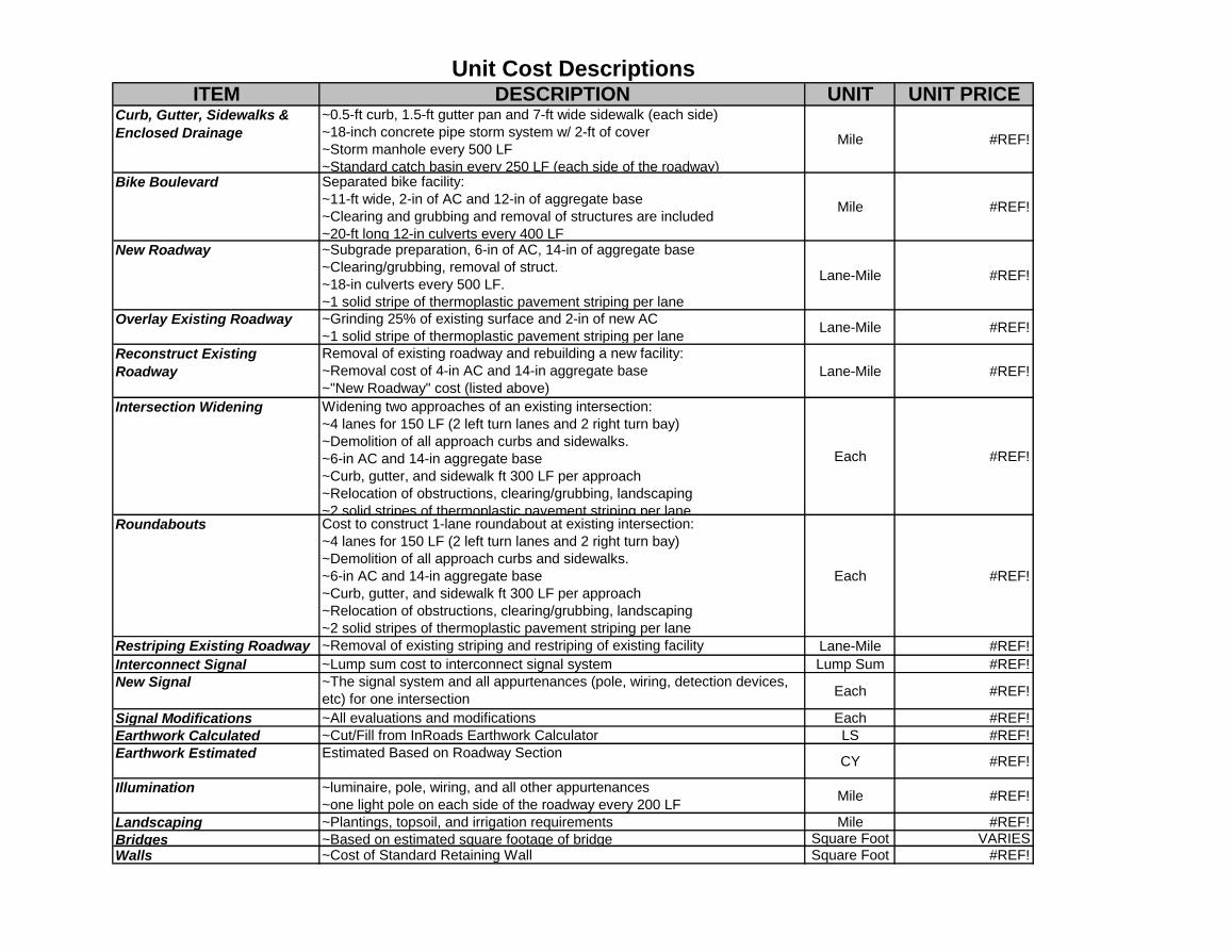
ITEM DESCRIPTION UNIT UNIT PRICECurb, Gutter, Sidewalks &
Enclosed Drainage
~0.5-ft curb, 1.5-ft gutter pan and 7-ft wide sidewalk (each side)
~18-inch concrete pipe storm system w/ 2-ft of cover
~Storm manhole every 500 LF
~Standard catch basin every 250 LF (each side of the roadway)
Mile #REF!
Bike Boulevard Separated bike facility:
~11-ft wide, 2-in of AC and 12-in of aggregate base
~Clearing and grubbing and removal of structures are included
~20-ft long 12-in culverts every 400 LF
Mile #REF!
New Roadway ~Subgrade preparation, 6-in of AC, 14-in of aggregate base
~Clearing/grubbing, removal of struct.
~18-in culverts every 500 LF.
~1 solid stripe of thermoplastic pavement striping per lane
Lane-Mile #REF!
Overlay Existing Roadway ~Grinding 25% of existing surface and 2-in of new AC
~1 solid stripe of thermoplastic pavement striping per laneLane-Mile #REF!
Reconstruct Existing
Roadway
Removal of existing roadway and rebuilding a new facility:
~Removal cost of 4-in AC and 14-in aggregate base
~"New Roadway" cost (listed above)
Lane-Mile #REF!
Intersection Widening Widening two approaches of an existing intersection:
~4 lanes for 150 LF (2 left turn lanes and 2 right turn bay)
~Demolition of all approach curbs and sidewalks.
~6-in AC and 14-in aggregate base
~Curb, gutter, and sidewalk ft 300 LF per approach
~Relocation of obstructions, clearing/grubbing, landscaping
~2 solid stripes of thermoplastic pavement striping per lane
Each #REF!
Roundabouts Cost to construct 1-lane roundabout at existing intersection:
~4 lanes for 150 LF (2 left turn lanes and 2 right turn bay)
~Demolition of all approach curbs and sidewalks.
~6-in AC and 14-in aggregate base
~Curb, gutter, and sidewalk ft 300 LF per approach
~Relocation of obstructions, clearing/grubbing, landscaping
~2 solid stripes of thermoplastic pavement striping per lane
Each #REF!
Restriping Existing Roadway ~Removal of existing striping and restriping of existing facility Lane-Mile #REF!
Interconnect Signal ~Lump sum cost to interconnect signal system Lump Sum #REF!
New Signal ~The signal system and all appurtenances (pole, wiring, detection devices,
etc) for one intersectionEach #REF!
Signal Modifications ~All evaluations and modifications Each #REF!
Earthwork Calculated ~Cut/Fill from InRoads Earthwork Calculator LS #REF!
Earthwork Estimated Estimated Based on Roadway SectionCY #REF!
Illumination ~luminaire, pole, wiring, and all other appurtenances
~one light pole on each side of the roadway every 200 LFMile #REF!
Landscaping ~Plantings, topsoil, and irrigation requirements Mile #REF!
Bridges ~Based on estimated square footage of bridge Square Foot VARIES
Walls ~Cost of Standard Retaining Wall Square Foot #REF!
Unit Cost Descriptions
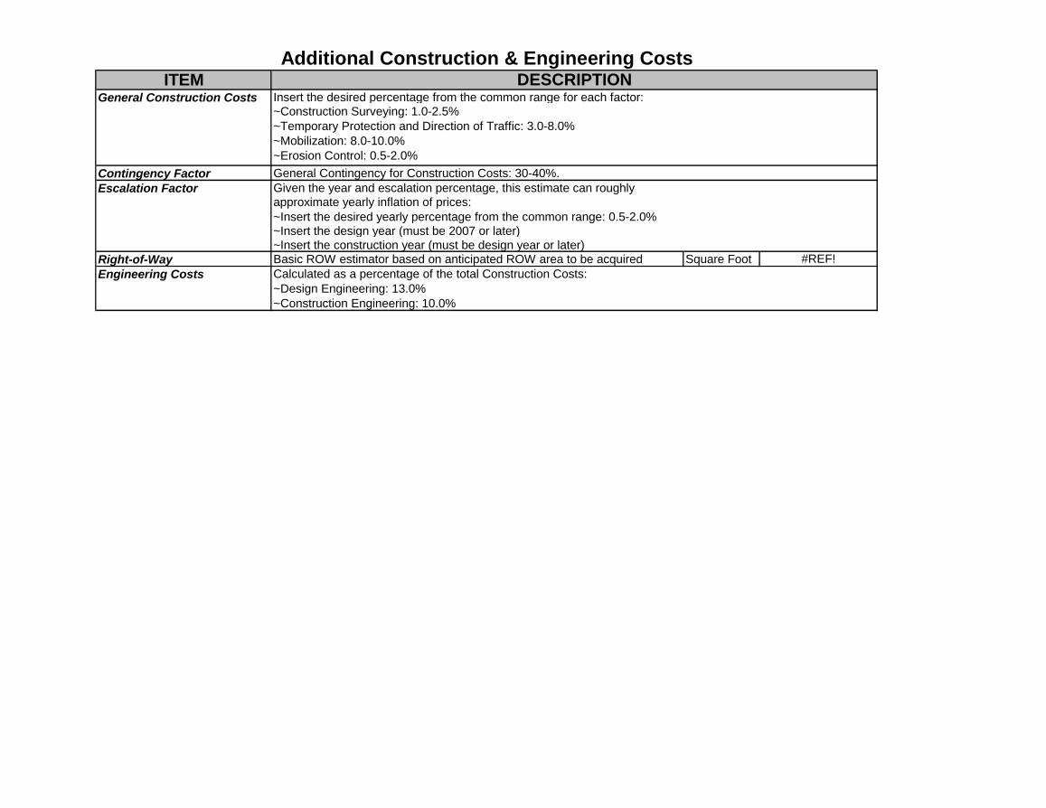
ITEM
Contingency Factor
Right-of-Way Basic ROW estimator based on anticipated ROW area to be acquired Square Foot #REF!
General Contingency for Construction Costs: 30-40%.
Additional Construction & Engineering CostsDESCRIPTION
Insert the desired percentage from the common range for each factor:General Construction Costs~Construction Surveying: 1.0-2.5%
~Temporary Protection and Direction of Traffic: 3.0-8.0%
~Mobilization: 8.0-10.0%
~Erosion Control: 0.5-2.0%
Engineering Costs
Given the year and escalation percentage, this estimate can roughly approximate yearly inflation of prices:
~Insert the desired yearly percentage from the common range: 0.5-2.0%
~Insert the construction year (must be design year or later)
Calculated as a percentage of the total Construction Costs:
~Design Engineering: 13.0%
~Construction Engineering: 10.0%
Escalation Factor
~Insert the design year (must be 2007 or later)
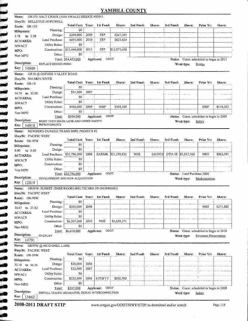
hwyr21h
Rectangle
Appendix F
Policy Revisions, Implementing Ordinances, Revisions to Street Standards
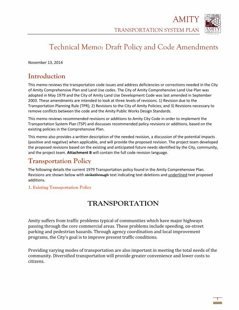
AMITY TRANSPORTATION SYSTEM PLAN
1
Technical Memo: Draft Policy and Code Amendments November 13, 2014
Introduction This memo reviews the transportation code issues and address deficiencies or corrections needed in the City of Amity Comprehensive Plan and Land Use codes. The City of Amity Comprehensive Land Use Plan was adopted in May 1979 and the City of Amity Land Use Development Code was last amended in September 2003. These amendments are intended to look at three levels of revisions. 1) Revision due to the Transportation Planning Rule (TPR); 2) Revisions to the City of Amity Policies; and 3) Revisions necessary to remove conflicts between the code and the Amity Public Works Design Standards.
This memo reviews recommended revisions or additions to Amity City Code in order to implement the Transportation System Plan (TSP) and discusses recommended policy revisions or additions, based on the existing policies in the Comprehensive Plan.
This memo also provides a written description of the needed revision, a discussion of the potential impacts (positive and negative) when applicable, and will provide the proposed revision. The project team developed the proposed revisions based on the existing and anticipated future needs identified by the City, community, and the project team. Attachment B will contain the full code revision language.
Transportation Policy The following details the current 1979 Transportation policy found in the Amity Comprehensive Plan. Revisions are shown below with strikethrough text indicating text deletions and underlined text proposed additions.
1. Existing Transportation Policy
TRANSPORTATION Amity suffers from traffic problems typical of communities which have major highways passing through the core commercial areas. These problems include speeding, on-street parking and pedestrian hazards. Through agency coordination and local improvement programs, the City’s goal is to improve present traffic conditions. Providing varying modes of transportation are also important in meeting the total needs of the community. Diversified transportation will provide greater convenience and lower costs to citizens.

AMITY TRANSPORTATION SYSTEM PLAN
2
FINDINGS
The condition of Amity's streets is generally adequate for the existing traffic load, although most streets are in need of paving. Improvements in the street conditions will be necessary to accommodate substantial increases in traffic.
The City of Amity, the State Highway Division and Yamhill County are responsible for the maintenance of streets in the planning area, curbs and sidewalks exist on very few of the City's streets.
There are no plans for road improvements on State roads within the planning area for at least the next 6 years.
Traffic volumes have increased by between 5 and 29 percent on monitored roads over the 5 year period from 1972 to 1977.
The most serious traffic hazards exist along Highway 99W (Trade Street) and the Bellevue-Hopewell Highway (Fifth and Nursery Streets), primarily due to traffic volumes and on-street parking.
The Southern Union Pacific Railroad owns the rail facilities in Amity, Portland & Western maintains and operates rail freight service in Amity on tracks running through the western portion of the City; the nearest available passenger service is in the City of Salem. air service is in the City of McMinnville.
For regularly scheduled commercial flights citizens generally travel to the Portland General International Airport.
Yamco Transit and Greyhound Lines Yamhill County Transit provide the City of Amity with a level of public transportation.
Walking and biking are attractive transportation modes despite the lack of adequate facilities.
Side streets serve as the primary routes for pedestrians and bicyclists.
A portion of the County's share of State gas monies is available to the City for the construction and maintenance of bicycle paths.
GOAL STATEMENT
To provide a safe, convenient, aesthetic, and economic transportation system through a variety of transportation means.
POLICIES
The City shall coordinate with Yamhill County and the Oregon Department of Transportation with regard to City actions and needs which may affect traffic on County and State roads within the Urban Growth Boundary.
Transportation improvements shall be used to guide urban development and be designed to serve anticipated future needs.
Transportation facility design shall be done in a manner consistent with city design standard and the Transportation System Plan (TSP), and which will minimize adverse effects on the existing land uses and natural features.
Alternative modes of transportation that will be energy conserving and will provide maximum efficiency and utilization of existing facilities shall be promoted.
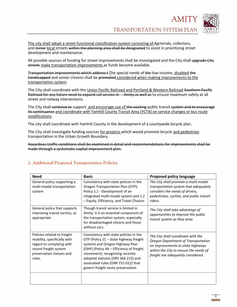
AMITY TRANSPORTATION SYSTEM PLAN
3
The city shall adopt a street functional classification system consisting of Aarterials, collectors, and minor local streets within the planning area shall be designated to assist in prioritizing street development and maintenance.
All possible sources of funding for street improvements shall be investigated and the City shall upgrade City streets make transportation improvements as funds become available.
Transportation improvements which address t The special needs of the low-income, disabled the handicapped and senior citizens shall be promoted considered when making improvements to the transportation system.
The City shall coordinate with the Union Pacific Railroad and Portland & Western Railroad Southern Pacific Railroad for any future need to expand rail service in Amity as well as to ensure maximum safety at all street and railway intersections.
The City shall continue to support and encourage use of the existing public transit system and to encourage its continuance and coordinate with Yamhill County Transit Area (YCTA) on service changes or bus route modifications.
The city shall coordinate with Yamhill County in the development of a countywide bicycle plan.
The City shall investigate funding sources for projects which would promote bicycle and pedestrian transportation in the Urban Growth Boundary.
Hazardous traffic conditions shall be examined in detail and recommendations for improvements shall be made through a systematic capital improvement plan.
2. Additional Proposed Transportation Policies
Need Basis Proposed policy language General policy supporting a multi-modal transportation system
Consistency with state policies in the Oregon Transportation Plan (OTP): Policy 1.1 - Development of an integrated multi-modal system and 1.2 – Equity, Efficiency, and Travel Choices
The City shall promote a multi-modal transportation system that adequately considers the needs of drivers, pedestrians, cyclists, and public transit riders.
General policy that supports improving transit service, as appropriate
Though transit service is limited in Amity, it is an essential component of the transportation system, especially for disadvantaged citizens and those without cars.
The City shall take advantage of opportunities to improve the public transit system as they arise.
Policies related to freight mobility, specifically with regard to complying with recent freight system preservation statues and rules.
Consistency with state policies in the OTP (Policy 1C – State highway freight system) and Oregon Highway Plan (OHP) (Policy 4A – Efficiency of freight movement); recognizing recently adopted statutes (ORS 366.215) and associated rules (OAR 731-012) that govern freight route preservation
The City shall coordinate with the Oregon Department of Transportation on improvements to state highways within the City to ensure the needs of freight are adequately considered.
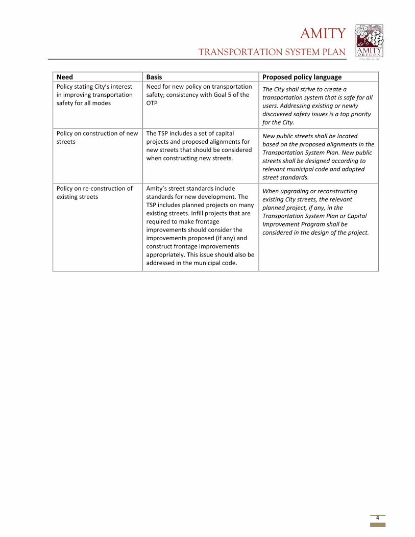
AMITY TRANSPORTATION SYSTEM PLAN
4
Need Basis Proposed policy language Policy stating City’s interest in improving transportation safety for all modes
Need for new policy on transportation safety; consistency with Goal 5 of the OTP
The City shall strive to create a transportation system that is safe for all users. Addressing existing or newly discovered safety issues is a top priority for the City.
Policy on construction of new streets
The TSP includes a set of capital projects and proposed alignments for new streets that should be considered when constructing new streets.
New public streets shall be located based on the proposed alignments in the Transportation System Plan. New public streets shall be designed according to relevant municipal code and adopted street standards.
Policy on re-construction of existing streets
Amity’s street standards include standards for new development. The TSP includes planned projects on many existing streets. Infill projects that are required to make frontage improvements should consider the improvements proposed (if any) and construct frontage improvements appropriately. This issue should also be addressed in the municipal code.
When upgrading or reconstructing existing City streets, the relevant planned project, if any, in the Transportation System Plan or Capital Improvement Program shall be considered in the design of the project.
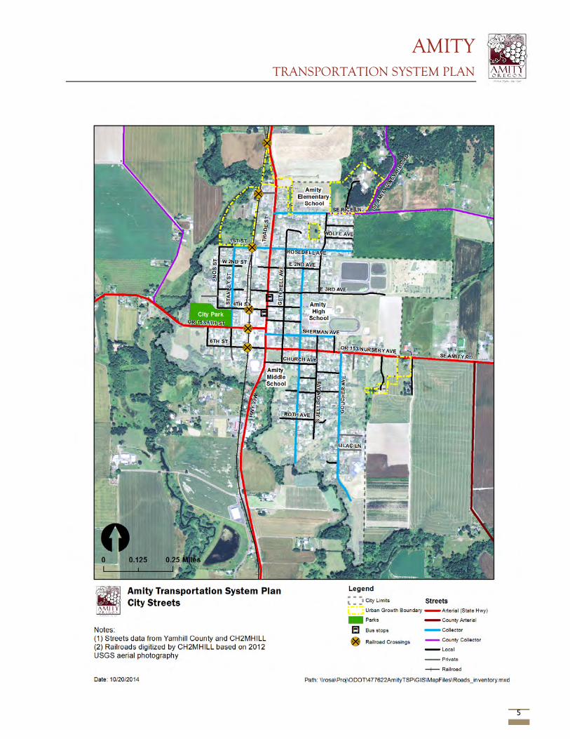
AMITY TRANSPORTATION SYSTEM PLAN
5
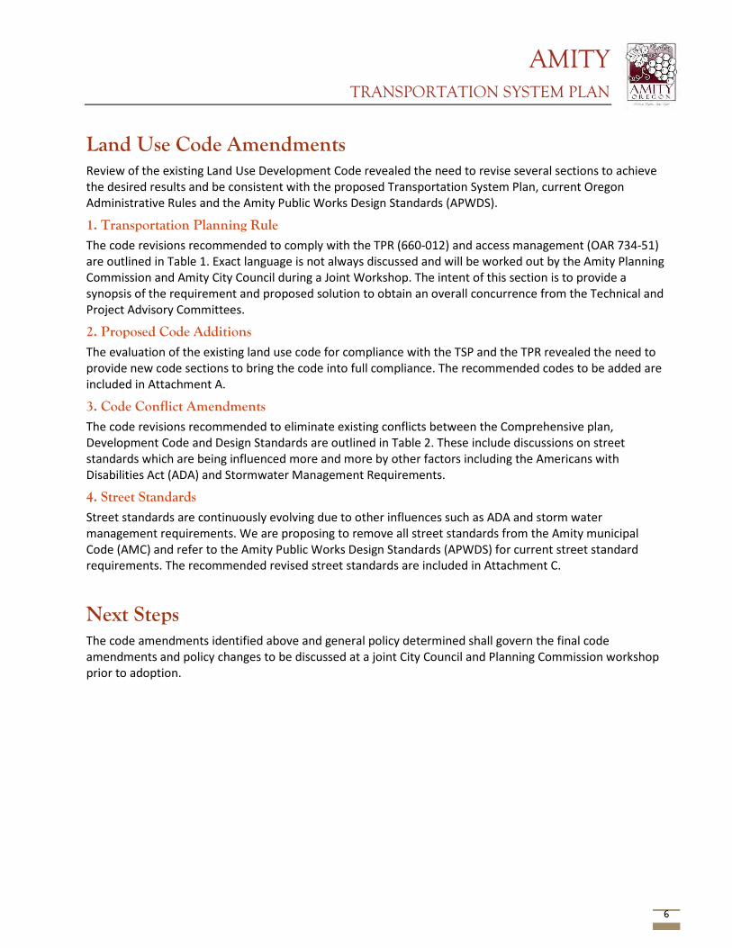
AMITY TRANSPORTATION SYSTEM PLAN
6
Land Use Code Amendments Review of the existing Land Use Development Code revealed the need to revise several sections to achieve the desired results and be consistent with the proposed Transportation System Plan, current Oregon Administrative Rules and the Amity Public Works Design Standards (APWDS).
1. Transportation Planning Rule The code revisions recommended to comply with the TPR (660-012) and access management (OAR 734-51) are outlined in Table 1. Exact language is not always discussed and will be worked out by the Amity Planning Commission and Amity City Council during a Joint Workshop. The intent of this section is to provide a synopsis of the requirement and proposed solution to obtain an overall concurrence from the Technical and Project Advisory Committees.
2. Proposed Code Additions The evaluation of the existing land use code for compliance with the TSP and the TPR revealed the need to provide new code sections to bring the code into full compliance. The recommended codes to be added are included in Attachment A.
3. Code Conflict Amendments The code revisions recommended to eliminate existing conflicts between the Comprehensive plan, Development Code and Design Standards are outlined in Table 2. These include discussions on street standards which are being influenced more and more by other factors including the Americans with Disabilities Act (ADA) and Stormwater Management Requirements.
4. Street Standards Street standards are continuously evolving due to other influences such as ADA and storm water management requirements. We are proposing to remove all street standards from the Amity municipal Code (AMC) and refer to the Amity Public Works Design Standards (APWDS) for current street standard requirements. The recommended revised street standards are included in Attachment C.
Next Steps The code amendments identified above and general policy determined shall govern the final code amendments and policy changes to be discussed at a joint City Council and Planning Commission workshop prior to adoption.
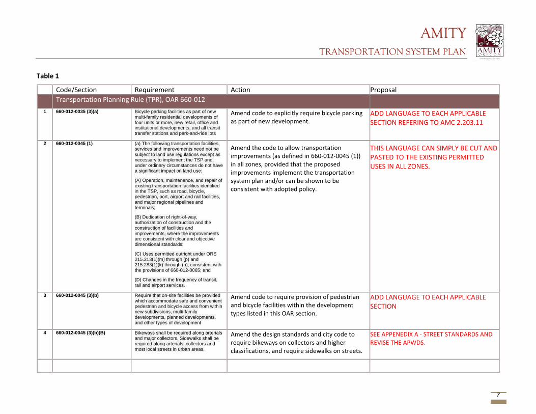
AMITY TRANSPORTATION SYSTEM PLAN
7
Table 1
Code/Section Requirement Action Proposal Transportation Planning Rule (TPR), OAR 660-012 1 660-012-0035 (3)(a) Bicycle parking facilities as part of new
multi-family residential developments of four units or more, new retail, office and institutional developments, and all transit transfer stations and park-and-ride lots
Amend code to explicitly require bicycle parking as part of new development.
ADD LANGUAGE TO EACH APPLICABLE SECTION REFERING TO AMC 2.203.11
2 660-012-0045 (1) (a) The following transportation facilities, services and improvements need not be subject to land use regulations except as necessary to implement the TSP and, under ordinary circumstances do not have a significant impact on land use:
(A) Operation, maintenance, and repair of existing transportation facilities identified in the TSP, such as road, bicycle, pedestrian, port, airport and rail facilities, and major regional pipelines and terminals;
(B) Dedication of right-of-way, authorization of construction and the construction of facilities and improvements, where the improvements are consistent with clear and objective dimensional standards;
(C) Uses permitted outright under ORS 215.213(1)(m) through (p) and 215.283(1)(k) through (n), consistent with the provisions of 660-012-0065; and
(D) Changes in the frequency of transit, rail and airport services.
Amend the code to allow transportation improvements (as defined in 660-012-0045 (1)) in all zones, provided that the proposed improvements implement the transportation system plan and/or can be shown to be consistent with adopted policy.
THIS LANGUAGE CAN SIMPLY BE CUT AND PASTED TO THE EXISTING PERMITTED USES IN ALL ZONES.
3 660-012-0045 (3)(b) Require that on-site facilities be provided which accommodate safe and convenient pedestrian and bicycle access from within new subdivisions, multi-family developments, planned developments, and other types of development
Amend code to require provision of pedestrian and bicycle facilities within the development types listed in this OAR section.
ADD LANGUAGE TO EACH APPLICABLE SECTION
4 660-012-0045 (3)(b)(B) Bikeways shall be required along arterials and major collectors. Sidewalks shall be required along arterials, collectors and most local streets in urban areas.
Amend the design standards and city code to require bikeways on collectors and higher classifications, and require sidewalks on streets.
SEE APPENEDIX A - STREET STANDARDS AND REVISE THE APWDS.
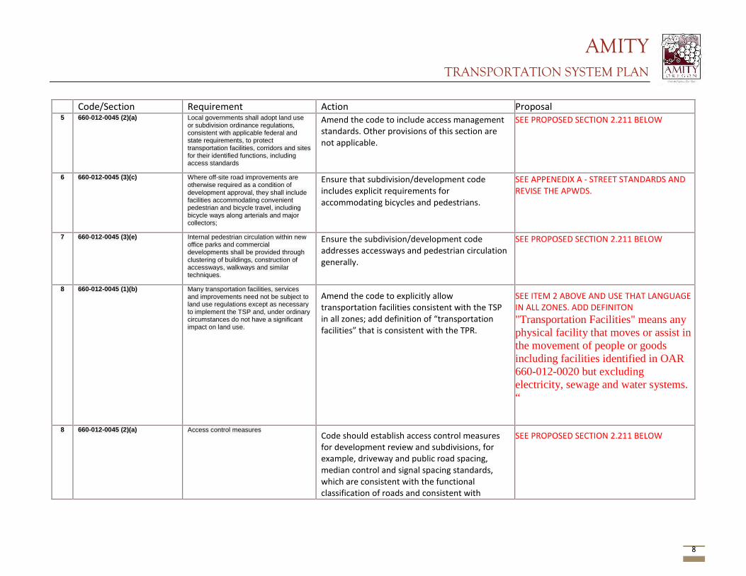
AMITY TRANSPORTATION SYSTEM PLAN
8
Code/Section Requirement Action Proposal 5 660-012-0045 (2)(a) Local governments shall adopt land use
or subdivision ordinance regulations, consistent with applicable federal and state requirements, to protect transportation facilities, corridors and sites for their identified functions, including access standards
Amend the code to include access management standards. Other provisions of this section are not applicable.
SEE PROPOSED SECTION 2.211 BELOW
6 660-012-0045 (3)(c) Where off-site road improvements are otherwise required as a condition of development approval, they shall include facilities accommodating convenient pedestrian and bicycle travel, including bicycle ways along arterials and major collectors;
Ensure that subdivision/development code includes explicit requirements for accommodating bicycles and pedestrians.
SEE APPENEDIX A - STREET STANDARDS AND REVISE THE APWDS.
7 660-012-0045 (3)(e) Internal pedestrian circulation within new office parks and commercial developments shall be provided through clustering of buildings, construction of accessways, walkways and similar techniques.
Ensure the subdivision/development code addresses accessways and pedestrian circulation generally.
SEE PROPOSED SECTION 2.211 BELOW
8 660-012-0045 (1)(b)
Many transportation facilities, services and improvements need not be subject to land use regulations except as necessary to implement the TSP and, under ordinary circumstances do not have a significant impact on land use.
Amend the code to explicitly allow transportation facilities consistent with the TSP in all zones; add definition of “transportation facilities” that is consistent with the TPR.
SEE ITEM 2 ABOVE AND USE THAT LANGUAGE IN ALL ZONES. ADD DEFINITON "Transportation Facilities" means any physical facility that moves or assist in the movement of people or goods including facilities identified in OAR 660-012-0020 but excluding electricity, sewage and water systems. “
8 660-012-0045 (2)(a) Access control measures Code should establish access control measures for development review and subdivisions, for example, driveway and public road spacing, median control and signal spacing standards, which are consistent with the functional classification of roads and consistent with
SEE PROPOSED SECTION 2.211 BELOW
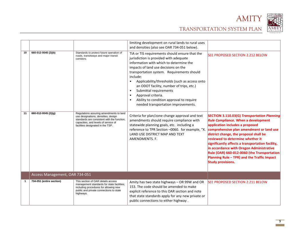
AMITY TRANSPORTATION SYSTEM PLAN
9
limiting development on rural lands to rural uses and densities (also see OAR 734-051 below).
10 660-012-0045 (2)(b) Standards to protect future operation of roads, transitways and major transit corridors.
TIA or TIS requirements should ensure that the jurisdiction is provided with adequate information with which to determine the impacts of land use decisions on the transportation system. Requirements should include: • Applicability/thresholds (such as access onto
an ODOT facility, number of trips, etc.) • Submittal requirements • Approval criteria. • Ability to condition approval to require
needed transportation improvements.
SEE PROPOSED SECTION 2.212 BELOW
11 660-012-0045 (2)(g) Regulations assuring amendments to land use designations, densities, design standards are consistent with the function, capacities, and levels of service of facilities designated in the TSP.
Criteria for plan/zone change approval and text amendments should require compliance with statewide planning goals, etc. including a reference to TPR Section –0060. for example, “X. LAND USE DISTRICT MAP AND TEXT AMENDMENTS. F.
SECTION 3.110.03(G) Transportation Planning Rule Compliance. When a development application includes a proposed comprehensive plan amendment or land use district change, the proposal shall be reviewed to determine whether it significantly affects a transportation facility, in accordance with Oregon Administrative Rule (OAR) 660-012-0060 (the Transportation Planning Rule – TPR) and the Traffic Impact Study provisions.
Access Management, OAR 734-051 1 734-051 (entire section) This section of OAR details access
management standards for state facilities, including procedures for allowing new public and private connections to state highways.
Amity has two state highways – OR 99W and OR 153. The code should be amended to make explicit reference to this OAR section and note that state standards apply for any new private or public connections to either highway .
SEE PROPOSED SECTION 2.211 BELOW
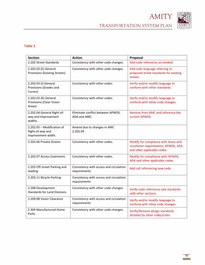
AMITY TRANSPORTATION SYSTEM PLAN
10
Table 2
Section Action Proposal 2.202 Street Standards Consistency with other code changes. Add code references as needed.
2.202.03 (E) General Provisions (Existing Streets)
Consistency with other code changes. Add code language referring to proposed street standards for existing streets.
2.202.03 (I) General Provisions (Grades and Curves)
Consistency with other codes. Verify and/or modify language to conform with other standards.
2.202.03 (K) General Provisions (Clear Vision Areas)
Consistency with other codes. Verify and/or modify language to conform with other code changes.
2.202.04 General Right-of-way and Improvement widths.
Eliminate conflict between APWDS, ADA and AMC.
Remove from AMC and reference the current APWDS.
2.202.05 – Modification of Right-of-way and Improvement width.
Amend due to changes in AMC 2.202.04
2.202.06 Private Streets Consistency with other codes. Modify for compliance with Acess and circulation requirements, APWDS, ADA and other applicable codes.
2.202.07 Access Easements Consistency with other codes. Modify for compliance with APWDS, ADA and other applicable codes.
2.203 Off-street Parking and loading
Consistency with access and circulation requirements
Add call referencing new code.
2.203.11 Bicycle Parking Consistency with access and circulation requirements
2.208 Development Standards for Land Divisions
Consistency with other code changes. Verify code references and standards with other sections.
2.209.08 Vision Clearance Consistency with access and circulation requirements
Verify and/or modify language to conform with other code changes.
2.304 Manufactured Home Parks
Consistency with other code changes. Verify/Remove design standards dictated by other codes/rules.
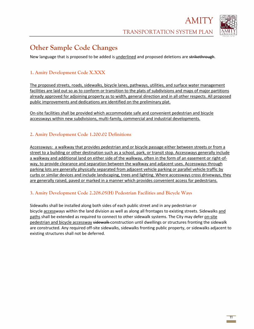
AMITY TRANSPORTATION SYSTEM PLAN
11
Other Sample Code Changes New language that is proposed to be added is underlined and proposed deletions are strikethrough.
1. Amity Development Code X.XXX The proposed streets, roads, sidewalks, bicycle lanes, pathways, utilities, and surface water management facilities are laid out so as to conform or transition to the plats of subdivisions and maps of major partitions already approved for adjoining property as to width, general direction and in all other respects. All proposed public improvements and dedications are identified on the preliminary plat. On-site facilities shall be provided which accommodate safe and convenient pedestrian and bicycle accessways within new subdivisions, multi-family, commercial and industrial developments.
2. Amity Development Code 1.200.02 Definitions Accessways: a walkway that provides pedestrian and or bicycle passage either between streets or from a street to a building or other destination such as a school, park, or transit stop. Accessways generally include a walkway and additional land on either side of the walkway, often in the form of an easement or right-of-way, to provide clearance and separation between the walkway and adjacent uses. Accessways through parking lots are generally physically separated from adjacent vehicle parking or parallel vehicle traffic by curbs or similar devices and include landscaping, trees and lighting. Where accessways cross driveways, they are generally raised, paved or marked in a manner which provides convenient access for pedestrians. 3. Amity Development Code 2.208.05(H) Pedestrian Facilities and Bicycle Ways Sidewalks shall be installed along both sides of each public street and in any pedestrian or bicycle accessways within the land division as well as along all frontages to existing streets. Sidewalks and paths shall be extended as required to connect to other sidewalk systems. The City may defer on-site pedestrian and bicycle accessway sidewalk construction until dwellings or structures fronting the sidewalk are constructed. Any required off-site sidewalks, sidewalks fronting public property, or sidewalks adjacent to existing structures shall not be deferred.
AMITY TRANSPORTATION SYSTEM PLAN
12
Attachment A1 - Access Management Suggested addition to the City of Amity code regarding access management.
2.211 ACCESS MANAGEMENT 2.211.01 Purpose
The purpose of this chapter is to ensure that developments provide safe and efficient access and circulation for pedestrians and vehicles. The Code provides standards for vehicular, bicycle and pedestrian access and circulation.
2.211.02 Applicability
This chapter shall apply to all public streets within the city and to all properties that abut these streets.
2.211.03 Access permit required.
Access to a public street requires an Access Permit (a Type I permit) in accordance with the following procedures: A. Permits for access to City streets shall be subject to review and approval by the City
Engineer based on the standards contained in this Chapter, the Amity Street Standards, the Transportation System Plan, and/or the Uniform Fire Code as applicable. An access permit may be in the form of a letter to the applicant, attached to a land use decision notice, or included as part of the development review/building permit approval.
B. Permits for access to State highways shall be subject to review and approval by the Oregon Department of Transportation (ODOT) and by the City. Except when ODOT has delegated this responsibility to the City, In that case, the City shall determine whether access is granted based on its adopted standards.
C. Permits for access to County roads shall be subject to review and approval by Yamhill County and the city, except where the County has delegated this responsibility to the City, in which case the City shall determine whether access is granted based on adopted City standards.
2.211.04 Conditions of approval.
The City or other agency with access permit jurisdiction may require the closing or consolidation of existing curb cuts or other vehicle access points, recording reciprocal access easements (i.e., for shared driveways), installation of traffic control devices or traffic safety devices, and/or other mitigation as a condition of granting an access permit, to ensure the safe and efficient operation of the street and highway system. Access to and from off-street parking areas shall not permit backing onto a public street, excepting for single-family or duplex residential uses. The City is authorized to require greater requirements for access in accordance with the adopted city
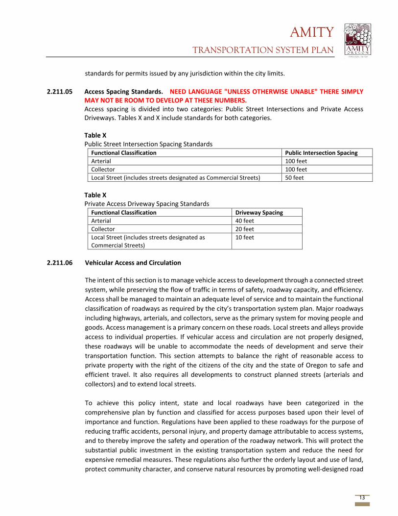
AMITY TRANSPORTATION SYSTEM PLAN
13
standards for permits issued by any jurisdiction within the city limits. 2.211.05 Access Spacing Standards. NEED LANGUAGE "UNLESS OTHERWISE UNABLE" THERE SIMPLY
MAY NOT BE ROOM TO DEVELOP AT THESE NUMBERS. Access spacing is divided into two categories: Public Street Intersections and Private Access Driveways. Tables X and X include standards for both categories. Table X Public Street Intersection Spacing Standards
Functional Classification Public Intersection Spacing Arterial 100 feet Collector 100 feet Local Street (includes streets designated as Commercial Streets) 50 feet
Table X Private Access Driveway Spacing Standards
Functional Classification Driveway Spacing Arterial 40 feet Collector 20 feet Local Street (includes streets designated as Commercial Streets)
10 feet
2.211.06 Vehicular Access and Circulation
The intent of this section is to manage vehicle access to development through a connected street system, while preserving the flow of traffic in terms of safety, roadway capacity, and efficiency. Access shall be managed to maintain an adequate level of service and to maintain the functional classification of roadways as required by the city’s transportation system plan. Major roadways including highways, arterials, and collectors, serve as the primary system for moving people and goods. Access management is a primary concern on these roads. Local streets and alleys provide access to individual properties. If vehicular access and circulation are not properly designed, these roadways will be unable to accommodate the needs of development and serve their transportation function. This section attempts to balance the right of reasonable access to private property with the right of the citizens of the city and the state of Oregon to safe and efficient travel. It also requires all developments to construct planned streets (arterials and collectors) and to extend local streets. To achieve this policy intent, state and local roadways have been categorized in the comprehensive plan by function and classified for access purposes based upon their level of importance and function. Regulations have been applied to these roadways for the purpose of reducing traffic accidents, personal injury, and property damage attributable to access systems, and to thereby improve the safety and operation of the roadway network. This will protect the substantial public investment in the existing transportation system and reduce the need for expensive remedial measures. These regulations also further the orderly layout and use of land, protect community character, and conserve natural resources by promoting well-designed road
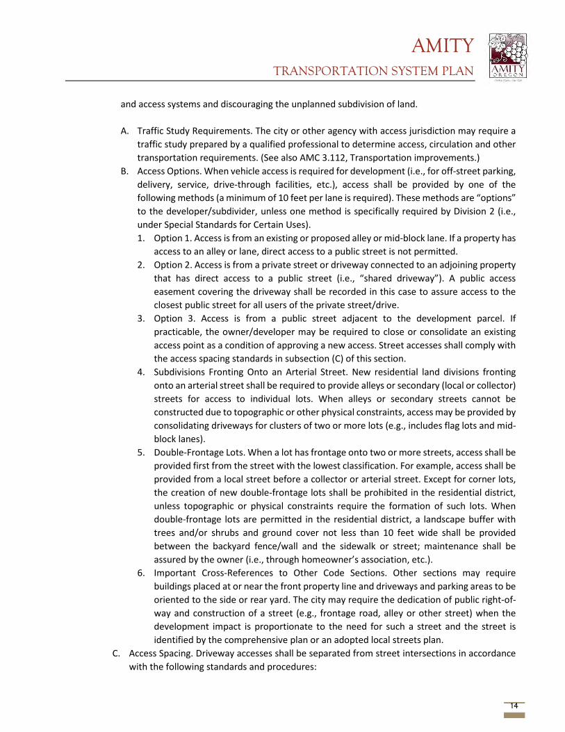
AMITY TRANSPORTATION SYSTEM PLAN
14
and access systems and discouraging the unplanned subdivision of land. A. Traffic Study Requirements. The city or other agency with access jurisdiction may require a
traffic study prepared by a qualified professional to determine access, circulation and other transportation requirements. (See also AMC 3.112, Transportation improvements.)
B. Access Options. When vehicle access is required for development (i.e., for off-street parking, delivery, service, drive-through facilities, etc.), access shall be provided by one of the following methods (a minimum of 10 feet per lane is required). These methods are “options” to the developer/subdivider, unless one method is specifically required by Division 2 (i.e., under Special Standards for Certain Uses). 1. Option 1. Access is from an existing or proposed alley or mid-block lane. If a property has
access to an alley or lane, direct access to a public street is not permitted. 2. Option 2. Access is from a private street or driveway connected to an adjoining property
that has direct access to a public street (i.e., “shared driveway”). A public access easement covering the driveway shall be recorded in this case to assure access to the closest public street for all users of the private street/drive.
3. Option 3. Access is from a public street adjacent to the development parcel. If practicable, the owner/developer may be required to close or consolidate an existing access point as a condition of approving a new access. Street accesses shall comply with the access spacing standards in subsection (C) of this section.
4. Subdivisions Fronting Onto an Arterial Street. New residential land divisions fronting onto an arterial street shall be required to provide alleys or secondary (local or collector) streets for access to individual lots. When alleys or secondary streets cannot be constructed due to topographic or other physical constraints, access may be provided by consolidating driveways for clusters of two or more lots (e.g., includes flag lots and mid-block lanes).
5. Double-Frontage Lots. When a lot has frontage onto two or more streets, access shall be provided first from the street with the lowest classification. For example, access shall be provided from a local street before a collector or arterial street. Except for corner lots, the creation of new double-frontage lots shall be prohibited in the residential district, unless topographic or physical constraints require the formation of such lots. When double-frontage lots are permitted in the residential district, a landscape buffer with trees and/or shrubs and ground cover not less than 10 feet wide shall be provided between the backyard fence/wall and the sidewalk or street; maintenance shall be assured by the owner (i.e., through homeowner’s association, etc.).
6. Important Cross-References to Other Code Sections. Other sections may require buildings placed at or near the front property line and driveways and parking areas to be oriented to the side or rear yard. The city may require the dedication of public right-of-way and construction of a street (e.g., frontage road, alley or other street) when the development impact is proportionate to the need for such a street and the street is identified by the comprehensive plan or an adopted local streets plan.
C. Access Spacing. Driveway accesses shall be separated from street intersections in accordance with the following standards and procedures:

AMITY TRANSPORTATION SYSTEM PLAN
15
1. Local Streets. A minimum of 35 feet separation as measured from the sides of the driveway to a parallel street right-of-way shall be required, except as provided in subsection (C)(3) of this section.
2. Arterial and Collector Streets. Access spacing on collector and arterial streets and at controlled intersections (i.e., with four-way stop sign or traffic signal) shall be determined based on the policies and standards contained in the city’s transportation system plan or Manual for Uniform Traffic Control Devices.
3. Special Provisions for All Streets. Direct street access may be restricted for some land uses, in conformance with the provisions of Division 2, Land Use Districts. For example, access consolidation, shared access, and/or access separation greater than that specified by subsections (C)(1) and (C)(2) of this section, may be required by the city, county or ODOT for the purpose of protecting the function, safety and operation of the street for all users. (See subsection (E) of this section.) Where no other alternatives exist, the permitting agency may allow construction of an access connection along the property line farthest from an intersection. In such cases, directional connections (i.e., right in/out, right in only, or right out only) may be required.
D. Number of Access Points. For single-family dwellings, one street access point is permitted per lot, when alley access cannot otherwise be provided. Two access points may be permitted for duplex or multifamily housing (i.e., no more than one access per street), subject to the access spacing standards in subsection (C) of this section. The number of street access points for multiple family, commercial, industrial, and public/institutional developments shall be minimized to protect the function, safety and operation of the street(s) and sidewalk(s) for all users. Shared access may be required, in conformance with subsection (E) of this section, in order to maintain the required access spacing and minimize the number of access points.
E. Shared Driveways. The number of driveway and private street intersections with public streets shall be minimized by the use of shared driveways with adjoining lots where feasible. The city shall require shared driveways as a condition of land division or site design review, as applicable, for traffic safety and access management purposes in accordance with the following standards: 1. Shared driveways and frontage streets may be required to consolidate access onto a
collector or arterial street. When shared driveways or frontage streets are required, they shall be stubbed to adjacent developable parcels to indicate future extension. “Stub” means that a driveway or street temporarily ends at the property line, but may be extended in the future as the adjacent parcel develops. “Developable” means that a parcel is either vacant or it is likely to receive additional development (i.e., due to infill or redevelopment potential).
2. Access easements (i.e., for the benefit of affected properties) shall be recorded for all shared driveways, including pathways, at the time of final plat approval (Chapter X.XXX AMC) or as a condition of site development approval (Chapter X.XXX AMC).
3. Exception. Shared driveways are not required when existing development patterns or physical constraints (e.g., topography, parcel configuration, and similar conditions) prevent extending the street/driveway in the future.
F. Street Connectivity and Formation of Blocks Required. In order to promote efficient vehicular
AMITY TRANSPORTATION SYSTEM PLAN
16
and pedestrian circulation throughout the city, land divisions and large site developments shall produce complete blocks bounded by a connecting network of public and/or private streets, bicycle or pedestrian pathways, in accordance with the following standards: 1. Block Length and Perimeter. The maximum block length and perimeter shall not exceed:
a. Six hundred feet length and 1,600 feet perimeter in the residential districts; b. Four hundred feet length and 1,200 feet perimeter in the commercial districts, except
as provided by AMC X.XXX, Block layout and building orientation; c. Not applicable to the industrial districts.
2. Street Standards. Public and private streets shall also conform to APWDS, Transportation improvements, AMC 2.211.06, Pedestrian access and circulation, and applicable Americans with Disabilities Act (ADA) design standards.
3. Exception. Exceptions to the above standards may be granted when blocks are divided by one or more pathway(s), in conformance with the provisions of AMC 2.211.06(D). Pathways shall be located to minimize out-of-direction travel by pedestrians and may be designed to accommodate bicycles.
G. Driveway Openings. Driveway openings or curb cuts shall be the minimum width necessary to provide the required number of vehicle travel lanes (10 feet for each travel lane). The following standards (i.e., as measured where the front property line meets the sidewalk or right-of-way) are required to provide adequate site access, minimize surface water runoff, and avoid conflicts between vehicles and pedestrians: 1. Single-family and duplex dwellings uses shall have a minimum driveway width of 10 feet
and a maximum width of 24 feet. 2. Multiple-family uses with between three and seven dwelling units shall have a minimum
driveway width of 20 feet and a maximum width of 24 feet. 3. Multiple-family uses with more than seven dwelling units, and off-street parking areas
with 16 or more parking spaces, shall have a minimum driveway width of 24 feet and a maximum width of 30 feet. These dimensions may be increased if the city determines that more than two lanes are required based on the number of trips generated or the need for turning lanes.
4. Access widths for all other uses shall be based on 10 feet of width for every travel lane, except that driveways providing direct access to parking spaces shall conform to the parking area standards in Chapter 2.203 AMC.
5. Driveway Aprons. Driveway aprons (when required) shall be constructed of concrete and shall be installed between the street right-of-way and the private drive. Driveway aprons shall conform to ADA standards for sidewalks and pathways, which require a continuous route of travel in compliance with the APWDS.
H. Fire Access and Parking Area Turnarounds. A fire equipment access drive that conforms to the local requirements shall be provided for any portion of an exterior wall of the first story of a building that is located more than 150 feet from an existing public street or approved fire equipment access drive. Parking areas shall provide adequate aisles or turnaround areas for service and delivery vehicles so that all vehicles may enter the street in a forward manner. For requirements related to cul-de-sacs, please refer to APWDS.
I. Vertical Clearances. Driveways, private streets, aisles, turnaround areas and ramps shall have
AMITY TRANSPORTATION SYSTEM PLAN
17
a minimum vertical clearance of 13 feet, six inches for their entire length and width. J. Vision Clearance. No signs, structures or vegetation in excess of three feet in height shall be
placed in “vision clearance areas.” The minimum vision clearance area may be increased by the city engineer upon finding that more sight distance is required (i.e., due to traffic speeds, roadway alignment, etc.).
K. Construction. The following development and maintenance standards shall apply to all driveways and private streets: 1. Driveways, parking areas, aisles, and turnarounds may be paved with asphalt, concrete or
comparable surfacing, or a durable nonpaving material may be used to reduce surface water runoff and protect water quality. Nonpaving surfaces shall be subject to review and approval by the city engineer.
2. When a paved surface is used, all driveways, excluding single-family and duplex residential, parking areas, aisles and turnarounds shall have on-site collection or infiltration of surface waters to eliminate sheet flow of such waters onto public rights-of-way and abutting property. Surface water facilities shall be constructed in conformance with city standards.
3. When driveway approaches or aprons are required to connect driveways within the public right-of-way, they shall be paved. (See also subsection (G) of this section.)
2.211.07 Pedestrian Access and Circulation
The intent of this section is to ensure safe, direct and convenient pedestrian circulation, all developments, except single-family detached housing (i.e., on individual lots with direct access to public streets), shall provide a continuous pedestrian and/or multi-use pathway system. (Pathways only provide for pedestrian circulation. Multi-use pathways accommodate pedestrians and bicycles.) The system of pathways shall be designed based on the standards in subsections (A)(1) through (A)(4) of this section: A. Continuous Pathways. The pathway system shall extend throughout the development site
and connect to all future phases of development, adjacent trails, public parks and open space areas whenever possible. The developer may also be required to connect or stub pathway(s) to adjacent streets and private property, in accordance with the provisions within this Code.
B. Safe, Direct, and Convenient Pathways. Pathways within developments shall provide safe, reasonably direct and convenient connections between primary building entrances and all adjacent streets, based on the following definitions: 1. Reasonably Direct. A route that does not deviate unnecessarily from a straight line or a
route that does not involve a significant amount of out-of-direction travel for likely users.
2. Safe and Convenient. Bicycle and pedestrian routes that are reasonably free from hazards and provide a reasonably direct route of travel between destinations.
3. For commercial, industrial, mixed-use, public, and institutional buildings, the “primary entrance” is the main public entrance to the building. In the case where no public entrance exists, street connections shall be provided to the main employee entrance.
4. For residential buildings the “primary entrance” is the front door (i.e., facing the street). For multifamily buildings in which each unit does not have its own exterior entrance, the
AMITY TRANSPORTATION SYSTEM PLAN
18
“primary entrance” may be a lobby, courtyard or breezeway which serves as a common entrance for more than one dwelling.
C. Connections within Development. For all developments subject to site design review, pathways shall connect all building entrances to one another. In addition, pathways shall connect all parking areas, storage areas, recreational facilities and common areas, and adjacent developments to the site, as applicable.
D. Street Connectivity. Pathways (for pedestrians and bicycles) shall be provided at or near mid-block where the block length exceeds the length required by this Code. Pathways shall also be provided where cul-de-sacs or dead-end streets are planned to connect the ends of the streets together, to other streets, and/or to other developments, as applicable. Pathways used to comply with these standards shall conform to all of the following criteria: 1. Multi-use pathways (i.e., for pedestrians and bicyclists) are no less than 10 feet wide
and located within a public right-of-way or easement that allows access for emergency vehicles;
2. If the streets within the subdivision or neighborhood are lighted, the pathways shall also be lighted;
3. Stairs or switchback paths using a narrower right-of-way/easement may be required in lieu of a multi-use pathway where grades are steep;
4. The city may require landscaping within the pathway easement/right-of-way for screening and the privacy of adjoining properties; and
5. The hearings body or planning official may determine, based upon facts in the record, that a pathway is unnecessary given the proximity of other pathways or access route. The pathway may prove impracticable due to: physical or topographic conditions on adjacent properties that physically prevent a connection now or in the future, considering the potential for redevelopment; recorded leases, easements, covenants, restrictions, or other agreements recorded as of the effective date of this title prohibit the pathway connection.
E. Design and Construction. Pathways shall conform to all of the standards in subsections (E)(1) through (E)(5) of this section: 1. Vehicle/Pathway Separation. Where pathways are parallel and adjacent to a driveway or
street (public or private), they shall be raised six inches and curbed, or separated from the driveway/street by a five-foot minimum strip with bollards, a landscape berm, or other physical barrier. If a raised path is used, the ends of the raised portions must be equipped with curb ramps.
2. Housing/Pathway Separation. Pedestrian pathways shall be separated a minimum of five feet from all residential living areas on the ground floor, except at building entrances. Separation is measured from the pathway edge to the closest dwelling unit. The separation area shall be landscaped in conformance with the provisions of this Code. No pathway/building separation is required for commercial, industrial, public, or institutional uses.
3. Crosswalks. Where pathways cross a parking area, driveway, or street (“crosswalk”), they shall be clearly marked with contrasting paving materials, humps/raised crossings, or painted striping. An example of contrasting paving material is the use of a concrete crosswalk through an asphalt driveway. If painted striping is used, it shall consist of thermoplastic striping or similar type of durable application. 4. Pathway Surface.
AMITY TRANSPORTATION SYSTEM PLAN
19
4. Pathway surfaces shall be concrete, asphalt, brick/masonry pavers, or other durable surface, at least six feet wide, and shall conform to ADA requirements. Multi-use paths (i.e., for bicycles and pedestrians) shall be the same materials, at least 10 feet wide.
5. Accessible Routes. Pathways shall comply with the Americans with Disabilities Act, which requires accessible routes of travel.
6. Bicycle Parking shall be provided and constructed in accordance with Section 2.203.
AMITY TRANSPORTATION SYSTEM PLAN
20
Attachment A2 - Traffic Studies Suggested addition to the City of Amity code regarding Traffic Studies.
3.112 TRAFFIC STUDIES 3.112.01 Purpose
The purpose of this section is to assist in determining which road authorities participate in land use decisions, and to implement the State’s Transportation Planning Rule that requires the City to adopt a process to apply conditions to development proposals in order to minimize impacts and protect transportation facilities. This section establishes the standards for when a proposal must be reviewed for potential traffic impacts; when a Traffic Impact Study must be submitted with a development application in order to determine whether conditions are needed to minimize impacts to and protect transportation facilities; what must be in a Traffic Impact Study and who is qualified to prepare the study.
3.112.02 Traffic Impact Study Required
The City or other road authority with jurisdiction may require a Traffic impact Study (TIS) as part of the application for development, a change in use, or a change in access. A TIS may be required when a land use application involves one or more of the following actions:
1. A change in zoning or a plan amendment designation. 2. Any proposed development or land use action that a road authority states may have
operational or safety concerns along its facility(ies). 3. An increase in site traffic volume generation by 300 Average Daily Trips (ADT) or more. 4. An increase in peak hour volume of a particular movement to and from the State Highway
by twenty (20) percent or more. 5. An increase in use of adjacent streets by vehicles exceeding the 20,000 pound gross vehicle
weights by 10 vehicles or more per day. 6. The location of the access driveway does not meet minimum sight distance requirements,
or is located where vehicles entering or leaving the property are restricted, or such vehicles queue or hesitate on the State Highway creating a safety hazard.
7. A change in internal traffic patterns that may cause safety problems, such as back up onto a street or greater potential for traffic accidents.
3.112.03 Traffic Impact Study Preparation
A Traffic Impact Study shall be prepared by an Oregon licensed professional engineer in accordance with the requirements of the road authority. If the road authority requiring the study is the Oregon Department of Transportation (ODOT), the study shall conform to ODOT’s regulations.
AMITY TRANSPORTATION SYSTEM PLAN
21
3.112.04 Transportation Related Development and Traffic Impacts
All transportation related development (including off-street parking and loading) must take into account the impacts of such development upon the transportation system, including the street grid, access, access management, circulation, and transportation improvements. Accordingly, a variety of land use actions (such as subdivisions, partitions, planned developments, conditional uses etc.) may require studies and mitigation of traffic impacts. The City Engineer may determine additional requirements for such studies and mitigation measures. The following provisions and definitions will guide such studies: A. Traffic Impact Analysis (TIA): A traffic impact analysis may involve, at a minimum, any or all
of the following depending on the nature of a development and its relationship to the transportation system. 1. An analysis of the effect of traffic generated by a development on the capacity,
operations, and safety of the public street and/or highway system. 2. An analytical and informational document prepared by a licensed professional traffic
engineer or civil engineer in connection with a specific proposed land use application that forcasts, describes, and suggests mitigation measures or ways of off-setting the traffic effects of the propose new activities within a geographic area
3. Astudy or analysis of how any use, plan or development will affect traffic ina surrounding area.
4. A study that assesses the impacts of a proposed development on the existing and future multi-modal transportation network, and includes recommended mitigation measures for the anticipated impacts, and an analysis of the adequacy of the developments planned access points.
B. Traffic Impact Mitigation Measure: Any measure or improvement taken by or required of the developer in order to lessen, abate, or reduce the traffic impact of the development on the public street and/or highway system.
C. Traffic Impact Study: An analysis of the effects of a proposed development on the transportation system, and of traffic impacts on neighboring properties.
D. Traffic Impact: A proposed developments effects on the transportation system, as represented by increased vehicle trips on the public street system, an increase in congestion, worsening of the level of service, or reductions in safety and efficiency.
E. Traffic Model: A mathematical representation of traffic movement within an area or region based on observed relationships between the kind and intensity of development in specific areas.
F. Traffic Study: A limited analysis of the operational aspects and traffic safety issues of a particular development area, including but not limited to on-site traffic circulation and access design and operation.
3.112.05 Traffic Counts
Unless otherwise specified by the City Engineer, the number used for traffic counts for all traffic studies and analyses shall be based on the number of persons determined by the Fire Marshal as maximum occupancy for the facilty(ies) in question.
AMITY TRANSPORTATION SYSTEM PLAN
22
Attachment B1 –City of Amity Comprehensive Plan Amendments made as part of the adoption of the City’s 2014 TSP Bold and underlined text indicates proposed additional or revised text. Text with strikethrough indicates text proposed for deletion
TRANSPORTATION Amity suffers from traffic problems typical of communities which have major highways passing through the core commercial areas. These problems include speeding, on-street parking and pedestrian hazards. Through agency coordination and local improvement programs, the City’s goal is to improve present traffic conditions. Providing varying modes of transportation are also important in meeting the total needs of the community. Diversified transportation will provide greater convenience and lower costs to citizens. FINDINGS The condition of Amity's streets is generally adequate for the existing traffic load, although most streets are in need of paving. Improvements in the street conditions will be necessary to accommodate substantial increases in traffic. The City of Amity, the State Highway Division and Yamhill County are responsible for the maintenance of streets in the planning area, curbs and sidewalks exist on very few of the City's streets. There are no plans for road improvements on State roads within the planning area for at least the next 6 years. Traffic volumes have increased by between 5 and 29 percent on monitored roads over the 5 year period from 1972 to 1977. The most serious traffic hazards exist along Highway 99W (Trade Street) and the Bellevue-Hopewell Highway (Fifth and Nursery Streets), primarily due to traffic volumes and on-street parking. The Southern Union Pacific Railroad owns the rail facilities in Amity, Portland & Western maintains and operates rail freight service in Amity on tracks running through the western portion of the City.; the nearest available air service is in the City of McMinnville. For regularly scheduled commercial flights citizens generally travel to the Portland General International Airport. Yamco Transit and Greyhound Lines Yamhill County Transit provide the City of Amity with a level of public transportation. Walking and biking are attractive transportation modes despite the lack of adequate facilities.
AMITY TRANSPORTATION SYSTEM PLAN
23
Side streets serve as the primary routes for pedestrians and bicyclists. A portion of the County's share of State gas monies is available to the City for the construction and maintenance of bicycle paths. GOAL STATEMENT To provide a safe, convenient, aesthetic, and economic transportation system through a variety of transportation means. POLICIES The City shall coordinate with Yamhill County and the Oregon Department of Transportation with regard to City actions and needs which may affect traffic on County and State roads within the Urban Growth Boundary. Transportation improvements shall be used to guide urban development and be designed to serve anticipated future needs. Transportation facility design shall be done in a manner consistent with city design standard and the Transportation System Plan (TSP), and which will minimize adverse effects on the existing land uses and natural features. Alternative modes of transportation that will be energy conserving and will provide maximum efficiency and utilization of existing facilities shall be promoted. The city shall adopt a street functional classification system consisting of Aarterials, collectors, and minor local streets within the planning area shall be designated to assist in prioritizing street development and maintenance. All possible sources of funding for street improvements shall be investigated and the City shall upgrade City streets make transportation improvements as funds become available. Transportation improvements which address t The special needs of the low-income, disabled the handicapped and senior citizens shall be promoted considered when making improvements to the transportation system. The City shall coordinate with the Union Pacific Railroad and Portland & Western Railroad Southern Pacific Railroad for any future need to expand rail service in Amity as well as to ensure maximum safety at all street and railway intersections. The City shall continue to support and encourage use of the existing public transit system and to encourage its continuance and coordinate with Yamhill County Transit Area (YCTA) on service changes or bus route modifications.
AMITY TRANSPORTATION SYSTEM PLAN
24
The city shall coordinate with Yamhill County in the development of a countywide bicycle plan. The City shall investigate funding sources for projects which would promote bicycle and pedestrian transportation in the Urban Growth Boundary. Hazardous traffic conditions shall be examined in detail and recommendations for improvements shall be made through a systematic capital improvement plan. The City shall promote a multi-modal transportation system that adequately considers the needs of drivers, pedestrians, cyclists, and public transit riders. The City shall take advantage of opportunities to improve the public transit system as they arise. The City shall coordinate with the Oregon Department of Transportation on improvements to state highways within the City to ensure the needs of freight are adequately considered. The City shall strive to create a transportation system that is safe for all users. Addressing existing or newly discovered safety issues is a top priority for the City. New public streets shall be located based on the proposed alignments in the Transportation System Plan. New public streets shall be designed according to relevant municipal code and adopted street standards. When upgrading or reconstructing existing City streets, the relevant planned project, if any, in the Transportation System Plan or Capital Improvement Program shall be considered in the design of the project.
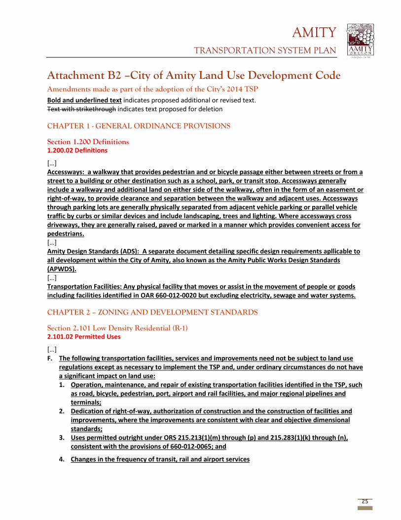
AMITY TRANSPORTATION SYSTEM PLAN
25
Attachment B2 –City of Amity Land Use Development Code Amendments made as part of the adoption of the City’s 2014 TSP Bold and underlined text indicates proposed additional or revised text. Text with strikethrough indicates text proposed for deletion CHAPTER 1 - GENERAL ORDINANCE PROVISIONS Section 1.200 Definitions 1.200.02 Definitions
[…] Accessways: a walkway that provides pedestrian and or bicycle passage either between streets or from a street to a building or other destination such as a school, park, or transit stop. Accessways generally include a walkway and additional land on either side of the walkway, often in the form of an easement or right-of-way, to provide clearance and separation between the walkway and adjacent uses. Accessways through parking lots are generally physically separated from adjacent vehicle parking or parallel vehicle traffic by curbs or similar devices and include landscaping, trees and lighting. Where accessways cross driveways, they are generally raised, paved or marked in a manner which provides convenient access for pedestrians. […] Amity Design Standards (ADS): A separate document detailing specific design requirements apllicable to all development within the City of Amity, also known as the Amity Public Works Design Standards (APWDS). […] Transportation Facilities: Any physical facility that moves or assist in the movement of people or goods including facilities identified in OAR 660-012-0020 but excluding electricity, sewage and water systems. CHAPTER 2 – ZONING AND DEVELOPMENT STANDARDS Section 2.101 Low Density Residential (R-1) 2.101.02 Permitted Uses
[…] F. The following transportation facilities, services and improvements need not be subject to land use
regulations except as necessary to implement the TSP and, under ordinary circumstances do not have a significant impact on land use: 1. Operation, maintenance, and repair of existing transportation facilities identified in the TSP, such
as road, bicycle, pedestrian, port, airport and rail facilities, and major regional pipelines and terminals;
2. Dedication of right-of-way, authorization of construction and the construction of facilities and improvements, where the improvements are consistent with clear and objective dimensional standards;
3. Uses permitted outright under ORS 215.213(1)(m) through (p) and 215.283(1)(k) through (n), consistent with the provisions of 660-012-0065; and
4. Changes in the frequency of transit, rail and airport services
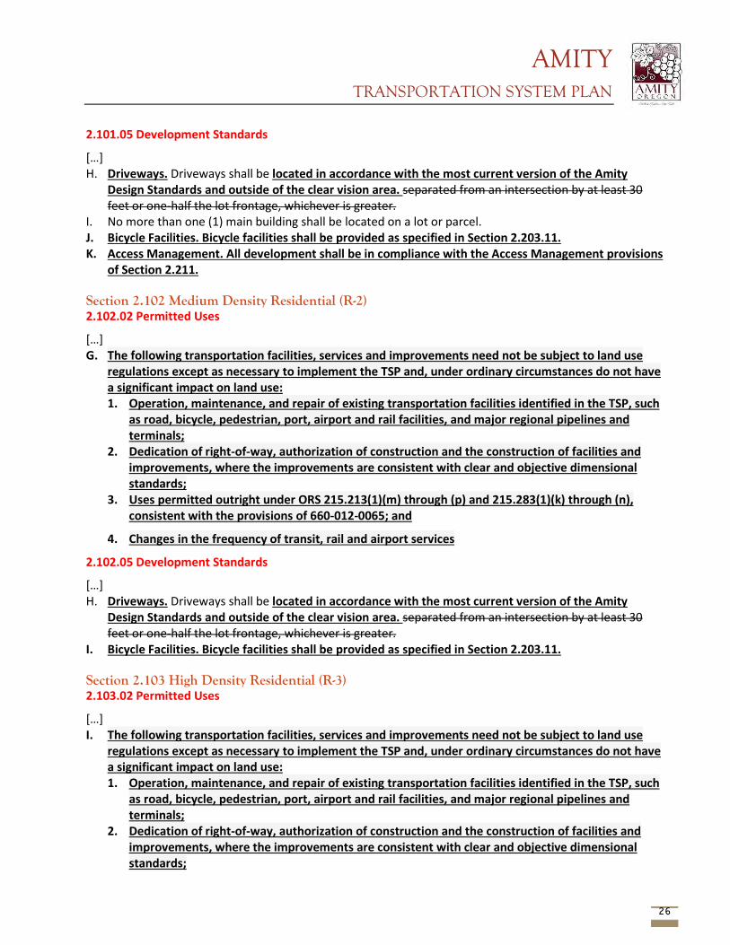
AMITY TRANSPORTATION SYSTEM PLAN
26
2.101.05 Development Standards
[…] H. Driveways. Driveways shall be located in accordance with the most current version of the Amity
Design Standards and outside of the clear vision area. separated from an intersection by at least 30 feet or one-half the lot frontage, whichever is greater.
I. No more than one (1) main building shall be located on a lot or parcel. J. Bicycle Facilities. Bicycle facilities shall be provided as specified in Section 2.203.11. K. Access Management. All development shall be in compliance with the Access Management provisions
of Section 2.211. Section 2.102 Medium Density Residential (R-2) 2.102.02 Permitted Uses
[…] G. The following transportation facilities, services and improvements need not be subject to land use
regulations except as necessary to implement the TSP and, under ordinary circumstances do not have a significant impact on land use: 1. Operation, maintenance, and repair of existing transportation facilities identified in the TSP, such
as road, bicycle, pedestrian, port, airport and rail facilities, and major regional pipelines and terminals;
2. Dedication of right-of-way, authorization of construction and the construction of facilities and improvements, where the improvements are consistent with clear and objective dimensional standards;
3. Uses permitted outright under ORS 215.213(1)(m) through (p) and 215.283(1)(k) through (n), consistent with the provisions of 660-012-0065; and
4. Changes in the frequency of transit, rail and airport services
2.102.05 Development Standards
[…] H. Driveways. Driveways shall be located in accordance with the most current version of the Amity
Design Standards and outside of the clear vision area. separated from an intersection by at least 30 feet or one-half the lot frontage, whichever is greater.
I. Bicycle Facilities. Bicycle facilities shall be provided as specified in Section 2.203.11. Section 2.103 High Density Residential (R-3) 2.103.02 Permitted Uses
[…] I. The following transportation facilities, services and improvements need not be subject to land use
regulations except as necessary to implement the TSP and, under ordinary circumstances do not have a significant impact on land use: 1. Operation, maintenance, and repair of existing transportation facilities identified in the TSP, such
as road, bicycle, pedestrian, port, airport and rail facilities, and major regional pipelines and terminals;
2. Dedication of right-of-way, authorization of construction and the construction of facilities and improvements, where the improvements are consistent with clear and objective dimensional standards;
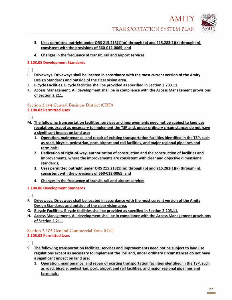
AMITY TRANSPORTATION SYSTEM PLAN
27
3. Uses permitted outright under ORS 215.213(1)(m) through (p) and 215.283(1)(k) through (n), consistent with the provisions of 660-012-0065; and
4. Changes in the frequency of transit, rail and airport services
2.103.05 Development Standards
[…] I. Driveways. Driveways shall be located in accordance with the most current version of the Amity
Design Standards and outside of the clear vision area. J. Bicycle Facilities. Bicycle facilities shall be provided as specified in Section 2.203.11. K. Access Management. All development shall be in compliance with the Access Management provisions
of Section 2.211. Section 2.104 Central Business District (CBD) 2.104.02 Permitted Uses
[…] M. The following transportation facilities, services and improvements need not be subject to land use
regulations except as necessary to implement the TSP and, under ordinary circumstances do not have a significant impact on land use: 1. Operation, maintenance, and repair of existing transportation facilities identified in the TSP, such
as road, bicycle, pedestrian, port, airport and rail facilities, and major regional pipelines and terminals;
2. Dedication of right-of-way, authorization of construction and the construction of facilities and improvements, where the improvements are consistent with clear and objective dimensional standards;
3. Uses permitted outright under ORS 215.213(1)(m) through (p) and 215.283(1)(k) through (n), consistent with the provisions of 660-012-0065; and
4. Changes in the frequency of transit, rail and airport services
2.104.06 Development Standards
[…] F. Driveways. Driveways shall be located in accordance with the most current version of the Amity
Design Standards and outside of the clear vision area. G. Bicycle Facilities. Bicycle facilities shall be provided as specified in Section 2.203.11. H. Access Management. All development shall be in compliance with the Access Management provisions
of Section 2.211. Section 2.105 General Commercial Zone (G-C) 2.105.02 Permitted Uses
[…] S. The following transportation facilities, services and improvements need not be subject to land use
regulations except as necessary to implement the TSP and, under ordinary circumstances do not have a significant impact on land use: 1. Operation, maintenance, and repair of existing transportation facilities identified in the TSP, such
as road, bicycle, pedestrian, port, airport and rail facilities, and major regional pipelines and terminals;
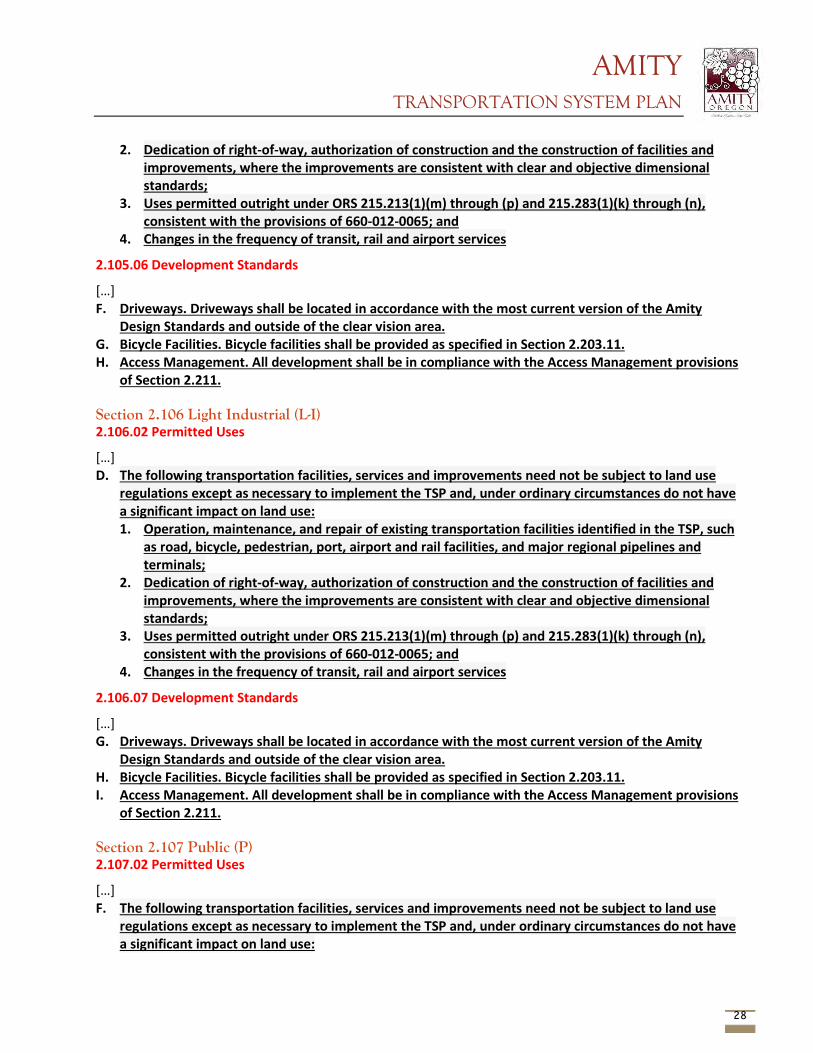
AMITY TRANSPORTATION SYSTEM PLAN
28
2. Dedication of right-of-way, authorization of construction and the construction of facilities and improvements, where the improvements are consistent with clear and objective dimensional standards;
3. Uses permitted outright under ORS 215.213(1)(m) through (p) and 215.283(1)(k) through (n), consistent with the provisions of 660-012-0065; and
4. Changes in the frequency of transit, rail and airport services
2.105.06 Development Standards
[…] F. Driveways. Driveways shall be located in accordance with the most current version of the Amity
Design Standards and outside of the clear vision area. G. Bicycle Facilities. Bicycle facilities shall be provided as specified in Section 2.203.11. H. Access Management. All development shall be in compliance with the Access Management provisions
of Section 2.211. Section 2.106 Light Industrial (L-I) 2.106.02 Permitted Uses
[…] D. The following transportation facilities, services and improvements need not be subject to land use
regulations except as necessary to implement the TSP and, under ordinary circumstances do not have a significant impact on land use: 1. Operation, maintenance, and repair of existing transportation facilities identified in the TSP, such
as road, bicycle, pedestrian, port, airport and rail facilities, and major regional pipelines and terminals;
2. Dedication of right-of-way, authorization of construction and the construction of facilities and improvements, where the improvements are consistent with clear and objective dimensional standards;
3. Uses permitted outright under ORS 215.213(1)(m) through (p) and 215.283(1)(k) through (n), consistent with the provisions of 660-012-0065; and
4. Changes in the frequency of transit, rail and airport services
2.106.07 Development Standards
[…] G. Driveways. Driveways shall be located in accordance with the most current version of the Amity
Design Standards and outside of the clear vision area. H. Bicycle Facilities. Bicycle facilities shall be provided as specified in Section 2.203.11. I. Access Management. All development shall be in compliance with the Access Management provisions
of Section 2.211. Section 2.107 Public (P) 2.107.02 Permitted Uses
[…] F. The following transportation facilities, services and improvements need not be subject to land use
regulations except as necessary to implement the TSP and, under ordinary circumstances do not have a significant impact on land use:
AMITY TRANSPORTATION SYSTEM PLAN
29
1. Operation, maintenance, and repair of existing transportation facilities identified in the TSP, such as road, bicycle, pedestrian, port, airport and rail facilities, and major regional pipelines and terminals;
2. Dedication of right-of-way, authorization of construction and the construction of facilities and improvements, where the improvements are consistent with clear and objective dimensional standards;
3. Uses permitted outright under ORS 215.213(1)(m) through (p) and 215.283(1)(k) through (n), consistent with the provisions of 660-012-0065; and
4. Changes in the frequency of transit, rail and airport services
2.107.06 Development Standards
[…] E. Driveways. Driveways shall be located in accordance with the most current version of the Amity
Design Standards and outside of the clear vision area. F. Bicycle Facilities. Bicycle facilities shall be provided as specified in Section 2.203.11. G. Access Management. All development shall be in compliance with the Access Management provisions
of Section 2.211. Section 2.108 Agricultural Holding Zone (A-H) 2.108.02 Permitted Uses
[…] D. The following transportation facilities, services and improvements need not be subject to land use
regulations except as necessary to implement the TSP and, under ordinary circumstances do not have a significant impact on land use: 1. Operation, maintenance, and repair of existing transportation facilities identified in the TSP, such
as road, bicycle, pedestrian, port, airport and rail facilities, and major regional pipelines and terminals;
2. Dedication of right-of-way, authorization of construction and the construction of facilities and improvements, where the improvements are consistent with clear and objective dimensional standards;
3. Uses permitted outright under ORS 215.213(1)(m) through (p) and 215.283(1)(k) through (n), consistent with the provisions of 660-012-0065; and
4. Changes in the frequency of transit, rail and airport services
Section 2.112 Downtown Development District (DD) 2.112.01 Purpose
The Downtown Design District (DD) is intended to provide development standards that emphasize the traditional downtown appearance of the City of Amity. While incorporating historical ornament and detail into new construction is encouraged, these standards relate to the requirements affecting, adjacent to and within the public right-of-ways. The purpose of these standards is to:
A. Further define the improvements required to fulfill the goals of the City Council.
B. Define activities that interfere with the utilization of the public right-of-ways for pedestrians.
AMITY TRANSPORTATION SYSTEM PLAN
30
C. Further define the development requirements as they relate to the public right-of-way, pedestrian, bicycle and parking requirements.
This Downtown Design District shall be applied to all zoning districts within the design district boundaries. The proposed standards comply with both the current ADAAG and the proposed public right-of-ways accessibility guideline (PROAG). 2.112.02 Applicability
The downtown design district shall apply to the area defined as the following: Trade Street from the north city limits to the south city limits; 5th Street from the west city limits to Trade Street; Nursery Avenue from Trade Street to the east city limits; The area west of Trade Street bounded by 1st Street, Stanley Street and 6th Street, all inclusive; And the area east of Trade Street bounded by 3rd Street (inclusive), Getchell Avenue and Church Avenue as detailed in the map with the Downtown Design Standards (DDS). The uses, procedures and standards contained the DD and DDS apply in addition to the development standards of the underlying zone. Where there is a conflict between the uses standards of this section and those of the base zone, the uses and standards of this section shall prevail. 2.112.03 Development
All development proposals, allowed as a permitted use or conditional use within any zone which is also within the DD zone, shall be reviewed for compliance with the requirements of the most current version of the City of Amity Downtown Development District and Downtown Development Standards. Approval or denial of the proposed development shall be consistent with the underlying zone and the Downtown Development District requirements. Section 2.200 General Development Standards 2.201.03 Application of Public Facility Standards
[…] C-2. Street Improvements for Single-Family Dwellings: New Single-family dwellings which require a street extension must provide full street improvements to city street standards. All Single-family dwellings shall provide sidewalk improvements. C-3. Street Improvements for Commercial or Industrial Expansion: lots fronting on County roads must obtain access permits from the Yamhill County Public Works Department. The City will require improvement to full city standards when the use meets any of the following criteria:
a. The expanded use generates an average of 100+ 20+ trips per day as documented in the Trip Generation Manual of the Institute of Transportation Engineers or other qualified source; or
b. The expanded use includes at least weekly shipping and delivery trips by vehicles over 20,000 pounds gross vehicle weight.
c. The subject use expands by at least 25%
2.201.04 Design Standards
The design of all improvement within existing and proposed rights-of-way and easements, all improvements to be maintained by the City, and all improvements for which City approval is required, shall comply with the requirements of the most recently adopted City of Amity, Public Works Design Standards.
AMITY TRANSPORTATION SYSTEM PLAN
31
Section 2.202 Street Standards 2.202.03 General Provisions
The following provisions shall apply to the dedication, construction, improvement, or other development of all public streets in the City, and are intended to provide a general overview of typical minimum design standards. All streets shall be designed in conformance with the specific requirements of the most recently adopted City of Amity, Public Works Design Standards. The standard sections contained in the City of Amity, Public Works Design Standards are minimum requirements only and shall not be construed as prohibiting the City Engineer from requiring thicker sections or allowing engineer designed pavement sections in lieu of standard sections where conditions warrant. […] E. Existing Streets
3. Improvements to existing streets shall be in compliance with the most current street standards for redevelopment of existing streets. The standard widths specified are minimum requirements and shall not be construed as prohibiting the City Engineer from requiring wider sections when warranted.
F. New Streets: Where new streets are created by a subdivision or partition, full street improvements shall be required. The widths specified within the most current street standards for new construction, by functional classification, shall be required. The standard widths specified are minimum requirements and shall not be construed as prohibiting the City Engineer from requiring wider sections when warranted.
G. Cul-de-sacs: Cul-de-sacs shall have maximum lengths of 400 500 feet and serve no more than 18 19 dwelling units. All cul-de-sacs shall terminate with circular turnarounds. Where required by the review authority, a pedestrian accessway shall connect the cul-de-sac to another street. The maximum length of a cul-de-sac may be extended to 750 feet and serve no more than 30 dwelling units when all of the following criteria are met:
1. The development contains or is adjacent to a marginal access street. 2. Unusual topographic conditions limit the ability of providing an additional access.
H. Street Names: Street names and numbers shall conform to the established pattern in the City and shall be subject to the approval of the City Council. Street names shall be required for all new publicly dedicated streets and all private streets regardless of ownership pattern.
I. Grades and Curves: Grades shall not exceed 6 percent on arterials, 10 percent on collectors, or 12 percent on any other public or private street. To provide for adequate drainage, all streets shall have a minimum slope of 0.5 0.25 percent in accordance with the Amity Design Standards. Centerline radii of curves shall not be less than 300 feet on major arterials, 200 feet on minor arterials, or 100 feet on other streets, and shall be to an even one (1) foot ten (10) feet. On arterials there shall be a tangent of not less than 100 feet between reversed curves. Where existing conditions, particularly topography, make it otherwise impractical to provide buildable lots, the Planning Commission may accept steeper grades and sharper curves.
J. Marginal Access Streets: If a development abuts or contains an existing or proposed arterial street or railroad right-of-way, the City may require marginal access streets, reverse frontage lots with suitable depth, screen planting contained in a non-access reservation along the rear or side property line, or such
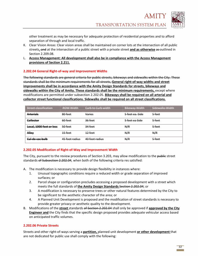
AMITY TRANSPORTATION SYSTEM PLAN
32
other treatment as may be necessary for adequate protection of residential properties and to afford separation of through and local traffic.
K. Clear Vision Areas: Clear vision areas shall be maintained on corner lots at the intersection of all public streets, and at the intersection of a public street with a private street and as otherwise as outlined in Section 2.209.08.
L. Access Management: All development shall also be in compliance with the Access Management provisions of Section 2.211.
2.202.04 General Right-of-way and Improvement Widths
The following standards are general criteria for public streets, bikeways and sidewalks within the City. These standards shall be the minimum requirements for all streets, General right-of-way widths and street improvements shall be in accordance with the Amity Design Standards for streets, bikeways and sidewalks within the City of Amity. These standards shall be the minimum requirements, except where modifications are permitted under subsection 2.202.05. Bikeways shall be required on all arterial and collector street functional classifications. Sidewalks shall be required on all street classifications.
Street classification ROW Width Curb to Curb width Bikeway Width Sidewalks Width
Arterials 80 feet Varies 5 feet ea. Side 5 feet
Collector 60 feet 36 feet 5 feet ea Side 5 feet
Local, 1000 feet or less 50 feet 34 feet N/R 5 feet
Alley 15 feet 12 feet N/R N/R
Cul-de-sac bulb 45 foot radius 40 foot radius N/R 5 feet
2.202.05 Modification of Right-of-Way and Improvement Width
The City, pursuant to the review procedures of Section 3.203, may allow modification to the public street standards of Subsection 2.202.04, when both of the following criteria res satisfied: A. The modification is necessary to provide design flexibility in instances where:
1. Unusual topographic conditions require a reduced width or grade separation of improved surfaces; or
2. Parcel shape or configuration precludes accessing a proposed development with a street which meets the full standards of the Amity Design Standards Section 2.202.04; or
3. A modification is necessary to preserve trees or other natural features determined by the City to be significant to the aesthetic character of the area; or
4. A Planned Unit Development is proposed and the modification of street standards is necessary to provide greater privacy or aesthetic quality to the development.
B. Modifications of the street standards of Section 2.202.04 shall only be approved if approved by the City Engineer and the City finds that the specific design proposed provides adequate vehicular access based on anticipated traffic volumes.
2.202.06 Private Streets
Streets and other right-of-ways serving a partition, planned unit development or other development that are not dedicated for public use shall comply with the following:
AMITY TRANSPORTATION SYSTEM PLAN
33
A. Private streets shall only be allowed where the applicable criteria of section 2.208.03(C) are satisfied. Private streets shall have a minimum easement width in accordance with the Amity Design Standards of 25 feet and minimum paved, curbed width of 20 feet.
B. Unless otherwise specified in the City of Amity, Public Works Design Standards, all private streets serving more than two dwelling units shall be constructed to the same pavement section specifications required for public streets. Provisions for the maintenance of the street shall be provide in the form of a maintenance agreement, homeowners association, or other instrument acceptable to the City Attorney.
C. A turn-around shall be required for any private street which has only one outlet and which is in excess of 200 150 feet long or which serves more than two residences. Turn-arounds for private streets shall be either a circular turn-around with a minimum paved radius of 35 feet, or a “tee” or “hammerhead”, turnaround with a minimum paved dimension across the “tee” of 70 feet and a 20 foot width with appropriate 28 foot radius at the corners.
D. Private streets shall also comply with all of Section 2.211 Access Management. E. Private streets shall be entirely contained within a separate tract or parcel.
Any grant of a private street or land functioning as an easement shall not be accepted by the City and dedicated for public use except upon approval of the City Council and upon meeting the specifications of Section 2.202.02 and through 2.202.04.
2.202.07 Access Easements
A private access easement created as the result of an approved partitioning shall conform to the following:
A. Partition access easements shall only be allowed where the applicable criteria of Section 2.208.03(C) are satisfied. The easements shall comply with the following standards:
1. Minimum width: 20 25 feet
2. Minimum paved or curb to curb width: 18 20 feet
3. Maximum length: 250 150 feet
4. No more than 3 2 dwelling units shall have sole access to the easement.
B. Unless otherwise specified in the City of Amity, Public Works Design Standards, all private streets serving more than two dwelling units shall be constructed to the same pavement section specifications required for public streets. Provision for the maintenance of the street Access Easement shall be provided in the form of a maintenance agreement, homeowners association, or other instrument acceptable to the City Attorney
C. A turn-around shall be required for any access easement which has only one outlet and which is in excess of 200 150 feet long or which serves more than two residences. Turn-arounds shall be either a circular turn-around with a minimum paved radius of 35 feet, or a “tee” or hammerhead” turn-around with a minimum paved dimension across the “tee” of 70 feet and a 20 foot width with appropriate 28 foot radius at the corners.
D. All private access easements serving more than two (2) residences shall be designed as a private street in accordance with Section 2.202.06 designated as fire lanes and signed for no parking.
AMITY TRANSPORTATION SYSTEM PLAN
34
Section 2.203 Off-Street Parking and Loading (Commercial, Industrial and Multi-Family Uses Only)
2.203.06 Residential Driveways
All residential driveways shall be paved concrete and shall be in accordance with Section 2.211. have a minimum ten (10) foot approach width at the curb line. The maximum single use residential driveway approach width shall be eighteen (18) feet.
2.203.08 Parking and Loading Area Requirements
[…] L. Access Management. All parking and loading facilities shall be in compliance with the Access
Management provisions of Section 2.211.
2.203.11 Bicycle Parking
[…] C. Access Management. All bicycle parking facilities shall be in compliance with the Access Management
provisions of Section 2.211. Section 2.208 Development Standards for Land Divisions 2.208.03 Standards for lots or Parcels
[…]
D. Flag lots: If a flag lot is permitted, they shall comply with the following standards: shall be
1. The access strip shall not be less than 20 feet wide. The access strip shall be improved with a minimum 12 foot wide paved driveway which meets applicable City standards. If said access strip is over 200 150 feet in length, the driveway shall terminate in a turn-around capable of accommodating emergency y fire vehicles.
2. […]
2.208.04 Standards for Blocks
[…]
B. Sizes: Blocks shall be in accordance with Section 2.211 1,000 feet in length between street lines, except blocks adjacent to marginal access arterial streets, or unless the previous adjacent development pattern or topographical conditions justify a variation. The recommended minimum distance between intersections on arterial streets is 1,800 feet. The maximum block length shall be 1,200 feet.
2.208.05 Improvement Requirements
[…]
B. Project Streets: All public or private streets within the land division shall be constructed as required by the provisions of Section 2.202 and 2.211. Private driveways serving flag lots or private streets shall be surfaced as per the requirements of this ordinanceof the Amity Design Standards.
AMITY TRANSPORTATION SYSTEM PLAN
35
[…]
H. Pedestrian Facilities and Bicycle Ways: Sidewalks shall be installed along both sides of each public street and in any pedestrian or bicycle accessways within the land division as well as along all frontages to existing streets. Sidewalks and bikeways shall conform to the requirements for Pedestrian Accees and Circulation within Section 2.211.07. Sidewalks and paths shall be extended as required to connect to other sidewalk systems. The City may defer on-site pedestrian and bicycle accessway sidewalk construction until the dwellings or structures fronting the sidewalk are constructed. Any required off-site sidewalks, sidewalks fronting public property, or sidewalks adjacent to existing structures shall not be differed.
I. Design Standards. Pedestrian/ bicycle access ways shall meet the following design standards: 1. Minimum dedicated width: 10 feet Shall meet the minimum requirements of Section 2.211.07 2. Minimum improved width: 5 feetShall meet the requirements within the Amity Design Standards. 3. Vision Clearance: A clear line of visions for the entire length of the accessway shall be required 4. Pedestrian scale lighting fixtures shall be provided along walkway and lighted to a level where the
system can be used at night 5. The accessway shall be designed to prohibit vehicle traffic, but accommodate maintenance vehicle
traffic as required.
2.209.08 Vision Clearance
[…]
The following measurements shall establish the clear vision areas:
Type of Intersection Measured Along Each Lot Line or Drive Edge* Controlled Intersection [stop sign or signal] 15 20 feet Uncontrolled Intersection 40 feet Commercial and Industrial District driveways 20 30 feet Residential District Driveways 10 feet Alley 15 feet *When there is an intersection of two or more streets or driveways of different types right-of-way width, the distance to be measured along the lot lines shall be the distance specified for each type of street or dirveway. 2.211 ACCESS MANAGEMENT 2.211.01 Purpose
The purpose of this chapter is to ensure that developments provide safe and efficient access and circulation for pedestrians and vehicles. The Code provides standards for vehicular, bicycle and pedestrian access and circulation. 2.211.02 Applicability
This chapter shall apply to all public streets within the city and to all properties that abut these streets.
AMITY TRANSPORTATION SYSTEM PLAN
36
2.211.03 Access permit required.
Access to a public street requires an Access Permit (a Type I permit) in accordance with the following procedures:
A. Permits for access to City streets shall be subject to review and approval by the City Engineer based on
the standards contained in this Chapter, the Amity Street Standards, the Transportation System Plan, and/or the Uniform Fire Code as applicable. An access permit may be in the form of a letter to the applicant, attached to a land use decision notice, or included as part of the development review/building permit approval.
B. Permits for access to State highways shall be subject to review and approval by the Oregon Department of Transportation (ODOT) and by the City. Except when ODOT has delegated this responsibility to the City, In that case, the City shall determine whether access is granted based on its adopted standards.
C. Permits for access to County roads shall be subject to review and approval by Yamhill County and the city, except where the County has delegated this responsibility to the City, in which case the City shall determine whether access is granted based on adopted City standards.
2.211.04 Conditions of approval.
The City or other agency with access permit jurisdiction may require the closing or consolidation of existing curb cuts or other vehicle access points, recording reciprocal access easements (i.e., for shared driveways), installation of traffic control devices or traffic safety devices, and/or other mitigation as a condition of granting an access permit, to ensure the safe and efficient operation of the street and highway system. Access to and from off-street parking areas shall not permit backing onto a public street, excepting for single-family or duplex residential uses. The City is authorized to require greater requirements for access in accordance with the adopted city standards for permits issued by any jurisdiction within the city limits. The proposed streets, roads, sidewalks, bicycle lanes, pathways, utilities, and surface water management facilities are laid out so as to conform or transition to the plats of subdivisions and maps of major partitions already approved for adjoining property as to width, general direction and in all other respects. All proposed public improvements and dedications are identified on the preliminary plat. On-site facilities shall be provided which accommodate safe and convenient pedestrian and bicycle accessways within new subdivisions, planned unit developments, mobile home parks, multi-family, commercial and industrial developments. 2.211.05 Access Spacing Standards.
A. Access spacing is divided into two categories: Street Intersections and Private Access Driveways. Tables 1 and 2 include minimum standards for both categories.
Table 1 Public and Private Street Intersection Spacing Standards
Functional Classification Public Intersection Spacing Arterial 100 feet Collector 100 feet Local Street (includes streets designated as Commercial Streets) 50 feet
Table 2
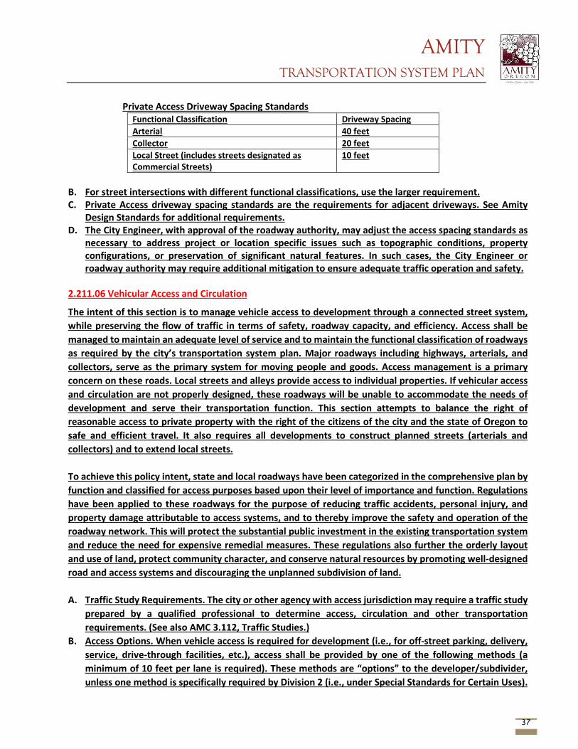
AMITY TRANSPORTATION SYSTEM PLAN
37
Private Access Driveway Spacing Standards Functional Classification Driveway Spacing Arterial 40 feet Collector 20 feet Local Street (includes streets designated as Commercial Streets)
10 feet
B. For street intersections with different functional classifications, use the larger requirement. C. Private Access driveway spacing standards are the requirements for adjacent driveways. See Amity
Design Standards for additional requirements. D. The City Engineer, with approval of the roadway authority, may adjust the access spacing standards as
necessary to address project or location specific issues such as topographic conditions, property configurations, or preservation of significant natural features. In such cases, the City Engineer or roadway authority may require additional mitigation to ensure adequate traffic operation and safety.
2.211.06 Vehicular Access and Circulation
The intent of this section is to manage vehicle access to development through a connected street system, while preserving the flow of traffic in terms of safety, roadway capacity, and efficiency. Access shall be managed to maintain an adequate level of service and to maintain the functional classification of roadways as required by the city’s transportation system plan. Major roadways including highways, arterials, and collectors, serve as the primary system for moving people and goods. Access management is a primary concern on these roads. Local streets and alleys provide access to individual properties. If vehicular access and circulation are not properly designed, these roadways will be unable to accommodate the needs of development and serve their transportation function. This section attempts to balance the right of reasonable access to private property with the right of the citizens of the city and the state of Oregon to safe and efficient travel. It also requires all developments to construct planned streets (arterials and collectors) and to extend local streets.
To achieve this policy intent, state and local roadways have been categorized in the comprehensive plan by function and classified for access purposes based upon their level of importance and function. Regulations have been applied to these roadways for the purpose of reducing traffic accidents, personal injury, and property damage attributable to access systems, and to thereby improve the safety and operation of the roadway network. This will protect the substantial public investment in the existing transportation system and reduce the need for expensive remedial measures. These regulations also further the orderly layout and use of land, protect community character, and conserve natural resources by promoting well-designed road and access systems and discouraging the unplanned subdivision of land.
A. Traffic Study Requirements. The city or other agency with access jurisdiction may require a traffic study
prepared by a qualified professional to determine access, circulation and other transportation requirements. (See also AMC 3.112, Traffic Studies.)
B. Access Options. When vehicle access is required for development (i.e., for off-street parking, delivery, service, drive-through facilities, etc.), access shall be provided by one of the following methods (a minimum of 10 feet per lane is required). These methods are “options” to the developer/subdivider, unless one method is specifically required by Division 2 (i.e., under Special Standards for Certain Uses).
AMITY TRANSPORTATION SYSTEM PLAN
38
1. Option 1. Access is from an existing or proposed alley or mid-block lane. If a property has access to an alley or lane, direct access to a public street is not permitted.
2. Option 2. Access is from a private street or driveway connected to an adjoining property that has direct access to a public street (i.e., “shared driveway”). A public access easement covering the driveway shall be recorded in this case to assure access to the closest public street for all users of the private street/drive.
3. Option 3. Access is from a public street adjacent to the development parcel. If practicable, the owner/developer may be required to close or consolidate an existing access point as a condition of approving a new access. Street accesses shall comply with the access spacing standards in subsection (C) of this section.
4. Subdivisions Fronting Onto an Arterial Street. New residential land divisions fronting onto an arterial street shall be required to provide alleys or secondary (local or collector) streets for access to individual lots. When alleys or secondary streets cannot be constructed due to topographic or other physical constraints, access may be provided by consolidating driveways for clusters of two or more lots (e.g., includes flag lots and mid-block lanes).
5. Double-Frontage Lots. When a lot has frontage onto two or more streets, access shall be provided first from the street with the lowest classification. For example, access shall be provided from a local street before a collector or arterial street. Except for corner lots, the creation of new double-frontage lots shall be prohibited in the residential district, unless topographic or physical constraints require the formation of such lots. When double-frontage lots are permitted in the residential district, a landscape buffer with trees and/or shrubs and ground cover not less than 10 feet wide shall be provided between the backyard fence/wall and the sidewalk or street; maintenance shall be assured by the owner (i.e., through homeowner’s association, etc.).
6. Important Cross-References to Other Code Sections. Other sections may require buildings placed at or near the front property line and driveways and parking areas to be oriented to the side or rear yard. The city may require the dedication of public right-of-way and construction of a street (e.g., frontage road, alley or other street) when the development impact is proportionate to the need for such a street and the street is identified by the comprehensive plan or an adopted local streets plan.
C. Access Spacing. Driveway accesses shall be separated from street intersections in accordance with the following standards and procedures: 1. Local Streets. A minimum of 35 feet separation as measured from the sides of the driveway to a
parallel street right-of-way shall be required, except as provided in subsection (C)(3) of this section. 2. Arterial and Collector Streets. Access spacing on collector and arterial streets and at controlled
intersections (i.e., with four-way stop sign or traffic signal) shall be determined based on the policies and standards contained in the city’s transportation system plan or Manual for Uniform Traffic Control Devices.
3. Special Provisions for All Streets. Direct street access may be restricted for some land uses, in conformance with the provisions of Division 2, Land Use Districts. For example, access consolidation, shared access, and/or access separation greater than that specified by subsections (C)(1) and (C)(2) of this section, may be required by the city, county or ODOT for the purpose of protecting the function, safety and operation of the street for all users. (See subsection (E) of this section.) Where no other alternatives exist, the permitting agency may allow construction of an access connection along the property line farthest from an intersection. In such cases, directional
AMITY TRANSPORTATION SYSTEM PLAN
39
connections (i.e., right in/out, right in only, or right out only) may be required. D. Number of Access Points. For single-family dwellings, one street access point is permitted per lot, when
alley access cannot otherwise be provided. Two access points may be permitted for duplex or multifamily housing (i.e., no more than one access per street), subject to the access spacing standards in subsection (C) of this section. The number of street access points for multiple family, commercial, industrial, and public/institutional developments shall be minimized to protect the function, safety and operation of the street(s) and sidewalk(s) for all users. Shared access may be required, in conformance with subsection (E) of this section, in order to maintain the required access spacing and minimize the number of access points.
E. Shared Driveways. The number of driveway and private street intersections with public streets shall be minimized by the use of shared driveways with adjoining lots where feasible. The city shall require shared driveways as a condition of land division or site design review, as applicable, for traffic safety and access management purposes in accordance with the following standards: 1. Shared driveways and frontage streets may be required to consolidate access onto a collector or
arterial street. When shared driveways or frontage streets are required, they shall be stubbed to adjacent developable parcels to indicate future extension. “Stub” means that a driveway or street temporarily ends at the property line, but may be extended in the future as the adjacent parcel develops. “Developable” means that a parcel is either vacant or it is likely to receive additional development (i.e., due to infill or redevelopment potential).
2. Access easements (i.e., for the benefit of affected properties) shall be recorded for all shared driveways, including pathways, at the time of final plat approval (Chapter 2.208 AMC) or as a condition of site development approval (Chapter 3.104 AMC).
3. Exception. Shared driveways are not required when existing development patterns or physical constraints (e.g., topography, parcel configuration, and similar conditions) prevent extending the street/driveway in the future.
F. Street Connectivity and Formation of Blocks Required. In order to promote efficient vehicular and pedestrian circulation throughout the city, land divisions and large site developments shall produce complete blocks bounded by a connecting network of public and/or private streets, bicycle or pedestrian pathways, in accordance with the following standards: 1. Block Length and Perimeter. The maximum block length and perimeter shall not exceed:
a. Six hundred feet length and 1,600 feet perimeter in the residential districts; b. Four hundred feet length and 1,200 feet perimeter in the commercial districts, except as
provided by AMC 2.208, Block layout and building orientation; c. Not applicable to the industrial districts.
2. Street Standards. Public and private streets shall also conform to ADS, Transportation improvements, AMC 2.211.06, Pedestrian access and circulation, and applicable Americans with Disabilities Act (ADA) design standards.
3. Exception. Exceptions to the above standards may be granted when blocks are divided by one or more pathway(s), in conformance with the provisions of AMC 2.211.06(D). Pathways shall be located to minimize out-of-direction travel by pedestrians and may be designed to accommodate bicycles.
G. Driveway Openings. Driveway openings or curb cuts shall be the minimum width necessary to provide the required number of vehicle travel lanes (10 feet for each travel lane). The following standards (i.e.,
AMITY TRANSPORTATION SYSTEM PLAN
40
as measured where the front property line meets the sidewalk or right-of-way) are required to provide adequate site access, minimize surface water runoff, and avoid conflicts between vehicles and pedestrians: 1. Single-family and duplex dwellings uses shall have a minimum driveway width of 10 feet and a
maximum width of 24 feet. 2. Multiple-family uses with between three and seven dwelling units shall have a minimum driveway
width of 20 feet and a maximum width of 24 feet. 3. Multiple-family uses with more than seven dwelling units, and off-street parking areas with 16 or
more parking spaces, shall have a minimum driveway width of 24 feet and a maximum width of 30 feet. These dimensions may be increased if the city determines that more than two lanes are required based on the number of trips generated or the need for turning lanes.
4. Access widths for all other uses shall be based on 10 feet of width for every travel lane, except that driveways providing direct access to parking spaces shall conform to the parking area standards in Chapter 2.203 AMC.
5. Driveway Aprons. Driveway aprons (when required) shall be constructed of concrete and shall be installed between the street right-of-way and the private drive. Driveway aprons shall conform to ADA standards for sidewalks and pathways, which require a continuous route of travel in compliance with the ADS.
H. Fire Access and Parking Area Turnarounds. A fire equipment access drive that conforms to the local requirements shall be provided for any portion of an exterior wall of the first story of a building that is located more than 150 feet from an existing public street or approved fire equipment access drive. Parking areas shall provide adequate aisles or turnaround areas for service and delivery vehicles so that all vehicles may enter the street in a forward manner. For requirements related to cul-de-sacs, please refer to ADS.
I. Vertical Clearances. Driveways, private streets, aisles, turnaround areas and ramps shall have a minimum vertical clearance of 13 feet, six inches for their entire length and width.
J. Vision Clearance. No signs, structures or vegetation in excess of three feet in height shall be placed in “vision clearance areas.” The minimum vision clearance area may be increased by the city engineer upon finding that more sight distance is required (i.e., due to traffic speeds, roadway alignment, etc.).
K. Construction. The following development and maintenance standards shall apply to all driveways and private streets: 1. Driveways, parking areas, aisles, and turnarounds may be paved with asphalt, concrete or
comparable surfacing, or a durable nonpaving material may be used to reduce surface water runoff and protect water quality. Nonpaving surfaces shall be subject to review and approval by the city engineer.
2. When a paved surface is used, all driveways, excluding single-family and duplex residential, parking areas, aisles and turnarounds shall have on-site collection or infiltration of surface waters to eliminate sheet flow of such waters onto public rights-of-way and abutting property. Surface water facilities shall be constructed in conformance with city standards.
3. When driveway approaches or aprons are required to connect driveways within the public right-of-way, they shall be paved. (See also subsection (G) of this section.)
2.211.07 Pedestrian Access and Circulation
AMITY TRANSPORTATION SYSTEM PLAN
41
The intent of this section is to ensure safe, direct and convenient pedestrian circulation, all developments, except single-family detached housing (i.e., on individual lots with direct access to public streets), shall provide a continuous pedestrian and/or multi-use pathway system. (Pathways only provide for pedestrian circulation. Multi-use pathways accommodate pedestrians and bicycles.) The system of pathways shall be designed based on the standards in subsections (A)(1) through (A)(4) of this section:
A. Continuous Pathways. The pathway system shall extend throughout the development site and
connect to all future phases of development, adjacent trails, public parks and open space areas whenever possible. The developer may also be required to connect or stub pathway(s) to adjacent streets and private property, in accordance with the provisions within this Code.
B. Safe, Direct, and Convenient Pathways. Pathways within developments shall provide safe, reasonably direct and convenient connections between primary building entrances and all adjacent streets, based on the following definitions: 1. Reasonably Direct. A route that does not deviate unnecessarily from a straight line or a route that
does not involve a significant amount of out-of-direction travel for likely users. 2. Safe and Convenient. Bicycle and pedestrian routes that are reasonably free from hazards and
provide a reasonably direct route of travel between destinations. 3. For commercial, industrial, mixed-use, public, and institutional buildings, the “primary entrance”
is the main public entrance to the building. In the case where no public entrance exists, street connections shall be provided to the main employee entrance.
4. For residential buildings the “primary entrance” is the front door (i.e., facing the street). For multifamily buildings in which each unit does not have its own exterior entrance, the “primary entrance” may be a lobby, courtyard or breezeway which serves as a common entrance for more than one dwelling.
C. Connections within Development. For all developments subject to site design review, pathways shall connect all building entrances to one another. In addition, pathways shall connect all parking areas, storage areas, recreational facilities and common areas, and adjacent developments to the site, as applicable.
D. Street Connectivity. Pathways (for pedestrians and bicycles) shall be provided at or near mid-block where the block length exceeds the length required by this Code. Pathways shall also be provided where cul-de-sacs or dead-end streets are planned to connect the ends of the streets together, to other streets, and/or to other developments, as applicable. Pathways used to comply with these standards shall conform to all of the following criteria: 1. Multi-use pathways (i.e., for pedestrians and bicyclists) are no less than 10 feet wide and located
within a public right-of-way or easement that allows access for emergency vehicles; 2. If the streets within the subdivision or neighborhood are lighted, the pathways shall also be
lighted; 3. Stairs or switchback paths using a narrower right-of-way/easement may be required in lieu of a
multi-use pathway where grades are steep; 4. The city may require landscaping within the pathway easement/right-of-way for screening and
the privacy of adjoining properties; and 5. The hearings body or planning official may determine, based upon facts in the record, that a
pathway is unnecessary given the proximity of other pathways or access route. The pathway may prove impracticable due to: physical or topographic conditions on adjacent properties that physically prevent a connection now or in the future, considering the potential for redevelopment; recorded leases, easements, covenants, restrictions, or other agreements recorded as of the effective date of this title prohibit the pathway connection.
AMITY TRANSPORTATION SYSTEM PLAN
42
E. Design and Construction. Pathways shall conform to all of the standards in subsections (E)(1) through (E)(6) of this section: 1. Vehicle/Pathway Separation. Where pathways are parallel and adjacent to a driveway or street
(public or private), they shall be raised six inches and curbed, or separated from the driveway/street by a five-foot minimum strip with bollards, a landscape berm, or other physical barrier. If a raised path is used, the ends of the raised portions must be equipped with curb ramps.
2. Housing/Pathway Separation. Pedestrian pathways shall be separated a minimum of five feet from all residential living areas on the ground floor, except at building entrances. Separation is measured from the pathway edge to the closest dwelling unit. The separation area shall be landscaped in conformance with the provisions of this Code. No pathway/building separation is required for commercial, industrial, public, or institutional uses.
3. Crosswalks. Where pathways cross a parking area, driveway, or street (“crosswalk”), they shall be clearly marked with contrasting paving materials, humps/raised crossings, or painted striping. An example of contrasting paving material is the use of a concrete crosswalk through an asphalt driveway. If painted striping is used, it shall consist of thermoplastic striping or similar type of durable application. 4. Pathway Surface.
4. Pathway surfaces shall be concrete, asphalt, brick/masonry pavers, or other durable surface, at least six feet wide, and shall conform to ADA requirements. Multi-use paths (i.e., for bicycles and pedestrians) shall be the same materials, at least 10 feet wide.
5. Accessible Routes. Pathways shall comply with the Americans with Disabilities Act, which requires accessible routes of travel.
6. Bicycle Parking shall be provided and constructed in accordance with Section 2.203. Section 2.302 Planned Unit Development (P.U.D.) 2.302.05 Development Requirements
[…] H. Access Management: Circulation:
1. Streets within the PUD shall comply with the applicable standards of Section 2.202. 2. All elements within the PUD development shall be in compliance with the Access Management
provisions of Section 2.211. Roads and pedestrian and bikeway paths shall be an integrated system designed to provide efficient and safe circulation to all users. Developments should be designed to minimize the length of roadway.
3. Pedestrian/bikeways shall be clearly signed and have adequate crossing facilities where warranted. J. Off-Street Parking: Off- street parking requirements shall be as specified in Section 2.203. Parking may
be provided on each lot or in clustered parking areas. Additional off-street parking for guests and recreational vehicles may be required by the City if warranted by reduced lot sizes, type of street, and/or traffic volumes. Bicycle facilities shall be provided as specified in Section 2.203.11.
AMITY TRANSPORTATION SYSTEM PLAN
43
Section 2.304 Manufactured Home Parks 2.304.02 General Standards
[…] Y. Access Management:
1. Streets within the Manufactured Home Park shall comply with the applicable standards of Section 2.202.
2. All elements within the development shall be in compliance with the Access Management provisions of Section 2.211. Developments should be designed to minimize the length of roadway.
3. Pedestrian/bikeways shall be clearly signed and have adequate crossing facilities where warranted.
Z. Off-Street Parking: Off- street parking requirements shall be as specified in Section 2.203. Parking may be provided on each lot or in clustered parking areas. Additional off-street parking for guests and recreational vehicles may be required by the City if warranted by reduced lot sizes, type of street, and/or traffic volumes. Bicycle facilities shall be provided as specified in Section 2.203.11.
Section 3.104 Site Design Review 3.104.06 Evaluation of Site Plan
The Review of a site Plan shall be based upon the consideration of the following: A. Conformance with the General Development Standards contained in this Ordinance including”
1. Streets 2. Off-street parking 3. Public facilities, including storm drainage and utility lines 4. Signs 5. Site and landscape design 6. Access management
Section 3.110 Zone Change 3.110.03 Criteria for Approval
[…] G. Transportation Planning Rule Compliance. When a development application includes a proposed
comprehensive plan amendment or land use district change, the proposal shall be reviewed to determine whether it significantly affects a transportation facility in accordance with Oregon Administrative Rule (OAR) 660-012-0060 (the Transportaion Planning Rule – TPR) and the Traffic Impact Study provisions.
3.112 TRAFFIC STUDIES 3.112.01 Purpose
The purpose of this section is to assist in determining which road authorities participate in land use decisions, and to implement the State’s Transportation Planning Rule that requires the City to adopt a process to apply conditions to development proposals in order to minimize impacts and protect transportation facilities. This section establishes the standards for when a proposal must be reviewed for potential traffic impacts; when a Traffic Impact Study must be submitted with a development application in order to determine whether conditions are needed to minimize impacts to and protect transportation facilities; what must be in a Traffic Impact Study and who is qualified to prepare the study.
AMITY TRANSPORTATION SYSTEM PLAN
44
3.112.02 Traffic Impact Study Required
The City or other road authority with jurisdiction may require a Traffic impact Study (TIS) as part of the application for development, a change in use, or a change in access. A TIS may be required when a land use application involves one or more of the following actions: 1. A change in zoning or a plan amendment designation. 2. Any proposed development or land use action that a road authority states may have operational or
safety concerns along its facility(ies). 3. An increase in site traffic volume generation by 300 Average Daily Trips (ADT) or more. 4. An increase in peak hour volume of a particular movement to and from the State Highway by twenty
(20) percent or more. 5. An increase in use of adjacent streets by vehicles exceeding the 20,000 pound gross vehicle weights by
10 vehicles or more per day. 6. The location of the access driveway does not meet minimum sight distance requirements, or is located
where vehicles entering or leaving the property are restricted, or such vehicles queue or hesitate on the State Highway creating a safety hazard.
7. A change in internal traffic patterns that may cause safety problems, such as back up onto a street or greater potential for traffic accidents.
3.112.03 Traffic Impact Study Preparation
A Traffic Impact Study shall be prepared by an Oregon licensed professional engineer in accordance with the requirements of the road authority. If the road authority requiring the study is the Oregon Department of Transportation (ODOT), the study shall conform to ODOT’s regulations.
3.112.04 Transportation Related Development and Traffic Impacts
All transportation related development (including off-street parking and loading) must take into account the impacts of such development upon the transportation system, including the street grid, access, access management, circulation, and transportation improvements. Accordingly, a variety of land use actions (such as subdivisions, partitions, planned developments, conditional uses etc.) may require studies and mitigation of traffic impacts. The City Engineer may determine additional requirements for such studies and mitigation measures. The following provisions and definitions will guide such studies: A. Traffic Impact Analysis (TIA): A traffic impact analysis may involve, at a minimum, any or all of the
following depending on the nature of a development and its relationship to the transportation system. 1. An analysis of the effect of traffic generated by a development on the capacity, operations, and
safety of the public street and/or highway system. 2. An analytical and informational document prepared by a licensed professional traffic engineer or
civil engineer in connection with a specific proposed land use application that forcasts, describes, and suggests mitigation measures or ways of off-setting the traffic effects of the propose new activities within a geographic area
3. Astudy or analysis of how any use, plan or development will affect traffic ina surrounding area. 4. A study that assesses the impacts of a proposed development on the existing and future multi-
modal transportation network, and includes recommended mitigation measures for the anticipated impacts, and an analysis of the adequacy of the developments planned access points.
AMITY TRANSPORTATION SYSTEM PLAN
45
B. Traffic Impact Mitigation Measure: Any measure or improvement taken by or required of the developer in order to lessen, abate, or reduce the traffic impact of the development on the public street and/or highway system.
C. Traffic Impact Study: An analysis of the effects of a proposed development on the transportation system, and of traffic impacts on neighboring properties.
D. Traffic Impact: A proposed developments effects on the transportation system, as represented by increased vehicle trips on the public street system, an increase in congestion, worsening of the level of service, or reductions in safety and efficiency.
E. Traffic Model: A mathematical representation of traffic movement within an area or region based on observed relationships between the kind and intensity of development in specific areas.
F. Traffic Study: A limited analysis of the operational aspects and traffic safety issues of a particular development area, including but not limited to on-site traffic circulation and access design and operation.
3.112.05 Traffic Counts
Unless otherwise specified by the City Engineer, the number used for traffic counts for all traffic studies and analyses shall be based on the number of persons determined by the Fire Marshal as maximum occupancy for the facilty(ies) in question.
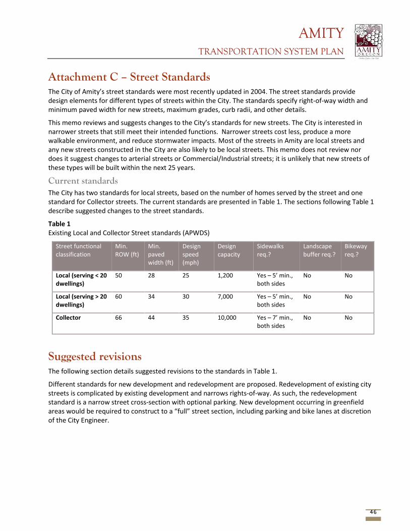
AMITY TRANSPORTATION SYSTEM PLAN
46
Attachment C – Street Standards The City of Amity’s street standards were most recently updated in 2004. The street standards provide design elements for different types of streets within the City. The standards specify right-of-way width and minimum paved width for new streets, maximum grades, curb radii, and other details.
This memo reviews and suggests changes to the City’s standards for new streets. The City is interested in narrower streets that still meet their intended functions. Narrower streets cost less, produce a more walkable environment, and reduce stormwater impacts. Most of the streets in Amity are local streets and any new streets constructed in the City are also likely to be local streets. This memo does not review nor does it suggest changes to arterial streets or Commercial/Industrial streets; it is unlikely that new streets of these types will be built within the next 25 years.
Current standards The City has two standards for local streets, based on the number of homes served by the street and one standard for Collector streets. The current standards are presented in Table 1. The sections following Table 1 describe suggested changes to the street standards.
Table 1 Existing Local and Collector Street standards (APWDS)
Street functional classification
Min. ROW (ft)
Min. paved width (ft)
Design speed (mph)
Design capacity
Sidewalks req.?
Landscape buffer req.?
Bikeway req.?
Local (serving < 20 dwellings)
50 28 25 1,200 Yes – 5’ min., both sides
No No
Local (serving > 20 dwellings)
60 34 30 7,000 Yes – 5’ min., both sides
No No
Collector 66 44 35 10,000 Yes – 7’ min., both sides
No No
Suggested revisions The following section details suggested revisions to the standards in Table 1.
Different standards for new development and redevelopment are proposed. Redevelopment of existing city streets is complicated by existing development and narrows rights-of-way. As such, the redevelopment standard is a narrow street cross-section with optional parking. New development occurring in greenfield areas would be required to construct to a “full” street section, including parking and bike lanes at discretion of the City Engineer.
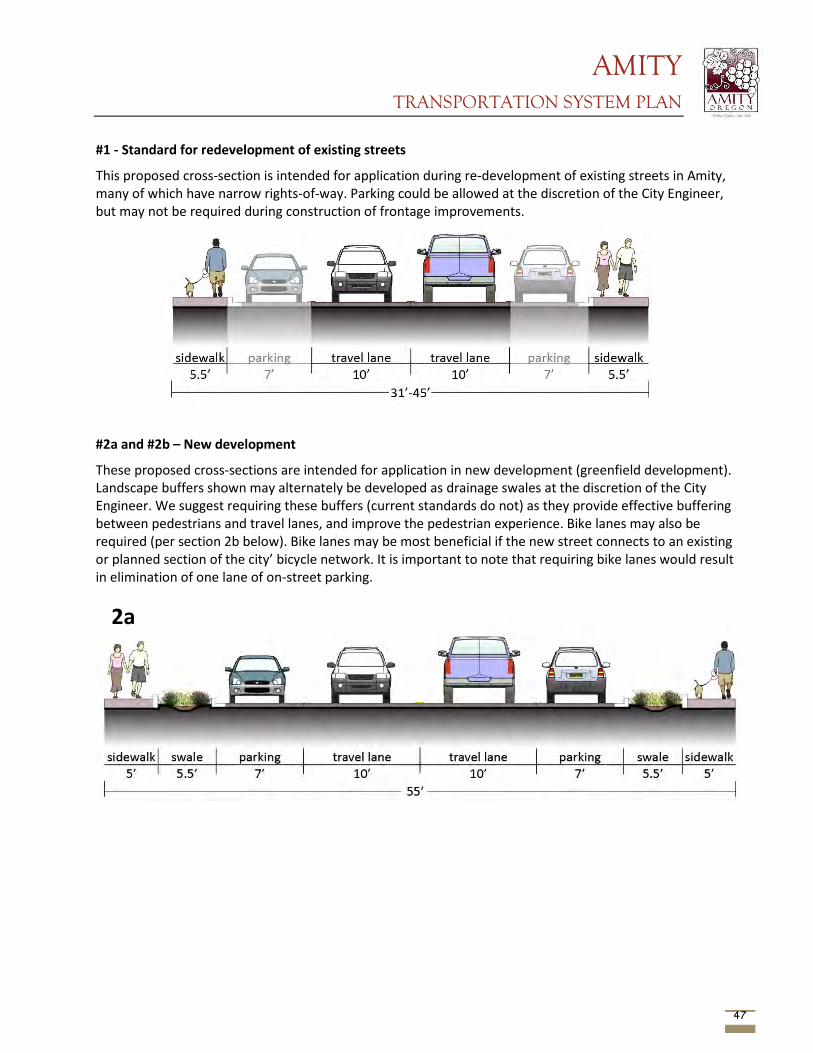
AMITY TRANSPORTATION SYSTEM PLAN
47
#1 - Standard for redevelopment of existing streets
This proposed cross-section is intended for application during re-development of existing streets in Amity, many of which have narrow rights-of-way. Parking could be allowed at the discretion of the City Engineer, but may not be required during construction of frontage improvements.
#2a and #2b – New development
These proposed cross-sections are intended for application in new development (greenfield development). Landscape buffers shown may alternately be developed as drainage swales at the discretion of the City Engineer. We suggest requiring these buffers (current standards do not) as they provide effective buffering between pedestrians and travel lanes, and improve the pedestrian experience. Bike lanes may also be required (per section 2b below). Bike lanes may be most beneficial if the new street connects to an existing or planned section of the city’ bicycle network. It is important to note that requiring bike lanes would result in elimination of one lane of on-street parking.
2a
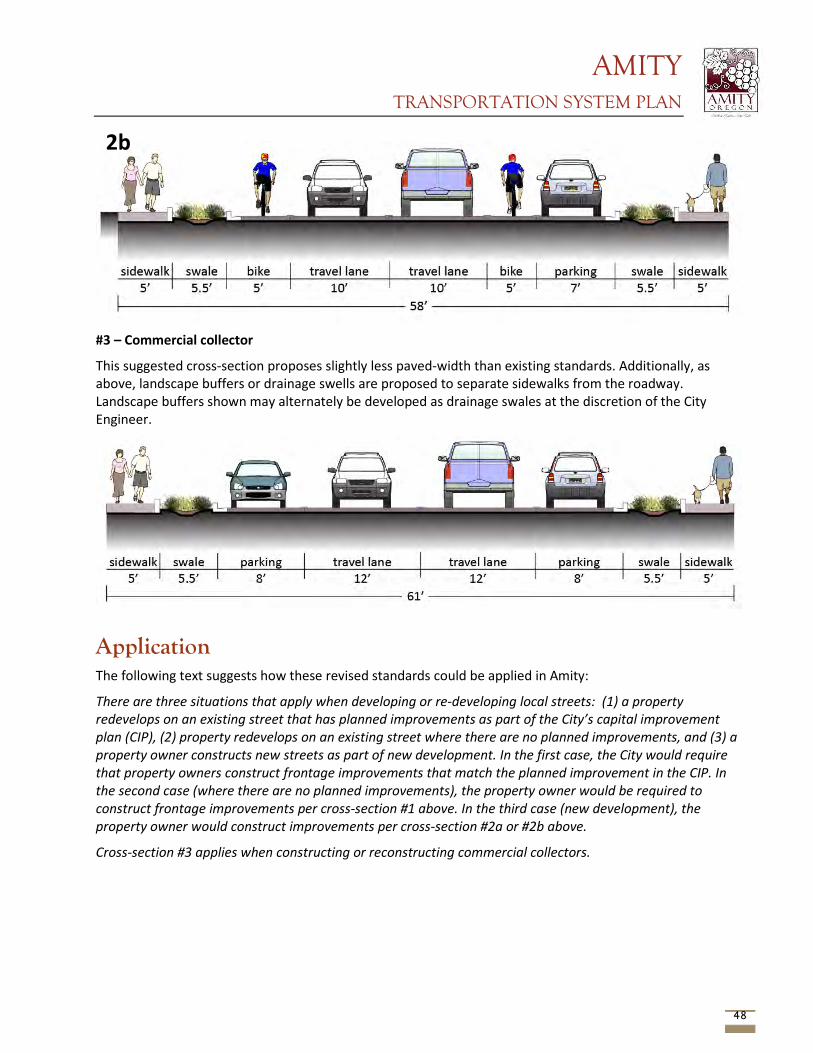
AMITY TRANSPORTATION SYSTEM PLAN
48
#3 – Commercial collector
This suggested cross-section proposes slightly less paved-width than existing standards. Additionally, as above, landscape buffers or drainage swells are proposed to separate sidewalks from the roadway. Landscape buffers shown may alternately be developed as drainage swales at the discretion of the City Engineer.
Application The following text suggests how these revised standards could be applied in Amity:
There are three situations that apply when developing or re-developing local streets: (1) a property redevelops on an existing street that has planned improvements as part of the City’s capital improvement plan (CIP), (2) property redevelops on an existing street where there are no planned improvements, and (3) a property owner constructs new streets as part of new development. In the first case, the City would require that property owners construct frontage improvements that match the planned improvement in the CIP. In the second case (where there are no planned improvements), the property owner would be required to construct frontage improvements per cross-section #1 above. In the third case (new development), the property owner would construct improvements per cross-section #2a or #2b above.
Cross-section #3 applies when constructing or reconstructing commercial collectors.
2b
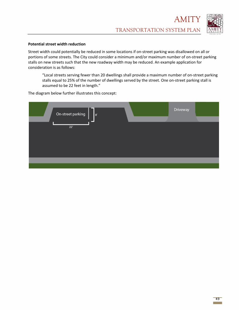
AMITY TRANSPORTATION SYSTEM PLAN
49
Potential street width reduction
Street width could potentially be reduced in some locations if on-street parking was disallowed on all or portions of some streets. The City could consider a minimum and/or maximum number of on-street parking stalls on new streets such that the new roadway width may be reduced. An example application for consideration is as follows:
“Local streets serving fewer than 20 dwellings shall provide a maximum number of on-street parking stalls equal to 25% of the number of dwellings served by the street. One on-street parking stall is assumed to be 22 feet in length.”
The diagram below further illustrates this concept:
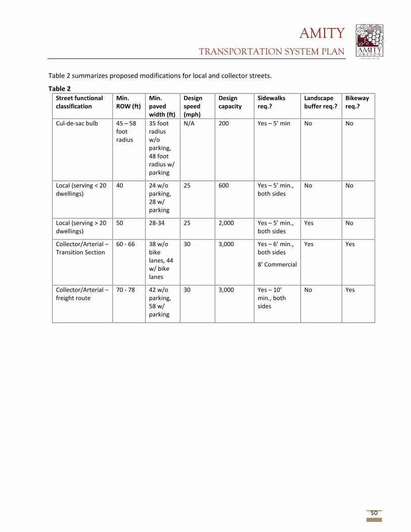
AMITY TRANSPORTATION SYSTEM PLAN
50
Table 2 summarizes proposed modifications for local and collector streets.
Table 2 Street functional classification
Min. ROW (ft)
Min. paved width (ft)
Design speed (mph)
Design capacity
Sidewalks req.?
Landscape buffer req.?
Bikeway req.?
Cul-de-sac bulb 45 – 58 foot radius
35 foot radius w/o parking, 48 foot radius w/ parking
N/A 200 Yes – 5’ min No No
Local (serving < 20 dwellings)
40 24 w/o parking, 28 w/ parking
25 600 Yes – 5’ min., both sides
No No
Local (serving > 20 dwellings)
50 28-34 25 2,000 Yes – 5’ min., both sides
Yes No
Collector/Arterial – Transition Section
60 - 66 38 w/o bike lanes, 44 w/ bike lanes
30 3,000 Yes – 6’ min., both sides
8’ Commercial
Yes Yes
Collector/Arterial – freight route
70 - 78 42 w/o parking, 58 w/ parking
30 3,000 Yes – 10’ min., both sides
No Yes

AMITY TRANSPORTATION SYSTEM PLAN
Appendix G Public Involvement and PAC/TAC Meetings
AMITY TRANSPORTATION SYSTEM PLAN
This page intentionally left blank
AMITY TRANSPORTATION SYSTEM PLAN
Table of Contents
Project Advisory Committee Meeting Minutes PAC Meeting #1 (10/15/13)
PAC Meeting #2 (4/10/14) PAC Meeting #3 (5/27/14)
Technical Advisory Committee Meeting Minutes TAC Meeting #1 (1/8/14) TAC Meeting #2 Minutes (4/10/14)
TAC Meeting #3 (5/27/14) TAC Meeting #4 (10/22/14)
Public Outreach Community Meeting #1 Summary
Community Meeting #2 Summary Community Meeting #2 Posters TSP Project Website
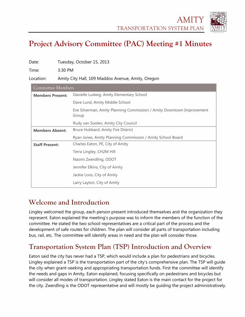
AMITY TRANSPORTATION SYSTEM PLAN
Project Advisory Committee (PAC) Meeting #1 Minutes
Date: Tuesday, October 15, 2013
Time: 3:30 PM
Location: Amity City Hall, 109 Maddox Avenue, Amity, Oregon
Committee Members
Members Present: Danielle Ludwig, Amity Elementary School
Dave Lund, Amity Middle School
Eve Silverman, Amity Planning Commission / Amity Downtown Improvement Group
Rudy van Soolen, Amity City Council
Members Absent: Bruce Hubbard, Amity Fire District
Ryan Jones, Amity Planning Commission / Amity School Board
Staff Present: Charles Eaton, PE, City of Amity
Terra Lingley, CH2M Hill
Naomi Zwerdling, ODOT
Jennifer Elkins, City of Amity
Jackie Loos, City of Amity
Larry Layton, City of Amity
Welcome and Introduction Lingley welcomed the group, each person present introduced themselves and the organization they represent. Eaton explained the meeting’s purpose was to inform the members of the function of the committee. He stated the two school representatives are a critical part of the process and the development of safe routes for children. The plan will consider all parts of transportation including bus, rail, etc. The committee will identify areas in need and the plan will consider those.
Transportation System Plan (TSP) Introduction and Overview Eaton said the city has never had a TSP, which would include a plan for pedestrians and bicycles. Lingley explained a TSP is the transportation part of the city’s comprehensive plan. The TSP will guide the city when grant-seeking and appropriating transportation funds. First the committee will identify the needs and gaps in Amity, Eaton explained, focusing specifically on pedestrians and bicycles but will consider all modes of transportation. Lingley stated Eaton is the main contact for the project for the city. Zwerdling is the ODOT representative and will mostly be guiding the project administratively.
AMITY TRANSPORTATION SYSTEM PLAN
She noted that the city will also hold two public meetings, along with adoption hearings at the very end of the project. The plan will look 20 years into the future to allow for growth and how transportation needs may change in that period. She said the planning commission and council will also be involved and have the opportunity to make decisions about the project.
Committee Operations Lingley explained the meeting guidelines. She said they will remain mostly informal but noted that once a decision has been made, the group will not go back to that topic.
Plan and Policy Review Lingley discussed the city’s aging previous plans and the goals and objectives of the comprehensive plan.
Evaluation Framework The committee reviewed the maps for corrections to street names and markings. There was one change to remove a crosswalk from the map (second from left on Rice Lane) and to add a crosswalk on Nursery Avenue at Getchell Avenue. The group decided that the map will be emailed to the city to work on correcting street names and “street” versus “avenue.”
Transportation Values Members listed areas of town where the transportation system works well: new area around middle school, new Rice Lane sidewalks, new pavement, and street lamps in the downtown, railroad crossings, and downtown improvements.
Members listed areas of town where the transportation system does not work well: lighting, sidewalks, routes through town off of Trade Street, Trade Street bike lanes, undergrounding of utilities, speed limit in residential areas, Nursery Avenue, transition from Trade Street to Rice Lane and Rice Lane to school.
Future Meetings and Next Steps The committee discussed opportune times to meet in the future. Lingley said a business owner committee member is still being sought. Lingley said we will try to avoid Monday, Wednesday, and Friday and will keep the time at 3:30pm.
Adjourn
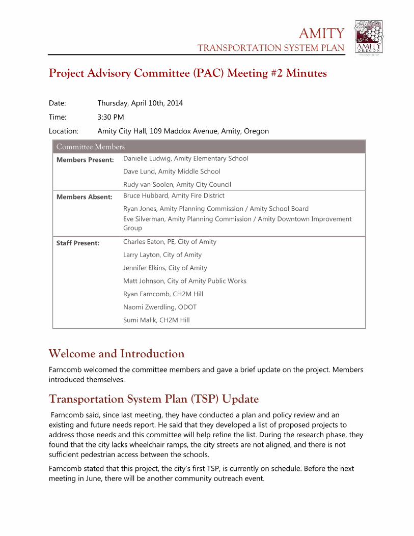
AMITY TRANSPORTATION SYSTEM PLAN
Project Advisory Committee (PAC) Meeting #2 Minutes
Date: Thursday, April 10th, 2014
Time: 3:30 PM
Location: Amity City Hall, 109 Maddox Avenue, Amity, Oregon
Committee Members
Members Present: Danielle Ludwig, Amity Elementary School
Dave Lund, Amity Middle School
Rudy van Soolen, Amity City Council
Members Absent: Bruce Hubbard, Amity Fire District
Ryan Jones, Amity Planning Commission / Amity School Board Eve Silverman, Amity Planning Commission / Amity Downtown Improvement Group
Staff Present: Charles Eaton, PE, City of Amity
Larry Layton, City of Amity
Jennifer Elkins, City of Amity
Matt Johnson, City of Amity Public Works
Ryan Farncomb, CH2M Hill
Naomi Zwerdling, ODOT
Sumi Malik, CH2M Hill
Welcome and Introduction Farncomb welcomed the committee members and gave a brief update on the project. Members introduced themselves.
Transportation System Plan (TSP) Update Farncomb said, since last meeting, they have conducted a plan and policy review and an existing and future needs report. He said that they developed a list of proposed projects to address those needs and this committee will help refine the list. During the research phase, they found that the city lacks wheelchair ramps, the city streets are not aligned, and there is not sufficient pedestrian access between the schools.
Farncomb stated that this project, the city’s first TSP, is currently on schedule. Before the next meeting in June, there will be another community outreach event.
AMITY TRANSPORTATION SYSTEM PLAN
Review Technical Memo #2 Farncomb introduced Tech Memo #2, which outlines projects to address traffic flow issues as well as their projected costs.
1. First, Farncomb discussed adding a traffic signal on Trade Street at Nursery Avenue and 6th Street. He noted that the idea is to allow traffic from the side streets to enter the main street but added that the light would cause a significant delay on Trade Street, which is also Highway 99W. Layton asked for clarification on why that would be. Farncomb said there are not enough vehicles turning onto Trade Street to justify the delay and back up on the highway. Van Soolen asked how it would differ from the proposed pedestrian light at Rice Lane and the highway. While Farncomb could not specifically address the concern since the study was not done with the pedestrian light in mind, Eaton theorized that the failure likely occurs during the peak traffic hours and the pedestrian crossing at Rice Lane will be utilized mostly during non-peak traffic periods.
2. Next, Farncomb mentioned modifying Nursery Avenue at Oak Avenue to include a median for pedestrian refuge, prohibiting left hand turns onto Oak Avenue from Nursery. Eaton asked what triggered this option. Farncomb answered that it is to address the pedestrian safety between schools. Eaton stated more discussion would need to occur with the school district since the bus route crosses straight across on Oak Avenue. Discussion involved moving the pedestrian refuge to Getchell Avenue if pedestrian movement would occur there. Farncomb acknowledged more weighing of the pro’s and con’s will need to be done on this project.
3. The third project on the list was to add a left turn pocket at Rice Lane and Trade Street. The committee discussed the bus routes. Ludwig noted that after dropping students off in the morning, the buses turn right from Rice Lane. Elkins stated that is when the buses enter into the southbound lane while attempting to turn into the northbound lane.
4. Farncomb introduced project number four, new street connections, which included three parts: A.) bicycle and pedestrian access from Rosedell Avenue to Rice Lane, B.) bicycle and pedestrian connection from 3rd Avenue to Nursery Avenue east of the high school, and C.) vehicular connection for an emergency service route to Goucher Avenue to and from Jellison Avenue. Farncomb acknowledged certain obstacles with project four, such as wetland issues and obtaining right-of-way or land acquisition.
5. The fifth project mentioned by Farncomb was to replace the bridge on 5th Street.
6. Farncomb said that, while there was not a traffic issue, it was discussed at citizen outreach events to realign the offset side streets, which resulted in the sixth proposed
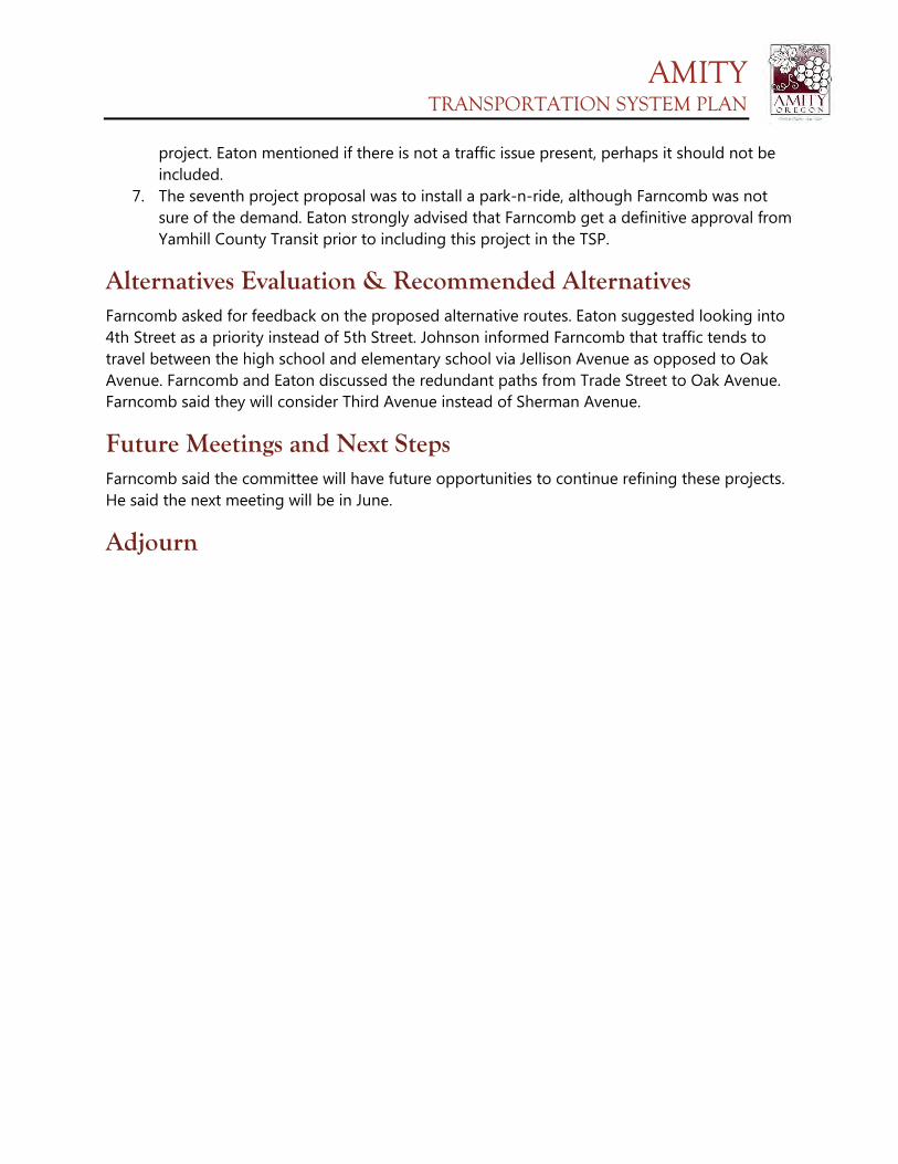
AMITY TRANSPORTATION SYSTEM PLAN
project. Eaton mentioned if there is not a traffic issue present, perhaps it should not be included.
7. The seventh project proposal was to install a park-n-ride, although Farncomb was not sure of the demand. Eaton strongly advised that Farncomb get a definitive approval from Yamhill County Transit prior to including this project in the TSP.
Alternatives Evaluation & Recommended Alternatives Farncomb asked for feedback on the proposed alternative routes. Eaton suggested looking into 4th Street as a priority instead of 5th Street. Johnson informed Farncomb that traffic tends to travel between the high school and elementary school via Jellison Avenue as opposed to Oak Avenue. Farncomb and Eaton discussed the redundant paths from Trade Street to Oak Avenue. Farncomb said they will consider Third Avenue instead of Sherman Avenue.
Future Meetings and Next Steps Farncomb said the committee will have future opportunities to continue refining these projects. He said the next meeting will be in June.
Adjourn
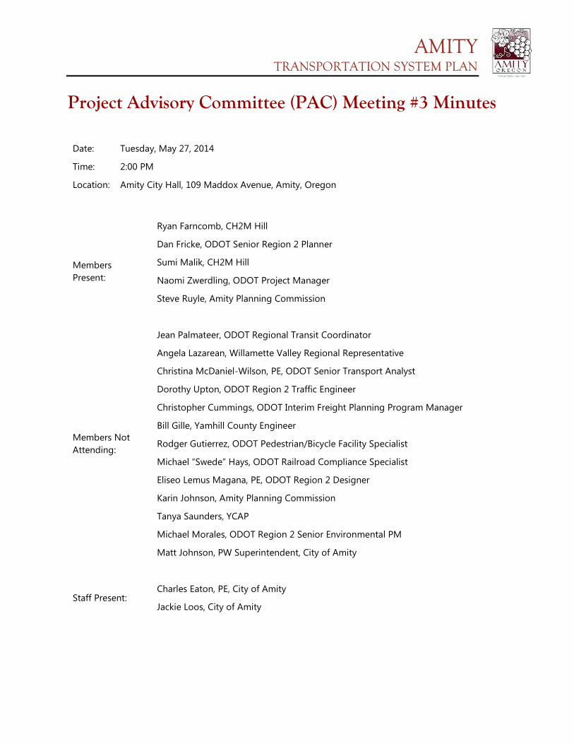
AMITY TRANSPORTATION SYSTEM PLAN
Project Advisory Committee (PAC) Meeting #3 Minutes Date: Tuesday, May 27, 2014
Time: 2:00 PM
Location: Amity City Hall, 109 Maddox Avenue, Amity, Oregon
Members Present:
Ryan Farncomb, CH2M Hill
Dan Fricke, ODOT Senior Region 2 Planner
Sumi Malik, CH2M Hill
Naomi Zwerdling, ODOT Project Manager
Steve Ruyle, Amity Planning Commission
Members Not Attending:
Jean Palmateer, ODOT Regional Transit Coordinator
Angela Lazarean, Willamette Valley Regional Representative
Christina McDaniel-Wilson, PE, ODOT Senior Transport Analyst
Dorothy Upton, ODOT Region 2 Traffic Engineer
Christopher Cummings, ODOT Interim Freight Planning Program Manager
Bill Gille, Yamhill County Engineer
Rodger Gutierrez, ODOT Pedestrian/Bicycle Facility Specialist
Michael “Swede” Hays, ODOT Railroad Compliance Specialist
Eliseo Lemus Magana, PE, ODOT Region 2 Designer
Karin Johnson, Amity Planning Commission
Tanya Saunders, YCAP
Michael Morales, ODOT Region 2 Senior Environmental PM
Matt Johnson, PW Superintendent, City of Amity
Staff Present:
Charles Eaton, PE, City of Amity
Jackie Loos, City of Amity
AMITY TRANSPORTATION SYSTEM PLAN
WELCOME AND INTRODUCTION: Each person present introduced themselves and the organization they represent. Farncomb thanked everyone for coming.
TRANSPORTATION SYSTEM PLAN (TSP) UPDATE: Farncomb updated every one of the project’s process. He also went over what was included in the handout. Farncomb stated that the committee would discuss street standards changes that may be recommended. Farncomb asked if there were any questions before proceeding. There were none.
REVIEW TECHNICAL MEMO #2: Farncomb stated that the project was in “recommended alternative and determining funding sources” stage. Farncomb went over the schedule, stating that the committee would meet again at the end of June or early July to discuss the feedback from the community workshop and then once again to discuss recommended code changes. He stated that the goal was to get the whole process completed by October 2014.
TECHNICAL MEMO #3: Farncomb explained the technical aspect of each project. He also talked about other design options and project prioritization. He stated that the signal and median addition discussed last meeting was eliminated. Farncomb described each project and their priority level, estimated cost, jurisdiction, and the potential funding partners/sources. The committee also discussed key factors of each project to determine what is likely needed for the project to proceed. The committee also discussed possible Urban Growth Boundry (UGB) access.
TECHNICAL MEMO #4: Farncomb and the committee then discussed the different funding options. The committee talked about other funding sources, such as the park SDC’s and the school district. Farncomb hoped that the committee would be able to review street standards; however, there was not enough time in this meeting. Therefore, street standards will be addressed at a later TAC meeting.
FUTURE MEETINGS & NEXT STEPS: Farncomb went over the next steps, which include a community workshop in June. He also stated that at the next TAC meeting, after all the recommended revisions, there should be a list of projects that will end up in the TSP. Farncomb also mentioned that the committee would be discussing code amendments at the next TAC meeting.
ADJOURN
Farncomb thanked everyone for attending and asked that any comments or suggestions be emailed to Charles Eaton. Meeting adjourned at 3:30 p.m.
AMITY TRANSPORTATION SYSTEM PLAN
Technical Advisory Committee (TAC) Meeting #1 Minutes
Date: Wednesday, January 8, 2014
Time: 2:30 PM
Location: Amity City Hall, 109 Maddox Avenue, Amity, Oregon
Committee Members
Members Present: Ryan Farncomb, CH2M Hill
Karin Johnson, Amity Planning Commission
Terra Lingley, CH2M Hill
Naomi Zwerdling, ODOT Project Manager
Michael Morales, ODOT Region 2 Senior Environmental PM
Lori Lewis, First Student
Members Absent: Dorothy Upton, ODOT Region 2 Traffic Engineer
Christopher Cummings, ODOT Interim Freight Planning Program Manager
Dan Fricke, ODOT Senior Region 2 Planner
Bill Gille, Yamhill County Engineer
Rodger Gutierrez, ODOT Pedestrian/Bicycle Facility Specialist
Michael “Swede” Hays, ODOT Railroad Compliance Specialist
Eliseo Lemus Magana, PE, ODOT Region 2 Designer
Christina McDaniel-Wilson, PE, ODOT Senior Transport Analyst
Angela Lazarean, Willamette Valley Regional Representative
Jean Palmateer, ODOT Regional Transit Coordinator
Steve Ruyle, Amity Planning Commission
Staff Present: Charles Eaton, PE, City of Amity
Matt Johnson, City of Amity Public Works
Jackie Loos, City of Amity
AMITY TRANSPORTATION SYSTEM PLAN
Welcome and Introduction Lingley welcomed the group; each person present introduced themselves and the organization they represent. Lingley explained the meeting’s purpose was to inform the members of the function of the committee and to review the existing and future conditions technical memo #1.
Transportation System Plan (TSP) Introduction and Overview Lingley described what the TSP was and the role of the TAC, along with ODOT, City, PAC, and consultants. She stated that the TSP is a resource for the community and the city. This plan will help with funding, future transportation needs and how to meet those needs with limited resources. It will also provide transportation guidance for the City for the next 20 years. She stated that the TSP will focus on transportation needs; specifically on plans for bicycles and pedestrians; roads, public transportation, air, rail, water, and pipelines. She talked about who was involved in this process, which includes Amity, ODOT, DLCD, and the Amity community. Lingley explained the planning process, beginning with an inventory, forecast future needs, develop and evaluate alternatives, determine funding, write draft TSP, brief community, hold an adoption hearing and adopt plan. During the adoption process, there will be additional opportunity for public to comment. She then talked about the schedule and key milestones.
Review Technical Memo #1 Ryan Farncomb went over the Existing and Future Conditions. He talked about land use, such as the recent UGB additions, Right of Way issues, and road connectivity. He talked about possible solutions, such as identifying future road connections, providing multi-modal crossings, and completing networks to provide alternatives.
Farncomb went over the bike system and bicycle levels of stress (BLOS). The committee discussed the BLOS methodology provided by ODOT and what the level of stress measures on City roads. Lingley stated that the main focus of the TSP will be on bicyclists and pedestrians, along with safe routes to school. Farncomb discussed the existing pedestrian system, such as sidewalks and safe pedestrian connections. Gaps in sidewalks, lack of sidewalks, barriers on sidewalks, and upgrading crossings were also discussed, along with ADA accessibility, which is a top priority for the City.
Lingley talked about safety conditions and the crash study and discussed the Amity TSP Study Location Descriptions (Table 4, page 17) and the shared jurisdictions between Amity and ODOT.
Evaluation Framework Lingley talked about plans and policies and staying consistent when writing the TSP. She also talked about findings, such as updating the city’s Comprehensive Plan. She stated that framework will help create a list of tasks to address priority project needs, such as safety, environmental impacts, transportation needs of all the citizens, system upgrades & preservation, multi-modal system, funding & finance, connectivity, and emergency response time.
AMITY TRANSPORTATION SYSTEM PLAN
Transportation Issues to Address Members listed areas of town that do not work well: Bus drivers turning off Rice Lane onto Hwy 99W struggle to find adequate gaps in traffic. Eaton stated that the city will have a pedestrian activated signal at that location soon. Eaton stated that his main issue is having an ADA connectivity transition plan. Karin Johnson stated that she sees issues with the Rice Lane and Church Avenue intersections during school hours. Morales asked about consolidating 5th & 6th Streets for a signal and creating 4 legged intersections. Eaton stated that is problematic due to the cemetery at the end of 6th Street. Matthew Johnson stated that his main issue is road surface repair. The members discussed sidewalks, along with handicap ramps on the sidewalks. Eaton addressed drainage and lighting issues. Lewis addressed children walking over railroad crossing. Eaton discussed the Park Plan Path and adding it to the TSP. Matthew Johnson also addressed the parking in downtown area.
Future Meetings & Next Steps The committee discussed the next steps, which include a community workshop to verify conditions and brainstorm solutions with the community. Lingley stated that the list of projects will be discussed at the next TAC meeting.
Adjourn Lingley thanked everyone for attending and asked that any comments or suggestions be emailed to Charles Eaton, Jackie Loos, or herself. Meeting adjourned at 4:00 p.m.
AMITY TRANSPORTATION SYSTEM PLAN
Technical Advisory Committee (TAC) Meeting #2 Minutes Date: Thursday, April 10, 2014
Time: 2:00 PM
Location: Amity City Hall, 109 Maddox Avenue, Amity, Oregon
Members Present:
Ryan Farncomb, CH2M Hill
Dan Fricke, ODOT Senior Region 2 Planner
Sumi Malik, CH2M Hill
Naomi Zwerdling, ODOT Project Manager
Michael Morales, ODOT Region 2 Senior Environmental PM
Chris ?, ODOT Roadway Representative - Representing Eliseo Lemus Magana
Christina McDaniel-Wilson, PE, ODOT Senior Transport Analyst
Angela Lazarean, Willamette Valley Regional Representative
Members Not Attending:
Jean Palmateer, ODOT Regional Transit Coordinator
Steve Ruyle, Amity Planning Commission
Dorothy Upton, ODOT Region 2 Traffic Engineer
Christopher Cummings, ODOT Interim Freight Planning Program Manager
Bill Gille, Yamhill County Engineer
Rodger Gutierrez, ODOT Pedestrian/Bicycle Facility Specialist
Michael “Swede” Hays, ODOT Railroad Compliance Specialist
Eliseo Lemus Magana, PE, ODOT Region 2 Designer
Karin Johnson, Amity Planning Commission
Tanya Saunders, YCAP
Staff Present:
Charles Eaton, PE, City of Amity
Matt Johnson, City of Amity Public Works
Jackie Loos, City of Amity
AMITY TRANSPORTATION SYSTEM PLAN
WELCOME AND INTRODUCTION: Farncomb thanked everyone for coming and introduced Sumi Malik, who is filling in for Terra Lingley until June. Each person present introduced themselves and the organization they represent. Farncomb explained the meeting’s purpose was review and discuss the project alternatives and project evaluation in technical memo #2.
TRANSPORTATION SYSTEM PLAN (TSP) UPDATE: Farncomb updated every one of the project’s process and schedule. Last time the committee met, they discussed the existing conditions memos and the transportation needs. He stated that one of the goals of this meeting was to get to the recommended alternatives. He also stated that toward the end of the presentation, he would like to have a discussion about these projects; is there something missing and what changes should be considered and after that, he will discuss the “next steps” process.
REVIEW TECHNICAL MEMO #2: Farncomb stated that the project was in the “develop and determine alternatives” stage. Early in the summer, after checking in with the community, the committee will recommend alternatives. Farncomb went over the TSP schedule. Farncomb talked about the projects and what to consider. Mr. Eaton asked the committee about the approaches from the technical viewpoint for the streets. He stated that there were a lot of challenges with right-of-way widths and space configurations. Mr. Morales asked about the Project Advisory Committee (PAC) and if there were representatives from environmental justice community on the committee. Naomi Zwerdling stated that Terra Lingley had been involved with looking at the income and the different minority groups in relation to the project and that there were findings. However, there doesn’t appear to be a particular representative from that group on the PAC committee. Mr. Eaton stated that the minority groups were being engaged through the school district representatives as well.
The committee discussed the alternatives evaluation in Tech Memo #2. The committee went over the system alternatives, along with corresponding map for the Roadway and Transit Alternatives. Projects included the addition of a signal on Trade/Nursery, adding a median on Oak Avenue, adding a left turn pocket on Rice Lane, and new street connections. Major street connections include Rosedell Avenue to Rice Lane, 3rd Avenue to Nursery Avenue, and Jellison to Goucher Avenue. Other project discussion included 5th Street bridge replacement, realigning Trade Street intersections, and potential park and ride.
The committee also reviewed the Pedestrian and Bicycle System and the corresponding Priority Bicycle and Pedestrian Improvements map. Projects included the addition of bike lanes, sidewalks, on-street parking, and shared use paths. Farncomb asked the committee if the right priorities had been addressed. The committee also discussed highway cross sections
AMITY TRANSPORTATION SYSTEM PLAN
The committee discussed several alternatives and possible environmental or private property impacts, with the addition of new streets.
FUTURE MEETINGS, NEXT STEPS, ADJOURN: Farncomb discussed the next steps, which include alternative recommendations and develop a funding plan.
ADJOURN
Farncomb thanked everyone for attending and asked that any comments or suggestions be emailed to Charles Eaton. Meeting adjourned at 3:30 p.m.
AMITY TRANSPORTATION SYSTEM PLAN
Technical Advisory Committee (TAC) Meeting #3 Minutes Date: Tuesday, May 27, 2014
Time: 2:00 PM
Location: Amity City Hall, 109 Maddox Avenue, Amity, Oregon
Members Present:
Ryan Farncomb, CH2M Hill
Dan Fricke, ODOT Senior Region 2 Planner
Sumi Malik, CH2M Hill
Naomi Zwerdling, ODOT Project Manager
Steve Ruyle, Amity Planning Commission
Members Not Attending:
Jean Palmateer, ODOT Regional Transit Coordinator
Angela Lazarean, Willamette Valley Regional Representative
Christina McDaniel-Wilson, PE, ODOT Senior Transport Analyst
Dorothy Upton, ODOT Region 2 Traffic Engineer
Christopher Cummings, ODOT Interim Freight Planning Program Manager
Bill Gille, Yamhill County Engineer
Rodger Gutierrez, ODOT Pedestrian/Bicycle Facility Specialist
Michael “Swede” Hays, ODOT Railroad Compliance Specialist
Eliseo Lemus Magana, PE, ODOT Region 2 Designer
Karin Johnson, Amity Planning Commission
Tanya Saunders, YCAP
Michael Morales, ODOT Region 2 Senior Environmental PM
Matt Johnson, PW Superintendent, City of Amity
Staff Present:
Charles Eaton, PE, City of Amity
Jackie Loos, City of Amity
WELCOME AND INTRODUCTION: Each person present introduced themselves and the organization they represent. Farncomb thanked everyone for coming.
AMITY TRANSPORTATION SYSTEM PLAN
TRANSPORTATION SYSTEM PLAN (TSP) UPDATE: Farncomb updated every one of the project’s process. He also went over what was included in the handout. Farncomb stated that the committee would discuss street standards changes that may be recommended. Farncomb asked if there were any questions before proceeding. There were none.
REVIEW TECHNICAL MEMO #2: Farncomb stated that the project was in “recommended alternative and determining funding sources” stage. Farncomb went over the schedule, stating that the committee would meet again at the end of June or early July to discuss the feedback from the community workshop and then once again to discuss recommended code changes. He stated that the goal was to get the whole process completed by October 2014.
TECHNICAL MEMO #3: Farncomb explained the technical aspect of each project. He also talked about other design options and project prioritization. He stated that the signal and median addition discussed last meeting was eliminated. Farncomb described each project and their priority level, estimated cost, jurisdiction, and the potential funding partners/sources. The committee also discussed key factors of each project to determine what is likely needed for the project to proceed. The committee also discussed possible Urban Growth Boundry (UGB) access.
TECHNICAL MEMO #4: Farncomb and the committee then discussed the different funding options. The committee talked about other funding sources, such as the park SDC’s and the school district. Farncomb hoped that the committee would be able to review street standards; however, there was not enough time in this meeting. Therefore, street standards will be addressed at a later TAC meeting.
FUTURE MEETINGS & NEXT STEPS: Farncomb went over the next steps, which include a community workshop in June. He also stated that at the next TAC meeting, after all the recommended revisions, there should be a list of projects that will end up in the TSP. Farncomb also mentioned that the committee would be discussing code amendments at the next TAC meeting.
ADJOURN
Farncomb thanked everyone for attending and asked that any comments or suggestions be emailed to Charles Eaton. Meeting adjourned at 3:30 p.m.
AMITY TRANSPORTATION SYSTEM PLAN
Technical Advisory Committee (TAC) Meeting #4 Minutes Date: Wednesday, October 22, 2014
Time: 2:00 PM
Location: Amity City Hall, 109 Maddox Avenue, Amity, Oregon
Members Present:
Ryan Farncomb, CH2M Hill
Eduardo Montejo CH2M Hill
Dan Fricke, ODOT Senior Region 2 Planner
Naomi Zwerdling, ODOT Project Manager
Steve Ruyle, Amity Planning Commission
Angela Lazarean, Willamette Valley Regional Representative, DLCD
Karin Johnson, Amity Planning Commission
Rodger Gutierrez, ODOT Pedestrian/Bicycle Facility Specialist
Members Not Attending:
Jean Palmateer, ODOT Regional Transit Coordinator
Christina McDaniel-Wilson, PE, ODOT Senior Transport Analyst
Dorothy Upton, ODOT Region 2 Traffic Engineer
Christopher Cummings, ODOT Interim Freight Planning Program Manager
Bill Gille, Yamhill County Engineer
Michael “Swede” Hays, ODOT Railroad Compliance Specialist
Eliseo Lemus Magana, PE, ODOT Region 2 Designer
Tanya Saunders, YCAP
Michael Morales, ODOT Region 2 Senior Environmental PM
Matt Johnson, PW Superintendent, City of Amity
Sumi Malik, CH2M Hill
Staff Present:
Charles Eaton, PE, City of Amity
Jackie Loos, City of Amity
AMITY TRANSPORTATION SYSTEM PLAN
WELCOME AND INTRODUCTION: Each person present introduced themselves and the organization they represent. Farncomb thanked everyone for coming.
TRANSPORTATION SYSTEM PLAN (TSP) UPDATE: Farncomb updated every one of the project’s process. He also went over what was included in the handout. Farncomb stated that the committee would discuss street standards changes that may be recommended. Farncomb asked if there were any questions before proceeding. There were none.
REVIEW TECHNICAL MEMO #3 & 4: Mr. Eaton discussed code amendments to the Amity Comprehensive Plan. He also discusses street standards, such as redevelopment of existing in the planned project, redevelopment of existing not planned, and development of new streets. The committee also discussed policy revisions and new policies to reflect the city’s vision.
The committee talked about transportation improvement and funding summary, cost estimates, and project prioritization.
FUTURE MEETINGS & NEXT STEPS: Farncomb went over the next steps, which includes finalizing the TSP, submitting for review, making any last revisions, and then adopting the TSP.
Charles Eaton informed the committee of the workshop that will be scheduled for December 3, 2014 at 5 pm, prior to the council meeting.
ADJOURN
Farncomb thanked everyone for attending and asked that any comments or suggestions be emailed to Charles Eaton. Meeting adjourned at 3:30 p.m.
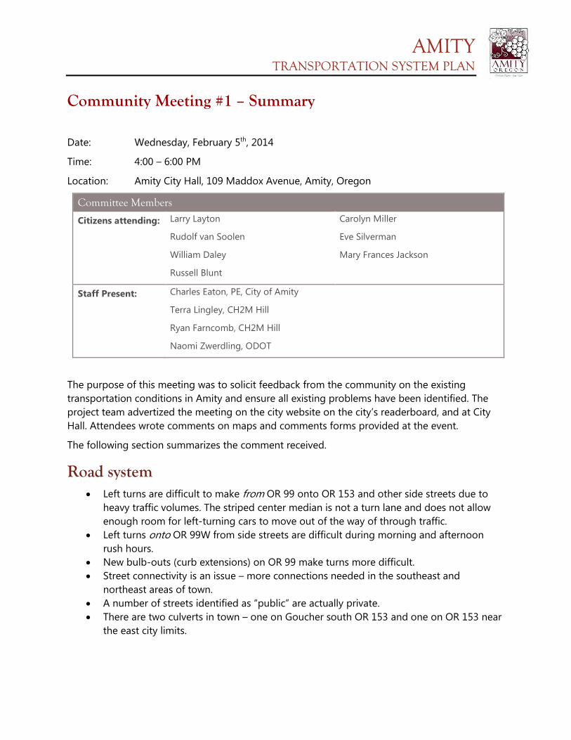
AMITY TRANSPORTATION SYSTEM PLAN
Community Meeting #1 – Summary
Date: Wednesday, February 5th, 2014
Time: 4:00 – 6:00 PM
Location: Amity City Hall, 109 Maddox Avenue, Amity, Oregon
Committee Members
Citizens attending: Larry Layton
Rudolf van Soolen
William Daley
Russell Blunt
Carolyn Miller
Eve Silverman
Mary Frances Jackson
Staff Present: Charles Eaton, PE, City of Amity
Terra Lingley, CH2M Hill
Ryan Farncomb, CH2M Hill
Naomi Zwerdling, ODOT
The purpose of this meeting was to solicit feedback from the community on the existing transportation conditions in Amity and ensure all existing problems have been identified. The project team advertized the meeting on the city website on the city’s readerboard, and at City Hall. Attendees wrote comments on maps and comments forms provided at the event.
The following section summarizes the comment received.
Road system • Left turns are difficult to make from OR 99 onto OR 153 and other side streets due to
heavy traffic volumes. The striped center median is not a turn lane and does not allow enough room for left-turning cars to move out of the way of through traffic.
• Left turns onto OR 99W from side streets are difficult during morning and afternoon rush hours.
• New bulb-outs (curb extensions) on OR 99 make turns more difficult. • Street connectivity is an issue – more connections needed in the southeast and
northeast areas of town. • A number of streets identified as “public” are actually private. • There are two culverts in town – one on Goucher south OR 153 and one on OR 153 near
the east city limits.
AMITY TRANSPORTATION SYSTEM PLAN
Bicycle & pedestrian system • The state department of transportation prefers the pedestrian crossing on OR 153 at
Getchell Avenue, but anecdotally, pedestrians are actually using the unimproved crossing at Oak Avenue.
• Intersection improvements at Rice Lane and OR 99 are much needed. This intersection will be improved this summer.
Other comments • There is a need for an emergency evacuation plan, as well as more redundancy in the
street network. Amity is vulnerable during an emergency because of the bridges and culverts on OR 99 and OR 153.
AMITY TRANSPORTATION SYSTEM PLAN
Community Meeting #2 – Summary
Date: Wednesday, June 18th, 2014
Time: 4:00 – 6:00 PM
Location: Amity City Hall, 109 Maddox Avenue, Amity, Oregon
Committee Members
Citizens attending: None.
Staff Present: Charles Eaton, PE, City of Amity
Ryan Farncomb, CH2M Hill
Sumi Malik, CH2M Hill
Eduardo Montejo, CH2M Hill
Naomi Zwerdling, ODOT
There were no attendees from the community. Community members who could not attend this meeting in person could provide their comments via an online survey instead.
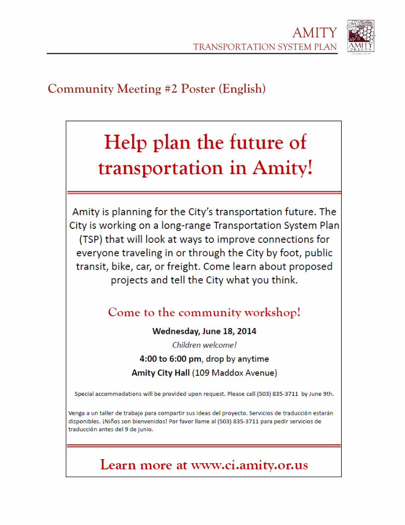
AMITY TRANSPORTATION SYSTEM PLAN
Community Meeting #2 Poster (English)
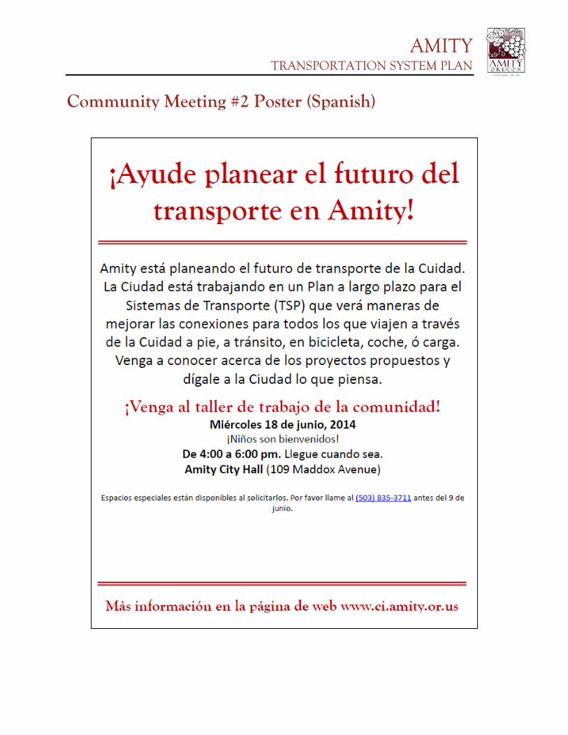
AMITY TRANSPORTATION SYSTEM PLAN
Community Meeting #2 Poster (Spanish)
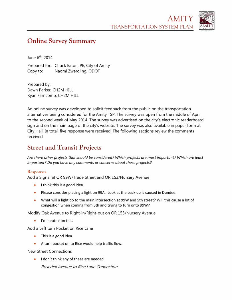
AMITY TRANSPORTATION SYSTEM PLAN
Online Survey Summary
June 6th, 2014
Prepared for: Chuck Eaton, PE, City of Amity Copy to: Naomi Zwerdling, ODOT
Prepared by: Dawn Parker, CH2M HILL Ryan Farncomb, CH2M HILL
An online survey was developed to solicit feedback from the public on the transportation alternatives being considered for the Amity TSP. The survey was open from the middle of April to the second week of May 2014. The survey was advertised on the city’s electronic readerboard sign and on the main page of the city’s website. The survey was also available in paper form at City Hall. In total, five response were received. The following sections review the comments received.
Street and Transit Projects Are there other projects that should be considered? Which projects are most important? Which are least important? Do you have any comments or concerns about these projects?
Responses Add a Signal at OR 99W/Trade Street and OR 153/Nursery Avenue
• I think this is a good idea.
• Please consider placing a light on 99A. Look at the back up is caused in Dundee.
• What will a light do to the main intersection at 99W and 5th street? Will this cause a lot of congestion when coming from 5th and trying to turn onto 99W?
Modify Oak Avenue to Right-in/Right-out on OR 153/Nursery Avenue
• I’m neutral on this.
Add a Left turn Pocket on Rice Lane
• This is a good idea.
• A turn pocket on to Rice would help traffic flow.
New Street Connections
• I don’t think any of these are needed
Rosedell Avenue to Rice Lane Connection
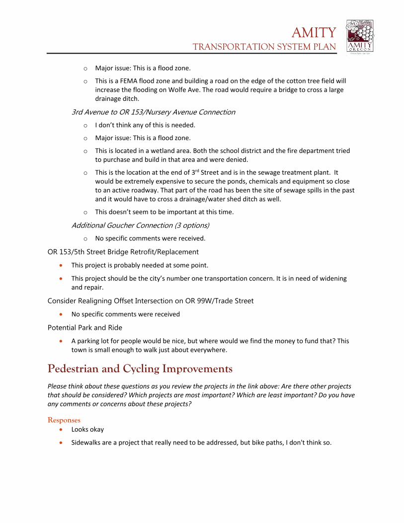
AMITY TRANSPORTATION SYSTEM PLAN
o Major issue: This is a flood zone.
o This is a FEMA flood zone and building a road on the edge of the cotton tree field will increase the flooding on Wolfe Ave. The road would require a bridge to cross a large drainage ditch.
3rd Avenue to OR 153/Nursery Avenue Connection
o I don’t think any of this is needed.
o Major issue: This is a flood zone.
o This is located in a wetland area. Both the school district and the fire department tried to purchase and build in that area and were denied.
o This is the location at the end of 3rd Street and is in the sewage treatment plant. It would be extremely expensive to secure the ponds, chemicals and equipment so close to an active roadway. That part of the road has been the site of sewage spills in the past and it would have to cross a drainage/water shed ditch as well.
o This doesn’t seem to be important at this time.
Additional Goucher Connection (3 options)
o No specific comments were received.
OR 153/5th Street Bridge Retrofit/Replacement
• This project is probably needed at some point.
• This project should be the city’s number one transportation concern. It is in need of widening and repair.
Consider Realigning Offset Intersection on OR 99W/Trade Street
• No specific comments were received
Potential Park and Ride
• A parking lot for people would be nice, but where would we find the money to fund that? This town is small enough to walk just about everywhere.
Pedestrian and Cycling Improvements Please think about these questions as you review the projects in the link above: Are there other projects that should be considered? Which projects are most important? Which are least important? Do you have any comments or concerns about these projects?
Responses • Looks okay
• Sidewalks are a project that really need to be addressed, but bike paths, I don't think so.
AMITY TRANSPORTATION SYSTEM PLAN
• The choice of working on sidewalks and bike lanes is the best idea. There has been a need for
sidewalks throughout the city. It is such a great community to walk. It is the responsibility of the city to put in sidewalks. The right-a-ways are there, use them.
• I don't think bike paths are important on any side streets (like Oak)
Other Comments Do you have any other comments? Is there anything else you want to tell us?
Responses • I would like to comment more on these projects, however I just learned about this project and
am heading out of town.
• We need more business to come to town so we need to think about what would make them want to come to our town.
• I really do think the city should work on reclaiming road run off on all streets not just the few downtowns. The ditch system you see throughout is not only a lost water resource to the city but also allows damage to property.
• Pipes can be placed and sidewalks on top, parking can them happen in the right-a-way instead of in the road.
• I am very disappointed in the road conditions in the downtown area. The contractor did not compact the area correctly or it was engineered incorrectly and it is now settling. This is something that should be addressed and fixed.
• The intersection near the bank and post office seems really narrow. Why does it have to be so narrow when turning off of 99W?
• Barney Alley gets a lot more traffic than you would think. A pave job would be much appreciated.
• I think a light at nursery would be a great asset.
• The city needs to fix existing roads.
• Adding the correct drainage for road water run off as several roads in the city allow runoff on to private property.
• Look into TDML laws.
Survey Data How did you hear about this open house?
Responses • Word of mouth (2)
• City of Amity Facebook page
• News Article
AMITY TRANSPORTATION SYSTEM PLAN
• Just happened to visit the website
Race/Ethnicity?
Responses • Caucasian (not of Hispanic origin) (3)
Language Spoken at Home?
Responses • English (3)
What year were you born?
Responses • 1954
• 1960
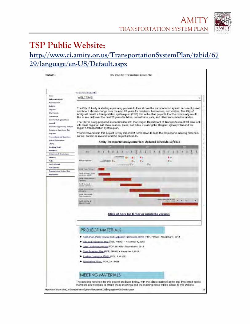
AMITY TRANSPORTATION SYSTEM PLAN
TSP Public Website: http://www.ci.amity.or.us/TransportationSystemPlan/tabid/6729/language/en-US/Default.aspx
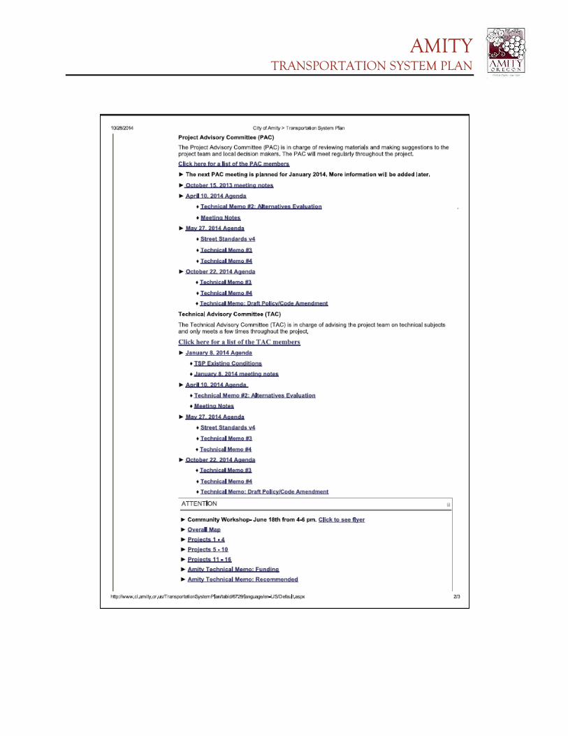
AMITY TRANSPORTATION SYSTEM PLAN
AMITY TRANSPORTATION SYSTEM PLAN
Appendix H
Cost Estimates
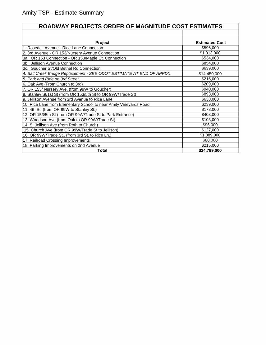
Amity TSP - Estimate Summary
Project Estimated Cost1. Rosedell Avenue - Rice Lane Connection $596,0002. 3rd Avenue - OR 153/Nursery Avenue Connection $1,013,0003a. OR 153 Connection - OR 153/Maple Ct. Connection $534,0003b. Jellison Avenue Connection $854,0003c. Goucher St/Old Bethel Rd Connection $639,0004. Salt Creek Bridge Replacement - SEE ODOT ESTIMATE AT END OF APPDX. $14,450,0005. Park and Ride on 3rd Street $215,0006. Oak Ave (From Church to 3rd) $209,0007. OR 153/ Nursery Ave. (from 99W to Goucher) $940,0008. Stanley St/1st St (from OR 153/5th St to OR 99W/Trade St) $893,0009. Jellison Avenue from 3rd Avenue to Rice Lane $638,00010. Rice Lane from Elementary School to near Amity Vineyards Road $239,00011. 4th St. (from OR 99W to Stanley St.) $178,00012. OR 153/5th St (from OR 99W/Trade St to Park Entrance) $403,00013. Woodson Ave (from Oak to OR 99W/Trade St) $103,00014. S. Jellison Ave (from Roth to Church) $96,000 15. Church Ave (from OR 99W/Trade St to Jellison) $127,00016. OR 99W/Trade St.. (from 3rd St. to Rice Ln.) $1,889,00017. Railroad Crossing Improvements $80,00018. Parking Improvements on 2nd Avenue $215,000
Total $24,799,000
ROADWAY PROJECTS ORDER OF MAGNITUDE COST ESTIMATES

Amity TSP: Project R3
DATE:
5/2/2014SHEET:
1 of 1NO. UNIT QUANTITY UNIT COST COST
1 Mi. 0.13 $882,000.00 $116,9322 Mi. $217,900.00 $03 Lane-Mi. 0.38 $213,300.00 $80,7954 Lane-Mi. $9.00 $05 EA $300,000.00 $06 Lane-Mi. 0.45 $14,670.00 $6,6687 5-10% 0.0% $08 Mi. 0.13 $260,000.00 $34,4709 Mi. $235,000.00 $0
10 SF $150.00 $0$238,865
SUGGESTED PERCENTAGE COST1.0-2.5% 2.5% $6,0003.0-8.0% 3.0% $7,200
8.0-10.0% 10.0% $23,9000.5-2.0% 2.0% $4,80030-40% 40.0% $95,500
0.5-2.0% 0.0% $0
2014$376,265
UNIT QUANTITY UNIT COST COSTSF 31,500 $4.00 $126,000LS All $0
SUGGESTED PERCENTAGE COST15.0% $56,40010.0% $37,600
$596,000
Assumptions:Project will construct a new roadway consisting of 2-12' Lanes, 1-8' Parking, and 2-5' Sidewalks and occur at the east end of Rosedell St north to Rice Ln.Only earthwork estimated is to construct the proposed pavement section. (4" AC over 6" Agg. Base) with a 20% increase for fill slopes.1867 lane-feet Two 750' Lanes (12') = 1400 lane-feet
One 750' Parking Lane (8') = 467 lane-feetIncludes 5' Sidewalk (Both Sides)Curb and Gutter Street lighting included at 200' spacing on each side.
ROW acquisition areas are approximated based on ROW dimensions provided by the City.
Design EngineeringConstruction Engineering
TOTAL PROJECT COST
Construction YearTOTAL CONSTRUCTION COST
RIGHT OF WAY COSTSNew Right of Way AcquisitionStructure(s)
ENGINEERING COSTS
Design Year
LandscapingBridges
SUBTOTAL
ADDITIONAL CONST. COSTSConstruction SurveyingTP & DTMobilizationErosion ControlContingencyEscalation (per year)
Illumination
Curb, Gutter, Sidewalks & DrainageMulti-use PathNew Local RoadwayReconstruct Existing RoadwayNew SignalEarthworkTraffic Calming
ITEM
AMITY TSP - ORDER OF MAGNITUDE ESTIMATE
PROJECT:
1. Rosedell Avenue - Rice Lane Connection PREPARED BY:
DESIGN LEVEL: Planning C. ClausenKIND OF WORK:
Roadway, Earthwork, Drainage, LightingLENGTH (MILE):
0.38

Amity TSP: Project R4 3 of 35
DATE:
5/2/2014SHEET:
1 of 1NO. UNIT QUANTITY UNIT COST COST
1 Mi. 0.23 $882,000.00 $200,4552 Mi. $217,900.00 $03 Lane-Mi. 0.61 $213,300.00 $129,2734 Lane-Mi. $9.00 $05 EA $300,000.00 $06 Lane-Mi. 0.73 $14,670.00 $10,6697 5-10% - $08 Mi. 0.23 $260,000.00 $59,0919 Mi. $235,000.00 $0
10 SF $150.00 $0$399,487
SUGGESTED PERCENTAGE COST1.0-2.5% 2.5% $10,0003.0-8.0% 8.0% $32,000
8.0-10.0% 10.0% $39,9000.5-2.0% 2.0% $8,00030-40% 40.0% $159,800
0.5-2.0% 0.0% $0
2014$649,187
UNIT QUANTITY UNIT COST COSTSF 50,400 $4.00 $201,600LS All $0
SUGGESTED PERCENTAGE COST15.0% $97,40010.0% $64,900
$1,013,000
Assumptions:This project will construct a new roadway consisting of 2-12' Lanes, 1-8' Parking, and 2-5' Sidewalks from the east end of 3rd St. to the east approx.. 240' and south to OR 153.Only earthwork estimated is to construct the proposed pavement section. (4" AC over 6" Agg. Base) with a 20% increase for fill slopes.3200 lane-feet Two 1200' Lanes (12') = 2400 lane-feet
One 1200' Parking Lane (8') = 800 lane-feetIncludes 5' Sidewalk (Both Sides)Curb and Gutter
ROW acquisition areas are approximated based on ROW dimensions provided by the City.
ITEM
AMITY TSP - ORDER OF MAGNITUDE ESTIMATE
PROJECT:2. 3rd Avenue - OR 153/Nursery
Avenue ConnectionPREPARED BY:
DESIGN LEVEL: Planning C. ClausenKIND OF WORK:
Roadway, Earthwork, Drainage, LightingLENGTH (MILE):
0.61
Illumination
New SignalEarthwork
Curb, Gutter, Sidewalks & DrainageMulti-use PathNew Local RoadwayReconstruct Existing Roadway
Traffic Calming
Design Year
LandscapingBridges
SUBTOTAL
ADDITIONAL CONST. COSTSConstruction SurveyingTP & DTMobilizationErosion ControlContingencyEscalation (per year)
Design EngineeringConstruction Engineering
TOTAL PROJECT COST
Construction YearTOTAL CONSTRUCTION COST
RIGHT OF WAY COSTSNew Right of Way AcquisitionStructure(s)
ENGINEERING COSTS
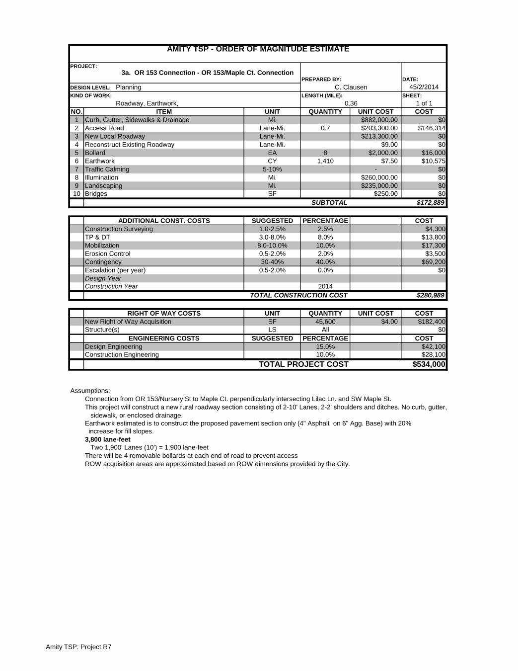
Amity TSP: Project R7
DATE:
45/2/2014SHEET:
1 of 1NO. UNIT QUANTITY UNIT COST COST
1 Mi. $882,000.00 $02 Lane-Mi. 0.7 $203,300.00 $146,3143 Lane-Mi. $213,300.00 $04 Lane-Mi. $9.00 $05 EA 8 $2,000.00 $16,0006 CY 1,410 $7.50 $10,5757 5-10% - $08 Mi. $260,000.00 $09 Mi. $235,000.00 $010 SF $250.00 $0
$172,889
SUGGESTED PERCENTAGE COST1.0-2.5% 2.5% $4,3003.0-8.0% 8.0% $13,8008.0-10.0% 10.0% $17,3000.5-2.0% 2.0% $3,50030-40% 40.0% $69,2000.5-2.0% 0.0% $0
2014$280,989
UNIT QUANTITY UNIT COST COSTSF 45,600 $4.00 $182,400LS All $0
SUGGESTED PERCENTAGE COST15.0% $42,10010.0% $28,100
$534,000
Assumptions:Connection from OR 153/Nursery St to Maple Ct. perpendicularly intersecting Lilac Ln. and SW Maple St.This project will construct a new rural roadway section consisting of 2-10' Lanes, 2-2' shoulders and ditches. No curb, gutter, sidewalk, or enclosed drainage.Earthwork estimated is to construct the proposed pavement section only (4" Asphalt on 6" Agg. Base) with 20% increase for fill slopes.3,800 lane-feet Two 1,900' Lanes (10') = 1,900 lane-feetThere will be 4 removable bollards at each end of road to prevent access
Structure(s)
ROW acquisition areas are approximated based on ROW dimensions provided by the City.
ENGINEERING COSTSDesign EngineeringConstruction Engineering
TOTAL PROJECT COST
Design YearConstruction Year
TOTAL CONSTRUCTION COST
RIGHT OF WAY COSTSNew Right of Way Acquisition
Escalation (per year)
Traffic CalmingIlluminationLandscapingBridges
SUBTOTAL
ADDITIONAL CONST. COSTSConstruction SurveyingTP & DTMobilizationErosion ControlContingency
Earthwork
KIND OF WORK:
Roadway, Earthwork, LENGTH (MILE):
0.36ITEM
Curb, Gutter, Sidewalks & DrainageAccess RoadNew Local RoadwayReconstruct Existing RoadwayBollard
DESIGN LEVEL: Planning C. Clausen
AMITY TSP - ORDER OF MAGNITUDE ESTIMATE
PROJECT:3a. OR 153 Connection - OR 153/Maple Ct. Connection
PREPARED BY:
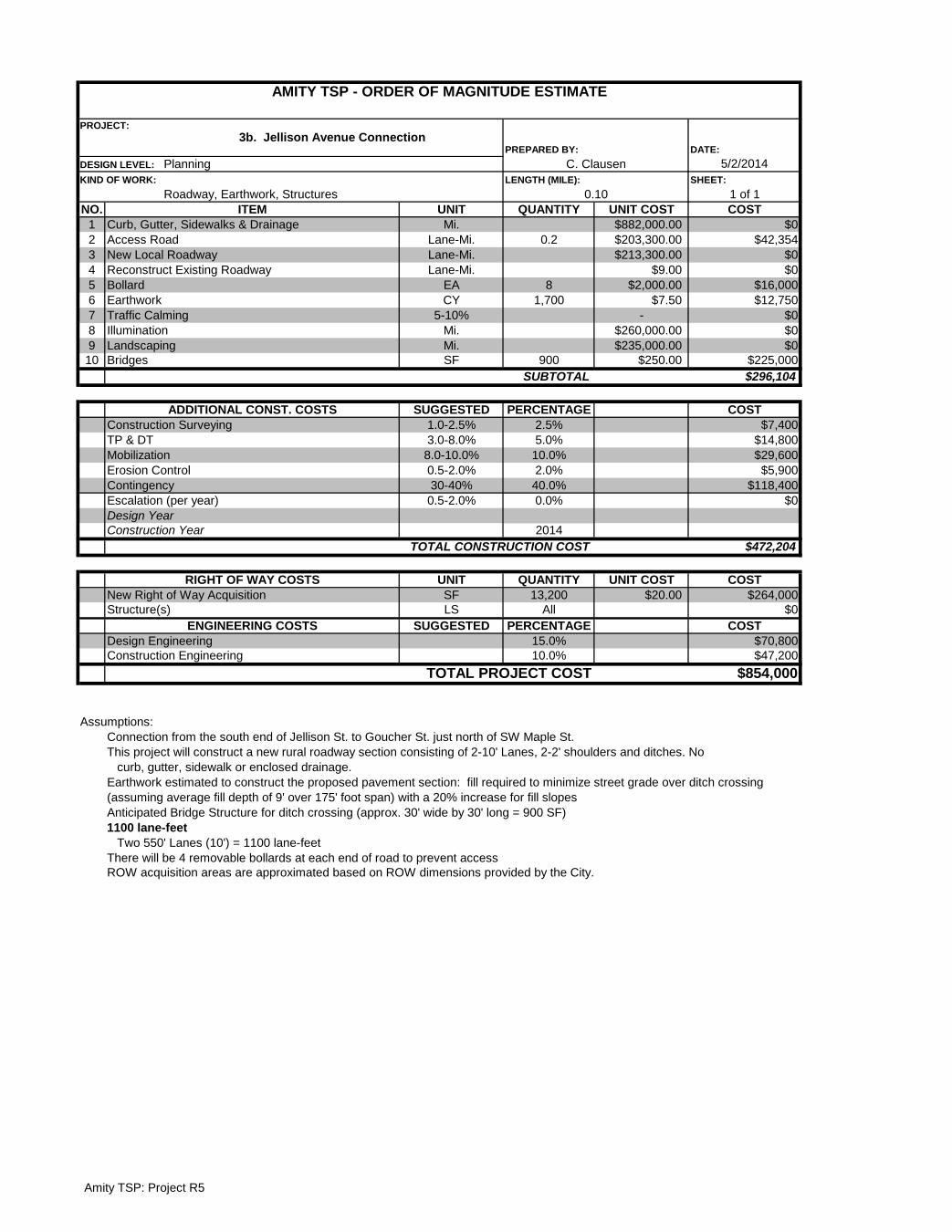
Amity TSP: Project R5
DATE:
5/2/2014SHEET:
1 of 1NO. UNIT QUANTITY UNIT COST COST
1 Mi. $882,000.00 $02 Lane-Mi. 0.2 $203,300.00 $42,3543 Lane-Mi. $213,300.00 $04 Lane-Mi. $9.00 $05 EA 8 $2,000.00 $16,0006 CY 1,700 $7.50 $12,7507 5-10% - $08 Mi. $260,000.00 $09 Mi. $235,000.00 $010 SF 900 $250.00 $225,000
$296,104
SUGGESTED PERCENTAGE COST1.0-2.5% 2.5% $7,4003.0-8.0% 5.0% $14,8008.0-10.0% 10.0% $29,6000.5-2.0% 2.0% $5,90030-40% 40.0% $118,400
0.5-2.0% 0.0% $0
2014$472,204
UNIT QUANTITY UNIT COST COSTSF 13,200 $20.00 $264,000LS All $0
SUGGESTED PERCENTAGE COST15.0% $70,80010.0% $47,200
$854,000
Assumptions:Connection from the south end of Jellison St. to Goucher St. just north of SW Maple St.This project will construct a new rural roadway section consisting of 2-10' Lanes, 2-2' shoulders and ditches. No curb, gutter, sidewalk or enclosed drainage.
Anticipated Bridge Structure for ditch crossing (approx. 30' wide by 30' long = 900 SF)1100 lane-feet Two 550' Lanes (10') = 1100 lane-feetThere will be 4 removable bollards at each end of road to prevent accessROW acquisition areas are approximated based on ROW dimensions provided by the City.
ITEM
AMITY TSP - ORDER OF MAGNITUDE ESTIMATE
PROJECT:3b. Jellison Avenue Connection
PREPARED BY:
DESIGN LEVEL: Planning C. ClausenKIND OF WORK:
Roadway, Earthwork, StructuresLENGTH (MILE):
0.10
Illumination
BollardEarthwork
Curb, Gutter, Sidewalks & DrainageAccess RoadNew Local RoadwayReconstruct Existing Roadway
Traffic Calming
Design Year
LandscapingBridges
SUBTOTAL
ADDITIONAL CONST. COSTSConstruction SurveyingTP & DTMobilizationErosion ControlContingencyEscalation (per year)
Earthwork estimated to construct the proposed pavement section: fill required to minimize street grade over ditch crossing (assuming average fill depth of 9' over 175' foot span) with a 20% increase for fill slopes
Design EngineeringConstruction Engineering
TOTAL PROJECT COST
Construction YearTOTAL CONSTRUCTION COST
RIGHT OF WAY COSTSNew Right of Way AcquisitionStructure(s)
ENGINEERING COSTS

Amity TSP: Project R6
DATE:
5/2/2014SHEET:
1 of 1NO. UNIT QUANTITY UNIT COST COST
1 Mi. $882,000.00 $02 Lane-Mi. 0.9 $203,300.00 $177,1173 Lane-Mi. $213,300.00 $04 Lane-Mi. $9.00 $05 EA 8 $2,000.00 $16,0006 CY 1,710 $7.50 $12,8257 5-10% - $08 Mi. $260,000.00 $09 Mi. $235,000.00 $010 SF $250.00 $0
$205,942
SUGGESTED PERCENTAGE COST1.0-2.5% 2.5% $5,1003.0-8.0% 8.0% $16,5008.0-10.0% 10.0% $20,6000.5-2.0% 2.0% $4,10030-40% 40.0% $82,4000.5-2.0% 0.0% $0
2014$334,642
UNIT QUANTITY UNIT COST COSTSF 55,200 $4.00 $220,800LS All $0
SUGGESTED PERCENTAGE COST15.0% $50,20010.0% $33,500
$639,000
Assumptions:Connection from the south end of Goucher to SE Old Bethel Rd.This project will construct a new rural roadway section consisting of 2-10' Lanes and 2-2' shoulders and ditches. No curb, gutter, sidewalk, or enclosed drainage.Earthwork estimated is to construct the proposed pavement section only (4" Asphalt on 6" Agg. Base) with a 20% increase for fill slopes.4,600 lane-feet Two 2,300' Lanes (10') = 4,300 lane-feetThere will be 4 removable bollards at each end of road to prevent access
Structure(s)ENGINEERING COSTS
Design EngineeringConstruction Engineering
TOTAL PROJECT COST
Design YearConstruction Year
TOTAL CONSTRUCTION COST
RIGHT OF WAY COSTSNew Right of Way Acquisition
Escalation (per year)
Traffic CalmingIlluminationLandscapingBridges
SUBTOTAL
ADDITIONAL CONST. COSTSConstruction SurveyingTP & DTMobilizationErosion ControlContingency
Curb, Gutter, Sidewalks & DrainageAccess RoadNew Local RoadwayReconstruct Existing RoadwayBollard
DESIGN LEVEL: Planning C. Clausen
ROW acquisition areas are approximated based on ROW dimensions provided by the City.
AMITY TSP - ORDER OF MAGNITUDE ESTIMATE
PROJECT:3c. Goucher St/Old Bethel Rd Connection
PREPARED BY:
Earthwork
KIND OF WORK:
Roadway, EarthworkLENGTH (MILE):
0.44ITEM
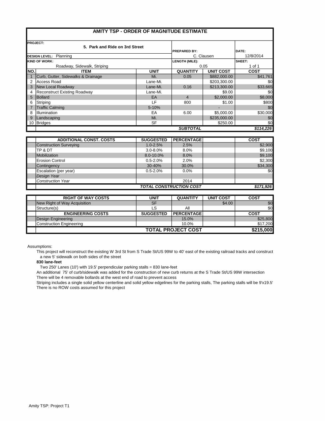
Amity TSP: Project T1
DATE:
12/8/2014SHEET:
1 of 1NO. UNIT QUANTITY UNIT COST COST
1 Mi. 0.05 $882,000.00 $41,7612 Lane-Mi. $203,300.00 $03 Lane-Mi. 0.16 $213,300.00 $33,6654 Lane-Mi. $9.00 $05 EA 4 $2,000.00 $8,0006 LF 800 $1.00 $8007 5-10% - $08 EA 6.00 $5,000.00 $30,0009 Mi. $235,000.00 $010 SF $250.00 $0
$114,226
SUGGESTED PERCENTAGE COST1.0-2.5% 2.5% $2,9003.0-8.0% 8.0% $9,1008.0-10.0% 8.0% $9,1000.5-2.0% 2.0% $2,30030-40% 30.0% $34,3000.5-2.0% 0.0% $0
2014$171,926
UNIT QUANTITY UNIT COST COSTSF $4.00 $0LS All $0
SUGGESTED PERCENTAGE COST15.0% $25,80010.0% $17,200
$215,000
Assumptions:This project will reconstruct the existing W 3rd St from S Trade St/US 99W to 40' east of the existing railroad tracks and construct a new 5' sidewalk on both sides of the street830 lane-feet Two 250' Lanes (10') with 19.5' perpendicular parking stalls = 830 lane-feetAn additional 75' of curb/sidewalk was added for the construction of new curb returns at the S Trade St/US 99W intersectionThere will be 4 removable bollards at the west end of road to prevent accessStriping includes a single solid yellow centerline and solid yellow edgelines for the parking stalls, The parking stalls will be 9'x19.5'
ITEM
AMITY TSP - ORDER OF MAGNITUDE ESTIMATE
PROJECT:5. Park and Ride on 3rd Street
PREPARED BY:
DESIGN LEVEL: Planning C. ClausenKIND OF WORK:
Roadway, Sidewalk, StripingLENGTH (MILE):
0.05
ADDITIONAL CONST. COSTS
Curb, Gutter, Sidewalks & DrainageAccess RoadNew Local RoadwayReconstruct Existing RoadwayBollardStripingTraffic CalmingIlluminationLandscapingBridges
SUBTOTAL
Structure(s)
Construction SurveyingTP & DTMobilizationErosion ControlContingencyEscalation (per year)Design YearConstruction Year
TOTAL CONSTRUCTION COST
RIGHT OF WAY COSTSNew Right of Way Acquisition
ENGINEERING COSTSDesign EngineeringConstruction Engineering
TOTAL PROJECT COST
There is no ROW costs assumed for this project

Amity TSP: Project BP1
DATE:
45/2/2014SHEET:
1 of 1NO. UNIT QUANTITY UNIT COST COST
1 Mi. 0.10 $882,000.00 $91,8752 Mi. $217,900.00 $03 SF 1275 $4.00 $5,1004 Lane-Mi. $9.00 $05 LF 4050 $2.00 $8,1006 EA $300,000.00 $07 CY $7.50 $08 5-10% - $09 EA $37,200.00 $010 SF $150.00 $0
$105,075
SUGGESTED PERCENTAGE COST1.0-2.5% 2.5% $2,6003.0-8.0% 5.0% $5,3008.0-10.0% 10.0% $10,5000.5-2.0% 2.0% $2,10030-40% 40.0% $42,0000.5-2.0% 0.0% $0
2014$167,575
UNIT QUANTITY UNIT COST COSTSF 0 $0LS All $0
SUGGESTED PERCENTAGE COST15.0% $25,10010.0% $16,800
$209,000
Assumptions:Improvements to occur on Oak Ave. from Church Ave. to 3rd St.Project will add bike lanes to existing roadway, construct new sidewalk and/or improvements, pedestrian crossing on OR 153/Nursery Ave (2-10' Lanes, 2-5' Bike Lanes, and 2-5' Sidewalks)Total quantity of curb and gutter/sidewalk modified to account for single side of road construction (unit cost is for both sides of street)Existing Roadway condition and widths adequate for proposed section except for segment 255' north of Church, only other new surfacing required is sidewalkSidewalk Construction required on west side of Oak for 255' north of Church (east side sidewalk to be kept in placed and used) 5' of new pavement required on east side of street.No construction needed for the first 120' north of Nursery Sidewalk Construction required on west side of Oak for the remaining 120' to Sherman (east side sidewalk to be kept in place and used)Sidewalk construction required on west side of Oak for 520 ft. from Sherman to Maddox (east side sidewalk to be kept in placed and used)No construction needed for the first 150' north of MaddoxSidewalk construction required for remaining 100 ft. on both sides of the streetStriping will consist of centerline and bike lane marking for the entire lengthAdditional 10% of sidewalk length added to account for existing cracked sidewalk replacementThere is no new ROW acquisition required for this project.
Design EngineeringConstruction Engineering
TOTAL PROJECT COST
MobilizationErosion ControlContingency
ENGINEERING COSTS
Escalation (per year)
New Right of Way AcquisitionStructure(s)
Construction YearTOTAL CONSTRUCTION COST
RIGHT OF WAY COSTS
Design Year
BridgesSUBTOTAL
ADDITIONAL CONST. COSTSConstruction SurveyingTP & DT
Pedestrian Crossing Assembly
Curb, Gutter, SidewalksMulti-use PathNew RoadwayReconstruct Existing RoadwayRestripe Existing RoadwayNew SignalEarthworkTraffic Calming
ITEM
AMITY TSP - ORDER OF MAGNITUDE ESTIMATE
PROJECT:6. Oak Ave (From Church to 3rd)
PREPARED BY:
DESIGN LEVEL: Planning C.ClausenKIND OF WORK:
Sidewalk, Curb, Gutter, and StripingLENGTH (MILE):
0.21
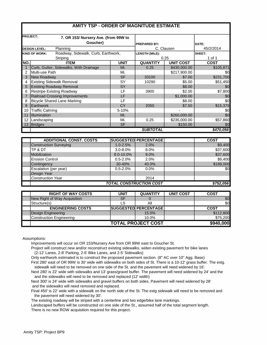
Amity TSP: Project BP9
DATE:
45/2/2014SHEET:
1 of 1NO. UNIT QUANTITY UNIT COST COST
1 Mi. 0.25 $430,000.00 $105,8712 Mi. $217,900.00 $03 SF 33100 $7.00 $231,7004 SY 10290 $5.00 $51,4505 SY $8.00 $06 LF 3900 $2.00 $7,8007 LF $1,000.00 $08 LF $8.00 $09 CY 2050 $7.50 $15,37510 5-10% - $011 Mi. $260,000.00 $012 Mi. 0.25 $235,000.00 $57,86013 SF $150.00 $0
$470,056
SUGGESTED PERCENTAGE COST1.0-2.5% 2.0% $9,4003.0-8.0% 8.0% $37,6008.0-10.0% 8.0% $37,6000.5-2.0% 2.0% $9,40030-40% 40.0% $188,000
0.5-2.0% 0.0% $0
2014$752,056
UNIT QUANTITY UNIT COST COSTSF 0 $0LS All $0
SUGGESTED PERCENTAGE COST15.0% $112,80010.0% $75,200
$940,000
Assumptions:Improvements will occur on OR 153/Nursery Ave from OR 99W east to Goucher St.Project will construct new and/or reconstruct existing sidewalks, widen existing pavement for bike lanes (2-12' Lanes, 2-8' Parking, 2-6' Bike Lanes, and 2-5' Sidewalks)Only earthwork estimated is to construct the proposed pavement section. (8" AC over 10" Agg. Base)First 280' east of OR 99W is 30' wide with sidewalks on both sides of St. There is a 10-12' grass buffer. The extg. sidewalk will need to be removed on one side of the St. and the pavement will need widened by 16'.Next 280' is 22' wide with sidewalks and 13' grass/gravel buffer. The pavement will need widened by 24' and the and the sidewalks will need to be removed and replaced (12' width)Next 300' is 24' wide with sidewalks and gravel buffers on both sides. Pavement will need widened by 28' and the sidewalks will need removed and replaced.Final 450' is 22' wide with a sidewalk on the north side of the St. The extg sidewalk will need to be removed and the pavement will need widened by 30'.The existing roadway will be striped with a centerline and two edge/bike lane markings.Landscaped buffers will be constructed on one side of the St., assumed half of the total segment length.
ITEM
AMITY TSP - ORDER OF MAGNITUDE ESTIMATE
PROJECT: 7. OR 153/ Nursery Ave. (from 99W to Goucher) PREPARED BY:
DESIGN LEVEL: Planning C. ClausenKIND OF WORK: Roadway, Sidewalk, Curb, Earthwork,
StripingLENGTH (MILE):
0.25
Landscaping
Curb, Gutter, Sidewalks, With DrainageMulti-use PathNew RoadwayExisting Sidewalk RemovalExisting Roadway RemovalRestripe Existing RoadwayRailroad Crossing ImprovementsBicycle Shared Lane MarkingEarthwork Traffic CalmingIllumination
TOTAL CONSTRUCTION COST
BridgesSUBTOTAL
ADDITIONAL CONST. COSTSConstruction SurveyingTP & DTMobilizationErosion ControlContingencyEscalation (per year)Design YearConstruction Year
TOTAL PROJECT COST
There is no new ROW acquisition required for this project.
RIGHT OF WAY COSTSNew Right of Way AcquisitionStructure(s)
ENGINEERING COSTSDesign EngineeringConstruction Engineering
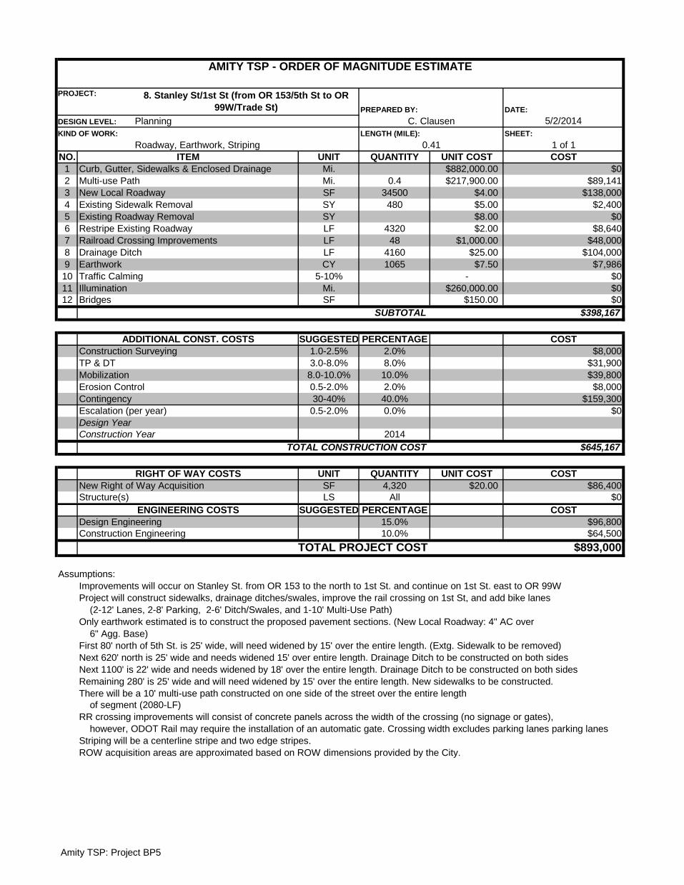
Amity TSP: Project BP5
DATE:
5/2/2014SHEET:
1 of 1NO. UNIT QUANTITY UNIT COST COST
1 Mi. $882,000.00 $02 Mi. 0.4 $217,900.00 $89,1413 SF 34500 $4.00 $138,0004 SY 480 $5.00 $2,4005 SY $8.00 $06 LF 4320 $2.00 $8,6407 LF 48 $1,000.00 $48,0008 LF 4160 $25.00 $104,0009 CY 1065 $7.50 $7,98610 5-10% - $011 Mi. $260,000.00 $012 SF $150.00 $0
$398,167
SUGGESTED PERCENTAGE COST1.0-2.5% 2.0% $8,0003.0-8.0% 8.0% $31,900
8.0-10.0% 10.0% $39,8000.5-2.0% 2.0% $8,00030-40% 40.0% $159,300
0.5-2.0% 0.0% $0
2014$645,167
UNIT QUANTITY UNIT COST COSTSF 4,320 $20.00 $86,400LS All $0
SUGGESTED PERCENTAGE COST15.0% $96,80010.0% $64,500
$893,000
Assumptions:Improvements will occur on Stanley St. from OR 153 to the north to 1st St. and continue on 1st St. east to OR 99WProject will construct sidewalks, drainage ditches/swales, improve the rail crossing on 1st St, and add bike lanes (2-12' Lanes, 2-8' Parking, 2-6' Ditch/Swales, and 1-10' Multi-Use Path)Only earthwork estimated is to construct the proposed pavement sections. (New Local Roadway: 4" AC over 6" Agg. Base)First 80' north of 5th St. is 25' wide, will need widened by 15' over the entire length. (Extg. Sidewalk to be removed)Next 620' north is 25' wide and needs widened 15' over entire length. Drainage Ditch to be constructed on both sidesNext 1100' is 22' wide and needs widened by 18' over the entire length. Drainage Ditch to be constructed on both sidesRemaining 280' is 25' wide and will need widened by 15' over the entire length. New sidewalks to be constructed.There will be a 10' multi-use path constructed on one side of the street over the entire length of segment (2080-LF)RR crossing improvements will consist of concrete panels across the width of the crossing (no signage or gates), however, ODOT Rail may require the installation of an automatic gate. Crossing width excludes parking lanes parking lanes Striping will be a centerline stripe and two edge stripes.
ITEM
AMITY TSP - ORDER OF MAGNITUDE ESTIMATE
PROJECT: 8. Stanley St/1st St (from OR 153/5th St to OR 99W/Trade St) PREPARED BY:
DESIGN LEVEL: Planning C. ClausenKIND OF WORK:
Roadway, Earthwork, StripingLENGTH (MILE):
0.41
Restripe Existing RoadwayRailroad Crossing ImprovementsDrainage DitchEarthwork
Curb, Gutter, Sidewalks & Enclosed DrainageMulti-use PathNew Local RoadwayExisting Sidewalk RemovalExisting Roadway Removal
Traffic Calming
Design Year
BridgesSUBTOTAL
ADDITIONAL CONST. COSTSConstruction SurveyingTP & DTMobilizationErosion ControlContingencyEscalation (per year)
Illumination
ROW acquisition areas are approximated based on ROW dimensions provided by the City.
Construction YearTOTAL CONSTRUCTION COST
RIGHT OF WAY COSTSNew Right of Way AcquisitionStructure(s)
ENGINEERING COSTSDesign EngineeringConstruction Engineering
TOTAL PROJECT COST
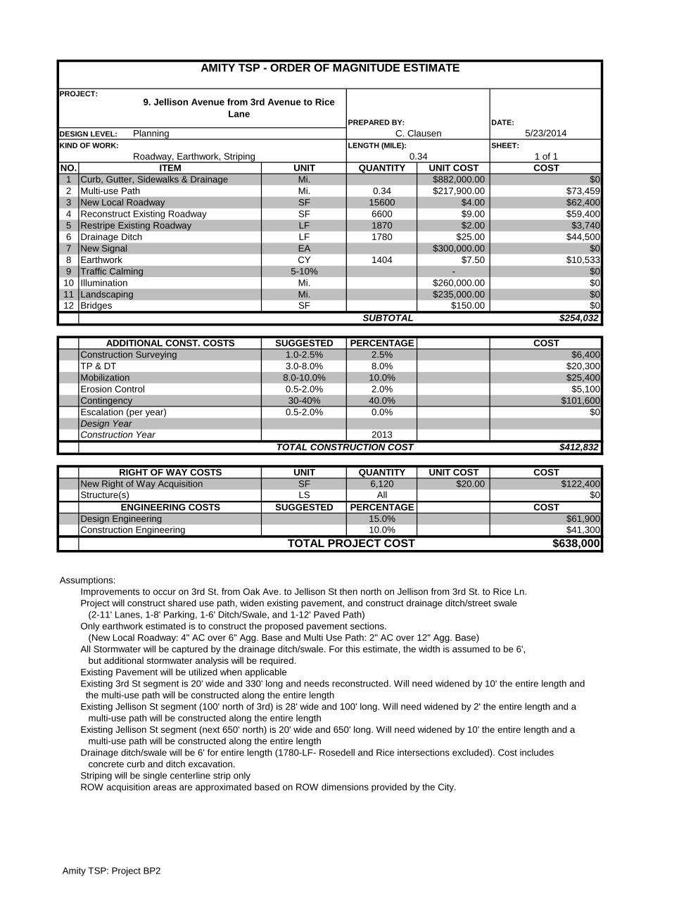
Amity TSP: Project BP2
DATE:
5/23/2014SHEET:
1 of 1NO. UNIT QUANTITY UNIT COST COST
1 Mi. $882,000.00 $02 Mi. 0.34 $217,900.00 $73,4593 SF 15600 $4.00 $62,4004 SF 6600 $9.00 $59,4005 LF 1870 $2.00 $3,7406 LF 1780 $25.00 $44,5007 EA $300,000.00 $08 CY 1404 $7.50 $10,5339 5-10% - $0
10 Mi. $260,000.00 $011 Mi. $235,000.00 $012 SF $150.00 $0
$254,032
SUGGESTED PERCENTAGE COST1.0-2.5% 2.5% $6,4003.0-8.0% 8.0% $20,300
8.0-10.0% 10.0% $25,4000.5-2.0% 2.0% $5,10030-40% 40.0% $101,600
0.5-2.0% 0.0% $0
2013$412,832
UNIT QUANTITY UNIT COST COSTSF 6,120 $20.00 $122,400LS All $0
SUGGESTED PERCENTAGE COST15.0% $61,90010.0% $41,300
$638,000
Assumptions:Improvements to occur on 3rd St. from Oak Ave. to Jellison St then north on Jellison from 3rd St. to Rice Ln.Project will construct shared use path, widen existing pavement, and construct drainage ditch/street swale (2-11' Lanes, 1-8' Parking, 1-6' Ditch/Swale, and 1-12' Paved Path)Only earthwork estimated is to construct the proposed pavement sections. (New Local Roadway: 4" AC over 6" Agg. Base and Multi Use Path: 2" AC over 12" Agg. Base)All Stormwater will be captured by the drainage ditch/swale. For this estimate, the width is assumed to be 6', but additional stormwater analysis will be required.Existing Pavement will be utilized when applicableExisting 3rd St segment is 20' wide and 330' long and needs reconstructed. Will need widened by 10' the entire length and the multi-use path will be constructed along the entire lengthExisting Jellison St segment (100' north of 3rd) is 28' wide and 100' long. Will need widened by 2' the entire length and a multi-use path will be constructed along the entire lengthExisting Jellison St segment (next 650' north) is 20' wide and 650' long. Will need widened by 10' the entire length and a multi-use path will be constructed along the entire lengthDrainage ditch/swale will be 6' for entire length (1780-LF- Rosedell and Rice intersections excluded). Cost includes concrete curb and ditch excavation.Striping will be single centerline strip onlyROW acquisition areas are approximated based on ROW dimensions provided by the City.
ITEM
AMITY TSP - ORDER OF MAGNITUDE ESTIMATE
PROJECT:9. Jellison Avenue from 3rd Avenue to Rice
Lane PREPARED BY:
DESIGN LEVEL: Planning C. ClausenKIND OF WORK:
Roadway, Earthwork, StripingLENGTH (MILE):
0.34
Illumination
Curb, Gutter, Sidewalks & DrainageMulti-use PathNew Local RoadwayReconstruct Existing RoadwayRestripe Existing RoadwayDrainage DitchNew SignalEarthworkTraffic Calming
Design Year
LandscapingBridges
SUBTOTAL
ADDITIONAL CONST. COSTSConstruction SurveyingTP & DTMobilizationErosion ControlContingencyEscalation (per year)
TOTAL PROJECT COST
Construction YearTOTAL CONSTRUCTION COST
RIGHT OF WAY COSTSNew Right of Way AcquisitionStructure(s)
ENGINEERING COSTSDesign EngineeringConstruction Engineering
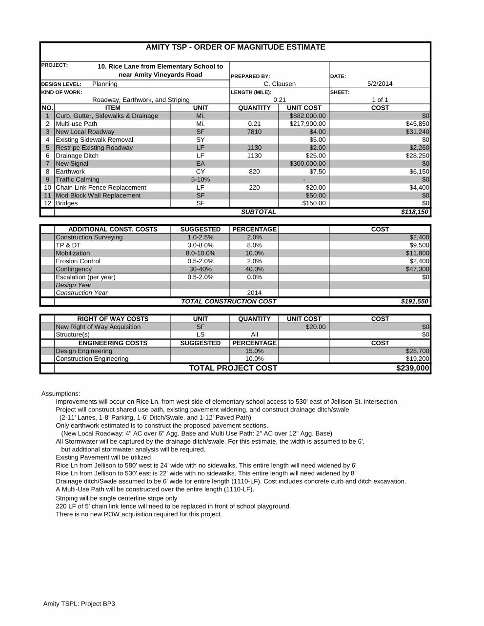
Amity TSPL: Project BP3
DATE:
5/2/2014SHEET:
1 of 1NO. UNIT QUANTITY UNIT COST COST
1 Mi. $882,000.00 $02 Mi. 0.21 $217,900.00 $45,8503 SF 7810 $4.00 $31,2404 SY $5.00 $05 LF 1130 $2.00 $2,2606 LF 1130 $25.00 $28,2507 EA $300,000.00 $08 CY 820 $7.50 $6,1509 5-10% - $0
10 LF 220 $20.00 $4,40011 SF $50.00 $012 SF $150.00 $0
$118,150
SUGGESTED PERCENTAGE COST1.0-2.5% 2.0% $2,4003.0-8.0% 8.0% $9,500
8.0-10.0% 10.0% $11,8000.5-2.0% 2.0% $2,40030-40% 40.0% $47,300
0.5-2.0% 0.0% $0
2014$191,550
UNIT QUANTITY UNIT COST COSTSF $20.00 $0LS All $0
SUGGESTED PERCENTAGE COST15.0% $28,70010.0% $19,200
$239,000
Assumptions:Improvements will occur on Rice Ln. from west side of elementary school access to 530' east of Jellison St. intersection.Project will construct shared use path, existing pavement widening, and construct drainage ditch/swale (2-11' Lanes, 1-8' Parking, 1-6' Ditch/Swale, and 1-12' Paved Path)Only earthwork estimated is to construct the proposed pavement sections. (New Local Roadway: 4" AC over 6" Agg. Base and Multi Use Path: 2" AC over 12" Agg. Base)All Stormwater will be captured by the drainage ditch/swale. For this estimate, the width is assumed to be 6', but additional stormwater analysis will be required.Existing Pavement will be utilizedRice Ln from Jellison to 580' west is 24' wide with no sidewalks. This entire length will need widened by 6'Rice Ln from Jellison to 530' east is 22' wide with no sidewalks. This entire length will need widened by 8'Drainage ditch/Swale assumed to be 6' wide for entire length (1110-LF). Cost includes concrete curb and ditch excavation.A Multi-Use Path will be constructed over the entire length (1110-LF).
Striping will be single centerline stripe only220 LF of 5' chain link fence will need to be replaced in front of school playground.
Mod Block Wall Replacement
Construction Year
Bridges
ITEM
Chain Link Fence Replacement
Curb, Gutter, Sidewalks & DrainageMulti-use PathNew Local RoadwayExisting Sidewalk RemovalRestripe Existing RoadwayDrainage DitchNew SignalEarthworkTraffic Calming
SUBTOTAL
ADDITIONAL CONST. COSTS
AMITY TSP - ORDER OF MAGNITUDE ESTIMATE
PROJECT: 10. Rice Lane from Elementary School to near Amity Vineyards Road PREPARED BY:
DESIGN LEVEL: Planning C. ClausenKIND OF WORK:
Roadway, Earthwork, and StripingLENGTH (MILE):
0.21
Construction SurveyingTP & DT
RIGHT OF WAY COSTS
Design Year
MobilizationErosion ControlContingencyEscalation (per year)
TOTAL CONSTRUCTION COST
There is no new ROW acquisition required for this project.
New Right of Way AcquisitionStructure(s)
Design EngineeringConstruction Engineering
TOTAL PROJECT COST
ENGINEERING COSTS

Amity TSP: Project BP13
DATE:
5/2/2014SHEET:
1 of 1NO. UNIT QUANTITY UNIT COST COST
1 Mi. $882,000.00 $02 Mi. 0.10 $217,900.00 $21,8733 SF 2600 $4.00 $10,4004 Lane-Mi. $9.00 $05 LF 623 $2.00 $1,2466 LF 530 $25.00 $13,2507 LF 40 $1,000.00 $40,0008 CY 355 $7.50 $2,6639 5-10% - $0
10 Mi. $260,000.00 $011 Mi. $235,000.00 $012 SF $150.00 $0
$89,432
SUGGESTED PERCENTAGE COST1.0-2.5% 2.0% $1,8003.0-8.0% 5.0% $4,500
8.0-10.0% 10.0% $8,9000.5-2.0% 2.0% $1,80030-40% 40.0% $35,800
0.5-2.0% 0.0% $0
2014$142,232
UNIT QUANTITY UNIT COST COSTSF 0 $0LS All $0
SUGGESTED PERCENTAGE COST15.0% $21,30010.0% $14,200
$178,000
Assumptions:Project will construct shared use path, widen existing pavement, and construct drainage ditch/street swale (2-11' Lanes, 1-8' Parking, 1-6' Swale, and 1-10 to 12' Paved Path)Only earthwork estimated is to construct the proposed pavement sections. (New Local Roadway: 4" AC over 6" Agg. Base and Multi Use Path: 2" AC over 12" Agg. Base)All Stormwater will be captured by the drainage ditch/swale. For this estimate, the width is assumed to be 6', but additional stormwater analysis will be required.Existing Pavement will be utilizedFirst 270' of 4th St. is 36' wide with a 6' sidewalk on both sides of St. and 8' landscaped buffers between the sidewalk and roadway. The extg. sidewalk on the north side of the St will be removed along with 4' of extg. roadway260' west of RR is 20' wide with gravel shoulders on both sides of St. The pavement will need widened by 10'.A multi-use path will be constructed on the entire length of 4th St (except for RxR)Drainage ditch/swale will be 6' for entire length of the 4th St (except for RxR). Cost includes concrete curb and ditch excavation.The RR crossing width is the section width minus the parking lane.Striping will be single centerline strip onlyThere is no new ROW acquisition required for this project.
DESIGN LEVEL: Planning C. Clausen
AMITY TSP - ORDER OF MAGNITUDE ESTIMATE
PROJECT:
11. 4th St. (from OR 99W to Stanley St.)
PREPARED BY:
Drainage Ditch
KIND OF WORK:
Roadway, Earthwork, StripingLENGTH (MILE):
0.12ITEM
Curb, Gutter, Sidewalks & DrainageMulti-use PathNew Local RoadwayReconstruct Existing RoadwayRestripe Existing Roadway
Erosion Control
Railroad Crossings ImprovementsEarthworkTraffic CalmingIlluminationLandscapingBridges
SUBTOTAL
ADDITIONAL CONST. COSTSConstruction SurveyingTP & DTMobilization
TOTAL PROJECT COST
ContingencyEscalation (per year)Design YearConstruction Year
TOTAL CONSTRUCTION COST
RIGHT OF WAY COSTSNew Right of Way AcquisitionStructure(s)
ENGINEERING COSTSDesign EngineeringConstruction Engineering

Amity TSP: Project BP4
DATE:
5/2/2014SHEET:
1 of 1NO. UNIT QUANTITY UNIT COST COST
1 Mi. 0.08 $430,000.00 $32,2502 Mi. 0.20 $217,900.00 $43,7453 SF 1470 $7.00 $10,2904 SY 380 $5.00 $1,9005 SY 380 $8.00 $3,0406 LF 1060 $2.00 $2,1207 LF 48 $1,000.00 $48,0008 LF 2120 $25.00 $53,0009 CY 640 $7.50 $4,80310 Mi. $260,000.00 $011 Mi. $235,000.00 $012 SF $150.00 $0
$199,148
SUGGESTED PERCENTAGE COST1.0-2.5% 2.0% $4,0003.0-8.0% 8.0% $15,9008.0-10.0% 10.0% $19,9000.5-2.0% 2.0% $4,00030-40% 40.0% $79,7000.5-2.0% 0.0% $0
2014$322,648
UNIT QUANTITY UNIT COST COSTSF 0 $0LS All $0
SUGGESTED PERCENTAGE COST15.0% $48,40010.0% $32,300
$403,000
Assumptions:Improvements will occur on OR 153/5th St. from OR 99W to west to the park entrance.Project will construct sidewalk improvements, construct shared use path, drainage ditch/swale, and improve rail crossing (1-12' Lane, 1-13' Lane, 1-8' Parking, 2-6' Ditch/Swales, 1-6' Sidewalk, and 1-12' Paved Path)Only earthwork estimated is to construct the proposed paved multi use path (2" AC over 12" Agg. Base) and roadway (8" AC over 12" Agg. Base)Total quantity of curb and gutter/sidewalk modified to account for single side of road construction (unit cost is for both sides of street)Due to the fact of this segment being an ODOT facility, the proposed section will need to be revised to meet ODOT StandardsAll Stormwater will be captured by the drainage ditch/swale. For this estimate, the width is assumed to be 6', but additional stormwater analysis will be required.The first 300' west of OR 99W is 50' wide and will have pavement and existing sidewalk removed north side of St. (Total of 12' of pavement width (for path construction) and 6' of sidewalk width (for swales)) Extg. Sidewalk to be usedThe next 265' will have 6' of pavement removal and 6' of sidewalk removal. The existing sidewalk on the north side of St will be kept in placeThe final 490' has 30' of pavement and no sidewalks will need widened by 3'. All existing pavement will be utilized and new sidewalk, multi use path, and drainage ditch/swales will be constructed.Drainage ditch/Swale assumed to be 6' wide for entire length (2120-LF)One new RR crossing will be installed consisting of new concrete panels over entire span of crossing (no signage) Parking lane excluded from crossing width.Striping will consist of one centerline stripeThere is no new ROW acquisition required for this project.
SUBTOTAL
ITEM
AMITY TSP - ORDER OF MAGNITUDE ESTIMATE
PROJECT:12. OR 153/5th St (from OR 99W/Trade St to Park
Entrance) PREPARED BY:
DESIGN LEVEL: Planning C. ClausenKIND OF WORK:
Roadway, Earthwork, StripingLENGTH (MILE):
ADDITIONAL CONST. COSTSConstruction SurveyingTP & DT
0.20
Illumination
Curb, Gutter, Sidewalks No DrainageMulti-use PathNew RoadwayExisting Sidewalk RemovalExisting Roadway RemovalRestripe Existing RoadwayRailroad Crossing ImprovementsDrainage DitchEarthwork
BridgesLandscaping
MobilizationErosion ControlContingencyEscalation (per year)
New Right of Way Acquisition
TOTAL CONSTRUCTION COST
RIGHT OF WAY COSTS
Design YearConstruction Year
Structure(s)
Design EngineeringConstruction Engineering
TOTAL PROJECT COST
ENGINEERING COSTS
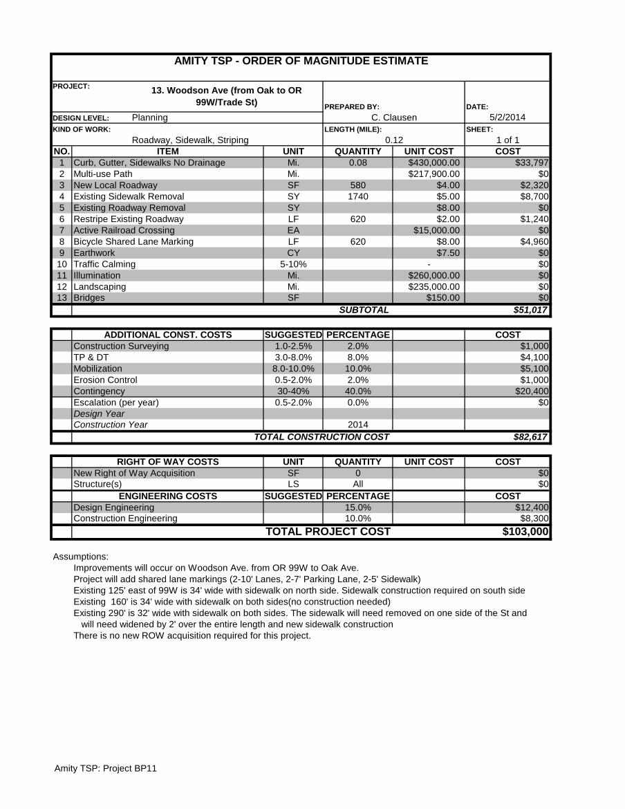
Amity TSP: Project BP11
DATE:
5/2/2014SHEET:
1 of 1NO. UNIT QUANTITY UNIT COST COST
1 Mi. 0.08 $430,000.00 $33,7972 Mi. $217,900.00 $03 SF 580 $4.00 $2,3204 SY 1740 $5.00 $8,7005 SY $8.00 $06 LF 620 $2.00 $1,2407 EA $15,000.00 $08 LF 620 $8.00 $4,9609 CY $7.50 $0
10 5-10% - $011 Mi. $260,000.00 $012 Mi. $235,000.00 $013 SF $150.00 $0
$51,017
SUGGESTED PERCENTAGE COST1.0-2.5% 2.0% $1,0003.0-8.0% 8.0% $4,100
8.0-10.0% 10.0% $5,1000.5-2.0% 2.0% $1,00030-40% 40.0% $20,400
0.5-2.0% 0.0% $0
2014$82,617
UNIT QUANTITY UNIT COST COSTSF 0 $0LS All $0
SUGGESTED PERCENTAGE COST15.0% $12,40010.0% $8,300
$103,000
Assumptions:Improvements will occur on Woodson Ave. from OR 99W to Oak Ave.Project will add shared lane markings (2-10' Lanes, 2-7' Parking Lane, 2-5' Sidewalk)Existing 125' east of 99W is 34' wide with sidewalk on north side. Sidewalk construction required on south sideExisting 160' is 34' wide with sidewalk on both sides(no construction needed)Existing 290' is 32' wide with sidewalk on both sides. The sidewalk will need removed on one side of the St and will need widened by 2' over the entire length and new sidewalk construction
ITEM
AMITY TSP - ORDER OF MAGNITUDE ESTIMATE
PROJECT: 13. Woodson Ave (from Oak to OR 99W/Trade St) PREPARED BY:
DESIGN LEVEL: Planning C. ClausenKIND OF WORK:
Roadway, Sidewalk, StripingLENGTH (MILE):
0.12
Landscaping
Curb, Gutter, Sidewalks No DrainageMulti-use PathNew Local RoadwayExisting Sidewalk RemovalExisting Roadway RemovalRestripe Existing RoadwayActive Railroad CrossingBicycle Shared Lane MarkingEarthworkTraffic CalmingIllumination
TOTAL CONSTRUCTION COST
BridgesSUBTOTAL
ADDITIONAL CONST. COSTSConstruction SurveyingTP & DTMobilizationErosion ControlContingencyEscalation (per year)Design YearConstruction Year
TOTAL PROJECT COST
There is no new ROW acquisition required for this project.
RIGHT OF WAY COSTSNew Right of Way AcquisitionStructure(s)
ENGINEERING COSTSDesign EngineeringConstruction Engineering
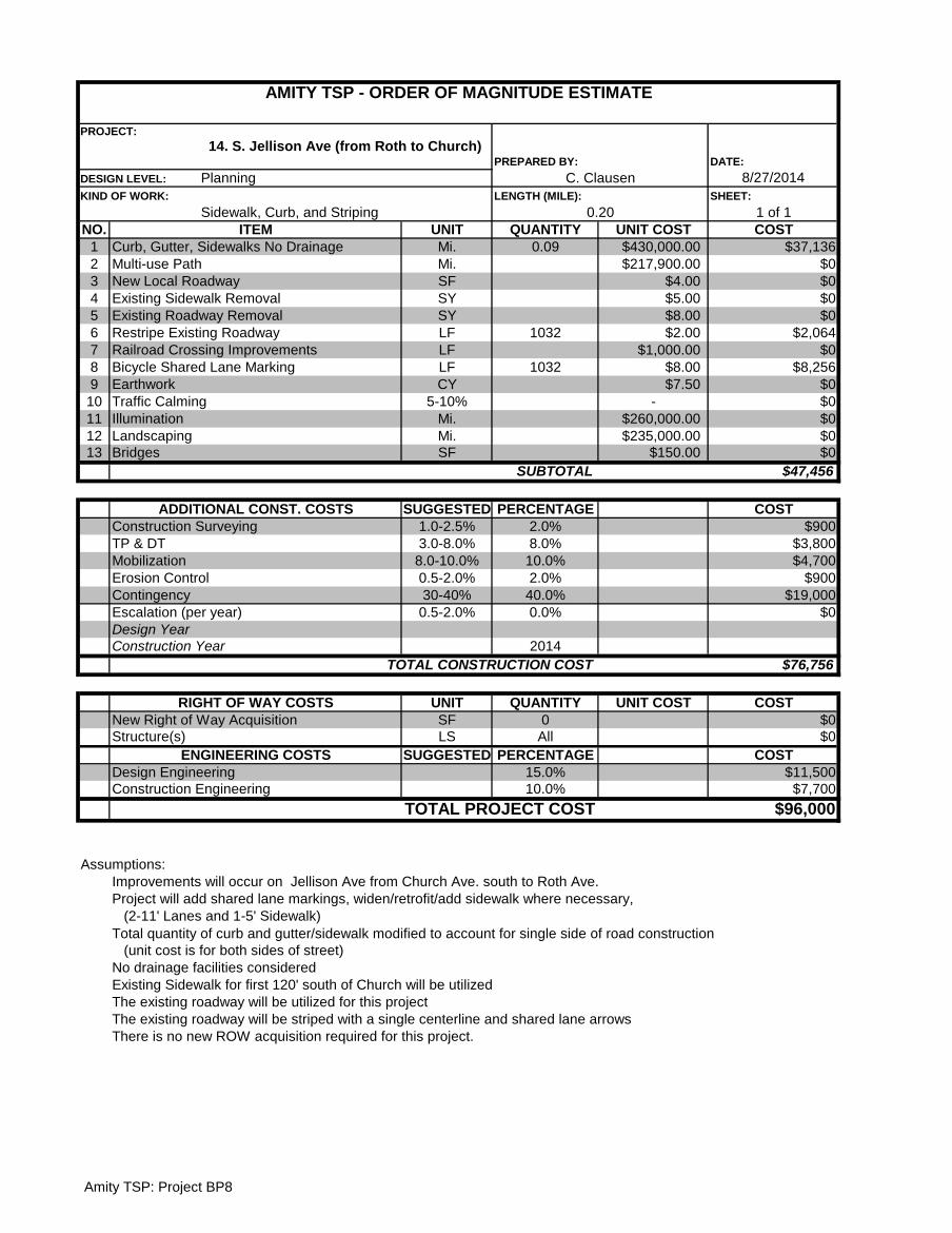
Amity TSP: Project BP8
DATE:
8/27/2014SHEET:
1 of 1NO. UNIT QUANTITY UNIT COST COST
1 Mi. 0.09 $430,000.00 $37,1362 Mi. $217,900.00 $03 SF $4.00 $04 SY $5.00 $05 SY $8.00 $06 LF 1032 $2.00 $2,0647 LF $1,000.00 $08 LF 1032 $8.00 $8,2569 CY $7.50 $0
10 5-10% - $011 Mi. $260,000.00 $012 Mi. $235,000.00 $013 SF $150.00 $0
$47,456
SUGGESTED PERCENTAGE COST1.0-2.5% 2.0% $9003.0-8.0% 8.0% $3,800
8.0-10.0% 10.0% $4,7000.5-2.0% 2.0% $90030-40% 40.0% $19,000
0.5-2.0% 0.0% $0
2014$76,756
UNIT QUANTITY UNIT COST COSTSF 0 $0LS All $0
SUGGESTED PERCENTAGE COST15.0% $11,50010.0% $7,700
$96,000
Assumptions:Improvements will occur on Jellison Ave from Church Ave. south to Roth Ave.Project will add shared lane markings, widen/retrofit/add sidewalk where necessary, (2-11' Lanes and 1-5' Sidewalk)Total quantity of curb and gutter/sidewalk modified to account for single side of road construction (unit cost is for both sides of street)No drainage facilities consideredExisting Sidewalk for first 120' south of Church will be utilizedThe existing roadway will be utilized for this projectThe existing roadway will be striped with a single centerline and shared lane arrowsThere is no new ROW acquisition required for this project.
ITEM
AMITY TSP - ORDER OF MAGNITUDE ESTIMATE
PROJECT:
14. S. Jellison Ave (from Roth to Church) PREPARED BY:
DESIGN LEVEL: Planning C. ClausenKIND OF WORK:
Sidewalk, Curb, and StripingLENGTH (MILE):
0.20
Illumination
Curb, Gutter, Sidewalks No DrainageMulti-use PathNew Local RoadwayExisting Sidewalk RemovalExisting Roadway RemovalRestripe Existing RoadwayRailroad Crossing ImprovementsBicycle Shared Lane MarkingEarthwork Traffic Calming
Design Year
LandscapingBridges
SUBTOTAL
ADDITIONAL CONST. COSTSConstruction SurveyingTP & DTMobilizationErosion ControlContingencyEscalation (per year)
Design EngineeringConstruction Engineering
TOTAL PROJECT COST
Construction YearTOTAL CONSTRUCTION COST
RIGHT OF WAY COSTSNew Right of Way AcquisitionStructure(s)
ENGINEERING COSTS
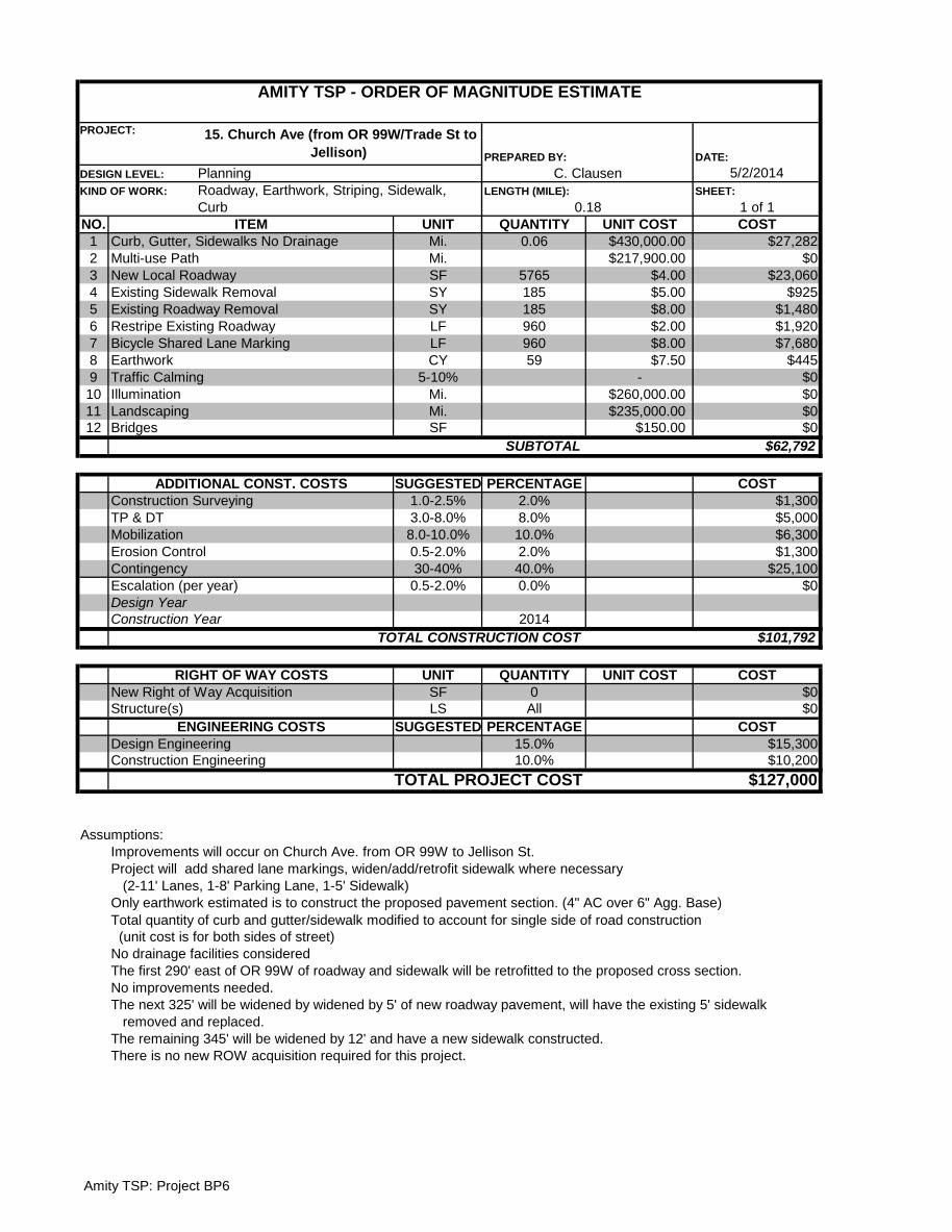
Amity TSP: Project BP6
DATE:
5/2/2014SHEET:
1 of 1NO. UNIT QUANTITY UNIT COST COST
1 Mi. 0.06 $430,000.00 $27,2822 Mi. $217,900.00 $03 SF 5765 $4.00 $23,0604 SY 185 $5.00 $9255 SY 185 $8.00 $1,4806 LF 960 $2.00 $1,9207 LF 960 $8.00 $7,6808 CY 59 $7.50 $4459 5-10% - $010 Mi. $260,000.00 $011 Mi. $235,000.00 $012 SF $150.00 $0
$62,792
SUGGESTED PERCENTAGE COST1.0-2.5% 2.0% $1,3003.0-8.0% 8.0% $5,0008.0-10.0% 10.0% $6,3000.5-2.0% 2.0% $1,30030-40% 40.0% $25,100
0.5-2.0% 0.0% $0
2014$101,792
UNIT QUANTITY UNIT COST COSTSF 0 $0LS All $0
SUGGESTED PERCENTAGE COST15.0% $15,30010.0% $10,200
$127,000
Assumptions:Improvements will occur on Church Ave. from OR 99W to Jellison St.Project will add shared lane markings, widen/add/retrofit sidewalk where necessary (2-11' Lanes, 1-8' Parking Lane, 1-5' Sidewalk)Only earthwork estimated is to construct the proposed pavement section. (4" AC over 6" Agg. Base)Total quantity of curb and gutter/sidewalk modified to account for single side of road construction (unit cost is for both sides of street)No drainage facilities consideredThe first 290' east of OR 99W of roadway and sidewalk will be retrofitted to the proposed cross section.No improvements needed.The next 325' will be widened by widened by 5' of new roadway pavement, will have the existing 5' sidewalk removed and replaced.The remaining 345' will be widened by 12' and have a new sidewalk constructed.
AMITY TSP - ORDER OF MAGNITUDE ESTIMATE
PROJECT: 15. Church Ave (from OR 99W/Trade St to Jellison) PREPARED BY:
DESIGN LEVEL: Planning C. Clausen
Restripe Existing Roadway
KIND OF WORK: Roadway, Earthwork, Striping, Sidewalk, Curb
LENGTH (MILE):
0.18ITEM
Curb, Gutter, Sidewalks No DrainageMulti-use PathNew Local RoadwayExisting Sidewalk RemovalExisting Roadway Removal
Traffic CalmingIlluminationLandscapingBridges
Bicycle Shared Lane MarkingEarthwork
SUBTOTAL
ADDITIONAL CONST. COSTS
MobilizationErosion ControlContingencyEscalation (per year)
TP & DTConstruction Surveying
There is no new ROW acquisition required for this project.
Design EngineeringConstruction Engineering
TOTAL PROJECT COST
ENGINEERING COSTSStructure(s)
Design YearConstruction Year
TOTAL CONSTRUCTION COST
RIGHT OF WAY COSTSNew Right of Way Acquisition

Amity TSP: Project BP14 18 of 35
DATE:
5/2/2014SHEET:
1 of 1NO. UNIT QUANTITY UNIT COST COST
1 Mi. 0.71 $882,000.00 $623,9152 Mi. $217,900.00 $03 SF 15370 $7.00 $107,5904 SY 11360 $5.00 $56,8005 LF 8460 $2.00 $16,9206 LF $25.00 $07 SF $1,000.00 $08 CY 950 $7.50 $7,1259 5-10% - $0
10 Mi. $260,000.00 $011 SF 21520 $5.60 $120,51212 SF $150.00 $0
$932,862
SUGGESTED PERCENTAGE COST1.0-2.5% 2.0% $18,7003.0-8.0% 8.0% $74,600
8.0-10.0% 10.0% $93,3000.5-2.0% 2.0% $18,70030-40% 40.0% $373,100
0.5-2.0% 0.0% $0
2014$1,511,262
UNIT QUANTITY UNIT COST COSTSF 0 $0LS All $0
SUGGESTED PERCENTAGE COST15.0% $226,70010.0% $151,100
$1,889,000
Assumptions:Project will widen existing pavement, and construct new sidewalks and landscaped buffers (2-14' Lanes, 2-6' Shoulder/Bike Lanes, and 2-6' Sidewalks)Only earthwork estimated is to construct the proposed pavement sections. (New Roadway: 8" AC over 12" Agg. Base)Existing Pavement will be utilizedFirst 430' of OR 99W is 38' wide with a 4' sidewalk on both sides of St. and 7'-10' landscaped buffers between the sidewalk and roadway. The extg. sidewalk will be removed and replaced and the extg. pavement will be widened by 1' on each side of the road.340' north of 2nd St. is 35' wide with a 4' sidewalk on both sides of St. and 10'-12' landscaped buffers between the sidewalk and sidewalk and roadway. The extg. sidewalk will be removed and replaced and the extg. pavement will be widened by 5'650' north of Rosedell varies in width from 44' to 35'. On east side of the St. there is a 4' sidewalk and a grass buffer (4'-10'' wide) On the west side of the St. there is a 4' sidewalk and a grass buffer (10'-13'). Assuming that the pavement will need widened by an avg. of 3' over entire length and the extg. Sidewalks will be removed and replaced.500' North of Rice Ln is 35' wide with no sidewalk. Pavement will be widened by 5' and new sidewalks and buffers will be constructed on both sides of street. Final 830' is 32' wide and will be widened by 8'. A sidewalk and buffer will be constructed on westside of Street.Striping will be single centerline and bike lane/edge lines onlyROW impacts are anticipated, but the costs are not included in this estimate.
TOTAL PROJECT COST
ContingencyEscalation (per year)Design YearConstruction Year
TOTAL CONSTRUCTION COST
RIGHT OF WAY COSTSNew Right of Way AcquisitionStructure(s)
ENGINEERING COSTSDesign EngineeringConstruction Engineering
Erosion Control
Railroad Crossings ImprovementsEarthworkTraffic CalmingIlluminationLandscapingBridges
SUBTOTAL
ADDITIONAL CONST. COSTSConstruction SurveyingTP & DTMobilization
Drainage Ditch
KIND OF WORK: Roadway, Earthwork, Sidewalk, Curb and Gutter, and Striping
LENGTH (MILE):
0.53ITEM
Curb, Gutter, Sidewalks & DrainageMulti-use PathNew RoadwayExisting Sidewalk RemovalRestripe Existing Roadway
DESIGN LEVEL: Planning C. Clausen
AMITY TSP - ORDER OF MAGNITUDE ESTIMATE
PROJECT:
16. OR 99W/Trade St.. (from 3rd St. to Rice Ln.)
PREPARED BY:

Amity TSP: Project RXR 19 of 35
DATE:
8/28/2014SHEET:
1 of 1NO. UNIT QUANTITY UNIT COST COST
1 Mi. $882,000.00 $02 Mi. $217,900.00 $03 Lane-Mi. $412,500.00 $04 Lane-Mi. $8,700.00 $05 EA $300,000.00 $06 Lane-Mi. $7.50 $07 LF 40 $1,000.00 $40,0008 Mi. $260,000.00 $09 Mi. $235,000.00 $010 SF $150.00 $0
$40,000
SUGGESTED PERCENTAGE COST1.0-2.5% 2.0% $8003.0-8.0% 5.0% $2,0008.0-10.0% 10.0% $4,0000.5-2.0% 2.0% $80030-40% 40.0% $16,000
0.5-2.0% 0.0% $0
2014$63,600
UNIT QUANTITY UNIT COST COSTSF 0 $0LS All $0
SUGGESTED PERCENTAGE COST15.0% $9,50010.0% $6,400
$80,000
Assumptions:This project will include the construction of 1 new railroad crossing between Inez Ln and 1st St.Crossing will need to accomodate 2-12' lanes and 2-6' sidewalksCrossing width will be 40' (to allow for 8' precast panels)Construction of this project will be contingent on ODOT rail permitting and may require additional safety features
ITEM
AMITY TSP - ORDER OF MAGNITUDE ESTIMATE
PROJECT:
17. Railroad Crossing ImprovementsPREPARED BY:
DESIGN LEVEL: Planning C. ClausenKIND OF WORK:
Railroad Crossing ConstructionLENGTH (MILE):
ADDITIONAL CONST. COSTS
Curb, Gutter, Sidewalks & DrainageMulti-use PathNew RoadwayRestriping Existing RoadwayNew SignalEarthwork Railroad Crossing ImprovementsIlluminationLandscapingBridges
SUBTOTAL
Structure(s)
Construction SurveyingTP & DTMobilizationErosion ControlContingencyEscalation (per year)Design YearConstruction Year
TOTAL CONSTRUCTION COST
RIGHT OF WAY COSTSNew Right of Way Acquisition
ENGINEERING COSTSDesign EngineeringConstruction Engineering
TOTAL PROJECT COST

Amity TSP: Project T2
DATE:
12/8/2014SHEET:
1 of 1NO. UNIT QUANTITY UNIT COST COST
1 Mi. 0.05 $882,000.00 $41,7612 Lane-Mi. $203,300.00 $03 Lane-Mi. 0.16 $213,300.00 $33,6654 Lane-Mi. $9.00 $05 EA 4 $2,000.00 $8,0006 LF 800 $1.00 $8007 5-10% - $08 EA 6.00 $5,000.00 $30,0009 Mi. $235,000.00 $010 SF $250.00 $0
$114,226
SUGGESTED PERCENTAGE COST1.0-2.5% 2.5% $2,9003.0-8.0% 8.0% $9,1008.0-10.0% 8.0% $9,1000.5-2.0% 2.0% $2,30030-40% 30.0% $34,3000.5-2.0% 0.0% $0
2014$171,926
UNIT QUANTITY UNIT COST COSTSF $4.00 $0LS All $0
SUGGESTED PERCENTAGE COST15.0% $25,80010.0% $17,200
$215,000
Assumptions:This project will reconstruct the existing W 3rd St from S Trade St/US 99W to 40' east of the existing railroad tracks and construct a new 5' sidewalk on both sides of the street830 lane-feet Two 250' Lanes (10') with 19.5' perpendicular parking stalls = 830 lane-feetAn additional 75' of curb/sidewalk was added for the construction of new curb returns at the S Trade St/US 99W intersectionThere will be 4 removable bollards at the west end of road to prevent accessStriping includes a single solid yellow centerline and solid yellow edgelines for the parking stalls, The parking stalls will be 9'x19.5'
ITEM
AMITY TSP - ORDER OF MAGNITUDE ESTIMATE
PROJECT:18. Parking Improvements on 2nd Street
PREPARED BY:
DESIGN LEVEL: Planning C. ClausenKIND OF WORK:
Roadway, Sidewalk, StripingLENGTH (MILE):
0.05
ADDITIONAL CONST. COSTS
Curb, Gutter, Sidewalks & DrainageAccess RoadNew Local RoadwayReconstruct Existing RoadwayBollardStripingTraffic CalmingIlluminationLandscapingBridges
SUBTOTAL
Structure(s)
Construction SurveyingTP & DTMobilizationErosion ControlContingencyEscalation (per year)Design YearConstruction Year
TOTAL CONSTRUCTION COST
RIGHT OF WAY COSTSNew Right of Way Acquisition
ENGINEERING COSTSDesign EngineeringConstruction Engineering
TOTAL PROJECT COST
There is no ROW costs assumed for this project
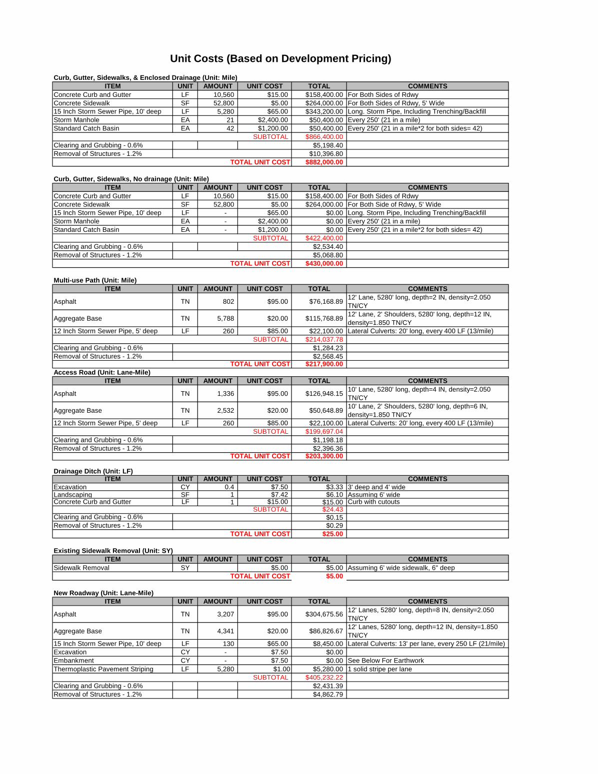
Curb, Gutter, Sidewalks, & Enclosed Drainage (Unit: Mile)ITEM UNIT AMOUNT UNIT COST TOTAL COMMENTS
Concrete Curb and Gutter LF 10,560 $15.00 $158,400.00 For Both Sides of RdwyConcrete Sidewalk SF 52,800 $5.00 $264,000.00 For Both Sides of Rdwy, 5' Wide15 Inch Storm Sewer Pipe, 10' deep LF 5,280 $65.00 $343,200.00 Long. Storm Pipe, Including Trenching/BackfillStorm Manhole EA 21 $2,400.00 $50,400.00 Every 250' (21 in a mile)Standard Catch Basin EA 42 $1,200.00 $50,400.00 Every 250' (21 in a mile*2 for both sides= 42)
SUBTOTAL $866,400.00Clearing and Grubbing - 0.6% $5,198.40Removal of Structures - 1.2% $10,396.80
TOTAL UNIT COST $882,000.00
Curb, Gutter, Sidewalks, No drainage (Unit: Mile)ITEM UNIT AMOUNT UNIT COST TOTAL COMMENTS
Concrete Curb and Gutter LF 10,560 $15.00 $158,400.00 For Both Sides of RdwyConcrete Sidewalk SF 52,800 $5.00 $264,000.00 For Both Side of Rdwy, 5' Wide15 Inch Storm Sewer Pipe, 10' deep LF - $65.00 $0.00 Long. Storm Pipe, Including Trenching/BackfillStorm Manhole EA - $2,400.00 $0.00 Every 250' (21 in a mile)Standard Catch Basin EA - $1,200.00 $0.00 Every 250' (21 in a mile*2 for both sides= 42)
SUBTOTAL $422,400.00Clearing and Grubbing - 0.6% $2,534.40Removal of Structures - 1.2% $5,068.80
TOTAL UNIT COST $430,000.00
Multi-use Path (Unit: Mile)ITEM UNIT AMOUNT UNIT COST TOTAL COMMENTS
Asphalt TN 802 $95.00 $76,168.8912' Lane, 5280' long, depth=2 IN, density=2.050 TN/CY
Aggregate Base TN 5,788 $20.00 $115,768.8912' Lane, 2' Shoulders, 5280' long, depth=12 IN, density=1.850 TN/CY
12 Inch Storm Sewer Pipe, 5' deep LF 260 $85.00 $22,100.00 Lateral Culverts: 20' long, every 400 LF (13/mile)SUBTOTAL $214,037.78
Clearing and Grubbing - 0.6% $1,284.23Removal of Structures - 1.2% $2,568.45
TOTAL UNIT COST $217,900.00Access Road (Unit: Lane-Mile)
ITEM UNIT AMOUNT UNIT COST TOTAL COMMENTS
Asphalt TN 1,336 $95.00 $126,948.1510' Lane, 5280' long, depth=4 IN, density=2.050 TN/CY
Aggregate Base TN 2,532 $20.00 $50,648.8910' Lane, 2' Shoulders, 5280' long, depth=6 IN, density=1.850 TN/CY
12 Inch Storm Sewer Pipe, 5' deep LF 260 $85.00 $22,100.00 Lateral Culverts: 20' long, every 400 LF (13/mile)SUBTOTAL $199,697.04
Clearing and Grubbing - 0.6% $1,198.18Removal of Structures - 1.2% $2,396.36
TOTAL UNIT COST $203,300.00
Drainage Ditch (Unit: LF)ITEM UNIT AMOUNT UNIT COST TOTAL COMMENTS
Excavation CY 0.4 $7.50 $3.33 3' deep and 4' wideLandscaping SF 1 $7.42 $6.10 Assuming 6' wideConcrete Curb and Gutter LF 1 $15.00 $15.00 Curb with cutouts
SUBTOTAL $24.43Clearing and Grubbing - 0.6% $0.15Removal of Structures - 1.2% $0.29
TOTAL UNIT COST $25.00
Existing Sidewalk Removal (Unit: SY)ITEM UNIT AMOUNT UNIT COST TOTAL COMMENTS
Sidewalk Removal SY $5.00 $5.00 Assuming 6' wide sidewalk, 6" deepTOTAL UNIT COST $5.00
New Roadway (Unit: Lane-Mile)ITEM UNIT AMOUNT UNIT COST TOTAL COMMENTS
Asphalt TN 3,207 $95.00 $304,675.5612' Lanes, 5280' long, depth=8 IN, density=2.050 TN/CY
Aggregate Base TN 4,341 $20.00 $86,826.6712' Lanes, 5280' long, depth=12 IN, density=1.850 TN/CY
15 Inch Storm Sewer Pipe, 10' deep LF 130 $65.00 $8,450.00 Lateral Culverts: 13' per lane, every 250 LF (21/mile)Excavation CY - $7.50 $0.00Embankment CY - $7.50 $0.00 See Below For EarthworkThermoplastic Pavement Striping LF 5,280 $1.00 $5,280.00 1 solid stripe per lane
SUBTOTAL $405,232.22Clearing and Grubbing - 0.6% $2,431.39Removal of Structures - 1.2% $4,862.79
Unit Costs (Based on Development Pricing)

TOTAL UNIT COST $412,500.00
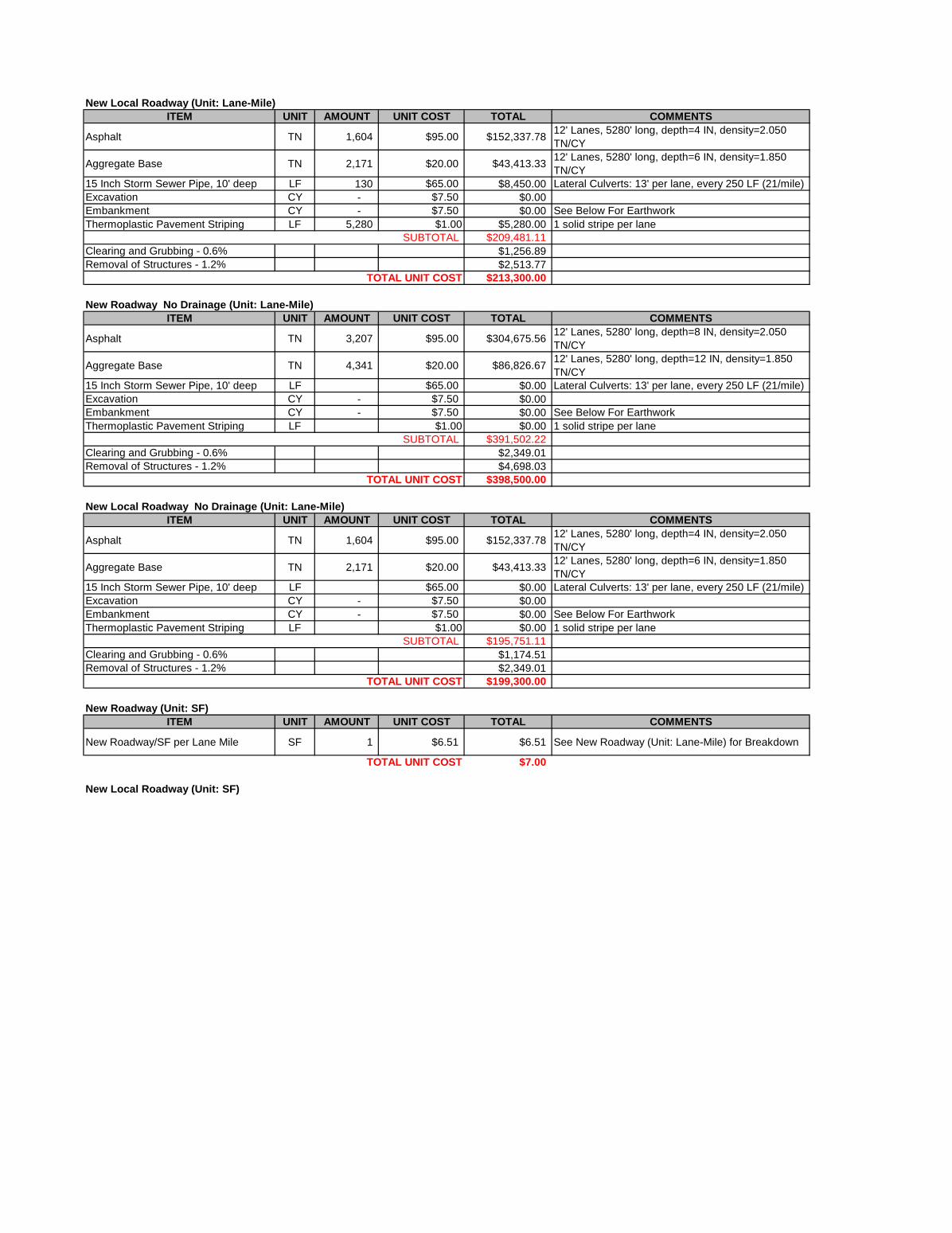
New Local Roadway (Unit: Lane-Mile)ITEM UNIT AMOUNT UNIT COST TOTAL COMMENTS
Asphalt TN 1,604 $95.00 $152,337.7812' Lanes, 5280' long, depth=4 IN, density=2.050 TN/CY
Aggregate Base TN 2,171 $20.00 $43,413.3312' Lanes, 5280' long, depth=6 IN, density=1.850 TN/CY
15 Inch Storm Sewer Pipe, 10' deep LF 130 $65.00 $8,450.00 Lateral Culverts: 13' per lane, every 250 LF (21/mile)Excavation CY - $7.50 $0.00Embankment CY - $7.50 $0.00 See Below For EarthworkThermoplastic Pavement Striping LF 5,280 $1.00 $5,280.00 1 solid stripe per lane
SUBTOTAL $209,481.11Clearing and Grubbing - 0.6% $1,256.89Removal of Structures - 1.2% $2,513.77
TOTAL UNIT COST $213,300.00
New Roadway No Drainage (Unit: Lane-Mile)ITEM UNIT AMOUNT UNIT COST TOTAL COMMENTS
Asphalt TN 3,207 $95.00 $304,675.5612' Lanes, 5280' long, depth=8 IN, density=2.050 TN/CY
Aggregate Base TN 4,341 $20.00 $86,826.6712' Lanes, 5280' long, depth=12 IN, density=1.850 TN/CY
15 Inch Storm Sewer Pipe, 10' deep LF $65.00 $0.00 Lateral Culverts: 13' per lane, every 250 LF (21/mile)Excavation CY - $7.50 $0.00Embankment CY - $7.50 $0.00 See Below For EarthworkThermoplastic Pavement Striping LF $1.00 $0.00 1 solid stripe per lane
SUBTOTAL $391,502.22Clearing and Grubbing - 0.6% $2,349.01Removal of Structures - 1.2% $4,698.03
TOTAL UNIT COST $398,500.00
New Local Roadway No Drainage (Unit: Lane-Mile)ITEM UNIT AMOUNT UNIT COST TOTAL COMMENTS
Asphalt TN 1,604 $95.00 $152,337.7812' Lanes, 5280' long, depth=4 IN, density=2.050 TN/CY
Aggregate Base TN 2,171 $20.00 $43,413.3312' Lanes, 5280' long, depth=6 IN, density=1.850 TN/CY
15 Inch Storm Sewer Pipe, 10' deep LF $65.00 $0.00 Lateral Culverts: 13' per lane, every 250 LF (21/mile)Excavation CY - $7.50 $0.00Embankment CY - $7.50 $0.00 See Below For EarthworkThermoplastic Pavement Striping LF $1.00 $0.00 1 solid stripe per lane
SUBTOTAL $195,751.11Clearing and Grubbing - 0.6% $1,174.51Removal of Structures - 1.2% $2,349.01
TOTAL UNIT COST $199,300.00
New Roadway (Unit: SF)ITEM UNIT AMOUNT UNIT COST TOTAL COMMENTS
New Roadway/SF per Lane Mile SF 1 $6.51 $6.51 See New Roadway (Unit: Lane-Mile) for Breakdown
TOTAL UNIT COST $7.00
New Local Roadway (Unit: SF)
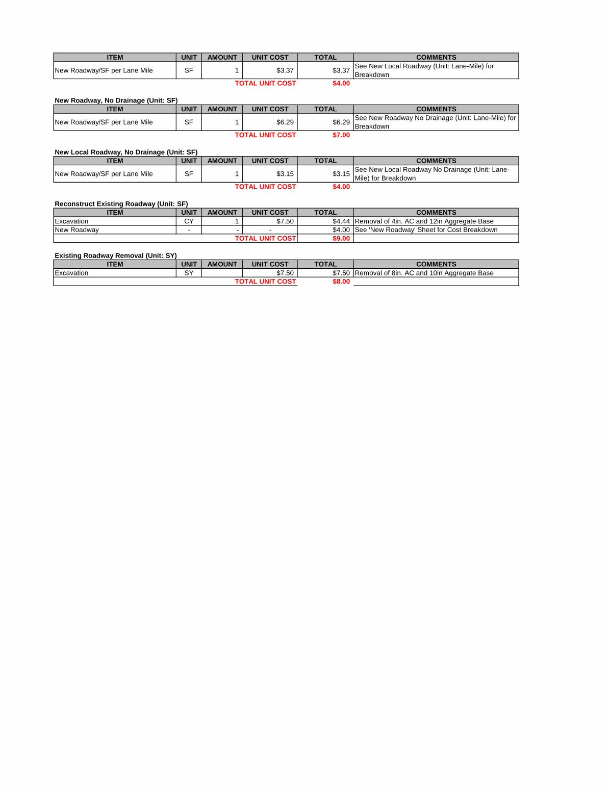
ITEM UNIT AMOUNT UNIT COST TOTAL COMMENTS
New Roadway/SF per Lane Mile SF 1 $3.37 $3.37See New Local Roadway (Unit: Lane-Mile) for Breakdown
TOTAL UNIT COST $4.00
New Roadway, No Drainage (Unit: SF)ITEM UNIT AMOUNT UNIT COST TOTAL COMMENTS
New Roadway/SF per Lane Mile SF 1 $6.29 $6.29See New Roadway No Drainage (Unit: Lane-Mile) for Breakdown
TOTAL UNIT COST $7.00
New Local Roadway, No Drainage (Unit: SF)ITEM UNIT AMOUNT UNIT COST TOTAL COMMENTS
New Roadway/SF per Lane Mile SF 1 $3.15 $3.15See New Local Roadway No Drainage (Unit: Lane-Mile) for Breakdown
TOTAL UNIT COST $4.00
Reconstruct Existing Roadway (Unit: SF)ITEM UNIT AMOUNT UNIT COST TOTAL COMMENTS
Excavation CY 1 $7.50 $4.44 Removal of 4in. AC and 12in Aggregate BaseNew Roadway - - - $4.00 See 'New Roadway' Sheet for Cost Breakdown
TOTAL UNIT COST $9.00
Existing Roadway Removal (Unit: SY)ITEM UNIT AMOUNT UNIT COST TOTAL COMMENTS
Excavation SY $7.50 $7.50 Removal of 8in. AC and 10in Aggregate BaseTOTAL UNIT COST $8.00

Restriping Existing Roadway (Unit: Lane-Mile)ITEM UNIT AMOUNT UNIT COST TOTAL COMMENTS
Stripe Removal LF 5,280 $0.65 $3,432.00 1 solid stripe removed per laneThermoplastic Pavement Striping LF 5,280 $1.00 $5,280.00 1 solid stripe per lane
TOTAL UNIT COST $8,700.00
Restriping Existing Roadway (Unit: LF)ITEM UNIT AMOUNT UNIT COST TOTAL COMMENTS
Stripe Removal LF 1 $0.65 $0.65 1 solid stripe removedThermoplastic Pavement Striping LF 1 $1.00 $1.00 1 solid stripe
TOTAL UNIT COST $2.00
Bicycle Shared Lane Marking (Unit: LF)ITEM UNIT AMOUNT UNIT COST TOTAL COMMENTS
Bike Lane Colored Marking LF 1 $8.00 $8.00Assuming 4 Thermoplastic "Sharrow" per 200 Linear Feet of Roadway
TOTAL UNIT COST $8.00
New Signal (Unit: Each)ITEM UNIT AMOUNT UNIT COST TOTAL COMMENTS
New Signal LS 1 $300,000.00 $300,000.00Includes signal system and all appurtenances (pole, wiring, detection devices, etc.) for 1 intersection
TOTAL UNIT COST $300,000.00
Earthwork Estimated (Unit: Lane-Mile)ITEM UNIT AMOUNT UNIT COST TOTAL COMMENTS
Excavation CY 1,956 $7.50 $14,666.67 Removal of 8in. AC and 10in Aggregate Base
TOTAL UNIT COST $14,670.00
Earthwork Estimated (Unit: CY)ITEM UNIT AMOUNT UNIT COST TOTAL COMMENTS
Earthwork (Cut/Fill) CY 1 $7.50 $7.50 Unit Cost
TOTAL UNIT COST $7.50
Illumination (Unit: Mile)ITEM UNIT AMOUNT UNIT COST TOTAL COMMENTS
Luminaire and appurtenances EA 52 5,000.00$ $260,000.00Luminaire, pole, wiring, etc. (1 pole on each side every 200'=52 poles)
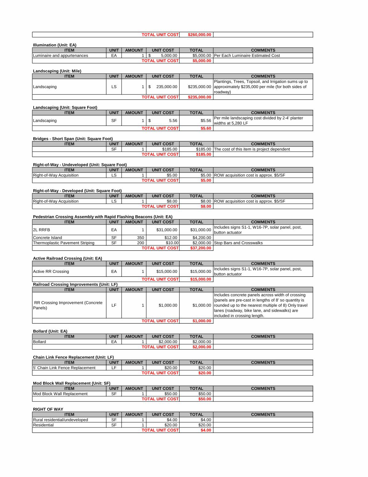
TOTAL UNIT COST $260,000.00
Illumination (Unit: EA)ITEM UNIT AMOUNT UNIT COST TOTAL COMMENTS
Luminaire and appurtenances EA 1 5,000.00$ $5,000.00 Per Each Luminaire Estimated CostTOTAL UNIT COST $5,000.00
Landscaping (Unit: Mile)ITEM UNIT AMOUNT UNIT COST TOTAL COMMENTS
Landscaping LS 1 235,000.00$ $235,000.00Plantings, Trees, Topsoil, and Irrigation sums up to approximately $235,000 per mile (for both sides of roadway)
TOTAL UNIT COST $235,000.00
Landscaping (Unit: Square Foot)ITEM UNIT AMOUNT UNIT COST TOTAL COMMENTS
Landscaping SF 1 5.56$ $5.56Per mile landscaping cost divided by 2-4' planter widths at 5,280 LF
TOTAL UNIT COST $5.60
Bridges - Short Span (Unit: Square Foot)ITEM UNIT AMOUNT UNIT COST TOTAL COMMENTS
SF 1 $185.00 $185.00 The cost of this item is project dependentTOTAL UNIT COST $185.00
Right-of-Way - Undeveloped (Unit: Square Foot)ITEM UNIT AMOUNT UNIT COST TOTAL COMMENTS
Right-of-Way Acquisition LS 1 $5.00 $5.00 ROW acquisition cost is approx. $5/SFTOTAL UNIT COST $5.00
Right-of-Way - Developed (Unit: Square Foot)ITEM UNIT AMOUNT UNIT COST TOTAL COMMENTS
Right-of-Way Acquisition LS 1 $8.00 $8.00 ROW acquisition cost is approx. $5/SFTOTAL UNIT COST $8.00
Pedestrian Crossing Assembly with Rapid Flashing Beacons (Unit: EA)ITEM UNIT AMOUNT UNIT COST TOTAL COMMENTS
2L RRFB EA 1 $31,000.00 $31,000.00Includes signs S1-1, W16-7P, solar panel, post, button actuator
Concrete Island SF 350 $12.00 $4,200.00Thermoplastic Pavement Striping SF 200 $10.00 $2,000.00 Stop Bars and Crosswalks
TOTAL UNIT COST $37,200.00
Active Railroad Crossing (Unit: EA)ITEM UNIT AMOUNT UNIT COST TOTAL COMMENTS
Active RR Crossing EA 1 $15,000.00 $15,000.00Includes signs S1-1, W16-7P, solar panel, post, button actuator
TOTAL UNIT COST $15,000.00Railroad Crossing Improvements (Unit: LF)
ITEM UNIT AMOUNT UNIT COST TOTAL COMMENTS
RR Crossing Improvement (Concrete Panels)
LF 1 $1,000.00 $1,000.00
Includes concrete panels across width of crossing (panels are pre-cast in lengths of 8' so quantity is rounded up to the nearest multiple of 8) Only travel lanes (roadway, bike lane, and sidewalks) are included in crossing length.
TOTAL UNIT COST $1,000.00
Bollard (Unit: EA)ITEM UNIT AMOUNT UNIT COST TOTAL COMMENTS
Bollard EA 1 $2,000.00 $2,000.00TOTAL UNIT COST $2,000.00
Chain Link Fence Replacement (Unit: LF)ITEM UNIT AMOUNT UNIT COST TOTAL COMMENTS
5' Chain Link Fence Replacement LF 1 $20.00 $20.00TOTAL UNIT COST $20.00
Mod Block Wall Replacement (Unit: SF)ITEM UNIT AMOUNT UNIT COST TOTAL COMMENTS
Mod Block Wall Replacement SF 1 $50.00 $50.00TOTAL UNIT COST $50.00
RIGHT OF WAYITEM UNIT AMOUNT UNIT COST TOTAL COMMENTS
Rural residential/undeveloped SF 1 $4.00 $4.00Residential SF 1 $20.00 $20.00
TOTAL UNIT COST $4.00


ITEM DESCRIPTION UNIT UNIT PRICECurb, Gutter, Sidewalks & Enclosed Drainage
~0.5-ft curb, 1.5-ft gutter pan and 7-ft wide sidewalk (each side)~18-inch concrete pipe storm system w/ 2-ft of cover~Storm manhole every 500 LF~Standard catch basin every 250 LF (each side of the roadway)
Mile #REF!
Bike Boulevard Separated bike facility:~11-ft wide, 2-in of AC and 12-in of aggregate base~Clearing and grubbing and removal of structures are included~20-ft long 12-in culverts every 400 LF
Mile #REF!
New Roadway ~Subgrade preparation, 6-in of AC, 14-in of aggregate base~Clearing/grubbing, removal of struct.~18-in culverts every 500 LF.~1 solid stripe of thermoplastic pavement striping per lane
Lane-Mile #REF!
Overlay Existing Roadway ~Grinding 25% of existing surface and 2-in of new AC~1 solid stripe of thermoplastic pavement striping per lane
Lane-Mile #REF!
Reconstruct Existing Roadway
Removal of existing roadway and rebuilding a new facility:~Removal cost of 4-in AC and 14-in aggregate base~"New Roadway" cost (listed above)
Lane-Mile #REF!
Intersection Widening Widening two approaches of an existing intersection:~4 lanes for 150 LF (2 left turn lanes and 2 right turn bay)~Demolition of all approach curbs and sidewalks. ~6-in AC and 14-in aggregate base~Curb, gutter, and sidewalk ft 300 LF per approach~Relocation of obstructions, clearing/grubbing, landscaping~2 solid stripes of thermoplastic pavement striping per lane
Each #REF!
Roundabouts Cost to construct 1-lane roundabout at existing intersection:~4 lanes for 150 LF (2 left turn lanes and 2 right turn bay)~Demolition of all approach curbs and sidewalks. ~6-in AC and 14-in aggregate base~Curb, gutter, and sidewalk ft 300 LF per approach~Relocation of obstructions, clearing/grubbing, landscaping~2 solid stripes of thermoplastic pavement striping per lane
Each #REF!
Restriping Existing Roadway ~Removal of existing striping and restriping of existing facility Lane-Mile #REF!Interconnect Signal ~Lump sum cost to interconnect signal system Lump Sum #REF!New Signal ~The signal system and all appurtenances (pole, wiring, detection devices,
etc) for one intersection Each #REF!
Signal Modifications ~All evaluations and modifications Each #REF!Earthwork Calculated ~Cut/Fill from InRoads Earthwork Calculator LS #REF!Earthwork Estimated Estimated Based on Roadway Section
CY #REF!
Illumination ~luminaire, pole, wiring, and all other appurtenances~one light pole on each side of the roadway every 200 LF
Mile #REF!
Landscaping ~Plantings, topsoil, and irrigation requirements Mile #REF!Bridges ~Based on estimated square footage of bridge Square Foot VARIESWalls ~Cost of Standard Retaining Wall Square Foot #REF!
Unit Cost Descriptions

ITEM
Contingency Factor
Right-of-Way Basic ROW estimator based on anticipated ROW area to be acquired Square Foot #REF!Engineering Costs
Given the year and escalation percentage, this estimate can roughly approximate yearly inflation of prices:~Insert the desired yearly percentage from the common range: 0.5-2.0%
~Insert the construction year (must be design year or later)
Calculated as a percentage of the total Construction Costs:~Design Engineering: 13.0%~Construction Engineering: 10.0%
Escalation Factor
~Insert the design year (must be 2007 or later)
General Contingency for Construction Costs: 30-40%.
Additional Construction & Engineering CostsDESCRIPTION
Insert the desired percentage from the common range for each factor:General Construction Costs~Construction Surveying: 1.0-2.5%~Temporary Protection and Direction of Traffic: 3.0-8.0%~Mobilization: 8.0-10.0%~Erosion Control: 0.5-2.0%
Related Documents