ESA Climate Change Initiative Phase II - Soil Moisture Algorithm Theoretical Baseline Document (ATBD) D2.1 Version 03.2 Executive Summary 24 February 2017 Prepared by Earth Observation Data Centre for Water Resources Monitoring (EODC) GmbH in cooperation with TU Wien, GeoVille, ETH Zürich, TRANSMISSIVITY, AWST, FMI, UCC and NILU

Welcome message from author
This document is posted to help you gain knowledge. Please leave a comment to let me know what you think about it! Share it to your friends and learn new things together.
Transcript

1
ESA Climate Change Initiative Phase II - Soil Moisture
Algorithm Theoretical Baseline Document (ATBD) D2.1 Version 03.2
Executive Summary
24 February 2017
Prepared by
Earth Observation Data Centre for Water Resources Monitoring (EODC) GmbH
in cooperation with
TU Wien, GeoVille, ETH Zürich, TRANSMISSIVITY, AWST, FMI, UCC and NILU

i
This document forms part 1 (of 4) of deliverable D2.1 Algorithm Theoretical Baseline Document (ATBD) and was compiled for the ESA Climate Change Initiative Phase 2 Soil Moisture Project (ESRIN Contract No: 4000112226/14/I-NB). For more information on the CCI programme of the European Space Agency (ESA) see http://www.esa-cci.org/.
Number of pages: 31
Authors: D. Chung, W. Dorigo, R.A.M de Jeu, S. Hahn. T. Melzer. R.M. Parinussa, C. Paulik. C. Reimer, M. Vreugdenhil, B. Barrett, W. Wagner, R. Kidd
Circulation: Not for public release Project Internal ONLY until review completed by Science Lead
Release Date Details Editor
0.1 02/12/2015 Update to the dataset v02.2 release Dec 2015 D. Chung
0.2 03/12/2015 Editing + updating W. Dorigo
3.2 02/12/2016 Update to the dataset v03.2 release Dec 2016 D. Chung, W. Dorigo
3.2 24/02/2017 Minor update D. Chung
For any clarifications please contact Wouter Dorigo ([email protected]).

Algorithm Theoretical Baseline Document (ATBD)
Version 03.2 Date 24 February 2017
ii
Project Partners
Prime Contractor Scientific Lead
EODC, Earth Observation Data Centre for Water Resources Monitoring (Austria)
Project Management GeoVille, GeoVille Information Systems GmbH (Austria)
System Engineering Partners AWST, Angewandte Wissenschaft Software und Technologie GmbH (Austria)
Earth Observation Partners TU Wien, Vienna University of Technology (Austria) TMS, Transmissivity, (The Netherlands) FMI, Finnish Meteorological Institute, (Finland) UCC, University College Cork, (Ireland)
Climate Research Partners ETH, Institute for Atmospheric and Climate Science, (Switzerland) NILU,Norsk institutt for luftforskning (Norway)
Algorithm Theoretical Baseline Document (ATBD)
Version 03.2 Date 24 February 2017
iii
Table of contents
LIST OF FIGURES .......................................................................................................................................... IV
DEFINITIONS, ACRONYMS AND ABBREVIATIONS ........................................................................................... V
1 INTRODUCTION ..................................................................................................................................... 1
1.1 PURPOSE OF THE DOCUMENT ........................................................................................................................... 1 1.2 TARGETED AUDIENCE ..................................................................................................................................... 1
2 CHANGE LOG ......................................................................................................................................... 2
2.1 PRE V03.2 ................................................................................................................................................... 2 2.2 CURRENT VERSION V03.2 ................................................................................................................................ 2
2.2.1 ACTIVE ATBD Document .................................................................................................................. 2 2.2.2 PASSIVE ATBD Document ................................................................................................................ 2 2.2.3 MERGING ATBD Document ............................................................................................................. 3
3 REFERENCE DOCUMENTS ....................................................................................................................... 3
4 SCOPE OF ESA CCI SOIL MOISTURE ......................................................................................................... 5
4.1 SOIL MOISTURE BECOMING AN ECV ................................................................................................................. 5 4.2 SELECTED SATELLITE SENSORS .......................................................................................................................... 6 4.3 BASELINE REQUIREMENTS ............................................................................................................................... 8
4.3.1 Scientific Requirements ................................................................................................................... 8 4.3.2 System Requirements ...................................................................................................................... 9
5 ESA CCI SM PRODUCTION APPROACH .................................................................................................. 10
5.1 POTENTIAL AND DRAWBACKS OF MERGING LEVEL 1 MICROWAVE OBSERVATIONS .................................................... 10 5.2 FUSION OF LEVEL 2 SOIL MOISTURE RETRIEVALS ................................................................................................ 10
6 DESCRIPTION OF SOIL MOISTURE RETRIEVAL FROM ACTIVE MICROWAVE SENSORS ............................. 14
6.1 PRINCIPLES OF THE PRODUCT.......................................................................................................................... 14 6.2 KNOWN LIMITATIONS & SCIENTIFIC ADVANCES UNDER INVESTIGATION .................................................................. 14
7 DESCRIPTION OF SOIL MOISTURE RETRIEVAL FROM PASSIVE MICROWAVE SENSORS ........................... 17
7.1 PRINCIPLES OF THE PRODUCT.......................................................................................................................... 17 7.2 KNOWN LIMITATIONS & SCIENTIFIC ADVANCES UNDER INVESTIGATION .................................................................. 17
8 DESCRIPTION OF THE MERGING OF ACTIVE AND PASSIVE SOIL MOISTURE RETRIEVALS ........................ 19
8.1 PRINCIPLES OF THE PRODUCT.......................................................................................................................... 19 8.2 KNOWN LIMITATIONS & SCIENTIFIC ADVANCES UNDER INVESTIGATION .................................................................. 19
9 REFERENCES ........................................................................................................................................ 21
Algorithm Theoretical Baseline Document (ATBD)
Version 03.2 Date 24 February 2017
iv
List of Figures
• Extensive description of existing and new sensors included in ESA CCI SM datasets ....... 3 • Description of new introduced Signal-to-Noise-Ratio (SNR) estimation for error estimation .................................................................................................................................. 3 Figure 1: Active and passive microwave sensors used for the generation of the ESA CCI soil moisture data sets. Although the Soil Moisture Active Passive (SMAP), Aquarius, and MetOp-C missions are not being considered in the current release (v03.2) of the CCI Soil Moisture product, they are already included in this diagram to highlight their potential inclusions in future dataset versions. Envisat ASAR and Sentinel-1 are merely used for evaluation purposes. .................................................................................................................................................... 7 Figure 2: Flow chart of the ECV Production System as first proposed in the ESA funded WACMOS project (Dorigo, Scipal et al. 2010, Liu, Parinussa et al. 2011). ............................... 11 Figure 3: Flow chart of the ESA CCI SM Production System in case that the current Level 1 inter-calibration biases between ERS AMI-WS and MetOp ASCAT can be quantified and removed. .................................................................................................................................................. 12
Algorithm Theoretical Baseline Document (ATBD)
Version 03.2 Date 24 February 2017
v
Definitions, acronyms and abbreviations
AMI Active Microwave Instrument AMSR2 Advanced Microwave Scanning Radiometer 2 AMSR-E Advanced Microwave Scanning Radiometer-Earth Observing System AMSU Advanced Microwave Sounding Unit ASAR Advanced Synthetic Aperture Radar ASCAT Advanced Scatterometer (Metop) CCI Climate Change Initiative CEOP Coordinated Energy and Water Cycle Observations Project CMORPH Morphing Method of the Climate Prediction Centre CPC Climate Prediction Centre DARD Data Access Requirement Document DMSP Defense Meteorological Satellite Program DTED Digital Terrain Elevation Model EASE Equal-Area Scalable Earth ECV Essential Climate Variable ENVISAT Environmental Satellite EO Earth Observation ERA-40 ECMWF ReAnalysis 40 data set ERS European Remote Sensing Satellite (ESA) EUMETSAT European Organisation for the Exploitation of Meteorological Satellites FTP File Transfer Protocol GIMMS Global Inventory Modeling and Mapping Studies GLDAS Global Land Data Assimilation System GLWD Global Lakes and Wetlands Database (GSPC/University of Kassel) GPCC Global Precipitation Climatology Centre GPCP Global Precipitation Climatology Project GRACE Gravity Recovery And Climate Experiment GSWP Global Soil Wetness Project ISMN International Soil Moisture Network ITRDB International Tree-Ring Data Bank
JAXA Dokuritsu-gyosei-hojin Uchu Koku Kenkyu Kaihatsu Kiko, (Japan Aerospace Exploration Agency)
JPL Jet Propulsion Laboratory (NASA) METOP Meteorological Operational Satellite (EUMETSAT)

Algorithm Theoretical Baseline Document (ATBD)
Version 03.2 Date 24 February 2017
vi
NASA National Aeronautics and Space Administration NIMA National Imagery and Mapping Agency NOAA National Oceanic and Atmospheric Administration NSIDC National Snow and Ice Data Center (radlab) NWS National Weather Service (NOAA) SAR Synthetic Aperture Radar SCAT Scatterometer SMAP Soil Moisture Active and Passive mission SMMR Scanning Multichannel Microwave Radiometer SMOS Soil Moisture and Ocean Salinity (ESA) SNR Signal to Noise Ratio SOW Statement of Work SSM Surface Soil Moisture SSM/I Special Sensor Microwave Imager TDR Time Domain Reflectometry TMI TRMM Microwave Imager TRMM Tropical Rainfall Measuring Mission TWS Terrestrial Water Storage USGS United States Geological Survey VIC Variable Infiltration Capacity VOD Vegetation Optical Depth WACMOS Water Cycle Multimission Observation Strategy WindSat WindSat Radiometer
Algorithm Theoretical Baseline Document (ATBD)
Version 03.2 Date 24 February 2017
1
1 Introduction
The Algorithm Theoretical Baseline Document (ATBD) provides a detailed description of the algorithms that are used within the ESA CCI Soil Moisture production system. The ESA CCI SM production system was initially developed within CCI Phase 1 and is continuously being updated within phase 2 to reflect the current state of the science driving the system. The ATBD is, by its nature, rather in-depth, and in order to facilitate frequent updates, and to provide a more manageable document to the reader the ATBD is provided as four distinct documents. These documents consist of an ATBD for the active retrieval, an ATBD for the passive retrieval and an ATBD for the merging process. An overriding document (this document) providing an executive summary sets the ATBD documents within framework for the CCI project and the ESA CCI SM production system.
The structure of this document reflects the distinct domains of the ATBD. Sections 4 and 5 provide a brief scope of the problem and an overview of the ESA CCI SM production system respectively. Section 6 contains a brief overview of the current status of retrieving surface soil moisture from active microwave sensors using the TU Wien approach. Section 7 describes succinctly the VUA-NASA Land Parameter Retrieval Method (LPRM) for estimating soil moisture from passive microwave sensors, and Section 8 starts with a brief overview of the changes from dataset version 02.2 to 03.2, and then it provides a description on the approach adopted for merging the active and passive soil moisture products.
1.1 Purpose of the Document
The Algorithm Theoretical Baseline Document (ATBD) is intended to provide a detailed description of the scientific background and theoretical justification for the algorithms used to produce the ESA CCI soil moisture data sets. Furthermore, it describes the scientific advances and algorithmic improvements which are made within the CCI project.
1.2 Targeted Audience
This document targets mainly:
1. Remote sensing experts interested in the retrieval and error characterisation of soil moisture from active and passive microwave data sets.
2. Users of the remotely sensed soil moisture data sets who want to obtain a more in-depth understanding of the algorithms and sources of error.
Algorithm Theoretical Baseline Document (ATBD)
Version 03.2 Date 24 February 2017
2
2 Change log
2.1 Pre v03.2
The first version of the ATBD (version 0) was provided as Deliverable 2.3 in CCI Phase 1 on 30th April 2012 and was updated to ATBD version 1 and accompanying Annex 1 on 14th Feb 2013. ATBD version 2 appeared in November 2014 and reflected the status of dataset release v02.0. ATBD version 2.2 was released in December 2015, which matched the dataset published at that time. This document forms deliverable 2.1 of CCI Phase 2 and provides an update for the ESA CCI SM 03.2 product released in February 2017. The updates in this version of the ATBD are summarised below.
2.2 Current version 03.2
This ATBD version 03.2 supersedes the ATBD v03.2 published in December 2016.
2.2.1 ACTIVE ATBD Document
• Updated section on latest algorithmic implementations of the sensor intra-calibration approach and to achieve consistency with respect to variable notations of equations.
• Updated section on the latest algorithmic implementation changes of slope/curvature estimation.
2.2.2 PASSIVE ATBD Document
• The flowchart in Figure 1 has been improved and is now applicable to all frequencies including the L-band based retrievals and includes the latest roughness approach
• Description of the latest roughness approach as applied in the LPRM • Improved description of the Wang & Schmugge dielectric mixing model in the
methodology. • Improved and updated explanation on the temperature input based on Ka-band
retrievals, in particular with respect to the current reliance on modelled soil temperature for the L-band missions.
• Comprehensive description of LPRM parameters for the different frequencies. • Extended description of decreased vegetation influences for L-band retrievals (SMOS). • Description of new approach on detecting and dealing with Radio Frequency
Interference (RFI). • Updated section on issues currently under investigation
Algorithm Theoretical Baseline Document (ATBD)
Version 03.2 Date 24 February 2017
3
2.2.3 MERGING ATBD Document
• Extensive description of existing and new sensors included in ESA CCI SM datasets
• Description of new introduced Signal-to-Noise-Ratio (SNR) estimation for error estimation
• Description of new SNR-based weighted average merging scheme for ACTIVE, PASSIVE, and COMBINED
• Description of new random error propagation scheme • Updated flowcharts of entire ESA CCI SM processor. • Updated section on issues currently under investigation
3 Reference Documents
The following references are of relevance to this document. Within the document, for the sake of clarity it has been sometimes necessary to provide sections of quoted texts taken from referenced documents, rather than just providing a reference to the document. In these cases, texts are “presented in quotes as italic text”.
[RD-1] ESA Climate Change Initiative Phase 1, Statement of Work for Soil Moisture and Ice Sheets, European Space Agency, EOEP-STRI-EOPS-SW-11-0001.
[RD-2] Technical Proposal (Part 3) in response to ESA Climate Change Initiative Phase 1 ESRIN/AO/1-6782/11/I-NB, Vienna University of Technology.
[RD-3] W. Dorigo, R. Kidd, R. De Jeu, S. Seneviratne, H. Mittelbach, J. Pulliainen, W.A. Lahoz, N. Dwyer, B. Barrett, Eva Haas, W. Wagner.ESA CCI Soil Moisture Data Access Requirements Document, v1.2
[RD-4] Wagner, W., W. Dorigo, R. De Jeu, D. Fernandez, J. Benveniste, E. Haas, M. Ertl (2012) Fusion of active and passive microwave observations to create an Essential Climate Variable data record on soil moisture, Proceedings of the ISPRS Congress 2012, Melbourne, Australia, August 25-September 1, 2012.
[RD-5] Liu, Y. Y., Parinussa, R. M., Dorigo, W. A., De Jeu, R. A. M., Wagner, W., van Dijk, A. I. J. M., McCabe, M. F., Evans, J. P. (2011). Developing an improved soil moisture dataset by blending passive and active microwave satellite-based retrievals. Hydrology and Earth System Sciences, 15, 425-436, doi:10.5194/hess-15-425-2011
[RD-6] Liu, Y.Y., Dorigo, W.A., Parinussa, R.M., de Jeu, R.A.M., Wagner, W., McCabe, M.F., Evans, J.P., van Dijk, A.I.J.M. (2012). Trend-preserving blending of passive
Algorithm Theoretical Baseline Document (ATBD)
Version 03.2 Date 24 February 2017
4
and active microwave soil moisture retrievals, Remote Sensing of Environment, 123, 280-297, doi: 10.1016/j.rse.2012.03.014.
[RD-7] D. Chung, W. Dorigo, S. Hahn. T. Melzer. C. Paulik. C. Reimer, M. Vreugdenhil, W. Wagner, R. Kidd (2015). ESA CCI Soil Moisture – ESA CCI SM production, Fusion of Soil Moisture Products: Algorithm Theoretical Baseline Document (ATBD) Version 2.2, December 2015.
[RD-8] D. Chung, W. Dorigo, C. Reimer, S. Hahn. T. Melzer. C. Paulik., M. Vreugdenhil, W. Wagner, R. Kidd (2016), Algorithm Theoretical Baseline Document (ATBD), Version 3.2, Active Soil Moisture Retrievals, December 2016.
[RD-9] R.A.M. de Jeu, W. Dorigo, R. van der Schalie, D. Chung, W. Wagner, R. Kidd (2016). Algorithm Theoretical Baseline Document (ATBD), Version 3.2, Soil Moisture Retrieval from Passive Microwave Observations, December 2016.
[RD-10] D. Chung, W. Dorigo, S. Hahn. T. Melzer. C. Paulik. C. Reimer, M. Vreugdenhil, W. Wagner, R. Kidd (2016). Algorithm Theoretical Baseline Document (ATBD), Version 3.2, Merging Active and Passive Soil Moisture Retrievals, December 2016.
[RD-11] R. Kidd, D. Chung, W. Dorigo, R. De Jeu (2013). ESA CCI Soil Moisture – Detailed Processing Model (DPM), Version 1.2, 26th November 2013.
[RD-12] D. Chung R. Kidd, W. Dorigo (2013) ESA CCI Soil Moisture – System Prototype Description (SPD), Version 1.0, 4th July 2013.
[RD-13] R. Kidd, D. Chung, W. Dorigo, R. De Jeu (2012). Input/ Output Data Definition Document (IODD), Version 1.0, 21st December 2012.
Algorithm Theoretical Baseline Document (ATBD)
Version 03.2 Date 24 February 2017
5
4 Scope of ESA CCI Soil Moisture
This Section is partially based on [RD-4].
4.1 Soil Moisture Becoming an ECV
Soil moisture is arguably one of the most important parameters for the understanding of physical, chemical and biological land surface processes (Legates, Mahmood et al. 2011). Therefore, it is for many geoscientific applications essential to know how much water is stored in the soil, and how it varies in space and time. For many years, soil moisture was considered to be only an "emergent ECV" because the retrieval of soil moisture was deemed too difficult with existing satellite sensors. Therefore, in recognition of the strong need for global soil moisture data sets, the European Space Agency (ESA) and the National Aeronautics and Space Administration (NASA) each decided to develop a dedicated satellite mission operating at 1.4 GHz (L-band). The first mission is the Soil Moisture and Ocean Salinity (SMOS) satellite that was launched in November 2009 by ESA (Kerr, Waldteufel et al. 2010). The second one is NASA's Soil Moisture Active Passive (SMAP) mission that was launched in January 2015 (Entekhabi, Njoku et al. 2010). But, as already noted by Wagner et al. (2007): “Besides these innovations in space technology, an initially less-visible revolution has taken place in algorithmic research. This revolution became possible thanks to the increasing availability of computer power, disk space, and powerful programming languages at affordable costs. This has allowed more students and researchers to develop and test scientific algorithms on regional to global scales than in the past. This has led to a greater diversity of methods and consequently more successful retrieval algorithms.”
In line with the above-described developments, several global and continental-scale soil-moisture datasets have been published and shared openly with the international community within the last 15 years. The very first remotely sensed global soil moisture dataset was published by the Vienna University of Technology (TU Wien) in 2002 and was based on nine years (1992-2000) of ERS C-band (5.6 GHz) scatterometer measurements (Scipal, Wagner et al. 2002, Wagner, Scipal et al. 2003). NASA released its first global soil moisture data retrieved from microwave radiometer measurements using the algorithms developed by Njoku et al. (2003) in the following year. Since then several other soil moisture data products mostly based on microwave radiometers (AMSR E, Windsat, etc.) have become freely available, notably the multi-sensor soil moisture datasets produced by Vrije Universiteit Amsterdam (VUA) in cooperation with NASA (Owe, de Jeu et al. 2008), and the WindSat soil moisture dataset produced by the US Naval Research Laboratory (Li, Gaiser et al. 2010). The first operational near-real-time soil moisture service was launched by EUMETSAT in 2008 based on the METOP Advanced Scatterometer (ASCAT) and algorithms and software prototypes developed by TU Wien (Bartalis, Wagner et al. 2007). Finally, SMOS Level 2 soil moisture data started to become
Algorithm Theoretical Baseline Document (ATBD)
Version 03.2 Date 24 February 2017
6
available in 2010, with first validation results published in 2011 (Albergel, Zakharova et al. 2011). Data from NASA’s Soil Moisture Active Passive (SMAP) have become available in the course of 2015, but unfortunately, only after 3 months of operation its radar failed thus impeding the continuation of the foreseen downscaled product.
Having a number of independent satellite soil moisture data sets does not mean that it is straight-forward to create long-term consistent time series suitable for climate change studies. In fact, for the assessment of climate change effects on soil moisture even subtle long-term trends must be detected reliably. This means that any potential influences of mission specifications, sensor degradation, drifts in calibration, and algorithmic changes must be carefully corrected for. Also, it must be guaranteed that the soil moisture data retrieved from the different active and passive microwave instruments are physically consistent.
4.2 Selected Satellite Sensors
Microwave remote sensing measurements of bare soil surfaces are very sensitive to the water content in the surface layer due to the pronounced increase in the soil dielectric constant with increasing water content (Ulaby, Moore et al. 1982). This is the fundamental reason why any microwave technique, particularly in the low-frequency microwave region from 1 to 10 GHz, offers the opportunity to measure soil moisture in a relatively direct manner. Therefore, the CCI soil moisture project focuses at this stage on spaceborne microwave systems operating at low-frequency bands. For soil moisture studies the most important bands are: L-band (frequency f = 1 – 2 GHz, wavelength λ = 30 – 15 cm), C-band (f = 4 – 8 GHz, λ = 7.5 – 3.8 cm), and X-band (f = 8 – 12 GHz, λ = 3.8 – 2.5 cm).
In microwave remote sensing, one distinguishes active and passive techniques. Active microwave sensors transmit an electromagnetic pulse and measure the energy scattered back from the Earth’s surface. For passive sensors (radiometers), the energy source is the target itself, and the sensor is merely a passive receiver (Ulaby, Moore et al. 1982). Radiometers measure the intensity of the emission of the Earth’s surface that is related to the physical temperature of the emitting layer and the emissivity of the surface. Despite the different measurement processes, active and passive methods are closely linked through Kirchhoff’s law which, applied to the problem of remote sensing of the Earth’s surface, states that the emissivity is one minus the hemisphere integrated reflectivity (Schanda 1986). Therefore, both active and passive techniques deal in principle with the same physical phenomena, though the importance of different parameters on the measured signal may vary depending on the sensor characteristics.
Algorithm Theoretical Baseline Document (ATBD)
Version 03.2 Date 24 February 2017
7
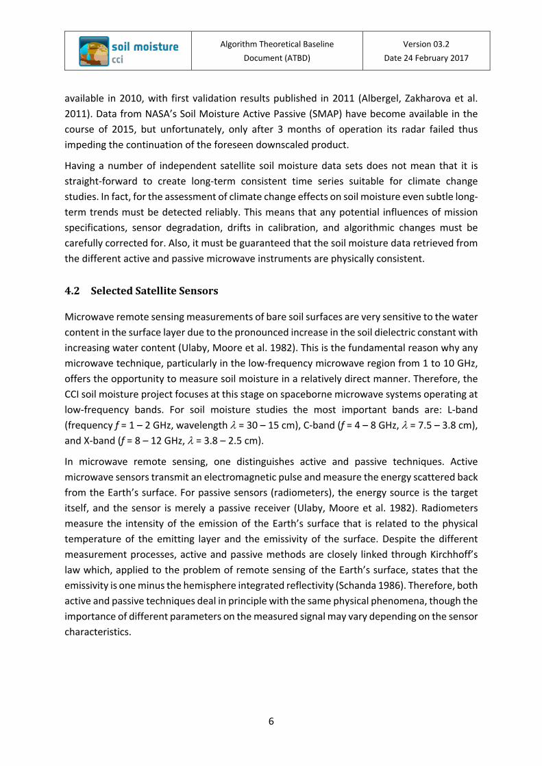
Figure 1: Active and passive microwave sensors used for the generation of the ESA CCI soil moisture data sets. Although the Soil Moisture Active Passive (SMAP), Aquarius, and MetOp-C missions are not being considered in the current release (v03.2) of the CCI Soil Moisture product, they are already included in this diagram to highlight their potential inclusions in future dataset versions. Envisat ASAR and Sentinel-1 are merely used for evaluation purposes.
Given that an ECV data record should be as long and complete as possible, it has to be based on both active and passive microwave observations. The CCI Soil Moisture project thus aims to combine C-band scatterometers (e.g. ERS-1/2 scatterometer, METOP Advanced Scatterometers) and multi-frequency radiometers (e.g., SMMR, SSM/I, TMI, AMSR-E, Windsat, AMSR2, SMOS) as these sensors are characterised by their high suitability for soil moisture retrieval and a long technological heritage (Figure 1). As specified in [RD-1], other microwave sensors suitable for soil moisture retrieval, including Synthetic Aperture Radars (SARs) and radar altimeters, are not considered in this phase of the CCI programme due to their recentness and/or their unfavourable spatio-temporal coverage. Nevertheless, the ESA CCI SM production system has been set up in such a way as to allow the integration of all these sensors in the future. A complete list and a detailed technical description of all data products used in the ESA CCI SM production system is provided in [RD-11 and RD-12].
Algorithm Theoretical Baseline Document (ATBD)
Version 03.2 Date 24 February 2017
8
4.3 Baseline Requirements
As part of the CCI Soil Moisture project a detailed assessment of the user requirements is carried out at regular intervals and reported in the User Requirement Document (URD). Nevertheless, based on the requirements as specified in [RD-1], and drawing from the experiences of the use of the currently available satellite soil moisture data sets, a number of baseline requirements can be specified already at this stage.
4.3.1 Scientific Requirements
Thanks to the fact that several decade-long soil moisture data records have been released within the last few years the generic user requirements for ESA CCI soil moisture data records are already reasonably well understood. According to authors’ experience from the cooperation with users of the TU Wien and VUA-NASA soil moisture data sets (Wagner, Naeimi et al. 2007, de Jeu, Wagner et al. 2008), the most important of these are:
1. Soil moisture is preferably expressed in volumetric soil moisture units (m3m-3). If soil moisture is expressed in a different unit, the conversion rule must be specified.
2. From an application point of view, the ESA CCI SM data should preferably represent the soil moisture content in deeper soil layers (0.2-1 m), not just the thin (0.5-5 cm) remotely sensed surface soil layer. Nevertheless, expert users typically prefer to work with data that are as close to the sensor measurements as possible, making the conversion of the remotely sensed surface soil moisture measurements to profile estimates themselves.
3. When merging datasets coming from different sensors and satellites the highest possible degree of physical consistency shall be pursued.
4. Due to the long autocorrelation length of the atmosphere-driven soil moisture field (Entin, Robock et al. 2000) a spatial resolution of ≤50 km is sufficient for climate studies.
5. The temporal sampling interval depends on the chosen soil layer. For deeper soil layers (1 m) a sampling rate of 1 week is in general enough, but for the thin remotely sensed soil layer it is ≤1 day.
6. Having a good quantitative understanding of the spatio-temporal error field is more important than working under the assumption of arbitrarily selected accuracy thresholds (e.g. like the often cited 0.04 m3m-3).
7. Some soil moisture applications require a good accuracy (low bias), but for most applications it is in fact more important to achieve a good precision (Koster, Guo et al. 2009, Entekhabi, Reichle et al. 2010).
8. For climate change studies the drift in the bias and dynamic range of the soil moisture retrievals should be as small as possible.

Algorithm Theoretical Baseline Document (ATBD)
Version 03.2 Date 24 February 2017
9
4.3.2 System Requirements
The generation of an ESA CCI SM data set is not a one-off activity, but should in fact be a long-term process where the ESA CCI SM product shall be continued and improved step by step with the active involvement of a broad scientific community. From a system point of view this requires that the ESA CCI SM Production System is modular so that
• the system supports algorithm development and is most open to broad scientific participatory inputs
• algorithms can be improved while minimising reprocessing costs • upgrades of any of its parts are facilitated without repercussions elsewhere • the system can be moved to different operators if required, i.e. it allows adaptations
to different data processing framework solutions
But not only modularity is a major requirement. The design and operations of the system should also be as lightweight as possible in order to be able to
• re-process ESA CCI SM data records on a frequent basis to account for Level 1 calibration- and Level 2 algorithmic updates
• update the ESA CCI SM datasets rapidly in case new Level 2 data sets become available • test alternative error characterisation, matching and merging approaches • keep operations and maintenance costs low
Please consult [RD-11] for further details on the soil moisture ESA CCI SM production system, detailing its components, their functions, and interfaces.
Algorithm Theoretical Baseline Document (ATBD)
Version 03.2 Date 24 February 2017
10
5 ESA CCI SM Production Approach
This Section is partly based on [RD-4].
5.1 Potential and drawbacks of merging Level 1 Microwave Observations
Probably the most straight-forward approach to generating an ESA CCI soil moisture data set would be to feed the Level 1 backscatter- and brightness temperature observations of all different active and passive microwave remote sensing instruments into one Level 2 soil moisture retrieval system, delivering as direct output a harmonised and consistent active-passive based ESA CCI surface soil moisture data set covering the complete period from 1978 to the present. As ideal as this approach may seem from a scientific point of view, there are some major practical problems:
• The technical specifications of the diverse active and passive microwave sensors suitable to soil moisture retrieval (ASCAT, AMSR-E, SMOS, SMAP, etc.) are so different that it appears hardly feasible to design one-can-do-it-all physical retrieval algorithm.
• The complexity of the retrieval algorithm and the requirements for high-quality ancillary data to constrain the retrieval process can be expected to increase drastically for a multi-senor compared to a single-sensor Level 2 retrieval approach. This bears a certain risk of errors becoming less easily traceable. Also, the overall software system may not be scalable in terms of processing time and disk space.
• For much of the historic time period (1978-2007) the spatio-temporal overlap of suitable active and passive microwave measurements is minimal.
• Because the surface soil moisture content may vary within minutes to hours, combing measurements taken at different times of the day in multi-sensor approach may produce large errors. It can e.g. be noted that the measurements of ASCAT (9:30 and 21:30 local time), AMSR-E (1:30 and 13:30) and SMOS (6:00 and 18:00) are currently well spread over the complete day.
Each of these problems is serious enough to not consider an ESA CCI SM Production System based on the fusion of Level 1 microwave observations. Considered together one can conclude that such an ESA CCI SM Production system would neither be modular nor lightweight, which makes this approach technically intractable. Therefore, in the next section the fusion of Level 2 soil moisture retrievals is discussed
5.2 Fusion of Level 2 Soil Moisture Retrievals
The possibility of generating a long-term (30+ years) soil moisture data set based on Level 2 soil moisture retrievals was already demonstrated within the WACMOS project funded by the
Algorithm Theoretical Baseline Document (ATBD)
Version 03.2 Date 24 February 2017
11
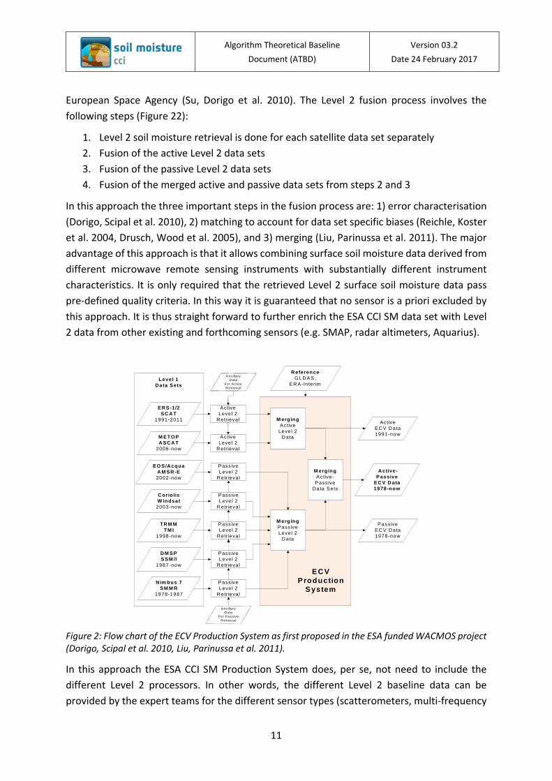
European Space Agency (Su, Dorigo et al. 2010). The Level 2 fusion process involves the following steps (Figure 22):
1. Level 2 soil moisture retrieval is done for each satellite data set separately 2. Fusion of the active Level 2 data sets 3. Fusion of the passive Level 2 data sets 4. Fusion of the merged active and passive data sets from steps 2 and 3
In this approach the three important steps in the fusion process are: 1) error characterisation (Dorigo, Scipal et al. 2010), 2) matching to account for data set specific biases (Reichle, Koster et al. 2004, Drusch, Wood et al. 2005), and 3) merging (Liu, Parinussa et al. 2011). The major advantage of this approach is that it allows combining surface soil moisture data derived from different microwave remote sensing instruments with substantially different instrument characteristics. It is only required that the retrieved Level 2 surface soil moisture data pass pre-defined quality criteria. In this way it is guaranteed that no sensor is a priori excluded by this approach. It is thus straight forward to further enrich the ESA CCI SM data set with Level 2 data from other existing and forthcoming sensors (e.g. SMAP, radar altimeters, Aquarius).
Figure 2: Flow chart of the ECV Production System as first proposed in the ESA funded WACMOS project (Dorigo, Scipal et al. 2010, Liu, Parinussa et al. 2011).
In this approach the ESA CCI SM Production System does, per se, not need to include the different Level 2 processors. In other words, the different Level 2 baseline data can be provided by the expert teams for the different sensor types (scatterometers, multi-frequency
ER S -1/2 SC A T
1991-2011
M ETO P A SC A T
2006-now
EO S/A cquaA M SR -E2002-now
C orio lisW indsat
2003-now
TR M MTM I
1998-now
D M SPSSM /I
1987-now
N im bus 7SM M R
1978-1987
ActiveLevel 2
R etrieval
ActiveLevel 2
R etrieval
Passive Level 2
R etrieval
Passive Level 2
R etrieval
Passive Level 2
R etrieval
Passive Level 2
R etrieval
Passive Level 2
R etrieval
Active EC V D ata1991-now
Passive EC V D ata1978-now
R eferenceG LD AS,
ER A-Interim
M ergingActive
Level 2 D ata
M ergingPassive Level 2
D ata
M ergingActive-Passive
D ata Sets
A ctive-Passive
EC V D ata1978-now
Level 1D ata Sets
EC VProduction
System
Ancillary D ata
For Active R etrieva l
Ancillary D ata
For Passive R etrieva l

Algorithm Theoretical Baseline Document (ATBD)
Version 03.2 Date 24 February 2017
12
radiometers, SMOS, SMAP, etc.) and the ESA CCI SM Production System itself has to deal with the fusion process only, as described above. This design is modular and lightweight, meeting the requirements as discussed in Section 4.3.2. A simplification of the ESA CCI SM Production System as shown in Figure 23 can be achieved if the existing Level 1 inter-calibration biases of the different microwave instruments can be quantified and hence be removed. For example, the current Level 1 bias between ERS AMI-WS and MetOp-ASCAT is in the order of about 0.1-0.3 dB and variable over the incidence angle range (Bartalis, Wagner et al. 2010). Such a bias may cause differences in the soil moisture estimates of more than 10 % (over areas with a low sensitivity to soil moisture). Work is underway to quantify the bias between the latest version of the ASCAT calibration (Wilson, Anderson et al. 2010) and the one of the ERS Level 1 archive reprocessed with an advanced scatterometer software (Crapolicchio, Lecomte et al. 2004). It is expected that the updated bias-correction tables will become available within the next years, after which it will be possible to feed the Level 1 backscatter data of both ERS AMI-WS and MetOp ASCAT into a Level 2 processor to produce directly a harmonized active ESA CCI SM data set (Figure 33). A similar simplification may in principle be possible also for the passive multi-frequency radiometers, but due to much more significant differences in design and operations of the instruments, this appears unrealistic within the near future.
Figure 3: Flow chart of the ESA CCI SM Production System in case that the current Level 1 inter-calibration biases between ERS AMI-WS and MetOp ASCAT can be quantified and removed.
ER S -1/2 SC A T
1991-2011
M ETO P A SC A T
2006-now
EO S/A cquaA M SR -E2002-now
C orio lisW indsat
2003-now
TR M MTM I
1998-now
D M SPSSM /I
1987-now
N im bus 7SM M R
1978-1987
ActiveLevel 2
R etrieval
Passive Level 2
R etrieval
Passive Level 2
R etrieval
Passive Level 2
R etrieval
Passive Level 2
R etrieval
Passive Level 2
R etrieval
Active EC V D ata1991-now
Passive EC V D ata1978-now
R eferenceG LD AS,
ER A-Interim
M ergingPassive Level 2
D ata
M ergingActive-Passive
D ata Sets
A ctive-Passive
EC V D ata1978-now
Level 1D ata Sets
EC VProduction
System
Ancillary D ata
For Active R etrieva l
Ancillary D ata
For Passive R etrieva l
Algorithm Theoretical Baseline Document (ATBD)
Version 03.2 Date 24 February 2017
13
The most serious concern related to this fusion approach is that Level 1 data processed with different Level 2 algorithms may not represent the same physical quantity. Fortunately, as an increasing number of validation and inter-comparison studies show (Rüdiger, Holmes et al. 2009, Gruhier, de Rosnay et al. 2010, Brocca, Hasenauer et al. 2011, Albergel, de Rosnay et al. 2012), the temporal soil moisture retrieval skills of SMOS, ASCAT and AMSR-E are often well comparable and of good quality in regions with sparse to moderate vegetation cover. Therefore, after bias correction and, if necessary, a conversion of units, the different Level 2 soil moisture data sets can be merged. Nevertheless, to maximise physical consistency it is advisable to process all active microwave data sets as shown in Figure 3 with one algorithm, and all passive microwave data with another algorithm. In other words, for groups of sensors with comparable sensor characteristics (scatterometers, multi-frequency radiometers) one should select only one algorithm. As a result, the combined active (scatterometer) and passive (multi-frequency radiometer) data sets may not always be directly comparable. Therefore, as illustrated in Figure 2 and Figure 3, the ESA CCI SM Production System delivers, besides the fused and thus most complete active+passive (COMBINED) ESA CCI SM data set, the two active-only (ACTIVE) and passive-only (PASSIVE) ESA CCI SM data sets. It will be thus up to the user to decide, which of these merged soil moisture data sets is best suited for his or her analyses. Please see [RD-10] for further details of the key principles of the algorithms used to generate the ESA CCI Soil Moisture product.

Algorithm Theoretical Baseline Document (ATBD)
Version 03.2 Date 24 February 2017
14
6 Description of soil moisture retrieval from active microwave sensors
Details are provided in [RD-8]
6.1 Principles of the product
The TU Wien change detection method (Wagner, Lemoine et al. 1999, Bartalis, Wagner et al. 2007) is applied to level 1 calibrated backscatter measurements from the ERS-1/2 and MetOp scatterometers to retrieve surface soil moisture. The soil moisture retrieval algorithm is implemented within a software package called the Soil Water Retrieval Package (WARP) and includes several processing steps. These include resampling the scatterometer measurements in orbit geometry to a fixed Discrete Global Grid (DGG), an azimuthal and incidence angle normalisation, an estimation of the backscatter noise and a correction for vegetation effects. Following these steps, dry and wet backscatter reference curves are determined and surface soil moisture is calculated as a degree of saturation between the historically wettest (highest) and driest (lowest) reference values. Finally, an estimate of the retrieval error is calculated by an error propagation scheme.
6.2 Known limitations & Scientific Advances under Investigation
The following list identifies the areas in which improvements are currently being made in the scatterometer retrieval algorithm. Further details are provided in [RD-8].
− Inter-calibration of Backscatter Data Records Scatterometer measurements must be consistent between antennas and over the range of incidence and azimuth angles of observations. Calibration errors cause inconstancies in radar backscatter measurements and degrade the accuracy of deduced geophysical parameters. The measurement model and inter-beam calibration strategy formulated by (Long and Skouson 1996) is being adopted to model calibration related errors using extended area Land-Targets for ERS 1/2 AMI-WS and ASCAT. A radiometric calibration methodology for European C-band scatterometer missions was developed at TU Wien to ensure consistent backscatter observations of these scatterometer missions (Reimer 2014). Sensor intra-calibration aims to support already established calibration efforts, undertaken by the operating Space Agency, with the objective to monitor and correct for residual scatterometer performance anomalies.

Algorithm Theoretical Baseline Document (ATBD)
Version 03.2 Date 24 February 2017
15
− Estimation of Diurnal Variability Backscatter measurements in some regions display a difference between morning and evening acquisitions. In WP 2-9-2-0 of CCI soil moisture Phase 1 [RD-2], efforts are being made to identify the underlying reasons for diurnal differences by comparing satellite ascending and descending orbit soil moisture retrievals. (Griesfeller, Lahoz et al. 2013) details the diurnal variability of ASCAT soil moisture measurements over Norway and preliminary results suggest an underestimation of ASCAT day retrievals over very wet soils. The approach is being applied to other international areas of interest.
− Improved Modelling of Volume Scattering in Soils Backscatter measurements over desert and semi-arid areas exhibit an unusual behaviour that may lead to a situation where soil moisture derived from scatterometers is often less accurate than radiometer retrievals (Wagner, Naeimi et al. 2007, Gruhier, de Rosnay et al. 2009). Due to the lack of high quality reference data in arid and semi-arid environments, it has not yet been possible to determine the physical reasons for this phenomenon. For example, the estimation of the wet reference is problematic due to the fact that saturated soil conditions cannot always be captured. Although this problem is addressed by using a wet correction based upon a climate classification map (Kottek, Grieser et al. 2006), the approach is not fully perfect and improvements are still required. Improving the estimation of the dry and wet reference will in turn increase the accuracy of the final surface soil moisture estimates.
− Better Vegetation Modelling In the WARP model, it is assumed that the vegetation state is constant at the same day of the year, i.e. it does not change inter-annually, and is thus a function of the day-of-year. Accordingly, there are 366 vegetation curves for each grid point location, with each curve determined by a slope and curvature. First research results suggest that soil moisture retrievals may benefit from a vegetation correction that varies from year to year according to the actual vegetation conditions (i.e. by not taking the vegetation as a climatology (Vreugdenhil et al., 2016). At present, the implementation of such an inter-annually dynamic slope and curvature computation suffers from several issues, foremost the use of Monte Carlo to effectively integrate estimates over different time window lengths. Several different approaches are being tested and the optimum approach will be incorporated into WARP 6.0.
Algorithm Theoretical Baseline Document (ATBD)
Version 03.2 Date 24 February 2017
16
− Masking of Snow and Frost Conditions Two different approaches were tested to improve the masking of snow and frost conditions. The first called SSFv2 is based on the SFF developed and already described in the ATBD v2.2 [RD-7]. The second called HMM FT is based on the probabilistic fusion approach developed by (Zwieback 2012). Using temperature as a proxy for the freeze/thaw state of the soil, validation of the approaches was performed with WMO air temperature, GLDAS Surface Temperature and in situ soil temperature measurements obtained from the ISMN (Dorigo, Wagner et al. 2011). Generally, HMM FT is the preferred method since it delivers probabilistic information and not only flags. It is planned to implement this method in the current WARP processing package.

Algorithm Theoretical Baseline Document (ATBD)
Version 03.2 Date 24 February 2017
17
7 Description of soil moisture retrieval from passive microwave sensors
Details can be found in [RD-9].
7.1 Principles of the product
The VUA-NASA Land Parameter Retrieval Method (LPRM) (Owe, de Jeu et al. 2008) is used for estimating surface soil moisture from passive microwave sensors. LPRM can be applied to all frequencies in the microwave domain and, hence, within the Soil Moisture CCI, it can be applied to measurements made by the Nimbus SMMR, DMSP-SSM/I, TRMM-TMI, Aqua-AMSR-E, WindSat, SMOS, and AMSR2 radiometers which observe at different wavelengths. The model is based on a microwave radiative transfer model that links soil moisture to the observed brightness temperatures. First, Ka-band (37 GHz) observations are used to estimate surface brightness temperatures. Subsequently, the vegetation optical depth and soil dielectric constants are derived simultaneously. Finally, the soil moisture content (m3m-3) is solved from the dielectric constant using the Wang-Schmugge dielectric mixing model. An analytical method is used to propagate errors of model and input variables through the retrieval scheme.
7.2 Known Limitations & Scientific Advances under Investigation
The following areas have been identified where improvements can be made in the radiometer retrieval algorithm and are detailed further in [RD-9]:
− Inter-calibration of Brightness Temperature Records Small differences in brightness temperature observations occur because of small
differences in sensor specifications and differences in their respective calibration procedures. Some differences (frequency and incidence angle) are accounted for in the soil moisture retrieval algorithm but others (artefacts of their individual calibration procedure) result in inconsistencies between the soil moisture retrievals from different sensors. Consequently, the brightness temperatures of different sensors need to be synchronised to develop a consistent CCI soil moisture product. (Parinussa, Holmes et al. 2012) demonstrated a successful technique to inter-calibrate Windsat observations with AMSR-E to retrieve soil moisture. A similar approach has been performed for TMI and AMSR-2 using AMSR-E as the reference to which the sensor measurements are calibrated. Inter-calibration activities with the GCOM-W1 AMSR2 and the Chinese satellite FengYun 3B have also been made but still need to be refined (see Parinussa et al., 2014a, 2014b).
Algorithm Theoretical Baseline Document (ATBD)
Version 03.2 Date 24 February 2017
18
− Better Vegetation Modelling for Radiometers Vegetation has a strong impact on the quality of the soil moisture retrievals and increases with decreasing observation wavelength. The influence of vegetation temperature on the vegetation optical depth and consequently the impact of vegetation temperature on the quality of soil moisture retrievals is not yet well understood. Thorough quality assessment using the Triple Collocation and the Rvalue verification techniques can be applied to day- and night-time soil moisture retrievals (i.e. different observation times). These results will be combined with a thorough theoretical analysis on the vegetation model. Such an analysis will improve our understanding of the influence of vegetation, and its associated errors, and give us more information about the optimum observation time for soil moisture retrieval.
− Improved Soil Moisture Product after the Application of the SFIM technique A major drawback of the use of passive microwave satellite observations for the derivation of soil moisture is the relatively coarse spatial resolution (~502 km2). In order to increase their use in regional-scale studies, a method to enhance the spatial resolution of surface soil moisture retrievals from these passive microwave observations was developed. The Smoothing Filter-based Intensity Modulation (SFIM) technique was applied to multi-frequency observations of the AMSR-E (Santi 2010). This technique transfers the spatial heterogeneity obtained at a higher microwave frequency to downscale the lowest microwave frequency before running the retrieval algorithm. Comparisons of the passive soil moisture products with and without applying the SFIM technique with active (ASCAT) and thermal infrared (ALEXI) soil moisture products over an area in the Iberian Peninsula show a generally improved agreement between products after application of the SFIM technique.
− Development of a solely satellite-based soil moisture data record Within the climate community there is a strong preference for climate records that are solely satellite based. Any additional dataset that is used in a soil moisture retrieval algorithm could potentially lead to a dependency between a model and an observation. Within CCI phase II, a study will be set up to derive soil moisture from the dielectric constant records without making use of any ancillary datasets, with such an approach you will create an independent dataset that could be used as a benchmark for different modelled soil moisture datasets.
Algorithm Theoretical Baseline Document (ATBD)
Version 03.2 Date 24 February 2017
19
8 Description of the merging of active and passive soil moisture retrievals
8.1 Principles of the product
The ESA CCI SM production system [RD-10] involves three steps: 1) merging the original active microwave soil moisture products into an ACTIVE dataset (from 1991 – present), 2) merging the original passive microwave soil moisture products into a PASSIVE product (from 1978 – present), and 3) blending the two ACTIVE and PASSIVE merged products into a COMBINED dataset (from 1978 – present). Before merging can take place all input datasets are resampled to a common grid and reference time stamp. As the input datasets have different dynamic ranges (e.g. due to differences in unit or sensor specifications) they need to be rescaled into a common climatology. This is done by CDF-matching. As a result, PASSIVE is expressed in the dynamic range of the AMSR-E product and ACTIVE in that of MetOp-A ASCAT. As no observational dataset has a global coverage, GLDAS-Noah land surface model soil moisture estimates serve as a reference for scaling ACTIVE and PASSIVE into a common climatology. Finally, merging the rescaled ACTIVE and PASSIVE dataset into COMBINED follows the same scheme used to generate ACTIVE and PASSIVE: The error properties of the involved data sets are obtained through triple collocation analysis (error characterisation). These error properties are then used to derive the weights of each observation to allow for a dynamic weighted average. The data merging is performed by applying a weighted average on the selected observations. This so called SNR (Signal to noise Ratio) blending scheme enables the blending of more than two retrievals available at the same time. The homogenised and merged product presents surface soil moisture with a global coverage and a spatial resolution of 0.25°. The time period spans the entire period covered by the individual sensors, i.e. 1978 –2015, while measurements are provided at a 1-day sampling.
8.2 Known Limitations & Scientific Advances under Investigation
PASSIVE Product Only descending overpasses, corresponding to night-time / early morning observations were considered in the current version of the merged passive product. This is because near surface land surface temperature gradients are regarded to be reduced at night leading to more robust retrievals (Owe, de Jeu et al. 2008). However, recent studies (Brocca, Hasenauer et al. 2011) suggest that for specific land cover types day-time observations may provide more robust retrievals than night-time observations, although the exact causes are still unknown. Based on extensive product validation and triple collocation analysis, the uncertainty of both modes has been addressed and. This information has been used by Parinussa et al. (2016) to improve the retrieval schemes for day-time observations. Based on these results, it will be
Algorithm Theoretical Baseline Document (ATBD)
Version 03.2 Date 24 February 2017
20
decided how both observations modes can be considered in the generation of a single merged passive product, potentially leading to improved observation frequency with respect to the exclusively night-time observations used in the ESA CCI SM v03.2 product.
ACTIVE Product As mentioned in Section 5.2 and discussed in detail in [RD-8], the quality of the merged ERS and ASCAT data could significantly benefit from an appropriate Level 1 intercalibration. Apart from improving the quality of the individual measurements, this would also improve the robustness of the calculation of the dry and wet references. It is currently being investigated how ERS and ASCAT backscatter values can be reliably intercalibrated and if gaps in the ASCAT time series can be potentially filled with ERS data.
COMBINED Product Currently the SNR-based merging scheme applies a relative weighting of data sets based on their relative error characteristics. However, studies have shown that different spectral components may be subject to different error magnitudes (Su et al. 2015, Draper et al. 2016). Therefore, we will investigate the feasibility of blending the climatologies and the anomalies of the data sets separately.
By estimating weights between already merged active and passive products, one averages out the relative performance of the passive input data sets, which might lead to a suboptimal relative weighting for the combined product. Therefore, we will investigate the possibility of generating also the combined product directly from the individual active and passive Level 2 data sets.

Algorithm Theoretical Baseline Document (ATBD)
Version 03.2 Date 24 February 2017
21
9 References
Albergel, C., P. de Rosnay, C. Gruhier, J. Muñoz-Sabater, S. Hasenauer, L. Isaksen, Y. Kerr and W. W. (2012). "Evaluation of remotely sensed and modelled soil moisture products using global ground-based in situ observations." Remote Sensing of Environment 118: 215-226.
Albergel, C., E. Zakharova, J. C. Calvet, M. Zribi, M. Pardé, J. P. Wigneron, N. Novello, Y. Kerr, A. Mialon and N. E. D. Fritz (2011). "A first assessment of the SMOS data in southwestern France using in situ and airborne soil moisture estimates: The CAROLS airborne campaign." Remote Sensing of Environment 115(10): 2718-2728.
Bartalis, Z., W. Wagner, W. Dorigo and V. Naeimi (2010). Accuracy and stability requirements of ERS and METOP scatterometer soil moisture for climate change assessment. European Space Agency Living Planet Symposium, Bergen, Norway, European Space Ageny.
Bartalis, Z., W. Wagner, V. Naeimi, S. Hasenauer, K. Scipal, H. Bonekamp, J. Figa and C. Anderson (2007). "Initial soil moisture retrievals from the METOP-A Advanced Scatterometer (ASCAT)." Geophy. Res. Lett 34: L20401.
Brocca, L., S. Hasenauer, T. Lacava, F. Melone, T. Moramarco, W. Wagner, W. Dorigo, P. Matgen, J. Martínez-Fernández, P. Llorens, J. Latron, C. Martin and M. Bittelli (2011). "Soil moisture estimation through ASCAT and AMSR-E sensors: An intercomparison and validation study accross Europe." Remote Sensing of Environment 115: 3390-3408.
Brocca, L., S. Hasenauer, T. Lacava, F. Melone, T. Moramarco, W. Wagner, W. Dorigo, P. Matgen, J. Martínez-Fernández, P. Llorens, J. Latron, C. Martin and M. Bittelli (2011). "Soil moisture estimation through ASCAT and AMSR-E sensors: An intercomparison and validation study accross Europe." Remote Sensing of Environment: submitted.
Crapolicchio, R., P. Lecomte and X. Neyt (2004). The Advanced Scatterometer Processing System for ERS Data: Design, Products and Performances. ENVISAT & ERS Symposium, Salzburg, Austria, 6-10 September 2004.
de Jeu, R., W. Wagner, T. Holmes, H. Dolman, N. C. van de Giesen and J. Friesen (2008). "Global soil moisture patterns observed by space borne microwave radiometers and scatterometers." Surveys in Geophysics 29: 399-420.
Dorigo, W. A., A. Gruber, R. A. M. De Jeu, W. Wagner, T. Stacke, A. Loew, C. Albergel, L. Brocca, D. Chung, R. M. Parinussa and R. Kidd (in review). "Evaluation of the ESA CCI soil moisture product using ground-based observations." Remote Sensing of Environment.
Dorigo, W. A., K. Scipal, R. M. Parinussa, Y. Y. Liu, W. Wagner, R. A. M. de Jeu and V. Naeimi (2010). "Error characterisation of global active and passive microwave soil moisture datasets." Hydrology and Earth System Sciences 14(12): 2605-2616.
Dorigo, W. A., W. Wagner, R. Hohensinn, S. Hahn, C. Paulik, A. Xaver, A. Gruber, M. Drusch, S. Mecklenburg, P. van Oevelen, A. Robock and T. Jackson (2011). "The International Soil

Algorithm Theoretical Baseline Document (ATBD)
Version 03.2 Date 24 February 2017
22
Moisture Network: a data hosting facility for global in situ soil moisture measurements." Hydrology and Earth System Sciences 15(6): 1675-1698.
Draper, C., & Reichle, R. (2015). The impact of near-surface soil moisture assimilation at subseasonal, seasonal, and inter-annual timescales. Hydrology and Earth System Sciences, 19(12), 4831.
Drusch, M., E. Wood and H. Gao (2005). "Observation operators for the direct assimilation of TRMM microwave imager retrieved soil moisture." Geophysical Research Letters 32(15): L15403.
Entekhabi, D., E. G. Njoku, P. E. O'Neill, K. H. Kellog, W. T. Crow, W. N. Edelstein, J. K. Entin, S. D. Goodman, T. J. Jackson, J. Johnson, J. Kimball, J. R. Piepmeier, R. Koster, N. Martin, K. C. McDonald, M. Moghaddam, S. Moran, R. Reichle, J. C. Shi, M. W. Spencer, S. W. Thurman, L. Tsang and J. Van Zyl (2010). "The Soil Moisture Active Passive (SMAP) mission." Proceedings of the IEEE 98(5): 704-716.
Entekhabi, D., R. H. Reichle, R. D. Koster and W. T. Crow (2010). "Performance metrices for soil moisture retrievals and application requirements." Journal Of Hydrometeorology 11(3): 832-840.
Entin, J. K., A. Robock, K. Y. Vinnikov, S. E. Hollinger, S. Liu and A. Namkhai (2000). "Temporal and spatial scales of observed soil moisture variations in the extratropics." Journal of Geophysical Research 105(D9): 11865-11877.
Griesfeller, A., W. A. Lahoz, T. M. Svendby, L. E. Haugen, W. Wagner and R. A. M. de Jeu (2013). "Evaluation of space-borne soil moisture products over Norway using ground-based in situ observations." submitted.
Gruber, A., C. H. Su, S. Zwieback, W. T. Crow, W. Wagner and W. Dorigo (Accepted). "Recent advances in (soil moisture) triple collocation analysis." International Journal of Applied Earth Observation and Geoinformation.
Gruhier, C., P. de Rosnay, S. Hasenauer, T. Holmes, R. de Jeu, Y. Kerr, E. Mougin, E. Njoku, F. Timouk, W. Wagner and M. Zribi (2009). "Soil moisture active and passive microwave products: intercomparison and evaluation over a Sahelian site." Hydrology and Earth System Sciences Discussions 6: 5303-5339.
Gruhier, C., P. de Rosnay, S. Hasenauer, T. Holmes, R. de Jeu, Y. Kerr, E. Mougin, E. Njoku, F. Timouk, W. Wagner and M. Zribi (2010). "Soil moisture active and passive microwave products: intercomparison and evaluation over a Sahelian site." Hydrology and Earth System Sciences 14: 141-156.
Kerr, Y., P. Waldteufel, J.-P. Wigneron, S. Delwart, F. Cabot, J. Boutin, M.-J. Escorihuela, J. Font, N. Reul, C. Gruhier, S. E. Juglea, M. R. Drinkwater, A. Hahne, M. Martin-Neira and Mecklenburg (2010). "The SMOS mission: New tool for monitoring key elements of the global water cycle." Proceedings of the IEEE 98(5): 666-687.

Algorithm Theoretical Baseline Document (ATBD)
Version 03.2 Date 24 February 2017
23
Koster, R. D., Z. Guo, R. Yang, P. A. Dirmeyer, K. Mitchell and M. J. Puma (2009). "On the Nature of Soil Moisture in Land Surface Models." Journal of Climate 22(16): 4322-4335.
Kottek, M., J. Grieser, C. Beck, B. Rudolf and F. Rubel (2006). "World map of the Koppen-Geiger climate classification updated." Meteorologische Zeitschrift 15(3): 259-263.
Legates, D. R., R. Mahmood, D. F. Levia, T. L. DeLiberty, S. M. Quiring, C. Houser and F. E. Nelson (2011). "Soil moisture: A central and unifying theme in physical geography." Progress in Physical Geography 35(1): 65-86.
Li, L., P. W. Gaiser, M. H. Bettenhausen and W. Johnston (2006). "WindSat radio-frequency interference signature and its identification over land and ocean." IEEE Transactions on Geoscience and Remote Sensing 44(3): 530-539.
Li, L., P. W. Gaiser, B.-C. Gao, R. M. Bevilacqua, T. J. Jackson, E. G. Njoku, C. Rüdiger, J.-C. Calvet and R. Bindlish (2010). "WindSat global soil moisture retrieval and validation." IEEE Transaction on Geoscience and Remote Sensing 48(5): 2224-2241.
Li, L., E. G. Njoku, E. Im, P. S. Chang and K. S. Germain (2004). "A preliminary survey of radio-frequency interference over the US in Aqua AMSR-E data." IEEE Transactions on Geoscience and Remote Sensing 42(2): 380-390.
Liu, Y. Y., R. M. Parinussa, W. A. Dorigo, R. A. M. de Jeu, W. Wagner, A. van Dijk, F. M. McCabe and J. P. Evans (2011). "Developing an improved soil moisture dataset by blending passive and active microwave satellite-based retrievals." Hydrology and Earth System Sciences 15(2): 425-436.
Long, D. G. and G. B. Skouson (1996). "Calibration of spaceborne scatterometers using tropical rain forests." IEEE Transactions on Geoscience and Remote Sensing 34(2): 413-424.
Njoku, E. G., P. Ashcroft, T. K. Chan and L. Li (2005). "Global survey and statistics of radio-frequency interference in AMSR-E land observations." IEEE Transactions on Geoscience and Remote Sensing 43(5): 938-946.
Njoku, E. G., T. J. Jackson, V. Lakshmi, T. K. Chan and S. V. Nghiem (2003). "Soil moisture retrieval from AMSR-E." IEEE Transactions on Geoscience and Remote Sensing 41(2): 215-229.
Owe, M., R. de Jeu and T. Holmes (2008). "Multisensor historical climatology of satellite-derived global land surface moisture." Journal of Geophysical Research-Earth Surface 113(F1): F01002.
Parinussa, R. M., T. R. H. Holmes and R. A. M. de Jeu (2012). "Soil moisture retrievals from the Windsat spaceborne polarimetric microwave radiometer." IEEE Transactions on Geoscience and Remote Sensing: in press.
Parinussa, R., de Jeu, R., van der Schalie, R., Crow, W., Lei, F., & Holmes, T. (2016). A Quasi-Global Approach to Improve Day-Time Satellite Surface Soil Moisture Anomalies through the Land Surface Temperature Input. Climate, 4, 50
Algorithm Theoretical Baseline Document (ATBD)
Version 03.2 Date 24 February 2017
24
Reichle, R. H., R. D. Koster, J. Dong and A. A. Berg (2004). "Global Soil Moisture from Satellite Observation, Land Surface Models, and Ground Data: Implications for Data Assimilation." Journal Of Hydrometeorology 5: 430-442.
Rüdiger, C., T. Holmes, J.-C. Calvet, R. de Jeu and W. Wagner (2009). "An intercomparision of ERS-Scat and AMSR-E soil moisture observations with Model Simulations over France." Journal Of Hydrometeorology 10(2): 431-447.
Santi, E. (2010). "An application of the SFIM technique to enhance the spatial resolution of spaceborne microwave radiometers." International Journal of Remote Sensing 31(9): 2419 - 2428.
Schanda, E. (1986). Physical fundamentals of remote sensing. Berlin Heidelberg New York Tokyo, Springer Verlag.
Scipal, K., W. Wagner, M. Trommler and K. Naumann (2002). "The Global Soil Moisture Archive 1992-2000 from ERS Scatterometer Data: First Results." Proceedings of the IGARSS 2002.
Su, Z., W. Dorigo, D. Fernández-Prieto, M. V. Helvoirt, K. Hungershoefer, R. P. R. de Jeu, J. Timmermans, R. Roebeling, M. Schröder, J. Schulz, C. V. d. Tol, P. Stammes, W. Wagner, L. Wang, P. Wang and E. Wolters (2010). "Earth observation Water Cycle Multi-Mission Observation Strategy (WACMOS)." Hydrology and Earth System Sciences Discussions 7: 7899-7956.
Su, C. H., & Ryu, D. (2015). Multi-scale analysis of bias correction of soil moisture. Hydrology and Earth System Sciences, 19(1), 17-31.
Ulaby, F. T., B. Moore and A. K. Fung (1982). Microwave Remote Sensing - Active and Passive, Vol. II: Radar Remote Sensing and Surface Scattering and Emission Theory. Norwood, Artech House.
Vreugdenhil, M., Dorigo, W., Wagner, W., De Jeu, R., Hahn, S., & van Marle, M.J.E. (accepted). Analysing the Vegetation Parameterisation in the TU-Wien ASCAT Soil Moisture Retrieval. IEEE Transactions on Geoscience and Remote Sensing, 54, 3513-3531
Wagner, W., G. Lemoine and H. Rott (1999). "A Method for Estimating Soil Moisture from ERS Scatterometer and Soil Data." Remote Sensing of Environment 70: 191-207.
Wagner, W., V. Naeimi, K. Scipal, R. de Jeu and J. Martinez-Fernandez (2007). "Soil moisture from operational meteorological satellites." Hydrogeology Journal 15(1): 121-131.
Wagner, W., K. Scipal, C. Pathe, D. Gerten, W. Lucht and B. Rudolf (2003). "Evaluation of the agreement between the first global remotely sensed soil moisture data with model and precipitation data." Journal of Geophysical Research D: Atmospheres 108(D19): Art. No. 4611.
Wilson, J. J. W., C. Anderson, M. A. Baker, H. Bonekamp, J. Figa Saldaña, R. G. Dyer, J. A. Lerch, G. Kayal, R. V. Gelsthorpe, M. A. Brown, E. Schied, S. Schutz-Munz, F. Rostan, E. W. Pritchard, N. G. Wright, D. King and Ü. Önel (2010). "Radiometric calibration of the Advanced Wind

Algorithm Theoretical Baseline Document (ATBD)
Version 03.2 Date 24 February 2017
25
Scatterometer Radar ASCAT carried on-board the METOP-A satellite." IEEE Transaction on Geoscience and Remote Sensing 48(8): 3236-3255.
Zwieback, S. a. B., A. and Melzer, T. and Wagner, W. (2012). "Probabilistic Fusion of Ku - and C-band Scatterometer Data for Determining the Freeze/Thaw State." IEEE Transactions on Geoscience and Remote Sensing 50(7): 2583 -2594.
Related Documents


![Sentinel-2 MSI Level 2A Products Algorithm Theoretical ...step.esa.int/thirdparties/sen2cor/2.3.1/[L2A-ATBD] S2PAD-ATBD-0001... · Issue 2.0 Level 2A Products Algorithm Theoretical](https://static.cupdf.com/doc/110x72/5c034d0e09d3f2a5198cd4a4/sentinel-2-msi-level-2a-products-algorithm-theoretical-stepesaintthirdpartiessen2cor231l2a-atbd.jpg)