Aldershot Aldershot 1.0 PARISH Aldershot 2.0 HUNDRED Crondall 3.0 NGR 486940 149805 (Church of St Michael the Archangel) 4.0 GEOLOGY London Clay 5.0 SITE CONTEXT (Map 1) Aldershot is a nineteenth-century new town situated on the west bank of the River Blackwater which here forms the boundary between Hampshire and Surrey. The Basingstoke Canal suggests a northern limit to the town although it effectively merges with Farnborough. To the west, Aldershot is confined by the north / south route of the A325 and at the southern extreme the fledgling River Blackwater flows west-east to form the town and District boundary). The Church of St Michael the Archangel (6.1) is at 95m AOD approx.; the former common edge settlement (6.2) is at 80m AOD approx. 6.0 PLAN TYPE & DESCRIPTION Church & manor / irregular row + common edge In 1854 the Government purchase three large tracts of land at Aldershot and established the North and South camps (ie either side of the Basingstoke Canal). In 1725 the population of the parish was given as 135; census returns indicated that this figure had risen to 30,974 by 1901. The former rural settlement was administered by an Urban District Council from 1894 (VCH 4: 2). The Tithe Map for the parish (surveyed 1841) shows the layout of the settlement prior to the arrival of the Army (1854) and from this source two foci can be identified. 6.1 Church and manor / irregular row (Aldershot south) St Michael the Archangel is situated on high ground (c. 95m AOD) commanding views northwards towards the former Aldershot Common and the settlement described in 6.2. The church is C12 or earlier in origin (paragraph 8.0) and 80m north-north-east of it stands Aldershot Manor within Aldershot Manor Park. This arrangement suggests a church and manor settlement. However, the evidence is not clear-cut and the reasons for this confusion are set out in the following sub-paragraphs. 6.1.1 Aldershot is not listed as a Domesday estate or manor. It was traditionally part of the manor of Crondall (VCH 3: 14). 6.1.2 Aldershot Manor was built in 1670. According to the SMR (SU85SE No. 4) the title deeds (at Aldershot Town Hall) indicate that the rights of lordship were sold by the owner of Aldershot Park to the owner of Aldershot Manor as late as 1889. It would seem that the Manor House was not the centre of a manor in the legal sense until that time. Aldershot Park is situated at the south-east end of the town. 6.1.3 As there is no good evidence for the existence of a true manor house until 1889, it must be admitted that Aldershot is not a church and manor site in the strictest sense. Nevertheless, it is probable that there was a house of high status close to the medieval church prior to 1670 and one which might have been associated with some other administrative function (eg the Rectory opposite, or an estate farm). For the purpose of IH/98 26

Welcome message from author
This document is posted to help you gain knowledge. Please leave a comment to let me know what you think about it! Share it to your friends and learn new things together.
Transcript
Aldershot
Aldershot
1.0 PARISH Aldershot 2.0 HUNDRED Crondall 3.0 NGR 486940 149805 (Church of St Michael the Archangel) 4.0 GEOLOGY London Clay 5.0 SITE CONTEXT (Map 1) Aldershot is a nineteenth-century new town situated on the west bank of the River Blackwater which here forms the boundary between Hampshire and Surrey. The Basingstoke Canal suggests a northern limit to the town although it effectively merges with Farnborough. To the west, Aldershot is confined by the north / south route of the A325 and at the southern extreme the fledgling River Blackwater flows west-east to form the town and District boundary). The Church of St Michael the Archangel (6.1) is at 95m AOD approx.; the former common edge settlement (6.2) is at 80m AOD approx. 6.0 PLAN TYPE & DESCRIPTION Church & manor / irregular row + common edge In 1854 the Government purchase three large tracts of land at Aldershot and established the North and South camps (ie either side of the Basingstoke Canal). In 1725 the population of the parish was given as 135; census returns indicated that this figure had risen to 30,974 by 1901. The former rural settlement was administered by an Urban District Council from 1894 (VCH 4: 2). The Tithe Map for the parish (surveyed 1841) shows the layout of the settlement prior to the arrival of the Army (1854) and from this source two foci can be identified. 6.1 Church and manor / irregular row (Aldershot south) St Michael the Archangel is situated on high ground (c. 95m AOD) commanding views northwards towards the former Aldershot Common and the settlement described in 6.2. The church is C12 or earlier in origin (paragraph 8.0) and 80m north-north-east of it stands Aldershot Manor within Aldershot Manor Park. This arrangement suggests a church and manor settlement. However, the evidence is not clear-cut and the reasons for this confusion are set out in the following sub-paragraphs. 6.1.1 Aldershot is not listed as a Domesday estate or manor. It was traditionally part of the manor of Crondall (VCH 3: 14). 6.1.2 Aldershot Manor was built in 1670. According to the SMR (SU85SE No. 4) the title deeds (at Aldershot Town Hall) indicate that the rights of lordship were sold by the owner of Aldershot Park to the owner of Aldershot Manor as late as 1889. It would seem that the Manor House was not the centre of a manor in the legal sense until that time. Aldershot Park is situated at the south-east end of the town. 6.1.3 As there is no good evidence for the existence of a true manor house until 1889, it must be admitted that Aldershot is not a church and manor site in the strictest sense. Nevertheless, it is probable that there was a house of high status close to the medieval church prior to 1670 and one which might have been associated with some other administrative function (eg the Rectory opposite, or an estate farm). For the purpose of
IH/98
26
Aldershot
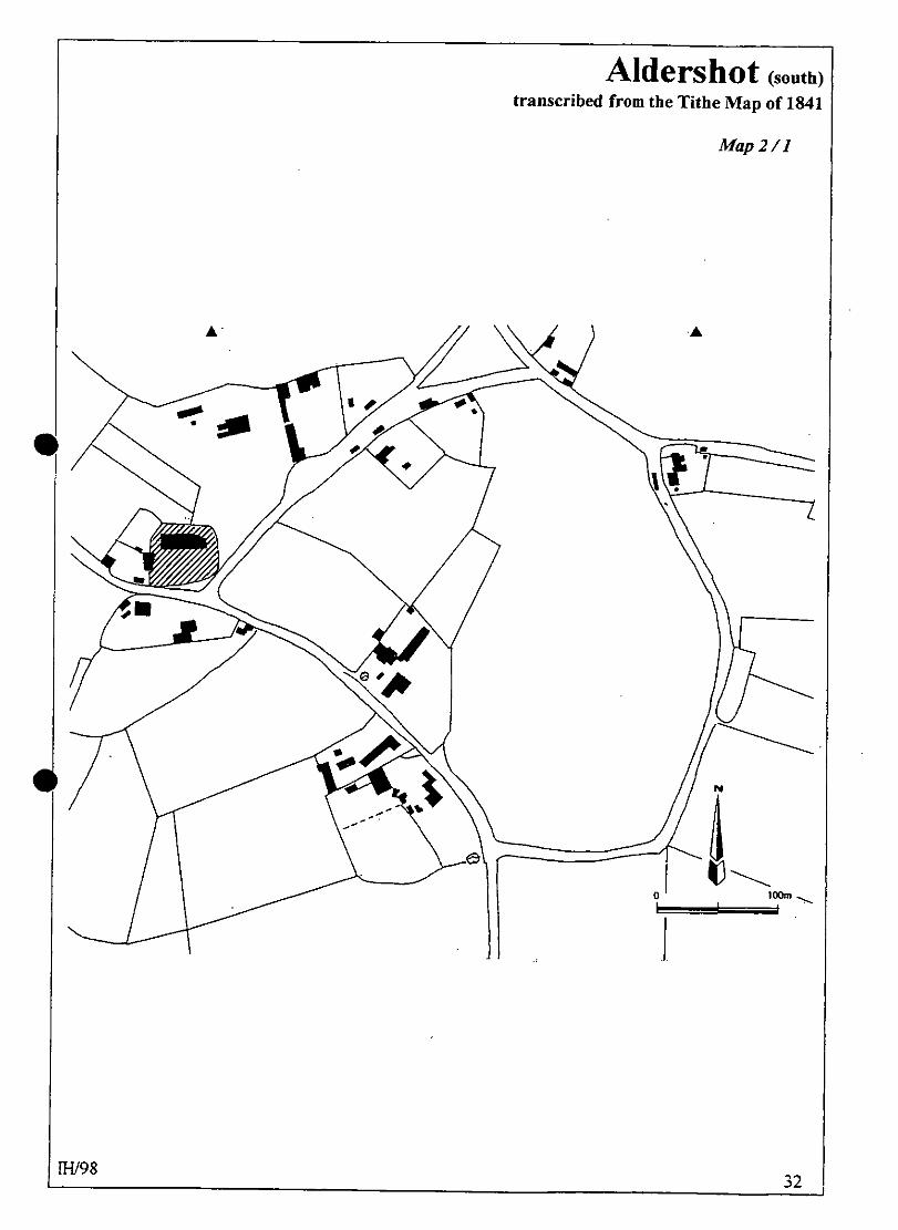
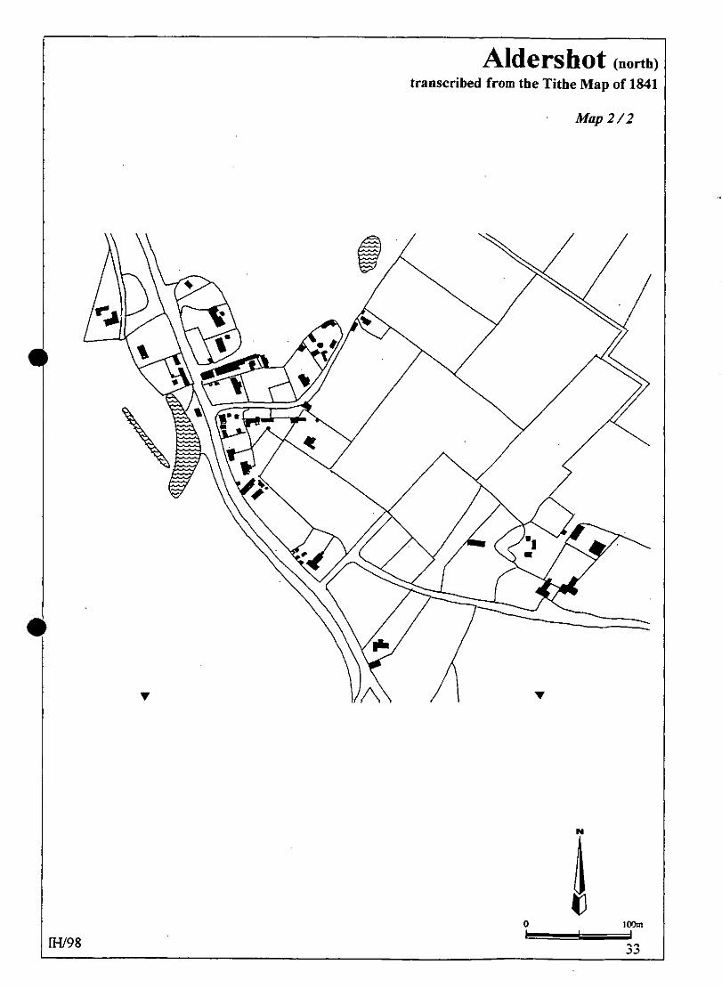
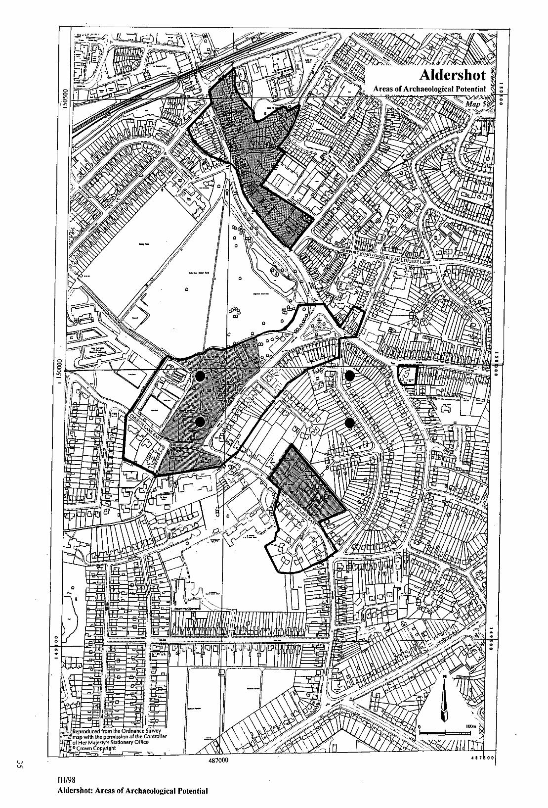
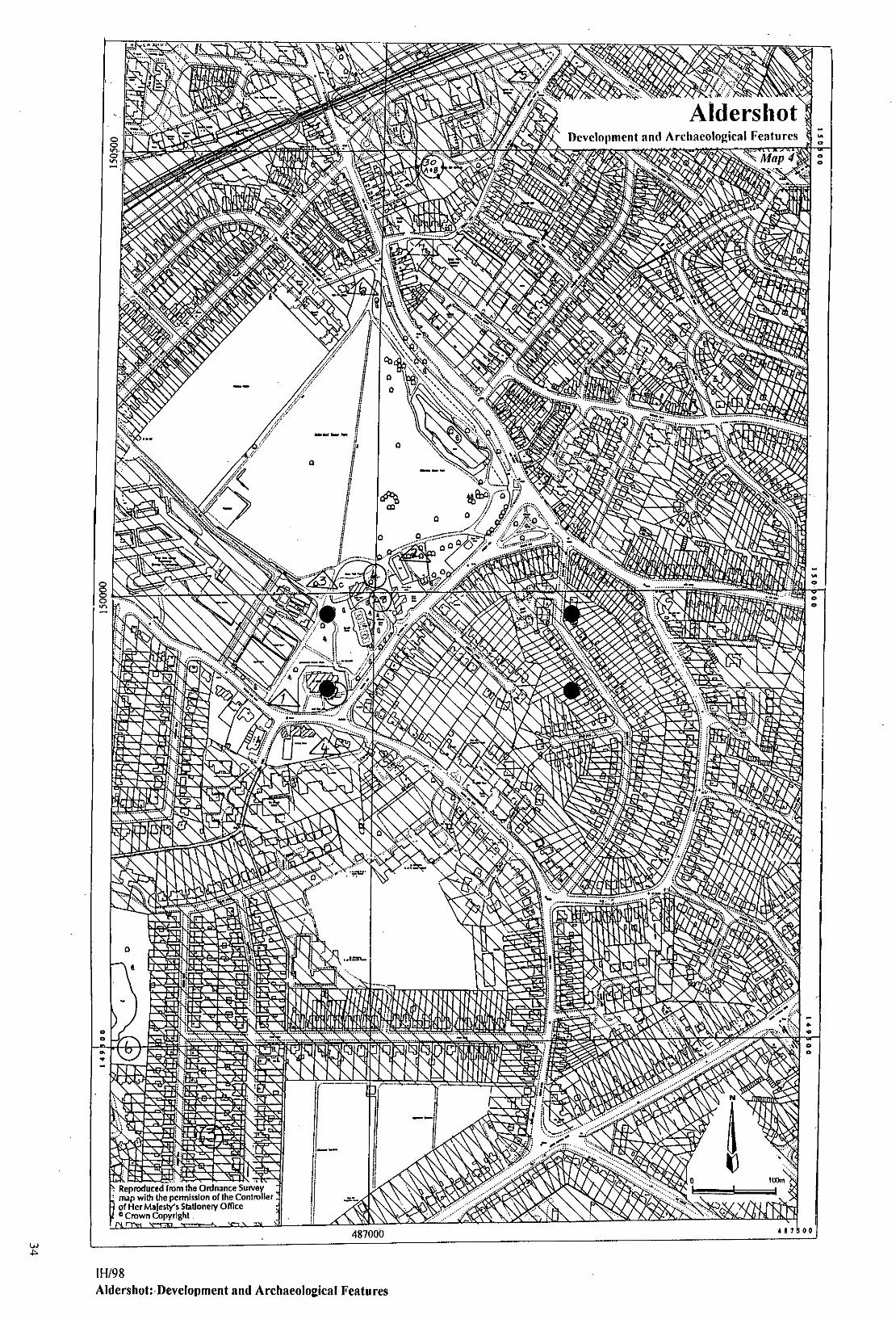
Aldershot this survey Aldershot has been classified as a church and manor settlement albeit that it was not an ancient manor. 6.1.4 The Tithe Map of 1841 shows a loose agglomerstion of other properties within a 300m radius of the church. Some of these were plots containing outbuildings associated with the Manor, others were ecclesiastical properties (Rectory, glebe structures etc.). South-east from the church by 200m were two substantial farmsteads in an off-set arrangement either side of Church Lane East (Map 2/1). Elm Place (south side) stands no longer but Aldershot Lodge remains, though in altered surroundings. The position of these properties in relation to each other and to the Rectory / glebe farm hints at an irregular row. 6.2 Common edge (Aldershot north) This part of old Aldershot is situated 500m north of 6.1 (ie the north side of Manor Park), immediately south of the railway and either side of a road that is now known as High Street. The pre-Army arrangement has been much disguised by a number of formal developments which have taken place since the 1850’s. However, the Tithe Map shows groups of properties either side of the road, which, whilst having the appearance of being in rows, were generally arranged in clusters or ‘islands’ some of which had become amalgamated (Map 2). This is typical of the type development to be expected in a common edge settlement. The typological identity of this component of pre-town Aldershot is confirmed by documentary evidence for enclosure of the commons in 1856 (17.2). 6.3 Site visit condition: strong sunlight; dry 7.0 ARCHAEOLOGICAL POTENTIAL 7.1 AsAP 7.1.1 Aldershot south A large area including the church, Aldershot Manor, the Rectory and both sides of Church Hill. It is important that the medieval church should be placed in a tighter context but there is also an entry in the SMR which indicates that medieval pottery was found close to the Manor. The entry goes on to describe the find spot as being in Newport Road (formerly Malthouse Lane; paragraph 10.0, No. 28) but this location would be c. 300m north-east of the map reference for the find spot. Any opportunity to clarify this ambiguity by archaeological investigation would be useful. 7.1.2 Aldershot north (High Street) The old part of Aldershot town is situated immediately south of the railway (Map 5). On the Tithe Map (Map 2/2) it can be identified as a linear settlement (sub-paragraph 6.2) on the edge of Aldershot Common. A date for the initial development of this settlement is not available but it is clear from SMR data that activities here included post-medieval pottery production (paragraph 10.0 No. 28). 7.1.3 The site of The Red Lion public house at NGR 487300 150000 was occupied by an earlier building of the same name in 1841. 7.1.4 The sites of the buildings and grounds of Aldershot Lodge and Elm Place.
IH/98
27
Aldershot
Aldershot 7.2 AsHAP 7.2.1 As for 7.1 but with an emphasis upon the church, Rectory and ‘manor’ sites. 7.2.2 The area of the common edge settlement described in sub-paragraphs 6.2 and 7.1.2 excluding the east side of the High Street which has been heavily redeveloped since 1841. 7.2.3 The area which defined the grounds of Aldershot Lodge in 1841. The site of Elm Place has been redeveloped in C20 and therefore has been excluded from this category. 8.0 CHURCH & CHURCHYARD St Michael the Archangel The church was formerly a chapelry of Crondall. The first known record is 1367-98 as the episcopy of William Wykeham (VCH 4: 4). It stands on high ground overlooking the Manor House and the High Street. C12 origin at the heart of the pre-newtown settlement. Enlarged 1910-11 when a
new chancel and nave were built. The C19 nave of yellow brick and the medieval chancel now comprise the south aisle and chapel.
C15 former chancel and east window. Windows of former name C15 style. Three-stage western tower c.1650; upper course of brick, ironstone rubble below
(Bagshot). Brick quoins. Modern extension on the north side. 9.0 BUILDINGS Many of Aldershot’s Listed Buildings date from the second part of C19. Many are simply parts of buildings (gateways etc.) and some are memorials. Where such structures and features are helpful in dating the recent development of the settlement they have been included in this section. PRN Details Dates Grade 4601 Church of the Holy Trinity, Windsor Way 1875-8 II 5238 Balloon School Memorial, Alison’s Rd 1892 II 4605 Ayling House, Ayling Lane Late C18 II 4606 2 x stone plaques, Princes Hall, Barrack Road 1859 II 4607 Building at Royal Aircraft Establishment 1910-11 II 4612 Aldershot Manor House (The Manor House), Church Hill, Manor Park 1670 & early C18 II 4613 Aldershot Manor House: stable block south of C18 II 4614 No. 104 Church Lane East c.1900-10 II 4615 The Vicarage, Church Lane East (now Manor Place Nursing Home) 1901 II 4616 The Vicarage: stable block S-W of late C18 II 1002 Church of St Michael the Archangel, Church Lane East C12, C17, Mod. II 4617 Aldershot Lodge, Church Lane East 1687, early C20 II 461(9?) Church of St Christopher, Cove Road 1934 II
IH/98
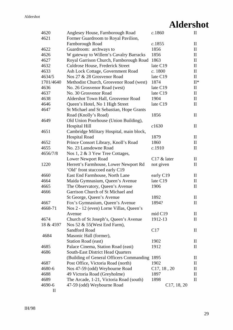
28
Aldershot
Aldershot 4620 Anglesey House, Farnborough Road c.1860 II 4621 Former Guardroom to Royal Pavilion, Farnborough Road c.1855 II 4622 Guardroom: archways to 1856 II 4626 W gateway to Willem’s Cavalry Barracks 1856 II 4627 Royal Garrison Church, Farnborough Road 1863 II 4632 Culdrose House, Frederick Street late C19 II 4633 Ash Lock Cottage, Government Road c. 1800 II 4634/5 Nos 27 & 28 Grosvenor Road late C19 II 1701/4640 Methodist Church, Grosvenor Road (west) 1874 II* 4636 No. 26 Grosvenor Road (west) late C19 II 4637 No. 30 Grosvenor Road late C19 II 4638 Aldershot Town Hall, Grosvenor Road 1904 II 4646 Queen’s Hotel, No 1 High Street late C19 II 4647 St Michael and St Sebastian, Hope Grants Road (Knolly’s Road) 1856 II 4649 Old Union Poorhouse (Union Building), Hospital Hill c1630 II 4651 Cambridge Military Hospital, main block, Hospital Road 1879 II 4652 Prince Consort Library, Knoll’s Road 1860 II 4655 No. 23 Lansdowne Road c.1910 II 4656/7/8 Nos 1, 2 & 3 Yew Tree Cottages, Lower Newport Road C17 & later II 1220 Herrett’s Farmhouse, Lower Newport Rd not given II ‘Old’ front stuccoed early C19 4660 East End Farmhouse, North Lane early C19 II 4664 Maida Gymnasium, Queen’s Avenue late C19 II 4665 The Observatory, Queen’s Avenue 1906 II 4666 Garrison Church of St Michael and St George, Queen’s Avenue 1892 II 4667 Fox’s Gymnasium, Queen’s Avenue 1894? II 4668-71 Nos 2 - 12 (even) Lorne Villas, Queen’s Avenue mid C19 II 4674 Church of St Joseph’s, Queen’s Avenue 1912-13 II 18 & 4597 Nos 52 & 55(West End Farm), Sandford Road C17 II 4684 Masonic Hall (former), Station Road (east) 1902 II 4685 Palace Cinema, Station Road (east) 1912 II 4686 South-East District Head Quarters (Building of General Officers Commanding 1895 II 4687 Post Office, Victoria Road (north) 1902 II 4680-6 Nos 47-59 (odd) Weybourne Road C17, 18 , 20 II 4688 49 Victoria Road (Greyholme) 1897 II 4689 The Arcade, 1-21, Victoria Road (south) 1898 II 4690-6 47-59 (odd) Weybourne Road C17, 18, 20 II
IH/98
29
Aldershot
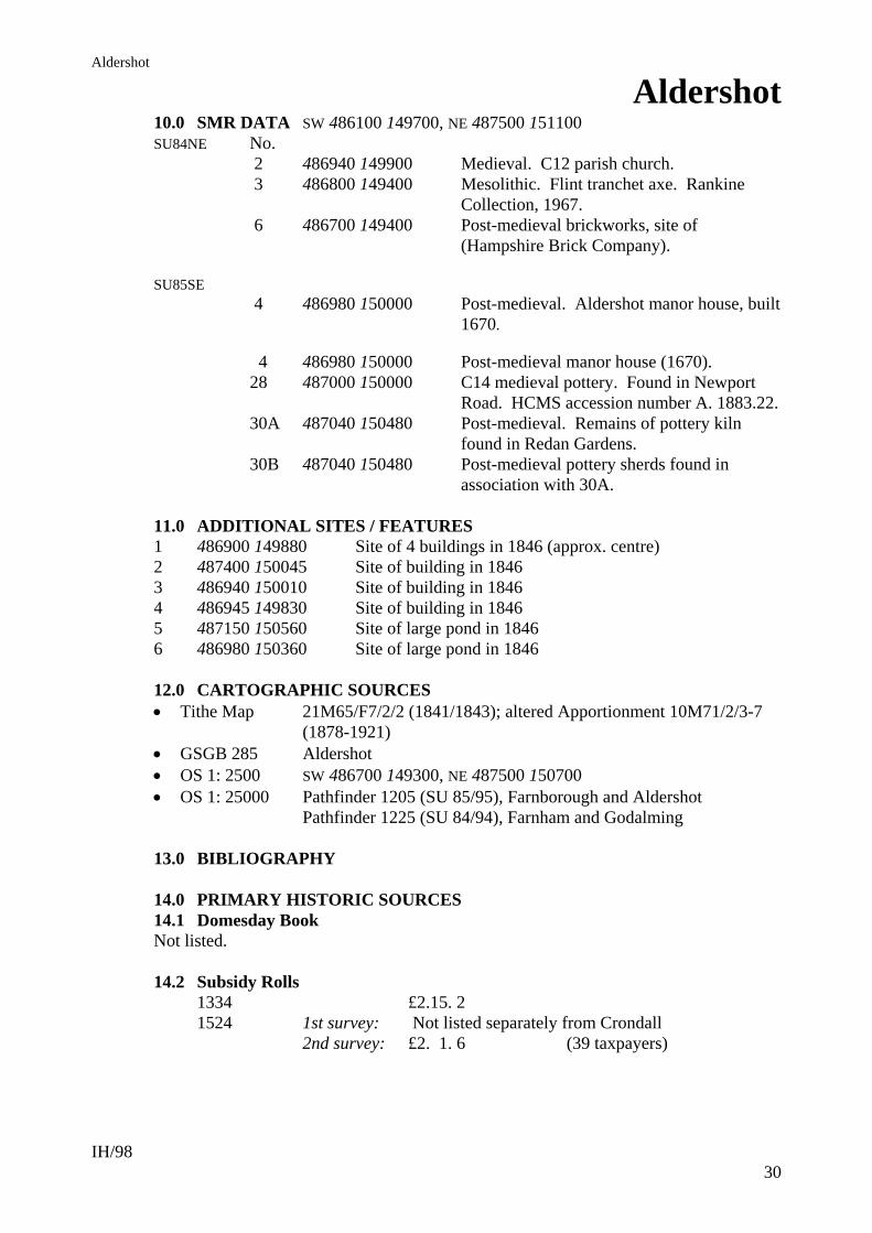
Aldershot 10.0 SMR DATA SW 486100 149700, NE 487500 151100 SU84NE No. 2 486940 149900 Medieval. C12 parish church. 3 486800 149400 Mesolithic. Flint tranchet axe. Rankine Collection, 1967. 6 486700 149400 Post-medieval brickworks, site of (Hampshire Brick Company). SU85SE 4 486980 150000 Post-medieval. Aldershot manor house, built 1670. 4 486980 150000 Post-medieval manor house (1670). 28 487000 150000 C14 medieval pottery. Found in Newport Road. HCMS accession number A. 1883.22. 30A 487040 150480 Post-medieval. Remains of pottery kiln found in Redan Gardens. 30B 487040 150480 Post-medieval pottery sherds found in association with 30A. 11.0 ADDITIONAL SITES / FEATURES 1 486900 149880 Site of 4 buildings in 1846 (approx. centre) 2 487400 150045 Site of building in 1846 3 486940 150010 Site of building in 1846 4 486945 149830 Site of building in 1846 5 487150 150560 Site of large pond in 1846 6 486980 150360 Site of large pond in 1846 12.0 CARTOGRAPHIC SOURCES Tithe Map 21M65/F7/2/2 (1841/1843); altered Apportionment 10M71/2/3-7
(1878-1921) GSGB 285 Aldershot OS 1: 2500 SW 486700 149300, NE 487500 150700 OS 1: 25000 Pathfinder 1205 (SU 85/95), Farnborough and Aldershot Pathfinder 1225 (SU 84/94), Farnham and Godalming 13.0 BIBLIOGRAPHY 14.0 PRIMARY HISTORIC SOURCES 14.1 Domesday Book Not listed. 14.2 Subsidy Rolls 1334 £2.15. 2 1524 1st survey: Not listed separately from Crondall 2nd survey: £2. 1. 6 (39 taxpayers)
IH/98
30

Aldershot
Aldershot
IH/98
31
14.3 Manorial Documents Part of the manor of Crondall (VCH3: 14). 14.4 Hearth Tax 1665 111 hearths chargeable (38 houses) 26 hearths not chargeable (19 houses). Total: 57 houses. 15.0 PLACE NAME 1171 Haleshet; 1248 Alreshete; 1287 Alresshate. OE alorsceat ‘alder corner’ (ie ‘at the alder tree). 16.0 PHOTOGRAPHS 17.0 OTHER PROJECT ELEMENTS 17.1 Other parish settlements include: Caesar’s Camp 483000 150000 973 as knaefes scylfe (‘knaef ‘s slope’ or ‘shelving hill’) Cranmore 1282, Crenemore (Crane or Heron Marsh) Deadbrook Farm 973 as duddenbroc (Dudda’s Brook) North Lane 488600 150500 1810 as ? Prey Bridge 1287 le Preye (from French pre = ‘meadow bridge’) West End 486500 150000 1810 as ? 17.2 Inclosure Act (private) 1856 Aldershot Common (HRO: Q23/2/1). 1856 Agreement re: roads (HRO: deposited plan 139a). 18.0 ILLUSTRATIONS 1 Location map at 1: 25000 2 Tithe Map transcription (Aldershot, south) at 1: 2500 3 Tithe Map transcription (Aldershot, north) at 1: 2500 4 Map: Development and Archaeological Features (Aldershot, south) at 1: 2500 5 Map: Development and Archaeological Features (Aldershot, north) at 1: 2500 6 Map: Areas of Archaeological Potential (Aldershot, south) at 1: 2500 7 Map: Areas of Archaeological Potential (Aldershot, north) at 1: 2500


Related Documents