Administrative Regulation 4.1 Governing the Submittal of Site Plans in Arlington County DEPARTMENT OF COMMUNITY PLANNING, HOUSING AND DEVELOPMENT Planning Division

Welcome message from author
This document is posted to help you gain knowledge. Please leave a comment to let me know what you think about it! Share it to your friends and learn new things together.
Transcript

AdministrativeRegulation4.1
Governing theSubmittal of Site Plansin Arlington County
DEPARTMENT OF COMMUNITY PLANNING,HOUSING AND DEVELOPMENT
Planning Division

Administrative Regulation 4.1Governing the Submittal of Site Plans in Arlington CountyRevised June 2013
EXECUTIVE SUMMARY
SummaryThe Administrative Regulation 4.1 was last revised on October 30, 2009. Over the past four years practices and County policies with regard to the submission and review of site plans has continued to evolve. With the current revisions, staff’s goals were to ensure that the site plan review process and submission requirements contained in the Administrative Regulation 4.1 (“Regulation”) were reflective of current County policy and practices such as the Crystal City Block Plan requirements, requirements for submission related to historic preservation, revisions to, and reformatting of the standard site plan conditions, changes to information regarding LEED, as well as to clarify data and information needed up front to ensure efficient staff review and analysis. In addition, certain redundancies and duplication in submission requirements were identified by staff.
ProcessDiscussions to update the Regulation began in early 2012. The review was initiated by staff in order to incorporate new requirements for a Crystal City Block Plan submission with redevelopment of sites in the C-O-Crystal City zoning district under Section 25C of the Zoning Ordinance, as well as submission requirements for historic preservation into the existing Regulation. As staff evaluated the Regulation to incorporate these new requirements, data and material submission requirements that were identified by staff in their implementation of the regulations to be either unclear or redundant were considered and further discussed. Based on practical experience of implementing the regulations and completing the review of submissions against the items required by and contained in the check list, staff determined that more efficient and effective review would occur if clear guidance were provided on the provision of density calculations and requests for exclusions and bonuses with the initial 4.1 submissions. Finally, staff in its practice found that there was redundancy and duplication in information relative to where it was required to be shown on the 4.1, and also that in some instances, the same information was being presented in the Regulation in multiple formats unnecessarily. Therefore staff concluded that the duplicative requirements and presentations could be eliminated.
After several iterations of revisions and staff review, the draft Regulation was discussed at a meeting with NAIOP/NVBIA and further shared with a small working group of NAIOP members. Their comments were reviewed and considered by staff and where appropriate, incorporated into the draft Regulation. A final draft Regulation was then completed, forwarded to the County Manager, and approved on (date). The final regulation will be made available for public distribution and posted on the Planning Division web site. In addition, forms from the Regulation will be available in a PFD format that allows users to fill them out online.
Summary of RevisionsFollowing is a brief synopsis of the substantive changes to the Regulation.General
Renamed and renumbered sections to show the addition of new requirements. Inserted references to the Crystal City Block Plan (CCBP). Changed Department of Parks, Recreation and Cultural Resources (PRCR) references to instead
refer to Arlington Economic Development (AED). Deleted duplicate submission requirements where provided in narrative format and then also in
checklist format.
Section 2 Plan Submittal Process and Requirements I. Added under public meetings, submission requirements for Historic Affairs and Landmark
Review Board meetings.
Section 4 Crystal City Block Plan (CCBP) Added a new section that provides detail submission requirements for Crystal City Block Plans.
Submittal Forms Attachment A: Site Plan Submittal Requirements and Checklist –
o Added requirement for a Presentation Plan sheet and required elementso Eliminated duplicate request of a Survey Plat.o Added that it be indicated with a rezoning if the zoning change is from an R,
RA, S-3A, S-D, C-1-R, C-1, C-1-R, C-2, C-1-O or C-O-1.0 district to any other commercial, mixed-use (C), industrial (M) or P-S district.
o Added requirement to provide as an information sheet, a tabulation in chart form of proposed density including density requested and bonus and exclusion.
o Added requirement for a statement of justification for all requested height and/or density bonuses and exclusions, as well as a letter explaining all requested Zoning Ordinance modifications to be complete with justifications.
o Updated required LEED information to reflect current applicable version(s) and clarified requirement to include explanation of why and how credits will be achieved along with identifying which credits the developer intends to pursue and the number of points needed to support a request for bonus density and/or height.
o Added requirement that the table showing by-right capacity for the site also include the density permitted for the site by site plan or approved Phased Development Site Plan.
o Added an Example of a Density Calculation Table.
Attachment B: Site Plan Specification Formo Eliminated numerical listing of specifications as it was duplicative of the actual
specification form provided.o Added requirement to include for site area, an attachment as an exhibit of site area
allocation as applicable.o Added that the requirement to include for Floor Area Ratio (FAR) be inclusive of
requested density bonuses and exclusions.
Attachment E: Crystal City Block Plan Submittal Requirementso Added a new attachment that details all requirements for the submission of a CCBP.
Attachment F: Crystal City Block Plan Specification Formo Added a new specification for required for the submission of a CCPB.
Attachment K: Crystal City Block Plan Review Processo Added a new flow chart that diagrams the review process for a CCBP submission.
Attachment M: List of Standard Site Plan Conditions by Category High Density Office, Residential and/or Mixed Use Developments
o Revised the listing to reflect the most up-to-date version of reformatted and re-organized conditions. Noted that this listing may be modified as applicable and appropriate, and serve as the basis for site plan conditions for townhouse and cluster developments.
Attachment N: List of Standard Site Plan Conditions by Category Townhouse and Cluster Developments
o Eliminated the listing until further updated to reflect where appropriate the reformatted and re-organized conditions on which these conditions would be based.
Attachment O: Historic Properties and Process for Review by Historic Affairs and Landmark Review Board (HALRB)
o Added a new attachment that details requirements for the review and submission of historic properties with site plans where applicable.
Attachment P: Historic Resources Inventory Informational (HRI) Formo Added a new attachment to provide information on any properties associated with a site
plan listed on the HRI, where applicable.
ADMINISTRATIVE REGULATION 4.1Governing
The Submittal of Site Plans
Arlington County, VirginiaOffice of the County Manager
Revised June 2013
Contents
Administrative Regulation 4.1Section 1. Purpose and Revision Process...................................................................1Section 2. Plan Submittal Process and Requirements................................................1Section 3. Phased Development Site Plan..................................................................5Section 4. Crystal City Block Plan...............................................................................5Section 5. Advertising................................................................................................6Section 6. Approved Plan ..........................................................................................6Section 7. Standard Site Plan Conditions ..................................................................6
Submittal FormsAttachment A: Site Plan Submittal Requirements and Checklist...............................7Attachment B: Site Plan Specification Form.............................................................28Attachment C: Phased Development Site Plan (PDSP) Submittal Requirements.....38Attachment D: PDSP Specification Form..................................................................42Attachment E: Crystal City Block Plan (CCBP) Submittal Requirements..................46Attachment F: CCBP Specification Form..................................................................52
Other AttachmentsAttachment G: Requirements for Traffic Impact Analysis (TIA).................................56Attachment H: Receipt of Approved Site Plan and Agreement.................................57Attachment I: Transportation Demand Management Program Matrix......................58Attachment J: Flow Chart of Site Plan Review Process..............................................60Attachment K: Flow Chart of Crystal City Block Plan Review Process.......................61Attachment L: Applicant Response to Comments Letter - template.........................62Attachment M: List of Standard Site Plan Requirements for High Density Office,
Residential and/or Mixed Use Developments by Category...............................63Attachment N: Vacation and Encroachment Request Waiver Form..........................65Attachment O: Historic Properties and Process for Review by the Historical Affairs
and Landmark Review Board (HALRB).............................................................66Attachment P: Historic Resources Inventory (HRI) Informational Form.....................68
ARLINGTON COUNTY, VIRGINIAOFFICE OF THE COUNTY MANAGER
Effective 01-02-60Revised 01-12-70Revised 07-01-71Revised 08-23-74Revised 09-12-75Revised 07-18-80Revised 07-01-82Revised 08-01-83Revised 12-01-86Revised 08-13-90Revised 12-23-91Revised 04-26-04Revised 03-01-07Revised 10-30-09Revised 06-26-13
ADMINISTRATIVE REGULATION 4.1 for Phased Development Site Plan (PDSP) and Site Plan Requests
Section 1. Purpose and Revision ProcessThis regulation sets forth administrative standards to facilitate timely and comprehensive review of and compliance with Site Plans, which includes new site plans, major amendments to existing site plans, and final site plans filed for Phased Development Site Plans and Crystal City Block Plans, pursuant to the Zoning Ordinance of Arlington County. The County Manager shall accept and authorize a submitted site plan for staff and public review, after staff has determined that the application has met all requirements set forth in Sections 2 through 6 of this regulation. The public review process (see Article 15.6.2 and 15.6.3 of the Arlington County Zoning Ordinance (ACZO)) commences once the application is complete, including filing 20 copies of the site plan and associated materials, and filing fees are paid. To ensure compliance with all those requirements, applicants are encouraged to contact Department of Community Planning, Housing and Development (DCPHD) and Department of Environmental Services (DES) staff prior to preliminary submittal.
This regulation will be updated as conditions warrant. At a minimum, the regulation will be reviewed and revised as necessary once per year. During the year between review dates, staff will collect comments regarding potential changes to the regulation and incorporate the suggested changes into the review process.
Section 2. Plan Submittal Process and RequirementsA. These regulations apply to the submission of Site Plans, Phased Development Site
Plans (PDSP), and Crystal City Block Plans (CCBP).
B. Submittal Process: The general submittal process for the actions noted in Section 2A is as follows: 1) Submit the appropriate type and number of requisite sets of drawings, forms and applications to the Zoning Office; 2) Staff will take up to ten (10) working days to review the preliminary application package and provide comments back to the applicant; 3) Continue that process until the application package is deemed complete and accepted by the County Manager; and 4) Submit 20 copies of the application package and requisite fees to the Zoning Office. Once the 20 sets of plans are stamped in by the Zoning Office and the required fees are paid, then the appropriate review cycle begins (see Sec. 2E of this document for details).
C. Preliminary Submittal Requirements : To ensure that all applications meet the detailed and comprehensive requirements of this regulation, three (3) copies of the applications for the PDSP or Site Plan must be submitted to the Arlington County
3

Zoning Office, along with the PDSP or Site Plan Specification Form, LEED® Scorecard, letter documenting discussions with Arlington Economic Development (AED) staff regarding public art opportunity on the site, letter outlining the proposed community benefits for staff review, and letter documenting discussions with Historic Preservation Program staff regarding potential impacts to historic properties. The applicant must provide all of the Site Plan Submittal Checklist items on the project’s plan sheets, unless otherwise agreed to in advance and in writing by the Planning Division Site Plan Check-In contact. County staff will contact the applicant within ten (10) working days of the initial and subsequent revised submittals and enumerate all revisions that will be required to make the plan consistent with this site plan submittal regulation and therefore acceptable to the County for completion of the submittal requirements. The applicant shall then incorporate the comments in the revised plans and resubmit the plans along with a Formal Response to Comments letter explaining how each comment was addressed. See Attachment L for a sample page from a Formal Response to Comments letter.
D. Final Submittal Requirements : Once staff determines that the plan meets the requirements of the plan submittal regulations and the County Manager has accepted the PDSP, CCBP, or Site Plan, 20 copies of the PDSP, CCBP or Site Plan shall be tendered, along with any fees due, to the Arlington County Zoning Office with the following information in sets of 20: Application form Letter outlining the proposed community benefits Disclosure statement listing all parties in control of the property, including owners
and homeowner’s associations Consent of all parties in control of the property, including owners and
homeowner’s associations Site Plan Specification Form Site Plan Submittal Checklist Public Review Civil Plan – please refer to
http://www.arlingtonva.us/departments/CPHD/planning/applications/site_plans/CPHDPlanningApplicationsSite_plansMain.aspx
Site Plan drawings at 24” x 36” Site Plan drawings at 11” x 17” CCBP, Block Development Document drawings at 24” x 36” CCBP, Block Framework drawings at 11” x 17” LEED Scorecard or other comparable reporting mechanism that is acceptable to
the County Manager or his designee with a description of how and/or why each credit can or cannot be achieved
Letter documenting discussions with Arlington Economic Development staff regarding public art opportunity on the site
Letter documenting discussions with Historic Preservation Program staff regarding potential impacts to historic properties
Historic Resources Inventory (HRI) Informational Form, as needed, and, If a rezoning is requested, a rezoning application and a zoning plat of the
proposal.
In addition, provide three (3) of the following: Compact discs, each containing a digital copy of the site plan drawings in JPEG,
PDF, and DXF formats (Filename format: “<Sheet #> <Sheet name>.xxx” for example, A204 Ground Floor Plan.pdf). For CCBP submissions, InDesign files and all associated linked documents should also be provided as a package.
Sets of plans at 8 1/2 x 11 inches in size
All plans, including reduced plans, shall be of sufficient size and clarity to be legible. All reduced plans shall include the graphic scale representation.
4
1. If it is determined that a Traffic Impact Analysis (TIA) is required, pursuant to the Traffic Impact Analysis Policy approved by the County Board, then twenty (20) copies of a TIA shall be submitted by the applicant to the Zoning Office at the time of final submittal. (See Attachment E: Requirements for Traffic Impact Analysis [TIA].)
2. Each PDSP and Site Plan requires a Transportation Demand Management (TDM) Plan. Twenty (20) copies of the TDM Plan shall be submitted by the applicant to the Zoning Office at the time of final submittal, and shall be consistent with the Transportation Demand Management Program Matrix (See Attachment G).
3. Refer to the Arlington County Zoning Ordinance, Article 15.6.8 and Article 15.6.9 to determine any requirements for Affordable Dwelling Units (ADUs) or contributions to support ADUs. In the event the project’s density exceeds the limits noted in Article 15.6.8 and/or Article 15.6.9, then an ADU plan must be submitted accordingly.
4. Twenty (20) copies of a conceptual Stormwater Management and Compliance Plan that addresses Chesapeake Bay Act and stormwater detention requirements, as well as any proposed LEED stormwater-related credits, shall be submitted by the applicant to the Zoning Office at the time of final submittal.
5. If the proposed PDSP or Site Plan includes property located in a jurisdiction other than Arlington, the applicant shall provide details of approvals required of the other jurisdiction and the status of the approvals.
E. County staff will contact the applicant when the County Manager has accepted the submittal. When the site plan is accepted the applicant must pay all fees and submit the PDSP or Site Plan to the Zoning Administrator. A minimum of 120 calendar days, after the receipt of fees and site plan submittal (see Sec. 2D), is required for review of a complete site plan. However, the County Board may, on its own motion, schedule hearings for a date which is less than one hundred twenty (120) days from the date of filing the application. The number of days will be determined by appropriate County staff based on the following criteria:
1. Minimum 120 Day Site Plan Cycle: Applicable to site plan proposals that are consistent with, or include rezoning and/or vacation requests that are consistent with, all elements of the County’s Comprehensive Plan, including the existing General Land Use Plan (GLUP) and/or Master Transportation Plan, and have no substantial policy conflicts or other issues.
2. Minimum 150-180 Day Site Plan Cycle: Applicable to site plan proposals that include rezoning and/or vacation requests requiring changes to the elements of the County’s Comprehensive Plan, including changes to the GLUP and/or Master Transportation Plan. This cycle also includes site plan proposals that involve major policy issues including, for example, “C-O-Rosslyn” or “C-O Crystal City” community benefits: infrastructure changes or vacation of public streets; and/or major variations from County plans and policies, such as Sector Plans, the Utility Underground Policy, or Affordable Housing.
3. Additional time may be required for any site plan that is substantially revised during its review or if issues arise during the review that requires time for discussion and resolution beyond the timeframes noted in Sec 2.E.1 and 2.E.2 above.
4. A proposed GLUP amendment for any site not identified in a County Board-adopted planning study will not be considered until such a planning study or analysis has been completed. As stated in the GLUP, the “Policy for Consideration
5
of General Land Use Plan Amendments Unanticipated by Previous Planning Efforts” provides further details on the process and how it could affect the time needed to process a site plan application.
F. Plan Resubmission1. The applicant shall submit a revised plan in accordance with County staff
comments within ten (10) working days of receiving staff comments. If staff comments necessitate major revisions to the plan, then a conceptual plan as agreed upon by staff and the applicant may be submitted for further staff review before full revised plans are submitted. The latest version of revised plans meeting the requirements of this regulation shall be submitted after the final SPRC meeting and not less than twenty (20) working days prior to the Planning Commission public hearing or the PDSP or Site Plan will automatically be deferred. The latest version of revised plans, in sets of six (6) in both 24 x 36 inches and 11 x 17 inches, as well as two (2) reduced sets of plans 8 ½ x 11 inches in size, and a revised digital copy on compact disc (JPEG, PDF, and DXF formats with filename format: <Sheet #> <Sheet name>.xxx), shall be filed with the Zoning Office. All plans, including reduced plans, shall be legible. All reduced plans shall include the graphic scale representation.
2. The applicant shall submit the required and updated data in time for the public notice and advertisement deadline relevant to the appropriate County Board meeting at which the site plan is to be heard in order to avoid the need to defer the item until a later County Board meeting date.
G. All supporting materials presented to the County Board or otherwise incorporated into the site plan by the County Board at the time of the public hearing become part of the public record and help define the requirements for the approval.
H. Every application for a PDSP or a Site Plan shall be accompanied by a fee in an amount set by the Arlington County Board.
I. For public meetings, the following sets of drawings are required for: Historical Affairs and Landmark Review Board (HALRB) meetings :
o Sets of presentation drawings at 11 X 17 inches in size, including building elevations, floor plans, overall site plan, perspectives demonstrating how the building fits in with the surrounding neighborhood, and color photographs showing the existing building conditions. For the HALRB’s subcommittee of the Design Review Committee (DRC), 10 sets will be required. For the full HALRB commission meeting, 20 sets will be required. Digital copies of all application materials in PDF format on compact disc are required for both the DRC and HALRB submittals.
Site Plan Review Committee (SPRC) meetings :o Sets of presentation drawings at 11 X 17 inches in size (in a number of copies
to be determined by staff) including colored building elevations, first floor plans, landscape plan, perspectives demonstrating how the building fits in with the surrounding neighborhood, and aerial photographs of the site and adjacent blocks. The types of required drawings will be generally determined by each respective SPRC meeting agenda.
Transportation Commission meetings :o Contact the assigned DES Site Planner for submittal requirements.
Planning Commission meetings :o 16 sets of presentation drawings at 11 X 17 inches in sizeo Current digital copy of presentation drawings in JPEG and PDF formats on
compact disc Filename format: <Sheet #> <Sheet name>.xxx
County Board meetings :
6
o 18 sets of presentation drawings at 11 X 17 inches in sizeo Current digital copy of presentation drawings in JPEG and PDF formats on
compact disc Filename format: <Sheet #> <Sheet name>.xxx
All copies of drawings shall be submitted to staff by no later than 12:00 noon the day before the regular distribution for each meeting. All plans, including reduced plans, shall be legible. All reduced plans shall include the graphic scale representation. In the event the applicant has not submitted to the assigned County Planner sufficient information and/or has not submitted information in time for SPRC report distribution, the County Planner and SPRC Chair assigned to the site plan may decide to cancel the SPRC meeting to allow for County staff to review the information and be able to provide staff’s comments at a future SPRC meeting.
Section 3. Phased Development Site Plan (PDSP)To permit the coordinated development of sites of more than twenty (20) acres in area, or a smaller area as authorized and accepted by the County Manager, the County Board may approve a Phased Development Site Plan (PDSP) in the form of a general plan for land uses, public facilities, transportation, and utilities. An approved PDSP shall be the site plan of record and shall guide future development proposals and approvals for the site. Approval of a Final Site Plan filed for a PDSP as set forth in this regulation is required prior to the issuance of a building permit for the Phased Development Site Plan project or project part.
Section 4. Crystal City Block Plan (CCBP)To facilitate coordinated and incremental redevelopment that achieves the vision established in the Crystal City Sector Plan, the County Board may adopt a Crystal City Block Plan (CCBP) for individual blocks in Crystal City, east of Jefferson Davis Highway. The CCBP provides a general and guiding long-range plan for existing and proposed general building locations, land use mix, tower coverage, transportation and other infrastructure, public open spaces and facilities, and utilities. CCBPs provide a level of block planning needed to address the existing superblock development across much of Crystal City, and the desired achievement of the plan’s many goals through redevelopment, such as:
The creation of new public open space; The relocation of existing functioning streets; The gradual transition to a more refined, pedestrian-scaled, urban street grid
network; and The incentive to encourage redevelopment of older functionally obsolete buildings
that maintains Crystal City as an economic engine of the County and achieves the above goals.
Although the Sector Plan called for the PDSP process to be applied in Crystal City, further consideration revealed serious limitations in the ability of PDSPs to achieve the Sector Plan vision for Crystal City. In response, the CCBP process was created to provide another block-level planning approach as an alternative to PDSPs, yet still be an integrated part of the development review process for individual site plan projects to help ensure:
Crystal City’s future build out is generally consistent with Sector Plan recommendations;
Proposed new buildings do not preclude the future planned, nearby improvements; Continued functionality of Crystal City systems and infrastructure throughout
periods of incremental redevelopment; and Ongoing discussions and decisions regarding the timing and sequencing of desired
community improvements relative to the overall build out.
Within the context above, the submission and review of individual site plan proposals within Crystal City should be preceded by or occur concurrent with an associated submission for a CCBP, based on the submittal requirements outlined as follows. An adopted CCBP will serve
7
as a supplemental long-range planning document for a specific block that builds upon and supports the Crystal City Sector Plan adopted in 2010. As such, it does not provide any additional development approvals or entitlements beyond those achieved as part of final site plan approvals.
Section 5. AdvertisingAfter acceptance by the County Manager, a Final Site Plan or a Major Site Plan Amendment application, as specified in Article 15.6.3.A of the Zoning Ordinance, PDSP, or CCBP must be submitted to the Zoning Office. Once the Zoning Office receives the Phased Development Site Plan, Crystal City Block Plan, Final Site Plan or Major Site Plan Amendment application and stamps it in, then it will be scheduled for hearing by the Planning Commission and the County Board following advertising and posting as specified in Article 15.1.2 of the Zoning Ordinance.
8
Section 6. Approved PlanTo permit the redevelopment of sites in a form that: 1) substantially complies with the character of master plans, PDSP, CCBP, if applicable, officially approved neighborhood or area development plans, and with the uses permitted and use regulations of the district as set forth in the Zoning Ordinance or as may be modified by the County Board; 2) functionally relates to other structures permitted in the district and will not be injurious or detrimental to the property or improvements in the neighborhood; and, 3) that is so designed and located that the public health, safety and welfare will be promoted and protected. An approved Final Site Plan or Major Site Plan Amendment shall be the site plan of record as required by Article 15.6 of the Zoning Ordinance.
Four (4) copies of a complete set of site plan drawings that meet the submittal requirements described in Attachment A, and one (1) digital copy in JPEG, PDF, and DXF formats on compact disc with filename format: <Sheet #> <Sheet name>.xxx, which complies with the final approval of the County Board and with the requirements of either Section 4 (Phased Development Site Plan Specifications) or Attachment A (Final Site Plan / or Major Site Plan Amendment Submittal Requirements) of this regulation as applicable, shall be filed with the Zoning Administrator within 90 calendar days of the County Board approval and before the issuance of any permit. After certification of approval by the County Manager or his designee and the Planning Division Chief or his designee, the record copies of these site plans as well as copies of the approved site plan conditions shall be distributed as follows:
A. Applicant (1 copy)
B. Department of Environmental Services (1 copy)
C. Zoning Section (2 copies)
Section 7. Standard Site Plan Conditions
By submitting a site plan application, the applicant understands there is a List of Standard Site Plan Requirements by Category – see Attachment M. Those conditions form the basis of discussions regarding the applicant’s site plan requirements. The final conditions applicable to a site plan are those eventually approved by the County Board for that specific site plan, and may include conditions in addition to those stated in the List of Standard Site Plan Requirements by Category.
The applicant shall submit a statement indicating receipt of the certified record copy of the site plan and concurrence with all site plan conditions as they were approved by the County Board (See Attachment H: Receipt of Approved Site Plan and Developer Agreement to Conditions).
9
Attachment AFinal Site Plan Submittal Requirements
Final Site Plan SpecificationsThe following data and specifications below and as further detailed in the accompanying Site Plan Submittal Checklist, shall be made a part of any submitted Final Site Plan or Major Site Plan Amendment. Applicants shall submit a digital copy in JPEG, PDF, and DXF formats on compact disc with filename format: <Sheet #> <Sheet name>.xxx, and a hard copy filing which comprises 20 complete sets of drawings measuring 24 x 36 inches in size, and 3 complete sets of reduced, legible drawings measuring 8 ½ x 11 inches in size and 20 complete sets of reduced, legible drawings measuring 11 x 17 inches in size, including the graphic scale representation, to include:
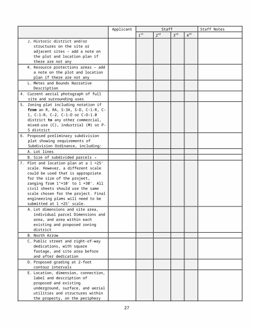
A. Certified survey plat, stamped and signed, of the parcel(s), including full sections of adjacent streets and intersections (from curb to curb or from edge of pavement to edge of pavement) and certified by a registered surveyor at a scale that is appropriate for the size of the project, ranging from 1" = 10' to 1” = 30’ showing:
Dimensions and site area, in square footage and acres, for the total site and for individual parcels as designated by the applicant, and if the site is divided into more than one zoning district, the area of the site encompassed by each zoning district.
North arrow orientation.
Types and dimensions of all existing easements.
Location, dimensions, size, and uses of all existing structures on site, including delineation of below-grade structures, number of existing parking spaces, number of existing residential and hotel units on the site, and reference to side lot lines and centerlines of adjacent streets.
Topography at two (2) foot contour intervals for the site and adjacent streets based on a recent survey (elevations given at Arlington County Datum).
Location and height in feet of structures on adjacent contiguous sites and across adjacent streets.
Provide details of existing street cross-sections.
Show location of trees on the site with a caliper of 3 inches or greater.
Historic districts and historic structures on the site or any adjacent sites - add a note on the plat if there are not any.
Resource protection areas (RPAs) - add a note on the plat if there are not any.
Metes and Bounds Narrative Description.
B. Current aerial photograph of full site and surrounding uses, generally to show the context of the site within surrounding blocks.
C. Zoning plat if the site plan is accompanied by a rezoning application.
Indicate if the proposed zoning change is from an R, RA, S-3A, S-D, C-1-R, C-1, C-1-R, C-2, C-1-O or C-O-1.0 district to any other commercial, mixed-use (C), industrial (M) or P-S district. An amendment to the sign map (Map 34-1 of the Zoning
10
Ordinance) may be required if the proposed rezoning is from or to one of the aforementioned zoning districts.
D. Proposed preliminary subdivision plat showing all matters required by Section 23-8 of the Arlington County Subdivision Ordinance including by way of illustration and not limitation lot lines, the square footage of all subdivided parcels, certified to be correct by a certified professional engineer or land surveyor.
E. Plot and location plan at a 1”=25’ scale. However, a different scale could be used that is appropriate for the size of the project, ranging from 1"=10' to 1”=30’. All civil sheets should use the same scale chosen for the project. Final engineering plans will need to be submitted at 1”=25’ scale. Show proposed improvements only highlighted in bold print, including:
Dimensions and site area, in square footage and acres, for the total site and for individual parcels as designated by the applicant, and if the site is divided into more than one zoning district, the area of the site encompassed by each existing and proposed zoning district.
North arrow orientation.
All dedications required for public street and for right-of-way purposes. Site area computed before and after public dedication, including the maximum permissible densities under the Zoning Ordinance computed on the basis of site area before and after dedication.
Topography at a minimum of two (2) foot contour intervals for the site and adjacent streets based on a recent survey (elevations given at Arlington County Datum).
Location, dimension, connection, label and description of proposed and existing known underground, surface, and aerial utilities and structures within the property, on the periphery of the site and in the full street. Show relationship of underground utilities to street tree placement. Refer to Site Plan Submittal Checklist, Item #7E, for a complete list of utilities and structures to include. Underground utilities must not conflict with the location of street trees (see the Standards for Planting and Preservation of Trees in Site Plan Projects, endorsed by the County Board on December 7, 2002). Existing aerial utilities within or along the periphery of the site shall be placed underground.
Location, dimension, connection, label and description of proposed and existing surface and below grade structures within the property, on the periphery of the site. Refer to Site Plan Submittal Checklist, Item #7F, for a complete list of structures to include.
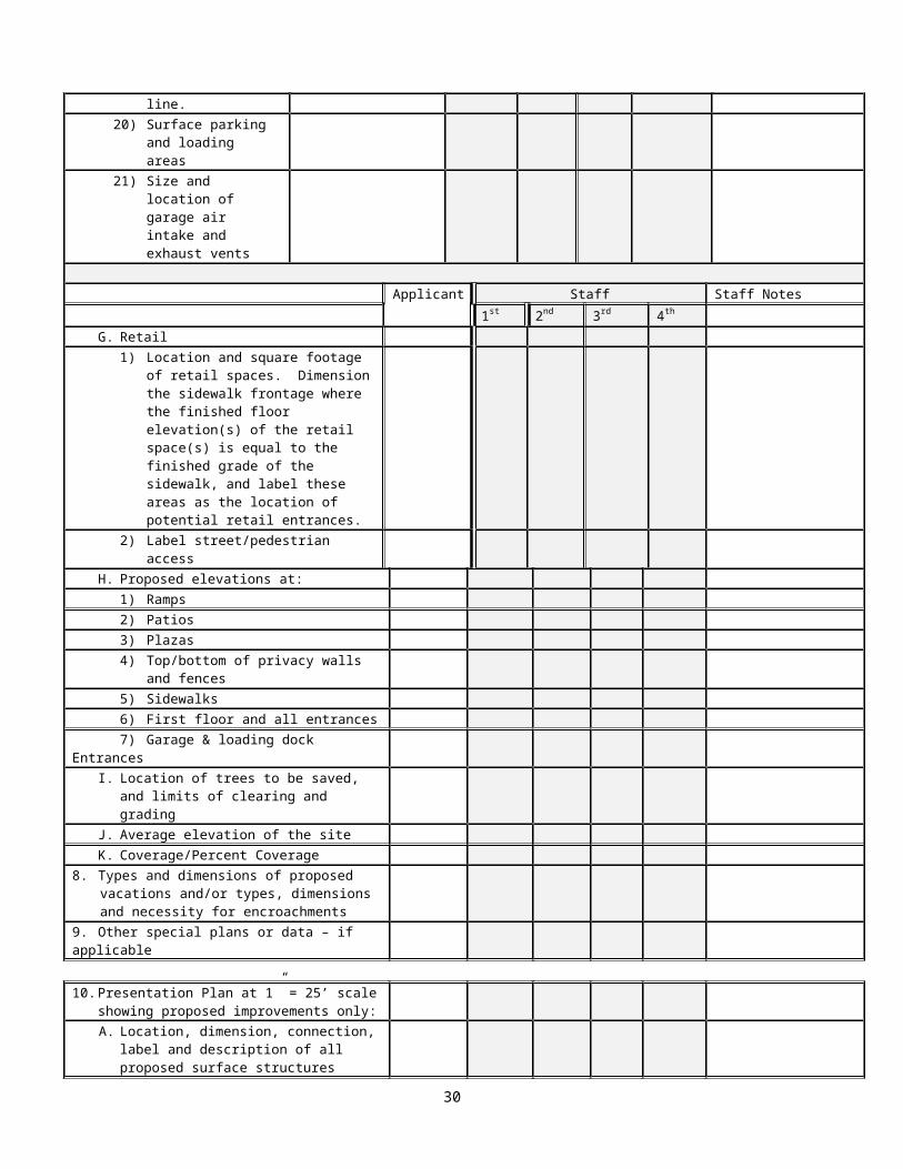
Location and square footage of retail spaces. Dimension the sidewalk frontage where the finished floor elevation(s) of the retail space(s) is equal to the finished grade of the sidewalk, and label these areas as the location of potential retail entrances.
Existing and proposed elevations at garage ramps, plazas, sidewalks, patios, first floor and all entrances, top/bottom of privacy and retaining walls and fences, and garage and loading dock entrances.
Location of all existing trees to be saved, and proposed limits of clearing and grading.
11
Average elevation of the site determined by taking elevations at 25-foot stations at the perimeter of the site, totaling the elevations and dividing by the total number of stations.
Coverage (area occupied by any buildings or structures, parking, driveways, maneuvering and/or loading spaces) and Percent Coverage (coverage expressed as a percent of the total lot area) before and after any proposed dedications and/or vacations of land. (District "RA7-16” includes sidewalks in the above definition of coverage.)
Types, dimensions, and necessity for each proposed vacation and/or types, dimensions, and necessity for each proposed encroachment into public right-of-way and easement areas, including streets and sidewalks. If no vacations or encroachments are expected, then the applicant must submit a completed, executed Vacation and Encroachment Request Waiver Form (see Attachment L).
Any special plans or data, if applicable, related to the site plan submittal, such as separate plat(s) showing proposed vacations and/or encroachments.
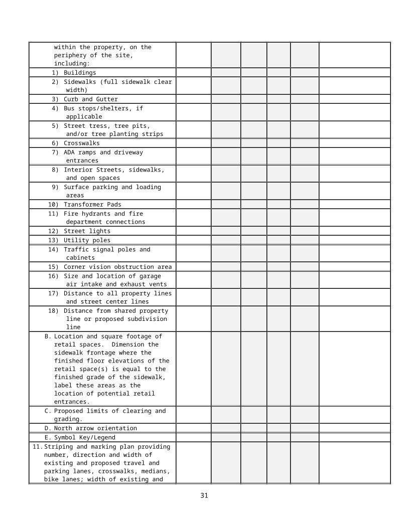
F. Presentation Plan at 1”=25’ scale. However, a different scale could be used that is appropriate for the size of the project, ranging from 1"=10' to 1”=30’. Show proposed improvements only, including:
Location, dimension, connection, label and description of all proposed surface structures within the property, on the periphery of the site, including:
a. Buildings
b. Sidewalks (full sidewalk and clear width)
c. Curb and gutter
d. Bus stops/shelters, if applicable
e. Street trees, tree pits and/or tree planting strips
f. Crosswalks
g. ADA ramps and driveway entrances
h. Interior streets, sidewalks, and open spaces
i. Surface parking and loading areas
j. Transformer pads
k. Fire hydrants and fire department connections
l. Street lights
m. Utility poles
n. Traffic signal poles and cabinets
o. Corner vision obstruction area
p. Size and location of garage air intake and exhaust vents
12
q. Distance to all property lines and street center lines
r. Distance from shared property line or proposed subdivision line
Location and square footage of retail spaces. Dimension the sidewalk frontage where the finished floor elevation(s) of the retail space(s) is equal to the finished grade of the sidewalk, and label these areas as the location of potential retail entrances.
Proposed limits of clearing and grading.
North arrow orientation.
Symbol Key/Legend
G. Striping and marking plan at a scale that is appropriate for the size of the project, ranging from 1" = 10' to 1” = 30’, showing details of the number, direction, and width of existing and proposed travel and parking lanes, crosswalks, medians (painted and raised), bike lanes, width of existing and proposed curb cuts, and any other pavement markings, planting areas, and street lights. Label and delineate fire lanes, if applicable. Existing and proposed traffic signals shall be shown, including the location of poles, span wires and/or mast arms. If separate sheets are required, also show, in addition to the above, all information on a single sheet at a scale of 1” = 50’ (or an alternate scale approved by the County Manager or his designee).
H. Existing and proposed street cross-sections showing, building wall lines and dimensions of sidewalks, planting areas, curb, gutter, parking lanes, bike lanes, travel lanes, medians, and other street elements consistent with applicable standards. Reference the existing survey center line and the middle of the pavement (if different) in the existing and proposed cross-sections.
I. Architectural Plans shall be prepared at a scale that is appropriate for the size of the project. For CAD or other computer generated drawings, the coordinate system should be Virginia State Plane North, North American Datum of 1983, in U.S. feet. For vertical datum, all Site Plans shall be referenced to the North American Vertical Datum of 1988 (NAVD 88). Architectural plans will include, by way of illustration and not limitation, the following:
Plan of each parking garage floor, providing for each floor level:
a. Elevations, dimensions, and GFA of overall structure, and number and layout of proposed spaces.
b. Labels and dimensions of typical standard, compact and handicapped parking spaces; dimensions of aisles; and locations and sizes (in square feet) of storage, mechanical and other non-parking areas. Labels for parking spaces designated for retail uses. Locations, labels, and number of bicycle storage spaces.
Ground floor plan, showing the ground floor of all structures above grade with the following information:
a. Overall dimension, elevation, and GFA of the floor. Overall GFA measured from exterior wall to exterior wall and including all areas in between.
b. Label all separate uses and access to separate uses, including storage, loading and service areas including height of loading docks, retail including
13

retail slab-to-slab height and retail access/connections to service areas, recycling and trash collection areas, and garage.
c. Label building entrances for pedestrians and vehicles including ground floor retail uses.
d. General location and information on landscaping, plazas, and other site features.
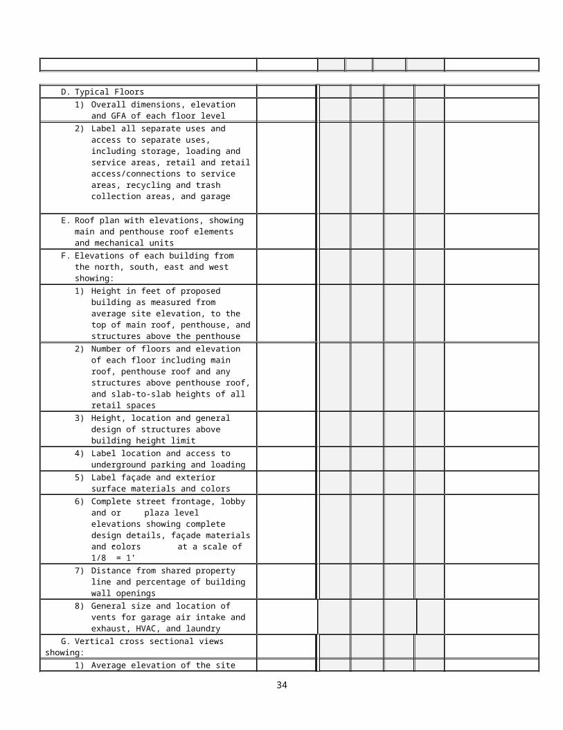
Plan of each non-typical floor with the following information:
a. Overall dimensions, elevations, and GFA of each floor. GFA measured from exterior wall to exterior wall and including all areas in between.
b. Label all separate uses and access to separate uses, including storage, loading and service areas including height of loading docks, retail including retail slab-to-slab height and retail access/connections to service areas, recycling and trash collection areas, and garage.
Typical floor plan(s) with the following information:
a. Overall dimensions, elevation, and GFA of each floor level. GFA measured from exterior wall to exterior wall and including all areas in between.
b. Label all separate uses and access to separate uses, including storage, loading and service areas including height of loading docks, retail including retail slab-to-slab height and retail access/connections to service areas, recycling and trash collection areas, and garage.
Roof plans showing all proposed elements and elevations of each roof level, including all penthouse elements, mechanical units, roof decks, or gardens.
Building elevations (north, south, east, and west) that show the following:
a. Height, in feet, of proposed buildings as measured from the average site elevation to the main roof, penthouse roof, and the top of all other buildings and/or structures, including structures above the penthouse.
b. Number of floors and elevation of each floor, including the main roof, penthouse roof, and the top of all other buildings and/or structures, including structures above the penthouse. The slab-to-slab height of all retail spaces shall be clearly labeled.
c. Height, location, and general design of structures proposed above the building height limit and/or above the main roof or penthouse roof.
d. Location of and label for vehicular access to underground parking and loading docks.
e. Labels for all materials to be used on the facades (i.e. brick, precast concrete, glass) or other exterior surfaces, general color of these materials, and the location of these materials.
f. In drawings having a scale of 1/8 inch = 1 foot, elevations of street, lobby, and plaza level frontages showing concepts for retail tenant signs or other signage proposed for all entrances, location of pedestrian and lobby entrances, treatment of retail storefronts and/or street level design including building materials and colors, and architectural features and glazing.
14
g. Distance of all building walls from a property line shared with an adjacent property, or a potential subdivision line, and the percentage of openings on the building wall, as calculated and described in the Virginia Uniform Statewide Building Code (VA USBC).
h. General size and location of vents for garage air intake and exhaust, HVAC, and laundry.
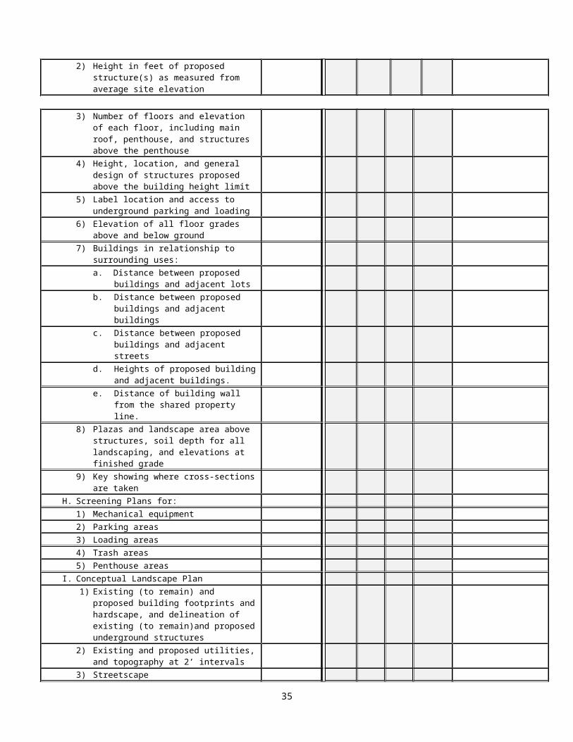
Vertical cross section views (north/south and east/west) that show the following:
a. Average elevation of the site.
b. Height, in feet, of proposed buildings measured from the average site elevation to the main roof, penthouse roof, and to the top of all other buildings and/or structures.
c. Number of floors and elevation of each floor, including the main roof, penthouse roof and the top of all buildings and/or structures, including structures above the penthouse.
d. Height, location, and general design of structures proposed above the main/penthouse roof and building height limit.
e. Location of and label for access to underground parking and loading docks, and height of loading docks.
f. Finished floor elevation of each floor, including basements and boiler rooms, and elevations at the top of slab of underground structures.
g. Distance, in feet, of proposed structures from adjacent lots; from other structures on the site and on parcels adjacent to and across the street from the site, showing the heights of the other structures; and from adjacent streets.
h. Sections through plaza and landscaped areas above structures, showing soil depth provided for all landscaping and elevations at the finished grade.
i. A key showing where cross sections are taken.
Screening of mechanical equipment, parking, loading, trash, and penthouse areas. Where applicable, provide general information on how these uses will be screened.
Conceptual landscape plan, to include:
a. Footprint(s) of all existing and proposed structures, hardscape, and delineation of existing and proposed underground structures.
b. All existing (to remain) and proposed utilities and topography at 2-foot contour intervals for the site and adjacent streets based on a recent survey (elevations given at Arlington County Datum).
c. Streetscape:1) Street tree species and spacing consistent with applicable Sector Plans,
Rosslyn-Ballston Corridor Streetscape Standards and the Standards for Planting and Preservation of Trees in Site Plan Projects.
15
2) Designs for sidewalks and paver treatments consistent with the Rosslyn-Ballston Corridor Streetscape Standards, Pedestrian Master Plan and/or other applicable standards and/or guidelines.
3) Differentiation in design and treatment of sidewalks and plazas, defining hardscape materials.
d. Design and size (in square feet) of plazas and other site features such as landscaped areas, swimming pools and activity areas, interior walkways and public sidewalks; landscaping for these areas specifying locations and types of all plant materials (i.e., major deciduous trees, evergreen trees, shrubs, groundcover, ornamental trees, street trees, seasonal flowers in landscaped beds, etc.); and other landscape elements, such as fences, street furnishings, large planters, and walls and other raised features. Label street trees and other streetscape elements including public sidewalks, street furniture and outdoor dining areas. Potential location of, label for, and identification of types of public art, if applicable.
e. Labels for, sizes (in square feet), and landscape elements of: 1) Common open space as required in cluster and “R-10T” development.
2) Open space easement or dedication to be conveyed by the property owner.
3) Landscaped area as required in the “R-C”, “C-O-A” and “C-R” Districts.
f. Tree survey (shown on separate sheet), conducted by a certified arborist or other horticultural professional with a demonstrated expertise in tree preservation techniques on urban sites, of all trees on the site with a caliper of 3 inches and greater. Provide locations of all existing trees to be saved, trees to be removed, proposed limits of clearing and grading, and a calculation of the number of trees to be replaced in tabular form pursuant to the tree replacement formula.
J. The following additional information shall be provided in the application drawings and shall be provided as attachments to the drawings:
1. Labels and identification of materials to be used in special architectural features, including, but not limited to, fences, walls, roof, or penthouse treatments.
2. Treatment of all mechanical and/or ventilation shafts or vents, e.g., HVAC, bathroom, fireplaces, clothes dryers, on facades, and residential balcony railings.
3. Exterior treatment of loading dock doors.
4. Photo montage showing how structures fit in with the fabric of the surrounding neighborhood at the street level, in the context of existing conditions, and known future development.
5. Drawings showing how structures fit in with surrounding development and uses, in terms of compatibility of massing.
6. Height profile, providing comparative drawing (sections) showing the relationship of the structures’ overall heights to other surrounding structures and uses within a 400-foot offset of development.
16

7. Context plan at a scale of 1” = 50’, showing street alignments, parking and travel lane designations, sidewalks, bike facilities, transit facilities, and building lines, within a 400-foot offset of development.
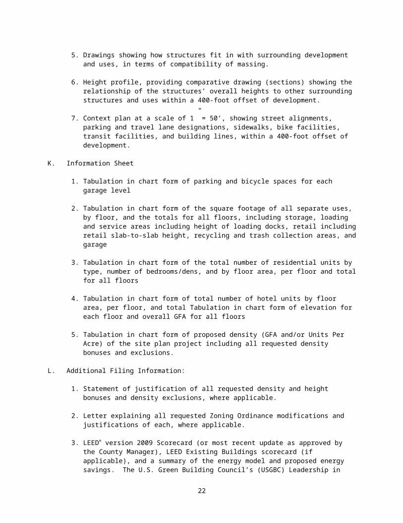
K. Information Sheet
1.Tabulation in chart form of parking and bicycle spaces for each garage level
2.Tabulation in chart form of the square footage of all separate uses, by floor, and the totals for all floors, including storage, loading and service areas including height of loading docks, retail including retail slab-to-slab height, recycling and trash collection areas, and garage
3.Tabulation in chart form of the total number of residential units by type, number of bedrooms/dens, and by floor area, per floor and total for all floors
4.Tabulation in chart form of total number of hotel units by floor area, per floor, and total Tabulation in chart form of elevation for each floor and overall GFA for all floors
5.Tabulation in chart form of proposed density (GFA and/or Units Per Acre) of the site plan project including all requested density bonuses and exclusions.
L. Additional Filing Information:
1. Statement of justification of all requested density and height bonuses and density exclusions, where applicable.
2. Letter explaining all requested Zoning Ordinance modifications and justifications of each, where applicable.
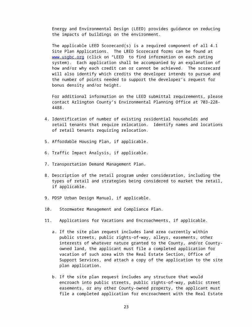
3. LEED® version 2009 Scorecard (or most recent update as approved by the County Manager), LEED Existing Buildings scorecard (if applicable), and a summary of the energy model and proposed energy savings. The U.S. Green Building Council’s (USGBC) Leadership in Energy and Environmental Design (LEED) provides guidance on reducing the impacts of buildings on the environment.
The applicable LEED Scorecard(s) is a required component of all 4.1 Site Plan Applications. The LEED Scorecard forms can be found at www.usgbc.org (click on “LEED” to find information on each rating system). Each application shall be accompanied by an explanation of how and/or why each credit can or cannot be achieved. The scorecard will also identify which credits the developer intends to pursue and the number of points needed to support the developer’s request for bonus density and/or height.
For additional information on the LEED submittal requirements, please contact Arlington County’s Environmental Planning Office at 703-228-4488.
4. Identification of number of existing residential households and retail tenants that require relocation. Identify names and locations of retail tenants requiring relocation.
5. Affordable Housing Plan, if applicable.
6. Traffic Impact Analysis, if applicable.
7. Transportation Demand Management Plan.
17
8. Description of the retail program under consideration, including the types of retail and strategies being considered to market the retail, if applicable.
9. PDSP Urban Design Manual, if applicable.
10. Stormwater Management and Compliance Plan.
11. Applications for Vacations and Encroachments, if applicable.
a. If the site plan request includes land area currently within public streets, public rights-of-way, alleys, easements, other interests of whatever nature granted to the County, and/or County-owned land, the applicant must file a completed application for vacation of such area with the Real Estate Section, Office of Support Services, and attach a copy of the application to the site plan application.
b. If the site plan request includes any structure that would encroach into public streets, public rights-of-way, public street easements, or any other County-owned property, the applicant must file a completed application for encroachment with the Real Estate Section, Office of Support Services, and attach a copy of the application to the site plan application.
c. A description, with illustrative plats, of all real estate transactions and/or permissions involving the County that are anticipated as a result of the site plan. This should include all vacations, encroachments, easements, licenses, or other incursions into, or planned use of, County property.
12. Tabulation in chart form showing the by-right capacity for the site, and the density permitted for the site by applicable site plan or PDSP approval where applicable, including the uses, gross floor area and density, building height, setback, and coverage.
13. Letter documenting discussions with AED staff regarding opportunity for public art on the site.
14. Letter outlining proposed community benefits.
15. Disclosure statement
16. For each resubmittal, a formal response to comments letter (see Attachment I for a template)
17. Historic preservation letter, if applicable.
18. Historic Resources Inventory (HRI) Informational Form, if applicable.
18

Site Plan Submittal Checklist To ensure a complete Site Plan Submittal, the applicant must complete and
submit this form.
Staff NotesDATE:APPLICANT/DEVELOPER:APPLICATION BY:ADDRESS:DAYTIME PHONE:EMAIL ADDRESS:CONTACT:PROJECT TITLE:PROJECT LOCATION:
Applicant
Staff1st 2nd 3rd 4th
1. Check-in Submissions: 2 copies of plan at correct scale and size (24” x 36”), with additional required information
2. Final Submissions: 20 copies of plan at correct scale and size (24” x 36”), with additional required information and digital copies
A. 3 reduced copies @ 8.5” x 11” , with graphic seal representation
B. 20 reduced copies @ 11” x 17”, with graphic seal representation
3. Certified Survey Plat at Scale that is appropriate for the size of the project, ranging from 1" = 10' to 1” = 30’A. Full Cross-Sections of adjacent streets from
curb to curb, with dimensions, including full intersections
B. Dimensions of TractsC. Lot area by Zoning District (square feet and
acres) for each tractD. North ArrowE. Types and dimensions of existing
easementsF. Location, dimensions, size and uses of
existing structures and below-grade structures, number parking spaces, number residential and hotel units, and distance from side lot lines and centerlines of adjacent streets
G. Topography at 2-foot intervalsH. Location and height in feet of existing
structures on adjacent contiguous site and across adjacent streets
I. Show location of trees on site with caliper of 3 inches or greater.
19
Applicant Staff Staff Notes1st 2nd 3rd 4th
J. Historic district and/or structures on the site or adjacent sites – add a note on the plot and location plan if there are not any
K. Resource protections areas – add a note on the plot and location plan if there are not any
L. Metes and Bounds Narrative Description
4. Current aerial photograph of full site and surrounding uses
5. Zoning plat including notation if from an R, RA, S-3A, S-D, C-1-R, C-1, C-1-R, C-2, C-1-O or C-O-1.0 district to any other commercial, mixed-use (C), industrial (M) or P-S district
6. Proposed preliminary subdivision plat showing requirements of Subdivision Ordinance, including: A. Lot linesB. Size of subdivided parcels
7. Plot and location plan at a 1”=25’ scale. However, a different scale could be used that is appropriate for the size of the project, ranging from 1"=10' to 1”=30’. All civil sheets should use the same scale chosen for the project. Final engineering plans will need to be submitted at 1”=25’ scale.A. Lot dimensions and site area,
individual parcel Dimensions and area, and area within each existing and proposed zoning district
B. North ArrowC. Public street and right-of-way
dedications, with square footage, and site area before and after dedication
D. Proposed grading at 2-foot contour intervals
E. Location, dimension, connection, label and description of proposed and existing underground, surface, and aerial utilities and structures within the property, on the periphery of the site and in the full street. Show relationship of underground utilities to street tree placement.
Applicant Staff Staff Notes1st 2nd
Ext Prop Ext Prop Ext Prop1) Water meter vaults &
water meter clear zones
2) Electric Transformer vaults
3) Storm Sewer4) Gas5) Sanitary Sewer
20

6) Water7) Electric 8) Cable TV9) Telephone
10) Fiber optics11) Other (please specify)12) MEP letter documenting
transformer size and location
13) METRO-related structures
F. Location, dimension, connection, label and description of proposed and existing surface and below grade structures within the property, on the periphery of the site.1) Full street sections
and intersections.2) Sidewalks (full
sidewalk and clear width)
3) Curb and gutter4) Street lights5) Utility poles6) Bus Stops / Bus
Shelters, if applicable
7) Street trees, tree pits and/or tree planting strips
8) Transformer pads9) Fire hydrants and
fire department connections
10) Crosswalks11) ADA ramps and
driveway entrances12) Traffic signal poles
and cabinets13) Distance to all
property lines and street center lines
14) Corner vision obstruction area
15) Physical relationship and distance to adjacent lots and buildings on same block, contiguous blocks and across adjacent streets
16) Location of streets on adjacent sites and blocks, with garage and loading
21
docks marked17) Driveways and
driveway entrances on the same block and across the street
18) Interior streets, sidewalks & open spaces
19) Distance from shared property line or proposed subdivision line.
20) Surface parking and loading areas
21) Size and location of garage air intake and exhaust vents
Applicant Staff Staff Notes1st 2nd 3rd 4th
G. Retail1) Location and square footage of
retail spaces. Dimension the sidewalk frontage where the finished floor elevation(s) of the retail space(s) is equal to the finished grade of the sidewalk, and label these areas as the location of potential retail entrances.
2) Label street/pedestrian accessH. Proposed elevations at:
1) Ramps2) Patios3) Plazas4) Top/bottom of privacy walls and
fences5) Sidewalks6) First floor and all entrances7) Garage & loading dock Entrances
I. Location of trees to be saved, and limits of clearing and grading
J. Average elevation of the siteK. Coverage/Percent Coverage
8. Types and dimensions of proposed vacations and/or types, dimensions and necessity for encroachments
9. Other special plans or data – if applicable
10. Presentation Plan at 1” = 25’ scale showing proposed improvements only:A. Location, dimension, connection, label
and description of all proposed surface structures within the property, on the periphery of the site, including:
1) Buildings2) Sidewalks (full sidewalk clear
width)
22
3) Curb and Gutter4) Bus stops/shelters, if applicable5) Street tress, tree pits, and/or tree
planting strips6) Crosswalks7) ADA ramps and driveway entrances8) Interior Streets, sidewalks, and
open spaces9) Surface parking and loading areas
10) Transformer Pads11) Fire hydrants and fire department
connections12) Street lights13) Utility poles14) Traffic signal poles and cabinets15) Corner vision obstruction area16) Size and location of garage air
intake and exhaust vents17) Distance to all property lines and
street center lines18) Distance from shared property line
or proposed subdivision lineB. Location and square footage of retail
spaces. Dimension the sidewalk frontage where the finished floor elevations of the retail space(s) is equal to the finished grade of the sidewalk, label these areas as the location of potential retail entrances.
C. Proposed limits of clearing and grading.
D. North arrow orientationE. Symbol Key/Legend
11. Striping and marking plan providing number, direction and width of existing and proposed travel and parking lanes, crosswalks, medians, bike lanes; width of existing and proposed curb cuts, planting areas, street lights, existing traffic signals (poles, span wires and/or mast arms), label and delineate fire lanes, if applicable
23

12. Existing and proposed street cross-sections:A. Building wall lines & dimensions of
sidewalkB. Planting areasC. Curb and gutterD. Parking, bike and travel lanesE. Medians
13. Architectural Plans at a scale appropriate for the project sizeA. Floor Plans of each garage level,
including:1) Elevations2) Dimensions of overall structure3) GFA of overall structure4) Layout and number of parking spaces5) Label and dimension of typical
standard, compact and handicapped spaces
6) Widths of each aisle7) Label and size of storage, mechanical,
retail parking, bicycle parking, and other non-parking areas.
B. Ground Floor Plan1) Overall dimension, elevation and GFA2) Label all separate uses and access to
separate uses, including storage, loading and service areas, retail and retail access/connections to service areas, recycling and trash collection areas, and garage
3) Label building entrances for pedestrians and vehicles, including ground floor retail
4) Location and information on landscaping, plazas and other site features
C. Non-typical Floors1) Overall dimensions, elevation and
GFA of each floor level2) Label all separate uses and access to
separate uses, including storage, loading and service areas, retail and retail access/connections to service areas, recycling and trash collection areas, and garage
D. Typical Floors1) Overall dimensions, elevation and
GFA of each floor level2) Label all separate uses and access to
separate uses, including storage, loading and service areas, retail and retail access/connections to service areas, recycling and trash collection areas, and garage
E. Roof plan with elevations, showing main and penthouse roof elements and mechanical units
24

F. Elevations of each building from the north, south, east and west showing:1) Height in feet of proposed building as
measured from average site elevation, to the top of main roof, penthouse, and structures above the penthouse
2) Number of floors and elevation of each floor including main roof, penthouse roof and any structures above penthouse roof, and slab-to-slab heights of all retail spaces
3) Height, location and general design of structures above building height limit
4) Label location and access to underground parking and loading
5) Label façade and exterior surface materials and colors
6) Complete street frontage, lobby and or plaza level elevations showing complete design details, façade materials and colors at a scale of 1/8” = 1’
7) Distance from shared property line and percentage of building wall openings
8) General size and location of vents for garage air intake and exhaust, HVAC, and laundry
G. Vertical cross sectional views showing:1) Average elevation of the site2) Height in feet of proposed structure(s)
as measured from average site elevation
3) Number of floors and elevation of each floor, including main roof, penthouse, and structures above the penthouse
4) Height, location, and general design of structures proposed above the building height limit
5) Label location and access to underground parking and loading
6) Elevation of all floor grades above and below ground
7) Buildings in relationship to surrounding uses:a. Distance between proposed
buildings and adjacent lotsb. Distance between proposed
buildings and adjacent buildingsc. Distance between proposed
buildings and adjacent streetsd. Heights of proposed building and
adjacent buildings.e. Distance of building wall from
the shared property line.8) Plazas and landscape area above
structures, soil depth for all
25

landscaping, and elevations at finished grade
9) Key showing where cross-sections are taken
H. Screening Plans for:1) Mechanical equipment2) Parking areas3) Loading areas4) Trash areas5) Penthouse areas
I. Conceptual Landscape Plan1) Existing (to remain) and proposed
building footprints and hardscape, and delineation of existing (to remain)and proposed underground structures
2) Existing and proposed utilities, and topography at 2’ intervals
3) Streetscape4) Label, design and size of plazas and
other site features; location and types of landscaping; label other landscape elements; label street trees and streetscape elements
5) Label, size and elements of common open spaces, open space easements and required landscaping
6) Location to be saved, and limits of clearing and grading
7) Tree survey of all trees on the site with a caliper of 3 inches and greater. Provide locations, sizes, and identification/species of all existing trees to be saved, trees to be removed, proposed limits of clearing and grading, and a calculation of the number of trees to be replaced in tabular form pursuant to the tree replacement formula
14. Additional DrawingsA. Materials of special architectural featuresB. Treatment of mechanical shafts and
balconyrailings
C. Exterior treatment of loading dock doorsD. Street level context of how buildings fit in
neighborhood with existing conditions andknown future development
E. Massing context of how buildings fit in surrounding development
F. Comparative drawing (sections) of height profiles within a 400-foot offset of development
G. Context plan of street alignments, parking and travel lane designations, sidewalks, bike and transit facilities, and building lines within a 400-foot offset of development
15. Information Sheet26
A. Tabulation in chart form of parking and bicycle spaces for each garage level
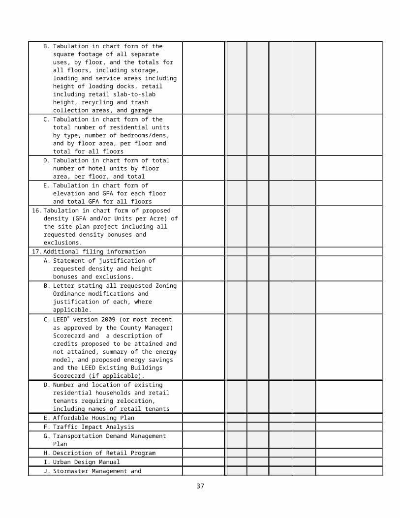
B. Tabulation in chart form of the square footage of all separate uses, by floor, and the totals for all floors, including storage, loading and service areas including height of loading docks, retail including retail slab-to-slab height, recycling and trash collection areas, and garage
C. Tabulation in chart form of the total number of residential units by type, number of bedrooms/dens, and by floor area, per floor and total for all floors
D. Tabulation in chart form of total number of hotel units by floor area, per floor, and total
E. Tabulation in chart form of elevation and GFA for each floor and total GFA for all floors
16. Tabulation in chart form of proposed density (GFA and/or Units per Acre) of the site plan project including all requested density bonuses and exclusions.
17. Additional filing informationA. Statement of justification of requested
density and height bonuses and exclusions.
B. Letter stating all requested Zoning Ordinance modifications and justification of each, where applicable.
C. LEED® version 2009 (or most recent as approved by the County Manager) Scorecard and a description of credits proposed to be attained and not attained, summary of the energy model, and proposed energy savings and the LEED Existing Buildings Scorecard (if applicable).
D. Number and location of existing residential households and retail tenants requiring relocation, including names of retail tenants
E. Affordable Housing PlanF. Traffic Impact Analysis G. Transportation Demand Management PlanH. Description of Retail ProgramI. Urban Design ManualJ. Stormwater Management and Compliance
PlanK. Vacation and Encroachment plat and
application(s) or waiver form. The plat shall show the exact locations and types of vacations and/or encroachments.
L. Description and plats of transactions involving County property
M. Public art letterN. Tabulation in chart form showing by-right
development capacityO. All tabular information required with
specification forms
27

P. Community benefits letterQ. Disclosure statementR. Formal response to comments (for
resubmissions only)S. Historic preservation letterT. Historic Resources Inventory (HRI)
Informational Form
28

Density Calculation Table Format
Office/Retail Example
BUILDING PROPOSALFloor Use Gross
Floor Area (sf)
Exclusions(sf)
Net Floor Area (sf)
Parking Spaces
Floor-to-Floor Height (ft)
Elevation (ASE)
G-4 Parking/Storage
0 0 0 70 10 30
G-3 Parking/Storage
0 0 0 70 10 40
G-2 Parking/Storage
0 0 0 70 10 50
G-1 Parking/Storage
0 0 0 70 10 60
1 Retail/Office 25,000 0 25,000 20 802 Office 25,000 0 25,000 12 923 Office 25,000 0 25,000 12 1044 Office 25,000 0 25,000 12 1165 Office 22,000 0 22,000 12 1286 Office 22,000 0 22,000 12 1407 Office 20,000 0 20,000 12 1528 Office 18,000 0 18,000 12 164Penthouse Mechanical 0 0 0 18 182Total 182,000 0 182,00
0280 122 182
DENSITY CALCULATIONSite Area: 2 ac. (87,120 sf)
Use Site Area Allocation (sf)
Density (FAR)
Gross Floor Area (sf)
MaximumPermitted(C-O-1.5)
Retail 7,142 1.5 FAR 10,713Office 79,978 1.5 FAR 119,967Total 87,120 1.5 FAR 130,680
Bonus Density Requested
LEED Gold .35 FAR 30,492Community Facilities
.10 FAR 8,712
Affordable Housing
.15 FAR 13,068
Total Bonus Requested
.6 FAR 52,272
Proposed with Bonus Density
Retail 7,142 2.1 FAR 15,000Office 79,978 2.09 FAR 167,000Exclusions Requested
0
Total 87,120 2.09 FAR 182,000Max. Allowed with Requested Bonuses
2.1 FAR 182,952
29
Residential/Retail ExampleBUILDING PROPOSAL
Level Use Units
Retail (sf)
Gross Floor Area (sf)
Exclusions (sf)
Net Floor Area (sf)
Floor-to-Floor Height (ft)
Elevation (ASE)
G2 Parking 0 0 0 10 30G1 Parking 0 0 0 10 40L1 Retail/
Residential28 15,000 45,000 2,000 43,000 20 60
L2 Residential 43 0 45,000 2,000 43,000 10 70L3 Residential 43 0 45,000 2,000 43,000 10 80L4 Residential 38 0 40,000 2,000 38,000 10 90L5 Residential 15 0 20,000 2,000 18,000 12 102Penthouse
Mechanical 0 0 0 0 0 18 120
Total 167 15,000
195,000
10,000 185,000
80 120
Density CalculationSite Area 75,000 sf
(1.72 ac)Zoning C-O-1.5Maximum Residential Density Permitted 72 du/acMaximum Commercial Density Permitted 1.5 FARSite Area Allocated to Residential 66,500 sf
(1.527 ac)Site Area Allocated to Retail 8,500 sf
(0.195 ac)Base Residential Density 109 unitsBase Retail Density 12,750 sfAverage Unit Size 1,000 sfLEED Bonus (Silver) – Residential GFA (.25 FAR)
16,625 sf
LEED Bonus (Silver)—Residential 16 unitsLEED Bonus (Silver)—Retail (.20 FAR) 1,700 sfADU Bonus (25%) 30 unitsTotal Residential Bonus Density Requested
46 units
Total Commercial Bonus Density Requested
1,700 sf
Exclusions Requested 10,000 sfResidential Density Proposed 167 units
110 du/acCommercial Density Proposed 15,000 sf
1.765 FARMaximum Residential Density Allowed in C-O-1.5 District with Requested Bonuses
155 units102 du/ac
Maximum Commercial Density Allowed in C-O-1.5 District with Requested Bonuses
14,450 sf1.7 FAR
30
Attachment BSite Plan Specification Form
The attached Final Site Plan Specification Form shall be completed with data that will be used in the public hearing notice. Use of incorrect data may require re-advertising of the public notice and deferral of the scheduled public hearing. (See attached forms.) If the application is a Major Amendment to an approved site plan, the applicant shall provide current data on the approved site plan and the status of its implementation, including the initial and/or latest approval of the site plan or major amendment, what has been constructed to date, and what remains to be constructed. If the application is for a Final Site Plan within a Phased Development Site Plan, the applicant shall also provide current data on the approved Phased Development Site Plan and the status of its implementation, including the latest approval of a Phased Development Site Plan Amendment, what has been constructed to date, and what remains to be constructed.
31

Site Plan Specification Form
STAFF ENTRY:Assigned Site Plan Number SP #PDSP Phase Number
APPLICANT ENTRY:Form (Re)Submission DateProject TitleProject LocationParcel RPC Numbers
DEVELOPMENT TEAM:ApplicantAddress (incl. zip code)Telephone Number (daytime w/area code)ContactE-mail AddressFax #
APPLICATION MADE BY:NameAddress (incl. zip code)Telephone Number (daytime w/area code)ContactE-mail AddressFax Number
ATTORNEY:FirmAddressTelephone NumberContactE-mail AddressFax #
ARCHITECT:FirmAddressTelephone NumberContactE-mail AddressFax #
32

ENGINEER:AddressTelephone NumberContactE-mail AddressFax #
LANDSCAPE ARCHITECT:FirmAddressTelephone NumberContactE-mail AddressFax #
LEED CONSULTANT:FirmAddressTelephone NumberContactE-mail AddressFax #
TRAFFIC CONSULTANT:FirmAddressTelephone NumberContactE-mail AddressFax #
ADDITIONAL CONSULTANT(S):FirmAddressTelephone NumberContactE-mail AddressFax #
33
Square Feet Acres1. A. Total Site Area
B. Site Area in Existing Zoning Districts1. District2. District3. District4. District5. District
C. Site Area in Proposed Zoning Districts1. District2. District3. District4. District5. District
2. Site Area Allocated for Density Purposes To: (Attach exhibit of site area allocation when necessary)A. OfficeB. CommercialC. HotelD. ResidentialE. Other (specify)
3. Floor Area Ratio (FAR) inclusive of requested density bonuses and exclusions(GFA divided by site area for density purposes [for mixed use districts, the allocated site area])
FAR
A. OfficeB. CommercialC. HotelD. ResidentialE. Other (specify)Total
4. Dwelling Units Per Acre5. Hotel Rooms Per Acre
34
Square Feet6. Total Gross Floor Area
A. Office Use1. Building 12. Building 23. Building 34. Building 45. Building 5Total
B. Retail Use1. Building 12. Building 23. Building 34. Building 45. Building 5Total
C. Hotel Use Square Feet # Rooms1. Building 12. Building 23. Building 34. Building 45. Building 5Total
D. Residential Use Square Feet # Units1. Building 12. Building 23. Building 34. Building 45. Building 5TotalAffordable Housing Units
E. Other (specify) Square Feet
35

7. Total # of Parking SpacesA. Office Use Standard Compact HC Total % Compact
1. Building 12. Building 23. Building 34. Building 45. Building 5Total
B. Retail Use1. Building 12. Building 23. Building 34. Building 45. Building 5Total
C. Hotel1. Building 12. Building 23. Building 34. Building 45. Building 5Total
D. Residential1. Building 12. Building 23. Building 34. Building 45. Building 5Total
E. Other (specify)
36
8. Type of Parking # of spacesA. Structured – Above gradeB. Structured – Below gradeC. Surface
9. Parking RatioA. # of Spaces per Office GFA One space per Sq. Ft.B. # of Spaces per Retail GFA One space per Sq. Ft.C. # of Spaces per Hotel Rooms space(s) per One roomD. # of Spaces per Residential space(s) per One unitE. # of Spaces per Other (specify)
space(s) per Sq. Ft.
10. Building HeightA. Average Elevation of the Site in feet above sea level
Feet
B. Building Height in feet to Main Roof and Penthouse Roof1. Office Main Roof Penthouse Roof # Stories
a. Building 1b. Building 2c. Building 3d. Building 4e. Building 5
2. Retaila. Building 1b. Building 2c. Building 3d. Building 4e. Building 5
3. Hotela. Building 1b. Building 2c. Building 3d. Building 4e. Building 5
37

10. (con’t)
4. Residential Main Roof Penthouse Roof # Storiesa. Building 1b. Building 2c. Building 3d. Building 4e. Building 5
5. Other (Specify)C. Building Elevation to Main Roof and Penthouse Roof (in feet above sea level)
1. Office Main Roof Penthouse Roofa. Building 1b. Building 2c. Building 3d. Building 4e. Building 5
2. Retaila. Building 1b. Building 2c. Building 3d. Building 4e. Building 5
3. Hotela. Building 1b. Building 2c. Building 3d. Building 4e. Building 5
4. Residentiala. Building 1b. Building 2c. Building 3d. Building 4e. Building 5
5. Other (Specify)
38

10. (con’t)
D. Retail slab-to-slab heights1. Office Height in Feet
a. Building 1b. Building 2c. Building 3d. Building 4e. Building 5
2. Retaila. Building 1b. Building 2c. Building 3d. Building 4e. Building 5
3. Hotela. Building 1b. Building 2c. Building 3d. Building 4e. Building 5
4. Residentiala. Building 1b. Building 2c. Building 3d. Building 4e. Building 5
4. Residentiala. Building 1b. Building 2c. Building 3d. Building 4e. Building 5
5. Other (Specify)
39

Sq. Ft. %11. Coverage and Percent Coverage12. Dimensions of Yards or Setbacks from right-of-way (for townhouse
projects)# Feet
A. FrontB. SideC. Side D. Rear
13. Common Open Space (if required) Square Feet14. Landscaped Area (“R-C”, “C-O-A” and “C-R”) Square Feet15. Proximity to Metro Entrance (walking distance from main entrance to
nearest station entrance) and proximity to regional and local bus service (walking distance from main entrance to bus shelter/ bus stop)
Feet
16. Requested Zoning Ordinance Modifications of Use Regulations (for example, density, height, parking, setback, coverage, etc.)A.B.C.
17. Requested Encroachment(s) and/or Vacation(s). Include plat(s) showing exact locations and types.
18. # LEED Credits Yes No Maybe19. Historic District and/or Building Yes No
Name of Building:Address of Building:
40
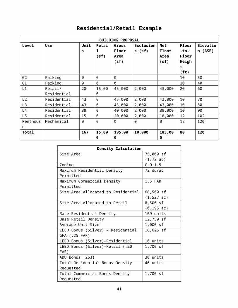
Attachment CPhased Development Site Plan Submittal Requirements
The data and specifications listed below shall be made a part of any submitted Phased Development Site Plan. Applicants shall submit a digital copy in JPEG, PDF, and DXF formats on compact disc with filename format: <Sheet #> <Sheet name>.xxx, and a hard copy filing, as indicated in Section 2 above, which comprises 20 complete sets of drawings measuring 24 x 36 inches in size, 3 complete sets of reduced, legible drawings measuring 8 ½ x 11 inches in size, and 20 complete sets of drawings measuring 11 x 17 inches in size, including the graphic scale representation, to include:
A. Certified survey plat, stamped and signed, of the parcel(s), including metes and bounds narrative descriptions and full sections of adjacent streets and intersections (from curb to curb or from edge of pavement to edge of pavement), and certified by a registered surveyor at a scale that is appropriate for the size of the project, ranging from 1" = 10' to 1” = 30’ showing:
1. Metes and Bounds Narrative Description2. Dimensions and site area, in square footage and acres, for the total site and for
individual parcels as designated by the applicant, and if the site is divided into more than one zoning district, the area of the site encompassed by each zoning district.
3. North arrow orientation.
4. Types and dimensions of all existing easements.
5. Location, dimensions, size and uses of all existing structures on site, including delineation of below-grade structures, number of existing parking spaces, number of existing residential and hotel units on the site, and reference to side lot lines and centerlines of adjacent streets.
6. Outline of structures on adjacent contiguous sites and across adjacent streets.
7. Tree survey, conducted by a certified arborist or other horticultural professional with a demonstrated expertise in tree preservation techniques on urban sites, of all trees on the site with a caliper of 3 inches and greater. Identify existing trees to be saved, trees to be removed, and a calculation of the number of trees to be replaced in tabular form pursuant to the tree replacement formula.
8. Historic districts and historic structures on the site or any adjacent sites - add a note on the plat if there are not any.
9. Resource protection areas (RPAs) - add a note on the plat if there are not any.
B. Current aerial photograph of the full site and surrounding uses (400-foot offset), generally to show the context of the site within surrounding blocks using currently available Arlington County’s GIS Mapping Center resources, or similar.
C. Plot and location plan at a 1”=25’ scale. However, a different scale could be used that is appropriate for the size of the project, ranging from 1"=10' to 1”=30’. All civil sheets should use the same scale chosen for the project. Final engineering plans will need to be submitted at 1”=25’ scale. Show proposed improvements only highlighted in bold print, including:
1. Dimensions and site area, in square footage and acres, for the total site and for individual parcels as designated by the applicant, and if the site is divided into
41

more than one zoning district, the area of the site encompassed by each zoning district.
2. North arrow orientation.
3. Topography at a minimum of two (2) foot contour intervals for the site and adjacent streets based on a recent survey (elevations given at Arlington County Datum).
4. Locations and description of all known and existing underground and aerial utilities such as water, sanitary sewer, gas, storm sewer, electric, utility poles, street light poles and conduit, telephone, traffic signals (poles, cabinets, conduits, pull boxes, and communication cables), CATV cables, fiber optics, and underground Metro-related structures (referenced to street centerline survey), within or on the periphery of the site and in the full street including complete intersections.
5. General description, including graphics, of proposed utility systems.
6. Location of all existing and proposed surface structures such as, but not limited to, sidewalks, curb and gutter, curb ramps, crosswalks, and bus shelters / bus stops.
7. Location and dimensions of all proposed structures on site, delineation of below-grade structures (if proposed structures are known), and reference to side lot lines and centerlines of adjacent streets.
8. Outline of block face and structures on adjacent contiguous sites and across adjacent streets, with curb cuts for garage entrances and loading docks marked.
9. Adjacent roadway median strips and existing and proposed median openings for vehicular access.
10. General location and extent of proposed uses, community and public facilities, and open space.
11. Plans for vehicular and pedestrian circulation systems, to include general location, design and control grades for perimeter and interior streets, vehicular grade separations, sidewalks, pedestrian bridges, and plazas.
12. General location of existing and proposed bus loading and transit facilities.
13. Average elevation of the site, or for individual parcels as designated by the applicant, determined by taking elevations at 25-foot stations at the perimeter of the site or individual parcels, totaling the elevations and dividing by the total number of stations.
D. Striping and marking plan at a scale that is appropriate for the size of the project, ranging from 1" = 10' to 1” = 30’ showing details of the number, direction, and width of existing and proposed travel and parking lanes, crosswalks, medians (painted and raised), width of existing and proposed curb cuts, bike lanes and any other pavement markings. Existing traffic signals need to be shown in addition to existing and proposed street cross-sections, where applicable. If separate sheets are required, also show, in addition to the above, all information on a single sheet at a scale of 1” = 50’ (or an alternate scale approved by the County Manager or his designee).
42
E. Conceptual landscape master plan providing a general description and location of landscape elements, e.g., streetscape elements, plazas, parks, and public and private open space areas.
F. The following data shall be provided by the applicant on the Phased Development Site Plan Specification Form (Attachment D of this Regulation). This data will be used in the public hearing notice. Use of incorrect data may require re-advertising of the public notice and deferral of the scheduled public hearing.
1. Site area in square feet and acres (from a certified plat) for the total site, and for individual parcels as designated by the applicant, and if the site is divided into more than one zoning district (existing and proposed), the area of the site encompassed by each zoning district.
2. Site area allocated for density purposes to (for mixed use districts, as determined by the Zoning Ordinance):a. Office b. Retailc. Hoteld. Residentiale. Other: specify__________________________.f. Total
3. Proposed Gross Floor Area (GFA) where applicable (See Zoning Ordinance for definition of GFA.) for each of the following uses:a. Office b. Retailc. Hoteld. Residentiale. Other: specify___________________________f. Total
4. Proposed Floor Area Ratio (FAR) inclusive of requested density bonuses and exclusions for each of the following uses (where applicable):a. Office b. Retailc. Hotel d. Residentiale. Other: specify___________________________f. TotalFAR = Gross floor area (square feet) divided by () site area (square feet) (for mixed use districts, the allocated site area)
5. Number of proposed dwelling units.
6. Number of proposed dwelling units per acre.Number of dwelling units divided by () site area (in acres) (for mixed use districts, the allocated site area)
7. Number of proposed hotel units.
8. Number of proposed hotel units per acre.Number of hotel units divided by () site area (in acres) (for mixed use districts, the allocated site area)
9. Parking (number of total spaces and parking ratio) for each of the following uses:a. Office b. Retail
43

c. Hoteld. Residentiale. Other: specify_____________________________
10. Proposed building height (number of stories, feet, elevation) measured from the average elevation of each parcel for each of the following uses:a. Office b. Retailc. Hoteld. Residentiale. Other: specify______________________________
11. Average elevation of the site, or for individual parcels as designated by the applicant, determined by taking elevations at 25-foot stations at the perimeter of the site or individual parcels, totaling the elevations and dividing by the number of stations.
12. Area of each proposed public open space (square feet).
13. Proposed recreational facilities (type, number, and area in square feet).
14. Identification of historic districts and historic structures on the site or any adjacent sites - add a note on the plat if there are not any.
G. Any special plans or data that may be required (such as zoning plat, Traffic Impact Analysis, Transportation Demand Management Plan, Urban Design Manual).
H. Tabulation in chart form and plans showing the by-right capacity for the site, including the uses, building footprint, gross floor area and density, building height, setback, coverage, and location and number of parking spaces.
I. A description, with illustrative plat or plan, of all easements or dedications of land necessary for public facilities or improvements. For any proposed buildings or improvements proposed to be constructed on or encroach upon any existing or planned County property interests, an illustrative plat or plan depicting the areas for which the developer or any of its agents may seek an encroachment or vacation from the County Board.
J. Tabulation in chart form explaining density proposal including requested density bonuses and exclusions and statement of justification of each (where applicable).
44

Attachment DPHASED DEVELOPMENT SITE PLAN SPECIFICATION FORM
STAFF ENTRY:Assigned Site Plan Number PDSP #
APPLICANT ENTRY:Project TitleProject LocationParcel RPC Numbers
DEVELOPMENT TEAM:ApplicantAddress (incl. zip code)Telephone Number (daytime w/area code)ContactE-mail AddressFax #
APPLICATION MADE BY:NameAddress (incl. zip code)Telephone Number (daytime w/area code)ContactE-mail AddressFax Number
ATTORNEY:FirmAddressTelephone NumberContactE-mail AddressFax #
ARCHITECT:FirmAddressTelephone NumberContactE-mail AddressFax #
45
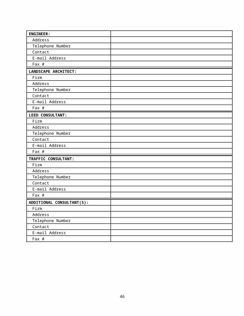
ENGINEER:FirmAddressTelephone NumberContactE-mail AddressFax #
LANDSCAPE ARCHITECT:FirmAddressTelephone NumberContactE-mail AddressFax #
LEED CONSULTANT:FirmAddressTelephone NumberContactE-mail AddressFax #
TRAFFIC CONSULTANT:FirmAddressTelephone NumberContactE-mail AddressFax #
ADDITIONAL CONSULTANT(S):FirmAddressTelephone NumberContactE-mail AddressFax #
46
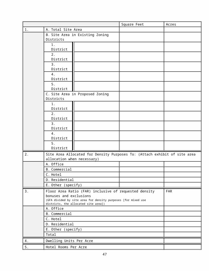
Square Feet Acres1. A. Total Site Area
B. Site Area in Existing Zoning Districts1. District2. District3. District4. District5. District
C. Site Area in Proposed Zoning Districts1. District2. District3. District4. District5. District
2. Site Area Allocated for Density Purposes To:A. OfficeB. CommercialC. HotelD. ResidentialE. Other (specify)
3. Gross Floor Area Square feetA. OfficeB. CommercialC. HotelD. ResidentialE. Other (specify)
4. Floor Area Ratio FARA. OfficeB. CommercialC. HotelD. ResidentialE. Other (specify)
5. Number of Proposed Dwelling Units6. Dwelling Units Per Acre7. Number of Hotel Units8. Hotel Units Per Acre
9. Number of Parking Spaces Total RatioA. OfficeB.CommercialC.HotelD. ResidentialE.OtherTOTAL
10. Building HeightA. Average Elevation of the Site
(in feet above sea level)B. Building Height in feet above the
average elevation of site, for each Feet
47

bldg.1. Office2. Commercial
10. (con’t)
3. Hotel4. Residential5. Other (specify)
C. Number of Stories for each building Stories1. Office2. Commercial3. Hotel4. Residential5. Other (specify)
11. Area of Each Open Space Square Feet
12. Recreational FacilitiesType Number Square Feet
13. Historic District and/or Building Yes NoName of Building:Address of Building:
14. Requested Zoning Ordinance Modifications of Use Regulations (for example, density, height, parking, setback, coverage, etc.)A.B.C.
48
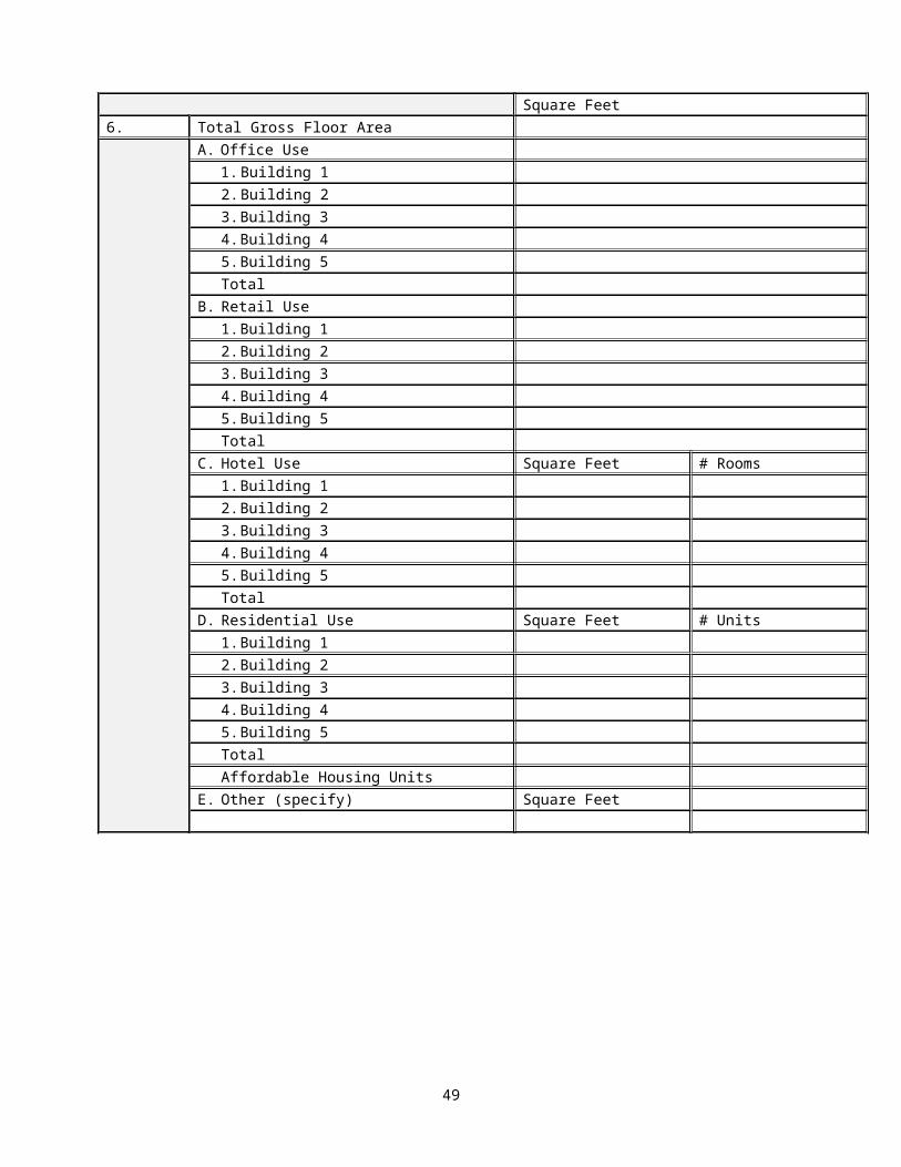
Attachment ECrystal City Block Plan Submittal Requirements
Per the stipulations below, submitted Crystal City Block Plans should consist of two primary parts: 1) the Block Framework and 2) the Block Development Document.
The Block Framework comprises Part 1 of the Block Plan submission, and includes several components. Beginning with base plan exhibits depicting plan view and orthophoto view conditions on the block as they existed when the Sector Plan was adopted in 2010, the Framework also includes Sector Plan policy map exhibits covering elements such as building heights, build-to lines, and public open spaces recommended in the Sector Plan, cropped to match the geographic extent of the subject block. Then, the Framework includes a summary of Sector Plan goals for the block, and demonstrates how the proposed final site plan and block plan can further advance specific and general goals of the plan.
The next section of the Framework includes a variety of exhibits depicting existing conditions and future conceptual plans for the block. The proposed final site plan details are overlaid on many of these block level exhibits. The culmination of this section includes any number of proposed scenario maps that, at a conceptual level, depict various ways in which the block could develop in the future consistent with the Sector Plan guidance.
The last section of the Framework is a cumulative list of deviations from the Sector Plan resulting from each CCBP adopted for the block. The purpose of this list of deviations is to provide insight for future reference when subsequent iterations of the block plan and future site plans are being devised, as it may provide further detail to or refine the recommendations presented in the Sector Plan. (This section is to be incorporated into the Block Plan by staff, and is not to be part of the applicant’s submission).
The Block Development Document comprises Part 2 of the Block Plan submission. This part of the CCBP includes the technical, legal, and other plan documentation necessary for the County’s review and analysis of the proposed final site plan in the context of the entire block. It is comprised primarily of civil engineering drawings, many of which correspond to and, in some instances provide more detail than the exhibits depicted in the Block Plan Framework.
1. PART 1: Block Framework RequirementsThe data, information, and statistics listed below shall be made as Part 1 of any submitted Crystal City Block Plan for projects located within the Crystal City Sector Plan planning area, east of Jefferson Davis Highway. Before beginning to prepare this document, the applicant shall confer with Planning Division (CPHD) staff to obtain the most recent adopted version of the Block Framework for the block, to be used as a starting point for preparing an updated Block Plan. Applicants shall submit digital copies in JPEG, PDF, and InDesign file formats, or other formats acceptable to the County Manager. (InDesign files should include folders with all linked files and fonts used in the InDesign document file). Digital copies should be submitted on compact disc with filename format: <Sheet #> <Sheet name>.xxx, and a hard copy filing, which comprises 20 complete sets of drawings measuring 11 x 17 inches in size and 3 complete sets of reduced, legible drawings measuring 8 ½ x 11 inches in size, including the graphic scale representation, to include the required information as depicted below.The following Table E.1 outlines a suggested general template to follow in the preparation of the Block Framework portion of the Block Plan submission. For consistency, all block plans should include a front and back cover that use graphic standards similar to the 2010 Sector Plan document, and may be modeled after the first adopted Block Plan, CCBP-JK-1. As a suggested outline, it is expected that submitted documents for a specific project may vary on a case by case basis, depending on the specifics of each project. Similarly, while the outline identifies a number of pages suggested to accommodate each element, they are
49

provided as a guideline rather than a rule; the exact number of pages may vary depending on the project.
Table E.1.Crystal City Block Framework Requirements and Proposed Outline
Page
Block Plan Component
Map Elements Tabular Elements Narrative Elements
Related
Item# in
TableE.2.
- Cover Plan of Existing Conditions in vicinity,
- - -
- Table of Contents
- 1. Table of contents - -
1 Introduction - - 1. Background/purpose
-
2 Block Location Map
Block Location on Sector Plan Map
3 Block Base Map Site Plan of Block, circa 2010 - - -3 Orthophoto Orthophoto of Block, circa 2010 - - - CRYSTAL CITY SECTOR PLAN (CCSP) MAPS AND SUMMARY4 Building Heights Building Heights Map of Block - - -4 Bulk Plane Angle Bulk Plane Angle Map of Block - - -5 Build to Lines Build to Lines Map of Block - - -5 Street Network
and Typology Street Network and Typology Map of Block
- - -
6 Tower Coverage Tower Coverage Map of Block - - -6 Land Use Mix Land Use Mix Map of Block - - -7 Public Open
SpacePublic Open Space Map of Block - - -
7 Retail Frontage and Underground
Retail Frontage and Underground Map of Block
- - -
8 Base Density Base Density Map of Block - - -8 Architectural
Features Architectural Features Map of Block
- - -
9 Surface Transitway
Surface Transitway Map of Block - - -
9 Service and Loading
Service and Loading Map of Block - - -
10-11
Sector Plan Summary of Block
None (but include relevant images, renderings from CCSP)
- 1. Summarize how proposal furthers CCSP goals for block
-
EXISTING CONDITIONS AND FUTURE PLANS12 Parcels and Lots Plan of real estate parcels and
lots of Block, existing conditions1.Land area, owner, and
zoning, by parcel (RPC)- A.2
13 Development Plan of development on block, existing conditions
1. GFA, by building and use
2. Existing Use Mix ratios
- A.5, A.6
14 Aerial Imagery Orthophoto of block, existing conditions
- - B.
15 Buildable Area Plan of net buildable area, on block (within RBLs depicted in CCSP)
1.Buildable and non-buildable areas, by sub-blocks
- -
16 Proposed Final Site Plan Overlay
Final Site Plan overlaid on existing conditions on block (and showing existing garage/loading entries, and those proposed per final site plan)
1. GFA, by building and use, per existing conditions and final site plan
2. Resulting Use Mix ratios
- C.7.A, C.7.B
17 Underground Level Pedestrian Network
Underground level pedestrian connections on block, 1.), existing and 2.) proposed
- - -
18 Street Level Pedestrian
Street level pedestrian connections on block, 1.) existing
- - -
50
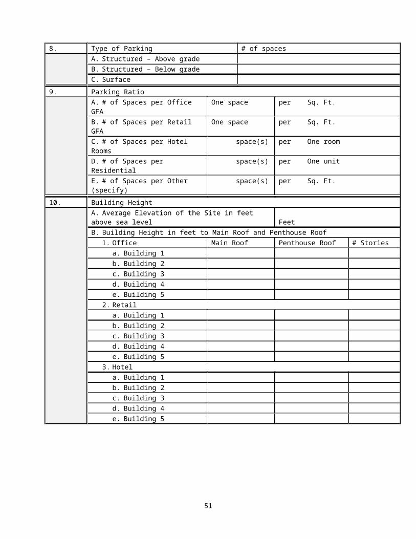
Network and 2.) proposed19 Street Network Street network for block, 1.)
existing and 2.) proposed- - -
CRYSTAL CITY BLOCK SCENARIO MAP (or MAPS)20 Crystal City
Block Plan Map, proposed scenario(s)
Conceptual plan for long-range planning and development, on block
1. GFA, by building and use, per proposed block plan
2. Resulting Use Mix ratios
3. Resulting Tower Coverage, by building and block
- -
NOTES: 1. Where relevant, maps should include appropriate legends and notes, if any.2. Geographic extent of maps should generally include the subject block and a 200 foot buffer surrounding
the block.
2. PART 2: Block Development Document RequirementsThe Block Development Document requirements listed below shall be provided for projects located within the Crystal City Sector Plan planning area, east of Jefferson Davis Highway. For purposes of preparing and submitting the Block Development Document, applicants shall follow the submission requirements pertaining to document format, file naming convention, number of hardcopies, size, and scale as set forth for Final Site Plan Specifications outlined in Attachment A: Final Site Plan Submittal Requirements and Checklist. (Therefore, Part 1 and Part 2 of the CCBP should be provided as separate hardcopy documents, along as an integrated electronic package in InDesign format). The Block Development Document materials shall include the required information as depicted in Table E.2 below.
Block Development Document Zones: Zone A: Entire Block Plan Area (inclusive of Site Plan Area) Zone B: Site Plan Area Only‘X’ in a column indicates the area for which the specified information must be provided.
Table E.2.CCBP: Block Development Document RequirementsElements A BA. Certified survey plat, stamped and signed, of the entire block comprising the
parcel(s) (or for other geographic extents where specified below), including metes and bounds narrative descriptions and full sections of adjacent streets and intersections (from curb to curb or from edge of pavement to edge of pavement), and certified by a registered surveyor at a scale that is appropriate for the size of the project, ranging from 1" = 10' to 1” = 30’ showing:
1. Metes and Bounds Narrative Description X2. Dimensions and site area, in square footage and acres, for the total site
and for individual parcels as designated by the applicant, and if the site is divided into more than one zoning district, the area of the site encompassed by each zoning district.
X
3. North arrow orientation. X4. Types and dimensions of all existing easements. X5. Location, dimensions, size and uses of all existing structures on site,
including delineation of below-grade structures, number of existing parking spaces, number of existing residential and hotel units on the site, and reference to side lot lines and centerlines of adjacent streets.
X
6. Outline of structures on adjacent contiguous sites and across adjacent streets.
X7. Tree survey at minimum for the area corresponding to the associated
final site plan area, conducted by a certified arborist or other horticultural professional with a demonstrated expertise in tree preservation techniques on urban sites, of all trees on the site with a caliper of 3 inches and greater. Identify existing trees to be saved, trees to be removed, and a calculation of the number of trees to be replaced in tabular form pursuant to the tree replacement formula.
X
8. Historic districts and historic structures on the site or any adjacent sites - add a note on the plat if there are not any.
X
51
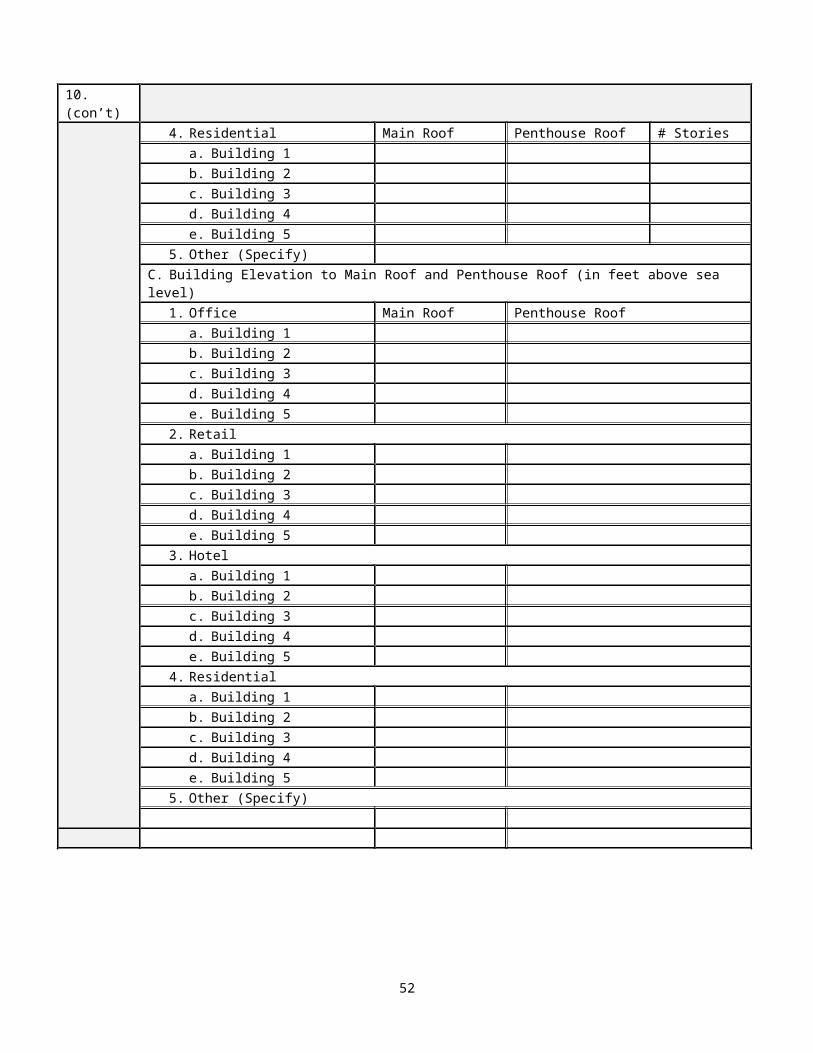
Elements A B9. Resource protection areas (RPAs) - add a note on the plat if there are not
any.X
B. Current aerial photograph of the full site and surrounding uses (400-foot offset), generally to show the context of the site within surrounding blocks using currently available Arlington County’s GIS Mapping Center resources, or similar.
X
C. Plot and location plan at a 1”=25’ scale. However, a different scale could be used that is appropriate for the size of the project, ranging from 1"=10' to 1”=30’. All civil sheets should use the same scale chosen for the project. Final engineering plans will need to be submitted at 1”=25’ scale. Show proposed improvements according to proposed Final Site Plan (highlighted in bold print) in relation to the balance of existing development on the block, including:
1. Dimensions and site area, in square footage and acres, for the total site and for individual parcels as designated by the applicant, and if the site is divided into more than one zoning district, the area of the site encompassed by each zoning district.
X
2. North arrow orientation. X3. Topography at a minimum of two (2) foot contour intervals for the site
and adjacent streets based on a recent survey (elevations given at Arlington County Datum). X
4. Locations and description of all known and existing underground and aerial utilities such as water, sanitary sewer, gas, storm sewer, electric, utility poles, street light poles and conduit, telephone, traffic signals (poles, cabinets, conduits, pull boxes, and communication cables), CATV cables, fiber optics, and underground Metro-related structures (referenced to street centerline survey), within or on the periphery of the site and in the full street including complete intersections.
X
5. General description, including graphics, of proposed utility systems at minimum for the area corresponding to the associated final site plan area and critical connections to adjacent properties. X
6. Location of all existing and proposed surface structures such as, but not limited to, sidewalks, curb and gutter, curb ramps, crosswalks, and bus shelters / bus stops.A. Existing XB. Proposed (as per final site plan) X
7. Location and dimensions of all existing and proposed (as per proposed final site plan) structures on site, delineation of below-grade structures, and reference to side lot lines and centerlines of adjacent streets.A. Existing XB. Proposed (as per final site plan) X
8. Outline of block face and structures on adjacent contiguous sites and across adjacentstreets, with curb cuts for garage entrances and loading docks marked.
X9. Adjacent roadway median strips and existing and proposed openings for
vehicular access.A. Existing XB. Proposed (as per final site plan) X
10. General location and extent of existing and proposed (as per proposed final site plan) uses, community and public facilities, and open space.A. Existing XB. Proposed (as per final site plan) X
11. Plans for existing and proposed (per final site plan) vehicular and pedestrian circulation systems, to include general location, design and control grades for perimeter and interior streets, vehicular grade separations, parking garage connections, sidewalks, pedestrian bridges, underground pedestrian bridges, and plazas.A. Existing XB. Proposed (as per final site plan) X
12. General location of existing and proposed vehicular loading, bus loading and transit facilities.A. Existing XB. Proposed (as per final site plan) X
13. Average elevation of the site, or for individual parcels as designated by the applicant, determined by taking elevations at 25-foot X
52
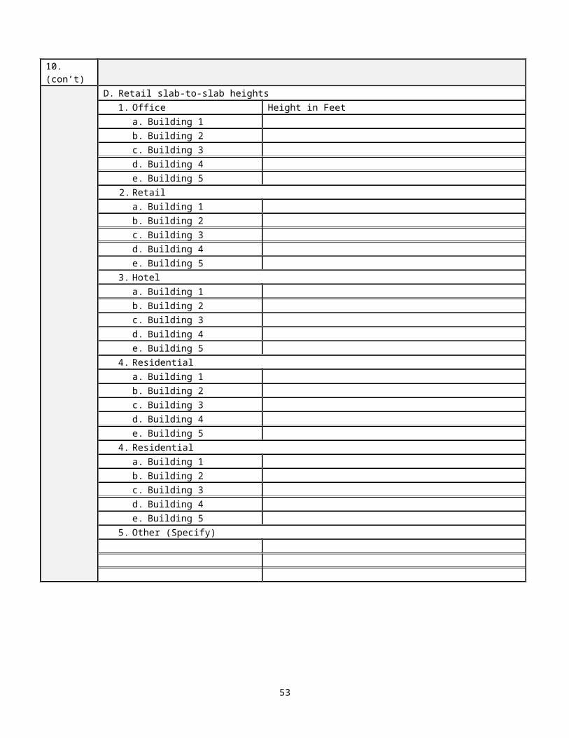
Elements A Bstations at the perimeter of the site or individual parcels, totaling the elevations and dividing by the total number of stations.
D. Striping and marking plan at a scale that is appropriate for the size of the project, ranging from 1"= 10' to 1” = 30’ showing details of the number, direction, and width of existing and proposed travel and parking lanes, crosswalks, medians (painted and raised), bike lanes and any other pavement markings. Existing traffic signals need to be shown in addition to existing and proposed street cross-sections, where applicable. If separate sheets are required, also show, in addition to the above, all information on a single sheet at a scale of 1” = 50’ (or an alternate scale approved by the County Manager or designee).
A. Existing XB. Proposed (as for streets and related items for property frontage
adjacent to proposed final site plan area.)X*
E. Conceptual landscape master plan for the final site plan area at a minimum, providing a general description and location of landscape elements, e.g., streetscape elements, plazas, parks, and public and private open space areas. X
F. The following data shall be provided by the applicant) 1. Site area in square feet and acres (from a certified plat) for the total site,
and for individual parcels as designated by the applicant, and if the site is divided into more than one zoning district (existing and proposed), the area of the site encompassed by each zoning district.A. Existing XB. Proposed (as per final site plan) X
2. Site area allocated for density purposes to (for mixed use districts, as determined by the Zoning Ordinance):
a. Officeb. Retailc. Hoteld. Residentiale. Other: specify__________________________.
A. Existing XB. Proposed X
3. Gross Floor Area (GFA) where applicable (See Zoning Ordinance for definition of GFA.) for each of the following uses:
a. Officeb. Retailc. Hoteld. Residentiale. Other: specify___________________________
A. Existing XB. Proposed X
4. Existing and proposed Floor Area Ratio (FAR) for each of the following uses (where applicable):
a. Officeb. Retailc. Hoteld. Residentiale. Other: specify___________________________
*For mixed use districts, use the allocated site areas to calculate FARA. Existing XB. Proposed X
5. Number of dwelling units.A. Existing XB. Proposed X
6. Number of dwelling units per acre.
*For mixed use districts, use the allocated site areas to calculate units per acreA. Existing XB. Proposed X
7. Number of hotel units.A. Existing XB. Proposed X
53
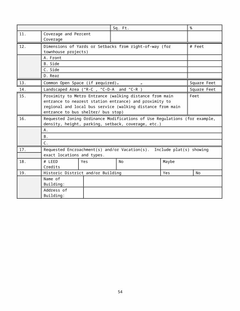
Elements A B8. Number of hotel units per acre.
*For mixed use districts, use the allocated site areas to calculate units per acreA. Existing XB. Proposed X
9. Parking (number of total spaces and parking ratio) for each of the following uses (if designated in that manner):
a. Officeb. Retailc. Hoteld. Residentiale. Other: specify_____________________________
A. Existing XB. Proposed X
10. Building Height (number of stories, feet, elevation) measured from the average elevation of each parcel for each of the following uses:
a. Officeb. Retailc. Hoteld. Residentiale. Other: specify______________________________
A. Existing XB. Proposed X
11. Average elevation of the site, or for individual parcels as designated by the applicant, determined by taking elevations at 25-foot stations at the perimeter of the site or individual parcels, totaling the elevations and dividing by the number of stations.
X
12. Area of each public open space. (square feet).A. Existing XB. Proposed X
13. Area and description of recreational facilities (type, number, and area in square feet).A. Existing XB. Proposed X
14.Calculation of use mix in comparison with the Sector Plan use mix goal for the site.A. Existing XB. Proposed X
15.Calculation of building tower coverage in comparison with the maximum Sector Plan tower coverage recommended for the block.A. Existing XB. Proposed X
16. Identification of historic districts and historic structures on the site or any adjacent sites -add a note on the plat if there are not any.
XG. Any special plans or data that may be required (such as zoning plat, Traffic
Impact Analysis, Transportation Demand Management Plan, Urban Design Manual).
X
H. Tabulation in chart form and plans showing the by-right capacity for the site, including the uses, building footprint, gross floor area and density, building height, setback, coverage, and location and number of parking spaces.
X
I. A description, with illustrative plat or plan, of all easements or dedications of land necessary for public facilities or improvements. For any proposed buildings or improvements proposed to be constructed on or encroach upon any existing or planned County property interests, an illustrative plat or plan depicting the areas for which the developer or any of its agents may seek an encroachment or vacation from the County Board.
A. Existing XB. Proposed X
54

Attachment FCRYSTAL CITY BLOCK PLAN SPECIFICATION FORM
STAFF ENTRY:Assigned Site Plan Number CCBP #
APPLICANT ENTRY:Project TitleProject LocationParcel RPC Numbers
DEVELOPMENT TEAM:ApplicantAddress (incl. zip code)Telephone Number (daytime w/area code)ContactE-mail AddressFax #
APPLICATION MADE BY:NameAddress (incl. zip code)Telephone Number (daytime w/area code)ContactE-mail AddressFax Number
ATTORNEY:FirmAddressTelephone NumberContactE-mail AddressFax #
ARCHITECT:FirmAddressTelephone NumberContactE-mail AddressFax #
ENGINEER:FirmAddressTelephone NumberContact
55
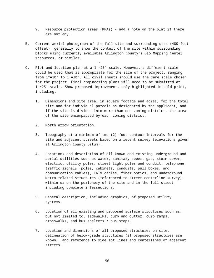
E-mail AddressFax #
LANDSCAPE ARCHITECT:FirmAddressTelephone NumberContactE-mail AddressFax #
LEED CONSULTANT:FirmAddressTelephone NumberContactE-mail AddressFax #
TRAFFIC CONSULTANT:FirmAddressTelephone NumberContactE-mail AddressFax #
ADDITIONAL CONSULTANT(S):FirmAddressTelephone NumberContactE-mail AddressFax #
Square Feet Acres1. A. Total Site Area
B. Site Area in Existing Zoning Districts1. District2. District3. District4. District5. District
C. Site Area in Proposed Zoning Districts1. District2. District
56

3. District4. District5. District
2. Site Area Allocated for Density Purposes To:A. OfficeB. CommercialC. HotelD. ResidentialE. Other (specify)E. Total
3. Gross Floor Area Square feetA. OfficeB. CommercialC. HotelD. ResidentialE. Other (specify)F. Total
4. Floor Area Ratio (inclusive of all requested density bonuses and exclusions (where applicable)
FAR
A. OfficeB. CommercialC. HotelD. ResidentialE. Total
5. Number of Proposed Dwelling Units6. Dwelling Units Per Acre7. Number of Hotel Units8. Hotel Units Per Acre9. Number of Parking Spaces Total Ratio
A. OfficeB.CommercialC.HotelD. ResidentialE.OtherTOTAL
10. Building HeightA. Average Elevation of the Site
(in feet above sea level)B. Building Height in feet above the
average elevation of site, for each bldg.
Feet
1. Office2. Commercial3. Hotel4. Residential5. Other (specify)
C. Number of Stories for each building Stories1. Office
57

2. Commercial3. Hotel4. Residential5. Other (specify)
11. Area of Each Open Space Square Feet
12. Recreational FacilitiesType Number Square Feet
13. Historic District and/or Building Yes NoName of Building:Address of Building:
14. Requested Zoning Ordinance Modifications of Use Regulations (for example, density, height, parking, setback, coverage, etc.)
58
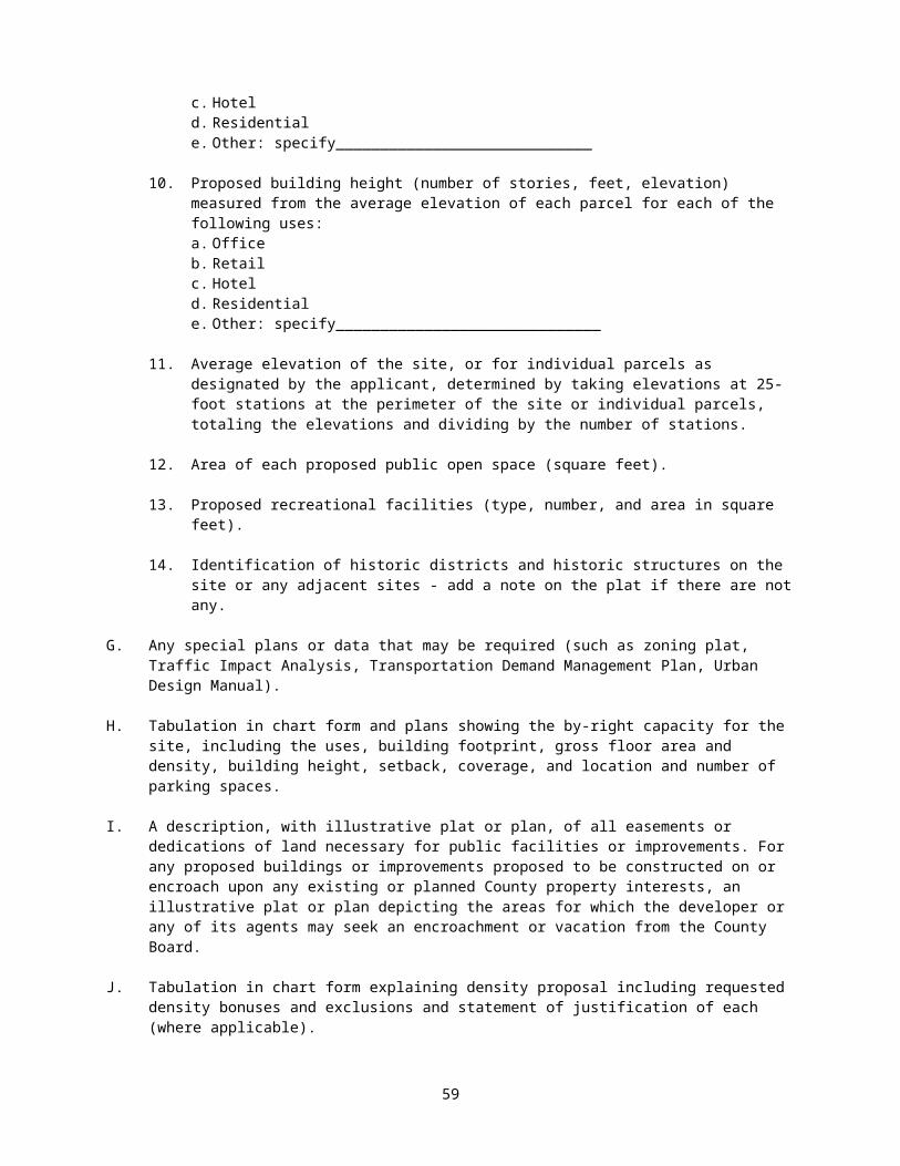
Attachment GRequirements for Traffic Impact Analysis (TIA)
WHEN IS A TRAFFIC IMPACT ANALYSIS IS REQUIRED? Consistent with General Assembly approved legislation (Chapter 527 of the 2006 Acts of Assembly) Arlington County requires all development projects to comply with the Code of Virginia, Chapter 155 Traffic Impact Analysis Regulations 24 VAC 30-155 requirements. Prior to setting up a TIA scoping meeting with Arlington County Staff, developers must submit a VDOT “Pre-scope of Work Meeting Form” to the Department of Environmental Services (DES) for review at the scoping meeting.
Type of Development Minimum Development2 Type of Analysis3
1. Consistent with GLUP1 and located within Metrorail Corridors4
Less than 100,000 square feet of commercial space or 100 dwelling units/hotel rooms
Site traffic at site access points
100,000 square feet of commercial space or 100 dwelling units/hotel rooms or greater
Site traffic to nearby critical intersections
2. Beyond GLUP1 or located outside of Metrorail Corridors4
Less than 75,000 square feet of commercial space or 75 dwelling units/hotel rooms
Site traffic at site access points
75,000 square feet of commercial space or 75 dwelling units/hotel rooms or greater
Site traffic in excess of forecast superimposed on future long-range forecast of traffic volumes, to nearby critical intersections, analyzed for levels of service with and without
3. Previously analyzed Same as for 2 above Same type as previously analyzed (either 1. or 2.)
1 GLUP refers to General Land Use Plan; development beyond General Land Use Plan may be a result of requested amendments, bonus densities or use of densities from vacated public streets or alleys, any of which results in more than 15,000 square feet of commercial space or 50 dwelling units in excess of the GLUP standards.
2 For a mixed use development, add the percentage of each type of use to see if it would be greater than 100 percent. For example, a mixed use development in category 1 with 40,000 square feet of commercial space (40 percent of threshold) and 75 hotel units (75 percent of threshold) would require a TIA (40% + 75% > 100%).
3 Applications shall use assumptions as to mode split, trip generation, distribution and assignment recommended by DES as a baseline. Deviations from the guidelines must be justified.
4 Metrorail Corridor boundaries refer to the Rosslyn-Ballston and Jefferson Davis Metrorail Corridors as specified in the GLUP.
59

Attachment HReceipt of Approved Site Plan and Developer Agreement to
Conditions
I/We have received the “applicant’s copy” of the final Site Plan for__________________________________________________________________________________________________________________________Arlington, Virginia, which was approved by the Arlington County Board on _______________,signed by the Planning Division Chief, ____________________________________________,signed by the County Manager or his designee, ________________________________,together with and attached thereto a copy of the conditions imposed by the County Board as part of the Site Plan Approval. I/We have reviewed and concur with/or accept said plan and voluntarily agree to, and do not object to said site plan conditions specific to this project as set forth in the County Manager’s report and as approved by the County Board, all of which constitute conditions of the final Site Plan Approval, as per Section 2.M. of Administrative Regulation 4.1.
Owner
Agent for the Owner
Witness
Date
60

ATTACHMENT I1990 MATRIX TRANSPORTATION DEMAND MANAGEMENT PROGRAM
(2008* dollars in parentheses)
Standard County policy is set forth in the TDM matrix. However, upon showing of clear and convincing evidence that particular elements of the TDM matrix may be inappropriate for a particular project, the developer may propose substitution of other elements which provide equivalent value. Additional information can be obtained by contacting John Durham at 703-228-3681.
LAND USESTRATEGIES CATEGORY
A B C DI. Ridesharing Marketing
a. information dissemination- distribute/display brochures, posters ...... x x x x- conduct employee transportation surveys..... x x x x
b. operate a vanpool program .................... x xc. subsidize vanpool program
- match State subsidy program ................ x x- double State subsidy program ............... x- backup, reserve maintenance vehicle ........ x
d. employee transportation coordinator- designate a part-time ETC .................. 2 x x - designate a full-time ETC .................. x- on-site ride matching ...................... x
e. contribute to a transit store or TMA- $ 5,000 ($8,369) per year .................. 2 x - $10,000 ($16,739) per year.................. x - $15,000 ($25,108) per year ................. x
f. locate/operate a transit store ............... xg. emergency ride home (taxi, bus) .............. 3 3 x
II. Preferential Parking Managementa. unlimited reserved rideshare parking ......... x x x xb. market rates for single occupant vehicles .... x x x xc. lease agreements reserved parking space ...... x x xd. deserved vanpool parking space ............... x x x x
- one-half market rate ....................... x x - free, no cost .............................. x x
e. variable rate parking for carpools (2+ employees)- market rate ................................ x - one-half market rate ....................... x x - free, no cost .............................. x
III. Transit Programsa. contribute to operation of an employer shuttle bus
- $ 5,000 ($8,369) per year .................. 2 1 1 1- $10,000 ($16,739) per year ................. 3 2 2 2
LAND USE CATEGORY
A B C D
61
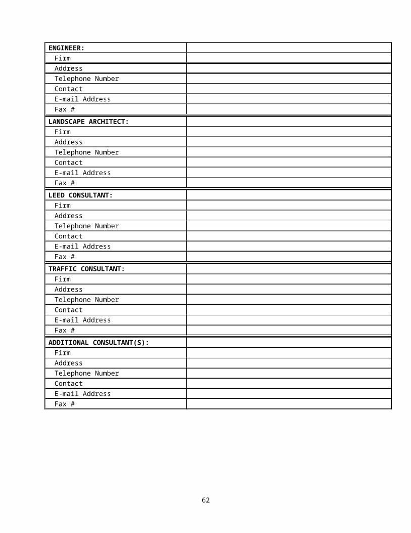
- $15,000 ($25,108) per year ................. 3 3 3b. operate an employer shuttle bus service ...... xc. fare media subsidy(100 percent is $100/month)
- 25 - 50 percent ............................ x - 50 - 75 percent ............................ x - 75+ percent ................................ x
IV. On-Site Construction a. bike lockers, racks .......................... x x x xb. shower facilities ............................ x x x xc. van accessible garage ........................ x x x xd. off-street delivery loading facility ......... x x x xe. roadway improvements adjacent to site ........ x x x x
V. Off-Site Construction a. pedestrian systems (SKYWALK).................. x x x xb. direct connections to Metro
- existing knockout panels to stations ....... x x x x- new connections
(elevator, escalator, tunnels) ......... x xc. intersection improvements (i.e. turn lane) ... x xd. new facility construction .................... xe. new Metrorail Station ........................ x
VI. Lease Agreements: Progressive Employee Policiesa. flex time, variable work hours ............... x x x xb. telecommuting ................................ x x x xc. trip generation restrictions ................. x xd. transportation management organization ....... x x x x
VII. Monitoring and Compliancea. Monitoring Contribution
- $ 1,000 (1,673) / Year ..................... 2 1 1 1- $ 5,000 (8,369) / Year ..................... 3 2 2 2- $10,000 (16,739) / Year .................... 3 3 3
b. Performance Guarantees ....................... xc. Zoning Compliance Fines ...................... x x x xd. Contingent Phasing ........................... x x
Land Use Category CodeA. GLUP consistent, no forecast traffic problemB. GLUP consistent, forecast traffic problemC. GLUP amendment requested, no forecast traffic problemD. GLUP amendment requested, forecast traffic problem
Footnotes1. Less than 100,000 sq. ft. gross floor area2. 100,000 - 200,000 sq. ft. gross floor area3. More than 200,000 sq. ft. gross floor are
*U.S. Department of Labor, Bureau of Labor Statistics, Consumer Price Indexes - Inflation Calculator http://www.bls.gov/cpi/home.htm
62
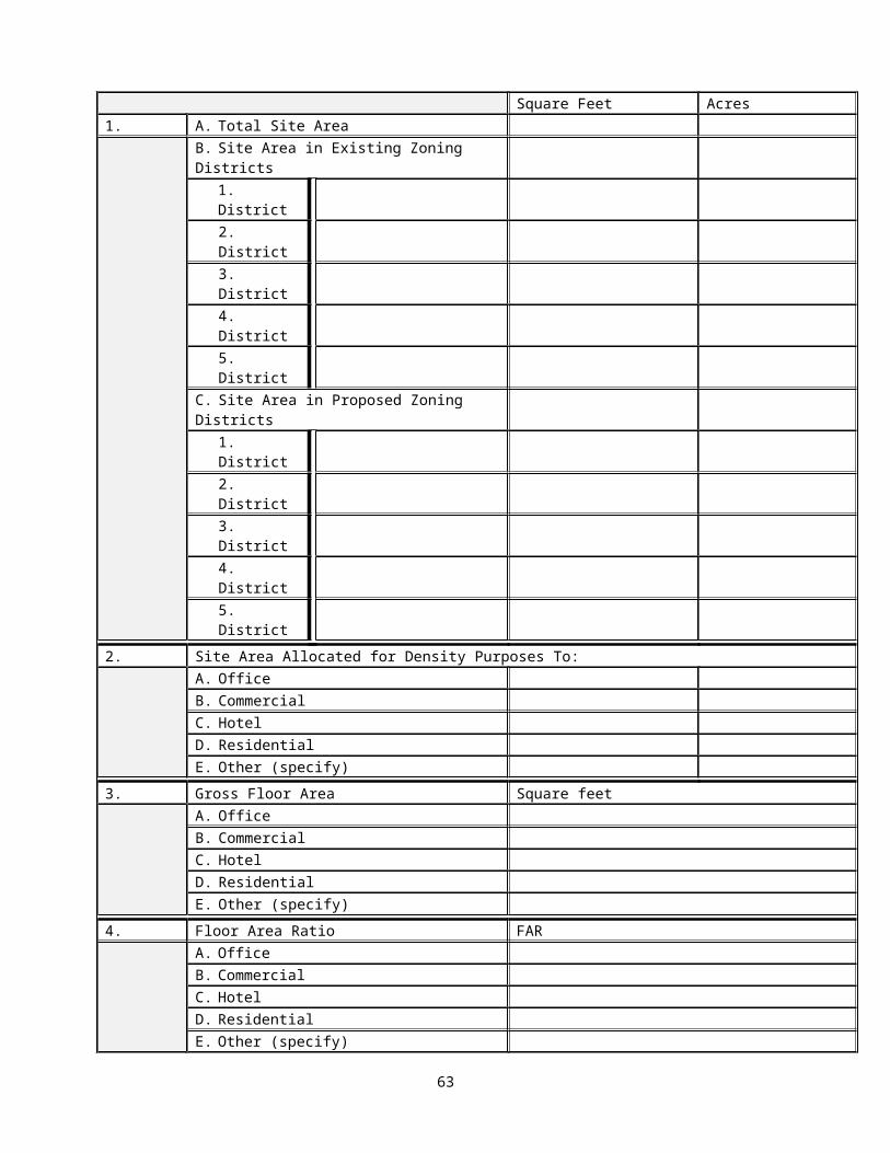
Attachment J
63
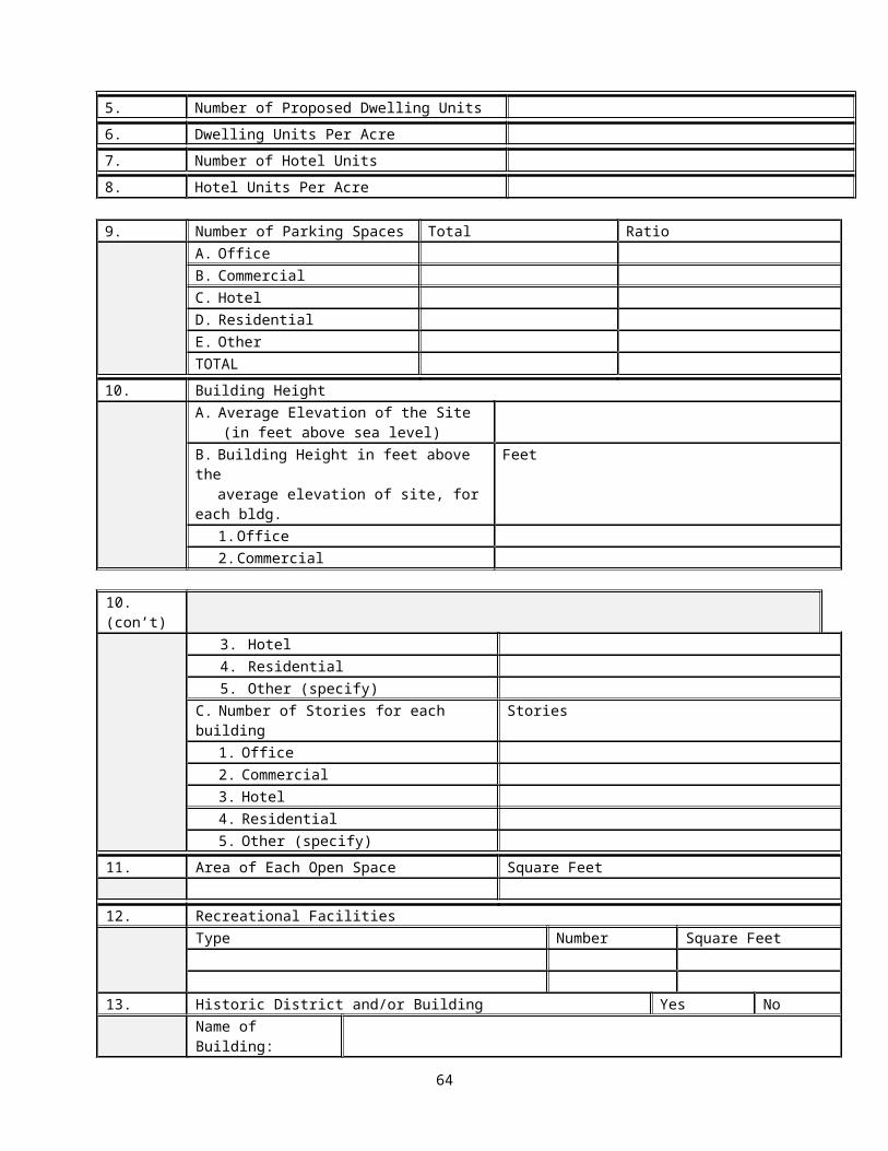
Attachment K
64

Attachment L
Applicant Response to Comments Letter – template
Applicant name Project nameAddress Address
City, State, Zip City, State, ZipPhone PhoneE-mail E-mail
Date:
Checklist item # or Drawing page # County Comment Applicant Response
65

ATTACHMENT MList of Standard Site Plan Conditions by Category
High Density Office, Residential and/or Mixed Use Developments(This list is current as of May 2013 and may be modified over time.)
Following is the list of Standard Site Plan Conditions for High Density Office, Residential and/or Mixed Use Developments. These standard site plan conditions may be modified, as applicable and appropriate, to also serve as the basis for site plan conditions for townhouse and cluster developments.
The conditions below are typically necessary in site plan projects approved at or near the maximum site plan height or density permitted in a district because they: (1) ameliorate the effect, on property or improvements in the area, of the project and its uses, any additional height and/or density or other bonuses that may be approved, or modifications to Zoning Ordinance standards proposed by a developer for a project to be approved through the site plan process; (2) ensure that a project substantially complies with County plans and policies and Zoning Ordinance regulations for a particular area; or (3) are in exchange for bonuses and other benefits approved as part of the project. They reflect language developed by County staff in conjunction with the development community, so as to clearly express the expectations of the parties, and to include enforcement mechanisms. As the density or height of a project increases from that allowed by-right toward the maximum permitted in the district through site plan approval, or when other modifications are approved, the effect of the project on the surrounding community would be greater. Therefore these conditions are necessary to enable staff to recommend, and the County Board to approve, projects as meeting the standards of the ordinance. The conditions below have been determined to address some of the impacts of site plan development, but changes to the conditions or additional conditions may be recommended and approved to reflect the impacts of a particular project, or the County’s plans and policies for a particular area.
1. Overall Compliance Requirements2. A. Site Plan Compliance (For Life of Site Plan)
B. Site Plan Expiration (Before Footing to Grade Permit)
Before Demolition and Land Disturbance Permits3. Post-County Board 4.1 Filing4. Site Plan Conditions Review Meeting5. Multi-Building Phasing Plan 6. Tree Survey, Tree Protection Plan, and Tree Protection Bond 7. Right-of-Way Permits8. Location of Construction Trailers 9. Photographic Record of Development 10. Plan for Temporary Circulation During Construction
Residential Relocation 12. Retail Relocation 13. Community Outreach During Construction 14. Construction Site Maintenance Agreement 15. Construction and Demolition Waste 16. Green Building Fund Contribution 17. Vacations and Encroachments 18. Public Art 19. LEED Credits and Sustainable Design Elements 20. Civil Engineering Plan
Before Excavation/Sheeting and Shoring Permit21. Final Landscape Plan
66
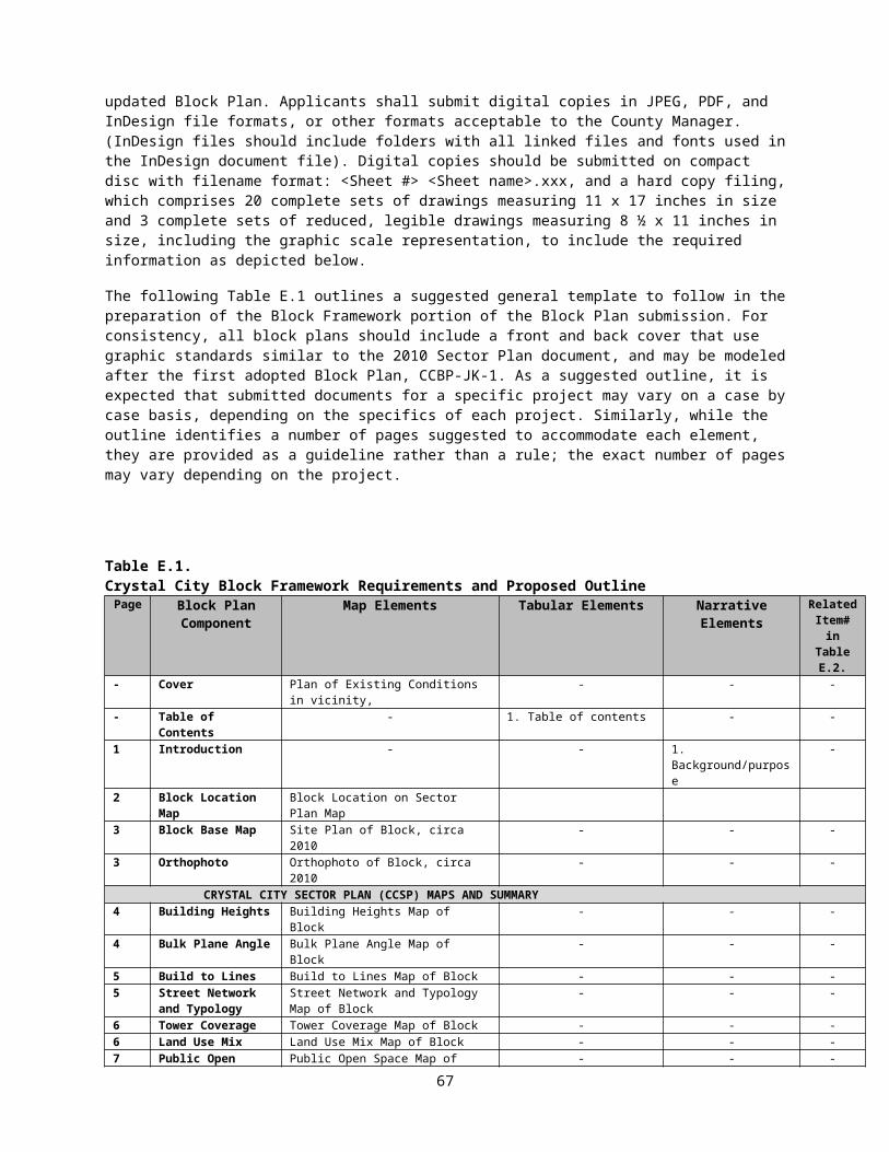
22. Internal and External Lighting Plan 23. Utility Company Contacts 24. Survey Monuments 25. FAA Documentation 26. Recordation of Deeds of Public Easements and Deeds of Dedications 27. Bicycle Storage Facilities
Before Footing to Grade Structure Permit28. Interior Exercise/Health Facilities 29. Façade Treatment of Buildings 30. Plat of Excavated Area 31. Public Improvements Bond32. Underground Utility Vaults 33. Interior Trash Collection and Recycling Areas 34. Interior Loading Spaces 35. Parking Space and Drive Aisle Compliance with Zoning Ordinance 36. Emergency Vehicle Access/Support on Surface Parking and Plaza Areas37. Parking 38. Documentation of Historical Artifacts, Features and Buildings
Before Final Building Permit38. Underground Utility Fund Contribution40. Wall Check Survey41. Use of Penthouse42. Review by Crime Prevention Through Environmental Design (CPTED) Practitioner 43. County Public Safety / Emergency Communications Systems 44. Retail Elements 45. Safety Measures at Garage Exit Ramps
Before Shell and Core Certificate of Occupancy46. Public Use and Access Easements 47. Transportation Management Plan 48. Affordable Housing Contribution49. Availability of Site Plan Conditions to Residential Condos, Cooperatives and
Homeowners Associations
Before First Certificate of Occupancy for tenant occupancy50. Authorization for Police to Enter Residential Parking Areas 51. Replacement of Damaged Existing Curb, Gutter and Sidewalk
Within 6 months of Receipt of the Certificate of Occupancy that permits full occupancy52. Obtain Master Certificate of Occupancy
Before Master Certificate of Occupancy53. Building Height Certification
For Life of Site Plan54. Existing Water Main or Fire Hydrant Service 55. Structural Modifications56. Snow Removal57. Maintenance of Residential Common Areas58. Retention of Approved Parking Ratio over Subdivided Site59. Retention of Approved Density over Subdivided Site60. Refuse Delivery to County Disposal Facility
67

ATTACHMENT N
VACATION AND ENCROACHMENT REQUEST WAIVER FORM
Vacation and Encroachment Request Waiver
Applicant: _____ _____________________________
Application Property: _____ ______________
The Applicant is not aware of nor has any plans to file a vacation or encroachment application related to the attached site plan. Should it be determined at a later date that a vacation or encroachment request related to the site plan needs to be filed, the Applicant acknowledges that it may cause a delay in processing of both the site plan and/or vacation/encroachment request.
CERTIFICATION: (All Applicants or their Agents must sign the Application).I/We hereby certify that all statements and information provided herein and in the documents submitted herewith are true, accurate, and complete to the best of my/our knowledge.
APPLICANT(S)/Agent:
_______________________ ________(Signature) (Date)
_______________________________Print Name
68

ATTACHMENT OHISTORIC PROPERTIES AND PROCESS FOR REVIEW BY THE
HISTORICAL AFFAIRS AND LANDMARK REVIEW BOARD (HALRB)
Historic properties include buildings and sites classified within the following categories:
Those locally-designated as Arlington Historic Districts by the County Board;
Those identified for preservation (e.g., full, frontage, facade) in County-adopted plans and policies; and/or
Those identified and ranked as part of the Historic Resources Inventory (HRI) planning initiative.
Those historic properties that are Historic Districts are regulated by Article 11.2 of the Arlington County Zoning Ordinance. Any exterior alterations, new construction, or demolition first require review by the HALRB and an HALRB-approved Certificate of Appropriateness (CoA) prior to the issuance of County building permits.
New development proposals affecting historic properties identified for preservation (full or partial) in County-adopted plans and policies (including, but not limited to, the Clarendon Sector Plan, Columbia Pike Form Base Code, the Fort Myer Heights North Plan, etc.), are subject to review and comment by the HALRB.
The HALRB review process for Arlington Historic Districts and historic properties identified for preservation in County-adopted plans and policies is as follows:
Applicants should expect to attend a minimum of one full meeting cycle, to include at least one meeting of the Design Review Committee (DRC) and at least one meeting of the full HALRB. These meetings are held monthly and the schedule and application deadlines are available online: www.arlingtonva.us/departments/CPHD/ons/CPHDOnsHistoricPreservation.aspx.
Applicants should attend the HALRB before presenting to other County commissions so that HALRB input pertaining to preservation and design elements (massing, scale, materials, detailing, etc.) will be carried through the rest of the review process.
When the HALRB is satisfied with the proposed architectural design, whether after the completion of one full meeting cycle or additional cycles at the determination of the HALRB Chairman, the HALRB will grant a conditional Certificate of Appropriateness (CoA) approval for the project.
Upon conclusion of review by other County commissions, and once the item has been advertised for a County Board hearing, the
69
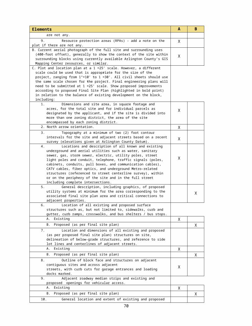
applicants shall return to the HALRB for its final review and issuance of a final CoA.
The HALRB review process for historic properties identified in the HRI is as follows:
Development proposals affecting those properties ranked as “Essential” and “Important” in the HRI are subject to review and comment by the HALRB.
Applicants should expect to attend a minimum of one full meeting cycle, to include at least one meeting of the Design Review Committee (DRC) and at least one meeting of the full HALRB. These meetings are held monthly and the schedule and application deadlines are available online: www.arlingtonva.us/departments/CPHD/ons/CPHDOnsHistoricPreservation.aspx.
Applicants should attend the HALRB before presenting to other County commissions so that HALRB input pertaining to preservation and design elements (massing, scale, materials, detailing, etc.) will be carried through the rest of the review process.
If there are outstanding issues related to the architectural design and/or preservation of affected historic buildings, the DRC Chairman and HALRB Chairman will confer to determine if additional HALRB review is warranted before the proposal is reviewed by other County commissions.
When the HALRB is satisfied with the proposed architectural design, the HALRB Chairman will provide a written summary of comments that will be submitted by the applicants as part of the submission for the County Board hearing.
70

ATTACHMENT PHISTORIC RESOURCES INVENTORY (HRI) INFORMATIONAL FORM
For questions, please call the County’s Historic Preservation Program Office at 703.228.3830 or see the County website:
www.arlingtonva.us/departments/CPHD/ons/hp/page82412.aspx
Applicant: ____________________________________________________________________________
Application Property Name: _______________________________________________________________
Application Property Address: _____________________________________________________________
HRI Ranking Category (please circle): ESSENTIALIMPORTANTNOTABLEMINORALTERED/NOT HISTORIC
Scope of Proposed Project (please circle, and explain below):
Renovation/Rehabilitation
Addition
Partial Demolition
Full Demolition
New construction_____________________________________________________________________________________________________________________________________________________________
Contact Information for Applicant:
Name: ________________________________________________
Phone : _______________________________________________
E-mail: _______________________________________________
CERTIFICATION: I/We hereby certify that all statements and information provided herein are true, accurate, and complete to the best of my/our knowledge. I/We understand that depending on the HRI status of the building(s), County staff may request additional information about potential impacts to historic properties on the site.
APPLICANT(S)/Agent:_______________________ ________(Signature) (Date)_______________________________Print Name
71
Related Documents