CONTENTS TOPIC 1 : CLIMATE AND ENVIRONMENT ................................ 1 TRENDS AND VARIATION IN MONTHLY RAINFALL AND TEMPERATURE IN SURINAME .................................................................... 2 EVALUATION OF THE EFFECTS OF ENSO TELECONNECTION ON CLIMATIC PARAMETERS FLUCTUATIONS IN KHORASAN PROVINCE I.R. OF IRAN ............................................................................... 3 THE INFLUENCE OF CLIMATE CHANGE ON METEOROLOGICAL DROUGHT CHARACTERISTIC IN TAIWAN ................................................. 4 SELF-LEARNING STATISTICAL SHORT-TERM CLIMATE PREDICTIVE MODEL FOR EUROPE............................................................ 5 EVALUATION OF SURFACE AIR TEMPERATURE TREND AND CLIMATE CHANGE IN THE NORTH – EAST OF I. R. OF IRAN .................. 7 INFLUENCE OF MILD WINTERS ON GROUNDWATER IN BULGARIA ...................................................................................................... 8 CLIMATE CHANGE AND THE EXPECTED IMPACT IN WATER RESOURCES IN ALBANIA ............................................................................ 9 RAINFALL VARIABILITY IN BULGARIA AND ITS RELATION WITH NAO .............................................................................................................. 10 CLIMATE VARIABILITY, CLIMATE CHANGES AND THEIR IMPACT ON WATER CYCLES..................................................................... 12 IMPACTS OF CLIMATE VARIABILITY ON THE RUNOFF IN THE SOUTH EASTERN PART OF BULGARIA ................................................... 13 TRENDS AND ANOMALIES OF PLUVIOMETRIC EXTREMES IN THE NORTH-WESTERN REGION OF ROMANIA....................................... 14 EFFECT OF CLIMATIC CONDITIONS AND IRRIGATION ON SUGARBEET PRODUCTION IN THE VOJVODINA PROVINCE, SERBIA AND MONTENEGRO ..................................................................... 15 RELATIONSHIP BETWEEN DROUGHT INTENSITY AND CROP PRODUCTION IN SERBIA AND MONTENEGRO ....................................... 17 I

Welcome message from author
This document is posted to help you gain knowledge. Please leave a comment to let me know what you think about it! Share it to your friends and learn new things together.
Transcript
CONTENTS
TOPIC 1 : CLIMATE AND ENVIRONMENT ................................ 1
TRENDS AND VARIATION IN MONTHLY RAINFALL AND TEMPERATURE IN SURINAME ....................................................................2
EVALUATION OF THE EFFECTS OF ENSO TELECONNECTION ON CLIMATIC PARAMETERS FLUCTUATIONS IN KHORASAN PROVINCE I.R. OF IRAN...............................................................................3
THE INFLUENCE OF CLIMATE CHANGE ON METEOROLOGICAL DROUGHT CHARACTERISTIC IN TAIWAN .................................................4
SELF-LEARNING STATISTICAL SHORT-TERM CLIMATE PREDICTIVE MODEL FOR EUROPE............................................................5
EVALUATION OF SURFACE AIR TEMPERATURE TREND AND CLIMATE CHANGE IN THE NORTH – EAST OF I. R. OF IRAN ..................7
INFLUENCE OF MILD WINTERS ON GROUNDWATER IN BULGARIA......................................................................................................8
CLIMATE CHANGE AND THE EXPECTED IMPACT IN WATER RESOURCES IN ALBANIA ............................................................................9
RAINFALL VARIABILITY IN BULGARIA AND ITS RELATION WITH NAO ..............................................................................................................10
CLIMATE VARIABILITY, CLIMATE CHANGES AND THEIR IMPACT ON WATER CYCLES.....................................................................12
IMPACTS OF CLIMATE VARIABILITY ON THE RUNOFF IN THE SOUTH EASTERN PART OF BULGARIA ...................................................13
TRENDS AND ANOMALIES OF PLUVIOMETRIC EXTREMES IN THE NORTH-WESTERN REGION OF ROMANIA.......................................14
EFFECT OF CLIMATIC CONDITIONS AND IRRIGATION ON SUGARBEET PRODUCTION IN THE VOJVODINA PROVINCE, SERBIA AND MONTENEGRO.....................................................................15
RELATIONSHIP BETWEEN DROUGHT INTENSITY AND CROP PRODUCTION IN SERBIA AND MONTENEGRO.......................................17
I
TRENDS OF CLIMATIC CHANGES CONSIDERING OVER YEARS 1894-1993 AND 1894-2003 FOR SARAJEVO.............................................19
EFFECTS OF GLOBAL WARMING ON FLOODS AND DROUGHTS IN THE CARIBBEAN ....................................................................................20
WINTER CLIMATE VARIABILITY AND CLASSIFICATION IN THE BULGARIAN MOUNTAINOUS REGIONS ...................................................21
ESTIMATING CLIMATE CHANGE IMPACT ON IRRIGATION DEMAND USING INTEGRATED MODELLING ...........................................22
HYDROLOGICAL IMPACT OF “EL NIÑO/LA NIÑA” ON THE WATERSHEDS OF RIVERS MALA, LURIN, RIMAC, CHILLON, CHANCAY – HIUARAL, HUAURA AND PATIVILCA ...................................24
CLIMATE CHANGE IMPACT ON THE RIVER RUNOFF : REGIONAL STUDY FOR THE CENTRAL ASIAN REGION .......................25
THE INFLUENCE OF CLIMATE CHANGE TO EUROPEAN LAKES, WITH A SPECIAL EMPHASIS IN THE BALKAN REGION ..........................27
APPLICATION OF THE HBV MODEL EOR ASSESSMENT OF CLIMATE CHANGE IMPACTS ON THE ELEMENTS OF HYDROLOGICAL CYCLE FOR THE STRUMA RIVER BASIN ...................29
CLIMATE VARIABILITY AND CHANGE AND RELATED DROUGHT ON BALKAN PENINSULA............................................................................30
ANALYSIS OF CLIMATE CHANGE IN SOUTHEASTERN BULGARIA AND NORTHWESTERN TURKEY............................................31
PHYTOCLIMATIC ASSESSMENT OF AIR TEMPERATURES TRANSITION ACROSS IMPORTANT BOUNDARY VALUES.....................32
ANALYSIS OF RAINFALL RELATED TO LANDSLIDE ACTIVITY DURING JANUARY-FEBRUARY 2003, SOUTH-EASTERN SECTOR OF ITALY ......................................................................................33
LONG-TERM RUNOFF CHANGES IN REGIONS OF SLOVAKIA ..............35
THE RIVER TEMPERATURE CHANGES FOLLOWS THE CLIMATE VARIABILITY................................................................................37
LONG-TERM VARIABILITY OF PRECIPITATION IN REPUBLIC OF MACEDONIA ................................................................................................38
II
METHODS FOR ASSESSMENT OF CLIMATE VARIABILITY AND CLIMATE CHANGES IN DIFFERENT TIME-SPACE SCALES ...................39
EVALUATION OF URBANIZATION EFFECTS ON CLIMATE CHANGE OVER THE NORTH-EAST OF I.R. OF IRAN ..............................41
STUDY ON VARIABILITY OF TEMPERATURE AND PRECIPITATION CONDITIONS IN THE SOUTH EASTERN BULGARIA....................................................................................................42
CHANGES IN EXTREME EVENTS IN THE SCENARIOS OF DOUBLING OR TRIPLING OF CO2 .............................................................43
CLIMATE CHANGE AND ITS IMPACT ON THE CRN DRIM CATCHMENT AREA IN MACEDONIA .........................................................44
ASSESSMENT OF CLIMATE CHANGE USING METHODS OF MATHEMATIC STATISTICS AND THEORY OF PROBABILITY.................45
EL-NINO/SOUTHERN OSCILLATION (ENSO) PHASE BASED MAPPING OF REGIONS AT RISK OF DROUGHT AND FLOOD RELATED DISASTERS OVER THE EASTERN AND SOUTHERN AFRICAN SUBREGIONS .............................................................................46
TROPICAL NORTH AFRICA HYDROCLIMATE VARIABILITY ...................47
INVESTIGATION OF THE MASS-ENERGY EXCHANGE IN THE REGION OF “KOPRINKA”LAKE...................................................................48
EFFECTS OF CLIMATE CHANGE ON AGRICULTURE PARTICULARLY IN SEMI-ARID TROPICS OF THE WORLD WITH SOME EXAMPLES OF ETHIOPIAN CONDITION .......................................49
THE MOUNTAINS INFLUENCE ON TURKEY CLIMATE............................50
SOME PARTICULARITIES OF RAINFALL VARIABILITY IN A TRANSITION CLIMATE : CASE OF THE DEPARTMENT OF THE ZOU IN BENIN - WEST AFRICA.................................................................52
ASSESSMENT OF EFFECTS OF CLIMATE CHANGE ON CATASTROPHIC FLOODS IN MOUNTAIN .................................................53
CHANGES OF HYDROLOGICAL CYCLES IN LAND AND ATMOSPHERE IN EUROPE AND ASIA IN CASE OF DEFORESTATION OF SIBERIA (RESULTS OF GCM NUMERICAL EXPERIMENTS) ...........................................................................................54
III
APPEARANCE PROBABILITY OF CERTAIN PRECIPITATION QUANTITIES AND TEMPERATURE SUMS > 10 0S DURING THE GROWING PERIOD .....................................................................................55
CHARACTERISTICS OF THE PRECIPITATION VALUES BY SEASON AND BY YEAR SHOWN THROUGH SUMMARY PROBABILITY, BY GAUSS LOW FOR NORMAL DISTRIBUTION IN REPUBLIC OF MACEDONIA FOR THE PERIOD 1951-2000 .....................56
INTENSITY OF THE EXTREME RAINFALLS IN THE REPUBLIC OF MACEDONIA ..........................................................................................57
THE INTERANNUAL RHYTHM OF RAINFALL IN MACEDONIA................59
DRYNESS AND ARIDITY OF CLIMATE IN THE REPUBLIC OF MACEDONIA ................................................................................................60
RADAR IDENTIFICATION AT THE FRONTAL CONVECTIVE CLOUDINESS SYSTEMS ............................................................................61
THE EFFECTS OF EXCEPTIONAL HEAVY RAINFALL ON THE ALLUVIAL GROUNDWATER TABLE OF TEBESSA...................................62
THE FREQUENCY OF PRECIPITATION DAYS IN THE YANGTZE CATCHMENT FROM 1950 TO 2000............................................................63
HYDROENERGETIC CAPACITY OF THE DRINI RIVER AND THE ENVIRONMENTAL IMPACT CONSIDERATIONS.......................................65
TOPIC 2 : HYDROLOGICAL CYCLE AND WATER BALANCES................................................................................ 67
WATER BALANCE OF THE REPUBLIC OF CROATIA : ACHIEVEMENTS AND NECESSITIES ........................................................68
STREAMFLOW CHARACTERISTICS OF EUROPEAN PART OF TURKEY........................................................................................................69
HYDROLOGICAL PECULIARITIES OF HIGH MOUNTAIN BASINS : THE CASE OF THE SPANISH PYRENEES ................................................71
TRANSBOUNDARY WATER ISSUES : THE GANGA-BRAHMAPUTRA-MEGHNA RIVER BASIN .................................................73
PRECIPITATION ON THE ADRIATIC COST AND ISLANDS IN CROATIA ......................................................................................................75
IV
AN EVALUATION OF THE RELATION BETWEEN THE REFERENCE EVAPOTRANSPIRATION, CALCULATED AFTER THE FAO PENMAN-MONTEITH МETHOD AND THE EVAPORATION RATE FROM AN OPEN WATER SURFACE IN BULGARIA....................................................................................................76
ESTIMATING REFERENCE EVAPOTRANSPIRATION AT FRENCH HUMID LOCATIONS BY MODIFIED HARGEAVES METHOD....................77
IDF-CURVES FOR PRECIPITATION IN BELGIUM.....................................78
HYDROLOGICAL REGIMES IN BALKAN AREA.........................................79
TIME SERIES ANALYSIS OF GROUNDWATER LEVELS IN THE DANUBE-TISZA INTERFLUVE ....................................................................81
HYDROLOGICAL PREVIEW ON WATER RESOURCES AND WATER QUANTITY IN THE CENTRAL BALKAN REGION ........................82
MAIN TRIBUTARY INFLUENCE ON THE RIVER VARDAR WATER QUANTITY....................................................................................................83
THE HYDROLOGIC REGIONALISATION OF ALBANIAN TERRITORY ACCORDING TO THE ANNUAL SPECIFIC YIELD...............84
MAPPING MEAN ANNUAL AND MONTHLY RIVER DISCHARGES : GEOSTATISTICAL DEVELOPMENTS FOR INCORPORATING RIVER NETWORK DEPENDENCIES ..........................................................85
INVESTIGATION OF THE EVAPOTRANSPIRATION REGIME IN SOME REGIONS OF BULGARIA.................................................................86
COMPARISON OF SOME METHODS OF ESTIMATION OF EVAPOTRANSPIRATION ............................................................................87
COMPARISON OF SEVERAL HYDROLOGICAL CYCLE PARAMETERS IN CROATIA FOR TWO PERIODS ....................................88
TOPIC 3 : DROUGHTS AND FLOODS ..................................... 89
A PARTITIONING METHODOLOGY FOR IDENTIFICATION OF HOMOGENEOUS REGIONS IN REGIONAL FLOOD FREQUENCY ANALYSIS.....................................................................................................90
FLOOD POTENTIAL IN ALBANIA................................................................93
V
THE ROMANIAN NATIONAL INTEGRATED METEOROLOGICAL SYSTEM (SIMIN) AND ITS HYDROLOGICAL APPLICATIONS .................94
EXTREME EVENTS: THE IMPLICATION FOR DREDGING AND NAVIGABILITY OF THE LOWER NIGER RIVER ........................................96
FLOOD EARLY WARNING SYSTEM IN I.R. OF IRAN ...............................97
SYNOPTIC CONDITIONS AND IMPACT ON THE EXTREME SUBSIDE OF THE WATER LEVEL IN THE BULGARIAN SECTION OF THE DANUBE RIVER.............................................................................99
FEASIBILITY OF ESTIMATING GENERALIZED EXTREME-VALUE DISTRIBUTION OF FLOODS.....................................................................100
ON THE FLOOD FORECASTING AT THE BULGARIAN PART OF STRUMA RIVER BASIN .............................................................................101
FLOOD FORECASTING AND WARNING SYSTEMS IN PAKISTAN........102
ANALYSIS OF CHARACTERISTIC OF FLOOD EVOLUTION IN WEIHE MIDDLE AND LOWER REACHES IN 2003...................................103
ANALYSIS OF FLOOD EVOLUTION CHARACTERISTIC BETWEEN LONGMEN AND TONGGUAN IN YELLOW RIVER IN JUL.2003.....................................................................................................104
ANALYSE ON CHANGES OF RUNOFF GENERATION AND CONFLUENCE OF THE LUOHE RIVER ...................................................105
OVERALL DESIGN OF THE FLOOD FORECASTING SYSTEM OF XIAO-HUA REACH ON THE YELLOW RIVER ..........................................106
THE INFLUENCE OF THE PHYSICO-GEOGRAPHICAL FACTORS WHICH DETERMINE FLOODS IN SMALL BASINS FROM THE ROMANIAN CARPATHIANS......................................................................107
THE AUTOMATIC HYDROLOGICAL INFORMATION SYSTEM OF THE JUCAR BASIN AS A WARNING SYSTEM ........................................108
LOCAL AND REGIONAL ESTIMATION OF FLOODS IN THE TIMIS AND BEGA HYDROGRAPHIC BASINS : APPLICATION OF CONVERGING QDF MODEL CONCEPT ..................................................110
CONTRIBUTION OF EARTH OBSERVATION DATA TO FLOOD RISK MAPPING IN THE FRAMEWORK OF THE NATO SFP “TIGRU” PROJECT.....................................................................................111
VI
THE ANALYSIS ON THE FLOOD PROPERTY OF WEIHE RIVER IN 2003........................................................................................................113
DROUGHT PERIODS DURING XXTH CENTURY......................................114
THE OPERATIONAL FLOOD FORECASTING SYSTEM WAVOS FOR THE RIVERS RHINE, ELBE AND ODRA ..........................................116
SYSTEM OF PREDICTION & WARNING OF FLOODS IN THE WATER BASIN OF STRUMA/STRYMONAS RIVER.................................117
EXTREME VALUES IN THE WATER RIVERS FLOW EVOLUTION, CAUSED BY EXTREME VARIATIONS OF PRECIPITATION, WATER FROST OR KARST ......................................................................118
HEAVY RAINFALLS, FLOODS AND LANDSLIDES IN THE SMALL CATCHMENTS OF THE BEND CARPATHIANS AND SUBCARPATHIANS (ROMANIA)...............................................................120
CONSIDERATIONS ON THE EXTREME FLOOD PRODUCED IN RAUL MARE BASIN (RETEZAT MOUNTAINS, ROMANIA)......................121
DROUGHT EARLY WARNING SYSTEM IN I.R. OF IRAN........................122
REMOTE CLIMATE PROCESSES UNDERLYING SUMMER DROUGHT EVENTS IN THE MEDITERRANEAN .....................................124
EARLY WARNING SYSTEM OF DROUGHT FOR RISK ASSESSMENT AND RISK MANAGEMENT ..............................................125
ADAPATIVE METHODS FOR FLOOD FORECASTING USING LINEAR REGRESSION MODELS IN THE UPPER BASIN OF SENEGAL RIVER .......................................................................................127
FLOOD FORECASTING AND UNCERTAINTY OF PRECIPITATION FORECASTS ..............................................................................................128
LOW FLOW AND DROUGHT SPATIAL ANALYSIS..................................129
THE IMPACT OF THE DROUGHT ON THE HYDROUS POTENTIALITES OF THE PLAIN OF MEJJATE AND SA BORDERS WESTERN, (MOROCCO)........................................................130
DROUGHT ANALYSIS AND THE EFFECT OF CLIMATE CHANGE IN THE WEST BANK/PALESTINE .............................................................131
VII
2002 FLOODS BY TYPHOON RUSA : EXPERIENCE AND PERSPECTIVES OF MITIGATION IN SOUTH KOREA ............................132
THE FLOOD FORECASTING SYSTEMS IN THE REPUBLIC OF KOREA........................................................................................................133
TELECONNECTIONS BETWEEN ATLANTIC SSTA AND SUMMER PALMER DROUGHT SEVERITY INDEX IN EUROPE ..............................134
2003 HYDROLOGICAL DROUGHT – NATURAL DISASTER ...................135
REAL TIME HYDROLOGIC FLOOD FORECAST BASED ON SAIH AND WEATHER RADAR DATA IN SPAIN.................................................136
USE OF FLOOD PROPAGATION MODELS IN REAL TIME HYDROLOGIC FORECAST. EXPERIENCES AT SEGURA RIVER .........137
FLOOD DISASTER AND PROTECTION MEASURES IN TURKEY CASE STUDY: MAY 1998 FLOOD DISASTER AT NORTH WESTERN BLACK SEA REGION OF TURKEY........................................138
TOPIC 4 : INTEGRATED WATER RESOURCES MANAGEMENT........................................................................ 139
MULTI-DISCIPLINARY APPROACHES IN RIVER BASIN MANAGEMENT - AN EXAMPLE................................................................140
A SURVEY OF RISK PERCEPTION OF DRINKING WATER AND BOTTLED WATER USE.............................................................................142
WATER RESOURCE MANAGEMENT IN ISTANBUL ...............................143
WATERSHED REGULATION AND MANAGEMENT OF METROPOLITAN CITY OF ISTANBUL......................................................145
INSURED – INFORMATION SYSTEM FOR AN INTEGRATED AND SUSTAINABLE USE OF WATER RESOURCES OF DRINI-DRIM RIVER .........................................................................................................146
WATER FRAMEWORK DIRECTIVE IN MACEDONIAN WATER LAW ............................................................................................................148
WATER POLICY AND WOMEN STATUS IN NIGERIA .............................150
ON THE ROLE OF AN UPDATED WATER POLICY IN SOLVING WATER RELATED ISSUES IN PENINSULAR INDIA................................151
VIII
WATER MANAGEMENT AND WATER FRAMEWORK DIRECTIVE ........153
WATER RESOURCE MANAGEMENT IN THE LOWER STRETCH OF THE RIVER GANGES NORTHEAST INDIA: AN APPROACH THROUGH COMMUNITY INVOLVMENT ..................................................154
WATER RESOURCE STRATEGIES AND DROUGHT ALLEVIATION IN WESTERN BALKAN AGRICULTURE...........................156
COASTAL MEDITERRANEANS WETLANDS IN THE WATER LAW IN THE BALKANS COUNTRIES ................................................................158
IRRIGATION OF THE BELA PALANKA’S FIELD FROM THE RESERVOIR “ZAVOJ”................................................................................160
BASIN MANAGEMENT OF NATURE USE AND HYDROLOGICAL RISKS IN SIBERIA .....................................................................................162
THE HYDROINFORMATICS APPROACH TO INTEGRATED RIVER BASIN MANAGEMENT ..............................................................................163
EC WATER FRAMEWORK DIRECTIVE – EXPERIENCE OF LATVIA........................................................................................................165
EVALUATION OF BROAD STRATEGIES FOR WATER RESOURCES DEVELOPMENT USING DYNAMIC STANDARDS: DNIEPER, DON AND KUBAN INTERNATIONAL BASINS CASE STUDY (ANNULE MESSAGE 19/01/04)....................................................167
INTEGRATED WATER MANAGEMENT IN CYPRUS GERMASOGEIA RIVERBED AQUIFER ....................................................169
MANAGEMENT OF GROUNDWATER RESOURCES IN CYPRUS - HARMONISATION WITH EU DIRECTIVES...............................................170
WATER RESOURCES MANAGEMENT AND DROUGHT OF THE SMALL AEGEAN SEA ISLANDS, GREECE ..............................................171
INTEGRATED MANAGEMENT OF WATER RESOURCES IN BUZAU HYDROGRAFIC BASIN ................................................................173
PARTICIPATORY DECISION SUPPORT FOR INTEGRATED RIVER BASIN MANAGEMENT ..................................................................175
ROLE OF WOMEN IN THE MANAGEMENT IN URBAN AREAS OF KATHMANDU VALLEY...............................................................................177
IX
ENVIRONMENTAL REPORTING SYSTEM DEVELOPMENT IN BOSNIA AND HERZEGOVINA...................................................................179
SEAWATER INTRUSION IN COASTAL AQUIFERS – A DANGER TO SUSTAINABLE WATER SUPPLY AND ECONOMY OF ISLAND COUNTRIES...............................................................................................180
POLLUTION AND USE OF TRANSBOUNDARY WATER RESOURCES IN CONFLICT MANAGEMENT; A CASE IN THE UPPER NILE BASIN, UGANDA .................................................................181
MANAGEMENT OF WATER RESOURCES IN KOSOVA .........................183
COMPETING AND CONFLICTING WATER USES - NEED FOR A DECISION SUPPORT SYSTEM: THE CYPRUS CASE STUDY...............184
PRELIMINARY RESEARCH ON AN INTEGRATED MANAGEMENT OF THE WATERS OF THE CATCHMENT OF RIVER NESTOS/MESTA........................................................................................185
METHODS, MODELS FOR RESEARCHING, AND MODELING THE RELATIONS BETWEEN HYDRO METEOROLOGICAL REGISTERED DATA SERIES AND REGISTERED DATA SERIES FOR WATER NEEDS .................................................................................186
APPLICATION OF INFORMATION TECHNOLOGY FOR MONITORING AND MANAGING WITH IRRIGATION SCHEME WITH LONG OPEN CANALS.....................................................................187
MONITORING SYSTEMS IN THE PROCESSES OF WATER USING AND WATER QUALITY CONSERVATION....................................188
THE USE OF SALINE WATER IN AGRICULTURE IN SOUTH EAST ......189
OF I.R. OF IRAN.........................................................................................189
WATER RESOURCES MANAGEMENT: BANGLADESH PERSPECTIVE...........................................................................................190
METHODOLOGY FOR RIVER MANAGEMENT STATEGY FORMULATION..........................................................................................193
NEW HORIZONS OF NATURAL AND WATER RESOURCES AS A REGIONAL PERSPECTIVE: CASE STUDY OF SOUTH-EASTERN ANATOLIA REGION AND SOUTH-EASTERN ANATOLIA PROJECT (GAP) IN TURKEY....................................................................194
X
QUANTIFICATION OF ACTUAL EVAPOTRANSPIRATION FROM AN ALLUVIAL AQUIFER OF THE KOURIS CATCHMENT (CYPRUS) USING STREAMFLOW RECORDS.........................................195
FUTURE EU FRONTIERS: INSTITUTIONAL ASPECTS OF TRANSBOUNDARY RIVER BASIN MANAGEMENT.................................196
THE JOURNEY WITH DIFFERENT METEOROLOGICAL DATAS IN A DEVELOPED IRRIGATION SOFTWARE...............................................197
RAIN WATER HARVESTING AND MANAGEMENT OF SMALL DAMS IN MEDITERRANEAN AREAS (NORTH AFRICA AND MIDDLE EAST)...........................................................................................198
THE VARDAR VALLEY INTEGRATED PROJECT....................................200
TOPIC 5 : WATER RESOURCES PROTECTION AND ECOHYDROLOGY................................................................... 203
METHOD OF COMPOSITION APPLIED FOR SELECTED KARSTIC SPRINGS IN BULGARIA ...........................................................204
ASSESSMENT AND ANALYSES ON THE REGULATING RUNOFF AND SEDIMENT OF YELLOW RIVER FOR THE FIRST TIME EXPERIMENT ON A LARGE SCALE IN JULY 2002 .................................205
STUDIES ON SEDIMENT AND WATER RESOURCES OF THE YELLOW RIVER .........................................................................................207
PROBLEMS OF BIOLOGICAL RESOURCES RATIONAL USE AND CONTROL...................................................................................................208
VULNERABILITY EVALUATION OF A MULTILAYER AQUIFER FOR A SUSTAINABLE USE OF THE RESOURCES (WESTERN SICILY, ITALY) ...........................................................................................210
ECOHYDROLOGY OF A KARSTIC TERRANE IN NORTHERN ALTA VERAPAZ, GUATEMALA.................................................................212
EVALUATION OF THE ANTHROPIC IMPACT OVER THE RIVER BED ECOSYSTEM .....................................................................................213
WATERS IN THE VITOSHA MOUNTAIN – DESCRIPTION, QUALITY, PROTECTION...........................................................................214
MINING ACTIVITIES AND HEAVY METAL RIVER POLLUTION IN THE APUSENI MOUNTAINS, ROMANIA ..................................................215
XI
CLASSIFICATION OF STREAM SITES AND REGIONAL PATTERNS FOR RIVERS IN THE TAGUS BASIN....................................216
THE STABILITY OF THE HYDROLOGICAL REGIMES AS A HYDROECOLOGICAL DESCRIPTOR OF RIVER LIFE ............................218
OVERVIEW OF NATIONAL HYDROGEOLOGICAL NETWORK OF BULGARIA..................................................................................................220
GROUNDWATER PROTECTION AGAINST POLLUTION CAUSED BY CERTAIN DANGEROUS SUBSTANCES-ROMANIAN EFFORTS, CURRENT STATE AND PERSPECTIVES .............................221
INVESTIGATION CONCERNING INFLUENCE OF SEISMIC ACTIVITY ON THE REGIME OF THERMAL WATER OCCURRENCE “PCHELINSKI BANI”, BULGARIA....................................222
RECLAMATION OF RIVER-AFFECTED AREAS THROUGH AGRO-FORESTRY IN NEPAL ...............................................................................223
HYDROGEOLOGICAL STUDY AND STATISTICS OF THE MAIN SOURCES OF THE VALLEY OF WADI CHICHAOUA, WESTERN HAOUZ, (MOROCCO)................................................................................224
CHEMICAL CHARACTERISATION OF THE WATER RESOURCES IN BAHLUI RIVER BASIN...........................................................................225
COMMON CHARACTERIZATION OF THE TRANSBOUNDARY AQUIFER OF SOMES-SZAMOS RIVER ...................................................226
DETERMINING THE CRITICAL TEMPORAL PATTERN OF SUSPENDED LOAD IN RIVERS AT DIFFERENT CLIMATES IN IRAN............................................................................................................227
MOTIVATION FOR A REGIONAL ECO-HYDROLOGY WORK GROUP.......................................................................................................228
FLOW VARIABILITY AND FISH POPULATION TRAITS IN A LARGE FRENCH BASIN ............................................................................230
COMPLEX APPROACH FOR INVESTIGATION THE RIVER WATER POLLUTION FROM POINT SOURCES.......................................231
IMPACT OF COAL MINING ON WATER QUALITY OF RIVER GODAVARI .................................................................................................232
XII
IMPACT OF INDUSTRIAL AND URBAN POLLUTANT INPUTS ON THE WATER RESOURCES IN REPUBLIC OF MACEDONIA ..................233
COMPLICITY OF FLOW PARAMETERS IN TROPHIC STRUCTURING THE INVERTEBRATE BOTTOM COMUNITIES OF THE MESTA RIVER (SW BULGARIA).......................................................234
CHARACTERISING THE KARST SPRINGS AND THEIR RECHARGE BY GROUNDWATER HYDROCHEMISTRY ........................236
WATER RESOURCES IN THE REPUBLIC OF MOLDOVA CURRENT STATE AND ISSUES OF THEIR PROTECTION ....................238
AQUATIC MACROPHYTES UPSTREAM OF THE ĐERDAP POWER PLANT DAMN (DANUBE RIVER, RKM 1146-943) .....................241
ENVIRONMENTAL PROTECTION AND PROMOTION OF HEADWATER RESOURCES BY AFFORESTATION IN RUGGED MOUNTAINS IN SERBIA............................................................................242
ZETA PLAIN THE MOST IMPORTANT AQUIFER OF MONTENEGRO - NATURAL CONDITIONS OF AQUIFER FORMATION, CURRENT STATE AND THE PERSPECTIVES ................243
EFFECTS OF EROSION CONTROL WORK IN SOME TORRENTS IN THE REPUBLIC OF MACEDONIA ........................................................245
AQUIFER OVEREXPLOITATION AND GROUNDWATER MINING..........247
AN ECOLOGICAL RESOURCE FORMING FACTORS OF THE FRESHWATER SUBAQUATIC LANDSCAPES (THE VOLGA RIVER CASE STUDY)................................................................................249
DEVELOPMENT OF A MANAGEMENT SYSTEM OF GROUNDWATER RESSOURCES OF FRATESTI AQUIFERS IN THE CITY OF BUCHAREST ......................................................................251
NUTRIENTS TRANSFER AND RETENTION IN THE DANUBE BASIN: BUDGETING AND MODELING APPROACHES...........................252
FACTORS AFFECTING DEGRADATION OF WATER RESOURCES IN REPUBLIC OF MACEDONIA.........................................253
NUTRIENTS, CHLOROPHYLL-A AND PHYTOPLANKTON IN FRONT OF BULGARIAN BLACK SEA COAST ( CAPE KALIAKRA ) .......254
XIII
PHYTOPLANKTON BLOOMS – A KEY ECOLOGICAL PROBLEM OF THE BULGARIAN BLACK SEA COAST .............................................256
SELECTION AND APPLICATION OF ARMA/ARIMA CLASS MODELS FOR THE SIMULATION AND FORECAST OF DYNAMICS OF PHREATIC GROUNDWATERS .......................................258
WATER QUALITY VULNERABILITY OF THE LEPENC RIVER BASIN .........................................................................................................260
IUCN ADDRESSING FRESHWATER FISHERIES ISSUES IN CENTRAL AND EASTERN EUROPEAN COUNTRIES.............................261
SCREENING AND QUANTIFICATION OF SOME HEAVY METALS IN SEDIMENTS FROM THE SAVA RIVER................................................262
TOPIC 6 : LAKES .................................................................... 265
OVERVIEW ON DIATOMS FROM OHRID LAKE ......................................266
EMPOWERMENT OF PUBLIC PARTICIPATION IN MANAGEMENT OF TRANSBOUNDARY WATERS IN COUNTRIES IN TRANSITION: LAKE PEIPSI (ESTONIA-RUSSIA) CASE STUDY ............267
COMBINING SCIENTIFIC DATA INTO FRAMEWORKS FOR DECISION-MAKING: EXAMPLES OF AN APPROACH TO INTEGRATED RESOURCES MANAGEMENT FROM TWO TRANSBOUNDARY LAKES (LAKE CHAMPLAIN, USA AND CANADA, AND LAKE OHRID, MACEDONIA AND ALBANIA) ..................269
A DAY-NIGHT AND SEASONAL PERIODICITY IN THE DISTRIBUTION OF THE ZOOPLANKTON FROM LAKE OHRID .............270
BIOMASS DYNAMIC OF LAKE OHRID PELAGIC COPEPODS DURING YEAR 2000 ..................................................................................271
COMPOSITION AND DYNAMIC OF ROTIFERA FAUNA FROM EASTERN LITTORAL ZONE OF LAKE OHRID AS PARAMETER OF WATER QUALITY.................................................................................272
LIVER LESIONS IN THE WILD POPULATION OF MEDITERANNEAN BARBEL (BARBUS MERIDIONALIS PETENYI HECK) IN LAKE OHRID AND ITS WATERSHED......................................273
GILL LESIONS IN PRESPA BARBELL (BARBUS PRESPENSIS) INHABITING A POLLUTED AREA OF PRESPA LAKE .............................274
XIV
LIVING LAKES - AN INTERNATIONAL LAKE PARTNERSHIP OF PRIVATE AND PUBLIC INSTITUTIONS FOR THE PROMOTION OF LAKE PROTECTION AND FRESH WATER CONSERVATION ..........275
ARTIFICIAL NEURAL NETWORKS FOR LAKE LEVEL MODELLING...............................................................................................277
PHYSICAL - CHEMICAL AND MICROBIOLOGICAL INVESTIGATIONS ON THE MACEDONIAN PART ON THE LAKE PRESPA......................................................................................................278
LAKE OHRID : A UNIQUE ECOSYSTEM ENDANGERED BY EUTROPHICATION ?.................................................................................279
THE BELT OF REED (PHRAGMITES COMMUNIS TRIN) FROM LAKE OHRID AS A HABITAT FOR THE RICH AND ENDEMIC MACROZOOBENTHIC COMMUNITIES ....................................................281
THE INFLUENCE OF THE TEXTURE OF THE SUPSTRATE IN COLONIZATION OF MACROZOOBENTHOS FROM LAKE OHRID.........282
QUALITATIVE AND QUANTITATIVE COMPOSITION OF GASTROPOD FAUNA FROM SOME LITTORAL POINTS IN LAKE OHRID.........................................................................................................283
ANNUAL PRODUCTION IN THE BELT OF STONEWORTS (CHARACEAE) FROM LAKE OHRID.........................................................284
SIMULATION MODEL OF AN DANGEROUS MOUNTAIN LAKE WATER BALANCE .....................................................................................285
THE PHYTOPLANKTON AND PRIMARY PRODUCTION FROM LAKE OHRID ..............................................................................................286
CONTENT OF SOME MICROELEMENTS IN THE REED FROM LAKE OHRID ..............................................................................................287
CONTENT OF MICROELEMENTS IN SOME SUBMERGE AQUATIC PLANTS FROM LOCALITY GRASNICA...................................288
INVESTIGATION OF DYNAMICS OF BIOMASS OF POTAMOGETON PERFOLIATUS L. FROM LOCALITY MAZIJA ............289
SEX COMPOSITION OF POPULATION OF THE MORANEC, PACHYCHILON PICTUM (HECKEL & KNER) FROM LAKE OHRID ........290
XV
AGE COMPOSITION OF POPULATION OF THE MORANEC, PACHYCHILON PICTUM (HECKEL & KNER) FROM LAKE OHRID ........291
HEAVY METALS IN THE MORANEC, PACHYCHILON PICTUM (HECKEL & KNER) FROM LAKE OHRID ..................................................292
HEAVY METALS IN THE OHRID ROACH, RUTILUS RUBILIO OHRIDANUS (KAR) FROM LAKE OHRID .................................................293
PRESPA AND OHRID LAKE AS AN UNIQUE HYDROLOGICAL SYSTEM WITH DIFFERENT WATER REGIME ........................................294
THE ANTHROPOLOGICAL AND NATURAL INFLUENCES ON THE DOJRAN LAKE REGIME............................................................................295
APPROACHES TO ECOSYSTEM/WATERSHED MANAGEMENT IN THE REGION OF LAKE OHRID AND THE PRESPA LAKES (ALBANIA, GREECE AND MACEDONIA)..................................................296
MICROBIOLOGICAL AND PHISICOHEMICAL INVESTIGATIONS OF LAKE OHRID DURING 2003................................................................298
INVESTIGATION OF DISTRIBUTION OF PROTEOLITIC, AMYLOLITIC AND LYPOLYTIC BACTERIA IN THE LAKE OHRID ..........299
RELATION BETWEEN ORGANOTROPHIC BACTERIA AND ORGANIC MATTER IN LAKE OHRID PELAGIC WATER COLUMN ........300
TREND OF ORGANOTROPHIC BACTERIA IN SOME AREAS OF LITTORAL ZONE OF LAKE OHRID...........................................................301
SUSTAINABILITY ASPECTS OF THE SKADAR LAKE WATER LEVEL REGULATION ................................................................................302
OXYGEN REGIME OF LAKE OHRID ........................................................303
PHOSPHATASE ACTIVITY IN THE WATER OF LAKE OHRID AS AN INDICATOR FOR ITS ECOPHYSIOLOGICAL CONDITION ...............304
LOADING RATE OF THE RIVERS VELGOSKA AND KOSELSKA AND THEIR INFLUENCE OF LAKE OHRID TROPHIC STATE ................305
SOCIO-ECONOMIC ACTIVITIES AND THEIR ENVIRONMENTAL IMPACT IN THE PRESPA REGION...........................................................306
XVI
TROPHIC STATE OF THE WATER IN THE LITTORAL REGION OF LAKE OHRID INFRONT OF THE INFLOWS OF THE MAIN TRIBUTARIES ............................................................................................308
THE PAST AND PRESENT STATE OF THE ENVIRONMENT OF THREE BALKAN TRANSBOUNDARY LAKES: DOJRAN, PRESPA AND OHRID................................................................................................309
HYDROLOGY OF PRESPA LAKE .............................................................311
MODELLING OF THE WATER AND ENERGY BUDGET OF A LAND SURFACE AREA NEAR TO THE OHRID LAKE .............................313
LAKE OHRID AND ITS WATERSHED: AN ASSESSMENT OF THE STATE OF THE ENVIRONMENT...............................................................314
APPLICATION OF VIZUALIZATION METHODS TO FIND CRITICAL POLLUTION SOURCES IN THE LAKE OHRID.........................................315
ENVIRONMENTAL ISOTOPES IN THE STUDY OF PRESPA LAKE AND UNDERGROUND CONNECTION BETWEEN PRESPA AND OHRID LAKES............................................................................................316
SEASONAL VARIATIONS IN HEAVY METAL (IRON AND COPPER) CONTENT IN THE LIVER OF WILD OHRID TROUT SALMO LETNICA KAR. (TELOESTEI, SALMONIDAE).............................317
A CONTRIBUTION TO KNWOLEDGE EUTROPHICATION PROCESES IN THE SKADAR LAKE WATER...........................................319
A CONCEPTUAL MODELLING OF THE HYDRODYNAMIC FUNCTIONNING OF PRESPA LAKE ........................................................321
APPENDIX ON THE SKADARSKO LAKE GEOGENESIS, IT'S INTAKE AND DISCHARGE COMPONENTS AND PREVIOUS ACTIVITIES RELATED TO IT'S REGULATION.........................................323
PHYTOPLANKTON, PHYSICO-CHEMICAL CHARACTERISTICS, TROPHIC STATUS AND SAPROBIOLOGICAL CHARACTERISTICS OF BOVAN RESERVOIR........................................325
HYDROMETEOROLOGICAL ANALYSIS, TYPICAL FOR DEFINING OF WATER BALANCE OF PRESPA LAKE ...............................................326
EFFECTS OF ANTROPOGENIC INFLUENCE ON TROPHIC STATES OF RESERVOIRS ........................................................................327
XVII

CAUSES OF HUGE OSCILLATIONS IN THE LEVEL OF PRESPA LAKE...........................................................................................................329
ULTRASTRUCTURAL FEATURES OF THE MACROPHAGES OF TESTES OF SALMONIDAE FROM OHRID LAKE.....................................330
TRANSBOUNDARY MANAGEMENT OF LAKE OHRID WATERSHED: THE NEED OF THE FIFTH ELEMENT .............................331
CAN ONE OF THE ENDEMIC LAKE OHRID FISH TELL THE STORY OF THE ECOSYSTEM STRESS? ................................................333
TAXONOMIC STATUTE OF PHAGOCATA STANKOVICI AND PHAGOCATA OCHRIDANA (TURBELLARIA: TRICLADIDA PALUDICOLA) ESTABLISHED WITH ENZYME ELECTROPHORESIS ................................................................................334
DEVELOPMENT OF THE CRANIAL LATERAL-LINE SYSTEM AND CANAL RELATED BONES IN SALMO LETNICA KARAMAN, 1924 (TELEOSTEI: SALMONIDAE) ....................................................................335
ECOLOGICAL ASPECTS OF THE MACEDONIAN LAKES - EXAMPLES OF INTERNATIONAL CO-OPERATION................................336
CONSERVATION MANAGEMENT OF WET MEADOWS AT THE GREEK PART OF LAKE MIKRI PRESPA..................................................337
TOPIC 7 : INFORMATION SYSTEMS FOR DECISION SUPPORT ................................................................................ 339
INFORMATICS SERVER FOR IMPORTANT ENVIRONMENT DATA – COLLECTING DATA FROM DIFFERENT SOURCES AND BUILD WARNING PROCEDURES ABOUT NORMAL AND EXTREME VALUE OF DATA DISTRIBUTION OVER A LARGE REGION......................................................................................................340
A NEW APPROACH TO INFORMATION MANAGEMENT FOR WATER RESOURCES DECISION SUPPORT ..........................................341
GEOSPATIAL INFORMATION SYSTEM FOR HYDROLOGICAL MAPPING PROGRAMMES, WATER RESOURCES GOVERNANCE AND EDUCATION IN INDIA.......................................................................342
MEDIA SUPPORT FOR INFORMATION ON CLIMATE AND WATER MANAGEMENT FOR DECISION-MAKING AND AGRICULTURAL SUSTAINABILITY IN NORTHEASTERN REGION OF INDIA.....................................................................................................343 XVIII
REQUIREMENTS FOR SATELLITE SENSORS WITH LIMITED SPECTRAL RESOLUTION FOR MONITORING QUALITY LAKE WATER ECOSYSTEMS .............................................................................345
HYDROMETEOROLOGICAL INFORMATION SYSTEM IN MACEDONIA – CLIDATA RDBMS.............................................................346
ASSESSING TIME SERIES DATA FOR RISK QUANTIFICATION OF ENVIRONMENTAL WATER POLLUTION ...........................................347
HYDROMETEOROLOGICAL DATA ACQUISITION, MANAGEMENT AND ANALYSIS FOR THE ATHENS WATER SUPPLY SYSTEM ......................................................................................348
INTEGRATED HYDROMETEOROLOGICAL SOLUTIONS FOR MONITORING AND NETWORK MANAGEMENT......................................349
INTEGRATED HYDROLOGICAL DATA MANAGEMENT: SOFTWARE SYSTEMS FOR HYDROLOGICAL DATA ARCHIVES, WATER OBSERVATION AND INFORMATION SYSTEMS.......................350
AUTOMATIC STATIONS FOR THE MONITORING OF HYDROMETEOROLOGICAL PARAMETERS INSTALLED IN ROMANIA WITHIN THE FRAMEWORK OF THE EC LIFE PROGRAM..................................................................................................352
ACCOMPLISHMENT OF THE HYDROLOGICAL YEAR-BOOK REGARDING THE REPRESENTATIVE BASINS USING EXCEL PROGRAM AND GIS TECHNIQUES.........................................................354
TO WICH HYDROMETEOROLOGICAL DATA ALGERIA NEEDS?..........356
GIS APPLICATION OF DISTRIBUTED MODELING FOR PREDICTING POTENTIAL NON-POINT SOURCES OF WATER POLLUTION FOR WATERSHED MANAGEMENT....................................358
COMPARATIVE MEASUREMENT OF RIVER DISCHARGE BY CLASSIC CURRENT METER AND ACOUSTIC DOPPLER CURRENT PROFILER (ADCP) ..................................................................359
USING A GIS FOR LOCALIZING OF AREA AFFECTED BY WATER EROSION – CASE STUDY IN NORTH-WEST BULGARIA.........360
DATA MANAGEMENT FOR THE LOWLAND CATCHMENT RESEARCH PROGRAMME.......................................................................361
XIX
MANAGEMENT INFORMATION SYSTEM FOR BENCHMARKING IN IRRIGATION PROJECTS ......................................................................363
METHODS FOR SYNTHESIS OF MISSING DATA AND RESTORATION OF LONG-TERM TIME SERIES .....................................365
METHODOLOGY AND STRUCTURE OF REGIONAL DATA BASE FOR HYDROLOGICAL COMPUTATIONS.................................................367
HIS2000 HYDROLOGICAL INFORMATION SYSTEM – THE ROLE IN THE LOW STREAMFLOW HYDROLOGICAL ANALYSIS ....................369
A DIGITAL GROUNDWATER MAP OF BULGARIA IN 1:500 000 SCALE – OBJECTIVES AND METHODOLOGICAL APPROACH.............370
SPATIAL DATA ANALYSIS AND WATER INFORMATION SYSTEM FOR THE SAVA RIVER IN SLOVENIA......................................................372
AUTOMATIC SYSTEM FOR METEOROLOGICAL MONITORING FOR ENVIRONMENTAL PURPOSES .......................................................373
GROUND WATER INFORMATION SYSTEMS AS DECISION MAKING TOOLS. CASE STUDIES: JAMAICA, TRINIDAD, JORDAN, UAE, BAHRAIN, AND DOMINICAN REPUBLIC .......................374
THE SPANISH HYDROLOGICAL SYSTEM ..............................................376
DATABASE CONSTRUCTION FOR MANAGEMENT INFORMATION SYSTEM ON IRRIGATION AND DRAINAGE SCHEMES ..................................................................................................378
DATA BASE FOR MONITORING, PROTECTION AND MANAGEMENT OF RESERVOIRS IN SERBIA.........................................380
PRECIPITATION DISTRIBUTION IN TIME AND SPACE USING GIS TECHNOLOGY FOR REPUBLIC OF MACEDONIA...........................381
GIS APPLICATIONS FOR THE EC WFD IMPLEMENTATION IN ACCESSION COUNTRIES.........................................................................382
WHAT VALUE IS LONG TERM DATA? .....................................................383
A PROPOSED AUSTRALIAN COLLABORATIVE NETWORK FOR LONG-TERM HYDROLOGICAL AND ECOLOGICAL MONITORING.......385
THE WORLD HYDROLOGICAL CYCLE OBSERVING SYSTEM (WHYCOS)..................................................................................................387
XX
HYDROMET – A SOFTWARE TO MANADGE AND PROCESS HYDROMETEOROLOGICAL DATA ..........................................................389
WATER RESOURCES IN MALI: COLLECTION AND PROCESSING OF HYDROLOGICAL DATA.......................................................................390
SAIH OF THE RIVER TAGUS BASIN: STUDY AND APPLICATION OF THE TELEDETECCION FOR SNOW SURFACE ANALYSIS. SNOW GAGE. THAW MODELS. TOOLS GIS FOR APPLICATION ........391
DATA INFRASTRUCTURE AND GEOGRAPHIC INFORMATION SYSTEM FOR DESERTIFICATION SURVEY IN AFRICA CIRCUM-SAHARIAN ZONE: ROSELT PROGRAM ..................................................392
AN ECONOMIC APPROACH TO WATER INFORMATION SYSTEMS...................................................................................................394
RIMSYS – RIVER MONITORING SYSTEM...............................................395
A SPECIFIC METHOD OF MODELING AND DESIGNING ENVIRONMENTAL INFORMATION SYSTEMS. THE EXAMPLE OF SIEREM, AN ENVIRONMENTAL INFORMATION SYSTEM FOR WATER RESOURCES ...............................................................................397
WEBMAP – INTERNET BASED APPLICATION FOR REMOTE DATA AND INFORMATION ACCESS AND VISUALIZATION...................398
A WEB SITE OF A NATIONAL HYDRO-METEOROLOGICAL SERVICE ....................................................................................................400
TOPIC 8 : HYDROLOGICAL MODELLING ............................. 403
HYDRAULIC GEOMETRY RELATIONS ....................................................404
THE APPLICATION OF THE ENGINEERING CALCULATION LANGUAGE - MATLAB ON HYDROLOGY................................................405
THE APPLICATION OF THE SATELLITE CLOUD ATLAS TO BUILD THE TOPOGRAPHY ELEVATION MODEL ON THE WUDINGHE RIVER BASIN ........................................................................406
“EXPERIMENTAL DESIGN OF A LUMPED RAINFALL-RUNOFF MODEL DEDICATED TO THE HOURLY TIME-STEP”..............................407
PREDICTING DIMENSIONLESS LONGITUDINAL DISPERSION COEFFICIENT IN NATURAL STREAMS BY FUZZY-LOGIC APPROACH................................................................................................409
XXI
SUB-SYSTEM BASED ON HYDROLOGICAL MODELING AND GIS TECHNOLOGY FOR FLOOD MANAGEMENT IN THE FRAMEWORK OF THE NATO SFP “TIGRU” PROJECT ..........................411
HYDROLOGIC SCENARIOS FROM PRECIPITATION DOWNSCALING.........................................................................................413
APPROPRIATE MODELING IN DSSS FOR RIVER BASIN MANAGEMENT ..........................................................................................414
A METHOD FOR SEPARATION OF BASEFLOW.....................................415
HYDRODYNAMIC MODELING OF THE PHREATIC AQUIFER FROM THE PRAHOVA – TELEAJEN ALLUVIAL FAN ..............................416
REGIONALISATION OF PARAMETERS FOR A CONCEPTUAL RAINFALL RUNOFF MODEL IN THE MEDITERRANEAN REGION ........418
QUANTITATIVE SOIL-LANDSCAPE MODELING FOR UNDERSTANDING SOIL-LANDSCAPE FUNCTION.................................419
IMPACT OF MORPHOGENETIC STRUCTURE OF RIVER BASINS ON FLOW PATTERNS: ADDESSING SCALE PROBLEMS USING EMPIRICAL AND CARTOGRAPHIC MODELLING....................................420
MULTICRITERIAL MODEL AT THE OPERATION OF THE IRRIGATIONAL SYSTEMS ........................................................................422
WATERSHED MODELLING AS A PART OF ECOLOGICAL CONCEPTS IN HYDROLOGY ...................................................................423
VICAIRE : VIRTUAL CAMPUS IN HYDROLOGY AND WATER RESOURCES .............................................................................................424
HYDRAULIC MODELING OF LEAKAGE MANAGEMENT USING GIS, A CASE STUDY IN SAVEH................................................................426
INTERACTIVE COMPUTER PACKAGE FOR SURFACE WATER HYDROLOGY .............................................................................................427
NUMERICAL MODELING OF NON - UNIFORM FLOW IN BUNA RIVER .........................................................................................................428
STREAMFLOW FORECASTING USING NEURO-FUZZY INFERENCE SYSTEM ...............................................................................430
XXII
THE FORECASTING AND ESTIMATION OF MAXIMUM OF WATER LEVEL IN VOLGA RIVER NEAR N. NOVGOROD DURING OF SPRING FLOOD PERIOD....................................................................431
MODELLING EXTREME FLOODS IN MEDITERRANEAN CATCHMENTS IN SOUTH OF FRANCE...................................................432
APPLICATION OF ARIMA STOCHASTIC MODELS FOR MODELING HYDRO METEOROLOGICAL DATA SERIES AND DISCOVERING, DETERMINING AND MODELING THE ANTHROPOGENIC INFLUENCE...............................................................434
APPLICATION OF ARIMA STOCHASTIC MODELS FOR PROGNOSTICATING OF HYDRO METEOROLOGICAL DATA...............435
INVESTIGATING APPLICABILITY OF PHYSICALLY BASED MODELS OF RUNOFF GENERATION TO POORLY GAUGED RIVER BASINS AND ESTIMATION OF UNCERTAINTY OF RUNOFF PREDICTIONS ...........................................................................436
WAVELET TRANSFORM ANALYSIS FOR NON STATIONARY RAINFALL-RUNOFF-TEMPERATURE PROCESSES...............................437
COMPUTATION OF CONFIDENCE LIMITS FOR THE TWO POPULATIONS - EXTREME VALUE TYPE I DISTRIBUTION..................438
CHANGES OF MEANDERING CHANNEL PATTERN AT ALLUVIAL BOUNDARY................................................................................................439
THE NEW DIGITAL ELEVATION MODEL DATA SET FROM THE SHUTTLE RADAR TOPOGRAPHY MISSION: SOME APPLICATIONS ON THE BALKANS AND THE DRIM CATCHMENT BASIN .........................................................................................................440
HYDROLOGICAL REGIONALISATION OF MULTIANNUAL MEAN DISCHARGE USING GIS. TIMIS-BEGA RIVER BASIN APPLICATION ............................................................................................442
XXIII
BALWOIS 2004 Ohrid, Macedonia, 25-29 May 2004
TOPIC 1 : CLIMATE AND ENVIRONMENT
Climate and Environment 1
BALWOIS 2004 Ohrid, Macedonia, 25-29 May 2004
TRENDS AND VARIATION IN MONTHLY RAINFALL AND TEMPERATURE IN SURINAME
Nurmohamed Raid
Department Infrastructure, Faculty of Technology, University of Suriname, Leysweg, POB 9212, Paramaribo, SURINAME
As Suriname lies within the equatorial trough zone, climate is mainly influenced by the movement and intensity of the Inter-tropical Convergence Zone and the El Nino Southern Oscillation. Scientist predict that global climate change will directly effect the hydrological cycle such as rainfall and temperature, and extreme events such as a El Nino and La Nina. The aim of this study is to analyze historical changes in monthly rainfall and temperature and to predict future changes, with respect to climate change (doubling of carbon dioxide (CO2) by 2100) and variability. Linear extrapolation and five Global Circulations Models (GCMs) (HadCM2, ECHAM4, GFDL-TR, CSIRO2-EQ, CCSR-NIES) will be used. Results of GCMs have showed that under global climate change by 2100, the monthly rainfall is predicted to change with -82 to 66 mm during January and August, and -36 to 47 mm during September and November. The monthly temperature is predicted to increase with 1.3 to 4.3oC by 2100. El Nino events have showed that along the coastal zone and in the center of Suriname, most months (>50%) during the year are drier than normal (88 to 316 mm), while in the west part of Suriname, most months (>50%) are wetter than normal (110 to 220 mm). La Nina events have showed that over entire Suriname, most of the months are wetter than normal (19 to 122 mm), with respect to the minimum rainfall. It can be concluded that the changes in rainfall due to El Nino and La Nina events may have significant impacts on the design, planning and management of water resources systems in Suriname and should therefore be incorporated in future water resources planning.
2 Climate and Environment
BALWOIS 2004 Ohrid, Macedonia, 25-29 May 2004 EVALUATION OF THE EFFECTS OF ENSO TELECONNECTION ON
CLIMATIC PARAMETERS FLUCTUATIONS IN KHORASAN PROVINCE I.R. OF IRAN
Kourosh Ehteramian, Alireza Shahabfar, Sohrab M. Gharaei, Javad B. Jamali
Climatological research institute
P. O. Box 91735-676 Mashhad, IRAN [email protected]
The long term forecasting and monitoring of climatological parameters depends on identification of all effective factors which are affects on this phenomena. One of these parameters is the weather signals. These signals are determinable and specific pattern and occurs in the distinguished regions in the world, but it’s effects are world wide. One of the famous signals is ENSO phenomenon, which have two phases.
In this paper with using annual and seasonal correlations between southern oscillation index (SOI) and precipitation and temperature data the effective amounts of ENSO phases on the differences of these factors was studied in the all regions of Khorasan province in Iran, then for more comprehensive study the classification maps in relation of ENSO and variability of precipitation and temperature were drown.
It was concluded that the mentioned parameters in the whole of the province especially in central and north strip have shown significant action to ENSO, in other word the average of precipitation and temperature correlation indices are negative annually and seasonally, it means when SOI amounts are increased the precipitation and temperature in Khorasan will be decreased.
With regard to increasing the above weather parameters in all regions of Khorasan at the time of ENSO negative phases (El Nino condition) variations of precipitation and temperature could be related to the changes of the pattern of occurrence this phenomenon (ENSO) due to climatic change around the world.
Climate and Environment 3
BALWOIS 2004 Ohrid, Macedonia, 25-29 May 2004
THE INFLUENCE OF CLIMATE CHANGE ON METEOROLOGICAL DROUGHT CHARACTERISTIC IN TAIWAN
Pao-Shan Yu, Chun-Chao Kuo, Chi-Wen Sung
Department of Hydraulic and Ocean Engineering, National Cheng Kung University,
Tainan, 70101, TAIWAN [email protected]
Global climate change and its influence on water resource are the worldwide issues. This study aims at investigating the impacts of climate change on drought characteristic in western Taiwan. This analysis on local climate change may provide the reference for climate change study on Asia region.
Thirty-one rainfall stations with at least 80 years records over western Taiwan provide the data set to analysis trend and change in the long term rainfall series. As the area of Taiwan is too small, the GCM is not suitable for our investigation on climate change. Therefore, the statistical methods of Cumulative Deviations test, Kruskal-Wallis test and Mann-Whitney-Pettitt test were applied to detect the change points of annual rainfall depth and detect whether the long-term rainfall series exist variation and tendency in the historical records. The analytical results reveal that a significant change point occurs during about 1960s for annual rainfall series. Two samples in the long-tern rainfall series are further divided based on this change point. Yearly rainfall depth increases in northern Taiwan and decreases in middle and southern Taiwan. Average values and standard deviation of monthly rainfall depth in these two samples are compared. A stable reducing tendency of average rainfall in the wet seasons (May to October) is found in middle and southern Taiwan and increasing tendency in northern Taiwan.
We further investigate whether drought characteristic is difference before and after 1960. Nine irrigation areas in Taiwan are divided based on its irrigation system. Standardized Precipitation Index (SPI) is estimated and compared with historical agriculture drought. It is found that 3-month SPI has better characteristic than 1-month SPI to respond the agriculture drought characteristic. Therefore, 3-month SPI for each irrigation area is estimated both before and after 1960. It is found that the frequency and duration of moderately dry (3-month SPI<-1.0) and severely dry (3-month SPI<-1.5) has increase tendency in middle and southern Taiwan after 1960. But northern Taiwan has decease tendency.
4 Climate and Environment
BALWOIS 2004 Ohrid, Macedonia, 25-29 May 2004
SELF-LEARNING STATISTICAL SHORT-TERM CLIMATE PREDICTIVE MODEL FOR EUROPE
Oleg M. Pokrovsky
Main Geophysical Observatory, St. Petersburg, 194012, RUSSIA [email protected]
A multivariate self-learning fuzzy-neural model is developed to describe predictive relationships between evolving large-scale patterns in Northern Hemisphere surface atmospheric pressure and air temperature fields (predictors) and subsequent patterns in the Europe surface temperature and precipitation (predictands). A lead interval of varying length (from 1 to 6 months) is placed between a series of consecutive predictor periods and a single predictand period. Objective evaluation of strength of such relationships is a primary aim of this study. Statistical analyses provide empirical knowledge that can lead to more skilful forecasts in the absence of explicit physical understanding. Additionally, acquired information may provide guidance towards identification of the physical process, contributing to or limiting the predictability. The choice to use an empirical approach reflect the fact that both simple and complex general circulation models (GCMs), either with prescribed boundary conditions or with actual oceanic coupling, currently do not adequately reproduce the processes of the real atmosphere at the lead times an averaging periods of concern here. We hope and assume that eventually, with advances in physical understanding, dynamic prediction approaches will outperform statistical ones. Prediction of time-averaged surface climate has received considerable attention over last two decades. First, the potentially predictable portion of the total variability of a given predictand has been empirically estimated using ratios of predictand variability at different frequencies (Trenberth, 1984). Second, direct attempts at forecasting and verification have been made using analog approaches (Barnston and Livezey, 1987) and linear statistical approaches with either several pre-selected predictor elements or whole predictor fields (Barnett, 1981). Neural network (NN) is a powerful nonlinear scheme based on “black box” statistics, where one can tune the model parameters to arrive at a good prediction, but can see neither the phase relation between the predicand and predictors, nor the origin of skills. Therefore, we assume that the predictability of seasonal climate is connected with forcing fields such as the SST or others. The key to a truly successful application of NN model lies in the understanding of the underlying physical mechanism for the relation between predictor and predictand fields (Pokrovsky, 2000). The decision to use the principal fuzzy patterns (PFPs) of the surface atmospheric pressure and temperature as predictor fields is based on findings of other studies on the field teleconnections (Namias, 1982; Lanzante, 1984).
Climate and Environment 5
BALWOIS 2004 Ohrid, Macedonia, 25-29 May 2004 Comparison of EOFs (empirical orthogonal function) and PFPs computed for surface atmospheric pressure and air temperature fields has been carried out and its results are analyzed. PFP advantages for field anomaly performance is demonstrated (Pokrovsky et al, 2002). Following teleconnection spatial areas (Barnston and Livezey, 1987) were selected to derive PFPs for Europe model: North-Atlantic Oscillation (NAO), East Atlantic (EA), EA Jet (EAJ), East-Atlantic/West Russia (EAWR), Scandinavia (S), Polar/Eurasian (PE). It is known (Barnston, 1994; Wang, 2001) that the effectiveness of statistical models depends crucially on whether the relevant components (with respect to space and time scales) to be used as predictors are suitable incorporated into prediction model, and whether the relationships between predictor and predicands (which may not necessarily be linear, particularly, when mid and high latitude are concerned) are properly established. In this respect implementation of optimal design technique (Pokrovsky and Roujean, 2003) permits to determine an optimal set of predictors (PFPs) representing key low-oscillation patterns, which are most informative with respect to the predictand field for a prescribed lead interval. Five layers neural network utilizes fuzzy classification input and out layers and radial basis functions (RBF) for PFPs as the activated units. In order to reduce the problem of artificial skill produced from over-fitting and thus receive a more representative estimate of real skill we used cross-validation method, in which forecast model is developed using only part of available data set and then applied to the independent data. Monthly time series (reanalysis NCEP) for 1948-1998 was split in two parts: the learning and verification samples. In contrast to the GCMs our self-learning model accumulates all past observing data in so way that after 35 years of learning process it could provide very competitive prediction results for surface temperature fields. It captured both positive and negative phases of above climate indexes as well as transition periods in their relationships with predicands fields. It is demonstrated a series of monthly observed and forecasted grid temperature fields over Europe for last decade of twentieth century. Forecasted fields reproduce main features of analysis grids. Deviation and other proper statistics are discussed. In particularly, achieved level for explained variance of predicted fields is much higher than those accessible for linear regression (see Blender et al, 2003). Partition of Europe at the set of the homogeneous climate ranges by fuzzy regioning is discussed. Forecasted and observed temperature and precipitation time series for several climate areas are considered. Skilful magnitudes are analysed as well.
6 Climate and Environment
BALWOIS 2004 Ohrid, Macedonia, 25-29 May 2004
EVALUATION OF SURFACE AIR TEMPERATURE TREND AND CLIMATE CHANGE IN THE NORTH – EAST OF I. R. OF IRAN
Shahabfar Alireza
Climatological Reseach Institute P.O.Box:91735-491,Mashhad, IRAN
In this paper maximum, minimum and mean surface air temperature recorded, analysed to reveal spatial and temporal patterns of long-term trends, change points, significant warming (cooling) periods and linear trend per decade. According to this research summer minimum temperatures have generally increased at a larger rate than in spring and autumn minimum temperatures. On the other hand, night-time warming rates of spring and summer are generally stronger than those that exist in spring and summer daytime temperatures. Considering the significant increasing trends in annual, spring and summer temperatures, it is seen that night-time warming rates are stronger in the northern regions, which are characterized by the Khorasan Province macroclimate type: a very hot summer, a relatively hot and late spring and early autumn, and a moderate winter. We have seriously considered the strong warming trends in spring and summer and thus likely in annual minimum air temperatures. It is very likely that significant and very rapid night-time warming trends over much of the province can be related to the widespread, rapid and increased urbanization in Khorasan Province, in addition to long-term and global effects of the human-induced climate change on air temperatures.
Climate and Environment 7
BALWOIS 2004 Ohrid, Macedonia, 25-29 May 2004 INFLUENCE OF MILD WINTERS ON GROUNDWATER IN BULGARIA
Teodssiia Andreeva, Tatiana Orehova
National Institute of Meteorology and Hydrology ( NIMH ) Blvd. Tzarigradsko shousse, 66. Sofia, 1784, BULGARIA
We have presented in this paper the role of the meteorological conditions during the mild winters for the period 1961-2003 in the cases of the groundwater regimes. For these purpose we used the received classification of the winters by the surface data and the statistical criteria for the territory of Bulgaria. Besides we have analysed the precipitation and its relation with thermal regimes by five synoptical stations in the mountain regions of Bulgaria.
The basic result is that the mild winters had negative impact on the groundwater levels and this water resource in Bulgaria is influenced by climatic variability.
8 Climate and Environment
BALWOIS 2004 Ohrid, Macedonia, 25-29 May 2004
CLIMATE CHANGE AND THE EXPECTED IMPACT IN WATER RESOURCES IN ALBANIA
Eglantina Demiraj, Liri Muçaj, Mirela Bicja
Hydrometeorological Institute Durrësi Street, 219 – Tirana, ALBANIA
The climate change scenarios for Albania are prepared by using MAGICC/SCENGEN software, by CRU/UEA. MAGICC is run to calculate the global changes by using the mid- range IS92a emission scenario as the reference scenario and SRESA1, SRESA2, SRESB1 and SRESB2 as policy scenarios. SCENGEN is run using 6 of the available standardized GCM global warming patterns (HadCM2, UKTR, ECHAM4, CSIRO-TR, UIUC-EQ, GFDLLO). A composite pattern is constructed by using these 6 GSM altogether for each scenario.
The climate change scenario for Albania leads to an annual increase in temperature up to 3.6°C and decrease in precipitation to –12.5% by 2100 related to 1990. Severe summers with high temperatures (up to 4.1°C) and low precipitation (up to –27%) are expected to meet over the territory that may cause negative or positive impacts. Autumn seems to play the second role in annual changes. Milder winters and warmer springs are expected as well. A decrease in the long term mean annual and seasonal runoff has to be expected for the whole territory and for three time horizons (years 2025,2050,2100). It would affect the surface water flow, reducing its amount. Under reduced surface flow and increased evaporation, the storage of reservoirs will decrease, which will effect the energy production by hydropower stations.
Because of the reduction of stream flows in the wetlands, western part of Albania would experience both increasing demands for water and reduced supply of water, which would decrease wetland area. Other consequences of expected warming include not only changes in total water amount and levels, but also erosion of riverbeds, and modification of turbidity and sediment load.
Climate and Environment 9
BALWOIS 2004 Ohrid, Macedonia, 25-29 May 2004
RAINFALL VARIABILITY IN BULGARIA AND ITS RELATION WITH NAO
Nina Nikolova
Department of Climatology, Hydrology and Geomorphology, Faculty of Geology and Geography, Sofia University “St. Kliment Ohridski”
15 Tzar Osvoboditel Blvd - Sofia 1504, BULGARIA [email protected]
The variations of climate exerts strong influence on the productivity of agriculture and on the various aspects of human activity. Many research programs at local, regional and global levels show as a main task the action to reduce, avoid, and better understand the risk associated with the climate change. The precipitation determine the availability of drinking water and the level of the soil moisture.
The paper is intended to provide an information about seasonal and geographical variation of precipitation in Bulgaria and its relation with North Atlantic Oscillation (NAO).
A Statistical test is applied to test the homogeneity and distribution of the initial data.
In order to characterize the long-term and more recent trends linear regression equations are calculated.
Correlation analysis is used to define the relationship between precipitation and global circulation mechanisms.
The main question of the research is: whether the observed trend in Bulgaria corresponds to the global climate change? The tasks are:
- Investigation of short-term and long-term rainfall variability
- Assessment of statistical significance of the linear trend
- Establishing the relationship between rainfall variability and NAO - what is the influence of the NAO on rainfall variability in Bulgaria
In order to characterize the long-term and more recent trends linear regression equations were calculated individually for each station for two periods 1931-2000 and 1961-2000. The trend is negative or close to 0 for the first period. For the second period it is a negative with the values for January to April between –0.2 and –0.7.
10 Climate and Environment
BALWOIS 2004 Ohrid, Macedonia, 25-29 May 2004 Correlation analysis is applied to define the relationship between rainfall variability in Bulgaria and NAO. The relationship is stronger for more recent period 1960-2000. The correlation coefficients are negative. Statistical significant coefficients are found for January, February and March.
The paper give an information about climate change in regional scale. The results of the research will have importance for better understanding the relationship between rainfall and NAO. The knowledge for rainfall variability and physical mechanisms responsible for this variability could be applied in risk management and land use planning in Bulgaria.
Climate and Environment 11
BALWOIS 2004 Ohrid, Macedonia, 25-29 May 2004
CLIMATE VARIABILITY, CLIMATE CHANGES AND THEIR IMPACT ON WATER CYCLES
Shaukat Ali Awan
Flood Forecasting Division, 46-Jail Road, Lahore-54000 PAKISTAN [email protected]
Water availability in Pakistan particularly depends upon both summer and winter rainfall in plains and snowfall over the mountains. Climatically being located in subtropical region, the major amount of rainfall is in monsoon season, which extends from July, to September. Incidentally the deficient or surplus rainfall years are dependent upon intensity of Monsoon current. The same Monsoon current is also responsible for rainfall over the catchment area of eastern rivers i.e. Sutlej, Ravi, Chenab. These catchments are located across the border of eastern rivers. Westerly wave component is another aspect, responsible for rainfall in Jhelum and Indus River though some times Monsoon depressions penetrate upto Jhelum and give heavy rainfall along the route over the Eastern rivers causing the net surplus water availability. The rainfall pattern determines the agriculture output and the crops to be sown along with the area determination. This is particularly dictated by the different regimes of the Monsoon rainfall to mitigate both the surplus and deficient water availability, comprehensive study of statistical data indicates future reservoir / dam location, its construction, and a shift in crops pattern and water utility in commensurate with Climatological dictates in this region of south Asia.
12 Climate and Environment
BALWOIS 2004 Ohrid, Macedonia, 25-29 May 2004
IMPACTS OF CLIMATE VARIABILITY ON THE RUNOFF IN THE SOUTH EASTERN PART OF BULGARIA
Bernardo Lizama Rivas1, Ivanka Koleva-Lizama2
1National Institute of Meteorology and Hydrology Department of Hydrology 66 Tzarigradsko Shosse, 1784 Sofia, BULGARIA
2University of Forestry, Department of Ecology 10 bul. Kliment Ochridski, 1756 Sofia, BULGARIA
The basic climatic factors which affect the river runoff are atmospheric precipitation and temperature. On the basis of the set of data from some hydro-meteorological gauging stations with more than 45 years observations have been studied the effect of meteorological conditions on runoff in the south eastern region of Bulgaria. The change of the temperature, precipitation and runoff over the south-eastern Bulgarian catchments are investigated and analyzed. During the application of several statistical tests was found that there are changes in the runoff which are not caused by the man's activity. The features in the variations of above mentioned hydro-meteorological elements and their inherent trends are determined.
The results of this study show that the runoff decreases considerably all over the studied region in the last years. An attempt to find a cause of the changes was done. The significant tendency to gradual reduction of runoff in the region is due to considerably decrease of the precipitation all over the Balkans. The study shows that high temperatures and low precipitation conduct to drought in the region and appears unsuitable conditions for the river runoff feeding and development of plants.
Climate and Environment 13
BALWOIS 2004 Ohrid, Macedonia, 25-29 May 2004 TRENDS AND ANOMALIES OF PLUVIOMETRIC EXTREMES IN THE
NORTH-WESTERN REGION OF ROMANIA
Elza Hauer, Carol Pavai, Narcis Maier, Ioan Hauer
Regional Meteorologic Center, Cluj-Napoca, ROMANIA [email protected]
The main aim of this study was to identify the trends and the anomalies of extreme precipitation amounts fallen in 24 hours in the North-Western region of Romania. For this purpose we used homogenous series of data for 42 years (1961-2002) of eight weather station in the analysed area: Vladeasa, Iezer (mountain areas), Baia Mare, Sighetu Marmatiei (mountain depressions) Bistrita, Cluj-Napoca, Dej, Zalau (hilly areas). The main conclusions of the study are: trends in maximum amounts of precipitation fallen in 24 hours are positive in mountain depression (Sighetu Marmatiei and Baia Mare weather station), but inconclusive, while they are negative for the other six station being important as values, especially in mountain areas (Vladeasa, Iezer weather stations).
14 Climate and Environment
BALWOIS 2004 Ohrid, Macedonia, 25-29 May 2004
EFFECT OF CLIMATIC CONDITIONS AND IRRIGATION ON SUGARBEET PRODUCTION IN THE VOJVODINA PROVINCE,
SERBIA AND MONTENEGRO
Livija Maksimovic, Svetimir Dragovic
Institute of Field and Vegetable Crops, Novi Sad, SERBIA and MONTENEGRO
The climatic conditions in the Vojvodina Province, the main agricultural region of Serbia and Montenegro, are generally favorable for crop production, but the rainfall during growing season is frequently too low or irregular to secure high and stable yields of agricultural crops including sugarbeet.
In climatic conditions where there is an uneven amount and distribution of precipitation, as is the case with this region, sugarbeet yield performance is directly dependant on weather conditions. Sugarbeet yields vary not only from one year to another but also from one region to another within the single growing season. The average sugar beet water requirement for the period 1987-2002 was 586 mm, with fairly small variations by either the region or the year.
About 10-20% of the total sugarbeet requirement for water comes from reserve soil water, while the rest is provided by rainfall and irrigation. The actual evapotranspiration is 392 mm on the average, ranging from 198 mm in dry years to 542 mm in rainy years.
The average precipitation sum for the growing season at Rimski Sancevi site was 360 mm, with high annual variation - from 138 to 683 mm. The average water deficit relative to the sugar beet water requirement was 190 mm, ranging from 24 to 367 mm. The deficit was especially pronounced in July and August, when it ranged between 0 and 282 mm, averaging 146 mm, or 75% of the total requirement.
Sugarbeet root yield is directly proportional to the amount of rainfall during growing season and the amount of available water spent for actual evapotranspiration. Relatively high yields have been obtained in years with high amounts of rainfall (from 500 to 650 mm) and favorable distribution of rainfall during growing season. High yields were also obtained in years with relatively low amounts of rainfall but moderately favorable or favorable distribution of rainfall.
In the period 1990 - 1999, root yields in commercial production varied significantly, from the average of 22.7 t/ha in 1993 to the average of 46.62 t/ha
Climate and Environment 15
BALWOIS 2004 Ohrid, Macedonia, 25-29 May 2004 in 1999. In the period 1987 - 2001, root yields in an irrigation experiment conducted at the experiment field of Institute of Field and Vegetable Crops exhibited large variations. In the non-irrigated variant, root yields were below 60 t/ha in 6 years (40%), from 60 to 80 t/ha in 4 years (27%) and above 80 t/ha in 5 years (33%). In irrigation variants, root yields were below 80 t/ha in 5 years (33%), from 80 to 100 t/ha in 3 years (20%), from 100 to 120 t/ha in 6 years (40%) and above 120 t/ha in 1 year (7%). In other words, the effect of irrigation was below 20% in 5 years (33%), from 20 to 45% in 3 years (20%) and above 45% in 7 years (47%).
16 Climate and Environment
BALWOIS 2004 Ohrid, Macedonia, 25-29 May 2004
RELATIONSHIP BETWEEN DROUGHT INTENSITY AND CROP PRODUCTION IN SERBIA AND MONTENEGRO
Svetimir Dragovic, Livija Maksimovic
Institute of Field and Vegetable Crops, Novi Sad, SERBIA and MONTENEGRO
Serbia and Montenegro is divided into three parts - the Mediterranean part, the mountainous part and the lowlands. Each part features distinctive local climatic conditions. The lowlands in the northern, eastern and central parts of the country, in which agricultural production is concentrated, have changeable, unstable and unforeseeable rainfall and dry periods between July and September. The northern part of the country (the Vojvodina Province) has a moderately continental climate with warm summers, cold and dry winters and the unevenly distributed precipitation, with frequent occurrences of drought.
The analysis of drought has been made on the basis of precipitation data collected in Novi Sad, which represents the northern part, and Zajecar, which represents the eastern part of the country. Precipitation sums by hydrological years (October - September) vary largely, from 322 to 867 mm. The variations during growing season are also significant, from 172 to 487 mm. The precipitation during growing season is important for water provision to plants. The average precipitation sum for the Vojvodina Province (Novi Sad), for the hydrological years in an 81-year period (1923-2002) is 605 mm, 341 mm in the vegetation period and 264 mm in the winter period. In the eastern part (Zajecar), the annual average is 592 mm (from 416 to 704 mm) and the average for growing season is 326 mm (from 170 to 478 mm).
In Serbia and Montenegro, droughts are frequent in the northern, eastern, and central parts of the country and they usually hit large areas of land. Droughts are characterized by fairly long spells with no precipitation, high air temperatures, hot and dry winds, increased plant water requirements, and soil moisture levels below the wilting point. All these phenomena affect plant growth and development and considerably reduce yields of most crop species. In some years and some regions of the country, drought reaches catastrophic proportions for agricultural production.
The analysis of rainfall for the period of 47 years (1948-1994) shows that 81% and 89.5% of the years had the monthly precipitation under 100 mm in July and August, respectively. That particular amount was chosen because most annual field crops as well as most perennial crops have their monthly water requirements in July and August over 100 mm. Also, there were 55.5% of
Climate and Environment 17
BALWOIS 2004 Ohrid, Macedonia, 25-29 May 2004 extremely dry years with less than 50 mm in July and 57.6% years with less than 50 mm in August.
Depending on drought intensity, crop yields may be reduced to 50% in relation to the genetic yield potentials. In extremely dry years, yield reductions reach 90% in comparison with years with favorable rainfall. When compared with 1991, which was a favorable year with respect to rainfall amount and distribution, the yield reductions in the year 2000 were 5.9-2.6 t/ha for corn, 2.2-1.6 t/ha for sunflower, 44.9-25.0 t/ha for sugar beet and 2.6-1.2 t/ha for soybean.
18 Climate and Environment
BALWOIS 2004 Ohrid, Macedonia, 25-29 May 2004
TRENDS OF CLIMATIC CHANGES CONSIDERING OVER YEARS 1894-1993 AND 1894-2003 FOR SARAJEVO
Željko Majstorovic, Aida Toromanovic, Senada Halilovic,
Federal Meteorological Institute B&H Bardakčije 12, Sarajevo, BOSNIA and HERZEGOVINA
Linear trends of changes in climatic parameters have been observed for Sarajevo and we considered correlation with world’s trends and mutual correlation of years 1894-1993 and 1894-2003, both for the same meteorological station Sarajevo. In purpose of ascertaining correlation with global climate’s changes, Sarajevo's records have been studied over the primary climatic parameters: average annual temperatures, absolute annual maximum and minimum temperatures, annual sum of rainfalls and drought index. We used method of adding of linear trends. Correlation with global tendency of climate has be shown as follow:
- We notice increase of average temperature about 0.7 oC in past 100 years
- We notice a rapid increase of absolute minimum temperature in compare with values of absolute maximum temperatures.
- Annual sum of rainfalls doesn’t show drastic changes.
- We notice asymmetry trend for some actual seasons.
- We notice increase of drought
During correlation of trends for years 1894-1993 and 1894-2003 has been noticed rapid increase of temperature and drought-index, while considering rainfalls there has not been drastic changes.
Climate and Environment 19
BALWOIS 2004 Ohrid, Macedonia, 25-29 May 2004 EFFECTS OF GLOBAL WARMING ON FLOODS AND DROUGHTS IN
THE CARIBBEAN
Kailas Narayan
Caribbean Institute for Meteorology and Hydrology P.O.Box 130 Bridgetown BARBADOS
The Caribbean islands stretch in an arc from Cuba, south of Florida, to Trinidad & Tobago, north of the South American coast.
The islands range in size from 100,000 square kilometers to 100 square kilometers, with populations ranging from ten million to less than ten thousand people.
There is a wide range of rainfall in the region, occurring mainly from the Inter-Tropical convergence Zone, Tropical Waves and Hurricanes. There are also extended periods of droughts in the dry season. As a result the islands suffer from droughts as well as floods. These phenomena can have devastating results on the economies of the islands, resulting in extreme hardships for the population as well as forced shifting of population centers. Change of precipitation patterns as a result of Global warming can only worsen the situation.
In this paper the author attempts an investigation into the effects of global warming and the resulting impacts in terms of droughts, floods on the Caribbean islands and on coastal areas of continental countries in the Caribbean.
Vulnerability and risks are also investigated in terms of these phenomena.
20 Climate and Environment
BALWOIS 2004 Ohrid, Macedonia, 25-29 May 2004
WINTER CLIMATE VARIABILITY AND CLASSIFICATION IN THE BULGARIAN MOUNTAINOUS REGIONS
Nadezhda Petkova, Ekaterina Koleva
National Institute of Meteorology and Hydrology, Sofia, BULGARIA [email protected]
The problems of snowiness and thermal conditions of winters are of high interest of investigations because of the more frequent droughts, occurred in the region.
In the present study an attempt to reveal tendencies existing during the last 70 years of 20th century in the course winter precipitation and temperature as well as in some of the snow cover parameters. On the base of mean winter air temperature winters in the Bulgarian mountains were analyzed and classified.
The main results of the study show that winter precipitation has decrease tendencies more significant in the highest parts of the mountains. On the other hand winter air temperature increases. It shows a relatively well-established maximum at the end of the studied period. In the Bulgarian mountains normal winters are about 35-40% of all winters.
Climate and Environment 21
BALWOIS 2004 Ohrid, Macedonia, 25-29 May 2004
ESTIMATING CLIMATE CHANGE IMPACT ON IRRIGATION DEMAND USING INTEGRATED MODELLING
Vesna Zupanc, Marina Pintar
University of Ljubljana, Biotechnical faculty, Department for Agriculture, Center for rural land management and agrohydrology, Jamnikarjeva 101,
1000 Ljubljana, SLOVENIA [email protected]
Water is basic element in agriculture, and along with the soil characteristics, it remains the essential for the growth and evolution of plants. Trends of air temperature and precipitation for Slovenia indicate the increase of the air temperature and reduction of precipitation during the vegetation period, which will have a substantial impact on rural economy in Slovenia. The impact of climate change will be substantial for soil the water balance. Distinctive drought periods in past years had great impact on rural plants in light soils. Climate change will most probably also result in drought in soils which otherwise provide optimal water supply for plants. Water balance in the cross section of the rooting depth is significant for the agriculture. Mathematical models enable smaller amount of measurements in a certain area by means of measurements carried out only in characteristic points serving for verification and calibration of the model. Combination of on site measurements and mathematical modelling proved to be an efficient method for understanding of processes in nature.
Climate scenarios made for the estimation of the impact of climate change are based on the general circulation models. A study based on a hundred year set of monthly data showed that in Slovenia temperature would increase at min. by 2.3º C, and. by 5.6º C at max. and by 4.5º C in average. Valid methodology for the estimate of the impact of climate change applies the model using a basic set of data for a thirty year period (1961-1990) and a changed set of climate input parameters on one hand, and, on the other, a comparison of output results of the model.
Estimating climate change impact on irrigation demand for West Slovenia for peaches and nectarines grown on Cambisols and Fluvisols was made using computer model SWAP. SWAP is a precise and power tool for the estimation of elements of soil water balance at the level of cross section of the monitored and studied profile from the soil surface to the contact with under-soil water. The change of data was initiated by disparity of 1.5ºC with the basic set of data for daily air temperature being increased by 1.5ºC, 3ºC and 4.5ºC. Precipitation estimate took into consideration anticipated seasonal changes. Several scenarios were studied, the first one with daily precipitation quantities
22 Climate and Environment
BALWOIS 2004 Ohrid, Macedonia, 25-29 May 2004 decreased by 10% throughout the whole year and the second one, i.e. mixed scenario with precipitation in the period April- September decreased by 10%, and in the period October-March increased by 10%.
Results indicated that the increase of air temperature had a greater impact on the calculation of irrigation needs than the reduction of precipitation. Comparison of soil depth to the number of days that water shortage (50% FC) appeared showed the smallest occurrence in deep soils. It has been shown that due to the different water retention capacities water shortage on some soil types will be more expressed than on the others. This statement has been clearly confirmed on Cambisols and fluvisols.
Climate and Environment 23
BALWOIS 2004 Ohrid, Macedonia, 25-29 May 2004
HYDROLOGICAL IMPACT OF “EL NIÑO/LA NIÑA” ON THE WATERSHEDS OF RIVERS MALA, LURIN, RIMAC, CHILLON,
CHANCAY – HIUARAL, HUAURA AND PATIVILCA
Juan Julio Ordoñez G., Waldo Lavado S., Juan Carlos Humani
Hidrología Aplicada del Senamhi, PERU [email protected]
The climatic medio.ambiente of the region of the South Pacific characterizes by the intense interaction ocean-atmosphere, which hits the life and other environmental parameters of the region. The one of the main phenomena that condition climatic variability of the region is: The NIño/Oscillation of Sur (ENOS).
Several investigators have found that a significant relation between the occurrence of EI Niño-Oscilacio'n of Sur (ENOS) and the hydrology of the countries of the river basin of the Pacific Ocean (Waylen & Caviedes exists, 1986; Quinn ET al., 1987; Piechota, T. C., Dracup, J. A.& Gutierrez, F. (1998) and others, in individual with the precipitation. Conceptually?El is known that a relation between the skin temperature of the sea (TSM) and precipitations in the North coast of Peru exists, particularly during the occurrence of events Young.
The intention of the present study is to evaluate the hidrológico impact of the events The NIño river basins located in the central coast of Peru. It will be used the information of precipitations, unloadings and temperatures, occurring special emphasis to the analysis of precipitations by means of the use of indices.
24 Climate and Environment
BALWOIS 2004 Ohrid, Macedonia, 25-29 May 2004
CLIMATE CHANGE IMPACT ON THE RIVER RUNOFF : REGIONAL STUDY FOR THE CENTRAL ASIAN REGION
Natalya Agaltseva
Central Asian Research Hydrometeorological Institute, 72, K.Makhsumova Str., 700052, Tashkent, Republic of UZBEKISTAN
The water resources of the Aral Sea Basin are jointly used by the Central Asian states. The river flow is concentrated in the two largest transboundary rivers: the Amudarya and Syrdarya Rivers, which run down from the mountains to the plains, cross the deserts and flow into the Aral Sea.
Uzbekistan is the major water consumer in the Aral Sea Basin. In accordance with interstate agreements, on average 43 – 52 km2 of water per year as allotted for use by Uzbekistan from the boundary rivers. About 90% of river flow is formed beyond Uzbekistan’s boundaries.
Under current conditions, water resource shortages in Uzbekistan, even a small but stable reduction of these resources presents a drastic problem.
The degree of impact of possible climate changes on the regime of mountain rivers of the Central Asia can be evaluated by sufficiently reliable mathematical models of the runoff formation in mountains. The basic mathematical model describes a complete cycle of the runoff formation, reflecting the main factors and processes: precipitation, dynamics of a snow cover, evaporation, contribution of melting and rain water to the catchment, glacial runoff, runoff transformation and losses in basin. The model complex consists of the model of snow cover formation in the mountains basin, model of glacial runoff and model of snowmelt and rainfall water inflow transformation in runoff.
Model calculations of snow reserves in the mountains under different climatic scenarios have demonstrated their gradual decrease due to growing aridity of the climate. Contribution of the snow is expected to decrease by 15-30%, especially for rivers which are snow-fed
At present, the annual glacial runoff of the rivers of the Syrdarya River basin amounts to 8-15%. Under different prognoses, increase in this flow of up to 20% is expected. Contribution of glacial runoff to the rivers of the Amudarya River basin might grow 32-39% under the most “severe” climatic scenarios .
During the cropping season, an increase is expected in evaporation from water surfaces of 15-20%. The most severe arid climate conditions in the watershed area were predicted under the CCCM model. According to this model, if CO2
Climate and Environment 25
BALWOIS 2004 Ohrid, Macedonia, 25-29 May 2004 concentration in the atmosphere is doubled, then the runoffs of the Syrdarya and Amudarya rivers are expected to be reduced by 28 and 40%, respectively.
According to GFDL and GISS scenarios, average annual temperature in the catchment area would increase by 3-4° C and average annual precipitation volume – by 10-15%. Under these scenarios, one could expect that no significant reduction in the Amudarya and Syrdarya runoff would occur.
An air temperature rise of 1-2º C will intensify the process of ice degradation. In 1957-180 glaciers in the Aral Sea river basins lost 115.5 km3 of ice (approximately 104 km3 of water), which constituted almost 20 per cent of the 1957 ice reserve. By 2000 another 14 per cent of the 1957 reserve were lost. By 2020 glaciers will lose at least another 10 per cent of their initial volume.
Calculations of regional climatic scenarios by the year 2030 also indicate persistence of present runoff volumes accompanied by an increase in fluctuations from year. Longer-term assessments are more pessimistic, since, along with increasing evaporation, water resource inputs (snow and glaciers in the mountains) are continuously shrinking.
26 Climate and Environment
BALWOIS 2004 Ohrid, Macedonia, 25-29 May 2004
THE INFLUENCE OF CLIMATE CHANGE TO EUROPEAN LAKES, WITH A SPECIAL EMPHASIS IN THE BALKAN REGION
Esko Kuusisto
Finnish Environment Institute Box 140, 00251 Helsinki, FINLAND [email protected]
There are almost one and half million lakes in Europe, if small water bodies with an area down to 0.001 km2 are included. The total area of lakes is over 200 000 km2, in addition the man-made reservoirs cover almost 100 000 km2. The largest lakes are located in the zone extending from southwestern Sweden through Finland to Russia, but there are many important lakes also in central and southern Europe.
The Balkan countries have altogether about ten thousand lakes with a total area of over 4000 km2 and total volume of almost 100 km3. Over half of the total volume is in Lake Ohrid, which ranks the seventh in Europe both as to the volume and as to the maximum depth. However, there are around thirty lakes in Europe with their surface area larger than that of Lake Ohrid. – In addition to the lakes, the Balkan countries also have thousands of reservoirs with a total water storage capacity of over 50 km3.
The response of European lakes to climate change can be discussed by dividing the lakes into five categories: 1) deep temperate lakes, 2) shallow temperate lakes, 3) mountain lakes, 4) boreal lakes and 5) arctic lakes. The lakes in the Balkan region fall belong into the first three categories.
Most of the deep temperate lakes are warm monomictic; convective overturn occurs in winter or early spring. The future climate change may suppress this overturn, giving these lakes the classification of oligomictic. This implies the enhancement of anoxic bottom conditions and an increased risk of eutrophication. The oxygen conditions can also be expected to deteriorate due to increased bacterial activity in deep waters and superficial bottom sediment.
In shallow temperate lakes, higher water temperatures in the future will induce intensified primary production and bacterial decomposition. The probability of harmful extreme events, e.g. the mass production of algae, will increase. The impacts may extend to fishing and recreational use. In lakes with relatively long water retention times, increased evaporation causes conservative solutes to concentrate. The effect may be enhanced by decreased annual inflows; this risk is particularly relevant in southern Europe.
Numerous mountain lakes exist in the Balkan region. These lakes are generally considered to be very sensitive to environmental changes. Their labile
Climate and Environment 27

BALWOIS 2004 Ohrid, Macedonia, 25-29 May 2004 ecosystems react quickly to stresses from outside. Many of these lakes are ultraoligotrophic and are covered with ice every winter.
The water balances of many Balkan lakes will be negatively affected both by climate change and increased water withdrawal in the future. This is already exemplified by several important lakes, particularly Lake Prespa, whose water level has dropped by six meters since the 1950s.
28 Climate and Environment
BALWOIS 2004 Ohrid, Macedonia, 25-29 May 2004
APPLICATION OF THE HBV MODEL EOR ASSESSMENT OF CLIMATE CHANGE IMPACTS ON THE ELEMENTS OF
HYDROLOGICAL CYCLE FOR THE STRUMA RIVER BASIN
Krassimir Stanev
National Institute of Meteorology and Hydrology, 66 Tzarigradsko chaussee boul., 1784 Sofia, BULGARIA
The model used in this report is a version of the HBV model developed for the project Climate Change and Energy Production, a Nordic project aimed at evaluating the impacts of climate change on the water resources. It has a simple vegetation parametrization including interception, temperature based evapotranspiration calculations, lake evaporation, lake routing, glacier mass balance simulation, special functions for climate change simulations etc. The HBV model, originally developed at the Swedish Meteorological and Hydrological Institute in the first half of the seventies (Bergström 1976) has gained widespread use for a large range of applications both in Scandinavia and beyond. It can be classified as a semi-distributed conceptual model. The version described in this report was developed for the Nordic project “Climate change and Energy Production” (Saelthun 1996), as a synthesis of several versions used in the different Nordic countries. The main input variables are the average daily temperature, daily totals of the precipitation, the potential evapotranspiration and the daily discharges.
The HBV model was applied for assessment of climate change impacts on the elements of hydrological cycle for the Struma river basin. The river Struma flows from North to South up to the Aegean Sea. Considerable part of the river basin is situated in northwest part of Bulgaria, heaving an area of more than 10000 km2 and average elevation about 900 m asl (cross-section Marino pole). The period of 16 years (1973 – 1988), four precipitation and temperature stations were used for the model parameters evaluation. The achieved value of R2 (Nash criterion) is 0.55. The climate change impact calculations (monthly values of temperatures change in oC and precipitation change in %) for two scenarios were used for the input data correction to the HBV model.
The obtained results are promising and they show the potential possibility for the HBV model use to assess the climate change impacts on the elements of hydrological cycle for Bulgarian river basins.
Climate and Environment 29
BALWOIS 2004 Ohrid, Macedonia, 25-29 May 2004
CLIMATE VARIABILITY AND CHANGE AND RELATED DROUGHT ON BALKAN PENINSULA
Vesselin Alexandrov
National Institute of Meteorology and Hydrology 66 Tzarigradsko shose Blvd. – Sofia, BULGARIA
In this paper, results on climate variability including variations of air temperature and precipitation in Bulgaria during the 20th century are presented. There has been an increase of air temperature during the last two decades. The years 1994 and 2000 were the warmest years on record in the country. Annual precipitation in Bulgaria varied considerably from year to year during the 20th century. In some years, very low annual precipitation caused droughts of different intensities. The country has experienced severe drought episodes in the 1940s, 1980s and 1990s. There was a decreasing trend in precipitation during the period April-September from the end of 1970s. Precipitation was below the 1961-1990 average for 14 of the last 20 years of investigation. A winter precipitation deficit was observed during the last decade. Both spring and summer as well as autumn precipitation had a tendency to decrease at the end of the 20th century.
The anomalies of annual air temperature and precipitation as well as related drought occurrence on the Balkan Peninsula were also analyzed. For this purpose, different weather sources (such as the CRU climate dataset, ATEAM weather dataset for Europe, etc.) were used. Several climate change scenarios for the Balkan Peninsula were developed and analyzed. These scenarios were based on GCM (global circulation model) weather outputs. Both GCM outputs with coarse spatial resolution (e.g. MAGICC/SCENGEN scenarios: 500 km x 500 km) as well as with high resolution (e.g. HadCM3 scenarios: 10’ x 10’ (less than 20 km x 20 km)) were used. The GCM climate change scenarios created by the Tyndall Centre (UK) for the Balkan countries were also considered and discussed.
30 Climate and Environment
BALWOIS 2004 Ohrid, Macedonia, 25-29 May 2004 ANALYSIS OF CLIMATE CHANGE IN SOUTHEASTERN BULGARIA
AND NORTHWESTERN TURKEY
Vesselin Alexandrov1, Hafzullah Aksoy2, Snejana Dakova1, Ahmad Dahamsheh2
1National Institute of Meteorology and Hydrology 66 Tzarigradsko shose Blvd. – Sofia, BULGARIA
2Istanbul Technical University Ayazaga, Istanbul, TURKEY [email protected]
An analysis of climate change in two neighbor regions in Bulgaria and Turkey was done. Annual and seasonal variability of air temperature and precipitation in Southeastern Bulgaria and Northwestern Turkey during the period 1961-2000 was studied. Different sources were used to complete the required input weather data. For assessing climate trends some techniques such as anomalies, polynomial, linear fit, moving average as well as the Mann-Kendall test were applied. Drought episodes during the late 20th century in the selected regions were defined and discussed. Climate change scenarios for the 21st century (e.g. 2020, 2050, 2080) were also created for Southeastern Bulgaria and Northwestern Turkey. HadCM3 scenarios (including A2 and B2 IPCC SRES emission scenarios) with high resolution (10’ x 10‘) were applied for this purpose. A special attention was paid on the projected precipitation.
Climate and Environment 31
BALWOIS 2004 Ohrid, Macedonia, 25-29 May 2004
PHYTOCLIMATIC ASSESSMENT OF AIR TEMPERATURES TRANSITION ACROSS IMPORTANT BOUNDARY VALUES
Valentin Kazandjiev, Nicola Slavov
National Institute of Meteorology and Hydrology – BAS 1784, Sofia, 66 Tsarigradsko shausse, BULGARIA
Thermal regime investigation in global and regional scale is the problem permanently in field of vision of climatologists in the world. Many of investigations abroad and in our country are devoted to discover long time variation, cycles and their periodicity and especially on the registration of air temperatures changes and averages per year, per six months, seasons and months. Great interest is assessment of change of terms for strong air temperatures transition across 0, 5, 10 and 15ºC during spring and autumn seasons, because they have important scientific and practical application i.e. they are the limit between cold and warm part of the year and trace out duration of the vegetative and non vegetative for different bioecosystems such as phytoecosystems and zooecosystems. For this reason, the interest on the investigation of agro climatic and forest climatic peculiarity of these indicators increase for last few years. This increase is connected with big importance part of nature season’s dynamics connected with human economic activity.
Increase of air temperature up to 0ºC an transition by this limit certify for change of cold with warm period and beginning of spring; Contrariwise, decrease the temperatures down the 0ºC shows the end of autumn and beginning of winter. In the moderate continental climatic regions, where is classified most big part of Bulgaria territory are observed for seasons – winter, spring, summer and autumn. Climatologists usually accept these seasons with equal duration – three months. This duration of the seasons, do not permit to provide clear assessment of meteorological conditions in connection with development of plant ecosystems and production in different country regions. By this reason, seasons differentiation by agro climatic and forest-climatic point of view is other – use the annual course of the air temperatures. As a strong and most suitable way for beginning and end of seasons are air temperatures transitions up and down across 0, 5, 10 and 15ºC
32 Climate and Environment
Main purpose of this work is to investigate changes and variations of the average date for air temperature transition across 0, 5, 10 and 15ºC for the 30-th years period (1961-1990). This investigation must determine start and end of seasons as agro-climatic and forest-climatic seasons on the territory of Bulgaria, to assess duration of these seasons with bioclimatic indicators and their vertical zoning.
BALWOIS 2004 Ohrid, Macedonia, 25-29 May 2004
ANALYSIS OF RAINFALL RELATED TO LANDSLIDE ACTIVITY DURING JANUARY-FEBRUARY 2003, SOUTH-EASTERN SECTOR
OF ITALY
Francesco Fiorillo
Dipartimento di Studi Geologici e Ambientali, University of Sannio, via Port’Arsa n.11, 82100 Benevento, ITALY
On 24-26th January 2003 a heavy storm struck the South-Eastern sector of the Italian peninsula, causing severe damage to agriculture and roads of the Abruzzo, Molise, Campania and Puglia regions. The areas involved are characterised by hilly morphology, up to 900 m a.s.l. inland, and are made up of mainly argillaceous sequences of Flysch and foredeep deposits of the Apennine chain.
Thousands of landslides occurred along hilly areas, generally characterized by shallow movements which ceased after some meters; deep seated landslides also occurred and with reactivations of previous instabilities. Flood phenomena occurred in several places, mainly along the high-order drainage lines.
The area is known to fall within a Mediterranean climate, with a long, hot “dry season” between June and September and a temperate-wet season between October and May. Thus, the 24÷26 January 2003 storm occurred in the mid-wet season, during winter; moreover, neither solid precipitation nor snow-melt phenomena occurred.
The first available hydrological data show that the 24-26th January 2003 storm was the maximum in the historical series of some rain gauges, considering 24-hour and 2-day cumulative rainfall; return time reaches values exceeding 70 years, with usual distribution function (Gumbel, GEV, Lognormal). The storm occurred after a wet period, characterized by previous storms, which most likely caused the reaching of field capacity of the soil. All shallow landslides occurred during or immediately after this storm and, thus, were most likely caused by positive pore pressure development.
At least 10 continuous rainy days after the storm (until 6th February 2003) were recorded, though they were characterized by low rainfall; it is important to highlight that it was mainly during these rainy days that some deep seated landslides were reactivated.
On the bases of historical hydrological data and landslide activity, this study analyses the possible relation between rainfall and landslides in the area, applying different models. In particular, hydrological thresholds for shallow
Climate and Environment 33

BALWOIS 2004 Ohrid, Macedonia, 25-29 May 2004 landslides are outlined and deep-seated reactivations in relation to rainfall are also discussed.
34 Climate and Environment
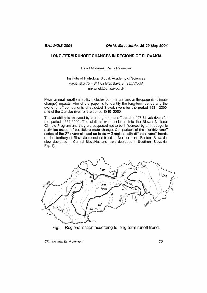
BALWOIS 2004 Ohrid, Macedonia, 25-29 May 2004
LONG-TERM RUNOFF CHANGES IN REGIONS OF SLOVAKIA
Pavol Miklanek, Pavla Pekarova
Institute of Hydrology Slovak Academy of Sciences Racianska 75 – 841 02 Bratislava 3, SLOVAKIA
Mean annual runoff variability includes both natural and anthropogenic (climate change) impacts. Aim of the paper is to identify the long-term trends and the cyclic runoff components of selected Slovak rivers for the period 1931–2000, and of the Danube river for the period 1840–2000.
The variability is analysed by the long-term runoff trends of 27 Slovak rivers for the period 1931-2000. The stations were included into the Slovak National Climate Program and they are supposed not to be influenced by anthropogenic activities except of possible climate change. Comparison of the monthly runoff series of the 27 rivers allowed us to draw 3 regions with different runoff trends on the territory of Slovakia (constant trend in Northern and Eastern Slovakia, slow decrease in Central Slovakia, and rapid decrease in Southern Slovakia; Fig. 1).
M. Dunaj
Váh
NitraHron
Ipeľ
Slan
á
Bodv
a
Hornád
Poprad
Uh
TopľaI.w
II.
III.
I.oI.e
Fig. Regionalisation according to long-term runoff trend.
Climate and Environment 35
BALWOIS 2004 Ohrid, Macedonia, 25-29 May 2004 The identification of different cyclic components of the runoff series is included. The length of the series allows to identify the 22-year cycles as maximum. By means of the longer runoff series of the Danube river it is shown that the more dry periods occurred in the central Europe and Slovakia in mid 19th century. The longer Danube series were used also to find the longer runoff cycles of about 31 and 46 years. The mean annual temperature in Europe was lower by 0.6°C in mid 19th century compared to 1990s. The temperature increase is put down to climate change impact. The driest period shown by Danube runoff series in mid 19th century occurred before the start of the climate change. Therefore it is probable that the long-term runoff variability has its own dynamics as well.
36 Climate and Environment
BALWOIS 2004 Ohrid, Macedonia, 25-29 May 2004
THE RIVER TEMPERATURE CHANGES FOLLOWS THE CLIMATE VARIABILITY
G. Gergov, Tz. Karagiozova
National Institute of Meteorology and Hydrology Sofia, BULGARIA
The temperature of the river water is a dynamical characteristic affected by the geophysical processes and climate characteristics of the catchment area, as well as the hydrological processes of the runoff formation and movement.
The knowledge about the river water is very important when the water losses for transpiration are concerned. One should add that the river pollution problems, the self purification, the potable water supply require this information also. We consider the temperature of the river water as a very important parameter for diversity of ecological studies and research.
It is a general practice to accept that the river water temperature is rather homogeneous across any profile because of the turbulent mass exchange. The temperature stratification is a matter of concern in limnology and oceanology studies mainly.
We have shown several basic regularities about the cyclic feature of the daily and seasonal changes or about the river water temperature and both the altitude of the catchment area (gradient 1°C per a 100 m.) and so on.
After the mean water temperatures on any hydrometric gauge stations are being determined the area patterns with equal temperatures are identified, thus drawing a map. It is a presumption that the river water temperatures inside a specific area are equal on any place, meaning that the temperature field is rather homogeneous. The mapping allowed to distinguish the river reaches, subjected to the anthropogenic impact.
The study and the map have been developed on the basis of the new hydrometric information data bank, composed recently by the authors.
Climate and Environment 37
BALWOIS 2004 Ohrid, Macedonia, 25-29 May 2004
LONG-TERM VARIABILITY OF PRECIPITATION IN REPUBLIC OF MACEDONIA
Nikola Slavov1, Tania Marinova1, Pece Ristevski2
1National Institute of Meteorology and Hydrology 66,
Tsarigradsko chaussee Sofia, BULGARIA 2Hydrometeorological Service, Skupi bb– Skopje,
Republic of MACEDONIA [email protected]
During the last century a great attention has been spared to the water resources of the territories of different countries in the world. In the last decades investigations were directed towards the long-term variability of precipitation in the basic regions of agricultural production. Among these investigations the results that indicate decreasing of precipitation amounts during the potential crop-growing season are of especially great interest because precipitation decreasing affects harmfully crop production and population feeding.
The purpose of the present work is to study the long-term variability of monthly precipitation sums for 5 representative meteorological stations in Republic of Macedonia: Skopje, Bitola, Prilep, Stip and Demir Kapija for the period 1925 – 2000. The duration and periodicity of precipitation variations are analyzed on the base of 5-years smooth values for different seasons, warm and cold half-year and for year. The tendencies of trend for the period 1925-2000 are found out.
38 Climate and Environment
BALWOIS 2004 Ohrid, Macedonia, 25-29 May 2004
METHODS FOR ASSESSMENT OF CLIMATE VARIABILITY AND CLIMATE CHANGES IN DIFFERENT TIME-SPACE SCALES
V.Lobanov, H.Lobanova
State Hydrological Institute, St.Petersburg, RUSSIA [email protected]
Main problem of hydrology and design support for water projects connects with modern climate change and its impact on hydrological characteristics as observed as well as designed. There are three main stages of this problem:
- how to extract a climate variability and climate change from complex hydrological records;
- how to assess the contribution of climate change and its significance for the point and area;
- how to use the detected climate change for computation of design hydrological characteristics.
Design hydrological characteristic is the main generalized information which is used for water management and design support. First step of a research is a choice of hydrological characteristic which can be as a traditional one (annual runoff for assessment of water resources, maxima, minima runoff, etc) as well as a new one, which characterizes an intra-annual function or intra-annual runoff distribution. For this aim a linear model has been developed which has two coefficients connected with an amplitude and level (initial conditions) of seasonal function and one parameter which characterizes an intensity of synoptic and macro-synoptic fluctuations inside a year.
Effective statistical methods have been developed for a separation of climate variability and climate change and extraction of homogeneous components of three time scales from observed long-term time series: intraannual, decadal and centural. The first two are connected with climate variability and the last (centural) – with climate change. Efficiency of new methods of decomposition and smoothing has been estimated by stochastic modeling and well as on the synthetic examples. For an assessment of contribution and statistical significance of modern climate change components statistical criteria and methods have been used.
Next step has been connected with a generalization of the results of detected climate changes over the area and spatial modeling. For determination of homogeneous region with the same climate changes indexes of such classification have been developed which included: statistical significance or
Climate and Environment 39
BALWOIS 2004 Ohrid, Macedonia, 25-29 May 2004 non-significance of climate changes, direction of climate change tendency in conditions of its statistical significance, assessment of its contribution and a form of the tendency if it enough complex over the time. In detected homogeneous regions the spatial generalization is fulfilled which includes different approach in dependence on regularities of spatial features. They are: an averaging, development of spatial distribution functions or spatial simulation. New spatial linear model has been developed and suggested which includes two coefficients connected with a gradient and a level of space field and one parameter which characterizes the internal inhomogeneity of the field.
The last step of the suggested methodology is a using of the detected point and field climate changes for determination of design hydrological value. Traditional design characteristics (as one random event in each year) as well as new ones (POT, rare extremes, characteristics of cycles of climate variability), which can be rare or often than one value per year have been chosen. Approach and methods for using of detected climate changes in hydrological computations have been developed.
Application of developed methods has been shown on some examples of different hydrometeorological characteristics (floods, low flow, annual runoff, monthly and annual temperature and precipitation) in some regions with different climatic conditions.
40 Climate and Environment
BALWOIS 2004 Ohrid, Macedonia, 25-29 May 2004 EVALUATION OF URBANIZATION EFFECTS ON CLIMATE CHANGE
OVER THE NORTH-EAST OF I.R. OF IRAN
Alireza Shahabfar, Javad B. Jamali, Azadeh Ramesh
Climatological Research Institute (CRI), I. R. of Iran Meteorological Organization P.O.Box: 91735-491,
Mashhad-I.R. of IRAN [email protected]
Several climatological studies shown that human activities such as urbanization, industrial developments have a great impact on changing of climatic parameters around the world, for example, exist of heat island over the large cities, increasing of global mean temperature, increasing of mean sea surface height.
In this research by the aim of evaluation of urbanization and industrial developments impacts on the surface air temperature trend and climate change in the North-East of I.R.of Iran an updated data set that have been observed and recorded by I.R.of Iran Meteorological Organization (IRIMO) since the late 1950s in Khorasan province at North-East of Iran have considered, Therefore, maximum, minimum and mean surface air temperature recorded, analyzed to reveal spatial and temporal patterns of long-term trends, change points, significant warming (cooling) periods and linear trend per decade. According to this research summer minimum temperatures have generally increased at a larger rate than in spring and autumn minimum temperatures. On the other hand, night-time warming rates of spring and summer are generally stronger than those that exist in spring and summer daytime temperatures. Considering the significant increasing trends in annual, spring and summer temperatures, it is seen that night-time warming rates are stronger in the northern regions, which are characterized by the Khorasan Province macroclimate type: a very hot summer, a relatively hot and late spring and early autumn, and a moderate winter. We have seriously considered the strong warming trends in spring and summer and thus likely in annual minimum air temperatures. It is very likely that significant and very rapid night-time warming trends over much of the province can be related to the widespread, rapid and increased urbanization in Khorasan Province, in addition to long-term and global effects of the human-induced climate change on air temperatures.
Climate and Environment 41
BALWOIS 2004 Ohrid, Macedonia, 25-29 May 2004 STUDY ON VARIABILITY OF TEMPERATURE AND PRECIPITATION
CONDITIONS IN THE SOUTH EASTERN BULGARIA
Ivanka Koleva-Lizama1, Bernardo Lizama Rivas2
1University of Forestry, Sofia, Bulgaria. Department of Ecology 10 bul. Kliment Ochridski, 1756 Sofia, BULGARIA
2National Institute of Meteorology and Hydrology, Sofia, BULGARIA, Department of Hydrology, 66 Tzarigradsko Shosse, 1784 Sofia, BULGARIA
Freshwater resources are an essential component of the earth’s hydrosphere and an indispensable part of all terrestrial ecosystems. The freshwater environment is characterized by the hydrological cycle. Global climate change and pollution could also have an impact on freshwater resources and their availability. There is now sufficient evidence, accepted by internationally respected scientists, that human activity is having an effect on the climate of the planet. The effects are mostly the result of greenhouse gas emissions, and are in addition to naturally occurring climate change. The impacts of climate change on water resources are displayed in every sector of water system. The temperature and precipitation are the most important factors which affect on water resources.
On the basis of meteorological data for more than 45 years from several gauging stations is made an analysis on the peculiarities of the climatic conditions in the south eastern Bulgaria. In order to trace the variability of historical precipitation and temperature series the analysis of trend and deviations from climate mean of recommended by WMO “climate normal” period – 1961 -1990 was used. Precipitation over the south eastern Bulgaria has a significant variability over wide range of temporal and spatial scales. The annual precipitation data were examined for evidence of a secular trend by calculation of a linear best fit for the 1952 to 2000. The tendency of rainfall decrease was determined. The drought period in the studied region is noticeable during the summer.
It should be concluded that temperature increase and precipitation decrease conduct to drought in the region and it may have more severe impacts on agriculture, water supply and society.
42 Climate and Environment
BALWOIS 2004 Ohrid, Macedonia, 25-29 May 2004
CHANGES IN EXTREME EVENTS IN THE SCENARIOS OF DOUBLING OR TRIPLING OF CO2
Constantin Mares1, Ileana Mares1, Ulrich Cubasch2
1National Institute of Meteorology and Hydrology, Sos. Bucuresti-Ploiesti, 97, Bucharest, 013686, ROMANIA
2 Meteorologisches Institut, Freie Universitat Berlin, Carl-Heinrich-Becker-Weg 6-10, D-12165, Berlin, GERMANY
The paper analyses the changes in the minimum, maximum, the difference between maximum and minimum (annual average) temperatures and precipitation amounts for the three cases: control, 2*CO2 and 3*CO2 time slice experiments (ECHAM3-T42).
Comparative analysis revealed that the increase of difference between maximum and minimum temperature over Central and Southern Europe is due to an increase of maximum values a little more than minimum values in the 3 integration relative to control experiment. T-test indicated a high significant level both for maximum and minimum values.
The observational trend of contrast of temperature in Romania, which indicates a slight increase in the last time, is in according with the time-slice experiments, namely in a part of Europe there is a significant increase of the contrast temperature. This slight increase of contrast between maximum and minimum temperature in Romania in the last time might be associated with a droughtiness period beginning with 1981 for which the absence of great cloudiness and moisture might explain this situation in the observational data.
Because many researchers consider that the temperature and precipitation combination a better index for climate changes, than the two field examined separately, we have analyzed the two fields together. Using monthly temperatures as well as precipitation amounts, a drought index has been calculated.
Regarding the combined analysis of the temperature and precipitation as a drought index, significant results have been obtained for the months of December, January, February, May, June, July and November, for which the impact of CO2 increase leads to an increase of drought frequency in the Romanian area, the geographical area location depending on the month.
Climate and Environment 43
BALWOIS 2004 Ohrid, Macedonia, 25-29 May 2004
CLIMATE CHANGE AND ITS IMPACT ON THE CRN DRIM CATCHMENT AREA IN MACEDONIA
Olivija Todorovik, Nina Stojanovska, Gorica Rikaloska
Hydrometeorological Service
Skupi bb, 1000 Skopje, Republic of MACEDONIA [email protected]
In this paper it will be presented the overview of the climate change and climate regimes of the world in general according different scenarios in the latest assessment (the 3rd Report published in 2001) of the Intergovernmental Panel on Climate Change (IPCC) and its impact on the Crn Drim catchment area in Macedonia.
This analysis and interpretation only provides a preliminary investigation into climate change and how it will affect Ohrid and Prespa lake system as a part of Crn Drim catchment area which is already attacked by the climate changed. From the climatological aspect two elements: temperature and rainfall, will be calculated and their expected changes over the century in the same area.
Date used in these analyses are from the Hydrometeorological Service of Republic of Macedonia archive. In the graphs are shown changes in average seasonal climate for the period around the 2080s, relative to 1961-1990 climate. Results are shown for the SRES A2 scenario, which assumes a future world of fairly conventional energy development, i.e., continuing dependence on fossil carbon fuels.
The projections for average seasonal climate for temperature and precipitation are estimated and shown separately for two seasons: winter and summer. The estimated values are compared with annual mean global worming for the 2080s, and for the SRES A2 scenario, as calculated by the IPCC (a velue of about 3.2 oC). The results show rate of worming greater in summer than in winter for Ohrid Lake as well as for Prespa Lake. Concerning the precipitation, it increases slightly in winter and decreases substantially in summer, by around 30 per cent.
As the conclusion it is obviously that the temperature will rise in all Crn Drim catchment area with implications for increasing water temperature and water quality which would be degraded by higher water temperature. This will increase evaporation and as the results can be expected water level decreasing. Also, higher temperatures and heat waves may change traditional summer tourism in very famous places in Macedonia Ohrid and Prespa Lakes.
44 Climate and Environment
BALWOIS 2004 Ohrid, Macedonia, 25-29 May 2004
ASSESSMENT OF CLIMATE CHANGE USING METHODS OF MATHEMATIC STATISTICS AND THEORY OF PROBABILITY
Lidija Trajanoska1, Ivancho Kaevski2,
1Hydrometeorological Service, Skupi BB, Skopje, Republic of MACEDONIA 2 Water Development Institute of Republic of MACEDONIA
In simple terms: “Climate” is the average of “weather”. The Earth’s weather system is a complex machine composed of coupled sub-systems (ocean, air, land, ice and the biosphere) between which energy are exchanged.
The understanding and study of climate change does not only rely on the understanding of the physics of climate change but is linked to the following question: “How we can detect change in a system that is changing all the time under its own volition”? What is even the meaning of “change” in such a situation?
The concept of “change” we should transform into the concept of “significant and long-term” then this re-phrasing allows for a definition in mathematical terms. Significant change in a system becomes a measure of how large an observed change is in terms of the variability one would see under ‘normal’ conditions.
Example could be the analyses of the yearly temperature of the air and precipitations, like in this paper .
A large amount of data are selected as representing the ‘before’ case (change) and another set of data are selected as being the ‘after’ case and then the average in these two cases are compared. These comparisons are in the form of ‘hypothesis tests’ in which one tests whether the hypothesis that there has been no change can be rejected. Both parameter and nonparametric statistic methods are used in the theory of mathematic statistic.
The most indicative changeable which show global change is an average, standard deviation and probability function distribution on examined time series. Examined meteorological series are taken like haphazard process so we can mathematic statistic applied.
Climate and Environment 45
BALWOIS 2004 Ohrid, Macedonia, 25-29 May 2004
EL-NINO/SOUTHERN OSCILLATION (ENSO) PHASE BASED MAPPING OF REGIONS AT RISK OF DROUGHT AND FLOOD
RELATED DISASTERS OVER THE EASTERN AND SOUTHERN AFRICAN SUBREGIONS
Abushen W. Majugu
Department of Meteorology,
P.O. Box 7025 Kampala, UGANDA [email protected]
The mapping of regions at high risk of drought and flood related disasters was based on analysed rainfall data for a thirty-year period (1961-90). The data consisting of about 650 rainfall stations were grouped into 127 homogeneous zones delineated by principal component analysis and zonally averaged monthly rainfall series worked out by taking a simple average based on the number of stations within each zone. Using the derived zonally averaged monthly rainfall series; thirty-year monthly percentile levels were worked out. Percentiles levels represent a kind of uniform spatial weighting of the impact levels corresponding to the external anomalous physical driving forces. Consequently, using percentile levels is a powerful tool in revealing the special and temporal extent, duration as well as the intensity of the anomalous external forcing. To map the regions at risk of ENSO phase based drought and flood related disasters percentile composites, averaged for the major El-Nino and Lanina episodes between 1961-90, were extracted and analysed.
The resulting maps indicate significant and persistent rainfall suppression and or enhancement over broad areas of the Eastern and Southern African sub-region during the two main phases of the ENSO cycle, that is the El-Nino and Lanina phases. These are the areas to be watched for potential ENSO based development and or occurrence of droughts and or floods. Thus these mappings coupled with the fact that the main tropical system with the highest inter-annual predictability potential is the ENSO forcing are becoming indispensable tools in planned and effective drought and flood related Disaster Management strategies.
46 Climate and Environment
BALWOIS 2004 Ohrid, Macedonia, 25-29 May 2004
TROPICAL NORTH AFRICA HYDROCLIMATE VARIABILITY
Abebe Yeshanew
National Meteorological Services Agency, P. O. Box 1090, Addis Ababa, ETHIOPIA. [email protected]
NCEP/NCAR data are used to study the modulating circulations of the hydroclimate of tropical North Africa. Wavelet analysis is used to identify modes of variability of stream flows within the region. Ocean-atmosphere circulation composites are considered to unravel the mechanisms for swing of stream flows.
The one of the main finding of the study reveals that hydroclimate variability swings within ENSO and decadal timescale. Pacific and Atlantic sea surface temperatures control the hydroclimate mode of variability. Associated to Pacific sea surface temperature, the Atlantic Walker Circulation modulates the hydroclimate swing of tropical North Africa. The detail result will be discussed.
Climate and Environment 47
BALWOIS 2004 Ohrid, Macedonia, 25-29 May 2004
INVESTIGATION OF THE MASS-ENERGY EXCHANGE IN THE REGION OF “KOPRINKA”LAKE
Julia Ivancheva, Anna Tzenkova
National Institute of Meteorology and Hydrology, Sofia, BULGARIA
The components of the mass-energy budget are the main factor responsible for the local climate variability. In the frame of the complex field experiments in the region of reservoir “Koprinka” the meteorological observations for studying the processes of mass-energy exchange were performed. In the present work the results for the heat balance calculations during the summer field experiment in 1989 are discussed. The turbulent fluxes are determined based on gradient measurements data from the temporary meteorological station operating during the period 1987-1990 and during.
48 Climate and Environment
BALWOIS 2004 Ohrid, Macedonia, 25-29 May 2004
EFFECTS OF CLIMATE CHANGE ON AGRICULTURE PARTICULARLY IN SEMI-ARID TROPICS OF THE WORLD WITH
SOME EXAMPLES OF ETHIOPIAN CONDITION
Almaz Demessie
Tropical Agricultural Development (Crop Protection) Ethiopian Meteorological Services Agency, ETHIOPIA
[email protected] Today climate change is a burning issue all over the world because of its global nature. Fears have arisen that, climate may be changing for the worse and its impact may be felt on agricultural production, which will reduce the supply of food to growing population, especially in developing countries. Climate change would affect various human activities. Agriculture is one of the activities, which can be seriously affected by climate change. Due to high inter-annual variability and uneven distribution of rainfall during the rainy season, recurrent droughts have been observed in semi-arid tropics of the world over the last three decades. As White (1996) pointed out rain fed agriculture in the semi-arid tropics is limited mostly by high climatic variability with principal limiting factor being rainfall. The main crops of traditional rain fed agriculture are sorghum, millet, maize, cowpea, pulses and sesame. There is a suggestion that increased CO2 will benefit temperate and humid tropical agriculture more than that in the semi-arid tropics. During the process of photosynthesis plant species with the C3 photosynthetic pathway tend to respond positively to increased CO2 while the C4 have a poor response. Since C4 plants are mostly tropical crops, the situation will be worst over the areas (Parry, 1990).
Climate change will alter the nature of occurrence of agricultural pests in terms of area. Warmer temperatures shorten the generation time; increase the development rate of epidemic. For example, assessment of the effect of global warming on the distribution of livestock disease suggests that pests at present limited to tropical countries, may spread into other parts of the world, which have different climatic condition (ibid).
Climate and Environment 49
BALWOIS 2004 Ohrid, Macedonia, 25-29 May 2004
THE MOUNTAINS INFLUENCE ON TURKEY CLIMATE
Serhat Sensoy
Turkish State Meteorological Service P.O.Box:401 – Kalaba – Ankara, TURKEY
Since the Black sea mountains at the north of the country and the Taurus mountains in the south lay parallel to the seashore and rise very sharply rain clouds can not penetrate to the internal part of the country. Rain clouds drops most of their water on the slopes opposite the sea. As rain clouds pass over the mountains and reach Central Anatolia they have no significant capability of rain. For this reason, the Central Anatolia does not have very much precipitation. The difference between the rates of precipitation on the inner and outer slopes seems to be effective on the expansion of plants. For example, there is a subtropical climate prevailing on the Black sea shore between Sinop and Batum where precipitation is more than 1000-2000 mm. yearly. Going from Sinop to the mouth of the Sakarya River the rate of precipitation goes down to 800-1250 mm in a year. Running from the Sakarya River to the western area covering Thrace the climate seems to be continental, and in the area dominant plant cover is of the Mediterranean type.
Since the succession of the mountains in Western Anatolia lay perpendicular to the seashore, rain clouds penetrate towards the inner regions for about 400 km. The continental climate with long, dry and summer affects this area. In the Eastern region of Anatolia, since the elevation of the mountains exceeds 2500-3000 m, valleys are disorderly scattered and located at high elevations, and the northern Black sea mountains and Caucasian mountains hold the rain clouds, the area is effected by the continental climate with long and very cold winters. Consequently precipitation at the Iğdır River goes down to 300 mm while it is 500-800 mm in most of areas and 1000-1500 mm in some regions towards northern Muş and Bingöl provinces.
As mentioned above, high mountains, which hold rain clouds, surround the Central Anatolia, which has caused drought in this region. In the central Anatolia covering Afyon, Eskişehir, Ankara, Çankırı, Çorum, Amasya, Kayseri, Sivas and Konya provinces precipitation is generally less than 500 mm.
Since southeastern Anatolia is under the effect of weather coming from the deserts in Syria, Iraq and Arab Peninsula, the summer season in this area is dry and hot.
50 Climate and Environment
Owing to the irregularity of its topography, various types of climate ranging from subtropical to cold or very cold climates as you move horizontally or vertically

BALWOIS 2004 Ohrid, Macedonia, 25-29 May 2004 characterize climate in Turkey. The driest regions are the Karaman, Iğdır and Şanlıurfa, where annual rainfall frequently is less than 300 millimeters. The wettest regions are the Black Sea coastal regions where annual rainfall can reach 2,200 millimeters annually.
Climate and Environment 51
BALWOIS 2004 Ohrid, Macedonia, 25-29 May 2004
SOME PARTICULARITIES OF RAINFALL VARIABILITY IN A TRANSITION CLIMATE : CASE OF THE DEPARTMENT OF THE
ZOU IN BENIN - WEST AFRICA
Ibouraïma Yabi, Fulgence Afouda, Michel Boko
Laboratory of Study of the Climates, Water Resources and Dynamics of Ecosystems (LECREDE)
Department of Geography of the University of Abomey-Calavi (Bénin) BP : 526 Abomey, CALAVI
The field of study is located in the middle Benin. It corresponds to the field of transition between the subequatorial climate to the south and the Soudanian climate in the north.
The basic conviction is that to measure the climatic changes which occur, it is necessary to look at the changes in the zones of margin.
We thus examined some of meteorological events such as pluviometric regime, the monthly concentration of the rains, the beginning and end of the rainy season, events which contrast with those of the framing facies climatic, which enabled us to know in which direction the changes take place.
The following reports were made:
There is a greater concentration of the rains over the wet months (June, July, August and September)
The inflection of the rains of August tends to disappear so that this month . It is wet This way, the bimodal style tends to disappear in favor of the unimodal, which confirms the CV (coefficient of variation) of which the low value shows a certain stability.
the volume of the rains in beginning as at the end of the wet period decreased almost everywhere in the band.
In fact there reports make think of the Soudanian climate and one can wonder whether the Soudanian does not tend to impose its rate/rhythm on this latitude. Anyway the assumption of a climatic change rate tends to prove correct. One can wonder how long this tendency will last.
52 Climate and Environment
BALWOIS 2004 Ohrid, Macedonia, 25-29 May 2004
ASSESSMENT OF EFFECTS OF CLIMATE CHANGE ON CATASTROPHIC FLOODS IN MOUNTAIN
V. Muchin
Hydrometeorological Centre of Russia, 9, Bol. Predtechenski per, Moscow, RUSSIA
The method, which has united model of formation thawed and rainfall runoff in river basins and a way of designing of the meteorological scenarios, simulating climate change, was applied to realization of these researches.
The decisions of three hydrological tasks was taken into consideration: 1) estimation of runoff reaction of on uniform within a year increase or downturn of air temperature in limits of ±2ºC; 2) estimation of runoff reaction on strengthening climate continentality - downturn of air temperature during snow cover accumulation (cold period) and the increase of air temperature in warm period (includes the period of snow melting) at preservation of annual air temperature at a modern level; 3) revealing of meteorological conditions leading to occurrence of danger on water object in the case of climate change.
The mountain rivers of Tien Shan, Altai and Urals were investigated.
The strengthening of climate continentality can result (with other equal conditions) in occurrence of catastrophic situations at increase of average height of basin and simultaneous increase of precipitation, as the maximal discharge can grow 8-10 times. The reaction of plane rivers much less and the maximum discharges grow 3 – 4 times.
Climate and Environment 53
BALWOIS 2004 Ohrid, Macedonia, 25-29 May 2004
CHANGES OF HYDROLOGICAL CYCLES IN LAND AND ATMOSPHERE IN EUROPE AND ASIA IN CASE OF
DEFORESTATION OF SIBERIA (RESULTS OF GCM NUMERICAL EXPERIMENTS)
Konstantin G. Rubinstein1, Andrey B. Shmakin2
1Hydrometeorological Centre of Russia, Bol.Predtechensky per, 9 -13, Moscow 123242, RUSSIA 2Institute of Geography, Russian Academy of Sciences,
StaromonetnySt., 29, Moscow 109017, RUSSIA [email protected].
A new parameterization scheme of land hydrology was introduced into GCM of Hydrometeorological Centre of Russia. In this paper a short description of GCM and the scheme and their main parameters is given, as well as some results of experiments are discussed. It was analyzed hydrological balance in Atmosphere above Euro-Asia continent in two experiments. One of them we call "Control” and other "Siberian". It differs only in type of vegetation and soil in Siberian region. It was shown that in case of "Siberian deforestation" experiment average summer precipitation and evaporation became detectable less. In region of Caspian sea precipitation and a little evaporation grow. As consequence it is possible to see changes in season changes of runoff Siberian and Caspian Sea basins. Runoff Siberian rivers decrease (as example we show result of Lena basin) and runoff Caspian basin increase.
54 Climate and Environment
BALWOIS 2004 Ohrid, Macedonia, 25-29 May 2004
APPEARANCE PROBABILITY OF CERTAIN PRECIPITATION QUANTITIES AND TEMPERATURE SUMS > 10 0S DURING THE
GROWING PERIOD
Blaga Dimitrovska, Zoran Dimitrovski, Pece Ristevski,
Hydrometeorological Service, Skupi BB, 1000 Skopje, Republic of MACEDONIA
In this paper are given probabilities for determined precipitation amounts existence and temperature sums >100S (in percentages) for fifteen measure stations in the Republic of Macedonia for the vegetative period of the year (from 1-st of April until 31. of Oktobar) and for period 1951 – 2000.
Using the precipitation amounts and sums of temperatures >100S for the vegetative period of the year we, calculated hydrotermic coefficient (HTC) by Seljaninov for each year of the period 1951 – 2000.
From the HTC values we categorized the drought for each measure station using criteria by S.Otorepec.
Calculating the probabilities for determined precipitation amounts existence and temperature summes > 100S occurance is very important for water balance calculation, irrigation norms etc.
Climate and Environment 55
BALWOIS 2004 Ohrid, Macedonia, 25-29 May 2004 CHARACTERISTICS OF THE PRECIPITATION VALUES BY SEASON
AND BY YEAR SHOWN THROUGH SUMMARY PROBABILITY, BY GAUSS LOW FOR NORMAL DISTRIBUTION IN REPUBLIC OF
MACEDONIA FOR THE PERIOD 1951-2000
Nina Aleksovska, Pece Ristevski, Snezana Todorovska
Hydrometeorological Service Skupi bb 1000 Skopje Republic of MACEDONIA
On the territory of the Republic of Macedonia there are few types of rainfall regimes: Mediterranean, changed Mediterranean, changed Continental and Continental rainfall regime. In the period between 1951-2000 year, there were few significant climate variations of the pluviometric conditions in many parts of the world. These climate variations also happened on the territory of Republic of Macedonia.
In the work are shown summary probabilities of the changes in seasonal, monthly and yearly values of the precipitation in the net of the main meteorological - climatological stations (with professional observers) by Gauss low for normal distribution with repeats from 5% to 95% on every 5%, resulting in classification within values of 5%, 50% and 95% repeats as well as values in between the highest and lowest values of the summary probability.
Also there are isohyets maps for average, most rainy and most dry year as characteristics of pluviometric regime, witch are necessity for defining of the climate and hydrometeorology conditions of the catchments areas in Republic of Macedonia.
56 Climate and Environment
BALWOIS 2004 Ohrid, Macedonia, 25-29 May 2004
INTENSITY OF THE EXTREME RAINFALLS IN THE REPUBLIC OF MACEDONIA
Ivan Blinkov
University “St. Cyril and Methodius”, Faculty of forestry – Skopje,
bul.”Alexandar Makedonski “bb. 1000 Skopje , Republic of MACEDONIA [email protected]
The object of this research is the analysis of intensity of rainfalls with different duration and returning period over the Republic of Macedonia.
There are 8 meteorological stations in the Republic of Macedonia that have long-term (> 30years) pluviograph data. This data was completed and generated in some previous analyses.
Maximal daily (24 hours) values of rainfalls registered with Helmans totalizers, in Macedonia are 188 mm (g.s. Popova Sapka in 1979), and 175 mm (g.s. Demir Kapija) in 1995. Maximal observed values of rainfall with different duration on the up mined 8 pluviometric stations for the whole territory of Macedonia are as follow :
Rainfall duration in minutes measure
unit 5' 10' 20' 40' 60' 90' 150' 300' 720' 1440'
mm 15.10 *26.20 *39.90 *54.70 *69.10 *78.00 *90.00 *92.50 *111.2 113.90
mm/min 3.02 2.62 2.00 1.37 1.15 0.87 0.60 0.31 0.15 0.08
Probability of their occurrence have been estimated testing and using difference distribution (Gumbel, Galton, Pirson, Freget, Bernoulli, Gauss).
For that purpose the intensity of rainfall with different returning period (0,1-50%) and duration (5-1440’) has been processed. In the follow table , theoretically estimated extreme rainfalls with 1% probability of occurrence on difference area in RM are presented.
Rainfall duration in minutes measure
unit 5' 10' 20' 40' 60' 90' 150' 300' 720' 1440'
mm 17.25 28.94 39.49 48.27 51.71 62.27 70.52 76.31 94.89 110.77
mm/min 3.45 2.89 1.97 1.21 0.86 0.69 0.47 0.25 0.13 0.08
After that, the intensity of the rainfalls expressed as [mm/min] and [l/s.ha] was estimated. The results have been used to draw the diagrams of intensity of
Climate and Environment 57
BALWOIS 2004 Ohrid, Macedonia, 25-29 May 2004 rainfall for all 8 main meteorological stations in the Republic of Macedonia that have long-term pluviografic data.
Based on the scatter diagrams some functions was defined. These functions in fact show correlation between rainfall intensity and their duration ( i = f (t)).
This paper give 2 benefits.
Firstly, the results are contribution to defining spatial-time defining of the extreme rainfalls in the Republic of Macedonia.
Secondary, the results of this research gives us the opportunity, using the proper method, to define the probability of torrential rains in particular watersheds and to estimate real maximal water discharge with difference occurrence.
58 Climate and Environment
BALWOIS 2004 Ohrid, Macedonia, 25-29 May 2004
THE INTERANNUAL RHYTHM OF RAINFALL IN MACEDONIA
Jean-Claude Klein
IRD 911, Avenue Agropolis BP 64 501 34394 - Montpellier Cedex 5 FRANCE
Annual rainfall analysis of some stations of Macedonia (1925-2000) shows no evidence of any longterm trend throughout the XXth century, but highlights the occurrence of a decadal scale rhythm.
This rhythm seems to characterize the whole Macedonia, without appearing in gauges farther away in the Balkan Peninsula. We will try to characterize and examine the possible causes of such a rhythm.
Climate and Environment 59
BALWOIS 2004 Ohrid, Macedonia, 25-29 May 2004
DRYNESS AND ARIDITY OF CLIMATE IN THE REPUBLIC OF MACEDONIA
Silvana Stefkova, Lidija Trajanoska
Hydrometeorological Service, Skupi bb 1000 Skopje, Republic of MACEDONIA [email protected]
One of the worst natural phenomenous, which have often (specially during the last ten years) appearance on the territory of Macedonia, is drought.
According the type, there is three type of droughts: atmospheric, hydrologic and agronomic.
It is very often to take for the dryness and aridity to be the same, but it isn’t.
Aridity is define like general and for long period climatic characteristic for some territory with little quantity of the precipitation, high air temperature, great evaporation and small hydrographic net. On the other hand, dryness is such a period of the year which is without precipitation, because of the atmospheric conditions, solar, geographic and anthropogenesis factors.
This paper contains: Definition of terms Dryness and Aridity; Regions with arid climate compared with other regions in Macedonia; Data for the period 1971-2000 have been used.
60 Climate and Environment
BALWOIS 2004 Ohrid, Macedonia, 25-29 May 2004
RADAR IDENTIFICATION AT THE FRONTAL CONVECTIVE CLOUDINESS SYSTEMS
Lena Jovanovska
Hydrometeorological Service of Macedonia Skupi b.b.1000 Skopje, Republic of MACEDONIA
In this study have been analyzed two characteristics cases at storm of the frontal character, occurred in Macedonia on May 18 and 21, 2003. Also to give a graphic interpretations at the characteristics radars parameters at the single out clouds parts from cloudiness systems.
Measured radar parameters of convective clouds are variable values and special contribution to their evolution have the synoptically and thermodynamical conditions. Also the orography has large contribution in evolution and transformation of the cloud mass, their movement with large speed and intensive precipitation of rainfall and hail.
Climate and Environment 61
BALWOIS 2004 Ohrid, Macedonia, 25-29 May 2004
THE EFFECTS OF EXCEPTIONAL HEAVY RAINFALL ON THE ALLUVIAL GROUNDWATER TABLE OF TEBESSA
L. Djabri1, R. Laouar2, A. Hani2
111 Rue Asla Hocine, 23000 Annaba, ALGERIA 2Département de Géologie, FST, Université Badji Mokhtar Annaba,
B.P. 12, 23000 Annaba, ALGERIA [email protected]
The study area is characterized by a semi-arid climate where the average rainfall does not exceed 350mm per year. During the hydrogeological year 2002-2003, the total precipitation reaches 600mm and the usually driest period, from May to August, has known an exceptional rainfall of 294mm; that is, 60% of yearly rainfall records.
This amount of precipitation had a direct positive effect on water quality and quantity of the alluvial groundwater table. The recharge has, therefore, resulted in an increase of the water table level on one hand, and on the other hand, contributed to a marked decrease of chemical element concentrations (mineralization). This is followed by a decrease of salt contents (natural dilution) of the groundwater.
62 Climate and Environment
BALWOIS 2004 Ohrid, Macedonia, 25-29 May 2004
THE FREQUENCY OF PRECIPITATION DAYS IN THE YANGTZE CATCHMENT FROM 1950 TO 2000
Wu Yijin1, Stefan Becker2, Jiang Tong3, Heike Harmann2, Su BuDa3
1The Institute Of Historical Geography, Wuhan University, Wuhan 430072,
CHINA 2Geographisches Institut, Justus-Liebig-University, Giessen, GERMANY
3Nanjing Institute of Geography and Limnology, CAS, Nanjing 210008, CHINA [email protected]
This paper explores the frequency of precipitation days by using different percentiles in the Yangtze river catchment from 1950 to 2000. Some interesting facts have been revealed through the present study.
The positive (increasing) trends of the yearly precipitation days at the 75th percentile appears in most of the Yangtze river catchment, especially in the northern regions of the upper and the middle reaches of the catchment. The Sichuan basin is the only region with negative trends. The transitional area from negative to positive trends is found east of the Sichuan basin in the Three Gorges area. For the 95th percentile, the negative trend regions are still mainly in Sichuan basin but extend to northern regions and there are also obviously increasing trend centers in the middle and lower reaches of Yangtze river catchment.
On the decadal time scale, the most significant positive trends at the 75th percentiles are in the middle reaches in 1980s and 1990s. The lower reaches show significant positive trends in 1980s. Those positive phases greatly contribute to the positive trends of the whole catchment during the last two decades. The most significant negative phase also occurs in the middle reaches during the earlier three decades. For this case, it seems that the precipitation days in the middle reaches are more sensitive to changes than other regions in the Yangtze river catchment. Take the Yangtze river catchment as a whole, a positive trend is very obvious for this percentile.
For the 95th percentile, the trends between the middle and lower reaches of the Yangtze river catchment are coherent: after two decades (1960s and 1970s) of negative phases, the most significant increasing trend is shown in the last two decades. On the other side, the fluctuation of the precipitation days in the catchment of the upper reaches over the 50 years is somewhat smoother than for other regions. For the whole catchment, the precipitation days in the 1950s and in the 1990s are at positive phase which indicates the frequent heavier precipitation events in those periods.
Climate and Environment 63
BALWOIS 2004 Ohrid, Macedonia, 25-29 May 2004 The precipitation days at the 75th percentile increase more obviously than that at the 95th percentile in the whole catchment compared the 75th with the 95th percentiles. This result indicates that an increasing precipitation in the recent two decades is mainly caused by excessive precipitation. The heavier precipitation events occur mainly in the upper reaches in 1960s, in the middle and lower reaches in the 1950s, 1980s and 1990s.
According to the different trends at different percentiles, the variation of yearly precipitation days can be classified as the following types: Type 1: the increasing trend at 75th percentile but decreasing trend at 95th percentile. Type 2: decreasing trends of yearly precipitation days for both percentiles. Type 3: increasing trends of yearly precipitation days for both percentiles.
The analysis of interdecade circulation also shows the different climatic anomalies centered mainly in the 1950s, the 1980s and the 1990s. Similar patterns of circulation can be found over the middle and lower reaches of the Yangtze river catchment in the above two periods. Those patterns may explain why floods could occur in the 1950s and in the recent decade.
64 Climate and Environment
BALWOIS 2004 Ohrid, Macedonia, 25-29 May 2004
HYDROENERGETIC CAPACITY OF THE DRINI RIVER AND THE ENVIRONMENTAL IMPACT CONSIDERATIONS
Bashkim Spahiu1, Yllka Spahiu2
1Institute of hydroenergetic research and design 2Institute of Pedagogical Study Tirana, ALBANIA
In terms of water specific capacity Albania is considered among the countries of the first place in Europe. Approximately 1500 mm of atmospheric rain rains per year that makes at about 26 milliard m3 of water without considering the process of evaporation. This water flows from the rivers to the sea and it makes 70% of yearly flow of the Albanian hydrography network.
Although a very good work on the water use is done in Albania, some rivers and their branches are unexplored and left out of the study. The detailed study of them is very important to create a full idea within the hydro-energetic use framework and to forward the studies on infrastructure and its reconstruction, on the development of rural area, on the building of different hydro-technical and reclamation objects, on community and fishery and tourism needs, etc.
These studies are very important because more than 90% of the electricity production in Albania is taken from the water sources.
Climate and Environment 65


BALWOIS 2004 Ohrid, Macedonia, 25-29 May 2004
66 Hydrological regimes and water balances
BALWOIS 2004 Ohrid, Macedonia, 25-29 May 2004
TOPIC 2 : HYDROLOGICAL CYCLE AND WATER BALANCES
Hydrological regimes and water balances 67
BALWOIS 2004 Ohrid, Macedonia, 25-29 May 2004
WATER BALANCE OF THE REPUBLIC OF CROATIA : ACHIEVEMENTS AND NECESSITIES
Ognjen Bonacci1, Bojana Horvat2
1Civil Engineering Faculty, University of Split
Matice hrvatske str. 15 - 21000 Split; Croatian Waters, VGO Rijeka, CROATIA 2Đure Šporera 3 - 51000 Rijeka, CROATIA
The paper presents recent results of water balance of the Republic of Croatia based on definition of average values for the thirty years period from 1961 to 1990. The long-term mean hydrological balance for the seventeen watersheds is presented as P-Q=ET, where P is average annual precipitation in a watershed, Q is average annual runoff from the watershed, and ET is average annual evapotranspiration (runoff deficit) from a watershed given in mm and m3/s. The simplified water balance according to given equation does not consider the distribution of hydrological variables into components as well as: variation of water storage within the catchment; water volumes infiltrating in or flowing out from the deep strata, etc. Most of the runoff data is based on the measured values, while the dispersed surface water and groundwater flows are estimated using regional analyses. The annual average precipitation is 1162 mm or 2083 m3/s. The annual average inner water runoff is 461 mm or 827 m3/s, while transit water runoff is 2303 mm or 4130 m3/s. Croatia is the country rich in water with unevenly (in space and time) distributed water resources due to extremely variable geological setting (karst and flatland) and different climatic conditions (Mediterranean and continental climate).
68 Hydrological regimes and water balances
BALWOIS 2004 Ohrid, Macedonia, 25-29 May 2004
STREAMFLOW CHARACTERISTICS OF EUROPEAN PART OF TURKEY
Hafzullah Aksoy, N. Erdem Unal, M. Deniz Itibar, Ahmad M.S. Dahamsheh, Lutfu Kaynar
Istanbul Technical University, Department of Civil Engineering, Hydraulics
Division 34469 Maslak, Istanbul, TURKEY [email protected]
The European part of Turkey, the Thrace region was selected as the study area. The region is of agricultural importance for the country and hence irrigational water demand increases in summer when most of the rivers in the region have no flow. Two gauged hydrological basins were selected. The rivers on which the stations are installed are in the Ergene river basin, the most important river in the region. The first station is on Hayrabolu River, a tributary of Ergene whereas the second station is on the Ergene River itself. The Ergene River joins Meric (Evros, Maritsa), a boundary river between Turkey and Greece with an upstream area in Bulgaria.
The aim in this study is the analysis of the stream flow characteristics of the European part of Turkey. For this, following tests were used.
Consistency test is applied to see if the stream flow time series is consistent. The double mass curve, which is a procedure based on the comparison of cumulative values of two data sets in a diagram form, one of the data sets being consistent, while the other is suspect was chosen for testing the consistency of the time series.
Randomness test is used to check the randomness of the time series. For this, a non-parametric test based on run analysis was chosen.
Jump test was performed by the automatic segmentation procedure and split sample test. Automatic segmentation breaks the time series into as many segments as possible.
Trend test was performed by the non-parametric Spearman Rank Order Correlation test. This test is preferred by the World Meteorological Organization (WMO) for the trend detection.
The Probability Plot Correlation Coefficient (PPCC) test was used to determine if any selected probability distribution is suitable for the observed data.
The selected gauging stations were found with consistent annual stream flow data for 26 years from the beginning to the end of observation period (1969-1994). It has also been found that both rivers are of random structure with no
Hydrological regimes and water balances 69

BALWOIS 2004 Ohrid, Macedonia, 25-29 May 2004 influence. No jump was observed in both rivers. However, both stations have data sets with negative trend. Results for the probability distribution goodness-of-fit test show stations with zero-skew distributions.
70 Hydrological regimes and water balances
BALWOIS 2004 Ohrid, Macedonia, 25-29 May 2004
HYDROLOGICAL PECULIARITIES OF HIGH MOUNTAIN BASINS : THE CASE OF THE SPANISH PYRENEES
Cesar Ferrer Castillo1, Justo Mora Alonso-Muñoyerro2, Miguel Arenillas Parra3, Guillermo Cobos Campos4
1Confederación Hidrográfica del Ebro (Ministerio de Medio Ambiente), SPAIN
2Dirección General de Obras Hidráulicas y Calidad de las Aguas, del Ministerio de Medio Ambiente SPAIN
3Universidad Politécnica de Madrid, SPAIN 4Universidad Politécnica de Valencia, SPAIN
The exploitation of a reservoir is determined by the availability of information within which the information provided by hydrological information systems must be included. This should be complemented, especially in flood circumstances, by meteorological forecasts and the results obtained by from hydrological and hydraulic simulation and forecasting models.
In mountain basins with marked influence of snow, specific hydrological modelling is necessary, permitting simulation of the phenomenon of snow runoff.
In particular, the hydrology of the basin of the River Ebro (Spain), is clearly influenced by this phenomenon. This basin is affected by flood situations caused by rapid melt of the snow accumulated on its Pyrenean slopes. This has brought about the need for a specific study to be undertaken in order to facilitate greater understanding and control. Additionally, the volume of accumulated snow in the catchment areas determines the management and everyday exploitation of the reservoirs for the achievement of maximum yield from water resources.
This interest in the understanding of snow phenomena has given rise to numerous studies in the Pyrenean area: field study campaigns to carry out point measurements of thickness and density, hydrological-statistical modelling for the forecasting of melts and course flows and the development and application of hydrological simulation models.
In the Pyrenean slopes basin the ASTER model has been applied to the reservoir of Yesa during a period of more than five years, achieving quite satisfactory results with regard to watercourse flow forecasting and the volume of water stored in the form of snow. This has enabled appropriate management
Hydrological regimes and water balances 71

BALWOIS 2004 Ohrid, Macedonia, 25-29 May 2004 of the reservoir during flood circumstances - minimising possible damage as well as under everyday conditions.
The results obtained from this period have led to the generalisation of the ASTER model to apply to all sources of the Pyrenean tributaries of the Ebro with clear snow influence and, finally its integration in the SAD system (Decision Assistance System).
72 Hydrological regimes and water balances
BALWOIS 2004 Ohrid, Macedonia, 25-29 May 2004
TRANSBOUNDARY WATER ISSUES : THE GANGA-BRAHMAPUTRA-MEGHNA RIVER BASIN
Debasri Roy, A.B. Goswami, Balaram Bose
School of Water Resources Engineering, Jadavpur University, Kolkata 700032, INDIA
Sharing of water of transboundary rivers among riparian nations has become a cause of major concern in different parts of the globe for quite sometime. The issue in the recent decades has been transformed into a source of international tensions and disputes resulting in strained relationships between riparian nations .Conflicts over sharing of water of the international rivers, like the Tigris, Euphrates & Jordan in the Middle East, the Nile in Northern Africa, the Mekong in South-East Asia, the Ganga-Brahmaputra-Meghna in the Indian subcontinent are widely known. The present paper discusses the water sharing issue in the Ganga- Brahmaputra- Meghna basin located in the Indian sub continent covering five sovereign countries (namely India, Nepal, China, Bhutan & Bangladesh).
Rapidly growing population, expanding agricultural & industrial activities besides the impacts of climate change have resulted in stressed condition in the arena of fresh water availability in the basin. Again occurrence of arsenic in sub-surface water in the lower reaches of the basin in India & Bangladesh has also added a new dimension to the problem. All the rivers of the GBM system exhibit wide variations between peak and lean flows as major part of the basin belongs to the monsoon region, where 80%-90 % of annual rainfall is concentrated in 4-5 months of South -West monsoon in the subcontinent. Over & above, the rivers in GBM system carry huge loads of sediments along with the flood water and receive huge quantum of different kinds of wastes contaminating the water of the rivers . Again high rate of sedimentation of the major rivers and their tributaries have been affecting not only the carrying capacity of the rivers but also drastically reduced their retention capacity. Almost every year during monsoon about 27% and nearly 60% of the GBM basin lying in India & Bangladesh respectively experience flood. The year round navigation in many rivers has also been affected. All these have serious impacts on the economy of this geo-politically sensitive region.
Hydrological regimes and water balances 73
It was found that the total water resource of the GBM river system would be unable to meet the prevailing water requirements of the basin, not to speak of the rise in demand of water in the future. It was established that the judicious water demand management and effective control of the over-use, misuse & abuse of water in the respective river basins in each country should get

BALWOIS 2004 Ohrid, Macedonia, 25-29 May 2004 preference over competition for access to additional supply of water to meet the requirements & also adoption of technology which helps that goal to achieve should be made.
74 Hydrological regimes and water balances
BALWOIS 2004 Ohrid, Macedonia, 25-29 May 2004
PRECIPITATION ON THE ADRIATIC COST AND ISLANDS IN CROATIA
Janja Milković
Meteorological and hydrological Service of Croatia Grič 3, 10000 Zagreb, CROATIA
Mean monthly and annual amount of precipitation for the 69 meteorological stations situated on the Adriatic coast and islands are analysed. The data are for the period 1961 – 1990. For the 12 stations in the same area exist also data series for the period 1931-1960. As the first step the basic characteristics of the precipitation course as well as coefficient of variation are analysed. The results show that the mean annual amount of precipitation are changes from 304 mm on the Palagruža island on the south part to 1561 mm in Rijeka on the north part of the region. Most part of the annual amount of precipitation (from 53% on the north to 69% on the south part) we can occur in the cold part of the year, mainly in November and December. For r the 12 selected stations comparison between two data series (1931-1960 and 1961 –1990) shows that there are some changes in the mean annual course of precipitation.
Hydrological regimes and water balances 75
BALWOIS 2004 Ohrid, Macedonia, 25-29 May 2004 AN EVALUATION OF THE RELATION BETWEEN THE REFERENCE
EVAPOTRANSPIRATION, CALCULATED AFTER THE FAO PENMAN-MONTEITH МETHOD AND THE EVAPORATION RATE
FROM AN OPEN WATER SURFACE IN BULGARIA
Nicola Slavov1, Milena Moteva2
1National Institute of Meteorology and Hydrology, BAS 66 Tzarigradsko Shosse, Blvd., 1784 Sofia, BULGARIA
2Research Institute of Land Reclamation and Agricultural Mechanization, NCAS 3 Shosse Bankya, 1080 Sofia, BULGARIA
Recently, the United Nations Food and Agricultural Organization (FAO), supported by the International Commission on Irrigation and Drainage (ICID), has recommended a revision of the methodologies for estimating the crop water requirements. Basing on series of existing studies all related to them parameters and calculating procedures were revised and a new methodology for estimating the evapotranspiration rate with the FAO Penman-Monteith equation was proposed.
The paper deals with the adequacy between the evapotranspiration rate calculated after the recommended FAO procedures and the measured at the Central Meteorological Station in Sofia evaporation rate from an open water surface with the WMO allowed standard pans.
76 Hydrological regimes and water balances
BALWOIS 2004 Ohrid, Macedonia, 25-29 May 2004
ESTIMATING REFERENCE EVAPOTRANSPIRATION AT FRENCH HUMID LOCATIONS BY MODIFIED HARGEAVES METHOD
Slavisa Trajkovic
Faculty of Civil Engineering, University of Nis 14, Aleksandra Medvedeva, Nis, SERBIA and MONTENEGRO
The International Commission for Irrigation and Drainage (ICID) and Food and Agriculture Organisation of the United Nations (FAO) have proposed using the Penman-Monteith method as the standard method for estimating reference evapotranspiration, and for evaluating other methods. The basic obstacle to widely using the FAO-56 Penman-Monteith method is the numerous required weather data that are not available in the most of the stations. Most of stations simply measure rainfall and temperature. FAO has proposed that when sufficient data to solve the FAO-56 PM equation are not available then Hargreaves method can be used. This method is one of the simplest empirical equations used to estimate reference evapotranspiration. However, this method generally overestimated ETo at humid locations. The modified Hargreaves method (MOD-HARG) was developed by using data from Western Balkan sites. The main purpose of this research is to evaluate the reliability of modified Hargreaves approach as compared to the FAO-56 PM method by using data from French humid locations. The data from thirty-seven humid locations from France were used for the verification of MOD-HARG method. This data set was obtained from CLIMWAT database. The data represents the long-term monthly average values for maximum and minimum air temperature, solar radiation, mean relative humidity, wind speed, and ETo computed by the FAO-56 PM method. The ETo values obtained by HARG and MOD-HARG were compared with the FAO-56 PM estimates. The HARG method greatly overpredicted FAO-56 PM values at all sites except some coastal sites. The average overestimating was 11%. As a result, HARG gave very high standard error of estimate (SEE) at all locations. The SEE varied from 0.15 mm day-1 for Bolougne to 0.74 mm day-1 for Gourdon, averaging 0.40 mm day-1. The twenty-nine sites gave the SEE higher than 0.25 mm day-1. Estimates by MOD-HARG were in closest agreement with FAO-56 PM estimates at most of locations. The SEE ranged from 0.06 mm/d for Rennes to 0.38 mm/d for Cannes, averaging 0.18 mm day-1. There only are five out of thirty-seven locations with SEE higher than 0.25 mm day-1. These results strongly support the use of the modified Hargreaves method at humid locations when only temperature data are available.
Hydrological regimes and water balances 77
BALWOIS 2004 Ohrid, Macedonia, 25-29 May 2004
IDF-CURVES FOR PRECIPITATION IN BELGIUM
Bernard Mohymont, Gaston R. Demarée
Royal Meteorological Institute of Belgium Department of Meteorological Research and Development 3,
Avenue Circulaire, B-1180 Brussels, BELGIUM [email protected]
The Intensity-Duration-Frequency (IDF) curves for precipitation constitute a relationship between the intensity, the duration and the frequency of rainfall amounts. The intensity of precipitation is expressed in mm/h, the duration or aggregation time is the length of the interval considered while the frequency stands for the probability of occurrence of the event. IDF-curves constitute a classical and useful tool that is primarily used to dimension hydraulic structures in general, as e.g., sewer systems and which are consequently used to assess the risk of inundation.
In this presentation, the IDF relation for precipitation is studied for different locations in Belgium. These locations correspond to two long-term, high-quality precipitation networks of the RMIB: (a) the daily precipitation depths of the climatological network (more than 200 stations, 1951-2001 baseline period); (b) the high-frequency 10-minutes precipitation depths of the hydrometeorological network (more than 30 stations, 15 to 33 years baseline period). For the station of Uccle, an uninterrupted time-series of more than one hundred years of 10-minutes rainfall data is available. The proposed technique for assessing the curves is based on maximum annual values of precipitation. A new analytical formula for the IDF-curves was developed such that these curves stay valid for aggregation times ranging from 10 minutes to 30 days (when fitted with appropriate data). Moreover, all parameters of this formula have physical dimensions.
Finally, adequate spatial interpolation techniques are used to provide nationwide extreme values precipitation depths for short- to long-term durations with a given return period. These values are estimated on the grid points of the Belgian ALADIN-domain used in the operational weather forecasts at the RMIB.
78 Hydrological regimes and water balances
BALWOIS 2004 Ohrid, Macedonia, 25-29 May 2004
HYDROLOGICAL REGIMES IN BALKAN AREA
Viorel Alexandru Stanescu
National Institute of Hydrology and Water Management (97, Sos Bucuresti-Ploiesti, Bucharest 013686, ROMANIA
Physical considerations of the deemed area are first considered in the paper. Then the regime types around the Balkan rivers are described in terms of the following characteristic features :
- Types of the regimes defined by the timing of the high and low flow phases;
- Regionalisation of the “micro-types”
- Stability of the river flow regimes.
The available mean monthly discharge data of the representative rivers allows characterising the river regime of the Balkan area covered by WOISYDES and BALWOIS projects. The classification of the hydrological regimes (types of regimes) was done by assessing the discriminant periods (descriptors of the regime phases) defined by the first, the second and the third highest and lowest monthly values of flows.
As sufficient data has been provided by countries involved in the Woisydes/ Balwois Project a hydrological regionalisation is performed all around the considered space. The existence of different zones, which are quasi-homogeneous in terms of physiographical properties, the latter especially being expressed by their mean altitudes and the climatic features, allowed to carry out a hydrological regionalisation of the river flow regime types. The regionalisation of the river flow regimes is presented as hydrological maps both referring to each Balkan country and for the entire region as an overall map.
The stability of a certain flow regime is an important descriptor of the ecological state of the river during the year. It may be quantitatively expressed by the stability coefficient determined by Corbus and Stanescu as the product between the frequency of the occurrence of any discriminant value in m subsequent month (m ) and a distribution coefficient along the period that depend on the length of the considered discriminant period. The advantage of this method stands in the fact that for several combinations of subsequent months, the maximisation of the stability coefficient leads to the assessment of the characteristic period itself of a distinct regime phase (maximum or minimum).
12,1=
Hydrological regimes and water balances 79

BALWOIS 2004 Ohrid, Macedonia, 25-29 May 2004 The project represents a co-operation of all WOISYDES / BALWOIS participating countries, which provided the needed data, suggestions and comments, and therefore it is a valuable contribution to the project.
Some comparisons are finally made between the BALWOIS and the FRIEND –AMHY regime types and their stability.
80 Hydrological regimes and water balances
BALWOIS 2004 Ohrid, Macedonia, 25-29 May 2004
TIME SERIES ANALYSIS OF GROUNDWATER LEVELS IN THE DANUBE-TISZA INTERFLUVE
József Kovács1, Péter Szabó1, Róbert Czéh1, József Szalai2,György Varga 2, László Márkus3
1Dept. of Applied and Environmental Geology, Eötvös Loránd University, Budapest, HUNGARY
2Water Resources Research Center, Budapest, HUNGARY 3Dept. of Probability Theory and Statistics, Eötvös Loránd University,
Budapest, HUNGARY [email protected]
More then thirty years long time series of groundwater levels, observed in 140 groundwater monitoring wells constituted the basis of the study in the area between the Danube and Tisza rivers (25000 km2), in Hungary. The changes of groundwater levels – above the first aquitard formation – are the result of different cumulative effects ( water infiltration from precipitation, water extraction etc. ).
Prior to time series analysis the hydrographs of the studied area has been classified into six groups by cluster-analysis. Then it was possible to determine typical hydrograph patterns for the Danube-Tisza Interfluves by taking group averages. On the other way round, regarding the years as variables and the wells as cases and again performing cluster-analysis years with similar groundwater behaviour could be grouped together.
Turning to time series methods spectral analysis has been applied first. As the observation of the time series wasn’t time-equidistant the Lomb-periodogram had to be used for calculating the length of periods. All time series exhibit an annual period. The five and eleven years period can be found in 90% and 50% of the time series respectively.
Spectral analysis uses sinusoid waves to describe the time series in the frequency domain. But these waves extend to the full time scale, so it is essential that the periods prevail throughout the whole time interval of observations. Our conjecture was that this is not the case in our samples. Wavelet analysis had been carried out to approve this conjecture. This analysis showed that the annual period, so characteristic for the groundwater levels, couldn’t be significantly identified between the years 1971-1977 in 80% of the observed hydrographs.
Hydrological regimes and water balances 81
BALWOIS 2004 Ohrid, Macedonia, 25-29 May 2004 HYDROLOGICAL PREVIEW ON WATER RESOURCES AND WATER
QUANTITY IN THE CENTRAL BALKAN REGION
Vasko Stojov
Hydrometeorological Service, Skupi bb 1000 Skopje, Republic of MACEDONIA
In the Hydrological Preview on Water Resources and Water Quantity in the Central Balkan Region, will be presented water resources on the one Balkan country where exist network of hydrological and meteorological stations with hydrometeorological database.
Considering water resources, hydrological and meteorological data on separated catchments areas will be determined water quantity and specific water discharges on main rivers in that part of the Balkan Region.
82 Hydrological regimes and water balances
BALWOIS 2004 Ohrid, Macedonia, 25-29 May 2004
MAIN TRIBUTARY INFLUENCE ON THE RIVER VARDAR WATER QUANTITY
Blaga Unevska, Vasko Stojov, Josif Milevski
Hydrometeorological Service Skupi bb 1000 Skopje, Republic of MACEDONIA
Hydrology in all catchments is defined like complex of geo-physics and hydro-geologic parameters. Regular defining on the hydrological parameters is essential for planning, improving and developing management on every country.
The main aim of this topic is to demonstrate disparity disposal on water resources in Republic of Macedonia depending on the different catchments areas. Here will be talk about different percentage of tributaries, which have influence on river Vardar. River Vardar is main recipient on water in Macedonia.
Hydrological regimes and water balances 83
BALWOIS 2004 Ohrid, Macedonia, 25-29 May 2004 THE HYDROLOGIC REGIONALISATION OF ALBANIAN TERRITORY
ACCORDING TO THE ANNUAL SPECIFIC YIELD
Bardhyl Shehu, Molnar Kolaneci
Hydrometeorological Institute, Tirana, ALBANIA [email protected]
Albanian territory is very reach in water resources. The long-term annual average of specific yield of water resources in Albania is around 30 l/s/km2. The spatial distribution of the water resources in Albanian territory is heterogeneous due to a high variability of climatic and land characteristics. The regionalisation of water resources in the area is a complicated phenomenon in general and especially in the case of Albanian territory becomes more difficult. The parameter chosen for this purpose is the specific yield as an integral parameter of the catchment area. The long-term average of specific yield has a spatial variability of 10 to 100 l/s/km2 in Albanian territory. The data used include the period 1951-1990 of 80 hydrometric stations distributed in whole Albanian hydrographic network. In the same time are evaluated the data of specific yield for the sectors between two hydrometric stations, in order to avoided the effects of a sub basin in the value of the whole basin. The lower limit of catchment area (basin) of 100 km2 is accepted due to high variability of the Albanian territory and its small size.
As the result are established two maps. In the first one is presented the general regionalisation of water resources according to the concept of high and low water resources. As the criteria is accepted the value of 20 l/s/km2 of the specific yield. The area with < 20 l/s/km2 are considered as area with low water resources and respectively the area with >20 l/s/km2 as area with high water resources. The second one presents the more detailed regionalisation that includes 8classes.
This is the first attempt of the regionalisation of the water resources in Albanian territory and we hope to be useful for the water management system in Albania.
84 Hydrological regimes and water balances
BALWOIS 2004 Ohrid, Macedonia, 25-29 May 2004
MAPPING MEAN ANNUAL AND MONTHLY RIVER DISCHARGES : GEOSTATISTICAL DEVELOPMENTS FOR INCORPORATING RIVER
NETWORK DEPENDENCIES
Eric Sauquet
Cemagref, Hydrology-Hydraulic Research Unit, 3 bis quai Chauveau, CP 220, 69336 LYON cedex 09, FRANCE
[email protected] Regional hydrology is one topic that shows real improvement in partly due to new statistical development and computation facilities. Nevertheless theoretical difficulties for mapping river regime characteristics or recover these features at ungauged location remain because of the nature of the variable under study : river flows are related to a specific area that is defined by the drainage basin, are spatially organised by the river network with upstream-downstream dependencies. Estimations of hydrological descriptors are required for studying links with ecological processes at different spatial scale, from local site where biological or/and water quality data are available to large scale for sustainable development purposes. This presentation aims at describing a method for runoff pattern along the main river network. The approach dedicated to mean annual runoff is based on geostatistical interpolation procedures to which a constraint of water budget has been added. Expansion in Empirical Orthogonal Function has been considered in combination with kriging for interpolating mean monthly discharges. The methodologies are implemented within a Geographical Information System and illustrated by two study cases (two large basins in France). River flow regime descriptors are estimated for basins of more than 50 km². Opportunities of collaboration with a partition of France into hydro-ecoregions derived from geology and climate considerations is discussed.
Hydrological regimes and water balances 85
BALWOIS 2004 Ohrid, Macedonia, 25-29 May 2004
INVESTIGATION OF THE EVAPOTRANSPIRATION REGIME IN SOME REGIONS OF BULGARIA
Anna Tzenkova
National Institute of Meteorology and Hydrology, Sofia, BULGARIA
The success of water management policies in our country is linked to the accuracy with which variations (temporal and special) in available water resources. Evapotranspiration is one of the most important processes in the land phase of the hydrological cycle. The aim of the presented paper is to estimate and describe the regime of the 2 river basins. Osam river base is representative for central part of Danube hilly plane and Struma river is the biggest river in south-western part of Bulgaria. The mean monthly potential evapotranspiration is calculated according Thornthwaite and Turc’s empirical equations for mean monthly value actual evapotranspiration is aplied. The long-term variability of evapotranspiration is analyzed.
86 Hydrological regimes and water balances
BALWOIS 2004 Ohrid, Macedonia, 25-29 May 2004
COMPARISON OF SOME METHODS OF ESTIMATION OF EVAPOTRANSPIRATION
Plamen Videnov, Julia Ivancheva, Anna Tzenkova
National Institute of Meteorology and Hydrology, Sofia, BULGARIA
The water resources planning, management for water supply and irrigation of agricultural areas required mathematical models for simulation the evapotranspiration processes. The aims of our investigation are to compare different methods for calculation of evapotranspiration such as Thornthwaite, Penman, Turc and Eagleman. Our aim is to find appropriate method for calculation of evapotranspiration, which can be applied on the data from standard meteorological stations. The daily data for temperature, humidity, wind speed and solar radiation for the representative months (I, IV, VII, X for 1952-2000) from the station Sandanski has been used in the presented work .
Hydrological regimes and water balances 87
BALWOIS 2004 Ohrid, Macedonia, 25-29 May 2004
COMPARISON OF SEVERAL HYDROLOGICAL CYCLE PARAMETERS IN CROATIA FOR TWO PERIODS
Kreso Pandzic, Dusan Trninic
Meteorological and Hydrological Service, Gric 3, HR - 10000 Zagreb, CROATIA
Comparison of several hydrological cycle parameter averages for two periods in Croatia is considered. Parameters are: yearly averages of: 2 m air temperature, precipitation amounts, potential and real evapotranspiration amounts. A basic period (1951-1980) and period for comparison (1981-1997) have been chosen1 . Differences among two period averages for 30 weather stations have been calculated. Temperature differences and those for potential evaporation are positive while for precipitation they are mainly negative. Real evaporation differences for two periods are an exception i.e. they are positive in continental but negative in Mediterranean part of Croatia. This results agree with global warming trend.
1 These periods accepted at The First Sub-Regional Expert Meeting on the “Assessment of Climate Change Impacts on the Hydrological Cycles in South-Eastern Europe” held in Sofia (Bulgaria) 17-20 February 1999.
88 Hydrological regimes and water balances
BALWOIS 2004 Ohrid, Macedonia, 25-29 May 2004
TOPIC 3 : DROUGHTS AND FLOODS
Droughts and Floods 89
BALWOIS 2004 Ohrid, Macedonia, 25-29 May 2004
A PARTITIONING METHODOLOGY FOR IDENTIFICATION OF HOMOGENEOUS REGIONS IN REGIONAL FLOOD FREQUENCY
ANALYSIS
Bhagabat Prasad Parida
University of Botswana, Private Bag UB 00704, Gaborone, BOTSWANA [email protected]
Flood has been one of the world’s greatest disasters with the highest public profile. Even in spite of extensive research on the floods over the past three decades or so, the world still suffers a great deal from this disaster. In the past two decades US Office of Foreign Disaster Assistance (OFDA) has not only registered the number of cases of flood disasters to be the highest amongst all other disasters but also has reported that the number of people affected due to floods as the highest. These therefore call for a revisit of the flood disaster management strategies, basic to which is the issue of reliable figures of flood quantiles at specified risks.
The flood estimation procedure, generally lays emphasis on two aspects viz: on the appropriate choice of a statistical model and a robust method of parameter estimation, such that both descriptive and predictive aspects are well covered (Cunnane, 1987). While this is true, the limitation of the historic data are often overlooked and any peculiarity in the data are analysed by hypothesising an elaborate statistical model.
Yet another dimension to the problem of flood estimation is to obtain reliable design flood estimates when the catchments are ungauged or when one needs to develop a nation-wide uniform flood estimation procedure. For these, Regional Flood Frequency Analysis (RFFA) methods in various forms have been in advocated, which besides being able to provide meaningful solutions to the above problems, have been found to improve the at-site flood estimates within the region (Cunnane, 1988). It is particularly so, as the regional estimators are least affected by most of the data related problems mentioned earlier. But the success of this technique depends considerably on the successful delineation of a homogeneous region besides others. In the past, several attempts have been made in this regard and some notable ones are due to :
- NERC (1975) which used regions delineated based on geographical continuity,
- Matalas et al., (1975) who used regional skew for delineation of homogeneous regions,
90 Droughts and Floods
BALWOIS 2004 Ohrid, Macedonia, 25-29 May 2004
- Acreman and Sinclair (1986) who used clustering techniques
- Hosking and Wallis (1993) who used the Discordancy measures on L-Moment parameters along with homogeneity indices
- Kachroo et al.,(2000), who used a mapping technique,
However, most of the above studies have tried to establish the regional homogeneity in terms of either some statistical parameters or indices often neglecting attributes that are combinedly responsible for the flood generation and flood characteristics. Since, most of the environmental variables such as physical, climatological and hydrological variables responsible for flood generation do not vary uniformly in space and time, it is proposed to capture the combined effect of these attributes in delineating regions that are hydrometeorologically homogeneous. In view of this, computation of Eucledian distances combining some such attributes responsible for flood generation in different catchments have been suggested, which can then be used to partition the sites to homogeneous regions using a K-Means algorithm (Gose et al., 1996).
The main reasons for selecting this technique are :
- it uses a simple algorithm and choice of a station to be included to one group is based on minimal distance of its attributes from the mean of such attributes of other stations of the group.
- It is not sensitive to measurement errors in the flood data,
- not biased towards the shape of the cluster (such as an elliptical, spherical or serpentine).
- makes use of the observed data rather that other derivatives .
Once the regions are identified, the catchments within each region will then be subjected to homogeneity tests based on some of the robust statistical parameters and indices suggested by Hosking and Wallis (1993) and their geographical continuity.
For the purpose of illustration, a study area located between 19o15’ – 23o35’ N latitudes and 80o25’ – 87o00’ E longitudes and covering three major river basins namely the Mahanadi, Brahmani and the has been chosen. The area covers 17 catchments and an attempt has been made here to partition these catchments to hydrometeorologically homogeneous region(s) such that appropriate flood disaster management strategies can be formulated. For this, attributes such as the Standardised Mean Annual Flood, Co-efficient of variation, Co-efficient of skewness of the flood data, 50 yr-3 hourly rainfall and Average coefficient of permeability of the predominant soil at each of the catchments have been chosen. These attributes in their standardised form have been used to compute Eucledian distances for final partitioning based on the K-means algorithm. The analysis yielded two regions one with 7 and the other with 10 stations . For each
Droughts and Floods 91
BALWOIS 2004 Ohrid, Macedonia, 25-29 May 2004 of the region H-statistics based on L-Moments (Hosking and Wallis, 1993) and Cc (Coefficient variation of the Cvs of stations within the region) have been computed and the results have been discussed which show the usefulness of the proposed methodology.
For each of these regions, regional distributions have been identified using the index flood procedure with L-moments. From amongst many plausible ones, Generalised Extreme Value (GEV) Distribution was found to explain the flood data in these regions well. Regional parameters and hence growth curves for each region were then developed which can be used for evolving flood management strategies.
92 Droughts and Floods
BALWOIS 2004 Ohrid, Macedonia, 25-29 May 2004
FLOOD POTENTIAL IN ALBANIA
Agim Selenica
Institute of Hydrometeorlogy of Albania, Rr. Durresit 219, Tirana, ALBANIA
The most important floods in the rivers of Albania are caused mainly from the intensive rainfall during the period December- March. Occasionally snowmelt have some contribution on flood magnitude.
Based on the observed data in 54 hydrologic stations, the parameters of floods are calculated, using Gumbel and Pearson III distribution. Using these parameters and the floods factors, a multiple regional correlation between them is estimated.
The specific discharge (modul) of the peak, corresponding to a return period of 100 years and a surface of the catchment area of 100 km2, was computed for other 50 small basins by means of the multiple regression aquation. This modul was chosen as an indicator of the flood potential.
A map of this indicator was established for the Albanian territory, serving as a flood potential indicator but also as a certain “risk of inundation”.
Droughts and Floods 93
BALWOIS 2004 Ohrid, Macedonia, 25-29 May 2004
THE ROMANIAN NATIONAL INTEGRATED METEOROLOGICAL SYSTEM (SIMIN) AND ITS HYDROLOGICAL APPLICATIONS
Allen Gerard, Bryce Ford
Lockheed Martin - location: Syracuse, NY USA [email protected]
The Romanian National Institute of Meteorology and Hydrology (INMH) has implemented a program to modernize the national meteorological and hydrological infrastructure. The Romanian National Integrated Meteorological System (SIMIN) is a turnkey, fully integrated national weather infrastructure capable of supplying end users with real-time, weather information. INMH has contracted with Lockheed Martin to implement the SIMIN system. The SIMIN System includes radars, lightning detectors, satellite imagery, a variety of other weather/hydrological sensors and integrated processing to provide uniquely tailored products to support critical mission requirements.
The Lockheed Martin SIMIN Team has structured the SIMIN project to make the maximum use of commercial off-the-shelf (COTS) technology and products for weather radars, automated surface and hydrological sensors, and integration/display equipment. The products/data derived from these assets, along with data provided by legacy meteorological systems in Romania, will provide meteorologists with the capability to detect and monitor weather phenomena within Romania, prepare forecasts and relay that information across a SIMIN communications network linking the weather data processing and collection sites.
This paper provides an overview of the SIMIN system architecture, how system components interact, and typical operation by anticipated users with a focus on hydrological applications.
SIMIN is designed to meet varying operational needs of users in many different organizations within Romania. Within each of these organizations, users of the SIMIN system support many types of operations with a wide range of roles, responsibilities and experience levels. These roles and responsibilities generally include the following types of users:
- Those who operate and maintain the proper functioning of components in the system
- Those who generate the fundamental forecasts and products to meet national, regional and general needs
- Those who generate forecasts and products to meet special or targeted operational needs
94 Droughts and Floods
BALWOIS 2004 Ohrid, Macedonia, 25-29 May 2004
- Those who support operational decision making by assessing the weather impact on an operation
Special tailored weather products are produced by a product source center and distributed to users of SIMINbrief with special operational interests such as aviation, water management, or maritime traffic management. These special products provide directed reference information targeted for users in one or more operational interest areas. Special SIMINbrief products are generally tailored for a specific type of operation, but may pertain to more than one operational setting. Examples of SIMINbrief products applicable to hydrology are:
Precipitation Totals: A radar derived product of total precipitation detected by radar for a specified time period or individual storm. This product is particularly helpful to water management, flood control, agriculture, and civil defence users.
Precipitation Water Forecast: A model product of total water forecast to be contained in the atmosphere to be available for precipitation at a specified time. This product is also particularly helpful to water management, flood control, agriculture, and civil defence users.
Droughts and Floods 95
BALWOIS 2004 Ohrid, Macedonia, 25-29 May 2004
EXTREME EVENTS: THE IMPLICATION FOR DREDGING AND NAVIGABILITY OF THE LOWER NIGER RIVER
Odunuga Shakirudeen
Department of Geography, University of Lagos Lagos, NIGERIA.
Sustainable development of water resources for transportation and other developmental activities requires an assessment of the complex relationships between a variety of environmental and hydrological processes across space and time. The economic benefits of dredging large river body for inland river navigation can only be realized if there is adequate water depth and where the hydro-climatic dynamics generate much water to sustain the high water level year round. The extreme water level is particularly critical to the Lower Niger River given the fact that the least available depth (LAD) of three meters is required for sustaining medium and relatively large shipping activities year round across the 690km length of the lower Niger River.
Based on statistical analysis at 95% level of significance, a 10% increase in the runoff generated was calculated for the wet season months while 5% increase was calculated for the dry season months as the expected runoff after dredging and deforestation. The event of the least available depth (LAD) was critically examine using Newton’s gravitational model of Manning equation for water depth analysis as well as water level duration analysis. The water level duration curves were used to determine the least available depth (LAD) for three stations (Onitsha, Lokoja and Baro) along the Lower Niger River.
Although the two extremes of minimum and maximum depths and the fluctuations within were critical for the usage of any river for shipping economic activities, it was however, found that the on going dredging of the Lower Niger River would only marginally meets the required LAD for few months within a year and this will reduce from downstream to upstream along the water course.
96 Droughts and Floods
BALWOIS 2004 Ohrid, Macedonia, 25-29 May 2004
FLOOD EARLY WARNING SYSTEM IN I.R. OF IRAN
Sina Samadi, Javad B.Jamali, Soheila. Javanmard
Climatological Research Institute (CRI) P. O. Box 91735-676 Mashhad, IRAN [email protected]
At the close of the twentieth century, natural hazards and disasters are one of the most common forms of disasters around the world. Natural disasters cause in significant loss of life and serious economic, environmental and social impacts that greatly retard the development process. Careful hazard assessment and planning, and a range of social, economic and political measures, can significantly contain these threats.
Risk is defined as the potential for loss or damage as the result of a particular action or decision and Risk Management is a process consisting of well-defined steps which, when taken in sequence, support better decision making by contributing to a greater insight into risks and their impacts. Most commonly, there are three components in a natural disaster plan: monitoring and early warning; risk assessment; and mitigation and response. Given the improved tools and technologies available today, it is possible to provide disaster information and minimize the potential damage of disasters. In the following parts of the report, the national early warning systems for flood would be discussed, as one of the important component of natural disaster risk management.
In I. R. of Iran, also, different types of natural disasters occur, such as drought, flood, earthquake, sea-level rise, dust storm, hail, freezing and etc, but Flood hazard and disaster is one of the most frequent and damaging types of natural disasters. They have been the most common type of geophysical disaster in the latter half of the twentieth century in Iran, generating an estimated more than 20 percent of all disasters from 1950 to 2003. One of the hazardous floods of Iran occurred in Golestan and north of Khorasan provinces, located in north-east of the country, on August 2001 and 2002. In this regard, according to the responsibility of I. R. of Iran Meteorological Organization (IRIMO) on the flood forecasting, the early warning issue of the mentioned flood, issued within 48 hour's in advance. Studies show that not only frequency but also intensity of floods have been increased during recent years. Flood risk mitigation measures aim at modifying either the flood producing processes, or the flood hazards, or exposure and vulnerability to flooding. The analysis and response to flood risk needs to be integrated in a systemic manner: that is to say, in a manner that recognizes all the factors present in natural hazard systems and their interactions. A guideline for integrated flood risk management was established, in our country. It is covered land-use regulation; the integration of structural and
Droughts and Floods 97

BALWOIS 2004 Ohrid, Macedonia, 25-29 May 2004 non-structural measures; the integration of flood risk management plans with related plans; and recommendations on interprovincial cooperation on flood risk management. Based on the above-mentioned components, the National Flood Early Warning System in I. R. of Iran (NFEWSI) has been designed and introduced to the government, by IRIMO (2001) and Climatological Research Institute (CRI, 2001) and it is on operation in the country from 2000. the NFEWSI consists from three main parts:1.Observation, 2.Forecast and Warning Issue, 3.Response.
98 Droughts and Floods
BALWOIS 2004 Ohrid, Macedonia, 25-29 May 2004
SYNOPTIC CONDITIONS AND IMPACT ON THE EXTREME SUBSIDE OF THE WATER LEVEL IN THE BULGARIAN SECTION OF
THE DANUBE RIVER
Teodossiia Andreeva, Martin Martinov
National Institute of Meteorology and Hydrology ( NIMH) Blvd. Tzarigradsko shousse, 66. Sofia, 1784, BULGARIA
The river Danube is main waterway for the countries of the Danube basin. The navigation on the river Danube was difficult during two periods of the low water stages of the year. The summer was the first period –as a result of the drying. The second one is during the winter, when there were the freezing precipitation and the run-off process is absented.
The summer law water stages in the Bulgarian section of the Danube River are examined in the work. During the summer 2003 as a result of unexpected continued drying in West and Central Europe the water level of the river Danube achieved a record extreme subside for last 100 years. It was the result of the breach of order of zonal atmospheric circulation over Europe and the blocking circulation for any length of time over the West part of Europe.
Droughts and Floods 99
BALWOIS 2004 Ohrid, Macedonia, 25-29 May 2004
FEASIBILITY OF ESTIMATING GENERALIZED EXTREME-VALUE DISTRIBUTION OF FLOODS
Manoel Moisés Ferreira de Queiroz
Western Paraná State University (UNIOESTE), Cascavel, PR, BRAZIL [email protected]
Flood frequency analysis by generalized extreme-value probability distribution (GEV) has found increased application in recent years, given its flexibility in dealing with the three asymptotic forms of extreme distribution derived from different initial probability distributions. Estimation of higher quantiles of floods is usually accomplished by extrapolating one of the three inverse forms of GEV distribution fitted to the experimental data for return periods much higher than those actually observed. This paper studies the feasibility of fitting GEV distribution by moments of linear combinations of higher order statistics (LH moments) using synthetic annual flood series with varying characteristics and lengths. As the hydrologic events in nature such as daily discharge occur with finite values, their annual maximums are expected to follow the asymptotic form of the limited GEV distribution. Synthetic annual flood series were thus obtained from the stochastic sequences of 365 daily discharges generated by Monte Carlo simulation on the basis of limited probability distribution underlying the limited GEV distribution. The results show that parameter estimation by LH moments of this distribution, fitted to annual flood samples of less than 100-year length derived from initial limited distribution, may indicate any form of extreme-value distribution, not just the limited form as expected, and with large uncertainty in fitted parameters. A frequency analysis, on the basis of GEV distribution and LH moments, of annual flood series of lengths varying between 13 and 73 years observed at 88 gauge stations on Paraná River in Brazil, indicated all the three forms of GEV distribution.
100 Droughts and Floods
BALWOIS 2004 Ohrid, Macedonia, 25-29 May 2004
ON THE FLOOD FORECASTING AT THE BULGARIAN PART OF STRUMA RIVER BASIN
Dobri Dimitrov
National Institute of Meteorology & Hydrology 66 Tzarigradsko Shose bul. 1784 Sofia, BULGARIA
Struma is a mountain river flowing from North to South, from Bulgaria through Greece up to the Aegean Sea. It generates flush floods of snowmelt – rainfall type mainly in the late spring. Flood forecasting there is needed to improve the flood mitigation measures at the Bulgarian territory of the basin as well as for effective reservoir management downstream Bulgarian border, secure flood handling at Greek territory and generally decrease the flood hazard.
The paper summarizes the range of activities in the basin including :
- the installation of automatic telemetric hydrometeorological observation network;
- review of the results of relevant past projects;
- analysis of historical hydrometeorological data;
- design and calibration of flood forecasting models;
- demonstrating the possibility to issue flood warnings with certain lead time and accuracy;
- recent efforts to increase the lead time of the hydrological forecasts, applying forecasts from High Resolution Limited Area meteorological models and other activities in the frame of the EC 5thFP EFFS project.
Droughts and Floods 101
BALWOIS 2004 Ohrid, Macedonia, 25-29 May 2004
FLOOD FORECASTING AND WARNING SYSTEMS IN PAKISTAN
Shaukat Ali Awan
Flood Forecasting Division 46-Jail Road, Lahore-54000 PAKISTAN [email protected]
Meteorologically, there are two situations which may cause three types of floods in Indus Basin in Pakistan: i) Meteorological Situation for Category-I Floods when the seasonal low is a semi permanent weather system situated over south eastern Balochistan, south western Punjab, adjoining parts of Sindh get intensified and causes the moisture from the Arabian Sea to be brought up to upper catchments of Chenab and Jhelum rivers. (ii) Meteorological Situation for Category-II & Category-III Floods which is linked with monsoon low/depression. Such monsoon systems originate in Bay of Bengal region and then move across India in general west/north westerly direction arrive over Rajasthan or any of adjoining states of India. Flood management in Pakistan is multi-functional process involving a number of different organizations. The first step in the process is issuance of flood forecast/warning which is performed by Pakistan Meteorological Department (PMD) utilizing satellite cloud pictures and quantitative precipitation measurement radar data, in addition to the conventional weather forecasting facilities. For quantitative flood forecasting, hydrological data is obtained through the Provincial Irrigation Department and WAPDA. Furthermore, improved rainfall/runoff and flood routing models have been developed to provide more reliable and explicit flood information to a flood prone population.
102 Droughts and Floods
BALWOIS 2004 Ohrid, Macedonia, 25-29 May 2004
ANALYSIS OF CHARACTERISTIC OF FLOOD EVOLUTION IN WEIHE MIDDLE AND LOWER REACHES IN 2003
Xinhui Jiang, Shiqing Huo, Yuebin Hu, Suqin Xu
Hydrology Bureau, YRCC, Henan, Zhengzhou, 450004 CHINA
Due to the effects of continual strong rainfall, 4 floods are generated in partial area of upper and middle reaches of Weihe, the largest branch in Yellow River, from Aug.26 to Sep.22 in 2003. The biggest flood peak of Huaxian station, which is 3570 m3/s, occurred 11:00 in Sep.1. It is the 33rd among all historical biggest flood peaks, but the stage, 342.76 m, is the 1st. During the evolution process of the flood, because of the effects of floodplain, inverse of branch flood, levee breach of partial branch etc. the largest cut down of flood peak of Lintong and Huaxian is 53.1%, and the longest travel time is 52.3h. Both are 1st in history. The evolution characteristics of the flood and the most reasons of large cut down and long travel time are analyzed in this paper.
Droughts and Floods 103
BALWOIS 2004 Ohrid, Macedonia, 25-29 May 2004
ANALYSIS OF FLOOD EVOLUTION CHARACTERISTIC BETWEEN LONGMEN AND TONGGUAN IN YELLOW RIVER IN JUL.2003
Shiqing Huo, Xinhui Jiang Siwu Luo, Xiaoying He Suqin Xu
Hydrology Bureau, YRCC, Henan, Zhengzhou, 450004 CHINA
The flood peak of Longmen station is 7230m3/s in Jul.31, 2003. Due to the serious floodplain between Longmen and Tongguan, the flood peak of Tongguan station is 2150 m3/s. The cut down of flood peak is 70% and the travel time is up to 30.1h. Both are 1st in historical floods. The evolution features of the flood and the most reasons of large cut down and long travel time are analyzed in this paper.
104 Droughts and Floods
BALWOIS 2004 Ohrid, Macedonia, 25-29 May 2004
ANALYSE ON CHANGES OF RUNOFF GENERATION AND CONFLUENCE OF THE LUOHE RIVER
Yiming Si1, Xiaowei Liu2
1Yellow River Water Resources Protection Bureau, YRCC, Zhengzhou 450004, Henan, CHINA;
2Hydrology Bureau of Yellow River Conservancy Commission, Zhengzhou 450004, Henan, CHINA
The change trend of water cycle factors such as rainfall, runoff and flood events etc. in the Luohe River basin are analysed based on hydrological data since 1950s. The analysis shows that rainfall has been decreasing, but not much, while runoff has been decreasing remarkably. Under the same rainfall conditions, runoff and peak discharge have dropped considerably, runoff coefficient has become much smaller, and the frequency of flood occurrence has been decreasing. It is considered that environmental variation caused by human activities accounts for the change in characteristics of runoff generation and confluence in the basin
Droughts and Floods 105
BALWOIS 2004 Ohrid, Macedonia, 25-29 May 2004
OVERALL DESIGN OF THE FLOOD FORECASTING SYSTEM OF XIAO-HUA REACH ON THE YELLOW RIVER
Xiaowei Liu, Longqing Liu, Keyan Xu, Lina Jin
Hydrology Bureau of Yellow River Conservancy Commission, Zhengzhou 450004, Henan, CHINA
The rainstorm and flood warning and forecasting system of Xiao-Hua reach on Yellow River is the first stage project of the "Digital Yellow River", and the flood forecasting subsystem ("FFSS" for short) is a main component of the system. FFSS makes full use of the up-to-date research result, applies advanced computer, network and software development technologies. It is supported by real-time and historical hydrological database, meteorological database and operation systems such as data processing and retrieving, and information service. It has a bank of common forecast models and methods, can admit new forecast models, and can quickly create many kinds of forecast schemes. It has the function of model calibrating in both manual and automatic manner and the function of real time modifying. The system runs in the environment of Browser/Server and GIS. In FFSS, Besides traditional hydrological forecast models and methods, new technologies and ideas have been introduced such as the distributed hydrology model, coupling of meteorological forecast and flood forecast, coupling of flood forecast and flood control regulation, flood forecast visualizing etc.
106 Droughts and Floods
BALWOIS 2004 Ohrid, Macedonia, 25-29 May 2004
THE INFLUENCE OF THE PHYSICO-GEOGRAPHICAL FACTORS WHICH DETERMINE FLOODS IN SMALL BASINS FROM THE
ROMANIAN CARPATHIANS
Felicia Popovici
National Institut of Hidrology and water management, Bucharest, ROMANIA
The purpose of this paper is to present the influence of the climatic, physical and geographical factors (precipitations, geology, soil, vegetation, anthropogenic impact) to the maximum discharge, factors who generate the floods in small basins situated in the west part of Oriental Carpathians, Romania.
For the period of study ( 1975 – 2000), is very important to analyse:
- the maximum discharge which are produced;
- the more important elements of floods;
- the characteristics of the precipitations and runoff coefficients which are produced in the basins considered.(Gurghiu, Tarnave, Sovata, Bistra , Hodos, Homorodul Mare si Homorodul Mic, Rastolita.)
Tables and graphics are coming to illustrate with accuracy the relationships between the characteristics of the rainfalls and geographical conditions of the main floods produced in these basins.
The reason of these analyse is to determine useful parameters for the prediction and forecast of the floods in small basins, because these basins have a high speed reaction to the inputs elements (precipitations and its characteristics).
Droughts and Floods 107
BALWOIS 2004 Ohrid, Macedonia, 25-29 May 2004
THE AUTOMATIC HYDROLOGICAL INFORMATION SYSTEM OF THE JUCAR BASIN AS A WARNING SYSTEM
Onofre Gabaldó Sancho1, Armando Molina Pérez2, Fernando Villalba Bergado2
1Confederación Hidrográfica del Júcar, Avda Blasco Ibáñez, 48, C.P. 46010 Valencia SPAIN
2Ofiteco, Avda Blasco Ibáñez, 48, C.P. 46010 Valencia SPAIN [email protected]
The original aim of the project was to create a tool to prevent and reduce flood damage.
Inside the legal normative in Spain for Civil Protection, the Automatic Hydrological Information System (in Spanish SAIH), plays an extremely important role in the protocols to make the warnings and communicate the different warning situations to the Civil Protection Forces and Local Administrations.
The SAIH of the Júcar Basin generates every five minutes about 3000 variables occupying a daily storage volume of 5 MB. The data are stored in sequential files to form the historic database.
The operation team checks continuously the different control variables, supervises rainfall data and the levels of reservoirs, rivers and channels. In case of under estimation of the critical values established previously, the operators inform the responsible technical staff of the Júcar Basin Water Authority as well as the Weather Service and Civil Protection Forces, following the defined operation rules.
Exists an automatic system of alarms generation that checks all the variables every five minutes and initiates the different protocols in the different warning levels by itself.
During the periods of high hydrologic risks, especially from September to November, the Basin Control Centre has operation personal 24 hours a day in order to increment the surveillance in the period of major risk of heavy rainfall and flood events. The operation personal of the system maintains a permanent contact with the responsible dam engineers of the Basin Water Authority as well as with the Civil Protection Forces.
Throughout 15 years of history, operating the automatic data acquisition system it is possible to find many examples that show its utility and benefits in the detection and evaluation of flood situations and to inform by time the authorities
108 Droughts and Floods

BALWOIS 2004 Ohrid, Macedonia, 25-29 May 2004 in charge of protection and evacuation measures, like the Civil Protection Forces and local administrations.
Droughts and Floods 109

BALWOIS 2004 Ohrid, Macedonia, 25-29 May 2004
LOCAL AND REGIONAL ESTIMATION OF FLOODS IN THE TIMIS AND BEGA HYDROGRAPHIC BASINS : APPLICATION OF
CONVERGING QDF MODEL CONCEPT
Rodica Mic1, Gilles Galéa2
1National Institute of Hydrology and Water Management, Şos. Bucureşti-Ploieşti, nr. 97, Sector 1, Bucureşti, ROMÂNIA 2Cemagref-Lyon, Unité de Recherche Hydrologie Hydraulique,
3bis quai Chauveau 69336 Lyon, Cedex 09 FRANCE [email protected]
A flow-duration-frequency regionalisation is carried out on the Timis and Bega rivers sub-catchments in the west of Romania. This regionalisation concerns 28 sub-catchments having about thirty years of streamflow measurements (daily flow, instantaneous flood peaks and hydrographs). This work about the floods regionalisation is realized in the framework of the European project Riverlife. The regional model will allow defining the hydrographs of project necessary for the hydraulic modelling. This hydraulic project is necessary in order to protect Timişoara - city against the floods. The method uses the hypotheses of the converging QdF model and adapts the index flood method for obtaining a regional dimensionless distribution. For long return periods, this approach uses the GRADEX method, which extrapolates discharge distributions according to the rainfall distributions.
The dimensionless regional QdF model needs two local descriptors of target site to be denormed: QIXA10 and ∆: the annual maximum instantaneous flow with a 10% probability to be exceeded (the 10-year peak flood) and a characteristic duration, respectively. For these both variables, the relations obtained by regression are presented, involving morphologic and climatic basin characteristics.
110 Droughts and Floods

BALWOIS 2004 Ohrid, Macedonia, 25-29 May 2004 CONTRIBUTION OF EARTH OBSERVATION DATA TO FLOOD RISK
MAPPING IN THE FRAMEWORK OF THE NATO SFP “TIGRU” PROJECT
Gheorghe Stancalie1, Corina Alecu1, Vasile Craciunescu1,
Andrei Diamandi1, Simona Oancea1, G. Robert Brakenridge2
1National Institute of Meteorology and Hydrology (NIMH), 97, Soseaua Bucuresti-Ploiesti, Sector 1, 71552 Bucharest, ROMANIA
2Dartmouth Flood Observatory, Department of Geography, Dartmouth College, Hanover NH 03755 USA
An important contribution of Earth Observation (EO) derived information in the topic of managing flooding connected phenomena could be envisaged at the level of mapping aspects. EO satellites can provide necessary information for flood hazard and vulnerability assessment and mapping, which are directly used in the decision - making process.
The EO data-derived information of the land cover/land use is important because it makes possible periodical updating and comparisons, and thus contribute to characterize the human presence and to provide elements on the vulnerability aspects, as well as the evaluation of the impact of the flooding.
In order to obtain high-level thematic products the data extracted from the EO images must be integrated with other non-space ancillary data (topographical, pedological, meteorological data) and hydrologic/hydraulic models outputs. This approach may be used in different phases of establishing the sensitive areas such as: the management of the database - built up from the ensemble of the spatially geo-referenced information; the elaboration of the risk indices from morpho-hydrographical, meteorological and hydrological data; the interfacing with the models in order to improve their compatibility with input data; recovery of results and the possibility to work out scenarios; presentation of results as synthesis maps easy to access and interpret, additionally adequate to be combined with other information layouts resulted from the GIS database.
The paper presents the specific methods, developed in the framework of the NATO SfP “TIGRU” project “Monitoring of extreme flood events in Romania and Hungary using EO data” for deriving satellite-based applications and products for flood risk mapping. The study area is situated in the Crisul Alb - Crisul Negru - Kőrős transboundary basin, crossing the Romanian – Hungarian border.
Using the optical and microwave data supplied by the new satellite sensors (U.S. DMSP/Quikscat, LANDSAT–7/TM, EOS-AM “TERRA”/MODIS and
Droughts and Floods 111
BALWOIS 2004 Ohrid, Macedonia, 25-29 May 2004 ASTER) different products (updated digital maps of the hydrographical network and land cover/land use, mask of flooded areas, multi-temporal maps of the flood dynamics, hazard maps with the extent of the flooded areas and the affected zones, etc.) have been obtained. These results, at different spatial scales, include synthesis maps easy to access and interpret, adequate to be combined with other information layouts resulted from the GIS database and to ingest rainfall-runoff models outputs.
The presented applications will contribute to preventive consideration of the extreme flood events by planning more judiciously land-use development, by elaborating plans for food mitigation, including infrastructure construction in the flood-prone areas and by optimization of the flood - related spatial information distribution facilities to end – users.
112 Droughts and Floods
BALWOIS 2004 Ohrid, Macedonia, 25-29 May 2004
THE ANALYSIS ON THE FLOOD PROPERTY OF WEIHE RIVER IN 2003
Liu Longqing, Jiang Xinhui
Hydrology Bureau of Yellow River Conservancy Commission, 450004, CHINA
From the end of Aug to Oct in 2003, it occurred a serious rainfall in the Weihe River --the largest tributary of Yellow River. The rainfall is rare in the history with long duration in the Weihe River valley so that 5 successive floods have formed at the controlling hydrological station -- Huaxian station. Those floods overflow the beach, broke the dykes and flood the big area of Lower Weihe River. The natural adversity made near 200000 populations leave their home and the serious economic losses. The durations of the floods are long, the water levels are high and the volume of floods is largeness, which is rare in the history to a large extent. The flood peak at Huaxian station is up to 3570m3/s, which is the first biggest peak since 1992. In recent years, owing to the fact that probability of the big flood on Weihe River was rare, the main river was withered clearly, propagation time of flood is lengthened and the discharge flowing over the floodplain was only 800—1000 m3/s. The water producing areas of those floods were in the area with little sediment production and the sediment content of the river is lower. As a result, the main river is eroded, the discharge ability of the river course becomes big gradually and the discharge flowing over the floodplain recovers above 2000 m3/s. From the analyses of flood components and flood progress, the conclusion is: the sediment deposit and the rising of channel bed, the withering of the main river, the decreasing of the discharge flowing over the floodplain, the increasing of the large peak whittling rate and the prolonging of the propagation duration, all have become the universal appearance of the rivers in arid and half arid districts. The appearance is extremely easily to create the serious calamity in the big flood and the flood law in local area should be researched further.
Droughts and Floods 113
BALWOIS 2004 Ohrid, Macedonia, 25-29 May 2004
DROUGHT PERIODS DURING XXTH CENTURY
Ekaterina Koleva, Vesselin Alexandrov, Nikola Slavov
National Institute of Meteorology and Hydrology Tzarigradsko shosse, 66 Sofia, BULGARIA
The drought problem always exists somewhere in the world so that the economy of some nation or nations is always being adversely influenced by this factor. Although drought is a natural component of the climate in arid and semi-arid areas, it can occur in areas which normally receive adequate precipitation. Available hydrometeorological data indicate droughts have occurred through the last century in Bulgaria and they a part of the climatic cycle on the Balkan peninsula.
The precipitation distribution is one of the basic characteristics of the drought occurrence in a given region. However, the distributions of additional meteorological elements should be also taken into account in order to describe the degree of the climate dryness. For example, the distribution of air temperature is an especially important characteristic for drought classifications. The last years in Bulgaria were drier and warmer than the normals for the period of so called “current climate” (1961-1990). Precipitation was approximately 80-85 % less than the normals.
Statistical methods were used in order to analyze the long-term variations of precipitation, air temperature. The long-term series of data were smoothed by averages and they were also approximated by means of a polynomial. These methods eliminate the random and short periodical fluctuations of the time series. The Spearman coefficient (r) and the Kendall coefficient (r1) were used in order to investigate the existence of eventual trends.
Some quantitative criteria were also used for a comparison of the drought frequency and intensity between different regions and years.
As a result of the conducted analysis, the investigated period can be divided to separate sub-periods with duration of 10-15 years. These years are characterized with different moisture conditions.
Three periods can be determined during the 20th century, which are characterized by longer and severe droughts, namely 1902-1913, 1942-1953 and 1982-1994. The drought years were approximately 20% of the total years during the first period, they increased till 40% during the second period. During the period 1982-1994 they were approximately 50%. Another specific
114 Droughts and Floods

BALWOIS 2004 Ohrid, Macedonia, 25-29 May 2004 characteristic of the last period is that years with significant precipitation were not observed in South Bulgaria.
Droughts and Floods 115
BALWOIS 2004 Ohrid, Macedonia, 25-29 May 2004 THE OPERATIONAL FLOOD FORECASTING SYSTEM WAVOS FOR
THE RIVERS RHINE, ELBE AND ODRA
S. Rademacher, P. Burek, P. Krahe, K. Wilke
Federal Institute of Hydrology, Am Mainzer Tor 1, 56068 Koblenz, GERMANY
The extreme floods of the past decade at the river Rhine (1993 and 1995), at the river Odra (1997) and at the River Elbe (2002) caused serious damages and confirmed again the urgency of exact and reliable flood forecasting systems as tools for decision support in order to reduce flood damages.
The Federal Institute of Hydrology (BfG) is developing suitable operational water level forecast models for the River Rhine (WAVOS Rhein), for the River Odra (WAVOS Oder), and for the River Elbe (ELBA and WAVOS Elbe).
These forecast systems are continuously used by the Federal Waterways and Shipping Administration on a daily basis for low water forecasting to support inland navigation. In case of floods the systems are used by four Federal State Flood Centres for flood forecasting several times per day.
In this paper the operational WAVOS water level forecasting system is described and for the three river basins examples of the forecasting results of the last floods are given.
With the growing demand for prolonging the forecasting period, increasing the accuracy and spatial density of forecasts, the tasks for future improvements of the models are shown.
116 Droughts and Floods
BALWOIS 2004 Ohrid, Macedonia, 25-29 May 2004 SYSTEM OF PREDICTION & WARNING OF FLOODS IN THE WATER
BASIN OF STRUMA/STRYMONAS RIVER
Theologos Mimides1, Spyros Rizos1, Kostas Soulis1, Dobri Dimitrov2
1Agricultural University of Athens 75, Iera Odos str., 118 55 Athens, GREECE 2National Institute of Meteorology and Hydrology
66, Tzarigradsko Shosee boul., 1784 Sofia, BULGARIA [email protected]
Struma is collecting waters from four countries: Bulgaria, Serbia, FYROM and Greece. Most of its basin area is located in Bulgaria and Greece, while the upper part of its basin is in Bulgaria. There are important hydrotechnical structures just below the Bulgarian – Greek border, and the floods generated in the Bulgarian part of the basin could significantly affect the security of those structures and their operational rules. That is why several years ago a project related to flood warning at Struma/ Strymonas river basin was formulated and its first phase was completed in 2000.
The main objective of the project was to demonstrate the principal possibility for issuing reliable warnings for hazardous flood events with sufficient lead-time to organize flood mitigation measures. The project implementation team included various scientists from the Agricultural University of Athens – Greece (leader), from the Center of Remote Sensing, Bristol University - UK, and from the National Institute of Meteorology and Hydrology of Sofia - Bulgaria. The work program of the first project phase included a range of activities implemented by the Bulgarian and Greek team members, coordinated by the Agricultural University of Athens. Among the activities of the Project are included: a) a preliminary model for peak flood hydrographs and specifications of an early warning system, b) a real time flood forecasting by routing flood hydrographs through the system of the river and Kerkini lake, c) thematic maps of vegetation and land cover derived by satellite remote sensing, d) satellite snow monitoring in the basin, e) an adaptation of the Alladin Weather Forecast Model at the hydrological basin and scaling of the Crocus Snow Model at a preliminary stage, and f) development of a geoenvironmental recording system.
Droughts and Floods 117
BALWOIS 2004 Ohrid, Macedonia, 25-29 May 2004
EXTREME VALUES IN THE WATER RIVERS FLOW EVOLUTION, CAUSED BY EXTREME VARIATIONS OF PRECIPITATION, WATER
FROST OR KARST
Pompiliu Mita, Simona Matareata
National Institute of Hydrology and Water Management 97, Bucuresti-Ploiesti street, Bucharest, ROMANIA
In this work, there are presented special situations occurred in the evolution of the water rivers flow, caused by different factors: extreme variations of precipitation, important volumes of ice stored in thick ice layers, raising of large levels determined by the presence of the ice jams, infiltrations, strong exsurgence from the karstic area.
For every situation are presented concrete examples met on some rivers of Romania.
The studies led to the specification of the factors that determined these extreme situations.
This specification was made quantitatively on the basis of the relations established between these extreme values of the flow and the characteristics of the factors that determined them.
Thus, in the case of small rivers from the eastern part of Romania, with areas till 15 – 20 km2 is presented first the flow regime, characterized through long periods of drought, over 100 – 150 days per year, on which there are overlapped rare but very strong floods. There are also presented situations when in melt snow periods, of only 10-15 days, are realised water volumes which represent 70-75% of the annual stock of the flow. This is the direct effect of the excessive continental climate specific to this area.
The analysis was materialized through the establishment of the dependence of drought phenomenon moment and duration to the precipitation quantity, taking into consideration the soil humidity before the drought phenomenon occurrence.
The characteristics of the maximum flow were determined on the basis of precipitation characteristics in the context of their torrential regime, especially in the framework of small hydrographic basins conditions.
For illustrating the remarkable diminishing of the water discharge due to the freezing on some rivers from Transylvania and Northern Moldavia, there were first established the sectors the most affected by the frost. In this purpose, there were obtained relations between the maximum thickness of the ice layers and
118 Droughts and Floods
BALWOIS 2004 Ohrid, Macedonia, 25-29 May 2004 the characteristics of the air temperature. Depending on the thickness of these layers and the time intervals in which they were formed, there were established the water volumes and, implicitly, the water discharges stored in ices.
The results demonstrate that the water volumes stored in ices could lead to decreases of the discharges till almost the total frost, even on some large rivers of the country.
The ice jams represent a problem analysed in detail in the framework of this work, as well. First, there are presented the most favourable sectors of ice jams forming on some rivers and even on the Danube. The analysis results highlight the producing of levels rising of over 3m, in the case of some inland rivers and of more than 5m on the Danube, as it has happened in some severe winters of years.
Regarding the karst influence upon the surface flow variation, the analysis points out its radical role, namely the total disappearance of some rivers in the underground but also the appearance of some very strong rivers in this kind of areas. The used methods –discharges measurements in characteristic points, the marking with tracers or with hydrological methods- gave the possibility to establish the direction of the ground water flow and, on the whole, the quantitative influence of various karst areas upon the surface flow in some hydrographic basins.
Droughts and Floods 119
BALWOIS 2004 Ohrid, Macedonia, 25-29 May 2004
HEAVY RAINFALLS, FLOODS AND LANDSLIDES IN THE SMALL CATCHMENTS OF THE BEND CARPATHIANS AND
SUBCARPATHIANS (ROMANIA)
Dan Balteanu, Mihaela Serban
Romanian Academy, Institute of Geography, D. Racovita, 12, sector 2, Bucharest, RO-70307, ROMANIA
The small catchments of the Bend Carpathians and of the adjacent hilly region are affected by a great diversity of geomorphic processes differing in terms of geological structure, terrain configuration, seismic activity and human pressure. The region is developed on Paleogene flysch and Neogene molasse deposits and is characterised by an intense tectonic mobility (neotectonic uplift movements, strong earthquakes).
We have chosen two catchments with a surface of 20-30 km2 in which we tried to evaluate the sediments transfers during extreme events on the slope, from the slope downwards the channels and along the channels. The two catchments are characterised by some of the highest sediment yield in the region.
Long-term measurements carried out in the region have revealed that landslides and mudflows are the most common processes of sediment transfer on the slopes. The reactivation of the mass movements is related to heavy rainfalls (over 100 mm in 24 hours) to long lasting rainy periods and to combined rainfalls and rapid snow melting. The denudation rates through mass movements were estimated in 6 experimental plots, indicating values between 1-10 mm in the years with high amount of precipitations with a return period of 5-7 years and 40-70 mm in extreme conditions with a return period of 50 years.
Sediment delivery ratios are controlled by rock erodibility and the runoff regime. A sediment yield multivariate statistical analysis of 27 third order drainage basins on flysch and molasse deposits indicates that total erosion is four times higher in the hilly region than in the flysch mountains (Ichim, Rădoane, 1987).
120 Droughts and Floods
BALWOIS 2004 Ohrid, Macedonia, 25-29 May 2004
CONSIDERATIONS ON THE EXTREME FLOOD PRODUCED IN RAUL MARE BASIN (RETEZAT MOUNTAINS, ROMANIA)
Mihai Barbuc
National Institute of Hidrology and Water Management, Bucharest, ROMANIA
[email protected] The aim of this paper is to illustrate the major impact of an extreme flood on the landscape, on the upper basin of Raul Mare, from Retezat Mountains, Romania, and what means “hazardous phenomenon”.
Romania is one of the European countries most severely affected by natural hazards, which have a big social and economic impact. Between them, floods are the very frequent and have one of the most important effects on settlements, agriculture and communications.
Raul mare has three main sources: Lapusnicul Mare, Lapusnicul Mic and Raul Ses. Its springs from glacier lakes, at high altitude, over 2000m, and have torrential and narrow valleys. In present, their conflence, at Gura Apelor, is covered by an anthropic lake, formed behind of a great dam, 173m high. This dam had a major role to attenuate and to fail to control the extreme flood from July 1990 and, at the same time, to reduce significantly, the damages in Hateg depression, a low area with many settlements and economic objectives.
Behind of the Gura Apelor kake, the Lapusnicul Mare and Mic valleys, the flush flood covered the whole channel, the effects on the landscape-devastating, and the flood probability, between 0,1-0,1%.
The maps, graphics and pictures presented in this paper will emphasize the situation before and after the event. Furthermore, some standard forms used to be filled in by authorities for immediate and unitary recording of extreme phenomena are presented.
Droughts and Floods 121
BALWOIS 2004 Ohrid, Macedonia, 25-29 May 2004
DROUGHT EARLY WARNING SYSTEM IN I.R. OF IRAN
Sina Samadi, Javad B.Jamali, Soheila Javanmard
Climatological research institute (CRI) Mashhad, P. O. Box 91735-676 IRAN
Drought is a normal, recurring feature of climate; it occurs in virtually all climatic regimes. It occurs in high as well as low rainfall areas. Drought is the consequence of a natural reduction in the amount of precipitation received over an extended period of time, usually a season or more in length, although other climatic factors (such as high temperatures, high winds, and low relative humidity) are often associated with it in many regions of the world and can significantly aggravate the severity of the event.
Most parts of the I. R. of Iran have a high degree of aridity and pronounced rainfall variability in large parts of their territories and are therefore highly vulnerable to drought. Therefore, drought is one of greatest natural disasters in our country. Among all natural disasters, droughts occur the most frequently, have the longest duration, cover the largest area, and cause the greatest losses in agricultural production. The quantification of impacts and the provision of disaster relief are far more difficult tasks for drought than they are for other natural hazards. Since, the drought is a normal part of climate, it is difficult to determine its onset, development, and end. This fact emphasizes the importance of developing comprehensive monitoring or early warning systems. Drought prediction (monthly, seasonal, or yearly trends) is particularly useful for the drought planning and mitigation. Drought Early Warning System is applied as a pilot study during the last two years. The NDEWSI is based on the monitoring drought indices, such as SPI, Palmer and NDVI, and preparedness, where will be discussed in this paper. In this paper, we have presented a brief drought analysis using the SPI and demonstrated its potential use for drought analysis with minimal data requirements. It is our view that development of a drought monitoring system, based largely on meteorological and climatic information, can be a great help for early assessment of drought impacts in I, R. of Iran. In this sense, the SPI can be a valuable tool for monitoring climatic conditions, particularly in drought-prone areas of the country. Assessing risk of drought is a first step in this direction. Whether the desert is expanding or not, there is agreement that patterns of vegetative cover in all areas of the I. R. Iran are dependent on rainfall, with the exception of some irrigated areas In most of the areas, rainfall is the key limiting factor in crop and rangelands production. The methodology, which is employed during recent years in our country, is based on the relationship between remote sensed data about vegetation, in the
122 Droughts and Floods

BALWOIS 2004 Ohrid, Macedonia, 25-29 May 2004 form of vegetation index, and rainfall. The research examines the implications of the results for operational drought risk monitoring. This study also concludes that remote sensing is the only feasible data source for requirement recourses for the information system necessary for drought monitoring.
Droughts and Floods 123
BALWOIS 2004 Ohrid, Macedonia, 25-29 May 2004
REMOTE CLIMATE PROCESSES UNDERLYING SUMMER DROUGHT EVENTS IN THE MEDITERRANEAN
Alfonso Crisci1, Lorenzo Genesio1, Francesco Piani1, Marina Baldi2, Gianni Dalu2, Francesco Meneguzzo2
1Fondazione Meteorologia Applicata - FMA 8, Via Caproni, Firenze, ITALY
2Istituto di Biometeorologia – IBIMET/CNR 8, Via Caproni, Firenze, ITALY [email protected]
The role of remote monsoon systems, the Asian monsoon and the West Africa monsoon, on the Mediterranean summer climate, is investigated on the basis of multiple gridded data sets, such as the NCEP-NCAR global reanalyses for the atmosphere and sea surface, the GPCC, GPCP and CRU-UEA for the precipitation, the CRU-UEA for the land surface temperature.
The intensity of the monsoon systems is described by means of widely accepted rainfall indices and OLR estimates.
Composite differences are produced with regards to atmospheric circulation features (storm track and geopotential heights at different tropospheric levels), and surface parameters (sea level pressure, precipitation, temperature) in years when the monsoon was stronger and weaker than the climatic average.
Results show an evident link between the monsoonal regime of Asia and Africa with the summer Mediterranean climate: this connection appears to change in time as the summer season progresses, and depends on the monsoon system under consideration, even if the two monsoons are closely linked. The Asian monsoon affects mainly the eastern Mediterranean climate, while for the West African monsoon affects the West Mediterranean. It is argued that latter effect, even if rather localized, can induce heavy and prolonged summer droughts in the Western Mediterranean.
Few climate scenarios produced by the Canadian Centre for Climate Modeling and Analysis (CCCma) are analysed in order to define their ability to reproduce the observed history of the monsoons and the links with the Mediterranean climate, and to draw some perspectives for the future summer Mediterranean climate
In order to evaluate the impact of prolonged droughts predicted by the above mentioned scenarios in the Mediterranean area, a vulnerability context based on time series analysis of aridity index is created to identify the most sensitive zones (hot spots). Furthermore, the vulnerability context is characterized by identifying zones showing recurrent dry spells in summer.
124 Droughts and Floods
BALWOIS 2004 Ohrid, Macedonia, 25-29 May 2004 EARLY WARNING SYSTEM OF DROUGHT FOR RISK ASSESSMENT
AND RISK MANAGEMENT
Chub V.E., Agaltseva N.A., Myagkov S.V.
Central Asian Research Hydrometeorological Institute,72, K. Makhsumova Str., 700052, Tashkent, Republic of UZBEKISTAN,
In Article 10 point 2 of the UN Convention to Combat Desertification and Drought it is pointed out that the National Action Plans “envisage the strengthening of the national basis of the climatic, meteorological and hydrological studies and the extending the possibilities for the creation of the system of the early drought forecasting”.
The Pilot Project « Early warning system of Drought» was executed in Uzbekistan at support of Germany project on Convention to combat Desertification (GTZ-CCD).
The objective of the project is the creation of the regional automated information system for the early drought warning (AISEWS).
In the framework of the project it is proposed to fulfil the main following tasks:
- development of concepts of preparing the databases on drought factors and keeping on the databank of drought conditions on territory of Republic Uzbekistan;
- the creation of the regional informational basis of the hydrometeorological and agrometeorological information and the system of its keeping on the basis of GIS technique;
- analysis of hydrometeorological situations causing the drought in the Aral sea basin;
- experimental agrometeorological (in the course of the field studies) and numerical estimation of the parameters of the model of the runoff formation and soil drought;
- adaptation of the models complex set of the runoff formation for hydrological objects;
- development of out the technique for the long-term drought forecasting basing on the mathematical models of the runoff formation in the river basin;
Droughts and Floods 125
BALWOIS 2004 Ohrid, Macedonia, 25-29 May 2004
- development of the computer information system for the early drought forecasting with the elements of the operational information transfer to the users.
For the Central Asian region the drought means, first of all, the deficit of the water resources that is why the forecasting of the water availability in rivers in the years with the water deficit is of the utmost importance.
The following tasks should be fulfilled for the achieving the designed output :
- Creation of the informational data base;
- Development of the techniques for the early drought warning and change of the relevant hydrometeorological components;
- Development of automated informational system of drought warning;
- Undertaking the field works on the collection of experimental data at the period a March-June.
- Hereinafter possible spreading a strategy of forecasting on the whole Central Asian region. For this it is necessary:
- Undertaking of organizing and co-ordinate work on making the national centers on the collection, primary processing and spreading data, on the forecasting of drought;
- Adapting a strategy of forecasting for water objects and agricultural regions of states of Central Asia.
The realization of the forecasting techniques in a form of an automated informational system will provide for the issuing the complex long-term forecasts of all agro- and hydrometeorological factors of drought are interesting for all states of Aral sea basin.
The project realization will provide for the establishment the system of the early drought (the dangerous natural phenomenon) forecasting in the Central Asia, which facilitates the timely working out the strategy of the urgent response to the expected decrease of the water resources.
126 Droughts and Floods
BALWOIS 2004 Ohrid, Macedonia, 25-29 May 2004
ADAPATIVE METHODS FOR FLOOD FORECASTING USING LINEAR REGRESSION MODELS IN THE UPPER BASIN OF
SENEGAL RIVER
Soussou Sambou
Cheikh Anta Diop University. Faculty of Sciences and Technics Department of Physics, Dakar, SENEGAL
In flood forecasting modelling, large basins are often considered as hydrological systems with multiple inputs and one output. Inputs are hydrological variables such rainfall, runoff, … , and physical characteristics of basin; output is runoff. Relating inputs to output can be achieved using deterministic, conceptual, or stochastic models. Rainfall runoff models generally lack of accuracy. Physical hydrological processes based models, either deterministic or conceptual are highly data requirement demanding and by the way very complex. Stochastic multiple input – output models, using only historical chronicles of hydrological variables particularly runoff are by the way very popular among the hydrologists for large river basin flood forecasting. Application is made on the Senegal River upstream of Bakel, where the River is formed by the main branch, Bafing, and two tributaries, Bakoye and Faleme; Bafing being regulated by Manantaly Dam. A three inputs and one output model has been used for flood forecasting on Bakel. Influence of the lead forecasting, and of the three inputs taken separately, then associated two by two, and altogether has been verified using a dimensionless variance as criterion of quality. Inadequacies occur generally between model output and observations; to put model in better compliance with current observations, we have compared four parameter updating procedure, recursive least squares, Kalman filtering, stochastic gradient method, iterative method, and an AR errors forecasting model. A combination of these model updating have been used in real time flood forecasting.
Droughts and Floods 127
BALWOIS 2004 Ohrid, Macedonia, 25-29 May 2004
FLOOD FORECASTING AND UNCERTAINTY OF PRECIPITATION FORECASTS
Mira Kobold, Kay Sušelj
Environmental Agency of the Republic of Slovenia 1b, Vojkova street – Ljubljana, SLOVENIA
The timely and accurate flood forecasting is essential for the reliable flood warning. The effectiveness of flood warning is dependent on the forecast accuracy of certain physical parameters, such as the peak magnitude of the flood, its timing, location and duration. The conceptual rainfall - runoff models enable the estimation of these parameters and lead to useful operational forecasts. The accurate rainfall is the most important input into hydrological models. The input for the rainfall can be real time rain-gauges data, or weather radar data, or meteorological forecasted precipitation.
The torrential nature of streams and fast runoff are characteristic for the most of the Slovenian rivers. Extensive damage is caused almost every year by rainstorms affecting different regions of Slovenia. The lag time between rainfall and runoff is very short for Slovenian territory and on-line data are used only for now-casting. Forecasted precipitations are necessary for hydrological forecast for some days ahead. ECMWF (European Centre for Medium-Range Weather Forecasts) gives general forecast for several days ahead while more detailed precipitation data with limited area ALADIN/SI model are available for two days ahead. There is a certain degree of uncertainty using such precipitation forecasts based on meteorological models. The variability of precipitation is very high in Slovenia and the uncertainty of ECMWF predicted precipitation is very large for Slovenian territory. ECMWF model can predict precipitation events correctly, but underestimates amount of precipitation in general. The average underestimation is about 60% for Slovenian region. The predictions of limited area ALADIN/SI model up to 48 hours ahead show greater applicability in hydrological forecasting.
The hydrological models are sensitive to precipitation input. The deviation of runoff is much bigger than the rainfall deviation. Runoff to rainfall error fraction is about 1.6. If spatial and time distribution of forecasted precipitation is accurate enough with known uncertainty then weather forecasts and hydrological models can aid to give advance warning of potential flooding.
128 Droughts and Floods
BALWOIS 2004 Ohrid, Macedonia, 25-29 May 2004
LOW FLOW AND DROUGHT SPATIAL ANALYSIS
Snejana Dakova
National Institute of Hydrology & Meteorology, BASc, 66 Tzarigradsko Shosse, 1784 Sofia, BULGARIA
The hydrological characteristics of Bulgarian rivers reflect to the climate variability. Nearly all precipitation is received during the spring and/or winter months, with negligible precipitations in summer. Thus, peak flows occur in spring and/or winter, and during the summer, the flow is significant lower with many rivers being ephemeral. Therefore, 2210 reservoirs for satisfaction the water needs have been constructed during the last sixty years. In spit of that, Bulgaria is facing to a new insufficiency of water. The recent climate change investigations and climate scenarios determine the area of Balkan Peninsula as territories with decreasing of rainfalls and increasing of air temperature. In view of that, research the low flow in the light of climate changing together with the water management is required.
In this study the definitions of low flow and drought are developed using available data obtained in Bulgarian area which has semiarid zone conditions. The difference between the terms of drought and low flow is describing and clarified also. The low flow and drought variables are investigated on two levels: first on long –year’s variability using annual data and than monthly and seasonal data series- for enabling the within-year effects to be determined. The relationship between the probability of river’s dry up and mean annual and seasonal rainfalls is quantified using multiple regressions applied to logarithmic- transformed data. This paper presets also analyses of minimum flow series with zero values. The exceed probability above which streamflow is zero and conditional probability of non-zero flow ( non-zero-duration curve) is obtained by the principals of total probability. A different kind of adjusting duration curves are proposed depending of the number of zero values in the series.
Droughts and Floods 129
BALWOIS 2004 Ohrid, Macedonia, 25-29 May 2004
THE IMPACT OF THE DROUGHT ON THE HYDROUS POTENTIALITES OF THE PLAIN OF MEJJATE AND SA BORDERS
WESTERN, (MOROCCO)
Boukhari Karima1, Er-Rouane Sadik1, Gouzrou Abdeljalil2
1Laboratory Hydrogeology, Faculty of Science Semlalia, Université Cadi Ayyad, Avenue Moulay Abdellah, Marrakech 40000, MAROCCO
2Provincial Direction equipment of Wilaya de Marrakech, Place du 16 novembre,
Guéliz, Marrakech 40000, MAROCCO [email protected]
The field of study includes the plain of Mejjate and its Western termination, located at 70 km in the Western South of Marrakech, on a surface of 2800 km2, delimited in North by the links of Jbilet, in the South by the High Western Atlas, in the East by wadi N’Fis and the West by the large basin of Essaouira - Meskala.
The principal rural agglomerations are Imintanout, Chichaoua, Sebt Mzouda, Had Mejjate, Guemassa, Zaouiet Sidi Abdelmoumen Taouloukt and Bouabout.
The principal socio-economic activity is the breeding and the cereal farming in bour, the total surface irrigated in all the area is about 7500 ha. Precipitations have a continental mode of arid type to semi-arid, characterized by an absence of the rains in the duration and summer months and rains brutal short to the remainder of the year. The annual average temperatures vary from 12 with 28°C, with an annual average of 19.32 °C.
The principal objective of this study consists in studying the impact of the dryness on the hydrous potentialities of the area of study. In this approach, one studied the variations in the course of the time of several components to know precipitations, the flows of the “wadis” and the sources and the piezometry of the Plio-quaternary tablecloth. Within the same framework and for better judging the relation which exists between these various components, one tried to carry out tests of linear correlation to examine whether there is a statistical bond between them.
130 Droughts and Floods
BALWOIS 2004 Ohrid, Macedonia, 25-29 May 2004 DROUGHT ANALYSIS AND THE EFFECT OF CLIMATE CHANGE IN
THE WEST BANK/PALESTINE
Natacha Carmi, Basema Bachir, Ayman Rabi
Palestinian Hydrology Group, P.O.Box 25220, Jerusalem 97300, PALESTINIAN TERRITORIES
Drought is a frequently occurring natural phenomenon in the semiarid areas, in which rainfall is the only source of recharge. Over the past few years, the West Bank has experienced lower than average annual precipitations. This paper conducts drought analysis in the West Bank and assesses the impact of climate change. The BILAN software package has been used to develop a physically based model and to assess the water balance components in a monthly step. Two sets of simulated time series have been generated; one for the reference situation and one for the conditions of climate change. Analysis of both time series has been conducted has revealed the impact of climate change on drought characteristics of duration, severity and onset. Given that BILAN has been developed for other bioclimatic zones, this paper will further recommend adapting it to semi-arid zones.
Droughts and Floods 131
BALWOIS 2004 Ohrid, Macedonia, 25-29 May 2004
2002 FLOODS BY TYPHOON RUSA : EXPERIENCE AND PERSPECTIVES OF MITIGATION IN SOUTH KOREA
Kim Hyunjun1, Hong Ilpyo1, Kim- hyunjun2, Hong-Ilpyo2
1Korea Institute of Construction Technology
2311, Daehwa, Ilsan, Goyang- Gyeonggi, Republic of KOREA 2Water Resources and Environmental Engineering Department
Korea Institute of Construction Technology 2311 Daehwa-dong, Ilsan-gu, Koyang-si, Kyeonggi-do KOREA
There are five river flood control offices which control the five.
Since 1990s, the Korean Peninsula faces frequent heavy rainfalls and typhoons with severe damage. A historical maximum, 2nd and 3rd damage by the floods were happened after 1990. In 2002 August, a heavy storm and typhoon "Rusa" caused tremendous damage more than 5 billion USD.
Typhoon 'Rusa', which struck the Korean peninsulaon August 31st, 2002, brought 870.8 mm of rain in Kangnung area, setting the highest daily rainfall record in Korea's historical rainfall observations. Its devastating power exerted itself throughout the country as it continued to set the regional daily rainfall records in Daekwanryung, Donghae, Chupungryung, Sangju, Jangsu, Sunchun, and Hapchun areas. During the 22 hours, it caused the property damage of more than 5 billion USD, the highest amount of damage ever caused by a single disaster in this century, and it also claimed 246 precious lives.
Because of the concentration of population and properties due to urbanization and industrialization, the impact and damage of disasters are getting more severe, and recent heavy rainfalls have been worsening the situation. Especially in the case of Rusa, the heavy rainfalls far exceeding the designed frequency caused the disruption of communications and transport systems that are essential to the emergency disaster response, and thus in turn brought about the heavy death toll. This kind of severe flood damage is expected to occur again in the future as El Nino and global warming continue to progress. This paper looks into the causes of damages Typhoon Rusa brought about in the Korean peninsula during the period of August 30 ~ September 1, 2002, and suggests flood mitigation measures based on the experience and prospect.
132 Droughts and Floods
BALWOIS 2004 Ohrid, Macedonia, 25-29 May 2004
THE FLOOD FORECASTING SYSTEMS IN THE REPUBLIC OF KOREA
Hong Ilpuo, Yoon Kwangsook
Korea Institute of Construction Technology
2311, Daehwa, Ilsan, Goyang- Gyeonggi, Republic of KOREA [email protected]
There are five river flood control offices which control the five major rivers in Korea. The five major rivers are Han, Nakdong, Geum, Youngsan and Somjin River. The modern flood forecasting system was introduced in early 1970's. From 1996 to 2000, the Ministry of Construction and Transportation(MOCT) enlarged the flood forecasting and waring systems from the 5 major rivers to the small and medium size rivers and streams where telemetering(TM) monitoring facilities were installed during the 4-year period.
In the Imjin River, where large scale flooding occurred in 1998 and 1999. But the upstream is located in North Korea and there were no available hydrological data. Therefore the rainfall-gauging radar system has been operating since 2000.
The Han River is the largest rivers in Korea. So, in this paper the Han River is described as an example of the flood forecasting system in Korea.
Droughts and Floods 133
BALWOIS 2004 Ohrid, Macedonia, 25-29 May 2004
TELECONNECTIONS BETWEEN ATLANTIC SSTA AND SUMMER PALMER DROUGHT SEVERITY INDEX IN EUROPE
Ileana Mares1, C. Mares1, Mihaela Mihailescu2
1National Institute of Meteorology and Hydrology, Sos. Bucuresti-Ploiesti, 97, Bucharest, 013686, ROMANIA
2Agricultural Science University, Bucharest, ROMANIA [email protected]
Monthly sea surface temperature anomalies (SSTA) in the Atlantic (400S – 400N; 750 W- 100E) for the period 1948-1993 have been expanded in EOF (Empirical Orthogonal Functions) separately for each month.
Monthly Palmer Drought Severity Index (PDSI) during the summer for 5 regions has been considered.
We defined a drought index using the first EOF components of the temperature and precipitation fields (EOFDI). Our drought index is comparable with the Palmer Drought Severity Index (PDSI).
We studied the direct influence of SSTA on the moisture variability across Europe by means of drought index, both by considering significant EOF components of SSTA and the SSTA series defined in each point from 216 points on the ocean. The statistical significant results are different; they depend on the season and the geographic position in Europe of the studied zone.
134 Droughts and Floods
BALWOIS 2004 Ohrid, Macedonia, 25-29 May 2004
2003 HYDROLOGICAL DROUGHT – NATURAL DISASTER
Dušan Trninić, Tomislava Bošnjak
Meteorological and Hydrological Service Grič 3, 10000 Zagreb, CROATIA
An exceptionally dry and warm period from February to early October 2003 resulted in hydrological drought with attributes of a natural disaster in most of the Croatian regions.
The paper presents hydrological analysis of the Sava River near Županja for the period 1945-2003 (N = 59 years). In defining maximum annual volumes of isolated waves below the reference discharges, the following reference discharges were used:
Q 30,95 % = 202 m3 s-1 - minimum mean 30-day discharge, 95 % probability,
Q 30,80 % = 254 m3 s-1 - minimum mean 30-day discharge, 80 % probability,
Q 95 % = 297 m3 s-1- (H = -!7 cm = minimum navigation level = 95 % of water level duration from average duration curve).
The analysis results have shown that the hydrological drought recorded during the current year belongs to the most thoroughly studied droughts in 59 years. For example, hydrological analysis of the reference discharge of 297 m3 s-1 has shown that this year drought comes second, immediately after the driest year of 1946. However, this year hydrological drought hit the record duration of 103 days, unlike the one from 1946 which lasted 98 days. It is interesting that the hydrological droughts affect the Sava River usually in autumn and summer, rarely in winter, and it has never been recorded in spring (referring to the analysed 1945-2003 period).
In conclusion, some recommendations are given for increase in low streamflows and on possible impacts of climate changes on these flows.
Droughts and Floods 135
BALWOIS 2004 Ohrid, Macedonia, 25-29 May 2004
REAL TIME HYDROLOGIC FLOOD FORECAST BASED ON SAIH AND WEATHER RADAR DATA IN SPAIN
Angel Luis Aldana Valverde 1, Ana Martínez Pérez Beato 1, Justo Mora Alonso-Muñoyerro 2
1 Centro de Estudios Hidrográficos (Hydrographic Studies Center)
CEDEX-Centro de Estudios y Experimentación de Obras Públicas (Center for Studies and Experimentation on Public Works)
Paseo Bajo del Puerto nº 3, 28005, Madrid, SPAIN 2 Ministerio de Medio Ambiente (Ministry of Environment). Dirección General de
Obras Hidráulicas (General Direction of Hydraulic Works and Water Quality) [email protected]
For several years hydrological models for real time flow forecast have been used in Spain along with the automatic hydrologic information systems (SAIH), which provides hydrologic variables such as precipitation, stream flow levels, reservoir discharges, etc, in real time through a network of measure gauges that covers the whole territory.
This is the case of the application called EDIMACHI, a development environment for models of forecasting and reservoir operation. The architecture of EDIMACHI is based on an annular, modular structure in which the external layers work with concepts closer to the hydrologic ones, whereas the internal layers have a more basic function, and where the different applications play the role of modules. In addition, EDIMACHI has been implemented by allowing using meteorological radar data, along with the rainfall data from the SAIH, in the precipitation analysis. The results of these calculations can be displayed graphically in a grid over the watershed, for different time intervals or accumulated over a given time period, as well as the mean areal precipitation for the different sub-watersheds.
EDIMACHI is linked to a precipitation – stream flow model. The model parameters are: curve number (CN), base flow (Qbase), average antecedent moisture condition (a) and the initial abstraction – potential maximum retention coefficient (Po/S). The model allows a parameter autocalibration, minimizing either the mean or the maximum error. The autocalibration can be carried out either with the four parameters or just with the specified ones. Well known unit hydrographs as well as time of concentration equations can be chosen to compute the stream flow.
At the present time the application is being applied and tested in many watersheds of Spain such as: Guadalquivir, Júcar, Tajo, Segura and Sur
136 Droughts and Floods
BALWOIS 2004 Ohrid, Macedonia, 25-29 May 2004
USE OF FLOOD PROPAGATION MODELS IN REAL TIME HYDROLOGIC FORECAST. EXPERIENCES AT SEGURA RIVER
Angel Luis Aldana Valverde, Ana Martínez Pérez Beato
Centro de Estudios Hidrográficos (Hydrographic Studies Center) CEDEX-Centro de Estudios y Experimentación de Obras Públicas (Center for
Studies and Experimentation on Public Works) Paseo Bajo del Puerto nº 3, 28005, Madrid, SPAIN
In this paper a case study related to flood propagation forecast in the Segura River in Spain is presented along with the application that was developed for that purpose.
Simulation and forecast models ease the work carry out by the watershed organism personnel and may be essential to understand the complexity of some of the propagation phenomena that take place at specific locations such as the study area, a man-made channel at the downstream end of the Segura River (from Contraparada to Guardamar), including the tributaries along the stream.
Three different models were used in the previous studies: a steady state numerical model (Hec-Ras), a physical model and two unsteady state numerical models (ISIS and HMS). Also, historical time series were analyzed and some topography works were carried out along the stream.
PROC Segura model was conceived for real time flood propagation forecast in the mentioned area using the data collected by the SAIH. A simplified model was developed based on the following methods: Muskingum, Muskingum – Cunge and Modified Puls. To overcome some of these models limitations, such as the one to one discharge – water surface relationships and the impossibility of reproducing downstream backwater, doubled input rating curves were used to estimate the discharge at some of the gauging stations located at the tributaries, i.e. Merancho and Rambla del Derramador, which may be affected by the water level in the Segura River.
The advantages of using these simplified models versus a dynamic wave model were studied and reported as well. In general, it can be stated that when several solutions are provided to solve the same problem, the simplest solution is usually the best one.
Droughts and Floods 137
BALWOIS 2004 Ohrid, Macedonia, 25-29 May 2004
FLOOD DISASTER AND PROTECTION MEASURES IN TURKEY CASE STUDY: MAY 1998 FLOOD DISASTER AT NORTH WESTERN
BLACK SEA REGION OF TURKEY
Ibrahim Gurer1, Hamza Ozguler2
1Gazi University, Faculty of Engineering and Architecture, Department of Civil Engineering, 06570 Maltepe, Ankara, TURKEY
2General Directorate of State Hydraulic Works (DSI) 06100, Yucetepe, Ankara, TURKEY
Due to geographical location, geology, and topography, Turkey undergoes three main types of natural disasters related to gravity flows; floods, landslides, and snow avalanches. Flooding is second important natural hazard after earthquakes with 18 floods and 23 deaths per year, on average. During 20-21 May 1998, the rainfall which was equal to about four times of long -term mean annual rainfall total of north western Black Sea geographical region of Turkey affected 35 000 m2, damaged 1300 km highway, 600 km roads to the villages, and 60 km railway. After the recession of the flood waters, the field survey done proved that 12 highway bridges, 91 small bridges on village roads and 6900 highway culverts, 13 800 m retaining wall and about 500 houses were severely damaged. During the last five years, with the loans and credits provided by World Bank, a series of flood protection structures were designed and built for the rehabilitation of the region. Mostly concentrating on non-structural flood protection studies, a work programme has been drafted in this framework to develop flood management and to reduce or eliminate long-term risk and damage to people and their property from natural hazards and their effects.
In this case study, the factors causing the flood disaster are given, and the flood event is analyzed from hydrologic and morphologic points of view. Also the different types of the flood protection measures are exemplified and the experience gained in controlling the flood damages is presented.
138 Droughts and Floods
BALWOIS 2004 Ohrid, Macedonia, 25-29 May 2004
TOPIC 4 : INTEGRATED WATER RESOURCES MANAGEMENT
Integrated Water Resources Management 139
BALWOIS 2004 Ohrid, Macedonia, 25-29 May 2004
MULTI-DISCIPLINARY APPROACHES IN RIVER BASIN MANAGEMENT - AN EXAMPLE
Werner Lahmer
Potsdam Institute for Climate Impact Research (PIK) P.O.Box 60 12 03 - D-14412 Potsdam, GERMANY
Climate changes and various anthropogenic pressures on the environment have large impacts on the regional water cycle (water quantity and quality). One recent example is the flood event in the Elbe river basin in August 2002, which clearly demonstrated that climate change impacts in combination with river regulations strongly influence the natural flow dynamics, resulting in the loss of property and life. On the other hand, the summer 2003 drought in large parts of Europe clearly showed that water availability issues and water management represent a challenge also in parts of Germany.
Integrated water resources management (IWRM) is a suitable concept to study such impacts and their socio-economic consequences. One of the ongoing research programs dealing with river basin management is the European Water Framework Directive (WFD), which aims at a general improvement of water quality in European river basins. The research project ‘Management Options in the Havel River Basin‘ (www.havelmanagement.de) aims at the implementation of the WFD in the Havel river basin, one of the largest German lowland river basins, characterized by various natural and anthropogenic deficits. The project develops a methodology for the modelling of water resource issues applicable to policy formulation, in order to solve the most severe water-related problems in that basin. A basic aim is the development of new concepts in river and water management at the regional level. One important step towards a better understanding of the complex processes in river basins is the integration of knowledge on the temporal and spatial dynamics in natural and socio-economic systems, including disciplines like e.g. hydrology, ecology or socio-economics, as well as an improved understanding of the feedbacks between sectoral processes.
The present contribution outlines the elements of a multi-disciplinary approach, which seems to be the only efficient way scientific projects can contribute to river rehabilitation, including an adequate transfer of results to stakeholders and decision makers. Besides the opportunities and constraints, the costs and benefits in rehabilitating over-regulated lowland rivers will be discussed. First results are presented for the management of flow regimes, the participation process, multi criteria analyses, and the implementation of a decision support
140 Integrated Water Resources Management
BALWOIS 2004 Ohrid, Macedonia, 25-29 May 2004 system (DSS) for sustainable river basin management, which will enhance the links between scientific institutions, decision makers, water managers as well as the public. Due to the complexity of possible management alternatives, policy makers are often not able to decide between different options or scenarios. Thus, a DSS stands at the interface of scientific research, practical application and policy and forms the basis for an effective and comprehensive management of water resources. Integrating both quantitative (e.g. results of various dynamic models) and qualitative information (e.g. socio-economics, stakeholder dialogue) it will enable decision makers and water authorities to evaluate alternative management options and their influence on water quantity and quality. By this it will help to clarify the question, why certain management strategies are recommended and others are not, taking into account the needs of various water users and the goals of the regional water resources planning authorities.
Integrated Water Resources Management 141
BALWOIS 2004 Ohrid, Macedonia, 25-29 May 2004
A SURVEY OF RISK PERCEPTION OF DRINKING WATER AND BOTTLED WATER USE
Gurdal Kanat, Mehmet Emin Birpinar
Yildiz Technical University, Environmental Engineering Department, 34349 Besiktas, Istanbul, TURKEY
Public concerns about quality of drinking water have arisen as a result of increased awareness about environmental pollution and reports of water borne diseases. Despite, many of the people think more of aesthetic (appearance and taste) of drinking water, they also concern about pathogens of water, generally influenced by media news. It is also similar in almost every country that just as public concern about drinking water has increased, so has bottled water consumption increased.
In Turkey, bottled water consumption increased up to 4.1 million m3 in 2001 and financial value was 165 million $ despite a strong economical crisis in the country. Metropolitan cities, which have poor water network quality because of rapid immigration and urbanization, take the big share of bottled water consumption.
In order to state public's perception of drinking water in Istanbul, a survey of including 190 people from different districts of the city has been done and results are evaluated. In the survey, some questions about municipal water network and bottled water were asked. Questions of ‘whether they drink tap water or they use it only for cooking and tea preparing (with boiling)’ were main questions about drinking water. Bottled water question was about what they concern when they buy bottled water.
Results of the survey showed that many of the people never drink tap water and some people do not use it for even cooking and coffee or tea preparing. When buying bottled water many people prefer to choose the renowned brands of big companies. They think that big firms generally sell high quality of spring water because these firms should keep the quality better to sell more expensive ones and to get higher profit. Generally, low-income people prefer cheaper bottled water brands although they sometimes think that it can be mixed by tap water because of weakness of official controlling system.
142 Integrated Water Resources Management
BALWOIS 2004 Ohrid, Macedonia, 25-29 May 2004
WATER RESOURCE MANAGEMENT IN ISTANBUL
Gurdal Kanat1, Mehmet Emin Birpinar1, Ahmet Demir2
1Yildiz Technical University, İstanbul, TURKEY
2Yildiz Technical University, Environmental Engineering Department, 34349 Besiktas, Istanbul, TURKEY
In recent years, mainly due to densely urbanization and migration to the cities, the cost of municipal and industrial water supply and wastewater disposal for water quality protection and pollution abatement are increasing. Also, problems of water shortage are becoming global in both developed and developing countries.
Istanbul Metropolitan City, with a population of around 12 million people, is the biggest city of Turkey and hosts nearly 50% of the Turkey's industry. Population increase of the city is still higher than Turkey’s overall rate of 25 per thousand and leads to water management problems. Water demand of the city is steadily rising, especially because of migration from rural areas. Furthermore, 65% of the citizens live in European and 35% in Asian side of the city while the reservoir capacities are contrary in percent. The present water demand of Istanbul is approximately 700 Mm3/yr and also it is estimated to double within the next 20 years.
There are many investments to solve the water and wastewater problems of this expanding city by Water Administration Authority but sources are scarce both physically and economically. In this year, it was very wet in Istanbul, but it does not mean that sufficient rainfall drops every year. In the summer of 1985 and 1990, there was long watering limits in the network up to 6-7 days in a week because of severe droughts combining with slack management of water authorities. Following years, there has been many efforts to balance water shortage. Today, it is almost balanced.
Mismanagement of the sources in 80s were the main reason of severe network water scarcity. Water Administration could not serve sufficient water for network in 1993 than year’s of 1989 due to mismanagement. Year of 1989 was worse but the droughtness of 1993 were much severe.
When there is a water famine in any country, the first step taken to cope with it is usually to give priority to the study of methods for the development of water resources, such as increasing the possible water intake, construction of dams, reducing the amount of agricultural or industrial use, etc. In fact, when water shortages are likely to occur in large cities, it will be fundamental solution to the
Integrated Water Resources Management 143

BALWOIS 2004 Ohrid, Macedonia, 25-29 May 2004 problem to take steps on a national land planning scale such as the restriction of immigration to the cities, the relocation of industry and other-similar means.
144 Integrated Water Resources Management
BALWOIS 2004 Ohrid, Macedonia, 25-29 May 2004
WATERSHED REGULATION AND MANAGEMENT OF METROPOLITAN CITY OF ISTANBUL
Ahmet Demir, Mehmet Emin Birpinar, Gürdal Kanat
Yıldız Technical University, İstanbul, TURKEY [email protected]
Istanbul is one of the world's most important cities in terms of history, culture, trade and tourism. Annual population increase is approximately 400.000. It could be said that Istanbul's population growth is equal to that of a medium sized province in Anatolia in Turkey. Nowadays 1.5 million cubic meter drinking water has been supplied to Istanbul city which has one of the highest population (10 million) in the world.
Predicted population of Istanbul city for the year 2010 is about 17 million and for the daily water requirement amount is approximately 4.5 million cubic meters and annually is 1.645 billion cubic meters for this population. Drinking and industrial water requirements for the city of Istanbul are delivered from the surface water reservoirs. However, pollution risk of these reservoirs will be extremely high in terms of drinking water quality.
The water catchment area of these reservoirs are being protected and controlled by Istanbul Water and Sewerage Administration (İSKİ) which is an organization established in order to ensure a continuous supply of drinking water and industrial water to the city by the construction of new dams, lakes, drinking water purification plants, supply lines, reservoirs, pumping stations, construction of water supply systems and their management.
In this paper, it is given that the studies of protection of watershed to ensure how the necessary measures are taken according to the law, guidelines and directions in force to prevent the population with solid and liquid industrial or domestic waste of surface water resources used in the supply of drinking and industrial water and to protect these resources.
Integrated Water Resources Management 145
BALWOIS 2004 Ohrid, Macedonia, 25-29 May 2004
INSURED – INFORMATION SYSTEM FOR AN INTEGRATED AND SUSTAINABLE USE OF WATER RESOURCES OF DRINI-DRIM
RIVER
Agim Selenica1, Miriam Bogdani1, Marc Morell2, Josif Milevski3, Olivija Todorovic3
1Institute of Hydrometeorology of ALBANIA,
2IRD, FRANCE 3Hydrometeorological Institute of Republic of MACEDONIA
The Basin of Drini (Drim) is situated at the southwestern part of Balkan Peninsula and concerns to the Adriatic Sea Catchment. It is the third biggest European river which discharges its water in the Mediterranean Sea after Rhone (France) and Po (Italy).
Drini is a transboundary river shared between Albania, FYR Macedonia, Kosovo and Greece. In the Drini Basin are situated Ohrid Lake and Prespa Lake (both under the patrimony of UNESCO) and Shkodra (Skadarski) Lake, the biggest lake in Balkan Peninsula.
Until now Drini River is used mainly for the production of hydroenergy. Thus, in this river 5 dams are constructed, 3 in Albania (mainly used for hydroenergy production) and 2 in Macedonia and 1 is planed to be constructed in Albania (hydropower plant of Bushati).
- One of the most interesting and important problems in this river is the modeling of non-uniform flow conditions in the hydraulic noodle Shkodra Lake-Buna River-Drini River. The solution of this problem will help the decision-makers to prepare the different alternatives of an integrated management of water resources of this river.
The main objective of the project is to offer to the scientific community and to the decision makers knowledge database and associated tools for decision support.
The knowledge database must be available on Web for the partner teams of researchers involved in the project as well as a part of this data and information and products must be in free access to be used by large public for awareness and pedagogical purposes.
146 Integrated Water Resources Management
BALWOIS 2004 Ohrid, Macedonia, 25-29 May 2004 The fact that Albania, FYR Macedonia, , Greece, Montenegro and Kosovo, share this complex water needs good collaboration between researchers of countries and exchange of scientific information in order to create a Unique Database of this system.
Until now, data and information are dispersed between various institutions of each country.
Four main actions are proposed:
- establishment of an information system (IS) bringing together all geomorphological, hydrological, meteorological and ecological data and related information (papers, maps, etc.) of Drini (Drim) region
- implementation of a monitoring program (MP) on water quantity and quality parameters which will provide in real time or near real time the Information System
- modelling of the ecosystem including all hydrological and climatological processes (precipitation, temperature, evaporation, runoff, infiltration, etc), hydrological regimes of tributaries, water balances of lakes, water quality parameters, limnological aspects, and anthropogenic impacts.
- implementation of a web site and end-users interfaces
End users products will be implemented according to their specific needs : awareness and education of large public, decision support for decision makers, etc.
Integrated Water Resources Management 147
BALWOIS 2004 Ohrid, Macedonia, 25-29 May 2004 WATER FRAMEWORK DIRECTIVE IN MACEDONIAN WATER LAW
Stanislava Dodeva1, Biljana Pulevska2,
1PWME "Water Management of Macedonia" III Makedonska brigada 10, - 1000 Skopje, Republic of MACEDONIA
2Project "Strengthening of the capacities of the Ministry of Environment and Physical Planning"
Bul. Partizanski odredi 70, Aluminka - 1000 Skopje, Republic of MACEDONIA [email protected]
This paper presents the harmonization of the Macedonian legislation in water sector with the Water Framework Directive (WFD) and other water related European directives. Main focus is given to WFD and its requirements regarding integral management of the river basins, planning process, monitoring of the water bodies and protection of the waters from pollution.
According to the Association and Stabilization Agreement between Republic of Macedonia and European Union, our country took the obligation to harmonize all national legislation with the European laws, respecting European directives, Codes, etc. In the water sector, beside WFD (2000/60/EC), other five directives are considered: Directive on the quality of water intended for human consumption (98/83/EC), Directive concerning urban waste water treatment 91/271/EEC), Directive concerning the quality of bathing water (76/160/EEC), Directive concerning the protection of waters against pollution caused by nitrates from agricultural sources (91/676/EEC) and Directive on the protection of the environment, when sewage sludge is used in agriculture (86/278/EEC).
After performing the gap analysis, it was concluded that completely new version of the Water Law is needed, which should be a framework and comprehensive law with links to other more specific laws (lex specialis). The project for drafting of the new Water law was supported and financed by the European Agency for Reconstruction.
Special attention in the new Water law is given to the integral management of the river basins. The main implementation river basin management body shall be the Agency for Waters, more precisely departments of the Agency responsible for the certain river basins. There are four major river basins, so there shall be four departments in the Agency for each river basin. These departments shall be responsible for planning, collecting of the monitoring data, control over the operators (drinking water supply utilities, irrigation operators, industry water supplier, etc), protection from the adverse effects of the water, protection of the water from pollution, implementation of the program of
148 Integrated Water Resources Management
BALWOIS 2004 Ohrid, Macedonia, 25-29 May 2004 measures and international cooperation regarding the preparation of international river basins management plans.
Planning is very important issue in the WFD. In the new Water law, beside the National Strategy on Waters and Water Master Plan, River Basin Management Plans are introduced according to the requirements of the WFD. The detailed contents of the plans shall be given in the secondary legislation prescribed by the Minister of Agriculture, Forestry and Water Management in cooperation with the Minister of Environment and Physical Planning, following the Annexes, related to the plan's contents.
In the chapter on Monitoring, there is clear description of the responsibilities for monitoring of the water bodies (surface and ground water bodies) and waters intended for different purposes. The methodology, parameters and manner of the monitoring according to the requirements of the WFD and other directives shall be defined in the secondary legislation.
Regarding the water protection from the pollution, separate articles are addressed to environmental objectives, quality standards and quality objectives, characterisation of the river bodies, different protection zones, program of measures etc.
This paper also deals with the expected problems during the implementation of the new Water law, actually during the implementation of FWD.
Integrated Water Resources Management 149
BALWOIS 2004 Ohrid, Macedonia, 25-29 May 2004
WATER POLICY AND WOMEN STATUS IN NIGERIA
Amos Abu
Department of Geography University of Lagos, Akoka, Yaba, Lagos, NIGERIA.
In spite of the lofty and ambitious government policies, the water situation in Nigeria is at the throes of major crisis. While large scale irrigation and water impoundment projects seem to be in vogue the availability accessibility of water to the people seem to been in sharp decline. This is particularly noticeable in the major cities and remote villages with a concomitant added pressure on women and the girl child who are the traditional managers of water in a male dominated society such as Nigeria. This precarious water situation is believed to be at the centre of the increasing incidence of water borne, water washed and water related diseases such as cholera, diarrhea, typhoid, malaria, schistosomiasis, dracunculiasis and so on. In this paper, the structure of the existing water planning policy instrument in Nigeria is reviewed to decipher the quantity and quality of its gender component. It revealed a marked absence of gender considerations and bypassed over 50% of the population - women. This more or less reflects clearly the low status of women in Nigeria. It is perhaps the failure to incorporate women who are the traditional managers of water that is at the core of failed water policies in the Nigerian setting. Clearly, the need for a database that can be readily assessed, updated, modulated and analyzed within a GIS environment loom large in the context of Nigeria. Even more important is the yearnings for the incorporation of gender perspective in water policies matched by active participation of women in major water decision making organs in Nigeria. This may portends radical changes in both policy and peopling which the dominating class of men is bound to resent and resist.
150 Integrated Water Resources Management
BALWOIS 2004 Ohrid, Macedonia, 25-29 May 2004
ON THE ROLE OF AN UPDATED WATER POLICY IN SOLVING WATER RELATED ISSUES IN PENINSULAR INDIA
K. Shadaninan Nair
Cochin University of Science & Technology Vallayil House, North Gate, Vaikom – 686141 Kottayam Dt., Kerala, INDIA
Integrated Water Resources Management 151
Satisfying the growing demands of water when the availability of resources is fast decreasing is a formidable challenge for governments, policy makers and water management experts. This is more serious in developing countries like India with increasing population and with a poor economy that is a hurdle in water resources development. This paper analyses the multiple issues related to water in the peninsular region of India and the drawbacks in the existing policies and management practices. Peninsular India comprising almost one-third of the area of India is having a peculiar topography that results in wide disparity in the distribution of rainfall and water resources. The continuous chain of mountain, the Western Ghats runs north-south, parallel to the coastline, geographical dividing almost the entire region into two parts. Western side of the Ghats is perhumid, with more than 3000cm of annual rainfall, whereas, the eastern rain shadow side is mostly semi arid. Several rivers originate in the more than 1000km length of the Ghats. Many of them flow fast westward to the Arabian Sea and the water is not effectively harnessed. Some of the rivers flow east to the dry, but rich agricultural lands and travel hundreds of kilometres through different States. There are disputes on water sharing among upstream and downstream users, different users and different States, the resolution of which is difficult with the present laws and water policies. According to the Constitution of India, water is a matter of the autonomous States and the Central administration has only limited power to interfere in it. Any change in the current policies or implementation of the orders of the Judiciary or special commissions is not easily possible with the political set up in the States and in the country as a whole. A vast area of the interior peninsula is fertile agricultural land where doubling of crop production is possible with efficient water management. This is vital for India itself, as the national economy and life of majority of the Indians depend on agriculture and the water related disputes have haltered the development activities for decades. Unfortunately, water management and conservation methods are very poor in some of the Sates. Slow government machinery and corruption at different levels make the projects more expensive and so that they are often left incomplete, without achieving the goals. Impact of the population growth on the resources, possible changes in climate and the proposed schemes to interconnect rivers are capable of worsening the issues and making policy implementation and management very
BALWOIS 2004 Ohrid, Macedonia, 25-29 May 2004 difficult tasks. An updated policy and a legal framework applicable to the entire region, taking into consideration the social, environmental and economic aspects, and a strong political will to implement them can definitely solve many of the related problems in the region. A detailed study of the water policy of India and constitutional provisions related to water has been made in this paper to provide some useful guidelines for an appropriate water policy in view of the changing scenarios.
152 Integrated Water Resources Management
BALWOIS 2004 Ohrid, Macedonia, 25-29 May 2004
WATER MANAGEMENT AND WATER FRAMEWORK DIRECTIVE
Boryana Georgieva
Ministry of Environment and Water 22, Maria Luiza Boulevard, Sofia, BULGARIA
The presentation will focus on the implementation of the EU environmental legislation in the Bulgaria as a pre-accession country, which the reader could compare to the activities of the other countries.
First a short summery will be prepared on the developed projects, related to the Water Framework Directive and some other liaised with the first one. The aim of this summery is to show different ways for assessment of the current situation and strengthening of the capacity for implementation of the Water Framework Directive.
Also this presentation will follow the graduation of the ideas and will give some lessons learned from our activities that derive to new actions.
Integrated Water Resources Management 153
BALWOIS 2004 Ohrid, Macedonia, 25-29 May 2004 WATER RESOURCE MANAGEMENT IN THE LOWER STRETCH OF
THE RIVER GANGES NORTHEAST INDIA: AN APPROACH THROUGH COMMUNITY INVOLVMENT
Santosh Kumar Sarkar1, M.Saha2, B.Bhattacharya2
1Department of Marine Science, University of Calcutta, 35, Ballygunge Circular Road, Calcutta 700019, INDIA
2Institute of Ecotoxicology and Environmental Sciences, Salt Lake, Calcutta, INDIA
Ganga estuary is a classical example of tide-dominated sink for contaminants discharge from multifarious sources. The living resources have been degraded recently due to increase in population pressure, pollution and natural resource consumption to the extent of overexploitation. The estuary exhibits a high energy hydrodynamic regime characterized by very effective flooding and ebbing through their respective channels. The coastal zone is very densely populated, low-lying and highly vulnerable where silting of river has become a common problem. The present study critically examines spatio-temporal distribution of dissolved heavy metals at three ecologically distinct zones – the metropolitan megacity Calcutta in the north (140 km upstream from the seaface), Bajbaj almost in the middle (95 km upstream) and Gangasagar in the extreme south (mouth of the estuary). The water quality of these zones differs widely because of both natural and artificial fluxes which includes the seasonal and diurnal variations in tidal intrusion in this partially-mixed estuary together with effluents discharged from multifarious industries, agricultural and aquacultural runoff and domestic sewage, marine traffic and runoff from upstream mining sites.
154 Integrated Water Resources Management
The distribution of dissolved heavy metals reveals a wide range of variations, both intermetallic and seasonal. These variations can be affected by a number of physical and chemical processes, including vertical mixing, atmospheric fallout as well as wide variations in different hydrological parameters. The descending order of the total concentration of metals is as follows : Fe>Zn>Mn>Cu>Cr>Pb>Hg > Se with few exceptions. The highest concentration of majority of the metals was recorded during monsoon season, a period characterized by low salinity and relatively low pH of water. This might be due to anthropogenic activities and land runoff during monsoon floods. This is marked by profuse blooming of globose marine algae Valonia sp., in the surface waters. An elevated concentration of Hg has been recorded at Calcutta (ranges from 0.15 to 1.05 µg/ml) which might be attributed to the huge discharge of untreated domestic and industrial effluents. Correspondingly, the
BALWOIS 2004 Ohrid, Macedonia, 25-29 May 2004 values of biochemical oxygen demand (BOD) at this station showed also higher values ( 3.8 to 4.8 mg/l). The mercury contents in water is mainly originated from paper factories using phenyl mercuric acetate, chlorine factories using Hg electrodes, agricultural runoff along with the fungicides and sewage sludge.
It is revealed that the Ganga river system contributes significantly towards the transport of pollutants to the coastal areas of the Bay of Bengal. The deterioration of water quality is closely related to insufficiency to water resource protection, malfunctioning of wastewater treatment facilities and lack of environmental planning and coordination. To achieve targets of regional sustainability, there is an urgent need to enhance the links between research organization and operational centers, to help the decision makers and all water actors, as well as to disseminate useful information on water-related issues to the common people. To accomplish the objective, the authors have initiated public awareness program highlighting the vulnerability of coastal zone and to discuss tools and measures for sustainable water resource management. The authors recommend an in-depth, long-term, interdisciplinary monitoring program to create a comprehensive data base to implement a viable water management plan.
Integrated Water Resources Management 155
BALWOIS 2004 Ohrid, Macedonia, 25-29 May 2004
WATER RESOURCE STRATEGIES AND DROUGHT ALLEVIATION IN WESTERN BALKAN AGRICULTURE
Sven-Erik Jacobsen1, Steve Quarrie2, Paul Quinn3, Radmila Stikic4, Sava Petkovic4, Sofija Pekic4, Mile Bozic5, Goran Nikolic5, Dane Bosev6, Aco
Gichev6, Goce Vasilevski6
1Department of Agricultural Sciences, KVL University - DK 2630 Taastrup, DENMARK
2Narodnog Fronta 39 - 11000 Belgrade, SERBIA and MONTENEGRO 3School of Civil Engineering and Geosciences, University of Newcastle NE1
7RU - UK 4Faculty of Agriculture, Belgrade University - 11080 Belgrade-Zemun,
SERBIA and MONTENEGRO 5Institute 'Jaroslav Cerni', Jaroslava Cernog 80 Pinosava, SERBIA and
MONTENEGRO 6Faculty of Agriculture, University of St Cyril and Methodius, Skopje,
Republic of MACEDONIA [email protected]
A three-year project, as part of the EU FP6 INCO-WB program, with four EU and three WB partners, is starting in 2004 to develop strategies to manage water resources for three regions in Serbia and Montenegro and Macedonia from a river basin scale through the farm scale, to a single crop and finally to single plant water use, taking account of environmental, socio-economic and health implications of different types of land-water use. Consortium members will study river flow, evaporation regimes, rainfall patterns, runoff and water availability in relation to land management, using geographical information systems (GIS) to categorize two regions near Belgrade, Serbia and Ovce Pole, Macedonia. Water quality and nutrient use will also be studied in relation to eutrophication, microbiological hazards and ecotoxicology on the farm scale. Water and nutrient use on a field scale will be monitored, modeled and predicted, and irrigation techniques tested for improving plant and crop water-use efficiency and reducing crop water demands. A Land/Water/Economic Information System will be created for the three regions to represent local and regional water sources, sources of contaminated runoff, agricultural water use, and likely impacts of farmer uptake of new water use and treatment technology. Results from modeling and experimental trials on water and nutrient use with maize, grapevine, potato and tomato will be extended to tests on selected local farms.
156 Integrated Water Resources Management
BALWOIS 2004 Ohrid, Macedonia, 25-29 May 2004 Year one will focus on data collection to characterize water quantity, quality and crop water use, to develop optimum water-use models for refining under experimental field and glasshouse conditions in years two and three. Year three will also focus on applying new models on local farms and socio-economic studies of likely impacts, farmer acceptance, environmental and health risks, etc. The project will deliver procedures for strategic water management in these catchment areas, models of water and nutrient use for four major crops, modern irrigation technology, and outreach of the GIS database and modeling resources for the West Balkans.
Integrated Water Resources Management 157
BALWOIS 2004 Ohrid, Macedonia, 25-29 May 2004 COASTAL MEDITERRANEANS WETLANDS IN THE WATER LAW IN
THE BALKANS COUNTRIES
Navarro Christine
859, rue J.F BRETON 34093 Montpellier Cedex 05, FRANCE [email protected]
Since the Ramsar convention, adopted in Iran in 1971 by more one hundred countries, the protection, enhancement, management and planning of the wetlands of international interest have been taking into account by several national legal tools.
This convention underlines the high necessity of integrating the management of the wetlands in the national policies.
In the Balkans countries, there is not yet a national policy for the protection of the wetlands ; but we could find some provisions in different legislations of environment, urban plan, specific protected area, coastal and water.
In the field of management and planning of the water resource, the protection and the management of those ecosystems are indirect. The water act in the Balkan countries doesn’t take care or mentioned the protection of the aquatics areas, but rather the re-used water, the waste water, the supplying water, etc.
We all know now the narrow link existing between the quality of the water and the protection and the management of the coastal wetlands. So, everybody agreed to say that it is fundamental to integrate the management and the protection of the coastal wetlands in the public program of water management.
The water policy has to recognize and underline the importance of all the precious functions (direct and indirect) and values of those wetlands.
The water policy has to organize a global water management in the catchment basin level, with all the aquatics areas concerned.
The water policy has to involve all users in the territorial planning and water decision-making at the local level, in order that the agricultural, industrial and domestic users will be aware and sensitive to the wetlands’ stakes.
The DCE (European directive for the water management), adopted by the U.E and enforced in December 2000, is a legal framework which offer a solution to make the link between the management of the water resource and the protection and the management of the wetlands.
The directive recommends a global management of the water and the area connected at the catchment basin level. It recommends also the participation of
158 Integrated Water Resources Management
BALWOIS 2004 Ohrid, Macedonia, 25-29 May 2004 all the users and the population at the decision-making. This framework could be applied in the Balkan countries with the necessary adaptations to the national context.
The national policies of water management have to be reinforced and extend in the global and integrated view of the sustainable development principles.
Integrated Water Resources Management 159
BALWOIS 2004 Ohrid, Macedonia, 25-29 May 2004
IRRIGATION OF THE BELA PALANKA’S FIELD FROM THE RESERVOIR “ZAVOJ”
Olivera Potic, Slavisa Trajkovic
Faculty of Civil Engineering, University of Nis 14, Aleksandra Medvedeva, Nis, SERBIA and MONTENEGRO
The basic purpose of the multipurpose reservoir “Zavoj” built in the river Nisava basin (Serbia) is the production of electric energy. After exploitation of its hydro-energetic potential, water from the reservoir is discharged into the balancing reservoir and drained into the Nisava. The reservoir “Zavoj” is also intended for water supply, flood control, irrigation and enrichment of small waters. In this investigation, two variants of the multipurpose usage of the reservoir “Zavoj” are analyzed through the application of the simulation model: I) Water supply of
Pirot, with mean yearly consumption - =godQ 0.20 m3 s-1, that ought to be provided after the hydro-energetic potential of the reservoir water has been used; and irrigation of the area of 2,000 ha in the field of Bela Palanka, and II) Water
supply of Nis and Bela Palanka, with mean yearly consumption of =godQ 1.0m3 s-
1 and irrigation of agricultural area: 2,000 ha - Pirot, 2,000 ha - B.Palanka and 5,000 ha - Nis. The conditions of usage of water from the reservoir “Zavoj” (set in the simulation model) are: production of hydro-energy according to the installed power of the hydro power plant and the level of water in the reservoir, provision of the water supply, provision of the biological minimum at all control points in the system and irrigation of agricultural area. For the determination of the status in the water supply system, the simulation model HEC-5 is used. In the investigation it is assumed that the reservoir on the beginning of the simulation period (1st of January 1965) is full. For that reason, the status of the conservation storage and the produced energy for both analyzed variants has the maximum values at the beginning of the period for which the simulation was run (1965-85, 240 months). The results of the simulation of the multipurpose usage of water from the reservoir “Zavoj” – VARIANT I show that with the operation of HPP “Zavoj” (peak-load hydroelectric station) water supply of Pirot and irrigation of agricultural are of 2,000 ha in the field of Bela Palanka can be
provided. Water supply of Pirot with =godQ 0.20 m3 s-1, is to be effected after the hydro-energetic potential has been used, where the usage of water for water supply and irrigation does not affect the produced energy in the system. However, the
160 Integrated Water Resources Management

BALWOIS 2004 Ohrid, Macedonia, 25-29 May 2004
VARIANT II shows that water supply of Nis and Bela Palanka of =godQ 1.00 m3 s-1
can be done with the reduction of produced energy. According to the conducted analyses, the controlled flow in the Nisava basin downstream from the reservoir, and thus the quantity of water supply water in the downstream control points depend on the operation of the HPP “Zavoj”. Due to the discharge rate of the HPP “Zavoj” (peak-load), the discharge of water from the reservoir into the Nisava, after the energetic potential has been used and settled in the balancing reservoir is Qis=8.2 m3 s-1. Such flow rate with inter flow to certain control points (B. Palanka, Nis) satisfies the irrigational needs of the envisaged agricultural area, at level of mean monthly requirements. In order to make a choice of manner and dynamics of irrigation, it would be required to synchronize the work of the hydro power plant and irrigation system. From the presented results, it is clear that the simulation model HEC-5 can be successfully used for planning of the multipurpose reservoirs, but also in the operational management for distribution of water to the users, on the basis of the known or forecast flow.
Integrated Water Resources Management 161
BALWOIS 2004 Ohrid, Macedonia, 25-29 May 2004
BASIN MANAGEMENT OF NATURE USE AND HYDROLOGICAL RISKS IN SIBERIA
Leonid Korytny
Institute of Geography, Siberian Branch Russian Academy of Sciences 1, Ulanbatorskaya-st. – Irkutsk, RUSSIA
As a result of thirty-years research a theoretical basis of basin approach to the study of interaction processes between the environment and society and to nature use and to water use first of all has been established. The basis uses the hydro-geomorphological, eco-biospheric, historical-ethnical, socio-economical and geopolitical approach. A method of basin division into districts and cartography has been developed. An important advantage of the basin method is an opportunity to use structural parameters of different systems, determined according to Horton-Staler diagram. On this basis a system of rivers and basins encoding, including 13 classes (ocean, parts of the world, sea, country, basins of nine grades) has been developed. Encoding of the whole territory of all planet has been carried out.Considering the basin management in national and international basins the nature and water resources management scheme improvement implying the basin principle has been developed. Some practical recommendations for a number of Ost Siberian basins are given (Ob-Irtysh, Angara, Lake Baikal). Basin conception plays important role in hydrological risks management. There was drew up an inventory of 15 basic hydrological risks in 17 macrobasins in Siberian area and valuation of every risk and their total combination. Risk was estimated with 5 point scale by following indicators: prevalence, recurrence, predictability, damage value, possibility of protection. The districts-basins with greatest risks and the risk priority in every basin were revealed.
162 Integrated Water Resources Management
BALWOIS 2004 Ohrid, Macedonia, 25-29 May 2004
THE HYDROINFORMATICS APPROACH TO INTEGRATED RIVER BASIN MANAGEMENT
A. Jonoski, I. Popescu
UNESCO-IHE Institute for water education, P.O. Box 3015, 2601 DA Delft, The NETHERLANDS
The concept of Integrated River Basin Management (IRBM) is already accepted as central in all policy directives about management of rivers and river basins world-wide. It is also firmly established as the most appropriate concept in the European Water Framework Directive. At the same time it is already recognised that the concept will have many difficulties in its development and implementation, primarily because of the divergent structure of institutions and government bodies responsible for water management issues, at national, regional and local level. In addition, the traditional decision making structure in the water sector is still ‘top-down’, while the concept of IRBM requires a more ‘bottom-up’ approach with participation of all stakeholders including the general public. The challenge is to develop the IRBM concept with moderate modification of the existing institutional structure, while promoting the participatory approach in development of IRBM plans and their implementation.
This paper argues that this process can be greatly facilitated by hydroinformatics systems, primarily developed and deployed over electronic networks such as the Internet, which will act as support environments for all interested parties involved in the development and implementation of IRBM. Such hydro informatics systems are aimed at integrating the best available data, information and knowledge about various aspects of a given river basin (physical, natural, environmental, socio-economic, etc.) At the core of the systems are sophisticated models of the river basin in question (such as hydraulic, hydrological, ecological etc). These models are primary integrating units which serve as commonly shared environments for all parties involved in the IRBM process. By making use of these models the participants in the process are able to judge different proposals for various courses of action in the river basin, against their own interests and beliefs, and, against the reactions of all the others involved in the process. The ultimate goal of a hydroinformatics system of this kind is to serve as a platform for collaboration and negotiation for all the participating parties that will enable them to arrive at commonly agreed planning and implementation actions. Apart from the overall structure of these hydroinformatics systems, the paper specifically discusses the requirements for the models that need to be incorporated in such a system, and the possibilities for integration of existing models.
Integrated Water Resources Management 163
BALWOIS 2004 Ohrid, Macedonia, 25-29 May 2004 The paper also discusses the conditions and the possible ways forward for design and development of such systems. One of the crucial condition for bringing such systems into life is development of professional experience with hydroinformatics concepts, in particular the understanding and use of modelling software through peer-collaboration. Such experience needs to be created simultaneously in the countries of the Balkan region. Particular target for these activities are the young water professionals, who will learn to collaborate with their colleagues from different nations and regions already during their University study period. An example of such kind of educational experiment is presented, named ‘Collaborative Engineering’, which already runs for four years and involves mixed groups of students and professionals from several European University centres
164 Integrated Water Resources Management
BALWOIS 2004 Ohrid, Macedonia, 25-29 May 2004
EC WATER FRAMEWORK DIRECTIVE – EXPERIENCE OF LATVIA
Sandra Poikane1, Marita Nikmane2, Maris Ozolins2
1Latvian Environment agency 5, Osu street – Jurmala, LATVIA
2Daugavas project a/k 49 - Valdlauci, LATVIA [email protected]
Both the objectives of the Water Framework Directive and the time-scales for implementation, are very ambitious: according to the EC Directive, Member States shall establish programmes to reduce pollution and to ensure compliance with the standards by 2015
The aim of this paper is to show that despite difficulties of implementation, Water Framework Directive presents a major opportunity to improve the whole water management system.
Latvia has made considerable progress developing :
- approach on identification of surface water bodies; - typology of lakes and rivers of Latvia; - defining of reference conditions for main types of water bodies; - developing of ecological classification system; - developing river basin management plan for pilot river basin.
This paper describes our approach to develop typology and ecological classification for lakes of Latvia as well as present case studies of lake management according to requirements of Water Framework Directive. For the purpose of demonstration and testing of the approach, the analysis has been performed for lakes representing different lake types and different levels of anthropogenic impact.
To calculate the loads of total nitrogen and total phosphorus concerning separate pollution sources the model originally produced in Sweden was applied. It was adapted to Latvian circumstances concerning loads from agricultural and forest lands. With the help of the model pollution sources of the chosen catchment area were identified (following sources: deposition on lakes, leakage from forests, leakage from arable land, leakage from wetlands, dairy and manure pits, individual sewer systems, municipal wastewater treatment plants, overflows and storm waters, industries fish breeding), the present and the permissible loads were calculated and necessary reduction levels identified.
Further measures to reduce the pollution up to permissible loads were developed with the aim to achieve the good status according to requirements of Water Framework Directive. We develop a step-wise approach :
Integrated Water Resources Management 165
BALWOIS 2004 Ohrid, Macedonia, 25-29 May 2004
- Identification of point and non-point pollution sources within catchments of rivers, their streams or lakes ;
- Collection and analyses of emission data ; - Calculation of the loads (present, permissible and necessary reduction)
; - Identification of the most relevant pollution sources within catchments ;
- The analyses of planned measures from existing plans, programs and projects focused on the pollution reduction within certain catchments and their incorporation into the program ;
- The determination of additional measures to reduce the pollution up to permissible loads ;
- Consultations with the involved parties (stakeholders), assessment of the efficiency of the measures and their costs, setting up priorities, improvement of the program of measures (corrections, supplementations).
166 Integrated Water Resources Management
BALWOIS 2004 Ohrid, Macedonia, 25-29 May 2004 EVALUATION OF BROAD STRATEGIES FOR WATER RESOURCES
DEVELOPMENT USING DYNAMIC STANDARDS: DNIEPER, DON AND KUBAN INTERNATIONAL BASINS CASE STUDY (ANNULE
MESSAGE 19/01/04)
Natalia Penkova, Valentina Parfionova
State Hydrological Institute 23, Second Line V.O. – Saint-Petersburg, RUSSIA
Complexity of the climate system makes exact predictions impossible, and needs continual re-assessment of climatic variability on the basis of observations of key variables, and means of communicating this information to policy-makers. This interdisciplinary problem cannot be resolved using traditional “volume-type” models which require enormous volumes of information and hamper use of homogeneity and comparability estimation principles. At the State Hydrological Institute, the models are being created based upon structural principles. The models have advantage of simplicity. They are liquid to those not specialized in water science, and can easily find a use in indicative planning based on modern electronic computing means. In the models, concrete measured or easily calculated indices of natural and man-induced processes in different parts of river and sea basins (river valleys, deltas, adjoining managed territories), as well as socio-economic indices of national statistics are being used. The sets of the indices include meteorological elements, composite climatic characteristics (evaporativity index, duration of activity of certain circulating mechanisms), hydrological characteristics (runoff, evaporation, soil moisture content) with emphasis not only on water but on chemical and sediment discharges, as well as changes of water storage in reservoirs, drawoff by irrigation canals, withdrawal of fresh and circulating water for human needs, fertilizers application, cereals yield, and others. The assessments by calculating rates and accelerations of the indices movement are being fulfilled. The main parameters of the models are rank correlation coefficients over deviations and over inversions, and the composite effectiveness estimations based on the Dynamic Standards (DSs). The future strategies for development of water resources, which are vitally important for producing food, maintaining ecosystems, and protecting human health, are being based on the concept of Basic Water Requirements (BWRs). The calculations for optimal strategies validation are being fulfilled using optimization models. The results obtained for basins of main confluents to the Black Sea on the FSU territory (Dnieper, Don and Kuban rivers) show that from the beginning of the XX century, the separate periods of several decades long can be
Integrated Water Resources Management 167
BALWOIS 2004 Ohrid, Macedonia, 25-29 May 2004 identified which are different according to natural and anthropogenic processes superposition patterns, as well as to intensity and frequency of natural and man-induced emergencies. During period of the last “meridional epoch” of atmospheric circulation (since early 1960th), southwestern cyclones are abnormally intensive, what may be associated with global warming. During the transition period (since early 1990th), an essential increase of dependence of development stability on climate fluctuations is fixed. In the future, unless the BWRs are met, human suffering in several parts of the territory, may continue and grow depending on natural, socio-economic and political factors. This needs to consider the sustainable development research as a flexible process not leading to a final, unchangeable “truth”, but to insights on the basis of existing knowledge.
168 Integrated Water Resources Management
BALWOIS 2004 Ohrid, Macedonia, 25-29 May 2004 INTEGRATED WATER MANAGEMENT IN CYPRUS GERMASOGEIA
RIVERBED AQUIFER
Charles Demetriou
Water Development Department, CYPRUS [email protected]
Germasogeia is a typical river alluvial aquifer in Cyprus developed along the Germasogeia river valley extending between the Germasogeia dam and the coast. Since the construction of the dam in 1969 the recharge of the aquifer depends on controlled releases from the dam and its spills. During the last ten years the dam spilled only twice, once in 1993 and once in 1995. The capacity of the dam is 13.6 million cubic meters (mcm).
Germasogeia was the first aquifer in Cyprus used as a natural water treatment plant. Surface water from the Germasogeia and Kouris dams is being released in the riverbed since 1982 for recharge of the aquifer. After natural purification (SAT - Soil Aquifer Treatment), the “treated” groundwater is pumped for the domestic water supply of Limassol town, the surrounding villages, and the tourist zone. This aquifer is the only source of domestic water supply of the surrounding villages and the tourist zone.
Germasogeia is the most intensively exploited aquifer in Cyprus. In 1996 up to 9 mcm of groundwater were extracted from this small aquifer, whose area is only 3 km2 and its total fresh water capacity (based on average water level) is in the order of only 3.5 mcm.
The hydrogeological regime and the water balance of the aquifer are “regulated” by controlled releases from the dam into the river valley to meet the expected demand for domestic water supply. The main targets of the aquifer’s “regulation” are: a) to cover water demand with groundwater of acceptable quality, b) to protect the aquifer from sea intrusion, and c) to minimize groundwater losses to the sea.
In this paper the decision making process on managing this integrated hydrologic system will be presented.
Integrated Water Resources Management 169
BALWOIS 2004 Ohrid, Macedonia, 25-29 May 2004
MANAGEMENT OF GROUNDWATER RESOURCES IN CYPRUS - HARMONISATION WITH EU DIRECTIVES
Charles Demetriou
Water Development Department, CYPRUS
Groundwater resources in Cyprus are overexploited by about forty percent of sustainable extraction. During the last 10 -15 years many of the aquifer’s water balance elements have been permanently altered.
Most of the aquifers of the Island are phreatic aquifers developed in river or coastal alluvial deposits. These are the biggest and the most dynamic aquifers mainly replenished from river flows and rainfall. During the last decade almost all aquifers, exhibit depleting trends. Some of the coastal aquifers show water levels below sea level. This is the result from frequent and long lasting droughts during the last decades. Droughts have reduced the direct and indirect groundwater recharge. The problem of reduced recharge to the aquifers has been exacerbated by the construction of a great number of dams on the major rivers of the country recharging the downstream aquifers. These caused great reductions in, and in many cases almost complete elimination of the natural riverbed recharge of the aquifers downstream of these dams. At the same time farmers, in their effort to maintain agricultural production levels have continued extracting the same quantities of groundwater and in most cases have even greatly increased these quantities. All these adverse conditions resulted in saline water intrusion and hence quality deterioration of coastal aquifers and the depletion of inland aquifers.
Unless groundwater is left to recover to a reasonable level, the resource will be of limited help to mitigate future water shortages. It is imperative for water sustainability that the adverse trend in groundwater is checked and reversed.
Cyprus as new member of the European Union has to satisfy all the requirements set by EU on water quality, such as those specified in the Water Framework Directive (2000/60/EC).
I n this paper, we present the state of the groundwater resources in Cyprus and the measures taken on implementing the Water framework Directive (2000/60/EC).
170 Integrated Water Resources Management
BALWOIS 2004 Ohrid, Macedonia, 25-29 May 2004
WATER RESOURCES MANAGEMENT AND DROUGHT OF THE SMALL AEGEAN SEA ISLANDS, GREECE
Theologos Mimides, Irene Trikili
Agricultural University of Athens 75, Iera Odos str., 118 55 Athens, GREECE
One of the seven wise of ancient Greece, Thalis from Militos, used to say, “Water is the beginning of everything”. Water resources that have not been degraded from any kind of pollution or contamination are presumption for every development and the main criteria for the survival of human population. The islands of the Aegean Sea are the driest territory of Greece. Among the various reasons the most important are:
- The climatic condition, that is the low mean annual rainfall, which is the southeast Cyclades, reaches the value of 350 mm/yr. The intense seasonal unbalanced distribution of rainfall, which in the Cyclades varies from 0 to 10%. The distribution of the renewable per year water potential, which is the distribution of the difference between the mean rainfall per year and the mean per year evapotranspiration for characteristic underbrush. At the islands of Cyclades the renewable water potential is zero. During the period of rainfalls (November – March) the renewable water potential at the same islands is less than 100 mm.
- The geological structure of the islands. These islands are composed mainly from impermeable rock formations (gneiss, granite, granodiorite, migmatites, mica schist, amphibolites, etc). An exception of this composition is the limestone and the marbles, which of limit extent are spread limitedly in comparison with the impermeable formations.
- The relatively small area of the islands with limited sized aquifers.
- The qualitative degradation that takes place in many aquifers as a result of the fact that they are vulnerable to an open sea.
- The geomorphology of the islands with a lot of sharp slopes and the luck of flora, factors that favor the run off towards the sea.
Despite all these inauspicious physical factors another one has been added the last few years, is the rapid quantitative and qualitative degradation of the groundwater. This kind of degradation is the result of over pumping mainly as an increase of water demand from uncontrolled residential and tourist
Integrated Water Resources Management 171
BALWOIS 2004 Ohrid, Macedonia, 25-29 May 2004 development. The rational management of surplus water and drought is expected to be regulated in the framework of the new projects that concern the implementation of the E.E. Directive 60/2000.
172 Integrated Water Resources Management
BALWOIS 2004 Ohrid, Macedonia, 25-29 May 2004 INTEGRATED MANAGEMENT OF WATER RESOURCES IN BUZAU
HYDROGRAFIC BASIN
Beatrice-Natalia Neagu, Ligia Tinca, Gheorghe Burlacu
Water Protection Direction Buzau-Ialomita 20 bis, Bucegi street- Buzau, ROMANIA
Buzau hydrographic basin is located in south –east part of Romania having a reception surface of 5505 square kilometres and belongs to Siret hydrographic basin. Buzau river is the main water flow of basin and has a length of 302 km representing the last righted affluent of Siret river.
The management style at the scale of Buzau basin is a centralised one and a large geographical area is covered, comprising Buzau county and parts of the following counties: Braila, Covasna, Brasov.
In the present context the corroboration of activities concerning the careful management of water flows with social-economical units which are imposed the revaluation of water resources is necessary. This corroboration must comply with the legislation and practice at European level.
Between the objectives of the integrated management of water resources it is mentioned : constant supply with water of users especially of population, improvement the water flows quality, defence against the floods, ecological reconstruction.
The usable water resources from Buzau hydrographic basin covers the request of water and are in the quantity of 215400 thousands cm, from which 55,7% belong to rivers supply and 44,28 % belong to depth water flows.
The request of water recorded a decrease. However the statistics are hardly possible to be interpreted , one of forecast realized on this basis proving a sharp decrease of water request.
The quality of Buzau river has 36 km of first category, 76 km of second category and 190 km of third category.
Ecological reconstruction of Buzau hydrographic basin is necessary in the area of accumulation lakes Siriu and Candesti and ballast exploitation area.
The committee of basin was established in order to directly involve the beneficiaries in decisional activities from water flows administration field, for recommending the priorities concerning the financing through development
Integrated Water Resources Management 173
BALWOIS 2004 Ohrid, Macedonia, 25-29 May 2004 projects of water supply works and canalisations and the notice of integrated plan for qualitative and quantitative administration.
174 Integrated Water Resources Management
BALWOIS 2004 Ohrid, Macedonia, 25-29 May 2004
PARTICIPATORY DECISION SUPPORT FOR INTEGRATED RIVER BASIN MANAGEMENT
Jörg Dietrich1, Andreas Schumann1, Alexandra Dehnhardt2
1Ruhr University Bochum, Institute for Hydrology, Water Management and Environmental Engineering, Universitätsstraße 150 – Bochum, GERMANY
2Institute for Ecological Economy Research, Potsdamer Straße 105 – Berlin, GERMANY
Integrated river basin management mainly considers hydrological, ecological and socio-economic conditions. Stakeholder participation is a key element of the planning and decision making process.
A joint research project will work out an ecological and socio-economic assessment of the Werra river basin according to the guidelines of the European Water Framework Directive (WFD). Measures and management strategies for the objective of good ecological status will be defined. The hydrological and ecological consequences of the measures are predicted by simulation models.
This paper focuses on the socio-economic assessment and the development of a spatial decision support system (SDSS) in order to select efficient and feasible strategies.
Within the WFD economic analysis as well as stakeholder participation is to be integrated into water management and policy making. In order to meet these requirements socio-economic approaches and tools are to be applied within the research project. Economic analysis encompasses on the one hand the assessment of costs (and cost-effectiveness) of potential measures within the management plans to achieve the good water status (e.g. costs of changing agricultural practices). On the other hand the assessment of related benefits is necessary to evaluate whether costs are disproportionate or not. An ecological-economic valuation of these benefits (e.g. benefits of improved recreational quality) therefore is part of the project. Based on the concept of the Total Economic Value the benefits will be measured in monetary terms (if at all possible). The main challenge in this context is the integration of economic elements in the development of the SDSS.
Even though economic analysis will provide valuable information to support decision-making, stakeholder preferences and conflicts concerning potential measures play an important role in the decision process. Hence, the socio-
Integrated Water Resources Management 175
BALWOIS 2004 Ohrid, Macedonia, 25-29 May 2004 economic part of the project emphasizes the role of public participation within the WFD.
The SDSS will be designed to integrate, generalize and evaluate information from all disciplines involved. A structured design ensures the placing of data within a dynamic context of driving forces, pressures, status, impacts and responses. The development of a common, interdisciplinary data and workflow model will be carried out. Special emphasis is put on the different functional and spatial scale of socio-economic, ecological and hydrological data. Software tools will support the workflow of river basin managers and decision makers.
A special component for multi-criteria analysis will support an interactive visual exploration of the decision space and trade-off analysis in a group decision situation, e.g. in a focus group meeting. It follows a learning based approach, which is considered to be suitable for participatory negotiation and decision support.
176 Integrated Water Resources Management
BALWOIS 2004 Ohrid, Macedonia, 25-29 May 2004
ROLE OF WOMEN IN THE MANAGEMENT IN URBAN AREAS OF KATHMANDU VALLEY
Keshari Bajracharya
Department of Hydrology and Meteorology, P.O. Box 406 OR 3526, Baber Mahal, Kathmandu, NEPAL
Nepal is one of the poorest country among the underdeveloped country, which extends over an area of 147,181km3 with an average north –south width of 193km and average east- west length of 850km. The kingdom consists of three physiographic region such as mountain hill and Tarai (plain).
The key environmental issue of Nepal are related with forest, soil, solid waste, water and air. These environmental resource bases are described in terms of pressure –state –impact- response framework.
By the year 2000 nearly 80% of the world's population will live in what we class today as "Developing Countries" and close to half of these will in towns and cities. Many will live in slums or informal squatter settlements which have neither sewerage nor adequate water drainage and often without adequate water supply.
The two crucial impacts of this expanding population are:
- Decreasing availability of water supplies , and
- Increased pollution from a number of sources such as sewage and waste disposal.
Kathmandu Valley the Capital of Nepal, is facing shortage of water supply in both, quantity and quality. The limited supply of water and ground water is used by a growing population in the Kathmandu valley and thousands of small scale industries scattered all over the valley. As of now, waste water treatment is lacking in Nepal which results in serious pollution problems of the main rivers of Kathmandu Valley. Domestic and industrial waste constitute a major health problem to many city dwellers who do not have access to safe supplies of drinking water. Water borne epidemics such as occasional cholera breakouts are therefore endemic.
Those who are to benefit from improved water supply and sanitation depends on those who are responsible for supplying it and the users too. Obviously, women are the caretakers of Village water facilities. Similarly, community health will only improves if women understand how to use water properly and take full advantage of water and sanitation facilities.
Integrated Water Resources Management 177
BALWOIS 2004 Ohrid, Macedonia, 25-29 May 2004 The access to safe water for the urban and rural population (1.5 million of population0 has developed as shown in the figure below. the strong decline of safe water availability for the urban areas is evident.
Since water quality problems have attained a prominent role for the growing population of Kathmandu, the monitoring of water resources contamination is the basis for environmental protection. Only by knowing the condition of water quality it is possible to take the appropriate measures to protect these scarce resources.
178 Integrated Water Resources Management
BALWOIS 2004 Ohrid, Macedonia, 25-29 May 2004
ENVIRONMENTAL REPORTING SYSTEM DEVELOPMENT IN BOSNIA AND HERZEGOVINA
Globevnik Lidija, Kupusovic E.
National Institute of Meteorology and Hydrology BOSNIA and HERZEGOVINA [email protected]
Current administrative organization of B&H reflects also to the national environmental management. Overall objective of the current project LIFE Third Countries titled “Setting up an Operational Unit under Environmental Steering Committee for Bosnia and Herzegovina” is to help to the development of an integrated and coherent policy for the protection of the environment through an improved cooperation between two B&H Entities – Federation of B&H (FB&H) and Republic of Srpska (RS). One of the specific objectives of the Project is delivery timely, relevant and reliable information on the environment to the policy/makers and the public in general.
The paper is focusing on the ongoing Project activities concerning Working Group in the field of water (WG Water) directed to establish an information system in line with standard methodologies adopted by European Environmental Agency (EEA) and European Environment Information and Observation Network (EIONET). After assessment of the present availability of information on water in both Entities, the main expert institution which will be regular collector and/or suppliers of data on water have been identified , as well as the institutions which will co-operate on specific water topics. The paper is also focusing on WG Water activities to enhance reporting on water topics, concerning reporting obligations that B&H have or will have towards the EEA and Water Framework Directive (WFD), which comprises:
Establishing the data flows and supporting information system on water in B&H to support reporting requirements of EEA (Eurowaternet) and conventions,
Establishing and calculating the indicators for assessment the state of water quality in B&H in line with EEA indicators and to support the national assessment of state of environment in B&H,
Establishing and improving access to data on water for experts and interested public and improve awareness.
Integrated Water Resources Management 179
BALWOIS 2004 Ohrid, Macedonia, 25-29 May 2004 SEAWATER INTRUSION IN COASTAL AQUIFERS – A DANGER TO
SUSTAINABLE WATER SUPPLY AND ECONOMY OF ISLAND COUNTRIES
Jasmiko Karanjac
Water Resources Management, University of the West Indies, Faculty of Pure & Applied Sciences, Mona Campus, Kingston 6, JAMAICA, W.I.
The loss of fresh water from coastal aquifers is well documented in the Dominican Republic and Jamaica. It is also known to have occurred in Barbados, Antigua, and Trinidad. In Jamaica, hydrogeologists from Water Resources Authority claim that about 10% of all ground water stored in coastal aquifers have been already lost to seawater intrusion, and about 25% are in danger of becoming brackish. In Jamaica, there is a competing demand for fresh ground water from coastal aquifers among sugar cane industry, bauxite industry, agriculture, and domestic supply.
This author was recently involved in a re-assessment of sustainable ground water supply in the Dominican Republic. Establishing a Ground Water Information System for the coastal area (“Planicie Costera Oriental”), he warned at an ever-increasing danger of losing fresh ground water within a 20-km wide by 120-km long belt east of Santo Domingo. This is the most populated area of the country and the one with ambitious plans for tourist industry development. This author warned at unacceptable, from hydrogeological point of view, plans of ground-water-based water supply expansions. He called for a workshop with all stakeholders that would analyze the current situation with seawater intrusion. A Ground Water Information System (GWIS) was established for the coastal plain showing interactively, in graphical forms, the position of seawater/freshwater interface, electrical conductivity as a function of depth, and water levels fluctuation at about the sea level or below.
The paper presents the findings of the study in the Dominican Republic, points at over abstracted areas in Jamaica and consequences resulting thereof. The need to separate agricultural demand (sugar cane fields) from urban developments (e.g., new town in Clarendon Parish) in Jamaica will also be discussed. The main point in presentation will be the advantages of having all ground water data processed and prepared as a comprehensive and well integrated ground water information system.
180 Integrated Water Resources Management
BALWOIS 2004 Ohrid, Macedonia, 25-29 May 2004
POLLUTION AND USE OF TRANSBOUNDARY WATER RESOURCES IN CONFLICT MANAGEMENT; A CASE IN THE UPPER
NILE BASIN, UGANDA
Fred Kyosingira
UGANDA
Water use and its pollution is a major factor in the socio-economic fabric of our society as well as a determining factor in the development potential of our nation. This give rise to cross border conflict if there is no cooperation in equity, water utilization and control on waste discharge to a transboundary water resource.
Although Uganda, in the Nile basin is usually considered as a country well endowed with water resources, their seasonal and spatial variability causes specific problems, which necessitate proper planning for the development and use of the available resources.
The impact of the population growth in the Nile basin has also affected the quality of the water bodies and most especially the equatorial lakes. The activities affecting the quality of water coming into Uganda, as well as activities within Uganda affecting the quality of water bodies flowing out of Uganda, are of international concern.
In addition to the international aspects of the lakes and river system in Uganda, a number of smaller rivers and streams, which cross borders may give rise to local conflicts regarding the water quality aspects.
Presently the most striking issue is the strong indication of the rapid deterioration of the water quality and ecology of the shared lake Victoria and Albert, River Lwakaka/Malaba and River Kagera . This issue emphasizes the necessity of collaboration between the riparian countries to be undertaken immediately.
The paper outlines the pollution sources and water use in the upper Nile Basin that may be of international concern, and which requires transboundary cooperation to avoid conflict of the riparian countries. It goes further to give possible mitigation measures to avert pollution and thus sustenance of the resource.
The paper narrates the existing opportunities in the Upper Nile Basin as far as policies, agreements, laws and regional cooperation is concerned and how these reduce or minimize the conflicts in the riparian countries.
There is need for all countries in the Nile basin to get a solution to address the issues of international concern so as to reduce the impact on the water Integrated Water Resources Management 181

BALWOIS 2004 Ohrid, Macedonia, 25-29 May 2004 resources to enable the future generation have access to enough water resources and which should be of good quality.
182 Integrated Water Resources Management
BALWOIS 2004 Ohrid, Macedonia, 25-29 May 2004
MANAGEMENT OF WATER RESOURCES IN KOSOVA
Sabri Avdullahi, Sylë Tahitsyla, Islam Fejza, Afrim Syla
Hydrometeorological Institute of UNMI KOSOVO [email protected]
In this project is given a review regarding climate monitoring, surface water’s-level and water’s quality made by Hydrometeorology Institute and the difficulties that they have during the realization of the duties. Regarding the water’s riches, Kosova is divided into the 4 basins, which are varying as from geographic position and the available water’s quantity.
Total amount of water in our country is small around 1600m3 / inhabitant /year. Having in regard natural characteristics of our territory, distribution in time and water resources areas, water springs utilization, water protection and protection from water, are duties that needs particularity. Long-time uncontrolled pollution of environment has influenced in degrading of all its potentials as for surface water and underground water. As result of that we have cases of permanent pollution of water surface flows and underground water springs.
Integrated Water Resources Management 183
BALWOIS 2004 Ohrid, Macedonia, 25-29 May 2004
COMPETING AND CONFLICTING WATER USES - NEED FOR A DECISION SUPPORT SYSTEM: THE CYPRUS CASE STUDY
Iacovos Iacovides
Iacovides & Associates (Water Resources and Environment) 3 Stavrou Avenue, Office 202, 2035 Strovolos, Nicosia, CYPRUS
[email protected] The presentation will focus on the competitive pressures on the limited water resources of the island of Cyprus, the conflicting use of them, and the need for a significant reallocation of this valuable resource.
The current situation of the water development works and networks (that is the state of water resources), will be presented together with the water resources and demand scenarios (the drivers and pressures), that influence and act upon it. The impacts due to these pressures on the water resources will be evaluated and discussed. These would lead to the required responses that are needed to act on the state of the water resources and on the pressure placed by the water demands. These required responses are expected to act on the state of water resources producing a new state and on the demand itself, constituting a water demand management approach resulting to more favourable impacts.
Emphasis will be placed on some of the current problems and impacts arising from the present water system and its ability to cope with the demand as well as on a number of scenarios that will be required to balance the supply with the demand both for the present as well as for the future.
The need for a Decision Support System that can help the evaluation of selected strategies for the water management in Cyprus will be highlighted.This DSS will need to optimally allocate water from available and user-defined sources to user-defined uses, taking into account user-defined priorities for each use and the selected strategy under different scenarios, and assessing the quality of the available resources. This discussion will bring out the interventions that are needed to be made, the need for the hydrological information required as well as information on the use of water that is being made together with all its attributes such as efficiency, costs and value added.
Finally, the challenge that Cyprus is facing in implementing the Water Framework Directive will be mentioned.
184 Integrated Water Resources Management
BALWOIS 2004 Ohrid, Macedonia, 25-29 May 2004
PRELIMINARY RESEARCH ON AN INTEGRATED MANAGEMENT OF THE WATERS OF THE CATCHMENT OF RIVER NESTOS/MESTA
Theologos Mimides
Agricultural University of Athens 75, Iera Odos str., 118 55 Athens, GREECE
Water forums the basic element of the natural ecosystems and the necessary factor for economical development and of natural ecosystems balance. Thus, the exploitation of this natural resource of crucial importance should be done in rational way in order to reassure a sustainable economical development. The research at its preliminary stage consisted of four parts: the technical, the ecological, the legal, regulative and institutional and main problems stating and their confrontation. First part describes the existing geographic, physical, thematic, climatic, hydrological, environmental and socio-economic regime of the study area. Second part deals with the ecology of the river basin parallel with water balance issues. Third part describes the legal, regulative and institutional issues that rule the transboundary Nestos/Mesta river catchment. Six major problems have been identified related to hydrology, water quality, and aquatic ecosystems, legislative and institutional, cartographical database domains.
Integrated Water Resources Management 185
BALWOIS 2004 Ohrid, Macedonia, 25-29 May 2004
METHODS, MODELS FOR RESEARCHING, AND MODELING THE RELATIONS BETWEEN HYDRO METEOROLOGICAL REGISTERED
DATA SERIES AND REGISTERED DATA SERIES FOR WATER NEEDS
Ivanco Kaevski, Angel Panov, Emilija Sprovska
Water Development Institute of Republic of Macedonia 62 Zeleznicka street - 1000 Skopje, Republic of MACEDONIA
The growth of number, knowledge and standard of living of the population in one country causes the increasing of consumed water for different needs. Because of the bad distribution of precipitation and water discharges in our country, only building of complex multipurpose hydro systems with reservoirs could satisfy these needs. In purpose of successful managing this complex waterworks, it is necessary to research and determine the relations between hydro meteorological values and water needs using already registered data series.
Application of such type of stochastic methods and models will be illustrated by data for Hydro System "Tikves" on Crna River. This Hydro System is intended for irrigation and production of electric power and there are average daily values for period of 10 years (1984-1994)
186 Integrated Water Resources Management
BALWOIS 2004 Ohrid, Macedonia, 25-29 May 2004
APPLICATION OF INFORMATION TECHNOLOGY FOR MONITORING AND MANAGING WITH IRRIGATION SCHEME WITH
LONG OPEN CANALS
Ivanco Kaevski, Emilija Spirovska
Water Development Institute of Republic of Macedonia 62 Zeleznicka street - 1000 Skopje, Republic of MACEDONIA
There are lots of irrigation schemes with long open canals in Republic of Macedonia, which are mostly managed manually. This manner of managing makes water loss more than 20 %, caused by flood of the water over safety outlets. Except HS"Strezevo", built in 1982 year, the rest of the smaller and larger irrigation systems are managing manually.
In this report will be present proposal for modernization of two Hydro Systems: Tikves and Turija and expecting results of applying information technology in this Hydro Systems.
Numeric models for simulation, optimization and prognosis will be present, applicable in phase of planning and managing in "real time".
Integrated Water Resources Management 187
BALWOIS 2004 Ohrid, Macedonia, 25-29 May 2004
MONITORING SYSTEMS IN THE PROCESSES OF WATER USING AND WATER QUALITY CONSERVATION
Vesna Nikoloska, Ivanco Kaevski
Water Development Institute of Republic of Macedonia 62 Zeleznicka street - 1000 Skopje, Republic of MACEDONIA
In the future, the systems of monitoring and remote control (SMRC) should be in prominent position during the management of water economy systems. It is possible by continuous monitoring of the systems, creating a database of the system, which could be basic for decision-making during the system operation. It enables minimizing the human factor influent. It could be useful for forecasting and prevention of damages, long-term planning and managing the systems.
All-inclusive database is well position to enlarge the system, flexibility of the system for different situations, to shorten time decision and strictly definition of the system regime. All of these aspects have important roles in the way of keeping and water conservation, which is natural product and it has most important role in the human life, so we have to use the water as rationally as possible and we have to follow and respect the natural roles and phenomena of the environment in the area of creating, appearing and using of water resources.
188 Integrated Water Resources Management
BALWOIS 2004 Ohrid, Macedonia, 25-29 May 2004
THE USE OF SALINE WATER IN AGRICULTURE IN SOUTH EAST OF I.R. OF IRAN
Leili Khazanedari, Mansoreh Koohi, Soheila Javanmard, Javad Ahmadian, Amir-reza Shahtahmasebi
Climatological Research Institute (CRI)
P.O.Box: 91735-676, Mashhad, I.R. of IRAN [email protected]
Shortage of water resources in I.R. of Iran is a very severe problem due to the dominance of arid and semi-arid climate over about half of its area. Water recourses originate mainly from rainfall which varies from 2000 mm/year in the western coastal of Caspian sea to less than 25 mm/year in centeral desert of I.R. of Iran. Recent droughts have decreased the quality and quantity of surface water resources in this country and ground water is also suffering from salinity increase due to overpumping. So, the quantity of good quality water supplies available to agriculture is diminishing. Therefore, the needs for new water resources are becoming more acute and pressing. It is very important that the irrigated agriculture makes use of marginal quality water such as saline water in a way that is technically sound, economically viable and environmentaly non-degrading. In this regard, we have presented the results of running SALTMED model -integrated approach for irrigation, crop and field management- for wheat in Birjand (one of the agrometeorological stations in south east of I.R. of Iran). The objective of the SALTMED is to increase productivity and sustainability of irrigated vegetable cropping in areas which have intrinsically or potentially saline water supplies. In this research, the model has been run using available data and model databases for wheat in Birjand station. According to these results, the effects of the salinity level of irrigation water on soil moisture, salinity distribution and crop yield have been estimated which lead us to improving water resource management in field conditions.
Integrated Water Resources Management 189
BALWOIS 2004 Ohrid, Macedonia, 25-29 May 2004
WATER RESOURCES MANAGEMENT: BANGLADESH PERSPECTIVE
Amir Hossain Chowdhury
Institute for Environment and Development Studies, BANGLADESH [email protected]
In the present day world, the problems of too much, too little or too polluted water are increasing at a rapid rate. These problems have became particularly severe for the developing countries, adversely affecting their agriculture, fisheries, navigation, drinking water supply and sanitation. Water resource management is no more just a challenge, it is a declared crisis. In the words of the World Water Forum “it is a crisis of managing water so badly, that billions of people and the environment suffer badly and prospects at the longer term look grim.”
…/…
The latent energies of people can be mobilized through community-based action, as has been done in two projects: the Orangi Pilot Project in Karachi, Pakistan, and the Condominial Sewerage System in Brazil. Many of these reforms will run into opposition from those benefiting from the status quo. For this reason political will is needed. Governments remain the key actors in the solution, be what they do or do not do, and how they choose to do it. A wide spread public education and awareness campaign is needed to ensure behavioral change by all.
…/…
Regional scenario: The region’s water resources are under increasing pressure, chronic shortages of freshwater of adequate quality are already being experienced in South and Central Asia. Most developing countries in the region have experienced growing water scarcity, deteriorating water quality and sectoral conflicts over water allocation. Water quality has been steadily degraded by a combination of factors including sewage and industrial effluents, urban and agricultural urn-of and saline intrusion. There is also good news, however: water supply converges in Asia has reached 83 per cent of the total population. In the rural areas, about 77 per cent of the population now has some form of access to water supply. Contaminated water and poor sanitation still cause more than 500,000 infant deaths a year in the Asia and Pacific region, as well as a huge burden of illness and disability. According to the World health Organization, diarrhea associated with contaminated water poses the most serious threat to health in the region and accounted for about 40 per cent of the total global diarrhea episodes in under five-year olds during 1990. 190 Integrated Water Resources Management
BALWOIS 2004 Ohrid, Macedonia, 25-29 May 2004 Demand for water will increase throughout the region as the century progresses. More countries are expected to be water stressed in a few decades. While agriculture will continue to use most water, freshwater demand is growing fastest in the urban and industrial sectors. As a consequence, a major freshwater issue in many countries will be how to allocate scarce water resources among competing sectors.
Without better management practices, groundwater depletion is likely to be aggravated. The future quality of fresh water is one of the most pressing environmental problems in many parts of the region. Growing populations and water contamination from a wide range of sources imply reduced per capita availability in the future. The challenge will be to satisfy a wide range of demands with dwindling supplies, and to increase national, sub-regional and regional cooperation to avoid conflicts over the shared use of water resources.
Bangladesh perspective: Bangladesh are no exception to the deteriorating situation of the water resource system referred above. Realizing the problem of water management in Bangladesh a National Water Policy was adopted in 1999.
Although in Bangladesh there is no shortage of water, on an year round basis, the excess of water in the monsoon period, sometimes causing flooding, and the water scarcity in the dry seasons, requires water management. Besides other problems, such as maintaining the quality of water and controlling over river sedimentation and bank erosion, need the attention of both the public authorities as well as the beneficiaries of water resources. The water policy provides for the handling of issues related to the harnessing and development of water resources and implementation of water delivery systems to ensure availability of water to all elements of the society. In order to develop and sustain the water resources the management of water resources has to be decentralized so that the private sector and local government institutions are empowered to manage the water resources, and thus optimize the benefits to the people.
An effective water resources management would involve coordination between and among all relevant agencies, all stake-holders in the steps relating to decision-making, implementation and operation of the water resources system. There has to be a proper balance of regulatory and incentive mechanism it optimize use of both the surface and ground water resources of the country. In drawing such a balance, it would be essential to establish a process that can take care of the necessary monitoring, control and enforcement. In short, what is needed is an operational and effective integrated and sustainable water resources management.
Sustainable management of water resources largely depends on its availability (supply and stocks) and proper allocation of water considering the various needs and demands by different stakeholder groups and sectors including agriculture, fisheries, navigation, industries, domestic uses and ecosystem. The
Integrated Water Resources Management 191
BALWOIS 2004 Ohrid, Macedonia, 25-29 May 2004 management plan is to be developed in the light of the trends of socio-economic development of the country considering and ensuring the rights and access of people of different social categories to water resources. the management of water resources also depends on policy and institutional set-up of the country, the behavior and consumption patterns of its population, people’s knowledge about the resources and status of technological development of country. Further, for sustainable management of water resource’s the true people’s participation is needed, also need the use the local resources, knowledge and institutions in managing local water resources. There is strong advice is that , the National Environment Management Action Plan (NEMAP) could use the participatory planning process of National Environment Management Action Plan (NEMAP), which had been widely acclaimed in home and abroad. It is expected that the policy makers use the results and experiences of different local level studies initiated by various organizations besides the government organization.
192 Integrated Water Resources Management
BALWOIS 2004 Ohrid, Macedonia, 25-29 May 2004
METHODOLOGY FOR RIVER MANAGEMENT STATEGY FORMULATION
Vladimir Stavric
Ministry of Environment and Physical Planning / UNDP NCSA Project Office Aluminka Building,
Partizanski Odredi br 67, 1000 Skopje, Republic of MACEDONIA [email protected]
Rivers play an important role in the development of countries and regions. They are valuable resources that bring prosperity. The economic uses of rivers are multiple. The valleys of rivers have intrinsic and amenity values. On the other hand, rivers impose dangers to people and property in flood prone areas.
River management can enhance the use of rivers and provide more benefits, or reduce the risk of damage. The multiple functions of the river and multiple users with sometimes different interests complicate the management. Furthermore, various stakeholders attribute quite different values to the physical and environmental function of the river. Thus, river management becomes a subject of multiple objective decision making.
An attempt is made to develop a generic methodology for river management to a case of a European river. The methodology is used to (i) distinguish different functions of the river and (ii) to examine and evaluate function triggered management strategies and their impacts on other functions, and consequently, other uses of the river. The end product is an analysis of the river functions, the elements of the river system, the fluvial process, the management objectives and the link between the objectives and their criteria to management measures.
Which combination of measures shall be chosen by the river manager depends on the value trade-offs between different user functions. This cannot be done by qualitative assessment. For that quantitative modelling is required. Such a model may further make part in development of a Decision Support Tool.
Integrated Water Resources Management 193
BALWOIS 2004 Ohrid, Macedonia, 25-29 May 2004
NEW HORIZONS OF NATURAL AND WATER RESOURCES AS A REGIONAL PERSPECTIVE: CASE STUDY OF SOUTH-EASTERN
ANATOLIA REGION AND SOUTH-EASTERN ANATOLIA PROJECT (GAP) IN TURKEY
Bulent Acma
Anadolu University, Department of Economics Unit of Southeastern Anatolia Project (GAP)
26470 Eskisehir, TURKEY [email protected]
The Southeastern Anatolia Project (GAP), one of the most important projects for develop remarkable natural resources of the world, is accepted as a change for getting benefit from rich water and agricultural resources of the Southeastern Anatolia Region.
The GAP Project has been considered as a regional development projects through years, but the dimensions of sustainability, protection of environment and participatory have been attached to the master of the project in recent years.
When the GAP Project is completed, the Upper Mesopotomia, the centers of many civilization, will re-again its importance as it had in the ancient times, and will be alive a center of civilization. Moreover, when the problem of water shortage and water supplies in the world for the future is kept in mind, the importance of Southeastern Anatolia water supplies will be doubled. For this reason, the GAP Project, developed by depending on water and natural resources of the region, will have an important place in the world.
The aim of this study is to introduce the region with rich natural resources and the GAP Project. For this reason, firstly, the natural potential of the region will be introduced. Second, The GAP Project will be presented in details. In the third stage, the projects being processed for protecting the natural sources and environment will be analyzed. In the last stage, strategies and policies to develop and to protect the natural resources of the region in short, mid, and long terms will be proposed.
In brief, the main of aim of this study is to carry out the effects of the civilization developing through water. To establish the relations of human being with water in the region, a series of studies will be held and policies and strategies will be presented.
194 Integrated Water Resources Management
BALWOIS 2004 Ohrid, Macedonia, 25-29 May 2004 QUANTIFICATION OF ACTUAL EVAPOTRANSPIRATION FROM AN
ALLUVIAL AQUIFER OF THE KOURIS CATCHMENT (CYPRUS) USING STREAMFLOW RECORDS
Anastasia Boronina1, Philippe Renard2, Werner Balderer1
1Institute of Geology, ETH Zürich, SWITZERLAND 2 Centre of Hydrogeology, University of Neuchâtel
The study applies continuous streamflow records in the River Limnatis (Kouris catchment, Cyprus) for calculation of actual evapotranspiration in dry seasons from a alluvial aquifer. Actual evapotranspiration from the alluvial aquifer was reflected by automatic and manual streamflow observations, thus, it was possible to estimate this water balance component on a daily basis. The calculated daily actual evapotranspiration had a high linear correlation with measured daily Pan evaporation data in two meteorological stations.
This regression allowed us to further quantify actual evapotranspiration from the alluvial aquifer for the last 15 years (period of available Pan evaporation measurements). The paper contributes in quantification of a regional water balance of the Kouris catchment, which is currently experiencing water scarcity problems due to its partially semi-arid climate and over-exploitation of water resources.
Integrated Water Resources Management 195
BALWOIS 2004 Ohrid, Macedonia, 25-29 May 2004
FUTURE EU FRONTIERS: INSTITUTIONAL ASPECTS OF TRANSBOUNDARY RIVER BASIN MANAGEMENT
Michel Soulie
Association VERSeau Développement/AGROPOLIS Yunona VIDENINA, Association VERSeau Développement
Sébastien FONBONNE, Association VERSeau Développement Domaine de Lavalette, 859, Rue Jean-François Breton,
34093 Montpellier Cedex 5 FRANCE [email protected]
The Water Convention on the Protection and Use of Transboundary Watercourses and International Lakes (established at Helsinki in 1992 and entered into force in October 1996) provides the common basis for an integrated river basin management and the necessary close cooperation between the riparian countries. The main Water Convention principles were largely supported and developed by the EU Water Framework Directive.
Since the Baltic republics, Poland, Czech republic, Slovakia and Hungary are EC candidate countries the river basin management procedures to be put in place have to be in accordance with WFD obligations. Therefore, the transboundary river basin approach in the relationships with the other neighboring countries represents an important challenge. A number of differences - political priorities, legislative and institutional framework, technical, financial and human resources capacities - between EU, EU accession and non-accession riparian countries is a serious obstacle for transboundary integrated water resources management.
A series of pilot projects on transboundary rivers in the UNECE region were established (Western Dvina, Nieman, Western Bug, Morava, Mures/Maros, Ipel/Ipoly and Tissa River basins). Activities in the EU boundary area supported by the several EU funded projects and local initiatives focus on the development of democracy in decision making; and establishment of transboundary cooperation.
Overview of successes and failures of several international and local initiatives will be presented.
196 Integrated Water Resources Management
BALWOIS 2004 Ohrid, Macedonia, 25-29 May 2004 THE JOURNEY WITH DIFFERENT METEOROLOGICAL DATAS IN A
DEVELOPED IRRIGATION SOFTWARE
Ahmet Koyun, Mehmet Emin Birpinar
Yıldız Technical University, İstanbul, TURKEY [email protected]
As known, there are three important parameters would be affect an irrigation process. First of them meteorological data, secondly soil properties and thirdly plant properties. Essentially that it can be say there is fourth parameters that is area projected for irrigation. Irrigation software developed to make a this parametrical study. While the plant irrigated is same in different three soil type, different meteorological data has been used in this developed irrigation software in same sample drawing area used in this analogy.
It has been investigated that the water consumption, the irrigation time in a lateral, frequencies of irrigation in same lateral. So it has been obtain the surf of variation of different soil and meteorological results and tried to get generalized graphics for irrigation processes.
Integrated Water Resources Management 197
BALWOIS 2004 Ohrid, Macedonia, 25-29 May 2004 RAIN WATER HARVESTING AND MANAGEMENT OF SMALL DAMS IN MEDITERRANEAN AREAS (NORTH AFRICA AND MIDDLE EAST)
Jean Albergel1, Slah Nasri2, Mohamed Boufaroua3, Abdallah Droubi4, Abdel Aziz Merzouk5
1IRD, HYDOMED, UMR LISAH, FRANCE
2 INRGREF TUNISIE 3 DG ACTA, Ministère de l’Agriculture, Av. Tunisie
4 ACSAD , SYRIE 5 DSS IAV Rabat, MAROC
Following the example of countries to the north of the Mediterranean, those of North Africa and the Middle East have initiated a policy of small dam construction. The objectives of this type of water resources management essentially fall into two different and at times contradictory categories: soil and water conservation and management and economic and social development :
- Erosion control, protection of the downstream infrastructure, in particular protection of large dams against rapid sedimentation;
- Integrated rural development through the provision of a scarce but vital renewable resource: equitable distribution of water to rural areas while limiting disruption to the social order, massive land expropriation and the displacement of infrastructures or people.
Using the results of multi-disciplinary research carried out in two countries in North Africa (Morocco and Tunisia), and two in the Middle East (Lebanon and Syria) the present article endeavors to show the role of small dams in the mobilization and management of water and soil resources in the semi-arid Mediterranean zones. It first outlines the context in which the projects are being implemented to an ever-increasing extent in the countries studied. As the culture of land development is different in each country, the construction of small dams has followed different directions and objectives. The first common feature is the political will to further develop this type of conservation project in the years to come. The objective of protecting large dams is more widespread in North Africa than in the Middle East. The fisheries aspect is completely absent in Tunisia.
Possible ways of protecting the conservation works and structures were studied using a model for the estimation and simulation of sediment transport and yields. This provided a better understanding of the erosion and siltation phenomena. 198 Integrated Water Resources Management
BALWOIS 2004 Ohrid, Macedonia, 25-29 May 2004 The issues involved in integrated development around hill reservoirs are closely linked to the sustainability of the resource. The types of crop and of agricultural development must be adapted to the life expectancy of the dam and to the frequency of its dry periods. The recharge of the water table in the valley improves the potential for development.
The environmental impacts of these structures are linked to the quality of the water and the maintenance of its supply. These impacts are positive, and the principal risk is dike failure.
Integrated Water Resources Management 199
BALWOIS 2004 Ohrid, Macedonia, 25-29 May 2004
THE VARDAR VALLEY INTEGRATED PROJECT
Jordan Stavrov, Jasna Ivanova Davidovic,
Electric Power Company of Macedonia, Skopje, Republic of MACEDONIA [email protected]
Water is life and survival. It is not substitutable and is a restricted resource, a factor of entire society development.
Republic of Macedonia belongs to countries among which there are no water resources sufficient and in certain periods their shortages can already be felt. The major problem with water in Republic of Macedonia is that it is unequally distributed in the area, time, and quality. It is a global problem worldwide, though we are aware of it, over the last twenty years there has been not that much done for their regulation.
With the growth of population and general industrial development also grow the demands for water supply to population, irrigation of agricultural areas, industry, energy, environment and etc.
The experience in the world teach us that water management and planning of resources should be complex and integrated for the purpose of achieving the most efficient and economic problem solving with water shortages. This fact suggests the need to establish a defined strategy and/or preparation of an preliminary coordinating project or a management plan for integrated water use in the central part of R. Macedonia along the Vardar river flow. There is a Project for Integrated Arrangement of the Vardar River Valley (PIVV) prepared.
It should be underlined that in the face of the longest river existence in the central part of the country, this area is already characterized as a semi-desert region tending to become a desert. This is the result of the five-century woodcutting in the central part along the river during the five centuries Ottoman reign in the Balkans and Macedonia, respectively. Change in the microclimate is done this way in the region in which the average annual rainfalls are around 500 mm. It should be pointed out, for information purposes, that these average annual rainfalls are twice higher in the eastern and western part of the country resulting in an intensive vegetation and aforrestation.
There has been no water industry project constructed so far along the main water flow of the Vardar river, the result of which is the irreversible and fast loss of water from the area of R. Macedonia. This condition binds us to both consider seriously our survival for the natural resource, the water and also for the survival of the future generations. Therefore, our strategic goal should be the rational water use and rehabilitation to the area now and in future
200 Integrated Water Resources Management
BALWOIS 2004 Ohrid, Macedonia, 25-29 May 2004 This material shall serve to make the first step towards the implementation of the Project for Integral Arrangement of the Vardar River Valley.
Integrated Water Resources Management 201

BALWOIS 2004 Ohrid, Macedonia, 25-29 May 2004
202 Water resources protection and Ecohydrology
BALWOIS 2004 Ohrid, Macedonia, 25-29 May 2004
TOPIC 5 : WATER RESOURCES PROTECTION AND ECOHYDROLOGY
Water resources protection and Ecohydrology 203
BALWOIS 2004 Ohrid, Macedonia, 25-29 May 2004
METHOD OF COMPOSITION APPLIED FOR SELECTED KARSTIC SPRINGS IN BULGARIA
Elena Kirilova Bojilova
National Institute of Meteorology and Hydrology – Bulgarian Academy of Sciences
66 Tzarigradsko chausse Av., 1784 Sofia, NIMH-BAS, Department of Hydrology, BULGARIA,
In the study empirical and theoretical distribution of the yearly spring flow data are evaluated. The estimations of statistical parameters of distribution functions using analytical methods are not with equal level of accuracy. Furthermore the graph-analytical method of Alekseev is in some ranges also subject of man influence.
In the present contribution for obtaining best fit to the empirical data the method of composition of the constituting casual values is used. For testing of the method some karstic springs are selected. The data originated from Bulgarian National Hydrological and Hydro-geological Network located in National Institute of Meteorology and Hydrology, Sofia, Bulgaria.
The method of composition for specifying the frequency curves is possible to use in three cases. In the research two cases are applied and discussed – composition in case of function between two arguments and correlation between two variables.
We can conclude that, method of composition is proved itself to be very powerful for extending probability curve of the empirical distribution. With this method is possible to estimate the quantiles in the range of very low probability of occurrence.
204 Water resources protection and Ecohydrology
BALWOIS 2004 Ohrid, Macedonia, 25-29 May 2004
ASSESSMENT AND ANALYSES ON THE REGULATING RUNOFF AND SEDIMENT OF YELLOW RIVER FOR THE FIRST TIME
EXPERIMENT ON A LARGE SCALE IN JULY 2002
Li Shiming, Yuan Dongliang, Xu Keyan
Hydrology Bureau of Yellow River Conservancy Commission East No.12, Chengbei Road, Zhengzhou, 450004, CHINA
It can be found from a large number of data for many years on the runoff and sediment course of Yellow River that, though the “much sediment and little runoff” existed, the Lower Yellow River has an ability to transport the sediment into the sea as long as the suitable condition of balance relation of sediment and runoff is reached. The " regulating runoff and sediment” (RRS) is to use the Reservoirs’ storage and discharge at the right moment, to find out a kind of suitable runoff and sediment proportion. Under the condition of fully using sediment load ability of the river course, adjusting natural course of sediment and runoff can make runoff and sediment course coordinate as far as possible and put the sediment into Bohai Sea. Seeing from data analyses of above 5 million measured at Lower Yellow River for the first time experiment on a large scale in July 2002, we can reach the conclusions as follow:
1). At each hydrometric station of Lower Yellow River the sediment content course changes greatly and has a clear two peak course. From Xiaolangdi to Sunkou, the change of average sediment content is not great, but from Jiahetan to Gaocun is reduced to some extent and the average sediment content at various stations below Sunkou increases faster.
2).The river course is silted up seriously at earlier stage, the main channel is withered, the over-floodplain discharge is reduced and the discharge ability of the river course is reduced to a large extent. After the flood overflowed the floodplain, the average velocity of flood deduced sharply, which leads to the propagation time of flood to lengthen. In recent 20 years at various stations, the water levels are raised year by year and the discharge ability is weaken year by year too. The little over-floodplain discharge, long propagation time and great deformation are the result of silts-up of the main channel for many years.
3). Sedimentation in Xiaolangdi Reservoir from 17th June to 18th July should be 183 million t with the method of sediment load difference, but the sedimentation in the same period with the method of cross-section change is only 144 million t and is 39 million t less than that with the method of sediment load, which is the result of the fact that, in the period, there is still a large mount of muddy water
Water resources protection and Ecohydrology 205
BALWOIS 2004 Ohrid, Macedonia, 25-29 May 2004 layers existing in the reservoir and the part of fine sediment is in the suspension state.
4). Around the period of the RRS, the floods with high sediment content have occurred three times and formatted the density current in Xiaolangdi Reservoir. Because of the energy loss in the routing course such as the frication loss between the bed face and the muddy water and clear water interfaces and the local loss of backward water in the tributary and acute change of topography etc., the discharge of the density current is reduced gradually and its kinetic energy is reduced correspondingly. The experiment and observation results of the slipping- into conditions of the density current are fitting basically with that in other reservoirs. The muddy water interface behind the dam in the period of the RRS reaches 197.58m. By way of selecting along the range, the sediment diameter of the density current is very small behind the dam and the sinking speed is slow. On 13th July, the interface between the muddy water and the clear water is still up to 193.82m.
About the characteristic of the reservoir density current, there is not the perfect numerical imitation method up to now and is the major problem needed to inquire into in next stage.
5). In the period of the RRS, the runoff and sediment load are 2944 million m3 and 32.l million tons respectively at Huayuankou station, but the runoff and sediment into the sea (at Dingzilukou station ) are 2251 million m3 and 53.1 million tons respectively. In the reaches from Xiaolangdi to Dingzilukou with the total length of 818 km, the sediment load eroded from the river bed is 21 million t with the method of sediment load difference under the circumstances of runoff loss of 693 million m3. Except the sedimentation in the reaches from Jiahetan to Gaocun, the bed eroding takes place in all other reaches.
206 Water resources protection and Ecohydrology
BALWOIS 2004 Ohrid, Macedonia, 25-29 May 2004
STUDIES ON SEDIMENT AND WATER RESOURCES OF THE YELLOW RIVER
Zhang Haimin, Niu Yuguo, Li Shiming
Hydrology Bureau of Yellow River Conservancy Commission, East No.12, Chengbei Road, Zhengzhou, 450004, CHINA
The Yellow River is the 2nd largest river of China and the sediment and water resources of the Yellow River have been one of the biggest problems in China. Recently, the zero-flow problems on the Lower Reaches caused by water resources shortage and sedimentation have drawn the attention of the whole country. The water resource and sediment become more and more important and are recognized gradually by the people. The water resource problems on the Yellow River have their special characteristics. Good methods have been quested for solving these problems. In this paper, the situation and problems concerning the water resource and sediment were introduced briefly and the causes of them have been analyzed overall.
Some Countermeasures on solving these problems have been proposed as follow :
- Consummating the Whole Plan of the Water Resource Development and Utilization and Strengthening the Studies of the Eco-environment Construction;
- Strengthen the Unification Management Mechanism, Reduce the Water Waste and Increase the Water Resource Use Benefits;
- Heighten the Water Resource Development and Utilization Efficiency, Intensify the Space and Temporal Adjustment;
- Quicken the Steps of Water Drawing Engineering, Realize the Over-basin Regulation;
- Set Up the Sediment Blocking Engineering System on the Branches of the MRYR, Intensify the Sediment Blocking Mechanism;
- the Water Pollution Preventing and Processing and the Water Environment Protecting Should Be Enhanced;
- Restrain the Water Demand and Reduce the Water Waste ;
- Strengthen the Basis Science Study and the Application Technique Study.
Water resources protection and Ecohydrology 207

BALWOIS 2004 Ohrid, Macedonia, 25-29 May 2004
PROBLEMS OF BIOLOGICAL RESOURCES RATIONAL USE AND CONTROL
Grigoryan Varduhi
Institute of Hydroecology and Ichthyology of National Academy of Sciences of Armenia, ARMENIA
In modern era finding solution for inter-regulation of economic, energy problems with ecological ones has become the most arduous issue for all countries irrespective their geographical position and political system. Neglecting of biosphere protection problems has led to degradation of vast territories in many countries. This resulted in incapability of countries especially NIS countries economics in transition to provide economic activity growth in long-term perspective. Even in the most developed countries the existing principles of resource utilization caused such depletion of natural resources that it often threatens the future of biogeocenoses in large ecogeographical regions. The widely accepted contemporary system of political decision-making in planning and management in independent states consists in division of socio-economic and ecological requirements. Such approach has serious negative impact on the sustainability of development and what is more important inhibits progress of socio-economic and political relations on domestic and intergovernmental level. A number of urgent and complex socio-economic problems arise in result of established situation. They are related to determination optimal ways of economy development, degraded ecosystems restoration, reduction of natural environment pollution. Freshwater bodies such as lakes, rivers and reservoirs are particularly susceptible ecosystems largely because all physical, chemical and biological transformations on watersheds are integrated in the aquatic environment. Environment protection and utilization of pedosphere, hydrosphere and atmosphere natural resources protection within boundaries of administrative territory of any state often leads to restrictions of economic development of each bordering countries. Therefore planning and implementation of programs on biosphere protection and natural resources rational utilization, as well as on dynamic development of economy must be mutually complementary but not mutually excluding for every country especially those included in one geographical region. Therefore, while devising the plans and implementing programs in the field, one should take these matters in congruity with the programs on the dynamic development of the economy, and not in contradiction with each other for any given country, especially for those included in the unified ecological-geographical region. These countries will have to solve the involved problems in collaboration ; otherwise, if they try to tackle
208 Water resources protection and Ecohydrology

BALWOIS 2004 Ohrid, Macedonia, 25-29 May 2004 them separately this will yield little efficiency. So, the efforts must be united, with an obligatory creation of united biogeosphere monitoring.
Water resources protection and Ecohydrology 209
BALWOIS 2004 Ohrid, Macedonia, 25-29 May 2004 VULNERABILITY EVALUATION OF A MULTILAYER AQUIFER FOR A SUSTAINABLE USE OF THE RESOURCES (WESTERN SICILY,
ITALY)
V.Liguori, V. Rametta
DISeG Facoltà di Ingegneria, Università Viale delle Scienze – Palermo, ITALY
This detailed research is aimed to manage and protect the groundwater in Sicilian carbonate aquifer for a qualitative and quantitative safeguards measure of the aquifers for the abstraction of drinking water. Particularly this study is intended to describe the water environmental status in the Plain of Castelvetrano and Campobello di Mazara (Western Sicily, Italy) where there are two fields wells (Staglio e Bresciana) for abstraction of drinking water.
According to twenty years collected data about quality of drawing it is necessary to determine the potential vulnerability of the aquifer in order to prevent pollution phenomena of the rich body of water.
The geology of the studied area is characterized by a series of quaternary sea terraces covering a Neogenic sequence constituted by clayey deposits (Fm.Terravecchia), which lean on unconformable Messinian evaporites passing upper to the pelagic and detritus-organogenic deposits.
Geological and hydrogeological data have allowed us to identify a multi-layered system composed of semiconfined aquifer (calcarenites lower complex) and a superficial unconfined aquifer (calcarenites upper complex) separated by an aquitard (clayey complex).
In the south of the studied area the thickness of aquitard becomes thinner until it disappears and the aquifer becomes a single unconfined aquifer.
The data collected since November 1999 have allowed us to define the superficial water as chlorinate – sulfate- alkaline – earthy and the groundwater as bicarbonate – alkaline – earthy; the different qualitative features are connected to diffused anthropic activities and a general draw down of groundwater.
Drawings for abstraction of drinking water have been valued in about 8,6 * 106m3/year, considering data coming from the management institution.
We want to elaborate in the fields wells Staglio e Bresciana an aquifer vulnerability map by using the SINTACS Methodology (M.Civita, 1997 –2000),
210 Water resources protection and Ecohydrology
BALWOIS 2004 Ohrid, Macedonia, 25-29 May 2004 proposed by the CNR – GNDCI in observance with the targets set by the law 152/99 in order to adopt the Directive 91/676/CEE.
The definition of a hydrogeological model provide useful information to characterize the different section of the aquifer in terms of:
- spatial distribution of the most significant aquifer; - flow, transport and delivery; - identification of relations between superficial water and groundwater; - determination of hydrochemical characteristcs; - assessment of the environmental quality objectives and objectives for
specific destination.
The groundwater chemical composition of the unconfined aquifer shows high level of nitrate, sulfide and potassium caused by the frequent use of chemical additives in agriculture.
In the investigated aquifer the water discharge, mainly represented by pumping to irrigation and civil use, is more or less 15% higher then mean annual recharge.
This study consequently is the starting point for the future definition of hazardousness and pollution risk, as well as for a correct water management policy.
Water resources protection and Ecohydrology 211
BALWOIS 2004 Ohrid, Macedonia, 25-29 May 2004 ECOHYDROLOGY OF A KARSTIC TERRANE IN NORTHERN ALTA
VERAPAZ, GUATEMALA
Byron Ramos, Rudy Machorro
Centro Universitario del Norte. Departamento de Geología. Cobán, Alta Verapaz. GUATEMALA
Karst is an important geomorphic process controlling the landscape and hydrology of about half of Guatemala. We have undertaken the first ecohydrological evaluation of northern Alta Verapaz, a karstic terrane that covers an area of about 7000 km2. The landscape is characterized by cockpit karst, poljes, and ponors. Factors controlling karst development include a thick, 1500 to 2000m, Cretaceous carbonate sequence, precipitation averaging 3m/year, mean maximum relief 1800m, and moderate to strong secondary permeability. The carbonate strata have been folded and faulted to form a series of East-West to N50oW trending belts. Secondary permeability is provided by three systematic fracture sets oriented N75o to 85oW, N50oW, and N5oW to N5oE. The area hosts three national parks and more than 400 caves and sinkholes with good potential for tourism. Some caves are important archeological sites of the Maya culture. Regional water quality monitoring for temperature, pH, hardness, Total Cl, and SO4
-2, has been undertaken to evaluate hydrochemical variability. Hardness values range from 120 to 205 mg/l CaCO3 and represent the dissolution of carbonate rocks. pH values range from 7.2 to 7.9 while temperature varies between 22 oC and 26 oC. There are pockets of local enrichment of SO4
-2 which are associated with gypsum and anhydrite. Wetlands are conspicuous ecosystems and host native and migrant birds plus endangered species such as Crocodylus acutus. Various environmental problems have been detected. Forest clearance for agriculture has been the main hazard for the different ecosystems. Pollution of water resources has been documented near major urban centers. Mining exploitation in carbonate-hosted Pb-Zn(Ag-Cd) deposits has had an impact on sediment quality of aquatic systems. Oil exploitation has taken place for nearly 50 years and still represents a threat. Conservation measures based on sound ecohydrological principles are needed to protect this unique karstic province.
212 Water resources protection and Ecohydrology
BALWOIS 2004 Ohrid, Macedonia, 25-29 May 2004 EVALUATION OF THE ANTHROPIC IMPACT OVER THE RIVER BED
ECOSYSTEM
Beatrice-Natalia Neagu, Ligia Tinca, Gheorghe Burlacu
Water Protection Direction Buzau-Ialomita 20 bis, Bucegi street, Buzau, ROMANIA
The river represents an aquatic ecosystem, having permanent character, which forms a eco-hydro- system together with his adjacent area.
The climatic changes, the anthropic activities (pollution, hydrotechnical constructions), environment changes (dryness, humidity excess) may lead to an unbalanced water ecosystem.
Buzau river represents the river with the biggest solid flow transported in Romania reporting to flow modulus (27 cm/s) and the landslips are the main providers.
The influence of quarries and Candesti accumulation is negative due to their location and exploitation ways because the thalweg decreased and affected the stability of neighborhood constructions, deposits have been stopped in Candesti accumulation and high floods regime was changed.
Statistical analysis showed that 31 quarries existed before 1989 and the total medium capacity annually exploited was 1885 thousand cm, and this number increased with 10 after 1989, and the total medium capacity annually exploited was 4022 thousand cm.
Regeneration capacity of reserve of mineral aggregates is good at the upstream area of the basin, but the exploitation of ballast must be minimized or even stopped at downstream, in case the aggregates reserve cannot be formed again.
In order to improve the water flow the Candesti lake was cleaned by hydraulic washing of deposits during the high floods.
Itinerant agriculture, dryness, deforestation, erosion processes and landslips occurred in Buzau hydrographic basin contribute to ecological degradation.
Water resources protection and Ecohydrology 213
BALWOIS 2004 Ohrid, Macedonia, 25-29 May 2004 WATERS IN THE VITOSHA MOUNTAIN – DESCRIPTION, QUALITY,
PROTECTION
V. Rajnova, S.Blaskova, J.Kirova, P.Ninov,
National Institute of Meteorology and Hydrology – BAS, Sofia 1784, Tzarigradsko shaussee 66, BULGARIA
The Vitosha Mountain co-exists as a comparatively high mountain (maximum altitude – 2290 m) and at the same time as a park near the more then one million city of Sofia – capital of Bulgaria. The issue of the waters in the Vitosha Mountain, their quality and protection was and will be a priority for the citizens of the city. The advance of the urbanizing processes upper on the slopes of the mountain requires new investigations revealing the actual condition of the waters and imposing plans for new protection activities concerning waters’ conservation. In the present material a detailed description of the existing surface and ground waters in the mountain is done. On the base of expeditions carried out the last years is prepared an assessment of the water quality on the main hydrochemical parameters reflecting the actual condition and analysing the influence of the process of urbanization. Some recommendations concerning water protection are presented with a view to running processes of mountain resources exploitation.
214 Water resources protection and Ecohydrology
BALWOIS 2004 Ohrid, Macedonia, 25-29 May 2004
MINING ACTIVITIES AND HEAVY METAL RIVER POLLUTION IN THE APUSENI MOUNTAINS, ROMANIA
Mihaela Şerban1, Mark Macklin2, Paul Brewer2, Dan Bălteanu1 Graham Bird2
1Romanian Academy, Institute of Geography, D. Racovita, 12, sector 2, Bucharest, RO-70307, ROMANIA
2Institute of Geography and Earth Sciences, Universitatea din Wales, Aberystwyth, Ceredigion, SY 23 3 DB, UK
Mining activities impact on environment is as old as these activities themselves. The mining activities in the Apuseni Mts., Romania date as far back as Roman times. There are several stages in the mining evolution in what regards human impact on the environment with different intensities and developments. The most affected environmental component, both in terms of quantity and quality, by metal mining is the water. In the Apuseni Mts., there are several categories of river basin systems grouped upon mining activities impact: systems with historical mining activity, present, active or inactive; systems where tailings dam accidents took place causing casualties (Certej catchment); systems where new mining sites are to be opened.
The rivers that drain the mining sites in the Apuseni Mts. are the Crisuri/Tisa and Mures/Tisa river basins, and the potential accidents and accidental pollutions have large implications in transboundary river pollution. The paper analyses the heavy metal concentrations (Pb, Zn, Cu, Cd) in surface waters and river and floodplain sediments, their downstream dispersion and transboundary effects.
The metal levels in the Apuseni Mts. rivers are assessed to those found in other mining affected river systems in Romania.
Water resources protection and Ecohydrology 215
BALWOIS 2004 Ohrid, Macedonia, 25-29 May 2004 CLASSIFICATION OF STREAM SITES AND REGIONAL PATTERNS
FOR RIVERS IN THE TAGUS BASIN
Domingo Baeza Sanz, Diego García del Jalón
Laboratorio de Hidrobiologia. ETSI Montes, Universidad Politécnica de Madrid. (Madrid) SPAIN
Environmental dynamism is now considered as central to sustaining and conserving native species diversity and ecological integrity in rivers and riverine ecosystems.
Modifications of hydrologic regimes can indirectly alter the composition, structure, or function of aquatic, riparian ecosystem through their impacts on physical habitat characteristics. Effective rivers management requires that existing hydrologic regimes be characterised using biologically-relevant hydrologic parameters.
In this work we present an approach to characterise flow regimes in the river network of the Tagus basin in Spain. The river Tagus (río Tajo) is one of the seven major rivers of the Iberian Peninsula.
All hydrological data were acquired from the measurements made in the Tagus basin, at 25 gauging stations. Twelve variables were derived for each gauged site to describe variability and predictability of average streamflow conditions, and to describe frequency, timing and intensity of high flow and low flow extremes.
A hierarchical clustering routine was used to identify similar groups of rivers defined in terms of similar characteristics of their streamflow regime. The result that is obtained in the cluster analysis, with the values of the twelve parameters, presents a first division into two main groups, each of which in turn has two main subdivisions. One of these subgroups, is seems to be the most homogenous, since it contains six rivers with similar characteristics, that in short can be considered to be classic regular rivers, the stations in this first subgroup are mostly situated geographically close to each other. At the other end, we have found a subgroup, with a high variation of flows over the year and high flood flows, these rivers are highly irregular rivers with great changes.
With these groups we made a Regional hydrology classification. The rivers type found were:
Regular flow rivers: Gallo, Escabas, Henares (Bujalaro), Tajuña, Mayor, Guadiela, Dulce Trabaque, Tajo, Lozoya y Jerte.
216 Water resources protection and Ecohydrology

BALWOIS 2004 Ohrid, Macedonia, 25-29 May 2004 Frequent change in streamflows rivers: Alberche, Henares, Cofio, Cuerpo de Hombre, y Tiétar en Rosarito.
Irregular flow rivers with torrential flow regime: Alagón, Almonte, Tiétar Perales, Cuernacabras, Ibor, Alberche en Navaluenga, Guadamejud y Cedena.
The number and type of parameters has been sufficient to allow well defined groups to be distinguished. Some parameters have shown a tendency to increase or decrease along the east-west axis, suggesting that some of the groups may have a geographical cause.
Water resources protection and Ecohydrology 217
BALWOIS 2004 Ohrid, Macedonia, 25-29 May 2004
THE STABILITY OF THE HYDROLOGICAL REGIMES AS A HYDROECOLOGICAL DESCRIPTOR OF RIVER LIFE
Ciprian Corbus, Viorel Alexandru Stanescu
National Institute of Hydrology and Water Management Bucharest, ROMANIA
The stability of the river flow regimes is of a tremendous importance in the hydroecological judgment of the river life. The hydrological regime is first defined by six descriptors meaning the first, the second and the third maximum and minimum values of the mean monthly discharges during the year (MAX1, MAX2, MAX3 for the maximum phases and MIN1, MIN2, MIN3 for the minimum phases). The stability is defined as the degree of regularity of the occurrence of a specific flow regime phase (maximum or minimum) in a given period indicated by one of the above-mentioned descriptors. The stability of a certain flow regime may be quantitatively expressed by the sum of the entropies of the occurrence of the regime characteristics in the descriptor periods. The index measuring the entropy can be used only within the interval of probability of occurrence of a certain phase pi>0.5. That is the reason that, in order to avoid this, a better characterization of the stability can be quantified by a new stability coefficient proposed by the authors.
According to this proposal, the sum of the frequencies of the occurrence in each of the months of the year, belonging to the selected characteristic period (descriptor) might be a numerical indicator of the stability of a considered descriptor value.
On the other hand, if such indicator is chosen only, it means that as the characteristic period is longer the sum of the frequencies of occurrence the descriptor value would arise and therefore the stability would have been greater. This is in conflict with idea that, in reality, if the period is longer, the occurrence of the descriptor value has a more unstable character. Taking into account these considerations a new component factor has been considered together with the frequency of occurrence. Thus the stability coefficient expressed by the product:
CS FA CR= *
where: FA is the frequency of the occurrence of the descriptor value in m subsequent month (m ) and CR is the distribution coefficient along the period, given by:
12,1=
218 Water resources protection and Ecohydrology
BALWOIS 2004 Ohrid, Macedonia, 25-29 May 2004
2
1213
−
=mCR
. Thus, as the frequency of the occurrence of a certain descriptor value is higher and the length of the period within which the value is found is lesser, the regime is more stable.
The proposed index is applied on the data recorded at 150 stations around Romania in order to determine different river flow regimes and their stability.
A regionalization based on the dependence of the flow regime features on the altitudinal and climatic factors in considered area is made, as well.
Water resources protection and Ecohydrology 219
BALWOIS 2004 Ohrid, Macedonia, 25-29 May 2004
OVERVIEW OF NATIONAL HYDROGEOLOGICAL NETWORK OF BULGARIA
Tatiana Orehova
Geological Institute at Bulgarian Academy of Sciences Sofia, BULGARIA
The frequency of measurements is mainly once per month. For some karstic springs the daily data are obtained using rating curves. Water level in observational wells is measured usually once in a month. Water level recorders are available only for one part of stations.
The primary processing is made by technical staff in Regional Units at the National Institute of Meteorology and Hydrology. The functioning of the NHGN is closely related to this of National Hydrological Network. The general management of both networks is executed from Hydrology Department at National Institute of Meteorology and Hydrology. From the year 2000 the Ministry of Environment and Water supports functioning of the Networks.
The data from NHGN are used for national and international projects and analysed in many studies.
220 Water resources protection and Ecohydrology
BALWOIS 2004 Ohrid, Macedonia, 25-29 May 2004 GROUNDWATER PROTECTION AGAINST POLLUTION CAUSED BY
CERTAIN DANGEROUS SUBSTANCES-ROMANIAN EFFORTS, CURRENT STATE AND PERSPECTIVES
Balaet Ruxandra
Ministry of Agriculture, Forests, Water and Environment
Bucharest, ROMANIA [email protected]
The presentation will review the main objectives of the Directive 80/68/EEC on the protection of groundwater against pollution caused by certain dangerous substances and consequently will describe the efforts done in Romania in order to transpose and implement this directive. It will briefly analyze the specific provisions contained in the Water Law, in the Governmental Decision no. 118/2002 on the approval of the Action Plan for reduction of the aquatic environment and groundwater pollution, in the Ministerial Order no. 1049/2002 for the approval of the Program of measures concerning the reduction of pollution risk for the groundwater and in several other Romanian regulations and also the enforcement activity of these legal provisions.
The paper will present the current state in implementation of the Directive, the main actors involved in this process and their role and the existing National System for Water Quality Monitoring. It will also analyze the necessary steps in order to develop the methods of issuing of new permits and the review of the existing permits, to optimize the monitoring network from the point of view of location of the wells but also of the range and frequency of sampling and to modernize the information system on groundwater quality, including an evaluation of the costs of these further steps.
Finally, the paper will propose and sustain some necessary changes in respect with the provisions of the new proposed EU Groundwater Directive, in order to be prepared for the repealing of the Directive 80/68/EEC and the replacement by the Water Framework Directive and its daughter Groundwater Directive.
Water resources protection and Ecohydrology 221
BALWOIS 2004 Ohrid, Macedonia, 25-29 May 2004 INVESTIGATION CONCERNING INFLUENCE OF SEISMIC ACTIVITY
ON THE REGIME OF THERMAL WATER OCCURRENCE “PCHELINSKI BANI”, BULGARIA
Boryana Yordanova Deneva
University of Mining and Geology, Sofia, BULGARIA [email protected]
“Pchelinski bani” thermal water occurrence is located in the central west part of Bulgaria. As a hydrogeological object of fissure-vein type, it has very complex structure. The main exploitation mineral water source which drains the whole thermal zone is the captured thermal spring “Pchelin”. Three boreholes were drilled near the spring. One of them is used as observation point.
Pchelinski bani” thermal water occurrence is a seismo-hydrogeological phenomenon. Disturbances in the thermal water regime were observed after some stronger earthquakes in Bulgaria and its neighboring countries.
The investigations on the thermal water regime have been carried out on the basis of analysis of data obtained from regime observation on the spring discharge for 66 years period and on water level fluctuations in the observation well for 20 years period.
From the data analysis is established that the spring discharge had decreased considerably after earthquakes with magnitude more than 4.5 occurring within the Balkan Peninsula. The water level in the observation well had sharply dropped after the earthquakes in Bulgaria and North Mediterranean region during 1986 and 1988.
222 Water resources protection and Ecohydrology
BALWOIS 2004 Ohrid, Macedonia, 25-29 May 2004
RECLAMATION OF RIVER-AFFECTED AREAS THROUGH AGRO-FORESTRY IN NEPAL
Shesh Kanta Kafle
Agro-Farm Foresters’ Association, Nepal (AFFAN), KATHMANDU [email protected]
Land degradation due to flooding has become a major threat to the foothills of middle mountainous region and Terai part of Nepal, leading to the poor socio-economic conditions and deterioration of natural ecosystems. Agroforestry practices have been launched in those areas with the twin objectives of countering land degradation problems and meeting the demands of local people for fuelwood, fodder, and small timber. The present study assessed the effectiveness of such practices in the riverside areas of the midhills region in reclaiming the degraded lands, considering vegetation establishment, land productivity and control of weed infestation (Imperata cylindrica, Saccharum munja) as the bases for evaluation. Data were gathered from the field measurements and observations. In addition, data pertaining to crop yields were collected using semi-structured questionnaires. Results of two years' study showed that D. sissoo could be successfully intercropped with Zea mays, Solanum tuberosum, Cajanus cajan and Phaseolus vulgeris in river affected areas. There was no significant difference in growth performance of D. sissoo planted in river-affected areas and unaffected areas. Yields of various crops have also been documented. Among the three treatments adopted to control infestation of Imperata cylindrica and Saccharum munja, namely; land preparation using power tiller, dense plantation of riverine tree species at 1 x 1 m spacing, and silvipasture (protection of existing grasslands from excess grazing and planting D. sissoo and Acacia catechu at 4 x 4 m spacing), the dense tree plantation was most appropriate from both the economic as well as ecological stand points. Species composition was found to have changed in silvipastrue plots. Land preparation using power tiller was found to be an effective approach to eradicate Imperata cylindrica and Saccharum munja. Economically, however, it was not feasible and transportation of the power tiller was also difficult in remote areas.
Water resources protection and Ecohydrology 223
BALWOIS 2004 Ohrid, Macedonia, 25-29 May 2004
HYDROGEOLOGICAL STUDY AND STATISTICS OF THE MAIN SOURCES OF THE VALLEY OF WADI CHICHAOUA, WESTERN
HAOUZ, (MOROCCO).
Boukhari Karima1, Er-Rouane Sadik1, Gouzrou Abdeljalil2
1Laboratory Hydrogeology, Faculty of Science Semlalia, Université Cadi Ayyad, MAROCCO
2 Provincial Direction equipment of Wilaya de Marrakech, Marrakech, MAROCCO
The valley of Chichaoua wadi constitutes a vast synclinal East-West axis basin, on the level of which one distinguishes a lithological series from Sorted with the quaternary one, with facies calcareous, marly, argillaceous and sandy. This major geological structure of the valley makes it possible subsoil waters and rain to accumulate and emerge thereafter with the favor of a whole of low points (springs).
The main objective of this study consists in analyzing the flows of the principal sources of the valley, very by studying the average and annual components.
In this approach, one used the basic statistics which allow a good comprehension of the studied phenomenon.
Within the same framework, and in order to characterize the operating mode of the discharge system previously studied, the application of the method suggested by A. MANGIN (1975), to study their curves of recessions, proves to be necessary.
224 Water resources protection and Ecohydrology
BALWOIS 2004 Ohrid, Macedonia, 25-29 May 2004 CHEMICAL CHARACTERISATION OF THE WATER RESOURCES IN
BAHLUI RIVER BASIN
I. Crăciun, R. Drobot.
Technical University of Civil Engineering Bucharest, ROMANIA [email protected]
The Bahlui river basin is situated in the North-Eastern part of Romania in a region with scarce water resources. Many industrial and agricultural objectives, having serious ecological effects, are concentrated in this area of about 1,400 km2.
The monitoring system of the water resources is structured in 4 subsystems: surface water, reservoirs, phreatic water and wastewater sub-systems. On the rivers, monitoring sections of 1-st and 2-nd order provide data with a monthly frequency; for the reservoirs, phreatic water and pollution sources the frequency of sampling varies from 1 month to 6 months.
A mass balance performed for the years 1995, 1996 and 1997 revealed the existence of unknown pollution sources, especially upstream of Iaşi, the most important city of the river basin.
According to the Romanian legislation and EU reference classes, the Bahlui's water resources can be characterised from a chemical point of view as it follows:
- taking into consideration the oxygen regime and special toxic parameters, Bahlui river and its main tributaries belongs on 95% of the rivers length to the categories III and D;
- most of the reservoirs have degraded waters concerning the chemical and biological indicators, except the Chiriţa and Pârcovaci lakes;
- the phreatic water, affected from industrial and agricultural activity, represents a threat for water supply;
- the waste water discharges and the unknown pollution sources affect in great measure the Bahlui's water resources.
The water quality management in the basin must be improved not only by using mathematical models, but also by extending the monitoring system to identify the unknown pollution sources and by rending more frequent the sampling withdrawal.
Water resources protection and Ecohydrology 225
BALWOIS 2004 Ohrid, Macedonia, 25-29 May 2004
COMMON CHARACTERIZATION OF THE TRANSBOUNDARY AQUIFER OF SOMES-SZAMOS RIVER
Dassargues, S. Brouyère, R. Drobot, L. Lenart, M. Bretotean, P. Szucs, M.Minciuna, A. Filip, I.C. Popescu, F. Nistea, S. Curtean, A. Szendrei, M. Virag-
Juhaszne, T. Madarasz, L. Miko, A. Szabo, M. Jianu
Technical University of Civil Engineering Bucharest, ROMANIA [email protected]
The alluvial aquifer of Somes-Szamos river is a transboundary hydrogeological basin, shared between Romania and Hungary. The research carried out by a complex team formed by Belgium, Rumanian and Hungarian partners, in the frame of the NATO Science for Peace programme, was intended to develop guidelines to give both water supply companies and regulatory authorities the means to manage the groundwater quantity and quality. The project focused on improving previous understanding of basic processes across many scales, using sophisticated computer simulation models and data acquisition techniques that provided valuable field data to supply the models.
To establish a spatially distributed and ‘process-based’ numerical model various types of data concerning geology, hydrology, hydrogeology, geomorphology, topography were required. Some of these data were collected from old archives; others were obtained during three field campaigns, undertaken in October 2001, April 2002 and April 2003. All collected data were put into a common database, whose concept was developed by Liège University. Based on these data, piezometric maps available for both teams were produced.
The quantitative model was difficult to be set out due to the specific hydrogeological structure of the aquifer. A conceptual model composed of 3 layers was considered a reasonable compromise between the complexity of the aquifer and the volume of reliable data concerning this structure and its hydrogeological parameters. The same conceptual model was adopted by both Romanian and Hungarian teams, which strongly collaborate during the mathematical modelling phase under the coordination of the Belgium team
226 Water resources protection and Ecohydrology
BALWOIS 2004 Ohrid, Macedonia, 25-29 May 2004
DETERMINING THE CRITICAL TEMPORAL PATTERN OF SUSPENDED LOAD IN RIVERS AT DIFFERENT CLIMATES IN IRAN
B. Ghermezcheshmeh1, M. J. Pouraghniaei2,
1Soil Conservation and Watershed Management Research Institute (SCWMRI), P.O.Box: 13445-1136, Tehran, IRAN
2(SCWMRI), P.O.Box: 13445-1136, Tehran, IRAN [email protected]
The sediment delivered to downstream is a result of some processes that start with several forms of erosion in the uplands, and transport to the rivers. River’s suspended load make’s various problem in downstream, such as change the ecosystem, disturbing the water structures and fill the reservoir’s dam, etc. Wide information is needed to manage the processes. Temporal pattern of suspended load is one of the parameters that can help managers of natural resources to have more effective plane.
This study has been down in some rivers of two climates (dry & humid) of Iran that have suitable sediment data.
Sediment rating curve has drew for both areas and the equations has calculated. Data’s in sediment rating curve, divided into two parts, regarding to their placement at the under or upper part of the line. Another sediment rating curve has been drawn for each group of data’s and each resulted group divided into two groups, again.
For next stage monthly data’s frequency extracted for each curve. The results showed that data frequency of upper part of the curve that show the months with high sediment rate and data frequency of under part of the curve that show the months with low sediment rate. Finally we had a comparison between months of high and low sediment load in different climates.
Water resources protection and Ecohydrology 227
BALWOIS 2004 Ohrid, Macedonia, 25-29 May 2004 MOTIVATION FOR A REGIONAL ECO-HYDROLOGY WORK GROUP
Pascal Breil
Cemagref, 3 bis quai Chauveau, 69336 Lyon cedex 09, FRANCE
The implementation of the European Water Framework Directive by member states is based on the delineation in space of the water body types and the qualification of their ecological status. The following step aims to improve impaired water masses to reach a good ecological status. All these goals require the development and adoption of European standardized methods based on a general recognition at the European level.
The water body classification for rivers is rather simple for typical areas with dominated underground or running or transitional waters systems. There is however a gradient or situations, sometime changing over seasons for groundwater connection and along water courses in large basins. Headwaters and main tributaries to a main channel can exhibit a same range of flow variability instead of their distance along a river network but with quite different ecological pools. Description of the flow regime in rivers has received few attention in the EWFD. Flow variability is however considered as a major driving force of the river ecosystem functioning. It can help to define the ecological potential both in natural and artificial river systems.
Since a decade, researchers, mainly from North America and south hemisphere developed river flow variability classifications. These are based on flow characteristics whose some were demonstrated to correlate with observe biological functional traits of river populations like fishes and benthic macro-invertebrates. The interest of such eco-hydrological flow regimes is to define what are the range and timing that anthropogenic water use does not exceed to maintain fundamental geomorphic and living processes in rivers. Fundamental processes are expected to support at the lower cost for society a good ecological status that is in turn a guarantee for a renewable, hence a durable, freshwater water resource.
A second point of concern for these flow variability regimes is the effect of the expected climatic global change on the long-term freshwater resource availability. Climatic modifications will surely lead to modify in turn the flow regime variability from place to place. What will be the consequences on the river ecosystem functioning? Will we be able to maintain rivers in a healthy condition? Is the regional pool in species traits adapted to replace un-adapted species to new conditions? Can we enhance some fundamental processes to support our needs by the way of the ecological engineering?
228 Water resources protection and Ecohydrology
BALWOIS 2004 Ohrid, Macedonia, 25-29 May 2004 Broad scale correlation can be demonstrated but once again the variety of situations along the major up to downstream gradient leads to un-operational perspectives. The landscape control effect, as described by Poff (1997), allow us to dress a framework to test flow variability characteristics and their influence on the running water species traits in a top – down approach, from the regional to the reach scales. To develop such an approach we have to cross our knowledge in hydrological spatial variability with in-stream species traits along a range of spatial scale. There is however some limitation in such a design because hydrological and, much more, ecological data are sparsely distributed. Methods to interpolate in space the flow variability and species traits must be crossed to implement an inter scale approach. On one hand the regional hydrology, has developed in the FRIEND program, is a first level answer. On the other hand, eco-regional analysis would be a starting point for species traits spatial analysis. This is the goal of the Regional Eco-hydrology new theme of the FRIEND-AMHY UNESCO program. The Alpine and Mediterranean Regions (AMHY) exhibit a large gradient in flow variability and ecological situations. Such a diversity will result in a large range of ecological and flow variability responses to the global climate change with some remarkable gradients from mountainous to costal areas. Regarding our present knowledge and data, the objective of the workshop is to built basics and to imagine a realistic implementation scheme based on cross collaborations to develop a Regional Eco-Hydrological method of analysis. A first task would be to develop relevant scale dependant factors for both the hydrological variability and species traits.
Water resources protection and Ecohydrology 229
BALWOIS 2004 Ohrid, Macedonia, 25-29 May 2004 FLOW VARIABILITY AND FISH POPULATION TRAITS IN A LARGE
FRENCH BASIN
Pascal Breil1, Philippe Boet2
1Cemagref, 3 bis quai Chauveau, 69336 Lyon cedex 09 FRANCE 2Cemagref, Parc de Tourvoie - BP 44 - 92163 Antony Cedex FRANCE
Flow variability is recognised to be a major driving force that shapes in-stream ecosystem patterns. Local studies on long term surveys have demonstrated the significant role of hydrological variability on fish population structures. However local studies are assumed to include a site effect that it is not evident to remove, which in turn limit the possibility for generalization. The invert problem comes from large area analysis that often results in significant but poor correlation levels between species traits and their flow variability characteristics. Two reasons can be felt: (i) the site effects are not taken into account an (ii) flow variability descriptors are not in adequacy with the fish population traits. The first reason can be explored using spatial analysis and the second, testing coarse to fine temporal flow variability characteristics.
A such scheme of analysis has been implemented on a large basin in France. It results in some interesting issues concerning the classification of flow variability types in a continental temperate area and its spatial overlap with eco-regions and fish population traits distribution along the channel order.
230 Water resources protection and Ecohydrology

BALWOIS 2004 Ohrid, Macedonia, 25-29 May 2004
COMPLEX APPROACH FOR INVESTIGATION THE RIVER WATER POLLUTION FROM POINT SOURCES
Konstantin Tzankov, T.Bojkova, P.Ninov, S.Blaskova,
National Institute of Meteorology and Hydrology – BAS, Sofia 1784,
Tzarigradsko shaussee 66, BULGARIA [email protected]
The catchment area of the Topolnitza river as well as the influence of the waste water from UMICORE MED AD - Pirdop was examined as an example model. The heavy metal pollution is the main object of investigation due to the wastewater character.
A methodology for the realization of such kind of investigations is proposed. This methodology is connected with the surface and waste water discharge in the region.
The results can be used for the organization of local water quality monitoring, control and assessment of the influence of point source of pollution on the surface water. The results are an appropriate base for river water categorization of the Zlatitza-Pirdop field.
Water resources protection and Ecohydrology 231
BALWOIS 2004 Ohrid, Macedonia, 25-29 May 2004
IMPACT OF COAL MINING ON WATER QUALITY OF RIVER GODAVARI
Chandra Sekhar M1, Appa Rao. G2
1Civil Engineering, Water & Environment Division, Regional Engineering
College, Warangal - 506 004, INDIA
2Civil Engineering, Government Polytechnic College, Warangal - 506 004, INDIA.
In the state of Andhra Pradesh located in Southern part of India, the coal mining activity has increased a lot in the recent decades to meet the ever increasing demands of coal in the industrial sector. The river Godavari flows through the region and receives mine discharges in addition to the wastewater from industries located in the river catchment. The quality of the mine discharge varies from basic to slightly acidic depending upon the nature of the ore and its host rock. The other impurities in the mine discharge are dissolved solids, suspended solids, some oils and often NH3 (resulting from the use of ammonium nitrate based blasting compounds).
The present study on impact of coal mining on water quality of the river has revealed gradual deterioration in the water quality of the river. Though coal mine discharge is the main most common problem associated with mining activities, there is no such problem in this region. However, water pollution results from the working of the ancillary industries particularly coal washeries and coak oven plants. All hazards due to mining operations can be mitigated to a large extent by long term planning of mining activity with due emphasis on environmental degradation.
232 Water resources protection and Ecohydrology
BALWOIS 2004 Ohrid, Macedonia, 25-29 May 2004
IMPACT OF INDUSTRIAL AND URBAN POLLUTANT INPUTS ON THE WATER RESOURCES IN REPUBLIC OF MACEDONIA
Radmila Simeva, Radmila Bojkovska, Olivija Todorovik
Hydrometeorological Service, Skupi bb, Skopje, Republic of MACEDONIA [email protected]
As a first attempt is generalized the relationship between polluted components in precipitation and their contribution in totality of water polluted resources.
Industrial and urban pollution are caused by burning fossil fuels, chiefly coal and oil, domestic heating and transport, which produces a ‘cocktail’ of pollutants than can be transported downwind from conurbation and contribute to both dry and wet deposition. Their impact on lakes and on rivers, may, in some cases, be disastrous. In turn, these effects will have an impact on water and fish supply.
Researching in atmospheric deposition here is especially focused of common larger water bodies, Ohrid and Prespa Lakes.
Furthermore, it also is necessary to consider whether the deposition is deposition to the water surface (i.e., direct deposition) or deposition to the watershed, with subsequent transport to the receiving stream (i.e., indirect deposition).To deal efficiently with such issues requires an understanding of both the sources of atmospheric contaminants (e.g., long-rang versus short-range transport, type of emission source) and the relative magnitude of the atmospheric depositional loading compared to that of all other sources of contaminants to surface waters.
The presentation will focus to summarize associated with emission and deposition of pollutants in precipitation; evaluate the current understanding of the magnitude and relative importance of atmospheric deposition to Ohrid and Prespa Lakes, its watershed and rivers around them; and identify the key step that should be considered as a means of reducing the uncertainty in developing estimates of atmospheric depositional loading.
Water resources protection and Ecohydrology 233
BALWOIS 2004 Ohrid, Macedonia, 25-29 May 2004 COMPLICITY OF FLOW PARAMETERS IN TROPHIC STRUCTURING
THE INVERTEBRATE BOTTOM COMUNITIES OF THE MESTA RIVER (SW BULGARIA)
Yordan Uzunov1, Snejana Dakova2, Emilia Varadinova1
1Central Laboratory of General Ecology, Sofia, BULGARIA
2National Institute of Hydrology & Meteorology, Sofia, BULGARIA [email protected]
Following the principles of the River Continuum Concept (Vannote et al. 1980), the benthic invertebrate communities in rivers establish their structure and functioning in a balance with the physical (abiotic) environment, dominated mainly by the hydrological factors, which predetermine numerous features of the stream morphology, flow regime and discharge, thermal conditions, soluble gases and substances, suspended solids, size and availability of organic particles, etc. To this end, the changing hydrological conditions arouse series of biotic responses in stream communities along the river length. An expression of such a continuum is the dynamic of functional feeding groups (FFG), which build up the trophic structure of the communities and reflect the dominating ecological situation with respect to both hydrological features of given stretch and the amount and availability of the organic matter.
Instead of common recognition of the importance of stream hydrology in structuring and dynamics of the invertebrate communities there are few studies on the specific role of the flow parameters such as discharge (Q), stream velocity (V), cross-section (F), etc. for setting up the trophic structure of the riverine zoobenthos and the dynamics of FFG.
The complicity of some hydrological parameters jointly with the thermal regime and saprobic level (as an expression of the amount and rate of degradation of the organic matter) was studied on a model river basin of the Mesta in Southwest Bulgaria. In the Bulgarian territory, the Mesta River (named Nestos in Greece) is a mountain stream with 1318 m average altitude, 126 km length and annual water discharge of 39 m3/s at the state border, having 2770 km2 of catchments area. The system of the Mesta River was selected as a model as far as its ecological status (both benthic communities and water quality) has been monitored for the last 25 years. In total, 8 permanent sites provided a continuum along the river with a stream size between 2 and 5 and a saprobiological status within the whole range from xeno/oligo- to polysaprobity. In total 256 quantitative samples have been collected and processed. The trophic structure of the zoobenthos was represented by density (ind.m-2) or percentage of the six basic FFG: shredders (SH), collectors (CL), filterers (FL),
234 Water resources protection and Ecohydrology
BALWOIS 2004 Ohrid, Macedonia, 25-29 May 2004 grazers/scrapers (SC), predators (PR), and deposit feeders (DF). The relations of each of the FFG to the Q, F and/or V were estimated by one-dimensional models (Pearson’s correlations) and multi-regressional ones with participation of water temperature (T) and Pantle & Buck’s saprobic indices (S). Three sites were selected as representative for high (JAKO), good (KUPN) and poor (IZTK) ecological status as represented by the respective saprobic levels (xeno/oligo-, β-meso- and α-meso-/polysaprobity).
In general, one-dimensional models showed poor and negative correlations between Q and most of the FFG in terms of density or percentage in respect the whole studied system. In some of the studied sites, however, there were good and strong correlations between Q and density of SC (R = -0,515-0,627) and CL (R = -0.571-0.629). In terms of percentage, the correlation coefficient was higher than -0.50 for CL in two sites only. The relatively higher level of correlation (R > -0.50) between V and density of SC and PR was obtained for one only site. It was concluded that the discharge and velocity had site-specific importance and they were not the only factors of importance for trophic structuring the benthic communities and dynamics of the single FFG.
Three-dimensional models with participation of Q (and/or F and V), T and S were developed for assessment of the dynamics of FFG. It was confirmed that the level of correlation was relatively poor (R2 < 0.50) in terms of the whole river studied. For selected sites, however, there were good and strong correlations between Q (F, V) and density or percentage of each of the FFGs.
Water resources protection and Ecohydrology 235
BALWOIS 2004 Ohrid, Macedonia, 25-29 May 2004 CHARACTERISING THE KARST SPRINGS AND THEIR RECHARGE
BY GROUNDWATER HYDROCHEMISTRY
Romeo Eftimi
ITA Consult Ltd. Rr. Rreshit Çollaku, pll. 10/3/18, Tirana, ALBANIA [email protected]
The karst rocks of Albania cover about 6800 km² representing nearly 25% of the territory of the country. About 100 karst springs have a average discharge more then 100 l/s and the average discharge of Blue Eay spring the biggest Albanian’s spring is about 18.5 m³/s. Karst rocks of different lithology like pure massive and stratified limestone, limestone with siliceous rocks, dolomite limestone and dolomite, as well as gypsum and anhydrides constitute the extensive and highly productive karst massifs of Albania. Beside this, complicated underground karst circulation systems facilitate the recharge of the karst springs by rivers, by lakes or by other non karst aquifers. At such situation identification of the recharge areas or recharge sources is often of primary importance for characterizing of the karst springs, for their use and for their protection by the pollution.
For characterisation of relation of the karst water chemistry to the rock lithology and other formation factors a study is conducted on 25 karst springs located at the following four lithologically different karst massifs (mountains):
- Mali me Gropa Mountain – pure massive limestone;
- Dajti Maountain – dolomite and less limestone;
- Tomorri Mountain – limestone and less dolomite;
- Mali Gjere Mountain – limestone with siliceous rocks
Most indicative parameters used for the characterisation of the quality of karst spring result the water chemical type, conductivity and total dissolved solids, total hardness, the ratios rCa/rMg, rSo4/rMg, CO2 pressure and indexes of calcite and dolomite saturation. The results show very clear relation of the karst water quality to the lithology of rocks.
Additional information is given by the graphic of rCa+rMg vs. rCa/rMg which makes possible to attach hydrochemistry of different waters to special lithologic units. Other important information is taken by the graphic of index of calcite saturation SIc vs. index of dolomite saturation Sid.
236 Water resources protection and Ecohydrology

BALWOIS 2004 Ohrid, Macedonia, 25-29 May 2004 The importance of the hydrochemical method as a tool for the identification of the recharge sources is demonstrated with the case studies of Poçem spring and of Blue Eye spring. It was found that in average about 70% of Pocemi spring water is recharged by Vjosa River and about 30 % of Blue Eye spring is recharged by the groundwater of Drinos alluvial plain.
Water resources protection and Ecohydrology 237
BALWOIS 2004 Ohrid, Macedonia, 25-29 May 2004 WATER RESOURCES IN THE REPUBLIC OF MOLDOVA CURRENT
STATE AND ISSUES OF THEIR PROTECTION
Valeriu Cazac, Gavril Gilca
Monitoring Centre on Environment Quality State Hydrometeorological Service, Republic of MOLDOVA
Republic of Moldova is located in the South-Eastern Europe, a zone with moderate continental climate and relative limited precipitation. Thus the hydrographical network comprises 3621 rivers and streams (including 7 rivers over 100 km length, and other 247 over 10 km length), 57 lakes (lake square 62,6 km2 ) and approximative 3000 artificial reservoirs. The overall rivers length is over 16 000 km. Drainage Nistru River Basin is located on the border of Moldova and Ukraine (657 km distance) and constitues 57% of the country’s territory with annual discharge appr. 10 km3. The Prut is another transboundary river between Moldova and Romania. Its lenght is 695 km and drainage basin constitues 24% of the territory with annual discharge appr. 2.4 km3. Another 19% of the territory are under small rivers basins flowing into the Danube River and the Black Sea. The biggest natural lakes are located on the downstream of the Prut River, but the biggest artificial reservoirs are Costesti-Stanca on the Prut River (735 mln. m3) and Dubasari on the Nistru River (277,4 mln. m3).
The average density of hydrographical network is 0,48 km/km2 , ranging from 0,84 km/km2 in the north and to 0,12 km/km2 on the left bank of the Nistru River. The average water level accumulated on the territory of the Republic of Moldova is 1.32 milliard m3 per year. The average annual precipitation in north-east is 500-600mm, but in south-west it reduces to 370-400mm. In Codru area located in the centre precipitation amount reaches 550-600mm per year. The most of precipitation are generated in form of rain and only 10% in form of snow. Nistru River is the major alimentation source that supplies 54% of water, Prut River – 16%, ground waters – 23%, other surface waters – 7%. Over 5000 of ground bores and 132 000 of wells are another important source of alimentation.
The issue of optimization of regime, balance and water quality is an important component in a quantity of consequences from human intervention into the environment, that results in afforestation, soil conservation, wetlands restoration, rivers’ flows regulation, collection of fresh water and water treatment, installation of reservoirs. These activities generated qualitative and quantitative alterations in the hydrographical network of the Republic of Moldova.
238 Water resources protection and Ecohydrology
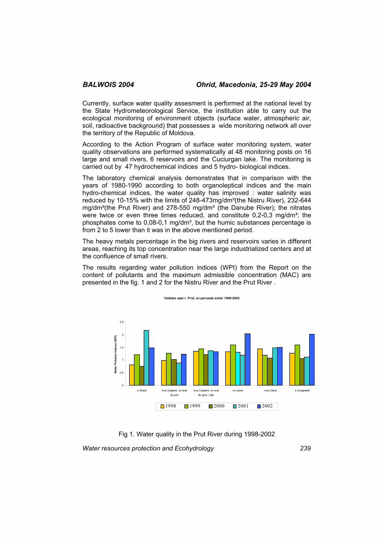
BALWOIS 2004 Ohrid, Macedonia, 25-29 May 2004 Currently, surface water quality assesment is performed at the national level by the State Hydrometeorological Service, the institution able to carry out the ecological monitoring of environment objects (surface water, atmospheric air, soil, radioactive background) that possesses a wide monitoring network all over the territory of the Republic of Moldova.
According to the Action Program of surface water monitoring system, water quality observations are performed systematically at 48 monitoring posts on 16 large and small rivers, 6 reservoirs and the Cuciurgan lake. The monitoring is carried out by 47 hydrochemical indices and 5 hydro- biological indices.
The laboratory chemical analysis demonstrates that in comparison with the years of 1980-1990 according to both organoleptical indices and the main hydro-chemical indices, the water quality has improved : water salinity was reduced by 10-15% with the limits of 248-473mg/dm³(the Nistru River), 232-644 mg/dm³(the Prut River) and 278-550 mg/dm³ (the Danube River); the nitrates were twice or even three times reduced, and constitute 0,2-0,3 mg/dm³; the phosphates come to 0,08-0,1 mg/dm³, but the humic substances percentage is from 2 to 5 lower than it was in the above mentioned period.
The heavy metals percentage in the big rivers and reservoirs varies in different areas, reaching its top concentration near the large industrialized centers and at the confluence of small rivers.
The results regarding water pollution indices (WPI) from the Report on the content of pollutants and the maximum admissible concentration (MAC) are presented in the fig. 1 and 2 for the Nistru River and the Prut River .
?alitatea apei r. Prut, оn perioada anilor 1998-2002
0
0.5
1
1.5
2
2.5
s.Sirauti mun.Ungheni, оn avalde pod
mun.Ungheni, оn avalde gura r.Jijia
or.Leova mun.Cahul s.Giurgiulesti
Wat
er P
ollu
tion
Indi
ces
(WPI
)
1998 1999 2000 2001 2002
Fig 1. Water quality in the Prut River during 1998-2002
Water resources protection and Ecohydrology 239
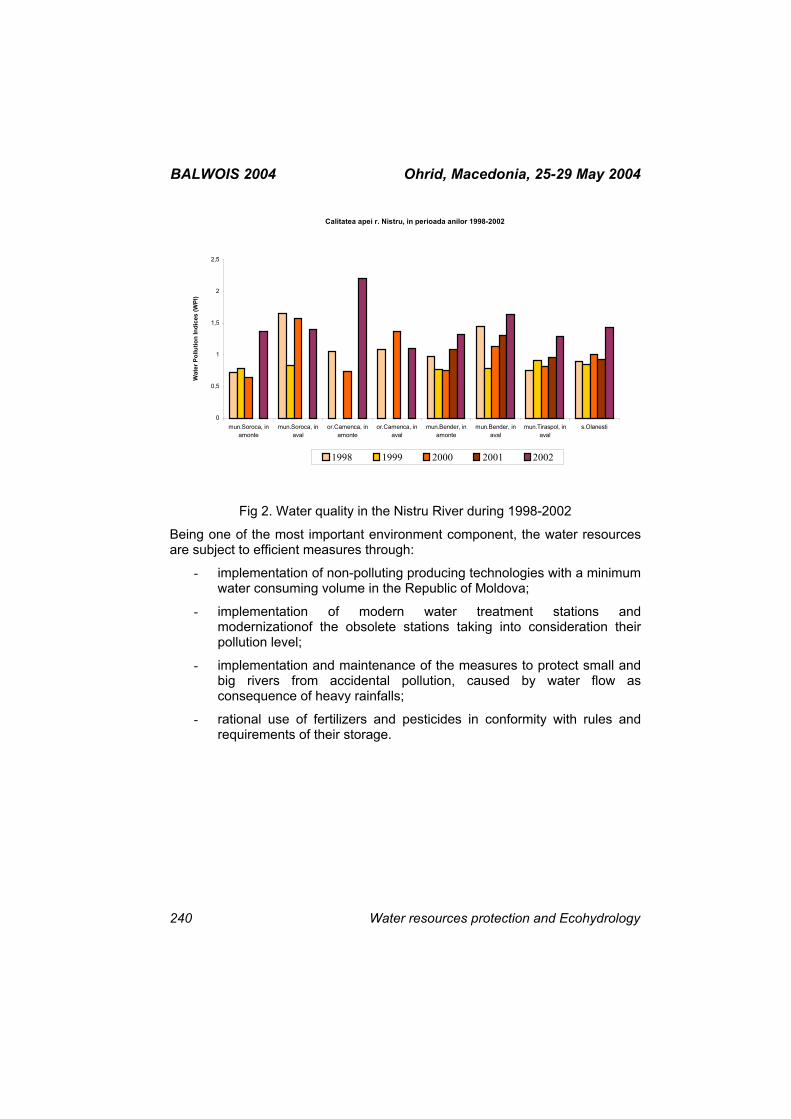
BALWOIS 2004 Ohrid, Macedonia, 25-29 May 2004
Calitatea apei r. Nistru, in perioada anilor 1998-2002
0
0,5
1
1,5
2
2,5
mun.Soroca, inamonte
mun.Soroca, inaval
or.Camenca, inamonte
or.Camenca, inaval
mun.Bender, inamonte
mun.Bender, inaval
mun.Tiraspol, inaval
s.Olanesti
Wat
er P
ollu
tion
Indi
ces
(WPI
)
1998 1999 2000 2001 2002
Fig 2. Water quality in the Nistru River during 1998-2002
Being one of the most important environment component, the water resources are subject to efficient measures through:
- implementation of non-polluting producing technologies with a minimum water consuming volume in the Republic of Moldova;
- implementation of modern water treatment stations and modernizationof the obsolete stations taking into consideration their pollution level;
- implementation and maintenance of the measures to protect small and big rivers from accidental pollution, caused by water flow as consequence of heavy rainfalls;
- rational use of fertilizers and pesticides in conformity with rules and requirements of their storage.
240 Water resources protection and Ecohydrology
BALWOIS 2004 Ohrid, Macedonia, 25-29 May 2004
AQUATIC MACROPHYTES UPSTREAM OF THE ĐERDAP POWER PLANT DAMN (DANUBE RIVER, RKM 1146-943)
Dragana Vukov1, Ružica Igić1, Goran Anačkov1, Georg A. Janauer2
1Department of Biology and Ecology, Faculty of Sciences and Mathematics
University of Novi Sad, 2, Trg Dositeja Obradovića Novi Sad, SERBIA and MONTENEGRO
2Institute of Ecology and Conservation Biology Faculty of Sciences and Mathematics 14, Althanstrasse – Vienna, AUSTRIA
After building of power plant Đerdap I, hydrological regime and ecological characteristics of the portion of Danube upstream of the damn have suffered severe changes; water level is 19-32m higher at the Power Plant Damn, and water flow is generally slower. These new conditions enabled growth of aquatic vegetation.
During the fieldwork in 2003, total number of 44 aquatic plant species has been recorded in the main channel of the river.
Among them, there are 21 hydrophytes, seven amphiphytes, and 16 helophytes. It is interesting that some plant species, untypical for the main channel of river like Danube, have been found. Their relative plant mass production, distribution pattern and ecology have been analyzed. Gained data show increased biomass of the aquatic macrophytes in the river.
Water resources protection and Ecohydrology 241
BALWOIS 2004 Ohrid, Macedonia, 25-29 May 2004
ENVIRONMENTAL PROTECTION AND PROMOTION OF HEADWATER RESOURCES BY AFFORESTATION IN RUGGED
MOUNTAINS IN SERBIA
Mihailo Ratknic
Institute of forestry, Kneza Viseslava 3, 11000 Belgrade, SERBIA and MONTENEGRO
[email protected] Population increase, the development of industry and agriculture in the world and in Serbia, increasingly endanger water supply quantity and quality. The rational utilization of water, which is getting the character of strategic raw material, requires long-term planning, as well as the change of social behavior towards water in general. However, if the local and economic interests are surpassed and if the complex water protection from contamination is ensured throughout Serbia, and especially land use in upland watersheds, the problem of good-quality water supply will be partially solved.
Forestry, as a complex field, has the task of permanent conservation of all the function of forests and forest land, among which the hydrological function has a special national significance. This depends on the method of management of the existing forests and the establishment of new forests, especially in the watersheds which great water accumulation. Forest functions in soil and water conservation are highly significant for the development and survival of some districts, regions and wider natural and social units. The task of forestry in the field of the improvement of forest hydrological function is expressed in water regime improvement protection of springs and storage reservoirs, i.e. in the increase of quality water supplies. Forests are indispensable water regulators and conservators, which means that the regime of water depends on the quality of forest cover.
Also, the environmental resources protection concept, planning, should include appearance as well as use, in order to acquire this, evaluate an area has to be done or region independent of its scale trough a careful survey followed by an analysis. The survey includes factors of natural resources, landscape ecology such as geological structures, soil types, hydrological and climate condition, as well as vegetation and fauna. It also includes economic factors like present land use and ownership parcels. In order to find solution for space conflicts, alternative scenarios need to be developed, such as planners comprehensive methodology and GIS tool (Geographical Information System) which could help to analyze those problems and to develop path to reduce them.
242 Water resources protection and Ecohydrology
BALWOIS 2004 Ohrid, Macedonia, 25-29 May 2004 ZETA PLAIN THE MOST IMPORTANT AQUIFER OF MONTENEGRO -
NATURAL CONDITIONS OF AQUIFER FORMATION, CURRENT STATE AND THE PERSPECTIVES
Darko Novaković, Jugoslav Žic
Hydrometeorological Institute of Montenegro, Podgorica, SERBIA and MONTENEGRO [email protected]
The area of Zeta Plain represents a special geomorphological entity, surrounded by hills and mountains from three sides while, on the south, it enters the Skadar lake basin.
The aquifer of the Zeta Plain, the richest groundwater resource in Montenegro, is formed in glaciofluvial sediments, which are settled over the limestone paleorelief. The surface of glaciofluvial sediment is approximately 200 km2 and the thickness is generally between 30 and 100 meters. The aquifer is fed by the water of rivers Morača and Cijevna, the groundwater inflow from the carst aquifers of surrounding limestone terrains and by the precipitation infiltration. The drainage of the aquifer is carried through the direct outflow to the Skadar Lake, mostly by the many short water streams. The groundwater regime of this aquifer has a direct influence on the Skadar lake water regime.
Very good filtration characteristics of glaciofluvial sediments, along with the other natural conditions, create circumstances for the formation of the rich aquifer, who's minimal groundwater flow (dynamical reserves) through the 12km wide cross section of Zeta Plain equals 12-15 m3/sec. Exploitation reserves of groundwater are significantly larger.
The exploitation of the Zeta Plain groundwaters is very intensive and, by a non-precise evaluation, in the long dry periods during the summer, it equals about 10 m3/sec. The biggest consumers are "Kombinat aluminijuma" (Aluminum Works) -10 m3/sec; "Agrokombinat" (Agricultural industry which has 1500 ha of grape-vine plants) -2 m3/sec; The waterworks of Podgorica -0.5 m3/sec and the individual predial estates which are estimated to have over 1000 wells and have cumulative consumption of about 5 m3/sec. The exploitation of groundwaters is not synchronized and there is no organized control of the exploitation conditions.
Since this is the most inhabited area in Montenegro (about the third of Montenegrin population lives in this area -the territory of the capital city -Podgorica) the side effects and side products of the "civilization" have significantly degraded the very good natural quality of the groundwaters in some
Water resources protection and Ecohydrology 243
BALWOIS 2004 Ohrid, Macedonia, 25-29 May 2004 parts of this large aquifer. The main pollutants are the Aluminum industry, private farms and the communal and industrial wastewater. The pollution problem is especially acute because of the large porosity of the glaciofluvial layer and it's surface exposure, which causes the large degree of vulnerability.
In spite of mentioned pollution problems, the parts of the Zeta Plain aquifer are still out of reach of significant pollutants.
The importance of the Zeta Plain aquifer is practically inestimable for Montenegro. It is a resource, which the many vital community activities on these parts depend on, the resource which will, in future, represent one of the basic elements of the community development: water supply for Podgorica and the Montenegrin coast, agriculture, industry, environmental protection of Skadar Lake etc.
The work describes the natural conditions of the aquifer formation; current state of usage, quality, protection and the studies of groundwater, along with the suggestion for the future steps toward the improvement of the aquifer's state, better protection and optimal usage and management of this resource.
244 Water resources protection and Ecohydrology
BALWOIS 2004 Ohrid, Macedonia, 25-29 May 2004 EFFECTS OF EROSION CONTROL WORK IN SOME TORRENTS IN
THE REPUBLIC OF MACEDONIA
Ivan Blinkov, Alexandar Trendafilov
University “St. Cyril and Methodius”, Faculty of forestry – Skopje, bul.”Alexandar Makedonski “bb. 1000 Skopje , Republic of MACEDONIA
Due to the report of The European Environment Agency, Republic of Macedonia, together with Yugoslavia and Albania performed “red zone of water erosion in Europe”. Role of other erosion types to soil degradation in the RM is insignificant.
According to the EROSION MAP of RM , 96.5% of the total area is under processes of erosion.. An amount 9423 km2 or 36.65% of the total state territory is encompassed by stronger categories (I – III). The total annual production of erosive materials on the whole territory is about 17*106 [m3 /year] or 685 [m3 / km2. year], which of 7.5*106 [m3 /year] or 303 [m3 / km2. year] are carried by. Significant part of these deposits, about 3*106 [m3 /year] is not carried through the downstream sections of the rivers to the exit of the state territory, but deposed in nature lakes and artificial reservoirs. Water erosion is dominant type.
Torrential flows (flash floods) are very often. There isn’t any city in Macedonia without problems with torrents and consequences of them: sedimentation of lot of material in the urban area, destroyed streets, bridges, houses, other infrastructure facilities and they cover agricultural land with sterile sediments (stones, gravel, etc.).
Exactly 1539 torrents are registered over the whole country territory. Their total catchments area is around 18 000 km2 (70% of the state territory).
In his analyzes one torrential groups was analyzed: torrents – tributaries of Kamenicka Reka (tributary of reservoir Kalimanci). Catchement area of Kamenicka Reka is 72.5 km2. This area is maybe the most erosive catchment in the Republic of Macedonia. Whole are belong to I, II and III category of destruction. Mean values of erosion quotient is Z = 0,67. Mean annual production of erosive material is 150 000 m3.
There are a lot of erosion control works constructed in the up mined torrents. Sediment behind barrages was geodetically measured. Data about forest cover and elements was extracted from forest managing plan.
Water resources protection and Ecohydrology 245

BALWOIS 2004 Ohrid, Macedonia, 25-29 May 2004 There are 51 built barrages in torrents-tributaries and about 618 other cross construction . A great part of barelands in the catchment was afforested.
As a result of all erosion control works, at about 1 000 000 m3 sediment is deposed behind the cross constructions.
246 Water resources protection and Ecohydrology
BALWOIS 2004 Ohrid, Macedonia, 25-29 May 2004
AQUIFER OVEREXPLOITATION AND GROUNDWATER MINING
Vladimir Stavric
Ministry of Environment and Physical Planning / UNDP NCSA Project Office Aluminka Building,
Partizanski Odredi br 67, 1000 Skopje, Republic of MACEDONIA [email protected]
The limits how much water can be extracted from a finite groundwater aquifer are economic and environmental. When water is pumped out faster than it is recharged by the natural processes, the water level in the aquifer drops, and the distance the water must be raised to the surface increases. Eventually, either the energy costs rise to the point that exceeds the value of the water, or the water quality falls bellow acceptable levels. At this point pumping must cease.
Although many aspects of what can be called overexploitation are not new in Hydrogeology, this concept is still poorly defined and subjected to varying interpretations by the different kinds of specialists, managers, policy makers and the public. A set of terms, not always fully equivalent are in use for concepts related to overexploitation, such as overpumping, overdraft, overdevelopment and groundwater mining.
The debates between experts and decision-makers on the management of groundwater resources, as regards the overexploitation of aquifers, are based on two main questions: a)How should we assess whether an aquifer is being overexploited, or predict if this may happen as a result of planned new exploitation? According to what criteria? ; and b) Is the overexploitation of an aquifer always undesirable, "bad management" that should be prohibited and prevented, or is it permissible or even advantageous under certain situations, and what impact should be anticipated and compensated for?
It is argued in this paper that non-equilibrium or an unbalanced regime of an aquifer can not simply be identified as overexploitation. The assessment of overexploitation is relative to the criteria used, which are themselves linked to the resource-management objectives. These criteria can therefore be: (a) purely physical and quantitative: depletion of resource, non-equilibrium etc.; (b) qualitative: degradation of water quality; (c) economic: non competitiveness, or more broadly - the all direct costs and external costs greater than collective advantages; (d) social: conflicts of use between unequal developers with detrimental effect suffered by third parties; (e) environmental: damage to the natural environment, especially to sensitive aquatic ecosystems.
Water resources protection and Ecohydrology 247
BALWOIS 2004 Ohrid, Macedonia, 25-29 May 2004 To evaluate possible aquifer overexploitation, not only detrimental (negative) effects have to be considered, but also beneficial (positive) ones. Otherwise a biased assessment may be reached. In some extreme cases of severe water shortage beneficial aspects may dominate over detrimental ones.
Various aspects and approaches in groundwater management of heavily overexploited aquifers are further analysed in the paper, as well as possible alternatives to it, like artificial recharge, reclamation and reuse of wastewater, desalinization, weather modification and finally demand modification.
248 Water resources protection and Ecohydrology
BALWOIS 2004 Ohrid, Macedonia, 25-29 May 2004
AN ECOLOGICAL RESOURCE FORMING FACTORS OF THE FRESHWATER SUBAQUATIC LANDSCAPES (THE VOLGA RIVER
CASE STUDY)
Natalia N. Mitina
Department of Water Quality and Ecology, Water Problems Institute of the Russian Academy of Sciences, 3, Gubkin St., Moscow 119991, RUSSIA
The research is aimed on evaluation of a ecological resource potential of bottom natural complexes (BNC) of large regulated river systems. This potential is considered as a set of the geological-geomorphologic, hydro-climatic, soil, and biological resources of the landscape, which has been already used or may be used without the destruction of ecosystem stability and regeneration ability. The direct and indirect methods of qualitative estimation of ecological resource potential of the BNC of regulated rivers were elaborated taking as an example the Ivan’kovo reservoir (the Upper Volga river). The direct method evaluates the total resource potential, which priority index is productivity of benthos-eating fish. Complex of abiotic indices and biotic indices of low trophic level shows the ecological niche, which could be occupied by some fish species in case its natural reserve is undermined and then it could reconstruct its potential within limits of certain BNC. Determination and calculation of the complex of these indices are the indirect or prognostic method of evaluation of resource potential. The BNC of different ranks are characterized by the specific resource potential with proper indications of environmental normalization and a minimum set of integral indications determining the state of aquatic ecosystem. Applying the factor analysis (method of principal components) for the analysis of the data of evaluation of natural-resource potential gives chance to evaluate the degree of ecological disturbance and sustainability of underwater landscapes of regulated rivers under influence of various anthropogenic impacts, to predict dynamics of underwater landscapes within limits of revealed factors when some of the components change and, accordingly, to substantiate the permissible levels of anthropogenic load. Analysis of a factor matrix showed that all significant variables could be divided into two general factors according to the loads. Each group of parameters, which makes significant input into some factor, has a certain meaning. The most significant load (r>0.7) in a factor matrix have the variables, which meaning shows us the swamp formation in the shallow zone of reservoir. The largest swamps are situated in the upper reach of reservoir. There are also swamps along the bays in the lower reach of the reservoir. The water from the shallow flood-plain territories, including the swamp territories, flow down into the deep channel part of reservoir and provoke the deficit of
Water resources protection and Ecohydrology 249

BALWOIS 2004 Ohrid, Macedonia, 25-29 May 2004 oxygen which results in massive fish suffocation. Therefore the swamping of the reservoir’s littoral influences the formation of resource potential not only in the shallow part of reservoir, but its bathyal zone as well. The physical meaning of the second factor is could be named ecological.
250 Water resources protection and Ecohydrology
BALWOIS 2004 Ohrid, Macedonia, 25-29 May 2004
DEVELOPMENT OF A MANAGEMENT SYSTEM OF GROUNDWATER RESSOURCES OF FRATESTI AQUIFERS IN THE
CITY OF BUCHAREST
Mihai Bretotean
National Institute of Hydrology of Romania, ROMANIA
The deep aquifer layers of Fratesti, which are presenting strategic source for the water supply of the Bucharest City is having a structural rising from the north to the south, is entering in contact at the southern part of the Bucharest City with the aquifer layer from alluvia of the Neajlov River, whose water is polluted which organic substances, NH4+, NO2-, NO3-, as a consequence of the utilisation of some natural and chemical fertilisers from agriculture.
As a consequence of the exploitation of Fratesti Layers in the Bucharest City area, especially of the upper strata, by around 500 drills, it was created a large depression cone towards waters are attracted, including from the polluted area from the contact with the alluvia of Neajlov River, existing the danger of pollution of the aquifer system of Fratesti in the Bucharest area.
In the Paper are presented the management measures, which are needed for the avoiding of the enlargement of the polluted area and even of the extinction of the pollution phenomena.
Water resources protection and Ecohydrology 251
BALWOIS 2004 Ohrid, Macedonia, 25-29 May 2004 NUTRIENTS TRANSFER AND RETENTION IN THE DANUBE BASIN:
BUDGETING AND MODELING APPROACHES
Maria Cristina Trifu1, Josette Garnier2, Gilles Billen2
1National Institute of Hydrology and Water Management, Bucharest, ROMANIA 2Pierre et Marie Curie University – Paris VI, FRANCE
This paper estimates the nutrients flux deliver by the Danube river system into the Black Sea, by taking into account the human activities modifications in the whole basin and its delta, for a long period of time (1988 – 1997). The modeling approach was realized by the division of the Danube basin into 11 sub-basins with their mains reservoirs, a main branch of the Danube River, from the confluence with the Inn River to the beginning of the Danube Delta, and the Danube Delta.
The RIVERSTRAHLER model (Billen et al., 1994; Garnier et al., 1995), that allows to simulate the main variables of quality water, the nutrients (nitrogen, phosphorus, silica) being included, was implemented for the entire river network..
The nutrients transfer in the sub-basins was estimated in order to analyze the role of human pressures on the nutrients budget, delivery in the Black Sea. The sub-basins contribution to the Danube pollution is different in function of the terms of estimation that could be in absolute or specific fluxes.
The resulting contribution budget, delivery in the Black Sea, for the whole hydrological systems of the Danube catchments (sub-basins, main branch and Danube delta), shows great silica retention in every component of the Danube river system and represent the confirmation of the small role of the Danube Delta like a “tampon area”.
The contribution flux was calculated for a dry year (1993) and a humid one (1996).
252 Water resources protection and Ecohydrology
BALWOIS 2004 Ohrid, Macedonia, 25-29 May 2004 FACTORS AFFECTING DEGRADATION OF WATER RESOURCES IN
REPUBLIC OF MACEDONIA
Katerina Donevska
University "Sts Cyril and Methodius", Faculty of Civil Engineering 1000 Skopje, Republic of MACEDONIA
The world’s fresh water resources face an unprecedented crisis. Water abstraction greatly exceeds its renewal and demand is likely to increase as the world’s population grows. At the same time, usable waters are being polluted as urban areas expand and agriculture intensifies. The aim of this paper is to develop a better conceptual and practical understanding of factors affecting water resources degradation, especially in the Republic of Macedonia. Degradation of water resources takes three forms: depletion of water resources, contamination, and secondary problems such as salination and land subsidence.
This paper deals with the analysis of present status of water resources in the Republic of Macedonia. It also presents the status of the water use. The study in the paper is based on the interdisciplinary process of identification, analysis, and assessment of relevant natural and human processes and their interaction, which determines the present and future status and quality of the resources. The factors that are affecting water resources and especially the three forms of water resources degradation are analysed. Water resources are affected by many factors resulting from population and growth of population, agriculture and industry, tourism and households and to factors related to natural variability of rainfall and climate changes. Extreme hydrological events like floods and drought have an impact on status of the water resources and water use and to the issues of the ecosystem status. Water quality condition and pollution of water resources in Republic of Macedonia has been presented, too. It is concluded that water resources in an average year can meet the water requirements at the present moment.
Water resources protection and Ecohydrology 253
BALWOIS 2004 Ohrid, Macedonia, 25-29 May 2004 NUTRIENTS, CHLOROPHYLL-A AND PHYTOPLANKTON IN FRONT
OF BULGARIAN BLACK SEA COAST ( CAPE KALIAKRA )
Daniela Petrova1, Galina Shtereva2, Violeta Velikova1
1Institute of Fisheries and Aquaculture –P.O.Box 72, Varna-9000, BULGARIA 2Institute of Oceanology - BAS, P.O.Box 152, Varna 9000, BULGARIA
Results of 3 cruises (June - August – November 2002) carried out within the Project “ Nutrient management in the Danube basin and its impact on the Black Sea” (DANUBS-EVK1-CT-2000-00051) are reported and discussed in this paper.
The sampling was taken on the board of the R/V “Prof. A. Valkanov” and covered 5 stations at Cape Kaliakra, situated from the coastline across the Danube transformed waters – 1, 3, 10, 20, 30 miles offshore. Vertical profiles of components were studied at standard depths in the layer surface-bottom or surface - 100 meters at greater depths.
Total 90 samples of nutrients and phytoplankton were collected in investigation periods.
The year 2002 is characterized by relatively high diversity of phytoplankton, and predomination in the density or biomass of a few Bacillariophyceae, Dinophyceae and Chrysophyceae species.
But since 1995 decreasing tendency of phytoplankton biomass was observed in the Bulgarian Black Sea. In 2002 this tendency was confirmed and the level of algal biomass was lower even in comparison with the year 2001, when the average values were also low.
In open – sea waters the maximal algal biomass during 2002 was observed in June in front of the Cape Kaliakra – 10 miles offshore – in the surface layer it was 7 438.62 mg.m-3, due to the bloom of the Dynophyceae species Heterocapsa triquetra.
The vertical distribution of P was haracterized by sufficient increase in depth and predomination of the organic form in deep waters due to the processes of mineralization and decomposition of organic matter.
Dissolved Si in coastal waters was higher than P. The higher bottom concentration of Si were due to the influence of sediments and processes of sedimentation. But in November an absence of Si was found in open seawaters – 30 miles offshore in front the Cape Kaliakra.
254 Water resources protection and Ecohydrology

BALWOIS 2004 Ohrid, Macedonia, 25-29 May 2004 During the 6 months period of investigation phosphates , chlorophyll a and phytoplankton biomass in surface waters were maximal in June - 10 miles zone. (during the most pronounced influence of Danube transformed waters on the Bulgarian shelf).
Water resources protection and Ecohydrology 255
BALWOIS 2004 Ohrid, Macedonia, 25-29 May 2004 PHYTOPLANKTON BLOOMS – A KEY ECOLOGICAL PROBLEM OF
THE BULGARIAN BLACK SEA COAST
Daniela Petrova, Violeta Velikova
Institute of Fisheries and Aquaculture , Blvd. Primorski 4, P.O.Box 72,
9000-Varna, BULGARIA [email protected]
The Black Sea has a long history of chronic harmful phytoplankton blooms – phenomena, which have a strong negative impact on marine water quality and tourism.
The impacts from these tiny organisms are many and diverse – illness of humans, fouling of beaches with foam and dead fish and shellfish.
The uncontrolled reproduction ( “blooming ”) of some phytoplankton species gives the marine water an unattractive greenish / brownish colour which is very often accompanied by a repulsive smell. It is enough for this phenomenon to last for some 10-20 days, and it will cause a massive outflow of tourists from the Black Sea resorts with all financial and social consequences for the local population.
The synthesis data showed that the man-induced increase of nutrients and organic substances enhanced the phytoplankton production in the Black Sea to pathological levels.
Thus phytoplankton, being the first target of nutrient alterations, is perceived to be a decisive factor for marine water quality and ecosystem health. The superfluity of the Black Sea ( when the ecosystem is replete with nutrients and phytoplankton) dictates that urgent steps should be taken to better understand and manage harmful algal species and the resources they threaten.
Apparently water – quality conclusions should undergo confirmatory analysis of major shifts in phytoplankton functioning. This talk will review the many types of harmful algal blooms, their impacts and national efforts to monitor, manage and research on these phenomena.
256 Water resources protection and Ecohydrology
BALWOIS 2004 Ohrid, Macedonia, 25-29 May 2004 APPLICATION OF DYNAMIC FACTOR ANALYSIS FOR GROUNDWATER LEVEL CHANGES OF DANUBE-TISZA INTERFLUVE1
József Kovács1, Róbert Czéh1 , Péter Szabó1 , József Szalai2, György Varga 2, László Márkus3
1Dept. of Applied and Enviromental Geology, Eötvös Loránd University, Budapest, HUNGARY
2Water Resources Research Center, Budapest, HUNGARY 3Dept. of Probability Theory and Statistics, Eötvös Loránd University,
Budapest, HUNGARY
Twenty-nine years long time series of groundwater level of 117 groundwater observation wells constituted the basis of the research in the area between the Danube and the Tisza rivers (25000 km2), in Hungary. The changes of these groundwater levels - above the first aquitard formation - are the results of different cumulative effects, like water infiltration from precipitation, water extraction, etc. Our purpose was to know what kind of background effects drive the fluctuation of the time series of observation wells.
The conventional tool to determine the background effects from observations is factor analysis. Since factor analysis has been elaborated for independent observations its direct application to time series vectors often produces unreliable or misleading results. To decompose the observed hydrogeological time series correctly into the linear combination of independent factor time series we applied dynamic factor analysis. These factor components can then be identified or regarded as the above mentioned effects.
Three background effects were determined and one of these was identified, so far. The first factor fits well to the integrated deviation from the average precipitation, which was determined from the meteorological data. A map produced from the loadings of the first factor will be presented. The information provided by the map may prove to be very useful because it indicates the contamination vulnerability of an area for surface contamination.
Water resources protection and Ecohydrology 257
BALWOIS 2004 Ohrid, Macedonia, 25-29 May 2004 SELECTION AND APPLICATION OF ARMA/ARIMA CLASS MODELS
FOR THE SIMULATION AND FORECAST OF DYNAMICS OF PHREATIC GROUNDWATERS
Elena Tanase
Hydrogeology and Environment Isotopes Laboratory National Institute of Hydrology and Water Management
Bucharest, ROMANIA [email protected]
The Paper presents the study of the behavior of the phreatic groundwater levels for different hydrographs.
The Paper illustrate the application of a most traditional and modern methods in the same time, utilized by the researchers, which are studying natural phenomena occurring in the natural environment, the ARMA/ARIMA class models methodology, i.e. the selection and application of the most adequate dimension (order) of the ARMA/ARIMA (autoregressive moving average models, integrated) models, in order of simulation and forecasting with small-acceptable errors.
For numerical aspects of the up-mentioned approach were analyzed two different univariate time series with various dynamics behaviors in the meaning of trend, periodic and “noise” terms.
The ARMA/ARIMA method was implemented on PC using the modern computational tools, as the soft DATAPLOT, running under Windows, created mainly for graphic representations and statistical analyze. The interpolation method under DATAPLOT is the least-square method applied in the estimation of the ARMA/ARIMA models coefficients. For the calibration of the model was utilized the regression method. The friendly interface with the user allows the use of scripts, macros and line commands.
One of the present Paper is proposing to illustrate the approach of the dynamics of phreatic groundwaters using the DATAPLORT soft, mainly the major basic necessary steps for the analyze, the identifying of the long-term trends and periodicities, the identification of the persistence of the characteristics of the process, the selection of the suitable model (type AR, MA or ARMA/ARIMA, and order).
There is presented the main role of the statistic functions for the detection and identification of the trends of the process: the autocorrelation function, the partial-autocorrelation function.
258 Water resources protection and Ecohydrology

BALWOIS 2004 Ohrid, Macedonia, 25-29 May 2004 The analyze of errors of the method underlines one o the main qualities of the ARMA/ARIMA- small method errors-. This allows good simulation and forecasting for monthly steps.
Water resources protection and Ecohydrology 259
BALWOIS 2004 Ohrid, Macedonia, 25-29 May 2004 WATER QUALITY VULNERABILITY OF THE LEPENC RIVER BASIN
Tahir Arbneshi1, Lule Beqa2, Islam Zuzaku1
1University of Prishtina, Faculty of Natural Science,
Department of Chemistry 5, Nëna Tereze street – Prishtinë, UNMI KOSOVO 2University of Prishtina, Faculty of Civil Engineering and Architecture 12,
Kodra e Diellit street – Prishtinë, UNMI KOSOVO [email protected]
Water is a natural resource with general interest, which should be rationally exploited, and it must be protected from eventual degradation. Industrial development and growth of population in large urban centers have an impact on water pollution, resulting from an outfall of polluted waters into the flow of the rivers without preliminary treatment. Large urban centers in our country at the same time are the main industrial centers being situated alongside the rivers. A great amount of the effluents and sewage flowing into these rivers exceed the self-purification capacity of the water, therefore the quality of these waters undergoes serious damage. All these are evident for water-collecting basin of Lepenc River, which springs from Firajë village, Shtërpcë municipality. This river in upper course of its spring has high quality water and it belongs to the first category of the surface waters, which can be used as drinkable water. Middle part and lower part of the flow of the river; pass through urban centers and industrial facilities, which means that this seriously risks river’s water quality. Experimental results show that garbage throwing and urban waters of Ferizaj, Kacanik, and Hani i Elezit affect water quality of this river.
In our country we have to be focused on finding practical solution of this issue, which should be preceded by a deep study that is intensively done in most of the countries dealing with this issue.
260 Water resources protection and Ecohydrology
BALWOIS 2004 Ohrid, Macedonia, 25-29 May 2004
IUCN ADDRESSING FRESHWATER FISHERIES ISSUES IN CENTRAL AND EASTERN EUROPEAN COUNTRIES
Robert Aps1, Tamara Kutonova2, Zenon Tederko2
1Estonian Marine Institute, University of Tartu
10a, Maealuse street – 12618 Tallinn, ESTONIA 2IUCN Office for Central Europe
4, Włoska street – 00-777 Warsaw, POLAND [email protected]
The post-socialist Central-Eastern European (CEE) countries are undergoing the process of transition meanwhile engaging themselves to shift to sustainability. Freshwater fisheries is one of the activities to be reformed so that it not only boosts the economy, but contributes to development of the society, and ensures conservation of its natural resources. A three-year project realised by IUCN Office for Central Europe focuses on reviewing freshwater fisheries policies and practices in the CEE states, and development of the principal recommendations.
One of the principal products of the project is the Overview Report on major underlining causes of biodiversity decrease based on national reports from 19 countries of the region. The provisional conclusions of the Report indicate increasing pressure of commercial and recreational fisheries on freshwater fish diversity and stocks; developed legislation and administrative system though poor enforcement, and control over illegal and unreported catches; habitat destruction and pollution as factors resulting in freshwater fish diversity loss; strong demand in the research of the issue, and in raising stakeholders’ awareness on shifting to sustainable fisheries. Discussion of the results of the reports; presentation of practices on stakeholders' involvement in the freshwater diversity conservation, transboundary cooperation, private fisheries and angling communities took part at the international workshop in Poland in December 2004. The principal recommendations of the meeting to IUCN Secretariat and members and to CEE governments, fishery managers and aquaculture producers included involvement of recreational and sport angling communities, and aquaculture industries into tackling the biodiversity decline; promotion of utilization of the ecosystem approach; development of the relevant IUCN program and project portfolio; and establishment of a network of excellence consisting of institutions, experts and case studies. At the following stages of the project activities will be focused on co-operation with recreational and sport fishermen; developing IUCN program and the follow-up project proposals.
Water resources protection and Ecohydrology 261
BALWOIS 2004 Ohrid, Macedonia, 25-29 May 2004 SCREENING AND QUANTIFICATION OF SOME HEAVY METALS IN
SEDIMENTS FROM THE SAVA RIVER
Emira Maljevic, Mario Iles, Aleksandar Miletic
Republic Hydrometeorological Service of Serbia, 66 Kneza Višeslava Street, 11030 Belgrade, SERBIA and MONTENEGRO
Water body sediments and their characterization from viewpoint of trace element and especially Heavy metals concentration represent an important ecosystem and indicators of environmental quality assessment of the long-term significance. Although naturally occurring in environment including water body sediments, heavy metals are not usually present in high concentrations, Moura, I. &Almeida, A. &Quendera, R. et al. (2004). However, the concentrations of some metals in mouth area of the Save River located in lowland may vary significantly due to runoff and river transport. In order to comply with the EC Council Directive (CE 76/464/EEC) of the European Union which requires monitoring of persistent, toxic and bioaccumulated substances commonly designated as hazard substances, Federal Hydrometheorological Institute of the FRY has made a long-term monitoring programme in 1999 dedicated to the evaluation of hazard substances in water, sediments and biota. This work presents the results as to heavy metals, including Pb, Cd, Zn, Ni, Hg and Cu in bedload-surface and deposited-bottom sediments for the Sava River in 2002. The results indicate that both bank of the Sava River are contaminated by heavy metals.
262 Water resources protection and Ecohydrology

BALWOIS 2004 Ohrid, Macedonia, 25-29 May 2004
Water resources protection and Ecohydrology 263


BALWOIS 2004 Ohrid, Macedonia, 25-29 May 2004
TOPIC 6 : LAKES
Lakes 265
BALWOIS 2004 Ohrid, Macedonia, 25-29 May 2004
OVERVIEW ON DIATOMS FROM OHRID LAKE
A. Miho1, H. Lange-Bertalot2
1Department of Biology, Faculty of Natural Sciences, Tirana University, ALBANIA
2Botanisches Institut, Johann Wolfgang Goethe-Universität, Siesmayerstrasse 70, D-60323 Frankfurt/M, GERMANY
Ohrid Lake represents a real treasure of biodiversity even considering microscopic algae, which has attracted the interest of many researchers from European and neighboring countries. An overview of diatom taxa (Bacillariophyceae) is reported here, based in the floristic data from 12 publications, starting from the beginning of last century, together with our data taken from examinations made in Albanian side during last decade. A checklist of more than 560 species and other forms of diatoms, where about 35 are centricae and about 525 pennatae, seems to belong to the lake as whole. More than 365 taxa were found in plankton or benthos of Albanian littoral part, where about 120 new recorded for ohrid. The whole checklist of species and other forms recorded since the present in Ohrid is reported.
Like in other living groups, Ohrid is also distinguished for the high presence of rare and tertiary relict species of diatoms. Hustedt (1945) and Jurilj (1954) report, all together, about 75 taxa of rare or endemic origin. By the study in Albanian side, more than 25 taxa have been considered interesting, not really known in other European habitats, with a very limited distribution or even endemics of the Lake. Six of them were recently described as new by Lange-Bertalot (2001). About 90 species belong to the read list of diatoms of Europe and more than 1/4 of species may be considered rare or tertiary relicts.
Most of species of the Lake may be considered ecologically as oligotraphentic, growing up only in very clean waters, with quite low nutrients, especially nitrogen and phosphor. However, in littoral habitats, there were observed tolerant species, belonging to a wide range, from oligotrophic to eutrophic waters. Moreover, poly-hypertrophic diatoms and the high presence of cyanophytes were observed, especially nearby Pogradeci town. It should be a direct consequence of the high content of nutrients, mainly total phosphor, caused by the direct discharge of untreated wastewaters and all other activities (agriculture, tourism and industry). Practical measures are needed to conserve the Lake values as whole, like wastewater and solid waste treatment, reforestation, organic farming, etc.
266 Lakes
BALWOIS 2004 Ohrid, Macedonia, 25-29 May 2004
EMPOWERMENT OF PUBLIC PARTICIPATION IN MANAGEMENT OF TRANSBOUNDARY WATERS IN COUNTRIES IN TRANSITION:
LAKE PEIPSI (ESTONIA-RUSSIA) CASE STUDY
Margit Säre
Peipsi Center for Transboundary Cooperation Aleksandri 9, 51004 Tartu, ESTONIA
Last decade has been for decision makers an intensive period for exploring new directions and instruments for increasing public participation in environmental matters. It has been proved though several examples that participation strengthens democracy by showing stakeholders that they do have an influence over what decisions are made. However, public participation in transboundary water management is much more complex and political rather than within one state where management measures are usually implemented in a homogeneous socio-economic, cultural, institutional and political context.
In general, transboundary water management is faced with the task of successfully solving complicated problems dependent on the specific conditions created by the interaction of two or more political systems. Within the EU, the differences in the member states political systems are quite minimal, in opposite to the dramatic differences in the new EU external borders.
In the new EU external border regions - between the EU and Russia, NIS or Balkan countries – the legal framework and institutional arrangements for the cooperation is still under development. Several new EU external border areas are often new emerging or reconstructed borders, as it is in the Lake Peipsi region in the Estonian – Russian border. Lake Peipsi is the biggest transboundary and fourth largest lake in Europe, with surface area is 3555 km2, of which 44% belongs to Estonia and 56% to Russia. Here, the institutions, including procedures for communication and cooperation are still in transition and cross border stakeholder networks are still weak and not yet institutionalized. In addition, in this border region as in several other international water basins in transition countries, differences in the institutions and politics, in socio-economic development, are striking.
Studies of theories and practices of public participation in the transition countries have shown that in the transboundary context public involvement has different character depending on a level of management of transboundary waters. At the international level, national agencies set up legal and coordination mechanisms, including signing transboundary water agreements,
Lakes 267
BALWOIS 2004 Ohrid, Macedonia, 25-29 May 2004 establishing joint water commissions or secretariats. Public involvement usually remains limited to a few large NGOs and well-organized interest groups.
In the Lake Peipsi basin, the transboundary water commission (since 1997) is a mechanism for organization of the formal cooperation across the borders between local stakeholders on one hand and the two governments on the other hand. The civil society organizations are also involved in the work of the commissions, such as Peipsi Center for Transboundary Cooperation (ww.ctc.ee), which works already for 10 years to promote sustainable development and cross-border cooperation in the Lake Peipsi basin. The experience has shown that in the situation of a non-formalized or weak intergovernmental cooperation, which was the case between Estonia and Russian during the 1990s, the role of NGOs could be very important. Non-governmental actors can play an important role of a mediator in helping to build trust between partners, in bringing together different stakeholder groups across borders.
However, studies of practices of public participation on the local level showed that for the local stakeholders is extremely difficult to get a grasp of transboundary water management issues and get involved in implementation of water policies. To overcome this problem, Peipsi CTC within the EU FP5 projects tested different innovative public participation methods in the Lake Peipsi Basin, including group interviews, focus groups and citizens´ juries, to bring the voice of local stakeholders to the respective governments and to make sure concerns of local people are incorporated in water management plans on national and transboundary water basins levels. This experience is planned to be share in other transboundary water basins. Specifically, Peipsi CTC has started cooperation with Chu - Talas transboundary rivers (Kyrgyzstan-Kasakhstan); River Daugava (Latvia, Byelorussia, and Russia) and also Lake Ohrid.
In conclusion we can say that involvement of local stakeholders, such as local authorities, schools, grassroot NGOs, in developing a shared vision and shared water management policies for transboundary water basins is a prerequisite for the long-term sustainable development. This requires taking into use of new innovative methods of public participation.
268 Lakes
BALWOIS 2004 Ohrid, Macedonia, 25-29 May 2004
COMBINING SCIENTIFIC DATA INTO FRAMEWORKS FOR DECISION-MAKING: EXAMPLES OF AN APPROACH TO INTEGRATED RESOURCES MANAGEMENT FROM TWO
TRANSBOUNDARY LAKES (LAKE CHAMPLAIN, USA AND CANADA, AND LAKE OHRID, MACEDONIA AND ALBANIA)
Mary C. Watzin
University of Vermont, USA [email protected]
Successful integrated water resources management must be based on a comprehensive scientific data base. Measures of the physical and biological characteristics of the environment must be combined with information about human activities and their effects on the ecosystem in frameworks that link an assessment of the ecological condition of the ecosystem to the potential causes of environmental change, including management activities. In the Lake Champlain Basin, my colleagues and I have developed an approach for monitoring ecosystem health that explicitly links management goals and objectives to the condition of the Lake Champlain ecosystem.
In our framework, ecological indicators are used as performance measures for a comprehensive management plan. They are applied within the context of Adaptive Management to both track environmental condition and fine-tune the actions outlined in Opportunities for Action, the Lake Champlain Basin Program’s Comprehensive Pollution Prevention, Control, and Restoration Plan. Each indicator relates to our overall Pressure-State-Response framework and our conceptual model of the Lake Champlain ecosystem.
In the Lake Ohrid Basin, a recently completed State of the Environment Report provides the basis for a similar integrated management strategy. The long-term monitoring record for Lake Ohrid provides unique insights into the functions of the ecosystem. As additional data are collected as part of the Lake Ohrid Conservation Project, they can be used in an adaptive management context both to test hypotheses about ecosystem function and to make adjustments as the knowledge base improves.
Examples from both basins will be presented to outline the elements of a successful strategy using this approach.
Lakes 269
BALWOIS 2004 Ohrid, Macedonia, 25-29 May 2004
A DAY-NIGHT AND SEASONAL PERIODICITY IN THE DISTRIBUTION OF THE ZOOPLANKTON FROM LAKE OHRID
Goce Kostoski, Dafina Guseska, Orhideja Tasevska
Hydrobiological Institute, Republic of MACEDONIA [email protected]
In the pelagic complex of the zooplankton community at Lake Ohrid, a presence of 21 species was evidenced, where 13 species belonging to Rotifera, 1 species to Mollusca and the rest 8 of them to Crustacea.
The maximum concentrations of the zoo-plankton are usually evidenced at depth from 15 to 25 m. Great reducing of the concentrations are notified in depths bigger than 75 m. At the beginning of the thermal stratification, at the surface (0m) and in the first depth layer from 0 to 10 m, the concentration is high, but not also a maximal. This kind of depth behavioural, almost with no exceptions, is quite regular. Also some oscillations are present (periodical or non periodical) at the months, - towards the deep or opposite towards the surface - which are different in different months, i.e. bigger in the period of partial watermixis and with lower intensity in the period of clear thermal stratification. The lake water movements are representing a significant life factor and its role is the most important for the spatial distribution of the zooplankton populations during the day-night or the season. But, anyway, the vertical plankton periodicity (the day-night and seasonal) conditioned by the combined influence of relatively big number of factors, for the bigger number of representatives in Lake Ohrid and for a certain part of the year may be predictable.
270 Lakes
BALWOIS 2004 Ohrid, Macedonia, 25-29 May 2004
BIOMASS DYNAMIC OF LAKE OHRID PELAGIC COPEPODS DURING YEAR 2000
Dafina Guseska, Goce Kostoski, Orhideja Tasevska
Hydrobiological Institute, Republic of MACEDONIA [email protected]
The copepods are primary consumers in the food chain, they take greatest part in secondary production of the continental waters and determine the character of energy which flowing in ecosystem.
Copepods in the Lake Ohrid pelagic zone are the most abundant member of the zooplankton community. Their abundance is continuously changing in space and time. Number of individuals, their individual body weights and development times are changing. Individual size is therefore a parameter of fundamental importance in ecosystem studies.
In this article is presented the seasonal dynamics of total biomass of pelagic copepods: Eudiaptomus gracilis Sars, Arctodiaptomus steindachneri Richard, Cyclops ochridanus Kiefer and Mesocyclops leuckarti (Claus), during year 2000.
Individual body weight was calculate with regression: ln W= ln a+b lnL (Bottrell et al. 1976).
Total biomass of the species was calculated with equation B = W x N
The obtained results showed that values of total biomass of the investigated species were variable during the sampling year.
The highest values of \"standing crop\" biomass were registered for Eudiaptomus gracilis and its mid annual percentage participation in comparison with other copepods species is 32%.
Cyclops ochridanus in comparison with other copepods species participated with 34%.
Arctodiaptomus steindachneri in comparison with other copepods species participated with 28 %.
Among the copepods from Lake Ohrid with the smallest number is presented Mesocyclops leuckarti. In comparison with other copepods species participated with 6 %.
Lakes 271
BALWOIS 2004 Ohrid, Macedonia, 25-29 May 2004
COMPOSITION AND DYNAMIC OF ROTIFERA FAUNA FROM EASTERN LITTORAL ZONE OF LAKE OHRID AS PARAMETER OF
WATER QUALITY
Orhideja Tasevska, Goce Kostoski, Dafina Guseska
Hydrobiological Institute, Republic of MACEDONIA [email protected]
Being rather tolerant to different environmental conditions, many rotifer species are good indicators of water quality and can be used for the ecological monitoring of water bodies. The aim of this study was to explore fauna of Rotifera from eastern littoral zone of Lake Ohrid and to determine the water quality on the basis of the noted bioindicative rotifers.
During the investigated period 30 species were identified. Their qualitative and quantitative composition varied dependent on season and locations. The most diverse composition was recorded in summer. The rotifer composition in the quiet bays with macrophyte vegetation is rich and more exuberant then in sand localities.
The most of the noted species were oligo-b-mesosaprobic and b-mesosaprobic indicators, except Rotaria rotatoria that belongs to a-mesosaprobic water.
Saprobiological testing based on rotifera showed that the water was oligo-b-mesosaprobic.
272 Lakes
BALWOIS 2004 Ohrid, Macedonia, 25-29 May 2004 LIVER LESIONS IN THE WILD POPULATION OF MEDITERANNEAN
BARBEL (BARBUS MERIDIONALIS PETENYI HECK) IN LAKE OHRID AND ITS WATERSHED
Lydia Velkova-Jordanoska
SI Hidrobiological Institute-Ohrid, Republic of MACEDONIA [email protected]
In our paper, results of investigations through 1999, 2000 and 2001 were presented. The 48 specimens of Mediterranean barbel (Barbus meridionalis petenyi Heck.) were collected at the five localities in Lake Ohrid (Ljubanista, Pestani, Metropol, Sileks and Park), 32 specimens at the locality Slatino and 40 specimens at the locality Trebenista. The microscopic analysis displayed presence of steatosis in the liver of barbel from locality Slatino, which could be normal finding in spawning period. In the liver tissues of fish from the locality Trebenista are indicated presence of hemoragia followed by necrosis on hepatocelular parenchime.
The histopathological investigations of tissue sections of 48 samples from five localities in Ohrid Lake indicate presence of granulomas in liver. The granulomatous inflammation response was proved to be a result of the presence of eggs of the parasite Capillaria sp. in the hepatocelular parenchime. Although only a long-term investigations can provide definitive answers, some lesions suggest environmental contamination and their effect on barbel health.
Lakes 273
BALWOIS 2004 Ohrid, Macedonia, 25-29 May 2004
GILL LESIONS IN PRESPA BARBELL (BARBUS PRESPENSIS) INHABITING A POLLUTED AREA OF PRESPA LAKE
Danica Roganovic-Zafirova, Adriana Spasova
Faculty of Natural Sciences and Mathematics bb Arhimedova, Skopje, Republic of MACEDONIA
The presentation will focus on gill lesions observed in prespa barbell individuals caught from a north littoral site of Prespa Lake situated between Sirhan and Asamati in the area of tributary Great River entrance which is under agricultural, industrial and urban pollution pressure. The gill’s tissue was analysed by light microscope on standard paraffin-embedded and resin-embedded specimens. The quantification of the histopathological condition of the gills was made according to the standardized protocol for fish that inhabit fresh waters. The numbers of mucous and chloride cells in gills tissue were determined by histometric analysis. In parallel with this a semi-quantitative scoring of present infections was made. The results were statistically processed by Pearson’s bivariant correlation analysis and multiple variance analysis (Kruskal-Wallis) test for independent variables.
Microscopic analysis has revealed a series of circulatory, regressive, progressive and to a smaller extent inflammatory changes from which the most prominent were: telangiectasis; necrosis of respiratory epithelium accompanied by collapsed secondary lamellae; necrosis and proliferation of mucous and chloride cells and proliferation of interlamellar and lamellar respiratory epithelium. Quantitative and statistic analysis of the results indicates that the registered gills lesions has occurred by double influence: toxic effects of polluted aquatic environment and opportunistic infections. The output of bi-variant correlation analysis suggests that the toxic effects from the pollution are dominant.
274 Lakes
BALWOIS 2004 Ohrid, Macedonia, 25-29 May 2004
LIVING LAKES - AN INTERNATIONAL LAKE PARTNERSHIP OF PRIVATE AND PUBLIC INSTITUTIONS FOR THE PROMOTION OF
LAKE PROTECTION AND FRESH WATER CONSERVATION
Udo Gattenloehner
Global Nature Fund, Fritz-Reichle-Ring 4 78315 Radolfzell, GERMANY
People need lakes and wetlands for many reasons - they provide products from fish to reeds and drinking water; they help prevent floods and reduce levels of pollutants. Furthermore these ecosystems provide habitat for wildlife. But they are also very sensitive and vulnerable. Living Lakes is a partnership of public and voluntary organizations for the protection of lakes and wetlands. Living Lakes was introduced in 1998 by the Global Nature Fund, a non-profit NGO. Aim of the partnership is to further and promote sustainable development objectives at international level. Currently the network comprises 28 lakes and wetlands spread across five continents.
Bridge building to overcome geographic and stakeholder co-operation gaps is the underlying idea of the Living Lakes initiative. The overall intent of the international network is to prepare the ground for an on-going international dialogue and co-operation between private and public stakeholders involved in water issues. Objectives are to further the exchange of know-how, technologies and experiences between NGOs and other stakeholders like governments, scientists and businesses moving Agenda 21 objectives from paper to practice. Annual conferences are held, thereby promoting the exchange of experiences, formulate statements, co-ordinate single activities and agree on further steps for common activities. The lake network supports campaigns and activities providing financial support from international conservation programs.
First results are now available from the LIFE project “Sustainable Management of Wetlands and Shallow Lakes” launched in 2001. The degraded wetlands which benefit from the project are Lakes La Nava and Boada in Spain, and the Nestos Lakes in north-eastern Greece. The broad aim of the LIFE project is to demonstrate that it is possible to manage wetlands in ways which enhance their nature conservation value while benefiting the social and economic needs of the local community. Plans for the sustainable management of the wetlands will be created. These plans are to include buffer zones around the lakes to stop nutrients from sources such as agricultural run-off and waste water entering the lakes. The plans will also include guidelines for the treatment of sewage effluent and visitor management.
Lakes 275

BALWOIS 2004 Ohrid, Macedonia, 25-29 May 2004 The Living Lakes project fits perfectly with its economic partners‘ approaches to sustainable development. In both, the sharing of knowledge, encouraging best practice, recognizing global responsibility and establishing local partnerships between NGOs, business and local communities, are all vital elements. Global partner of the Living Lakes project is Unilever. Supporters at international level are DaimlerChrysler and the Deutsche Lufthansa. Living Lakes is also supported by T-Mobile, Kärcher, Ziemann, a number of middle-size companies and media partners.
276 Lakes
BALWOIS 2004 Ohrid, Macedonia, 25-29 May 2004 ARTIFICIAL NEURAL NETWORKS FOR LAKE LEVEL MODELLING
Özgür Kíşí1, Taner Cengiz2, Fatih Üneş2
1Erciyes University, Engineering Faculty, Civil Eng. Dept., 38039, Kayseri, TURKEY
2Istanbul Technical University, Civil Eng. Faculty, Civil Eng. Dept., 34469, Istanbul, TURKEY
Lake level modelling is important for planning, design, construction and operation of lakeshore structures. In this study, the monthly lake levels are modelled using artificial neural networks (ANN), auto-regressive models and multi-linear regression technique. The monthly lake level time series data belongs to Lake Van that is the biggest lake in Turkey are used as a case study. Different number of input combinations are tried. Let Ht shows the lake level at time t, the input combinations; 1) Ht-1; 2) Ht-1, Ht-2; 3) Ht-1, Ht-2, Ht-3; 4) Ht-1, Ht-2, ..., Ht-4; 5) Ht-1, Ht-2, ..., Ht-5; 6) Ht-1, Ht-2, ..., Ht-6 are used. The adaptive learning rate is used to increase convergence velocity of the ANN models. The models are compared to each other according to three criteria, namely, mean square errors, absolute mean relative error and determination coefficient. The ANN models gave better results than the other techniques.
Lakes 277
BALWOIS 2004 Ohrid, Macedonia, 25-29 May 2004
PHYSICAL - CHEMICAL AND MICROBIOLOGICAL INVESTIGATIONS ON THE MACEDONIAN PART ON THE LAKE
PRESPA
Momcula Jordanoski, Lence Lokoska
Hydrobiological institute 50, Naum Ohridski street- Ohrid, Republic of MACEDONIA [email protected]
Lake Prespa and Lake Ohrid, two largest lakes in Republic of Macedonia originated from Desaret group lakes.
In period 2000-2002, within the project "Influence of anthropogenic factor and inflow to Lake Prespa trophic state" performed are investigations from many aspects. However, after finished that project, Hydrobiological institute has been prolonged investigations on this lake from physical-chemical and microbiological aspects.
The aim of this work is to establish of water quality of Prespa Lake in year 2003, and to compared with former results.
The selection that has been made about measuring sites (the region from border Greece till tourist place Otesevo) is giving a complete picture about the quality of water in this region.
Water quality is determined from physical and chemical parameters temperature, dissolved oxygen, organic load and total nitrogen and phosphorus. Microbiological condition is followed with heterotrophic bacteria, most probable number of total coliforms (MPN), Esherichia coli and Clostridium perfringens.
Categorization is an according to OECD regulations, positive by law regulations of Republic of Macedonia and criteria by Tumpling, Kohl, Pagnotta & all. and Kavka.
Results of this investigations indicate that all tributaries of Lake Prespa, for a long period of time, are under high anthropogenic impact and they pollute the littoral region in front of their inflow.
The water quality varies from II to IV class.
278 Lakes
BALWOIS 2004 Ohrid, Macedonia, 25-29 May 2004
LAKE OHRID : A UNIQUE ECOSYSTEM ENDANGERED BY EUTROPHICATION ?
Andreas Matzinger1, Elizabeta Veljanoska-Sarafiloska2, Momcula Jordanoski2, Trajce Naumoski2
1Limnological Research Center – EAWAG Seestrasse,
Kastanienbaum, SWITZERLAND 2Hydrobiological Institute, Naum Ohridski, Ohrid, Republic of MACEDONIA
Lake Ohrid is a large (V ~ 55 km3), oligotrophic (Ptot,mean ~ 4.5 mg l-1) lake, situated in South-Eastern Europe, on the border between Macedonia and Albania. It is one of the oldest lakes in the world (> 3 Mio yr.) and harbours a variety of endemic and relict species. Another peculiarity of Lake Ohrid is its slow water exchange rate (hydraulic residence time ~ 70 yr), which is a result of the relatively dry, Mediterranean climate. In recent years concerns arose that the unique species might be endangered by anthropogenic nutrient input. Two approaches indicate that eutrophication is indeed in progress in Lake Ohrid:
Dated sediment cores from different sites in the lake show a two-fold increase in organic C and total N over the past 50 years, indicating an increase in lake productivity.
Based on a mass flux balance, a linear model approach was used to estimate the future development of P-concentrations in Lake Ohrid. Results point to a future equilibrium concentration of ~ 10 mg P l-1, which is two times larger than the actual concentration in the lake and given the sediment measurements in A, probably three to four times larger than 50 years ago. A potential new equilibrium would be approached on a time scale of tP ~ 13 yr, which is the system reaction time for the bio-available phosphorus.
The effects of such a change for the specialised species in Lake Ohrid, which have adapted to nutrient-poor conditions during their evolution, are hard to assess but cause serious concerns.
To verify and improve this first assessment, a one-dimensional reaction-advection-diffusion model for Lake Ohrid is being implemented in the software package AQUASIM. In particular the model aims at the following three goals:
- to support the analysis of the status quo of Lake Ohrid,
- to allow more reliable future prognoses and
Lakes 279

BALWOIS 2004 Ohrid, Macedonia, 25-29 May 2004
- to be used as a tool for scenario analysis and consequently assist decision making.
In the presented paper the latest experimental findings will be outlined and the first model results will be discussed.
280 Lakes
BALWOIS 2004 Ohrid, Macedonia, 25-29 May 2004 THE BELT OF REED (PHRAGMITES COMMUNIS TRIN) FROM LAKE
OHRID AS A HABITAT FOR THE RICH AND ENDEMIC MACROZOOBENTHIC COMMUNITIES
Sasho Trajanovski, Sonja Trajanovska, Biljana Budzakoska
Hydrobiological Institute Naum Ohridski 50, Ohrid, Republic of MACEDONIA
The belt of reed represents a very attractive habitat for numerous representatives from the macroinvertebrate fauna in Lake Ohrid. Among the numerous factors that makes the belt of reed an attractive habitat for the benthic communities, the most important are the well oxygen saturation and producing and presence of feeding detritus.
In order to prove and enhance the importance of the belt of reed from Lake Ohrid as a life habitat for the macrozoobenthos, there were collected samples of reed from 1m2 surface in 6 different localities.
The qualitative and quantitative analyses showed that the macrozoobentos that settle the belt of reed belongs to the following 8 systematic groups: Turbellaria; Oligochaeta, Hirudinea, Bivalvia, Gastropoda, Amphipoda, Isopoda and Insecta. In a range of taxam the qualitative composition of macrozoobenthos from the belt of reed is presented by 33 taxa. The highest diversity is noticed in the group Insecta (8 taxa). The group Gastropoda is presented by 7 taxa, Hirudinea by 6 and Oligochaeta by 5 taxa. The poorest qualitative compositions is noticed in the groups Turbellaria and Isopoda, only one taxa.
Lakes 281
BALWOIS 2004 Ohrid, Macedonia, 25-29 May 2004
THE INFLUENCE OF THE TEXTURE OF THE SUPSTRATE IN COLONIZATION OF MACROZOOBENTHOS FROM LAKE OHRID
Sasho Trajanovski, Biljana Budzakoska
Hydrobiological Institute Naum Ohridski 50 Ohrid, Republic of MACEDONIA [email protected]
The substrate is a physical aspect of the aquatic ecosystems. In the same time, the substrate represents the life habitat for the benthic fauna, and the primary factor that influences the diversity and the abundance of the whole benthic representatives that populate it.
In general, it is well know that the more stabile and richer in organic detritus, the substrate is, the higher is the diversity and the abundance in the communities of macrozoobenthos.
The influence of the substrate and its texture on qualitative and quantitative composition of macrozoobenthos from Lake Ohrid was studied during 2001 (with monthly dynamic of sampling) on the profile HBZ-v.Radozda. The material was collected from 18 depth points that covered all three depth zones. This profile was chosen because its bottom characterizes by mild transitions from one to other depth zone, and different substrates with different texture are present in the littoral, sub-littoral and profundal zone.
The results from our investigations showed that the littoral zone both with qualitative and quantitative composition of macrozoobenthos is the richest zone, and this is thanks to the heterogeneity of the substrate. It was found that from the total 64 taxa registered on the mentioned profile, 48 populate the littoral, 34 are found in sub-littoral and 11 in profundal. About the quantitative composition, it was found that benthic communities from the littoral points in general, characterizes higher density compared with the sublittoral and profundal points. The maximum density of macorozobethos recorded in littoral was 1716 ind·m-2, in sublittoral 816 and in the profundal 709 ind·m-2.
282 Lakes
BALWOIS 2004 Ohrid, Macedonia, 25-29 May 2004
QUALITATIVE AND QUANTITATIVE COMPOSITION OF GASTROPOD FAUNA FROM SOME LITTORAL POINTS IN LAKE
OHRID
Biljana Budzakoska, Sasho Trajanovski
Hydrobiological Institute Naum Ohridski 50 Ohrid, Republic of MACEDONIA
Lake Ohrid represents a refugium for numerous endemic and relict gastropod species which origin by the processes of intralacustric speciation. Nowadays they are still present, first of all thanks to the complexity and stability of living condition of the old Lake ecosystem.
In this work, we present the qualitative and quantitative composition of Gastropod fauna and its vertical distribution in different localities from the littoral region of Lake Ohrid. The results are based on the investigation we made in the Summer 2003, on three (Eleshec, Gradishte, Ljubanishta) different localities and five different depth points from each locality.
According to our results we found out different both qualitative and quantitative composition of Gastropod in different depth and localities. Therefor, the qualitative composition in all localities is presented by 13 taxa, that belong to 10 genus: Theodoxus, Viviparus, Valvata, Pyrgula, Ginaia, Radix, Gyraulus, Coretus, Pseudamnicola and Pyrgohydrobia. Among the present taxa, Pyrgula macedonica characterises highest density and frequency (it is the only one species present in all three localities).
Lakes 283
BALWOIS 2004 Ohrid, Macedonia, 25-29 May 2004
ANNUAL PRODUCTION IN THE BELT OF STONEWORTS (CHARACEAE) FROM LAKE OHRID
Sonja Trajanovska
Hydrobiological Institute, Naum Ohridski 50 Ohrid, Republic of MACEDONIA
The stoneworts (Characeae) from Lake Ohrid altogether with the rest of macrophytic vegetation and phytoplankton are the producers and take the first (lowest) level on the trophic pyramid.
The estimation of the productivity of the stoneworts from Lake Ohrid is made during the one year period of investigation (2000-2001), and it represent the result of changing in biomass in mentioned period.
All the values for the annual production of stoneworts in our investigations have gotten as a result of the changes in the biomass of stoneworts in 6 localities: Sveti Stefan, Mazija, Pristanishte, Grashnica, Kaneo and Daljan. In all these localities it was measured the production of stoneworts at different depth points (from 4-5, with an exception in Daljan where we followed the biomass in only one depth point).
The highest average value for the annual production of stoneworts was registered in Kaneo, (3.14 kg·m-2), while the lowest value was noticed in Daljan (0,02 kg·m-2).
The value for the annual production of whole belt of stonewort in Lake Ohrid is gotten from the maximum value of biomass of stoneworts (reached in July for whole investigated year) minus the minimum value of the biomass of stoneworts (reached in April). It is 1,84 kg·m-2.
284 Lakes
BALWOIS 2004 Ohrid, Macedonia, 25-29 May 2004
SIMULATION MODEL OF AN DANGEROUS MOUNTAIN LAKE WATER BALANCE
Gleb E. Glazirin, R.R. Murakaev, M.G. Glazirina
Central Asian Research Hydrometeorological Institute, 72, K.Makhsumov st. 700052 Tashkent, UZBEKISTAN
There are hundreds of perennial and temporary lakes, formed as a result of landslides, rock-falls, recession of glaciers at the mountain territory surrounding Uzbekistan Republic. Most of the lakes represent probable threat because of failure of their dams. It can lead to flood, mud-flood, which sometimes can be catastrophic. Long time measurement is impossible at the lakes because of their great number and difficult of access. Besides, it is impossible to measure inflow and outflow fluxes in many cases.
The only way to evaluate water regime (water balance) of the lakes is mathematical simulation using limited data. The technique of water balance calculation of high-mountain lake using data (daily air temperature and precipitation) from nearest meteorological station is proposed. The basis of the method are standard water balance equation and well-known one-tank simulation model of mountain river run-off. It was used for calculation of inflow to the lake. There are two ways of outflow: seepage through the dam and overflow. The main problem is evaluation of water outflow from the lake depending on water level. The dependence can be found by comparison of calculated and real water level in the lake. So short time measurement of the level should be performed. The result of the calculation may be the basis for lakes outburst and flood forecast and management of hazard situation downstream of mountain rivers.
The water balance of Ikhnach lake was evaluated as an example. It locates at the Pskem River basin (West Tien Shan) at the height 2450 m. Inflow is formed by snowmelt water and liquid precipitation. Pskem meteorological station (1260 m) is basic one for calculation. It was found that result is good enough.
Lakes 285
BALWOIS 2004 Ohrid, Macedonia, 25-29 May 2004 THE PHYTOPLANKTON AND PRIMARY PRODUCTION FROM LAKE
OHRID
Vasa Mitic, Suzana Patceva
Hydrobiological Institute, Ohrid, Republic of MACEDONIA
The phytoplankton investigations from the deep oligotrophic lake, Lake Ohrid, commenced at the end of the 19th century, and in the period of the last few decades continuous investigations of the phytoplankton in the pelagial zone of the lake were performed. The phytoplankton species in the pelagial waters of the lake comprise of a small number of species (about 30) that belong to Cyanophyta, Chrysophyta, Diatomeae, Pyrrophyta and Chlorophyta. The long-term data of the qualitative and quantitative composition of the phytoplankton in the pelagic water of Lake Ohrid represent an essential basis for monitoring of the water quality.
The first investigations of the photosynthetic pigments in Lake Ohrid phytoplankton started much later in comparison with the algal ones, to be more precise at the end of the seventies and continued with a long-term program of investigation from 1988.
Using methods that translate the Secchi disk transparency of the water into an estimate of the average chlorophyl a concentration and primary production, in the distant 1926, when the highest annual Secchi disc transparency of the water was observed (16,86 m) as well as the lowest day average primary phytoplankton production of 185,37 mgC/m2 day. The highest primary phytoplankton production of 235,95 mgC.m-2 day was estimated in 1979.
In this paper are presented dates from dominant phytoplankton species and primary production from Lake Ohrid as an indicator of the trophyc state of the lake in the last few years and compared with historical dates.
286 Lakes
BALWOIS 2004 Ohrid, Macedonia, 25-29 May 2004 CONTENT OF SOME MICROELEMENTS IN THE REED FROM LAKE
OHRID
Marina Talevska1, Petko Bozidarov Mandjukov2, Borce Maslinko3
1Hydrobiological Institute, Naum Ohridski, 50,
6000 Ohrid, Republic of MACEDONIA 2Southwest University of Blagoevgrad, "Neofit Rilski" Blagoevgrad, BULGARIA
3Faculty of teachers, University "Kliment Ohridski" 7000 Bitola, Republic of MACEDONIA
The reed as emergent species has a capability of selective absorption of different chemical elements from the surrounding (air, water and soil).
The aim of this work was to determine the content of some microelements in the aboveground organs of reed, Phragmites communis TRIN. (stems, leaves and inflorescence).
The investigations were carried in the course of the maximum development of reed (in august 2001). The material was collected by standard limnological methods from 3 localities along the Ohrid Lake's coast where anthropogenic influence is different expressed: in the inflow of Velgoska river (locality Grasnica), in the inflow of Sateska river (locality Sateska) and port Struga (locality Struga).
The content of microelements in the organs of reed was determined by method of mixed acids and than red by atomic absorption spectrophotometer.
The results from the investigations show that there are differences in the content of investigated microelements among different reed organs and also between the reed of particular investigated localities.
The investigations of microelements contained in the reed organs indicate that the reed had a significant role in the cycling of these elements in Lake Ohrid.
Lakes 287
BALWOIS 2004 Ohrid, Macedonia, 25-29 May 2004
CONTENT OF MICROELEMENTS IN SOME SUBMERGE AQUATIC PLANTS FROM LOCALITY GRASNICA
Marina Talevska1, Petko Bozidarov Mandjukov2, Borce Maslinko3
1Hydrobiological Institute, Naum Ohridski, 50, 6000 Ohrid, Republic of MACEDONIA
2Southwest University of Blagoevgrad, "Neofit Rilski" Blagoevgrad, BULGARIA 3Faculty of teachers, University "Kliment Ohridski" 7000 Bitola,
Republic of MACEDONIA [email protected]
Submerge aquatic plants utilize the different chemical elements from the surrounding (soil and water).
The aim of this work was to confirm that quantity of accumulated microelements depend of morphological character of particular submerge plants.
In this paper was determined the content of some microelements in aquatic submerge plants: Myriophyllum spicatum, Ceratophyllum demersum and Vallisneria spiralis.
The investigations were carried in the course of the maximum development of the submerged vegetation (in august 2001). The plant material was collected by standard lymnological methods from locality Grasnica.
The content of microelements in the investigated macrophytic species was determinate by method of mixed acids and than red by atomic absorption spectrophotometer.
The result show that the differences in the content of microelements between Myriophyllum spicatum, Ceratophyllum demersum and Vallisneria spiralis depend of morphological character of investigated submerge plants: form and size of leaves and also of stems.
.
288 Lakes
BALWOIS 2004 Ohrid, Macedonia, 25-29 May 2004 INVESTIGATION OF DYNAMICS OF BIOMASS OF POTAMOGETON
PERFOLIATUS L. FROM LOCALITY MAZIJA
Marina Talevska
Hydrobiological Institute, Naum Ohridski, 50, 6000 Ohrid, Republic of MACEDONIA
The pondweed, Potamogeton forms almost continuous belt around entire lake Ohrid. The species Red head Grass, Potamogeton perfoliatus predominated and forms sometimes almost pure associations in this belt.
In this work are presented the investigation of dynamics of biomass in Red head Grass, Potamogeton perfoliatus L. from Lake Ohrid. The plant material was collected by standard lymnological methods from locality Mazija, along the northeast coast of Lake Ohrid.
The investigations were carried in the course of 3 vegetation periods of Red head Grass (April 2000-November 2000, April 2001-November 2001, April 2002-November 2002) in depth of 2 meters, 4.5 meters and 6.5 meters.
The results from the investigations show that there are differences in biomass between investigated depths. However, in all investigated depths minimal biomass was evidenced in April, in beginning of vegetation period of Potamogeton perfoliatus and maximal biomass in middle of summer period (July) when red head Grass overtake maximal growth and development in this investigated locality.
Lakes 289
BALWOIS 2004 Ohrid, Macedonia, 25-29 May 2004
SEX COMPOSITION OF POPULATION OF THE MORANEC, PACHYCHILON PICTUM (HECKEL & KNER) FROM LAKE OHRID
Trajce Talevski
Hydrobiological Institute, Naum Ohridski 50, 6000 Ohrid, Republic of MACEDONIA [email protected]
Sex composition is fundamental characteristic to estimate the condition of fish population. The moranec, Pachychilon pictum (Heckel & Kner,1858) is endemic and relict species in system Ohrid-Drim-Skadar.
In the period between 1996 and 2001 year was analyzed the sex composition of population of the moranec, Pachychilon pictum (Heckel & Kner,1858) from Lake Ohrid. Day and night time experimental fishing with various fishing gear collected materials for analyses. A cast net was used for daytime fishing with mesh size of 13 mm, whereas the night time fishing was performed with bleak nets (mesh size from 12mm and 13 mm), barbell nets with mesh size of 22 mm, 24 mm, 26 mm and 28 mm. The height of each fishing gear is basically a hundred heights per each mesh, and the length is about 50 meters.
Sex composition of population the moranec, Pachychilon pictum (Heckel & Kner, 1858) from Lake Ohrid, was constituted of greater number of female individuals. In this paper are presented the monthly changes of sex composition, changes of sex composition in dependence of age classes (% and number composition), the coefficient of the correlation and Pears coefficient between monthly changes of sex composition and the sex composition and age composition.
290 Lakes
BALWOIS 2004 Ohrid, Macedonia, 25-29 May 2004
AGE COMPOSITION OF POPULATION OF THE MORANEC, PACHYCHILON PICTUM (HECKEL & KNER) FROM LAKE OHRID
Trajce Talevski
Hydrobiological Institute, Naum Ohridski 50, 6000 Ohrid, Republic of MACEDONIA [email protected]
Sex composition is fundamental characteristic to estimate the condition of fish population. The moranec, Pachychilon pictum (Heckel & Kner,1858) is endemic and relict species in system Ohrid-Drim-Skadar.
In the period between 1996 and 2001 year was analyzed the age composition of population of the moranec, Pachychilon pictum (Heckel & Kner,1858) from Lake Ohrid. Day and night time experimental fishing with various fishing gear collected materials for analyses. A cast net was used for daytime fishing with mesh size of 13 mm, whereas the night time fishing was performed with bleak nets (mesh size from 12mm and 13 mm), barbell nets with mesh size of 22 mm, 24 mm, 26 mm and 28 mm. The height of each fishing gear is basically a hundred heights per each mesh, and the length is about 50 meters.
Age composition of population of the moranec, Pachychilon pictum (Heckel & Kner, 1858) from Lake Ohrid, was constituted of greater number of youngest individuals. In this paper are presented the changes of length composition and age composition, changes of weight composition and age composition, change of coefficient the correlation and Pears coefficient between age composition and sex composition, length composition and weight composition.
Lakes 291
BALWOIS 2004 Ohrid, Macedonia, 25-29 May 2004
HEAVY METALS IN THE MORANEC, PACHYCHILON PICTUM (HECKEL & KNER) FROM LAKE OHRID
Trajce Talevski1, Petko Bozidarov Mandjukov2, Borce Maslinko3
1Hydrobiological Institute, Naum Ohridski, 50, 6000 Ohrid, Republic of MACEDONIA
2Southwest University of Blagoevgrad, "Neofit Rilski" Blagoevgrad, BULGARIA 3Faculty of teachers, University "Kliment Ohridski" 7000 Bitola,
Republic of MACEDONIA [email protected]
The moranec, Pachychilon pictum (Heckel & Kner,1858) is endemic and relict species in system Ohrid-Drim-Skadar.
In this paper are presented the results of preliminary investigations of the heavy metals in the moranec, Pachychilon pictum (Heckel & Kner) from Lake Ohrid. The material for analizes was collected during 2003 year.
The aim of this work was to determine the content of heavy metals in some organs (liver, gills, kidney, scale, spleen) and in the mixed sample of dorsal, caudal, anal, pectoral and pelvic fin. Also were investigated the heavy metals in some tissue (muscle segment and leather).
The obtained results shows that concentrations of total accumulated heavy metals in organs of moranec (liver, gills, kidney, scale, spleen and in the mixed sample of dorsal, caudal, anal, pectoral and pelvic fin) and in muscle segment and leather were different and depend of their function.
If we consider the fact that the fishes from Lake Ohrid are used for human nutrition and the water from the lake is used for water supply of town Ohrid, than the meaning and the importance of this investigations is of much greater character among the other things.
292 Lakes

BALWOIS 2004 Ohrid, Macedonia, 25-29 May 2004
HEAVY METALS IN THE OHRID ROACH, RUTILUS RUBILIO OHRIDANUS (KAR) FROM LAKE OHRID
Trajce Talevski1, Petko Bozidarov Mandjukov2, Borce Maslinko3
1Hydrobiological Institute, Naum Ohridski, 50, 6000 Ohrid, Republic of MACEDONIA
2Southwest University of Blagoevgrad, "Neofit Rilski" Blagoevgrad, BULGARIA 3Faculty of teachers, University "Kliment Ohridski" 7000 Bitola,
Republic of MACEDONIA [email protected]
The Ohrid roach Rutilus rubilio ohridanus (Kar.) from Lake Ohrid is part of Lake Ohrid fish population.
In this paper are presented the result of preliminary investigations of the some heavy metals in the roach, Rutilus rubilio ohridanus (Kar.) from Lake Ohrid. The material for analyzes was collected during 2003 year.
The aim of this work was to determine the content of heavy metals in some organs (liver, gills, kidney, scale, spleen) and in the mixed sample of dorsal, caudal, anal, pectoral and pelvic fin. Also were investigated the heavy metals in some tissue (muscle segment and leather).
The obtained results shows that concentrations of total accumulated heavy metals in organs of roach (liver, gills, kidney, scale, spleen and in the mixed sample of dorsal, caudal, anal, pectoral and pelvic fin) and in muscle segment and leather were different and depend of their function.
If we consider the fact that the fishes from Lake Ohrid are used for human nutrition and the water from the lake is used for water supply of town Ohrid, than the meaning and the importance of this investigations is of much greater character among the other things.
Lakes 293
BALWOIS 2004 Ohrid, Macedonia, 25-29 May 2004
PRESPA AND OHRID LAKE AS AN UNIQUE HYDROLOGICAL SYSTEM WITH DIFFERENT WATER REGIME
Zivko Skoklevski, Ivan Kaevski, Angel Panov
Water development institute of Republic of MACEDONIA [email protected]
The catchments area of the Prespa Lake and the lake itself is divided between following countries: Republic of Macedonia, Republic of Greece and Republic of Albania, while the Ohrid Lake watershed is divided between Macedonia and Albania.
This paper shall present the basic natural characteristics of the catchment areas of the two lakes, divided between the neighbouring countries, as well as the established monitoring system in Macedonia. The results of this paper will be direction for the further hydrological analysis connected with the two lakes. All the springs through which the water of the Prespa Lake is leaking and the karstificated massive of mountain Galicica will be the subject of the analysis. The analysis of data will help in the estimation of oscillations of the two lake levels, which are dependent on natural and anthropogenic influences.
294 Lakes
BALWOIS 2004 Ohrid, Macedonia, 25-29 May 2004
THE ANTHROPOLOGICAL AND NATURAL INFLUENCES ON THE DOJRAN LAKE REGIME
Zivko Skoklevski, Ivan Kaevski, Angel Panov
Water development institute of Republic of MACEDONIA [email protected]
The main morphological and hydrological characteristics of the Dojran Lake and its watershed, will be presented in this paper. The analysis of the data of the monitoring system of the Republic of Macedonia will interpret the natural metrological and hydrological characteristics of the Macedonian watersheds. Though, we cannot define the water balance for the whole hydrological system of Dojran Lake, because of the shortage of adequate data from Republic of Greece. The comparison of the variations of the water level and the variation of the metrological conditions, as well as the water use, shall give us the explanation for the rapid decrease of the water level, which happened since 1988 till 1995. During that time the lake lost over 60 % of its volume. The rapid decrease of water level and the “lost” water, were the main reasons for the ecological catastrophe that stroke this lake.
Lakes 295
BALWOIS 2004 Ohrid, Macedonia, 25-29 May 2004
APPROACHES TO ECOSYSTEM/WATERSHED MANAGEMENT IN THE REGION OF LAKE OHRID AND THE PRESPA LAKES
(ALBANIA, GREECE AND MACEDONIA)
Oliver Avramoski
Alliance for Lake Cooperation in Ohrid and Prespa, Ohrid, Republic of MACEDONIA
The Region of Ohrid and the Prespa Lakes embodies one of the largest biological reserves in Europe. Recognising the need for more sustainable and effective environmental management, concepts such as integrated environmental management, ecosystem management, and watershed approach have recently been rapidly and enthusiastically embraced by the governments of Albania, Greece and Macedonia. The growing awareness of the need for protection of natural resources among the national agencies, as well as international actors, resulted with proliferation of bilateral and trilateral legal instruments related to the transboundary management of environmental issues within the Lake Ohrid watershed. The origins of the ecosystem/watershed approach as an environmental management tool for the region can be traced back to the preparation phase of Lake Ohrid Conservation Project (LOCP). The approach of the LOCP was based on four principles: (i) Conservation and protection of the natural resources and biodiversity entail both, Lake Ohrid and its watershed (including the Prespa Lakes); (ii) Joint and coordinated environmental management by Albania and Macedonia is a prerequisite for achieving sustainable economic development of the watershed; (iii) Conserving the ecological and trophic condition of Lake Ohrid requires a major and coordinated effort by different levels of beneficiaries of the watershed; and (iv) Management is adaptive (using pilot projects and catalytic measures) and based on reliable and accessible environmental information, and an elaborated set of ecological indicator(s) of the Lake’s ecosystem generated by a joint monitoring program. The implementation of the LOCP showed that, however, the complexity of region in terms of geography, hydrology, socio-economic context, jurisdiction as well as the politics is difficult to deal with. LOCP failed to involve Greece in the transboundary management, in any form, despite the well-known fact that part of the Lake Ohrid watershed is shared by Greece. Instead, the officials of Albania, Greece and Macedonia worked towards establishing a separate institutional framework for environmental management of the Prespa basin alone in the frame of the transboundary Prespa Park (PP). This paper analyses the development of both the LOCP and the PP, identifies their main principles and how they are followed in practice. It seeks to
296 Lakes

BALWOIS 2004 Ohrid, Macedonia, 25-29 May 2004 understand the differences between the managers, experts and scientists in their approach to the region as a whole and explores the prospects of the alternative approaches advocated by the national and international actors.
Lakes 297
BALWOIS 2004 Ohrid, Macedonia, 25-29 May 2004 MICROBIOLOGICAL AND PHISICOHEMICAL INVESTIGATIONS OF
LAKE OHRID DURING 2003
Lenche Lokoska, Momcula Jordanoski
Hydrobiological institute, Naum Ohridski 50, Ohrid, Republic of MACEDONIA
The problem of the eutrophication, which is real problem in the world, is under threatening to the oligotrophic Lake Ohrid.
The water of Lake Ohrid and its tributaries are subject to a heavy anthropogenic pressure due to the high density of the population, large use of chemicals in agriculture and intensive livestock production. Investigations of tributaries, and littoral and pelagical water of Lake Ohrid were conducted during 2003. The aim of this investigations was to determine water quality and anthropogenic influence of this lake.
Water quality is presented through following parameters: number of saprophitic bacteria, most probable number of total koliforms (MPN), indicators for fecal pollution (E. coli, Clostridium perfringens), temperature, dissolved oxygen, organic load and total phosphorus and nitrogen.
Results, received during these investigations indicate that waste water from the settlements located in the watershed, especially on the shore, have distinct human impact to the water quality in particular areas of Lake Ohrid. There are touristic sites which directly, without pre-treatment, let off waste water in the Lake. Tributaries of Lake Ohrid, for a long period of time, are under high anthropogenic impact and they pollute the littoral region in front of their inflow. Microbial contamination from the waste water present serious risk to the human health.
In order to prevent further eutrophication processes, certain measures of lake water protection and conservation should be undertaken. Also, the regular monitoring of the water quality should be established.
298 Lakes
BALWOIS 2004 Ohrid, Macedonia, 25-29 May 2004 INVESTIGATION OF DISTRIBUTION OF PROTEOLITIC, AMYLOLITIC
AND LYPOLYTIC BACTERIA IN THE LAKE OHRID
Lenche Lokoska
Hydrobiological institute, Naum Ohridski 50, 6000 Ohrid, Republic of MACEDONIA
The aim of this work was to confirm spatial and temporal distribution of proteolytic, amylolitic and lypolitic bacteria in the littoral and pelagic water of Lake Ohrid, on a monthly basis from 2002. Proteolytic bacteria are identified on the MPA (meat peptone agar) media with 1,5% gelatine, amylolitic on the MPA with 1,5 % starch and lipolytic bacteria on the tributyrrine agar.
According to the results from this research, there is close relation between water pollution and bacterial number. Their quantity is usually higher in the littoral water, than in the pelagic water.
The highest number of studied bacterial groups was recorded from littoral water at Grasnica, in the area where the majority of municipalities and industrial effluents are received and spread in the surface layer. Lokality of Grasnica is a very specific, shallow, with poor circulation. Major part of municipal wastewaters from the town of Ohrid are discharged there. Density of this bacterial groups decreased with the distance from this area.
Seasonal oscillations showed summer maximum and winter minimum. In the pelagial, vertical distribution showed that their density increased with depth. Proteolytic bacteria occurred in greatest number, followed by amylolitic bacteria while lipolytic bacteria numbers were lowest.
All this led us to conclude that increased proportion of complex organic compounds (proteins, carbohydrates, lypids) was favorable for the development of bacteria which decompose these compounds. Increased proportion of individual physiological bacterial groups may be a good indicator of pollution by defined organic compounds.
Lakes 299
BALWOIS 2004 Ohrid, Macedonia, 25-29 May 2004
RELATION BETWEEN ORGANOTROPHIC BACTERIA AND ORGANIC MATTER IN LAKE OHRID PELAGIC WATER COLUMN
Vera Novevska
Hydrobiological institute, Naum Ohridski, 50, 6000 Ohrid, Republic of MACEDONIA
Organic matter is main energetic source for growing of organotrophic bacteria. That is way there is close connection between populations of heterotrophic bacteria and dissolved biodegradable organic matter. Goal of this work is to present a survey of content of the biodegradable organic matter and the dynamics of the organotrophic bacteria in the water column of the pelagic zone of Lake Ohrid.
300 Lakes
BALWOIS 2004 Ohrid, Macedonia, 25-29 May 2004
TREND OF ORGANOTROPHIC BACTERIA IN SOME AREAS OF LITTORAL ZONE OF LAKE OHRID
Vera Novevska, Trajce Naumoski
Hydrobiological institute, Naum Ohridski 50, 6000 Ohrid, Republic of MACEDONIA
In this article is presented a survey of the number of heterotrophic bacteria in some littoral areas of Lake Ohrid for a longer period. Intention is to find out the alochtonous influence to the water state in this region through the dynamics of organotrophic bacteria which are one of the best mineralizers of organic matter which represent energetic resource, and significant indicators for its quantity in the lake water.
Lakes 301
BALWOIS 2004 Ohrid, Macedonia, 25-29 May 2004
SUSTAINABILITY ASPECTS OF THE SKADAR LAKE WATER LEVEL REGULATION
Mirko Knezevic1, Mladen Todorovic2
1Biotechnical Institute bb., Kralja Nikole – Podgorica, SERBIA and MONTENEGRO
2Mediterranean Agronomic Institute of Bari, Siheam-Iamb 9, Via Ceglie - Valenzano (Bari) - ITALY
The Skadar lake is the biggest lake in the Balkan (418 km2) and it is shared between Albania (38%) and Montenegro (62%). The surface area of the Skadar Lake watershed is about 5490 km2 which is by 81.2% in Montenegro and 18.8% in Albania. The lake is located in the area of high water availability (average annual precipitation is about 1700 mm) and it is plenty supplied with water by the numerous rivers, springs and underground water courses. The lake is connected to the Adriatic Sea by the 25 km long Bojana River, which traces the boundary between Albania and Montenegro. The Skadar lake represents a perfect Mediterranean wetland with large willow groves, reedbeds, floating vegetation and open water. The National park of Skadar with its surroundings represents a hot spot of biodiversity of Balkan Peninsula and Europe and it has been protected according the Ramsar Convention. Nevertheless, sustainable development of the lake is highly compromised by the significant water level variability during the year (in the range between 4.6 and 9.8 m a.s.l) which causes the flooding of the surrounded agricultural land (the lake surface area may vary from 353 to 500 km2) and impedes the cultivation due to high groundwater level.
The present work is focused on the analysis of the several possible solutions for the Skadar lake water level regulation aiming on the sustainable development of the region. The analysis is carried out taking into consideration both technical and environmental aspects of consequences of water level regulation and using historical series of climatic and hydrological data for a period of 35 years. The Geographical Information System (GIS) is applied for the comparison of different solutions. The overall results indicates that the constant flooding zone of the Skadar lake (10,268 ha) should be maintained in order to guarantee biodiversity and sustainability aspects of water level regulation in the lake. The regulation and flood protection of the other areas which are actually subjected to periodic flooding (2,042 ha) is recommended. It should be realized by the construction of dams and accumulation lakes on the Moraca river which will attenuate annual water level variation in the lake and, in such a way, will permit improved agricultural production at larger areas. 302 Lakes
BALWOIS 2004 Ohrid, Macedonia, 25-29 May 2004
OXYGEN REGIME OF LAKE OHRID
Trajce B. Naumoski, Vera Novevska
Hydrobiological Institute 50 Naum Ohridski street 6000 Ohrid, Republic of MACEDONIA
Oxygen saturation in the Lake Ohrid water column is characteristic for deep (mean depth 164m) oligotrophic lakes. Additional contribution to this condition comes from the dominant spring water that Lake Ohrid is mostly fed (over 56%). Lake Ohrid is classified as cold oligomictic lake, and as it is found for a longer period the overturn occur every six - seven years. Even, some parts of the littoral region are under evident anthropogenic impact (industrial wastewater, agricultural runoff partially treated or untreated wastewater which is not connected to the existing sewage system,, tourist activities and etc), Lake Ohrid is well oxygenated i.e. saturation vary between over 50% in the lower layers of the hypolimnion to 135% in the thermocline during summer thermal stratification. This enable animal organisms inhabit the profundal zone and support significant biodiversity.
Lakes 303
BALWOIS 2004 Ohrid, Macedonia, 25-29 May 2004 PHOSPHATASE ACTIVITY IN THE WATER OF LAKE OHRID AS AN
INDICATOR FOR ITS ECOPHYSIOLOGICAL CONDITION
Angela Vasileska
Hydrobiological Institute 50 Naum Ohridski street 6000 Ohrid, Republic of MACEDONIA
[email protected] Main goal of this paper was to find out if phosphatase activity in the lake water can be used as an indicator for estimation of ecophysiological condition of Lake Ohrid. Parallel to the enzymatic activity some physicochemical and biological parameters were investigated. Comparative analyses of enzymatic activities of special types of phosphatases indicated that there was a domination of neutral and alkaline phosphatase activities. Positive correlation was found between phosphatase activity and classical microbiological parameters as well..
304 Lakes
BALWOIS 2004 Ohrid, Macedonia, 25-29 May 2004 LOADING RATE OF THE RIVERS VELGOSKA AND KOSELSKA AND
THEIR INFLUENCE OF LAKE OHRID TROPHIC STATE
Elizabeta Veljanoska Sarafiloska, Momcula Jordanoska, Vasa Mitic, Suzana Patceva
Hydrobiological Institute 50, Naum Ohridski street - Ohrid,
Republic of MACEDONIA [email protected]
Lake Ohrid with its placement, significance and meaning for Republic of Macedonia, imposes like a subject for continual investigations and adequate protection.
The antropogenic impact, especially seen in certain areas of shoreline, contributes to the presence of so called "hot spots" with an alarming condition of the water quality.
Such segment is formed by River Velgoska and Koselska and the littoral in front of its estuaries. In purpose of confirmation the quality of lakes water, there are investigated: concentration of total phosphorus, total nitrogen, chlorophyl a. One measuring point in the pelagial of the lake is a taken as a comparative one, with a vertical profile of 10 depths.
Investigation period was July 1999 - June 2000.
The application of the Carlson's method for determination of the trophic state of water which refers to the following parameters: concentration of total phosphorus content of chlorophyl a and Secchi transparency, provides the numeric value of the trophic state index. According to the mean values of this index (on the basis of chlorophyll a content and total phosphorus concentracion), a classification of the respective measuring points is made, which shows that littoral water in Grasnica is mesotrophic, whereas the littoral Daljan is oligotrophic. The trophic state index for the control pelagic point, on the basis of the three parameters, belongs to the oligotrophic aquatic systems.
The application of the mathematical model for the total nitrogen and total phosphorus (TN/TP) proportion proves that there is phosphorus limitation of the primary production in every investigation locality.
Lakes 305
BALWOIS 2004 Ohrid, Macedonia, 25-29 May 2004
SOCIO-ECONOMIC ACTIVITIES AND THEIR ENVIRONMENTAL IMPACT IN THE PRESPA REGION
Sabri Laçi1, Narin Panariti2
1Department of Geography, University of Tirana, ALBANIA 2 Ministry of Environment, Tirana, ALBANIA
[email protected] This paper focuses the Albanian part of the Prespa region. During the second half of the last century, the region has been undergoing significant transformations and changes in many ways and aspects: nature and landscape, territory, land use, economic activities, population density, social organization and development of social life, etc. All these transformations have had a visible impact on environment, the later becoming increasingly anthropogenic.
Our area of interest (the Prespa basin and the surrounding mountains) are part of the sub-region of the Southeastern High Plains and the surrounding mountains. It represents a mountainous region, of an altitude over 900 m above the sea level. The relief is diverse and contrasting: small plains along the lakes are surrounded by high mountains intersected by deep and narrow valleys. The geological construction of the terrain made of lime rocks, the geomorphology and, particularly, the steep slopes, the high contrast climate and the vegetation damaged by the continuous irrational cut, have brought as a result severe soil erosion, which has also resulted in a damaged landscape. Aiming at the prevention of further damages, as well as at the conservation of nature values, in 1999, the region was declared a “national park”.
Starting from the middle neoliths (where the Dunavec habitat is located), the territory has been inhabited by an increasingly growing population. Agriculture, livestock, forestry, fishing, construction and handicrafts used to be the main traditional activities. In centuries they have seriously impacted environment. Deforestation for opening new arable lands, over-grazing by ruminants, irrational forest exploitation, construction of the Hydro-technical System of the Little Prespa, which supplied water to the lake during the wet season, and irrigated the 35,000 ha Korca Field during the dry season, are listed between the most environmentally harmful activities.
This paper tries to define :
- the past human impact to the environment quality in the area;
- the current human – environment relationships, and
306 Lakes

BALWOIS 2004 Ohrid, Macedonia, 25-29 May 2004
- the appropriate human – environment relationships for a future potential sustainable development of the area.
Lakes 307
BALWOIS 2004 Ohrid, Macedonia, 25-29 May 2004
TROPHIC STATE OF THE WATER IN THE LITTORAL REGION OF LAKE OHRID INFRONT OF THE INFLOWS OF THE MAIN
TRIBUTARIES
Suzana Patceva
Hydrobiological Institute, Naum Ohridski 50, 6000 Ohrid, Republic of MACEDONIA
With the recent development of the human activities in the watershed of Lake Ohrid, which is the oldest lake in Europe, part of them have also negative impact on this unique lake's ecosystem.
Thus, with aim to determine the loading rate of the littoral region of Lake Ohrid caused by the influence of anthropogenic activities in its catchment area, in our case, within one year period (February 1999 - February 2000) with a monthly frequency of sampling, were carried out investigations of the basic physic - chemical parameters which are indicators of the water trophic state, spatial and temporal distribution of the phytoplankton community, which is the most sensitive indicator of changes in aquatic ecosystems from one hand and its constitutional part, the chlorophyll a as biological indicator of the trophic state in other hand.
The material for the analysis was collected from the littoral region in front of the inflows of the following tributaries: River Velgoska, River Koselska, Sateska and Cerava, and from the area directly behind the outflow of spring water at St. Naum and before the outflow of River Crn Drim from the lake.
The results from all of the investigated parameters indicate that, the largest negative influence on the littoral region and in the same time the highest trophic state provokes the River Velgoska, and afterwards respectfully follows Cerava and Sateska, thus the lake water in the areas of their inflow has a mesotrophic state. From all of the investigated areas in the littoral region, the water that outflows from Lake Ohrid has the best quality.
The investigations showed once again, that in Lake Ohrid exists phosphorus limitation in terms of primary production, which indicates the necessity of reduction on phosphorus load in the lake.
308 Lakes
BALWOIS 2004 Ohrid, Macedonia, 25-29 May 2004
THE PAST AND PRESENT STATE OF THE ENVIRONMENT OF THREE BALKAN TRANSBOUNDARY LAKES: DOJRAN, PRESPA
AND OHRID
Zoran Spirkovski
Hydrobiological Institute, Naum Ohridski 50, 6000 Ohrid, Republic of MACEDONIA
The lakes Dojran (47 km2), Prespa (277km2) and Ohrid (358 km2) are situated in the South-West Balkan and represent trans-boundary lakes shared between Greece-R. Macedonia, Albania-Greece-R. Macedonia and Albania-Macedonia respectfully. The common thing for these lakes is their origin, which is tectonic. The Lake Dojran belongs to the group of Aegean lakes whilst Prespa and Ohrid to the Dessaretian ones - draining to Adriatic See. In terms of their elevation above the see level Dojran is the lowest one (148 m), Prespa the highest (853 m) and Ohrid lays at 695 m. Lake Ohrid is the oldest one (between 2>20 mil. years) and is the oldest in Europe.
Concerning the richness in freshwater biodiversity Ohrid is the most significant one and also called "museum of living fossils" (220 endemic faunistic species and even one endemic diatom algae), Prespa is at the second place (25 endemic faunistic species from which 6 are common with Ohrid) and at last Dojran (8 endemic species). This is in strong relation with the living conditions and as well due to their water body stability. Few decades ago Dojran had biggest depth of 10m, and it was eutrophic, Prespa was 57m deep and oligo-mesotrophic, whilst Ohrid 289m deep and highly oligotrophic. In terms of economy all the three lakes were representing significant ones as in tourism as well in fishery.
Starting from 1988, serious and significant changes start affecting the three lakes, from which Dojran and Prespa suffered mostly. The long dry period, combined with the human activities around the lakes and inside contribute do decreasing in the surface of Dojran and Prespa, which from other hand with the nutrient and harmful matters load into the lakes drastically changed the lakes ecosystems in worsening their conditions. Thus, Lake Dojran now has biggest depth of 3 m, Prespa 49 m. Also, the life composition changed tremendously in these two lakes. Worth to mention is that in Dojran in 2001 more than 50 islands appear and the previous fish yield of 500 t/y is reduced to 50 t/y. The trophic level of Dojran went to extremely eutrophic, Prespa to meso-eutrophic. The underground draining of the water from Lake Prespa - whose watershed is highly utilized for agriculture - to Lake Ohrid combined with the human activities
Lakes 309
BALWOIS 2004 Ohrid, Macedonia, 25-29 May 2004 in the surrounding of L. Ohrid results also in changing of the water quality and life composition in this lake as well. Even in the pelagic zone (which is representing the biggest part of the lake water volume) changes are evident in the composition of the plankton community with presence of species representative for eutrophic waters. Parts of the littoral in the summer period appear to be meso to eutrophic. The fish yield, previously mostly represented by two salmonid fish that lives in extremely clean waters combined with the high fishing pressure on them, is reduced and instead of previously called "lake of trout" turns to fishes belonging to the carp family that can live in worse water conditions. There are much more other changes but for this case those mentioned here are just few of the most representative changes in these lakes
Hence, immediate action for reanimation, protection and management of these lakes are necessary to prolong their life to keep them and their very important life forms for the next generations.
310 Lakes
BALWOIS 2004 Ohrid, Macedonia, 25-29 May 2004
HYDROLOGY OF PRESPA LAKE
Molnar Kolaneci
Hidrometeorological Institute, Tirana, ALBANIA [email protected]
The levels of the Prespa Lakes follow an annual cycle with peak levels in May and June and the low water levels in autumn. Superimposed on this annual cycle are longer period fluctuations caused by particularly wet or dry periods.
After 1988 it is observed a continuing and fast decrease of water level in Big Prespa Lake. Up to this year the amplitude of level oscillation from the beginning of the regular observations (1952) was about 4 m with maximum of 852.91-m a.s.l. in 1963 and minimum of 848.91 m a.s.l. in 1978. In 1989 started a fast decrease and is still going on. For the period from 1988-1989 to 1995-1996 (7-8 years) it was observed the amplitude of 4.17 m, the same as it was observed for the period of 36 years (1952-1988). After a short period of 4 years (1997-2000) of stagnation with small increasing of water level, restarted the decreasing and as consequence the minimal historic water level of Big Prespa Lake is observed in 2002.
This phenomenon caused the separation of Small Prespa from Big Prespa Lake. In last years the communication of these two lakes is interrupted. This is a serious problem and constitutes a big threatens for the Prespa Lake ecosystem.
Exchanging of hydro meteorological data between the three neighbouring countries and cooperation between professional institutions is the only possible way to define a real water balance of Prespa Lake.
Concerning the water inflow from Albanian part, there are not natural surface inflows into both lakes. In Small Prespa in Greek territory there are small temporary streams that inflow into the lake. There are several rivers flowing into Big Prespa Lake: Agios Germanos River in Greek territory and Golema, Kranjska, Brajchinska and Istocna River in Macedonian territory.
There are no natural outflows by surface way in all Prespa Lakes. However, there has been considerable human modification of the hydrology of the area, which has to be taken in consideration. So, in 1976 in Small Prespa was created a channel which a water from Devolli River has been is turned in during the wet and withdraw water from the lake planned for irrigation during the dry period. However, due to the existing artificial channels, the level in Small Prespa Lake is less oscillating.
Lakes 311

BALWOIS 2004 Ohrid, Macedonia, 25-29 May 2004 The water balance of Small Prespa Lake shows a good equilibrium between inflow and outflow elements for the long-term period even some of these elements require more accurate estimations.
The water balance of Big Prespa Lake demonstrates that the most interesting and in the same time the most difficult element of the outflow by underground way is not yet defined properly. Also in this case the same elements require more accurate estimations.
312 Lakes
BALWOIS 2004 Ohrid, Macedonia, 25-29 May 2004
MODELLING OF THE WATER AND ENERGY BUDGET OF A LAND SURFACE AREA NEAR TO THE OHRID LAKE
Eram Artinyan1, Olivia Todorovik2, Agim Selenica3
1National Institute of Meteorology and Hydrology, Bulgaria 139, Ruski str., 4000 Plovdiv, BULGARIA
2 Hydrometeorological Service, Skupi BB, 1000 Skopje, Republic of MACEDONIA
3 National Institute of Meteorology and Hydrology, Tirana, ALBANIA [email protected]
Investigations on the Ohrid Lake water budget have started in the beginning of the XIX century with the works of Bourcart J. and Cvijik J. They tried to understand how is maintained the equilibrium of the Prespa-Ohrid natural lake system according to the knowledge of that time. The modern computer oriented meteorological and hydrological models will permit to have more precise, quantitative approach to the water and energy budget of the two-lake system. Although this approach requires many data in order to be accomplished, a good start is to try out the method with a small area in the region. This work presents the results of that investigation which will guide us to the preliminary stages of the inquiry.
Lakes 313
BALWOIS 2004 Ohrid, Macedonia, 25-29 May 2004
LAKE OHRID AND ITS WATERSHED: AN ASSESSMENT OF THE STATE OF THE ENVIRONMENT
Veli Puka1, Trajce Naumoski2, Mary Watzin3
1Hydrometeorological Institute of Academy of Sciences,
Durresit Street 219, Tirana, ALBANIA 2Hydrobiological Institute, Naum Ohridski, 50,
6000 Ohrid, Republic of MACEDONIA 3 Rubenstein Ecosystem Science Laboratory, University of Vermont,
Burlington, VT 05405 USA [email protected]
Lake Ohrid is an ancient tectonic lake with many endemic and relict species and a rich cultural heritage that is threatened by a rapidly increasing population, pollution, overfishing and habitat destruction. Data collected as part of the Lake Ohrid Conservation Project have been used to develop a comprehensive assessment of the State of Environment. These data show an ecosystem that is changing significantly and at risk of serious decline. Water quality monitoring shows significant organic loading from municipal, agricultural and tributary sources. Although the lake’s phosphorus concentrations still suggest an oligotrophic condition, the plankton, benthos, and macrophytes are shifting to a species composition more characteristic of a mesotrophic state.
In addition, the commercially important fish species in Lake Ohrid have been overharvested and are in immediate danger of collapse. Human activities along the shoreline also threaten the spawning and wintering grounds of these fish. Although the Lake Ohrid Conservation Project has brought authorities from both countries together in positive ways and individuals and groups are increasingly aware of their role in the ecosystem, only a coordinated long-term effort can ensure that Lake Ohrid remains in a healthy condition for future generations.
314 Lakes
BALWOIS 2004 Ohrid, Macedonia, 25-29 May 2004
APPLICATION OF VIZUALIZATION METHODS TO FIND CRITICAL POLLUTION SOURCES IN THE LAKE OHRID
Sasho Manasov1, Radica Gareva2
1"GisVision", Skopje, Republic of MACEDONIA
2Ministry of defence, Skopje, Republic of MACEDONIA [email protected]
In the paper, on the basis of measurement of phosphorus concetration in the Lake Ohrid, an pollution analysis using visualization technique is presented.
The main sources of pollution are identified as a results of the virtual modelling techniques.
The Lake Ohrid represents rare natural ecosystem inhabited by many endemic and relict species. For its outstanding natural heritage list. The lake faces accelerated deterioration of its waters and a change of the trophic state of this aquatic ecosystem, mainly caused by nutrient lead.
We have used GIS software for virtual modelling and vizualization.
The present state of the Lake Ohrid is a result of all abiotic and biotic factors. The review, included in this work, presents the state as a result of the phosphorus influence in the Lake Ohrid. The goal of this work is an investigation of the content of phosphorus, as a part of biogenetic elements loading into the lake that in most casses are the limiting factors in the eutrophication.
The subject of our investigation was ti analize the water quality of the Lake Ohrid, under the influence of four biggest permanent tributaries at the Macedonian part of the Lake Ohrid, the rivers Sateska, Koselska, Velgoska and Cerava and outflow of the River Crni Drim at Struga.
The virtual models shows that if the influence of rivers velgoska and Koselska are minimized, or if they are totally cleaned from phosphorus, the average pollution of the lake will be evidently decreased, esspecially in the litoral zone.
Lakes 315
BALWOIS 2004 Ohrid, Macedonia, 25-29 May 2004
ENVIRONMENTAL ISOTOPES IN THE STUDY OF PRESPA LAKE AND UNDERGROUND CONNECTION BETWEEN PRESPA AND
OHRID LAKES
J. Zoto1, I. Leontiadis2, T. Anovski3, L. Gourcy4, R. Eftimi5
1Institute of Nuclear Physics, Tirana, ALBANIA
2National Research Center “Demokritos”, Athens, GREECE 3University “Kiril i Metodij”, Skopje, Republic of MACEDONIA
4International Atomic Energy Agency, Hydrology Section, Vienna, AUSTRIA 5ITA - Consult, Tirana, ALBANIA
[email protected] Small Prespa lake, Big Prespa lake and Ohrid lake there is a system of three lakes in the bordering part between Republic of Albania, Republic of Greece and FYR. of Makedonia. The altitude of the lakes there is different, concretely H(O) = 695 m. asl and H(P) = 850 m. asl. Between three lakes there are situated Mali i Thate mountain with the highest peak 2287 m. asl in albanian territory and Galichitsa mountain with the highest peak 2251 m. asl in FYR. of Makedonia territory. At the western part of the Galichitsa and Mali i Thate mountains there are some big karstic springs as St. Naumi and Tushemishte; also, there are some springs during the lakeside of Ohrid and mountainside of Galichitsa and Mali i Thate.
The environmental isotopes of hydrogen and oxygen there are used for the study of the Prespa lakes and their underground communication with the springs. The local precipitations and Prespa lake are considered as a potential sources of the water of the big springs. A net of sampling points of the water at the lakes, springs, rivers and meteorologic stations of precipitations it is used for the data of the environmental isotopes and determination of δ2H and δ18O. Refering the values of δ2H and δ18O it is concluded that : exist a very slow movement of the lake water; well mixing conditions are predominating at least for the main body of the lake; the contribution of the lake Prespa to the water of the big springs is very important.
316 Lakes
BALWOIS 2004 Ohrid, Macedonia, 25-29 May 2004
SEASONAL VARIATIONS IN HEAVY METAL (IRON AND COPPER) CONTENT IN THE LIVER OF WILD OHRID TROUT SALMO LETNICA
KAR. (TELOESTEI, SALMONIDAE)
M. Jordanova1, N. Miteva1, E. Rocha2,3
1Institute of Biology, Faculty of Natural Sciences and Mathematics, 1000 Skopje, Republic of MACEDONIA
2Institute of Biomedical Sciences Abel Salazar (ICBAS), University of Porto, 4099-003 PORTUGAL
3Centre for Marine and Environmental Research (CIIMAR), 4050-123 Porto, PORTUGAL
Iron and copper are essential micronutritients for the normal metabolism of animals, yet, they can also be deleterious, appearing for instance as environmental toxicants. Aquatic species facing this threat often appear with significantly increased body concentrations of those metals. The fish are the end consumers in the aquatic food chain and thus, because they bioaccumulate, they can be used as indicator organisms for heavy metal pollution. In this vein, and also considering the potential risk from using “metal-loaded” fish for human consumption, we evaluated the relative iron and copper content in liver throughout the breeding cycle in the wild population of Ohrid trout, collected from 2000 until 2002, including specimens presenting hepatic lesions. Up to this date, and as far as we know, not only the normal baseline iron and copper hepatic contents but also the eventual seasonal normal variations are unknown for the species.
Iron and copper were revealed in the liver, respectively, by the Perls and rubianic acid stains. Ohrid trout displayed seasonal variations in both metals, with a marked content in the spawning and post-spawned females when compared with earlier gonadal stages; this happened in both investigated years. Based on a semi-quantitative evaluation, fish with noted liver lesions displayed a significantly higher iron and copper content within the hepatocytes, when compared with fish without liver injuries.
The observed "metal-breeding association" suggested that metal content in the liver could be particularly related to seasonal variations in key physiological processes, such as liver remodelling, particular metabolic shifts or even changes in feeding behavior along spawning stages. Moreover, the observed increase in the heavy metal concentrations in the specimens with liver lesions can be related to metal overloading in the lake and, therefore, a potential metal
Lakes 317

BALWOIS 2004 Ohrid, Macedonia, 25-29 May 2004 stress situation in this biota can not be excluded. On the other hand, excess of metal deposits can be equated as a “side-effect” of the lesions. Although only a long-term monitor program can provide definitive answers, our data supports that seasonal variations in the liver iron and copper contents should be taken into account in the design of field studies for investigating the effects of metals in wild fish or for metal burden monitoring.
Acknowledgment: We would like to express our warmest thanks to Mrs. Helena Oliveira2 for making the special stain for the copper.
318 Lakes
BALWOIS 2004 Ohrid, Macedonia, 25-29 May 2004
A CONTRIBUTION TO KNWOLEDGE EUTROPHICATION PROCESES IN THE SKADAR LAKE WATER
Pavle N. Djuraskovic, Andrijana Vujovic
Hydrometeorological Institute of Montenegro, Podgorica, SERBIA and MONTENEGRO [email protected]
Skadar lake, as the most fresh water basin at the Balkan peninsula is also important development resource for the Montenegro. It is also very interesting space for scientific research. But due to the fact that it is protected area as the part of the National Park there is a conflict between that status and its potential exploitation.
Natural and anthropogenic factors determine increase in trophic degree of the Lake water, what directly limits its usable purpose and has bad influence to the ecosystem.
There were various numbers of research in Montenegrian part of the Lake, but in the last time there is a lack of adequate methodological approach to the problem.
Hydrometeorological Institute in Podgorica estimates permanently Lake water quality in nine measuring stations over the Lake. Water sampling is done one time per month, usually in vegetation period of time.
In attemption to estimate causality between these parameters and possible direction of pollutants migrations through the Lake water available date of the trophic parameters from the target stations has been used. Additionally the assessment influence to water pollution from the tributaries Moraa and Crnojevi}a river, and Otoka Bojana will be represented in this paper.
Lakes 319
During research period 1999.-2003.g. all the most important elements of basic processes in water (photo syntheses and transformation of energy in one side and respiration and mineralization of organic matter in another side) were included: The content of nitrite and nitrate-nitrogen, ammonia- nitrogen, orto-phosphorus, water saturation by oxygen, 5-day biochemical oxygen demand and pH value. Using Excel statistical elaboration of date for each parameters has been done. Basic statistical parameters is calculated and also correlation coefficient for pairs: N-(NO2 + NO3) → P-PO4 , N-(NO2 + NO3) → %O2 , N-NH4 → P-PO4 , N-NH4 → %O2 , %O2 → BPK5 , P-PO4 →%O2 i pH → N- (NO2 + NO3), N-NH4 , P-PO4, %O2, BPK5. Besides that correlation coefficients for each parameters at selected locations has been calculated: Rijeka Crnojevi}a → Kamenik, Vukovci (Mora~a) → Kamenik, Plavnica → Center of Lake, Plavnica
BALWOIS 2004 Ohrid, Macedonia, 25-29 May 2004 → Star~eva gorica, Moranik → Ckla, Center of Lake → Ckla i Ckla → Fraskanjel (Bojana).
The strongest relation between nitrate- nitrogen and o-phosphorus at central zone of the Lake has been found, also pH and oxygen saturation at Plavnica area. Correlation between nitrite- nitrogen and pH to o-phosphorus at Crnojevi}a river also has been found. It has been noticed that inverse proportion between oxydising nitrogen and oxygen saturation exists in Mora~a river (Vukovci area). In the river flows and North-West part of Lake (Kamenik) some balance of production and respiration processes exist, while the balance for most part of the Lake has not been established.
The correlation of individual parameters shows that similar processes and causality of water quality parameters are present in the middle and South-East part of the Lake (zone Center- Moranik- Ckla). There has been found emphasized correlation between o-phosphorus (r=0.99) and ammonia- nitrogen at Center- Ckla zone, both form of oxidizing nitrogen (r=0.89 i 0.86) at Moranik- Ckla zone, pH value (r=0.89) at Center-Moranik zone. Very strong correlation between ammonia- nitrogen content has been found at Plavnica- Center zone (r=0.95). BPK5 does not show any correlation between profiles, except the Moranik- Ckla zone (r=0.66). Significant correlation between these parameters in tributaries water and the Lake water has not been found, except pH value near Vukovci to Kamenik (r=0.71). Also inverse correlation of oxidizing nitrogen at Crnojevi}a river to Kamenik (r= -0.37). The similar situation is present in Bojana river, where significant correlation at Ckla area to Fraskanjel (Bojana) has been found only for o-phosphorus (r=0.63) and ammonia- nitrogen (r=0.42).
320 Lakes
BALWOIS 2004 Ohrid, Macedonia, 25-29 May 2004
A CONCEPTUAL MODELLING OF THE HYDRODYNAMIC FUNCTIONNING OF PRESPA LAKE
Marc Morell1, Josif Milevski2, Vasko Stojov2, Olivija Todorovik2, Miriam Bogdani3, Molnar Kolaneci3, Agim Selenica3
1Institut de recherche pour le développement, FRANCE
2Hydrometeorological Services of Republic of MACEDONIA 3National Hydrometeorological Institute of ALBANIA
The complex hydrosystem constituted by Ohrid Lake and Prespa lake could be considered as a perfect subject of studies related to both Biodiversity, Climate changes and International Waters.
This hydrosystem is shared between F.Y.R. of Macedonia, Albania and Greece. Two third of Ohrid lake are located in Macedonia and the rest in Albania. Water table of Ohrid Lake is located in an altitude of 693 m.
Prespa is an endorheic lake which is 150 m higher than Ohrid lake and is separated from the last one by the karstic Galicica mountain.
The ecological equilibrium of Ohrid Lake is under the pressure of an increasing urban and agricultural pollution. Ohrid Lake receives probably around 25 % of its inputs from Prespa Lake through overhead and sub-aquatic springs.
During the last 40 years, a catastrophic decreasing of the water level of Prespa Lake has been observed.
Some hypothesis have been presented as for example the increasing of water uses, tectonic effects favoring the underground losses of water, the modification of certain hydrological cycle terms due to regional climatic changes etc.
Several authors from Macedonia and Albania have presented their analysis of the phenomena through the calculation of the water budgets of Prespa lake more often on an average basis. Until now no modelling, using all available data, has been done.
This paper provides the inventory of existing data supplied by the Hydrometeorological Institutes of Macedonia and Albania and a conceptual model for the simulation of the hydrodynamic functioning of Prespa Lake at monthly time steps.
The results of this paper contribute to go deeper in the analysis of the various hypothesis proposed to explain the water level decreasing of Prespa and focus on the necessity to include in a regional project a study of hydrometeorological
Lakes 321

BALWOIS 2004 Ohrid, Macedonia, 25-29 May 2004 processes and water budgets of the two lakes in order to assess the impacts of potential regional climate changes and human activities on the water balances of Ohrid and Prespa lakes.
The evolution of these water budgets will determine the existence itself in the future of both two lakes.
322 Lakes
BALWOIS 2004 Ohrid, Macedonia, 25-29 May 2004 APPENDIX ON THE SKADARSKO LAKE GEOGENESIS, IT'S INTAKE
AND DISCHARGE COMPONENTS AND PREVIOUS ACTIVITIES RELATED TO IT'S REGULATION
Milan Bokovi, Mirjana Popovi, Nevzeta Alilovi
Hydrometeorological Institute of Montenegro, Podgorica,
SERBIA and MONTENEGRO [email protected]
Origin of the Zeta - Skadar depression, specifically shaped phenomenon in the wider region of the Balkan Peninsula, is a complex geological process that has not been comprehensively studied to date, so it is not known yet.
There are two theories on the Skadarsko lake geogenesis, one of which is based on the Wegener theory on continental drift, known as a " plate tecnonics " concept. The other is based on drainage of the sea gulf, which is separated from sea by erecting the "Tarabo{-Rasaf" rung. Afterward, it's saltwater was pressed by fresh water, which penetrated into sea through the river Bojana bed, which was then incised into the massif.
According to the first hypothesis, all continental platforms, along the break in lithosphere, are facing each other, with one slab descending under the other (subduction) or one slab is overridden by the other. Such process has proceeded in the Mediterranean zone, where north African plate has been sinking under the European plate, causing compression of the geosyncline area, whereupon the mountain range Dinaridi was formed with the Skadarko lake being formed at it's sequel.
According to the second theory, the part of sea gulf that was, originally, 600 m deep below sea-level, has been drained. In the process of Wurm glaciation during the 10.000 years period, the gulf was filled up with fluvial - glacial and neo - glacial drift, while the river Bojana bed was incised along the Vranjska gora - Kamenica - Skadar zone, through which the saltwater flew off into the Adriatic sea.
As far as intake and discharge components of the Skadarsko lake are concerned, they are listed according to the level of the related research work: from the components that were completely studied out to those components that were not researched yet ( or at least are not available to the Yugoslav part ), so thay have just been assessed.
The activities related to regulating of water of the Skadarsko lake, the river Drim and the river Bojana have been chronologically listed over the past 200 years, but thay have never been accomplished mainly because of the wars that
Lakes 323
BALWOIS 2004 Ohrid, Macedonia, 25-29 May 2004 were taking place in this region ( the Balkans wars , World War I and II, Information Bureau of the Cominform resolution and cold relations with Albania). The common feature of any solution is a construction of the " Oboti - Beljaj " cut, dredging of the river Bojana bed and decrease of the Skadar lake elevation, probably between 4,50 and 6,50 m above sea - level.
Under the newly established circumstances, Yugoslav part cannot withdraw it's claim for a half of the sovereignty of the river Bojana waters along with the river Drim. Therefore, further projects have to take due account of the above circumstances.
324 Lakes
BALWOIS 2004 Ohrid, Macedonia, 25-29 May 2004
PHYTOPLANKTON, PHYSICO-CHEMICAL CHARACTERISTICS, TROPHIC STATUS AND SAPROBIOLOGICAL CHARACTERISTICS
OF BOVAN RESERVOIR
Snežana Čađo, Aleksandar Miletic, Aleksandra Đurković
Republic Hydrometeorologic Service of Serbia, 66, Kneza Višeslava street, Belgrade, SERBIA and MONTENEGRO
In July 2003, the Republic Hydrometeorologic Service of Serbia carried out complex physico-chemical and biological examinations of water quality of Bovan reservoir, which is also used as a water supply for town of Aleksinac and its surroundings. The sampling has been carried out on the three spots of free water of the reservoir, on three different dephts. The phytoplankton analysis schowed less floristic variety comparing to earlier examinations. The presence of 94 taxa of seven divisions of algae has been noted. In the conditions of thermal stratification, in epilimnion, it has been noted the intensive growth of the species Aphanizomenon flos-aquae (L.) Ralfs from the group of Cyanophyta. Ceratium hirundinella (O.F.M.) Bergh of the Pyrrophyta group is present as a subdominant species. Surface water is characterize by the extreme super saturation of oxygen is noted. The high concentrations of the primary nutrients have been noted. The trophic status of Bovan reservoir can be characterized as eutrophic, on the basis of the average values of concentrations of chlorophyll a and total phosphorous and transparency. Saprobiological examinations show the domination of β-mesosaprobic conditions in the reservoir.
Lakes 325
BALWOIS 2004 Ohrid, Macedonia, 25-29 May 2004
HYDROMETEOROLOGICAL ANALYSIS, TYPICAL FOR DEFINING OF WATER BALANCE OF PRESPA LAKE
Tase Stojov, Lidija Trajanoska, Vasko Stojov
Hydrometeorological Service, Skupi BB, Skopje, Republic of MACEDONIA
With detailed hydrological analysis on yearly water level oscillations, a decreasing regime of the level of the Prespa Lake will be established.
In contribution to water level oscillation analysis, further analysis of yearly amount of precipitations, air temperatures and evaporation in the region of Prespa Lake will follow.
For complete hydrometeorological summary of water balance of Prespa Lake, water inflow and outflow analysis will be presented in this paper.
326 Lakes
BALWOIS 2004 Ohrid, Macedonia, 25-29 May 2004 EFFECTS OF ANTROPOGENIC INFLUENCE ON TROPHIC STATES
OF RESERVOIRS
Aleksandar Ostojic, Svetlana Curcic, Ljiljana Comic, Marina Topuzovic
Faculty of Science, Institute of biology and ecology R. Domanovica 12, 34000 Kragujevac, SERBIA and MONTENEGRO
Results of investigations indicate certain differences between the investigated reservoirs. Although it is considerably older, the Grosnica reservoir is far less exposed to human influence. Increase in the quantity of nutrients and values of zooplankton production (both abundance and biomass, primarily of mesotrophy indicators) show that advance of the trophic state has occurred with the passage of time. However, the mesotrophic status of the reservoir (based on analysis of parameters of the trophic state, eg., total phosphorus, clarity, and chlorophyll a) is satisfactory from the standpoint of its role in water supply, although further increase of human influence must be prevented. Ecological analysis of the zooplankton - including evaluation of diversity - indicates relatively stable relations, which are reflected in the narrow scope of variation. Saprobity analysis and application of the WQI method indicated an oligosaprobic status for the reservoir, its water being within class II limits. For maintenance of good conditions, it is imperative to conduct sanation of sediments (which have become enriched with nutrients, a situation representing a very important source for primary production, currently at a low level) and perform analysis of the ichthyofauna for eventual biomanipulation. Unfortunately, the capacity of the Grosnica reservoir is small, and it cannot come close to satisfying the water requirements of Kragujevac.
Very rapid development of the zooplankton community of the Gruza reservoir indicates accelerated eutrophication and aging. This is promoted by adverse human influence (a large number of cultivated fields directly beside the reservoir, with intensive application of agrotechnical measures on them; influxes of sewage from homes and industry), as well as by the extremely unfavorable morphometric characteristics of the Gruza reservoir. Only a small part of the reservoir (from the dam to a point about 500 m upstream) has the characteristics of a gorge, with steep banks covered by forest vegetation. The greatest part of the reservoir (more than two thirds) possesses the characteristics of a lowland reservoir, with little depth, an unfavorable ratio of trophogenic and tropholytic layers, and banks surrounded by meadows and cultivated fields. A special characteristic is the bridge across the reservoir, over which frequent traffic moves (the road linking Kragujevac and Cacak passes over this bridge), with the result that large quantities of exhaust fumes gather
Lakes 327

BALWOIS 2004 Ohrid, Macedonia, 25-29 May 2004 over the water below and enter it by means of diffusion and through precipitation. Human influence is supplemented by floristic composition of the phytoplankton. Mass development of Cyanobacteria capable of producing toxic substances occurs in summer, and this has an adverse effect on water quality. On the other hand, the Cyanobacteria constitute an insignificant group in the Grosnica reservoir.
328 Lakes
BALWOIS 2004 Ohrid, Macedonia, 25-29 May 2004
CAUSES OF HUGE OSCILLATIONS IN THE LEVEL OF PRESPA LAKE
Josif Milevski, Olivija Todorovik
Hydrometeorological Service, Skupi bb 1000 Skopje, Republic of MACEDONIA [email protected]
In former period of 50 years it is found out huge oscillations of Prespa Lake level with higher differences more than 8m. The newly investigations about morphology of the bottom of the lake as well as the evidences of old human settlements which appears on the east coast of the lake (during the extreme water level decreasing in the last 15 years) show the fact that the axis of the oscillation is much more than 15 meters. Also, in this sense are the narration’s from older local residents in this area.
Because of that, in this paper we will try to explain the causes of huge level oscillation only using relevant evidences which are directly measured or indirectly calculated but have strong traces of demonstrations. The theoretical parameters will be apply very few.
As the main causes, which are very important and of which we are going to present appropriate arguments, are:
- climate change shown as deficit of precipitation as main component in water balance;
- anthropogenic influences on the lake, above all, it is the uses of the water from the lake for irrigation;
- possible tectonic movements of the mountains mass of Galicica which results with water quantity changes in the flow from Prespa to Ohrid Lake or into other catchments areas.
The period taken in consideration, with available permanent measurements of hydrological and climatological parameters, is 1951-2000, during which the extreme level minimum is recorded for the last century.
Complete investigation of all factors which are the reason for changes in the level of Prespa Lake requires a complete and joint investigation of the whole catchment area of the lake by establishing a complete monitoring to follow all the parameters as well as good modeling of the functioning of the lake.
Lakes 329
BALWOIS 2004 Ohrid, Macedonia, 25-29 May 2004
ULTRASTRUCTURAL FEATURES OF THE MACROPHAGES OF TESTES OF SALMONIDAE FROM OHRID LAKE
Irena Tavciovska-Vasileva, Katerina Rebok
Institute of biology, Faculty of Natural Sciences and Mathematics, 1000 Skopje, Republic of MACEDONIA
In this paper the ultrastructural analysis of macrophages of the testes of Salmonidae from Ohrid Lake has been done. In the seminiferous lobules of Ohrid trout Salmo letnica (Karaman) where Sertoli degenerated material is present, it is characteristic that there are macrophages located in the wall of the lobules and in their lumen. The macrophages possess a characteristic deepened nucleus. Some macrophages have widened perinuclear space. the presence of macrophages in seniniferous lobules in the period of intensive degeneration, i.e. involution of Sertoli cells shows that these phagocyte elements probably participate in elimination (phagocytosis) of Sertoli necrotic material.
In Ohrid belvica (Acantholingua ohridana) similarly to the Ohrid trout, the macrophages have been noticed in the wall of the lobules, as well as in the lumen. At ultrastructural level we can see that macrophages possess a segmented nucleus, which is characteristic for these cells, and a cytoplasm rich with phagolysosomes. Their presence in the seminiferous lobules when an intensive degeneration, i.e. involution of Sertoli cells goes on, can be noticed with their eventual phagocytosis, i.e. elimination of the necrotic material, which originates from The Sertoli cells.
It has to be point out that presence of macrophages in the postspawning period is much more intensive in Ohrid belvica (Acantholingua ohridana) in contrast to the Ohrid trout, Salmo letica (Karaman).
330 Lakes
BALWOIS 2004 Ohrid, Macedonia, 25-29 May 2004 TRANSBOUNDARY MANAGEMENT OF LAKE OHRID WATERSHED:
THE NEED OF THE FIFTH ELEMENT
Dejan Panovski
Lake Ohrid Conservation Project. P.O.box 28 , 6000 Ohrid, Republic of MACEDONIA
Eutrophication is one of the main risks for Lake Ohrid. Because of the increasing number of inhabitants within the watershed of Lake Ohrid and a predicted increasing industrial activity, the ecosystem of the lake is endangered not only by the present, but even more by the expected future pollution load. Lake Ohrid Conservation Project(LOCP) started 1999 as a bilateral Macedonia/Albania Project aimed to establish transboundary management of natural recourses and basis for sustainable development of the region.
LOCP was implemented through four elements :
- First element (air) goes for harmonization of legislation and building the legal instruments . New “Joint Agreement for the Protection and Sustainable Develop of Lake Ohrid and Its Watershed” would be a major step forward by establishing an international Lake Ohrid Management Agency and empowering it with legal authority in Albania, Macedonia, and in the future, Greece, as a full partner in the management regime.
- Second element (water) goes for Monitoring Program makes sense if it is only joint implemented. This was recognized immediately in the LOCP and Monitoring Task Forces were established in both Macedonia and Albanian to develop such a joint program. As a result, a joint sampling plan was prepared and endorsed by both sides in the first year of the project. Also First Joint State of Environment of the Lake and its watershed is produced.
- Third element (earth) goes for Stakeholders involvement , participatory approach. To bring local groups together and involve them in implementation of the LOCP, Watershed Management Committees were established in both Albania and Macedonia to develop a series of pilot projects and catalytic measures designed to test and demonstrate affordable and cost-effective measures for improving the environmental conditions in the watershed.
- Forth element (fire) goes for Public awareness and NGO capacity building. “Green Centers” were established in Struga and Ohrid in
Lakes 331
BALWOIS 2004 Ohrid, Macedonia, 25-29 May 2004
Macedonia and Pogradec in Albania. The Centers serve as clearinghouses to connect the NGOs to each other and to provide the critical information they need to mobilize public interest and public action.
But , there is still need of the Fifth Element (Action). To be effective the Joint Watershed Committee of the LOCP prepared a “Transboundary Watershed Action Plan” (September 2003) with the input and concurrence of all the major stakeholders in the basin so that all parties recognize where they have roles and responsibilities. Reduce pollution from point sources, reduce pollution from non-point sources, habitat restoration and developing transboundary management plan are the main points within the Action Plan.
332 Lakes

BALWOIS 2004 Ohrid, Macedonia, 25-29 May 2004 CAN ONE OF THE ENDEMIC LAKE OHRID FISH TELL THE STORY
OF THE ECOSYSTEM STRESS?
Dusica Ilic Boeva
Hydrobiological Institute, Naum Ohridski 50, 6000 Ohrid, Republic of MACEDONIA
Belvica Acantholingua ohridana (Steindachner) is endemic salmonid species from Lake Ohrid, with both biogeographically and high commercial value. During the period of investigation (August 2000 to November 2003) some comparisons are made to detect changes in population structure - like a respond to the ecosystem changes- as the sex composition from one hand and as well the age and length composition with data from one decade ago.
The results from those investigations are another step more to confirm the necessary process of protection of this endemic species and improvement of the present state not only of the own population but also the whole ecosystem integrity.
Lakes 333
BALWOIS 2004 Ohrid, Macedonia, 25-29 May 2004
TAXONOMIC STATUTE OF PHAGOCATA STANKOVICI AND PHAGOCATA OCHRIDANA (TURBELLARIA: TRICLADIDA
PALUDICOLA) ESTABLISHED WITH ENZYME ELECTROPHORESIS
Zdravko Krstanovski1, Tadeusz Sywula2, Jerzy Sell2, Tomasz Kretowicz2, Orhideja Tasevska1
1Hydrobiological Institute, Naum Ohridski 50, Ohrid, Republic of MACEDONIA
2University of Gdansk, Chair of genetics and cytology, Kladki,24,80-958 Gdansk 50, POLAND
The list of Tricladida Paludicola living in Lake Ohrid includes 29 species of genera Dugesia Girard, Planaria Müller, Phagocata Leidy, Crenobia Kenk and Dendrocoelum Örsted.
Genus Phagocata Leidy includes 4 species: Phagocata stankovici, Phagocata ochridana, Phagocata maculata and Phagocata undulata. These taxa are determined as a separate species on the basis of differences in their morpho-anatomical characteristics, particularly in composition of their sexual apparatus. Meanwhile we have to underline that determine of Phagocata stankovici and Phagocata ochridana as separate species was done on the basis of few unnoticeable morphological differences, because of the reason that they have no differences in their sexual apparatus.
Starting of this mentioned moments; the aim of these investigations was to obtain the answer on question can we establish the statute of certain species with method of Enzyme Electrophoresis and can be enough for determination using of few unnoticeable morphological differences.
334 Lakes
BALWOIS 2004 Ohrid, Macedonia, 25-29 May 2004
DEVELOPMENT OF THE CRANIAL LATERAL-LINE SYSTEM AND CANAL RELATED BONES IN SALMO LETNICA KARAMAN, 1924
(TELEOSTEI: SALMONIDAE)
Milica Ristovska,1 B.Karaman,1 W. Verraes2, D. Adriaens2
1University SV. Ciril & Methodij, Faculty of Natural Sciences and Mathemathics, Institute of Biology,P.O. box 162, 1000 Skopje, Repuplic of MACEDONIA
2Gent University, Department of Biology,Vertebrate Morphology, Ledeganckstraat 35, 9000 Gent, BELGIUM
In this study the ontogenetic development of the cranial lateral-line system, as well as the canal related bones of Ohrid trout Salmo letnica were studied from hatching until the age of 92 days posthatching (PH). Samples at age of 200 days posthatching were also included in this study, as well as one year old trouts. Most of the samples were in toto trypsine cleared and stained, some specimens were used for making serial histological sections. The center and type of ossification was observed using these serial sections. A chronological evaluation of the formation of the canal bones during early development of Salmo letnica was performed. The os dentale, which encloses the rostral part of the praeoperculo-mandibular canal, was the first ossified bone. The formation of this bone was observed at the age of one day PH. At the age of 5 days PH, the ossification of the os posttemporale was noticed. Few days latter the ossification of the os frontale was noticed. The first signs of the os dermopterotucum was evident at 25 days PH. The formation of the os lacrimale, as a part of the infraorbital canal, was observed at 29 days. The formation of os antorbitale, os infraorbitale II, IV, V and os suprapreopreculare was simultaneously at the age of 92 days PH.
Lakes 335
BALWOIS 2004 Ohrid, Macedonia, 25-29 May 2004
ECOLOGICAL ASPECTS OF THE MACEDONIAN LAKES - EXAMPLES OF INTERNATIONAL CO-OPERATION
R.A.Baker1, N. Hristovski2, S. Stojanovski3
1School of Biology, University of Leeds, Leeds LS2 9JT, UK
2Faculty of Biotechnical Sciences, University of St Kliment Ohridski, Bitola, Republic of MACEDONIA
3Hydrobiological Institute, Naum Ohridski Str. 50, 6000 Ohrid, Republic of MACEDONIA
The main Macedonian lakes are Ohrid, Prespa and Dojran. Lake Ohrid, is a natural tectonic lake. It is the deepest lake in Europe and one of the oldest in the world. One third of its surface is shared with Albania. It possesses a unique flora and fauna and the lake contains many relic and endemic species including the famous Ohrid trout, Salmo letnica.
In 1998 a conference was held at Ohrid with the title BIOECCO 2 (The biology, ecology and conservation of the Balkan fauna). It was clear from this meeting that some research networks already exist between scientists from the Balkans and other parts of the world and some topics dealt with the Macedonian lakes.
In the poster four examples are chosen which illustrate existing collaborative links between teams of scientists from Macedonia and Albania with those from EU countries and North America.
Amongst the topics considered will be work on invertebrates, biodiversity and conservation, monitoring and management and on freshwater fish parasites.
336 Lakes
BALWOIS 2004 Ohrid, Macedonia, 25-29 May 2004
CONSERVATION MANAGEMENT OF WET MEADOWS AT THE GREEK PART OF LAKE MIKRI PRESPA
Yannis Kazoglou, Irene Koutseri
Society for the Protection of Prespa, 53077 Agios Germanos, GREECE [email protected], [email protected]
Wet Meadows are one of the most vital biotopes of the Prespa Lakes ecosystem. Since the mid 80’s, radical changes in the local primary sector activities led to the abandonment of their traditional management and consequently to the critical decrease of their total surface area at Lake Mikri Prespa, negatively affecting aquatic bird species, which use wet meadows as main feeding grounds. Presently, through the LIFE-Nature project titled “Conservation of Priority Bird Species at Lake Mikri Prespa, Greece” vegetation management aims at the restoration of wet meadows, while hydrological management aims at improving water level control. Simultaneously, systematic monitoring of the managed vegetation and the use of the managed areas by bird fauna is carried out in order to follow up the results of the management interventions. The present paper describes the conservation efforts for the restoration of wet meadows applied since 1991 by the Society for the Protection of Prespa and relevant authorities and institutions and includes proposals for their future management.
Lakes 337

BALWOIS 2004 Ohrid, Macedonia, 25-29 May 2004
338 Information Systems for Decision Support
BALWOIS 2004 Ohrid, Macedonia, 25-29 May 2004
TOPIC 7 : INFORMATION SYSTEMS FOR DECISION SUPPORT
Information Systems for Decision Support 339
BALWOIS 2004 Ohrid, Macedonia, 25-29 May 2004 INFORMATICS SERVER FOR IMPORTANT ENVIRONMENT DATA –
COLLECTING DATA FROM DIFFERENT SOURCES AND BUILD WARNING PROCEDURES ABOUT NORMAL AND EXTREME VALUE
OF DATA DISTRIBUTION OVER A LARGE REGION
Boris Sekirarski
Hydrometeorological Service Skupi bb, 1000 Skopje, Republic of MACEDONIA
Windows based solutions, without any specific hardware demanding, can be a useful foundation for organized Informatics solution, for subjects that are for any reasons in need to process data important for the environment. As result of two years working period, a group of organized automatic procedures create useful foundation of hydro-meteorological products for different scales of any ecological monitoring.
In the basis is established solid naming convention for the time, source, scale, calculation type, used language - characteristics under which will be determined every important record created during the work. This convention should be implemented in all processes of accessing, processing, archiving and publishing of products. Two years of work on a solution like this is a good experience for development in this way. Some of the products, even now can give better presentation for efficient management with water resources.
Combined work of developed applications and some commercial software with use of additional financial possibilities will allow developing economical background in data important for our environment.
340 Information Systems for Decision Support
BALWOIS 2004 Ohrid, Macedonia, 25-29 May 2004
A NEW APPROACH TO INFORMATION MANAGEMENT FOR WATER RESOURCES DECISION SUPPORT
Slobodan P. Simonovic
The University of Western Ontario Department of Civil and Environmental Engineering
London, Ontario, CANADA N6A 5B9 [email protected]
Information for water resources management exists in many forms and is not always widely available. One of the most important water resources management tasks is to ensure that all information is accessible to all users. A new approach named ‘The Virtual Database’ (VDB) is introduced as one of the three main components of a water resources decision support system. The VDB is an Internet based data catalogue that facilitates search by data type, custodian, location and other attributes from a distributed confederation of data holding organizations within and outside of the water resources basin. The VDB concept does not require a single data repository, thus eliminating the need for regular updates of data to central data clearinghouse.
The 1997 flood of the Red River (Canada and the USA) tested the existing flood protection infrastructure to the limits. The risk of similar or greater flood event has stimulated numerous activities. One activity is the commissioning of the Canadian virtual database (RRBVDB) that can be best described as a gateway to data repositories that reside in several locations, making them accessible via the Internet. The RRBVDB focuses on providing access to data sets that relate to flood management activities with the Red River Basin. These activities consist of flood fighting efforts, but also flood planning and flood recovery activities. However, developing a data clearing house does not quite fit the full intent of the RRBVDB. The final goal relates more to a decision support tool in which specific activities and decision processes are directly supported.
This presentation will describe the overall vision for providing flood disaster decision support, a discussion of the VDB concept and its implementation for integrating various Canadian data provides within the current ‘Canadian data culture, and a tour of the current functionality of RRBVDB.
Information Systems for Decision Support 341
BALWOIS 2004 Ohrid, Macedonia, 25-29 May 2004
GEOSPATIAL INFORMATION SYSTEM FOR HYDROLOGICAL MAPPING PROGRAMMES, WATER RESOURCES GOVERNANCE
AND EDUCATION IN INDIA
R.B. Singh
Secretary General- Nat. Asso. Of Geographers, India (NAGI) Department of Geography, Delhi School of Economics,
University of Delhi, Delhi-110007, INDIA [email protected]
Hydrological mapping is undergoing dramatic and substantial changes driven primarily due to technological developments in both the computer and telecommunication fields. Cartographic designers have a greater opportunity to utilize computer and multimedia for hydrological data processing.
Every year a large number of new software are either made or modified. The geospatial information technology (GIT) has changed mapping in many ways.
Softcopy images have replaced printed maps for many applications.
Production time has been reduced drastically for micro-planning and development needs, a timely, high resolution image of a designated site can be obtained in minutes by moving a nearby satellite into a new orbit.
Automation is also changing the quality as well as variety of geospatial information that can be mapped. Further, Geographic Information System (GIS) is expanding the role of geospatial mapping and analysis in decision making. The paper identifies various national hydrological data bases in order to link with water resources governance in India. Only few studies, based on such technology have been made in India in regard to governance and education. In this sense, the GIT is emerging as pioneering technology of great significance and may serve as a powerful aid in the development planning and governance together with hydrological education. To make the best use of the GIT, effective networking and multi-level infrastructure is essential. It bridges the gap between the users, end-users and data providers. It is important that sharing digitised geospatial data as well as socio-economic and statistical data is a key issue to promote sustainable development. Therefore, spatial technology has become a key science for decision support of sustainable development and management of water resources. It is essential to create such communication network in order to achieve virtual enhancement of academic infrastructure for marginalized section of society.
342 Information Systems for Decision Support
BALWOIS 2004 Ohrid, Macedonia, 25-29 May 2004
MEDIA SUPPORT FOR INFORMATION ON CLIMATE AND WATER MANAGEMENT FOR DECISION-MAKING AND AGRICULTURAL
SUSTAINABILITY IN NORTHEASTERN REGION OF INDIA
Uttam C. Sharma
CNRM, V.P.O. Tarore – 181133, district Jammu, J & K, INDIA [email protected]
The north-eastern region of India, with an area of 255,090 sq km, is prone to vagaries of nature like soil erosion with run-off in the hills and frequent occurrence of floods in the plains. Though the region is endowed with rich water and land resources, their indiscriminate use has rendered the region in a fragile state. Agriculture is the main stay of the people of the region as more than 75% of the population are directly or indirectly associated with the profession. Even then, the region is deficit in food grains. Besides other constraints, this can mainly be attributed to the natural factors such as flood-drought-flood syndrome, temporal and spatial variation in rainfall, high humidity and above all, lack of proper information on these aspects. About 510 km3 of water is received as rainfall annually in the region but its mismanagement results in annual loss of 600 million tonnes of soil. Prevalence of shifting cultivation in 386.9 thousand ha has further aggravated the problem of soil erosion.
Mostly, the crops are grown during March-October, when more than 85% of the rains are received. High incidence of pests and diseases is experienced during the period due to high humidity and favourable temperature prevailing. Timely information on weather parameters can help in taking corrective measure to prevent the diseases and control of pests. All field operations are dependent on the availability of water, through rains or other sources. Water observation and information system can ensure enduring food security in the region. Regular relays through different media like television, radio and newspapers on climate and water management issues can help the farmers in minimizing soil erosion through run-off, rain-water harvesting, environment preservation and enhancing crop productivity.
The north-eastern region is undergoing rapid changes in economic structure and development and pressure on land and water resources is increasing. Food production has biophysical, cultural, political and socio-economic dimensions. To rationalize and maximize input use efficiency, it is essential to know and understand the information related to water availability. Simulation models on soil-crop-atmosphere, soil-crop-water and water-crops can make the farmers to understand crop responses and make predictions. These can serve as decision support tools and help in investigating the long term climatic variability and economic feasibility in a given environment. Water, its availability in time and
Information Systems for Decision Support 343

BALWOIS 2004 Ohrid, Macedonia, 25-29 May 2004 space and observations and information on this commodity will help in assuring enduring food security in the region. Sill more important is to make the farmers aware of the useful use of this information.
344 Information Systems for Decision Support
BALWOIS 2004 Ohrid, Macedonia, 25-29 May 2004
REQUIREMENTS FOR SATELLITE SENSORS WITH LIMITED SPECTRAL RESOLUTION FOR MONITORING QUALITY LAKE
WATER ECOSYSTEMS
Anatoly Gitelson1, Reza Khanbilvardi2, Yosef Yacobi3, Boris Shteinman4, Vadim Khazin5
1School of Natural Resource Sciences, University of Nebraska-Lincoln. 113
Nebraska Hall. Lincoln, Nebraska 68588-0517, USA, 245International Center for Environmental Research and Development, City
University of New York, Convent Ave. at 140th St., Room T-107, New York, NY 10031, USA,
3Israel Oceanographic and Limnological Research, Yigal Allon Kinneret Limnological Laboratory. P.O.B. 447, Migdal 14950, ISRAEL,
A major and yet unresolved issue is to determine whether our findings from high spectral resolution radiometer measurements can be applied to satellite sensors with limited spectral resolution. Global maps of algal density (i.e., Chl a) in the oceans were achieved using wide band sensors and/or a small number of narrower channels appropriate for phytoplankton sensing (i.e. the CZCS and SeaWiFS). We infer from our work that the spectral requirements for Chl estimation are quite restricted, and use of an instrument with several narrow (10-20 nm) spectral channels in the red and near-infrared ranges should be sufficient. We suggest that an optimum configuration would include channels centered at 600, 625, 650 nm (accessory pigments), 670 nm (Chl absorption and reference for baseline), 685 nm (Chl fluorescence), 700 nm (NIR peak position), and 750 nm (reference for baseline). Narrow-band satellite sensors offer a better capability to detect phytoplankton pigments: MERIS (ESA) and MODIS (NASA) are intended to monitor photosynthetic pigments in vegetation and aquatic environments, and its spectral channels (especially of MERIS) coincide to a certain extent with the significant spectral features of water constituents in inland waters. These sensors include spectral channels for atmospheric corrections, which is mandatory for monitoring inland water quality from space.
The authors gratefully acknowledge the financial support provided by NASA (Center for Optical Sensing and Imaging Cost Grant) and US-Israel Bi-National Science Foundation.
Information Systems for Decision Support 345
BALWOIS 2004 Ohrid, Macedonia, 25-29 May 2004
HYDROMETEOROLOGICAL INFORMATION SYSTEM IN MACEDONIA – CLIDATA RDBMS
Trajanoska Lidija, Boris Sekirarski
Hydrometeorological Service bb. Skupi, Skopje, Republic of MACEDONIA [email protected]
Archiving of the hydrometeorology data is a very complex activity. Solution should combine many years experiences in meteorology and hydrology and the best achievements in informatics. Almost 4 year a modern informatics solution in Macedonia is used. Clidata is a software product and is combination of such experience in Czech Hydrometeorological Institute and professional programming team of Ataco Ltd.-Ostrava. In the paper are presented some characteristics and results of this Hydro meteorological Informatics System in Macedonia (in Macedonian Hydrometeorological Service). CLIDATA is Oracle application with implemented GIS solution for controlling data, analyses and presentation of the archiving material. Continuing work (24/7/365), automated imports of the data according predefined import-definitions, predefined more complex products (precipitation intensity, wind rose, day-number function for chosen element), easy and safety access to the data using Oracle Discoverer, are part of characteristics which make Clidata very exceptional.
346 Information Systems for Decision Support
BALWOIS 2004 Ohrid, Macedonia, 25-29 May 2004
ASSESSING TIME SERIES DATA FOR RISK QUANTIFICATION OF ENVIRONMENTAL WATER POLLUTION
Jacques Ganoulis
Laboratory of Hydraulics, School of Engineering, Aristotle University of Thessaloniki, 54124 Thessaloniki, GREECE
The risk assessment approach is illustrated in this presentation, when data on water pollution are available in time series form. Data may refer to chemical, physicochemical, biological or microbiological characteristics, such as heavy metals, nitrates, nitrites and coliform bacteria. The risk of water pollution is quantified by use of a frequency analysis of available data or by fitting statistical distributions of extremes. The results of such assessments may be useful for helping decision making between alternative measures aiming to restore areas affected by water pollution, such as a lake, river or a groundwater aquifer.
Information Systems for Decision Support 347
BALWOIS 2004 Ohrid, Macedonia, 25-29 May 2004
HYDROMETEOROLOGICAL DATA ACQUISITION, MANAGEMENT AND ANALYSIS FOR THE ATHENS WATER SUPPLY SYSTEM
Nikos Mamassis, Antonis Christofides, Demetris Koutsoyiannis
Department of Water Resources, School of Civil Engineering, National Technical University of Athens, Heroon Polytechneiou 5, Zographou, GREECE
A hydrometeorological telemetric network has been installed, in the framework of a decision support system (DSS) for the management of the Athens water resource system, that extends over an area of 5000 km2. In this paper the telemetric network and data management and analysis are described. The information collected includes meteorological data, reservoir water levels and stream stage and discharge data. The data acquisition procedure is executed periodically, by a computer at the data centre and all data is stored in the database for immediate use by other subsystems of the DSS. Some data by conventional instruments are also stored for comparison and tests. A software application (Hydrognomon) is used for management and analysis of the various raw data and for producing a large number of derivative time series. The whole procedure has been standardised for easy implementation in other similar networks.
348 Information Systems for Decision Support
BALWOIS 2004 Ohrid, Macedonia, 25-29 May 2004
INTEGRATED HYDROMETEOROLOGICAL SOLUTIONS FOR MONITORING AND NETWORK MANAGEMENT
Hannu Kokko
Vaisala Oyj, Helsinki FINLAND [email protected]
The rapid development of information and sensor technology and high integration of electronics and data communication have made automation of meteorological and hydrological networks increasingly affordable and attractive to meteorological and hydrological Institutes, who need real-time monitoring and management of water systems such as rivers, lakes, reservoirs and ground water. Hydrometeorological networks, typically consisting of a large number of automatic monitoring stations, telecommunication systems, databases and application software for the users, are installed in a wide geographical area, often in remote locations. Capable of surviving harsh weather conditions, they provide valuable information on precipitation, water quality and existing water reserves helping the authorities to manage their water resources, scarce or overabundant. On the other hand there is all the time increasing demand on volume of meteorological and hydrological data due to requirements derived from legislation, environmental awareness and efficiency in many industrial sectors of our modem society. Now casting, including floods and severe weather events, adds its requirements for real-time monitoring.
Telecommunication and management of large databases form the main part of the total operating cost of these networks. For severe events, the reliability of the monitoring equipment and telecommunication are the most important selection criteria. Multi-telemetry systems offer the means to optimize the communication cost, extend the network even to most remote places and secure the continuous availability of critical monitoring data under all circumstances.
This paper will provide the description of a flexible and integrated monitoring and data management system, from sensor to databases, offering significant savings in setting up and in the operating cost of a modern and always up-to-date monitoring network.
Information Systems for Decision Support 349
BALWOIS 2004 Ohrid, Macedonia, 25-29 May 2004 INTEGRATED HYDROLOGICAL DATA MANAGEMENT: SOFTWARE
SYSTEMS FOR HYDROLOGICAL DATA ARCHIVES, WATER OBSERVATION AND INFORMATION SYSTEMS
Roland Funke, Matthias Egeling
Kisters AG – Environmental Informatics, Charlottenburger Allee 5, D-52068 Aachen, GERMANY
The demand for information about different measured hydro-meteorological and environmental parameters is increasing in quantity and quality significantly. This is regarding the use in hydrological modeling, water management techniques and public information. Today the information technology available represents an ideal base for hydrological information systems optimized for acquisition, data evaluation and dissemination of verified hydrological and ecological data sets.
For the successful quality assurance of hydrometric network data, work at different levels such as hydrometric standards, workflows, software and data security is needed. The user must be supplied every time with information about the data quality and the processing history of data values in addition to the value itself.
Most of these requirements can be complied by a user friendly hydrometric information system set up in a relational database environment. Typical elements like time series plots, tables, reports, GIS functionality should be available as a user interface. For the high acceptance Windows-compatibility and office integration is desirable. All data quality information should always be available at every time.
A modern tool for hydro-meteorological data management is the WISKI software and database package. WISKI is a Windows based client/server system based on relational databases, designed in close cooperation with water agencies, authorities, hydro-electric power producers, engineers and hydrologists. It combines modern standards of data management with advanced tools to collect, edit, store and present time series data to World Wide Web and GIS users. The system allows automatic and effortless flow of time series data from the measuring site into the database. This data is then reviewed using an outstanding powerful graphical and tabular user interface.
The WISKI package has been used for over ten years as an information system for different hydrometric networks in Europe and world wide. WISKI is highly scalable for the ideal adoption to the needs of users from small river basins
350 Information Systems for Decision Support
BALWOIS 2004 Ohrid, Macedonia, 25-29 May 2004 authorities up to nation wide operating institutions. Two case studies demonstrate the efficient use of WISKI. The Environment Agency of England and Wales introduced WISKI in 2003 as the new nationwide hydrometric surface with data sets of more than 35,000 hydrometric surface water, ground water and precipitation sites. 800 users are connected to one central data base.
The hydro-electric power producer Austrian Hydro Power Verbund uses WISKI for more than 2500 hydrological, water energy and meteorological sites. Additional they requires WISKI for consulting work world wide.
At every installation the WISKI package replace and modernize several different old systems, methods and data storage archives.
Information Systems for Decision Support 351
BALWOIS 2004 Ohrid, Macedonia, 25-29 May 2004
AUTOMATIC STATIONS FOR THE MONITORING OF HYDROMETEOROLOGICAL PARAMETERS INSTALLED IN
ROMANIA WITHIN THE FRAMEWORK OF THE EC LIFE PROGRAM
Victor Gubandru1, Gerhard Pevny2
1Siat SA 169, Calea Floreasca – Bucharest, ROMANIA 2Logotronic GmbH Phorusgasse 8 – Vienna, AUSTRIA
The paper presents the solutions adopted at the creation of the infrastructure for the Information System, conceived to automate the Monitoring of Hydrological Parameters, works co-ordinated by INHGA Bucharest and achieved in the framework of the both CE LIFE Programmes: MOSYM – “The modernisation of the system of measurement, storage, transmission and dissemination of hydrological data to various decision levels” and RIVER LIFE – “Protection of RIVER LIFE by mitigation of flood damages”.
The system is based on HYDRAROM automated stations, produced by SIAT SA, major partner in the framework of the above mentioned Programmes. The automated stations were installed at different sites, with the support of the “Apele Romane SA” Authority.
Into the framework of the LIFE MOSYM project, were produced, with the consulting support of the SAAS GmbH Company (Germany), the prototype and a trial batch of 36 HYDRAROM automated stations. The station was homologated. The achievement of the HYDRAROM automated stations was based on a set of components and subassemblies provided by Logotronic GmbH Company (Austria). The stations produced in the framework of this project were installed in Arges, Mures and Siret basins.
With the experience already acquired and using the same type of components, in the framework of the following project RIVER LIFE, were produced 30 automated stations, installed in the Timis-Bega basin.
The automated stations can measure quantitative and qualitative hydrological parameters: water level, water temperature, air temperature, precipitation quantity, pH, redox potential, solved oxygen, conductivity and turbidity, but they are equipped and configured depending on the relevant parameters for the respective measuring point.
The transmission of the measured and acquired data by automated stations is performed using GSM modems, telephone modems, radio modems or several combinations of them, depending on local communication facilities.
352 Information Systems for Decision Support
BALWOIS 2004 Ohrid, Macedonia, 25-29 May 2004 The user interface of both the automated station and the monitoring system, located at the dispatcher place, uses Romanian language.
The purpose of this paper is to present several aspects related to the structure that the HYDRAROM automated stations were built-up, the different ways they were installed and some remarks regarding their operation.
Information Systems for Decision Support 353
BALWOIS 2004 Ohrid, Macedonia, 25-29 May 2004
ACCOMPLISHMENT OF THE HYDROLOGICAL YEAR-BOOK REGARDING THE REPRESENTATIVE BASINS USING EXCEL
PROGRAM AND GIS TECHNIQUES
Simona Matreata, Pompiliu Mita
National Institute of Hydrology and Water Management 97, Bucuresti-Ploiesti street, Bucharest, ROMANIA
In Romania there are 19 representative basins (R.B.) and 2 experimental basins administrated by NIHWM and Water Directions, and coordinated from scientific point of view by NIHWM.
The main objective of all these basins is to study the relation rain-infiltration-flow. But many of them have also another objective too: the influence of the forest or karst upon the surface flow, the snow melt flow, the drought phenomenon etc.
In order to study these problems, R.B. were adequately equipped.
Most of the R.B. have begun their activity in 1975. Even since their setting-up there were established special measurements programs specific to small basins with areas that vary between 1 – 50 km2, characterized by a rapid reaction to the genetic factor of the flow – precipitation.
The basic data processing were also adapted to this kind of flow.
The hydro-meteorological data systematisation was made in specific Year-books too. They included sheets of paper, tables and graphics regarding the main flow elements: discharges from rains and melt snow, alluvial discharges, floods waves characteristics etc. and upon the factors that determined them – liquid precipitation, snow layer characteristics.
The year-books contain data regarding the water temperature, the frost rivers phenomena or the climatic – wind speed, nebula, air humidity etc. Till not long ago, the processing of these elements was made with a classical methodology and the graphic presentation was made manually.
In order to make easier the use and analysis of the measurements data in the R.B., we’ve started a project for activity automation, which main objective is to draw up automatically the hydrological year-book and to create a data base on magnetic support.
Therefore, it is presented a GIS application, using the ArcView 3.2 program that represents the main interface for accessing the data from the data base.
354 Information Systems for Decision Support
BALWOIS 2004 Ohrid, Macedonia, 25-29 May 2004 The GIS application contains, for each R.B., the following thematic plans: the limits of the basins and of the sub-basins, hydrographical network, level curves, hydrometrical network, pluviometer network, geology, vegetation, soils. According as the implementation is made, depending on the necessities, there will be added other thematic plans too.
Data are introduced in Excel documents that offer facilities of table calculations and graphic presentations, the automatic editing of the year-book is realized through the available functions of the program.
A special problem is the tracing of the isohyets of the largest rains registered during the year for which was realized an independent application in JAVA language, which takes into consideration the precipitation registered at the pluviographs from the basin and calculates the medium rain on the basin.
In the last two years, it was elaborated a program for implementing this project at the hydrometric stations level from the territory and than the obtained data will be centralized at the institute level, where they will be processed and stored in a relational data base.
Information Systems for Decision Support 355
BALWOIS 2004 Ohrid, Macedonia, 25-29 May 2004
TO WICH HYDROMETEOROLOGICAL DATA ALGERIA NEEDS?
Mohamed Meddi
LERP – Khemis Milian, 44225 ALGERIA [email protected]
Water represents one of the essential keys of the durable development. Nowadays, Algeria is facing a problem of scarcity and management of water resources. Nowadays, Algeria is facing a problem of scarcity and management of water resources. Moreover, it knows these last years natural disasters caused by torrential rains and consequently a devastating floods provocative an enormous damage in human and material loss. The floods which became very frequent these last years, cause a considerable damage in human life (Tiaret: 6 dead, Tissemssilit : 1 dead, Medéa : 8 dead, Djelfa : 1 missing family, Ain Defla : 2 dead, Bouira : 4 dead, Msila : 5 dead, Bordj Bou Arreridj : 2 dead) plus a material damage (billion dinars). By this work, we tried to clarify the negative implication of the lack of reliable data in quantities and qualities, by giving some examples relating to rains, floods and to the dam silting.
We showed the importance of the installation of the new pluviometric stations to cover the summits and the arid regions. These observations were drawn from the undertaken work in order to establish the pluviometric map of the North Western of Algeria. We also showed the difficulty in correctly representing the surface flow by studying the largest basin of Algeria, Chelli-Zahrez basin. The study of the dams silting up showed these limits because of the insufficiency of the reliable information system. From where, the need for a dense network and experimental sites able to provide the necessary information for the forecasting and the management of the water resources.
The last years were characterized by torrential rains which had caused a catastrophic floods. For a better management of these extreme cases, it is necessary to install a rainfall recorder network denser than existing, especially in the risked areas; To install gauging site before the risks zones; To increase the number of gauging stations along the oueds responsible of the inundations. Is recommended to create a data acquisition system in real time connecting all the measuring sites. To have a representative rainfall records of the pluviometric regime on the level of a basin threatened by the floods. It is useful to install pluviometric stations for the announcement floods system. Their data are integrated, in real time with the hydrometric data, in a forecasting system of floods and alert system. (used in a adaptable mathematical models to the areas studied for a better forecasting of those floods and to alert, at times, the public authorities and to allow them to take the adequate decisions). These networks must be integrated in a regional group (Maghrebin and Mediterranean) for a 356 Information Systems for Decision Support
BALWOIS 2004 Ohrid, Macedonia, 25-29 May 2004 better collaboration in the climatic situations forecasting and the natural disasters caused by the torrential rains like what happened in Algiers between 9 an11 of November 2002 (The 10 November, with it only, recorded 169mmm, period is approximately 90 years). From there, we have noticed that the water problematic is posed with an increased acuity in the country. This situation will be exacerbated by the future evolution of the climate characterized by the variability and the increase in the extreme phenomena. Hence, it is urgent to integrate the forecasting in any policy of mobilization and management of the water resources.
Information Systems for Decision Support 357
BALWOIS 2004 Ohrid, Macedonia, 25-29 May 2004 GIS APPLICATION OF DISTRIBUTED MODELING FOR PREDICTING POTENTIAL NON-POINT SOURCES OF WATER POLLUTION FOR
WATERSHED MANAGEMENT
Pece V. Gorsevski , Paul E. Gessler 1 2
1Department of Forest Resources College of Natural Resources
University of Idaho Research Park, 721 Lochsa Street, Post Falls, ID 83854, USA
2Department of Forest Resources, College of Natural Resources University of Idaho, Moscow, ID 83843, USA
Efforts to manage National Forests in the US for wood production, while protecting water quality, are currently constrained by models that do not address temporal dynamics of variable non-point source (NPS) areas. NPS’s are watershed sources of contaminants contributed by runoff or percolation as a result of different land use activities. A distributed process-based model for predicting potential NPS areas prone to generating runoff was applied to the 72 km Pete King watershed located in the Clearwater National Forest (CNF) in central Idaho, USA. This Geographic Information System grid-based modeling approach integrates a Soil Moisture Routing (SMR) model with probabilistic analysis. The SMR model is a daily water balance model that simulates the hydrology of forested watersheds by combining real or stochastically generated climate data, a digital elevation model, soil, and land use data. The probabilistic analysis involves Monte Carlo simulation, which is used to incorporate the variability of input parameters and account for uncertainties associated with the prediction of NPS areas. Sample results of this integrated approach of dynamic prediction of saturated areas prone to generating runoff are presented. Results from simulated model outputs should help decision-making in effective forest management and planning by mapping or delineating NPS areas likely to transport contaminants to perennial surface water bodies.
2
358 Information Systems for Decision Support
BALWOIS 2004 Ohrid, Macedonia, 25-29 May 2004
COMPARATIVE MEASUREMENT OF RIVER DISCHARGE BY CLASSIC CURRENT METER AND ACOUSTIC DOPPLER CURRENT
PROFILER (ADCP)
Borivoj Terek
Grič 3, 10000 Zagreb, CROATIA [email protected]
Results of simultaneous discharge measurements carried out on Sava and Mura rivers by using a classic current meter and an Acoustic Doppler Current Profiler (ADCP) are reported. The results of these measurements, first of that sort carried out in Croatia, show comparative advantages of the ADCP system over classic procedures that use current meters. The discharge measured at the same water level with the current meter and ADCP generally differed by the order of magnitude of two percent (2%). Repeatability of the ADCP discharge measurement results was additionally confirmed by subsequent discharge measurement carried out at the same measuring site during a slightly different water level, which resulted in corresponding difference in measured discharge. These tests have confirmed that the Broad-Band ADCP system RD Instruments Workhorse Rio Grande Zedhed 1200 kHz, used for measurements, presents a significant advancement regarding accuracy, repeatability, duration and flexibility of measurements, as well as possible selection of measurement site, work safety and general operability.
Information Systems for Decision Support 359

BALWOIS 2004 Ohrid, Macedonia, 25-29 May 2004
USING A GIS FOR LOCALIZING OF AREA AFFECTED BY WATER EROSION – CASE STUDY IN NORTH-WEST BULGARIA
Zhulieta Arnaudova
Agricultural University, Plovdiv, BULGARIA [email protected]
Applying of up-to-date technology allows taking right decisions and carrying out activities to prevent agricultural lands of soil erosion.
In this report was presented a case of land management of vineyards. The study area is situated in village Stanevo, North - West Bulgaria. The terrain characteristics are very complicated, non uniform relief - high and low places and closed contours. By reason of absence of levelling there are conditions of erosion processes and poor water runoff. There are not existing irrigation and drainage systems. Absence of levelling works. Large terraces, high embankments.
It was prepared a map and identified areas that are highly susceptible to erosion using a GIS. It was developed decision support systems to assist land management.
360 Information Systems for Decision Support
BALWOIS 2004 Ohrid, Macedonia, 25-29 May 2004
DATA MANAGEMENT FOR THE LOWLAND CATCHMENT RESEARCH PROGRAMME
Tabitha George, Roger Moore
The Centre for Ecology and Hydrology, Crowmarsh Gifford - Wallingford – Oxon, UK
This paper describes the data management infrastructure which has been set up to support a major research programme studying water resource issues in the heavily populated lowland chalk and sandstone catchments of the UK. The key drivers for the programme are the need to extend our understanding of the effects of anthropogenic pressures and regional climate change on lowland river catchments in order that mitigating strategies can be developed. To facilitate the research, three study catchments have been intensively instrumented and surveyed in order to measure a wide range of hydrological, hydrogeological, meteorological and ecological variables. A large volume of high resolution data is being generated.
The paper will describe the set up and operation of the organisation created to collect, quality control, store and disseminate these data. In this process, the major tasks have been setting up Catchment Service Teams and a Data Centre. The Catchment Service Teams are responsible for maintaining the instrumentation, collecting and quality controlling the data. The Data Centre provides the database to store field and third party data, sets standards and facilitates access to the data via the publication of data set descriptions (metadata) on the World Wide Web.
The paper will go on to describe the flow of data from the field to the user. It will focus on the novel aspects of the system, in particular, the work to integrate the metadata catalogue with the main database. Important aims are to conform with the guidance from the Water Framework Directive Working Groups, especially that on Geographic Information Systems, and to conform with the new ISO standard 19115.
The programme involves scientists from many disciplines and one of the challenges is enabling them to find relevant data sets when they are not familiar with the terminology. To solve this problem, a thesaurus has been added to the metadata catalogue. The issues associated with this development will be discussed. Finally, the paper will outline the future work of the Data Centre.
Information Systems for Decision Support 361

BALWOIS 2004 Ohrid, Macedonia, 25-29 May 2004 Following on earlier developments, the programme has continued introducing quality assurance to data management. The goal towards which we are working is a database in which the history of every value is traceable.
362 Information Systems for Decision Support
BALWOIS 2004 Ohrid, Macedonia, 25-29 May 2004 MANAGEMENT INFORMATION SYSTEM FOR BENCHMARKING IN
IRRIGATION PROJECTS
Milind Waikar1, Ramchandra Tatwawadi2
1S G G S college of Engineering and Technology Vishnupuri – Nanded, INDIA 2Jawaharlal Darda Institute of Engineering and Technology
M I D C, Lohara – Yavatmal, INDIA [email protected]
The basic objective of irrigation development has been to effect substantial increase in agriculture productivity leading thereby to prosperity of rural area. In view of this, it was considered necessary to have benchmarking of irrigation projects. The benchmarking process involves identifying certain common parameters among similar irrigation systems, choosing the best or an ideal irrigation system which excels the other system (with reference to the identified parameters) and then comparing with the ideal system so as to find how best the other systems too could be brought at par with the ideal project. This flow cannot be regulated without having any coordination among the departments. Each of these areas requires specific knowledge and management skills. With this background, it can be emphasized that a periodical flow of information is to be maintained between the various departments, which is essential to make whole organization function as a unit.
Management information system performs the integrating role in the organization. Proper monitoring helps benchmarking, which depends upon reporting and reporting is based on information. Judgment of performance requires some standard of comparison. Though it is very difficult to generalize the benchmarking process, an effort is made to develop a framework with help of M I S for benchmarking at a particular region, so as to achieve effective flow of information in irrigation projects. The system developed, creates in-house information by processing the data gathered from concerned department. Benchmarking is a mean to improve the level of irrigation services, increase transparency and accountability of irrigation projects and promote an increased role for water users in irrigation management. The purpose of this framework is to quantify the achievements and compare them with original or revised project objectives, and to identify specifically those areas with deficiencies so that steps may be taken in time for improvement. Framework of Benchmarking is based on the present status of projects and identification of relevant benchmarking values. Sustainability and possibility of matrix and process benchmarking will be recognized in this study. Comparative indicators make it possible to see how well the irrigated agriculture is performing at the system, basin or national scale. These indicators give broad overview of the hydrological, agronomical,
Information Systems for Decision Support 363
BALWOIS 2004 Ohrid, Macedonia, 25-29 May 2004 economical, financial and environmental performance of irrigation system. Results of this project will provide irrigation department managers the information required to improve quality, reliability and cost effectiveness of irrigation system. This framework will act as a pilot tool, which will try to promote the benchmarking irrigation service provisions.
364 Information Systems for Decision Support
BALWOIS 2004 Ohrid, Macedonia, 25-29 May 2004
METHODS FOR SYNTHESIS OF MISSING DATA AND RESTORATION OF LONG-TERM TIME SERIES
Helen Lobanova, Vladimir Lobanov
State Hydrological Institute, St.Petersburg, RUSSIA [email protected]
Hydrological data, as usual, have missing observations, different sizes of observations for different sites and very often – a short-term period of observation. The main modern problem connects with climate change and man’s activity impact on hydrological and meteorological characteristics. Today and future estimation of climate change deals with an extraction and forecasting of long-tern climate change components in time series of different information: annual runoff, hydrological extremes, air temperature, precipitation and other. In correspondence with the task the following demands to information take place :
- time series of information have to be with a period of one or more centuries for a determination of long-term (centennial) tendency and its correct extrapolation for the nearest future on 10-15 years with conditions that it is 5-10% of the whole time series;
- time series have to include as less as possible of missing data for a correct and effective determination of long-term climate changes (trends, tendencies) and their parameters;
- time series on the different gauged sites have to be practically the same size for a comparison of the results over the space;
- time series have to include the last years of observations and continually to be added by new data for a monitoring and checking of stability of obtained climatic changes and their parameters.
Therefore the only one way is a restoration of missing data and synthesis of data before the beginning of observation period at the particular site. Methodology of restoration depends on the kind of data. As usual, water management deals with data of intra-annual and annual scales. And the following methodology of data restoration can be suggested :
- use of the particular analogues and simple and multi-regression models for long-term period;
- use of all numbers of analogies inside of homogeneous regions and development of regional relationships between data of two different years or between the particular year and averaged historical data (simple regression);
Information Systems for Decision Support 365
BALWOIS 2004 Ohrid, Macedonia, 25-29 May 2004
- use of different information in the particular site and development of relationships (simple and multi) between long-term time series of different information: between one month and other month data, between monthly data of the particular year and averaged monthly data for a long-term period, between runoff data and meteorological data, etc.
In such methodology the principle of step by step restoration is applied as well as a transition from using of spatial regular properties of synchronous of fluctuation to relationships between different information for the particular site or river basin. As a result the system of consistent and total restoration and synthesis of data has been developed as well as the particular methods.
The next problem connects with generalization of restored information by different methods. Theoretical proof has been made that the random error of calculated value will be less in the case of several methods than they use only one, but the best with the minimum error.
For generalization of restored data obtained by different methods two main approaches could be applied:
- averaging of calculated values with weight coefficients inversely proportional to the standards or variances of random errors of their calculation;
- probabilistic approach, which takes into account the normal distribution of random errors for each calculated value and their generalization in the form of maximum likelihood or composition of distributions of errors.
The particular methods of generalization have been developed and their application has been given on some examples.
The next important step connects with assessment of efficiency of restoration and synthesis. Two approaches have been used: assessment on dependent and independent data. Criteria and indexes of efficiency have been developed. Application of the methods and criteria has been given for different data: annual runoff, extreme hydrological characteristics and meteorological data.
366 Information Systems for Decision Support
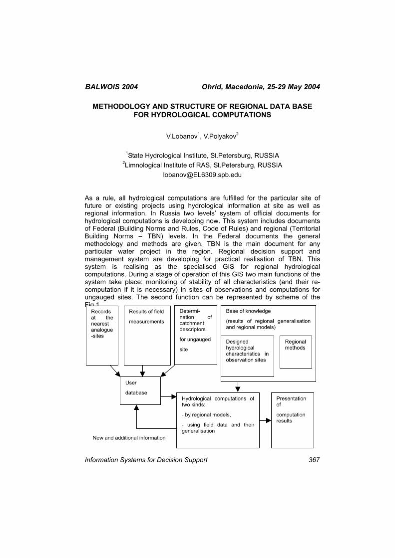
BALWOIS 2004 Ohrid, Macedonia, 25-29 May 2004
METHODOLOGY AND STRUCTURE OF REGIONAL DATA BASE FOR HYDROLOGICAL COMPUTATIONS
V.Lobanov1, V.Polyakov2
1State Hydrological Institute, St.Petersburg, RUSSIA 2Limnological Institute of RAS, St.Petersburg, RUSSIA
As a rule, all hydrological computations are fulfilled for the particular site of future or existing projects using hydrological information at site as well as regional information. In Russia two levels’ system of official documents for hydrological computations is developing now. This system includes documents of Federal (Building Norms and Rules, Code of Rules) and regional (Territorial Building Norms – TBN) levels. In the Federal documents the general methodology and methods are given. TBN is the main document for any particular water project in the region. Regional decision support and management system are developing for practical realisation of TBN. This system is realising as the specialised GIS for regional hydrological computations. During a stage of operation of this GIS two main functions of the system take place: monitoring of stability of all characteristics (and their re-computation if it is necessary) in sites of observations and computations for ungauged sites. The second function can be represented by scheme of the Fig.1.
Records at thenearest analogue -sites
Results of field
measurements
Determi-nation of catchment descriptors
for ungauged
site
User
database
Base of knowledge
(results of regional generalisationand regional models)
Designed hydrological characteristics inobservation sites
Regional methods
Hydrological computations oftwo kinds:
- by regional models,
- using field data and theirgeneralisation
Presentation of
computation results
New and additional information
Information Systems for Decision Support 367
BALWOIS 2004 Ohrid, Macedonia, 25-29 May 2004
Fig.1 Block-scheme of a subsystem of hydrological computations for ungauged sites.
For regional computation, the user forms his own database for a decision of two main tasks:
- determination of design hydrological characteristics in the site of observations (including restoration of long-term time series, assessment of homogeneity and stationarity, design values and their errors, etc);
- transition from the information in observation sites to any ungauged basin on the basis of different kinds of models.
This database includes field measurements fulfilled by user at ungauged site during any period of time, basin descriptors obtained by user for ungauged site which are factors of regional models (for example, basin area, precipitation, average altitude of basin, etc). In addition, the user forms his own database of historical records at analogues sites for restoration of historical long-term series from short-term field observations by space-time regional relationships. For computation the user applies this database as well as a database of knowledge, i.e. all results obtained on the previous stage of GIS formation: computed hydrological characteristics at sites and parameters of regional models. The results of computation for any ungauged site can be presented and restored in the database as new information.
368 Information Systems for Decision Support
BALWOIS 2004 Ohrid, Macedonia, 25-29 May 2004 HIS2000 HYDROLOGICAL INFORMATION SYSTEM – THE ROLE IN
THE LOW STREAMFLOW HYDROLOGICAL ANALYSIS
Gordana Bušelić, Boris Lovošević, Dijana Oskoruš
Meteorological and Hydrological Service, 10 000 Zagreb, Grič 3, CROATIA
The Hydrology Department of the Meteorological and Hydrological Service of the Republic of Croatia has been intensively engaged for more than three years on development and implementation of new information system referred to as HIS2000. The system is intended for quality, reliable and fast collecting of all sorts of hydrological information, their storing, processing, and distribution to users.
The presentation reports on the HIS2000 information system concept, focusing specifically on the database as a core part of the system. The low streamflow hydrological analysis has been chosen as an example of HIS2000 implementation.
The authors of the poster are the system developers.
Information Systems for Decision Support 369
BALWOIS 2004 Ohrid, Macedonia, 25-29 May 2004
A DIGITAL GROUNDWATER MAP OF BULGARIA IN 1:500 000 SCALE – OBJECTIVES AND METHODOLOGICAL APPROACH
Pavel Pentchev, Chavdar Gurov, Nickolai Stojanov, Vassil Petrov
University of Mining and Geology “St. Ivan Rilski” 1100, Studentski Grad, Sofia, BULGARIA
The present groundwater map of Bulgaria is intended for a wide range of users - hydrogeologists, non-professionals in the field of hydrogeology, investors, students, etc. who wish to get a general idea of the distribution and type of main groundwater and mineral water reservoirs in Bulgaria.
The map can be used in different ways depending on the interests of the user. For those wishing to find the location of the most productive aquifers in Bulgaria, a look at the map is enough since the differences between the separate aquifers are given in colours. A closer look at the map will reveal the lithological type of the water-bearing formations, the location of the basic groundwater springs and mineral water reservoirs, the boundaries of the hydrogeological regions and the areas for basin water management. A further detailed examination of the map with the help of the explanatory note will enable the user to discover the stratigraphic levels and names of the separate aquifers, their distribution and finally, the official litho-stratigraphic units to which these are associated.
Four classes according to groundwater productivity and four subclasses depending on the porosity type of water-bearing rocks are used to categorise the hydrogeological formations:
- major aquifers in class A, major aquifers in class B, minor aquifers in class C, and non-aquifers in class D;
- porous aquifers in subclass 1, fractured aquifers in subclass 2, fractured-karst aquifers in subclass 3, and porous-karst aquifers in subclass 4.
The separate classes can be identified by the different letter indices and colours, while the separate subclasses by the different numerical indices and patterns. The map is cleared up of information items of no particular significance for the regional characteristics of the hydrogeological conditions. It also includes only the most significant groundwater springs and mineral water sources exclusively property of the state.
370 Information Systems for Decision Support
BALWOIS 2004 Ohrid, Macedonia, 25-29 May 2004 The map has been prepared as a digital model in GIS - MapInfo which makes it particularly easy to use and update by computer data base processing.
Information Systems for Decision Support 371
BALWOIS 2004 Ohrid, Macedonia, 25-29 May 2004
SPATIAL DATA ANALYSIS AND WATER INFORMATION SYSTEM FOR THE SAVA RIVER IN SLOVENIA
Lidija Globevnik, Andrej Vidmar, Mitja Brilly
University of Ljubljana, Faculty for Civil Engineering and Geodesy,
Jamova 2, 1000 Ljubljana, SLOVENIA [email protected]
To follow holistic doctrine for a protection of water environment and human health we need to develop river basin management plans. To support their development, harmonised data on catchments characteristics and integrative information of today's management of water environment are needed. Therefore, we are developing an information system, in which data and information from different sources are collected, harmonised and evaluated. On the bases of this information system we are developing DPSIR indicator system for the Sava river in Slovenia. The system will also support water quality and water flow model.
The system consists of thematically independent data bases or thematic maps; each data base consists of GIS thematic map and corresponding relational data base or descriptive information (documents, tables, pictures, moving slides…). Each data base is unique, none attribute is repeated elsewhere. It is also harmonised with the others and integrated into one, consolidated system. Objects in each data base are spatially represented and geo oriented in 2D surface (Gauss Krüger coordinate system). The basic areal geographical data base is hydro geographical surface delineation of Slovenia territory. The system is based on PC platforms, prepared for web communication and user control system. Data bases are prepared in PC commercial software forms with html protocols and xml data descriptions.
In the first step, information on the existing national data fond is aggregated and analysed. In the module‘ driving forces and pressures’ data on settlements with population, land use, captured springs, areas of water supply and sewerage systems is collected and analysed. In the module ‘state and impact’ data on water quantity, water chemical quality on selected surface water stations and groundwater bodies, vulnerable areas to nutrients and organic emissions is collected and harmonised. In the ‘response module’ data on nature protected areas, drinking water protection regimes, waste water treatment plants and solid waste dumping sites is prepared and analysed.
372 Information Systems for Decision Support
BALWOIS 2004 Ohrid, Macedonia, 25-29 May 2004 AUTOMATIC SYSTEM FOR METEOROLOGICAL MONITORING FOR
ENVIRONMENTAL PURPOSES
Hristomir Branzov
National Institute of Meteorology and Hydrology, Sofia, BULGARIA
Thе contemporary management of the environment needs exact hydro-meteorological data suitable for assimilation from numerical models for estimation of air and water pollution caused by significant pollution sources The existing networks can’t provide such information that why the big industrial object like power plants, chemical enterprises, mining companies end others develop their own monitoring systems. In the presented paper the automatic meteorological systems created for different industrial objects is presented.
Information Systems for Decision Support 373
BALWOIS 2004 Ohrid, Macedonia, 25-29 May 2004 GROUND WATER INFORMATION SYSTEMS AS DECISION MAKING
TOOLS. CASE STUDIES: JAMAICA, TRINIDAD, JORDAN, UAE, BAHRAIN, AND DOMINICAN REPUBLIC
Jasminko Karanjac
University of the West Indies, Faculty of Pure & Applied Sciences, Mona Campus, Kingston 6, JAMAICA, W.I.
[email protected] Ground water data collection and information management are essential prerequisites for any ground-water-resources based decision-making. While data are available to more or less extent in most countries, scattered as they may be in many institutions and in various paper or digital formats, they are not easily retrievable, neither is the information effortlessly interpretable without the support of dedicated ground water data analysis and interpretation tools.
A modern Ground Water Information System (GWIS) integrates all data, descriptive or quantitative, it links to GIS, makes the analysis and interpretation of data a routine procedure, and presents and reports data and information in a way that helps in decision-making.
The author has helped establish in recent years many such GWISs in arid countries (Bahrain and United Arab Emirates), in semiarid countries (Jordan), and in countries with tropical climates (Jamaica, Trinidad, The Dominican Republic). A GWIS stores information on lithology of aquifers, water quality over an extended period of time and with depth, evolution of water levels, abstractions for various uses, etc. Numerous maps and dedicated diagrams, graphs, and cross sections are made a part of the GWIS.
Each of the GWISs recently established for Jamaica and Trinidad contain information from about 800 wells. The GWIS of the Dominican Republic stores data from about 1900 wells mostly along the southern coast of the country. All three GWISs point at seawater intrusion, agricultural contamination by fertilizers and pesticides. Other GWISs selected for this presentation contain more than 1000 wells in their databases (Jordan 4,500; Bahrain over 1000; UAE close to 1,400). The GWIS of Jamaica produces from raw field data the information about extension of sodium plumes near bauxite processing plants. GWIS of Jordan indicates over abstraction from well fields supplying Amman with water and salinization of agricultural lands due to improper drainage. The GWIS of Bahrain illustrates water level declines and water quality deterioration that prompted the government to declare moratorium on any water well drilling activities.
374 Information Systems for Decision Support
BALWOIS 2004 Ohrid, Macedonia, 25-29 May 2004 Each GWIS processes field-collected data, turns data into information using dedicated mapping and other graphical presentations, and presents information in a form usable to decision makers. In coastal countries, a GWIS points at seawater intrusion and helps in making plans for sustainable development.
Information Systems for Decision Support 375
BALWOIS 2004 Ohrid, Macedonia, 25-29 May 2004
THE SPANISH HYDROLOGICAL SYSTEM
Alberto Rodriguez Fontal1, Justo Mora Alonso-Muñoyerro1, Fernando Toledano Sánchez2
1General Direction of Hydraulic Works and Quality of Waters, SPAIN 2Confederación Hidrográfica del Segura Angel Luis Aldana Valverde
Hydrographic Studies Center, SPAIN [email protected]
In this paper the authors describe the Spanish Hydrological System applied to flood propagation forecast in all Spain rivers.
It is in the century XIX when in Spain are begun to master the necessary techniques for the determination of river flows. Though are known data in some Spanish rivers from before, it is in the last third of this century when starts to be had continuous series. The series of known daily flows longer of Spain is the series of river Guadalentin dated of 1885. The systematical records begin around the beginning of the century XX.
The first normative official on nets of discharge measures date of 1941, when the then Public Works Ministry approved a Ministerial Order to know the water used by the concessionaires. Therefore the General Direction of Hydraulic Works approved in 1963 a General Improvement and Amplification Plan of Discharge Mesures Stations, that drove to the establishment of the Official Stations Net of Discharge Mesures (named ROEA, Red Oficial de Estaciones de Aforo).
This important plan was updated in all the basins in the decade of 1970s years, what gave cause for a very important growth of the number of measure stations in the peninsular rivers.
Since 1988, the General Direction of Hydraulic Works and Quality of Waters has been making an important effort with a view to setting up a real time telemetering network for hydraulic and hydrological variables. This network, known as Sistema Automático de Información Hidrológica (SAIH) (Automatic Hydrological Information System), basically measures magnitudes such as rainfall in rain gauges, river and reservoir levels, and flow rates in piping, but some points have been equipped with devices and gauges for measuring other variables, such as temperatures, evaporation, wind speeds and directions or the snowline. Each one of these automatically operated measurement points, is connected to a communications system, either via satellite or radio, in such a way that all the data can be brought together in a basin processing centre, where all the variables that have been measured are collected, giving rise to a
376 Information Systems for Decision Support
BALWOIS 2004 Ohrid, Macedonia, 25-29 May 2004 complete information system that operates in real time. The data update period can vary, but it generally takes place at regular intervals of 5, 10, 30 minutes and never more than one hour.
The system include mathematical models for the forecast and control of floods, based on hydrological methods. Several real cases using this models could be sowed.
Information Systems for Decision Support 377
BALWOIS 2004 Ohrid, Macedonia, 25-29 May 2004
DATABASE CONSTRUCTION FOR MANAGEMENT INFORMATION SYSTEM ON IRRIGATION AND DRAINAGE SCHEMES
Llija Kondinski
JP "Strezevo" – Bitola, Bulevar 1 Maj bb, Bitola, Republic of MACEDONIA
A great part of current problems in Irrigation and Drainage Schemes (IDS) all over the world (poor performance of irrigation and drainage, increasing demands for larger agricultural productivity, quality and quantity restricted water resources in agriculture, endangered soil resources and negative effects of global climate changes) may be overpassed or considerably mitigated by improvement of organization and management of existing IDS, i.e. by introducing of contemporary Management Information Systems (MIS).
Contemporary MIS are set of various components: Geographic Information System (GIS), Database (DB), Software, Hardware, Lifeware, and Orgware.
In the paper is suggested a model for construction of user database for MIS on IDS. This user database should take related data from the fundamental databases on information systems from various authorized institutions (state institutions and public enterprises for hydrometeorology, geodesy, geology, physical planning, statistics and etc.), in charge of collection, processing and storing data from their domain.
Some of these institutions have wide spread measuring network, with measuring points, which in rational way, cover the entire territory of the country. Various weather forecasts and reports, different cadastres, topological and other thematic maps are resulted from these fundamental databases, which are very useful for IDS's MIS.
Synergetic concept for development of monitoring system for the needs of MIS on IDS is provided, which includes both, public and IDS's monitoring systems. The main emphasize is on the use of modular automatic measuring systems with possibilities of teletransmission of measuring parameters.
The existing hydrometeorological stations should be equipped with measuring devices with an aim to measure additional agrometeorological parameters for the necessities of both IDS's MIS and agriculture - soil moisture and soil temperature of various depths, the temperature in lower overground layer and etc.
378 Information Systems for Decision Support
BALWOIS 2004 Ohrid, Macedonia, 25-29 May 2004 From the crop aspect, more closely covering (particularly for soil moisture) is necessary, which could be provided through sensor network placed in every large plot or by application of advanced technologies (microwave absorption, radio attenuation, spectral reflectance and thermal infrared techniques), which very soon could develop practical methods for determination of the soil moisture.
The most important thing during soil moisture measuring for the necessities of IDS's MIS is the rapid result obtaining and following of its dynamics, in field conditions.
Information Systems for Decision Support 379
BALWOIS 2004 Ohrid, Macedonia, 25-29 May 2004 DATA BASE FOR MONITORING, PROTECTION AND MANAGEMENT
OF RESERVOIRS IN SERBIA
Ljiljana Comic, Svetlana Curcic, Aleksandar Ostojic
Faculty of Science, Institute of biology and ecology R. Domanovica 12, 34000 Kragujevac, SERBIA and MONTENEGRO
In Serbia more than 30 greater reservoirs were built and most of them are using for supply of inhabitants with drinking water.
Basic characteristics of most reservoirs are inadequate ecological protection and non rational management. Investigation on whom would be based programs for monitoring, protection and remediation, mostly are not scientifically established and properly planed. Except that, present date did not adequate process and not available to all participants is exploitation of reservoirs. Because of that, necessity for formation of data base serving transfer of knowledge and information, cooperation among participants in management and support of sustainable using of water resources.
380 Information Systems for Decision Support
BALWOIS 2004 Ohrid, Macedonia, 25-29 May 2004
PRECIPITATION DISTRIBUTION IN TIME AND SPACE USING GIS TECHNOLOGY FOR REPUBLIC OF MACEDONIA
Pece Ristevski1, Sasho Manasov2, Radica Gareva3, Olivija Todorovik1
1Hydrometeorological Service, Skupi bb 1000 Skopje, Republic of MACEDONIA
2"GisVision", Skopje, Republic of MACEDONIA 3Ministry of Defence, Republic of MACEDONIA
In this paper there are analyzed monthly, seasonal and yearly precipitation values for the territory of Republic of Macedonia.
There are prepared monthly, seasonal and yearly maps in GIS technology using adequate methodology, i.e. functional relation between precipitation and the altitude. During the preparation of the climate maps in GIS it is also taken into account the changes in climatological and agroclimatological characteristics according the altitude. The climatological maps are in ratio 1:250000 with specific attributes which are got as appropriate investigation in the space using the relationship between influence of climate system and circulars factors as physical-geographic characteristics, orography, hydrography, influence of natural and artificial water body, influence of Adriatic and Aegean see etc.
Investigations are done by functional relations between elevation and appropriate climatological elements (precipitation and others parameters). For each climatological element and its parameter are shown the following functions :
f(x)=ax+b;
f(x)=ax2+bx+c;
f(x)=ax3+bx2+cx+d and etc .
There are analyzed and presented in digital maps monthly, seasonal, yearly sums of precipitation for the period 1951-2000, in comparison with periods: 1951-1960; 1961-1970; 1971-1980; 1981-1990; 1991-2000; 1951-1980; 1961-1990 and 1971-2000.
Information Systems for Decision Support 381

BALWOIS 2004 Ohrid, Macedonia, 25-29 May 2004
GIS APPLICATIONS FOR THE EC WFD IMPLEMENTATION IN ACCESSION COUNTRIES
Snejana Balabanova1, Dobri Dimitrov1, Olivija Todorovik2, Kostas Solis3
1National Institute of Meteorology & Hydrology, Sofia, BULGARIA 2Hydro-Meteorological Service, Skopje, Republic of MACEDONIA
3Agricultural University of Athens, GREECE [email protected]
The paper deals with specific problems arising in hydrological GIS applications related to the implementation of the EC WFD. Those problems concern:
- The configuration of the required set of GIS layers and related data, their accuracy and degree of generalization;
- Different tools for computerized delineation of catchments; Pre-processing of DTM and river network, reconditioning the DTM with the river network.
- Rivers, basins and monitoring network coding; approaches, different coding systems;
- GIS data harmonization in trans-boundary basins.
382 Information Systems for Decision Support
BALWOIS 2004 Ohrid, Macedonia, 25-29 May 2004
WHAT VALUE IS LONG TERM DATA?
Richard Silberstein
CSIRO Land and Water, Floreat, Western Australia Private Bag No. 5, PO Wembley, WA 6913, AUSTRALIA
Long-term datasets are the underlying backbone of hydrology, ecology and many natural sciences. While much knowledge and understanding is gained from short-term observations and laboratory experiments, hydrological and ecological systems have such spatial coverage and long-term response times that often changes are not detected. Subject to inter-annual and inter-seasonal variability in the natural world, changes are often difficult to detect without an extremely good dataset against which to compare current trends. However, in most of the developed world long-term data collection is under threat. In Australia, continual demands for short-term delivery of results, and the demand to demonstrate clear economic benefits that are often difficult for scientists to quantify, have led to a decline in such infrastructure, and decline in the technical capacity of water management agencies to analyse data that is collected. On the other hand, hydrological modelling has progressed to the stage where virtually any catchment process can be modelled, and global climate models, that are run continuously on the world’s most powerful computers, can simulate the weather over the last 100’s of years, and the next. These capabilities are truly awesome, and genuinely raise the question: Given we can now simulate how the world works so well, can we cut down the need for data? Undoubtedly the models can be used to fill in missing parts of hydrological and meteorological puzzles, but perhaps the most valuable scientific use they can be put to is the analysis of data. Models provide a framework for testing of ideas, and a systematic platform for data analysis. This data comes from observations of natural systems that we are trying to understand, generally so we can better manage them or live with them. In fact, now that we have the capability to simulate these systems for such long periods, the value of long-term datasets with which to compare them has become even greater. Witness the effort taken in analysing ice cores from Antarctica and the Arctic, palaeopollen studies and the atmospheric data collection, including air archive, undertaken at the Cape Grimm station in southern Australia.
In this paper I cite examples of studies that have used long-term datasets, and attempt to demonstrate that the idea that we could replace data collection with modelling is a dangerous one. One third of the world’s population lacks fresh water that most in the Western nations take for granted, and management of fresh water resources is the most significant resource issue facing mankind
Information Systems for Decision Support 383

BALWOIS 2004 Ohrid, Macedonia, 25-29 May 2004 world wide. Against this background it is surprising that support for hydrological research is in decline in many countries, and especially the collection of the most fundamental data for the science – data that will form the basis of any scientific progress. The ability to predict hydrological behaviour in ungauged basins depends absolutely on good data in basins that are gauged. While it is a significant hydrological science goal is to make predictions with minimal data, we need data to test this ability.
384 Information Systems for Decision Support
BALWOIS 2004 Ohrid, Macedonia, 25-29 May 2004
A PROPOSED AUSTRALIAN COLLABORATIVE NETWORK FOR LONG-TERM HYDROLOGICAL AND ECOLOGICAL MONITORING
Richard Silberstein
CSIRO Land and Water, Floreat, Western Australia Private Bag No. 5, PO Wembley, WA 6913, AUSTRALIA
Management of fresh water resources is the most significant issue facing mankind world wide. One third of the world’s population lacks fresh water that most in the Western nations take for granted. Against this background it is surprising that support for hydrological research is in decline in many countries, and especially the collection of the most fundamental data for the science – data that will form the basis of any scientific progress. This declining support for fundamental data is particularly evident in Australia. Our hydrology needs an injection of vitality and a long-term vision, to ensure that scientific input keeps water management and natural resource management (NRM) at a high standard, in the world’s driest inhabited continent. The ability to predict hydrological behaviour in ungauged basins depends absolutely on good data in basins that are gauged. While the goal is to make predictions with minimal data, we need data to test this ability. In the last 40 years there have been perhaps 20 major reviews of hydrological monitoring in Australia; each concluding that long-term monitoring is essential, but needs focus and coordinated analysis to ensure its value. However, despite these conclusions and widespread recognition within Australian State and Federal agencies that long-term monitoring is essential for good NRM, monitoring resources have declined almost monotonically over that time.
In this paper I call for a significant improvement in the state of hydrological gauging and ecological monitoring networks, data processing, quality control and data sharing. Existing networks should be expanded to include ecological indicators. I propose a collaboration to establish links between data collection agencies, Universities, CSIRO, and other research agencies, industry, schools and the community, all participating at some level in the hydrological science activity through data collection, analysis, and reporting. Such an activity would have irreplaceable value to the Australian community if adequate monitoring is undertaken and well-designed. A model for this is the highly successful Australian Collaborative Land Evaluation Programme (ACLEP). We need to expand beyond our one link in the International Long-term Ecological Research Network, to establish catchments around the country that satisfy the criteria, and can contribute to international efforts in understanding the global bio-geo-chemical and hydrological cycles. A national workshop is proposed to
Information Systems for Decision Support 385

BALWOIS 2004 Ohrid, Macedonia, 25-29 May 2004 establish: a) minimum levels of monitoring activity; b) common interests; c) collaboration between agencies; d) a reinvigoration of hydrology in Australia.
386 Information Systems for Decision Support
BALWOIS 2004 Ohrid, Macedonia, 25-29 May 2004
THE WORLD HYDROLOGICAL CYCLE OBSERVING SYSTEM (WHYCOS)
Bernard Thebe, Tommaso Abrate
Institut de Recherche pour le Développement US OBHI - BP 64501- 34394 Montpellier Cedex 5 FRANCE
Adequate information is essential for wise management of water resources. Sadly, at the global scale our ability to provide information about the status and trend of water resources is declining. Many developing countries are unable to maintain their systems for acquiring water-related data, and for disseminating them to decision makers, engineers, resource managers, and the public. To counter these trends, an essential goal of WMO is to assist its Members in maintaining and improving their information systems. The Organization uses such means as technology transfer and training, collaboration among meteorological and hydrological services, and international exchange of data and information.
The World Hydrological Cycle Observing System (WHYCOS) has been developed to contribute to this goal. Composed of regional systems (HYCOSs) implemented by cooperating nations, WHYCOS will complement national efforts to provide the information required for wise water resource management. Modeled on WMO's World Weather Watch (WWW), and using the same information and telecommunications technology, WHYCOS will provide a vehicle not only for disseminating high quality information, but also for promoting international collaboration. It will build the capacity of national Hydrological Services (NHSs), so that they are ready to face the demands of the 21st century. It will provide a means for the international community to monitor more accurately water resources at the global level, and to understand the global hydrological cycle.
The objectives of WHYCOS are :
- Strengthen the technical and institutional capacities of hydrological services to capture and process hydrological data, and meet the needs of their end users for information on the status and trend of water resources;
- Establish a global network of national hydrological observatories which provide information of a consistent quality, transmitted in real time to national and regional databases, via the Global Telecommunication System (GTS) of WMO; and
Information Systems for Decision Support 387

BALWOIS 2004 Ohrid, Macedonia, 25-29 May 2004
- Promote and facilitate the dissemination and use of water-related information, using modern information technology such as the World Wide Web and CD-ROMs.
388 Information Systems for Decision Support
BALWOIS 2004 Ohrid, Macedonia, 25-29 May 2004
HYDROMET – A SOFTWARE TO MANADGE AND PROCESS HYDROMETEOROLOGICAL DATA
Bernard Thebe
Institut de Recherche pour le Développement
US OBHI - BP 64501- 34394 Montpellier Cedex 5 FRANCE [email protected]
The Research Institute for Development (IRD) and the National Company for the Rhone (CNR) have combined their expertise in managing networks for measuring and processing hydro-meteorological data. The result is a new software program called HYDROMET.
HYDROMET has been designed to provide the following functions:
- hydro-meteorological data acquisition and collection : stage, discharges, gaugings, rating curves, water quality parameters, rainfall, temperatures, hygrometry, wind speed, etc.
- information storage in an ORACLE data base ensuring full integrity,
- automatic data processing in real time or in deferred time for data stored in the data base,
- varied means of disseminating stored data.
HYDROMET is an open system, designed to solve the problems of data management in contemporary hydro-meteorology.
The dissemination of information on Minitel (France) or Internet ensures 24 hour a day service to public services and consumers with no time constraints or human intervention necessary.
Several architectures could be used, depending on needs hydro meteorological network size, number of applications which are installed on the server, number of client PCs on the network, etc.
HYDROMET is available in a multi-station version: a server and several client PCs: (for example, up to a hundred client PCs can be connected at the CNR, some of which are off-site, connected to the server with through a high-speed data link and have the same conditions of access as the users of the central site and the same access time as those using the internal network), or in mono-station version : the server and the client are on the same PC.
Information Systems for Decision Support 389
BALWOIS 2004 Ohrid, Macedonia, 25-29 May 2004
WATER RESOURCES IN MALI: COLLECTION AND PROCESSING OF HYDROLOGICAL DATA
Bréhima Coulibaly
Direction Nationale de l'Hydraulique. Bamako, MALI
One of the main missions of the National Hydraulic Directorate is to follow and to value (qualitatively and quantitatively) the available water potential of the country.
For the case of the surface waters, the achievement of this mission is assured by the Division Hydrology through the management of hydrometric network of more than 100 operational stations listed in the Hydrological Directory.
This network has been reinforced in 2001 by the installation of 08 Platforms of Collection and transmission of the Hydrological Data by satellite in setting of project in the basin of superior Niger river.
The hydrological stations distributed on the whole territory is confided to local observers whose essential stains consist in making the daily readings of water levels and to assure the interview and the security of the batteries of scales and platforms of Collection of Data by satellite.
The operational management of the network is assured by the technical teams of the Regional Directions of hydraulic and energy : the maintenance and the repairing of the stations; the campaigns of measures of discharges; the control and the retraining of the observers; the maintenance of the automatic stations and the facilities of collection and treatments of the data.
The Division of Hydrology assures: the collection; the processing and the publication of the hydrological data.
It elaborates and diffuses the hydrological information through the publication of the following documents: Hydrological directories; Hydrological Bulletins ; Notes of synthesis on the rises in water levels.
The fundamental objective of the hydrological follow-up being to encourage a better knowledge of the hydrological factors and their impact on the national economy, the data are distributed to the attention of the decision-makers and potential users of surface water resources.
390 Information Systems for Decision Support
BALWOIS 2004 Ohrid, Macedonia, 25-29 May 2004 SAIH OF THE RIVER TAGUS BASIN: STUDY AND APPLICATION OF
THE TELEDETECCION FOR SNOW SURFACE ANALYSIS. SNOW GAGE. THAW MODELS. TOOLS GIS FOR APPLICATION
Juan Torres Cerezo, Luis Pérez Sánchez, Jose Antonio Hinojal, Carmen Marta Soriano Roncero
Confederación Hidrográfica del Tajo
(Ministerio de Medio Ambiente), PERU
The Tagus Hydrographical Confederation (CHT) has an Automatic System for Hydrological Information at the present time (SAIH) for the administration of the resources and to prevention floods, characterized by the location of 202 control points or measurement (rain, snow, flows, levels…), that every 15 minutes it transmits the registered information, through the satellite HISPASAT, to the Basin Control Center. As investigation study it has been carried out the analysis of the snow surface in the CHT, using the teledetección through pictures of NOAA satellite, to characterize the snow area, in differents fringes of altitude that it is presented, as well as their analysis with the information received by the snow gage, and their later inclusion in thaw models developed for differents subbasins of the right riverbank of the river Tajus. All this presented under a Geographical Information System (Arc IMS).
Information Systems for Decision Support 391
BALWOIS 2004 Ohrid, Macedonia, 25-29 May 2004
DATA INFRASTRUCTURE AND GEOGRAPHIC INFORMATION SYSTEM FOR DESERTIFICATION SURVEY IN AFRICA CIRCUM-
SAHARIAN ZONE: ROSELT 2PROGRAM
Desconnets J.C.1, Loireau M.2, Leibovici D.3, Moyroud N11, D’herbès J.M.3
1 IRD – Programme ROSELT/OSS Maison de la télédétection, 500, avenue J.F.
Breton 34093 Montpellier cedex 05, FRANCE 2 CIRAD – Programme ROSELT/OSS Centre IRD Montpellier - 911, av
Agropolis - BP 64501, 34394 Montpellier cedex 5, FRANCE 3 IRD - Programme ROSELT/OSS, Centre IRD Montpellier - 911, av Agropolis –
BP 64501, 34394 Montpellier cedex 5 FRANCE [email protected]
The fundamental purpose of ROSELT program is to improve knowledge of the mechanisms, causes, consequences and scope of desertification in arid and semi-arid zones of the circum-Saharan area. ROSELT is a key programme running by the Sahara and Sahel Observatory (OSS), co-ordinated by IRD3, CIRAD4 and INSAH5, as a long term environmental monitoring and a research platform. The network of 25 Circum-Saharian observatories in 11 countries is in charge of the ecosystem characterisation, its monitoring survey and the changes assessment. To be able to, in one hand, harmonize data collection and data processing methodology, and in the other hand, take into account the heterogeneous data structure, volume and nature, is necessary to setting up of same tools to provide management, data processing and sharing the information produced.
With this framework two complementary approaches were suggested to the ROSELT network :
- Local Environmental Information System for data management and data processing (LEIS6) integrating surveyed data from the observatory and
2Observatory Network for Long Term Ecological Survey (Réseau d’Observatoires pour le Surveillance Ecologique à Long Terme) 3 IRD : Research Institute for Development (Institut de Recherche pour le Développement) 4 CIRAD : Agronomical International Research Center for Development (Centre International de Recherche Agronomique pour le Développement) 5 INSAH :Sahel Institue (Institut du Sahel) 6 LEIS : Local Environmental Information System
392 Information Systems for Decision Support
BALWOIS 2004 Ohrid, Macedonia, 25-29 May 2004 environmental scientist expertise to reach the goal of decision making products (ecosystem changes indicators). These systems are installed and available locally.
- Regional Data Infrastructure enabling data consolidation for local databases. It works with the help of two services: a production and management metadata tool referencing local data and a mediation service allowing communication between local metadata bases and data bases. This mediation service provides a coherent and global view of the available data from the observatories network
For this purpose the dynamic within the network was based onto sharing conceptual definitions (ontology, methodological guides for surveys and data processing), developing the necessary tools to reach the objectives, training sessions, charter for management and circulation of data especially for data status and duties of network members.
Our communication will present in detail these two complementary approaches, particularly on the specificity of each tool implemented in the observatories. Perspectives on using this approach at national level for environmental monitoring in the circum-Saharian zone are given.
Information Systems for Decision Support 393
BALWOIS 2004 Ohrid, Macedonia, 25-29 May 2004 AN ECONOMIC APPROACH TO WATER INFORMATION SYSTEMS
Alexandre Borde
Centre d’Economie et d’Ethique pour l’Environnement et le Développement7 Université de Versailles Saint-Quentin-en-Yvelines
47, boulevard Vauban, 78047 Guyancourt cedex, FRANCE [email protected]
There is a constant need to develop meaningful and concise information to support water policies and actions programs. When it comes for example to the use of water for irrigation or to the forecast of floods, information is a prerequisite. Unfortunately, it is widely agreed that effective action is still hampered by incomplete information and data gaps.
This can be explained by the weakness of information evaluation. As information can have many variable aspects, the decision to develop information activities must be well assessed. First of all, the scope of an information system must be measured with respect to the decision making process. Second, we propose to consider information depending of its purpose (inventory, monitoring and evaluation, forecast, public awareness, etc.).
After having studied the various role of information vis-à-vis the decision making process, we will oppose two visions of information, and besides, of the information system framework. The first vision could be called the pyramidal approach to information. Data are collected, processed, stored and transmitted through a unidirectional flow of information. To the opposite, an information system can be seen as an information exchange media. Information is widely disclosed to the various stakeholders of a water policy or action plan design.
In the first case, information is only a support tool to the decision making process, while in the second case, information contributes also to foster public awareness. The EU directive on public access to environmental information is an expression of this evolution towards the right-to-know8. Information becomes an indirect incentive mechanism allowing to change behaviours (for example towards a better protection of water resources).
7 UMR C3ED 063 (IRD-UVSQ) 8 Directive 2003/4/CE on public access to environmental information (28/01/2003).
394 Information Systems for Decision Support
BALWOIS 2004 Ohrid, Macedonia, 25-29 May 2004
RIMSYS – RIVER MONITORING SYSTEM
Josif Milevski1, Christian Tognacca2
1Hydrometeorological Service bb.,Skupi – Skopje, Republic of MACEDONIA 2ITECO Ingenieurunternehmung AG
Alte Obfelderstrasse 68 8910 Affoltern am Albis Zurich, SWISS [email protected]
The River Monitoring System Project (RIMSYS), a cooperation project between the governments of the FYR of Macedonia and Switzerland, is designed to revitalize the national river monitoring system in Macedonia. The main aims are to measure and document long term changes in the pollution levels of the important rivers in the country and to implement regulation measures designed to control water pollution.
The project includes the refurbishment of 18 monitoring stations throughout the country, the construction of an environmental monitoring laboratory in Skopje, the implementation of a data management system, and the production of yearbooks for hydrometric and water quality data. An initial 7 priority monitoring stations are in the final phase of planning and construction and commissioning should be completed within a few months. The civil works for the laboratory are in the final stage and the laboratory equipment will be commissioned and installed as soon as these works are completed. The data management system has been successfully implemented, staff trained and the yearbook of 2002 has already been published on the homepage of the Hydrometeorogical Department (HMD) (www.meteo.org.mk).
In the paper the authors will focus in particular on the data management system, present details of the hydrological data management system HydroPro™, and give an overview of the data collected, analysed and published to date by the Hydrometrical Division and the Water Quality Division of HMD.
The hydrological data management system HydroPro™ was developed by the company A.P. KERN Ltd (based in Bern, Switzerland) as a tool for the management, analysis and publication of the hydrological data of the Swiss Federal Administration and a number of Swiss cantonal institutions. Particular needs of the HMD were addressed by designing and implementing a new module for the management of water quality data. HydroPro™ represents an important tool for the dissemination of hydrological data in Macedonia.
In addition to presenting the Macedonian experience and data collected from the RIMSYS stations, the authors will describe experience gained and present
Information Systems for Decision Support 395

BALWOIS 2004 Ohrid, Macedonia, 25-29 May 2004 summaries of data obtained from locations in Switzerland and Uzbekistan, where HydroPro™ has also been successfully implemented.
396 Information Systems for Decision Support
BALWOIS 2004 Ohrid, Macedonia, 25-29 May 2004
A SPECIFIC METHOD OF MODELING AND DESIGNING ENVIRONMENTAL INFORMATION SYSTEMS. THE EXAMPLE OF
SIEREM, AN ENVIRONMENTAL INFORMATION SYSTEM FOR WATER RESOURCES
Boyer Jean-François, Servat Eric, Dieulin Claudine
IRD-UMR HSM – BP 64501- 34394 Montpellier Cedex 5 FRANCE
The Hydrosciences Montpellier Research Unity suggests studying hydrological variability on the African continent. The regional scale and the consideration of physical elements of the environment (soil, vegetations, geology, etc.), impose to lean on one environmental database.
Analytical method chosen as the realization of this knowledge base, is the method called POLLEN. This method is an adaptation of the OMT method (Object Modeling Technique) specific to the environmental information systems design.
The main part of the analysis consists in modeling data what implies to identify the objects of the system, to define their structure and their behavior and to describe their relations.
For every type of data, an object diagram and a data dictionary is provided. The diagram object is a graphic model giving a synthetic vision of the object classes, the data dictionary is a textual description of all the data and their relations.
Then the system of information is described according to the various services which it has to provide. This allows to define treatments asked by the users and to supply a functions and algorithms descriptions. System is so cut in sub-systems. Each of them is described according to its interface, the implementation software, the object classes which it uses, returned services and the relations with the other sub-systems.
Tools software packages developed are two types : the tools of treatment and constitution of data and\or their putting at disposal. Their development takes place in the phase of conception which goes through the adaptation of the model object to logical and physical constraints, conception and validation of algorithms, the interface modelling and choice of software packages and materials for every sub-system. The main tools software packages chosen divide into three categories, DBMS, GIS and tools of construction of interface.
Information Systems for Decision Support 397
BALWOIS 2004 Ohrid, Macedonia, 25-29 May 2004 WEBMAP – INTERNET BASED APPLICATION FOR REMOTE DATA
AND INFORMATION ACCESS AND VISUALIZATION
Dejan Lekic, Gordana Spegar
Ministry of Science and Environment Protection, Directorate for the Environmental Protection, Ruze Jovanovic 27a, Belgrade, SERBIA and
MONTENEGRO [email protected]
WebMap Application is a Client-Server type of application that provides remote access to the Relational Database Management System (RDBMS). Clients access the database using their Internet Browser (MS Internet Explorer 5.0 or higher), without need of installing any kind of software on their computers. This approach provides the information system designer a wide set of possibilities since the code for the application exists on the server only, thus all the changes or software enhancements are instantly available to the client users. Commonly used RDBM systems can be interfaced with WebMap (Oracle, MySQL, MS Access).
The application itself is a combination of different technologies, programming languages and already existing software packages interconnected in a system that simultaneously runs on both sides of it, on the Web&Database Server and on the Client computer. The connection made through this application doesn't have the possibility of altering the database itself, meaning that it's the main purpose of the application is to make the database accessible for numerous remote users either on Intranet or Internet, through user-friendly interface.
The application itself consists of three parts: Database Inventory Browser, Web Access Administrator Panel and the main WebMap Application. The first part gives the view on the database tables and connections between them, currently stored in the database. Using these module users can easily browse through all the available database views, but they cannot access the data itself in any form. For the direct data access, the database administrator has to create a particular user (using Web Access Administrator Panel).
The third, main part is a fully featured Web application, combining features from different types of applications such as GIS, Spreadsheet and other common Windows packages. User is provided by several interfaces with features such as Object and Layer selection, manipulation and reordering as well as direct access to the inventories of the Data and Information attached to Objects previously defined as geographical locations represented as points, lines or polygons, stored in the RDBMS. Any kind of data organized as time series, tables, set of files, etc. can be attached to these objects providing fully
398 Information Systems for Decision Support

BALWOIS 2004 Ohrid, Macedonia, 25-29 May 2004 customizable way for storing and representing different types of information about the selected item.
Information Systems for Decision Support 399
BALWOIS 2004 Ohrid, Macedonia, 25-29 May 2004
A WEB SITE OF A NATIONAL HYDRO-METEOROLOGICAL SERVICE
Minka Stoyanova
National Institute of Meteorology and Hydrology 66, Tsarigradsko Shosse blvd., Sofia, BULGARIA
On the example of the web-site of the National Institute of Meteorology and Hydrology of Bulgaria, the paper will focus on particular problems of designing and organizing a web-site of a national hydro-meteorological service (NHMS). Defining the targeted audience – from scientists to general public – imposes specific design principles. The first one is that the web-site as a whole should represent the tendency of consciously shifting from a predominantly science-centered approach to a more user-oriented philosophy - the site should start with what is most interesting for the general public. It should follow clear separation of 'scientific' and 'non-scientific' sides of the information. It must also keep visible on each level the route to all services proposed by the NHMS.
The second general challenge in making a web-site of a NHMS is that new information comes constantly. Serving it means first verify it as much as possible as quickly as possible, and second make the general public aware which information is verified and which is not.
There are yet two different aspects of using the web-technologies in a NHMS. First is using it in making “working place of the forecasters”. It means that a separate branch of the web should be developed for the forecasters to be able to change the information on the web on the fly. That is the structure of the web-site must be in relation with the technological cycle of issuing forecasts.
An important part of using web-technologies is serving for particular clients specific information prepared for them. This part should be clearly indicated, not to frustrate general users trying to download a page only to see that they are not allowed to browse further.
The web-site is a very important media, though complementary and passive, for distributing warnings for extreme events. For this purpose the information on the web-site must be always up-to-date, reliable, precise. Transparent design is an indispensable virtue, which diminishes the time for browsing the site and finding the information needed. Graphical representation in addition to precise text, makes straight-forward understanding of a warning. A special branch of the web-site dedicated to improving public understanding of and response to
400 Information Systems for Decision Support

BALWOIS 2004 Ohrid, Macedonia, 25-29 May 2004 warning, forecasts and real-time data should be considered in planning further development of a web-site of a NHMS.
Information Systems for Decision Support 401

BALWOIS 2004 Ohrid, Macedonia, 25-29 May 2004
402 Hydrological modelling

BALWOIS 2004 Ohrid, Macedonia, 25-29 May 2004
TOPIC 8 : HYDROLOGICAL MODELLING
Hydrological modelling 403
BALWOIS 2004 Ohrid, Macedonia, 25-29 May 2004
HYDRAULIC GEOMETRY RELATIONS
Levent Yilmaz
Technical University of Istanbul Civil Engineering Department, Hydraulic Division,
80626, Maslak, Istanbul, TURKEY [email protected]
Hydraulic geometry is an empirical model devised by Leopold and Maddock (1953) to provide a quantitative description of stream behavior either at a particular cross-section or along a particular stream. Only at – a – station hydraulic geometry is considered here. The application of the model in a wide range of physiographic environments (Wolman, 1955; Leopold and Miller, 1956; Fahnenstock, 1963; Lewis, 1969; Heede, 1972) indicates the extent to which it has become accepted as a suitable means of analyzing the behavioural characteristics of natural streams. However, the model does contain certain assumptions. Firstly, discharge is regarded as the dominant independent variable to which the dependent variables adjust, all other independent variables being controlled to a greater or lesser extent. Secondly, simple power functions are considered to be a suitable expression of the relationships between the dependent variables and discharge, the three basic relationships being
w=aQb d=cQf v=kQm (1)
where w is width, d is mean depth, v is mean velocity, and Q is a discharge. Since discharge is the product of width, depth, and velocity, it follows that
b+f+m=1 (2)
Richards (1973) has seriously challenged this assumption on the basis that, since resistance variation is not necessarily linear, neither depth nor velocity can be expected to vary linearly with discharge. He suggested that higher order functions are more appropriate than simple log-linear functions in describing the relationships. Finally, it is assumed that a given set of relations represents the mean condition of stream behavior at a particular cross-section, with the result that little or no scatter should be present about regression lines.
404 Hydrological modelling
BALWOIS 2004 Ohrid, Macedonia, 25-29 May 2004
THE APPLICATION OF THE ENGINEERING CALCULATION LANGUAGE - MATLAB ON HYDROLOGY
Zhang Haimin, Li Shiming, Zhang Liuzhu
Hydrology Bureau of Yellow River Conservancy Commission East No.12, Chengbei Road, Zhengzhou, 450004, CHINA
The hydrology is a field with concentrated information and is and high digitisation level. The MATLAB language and its merit ability have introduced in this paper. According to author experiences, the application foreground of this language in the hydrology have been analysed as a extensive use of language in the engineering. From learning and extensive use of this strong tools, the clear society beneficial result and economic performance can certainly be given rise to in the hydrology specialty domain.
According to the complicated level of the problem to be settled, the several stages can be divided into as following:
- Generally application: Under the only need of studying the installation and simple grammar of this program and combining the work, we can directly call the functions and satisfy the analysis and calculation requirement on the application terrace of MATLAB.
- General program development: The Need is to grasp the basic grammar and the function and compiles skill.
- The application on higher level: The synthetic knowledge of learning of application in every branches is needed, and under the aid of merit big and powerful in the computer-aided design and analysis of MATLAB, the construction and distinguishes of the various models can be done and the general system analysis program in hydrology domain can be produced so as to solve the comparatively complicated system problem.
Hydrological modelling 405
BALWOIS 2004 Ohrid, Macedonia, 25-29 May 2004
THE APPLICATION OF THE SATELLITE CLOUD ATLAS TO BUILD THE TOPOGRAPHY ELEVATION MODEL ON THE WUDINGHE
RIVER BASIN
Zhang Kejia, Ma Jun, Li Shiming
Hydrology Bureau of Yellow River Conservancy Commission East No.12, Chengbei Road, Zhengzhou, 450004, CHINA
The satellite cloud atlas has been extensively used in meteorological work, but is seldom in the condition of combining with the hydrology model. In this paper, in the application of satellite cloud atlas information, the methods such as small wave analysis and triangleization etc have been used directly from the pixel element and the satellite cloud atlas information can be turned into the basic data needed in hydrology model calculation. This data reflecting on the satellite cloud atlas are some unstable elevation changes on Wudinghe Basin such as elevation, slop and etc.
The conclusions are that the satellite cloud atlas and remote sensing information can be used as one of feasible methods to calculate topography. The method is better than that reached only with the minority of meteorological phenomena surveys in the consideration of undulation of topography. The data resolutions are changed with the resolution of remote sensing picture. The satellite cloud atlas resolution used in this paper is not high, but the cloud atlas still can reflect the undulation change trend of topography.
Because the resolution of the remote sensing picture is fairly slightly, speaking in certain level, the data is only the preliminary result and need to be compared with other corresponding results to find the differences to correct.
406 Hydrological modelling
BALWOIS 2004 Ohrid, Macedonia, 25-29 May 2004
“EXPERIMENTAL DESIGN OF A LUMPED RAINFALL-RUNOFF MODEL DEDICATED TO THE HOURLY TIME-STEP”
Thibault Mathevet, Claude Michel, Charles Perrin, Vazken Andreassian.
Cemagref, Water Quality and Hydrology research unit, Parc de Tourvoie, BP 44, 92163 Antony Cedex FRANCE
During the last decades, the public, water authorities and scientists have been more and more concerned by extreme flood events, which have lead to an increased social need of hydrological forecasting (Takeuchi, 2002). In the same time, the operational use of flood forecasting and warning systems has increased. However, it seems that only a few models used in these systems have been designed in order to take into account short time-steps. In particular, most available rainfall–runoff models were developed with daily data. Besides, recent work focusing on the coherence of the structures of conceptual models at different time-steps (from daily to pluri-annual; Mouelhi, 2003) and other works on the downward approach in rainfall-runoff modelling (Jothityangkoon, Sivapalan and Farmer, 2001) showed the necessity to adapt the model structure to the time-step. These results suggest that models used today at short time steps and developed at larger ones may not be as efficient as they could be, because of an inadequate structure and level of complexity. In this context, there is an actual need to carry on this research on model development up to the hourly time-step, and to develop the best structure dedicated to the modelling of the rainfall-runoff transformation at this time-step. Our research is based on three main aspects that will be presented here : (1) a large sample of catchments (more than 150) on which our model development methodology is based, (2) a comparative assessment of the performances of several well-known rainfall-runoff models, at the hourly time-step, on this large sample of catchments, (3) the design of an improved model structure having the most appropriate organisation and level of complexity to give better results in rainfall-runoff modelling.
Our sample of catchments represents a very large database for such a short time-step. Data, rainfall, potential evapotranspiration and runoff, on more than 150 watersheds have been gathered, mainly in France, but also in Australia and Slovenia. This database represents a large sample of catchment area (from 1 to 5000 km²), of climate (semi-arid, Mediterranean, oceanic, continental…) which helps us to test model structure in very contrasted hydro-climatic conditions.
Hydrological modelling 407

BALWOIS 2004 Ohrid, Macedonia, 25-29 May 2004
One of the main operational application for an hourly model is flood forecasting, which requires very robust and simple models, that our research will generate. The present inter-comparison study is based on the structure derived from four well-know lumped rainfall-runoff model : GR4J, TOPMODEL, HBV and IHACRES (Perrin, 2000).
408 Hydrological modelling
BALWOIS 2004 Ohrid, Macedonia, 25-29 May 2004
PREDICTING DIMENSIONLESS LONGITUDINAL DISPERSION COEFFICIENT IN NATURAL STREAMS BY FUZZY-LOGIC
APPROACH
Z. Fuat Toprak
Istanbul Technical University, Department of Civil Engineering, Hydraulics Division 34469 Maslak, Istanbul, TURKEY
In order to investigate dispersion process, researchers have used differential equations, which can be written under certain assumptions. However, they all include dimensional or dimensionless dispersion coefficients. These differential equations cannot be used practically until the dispersion coefficients are either directly measured or indirectly calculated from other measurements. In practice however, most often-empirical equations are developed for the estimation of dispersion coefficients especially for longitudinal dispersion coefficients in natural channels. These empirical equations most often depend procedurally on the least squares techniques through regression equations of non-linear types. Unfortunately, many critical assumptions in the derivation of these regression equations are not considered at all and consequently the resulting equations can be used precautious with reservations. Otherwise, the results of these differential equations will not be reliable. However, many statistical methods or several black box approaches are used to develop equations or models for determination of the dimensional or dimensionless longitudinal dispersion coefficients. The dimensionless longitudinal dispersion coefficient has more generality than dimensional longitudinal dispersion coefficient.
The main goal of the study is to develop a new fuzzy model to predict the dimensionless longitudinal dispersion coefficients in natural channels. The fuzzy model depends on 96 data sets from the literature concerning more than 30 rivers at different times in the USA. The data sets include four independent and one dependent variable(s), which are, the depth (H, m), the width (W, m) and the mean cross-sectional velocity (U, m/s) of the flow, shear velocity (U*, m/s) and longitudinal dispersion coefficients (D1, m2/s), respectively. In order to test the model, the data sets have divided for training and testing phases.
The results of the model have compared with existing data and seven empirical equations which are developed by six researchers. The comparison depends on: 1) several statistical parameters (maximum, minimum, average, standard deviation, coefficient skew ness, coefficient of variance, and coefficient of
Hydrological modelling 409

BALWOIS 2004 Ohrid, Macedonia, 25-29 May 2004
correlation). 2) Four different error modes as the mean square error (MSE), root mean square error (RMSE), standard error (SE), and normalized error (NE).
It is observed that the fuzzy model yields more reliable results and it can be used more easily and efficiently.
410 Hydrological modelling
BALWOIS 2004 Ohrid, Macedonia, 25-29 May 2004
SUB-SYSTEM BASED ON HYDROLOGICAL MODELING AND GIS TECHNOLOGY FOR FLOOD MANAGEMENT IN THE FRAMEWORK
OF THE NATO SFP “TIGRU” PROJECT
Valentina Ungureanu1, Gheorghe Stancalie2, Viorel Alexandru Stanescu1
1National Institute of Hydrology and Water Management Sos. Bucuresti-Ploiesti 97 – 013686 Bucuresti – ROMANIA
2National Institute of Meteorology and Hydrology Sos. Bucuresti-Ploiesti 97 – 013686 Bucuresti – ROMANIA
An important objective of the NATO SfP “TIGRU” project “Monitoring of extreme flood events in Romania and Hungary using EO data” is the development of a dedicated sub-system based on GIS technology, in order to improve the flood management and implementation of flood mitigation programs in the Romanian – Hungarian trans-boundary area situated in the Crisul Alb and Crisul Negru (Kőrős) basins. This sub-system will allow the storage, management and exchange of raster and vector graphic information, and also of related attribute data for the monitoring of hydrological extreme phenomena.
The purpose of the development of such a sub-system is to contribute to regional quantitative risk assessment for monitoring and hydrological validating risk simulations, in the Crisul Alb and Crisul Negru (Kőrős) basins. Also an important result will be the preventive consideration of extreme flood by planning more judiciously land-use development and elaborating plans for food mitigation, including infrastructure construction in the flood-prone areas.
The main functions of this sub-system will be: acquisition, storage, analysis and interpretation of data; management and exchange of raster and vector graphic information and of related attribute data for the flood monitoring activities; handling and preparation for a data rapid access; updating of the information (temporal modification); data restoring and elaboration of thematic documents (maps, graphs, tables); generation of value-added information (complex indices for flood prevention, risk maps).
The sub-system will consist, on one hand, on a GIS database, represented by the spatial geo-referential information ensemble (satellite images, thematic maps, series of the meteorological and hydrological parameters, other exogenous data) connected with the classical hydrological database and, on the other hand, on a hydrological forecast model.
Hydrological modelling 411

BALWOIS 2004 Ohrid, Macedonia, 25-29 May 2004
The dedicated sub-system will contribute to regional quantitative risk assessment using flood hazard and vulnerability characteristics and will significantly improve the efficiency of the action plans implementation for flood defence in the Romanian – Hungarian trans-boundary area.
412 Hydrological modelling
BALWOIS 2004 Ohrid, Macedonia, 25-29 May 2004 HYDROLOGIC SCENARIOS FROM PRECIPITATION DOWNSCALING
Youmin Chen1, Gerd Buerger2
1Earth Sciences Centre, Gothenburg University, Box 460, 405 30 Gothenburg, SWEDEN
2Potsdam Institute for Climate Impact Research, D-14412 Potsdam, GERMANY
Expanded downscaling (EDS) is a modification of the classical regression scheme. EDS replaces the absolute error minimization of regression by a relative criterion, allowing for the local variability to be preserved. Accordingly, the EDS model shows realistic climate variability when driven by observed atmospheric fields, including the simulation of extreme events. EDS is especially suited to field-oriented applications such as hydrological models because the relationship between any two variables is also preserved. The EDS model can only be found through nonlinear optimization techniques which is computationally quite expensive. Therefore the size of the field dimensions (number of global and local variables) is limited.
We present results of EDS precipitation downscaling for the Ruhr catchment in Germany, along with subsequent hydrologic simulations. With respect to the simulated runoff we compare the EDS model with other techniques such as regression and inflation, and found it superior in most cases. The EDS model was driven by observed and simulated atmospheric circulations, the latter taken from a 300-year control run together with a 240-year climate change simulation of the ECHAM4/OPYC3 global climate model. The simulations show a clear redistribution of rainfall, with a trend towards stronger events throughout the year, and stronger and rarer events in summer. This redistribution is also reflected in the runoff signals, but here the additional effect of increased evaporation due to the warming comes into play.
Hydrological modelling 413
BALWOIS 2004 Ohrid, Macedonia, 25-29 May 2004
APPROPRIATE MODELING IN DSSS FOR RIVER BASIN MANAGEMENT
Yueping Xu
University of Twente, Faculty of Engineering Water Engineering and Management
P.O. Box 217 7500 AE Enschede The NETHERLANDS [email protected]
In recent years, there are increasing interests in the development of decision support systems (DSSs) for integrated river basin management. On the one hand, new ideas and techniques shot up very quickly, like sustainability, Geographic Information System (GIS), Remote Sensing (RS), participations of new stakeholders etc, which contribute much to the perfection of DSSs. On the other hand, the role of models in DSSs has been emphasized. A decision support system for river basin management often encompasses a number of sub-models, including flood risk, ecology, tourism and recreation, navigation etc. These models are fundamental in supporting the whole decision-making process. However, often very complicated and sophisticated models are used which are difficult to understand and operate with for decision-makers. What’s more, these models are often not necessary for some specific-purpose DSSs, such as those for preliminary planning purpose. Thus the aim of this paper is to try to find appropriate models for a decision support system starting from simple enough models.
The appropriateness of a decision support system here is defined as ‘the system can produce final results which enable the decision makers to distinguish among different river engineering measures according to the current problem. As an example, this paper uses a sub-model of a DSS — a flood damage model, to illustrate the procedure of realizing the idea of the appropriateness. Also it is presented here the analyzing results of the appropriateness of this model in the domain of the DSS. The methods used here are mainly Latin Hypercube Simulation and Morris’ method. The results tell us that the approach proposed here is applicable and beneficial.
414 Hydrological modelling
BALWOIS 2004 Ohrid, Macedonia, 25-29 May 2004
A METHOD FOR SEPARATION OF BASEFLOW
Mesut Çimen, Kemal Saplioğlu
Suleyman Demirel Univ., Fac. of Engineering-Architecture, Dept., of Civil Engineering, 32260, Isparta, TURKEY
In modeling of streamflow recessions, there are many difficulties.
These are :
- rainfalls occurring after from starting of recession,
- snow melts,
- interflow,
- properties of the aquifer recharging the stream,
- evapotranspiration,
- geological structure of the catchment,
- plants on the catchment.
However, identification of response of the baseflow affecting stream hydrograph is important for evaluation of water resources. In this study, the methods which are used at separation of baseflow are considered, and a method for this purpose is suggested. These methods are compared each other.
Hydrological modelling 415
BALWOIS 2004 Ohrid, Macedonia, 25-29 May 2004
HYDRODYNAMIC MODELING OF THE PHREATIC AQUIFER FROM THE PRAHOVA – TELEAJEN ALLUVIAL FAN
Ada Pandele1, Emmanuel Ledoux2, Radu Drobot3
1National Institute of Hydrology and Water Management 97, sos. Bucuresti-Ploiesti, Bucarest, ROMANIA
2Centre d’Informatique Géologique - Ecole Nationale Supérieure des Mines de Paris 35, Rue Saint-Honore, Fontainebleau, FRANCE
3Technical University of Civil Engineering Bdul Lacul Tei, Bucarest, ROMANIA
In the last decades, due to the intensive urban and industrial development, which was often inadequate to the ecological and resources protection principles, there occurred some unsuited modifications of the environment components.
Some of the very affected resources are the waters, both the groundwater and the surface waters.
The quantitative and qualitative deterioration in the strongly urbanized and industrialized areas takes place in the conditions of the continuously growth of water necessity, that leads sometimes to crisis situations, with economical and social implications.
In natural conditions, these aquifers present a hydrodynamic and hydro- chemical regime, controlled by the climatic, morphological, hydrological and hydro-geological conditions, specific to the respective area.
The occurrence and the development of some human activities provoke, in the long run, disequilibria of the natural regime, with effects to the local or regional scale, with various intensities, depending on many factors.
The aquifer structure situated in the Prahova – Teleajen alluvial fan is one of the first ten from Romania, from groundwater reserves point of view. With an installed total discharge of 6.8 m3/s, from which 5.2 3/s are exploited at present, this is considered to be the most solicited from Romania. It is also characterized by very large pollution vulnerability because of the pollutant influence due to the local industrial activity (especially the petroleum refinement in some big refineries from the area).
416 Hydrological modelling
BALWOIS 2004 Ohrid, Macedonia, 25-29 May 2004 The mathematical modeling provides an excellent mean of integration of all known parameters and constitutes an important instrument for guiding the interpretations and the behavior suited in a given situation.
The paper will presents an analysis of the hydrodynamic regime of the phreatic aquifer from the Prahova – Teleajen alluvial fan, made with NEWSAM and MODCOU softwares (from CIG Fontainebleau), both in steady state and transient regime. After the calibration, the model was used to make an resource evaluation and to simulate some contaminant transport scenarios.
Hydrological modelling 417
BALWOIS 2004 Ohrid, Macedonia, 25-29 May 2004
REGIONALISATION OF PARAMETERS FOR A CONCEPTUAL RAINFALL RUNOFF MODEL IN THE MEDITERRANEAN REGION
Antoine Hreiche1, Claude Bocquillon1, Wajdi Najem1, Eric Servat2, Alain Dezetter2
1CREEN, Université Saint Joseph, BP 11-0514 Riad-el-Solh, Beyrouth, LIBAN 2IRD, UMR Hydrosciences, BP 64501, F-34394Montpellier Cedex 5, FRANCE
The MEDOR model, a daily lumped conceptual rainfall-runoff model with four parameters, was developed for Mediterranean catchments. The aim is to relate the different model parameters to both climatic and physical catchments characteristics.
The calibration of MEDOR is affected by the equifinality issue. Systematic scanning of the Nash criterion objective function, using parallel processing techniques, shows the existence of a basin-specific equifinality relationship among the two loss function parameters independently of the transfer parameters.
In fact, this article shows that, for a given basin, parameter’s equifinality relationship (PER) can be determined using the annual balance of rainfall-runoff and generated daily rainfall data from a stochastic model calibrated for the region. Moreover, the analysis shows the importance of the stochastic structure of rainfall in the calibration of MEDOR. Thus, the parameters cannot be determined solely from the physical properties of the basin. It has been demonstrated that the stochastic structure of the rain is homogenous in the same climatic zone.
Coupled to a stochastic model of rainfall of a given region, MEDOR generates equifinality relations between runoff coefficients (CR) defining a surface in the parameters space. Several large areas have been identified in the Mediterranean region having a single reference CR surface (e.g., Balkan area, East Mediterranean islands…). The runoff coefficient of a given watershed located in one of these areas fixes the specific equifinality relation. This latter correspond to the PER of the loss function. Thus, the loss parameters of the daily model are defined using only the annual runoff coefficient.
418 Hydrological modelling
BALWOIS 2004 Ohrid, Macedonia, 25-29 May 2004
QUANTITATIVE SOIL-LANDSCAPE MODELING FOR UNDERSTANDING SOIL-LANDSCAPE FUNCTION
Paul E. Gessler
Department of Forest Resources College of Natural Resources University of IDAHO Moscow, ID 83843, USA
Quantitative soil-landscape modeling is the development of mathematical models that describe the spatial distribution of soil properties or patterns in the landscape. They generally involve the development of statistical models that quantify correlations between soil properties and environmental variables (i.e. digital terrain attributes: slope, flow accumulation, curvature) that are easier to measure and available in a spatially continuous manner. The models may then be implemented using GIS map algebra tools to develop maps or to provide surfaces for inclusion or parameterization of other models. Techniques for quantitative soil-landscape modeling have been under development since the early 1990’s in Australia, the US and elsewhere. This paper will illustrate the application of quantitative soil-landscape modeling methods for understanding soil-water dynamics within a Mediterranean climate study site in California over a three year time period encompassing both El Niño and La Niña climate extremes. Results demonstrate how water balance modeling and soil-landscape modeling can provide useful visualizations of how water is cycled through these systems during climate extremes.
Hydrological modelling 419
BALWOIS 2004 Ohrid, Macedonia, 25-29 May 2004
IMPACT OF MORPHOGENETIC STRUCTURE OF RIVER BASINS ON FLOW PATTERNS: ADDESSING SCALE PROBLEMS USING
EMPIRICAL AND CARTOGRAPHIC MODELLING
Natalia Penkova
State Hydrological Institute 23, Second Line V.O. – Saint-Petersburg, RUSSIA
In the contribution, some results on influence of climatic and regional geomorphological and geological conditions on short-term (several days) and long-term (inter-annual and within-the-year) fluctuations of river runoff characteristics will be presented, based on two empirical techniques. In the first one, the use of especial hydrometric surveys data is made provision for, the second one is based on the state hydrological networks data. For several regions within the Black sea basin (Dnieper and Don basins), and for the Middle Volga region, the strong impact of lithostratigraphical and tectonic structure on different-order river runoff patterns will be demonstrated, and some ways of implementation of user-friendly semi-empirical methods highlighted for hydrological computations and forecasts. In the study, different type representations of drainage basin structure are used: non-formalised cartographic range (linear) and area images of geological structure, and formally-theoretical representations of hydrographic networks: according to Horton-Strahler’s interpretation, and to Scheidegger’s one. The latter is used under treatment of the field hydrometric surveys data for operational short-term (several days) runoff forecasts in small ungauged rivers, on the basis of empirical relationships between instant debits and total stream channels lenght above measuring sites, over a range of composite indexes for meteorological conditions prior to measuring date. The Horton-Strahler’s representation is used with the purpose to create analytical river runoff maps intended primarily for hydraulic engineering validation. Detailing of cartographic images is realized using the Philosophov’s method. According to the approach, first the maps of different-orger thalwegs and maps of isobases were created. For the basic surfaces, the river runoff statistical distribution parameters were calculated using data of the state networks. Calculations were fulfiled for regular grids using different techniques (Kryukov’s consecutive composite regression method, multidimentional cubic spline approximations).
For this, the standard watershed characteristics (watershed square, drainage density, marsh-riddeness, etc.), and characteristics easily definable from general maps (geographical coordinates and altitudes of specific sites on watersheds) have been used. Using the latter group of characteristics is 420 Hydrological modelling
BALWOIS 2004 Ohrid, Macedonia, 25-29 May 2004 destined for representing geographical, “longtitudinal-circulating” (disposition of watersheds relative to moist air fluxes) and “barrier” (influence of earth’s relief elements) zonalities, as well as exposition of watersheds (slopes steepness and orientation to sunbeams). The maps demonstrate two main features of runoff distribution: firstly, for all fixed altitudes of watersheds locations, the river runoff gradients conform to basin-range structure of the territory; secondly, these regularities are got broken in fructure and fault zones. The main rivers of a region, can be regarded the global limits for all regularities of local runoff distribution. They belong to higher order spatial regularities domain, nevertheless also conditioned by geologic reasons. So, perfecting methodologies for hydrologic computations and forecasts towards their spatial and temporal detailing raises several theoretical questions and research agendas, and a need to change the fundamental geographical paradigm: we have to supersede traditional priority of “typicalness and reproduction” by one of “inimitability and uniqueness”.
Hydrological modelling 421
BALWOIS 2004 Ohrid, Macedonia, 25-29 May 2004
MULTICRITERIAL MODEL AT THE OPERATION OF THE IRRIGATIONAL SYSTEMS
Ivan Braykov Ivanov
Agricultural University – Plovdiv, BULGARIA [email protected]
The main criteria for evaluation of the irrigation systems are developed.
An evaluation in one operating irrigation system, using the method of multicriterial optimization, is made. On the basis of the collected and systematized data base of the condition in the examined system, the model with real data is tested.
The proposed mathematical model can be used for evaluation at the operation of the irrigational systems.
422 Hydrological modelling
BALWOIS 2004 Ohrid, Macedonia, 25-29 May 2004
WATERSHED MODELLING AS A PART OF ECOLOGICAL CONCEPTS IN HYDROLOGY
Zvonimir Vukelic1, Ordan Chukaliev2, Marija Vukelic-Shutoska3, Lidija Trajanoska4
1University St Cyril and Methodius, Faculty of Civil Engineering,
Skopje, Republic of MACEDONIA 23University St Cyril and Methodius, Faculty of Agriculture,
Skopje, Republic of MACEDONIA 4Hydrometeorological Service,
Skupi BB, 1000 Skopje, Republic of MACEDONIA [email protected]
Applied hydrology uses many engineering assumptions in attempting to quantify soil or river responses to rainfall events. Whether the rainfall converts to surface runoff or infiltration depends on land slope and infiltration capacity. The water yield of a watershed is used in the planning and design of some watershed projects, especially in irrigation. Methods of estimating yield from ungauged watershed may be by using of climatic factors, only geographic location and watershed and climatic factors. Methods for estimating yields, as regional analysis, water accounting, direct runoff method, climatic and geographic factors, should be considered as giving estimates so broad that the influence of specific factors have large margins or error. Hydrologic simulation models in watershed modeling use mathematical equations to calculate results like runoff volume or peak flow. Those models can be classified as either theoretical or empirical models. A theoretical model includes a set of general laws or theoretical principles. If all the governing physical laws were well known and could be described by equations of mathematical physics, the model would be physically based. Further, depending on the character of the results obtained, models are classified as stochastic or deterministic.
In this paper are analyzed methods for estimating yields, event versus continuous models (empirical model, linear system transfer functions, explicit moisture accounting model-conceptual, physical process model) and generalities of watershed models (hydrodynamics and water quality of land surface runoff, groundwater and freshwater hydrodynamics and water).
Hydrological modelling 423
BALWOIS 2004 Ohrid, Macedonia, 25-29 May 2004
VICAIRE : VIRTUAL CAMPUS IN HYDROLOGY AND WATER RESOURCES
Musy André1, Drobot Radu2, Zlatunova Daniela3, Cretu Gheorghe4, Sherenkov Igor5, Makarovskyi Evgeni6, Giurma Ion7, Ungurenu Dumitru8
1 Ecole Polytechnique Fédérale de Lausanne, SWITZERLAND 2 Technical University of Civil Engineering Bucharest, ROMANIA
3 Sofia University "St Kliment Ohridski", BULGARIA 4 "Politehnica" University Timisoara, ROMANIA
5 Kharkiv State Technical University of Civil Engineering and Architecture, UKRAINE
6 Ukrainian Scientific Research Institute of Ecological Problems, Kharkiv, UKRAINE
7 Technical University "Gh. Asachi" of Iasi, ROMANIA 8 Technical University of Moldova, Chisinau, MOLDOVA
The VICAIRE project proposed within the framework of "SCOPES 2000-2003 Scientific Cooperation between Eastern Europe and Switzerland" has been launched in January 2001 and ended in December 2002.
It is an institutional partnership, which gathers a Swiss partner, EPF Lausanne under the coordination of the Laboratory "Hydrology and Land Improvement (HYDRAM)", and a selection of seven Eastern European institutions placed under the local coordination of the Technical University of Civil Engineering Bucharest-Romania.
The project's main objectives are :
- to elaborate and develop an international and competitive distance learning programme in the field of hydrology and water resources for Eastern European countries,
- to train specialists in the above-mentioned field, capable of managing surface and groundwater resources in countries worldwide, whatever their geographical and socio-economical situation, to improve and modernise the existing teaching systems of higher education in the partner's institutes by adding web-based courses
This programme, which includes basic courses, didactic demonstration tools, exercises and tests, is oriented towards the knowledge of actual and future methods allowing the resolution of problems related to surface & groundwater
424 Hydrological modelling
BALWOIS 2004 Ohrid, Macedonia, 25-29 May 2004 protection and management in urban and/or rural areas aiming at ensuring drinking water supplies, flood protection but also to manage drainage and irrigation in a more suitable way. It includes 5 modules : Basic Hydrology, Engineering Hydrology, Water Quality, Groundwater Hydrology and Water Management.
Each module is composed of 8-12 chapters; every chapter contains the objectives of the chapter, an abstract, the text presentation, simply questions, questions with multiple choice, exercises and solutions. The results of the projects are presented in a computerized version, based on the templates currently used at EPFL today for the distance-teaching policy.
Hydrological modelling 425
BALWOIS 2004 Ohrid, Macedonia, 25-29 May 2004
HYDRAULIC MODELING OF LEAKAGE MANAGEMENT USING GIS, A CASE STUDY IN SAVEH
Abdollah Ardeshir1, F.Sabour2, M. Saraee3, F. Jalilsani4
1Amirkabir Univ. of Tech. IRAN 2Directing manager, Consulting engineer, Sadra Negar
3Postgraduate student Amirkabir Univ. of Tech. IRAN 4Faculty of Mechanical Eng., AmirKabir Univ. of Tech., IRAN
Water shortage; and threat of changing climate, makes the water management and leakage control to be very important in under-developed countries. Linkage of GIS with Hydraulic Model can improve the performance and the result can be useful tool, enabling one for accurate construction of network model for performance of leakage management, prioritizing of pipe replacement and scenario planning of active leakage control.
This paper reviews the different approaches used in leakage reduction. As a pilot study, in the city of Saveh in Iran with the population of 120000, water leakage control has been investigated. The methodology utilized, accounts for the effect of pressure, age of pipe, length and diameter to be important factors. The leakage indicators such as ILI (Infrastructure Leakage Index), UARL, CARL, were compared. It was found the ILI indicator is a valuable tool for an efficient leakage management. The approach of using GIS integrated with Hydraulic Model provides an advanced tool for the leakage management in the water distribution system.
426 Hydrological modelling
BALWOIS 2004 Ohrid, Macedonia, 25-29 May 2004
INTERACTIVE COMPUTER PACKAGE FOR SURFACE WATER HYDROLOGY
Jose A. Raynal-Villasenor, Jadir Solis-Montero
Civil Engineering Department, Universidad de las Americas-Puebla 72820 Cholula, Puebla, MEXICO
The interactive computer package comprises a number of very common hydrological analyses: computation of infiltration, flood routing through reservoirs and river channels, and the computation of unit hydrographs. In order to make the computer code efficient and appealing, it was developed in the Visual Basic 6.0 (Trade Mark of Microsoft Corporation) computing environment, which has the same advantages of the computing environment of Windows (Trade Mark of Microsoft Corporation) environment and its use is quite friendly. In the paper, several examples are included dealing with infiltration, flood routing and the computation of unit hydrographs, to show the usage of the computer package with real world data. The graphs produced by the computer package are depicted, too.
Hydrological modelling 427
BALWOIS 2004 Ohrid, Macedonia, 25-29 May 2004
NUMERICAL MODELING OF NON - UNIFORM FLOW IN BUNA RIVER
Fatos Hoxhaj
Institute of Hydrometeorology, Rr. Durresit, 219, Tirana, ALBANIA
Buna river, lake Shkodra, and Drini river form a complex hydrological system on the international boundary between Albania and Montenegro.
This waterway is a potential major navigational and economical resource of the Shkodra lake region that connects lake Shkodra with the Adriatic Sea. A mathematical model of non-uniform flow in the Buna river from Shkodra lake to the junction of Buna and Drini river waterway is being developed to better understand the water flow dynamics.
Buna river extends about 44km from its head at the outlet of lake Shkodra to the delta area in the Adriatic Sea and water surface elevations fall about 9.2m as it discharges an average of 680m³/s. The average discharge of Drini river at the junction point is 352m³/s. In the addition, the length of Buna river which is studied is about 1.5km and water surface elevations fall about 7.1m as it discharges an average of 320m³/s. Shkodra lake has a surface area of 368 km² and its depths that average about 8m. Buna river receives water from lake Shkodra where it courses to Drini-Buna river junction.
The mathematical model is being developed to compute stream velocities and water surface elevations within the waterway. The model is based on the physics of fluid flow and the geometry of the system. Flow resistance and mixing characteristics are taken by literature but will be inferred from direct measurements of flow and stage in the future investigations.
The numerical technique uses an open source hydrodynamic model for computations which is referred to as RMA2. The RMA2 code is a finite element formulation that is used for river hydrodynamic problems in which vertical accelerations of flow are negligible and averaged vertical velocities are needed. The density of finite element grid was increased throughout the waterway to provide more detail on flow in the vicinity of water supply intakes.
The bathymetry is based on cross sections which are collected at defined line spacing.
The velocity measurements will allow estimation of the magnitude and uncertainty of model parameters describing flow resistance and mixing
428 Hydrological modelling

BALWOIS 2004 Ohrid, Macedonia, 25-29 May 2004 characteristics. The model is expected to provide a basis for studies of water movement and sediment transport within this waterway part of Buna river.
Development and on-going utilization of the flow model will depend on the continued availability of stage data at the model boundaries and interior points. Further availability of the data in real time through the further measurements would help improve the numerical pictures of the model.
Hydrological modelling 429
BALWOIS 2004 Ohrid, Macedonia, 25-29 May 2004
STREAMFLOW FORECASTING USING NEURO-FUZZY INFERENCE SYSTEM
Prakash C. Swain1, N.V. Umamahesh2
1Department of Civil Engineering, University College of Engineering, Burla, Orissa, INDIA
2Water & Environment Division Department of Civil Engineering, Regional Engineering College, Warangal – 506 004, Andhra Pradesh, INDIA
This paper presents combined approaches of neural network analysis and fuzzy inferencing techniques to the problem of streamflow forecasting. The physical system of the river basin that takes the rainfall as an input and produces the runoff is highly nonlinear, complicated and very difficult to fully comprehend. The system is influenced by large number of factors and variables. The large spatial extent of the systems forces the uncertainty into the hydrologic information. Therefore, it is practically very difficult to determine an appropriate model structure by using conventional modeling techniques. The relatively new soft computing technique of Adaptive Neuro-Fuzzy Inference System (ANFIS) is able to take care of the non-linearity, uncertainty, and vagueness embedded in the system. It is a judicious combination of the Neural Networks and fuzzy systems. It can learn and generalize highly nonlinear and uncertain phenomena due to the embedded neural network (NN). NN is efficient in learning and generalization, and the fuzzy system mimics the cognitive capability of human brain. Hence, ANFIS can learn the complicated processes involved in the basin and correlate the precipitation to the corresponding discharge.
In the present study, one step ahead forecasts are made for ten-daily flows, which are mostly required for short term operational planning of multipurpose reservoirs. A Neuro-Fuzzy model is developed to forecast ten-daily flows into the Hirakud reservoir on River Mahanadi in the state of Orissa in India. The input variables influencing the flows into the reservoir are identified using correlation analysis. The performance of the model is evaluated using various performance indicators and the results are presented. The results indicate that the Neuro-Fuzzy modeling technique is able to model the streamflow process with reasonable accuracy and can be used for real time forecasting of streamflows.
430 Hydrological modelling
BALWOIS 2004 Ohrid, Macedonia, 25-29 May 2004
THE FORECASTING AND ESTIMATION OF MAXIMUM OF WATER LEVEL IN VOLGA RIVER NEAR N. NOVGOROD DURING OF
SPRING FLOOD PERIOD
A.J. Polunin
Hydrometcentre of Russia, RUSSIA [email protected]
The river Volga and river Oka are confluence at Nizgniy Novgorod. 80 kilometers upstream of Volga are located dam of Gorky reservoir. For the forecasting and estimation of maximum of water level in Volga river near N. Novgorod during of spring flood period the data about the control output of Gorky reservoir, estimated hydrograf of Oka river near Gorbatov and statistical estimate of side inflow to part of river channel are used. The non-linear dynamic model and procedure of its parameters identification are offered for forecast. The method of forecasting was developed on the base of the analysis of extreme spring floods of Volga river. The suggested method gives the possibility to make the realistic forecast of water level for 10 days ahead.
Hydrological modelling 431
BALWOIS 2004 Ohrid, Macedonia, 25-29 May 2004
MODELLING EXTREME FLOODS IN MEDITERRANEAN CATCHMENTS IN SOUTH OF FRANCE
C. Bouvier, A. Marchandise, A. Lequien
UMR 5569 CNRS/IRD/UM2, HydroSciences Université Montpellier 2, Place Eugène Bataillon, Case Courrier MSE,
34095 Montpellier cedex 5 FRANCE [email protected]
South of France has suffered very strong flash floods in Sept 2002. Rainfall amounts reached up 600 mm in 24 hours, while the isohyet 200-mm was more than 4000 km² extended. This kind of event is the last of a yet long list of catastrophic floods (1907, 1933, 1940, 1958, 1999) which occurred in the Mediterranean French departments during the last 100 years.
Hydrological models may be very useful to predict this kind of flood. However, in most of the cases, the extrapolation of the models towards the extreme events generates very strong uncertainties, because of inappropriate rainfall-runoff processes or parameters values. When extreme event data are available, the analysis of the behaviour of the models must be done, over a large range of floods including extreme floods, to know what are the most efficient models in extrapolating and why are they efficient.
Such kind of study was done in two French Mediterranean catchments : the Gardon at Anduze (525 km²) and the Vidourle at Sommières (800 km²), which have been monitored since the early 70’. Rainfall data from meteorological radar are also available since 1995.
Hydrological models that we used are first described. Most of them are distributed GIS-based models, which can be performed through the MERCEDES toolkit frame (http://www.athys.fr). Runoff models can be Green & Ampt, SCS, TopModel and many others, while routing models can be kinematic wave or conceptual lag and route. Green & Ampt, TopModel and SCS models, each one combined with lag and route, will be studied here.
Hortonian models like Green & Ampt are not found to be efficient to simulate extreme events as well as moderate floods, which suggests that runoff is not really linked to the infiltration rates at the surface of the soils. Indeed, infiltration rates are very high in the soils, and runoff might rather be due to saturation of soils, as assumed in TopModel. But such model did not succeed better, because the extension of saturated areas appeared to be insufficient in extreme conditions. Finally the most efficient model was found to be the SCS. Assuming that runoff coefficient greatly increases beyond a given rainfall amount (~200 432 Hydrological modelling

BALWOIS 2004 Ohrid, Macedonia, 25-29 May 2004 mm) seems to be convenient with the hydrological behaviour of these catchments.
This study is going on with experiments at both plot and hill slope scales, in order to understand the physical transformation of rainfall in runoff.
Hydrological modelling 433
BALWOIS 2004 Ohrid, Macedonia, 25-29 May 2004
APPLICATION OF ARIMA STOCHASTIC MODELS FOR MODELING HYDRO METEOROLOGICAL DATA SERIES AND DISCOVERING,
DETERMINING AND MODELING THE ANTHROPOGENIC INFLUENCE
Ivanco Kaevski, Angel Panov, Emilija Spirovska
Water Development Institute of Republic of Macedonia 62 Zeleznicka street - 1000 Skopje, Republic of MACEDONIA
The general ARIMA stochastic models (BOX and COX, 1976) are used to analyze, to model periodical data series within different interval of period (1 year, 1 month, 1 week, 1 day or less). During analysis of discharges on Vardar River it is noticed that data series for upstream water meter station Skopje is homogeneous, while for downstream water meter station Gevgelija it is non homogeneous.
The phenomenon of non homogeneous could be result of intensive antropogenic influence of human by building the largest reservoirs in water shed of Vardar River (Tikves, Kalimanci, Mantovo and etc.) during period of 1968 to 1975 year, as well as of occurrence of extremely dried period in 1986.
The application of ARIMA models can show the possibility of discovering, quality and quantity determining of deviation of antropogenic activity and including that deviation into models.
434 Hydrological modelling
BALWOIS 2004 Ohrid, Macedonia, 25-29 May 2004
APPLICATION OF ARIMA STOCHASTIC MODELS FOR PROGNOSTICATING OF HYDRO METEOROLOGICAL DATA
Ivanco Kaevski, Angel Panov, Emilija Spirovska
Water Development Institute of Republic of Macedonia 62 Zeleznicka street - 1000 Skopje, Republic of MACEDONIA
The ARIMA stochastic models are used mostly for prognosticating of coming values of hydrometeorological data, which reduces uncertainty during determination of some important decisions during managing with water economy systems. It can be used for prognosticating of stationary as well as of non-stationary hydrometeorological processes and water needs during various time interval (year, month, week, day, hour) depending of prognosis purpose. Their application will be illustrated by prognosticating of several hydrometeorological and other data series in field of water economy in Republic of Macedonia.
Hydrological modelling 435
BALWOIS 2004 Ohrid, Macedonia, 25-29 May 2004
INVESTIGATING APPLICABILITY OF PHYSICALLY BASED MODELS OF RUNOFF GENERATION TO POORLY GAUGED RIVER
BASINS AND ESTIMATION OF UNCERTAINTY OF RUNOFF PREDICTIONS
KUchment L.S. Gelfan A. N., Demidov V. N.
Water Problems Institute of Russian Academy of Sciences, 3 Gubkin Str., Moscow, 117 735, RUSSIA
Applicability of physically based models of rainfall and snowmelt runoff generation and uncertainty of runoff predictions for various databases and different physiographic conditions have been investigated. The models are based on the finite-element schematization of river basins and include a detailed description of snow processes, soil freezing and thawing, infiltration into the frozen and thawed soil, overland and subsurface flow, water movement in the river channel system. It is assumed that the snow water equivalent, the saturated hydraulic conductivity and the depth of frozen soil have subgrid stochastic variability which is taking into account with aid of spatial statistical distributions. The scaling of statistical parameters of these distributions is carried out to account for the sizes of subgrid areas The structure of the models is chosen on the basis of results of sensitivity analysis and analysis of runoff generation mechanisms in given river basins. The part of parameters are the measured basin characteristics, several parameters are determined on the basis of empirical dependencies including the measured characteristics, and the rest of parameters are calibrated against runoff or other water balance component measurements. Case studies have carried out for three river basins in the central part of the European Russia and for two basins in the Far East part of Russia. The accuracy and the uncertainty of runoff predictions have been tested on the basis of numerical experiments with different number of calibrated parameters and different length of data series used for calibration of parameters.. Possibilities of using different empirical dependencies and transferability of these dependences and model parameters between basins have been considered. It has been showed that only 2-4 of most important parameters should be calibrated using comparatively short series of runoff measurements, whereas the values of the rest 10-12 parameters can be regionalized or determined using empirical relationships.
436 Hydrological modelling
BALWOIS 2004 Ohrid, Macedonia, 25-29 May 2004
WAVELET TRANSFORM ANALYSIS FOR NON STATIONARY RAINFALL-RUNOFF-TEMPERATURE PROCESSES
anbul Technical Universities, Civil Engineering Faculties Hydraulics Department
Nonstationary series analysis is difficult issue for various research areas. Since feature detection is very important in hydrology science, especially wavelet transform technique, which is widely used last decays gives better result for hydrologic processes. Wavelet analysis is provided good feature detection than other former methods. In this study, Wavelet Transform is applied Rainfall-Runoff-Temperature process in one hydrologic unit. Results are compared with each variable. Feature and climate characteristics of the hydrologic unit can be detected aided by this technique.
Ekrem Tigli1, Murat Küçük2, Necati Ağiralioğlu2
1 Istanbul Technical Universities, Electric-Electronic Engineering Faculties, Istanbul, TYRKEY
2Ist
80626, Maslak, Istanbul, TYRKEY [email protected]
Hydrological modelling 437
BALWOIS 2004 Ohrid, Macedonia, 25-29 May 2004
COMPUTATION OF CONFIDENCE LIMITS FOR THE TWO POPULATIONS - EXTREME VALUE TYPE I DISTRIBUTION
Maria Elena Raynal-Gutierrez1, Jose A. Raynal-Villasenor2
14150 Newmark CEE Bldg, Department of Civil and Environmental Engineering, University of Illinois at Urbana-Champaign 205 N. Mathews, Urbana, IL 61801, E.U.A.
2Civil Engineering Department, Universidad de las Americas-Puebla 72820 Cholula, Pue., MEXICO
A methodology for obtaining the confidence limits for the two populations extreme value type I distribution is presented. The methodology is based on the application of the maximum likelihood method for estimating the parameters of the distribution and the confidence limits of the design values as well.
The confidence limits are obtained by the use of the variance-covariance matrix of the parameters and a normal distribution of the design values is assumed in order to compute such confidence limits. Given the complexity of the likelihood function, its logarithmic form is used and an optimisation code is used to maximize such function to produce the maximum likelihood estimators of the parameters of the distribution. In the paper, the procedures needed to apply the proposed methodology are explained, and all the required mathematical expressions are contained in the text of the paper. An example of application of the proposed methodology is contained in the paper.
438 Hydrological modelling
BALWOIS 2004 Ohrid, Macedonia, 25-29 May 2004
CHANGES OF MEANDERING CHANNEL PATTERN AT ALLUVIAL BOUNDARY
Levent Yilmaz
Hydraulic Division, Civil Engineering Department, Technical University of Istanbul,
Maslak, 80626, Istanbul, TURKEY [email protected]
An analytical model of free-surface flow over an erodible bed is developed and used to investigate the stability of the fluid-bed interface on a planform, which gives the planform characteristics of the bed features at a oscillatory boundary layer in a laboratory canal. Finally, brief consideration is given to the factors involved in determining the bed features distribution at the meandering channels.
Hydrological modelling 439
BALWOIS 2004 Ohrid, Macedonia, 25-29 May 2004
THE NEW DIGITAL ELEVATION MODEL DATA SET FROM THE SHUTTLE RADAR TOPOGRAPHY MISSION: SOME APPLICATIONS
ON THE BALKANS AND THE DRIM CATCHMENT BASIN
The second part of the paper evaluates a new method dedicated to massif extraction instead of catchment basin partition, which has been already largely explored and implemented in hydrological sciences. Massifs can be considered as the counterpart of catchment basins if one consider the land surface upside down. Nevertheless, the two systems of land partition are not symmetrical. The topological properties of catchment basins and related thalweg networks are determined by hydrological processes responsible for the carving of valley. On the other hand, massifs and related crest lines appear to be more closely
Christian Depraetere1, Serge Riazanoff2
1Laboratoire d'étude des Transferts en Hydrologie et Environnement (LTHE) BP 53 38041 Grenoble cedex 9 FRANCE
2GAEL Consultant, Cité Descartes 18, rue Albert Einstein 77420 Champs-sur-Marne, FRANCE
A new Digital Elevation Model data set (DEM) from the Shuttle Radar Topography Mission (SRTM) at 3 arc-sec resolution had become available at no cost for the Balkanic region from november 2003. SRTM consists of a specially modified radar system that flew onboard the Space Shuttle Endeavour in the year 2000.
This paper presents the results of a first evaluation of the DEM/SRTM suitability for hydrogeomorphological applications for the Balkans. The study is carried out on the Drim catchment basin including the Ohrid and Prespa lakes (Macedonia, Albania and Greece).
One major benefit of the DEM/SRTM data base is that the DEM is homogeneous over the entire Balkans. This should facilitate transferability of local results to other regions. The study investigates first the specific limitations of the data sets such as artefacts resulting from the speckle effect generated by the radar. These artefacts are responsible for erroneous results for slope and drainage lines with gradient below 6%. On steeper slopes, river networks and watersheds are comparable to what can be seen on maps at 1/100.000 scale. This result suggests that the basic hydrogeomorphological operations required for hydrological applications (computation of slope gradients, river network delineation, catchment basin partition) are satisfactory for most areas of balkanic region apart from relatively flat plains.
440 Hydrological modelling
BALWOIS 2004 Ohrid, Macedonia, 25-29 May 2004 associated with the geological structure including lithology and tectonic. In the Ohrid region, the massifs are mainly mountain ranges or plateaus with specific “morphological signatures” symptomatic of potential differences in transfer and production functions. Combined with catchment basins partitions, massifs partitions of the land surface appear to be relevant source of information for automatic delineation of homogenous hydrological units to be used in distributed hydrological models.
As a new standard and homogeneous product for relief depiction, the DEM/SRTM data base offers the basic capabilities for most applications in hydrology all over the world. In the specific context of the Balkans where no dense DEM were available before, these DEM product may constitute a major breakthrough in a near future for hydrological modelling and environmental GIS.
Hydrological modelling 441
BALWOIS 2004 Ohrid, Macedonia, 25-29 May 2004
HYDROLOGICAL REGIONALISATION OF MULTIANNUAL MEAN DISCHARGE USING GIS. TIMIS-BEGA RIVER BASIN APPLICATION
Regionalisation technique is used to transfer the punctual hydrologic information, determined on direct computation in points in which these data are missing. This paper presents a method of geo-referencing of altitude in a raster format based on numeric model of terrain determined by TIN method. The export from TIN into GRID of numeric model of terrain can be made in ArcMap, by a supplementary operation. The application was made for Timis-Bega river basin. For each cell of GRID exists in the attribute table information regarding altitude, which was correlated with the specific mean discharge.
Bogdan Cheveresan1, Simona Radu2, V. Al. Stanescu2
1Geosystem – Bucharest, ROMANIA 2National Institute of Hydrology and Water Management-Bucharest, ROMANIA
Next it is presented the influence of scale in Timis-Bega river basin about the precision of regionalisation and the relationship methods. In the last part is presented the map of multiannual mean discharge in basin, using NMT and the regionalisation relationship. Is made also a comparison between measured and calculated discharge.
442 Hydrological modelling
Related Documents