A Web Services Based Water Data Sharing Approach Using Open Geospatial Standards Rohit Kumar Khattar A project report submitted to the faculty of Brigham Young University in partial fulfillment of the requirements for the degree of Master of Science Daniel P. Ames E. James Nelson Gus Williams Department of Civil and Environmental Engineering Brigham Young University December 2014 Copyright © 2014 Rohit Kumar Khattar All Rights Reserved

Welcome message from author
This document is posted to help you gain knowledge. Please leave a comment to let me know what you think about it! Share it to your friends and learn new things together.
Transcript

A Web Services Based Water Data Sharing Approach
Using Open Geospatial Standards
Rohit Kumar Khattar
A project report submitted to the faculty of
Brigham Young University
in partial fulfillment of the requirements for the degree of
Master of Science
Daniel P. Ames
E. James Nelson
Gus Williams
Department of Civil and Environmental Engineering
Brigham Young University
December 2014
Copyright © 2014 Rohit Kumar Khattar
All Rights Reserved


ABSTRACT
A Web Services Based Water Data Sharing Approach
Using Open Geospatial Standards
Rohit Kumar Khattar
Department of Civil and Environmental Engineering, BYU
Master of Science
Sharing of water data across disparate computer hardware and software platforms is
facilitated by the Consortium of Universities for the Advancement of Hydrologic Science, Inc.
(CUAHSI) Hydrological Information System (HIS) and similar open and closed source systems.
CUAHSI’s WaterOneFlow (WOF) and WaterML 1.1 web services and data encoding standard
have become widely recognized and implemented. This growth in demand for and use of
standards for water data sharing has prompted the Open Geospatial Consortium (OGC), a major
international standards setting organization to promulgate a more widely applicable data-
encoding standard called, WaterML2. This paper presents a generic OGC standards-based water
data sharing approach using WaterML2 and the existing OGC standard for vector data encoding,
Web Feature Service (WFS). A data sharing system built using these two standards has the
benefit of being accessible by a much broader collection of software systems than previously
available using WOF and WaterML1.1. The new approach requires encoding of data sites in a
WFS accessible layer that includes attributes that identify a WaterML 2 encoded data set
available at each site. The system is prototyped in the open source HydroServer Lite data server.
This service oriented architecture completes an essential link between two major standards in
geospatial and temporal data management and sharing.
Keywords: HydroServer; CUAHSI; OGC, WaterML2; data interoperability; WFS


ACKNOWLEDGEMENTS
I would like to acknowledge Jiří Kadlec who helped by providing development ideas for
the WFS services. Also, thanks to David Valentine at San Diego Computer Center for providing
feedback and mapping templates for WaterML 2 encoding. None of this work would have been
possible without the support of Dr. Daniel P. Ames.


v
TABLE OF CONTENTS
LIST OF FIGURES ................................................................................................................... viii
1 Introduction ........................................................................................................................... 1
1.1 Need for Hydrologic Data Sharing ................................................................................. 1
1.2 Standards for Hydrologic Data Sharing .......................................................................... 3
1.3 Systems for Hydrologic Data Sharing ............................................................................ 5
1.4 Research Goal: An Open Source, OGC Standards-Based Hydrologic Information
System ............................................................................................................................. 7
2 Methods .................................................................................................................................. 9
2.1 Design Approach ............................................................................................................ 9
2.2 Software Architecture ................................................................................................... 11
2.3 Services Development .................................................................................................. 13
2.3.1 WFS 1.0.0 ................................................................................................................. 15
2.3.2 WFS 2.0.0 ................................................................................................................. 18
2.3.3 Time series data in WaterML 2................................................................................. 18
2.4 Services Evaluation and Testing ................................................................................... 19
3 Results .................................................................................................................................. 23
3.1 Deployment to HydroServer Lite ................................................................................. 23
3.2 Testing with GIS software ............................................................................................ 23
4 Conclusions .......................................................................................................................... 26
References .................................................................................................................................... 29

vi
LIST OF TABLES
Table 1: Comaprision of WaterOneFlow and WFS Service Methods ...................................11
Table 2: Metadata associated with Feature Objects ...............................................................14
Table 3: Data Interoperability Comparison ...........................................................................27

vii

viii
LIST OF FIGURES
Figure 1: WaterOneFlow Workflow ......................................................................................10
Figure 2: Services Workflow Diagram ..................................................................................13
Figure 3: UML Sequence Diagram showing the workflow of the MVC
architecture for the WFS services ..............................................................................15
Figure 4 : An example showing the attributes associated with a feature type in
WFS 1.0 .....................................................................................................................16
Figure 5: Attributes associated with a feature description in WFS .......................................17
Figure 6: WaterOneFlow with Hydrodesktop ........................................................................24
Figure 7: Data Discovery in QGIS 2.0...................................................................................25
Figure 8: Attribute table from WFS Feature in ArcMap .......................................................26
1
1 INTRODUCTION
1.1 Need for Hydrologic Data Sharing
Water data collection, organization, and distribution typically involves massive
investments in technical infrastructure and manpower and results in a number of important societal
benefits. For example, the U.S. Geological Survey (USGS), since 1889, has emplaced a total of
7,292 continuous-record stream-gaging stations, costing the government millions of dollars. (U.S.
Department of the Interior, U.S. Geological Survey, 1995). These data sets are shared via a custom
database and web site developed by the USGS which together constitute the National Water
Information System (NWIS) (USGS Water Data for the Nation, 2014). This system was developed
in recognition of the fact that access to high quality, real-time, and historic hydrologic data can
significantly improve management of water resources in the United States. An additional benefit
of this data sharing system is the contribution it has made to hydrologic science research. It has
been used to evaluate the water quality of a lake (Dolan, 1993), to improve calibration on ground
water vulnerability mapping methods (Rupert, 2001) and even to determine the variations in acid
precipitation over the state of New York from 1965 to 1979 (Bilonick & Nichols, 1986). Dynamic
access to hydrologic databases through standardized web interfaces also facilitates use of data
intensive simulation models and decision support systems. Open access sharing of data also has
the benefit of reducing duplicated data collection efforts and allowing for multiple purpose use of
data – thereby gaining maximum benefit from data collection investments.
2
In addition to the USGS and other government bodies, nongovernmental research and
resource management organizations have also invested heavily in developing relational databases
and data sharing systems to address many of the same needs described above. For example,
Swedish Water House developed a Transboundary Water Management Database that maps more
than 700 trans boundary basins, including Large Marine Ecosystems, Rivers, Aquifers and Lakes
to have to more informed decision-making in water management. The Institute for Water and
Watersheds (IWW), Oregon, assembles diverse research teams who have worked on developing
web-based database of hydrological data for watersheds in that region. Ohio University has
developed a web interface, Ohio Watershed Data which compiles and tracks changes in Ohio’s
watersheds to measure the success of ongoing reclamation efforts by measuring various surface
water and groundwater properties through volunteer efforts.
Freely available data promote and reinforce open scientific inquiry, allowing a researcher's
conclusions to be validated or refuted by his or her peers. Also, free exchange of data enables new
analyses to be performed, which may lead to novel conclusions. Sharing data using common social
media channels have led to innovative linked open data methods for disaster management as seen
during the Haitian earthquake of 2010. (Ortmann, Limbu, Wang, & Kauppinen, 2011)Sharing
hydrological data across geographical boundaries can help alleviate damage from floods. Water
rights can be managed on a need basis instead of greed, thus preventing droughts and dry spells in
downstream regions. Several studies (Delbourg & Strobl, 2012) have evaluated the conflicts
between upstream and downstream countries and emphasized the need for cooperation amongst
these nations, which cannot happen without data flowing seamlessly over the borders.
3
1.2 Standards for Hydrologic Data Sharing
To establish an efficient data sharing system, three main issues need to be addressed: 1.
Finding suitable information sources; 2. Enabling a remote system to process the accessed data; 3.
Identifying solutions for helping the remote system to interpret the accessed data. (Visser,
Stuckenschmidt, Wache, & Vogele). This finding, processing, and interpreting of data requires the
transmission of files, and the use of communication protocols. Optimally such file formats and
protocols would be standardized to facilitate interoperability and reuse across software hardware
systems. However, multiple data formats and communication protocols have evolved out of the
unique and sometimes competing needs and requirements of individual researchers, institutions,
agencies and organizations. This proliferation of formats and protocols for collecting, storing, and
sharing hydrologic data creates unique challenges for data users – potentially making data access
and reuse highly challenging and time consuming.
The challenges noted above can be addressed through syntactic approaches to overcome
problems of standardization. One approach is to define standardized models and structures for both
data and meta-data as well as standard communication protocols for data sharing. In the broader
internet infrastructure, the World Wide Web Consortium (W3C) was established to create web
standards such as HTML and CSS (file formats and data models) as well HTTP and FTP
(communication protocols) (World Wide Web Consortium, 1999).
The key standards-setting organization for geospatial data is the Open Geospatial
Consortium (OGC), which is an international voluntary consensus standards organization,
originated in 1994. “OGC is comprised of more than 400 commercial, governmental, nonprofit
and research organizations worldwide that collaborate in a consensus process encouraging
development and implementation of open standards for geospatial content and services, GIS

4
(Geographic information system) data processing, and data sharing and seeks to serve as a global
forum for the collaboration of developers and users of spatial data products and services, and to
advance the development of international standards for geospatial interoperability” (Open
Geospatial Consortium, 2014). OGC standards are technical documents that detail software
interfaces and information encodings. They help address data interoperability challenges and they
help software developers to implement these in products or online services by multiple software
engineers, working independently, and the resulting components work together.
One of the most widely used of the OGC standards is the Web Feature Service (WFS)
which offers direct fine-grained access to geographic information at the feature and feature
attribute level. Most GIS applications support WFS 1.0.0 and WFS 1.1.0 servers, but are being
updated to incorporate the latest WFS 2.0.0 servers. The other most commonly used OGC
standards include Web Mapping Service (WMS), which is used to send map images between
computers, and Keyhole Markup Language (KML) used to encode feature data in applications
such as Google Maps. The Sensor Observation Service (SOS) version 2.0 standard, defines a web
service interface is used to report not only the observations collected by the sensor but also manage
and report sensor metadata from heterogeneous sensor systems.
The Consortium of Universities for the Advancement of Hydrologic Sciences (CUASHI)
developed a data encoding standard, WaterML, as an information model for the representation of
water observations data, with the intent of allowing the exchange of such datasets across
information systems. WaterML was originally developed as part of a research collaboration
between CUAHSI, Utah State University, University of Texas-Austin, and the San Diego
Supercomputer Center. This effort resulted in two specific versions of WaterML (version 1.0 and
1.1) which are focused on limited observation data transfer. Simultaneous with this effort, the

5
Australian Commonwealth Scientific and Industrial Research Organisation (CSIRO), began
developing a similar water data encoding standard. These two efforts merged under the direction
of the OGC Hydrology Domain Working Group resulting in a new, more broadly applicable
standard for water data encoding called WaterML2 or WaterML 2.0. WaterML 2.0 is, based on
the OGC Observations and Measurements standard (ISO 19156), and therefore is significantly
different from CUAHSI WaterML1.0. Given that WaterML 2.0 was created through the OGC
process, it is likely to become widely used and adopted as a water data encoding format, thereby
becoming the de facto standard for all water data and information encoding globally.
CUAHSI also developed a data search, discovery, and download web service called Water
One Flow (WOF) that is based on standard Simple Object Access protocol (SOAP) and
Representational state transfer (REST) protocols and is intended to enable search and discovery of
water data. While WOF is currently supported on a large number of CUAHSI compliant systems,
OGC has recently defined a hydrology profile for the SOS 2.0 web service, which can be viewed
as a potential replacement for WOF in much the same way that WaterML 2.0 is replacing
WaterML 1. (Open Geospatial Organisation, 2012).
1.3 Systems for Hydrologic Data Sharing
CUAHSI has a primary mission to help improve how scientists, researchers, and agencies
store and share hydrological and environmental data. CUAHSI is supported by the National
Science Foundation (NSF) and includes over a 110 member universities, non-profit and
international affiliates, and corporate members. The CUAHSI Hydrologic Information System
(HIS) is a three-part system consisting of standardized data servers (HydroServer) (Horsburgh, et
al., 2009), a centralized and searchable metadata catalog (HydroCatalog) and a desktop application
for discovering and accessing data (HydroDesktop) (Ames, et al., 2012).

6
HydroServer is built on a standard database schema called Observations Data Model
(ODM). ODM was designed with extensive feedback from the earth sciences community to
structure data and store the associated metadata in relational tables (Horsburgh, et al., 2009). Using
the ODM database schema to store data in a HydroServer ensures that the data will be thoroughly
described using metadata that is compliant with the international ISO standard for 19115 which
has been adopted by many U.S. and international government agencies for documenting
environmental data (e.g. see NOAA 2011). HydroServer is a free and open source software
package built using Microsoft SQL Server, ASP.NET, and ArcGIS. The software is presently
being used to host several million data points on a number of hydrologic data servers globally
(http://hydroserver.codeplex.com).
HydroServer Lite (HSL) was developed as an alternative, Linux-Apache-MySQL-PHP
based open-source data server solution intended to be fully compliant with the CUAHSI HIS and
fulfill the same functions as the full HydroServer system while being easier to install and manage
and less expensive than the .NET based HydroServer (Kadlec & Ames, 2012; Conner, et al., 2013).
HSL uses the ODM schema in its backend based on a MySQL server and PHP and HTML user
interface that is designed to be intuitive and simple to use (Kadlec J. A., 2011). The HSL server
software includes support for WOF services and WaterML 1.1 data encoding.
The HydroCatalog is hosted at the CUAHSI Water Data Center (WDC) which harvests
data from various HydroServers and organizes metadata in a searchable framework. The WDC
also enables the community by developing the appropriate software to provide data access, in
addition to participating in the development of standards for sharing data.
7
Another system for water data sharing, HydroShare, aims to develop a web portal that will
give better access to hydrological data and models. It is intended to broaden the data sharing
capabilities of the CUAHSI HIS and take advantage of the emerging social media functionality to
enhance information about and collaboration around hydrologic data and models. It is envisioned
as a social media platform for hydrological scientists. The Beta version is presently accessible at
http://beta.hydroshare.org/.
Several prominent commercial solutions for water data management and sharing are also
used extensively by government and research agencies. The software system, WISKI developed
by KISTERS allows users to manage water data by automatically importing, processing,
computing as well as storing and reporting the time series and metadata. This commercial package
can work with different types of databases (e.g. MySQL and Postgres) and supports OGC
standards. WISKI also gives the user the ability to perform a wide variety of calculations, analyses,
and data evaluations.
AQUARIUS Time-Series developed by Aquarius Informatics is another commercial water
data management system. It allows water resource managers to correct and quality control time
series data, build rating curves, and derive and publish hydrological data in real-time to meet
stakeholder expectations. Recently, USGS has adopted AQUARIUS Time-Series for use by the
Water Resources Division to more efficiently manage water time series data nationally. (Aquatic
Informatics Inc., 2012)
1.4 Research Goal: An Open Source, OGC Standards-Based Hydrologic Information
System
The major issue that I address in this report is how to make water data with geographical
and temporal attributes discoverable and accessible through web services using OGC standards.

8
My research goal is to address this problem using WFS, WaterML, SOS, and CUAHSI
WaterOneFlow web services. I present the design and development of OGC compliant services
that enable data from the CUAHSI HIS to be shared across a large range of OGC compliant
software applications in a format that is standardized and well-established. The software design
leverages the existing PHP architecture of the WOF web services of HydroServer Lite and extends
its capabilities to act as a WFS server. Next, I update the data encoding mechanism within
HydroServer Lite to use WaterML 2.0. This new software system is deployed on case study
installations as well as existing HydroServers to test its functionalities. Testing includes accessing
these services via OGC compliant GIS clients and verifying that the data is being transmitted
accurately. The result of this effort is the first complete demonstration of an approach for creating
a hydrologic information system using OGC standards.

9
2 METHODS
2.1 Design Approach
The goal is to refactor the HIS system using the same design principles as developed in the
original HIS, however to extend and expand this system using OGC standards (WFS and
WaterML2).
The WaterOneFlow services work on the basis of a step wise data discovery, which filters
the data at each level. To begin with, a user or a software client will access the central catalogue
to retrieve the data source. Upon finding the data source and the network it requests for sites which
may be restricted to a certain geographical boundary. On obtaining the sites, the request to find the
variables associated with the site is sent out and finally combining the variable and the site, a final
call to a GetValuesObject returns the time series encoded in WaterML 1.1. An overview with an
example is shown in the figure below.
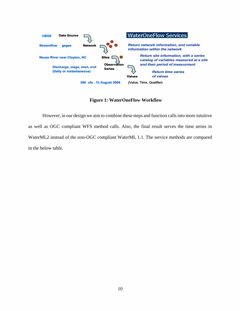
10
Figure 1: WaterOneFlow Workflow
However, in our design we aim to combine these steps and function calls into more intuitive
as well as OGC compliant WFS method calls. Also, the final result serves the time series in
WaterML2 instead of the non-OGC compliant WaterML 1.1. The service methods are compared
in the below table.
11
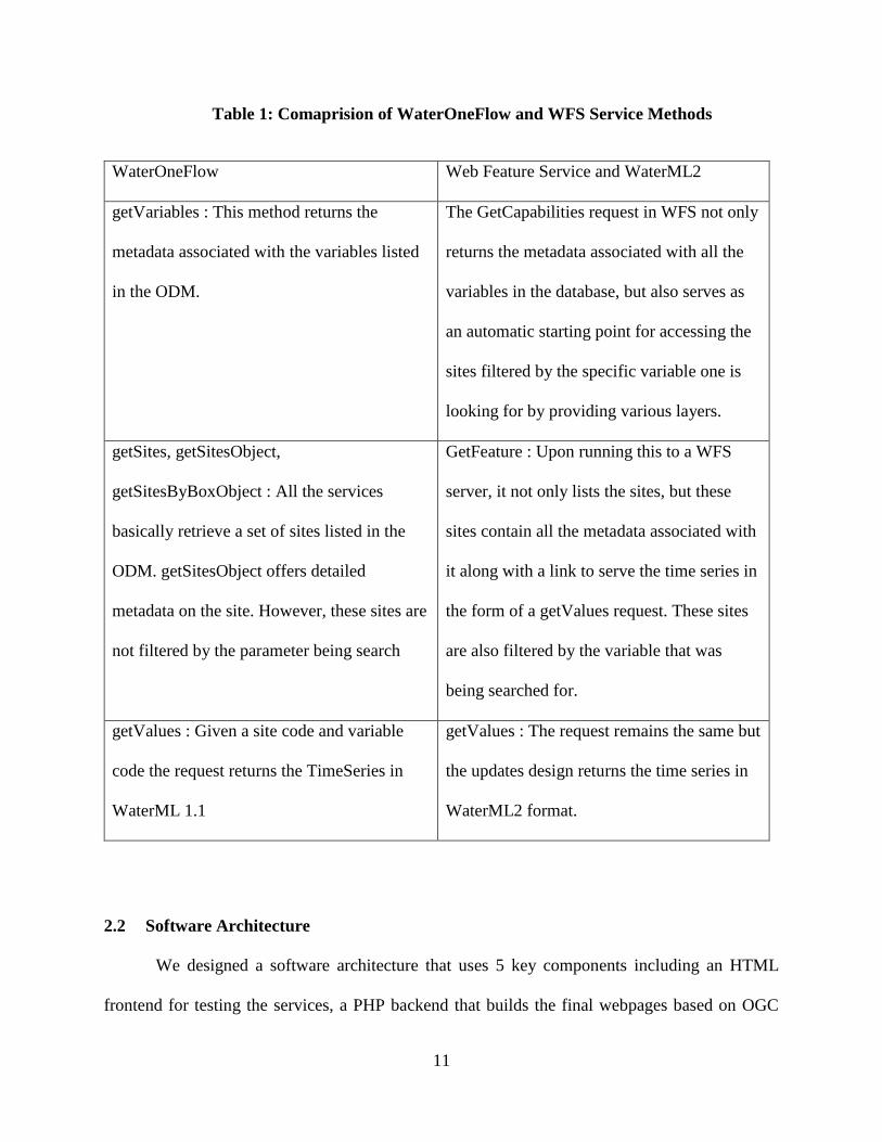
Table 1: Comaprision of WaterOneFlow and WFS Service Methods
WaterOneFlow Web Feature Service and WaterML2
getVariables : This method returns the
metadata associated with the variables listed
in the ODM.
The GetCapabilities request in WFS not only
returns the metadata associated with all the
variables in the database, but also serves as
an automatic starting point for accessing the
sites filtered by the specific variable one is
looking for by providing various layers.
getSites, getSitesObject,
getSitesByBoxObject : All the services
basically retrieve a set of sites listed in the
ODM. getSitesObject offers detailed
metadata on the site. However, these sites are
not filtered by the parameter being search
GetFeature : Upon running this to a WFS
server, it not only lists the sites, but these
sites contain all the metadata associated with
it along with a link to serve the time series in
the form of a getValues request. These sites
are also filtered by the variable that was
being searched for.
getValues : Given a site code and variable
code the request returns the TimeSeries in
WaterML 1.1
getValues : The request remains the same but
the updates design returns the time series in
WaterML2 format.
2.2 Software Architecture
We designed a software architecture that uses 5 key components including an HTML
frontend for testing the services, a PHP backend that builds the final webpages based on OGC

12
guidelines for WFS and WaterML2, a MySQL database for hosting all the data, the ODM schema
developed by CUAHSI for their HIS, and a frontend interface for accessing the data and managing
the ODM provided by HydroServer Lite.
The services code base was built on CodeIgniter which is a PHP framework that is built on
the model, view and controller (MVC) philosophy (Upton, 2007). These WFS endpoints generate
geospatial site location data based on the input parameters and provide them as features to the
user’s GIS application. Each feature contains the data discovery endpoint for both WaterML 1.1
and WaterML2. The workflow can be represented in Figure 2.
The controllers in CodeIgniter are programmed to determine the version being requested
for the WFS services and redirect the user to the appropriate service end point. As described in
Figure 2, each of the service connects to the MySQL backend which contains the data
stored in an ODM database. For these services, the database needs to be a MySQL database, but
the code can easily be reconfigured to connect to a MSSQL or PostgreSQL database. Both services
return the feature set in the encoding as specified by the respective version guidelines. They link
to data endpoints which are encoded in WaterML1.1 and WaterML2. Upon connecting to any one
of these data endpoints, the services once again query the data from the backend database and
return the time series data in the appropriate encoding.
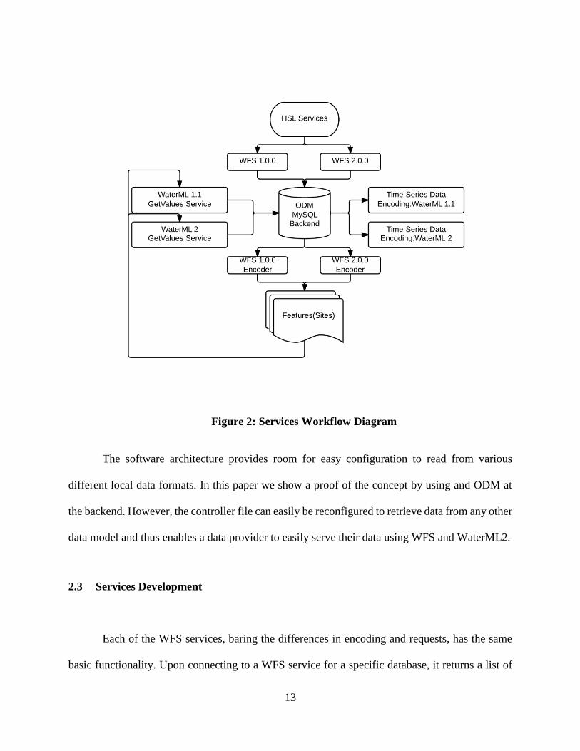
13
Figure 2: Services Workflow Diagram
The software architecture provides room for easy configuration to read from various
different local data formats. In this paper we show a proof of the concept by using and ODM at
the backend. However, the controller file can easily be reconfigured to retrieve data from any other
data model and thus enables a data provider to easily serve their data using WFS and WaterML2.
2.3 Services Development
Each of the WFS services, baring the differences in encoding and requests, has the same
basic functionality. Upon connecting to a WFS service for a specific database, it returns a list of

14
layers from the database pertaining to the variables defined in the database that contain data points.
Features for each of the layer can be requested, where each feature in that layer is a site feature
with feature attributes that describe the metadata as listed in table 2 and most importantly provides
a URL to the WaterML2 data service for that time series. Error! Reference source not found.3
hows a Unified Modelling Language (UML) sequence diagram for the services.
Table 2: Metadata associated with Feature Objects
Field Name Field Description
the_geom Contains the sites point geometry encoded in GML
Name Site Name
siteID Site’s ID as referenced in the local HIS system
Lon Longitude
Lat Latitude
Waterml2url URL to get the time series data for the specific site and variable
encoded in OGC compliant WaterML2
Watermlurl URL to get the time series data for the specific site and variable
encoded in WaterML 1.1
Begindate Earliest recorded date and time for this dataset
Enddate Last recorded date and time for the dataset
descriptor Description of the site
Source Source organization that collected the data.
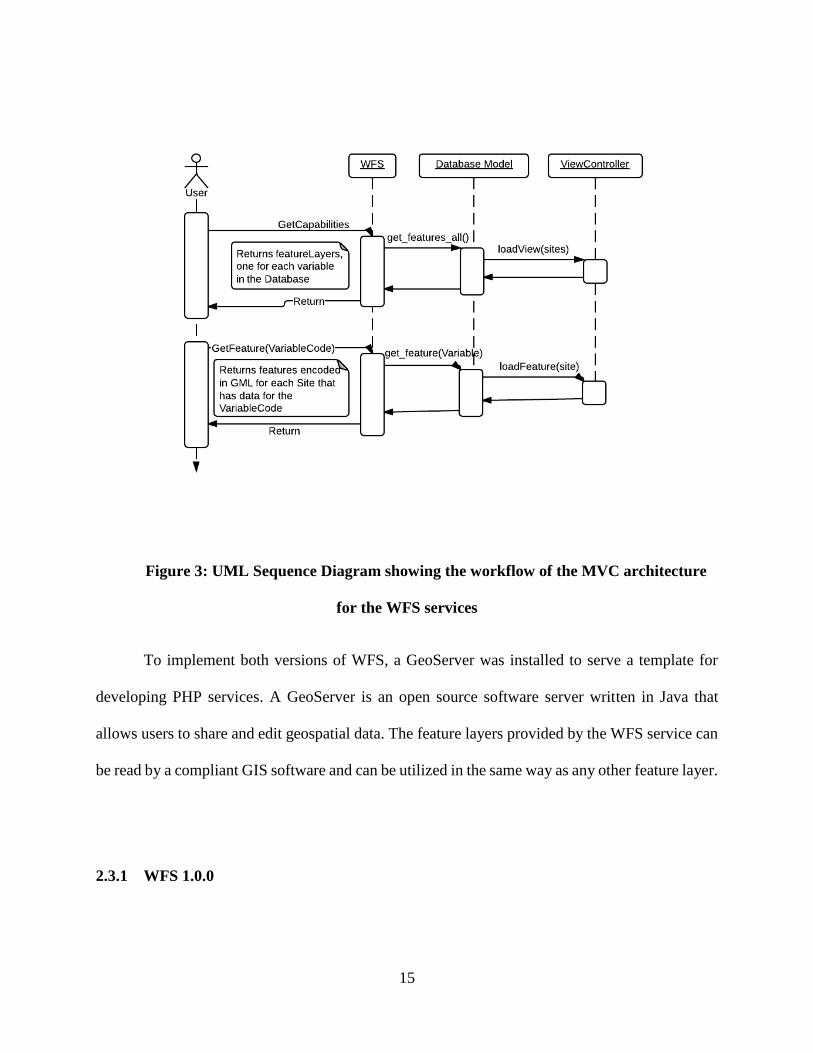
15
Figure 3: UML Sequence Diagram showing the workflow of the MVC architecture
for the WFS services
To implement both versions of WFS, a GeoServer was installed to serve a template for
developing PHP services. A GeoServer is an open source software server written in Java that
allows users to share and edit geospatial data. The feature layers provided by the WFS service can
be read by a compliant GIS software and can be utilized in the same way as any other feature layer.
2.3.1 WFS 1.0.0

16
To implement a Basic WFS 1.0.0 service that confirms to OGC standard code: OGC 02-
058, the service needs to support GET and POST operations and provide response to the following
requests:
GetCapabilities: This service returns the list of operations that one can perform on the server,
provides links to the endpoints for all the requests the WFS server supports. It also returns
the variables encoded as feature types that are discoverable by any GIS application. The
feature types become the parameters for GetFeature requests. The bounding box in the
below example is the extents of a layer containing all the sites which contain data for the
specific variable.
DescribeFeatureType: The service response contains the definition for each of the feature
(Site) that will be returned from the GetFeature request. It describes its attributes and their
types as well as certain restrictions on them such as if they are allowed to be Null or not.
<FeatureType>
<Name>variables:VariableName_ variables:VariableID</Name>
<Title> variables:VariableCode</Title>
<Abstract> variables:DataType</Abstract>
<SRS>EPSG:4326</SRS>
<Keywords>Sample Medium</Keywords>
<LatLongBoundingBox minx="-111.93374" miny="18.44775"
maxx="-69.89174" maxy="40.733979999999995"/>
</FeatureType>
Figure 4 : An example showing the attributes associated with a feature type in WFS 1.0
17
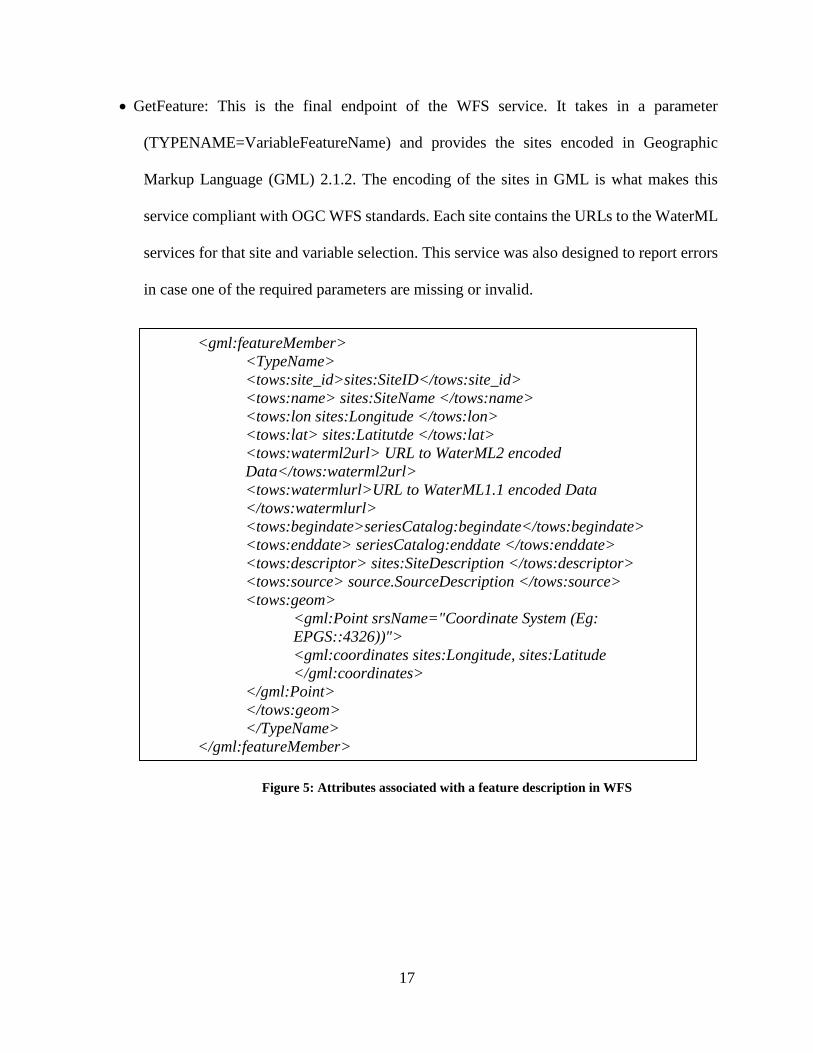
GetFeature: This is the final endpoint of the WFS service. It takes in a parameter
(TYPENAME=VariableFeatureName) and provides the sites encoded in Geographic
Markup Language (GML) 2.1.2. The encoding of the sites in GML is what makes this
service compliant with OGC WFS standards. Each site contains the URLs to the WaterML
services for that site and variable selection. This service was also designed to report errors
in case one of the required parameters are missing or invalid.
Figure 5: Attributes associated with a feature description in WFS
<gml:featureMember>
<TypeName>
<tows:site_id>sites:SiteID</tows:site_id>
<tows:name> sites:SiteName </tows:name>
<tows:lon sites:Longitude </tows:lon>
<tows:lat> sites:Latitutde </tows:lat>
<tows:waterml2url> URL to WaterML2 encoded
Data</tows:waterml2url>
<tows:watermlurl>URL to WaterML1.1 encoded Data
</tows:watermlurl>
<tows:begindate>seriesCatalog:begindate</tows:begindate>
<tows:enddate> seriesCatalog:enddate </tows:enddate>
<tows:descriptor> sites:SiteDescription </tows:descriptor>
<tows:source> source.SourceDescription </tows:source>
<tows:geom>
<gml:Point srsName="Coordinate System (Eg:
EPGS::4326))">
<gml:coordinates sites:Longitude, sites:Latitude
</gml:coordinates>
</gml:Point>
</tows:geom>
</TypeName>
</gml:featureMember>
18
2.3.2 WFS 2.0.0
OGC defines the WFS 2.0.0 standards in ISO 19142 (Open Geospatial Consortium, 2010).
This standard conformance document served as a base to develop a Basic WFS 2.0.0 service. In
addition to the above mentioned services for WFS 1.0.0, it also supports the following operations:
ListStoredQueries : This function was designed to provide a list of stored
queries on the WFS server. At present, only one query, GetFeatureByID, which returns the
Site as a feature object based on its ID, is supported.
DescribeStoredQueries: Provides a description for the queries stored on the
server. This document is the boiler plate on which requests based on stored queries can be
generated by the software accessing the WFS server.
WFS 2.0.0 standard also required us to update GetFeature responses to be encoded in GML
3.2. The Extensive Markup Language (XML) tags for the response differ slightly, but more or less
the response is similar to WFS 1.0.0
2.3.3 Time series data in WaterML 2
WaterML2 is defined by OGC in their document: 10-126r4. The document describes the
details and the XML tags that are to be employed to encode the data. It provides many categories
of time series data that may be used to represent the data. Upon careful consideration, the
Measurement Time Series format was chosen as the best match for HIS time series data.
In addition to the above mentioned document, CUAHSI had published a mapping
document that maps HIS vocabulary to WaterML2 (Valentine, 2012), which was used to code the
scripts for generating WaterML2 outputs.
19
The scripts have support to publish multiple time series within the same document if found.
The service takes the following input parameters:
Site Code : Required
Variable Code : Required
Begin Date : Optional
End Date : Optional
2.4 Services Evaluation and Testing
To be accepted as a satisfactory service to serve hydrological data, we established two
constraints as the base requirement. It should confirm to OGC standards and it should be accessible
through major GIS applications. To do so, a proprietary application (ArcMap 10.2) and an open
source application (QGIS 2.0) were used to cover both domains of software licenses. Also in order
to ensure that these services provide support to any future web applications that might wish to
harvest these services, we also tested them against the OpenLayers mapping library.
To test the services against the base requirements the following tasks were performed:
20
Test Description Pass Conditions
WFS 1.0.0
QGIS 2.0
Trying to connect and load
site feature layers into QGIS
2.0 from a WFS 1.0 service
provided by a HSL
installation. Both GET and
POST protocols will be
tested.
The software is able to connect to
the server without any further
modifications to either end.
All Layers are listed in the result
of GetCapabilites request.
Upon selecting a certain layer, it
loads onto the map with all its
feature attributes.
WFS 2.0
QGIS 2.0
WFS Plugin
Trying to connect and load
site feature layers into QGIS
2.0 using a WFS 2.0 parser
plugin, from a WFS 2.0
service provided by a HSL
installation.
The plugin is able to connect to the
server without any further
modifications to either end.
All Layers are listed in the result
of GetCapabilites request made by
the plugin.
Upon selecting a certain layer, the
plugin can successfully parse the
features onto the map with all their
feature attributes.

21
Test Description Pass Conditions
WFS 1.0.0
ArcGIS 10.2
Attempting to retrieve data
layers from a WFS 1.0
service provided by a HSL
installation, using the Data
Interoperability Extension in
ArcMap 10.2
Successfully lists all the layers in
the Data Connections tab
Upon pulling a layer into view, the
view is updated with the sites
present on that layer.
The feature attributes lists all the
features provided by the site.
WFS 1.0.0
DotSpatial
Using the WFS extension to
create a test web application
that will try to request and
display layers from a WFS
1.0 service provided by a
HSL installation
WFS extensions is able to connect
to the service and request for all
the layers available on the server
Upon selecting the layer, it is able
to display the features on the map
and list all the attributes associated
with the feature.
WFS
OpenLayers
Develop a test web
application using OpenLayers
as the mapping library. This
web application will try to
fetch a single WFS layer
from the HSL server.
The library encounters no errors
while connecting
The features are added to the map
accurately.
22
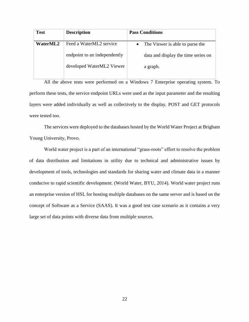
Test Description Pass Conditions
WaterML2 Feed a WaterML2 service
endpoint to an independently
developed WaterML2 Viewer
The Viewer is able to parse the
data and display the time series on
a graph.
All the above tests were performed on a Windows 7 Enterprise operating system. To
perform these tests, the service endpoint URLs were used as the input parameter and the resulting
layers were added individually as well as collectively to the display. POST and GET protocols
were tested too.
The services were deployed to the databases hosted by the World Water Project at Brigham
Young University, Provo.
World water project is a part of an international “grass-roots” effort to resolve the problem
of data distribution and limitations in utility due to technical and administrative issues by
development of tools, technologies and standards for sharing water and climate data in a manner
conducive to rapid scientific development. (World Water, BYU, 2014). World water project runs
an enterprise version of HSL for hosting multiple databases on the same server and is based on the
concept of Software as a Service (SAAS). It was a good test case scenario as it contains a very
large set of data points with diverse data from multiple sources.
23
3 RESULTS
3.1 Deployment to HydroServer Lite
The services were deployed to the server and can be accessed simply by going to the
specific database that we are looking for and appending the directory name “services” to the URL.
To access the service endpoint for the test ‘Sandbox’ installation one may point the web browser
to ‘http://www.worldwater.byu.edu/interactive/sandbox/services’. These services were used as our
source URL’s for testing them with GIS applications.
To deploy the services code was transferred to the server using FTP and the database
settings in the application were reconfigured to connect to the ODM on the server. The advantage
of building the services on the MVC architecture paid off as without any further configuration the
services were successfully accessible through a web browser.
Upon further testing of each individual function of the services such including GetTypes,
there were issues with the URL not being redirected to the right service endpoint. This was fixed
by rewriting the htaccess file which controls how the server behaves to certain URLs.
3.2 Testing with GIS software

24
One of the most important tests was to confirm that data provided by the WFS services can
be consumed by major GIS applications. Both applications, ArcGIS 10.2 and QGIS 2.0 support
WFS 1.0.0 by default.
Moving hydrological data to the spatial domain eased the process of searching for data as
opposed to WaterOneFlow Services. Using WaterOneFlow services with hydro desktop runs
through a 6 step workflow to obtain the dataset (Figure 6). However using the spatial domain to
filter the data just takes 3 steps. Also, the speed of data discovery is much faster as there are fewer
server calls.
Figure 6: WaterOneFlow with Hydrodesktop
Fetching data using QGIS was very straight forward. Upon entering the server URL the
available variables were listed. From there we can add them to the view and click on any site of
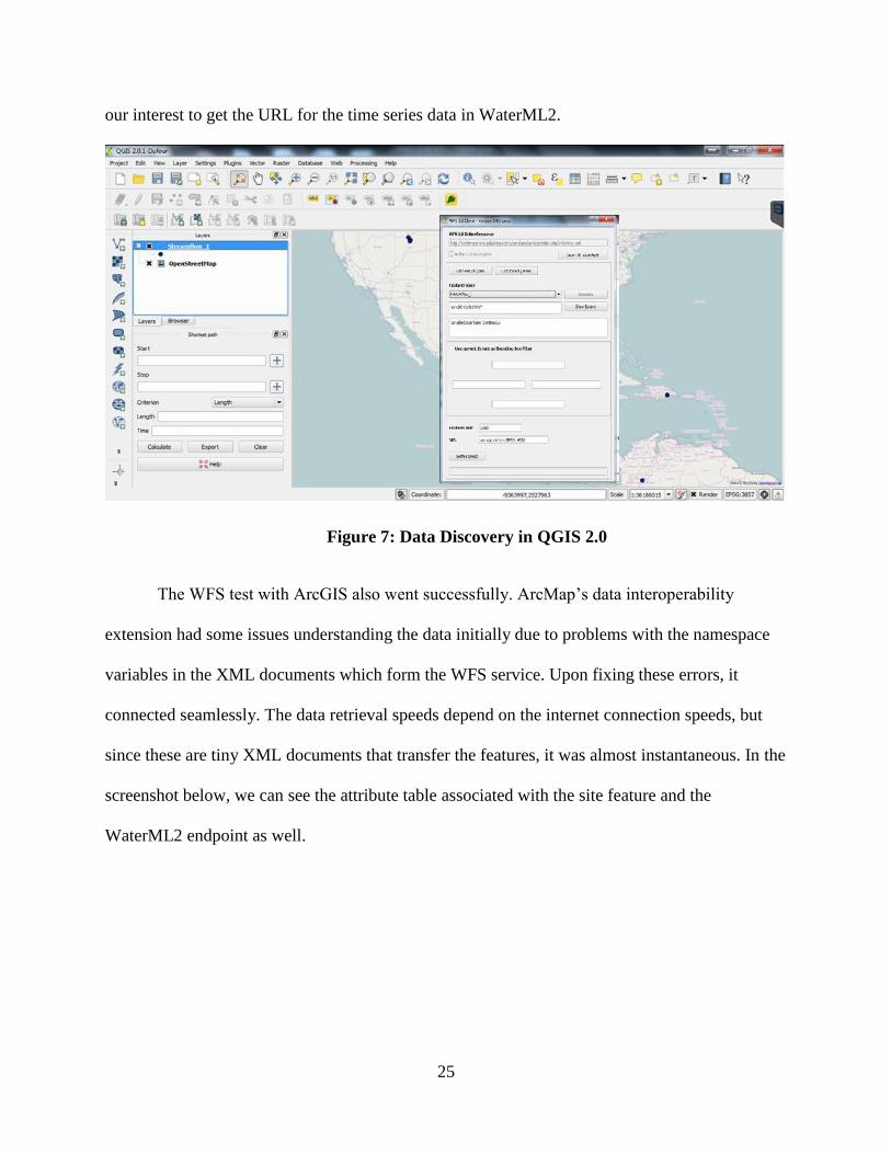
25
our interest to get the URL for the time series data in WaterML2.
Figure 7: Data Discovery in QGIS 2.0
The WFS test with ArcGIS also went successfully. ArcMap’s data interoperability
extension had some issues understanding the data initially due to problems with the namespace
variables in the XML documents which form the WFS service. Upon fixing these errors, it
connected seamlessly. The data retrieval speeds depend on the internet connection speeds, but
since these are tiny XML documents that transfer the features, it was almost instantaneous. In the
screenshot below, we can see the attribute table associated with the site feature and the
WaterML2 endpoint as well.

26
Figure 8: Attribute table from WFS Feature in ArcMap
Another important test we performed was on the WFS extension that is built into
DotSpatial. DotSpatial is a GIS library for Windows applications. Like ArcObjects, it provides a
developer with many GIS functions and mapping components, utilizing which the developer may
develop their own GIS software applications. The advantage of using DotSpatial is that its free
and open source and hence is constantly being improves. GIS applications such as HydroDesktop
are built on DotSpatial as their foundation and ensuring this works makes it much easier for
application developers to harvest these services.
To verify the usability of WFS 2.0.0 service, an open source plugin, WFS 2.0 Client was
used. Basic WFS 2.0 needs to provide two methods to get features: by type names i.e. the variable
name or by using one of the stored queries.

27
4 CONCLUSIONS
The goal of this study was to develop web services that will enable hydrological and
climate data stored in CUAHSI HIS to be shared with various applications that support OGC
standards. This was done by first building WFS endpoints within the service package for HSL.
HSL, being open-source, is easily customizable to add in additional features. This solved the
problem of data interoperability up to a huge extent as any software/application that is compliant
with OGC will now be able to connect to a CUAHSI HIS HydroServer and have access to
hydrological data in an OGC compliant WaterML2 standard. The services were tested against a
variety of different GIS applications and they all connected seamlessly. Data retrieval was
compliant with WaterML2 guidelines.
Table 3: Data Interoperability Comparison
Independent
Efforts
CUAHSI OGC
Data
Organization
Maybe. Excel
Sheets and
Binders
ODM, well
organized
XML Schemas : Human readable
and concrete vocabulary
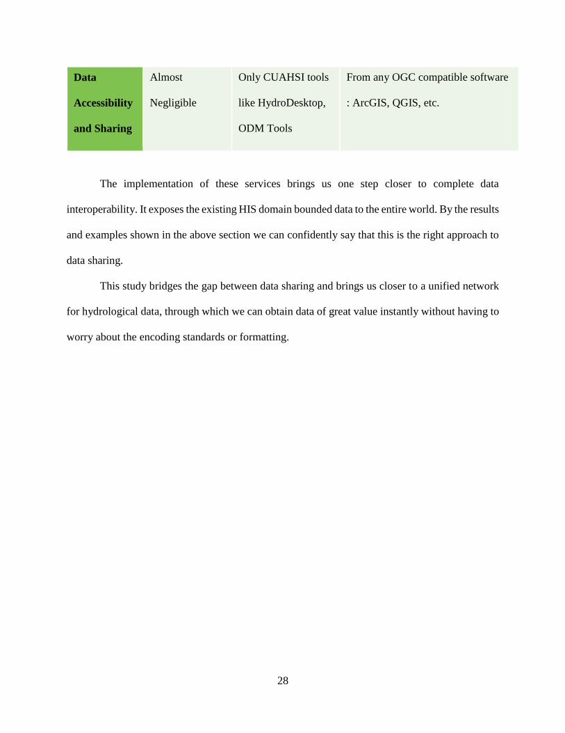
28
The implementation of these services brings us one step closer to complete data
interoperability. It exposes the existing HIS domain bounded data to the entire world. By the results
and examples shown in the above section we can confidently say that this is the right approach to
data sharing.
This study bridges the gap between data sharing and brings us closer to a unified network
for hydrological data, through which we can obtain data of great value instantly without having to
worry about the encoding standards or formatting.
Data
Accessibility
and Sharing
Almost
Negligible
Only CUAHSI tools
like HydroDesktop,
ODM Tools
From any OGC compatible software
: ArcGIS, QGIS, etc.
29
REFERENCES
Ames, D. P., Horsburgh, J. S., Cao, Y., Kadlec, J., Whiteaker, T., & Valentine, D. (2012).
HydroDesktop: Web services-based software for hydrologic data discovery, download,
visualization, and analysis. Environmental Modelling & Software, 146-156.
Aquatic Informatics Inc. (2012, 09 25). USGS Selects AQUARIUS Software by Aquatic
Informatics to Centralize National Water Data Management & Operations. Portlan,
Oregon, USA.
Bilonick, R. A., & Nichols, D. G. (1986). Temporal variations in acid precipitation over New
York State—what the 1965–1979 USGS data reveal. Atmospheric Environment (1967),
17(6), 1063-1072.
Delbourg, E., & Strobl, E. (2012). Cooperation and conflict between upstream and downstream
countries in African transboundary rivers.
Dolan, D. M. (1993). Point Source Loadings of Phosphorus to Lake Erie: 1986–1990. Journal of
Great Lakes Research, 19(2), 212-223.
Horsburgh, J., Tarboton, D., Piasecki, M., Maidment, D., Zaslavsky, I., Valentine, D., &
Whitenack, T. (2009). An inegrated system for publishing environmental observations
data. Environmental Modelling & Software(24), 879-888.

30
Kadlec, J. A. (2011). Design and Development of Web Services for Accessing Free Hydrological
Data from the Czech Republic. In J. Hřebíček, Environmental Software Systems.
Frameworks of eEnvironment. Springer Berlin Heidelberg.
Open Geospatial Consortium. (2010, November 2). Web Feature Service. Retrieved from Open
Geospatial Consortium Inc.: http://portal.opengeospatial.org/files/?artifact_id=39967
Open Geospatial Consortium. (2014, February 2). Vison, Mission and Goals. Retrieved from
OGC: http://www.opengeospatial.org/ogc/vision
Open Geospatial Organisation. (2012, 04 20). Sensor Observation Service. Retrieved from Open
Geospatial Organisation: https://portal.opengeospatial.org/files/?artifact_id=47599
Ortmann, J., Limbu, M., Wang, D., & Kauppinen, T. (2011). Crowdsourcing Linked Open Data
for Disaster. Terra Cognita 2011: Foundations, Technologies and Applications of the
Geospatial Web, (pp. 11-22). Germany.
Rupert, M. (2001). Calibration of the DRASTIC Ground Water Vulnerability Mapping Method.
Groundwater, 39(4), 625-630.
U.S. Department of the Interior, U.S. Geological Survey. (1995, April 24). An Overview of the
Stream-Gaging Program. Retrieved from U.S. Geological Survey:
http://water.usgs.gov/wid/html/SG.html
United States Geological Survey. (2014, 11 20). USGS Water Data for the Nation. Retrieved
from National Water Information System: Web Interface: http://waterdata.usgs.gov/nwis
Upton, D. (2007). CodeIgniter for Rapid PHP Application Development. Packt Publishing Ltd.
Valentine, D. (2012). CUAHSI OBSERVATIONS DATA MODEL, CUAHSI WATERML 1 AND
OGC WATERML 2 MAPPING. San Diego: CUAHSI.

31
Visser, U., Stuckenschmidt, H., Wache, H., & Vogele, T. (n.d.). Using Envirnonmental
Information Efficiently: Sharing Data and Knowledge from Heteregenous Sources. In C.
Rautenstrauch, Environmental Information Systems in Industry and Public
Administration (pp. 41-43). Idea Group Publishing.
World Water, BYU. (2014, February 27). Introduction. Retrieved from World Water Project,
BYU: http://www.worldwater.byu.edu
World Wide Web Consortium. (1999). HTML 4.01 specification.
Related Documents