Proceedings World Geothermal Congress 2015 Melbourne, Australia, 19-25 April 2015 1 A Web Application Designed to Publish Information of Surface Manifestations of Hydrothermal Systems of Colombia 1 Claudia Alfaro, 2 Iván Ortiz, 3 Gina Rodríguez, 4 Camilo Matiz, 5 Jaison Malo, 6 Gilbert Rodríguez and 7 Lucila Gómez Diagonal 53 No. 34-53 – Bogotá D. C., Colombia 1 [email protected], 2 [email protected], 3 [email protected], 4 [email protected], 5 [email protected], 6 [email protected], 7 [email protected] Keywords: web application, hot springs information, hot springs historical records, fluid geochemistry, Colombian surface manifestations. ABSTRACT The Colombian Geological Survey (SGC, for its acronym in Spanish) developed a web application for searching public information of surface manifestations of hydrothermal systems, particularly hot springs and fumaroles. This application was developed as a means to provide information to the general public, national industry users and researchers in the areas of geothermal exploration, tectonics, geochemistry of hydrothermal fluids, geochemical monitoring of volcanic activity and microbiology. Additionally, the application aims to encourage interaction and discussion of researchers on geochemistry of volcanic and hydrothermal fluids to strengthen this research line in the SGC. The information of the surface manifestations, made available through this application, includes general data on geographical and geological location, in situ physicochemical features, images (pictures and videos), availability of spa infrastructure, pathways, as well as chemical and isotopic composition of the liquid and gas phases. The main functions of the application include information display, variables selection, and reports generation downloaded as pdf files, for general, geological and geochemical queries. The geochemical module includes the option to plot the most common diagrams for gas and water geochemical interpretation (relative triangular composition diagrams, Stiff, Schoeller, Piper and X-Y charts, including time series). This will be updated periodically, with expanded coverage analysis in liquid and gas phases. The loaded information includes individual records for 300 hot springs (and 11 fumaroles) located mainly in the Andean, Caribbean and Pacific regions, most of them related with volcanoes. For some of these, historical records are taken from the information review. The great diversity of chemical composition in these hot springs is expressed in their physicochemical characteristics: highest temperature above 90 °C, pH between 1.2 and 9.7, and highest electrical conductivity above 50,000 uS/cm. 1. INTRODUCTION Colombian Geological Survey (SGC) has among its main functions to "improve basic and applied scientific research of potential underground resources, and manage data and information related to the subsoil of the country", and "generate and integrate knowledge, and survey collect, validate, store and supply, in an automated and standard way, information of geology, subsoil assets and geological hazard, in accordance to the policies of the National Government". Under this institutional framework and the use of powers under Presidential Decree 4131 of 2012, the SGC has developed the National Inventory of Hydrothermal Manifestations of Colombia, a project that has collected 98% of the information related to the thermal springs and fumaroles (predominantly hydrothermal manifestations in Colombia). With the surveying of a significant volume of information, the Geothermal Resources Exploration team of the SGC raised the need for a web application to allow the dissemination of information about hydrothermal manifestations in the country, and to socialize the results among academic and professional communities, and general public interested in geothermal resources. In the global context, several web tools have been developed as applications for viewing and querying information of hydrothermal manifestations as cited in Matiz (2013), such as the Mining Geological Institute of Spain – IGME (for its acronym in Spanish), the Geothermal Atlas and Viewer of Catalonia, the Catalogue of Thermal Manifestations of Argentina, and the information of hydrothermal manifestations integrated in the GIS of countries like Philippines, Indonesia, Italy, Switzerland, Australia, Kenya, Mexico, among others. Considering this background, the SGC hired in public and open tender the development of a web application that integrated the functional requirements and technical needs considered by the Geothermal Resources Exploration team to InvTermales Consortium formed by the companies GKudos (www.gkudos.com) and MercatorSIG (www.mercatorsig.com) which specialize in software development and management of geographic information. This software implementation materialized in the development of the National Inventory of Hydrothermal Manifestations of Colombia Web Application, with tools to query hydrothermal manifestations by different attributes, point editing, data loading, report generation, documents exporting, and access routes, as well as a module for graphical analysis for representation of chemical and isotopic composition data, the source code of the application development, and user and installation manuals (InvTermales Consortium, 2013). 2. METHODOLOGY 2.1 Unified Process Software Development The Unified Process - UP is defined as a set of activities that a team performs to transform a set of customer requirements into a software system. It is also a generic process framework that people can customize by adding and removing activities based on particular needs and available resources for a project (Scott, 2001).

Welcome message from author
This document is posted to help you gain knowledge. Please leave a comment to let me know what you think about it! Share it to your friends and learn new things together.
Transcript
Proceedings World Geothermal Congress 2015
Melbourne, Australia, 19-25 April 2015
1
A Web Application Designed to Publish Information of Surface Manifestations of
Hydrothermal Systems of Colombia
1Claudia Alfaro,
2Iván Ortiz,
3Gina Rodríguez,
4Camilo Matiz,
5Jaison Malo,
6Gilbert Rodríguez and
7Lucila Gómez
Diagonal 53 No. 34-53 – Bogotá D. C., Colombia
[email protected], [email protected], [email protected], [email protected], [email protected], [email protected], [email protected]
Keywords: web application, hot springs information, hot springs historical records, fluid geochemistry, Colombian surface
manifestations.
ABSTRACT
The Colombian Geological Survey (SGC, for its acronym in Spanish) developed a web application for searching public information
of surface manifestations of hydrothermal systems, particularly hot springs and fumaroles.
This application was developed as a means to provide information to the general public, national industry users and researchers in
the areas of geothermal exploration, tectonics, geochemistry of hydrothermal fluids, geochemical monitoring of volcanic activity
and microbiology. Additionally, the application aims to encourage interaction and discussion of researchers on geochemistry of
volcanic and hydrothermal fluids to strengthen this research line in the SGC.
The information of the surface manifestations, made available through this application, includes general data on geographical and
geological location, in situ physicochemical features, images (pictures and videos), availability of spa infrastructure, pathways, as
well as chemical and isotopic composition of the liquid and gas phases. The main functions of the application include information
display, variables selection, and reports generation downloaded as pdf files, for general, geological and geochemical queries. The
geochemical module includes the option to plot the most common diagrams for gas and water geochemical interpretation (relative
triangular composition diagrams, Stiff, Schoeller, Piper and X-Y charts, including time series). This will be updated periodically,
with expanded coverage analysis in liquid and gas phases.
The loaded information includes individual records for 300 hot springs (and 11 fumaroles) located mainly in the Andean, Caribbean
and Pacific regions, most of them related with volcanoes. For some of these, historical records are taken from the information
review. The great diversity of chemical composition in these hot springs is expressed in their physicochemical characteristics:
highest temperature above 90 °C, pH between 1.2 and 9.7, and highest electrical conductivity above 50,000 uS/cm.
1. INTRODUCTION
Colombian Geological Survey (SGC) has among its main functions to "improve basic and applied scientific research of potential
underground resources, and manage data and information related to the subsoil of the country", and "generate and integrate
knowledge, and survey collect, validate, store and supply, in an automated and standard way, information of geology, subsoil assets
and geological hazard, in accordance to the policies of the National Government". Under this institutional framework and the use of
powers under Presidential Decree 4131 of 2012, the SGC has developed the National Inventory of Hydrothermal Manifestations of
Colombia, a project that has collected 98% of the information related to the thermal springs and fumaroles (predominantly
hydrothermal manifestations in Colombia). With the surveying of a significant volume of information, the Geothermal Resources
Exploration team of the SGC raised the need for a web application to allow the dissemination of information about hydrothermal
manifestations in the country, and to socialize the results among academic and professional communities, and general public
interested in geothermal resources. In the global context, several web tools have been developed as applications for viewing and
querying information of hydrothermal manifestations as cited in Matiz (2013), such as the Mining Geological Institute of Spain –
IGME (for its acronym in Spanish), the Geothermal Atlas and Viewer of Catalonia, the Catalogue of Thermal Manifestations of
Argentina, and the information of hydrothermal manifestations integrated in the GIS of countries like Philippines, Indonesia, Italy,
Switzerland, Australia, Kenya, Mexico, among others.
Considering this background, the SGC hired in public and open tender the development of a web application that integrated the
functional requirements and technical needs considered by the Geothermal Resources Exploration team to InvTermales Consortium
formed by the companies GKudos (www.gkudos.com) and MercatorSIG (www.mercatorsig.com) which specialize in software
development and management of geographic information. This software implementation materialized in the development of the
National Inventory of Hydrothermal Manifestations of Colombia Web Application, with tools to query hydrothermal manifestations
by different attributes, point editing, data loading, report generation, documents exporting, and access routes, as well as a module
for graphical analysis for representation of chemical and isotopic composition data, the source code of the application development,
and user and installation manuals (InvTermales Consortium, 2013).
2. METHODOLOGY
2.1 Unified Process Software Development
The Unified Process - UP is defined as a set of activities that a team performs to transform a set of customer requirements into a
software system. It is also a generic process framework that people can customize by adding and removing activities based on
particular needs and available resources for a project (Scott, 2001).
Alfaro et al.
2
The Unified Process allowed the generation of integrated processes and products as part of its evolution, being the most
representative and well-known the Rational Unified Process (RUP), which has been shown in iterative software development
created by the Rational Software Corporation, a division of IBM. RUP is a specific implementation of UP and is oriented to be an
adaptable process framework for development companies and software project teams who select the items in the UP that are
applied to their functional requirements (Torossi, 2004). UP has characteristics marked as core principles that underlie the same
unified process, these are: Use Case Driven, Architecture-Centric, and Iterative and Incremental.
2.1.1 Use Case Driven
A use case is a sequence of actions, performed by one or more actors (people or non-human entities outside of a system) and by the
system itself, that produces one or more results of value to one or more of the actors. One of the key aspects of the Unified Process
is its application of use cases as a driving force for development. The phrase use case driven refers to the fact that the project team
utilises the use cases to drive all development work, from initial gathering and negotiation of requirements through code (Scott,
2001).
2.1.2 Architecture-Centric
The Unified Process specifies that the architecture of the system being built, as the fundamental foundation on which that system
will rest, must sit at the heart of the project team’s efforts to shape the system, and also that architecture, in conjunction with the use
cases, must drive the exploration of all aspects of the system. The architecture as expressing the common vision that all members of
the team must share in order for the resulting system to be suitably robust, flexible, expandable, and cost-effective (Scott, 2001).
2.1.3 Iterative and Incremental
The third fundamental tenet of the Unified Process is its iterative and incremental nature. Iteration is a mini-project that results in a
version of the system that will be released internally or externally. This version is supposed to offer incremental improvement over
the previous version, which is why the result of a single iteration is called an increment. The typical Iterations and Increments
describe how iterations and increments fit into the larger context of the overall process (Scott, 2001).
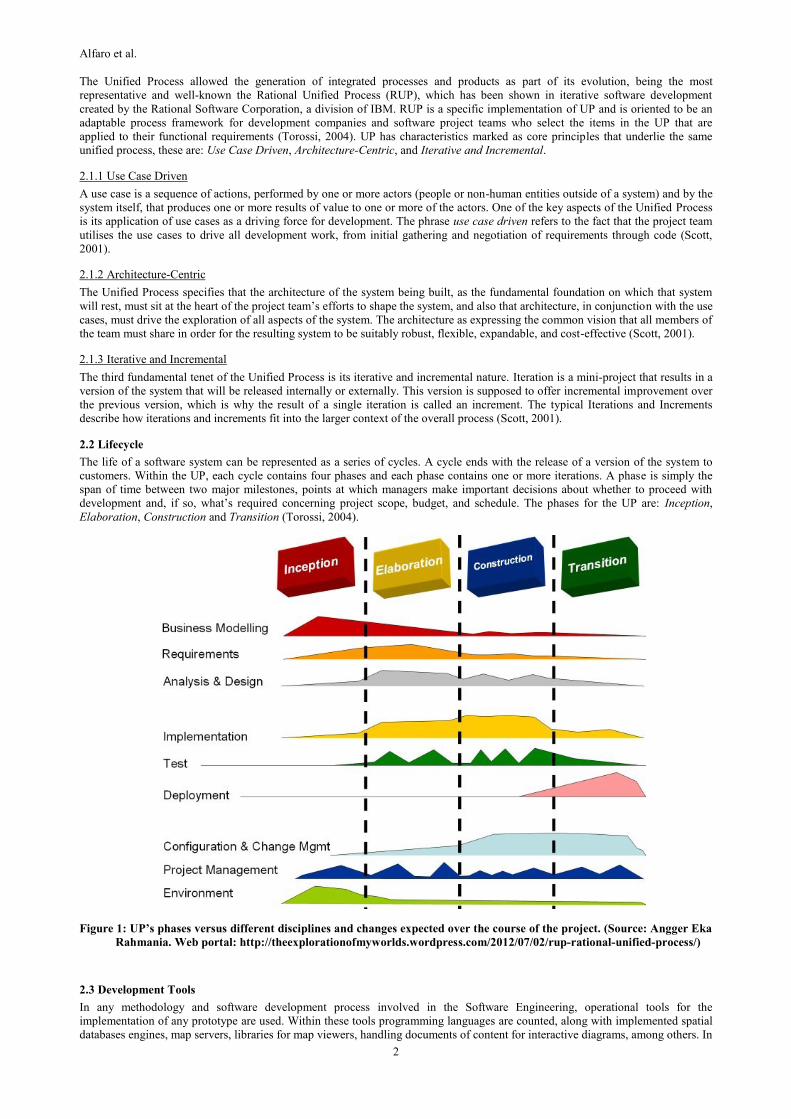
2.2 Lifecycle
The life of a software system can be represented as a series of cycles. A cycle ends with the release of a version of the system to
customers. Within the UP, each cycle contains four phases and each phase contains one or more iterations. A phase is simply the
span of time between two major milestones, points at which managers make important decisions about whether to proceed with
development and, if so, what’s required concerning project scope, budget, and schedule. The phases for the UP are: Inception,
Elaboration, Construction and Transition (Torossi, 2004).
Figure 1: UP’s phases versus different disciplines and changes expected over the course of the project. (Source: Angger Eka
Rahmania. Web portal: http://theexplorationofmyworlds.wordpress.com/2012/07/02/rup-rational-unified-process/)
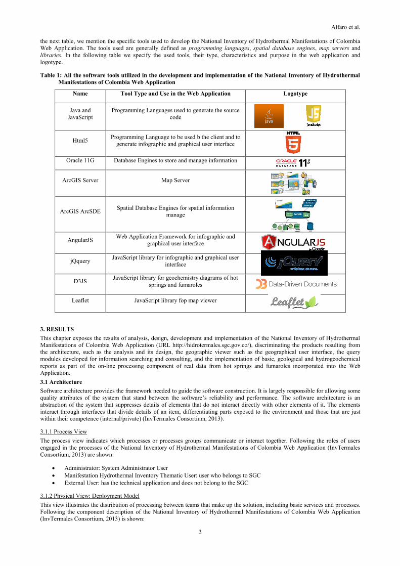
2.3 Development Tools
In any methodology and software development process involved in the Software Engineering, operational tools for the
implementation of any prototype are used. Within these tools programming languages are counted, along with implemented spatial
databases engines, map servers, libraries for map viewers, handling documents of content for interactive diagrams, among others. In
Alfaro et al.
3
the next table, we mention the specific tools used to develop the National Inventory of Hydrothermal Manifestations of Colombia
Web Application. The tools used are generally defined as programming languages, spatial database engines, map servers and
libraries. In the following table we specify the used tools, their type, characteristics and purpose in the web application and
logotype.
Table 1: All the software tools utilized in the development and implementation of the National Inventory of Hydrothermal
Manifestations of Colombia Web Application
Name Tool Type and Use in the Web Application Logotype
Java and
JavaScript
Programming Languages used to generate the source
code
Html5 Programming Language to be used b the client and to
generate infographic and graphical user interface
Oracle 11G Database Engines to store and manage information
ArcGIS Server Map Server
ArcGIS ArcSDE Spatial Database Engines for spatial information
manage
AngularJS Web Application Framework for infographic and
graphical user interface
jQquery JavaScript library for infographic and graphical user
interface
D3JS JavaScript library for geochemistry diagrams of hot
springs and fumaroles
Leaflet JavaScript library fop map viewer
3. RESULTS
This chapter exposes the results of analysis, design, development and implementation of the National Inventory of Hydrothermal
Manifestations of Colombia Web Application (URL http://hidrotermales.sgc.gov.co/), discriminating the products resulting from
the architecture, such as the analysis and its design, the geographic viewer such as the geographical user interface, the query
modules developed for information searching and consulting, and the implementation of basic, geological and hydrogeochemical
reports as part of the on-line processing component of real data from hot springs and fumaroles incorporated into the Web
Application.
3.1 Architecture
Software architecture provides the framework needed to guide the software construction. It is largely responsible for allowing some
quality attributes of the system that stand between the software’s reliability and performance. The software architecture is an
abstraction of the system that suppresses details of elements that do not interact directly with other elements of it. The elements
interact through interfaces that divide details of an item, differentiating parts exposed to the environment and those that are just
within their competence (internal/private) (InvTermales Consortium, 2013).
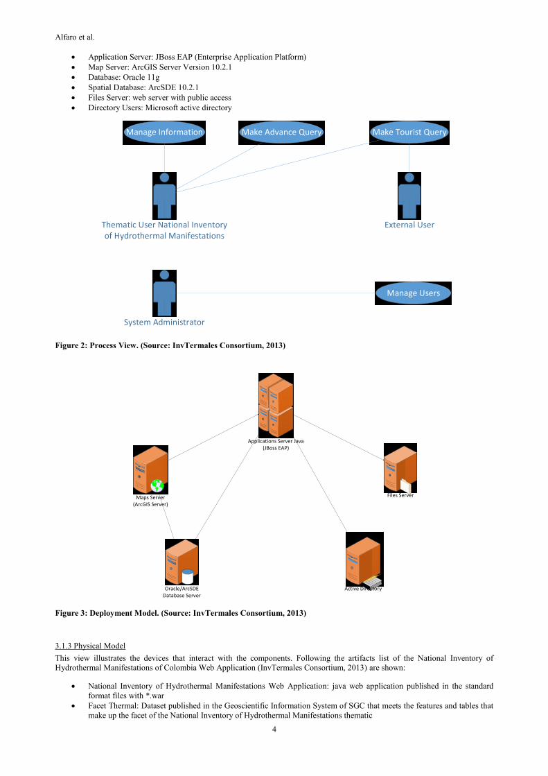
3.1.1 Process View
The process view indicates which processes or processes groups communicate or interact together. Following the roles of users
engaged in the processes of the National Inventory of Hydrothermal Manifestations of Colombia Web Application (InvTermales
Consortium, 2013) are shown:
Administrator: System Administrator User
Manifestation Hydrothermal Inventory Thematic User: user who belongs to SGC
External User: has the technical application and does not belong to the SGC
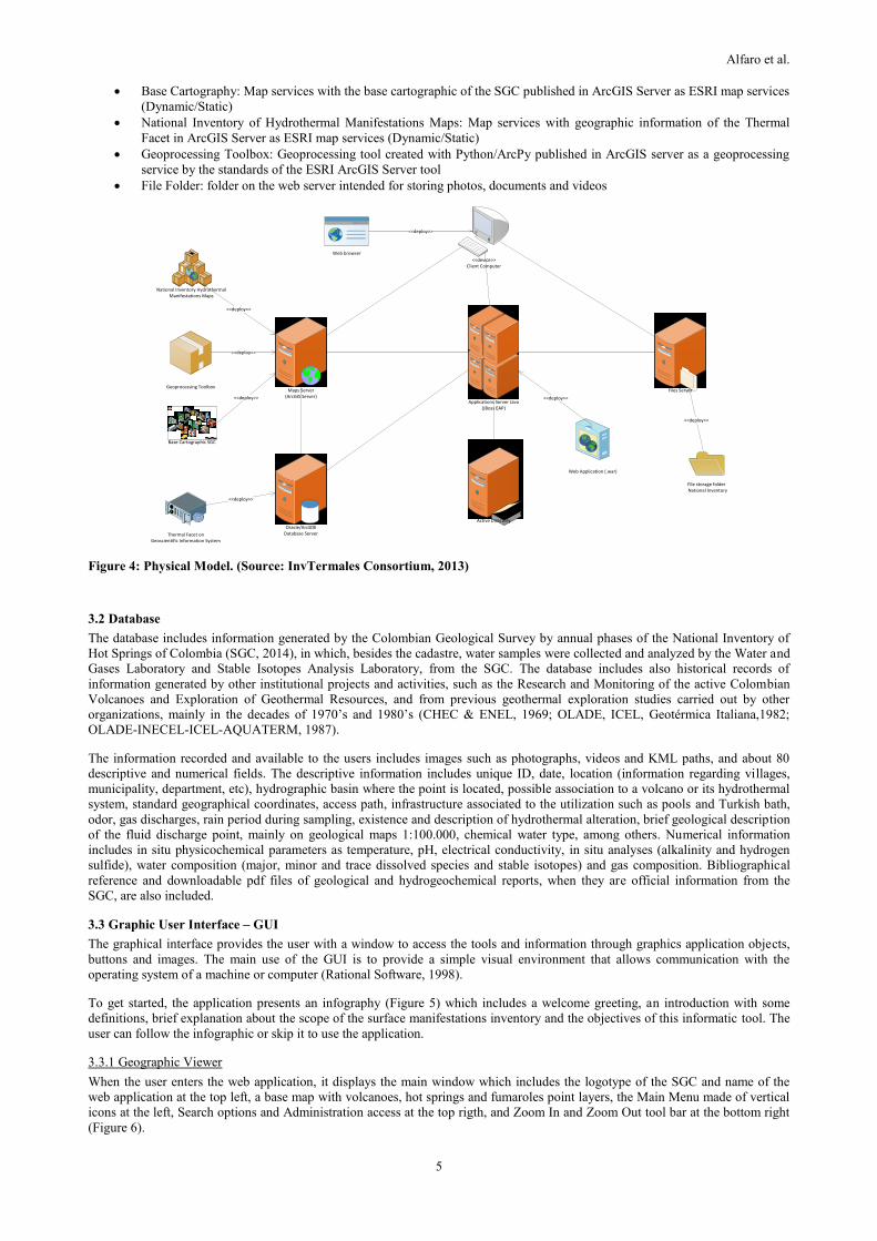
3.1.2 Physical View: Deployment Model
This view illustrates the distribution of processing between teams that make up the solution, including basic services and processes.
Following the component description of the National Inventory of Hydrothermal Manifestations of Colombia Web Application
(InvTermales Consortium, 2013) is shown:
Alfaro et al.
4
Application Server: JBoss EAP (Enterprise Application Platform)
Map Server: ArcGIS Server Version 10.2.1
Database: Oracle 11g
Spatial Database: ArcSDE 10.2.1
Files Server: web server with public access
Directory Users: Microsoft active directory
Thematic User National Inventory of Hydrothermal Manifestations
Manage Information
External User
System Administrator
Manage Users
Make Advance Query Make Tourist Query
Figure 2: Process View. (Source: InvTermales Consortium, 2013)
Files Server
Applications Server Java (JBoss EAP)
Maps Server(ArcGIS Server)
Active DirectoryOracle/ArcSDEDatabase Server
Figure 3: Deployment Model. (Source: InvTermales Consortium, 2013)
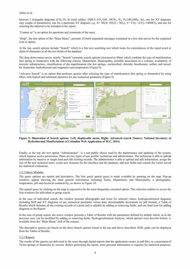
3.1.3 Physical Model
This view illustrates the devices that interact with the components. Following the artifacts list of the National Inventory of
Hydrothermal Manifestations of Colombia Web Application (InvTermales Consortium, 2013) are shown:
National Inventory of Hydrothermal Manifestations Web Application: java web application published in the standard
format files with *.war
Facet Thermal: Dataset published in the Geoscientific Information System of SGC that meets the features and tables that
make up the facet of the National Inventory of Hydrothermal Manifestations thematic
Alfaro et al.
5
Base Cartography: Map services with the base cartographic of the SGC published in ArcGIS Server as ESRI map services
(Dynamic/Static)
National Inventory of Hydrothermal Manifestations Maps: Map services with geographic information of the Thermal
Facet in ArcGIS Server as ESRI map services (Dynamic/Static)
Geoprocessing Toolbox: Geoprocessing tool created with Python/ArcPy published in ArcGIS server as a geoprocessing
service by the standards of the ESRI ArcGIS Server tool
File Folder: folder on the web server intended for storing photos, documents and videos
Files Server
Applications Server Java (JBoss EAP)
Maps Server(ArcGIS Server)
Active Directory
Oracle/ArcSDEDatabase Server
<<device>>Client Computer
File storage folder National Inventory
Geoprocessing Toolbox
Web browser
Thermal Facet on Geoscientific Information System
<<deploy>>
<<deploy>>
Web Application (.war)
<<deploy>>
<<deploy>>
<<deploy>>
<<deploy>>
<<deploy>>
Base Cartographic SGC
National Inventory Hydrothermal Manifestations Maps
Figure 4: Physical Model. (Source: InvTermales Consortium, 2013)
3.2 Database
The database includes information generated by the Colombian Geological Survey by annual phases of the National Inventory of
Hot Springs of Colombia (SGC, 2014), in which, besides the cadastre, water samples were collected and analyzed by the Water and
Gases Laboratory and Stable Isotopes Analysis Laboratory, from the SGC. The database includes also historical records of
information generated by other institutional projects and activities, such as the Research and Monitoring of the active Colombian
Volcanoes and Exploration of Geothermal Resources, and from previous geothermal exploration studies carried out by other
organizations, mainly in the decades of 1970’s and 1980’s (CHEC & ENEL, 1969; OLADE, ICEL, Geotérmica Italiana,1982;
OLADE-INECEL-ICEL-AQUATERM, 1987).
The information recorded and available to the users includes images such as photographs, videos and KML paths, and about 80
descriptive and numerical fields. The descriptive information includes unique ID, date, location (information regarding villages,
municipality, department, etc), hydrographic basin where the point is located, possible association to a volcano or its hydrothermal
system, standard geographical coordinates, access path, infrastructure associated to the utilization such as pools and Turkish bath,
odor, gas discharges, rain period during sampling, existence and description of hydrothermal alteration, brief geological description
of the fluid discharge point, mainly on geological maps 1:100.000, chemical water type, among others. Numerical information
includes in situ physicochemical parameters as temperature, pH, electrical conductivity, in situ analyses (alkalinity and hydrogen
sulfide), water composition (major, minor and trace dissolved species and stable isotopes) and gas composition. Bibliographical
reference and downloadable pdf files of geological and hydrogeochemical reports, when they are official information from the
SGC, are also included.
3.3 Graphic User Interface – GUI
The graphical interface provides the user with a window to access the tools and information through graphics application objects,
buttons and images. The main use of the GUI is to provide a simple visual environment that allows communication with the
operating system of a machine or computer (Rational Software, 1998).
To get started, the application presents an infography (Figure 5) which includes a welcome greeting, an introduction with some
definitions, brief explanation about the scope of the surface manifestations inventory and the objectives of this informatic tool. The
user can follow the infographic or skip it to use the application.
3.3.1 Geographic Viewer
When the user enters the web application, it displays the main window which includes the logotype of the SGC and name of the
web application at the top left, a base map with volcanoes, hot springs and fumaroles point layers, the Main Menu made of vertical
icons at the left, Search options and Administration access at the top rigth, and Zoom In and Zoom Out tool bar at the bottom right
(Figure 6).

Alfaro et al.
6
Figure 5: Geographic Viewer: main window. (Source: National Inventory of Hydrothermal Manifestations of Colombia
Web Application of SGC, 2014)
Figure 6: Geographic Viewer: main window. (Source: National Inventory of Hydrothermal Manifestations of Colombia
Web Application of SGC, 2014)
The Main Menu includes the following seven options (Figure 7): “Layers Administrator” includes the options for the base map
(Google Maps, Bing Maps or a shadow model), municipalities, departments, volcanoes, hot springs and fumaroles layers, which
can be activated and deactivated. In this map the hot springs are represented according to their discharge temperature.
“Selected Points” presents a list of the active selected points.
“Table of Results” displays the default table or the edited table, with added or removed fields.
“Map Legend” allows to display or to hide the conventions for hot springs and fumaroles, which are classified by temperature.

Alfaro et al.
7
Figure 7: Illustration of the Main Menu (Source: National Inventory of Hydrothermal Manifestations of Colombia Web
Application of SGC, 2014)
“Hydrogeochemical Analysis” is the most specialized module of this application since it provides the basic interpretation tools for
chemists and geochemists. This option enables the visualization of relationships between dissolved species to infer the chemical
water type; trace the origin of the fluids; establish the maturity of fluids in the water-rock interaction; identify processes as dilution
and mixing; estimate alkaline geothermometers; evaluate variations of composition with time, among others.
The “Hydrogeochemical Analysis” module contains 6 icons; 5 to visualize some of the most used diagrams in geochemical
interpretation and one for selecting the diagrams to be included in the Report (Figure 8). The options of diagrams include:
triangular, Piper, Shoeller, XY diagrams for any couple of parameters (for the last 10 records of each one of the hot springs chosen)
and D Vs.18O.
The available triangular diagrams are: Cl,SO4, HCO3 ; Na/1000, K/100, Mg^0.5; Cl, Li, B/4; Cl/100, 10Li, B; Cl, HCO3, 10B; Cl,
0.1SO4, 50B and Li, 4Rb, 10Cs, all in mg/L.
Figure 8: Illustration of the Hydrogeochemical Analysis window (Source: National Inventory of Hydrothermal
Manifestations of Colombia Web Application of SGC, 2014)
The “Geochemical Analysis” module, which replaces the “Hydrochemical Analysis” tool when searching fumaroles information, is
still under development. It also includes diagrams used to trace origin, establish the contribution of the magmatic or hydrothermal
sources, and evaluate variations of composition with time. The “Geochemical Analysis” module includes 4 icons: one for choosing
Layers’ Administrator
Selected points
Table of Results
Map Legend
Hydrogeochemical Analysis
Contact us
Help
Alfaro et al.
8
between 3 triangular diagrams (CO2/10, St (total sulfur), 10HCl; CO2/100, 10CH4, N2; N2/100,10He, Ar), one for XY diagrams
(any couple of parameters), one for a particular XY diagram, e.g. X= 5H2S/ (5H2S + SO2), Y= CO2 / (CO2+100HCl), and one for
selecting the material to be included in the report.
“Contact us” is an option for questions and comments of the users.
“Help”, the last option of the “Main Menu”, presents 10 brief sequential messages contained in a box that moves by the explained
icon or option.
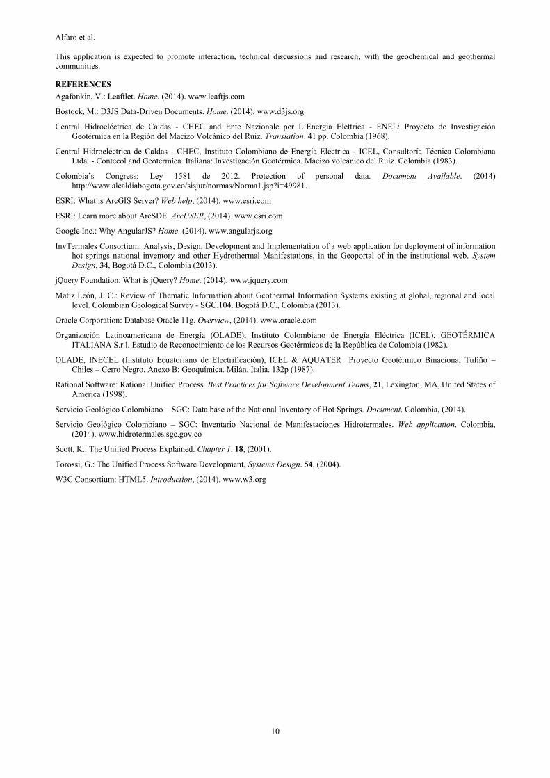
At the top, search options include “Search” which is a free text searching tool which looks for coincidences of the typed word or
chain of characters in all the text fields of the database.
The drop down menu (arrow nearby “Search”) presents search options structured as filters which combine the type of manifestation
(hot spring or fumaroles) with the following criteria: Department, Municipality, possible association to a volcano, availability of
touristic infrastructure, classification of the manifestation (for hot springs: unclassified, chloride, bicarbonate, sulfate and mixed;
for fumaroles: hydrothermal and magmatic) and temperature (Figure 9).
“Advance Search” is an option that performs queries after selecting the type of manifestation (hot spring or fumaroles) by using
filters with logical and relational operators for any numerical parameter (Figure 9)
Figure 9: Illustration of Search options. Left: displayable menu. Right: Advanced search (Source: National Inventory of
Hydrothermal Manifestations of Colombia Web Application of SGC, 2014)
Finally, at the top, the text option “Administrator”, is a non-public choice used by the maintenance and updating of the system,
which requires access permission. There are two types of user profile: technician and administrator. The technician is able to upload
information by massive or single load and edit existing records. The administrator is able to upload and edit information, assign the
role of the new technical users, create new domains for the interface and the database, add new fields and consult the visitor record
for statistical evaluations.
3.3.2 Query Modules
The query options are spatial and descriptive. The first quick spatial query is made available by panning on the map. Pop-up
windows appear showing the most general information including Name, Department, and Municipality, a photography,
temperature, pH and electrical conductivity, as shown in Figure 10.
The spatial query by clicking on the map is expected to be the most frequently consulted option. This selection enables to access the
first windows for individual or group search.
In the case of individual search, the window presents photographs and icons for selected videos, hydrogeochemical diagrams
including Stiff and XY diagrams of any numerical parameter versus date, downloadable documents (in pdf format), a Table of
Results which includes all the existing records of a point and is editable by adding or removing fields, and one final icon for adding
diagrams to the Report.
In the case of group search, the active window presents a Table of Results with the parameters defined by default which, as in the
previous case, can be modified by adding or removing fields. Hydrogeochemical Analysis, which options were describe before, is
available from the “Main Menu” (left of the screen).
The descriptive queries are based on the three Search options found at the top and above described. KML paths can be displayed
from the Tables of Results.
3.3.3 Reports
The results of the queries are delivered to the users through digital reports that the application creates in pdf files, to a maximum of
10 hot springs or fumaroles by session. Before generating the report, some personal information is requests for statistical purposes,

Alfaro et al.
9
which, according to the Colombian Law (Hábeas data) (Colombia, Ley 1581, 2012) requires the user’s authorization. Three types
of reports can be requested, generated and downloaded as pdf files, as described in the Table 2.
Figure 10: Illustration of pop-up function (Source: National Inventory of Hydrothermal Manifestations of Colombia Web
Application of SGC, 2014)
3.4 Updating program
The web application is going to be updated periodically (possibly every 5 years) with new chemical and isotopic characterization.
Meanwhile, and as analytical techniques become available new, parameters are going to be included as some dissolved species not
analyzed yet, gas emissions and surrounding hydrothermal deposits.
Table 2. Reports generated by the web application “National Inventory of Hydrothermal Manifestations of Colombia”
4. CONCLUSIONS
A new web application developed by the Colombian Geological Survey, for divulgation of hot springs and fumaroles, is going to be
delivered to the geothermal community and to the public in general.
The users of the application can access the general information of hot springs and fumaroles, general aspects of the geology where
these hydrothermal manifestations spring out, chemical and isotopic composition and diagrams used as tools for geochemical
interpretation.
The web application will be updated periodically with new records and new analyzed parameters.
The integration of information of other types of surface hydrothermal manifestations such us steaming ground and hydrothermal
mud is expected in updated versions of the applications. However those manifestations are very scarce in Colombia.
REPORT CONTENTS EXPECTED USER'S PROFILE
Photographies
Table of Results. Contents by default or according to
the preferences of the user
Stiff Diagram
Geographic Map
Geological Map
Map description
Photography
Table of Results. Contents by default or according to
the preferences of the user
Hydrochemical diagrams
Public in general
Earth scientists, particularly structural and
tectonic geologist
Geothermal researchers
Geothermal researchers and developers from the
productive sector
Earth scientists
Chemists
Geochemists
Medical Doctors
Professionals of the Vice-Ministry of Tourism.
BASIC
GEOLOGICAL
HYDROGEOCHEMICAL
Alfaro et al.
10
This application is expected to promote interaction, technical discussions and research, with the geochemical and geothermal
communities.
REFERENCES
Agafonkin, V.: Leaftlet. Home. (2014). www.leaftjs.com
Bostock, M.: D3JS Data-Driven Documents. Home. (2014). www.d3js.org
Central Hidroeléctrica de Caldas - CHEC and Ente Nazionale per L’Energia Elettrica - ENEL: Proyecto de Investigación
Geotérmica en la Región del Macizo Volcánico del Ruiz. Translation. 41 pp. Colombia (1968).
Central Hidroeléctrica de Caldas - CHEC, Instituto Colombiano de Energía Eléctrica - ICEL, Consultoría Técnica Colombiana
Ltda. - Contecol and Geotérmica Italiana: Investigación Geotérmica. Macizo volcánico del Ruiz. Colombia (1983).
Colombia’s Congress: Ley 1581 de 2012. Protection of personal data. Document Available. (2014)
http://www.alcaldiabogota.gov.co/sisjur/normas/Norma1.jsp?i=49981.
ESRI: What is ArcGIS Server? Web help, (2014). www.esri.com
ESRI: Learn more about ArcSDE. ArcUSER, (2014). www.esri.com
Google Inc.: Why AngularJS? Home. (2014). www.angularjs.org
InvTermales Consortium: Analysis, Design, Development and Implementation of a web application for deployment of information
hot springs national inventory and other Hydrothermal Manifestations, in the Geoportal of in the institutional web. System
Design, 34, Bogotá D.C., Colombia (2013).
jQuery Foundation: What is jQuery? Home. (2014). www.jquery.com
Matiz León, J. C.: Review of Thematic Information about Geothermal Information Systems existing at global, regional and local
level. Colombian Geological Survey - SGC.104. Bogotá D.C., Colombia (2013).
Oracle Corporation: Database Oracle 11g. Overview, (2014). www.oracle.com
Organización Latinoamericana de Energía (OLADE), Instituto Colombiano de Energía Eléctrica (ICEL), GEOTÉRMICA
ITALIANA S.r.l. Estudio de Reconocimiento de los Recursos Geotérmicos de la República de Colombia (1982).
OLADE, INECEL (Instituto Ecuatoriano de Electrificación), ICEL & AQUATER Proyecto Geotérmico Binacional Tufiño –
Chiles – Cerro Negro. Anexo B: Geoquímica. Milán. Italia. 132p (1987).
Rational Software: Rational Unified Process. Best Practices for Software Development Teams, 21, Lexington, MA, United States of
America (1998).
Servicio Geológico Colombiano – SGC: Data base of the National Inventory of Hot Springs. Document. Colombia, (2014).
Servicio Geológico Colombiano – SGC: Inventario Nacional de Manifestaciones Hidrotermales. Web application. Colombia,
(2014). www.hidrotermales.sgc.gov.co
Scott, K.: The Unified Process Explained. Chapter 1. 18, (2001).
Torossi, G.: The Unified Process Software Development, Systems Design. 54, (2004).
W3C Consortium: HTML5. Introduction, (2014). www.w3.org
Related Documents