A mega-splay fault system and tsunami hazard in the southern Ryukyu subduction zone Shu-Kun Hsu a,n , Yi-Ching Yeh b , Jean-Claude Sibuet a , Wen-Bin Doo a , Ching-Hui Tsai a a Department of Earth Sciences, National Central University, Chung-Li 320, Taiwan b Taiwan Ocean Research Institute, Kaohsiung 852, Taiwan article info Article history: Received 3 July 2012 Received in revised form 3 November 2012 Accepted 28 November 2012 Editor: P. Shearer Keywords: splay fault earthquake tsunami Ryukyu Trench convergent boundary abstract In April 1771, a subduction earthquake generated a great tsunami that struck the south Ryukyu islands and killed 12,000 people, whereas its mechanism is still enigmatic (Nakata and Kawana, 1995; Nakamura, 2006; Matsumoto et al., 2009). In this paper, we show its probable source on a mega-splay fault system existing along the southern Ryukyu forearc. Analyses of deep multi-channel seismic reflection profiles indicate that the mega-splay fault system is rising from the summit of a 1 km high ridge situated at a 51 landward dipping plate interface. An outer ridge marks the seafloor outcrop of the splay fault system and separates the landward inner wedge and the oceanward outer wedge. The inner wedge is uplifting and exhibits widespread normal faulting while the outer wedge shows folded structures. The mega-splay fault system is parallel to the Ryukyu Trench east of 125.51E and is estimated to be 450 km long. The origin of this south Ryukyu mega-splay fault system is ascribed to a resistant subduction of the elevated transverse ridges associated with the subducting portion of the trench-parallel Luzon–Okinawa Fracture Zone. In contrast, no similar splay fault is found west of 125.51E where the oblique subduction has produced large shear zones along the south Ryukyu forearc. We infer that a thrust earthquake linked to the mega-splay fault system is responsible for the south Ryukyu tsunami. However, another possible scenario of generating a large tsunami affecting the south Ryukyu islands is that the subducted ridge in the western end of the mega-splay fault system nucleated a large earthquake and simultaneously triggered the 100 km long E–W trending strike-slip fault west of 125.51E and induced a southward-dipping tsunami-genic subsidence. In any case, after a quiescence of 241 yr, a large earthquake and tsunami is anticipated in the south Ryukyu forearc in the near future. & 2012 Elsevier B.V. All rights reserved. 1. Introduction In subduction zones, convergent thrust faults usually occur in accretionary wedges and propagate trenchward in sequence. In contrast, several out-of-sequence thrust faults (splay faults) associated with great earthquakes are found in the Sunda (Sibuet et al., 2007), Nankai (Park et al., 2002; Moore et al., 2007), Ecuador–Colombia (Collot et al., 2004) and Alaska (Plafker, 1972) subduction zones. These splay faults, branching from plate interfaces with steep dipping angles near the seafloor, may generate devastating tsunamis in the nearby regions. This threat is emphasized by geodetic observation (Hsu et al., 2006) and theoretical modeling (Wang and Hu, 2006), which demonstrate that the splay fault and the plate interface beneath the inner wedge are co-seismically active, while the plate interface beneath the outer wedge slips post-seismically. In the Ryukyu subduction zone, earthquakes of magnitude greater than 8 have not been recorded. However, in 1771 a devastating tsunami named Meiwa tsunami struck the south Ryukyu islands (Nakata and Kawana, 1995). The run-up exceeded 30 m and the main damage was reported on Ishigaki and Miyako Islands (Nakata and Kawana, 1995; Nakamura, 2006; Matsumoto et al., 2009). Reef boulders transported by the tsunami are distributed onshore along the southeast coast of Ishigaki Island (Goto et al., 2010), suggesting that the source of the Meiwa tsunami was located southeast of Ishigaki Island. Nakamura (2006) inferred that the 1771 tsunami was due to an earthquake near the Ryukyu Trench but no surface rupture was found yet. In fact, older reef boulders were found at even higher altitudes on Ishigaki Island, suggesting that great tsunamis larger than the Meiwa tsunami occurred intermittently in this area at an interval of several hundreds to one thousand years (Nakamura, 2006). In this study, we display four multichannel seismic reflection Contents lists available at SciVerse ScienceDirect journal homepage: www.elsevier.com/locate/epsl Earth and Planetary Science Letters 0012-821X/$ - see front matter & 2012 Elsevier B.V. All rights reserved. http://dx.doi.org/10.1016/j.epsl.2012.11.053 n Corresponding author. Tel.: þ886 3 4268316; fax: þ886 3 4222044. E-mail address: [email protected] (S.-K. Hsu). Earth and Planetary Science Letters 362 (2013) 99–107

Welcome message from author
This document is posted to help you gain knowledge. Please leave a comment to let me know what you think about it! Share it to your friends and learn new things together.
Transcript
Earth and Planetary Science Letters 362 (2013) 99–107
Contents lists available at SciVerse ScienceDirect
Earth and Planetary Science Letters
0012-82
http://d
n Corr
E-m
journal homepage: www.elsevier.com/locate/epsl
A mega-splay fault system and tsunami hazard in the southernRyukyu subduction zone
Shu-Kun Hsu a,n, Yi-Ching Yeh b, Jean-Claude Sibuet a, Wen-Bin Doo a, Ching-Hui Tsai a
a Department of Earth Sciences, National Central University, Chung-Li 320, Taiwanb Taiwan Ocean Research Institute, Kaohsiung 852, Taiwan
a r t i c l e i n f o
Article history:
Received 3 July 2012
Received in revised form
3 November 2012
Accepted 28 November 2012
Editor: P. Shearerreflection profiles indicate that the mega-splay fault system is rising from the summit of a �1 km high
Keywords:
splay fault
earthquake
tsunami
Ryukyu Trench
convergent boundary
1X/$ - see front matter & 2012 Elsevier B.V.
x.doi.org/10.1016/j.epsl.2012.11.053
esponding author. Tel.: þ886 3 4268316; fax
ail address: [email protected] (S.-K. Hsu).
a b s t r a c t
In April 1771, a subduction earthquake generated a great tsunami that struck the south Ryukyu islands
and killed �12,000 people, whereas its mechanism is still enigmatic (Nakata and Kawana, 1995;
Nakamura, 2006; Matsumoto et al., 2009). In this paper, we show its probable source on a mega-splay
fault system existing along the southern Ryukyu forearc. Analyses of deep multi-channel seismic
ridge situated at a �51 landward dipping plate interface. An outer ridge marks the seafloor outcrop of
the splay fault system and separates the landward inner wedge and the oceanward outer wedge.
The inner wedge is uplifting and exhibits widespread normal faulting while the outer wedge shows
folded structures. The mega-splay fault system is parallel to the Ryukyu Trench east of 125.51E and is
estimated to be �450 km long. The origin of this south Ryukyu mega-splay fault system is ascribed to a
resistant subduction of the elevated transverse ridges associated with the subducting portion of the
trench-parallel Luzon–Okinawa Fracture Zone. In contrast, no similar splay fault is found west of
125.51E where the oblique subduction has produced large shear zones along the south Ryukyu forearc.
We infer that a thrust earthquake linked to the mega-splay fault system is responsible for the south
Ryukyu tsunami. However, another possible scenario of generating a large tsunami affecting the south
Ryukyu islands is that the subducted ridge in the western end of the mega-splay fault system nucleated
a large earthquake and simultaneously triggered the �100 km long E–W trending strike-slip fault west
of 125.51E and induced a southward-dipping tsunami-genic subsidence. In any case, after a quiescence
of �241 yr, a large earthquake and tsunami is anticipated in the south Ryukyu forearc in the near
future.
& 2012 Elsevier B.V. All rights reserved.
1. Introduction
In subduction zones, convergent thrust faults usually occur inaccretionary wedges and propagate trenchward in sequence. Incontrast, several out-of-sequence thrust faults (splay faults)associated with great earthquakes are found in the Sunda(Sibuet et al., 2007), Nankai (Park et al., 2002; Moore et al.,2007), Ecuador–Colombia (Collot et al., 2004) and Alaska (Plafker,1972) subduction zones. These splay faults, branching from plateinterfaces with steep dipping angles near the seafloor, maygenerate devastating tsunamis in the nearby regions. This threatis emphasized by geodetic observation (Hsu et al., 2006) andtheoretical modeling (Wang and Hu, 2006), which demonstratethat the splay fault and the plate interface beneath the inner
All rights reserved.
: þ886 3 4222044.
wedge are co-seismically active, while the plate interface beneaththe outer wedge slips post-seismically.
In the Ryukyu subduction zone, earthquakes of magnitudegreater than 8 have not been recorded. However, in 1771 adevastating tsunami named Meiwa tsunami struck the southRyukyu islands (Nakata and Kawana, 1995). The run-up exceeded30 m and the main damage was reported on Ishigaki and MiyakoIslands (Nakata and Kawana, 1995; Nakamura, 2006; Matsumotoet al., 2009). Reef boulders transported by the tsunami aredistributed onshore along the southeast coast of Ishigaki Island(Goto et al., 2010), suggesting that the source of the Meiwatsunami was located southeast of Ishigaki Island. Nakamura(2006) inferred that the 1771 tsunami was due to an earthquakenear the Ryukyu Trench but no surface rupture was found yet. Infact, older reef boulders were found at even higher altitudes onIshigaki Island, suggesting that great tsunamis larger than theMeiwa tsunami occurred intermittently in this area at an intervalof several hundreds to one thousand years (Nakamura, 2006). Inthis study, we display four multichannel seismic reflection
S.-K. Hsu et al. / Earth and Planetary Science Letters 362 (2013) 99–107100
profiles across the south Ryukyu Trench to show the possiblesource of the earthquake related to the 1771 Meiwa tsunami anddiscuss the potential of a future large tsunami being generated inthe southern Ryukyu subduction zone.
2. Tectonic background
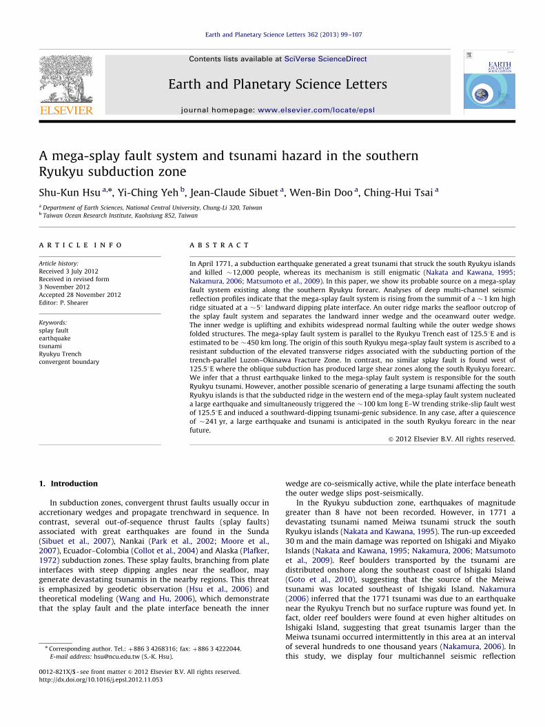
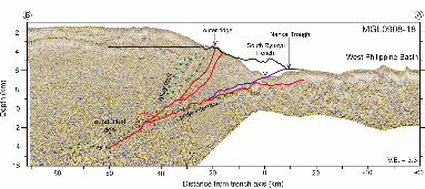
Along the Ryukyu Trench, the Philippine Sea Plate (PSP) issubducting northwestward beneath the Eurasian Plate (EP) with aconvergence rate of �65 mm/yr near the south Ryukyu Trench(Seno et al., 1993) (Fig. 1). Near location J (�23.51N and �1261E)in Fig. 1, the Ryukyu Trench abruptly changes its orientation from�N0821 in the west to �N0521 in the east. In the east, the trenchis relatively narrow and quasi-linear and the subduction directionis almost perpendicular to the trench orientation (Fig. 1).However, to the north of the Daito Ridge, the trench characteristicbecomes unclear. The segment of the Ryukyu Trench between1261E and 1301E almost coincides with the northeastwardprolongation of the multi-stranded Luzon–Okinawa Fracture Zone(LOFZ), which is subducting northwestward beneath the Ryukyu
Fig. 1. Morphology of the study area. Black arrow indicates the convergent direction of
gravity anomalies in the south Ryukyu forearc shown in Fig. 2. Note that the subducti
subduction is oblique in the west of 125.51E. Note also that the orientation of the seaflo
and 124.51E. FZ: Fracture zone; I: Ishigaki Island; M: Miyako Island; O: Okinawa Islan
forearc (Fig. 1). The subduction of the northeastern portion of theLOFZ has induced several NE–SW trending bathymetric undula-tion. From north to south, the orientation of the LOFZ has changed�181 anticlockwise near the location J (Fig. 1). This change inorientation of the fracture zones could be linked to the change ofseafloor spreading directions in the West Philippine Basin.This fact can be justified by examining the different orientationsof the seafloor fabrics near the fracture zones: an orientation of�N3181 near 24.51N and 1281E, but �N3001 near 211N and124.51E (Fig. 1).
The LOFZ is also marked by the linear free-air gravity anomalyhighs and lows (Fig. 2). The linear gravity highs may representsome transverse ridges formed due to tectonic transpression.Bathymetric and gravity highs also appear along the forearc offMiyako and Okinawa Islands (Figs. 1 and 2). The gravity higharound 241N and 1261E is particularly obvious and is close to thelocation J. In stark contrast, west of 125.51E, there is no forearcgravity high but the forearc basins are well developed (Lallemandet al., 1999). Additionally, because the PSP/EP convergencedirection is �451 oblique to the trench, strain partition andtrench-parallel right-lateral shear zones have developed in the
the Philippine Sea Plate relative to the Eurasian Plate. Stippled areas indicate high
on is almost perpendicular to the Ryukyu Trench in the east of 125.51E while the
or spreading fabrics near 24.51N and 1281E is �N3181, but it is �N3001 near 211N
d.
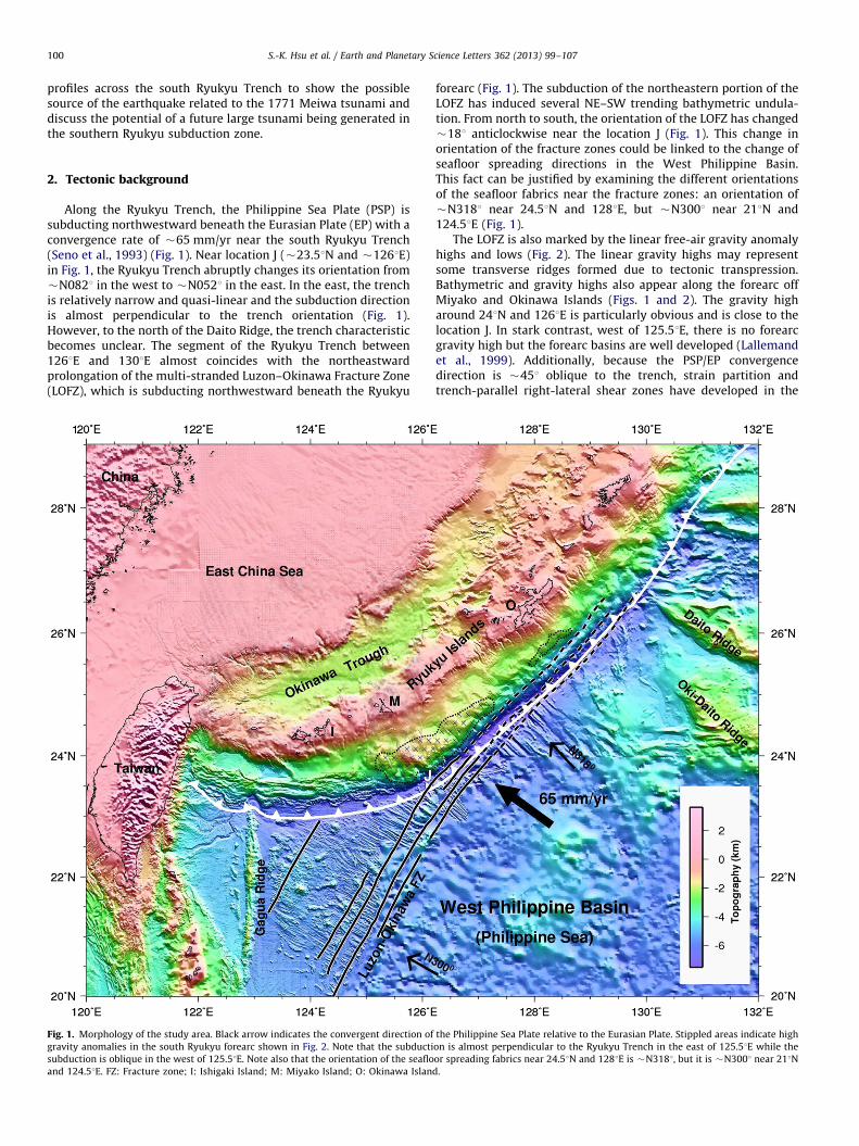
Fig. 2. Free-air gravity anomalies draped onto the bathymetry of the study area. White lines indicate the right-lateral shear zones in the southernmost Ryukyu forearc.
Lines AB, BCD, EF and GH are the locations of seismic reflection profiles used in this study. FZ: Fracture zone; I: Ishigaki Island; M: Miyako Island; O: Okinawa Island.
S.-K. Hsu et al. / Earth and Planetary Science Letters 362 (2013) 99–107 101
accretionary wedge west of 125.51E (Kao et al., 1998; Lallemandet al., 1999) (Fig. 2).
3. Seismic data processing and interpretation
During the TAIGER cruise in 2009, we have collected four6-km-long multi-channel seismic (MCS) reflection profiles acrossthe south Ryukyu Trench by using R/V Marcus G. Langseth with a6600 c.i. air-gun source array (Fig. 2). The MCS profiles have beenprocessed and a F–K migration was applied.
3.1. Mega-splay fault system
The easternmost MCS profile (Line AB in Fig. 2) shows apronounced plate interface between the subducting PSP and theoverriding EP, especially at the locations where the seismic phaseshows an obvious negative-polarity reflection (Figs. 3 and A.1).The strong negative-polarity reflection indicates the existence offluid in a high-porosity layer (Shipley et al., 1994). The clearstratification beneath the plate interface suggests that therelative plate motion has occurred along a sedimentary interfaceabove the oceanic basement, where high-pressure fluid prevails
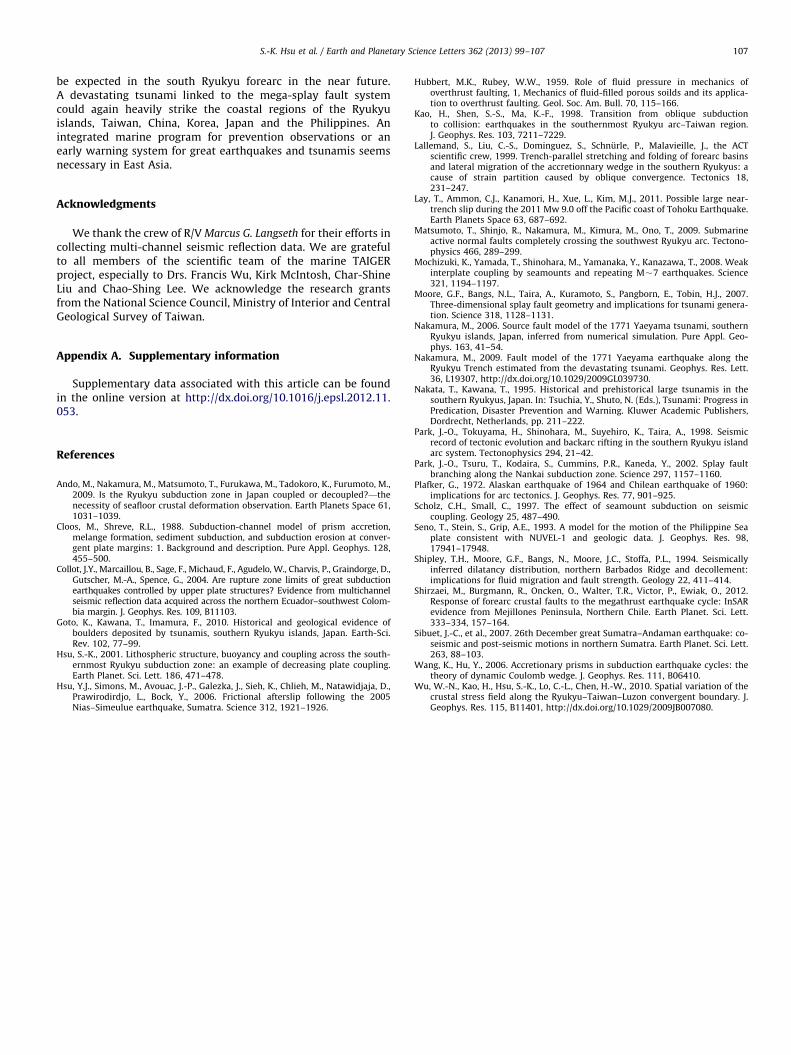
(Fig. A.1) (e.g. Cloos and Shreve, 1988). The MCS profile AB alsoshows a �30 km long thrust fault system that branches upwardfrom the plate interface (red lines in Fig. 3). The thrust faultsystem cuts across sedimentary layers of the wedge and is an out-of-sequence thrust fault (splay fault) system. This splay faultsystem displays several branches, but as commonly observed inthe Nankai Trough (Moore et al., 2007), none of them intersectswith the seafloor. Negative-polarity seismic reflectors are alsofound in the splay fault system. Located at �50 km landwardfrom the trench axis and at a depth of �6.5 s two-way-travel(TWT) time or �11 km below the seafloor (Fig. A.2), the splayfault system rises from the summit of an elevated ridge on top ofa �51 landward dipping plate interface (Fig. A.2). Similar to thecase in the Nankai Trough (Park et al., 2002; Moore et al., 2007),an outer ridge is observed near the updip end of the splay faultsystem (Fig. 3). Spatially, the outer ridge separates the innerwedge from the outer wedge. The inner wedge is intensivelystretched as demonstrated by numerous normal faults in the topstrata, whereas the outer wedge oppositely shows compressionalfolding features above the plate interface (Fig. 3).
Although there are several similarities between the southRyukyu and the Nankai splay fault systems, there are somedifferent features between these two systems. We use the outer

Fig. 3. Multi-beam bathymetric image and seismic reflection along profile AB (upper two panels, respectively). The seismic interpretations are shown in the lower panel.
Red lines indicate the splay fault system. Blue boxes indicate portions of close-ups shown in Fig. 4 and Fig. A.1. FZ: Fracture zone. (For interpretation of the references to
color in this figure legend, the reader is referred to the web version of this article.)
S.-K. Hsu et al. / Earth and Planetary Science Letters 362 (2013) 99–107102
ridges of the two systems as a fixed reference point even thoughthe outer ridge in the southern Ryukyu subduction zone is�1.5 km deeper than in the Nankai subduction zone. In that case,we can observe that the highest inner wedge is �2 km higher andthe trench is �1 km lower in the southern Ryukyu subductionzone (Fig. A.2). Moreover, the horizontal position of the southRyukyu Trench is �10 km closer to the outer ridge. In otherwords, the plate coupling is much stronger in the southernRyukyu subduction zone; thus, its overriding plate is seriouslybent and dragged deeper along the plate interface. It implies thatearthquake and tsunami hazard is much more imperative andvital in the southern Ryukyu subduction zone than in the Nankaisubduction zone. However, a decollement is not observed beneaththe outer wedge in the profile AB.
3.2. Deformation of the inner wedge and the outer wedge
As shown in Fig. 4, sedimentary layers L3 and L2 in the innerwedge display onlaps over the unconformity Ua between 54 and66 km landward from the trench axis. Ua is tilted �2.51 land-ward. Between 52 and 67 km, the tilted layers L7–L4 are roughlyparallel to Ua but display onlaps over the unconformity Ub(Fig. 4), which means that Ub was rotated �2.51 anticlockwiseafter the deposition of layer L4. Beneath Ub, the sedimentarylayers are tilted �4.51 landward, suggesting that prior to thedeposition of layer L7, the inner wedge was rotated �21 antic-lockwise. The landward tilting of the strata implies that there
were episodic uplifts on the seaward edge of the basin.Thus, there were at least two major tectonic events as indicatedby Ua and Ub unconformities or two major slip events along themega-splay fault, which uplifted the south Ryukyu forearc innerwedge. It indicates also that the megathrust splay faults arebreaking backward (away from the trench) in an out-of-sequence thrust mode. In comparison with the interpretation ofseismic stratigraphy by Park et al. (1998), the tectonic event of Uapossibly occurred in Pliocene. Currently, there are numeroussmall and active landward-dipping normal faults that widelyspread in the top layer of the inner wedge (Figs. 3 and 4). Itimplies that the inner wedge is gradually bent. However, there arefour larger seaward-dipping normal faults in the inner wedge andthey even cut across unconformity Ub and the acoustic basement(Figs. 3 and 4). It indicates that a subducted ridge or seamount haspassed beneath the inner wedge, which caused the conspicuousseaward subsidence.
The normal faults in the inner wedge reflect a decreasingstress of the splay fault system in current inter-seismic period.Because the uplifted center of the inner wedge is situated above arelatively high ridge of the subducted plate interface (Fig. 3), thesubducted elevated relief could be the source of the strong platecoupling that causes the warping and tensile deformation of theinner wedge as well as the development of the splay fault system.On the other hand, the compressive features in the outer wedgecould be generated during each post-seismic slipping along theplate interface beneath the outer wedge (Hsu et al., 2006). In

Fig. 4. Close-up of a portion of the extensional inner wedge, indicated by a blue rectangle in the lower panel of Fig. 3. Note that the warping inner wedge contains two
major unconformities (Ua and Ub) and four major normal faults dipping seawards. (For interpretation of the references to color in this figure legend, the reader is referred
to the web version of this article.)
S.-K. Hsu et al. / Earth and Planetary Science Letters 362 (2013) 99–107 103
response to megathrust earthquake cycles, the inter-seismicconvex bending and normal faulting are also observed in theforearc in northern Chile (Shirzaei et al., 2012).
3.3. Forearc strike-slip fault and decollement west of 125.51E
In contrast to the profile AB, the MCS profile GH crosses astrike-slip fault system along the southern end of the Ryukyuforearc (Lallemand et al., 1999) (Fig. 2). There is no clear distinc-tion between the inner wedge and the outer wedge, but some in-sequence thrusts are observed along profile GH (Fig. 5). Besides, adecollement is observed beneath the accretionary prism and aforearc basin is well developed (Fig. 5). However, the forearc basinis separated from the rest of the accretionary prism by a majorE–W trending left-lateral strike-slip fault (Figs. 2 and 5). Theformation of the normal faults in this forearc basin could be dueto a fast retreat of the subducted PSP or a strong decouplingbetween PSP and EU in this area (Hsu, 2001). In contrast, thenormal faults in the inner wedge of profile AB is mainly due to aconvex bending caused by the subduction of a locally elevatedridge and a strong coupling in the plate interface.
Between profiles AB and GH, the profiles BCD and EF arelocated in a transitional setting (Figs. 6 and 7). The splay faultsrising from the subducted plate interface and the normal faultingin the inner wedge can also be observed in profiles BCD and EF.A decollement beneath the outer wedge is also observed in profileBCD and profile EF (Figs. 6 and 7). The overall structures of thesetwo MCS profiles are quite similar to the mega-splay fault systemin the Nankai Trough (Park et al., 2002).
4. Discussion
The outer ridge characterizes the updip end of the splay faultsystem. In terms of morphology, it may continue along the forearcfrom 125.51E to 129.51E (Fig. 1). In the north, the elongateddistribution of the inner wedge spatially coincides with a free-airgravity anomaly high (Figs. 2 and 8), which is probably related tothe doming of the inner wedge. Taking into account the highgravity anomaly distributed along the forearc off Miyako andOkinawa Islands, the splay fault system along the south Ryukyuforearc can extend up to �450 km long, until the northwesternend of the Daito ridge (Fig. 2). Further north, the tectonic stressregime is different (Wu et al., 2010). Considering such a largescale, the splay fault system beneath the south Ryukyu forearc isregarded as a mega-splay fault system. Accordingly, we mayascribe the 1771 Meiwa tsunami and prehistoric larger tsunamishitting the southern Ryukyu islands to great earthquakes thatoccurred intermittently along this south Ryukyu mega-splay faultsystem.
As shown in Fig. 1, several topographic features such as theGagua Ridge or Daito Ridge are subducting or will subductbeneath the Ryukyu forearc. Such subducted oceanic plateaus,seamounts or ridges would increase the seismic coupling andrecurrence intervals of great earthquakes (Scholz and Small,1997). Although Mochizuki et al. (2008) suggested that interplatecoupling over seamounts was weak because of the repeatingearthquakes of magnitude M�7 in the Japan Trench, there was a2011 Tohoku earthquake of M9 at almost the same seamountsubducted interface (e.g. Lay et al., 2011). In the southern Ryukyusubduction zone, the undulated geometry of the oceanic basement
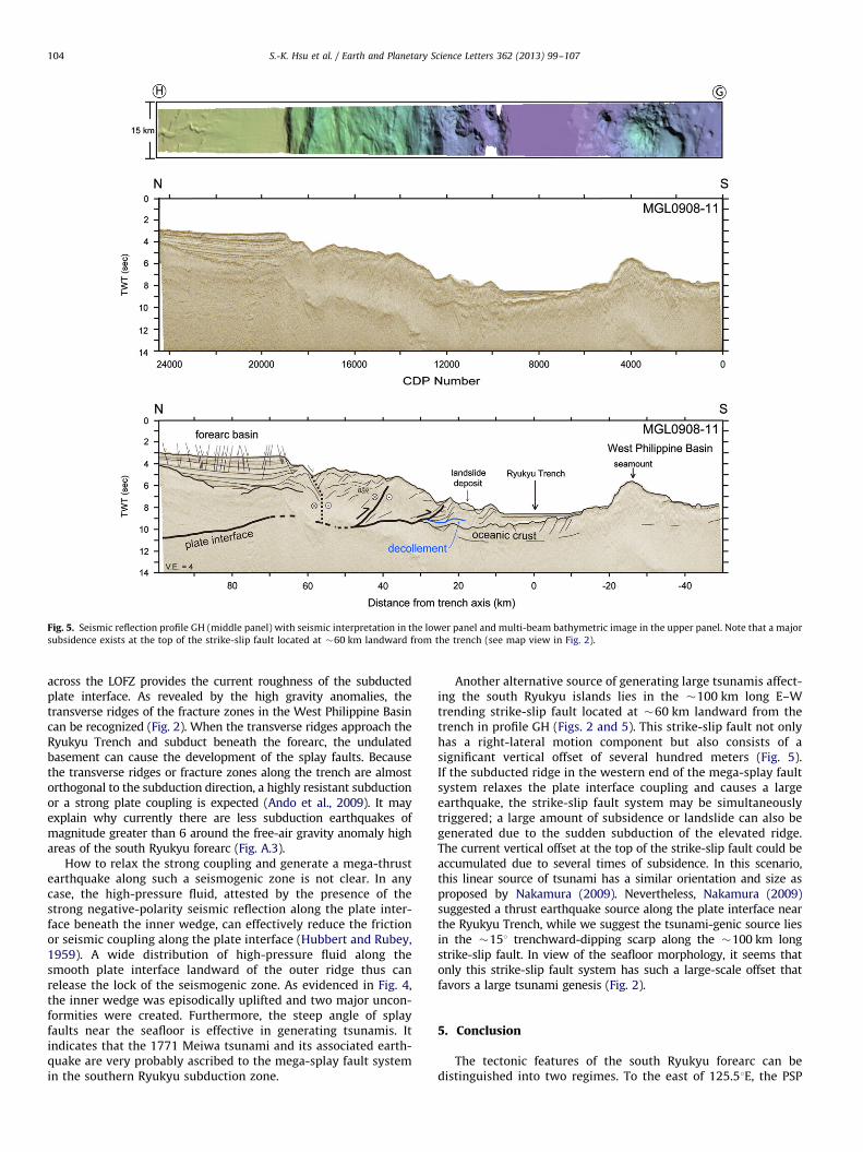
Fig. 5. Seismic reflection profile GH (middle panel) with seismic interpretation in the lower panel and multi-beam bathymetric image in the upper panel. Note that a major
subsidence exists at the top of the strike-slip fault located at �60 km landward from the trench (see map view in Fig. 2).
S.-K. Hsu et al. / Earth and Planetary Science Letters 362 (2013) 99–107104
across the LOFZ provides the current roughness of the subductedplate interface. As revealed by the high gravity anomalies, thetransverse ridges of the fracture zones in the West Philippine Basincan be recognized (Fig. 2). When the transverse ridges approach theRyukyu Trench and subduct beneath the forearc, the undulatedbasement can cause the development of the splay faults. Becausethe transverse ridges or fracture zones along the trench are almostorthogonal to the subduction direction, a highly resistant subductionor a strong plate coupling is expected (Ando et al., 2009). It mayexplain why currently there are less subduction earthquakes ofmagnitude greater than 6 around the free-air gravity anomaly highareas of the south Ryukyu forearc (Fig. A.3).
How to relax the strong coupling and generate a mega-thrustearthquake along such a seismogenic zone is not clear. In anycase, the high-pressure fluid, attested by the presence of thestrong negative-polarity seismic reflection along the plate inter-face beneath the inner wedge, can effectively reduce the frictionor seismic coupling along the plate interface (Hubbert and Rubey,1959). A wide distribution of high-pressure fluid along thesmooth plate interface landward of the outer ridge thus canrelease the lock of the seismogenic zone. As evidenced in Fig. 4,the inner wedge was episodically uplifted and two major uncon-formities were created. Furthermore, the steep angle of splayfaults near the seafloor is effective in generating tsunamis. Itindicates that the 1771 Meiwa tsunami and its associated earth-quake are very probably ascribed to the mega-splay fault systemin the southern Ryukyu subduction zone.
Another alternative source of generating large tsunamis affect-ing the south Ryukyu islands lies in the �100 km long E–Wtrending strike-slip fault located at �60 km landward from thetrench in profile GH (Figs. 2 and 5). This strike-slip fault not onlyhas a right-lateral motion component but also consists of asignificant vertical offset of several hundred meters (Fig. 5).If the subducted ridge in the western end of the mega-splay faultsystem relaxes the plate interface coupling and causes a largeearthquake, the strike-slip fault system may be simultaneouslytriggered; a large amount of subsidence or landslide can also begenerated due to the sudden subduction of the elevated ridge.The current vertical offset at the top of the strike-slip fault could beaccumulated due to several times of subsidence. In this scenario,this linear source of tsunami has a similar orientation and size asproposed by Nakamura (2009). Nevertheless, Nakamura (2009)suggested a thrust earthquake source along the plate interface nearthe Ryukyu Trench, while we suggest the tsunami-genic source liesin the �151 trenchward-dipping scarp along the �100 km longstrike-slip fault. In view of the seafloor morphology, it seems thatonly this strike-slip fault system has such a large-scale offset thatfavors a large tsunami genesis (Fig. 2).
5. Conclusion
The tectonic features of the south Ryukyu forearc can bedistinguished into two regimes. To the east of 125.51E, the PSP

Fig. 6. Seismic reflection profile BCD (middle panel) with seismic interpretation in the lower panel and multi-beam bathymetric image in the upper panel.
Fig. 7. Seismic reflection profile EF (middle panel) with seismic interpretation in the lower panel and multi-beam bathymetric image in the upper panel.
S.-K. Hsu et al. / Earth and Planetary Science Letters 362 (2013) 99–107 105
is almost perpendicularly subducting beneath the Ryukyu Arc,while to the west of 125.51E the plate subduction is oblique to theRyukyu Trench. In consequence, to the west of 125.51E strain
partitioning and trench-parallel strike-slip faults can be observed.In contrast, the mega-splay fault system has developed well to theeast of 125.51E. Its formation is attributed to the resistant

Fig. 8. A series of the seismic interpretations across the south Ryukyu Trench and forearc area. It is noted that the development of the splay fault system is associated with
an elevated subducted ridge and a free-air gravity high.
S.-K. Hsu et al. / Earth and Planetary Science Letters 362 (2013) 99–107106
subduction of the elevated ridges associated with the multi-stranded Luzon–Okinawa fracture zone whose orientation isalmost parallel to the Ryukyu Trench.
Geometrically, the quasi-linear Ryukyu Trench, the subductedfracture zones and the gravity anomaly highs east of 125.51Emarks the spatial distribution of the mega-splay fault systemalong the south Ryukyu forearc. This system is not segmenteduntil the Daito Ridge and is about 450 km long. Accordingly,historical megathrust earthquakes and tsunamis that occurred
due to the activities of this splay fault system are not surprising.Currently, the plate coupling in the southern Ryukyu subductionzone is very strong; thus, extensional features are presentthroughout the inner wedge and the outer wedge is deeplydragged or rotated clockwise with a pivot at the outer ridge. Highpore-pressure fluids also clearly exist along the plate interface ofthe seismogenic zone, which could effectively reduce seismiccoupling and induce a megathrust earthquake. After a quiescenceof �241 yr, a potential great earthquake of magnitude �8.5 can
S.-K. Hsu et al. / Earth and Planetary Science Letters 362 (2013) 99–107 107
be expected in the south Ryukyu forearc in the near future.A devastating tsunami linked to the mega-splay fault systemcould again heavily strike the coastal regions of the Ryukyuislands, Taiwan, China, Korea, Japan and the Philippines. Anintegrated marine program for prevention observations or anearly warning system for great earthquakes and tsunamis seemsnecessary in East Asia.
Acknowledgments
We thank the crew of R/V Marcus G. Langseth for their efforts incollecting multi-channel seismic reflection data. We are gratefulto all members of the scientific team of the marine TAIGERproject, especially to Drs. Francis Wu, Kirk McIntosh, Char-ShineLiu and Chao-Shing Lee. We acknowledge the research grantsfrom the National Science Council, Ministry of Interior and CentralGeological Survey of Taiwan.
Appendix A. Supplementary information
Supplementary data associated with this article can be foundin the online version at http://dx.doi.org/10.1016/j.epsl.2012.11.053.
References
Ando, M., Nakamura, M., Matsumoto, T., Furukawa, M., Tadokoro, K., Furumoto, M.,2009. Is the Ryukyu subduction zone in Japan coupled or decoupled?—thenecessity of seafloor crustal deformation observation. Earth Planets Space 61,1031–1039.
Cloos, M., Shreve, R.L., 1988. Subduction-channel model of prism accretion,melange formation, sediment subduction, and subduction erosion at conver-gent plate margins: 1. Background and description. Pure Appl. Geophys. 128,455–500.
Collot, J.Y., Marcaillou, B., Sage, F., Michaud, F., Agudelo, W., Charvis, P., Graindorge, D.,Gutscher, M.-A., Spence, G., 2004. Are rupture zone limits of great subductionearthquakes controlled by upper plate structures? Evidence from multichannelseismic reflection data acquired across the northern Ecuador–southwest Colom-bia margin. J. Geophys. Res. 109, B11103.
Goto, K., Kawana, T., Imamura, F., 2010. Historical and geological evidence ofboulders deposited by tsunamis, southern Ryukyu islands, Japan. Earth-Sci.Rev. 102, 77–99.
Hsu, S.-K., 2001. Lithospheric structure, buoyancy and coupling across the south-ernmost Ryukyu subduction zone: an example of decreasing plate coupling.Earth Planet. Sci. Lett. 186, 471–478.
Hsu, Y.J., Simons, M., Avouac, J.-P., Galezka, J., Sieh, K., Chlieh, M., Natawidjaja, D.,Prawirodirdjo, L., Bock, Y., 2006. Frictional afterslip following the 2005Nias–Simeulue earthquake, Sumatra. Science 312, 1921–1926.
Hubbert, M.K., Rubey, W.W., 1959. Role of fluid pressure in mechanics ofoverthrust faulting, 1, Mechanics of fluid-filled porous soilds and its applica-tion to overthrust faulting. Geol. Soc. Am. Bull. 70, 115–166.
Kao, H., Shen, S.-S., Ma, K.-F., 1998. Transition from oblique subductionto collision: earthquakes in the southernmost Ryukyu arc–Taiwan region.J. Geophys. Res. 103, 7211–7229.
Lallemand, S., Liu, C.-S., Dominguez, S., Schnurle, P., Malavieille, J., the ACTscientific crew, 1999. Trench-parallel stretching and folding of forearc basinsand lateral migration of the accretionnary wedge in the southern Ryukyus: acause of strain partition caused by oblique convergence. Tectonics 18,231–247.
Lay, T., Ammon, C.J., Kanamori, H., Xue, L., Kim, M.J., 2011. Possible large near-trench slip during the 2011 Mw 9.0 off the Pacific coast of Tohoku Earthquake.Earth Planets Space 63, 687–692.
Matsumoto, T., Shinjo, R., Nakamura, M., Kimura, M., Ono, T., 2009. Submarineactive normal faults completely crossing the southwest Ryukyu arc. Tectono-physics 466, 289–299.
Mochizuki, K., Yamada, T., Shinohara, M., Yamanaka, Y., Kanazawa, T., 2008. Weakinterplate coupling by seamounts and repeating M�7 earthquakes. Science321, 1194–1197.
Moore, G.F., Bangs, N.L., Taira, A., Kuramoto, S., Pangborn, E., Tobin, H.J., 2007.Three-dimensional splay fault geometry and implications for tsunami genera-tion. Science 318, 1128–1131.
Nakamura, M., 2006. Source fault model of the 1771 Yaeyama tsunami, southernRyukyu islands, Japan, inferred from numerical simulation. Pure Appl. Geo-phys. 163, 41–54.
Nakamura, M., 2009. Fault model of the 1771 Yaeyama earthquake along theRyukyu Trench estimated from the devastating tsunami. Geophys. Res. Lett.36, L19307, http://dx.doi.org/10.1029/2009GL039730.
Nakata, T., Kawana, T., 1995. Historical and prehistorical large tsunamis in thesouthern Ryukyus, Japan. In: Tsuchia, Y., Shuto, N. (Eds.), Tsunami: Progress inPredication, Disaster Prevention and Warning. Kluwer Academic Publishers,Dordrecht, Netherlands, pp. 211–222.
Park, J.-O., Tokuyama, H., Shinohara, M., Suyehiro, K., Taira, A., 1998. Seismicrecord of tectonic evolution and backarc rifting in the southern Ryukyu islandarc system. Tectonophysics 294, 21–42.
Park, J.-O., Tsuru, T., Kodaira, S., Cummins, P.R., Kaneda, Y., 2002. Splay faultbranching along the Nankai subduction zone. Science 297, 1157–1160.
Plafker, G., 1972. Alaskan earthquake of 1964 and Chilean earthquake of 1960:implications for arc tectonics. J. Geophys. Res. 77, 901–925.
Scholz, C.H., Small, C., 1997. The effect of seamount subduction on seismiccoupling. Geology 25, 487–490.
Seno, T., Stein, S., Grip, A.E., 1993. A model for the motion of the Philippine Seaplate consistent with NUVEL-1 and geologic data. J. Geophys. Res. 98,17941–17948.
Shipley, T.H., Moore, G.F., Bangs, N., Moore, J.C., Stoffa, P.L., 1994. Seismicallyinferred dilatancy distribution, northern Barbados Ridge and decollement:implications for fluid migration and fault strength. Geology 22, 411–414.
Shirzaei, M., B€urgmann, R., Oncken, O., Walter, T.R., Victor, P., Ewiak, O., 2012.Response of forearc crustal faults to the megathrust earthquake cycle: InSARevidence from Mejillones Peninsula, Northern Chile. Earth Planet. Sci. Lett.333–334, 157–164.
Sibuet, J.-C., et al., 2007. 26th December great Sumatra–Andaman earthquake: co-seismic and post-seismic motions in northern Sumatra. Earth Planet. Sci. Lett.263, 88–103.
Wang, K., Hu, Y., 2006. Accretionary prisms in subduction earthquake cycles: thetheory of dynamic Coulomb wedge. J. Geophys. Res. 111, B06410.
Wu, W.-N., Kao, H., Hsu, S.-K., Lo, C.-L., Chen, H.-W., 2010. Spatial variation of thecrustal stress field along the Ryukyu–Taiwan–Luzon convergent boundary. J.Geophys. Res. 115, B11401, http://dx.doi.org/10.1029/2009JB007080.

Related Documents