Abstract The Altaids, an Ediacaran to early Cretaceous superorogenic complex in central and northwestern Asia, is bounded on the west by the Urals, on the south by the 'Intermediate Units' consisting of the Alay Microcontinent, the Tarim Block and south China car- rying also the Manchuride Orogenic Belt and on the northeast by the Siberian Craton. Within this frame the superorogenic system evolved along two major arc systems, both in part rifted from the Siberian Craton. Throughout the evolution of the system there were no continental or arc collisions until the system was sealed by its final collision with the intermediate units in the late Palaeo- zoic and the closure of the Khangai-Khantey Ocean during the early Cretaceous. Available reliable palaeomagnetic data are con- sistent with the operation of only two major arc systems throughout the evolution of the superorogenic complex. During this evolu- 2 3 tion the Altaids seem to have generated some 3 million km new continental crust which comes to some 0.5 km annually. This is about one-third of the average rate of growth of the continental crust. The global eustatic sea-level seems to have been dominated by the Altaid evolution only during the latest Carboniferous and the early Permian._______________________________________ 1. Introduction In the first part of this paper (Şengör et al., 2014) we revie- wed the available geological data on the entire Altaid super- orogenic system of central and northwestern Asia (Fig. 1) sup- ported by some 1090 new, mostly zircon ages of magmatic and some metamorphic rocks. It is the purpose of this second part to present all the available reliable palaeomagnetic data and then relate the evolution of the entire system in terms of fifteen time-lapse frames of reconstructions from the Ediaca- ran to the early Cretaceous. In what follows, we first outline how we selected the palaeomagnetic data and how they were treated while building the reconstructions. We then review the basic principles of the reconstruction. This had been done be- fore in Şengör et al. (1993) and Şengör and Natal'in (1996), but we repeat it here and enlarge upon the earlier account in view of the new palaeomagnetic data and the objections rai- sed subsequently in the literature to the earlier account. The new account contains some interesting observations on the nature of the interpretations of palaeomagnetic results in com- plexly deformed areas of wide extent and diffuse strain. We basically conclude that the objections against the evolutionary model presented in Şengör et al. (1993) and Şengör and Na- tal'in (1996) have mostly resulted from either misunderstan- ding of what had been said or of the consequences of the al- ternatives proposed. Last, we present the reconstructions. For each time frame, with the exception of the Mesozoic ones, we show two maps: one with the units identified and palaeomagnetic observations points shown and the other with the newly-dated igneous and metamorphic rocks indicated on the maps. We have been forced to use two maps for each time slice, simply because otherwise the maps would have become illegible owing to overcrowding of symbols. We emphasise at the outset that our reconstructions, although they represent serious improve- ments upon those in Şengör and Natal'in (1996), are most li- kely still substantially wrong in terms of the shape of the Kip- chak Arc and the geometry of the southern wing of the Tuva- Mongol Arc, simply because reliable palaeomagnetic data are so sparse. The main advantage of the reconstructions we of- fer is that they indicate where more observations are needed. Palaeomagnetic data were compiled with the following con- straints: ages are restricted to Palaeozoic plus earliest Trias- sic (542 – 242 Ma) for the Altaids and neighbouring areas (la- _________________________________ 2. Palaeomagnetic data selection Austrian Journal of Earth Sciences Vienna 2014 Volume 107 /2 KEYWORDS subduction-accretion complexes growth of continental crust Central and Northern Asia palaeomagnetism Eduard Suess island arcs sea-level A new look at the Altaids: A superorogenic complex in northern and central Asia as a factory of continental crust. Part II: palaeomagnetic data, reconstructions, crustal growth and global sea-level____________________ 1)2)*) 1) 3) 1) A. M. Celâl ŞENGÖR , Boris A. NATAL'IN , Rob van der VOO & Gürsel SUNAL 1) İstanbul Teknik Üniversitesi, Maden Fakültesi, Jeoloji Bölümü, Ayazağa 34469 İstanbul, Turkey; 2) İstanbul Teknik Üniversitesi, Avrasya Yerbilimleri Enstitüsü, Ayazağa 34469 İstanbul, Turkey; 3) University of Michigan, Earth and Environmental Sciences, 2534 C.C. Little Building, 1100 North University Ave., Ann Arbor, MI 48109-1005, USA; *) Corresponding author, [email protected] 3) Nature is not more complicated than you think. It is more complicated than you can think. Frank Edwin Elger

Welcome message from author
This document is posted to help you gain knowledge. Please leave a comment to let me know what you think about it! Share it to your friends and learn new things together.
Transcript
Abstract
The Altaids, an Ediacaran to early Cretaceous superorogenic complex in central and northwestern Asia, is bounded on the west
by the Urals, on the south by the 'Intermediate Units' consisting of the Alay Microcontinent, the Tarim Block and south China car-
rying also the Manchuride Orogenic Belt and on the northeast by the Siberian Craton. Within this frame the superorogenic system
evolved along two major arc systems, both in part rifted from the Siberian Craton. Throughout the evolution of the system there
were no continental or arc collisions until the system was sealed by its final collision with the intermediate units in the late Palaeo-
zoic and the closure of the Khangai-Khantey Ocean during the early Cretaceous. Available reliable palaeomagnetic data are con-
sistent with the operation of only two major arc systems throughout the evolution of the superorogenic complex. During this evolu-2 3tion the Altaids seem to have generated some 3 million km new continental crust which comes to some 0.5 km annually. This is
about one-third of the average rate of growth of the continental crust. The global eustatic sea-level seems to have been dominated
by the Altaid evolution only during the latest Carboniferous and the early Permian._______________________________________
1. Introduction
In the first part of this paper (Şengör et al., 2014) we revie-
wed the available geological data on the entire Altaid super-
orogenic system of central and northwestern Asia (Fig. 1) sup-
ported by some 1090 new, mostly zircon ages of magmatic
and some metamorphic rocks. It is the purpose of this second
part to present all the available reliable palaeomagnetic data
and then relate the evolution of the entire system in terms of
fifteen time-lapse frames of reconstructions from the Ediaca-
ran to the early Cretaceous. In what follows, we first outline
how we selected the palaeomagnetic data and how they were
treated while building the reconstructions. We then review the
basic principles of the reconstruction. This had been done be-
fore in Şengör et al. (1993) and Şengör and Natal'in (1996),
but we repeat it here and enlarge upon the earlier account in
view of the new palaeomagnetic data and the objections rai-
sed subsequently in the literature to the earlier account. The
new account contains some interesting observations on the
nature of the interpretations of palaeomagnetic results in com-
plexly deformed areas of wide extent and diffuse strain. We
basically conclude that the objections against the evolutionary
model presented in Şengör et al. (1993) and Şengör and Na-
tal'in (1996) have mostly resulted from either misunderstan-
ding of what had been said or of the consequences of the al-
ternatives proposed.
Last, we present the reconstructions. For each time frame,
with the exception of the Mesozoic ones, we show two maps:
one with the units identified and palaeomagnetic observations
points shown and the other with the newly-dated igneous and
metamorphic rocks indicated on the maps. We have been
forced to use two maps for each time slice, simply because
otherwise the maps would have become illegible owing to
overcrowding of symbols. We emphasise at the outset that
our reconstructions, although they represent serious improve-
ments upon those in Şengör and Natal'in (1996), are most li-
kely still substantially wrong in terms of the shape of the Kip-
chak Arc and the geometry of the southern wing of the Tuva-
Mongol Arc, simply because reliable palaeomagnetic data are
so sparse. The main advantage of the reconstructions we of-
fer is that they indicate where more observations are needed.
Palaeomagnetic data were compiled with the following con-
straints: ages are restricted to Palaeozoic plus earliest Trias-
sic (542 – 242 Ma) for the Altaids and neighbouring areas (la-
_________________________________
2. Palaeomagnetic data selection
Austrian Journal of Earth Sciences Vienna 2014Volume 107/2
KEYWORDS
subduction-accretion complexesgrowth of continental crustCentral and Northern Asia
palaeomagnetismEduard Suess
island arcssea-level
A new look at the Altaids: A superorogenic complex in northern and central Asia as a factory of continental crust. Part II: palaeomagnetic data, reconstructions, crustal growth and global sea-level____________________
1)2)*) 1) 3) 1)A. M. Celâl ŞENGÖR , Boris A. NATAL'IN , Rob van der VOO & Gürsel SUNAL
1) İstanbul Teknik Üniversitesi, Maden Fakültesi, Jeoloji Bölümü, Ayazağa 34469 İstanbul, Turkey;
2) İstanbul Teknik Üniversitesi, Avrasya Yerbilimleri Enstitüsü, Ayazağa 34469 İstanbul, Turkey;
3) University of Michigan, Earth and Environmental Sciences, 2534 C.C. Little Building, 1100 North University Ave.,
Ann Arbor, MI 48109-1005, USA;
*) Corresponding author, [email protected]
3)
Nature is not more complicated than you think.
It is more complicated than you can think.
Frank Edwin Elger
titude range 37.2-54.3°N, and longitude range 66.6-119.4°E)
from the generally accessible literature (published after 1992),
and containing palaeomagnetic results obtained with modern
laboratory treatments and important field tests, including prin-
cipal-component analysis, reversal (r), fold (f), conglomerate
(cg), and baked contact (bc) tests. These tests, when “nega-
tive” are exceedingly useful to allow identification of undesi-
rable magnetizations that are younger than the hosting rocks.
The selected results are listed in Table 1, ranked by age of
the rocks that reveal a characteristic, and presumably primary,
magnetization. In other words, remagnetizations have not been
included. Imprecise age assignments may have disqualified
certain poorly dated palaeomagnetic results. About 4, other-
wise qualifying results, have been listed in the table as “not
used” for additional reasons specified at the bottom of the ta-
ble (## 1 – 4). A few additional palaeomagnetic results, publi-
shed by Russian authors (e.g., Burtman et al., 1998; Grishin et
al., 1997; Klishevich and Khramov, 1993) are in broad agree-
ment with the results listed in the table, but have not been in-
cluded because they lack relevant detailed information._____
3. Methodology followed in building the
reconstructions
These reconstructions are all made on the basis of the geo-
logical data discussed in Part I (Şengör et al., 2014), palaeo-
magnetic data discussed above, and in some cases sparse
palaeobiogeographical data. In nearly all cases we allowed
no error margin to the palaeomagnetic data as reported in
Table I and honoured both the palaeolatitude reported and
the orientation. The relative positions of continents along the
latitudes we determined only as dictated by regional geology,
frequently ignoring the positioning suggested by our sources
listed above, for most had little structural geological basis.
Positions of the Russian and Siberian cratons as well as
Tarim and North China blocks are shown as suggested by
Cocks and Torsvik (2005) for Ediacaran times, by Torsvik et
al. (2014) for early Cambrian, late Cambrian, medial and late
Silurian-early Devonian, late Devonian, early Carboniferous,
late Carboniferous, early Permian and late Permian, and by
Torsvik and Cocks (2013) for the medial Ordovician and late
Ordovician) with small changes well within the error margins
__
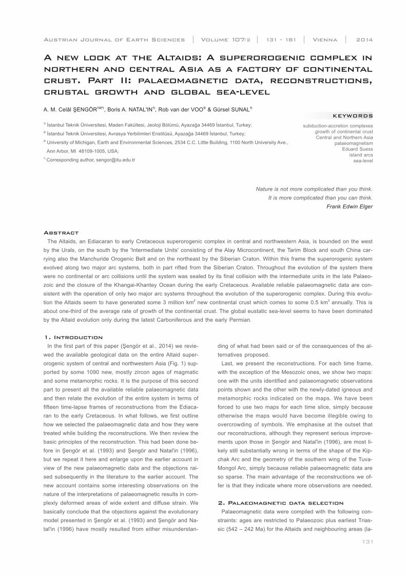
Figure 1: Tectonic map of the Altaids. The map is based on a equidistant conical projection with the central meridian is 95° and the standard pa-
rallels are 1:15.0 and 2:85.0, latitude of origin is 30.0. It is essentially the same as the map in Fig. 6 of the first part of this paper (Şengör et al., 2014),
except that the ophiolite occurrences are removed and the palaeomagnetic declination vectors are added. The numbers at the tips of the palaeomag-
netic vectors are those of reference numbers in Fig. 1. The Arabic numerals and the lower case letters attached to some of them correspond with the
first-order tectonic units of the Altaids. Key to the first-order tectonic units: 1. Valerianov-Chatkal, 2. Turgay, 3. Baykonur-Talas, 4.1 Djezkazgan-Kirgiz,
4.2 Jalair-Naiman, 4.3 or 16. Borotala, 5. Sarysu, 6. Atasu-Mointy, 7. Tengiz, 8. Kalmyk Kol-Kökchetav, 9. Ishim-Stepnyak, 10. Ishkeolmes, 11. Selety,
12. Akdym, 13.1 - Boshchekul-Tarbagatay, 13. 2 - Bayanaul-Akbastau, 14. Tekturmas, 15. Junggar-Balkhash, 16 or 4.3. Borotala, 17. Tar-Muromtsev,
18. Zharma-Saur, 19. Ob-Zaisan-Surgut, 20. Kolyvan-Rudny Altay, 21. Gorny Altay, 22. Charysh-Chuya-Barnaul, 23. Salair-Kuzbas, 24. Anuy-Chuya,
25. Eastern Altay, 26. Kozhykhov, 27. Kuznetskii Alatau, 28. Belyk, 29. Kizir-Kazyr, 30. North Sayan, 31. Utkhum-Oka, 32. Ulugoi, 33. Gargan, 34.
Kitoy, 35. Dzhida, 36. Darkhat, 37. Sangilen, 38. Eastern Tannuola, 39. Western Sayan, 40. Kobdin, 41. Ozernaya, 42. Han-Taishir, 43. Tuva-Mongol
(43.1. Tuva-Mongol Arc Massif, 43.2. Khangay-Khantey, 43.3. South Mongolian, 44. South Gobi.___________________________________________
A new look at the Altaids: A superorogenic complex in northern and central Asia as a factory of continental crust. Part II: palaeomagnetic data, reconstructions, crustal growth and global sea-level_____________________________________________________________________________
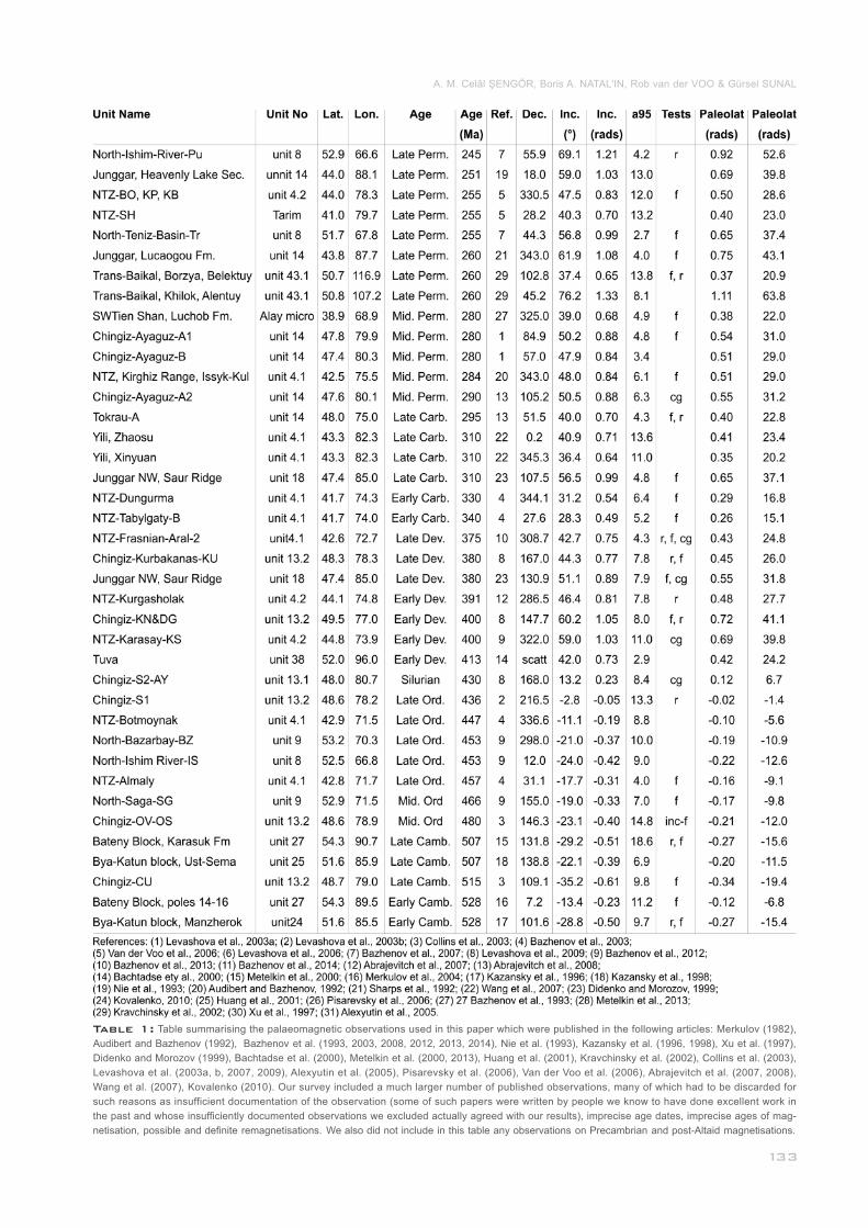
Table 1: Table summarising the palaeomagnetic observations used in this paper which were published in the following articles: Merkulov (1982),
Audibert and Bazhenov (1992), Bazhenov et al. (1993, 2003, 2008, 2012, 2013, 2014), Nie et al. (1993), Kazansky et al. (1996, 1998), Xu et al. (1997),
Didenko and Morozov (1999), Bachtadse et al. (2000), Metelkin et al. (2000, 2013), Huang et al. (2001), Kravchinsky et al. (2002), Collins et al. (2003),
Levashova et al. (2003a, b, 2007, 2009), Alexyutin et al. (2005), Pisarevsky et al. (2006), Van der Voo et al. (2006), Abrajevitch et al. (2007, 2008),
Wang et al. (2007), Kovalenko (2010). Our survey included a much larger number of published observations, many of which had to be discarded for
such reasons as insufficient documentation of the observation (some of such papers were written by people we know to have done excellent work in
the past and whose insufficiently documented observations we excluded actually agreed with our results), imprecise age dates, imprecise ages of mag-
netisation, possible and definite remagnetisations. We also did not include in this table any observations on Precambrian and post-Altaid magnetisations.
A. M. Celâl ŞENGÖR, Boris A. NATAL'IN, Rob van der VOO & Gürsel SUNAL
in some cases it may be necessary to take an interval as long
as the entire Cainozoic into account, but for most cases this
is not true.
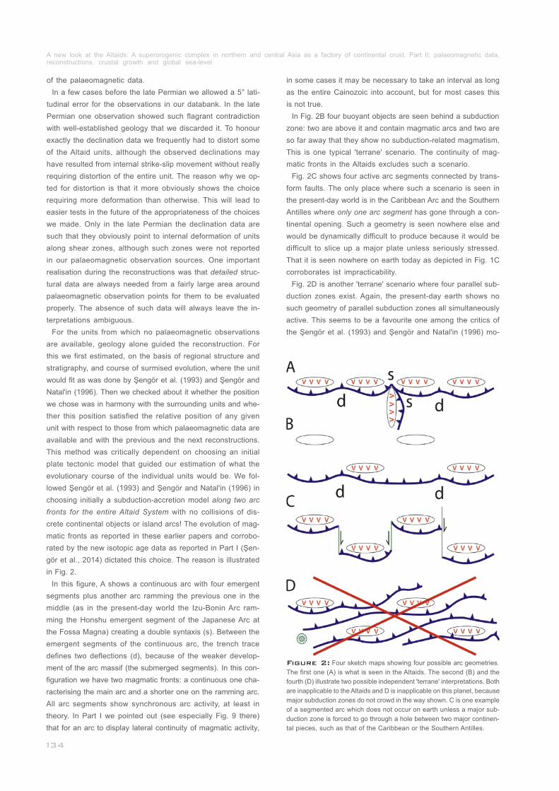
In Fig. 2B four buoyant objects are seen behind a subduction
zone: two are above it and contain magmatic arcs and two are
so far away that they show no subduction-related magmatism.
This is one typical 'terrane' scenario. The continuity of mag-
matic fronts in the Altaids excludes such a scenario.
Fig. 2C shows four active arc segments connected by trans-
form faults. The only place where such a scenario is seen in
the present-day world is in the Caribbean Arc and the Southern
Antilles where only one arc segment has gone through a con-
tinental opening. Such a geometry is seen nowhere else and
would be dynamically difficult to produce because it would be
difficult to slice up a major plate unless seriously stressed.
That it is seen nowhere on earth today as depicted in Fig. 1C
corroborates ist impracticability.
Fig. 2D is another 'terrane' scenario where four parallel sub-
duction zones exist. Again, the present-day earth shows no
such geometry of parallel subduction zones all simultaneously
active. This seems to be a favourite one among the critics of
the Şengör et al. (1993) and Şengör and Natal'in (1996) mo-
_______
________________________
Figure 2: Four sketch maps showing four possible arc geometries.
The first one (A) is what is seen in the Altaids. The second (B) and the
fourth (D) illustrate two possible independent 'terrane' interpretations. Both
are inapplicable to the Altaids and D is inapplicable on this planet, because
major subduction zones do not crowd in the way shown. C is one example
of a segmented arc which does not occur on earth unless a major sub-
duction zone is forced to go through a hole between two major continen-
tal pieces, such as that of the Caribbean or the Southern Antilles.____
of the palaeomagnetic data.
In a few cases before the late Permian we allowed a 5° lati-
tudinal error for the observations in our databank. In the late
Permian one observation showed such flagrant contradiction
with well-established geology that we discarded it. To honour
exactly the declination data we frequently had to distort some
of the Altaid units, although the observed declinations may
have resulted from internal strike-slip movement without really
requiring distortion of the entire unit. The reason why we op-
ted for distortion is that it more obviously shows the choice
requiring more deformation than otherwise. This will lead to
easier tests in the future of the appropriateness of the choices
we made. Only in the late Permian the declination data are
such that they obviously point to internal deformation of units
along shear zones, although such zones were not reported
in our palaeomagnetic observation sources. One important
realisation during the reconstructions was that detailed struc-
tural data are always needed from a fairly large area around
palaeomagnetic observation points for them to be evaluated
properly. The absence of such data will always leave the in-
terpretations ambiguous.
For the units from which no palaeomagnetic observations
are available, geology alone guided the reconstruction. For
this we first estimated, on the basis of regional structure and
stratigraphy, and course of surmised evolution, where the unit
would fit as was done by Şengör et al. (1993) and Şengör and
Natal'in (1996). Then we checked about it whether the position
we chose was in harmony with the surrounding units and whe-
ther this position satisfied the relative position of any given
unit with respect to those from which palaeomagnetic data are
available and with the previous and the next reconstructions.
This method was critically dependent on choosing an initial
plate tectonic model that guided our estimation of what the
evolutionary course of the individual units would be. We fol-
lowed Şengör et al. (1993) and Şengör and Natal'in (1996) in
choosing initially a subduction-accretion model along two arc
fronts for the entire Altaid System with no collisions of dis-
crete continental objects or island arcs! The evolution of mag-
matic fronts as reported in these earlier papers and corrobo-
rated by the new isotopic age data as reported in Part I (Şen-
gör et al., 2014) dictated this choice. The reason is illustrated
in Fig. 2.
In this figure, A shows a continuous arc with four emergent
segments plus another arc ramming the previous one in the
middle (as in the present-day world the Izu-Bonin Arc ram-
ming the Honshu emergent segment of the Japanese Arc at
the Fossa Magna) creating a double syntaxis (s). Between the
emergent segments of the continuous arc, the trench trace
defines two deflections (d), because of the weaker develop-
ment of the arc massif (the submerged segments). In this con-
figuration we have two magmatic fronts: a continuous one cha-
racterising the main arc and a shorter one on the ramming arc.
All arc segments show synchronous arc activity, at least in
theory. In Part I we pointed out (see especially Fig. 9 there)
that for an arc to display lateral continuity of magmatic activity,
___________________________
_____________________________
A new look at the Altaids: A superorogenic complex in northern and central Asia as a factory of continental crust. Part II: palaeomagnetic data, reconstructions, crustal growth and global sea-level_____________________________________________________________________________
del, but the present-day earth does not support such a model.
In the Tethyan realm such a geometry did exist during the me-
dial Mesozoic, but with at most two subparallel subduction
zones. That geometry existed only during the Jurassic once
and only in Tibet and during the Cretaceous again in Tibet
and in a short segment of the Mediterranean Alpides in Turkey,
i.e. for brief times and short distances. Such a model would
be difficult to envisage for the immense Altaid System.
The continuity of the magmatic fronts thus forces us to as-
sume a single arc geometry (actually two arcs as the Tuva-
Mongol fragment had two subduction zones on is both sides).
Once this choice is made, we know what to look for in each
unit: we identify the backstops and the arc massifs. The next
question concerns the arc facing and what sort of an arc we
had before us i. e., ensimatic or ensialic. The internal strati-
graphy decides that. The stratigraphy of each arc segment
and its structural evolution, supplemented by the petrology
and the ages of the coeval igneous rocks are matched with
possible 'provenance' or 'mother' cratons. We thus fitted the
arc segments onto their mother cratons. At this stage a simple
independent check is the geometric compatibility of the fitted
pieces with the margins onto which we try to fit them: an ensi-
alic arc postulated to have rifted off a continent, for instance,
could not have been much longer than the margin on which it
had supposedly originally formed. Tectonic environments fur-
ther guide us. Some such examples have been documented
and discussed in Şengör and Natal'in (2004).
Once the arcs are placed in their original positions, the next
question is naturally how the units evolved and moved. Here,
the magmatic fronts and the age spans of subduction-accre-
tion complexes is of decisive help. Magmatic fronts for a given
age ('age length' is taken at most 50±10 Ma: see Şengör et
al., 1993, 1994, 2014) are carefully mapped from the existing
geological maps and can now be checked against the isotopic
age data provided in Part I (Şengör et al., 2014). Cessation of
subduction-accretion complex growth is commonly seen to
have been brought about by the strike-slip emplacement of a
different unit in front as seen by a variety of geological indica-
tors such as intervening shear zones with folds having steeply
plunging hinges and horizontal lineations on steep foliation
planes, common cover sequences, stitching plutons and/or
doubling of a given magmatic front.
In the following we present briefly the evolution of the Altaids
between the Ediacaran and the late Jurassic using Figures 3-
17 as a basis. For text we closely follow Şengör and Natal'in
(1996), in many places just copying it, with a view to showing
how little the interpretations had to be modified in view of ne-
wer data, despite the numerous claims in the subsequent lite-
rature to the contrary. None of these claims have offered alter-
native reconstructions using the newer data, thus weakening
their substance. The account below shows most of them to
be unjustified.
______
_____________
_____________________
______________________________________
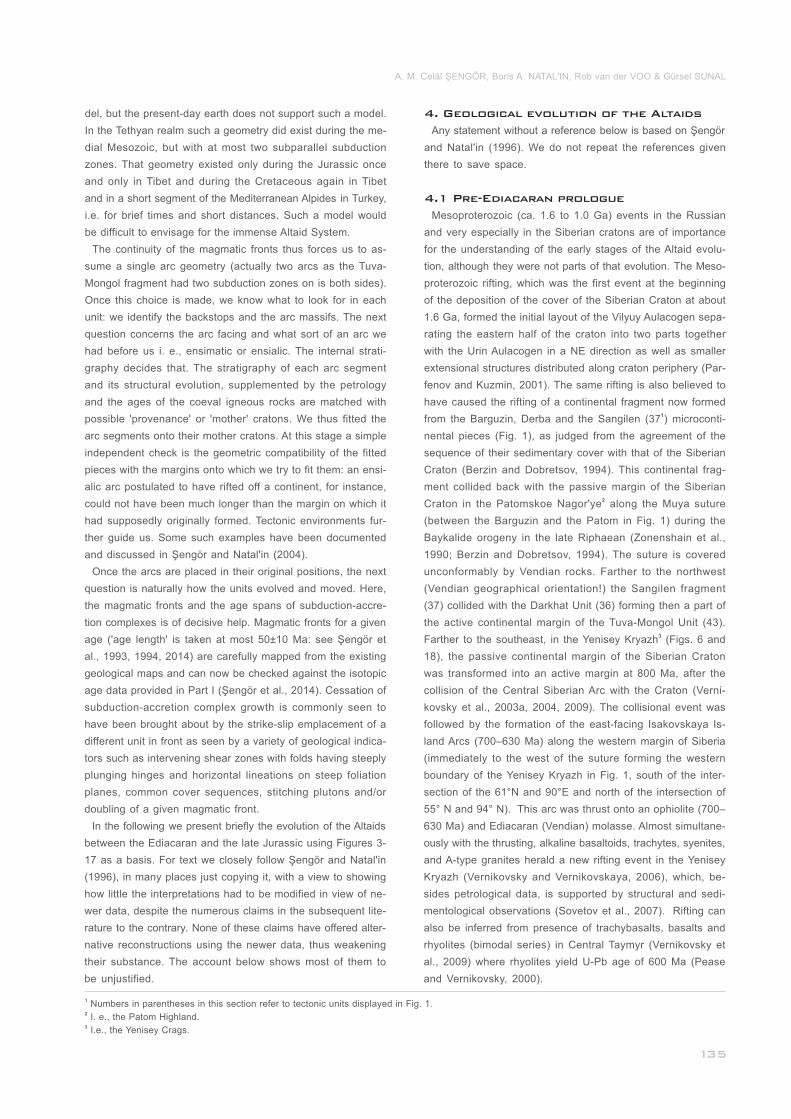
4. Geological evolution of the Altaids
4.1 Pre-Ediacaran prologue
Any statement without a reference below is based on Şengör
and Natal'in (1996). We do not repeat the references given
there to save space.
Mesoproterozoic (ca. 1.6 to 1.0 Ga) events in the Russian
and very especially in the Siberian cratons are of importance
for the understanding of the early stages of the Altaid evolu-
tion, although they were not parts of that evolution. The Meso-
proterozoic rifting, which was the first event at the beginning
of the deposition of the cover of the Siberian Craton at about
1.6 Ga, formed the initial layout of the Vilyuy Aulacogen sepa-
rating the eastern half of the craton into two parts together
with the Urin Aulacogen in a NE direction as well as smaller
extensional structures distributed along craton periphery (Par-
fenov and Kuzmin, 2001). The same rifting is also believed to
have caused the rifting of a continental fragment now formed 1from the Barguzin, Derba and the Sangilen (37 ) microconti-
nental pieces (Fig. 1), as judged from the agreement of the
sequence of their sedimentary cover with that of the Siberian
Craton (Berzin and Dobretsov, 1994). This continental frag-
ment collided back with the passive margin of the Siberian 2Craton in the Patomskoe Nagor'ye along the Muya suture
(between the Barguzin and the Patom in Fig. 1) during the
Baykalide orogeny in the late Riphaean (Zonenshain et al.,
1990; Berzin and Dobretsov, 1994). The suture is covered
unconformably by Vendian rocks. Farther to the northwest
(Vendian geographical orientation!) the Sangilen fragment
(37) collided with the Darkhat Unit (36) forming then a part of
the active continental margin of the Tuva-Mongol Unit (43). 3Farther to the southeast, in the Yenisey Kryazh (Figs. 6 and
18), the passive continental margin of the Siberian Craton
was transformed into an active margin at 800 Ma, after the
collision of the Central Siberian Arc with the Craton (Verni-
kovsky et al., 2003a, 2004, 2009). The collisional event was
followed by the formation of the east-facing Isakovskaya Is-
land Arcs (700–630 Ma) along the western margin of Siberia
(immediately to the west of the suture forming the western
boundary of the Yenisey Kryazh in Fig. 1, south of the inter-
section of the 61°N and 90°E and north of the intersection of
55° N and 94° N). This arc was thrust onto an ophiolite (700–
630 Ma) and Ediacaran (Vendian) molasse. Almost simultane-
ously with the thrusting, alkaline basaltoids, trachytes, syenites,
and A-type granites herald a new rifting event in the Yenisey
Kryazh (Vernikovsky and Vernikovskaya, 2006), which, be-
sides petrological data, is supported by structural and sedi-
mentological observations (Sovetov et al., 2007). Rifting can
also be inferred from presence of trachybasalts, basalts and
rhyolites (bimodal series) in Central Taymyr (Vernikovsky et
al., 2009) where rhyolites yield U-Pb age of 600 Ma (Pease
and Vernikovsky, 2000).
_________________________________
______________________________
1 Numbers in parentheses in this section refer to tectonic units displayed in Fig. 1.2 I. e., the Patom Highland.3 I.e., the Yenisey Crags.
A. M. Celâl ŞENGÖR, Boris A. NATAL'IN, Rob van der VOO & Gürsel SUNAL
The Mesoproterozoic rifting may have led to the isolation of
the Tuva-Mongol Unit (43.1), although geological evidence for
this event largely has been obliterated subsequently by the
convergent events between the Tuva-Mongol Unit and the Si-
berian Craton. On the basis of palaeomagnetic observations,
Kravchinsky et al. (2001, 2010) suggest a close proximity of
the Siberian Craton and the Tuva-Mongol Massif during Edia-
caran–Early Cambrian time. The Tuva-Mongol Unit, essen-
tially a continental arc massif, is a large "isoclinal," almost
"ptygmatic" orocline with the highly disrupted late Proterozoic
to Triassic Khangai-Khantei Accretionary Complex (unit 43.2)
in its core. In the literature following Şengör and Natal'in (1996)
there were frequent complaints that they had assumed every-
thing in the Altaids to be juvenile (Kröner et al., 2007, 2008,
2014; Rojas-Agramonte et al., 2011), yet there is here a large
Precambrian continental core. This complaint is based clearly
on not having read at all what had been written by Şengör et
al. (1993) and Şengör and Natal'in (1996) and the many deri-
vative papers they published. Since these criticisms do not
target a real problem we simply ignore them.
A part of the Khangai-Khantei Accretionary Complex (43.2)
was extruded east and northeastward during the early and
medial Mesozoic while the Tuva-Mongol 'pincher' was closing
(Şengör and Natal'in, 1996; Van der Voo et al., 1999 and in
press) and went to the east to form the eastern part of the
Mongol-Okhotsk belt as far as the southeastern corner of the
Okhotsk Sea shelf. The Khangai-Khantei Accretionary Com-
plex is pinched out completely in easternmost Mongolia and
Russia such that the limbs of the orocline consisting of the
pre-Altaid, i.e., Precambrian, continental crust are opposed
directly against each other (Figs. 2 and 17). In the Stanovoy
region, the northern limb, now separated from the Siberian
Craton by a large dextral strike-slip fault zone (Stanovoy Fault)
of Mesozoic age (Fig. 1: Natal'in et al., 1985), consists of the
same Precambrian rock assemblages and similar structures
as the Aldan Shield of the Siberian Craton (Kozlovsky, 1988).
The similarity of these rocks and structures may indicate that
initially the Siberian Craton and the Tuva-Mongol Massif for-
med parts of one continent (Şengör and Natal’in, 1996; Kuz-
michev et al., 2001; Yakubchuk, 2004; Wilhem et al., 2012).
Pre-Ediacaran bimodal volcanic rocks of the unit 36 and in the
western part of Tuva-Mongol Massif are interpreted as eviden-
ce of rifting along the massif margins (Kovalenko et al., 2004),
although some prefer to interpret these rocks as subduction-
related (Tomurtogoo and Bayasgalan, 2002; Badarch et al.,
2002) considering their age Cryogenian-Tonian. This age de-
termination is more commonly used within the framework of
ideas about rifting because it is related by the authors using it
in this context to the Rodinia breakup. We do not make that
association. The rifting and subduction interpretations need
not be mutually exclusive as rifting above a subduction zone
in this setting seems entirely possible. Together with the rift-
related Neoproterozoic rock assemblages at the western mar-
gin of the Siberian Craton, these data indicate the presence
of a narrow sliver of Precambrian continental crust that had
_____________
partly rifted from the Siberian Craton in the Neoproterozoic
then rotated counterclockwise while its eastern end remaining
attached to the craton in the Stanovoy region (Kuzmichev et
al., 2001; Yakubchuk, 2004; Wilhem et al., 2012). Neverthe-
less, how this occurred kinematically is now not clear, but it
seems that the southern part of the Tuva-Mongol Arc Massif
actually rifted from the present western margin of the Siberi-
an Craton essentially opening the ocean the later closure of
which later led to the construction of the Baykalides. The geo-
metry of the Tuva-Mongol Massif in the Ediacaran (Fig. 3a)
implies a minimum of 90° anti-clockwise rotation although as
of now we are not familiar with any data to substantiate that.
The Neoproterozoic rift-related volcanics of the Tuva-Mongol
Arc Massif crop out together with calc-alkalic volcanics which
are probably subduction-related as one can surmise from their
geochemistry. Neoproterozoic ophiolites and sedimentary rocks
in the unit 36 (Tumurtogoo and Bayasgalan, 2002; Sklyarov et
al., 1996; Kuzmichev et al., 2001, 2005) appear to be parts of
an accretionary complex. Both rock assemblages are located
along the side of the Tuva-Mongol Arc Massif, which, during
the rotation, was facing the Siberian Craton, implying an active
margin on the face receding from the Siberian Craton during
the rotation implying a plate boundary geometry, more compli-
cated than is expected simply from the rotation itself.
There was also subduction along what later became the in-
ner margin of the Tuva-Mongol Orocline at the same time. Al-
though not well-constrained by any geochronological or pala-
eontological data, Mesoproterozoic ophiolites had been assu-
med (Tumurtoogo, 1989) in the Khangai-Khantey Unit. Recent
studies have revealed the presence of only Neoproterozoic
rocks as the oldest members in the Khangai-Khantey Unit
(Kovach et al., 2005; Jian et al., 2010).
The Neoproterozoic history of the western margin of the Si-
berian Craton is similar to that of the eastern margin of the
Russian craton, along both of which originated later the Ur-
baykalide Orogenic System formed from the Pre-Uralides and
the Baykalides (see below). The structures of Yenisey Kryazh
continue to the Taymyr Peninsula and turn around the Kara
Block to join the Pre-Uralides (e.g. Natal’in, 2011; Natal’in et
al., 2012). The most important initial constraint of the Altaid
evolution is the assumption that the Siberian and the Russian
cratons had been united as a single cratonic mass along their
present northern margins, like a pair of Siamese twins con-
nected head-to-head during the earliest Ediacaran and that
they parted company sometime later during the early Edia-
caran, towards 600 Ma. Evidence for this was presented in
Şengör and Natal'in (1996) and, contrary to numerous later
claims, there are no palaeomagnetic data to disprove this
assumption. An alkalic complex in northern Timan consisting
of gabbros, syenites, and granites intruding probable Neopro-
terozoic turbidites in a trough was recently dated at 613-617
Ma by zircon ion microprobe dating. Timanian Orogeny follo-
wed this rifting at about the 610 to 560 Ma interval (Larionov
_______
__________________
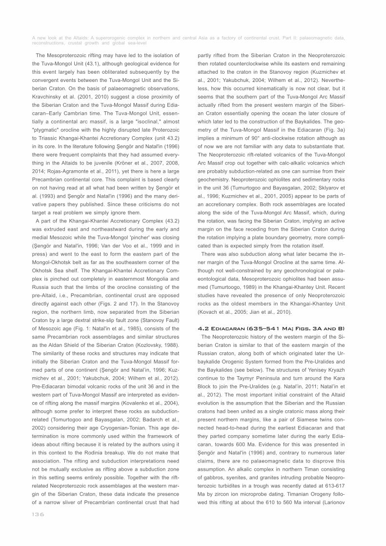
4.2 Ediacaran (635–541 Ma; Figs. 3A and B)
A new look at the Altaids: A superorogenic complex in northern and central Asia as a factory of continental crust. Part II: palaeomagnetic data, reconstructions, crustal growth and global sea-level_____________________________________________________________________________
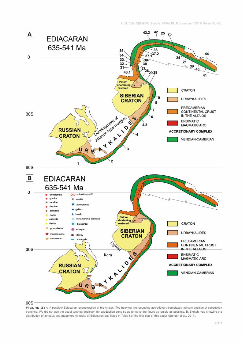
Figure 3: A. A possible Ediacaran reconstruction of the Altaids. The heaviest line bounding accretionary complexes indicate position of subduction
trenches. We did not use the usual toothed depiction for subduction zone so as to leave the figure as legible as possible. B. Sketch map showing the
distribution of igneous and metamorphic rocks of Ediacaran age listed in Table I of the first part of this paper (Şengör et al., 2014).________________
A. M. Celâl ŞENGÖR, Boris A. NATAL'IN, Rob van der VOO & Gürsel SUNAL

et al., 2004). Available palaeomagnetic data allow placing the
two cratons as shown in Fig. 3A. Medial Ediacaran rifting be-
tween the Russian and the Siberian cratons is indicated on
the European margin further by the ~600 Ma dykes in both
Finnmark (Beckinsale et al., 1975) and the northern Kola Pe-
ninsula (Lybutsov et al., 1991) just as in northern Siberia in
northern Taimyr (Vernikovsky et al., 2004) and extensive Edi-
acaran diamictite and turbidite deposition and intrusions and
volcanism in tectonically active basins. In the Timanides, vol-
canic and sedimentary rocks, granitoids, ultramafic rocks, and
blueschist were accreted to the Russian Craton in latest Edi-
acaran to earliest Cambrian time (Zonenshain et al., 1990;
Olovyanishnikov, 1998; Gee et al., 2006). The accreted units
are interpreted as a Neoproterozoic magmatic arc that was
attached to a continental block – the Kara Block (Metelkin et
al., 2005) or to an 'Arctida Continent' (Zonenshain et al., 1990;
Kuznetsov et al., 2010). The Timanide orogeny occurred be-
tween 500–550 Ma and caused intrusions of 550–560 Ma
(Roberts and Olovyanishnikov, 2004) and younger 510 Ma
granites (Kuznetsov et al., 2010). For further details on the
Timan/Pechora region, see Khain (1985), Zonenshain et al.
(1990), Gustavson Associates, Inc. (1992), Lindquist (1999),
Fossum et al. (2001), and Gee (2005).
Along the northern side of Kola and Kanin peninsulas an al-
kalic complex consisting of gabbros, syenites, and granites in-
truding probable Neoproterozoic turbidites are dated at 613-617
Ma by zircon ion microprobe dating. Farther east and southeast
this rifting preceding the Timanian Orogeny is dated within the
610 to 560 Ma interval (Roberts and Siedlecka, 2002; Larionov
et al., 2004; Roberts and Olovyanishnikov, 2004; Kuznetsov et
al., 2010). Along the Uralian margin, the continuation of these
extensional structures is unclear because of strong reworking
by late Palaeozoic shortening and significant orogen-parallel
dextral strike-slip faulting (Hetzel and Glodny, 2002; Friberg et
al., 2002). However, in the polar Urals, the Vendian sequences
include glacial and glacio-marine (?) deposits and mafic volca-
nics as well as Upper Cambrian coarse-grained clastics of pre-
sumably extensional tectonic setting, which preceded the main
rifting events that created the Uralide Ocean in the Tremado-
cian-Arenigian (Koroteev et al., 1997). Farther south along
the Uralian Orogen, the Bashkir uplifts consist predominantly
of sedimentary rocks (Maslov, 2004) among which rare hori-
zons of alkali and sub-alkali basaltic lavas are exposed (Kar-
pukhina et al., 1999; Sazonova et al., 2010). The Neoprotero-
zoic complexes of the Uraltau uplift is represented by meta-
morphosed volcanic, volcanic-sedimentary rocks, granites and
ultramafic rocks (Lennykh et al., 1995; Hetzel, 1999; Leech
and Willingshofer, 2004). They are exposed to the east of the
Ordovician Uralian Ocean and are unrelated to the Russian
Craton (Kuzmichev et al., 2001). Thus the most likely explana-
tion of the relations is that they belong to the Timanides that
were transported from the north by dextral strike-slip. They
are the remnants of repeated rifting events first in the Neopro-
terozoic, then in the early Ediacaran–early Cambrian (Kipchak
Arc), and finally in the Ordovician.
__________________
______________________
The combined Russian/Siberian continent had what appears
to have been a Pacific-type continental margin of the Andean
or perhaps Sumatran variety along its eastern side (Ediacaran
geographical orientation) underlain by the Mesoproterozoic
Pre-Uralide (=Timanide: Gee and Pease, 2004a, b; Bogolepo-
va and Gee, 2004) collisional orogen to the east of the Russi-
an Craton and by the Baykalide collisional orogen to the east
and north of the Siberian Craton (see Fig. 3b for Ediacaran
rocks isotopically dated since Şengör and Natal'in, 1996 was
published). These two orogens are here interpreted as parts
of a single, continuous collisional mountain belt (also see Ver-
nikovsky et al., 2004). We hope to provide a more detailed ju-
sitification of this interpretation elsewhere, showing the inde-
pendent nature of the Pre-Uralide and the Baykalide orogens
from the Uralides and the Altaids respectively: for the united
single orogen we here propose the name Urbaykalides. Our
judgement about the nature of the Urbaykalides has been for-
med on the basis of the information provided in the following
publications, listed according to regions we considered, in ad-
dition to the few mentioned above: Timan-Pechora regions in
general: Khain (1985), Zonenshain et al. (1990), Gustavson
Associates, Inc. (1992), Lindquist (1999), Fossum et al. (2001),
Gee (2005); Polar Urals to Patomskoe Nagor'ye: Vernikovsky
et al. (2004); Varanger Peninsula: Siedlecka (1975), Hambrey
(1988), Roberts and Olovyanishnikov (2004), Siedlecka et al.
(2004); Kildin Island: Siedlecka (1975); Rybachi and Sredniy
peninsulas: Emelyanov et al. (1971), Siedlecka (1975), Ham-
brey (1988), Siedlecka et al. (2004); Kanin Peninsula: Sied-
lecka (1975), Churkin et al. (1981), Khain (1985), Mitrofanov
and Kozakov (1993), Lorenz et al. (2004), Maslov (2004), Ro-
berts et al. (2004); northern Timan: Siedlecka (1975), Mitrofa-
nov and Kozakov (1993), Bogolopeva and Gee (2004), Lario-
nov et al. (2004), Roberts et al. (2004), Siedlecka et al. (2004);
Mezen Basin: Grazhdankin (2004); Pechora-Izhma Depression:
Khain (1985), Bogolopeva and Gee (2004), Maslov (2004),
Pease et al. (2004); Kolva Swell: Swirydczuk et al. (2003),
Pease et al. (2004); Khoreyver Depression: Khain (1985),
Fossum et al. (2001), Maslov (2004), Pease et al. (2004);
Polar and Subpolar Urals: Hambrey (1988), Bogolopeva and
Gee (2004), Maslov (2004); Glasmacher et al. (2004); No-
vaya Zemlya: Drachev et al. (2010), Pease and Scott (2009);
Kara Sea: Ivanova et al. (2011), Metelkin et al. (2005); Taimyr:
Inger et al. (1999), Pease et al. (2001), Pease (2011), Torsvik
and Andersen (2002), Vernikovsky et al. (2003a and 2004),
Vernikovsky and Vernikovskaya (2001 and 2006), Yenisey
Kryazh: Smit et al. (2000), Vernikovsky et al. (2003a, 2003b,
2004, 2007, 2009), Khomentovsky (2007), Kochnev et al.
(2007), Nozhkin et al. (2007), Sovetov et al. (2007), Kuzmi-
chev et al. (2008), Kontorovich (2011).
During the Ediacaran, segments of the Urbaykalide orogenic
belt began to disintegrate by extension along the eastern mar-
gin of the combined Russian/Siberian continent (Fig. 3). Active
rifting is documented in units 1, 3, 4, 6, 7, and 8 of the Altaid
collage. Seismic profiling revealed a system of Riphaean to
Palaeozoic rifts including the Vendian sediments at the wes-
___________________
A new look at the Altaids: A superorogenic complex in northern and central Asia as a factory of continental crust. Part II: palaeomagnetic data, reconstructions, crustal growth and global sea-level_____________________________________________________________________________
Figure 4: Sketch map showing the concept of arc shaving (to the right) and arc slicing (to the
left) strike-slip faults and the tectonic consequences of their activities.________________________
tern (present geographical orientation) margin of the Siberian
Craton beneath the West Siberian Basin (Vernikovsky et al.,
2009). The same is true in the northern unit of the Taimyr Pe-
ninsula (Vernikovsky et al., 2004). Rifting became younger
southward (in the Ediacaran orientation): in the Polar Ural (i.e.,
Russian Craton) side, rift sedimentary rocks are of late Cam-
brian to early Ordovician age which becomes entirely early
Ordovician in the Sakmara allochthon farther south (in addi-
tion to the references cited in Şengör and Natal'in, 1996, see
Puchkov, 2002, especially fig. 2, for the entire Urals; Glodny
et al., 2005, date the rifting on the Russian Craton side at
about 490 Ma using zircons from metagranites).
Evidence for Ediacaran rifting exists in the Kazakhstan-Tien
Shan tectonic units but such evidence is generally unknown
in the Altay domain. Units 1 through 9 bearing evidence of
rifting are placed in Fig. 3a along the eastern margin of the
combined Russian-Siberian continent displaying evidence for
the same rifting. Units 28–42 consisting mainly of the Vendian-
early Cambrian accretionary complexes and arc magmatism
(mostly grown on the accretionary complexes) are distributed
along the northern margin of the Tuva-Mongol Massif (43.1)
and the South Gobi Tectonic Unit (44). Fig. 3B shows the sub-
duction-related magmatic rocks and accreted ophiolites on
top, and on both sides, of the Tuva-Mongol Massif that have
been dated isotopically since Şengör and Natal'in (1996) was
published.
The late Precambrian-early Cambrian rocks of the South Go-
bi Unit (44: shallow-marine carbonates and quartzites sitting
on old continental crust as already emphasised in Şengör et
al., 1993 and Şengör and Natal'in, 1996) are very similar to
the rocks of the Tuva-Mongol Arc Massif; Palaeozoic rocks
are also similar and therefore we assume that in the Vendian-
early Carboniferous the South Gobi Unit was a direct continu-
ation of the Tuva-Mongol Arc Massif as it is shown in the re-
construction (see Fig. 3A). The difference between the late
Precambrian shallow-marine carbonates of the South Gobi
Unit (the very east of the Tuva-Mongol Arc Massif) and the
___________
same rocks in its western part (around unit 37 and 36; Fig. 3A)
is that the latter contain phosphorites (Marinov et al., 1973;
Ilyin and Ratnikova, 1981). Phosphorite accumulation is con-
trolled by zones of upwelling located along western sides of
oceans because of Coriolis force (Parrish, 1987) which fits
palaeogeography depicted in Fig. 3A. There is no geological
indication to suggest that they were separate. Placing the
South Gobi Unit far away from the Tuva-Mongol Arc Massif
requires independent evidence. There are palaeomagnetic
data showing the western part of this massif as far south as
2.7°±10.8° S latitude during the early Carboniferous (Krav-
chinsky et al., 2001). For this unit to reach its early Permian
position to be a part of the south Mongolian collage it would
have had to maintain a speed of 15 to 45 cm/a. While 15 cm
is at the edge of reasonableness yet the highest known rate
from the present-day earth, between the Pacific and the Nazca
Plates although not well constrained, is believed to be ≤ 15 cm/a.
If such a rate is accepted as reasonable for unit 44, it is still
an extremely high plate velocity (DeMets et al., 2010). The
highest ever measured rate of spreading we know to have oc-
curred on our planet was some 20–22 cm/a some 20–11 Ma
ago on the superfast East Pacific Rise, where the Cocos Plate
is still separating from the Pacific Plate: Teagle and Wilson,
2007). 45 cm/a is in any case an absurdly high rate of motion.
Whatever adjustments one can make to massage the palaeo-
magnetic data, they are impossible to bring into agreement
with the well-established gross geology of southern Mongolia
and north China. We have therefore chosen to ignore this ob-
servation until it is further corroborated by newer observations.
All tectonic units of the Altaids which are depicted in the Edi-
acaran reconstruction essentially consist of magmatic arcs
and accretionary complexes. All of the magmatic arcs active
at this time were built on pre-existing, i. e., Precambrian, al-
most entirely Meso- and Neoproterozoic Urbaykalide crust
ripped off from the Russian and the Siberian cratons at diffe-
rent times. This, combined with the reconstruction of the tie
points of magmatic fronts and arc massif/accretionary com-
plex boundaries as explained in Şen-
gör and Natal'in (1996), allow us to
reconstruct a single subduction zone
along the eastern margin of the com-
bined Russian/Siberian superconti-
nent and another along the northern
margin of the Tuva-Mongol/South
Gobi arc. As Fig. 3A shows, at the
beginning of the Altaid evolution, that
there were two subduction zones
active within what was to become
the Altaid Superorogenic Complex:
fragments of the Ediacaran-early
Cambrian accretionary complexes
in the Khangai-Khantey Unit clearly
show the existence of the subduc-
tion zone also to the south of the
Ediacaran Tuva-Mongol Arc Massif
A. M. Celâl ŞENGÖR, Boris A. NATAL'IN, Rob van der VOO & Gürsel SUNAL
(Fig. 3A) and so do the well-dated subduction-related mag-
matic rocks (Fig. 3B).
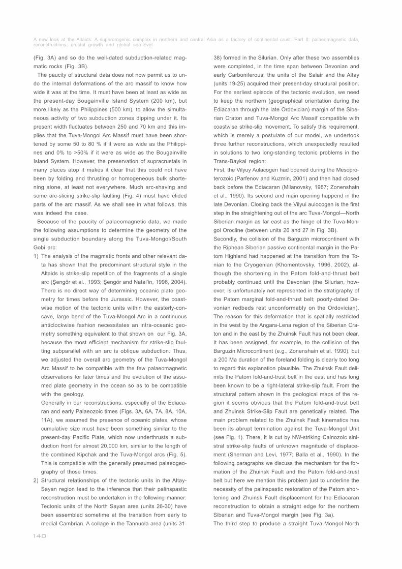
The paucity of structural data does not now permit us to un-
do the internal deformations of the arc massif to know how
wide it was at the time. It must have been at least as wide as
the present-day Bougainville Island System (200 km), but
more likely as the Philippines (500 km), to allow the simulta-
neous activity of two subduction zones dipping under it. Its
present width fluctuates between 250 and 70 km and this im-
plies that the Tuva-Mongol Arc Massif must have been shor-
tened by some 50 to 80 % if it were as wide as the Philippi-
nes and 0% to >50% if it were as wide as the Bougainville
Island System. However, the preservation of supracrustals in
many places atop it makes it clear that this could not have
been by folding and thrusting or homogeneous bulk shorte-
ning alone, at least not everywhere. Much arc-shaving and
some arc-slicing strike-slip faulting (Fig. 4) must have elided
parts of the arc massif. As we shall see in what follows, this
was indeed the case.
Because of the paucity of palaeomagnetic data, we made
the following assumptions to determine the geometry of the
single subduction boundary along the Tuva-Mongol/South
Gobi arc:
1)
2)
________________________________
________________________________
__________________________________________
The analysis of the magmatic fronts and other relevant da-
ta has shown that the predominant structural style in the
Altaids is strike-slip repetition of the fragments of a single
arc (Şengör et al., 1993; Şengör and Natal'in, 1996, 2004).
There is no direct way of determining oceanic plate geo-
metry for times before the Jurassic. However, the coast-
wise motion of the tectonic units within the easterly-con-
cave, large bend of the Tuva-Mongol Arc in a continuous
anticlockwise fashion necessitates an intra-oceanic geo-
metry something equivalent to that shown on our Fig. 3A,
because the most efficient mechanism for strike-slip faul-
ting subparallel with an arc is oblique subduction. Thus,
we adjusted the overall arc geometry of the Tuva-Mongol
Arc Massif to be compatible with the few palaeomagnetic
observations for later times and the evolution of the assu-
med plate geometry in the ocean so as to be compatible
with the geology.
Generally in our reconstructions, especially of the Ediaca-
ran and early Palaeozoic times (Figs. 3A, 6A, 7A, 8A, 10A,
11A), we assumed the presence of oceanic plates, whose
cumulative size must have been something similar to the
present-day Pacific Plate, which now underthrusts a sub-
duction front for almost 20,000 km, similar to the length of
the combined Kipchak and the Tuva-Mongol arcs (Fig. 5).
This is compatible with the generally presumed palaeogeo-
graphy of those times.
Structural relationships of the tectonic units in the Altay-
Sayan region lead to the inference that their palinspastic
reconstruction must be undertaken in the following manner:
Tectonic units of the North Sayan area (units 26-30) have
been assembled sometime at the transition from early to
medial Cambrian. A collage in the Tannuola area (units 31-
_________________________________
_____________________________
38) formed in the Silurian. Only after these two assemblies
were completed, in the time span between Devonian and
early Carboniferous, the units of the Salair and the Altay
(units 19-25) acquired their present-day structural position.
For the earliest episode of the tectonic evolution, we need
to keep the northern (geographical orientation during the
Ediacaran through the late Ordovician) margin of the Sibe-
rian Craton and Tuva-Mongol Arc Massif compatible with
coastwise strike-slip movement. To satisfy this requirement,
which is merely a postulate of our model, we undertook
three further reconstructions, which unexpectedly resulted
in solutions to two long-standing tectonic problems in the
Trans-Baykal region:
First, the Vilyuy Aulacogen had opened during the Mesopro-
terozoic (Parfenov and Kuzmin, 2001) and then had closed
back before the Ediacaran (Milanovsky, 1987; Zonenshain
et al., 1990). Its second and main opening happend in the
late Devonian. Closing back the Vilyui aulocogen is the first
step in the straightening out of the arc Tuva-Mongol—North
Siberian margin as far east as the hinge of the Tuva-Mon-
gol Orocline (between units 26 and 27 in Fig. 3B).
Secondly, the collision of the Barguzin microcontinent with
the Riphean Siberian passive continental margin in the Pa-
tom Highland had happened at the transition from the To-
nian to the Cryogenian (Khomentovsky, 1996, 2002), al-
though the shortening in the Patom fold-and-thrust belt
probably continued until the Devonian (the Silurian, how-
ever, is unfortunately not represented in the stratigraphy of
the Patom marginal fold-and-thrust belt; poorly-dated De-
vonian redbeds rest unconformably on the Ordovician).
The reason for this deformation that is spatially restricted
in the west by the Angara-Lena region of the Siberian Cra-
ton and in the east by the Zhuinsk Fault has not been clear.
It has been assigned, for example, to the collision of the
Barguzin Microcontinent (e.g., Zonenshain et al. 1990), but
a 200 Ma duration of the foreland folding is clearly too long
to regard this explanation plausible. The Zhuinsk Fault deli-
mits the Patom fold-and-trust belt in the east and has long
been known to be a right-lateral strike-slip fault. From the
structural pattern shown in the geological maps of the re-
gion it seems obvious that the Patom fold-and-trust belt
and Zhuinsk Strike-Slip Fault are genetically related. The
main problem related to the Zhuinsk Fault kinematics has
been its abrupt termination against the Tuva-Mongol Unit
(see Fig. 1). There, it is cut by NW-striking Cainozoic sini-
stral strike-slip faults of unknown magnitude of displace-
ment (Sherman and Levi, 1977; Balla et al., 1990). In the
following paragraphs we discuss the mechanism for the for-
mation of the Zhuinsk Fault and the Patom fold-and-trust
belt but here we mention this problem just to underline the
necessity of the palinspastic restoration of the Patom shor-
tening and Zhuinsk Fault displacement for the Ediacaran
reconstruction to obtain a straight edge for the northern
Siberian and Tuva-Mongol margin (see Fig. 3a).
The third step to produce a straight Tuva-Mongol-North
______________________________
_______
________
A new look at the Altaids: A superorogenic complex in northern and central Asia as a factory of continental crust. Part II: palaeomagnetic data, reconstructions, crustal growth and global sea-level_____________________________________________________________________________
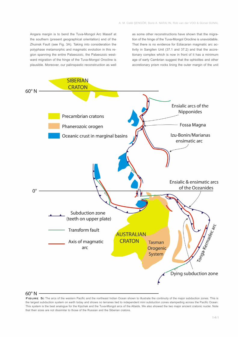
Figure 5: The arcs of the western Pacific and the northeast Indian Ocean shown to illustrate the continuity of the major subduction zones. This is
the largest subduction system on earth today and shows no terranes tied to independent mini subduction zones stampeding across the Pacific Ocean.
This system is the best analogue for the Kipchak and the Tuva-Mongol arcs of the Altaids. We also showed the two major ancient cratonic nuclei. Note
that their sizes are not dissimilar to those of the Russian and the Siberian cratons._______________________________________________________
Angara margin is to bend the Tuva-Mongol Arc Massif at
the southern (present geographical orientation) end of the
Zhuinsk Fault (see Fig. 3A). Taking into consideration the
polyphase metamorphic and magmatic evolution in this re-
gion spanning the entire Palaeozoic, the Palaeozoic west-
ward migration of the hinge of the Tuva-Mongol Orocline is
plausible. Moreover, our palinspastic reconstruction as well
as some other reconstructions have shown that the migra-
tion of the hinge of the Tuva-Mongol Orocline is unavoidable.
That there is no evidence for Ediacaran magmatic arc ac-
tivity in Sangilen Unit (37.1 and 37.2) and that the accre-
tionary complex which is now in front of it has a minimum
age of early Cambrian suggest that the ophiolites and other
accretionary prism rocks lining the outer margin of the unit
A. M. Celâl ŞENGÖR, Boris A. NATAL'IN, Rob van der VOO & Gürsel SUNAL
now and also cropping out in its central part were brought
there by the later major Altaid coastwise strike-slip trans-
port. This supports the presence of a trench-trench trans-
form fault (i.e. a subduction-free margin) in this inferred
dog-leg segment of the Tuva-Mongol Arc before the onset
of the long-shore transport. The geometry of our postulated
ridge makes this possible, although the scale of our recon-
structions do not allow its exhibition (Fig. 3A).
The Darkhat Unit (36) contains a Mesoproterozoic accre-
tionary complex twice as long as the related magmatic arc
(see Fig. 1). In the Ediacaran reconstruction (Fig. 3A), the
magmatic arc of this unit is placed as a direct continuation
of the coeval volcanics of the same type in western Mon-
golia (Darkhan Series) which stretch as a narrow north-
south belt along the westernmost boundary (present geo-
graphical orientation) of unit 43.1. Thus the Riphaean ac-
cretionary complex "too long" for unit 36 is seen to have
belonged both to unit 36 and unit 43.1, forming two seg-
ments of the same ancient magmatic arc.
The Kuznetsk-Alatau Unit (27) having a piece of the pre-
Altaid (i.e. Precambrian) continental crust overlain by thick
upper Proterozoic carbonates is shown as the continuation
of the Barguzin microcontinent, also characterised by a
thick cover of similar Neoproterozoic carbonates (Rudenko,
2009). Contrary to unit 27, these carbonates have been
subjected to metamorphism up to granulite facies in the
early Ordovician (488 Ma) and are cut by trondjemite yiel-
ding 477.6±2 Ma zircon ages (Salnikova et al., 1998).
The Eastern Sayan Unit (25), with a basement and carbo-
nate cover similar to those of the Barguzin, constitutes a part
of the arc massif of the Tuva-Mongol Unit (43.1). Its exact
placement within it is inferred by assuming original proximity
to the only place having a similar carbonate cover atop the
presently defined Tuva-Mongol Unit (Middle Gobi region).
Units 13-20, 43.3, and 44.1 do not appear in the Vendian
reconstruction because their formation as yet lay in the fu-
ture.
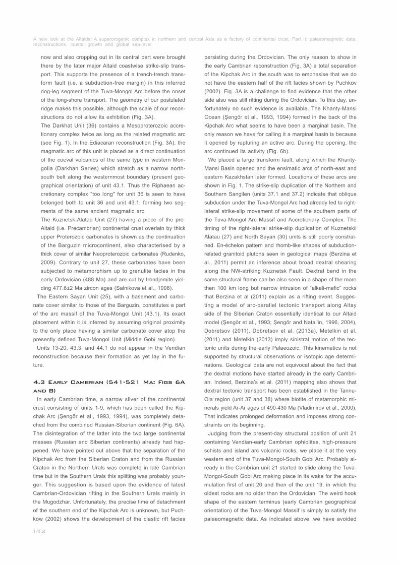
In early Cambrian time, a narrow sliver of the continental
crust consisting of units 1-9, which has been called the Kip-
chak Arc (Şengör et al., 1993, 1994), was completely deta-
ched from the combined Russian-Siberian continent (Fig. 6A).
The disintegration of the latter into the two large continental
masses (Russian and Siberian continents) already had hap-
pened. We have pointed out above that the separation of the
Kipchak Arc from the Siberian Craton and from the Russian
Craton in the Northern Urals was complete in late Cambrian
time but in the Southern Urals this splitting was probably youn-
ger. This suggestion is based upon the evidence of latest
Cambrian-Ordovician rifting in the Southern Urals mainly in
the Mugodzhar. Unfortunately, the precise time of detachment
of the southern end of the Kipchak Arc is unknown, but Puch-
kow (2002) shows the development of the clastic rift facies
__________
_____________
____
___
4.3 Early Cambrian (541-521 Ma: Figs 6A
and B)
persisting during the Ordovician. The only reason to show in
the early Cambrian reconstruction (Fig. 3A) a total separation
of the Kipchak Arc in the south was to emphasise that we do
not have the eastern half of the rift facies shown by Puchkov
(2002). Fig. 3A is a challenge to find evidence that the other
side also was still rifting during the Ordovician. To this day, un-
fortunately no such evidence is available. The Khanty-Mansi
Ocean (Şengör et al., 1993, 1994) formed in the back of the
Kipchak Arc what seems to have been a marginal basin. The
only reason we have for calling it a marginal basin is because
it opened by rupturing an active arc. During the opening, the
arc continued its activity (Fig. 6b).
We placed a large transform fault, along which the Khanty-
Mansi Basin opened and the ensimatic arcs of north-east and
eastern Kazakhstan later formed. Locations of these arcs are
shown in Fig. 1. The strike-slip duplication of the Northern and
Southern Sangilen (units 37.1 and 37.2) indicate that oblique
subduction under the Tuva-Mongol Arc had already led to right-
lateral strike-slip movement of some of the southern parts of
the Tuva-Mongol Arc Massif and Accretionary Complex. The
timing of the right-lateral strike-slip duplication of Kuznetskii
Alatau (27) and North Sayan (30) units is still poorly constrai-
ned. En-échelon pattern and rhomb-like shapes of subduction-
related granitoid plutons seen in geological maps (Berzina et
al., 2011) permit an inference about broad dextral shearing
along the NW-striking Kuznetsk Fault. Dextral bend in the
same structural frame can be also seen in a shape of the more
then 100 km long but narrow intrusion of “alkali-mafic” rocks
that Berzina et al (2011) explain as a rifting event. Sugges-
ting a model of arc-parallel tectonic transport along Altay
side of the Siberian Craton essentially identical to our Altaid
model (Şengör et al., 1993; Şengör and Natal'in, 1996, 2004),
Dobretsov (2011), Dobretsov et al. (2013a), Metelkin et al.
(2011) and Metelkin (2013) imply sinistral motion of the tec-
tonic units during the early Palaeozoic. This kinematics is not
supported by structural observations or isotopic age determi-
nations. Geological data are not equivocal about the fact that
the dextral motions have started already in the early Cambri-
an. Indeed, Berzina’s et al. (2011) mapping also shows that
dextral tectonic transport has been established in the Tannu-
Ola region (unit 37 and 38) where biotite of metamorphic mi-
nerals yield Ar-Ar ages of 490-430 Ma (Vladimirov et al., 2000).
That indicates prolonged deformation and imposes strong con-
straints on its beginning.
Judging from the present-day structural position of unit 21
containing Vendian-early Cambrian ophiolites, high-pressure
schists and island arc volcanic rocks, we place it at the very
western end of the Tuva-Mongol-South Gobi Arc. Probably al-
ready in the Cambrian unit 21 started to slide along the Tuva-
Mongol-South Gobi Arc making place in its wake for the accu-
mulation first of unit 20 and then of the unit 19, in which the
oldest rocks are no older than the Ordovician. The weird hook
shape of the eastern terminus (early Cambrian geographical
orientation) of the Tuva-Mongol Massif is simply to satisfy the
palaeomagnetic data. As indicated above, we have avoided
______________________
______________________________
A new look at the Altaids: A superorogenic complex in northern and central Asia as a factory of continental crust. Part II: palaeomagnetic data, reconstructions, crustal growth and global sea-level_____________________________________________________________________________
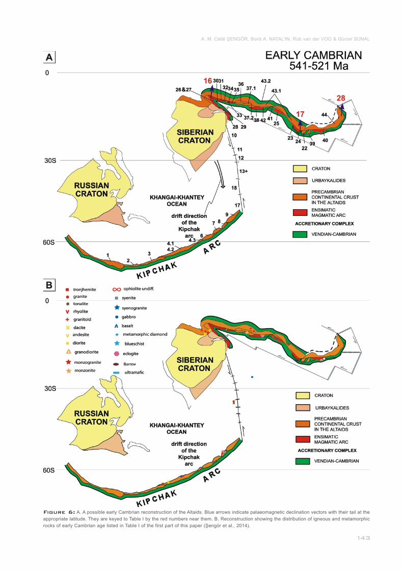
Figure 6: A. A possible early Cambrian reconstruction of the Altaids. Blue arrows indicate palaeomagnetic declination vectors with their tail at the
appropriate latitude. They are keyed to Table I by the red numbers near them. B. Reconstruction showing the distribution of igneous and metamorphic
rocks of early Cambrian age listed in Table I of the first part of this paper (Şengör et al., 2014).____________________________________________
A. M. Celâl ŞENGÖR, Boris A. NATAL'IN, Rob van der VOO & Gürsel SUNAL
using the uncertainty margins of the data unless made absolu-
tely necessary by well-established and generally agreed-upon
geological relationships. The hook shape and the coastwise
transport along its outer side (south, east and northeast) can
both be easily accommodated if an oceanic plate geometry of
the kind drawn in our Fig. 6A existed. The ladder pattern indi-
cates a zone of shortening in the ocean, the polarity of which
can no longer be recovered.
The accretionary complexes belonging to the units 7 through
9 are fairly voluminous. They accumulated in front of the Kök-
chetav diamond-bearing terrains suggesting rapid and consi-
derable uplift/unroofing. The resultant highlands could have
fed the Kipchak trench with clastics more voluminous than in
other segments of the arc.
Newly isotopically-dated magmatic arc rocks show a greater
spread than the ones in the Ediacaran reconstruction. This is
clearly a sampling/preservation bias, but what is most likely
___________________________
____________________________
not such a bias is their remarkable lining up along the Kipchak
and the Tuva Mongol arcs and nowhere else (Fig. 6b), because
this is what the stratigraphically-dated subduction-related rocks
also indicate (see Şengör and Natal'in, 1996, and Plate I).
At this time, the transform fault connecting the Kipchak and
Tuva-Mongol arcs had already been changed into a subduc-
tion zone above which the units 10-18 formed that are now
located in norteastern and eastern Kazakhstan (Fig. 7A).
The Boshchekul-Tarbagatay Unit (13) developed as a dou-
ble arc system because of marginal basin opening by splitting
the arc during the medial Cambrian. In the Ordovician it was
transformed into a marginal sea floored by oceanic lithosphere
as inferred from the age of the ophiolites in the Maikain-Balky-
bek Suture separating the Boshchekul-Tarbagatay (13.1) and
__
____
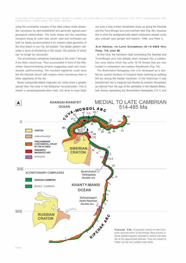
4.4 Medial to Late Cambrian (514-485 Ma:
Figs. 7A and B)
Figure 7A: A possible medial to late Cam-
brian reconstruction of the Altaids. Blue arrows in-
dicate palaeomagnetic declination vectors with their
tail at the appropriate latitude. They are keyed to
Table I by the red numbers near them.__________
A new look at the Altaids: A superorogenic complex in northern and central Asia as a factory of continental crust. Part II: palaeomagnetic data, reconstructions, crustal growth and global sea-level_____________________________________________________________________________
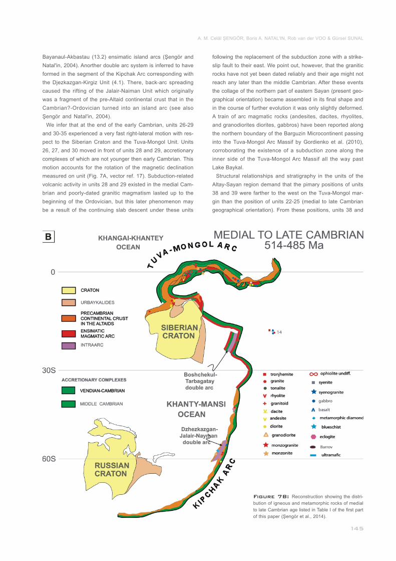
Figure 7B: Reconstruction showing the distri-
bution of igneous and metamorphic rocks of medial
to late Cambrian age listed in Table I of the first part
of this paper (Şengör et al., 2014).______________
Bayanaul-Akbastau (13.2) ensimatic island arcs (Şengör and
Natal'in, 2004). Anorther double arc system is inferred to have
formed in the segment of the Kipchak Arc corresponding with
the Djezkazgan-Kirgiz Unit (4.1). There, back-arc spreading
caused the rifting of the Jalair-Naiman Unit which originally
was a fragment of the pre-Altaid continental crust that in the
Cambrian?-Ordovician turned into an island arc (see also
Şengör and Natal'in, 2004).
We infer that at the end of the early Cambrian, units 26-29
and 30-35 experienced a very fast right-lateral motion with res-
pect to the Siberian Craton and the Tuva-Mongol Unit. Units
26, 27, and 30 moved in front of units 28 and 29, accretionary
complexes of which are not younger then early Cambrian. This
motion accounts for the rotation of the magnetic declination
measured on unit (Fig. 7A, vector ref. 17). Subduction-related
volcanic activity in units 28 and 29 existed in the medial Cam-
brian and poorly-dated granitic magmatism lasted up to the
beginning of the Ordovician, but this later phenomenon may
be a result of the continuing slab descent under these units
___________________________
following the replacement of the subduction zone with a strike-
slip fault to their east. We point out, however, that the granitic
rocks have not yet been dated reliably and their age might not
reach any later than the middle Cambrian. After these events
the collage of the northern part of eastern Sayan (present geo-
graphical orientation) became assembled in its final shape and
in the course of further evolution it was only slightly deformed.
A train of arc magmatic rocks (andesites, dacites, rhyolites,
and granodiorites diorites, gabbros) have been reported along
the northern boundary of the Barguzin Microcontinent passing
into the Tuva-Mongol Arc Massif by Gordienko et al. (2010),
corroborating the existence of a subduction zone along the
inner side of the Tuva-Mongol Arc Massif all the way past
Lake Baykal.
Structural relationships and stratigraphy in the units of the
Altay-Sayan region demand that the pimary positions of units
38 and 39 were farther to the west on the Tuva-Mongol mar-
gin than the position of units 22-25 (medial to late Cambrian
geographical orientation). From these positions, units 38 and
A. M. Celâl ŞENGÖR, Boris A. NATAL'IN, Rob van der VOO & Gürsel SUNAL
39 first came to the point of their final destination in the core
of the West Sayan Orocline and afterwards units 22-25 over-
took them and occupied the present-day frontal position. For
this reason we infer that in the Cambrian units 38 and 39
moved faster than the later ones.
On unit 27 the palaeolatitude is in agreement with the re-
construction here presented, but not the declination. When
one considers that while the magnetisation of unit was being
acquired strong strike slip was going on in and around it, it is
natural that the declination would have rotated. Regrettably
we have no structural data from the precise site of the palaeo-
magnetic observation and therefore we have no idea how to
restore the declination just as in the case of unit above.
Unit 21 continued its movement along the South Gobi Unit (44)
making place in its wake for the formation of units 20 and 19.
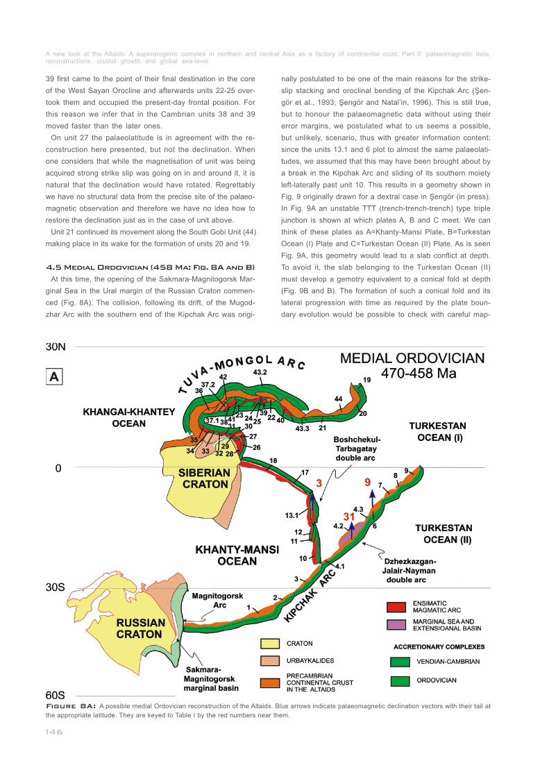
At this time, the opening of the Sakmara-Magnitogorsk Mar-
ginal Sea in the Ural margin of the Russian Craton commen-
ced (Fig. 8A). The collision, following its drift, of the Mugod-
zhar Arc with the southern end of the Kipchak Arc was origi-
______________________
_____
_
4.5 Medial Ordovician (458 Ma: Fig. 8A and B)
nally postulated to be one of the main reasons for the strike-
slip stacking and oroclinal bending of the Kipchak Arc (Şen-
gör et al., 1993; Şengör and Natal’in, 1996). This is still true,
but to honour the palaeomagnetic data without using their
error margins, we postulated what to us seems a possible,
but unlikely, scenario, thus with greater information content:
since the units 13.1 and 6 plot to almost the same palaeolati-
tudes, we assumed that this may have been brought about by
a break in the Kipchak Arc and sliding of its southern moiety
left-laterally past unit 10. This results in a geometry shown in
Fig. 9 originally drawn for a dextral case in Şengör (in press).
In Fig. 9A an unstable TTT (trench-trench-trench) type triple
junction is shown at which plates A, B and C meet. We can
think of these plates as A=Khanty-Mansi Plate, B=Turkestan
Ocean (I) Plate and C=Turkestan Ocean (II) Plate. As is seen
Fig. 9A, this geometry would lead to a slab conflict at depth.
To avoid it, the slab belonging to the Turkestan Ocean (II)
must develop a gemotry equivalent to a conical fold at depth
(Fig. 9B and B). The formation of such a conical fold and its
lateral progression with time as required by the plate boun-
dary evolution would be possible to check with careful map-
Figure 8A: A possible medial Ordovician reconstruction of the Altaids. Blue arrows indicate palaeomagnetic declination vectors with their tail at
the appropriate latitude. They are keyed to Table I by the red numbers near them.______________________________________________________
A new look at the Altaids: A superorogenic complex in northern and central Asia as a factory of continental crust. Part II: palaeomagnetic data, reconstructions, crustal growth and global sea-level_____________________________________________________________________________
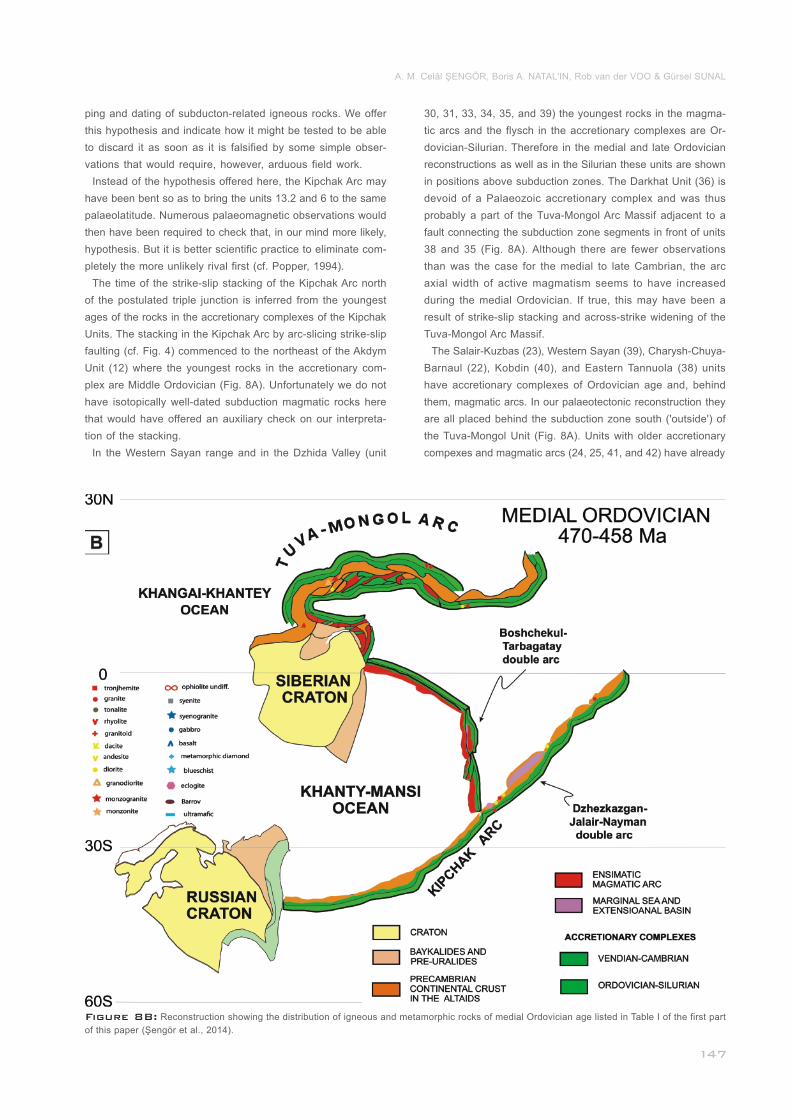
Figure 8B: Reconstruction showing the distribution of igneous and metamorphic rocks of medial Ordovician age listed in Table I of the first part
of this paper (Şengör et al., 2014).____________________________________________________________________________________________
ping and dating of subducton-related igneous rocks. We offer
this hypothesis and indicate how it might be tested to be able
to discard it as soon as it is falsified by some simple obser-
vations that would require, however, arduous field work.
Instead of the hypothesis offered here, the Kipchak Arc may
have been bent so as to bring the units 13.2 and 6 to the same
palaeolatitude. Numerous palaeomagnetic observations would
then have been required to check that, in our mind more likely,
hypothesis. But it is better scientific practice to eliminate com-
pletely the more unlikely rival first (cf. Popper, 1994).
The time of the strike-slip stacking of the Kipchak Arc north
of the postulated triple junction is inferred from the youngest
ages of the rocks in the accretionary complexes of the Kipchak
Units. The stacking in the Kipchak Arc by arc-slicing strike-slip
faulting (cf. Fig. 4) commenced to the northeast of the Akdym
Unit (12) where the youngest rocks in the accretionary com-
plex are Middle Ordovician (Fig. 8A). Unfortunately we do not
have isotopically well-dated subduction magmatic rocks here
that would have offered an auxiliary check on our interpreta-
tion of the stacking.
In the Western Sayan range and in the Dzhida Valley (unit
____
_______
__________________________________
30, 31, 33, 34, 35, and 39) the youngest rocks in the magma-
tic arcs and the flysch in the accretionary complexes are Or-
dovician-Silurian. Therefore in the medial and late Ordovician
reconstructions as well as in the Silurian these units are shown
in positions above subduction zones. The Darkhat Unit (36) is
devoid of a Palaeozoic accretionary complex and was thus
probably a part of the Tuva-Mongol Arc Massif adjacent to a
fault connecting the subduction zone segments in front of units
38 and 35 (Fig. 8A). Although there are fewer observations
than was the case for the medial to late Cambrian, the arc
axial width of active magmatism seems to have increased
during the medial Ordovician. If true, this may have been a
result of strike-slip stacking and across-strike widening of the
Tuva-Mongol Arc Massif.
The Salair-Kuzbas (23), Western Sayan (39), Charysh-Chuya-
Barnaul (22), Kobdin (40), and Eastern Tannuola (38) units
have accretionary complexes of Ordovician age and, behind
them, magmatic arcs. In our palaeotectonic reconstruction they
are all placed behind the subduction zone south ('outside') of
the Tuva-Mongol Unit (Fig. 8A). Units with older accretionary
compexes and magmatic arcs (24, 25, 41, and 42) have already
______________________________
A. M. Celâl ŞENGÖR, Boris A. NATAL'IN, Rob van der VOO & Gürsel SUNAL
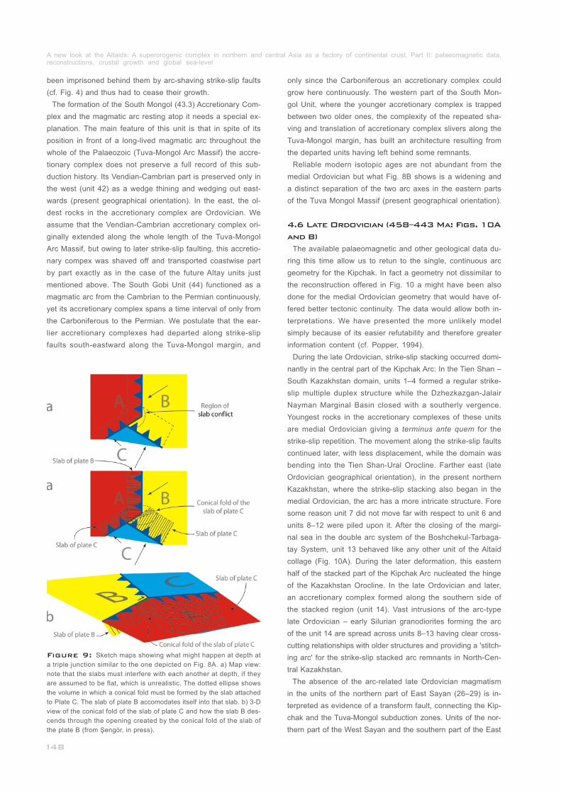
been imprisoned behind them by arc-shaving strike-slip faults
(cf. Fig. 4) and thus had to cease their growth.
The formation of the South Mongol (43.3) Accretionary Com-
plex and the magmatic arc resting atop it needs a special ex-
planation. The main feature of this unit is that in spite of its
position in front of a long-lived magmatic arc throughout the
whole of the Palaeozoic (Tuva-Mongol Arc Massif) the accre-
tionary complex does not preserve a full record of this sub-
duction history. Its Vendian-Cambrian part is preserved only in
the west (unit 42) as a wedge thining and wedging out east-
wards (present geographical orientation). In the east, the ol-
dest rocks in the accretionary complex are Ordovician. We
assume that the Vendian-Cambrian accretionary complex ori-
ginally extended along the whole length of the Tuva-Mongol
Arc Massif, but owing to later strike-slip faulting, this accretio-
nary compex was shaved off and transported coastwise part
by part exactly as in the case of the future Altay units just
mentioned above. The South Gobi Unit (44) functioned as a
magmatic arc from the Cambrian to the Permian continuously,
yet its accretionary complex spans a time interval of only from
the Carboniferous to the Permian. We postulate that the ear-
lier accretionary complexes had departed along strike-slip
faults south-eastward along the Tuva-Mongol margin, and
____________
only since the Carboniferous an accretionary complex could
grow here continuously. The western part of the South Mon-
gol Unit, where the younger accretionary complex is trapped
between two older ones, the complexity of the repeated sha-
ving and translation of accretionary complex slivers along the
Tuva-Mongol margin, has built an architecture resulting from
the departed units having left behind some remnants.
Reliable modern isotopic ages are not abundant from the
medial Ordovician but what Fig. 8B shows is a widening and
a distinct separation of the two arc axes in the eastern parts
of the Tuva Mongol Massif (present geographical orientation).
The available palaeomagnetic and other geological data du-
ring this time allow us to retun to the single, continuous arc
geometry for the Kipchak. In fact a geometry not dissimilar to
the reconstruction offered in Fig. 10 a might have been also
done for the medial Ordovician geometry that would have of-
fered better tectonic continuity. The data would allow both in-
terpretations. We have presented the more unlikely model
simply because of its easier refutability and therefore greater
information content (cf. Popper, 1994).
During the late Ordovician, strike-slip stacking occurred domi-
nantly in the central part of the Kipchak Arc: In the Tien Shan –
South Kazakhstan domain, units 1–4 formed a regular strike-
slip multiple duplex structure while the Dzhezkazgan-Jalair
Nayman Marginal Basin closed with a southerly vergence.
Youngest rocks in the accretionary complexes of these units
are medial Ordovician giving a terminus ante quem for the
strike-slip repetition. The movement along the strike-slip faults
continued later, with less displacement, while the domain was
bending into the Tien Shan-Ural Orocline. Farther east (late
Ordovician geographical orientation), in the present northern
Kazakhstan, where the strike-slip stacking also began in the
medial Ordovician, the arc has a more intricate structure. Fore
some reason unit 7 did not move far with respect to unit 6 and
units 8–12 were piled upon it. After the closing of the margi-
nal sea in the double arc system of the Boshchekul-Tarbaga-
tay System, unit 13 behaved like any other unit of the Altaid
collage (Fig. 10A). During the later deformation, this eastern
half of the stacked part of the Kipchak Arc nucleated the hinge
of the Kazakhstan Orocline. In the late Ordovician and later,
an accretionary complex formed along the southern side of
the stacked region (unit 14). Vast intrusions of the arc-type
late Ordovician – early Silurian granodiorites forming the arc
of the unit 14 are spread across units 8–13 having clear cross-
cutting relationships with older structures and providing a 'stitch-
ing arc' for the strike-slip stacked arc remnants in North-Cen-
tral Kazakhstan.
The absence of the arc-related late Ordovician magmatism
in the units of the northern part of East Sayan (26–29) is in-
terpreted as evidence of a transform fault, connecting the Kip-
chak and the Tuva-Mongol subduction zones. Units of the nor-
thern part of the West Sayan and the southern part of the East
_______
__________________
4.6 Late Ordovician (458–443 Ma: Figs. 10A
and B)
Figure 9: Sketch maps showing what might happen at depth at
a triple junction similar to the one depicted on Fig. 8A. a) Map view:
note that the slabs must interfere with each another at depth, if they
are assumed to be flat, which is unrealistic. The dotted ellipse shows
the volume in which a conical fold must be formed by the slab attached
to Plate C. The slab of plate B accomodates itself into that slab. b) 3-D
view of the conical fold of the slab of plate C and how the slab B des-
cends through the opening created by the conical fold of the slab of
the plate B (from Şengör, in press).____________________________
A new look at the Altaids: A superorogenic complex in northern and central Asia as a factory of continental crust. Part II: palaeomagnetic data, reconstructions, crustal growth and global sea-level_____________________________________________________________________________
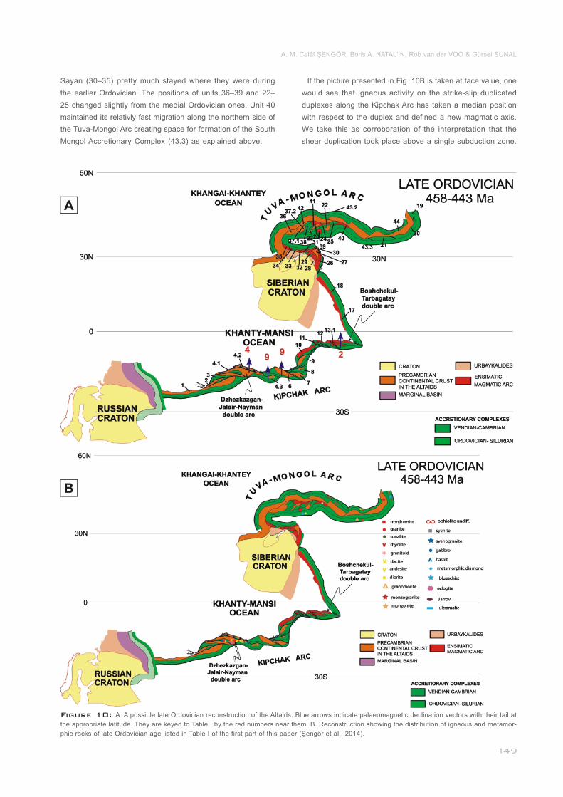
Figure 10: A. A possible late Ordovician reconstruction of the Altaids. Blue arrows indicate palaeomagnetic declination vectors with their tail at
the appropriate latitude. They are keyed to Table I by the red numbers near them. B. Reconstruction showing the distribution of igneous and metamor-
phic rocks of late Ordovician age listed in Table I of the first part of this paper (Şengör et al., 2014).________________________________________
Sayan (30–35) pretty much stayed where they were during
the earlier Ordovician. The positions of units 36–39 and 22–
25 changed slightly from the medial Ordovician ones. Unit 40
maintained its relativly fast migration along the northern side of
the Tuva-Mongol Arc creating space for formation of the South
Mongol Accretionary Complex (43.3) as explained above.___
If the picture presented in Fig. 10B is taken at face value, one
would see that igneous activity on the strike-slip duplicated
duplexes along the Kipchak Arc has taken a median position
with respect to the duplex and defined a new magmatic axis.
We take this as corroboration of the interpretation that the
shear duplication took place above a single subduction zone.
A. M. Celâl ŞENGÖR, Boris A. NATAL'IN, Rob van der VOO & Gürsel SUNAL
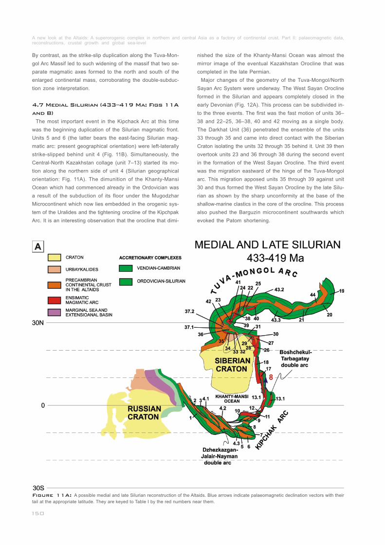
By contrast, as the strike-slip duplication along the Tuva-Mon-
gol Arc Massif led to such widening of the massif that two se-
parate magmatic axes formed to the north and south of the
enlarged continental mass, corroborating the double-subduc-
tion zone interpretation.
The most important event in the Kipchack Arc at this time
was the beginning duplication of the Silurian magmatic front.
Units 5 and 6 (the latter bears the east-facing Silurian mag-
matic arc: present geographical orientation) were left-laterally
strike-slipped behind unit 4 (Fig. 11B). Simultaneously, the
Central-North Kazakhstan collage (unit 7–13) started its mo-
tion along the northern side of unit 4 (Silurian geographical
orientation: Fig. 11A). The dimunition of the Khanty-Mansi
Ocean which had commenced already in the Ordovician was
a result of the subduction of its floor under the Mugodzhar
Microcontinent which now lies embedded in the orogenic sys-
tem of the Uralides and the tightening orocline of the Kipchpak
Arc. It is an interesting observation that the orocline that dimi-
______________________________
4.7 Medial Silurian (433–419 Ma: Figs 11A
and B)
nished the size of the Khanty-Mansi Ocean was almost the
mirror image of the eventual Kazakhstan Orocline that was
completed in the late Permian.
Major changes of the geometry of the Tuva-Mongol/North
Sayan Arc System were underway. The West Sayan Orocline
formed in the Silurian and appears completely closed in the
early Devonian (Fig. 12A). This process can be subdivided in-
to the three events. The first was the fast motion of units 36–
38 and 22–25, 36–38, 40 and 42 moving as a single body.
The Darkhat Unit (36) penetrated the ensemble of the units
33 through 35 and came into direct contact with the Siberian
Craton isolating the units 32 through 35 behind it. Unit 39 then
overtook units 23 and 36 through 38 during the second event
in the formation of the West Sayan Orocline. The third event
was the migration eastward of the hinge of the Tuva-Mongol
arc. This migration apposed units 35 through 39 against unit
30 and thus formed the West Sayan Orocline by the late Silu-
rian as shown by the sharp unconformity at the base of the
shallow-marine clastics in the core of the orocline. This process
also pushed the Barguzin microcontinent southwards which
evoked the Patom shortening.
_________________________
_________________________
Figure 11A: A possible medial and late Silurian reconstruction of the Altaids. Blue arrows indicate palaeomagnetic declination vectors with their
tail at the appropriate latitude. They are keyed to Table I by the red numbers near them.__________________________________________________
A new look at the Altaids: A superorogenic complex in northern and central Asia as a factory of continental crust. Part II: palaeomagnetic data, reconstructions, crustal growth and global sea-level_____________________________________________________________________________
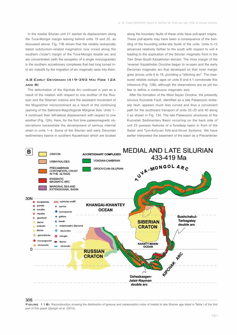
Figure 11B: Reconstruction showing the distribution of igneous and metamorphic rocks of medial to late Silurian age listed in Table I of the first
part of this paper (Şengör et al. (2014)._________________________________________________________________________________________
In the medial Silurian unit 21 started its displacement along
the Tuva-Mongol margin leaving behind units 19 and 20, as
discussed above. Fig. 11B shows that the reliably isotopically
dated subduction-related magmatics now crowd along the
southern ('outer') margin of the Tuva-Mongol double arc and
are concentrated (with the exception of a single monzogranite)
in the southern accretionary complexes that had long turned in-
to arc massifs by the migration of arc magmatic axes into them.
The deformation of the Kipchak Arc continued in part as a
result of the rotation with respect to one another of the Rus-
sian and the Siberian cratons and the westward movement of
the Mugodzhar microcontinent as a result of the continuing
opening of the Sakmara-Magnitogorsk Marginal Sea. Units 1–
4 continued their left-lateral displacement with respect to one
another (Fig. 12A). Here, for the first time palaeomagnetic ob-
servations necessitate the development of serious internal
strain in units 1–4. Some of the Silurian and early Devonian
sedimentary basins in southern Kazakhstan which are located
4.8 Early Devonian (419–393 Ma: Figs 12A
and B)
along the boundary faults of these units have pull-apart origins.
These pull-aparts may have been a consequence of the ben-
ding of the bounding strike-slip faults of the units. Units 5–12
advanced relatively farther to the south with respect to unit 4
leading to the duplication of the Silurian magmatic front in the
Tien Shan-South Kazakhstan domain. The inner margin of the
'reverse' Kazakhstan Orocline began to re-open and the early
Devonian magmatic arc that developed on that inner margin
grew across units 6 to 18, providing a "stitching arc". The mea-
sured reliable isotopic ages on units 8 and 4.1 corroborate this
inference (Fig. 12B), although the observations are as yet too
few to define a continuous magmatic axis.
After the formation of the West Sayan Orocline, the presently
sinuous Kuznetsk Fault, identified as a late Palaeozoic strike-
slip fault, appears much less curved and thus a convenient
path for the southward transport of units 22–25 and 40 along
it as shown in Fig. 134. The late Palaeozoic structures of the
Kuznetsk Sedimentary Basin occurring on the back side of
unit 23 possess features of a foredeep basin in front of the
Salair and Tym-Kolyvan fold-and-thrust Systems. We have
earlier interpreted the basement of the basin as a Precambrian
_______________
A. M. Celâl ŞENGÖR, Boris A. NATAL'IN, Rob van der VOO & Gürsel SUNAL
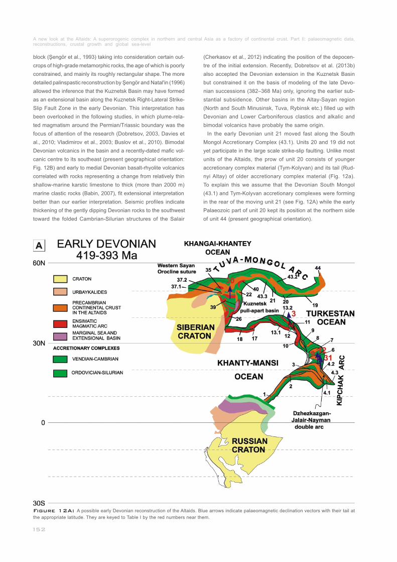
block (Şengör et al., 1993) taking into consideration certain out-
crops of high-grade metamorphic rocks, the age of which is poorly
constrained, and mainly its roughly rectangular shape. The more
detailed palinspastic reconstruction by Şengör and Natal'in (1996)
allowed the inference that the Kuznetsk Basin may have formed
as an extensional basin along the Kuznetsk Right-Lateral Strike-
Slip Fault Zone in the early Devonian. This interpretation has
been overlooked in the following studies, in which plume-rela-
ted magmatism around the Permian/Triassic boundary was the
focus of attention of the research (Dobretsov, 2003, Davies et
al., 2010; Vladimirov et al., 2003; Buslov et al., 2010). Bimodal
Devonian volcanics in the basin and a recently-dated mafic vol-
canic centre to its southeast (present geographical orientation:
Fig. 12B) and early to medial Devonian basalt-rhyolite volcanics
correlated with rocks representing a change from relatively thin
shallow-marine karstic limestone to thick (more than 2000 m)
marine clastic rocks (Babin, 2007), fit extensional interpretation
better than our earlier interpretation. Seismic profiles indicate
thickening of the gently dipping Devonian rocks to the southwest
toward the folded Cambrian-Silurian structures of the Salair
(Cherkasov et al., 2012) indicating the position of the depocen-
tre of the initial extension. Recently, Dobretsov et al. (2013b)
also accepted the Devonian extension in the Kuznetsk Basin
but constrained it on the basis of modeling of the late Devo-
nian successions (382–368 Ma) only, ignoring the earlier sub-
stantial subsidence. Other basins in the Altay-Sayan region
(North and South Minusinsk, Tuva, Rybinsk etc.) filled up with
Devonian and Lower Carboniferous clastics and alkalic and
bimodal volcanics have probably the same origin.
In the early Devonian unit 21 moved fast along the South
Mongol Accretionary Complex (43.1). Units 20 and 19 did not
yet participate in the large scale strike-slip faulting. Unlike most
units of the Altaids, the prow of unit 20 consists of younger
accretionary complex material (Tym-Kolyvan) and its tail (Rud-
nyi Altay) of older accretionary complex material (Fig. 12a).
To explain this we assume that the Devonian South Mongol
(43.1) and Tym-Kolyvan accretionary complexes were forming
in the rear of the moving unit 21 (see Fig. 12A) while the early
Palaeozoic part of unit 20 kept its position at the northern side
of unit 44 (present geographical orientation).
__________
______________
Figure 12A: A possible early Devonian reconstruction of the Altaids. Blue arrows indicate palaeomagnetic declination vectors with their tail at
the appropriate latitude. They are keyed to Table I by the red numbers near them.______________________________________________________
A new look at the Altaids: A superorogenic complex in northern and central Asia as a factory of continental crust. Part II: palaeomagnetic data, reconstructions, crustal growth and global sea-level_____________________________________________________________________________
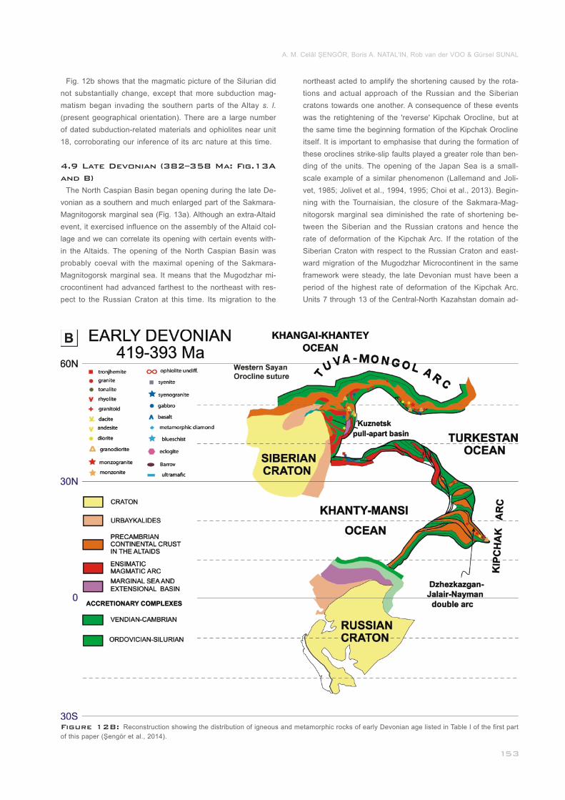
Figure 12B: Reconstruction showing the distribution of igneous and metamorphic rocks of early Devonian age listed in Table I of the first part
of this paper (Şengör et al., 2014).____________________________________________________________________________________________
Fig. 12b shows that the magmatic picture of the Silurian did
not substantially change, except that more subduction mag-
matism began invading the southern parts of the Altay s. l.
(present geographical orientation). There are a large number
of dated subduction-related materials and ophiolites near unit
18, corroborating our inference of its arc nature at this time.
The North Caspian Basin began opening during the late De-
vonian as a southern and much enlarged part of the Sakmara-
Magnitogorsk marginal sea (Fig. 13a). Although an extra-Altaid
event, it exercised influence on the assembly of the Altaid col-
lage and we can correlate its opening with certain events with-
in the Altaids. The opening of the North Caspian Basin was
probably coeval with the maximal opening of the Sakmara-
Magnitogorsk marginal sea. It means that the Mugodzhar mi-
crocontinent had advanced farthest to the northeast with res-
pect to the Russian Craton at this time. Its migration to the
_
4.9 Late Devonian (382–358 Ma: Fig.13A
and B)
northeast acted to amplify the shortening caused by the rota-
tions and actual approach of the Russian and the Siberian
cratons towards one another. A consequence of these events
was the retightening of the 'reverse' Kipchak Orocline, but at
the same time the beginning formation of the Kipchak Orocline
itself. It is important to emphasise that during the formation of
these oroclines strike-slip faults played a greater role than ben-
ding of the units. The opening of the Japan Sea is a small-
scale example of a similar phenomenon (Lallemand and Joli-
vet, 1985; Jolivet et al., 1994, 1995; Choi et al., 2013). Begin-
ning with the Tournaisian, the closure of the Sakmara-Mag-
nitogorsk marginal sea diminished the rate of shortening be-
tween the Siberian and the Russian cratons and hence the
rate of deformation of the Kipchak Arc. If the rotation of the
Siberian Craton with respect to the Russian Craton and east-
ward migration of the Mugodzhar Microcontinent in the same
framework were steady, the late Devonian must have been a
period of the highest rate of deformation of the Kipchak Arc.
Units 7 through 13 of the Central-North Kazahstan domain ad-
A. M. Celâl ŞENGÖR, Boris A. NATAL'IN, Rob van der VOO & Gürsel SUNAL
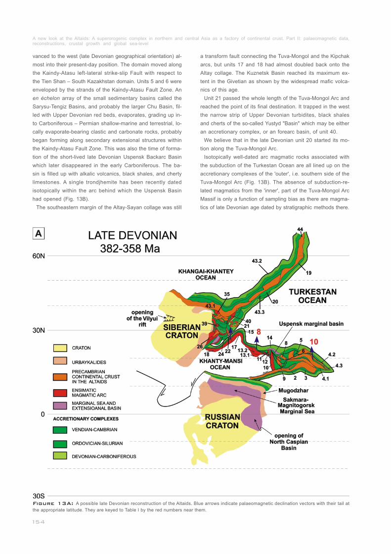
vanced to the west (late Devonian geographical orientation) al-
most into their present-day position. The domain moved along
the Kaindy-Atasu left-lateral strike-slip Fault with respect to
the Tien Shan – South Kazakhstan domain. Units 5 and 6 were
enveloped by the strands of the Kaindy-Atasu Fault Zone. An
en échelon array of the small sedimentary basins called the
Sarysu-Tengiz Basins, and probably the larger Chu Basin, fil-
led with Upper Devonian red beds, evaporates, grading up in-
to Carboniferous – Permian shallow-marine and terrestrial, lo-
cally evaporate-bearing clastic and carbonate rocks, probably
began forming along secondary extensional structures within
the Kaindy-Atasu Fault Zone. This was also the time of forma-
tion of the short-lived late Devonian Uspensk Backarc Basin
which later disappeared in the early Carboniferous. The ba-
sin is filled up with alkalic volcanics, black shales, and cherty
limestones. A single trondjhemite has been recently dated
isotopically within the arc behind which the Uspensk Basin
had opened (Fig. 13B).
The southeastern margin of the Altay-Sayan collage was still
_______________________________
a transform fault connecting the Tuva-Mongol and the Kipchak
arcs, but units 17 and 18 had almost doubled back onto the
Altay collage. The Kuznetsk Basin reached its maximum ex-
tent in the Givetian as shown by the widespread mafic volca-
nics of this age.
Unit 21 passed the whole length of the Tuva-Mongol Arc and
reached the point of its final destination. It trapped in the west
the narrow strip of Upper Devonian turbidites, black shales
and cherts of the so-called Yustyd "Basin" which may be either
an accretionary complex, or an forearc basin, of unit 40.
We believe that in the late Devonian unit 20 started its mo-
tion along the Tuva-Mongol Arc.
Isotopically well-dated arc magmatic rocks associated with
the subduction of the Turkestan Ocean are all lined up on the
accretionary complexes of the 'outer', i.e. southern side of the
Tuva-Mongol Arc (Fig. 13B). The absence of subduction-re-
lated magmatics from the 'inner', part of the Tuva-Mongol Arc
Massif is only a function of sampling bias as there are magma-
tics of late Devonian age dated by stratigraphic methods there.
_____________________________________
____
________________________
Figure 13A: A possible late Devonian reconstruction of the Altaids. Blue arrows indicate palaeomagnetic declination vectors with their tail at
the appropriate latitude. They are keyed to Table I by the red numbers near them.______________________________________________________
A new look at the Altaids: A superorogenic complex in northern and central Asia as a factory of continental crust. Part II: palaeomagnetic data, reconstructions, crustal growth and global sea-level_____________________________________________________________________________
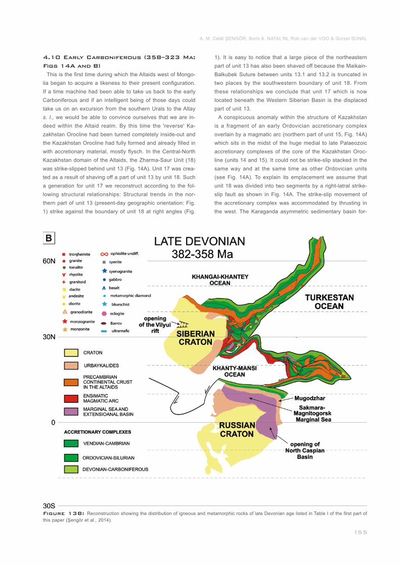
Figure 13B: Reconstruction showing the distribution of igneous and metamorphic rocks of late Devonian age listed in Table I of the first part of
this paper (Şengör et al., 2014)._______________________________________________________________________________________________
4.10 Early Carboniferous (358–323 Ma:
Figs 14A and B)
This is the first time during which the Altaids west of Mongo-
lia began to acquire a likeness to their present configuration.
If a time machine had been able to take us back to the early
Carboniferous and if an intelligent being of those days could
take us on an excursion from the southern Urals to the Altay
s. l., we would be able to convince ourselves that we are in-
deed within the Altaid realm. By this time the 'reverse' Ka-
zakhstan Orocline had been turned completely inside-out and
the Kazakhstan Orocline had fully formed and already filled in
with accretionary material, mostly flysch. In the Central-North
Kazakhstan domain of the Altaids, the Zharma-Saur Unit (18)
was strike-slipped behind unit 13 (Fig. 14A). Unit 17 was crea-
ted as a result of shaving off a part of unit 13 by unit 18. Such
a generation for unit 17 we reconstruct according to the fol-
lowing structural relationships: Structural trends in the nor-
thern part of unit 13 (present-day geographic orientation: Fig.
1) strike against the boundary of unit 18 at right angles (Fig.
1). It is easy to notice that a large piece of the northeastern
part of unit 13 has also been shaved off because the Maikain-
Balkubek Suture between units 13.1 and 13.2 is truncated in
two places by the southwestern boundary of unit 18. From
these relationships we conclude that unit 17 which is now
located beneath the Western Siberian Basin is the displaced
part of unit 13.
A conspicuous anomaly within the structure of Kazakhstan
is a fragment of an early Ordovician accretionary complex
overlain by a magmatic arc (northern part of unit 15, Fig. 14A)
which sits in the midst of the huge medial to late Palaeozoic
accretionary complexes of the core of the Kazakhstan Oroc-
line (units 14 and 15). It could not be strike-slip stacked in the
same way and at the same time as other Ordovician units
(see Fig. 14A). To explain its emplacement we assume that
unit 18 was divided into two segments by a right-latral strike-
slip fault as shown in Fig. 14A. The strike-slip movement of
the accretionary complex was accommodated by thrusting in
the west. The Karaganda asymmetric sedimentary basin for-
______________________________________
A. M. Celâl ŞENGÖR, Boris A. NATAL'IN, Rob van der VOO & Gürsel SUNAL
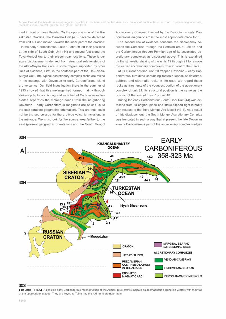
med in front of these thrusts. On the opposite side of the Ka-
zakhstan Orocline, the Baratala Unit (4.3) became detached
from unit 4.1 and moved towards the inner part of the orocline.
In the early Carboniferous, units 19 and 20 left their positions
at the side of South Gobi Unit (44) and moved fast along the
Tuva-Mongol Arc to their present-day locations. These large-
scale displacements derived from structural relationships of
the Altay-Sayan Units are in some degree supported by other
lines of evidence. First, in the southern part of the Ob-Zaisan-
Surgut Unit (19), typical accretionary complex rocks are mixed
in the mélange with Devonian to early Carboniferous island
arc volcanics. Our field investigation there in the summer of
1993 showed that this mélange had formed mainly through
strike-slip tectonics. A long and wide belt of Carboniferous tur-
bidites separates the mélange zones from the neighboring
Devonian – early Carboniferous magmatic arc of unit 20 to
the east (present geographic orientation). This arc thus could
not be the source area for the arc-type volcanic inclusions in
the mélange. We must look for the source area farther to the
east (present geographic orientation) and the South Mongol
Accretionary Complex invaded by the Devonian – early Car-
boniferous magmatic arc is the most appropriate place for it.
The second line of evidence concerns the discrepancy be-
tween the Cambrian through the Permian arc of unit 44 and
the Carboniferous through Permian age of its associated ac-
cretionary complexes as discussed above. This is explained
by the strike-slip shaving of the units 19 through 21 to remove
the earlier accretionary complexes from in front of their arcs.
At its current position, unit 20 trapped Devonian – early Car-
boniferous turbidites containing tectonic lenses of dolerites,
gabbros and ultramafic rocks in the east. We regard these
rocks as fragments of the youngest portion of the accretionary
complex of unit 21. Its structural position is the same as the
position of the Yustyd 'Basin' of unit 40.
During the early Carboniferous South Gobi Unit (44) was de-
tached from its original place and strike-slipped right-laterally
with respect to the Tuva-Mongol Arc Massif (43.1). As a result
of this displacement, the South Mongol Accretionary Complex
was truncated in such a way that at present the late Devonian
– early Carboniferous part of the accretionary complex wedges
_
_
__________________
Figure 14A: A possible early Carboniferous reconstruction of the Altaids. Blue arrows indicate palaeomagnetic declination vectors with their tail
at the appropriate latitude. They are keyed to Table I by the red numbers near them.____________________________________________________
A new look at the Altaids: A superorogenic complex in northern and central Asia as a factory of continental crust. Part II: palaeomagnetic data, reconstructions, crustal growth and global sea-level_____________________________________________________________________________
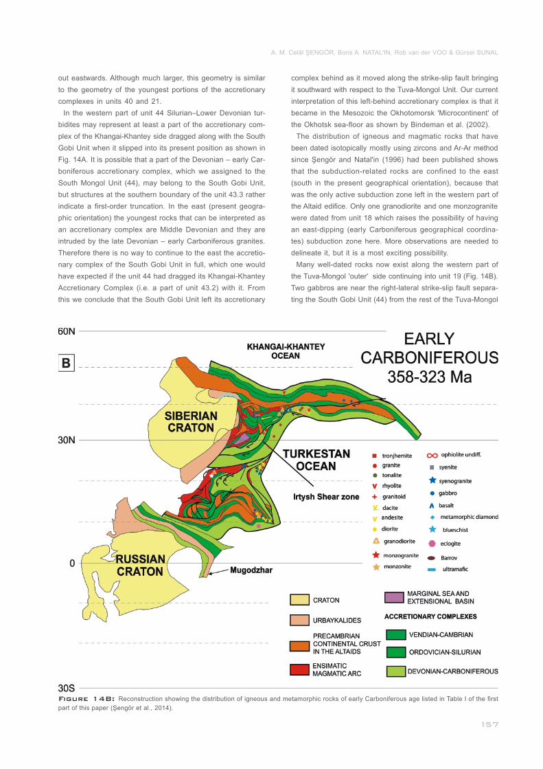
Figure 14B: Reconstruction showing the distribution of igneous and metamorphic rocks of early Carboniferous age listed in Table I of the first
part of this paper (Şengör et al., 2014)._________________________________________________________________________________________
out eastwards. Although much larger, this geometry is similar
to the geometry of the youngest portions of the accretionary
complexes in units 40 and 21.
In the western part of unit 44 Silurian–Lower Devonian tur-
bidites may represent at least a part of the accretionary com-
plex of the Khangai-Khantey side dragged along with the South
Gobi Unit when it slipped into its present position as shown in
Fig. 14A. It is possible that a part of the Devonian – early Car-
boniferous accretionary complex, which we assigned to the
South Mongol Unit (44), may belong to the South Gobi Unit,
but structures at the southern boundary of the unit 43.3 rather
indicate a first-order truncation. In the east (present geogra-
phic orientation) the youngest rocks that can be interpreted as
an accretionary complex are Middle Devonian and they are
intruded by the late Devonian – early Carboniferous granites.
Therefore there is no way to continue to the east the accretio-
nary complex of the South Gobi Unit in full, which one would
have expected if the unit 44 had dragged its Khangai-Khantey
Accretionary Complex (i.e. a part of unit 43.2) with it. From
this we conclude that the South Gobi Unit left its accretionary
_________________________
complex behind as it moved along the strike-slip fault bringing
it southward with respect to the Tuva-Mongol Unit. Our current
interpretation of this left-behind accretionary complex is that it
became in the Mesozoic the Okhotomorsk 'Microcontinent' of
the Okhotsk sea-floor as shown by Bindeman et al. (2002).
The distribution of igneous and magmatic rocks that have
been dated isotopically mostly using zircons and Ar-Ar method
since Şengör and Natal'in (1996) had been published shows
that the subduction-related rocks are confined to the east
(south in the present geographical orientation), because that
was the only active subduction zone left in the western part of
the Altaid edifice. Only one granodiorite and one monzogranite
were dated from unit 18 which raises the possibility of having
an east-dipping (early Carboniferous geographical coordina-
tes) subduction zone here. More observations are needed to
delineate it, but it is a most exciting possibility.
Many well-dated rocks now exist along the western part of
the Tuva-Mongol 'outer' side continuing into unit 19 (Fig. 14B).
Two gabbros are near the right-lateral strike-slip fault separa-
ting the South Gobi Unit (44) from the rest of the Tuva-Mongol
__
____________
A. M. Celâl ŞENGÖR, Boris A. NATAL'IN, Rob van der VOO & Gürsel SUNAL
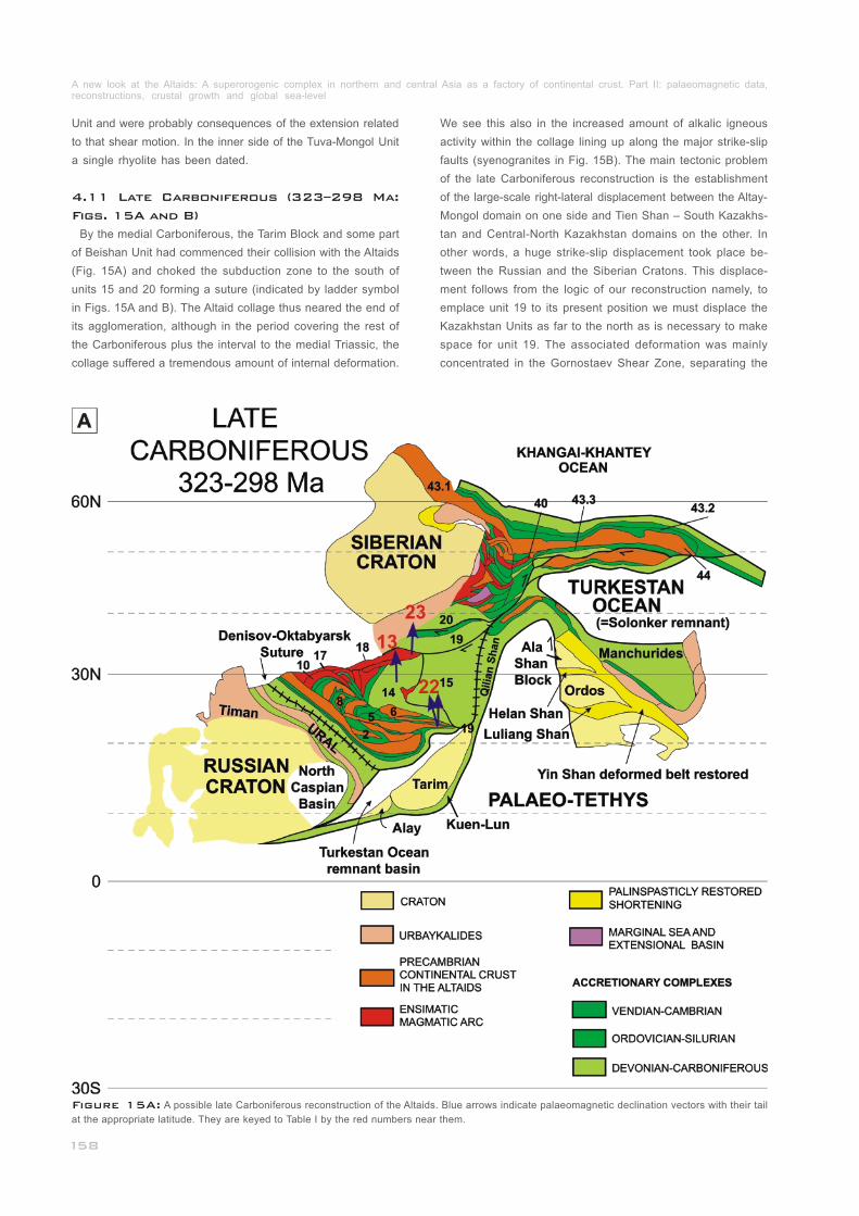
Unit and were probably consequences of the extension related
to that shear motion. In the inner side of the Tuva-Mongol Unit
a single rhyolite has been dated.
By the medial Carboniferous, the Tarim Block and some part
of Beishan Unit had commenced their collision with the Altaids
(Fig. 15A) and choked the subduction zone to the south of
units 15 and 20 forming a suture (indicated by ladder symbol
in Figs. 15A and B). The Altaid collage thus neared the end of
its agglomeration, although in the period covering the rest of
the Carboniferous plus the interval to the medial Triassic, the
collage suffered a tremendous amount of internal deformation.
_______________________
4.11 Late Carboniferous (323–298 Ma:
Figs. 15A and B)
We see this also in the increased amount of alkalic igneous
activity within the collage lining up along the major strike-slip
faults (syenogranites in Fig. 15B). The main tectonic problem
of the late Carboniferous reconstruction is the establishment
of the large-scale right-lateral displacement between the Altay-
Mongol domain on one side and Tien Shan – South Kazakhs-
tan and Central-North Kazakhstan domains on the other. In
other words, a huge strike-slip displacement took place be-
tween the Russian and the Siberian Cratons. This displace-
ment follows from the logic of our reconstruction namely, to
emplace unit 19 to its present position we must displace the
Kazakhstan Units as far to the north as is necessary to make
space for unit 19. The associated deformation was mainly
concentrated in the Gornostaev Shear Zone, separating the
Figure 15A: A possible late Carboniferous reconstruction of the Altaids. Blue arrows indicate palaeomagnetic declination vectors with their tail
at the appropriate latitude. They are keyed to Table I by the red numbers near them.____________________________________________________
A new look at the Altaids: A superorogenic complex in northern and central Asia as a factory of continental crust. Part II: palaeomagnetic data, reconstructions, crustal growth and global sea-level_____________________________________________________________________________
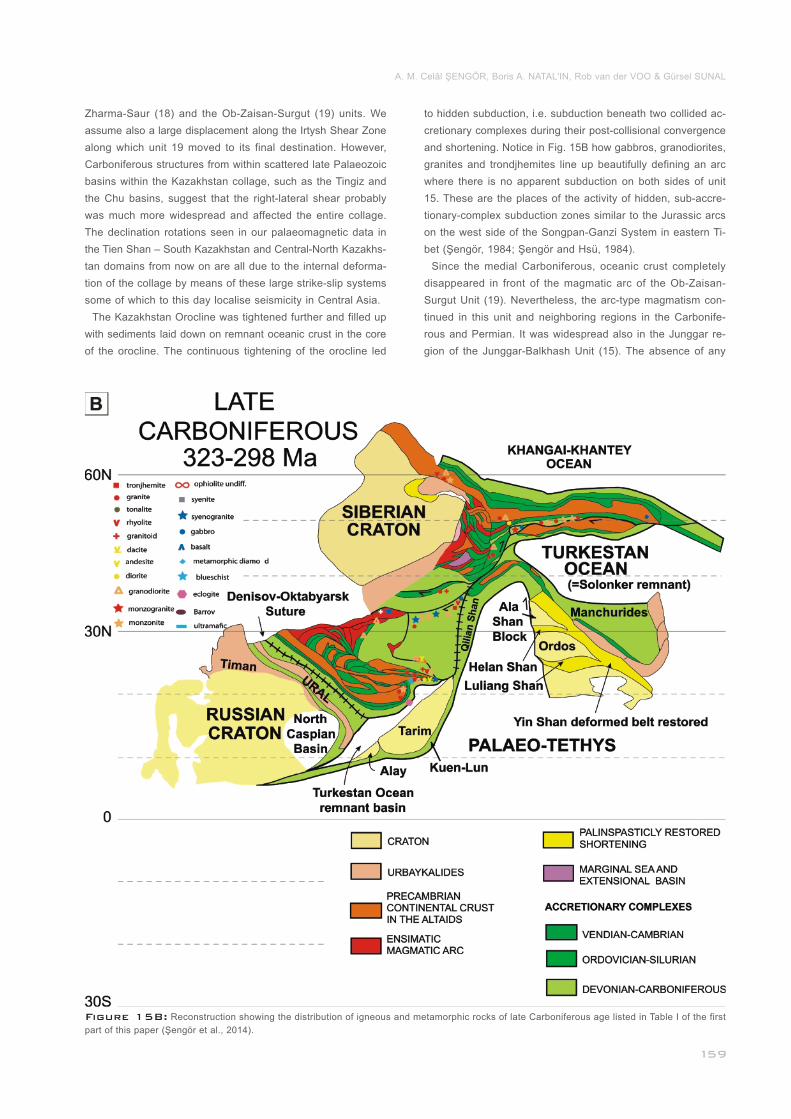
Figure 15B: Reconstruction showing the distribution of igneous and metamorphic rocks of late Carboniferous age listed in Table I of the first
part of this paper (Şengör et al., 2014).________________________________________________________________________________________
Zharma-Saur (18) and the Ob-Zaisan-Surgut (19) units. We
assume also a large displacement along the Irtysh Shear Zone
along which unit 19 moved to its final destination. However,
Carboniferous structures from within scattered late Palaeozoic
basins within the Kazakhstan collage, such as the Tingiz and
the Chu basins, suggest that the right-lateral shear probably
was much more widespread and affected the entire collage.
The declination rotations seen in our palaeomagnetic data in
the Tien Shan – South Kazakhstan and Central-North Kazakhs-
tan domains from now on are all due to the internal deforma-
tion of the collage by means of these large strike-slip systems
some of which to this day localise seismicity in Central Asia.
The Kazakhstan Orocline was tightened further and filled up
with sediments laid down on remnant oceanic crust in the core
of the orocline. The continuous tightening of the orocline led
_
to hidden subduction, i.e. subduction beneath two collided ac-
cretionary complexes during their post-collisional convergence
and shortening. Notice in Fig. 15B how gabbros, granodiorites,
granites and trondjhemites line up beautifully defining an arc
where there is no apparent subduction on both sides of unit
15. These are the places of the activity of hidden, sub-accre-
tionary-complex subduction zones similar to the Jurassic arcs
on the west side of the Songpan-Ganzi System in eastern Ti-
bet (Şengör, 1984; Şengör and Hsü, 1984).
Since the medial Carboniferous, oceanic crust completely
disappeared in front of the magmatic arc of the Ob-Zaisan-
Surgut Unit (19). Nevertheless, the arc-type magmatism con-
tinued in this unit and neighboring regions in the Carbonife-
rous and Permian. It was widespread also in the Junggar re-
gion of the Junggar-Balkhash Unit (15). The absence of any
_______________
A. M. Celâl ŞENGÖR, Boris A. NATAL'IN, Rob van der VOO & Gürsel SUNAL
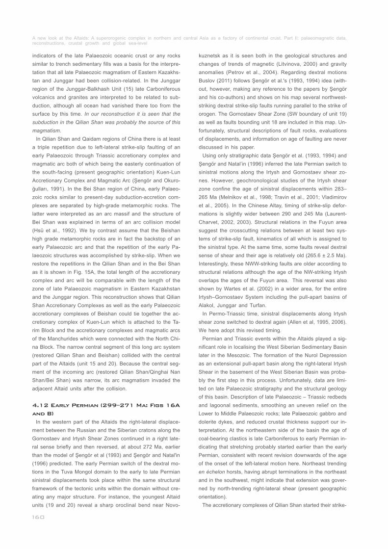
indicators of the late Palaeozoic oceanic crust or any rocks
similar to trench sedimentary fills was a basis for the interpre-
tation that all late Palaeozoic magmatism of Eastern Kazakhs-
tan and Junggar had been collision-related. In the Junggar
region of the Junggar-Balkhash Unit (15) late Carboniferous
volcanics and granites are interpreted to be related to sub-
duction, although all ocean had vanished there too from the
surface by this time. In our reconstruction it is seen that the
subduction in the Qilian Shan was probably the source of this
magmatism.
In Qilian Shan and Qaidam regions of China there is at least
a triple repetition due to left-lateral strike-slip faulting of an
early Palaeozoic through Triassic accretionary complex and
magmatic arc both of which being the easterly continuation of
the south-facing (present geographic orientation) Kuen-Lun
Accretionary Complex and Magmatic Arc (Şengör and Okuro-
ğulları, 1991). In the Bei Shan region of China, early Palaeo-
zoic rocks similar to present-day subduction-accretion com-
plexes are separated by high-grade metamorphic rocks. The
latter were interpreted as an arc massif and the structure of
Bei Shan was explained in terms of an arc collision model
(Hsü et al., 1992). We by contrast assume that the Beishan
high grade metamorphic rocks are in fact the backstop of an
early Palaeozoic arc and that the repetition of the early Pa-
laeozoic structures was accomplished by strike-slip. When we
restore the repetitions in the Qilian Shan and in the Bei Shan
as it is shown in Fig. 15A, the total length of the accretionary
complex and arc will be comparable with the length of the
zone of late Palaeozoic magmatism in Eastern Kazakhstan
and the Junggar region. This reconstruction shows that Qilian
Shan Accretionary Complexes as well as the early Palaeozoic
accretionary complexes of Beishan could tie together the ac-
cretionary complex of Kuen-Lun which is attached to the Ta-
rim Block and the accretionary complexes and magmatic arcs
of the Manchurides which were connected with the North Chi-
na Block. The narrow central segment of this long arc system
(restored Qilian Shan and Beishan) collided with the central
part of the Altaids (unit 15 and 20). Because the central seg-
ment of the incoming arc (restored Qilian Shan/Qinghai Nan
Shan/Bei Shan) was narrow, its arc magmatism invaded the
adjacent Altaid units after the collision.
In the western part of the Altaids the right-lateral displace-
ment between the Russian and the Siberian cratons along the
Gornostaev and Irtysh Shear Zones continued in a right late-
ral sense briefly and then reversed, at about 272 Ma, earlier
than the model of Şengör et al (1993) and Şengör and Natal'in
(1996) predicted. The early Permian switch of the dextral mo-
tions in the Tuva Mongol domain to the early to late Permian
sinistral displacements took place within the same structural
framework of the tectonic units within the domain without cre-
ating any major structure. For instance, the youngest Altaid
units (19 and 20) reveal a sharp oroclinal bend near Novo-
__________________
4.12 Early Permian (299–271 Ma: Figs 16A
and B)
kuznetsk as it is seen both in the geological structures and
changes of trends of magnetic (Litvinova, 2000) and gravity
anomalies (Petrov et al., 2004). Regarding dextral motions
Buslov (2011) follows Şengör et al.'s (1993, 1994) idea (with-
out, however, making any reference to the papers by Şengör
and his co-authors) and shows on his map several northwest-
striking dextral strike-slip faults running parallel to the strike of
orogen. The Gornostaev Shear Zone (SW boundary of unit 19)
as well as faults bounding unit 18 are included in this map. Un-
fortunately, structural descriptions of fault rocks, evaluations
of displacements, and information on age of faulting are never
discussed in his paper.
Using only stratigraphic data Şengör et al. (1993, 1994) and
Şengör and Natal’in (1996) inferred the late Permian switch to
sinistral motions along the Irtysh and Gornostaev shear zo-
nes. However, geochronological studies of the Irtysh shear
zone confine the age of sinistral displacements within 283–
265 Ma (Melnikov et al., 1998; Travin et al., 2001; Vladimirov
et al., 2005). In the Chinese Altay, timing of strike-slip defor-
mations is slightly wider between 290 and 245 Ma (Laurent-
Charvet, 2002, 2003). Structural relations in the Fuyun area
suggest the crosscutting relations between at least two sys-
tems of strike-slip fault, kinematics of all which is assigned to
the sinistral type. At the same time, some faults reveal dextral
sense of shear and their age is relatively old (265.6 ± 2.5 Ma).
Interestingly, these NWW-striking faults are older according to
structural relations although the age of the NW-striking Irtysh
overlaps the ages of the Fuyun area. This reversal was also
shown by Wartes et al. (2002) in a wider area, for the entire
Irtysh–Gornostaev System including the pull-apart basins of
Alakol, Junggar and Turfan.
In Permo-Triassic time, sinistral displacements along Irtysh
shear zone switched to dextral again (Allen et al, 1995, 2006).
We here adopt this revised timing.
Permian and Triassic events within the Altaids played a sig-
nificant role in localising the West Siberian Sedimentary Basin
later in the Mesozoic. The formation of the Nurol Depression
as an extensional pull-apart basin along the right-lateral Irtysh
Shear in the basement of the West Siberian Basin was proba-
bly the first step in this process. Unfortunately, data are limi-
ted on late Palaeozoic stratigraphy and the structural geology
of this basin. Description of late Palaeozoic – Triassic redbeds
and lagoonal sediments, smoothing an uneven relief on the
Lower to Middle Palaeozoic rocks; late Palaeozoic gabbro and
dolerite dykes, and reduced crustal thickness support our in-
terpretation. At the northeastern side of the basin the age of
coal-bearing clastics is late Carboniferous to early Permian in-
dicating that stretching probably started earlier than the early
Permian, consistent with recent revision downwards of the age
of the onset of the left-lateral motion here. Northeast trending
en échelon horsts, having abrupt terminations in the northeast
and in the southwest, might indicate that extension was gover-
ned by north-trending right-lateral shear (present geographic
orientation).
The accretionary complexes of Qilian Shan started their strike-
_______________________________
___________________________
______________________
A new look at the Altaids: A superorogenic complex in northern and central Asia as a factory of continental crust. Part II: palaeomagnetic data, reconstructions, crustal growth and global sea-level_____________________________________________________________________________
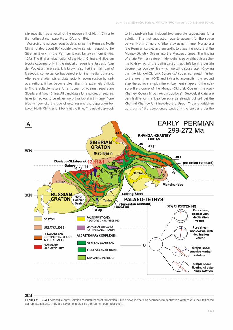
Figure 16A: A possible early Permian reconstruction of the Altaids. Blue arrows indicate palaeomagnetic declination vectors with their tail at the
appropriate latitude. They are keyed to Table I by the red numbers near them.__________________________________________________________
slip repetition as a result of the movement of North China to
the northeast (compare Figs. 15A and 16A).
According to palaeomagnetic data, since the Permian, North
China rotated about 90° counterclockwise with respect to the
Siberian Block. In the Permian it was far away from it (Fig.
16A). The final amalgamation of the North China and Siberian
blocks occurred only in the medial or even late Jurassic (Van
der Voo et al., in press). It is known also that the main part of
Mesozoic convergence happened prior the medial Jurassic.
After several attempts at plate tectonic reconstruction by vari-
ous authors, it has become clear that it is extremely difficult
to find a suitable suture for an ocean or oceans, separating
Siberia and North China. All candidates for a suture, or sutures,
have turned out to be either too old or too short in time if one
tries to reconcile the age of suturing and the separation be-
tween North China and Siberia at the time. The usual approach
______________
to this problem has included two separate suggestions for a
solution: The first suggestion was to account for the space
betwen North China and Siberia by using in Inner Mongolia a
late Permian suture, and secondly, to place the closure of the
Mongol-Okhotsk Ocean into the Mesozoic times. The finding
of a late Permian suture in Mongolia is easy although a sche-
matic drawing of the palinspastic maps left behind certain
geometrical complexities which we will discuss later. Knowing
that the Mongol-Okhotsk Suture (s.l.) does not stretch farther
to the west than 100°E and trying to accomplish the second
step the authors employ the embayment shape and the scis-
sors-like closure of the Mongol-Okhotsk Ocean (Khangay-
Khantey Ocean in our reconstructions). Geological data are
permissible for this idea because as already pointed out the
Khangai-Khantey Unit includes the Upper Triassic turbidites
as a part of the accretionary wedge in the east and via the
A. M. Celâl ŞENGÖR, Boris A. NATAL'IN, Rob van der VOO & Gürsel SUNAL
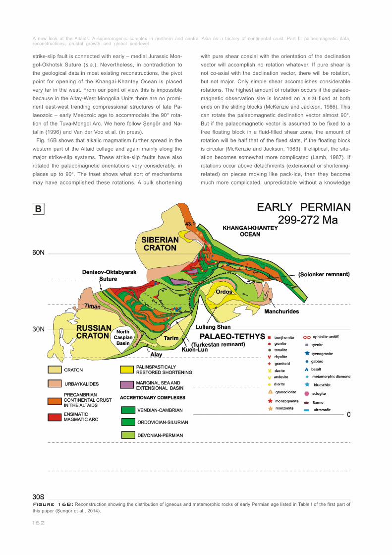
Figure 16B: Reconstruction showing the distribution of igneous and metamorphic rocks of early Permian age listed in Table I of the first part of
this paper (Şengör et al., 2014).______________________________________________________________________________________________
strike-slip fault is connected with early – medial Jurassic Mon-
gol-Okhotsk Suture (s.s.). Nevertheless, in contradiction to
the geological data in most existing reconstructions, the pivot
point for opening of the Khangai-Khantey Ocean is placed
very far in the west. From our point of view this is impossible
because in the Altay-West Mongolia Units there are no promi-
nent east-west trending compressional structures of late Pa-
laeozoic – early Mesozoic age to accommodate the 90° rota-
tion of the Tuva-Mongol Arc. We here follow Şengör and Na-
tal'in (1996) and Van der Voo et al. (in press).
Fig. 16B shows that alkalic magmatism further spread in the
western part of the Altaid collage and again mainly along the
major strike-slip systems. These strike-slip faults have also
rotated the palaeomagnetic orientations very considerably, in
places up to 90°. The inset shows what sort of mechanisms
may have accomplished these rotations. A bulk shortening
_____________
with pure shear coaxial with the orientation of the declination
vector will accomplish no rotation whatever. If pure shear is
not co-axial with the declination vector, there will be rotation,
but not major. Only simple shear accomplishes considerable
rotations. The highest amount of rotation occurs if the palaeo-
magnetic observation site is located on a slat fixed at both
ends on the sliding blocks (McKenzie and Jackson, 1986). This
can rotate the palaeomagnetic declination vector almost 90°.
But if the palaeomagnetic vector is assumed to be fixed to a
free floating block in a fluid-filled shear zone, the amount of
rotation will be half that of the fixed slats, if the floating block
is circular (McKenzie and Jackson, 1983). If elliptical, the situ-
ation becomes somewhat more complicated (Lamb, 1987). If
rotations occur above detachments (extensional or shortening-
related) on pieces moving like pack-ice, then they become
much more complicated, unpredictable without a knowledge
A new look at the Altaids: A superorogenic complex in northern and central Asia as a factory of continental crust. Part II: palaeomagnetic data, reconstructions, crustal growth and global sea-level_____________________________________________________________________________
Figure 17A: A possible late Permian reconstruction of the Altaids. Blue arrows indicate palaeomagnetic declination vectors with their tail at the
appropriate latitude. They are keyed to Table I by the red numbers near them.__________________________________________________________
of the exact geometry of the rotating blocks which requires de-
tailed geological mapping in extensive areas. In one zone of
shortening or extension, one can get rotations in both senses
simultaneously greatly complicating tectonic interpretations (e.
g., Kissel et al., 1987; Şengör, 1987). We have no reliable data
on the detailed structural geology of the wider surroundings of
the points where the palaeomagnetic observations we used
were reported from. This shows how critical it is to combine
palaeomagnetic work with structural work in a fairly extensive
area around the points of palaeomagnetic observations.
In the Tuva-Mongol double arc, the southern subduction zone
was still active, although living its last days. A lively magmatic
activity is attested by the new isotopic age dates in unit 43. 1
above a slab dipping under Siberia. Van der Voo et al. (1999
and in press) were able to image this now vanished slab by
seismic tomography under Siberia.
By the late Permian, right-lateral strike-slip displacement be-
tween the Russian and the Siberian cratons had switched to
left-lateral as mentioned above. It was concentrated mainly in
the Gornostaev Fault Zone, but affected not only the entire
Altaid collage but also the Manchurides (Fig. 17A).
The creation of the largest and deepest part of the basement
_____
______________________
_________
4.13 Late Permian (259–252 Ma: Fig. 17A
and B)
of the West Siberian Lowlands, namely the Nadym Basin,
seems related to this event (Fig. 17A). This Palaeozoic basin
of some 5 km depth is in turn overlain by 5–9 km-thick rocks
of the Mesozoic–Cainozoic Western Siberian Basin. The Na-
dym Basin was interpreted as a relict oceanic basin, taking
into consideration the great thickness of the sedimentary fill,
absence of angular unconformities throughout the Palaeozoic
and Mesozoic succession, reduced thickness of the crust, and
the absence in the crust of the so-called “granitic” layer. Na-
dym Basin and some smaller basins filled up with late Palaeo-
zoic clastic rocks intercalated with volcanics and limestones
on the trend of the Gornostaev Fault lie in a left-stepping pull-
apart geometry (Fig. 17A). These rocks are intruded by doleri-
tes and basalts. Judging from this arrangement of the basins,
the Gornostaev Fault, and the loci of the late Palaeozoic mag-
matism here, we follow Şengör et al (1993) and Şengör and
Natal'in (1996) in inferring an extensional origin for the Nadym
Basin, as well as the other smaller basins, related to strike-
slip along the Gornostaev Fault.
The left-lateral displacement along the Irtysh-Gornostaev
Keirogen had brought the two segments of northern Asia it
divided nearly to their present-day positions relative to each
another as seen in Fig. 17A. The northern end of the Irtysh-
Gornostaev Keirogen is located in the deep Nadym Basin (Fig.
17a). It is remarkable that the largest plateau basalt outpour
________________________
A. M. Celâl ŞENGÖR, Boris A. NATAL'IN, Rob van der VOO & Gürsel SUNAL
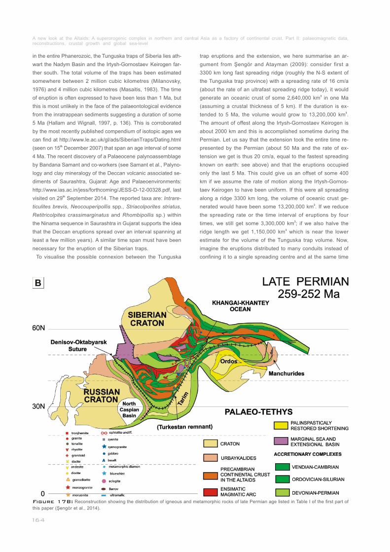
Figure 17B: Reconstruction showing the distribution of igneous and metamorphic rocks of late Permian age listed in Table I of the first part of
this paper (Şengör et al., 2014).______________________________________________________________________________________________
in the entire Phanerozoic, the Tunguska traps of Siberia lies ath-
wart the Nadym Basin and the Irtysh-Gornostaev Keirogen far-
ther south. The total volume of the traps has been estimated
somewhere between 2 million cubic kilometres (Milanovsky,
1976) and 4 million cubic kilometres (Masaitis, 1983). The time
of eruption is often expressed to have been less than 1 Ma, but
this is most unlikely in the face of the palaeontological evidence
from the inratrappean sediments suggesting a duration of some
5 Ma (Hallam and Wignall, 1997, p. 136). This is corroborated
by the most recently published compendium of isotopic ages we
can find at http://www.le.ac.uk/gl/ads/SiberianTraps/Dating.html th(seen on 15 December 2007) that span an age interval of some
4 Ma. The recent discovery of a Palaeocene palynoassemblage
by Bandana Samant and co-workers (see Samant et al., Palyno-
logy and clay mineralogy of the Deccan volcanic associated se-
diments of Saurashtra, Gujarat: Age and Palaeoenvironments:
http://www.ias.ac.in/jess/forthcoming/JESS-D-12-00328.pdf, last thvisited on 29 September 2014. The reported taxa are: Intrare-
ticulites brevis, Neocouperipollis spp., Striacolporites striatus,
Retitricolpites crassimarginatus and Rhombipollis sp.) within
the Ninama sequence in Saurashtra in Gujarat supports the idea
that the Deccan eruptions spread over an interval spanning at
least a few million years). A similar time span must have been
necessary for the eruption of the Siberian traps.
To visualise the possible connexion between the Tunguska
___________
trap eruptions and the extension, we here summarise an ar-
gument from Şengör and Atayman (2009): consider first a
3300 km long fast spreading ridge (roughly the N-S extent of
the Tunguska trap province) with a spreading rate of 16 cm/a
(about the rate of an ultrafast spreading ridge today), it would 3generate an oceanic crust of some 2,640,000 km in one Ma
(assuming a crustal thickness of 5 km). If the duration is ex-3tended to 5 Ma, the volume would grow to 13,200,000 km .
The amount of offest along the Irtysh-Gornostaev Keirogen is
about 2000 km and this is accomplished sometime during the
Permian. Let us say that the extension took the entire time re-
presented by the Permian (about 50 Ma and the rate of ex-
tension we get is thus 20 cm/a, equal to the fastest spreading
known on earth: see above) and that the eruptions occupied
only the last 5 Ma. This could give us an offset of some 400
km if we assume the rate of motion along the Irtysh-Gornos-
taev Keirogen to have been uniform. If this were all spreading
along a ridge 3300 km long, the volume of oceanic crust ge-3nerated would have been some 13,200,000 km . If we reduce
the spreading rate or the time interval of eruptions by four 3times, we still get some 3,300,000 km ; if we also halve the
3ridge length we get 1,150,000 km which is near the lower
estimate for the volume of the Tunguska trap volume. Now,
imagine the eruptions distributed to many conduits instead of
confining it to a single spreading centre and at the same time
A new look at the Altaids: A superorogenic complex in northern and central Asia as a factory of continental crust. Part II: palaeomagnetic data, reconstructions, crustal growth and global sea-level_____________________________________________________________________________
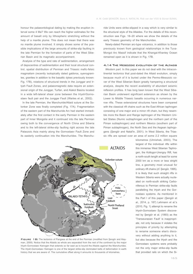
Figure 18: The tectonics of Pangaea at the end of the Permian (modified from Şengör and Atay-
man, 2009). Notice that the Altaids as whole are separated from the rest of the continent by the major
Irtysh-Gornostaev Keirogen that extends so far east as to bound the Altaids against the Manchurides.
The Irtysh-Gornostaev Keirogen is one of the largest strike-slip dominated belts of deformation in earth
history that we are aware of. The cumulative offset along it amounts to thousands of kilometres._____
honour the palaeontological dating by making the eruption in-
terval some 4 Ma? We can reach the higher estimates for the
amount of basalt only by lithospheric stretching without the
help of a mantle plume. This does not mean that there was
no mantle plume involved. It simply shows some of the pos-
sible implications of the large amounts of strike-slip faulting in
the late Permian for the formation of parts of the West Sibe-
rian Basin and its magmatic accompaniment.
Analysis of the type and rate of sedimentation, arrangement
of depocentres of sedimentation and their local structural con-
trol, spatial distribution of Permian and Triassic mafic-felsic
magmatism (recently isotopically dated gabbros, syenograni-
tes, granites in addition to the basaltic dykes previously known:
Fig. 17B), rotations of structural trends in the Junggar and Ir-
tysh Fault Zones, and palaeomagnetic data require an exten-
sional origin of the Junggar, Turfan, and Alakol Basins located
in a wide left-lateral shear zone between the Irtysh/Gorno-
staev fault pair and the Junggar Fault (Wartes et al., 2002).
In the late Permian, the Manchuride/Altaid suture at the So-
lonker Zone was finally completed (Fig. 17A). Fragmentation
of the eastern part of the Manchuride Arc had started immedi-
ately after the first contact in the early Permian in the eastern
part of Inner Mongolia and it continued into the late Permian
owing both to the convergence of North China and Siberia
and to the left-lateral strike-slip faulting right across the late
Palaozoic Asia mainly along the Gornostaev Fault Zone and
its easterly continuation into the Manchurides. The Manchu-
_____________
_
ride Units were strike-slipped in a way which is very similar to
the structural style of the Altaides. For the details of this recon-
struction see Figs. 18–20 where we show the details of the
early Triassic geometry of the Manchurides.
Newly-dated Permian arc-type volcanics, in addition to those
previously known from geological relationships in the Tuva-
Mongol Arc Massif indicate that the Khangai-Khantey Ocean
remained open as it is shown in Fig. 17B.
Western part. In this paper we do not deal with the intracon-
tinental tectonics that post-dated the Altaid evolution, simply
because much of it is buried under the Permo-Mesozoic co-
ver of the West Siberian Basin greatly hampering a structural
analysis, despite the recent availablitiy of abundant seismic
reflexion profiles. It has long been known that the West Sibe-
rian Basin underwent significant extension as shown by the
Lower to Middle Triassic basalts occurring in numerous nar-
row rifts. These extensional structures have been compared
with the classical rift chains such as the East African taphrogen
consisting of one major and a minor rift chain, but they resem-
ble more the Basin and Range taphrogen of the Western Uni-
ted States (Numic subtaphrogen and the northern part of the
Piman subtaphrogen) and northern Mexico (southern part of
Piman subtaphrogen), the North Sea and the Aegean taphrgo-
gens (Şengör and Natal'in, 2001). In West Siberia, the Trias-
sic rifts are spread over an area of some 2.2 million square
______________
________________
4.14 The Mesozoic evolution of the Altaids
kilometres (Ulmishek, 2003). The
largest of the individual rifts within
this immense West Siberian Taphro-
gen, the Koltogor-Urengoy Rift, has
a north-south length at least for some
2000 km as a more or less stright
line, a geometry most unusual for
ordinary rift chains (cf. Şengör, 1995).
It is likely that such straight rifts in
Western Siberia were actually nucle-
ated on north-south striking Carbo-
niferous to Permian strike-slip faults
parallelling the Irtysh and the Gor-
nostaev systems. As mentioned in
the Part I of this paper (Şengör et
al., 2014, p. 187) Lehmann et al.'s
(2010, Fig. 1) attempt to rename the
Irtysh-Gornostaev System discove-
red by Şengör et al. (1993) as the
'Transeurasian Fault' is inappropri-
ate, not only because it violates the
principles of priority by attempting
to rename someone else's disco-
very without adding anything to it,
but also because the Irtysh and the
Gornostaev systems were probably
not the only major strike-slip faults
that provided rails on which the Si-
A. M. Celâl ŞENGÖR, Boris A. NATAL'IN, Rob van der VOO & Gürsel SUNAL
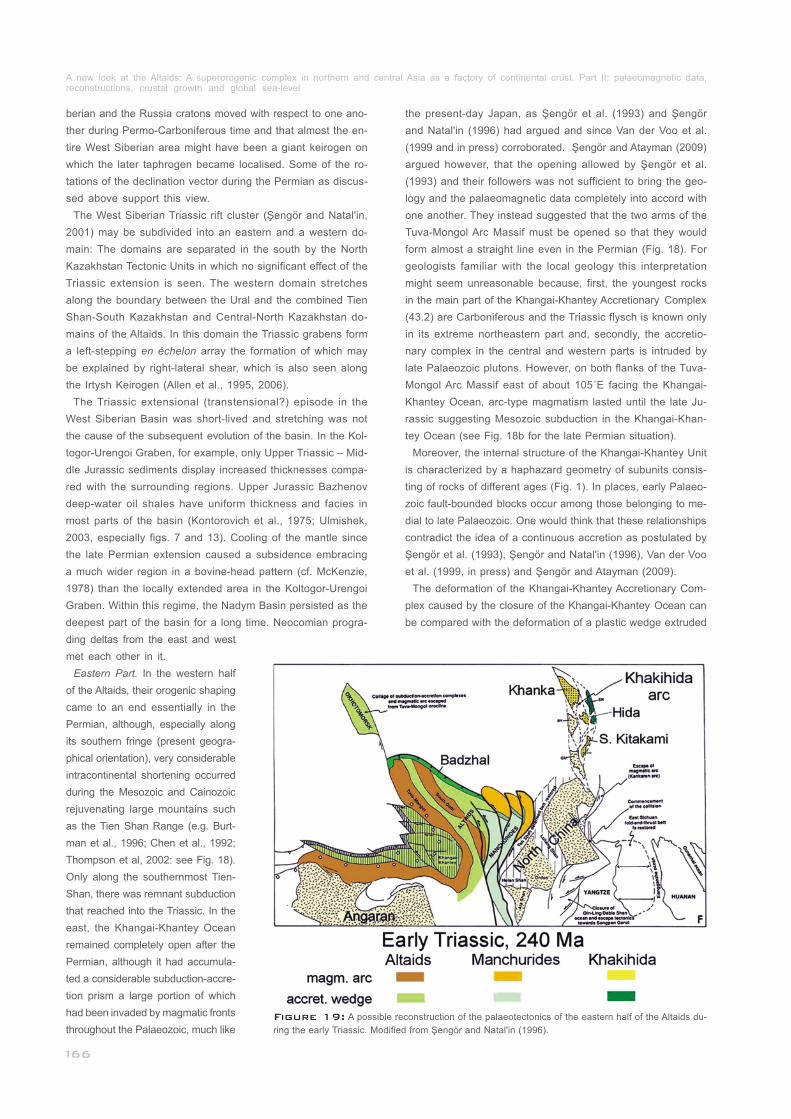
Figure 19: A possible reconstruction of the palaeotectonics of the eastern half of the Altaids du-
ring the early Triassic. Modified from Şengör and Natal'in (1996).______________________________
berian and the Russia cratons moved with respect to one ano-
ther during Permo-Carboniferous time and that almost the en-
tire West Siberian area might have been a giant keirogen on
which the later taphrogen became localised. Some of the ro-
tations of the declination vector during the Permian as discus-
sed above support this view.
The West Siberian Triassic rift cluster (Şengör and Natal'in,
2001) may be subdivided into an eastern and a western do-
main: The domains are separated in the south by the North
Kazakhstan Tectonic Units in which no significant effect of the
Triassic extension is seen. The western domain stretches
along the boundary between the Ural and the combined Tien
Shan-South Kazakhstan and Central-North Kazakhstan do-
mains of the Altaids. In this domain the Triassic grabens form
a left-stepping en échelon array the formation of which may
be explained by right-lateral shear, which is also seen along
the Irtysh Keirogen (Allen et al., 1995, 2006).
The Triassic extensional (transtensional?) episode in the
West Siberian Basin was short-lived and stretching was not
the cause of the subsequent evolution of the basin. In the Kol-
togor-Urengoi Graben, for example, only Upper Triassic – Mid-
dle Jurassic sediments display increased thicknesses compa-
red with the surrounding regions. Upper Jurassic Bazhenov
deep-water oil shales have uniform thickness and facies in
most parts of the basin (Kontorovich et al., 1975; Ulmishek,
2003, especially figs. 7 and 13). Cooling of the mantle since
the late Permian extension caused a subsidence embracing
a much wider region in a bovine-head pattern (cf. McKenzie,
1978) than the locally extended area in the Koltogor-Urengoi
Graben. Within this regime, the Nadym Basin persisted as the
deepest part of the basin for a long time. Neocomian progra-
__________________________
_____________
ding deltas from the east and west
met each other in it.
Eastern Part. In the western half
of the Altaids, their orogenic shaping
came to an end essentially in the
Permian, although, especially along
its southern fringe (present geogra-
phical orientation), very considerable
intracontinental shortening occurred
during the Mesozoic and Cainozoic
rejuvenating large mountains such
as the Tien Shan Range (e.g. Burt-
man et al., 1996; Chen et al., 1992;
Thompson et al, 2002: see Fig. 18).
Only along the southernmost Tien-
Shan, there was remnant subduction
that reached into the Triassic. In the
east, the Khangai-Khantey Ocean
remained completely open after the
Permian, although it had accumula-
ted a considerable subduction-accre-
tion prism a large portion of which
had been invaded by magmatic fronts
throughout the Palaeozoic, much like
____________
the present-day Japan, as Şengör et al. (1993) and Şengör
and Natal'in (1996) had argued and since Van der Voo et al.
(1999 and in press) corroborated. Şengör and Atayman (2009)
argued however, that the opening allowed by Şengör et al.
(1993) and their followers was not sufficient to bring the geo-
logy and the palaeomagnetic data completely into accord with
one another. They instead suggested that the two arms of the
Tuva-Mongol Arc Massif must be opened so that they would
form almost a straight line even in the Permian (Fig. 18). For
geologists familiar with the local geology this interpretation
might seem unreasonable because, first, the youngest rocks
in the main part of the Khangai-Khantey Accretionary Complex
(43.2) are Carboniferous and the Triassic flysch is known only
in its extreme northeastern part and, secondly, the accretio-
nary complex in the central and western parts is intruded by
late Palaeozoic plutons. However, on both flanks of the Tuva-
Mongol Arc Massif east of about 105˚E facing the Khangai-
Khantey Ocean, arc-type magmatism lasted until the late Ju-
rassic suggesting Mesozoic subduction in the Khangai-Khan-
tey Ocean (see Fig. 18b for the late Permian situation).
Moreover, the internal structure of the Khangai-Khantey Unit
is characterized by a haphazard geometry of subunits consis-
ting of rocks of different ages (Fig. 1). In places, early Palaeo-
zoic fault-bounded blocks occur among those belonging to me-
dial to late Palaeozoic. One would think that these relationships
contradict the idea of a continuous accretion as postulated by
Şengör et al. (1993), Şengör and Natal'in (1996), Van der Voo
et al. (1999, in press) and Şengör and Atayman (2009).
The deformation of the Khangai-Khantey Accretionary Com-
plex caused by the closure of the Khangai-Khantey Ocean can
be compared with the deformation of a plastic wedge extruded
_____
_____
A new look at the Altaids: A superorogenic complex in northern and central Asia as a factory of continental crust. Part II: palaeomagnetic data, reconstructions, crustal growth and global sea-level_____________________________________________________________________________
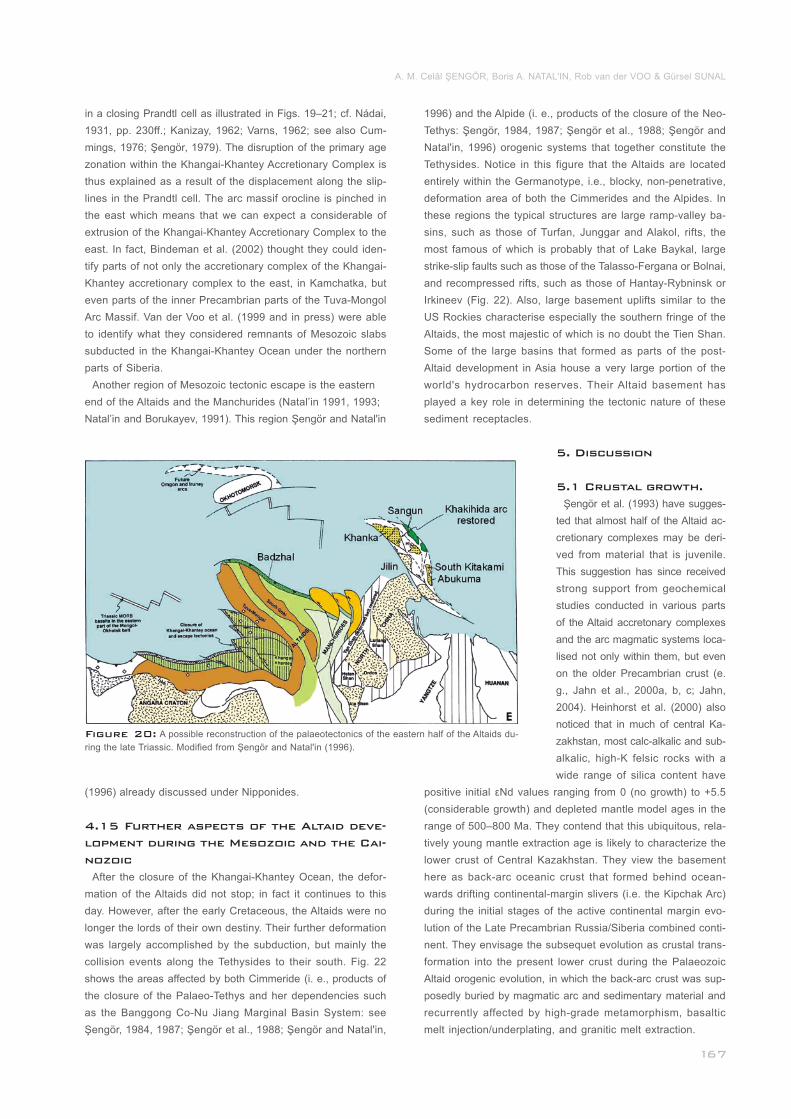
Figure 20: A possible reconstruction of the palaeotectonics of the eastern half of the Altaids du-
ring the late Triassic. Modified from Şengör and Natal'in (1996)._______________________________
in a closing Prandtl cell as illustrated in Figs. 19–21; cf. Nádai,
1931, pp. 230ff.; Kanizay, 1962; Varns, 1962; see also Cum-
mings, 1976; Şengör, 1979). The disruption of the primary age
zonation within the Khangai-Khantey Accretionary Complex is
thus explained as a result of the displacement along the slip-
lines in the Prandtl cell. The arc massif orocline is pinched in
the east which means that we can expect a considerable of
extrusion of the Khangai-Khantey Accretionary Complex to the
east. In fact, Bindeman et al. (2002) thought they could iden-
tify parts of not only the accretionary complex of the Khangai-
Khantey accretionary complex to the east, in Kamchatka, but
even parts of the inner Precambrian parts of the Tuva-Mongol
Arc Massif. Van der Voo et al. (1999 and in press) were able
to identify what they considered remnants of Mesozoic slabs
subducted in the Khangai-Khantey Ocean under the northern
parts of Siberia.
Another region of Mesozoic tectonic escape is the eastern
end of the Altaids and the Manchurides (Natal’in 1991, 1993;
Natal’in and Borukayev, 1991). This region Şengör and Natal'in
(1996) already discussed under Nipponides.
After the closure of the Khangai-Khantey Ocean, the defor-
mation of the Altaids did not stop; in fact it continues to this
day. However, after the early Cretaceous, the Altaids were no
longer the lords of their own destiny. Their further deformation
was largely accomplished by the subduction, but mainly the
collision events along the Tethysides to their south. Fig. 22
shows the areas affected by both Cimmeride (i. e., products of
the closure of the Palaeo-Tethys and her dependencies such
as the Banggong Co-Nu Jiang Marginal Basin System: see
Şengör, 1984, 1987; Şengör et al., 1988; Şengör and Natal'in,
_____________________________________
4.15 Further aspects of the Altaid deve-
lopment during the Mesozoic and the Cai-
nozoic
1996) and the Alpide (i. e., products of the closure of the Neo-
Tethys: Şengör, 1984, 1987; Şengör et al., 1988; Şengör and
Natal'in, 1996) orogenic systems that together constitute the
Tethysides. Notice in this figure that the Altaids are located
entirely within the Germanotype, i.e., blocky, non-penetrative,
deformation area of both the Cimmerides and the Alpides. In
these regions the typical structures are large ramp-valley ba-
sins, such as those of Turfan, Junggar and Alakol, rifts, the
most famous of which is probably that of Lake Baykal, large
strike-slip faults such as those of the Talasso-Fergana or Bolnai,
and recompressed rifts, such as those of Hantay-Rybninsk or
Irkineev (Fig. 22). Also, large basement uplifts similar to the
US Rockies characterise especially the southern fringe of the
Altaids, the most majestic of which is no doubt the Tien Shan.
Some of the large basins that formed as parts of the post-
Altaid development in Asia house a very large portion of the
world's hydrocarbon reserves. Their Altaid basement has
played a key role in determining the tectonic nature of these
sediment receptacles.________________________________
5. Discussion
5.1 Crustal growth.
Şengör et al. (1993) have sugges-
ted that almost half of the Altaid ac-
cretionary complexes may be deri-
ved from material that is juvenile.
This suggestion has since received
strong support from geochemical
studies conducted in various parts
of the Altaid accretonary complexes
and the arc magmatic systems loca-
lised not only within them, but even
on the older Precambrian crust (e.
g., Jahn et al., 2000a, b, c; Jahn,
2004). Heinhorst et al. (2000) also
noticed that in much of central Ka-
zakhstan, most calc-alkalic and sub-
alkalic, high-K felsic rocks with a
wide range of silica content have
positive initial εNd values ranging from 0 (no growth) to +5.5
(considerable growth) and depleted mantle model ages in the
range of 500–800 Ma. They contend that this ubiquitous, rela-
tively young mantle extraction age is likely to characterize the
lower crust of Central Kazakhstan. They view the basement
here as back-arc oceanic crust that formed behind ocean-
wards drifting continental-margin slivers (i.e. the Kipchak Arc)
during the initial stages of the active continental margin evo-
lution of the Late Precambrian Russia/Siberia combined conti-
nent. They envisage the subsequet evolution as crustal trans-
formation into the present lower crust during the Palaeozoic
Altaid orogenic evolution, in which the back-arc crust was sup-
posedly buried by magmatic arc and sedimentary material and
recurrently affected by high-grade metamorphism, basaltic
melt injection/underplating, and granitic melt extraction._____
A. M. Celâl ŞENGÖR, Boris A. NATAL'IN, Rob van der VOO & Gürsel SUNAL
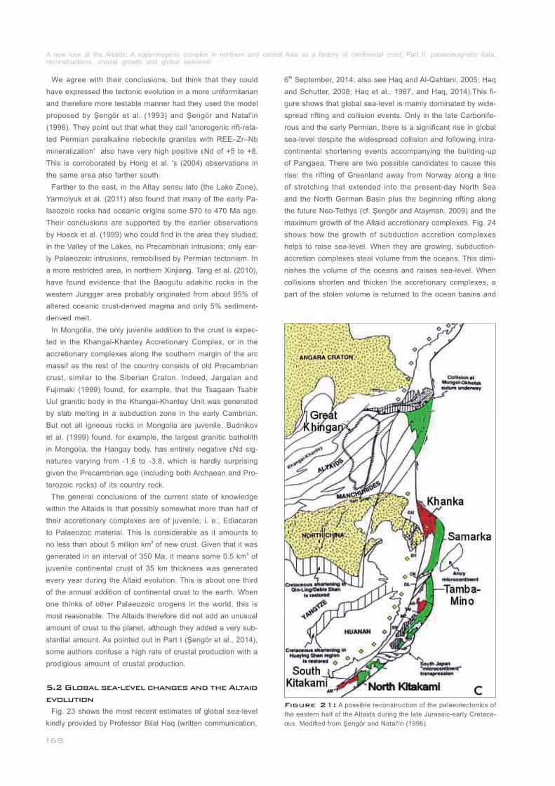
Figure 21: A possible reconstruction of the palaeotectonics of
the eastern half of the Altaids during the late Jurassic-early Cretace-
ous. Modified from Şengör and Natal'in (1996).__________________
We agree with their conclusions, but think that they could
have expressed the tectonic evolution in a more uniformitarian
and therefore more testable manner had they used the model
proposed by Şengör et al. (1993) and Şengör and Natal'in
(1996). They point out that what they call 'anorogenic rift-rela-
ted Permian peralkaline riebeckite granites with REE–Zr–Nb
mineralization' also have very high positive εNd of +5 to +8.
This is corroborated by Hong et al. 's (2004) observations in
the same area also farther south.
Farther to the east, in the Altay sensu lato (the Lake Zone),
Yarmolyuk et al. (2011) also found that many of the early Pa-
laeozoic rocks had oceanic origins some 570 to 470 Ma ago.
Their conclusions are supported by the earlier observations
by Hoeck et al. (1999) who could find in the area they studied,
in the Valley of the Lakes, no Precambrian intrusions; only ear-
ly Palaeozoic intrusions, remobilised by Permian tectonism. In
a more restricted area, in northern Xinjiang, Tang et al. (2010),
have found evidence that the Baogutu adakitic rocks in the
western Junggar area probably originated from about 95% of
altered oceanic crust-derived magma and only 5% sediment-
derived melt.
In Mongolia, the only juvenile addition to the crust is expec-
ted in the Khangai-Khantey Accretionary Complex, or in the
accretionary complexes along the southern margin of the arc
massif as the rest of the country consists of old Precambrian
crust, similar to the Siberian Craton. Indeed, Jargalan and
Fujimaki (1999) found, for example, that the Tsagaan Tsahir
Uul granitic body in the Khangai-Khantey Unit was generated
by slab melting in a subduction zone in the early Cambrian.
But not all igneous rocks in Mongolia are juvenile. Budnikov
et al. (1999) found, for example, the largest granitic batholith
in Mongolia, the Hangay body, has entirely negative εNd sig-
natures varying from -1.6 to -3.8, which is hardly surprising
given the Precambrian age (including both Archaean and Pro-
terozoic rocks) of its country rock.
The general conclusions of the current state of knowledge
within the Altaids is that possibly somewhat more than half of
their accretionary complexes are of juvenile, i. e., Ediacaran
to Palaeozoc material. This is considerable as it amounts to 2no less than about 5 million km of new crust. Given that it was
3generated in an interval of 350 Ma, it means some 0.5 km of
juvenile continental crust of 35 km thickness was generated
every year during the Altaid evolution. This is about one third
of the annual addition of continental crust to the earth. When
one thinks of other Palaeozoic orogens in the world, this is
most reasonable. The Altaids therefore did not add an unusual
amount of crust to the planet, although they added a very sub-
stantial amount. As pointed out in Part I (Şengör et al., 2014),
some authors confuse a high rate of crustal production with a
prodigious amount of crustal production.
_______________________
_______________________________________
______________________
_________________
5.2 Global sea-level changes and the Altaid
evolution
Fig. 23 shows the most recent estimates of global sea-level
kindly provided by Professor Bilal Haq (written communication,
th6 September, 2014; also see Haq and Al-Qahtani, 2005; Haq
and Schutter, 2008; Haq et al., 1987, and Haq, 2014).This fi-
gure shows that global sea-level is mainly dominated by wide-
spread rifting and collision events. Only in the late Carbonife-
rous and the early Permian, there is a significant rise in global
sea-level despite the widespread collision and following intra-
continental shortening events accompanying the building-up
of Pangaea. There are two possible candidates to cause this
rise: the rifting of Greenland away from Norway along a line
of stretching that extended into the present-day North Sea
and the North German Basin plus the beginning rifting along
the future Neo-Tethys (cf. Şengör and Atayman, 2009) and the
maximum growth of the Altaid accretionary complexes. Fig. 24
shows how the growth of subduction accretion complexes
helps to raise sea-level. When they are growing, subduction-
accretion complexes steal volume from the oceans. This dimi-
nishes the volume of the oceans and raises sea-level. When
collisions shorten and thicken the accretionary complexes, a
part of the stolen volume is returned to the ocean basins and
A new look at the Altaids: A superorogenic complex in northern and central Asia as a factory of continental crust. Part II: palaeomagnetic data, reconstructions, crustal growth and global sea-level_____________________________________________________________________________
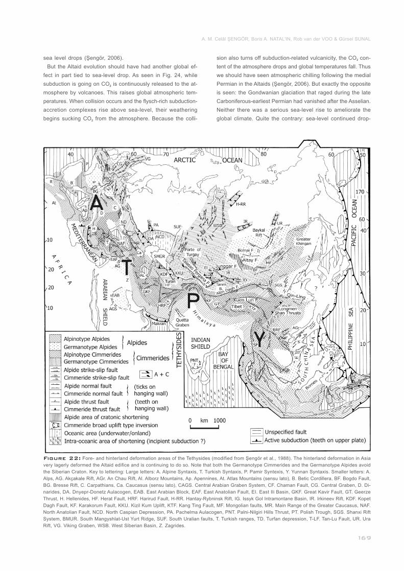
Figure 22: Fore- and hinterland deformation areas of the Tethysides (modified from Şengör et al., 1988). The hinterland deformation in Asia
very lagerly deformed the Altaid edifice and is continuing to do so. Note that both the Germanotype Cimmerides and the Germanotype Alpides avoid
the Siberian Craton. Key to lettering: Large letters: A. Alpine Syntaxis, T. Turkish Syntaxis, P. Pamir Syntexis, Y. Yunnan Syntaxis. Smaller letters: A.
Alps, AG. Akçakale Rift, AGr. An Chau Rift, Al. Alborz Mountains, Ap. Apennines, At. Atlas Mountains (sensu lato), B. Betic Cordillera, BF. Bogdo Fault,
BG. Bresse Rift, C. Carpathians, Ca. Caucasus (sensu lato), CAGS. Central Arabian Graben System, CF. Chaman Fault, CG. Central Graben, D. Di-
narides, DA. Dnyepr-Donetz Aulacogen, EAB. East Arabian Block, EAF. East Anatolian Fault, EI. East Ili Basin, GKF. Great Kavir Fault, GT. Geerze
Thrust, H. Hellenides, HF. Herat Fault, HRF. Harirud Fault, H-RR. Hantay-Rybninsk Rift, IG. Issyk Gol Intramontane Basin, IR. Irkineev Rift, KDF. Kopet
Dagh Fault, KF. Karakorum Fault, KKU. Kizil Kum Uplift, KTF. Kang Ting Fault, MF. Mongolian faults, MR. Main Range of the Greater Caucasus, NAF.
North Anatolian Fault, NCD. North Caspian Depression, PA. Pachelma Aulacogen, PNT. Palni-Nilgiri Hills Thrust, PT. Polish Trough, SGS. Shanxi Rift
System, BMUR. South Mangyshlat-Ust Yurt Ridge, SUF. South Uralian faults, T. Turkish ranges, TD. Turfan depression, T-LF. Tan-Lu Fault, UR. Ura
Rift, VG. Viking Graben, WSB. West Siberian Basin, Z. Zagrides.____________________________________________________________________
sea level drops (Şengör, 2006).
But the Altaid evolution should have had another global ef-
fect in part tied to sea-level drop. As seen in Fig. 24, while
subduction is going on CO is continuously released to the at-2
mosphere by volcanoes. This raises global atmospheric tem-
peratures. When collision occurs and the flysch-rich subduction-
accretion complexes rise above sea-level, their weathering
begins sucking CO from the atmosphere. Because the colli-2
________________________ sion also turns off subduction-related vulcanicity, the CO con-2
tent of the atmosphere drops and global temperatures fall. Thus
we should have seen atmospheric chilling following the medial
Permian in the Altaids (Şengör, 2006). But exactly the opposite
is seen: the Gondwanian glaciation that raged during the late
Carboniferous-earliest Permian had vanished after the Asselian.
Neither there was a serious sea-level rise to ameliorate the
global climate. Quite the contrary: sea-level continued drop-
A. M. Celâl ŞENGÖR, Boris A. NATAL'IN, Rob van der VOO & Gürsel SUNAL
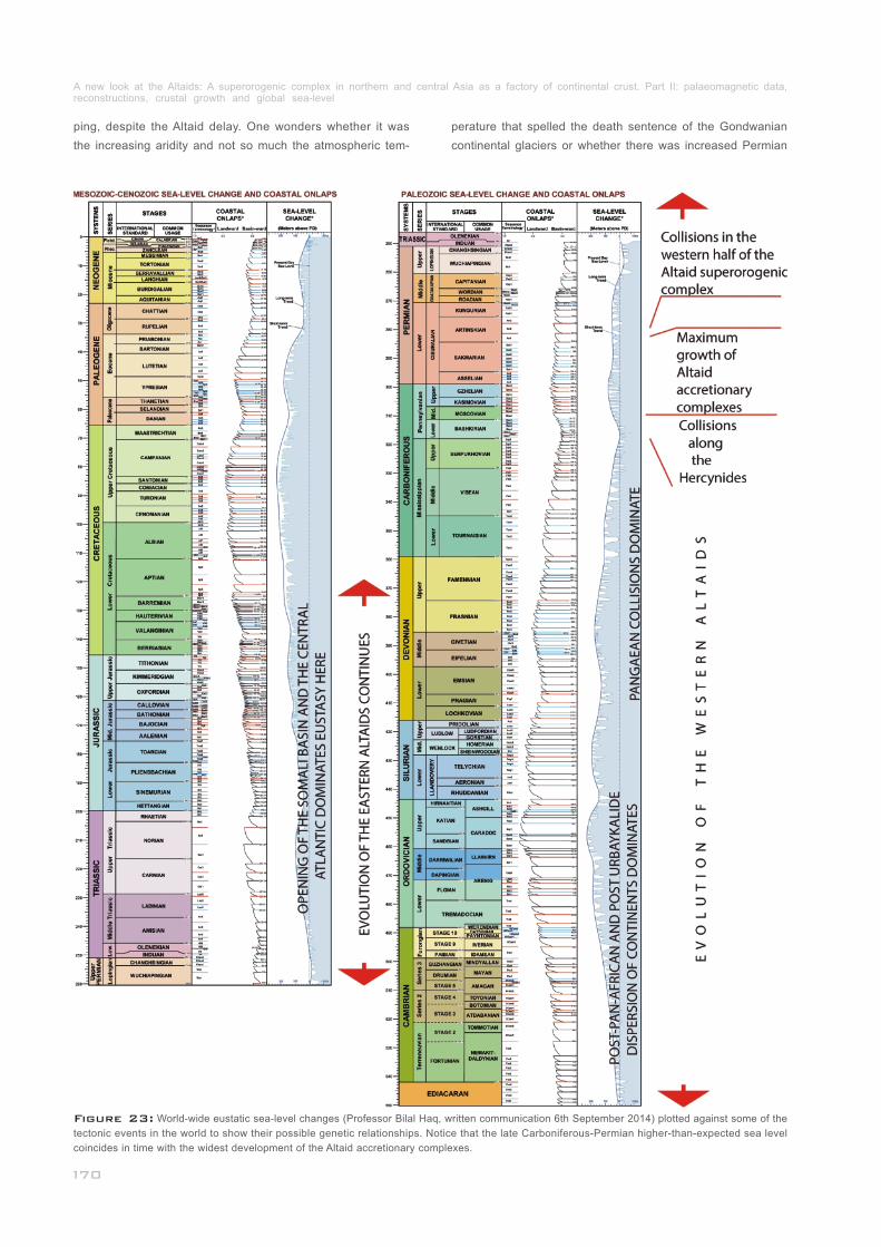
Figure 23: World-wide eustatic sea-level changes (Professor Bilal Haq, written communication 6th September 2014) plotted against some of the
tectonic events in the world to show their possible genetic relationships. Notice that the late Carboniferous-Permian higher-than-expected sea level
coincides in time with the widest development of the Altaid accretionary complexes._____________________________________________________
ping, despite the Altaid delay. One wonders whether it was
the increasing aridity and not so much the atmospheric tem-
perature that spelled the death sentence of the Gondwanian
continental glaciers or whether there was increased Permian
A new look at the Altaids: A superorogenic complex in northern and central Asia as a factory of continental crust. Part II: palaeomagnetic data, reconstructions, crustal growth and global sea-level_____________________________________________________________________________
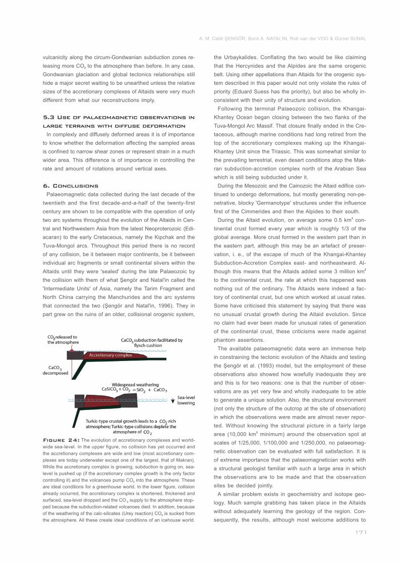
Figure 24: The evolution of accretionary complexes and world-
wide sea-level. In the upper figure, no collision has yet occurred and
the accretionary complexes are wide and low (most accretionary com-
plexes are today underwater except one of the largest, that of Makran).
While the accretionary complex is growing, subduction is going on, sea-
level is pushed up (if the accretionary complex growth is the only factor
controlling it) and the volcanoes pump CO into the atmosphere. These 2
are ideal conditions for a greenhouse world. In the lower figure, collision
already occurred, the accretionary complex is shortened, thickened and
surfaced, sea-level dropped and the CO supply to the atmosphere stop-2
ped because the subduction-related volcanoes died. In addition, because
of the weathering of the calc-silicates (Urey reaction) CO is sucked from 2
the atmosphere. All these create ideal conditions of an icehouse world.
A. M. Celâl ŞENGÖR, Boris A. NATAL'IN, Rob van der VOO & Gürsel SUNAL
vulcanicity along the circum-Gondwanian subduction zones re-
leasing more CO to the atmosphere than before. In any case, 2
Gondwanian glaciation and global tectonics relationships still
hide a major secret waiting to be unearthed unless the relative
sizes of the accretionary complexes of Altaids were very much
different from what our reconstructions imply.
In complexly and diffusely deformed areas it is of importance
to know whether the deformation affecting the sampled areas
is confined to narrow shear zones or represent strain in a much
wider area. This difference is of importance in controlling the
rate and amount of rotations around vertical axes.
Palaeomagnetic data collected during the last decade of the
twentieth and the first decade-and-a-half of the twenty-first
century are shown to be compatible with the operation of only
two arc systems throughout the evolution of the Altaids in Cen-
tral and Northwestern Asia from the latest Neoproterozoic (Edi-
acaran) to the early Cretaceous, namely the Kipchak and the
Tuva-Mongol arcs. Throughout this period there is no record
of any collision, be it between major continents, be it between
individual arc fragments or small continental slivers within the
Altaids until they were 'sealed' during the late Palaeozoic by
the collision with them of what Şengör and Natal'in called the
'Intermediate Units' of Asia, namely the Tarim Fragment and
North China carrying the Manchurides and the arc systems
that connected the two (Şengör and Natal'in, 1996). They in
part grew on the ruins of an older, collisional orogenic system,
_____________
___
_________
5.3 Use of palaeomagnetic observations in
large terrains with diffuse deformation
6. Conclusions
the Urbaykalides. Conflating the two would be like claiming
that the Hercynides and the Alpides are the same orogenic
belt. Using other appellations than Altaids for the orogenic sys-
tem described in this paper would not only violate the rules of
priority (Eduard Suess has the priority), but also be wholly in-
consistent with their unity of structure and evolution.
Following the terminal Palaeozoic collision, the Khangai-
Khantey Ocean began closing between the two flanks of the
Tuva-Mongol Arc Massif. That closure finally ended in the Cre-
taceous, although marine conditions had long retired from the
top of the accretionary complexes making up the Khangai-
Khantey Unit since the Triassic. This was somewhat similar to
the prevailing terrestrial, even desert conditions atop the Mak-
ran subduction-accretion complex north of the Arabian Sea
which is still being subducted under it.
During the Mesozoic and the Cainozoic the Altaid edifice con-
tinued to undergo deformations, but mostly generating non-pe-
netrative, blocky 'Germanotype' structures under the influence
first of the Cimmerides and then the Alpides to their south.3During the Altaid evolution, on average some 0.5 km con-
tinental crust formed every year which is roughly 1/3 of the
global average. More crust formed in the western part than in
the eastern part, although this may be an artefact of preser-
vation, i. e., of the escape of much of the Khangai-Khantey
Subduction-Accretion Complex east- and northeastward. Al-2though this means that the Altaids added some 3 million km
to the continental crust, the rate at which this happened was
nothing out of the ordinary. The Altaids were indeed a fac-
tory of continental crust, but one which worked at usual rates.
Some have criticised this statement by saying that there was
no unusual crustal growth during the Altaid evolution. Since
no claim had ever been made for unusual rates of generation
of the continental crust, these criticisms were made against
phantom assertions.
The available palaeomagnetic data were an immense help
in constraining the tectonic evolution of the Altaids and testing
the Şengör et al. (1993) model, but the employment of these
observations also showed how woefully inadequate they are
and this is for two reasons: one is that the number of obser-
vations are as yet very few and wholly inadequate to be able
to generate a unique solution. Also, the structural environment
(not only the structure of the outcrop at the site of observation)
in which the observations were made are almost never repor-
ted. Without knowing the structural picture in a fairly large 2area (10,000 km minimum) around the observation spot at
scales of 1/25,000, 1/100,000 and 1/250,000, no palaeomag-
netic observation can be evaluated with full satisfaction. It is
of extreme importance that the palaeomagnetician works with
a structural geologist familiar with such a large area in which
the observations are to be made and that the observation
sites be decided jointly.
A similar problem exists in geochemistry and isotope geo-
logy. Much sample grabbing has taken place in the Altaids
without adequately learning the geology of the region. Con-
sequently, the results, although most welcome additions to
________
___________________
__
_________________________________
______________________________
A new look at the Altaids: A superorogenic complex in northern and central Asia as a factory of continental crust. Part II: palaeomagnetic data, reconstructions, crustal growth and global sea-level_____________________________________________________________________________
our knowledge, cannot be adequately assessed in terms of
the entire evolution of the orogenic system (cf. Şengör et al.,
2014; Şengör, 2014).
The Altaid research has greatly suffered from fashion addic-
tion. There was a deplorable multiplication of mute 'terranes' in
numerous publications or an uncalled-for frenzy of age dating
with highly sophisticated methods without looking at the geo-
logy properly. Particularly, what is now most needed is careful
field mapping combined with age dating and palaeomagnetic
observations and extensive palaeontology. Funding agencies
ought to desist from funding research without a solid field basis.
________________________________
___________________________
______________
_______
________________________
__________________
References
Abrajevitch, A., Van der Voo, R., Bazhenov, M. L., Levashova,
N. M. and McCausland, P. J. A., 2008.
Abrajevitch, A., Van der Voo, R., Levashova, N. M. and Baz-
henov, M. L., 2007.
Alexyutin, M.V., Bachtadse, V., Alexeiev, D.V., and Nikitina, O.
I., 2005.
Allen, M. B., Şengör, A. M. C. and Natal'in, B. A., 1995.
Allen, M.B., Anderson, L., Searle, R.C. and Buslov, M., 2006.
Argand, E., 1928.
Audibert, M. and Bazhenov, M. L., 1992.
Babin, G. A. (ed.), 2007.
The role of the Kazakhs-
tan orocline in the late Paleozoic amalgamation of Eurasia,
Tectonophysics, 455, 61-76.
Paleomagnetic constraints on the paleo-
geography and oroclinal bending of the Devonian volcanic arc
in Kazakhstan, Tectonophysics, 441, 67-84.
Palaeomagnetism of Ordovician and Silurian rocks
from the Chu-Yili and Kendyktas Mountains, South Kazakhs-
tan. Geophysical Journal International, 162, 321-331.
Jung-
gar, Turfan, and Alakol basins as Late Permian to ?Early Tri-
assic sinistral shear structures in the Altaid orogenic collage,
Central Asia. Journal of the Geological Society of London,
152, 327-338.
Oblique rift geometry of the West Siberian Basin: tectonic set-
ting for the Siberian flood basalts. Journal of the Geological
Society, London, 163, 901-904.
Carte Tectonique de l'Eurasie. Service Géo-
logique de Belgique, Bruxelles, 1 sheet.
Permian paleomag-
netism of the North Tien Shan: Tectonic implications, Tecto-
nics, 11, 1057-1070.
Gosudarstvennay geologiheskay
karta Rossiiskoi federatsii. Mashtab 1:1 000 000 (trete poko-
lenie). Seriya Altae-Sayanskaya. List N-45 – Novokuznetsk.
Obyasnitelnaya zapiska. Kartfabrika VSEGEI, SPb, 665 pp +
10 maps.
Bachtadse, V., Pavlov, V. E., Kazansky, A. Y. and Tait, J. A.,
2000.
Badarch, G., Cunningham, W. D. and Windley, B. F., 2002.
Balla, Z., Kuzmin, M. I. and Levi, K. G., 1990.
Bazhenov, M. L., Chauvin, A., Audibert, M. and Levashova, N.
M., 1993.
Bazhenov, M. L., Collins, A. Q., Degtyarev, K. E., Levashova,
N. M., Mikolaichuk. A.V., Pavlov, V. E. and Van der Voo, R.,
2003.
Bazhenov, M. L., Grishanov, A. N., Van der Voo, R. and Leva-
shova, N. M., 2008.
Bazhenov, M. L., Levashova , N. M., Degtyarev, K. E., Van
der Voo, R., Abrajevitch, A. and McCausland, P. J. A., 2012.
Bazhenov, M. L., Van der Voo, R., Levashova, N. M. and Do-
minguez, A. R., 2013.
Bazhenov, M. L., Van der Voo, R., Meert, J, G., Levashova,
N. M. and lpatieva, I. S., 2014.
Beckinsale R. D., Reading H. G. and Rex D. C., 1975.
Berzin, N. A. and Dobretsov, N. L., 1994.
Siluro-Devonian paleomagnetic results from the Tuva
Terrane (southern Siberia, Russia): Implications for the paleo-
geography of Siberia. Journal of Geophysical Research, 105,
13,509-13,518.
A
new terrane subdivision for Mongolia: implications for the
Phanerozoic crustal growth of Central Asia. Journal of Asian
Earth Sciences, 21, pp. 87-110.
Kinematika ras-
krytiya Baikala. Getektonika, 2, 80-91.
Permian and Triassic paleomagnetism of the south-
western Tien Shan: Timing and mode of tectonic rotations.
Earth and Planetary Science Letters, 118, 195-212.
Paleozoic northward drift of the North Tien Shan (Cen-
tral Asia) as revealed by Ordovician and Carboniferous paleo-
magnetism, Tectononophysics, 366, 113-141.
Late Permian palaeomagnetic data set
east and west of the Urals. Geophysical Journal International,
173, 395-408.
Unraveling the early-middle Paleozoic paleogeography of Ka-
zakhstan on the basis of Ordovician and Devonian paleomag-
netic results, Gondwana Research, 22, 974-991.
Late Devonian palaeomagnetism of the
North Tien Shan, Kyrgyzia: Can secular variation vary on a
short time scale? Geophysical Journal International, 193, 635-
649, doi:l0.1093/gji/ggtOl l.
Late Paleozoic geomagnetic
field estimates from studies of Permian lavas in northeastern
Kazakhstan, Russian Geology and Geophysics, 55, 108-117.
Potas-
sium-argon ages for basic dykes from East Finnmark: strati-
graphical and structural implications. Scottish Journal of Geo-
logy, 12, 51-65.
Geodynamic evolu-
tion of southern Siberia in Late Precambrian-Early Paleozoic.
Coleman R. G., (ed.), Reconstruction of the Paleo-Asian oce-
an. VSP Utrecht, The Nederlands, pp. 53-70.
________________________
___________________
________
_____________
__________
_____________
A. M. Celâl ŞENGÖR, Boris A. NATAL'IN, Rob van der VOO & Gürsel SUNAL
Berzina, A.P., Berzina, A.N. and Gimon, V.O., 2011.
Bindeman, I. N., Vinogradov, V. I., Valley, J. W., Wooden, J. L.
and Natal'in, B. A., 2002.
Bogolopeva, O. K. and Gee, D. G., 2004.
Budnikov, S. V., Kovalinko, V. I., Kotov, A. B, Salnikova, E. B and
Kovach, V. P., 1999.
Burtman V.S., Scobelev S.F. and Molnar P., 1996.
Burtman, V.S., Gurary, G.Z., Belenky, A.V. and Kudasheva, I.
A., 1998.
Buslov, M.M., 2011.
Buslov, M.M., Safonova, I.Y., Fedoseev, G.S., Reichow, M.K.,
Davies, K. and Babin, G.A., 2010.
Chen, Y., Cogné, J.-P., and Courtillot, V., 1992.
Cherkasov, G. N., Sharov, G. N. and Ashurkov, B. A., 2012.
Choi, D.-L., Kim, H.-J., Jou, H.-T., Jeong, S.-K., Lee, Y.-K. and
Lee, T.-H., 2013.
Churkin, M., Jr., Soleimani, G., Carter, C. and Robinson, R.,
1981.
The Sora
porphyry Cu-Mo deposit (Kuznetsk Alatau): magmatism and
effect of mantle plume on the development of ore-magmatic
system. Russian Geology and Geophysics, 52, 1553–1562.
Archean protolith and accretion of
crust in Kamchatka: SHRIMP dating of zircons from Sredinny
and Ganal massifs. Journal of Geology, 110, 271-289.
Early Palaeozoic un-
conformity across the Timanides, NW Russia. In: Gee, D. G.
and Pease, V. (eds.), The Neoproterozoic Timanide Orogen of
Eastern Baltica, Geological Society, London, Memoirs, 30, pp.
145-157.
The ages and sources of the Hangay Batho-
lith (Central Mongolia). In Badarch, G. and Jahn, B.-M., (eds.),
Second Workshop Abstracts and Excursion Guidebook (Geotra-
verse Through A Terrane Collage in Southern Khangay), July 25-
August 3, 1999. Géosciences Sennes, Hors Série, no. 2, p. 11.
Late Ceno-
zoic slip on the Talas-Ferghana fault, Tien Shan, Central Asia.
Geological Society of America Bulletin, 108, 1004–1021.
Kazakhstan and the Altai in the Devonian: paleo-
magnetic evidence. Geotectonics, 6, 63–71.
Tectonics and geodynamics of the Cen-
tral Asian Foldbelt: the role of Late Paleozoic large-amplitude
strike-slip faults. Russian Geology and Geophysics, 52, 52-71.
Permo-Triassic plume mag-
matism of the Kuznetsk Basin, Central Asia: geology, geochro-
nology, and geochemistry. Russian Geology and Geophysics,
51, 1021-1036.
New Cretace-
ous paleomagnetic poles from the Tarim Basin, nothwestern
China. Earth and Planetary Science Letters, 114, 17–38, doi:
10.1016/0012-821X(92)90149-P.
Ne-
ftegazovyi potentsial Kuznetskogo progiba (Zapadnaya Sibir).
Geologiya i mineralno-syrevye resursy Sibiri, 9, 107-121.
Right-lateral strike-slip movement of the South
Korea Plateau associated with the opening of the East Sea
(Sea of Japan). Ocean Science Journal, 48, 59-66.
Geology of the Soviet Arctic: Kola Peninsula to Lena
River. In: Nairn, A. E. M., Churkin, M., Jr. and Stehli, F. G.
(eds.), The Ocean Basins and Margins. ,v. 5, The Arctic Ocean,
Plenum Press, New York, pp. 331-375.
_
______
____
______________
_______________________
____
________
___________________
Cocks, L.R.M. and Torsvik, T.H., 2005.
Collins, A. Q., Degtyarev, K.E., Levashova, N.M., Bazhenov,
M.L. and Van der Voo, R., 2003.
Cummings, D., 1976.
Davies, C., Allen, M.B., Buslov, M.M. and Safonova, I., 2010.
DeMets, C., Gordon, R. G. and Argus, D. F., 2010.
Didenko, A. N. and Morozov, O. L., 1999.
Dobretsov, N.L., 2003.
Dobretsov, N.L., 2011.
Dobretsov, N.L., Buslov, M.M., De Grave, J. and Sklyarov, E.V.,
2013a.
Dobretsov, N.L., Polyanskii, O.P., Reverdatto, V.V., Babichev,
A.V., 2013b.
Drachev, S.S., Malyshev, N.A., Nikishin, A.M., 2010.
Emelyanov, E. M., Litvin, V. M., Levchenko, V. A. and Marty-
nova, G.P., 1971.
Baltica from the late
Precambrian to mid-Palaeozoic times: The gain and loss of a
terrane's identity. Earth-Science Reviews, 72, 39-66.
Early Paleozoic paleomag-
netism of East Kazakhstan: Implications for paleolatitudinal
drift of tectonic elements within the Ural-Mongol Belt. Tecto-
nophysics, 377, 229-247.
Theory of plasticity applied to faulting,
Mojave Desert, southern California. Geological Society of
America Bulletin, 87, 720-724.
Deposition in the Kuznetsk Basin, Siberia: Insights into the
Permian-Triassic transition and the Mesozoic evolution of Cen-
tral Asia. Palaeogeography, Palaeoclimatology, Palaeoecology,
295, 307-322.
Geologi-
cally current plate motions. Geophysical Journal International,
181, 1-80.
Geology and paleo-
magnetism of Middle-Upper Paleozoic rocks of the Saur Ridge.
Geotectonics, 4, 326-342.
Evolution of the structures of Urals, Ka-
zakhstan, Tien Shan, and Altai-Sayan region within the Ural-
Mongolian fold belt. Russian Geology and Geophysics, 44, 5-27.
Early Paleozoic tectonics and geody-
namics of Central Asia: role of mantle plumes. Russian Geo-
logy and Geophysics, 52, 1539–1552.
Interplay of magmatism, sedimentation, and collision
processes in the Siberian craton and the flanking orogens.
Russian Geology and Geophysics, 54, 1135-1149.
Dynamics of the Arctic and adjacent petroleum
basins: A record of plume and rifting activity. Russian Geology
and Geophysics, 54, 1145-1161.
Tectonic
history and petroleum geology of the Russian Arctic Shelves:
an overview. Geological Society, London, Petroleum Geology
Conference series, 7, 591-619.
The Geology of the Barents Sea. Natural
Environment Research Council, Institute of Geological Scien-
ces, Her Majesty's Stationery Office, London, Report v. 70,
issue, 14, 15 pp.
_______
_________________________
___________________
__________
_______________________
________________________
A new look at the Altaids: A superorogenic complex in northern and central Asia as a factory of continental crust. Part II: palaeomagnetic data, reconstructions, crustal growth and global sea-level_____________________________________________________________________________
Fossum, B. J., Schmidt, W. J., Jenkins, D. A., Bogatsky, V. I.
and Rappoport, B. I., 2001.
Friberg, M., Juhlin, C., Beckholmen, M., Petrov, G.A. and
Green, A.G., 2002.
Gee, D. G.and Pease, V. (eds.), 2004a.
Gee, D. G. and Pease, V., 2004b.
Gee, D.G., 2005.
Gee, D.G., Bogolepova, O.K. and Lorenz, H., 2006.
Glasmacher, U.A., Matenaar, I., Bauer, W., Puchkov, V.N., 2004.
Glodny, J., Pease V., Montero, P., Austrheim, H., Rusin, A.I.,
2005.
Gordienko, I.V., Bulgatov, A.N., Ruzhentsev, S.V., Minina, O.
R., Klimuk, V.S., Vetluzhskikh, L.I., Nekrasov, G.E., Lastoch-
kin, N.I., Sitnikova, V.S., Metelkin, D.V., Goneger, T.A. and
Lepekhina, E.N., 2010.
Grazhdankin, D., 2004.
New frontiers for hydrocarbon
production in the Timan-Pechora Basin, Russia. In: Downey,
M. W., Threet, J. C. and Morgan, W. A., (eds.), Petroleum
Provinces of the Twenty-First Century, American Association
of Petroleum Geologists Memoir, 74, pp. 259-279.
Palaeozoic tectonic evolution of the Mid-
dle Urals in the light of the ESRU seismic experiments. Jour-
nal of the Geological Society, London 159, 295-306.
The Neoproterozoic
Timanide Orogen of Eastern Baltica, Geological Society, Lon-
don, Memoirs, 30, vi+255 pp.
The Neoproterozoic Tima-
nide Orogen of eastern Baltica: introduction: In Gee, D. G.and
Pease, V. (eds.), The Neoproterozoic Timanide Orogen of Eas-
tern Baltica, Geological Society, London, Memoirs, 30, pp. 1-3.
Timanides of Northern Russia, Encyclope-
dia of Geology. In: Selley, C. R., Cocks, L.R.M. and Plimer,
I.R. (eds.), Elsevier, Amsterdam, pp. 49-56.
The Ti-
manide, Caledonide and Uralide orogens in the Eurasian high
Arctic, and relationships to the palaeo-continents Laurentia,
Baltica and Siberia. Gelogical Society, London, Memoirs, 32,
507-520.
Diagenesis and incipient metamorphism in the western fold-
and-thrust belt, SW Urals, Russia. International Journal of Earth
Sciences, 93, 361-383.
Protolith ages of eclogites, Marun-Keu Complex, Polar
Urals, Russia; implications for the pre- and early Uralian evolu-
tion of the northeastern European continental margin. In Gee,
D. G. and Pease, V. (eds.). The Neoproterozoic Timanide oro-
geny of Eastern Baltica. Geological Society of America Memoir,
30, pp. 87-105.
The Late Riphean–Paleozoic history
of the Uda–Vitim island arc system in the Transbaikalian sec-
tor of the Paleoasian ocean. Russian Geology and Geophy-
sics, 51, 461-481.
Late Neoproterozoic sedimentation in
the Timan foreland. In: Gee, D. G. and Pease, V. (eds.), The
Neoproterozoic Timanide Orogen of Eastern Baltica, Geologi-
cal Society, London, Memoirs, 30, pp. 37-46.
_________
_______
__________________________
______________
________________________________
_____________
Grishin, D.V., Pechersky, D.M., and Degtyarev, K.E., 1997.
Gustavson Associates, Inc., 1992.
Hallam, A. and Wignall, P.B., 1997.
Hambrey, M. J., 1988.
Haq, B.U. and Schutter, S.R., 2008.
Haq, B.U., 2014.
Haq, B.U. and Al-Qahtani, A.M. 2005.
Haq, B.U., Hardenbol, J. and Vail, P.R., 1987.
Heinhorst, J., Lehmann, B., Ermolov, P., Serykh, V. and Zhu-
rutin, S., 2000.
Hetzel, R., 1999.
Hetzel, R. and Glodny, J., 2002.
Hoeck, V., Frank, W., Hejl, E. and Furtmueller, G., 1999.
Hong, D. W., Zhang, J. S., Wang, T., Wang, S.G. and Xie, X.
L., 2004.
Pa-
leomagnetism and reconstruction of Middle Paleozoic structure
of Central Kazakhstan. Geotectonics, 1, 71–81.
Petroleum Geology and
Exploration Potential in the Former Soviet Republics. Gustav-
son Associates, Boulder, Colorado, not consecutively pagina-
ted+ two foldout maps in pocket.
Mass Extinctions and Their
Aftermath. Oxford University Press, Oxford, 230 p.
Late Proterozoic stratigraphy of the Ba-
rents Shelf. In: Harland, W. B. and Dowdeswell, E. K. (eds.),
Geological Evolution of the Barents Shelf Region, Graham &
Trotman, London, pp. 49-72.
A Chronology of Paleo-
zoic Sea-Level Changes. Science, 322, 64-68.
Cretaceous Eustasy Revisited. Global and
Planetary Change, 113, 44-58.
Phanerozoic Cycles of
Sea-level Change on the Arabian Platform. GeoArabia, 10,
127-160.
Chronology of
Fluctuating Sea Levels since the Triassic. Science. 235, 1156-
1167.
Paleozoic crustal growth and metallogeny of
Central Asia: evidence from magmatic-hydrothermal ore sys-
tems of central Kazakhstan: Tectonophysics, 328, 69-87.
Geology and geodynamic evolution of the
high-P/low-T Maksyutov Complex, southern Urals, Russia.
Geologische Rundschau, 87, 577-588.
A crustal-scale, orogen-pa-
rallel strike-slip fault in the Middle Urals: age, magnitude of
displacement, and geodynamic significance. International
Journal of Earth Sciences, 91, 231-245.
Pe-
trology and cooling history of the Mt. Ushgoeg Range (Cen-
tral Mongolia). In: Badarch, G. and Jahn, B.-M. (eds.), Second
Workshop Abstracts and Excursion Guidebook (Geotraverse
Through A Terrane Collage in Southern Khangay), July 25-
August 3, 1999: Géosciences Sennes, Hors Série, no. 2, pp.
35-37.
Continental crustal growth and the supercontinental
cycle: evidence from the Central Asian Orogenic Belt. Journal
of Asian Earth Sciences, 23, 799-813.
____________
_______________________
_________
___________________________
___________
_________________________
___
__________________
_________________
___________________
A. M. Celâl ŞENGÖR, Boris A. NATAL'IN, Rob van der VOO & Gürsel SUNAL
Hsü, K.J., Yao Yongyun, Li Jiliang, and Wang Q.-C., 1992.
Huang, B. C., Otofuji, Y., Zhu, R., Shi, R. and Wang, Y., 2001.
Ilyin, A.V. and Ratnikova, G.I., 1981.
Inger, S., Scott, R.A., Golionko, B.G., 1999.
Ivanova, N.M., Sakulina, T.S., Belyaev, I.V., Matveev, Y.I. and
Roslov, Y.V., 2011.
Jahn, B.-M., 2004.
Jahn, B.-M., Wu, F.Y. and Chen, B., 2000a.
Jahn, B.M., Wu, F. and Chen, B., 2000b.
Jahn, B.-M., Wu, F.Y. and Hong, D. W., 2000c.
Jargalan, S. and Fujimaki, H., 1999.
Jian, P., Kröner, A., Windley, B.F., Shi, Y., Zhang, F., Miao, L.,
Tomurhuu, D., Zhang, W., Liu, D., 2010.
Geology of the Beishan Mountains and the tectonic evolution
of Northwest China. Eclogae geologicae Helvetiae, 85, 213-
225.
Paleomagnetism of Carboniferous sediments in the Hexi Cor-
ridor: Its origin and tectonic implications. Earth Planetary Sci-
ence Letters, 194, 135-149.
Primary, bedded, struc-
tureless phosphorite of the Khubsugul Basin, Mongolia. Jour-
nal of Sedimentary Research, 51, 1215-1222.
Tectonic evolution
of the Taimyr Peninsula, northern Russia: Implications for arc-
tic continental assembly. Journal of the Geological Society,
London, 156, 1069-1072.
Depth model of the Barents and Kara seas
according to geophysical surveys results. Geological Society,
London, Memoirs, 35, 209-221.
The Central Asian Orogenic Belt and growth
of the continental crust in the Phanerozoic. In: Malpas, J., Flet-
cher, C. J. N., Ali, J. R and Aitchison, J. C. (eds.), Aspects of
the tectonic Evolution of China. Geological Society (London)
Special Publications, 226, pp. 73-100.
Massive granitoid
generation in central Asia: Nd isotope evidence and implica-
tion for continental growth in the Phanerozoic, Episodes, 23,
82-92.
Granitoids of the
Central Asian Orogenic Belt and continental growth in the
Phanerozoic: Transactions of the Royal Society of Edinburgh:
Earth Sciences, 91, 181-193.
Important crus-
tal growth in the Phanerozoic: Isotopic evidence of granitoids
from east-central Asia. Journal of Earth System Science, 109,
5-20.
Major and trace element
characteristics of granitic body of Tsagaan Tsahir Uul area,
Mongolia. In: Badarch, G. and Jahn, B.-M. (eds.), Second
Workshop Abstracts and Excursion Guidebook (Geotraverse
Through A Terrane Collage in Southern Khangay) July 25-
August 3, 1999. Géosciences Sennes, Hors Série, no. 2, pp.
47-55.
Zircon ages of the
Bayankhongor ophiolite melange and associated rocks: Time
constraints on Neoproterozoic to Cambrian accretionary and
collisional orogenesis in Central Mongolia. Precambrian Re-
search, 177, 162-180.
___________________________
_____________
________________________
___________________
__________________________
Jolivet, L., Shibuya, H. and Fournier, M., 1995.
Jolivet, L., Tamaki, K. and Fournier, M., 1994.
Kanizay, S.P., 1962.
Karpukhina, E.V., Pervov, V.A., Zhuravlev, D.Z. and Lebedev,
V.A., 1999.
Kazansky, A. Y., Buslov, M. M. and Metelkin, D. V., 1998.
Kazansky, A. Y., Kungurtsev, L. V. and Matasova, G. G., 1996.
Khain, V. E., 1985.
Khomentovskv, V.V., 2002.
Khomentovsky, V.V., 1996.
Khomentovsky, V.V., 2007.
Kissel, C., Laj, C., Şengör, A. M. C. and Poisson, A., 1987.
Klishevich, V. L. and Khramov, A. N., 1993.
Kochnev, B.B., Nagovitsin, K.E. and Faizullin, M.S., 2007.
Paleomagnetic
rotations and the Japan Sea opening. In: Taylor, B. and Nat-
land, J. (eds.), Active Margins and Marginal Basins of the Wes-
tern Pacific. Geophysical Monograph, 88, American Geophy-
sical Union, Washington, D. C., pp. 355-369.
Japan Sea, ope-
ning history and mechanism: a synthesis. Journal of Geophy-
sical Research, 99, 22,237-22,259.
Mohr’s theory of strength and Prandtl’s
compressed cell in relation to vertical tectonics. Geological
Survey Professional Paper 414-B, 1-16.
The age of maficultramafic magmatism on the wes-
tern slope of the Urals: first Sm–Nd and Rb–Sr data. Doklady
Akademii Nauk, 369A, 1384–1386.
Evo-
lution of Paleozoic structure of Gorny Altai: Correlation of pa-
leomagnetic and geologic data. Russian Geology and Geo-
physics, 39, 303-314.
Paleomagnetism of Cambrian island-arc complexes of north
of Gorny Altai. In: Paleomagnetism and rock magnetism,
UIPhERAN, Moscow, pp. 46-49 (in Russian, cited in Sennikov
et al., 2004).
Geology of the USSR—First Part. Old Cra-
tons and Paleozoic Fold Belts. Gebrüder Borntraeger, Berlin,
VIII+272 pp.
Baikalian of Siberia (850-650 Ma).
Russian Geology and Geophysics, 43, 313-333.
Event base of the Neoproterozoic
stratigraphic chart of Siberia and China. Russian Geology and
Geophysics, 37, 43-56.
The Upper Riphean of the Yenisei
Range. Russian Geology and Geophysics, 48, 711-720.
Paleomagnetic evidence for rotation in opposite senses of
adjacent blocks in northeastern Aegea and Western Anatolia.
Geophysical Research Letters, 14, 907-910.
Reconstruction of
the Turkestan paleoocean (southern Tien Shan) for the Early
Devonian. Geotektonika, 4, 66-75. (In Russian).
The
Baikalian and Vendian sequences in the Lower Angara area
(southwestern Siberian Platform). Russian Geology and Geo-
physics, 48, 933-940.
______________
______________________
_________________
______________________
___________
____
______________
___________

A new look at the Altaids: A superorogenic complex in northern and central Asia as a factory of continental crust. Part II: palaeomagnetic data, reconstructions, crustal growth and global sea-level_____________________________________________________________________________
Kontorovich, A. E., Nesterov, I. I., Salmanov, F. K., Surkov, V.
S., Trofimuk, Y. G. and Ervye, Y. G., 1975.
Kontorovich, V.A., 2011.
Koroteev, V. A., Boorder, H. D., Necheukhin, V. M., Sazonov,
V. N., 1997.
Kovach, V.P., Jian, P., Yarmolyuk, V.V., Kozakov, I.K., Liu, D.,
Terent’eva, L.B., Lebedev, V.I. and Kovalenko, V.I., 2005.
Kovalenko, D. V., 2010.
Kovalenko, D. V., Yarmolyuk, V. V., Kovach, V. P., Kozakov, I.
K., Salnikova, E. B. and Larin, A. M., 2004.
Kozlovsky E.A. (ed.) 1988.
Kravchinsky, V. A., Cogne, J.-P., Harbert , W. P. and Kuzmin, M.
I., 2002.
Kravchinsky, V. A., Konstantinov, K. M. and Cogné, J.-P., 2001.
Kravchinsky, V.A., Sklyarov, E.V., Gladkochub, D.P. and Har-
bert, W.P., 2010.
Kröner, A., Hegner, E., Lehmann, B., Heinhorst, J., Wingate,
M. T. D., Liu, D. Y. and Ermelov, P., 2008.
Geologiya nefti i
gaza Zapadnoy Sibiri (Oil and gas geology of Western Sibe-
ria). Nedra, Moscow, 680 p.
The tectonic framework and hydro-
carbon prospectivity of the western Yenisei–Khatanga regio-
nal trough. Russian Geology and Geophysics, 52, 804-824.
Geodynamic setting of the mineral deposits of
the Urals. Tectonophysics, 276, 291-300.
Mag-
matism and Geodynamics of Early Stages of the Paleoasian
Ocean Formation: Geochronological and Geochemical Data on
Ophiolites of the Bayan-Khongor Zone. Doklady Earth Scien-
ces, 404, 1072-1077.
Paleomagnetism of late Paleozoic,
Mesozoic, and Cenozoic rocks in Mongolia, Russian Geo-
logy and Geophysics, , 51, 387- 403.
Isotope provinces,
mechanism of generation and sources of the continental crust
in the central Asian mobile belt: geological and isotopic evi-
dence. Journal of Asian Earth Sciences, 23, 605-627.
Geologiya zony BAM. T. 1. Geolo-
gicheskaya struktura (Geology of the Baykal-Amur railroad re-
gion. Vol. 1, Geological structure). Nedra, Leningrad, p. 443.
Evolution of the Mongol Okhotsk Ocean as constrained
by new palaeomagnetic data from the Mongol-Okhotsk suture
zone, Siberia, Geophysical Journal International, 148, 34-57.
Palaeomagnetic study of Vendian and Early Cambrian rocks of
South Siberia and Central Mongolia: was the Siberian platform
assembled at this time? Precambrian Research, 110, 61-92.
Paleomagnetism of the Precambrian Eastern
Sayan rocks: Implications for the Ediacaran–Early Cambrian
paleogeography of the Tuva-Mongolian composite terrane.
Tectonophysics, 486, 65-80.
Palaeozoic arc
magmatism in the Central Asian Orogenic Belt of Kazakhstan:
SHRIMP zircon ages and whole-rock Nd isotopic systematics.
Journal of Asian Earth Sciences, 32, 118-130.
_
________________
_________________________________
___________________
______
__
____________
Kröner, A., Kovach, V., Belousova, E., Hegner, E., Armstrong,
R., Dolgopolova, A., Seltmann, R., Alexeiev, D. V., Hoffmann,
J. E., Wong, J., Sun, M., Cai, K., Wang, T., Tong, Y., Wilde, S.
A., Degtyarev, K. E. and Rytsk, E., 2014.
Kröner, A., Windley, B. F., Badarch, G., Tomurtogoo, O., Heg-
ner, E., Jahn, B. M., Gruschka, S., Khain, E. V., Demoux, A.
and Wingate, M. T. D., 2007.
Kuzmichev, A. B., Bibikova, A. B. and Zhuraviev, D. Z., 2001.
Kuzmichev, A., Kröner, A., Hegner, E., Dunyi, L. and Yusheng,
W., 2005.
Kuzmichev, A.B., Paderin, I.P. and Antonov, A.V., 2008.
Kuznetsov, N.B., Natapov, L.M., Belousova, E.A., O`Reilly, S.
Y. and Griffin, W.L., 2010.
Lallemand, S. and Jolivet, L., 1985.
Lamb, S. H., 1987.
Larionov, A. N., Andreichev, V. A. and Gee, D. G., 2004.
Laurent-Charvet, S., Charvet, J., Monié, P. and Shu, L., 2003.
Laurent-Charvet, S., Charvet, J., Shu, L., Ma, R. and Lu, H.,
2002.
Reassessment of
continental growth during the accretionary history of the Cen-
tral Asian Orogenic Belt. Gondwana Research, 25, 103-125.
Accretionary growth and crust
formation in the Central Asian Orogenic Belt and comparison
with the Arabian-Nubian shield. Geological Society of America
Memoirs, 200, 181-209.
Neoproterozoic (∼800 Ma) orogeny in the Tuva-Mongolia Mas-
sif (Siberia): island arc-continent collision at the northeast Ro-
dinia margin. Precambrian Research, 110, 109-126.
The Shishkhid ophiolite, northern Mongolia: A key
to the reconstruction of a Neoproterozoic island-arc system in
central Asia. Precambrian Research, 138, 125-150.
Late Ri-
phean Borisikha ophiolite (Yenisei Ridge): U-Pb zircon age and
tectonic setting. Russian Geology and Geophysics, 49, 883-893.
Geochronological, geochemical and
isotopic study of detrital zircon suites from late Neoproterozoic
clastic strata along the NE margin of the East European Cra-
ton: Implications for plate tectonic models. Gondwana Re-
search, 17, 583-601.
Japan Sea: a pull-apart
basin? Earth and Planetary Science Letters, 76, 375-389.
A model for tectonic rotations about a ver-
tical axis: Earth and Planetary Science Letters, 84, 75-86.
The
Vendian alkaline igneous suite of northern Timan: ion micro-
probe U-Pb zircon ages of gabbros and syenite. In: Gee, D.
G. and Pease, V. (eds.), The Neoproterozoic Timanide Oro-
gen of Eastern Baltica. Geological Society, London, Memoirs,
30, pp. 69-74.
Late Paleozoic strike-slip shear zones in eastern central Asia
(NW China): New structural and geochronological data. Tecto-
nics, 22, 1009, doi: 1010.1029/2001TC901047.
Palaeozoic late collisional strike-slip deformations in
Tianshan and Altay, Eastern Xinjiang, NW China. Terra Nova,
14, 249-256.
________
________
___
__
____________
A. M. Celâl ŞENGÖR, Boris A. NATAL'IN, Rob van der VOO & Gürsel SUNAL
Leech, M. L. and Willingshofer, E., 2004.
Lehmann, J., Schulmann, K., Lexa, O., Corsini, M., Kröner A.,
Štípská, P., Tomurhuu D. and Otgonbator, D., 2010.
Lennykh, V. I., Valizer, P.M., Beane, R., Leech, M., Ernst, W.
G., 1995.
Levashova, N. M., Degtyarev, K. E., Bazhenov, M. L., Collins,
A. Q. and Van der Voo, R., 2003a.
Levashova , N. M., Degtyarev, K. E., Bazhenov, M. L., Collins,
A. Q. and Van der Voo, R., 2003b.
Levashova , N. M., Mikolaichuk, A. V., McCausland , P. J. A.,
Bazhenov, M. L. and Van der Voo, R., 2007.
Levashova, N.M., Voo, R.V.d., Abrajevitch, A.V. and Bazhenov,
M.L., 2009.
Lindquist, S., 1999.
Litvinova, T.P., 2000.
Lorenz, H., Pystin, A. M., Olovyanishnikov, V.G. and Gee, D.
G., 2004.
Thermal modeling of
the UHP Maksyutov Complex in the south Urals. Earth and
Planetary Science Letters, 226, 85-99.
Structu-
ral constraints on the evolution of the Central Asian Orogenic
Belt in Southern Mongolia. American Journal of Science, 310,
575–628.
Petrotectonic evolution of the Maksyutow Complex,
southern Urals, Russia: implications for ultra-high-pressure
metamorphism. International Geology Review, 37, 584–600.
Permian palaeomagnetism
of East Kazakhstan and the amalgamation of Eurasia, Geo-
physical Journal International, 152, 677-687.
Middle Paleozoic paleo-
magnetism of East Kazakhstan: Post-Middle Devonian rota-
tions in a large-scale orocline in the Ural-Mongol Belt Tecto-
nophysics, 377, 249-268.
Devonian paleo-
magnetic results from the North Tien Shan and their implica-
tions for the paleogeography of Kazakhstan's tectonic units
with respect to Baltica, Earth and Planetary Science Letters,
257, 104-120.
Paleomagnetism of mid-Paleozoic subduction-
related volcanics from the Chingiz Range in NE Kazakhstan:
The evolving paleogeography of the amalgamating Eurasian
composite continent. Geological Society of America Bulletin,
121, 555-573.
The Timan-Pechora Basin Province of North-
west Arctic Russia: Domanik — Paleozoic Total Petroleum Sys-
tem: U. S. Geological Survey, Open-File Report, 99-50-G, 40 pp.
Karta anomalnogo magnitnogo polya
(ΔTa)a Rossii, sopredelnyx gosudarstv (v granitsax byvshego
SSSR) I prilegayuschikh akvatorii. Epokha 1964. Massstab
1:5 000 000,4 sheets. Sankt-Peterburgskaya Kartografiches-
kaya fabrika VSEGEI, Sankt-Peterburg.
Neoproterozoic high-grade metamorphism of the
Kanin Peninsula, Timanide Orogen, northern Russia.In: Gee,
D. G. and Pease, V., (eds.), The Neoproterozoic Timanide Oro-
gen of Eastern Baltica. Geological Society, London, Memoirs,
30, pp. 59-68.
__________________
_
______________
__________________
Lybutsov V.V., Negrutsa V.Z. and Predovsky, A.A., 1991.
Marinov, N. A., Zonenshain, L. P. and Blagonravov, V. A., 1973.
Masaitis, V.L., Moskaleva, V.N., Rumyantseva, N.A., 1983.
Maslov, A. V., 2004.
McKenzie, D. and Jackson, J., 1983.
McKenzie, D. P. and Jackson, J., 1986.
McKenzie, D., 1978.
Melnikov, A., Travin, A., Plotnikov, A., Smirnova, L. and Theu-
nissen, K., 1998.
Merkulov, V. P.,1982.
Metelkin D. V., Gordienko, I.V., Vetluzhskikh, L. I. and Mik-
haltsov, N. E., 2013.
Metelkin, D. V., Kazansky, A. Y . and Kungurtsev, L. V., 2000.
Metelkin, D.V., 2013.
Up-
per Proterozoic sedimentary rocks of the Kola coast of the
Barents Sea. (A guidebook to typical sections of the Kildin
Island, Rybachiy and Sredniy Peninsular, Bolshoy Aynov and
Kheynya Islands). Kola Science Centre, USSR Acad. Sci.,
Apatity, 1991, 53 p.
Geologiya Mongolskoi Narodnoi Respubliki, vol. 1. Stratigra-
fiya. Nedra, Moscow, 584 pp.
Magmatic formations. Nedra, Leningrad. 259 p.
Riphean and Vendian sedimentary se-
quences of the Timanides and Uralides, the eastern periphery
of the East European Craton. In: Gee, D. G. and Pease, V.
(eds.), The Neoproterozoic Timanide Orogen of Eastern Bal-
tica. Geological Society, London, Memoirs, 30, pp. 19-35.
The relationship be-
tween strain rates, crustal thickening, palaeomagnetism, finite
strain and fault movements in a deforming zone. Earth and
Planetary Science Letters, 65, 182-202.
A block model of dis-
tributed deformation in faulting. Journal of the Geological So-
ciety, London, 143, 349-353.
Some remarks on the development of sedi-
mentary basins. Earth and Planetary Science Letters, 40, 25-32.
Kinematics and Ar/Ar geochronology of the
Irtysh Shear zone in the NE Kazakhstan.In: Jahn, B.M. and
Hong, D.W. (eds.), IGCP 420. Int. Union of Geol. Sci., Otta-
wa, Ont., Canada, p. 60.
Paleomagnetic investigation of Upper
Proterozoic and Cambrian strata of eastern slope of Kuznetsky
Alatau. PhD thesis, Tomsk, 239 pp. (In Russian, cited in Sen-
nikov et al., 2004).
Geology and paleomagnetism of the
Vendian and Lower Cambrian deposits from Argun Terrane (E
Transbaikalia). Doklady Rossiskaya Akademia Nauk, Earth
Sciences, 449, 284-289.
Kuznetsky Alatau structure in Middle-Late Cambrian based
from paleomagnetic data. Russian Geology and Geophysics,
41, 772-784.
Kinematic reconstruction of the Early
Caledonian accretion in the southwest of the Siberian paleo-
continent based on paleomagnetic results. Russian Geology
and Geophysics, 54, 381-398.
__________________________
___________
__
_________________
_________________________

A new look at the Altaids: A superorogenic complex in northern and central Asia as a factory of continental crust. Part II: palaeomagnetic data, reconstructions, crustal growth and global sea-level_____________________________________________________________________________
Metelkin, D.V., Vernikovsky, V.A. and Kazansky, A.Y., 2011.
Metelkin, D.V., Vernikovsky, V.A., Kazansky, A.Y., Bogolepova,
O.K. and Gubanov, A.P., 2005.
Milanovskiy, Y.Y., 1976.
Milanovsky, E. E., 1987.
Mitrofanov, F.P. and Kozakov, I. K., 1993.
Natal'in, B.A., 1991.
Natal'in, B.A., 1993.
Natal'in, B.A., 2011.
Natal'in, B.A. and Borukayev, C. B., 1991.
Natal'in B.A., Popeko L.I. and Chobotov S.A., 1985.
Natal'in, B., Sunal, G., Satır, M. and Toraman, E., 2012.
Nie, S., Van der Yoo, R., Li, M. and Rowley, D. B., 1993.
Nozhkin, A.D., Postnikov, A.A., Nagovitsin, K.E., Travin, A.V., Sta-
nevich, A.M. and Yudin, D.S., 2007.
Olovyanishnikov, V.G., 1998.
Parfenov, L. M. and Kuzmin, M. I., 2001.
Si-
beria - from Rodinia to Eurasia. In: Closson, D. (ed.), Tecto-
nics. In Tech, Rijeka, Croatia, p. 103–136.
Paleozoic history of the Kara
microcontinent and its relation to Siberia and Baltica: Paleo-
magnetism, paleogeography and tectonics. Tectonophysics,
398, 225-243.
Rift zones of the geologic past and
their associated formations. International Geology Review, 18,
619–639.
Riftogenez v Istorii Zemli. Riftogenez
v Podvijnih Poyasakh: Nedra, Moscow, 298 p.
Precambrian in youn-
ger fold belts. In: Rundquist, D. V. and Mitrofanov, F.P. (eds.),
Precambrian Geology of the USSR. Developments in Precam-
brian Geology, vol. 9, Elsevier, Amsterdam, pp. 443-498.
Mezozoiskaya akkretsionnaya i kollizion-
naya tektonika yuga Dalnego Vostoka. Tikhookeanskaya Geo-
logiya, no. 5, pp. 3-23.
History and modes of Mesozoic accretion
in Southeastern Russia. The Island Arc, 2, 15-34.
Edvard Züss i Russkiye Geologii. Geody-
namica et Tectonophysica, 2, 289–323.
Mesozoic sutures
in the Far East south. Geotektonika, 1, 84-96.
Tekto-
nika zapadno Dzhagdinskoy zony Mongolo-Okhotskoy sklad-
chatoy sistemy. Tikhookeanskaya Geologiya, 2, 49-64.
Tec-
tonics of the Strandja Massif, NW Turkey: History of a Long-
Lived Arc at the Northern Margin of Palaeo-Tethys. Turkish
Journal of Earth Sciences, 21, 755-798.
Pa-
leomagnetism of late Paleozoic rocks in the Tianshan, north-
western China, Tectonics, 12, 568-579.
Neoproterozoic Chingasan
Group in the Yenisei Ridge: new data on age and deposition en-
vironments. Russian Geology and Geophysics, 48, 1015-1025.
Upper Precambrian of Timan and
Kanin Peninsula Komi Science Centre, RAS, Ural Division,
Syktyvkar, p. 1004–1021.
Tektonika, Geodina-
mika i Metallogeniya Territorii Respubliki Sakh (Yakhutiya).
Moscow, MAIK “Interperiodika”, 571 pp.
________________
____________
_____
__________
__________________
_____________
______
_________________
__________________
__________________
Parrish, J.T., 1987.
Pease, V. and Scott, R.A., 2009.
Pease, V. and Vernikovsky, V., 2000.
Pease, V., 2011.
Pease, V., Dovzhikova, E., Beliakova, L.and Gee, D.G., 2004.
Pease, V., Gee, D.G., Vernikovsky, V., Vernikovskaya, A. and
Kireev, S., 2001.
Petrov, O.V., Morozov, A.F., Lipin, A.V., Kolesnikov, V.I., Litvi-
nova, T.P., Myasnikov, F.V., Erinchek, Y.M. and Kaminsky,
V.D., 2004.
Pisarevsky, S. A., Gladkochub, D. P., Donskaya, T. A., DeWaele,
B. and Mazukabsov, A. M., 2006.
Popper, K. R., 1994.
Puchkov, V., 2002.
Roberts, D. and Olovyanishnikov, V., 2004.
Palaeo-upwelling and the distribution of
organic-rich rocks. Geological Society, London, Special Pub-
lications, 26, 199-205.
Crustal affinities in the Arctic
Uralides, northern Russia: significance of detrital zircon ages
from Neoproterozoic and Palaeozoic sediments in Novaya
Zemlya and Taimyr. Journal of the Geological Society, London,
166, 517-527.
The tectonic-magmatic
evolution of the Taimyr Peninsula: further constraints from new
ion-microprobe data. Polarforschung, 68, 171–178.
Eurasian orogens and Arctic tectonics: an
overview. Geological Society, London, Memoirs, 35, 311-324.
Late Neoproterozoic granitoid magmatism in the basement to
the Pechora Basin; NW Russia:geochemical constraints indi-
cate westward subduction beneath NE Baltica. In: Gee, D. G.
and Pease, V. (eds.), The Neoproterozoic Timanide Orogen of
Eastern Baltica, Geological Society, London, Memoirs, 30, pp.
75-85.
Geochronological evidence for late-Grenvil-
lian magmatic and metamorphic events in central Taimyr, nor-
thern Siberia. Terra Nova, 13, 270-280.
Gravimetril map of Russia. Scale 1 : 5 000 000.
VSEGEI, Sankt-Peterburg.
Paleomagnetism and geo-
chronology of mafic dikes in south Siberia, Russia: The first pre-
cisely dated Early Permian paleomagnetic pole from the Sibe-
rian craton. Geophysical Journal International, 167, 649-658.
Logik der Forschung. 10. verbesserte
und vermehrte Auflage, J. C. B. Mohr (Paul Siebeck), Tübin-
gen, XXIX + 481 pp.
Paleozoic evolution of the east European
continental margin involved in the Uralide orogeny. In: Brown,
D., Juhlin, C. and Puchkov, V. (eds.), Mountain Building in the
Uralides—Pangea to the Present. Geophysical Monograph,
132, American Geophysical Union, Washington, D. C., pp. 9-31.
Structural and tec-
tonic development of the Timanide orogen. In Gee, D. G. and
Pease, V. (eds.), The Neoproterozoic Timanide Orogen of
Eastern Baltica, Geological Society, London, Memoirs, 30,
pp. 47-57.
_________
__________________
__

A. M. Celâl ŞENGÖR, Boris A. NATAL'IN, Rob van der VOO & Gürsel SUNAL
Roberts, D., Siedlecka, A., 2002.
Roberts, D., Siedlecka, A.and Olovyanishnikov, V. G., 2004.
Rojas-Agramonte, Y., Kröner, A., Demoux, A., Xia, X., Wang,
W., Donskaya, T., Liu, D. and Sun, M., 2011.
Rudenko, V. E. (e.d.), 2009.
Salnikova, E.B., Sergeev, S.A., Kotov, A.B., Yakovleva, S.Z.,
Steiger, R.H., Reznitskiy, L.Z. and Vasil'ev, E.P., 1998.
Sazonova, L.V., Nosova, A.A. and Petrova, L.G., 2010.
Şengör, A. M. C. and Atayman, S., 2009.
Şengör, A. M. C. and Hsü, K. J., 1984.
Şengör, A. M. C. and Natal'in, B. A., 2001.
Şengör, A. M. C. and Natal'in, B., 1996.
Şengör, A. M. C. and Natal'in, B., 2004.
Timanian orogenic deforma-
tion along the northeastern margin of Baltica, Northwest Rus-
sia and Northeast Norway, and Avalonian-Cadomian connec-
tions. Tectonophysics, 352, 169-184.
Neoproterozoic, passive margin, sedimentary systems of the
Kanin Peninsula, and northern and central Timan, NW Russia.
In: Gee, D. G. and Pease, V. (eds.), The Neoproterozoic Ti-
manide Orogen of Eastern Baltica, Geological Society, Lon-
don, Memoirs, 30, pp. 5-17.
Detrital and
xenocrystic zircon ages from Neoproterozoic to Palaeozoic
arc terranes of Mongolia: Significance for the origin of crustal
fragments in the Central Asian Orogenic Belt: Gondwana Re-
search, 19, 751-763.
Gosudarstvennay geologiheskay
karta Rossiiskoi federatsii. Mashtab 1:1 000 000 (trete poko-
lenie). Seriya Aldano-Zabaikapskaya List M-48 – Ulan-Use.
Obyasnitelnaya zapiska. Kartfabrika VSEGEI, SPb, 271 pp +
3 maps.
U-Pb
Zircon Dating of Granulite Metamorphism in the Sludyanskiy
Complex, Eastern Siberia. Gondwana Research, 1, 195-205.
Neo-
proterozoic riftogenic subalkali basites of the Central Urals:
Geochemical specifics of clinopyroxene. Geochemistry Inter-
national, 48, 260-279.
The Permian Extinc-
tion and the Tethys: An Exercise in Global Geology. Geologi-
cal Society of America Special Paper, 448, x+96 pp.
The Cimmerides of
Eastern Asia: History of the eastern end of Palaeo-Tethys:
Mémoires de la Société Géologique de France, N.S., 147,
139-167.
Rifts of the world.
In Ernst, R. and Buchan, K. (eds.), Mantle Plumes: Their Iden-
tificaniton Through Time. Geological Society of America Spe-
cial Paper, 352, pp. 389-482.
Palaeotectonics of
Asia: Fragments of A Synthesis. In: Yin, A. and Harrison, M.
(eds.), The Tectonic Evolution of Asia. Rubey Colloquium,
Cambridge University Press, Cambridge, pp. 486-640.
Phanerozoic analo-
gues of Archaean oceanic basement fragments: Altaid ophio-
lites and ophirags. In: Kusky, T. M. (ed.), Precambrian Ophio-
lites and Related Rocks. Developments in Precambrian Geo-
logy, vol. 13, Elsevier, Amsterdam, pp. 675-726.
____________________
___________________________
_______
_____
___________
Şengör, A. M. C. and Okuroğulları, A. H., 1991.
Şengör, A. M. C., 1979.
Şengör, A. M. C., 1984.
Şengör, A. M. C., 1987.
Şengör, A. M. C., 1995.
Şengör, A. M. C., 2006.
Şengör, A. M. C., 2014.
Şengör, A. M. C., in press.
Şengör, A.M.C., Altıner, D., Cin, A., Ustaömer, T. and Hsü, K.
J., 1988.
Şengör, A. M. C., Natal'in, B. A. and Burtman, V. S., 1993.
Şengör, A.M.C., Natal’in B.A., Sunal, G. and van der Voo, R.,
2014.
Şengör, A.M.C., Natal'in, B.A. and Burtman V.S., 1994.
Sherman, S. Y. and Levi, K. G., 1977.
The role of ac-
cretionary wedges in the growth of continents: Asiatic examp-
les from Argand to plate tectonics. Eclogae Geologicae Helve-
tiae, 84, 535-597.
The North Anatolian Transform Fault:
its age, offset and tectonic significance. Journal of the Geolo-
gical Society, London, 136, 269-282.
The Cimmeride Orogenic System and
the Tectonics of Eurasia. Geological Society of America Spe-
cial Paper, 195, xi+82 pp.
Cross-faults and differential stretching
of hangingwalls in regions of low-angle normal faulting: examp-
les form western Turkey. In: Coward, M. P., Dewey, J. F. and
Hancock, P. L. (eds.), Continental extensional tectonics. Geo-
logical Society, London, Special Publication, 28, pp. 575-589.
Sedimentation and tectonics of fossil
rifts. In: Busby, C. J. and Ingersoll, R. V. (eds.), Tectonics of
Sedimentary Basins, Blackwell, Oxford, pp. 53-117.
Orogenic style, sea-level, Sr isotopes
and a brief history of the Earth for the last 600 million years.
Russian Geology and Geophysics, 47 (N.L. Dobretsov vo-
lume), 26-34.
Outcrops, isotopic ages, terranes and
the undesirable fate of tectonic interpretations. Geodinamica
Acta, 26, 159-174.
Triple Junctions. In: Harff, J., Me-
schede, M., Petersen, S. and Thiede, J. (eds.), Encyclopedia
of Marine Sciences. Springer-Verlag, Berlin.
Origin and assembly of the Tethyside orogenic col-
lage at the expense of Gondwana-Land. Geological Society
of London Special Publication, 37, pp. 119-181.
Evolution of the Altaid tectonic collage and Palaeozoic crustal
growth in Eurasia. Nature, 364, 299-307.
A new look at the Altaids: A superorogenic complex in
Northern and Central Asia as a factory of continental crust.
Part I: Geological data compilation (exclusive of palaeomag-
netic observations). Austrian Journal of Earth Sciences, 107,
169-232.
Tekto-
nicheskaya evolyutziya Altaid. Geologiya i Geofizika, , 41-58.
Transformnye razlomy
Baikalskoi riftovoi sistemy, Doklady AN SSSR, 233, 461-463.
____________________
________
______________
___________
________________
A new look at the Altaids: A superorogenic complex in northern and central Asia as a factory of continental crust. Part II: palaeomagnetic data, reconstructions, crustal growth and global sea-level_____________________________________________________________________________
Siedlecka, A., 1975.
Siedlecka, A., Roberts, D., Nystuen, J. P. and Olovyanishnikov,
V. G., 2004.
Sklyarov, E.V., Postnikov, A.A., Posohov, V.F., 1996.
Smit, C.A., Reenen, D.D.V., Gerya, T.V., Varlamov, D.A., Fed'kin,
A.V., 2000.
Sovetov, J.K., Kulikova, A.E., Medvedev, M.N., 2007.
Swirydczuk, K., Rapoport, B.I., Lesnichy, V. F. and Quadir, J.
A., 2003.
Tang, G. J., Wang, Q., Wyman, D. A., Li, Z. -X., Zhao, Z. H.,
Jia, X.-H. and Jiang, Z. Q., 2010.
Teagle, D. A. H. and Wilson, D. S., 2007.
Thompson, S.C., Weldon, R.J., Rubin, C.M., Abdrakhmatov,
K., Molnar, P. and Berger, G.W., 2002.
Late Precambrian stratigraphy and struc-
ture of the north-eastern margin of the Fennoscandian Shield
(east Finnmark-Timan region). Norges Geologiske Unedrsøkel-
se, 316, 313-348.
Northeastern and northwestern margins of Baltica
in Neoproterozoic time: evidence from the Timanian and Cale-
donian orogens. In: Gee, D. G. and Pease, V. (eds.), The Neo-
proterozoic Timanide Orogen of Eastern Baltica, Geological
Society, London, Memoirs,, pp. 169-190.
Structu-
ral location, metamorphism and petrology of Hugein series
(Northern Mongolia). Geology and Geophysics, 37, 69-78.
Structural-metamorphic evolution of the Southern
Yenisey Range of Eastern Siberia: implications for the emplace-
ment of the Kanskiy granulite Complex. Mineralogy and Petro-
logy, 69, 35–67, DOI: 10.1007/s007100050018.
Sedi-
mentary basins in the southwestern Siberian Craton: Late
Neoproterozoic–Early Cambrian rifting and collisional events.
In: Linnemann, U., Nance, R.D., Kraft, P., Zulauf, G. (eds.),
The evolution of the Rheic Ocean: From Avalonian-Cadomian
Active Margin to Alleghenian-Variscan collision. Geological
Society of America, Special Paper, 423, pp. 549–578.
Yuzhno Khilchuyu field, Timan-Pechora Basin, Rus-
sia.In: Halbouty, M. T. (ed.), Giant Oil and Gas Fields of the
Decade 1900-1999, American Association of Petroleum Geo-
logists Memoir, 78, pp. 251-274.
Ridge subduction and crus-
tal growth in the Central Asian Orogenic Belt: Evidence from
Late Carboniferous adakites and high-Mg diorites in the wes-
tern Junggar region, northern Xinjiang (west China). Chemical
Geology, 277, 281-300.
Leg 206 synthesis:
Initiation of drilling an intact section of upper oceanic crust
formed at a superfast spreading rate at site 156 in the eastern
equatorial Pacific.In: Teagle, D. A. H., Wilson, D.S., Acton, G.
D. and Vanko, D. A. (eds.), Proceedings of the Ocean Dril-
ling Program, Scientific Results, 206, pp. 1–15, doi:10.2973/
odp.proc.sr.206.001.2007.
Late Quaternary slip
rates across the central Tien Shan, Kyrgyzstan, central Asia.
Journal of Geophysical Research, 107, ETG 7-1–ETG 7-32,
no. B9, 2203, doi: 10.1029/2001JB000596.
__________________
__
____________
______
_______________________
____________________________
______________
Tomurtogoo, O. and Bayasgalan, A., 2002.
Torsvik, T., Cocks, L.R.M., 2013.
Torsvik, T., Van der Voo, R., Doubrovine, P.V., Burke, K., Stein-
berger, B., Ashwal, L.D., Trønnes, R.G., Webb, S.J. and Bull,
A.L., 2014.
Torsvik, T.H. and Andersen, T.B., 2002.
Travin, A.V., Boven, A., Plotnikov, A.V., Vladimiron, V.G., Tenis-
sen, K., Vladimirov, A.G., Melnikov, A.V. and Titov, A.V., 2001.
Ulmishek, G., 2003.
Van der Voo, R., Hinsbergen, D. J. J., Domeier, M., Spakman,
W. and Torsvik, T., in press.
Van der Voo, R., Levashova, N. M., Skrinnik, L. I., Kara, T. V.
and Bazhenov, M. L., 2006.
Van der Voo, R., Spakman, W. and Bijwaard, H., 1999.
Varns, D.J., 1962.
Vernikovsky, V. A., Vernikovskaya, A. E., Pease, V. L. and
Gee, D. G., 2004.
Tectonic Map of
Mongolia. Scale 1:1 000 000. Institute of Geology and Mineral
Resources (IGMR) of Mongolian Academy, Geological Infor-
mation Center, MRAM, Ulaanbaatar.
New global palaeogeographi-
cal reconstructions for the Lower Palaeozoic and their gene-
ration.In: Harper, S. (ed.), Lower Palaeozoic Palaeo(bio)geo-
graphy. Geological Society of London, Memoir, 38, pp. 5-24.
Deep mantle structure as a reference frame for
movements in and on the Earth. Proceedings National Acade-
my of Sciences, 111, 8735–8740.
The Taimyr fold belt,
Arctic Siberia: timing of prefold remagnetisation and regional
tectonics. Tectonophysics, 352, 335-348.
40 39Ar/ Ar datirovanie plasticheskikh deformatsii v Irtyshskoi
40 39sdvigivoi zone (Vostochnyi Kazakhstan) ( Ar/ Ar dating of
ductile deformation in the Irtysh strike-slip fault zone (Eastern
Kazakhstan)). Geokhimiya, 1-5.
Petroleum geology and resources of the
West Siberian Basin, Russia. U. S. Geological Survey Bulle-
tin, 2201-G, IV+49 pp.
Latest Jurassic-earliest Cretace-
ous closure of the Mongol-Okhotsk Ocean: A paleomagnetic
and seismological-tomographic analysis. Geological Society
of America Special Paper.
Late orogenic, large-scale rota-
tions in the Tien Shan and adjacent mobile belts in Kyrgyzs-
tan and Kazakhstan. Tectonophysics, 426, 335-360.
Meso-
zoic subducted slabs under Siberia. Nature, 397, 246-248.
Analysis of plastic deformation according to
von Mises’ theory with application to the South Silverton area,
San Juan Country Colorado. Geological Survey Professional
Paper, 378-B, 49 p.
Neoproterozoic orogeny along the margins
of Siberia.In: Gee, D. G. and Pease, V. (eds.), The Neopro-
terozoic Timanide Orogen of Eastern Baltica. Geological So-
ciety, London, Memoirs, 30, pp. 233-247.
____________________
_
_______________________
________________
________________________
_______
__
________________
Received: 1 October 2014
Accepted: 24 November 2014
1)2)*) 1) 3)A. M. Celâl ŞENGÖR , Boris A. NATAL'IN , Rob van der VOO 1)& Gürsel SUNAL ____________________________________
1)
2)
3)
*)
İstanbul Teknik Üniversitesi, Maden Fakültesi, Jeoloji Bölümü, Aya-
zağa 34469 İstanbul, Turkey;
Corresponding author, [email protected]
________________________________
____________________________________
______________________________________________
______________________
İstanbul Teknik Üniversitesi, Avrasya Yerbilimleri Enstitüsü, Ayazağa
34469 İstanbul, Turkey;
University of Michigan, Earth and Environmental Sciences, 2534 C.
C. Little Building, 1100 North University Ave., Ann Arbor, MI 48109-
1005, USA;
A. M. Celâl ŞENGÖR, Boris A. NATAL'IN, Rob van der VOO & Gürsel SUNAL
Vernikovsky, V.A., Kazansky, A.Y., Matushkin, N.Y., Metelkin,
D.V. and Sovetov, J.K., 2009.
Vernikovsky, V.A., Vernikovskaya, A.E., Kotov, A.B., Sal'niko-
va, E.B. and Kovach, V.P., 2003a.
Vernikovsky, V.A., Pease, V.L., Vernikovskaya, A.E., Roma-
nov, A.P., Gee, D.G. and Travin, A.V., 2003b.
Vernikovsky, V.A. and Vernikovskaya, A.E., 2001.
Vernikovsky, V.A. and Vernikovskaya, A.E., 2006.
Vernikovsky, V.A., Vernikovskaya, A.E., Wingate, M.T.D., Po-
pov, N.V. and Kovach, V.P., 2007.
Vladimirov, A. G., Kruk, N. N., Polyansky, O. P., Vladimiriv, V.
G., Banin, G. A. Rudvev, S. N., Annikiva, I. Y., Travin, A. V.,
Savinykh, Y. B. and Pollesky, S. V., 2005.
Vladimirov, A.G., Kruk, N.N., Rudnev, S.N., Khromykh, S.V.,
2003.
Vladimirov, A.G., Kruk, N.N., Vladimirov, V.G., Gibsher, A.S.,
Rudnev, S.N., 2000.
Wang, B., Chen, Y., Zhan, S., Shu, L.., Faure, M., Cluzel, D.,
Charvet, J. and Laurent-Charvet, S., 2007.
The geodynamic evolution of
the folded framing and the western margin of the Siberian cra-
ton in the Neoproterozoic: geological, structural, sedimento-
logical, geochronological, and paleomagnetic data. Russian
Geology and Geophysics, 50, 380-393.
Neoproterozoic accretio-
nary and collisional events on the western margin of the Sibe-
rian craton: new geological and geochronological evidence
from the Yenisey Ridge. Tectonophysics, 375, 147-168.
First report of
early Triassic A-type granite and syenite intrusions from Tai-
myr: product of the northern Eurasian superplume? Lithos,
66, 23-36.
Central Tai-
myr accretionary belt (Arctic Asia): Meso-Neoproterozoic tec-
tonic evolution and Rodinia breakup. Precambrian Research,
110, 127-141.
Tectonics
and evolution of granitoid magmatism in the Yenisei Ridge.
Russian Geology and Geophysics, 47, 35-52.
The 880-864 Ma granites of
the Yenisey Ridge, western Siberian margin. Geochemistry,
SHRIMP geochronology, and tectonic implications. Precam-
brian Research, 154, 175-191.
Korrelyatziya gert-
zinskih deformatzii, osadkonakopleniya I magmatizma altais-
koi kollizionnoi sistemy kak otrazhenie plate- I plyumetekto-
niki. Problemy tektoniki Tzentralnoi Azii. GEOS, Moscow, pp.
273-308.
Geodynamics and granitoid magmatism of collisional
orogens Russian Geology and Geophysics, 44, 1321-1338.
Synkinematic granites and collision-shear
deformations in West Sangilen (Southeastern Tuva). Geolo-
giya i Geofizika (Russian Geology and Geophysics), 41, 398–
413 (391–405).
Primary Carboni-
ferous and Permian paleomagnetic results from the Yili Block
(NW China) and their implications on the geodynamic evolu-
tion of Chinese Tianshan Belt. Earth and Planetary Science
Letters, 263, 288-308.
__________________
____
____________
_________________________
Wartes, M. A., Carroll, A. R. and Greene, T. J., 2002.
Wilhem, C., Windley, B. F. and Stampfli, G. M., 2012.
Xu, X., Harbert, W., Dril, S. and Kravchinsky, V., 1997.
Yakubchuk, A., 2004.
Yarmolyuk, V. V., Kovach, V. P., Kovalenko, V. I., Salnikova,
E. B., Kozlovskii, A. M., Kotov, A. B, Yakovleva, Z. S. and
Fedoseenko, A. M., 2011.
Zonenshain, L.P., Kuzmin, M. I. and Natapov, L. M., 1990.
Permian
sedimentary record of the Turpan-Hami basin and adjacent
regions, northwest China: constraints on potamalgamation
tectonic evolution. Geological Society of America Bulletin,
114, 131-152.
The
Altaids of Central Asia: A tectonic and evolutionary innovative
review. Earth-Science Reviews, 113, 303-341.
New
Paleomagnetic Data from the Mongol-Okhotsk collision zone,
Chita Region, south-central Russia: Implications for Paleozoic
Paleogeography of the Mongol-Okhotsk Ocean. Tectonophy-
sics, 269, 113-129.
Architecture and mineral deposit set-
tings of the Altaid orogenic collage: a revised model. Journal
of Asian Earth Sciences, 23, 761-779.
Composition, sources, and mecha-
nism of continental crust growth in the Lake zone of the Cen-
tral Asian Caledonides: I. Geological and geochronological
data. Petrology, 19, 55-78.
Geology of the USSR: a plate-Tectonic Synthesis. Geodyna-
mics Series, v. 21, American Geophysical Union, Washington,
D. C., xvii+242+1 foldout figure. (eds.)
____________
__________________
__________________
Related Documents


